A reconstruction of flood events using scarred trees in the Tatra Mountains, Poland
11
Dendrochronologia 26 (2008) 173–183 ORIGINAL ARTICLE A reconstruction of flood events using scarred trees in the Tatra Mountains, Poland Tomasz Zielonka a, , Jan Holeksa a , Szymon Ciapala b a Institute of Botany, Polish Academy of Sciences, Lubicz 46, 31-512 Krako´w, Poland b Department of Ecology and Environmental Management, University School of Physical Education, Jana Pawla II 78, 31-571 Krako´w, Poland Received 13 February 2007; accepted 27 June 2008 Abstract In this paper we reconstructed flood events in a small mountain stream (6.6 km long, elevation 1100–1950 m a.s.l.) in the Dolina Waksmundzka Valley in the Tatra Mountains in the Western Carpathians. This reconstruction was based on cross-dated flood scars found in Norway spruce trees growing along stream banks. The scars were most likely formed by woody debris and stones transported during flood events. Reconstructed flood years were then compared with climatic records collected at the nearest meteorological station. Fifty-eight scars were cross-dated indicating 17 years with flood events in the period between 1928 and 2005. The large number of reconstructed flood events proves that the Potok Waksmundzki stream discharge can be highly variable. The high mid-summer rainfall (approximately 300 mm or more per month) peaks in June, July, August and this period coincides with some of the flood scar formation. The high winter and spring precipitation (December–May) does not seem to induce floods. The rate of snow melting seems to be more important. The highest number of scars (33%) was formed in dormant season of 1957/1958. In April and May 1958 there was an unusually large difference between mean monthly temperatures, the highest recorded in the twentieth century. This probably led to an abnormally rapid snow melt. No one single climatic factor can be held responsible for all flood events. Intensive mid-summer rainfall as well as rapid snow melting may induce floods in the Dolina Waksmundzka Valley. Cross-dated scars have enabled past flood events to be detected, which are otherwise invisible from climatic data alone. r 2008 Elsevier GmbH. All rights reserved. Keywords: Climatic anomaly; Dendrochronology; Flood event; Flood scar; Mountain stream; The Western Carpathian Mountains Introduction Dendrochronological methods enable reconstruction of many ecological phenomena in space and in time. Information contained in tree rings allows for recon- struction of conditions of tree growth in a continuous way. Such long-term data obtained from sequences of tree rings is used broadly in the study of climate, physiology of tree growth, forest dynamics and many other areas (Payette et al., 1990; Fritts, 1991; Bergeron et al., 2002). Tree-ring studies also enable the location of episodes, such as sudden disturbances and events like fires, tree falls and uprooting, rock fall and avalanches precisely in time (Denneler and Schweingruber, 1993; ARTICLE IN PRESS www.elsevier.de/dendro 1125-7865/$ - see front matter r 2008 Elsevier GmbH. All rights reserved. doi:10.1016/j.dendro.2008.06.003 Corresponding author. Tel.: +48 12 424 17 42; fax: +48 12 421 97 90. E-mail address: [email protected] (T. Zielonka).
Transcript of A reconstruction of flood events using scarred trees in the Tatra Mountains, Poland

ARTICLE IN PRESS
Dendrochronologia 26 (2008) 173–183
1125-7865/$ - se
doi:10.1016/j.de
�Correspondfax: +4812 421
E-mail addr
www.elsevier.de/dendro
ORIGINAL ARTICLE
A reconstruction of flood events using scarred trees in the
Tatra Mountains, Poland
Tomasz Zielonkaa,�, Jan Holeksaa, Szymon Ciapałab
aInstitute of Botany, Polish Academy of Sciences, Lubicz 46, 31-512 Krakow, PolandbDepartment of Ecology and Environmental Management, University School of Physical Education,
Jana Pawła II 78, 31-571 Krakow, Poland
Received 13 February 2007; accepted 27 June 2008
Abstract
In this paper we reconstructed flood events in a small mountain stream (6.6 km long, elevation 1100–1950ma.s.l.) inthe Dolina Waksmundzka Valley in the Tatra Mountains in the Western Carpathians. This reconstruction was basedon cross-dated flood scars found in Norway spruce trees growing along stream banks. The scars were most likelyformed by woody debris and stones transported during flood events. Reconstructed flood years were then comparedwith climatic records collected at the nearest meteorological station.
Fifty-eight scars were cross-dated indicating 17 years with flood events in the period between 1928 and 2005. Thelarge number of reconstructed flood events proves that the Potok Waksmundzki stream discharge can be highlyvariable. The high mid-summer rainfall (approximately 300mm or more per month) peaks in June, July, August andthis period coincides with some of the flood scar formation. The high winter and spring precipitation (December–May)does not seem to induce floods. The rate of snow melting seems to be more important. The highest number ofscars (33%) was formed in dormant season of 1957/1958. In April and May 1958 there was an unusually largedifference between mean monthly temperatures, the highest recorded in the twentieth century. This probablyled to an abnormally rapid snow melt. No one single climatic factor can be held responsible for all flood events.Intensive mid-summer rainfall as well as rapid snow melting may induce floods in the Dolina Waksmundzka Valley.Cross-dated scars have enabled past flood events to be detected, which are otherwise invisible from climatic dataalone.r 2008 Elsevier GmbH. All rights reserved.
Keywords: Climatic anomaly; Dendrochronology; Flood event; Flood scar; Mountain stream; The Western Carpathian Mountains
Introduction
Dendrochronological methods enable reconstructionof many ecological phenomena in space and in time.Information contained in tree rings allows for recon-
e front matter r 2008 Elsevier GmbH. All rights reserved.
ndro.2008.06.003
ing author. Tel.: +4812 424 17 42;
97 90.
ess: [email protected] (T. Zielonka).
struction of conditions of tree growth in a continuousway. Such long-term data obtained from sequences oftree rings is used broadly in the study of climate,physiology of tree growth, forest dynamics and manyother areas (Payette et al., 1990; Fritts, 1991; Bergeronet al., 2002). Tree-ring studies also enable the location ofepisodes, such as sudden disturbances and events likefires, tree falls and uprooting, rock fall and avalanchesprecisely in time (Denneler and Schweingruber, 1993;
ARTICLE IN PRESST. Zielonka et al. / Dendrochronologia 26 (2008) 173–183174
Fantucci, 1999; Lang et al., 1999; Niklasson andGranstrom, 2000; Storaunet and Rolstad, 2004; Stoffeland Perret, 2006).
Tree rings have also been used to identify floods andindicate raised water levels (Harrison and Reid, 1967;Begin and Payette, 1988; Hupp, 1988; Gottesfeld andGottesfeld, 1990; Tardif and Bergeron, 1997; Begin,2001). This information might be preserved in livingtrees or within dead stumps allowing a long-termreconstruction of past flood events (LePage and Begin,1996; Yanoski, 1999; St George and Nielsen, 2003).The time window reconstructed by using tree scars isprobably wider than that achieved by dating coarsewoody debris accumulated in the stream channel. Thisseems to be especially true for small, steep, mountainstreams with water flow causing redistribution, frag-mentation and abrasion of tree trunks shortly after theirdelivery to channel.
Annual rings of many tree species may recorddifferent kinds of cambial damage when the cambiumis injured or killed in a portion of the circumference dueto mechanical abrasion or high temperature. If the sizeof wound is not sufficient to kill the tree, the injury isoften overgrown in following years to form a scar. Theidentification of overgrown scars can permit the detec-tion of the exact year of an event that caused theinjury. Flood scars are wounds on the stems of treesgrowing in channel banks and in flood plain areascaused by impacts from objects transported with water(Gottesfeld, 1996). These wounds are formed by floatingwoody debris or by ice as well as stones and bouldersmoved by water. A distribution of scars on calendartime scale permits the identification of years with floodevents (Harrison and Reid, 1967). There are fewexamples of flood event reconstruction using tree scarsfrom Europe. Historical information about flood eventsis usually limited to rivers crossing inhabited areaswhere floods are a serious source of damage. Much lessinformation is available from small forested catchments,such as the one identified for this research. Datagenerated by such a study might be very important inexplaining and understanding fluvial activity of streams,geomorphology dynamics of stream channels, transpor-tation of debris including coarse woody debris or thedynamics of litoral vegetation (McCord, 1996). Thisstudy aims to demonstrate the potential of applyingdendrochronology to the reconstruction of floods in asmall mountain stream.
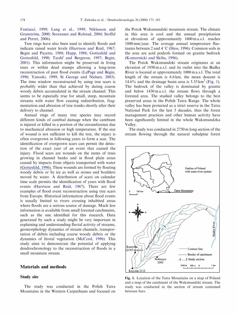
Fig. 1. Location of the Tatra Mountains on a map of Poland
and a map of the catchment of the Waksmundzki stream. The
study was conducted in the section of stream contained
between bars.
Materials and methods
Study site
The study was conducted in the Polish TatraMountains in the Western Carpathians and focused on
the Potok Waksmundzki mountain stream. The climatein this area is cool and the annual precipitationat elevations of approximately 1600ma.s.l. reaches1800mm/year. The average annual temperature fluc-tuates between 2 and 4 1C (Hess, 1996). Common soils inthe area are acid podzols formed on granite bedrock(Komornicki and Skiba, 1996).
The Potok Waksmundzki stream originates at anelevation of 1950m a.s.l. and its outlet into the BiałkaRiver is located at approximately 1000ma.s.l. The totallength of the stream is 6.6 km, the mean descent is14.6% and the drainage basin area is 5.35 km2 (Fig. 1).The bedrock of the valley is dominated by graniteand below 1430ma.s.l. the stream flows through aforested area. The studied valley belongs to the bestpreserved areas in the Polish Tatra Range. The wholevalley has been protected as a strict reserve in the TatraNational Park for the last 5 decades, thus the forestmanagement practices and other human activity havebeen significantly limited in the whole WaksmundzkaValley.
The study was conducted in 2750m long section of thestream flowing through the natural subalpine forest

ARTICLE IN PRESST. Zielonka et al. / Dendrochronologia 26 (2008) 173–183 175
within altitude range 1380–1080ma.s.l. (see Fig. 1).The forest covering the whole valley including thestream banks is dominated by Norway spruce (Picea
abies (L.) Karst.). In the higher elevation dwarf pine(Pinus mugo L.) and individual stone pines (Pinus
cembra L.) are present. Forest stands are unevenly agedand spruces 150–200 year old dominate; however, someof the oldest spruces attain up to 350 years at DBH(Zielonka, 2006). The bottom of the valley near thestream channel is covered usually with younger treecohorts. There was no observation of ice flow in the
Fig. 2. Typical scar in spruce stem formed by d
Waksmundzki stream, probably due to high slopegradient and low discharge.
Data collection
Basal parts of trees, both living and dead, werecarefully inspected on both banks of the stream for thepresence of scars and the other stem injuries. Weregarded flood scars as all wounds on basal parts oftrees growing on the banks at the closest distance to the
ebris transportation during a flood event.

ARTICLE IN PRESST. Zielonka et al. / Dendrochronologia 26 (2008) 173–183176
stream channel with injuries facing the stream axis oruphill (Fig. 2). We paid attention to exclude scars, whichmight be formed by other factors like the fall of a treefrom the forest or rot. Scars of such doubtful origin werenot included in the study.
In total, 48 wood samples containing scars wereextracted from dead and living trees. They were evenlydistributed along the 2750m long section of the stream
Fig. 3. Wood sample with two cross-dated sc
surrounded by the spruce forest. Wood samples wereextracted with a chain saw. From dead stumps wholecross-sections were collected, while from living treesonly fragments of sections containing scars were cut out(Arno and Sneck, 1977). Then samples were dried andpolished with a belt sander. For the construction of alocal reference chronology, 30 living spruces werechosen in the forest surrounding the stream within
ars formed in the same portion of stem.
ARTICLE IN PRESST. Zielonka et al. / Dendrochronologia 26 (2008) 173–183 177
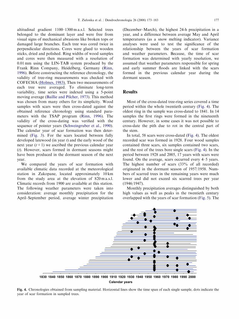
altitudinal gradient 1100–1300ma.s.l. Selected treesbelonged to the dominant layer and were free fromvisual signs of mechanical abrasions like broken tops ordamaged large branches. Each tree was cored twice inperpendicular directions. Cores were glued to woodensticks, dried and polished. Ring widths of wood samplesand cores were then measured with a resolution of0.01mm using the LIN-TAB system produced by theFrank Rinn Company, Heidelberg, Germany (Rinn,1996). Before constructing the reference chronology, thevalidity of tree-ring measurements was checked withCOFECHA (Holmes, 1983). Then two measurements ofeach tree were averaged. To eliminate long-termvariability, time series were indexed using a 5-pointmoving average (Baillie and Pilcher, 1973). This methodwas chosen from many others for its simplicity. Woodsamples with scars were then cross-dated against theobtained reference chronology using standard para-meters with the TSAP program (Rinn, 1996). Thevalidity of the cross-dating was verified with thesequence of pointer years (Schweingruber et al., 1990).The calendar year of scar formation was then deter-mined (Fig. 3). For the scars located between fullydeveloped latewood (in year t) and the early wood of thenext year (t+1) we ascribed the previous calendar year(t). However, scars formed in dormant seasons mighthave been produced in the dormant season of the nextyear.
We compared the years of scar formation withavailable climatic data recorded at the meteorologicalstation in Zakopane, located approximately 10 kmfrom the study area at the elevation of 820ma.s.l.Climatic records from 1900 are available at this station.The following weather parameters were taken intoconsideration: average monthly precipitation for theApril–September period, average winter precipitation
1830Calendar
1840 1850 1860 1870 1880 1890 1900 1910 19
Fig. 4. Chronologies obtained from sampling material. Horizontal li
year of scar formation in sampled trees.
(December–March), the highest 24-h precipitation in ayear, and a difference between average May and Apriltemperatures (as a snow melting indicator). Varianceanalyses were used to test the significance of therelationship between the years of scar formationand weather parameters. Because, the time of scarformation was determined with yearly resolution, weassumed that weather parameters responsible for springand early summer floods are linked with the scarsformed in the previous calendar year during thedormant season.
Results
Most of the cross-dated tree-ring series covered a timeperiod within the whole twentieth century (Fig. 4). Theoldest ring in the sample was cross-dated to 1841. In 14samples the first rings were formed in the nineteenthcentury. However, in some cases it was not possible tocross-date the pith due to rot in the central part ofthe stem.
In total, 58 scars were cross-dated (Fig. 4). The oldestrecorded scar was formed in 1928. Four wood samplescontained three scars, six samples contained two scars,and the rest of the trees bore single scars (Fig. 4). In theperiod between 1928 and 2005, 17 years with scars werefound. On the average, scars occurred every 4–5 years.The highest number of scars (33% of all recorded)originated in the dormant season of 1957/1958. Num-bers of scarred trees in the remaining years were muchlower and did not exceed six scarred trees per year(1946/1947).
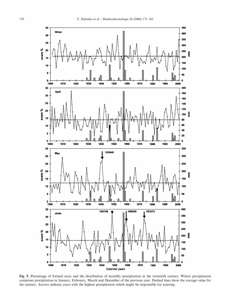
Monthly precipitation averages distinguished by bothhigh values as well as peaks in the twentieth centuryoverlapped with the years of scar formation (Fig. 5). The
years 20 1930 1940 1950 1960 1970 1980 1990 2000
nes show the time span of each single sample, dots indicate the
ARTICLE IN PRESS
Fig. 5. Percentage of formed scars and the distribution of monthly precipitation in the twentieth century. Winter precipitation
comprises precipitation in January, February, March and December of the previous year. Dashed lines show the average value for
the century. Arrows indicate years with the highest precipitation which might be responsible for scarring.
T. Zielonka et al. / Dendrochronologia 26 (2008) 173–183178

ARTICLE IN PRESS
Fig. 5. (Continued)
T. Zielonka et al. / Dendrochronologia 26 (2008) 173–183 179
highest number of years when the formation of scarsoverlapped with peaks in precipitation was found insummer months, when the precipitation was the highest.Peaks in precipitation of July overlapped with scarformation in 1934, 1938, 1980 and 1997 (Fig. 5). Thehighest precipitation in the century occurred in June(over 300mm in 1948, 1959 and 1972) and might beresponsible for scar formation in the dormant seasonbefore cambial activity or in the beginning of cambiumactivity in these years. Similarly, the second highest levelof precipitation during the last century, in May 1940
might have resulted in scars in the dormant season of1939/1940. Unusually high precipitation in August in1938 (305mm) and in 1972 (323mm) might also haveresulted in late summer floods which were responsiblefor scar formation. In September, which usually is muchdryer than previous months, high values of 272mmwere recorded in 1931 and 247mm in 1996 when scarswere formed. The relationship between years of scarformation and snow accumulation during the winter(precipitation December–March) was statistically notsignificant, and no years with the highest winter
ARTICLE IN PRESST. Zielonka et al. / Dendrochronologia 26 (2008) 173–183180
precipitation overlapped with the years of scar forma-tion (Fig. 5).
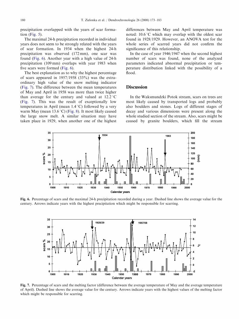
The maximal 24-h precipitation recorded in individualyears does not seem to be strongly related with the yearsof scar formation. In 1934 when the highest 24-hprecipitation was observed (172mm), one scar wasfound (Fig. 6). Another year with a high value of 24-hprecipitation (109mm) overlaps with year 1983 whenfive scars were formed (Fig. 6).
The best explanation as to why the highest percentageof scars appeared in 1957/1958 (33%) was the extra-ordinary high value of the snow melting indicator(Fig. 7). The difference between the mean temperaturesof May and April in 1958 was more than twice higherthan average for the century and valued at 12.2 1C(Fig. 7). This was the result of exceptionally lowtemperatures in April (mean 1.4 1C) followed by a verywarm May (mean 13.6 1C) (Fig. 8). It most likely causedthe large snow melt. A similar situation may havetaken place in 1929, when another one of the highest
Fig. 6. Percentage of scars and the maximal 24-h precipitation recor
century. Arrows indicate years with the highest precipitation which
Fig. 7. Percentage of scars and the melting factor (difference between
of April). Dashed line shows the average value for the century. Arro
which might be responsible for scarring.
differences between May and April temperature wasnoted: 10.6 1C which may overlap with the oldest scarfound in 1928/1929. However, an ANOVA test for thewhole series of scarred years did not confirm thesignificance of this relationship.
In the case of year 1946/1947 when the second highestnumber of scars was found, none of the analyzedparameters indicated abnormal precipitation or tem-perature distribution linked with the possibility of aflood.
Discussion
In the Waksmundzki Potok stream, scars on trees aremost likely caused by transported logs and probablyalso boulders and stones. Logs of different stages ofdecay and various dimensions were present along thewhole studied section of the stream. Also, scars might becaused by granite boulders, which fill the stream
ded during a year. Dashed line shows the average value for the
might be responsible for scarring.
the average temperature of May and the average temperature
ws indicate years with the highest values of the melting factor

ARTICLE IN PRESS
Fig. 8. Distribution of monthly temperatures, average for the
whole century and for critical year 1958.
T. Zielonka et al. / Dendrochronologia 26 (2008) 173–183 181
channel. During the fieldwork, boulders of differentdimensions were found on the lifted banks amongground vegetation, and this indicates that granite debriscan be lifted and removed from the channel duringfloods. In contrast, floating ice, which can also beresponsible for tree injuries (Begin, 2001), is ratherunusual in the studied stream due to the high relief andhigh decline of the stream channel.
According to Gottesfeld’s (1996) observations scarsare easily formed on the stems of living trees by rubbingof transported logs during floods. Woody debris may hitpartially submerged trees forming a wound, then rotateand continue movement downstream. Others mayremain anchored against trees and start to rub the barkaccording to changes of the water level. Such a rubbingcycle may last from 10 s to several minutes with verticalmovement ranging from 10 to 30 cm (Gottesfeld, 1996).These mechanisms may also explain the occurrence ofseveral scars in the same tree. A log after causing thefirst wound is caught at the base of the living tree andmakes another scar during the next flood event. Itresults in a series of partially overhealed wounds(Fig. 3). However, successive partially overhealed scarsoccurring at the same position of the tree trunk maysimply result from its location exposed to a frequentimpact of debris.
The average time interval between subsequent floodevents calculated for the period 1928–2005 was 4.5 yearsand shows that the Waksmundzki stream dischargecan be highly variable and flood events appear herefrequently. The lack of scars before 1928 could becaused by at least two factors. Most of the trees growingon banks belonged to a rather young generation. Flowactivity of the stream as a disturbance factor probablyresulted in the lack of old trees on the banks. It should
be expected also, that a minimal diameter is required fora tree to sustain an injury and survive. Trees of smalldiameter could easily be devastated by floating objects,or the cambial wound might be too extensive to enablefurther growth. We can also presume that before theoldest scars were formed the channel was located somedistance from the present course of the stream. Old,inactive channels, overgrown by vegetation and spruceregeneration were observed in the field in some flatfragments of the valley bottom.
Our results show that most probably there are twoweather factors responsible for floods in the studiedstream: heavy mid-summer rainfall and violent snowmelting in spring. In the Tatras, the highest precipitationoccurs in the summer months. The average Julyprecipitation for the whole twentieth century was177mm. Rainfall in this month might be responsiblefor scar formation in 1934, 1938, 1980 and 1997. Duringthese years the July rainfall varied from 323 to 423mmand was more than twice as high as the meanprecipitation for July. For example, at the beginningof July 1997, a large flood was also recorded throughoutsouthern Poland, and much flood damage was reportedalong streams and rivers in the nearby area. August ischaracterized by lower average precipitation (147mm),however, the rainfall can still be substantial in thismonth. In 1972, when four flood scars were formed, thehighest August rainfall in the whole twentieth centurywas recorded (323mm). Also, in 1938, wet July wasfollowed by rainy August.
The amount of snow fall during winter does not seemto influence the spring floods. Irrespective of theprecipitation in winter, the depth of snow cover is0.5–1.5m but locally may exceed 3m in the higherelevations (Łajczak, 1996). The rate of snow meltingwhich most likely induces high floods is more important.Many scars formed in the dormant season of 1957/1958were most likely the result of such an intensive snowmelt in the late spring of 1958. Climatic records indicatethat during this year an unusual increase of thetemperature in May was observed. The monthlytemperature of April was 3.1 1C below the average forthe century while the temperature of May was 3.81above the May average temperature for the century. Thesnow melting period, which normally is spread in Apriland May, occurred only in May. Historical informationconfirms a large flood in 1958 in southern Poland,described as ‘‘the largest since the Second World War’’(Fal, 1997). The oldest scar from 1928/1929 might alsobe a result of such anomaly in 1929, when one of thehighest differences between May and April temperatureswas recorded. The high precipitation in May and Junereinforcing discharge normally caused by snow meltmay explain formation of scars in 1939/1940, 1947/1948,1958/1959 and 1972/1973 when the highest values ofprecipitation in the century, around 300mm or more,

ARTICLE IN PRESST. Zielonka et al. / Dendrochronologia 26 (2008) 173–183182
were recorded. Scars formed during snow melt areformed before cambial activity, during the dormantperiod. Because of the larger number of scars in1957/1958 it was possible to observe fully developedlatewood of 1957 in some samples before the location ofscars, which may confirm that they appeared in thespring of 1958. But due to the limited number ofsampling material from other years, a reliable season ofscar formation could not be precisely determined.Because the cessation of cambial activity depends notonly on the photoperiod but predominantly on thetemperature in high elevations (Sander et al., 1995), itwould also have been difficult to relate the scar locationwith precipitation of a certain month. Although thecambium may start its activity before June (Rossi et al.,2006), if a scar was formed during this period after anarrow layer of cells of early wood often malformed bythe abrasion, it was difficult to detect the end of thedormant season in the sample, which usually consistedof narrow ring wood. Thus in this study we assumedthat high rainfall in June is responsible for the scarringin the dormant season of previous years.
Some limitation of the method should be addressed.Trees growing at the area of fluvial activity of thestream probably do not achieve a very old age whichconsiderably shortens the maximal time of reconstruc-tion. Scarred trees used for this study were rather youngin comparison with the potential longevity of Norwayspruce in the Tatra Mountains (Zielonka, 1996).
The relatively small data set collected in this study ofthe formation of scars during floods is to some extentaccidental. The formation of a flood scar requires highflow, presence of debris in the channel and finally theinjury in stems of trees growing on the bank, which infact is accidental. Thus, the flood scar indicates a floodevent, but a period without scars does not have to befree from floods. In the small scale of this study (2.75 kmlong stream section) a flood event may happen althoughno scars could be found, due to the lack of transportedobjects or injured trees. Also scarred trees might havealready disappeared from the banks. This means thatthe series of reconstructed flood events cannot be treatedas a complete data set. A similar problem concerns theintensity of flood events. A high number of scars formedin dormant season 1957/1958 may indicate an event ofrelatively high intensity. In the case of the rest of theflood years when the number of scarred trees variedfrom 1 to 6, the intensity of flood can hardly beestimated. Available climatic records from Zakopanemay not precisely reflect the weather conditions in thestudied valley, where elevation is significantly higher.Also using monthly precipitation and temperature is asimplification, as it might be too long period to detectweather anomalies. For instance, six scars whichappeared in 1946/1947 could not be explained usingweather parameters. This shows that stream flows in a
small catchment extending across wide altitudinal rangeand different hydrological zones may react veryviolently to abrupt local weather change. Such floods,recorded in flood scars might not be recognized withbasic weather records.
Conclusions
Our study shows that it is possible to reconstructflood events in the fine scale of a small mountain streamin the relatively long period of almost a century. It ishard to point to one weather factor, which is responsiblefor these flood events. Most probably, small catchmentsof high decline and varied hydrological characteristicsmay react very suddenly to changeable weather condi-tions. Flood scar evidence proves that the Waksmundzkistream discharge can be highly variable. Cross-datedscars also enable detection of past floods, which hardlycould be reconstructed only with basic climatic data.
Acknowledgments
This study was supported by the State Committee forScientific Research (KBN Project no. 2P04F 008 26).We are grateful to Piotr Malina who helped with bothfield and laboratory works. We would like to thank twoanonymous referees who gave valuable comments forthe manuscript and Margaret Devall for languageediting.
References
Arno, S.F., Sneck K.M., 1977. A method for determining fire
history in coniferous forests of the Mountain West. General
Technical Report INT-42, US Department of Agriculture,
Forest Service, Intermountain Forestry and Range Experi-
ment Station, Ogden, UT, pp. 1–28.
Baillie, M.G.L., Pilcher, J.R., 1973. A simple cross-dating
program for tree-ring research. Tree-Ring Bulletin 33, 7–14.
Begin, Y., 2001. Tree-ring dating of extreme lake levels
at the subarctic–boreal interface. Quaternary Research 55,
133–139.
Begin, Y., Payette, S., 1988. Dendroecological evidence of
subarctic lake-level changes during the last three centuries
in subarctic Quebec. Quaternary Research 30, 210–220.
Bergeron, Y., Denneler, B., Charron, D., Girardin, M.-P.,
2002. Using dendrochronology to reconstruct disturbances
and forest dynamics around Lake Duparquet, northwestern
Quebec. Dendrochronologia 20, 175–189.
Denneler, B., Schweingruber, F.H., 1993. Slow mass move-
ment. A dendrochronological study in Gams, Swiss Rhine
valley. Dendrochronologia 11, 55–67.
Fal, B., 1997. Powodz tysiaclecia? Wiedza i Zycie 10
(in Polish).
Fantucci, R., 1999. Dendrogeomorphology in landslide
analysis. In: Casale, R., Margottini, C. (Eds.), Floods and
ARTICLE IN PRESST. Zielonka et al. / Dendrochronologia 26 (2008) 173–183 183
Landslides: Integrated Risk Assessment. Springer, Berlin,
pp. 69–81.
Fritts, H.C., 1991. Reconstructing Large-Scale Climate Pat-
terns from Tree-Ring Data. University of Arizona Press,
Tucson.
Gottesfeld, A.S., 1996. British Columbia flood scars: max-
imum flood-stage indicators. Geomorphology 14, 319–325.
Gottesfeld, A.S., Gottesfeld, L.D., 1990. Floodplain dyna-
mics of a wandering river, dendrochronology of the
Morice river, British Columbia, Canada. Geomorphology
3, 159–179.
Harrison, S.S., Reid, J.R., 1967. A flood-frequency graph
based on tree-scar data. Proceedings of the Northern
Dakota Academy of Sciences 21, 23–33.
Hess, M., 1996. Climate. In: Mirek, Z. (Ed.), The Nature of the
Tatra National Park. Tatrzanski Park Narodowy, Zako-
pane Krakow, pp. 53–68 (in Polish with English summary).
Holmes, R.L., 1983. Computer assisted quality control in tree-
ring dating and measurement. Tree-Ring Bulletin 43,
67–78.
Hupp, C.R., 1988. Plant ecological aspects of flood geomor-
phology and paleoflood history. In: Baker, V.R., Kochel,
C.R., Patton, P.C. (Eds.), Flood Geomorphology. Wiley,
New York, pp. 335–356.
Komornicki, T., Skiba, S., 1996. Soils. In: Mirek, Z. (Ed.), The
Nature of the Tatra National Park. Tatrzanski Park
Narodowy, Zakopane Krakow, pp. 215–226 (in Polish
with English summary).
Łajczak, A., 1996. Hydrology. In: Mirek, Z. (Ed.), The Nature
of the Tatra National Park. Tatrzanski Park Narodowy,
Zakopane Krakow, pp. 169–196 (in Polish with English
summary).
Lang, A., Moya, J., Corominas, J., Schrott, L., Dikau, R.,
1999. Classic and new dating methods for assessing the
temporal occurrence of mass movements. Geomorphology
30, 33–52.
LePage, H., Begin., Y., 1996. Tree-ring dating of extreme
water level events at Lake Bienville, Subarctic Quebec,
Canada. Arctic and Alpine Research 28, 77–84.
McCord, V.A.S., 1996. Fluvial process dendrogeomorphology:
reconstruction of flood events from the southwestern
United States using flood scarred trees. In: Dean, J.S.,
Meko, D.M., Swetnam, T.W. (Eds.), Tree Rings, Environ-
ment, and Humanity. Radiocarbon 1996, 689–699.
Niklasson, M., Granstrom, A., 2000. Numbers and sizes of
fires: long-term spatially explicit fire history in a Swedish
boreal landscape. Ecology 81, 1484–1499.
Payette, S., Filion, L., Delwaide, A., 1990. Disturbance regime
of a cold temperate forest as deduced from tree-rings
pattern: the Tantare ecological reserve, Quebec. Canadian
Journal of Forest Research 20, 1228–1241.
Rinn, F., 1996. TSAP Version 3.0. Reference Manual.
Heidelberg, Germany.
Rossi, S., Deslauriers, A., Anfodillo, T., 2006. Assessment of
cambial activity and xylogenesis by microsampling tree
species: an example at the alpine timberline. IAWA Journal
27 (4), 383–394.
Sander, C., Eckstein, D., Knyckl, J., Dobry, J., 1995.
The growth of spruce (Picea abies (L.) Karst.) in the
Krkonose-(Giant) mountains as indicated by ring width
and wood density. Annales des Sciences Forestieres 52 (5),
401–410.
Schweingruber, F.G., Eckstein, D., Serre-Bachet, F., Braker,
O.U., 1990. Identification, presentation, and interpretation
of event years and pointer years in dendrochronology.
Dendrochronologia 8, 9–37.
St. George, S., Nielsen, E., 2003. Palaeoflood records for the
Red River, Manitoba, Canada, derived from anatomical
tree-ring signatures. Holocene 13 (4), 547–555.
Stoffel, M., Perret, S., 2006. Reconstructing past rockfall
activity with rings: some methodological considerations.
Dendrochronologia 24 (1), 1–15.
Storaunet, K.O., Rolstad, R., 2004. How long do Norway
spruce snags stand? Evaluating four estimation methods.
Canadian Journal of Forest Research 34, 375–383.
Tardif, J., Bergeron, Y., 1997. Ice flood history reconstructed
with tree-rings from the southern boreal forest limit,
western Quebec. Holocene 7, 291–300.
Yanoski, T.M., 1999. Tree ring analysis in hydrometry. In:
Herschy, R.W. (Ed.), Hydrometry: Principles and Practises.
Wiley, New York, pp. 265–289.
Zielonka, T., 1996. The oldest spruces (Picea abies) in Poland
from Tatra National Park. Rocznik Dendrologiczny 44,
137–144 (in Polish with English summary).
Zielonka, T., 2006. Quantity and decay stages of coarse woody
debris in old-growth subalpine spruce forests of the western
Carpathians, Poland. Canadian Journal of Forest Research
36 (10), 2614–2622.