A preliminary investigation into the influence of changing stream network patterns on the...
6
A preliminary investigation into the influence of changing stream network patterns on the distribution of water in the Narran Lakes Ecosystem. Scott Rayburg 1 , Melissa Neave 2 , Martin Thoms 1 , Edwina Mesley 1 1 CRCFE, University of Canberra, Belconnen, ACT 2601. Phone 02 6201 5363, fax 02 6201 2328, email: [email protected] . 2 Division of Geography, School of Geosciences, University of Sydney, NSW 2006. Abstract Channel network evolution within the Narran Lakes was assessed using aerial photographs for the period of 1959 to 1998. Over this time, there has been a general reduction in network distribution and area which has been attributed to upstream and localized changes in landuse. Network changes have taken three forms: creation of new network, destruction of old network and migration of existing network. Of these changes, network destruction has dominated, with three times more channel area being destroyed than created over the period of study. As the Narran Lakes is a terminal wetland for the Narran River and is recognized internationally as an important migratory bird breeding habitat, the findings of this study have important management implications. In order to predict the impact of future landuse changes on the hydrologic functioning of this system, a comprehensive hydrologic model will be developed. Fundamental to this model will be the incorporation of knowledge on the evolution of regional water delivery networks. Keywords Network evolution, Narran Lakes Ecosystem, Landuse change Introduction The Narran Lakes ecosystem, situated within the Lower Balonne Catchment (Figure 1a) in northern NSW, is a terminal wetland for the Narran River. The habitat afforded by the lakes constitutes an important breeding site for migratory water birds and, consequently, Narran Lakes is listed on the Ramsar List of Internationally Important wetlands. This listing carries with it certain responsibilities for the host nation, including a consideration of conservation, management and wise use of the wetlands (Thoms et al., 2002). Figure 1. Location of the Narran Lakes ecosystem: a. Position of the Narran Lakes in Australia, b. Structure of the Narran Lakes ecosystem (adapted from Sims and Thoms, 2002).
Transcript of A preliminary investigation into the influence of changing stream network patterns on the...
A preliminary investigation into the influence of changing stream network patterns on the distribution of water in the Narran Lakes Ecosystem. Scott Rayburg1, Melissa Neave2, Martin Thoms1, Edwina Mesley1
1CRCFE, University of Canberra, Belconnen, ACT 2601. Phone 02 6201 5363, fax 02 6201 2328, email: [email protected]. 2Division of Geography, School of Geosciences, University of Sydney, NSW 2006. Abstract Channel network evolution within the Narran Lakes was assessed using aerial photographs for the period of 1959 to 1998. Over this time, there has been a general reduction in network distribution and area which has been attributed to upstream and localized changes in landuse. Network changes have taken three forms: creation of new network, destruction of old network and migration of existing network. Of these changes, network destruction has dominated, with three times more channel area being destroyed than created over the period of study. As the Narran Lakes is a terminal wetland for the Narran River and is recognized internationally as an important migratory bird breeding habitat, the findings of this study have important management implications. In order to predict the impact of future landuse changes on the hydrologic functioning of this system, a comprehensive hydrologic model will be developed. Fundamental to this model will be the incorporation of knowledge on the evolution of regional water delivery networks. Keywords Network evolution, Narran Lakes Ecosystem, Landuse change Introduction The Narran Lakes ecosystem, situated within the Lower Balonne Catchment (Figure 1a) in northern NSW, is a terminal wetland for the Narran River. The habitat afforded by the lakes constitutes an important breeding site for migratory water birds and, consequently, Narran Lakes is listed on the Ramsar List of Internationally Important wetlands. This listing carries with it certain responsibilities for the host nation, including a consideration of conservation, management and wise use of the wetlands (Thoms et al., 2002).
Figure 1. Location of the Narran Lakes ecosystem: a. Position of the Narran Lakes in Australia, b. Structure of the Narran Lakes ecosystem (adapted from Sims and Thoms, 2002).
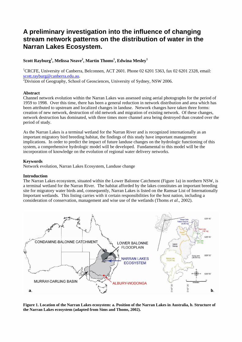
Since the mid 1990’s increasingly large volumes of water have been extracted from rivers upstream of the lakes, largely to support the growth of irrigated cotton. These extractions have been observed to reduce flow frequencies by as much as 30% and have led to increased rates of sediment deposition within the Balonne Catchment. Water allocation plans for the region suggest that water extraction levels may continue to increase, possibly to a level that would reduce inflows to the Narran Lakes by more than 50% of natural (Thoms et al., 2002). Despite the recognition of the importance of the Narran Lakes site, little is currently known about the physical and biological functioning of its ecosystem. In order to assess potential impacts associated with water use developments in the catchment a detailed hydrologic model of the site is required. The Narran Lakes ecosystem is composed of several geomorphic elements (Figure 1b) including: a large main lake (Narran Lake), several smaller lakes (Clear Lake, Back Lake, Long Arm), connecting floodplains and an intricate distributary channel network. This network represents the mechanism by which water is conveyed through the system and is, therefore, one of the critical components of the hydrologic model. The purpose of this study is to assess changes in the channel network within the Narran Lakes between 1959 and 1998. The study will focus on the northeastern region of the ecosystem where inundation events are most frequent and the channel network is highly complex – containing both intricate channels and large water storage regions. This research represents a preliminary investigation of network change in one region of the Narran Lakes. Further work will include a consideration of the entire Narran Lakes wetland system for five additional time periods. This will allow for a more detailed temporal investigation of change since the expansion of resource development in the catchment. The information acquired from this larger study will become an integral component of the proposed hydrologic model, allowing for more realistic assessments of changing flow inundation patterns. Channel Networks Channel network patterns have been widely studied as indicators of the hydrologic and erosional conditions in operation on hillslopes. These studies have typically focussed on general network characteristics (Horton, 1945, Shreve, 1974, Strahler, 1957), river channel change (Gurnell, 1997, Winterbottom, 2000), network evolution (Howard, 1994, Willgoose et al., 1991) and the fractal dimensions of river networks (Tarboton et al., 1998, Wilson and Storm, 1993). Commonly the networks investigated in these studies have formed through downslope increases in the concentration of runoff and erosive ability. In the Narran Lakes ecosystem flow is distributed across the wetland after being delivered by the Narran River. This means that flow dispersed from the main channel carves smaller tributaries, which is the reverse of what occurs in more ‘traditional’ network systems. It is proposed that large floods from the Narran River lead to the formation of new small channels and, hence, increasingly complex networks, while intervening small flows cause the distributary channels to fill in. This ensures that upstream changes in the delivery of water and sediment to the Narran River will have impacts on the nature of distributary channel formation within the Narran Lakes wetland, affecting a change in the overall evolution of the hydrologic system. The aerial photographic sets chosen for inclusion in this study were 1:50000 runs from 1959 and 1998 (Figure 2). These sets were obtained in digital format from the NSW Department of Lands. The data were imported into ERMapper for initial processing which included geo-rectification and the production of a photo-mosaic for each date. These data were then brought into ARCGIS and digitized. Once digitized, the separate images were overlaid and the raster calculator within ArcGIS was used to derive three cell classes: cells with active channel areas in 1959, cells with active channel areas in 1998, and cells with active channel areas in both 1959 and 1998. Overall the position of the two data sets had a high degree of correspondence although some errors were evident due to warping during the mosaic creation. Therefore some error exists in the computation of overlapping areas. These errors are on the order of 5 to 10% over the full spectrum of the image with specific areas having either higher or lower overall errors based on the degree of warping. Results and Discussion A comparison of the land area occupied by channel network from 1959 to 1998 reveals an overall loss of 3.79 km2 (Table 1). This change is composed of several parts: 2.22 km2 of new channel was observed in 1998 representing land area that was not channel in 1959. Conversely, 6.01 km2 of active channel in 1959 was no longer present in 1998. Finally, 8.35 km2 of channel area did not change from 1959 to 1998. This indicates that 50% of the land area occupied by channel networks in both 1959 and 1998 has undergone change through either cut or fill. The rate of filling is approximately three times that of cutting indicating a general trend of overall reduction in network area.
Figure 2. Narran Lakes Network: a. 1959 aerial photograph with digitized channel network, b. 1998 aerial photograph with channel network. Table 1. Channel network changes, Narran Lakes ecosystem.
Channel Network Extent Area Rate of Change (km2) (km2 yr-1) Present only in 1998 (Channel Area Gain) 2.22 0.057 Present only in 1959 (Channel Area Loss) 6.01 0.154 Present in both 1959 and 1998 (No Change in Channel Area) 8.35 Total Network 1959 14.36 Total Network 1998 10.57 Difference 3.79 0.097
The changing distributions of channel networks from 1959 to 1998 are represented in Figure 3. The largest regions exhibiting no change (i.e., containing obvious channels or large water storage areas in both 1959 and 1998) are located in the lake basins of Back Lake (Figure 3b) and Clear Lake (Figure 3d). Substantial network losses are evident throughout the study region, suggesting that channel infilling is affecting the entire Narran Lakes ecosystem, whereas the largest areas of new channel are found in the north eastern section of the study site (Figure 3a) with only moderate additions in other areas. This indicates a tendency towards network development in areas closest to the water delivery source, the Narran River. As the Narran Lakes is a terminal wetland system that acts as a sediment sink, high rates of infilling are not surprising. But these rates are likely to have increased in the ecosystem due to landuse activities throughout the Lower Balonne catchment that have accelerated rates of sediment mobilisation (Thoms et al., 2002). These changes are thought to have both reduced the magnitude and frequency of large flood events (reducing the creation of new network) (Figure 4) and increased the volume of sediment delivered to the system (increasing the rate of network infilling). The observed changes in network reduction are enhanced by more localized landuse changes. In recent years, vegetative cover within the Narran Lakes has increased in the upper parts of the ecosystem. This vegetation is dominated by lignum (Muehlenbeckia florulenta), which is a dense shrub that grows in
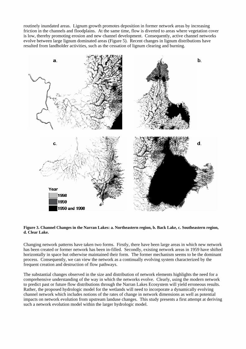
routinely inundated areas. Lignum growth promotes deposition in former network areas by increasing friction in the channels and floodplains. At the same time, flow is diverted to areas where vegetation cover is low, thereby promoting erosion and new channel development. Consequently, active channel networks evolve between large lignum dominated areas (Figure 5). Recent changes in lignum distributions have resulted from landholder activities, such as the cessation of lignum clearing and burning.
Figure 3. Channel Changes in the Narran Lakes: a. Northeastern region, b. Back Lake, c. Southeastern region, d. Clear Lake. Changing network patterns have taken two forms. Firstly, there have been large areas in which new network has been created or former network has been in-filled. Secondly, existing network areas in 1959 have shifted horizontally in space but otherwise maintained their form. The former mechanism seems to be the dominant process. Consequently, we can view the network as a continually evolving system characterized by the frequent creation and destruction of flow pathways. The substantial changes observed in the size and distribution of network elements highlights the need for a comprehensive understanding of the way in which the networks evolve. Clearly, using the modern network to predict past or future flow distributions through the Narran Lakes Ecosystem will yield erroneous results. Rather, the proposed hydrologic model for the wetlands will need to incorporate a dynamically evolving channel network which includes notions of the rates of change in network dimensions as well as potential impacts on network evolution from upstream landuse changes. This study presents a first attempt at deriving such a network evolution model within the larger hydrologic model.

Figure 4. Lignum in the Narran Lakes: a. Aerial view over back lake during a dry phase, b. Oblique aerial photo showing Clear Lake and connecting channels during an inundation event.
Figure 5. Flow data in the Narran River: a. 1922 to 1958, b. 1959 to 1997. Conclusion The Narran Lakes ecosystem contains a complex channel network that forms through the dispersion of water and sediment from the Narran River. This network is constantly changing, both in form and distribution, with a general trend of declining network area observed over the last 40 years. These network changes have involved network creation (new channels forming), network destruction (old channels infilling) and network
migration (channels moving laterally). Of these three changes, network destruction has dominated, with three times more infilling observed than channel creation. The dominance of network infilling has been attributed to landuse changes, both within the Narran Lakes themselves and upstream in the catchment of the Narran River. These changes include a reduction in the magnitude and frequency of flow events, increased sediment delivery rates and changing distributions of lignum patterns. The dynamic nature of the channels within the Narran Lakes wetland illustrates the need for the development of a more comprehensive network evolution model. To date, limited information has been collected on distributed systems such as those observed in the Narran Lakes, yet their form is integral to the hydrologic operation of this wetland environment. In order to understand the impact of changing landuse in the catchment of the Narran Lakes on the quality of the ecosystem as a waterbird habitat, it will be necessary to derive a model that predicts the distribution of water in the system. Integral to such a model will be the inclusion of a dynamic network evolution component that represents network changes such as those observed over the last 40 years. Future work, including network analysis for the entire system of the Narran Lakes and a larger number of photographic runs, should improve the robustness of such a model. Acknowledgements Funds to conduct this study were made available by the Murray-Darling Basin Commission. Channel network digitizing and aerial photographic interpretation was provided by Orla Murray. References Gurnell, A.M. (1997). Channel change on the River Dee meanders, 1946–1992, from the analysis of air
photographs. Regulated Rivers: Research and Management, 12, 13–26. Horton, R.E. (1945). Erosional development of streams and their drainage basins: hydrophysical approach to
quantitative morphology. Bull. Geol. Soc. Am., 56, 275– 370. Howard, A.D. (1994) A detachment-limited model of drainage basin evolution. Water Resources Research,
30, 2261-2286. Shreve, R.L. (1974). Variation of mainstream length with basin area in river networks. Water Resources
Research, 10, 1167-1177. Sims, N.C., Thoms, M. (2002). Hydrology of the Narran Lakes Ecosystem: Preliminary report. CRCFE
Publication. Strahler, A.N. (1957). Quantitative analysis of watershed geomorphology. Transactions of the American
Geophysical Union, 38, 913-920. Tarboton, D.G., Bras, R.L., Rodrı´guez-Iturbe, I., 1988. The fractal nature of river networks. Water
Resources Research, 24, 1317– 1322. Thoms, M., Quinn, G., Butcher, R., Phillips, B., Wilson, G., Brock, M., Gawne, B. (2000). Scoping study for
the Narran Lakes and Lower Balonne floodplain management study (R2011). Technical Report 3, CRCFE Publication.
Willgoose, G, Bras, R.L., Rodrı´guez-Iturbe, I. (1991). A coupled channel network growth and hillslope evolution model. 1. Theory. Water Resources Research, 27, 1671-1684.
Wilson, B.N., Storm, D. (1993). Fractal analysis of surface drainage networks for small upland areas. Trans. ASAE, 36, 1319– 1326.
Winterbottom, S.J. (2000). Medium and short-term channel planform changes on the Rivers Tay and Tummel, Scotland. Geomorphology, 34: 195–208.