
Prehistoric avian, mammalian and H.sapiens footprint-tracks ...
Upload
khangminh22Category
view
1download
0
A PREHISTORIC ROUTE AND ANCIENT CART-TRACKS IN THE GEMEENTE OF ANLOO (PROVINCE OF DRENTHE)
Sake W. J ager
ABSTRACT: An investigation of a possibie linear pattern of burial mounds north of Eext in thegemeente of Anloo led to surprising results. Not only a prehistoric route could be reconstructed by means of a string of grave monuments; along this route a number of settlements were also located and old excavation results appeared to fit meaningfully in this arrangement of funerary monuments. Furthermore, during field-survey an ancient ro ad was discovered, which could be traced over some distance along this row of grave mounds. Mo'reover, on three locations in this area sub-recent cart-tracks were uncovered.
KEYWORDS: North-East Drenthe, burial monuments, prehistoric route, old fossil road, sub-recent cart-tracks.
1. INTRODUCTION
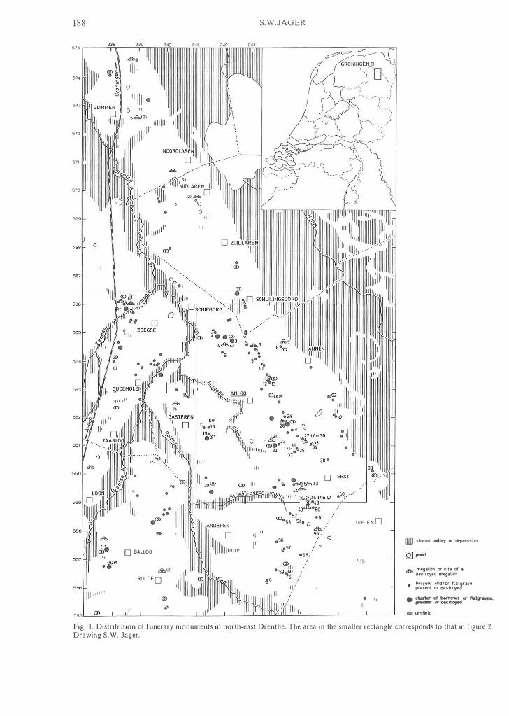
Not many people take the trouble to travei on foot from the Galgwandenveen north of the village of Eext, through the woods and across Anloo's Molenes to the megalithie tomb (hunebed) known as D8; but those who do will come across a number of tumuli scattered in the landscape in a seemingly random way. If, however, we map these burial mounds together with all the funeral monuments that are known to have disappeared, a remarkable linear pattern emerges. Between Eext and Anloo, and continuing towards hunebed D8, a more or less uninterrupted alignment of monuments becomes apparent (figs. l and 2). It is a generally accepted interpretation that such linear patterns of burials correspond with ancient trackways. Via these monuments it should thus be possibie to trace the course of an old route. It is highly probable that the stretch from Eext to hunebed D8 forms part of a north-south through route running along the northern part of the Hondsrug ridge. As it is only the 6-km stretch between Eext and hunebedD8 that ean be reconstructed convincingly, only this part of it will be discussed here.
The oldest relics along the route date back to the TRB (Trechterbeker= Funnel Beaker) Culture; the most recent grave dates from the Late Iron Age. Along the line of tumuli a fossil cart-track, most probably older than Early Medieval, could be traced over a length of about 2 km (figs. 4 and 5).
In order to gain insight als o into the distribution
185
and dating of other graves that were not along the route, the author has made an inventory of all known N�olithic, Early and Middle Bronze Age burials in the gemeenteof Anloo, an area with a rich prehistoric pas t. To this end the field drawings, excavation journals, photographs, etc .. kept at the Biologisch-Archaeologisch Instituut at Groningen were consulted. All monuments are discussed in the Appendix.
Plans, based on the original excavation drawings, and drawings of small finds are also provided for grave monuments which were previously unpublished or inadequately published.
2. RECONSTRUCTING ANCIENT TRACK· WAYS
These days, the countless roads are an important element in the scenery. In the past, however, the road network would have played a far less dominant role in the landscape. If we examine the historicai development of the ro ad network, the oldest lines of communication cannot have been much more than seasonal pathways, along which hunters and gatherers migrated from one camp to the next. This 'infrastructure' would have been the basis from which, from the Neolithic, a network of tracks was able to dev�lop. Presumably, the road pattern initially consisted of short stretches connecting neighbouring settlements. Apart from the more sedentary ways of life of farming communities, the

186 S.W.JAGER
gradual development towards a market economy with the resulting increase in goods transportation must have been the stimulus for the development of a road network proper. Part of the go ods transportation must have taken place on inland waterways and possibly even along the coast.
In reconstructing ancient trackways, three lines of research should be combined with field-work in order to ensure optimum results (Bakker, 1976). These are:
l . Historicai geography (Denecke, 1969; a.o.). This involves the recording of old roads by means of features typically associated with road traffic, such as bridges, turnpikes, and wayside inns. Important sources of information are old maps, archives, field-names, and aerial photographs. Remains of roads are investigated in the fieid. Intensive use of a specific stretch of ro ad could result in a sunken lane. This is because trave liers preferred keeping to the beaten track: this made for greater speed and less ris k of losing the way. Wherever the soil was soft and it was possibie to turn aside, a series of parallel lanes was likely to develop. When a track became impassable a new one would be made alongside. Such a pattern of parallel cart-ruts covers for instance the entire eastern part of the Balloerveld heath. A similar system of cart-tracks is also to be found in the Strubben/Kniphorstbos near Anloo. These groups of cart-tracks are the remains of parts of the inter-regional route from Coevorden to Groningen, one branch of which went by way of Rolde, Balloo and Gasteren, and the other along the Hondsrug via Borger and Anloo.
2. Physical geography. The configuration of the terrain is an important factor in the course that roads take. It was according to the princip le of minimum effort that prehistoric trackways came into being; the shortest, fastest, and most efficient route was op ted for. From a transport point of view the lands cape may be divided into two types: the traffic-friendly and the traffic-hostile. In this region the former consists of the higher , drier grounds. The only danger in using the high sandy areas was that intensive use might cause the destruction of the vegetation cover and result in sand drift. Zones hostile to traffic, such as marshy valleys, peat-bogs, drift-sands and forests-in the forested Veluwe region highwaymen were active right in to the 19th century-were avoided as much as possible. As it was not always feasible to avoid all these, the most convenient course would be selected. On the whole, valleys were crossed at their narrowest point. These crossing places often remained in use for many
centuries, and have since been provided with a bridge or causeway. For this reason, there is often continuity of the road pattern.
3. Archaeological geography. From distribution patterns of lost settlements, wayside monuments, or prominent linear distributions of finds, it is sometimes possibie to trace ancient trackways. For the prehistorian, this mostly means tumuli marking a route. In a number of cases, megalithic tombs are the oldest monuments along these through routes. Apart from old topographical maps, aerial photographs can play an important part in locating archaeological objects as well. Extrapolating from the sites of excavated and leve lied barrows, one may sometimes be ab le to locate lost tumuli, when conditions are favourable and the layer of humic topsoil is not toa thick.
In some cases and at a smaller scale, the course of roads may be deduced from other archaeological features. Thus, in settlement excavations in the Netherlands, road patterns have been reconstructed from the traces of fences, and the position and orientation of houses (Wijster: Van Es, 1965; Odoorn: Waterbolk, 1973; Kootwijkerzand: Heidinga, 1976). Field boundaries and/or the siting of a Celtic Field may als o afford insight into ancient trackways (Vaassen: Brongers, 1972/1976; Hijken: Harsema, 1982: fig. 7). In some urnfields in the north of the Netherlands, tracks have been shown to be contemporary with, and in some cases to antedate, the cemetery (Kooi, 1979: pp. 152, 156, 158; Sleen, Noordbarge, Anloo, Gasteren, Vledder).
Thus, in reconstructing ancient routes, the prehistorian is largely dependent on recognizing a linear relation among grave monuments. Muller (1904) was the first archaeologist to suggest a connection between the long alignments of tumuli, often linked with old cart-tracks, in lutland, and prehistoric routes. In a number of places in northwest Germany such strings of burial mounds were also recognized, often coinciding completely or in part with old high-roads or Ochsenwege (Hinz, 1950/1951; Kersten, 1951; Rbschmann, 1963; Marschalleck, 1964; a.o.).
A fine example of the link between a road and a line of tumuli is described by Lincke (1939). A string of funeral monuments-the oldest among them are reckoned to be of TRB origin; most of them, ' however, were constructed in the Bronze Age-Ieads towards a wooden trackway across the peat near Meckelstedt, Kr. Wesermunde. The wooden road, dating from the (Early) Bronze Age,

A prehistoric roule and ancient cart-tracks 187
traverses the most low-Iying part of a valley and connects the sandy rising grounds with a long and narrow sandy ridge. Here we are dealing with a route that was used as far back as TRB days. As the valley gradually filled with peat, the wooden trackway was constructed of planks and thin logs.
The first to pay attention to prehistoric tracks in the Netherlands was the amateur archaeologist Beijerinck (1932). His survey of 'migration routes' of the Mesolithic and Neolithic in the northern Netherlands, based on the then-known sites which he connected up by drawing lines, is, however, rather hypothetical.
Beex (1952) associates some tumuli lying in a row along the small lake called Huismeer near Knegsel (province of Noord-Brabant) with an ancient route. The barrows are situated along the crest of a narrow cover-sand ridge, hemmed in between the fen and a small stream-valley. Taking into account the lie of the land, the old track would have had to run immediately alongside the barrows. The fact that these mounds are aligned do es not necessarily imply that they were constructed along a trackway. However, the Antwerpse Baan, an old through route connecting the city of Antwerp with East Brabant, most probably ran along the very foot of the grave mounds. A number of other prehistoric sites, such as urnfields, have also been located along this road.
Glasbergen (1954: p. 174, fig. 76) in his dissertation states that the necropolis of Toterfout-Halve Mijl, which extends over a length of 2 km, is very likely to have been laid out along a prehistoric trackway, in view of its having developed from several nuclei.
With a soil map of south-east Drenthe onto which he projected the archaeological data as a starting point, Wieringa (1958) outlines a possibie prehistoric road pattern for this area. The dominant theme in his study is the connection between soil characteristics and prehistoric remains.
Hijszeler (1961; 1966) also discusses prehistoric trackways. On finding that a number of funeral monuments and cemeteries is situated close to old, still used, unmetalled roads, he rushes to the conclusion that the latter must be "very ancient migration and cemetery roads".
Kooi (1979: p. 167) arrives at a reconstruction of the road network in south-eastern Drenthe during the Late Bronze and Early Iron Age, by analyzing the orientation of graves in urnfields and of'certain rows of barrows'.
Nonetheless, the first wholly convincing prehis-
toric route in the Netherlands, marked by tumuli, was record ed by Modderrnan (1955) southwest of Epe in the Veluwe region. In his comprehensive article on trackways, Bakker (1976: fig. II) published a map showing the distribution of these mounds. It even proved possibie to distinguish two side-roads. The oldest burial along one of the sideroads dates from the Single Grave Culture. l
The second unmistakable prehistoric route in the Netherlands is the stretch between Eext and hunebed 08.
3. THE TRACK BETWEEN EEXT AND HUNE
BED 08 (FIGS. I AND 2)
3. 1. Geomorphology
The track traverses a landscape that forms part of the relatively flat Hondsrug plateau, which is bounded on the west by the Drentse A river and its tributary the Rolder Diep, and on the eas t by the Hunze valley. In some places, valleys were cut into the Hondsrug, which later filled up to some extent with fluvioperiglacial deposits and cover-sand. During the Holocene, peat was forrned in these lowlyingparts. In this valley system the Drentse A and the Rolder Diep have as tributaries the Anlooer Diepje and the Scheebroeker Loopje, the erosion system thus reaching to just west of Eext. In wide areas of the Hondsrug, the underlying boulder�clay almost reaches the surface. The cover-sand deposits, consisting of fine sands varying in silt content, further define the relief. Moreover, the area has some depressions and pingo remnants, of which the Galgwandenveen, also known as Eexter Vispias, is one.
3.2. A survey of graves and settlements along the track
In figures I and 2 the more or less uninterrupted alignment of monuments between Eext and Anloo, continuing towards hunebed 08 in Kniphorstbos north of Anloo is clearly visible. The linear pattern of graves is only interrupted by the essen. These open fieids have for centuries been fertilized with a mixture of manure and sods, litter, or sand. In this way a plaggen soil could develop, sometimes reaching a considerable thickness. The gaps in the row of burials thus may one day be filled in with tumuli that were levelled long ago and remains of which may yet be found beneath the plaggen soil. Inspec-
188
575 ,-----"ir.-----"T"-rrrr
573
572
57'
570
1111(1"'"
"
D BAllOO
&,(2) ROlDE D
<l!) .'
S.W.JAGER
-ss .. :
GIETEND
'1[1'
- " II
lIID slream valley or depression
db megalith or site of a destroyed megalith
• �;�� ��djeo;;r�a�drave.
• dustor ol bMTows er '1.09' ...... prHOOt er dostroyod CD) ISTlfield
Fig. I. Distribution of funerary monuments in north-east Drenthe. The area in the smaller rectangle corresponds to that in figure 2. Drawing S .W. Jager.

lIIll slream v alley or depres sion
IQ] pond
A prehistoric mute and ancient cart-tracks
[J essen
& megalilh or site ol a destroyed megalith
barrow and/or lIat grave, • present or destroyed
• ���sst:�
t O�r
bd��rio:ed
189
Cl) urnfield
Fig. 2. Alignment offunerary monuments north of Eext. The area in the smaller rectangle corresponds to that in figure 4. Drawing S. W. Jager.

190 S.W.JAGER
Table I. List of excavated or datable monuments marking the prehistoric route between Eext and hunebed D8.
MN/LN Late Neolithic Monuments TRB Single AOO BB
Grave
6. Anloo, hunebed D8 + 9. Anloo, tumulus II
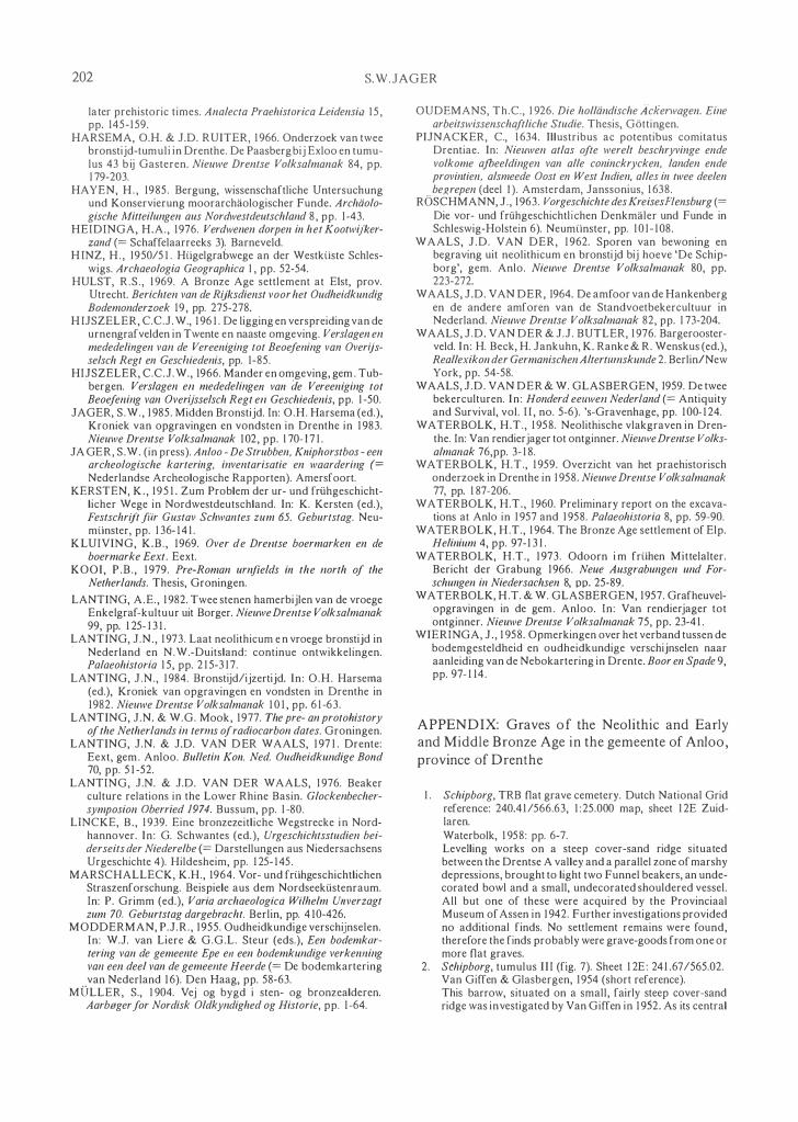
( 1 952) + IO. Anloo, tumulus I ( 1 952) + Il . Anloo, tumulus + 1 2. Anloo, tumulus I I + 1 3 . Anloo, tumulus I 63. Anloo, cemetery
Molenes 24. Eext, tumulus
Eexterstrubben II 25. Eext, tumulus
Eexterstrubben I 26. Anloo, excavation
Evertsbos + + + 27. Eext, tumulus I + 28. Eext, tumulus II 29. Eext, tumulus I I I 30. Eext, tumulus
Galgwandenveen I + 33. Eext, tumulus
Schuilingsbosje 34. Eext, tumulus
Galgwandenveen III + 38. Eext, tumulus
' t Witzand
ting this route from the air has not yet resulted in new tumulus sites. In other places, however, such reconnaissance flights have been very useful indeed in locating levelled barrows.
Table l lists the excavated or datable monuments marking the prehistoric route. The folIowing criteria were applied in dating the graves from the Early and Middle Bronze Age when characteristic gravegoods were absent or radiocarbon dating was not possible.2
Early Bronze Age/first half of the Middle Bronze
Age. A number of burials under 'structureless mounds' (Lan ting & Mook, 1977: p. 113), e.g.
mounds without encircling features near the edge. In som e cases circular stonepackings in the mound are present. We must take into account, however, that mounds with a circular stonepacking, barrows, mostly consisting of yellow sand, constructed over burials in shallow pits or on the original ground level, and Brandskeletgraber under structureless tumuli principally date from the first hal f of the Middle Bronze Age.
First half ofthe Middle Bronze Age. To this period we ean date tumuli with an encircling ditch (Lanting & Mook, 1977: p. 1 13).
EBA EBAI MBA LBAI Later lAl first half first half sec. half earlier lA Roman period
MBA
+ +
+ +
+ + +
+
+
+ + + + + +
+ +
+
+
Second half of the Middle Bronze Age. Tumuli with a single or multiple circle of posts at their foot are typical for this period (Lanting & Mook, 1977: p. 144).
In the archaeological investigations along this track, the excavations carried out by Waterbolk north-west of Eext in 1957/1958 play an important part. Apart from Beaker graves and an urnfield, the site provided evidence of prolonged occupation (fig. 3: no. 26).
TRB Culture. To begin with, the excavations revealed the traces of a threefold fence. Waterbolk (1960, p. 83) interpreted the palings as a cattle enclosure of the Single Grave Culture. This was completely in keeping with the ideas of those days, when the Single Grave Culture was seen as one of farming communities (Van der Waals & Glasbergen, 1959: p. 107). From the distribution of TRB finds, however, it becomes clear that this is an enclosed TRB settlement of the Early Havelte E2 phase.?
Beaker Cultures. The oldest Beaker burials along the track are graves D and E. Apart from these Single Graves, three more Beaker burials were uncovered. Two of these, graves B and C, may be

A prehistoric route and ancient cart-tracks 191
assigned to the AOO group on the grounds of their grave-goods. Grave A contained no finds, but may be reckoned to be of the same group because of its location and orientation. Waterbolk (1960: p. 83) used, among other things, the more or les s parallel orientation of the graves and the palisade as an argument in dating the latter. This parallelism is now accounted for by the presence of a road. Beaker sherds, among which is one of a Maritime Bell Beaker (private collection of J .E. Musch), were found all over the excavation site, and point to the presence, here or near by, of a Beaker settlement in the Late Neolithic.
Early Bronze Age. From a number of settlement pits, with Barbed Wire pottery dating to the Early Bronze Age, it was possibie to roughly determine the position of the houses, i. e. more or less parallel to a road.
Middle Bronze Age. During this period, the site was in use as ara ble land.
Late Bronze Age. The excavation also revealed a small urnfield. On the basis of two groups of burials, both forming straight lines, Kooi (1979: p. 156, fig. 153) later postulated a cross-roads here. The present author does not consider the road running east-west a convincing one. However, it turned out that a large part of the north-south road was (unwittingly) record ed by the field technicians. It appears in the field drawings partly as a dark smudgy zone in the southern part, partly as interruptions (e.g. places where 'dirty' soil was dug away in an attempt to improve to visibility of the traces) in the enclosure fences in the northern part of the excavation. Unfortunately, the road was not recorded photographically. The sections drawn from the baulks do not reveal any trace of a 'road surface' either; what was visible in the horizontal surface must have been the last remnant of the trackway.
A chance to follow this road further came up just prior to the completion of this article, when the adjacent parcel on the north, which had been under grass for years, was p10ughed. This also provided an opportunity to document the north edge of the urnfield. The excavation yie1ded in the first place a long bed of type Gasteren situated along the west side of the road. Hs central grave consisted of an unurned cremation. The grave pit also contained charcoal. The ditch surrounding the long bed was not found; presumably it had entire1y been ploughed away, and only the deeper postholes and the central grave remained. Just to the west of it, two more cremations were found. Directly to the north of Waterbolk's excavation cutting a flat grave was
found in which a coffin with extended shadow skeleton showed up. At the bottom of this grave pit charcoal was collected for a 14C determination, which gave a Middle Iron Age-date (GrN-14333: 2380±120 B.P.). Similar (not-dated) graves for instance are known from the urnfield of Laudermarke (Van Giffen, 1935).
The long bed appeared to join onto Eext, tumulus Eexterstrubben I (no. 25), which was excavated in 1954. This grave mound, which is also part of the row of burials along the west side of the road, was actually the northern edge of the cemetery. The road showed itself beside this tumulus as an ironpan- infiltrated zone with podsolized wheel-tracks. The track continues on toward the north in the direction of Eext, tumulus Eexterstrubben II (no. 24).
The above-mentioned urnfield of site 26 seems to be not the only one along this route. Strong indications for the presence of a second one were found north-east of Anloo. In 1938 some Late Bronze Age urns were found as secondary interments in a Late Neolithic burial mound (no. 11) during reclamation work. In the spring of 1986 on the flank of a wind hollow close to this burial mound some sherds belonging to a single pot, probably an urn, were found. A small-scale excavation, along the edge of the hollow, revealed the remains of a ditch, which once had forrned the periphery of a low, small mound (Jager, in press).
In some cases heaps of cremated bones without cinerary urns were found as secondary interments in burial mounds of the Late Neolithic, Early or Middle Bronze Age (nos. 12 and 27). We should keep in mind, however, that these cremations cannot be dated with any accuracy, and may even date from the Roman period. That was demonstrated in the case of the small cemetery (no. 63), shown in figures 1 and 2 as the symbol of an urnfield, that was discovered beside the prehistoric route, at the edge of the Anloo Molenes. Four small pits were found to contain cremated bones. In one case, the ashes has been placed in a Kummerkeramik pot. In this excavation a so-calledBrandgrube was als o uncovered which con tai ned a piece of corroded iron. Two pits and theBrandgrube were radiocarbon dated. As is evident from these 14C dates and the finds, a small ridge was here in use as a cemetery both in the beginning and end of the Middle Bronze Age and in the Late Iron Age.
The presence of potsherds and flints on the old surface beneath tumuli or in the mound's body indicates that a settlement must have existed there

192 S.W.JAGER
or in the immediate vicinity. Settlements material was found under the folIowing barrows:
l . Anloo, tumulus I (no. lO)-Pot Beaker sherds. In the neighbourhood of this mound, TRB material and Barbed Wire sherds were found.
2. Eext, tumulus I (no. 27)-TRB sherds. 3. Eext, tumulus Galgwandenveen I (no. 30)
TRB sherds and a sherd of a Maritime Bell Beaker. 4. Eext, tumulus 't Witzand (no. 38)-Bell Beaker
sherds. Moreover, in the field immediately north of this tumulus, TRB material came to light.
East of the burial mounds 11, 12 and 13 surface finds indicate to locality of settlements of TRB and Single Grave Cultures. A Celtic Field of the Middle and Late lron Age has been localized to the west of the same tumuli with the help of aerial photographs (Brongers, 1976: pp. 96, 97; sheet 12 East-Anloo no. 1). Surface finds comprise material from the Iron Age and the earlier part of the Roman period (Jager, in press).
3.3. Period of use
As we have seen above, the grave monuments which mark a prehistoric road, and the settlement traces alongside it, are the most important documents in determining its period of use. Thus, we ean determine that the oldest cultural remains along the road segment between Eext and hunebedD8 are from the period of the TRB Culture. The road was in any case then in use. Subsequently we find traces of burials and/or settlements along this stretch up to Roman times. So we may conclude that the ro ad along the tumuli continued in use at least until the Roman period.
3.4. The trackway in a wider perspective
The stretch between Eext and hunebed D8 is very likely to have been a section of a north-south route along the northern part of the Hondsrug. Near hunebed D8 a side-ro ad seems to fork off, leading along a string of burials on the uneven ground east of the Schipborger Meer, which was reclaimed fairly recently. It is quite possibie that around 1920 the reclamation works destroyed some barrows that lay between this row of burials and two tumuli, of which one has been levelled, north-west of hune
bed D8, immediately east of the modern main road. The site was levelled in such a thorough-going way that any traces of such barrows are hard to locate. Another branch probably traverses the western slope of the Hondsrug. Between hunebed D8 and
Schipborg a linear pattern of tumuli is blurred by a number of clusters. Although the majority of these clustered tumuli date back to the lron Age, there is evidence that there are some older ones among them.
Both routes ean be followed northward by means of a few aligned monuments. One would be inclined to interpret the distribution pattern as a joining-up of the two branches from the Noordlaren hunebed
onward, beyond which the northerly peat area could be passed via a central narrow sandy ridge. The northernmost link of this route would then be marked by the Harenermolen tumulus. To the south, the track probably continues towards tumulus no. 40 (Eext, tumulus Gieterstraat) and may run pas t a few aligned monuments south of Gieten.
Examination of the distribution of tumuli southwest of Eext does not reveal a clear pattern. Possibly the details of relief determined the location of some of these barrows, or ancient trackways that ean no longer be traced. The concentrations of tumuli beside the Drentse A near Oudemolen and the Zeegser Loopje north-west of Zeegse point to fords in these streams.
If we examine the location of the grave mounds along the eas t flank of the Hondsrug, we find here two cemeteries of the phase transitional between the urnfields and the pyre mounds (Kooi, 1979: pp. 120-124, 153). Together with a number of burial monuments that form more or less a diffuse row, this suggests a seeond route, which, taken together with the older grave monuments, was aiready in use in the Neolithic. It therefore seems probable that at the same time a seeond route ran along the east flank of the Hondsrug, partly coinciding with the Oude Groningerweg.
4. THE RELATION SETTLEMENT, BURlAL AND ROUTE
The question of the topographical and social relationship between settlements and burials is an interesting one. However, ve ry little is known on this subject. One needs a clear view of the topographical position of both settlement and cemetery if one is going to discuss the distance between the two; but which settlement belongs to which barrow or cem etery? On the whole, data on the one or the other are lacking, or too ambiguous to perm it satisfactory conclusions. The problem is aggravated where burials are dispersed, or where settlements shifted nr migrated altogether. Here follow some investiga-

A prehistoric route and ancien! cart-!racks 193
tions in which it was possibie to link settlement and burial in the Neolithic and the Bronze Age.
Near Elp, a tumulus with a post circle was excavated, which was found to be related to a Middle and Late Bronze Age settlement. Within the settlement complex, a small Middle Bronze Age cemetery was als o u'ncovered, with flat graves (Waterbolk, 1964). Although the settlement area concern ed was presumably not occupied continuously, and that the settlement moved to another location whenever the land Io ca Ily was exhausted, and returned later, it is probable that the tumulus and the flat graves belonged to an early phase of the settlement, and were thus situated a short distance from the houses.
Near Angelsloo-Emmerhout around fifty house plans of the Middle and Late Bronze Age were uncovered on a narrow cover-sand ridge running north-south over a length of about l km. At the southern end of the settlement complex, a tumulus of the same period was excavated, as well as a small urnfield. More ploughed-out barrows lay scattered in the vicinity (Van der Waals & Butler, 1976).
Hulst (1969) mentions a distance of 500 to 600 m between settlement and funeral monument in EIst (provinee of Utrecht); the relation between the two is not wholly convincing, however.
Casparie and Groenman-van Waateringe (1980), in their palynological research on Dutch burial mounds from the Neolithic and the Early (and Middle) Bronze Age, discovered that most pollen spectra under these tumuli reflect human activity. From this faet the authors draw the conclusion that most barrows were constructed close to a settlement. Conclusion: it seems reasonable to suppose that the dea d were usually buried in the vicinity of the settlements.
Among other things, the distribution of surfaee finds allows us to sketch a rough outline of the settlement areas in the Neolithic and the Early and Middle Bronze Age in the gemeente of Anloo. The majority of the known settlements were situated on the edge of the plateau along the valleys and on the rising ground wherever water was available. A striking feature of their distribution is the scarcity of TRB habitation along the plateau's margins. Settlements of this culture seem to have been concentrated on the higher parts of the Hondsrug. We should, however, take care when drawing conclusions from such distributions as it has not been possibie to collect surface finds from some areas such as woods and essen. We should also realize that our overview of burials in the Anloo area is not complete. The
author therefore does not think that the available data on settlements and burials are sufficient for the purpose of comparison. In any case, the route connected a number of settlements. AIso, it is quite likely that the construction of some tumuli along its course required the burning of the vegetation in order to clear a space. Tumulus I and tumulus Galgwandenveen III, both in Eext (nos. 27 and 34), bear witness to this. The old surface under these barrows contained hardly any pollen, but some carbonized material was present (Casparie & Groenman-van Waateringe, 1980: pp. 16, 17 and 44; no. 19 and 20).
When we look at the distribution pattern of burial monuments in general, our attention is drawn to larger and smaller clusters of monuments apart from the alignment along the route and some isolated graves. A desire to mark one's territory by claiming a certain area as a formal cemetery may explain the custom of constructing groups of barrows, burying several dea d in common, so-called family mounds, and creating urnfields. Though this motive may in some cases have played a role in burying the deceased along a road, other notions probably counted more heavily. That these mounds along a route should have been intended as beacons for weary traveIlers in danger of getting lost during foul weather, do es not seem a satisfactory explanation. The fact that, for instance, the five Beaker graves, excavated in 1958 had not been covered with a mound, or at most with very small, low ones, would rather argue against this view. Comparison of the grave-go ods from the Single Graves along the track with those of other Single Graves from the Anloo area does not reveal a clear difference in social status. Presumably it was a religious notion that underlay the phenomenon.
5. ANCIENT CART-TRACKS (FIGS. 4 AND 5)
5.1. The track along the string of grave monuments
Thanks to information provided by the amateur archaeologist H.J. Homan of Eext, and to the attentiveness of J.H. Zwier, draughtsman at the B.A.L, fossil cart-tracks were discovered in the bank of a modern boundary ditch along the southern edge of the N oardes of Eext. The old tracks, which follow the alignment of tumuli, could be pursued over a length of c. 2 km (fig. 4).
In the Noardes and some distance into the Haverlanden, the course of the road could be recorded by

194 S.W.JAGER
/
c <l E -
D�\ , , , . " , , , , Q" , , IO
ø
\ , , \ ØJ 0\ " ,
10 20m
Fig. 3. Combined plans of the excavations of 1954, 1 957/58 (with some additions of the author) and 1 986. Drawing H.R. Roelink/J.H. Zwier.
digging a series of trenches. Beneath the plaggen
soil, the nature of the traces was rather variable. In the north of the Noordes, the track shows up as a dark, blotchy zone, 1.50-1.70 m wide. Near the present-day cemetery of Eext the ro ad is c. 2 m wide, and has wheel-ruts in which a podsol profile has developed, with a grimy, somewhat humic strip between the ruts, which may have served for walking on.
In the Haverlanden area the track looks quite different. The ruts, here visible as dark, podsolized lines, fan out towards the south-east. Of these divergent tracks, one was pursued by the excavators: towards the south, the ruts gradually became shallower. In the last trench they could only be recognized from the zones of iron accumulation. A few metres farther on, the visible traces had disappeared alto gethe r. Trenches along the southern and

A prehistoric route and andent cart-tracks 195
A AA AA··· • Po
AA � "'.f-�<!> AAA A
AAA AAA
AA AA
A A"A
AA AA A
561 A A A A A �IIIIIIIIII A
A"A
AA AA
ITllI depression
IQ] pond
". A AA
A '�" AA
A
A
barrow or • flatgrave
<lD urnfield
AA
A
.... ancient cart-tracks
._._ subrecent cart-tracks
A
AA A AA
A
A A A A
A A A A \A
A
A"
--- unpaved road 1853
= excavation cutting
Fig. 4. The ancient trackway and two or the three sub-recent roads. Drawing S.W. Jager.
eas tern edges of this field revealed nothing but one single wheel-rut in the south-eastern corner.
Towards the north, research was continued in the woods belonging to the forestry of Anloo. Here we were restricted to digging trenches along the paths and in unplanted lots, as the soil in the wooded parts had been ploughed over, down to the B2 horizon. Nonetheless, the track could be followed
over a considerable distance. Near the Galgwandenveen it manifests itself as a hollow lane, marked by a substantial leached horizon with thick iran pan beneath it. The sunken lane has a fill of thin humic layers alternating with (wind-blown) sand (fig. 5: I). The route passes between the Galgwandenveen and Eext, tumuli II and III (no 28 and 29), and is still visible in the form of a depression in the terrain.

196 S.W.JAGER
- � �xxxVVVVVV$ �xxz.;z::>0XXXXXXXXxX')6(X x X xxXxxvvyySM 0:; _ ;- - .' .. :.7'/·:;;\'.:· :, III r 1III111mmmilmnn II 1'1 Inrl11'Illlllfl ITrllll1 nr 1'1 II 1i'I;ril{11111I'1'1 i rlllll ,:
Fig. 5. I. Northern section, cutting through the ancient trackway. II. Southern section, cutting through the ancient trackway and the sub-recent cart-ruts. Drawing S.W. Jager.
Van Giffen, excavating in 1937, never noticed the hollow road, even though it passes immediately beside the mounds. His sections stopped just short of the trackway.
A littie north of Eext, tumulus I (no. 27) our track coincides with an old unmetalled road that was recorded by the Ordnance Survey of 1853. At the turn of the century this road was no longer shown on military maps, but it is recognizable even now as a strip of meadow-grass among the heather. The ancient track coincides with this sandy road for some distance. In the woods the last observation of the ruts was made c. 100 m south of the site of Waterbolk's excavation of 1957 and 1958. An attempt to expose the road along the southern margin of the excavation cutting was unsuccessful. That the road connects up with the dark stripe running through the urnfield is confirmed by a recent excavation in the parcel direct ly north of Waterbolk's excavation; here the continuation of the road was documented (fig. 3). To the north the road runs in the direction of Eext, tumulus Eexterstrubben II (no. 24). The gauge of the carts using this track was around 1.00-1.10 m.
5.2. Dating
Although it is rather difficult to ascertain the age of this track, the folIowing facts support the idea of its being a very ancient one.
1. In the investigation of Eext, tumulus 't Witzand (no. 38), cart-tracks were uncovered that belonged to this road. The ruts cut across the foot of the barrow and then make a slight turning towards the south-east. Here a grave was cut through the track. This grave, forming part of a littie group of
secondary burials in the edge of the tumulus, is the only one to have a deviating orientation. The others were oriented in a radial fashion. Three of the graves revealed bone remains; in two cases the posture of the body could be observed, i. e. extended, on its back. In the three graves the dead person had been buried with his or her head towards the west. None of the graves contained any grave-goods. On the basis of the preservation of the bone material, an Early Medieval date seems most probable.
2. In the Noordes the cart-ruts were sampled for the purpose of pollen analysis. Although perhaps not fully comparable with a buried surface under a tumulus, there is, as with grave mounds, a buried soil profile. The result of the pollen counts is presented in table 2 (in percentages). From this investigation it appears that the track belongs to a period in which heather still predominated in the area. The higher cerealia-type values in the pollen spectrum of the deepest layer of plaggen soil are accounted for by Secale (rye), this being dependent on wind pollination and the only species likely to reach such counts. Most probably the track was in use before the widespread introduction of rye cultivation.
3. From research in the Provincial Archives in Assen, it is clear that field names such as Drevel (Drewelik), Galgwand, Botterman, Boomboschen, Quenckeler (Kwenkelaars) and Quoothorns-the fieids that cover the track-were aiready in use in 1642 when the arable lands were surveyed and taxed. The fieids themselves, however, must have been in' use from a far earlier date.
Conclusion. The above-mentioned facts make an origin of this track before 700-800 A.D. quite likely.

A prehistoric route and ancient cart-tracks 197
Table 2. The result of the pollen analysis (in percentages) of the bottom of the plaggen soil and the cart-ruts in the Noordes.
Percentages Plaggen soil Cart-ruts
Gramineae 37.7 1 7.8 Cerealia-type 1 4.0 1 .4 RUII/ex 1 2. 1 4.7 Ericaeeae 7. 1 40.2 Alnus 2.9 9.2 Betula 1 .0 0.9 Pinus 1 .0 0.8 CO/ylus 0.6 2.4 Plantago lal/ceolata 0.5 1 . 1 Querclls 0.2 3.3 Potentilla-type 0.2 LiguliOorae 0.2 1 . 3 TubuliOorae 0.2 1 . 5 Caryophyllaceae 0.3 0.2 Centaurea cyanIIs 0.2 FagopyrulI/ 0. 1 Polygon 1111/ aviclllare 0. 1 0. 1 Sperglllaria 0. 1 U1I1/IIS 0.5 Umbelliferae 0. 1 RallllllC/lIIIs acer-type 0.3 Mel/tha-type 0.4 Dlyopteris 0.3 Pteridilllll 0. 1 Lycopodilllll 0. 1 Unidentified 19. 1 12 .5
As has been said before, the track, or at least those parts that were excavated in the Anloo forestry and in the Molenes, has the appearance of a proper road. In the Haverlanden, however, it splits into a number of separate cart-tracks. Apart from the possibility that here it was simply easier to turn as ide, this could indicate a point where the road forked into various directions. Maybe the tracks turning towards the south-east headed for three Roman-period settlements, which were located south, east and south-east of Eext; two by excavations (Van Giffen, 1934; 1937a; Van Es, 1964), one by surface finds. As the track towards the north joins on to the dark zone across the urnfield, the road's being in use as far as back as the Late Bronze Age should be taken as a serious possibility.
To date the tracks on the basis of width is probiernaticaI. Hayen's recent study of wooden trackways across bogs and cart debris preserved in the peat shows that Neolithic carts had a gauge of around 1.50 m. In the Bronze Age this was reduced to about 1.20 m, which remained the usual width throughout prehistory. During the Middle Ages, however, gauges of around 1.50 m were re-introduced (Hayen, 1985: pp. 34-37). The common 1.20 m gauge thus is a nuisance for dating purposes.
Also our knowledge of gauges of the past, of their spatial distribution and of their permanence is (still) insufficient to allow us the use of track width as a criterion for dating.
There are a few dated gauges in the Netherlands. In excavating the Carolingian settlement site in the drift-sands near Kootwijk, it was found that the inhabitants employed vehicles with different gauges. In the settlement, tracks with a l -m gauge were uncovered; however, part of an axle, recovered from a well, shows that carts with a gauge of c. 1.40 m were also in use (Heidinga, 1976).
In the north of the Netherlands, large-scale settlement excavations revealed cart-tracks in some cases. In Wijster, ruts were uncovered in the northern part of a Roman-period settlement (Van Es, 1965: Plan X, 1 and 2). It is highly probable that these date to the same period, or the Early Middle Ages. The wheels had been c. 1.20 m apart. In continued research at Odoorn, where Waterbolk had excavated the major part of an Early Medieval settlement in 1966, wheel-tracks appeared that belonged to the settlement. Here too, the gauge is about 1.20 m (not published).
Furthermore, a cart-track was uncovered in the excavation of a road paved with stones in the valley of the former rivulet Voorste Diep; it had a width of 1.10-1.25 m. This road must have been in use between the late 10th and the middle of the 11 th century (Casparie et al., 1983).
5.3. Other excavated cart-tracks north of Eext
In recording the course of the very ancient track in the northern edge of the Noordes, sub-recent ruts were recognized in the steep bank of a boundary ditch. These have a fill of fine layers of washed-in sand. This track heads for the edge of the old es. To the north, itjoins up with the sandy road of 1853. In profile II (fig. 5), its relation with the ancient track is demonstrated. Near the Galgwandenveen this sub-recent road is visible on the eas tern flank of the pingo rampart, resembling a terrace. The subrecent ruts show a gauge of 1.10 m.4
This excavated track must be the same as the road described by Kluiving in his book on the boermarke of Eext: "It seems that an ancient road used to run from the northern end of the village along the es and between the Dreweling fieids and the Galgwanden, across the heath towards the Anloo coppice and the village of Anloo" (Kluiving, 1969: p. 98). Presumably Kluiving bases his description on oral tradition.

198
1111111111111111
[[l] stnNlm valley Of depressiOfl - . - edge of es
S.W.JAGER
_. pretlistoric route ,
etetet Medieval f Post-Medieval route system
000 later main roads
1 1
�.I <' < ...... . - . .........
........ . -..... .
/' '.
lo. I ,
\ "'
\
.... I i \.)
I1III
'-._.-
Fig. 6. A reconstruction or the through connections on the Hondsrug north or Eext throughout the ages. Drawing S.W. Jager.

A prehistoric route and ancient cart-tracks 199
A second sub-recent road appeared in Eext when tumulus 't Witzand (no. 38) was investigated. To the west of the barrow site, a hollow road was uncovered, which probably joins up with an existing or former road leading into the Hunze valley. This hollow lane, with. a 1.20-1.30 m gauge, runs parallel to a boundary ditch that was last record ed on the Ordnance Map of 1853. Just north of the barrow, these sub-recent ruts cut across the older ones.
A third ro ad was uncovered in the excavation of a small cemetery at the edge of the Molenes at Anloo (no. 63). Here, on the eas t side of a narrow coversand ridge, at the bottom of a road depression filled with wind-blown sand and plough soil, a cart-track was found which was visible as somewhat ironpanned tracks with local fine layers of washed-in sand. The track width was c. 1.20 m. Toward the south thi s road could not be pursued. To the north the cart-tracks may head in the direction of Anloo, tumuli I and II (no. 13 and 12). Presumably this road was part of a route along the eastern edge of the Molenes, and the cart-tracks have disappeared under the es in a la ter extension of the cultivated area.
6. SYNTHESIS (FIG. 6)
As has become evident from the burials and settlements along the stretch between Eext and hunebed
08, the prehistoric route was at least in use until the Roman period. There was a change in the course of this period or the Early Middle Ages; presumably parti y because of the shifting of the predecessors of the present-day villages of Eext and Anloo, though this is hard to prove on the basis of finds, and the growing importance of Anloo. Besides settlements from the Roman period S, E and SE of Eext, and some finds from the earlier part of the Roman period east of Anloo, potsherds from the Roman period have been found in the centre of Anloo. Finds from the Early Middle Ages are practically lacking in the vicinity of these villages. We may assume that in the course of the Carolingian period these settlements correspond with the present-day location of Eext and Anloo. Another factor thay may have influenced traffic to divert its route was the creation of the essen.
The ancient trackway was in all probability abandoned about that time and re-routed to the Kerkweg. When the fieids in which the tracks now lie were brought into cultivation and ploughed
-over, the trackway must aiready have been out of use for some considerable time, as is evident from the podsolization under the old ruts, which were later covered by the plaggen soil. To the north of the es traffic followed this road toward Anloo, or fanned out over waste ground to pass the Molenes of Anloo to the east. Aerial photographs from the 1950's point in this direction. Because of ploughing and afforestation traces of cart-tracks between Eext and Anloo have largely disappeared. To the north of Anloo, in the Kniphorstbos, we located the eastern branch in the form of multiple carttracks, which show a clear connection with the burial mounds. The traces of lively traffic that once passed over the heath determine in part the landscape in this area (Jager, in press). These cart-tracks derive for the most part from the Middle Ages or later, and belong to the easterly branch of the interregional route from Coevorden to Groningen by way of the Hondsrug. Thus we can postulate that the prehistoric route between Eext and Anloo was probably abandoned in the course of the Roman period or the Early Middle Ages. To the north-east of Anloo traffic also continued centuries long to follow the track along the burial mounds, until the traffic ran exclusively via Anloo.
On the map of Orenthe by Pijnacker (1634) the principal connection Eext-Anloo-Zuidlaren more or less coincides with the Kerkweg and the Oude Zuidlaarderweg. As has aiready been stated, the Kerkweg is as such much older. It is ve ry probable that this road go es back as far as the Early Middle Ages. The name, which refers to the church of Anloo, also points in this direction. This church was originally the only church in the area, and may have been founded as early as the 8th or 9th century. Moreover, Charlemagne prescribed in 785, when he swayed the sceptre over the Frankish empire, that the dead had to be buried near the churches and the transport of the deceased should take place over dictated roads. The Kerkweg might be interpreted as such a funeral road, along which the dead were brought to the churchyard of Anloo. How far back in time the Oude Zuidlaarderweg go es is difficult to say. In addition to the group of cart-tracks which coincides with the row of burial mounds, another set of cart-tracks leads from the villag� of Anloo in the direction of hunebed 08. These cart-track sets can be regarded as the predecessors of the Oude Zuidlaarderweg. Be this as it may, it appears from the Pijnacker map that the chief connection was by way of Anloo in the 17th century; and so by that time the centuries-old

200 S.W.JAGER
trajectory along the burial mounds was no longer in use as the principal through connection.
On the Napoleonic - map of 1812, a second through route is shown, namely an easterly route from Gieten along the Oude Groningerweg, east of Eext, to Annen and Zuidlaren. But the fact that the main route ran via Eext and Anloo in the 17th century indicates that the Oude Groningerweg then had a les s important role for road traffic. This road survives, in part, as an unmetalled road. The disused northern part may still be recognized as a sunken lane. The Gieten-Zuidlaren route via Eext and Annen became increasingly important in the 19th century, probably stimulated by the development of the village of Annen. From around 1856, when this stretch was metalled, the Kerkweg, the Oude Zuidlaarderweg, and the Oude Groningerweg, all three unmetalled roads, were no longer used for anything but local traffic.
What was the function of the road mentioned by Kluiving in this road system? This track can be regarded as a more recent version of the pre-es road and was no more than a local connection between Eext and Anloo. Presumably the old trackway was still clearly recognizable north of the Noordes in the days of this road's construction. This would explain the partial merging of Kluiving's road/the 1853 unmetalled track with the ancient trackway.
When, around 1846, the common land along the eastern edge of the Noordes open field was laid down to grass, Kluiving's road was shifted to follow the new boundary of cultivated land. The present unmetalled road thus may well be regarded as its successor.
7. ACKNOWLEDGEMENTS
First of all, the author would like to thank J.N. Lanting most warmly for his support and supervision. Furthermore, he is much indebted to: H.J. Homan, for his help and hospitality; O.H. Harserna for his assistance and advice; A.E. Lanting for placing at the author's disposal his data on Single Graves in the gemeente of Anloo; H.T. Waterbolk, for his advice and keen interest; W. de Vries-Metz (of the I.P.P. in Amsterdam), for her offer to fly the author over Eext and surroundings, and for photographically recording the area from the air; S. Bottema, for his assistance in the palynological fieid; G. Delger, draughtsman at the B.A.I., who made available his documentation on funerary monuments in the gemeente of Anloo; R.B. Kluiving, G.
Hadders and L. Tiems for their kind permission to conduct excavations on their land; G. Delger, H.R. Roelink, J.M. Smit and J.H. Zwier, all draughtsmen at the B.A.1. for their visible contribution to this article; M. Bierma at the B.AJ. for preparing the typescript; and finally A.C. Bardet, who transIated this article, and J.J. Butler for his assistance with the translation.
8. NOTES
I. The author agrees with A.E. Lanting ( 1 982: p. 1 30; note 5) that the denotation Single Grave Culture (EllkelgrafclI/llIlIr, EG K) is preferable to Protruding Foot Beaker Culture (PFB).
2. For the dating of Beaker graves and graves of the Barbed Wire phase, the reader is referred to Lanting and Van der Waals ( 1 976), and Lanting ( 1 973), respectively.
3. In his article dealing, among other things, with the location of Illlllebeddell, TRB flat graves and TRB settlements in part of Drenthe, in relation to the 1 :50.000 Soil Map of the Netherlands, Bakker ( 1 982: p. 103, fig. 9) stresses the unusual position of Anloo's enclosed TRB settlement. It is unique in Iying in a zone pedologically coded Hn 23X-VI, i.e. in an area of veldpodzol (typical 'humic' gley-podzol) soils in loa my fine sand with boulder clay or 'pot clay' beginning at 40 to 1 20 cm below the surface, and an average highest groundwater level at 40 to 80 cm below the surface. The other known TRB settlements seem to have preferred the higher haarpodzol (humus podzol) soils of fine sand, poor in loam, with an average highest groundwater level at least 80 cm below the surface (code: Hd 2 1 -VII).
The enclosed TRB settlement is also mentioned by Harsema ( 1 982: pp. 1 50- 1 53) in his article on location factors on the Drenthe plateau in prehistory. He discusses the attractiveness of the site in terms of landscape features and soil characteristics. In view of this settlements's location at a point where the underlying boulder-clay even reaclles the surface in places, the present author would like to add a third, even more decisive, factor: the crucial importance of the road.
4. This gauge does not accord with the measurements carried out by Oudemans on old farm carts and drays in the province of Drenthe and elsewhere. The gauges of the carts from Drenthe ranged between 1 . 1 8 and 1 . 36 m (Oudemans, 1926: pp. 32-33).
5. Van Giffen mentions this find in his discussion of the grave goods from the Onnen beehive grave. Apart from a Single Grave bea ker of type I d , this burial yielded a small undecorated beaker bearing a strong resemblance to that of Gasteren/ Anderen.
The folIowing Late Neolithic, undecorated small beakers are also known from the Netherlands: I . Beilen: found in a ploughed fieId, possibly associated with an 'amphora' and presumably from a flat grave (Van der Waals, 1 964: p. 1 8 1 , fig. 7); 2 . Oudemolen, tumulus 1 3 : from a grave, associated with a Bell Beaker (unpublished); 3. Drijber, 'Otterberg' tumulus I I : from a grave, associated with a Bell Beaker (Lanting, 1 973: pp. 273-275, fig. 14); 4. Hijkerveld: from a Single Grave Culture child's grave (Bloemers el al. , 198 1 : p. 50); 5. Eexterhalte, tumulus a: from a grave (see No. 59); 6. Borger, tumulus Drouwenerweg l : from a Single Grave Culture child's grave. This small grave, surrounded by a foundation trench, was one of two contemporaneous primary interments under a barrow. The foundation trench ment io-

A prehistoric roufe and andent carf-fracks 20 1
ned joined up with a larger one surrounding the central principal grave. The latter contained a type B battie axe, 2 flint axes, a flint blade and 8 arrowheads of which 4 were transverse and 4 tanged without barbs (unpublished).
6. Although the l i tt ie bea ker carries this inventory number, it was erroneously entered in the books as 1937/VI 1 1 8.
7. Present inventory numbers: 1928/VII 3 , 4 , 5 , 5a, 6, 7 , 7a and 7b.
8 . Present inventory numbers: 1928/VII 5 and 5a.
9. REFERENCES
ALBRECHT, Ch. , 1934. Die Hagelgriiber der jangeren Sleinzeil in Westjalen (= Bodenalterttimer Westfalens 3). Miinster.
BAKKER, J .A. , 1 976. On the possibility of reconstructing roads from the TRB period. Berichten van de Rijksdiensl voor hel Oudheidkundig Bodelllonderzoek 26, pp. 63-9 1 .
BAKKER, J .A. , 1979. The TRB Wesl Group. Sludies in Ihe chronology and geography of Ihe makers of hunebeds and Tiefslich pOllery. Amsterdam.
BAKKER; J .A. , 1 982. TRB settlement patterns on the Dutch sandy soils. AnalecIa Praehislorica Leidensia 1 5 , pp. 87- 1 24 .
BEEX, G . , 1 952. De grafheuvels en de weg langs het Huismeer te Knegsel. Brabants Heem 4 , pp. 1 4- 1 8 .
BEIJERINCK, W. , 1932. Over trekwegen u i t den steentijd i n Noord-Nederland. Mensch en Maalschappij 8 , pp. 353-362.
BLOEMERS, J .H.F. , L .P . LOUWE KOOIJMANS & H. SARFATIJ, 198 1 . Verleden land. Amsterdam.
BRONGERS, J.A., 1 972. Vaassen, een akkercomplex uil de ijzerlijd (= Archeologische monumenten in Nederland 2). Bussum/ Amersfoort.
BRONGERS, J.A., 1 976. A ir pholography and cellic field research in Ihe Nelherlands. Thesis, Groningen.
BRUNSTING , H . , 1942. Een tumulus uit den ouderen bronstijd, bij Eext , gem. Anloo. NieulVe Drenlse Volksallllanak 60, pp. 98- 100.
BRUNSTING, H . , 1943. Een drieperioden-heuvel, tumulus I I , bij Anloo, gem. Anloo. NieUlVe Drenlse Volksalmanak 61 , pp. 1 0 1 - 102.
BUTLER, J .J . & J.D. VAN DER WAALS, 1966. Bell Beakers and early metal-working in the Netherlands. Palaeohisloria 1 2, pp. 4 1 - 1 39.
CASPARlE, W.A. , G.A. COERT, G . D E LEEUW, F. SMITS & H.D. VEEN, 1 983. De middeleeuwse keienweg van Bronneger, gem. Bronneger. NieulVe Drenlse Volksallllanak 100, pp. 147-20 1 .
CASPAR l E , W.A. & W . GROENMAN-VAN WAATERINGE, 1980. Palynological analysis of Dutch barrows. PalaeohislOl'ia 22, pp. 7-65.
DEICHMULLER, J . , 1 963. Ein Hiigelgraberfeld bei Goldbeck. Nachrichlen aus Niedersachsen 32, pp. 87-92.
DENECKE, D . , 1969. Melhodische Unlersuchungen zur hislorisch-geographischen Wegeforschung im Raulll zlVischen SolIing und Harz (= Giittinger geographische Abhandlungen 54). Giittingen.
ES, W.A. VAN, 1964. Sporen van een nederzetting uit de Romeinse Keizertijd bij Gieten. NieUlVe Drenlse Volksalmanak 82, pp. 205-208.
ES, W.A. VAN, 1965. Wijsler. A nalive village beyond Ihe imperial /ronlier 150-425 A.D. Thesis, Groningen (also Palaeonak 52, pp. 1 1 2- 1 16 .
GIFFEN, -A.E. VAN, 1 925127. De hunebedden in Nederland'
(atlas 1 925; text vols. 1927). Utrecht. GIFFEN, A.E. VAN, 1 930. Die Bauarl der Einzelgriiber (=
Mannus-Bibliothek 44/45). Leipzig. GIFFEN, A.E . VAN, 1 934. De Germaansche nederzetting uit
den Romeinschen keizertijd in de zgn. Vijzelkampen op den
Hondsrug bij Eext, gem. Anloo. NieulVe Drenlse Volksalmanak 52, pp. 1 1 2- 1 1 6.
GIFFEN, A.E. VAN, 1 935. BoulVstoffen voor de Groningsche oergeschiedenis (II). Opgravingsresultaten in 1 932: Het grafveld in de Laudermarke. Verslag van hel Museulll van Oudheden le Groningen, pp. 47-87.
GIFFEN, A.E. VAN, 1 937a. De Germaansche nederzetting in de zgn. Vijzelkampen te Eext, gem. Anloo. NieulVe Drenlse Volksalmanak 55, p. 4 .
GIFFEN, A.E . VAN, 1937b. Twee grafvelden uit den hunebedden- en bekertijd in het Kruidhaarsveld bij Sleen, gem. Sleen. NieulVe Drenlse Volksalmanak 55, pp. 8-1 1 .
GIFFEN, A .E . VAN, 1938. Het urnenveld e n de vergraven palissadeheuvel bij Peel0, gem. Assen. NieulVe Drenlse Volksalmanak 56, pp. 20-24.
GIFFEN, A.E. VAN, 1 939. Een tweeperioden-heuvel en twee steenkransheuvels bij Eext, gem. Anloo. NieUlVe Drenlse Volksalmanak 57, pp. 1 24- 1 27.
GIFFEN, A.E . VAN, 1 940. Oudheidkundige aantekeningen over Drentsche vondsten (VII) (introduetion). NieulVe Drenlse Volksaimanak 58, pp. 1 80- 1 8 1 .
GIFFEN, A.E. VAN, 1941a . Neolithische grafheuvel (I) N.O. van Anloo, gem. Anloo. NieulVe Drenlse Volksalmanak 59, pp. 1 26- 1 27.
GIFFEN, A.E. VAN, 1 94 1 b. Tweeperioden-heuvel N. van Gasteren, gem. Anloo. NieulVe Drenlse Volksalmanak 59, pp. 1 29- 1 3 1 .
GIFFEN, A.E. VAN, 1 94 1 c. Tweeperioden-heuvel N. van Eext, gem. Anloo. NieUlVe Drenlse Volksalmanak 59, pp. 1 27-1 29.
GIFFEN, A.E . VAN, 1941d . Neolithische grafheuvel bij het 'Hillig Meer', Z.W. van Eext, gem. Anloo. NieulVe Drenlse Volksalmanak 59, pp. 1 3 1 - 1 32.
GIFFEN, A.E . VAN, 1942. Twee tumuli, een tweeperiodenheuvel (I) uit den steentijd, bij Eext, gem. Anloo. NieulVe Drenlse Volksalmanak 60, pp. 109- 1 12 .
G IFFEN, A .E . VAN, 1 943. De zgn. Eexter grafkelder, hunebed D XI I I , te Eext, gem . Anloo. NieulVe Drenlse Volksalmanak 6 1 , pp. 103- 1 14 .
GI FFEN, A.E . VAN, 1944a. Een steenkeldertje DXIIIa , te Eext, gem . Anloo. NieulVe Drenlse Volksalmanak 62, pp. 1 1 7- 1 1 9.
GIFFEN, A.E. VAN, 1944b. Twee vernieide hunebedden, DXIIIb en c, te Eext, gem. Anloo. NieulVe Drenlse Volksalmanak 62, pp. 1 19- 1 25.
GIFFEN, A.E. V AN, 1 944c. De noordelij ke tumuligroep op het Eexterveld, gem. Anloo. Niell\ve Drenlse Volksalmanak 62, pp. 1 30- 1 3 1 .
GI FFEN, A.E. VAN, 1944d. Een grafheuvel, tumulus I I I , te Eext, gem. Anloo. NieulVe Drenlse Volksalmanak 62, p. 1 25.
GIFFEN, A.E . VAN, 1944e. Een grafheuvel, tumulus IV, te Eext, gem . Anloo. Niell\ve Drenlse Volksalmanak 62, pp. 1 25- 1 27.
GI FFEN, A.E . VAN, 1945. Het kringgrepurnenveld en de grafheuvels O.Z.O. van Gasteren, gem. Anloo. NieulVe Drenlse Volksalmanak 63, pp. 69- 1 2 1 .
GIFFEN, A.E. VAN & W . GLASBERGEN, 1954. Praehistorische opgravingen in Nederland. I'Anliqllile Classiqlle 23, pp. 1 72- 1 74 .
G LAS BERG EN, W. , 1 954. BarrolV excavalions in lire Eighl Bealiludes. Thesis Groningen (also Palaeohisloria 2 and 3).
GLASBERGEN, W. & O.H. HARSEMA, 1970. Een bekervondst uit Anloo, gem. Anloo. NieulVe Drenlse Volksalma
. nak 88, pp. 221 -239. HAR�EMA, O . H . , 1 976. Kroniek van opgravingen en vondsten
in Drenthe in 1 974. NieulVe Drenlse Volksalmanak 93, p. 1 79. HARSEMA, O .H . , 1977. Kroniek van opgravingen en vondsten
in Drenthe in 1 975. Niell\ve Drenlse Volksalmanak 94, pp. 25 1 -254.
HARSEMA, O.H. , 1 982. Settlement site selection in Drenthe in
202 S.W.JAGER
la ter prehistoric times. AI/alecta Praehistorica Leidel/sia 1 5 , pp. 145-1 59.
HARSEMA, O.H. & J.D. RUITER, 1 966. Onderzoek van twee bronstijd-tumuli in Drenthe. De Paasberg bij Exloo en tumulus 43 b ij Gasteren. NieulVe Drel/tse Volksalmal/ak 84, pp. 1 79-203.
HA YEN, H . , 1985. Bergung, wissenschaftliche Untersuchung und Konservierung moorarchaologischer Funde. Archiiologische Mitteilullgel/ aus NordlVestdeutschlalld 8 , pp. 1 -43.
HEIDINGA, H.A. , 1976. VerdlVellell dorpel/ il/ het Kootwijkerzand (= Schaffelaarreeks 3). BarneveId.
H INZ, H . , 1950/5 1 . Hiigelgrahwege an der Westkiiste Schleswigs. Archaeologia Geographica l , pp. 52-54.
HULST, R .S . , 1 969. A Bronze Age settlement at EIst, provo Utrecht. Berichtell vall de Rijksdiel/st voor het Oudheidkul/dig Bodemollderzoek 19 , pp. 275-278.
H IJSZELER, C.c.J. W., 1 96 1 . De ligging en verspreiding van de urnengrafvelden in Twente en naaste omgeving. VersIagelI el/ mededelingelI val/ de Vereel/igillg tot Beoefellillg van Overijsselsch Regt ell Gesclliedellis, pp. 1-85.
HIJSZELER, C.C.J. W., 1966. Mander en omgeving, gem . Tub. bergen. Verslagel/ el/ mededelillgim val/ de Vereel/igillg tot Beoefel/illg vall Overijsselsch Regt ell Geschiedel/is, pp. I -50.
JAGER, S .W. , 1 985. Midden Bronstijd. In: O.H. Harserna (ed.), Kroniek van opgravingen en vondsten in Drenthe in 1 983. Nieuwe Drelltse Volksalmallak 1 02, pp. l 70- l 7 1 .
J A G ER, S . W. (in press). AI/loo - De Strubbel/, KI/iphorstbos - eell archeologische karterilljJ, illvel/tarisatie el/ lVaarderillg (= Nederlandse Archeologische Rapporten). Amersfoort.
KERSTEN, K . , 195 1 . Zum Problem der ur- und friihgeschichtlicher Wege in Nordwestdeutschland. In: K. Kersten (ed.), Festschrift fiir Gustav Schwalltes zum 65. Geburtstag. Neumiinster, pp. 1 36- 1 4 1 .
K LUIVING, K.B . , 1969. Over d e Drefllse boermarkel/ el/ de boermarke Eext. Eext.
KOOI, P .B . , 1 979. Pre-Romall url/fields il/ the 1I0rth of the NetherIaIlds. Thesis, Groningen.
LANTING, A.E. , 1 982. Twee stenen hamerbijlen van de vroege Enkelgraf-kultuur uit Borger. Nieuwe Drel/tse Volksalmallak 99, pp. 1 25- 1 3 1 .
LANTING, J .N. , 1 973. Laat neolithicum e n vroege bronstijd in . Nederland en N.W.-Duitsland: continue ontwikkelingen. Palaeohistoria 1 5, pp. 2 1 5-3 1 7.
LANTING, J .N. , 1 984. Bronstijd/ijzertijd. In: O .H. Harserna (ed.), Kroniek van opgravingen en vondsten in Drenthe in 1982. NieulVe Drelltse Volksalmal/ak 1 0 1 , pp. 6 1 -63.
LANTING, J.N. & W.G. Mook, 1977. The pre- all protollistory of the NetherIaIlds ill temls of radiocarboll dates. Groningen.
LANTING, J.N. & J.D. VAN D ER WAALS, 1 97 1 . Drente: Eext, gem . Anloo. Bulletill KOI/. Ned. Oudheidkulldige BOI/d 70, pp. 5 1 -52.
LANTING, J.N. & J.D. VAN DER WAALS, 1 976. Beaker culture relations in the Lower Rhine Basin. Glockellbechersymposiol/ Oberried 1974. Bussum, pp. 1 -80.
LINCKE, B. , 1 939. Eine bronzezeitliche Wegstrecke in Nordhannover. In: G. Schwantes (ed.), Urgeschichtsstudiell beiderseits der Niederelbe (= Darstellungen aus Niedersachsens Urgeschichte 4). Hildesheim, pp. 1 25- 1 45.
MARSCHALLECK, K.H., 1964. Vor- und friihgeschichtlichen Straszenforschung. Beispiele aus dem Nordseekiistenraum. In: P. Grimm (ed.), Varia archaeologica Wilhelm Ullverzagt zum 70. Geburtstag dargebracht. Berlin, pp. 4 10-426.
MODDERMAN, P.J.R . , 1955. Oudheidkundige verschijnselen. In : W.J. van Liere & G.G.L. Steur (eds.), Eell bodemkarteril/g val/ de gemeelIte Epe ell eell bodemkulldige verkel/I/illg val/ eel/ deel vall de gemeelIte Heerde (= De bodemkartering van Nederland 1 6). Den Haag, pp. 58-63.
MULLER, S., 1 904. Vej og bygd i sten- og bronzealderen. Aarbøger for Nordisk OldkYlldighed og Historie, pp. 1 -64.
OUDEMANS, Th.C., 1 926. Die holliilldische Ackenvagel/. Eille arbeitslVissel/schaftliche Studie. Thesis, Gottingen.
PIJNACKER, C., 1 634. Illustribus ac potentibus comitatus Drentiae. In: Niel/IVel/ atlas ofte werelt beschryvil/ge el/de volkome ajbeeldillgel/ vall alle cOl/il/ckryckel/, lalldell el/de provilltiel/, alsmeede Oost en West II/diell, alles il/ lIVee deelel/ bej?repel/ (deel I). Amsterdam, Janssonius, 1 638.
ROSCHMANN, J . , 1963. Vorgeschichte desKreisesFlensburg (= Die vor- und friihgeschichtlichen Denkmaler und Funde in Schleswig-Holstein 6). Neumiinster, pp. 1 0 1 - 1 08.
WAALS, J .D. VAN DER, 1 962. Sporen van bewoning en begraving uit neolithicum en bronstijd bij hoeve 'De Schipborg', gem. Anlo. Nieuwe Drel/tse Volksalmallak 80, pp. 223-272.
WAALS, J.D. VAN DER, 1964. De amfoor van de Hankenberg en de andere amforen van de Standvoetbekercultuur in Nederland. Nieuwe Drel/tse Volksalmallak 82, pp. 1 73-204.
WAALS, J .D. VAN DER & J.J. BUTLER, 1 976. Bargeroosterveld. In : H. Beck, H. Jankuhn, K. Ranke & R. Wenskus (ed.), Reallexikoll der Germanischel/ Altertwl/skullde 2. BerlinINew York, pp. 54-58.
WAALS, J .D. VAN DER & W. GLASBERGEN, 1959. De twee bekerculturen. In : HOl/derd eeUlVel/ NederIalId (= Antiquity and Survival, vol. I I , no. 5-6). 's-Gravenhage, pp. 1 00- 1 24.
WATERBOLK, H.T. , 1 958 . Neolithische vlakgraven in Drentheo In: Van rendierjager tot ontginner. Niel/lve Drelltse Volksalmal/ak 76,pp. 3- 1 8.
WA TERBOLK, H.T., 1 959. Overzicht van het praehistorisch onderzoek in Drenthe in 1 958. NieulVe Drelllse Volksalmanak 77, pp. 1 87-206.
WATERBOLK, H.T., 1 960. Preliminary report on the excavations at Anlo in 1 957 and 1 958. Palaeohistoria 8, pp. 59-90.
WATERBOLK, H .T., 1 964. The Bronze Age settlement of Elp. Helillium 4, pp. 97-1 3 1 .
WATERBOLK, H .T., 1 973. Odoorn i m friihen Mittelalter. Bericht der Grabung 1966. Neue Ausgrabul/gel/ ulld ForschulIgell ill Niedersachsel/ 8, pp. 25-89.
WATERBOLK, H .T. & W. GLASBERGEN, 1957. Grafheuvelopgravingen in de gem . Anloo. In: Van rendierjager tot ontginner. NieulVe Drelllse Volksalmal/ak 75, pp. 23-4 1 .
WIERINGA, J . , 1 958. Opmerkingen over het verband tussen de bodemgesteldheid en oudheidkundige verschijnselen naar aanleiding van de Nebokartering in Drente. Boor el/ Spade 9, pp. 97- 1 14 .
APPENDIX: Graves of the Neolithic and EarJy and Middle Bronze Age in the gemeente of Anloo, provinee of Drenthe
I . Schipborg, TRB nat grave cemetery. Dutch National Grid reference: 240.4 1 /566.63, 1 :25.000 map, sheet 1 2E Zuidlaren. Waterbolk, 1 958: pp. 6-7. LeveIling works on a steep cover-sand ridge situated between the Drentse A valley and a parallel zone of marshy depressions, brought to light two Funnel beakers, an undecora ted bowl and a small, undecorated shouldered vessel. All but one of these were acquired by the Provinciaal Museum of Assen in 1 942. Further investigations provided no additional finds. No settlement remains were found, therefore the finds probably were grave-goods from one or more nat graves.
2. Schipborg, tumulus I I I (fig. 7). Sheet 1 2E: 24 1 .67/565.02. Van Giffen & Glasbergen, 1954 (short reference). This barrow, situated on a small, fairly steep cover-sand ridge was investigated by Van Giffen in 1 952. As its central

1500 m
14 00
1300
1 2 00 1500m
B 1400
1300
1 2 00
A prehistoric route and ancient cart-tracks 203
�236 + � 74 +
12.84+
12.84 + -1239 + o �\
- 12;;ø 12.84+ - 12.34 + 0 12.90+
-12.44 + 12. 84+
G <2>
«o" 61219+ '" 12.34 + 12. 81+
12.98+ (f!f}!fJ 1276� -��74� . . : :-.: . • /. �;2.37+
. . • .. .. . . . . .. : : . . : .
' :,: ,'. : : . ' , .
13.07+ ® - 12.63+
13.01 +
1 5 00m.
1 4 00
1 3 00
B l
o 4 m. IL __ � __ � __ � __ �I
1500
1 4 00
1 3 00
1 2 0 0 1500·
1 4 0 0
1 3 0 0
1 2 00 1500
14 00
1300
Fig. 7. Schipborg, tumulus I I I . Plan and sections. Drawing G. Delger. 1 2 00 1 2 0 0

204 S.W.JAGER
part was ve ry badly damaged, only two exploratory trenches were dug, with a roughly WSW-ENE orientation. In the northernmost trench, of which the north section (A) was recorded, part of a burial (grave A) was uncovered. The other trench also cut into a grave; the western part of its southern section was documented (section B). In the eastern part of the tumulus, the latter trench was subsequently made to run parallel to the former; this revealed a third grave. The northern section of this adjusted trench was also recorded (B I ) , and forms a continuation ofsection B. The part south ofthe southern trench was then removed, with the exception however of a baulk running NNW-SSE. The western section of this baulk was drawn (section C). The bottom of the trench showed some post holes; a number ofsmall pits were dug to further document the post circle. To the north, the foot of the barrow was found to be disturbed, probably by the construction of the cycle-path. Postholes were not found here. During the search for postholes another grave was found in the western foot of the mound. After the excavations, the tumulus was restored.
The sections. In section A the old surface lies at 1 2.60 m to 1 3 .65 m above NAP (Dutch Ordnance Datum). East of grave A it can be observed as a dark band of c. 8 cm width, with occasional charcoal llecks in i t . West of the grave, the old surface is hardly recognizable. In the Ilank of the mound, however, two periods may be distinguished. Their interface becomes blurred towards the centre of the barrow. The burial pit, reaching down to just below the old surface, belongs to period 2. The top ofthe primary mound is probably to be found left of the grave, immediately beneath the yellow sand and the charcoal; the yellow sand having come from the grave pit. Immediately east of the grave, the foot of the primary mound seems to join the old surface. Here the bod y of the barrow is all part of the secondary construction. In sections B and B I , the old surface lies between 1 2.65 and 1 3 .90 m above NAP and shows a well-developed soil profile. The latter consists of a humic horizon of IO cm thickness, and a 20 to 60 cm eluvial horizon, below which is iron-pan ofvarying thickness. The soil profile has also developed in grave B and thus blurs the grave's vertical sides. The iron-pan, however, is sharply interrupted by the eas tern edge of this grave, only to reappear, less well-developed, at the foot of the mound. Here too, the barrow's bod y is of period 2. Section C shows the foot of the second-period barrow, with a tip of grave B.
Interpretation: from the field-drawings the conclusion may be drawn that this is a two-period barrow. Period l is marked by a low mound of spotted grey sand with infiltration veins and a 12 m diameter. The primary grave is likely to have been the western most burial within the post circle. The grave is rounded-rectangular in outline, oriented NWSE, and measures 1 .80 m by 0.60-0.70 m. Its bottom lies only a l itt le below the old surface. In the grave, in which no go ods were found, the head and right lower leg of an extended body were observed as a silhouette. Period 2 consists of yellowish-grey sand with sods. By this raising, the barrow was given a height of c. 1 .20 and a 1 6- 1 7 m diameter. This covering mound does, however, lie eccentric in relation to the primary barrow, having a bias towards the eas t. The single, widely-spaced post circle with its 15 m diameter most probably belongs to period 2. Of the postholes, 13 were documented. To the north, they seem to have been disturbed. The posts were regularly spaced, but to the south-west the distance between one pair of posts was wider. It is unlikely that one post hole SilOUld have been missed out here, as the stains in the sand were quite distinct. This opening may be an entrance of some kind. The circle must have consisted of 17 or 1 8 posts. The post circle as reconstructed centres on the eas tern edge of grave A. This rounded-rectangular pit, oriented NNW-SSE and meas u-
ring 2.40 by 1 .00 m, had been cut into the foot of the primary mound and just into the old surface. Within the pit, the outline of a tree coffin could be seen, as well as those of an extended bod y of which only the back bone was less clearly visible. Some erratics had been put in the fill of the pit and along its eas tern side, for the purpose of supporting the coffin . No grave-go ods were found. Although grave B, like the primary grave of period I , would seem to be a tangential secondary burial within the post circle of period 2, i t cannot have been cut into the barrow. This is obvious when we see the soil pi o file of the old surface continuing, without interruption, into the grave pit. Apparently, this is a Ilat grave, dating from before period 2. The pit, rounded-rectangular, oriented WSWENE, measuring 2.40 by 0.90 m, and c. 0.70 m deep, contained a coffin that had been placed against its northern wal!. Only the outlines of a skuli were observed. Probably, the bod y had been buried in an extended position. The (child's) grave, 0.40 m east of grave A, measuring 1 .40 by 0.50 m, had the same orientation and depth. Although this grave does not appear in a recorded section, this most probably was also a Ilat grave. Dating of period I : Early Bronze Age/first half of the Middle Bronze Age. Dating of Ilat graves: in any case before the second half of the Middle Bronze Age. Dating of period 2: second half of the Middle Bronze Age.
3. Schipborg, tumulus d, Sheet 1 2E: 242.29/564.72. Waterbolk & Glasbergen, 1957, pp. 33-34. In 1954, Waterbolk investigated the remains of a barrow in the mil itary training grounds near Schipborg. The soldiers had levelled the mound, but its circumference was still visible where the podsol horizons came to the surface. At the centre, a rounded-rectangular to oval foundation trench, orientated WNW-ESE with outer dimensions of 4 .20 by 2.60 m, c. 0.20-0.60 m wide and 0.30-0.50 m deep, showed up. At a point where this seemed to widen, to the north-east, some charcoal was collected. This had a radiocarbon age of 5480±70 B.P. (GrN- 1 1 9 1 7). Although Waterbolk saw this 'widening' as part of the trench, the too-old I'C date suggests it is an older, possibly settlement, pit . Within the trench, no grave had been dug. We must assume that the grave had been on the old surface. Only a few years ago, ] .A. Bakker was shown a small llint axe and a battie axe by Mrs. Ballintijn of Amstelveen. These had been found by Mr. and Mrs. Ballintijn, among the sand that had been tipped away by the soldiers. Both finds point to a Single Grave. In the edge of the mound, quite near the foot, Waterbolk found another ditch. This one was secondary to the Neolithic barrow. Most probably the ditch surrounded a secondary burial of the Late Bronze Age or Early Iron Age. In the neighbourhood of the investigated tumulus remains are several small and low mounds, which are part of an urnfield.
Finds (both in private collection). Battle axe (fig. 8) of green, white-speckled stone; probably diorite. Cutting edge slightly extended downward. In section it is rounded-rectangular on the fore side of the shafthole; and practically oval towards the butt. This undamaged specimen is a somewhat a-typical H-hammer (pers.comm. A.E. Lanting). Length: 13 cm; greatest width: 5.5 cm; the shafthole, at a distance of3.9 cm from the butt, has a 2. 1 cm diameter. Small axe (fig. 8) of opaque paie grey Ilint with paler and darker stains. Both faces polished practically all over; the narrow sides only partially polished. One face has some Ilaking near the cutting edge. Rectangular section; both faces convex. Length: 7.8 cm; greatest width (at the cutting edge): 3.9 cm; greatest width of the narrow sides: 1 .9 cm. Dating: Single Grave Culture.

A prehistoric route and ancient cart-tracks 205
CJ Fig. 8. Schipborg, tumulus d. Battie axe of type H and small axe from the disturbed primary grave. Drawing H.R. Roelink, scale 2:3.
4. Schipborg, hUl/ebed D7. Sheet 1 2E: 241 .97/564.60. Van Giffen, 1925/1 927. Not investigated.
5. Schipborg, Beaker graves near farmstead 'De Schipborg'. Sheet 1 2E: c. 241 .9/564.3. Van der Waals, 1962: figs. 20, 22 and 23. During ground improvement works a l itt le east of 'De Schipborg' farm in 1959, labourers hit upon a Single Grave beaker of type l a , together with a flint flake and blade. Further details of the find circumstances are not known. Apart from the flint flake, which is presumably to be regarded as settlement debris, these finds form a set of gravegoods from a Single Grave. Traces of any barrow would have disappeared long before, as the site had been reclaimed from heathland in 1 9 10 . From the same site a Bell Beaker is known which was found together with a greenstone axe and an axe fragment that had been used as a
percussion stone, in a pit that was distinetly recognizable as such. The dimensions and orientation of this pit are unknown; its depth must have been c. 0.60-0.70 m. The Bell Beaker displays a rather unusual regional style (pers. comm. J .N. Lanting). From the faet that the axe fragment had been in use as a percussion stone, Van der Waals ( 1 962: p. 236) drew the conclusion that the pit must have belonged to a settlement, as no Bell Beaker graves with axes were known to him then. Nol'.', however, we do know some Bell Beaker graves containing an axe or axe fragment, i.e. those at Lunteren, Soesterberg (Butler & Van der Waals, 1 966: fig. l 3b and 1 4) and Fochteloo (Lanting & Van der Waals, 1 976: fig. 23). Thus it is not unlikely that the Schipborg pit was a grave after all . In 1 960, the B.A.! . investigated the adjoining parcel to the north, prior to further leveIling works. Stray·surface finds promised a TRB settlement here. Apart from TRB pottery of the Mid-Havelte phase there

206 S.W.JAGER
Cllib'3
ii29• W�a29+ 8.25+
9.00 m.
aoo
7.86+ 7. 72+ o 2 � LI __ � ____ L-__ � __ �I
9.00
8.00
Fig. 9. Annen, Beaker burial Holtkampen. Situation, details of grave and section. Orawing S. W. Jager/G. Delger.
were many sherds of undecorated Late-Havelte ware. On the same site some Late Neolithic beaker sherds were found also. The bulk of the finds, however, consisted of Barbed Wire potsherds. Oating of Beaker grave I : Single Grave Culture. Oating of possibIe Beaker grave 2: Bell Beaker Culture.
6. Allloo, hIllIebed 08 (Kniphorstbos). Sheet 1 2E: 242.96/ 564.47. Van Giffen, 1925/1 927. Not investigated.
7 . Aili/eli, hIlllebed 09. Sheet 1 2E: 244.02/564.67. Van Giffen, 1 925/ 1927. Excavated in 1952, unpublished.
8. AIlIleII , Beaker grave Holtkampen (fig. 9) . Sheet 1 2E: 243.96/564.48. Harsema, 1976.
In 1 974, the fieIds known as Holtkampen were made into a building site for the expanding village of Annen. In one of the building pits part of a grave was exposed. On the surface, which here was c. 8 . 1 5 m above NAP, Zigzag bea ker sherds were found in secondary position. Ollly the lower part of the bea ker was retrievable. In the side of the building trench some boulders were seen to be present in the fi l l and along the wall ofthe burial pit. This section was recorded. Subsequently it was cut into, and the undisturbed part of the grave was excavated down to the building pit's bottom level. The side ofthe building trench produced one more sherd of the bea ker, from the top of the grave's fi jI . Most likely, the top half of the beaker must have been ploughed out before the remainder of the vessel was disturbed by the builders' digging. At a level of c. 8.05 m above NAP the whole of the grave was drawn. The

A prehistoric route and ancient cart-tracks 207
rounded-rectangular pit, measuring 2. 10 by 1 .30 m, was oriented SW-NE. In the fill was recorded a more Ol' less oval circle of stones, with inner dimensions of c. 1 .30 by 0.80 m. Within this stone structure the soil was a littIe darker in colour than at the sides of the pit. At the centre, chareoal was encountered. A sample of this was radiocarbon-dated 4 1 65±45 B.P . (GrN- 1 1 9 1 8). The border of stones was situated between 8 .30 and 8.00 m above NAP. At 7.82 m, the 'sherds or a second beaker were found Iying close toget her. These fragments, forming a virtuaIly complete bea ker, lay at the western long side of an irregularly oblong dark stain of 1 . 20- 1 .60 by 0.90 m, which showed up distinctly at this level. The bottom of the grave pit lay a t c. 7.72 m. A continuous, vague, orange illuvial horizon below the arable topsoil was what had remained of the original soil profile. .
Interpretation. We are probably dealing with a burial in which the beakers were placed at different levels in the burial pit. The darker soil within the oval of stones, whieh becomes narrower as i t deepens, points to a coffin. One beaker may have been placed on top ofthe latter, while the other may have been inside it . Presumably, the stones served to support the coffin's wooden walls.
Finds (Provinciaal Museum Assen) 1974/1 16 (fig. 1 0): sherds of a light brown Single Grave bea ker. Only its foot and belly could be restored. The fabric has a fine sand temper. Decoration partly covering the belly, consisting of a zigzag pattern filled in with pairs of parallel lines all slanting the same way. Slightly protruding foot and concave base. Diameter of the belly: 1 1 . 1 cm; of the foot: 6. 1 -6.3 cm. 1 974/1 16A (fig. 1 0): small Single Grave beaker of ochre ware, tempered with fine sand. The decoration reaches down almost to the greatest circumferenee, and eonsists of eight horizontal rows of oblique impressions (type l e). Markedly protruding foot and flat base. Height: 1 3 .6- 1 3.9 cm; diameter of mouth: 10 .5- 1 1 . 1 cm; of belly: 9.8- 10. 1 cm; of foot : 5.4-5.7 cm. Dating: Single Grave eulture.
9. Anloo, tumulus II ( 1 952; fig. I l ). Sheet 1 2E: 243.08/564.04. Van Giffen & Glasbergen, 1954 (short reference). This tumulus, with a well-developed podsol profile and bad ly damaged by burrowing ani maIs, was excavated by Van Giffen. He dug trenches crosswise across the barrow and opened up the central part. AIso, the south-western quadrant was completely excavated. After the investigations, the tumulus was restored. It had been constructed in a single phase, out of orange sand, with a diameter of c. 1 2 m and a height o f 0.60 m. Later deposit of drift-sand increased the height to 0.90 m. The old surface beneath it was not clearly recognizable, but would have been at c. 9.95 m NAP. Under the mound, two graves were found.
Grave l. This lay 1 . 50 m west of the southern baulk and 1 .20 m south of the western baulk, and was marked by a crushed Single Grave bea ker at the level of the old surface (no. 2). Van Giffen interpreted this as a secondary burial.
Grave 2. Under the southern baulk, at the centre, lay a second grave. This shallow, rounded-rectangular pit was oriented north-south and measured c. 1 .70 by 0.80 m. I t had been filled-in wi th grey sand with charcoal flecks. Along the west and south edges of the grave some stones had been piled up. Van Giffen considered this grave, devoid of grave-goods, to be the primary grave.
Interpretation. The field drawings and photograph suggest that the barrow contained two primary graves, i. e. one on the old surface, of which neither dimensions nor orientation eould be ascertained, but which contained a Single Grave beaker oftype I d, and one in a shallow, north-south oriented pit. There are no clear indications for grave 2 to have been dug into the body ofthe tumulus; the excavators
��� ��� �� ��� /'/"//� '//� ��� ���
Fig. I O. Annen, Beaker burial Holtkampen. Zigzag bea ker and Single Grave bea ker of type le from the grave. Drawing H.R. Roel ink, scale 2:3.
were of the same opinion. It is very unlikely, although theoretically possible, that grave l was a secondary burial. Single Grave burials deviating by more than 45° from the preferred east-west orientation occur sporadieally in the Netherlands (Kleunveld near Peeloo (Van Giffen, 1938); Hoogeloo near Noordbarge, grave I (unpublished), Kruidhaarsveld, grave D (Van Giffen, 1937b); Lieveren (unpublished). In the Netherlands, tumuli such as this one, with contemporaneous Single Graves, are unknown. Two instances are reported from Germany, however: in Goldbeck, Kr. Stade in Niedersachsen (Deichmiiller, 1 963), and in Neheim-Hoingen, Kr. Soest in Westphalia (Albrecht,

208 S.W.JAGER
B 9. 65 +
9.60+
9.61+
A 9.54 +
9.86 +
9. 77+
o f. m. 970+ ,--I �---,--�----,I
Fig. I l . Anloo, tumulus II ( 1 952). Plan and sections. Drawing G. Delger.

A prehistoric route and ancien! cart-tracks 209
Fig. 1 2 . Anloo, tumulus II ( 1 952). Single Grave bea ker of type I d from 'grave' I . Drawing H . R . Roelink, scale 1 :2 .
1 934: pp. 87-92). In both cases these were 'joint graves' however, the bodies Iying side-by-side.
Filld(Provinciaal Museum Assen; no inventory number). Beaker (fig. ( 2) of ochre ware, tempered with fine sand. S-shaped profile; drawn-out neck; asymmetrical belly; narrow, only slightly protruding foot ; flat base. Decoration: three horizontal zones, each consisting of a threefold series of oblique impressions, herringbone-wise, reaching down to below the greatest circumference. Height: 1 8.8- 1 9.5 cm; diameter ofmouth: c. 1 3 cm; ofbelly: 1 3.2- 1 3.6 cm; offoot: 6.2-6.4 cm. Dating of grave I : Single Grave Culture. Dating of grave 2: probably Single Grave Culture.
IO. Allloa, tumulus I ( 1 952; fig. 1 3) . Sheet 1 2E: 243.37/563.83. Van Giffen & Glasbergen, 1 954 (short reference); Lanting & Van der Waals, 1976: p. 47, fig. 30. This tumulus was investigated by Van Giffen in 1 952. It was something of a battered barrow: the centre had been disturbed down to below the old surface in places, the foot was found to have been dug over on a large scale by stone-diggers, the southern flank was crossed by a track, and part of the barrow was covered with drift-sand. Van Giffen ad op ted a modified version ofhis quadrant method; using a grid with axes running NW-SE and SW-NE, he omitted the southeastern baulk but left a third baulk in the eas tern half of the tumulus, parallel to the SW-NE baulk and at a distance of 2.80 m from the latter. After the excavations, the tumulus was restored.
Period l. The period I mound had been built of orange sand and had a height of 1 . 20 m. Its diameter was c. I I m. A brownish horizon, 1 0-20 cm thick, marked the old surface under the mound (c. 10 .95 m above NAP). At the centre,
the primary grave was still to be observed, surrounded by an intermediary ditch. This ditch had a width-at the highest recorded level- of 0.40 to 0.70 m, and an outer diameter of c. 3 .20 m. I t measured some 0.80 m in depth. No postholes were observed in it. The grave itselfappeared as a rounded-rectangular pit of 1 .30 by 1 .00 m, oriented WNW-ESE. A stain within the pit, of similar shape, and measuring 1 .20 by 0.50 m, most probably results from a coffin. Furthermore, the grave revealed the silhouette of a body lying in a flex ed position on its right side, head towards the west. The ena mel of some molars survived. Behind the head, the cutting edge touching it, lay a greenstone axe. A flint flake found between the upper part ofthe legs probably came into the grave pit by accident. The grave's depth was c. 0.80 m. Within the foundation trench no old surface could be recognized; probably the ground had been dug away here. Some yellow sand covered the actual grave; this may originate from the ditch, which would imply that the grave had been fi lled-in before the ditch was dug. In the centre of the primary mound, a number of erratics lay scattered on, or a littie above, the old surface. Here and there on its talus, some charcoal was found.
Period 2 produced a covering mound of yellowish sand with infiltration veins. This raising increased the diameter to c. 20 m, and the height to c. 1 .90 m. At the foot of this mound lay a packing ofsmall stones, which had partly been made off with by stone-diggers. In the top of the barrow, some of them Iying on the primary mound, a number of stones were uncovered. Maybe they are the remains of a stone cis t. The central part of the tumulus was toa badly damaged, however, to ascertain this. Sherds ofPot Beakers were found in and under the mound, suggesting habitation at the spot or close by.
Filld (Provinciaal Museum Assen) 1966/V 4a (= 6a; fig. 14): axe of dark green dolerite, speckled pale-grey, rectangular in section. Both faces, slightly convex, facetted here and there along the edges; narrow sides flat and straight; butt end thick and rounded, damaged end face. Length: 10 .7 cm; greatest width, at the cutting edge: 5 . 1 cm; greatest width of narrow side: 1 .9 cm. 1966/V 4b (=6b; fig. 1 4): wide flake of translucent, greybrown flint. Width: 3.0 cm; height: 1 . 8 cm. Dating of period I: Single Grave Culture. Dating of period 2 : Early Bronze Age/first half of the Middle Bronze Age.
I I . Allloa, tumulus. Sheet 1 2E: 243.60/563.40. Glasbergen & Harserna, 1970. In 1 958, a five-year-old boy from Anloo dug up some bea ker sherds at the edge of a drift-sand area a littie northeas t of Anloo. FolIowing this event, Glasbergen investigated the find-spot and found the major part of a bea ker ill sill/, in a grave that had been largely ploughed-out. The Single Grave bea ker was oftype I b with some le traits, and not a Id bea ker as Glasbergen thought. The two zones of herringbone decoration round the base are a striking feature. Initially i t was believed to be from a flat grave, until G. Delger, draughtsman at the B.A. I . , discovered during documentation activities, that a battle axe had been found on the very same spot. Apparently, according to its finder, a small knoll had been levelled in 1938, from which some Late Bronze Age urns, a battle axe (type D) and a flint blade had emerged. Thus i t is highly probable that beaker, battie axe and blade originate from the same burial: a shallow grave pit covered by a small, low mound, in which later some urns were deposited. Dating: Single Grave Culture.
12. Allloa, tumulus I l (fig. 1 5) . Sheet 1 2E: 243.58/563.35. Brunsting, 1 943. In September 194 1 , a tumulus threatened by reclamation
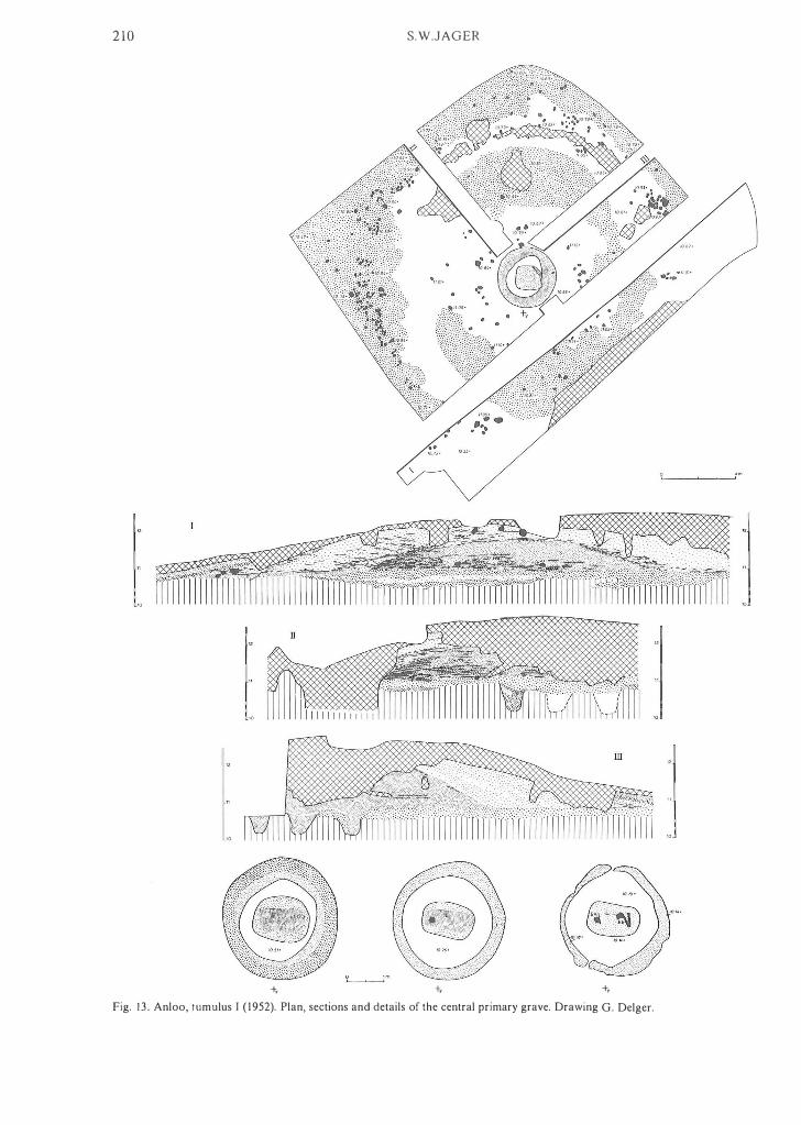
2 10
+,
S.W.JAGER
" 1(). 71·
+, +,
Fig. 1 3 . Anloo, tumulus I ( 1 952). Plan, sections and details of the central primary grave. Drawing G. Delger.

A prehistoric route and ancient cart-tracks 21 1
Fig. 14. Anloo, tumulus I ( 1 952). Axe and nake from the grave. Drawing J .M. Smit, scale 2 :3 .
works was excavated by Brunsting. The tumulus, 2 .30 high and c. 18 m in diameter, was investigated according to the quadrant method. Three ph ases af construction could clearly be distinguished.
Period l produced a low (0.60 m) mound with a c. 8 .50 m diameter, raised af yellowish sand an a surface that was observed as a somewhat humic, narrow dark band. This old surface lay at c. 16 m above NAP. In the prima ry grave, a rounded-trapezoid pit oriented NW-SE and measuring 2. 1 0 by 1 .00- 1 .50 m with a depth af 0.55 m, a blurred silhouette was visible. The flexed body had been Iying an its right side, with its head towards the north-west. This was not clearly documented in the field notes, but could be inferred from a photograph. At the bottom ofthe pit, to the north-west, a Single Grave bea ker af type le was found. The presence af charcoal fragments along the lang sides af the pit suggests a coffin af charred wood. Half-way along the western section, same sand Iying an the old surface was recognized as being from the grave pit .
Period 2. The first capping mound was constructed af sods and had a thickness af about 0.75 m . In the primary mound a podsol profile had aIready been developing. The period 2 grave had been cut same 0 .80 m deep into the top of the primary barrow, and measured 1 .85 m by 1 .00- 1 .25 m, with a WNW-ESE orientation. Along its edges and inside the pit same stones were found; grave-goods were absent.
Period 3. The second addition consisted af yellow sand and sods. A stonepacking once surrounded the foot af this mound, but it had later been dug away to a large extent. On the west side only, part af it survived. The grave belonging to this phase was found to have been cut into the previous addition to a depth ofc. 0.55 m. This pit, which appeared in the centre af the southern section, was not recorded. The grave con tai ned no artefacts. In the ve ry top af the tumu-
lus, three cremations were uncovered, ane af them a small Brol/dskelettgrab ( 1 . 1 0 by 1 .40 m), which had largely been disturbed by a la ter cremation burial.
Fil/d (Provinciaal Museum Assen) 1941/IX 3 (fig. 1 6) : heavy, fairly thick-walled bea ker af paIe-brown ware, tempered with fine sand. S-shaped slightly carinated profile; nat base. Decoration dawn to the carination, consisting af eight horizontal bands af oblique spatula impressions af irregular depth. Height: 19 .2- 19 .6 cm; diameter af mouth: 14 .5- 1 5 . 1 cm; af belly: 1 5.0- 1 5 . 8 cm; af base: 7.0-7.4 cm. Dating af period I : Single Grave Culture. Dating af period 2: Early Bronze Age/first half af the Middle Bronze Age. Dating af period 3: Early Bronze Age/first half af the Middle Bronze AGe.
1 3. AI/loa, tumulus I . Sheet 1 2E: 243.64/563.27. Van Giffen, 194 1 a. In 1 939, Van Giffen undertook a rescue excavation an a tumulus due to be destroyed in the course af reclamation activities. The tumulus, which was 1 .30 high and had a diameter af c. 1 4 m , was investigated according to the quadrant method. On the east and north-east, the barrow was covered by a layer af drift-sand. At its centre, a recent disturbance reached dawn to below the old surface. AIthough a two-period construction is suggested by infiltration veins in the core af the mound and by dark patches probably representing humic sods in its talus, the au thor believes it to be a single-period barrow, raised an a low natural knoll. On the old surface, visible here and there in the sections as a vague and thin humic horizon (at c. 1 2.65 m above NAP), same stones were present . The central grave presented itself as a dark stain with charcoal flecks,
. and had hardly been dug into the ground. It had been disturbed in part, and no grave-goods were found.

212
• 3� . 15.68+ 1540+
-ty -ty
S.W.JAGER
Fig. 1 5 . Anloo, tumulus I I . Plan and sections. Drawing G. Delger.
o f. m. �I ---"----'--�I
18.00
17.00
16.00
1500

A prehistoric route and ancient cart-tracks 213
�\ " � � � \' � � f \: I r ' ,I,
� � Ci " H , q ' \ I I ' \;' � I,) � \1 � � \ � \ \ 1 1
� 1(\ � � (Io fI", � t � \ \ \ (I � I;)
\\ � , , \ � \ \ � , ' \ ' \ \\ ' " '\\ \� \, , '\ , " \
Fig. 1 6. Anloo, tumulus I I . Single Grave bea ker oftype l e, from the primary, principal grave. Drawing H .R . Roelink, scale 1 :2.
Dating: Early Bronze Age/first half of the Middle Bronze Age.
14 . GastereII, tumulus ( 1 939). Sheet 1 2E: 240.73/562.70. Van Giffen, 1941b; Lanting, 1973: pp. 260-26 1 . Van Giffen believed this tumulus t o have been built u p in two phases, but Lanting was able to show that it was, in fact , a three-period construction.
Period l . The primary mound was constructed of grey sand containing charcoal Oecks, on old ara ble land. Its diameter was c. 9 m, its height c. 0.80 m. The grave, measuring 2 .50 by 1 .50 m, had a depth of c. 0.25 m and a NW-SE orientation. In the western corner of the grave, a Barbed Wire vessel was found, upside-down.
Period 2 saw the barrow raised with yellowish sand. This gave it a 1 2- 1 3 m diameter and a height of 1 .30 m. The burial be10nging to it was a Bralldskelettgrab.
Period 3 brought another covering mound of yellowish sand. This addition resulted in the mound's growing to 1 .80 m in height and c. 17 m in diameter. The period 3 grave was observed in the centre of the western section only. It was about 60 cm deep. The peripheral structure in this ph ase consisted of a c1osely-spaced, mostly threefold circle ofthin stakes. Dating of period I : t.arly Bronze Age (Barbed Wire phase). Dating of period 2: Early Bronze Age/first half of the Middle Bronze Age. Dating of period 3: second hal f of the Middle Bronze Age.
I S . GastereII, hUllebed D IO. Sheet 12G Gieten: 240.23/562.47. Van Giffen, 1925/1927. Not investigated.
Fig. 1 7. Gasteren. Barbed Wire beaker from a barrow levelled in 1937. Drawing H .R . Roelink, scale 1 :2 .
16. GastereII , tumulus. Sheet 1 2G: c. 241 .6/56 1 .9. Unpublished. In the national daily paper Algemeen Handelsblad of 23 May 1 937, a short article drew attention to the finding of a bea ker and cremated remains, in a small tumulus Iying in a heathland plot south ofthe Gasteren-Anloo road, opposite ' De Volharding' farm. The bea ker is decorated down to belO\\! its widest circumference with horizontal grooves running round it. Although it is not a Barbed Wire design proper, the vessel's shape, fabric and tem per assign it to the Barbed Wire phase (J.N. Lanting, pers .comm.). Presumably the bea ker came from a cremation burial.
Filld (Provinciaal Museum Assen). 1 937/V 2 (fig. 1 7): sherds of a Oat-based bea ker with an S-shaped profile. The granite-tempered ware, orange-red to reddish brown on the surface, has a red core. The decoration, reaching down to cover the greater part of the belly, consists of horizontal grooves. Dating: Early Bronze Age (Barbed Wire phase).
1 7. GastereIl , tumulus 44 ( 1939). Sheet 1 2G: 24 1 . 27/561 .64. Van Giffen, 1 945. This structureless single-period barrow with a 16 m diameter and a height of c. 1 .50 m was built ofyellowish sand with infiltration veins. The top 0.50 m of the mound had been dug over. The old surface, which shows as an indistinct brownish horizon, was s ituated at c. 1 3.70 m above NAP. The excavations, headed by Van Giffen, who was assisted by Brunsting, were carried out according to the quadrant method. The north-western quadrant, which was not opeoed, still remains standing. The grave, resting on the old

214 S.W.JAGER
surface, was visible as a dark stain in the centre of the mound. Charcoal collected in this area, a little above the old surface, had a radiocarbon age of 3 8 1 0±60 B .P. (GrN-1 3087). In the body of the tumulus a couple of sherds were found, decorated in Barbed Wire style, with widely-spaced 'barbs'. Dating: Early Bronze Age/first hal f of the Middle Bronze Age.
1 8 . Gaslerel/, tumulus 43 ( 1964). Sheet 1 2G: 24 1 .43/56 1 .67. Harserna & Ruiter, 1 966. This two-period tumulus was excavated by Van der Waals. It belongs to a large cemetery south-east of Gasteren, as do tumuli 37 and 44. The barrow's southern half had largely been blown out by the wind, so that only the north-western and north-eastern quadrants and a I m wide strip south of the east-west baulk remained available for investigation. A c. 0.80 m thick layer of fine, layered drift-sand covered the eroded barrow, the central part ofwhich had virtuaIly been levelled by recent disturbance. The investigations were followed by restoration.
In period l, a mound with a core of paie sand and a covery of grey, humous sand was constructed on old arable land (at c. 1 1 .60 m above NAP). This primary mound had a diameter of ab out 1 6.50 m; its height could no longer be assessed. Its peripheral structure consisted of a somewhat oval ditch, 0.80- 1 . 20 m wide and 0.50-0.60 m deep. The central grave, an oval discolouration of2.20 by 1 .30 m, was oriented north-south and had a depth of c. 0.70 m. No grave goods were found.
Period 2. The secondary mound, with an 1 8 m diameter, had a circular ditch of 0.60 m width and a depth of c. 0.50 m. At the time of this secondary construction, no clear soil profile had yet been able to develop in the primary mound; only a thin organic layer was visible, especiaIly above the ditch that surrounded the primary mound. In relation to the latter the secondary mound had been placed eccentricaIly. On the west, 0.40 m separated the two circular ditches; this amounted to 4 m on the east. The central grave belonging to the second phase was not found. However, two Klimmerkeramik pots and a cremation were uncovered in the tumulus. Moreover, a rabbit-hole yielded part of a pair of bronze tweezers, probably belonging with the cremation. Dating of periods I and 2: first half of the Middle Bronze Age.
19 . GaslereIl, tumulus 37. Sheet 1 2G: 24 1 .45/561 .43. Van Giffen, 1945. Van Giffen excavated this barrow, with a I O-m diameter and a height ofO.50 m, in 1 939; using the quadrant method. The single-period barrow had been constructed of dull grey sand. The old surface which lay at c. 1 3.40 m above NAP, showed signs of incipient podsolization. At the foot of the barrow, traces of a single, widely-spaced post circle were identified. The circle comprised nine posts and had a diameter of 9.20-9.60 m. Two smaller postholes, one of which appeared in the middle of the southern section, als o are connected with the construction of the mound, although they do not belong to the post circle. The principal grave was in a somewhat eccentric position. Its burial pit was oriented NNW-SSE, 1 .60 m long, 0.70 m wide, and 0.60 m deep. I nside i t , a tree coffin could be traced out, containing cremated remains. At the bottom of the shaft, a shallow trench along its edges, containing darker soil, showed the traces of29 stakes ofvarying thickness. Evidently, the walls had been lined with sticks. A great deal of charcoal was found on the old surface surrounding the grave, under the yellow sand that had come from the pit. Three small postholes, forming a rectangle of 1 . 80 by 0.90 m of which the north-east corner was obliterated when the grave was dug, form the remains of a mortuary house. Within the post
circle, four tangential secondary burials were observed, all of them showing traces of tree coffins. In one of them, the outline of a skuli could be recognized. Two graves were found to contain Klimmerkeramik pots, one of them with a cordon below the rim. Dating: second half of the Middle Bronze Age.
20. Gaslerell/ Allderel/, tumulus. Sheet 1 2G: grid square 24 1 .5/ 559.5 . Van Giffen, 1 930: p. 1 27. In 1 923 J. Smallenbroek donated a small undecorated beaker to the Provincial Museum in Assen, recorded as "found in a tumulus during the construction of the Gasteren-Anloo road, in the gemeellIe of Anloo". Clearly there was some doubt about the accuracy of this pro venance, as this statement was entered in the museum's inventory books followed by a question mark. Later inquiry did, in fact, reveal that the bea ker must have been found when the Gasteren-Anderen road was metalled in 1922. Smallenbroek had been an engineer employed as a site supervisor in the construction ofthis road. It is quite likely that the bea ker came from a barrow that was used as a source of sand for raising the roadway. AI.though a number of levelled tumuli have been located along the road, or at a short distance of i t , no further details were gained about the beaker, which may be attributed to the Single Grave or Bell Beaker Culture.5
Fil/d (Provinciaal Museum Assen) 1923/IV 3 (fig. 1 8): practically intact, small undecorated beaker. Thin-walled, ochre to reddish ware, tempered with fine sand. S-shaped profile, nat base, rounded rim with partially folded lip. Height: 7 .2-7.4 cm; diameter ofmouth: 6.0-6.3 cm; of belly: 6. 3-6.5 cm; of base: 3 .7-3.8 cm.
2 1 . AI/loa, hUl/ebed D I I (Evertsbos). Sheet 1 2G: 243.60/ 56 1 . 1 8. Van Giffen , 1 925/1927. Not investigated.
22. Eexl, tumulus 2 ( 1 927). Sheet 1 2G: 243.77/56 1 .04. Van Giffen, 1 944c. The tumulus is one of a gro up of eight (fig. 1 9). The site
Fig. 1 8 . Gasteren/ Anderen. Small undecorated beaker from a levelled barrow. Drawing H.R. Roelink, scale I : I .

A prehistoric route and ancient cart-tracks 215
Fig. 19 . Map silOwing the location of Eext , tumulus 2 ( 1 937). Drawing S.W. Jager.
having been ploughed aiready in the course of its reclamation from heathland, and the barrows ravaged by treasurehunters, Van Giffen confined himself to sinking some testpits into five ofthe ruined mounds. The summary nature of these investigations thus did not perm i t proper documentation of the eight tumuli . Tumulus 2 was a two-period barrow: a primary mound of yeltow sand, covered by one built up out of sods. In the central, primary grave was found a Single Grave bea ker of type l a. Some of the other barrO\vs probably also date from the Neolithic, judging from their structure. In tumulus 3 an earlier disturbanee had aiready revealed a thick-butted nint axe. This specimen is broken, and slightly damaged at its cutting edge. From tumulus 4 an urn came to light . Dating of tumulus 2 : period l : Single Grave Culture; period 2: Bronze Age.
23. Eext, Beaker grave ( 1 958). Sheet 12G: 243.89/561 .07. Waterbolk, 1959: fig. 3. In the digging-up of a woodland track, a Single Grave bea ker was brought to light. With it, a ni nt nake was unearthed. The beaker's decoration consists of four moreor-less horizontal bands of impressions below the rim. On one side, the bands cross each other. It is difficult to fit this bea ker into the Single Grave type sequence. According to the labourers, the bea ker was discovered at a depth of about a metre. Waterbolk, who carried out a foltow-up investigation, concluded that there had been no tumulus, as the podsol profile was unchanged at about 3 m from the find spot. Outlines of a grave were no longer to be observed. Dating: Single Grave Culture.
24. Eext, tumulus Eexterstrubben II (fig. 20). Sheet 1 2G: 244.09/562.00. Unpublished. This mound, which had a diameter of c. 8 m and a height of 0.70 m was investigated in April 1954. In its centre a recent disturbanee reached to below the old surface. The eastern part of the barrow was excavated without leaving any baulk . Subsequently the N-S section was recorded. The
western part was investigated leaving a western and a northern baulk. This appears to be a single-period mound with a co re of homogeneous, very humic, even peaty soil, covered with a layer of humic sods mixed with sand. The interface is marked by a thin sandy band, seen in the middle of the northern section. Under the barrow, the old profile consisted of a thin humic layer, a I O-cm eluvial horizon and an iltuvial one. The old surfaee was at c. 1 8. 1 5 m above NAP. No central burial was found; however, a tangential secondary grave appeared at the foot of the mound. This rounded-rectangular pit was recorded as a stain of 2 .30 by 0.90 m with a depth of c. 0.60 m. On the old surface, at the barrow's centre, lay a concentration of charcoal, which was sampled and found to have a I4C age of 3370±25 (GrN-1 1 906). Dating: first half of the Middle Bronze Age.
25. Eext, tumulus Eexterstrubben I (fig. 2 1 ). Sheet 1 2G: 244. 1 7/56 1 .85.
26.
Unpublished. This bad ly damaged barrow was excavated by the quadrant method, at the end of March 1 954. It was situated in ploughed heathland, a littie north of the site where Waterbol k was to excavate in 1 957 and 1958. Although a humic horizon seems to indicate two construetion phases, the faet that this dark band reappears in the middle of the eastern section as a discontinuous layer of humic sods, makes a single-period construetion more likely. The core of the barrow consisted of yellow sand with few sods; at its foot were very humic sods. The mound had an 1 1- 1 2 m diameter and was c . 0.90 m high. The old land surfaee beneath i t had a welt-developed soil p ro fil e , consisting of a thin humic layer, a I O-cm eluvial horizon and an iltuvial zone. Its surfaee lay at c. 1 6.90 m above NAP. The central burial was a cremation lying on the old surfaee with some 40 cm thick, charred t imbers framing it on the south. Charcoal from the latter had a radiocarbon age of3385±25 B.P. (GrN-1 1905). In the southwestern quadrant, a tangential secondary burial was uncovered, at 2.40 m from the central grave. The shape of this pit was rounded-trapezoid, 2.00 m long, 0.50-0.70 m wide, and c. 0.40 m deep. The southeastern quadrant was not investigated. This part of the levelted barrow was exposed in the excavation of 1 986. However, no more tangential burials came to light. Dating: first half of the Middle Bronze Age. AI/loo, Beaker burials in Evertsbos (fig. 3). Sheet 1 2G : 244.20/56 1 . 77. Waterbolk , 1959; 1960. In 1957 and 1 958 Waterbolk investigated a site north-west of Eext, where surfaee finds indicated a TRB settlement. The excavations yielded a number of interesting results. First, there were traces of a threefold enclosure. Waterbolk's initial opinion, that this represented a Single Grave cattle kraal, is no longer tenable. The distribution of TRB pottery largely coincides with the enclosed area. Thus, its interpretation as an enclosed TRB settlement is a far more obvious one (Early Havelte E2 phase; Bakker, 1 979: p. 1 84). Apart from stray finds of Beaker pottery, five Beaker burials were found. These are:
Grave A (fig. 22). The present-day surfaee over this grave was between 1 7 .40 and 1 7 .50 m above NAP. Under the arable layer was visible an irregularly-shaped, roundedrectangular to oval grave, oriented NW-SE and measuring 2.40 m by 1 .40- 1 .60 m. In its centre an oval , paie discolouration was seen. At a lower level the pit was oval, 2 .20 by 1 .30 m; while at the bottom, at 1 .60 m below today's surface, it was more-ar-less rectangular, 1 .70 long and 0. 80-0.90 m wide. There a coffin had been placed on at least four pieces of timber lying across the noor. The coffin's length had be.en 1 .60 m and its width 0.70 m. Charcoal from a charred coffin walt had a radiocarbon age of 4 1 95±70

216
B
1 9.00 m.
1 8.00
17. 00
S.W.JAGER
18. 10 +
. . . . . . . . ' " . "
. ' . . . ,'
- 1 7 90+: : : :: : " : . . o . .
. . , . ' " . . . . '
1 9.00
1 8.00
1 7.00
«
18.10+
-17 90+
18. 10+
0,-1 _-----' __ --'t m .
Fig. 20. Eext, tumulus Eexterstrubben I I . Plan and sections. Drawing G. Delger.
1 9.00
1 8.00
1 7 00

A prehistoric route and ancient cart-tracks
16. 78 +
16. 81+
B 16.63 + � � � 16.95+ ...
�'1t.; e/ 1691+
16.58+
16.68 +
1663+
16. 83+
o ' m. I I
Fig. 2 1 . Eext, tumulus Eexterstrubben I. Plan and sections. Drawing G. Delger.
217
::::� 16.00]
::::] 16.00]

218
. . ' " . ' . . ' . . . " . . .
16. 75+
.' •. \\1'?00>�).,:, . � . . : ... :� .. :.::.:\,::.
16. 06 + . . ' �:; .. : ,' ;.:: x y
S.W.JAGER
16. 40 +
o x y
. ' :/:'� : ' ' , :.: ,: :: . . . .. .. . : : : . . . . . . .. .. .. : .. . ' ,' : : : '. : " . . .. ' . ' . : . ' 0 0 , 0 .
1590+ 1 m .
Fig. 22. Anloo, Beaker grave A (Evertsbos). Details of the burial. Drawing G. Delger.
17m.
16 B
17
16
+G Fig. 23. Anloo, Beaker grave B (Evertsbos). Details of the burial and sections. Drawing G. Delger.

A prehisforic roufe and ancient cart-fracks 219
B.P. (GrN- 1965; Lanting & Mook, 1977: p. 89). No artefacts were found in the grave. Orielllation and position of this burial make i t comparable to those of the AOO group, to which it should probably be assigned.
Grave B (fig. 23). At grave B, the present-day surface lay at a level of 1 7.35 m above NAP. At 1 6.90 m, the grave showed as a rectangle of 2.80 by 1 .60 m, oriented NW-SE. A great dea I of charcoal covered this surface, a narrow strip along the western edge ·excepted. This could have been a charred coffin top. Deeper, at 1 6 .70 m, the grave seerned to widen to 3 . 1 0 by 1 .90 m; this is probably due to erroneous observation at a higher level. A recent disturbance cut into it , down to below the bottom of the shaft. In the grave, the coffin manifested itself as a patch of charcoal, measuring 2.40 by 1 .20 m. A concentration of this, probably still part of the coffin's lid, was sampled for radiocarbon dating (GrN-85 1 : 4 1 40±70 B.P. ; Lanting & Van der Waals, 1 976: p. 40). At c. 1 6.57 m above NAP, the coffin was still visible, as an oblong paie grey stain of2.00 by 1 . 20 m. At this level, charcoal from the coffin's wall was found along its northeastern side. Stones serving to support the coffin were uncovered in the pit, which descended to some 90 cm below the present-day surface. On one of the stones lay sherds of two AOO beakers oftypes 2IIb. As the major part of these beakers was missing, they were probably broken before being buried. The grave was surrounded by a foundation trench with an outer diameter of 6.40-6.60 m, and a width of 0.50-0.80 m. 19 posthole stains were counted in this ditch. No. 20, hidden under the baulk, was not recorded. By their shapes, 14 of them indicated the use ofmultiple posts. The ditch had been dug to c. 0.80 m below today's surface. On the south, it was cut by a round pit, which was full of sand burnt red and charcoal. This had the same depth as the ditch itself.
Grave C (fig. 25). The present-day surface was at c. 1 7.35 m above NAP here. At c. 1 6. 9 1 m the grave appeared as a rounded-rectangular pit of2. 70 by 1 . 1 0 m, oriented NNWSSE. At a level of 1 6.85 m, the dimensions were 3.00 m and 0.90- 1 ,00 m, so that an observation error similar to that in grave B is l ikely to have occurred. No traces of a coffin or a bod y silhouette were encountered, but an AOO bea ker of type 2IIb had been buried with the deceased. The bottom of this grave was at c. 1 6.70 m above NAP. Charcoal from a pit that had been dug through the grave, even disturbing its bottom, was found to have a radiocarbon age of 3965±50 B.P. (GrN- 1 976; Lanting & Van der Waals, 1976: p. 40), which may be regarded as a lerminus anIe quem for the burial. The grave was surrounded by a somewhat oval foundation trench with a 4. 1 0-4.60 m outer diameter and a width of 0.35-0.50 m. !ts depth in relation to today's land surface was 0.75-0.90 m. In its fill, sixteen more-or-Iess round postholes were observed; they could be traced all the way down to the bottom of the ditch.
Grave D (fig. 27). At grave D the present-day land surface was c. 17 .30 m above NAP. Below the arable layer, grave D showed as an oval stain measuring 1 .90 by 1 .70 m . As i t deepened, it gradually became rounded-rectangular, measuring 1 .70 by 0.75 m at a level of 16. 19 m. !t had an east-west orientation. Reckoned from today's surface, it was 1 .30 m deep. The grave-goods consisted of a Single Grave beaker of type l a , a flint blade, a nint blade axe and a sandstone whetstone.
Grave E (fig. 29). At 1 6 . 6 1 m above NAP, some 60 cm below the surface, the grave appeared as a roundedrectangular to oval pit, orient ed WSW-ENE and meas uring 1 .75 by 1 .00 m. At this level some charcoal, probably from a coffin, was collected; this was radiocarbon dated 4420±75 B.P. (GrN- 1 855; Lanting & Van der Waals, 1976: p . 39). At a lower level, the pit had an irregular circumference. It contained a fine Single Grave beaker of type la .
, _ _ _ _ _ _ _ _ _ _ _ _ _ _ _ _ T _ _ _ _ _ _ _ _ _ _ _ _ _ _ _ _ _ 7
'\ " " I / , , I
" '\ I " I " I , , , ,
, \ \ \ I I I I
I I I ' I "
, , , , , , , , , , ,
I , ,
\ , ,
Fig. 24. Anloo, Beaker grave B (Evertsbos). AOO beakers of type 2IIb, from the grave. Drawing H .R . Roelink, scale 1 :2 .
Some fl int flakes, as found in grave D also, are considered to be settlement waste. The bottom of the burial pit was at 1 6.38 m above NAP. Whether tumuli had eve r been present over these graves is doubtful. Considering their dose spacing, such monuments could not have been very large ones. Any low mounds might aiready have been ploughed out during the Middle Bronze Age. Grave D and the trench round grave C are cut by carl-ruts. Further finds on the site were traces of Early Bronze . Age occupation and a Late Bronze Age urnfield.

220
-16.�1·
S.W.JAGER
2 m. L-____ � __ � __ �!
1"·� "1 � � :�� I 16 16
Fig. 25. Anloo, Beaker grave C (Evertsbos). Details of the burial and section. Drawing G. Delger.
Finds/rom grave B (Provinciaal Museum Assen). 1 958/VII I 60a (= 49a; lig. 24): sherds of a thin-walled Jeather-brown AOO bea ker of type 2IIb, which could be reconstructed. Temper: probably fine sand. Biconical, fairly sharply carinated belly. Strongly everted rim, with rounded tip. Flat base. The decoration consists ofhorizontal cord impressions, covering the whole vessel. This ornamentation is also found inside the rim, and consists of five to six impressed lines. Waterbolk, erroneously, shows only two in his article of 1 960 (lig. 32). Height: c. 18 cm; diameter of mouth c. 13 cm; of belly: c. 1 3 . 3 cm; of base: 6.2 cm. I 958/VII I 60b (= 49b; fig. 24): AOO bea ker, type 2IIb, of thin-walled, Jeather-brown ware, tempered probably with fine sand. Only the base and lower part of the belly could be reconstructed. Waterbolk shows a large separate sherd (lig. 32), which in faet fits on to the beakers' bottom half and which had broken off at the sharp carination. Decoration consists of irregular cord impressions, applied in pairs. Diameter of belly: c . 13 cm; of base: 5.2 cm.
Find from grave C (private collection of Mrs. A.A. Suringar-Everts of Assen). No. 46 (fig. 26): almost complete AOO beaker oftype 2IIb, leather-brown. Biconical bell y and gradually everted rim,
nattened at the top. Flat base. The vessel is decorated all over with horizontal cord impressions. These were also applied to the nattened rim, and the same piece of string was used to impress three or four more lines on the inside of the rim. Height: 2 1 cm; diameter of rim: 14 cm; of belly: 1 3 .6 cm; of base: 8.2 cm.
Finds/rom grave D (Provinciaal Museum Assen) 1 958/VII I 36a (fig. 28): Single Grave bea ker of type l a , fired to ochre a n d reddish-brown blackish in parts. The tem per consists of line sand. The inside shows that the pot was coil-built. About one-third of the vessel could be restored. S-shaped profile with partially folded lip. Markedly protruding foot, and nat base. The decoration, down to just above the widest circumference, consists of irregular cord impressions, in pairs, which are quite shallow in places. The lower edge of the decorated area is marked by a series of sharp spatula impressions. Height: 1 7.6-1 8.0 cm; diameter of rim: 1 3.0- 1 4 . 3 cm; of belly: 1 3 .0- 1 3 .2 cm; of fQot: 5.8-6.0 cm. I 958/VII I 36b (fig. 28): small blade axe ofblue-grey to paie grey, fine-grained ninI . The dorsal face shows two blade negatives. The dorsal as well as the ventral face have been polished near the cutting edge on a fine-grained stone. The

A prehistoric route and ancient cart-fracks
Fig. 26. Anloo, Beaker grave C (Evertsbos). AOO beaker of type 2IIb from the grave. Drawing H. R . Roelink, scale 2:3 .
o I
Fig. 27. Anloo, Beaker grave D (Evertsbos). Drawing G. Delger.
1 m . I
221
�?bi (\\ .·.�36a � 3''bj" • •. •. • . �. < . : " " " ' . . : " : � : . : . : . " ', :, ' .' : : . . ..
16. 19 + - 1601+

222 S.W.JAGER
Fig. 28. Anloo, Beaker grave D (Evertsbos). Single Grave bea ker of type la, small blade axe, blade and whetstone from the grave. Drawing H.R. Roelink, scale 1 :2.
transition between the faces is an edge of only a few mill imetres' width; ground on coarser stone. But! rounded and partially polished. Length: 8 .3 cm; greatest width: 2.9 cm; greatest thickness 0.9 cm. 1 958/VIII 36c (fig. 28): small blade of grey, fine-grained flint . On the dorsal face two blade negatives are visible. Length: 7.6 cm; greatest width: 2 . 1 cm; greatest t hickness: 0.5 cm.
1 958/VIII 36d (fig. 28): triangular (when seen from above) whetstone of reddish- to greyish- brown, very fine-grained sandstone.
Find from grave E (private collection of Mrs. A.A. Suringar-Everts of Assen). No. 5 1 (a)(fig. 30): S ingle Grave bea ker, type l a , of leatherbrown, in parts blackish, ware. S-shaped profile with a rather wide belly; flat base. Decoration not reaching
A prehistoric route and ancient cart-tracks 223
. .. ,' . .... ' : . . . , , ' : . : :' : . . ,
. . . . . . ' .
. . . : .... . . ' . : � .. : : .. : » .. : : .. � . .'. '.: . . ' : . . . . . . '
, ' , ' , ' . . . .
. . .' .. .. . . : . � : : : : : . : :' :':':': : .
. . . . . . : .
',' .: : . : . . ' . . ' 16. 72+ • ' , l '
Fig. 29. Anloo, Beaker grave E (Evertsbos). Drawing G. Delger.
Fig. 30. Anloo, Beaker grave E (Evertsbos). Single-Grave beaker of type l a , from the grave. Drawing H .R . Roelink , scale 2:3 .
beyond the neck, consisting of nine pairs of cord impressions, beneath which a row of short, vertical to oblique spatula marks. Height: 2 1 .2 cm; diameter of mouth: 1 3 .8-1 4.4 cm; of belly: 14.8- 15 .0 cm; of base: 5.9 cm. Dating of grave A, B and C: AOO group. Dating of grave D and E: Single Grave Culture.
27. Eext, tumulus I ( 1937). Sheet 1 2G: 244.75/56 1 .25. Van Giffen, 1 939; Waterbolk & Glasbergen, 1 957: fig. 1 5 .
' , ' ,
16 46 + -1638 + O 1 m . L.,.' __ -'-__ --',
W.hen, in 1 936, two amateur archaeologists unearthed the sherds of a Zigzag beaker, a battie axe of type P I , a small flint axe, and a Grand-Pressigny dagger-obviously goods from a S ingle Grave-from a tumulus north of the Galgwandenveen, Van Giffen decided to investigate the barrow's structure. After the quadrant-method excavation, the barrow was restored.
Period l. The init ial mound was 1 . 1 0 m high, some 18 m

224
I I
16
I I
I I I
" / / / "
\::.:. " ,-:,' "
I
/ / /
" /
/ /
o 2 m. L.I ____ ,--__ ....J I
S.W.JAGER
- ' .... , .... " .... " " "
/ "
" , , , , \
" /
" " / /
/
I I
I
~
o 4 m. LI ____ � __ _L __ � __ �I
O l m. LI ____ ,--__ ....J I
17
16
Fig. 3 1 . Eext, tumulus Galgwandenveen l. Plan, details af the burial and sectians. Drawing G. Delger.

A prehistoric route and ancient cart-tracks 225
in diameter, and built of yellow sand. Beneath the old surface, which was at 1 6. 50 to 1 6 .60 m above NAP, the so il profile showed an indistinct hum ic horizon over a clear eluvial horizon, and blotches of illuvial iron. The primary grave had for the most part been disturbed by the treasurehunters, and was only partly visible in the excavation. It had been on the old surface. Round it, under the foot ofthe primary mound, was a wide foundation trench with an outer diameter of 1 2.00- 1 2.40 m . I n section, the trench was rounded V-shaped, 0.70-0.90 m wide and 0 .25-0.75 m deep. In its fill, 52 post holes appeared. Charcoal collected from one of these was radiocarbon-dated 4 1 45±30 B.P. (GrN-6727; Lanting & Van der Waals, 1 976: p. 40).
Period 2. The yellow-grey secondary mound was built of sods. This gave the tumulus a 1 9-m diameter and a height of 2.40 m . A grave containing cremated remains, which was observed only in the middle of the northern section, was assigned to the same period by Van Giffen. In this, he was mistaken: the shaft had been sunk from the top of the tumulus and descended some 30 cm into the primary mound. The shaft with the cremation must be of a la ter date. No central grave was found for period 2; it was probably destroyed by the diggers mentioned earlier. In the foot of the tumulus, in the north-west as well as the northeas t quadrants, rectangular, radial pits were uncovered. These two resemble the radial secondary graves cut into the foot of the 't Witzand tumulus (no. 38). A littie below the old surface, within the foundation trench, some decorated TRB sherds were retrieved. A Scandinavian flint dagger, discovered in the iron-indurated sand under the edge ofthe secondary mound, was a nice surprise for the archaeologists. It belongs to type II and dates to the Early Bronze Age. Dating of period I : Single Grave Culture. Datillg of period 2: Early Bronze Age/first half of the Middle Bronze Age.
28. Eexl, tumulus II ( 1 937). Sheet 1 2G: 244.82/56 1 . 23. Van Giffen, 1 939. Together with tumulus I , two more barrO\vs Iying on a pingo rampart east of the Galgwandenveen were excavated. The northernmost, which was restored after its investigation by the quadrant method, turned out to be of singlephase construetion with a border of stones. Its diameter was 13 to 14 m, and its height 1 . 10 m. Thin layers of drift-sand had accumulated on its lee side. The tumulus, consisting of yellow-grey sand, lay on the north-east flank of the pingo rampart, as did most of its stone border also. The old surface, between 1 7 .00 and 1 7.70 m above NAP, had in its profile a leaehed horizon over a yellow-brown illuvial zone. A discolouration was all that remained of the central grave. It had not been dug into the old surface. To the north and east of it, a widely-spaced semicircle of stones accompanied the grave. Within the stonepacking, on the south-west flank of the rampart, an arrowhead with a concave base was found. Dating: Early Bronze Age/first half of the Middle Bronze Age.
29. Eexl, tumulus III ( 1 937). Sheet 1 2G: 244.85/56 1 . 2 1 . Van Giffen, 1 939. This oval tumulus, measuring 13 by 9 m, and 1 . 10 m high, c1ose1y resembled tumulus II in its structure and location. It toa was a single-phase construetion, with a stonepacking. The barrow was excavated with the exception of a con tinuous NNW-SSE baulk, an east-west baulk of which the western part made a sharp turn towards the south-west, and a NW-SE baulk biseeting the north-western part ofthe mound. Only the NN W-SS E section was recorded in field drawings. The excavations were followed by the barrow's restoration. The body ofthe tumulus consisted ofyellowish sand with infiltration veins. Below the old surface, which
lay at 16 .85 to 17 .60 m above NAP, the soil profile showed a thin humic layer, a I O-cm eluvial horizon and an illuvial zone. To the west and north, the foot ofthe barrow contained a fragmentary stonepacking. The centre had been recently disturbed; no central grave was found. It is likely to have also been on the original land surface. Dating: Early Bronze Age/first half of the Middle Bronze Age.
30. Eexl, tumulus Galgwandenveen I ( 1 970; fig. 3 1 ). Sheet 1 2G: 244.87/56 1 . 1 5 . Lanting & van der Waals, 197 1 . The ploughed-out relics were all that remained o f this monument. It had lain in ara ble land on the south-east flank of the Galgwandenveen pingo ram part. Under the ara ble layer on the flank of the rampart, the old land surface was still visible, if only just, as a thin grey horizon. The tumulus had a diameter of c. 16 m and had probably been built in a single period. The grave itself, WSW-ENE oriented, was rounded-rectangular, measured 2 .80 by 1 . 1 0 m, a'nd was 0 .30 m deep. The bottom of the grave lay at c . 1 6.55 m above NAP. In the grave, a silhouette was observed: the body had been Iying in a flexed position on its left side, head to the east and thus facing south. The dead person had been given as grave-goods a Single Grave beaker of type le and a flint blade 1 2.3 cm long. The south-east corner of the grave just touched a round pit. This had a diameter of 1 .30 m and a depth ofO.55 m. Its fill consisted of charcoal and red-burnt sand; radiocarbon dating gave an age of3930±45 B. P. (GrN-8254). Before the excavations were begun, a sherd of a Maritime Bell Beaker was found on the spot. It is quite possibie that this had been ploughed up from the old surface. Moreover, TRB sherds were found in the subsoil of the leve lied barrow.
Finds (Provinciaal Museum Assen) 1 970/XII 5 (fig. 32): fine, slender Single Grave beaker of yellow to reddish-brown ware, blackened in places and with a black core. Fine sand tem per. Graceful, S-shaped profile, and somewhat concave base with a markedly protruding foot. The decoration, which was applied with great care, consists often horizontal bands ofshort oblique lines, and stops short ofthe greatest circumference. Height: 2 1 .4-2 1 .7 cm; diameter o f rim: 14.8- 1 5.2 cm; of belly: 1 3 .4- 1 3 .7 cm; of foot: 6.9-7.0 cm. 1970/XII 6 (fig. 32): blade of beige- to brownish-grey, fine-grained flint. Sharply curved lower half; the tip is missing. On the dorsal face two blade negatives are visible. Towards the distal end the edges show fine retouch. Length: 1 2. 3 cm; greatest width: 3.3 cm; thickness: 0.8 cm. Dating: Single Grave Culture.
3 1 . Eexl, tumulus b. Sheet 1 2G: 245.83/562.08. Waterbolk & Glasbergen, 1957: pp. 27-32. AIready in 1 923 this tumulus had been dug by an amateur archaeologist, which had resulted in some interesting finds, such as a Grand-Pressigny dagger and a Zigzag beaker. As the parcel containing the scarred barrow was due to be brought into cultivation, an excavation was carried out in December 1 955. The single-period tumulus with i t s c. 16-m diameter and height of at least 1 . 1 0 m, had been built on a soil with an eluvial horizon of 15 cm thickness and an orange-yellow illuvial horizon. The old surfaee lay at 1 0.00 to 10 . 1 0 m above NAP. Its body consisted of dirty yellow sand with sods. Beneath the mound, a foundation trench was uncovered with an inner diameter of2.00 m, a width of 0.50-0.60 m and a depth of 0.70-0.80 m . The ground that håd come out of i t surrounded it as a low bank. Within the trench, a littie above the old surface, was found a cake of charcoal, I O cm thick and 1 .00 m across, which seerned to continue into a practically cylindrical pit, cut into the soil to a depth orc. 0.60 m. A sample ofthis charcoal was found to have a radiocarbon age of 3880±40 B.P. (Lanting & Van

226 S.W.JAGER
Fig. 32. Eext , tumulus Galgwandenveen r. Single Grave bea ker oftype l e and nint blade, from the grave. Drawing J.M. Smit, scale 2 :3 .
der Waals, 1 976: p . 40). The interpretation of the charcoal cake and pit remains uncertain; probably they are seconda ry to the barrow. In that case, the date mentioned should be regarded as a terminus anie quem. No traces of a burial were observed. When the old surface within the ditch was investigated, however, a battle axe of type H was found. This convincingly proved the grave to have been on the old surface. Dating: Single Grave Culture.
32. Eexl, tumulus c. Sheet 1 2G: 245.89/562.03. Waterbolk & Glasbergen, 1 957: pp. 32-33. In the course of tumulus b's excavation, another was discovered at a distance of some 50 m from il. Most of this barrow had been ploughed out; its remaining height was hardly 40 cm. The old soil profile beneath it consisted of an eluvial horizon c. 8 cm thick, and an indistinct orangeyellow illuvial horizon. The old surface lay at around 9.70 m above NAP. In the excavation, the central grave was
visible as a rounded-rectangular pit 2 .30 by 1 . 20 m, with a WSW-ENE orientation. Its depth was 0.65 m. In the northwestern carner of this burial, a Single Grave bea ker of type Ic was uncovered. Dating: Single Grave Culture.
33. Eext, tumulus Schuilingsbosje . Sheet 1 2G: 245.06/56 1 .08. Van Giffen, 1 94 1 c; Lanting, 1973: p. 230. In July 1 939 this tumulus was excavated by Van Giffen. It was situated on a dune-sand ridge, in ve ry uneven terrain. The investigations were carried out by cutting two trenches crosswise across the mound, and by opening up the northwest quadrant in order to expose all of the primary grave. The barrow was restared afterwards. I t was found to be a two�period tumulus.
Period l consisted ofa low mound, c. 9 m in diameter, of dirty yellow sand with few sods in i l . The old surface was at 1 7.75 to 1 8 . 20 m above NAP; under it a brown horizon of 20 cm thickness, with some marbling due to infiltration,

A prehistoric mute and ancient cart-tracks 227
r::: �1rmlrmTfl_ Fig. 33. Eext, tumulus Galgwandenveen I I I . Plan, sections and details of the primary grave. Drawing G. Delger.
was visible. Around the primary grave, on the old surface, lay the yellow sand from its pit. The grave was oriented NNW-SSE, rounded-rectangular, 2. 1 0 by 1 .25 m, and 0 .85 m deep. Along the sides lay boulders, which had served to support the coffin . Some stones were present also on top of the grave. In the grave, a silhouette appeared, representing a body Iying on its left side in a crouched position, head to the SSE. The chin rested on one of the hands.
In period 2, the mound had been raised with sods. By this addition, it grew to a height of l . IO m and a diameter of some 16 m . The interface with the primary mound was recognizable by a thin humic layer in the top of the latter. The secondary mound lay a littie eecentric in relation to its predecessor. The grave belonging to it was north-south
oriented, rounded-rectangular in shape, and measured 1 . 50 by 1 . 1 0 m. It had been cut into the primary mound, the shaft reacJling to a littie below the old surface. Seven erratics lay on top of the pit. Only cremated remains were found in the grave, of which only the horizontal outlines were drawn. Dating period I: Early Bronze Age (Barbed Wire phase). Dating period 2: Early Bronze Age/first half ofthe Middle Bronze Age.
34. Eexl, tumulus Galgwandenveen III ( 1 970; fig. 33). Sheet 1 2G: 245.03/561 .06. Lanting & Van der Waals, 197 1 ; 1976: fig. 6. This was a ploughed-out tumulus, about 250 m southeast of the Galgwandenveen, and at the edge of the Noordes of

228 S.W.JAGER
o
o o CJ o
Fig. 34. Eext, tumulus Galgwandenve;::n I I I . Single Grave beaker af type I d , type H battie axe, small flint axe and GP-dagger from the primary grave. Drawing J.M. Smit, scale 1 :2 .

A prehistoric mufe and ancienf cart-fracks 229
Eext. It was crossed by a NW-SE trench 1 7 m long and 3 m wide. Where the grave was encountered, a small side trench was added at right angles to the first. Beneath the arable layer enough had remained of the mound's body to allow conclusions about the barrow's construction. I t was a three-period tumulus with a diameter of 1 6 to 17 m.
Period l. A yellow sand mound, c. 1 0 m across, lay on a soil with a white eluvial horizon of c. I O cm thickness, and an orange illuvial zone . Here and there, some very faint traces of a thin hum ic layer could be observed. The old land surface lay at c. 1 5 .65 m above NAP. Even above this level, the primary grave pit was shown up by a roughly rectangular pattern of infiltration stains, and charcoal. It had been cut some 10 to 20 cm into the old surface, and had a NE-SW orientation. The bits of charcoal are likely to be the remains of a charred coffin, measuring about 2.80 by 0.90 m. Evidently, the coffin had not sunk below the old surface. The grave-goods comprised a Single Grave bea ker of type I d (herringbone design), a type H battie axe, a small flint axe and a Grand-Pressigny dagger. Two radiocarbon dates were obtained from the charcoal: 3935±35 B.P. (GrN-6368) and 3940±30 B.P . (GrN-6635) (Lanting & Van der Waals, 1976, pp. 39-40).
Periods 2 and 3. At the foot of the ruined barrow, two phases of enlargement could be clearly identified. Both additions were structureless. No graves were found.
Finds (Provinciaal Museum Assen). 1970/XII 26 (fig. 34): Grand-Pressigny dagger of finegrained, slightly transparent flint, brownish-yellow with grey-white specks and some coarses inclusions. Slightly curved lengthwise. Ventral face flat to slightly convex; dorsal face ground down to make the blade thinner. Hiltblade transition marked by a series of parallel marginal retouches. The end of the hilt straight and with quite steep retouch; the edges of the blade finished with fine retouch. Upper face of the blade polished and convex, its sides evenly curved. The blade near the hilt rounded-triangular in section. Length: 23 .7 cm; greatest width: 3.7 cm; greatest thickness: 1 . 3 cm. 1 970/XII 27 (fig. 34): battle axe of fairly coarse-grained dolerite. Upper side ground concave; axe end straight, slightly curved towards the cutting edge, butt end curved more strongly. Cutting edge, and, to a lesser degree, hammer head, extended downwards. The battle axe is rounded-rectangular to round in section. Length: 1 5.4 cm; greatest width: 5 . 5 cm; diameter of shafthole: 2.4-2.6 cm; shafthole at 5.1 cm from the butt end. 1 970/XII 28 (fig. 34): sherds of a bea ker with S-shaped profile; fairly concave base with a markedly protruding foot. Only the foot and one side of the bea ker could be restored. The fabric, reddish-brown to blackish in colour, was tempered with fine sand and crushed pottery. The decoration, applied to the top half ofthe bea ker, consists of eleven horizontal bands of impressions, forminga herringbone design. Height: 22.2-22.6 cm; diameter offoot: 6.3-6.4 cm. I 970/XII 29 (fig. 34): small axe ofbeige-grey, fine-grained flint with some coarser inclusions. Rectangular in section, both faces slightly convex, heavily ground-down near the cutting edge, narrow sides straight and partially polished. On one face, some gloss indicates hafting. Butt face virtua Ily flat and partially polished. Length: 6.7 cm; greatest width, at cutting edge: 3 .7 cm; greatest width of the narrow sides: 1 .2 cm. Dating of period I : Single Grave Culture. Dating ofperiod 2 and 3: Early Bronze Age/ first halfof the Middle Bronze Age.
35. Eexl, tumulus Kerkweg 3 ( 1 970). Sheet 1 2G: 244.56/ 560.90. Lanting, 1973: pp. 270-27 1 .
Of this tumulus only the levelled remnants survived. I t was found to have two phases of construction.
Period l: a mound probably 15 m across. The soil it stood on contained a thi n humic layer, a 20 cm eluvial zone and a poorly-deve!oped illuvial horizon. The old surface lay at 1 8 .05 to 1 8.25 m above NAP. The central grave, oriented east-west, had a depth of 0.65 m. The rounded-rectangular pit was 3.40 m long and 1 .60 m wide. Inside the grave, the coffin had been supported by a construction of stones. Charcoal from the coffin had a radiocarbon age of 3760±35 B.P. (GrN-6340). The grave-goods were formed by two battle axes of Emmen type, one of which was an unfinished, atypical specimen.
Period 2 was marked by an addition of yellow sand, which was visible only on the south side. No grave belonging to i t was found. As a peripheral feature i t had an interrupted circular ditch with an inner diameter of some 20 m, a width of c. I m and a c. 0.80 m depth. The ditch only showed up at a fairly low level, as a well-developed podsol profile had covered the whole barrow thereby partly obliterating the traces of the ditch. Dating of period I : late Bell Beaker Culture. Dating of period 2: first half of the Middle Bronze Age.
36. Eexl, tumulus Kerkweg 2 ( 1 970). Sheet 1 2G: 244.54/ 560.92. Lanting, 1 973: pp. 264-265. This site contained the levelled remains of a single-period tumulus. I t had been built on well-podsolized soil; the old surface lay at c . 17 .75 m above NAP. The east-west, central grave was 2.60 m long, 1 .40 m wide, and 0.70 m deep. Remains of a coffin were found inside it . Charcoal from these was C l 4-dated to 3670±35 B.P. (GrN-6367). A small, flat , triangular knife offlint had been given to the deceased. Only on the south had part of the original stone border survived. West of the grave, within the border, sherds of a Barbed Wire beaker were found Iying on the old surface. Dating: Bell Beaker Culture to Early Bronze Age transition (Barbed Wire phase).
37. Eexl, tumulus Kerkweg I ( 1 970; fig. 35). Sheet 1 2G: 244.45/560.80. Lanting & Van der Waals, 197 1 . This tumulus toa had been levelled. I t had been ploughed out to below the old land surface. The barrow probably had a diameter of about 12 m. The central grave, oriented NE-SW, was oval, measuring 1 .60 by 1 . 20 m, and had a depth of 0.70 m. The bottom of the grave lay at c. 1 7.45 m above NAP. There a vague silhouette appeared, of a crouched body Iying on its right side, its head to the south-west. No grave-go ods were found. Dating: probably Single Grave Culture.
38. Eexl, tumulus 't Witzand (fig. 36). Sheet 1 2G: 245.62/ 560.49. Jager, 1 985 . The bottom slice of this tumulus, which had survived under the arable layer, was excavated in 1983, according to the quadrant method. The barrow probably had not been levelled until the late 1 9th century, as two boundary ditches on the Ordnance Survey map of 1 853 stop dead at this point instead ofjoining up. This two-period barrow was built on a podsol profile comprising a greyish humic zone 8 to 1 2 cm thick, a paie grey eluvial horizon of c. 4 cm and a brownish illuvial horizon. In places, the interface between the subsoil and the mound's base was accentuated by a thi n layer of charcoal. The old surface lay at c. 1 8 . 30 m ab ove NAP. Beneath i t , plough scratches were recognized.
Period l in the barrow's construction left a mound of yellowish to grey-brown sand, surrounded by a ditch. The latter is somewhat angular and asymmetrical. Its inner diameter is 8 . 80 to 1 0.50 m, its width varies from 0.50 to c. 2.20 m, and its depth between c. 0.20 and 1 . 10 m. The ditch

230 S.W.JAGER
17. 9 0 .
. .
. . . . . . . .. \
.� . • • (jj) 17. 79. 17.69.
O 3 m. LI ____ � __ � ____ �I
17.61.
shows a curious anomaly: in the south-eastern quadrant i t is v e r y narrow and shallow; in the north-east quadrant i t i s absent over a 3 m stretch, beyond which i t continues as a very shallow ditch. Then suddenly it attains its greatest width and depth. Immediately beneath the arable layer, some stones and hollows of ploughed-out stones marked the spot of the central grave. It must have been a very shallow one, with stones along its sides. In the middle ofthe northern section, the burial pit may be indicated by an interruption of the humic horizon, but no discolouration was visible from above. The grave thus must have been almost on the old surface. The distribution of the stones, and the hiatus in the humic horizon, give the grave a length of c. 2 .80 m and a width of c. 1 . 20 m . Its orientation would have been c. NNE-SSW. Under the western baulk, immediately against the prima ry grave, a shallow pit was observed which may be older than the barrow. Its fill consisted of grey sand with charcoal flecks. In the southwestern quadrant, a rounded-rectangular pit which partly cuts into the ditch may be a tangential child's grave, although no further evidence was found for this assumption. It dimensions were 1 .20 by 0. 50-0.60 m; its depth 0 .80 m. Charcoal from the encircling ditch was radiocarbon-dated to 3585±30 B.P. (GrN-12266).
17. 4 5 . 17.42. Fig. 35. Eext, tumulus Kerkweg I . Plan and details of the grave. Drawing G. Delger.
width of 0.90- 1 .40 m, and a depth of 0.70-0.80 m. In the north-western quadrant i t had a narrow, 20 cm interruption. Period 2 lies a littie eccentric in relation to the first period: on the north the second ditch cuts through the first, while to the south the ditches are 3. 1 0 m apart. An almost cylindrical pit in the north-east quadrant was visible immediately under the ara ble layer, and must therefore have been dug from a higher level. It may aiso belong to the second phase. Just under the ara ble layer, it measured 1 .20 by 1 . 30 m; from this level i t extended downward another metre. Nothing was found in i t . The central grave of period 2 remained undetected.
Moreover, a dozen later burials were uncovered in the slope at the foot of the barrow. Most probably, they are Early Medieval. In three of them, bone remains were still present, which showed that the bodies had been lying head to the west, feet 'downhill'. In two cases they could be seen to have been in an extended, supine position. All graves but one were radially oriented; none of them contained artefacts. The grave with the contrasting orientation cuts into a cart-track that runs across the flank ofthe mound. The ruts belong to an ancient road, which was record ed over a length of about 2 km. To the west of the tumulus, some sub-recent tracks also appeared. Dating of period l and 2: first half of the Middle Bronze Age.
Period 2 also produced an encircling ditch. This, however, was partly hidden in the iron-pan at the foot of the mound, and only manifested itself clearly at a fairly dee p level. This ditch had an inner diameter of 15 . 80- 16 .80 m, a
39. Eext, Beaker grave Vijzelkampen. Sheet 1 2G: 247.2/560. 1 . Unpublished.

A prehistoric route and ancient cart-tracks 231
,,� rrr " rrrlrrrfmmmllllll llllln l lll l I I Hlrrllfr r ITl rrl rr r llTlfl lll lll llrr l l l l l l l l l l l lOI 'I "J
l�m lrl [�lrl l l lmn11rlrlfl 1 1·l flI Irlli lnnnrnflllrrrrl llnn l·lmmrn lflll l rl1nl�nJmm1 I :: Fig. 36. Eext, tumulus 't Witzand. Plan and sections. Drawing G. Delger.
' 'p �' / //A � '\.- � '-\\
# ##,/ #111 '\ " \. , � ,,'\
,Ø ø' l'f# 1' #
Fig. 37. Eext. Single Grave beaker of type I d, from the Vijzelkampen. Most probably from a destroyed Beaker grave. Drawing H.R. Roelink, scale 2 :3 .
In 1937 the Provinciaal Museum in Assen bought a small Single Grave bea ker ofMr. Doddema ofEext. The beaker's provenance was Mr. Doddema's sand pit in the Vijzelkampen. Nothing is known about the circumstances. The beaker is likely to have accompanied a Single Grave burial.
Find (Provinciaal Museum Assen). 1937/V 16 (fig. 37): small, virtuaIly intact Single Grave beaker, type Id , of yellowish-brown, rather th ick-walled ware with fine sand tem per. S-shaped profile, with a high waist , wide belly, and almost nat base with markedl)l protruding foot. Oecoration below the rim, consisting of five more-or-Iess horizontal bands of ill-defined oblique lines forming a herringbone design. Height: 10.5- 10 .8 cm; diameter of mouth: 8 .4-8.7 cm; of belly: 9 .7-9 .9 cm; of foot: 5 .9-6.3 cm. Dating: Single Grave Culture.
40. Eexl, tumulus Gieterstraat ( 1 982; fig. 38). Sheet 12G: 246.00/559.23. Lanting, 1 984. At the outset of the excavations, this tumulus was found to øe in a very bad condition: the south-eastern quadrant had largely been removed and subsequently used as a rubbish dump; a large part of the western half had been ploughed-out , as the barrow had been in a wooded bank forming a field boundary; in the centre a recent disturbanee reached down to below the bottom of the primary grave; some stout trees had sunk their roots into the mound, and

232 S.W.JAGER
lUIII.. 8
1920- :' . " . ' .
O'Cf � - � --=::. -�� . . =
���III I I I�l l l l l l lm� l l l l lnl l l l l l l l r ll l l l l l lm.�I �
:�= ��d·" Fig. 38. Eext, tumulus Gieterstraat. Plan, sectians, and details ar the central primary grave and the Beaker burial. Drawing G. Delger.

A prehistoric route and ancient cart-tracks 233
even during the excavations it proved to be something of a rabbit-warren. The two-period tumulus was investigated according to the quadrant method.
Period l. The primary mound had been built of dull yellowish-brown sand with sandy sods, on old ara ble land. The fossil soil profile showed a thin humic layer, accentuated in places by an accumulation of infiltrated material, and a brownish-grey layer of 20 cm thickness. The old surface lay at .19 . 80- 19'.90 m above NAP. This barrow, somewhat Dattened at the top, had a height ofO. 70-0.80 m . Initially, this primary mound had been enclosed b y an encircling ditch at its foot, but this had been filled in shortly after, when the barrow was expanded. The ditch had a rounded V-s hap ed section; its sides had crumbled almost all around. In the bottom fine layers of silt had accumulated with yellow sand and darker material, both from the tumulus, followed by large lumps of dark ground, and then by soil ofthe same colour and texture as the mound's body. The ditch's outer diameter was about 1 5. 80 m, its width 1 .40-2.20 m, and its depth 0.70- 1 . 1 5 m . The mound itself must have been about 19 m across. Around the grave, in the bod y of the mound, a stonepacking with a diameter of 8 m was found; in the western half it had largely disappeared, which is probably due to the activities of stone-diggers. Two disturbances correspond closely with the stone circle. Yellow sand from the burial pit, surrounded the grave as a little bank. The middle of the western section gave a good view of how the sand had been thrown onto the old surface, the dim-coloUJ'ed layer first. The grave's orientation was almost east-west; its shape rounded-rectangular and its dimensions 2.20 by 1 . 1 0- 1 .20 m. The western end had been disturbed. Here, the stones heaped onto the grave had also disappeared in the disturbance which reached to below the bottom of the grave. Although this could not be ascertained, most probably a tree coffin containing the bod y had rested on some stones, in an eccentric position neal' the northern wall of the shaft. The bottom lay at 19.22 m above NAP. No grave-goods were found. Charcoal gleaned from the sand of the pit's fill was radiocarbon-dated (GrN- 1 1 742): 3665±30 B.P. As the grave itself contains hardly any charcoal, it is quite likely that this rat her great age is to be explained by the grave's having been dug through a pre-existing hearth. Under the mound another patch of charcoal was uncovered.
Period 2. The secondary mound was constructed of grey sand and sods. This gave the tumulus its height of 1 .70 m and its 21 m diameter. The individual sods, overlap ping like roof-tiles, could be vaguely discerned, especiaIly a layer of thick humic sods in the north-eastern slope. Quite probably, the primary mound was Dattened before being added to: in its top the thin organic layer, visible on its slopes, is missing. There was only a 1 0-20 cm thick eluvial horizon, with secondary leaching also, set off by thick infiltration veins. The Dattening is clearly illustrated in the sections of the south and east baulks, by a thin organic layer on the slope, meeting the eluvial horizon's upper vein at an angle. This period's peripheral structure was forrned by a regular, single, widely-spaced post circle, set into the slope of the primary mound. the circle had a diameter of about 16 m; 17 of its postholes were identified; originally, it must have comprised 19 posts. Some of the posts had been set in the ditch fill; but to the south-west especiaIly, they were just outside the ditch. Double post holes-in one case maybe even a triple posthole-indicate repairs carried out on the circle. In the north-eastern quadrant, the posts' cores contrast sharply with the yellow sand fill of the double postholes and their accompanying infiltration veins. The second-period grave was missing. There was, however, a recent disturbance just beside the centre-point ofthe post circle, so presumably the grave had been destroyed by it. In
the bottom of the disturbed ground some cremated remains were found, which might have come from the lost grave. But they might also belong to a la ter burial of the Late Bronze Age or Early Iron Age. In the slope ofthe tumulus a ditch had been cut right down to, or even into, the primary mound's surface. This ditch, U-shaped in section, had a fill of paIe yellow sand with infiltration veins. Its diameter was 1 4- 1 5 m; its bottom lay at 20.00-20.30 m above NAP. In the primary mound's body and its subsoil, pottery and Dint were encountered, among them Bell Beaker fragments and TRB sherds of DroU\ven A phase. They point to occupation on this site or in the immediate vicinity.
In the digging of a small trench across the ditch along the western section of the north baulk-for the purpose of obtaining a section ofthe ditch fill-two small vessels from a Beaker Dat grave were hit upon. They were broken by the spade, but sieving the spoil brought to light all fragments. The spot where they had been, close together, was clearly at the middle ofthe eastern side of a grave. Although the latter had largely been destroyed by the cutting of the circular ditch, its circumference could be clearly established. The burial pit was visible only in the layered cover-sand subsoil, and had to be recorded in four parts, at different leveIs. It was NE-SW oriented, and rounded-rectangular with a curved eas tern long side. Its length was 1 .80 m, its width 0.90- 1 .00 m. The pit's fill consisted of paIe yellowish-grey sand, here and there containing grey patches with charcoal Decks in them. No traces of a coffin Ol' a body silhouette were observed. The bottom of the burial pit lay at c. 1 8 .60 m above NAP. There was no sign of a foundation trench.
Fil/ds (Provinciaal Museum Assen) 1 9821XII 23a (fig. 39): small AOO bea ker of type 2IIb, reconstructed from sherds, of ochre to reddish-brown, in parts yellowish-black ware with a black core. Fine sand tem per. S-shaped profile and almost Dat base. The decoration on the inside of the rim consists offive horizontal cord impressions. Probably broken when the encircling ditch was dug. Height : c. 1 1 . 5 cm; diameter of rim: c. 10 .5 cm; of belly: c . 8.6 cm; of base: 5 .7-5.8 cm. I 982/X I I 23b (fig. 39): small polypod bowl, with six feet, yellowish to dirty-yellow ware with a black core; tempered with fine sand and crushed pottery. The decoration consists of three or four horizontal bands of short, deep, oblique spatula impressions. Height: c. 4.7 cm; diameter of rim: c. 1 0 cm. Dating of Beaker grave: AOO group. Dating of period I : first half of the Middle Bronze Age. Dating of period 2: second half of the Middle Bronze Age.
4 1 . Eexl, tumulus Bergakkers I ( 1 97 1 ; fig. 40). Sheet 1 2G: 244.44/559.63. Lanting & Van der Waals, 197 1 . This tumulus Iying i n ara ble land, had completely lost its body. Today's surfaee lay at c. 1 6.40 m above NAP. The barrow had measured c. 18 m across. At its centre, under the arable layer, a rounded-rectangular foundation trench manifested itself, 0.25-0.40 m wide, oriented east-west and with inner dimensions of 2.30 by 1 .40 m. To the west, the little trench showed a curious widening. In this widening a piece of charred plank was sampled for C I 4-dating: 4 1 70±50 B.P. (GrN- I I 92 I ). In the bottom of this trench (0.40-0. 50 m under the present surface), eleven, maybe twelve, small postholes appeared. At this level, the foundation trench showed a small interruption on the south-west side. Probably the trench is what remained of a small beellive grave with its bottom on or just below the old surface. Any grave-go ods would have disappeared when the land was brought into cultivation. EspeciaIly south and west of the tumulus, a great deal of TRB material was found. Oating: Single Grave Culture.

234 S.W.JAGER
Fig. 39. Eext , tumulus Gieterstraat. Small AOO bea ker of type 2IIb and polypod bowl from the Beaker flat grave. Drawing H.R. Roelink, scale 2 :3 .
42 . EexI, tumulus Bergakkers I ! ( 1 97 1 ; fig. 4 1 ) . Sheet 1 2G: 244.47/559.65. Lanting & Van der Waals, 197 1 . This tumulus had been levelled and ploughed out t o below the old surface. Of the old soil profile, only part of the eluvial horizon survived. The tumulus was a four-period construction.
Period 1 : the mound had a peripheral structure consisting of a regular, threefold post circle with an outer diameter of c . 10 m. No grave belonging to this phase was found; it may well have been on the old surface and thus been plohghed out. However, four postholes at the centre showed the position of a mortuary house, measuring 1 .70 by 0 .80 m .
Period 2 was marked b y a n encircling ditch with a rounded V-shaped section, an inner diameter of c. IO m and a width of 1 . 20-2.00 m. It must have been about 1 m deep. In its construction the postholes of the northern part of the old post circle were cut through. In the south-eastern quadrant the inner edge ofthe ditch was lined with yellow sand, contrasting with the ditch's dark, grey fill. Obviously the ditch had been deepened at some point. This is confirmed by a section in the south-east quadrant: two ditch bottoms are clearly recognizable here. No central grave was found for period 2.
Period 3 saw a peripheral structure of 1 5 widely-spaced posts forming a single circle. A number of the postholes showed a yellow fill round a dark core. The circle's diameter was c . 1 3 m. The ten tangential burials, ofwhich five had been dug into the ditch fil l partly or completely, most probably belong to this period. In view of their small
dimensions, two of them are likely to be children's graves. One grave lay well within the foot ofthe barrow. In all ten, traces of tree coffins were observed: in five of them, the pattern of iron accumulation showed the contours of extended bodies.
Period 4: a double circle of closely-spaced posts, with an outer diameter of c. 1 5 m, enclosed the barrow in this ph ase. On the north, the postholes disappeared from view, the posts having been set into the now lost tumullls body.
In the SW quadrant, a Beaker burial was discovered that had partly been destroyed by the encircling ditch, by a tangential burial and by nine postholes of the threefold post circle. As it is in an eccentric position in relation to the tumulus, i t probably was a flat grave. The grave had a WNW-ESE orientation and probably a rounded-trapezoid circllmference. It was 2.45 m long and 1 .20 m wide at its eastern end. Along the northern side and folIowing the edge of the pit at the western end, a coffin wall appeared. Charcoal from this had a C l 4-age of 3945±40 B.P. (GrN-6349). Less distinctly, a silhouette was seen. I t showed a body in a flexed position, on i ts right side, head to the west and facing south. Grave goods lay in front of the stomach: a crllshed Single Grave bea ker of type I b; a flint knife, 9.6 cm long, which had lost its tip before bllrial; and a blade-like flint flake, which was presumably not deliberately deposited with the body, but got into the grave pit by accident. The bottom of the grave lay at 0.60-0.70 m below the present surface.
Fil/ds (Provinciaal Museum Assen). 1970/XI! 1 7a (fig. 42): small bea ker of yellowish-brown ware, slightly burnt black in part. Fine sand temper, S-

A prehistoric route and ancien! cart-tracks 235
:.:�i;.:·\.:::.�i)·· " o :':' /:(.::.:Q20' :';'::'::';'
CD 0.167-
.' O .... , _�_--,5p cm.
o 4 m. LI _� __ �_�_�I
0.10.,.
Fig. 40. Eext, tumulus Bergakkers I. Plan and section. Drawing G. Delger.
shaped profile, somewhat asymmetrical bell y and flat base. The decoration consists of five horizontal grooves applied to the vessel's upper half. Height: 1 3 .8- 14. 1 cm; diameter of rim: c. I I cm; of belly: 1 0.8- 1 1 .2 cm; of base: 5 .2-5.5 cm. 1 970/XII l 7b (fig. 42): knife of beige-grey, fine-grained flint. The tip is missing. Pronounced percussion bulb, irregular retouch along the edges. Length: 9.6 cm; greatest width: 2.6 cm; greatest thickness: 1 .0 cm. 1 970/XI I 1 7b (fig. 42): blade-like flake of golden brown, somewhat transparent flint. The distal end is missing. Length: 3.9 cm; greatest width: 1 . 5 cm. Dating of flat grave: Single Grave Culture. Dating of periods I and 2: transition of first half of the Middle Bronze Age to second half of the Middle Bronze Age. Dating of periods 3 and 4: second half ofthe Middle Bronze Age.
43. Eexl, tumulus Bergakkers III ( 1 97 1 ; fig. 43). Sheet 12G: 244.55/559.66. Lanting & Van der Waals, 197 1 . This tumulus also had been levelled and ploughed out to below the old surface. I n the centre, part of the orange illuvial horizon remained ofthe old soil profile; towards the edges an eluvial horizon had survived in part. At the centre, the recent digging of a pit with a 2-m diameter had brought to light some cremated remains and three sherds of what had probably been a Kiimmerkeramik pot.
.Period l . The barrow had had an encircling ditch with an inner diameter of c. 9.20 m and a width of c. 0.50 m. Its depth was 1 5-20 cm below today's arable layer. I n its grey fill, sods were vaguely recognizable, which suggests the diteh's having been filled in deliberately. In that case i t could have been a foundation trench in the foot ofa Neolithic barrow. However, another possibility is that the encir-
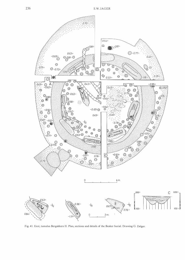
236
, . , .
, 0.84"" , , , / ' .... - ,/
S.W.JAGER
i( ·.·.·.·.< iNMX' . .
' .
. . ' , ' , . . ' . . . ' . .
. : : . ' :.::' .
0.54.;-CD �81� : : :
.> : . . . . . . . . . . , ':. ' ' , ' .
, ' : . . . . .
o 4 m. LI __ � __ � __ � __ �I
o 2 m. I'---��---'I
. ,' . . . ", , ', ' . ' . . . ' " e-O. 77�
. ' . " . o·io:>'; . . .. . : . . .
* [ IR11 �] Fig. 4 1 . Eext, tumulus Bergakkers I I . Plan, sectians and details af the Beaker burial. Drawing G. Delger.

A prehisforic mule and ancien! cart-lracks 237 t 0 00 m.
1 00
2 0 0
A 0 001 1 0 0
2 00
I '"Om B ' " Z\ 2" ", "mrr' P . ' . ' . ... . . . " . ' .' , . &;:Z,?V y °'"1 ::: mT� r ���· · mIti1irl:'l::J Fig. 4 1 (continued).
Fig. 42. Eext, tumulus Bergakkers I l . Single Grave bea ker of type I b , knife and flake from the Beaker flat grave. Drawing J .M . Smit, scale 2 :3 .
cling ditch was the peripheral structure of a barrow buil t in the first half of the Middle Bronze Age, and that i t was back-filled for obscure reasons (ef Eext, tumulus Gieterstraat, no. 40). The burial belonging to it was not found; probably it was a shallow grave, destroyed by the recent disturbance.
Period 2 had a peripheral structure of 12 widely-spaced posts forming a single circle with a diameter of c. 1 1 .50 m. A number of the postholes had a dark core in their fill, some even with charcoal. This had a radiocarbon age of 3240±35 B.P. (GrN-6747). A tangential burial, cutting period l 's ditch, belongs to period 2. In this grave, a tree coffin with the silhouette of an extended body appeared. The primary grave of period 2 was not located. At the
centre ofthe site, south ofthe recent disturbance and partly cut by it, an L-shaped stain accentuated by heavy iron accumulation manifested itself. I t may have formed beneath two, more or less rectangular, grave pits. As the centre-point of the post circle lies at the edge of the stain's NW-SE oriented leg, the latter may be what remains of period 2's lost grave. Finally, part of an encircling ditch was uncovered. This had an outer diameter of c . 1 6 m , a width of 0.60-0.80 m and a depth of 0.55-0.70 m below today's arable layer. The ditch may date to the Late Bronze or Early lron Age.
Furthermore, two Beaker flat graves appeared in the barrow site.
. F/al grave l lay in the south-western quadrant and was

238 S.W.JAGER
e :c: · · :.'0i� . i�"'f
4 m. ��_�_�---"
Fig. 43. Eext, tumulus Bergakkers I I I . Plan, sections and details of Beaker nat grave I. Drawing G. Delger.
cut by the ditch of period l . It had a WSW-ENE orientation. At c. 0.90 m beneath the present-day arable layer, a coffin lid, measuring 1 .60 by 0.90 m, with two planks across it, was observed in the rounded-rectangular grave pit . Further trowelling revealed the silhouette of a nexed body, Iying on its right side, head to the WSW; its brain-pan had been transformed into iron-pan. There were no gravegoods. Charcoal from the grave's fill was radiocarbondated to 3750±80 B .P. (GrN-8253).
Flat grave 2 1ay in north-west quadrant and seemed to cut through the most recent ditch in its north-western corner. This apparent anomaly is probably due to the gradual blurring of the grave pit's outline. The dimensions of this pit were 1 .:20 by 0.90 m, with an east-west orientation. The bottom lay at c . 0.50 m beneath the modem arable layer. Charcoal from what had been a coffin was radiocarbondated 3760±35 B.P . (GrN- 10436). Dating of both nat graves: Bell Beaker Culture.

A prehisforic rOl/fe and ancien! cart-fracks 239
Dating of period l : Bell Beaker Culture or first half of the Middle Bronze Age. Dating of period 2 : second half of the Middle Bronze Age.
44. Eext, hl/nebed D 1 2 (Kampakkers). Sheet 1 2G: 244.70/ 559.50. Van Giffen, 1925/1 927. Not investigated.
45. Eext, hUllebed D 1 3b. Sheet 1 2G : 244.90/559. 19 . Van Giffen, 1944b.
.
In 1 927 van Giffen discovered the remains of two small hunebeddelI immediately WNW of the Eext 'burial-vault' (no. 47). The two megalithie tombs had been destroyed 10ng before, and their sites were recognizable only as patches of rock-waste. The investigation of D 1 3b did not yield much information. Apart from some TRB material, the sherds of an early Bell Beaker of type 2Ib were retrieved.
46. Eext, Ill1l1ebed D l 3c ( 1 927). Sheet 1 2G: 244.86/559. 1 3. Van Giffen, 1944b. Here i t proved possibIe to reconstruct the plan ofthe small destroyed hUllebed. The finds consisted of TRB material and two bea ker sherds with zones of cord ornament.
47. Eext, hunebed D I 3 Cthe Eext burial-vault'). Sheet 1 2G: 244.92/559. 1 0. Van Giffen, 1925/1927; 1 943. This hUllebed with steps leading down into it-unique in the Netherlands-was investigated by Van Giffen in 1927. In the 1 8th century, however, the antiquary Mr. van Lier had preceded him, so that the 1927 excavations yielded hardly any finds.
48. Eext, tumulus I I I ( 1 927). Sheet 1 2G: 245.08/559.02. Van Giffen, 1944d. This tumulus was examined from a trench l m wide, running north-south, which was widened at the centre in order to lay open the principal grave. The mound was 16 m across, 1 .40 m high, and consisted of yellow-brown sand with infiltration veins. The fossil soil profile showed no signs of podzolization; its surface lay at c. 1 8 .20 m above NAP. The central grave was rounded-rectangular in shape, 2 . 1 0 by 0.95 m, and had been dug c. 0.40 m into the soil. I ts orientation was WSW-ENE. Some erratic stones covered the grave, in which no artefacts were found. A hand-written note (among van Giffen's collected works, no. 93) by Mr. Essing of Eext, amateur-archaeologist in the thirties, and correspondent of the Provinciaal Museum at Assen, says that levelling the barrow revealed a tangential secondary burial in the north-eastern quadrant. In this grave a particularly fine tree coffin appeared. It was photographically recorded (B.A. I . 1932b: 1 66-1 67). Dating: first half of the Middle Bronze Age.
49. Eext, hUllebed D 1 3a. Sheet 1 2G: 245.03/558.85. Van Giffen, 1944a; Bakker, 1 979: p . 1 55 . Site spotted in 1 923 and dug over by the discoverer. Later investigations therefore revealed little more than a number of boulders, several TRB sherds, and a virtually intact collared nask. Judging from the pottery (phase C, possibly also B, and at any rate G) Bakker thinks that Van Giffen was wrong in believing the grave to have been a stone cist, and that it is more likely to have been a small hUllebed, dismantled long ago. However, as not a single trace remained visible in the ground, a shallow stone cis t seems the more plausible explanation.
50. Eext, tumulus IV. Sheet 1 2G: 245 . 1 0/558 . 0 1 . Van Giffen, 1944e. Early in 1930, this oval tumulus, oriented north-south, was threatened by reclamation works. The rescue excavations were carried out according to the quadrant method with double east-west baulks. The mound, 16 m long, 7 m wide and c. 0.50 m high, consisted of dirty-yellow sand on a subsoil that lacked a clear soil profile. The old surface lay at c. 1 7.50 m above NAP. In the north-eastern 'sextant' a
widely-spaced stonepackingwas encountered. In the north-western sextant was a grave, oriented WSW-ENE, with stones heaped onto it and beside it on the north. The pit was 2. 1 5 m long, 0.90 m wide and c . 0.40 m deep. The middlewestern sextant yielded a badly weathered baItie axe of Emmen type, from the bod Y of the mound. Dating: Early Bronze Age/first half of the Middle Bronze Age.
5 1 . Eexterhalte, tumulus ( 1 975). Sheet 1 2G: 245.24/558.48. Harserna, 1977. This tumulus had lost its third dimension. As soon as the arable layer had been peeled away, three grave pits and the six post holes of a widely-spaced post circle showed.
The gra ve of period l was rectangular to oval in shape, measuring 1 .50 by 1 . 1 0 m, and c . 0.80 m deep under today's arable layer. It was oriented SW-NE. Its fill showed a dark edge surrounding a lighter-coloured centre of 1 .30 by 0.50-0.70 m. This colour contrast probably points to the presence of a coffin. Inside it, the silhouette was observed of a nexed body Iying on its right side, head to the south-west. Some emimel of the molars was still present. Touching the cranium, a I O-cm nint blade was found upright, point down.
In period 2 the barrow had a diameter of 1 5- 1 6 m, as could be seen from the iron pan perimeter. With i t belongs a widely-spaced, single post circle with a diameter of 1 1 . 60-1 2.40 m. Charcoal from one of the postholes was radiocarbon-dated to 3790±60 B.P. (GrN-1 1 9 19), which is much too early. Within the post circle were uncovered, side-byside, two tangential burials. The outer grave was seen to contain a tree coffin. Along its walls were two supporting stones. The inner grave quite probably had a similar coffin : there were marks in i t pointing to recently extracted stones. Dating of period l : Single Grave Culture. Dating of period 2: second half of the Middle Bronze Age.
52. Eext, tumulus ( 1 938). Sheet 1 2G: 244.30/558 . 6 1 . Van Giffen, 1 940 (short reference). In 1 928 the Provinciaal Museum of Drenthe in Assen acquired a number of finds that were said to have come from this tumulus and from one a littie further to the south-east (inv.nos . : 1928, 1 3- 1 5, 17, 25-28).' The three barbed ni nt arrowheads, fragments of a small bronze dagger, and two urns had been found in a barrow (see no. 53) west ofthe Eext burial-vault (no. 47), while 2 other urns (inv.nos. 1928, 27-28)8 were said to have been found in this 'barrow a littie to the west of the tumulus mentioned under inv.nos. 1 3- 1 5 , 1 7, and 25-26'. Almost certainly, the barrows were mixed up, and probably the 2 urns came from secondary burials in this tumulus (no. 52). A short while after this acquisition, the centre of this barrow was examined, without any of the findings being recorded. No artefacts were discovered. In 1938, the mound having been levelled meanwhile, its remains were re-investigated. These excavations revealed nothing but a patch of charcoal in the north-eastern quadrant. The diameter of this grey-sand tumulus had been about I O m. Dating: Early Bronze Age/first half of the Middle Bronze Age.
53. Eext, tumulus ( 1 940). Sheet 1 2G: 244.07/558.40. Brunsting, 1942. Ve ry probably, 3 barbed nint arrowheads, fragments of a small bronze dagger and 2 urns, sold to the Provinciaal Museum in Assen in 1928, had been dug out ofthis tumulus (see no. 52). Only the south-eastern half of the mound, which lay on a field boundary, survived. As these remains were due to be destroyed in the course of reclamation works, i t was decided to excavate them. In the centre, a deep recent pit reached down to below the bottom of the central grave. The barrow was found to have been constructed in a single phase. The soil profile below it showed a

240 S.W.JAGER
well-developed profile, consisting of a humic layer, a I O cm thick eluvial horizon and an illuvial zone. The bod y of the mound had been built out of sods, with sand from an encircling ditch thrown up against i t . The mound's diameter was c. 16 m; its height I m. In its centre was a burial shaft, the circumference of which could just be discerned outside the recent disturbance. Its orientation was NNWSSE; its dimensions were 3.00 by 1 .25- 1 .75 m and its depth c. 0.70 m. Around this pit, yellow sand lay about on the old surface. Inside the grave, traces of a tree coffin could be seen along the eastern side. The northernmost 30 cm ofthe pit had been deepened by another 0 .30 m . In the fill of this littie 'extra grave' a shadow silhouette was observed; the position of the bod y was no longer to be ascertained, however. The barrow's peripheral structure consisted of an encircling ditch with an inner diameter of c. 1 1 .80 m , a width of c. 1 . 80 and a depth of c. 0.70 m. In the south-west quadrant a cremation came to light. I t was said that a small urn had been found when the north-west halfwas levelled, but this had been lost. This brings the number of secondary burials in the tumulus up to 3, probably even 4. Dating: transition of the Early Bronze Age to the first half of the Middle Bronze Age.
54. Eext, tumulus 'Huttenheuvel'. Sheet 1 2G: 244.76/558.25. Van Giffen, 1 930: pp. 1 40- 142; fig. 1 09. In 1 926, only part ofthis tumulus was opened up, in a 4 by 4 m excavation. Van Giffen was short of funds for carrying out the investigations in a more satisfactory way. Thus, no sections were drawn either. The barrow's owner had been digging part of i t away, which had necessitated excavation. At the start, the north-eastern part was found to have been destroyed, the disturbance reaching deep into the subsoil. Therefore, the excavation had to be located a little to the west ofthe mound's centre. The old surface lay at c. 17 .20 m above NAP; the mound was 1 6- 1 8 m across and c. 1 . 20 m high. The photographs taken at the time show a singleperiod construction. Under it, Van Giffen encountered an oval 'ditch', interrupted on the east. In the photos, however, this more closely resembles a round to oval pit, measuring 2.90 by 2 .50 m. Towards the bottom, the pit became smaller. At a deeper level, c. 1 6.50 m above NAP, rectangular traces manifested themselves, but these were not recorded photographically. Van Giffen interpreted these stains as the remains ofa hut-like construction within the barrow, in which the dead person had been la id to rest. In fact, it probably is an old settlement pit that has nothing to do with the barrow. At various level s against the north and south sides of the pit, sherds were found belonging to a so-called Wellenband pot of the Single Grave Culture. From the position of the sherds it can be concluded that the pit had probably been c. 0 .65 m deep. The rectangular stains may have been caused by leaching from the pit. In 1 928 the Provinciaal Museum in Assen acquired a small flint axe, a battle axe of type A/B, and a flint blade 1 2.3 cm long, which the barrow's owner had found 'at the foot of the mound'. Among archaeologists this would be interpreted as 'at the edge ofthe mound', but it cannot be ruled out that the man mean t 'the base of the mound'. In that case, it would point to a grave at ground level, and the finds might be from the principal burial. This suggestion is supported, although not proved, by some of the photos, in which the pit's south and east walls are seen to have sagging veins of infiltration. These could be indicative of an intermediate ditch. Such a ditch was not observed in the excavation, however. Thus there are indications that the central grave may have been immediately south-east of the excavated area, in a somewhat eccentric position under the mound. Probably the grave-go ods appeared during the final demolition of the barrow remains, but no further details are known.
Finds (Provinciaal Museum, Assen). 1928/IV l (fig. 44): rather short, squat battle axe of greygreen, somewhat weathered very find-grained dolerite. Top slightly convex; also slightly curved lengthwise. Underside convex, ground somewhat hollow round the shafthole; al most straight lengthwise, extended downwards towards the cutting edge. In section the axe end is virtuaIly oval; the butt end ofthe battle axe is rounded-rectangular in section. Length: 14 .5 cm; greatest width: 6.4 cm; diameter of shafthole: 2. 1-2.2 cm at a distance of 4.7 cm from the butt. 1 928/IV 2 (fig. 44): slender, slightly curved blade of beigegrey to blue-grey, fine-grained flint. It was struck off a pyramidal core; its distal end, which shows natural retouch, curving inward. Length: 1 2. 3 cm; greatest width: 1 .8 cm; greatest thickness: 0.6 cm. 1 928/IV 3 (fig. 44): small axe of beige-grey flint with some yellowish bands. Faces slightly convex; narrow sides almost flat and only partially polished. One of the sides is concave lengthwise. Rectangular section. The end is levelled to a thin and rounded butt. Slightly damaged cutting edge. Length: 10 .3 cm; greatest width, at cutting edge: 4.7 cm; greatest width of narrow sides: 1 .5 cm. Dating: Single Grave Culture.
55. Eext, hunebed D I 4 (Eexterhalte). Sheet 1 2G: 245.20/ 558.02. Van Giffen, 1 925/1 927; Bakker, 1 979: p. 1 55 . This passage grave was investigated by Van Giffen in 1 927, but its pottery was not published. The earliest pottery dates to TRB phases Dromven B and C. Much of the incised ware, however, belongs to later phases.
56. Eext, tumulus 'Hillig Meer'. Sheet 1 2G: 243.8 1 /557. 6 1 . Van Giffen, 1 94 1d. This tumulus, threatened by reclamation works, was investigated in 1 939, from two trenches cut into it crosswise. Subsequently, only the south-west quadrant was excavated as a whole. The mound's centre had been disturbed to below the old surface. The latter lay at c. 16.95 m above NAP. The single-phase barrow had been built on hardly podsolized soil, and consisted of yellowish sand strongly marbled with infiltration veins. Its diameter was c. 14 m, its height c. 1 . 50 m. In its slope, some humic patches probably were the remains of sods. The central grave, arranged on the old surface, could still be vaguely discerned as a somewhat rounded stain. Dating: Early Bronze Age/first hal f of the Middle Bronze Age.
57. Eext(erhalte), tumulus 'De Ketenberg'. Sheet 1 2G: 244.09/ 557.38. Van Giffen, 1 930: pp. 45-50; Lanting, 1 973, pp. 237-238. This tumulus had been built on a natura l knoll. Its body, badly damaged by recent digging, and by wind erosion on its south-east, was investigated in 1 927 by Van Giffen, who cut some exploratory trenches and opened up the centre. In 1 948, Halbertsma excavated most of the north-east, northwest, and south-west quadrants. A small area in the southeast quadrant was also opened. Finally , the barrow was restored to its original shape.
Period 1. A mound of white sand, with a 1 4- 1 5 m diameter and a height of0.40 m, stood on natural knoll with a soil profile showing an indistinct, paie grey band of c. IO cm thickness and a poorly developed illuvial horizon. The old surface lay at 1 5.60-1 6.00 m above NAP. The grave belonging to this phase was oriented SW-NE. At the bottom of the burial pit its dimensions were 1 .40 by 0 .80 m . A chaotic pattern of heavy infiltration bands limited the possibilities of ,observation at higher levels; probably the pit was somewhat larger there. Its depth was c. 0.80 m. In the bottom, the silhouette appeared of a body in a flexed position on its right side, head to the south-west. The grave-goods consisted of a Single Grave beaker of type l a ,

A prehistoric route and ancien! cart-tracks
- o
Fig. 44. Eext, tumulus 'Huttenheuvel'. Battie axe of type A/B, flint blade and flint axe, most probably from the primary principal grave. Drawing J .M. Smit, scale 2:3.
241

242
17.85+ A 18.00+
S.W.JAGER
17.82+ B
18.02+
17.90+ 1802+
18.00+ 18.02+
/8.00 + 18.07+
17.80+
Iii . . 17. 80+
O l m. I !
Fig. 45. Eexterhalte, tumulus. Plan and sections. Drawing G. Delger.
17.85+

A prehistoric raute and ancient cart-tracks 243
a type B battie axe, a small flint axe, and a flint blade. Surrounding the grave, a foundation trench had been dug, U-shaped in section, c. 0.90 m deep, 0.40-0.50 m wide, with an inner diameter of 3 .50-3.60 m. In it, 19 posthole stains were observed. The original number of posts must have been about 40.
In period 2, the barrow was capped by a secondary mound of sods and yellow sand. This brought its diameter up to c. 20 m and its height to c. 1 .60 m. In the top of the primary mound, a faint soil profile had developed, visible as a grey layer, IO cm thick. The sod addition was a littie eccentric in relation to the per iod 2 grave. This pit, with a NE-SW orientation, measured 1 .80 by 1 .00 m and was c. 0.60 m deep. Inside it a coffin had been burnt in situ. The bod y had been buried in a crouched position on its lefl side, head to the north-east. The carbonized coffin with the calcined skeleton was encased in plaster of Paris and lif ted. As yet, the contents have not been completely investigated; therefore any grave-goods in it are yet to be discovered. Charcoal from the coffin was C l 4-dated to 3765±55 B.P. (GrN - 1 676). The purpose of two patches of stone capping, one on the slope ofthe primary mound and another within the second-period addition in the north-east quadrant remains obscure. Beneath the tumulus, mainly under the foot of the secondary mound, traces (post holes, etc .. ) were encountered that may belong to a settlement. The configuration of the latter was such that their being part of a post circle is out of the question. Dating of period I: Single Grave Culture. Dating of period 2: Bell Beaker Culture.
58. Eexterhalte, tumulus (fig. 45). Sheet 1 2G: 244.68/557. 1 7 . Unpublished. The centre of this structureless barrow was found to have been badly disturbed, when it was excavated in 1954 by Van Giffen, who applied the quadrant method. The old surface was at c. 18 . 10 m above NAP, the soil profile beneath it consisted of a thin dark layer, accentuated by infiltration along its top. The s ingle-period mound itself consisted of dull yellowish-brown to orange sand with infiltration veins. It measured 1 3 .50- 1 4. 50 m in diameter, and c. 1 .20 m in height. In the south-west quadrant, part of the central grave, oriented WSW-ENE, remained visible. At the highest level the pit 's outline was blurred by a chaotic pattern of infiltration veins. At about 0.30 m below the old surface, the pit was irregularly shaped, with a width of c. 0.75 m. Its fill for the most part consisted ofsand burnt red. At the level mentioned, some charcoal, probably from a coffin , was collected for radiocarbon dating: 3490±40 B.P. (GrN- I I 920). Towards the bottom, which lay at c. 1 7.55 m above NAP, the pit narrowed. Its length could not be ascertained. Dating: transition of the Early Bronze Age to the first half of the Middle Bronze Age.
59. Eexterhalte, tumulus a ( 1954). Sheet 1 2G : 244. 17/556.52. Waterbolk & Glasbergen, 1 957; Lanting, 1 973, p. 230. Waterbolk and Glasbergen interpreted tumulus a as a twoperiod construction. The primary mound covered a Beaker grave and its somewhat oval foundation trench. To the second phase belonged a central grave with the silhouette of an extended body, a secondary mound with a 'ritual pit' beneath its foot, and a single, widely-spaced post circle which had been set into the barrow's slope. Moreover, three cremations were found, two of them in urns. Lanting, however, was able to show that this was a three-period tumulus.
Period l's tumulus had a IO m diameter and a height of 0.50 m. It consisted of yellow sand. The fossil soil profile showed a greyish horizon, 0. 1 5-0.20 m thick. The primary grave, Iying eccentrically and surrounded by a foundation trench, had a NW-SE orientation and appeared as an oval
pit 1 .40 by 1 . 1 0 m, with a depth below the old surface of c. 0.40 m. A small, undecorated Bell Beaker accompanied the deceased. The oval foundation trench had an outer diameter of 3.00 to 3.40 m, a width of c. 0.30 m, and a depth of c. 0 .50 m below the old surface. No traces ofposts were found in i t .
Period 2. The barrow was raised with yellowish-grey sand, giving it a diameter of c. 16 m and a height between 1 .00 m and 1 . 30 m. The problem here is the fact that the well-developed podsol profile renders unrecognizable any indication of a possibie second sand capping. In the top of the primary mound also a soil profile was visible: a greyish horizon c. I O cm thick with a thi n humic layer containing some infiltration here and there. A recent pit in the centre had largely destroyed the grave belonging to period 2. Also, a small part of it was cut away in the excavation of the south-west quadrant. The pit was NW-SE oriented, 2.30 m long, 1 .60 m wide, and c. 0.30 m deep. At the bottom, the silhouette of an extended body appeared, head to the south-east. A thin trace of charcoal, higher up in the fill, may be part of a charred coffin wall. Charcoal from the burial pit was C l 4-dated to 3485±45 B.P. (GrN-6726). In the south-east quadrant, within the foot ofthe tumulus and in line with the grave, near its head end, a pit was uncovered with a diameter of 1 .70 m and an equal depth. This 'ritual pit' contained some small sherds, one of them with Barbed Wire decoration. This pit constitutes a terminus post quem for period 2 .
Period 3 was not identified from an addition to the barrow; if there were an additional layer of sand, heavy podsol profile would conceal any sign of it. The widelyspaced, single post circle belongs to this phase. The posts had been dug into the second-period tumulus slope. The circle's diameter measured c. 1 1 .70 m. Quite likely, the main grave belonging to this phase is forrned by the unurned cremation found just beside the centre point of the post circle. Finally, a co up le of Middle Iron Age secondary burials were brought to light. Dating of period I : Bell Beaker Culture. Dating ofperiod 2: Early Bronze Age (Barbed Wire phase). Dating of period 3: second half of the Middle Bronze Age.
60. Eexterhalte, tumulus II. Sheet 1 2G: 244. 19/556.5 1 . Van Giffen, 1 942. In the autumn of 1 940, Van Giffen investigated two tumuli, or rather their remains, south of the unmetalled RoldeGasteren track. The northern barrow, which was completely ploughed-out and the centre of which had been disturbed to below the old surface, was investigated because two urns had been found in i t . The mound had been surrounded by a circular ditch, with a V-shaped section, an inner diameter of c. 6.50 m, a width of 1 .20- 1 .50 m and a depth of 0.75- 1 .00 m. The remains ofthe mound consisted ofyellow sand, built onto a soil that showed no signs of podsolization. No central grave was found; probably it had been on the old surface. In the north-west quadrant a secondary interment in the form of a Brandskeleflgrab was uncovered. Dating: first half of the Middle Bronze Age.
6 1 . Eexterhalte, tumulus I ( 1 940). Sheet 1 2G: 244.20/556.47. Van Giffen, 1942. This two-period tumulus, the bod y of which had largely been ploughed-out, was investigated according to the quadrant method. In its centre, a recent disturbance had cut into the primary grave.
Period I: a yellow sand mound with a diameter of c. 8 m and a height of 0.50-0.60 m. Beneath it the soil profile consisted of a thin organic layer, a vague eluvial horizon c. IO cm wide and an illuvial horizon. The rounded-rectangular central grave, measuring 2.50 by 1 .00- 1 .20 m, was c. 0.50 m deep. Its orientation was WSW-ENE. Of the body, which had been buried on its right side with its head

244 S.W.JAGER
cremated remains, was NNE-SSW oriented. In the so uthwest quadrant, a smal! cremation burial was uncovered. Dating of period l : Single Grave Culture. Dating of period 2: first half of the Middle Bronze Age.
to the west, facing south, the silhouette of the upper part and head were all that remained to be seen; the enamel of six molars constituted the tangibie remains. The gravegoods comprised a narrow, rectangular flint blade with a length of 9.4 cm, and a flint blade, 1 5 .7 cm, with a retouched point. The south-eastern part of the burial pit had been disturbed, so that any further grave-goods were lost. In the south-east quadrant some sherds of a Single Grave beaker type l b were recovered.
62. AIlIleII, tumulus I. Sheet 1 2E: 245.73/562.72.
Period 2 was a construction of sods. Some charcoal had been lying on the primary mound. A circular ditch, Vshaped in section, surrounded the secondary barrow; i t had an inner diameter of c. 10 m, a width of 1 .20-2.00 m, and a depth of c. 1 .00 m. In the north-west quadrant, the ditch was interrupted over a length of c. 1 .50 m. Some dirtyyellow silt had been washed into the bottom. Higher up, the fil l was greyish and wind-deposited. The grave belonging to period 2 had been cut from the top of the primary barrow, some 50 cm into it. Its width was 1 .00 m, its length could no longer be ascertained. The pit, which contained scattered
1376.� U L __ 020m
1360'
. . . ·.··.·.· · ·�;� �8.> · · · .... : :
. . .No'-'
lJt;6'
1366'
1374'
13 70'
135�' . .'
° 4m '--=-�
Fig. 46. Anloo, cemetery Molenes. Plan and sections. Drawing J .H . Zwier.
Unpublished. In the 1954 edition of the map indicated above, two tumuli are shown south of the Kampakkers in a heathland parcel south-east of Annen. According to the field diary (22 November 1 954, no. 18) of the B.A.L draughtsman H . Praamstra, the two mounds had been seriously damaged previously. A third barrow, south-east of these two, had aiready succumbed to reclamation by then. A more recent edition of 1 970 shows the parcel to be under cultivation, without a trace of the tumuli . During a reconnaissance flight that the author made together with Ms. W. Metz-de Vries (I. P . P. Amsterdam), the easternmost of the two was rediscovered from marks in the freshly-ploughed soil. The site was investigated in October 1 984. At the centre of the completely levelled mound, some recent pits were revealed,
1364'
:: �j
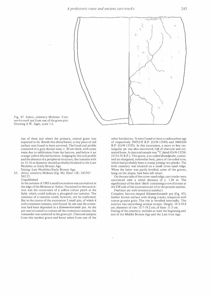
A prehistoric route and ancien! cart-tracks 245
Fig. 47. Anloo, cemetery Molenes. Klimmerkeramik pot from one of the grave pits. ' Drawing S. W. Jager, scale 1 :2.
one of them just where the primary, central grave was expected to beo Beside this disturbance, a tiny piece of old surface was found to have survived. The fossil soil profile consisted of a grey eluvial zone, C. 20 cm thick, with some veins due to infiltration from the barrow, and below i t an orange-yellow illuvial horizon. Judging by this soil profile and the absence of a peripheral structure, this tumulus with its 1 5- 1 6 m diameter should probably be dated to the Late Neolithic or Early Bronze Age. Dating: Late Neolithic/Early Bronze Age.
63. AI/loo, cemetery Molenes (fig. 46). Sheet 1 2E: 243.93/ 562.23.
.
Unpublished. In the autumn of 1 985 a small excavation was carried out at the edge ofthe Molenes at Anloo. Occasion for the excavation was the occurrence of a yellow colour patch in the fieid, which could indicate a p10ughed-out tumulus. The existence of a tumulus could, however, not be confirmed. But in the course of the excavation 5 small pits, of which 4 with cremation remains, were found. In one case the cremation had been deposited in a Klimmerkeramik pot. As the pot was toa small to contain all the cremation remains, the remainder was scattered in the grave pit . Charcoal samples from this modest grave and loose ashes from one of the
-� ,
) ,
\ (\
1 \ I I
other burials (no. 3) were found to have a radiocarbon age of respectively 2945±35 B.P. (GrN- 1 3549) and 3460±60 B.P . (GrN- 1 3335). In this excavation, a more or less rectangular pit was also uncovered, full of charcoal and cremated bone. A charcoal sample was 14C dated (GrN- 1 3336: 2 1 1 5±35 B.P.). This grave, a so-called Brandgrube, contained an elongated, somewhat bent, piece of corroded iron, which had probably been a cramp joining two planks. The little cemetery was situated on a small cover-sand ridge. When the latter was partly levelled, some of the graves, Iying on the slopes, had been left intact.
On the east side of the cover-sand ridge, cart-tracks were uncovered with a wheel distance of C. 1 .20 m. The significance ofthe dark 'ditch' containing a row ofstones at the SW side ofthe excavation pit is for the present unclear.
Find (not yet with inventory numbcr) Complete barrow-shaped Klimmerkeramik pot (fig. 47); leather brown surface with drying cracks, tempered with coarse granite grits. The rim is bevelled internally. The exterior has smoothing vertical stripes. Height: 19. 2- 1 9.8 cm; diameter of rim: 1 5 .7- 1 9.2 cm; of base: 1 1 .5 cm. Dating of the cemetery: includes at least the beginning and end of the Middle Bronze Age and the Late Tron Age.
Copyright © 2022 FDOKUMEN