A Policy Framework for Sustainable Utilisation of Farmland for the Waterberg District Municipality...
16
UNCORRECTED PROOF 99 Abstract This study crafts a policy framework for sustainable utilisation of farm- land for the Waterberg District Municipality in South Africa. The district, being predominantly agricultural and rural, faces contention in terms of land alloca- tion for traditional agricultural land uses versus contemporary uses such as golf courses, game ranching and holiday accommodation/lodges. The situation was exacerbated by the fact that these challenges were besetting the district at a time when it did not have a policy for sustainable land use. Fully cognisant of this shortcoming, the municipality decided to generate a policy framework for sus- tainable utilisation of farmland. The approach entailed a participatory situational analysis identifying all land zones for agricultural purposes in the district and prime agricultural land as well as environmentally sensitive areas. In addition, the policy environment governing the development of agricultural land was thor- oughly assessed to ensure compliance, consistency and alignment of the policy with the provincial and national policies. The outcome is a policy framework expected to facilitate, guide and influence the sustainable subdivision of farmland taking into account the realities of the existence of competing needs for agri- cultural land use. The policy framework clearly shows specific areas that may and may not subdivide further, with reasons. Also, it presents a set of guidelines and minimum requirements, to inform decision-making regarding subdivision proposals. Keywords Land policy • Sustainable • Farmland • Waterberg • South Africa M. Behnassi et al. (eds.), Sustainable Agricultural Development, DOI 10.1007/978-94-007-0519-7_6, © Springer Science+Business Media B.V. 2011 Chapter 6 A Policy Framework for Sustainable Utilisation of Farmland for the Waterberg District Municipality in South Africa Charles Nhemachena, James Chakwizira, Mac Mashiri and Sipho Dube C. Nhemachena () Council for Scientific and Industrial Research (CSIR) Built Environment Unit, P.O. Box 395, Pretoria 0001, South Africa e-mail: [email protected] e-mail: [email protected] 1 2 3 4 5 6 7 8 9 10 11 12 13 14 15 16 17 18 19 20 21 Author’s Proof ! Book ID: 215267_1_En Chapter ID: 6 Dispatch Date:13/12/2010 ProofNo: 1
-
Upload
independent -
Category
Documents
-
view
1 -
download
0
Transcript of A Policy Framework for Sustainable Utilisation of Farmland for the Waterberg District Municipality...

UNCORRECTE
D PROOF
99
Abstract This study crafts a policy framework for sustainable utilisation of farm-land for the Waterberg District Municipality in South Africa. The district, being predominantly agricultural and rural, faces contention in terms of land alloca-tion for traditional agricultural land uses versus contemporary uses such as golf courses, game ranching and holiday accommodation/lodges. The situation was exacerbated by the fact that these challenges were besetting the district at a time when it did not have a policy for sustainable land use. Fully cognisant of this shortcoming, the municipality decided to generate a policy framework for sus-tainable utilisation of farmland. The approach entailed a participatory situational analysis identifying all land zones for agricultural purposes in the district and prime agricultural land as well as environmentally sensitive areas. In addition, the policy environment governing the development of agricultural land was thor-oughly assessed to ensure compliance, consistency and alignment of the policy with the provincial and national policies. The outcome is a policy framework expected to facilitate, guide and influence the sustainable subdivision of farmland taking into account the realities of the existence of competing needs for agri-cultural land use. The policy framework clearly shows specific areas that may and may not subdivide further, with reasons. Also, it presents a set of guidelines and minimum requirements, to inform decision-making regarding subdivision proposals.
Keywords Land policy • Sustainable • Farmland • Waterberg • South Africa
M. Behnassi et al. (eds.), Sustainable Agricultural Development, DOI 10.1007/978-94-007-0519-7_6, © Springer Science+Business Media B.V. 2011
Chapter 6A Policy Framework for Sustainable Utilisation of Farmland for the Waterberg District Municipality in South Africa
Charles Nhemachena, James Chakwizira, Mac Mashiri and Sipho Dube
C. Nhemachena ()Council for Scientific and Industrial Research (CSIR) Built Environment Unit, P.O. Box 395, Pretoria 0001, South Africae-mail: [email protected]: [email protected]
1234567891011121314151617181920
21
Aut
hor’s
Pro
of !
Book ID: 215267_1_En Chapter ID: 6 Dispatch Date:13/12/2010 ProofNo: 1

UNCORRECTE
D PROOF
100
6.1 Introduction and Background
“Land is an asset. Land is scarce. Land is fragile.” These statements reflect the basic relationships of humankind with land: social, economic and environmental. Humanity’s association with land springs from the enduring nature of land: it is the basis of food, shelter and livelihoods (Ministry of Agriculture and Land Affairs 2001). It is no exaggeration to say that sustainable utilisation of land resources is pivotal to the economic, social and environmental future of the economy. Further-more, high potential and unique agricultural land is likely a non-renewable asset, and its preservation is fundamental to achieving sustainable resource management, including sustainable use of agricultural land (Department of Agriculture 2006).
An increasing trend of subdividing productive agricultural land in the Waterberg District Municipality (WDM) has been witnessed in recent years. Most of the subdi-visions have been executed without public interest, participation and assessment of the costs and benefits leaving the district with little productive land for agricultural development (Waterberg District Municipality 2008a). In a bid to promote balanced sustainable development, WDM resolved that generating a policy framework to guide the subdivision of agricultural land was necessary. Such a policy framework would further assist the district and local municipalities in developing by-laws vital in ex-ecuting the intentions of each municipality’s respective relevant land use schemes.
The overarching strategic policy objectives and rationale for the study and devel-opment of a policy framework for sustainable utilisation of farmland in the Waterberg District Municipality were to: (a) preserve agricultural land in WDM as enshrined in the Subdivision of Agricultural Land Act (1970) (Act No 70 of 1970), the Conserva-tion of Agricultural Resources Act (1983) (Act No 43 of 1983) and Department of Agriculture (2006) National Policy on the Preservation of High Potential and Unique Agricultural Land and; (b) provide guidelines relating to norms and standards appli-cable in the adjudication of applications for: subdivision of agricultural land, change of agricultural land, and rezoning and conversion of agricultural land.
6.2 Conceptual Framework
Many human cultures have lived in harmony with diverse agro-ecological environ-ments for centuries (Pontius and Schneider 2001; Perman et al. 2003). Many others have incidentally failed to live in harmony with the mundane agro-ecological envi-ronments, resulting in such problems as loss of biodiversity, climate change, food shortages, hunger, starvation, poverty, inequality, drainage or severe impact of wet-lands, and soil erosion throughout the world (Parmesan and Yohe 2003; Leemans and Eickhout 2004; Rong and Futian 2007). Conservation of environments, habi-tats, ecosystems and wetlands needs to be a priority given the governance of cultur-al and ecological values enshrined and protected (Altieri 1999; Knill and Lenshow 2000; Moss 2004). But a more optimistic note is that large-scale restoration and re-creation of habitats, ecosystems, wetlands and riverine systems is beginning to hap-pen throughout the world through ecological engineering and diversified economic pathways opportunities (Dasgupta et al. 2000; Rabalais et al. 2002).
C. Nhemachena et al.
22
232425262728293031323334353637383940414243444546474849
50
51525354555657585960616263
Aut
hor’s
Pro
of !
AQ1
AQ2
Book ID: 215267_1_En Chapter ID: 6 Dispatch Date:13/12/2010 ProofNo: 1

UNCORRECTE
D PROOF
101
One of the requirements of sustainable utilisation of resources is the efficiency of intergenerational allocation that is important to the long-term utilisation of re-sources (Rong and Futian 2007). Marsden et al. (2001) argues for the need to recon-stitute nature through rural development practices by way of realignment of social theory and empirical practice in considering the real potentiality of alternative and emergent rural development cases.
Ellis and Boggs (2001) argue that if a new paradigm of rural development is to emerge, it will be one in which agriculture takes place along with a host of other actual and potential rural and non-rural activities that are important to the construc-tion of viable rural livelihoods, without undue preference being given to farming as the unique solution to rural poverty (Bilsborrow and Ogendo 1992; Kline and Ralph 1999; Kohler 2000). This paper focuses on a multi-disciplinary approach to ad-dressing sustainable utilisation of farmland in the Waterberg District Municipality.
6.3 Study Area
The WDM (Fig. 6.1) is located in the western section of the Limpopo Province sharing the provincial border with Botswana. Within the province, Waterberg shares its borders with Capricorn and Sekhukhune District Municipalities. The southern boundary of the district abuts Northwest Province and Gauteng Province.
6 A Policy Framework for Sustainable Utilisation of Farmland
Fig. 6.1 Background map of the Waterberg District Municipality
64656667686970717273747576
77
78798081
Aut
hor’s
Pro
of !
AQ3
Book ID: 215267_1_En Chapter ID: 6 Dispatch Date:13/12/2010 ProofNo: 1

UNCORRECTE
D PROOF
102
Waterberg District consists of six local municipalities: Bela-Bela, Modimolle, Mogalakwena, Mookgopong, Lephalale and Thabazimbi. Compared with the rest of the province, Waterberg is unique as it encompasses little former homeland area and has an internationally acclaimed biosphere making up 15% of its total area. This creates its own set of challenges and opportunities. Waterberg consists mainly of commercial farms, game farming and only approximately 0.54% of the total area is used for settlement purposes (both towns and villages) (Waterberg District Munici-pality 2008a; Waterberg Spatial Development Framework-SDF 2009).
6.4 Study Methodology
The process of drafting the Waterberg District land policy framework was conduct-ed through official consultation and stakeholder participation at all levels of the po-litical economy impacting and impacted by WDM. A broad consensus emerged not only on the need for urgency in policy development but also on the critical issues that process should address. A number of sequential processes were adopted and satisfied. These entailed a comprehensive review of available literature (existing agricultural reports, Integrated Development Plans (IDPs), Spatial Development Frameworks (SDFs), legislative documents), preparation and revision of several drafts, discussion of drafts with civil society groups, the private sector, owners and users of land and various government agencies (Nhemachena et al. 2009a). The penultimate version of the policy was presented to a District Planning Forum before transmission of the final draft to the District for approval. Figure 6.2 is a graphical representation of the study methodology.
6.5 Results and Discussion
6.5.1 Situational Analysis of the Agricultural and Related Environment
This section presents the major highlights of results from the situational analysis of the agricultural and environment of WDM (Nhemachena et al. 2009a).
Legislative framework The generated policy framework recognises the existence of other legislations that have a direct or an indirect bearing on the access to and utilisation of agricultural land, including, but not limited to: Development Facilitation Act (1995) (Act 67 of 1995); National Environmental Management Act (1998) (Act 107 of 1998); Local Government Municipal Systems Act (2000) (Act 32 of 2000); Land Use Management Bill (2004); National Policy on the Preservation of High Potential and Unique Agricultural Land 2006 and various provincial ordinances. The study confirmed the findings of the National Policy
C. Nhemachena et al.
8283848586878889
90
919293949596979899100101102103
104
105
106
107108
109110111112113114115116
Aut
hor’s
Pro
of !
AQ4
AQ5
Book ID: 215267_1_En Chapter ID: 6 Dispatch Date:13/12/2010 ProofNo: 1

UNCORRECTE
D PROOF
103
on the Preservation of High Potential and Unique Agricultural Land (Depart-ment of Agriculture 2006) including a summary of some of the legislative and administrative flaws that emerged in the administration and implementation of the Subdivision of Agricultural Act (1970) (Act 70 of 1970). These are sum-marised in Table 6.1.
Importance of land policy for agricultural land use management and develop-ment The WDM land policy framework for agricultural land-use management is guided by two main underlying rationales. Firstly, there is the widely perceived resistance to the idea of uncontrolled agricultural land development. Secondly, there is the commonly expressed preference in particular sectors of society to promote a healthy mix of various types of desirable agricultural land development, urban development and meeting the requirements of sustainable environments (Ministry of Agriculture and Land Affairs 2001). The resistance to uncontrolled development is motivated by a number of concerns, the precise mix of which is determined by the particular social, economic and political contexts of different times and places. Some of the reasons include the ones summarised in Table 6.2. Also, the wish to
Fig. 6.2 Study methodology
Experimentation
Thematic Focus
Interest Groups
Key Informant Interviews Surveys Observations Sample
Analysis
Rapid Participatory
Appraisal
Interest Groups
StakeholderMapping
Study Terms of Reference/Brief
Recycled Data
Benchmarking Studies Desktop Review
Waterberg District Municipality Primary Unit of Analysis, Policy Generation, Intervention and Monitoring & Evaluation
Cluster Working Groups
Raw Data Processed
Cluster Reference Groups
Project Steering Committee (PSC)
6 A Policy Framework for Sustainable Utilisation of Farmland
117118119120121
122123124125126127128129130131132
Aut
hor’s
Pro
of !
Book ID: 215267_1_En Chapter ID: 6 Dispatch Date:13/12/2010 ProofNo: 1

UNCORRECTE
D PROOF
104
Table 6.1 Sustainable utilisation of agricultural land gaps and shortcomingsPhysical and spatial bottlenecks
Agricultural impediments
Legislative constraints Political challenges
Inadequate and inap-propriate control, protection and regulation of the available high potential and unique agricultural land
Absence of uniform guidelines for use by local authorities in the development and review of their SDFs and IDPs
Increase in the prolif-eration of land use changes, rezoning and subdivision of agricultural land which take place without approval
Absence of refined agricultural sub-division norms and standards to appropriately guide decision-making on agri-cultural land use related matters
Fragmentation and mul-tiple statues applicable to agricultural land make planning, man-agement and sustain-ability of the sector a challenging task
A number of land use related legislations (e.g. Development Facilitation Act (DFA), Draft LUMN, etc.) which are administered by other departments and/or spheres of govern-ment, place a direct and indirect demand on agricultural land for non-agricultural development
Adjudication over land develop-ment appli-cations on agricultural land is not uniform and consistent at all levels of decision-making
Table 6.2 Reasons for controlling agricultural land use and developmentEnvironmen-tal concerns
Efficiency of infra-structure provision and traffic management
Social control Health and safety concerns
Aesthetic concerns
Uncontrolled develop-ment of agricul-tural land can have adverse effects on natural habitats, cultural land-scapes, and air and water quality
Infrastructure capacity constraints presented in a context where development permits are granted without assessing critically the capacity of exist-ing infrastructure to accommodate the new developments
The concomitant chal-lenge regarding infrastructure that is provided, generally at high financial cost, without taking into account the opportunity cost of these new develop-ments in terms of the societal impact on land-use and settle-ment patterns for example
Controlling agricul-tural land uses and building types has long been a means of exerting social control, par-ticularly through the exclusion of certain types of person, household or economic activ-ity from certain areas through the application of particular development controls limit-ing, for instance, plot sizes, plot coverage and home industries
Uncontrolled develop-ment can lead to over-crowding and unsafe building construction
Certain agricul-tural land use and develop-ment decisions can also be detrimen-tal to the health and safety of neighbours
Control-ling and regulating agricultural land devel-opment enables the district to prescribe certain design param-eters for buildings
C. Nhemachena et al.
Aut
hor’s
Pro
of !
Book ID: 215267_1_En Chapter ID: 6 Dispatch Date:13/12/2010 ProofNo: 1

UNCORRECTE
D PROOF
105
promote desirable development is driven by a number of different concerns that relate mainly to land management and development.
Subdivision of productive agricultural land has become a trend in recent years Most of the land and agricultural subdivisions have been executed in the absence of clear guiding principles and regulations (Waterberg District Municipality 2008a). Con-sequently, land and subdivision suitability assessments criteria including auditing the public and environmental benefits and costs of proposed land and subdivision developments have been in most cases not considered at all.
The distribution and demography of the population has implications for land and agricultural use policy and decisions In the study area, such densely populated areas as Mogalakwena exert pressure for the provision of engineering services and socio-economic developments to meet the growing needs and demands of such spa-tial areas. Twenty percent of all people in the district area reside on farms; 39% in formal towns; 2% in informal settlements and 39% in tribal areas (Waterberg Dis-trict Municipality 2008a; Mogalakwena Local Municipality 2008). Pro-active and strategic forward planning of regulation, managing and sustaining the competing and often conflicting land and agriculture development interests is therefore a vital component of the growth and development trajectory in the district.
Agriculture profile of the district and continued dependence on food imports despite the inherent local agricultural production potential Despite the high agricultural production potential, agriculture continues to contribute only 3.6% towards the economy of WDM (Waterberg District Municipality 2005, 2007, 2008a; Waterberg SDF 2009). Many local municipalities in the district continue to import agricul-tural products outside their boundaries despite this potential, perhaps a worrisome trend and cause for concern. This trend is probably explained by a combination of factors some enumerated in the Waterberg IDP (Waterberg District Municipality 2008a). These range from generally low levels of development in the area that is manifested in terms of high levels of poverty. In addition, poor land and agriculture infrastructural development further inhibits the growth and development potential. This may suggest strongly that potential and emerging farmers have limited access to resources necessary for enhanced production.
Relative importance of land and agriculture in local economic growth and devel-opment Although agricultural development is not as dominant in terms of its con-tribution to the Gross Value Added of the region, it remains a critical base for livelihood sustenance of the majority of the people especially from the previously disadvantaged sections of the society (Waterberg District Municipality 2005). Also, land and agriculture forms an integral backbone for providing basic infrastructure, facilities and amenities that support and promote eco-tourism (incidentally a vital component of the district economy; Waterberg District Municipality 2005, 2007, 2008a, b).
Soil potential and land capability assessment indicates that high potential areas for crop farming are limited Ranching potential, however, is widespread and conserva-tion outside the proclaimed nature reserves is limited to eco-tourism activities on
6 A Policy Framework for Sustainable Utilisation of Farmland
133134
135136137138139140
141142143144145146147148149150
151152153154155156157158159160161162163
164165166167168169170171172
173174175
Aut
hor’s
Pro
of !
Book ID: 215267_1_En Chapter ID: 6 Dispatch Date:13/12/2010 ProofNo: 1
UNCORRECTE
D PROOF
106
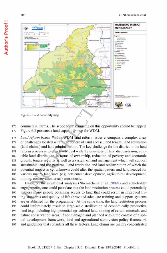
commercial farms. The scope for maximising on this opportunity should be tapped. Figure 6.3 presents a land capability map for WDM.
Land reform issues Within WDM land reform issues encompass a complex array of challenges located within the sphere of land access, land tenure, land restitution (land claims) and land administration. The key challenge for the district in the land reform process is to effectively deal with the injustices of land dispossession, equi-table land distribution in terms of ownership, reduction of poverty and economic growth, tenure security as well as a system of land management which will support sustainable land use patterns. Land restitution and land redistribution of which the potential impact is yet unknown could alter the spatial pattern and land needed for various macro land uses (e.g. settlement development, agricultural development, mining, conservation areas) enormously.
Based on the situational analysis (Nhemachena et al. 2009a) and stakeholder engagements, one could postulate that the land restitution process could potentially witness many people obtaining access to land that could result in improved liv-ing standards and quality of life (provided adequate training and support systems are established for the programme). At the same time, the land restitution process could unfortunately result in large-scale sterilisation of economically productive land (e.g. including high potential agricultural land, mining of certain minerals, and nature conservation areas) if not managed and planned within the context of a spa-tial development framework, land and agricultural subdivision policy framework and guidelines that considers all these factors. Land claims are mainly concentrated
Fig. 6.3 Land capability map
C. Nhemachena et al.
176177
178179180181182183184185186187188189190191192193194195196197
Aut
hor’s
Pro
of !
Book ID: 215267_1_En Chapter ID: 6 Dispatch Date:13/12/2010 ProofNo: 1

UNCORRECTE
D PROOF
107
in the Mogalakwena and Lephalale Local Municipalities. These are also the areas with the highest population densities and as indicated earlier this emanates from the historical background of the areas (Waterberg District Municipality 2008b).
Environmentally sensitive areas Several areas in Waterberg have been identified as habitats of rare and threatened animal and plants species. These areas largely coincide with the biosphere reserve and existing conservation areas. These areas are highly vulnerable to the large-scale disturbances of mining and urban activities (Waterberg District Municipality 2008a, b). Ring fencing and sterilising these areas to land and agriculture subdivision is necessary with exploitation permitted under special consent.
The Waterberg Biosphere Reserve (Fig. 6.4) constitutes an environmentally unique area that might be negatively affected by human activities that physically change the environment. The Waterberg Biosphere Reserve established in 2001 is one of the only five biospheres in South Africa. The biosphere consists of three distinct zones: the biosphere core (114,571 ha); the buffer zone (150,000 ha) and a transition zone (15,0000 ha). The core area constitutes proclaimed nature reserves with the buffer and transition zones filling the areas in between (Waterberg District Municipality 2008a, b).
The biosphere is sensitive to urban, rural and mining activities but provides op-portunities for ranching and conservation activities (Waterberg District Municipal-ity 2008a; Waterberg SDF 2009). It is critical that any developments in and around
6 A Policy Framework for Sustainable Utilisation of Farmland
Fig. 6.4 The Waterberg biosphere reserve
198199200
201202203204205206207208209210211212213214215216217218
Aut
hor’s
Pro
of !
Book ID: 215267_1_En Chapter ID: 6 Dispatch Date:13/12/2010 ProofNo: 1

UNCORRECTE
D PROOF
108
the biosphere clearly distinguish high conservation potential areas, middle conser-vation areas and development nodes, e.g. in transitional zones. In addition, the den-sity of developments that should be allowed across the biosphere need to be clearly identified and set out to ensure that environmentally sensitive and conservation ar-eas are protected.
Departure points for land and agriculture subdivision policy directions Based on existing land and agriculture document analysis and reviews (Nhemachena et al. 2009a), fieldwork observation and measurements, geographical information sys-tems analysis (including climatic, soil, hydrological, physical, and geological anal-ysis), it is argued that it is imperative to have a land and agriculture subdivision policy for sustainable utilisation of agricultural and farmland in WDM. The policy framework departure points are summarised in Table 6.3.
6.5.2 Policy Framework Issues and Guidelines
The decisions of planning authorities, whether related to the formulation of plans such as IDPs or the consideration of land development applications, must all be consistent with the vision, objectives, principles, norms and standards as developed and generated in the sustainable utilisation of farmland policy document (Nhe-machena et al. 2009b). The sustainable utilisation of farmland policy objectives, principles and norms and highlight of specific policy position is summarised in Table 6.4.
Table 6.3 Departure points for land and agriculture subdivision policy framework developmentAchieving the right mix of development
Food security and household productivity
Farmer productivity strength-ening model
Development proposals should aim to achieve the correct balance between economic development, sustain-able resource use and protection of natural resources
High potential agricultural land irrespective of existing use (i.e. whether it is cash crop farming or not) should be protected against future agriculture productivity sterilization from settlement development or any alternative land uses
Township development at existing nodes (including future pro-posed nodes) should take full cognisance and be sensitive to high potential agricultural land
Household food production is seen as a means of improving food security and fighting poverty through utilising agricultural resources within the vicinity of communities
Commercial agriculture contributes significantly to the district’s economy and requires interventions, which create an enabling environment in which both established farmers and emerging commercial farmers can thrive and develop
Improved institutional co-ordination of activities, interventions, programmes and projects is a key issue for improved delivery and successful development of the agriculture sector in the Waterberg District Municipality
C. Nhemachena et al.
219220221222223
224225226227228229230
231
232233234235236237238
Aut
hor’s
Pro
of !
Book ID: 215267_1_En Chapter ID: 6 Dispatch Date:13/12/2010 ProofNo: 1

UNCORRECTE
D PROOF
1096 A Policy Framework for Sustainable Utilisation of Farmland
Stra
tegi
c vi
sion
To e
ffect
ivel
y, e
ffici
ently
and
con
tinuo
usly
pro
mot
e an
d su
stai
n th
e lo
ng te
rm fu
ture
dev
elop
men
t, us
e an
d m
anag
emen
t of a
gric
ultu
re fa
rmla
nd, b
iosp
here
, m
inin
g an
d hu
man
settl
emen
ts in
the
dist
rict
Polic
y ob
ject
ives
Ensu
re th
at h
igh
pote
ntia
l and
uni
que
agric
ultu
ral l
and
is u
sed
prim
arily
fo
r agr
icul
tura
l pu
rpos
es to
enh
ance
fo
od se
curit
y
Prov
ide
user
frie
ndly
gu
idel
ines
for
agric
ultu
ral l
and
use
chan
ges a
s wel
l as
subd
ivis
ion
of
agric
ultu
ral l
and
Reg
ulat
e an
d co
ntro
l ac
cess
to a
gri-
cultu
ral l
and
by
prop
onen
ts o
f no
n-ag
ricul
tura
l de
velo
pmen
t
Pres
erve
agr
icul
tura
l la
nd re
sour
ces
for t
he b
enef
it of
co
mm
uniti
es w
hose
liv
elih
ood
is b
ased
on
agr
icul
ture
for:
inco
me
gene
ratio
n,
food
secu
rity,
job
oppo
rtuni
ties a
nd
bette
r qua
lity
of li
fe
Prom
ote
know
ledg
e an
d en
hanc
e sk
ills t
rans
fer
amon
gst s
take
hold
ers o
n m
atte
rs p
ertin
ent t
o la
nd u
se p
lann
ing
in g
ener
al a
nd p
rese
rvat
ion
of
agric
ultu
ral l
and
in p
artic
ular
Prin
cipl
es, n
orm
s and
stan
dard
sSu
stai
nabi
lity
Equa
lity
Effic
ienc
yFa
irnes
sG
ood
gove
rnan
ce
Broa
d st
rate
gic
polic
y in
terv
entio
n le
vers
and
are
asPr
ovid
ing
a de
fini-
tion
of a
gric
ultu
re
and
farm
land
use
th
at d
istin
guis
hes
agric
ultu
re la
nd u
ses
and
activ
ities
from
no
n-ag
ricul
tura
l la
nd u
ses a
nd a
ctiv
i-tie
s in
WD
M in
clud
-in
g de
finin
g w
hat a
fa
rm u
nit i
s
Bal
anci
ng e
nviro
nmen
-ta
l pro
tect
ion,
agr
i-cu
ltura
l exp
loita
tion
need
s with
gro
wth
an
d de
velo
pmen
t co
ncer
ns in
WD
M
Gen
erat
ing
spec
ific
type
s/cl
asse
s of a
gri-
cultu
ral c
omm
erci
al
and
indu
stria
l use
s (in
clud
ing
farm
-re
late
d in
dust
ries)
th
at a
re fr
eely
pe
rmitt
ed in
agr
icul
-tu
ral a
nd fa
rm la
nds
in W
DM
, lod
ges,
etc
Prom
otin
g ba
lanc
ed a
nd
sust
aina
ble
envi
ron-
men
tal d
evel
opm
ent,
man
agem
ent o
f the
na
tura
l env
ironm
ent
and
the
bios
pher
e in
W
DM
Gui
danc
e an
d di
rec-
tion
in te
rms o
f th
e pr
ovis
ion
and
deliv
ery
of c
om-
mun
ity fa
cilit
ies
and
infr
astru
ctur
e in
agr
icul
tura
l and
fa
rmla
nd c
omm
uni-
ties a
nd a
reas
Out
linin
g de
velo
pmen
t an
d pr
ovis
ion
of
holid
ay a
ccom
mod
a-tio
n on
farm
land
s an
d ag
ricul
tura
l are
as
guid
elin
e
Tabl
e 6.
4 Sa
mpl
e re
pres
enta
tion
of so
me
issu
es ta
ckle
d by
the
sust
aina
ble
utili
satio
n of
farm
land
pol
icy
in W
ater
berg
Dis
trict
Aut
hor’s
Pro
of !
Book ID: 215267_1_En Chapter ID: 6 Dispatch Date:13/12/2010 ProofNo: 1

UNCORRECTE
D PROOF
110
Exam
ple
of sp
ecifi
c pr
ovis
ion
to a
ddre
ss th
e br
oad
stra
tegi
c po
licy
inte
rven
tion
leve
rs a
nd a
reas
: pro
vidi
ng a
def
initi
on o
f agr
icul
ture
and
farm
land
use
th
at d
istin
guis
hes a
gric
ultu
re la
nd u
ses a
nd a
ctiv
ities
from
non
-agr
icul
tura
l lan
d us
es a
nd a
ctiv
ities
in W
DM
incl
udin
g de
finin
g w
hat a
farm
uni
t is
Incl
usiv
e de
finiti
on
of a
gric
ultu
re a
nd
farm
land
use
/act
ivi-
ties a
ccom
mod
ativ
e of
all
farm
ing
type
s su
ch a
s: in
dust
rial
and
com
mer
cial
ac
tiviti
es w
hich
are
pr
imar
ily re
late
d to
agr
icul
ture
, na
tura
l fea
ture
s tha
t en
hanc
e th
e ar
ea fo
r ag
ricul
ture
and
eco
-sy
stem
hea
lth a
nd
sust
aina
ble
agric
ul-
tura
l pra
ctic
es th
at
prom
ote
a he
alth
y en
viro
nmen
t has
be
en in
corp
orat
ed
The
farm
uni
t sho
uld
cons
ists
of:
land
ba
se, b
arns
and
ot
her b
uild
ings
th
at su
ppor
t the
fa
rm o
pera
tion,
fa
rm d
wel
ling
and
tem
pora
ry d
wel
lings
re
quire
d fo
r add
i-tio
nal l
abou
r or f
or a
re
tirin
g fa
rmer
One
resi
denc
e/dw
ellin
g un
it m
ay b
e bu
ilt o
n th
e ag
ricul
tura
l far
m
prem
ises
whe
re it
is
an
acce
ssor
y to
a
com
mer
cial
scal
e fa
rmin
g op
erat
ion
A se
cond
per
man
ent
dwel
ling
on a
farm
or
on
a se
para
ted
lot w
ill n
ot b
e pe
rmitt
ed.
Two
addi
tiona
l uni
ts
may
be
allo
wed
at
a de
nsity
of 1
uni
t pe
r 10
ha th
at c
ould
be
use
d fo
r gue
st
acco
mm
odat
ion.
Clu
ster
ing
of b
uild
ings
sh
ould
be
rega
rded
as
a h
igh
prio
rity
Agr
i-vill
ages
est
ablis
hmen
t will
be
supp
orte
d if
it is
in su
ppor
t of a
gric
ultu
ral p
rodu
ctio
n an
d pr
ovid
ing
secu
rity
of te
nure
to fa
rm w
orke
rs.
The
crite
ria th
at sh
ould
be
used
in e
valu
atin
g ag
ri-vi
llage
app
licat
ions
shou
ld in
clud
e bu
t not
be
rest
ricte
d to
the
follo
win
g:•
Why
farm
wor
ker h
ousi
ng c
anno
t be
pro-
vide
d in
an
urba
n ar
ea, b
efor
e an
agr
i-vill
age
can
be e
stab
lishe
d ou
tsid
e of
exi
stin
g no
des.
• A
gri-v
illag
es m
ust b
e id
entif
ied
as a
nod
e in
SD
F.•
Agr
i-vill
ages
shou
ld b
e w
ithin
wal
king
di
stan
ce (l
ess t
han
2 km
).•
Agr
i-vill
ages
shou
ld p
refe
rabl
y be
est
ab-
lishe
d on
exi
stin
g di
stur
bed
site
s.•
Agr
i-vill
ages
shou
ld b
e of
lim
ited
popu
la-
tion
size
(usu
ally
up
to 5
00 p
eopl
e)
Tabl
e 6.
4 (c
ontin
ued)
C. Nhemachena et al.
Aut
hor’s
Pro
of !
Book ID: 215267_1_En Chapter ID: 6 Dispatch Date:13/12/2010 ProofNo: 1

UNCORRECTE
D PROOF
111
While Table 6.4 presents a snapshot of the policy document, the actual policy document itself is more extensive and provides clear policy direction and guidance regarding density, accessibility, siting/location, design, materials and aesthetics re-garding developments in the area. This covers for such a range of activities as estab-lishing holiday accommodation and lodges, developing cable cars in the biosphere, establishing agricultural factories on farmlands, bush pubs and conferencing facili-ties and infrastructure, handling home industries and home occupations, extraction and mining of pit and river sand in agricultural premises, greenhouse development and management, game farming infrastructure and development (Nhemachena et al. 2009b). Figure 6.5 presents WDM land subdivision proposals based on the above information.
6.6 Conclusions
The useful outcome of this study is a policy framework expected to facilitate, guide and influence the sustainable subdivision of farmland taking into account the reali-ties of the existence of competing needs for agricultural land use. The generated policy framework shows clearly specific areas that may and may not subdivide fur-ther, with reasons. Also, it presents a set of guidelines and minimum requirements, to inform decision-making regarding subdivision proposals.
6 A Policy Framework for Sustainable Utilisation of Farmland
Fig. 6.5 Waterberg District subdivision of farmland issues and proposals
239240241242243244245246247248249
250
251252253254255256
Aut
hor’s
Pro
of !
Book ID: 215267_1_En Chapter ID: 6 Dispatch Date:13/12/2010 ProofNo: 1

UNCORRECTE
D PROOF
112
6.6.1 Recommendations
Generally, policy frameworks—such as the Subdivision of Agricultural Land Act (1970, Act No 70), the Conservation of Agricultural Resources Act (1983, Act No 43) and the Department of Agriculture (2006) National Policy on the Preserva-tion of High Potential and Unique Agricultural Land—for sustainable utilisation of farmland should incorporate the following issues:
• The policy framework should be informed by an extensive agricultural environ-mental analysis supported with empirical evidence and insight into existing and potential agricultural land uses in the district.
• It is important to establish a baseline for systematic control, protection and reg-ulation of available high potential and unique agricultural land as defined by stakeholders.
• A set of uniform guidelines should be generated to be used by local authorities in the development and review of their spatial development plans. The spatial development plans that will require updating to incorporate sustainable farmland utilisation requirements include the Spatial Development Framework (SDFs), Integrated Development Plans (IDPs), Town Planning Schemes (TPS), Master Plans (MP), Physical Plans (PP) and Land Use Schemes (LUS).
• It is also important to establish an appropriate policy framework for better tracking and management of agricultural farmland land use migration trends and changes, rezoning and subdivision so that planning becomes pro-active rather than reactive.
• Establishing an agricultural farmland databank is also one way of improving the agricultural information management systems.
• The final policy documents, including the translations into the major indigenous languages of the people in the affected areas, should be disseminated as widely as possible using different media.
• Inclusive and participatory approaches are important to allow various agricultur-al participants, experts, beneficiaries, users and interest groups to provide input and own the process and product.
• A strong capacity building and training programme should be factored as part of marketing and implementing the policy. This will need to be extensive and cover all levels of government and segments of society.
• The policy is never complete unless a robust implementation plan including spe-cific projects, budgets, timelines and project champions has been clearly spelt out. A clear implementation framework, structure and plan are crucial to ensure that the good policies contained in the policy document are transformed into real projects that make a difference in people lives.
References
Altieri MA (1999) The ecological role of biodiversity in agroecosystems. Agric Ecosyst Environ 74(199):19–31
C. Nhemachena et al.
257
258259260261262
263264265266267268269270271272273274275276277278279280281282283284285286287288289290291292293
294
295296
Aut
hor’s
Pro
of !
Book ID: 215267_1_En Chapter ID: 6 Dispatch Date:13/12/2010 ProofNo: 1

UNCORRECTE
D PROOF
113
Bilsborrow RE, Ogendo HWO (1992) Population driven changes in land use in developing coun-tries. Ambio 21(1):37–45 (Population, Natural Resources and Environment)
Conservation of Agricultural Resources Act (1983) (Act No 43 of 1983) Government printer, Pre-toria, Republic of South Africa
Dasgupta P, Levin S, Lubchenco J (2000) Economic pathways to ecological sustainability. BioSci-ence 50:339–345
Department of Agriculture (2006) National policy on the preservation of high potential and unique agricultural land. Dep. of Agriculture, Pretoria
Development Facilitation Act (1995) (Act 67 of 1995) Government printer, Pretoria, Republic of South Africa
Ellis F, Boggs S (2001) Evolving themes in rural development 1950s–2000s. Dev Policy Rev 19(4):437–448
Kline JD, Ralph JA (1999) Does land use planning slow the conversion of forest and farm lands. Growth Chang 30:3–22
Knill C, Lenschow A (2000) On deficient implementation and deficient theories: the need for an institutionalist perspective in implementation research. In: Knill C, Lenschow A (eds) Imple-menting EU environmental policy. New directions and old problems. Manchester University Press, Manchester, pp 9–35
Kohler TA (2000) Dynamics in human and primate societies. Oxford University Press, New YorkLand Use Management Bill (2004) Government printer, Pretoria, Republic of South AfricaLeemans R, Eickhout B (2004) Another reason for concern: regional and global impacts on eco-
systems for different levels of climate change. Global Environ Chang 14:219–228Local Government Municipal Systems Act (2000) (Act 32 of 2000) Government printer, Pretoria,
Republic of South AfricaMarsden T, Banks J, Renting H, Van Der Ploeg JD (2001) The road towards sustainable rural
development: issues of theory, policy and research practice. J Environ Policy Plan 3(2):75–83 (Special issue: Reconstituting nature through rural development practices)
Ministry of Agriculture and Land Affairs (2001) White paper on spatial planning and land use management. Government printer, Pretoria
Mogalakwena Local Municipality (2008) Integrated development plan (IDP). Mogalakwena Local Municipality, Mokopane
Moss T (2004) The governance of land use in river basins: prospects for overcoming problems of institutional interplay with the EU Water Framework Directive. Land use policy 21:85–94
National Environmental Management Act (1998) (Act 107 of 1998) Government printer, Pretoria, Republic of South Africa
Nhemachena C, Chakwizira J, Mashiri M, Maritz J, Norsworthy J (2009a) Land and sustainable utilisation of farmland situational analysis report. Waterberg District Municipality, Limpopo
Nhemachena C, Chakwizira J, Mashiri M, Maritz J, Norsworthy J (2009b) Land policy frame-work, guidelines and principles for sustainable utilisation of farmland report. Waterberg Dis-trict Municipality, Limpopo
Parker DC, Mason SM, Jason MA, Hoffman PD (2002) Multi-agent systems for the simulation of land-use and land-cover change: a review. Ann Assoc Am Geogr 93(2):314–337 (June 2003)
Parmesan G, Yohe G (2003) A globally coherent fingerprint of climate change impacts across natural systems. Nature 421:37–42
Perman R, Yue M, McGilvray J, Common M (2003) Natural resource and environmental econom-ics, 3rd edn. Addison-Wesley, Upper Saddle River, pp 359–361
Pontius RG, Schneider L (2001) Land-use change model validation by a ROC method. Agric Ecosyst Environ 85(1–3):239–248
Rabalais NN, Turner RE, Scavia D (2002) Beyond science into policy: Gulf of Mexico hypoxia and the Mississippi River. BioScience 52:129–142
Rong T, Futian Q (2007) Intergenerational efficiency of farmland conversion and farmland re-source loss in China. China Popul Res Environ 17(3):28–34
Subdivision of Agricultural Land Act (1970) (Act No 70 of 1970) Government printer, Pretoria, Republic of South Africa
6 A Policy Framework for Sustainable Utilisation of Farmland
297298299300301302303304305306307308309310311312313314315316317318319320321322323324325326327328329330331332333334335336337338339340341342343344345346347348349350
Aut
hor’s
Pro
of !
AQ6
Book ID: 215267_1_En Chapter ID: 6 Dispatch Date:13/12/2010 ProofNo: 1

UNCORRECTE
D PROOF
114
Waterberg District Municipality (2005) Agricultural development strategy for Waterberg District, Status Quo Report. Waterberg District Municipality, Limpopo
Waterberg District Municipality (2007) Local economic development strategy (LED). Waterberg District Municipality, Limpopo
Waterberg District Municipality (2008a) Integrated development plan (IDP). Waterberg District Municipality, Limpopo
Waterberg District Municipality (2008b) Spatial development framework (SDF). Waterberg Dis-trict Municipality, Limpopo
C. Nhemachena et al.
351352353354355356357358359A
utho
r’s P
roof
!
Book ID: 215267_1_En Chapter ID: 6 Dispatch Date:13/12/2010 ProofNo: 1