agroforestry system design for peri-urban environment. case ...
Upload
independentCategory
view
0download
0
Copyright © 2008 by the author(s). Published here under license by the Resilience Alliance.Grau, H. R., M. E. Hernández, J. Gutierrez, N. I. Gasparri, M. C. Casavecchia, E. E. Flores, and L. Paolini.2008. A peri-urban neotropical forest transition and its consequences for environmental services. Ecologyand Society 13(1): 35. [online] URL: http://www.ecologyandsociety.org/vol13/iss1/art35/
Research, part of a Special Feature on The influence of human demography and agriculture on naturalsystems in the NeotropicsA Peri-Urban Neotropical Forest Transition and its Consequences forEnvironmental Services
H Ricardo Grau 1,2, María Eugenia Hernández 1, Jorgelina Gutierrez 1, N. Ignacio Gasparri 1,2, M. Cristina Casavecchia 3, Emilio E. Flores-Ivaldi 1, and Leonardo Paolini 1,2
ABSTRACT. We analyzed changes in land cover in the Sierra de San Javier and its surroundings, an areaof ca. 70 000 ha near San Miguel de Tucumán, an urban center of ca. 1 million people in subtropicalArgentina. The analysis covered two periods: 1949–1972 and 1972–2006 using remote sensing techniques.For the year 2001, we mapped the patterns of distribution of secondary forests dominated by the mostabundant exotic tree species (Ligustrum lucidum). Based on land-cover maps, we estimated sediment yieldas an index of watershed condition. Urban area was growing during the whole study period. Between 1949and 2006, forest area increased approximately 1400 ha, mostly over abandoned agriculture and grasslands;this expansion was accelerated between 1972 and 2006. Increased forest cover resulted in a reduction inerosion and sediment yield that was disproportionately large, as most new forests are located in areas ofsteep slopes and high rainfall. By 2001, Ligustum-dominated forests had expanded to more than 500 ha,in the southern portion of the sierra only. Overall, the analysis quantifies a process of Neotropical peri-urban forest transition, likely associated with socioeconomic changes related to population urbanization,that promotes improvements of some environmental services, such as watershed and biodiversityconservation. However, natural communities are strongly affected by past land use and neighboring urbanareas, which have promoted a growing importance of exotic species with mostly unknown ecologicalconsequences.
Key Words: exotic species invasion; forest transition; GIS; land-use change; subtropical Argentina;urbanization; watershed conservation; yungas
INTRODUCTION
Land use and land cover (LUC) play a central rolein defining the capacity of terrestrial ecosystems toprovide environmental services. In forested biomes,forest cover is probably the single most importantdescriptor of LUC, and is a main control ofenvironmental services such as erosion control,carbon sequestration, and biodiversity conservation.In general, forest recovery improves watershedconservation (Mather and Fairnbarn 2000) andcarbon sequestration (Grau et al. 2004). Recentpapers have argued that expanding secondaryforests associated with population urbanizationcould also play a significant role in favoringbiodiversity recovery in Neotropical ecosystems(Lugo 2002, Grau et al. 2003, 2007, Hecht et al.2006), to the point that this process may help
mitigate the so-called biodiversity crisis (Aide andGrau 2004, Wright 2005, Wright and Muller-Landau 2006). But, forest cover can be anincomplete index. For example, increasing forestcover is frequently composed of exotic monospeciesstands, which hardly contribute to biodiversity(Rudel et al. 2005). Therefore, in addition to forestcover area, it is important to assess the compositionof these forests.
Forest transition, the reversal of trends in LUCchange from deforestation to reforestation, has beenwell documented in the temperate forests of Europe(Mather 1992) and North America (Veblen andLorenz 1991, Foster 1992). This change occurs inassociation with socioeconomic changes related toa modern economy, including agriculturaladjustment to the most productive soils, rural to
1Universidad Nacional de Tucumán, 2CONICET, 3Universidad Nacional de Córdoba
Ecology and Society 13(1): 35http://www.ecologyandsociety.org/vol13/iss1/art35/
urban migration, increases in transport andinformation technology, decreasing dependence onlocal resources, and government conservationpolicies derived from the increased awareness ofpotential environmental crises (Mather 2001). Asmany developing tropical countries are undergoingthis sort of socioeconomic change, they couldexperience forest transition. And, in fact, forestrecovery has been documented in different areas ofthe Caribbean, México, and Central and SouthAmerica (Grau and Aide 2008).
One particular case of forest transition is when itoccurs near to large urban centers. This type of localLUC change differs from more extensive regional-scale processes in two ways. First, recoveringnatural areas are likely to be more affected by thedirect effects of urbanization, including a diversesource of potential invader organisms. Second, alarge and concentrated human population is directlyaffected by the changes in the environmentalservices provided by the surrounding landscapes.Mid-sized urban centers are the ones growing fastestglobally (United Nations Population Fund(UNFPA) 2007), therefore, assessing the patternsand ecological consequences of LUC change in thevicinity of mid-sized cities is particularly relevantfor sustainable development in the present andcoming decades. However, studies on the ecologicaleffects of forest transition in peri-urban Neotropicallandscapes are scarce. The most detailed analysesof the ecological consequences of this process havebeen conducted in Puerto Rico, a highly urbanizedCaribbean island. Much of the new Puerto Ricanecosystems is strongly influenced by the abundanceof exotic species (Aide et al. 2000, Lugo and Helmer2004). But, despite these invaders, massive forestexpansion during the last 50 years has led to therecovery of local diversity of plants, different insectgroups, and earthworms (Grau et al. 2003), and hasprevented the extinction of a rich biologicalcommunity (Lugo 2002). However, the particularconditions of Puerto Rico both in ecological andsocioeconomic terms (an island frequently affectedby hurricanes and highly influenced by its stronglinks with the USA), imply some caveats forextrapolating these observations to the rest of theNeotropics (Grau et al. 2003), and research isneeded in a wider range of peri-urban situations.
Here, we describe the patterns and some ecologicalconsequences of a process of forest transition in thevicinity of San Miguel de Tucumán, the largesturban center in subtropical Argentina. The two main
specific objectives of the paper were: (1) Todescribe patterns of LUC change during the last 50years, including an analysis of the distribution offorests dominated by the most abundant exotic treespecies. Based on these analyses, we discuss thepotential effects of LUC changes on biodiversityconservation. (2) To quantify the effects of theseLUC changes on sediment yields as an index ofwatershed quality.
METHODS
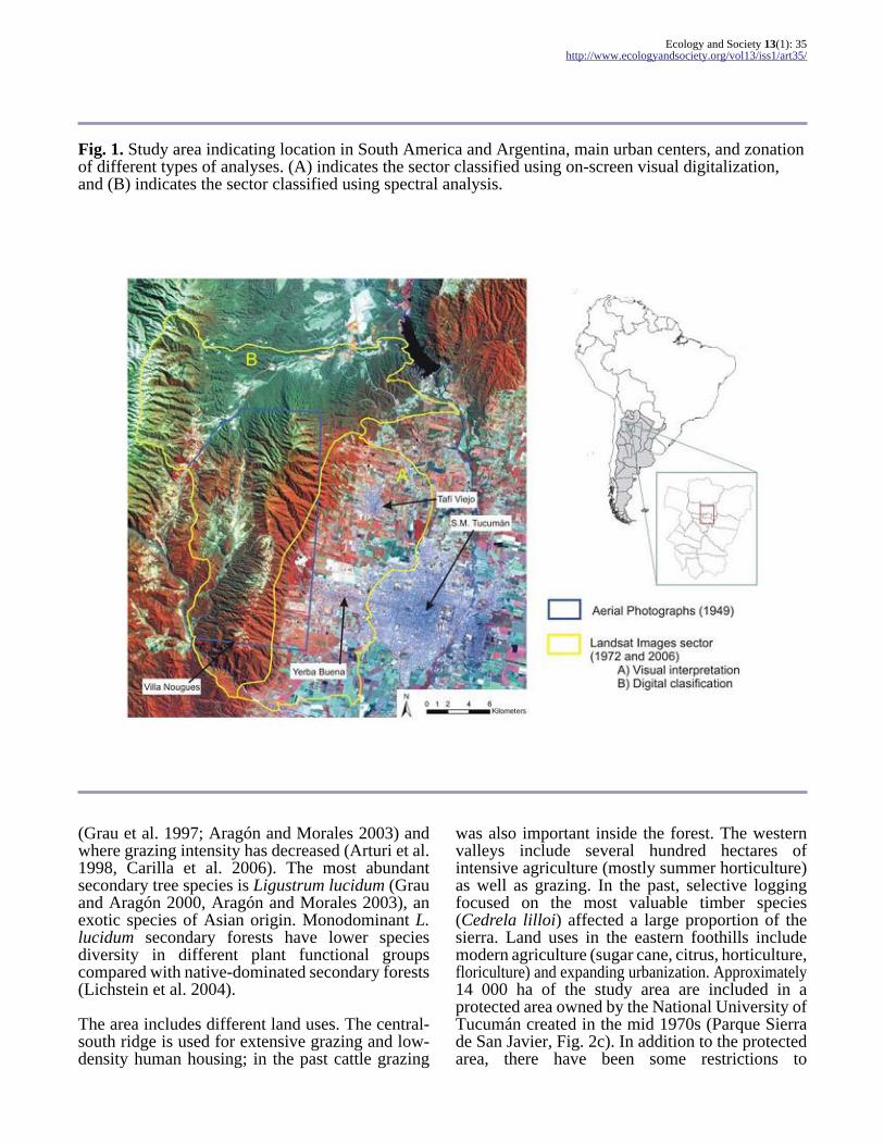
The study focused on the Sierra de San Javier, amountain range located about 15 km west of the cityof San Miguel de Tucumán, Tucumán province,Argentina, between 26°39’ to 26°54’ S and between65°17’ to 65°27’ W (Fig. 1). Our analysis has twomain components: (1) We analyzed the changes inLUC between 1949 and 2006 in two periods (beforeand after 1972). In addition, for the year 2001, wemapped the distribution of forests dominated byLigustrum lucidum, the most abundant exotic treespecies. (2) We assessed the effects of land-usetrends on watershed conservation, by analyzing thechanges in sediment yields between 1972 and 2006.
Study Area
The San Javier mountain range has a dominantnorth–south direction (Fig. 1), and covers anelevational range from 500 m in the eastern foothillsto 1876 m on the mountain top. The climate issubtropical with a monsoonal rainfall regime (drywinters, rainy summers). Temperature and rainfallare strongly controlled by topography (Hunzinger1997). During the second half of the 20th century,regional precipitation has increased (Minetti andVargas 1997), likely in association with globalatmospheric changes (Labraga 1997).
Natural vegetation is dominated by subtropicalmontane forests, with local variations in vegetationdue to topography. Yungas semi-evergreen forestscover most of the area, including the eastern,southern, and southwest slopes. Northwesternslopes are dominated by Chaco dry forests andshrublands, and natural foggy grasslands spreadover some sectors of the mountain top (Moyano andMovia 1989). The grasslands area has likely beenextended due to past extensive grazing. Secondaryforests occur near to agricultural and urban sectors
Ecology and Society 13(1): 35http://www.ecologyandsociety.org/vol13/iss1/art35/
Fig. 1. Study area indicating location in South America and Argentina, main urban centers, and zonationof different types of analyses. (A) indicates the sector classified using on-screen visual digitalization,and (B) indicates the sector classified using spectral analysis.
(Grau et al. 1997; Aragón and Morales 2003) andwhere grazing intensity has decreased (Arturi et al.1998, Carilla et al. 2006). The most abundantsecondary tree species is Ligustrum lucidum (Grauand Aragón 2000, Aragón and Morales 2003), anexotic species of Asian origin. Monodominant L.lucidum secondary forests have lower speciesdiversity in different plant functional groupscompared with native-dominated secondary forests(Lichstein et al. 2004).
The area includes different land uses. The central-south ridge is used for extensive grazing and low-density human housing; in the past cattle grazing
was also important inside the forest. The westernvalleys include several hundred hectares ofintensive agriculture (mostly summer horticulture)as well as grazing. In the past, selective loggingfocused on the most valuable timber species(Cedrela lilloi) affected a large proportion of thesierra. Land uses in the eastern foothills includemodern agriculture (sugar cane, citrus, horticulture,floriculture) and expanding urbanization. Approximately14 000 ha of the study area are included in aprotected area owned by the National University ofTucumán created in the mid 1970s (Parque Sierrade San Javier, Fig. 2c). In addition to the protectedarea, there have been some restrictions to
Ecology and Society 13(1): 35http://www.ecologyandsociety.org/vol13/iss1/art35/
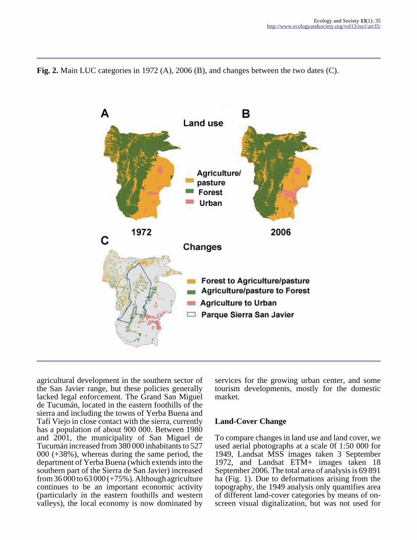
Fig. 2. Main LUC categories in 1972 (A), 2006 (B), and changes between the two dates (C).
agricultural development in the southern sector ofthe San Javier range, but these policies generallylacked legal enforcement. The Grand San Miguelde Tucumán, located in the eastern foothills of thesierra and including the towns of Yerba Buena andTafí Viejo in close contact with the sierra, currentlyhas a population of about 900 000. Between 1980and 2001, the municipality of San Miguel deTucumán increased from 380 000 inhabitants to 527000 (+38%), whereas during the same period, thedepartment of Yerba Buena (which extends into thesouthern part of the Sierra de San Javier) increasedfrom 36 000 to 63 000 (+75%). Although agriculturecontinues to be an important economic activity(particularly in the eastern foothills and westernvalleys), the local economy is now dominated by
services for the growing urban center, and sometourism developments, mostly for the domesticmarket.
Land-Cover Change
To compare changes in land use and land cover, weused aerial photographs at a scale 0f 1:50 000 for1949, Landsat MSS images taken 3 September1972, and Landsat ETM+ images taken 18September 2006. The total area of analysis is 69 891ha (Fig. 1). Due to deformations arising from thetopography, the 1949 analysis only quantifies areaof different land-cover categories by means of on-screen visual digitalization, but was not used for
Ecology and Society 13(1): 35http://www.ecologyandsociety.org/vol13/iss1/art35/
spatially explicit analyses. The 1972 image was co-registered with the 2006 image using 20 non-variantcontrol points (e.g., buildings, crossroads), with anerror of 76.33 m (approximately one MSS pixel).
Three land-cover categories (agriculture andgrasslands, forests, and urban) were discriminatedusing two different methodological approaches inthe images of 1972 and 2006. In the western foothillsof the sierra (Fig. 1), with a high cover of modernagriculture and all the urban zones of the study area,we conducted an on-screen visual digitalization thatwas adequate to discriminate forests from low-density urbanization and diverse agricultural coverwith different spectral properties (citrus, sugar cane,annual crops), based on spatial patterns combinedwith spectral characteristics. In the rest of the area,corresponding to the mountains, hills, and westernvalleys, the land cover is dominated by forest andgrassland with only few agricultural plots and nourban areas. In this sector, we used supervisedclassifications for the two dates, using as trainingsites field observations in 2007 for 2006, and aerialphotographs at a scale of 1:50 000 taken in 1968 for1972. The 1972 image classification used threeclasses: (i) agriculture and grasslands, (ii) dryforests, and (iii) evergreen forests. Referencespectral signatures were defined based on 15training sites for each category. Separability(transformed divergence; Richards and Xiuping2006) between forests and agriculture/grasslandswas 1.6 for dry forests and 2 for evergreen forests(separability varies between 1 and 2, where 2 ismaximum). For the 2006 classification, we alsoconsidered forests dominated by Ligustrum lucidum and pine plantations. For this classification,separability between agriculture and dry forests was1.94, and separability between agriculture/grasslands and all the other forest types was 2. Forthe classification process, we used different classesof forest (dry and evergreen in 1972 and dry,evergreen Ligustrum and pine plantation in 2006)to avoid using “hybrid” spectral signatures of forestof different types. We finally merged these forestclasses into a single one to generate a binary digitalclassification: forest and non-forest, resampled to86 X 86 m resolution (digital elevation model(DEM) resolution used for sediment study). Inaddition, the on-screen digitizing information of theeastern sector of the study area was transformed toa raster format with the same resolution, whichyielded as a final result two layers (1972 and 2006)with three resulting classes: forests, agriculture/grasslands, and urban.
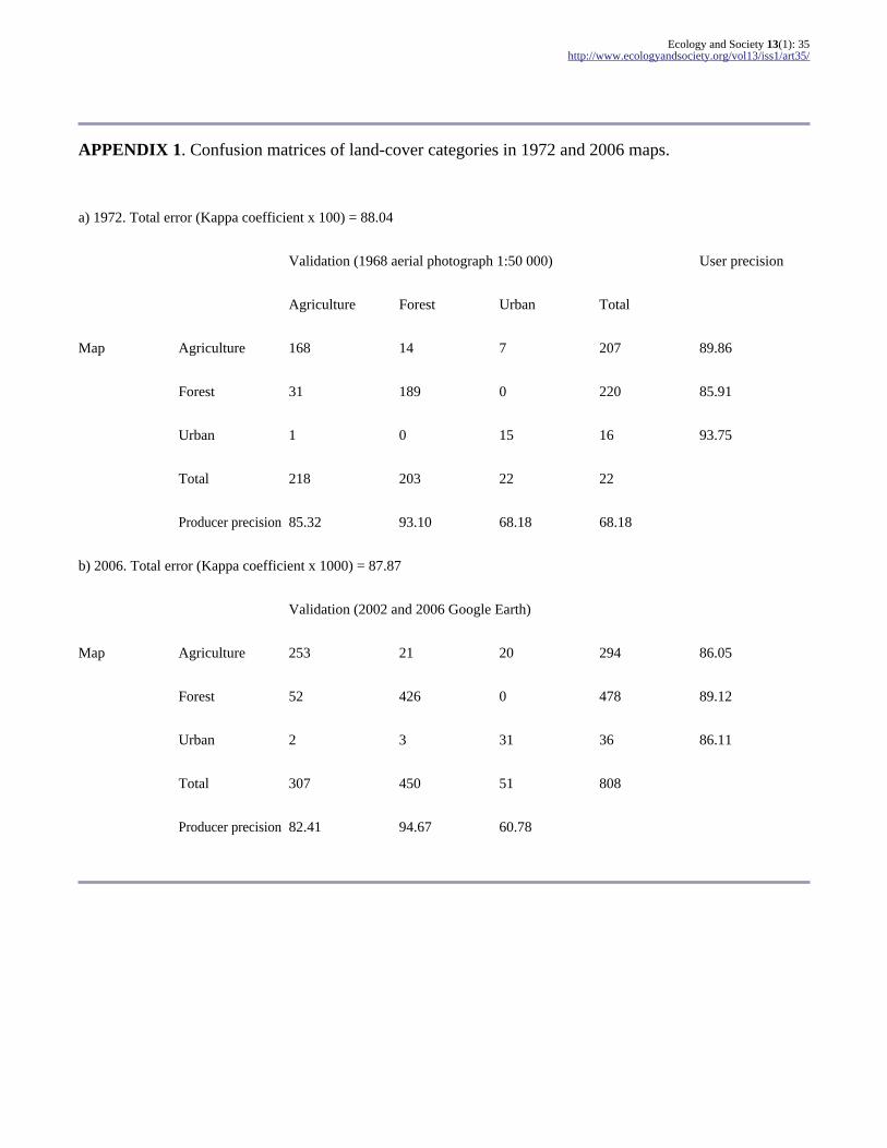
To assess the accuracy of this final classification,we generated a triangular grid where we allocatedcells of 1 km X 1 km regularly, overlaid on theclassified images. On this grid, we sampled 443 cellsfor the 1972 image and 808 cells for the 2006 image.For each one of these cells, we compared the land-cover class derived from our digital classificationwith a visual classification obtained from high-resolution remote sensing, to generate a confusionmatrix. The 1972 classification map was comparedwith 1:50 000 aerial photographs taken in 1968, andthe 2006 classification was compared with GoogleEarth mosaics derived from Quick Bird imagestaken in 2002 and 2006. The overall precision(Kappa coefficient; Foody 2002) was 88.04% forthe 1972 classification and 87.87% for the 2006classification; the class with lower errors beingforests, and the class with higher errors being urban(Appendix 1).To map the distribution of Ligustrum lucidum forests, we focused on the southern sector of thestudy area, where the species is more abundant.First, we used Landsat ETM+ images of differentseasons (June = winter; September = early spring;December = late spring) in 2001 to assess duringwhich season Ligustrum forests are betterdiscriminated from native forests. We selected theimage of September, in which the separability(Richards and Xiuping 2006) between native forestsand Ligustrum-dominated forests was greater,especially in band 4 = near infrared (“transformeddivergence” = 1.95). Based on this, we conducted asupervised classification of an image taken on 25September 2001, using bands 1, 2, 3, 4, 5, and 7;and we applied a “majority” 3 X 3 filter to obtainthe final thematic map. To assess the precision ofthe classification, we used 96 ground control pointsdistributed across the study area, in which between2003 and 2005, we determined land cover in thefield and located these groundtruthing points on themap with a Geographic Positioning System (GPS).These points were used to construct a vector pointlayer in the GIS to be compared with theclassification map, yielding an overall precision of96%.
Changes in Sediment Yield
To analyze the effect of land-use changes onwatershed conservation, we estimated erosion andsediment yield using the Gavrilovic’s model(Emmanouloudis et al. 2003, De Vente and Poesen2005). Parameters of the model and their spatial
Ecology and Society 13(1): 35http://www.ecologyandsociety.org/vol13/iss1/art35/
distribution are presented in Appendix 2. Thismethod estimates sediment yield (G) as the productof an erosion (W) and a sediment delivery (R)component (Eqn 1)
(1)
in order to quantify sediment delivery on perwatershed basis. For this analysis, the study areaincluded 10 watersheds. Erosion is calculated in aGIS environment, on a per pixel basis (Fig.3,Appendix 2) based on Eqn 2.
(2)
where Wi is Gross erosion (m3/year), T is atemperature coefficient, H is average precipitation(mm/year), Z is an erosion coefficient, and F is thearea of the pixel (0.007396 km2).
The temperature coefficient T is defined by Eqn 3,
(3)
where tm = average annual temperature (°C). In ourcase, to calculate the temperature coefficient weused a 1 km resolution raster with the averagetemperature for 1960–2000 (NETBIO1) from theWorldclim database (http://www.worldclim.org).
H was based on a rainfall map, that we producedusing a dot-shaped file with the average values forthe years 1966–1976 of available rain station data(n = 21) and our own estimates for the mountain
region based on vegetation (n = 23), which closelyreflect the topography-controlled changes in rainfall(Bianchi and Yanez 1992). With these 44 points, weinterpolated rainfall to the entire study area using aspline-tension method to obtain a raster map with apixel size of 86 X 86 m.
Erosion coefficient Z is defined by Eqn 4
(4)
where X is coefficient of soil cover; Y is acoefficient of soil resistance; φ = coefficient ofextent of erosion, and I is the slope (Appendix 2).In our case, X was based on our land-cover analysisusing three main categories: forest, urban, andpasture/agriculture. Forest was subdivided in threesub-categories mainly because of climatedifferences that make forest more dense,intermediate or drier with consequences for soilerosion. Categories for Y were based on soilcharacteristics from an available soil map from theNational Institute for Agriculture Technology(INTA) and ranked in comparison with each other.φ was based on satellite images observations andgeology of the study area (Mon and Suayter 1973)to estimate coefficients following values used inother studies (Beyer-Portner 1998, De Vente andPoesen 2005). I was calculated using a DEM fromthe U.S. Geological Survey (http://edc.usgs.gov/products/elevation.html).
The sediment delivery ratio ( R ) is calculated usingthe morphology data for each basin (Eqn 5).
(5)
where O is the perimeter of the basin (km); D is theaverage elevation of the watershed (km); Li is thetotal length of the secondary waterways (km); L isthe length of the principal waterway (km); and F isthe area of the watershed (km2).
Ecology and Society 13(1): 35http://www.ecologyandsociety.org/vol13/iss1/art35/
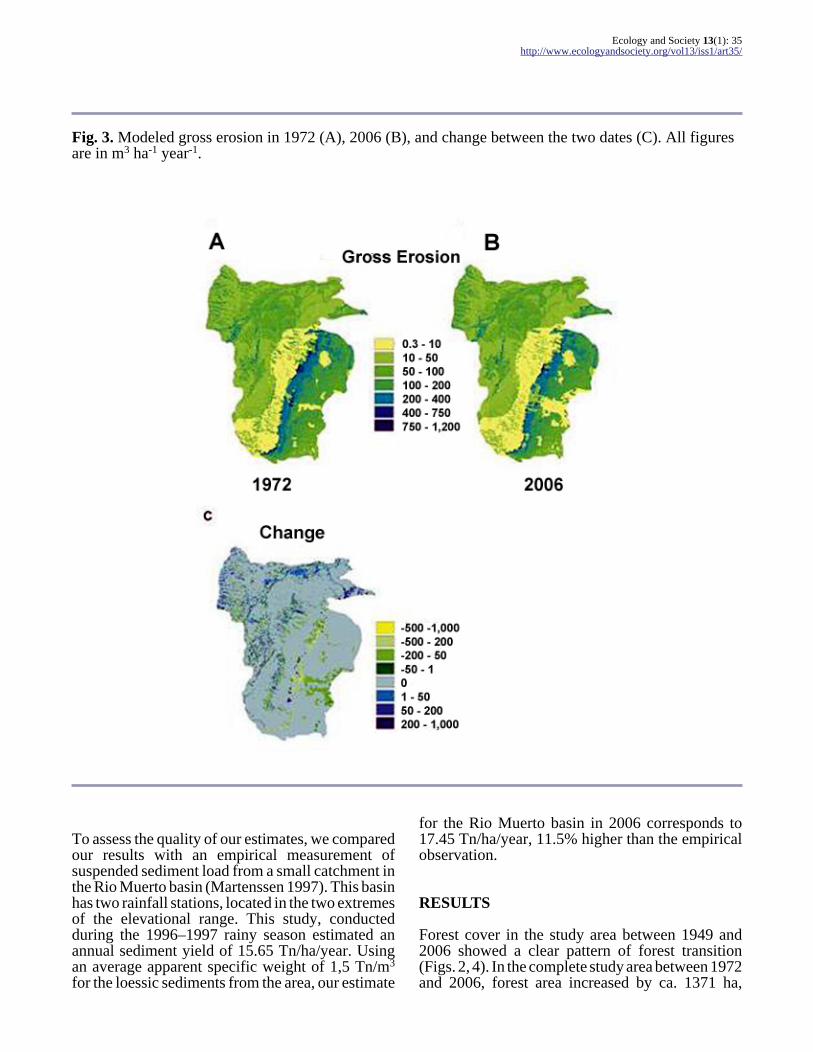
Fig. 3. Modeled gross erosion in 1972 (A), 2006 (B), and change between the two dates (C). All figuresare in m3 ha-1 year-1.
To assess the quality of our estimates, we comparedour results with an empirical measurement ofsuspended sediment load from a small catchment inthe Rio Muerto basin (Martenssen 1997). This basinhas two rainfall stations, located in the two extremesof the elevational range. This study, conductedduring the 1996–1997 rainy season estimated anannual sediment yield of 15.65 Tn/ha/year. Usingan average apparent specific weight of 1,5 Tn/m3 for the loessic sediments from the area, our estimate
for the Rio Muerto basin in 2006 corresponds to17.45 Tn/ha/year, 11.5% higher than the empiricalobservation.
RESULTS
Forest cover in the study area between 1949 and2006 showed a clear pattern of forest transition(Figs. 2, 4). In the complete study area between 1972and 2006, forest area increased by ca. 1371 ha,

Ecology and Society 13(1): 35http://www.ecologyandsociety.org/vol13/iss1/art35/
Fig. 4. Changes in the area of forest; the solid line represents the complete study area, the dotted linerepresents the area included in the 1949 aerial photographs.
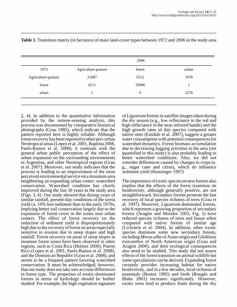
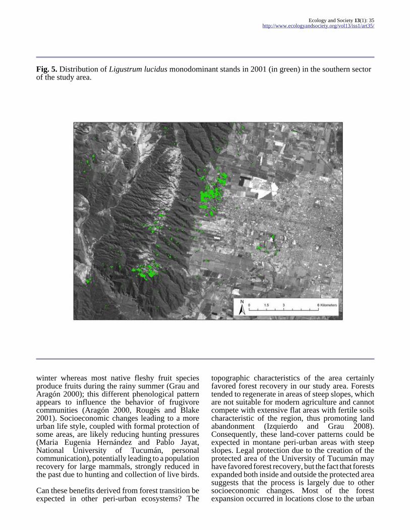
which is the net balance of 5512 ha of agriculturalfields converted into forests and 4111 ha of foreststransformed into agricultural fields (Table 1).Despite the occurrence of these new agriculturalareas, net agricultural area decreased by 3377 ha;73% of the disappearing agricultural land wastransformed into new forests and 27% into urbanareas, which in turn showed a net increase of 1978ha (Table 1). Between 1972 and 2006, the generaltrend of forest expansion was the same within thearea included in the 1949 aerial photographs (Fig.4), which showed a slight increase in forest coverbetween 1949 and 1972 (ca. 100 ha), thus suggestingthat forest expansion may have started earlier butwas accelerated during the last decades. Forestexpansion occurred both inside and outside theprotected area. Of the 5512 new forests regeneratedbetween 1972 and 2006, 1372 occurred within theprotected area, and 4140 (75% of the total) occurredoutside. Specific areas of forest expansion includethe southern sector of the sierra ridge and the easternfoothills, whereas deforestation mainly occurred inthe north of the study area (Fig. 2). In the southernsector of the sierra, the area of Ligustrum forestswas 539 ha (Fig.5) by 2001.
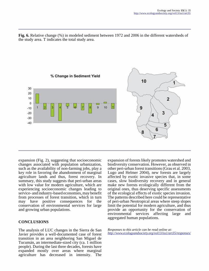
Modeled soil erosion changed as a consequence ofland-use changes (Fig. 3). The western and northernvalleys showed a combination of both increases ofsediment yield due to deforestation, and decreasesdue to forest recovery. In contrast, sediment yieldclearly decreased along the upper ridge of the sierraand particularly in the eastern foothills due toincreases in forest cover, and in the eastern side ofthe study area due to urbanization. Modeled totalsediment yield decreased by ca. 10%, and thisdecrease occurred in eight out of 10 watershedsanalyzed (Fig. 6).
DISCUSSION
Our study documented a case of peri-urban foresttransition in the subtropical region of Argentina,with clear implications for the conservation ofenvironmental services, and with a salient feature:a significant proportion of the new forests aredominated by an exotic tree species.
In the Sierra de San Javier, forest expansionprobably started during the second half of the 20th century, and accelerated over the last 30 years (Figs.
Ecology and Society 13(1): 35http://www.ecologyandsociety.org/vol13/iss1/art35/
Table 1. Transition matrix (in hectares) of main land-cover types between 1972 and 2006 in the study area
2006
1972 Agriculture-pasture forest urban
Agriculture-pasture 21087 5512 1978
forest 4111 35896 1
urban 1 0 1270
2, 4). In addition to the quantitative informationprovided by the remote-sensing analysis, thisprocess was documented by comparative historicalphotographs (Grau 1985), which indicate that thepattern reported here is highly reliable. Althoughforest recovery has been reported in other peri-urbanNeotropical areas (López et al. 2001, Baptista 2008,Parés-Ramos et al. 2008), it contrasts with thegeneral urban public perception of the effect ofurban expansion on the surrounding environmentsin Argentina, and other Neotropical regions (Grauet al. 2007). Moreover, our study indicates that theprocess is leading to an improvement of the mostperceived environmental service on a mountain areaneighboring an expanding urban center: watershedconservation. Watershed condition has clearlyimproved during the last 30 years in the study area(Figs. 3, 6). Our study showed that during years ofsimilar rainfall, present-day conditions of the sierrayield ca. 10% less sediment than in the early 1970s,implying better soil conservation largely due to theexpansion of forest cover in the zones near urbancenters. The effect of forest recovery on thereduction of sediment yield is disproportionatelyhigh due to the recovery of forest on areas especiallysensitive to erosion due to steep slopes and highrainfall. Forest recovery on areas of steep slopes inmontane forest zones have been observed in otherregions, such as Costa Rica (Helmer 2000), PuertoRico (Lopez et al. 2001, Parés-Ramos et al. 2008),and the Dominican Republic (Grau et al. 2008), andseems to be a frequent pattern favoring watershedconservation. It must be acknowledged, however,that our study does not take into account differencesin forest type. The properties of exotic-dominatedforests in terms of hydrology should be furtherstudied. For example, the high vegetation signature
of Ligustrum forests in satellite images taken duringthe dry season (e.g., low reflectance in the red andhigh reflectance in the near-infrared bands) and thehigh growth rates of this species compared withnative ones (Easdale et al. 2007), suggest a greaterwater consumption with potential consequences forwatershed dynamics. Forest biomass accumulationdue to decreasing logging activities in the area (notquantified in this study) is also probably leading tobetter watershed conditions. Also, we did notconsider differences caused by changes in crops (e.g., sugar cane and citrus), which do influencesediment yield (Hunzinger 1997)
The importance of exotic species on new forests alsoimplies that the effects of the forest transition onbiodiversity, although generally positive, are notstraightforward. Secondary forests promote the fastrecovery of local species richness of trees (Grau etal. 1997). However, Ligustrum-dominated forests,which represent a growing proportion of secondaryforests (Aragón and Morales 2003, Fig. 5) havereduced species richness of trees and lianas whencompared with native forests of similar age(Lichstein et al. 2004). In addition, other exoticspecies dominate some new secondary forests,including Morus alba of Asian origin and Gleditiziatriacanthos of North American origin (Grau andAragón 2000), and their ecological consequencesalso need to be studied. This study did not assesseffects of the forest transition on animal wildlife butsome speculations can be derived. Expanding forestcertainly provides increasing habitat for nativebiodiversity, and in a few decades, local richness ofmammals (Bustos 1995) and birds (Rougès andBlake 2001) increases significantly. However,exotic trees tend to produce fruits during the dry
Ecology and Society 13(1): 35http://www.ecologyandsociety.org/vol13/iss1/art35/
Fig. 5. Distribution of Ligustrum lucidus monodominant stands in 2001 (in green) in the southern sectorof the study area.
winter whereas most native fleshy fruit speciesproduce fruits during the rainy summer (Grau andAragón 2000); this different phenological patternappears to influence the behavior of frugivorecommunities (Aragón 2000, Rougès and Blake2001). Socioeconomic changes leading to a moreurban life style, coupled with formal protection ofsome areas, are likely reducing hunting pressures(Maria Eugenia Hernández and Pablo Jayat,National University of Tucumán, personalcommunication), potentially leading to a populationrecovery for large mammals, strongly reduced inthe past due to hunting and collection of live birds.
Can these benefits derived from forest transition beexpected in other peri-urban ecosystems? The
topographic characteristics of the area certainlyfavored forest recovery in our study area. Foreststended to regenerate in areas of steep slopes, whichare not suitable for modern agriculture and cannotcompete with extensive flat areas with fertile soilscharacteristic of the region, thus promoting landabandonment (Izquierdo and Grau 2008).Consequently, these land-cover patterns could beexpected in montane peri-urban areas with steepslopes. Legal protection due to the creation of theprotected area of the University of Tucumán mayhave favored forest recovery, but the fact that forestsexpanded both inside and outside the protected areasuggests that the process is largely due to othersocioeconomic changes. Most of the forestexpansion occurred in locations close to the urban
Ecology and Society 13(1): 35http://www.ecologyandsociety.org/vol13/iss1/art35/
Fig. 6. Relative change (%) in modeled sediment between 1972 and 2006 in the different watersheds ofthe study area. T indicates the total study area.
expansion (Fig. 2), suggesting that socioeconomicchanges associated with population urbanization,such as the availability of non-farming jobs, play akey role in favoring the abandonment of marginalagriculture lands and thus, forest recovery. Insummary, this study suggests that peri-urban areaswith low value for modern agriculture, which areexperiencing socioeconomic changes leading toservice- and industry-based economies, may benefitfrom processes of forest transition, which in turnmay have positive consequences for theconservation of environmental services for largeand growing urban populations.
CONCLUSIONS
The analysis of LUC changes in the Sierra de SanJavier provides a well-documented case of foresttransition in an area neighboring San Miguel deTucumán, an intermediate-sized city (ca. 1 millionpeople). During the last three decades, forests haveexpanded mostly over areas where marginalagriculture has decreased in intensity. The
expansion of forests likely promotes watershed andbiodiversity conservation. However, as observed inother peri-urban forest transitions (Grau et al. 2003,Lugo and Helmer 2004), new forests are largelyaffected by exotic invasive species that, in somecases, slow biodiversity recovery and in generalmake new forests ecologically different from theoriginal ones, thus deserving specific assessmentsof the ecological effects of exotic species invasion.The patterns described here could be representativeof peri-urban Neotropical areas where steep slopeslimit the potential for modern agriculture, and thusprovide an opportunity for the conservation ofenvironmental services affecting large andaggregated human populations.
Responses to this article can be read online at:http://www.ecologyandsociety.org/vol13/iss1/art35/responses/
Ecology and Society 13(1): 35http://www.ecologyandsociety.org/vol13/iss1/art35/
Acknowledgments:
This study was made possible thanks to fundsprovided by PICT-O 2004 #816 from the ArgentineFund for Science and Technology (FONCYT), aCIUNT grant from the National University ofTucumán, and a Russell Train grant to CristinaCasavecchia. NSF grant #DEB-0731594 providedfunds for this publication and travel costs to attendthe meeting of the Association for Tropical Biologyand Conservation (Morelia 2007) where this specialfeature originated. Mitch Aide, Sandra Baptista,Tania Lopez, Pablo Jayat, and one anonymousreviewer provided useful comments on earlymanuscripts
LITERATURE CITED
Aide, T. M., and H. R. Grau. 2004. Globalization,migration, and Latin American ecosystems. Science 305:1915–1916.
Aide, T. M., J. K. Zimmerman, J. B. Pascarella,L. Rivera, and H. Marcano-Vega. 2000. Forestregeneration in a chronosequence of tropicalabandoned pastures: implications for restorationecology. Restoration Ecology 8:328–338.
Aragón, R. 2000. Especies exóticas como recursospara las aves en bosques secundarios de las Yungas.Pages 21–35 in H. R. Grau, and R Aragón, editors.Ecología de árboles exóticos de las Yungasargentinas. LIEY – UNT, Tucumán, Argentina
Aragón, R., and J. M. Morales. 2003. Speciescomposition and invasion in NW Argentinasecondary forests: effects of land use history,environment and landscape. Journal of VegetationScience 14:195–204.
Arturi , M. F., H. R. Grau, P. G. Aceñolaza, andA. D. Brown. 1998. Estructura y sucesión enbosques montanos del Noroeste de Argentina.Revista de Biología Tropical 46:525–532.
Baptista, S. R. 2008. Human dimensions of forestrecovery in the metropolitan region of Florianópolis,Santa Catarina state, southern Brazil. Ecology andSociety: in press.
Beyer-Portner, N. 1998. Érosion des bassinsversant alpins suisses par ruissellement de surface. Dissertation. Laboratoire de Constructions Hydrauliques-LCH, No. 1815, Laussanne, Switzerland.
Bianchi A. R., and C. Yanez. 1992. Lasprecipitaciones del noroeste argentino. InstitutoNacional de Tecnología Agropecuaria, Salta,Argentina.
Bustos, M. 1995. Cambios en la comunidad deroedores en la sucesión secundaria de la Sierra deSan Javier, Tucumán, Argentina. Pages 115–122 in A. D. Brown, and H. R. Grau, editors. Investigación,conservación y desarrollo en selvas subtropicalesde montaña. LIEY – Universidad Nacional deTucumán, Tucumán, Argentina.
Carilla, J., H. R. Grau, and A. Malizia. 2006.Patterns of forest recovery in grazing fields in thesubtropical mountains of northwest Argentina.Pages 263–273 in E. Spehn, M. Lieberman, and C.Körner, editors. Land use change and mountainbiodiversity. CRS, Taylor and Francis, Boca Raton,Florida, USA.
De Vente, J., and J. Poesen. 2005. Predicting soilerosion and sediment yield at the basin scale: scaleissues and semi-quantitative models. Earth ScienceReviews 71: 95–125.
Easdale, T. A., J. R. Healey, H. R. Grau, and A.Malizia. 2007. Tree life histories in a montanesubtropical forest: species differ independently byshade-tolerance, turnover rate, and substratepreference. Journal of Ecology 95:1234–1249.
Emmanouloudis, D. A., O. P. Christou, and E.Filippidis. 2003. Quantitative estimation ofdegradation in the Aliakmon river basin using GIS.Pages 234–240 in D. De Boer, W, Froehlich, T.Mizuyama, and A. Pietroniro, editors. Erosionprediction in ungauged basins: integrating methodsand techniques. IAHS Publication 279.
Foody, G. M. 2002. Status of land coverclassification accuracy assessment. Remote Sensingof the Environment 80:185–201.
Foster, D. 1992. Land use history (1730–1990) andvegetation dynamics in central New England.Journal of Ecology 80:753–771.
Grau, A. 1985. La expansión del aliso del cerro
Ecology and Society 13(1): 35http://www.ecologyandsociety.org/vol13/iss1/art35/
(Alnus acuminata subsp. acuminata) en el Noroestede Argentina. Lilloa 36:237–247.
Grau, H. R., and T. M. Aide. 2008. Globalizationand land use transitions in Latin America. Ecologyand Society in press.
Grau, H. R., T. M. Aide, J. K. Zimmerman, J. R.Thomlinson, E. Helmer, and X. Zou. 2003. Theecological consequences of socioeconomic andland-use changes in postagricultural Puerto Rico.Bioscience 53:1159–1168.
Grau, H. R., T. M. Aide, J. K. Zimmerman, andJ. R. Thomlinson. 2004. Trends and scenarios ofthe carbon budget in post-agricultural Puerto Rico(1936–2060). Global Change Biology 10:1163–1179.
Grau, H. R., and R. Aragón R. 2000. Árbolesinvasores de la Sierra de San Javier, Tucumán,Argentina. Pages 5–20 in H. R. Grau, and R. Aragón,editors. Ecología de árboles exóticos de las Yungasargentinas. LIEY – UNT, Tucumán, Argentina.
Grau, H. R., M. F. Arturi, A. D. Brown, and P. G.Aceñolaza. 1997. Floristic and structural patternsalong a chronosequence of secondary forestsuccession in Argentinean subtropical montaneforests. Forest Ecology and Management 95:161–171.
Grau, H. R., N. I. Gasparri, M. M. Morales, A.Grau, E. Araoz, J. Carilla, and J. Gutierrez. 2007.Regeneración ambiental en el Noroeste Argentino.Ciencia Hoy 17:42–55.
Grau H. R. M. Perez-Ceballos, S. Martinuzzi, X.Encarnación and T. M. Aide. 2008. Cambiossocioeconómicos y regeneración del bosque en laRepública Dominicana. Pages 221–227 in M.Gonzáles Espinosa, J. M. Rey Benayas and N.Ramírez-Marcial, editors. Restauración de bosquesen América Latina. Mundi-Prensa, México.
Hecht,S. B., S. Kandel, I. Gomes, N. Cuellar, andH Rosa. 2006. Globalization, forest resurgence, andenvironmental politics in El Salvador. WorldDevelopment 34:308–323.
Helmer, E. 2000. The landscape ecology of tropical
secondary forests in montane Costa Rica.Ecosystems 3:98–114.
Hunzinger, H. 1997. Hydrology of montane forestsin the Sierra de San Javier, Tucumán, Argentina.Mountain Research and Development 17:299–308.
Izquierdo, A., and H. R Grau. 2008. Agricultureadjustment, land use transition, and protected areasin Northwestern Argentina. Journal of EnvironmentalManagement: in press.
Labraga, J.C. 1997. The climate change in SouthAmerica due to doubling in the CO2 concentration:intercomparison of general circulation modelequilibrium experiments. International Journal ofClimatology 17:377–398.
Lichstein, J. W., H. R. Grau, and R. Aragón. 2004.Recruitment limitation in secondary forestsdominated by an exotic tree. Journal of VegetationScience 15:721–728.
Lopez, T. M., T. M. Aide, and J. R. Thomlinson. 2001. Urban expansion and the loss of primeagricultural lands in Puerto Rico. Ambio 30:49–54.
Lugo, A. E. 2002. Can we manage tropicallandscapes? An answer from the Caribbeanperspective. Landscape Ecology 17:601–615.
Lugo, A. E., and H. Helmer. 2004. Emergingforests on abandoned land: Puerto Rico´s newforests. Forest Ecology and Management 190:145–161.
Martenssen, J. 1997. Metodologías paramétricas ysu relación con mediciones en parcelas aplicables ala estimación de erosión en cuencas hidrográficas.Pages 1–5 in Proceedings of the VII CongresoGeológico Chileno. Antofagasta, Chile.
Mather, A. S. 1992. The forest transition. Area 24:367–379.
Mather, A. S. 2001. The transition fromdeforestation to reforestation in Europe. 2001.Pages 35–52 in A. Angelsen and D. Kaimowitz,editors. Agricultural technologies and tropicaldeforestation CABI Publishing, Wallingford, UK.
Ecology and Society 13(1): 35http://www.ecologyandsociety.org/vol13/iss1/art35/
Mather, A. S., and J. Fairbairn. 2000. From floodsto reforestation: the forest transition in Switzerland.Environment and History 6:399–421
Minetti, J. L., and W. M. Vargas. 1997. Trendsand jumps in the annual rainfall in South America,south of the 15o S. Atmosfera 11:205–223.
Mon, R., and L. Suayter. 1973. Geología de lasierra de San Javier (provincia de Tucumán,Argentina). Acta Geológica Lilloana 12:155–168.
Moyano, M. Y., and C. P. Movia. 1989.Relevamiento florístico-estructural de las sierras deSan Javier y el Periquillo (Tucumán, Argentina).Lilloa 37:123–135.
Parés-Ramos, I., W. Gould, and T. M. Aide. 2008.Suburban growth and forest expansion followingagricultural abandonment in Puerto Rico (1991–2000). Ecology and Society: in press.
Richards, J. A., and J. Xiuping. 2006. Digitalimage analysis. An introduction. Springer Verlag,New York, New York, USA.
Rougès, M., and J. Blake. 2001. Tasas de capturay dietas de aves del sotobosque en el ParqueBiológico Sierra de San Javier, Tucumán. ElHornero 16:7–15.
Rudel, T. K., O. T. Coomes, E. Moran, F. Achard,A. Angelsen, J. Xu, and E. Lambin. 2005. Foresttransitions: towards a global understanding of theland use change. Global Environmental Change 15:23–31.
Rudel, T. K., M. Perez-Lugo, and H. Zichal. 2000.When fields revert to forest: development andspontaneous reforestation in post-war Puerto Rico.Professional Geographer 52:386–397.
United Nations Population Fund (UNFPA). 2007.State of the world population. Unleashing thepotential of urban growth. [online] URL: http://www.unfpa.org/swp/swpmain.htm.
Veblen, T. T., and D. C. Lorenz. 1991. TheColorado front range. A century of ecologicalchange. University of Utah Press, Salt Lake City,Utah, USA.
Wright, S. J. 2005. Tropical forests in a changingenvironment. Trends in Ecology and Evolution 20:553–560.
Wright, S. J., and H. Muller-Landau. 2006. Thefuture of tropical forest species. Biotropica 38:287–301.
Ecology and Society 13(1): 35http://www.ecologyandsociety.org/vol13/iss1/art35/
APPENDIX 1. Confusion matrices of land-cover categories in 1972 and 2006 maps.
a) 1972. Total error (Kappa coefficient x 100) = 88.04
Validation (1968 aerial photograph 1:50 000) User precision
Agriculture Forest Urban Total
Map Agriculture 168 14 7 207 89.86
Forest 31 189 0 220 85.91
Urban 1 0 15 16 93.75
Total 218 203 22 22
Producer precision 85.32 93.10 68.18 68.18
b) 2006. Total error (Kappa coefficient x 1000) = 87.87
Validation (2002 and 2006 Google Earth)
Map Agriculture 253 21 20 294 86.05
Forest 52 426 0 478 89.12
Urban 2 3 31 36 86.11
Total 307 450 51 808
Producer precision 82.41 94.67 60.78

Ecology and Society 13(1): 35http://www.ecologyandsociety.org/vol13/iss1/art35/
Appendix 2. Values and spatial distribution of coefficients used in the sediment yield analysis.
Please click here to download file ‘appendix2.pdf’.
Copyright © 2022 FDOKUMEN