A mobile collaborative application to reduce the radio traffic in urban emergencies
8
Proceedings of the 2012 IEEE 16th Inteational Conference on Computer Supported Cooperative Work in Design A Mobile Collaborative Application to Reduce the Radio Traffic in Urban Emergencies Manuel Ibarra, Alvaro Monares, Sergio F. Ochoa, Jose A. Pino, David Suarez, Department of Computer Science University of Chile Santiago, Chile {mibarra, amonares, sochoa, jpino, dsuarez}@dcc.uchile.c1 Abstract- A firefighter Incident Commander (IC) is responsible for organizing, coordinating and decision-making in most urban emergencies such as fires or car crashes. To accomplish this task, the IC uses a couple of radio channels for communicating with the Alarms Center (AC, also known as Emergency Operation Center) and the resources assigned to such emergency. Although radio-based communication has brought several benefits, it also has drawbacks for sending, sharing, updating, and saving geospatial information. This paper presents the extension to a mobile collaborative tool called "MobileMap", which complements the radio system. The tool helps to increase the availability of the most frequently requested information for the IC and firefighters in the field. The system design was based on a study of relevant information that the IC requires on-site for an efficient and effective decision-making. The results highlight that using MobileMap makes it possible to reduce the radio channels usage time by approximately 20%. Furthermore, the information shared through the application improves the IC decision-making process during an emergency. Keywords - Mobile collaborative application; information availabi; communication suppo; urban emergencies. I. INTRODUCTION Collaboration requires communication and coordination [6]. Various collaborative activities can be analyzed as having these ingredients in varying proportions. This paper tries to deal with the collaborative work of remen in the eld, by improving the communication and cooperation components supporting the cuent urban emergencies response processes. Typically, the emergency response process begins when a person dials 132, which automatically transfers the call to the Alarms Center (AC, also own as Emergency Operation Center). An operator answers the call and requests the location and type of emergency. Then the AC coordinates activities to dispatch re ucks, reghters, and special equipment when it is required. The person in the eld who is in charge of dealing with such situation is named the Incident Commander (IC). The IC maintains equent radio contact with the AC and the reghters in the eld using at most 2 radio channels. These communications follow two main goals: (1) to deliver alarms and orders, and (3) to keep the coordination among the several teams working in the emergency. Once the emergency is conolled, the reghters and re ucks retu to their companies. 978-1-4673-1212-7112/$31.00 ©2012 IEEE 358 Most distant communication among partIcIpants in an emergency response process is done through VHF radio systems. Taking conol of the emergency requires much local and context information, for example: exact location of the emergency, location of water hydrants, location of re tracks, dangerous 1 special areas, hospitals, police stations, elecical 1 gas network, building blueprints, sketch maps, etc. This information is usually relevant to organize and coordinate the response process and an important part of it is digital information (e.g. photos, blueprints, sketches, or maps). The problem is that some of this digital information is required several times and cannot be delivered or shared through a radio system. This limitation of radio systems has been previously informed by several researchers [2, 3]. Another limitation of the radio systems in urban emergencies is the insufcient number of channels available (typically 2 channels) to support all activities of the response processes. This shortage becomes evident when the AC has to coordinate more than two simultaneous emergencies. Typically the AC has a radio system able to send/receive voice communication within an area with a 30 radius. Radio systems in re ucks and portable radio devices are able to transmit/receive voice communication in an area of 2-4 km around them, depending on the equipment broadcasting power. If two emergencies are happening simultaneously, two ICs have to share just one channel with the AC. The concurrency for accessing the channel typically delays information sending/receiving. This delay may occur because e.g., the channel is busy, the message was overwritten by another message sent with a more powerl radio device, or the message is not understandable because it was mixed with another one [15]. These delays to sendeceive information sometimes force the incident commander (and also other reghters in the eld) to improvise their response actions, because they are not able to wait for additional information or for the radio channel to become available. A similar problem happens when two crisis situations occur simultaneously within the same communication range (within a 2 distance). For these reasons, we have started this research trying to improve the communication capabilities in the eld. Following the sategy proposed by Monares et al. [15], we intended to increase the emergencies' information availability as a way to reduce the radio channels usage. In such work the researchers
-
Upload
independent -
Category
Documents
-
view
6 -
download
0
Transcript of A mobile collaborative application to reduce the radio traffic in urban emergencies
Proceedings of the 2012 IEEE 16th International Conference on Computer Supported Cooperative Work in Design
A Mobile Collaborative Application to Reduce the Radio Traffic in Urban Emergencies
Manuel Ibarra, Alvaro Monares, Sergio F. Ochoa, Jose A. Pi no, David Suarez, Department of Computer Science
University of Chile Santiago, Chile
{mibarra, amonares, sochoa, jpino, dsuarez}@dcc.uchile.c1
Abstract- A firefighter Incident Commander (IC) is responsible
for organizing, coordinating and decision-making in most urban
emergencies such as fires or car crashes. To accomplish this task,
the IC uses a couple of radio channels for communicating with
the Alarms Center (AC, also known as Emergency Operation
Center) and the resources assigned to such emergency. Although
radio-based communication has brought several benefits, it also
has drawbacks for sending, sharing, updating, and saving
geospatial information. This paper presents the extension to a
mobile collaborative tool called "MobileMap", which
complements the radio system. The tool helps to increase the
availability of the most frequently requested information for the
IC and firefighters in the field. The system design was based on a
study of relevant information that the IC requires on-site for an
efficient and effective decision-making. The results highlight that
using MobileMap makes it possible to reduce the radio channels
usage time by approximately 20%. Furthermore, the information
shared through the application improves the IC decision-making
process during an emergency.
Keywords - Mobile collaborative application; information availability; communication support; urban emergencies.
I. INTRODUCTION
Collaboration requires communication and coordination [6]. Various collaborative activities can be analyzed as having these ingredients in varying proportions. This paper tries to deal with the collaborative work of fIremen in the fIeld, by improving the communication and cooperation components supporting the current urban emergencies response processes.
Typically, the emergency response process begins when a person dials 132, which automatically transfers the call to the Alarms Center (AC, also known as Emergency Operation Center). An operator answers the call and requests the location and type of emergency. Then the AC coordinates activities to dispatch fIre trucks, fIrefIghters, and special equipment when it is required. The person in the fIeld who is in charge of dealing with such situation is named the Incident Commander (IC). The IC maintains frequent radio contact with the AC and the fIrefIghters in the fIeld using at most 2 radio channels. These communications follow two main goals: (1) to deliver alarms and orders, and (3) to keep the coordination among the several teams working in the emergency. Once the emergency is controlled, the fIrefIghters and fIre trucks return to their companies.
978-1-4673-1212-7112/$31.00 ©20 12 IEEE 358
Most distant communication among partIcIpants in an emergency response process is done through VHF radio systems. Taking control of the emergency requires much local and context information, for example: exact location of the emergency, location of water hydrants, location of fIre tracks, dangerous 1 special areas, hospitals, police stations, electrical 1 gas network, building blueprints, sketch maps, etc. This information is usually relevant to organize and coordinate the response process and an important part of it is digital information (e.g. photos, blueprints, sketches, or maps). The problem is that some of this digital information is required several times and cannot be delivered or shared through a radio system. This limitation of radio systems has been previously informed by several researchers [2, 3].
Another limitation of the radio systems in urban emergencies is the insuffIcient number of channels available (typically 2 channels) to support all activities of the response processes. This shortage becomes evident when the AC has to coordinate more than two simultaneous emergencies. Typically the AC has a radio system able to send/receive voice communication within an area with a 30 km radius. Radio systems in fIre trucks and portable radio devices are able to transmit/receive voice communication in an area of 2-4 km around them, depending on the equipment broadcasting power.
If two emergencies are happening simultaneously, two ICs have to share just one channel with the AC. The concurrency for accessing the channel typically delays information sending/receiving. This delay may occur because e.g., the channel is busy, the message was overwritten by another message sent with a more powerful radio device, or the message is not understandable because it was mixed with another one [15]. These delays to sendlreceive information sometimes force the incident commander (and also other fIrefIghters in the fIeld) to improvise their response actions, because they are not able to wait for additional information or for the radio channel to become available. A similar problem happens when two crisis situations occur simultaneously within the same communication range (within a 2 km distance).
For these reasons, we have started this research trying to improve the communication capabilities in the fIeld. Following the strategy proposed by Monares et al. [15], we intended to increase the emergencies' information availability as a way to reduce the radio channels usage. In such work the researchers
proposed to use a mobile collaborative system, named MobileMap, as a complement of the radio system. The work presented in this paper extends MobileMap using the findings from an exhaustive analysis of audio records of urban emergencies. This study identified the structure of typical communications among participants, the communication patterns and frequent messages, and the communication requirements from firefighters and the Ae. As a consequence, a new version of MobileMap was developed and delivered to help overcome these limitations. This tool was evaluated reanalyzing the audio records of the past emergencies, and also through a focus group with ICs from two Firefighting companies of Santiago, Chile. The obtained results indicate the new version of the system is able to reduce the time span for taking control of an emergency about a 20%.
This paper is organized as follows. Section II presents the related work. Then, section III presents the study performed based on the audio recordings analysis from past urban emergencies. That section also presents the methodology used to characterize frequency of sentlreceived messages in the context of an urban emergency. Section IV discusses the provision of embedded data in the mobile-based software tool and the visualization of relevant information using smartphones. Section V presents an evaluation of the tool, based on the communications analysis, focus group with ICs and usability expert user's opinion. Finally, section VI presents the conclusions and future work.
II. RELATED WORK
There have been several proposals on the use of information technology to support emergencies in recent years. Several authors have reported on how to deal with challenges in decision-making [7, 17], especially in large-scale natural and man-made disasters mitigation i.e. earthquakes, tsunamis, hurricanes, terrorist attacks, etc. Many of them are focused on the communication and notification problems [8, 10, 14, 12, 19]. Some examples of systems proposed by other researchers in this area are: CATS [20], DERMIS [21], Sahana [5], DUMBONET [9], Eplan [23], and MESA [13].
Solutions focused on communication limitations try to deal not only with most problems discussed in the previous section, but also with others that occur in large disaster relief efforts. These solutions typically involve equipment and novel communication infrastructure, e.g. WiMax mobile, IP telephones, mobile antennas deployed on communication trucks, satellite communication, temperature sensors, smoke sensors, routers, access points, etc. Although they provide strong communication support in the affected area, they require expensive equipment (it can reach millions of dollars) and supporting infrastructure.
In Chile, as in many Latin American countries, firefighters are typically volunteers. The financial resources to operate are obtained from small government grants, internal and external donations, or volunteers buying their own equipment and training. Clearly the use of expensive solutions is not an option for such organizations.
A study published by the National Institute for Occupational Safety and Health [22] has identified the
359
shortcomings of radio communications, especially when firefighters are working with very large structures and need mobility. This study found that using a single communication technology is not enough, and that combining technologies would be much better. In turn, they identified new technologies that could help solve communications problems for firefighters, for example: mobile ad hoc networks, ultra wideband, bidirectional amplifiers, online communications, the medium frequency, very low frequency, and heating, ventilation and air conditioning radio frequency (HV AC RF).
Previous research has also clarified the need for spatial information about emergencies. Most information about an emergency concerns geographical data, e.g. causes, people, affected infrastructure, resources [1, 2]. A proposal for daily emergencies used augmented reality to support spatial information communication [18].
The past decades have shown a revolutionary size and price reduction of computers and wireless mobile technology. Mobile devices have captured the interest of society, getting inserted into people's daily life. This development brings endless possibilities to create solutions to support various activities. Some of the application scenarios are education, tourism, health services and also emergency support.
On the other hand, the use of these mobile devices still presents some limitations, such as small screen size, low memory capacity, and inefficient mechanisms to handle data entry [4]. It is therefore necessary to make a detailed analysis to prioritize the information to be displayed on these devices' screens.
Considering this issue the authors' proposed MobileMap, which is a GIS-based mobile collaborative tool that allows firefighters to receive and share information about an emergency [15]. However, such proposal has some shortcomings namely: a) the displayed information is not characterized and therefore it eventually saturates the mobile device screen, b) it takes some noticeable time to load local points of interest (e.g. hydrants location), and c) it does not include some new functionality obtained from the study of past emergencies and validated with ICs.
The present work aims to improve understanding of communication between ICs and the AC, and based a new version of the MobileMap system has been developed. As a consequence we have obtained a low-cost and usable solution, which requires few resources and bandwidth, focused on supporting daily emergencies, in which typical communications infrastructure is available. Next section presents the study of past emergencies, where we gathered and classified the relevant sent/received information during an emergency occurrence.
III. CLASSIFICATION OF RELEVANT INFORMATION
Part of this work was focused on studying radio communication between the AC and the Ie. The "Nufioa Alarm Center", belonging to Santiago's Firefighters (Chile), provided the recordings of all radio communications of the urban emergencies occurred during one year (2009). For this work, we have just considered small-sized and medium-sized urban emergencies, i.e. emergencies having firemen working
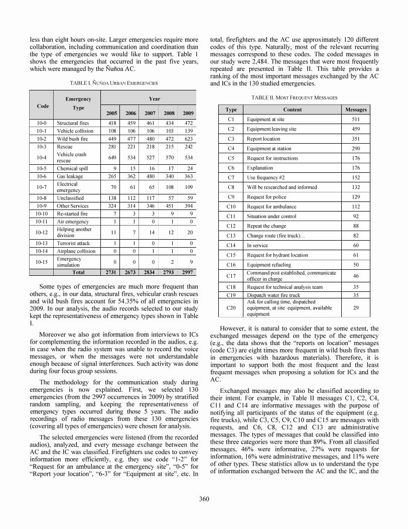
less than eight hours on-site. Larger emergencies require more collaboration, including communication and coordination than the type of emergencies we would like to support. Table 1 shows the emergencies that occurred in the past five years, which were managed by the Nufioa AC.
TABLE I. NuNOA URBAN EMERGENCIES
Emergency Year Code Type
2005 2006 2007 2008 2009
10-0 Structural fires 418 459 461 434 472
10-1 Vehicle collision 108 106 106 103 139
10-2 Wild bush fire 449 477 480 472 623
10-3 Rescue 281 221 218 215 242
10-4 Vehicle crash
649 534 527 570 534 rescue
10-5 Chemical spill 9 15 16 17 24
10-6 Gas leakage 265 362 480 340 363
10-7 Electrical
70 61 65 108 109 emergency
10-8 Unclassified 138 112 117 57 59
10-9 Other Services 324 314 346 451 394
10-10 Re-started fire 7 3 3 9 9
10-11 Air emergency 1 1 0 1 0
10-12 Helping another
11 7 14 12 20 division
10-13 Terrorist attack I I 0 I 0
10-14 Airplane collision 0 0 I I 0
10-15 Emergency
0 0 0 2 9 simulation
Total 2731 2673 2834 2793 2997
Some types of emergencies are much more frequent than others, e.g., in our data, structural fires, vehicular crash rescues and wild bush fires account for 54.35% of all emergencies in 2009. In our analysis, the audio records selected to our study kept the representativeness of emergency types shown in Table I.
Moreover we also got information from interviews to ICs for complementing the information recorded in the audios, e.g. in case when the radio system was unable to record the voice messages, or when the messages were not understandable enough because of signal interferences. Such activity was done during four focus group sessions.
The methodology for the communication study during emergencies is now explained. First, we selected 130 emergencies (from the 2997 occurrences in 2009) by stratified random sampling, and keeping the representativeness of emergency types occurred during those 5 years. The audio recordings of radio messages from these 130 emergencies (covering all types of emergencies) were chosen for analysis.
The selected emergencies were listened (from the recorded audios), analyzed, and every message exchange between the AC and the IC was classified. Firefighters use codes to convey information more efficiently, e.g. they use code "1-2" for "Request for an ambulance at the emergency site", "0-5" for "Report your location", "6-3" for "Equipment at site", etc. In
360
total, firefighters and the AC use approximately 120 different codes of this type. Naturally, most of the relevant recurring messages correspond to these codes. The coded messages in our study were 2,484. The messages that were most frequently repeated are presented in Table II. This table provides a ranking of the most important messages exchanged by the AC and ICs in the 130 studied emergencies.
T ABLE II. MOST FREQUENT MESSAGES
Type Content Messages
Cl Equipment at site 511
C2 Equipment leaving site 459
C3 Report location 351
C4 Equipment at station 290
C5 Request for instructions 176
C6 Explanation 176
C7 Use frequency #2 152
C8 Will be researched and informed 132
C9 Request for police 129
CI0 Request for ambulance 112
Cll Situation under control 92
CI 2 Repeat the change 88
C13 Change route (fire truck) ... 82
CI4 Tn service 60
CI 5 Request for hydrant location 61
CI 6 Equipment refueling 50
C17 Command post established, communicate
46 officer in charge
CI8 Request for technical analysis team 35
CI 9 Dispatch water fire truck 35 Ask for calling time, dispatched
C20 equipment, at site equipment, available 29 equipment
However, it is natural to consider that to some extent, the exchanged messages depend on the type of the emergency (e.g., the data shows that the "reports on location" messages (code C3) are eight times more frequent in wild bush fires than in emergencies with hazardous materials). Therefore, it is important to support both the most frequent and the least frequent messages when proposing a solution for ICs and the AC.
Exchanged messages may also be classified according to their intent. For example, in Table II messages Cl, C2, C4, C 11 and C 14 are informative messages with the purpose of notifying all participants of the status of the equipment (e.g. fire trucks), while C3, C5, C9, CI0 and C15 are messages with requests, and C6, C8, C12 and C13 are administrative messages. The types of messages that could be classified into these three categories were more than 89%. From all classified messages, 46% were informative, 27% were requests for information, 16% were administrative messages, and 11 % were of other types. These statistics allow us to understand the type of information exchanged between the AC and the IC, and the
timing of such exchange. In order to support the participants' information needs and thus try to reduce the radio channels usage, we have extended the MobileMap application.
IV. DESIGN AND IMPLEMENT A TION OF MOBILEMAP
The MobileMap application can operate in two modes: offline and online. When the application works offline (i.e. stand-alone), it does not interact with the AC; typically it occurs when the IC is out of the communication threshold of the corresponding AC. In that case the only information available in the application must have been pre-loaded in the mobile computing device at deployment time. It typically corresponds to files in "XML", "PNG" and "JPG" formats.
The IC can then have access to such information which is usually relevant to make decisions. Example of such data is the geographical location of hydrants and hospitals, and any other quite stable information that can be valid at the moment the IC requires it. In fact, there is almost no limitations on the type and amount of information that can be pre-loaded in the application. However if there is a risk that some data be outdated when the IC needs it, then such information must be managed through the second mode of operation, i.e. the online mode.
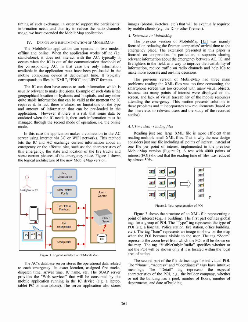
In this case the application makes a connection to the AC server using Internet via 3G or WiFi networks. This method lets the IC and AC exchange current information about an emergency or the affected site, such as: the characteristics of this emergency, the state and location of the fue trucks and some current pictures of the emergency place. Figure 1 shows the logical architecture of the new MobileMap version.
* Firefighter or Ie
lo •
Map Visualization
Alarm Center
SOAP Server
I
Figure I. Logical architecture of MobileMap
The AC's database server stores the operational data related to each emergency: its exact location, assigned fue trucks, dispatch time, arrival time, IC name, etc. The SOAP server provides the "Web services" that will be consumed by the mobile application running in the IC device (e.g. a laptop, tablet PC or smartphone). The server application also stores
361
images (photos, sketches, etc.) that will be eventually required by mobile clients (e.g. the IC or other fuemen).
A. Extension to MobileMap
The previous version of MobileMap [15] was mainly focused on reducing the fuemen companies' arrival time to the emergency place. The extension presented in this paper is focused on cooperation. In particular, it supports sharing relevant information about the emergency between AC, IC, and fuefighters in the field, as a way to improve the availability of information, reduce traffic on radio channels and help ICs to make more accurate and on-time decisions.
The previous version of MobileMap had three main problems: reading the XML files was too time consuming, the smartphone screen was too crowded with many visual objects, because too many points of interest were displayed on the screen, and lack of visual traceability of the mobile resources attending the emergency. This section presents solutions to these problems and it incorporates new requirements (based on the interviews to relevant users and the study of the recorded audios).
A.i. Time delay readingjiles
Reading just one large XML file is more efficient than reading multiple small XML files. That is why the new design considers just one file including all points of interest, instead of one file per point of interest implemented in the previous MobileMap version (Figure 2). A test with 4000 points of interest (POI) showed that the reading time of files was reduced by almost 50%.
I xmlJ I xmlJ I xmlJ I xmlJ I xmlJ I xmlJ y I xmlJ I xmlJ I xmlJ
xml xml xml xml xml xml
Figure 2. New representation of POI
p
Figure 3 shows the structure of an XML file representing a point of interest (e.g., a building). The fust part defines global tags for a group of POI. The "Type" tag represents the type of POI (e.g. a hospital, Police station, fue station, office building, etc.). The tag "Icon" represents an image to show on the map when the POI becomes visible to the user. The tag "Zoom" represents the zoom level from which the POI will be shown on the map. The tag "VisibleOnlyInRadio" specifies whether or not the POI will be shown only if it is located within the local area of action.
The second part of the file defmes tags for individual POI. The "Name", "Address" and "Coordinates" tags have intuitive meanings. The "Detail" tag represents the especial characteristics of the POI, e.g., the builder company, whether or not the building has a pool, number of floors, number of departments, and date of building.
<PointsOflnterest> <Type>building<!Type> <lcon>building.png<!lcon> <Zoom>5<!Zoom> <VisibleOnlylnRadio>No</yisibleOnlylnRadio> <Points>
<Point> <Name>Condominio Grecia<!Name> <Address>AV Grecia 1010<!Address> <Coordinates>
<Latitude>-33.46982<!Latitude> <Longitude>-70.5747 6<!Longitude>
<!Coordinates> <Detail>
<Builder>ABC Constructores<! Builder > <Floors>12<! Floors > <DryNet>No<! DryNet > <Pool>First floor<! Pool > <Departments>30<! Departments > <DateBuild>Mar!1950<! DateBuild >
<!Detail> <!Point> <Point>
<!Point>
<!Points> <!PointsOflnterest>
Figure 3. XML representation of a POI
The XML files containing this information are locally stored in the smartphone hard memory, or in the hard drive of the mobile computing device running the MobileMap client application. Xpath was the language used to make queries to retrieve the relevant information from the XML file, and then show it on the device screen. The "Detail" tag has variable child nodes, because every group of POls can have a specific structure. This is really useful in cases like this, in which we do not know how many child nodes are needed to describe the POI details.
A.2. Visual representation of POI
Considerable effort is needed to understand how to design effective visualizations, especially in mobile devices, due to the mobility context in emergencies. Representing information in a smartphone is an important challenge since these devices have significant technical restrictions, such as the small screen size and the limited graphical processing capabilities.
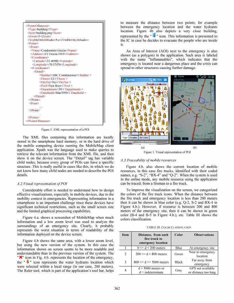
Figure 4.a. shows a screenshot of MobileMap when much infonnation and a low zoom level was used to analyze the surroundings of an emergency site. Clearly, it probably represents the worst situation in tenns of readability of the information deployed on the device screen.
Figure 4.b shows the same area, with a lower zoom level, but using the new version of the system. In this case the information shown on screen seems to be more readable and understandable than in the previous version of the system. The "X" icon in Fig. 4.b. represents the location of the emergency,
the " �" icon represents the water hydrants location which were selected within a local range (in our case, 200 meters). The Ruler tool, which is part of the application's tool bar, helps
362
to measure the distance between two points; for example between the emergency location and the water hydrants location. Figure 4b also depicts a very close building,
represented by the " " icon. This information is presented to the IC in case he decides to evacuate the people who are inside it.
An Area of Interest (AOI) next to the emergency is also shown (as a polygon) in the application. Such area is labeled with the name "Inflammables", which indicates that the emergency is located near a dangerous place and the crisis can spread to other structures causing further damage.
(a) (b)
Figure 1. Visual representation of POI
A. 3. Traceability of mobile resources
Figure 4.b. also shows the current location of mobile resources, in this case fire trucks, identified with their coded names, e.g. "S-2", "BX-4" and "Q-2". When the system is used in the online mode, any mobile resource using the application can be traced; from a fueman to a fue truck.
To improve the visualization on the screen, we categorized the colors of the fue truck icons. When the distance between the fue truck and emergency location is less than 200 meters then it can be shown in blue color (e.g. Q-2, S-2 and BX-4 in Figure 4.b.). However, if resource is between 200 and 800 meters of the emergency site, then it can be shown in green color (B-4 and B-5 in Figure 4.b.), etc. Table III shows the colors classification.
TABLE III. COLOR CLASSIFICATION
Item Distance, from each Color Observations
fire truck to
emergency location
1 o <= d < 200 meters Blue At emergency site
2 200 <= d < 800 meters Green Near to emergency
location
3 800 <= d <= 5000 meters Black Far away from
emergency
4 d > 5000 meters or
Gray GPS not available
d = indeterminate or distance too long
A.4. Additional requirements
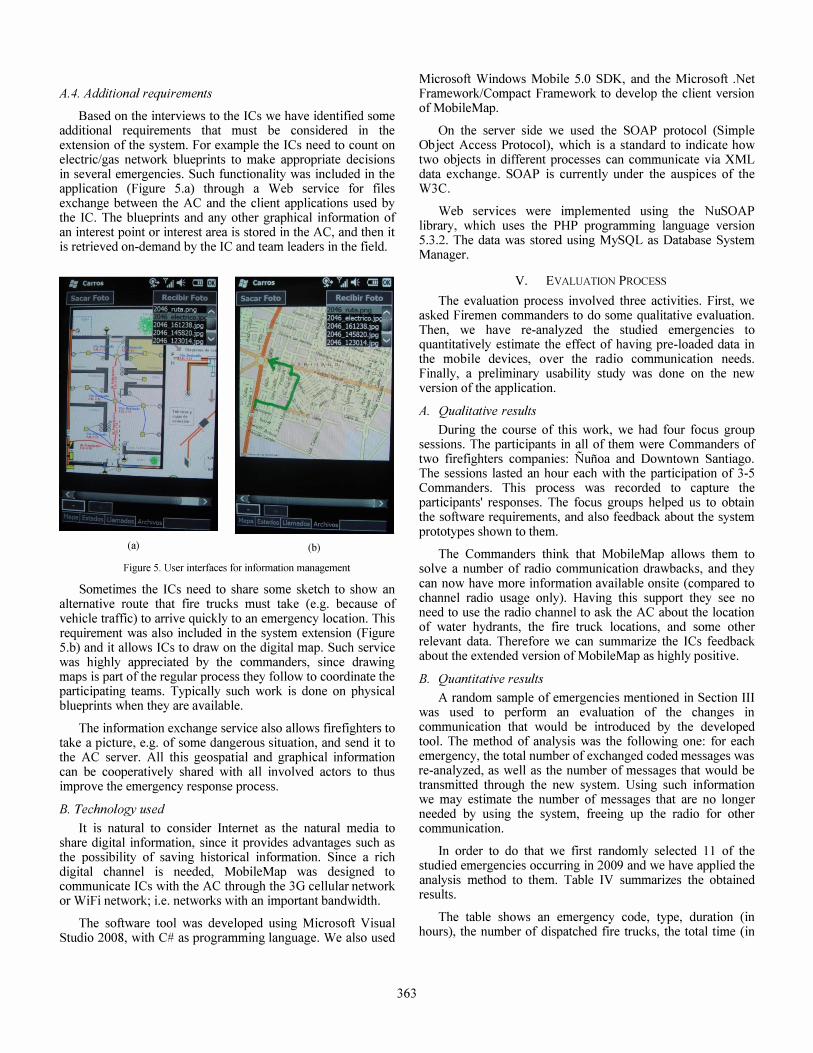
Based on the interviews to the ICs we have identified some additional requirements that must be considered in the extension of the system. For example the ICs need to count on electric/gas network blueprints to make appropriate decisions in several emergencies. Such functionality was included in the application (Figure 5.a) through a Web service for files exchange between the AC and the client applications used by the Ie. The blueprints and any other graphical information of an interest point or interest area is stored in the AC, and then it is retrieved on-demand by the IC and team leaders in the field.
(a) (b)
Figure 5. User interfaces for infonnation management
Sometimes the ICs need to share some sketch to show an alternative route that fire trucks must take (e.g. because of vehicle traffic) to arrive quickly to an emergency location. This requirement was also included in the system extension (Figure 5.b) and it allows ICs to draw on the digital map. Such service was highly appreciated by the commanders, since drawing maps is part of the regular process they follow to coordinate the participating teams. Typically such work is done on physical blueprints when they are available.
The information exchange service also allows firefighters to take a picture, e.g. of some dangerous situation, and send it to the AC server. All this geospatial and graphical information can be cooperatively shared with all involved actors to thus improve the emergency response process.
B. Technology used
It is natural to consider Internet as the natural media to share digital information, since it provides advantages such as the possibility of saving historical information. Since a rich digital channel is needed, MobileMap was designed to communicate ICs with the AC through the 3G cellular network or WiFi network; i.e. networks with an important bandwidth.
The software tool was developed using Microsoft Visual Studio 2008, with C# as programming language. We also used
363
Microsoft Windows Mobile 5.0 SDK, and the Microsoft .Net Framework/Compact Framework to develop the client version of MobileMap.
On the server side we used the SOAP protocol (Simple Object Access Protocol), which is a standard to indicate how two objects in different processes can communicate via XML data exchange. SOAP is currently under the auspices of the W3e.
Web services were implemented using the NuSOAP library, which uses the PHP programming language version 5.3.2. The data was stored using MySQL as Database System Manager.
V. EVALUATION PROCESS
The evaluation process involved three activities. First, we asked Firemen commanders to do some qualitative evaluation. Then, we have re-analyzed the studied emergencies to quantitatively estimate the effect of having pre-loaded data in the mobile devices, over the radio communication needs. Finally, a preliminary usability study was done on the new version of the application.
A. Qualitative results
During the course of this work, we had four focus group sessions. The participants in all of them were Commanders of two firefighters companies: Nufioa and Downtown Santiago. The sessions lasted an hour each with the participation of 3-5 Commanders. This process was recorded to capture the participants' responses. The focus groups helped us to obtain the software requirements, and also feedback about the system prototypes shown to them.
The Commanders think that MobileMap allows them to solve a number of radio communication drawbacks, and they can now have more information available onsite (compared to channel radio usage only). Having this support they see no need to use the radio channel to ask the AC about the location of water hydrants, the fue truck locations, and some other relevant data. Therefore we can summarize the ICs feedback about the extended version of Mobile Map as highly positive.
B. Quantitative results
A random sample of emergencies mentioned in Section III was used to perform an evaluation of the changes in communication that would be introduced by the developed tool. The method of analysis was the following one: for each emergency, the total number of exchanged coded messages was re-analyzed, as well as the number of messages that would be transmitted through the new system. Using such information we may estimate the number of messages that are no longer needed by using the system, freeing up the radio for other communication.
In order to do that we fust randomly selected 11 of the studied emergencies occurring in 2009 and we have applied the analysis method to them. Table IV summarizes the obtained results.
The table shows an emergency code, type, duration (in hours), the number of dispatched fue trucks, the total time (in

seconds), avoidable time (in seconds), and the reduction percentage because of the system usage.
TABLE TV: RADIo TrME USED IN EMERGENCIES
o J - o V ..!:V 0 .... ., 3-: ..... 11' U • liS D :;i
G' -. 51 -ilU -Ie. .;II ::;,
El Stru ctural fire 2 :50 5 1847 480 26,0%
E2 Vehicular rescue 0:49 2 476 55 11,6%
E3 Stru ctural fire 1:06 3 497 108 21,7%
E4 Vehicular rescue 2:48 3 669 87 13,0%
E5 wil d bush fire 5:53 16 4801 1220 25,4%
E6 wil d bu sh fire 3:27 10 1863 489 26,2%
E7 Stru ctural fire 1:45 7 1219 311 25,5%
E8 Stru ctural fire 1:38 7 1532 269 17,6%
E9 Debris emergency 1:20 3 790 101 12,8%
E I 0 Gas emergency 1:35 2 261 34 13,0%
Ell Electrical emergency 2:12 2 629 130 20,7%
15151 lID u.aol
These results show that the radio usage time could be reduced by approximately 20% when using the extended version of MobileMap. This represents an important improvement for emergencies when one considers that radio time availability is one of the scarcest resources.
C. Usability study
We used an end-users questionnaire to try capturing the user satisfaction when they utilize the proposed system. The questionnaire was designed for emergency cases and it has 10 items of questions with ratings according to a 10-va1ues Likert scale.
Five firemen commanders participated in this test. First, we explained the functionalities of the tool and we generated a simulated emergency. Then, other software was used to dispatch (in a simulated way) fire trucks every 20 seconds. The MobileMap application running on smartphones received the information of the new emergency, and selected and showed the relevant POls (e.g. hydrants, hospitals, buildings) to be considered by the ICs. The dispatched fire trucks appeared on the map once they were near the emergency location. Finally the Commanders used the application to retrieve information and filled out the questionnaire.
The evaluation done by the ICs covered the following points: a) POls shown over the map, b) availability of supporting information, c) the information support for effective decision making, and d) the potential capability of the tool to reduce radio usage time.
364
Another questionnaire was designed to get usability experts' evaluation. It contained 12 items of study, with each one having between 3 to 5 sub-items, and a sununary at the end of the document. This questionnaire contained the ten rules of usability proposed by Nielsen [16], plus two questions related to content treatment and request time. The values considered for each question in this evaluation were from 1 (Deficient) to 5 (Excellent). Although the obtained results are not enough to get sound conclusions, they indicate that the tool has a good user interface design, and the users felt comfortable using the application.
VI. CONCLUSIONS AND FUTURE WORK
This paper presented the extension of MobileMap, which intends to improve the information support during an emergency, and thus to reduce the use of the radio channels. This application complements the currently used radio systems, providing support to retrieve and exchange digital information. The requirements involved in the extension of MobileMap came from a detailed analysis of 130 urban emergencies occurred in Santiago, Chile, during 2009. Moreover, four focus groups with ICs also provided additional requirements for the tool extension.
The new version of MobileMap was presented to and evaluated by Commanders of Nuiioa and Santiago Firefighting Companies. They confirmed that the use of the tool effectively solves some operational problems of communication, since it provides information that is often asked repeatedly to AC, and therefore it can reduce radio traffic. The usability of the user interface was also evaluated by usability experts. Their feedback was considered for the tool adjustment. However the experts have agreed the usability of the system is good.
Eleven random emergencies were re-analyzed to determine the potential impact of using the tool extension. According to the quantitative results, using MobileMap in emergencies can reduce about 20% radio channel usage time, leaving it available for other activities.
The next steps in this initiative are the following ones. First, we have to complete the tool evaluation process, therefore a test with real fire trucks is planned for the next future. Such test will use the real scenario, but the emergencies to address will be simulated. Once tested and approved the system by the firefighter's commanders, we have to develop the application for other operating systems such as Android, iOS, etc., since today the application is available just for Windows operating systems. In the long term we want other organizations, such as public health services, police agencies, and electrical companies, could evaluate the system because they face similar problems to the one presented in this paper. Therefore, the solution could impact the work of several organizations as well.
ACKNOWLEDGEMENTS
The authors thank the Nuiioa Fire Department, in Santiago, Chile, for their contributions to this work. The work of Alvaro Monares was supported by a Conicyt PhD Scholarship. This work has also been partially supported by Fondecyt Project (Chile), grant: 1120207.
REFERENCES
[I] Agrawal, P., Rauschert, I., Inochanon, K., Bolelli, L., Fuhrmann, S., Brewer, T., Cai, G., MacEachren, A, Sharma, R. "Multimodal interface platform for geographical information systems (GeoMIP) in crisis management". Proceedings of the 6th International Conference on Multimodal Interfaces, 339-340, 2004.
[2] Aldunate, R., Ochoa, S.F., Pen a-Mora, F., Nussbaum, M. "Robust mobile ad hoc space for collaboration to support disaster relief efforts involving critical physical infrastructure". Journal of Computing in Civil Engineering, volume 20, page 13-27, 2006.
[3] Carver, L. Turoff, M. "Human-computer interaction: the human and computer as a team in emergency management information systems". Journal Communications of the ACM, 50(3), pages 33-38, 2007.
[4] Chittaro, L. " Visualizing Information on Mobile Devices ". Journal of Computer, publishied by IEEE Computer Society Press, 39(3), page 40-45, 2006.
[5] Currion P., de Silva c., & Van de Walle B. "Open source software for disaster management". Communications of the ACM, 50(3), 61-65, 2007.
[6] Ellis, c., Gibbs, S., Rein, G.: "Groupware: Some issues and experiences". Communications of the ACM 34(1), 39-58, 1991.
[7] Engelbrecht, A, Borges, M.R.S., Vivacqua, A "Digital tabletops for situational awareness in emergency situations". Proc. of CSCWD'I1. IEEE pres, pp. 669-676. 2011.
[8] Kanchanasut, K., Tunpan, A., Awal, MA, Wongsaardsakul, T., Das, D., Tsuchimoto, Y. "Building A Long-distance Multimedia Wireless Mesh Network for Collaborative Disaster Emergency Responses". Internet Education and Research Laboratory, Asian Institute of Technology, Thailand, 2007.
[9] Kanchanasut, K., Tunpan, A., Awal, M., Das, D., Wongsaardsakul, T. & Tsuchimoto, Y. "DUMBONET: a multimedia communication system for collaborative emergency response operations in disaster-affected areas". International Journal of Emergency Management, 4(4), pp. 670 - 681, 2007.
[10] Manoj, BS., Baker, A.H. "Communication challenges in emergency response". Comm. of the ACM, 50(3), pages 51-53, 2007.
[11] Mattern, F. "Wireless Future: Ubiquitous Computing". ETH ZUrich. Pages 1-10, 2004.
[12] Meissner, A., Luckenbach, T., Risse, T., Kirste, T., Kirchner, H. "Design challenges for an integrated disaster management communication and information system". The First IEEE Workshop on Disaster Recovery Networks, volume 24, 2002.
[13] MESA. "Mobile Broadband for Emergency and Safety Applications". MESA Project, http://www.projectmesa.orgl. Last visit: August, 2009.
[14] Midkiff, S.F., Bostian, C.W. "Rapidly-deployable broadband wireless networks for disaster and emergency response". The First IEEE Workshop on Disaster Recovery Networks, 2002.
[15] Monares, A Ochoa, S.F., Pino, 1. A, Herskovic, V., Rodriguez-Covili, 1., Neyem, A "Mobile Computing in Urban Emergency Situations: Improving the Support to Firefighters in the Field". Expert Systems with Applications 38(2), pp. 1255-1267, 2011.
[16] Nielsen, J. "Usability Engineering". Morgan Kaufmann, San Francisco, USA 1993.
[17] Sapateiro, C. and Antunes, P. "An Emergency Response Model Toward Situational Awareness Improvement". International Conference on Information Systems for Crisis Response and Management ([SCRAM), Goteborg, Sweden. 2009.
[18] Schoning, J., Rohs, M., KrUger, A., Stasch, C. "Improving the Communication of Spatial Information in Crisis Response by Combining Paper Maps and Mobile Devices". Journal of Mobile Response, pages 57-65, 2009.
[19] Smith, P.C., Simpson, D.M. "Technology and Communications in an Urban Crisis: The Role of Mobile Communications Systems in Disasters". Journal of Urban Technology, 16(1), pages 133-149, 2009.
[20] Swiatek, J. "Crisis Prediction Disaster Management". SAIC Science and Technology Trends II, 1999.
365
[21] Turoff, M., Chumer, M., Van de Walle, B., Yao, X. "The Design of a Dynamic Emergency Response Management Information System (DERMIS)", Journal of Information Technology Theory and Application (JITTA) 5(4), 1-36, 2004.
[22] National Institute for Occupational Safety and Health "Current Status, Knowledge Gaps, and Research Needs Pertaining to Firefighter Radio Communication Systems", 2003.
[23] Zhang, Z., Li, Q. "An Open Urban Emergency Decision Support System". The International Archives of the Photogrammetry, Remote Sensing and Spatial Information Sciences (ISPRS'08), 1123-1128. Beijing, China, 2008.