Assessment of Changes in Landcover and Landuse in Ebonyi ...
A LANDUSE REPORT ON SARIKKHALI MOUZA, PATUAKHALI
Md. Anwar Hossain 4th Year BS (Hons); Session: 2006-2007 Class Roll No: 093; Exam Roll No: 1421
Department of Geography and Environment University of Dhaka
ABSTRACT
The curriculum is to be thought of in terms activity and experience rather than knowledge to be acquired and facts to be stored. It is one of the idea of geography is to discuss the behavior of man and environment in this world in this world in different time and space. At present, both nature man and made environment are prominent objects in geography. It enjoys a high position among field sciences. For the proper understanding of the subject, observation in the field is absolutely essential. This year we the students of 4th year Honors (Session: 2006-2007), Department of Geography and Environment, University of Dhaka, visited Patuakhali Pourashava and its adjacent mouza named Sarikkhali. The significant benefit of this survey is to conduct with a view to expand our knowledge on landuse, socio-economic and environmental condition of Pautakhali Pourashava and Sarikkhali mouza under the direct supervision of Dept. of Geography of Environment. We studied two areas in Patuakhali and collect necessary data from the study areas but this report is mainly concern with the landuse of Sarikkhali and its socio-economic characteristics. Sarikkhali is low lying flood plain area characterized by the agricultural landuse. In our study, we tried to collect the all kinds information related with landuse. In this report, I tried to represent my experience and acquired knowledge systematically including maps, tables and graphs. To analyze the data, different statistical methods are used in this study. GIS technology is used to produce different types of maps of the study area. After analyzing the data I have tried myself to give an opinion about the land use characteristics of that region and also identify some problems. I hope that this survey will act as a conceptual framework for the future planning of Patuakhali Pourashava and Sarikkhali mouza.
ACKNOWLEDGEMENT
First of all I owed to my Dept. of Geography and Environment to introduce us with field techniques and methods of rural and urban land use survey, socio-economic studies and environmental analysis. I owe especially to my honorable course teacher Professor Dr. Nurul Islam Nazem who led the whole survey in a befitting manner. I am grateful to my other honorable teachers Professor Dr. Borhan Uddin, Professor Dr. Abdul Baquee and Mr. Rony for their opinion, ideas and valuable advice. The people of Patuakhali Pourashava and Sharik Khali village responded to us very delightfully and provided our necessary information with great patience and sincerity that leads our survey to a successful one. I am very obliged by the willingness of them. I am also greatful to those organizations that provided useful data for our report. Such organizations are Bangladesh Bureau of Statistics (BBS), Department of Local Government and Rural Development (LGRD) and Department of Land Survey. I want to thank our Chairman Professor Shahanaz Huq who gave permission and enlighted us with her valuable experience to arrange this study tour. Specially, I would like to thanks my younger brother Raihan to support me in the processing of data. Finally, I would like to thank all of my classmates and also my friends for their continuing support and encouragement.
Md. Anwar Hossain
TABLE OF CONTENT Description Page No.
CHAPTER ONE
: INTRODUCTION
01 - 06
1.1 Introduction
1.2 Objectives of the Study
1.3 Data Sources
1.4 Methods of Study
1.5 Limitations of the Study
1.6 Glossary of Terms and Unit Conversions
CHAPTER TWO : PROFILE OF SARIKKHALI MOUZA 07 - 09
CHAPTER THREE : NATURAL AND PHYSICAL ENVIRONMENT 10 - 25
3.1 Physiographic Characteristics
3.2 Water bodies and Drainage Quality
3.3 land Level
3.4 Slope Intensity
3.5 Floodability
3.6 Soil Characteristics
CHAPTER FOUR : SOCIO-ECONOMIC STATUS 26 - 41
4.1 Demographic Characteristics
4.2 Economic Characteristics
4.3 Housing Characteristics
4.4 Livelihood and Social Facilities
CHAPTER FIVE : GENERAL LANDUSE PATTERN 42 - 46
Description Page No.
CHAPTER SIX
: AGRICULTURAL PRACTICE AND LANDUSE
47 - 59
6.1 General Agricultural Landuse
6.2 Cropping Intensity
6.3 Dominant Crop
6.4 Irrigation
6.5 Vegetation Cultivation
6.6 Use of Technology
6.7 Use of Fertilizer and Pesticides
CHAPTER SEVEN :HEALTH AND ENVIRONMENT 60 - 61
7.1 Health
7.2 Environmental Aspects
CHAPTER EIGHT : CONCLUSION AND RECOMMENDATIONS 62 - 63
8.1 Conclusion
8.2 Recommendations
BIBLIOGRAPHY 64 - 64
SAMPLE QUESTIONEER
PRACTIONAL CODE LIST
CHAPTER ONE
INTRODUCTION
A Landuse Report on Sarikkhali Mouja, Patuakhali 2
CHAPTER ONE: INTRODUCTION
CHAPTER ONE: INTRODUCTION
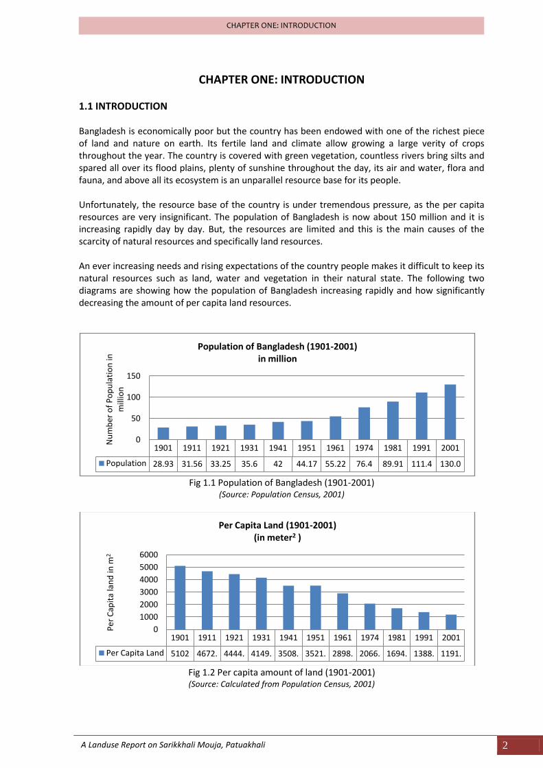
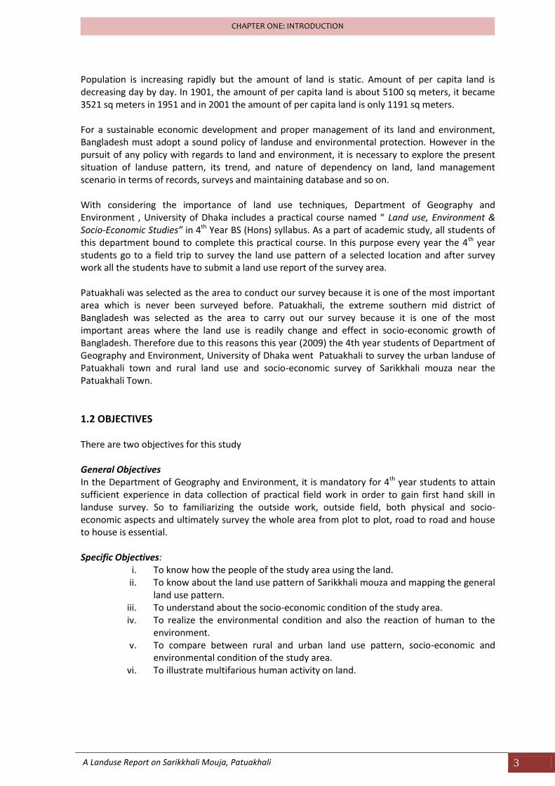
1.1 INTRODUCTION Bangladesh is economically poor but the country has been endowed with one of the richest piece of land and nature on earth. Its fertile land and climate allow growing a large verity of crops throughout the year. The country is covered with green vegetation, countless rivers bring silts and spared all over its flood plains, plenty of sunshine throughout the day, its air and water, flora and fauna, and above all its ecosystem is an unparallel resource base for its people. Unfortunately, the resource base of the country is under tremendous pressure, as the per capita resources are very insignificant. The population of Bangladesh is now about 150 million and it is increasing rapidly day by day. But, the resources are limited and this is the main causes of the scarcity of natural resources and specifically land resources. An ever increasing needs and rising expectations of the country people makes it difficult to keep its natural resources such as land, water and vegetation in their natural state. The following two diagrams are showing how the population of Bangladesh increasing rapidly and how significantly decreasing the amount of per capita land resources.
Fig 1.1 Population of Bangladesh (1901-2001)
(Source: Population Census, 2001)
Fig 1.2 Per capita amount of land (1901-2001) (Source: Calculated from Population Census, 2001)
1901 1911 1921 1931 1941 1951 1961 1974 1981 1991 2001
Population 28.93 31.56 33.25 35.6 42 44.17 55.22 76.4 89.91 111.4 130.0
0
50
100
150
Nu
mb
er o
f P
op
ula
tio
n in
m
illio
n
Population of Bangladesh (1901-2001)in million
1901 1911 1921 1931 1941 1951 1961 1974 1981 1991 2001
Per Capita Land 5102 4672. 4444. 4149. 3508. 3521. 2898. 2066. 1694. 1388. 1191.
0
1000
2000
3000
4000
5000
6000
Per
Cap
ita
lan
d in
m2
Per Capita Land (1901-2001)(in meter2 )
A Landuse Report on Sarikkhali Mouja, Patuakhali 3
CHAPTER ONE: INTRODUCTION
Population is increasing rapidly but the amount of land is static. Amount of per capita land is decreasing day by day. In 1901, the amount of per capita land is about 5100 sq meters, it became 3521 sq meters in 1951 and in 2001 the amount of per capita land is only 1191 sq meters. For a sustainable economic development and proper management of its land and environment, Bangladesh must adopt a sound policy of landuse and environmental protection. However in the pursuit of any policy with regards to land and environment, it is necessary to explore the present situation of landuse pattern, its trend, and nature of dependency on land, land management scenario in terms of records, surveys and maintaining database and so on. With considering the importance of land use techniques, Department of Geography and Environment , University of Dhaka includes a practical course named “ Land use, Environment & Socio-Economic Studies” in 4th Year BS (Hons) syllabus. As a part of academic study, all students of this department bound to complete this practical course. In this purpose every year the 4th year students go to a field trip to survey the land use pattern of a selected location and after survey work all the students have to submit a land use report of the survey area. Patuakhali was selected as the area to conduct our survey because it is one of the most important area which is never been surveyed before. Patuakhali, the extreme southern mid district of Bangladesh was selected as the area to carry out our survey because it is one of the most important areas where the land use is readily change and effect in socio-economic growth of Bangladesh. Therefore due to this reasons this year (2009) the 4th year students of Department of Geography and Environment, University of Dhaka went Patuakhali to survey the urban landuse of Patuakhali town and rural land use and socio-economic survey of Sarikkhali mouza near the Patuakhali Town.
1.2 OBJECTIVES There are two objectives for this study General Objectives In the Department of Geography and Environment, it is mandatory for 4th year students to attain sufficient experience in data collection of practical field work in order to gain first hand skill in landuse survey. So to familiarizing the outside work, outside field, both physical and socio-economic aspects and ultimately survey the whole area from plot to plot, road to road and house to house is essential. Specific Objectives:
i. To know how the people of the study area using the land. ii. To know about the land use pattern of Sarikkhali mouza and mapping the general
land use pattern. iii. To understand about the socio-economic condition of the study area. iv. To realize the environmental condition and also the reaction of human to the
environment. v. To compare between rural and urban land use pattern, socio-economic and
environmental condition of the study area. vi. To illustrate multifarious human activity on land.
A Landuse Report on Sarikkhali Mouja, Patuakhali 4
CHAPTER ONE: INTRODUCTION
1.3 DATA SOURCES Landuse data are collected through primary surveys directly from the study areas. Two different surveys were conducted to collect landuse data. These are-
Plot to Plot Landuse Survey Socio-Economic Survey
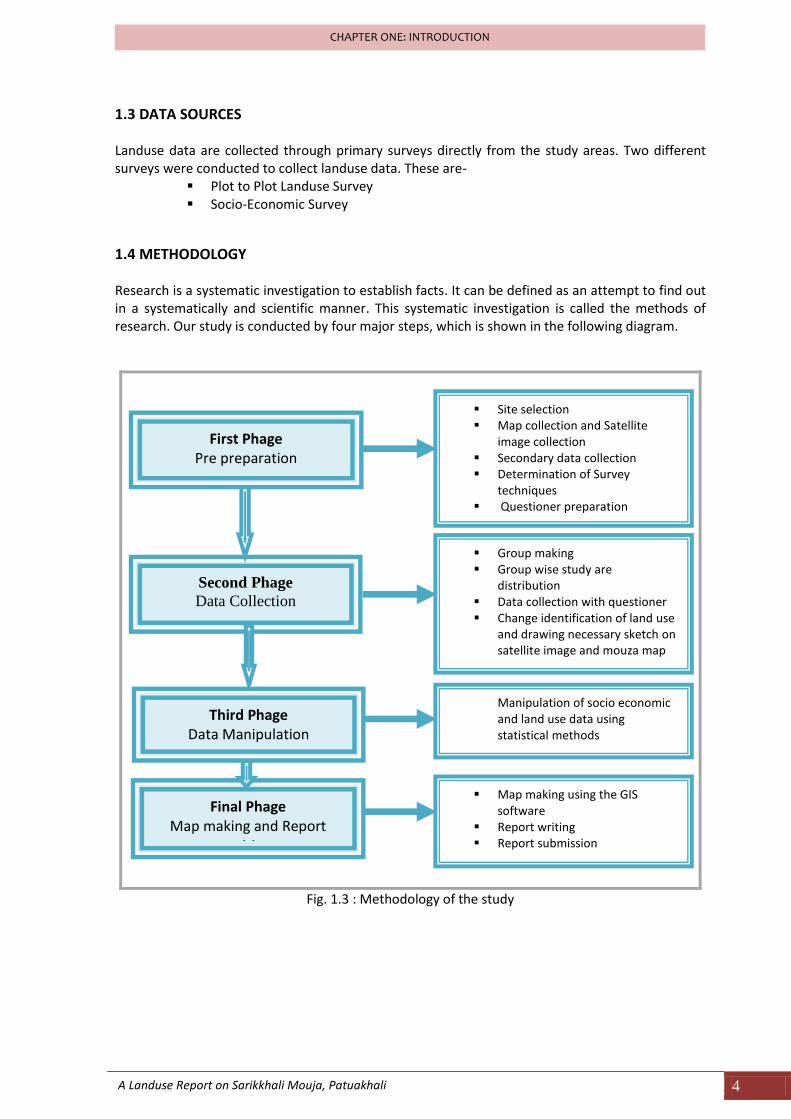
1.4 METHODOLOGY Research is a systematic investigation to establish facts. It can be defined as an attempt to find out in a systematically and scientific manner. This systematic investigation is called the methods of research. Our study is conducted by four major steps, which is shown in the following diagram.
Fig. 1.3 : Methodology of the study
First Phage Pre preparation
Second Phage
Data Collection
Third Phage Data Manipulation
Final Phage Map making and Report
writing
Site selection Map collection and Satellite
image collection Secondary data collection Determination of Survey
techniques Questioner preparation
Group making Group wise study are
distribution Data collection with questioner Change identification of land use
and drawing necessary sketch on satellite image and mouza map
Manipulation of socio economic and land use data using statistical methods
Map making using the GIS software
Report writing Report submission
A Landuse Report on Sarikkhali Mouja, Patuakhali 5
CHAPTER ONE: INTRODUCTION
1.5 LIMITATIONS OF THE STUDY Every research work if it is a good one has to face some problems. During our survey we also faced some limitations. These are as follows:
Time was constraint; we did not have enough time to cover the whole area properly both in rural and urban aspects. We have got only two days for covering the whole area both for land use as well as socio-economic survey.
Could not get information from the head of the house hold all the time. Because when we surveyed they were not available at home.
Somewhere people were reluctant to answer some questions and some of them also gave incorrect answers, hence it created some problems.
The map we used for survey was too old. The plot number of the respective area was changed also with the time. As a result we faced many problems to identify the real plots.
The availability of secondary data was inadequate.
A Landuse Report on Sarikkhali Mouja, Patuakhali 6
CHAPTER ONE: INTRODUCTION
1.6 GLOSSARY OF TERMS AND UNIT CONVERSIONS acre : unit of measuring area, 1 acre = 0.4046 hectare aman : traditional varites of paddy harvested in November/ December aus : traditional varites of paddy harvested in July/ August boro : crop season and also traditional varites of paddy harvested in March/ april decimal : unit of measuring area, 100 decimal = 1 acre HYV : High Yield Varitey of crops mouza : A unit of land having legal boundaries and use to administer surveys and to maintain
records vita : land raised for building homestead

CHAPTER TWO
PROFILE OF SARIKKHALI MOUZA
A Landuse Report on Sarikkhali Mouja, Patuakhali 8
CHAPTER TWO: PROFILE OF SARIKKHALI MOUZA
CHAPTER TWO: PROFILE OF SARIKKHALI MOUZA
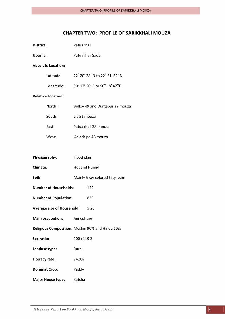
District: Patuakhali
Upazila: Patuakhali Sadar
Absolute Location:
Latitude: 220 20’ 38’’N to 220 21’ 52’’N
Longitude: 900 17’ 20’’E to 900 18’ 47’’E
Relative Location:
North: Bollov 49 and Durgapur 39 mouza
South: Lia 51 mouza
East: Patuakhali 38 mouza
West: Golachipa 48 mouza
Physiography: Flood plain
Climate: Hot and Humid
Soil: Mainly Gray colored Silty loam
Number of Households: 159
Number of Population: 829
Average size of Household: 5.20
Main occupation: Agriculture
Religious Composition: Muslim 90% and Hindu 10%
Sex ratio: 100 : 119.3
Landuse type: Rural
Literacy rate: 74.9%
Dominat Crop: Paddy
Major House type: Katcha
A Landuse Report on Sarikkhali Mouja, Patuakhali 9
CHAPTER TWO: PROFILE OF SARIKKHALI MOUZA
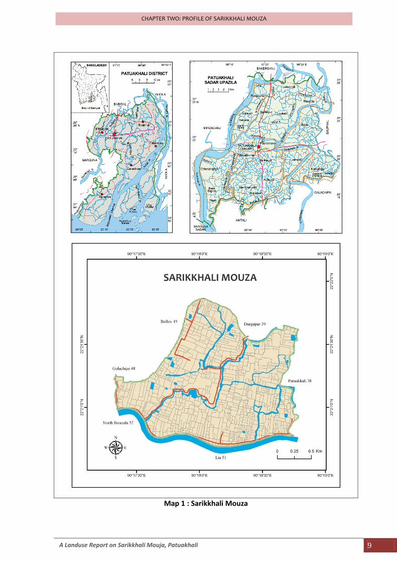
Map 1 : Sarikkhali Mouza

CHAPTER THREE
NATURAL AND PHYSICAL ENVIRONMENT
A Landuse Report on Sarikkhali Mouja, Patuakhali 11
CHAPTER THREE: NATURAL AND PHYSICAL ENVIRONMENT
CHAPTER THREE: NATURAL AND PHYSICAL ENVIRONMENT
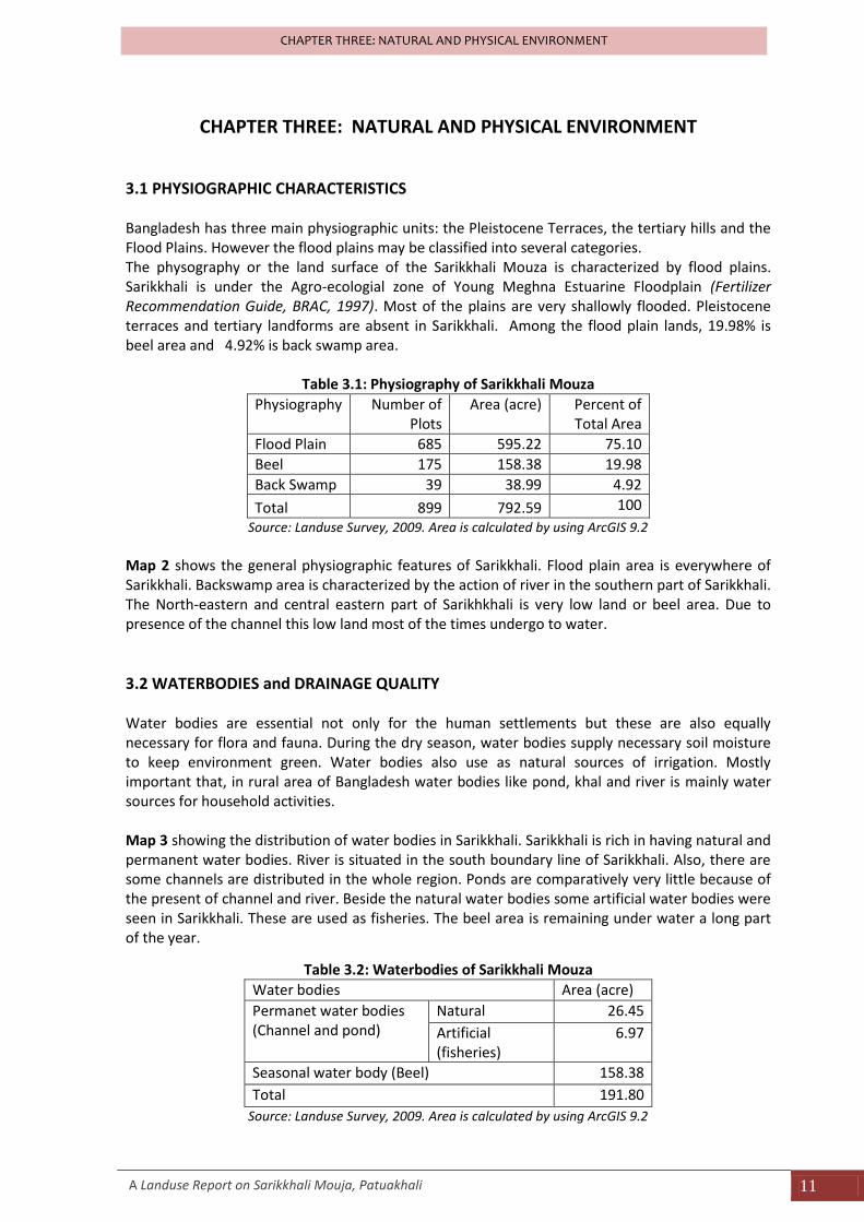
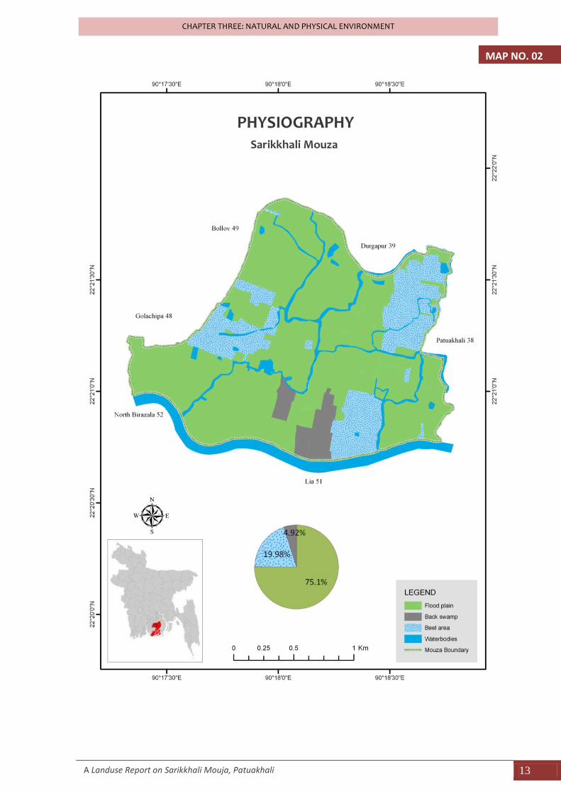
3.1 PHYSIOGRAPHIC CHARACTERISTICS Bangladesh has three main physiographic units: the Pleistocene Terraces, the tertiary hills and the Flood Plains. However the flood plains may be classified into several categories. The physography or the land surface of the Sarikkhali Mouza is characterized by flood plains. Sarikkhali is under the Agro-ecologial zone of Young Meghna Estuarine Floodplain (Fertilizer Recommendation Guide, BRAC, 1997). Most of the plains are very shallowly flooded. Pleistocene terraces and tertiary landforms are absent in Sarikkhali. Among the flood plain lands, 19.98% is beel area and 4.92% is back swamp area.
Table 3.1: Physiography of Sarikkhali Mouza
Physiography Number of Plots
Area (acre) Percent of Total Area
Flood Plain 685 595.22 75.10
Beel 175 158.38 19.98
Back Swamp 39 38.99 4.92
Total 899 792.59 100
Source: Landuse Survey, 2009. Area is calculated by using ArcGIS 9.2
Map 2 shows the general physiographic features of Sarikkhali. Flood plain area is everywhere of Sarikkhali. Backswamp area is characterized by the action of river in the southern part of Sarikkhali. The North-eastern and central eastern part of Sarikhkhali is very low land or beel area. Due to presence of the channel this low land most of the times undergo to water.
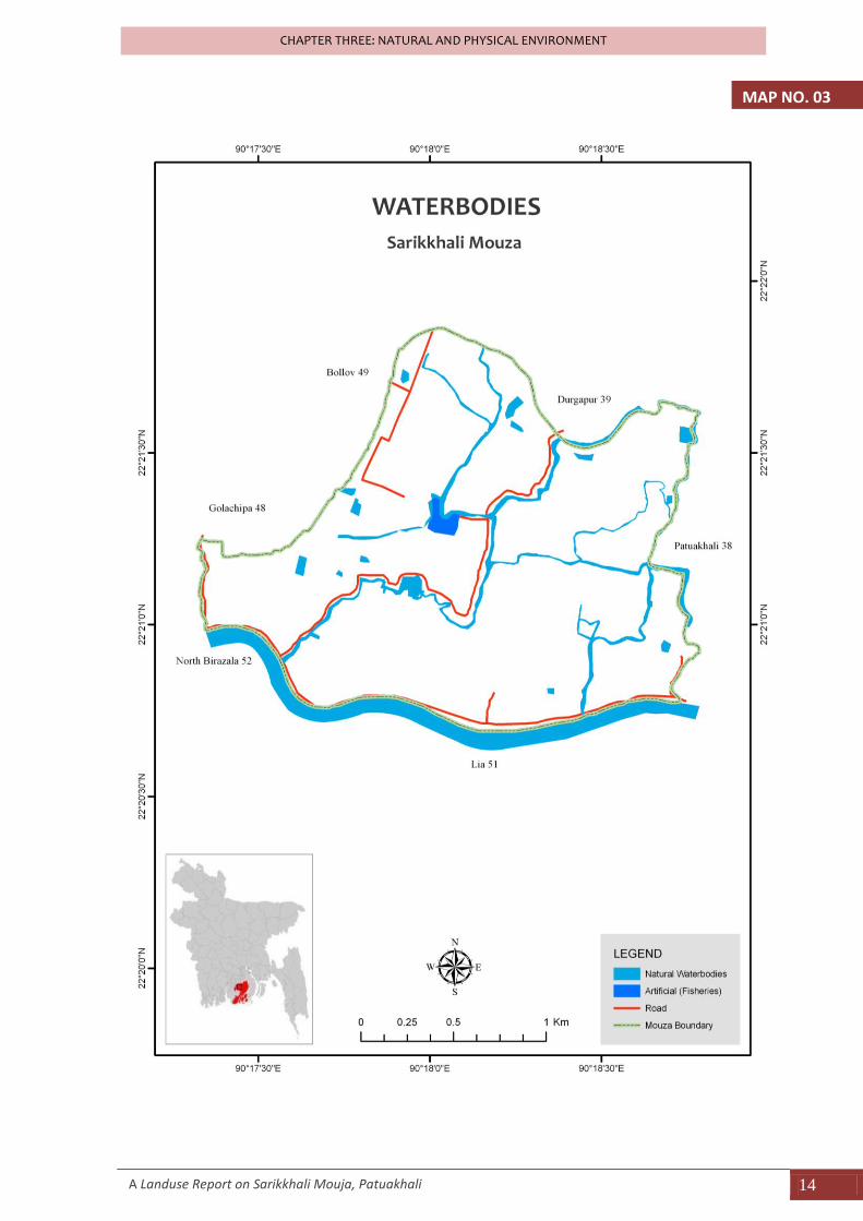
3.2 WATERBODIES and DRAINAGE QUALITY Water bodies are essential not only for the human settlements but these are also equally necessary for flora and fauna. During the dry season, water bodies supply necessary soil moisture to keep environment green. Water bodies also use as natural sources of irrigation. Mostly important that, in rural area of Bangladesh water bodies like pond, khal and river is mainly water sources for household activities. Map 3 showing the distribution of water bodies in Sarikkhali. Sarikkhali is rich in having natural and permanent water bodies. River is situated in the south boundary line of Sarikkhali. Also, there are some channels are distributed in the whole region. Ponds are comparatively very little because of the present of channel and river. Beside the natural water bodies some artificial water bodies were seen in Sarikkhali. These are used as fisheries. The beel area is remaining under water a long part of the year.
Table 3.2: Waterbodies of Sarikkhali Mouza
Water bodies Area (acre)
Permanet water bodies (Channel and pond)
Natural 26.45
Artificial (fisheries)
6.97
Seasonal water body (Beel) 158.38
Total 191.80
Source: Landuse Survey, 2009. Area is calculated by using ArcGIS 9.2
A Landuse Report on Sarikkhali Mouja, Patuakhali 12
CHAPTER THREE: NATURAL AND PHYSICAL ENVIRONMENT
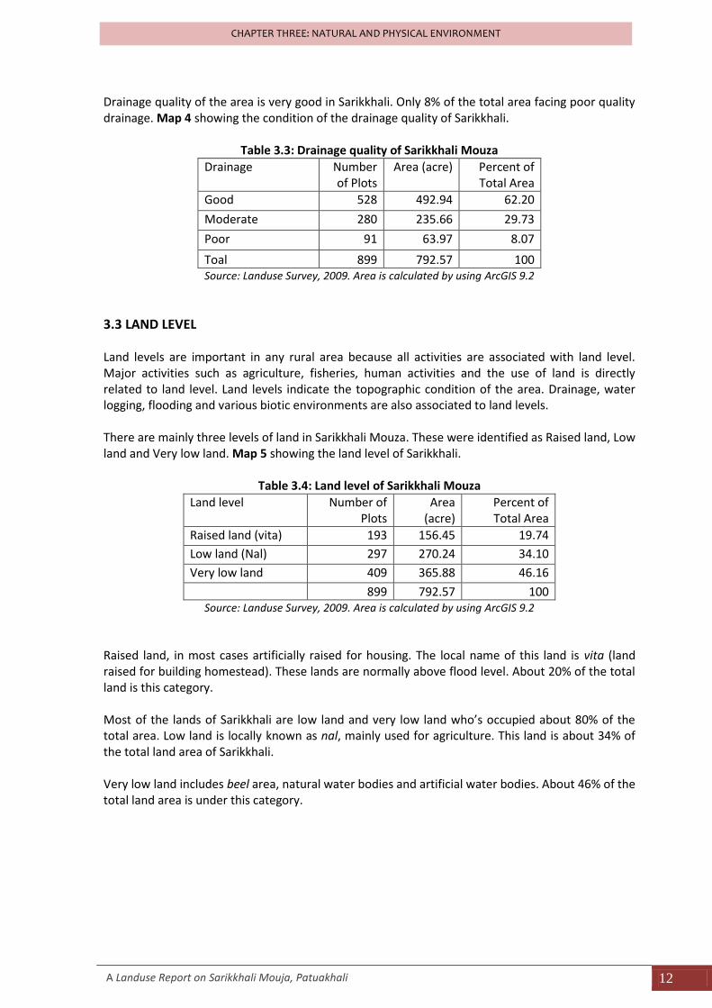
Drainage quality of the area is very good in Sarikkhali. Only 8% of the total area facing poor quality drainage. Map 4 showing the condition of the drainage quality of Sarikkhali.
Table 3.3: Drainage quality of Sarikkhali Mouza
Drainage Number of Plots
Area (acre) Percent of Total Area
Good 528 492.94 62.20
Moderate 280 235.66 29.73
Poor 91 63.97 8.07
Toal 899 792.57 100 Source: Landuse Survey, 2009. Area is calculated by using ArcGIS 9.2
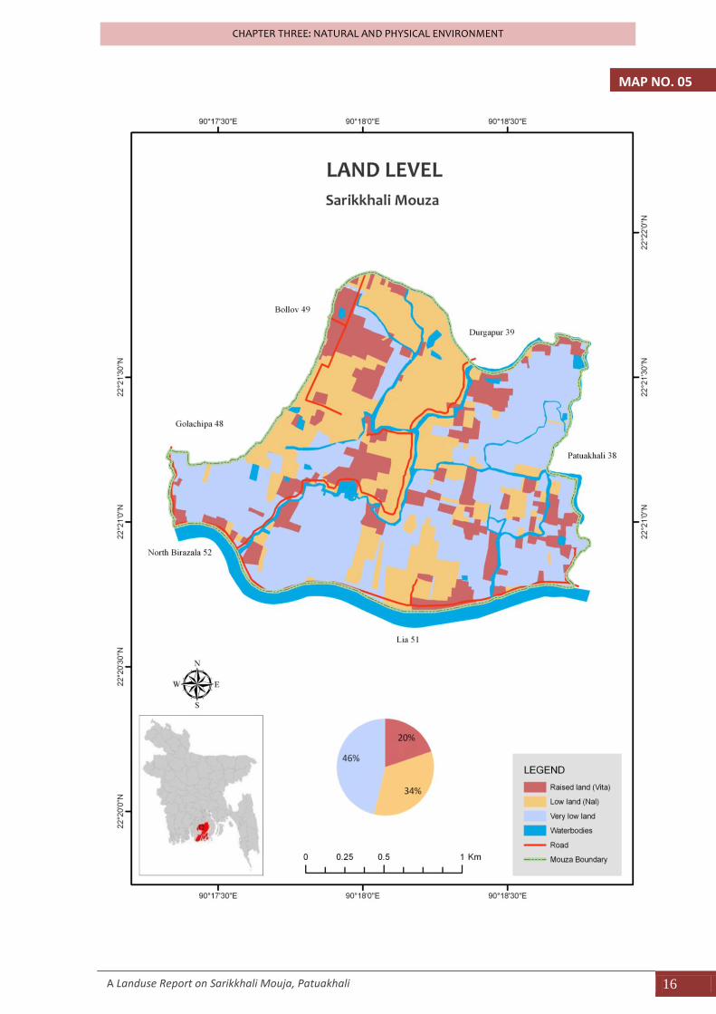
3.3 LAND LEVEL Land levels are important in any rural area because all activities are associated with land level. Major activities such as agriculture, fisheries, human activities and the use of land is directly related to land level. Land levels indicate the topographic condition of the area. Drainage, water logging, flooding and various biotic environments are also associated to land levels. There are mainly three levels of land in Sarikkhali Mouza. These were identified as Raised land, Low land and Very low land. Map 5 showing the land level of Sarikkhali.
Table 3.4: Land level of Sarikkhali Mouza
Land level Number of Plots
Area (acre)
Percent of Total Area
Raised land (vita) 193 156.45 19.74
Low land (Nal) 297 270.24 34.10
Very low land 409 365.88 46.16
899 792.57 100
Source: Landuse Survey, 2009. Area is calculated by using ArcGIS 9.2
Raised land, in most cases artificially raised for housing. The local name of this land is vita (land raised for building homestead). These lands are normally above flood level. About 20% of the total land is this category. Most of the lands of Sarikkhali are low land and very low land who’s occupied about 80% of the total area. Low land is locally known as nal, mainly used for agriculture. This land is about 34% of the total land area of Sarikkhali. Very low land includes beel area, natural water bodies and artificial water bodies. About 46% of the total land area is under this category.
A Landuse Report on Sarikkhali Mouja, Patuakhali 13
CHAPTER THREE: NATURAL AND PHYSICAL ENVIRONMENT
MAP NO. 02
A Landuse Report on Sarikkhali Mouja, Patuakhali 14
CHAPTER THREE: NATURAL AND PHYSICAL ENVIRONMENT
MAP NO. 03
A Landuse Report on Sarikkhali Mouja, Patuakhali 15
CHAPTER THREE: NATURAL AND PHYSICAL ENVIRONMENT
Drainage Quality Map Missing
MAP NO. 04
A Landuse Report on Sarikkhali Mouja, Patuakhali 16
CHAPTER THREE: NATURAL AND PHYSICAL ENVIRONMENT
MAP NO. 05
A Landuse Report on Sarikkhali Mouja, Patuakhali 17
CHAPTER THREE: NATURAL AND PHYSICAL ENVIRONMENT
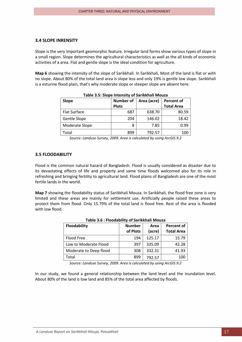
3.4 SLOPE INRENSITY Slope is the very important geomorphic feature. Irregular land forms show various types of slope in a small region. Slope determines the agricultural characteristics as well as the all kinds of economic activities of a area. Flat and gentle slope is the ideal condition for agriculture. Map 6 showing the intensity of the slope of Sarikkhali. In Sarikkhali, Most of the land is flat or with no slope. About 80% of the total land area is slope less and only 19% is gentle low slope. Sarikkhali is a esturine flood plain, that’s why moderate slope or steeper slope are absent here.
Table 3.5: Slope Intensity of Sarikkhali Mouza
Slope Number of Plots
Area (acre) Percent of Total Area
Flat Surface 687 638.70 80.59
Gentle Slope 204 146.02 18.42
Moderate Slope 8 7.85 0.99
Total 899 792.57 100 Source: Landuse Survey, 2009. Area is calculated by using ArcGIS 9.2
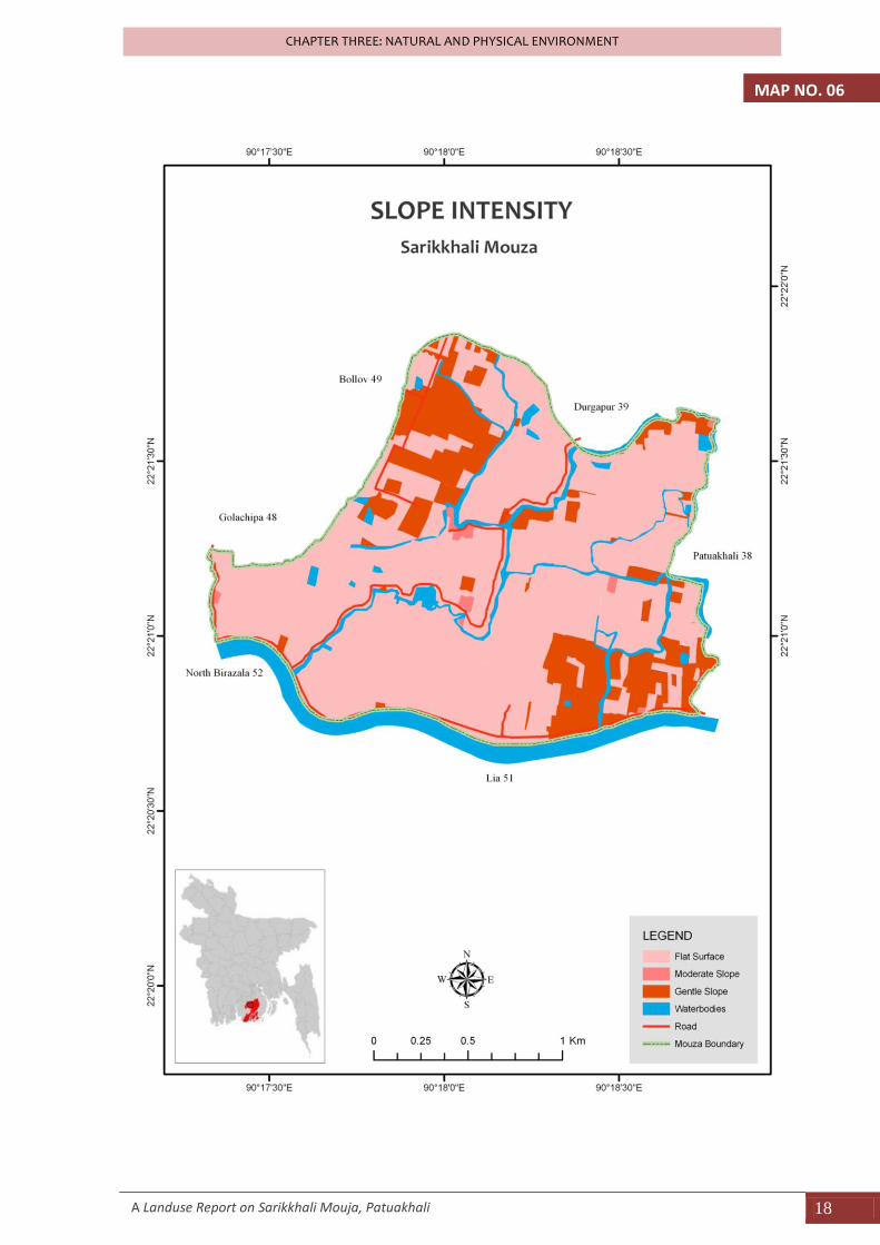
3.5 FLOODABILITY Flood is the common natural hazard of Bangladesh. Flood is usually considered as disaster due to its devastating effects of life and property and same time floods welcomed also for its role in refreshing and bringing fertility to agricultural land. Flood plains of Bangladesh are one of the most fertile lands in the world. Map 7 showing the floodability status of Sarikkhali Mouza. In Sarikkhali, the flood free zone is very limited and these areas are mainly for settlement use. Artificially people raised these areas to protect them from flood. Only 15.79% of the total land is flood free. Rest of the area is flooded with low flood.
Table 3.6 : Floodability of Sarikkhali Mouza
Floodability Number of Plots
Area (acre)
Percent of Total Area
Flood Free 194 125.17 15.79
Low to Moderate Flood 397 335.09 42.28
Moderate to Deep flood 308 332.31 41.93
Total 899 792.57 100
Source: Landuse Survey, 2009. Area is calculated by using ArcGIS 9.2
In our study, we found a general relationship between the land level and the inundation level. About 80% of the land is low land and 85% of the total area affected by floods.
A Landuse Report on Sarikkhali Mouja, Patuakhali 18
CHAPTER THREE: NATURAL AND PHYSICAL ENVIRONMENT
MAP NO. 06
A Landuse Report on Sarikkhali Mouja, Patuakhali 19
CHAPTER THREE: NATURAL AND PHYSICAL ENVIRONMENT
MAP NO. 07
A Landuse Report on Sarikkhali Mouja, Patuakhali 20
CHAPTER THREE: NATURAL AND PHYSICAL ENVIRONMENT
3.6 SOIL CHARACTERISTICS Soils are loose materials of the uppermost layer of the earth surface composed of organic and inorganic substances. In organic matters are basically the mineral substances. Soils also contain water and air. Depending on the material contents and the size of soil particles they are classified into various types. In Sarikkhali main types of soil is Calcareous and Non-calcareous Alluvium Grey Flood Plain Soils (Fertilizer Recommendation Guide, BRAC, 1997). In our study, we identified two characteristics of soil, such as; soil texture and soil color and beside this we also examined the soil fertility and the intensity of soil erosion.
Soil texture In our survey, we identified six types of soil in Sarikkhali Mouza; these are- clay soil, Loamy soil, Sandy soil, Sandy loam soil, silt, and silt loamy soil. Sandy loam and silt loam are occupied about 64% of the total area of Sarikkhali (sandy loam 33.42% and silt loam 30.85%) and 25.85% of the total land area is occupied by clay soil. Map 8 shows the general distribution of the different types of soil.
Table 3.7 : Soil Texture of Sarikkhali Mouza
Soil Texture Number of Plots
Area (acre)
Percent of Total Area
Clay 210 204.91 25.85
Loam 38 24.77 3.13
Sandy 12 7.71 0.97
Sandy Loam 299 264.82 33.42
Silt 45 45.84 5.78
Silt Loam 295 244.54 30.85
Total 899 792.59 100
Source: Landuse Survey, 2009. Area is calculated by using ArcGIS 9.2
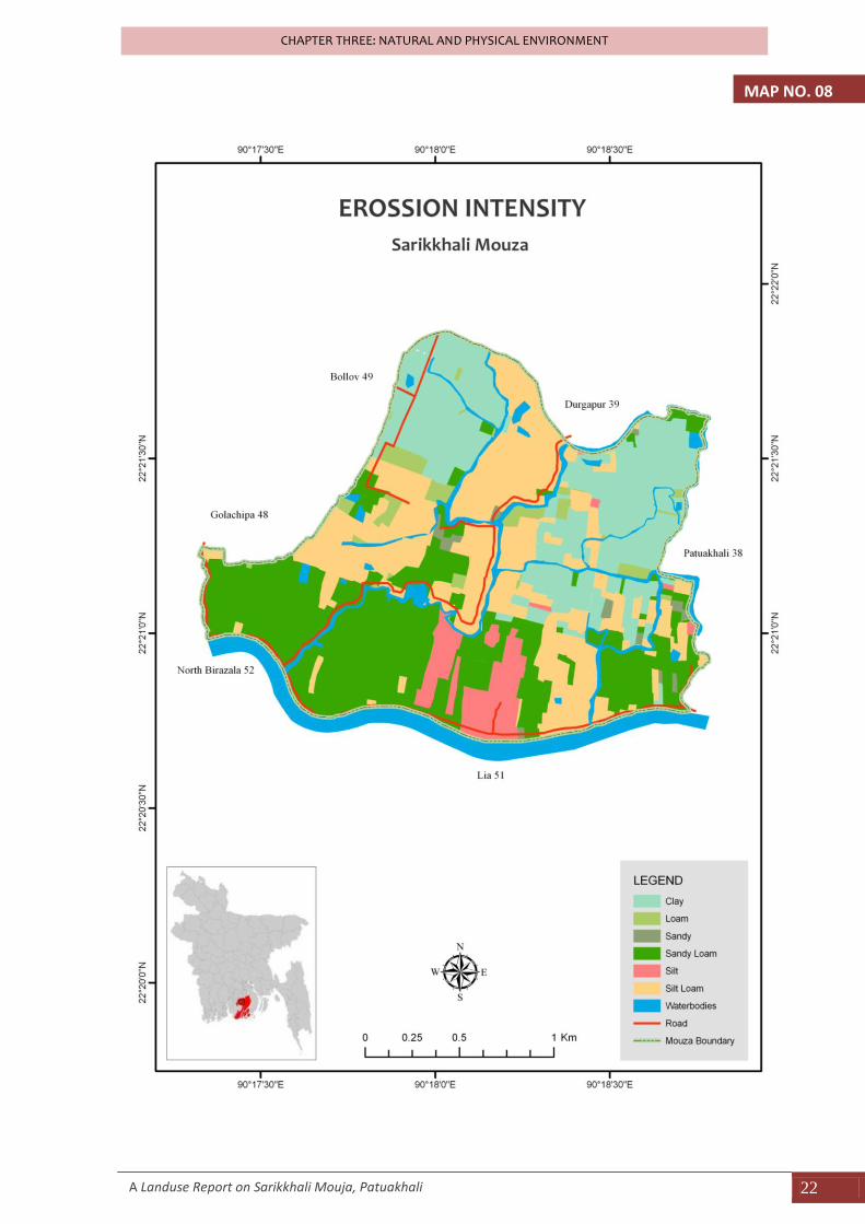
Soil Color Color of the soil reflects the quality of soil and gives a general idea about the components of the observed soil. Such as, the soil with gray or light gray in color represent the good quality of soil and mainly this soil is formed due to the siltation process of river, on the other hand, soil with brown or dark brown color reflects that the soil mineral components are mainly Ferrous grouped like Fe, Al, Mg etc. Soil with gray color is more fertile than the other colored soil.
Table 3.8 :Soil color of Sarikkhali Mouza
Soil Color Number of Plots
Area (acre) Percent of Total Area
Brown 26 25.24 3.18
Dark Grey 245 250.51 31.61
Light Brown 85 46.38 5.85
Light Grey 543 470.47 59.36
Total 899 792.59 100
A Landuse Report on Sarikkhali Mouja, Patuakhali 21
CHAPTER THREE: NATURAL AND PHYSICAL ENVIRONMENT
Source: Landuse Survey, 2009. Area is calculated by using ArcGIS 9.2
In our study area, we found about 91% of the total land area covered by gray or dark gray colored soil because of the presence of the river and only about 9% of the area covered by brown soils. Map 9 shows the distribution of the different colored soils in Sarikkhali Mouza.
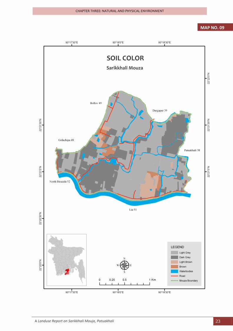
Soil Fertility Fertility means the production quality of the soil. Land of high productivity is the results of soil quality as well as the soil fertility. Sarikkhali is a fully floodplain region and the soil formed by the siltation process of the river. Flood plain soil is the best quality of soil which occupied high amount of mineral matters and these matters supports for high productivity of the soil. So, the fertility of the soil is good. Map 10 shows the soil fertility condition of Sarikkhali.
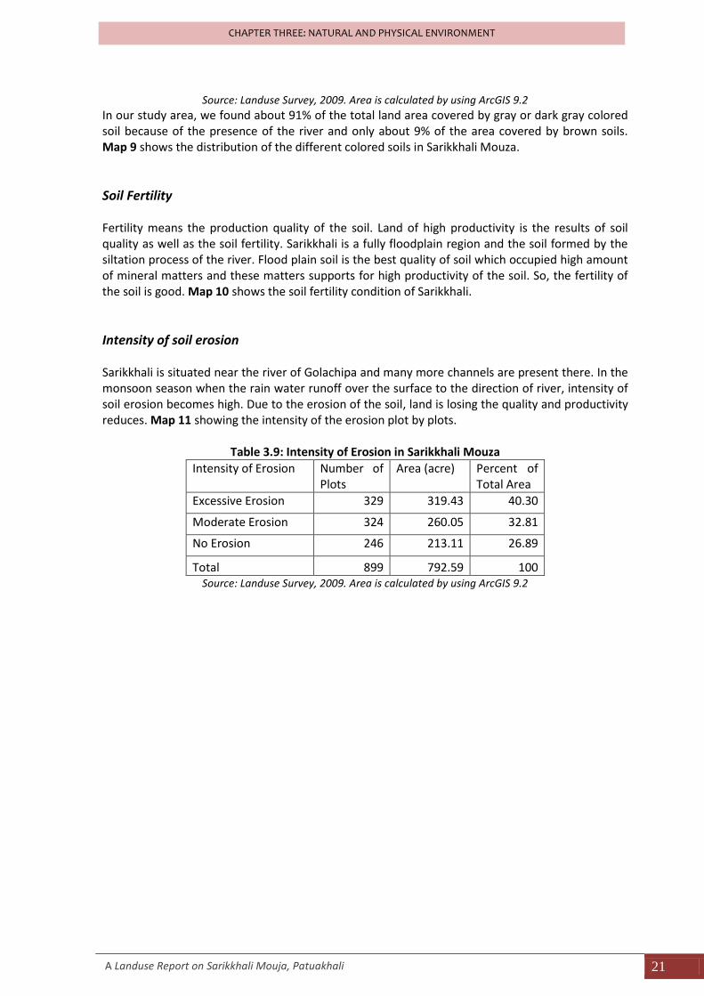
Intensity of soil erosion Sarikkhali is situated near the river of Golachipa and many more channels are present there. In the monsoon season when the rain water runoff over the surface to the direction of river, intensity of soil erosion becomes high. Due to the erosion of the soil, land is losing the quality and productivity reduces. Map 11 showing the intensity of the erosion plot by plots.
Table 3.9: Intensity of Erosion in Sarikkhali Mouza
Intensity of Erosion Number of Plots
Area (acre) Percent of Total Area
Excessive Erosion 329 319.43 40.30
Moderate Erosion 324 260.05 32.81
No Erosion 246 213.11 26.89
Total 899 792.59 100 Source: Landuse Survey, 2009. Area is calculated by using ArcGIS 9.2
A Landuse Report on Sarikkhali Mouja, Patuakhali 22
CHAPTER THREE: NATURAL AND PHYSICAL ENVIRONMENT
MAP NO. 08
A Landuse Report on Sarikkhali Mouja, Patuakhali 23
CHAPTER THREE: NATURAL AND PHYSICAL ENVIRONMENT
MAP NO. 09
A Landuse Report on Sarikkhali Mouja, Patuakhali 24
CHAPTER THREE: NATURAL AND PHYSICAL ENVIRONMENT
MAP NO. 10
CHAPTER FOUR
SOCIO-ECONOMIC STATUS
A Landuse Report on Sarikkhali Mouja, Patuakhali 27
CHAPTER FOUR: SOCIO-ECONOMIC STATUS
CHAPTER FOUR: SOCIO-ECONOMIC STATUS
The socio economic condition of an area or region can be understood from its demographic characteristics, resource base and various economic and social indicators. The socio-economic condition is also influenced by the physical and social infrastructure available in and around the area. The Socio economic condition of Sarikkhali Mouza is described as under the following broad categories.
- Demographic characteristics - Economic characteristics - Housing Characteristics - Characteristics of Livelihood and Social facilities.
4.1 DEMOGRAPHIC CHARACTERISTICS
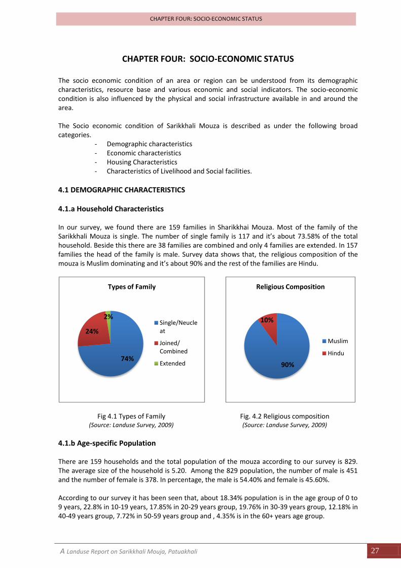
4.1.a Household Characteristics In our survey, we found there are 159 families in Sharikkhai Mouza. Most of the family of the Sarikkhali Mouza is single. The number of single family is 117 and it’s about 73.58% of the total household. Beside this there are 38 families are combined and only 4 families are extended. In 157 families the head of the family is male. Survey data shows that, the religious composition of the mouza is Muslim dominating and it’s about 90% and the rest of the families are Hindu.
Fig 4.1 Types of Family (Source: Landuse Survey, 2009)
Fig. 4.2 Religious composition (Source: Landuse Survey, 2009)
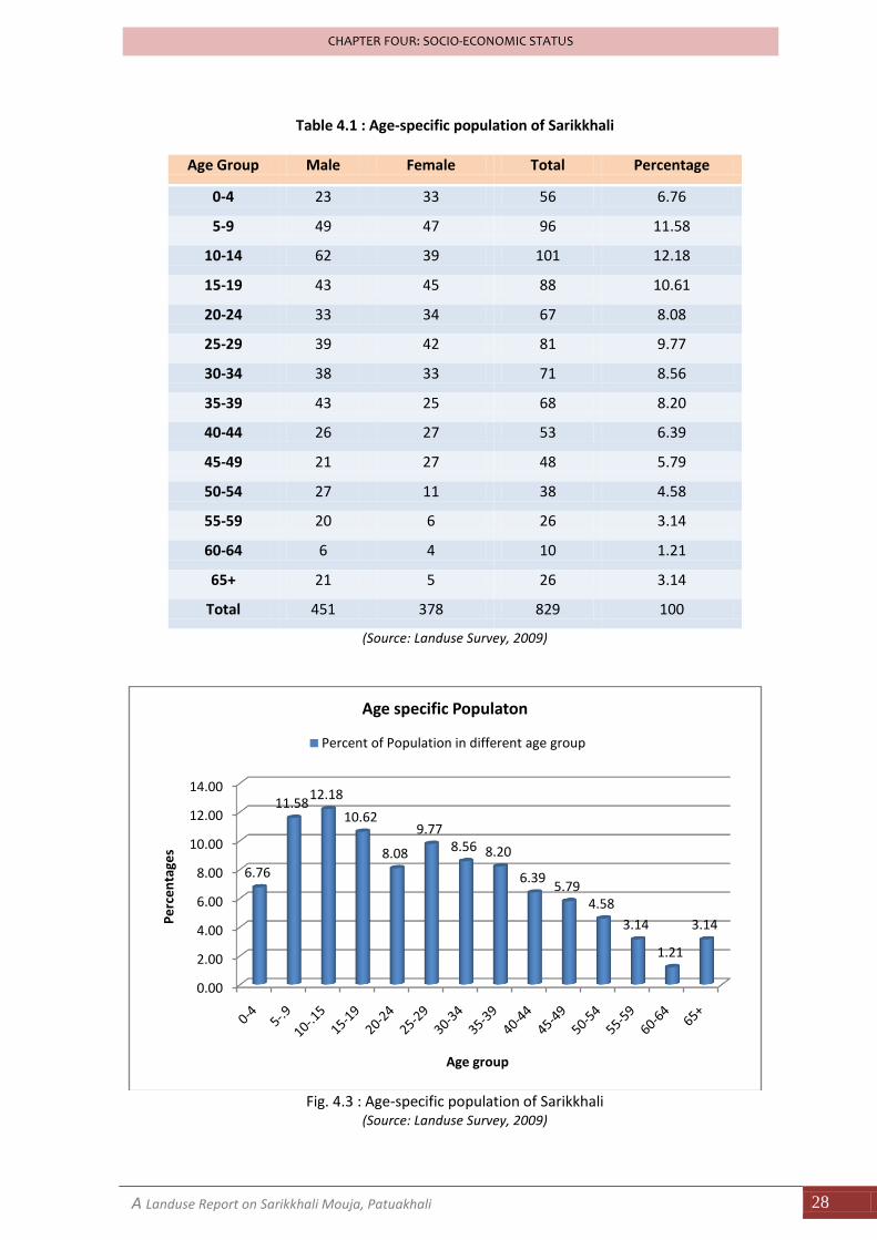
4.1.b Age-specific Population There are 159 households and the total population of the mouza according to our survey is 829. The average size of the household is 5.20. Among the 829 population, the number of male is 451 and the number of female is 378. In percentage, the male is 54.40% and female is 45.60%. According to our survey it has been seen that, about 18.34% population is in the age group of 0 to 9 years, 22.8% in 10-19 years, 17.85% in 20-29 years group, 19.76% in 30-39 years group, 12.18% in 40-49 years group, 7.72% in 50-59 years group and , 4.35% is in the 60+ years age group.
74%
24%
2%
Types of Family
Single/Neucleat
Joined/ Combined
Extended 90%
10%
Religious Composition
Muslim
Hindu
A Landuse Report on Sarikkhali Mouja, Patuakhali 28
CHAPTER FOUR: SOCIO-ECONOMIC STATUS
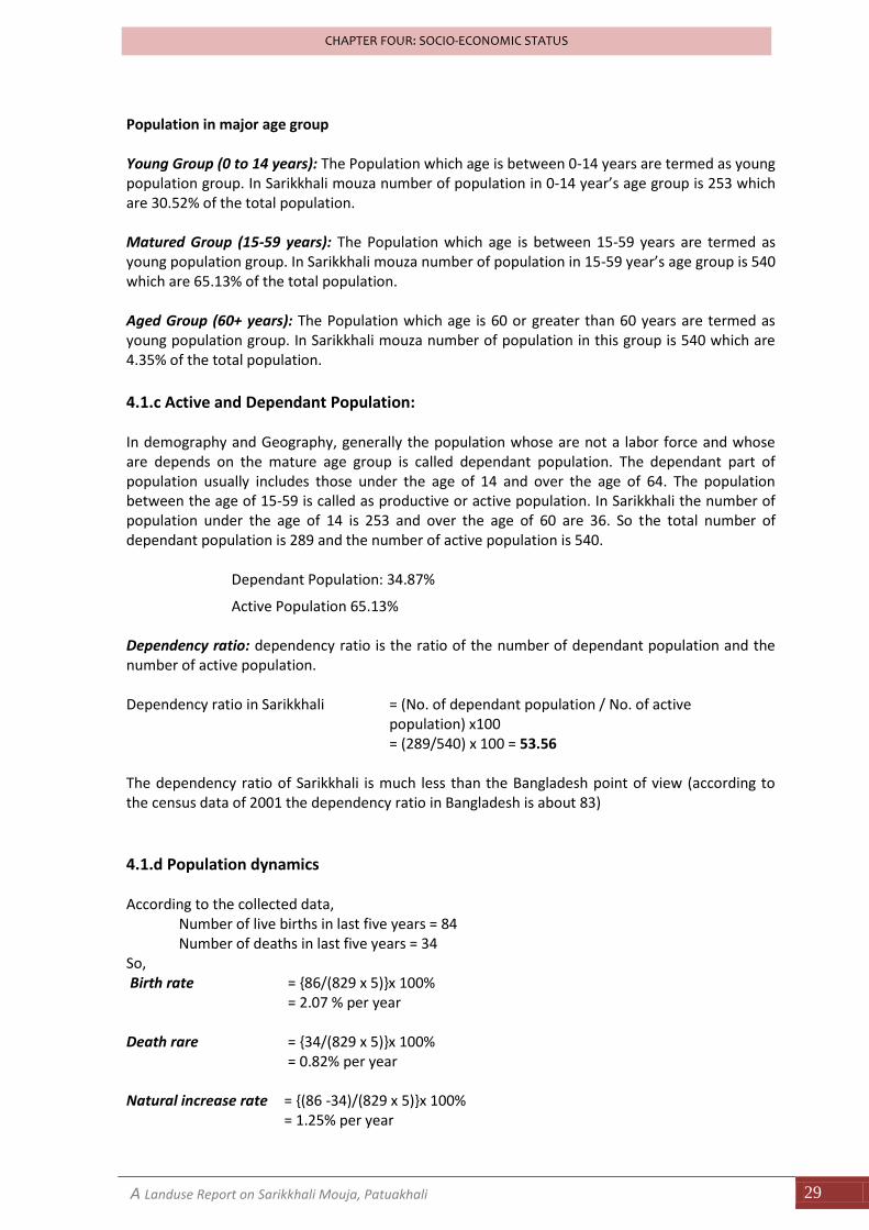
Table 4.1 : Age-specific population of Sarikkhali
Age Group Male Female Total Percentage
0-4 23 33 56 6.76
5-9 49 47 96 11.58
10-14 62 39 101 12.18
15-19 43 45 88 10.61
20-24 33 34 67 8.08
25-29 39 42 81 9.77
30-34 38 33 71 8.56
35-39 43 25 68 8.20
40-44 26 27 53 6.39
45-49 21 27 48 5.79
50-54 27 11 38 4.58
55-59 20 6 26 3.14
60-64 6 4 10 1.21
65+ 21 5 26 3.14
Total 451 378 829 100
(Source: Landuse Survey, 2009)
Fig. 4.3 : Age-specific population of Sarikkhali
(Source: Landuse Survey, 2009)
0.00
2.00
4.00
6.00
8.00
10.00
12.00
14.00
6.76
11.5812.18
10.62
8.08
9.778.56 8.20
6.395.79
4.58
3.14
1.21
3.14Pe
rce
nta
ges
Age group
Age specific Populaton
Percent of Population in different age group
A Landuse Report on Sarikkhali Mouja, Patuakhali 29
CHAPTER FOUR: SOCIO-ECONOMIC STATUS
Population in major age group Young Group (0 to 14 years): The Population which age is between 0-14 years are termed as young population group. In Sarikkhali mouza number of population in 0-14 year’s age group is 253 which are 30.52% of the total population. Matured Group (15-59 years): The Population which age is between 15-59 years are termed as young population group. In Sarikkhali mouza number of population in 15-59 year’s age group is 540 which are 65.13% of the total population. Aged Group (60+ years): The Population which age is 60 or greater than 60 years are termed as young population group. In Sarikkhali mouza number of population in this group is 540 which are 4.35% of the total population.
4.1.c Active and Dependant Population: In demography and Geography, generally the population whose are not a labor force and whose are depends on the mature age group is called dependant population. The dependant part of population usually includes those under the age of 14 and over the age of 64. The population between the age of 15-59 is called as productive or active population. In Sarikkhali the number of population under the age of 14 is 253 and over the age of 60 are 36. So the total number of dependant population is 289 and the number of active population is 540.
Dependant Population: 34.87%
Active Population 65.13%
Dependency ratio: dependency ratio is the ratio of the number of dependant population and the number of active population. Dependency ratio in Sarikkhali = (No. of dependant population / No. of active
population) x100 = (289/540) x 100 = 53.56
The dependency ratio of Sarikkhali is much less than the Bangladesh point of view (according to the census data of 2001 the dependency ratio in Bangladesh is about 83)
4.1.d Population dynamics According to the collected data,
Number of live births in last five years = 84 Number of deaths in last five years = 34
So, Birth rate = {86/(829 x 5)}x 100%
= 2.07 % per year Death rare = {34/(829 x 5)}x 100%
= 0.82% per year Natural increase rate = {(86 -34)/(829 x 5)}x 100%
= 1.25% per year
A Landuse Report on Sarikkhali Mouja, Patuakhali 30
CHAPTER FOUR: SOCIO-ECONOMIC STATUS
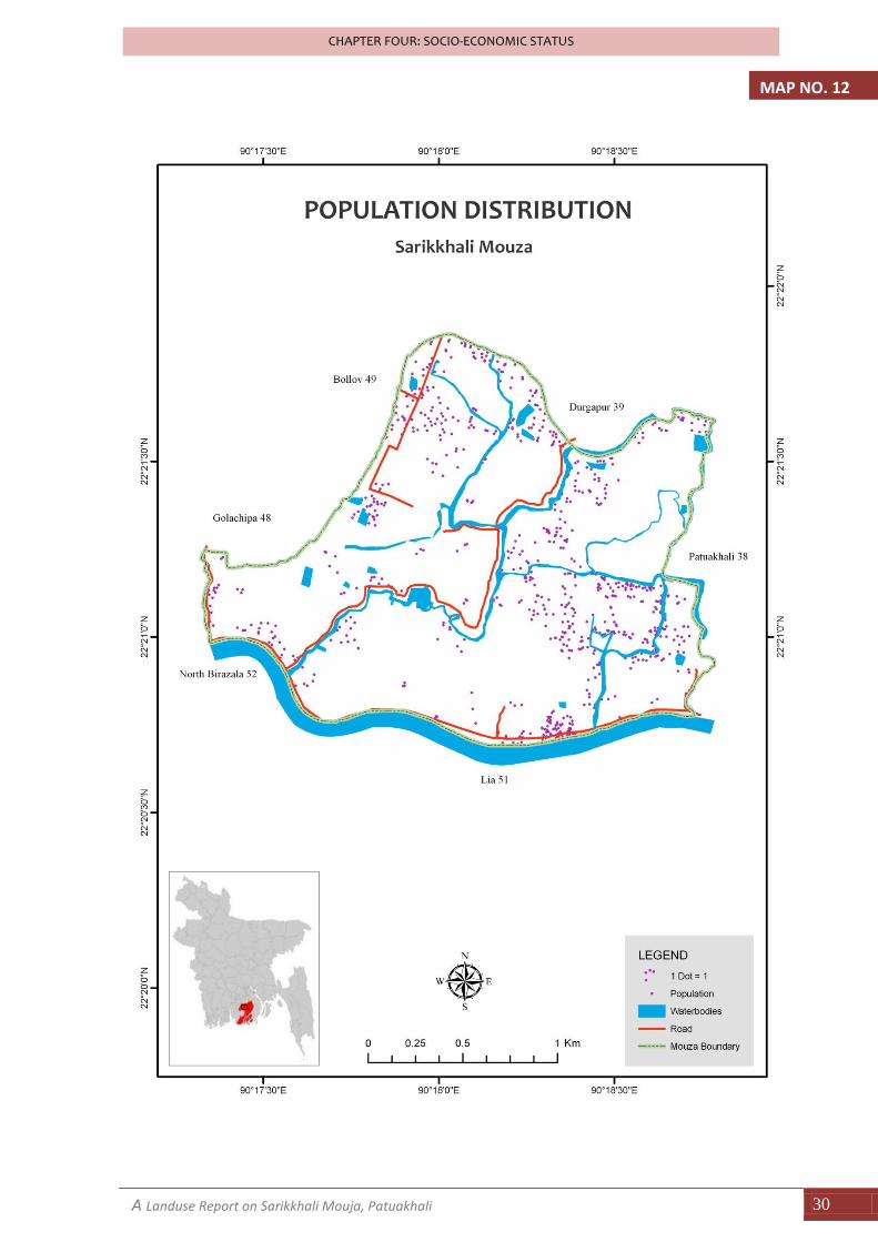
MAP NO. 12
A Landuse Report on Sarikkhali Mouja, Patuakhali 31
CHAPTER FOUR: SOCIO-ECONOMIC STATUS
Summary Statistics of the Demographic Characteristics of Sarikkhali
Total number of household: 159
Total Population: 829
Average Household Size: 5.20
Male Female Ratio: 119.3 (which means 119.3 male for 100 female)
Dependency Ratio: 53.56
Age specific population: Young 30.52%, Matured 65.13% and Aged 4.35%
Birth rate: 2.07% per year
Death rate: 0.82% per year
Natural Increasing rate: 1.25% per year
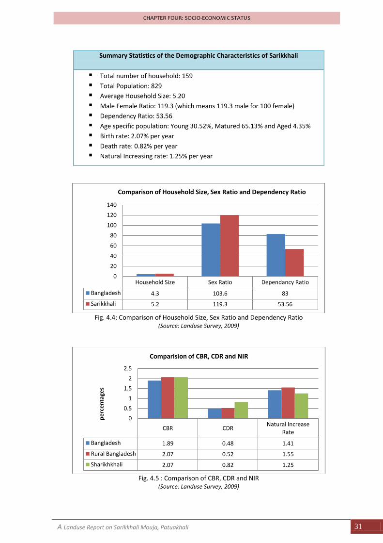
Fig. 4.4: Comparison of Household Size, Sex Ratio and Dependency Ratio
(Source: Landuse Survey, 2009)
Fig. 4.5 : Comparison of CBR, CDR and NIR
(Source: Landuse Survey, 2009)
Household Size Sex Ratio Dependancy Ratio
Bangladesh 4.3 103.6 83
Sarikkhali 5.2 119.3 53.56
0
20
40
60
80
100
120
140
Comparison of Household Size, Sex Ratio and Dependency Ratio
CBR CDRNatural Increase
Rate
Bangladesh 1.89 0.48 1.41
Rural Bangladesh 2.07 0.52 1.55
Sharikhkhali 2.07 0.82 1.25
0
0.5
1
1.5
2
2.5
pe
rce
nta
ges
Comparision of CBR, CDR and NIR
A Landuse Report on Sarikkhali Mouja, Patuakhali 32
CHAPTER FOUR: SOCIO-ECONOMIC STATUS
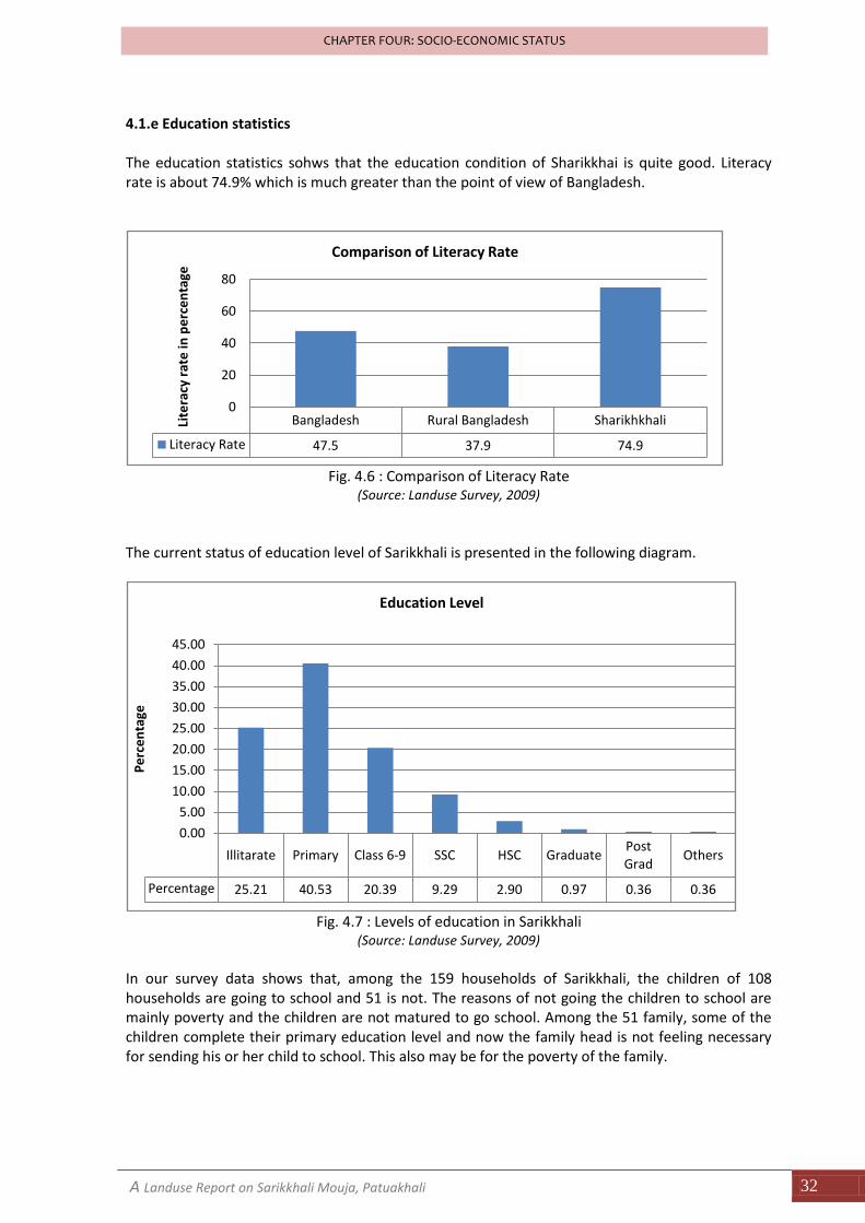
4.1.e Education statistics The education statistics sohws that the education condition of Sharikkhai is quite good. Literacy rate is about 74.9% which is much greater than the point of view of Bangladesh.
Fig. 4.6 : Comparison of Literacy Rate
(Source: Landuse Survey, 2009)
The current status of education level of Sarikkhali is presented in the following diagram.
Fig. 4.7 : Levels of education in Sarikkhali
(Source: Landuse Survey, 2009)
In our survey data shows that, among the 159 households of Sarikkhali, the children of 108 households are going to school and 51 is not. The reasons of not going the children to school are mainly poverty and the children are not matured to go school. Among the 51 family, some of the children complete their primary education level and now the family head is not feeling necessary for sending his or her child to school. This also may be for the poverty of the family.
Bangladesh Rural Bangladesh Sharikhkhali
Literacy Rate 47.5 37.9 74.9
0
20
40
60
80
Lite
racy
rat
e in
pe
rce
nta
ge
Comparison of Literacy Rate
Illitarate Primary Class 6-9 SSC HSC GraduatePost Grad
Others
Percentage 25.21 40.53 20.39 9.29 2.90 0.97 0.36 0.36
0.00
5.00
10.00
15.00
20.00
25.00
30.00
35.00
40.00
45.00
Pe
rce
nta
ge
Education Level
A Landuse Report on Sarikkhali Mouja, Patuakhali 33
CHAPTER FOUR: SOCIO-ECONOMIC STATUS
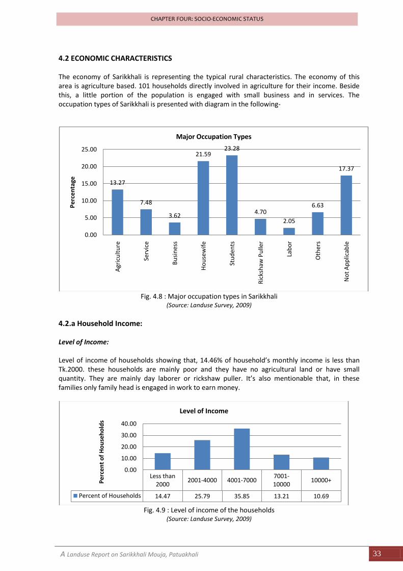
4.2 ECONOMIC CHARACTERISTICS The economy of Sarikkhali is representing the typical rural characteristics. The economy of this area is agriculture based. 101 households directly involved in agriculture for their income. Beside this, a little portion of the population is engaged with small business and in services. The occupation types of Sarikkhali is presented with diagram in the following-
Fig. 4.8 : Major occupation types in Sarikkhali
(Source: Landuse Survey, 2009)
4.2.a Household Income: Level of Income: Level of income of households showing that, 14.46% of household’s monthly income is less than Tk.2000. these households are mainly poor and they have no agricultural land or have small quantity. They are mainly day laborer or rickshaw puller. It’s also mentionable that, in these families only family head is engaged in work to earn money.
Fig. 4.9 : Level of income of the households
(Source: Landuse Survey, 2009)
13.27
7.48
3.62
21.5923.28
4.70
2.05
6.63
17.37
0.00
5.00
10.00
15.00
20.00
25.00
Agr
icu
ltu
re
Serv
ice
Bu
sin
ess
Ho
use
wif
e
Stu
den
ts
Ric
ksh
aw P
ulle
r
Lab
or
Oth
ers
No
t A
pp
licab
le
Pe
rce
nta
ge
Major Occupation Types
Less than 2000
2001-4000 4001-70007001-10000
10000+
Percent of Households 14.47 25.79 35.85 13.21 10.69
0.00
10.00
20.00
30.00
40.00
Pe
rce
nt
of
Ho
use
ho
lds
Level of Income
A Landuse Report on Sarikkhali Mouja, Patuakhali 34
CHAPTER FOUR: SOCIO-ECONOMIC STATUS
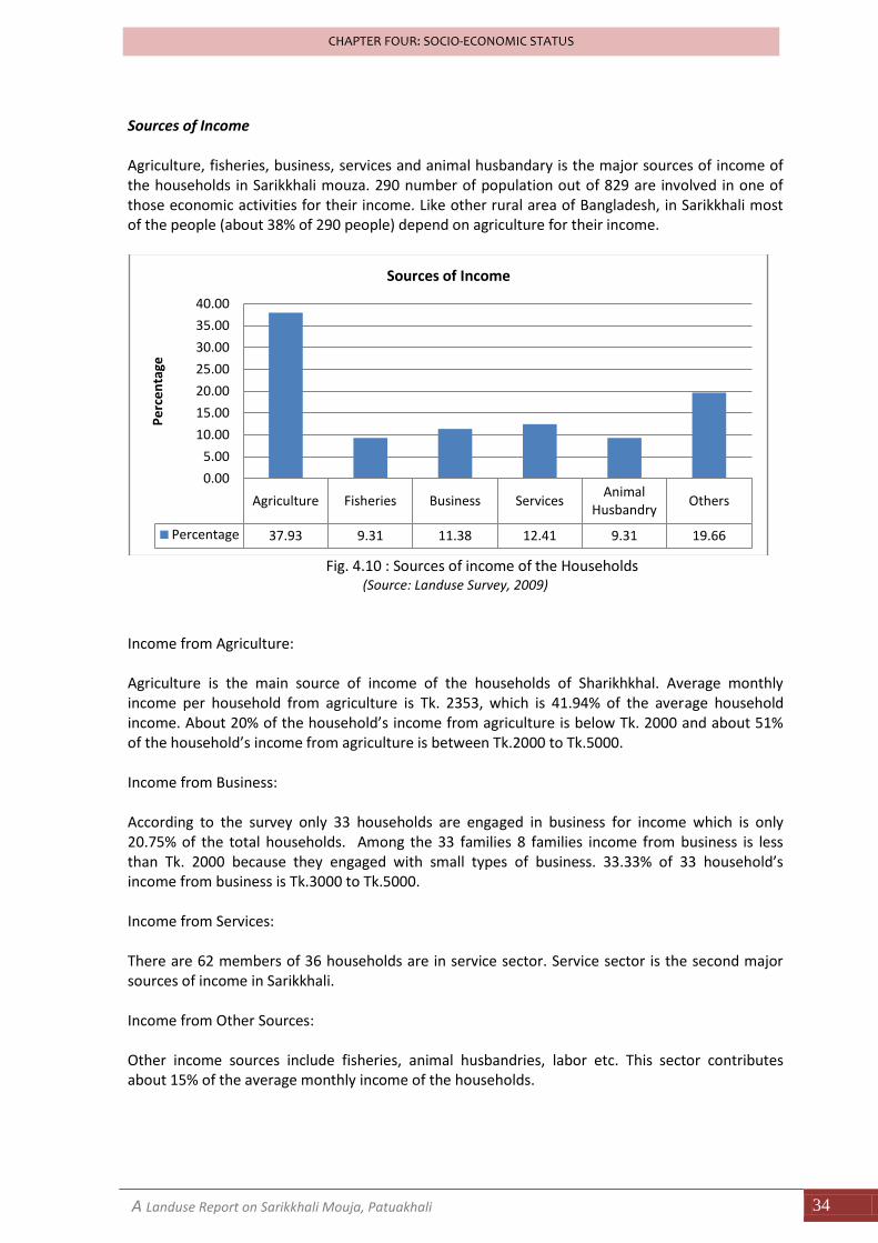
Sources of Income Agriculture, fisheries, business, services and animal husbandary is the major sources of income of the households in Sarikkhali mouza. 290 number of population out of 829 are involved in one of those economic activities for their income. Like other rural area of Bangladesh, in Sarikkhali most of the people (about 38% of 290 people) depend on agriculture for their income.
Fig. 4.10 : Sources of income of the Households
(Source: Landuse Survey, 2009)
Income from Agriculture:
Agriculture is the main source of income of the households of Sharikhkhal. Average monthly income per household from agriculture is Tk. 2353, which is 41.94% of the average household income. About 20% of the household’s income from agriculture is below Tk. 2000 and about 51% of the household’s income from agriculture is between Tk.2000 to Tk.5000.
Income from Business:
According to the survey only 33 households are engaged in business for income which is only 20.75% of the total households. Among the 33 families 8 families income from business is less than Tk. 2000 because they engaged with small types of business. 33.33% of 33 household’s income from business is Tk.3000 to Tk.5000. Income from Services: There are 62 members of 36 households are in service sector. Service sector is the second major sources of income in Sarikkhali. Income from Other Sources: Other income sources include fisheries, animal husbandries, labor etc. This sector contributes about 15% of the average monthly income of the households.
Agriculture Fisheries Business ServicesAnimal
HusbandryOthers
Percentage 37.93 9.31 11.38 12.41 9.31 19.66
0.00
5.00
10.00
15.00
20.00
25.00
30.00
35.00
40.00
Pe
rce
nta
ge
Sources of Income
A Landuse Report on Sarikkhali Mouja, Patuakhali 35
CHAPTER FOUR: SOCIO-ECONOMIC STATUS
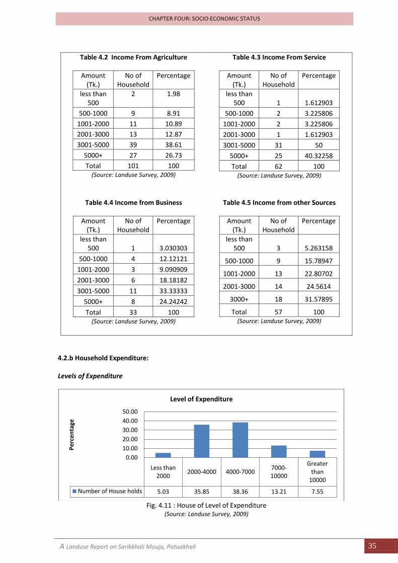
Table 4.2 Income From Agriculture
Amount (Tk.)
No of Household
Percentage
less than 500
2
1.98
500-1000 9 8.91
1001-2000 11 10.89
2001-3000 13 12.87
3001-5000 39 38.61
5000+ 27 26.73
Total 101 100 (Source: Landuse Survey, 2009)
Table 4.3 Income From Service
Amount (Tk.)
No of Household
Percentage
less than 500 1 1.612903
500-1000 2 3.225806
1001-2000 2 3.225806
2001-3000 1 1.612903
3001-5000 31 50
5000+ 25 40.32258
Total 62 100 (Source: Landuse Survey, 2009)
Table 4.4 Income from Business
Amount (Tk.)
No of Household
Percentage
less than 500 1 3.030303
500-1000 4 12.12121
1001-2000 3 9.090909
2001-3000 6 18.18182
3001-5000 11 33.33333
5000+ 8 24.24242
Total 33 100 (Source: Landuse Survey, 2009)
Table 4.5 Income from other Sources
Amount (Tk.)
No of Household
Percentage
less than 500 3 5.263158
500-1000 9 15.78947
1001-2000 13 22.80702
2001-3000 14 24.5614
3000+ 18 31.57895
Total 57 100 (Source: Landuse Survey, 2009)
4.2.b Household Expenditure: Levels of Expenditure
Fig. 4.11 : House of Level of Expenditure
(Source: Landuse Survey, 2009)
Less than 2000
2000-4000 4000-70007000-10000
Greater than
10000
Number of House holds 5.03 35.85 38.36 13.21 7.55
0.00
10.00
20.00
30.00
40.00
50.00
Pe
rce
nta
ge
Level of Expenditure
A Landuse Report on Sarikkhali Mouja, Patuakhali 36
CHAPTER FOUR: SOCIO-ECONOMIC STATUS
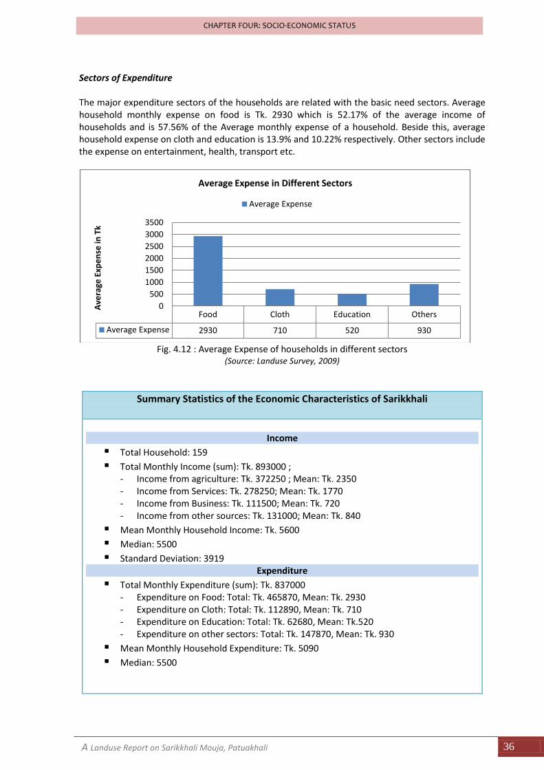
Sectors of Expenditure The major expenditure sectors of the households are related with the basic need sectors. Average household monthly expense on food is Tk. 2930 which is 52.17% of the average income of households and is 57.56% of the Average monthly expense of a household. Beside this, average household expense on cloth and education is 13.9% and 10.22% respectively. Other sectors include the expense on entertainment, health, transport etc.
Fig. 4.12 : Average Expense of households in different sectors
(Source: Landuse Survey, 2009)
Summary Statistics of the Economic Characteristics of Sarikkhali
Income
Total Household: 159
Total Monthly Income (sum): Tk. 893000 ; - Income from agriculture: Tk. 372250 ; Mean: Tk. 2350 - Income from Services: Tk. 278250; Mean: Tk. 1770 - Income from Business: Tk. 111500; Mean: Tk. 720 - Income from other sources: Tk. 131000; Mean: Tk. 840
Mean Monthly Household Income: Tk. 5600
Median: 5500
Standard Deviation: 3919 Expenditure
Total Monthly Expenditure (sum): Tk. 837000 - Expenditure on Food: Total: Tk. 465870, Mean: Tk. 2930 - Expenditure on Cloth: Total: Tk. 112890, Mean: Tk. 710 - Expenditure on Education: Total: Tk. 62680, Mean: Tk.520 - Expenditure on other sectors: Total: Tk. 147870, Mean: Tk. 930
Mean Monthly Household Expenditure: Tk. 5090
Median: 5500
Food Cloth Education Others
Average Expense 2930 710 520 930
0
500
1000
1500
2000
2500
3000
3500
Ave
rage
Exp
en
se in
Tk
Average Expense in Different Sectors
Average Expense
A Landuse Report on Sarikkhali Mouja, Patuakhali 37
CHAPTER FOUR: SOCIO-ECONOMIC STATUS
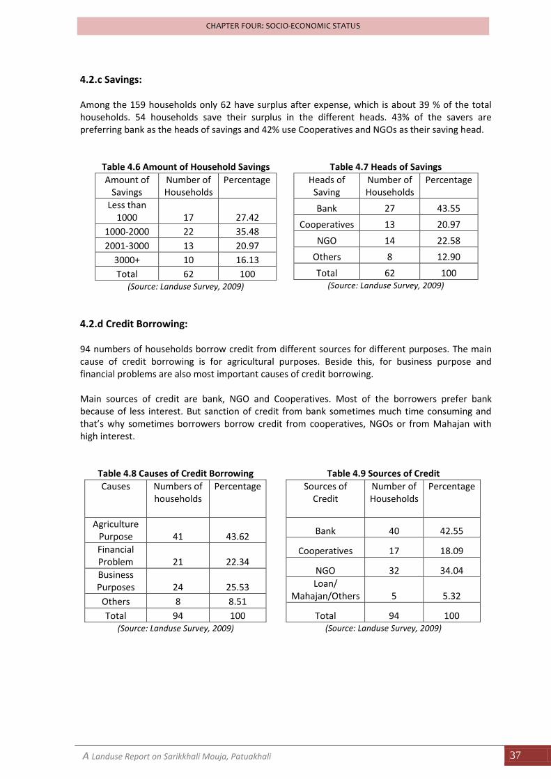
4.2.c Savings: Among the 159 households only 62 have surplus after expense, which is about 39 % of the total households. 54 households save their surplus in the different heads. 43% of the savers are preferring bank as the heads of savings and 42% use Cooperatives and NGOs as their saving head.
Table 4.6 Amount of Household Savings
Amount of Savings
Number of Households
Percentage
Less than 1000 17 27.42
1000-2000 22 35.48
2001-3000 13 20.97
3000+ 10 16.13
Total 62 100 (Source: Landuse Survey, 2009)
Table 4.7 Heads of Savings
Heads of Saving
Number of Households
Percentage
Bank 27 43.55
Cooperatives 13 20.97
NGO 14 22.58
Others 8 12.90
Total 62 100 (Source: Landuse Survey, 2009)
4.2.d Credit Borrowing: 94 numbers of households borrow credit from different sources for different purposes. The main cause of credit borrowing is for agricultural purposes. Beside this, for business purpose and financial problems are also most important causes of credit borrowing. Main sources of credit are bank, NGO and Cooperatives. Most of the borrowers prefer bank because of less interest. But sanction of credit from bank sometimes much time consuming and that’s why sometimes borrowers borrow credit from cooperatives, NGOs or from Mahajan with high interest.
Table 4.8 Causes of Credit Borrowing
Causes
Numbers of households
Percentage
Agriculture Purpose 41 43.62
Financial Problem 21 22.34
Business Purposes 24 25.53
Others 8 8.51
Total 94 100 (Source: Landuse Survey, 2009)
Table 4.9 Sources of Credit
Sources of Credit
Number of Households
Percentage
Bank 40 42.55
Cooperatives 17 18.09
NGO 32 34.04
Loan/ Mahajan/Others 5 5.32
Total 94 100 (Source: Landuse Survey, 2009)
A Landuse Report on Sarikkhali Mouja, Patuakhali 38
CHAPTER FOUR: SOCIO-ECONOMIC STATUS
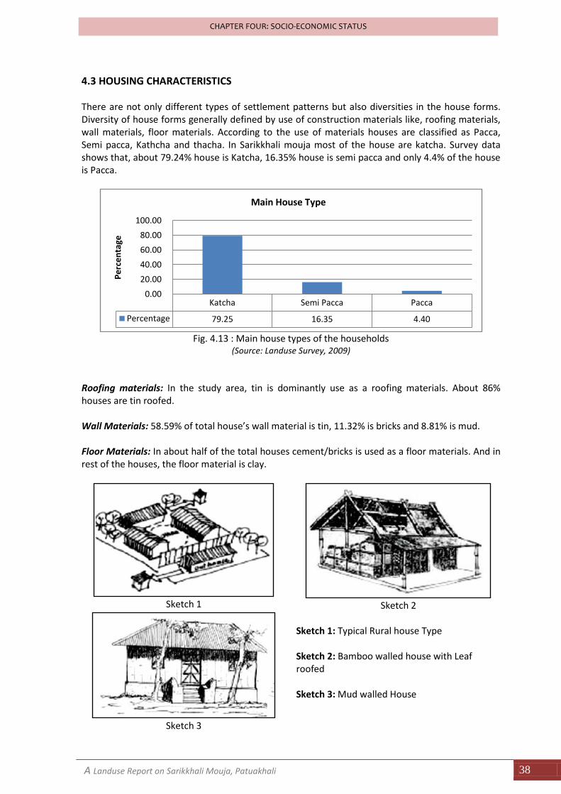
4.3 HOUSING CHARACTERISTICS There are not only different types of settlement patterns but also diversities in the house forms. Diversity of house forms generally defined by use of construction materials like, roofing materials, wall materials, floor materials. According to the use of materials houses are classified as Pacca, Semi pacca, Kathcha and thacha. In Sarikkhali mouja most of the house are katcha. Survey data shows that, about 79.24% house is Katcha, 16.35% house is semi pacca and only 4.4% of the house is Pacca.
Fig. 4.13 : Main house types of the households
(Source: Landuse Survey, 2009)
Roofing materials: In the study area, tin is dominantly use as a roofing materials. About 86% houses are tin roofed. Wall Materials: 58.59% of total house’s wall material is tin, 11.32% is bricks and 8.81% is mud. Floor Materials: In about half of the total houses cement/bricks is used as a floor materials. And in rest of the houses, the floor material is clay.
Sketch 1
Sketch 2
Sketch 3
Sketch 1: Typical Rural house Type Sketch 2: Bamboo walled house with Leaf roofed Sketch 3: Mud walled House
Katcha Semi Pacca Pacca
Percentage 79.25 16.35 4.40
0.00
20.00
40.00
60.00
80.00
100.00
Pe
rce
nta
ge
Main House Type
A Landuse Report on Sarikkhali Mouja, Patuakhali 39
CHAPTER FOUR: SOCIO-ECONOMIC STATUS
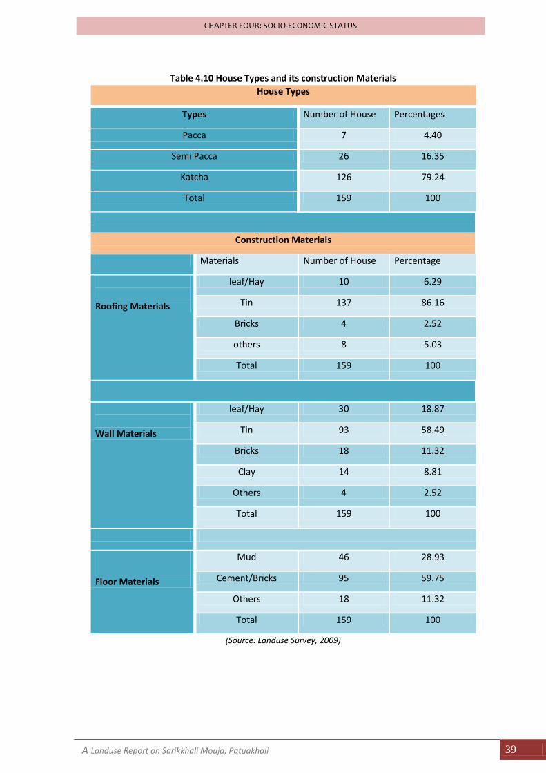
Table 4.10 House Types and its construction Materials
House Types
Types Number of House Percentages
Pacca 7 4.40
Semi Pacca 26 16.35
Katcha 126 79.24
Total 159 100
Construction Materials
Materials Number of House Percentage
Roofing Materials
leaf/Hay 10 6.29
Tin 137 86.16
Bricks 4 2.52
others 8 5.03
Total 159 100
Wall Materials
leaf/Hay 30 18.87
Tin 93 58.49
Bricks 18 11.32
Clay 14 8.81
Others 4 2.52
Total 159 100
Floor Materials
Mud 46 28.93
Cement/Bricks 95 59.75
Others 18 11.32
Total 159 100
(Source: Landuse Survey, 2009)
A Landuse Report on Sarikkhali Mouja, Patuakhali 40
CHAPTER FOUR: SOCIO-ECONOMIC STATUS
4.4 LIVELIHOOD AND SOCIAL FACILITIES Livelihood and Social facilities determine that the socio-economic condition of the area. Facilities can be classified as two major types; livelihood facilities and social facilities
4.4.a Livelihood Facilities: Water: Main sources of water are tubewell, river and pond. For drinking, all the family of Sarikkhali use tubewell water. But for cooking purposes, sometimes they use water of pond and river. 59% household use tubewell water for cooking and 30.8% family use pond water and rest of the family use river water. For bath, most of the families use the pond and river water. Only 18 family which percentages is 11.32% facing the problem of water use. These families are mainly poor and the families have no tubewell. In dry season, the pond and river become waterless and then these families become dependent to neighbors for water. Light: Most of the families of Sarikkhali use Kerosene for light. Only the northern part of Sarikkhali has electricity facilities. 25% family of Sarikkhali use electricity for light and 70.44% family use kerosene for light. Fuel types: In Sarikkhali, major type of fuel is wood. About 74% households use wood as fuel. Beside this 10% households use kerosene and rest of the households use organic fuel, bamboo or electricity as their fuel. Transport: Cycle, Rickshaw, boat and sometime motor cars are use as mode of transport. About 32.70% of the total households have cycle, which is the best transport for both short and long distance. 74.84% families use rickshaws for their daily transport. Modern Goods: In Sarikkhali only few families have electricity facility, that’s why the modern e-goods use so small in this village. Only 11% family has TV. 32% family has radio, 46.54% family has watch and only 5 families has sewing machine.
A Landuse Report on Sarikkhali Mouja, Patuakhali 41
CHAPTER FOUR: SOCIO-ECONOMIC STATUS
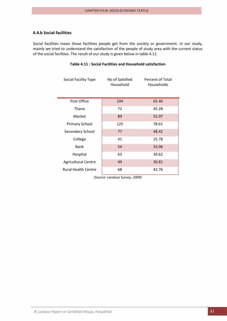
4.4.b Social facilities Social facilities mean those facilities people get from the society or government. In our study, mainly we tried to understand the satisfaction of the people of study area with the current status of the social facilities. The result of our study is given below in table 4.11.
Table 4.11 : Social Facilities and Household satisfaction
Social Facility Type
No of Satisfied Household
Percent of Total Households
Post Office 104 65.40
Thana 72 45.28
Market 89 55.97
Primary School 125 78.61
Secondary School 77 48.42
College 41 25.78
Bank 54 33.96
Hospital 63 39.62
Agricultural Centre 49 30.81
Rural Health Centre 68 42.76
(Source: Landuse Survey, 2009)
CHAPTER FIVE
GENERAL LANDUSE PATTERN
A Landuse Report of Sarikkhali Mouja, Patuakhali 43
CHAPTER FOUR: GENERAL LANDUSE PATTERN
CHAPTER FIVE: GENERAL LANDUSE PATTERN
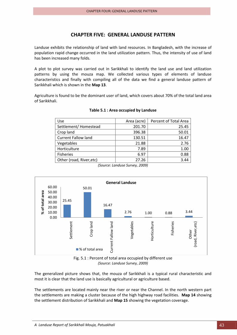
Landuse exhibits the relationship of land with land resources. In Bangladesh, with the increase of population rapid change occurred in the land utilization pattern. Thus, the intensity of use of land has been increased many folds. A plot to plot survey was carried out in Sarikkhali to identify the land use and land utilization patterns by using the mouza map. We collected various types of elements of landuse characteristics and finally with compiling all of the data we find a general landuse pattern of Sarikkhali which is shown in the Map 13. Agriculture is found to be the dominant user of land, which covers about 70% of the total land area of Sarikkhali.
Table 5.1 : Area occupied by Landuse
Use Area (acre) Percent of Total Area
Settlement/ Homestead 201.70 25.45
Crop land 396.38 50.01
Current Fallow land 130.51 16.47
Vegetables 21.88 2.76
Horticulture 7.89 1.00
Fisheries 6.97 0.88
Other (road, River,etc) 27.26 3.44 (Source: Landuse Survey, 2009)
Fig. 5.1 : Percent of total area occupied by different use
(Source: Landuse Survey, 2009)
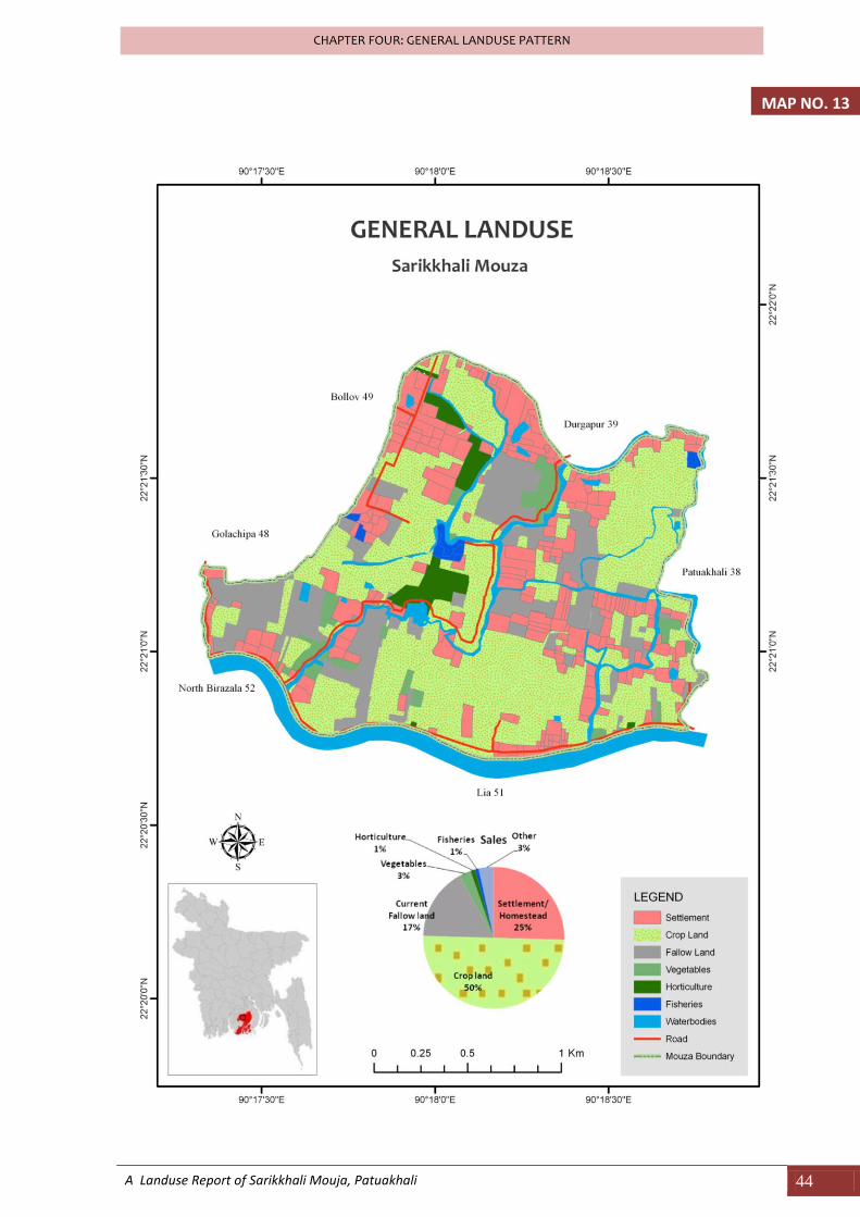
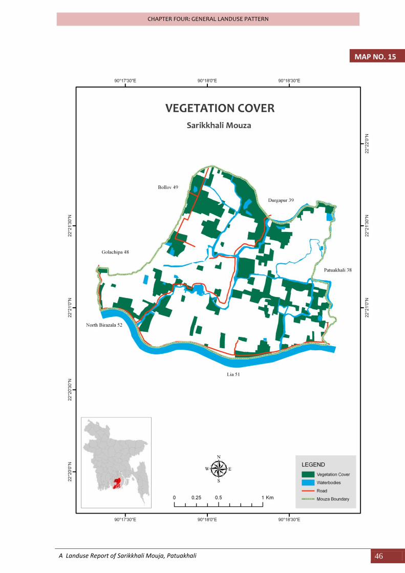
The generalized picture shows that, the mouza of Sarikkhali is a typical rural characteristic and most it is clear that the land use is basically agricultural or agriculture based. The settlements are located mainly near the river or near the Channel. In the north western part the settlements are making a cluster because of the high highway road facilities. Map 14 showing the settlement distribution of Sarikkhali and Map 15 showing the vegetation coverage.
25.45
50.01
16.47
2.76 1.00 0.88 3.44
0.00
10.00
20.00
30.00
40.00
50.00
60.00
Sett
lem
ent
Cro
p la
nd
Cu
rren
t Fa
llow
lan
d
Veg
etab
les
Ho
rtic
ult
ure
Fish
erie
s
Oth
er
(ro
ad, R
iver
,etc
)
% o
f to
tal a
rea
General Landuse
% of total area
A Landuse Report of Sarikkhali Mouja, Patuakhali 44
CHAPTER FOUR: GENERAL LANDUSE PATTERN
MAP NO. 13
A Landuse Report of Sarikkhali Mouja, Patuakhali 45
CHAPTER FOUR: GENERAL LANDUSE PATTERN
MAP NO. 14
A Landuse Report of Sarikkhali Mouja, Patuakhali 46
CHAPTER FOUR: GENERAL LANDUSE PATTERN
MAP NO. 15

CHAPTER SIX
AGRICULTURAL PRACTICE AND LANDUSE
A Landuse Report of Sarikkhali Mouja, Patuakhali 48
CHAPTER SIX: AGRICULTURAL PRACTICE AND LANDUSE
CHAPTER SIX: AGRICULTURAL PRACTICE AND LANDUSE
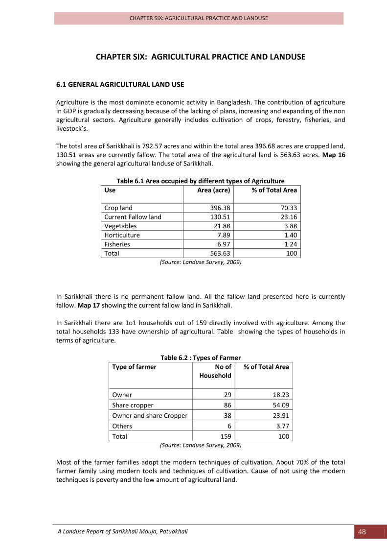
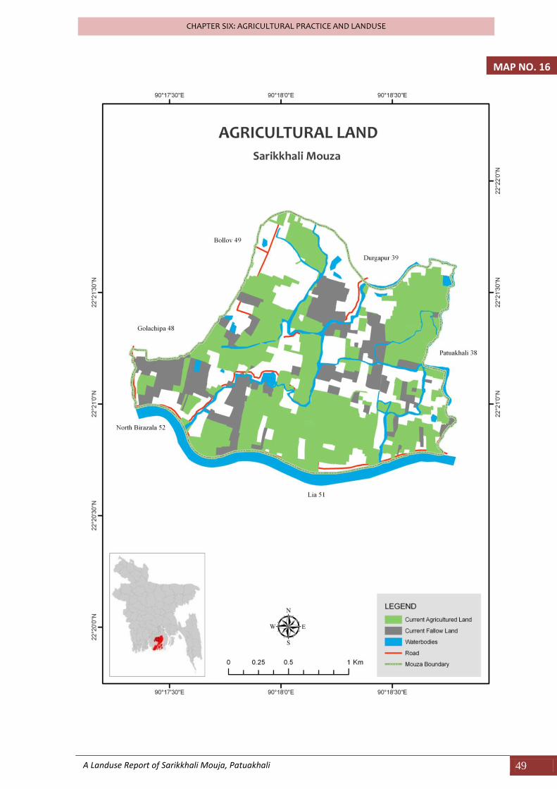
6.1 GENERAL AGRICULTURAL LAND USE Agriculture is the most dominate economic activity in Bangladesh. The contribution of agriculture in GDP is gradually decreasing because of the lacking of plans, increasing and expanding of the non agricultural sectors. Agriculture generally includes cultivation of crops, forestry, fisheries, and livestock’s. The total area of Sarikkhali is 792.57 acres and within the total area 396.68 acres are cropped land, 130.51 areas are currently fallow. The total area of the agricultural land is 563.63 acres. Map 16 showing the general agricultural landuse of Sarikkhali.
Table 6.1 Area occupied by different types of Agriculture
Use Area (acre) % of Total Area
Crop land 396.38 70.33
Current Fallow land 130.51 23.16
Vegetables 21.88 3.88
Horticulture 7.89 1.40
Fisheries 6.97 1.24
Total 563.63 100 (Source: Landuse Survey, 2009)
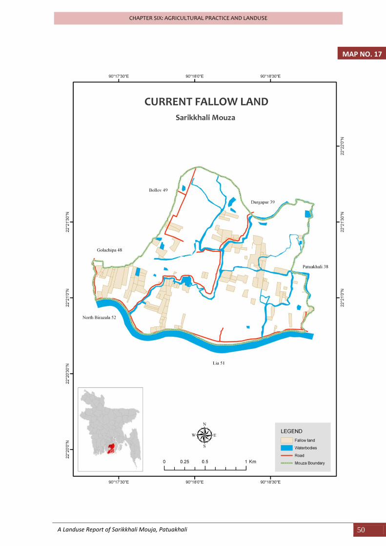
In Sarikkhali there is no permanent fallow land. All the fallow land presented here is currently fallow. Map 17 showing the current fallow land in Sarikkhali. In Sarikkhali there are 1o1 households out of 159 directly involved with agriculture. Among the total households 133 have ownership of agricultural. Table showing the types of households in terms of agriculture.
Table 6.2 : Types of Farmer
Type of farmer
No of Household
% of Total Area
Owner 29 18.23
Share cropper 86 54.09
Owner and share Cropper 38 23.91
Others 6 3.77
Total 159 100 (Source: Landuse Survey, 2009)
Most of the farmer families adopt the modern techniques of cultivation. About 70% of the total farmer family using modern tools and techniques of cultivation. Cause of not using the modern techniques is poverty and the low amount of agricultural land.
A Landuse Report of Sarikkhali Mouja, Patuakhali 49
CHAPTER SIX: AGRICULTURAL PRACTICE AND LANDUSE
MAP NO. 16
A Landuse Report of Sarikkhali Mouja, Patuakhali 50
CHAPTER SIX: AGRICULTURAL PRACTICE AND LANDUSE
MAP NO. 17
A Landuse Report of Sarikkhali Mouja, Patuakhali 51
CHAPTER SIX: AGRICULTURAL PRACTICE AND LANDUSE
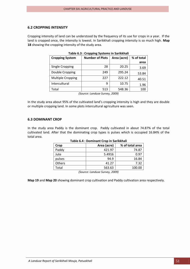
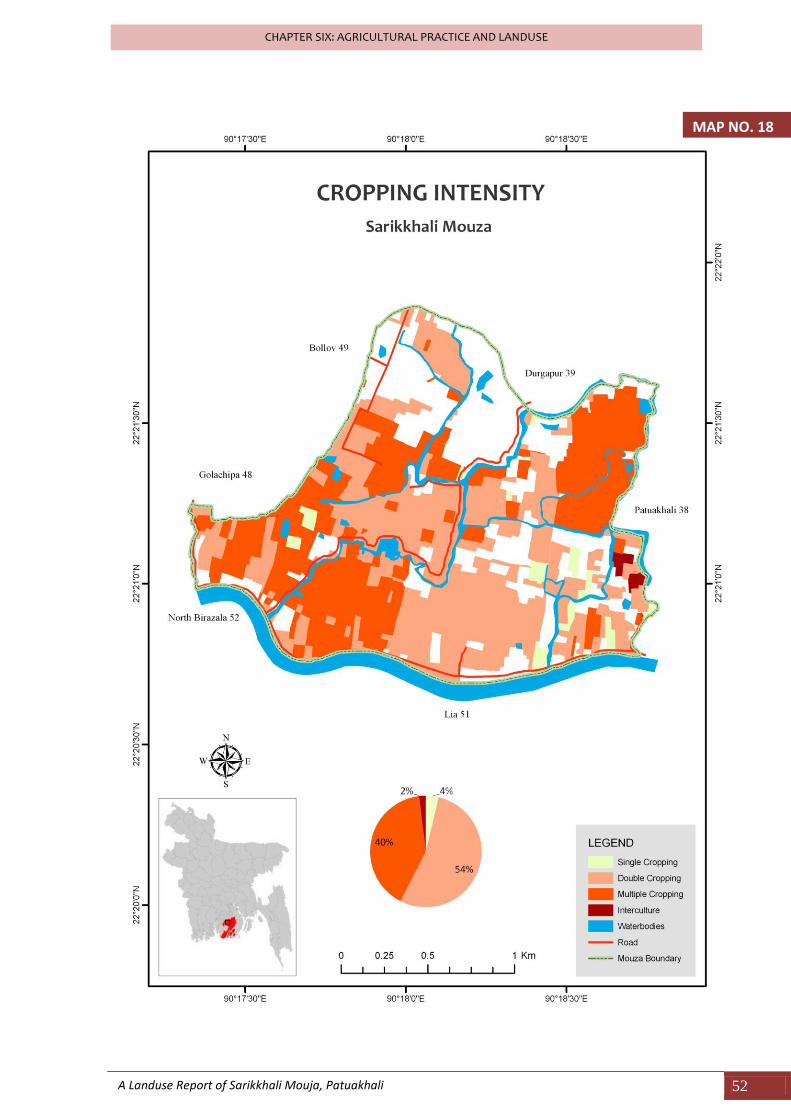
6.2 CROPPING INTENSITY Cropping intensity of land can be understood by the frequency of its use for crops in a year. If the land is cropped once, the intensity is lowest. In Sarikkhali cropping intensity is so much high. Map 18 showing the cropping intensity of the study area.
Table 6.3 : Cropping Systems in Sarikkhali
Cropping System Number of Plots Area (acre) % of total area
Single Cropping 28 20.25 3.69
Double Cropping 249 295.24 53.84
Multiple Cropping 227 222.12 40.51
Intercultural 9 10.75 1.96
Total 513 548.36 100 (Source: Landuse Survey, 2009)
In the study area about 95% of the cultivated land’s cropping intensity is high and they are double or multiple cropping land. In some plots intercultural agriculture was seen.
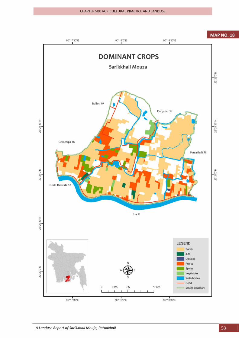
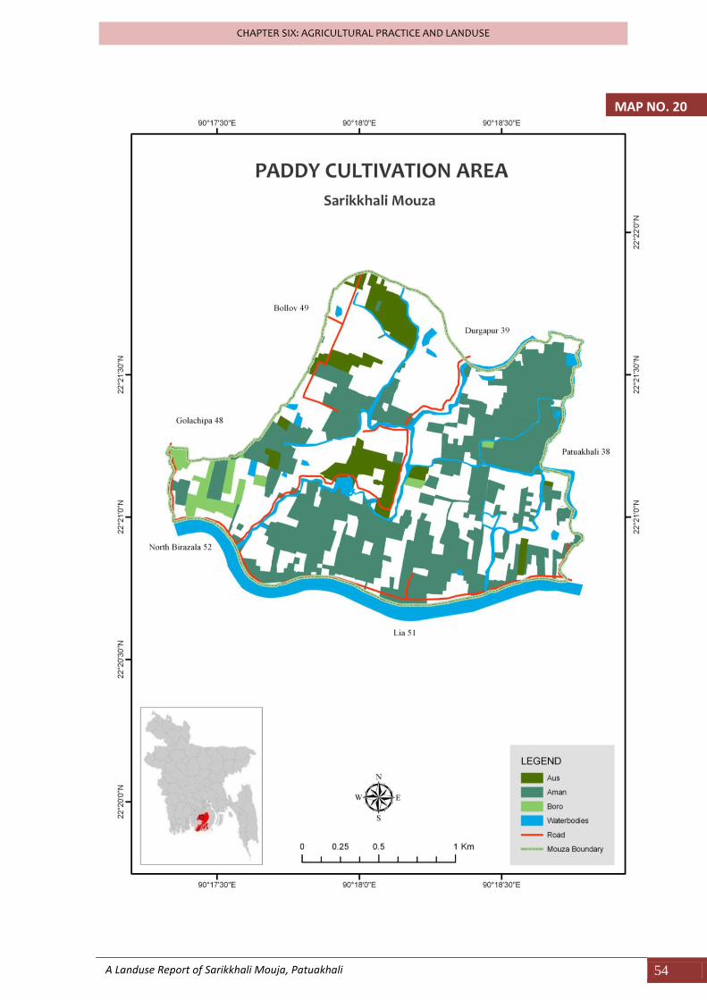
6.3 DOMINANT CROP In the study area Paddy is the dominant crop. Paddy cultivated in about 74.87% of the total cultivated land. After that the dominating crop types is pulses which is occupied 16.84% of the total area.
Table 6.4 : Dominant Crop in Sarikkhali
Crop Area (acre) % of total area
Paddy 421.97 74.87
Jute 5.4916 0.97
pulses 94.9 16.84
Others 41.27 7.32
Total 563.63 100.00 (Source: Landuse Survey, 2009)
Map 19 and Map 20 showing dominant crop cultivation and Paddy cultivation area respectively.
A Landuse Report of Sarikkhali Mouja, Patuakhali 52
CHAPTER SIX: AGRICULTURAL PRACTICE AND LANDUSE
MAP NO. 18
A Landuse Report of Sarikkhali Mouja, Patuakhali 53
CHAPTER SIX: AGRICULTURAL PRACTICE AND LANDUSE
MAP NO. 18
A Landuse Report of Sarikkhali Mouja, Patuakhali 54
CHAPTER SIX: AGRICULTURAL PRACTICE AND LANDUSE
MAP NO. 20
A Landuse Report of Sarikkhali Mouja, Patuakhali 55
CHAPTER SIX: AGRICULTURAL PRACTICE AND LANDUSE
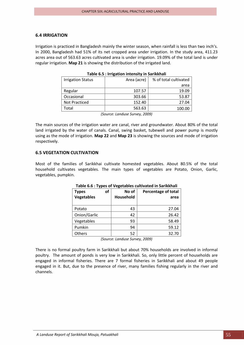
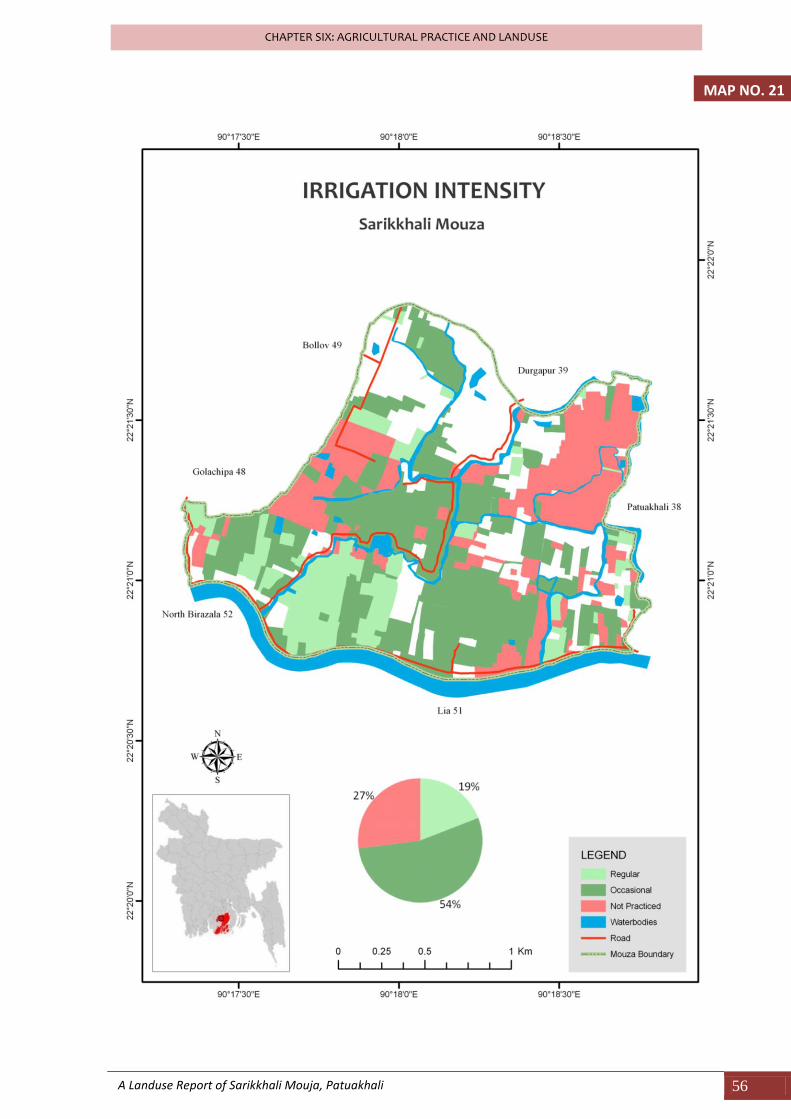
6.4 IRRIGATION Irrigation is practiced in Bangladesh mainly the winter season, when rainfall is less than two inch’s. In 2000, Bangladesh had 51% of its net cropped area under irrigation. In the study area, 411.23 acres area out of 563.63 acres cultivated area is under irrigation. 19.09% of the total land is under regular irrigation. Map 21 is showing the distribution of the irrigated land.
Table 6.5 : Irrigation intensity in Sarikkhali
Irrigation Status Area (acre) % of total cultivated area
Regular 107.57 19.09
Occasional 303.66 53.87
Not Practiced 152.40 27.04
Total 563.63 100.00 (Source: Landuse Survey, 2009)
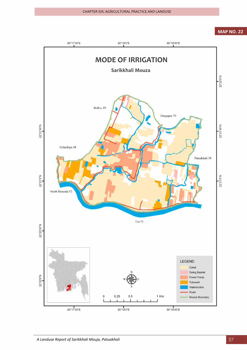
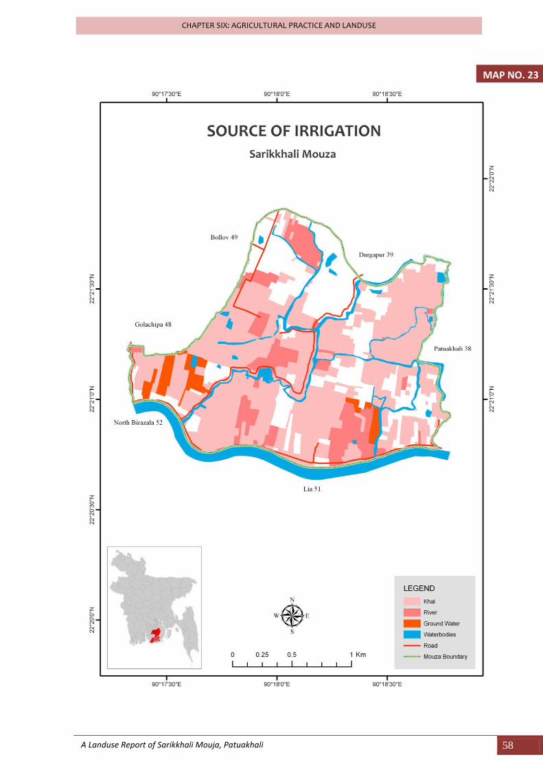
The main sources of the irrigation water are canal, river and groundwater. About 80% of the total land irrigated by the water of canals. Canal, swing basket, tubewell and power pump is mostly using as the mode of irrigation. Map 22 and Map 23 is showing the sources and mode of irrigation respectively.
6.5 VEGETATION CULTIVATION Most of the families of Sarikkhai cultivate homested vegetables. About 80.5% of the total household cultivates vegetables. The main types of vegetables are Potato, Onion, Garlic, vegetables, pumpkin.
Table 6.6 : Types of Vegetables cultivated in Sarikkhali
Types of Vegetables
No of Household
Percentage of total area
Potato 43 27.04
Onion/Garlic 42 26.42
Vegetables 93 58.49
Pumkin 94 59.12
Others 52 32.70 (Source: Landuse Survey, 2009)
There is no formal poultry farm in Sarikkhali but about 70% households are involved in informal poultry. The amount of ponds is very low in Sarikkhali. So, only little percent of households are engaged in informal fisheries. There are 7 formal fisheries in Sarikkhali and about 49 people engaged in it. But, due to the presence of river, many families fishing regularly in the river and channels.
A Landuse Report of Sarikkhali Mouja, Patuakhali 56
CHAPTER SIX: AGRICULTURAL PRACTICE AND LANDUSE
MAP NO. 21
A Landuse Report of Sarikkhali Mouja, Patuakhali 57
CHAPTER SIX: AGRICULTURAL PRACTICE AND LANDUSE
MAP NO. 22
A Landuse Report of Sarikkhali Mouja, Patuakhali 58
CHAPTER SIX: AGRICULTURAL PRACTICE AND LANDUSE
MAP NO. 23
A Landuse Report of Sarikkhali Mouja, Patuakhali 59
CHAPTER SIX: AGRICULTURAL PRACTICE AND LANDUSE
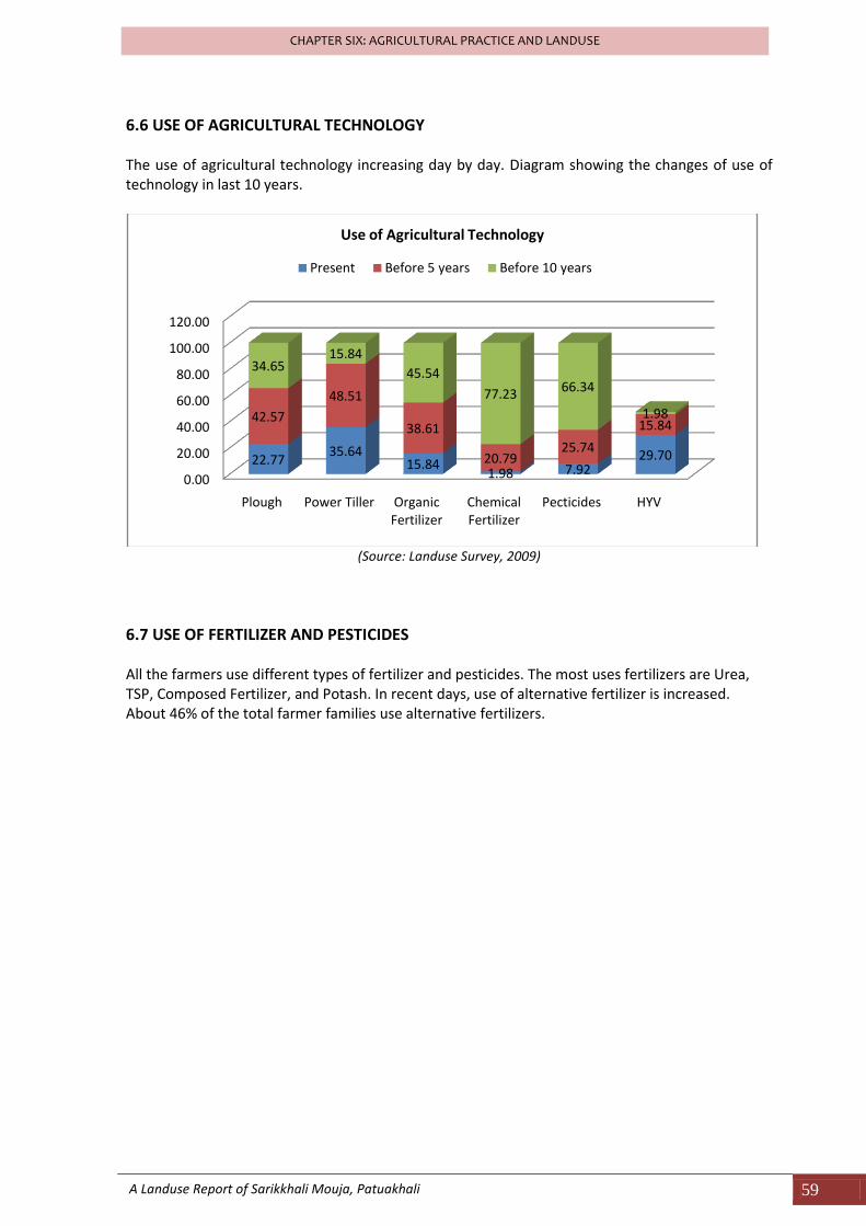
6.6 USE OF AGRICULTURAL TECHNOLOGY The use of agricultural technology increasing day by day. Diagram showing the changes of use of technology in last 10 years.
(Source: Landuse Survey, 2009)
6.7 USE OF FERTILIZER AND PESTICIDES All the farmers use different types of fertilizer and pesticides. The most uses fertilizers are Urea, TSP, Composed Fertilizer, and Potash. In recent days, use of alternative fertilizer is increased. About 46% of the total farmer families use alternative fertilizers.
0.00
20.00
40.00
60.00
80.00
100.00
120.00
Plough Power Tiller Organic Fertilizer
Chemical Fertilizer
Pecticides HYV
22.7735.64
15.841.98 7.92
29.70
42.57
48.51
38.61
20.7925.74
15.84
34.6515.84
45.54
77.23 66.34
1.98
Use of Agricultural Technology
Present Before 5 years Before 10 years

CHAPTER SEVEN
HEALTH AND ENVIRONMENT
A Landuse Report on Sarikkhali Mouja, Patuakhali 61
CHAPTER SEVEN: HEALTH AND ENVIRONMENT
CHAPTER SEVEN: HEALTH AND ENVIRONMENT
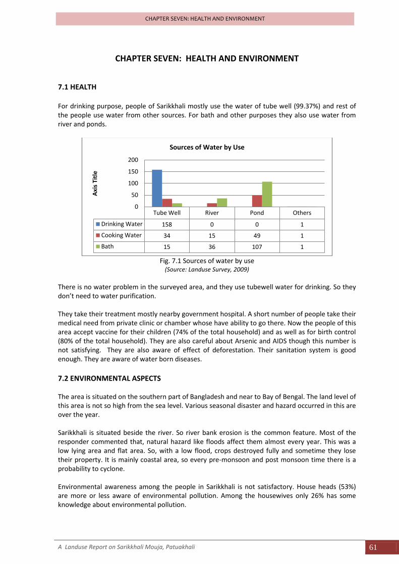
7.1 HEALTH For drinking purpose, people of Sarikkhali mostly use the water of tube well (99.37%) and rest of the people use water from other sources. For bath and other purposes they also use water from river and ponds.
Fig. 7.1 Sources of water by use
(Source: Landuse Survey, 2009)
There is no water problem in the surveyed area, and they use tubewell water for drinking. So they don’t need to water purification. They take their treatment mostly nearby government hospital. A short number of people take their medical need from private clinic or chamber whose have ability to go there. Now the people of this area accept vaccine for their children (74% of the total household) and as well as for birth control (80% of the total household). They are also careful about Arsenic and AIDS though this number is not satisfying. They are also aware of effect of deforestation. Their sanitation system is good enough. They are aware of water born diseases.
7.2 ENVIRONMENTAL ASPECTS The area is situated on the southern part of Bangladesh and near to Bay of Bengal. The land level of this area is not so high from the sea level. Various seasonal disaster and hazard occurred in this are over the year. Sarikkhali is situated beside the river. So river bank erosion is the common feature. Most of the responder commented that, natural hazard like floods affect them almost every year. This was a low lying area and flat area. So, with a low flood, crops destroyed fully and sometime they lose their property. It is mainly coastal area, so every pre-monsoon and post monsoon time there is a probability to cyclone. Environmental awareness among the people in Sarikkhali is not satisfactory. House heads (53%) are more or less aware of environmental pollution. Among the housewives only 26% has some knowledge about environmental pollution.
Tube Well River Pond Others
Drinking Water 158 0 0 1
Cooking Water 34 15 49 1
Bath 15 36 107 1
0
50
100
150
200
Axi
s Ti
tle
Sources of Water by Use

CHAPTER EIGHT
CONCLUSION AND RECOMMENDATIONS
A Landuse Report on Sarikkhali Mouja, Patuakhali 63
CHAPTER TWO: CONCLUSION AND RECOMMENDATIONS
CHAPTER EIGHT: CONCLUSION AND RECOMMENDATIONS
8.1 CONCLUSION Sarikkhali lies in the southern fringe of Bangladesh. This area is the typical example of rural Bangladesh. The economy of Saikkhali is agriculture based and the landuse is agricultural. The overall condition of Sarikkhali is not good or not so bad. Modernization is slow but due to the geographic location value this area got some advantages. The fertility of the soil is good but due to the use of Chemical fertilizer and Pesticides the fertility is decreasing. Development program is not equal everywhere. Many more area deserves more attention from both Government and NGOs. Sarikkhali is situated on the west of Patuakhali Sadar Upazila but still is not connected with the main development stream. This part of rural area is associated with intensive agricultural land use which is required to be noticed for more efficient cultivation practice.
8.2 RECOMMENDATIONS
Sarikkhali is a flood plain fertile area but the net production is very low because of the unplanned agriculture and because of the economy. The average household income is only about Tk. 5600 and about 75 families income is less than Tk. 5000. Government should take proper steps to funding them in agriculture to get best outputs.A good number of lands are found fallow because of decrease in fertility. So, scientific tools and techniques should be popularized among the farmers should be aware of bad effect of using excess chemical fertilizers.
Aman is the dominant crop in Sarik Khali Mouza due to the it’s fast growing nature and profitability but it has bad impact on agricultural productivity. So other seasonal crops cultivation should be encouraged among the farmers to increase the productivity.
As an agricultural based village, Sarik khali needs more trained farmers. New technologies should be familiarized among the farmers to enhance the productivity of land. More flexible loan facilities with low interest rate should be introduced in Sarikkhali Mouza so that farmers can easily can grow crops and improve their economic condition.
Rate of literacy is not bad. It is better than the Bangladesh average but the opportunity to get higher education is very limited. In one side, for economic problem most of the students leave school after primary education. On the other hand, highr education institutions are far away from Sarikkhali. So government should take proper policy and should establish more school and also established higher institutions nearby area.
Infrastructural development and new institution should be built in the area to provide the people of Sarikkhali necessary social services. The infrastructural development refers to college establishment, modern road network, agricultural centre with sufficient technology, health centers etc. The Intra zonal Communication system of Sarikkhali isn’t good. So, Roads and transport facility needs more attention.
Awareness about environmental pollution must be increased for overall development of Sarikkhali village.
Lack of knowledge about health, gives rise to waterborne diseases to villagers. So, the
different training should have to arrange to make the people aware about diseases.
Copyright © 2022 FDOKUMEN