a historical archaeological investigation into two recent
240
A HISTORICAL ARCHAEOLOGICAL INVESTIGATION INTO TWO RECENT HOUSEHOLDS OF THE MOTSE, BOTSHABELO MISSION STATION, MIDDELBURG, MPUMALANGA, SOUTH AFRICA. by CAROLINE ROSINE CLAUDE CHRISTIANE CHISLAINE BOOTH submitted in accordance with the requirements for the degree of MASTER OF ARTS in the subject ARCHAEOLOGY at the UNIVERSITY OF SOUTH AFRICA SUPERVISOR: DR. NJ SWANEPOEL JANUARY 2017
-
Upload
khangminh22 -
Category
Documents
-
view
0 -
download
0
Transcript of a historical archaeological investigation into two recent

A HISTORICAL ARCHAEOLOGICAL INVESTIGATION INTO TWO RECENT
HOUSEHOLDS OF THE MOTSE, BOTSHABELO MISSION STATION,
MIDDELBURG, MPUMALANGA, SOUTH AFRICA.
by
CAROLINE ROSINE CLAUDE CHRISTIANE CHISLAINE BOOTH
submitted in accordance with the requirements
for the degree of
MASTER OF ARTS
in the subject
ARCHAEOLOGY
at the
UNIVERSITY OF SOUTH AFRICA
SUPERVISOR: DR. NJ SWANEPOEL
JANUARY 2017

DECLARATION
Name: Caroline Rosine Booth
Student number: 0802-673-4
Degree: Master of Arts in Archaeology.
“A historical archaeological investigation into two recent households of the Motse,
Botshabelo Mission Station, Middelburg, Mpumalanga, South Africa.”
I declare that the above dissertation is my own work and that all sources that I have used or
quoted have been indicated and acknowledged by means of complete references.
I further declare that I have not previously submitted my work, or part of it, for examination at
UNISA for another qualification or at any other higher education institution.
Caroline Rosine Booth 13 January 2017
___________________ ________________
Signature Date

SUMMARY
The archaeological research discussed in this dissertation was conducted at Botshabelo, a
nineteenth century Berlin Mission Society station located outside Middelburg, Mpumalanga. It
focuses primarily on the collection of residential houses and homesteads in the area known as the
Motse, meaning “village” in Sotho. This is where the mission station’s African residents lived.
This research used archaeology to refine the chronology of changes to settlement in this area and
to study the associated cultural material through analysis. It was through survey of the area,
careful excavation of two of the houses of the Motse, together with the analysis of the
architecture and associated material culture, that these households could be explored.
Although the mission station and its settlement dates from 1865, the material culture excavated
and analysed in this project is primarily from the twentieth century, and thus from the recent and
contemporary past.

TABLE OF CONTENTS: PAGES
ACKNOWLEDGEMENTS
ABSTRACT 1
CHAPTER 1: INTRODUCTION 3
1.1. The Berlin Mission Society in South Africa. 5
1.1.1. Founding and early history. 5
1.1.2. Historical context. 9
1.1.2.1 Twentieth century political landscapes. 9
1.1.3. Chronology of the events before, during and after the establishment of
Botshabelo. 14
1.2 The historical background of Botshabelo Mission Station. 15
1.2.1 Impact of Apartheid on land-ownership and education. 21
1.3. Outline of dissertation. 26
CHAPTER 2: THE HISTORICAL/CONTEMPORARY ARCHAEOLOGY OF
THE MOTSE. 27
2.1. A brief introduction to historical archaeology and the archaeology of the
contemporary past. 27
2.2. Mission archaeology. 30
2.3. Household archaeology. 34
2.4. The archaeology of consumption. 38

2.5. Theoretical perspective: Botshabelo and the Motse. 41
CHAPTER 3: BOTSHABELO AND THE MOTSE IN SPACE AND TIME 45
3.1. An introduction to the documentary/pictorial and cartographic sources. 45
3.2. Botshabelo and the Motse in space. 50
3.3. Botshabelo and the Motse in time. 53
3.4. An overview of Botshabelo and the Motse in space and time. 68
3.5. The survey of the Motse. 72
CHAPTER 4: THE ARCHAEOLOGY OF THE MOTSE: THE FIELDWORK 85
4.1. The excavation. 86
4.1.1. Motse homestead 11.7. 87
4.1.2 Motse homestead 11.25. 95
CHAPTER 5: THE HOUSES OF THE MOTSE: THE ANALYSIS 104
5.1. Glass. 108
5.1.1. The glass of Motse homestead 11.7. 108
5.1.2 The glass of Motse homestead 11.25. 123
5.1.3 Comparative analysis of the glass. 133
5.2. Ceramics. 135
5.2.1. The local ceramics of Motse homestead 11.7. 136

5.2.2 The imported ceramics of the Motse. 139
5.2.2.1. The ceramics of Motse homestead 11.7. 140
5.2.2.2. The ceramics of Motse homestead 11.25. 151
5.3. Buttons. 160
5.3.1. The buttons of Motse homestead 11.7. 160
5.3.2. The buttons of Motse homestead 11.25. 164
5.4. Supplementary analysis. . 166
CHAPTER 6: THE HOUSES AND HOUSEHOLDS OF THE MOTSE:
THE DISCUSSION 175
6.1. The settlement layout, spatial organisation and architecture of the Motse. 175
6.2. The households of the Motse. 182
CHAPTER 7: CONCLUSION. 190
LIST OF REFERENCES: 195
APPENDIX 1: A TOPOGRAPHICAL MAP OF THE FARM TOEVLUGT. 209
APPENDIX 2: COMPLETED FIELD INVENTORY FORMS. 210
APPENDIX 3: MOTSE ARTEFACT CATALOGUE ON DISC. 223

TABLES: PAGES
Table 5.1. The presence or absence of types of cultural material of the houses. 107
Table 5.2. Maker’s marks from Motse 11.7. 113
Table 5.3. The number of individual specimens of coloured glass from Motse 11.7. 116
Table 5.4. Classification of the glass from Motse 11.7. 121
Table 5.5. The distribution of the glass at Motse 11.7 by square and unit. 122
Table 5.6. Coloured glass found at Motse 11.25. 126
Table 5.7. Maker’s marks from Motse 11.25. 128
Table 5.8. Classification of the glass from Motse 11.25. 130
Table 5.9. The distribution of the glass from Motse 11.25 by square and unit. 131
Table 5.10. Comparative analysis of glass found at Motse 11.7 and Motse 11.25. 134
Table 5.11. The total number of local ceramic sherds excavated. 136
Table 5.12. Ware and decorated ceramics recorded from Motse 11.7. 141
Table 5.13. The classification of form types from Motse 11.7. 141
Table 5.14. Maker’s marks. 151
Table 5.15. Ware and decorated ceramics recorded from Motse 11.25. 152
Table 5.16. The classification of types of forms from Motse 11.25. 152
Table 5.17. A comparison table of the ceramics from Motse 11.7 and Motse 11.25. 159
Table 5.18. Motse 11.7 buttons. 162
Table 5.19. Motse 11.25 buttons. 166

FIGURES: PAGES
Figure 1.1: The Berlin Missionhaus in Germany. 7
Figure 1.2: Location map of the Middelburg, Mpumalanga area. 12
Figure 1.3: Position of Botshabelo Mission Station. 13
Figure 1.4: Merensky as a young and older man. 15
Figure 1.5: A recent satellite image of the Botshabelo Mission Station Complex. 17
Figure 1.6: Seminarians working at Botshabelo Mission Station. 19
Figure 3.1: An example from Carl Hoffmann’s Journal. 47
Figure 3.2: A ‘typical’ missionary scene circa 1930s. 48
Figure 3.3: An aerial view of the Botshabelo Mission Station complex. 51
Figure 3.4: An aerial view of the Motse. 52
Figure 3.5: Hand drawn map of Botshabelo Mission Station circa 1865. 54
Figure 3.6: A hand drawn map of Botshabelo by Merensky in 1866. 55
Figure 3.7: Fort Merensky and the first buildings at Botshabelo Mission Station 56
Figure 3.8: Fort Merensky on the hill with the mission station and the villages. 57
Figure 3.9: 1870 survey map. 58
Figure 3.10: A view of Botshabelo depicting the two distinct villages. 60
Figure 3.11: Merensky’s map of Botshabelo Mission Station. 62
Figure 3.12: Aerial photograph of Botshabelo Mission Station Complex circa 1943. 66
Figure 3.13: Motse 11.19 with the white paint marks. 67
Figure 3.14: The Motse. 69
Figure 3.15: An early sketch of the Motse homesteads. 71
Figure 3.16: A copy of the area plan used by the UP Architectural Team in 1991. 73
Figure 3.17: The GPS tracking of the foot survey of the Motse – August 2013. 76
Figure 3.18: The GPS tracking of the foot survey of the greater Motse area. 77
Figure 3.19: The fort. 78
Figure 3.20: A photograph of the thicker wall of the fort. 78
Figure 3.21: A sample of the types of surface scatter found during the 2013 survey. 79
Figure 3.22: Motse 11.25 as surveyed in 1991 and during the field work in 2013. 80
Figure 3.23: Motse 11.25 as surveyed in 1991 and during the field work in 2013. 80
Figure 3.24: Motse 11.25 as surveyed in 1991 and during the field work in 2013. 80
Figure 3.25: The wrought iron grave markers found at the graveyard. 81
Figure 3.26: The unmarked stone cairns found in the graveyard. 82
Figure 3.27: The terrain surrounding Botshabelo and the Motse. 83
Figure 3.28: Map of the survey area in 2013. 84
Figure 4.1: The Motse today. 85
Figure 4.2: Motse house 11.7. 88
Figure 4.3: Motse house 11.7 with attached back structure. 89
Figure 4.4: The remains of the outdoor oven. 90
Figure 4.5: One of the round structures with the midden visible. 90
Figure 4.6: A view of Motse house 11.7 from one of the bulldozed houses. 91
Figure 4.7: The north profile of M20-N20. 92

Figure 4.8: The north profile of P11. 92
Figure 4.9: Floor plan of Motse 11.7. 93
Figure 4.10: Motse house 11.7 locus map. 94
Figure 4.11: The main house of Motse 11.25. 96
Figure 4.12: Interior of Motse 11.25 with the white plaster. 96
Figure 4.13: The second structure. 97
Figure 4.14: The outside building found south of the main house. 97
Figure 4.15: The cone-on-cylinder structure attached to Motse house 11.25. 98
Figure 4.16: Motse 11.25 excavation in progress. 99
Figure 4.17: Section drawing of the west wall – L14, L13, L12, L11. 100
Figure 4.18: Section drawing of the south wall. 100
Figure 4.19: Floor plan of Motse house 11.25. 101
Figure 4.20: Motse house 11.25 locus map. 102
Figure 4.21: Position of the relevant excavated sites. 103
Figure 5.1: Metal artefacts that have been cleaned and sorted. 105
Figure 5.2: The buttons being labelled and catalogued. 106
Figure 5.3: Bottom of a TALANA bottle. 111
Figure 5.4: Chesebrough cosmetic jar. 111
Figure 5.5: A fragment of a Coke bottle 111
Figure 5.6: Embossed sparkling water bottle. 111
Figure 5.7: A Lennon medicine vial. 112

Figure 5.8: A Ponds Cold Cream jar. 112
Figure 5.9: Glass dropper bottle. 112
Figure 5.10: Stephens Inkwell. 112
Figure 5.11: Example of applied colour labelling found on a milk bottle. 114
Figure 5.12: Example of applied colour labelling found on a sunflower oil bottle. 114
Figure 5.13 A sample of the finishes of the various bottles found at Motse 11.7. 115
Figure 5.14 Distribution of coloured glass excavated at Motse 11.7. 116
Figure 5.15: Seal from a Dutch Gin bottle. 117
Figure 5.16: Lip from a Dutch Gin bottle. 117
Figure 5.17 The types of glass from Motse 11.7. 118
Figure 5.18: Soetolie bottle fragments. 118
Figure 5.19: Soetolie bottle fragments. 118
Figure 5.20: An olive green ampule. 119
Figure 5.21: Fragment of a pink glass. 119
Figure 5.22: A fragment of lighting glass. 119
Figure 5.23: An example of tableware. 119
Figure 5.24: A clear canning jar lid. 120
Figure 5.25: A fragment of a jade milk glass saucer. 120
Figure 5.26: Distribution of the NISP for Motse 11.7. 123
Figure 5.27: An aqua bottle stopper. 124
Figure 5.28: An example of a modern bottle stopper from France. 124

Figure 5.29: Various fragments of aqua glass. 125
Figure 5.30: Stephens Inkwell. 125
Figure 5.31: Woods cough medicine bottle. 125
Figure 5.32: A preserve jar. 125
Figure 5.33: Distribution of coloured glass excavated at Motse 11.25. 127
Figure 5.34: Ginger beer bottle with applied colour labelling. 127
Figure 5.35: Crown top and neck from a soda bottle with ACL. 127
Figure 5.36: Examples of clear stopper and screw top lips. 128
Figure 5.37: A complete glass deodorant ampule. 128
Figure 5.38: Phillips Milk of Magnesia bottle. 129
Figure 5.39: A poster for Phillips Milk of Magnesia. 129
Figure 5.40: Distribution of the glass fragments per level for Motse 11.25. 132
Figure 5.41: Types of glass found at Motse 11.25. 133
Figure 5.42: A representation of the total number of local ceramic sherds. 137
Figure 5.43: Decorated local ceramic sherds. 137
Figure 5.44: Decorated local ceramic sherds 137
Figure 5.45: Decorated local ceramic sherds. 138
Figure 5.46: Decorated local ceramic sherds. 138
Figure 5.47: A photograph of modern Pedi pottery with decorations. 138
Figure 5.48: Salt-glaze stoneware fragment from Motse 11.7. 142
Figure 5.49: Salt-glaze stoneware fragment from Motse 11.7. 142

Figure 5.50: Lithographic printing. 145
Figure 5.51: Lithographic printing. 145
Figure 5.52: Lithographic printing. 145
Figure 5.53: Lithographic printing. 145
Figure 5.54: Lithographic printing. 145
Figure 5.55: Lithographic printing. 145
Figure 5.56: Transfer printing. 146
Figure 5.57: Transfer printing. 146
Figure 5.58: Transfer printing. 146
Figure 5.59: Transfer printing. 146
Figure 5.60: Transfer printing. 146
Figure 5.61: Transfer printing. 146
Figure 5.62: Sponge ware. 147
Figure 5.63: Sponge ware. 147
Figure 5.64: Token made from sponged ware fragments. 147
Figure 5.65: Token made from sponged ware fragments. 147
Figure 5.66: Sponged ceramic fragment. 147
Figure 5.67: Sponged ceramic fragment. 147
Figure 5.68: Slipped industrial ware. 148
Figure 5.69: Example of gilding on excavated ceramic. 148
Figure 5.70: Example of gilding on excavated ceramic. 148

Figure 5.71: More examples of gilding. 148
Figure 5.72: More examples of gilding. 148
Figure 5.73: Modern lustre decorated ceramics. 149
Figure 5.74: Modern lustre decorated ceramics. 149
Figure 5.75: Relief moulded ceramics. 149
Figure 5.76: Relief moulded ceramics. 149
Figure 5.77: An example of relief moulded saucer. 149
Figure 5.78: An example of undecorated white ware. 149
Figure 5.79: An example of a maker’s mark. 150
Figure 5.80: An example of a maker’s mark. 150
Figure 5.81: Maker’s mark with ‘Made in England’. 150
Figure 5.82: Lithographic printing. 153
Figure 5.83: Lithographic printing. 153
Figure 5.84: Lithographic printing. 153
Figure 5.85: Transfer printing. 153
Figure 5.86: Transfer printing. 153
Figure 5.87: Transfer printing. 154
Figure 5.88: Transfer printing. 154
Figure 5.89: Sponged ware ceramics. 154
Figure 5.90: Sponged ware ceramics. 154
Figure 5.91: Sponged ware ceramics. 154

Figure 5.92: Sponged ware ceramics. 154
Figure 5.93: Slipped industrial ware. 155
Figure 5.94: Slipped industrial ware. 155
Figure 5.95: Slipped industrial ware. 155
Figure 5.96: Ceramic fragment with gilding. 155
Figure 5.97: Ceramic fragment with gilding. 155
Figure 5.98: Ceramic fragment with gilding. 156
Figure 5.99: Ceramic fragment with gilding. 156
Figure 5.100: Relief moulding ceramics. 156
Figure 5.101: Relief moulding ceramics. 156
Figure 5.102: Example of undecorated white ware. 156
Figure 5.103: Example of undecorated white ware. 156
Figure 5.104: The remains of a pot lid. 157
Figure 5.105: The remains of a pot lid. 157
Figure 5.106: The plastic buttons of Motse 11.7. 163
Figure 5.107: The metal buttons of Motse 11.7. 163
Figure 5.108: Marks embossed on the metal button. 164
Figure 5.109: Marks embossed on the metal button. 164
Figure 5.110: The plastic buttons of Motse 11.25. 165
Figure 5.111: The metal buttons of Motse 11.25. 165
Figure 5.112: Example of toothpaste tube. 167

Figure 5.113: Another example of a toothpaste tube. 167
Figure 5.114: Example of skin lightening cream. 169
Figure 5.115: Another example of skin lightening cream. 169
Figure 5.116: Tastic rice packet excavated from Motse 11.25. 170
Figure 5.117: Peanut butter bottle tops. 171
Figure 5.118: Example of an excavated tin can. 171
Figure 5.119: A fragment of an excavated tin can. 171
Figure 5.120: Packaging of Eveready Batteries circa 1950s. 172
Figure 5.121: Fragments from Eveready 9V transistor battery. 172
Figure 5.122: An example of an upper grinding stone. 173
Figure 6.1: An intact house of the Motse circa 1900s. 181
Figure 6.2: A couple of magazine covers from Drum Magazine circa 1956. 187
Figure 7.1: Rubble from a Motse house bulldozed during the forced removals. 192
Figure 7.2: The remains of the Botshabelo Museum. 193
Figure 7.3: Some of the old exhibits. 193

ACKNOWLEDGEMENTS:
Dr. Natalie Swanepoel who supervised my dissertation research, I could not have done this work
without her wisdom, her guidance, her patience and her trust.
Thank you to all the students who helped with the survey and excavations during the 2013 and
2014 UNISA Field Schools, I owe them all a great debt of gratitude.
Special thanks to the Department of Anthropology & Archaeology at UNISA for their support
over the past few years. No matter where I was in the world, they tried to assist me above and
beyond.
I would like to thank my husband for all his encouragement and understanding particularly
during the past couple of years. I know it has not always been easy trying to manage our lives
especially when living in separate countries. I am truly grateful that you let me pursue this.
And to my dad, Papa, merci pour tout ce que vous faites and my mom, Maman, elle est
terminée. Merci de croire en moi. Tu me manques tous les jours.
Excavations were conducted under SAHRA permit no. 9/2/242/0004. The research was funded
by the National Research Foundation (NRF) and the University of South Africa (UNISA).

1
ABSTRACT:
The archaeological research was conducted at Botshabelo, a nineteenth century Berlin Mission
Society station located outside Middelburg, Mpumalanga. It focuses primarily on the collection
of residential houses and homesteads in the area known as the Motse, meaning “village” in
Sotho. This is where the mission station’s African residents lived. This research seeks to use
archaeology, specifically the study of the associated material culture, in order to refine the
chronology of changes to settlement in this area, and to explore the ways in which the inhabitants
interacted with other sectors of the mission station community and the then wider Transvaal
society. Although the mission station and its settlement dates from 1865, the material culture
excavated and analysed in this project is primarily from the twentieth century. It is through the
careful analysis of these houses and their architecture, together with the associated material
culture that the social and cultural values of the people who built and used them can be explored.
To date there has been a copious amount of research done on these mission stations in southern
Africa, flowing mainly from the disciplines of history and anthropology (Comaroff and
Comaroff 1991; Delius 1981; Japha et al 1993; Kirkaldy 2005; Vernal 2009). In contrast,
however, there has been relatively little archaeological research carried out on the various
mission stations within southern Africa (but see Ashley 2010; Boshoff 2004; Clift 2001; Jeppson
2005; Reid et al 1997). This research project is based in archaeology, and in particular in the
discipline of historical archaeology, which can provide the methodologies and approaches that
can be used to make sense of the history of the Botshabelo Mission Station and the Motse. This
research therefore intends to contribute to the currently under researched field of mission
archaeology within South Africa.

2
Key words:
Historical archaeology, contemporary past, mission stations, Lutheran, ethnography,
households, consumption, architecture, spatial analysis, social relations.

3
CHAPTER 1: INTRODUCTION
The archaeological research discussed here, was carried out at Botshabelo Mission Station,
located in what is currently the Nkangala District, in the Steve Tshwete Local Municipality,
Mpumalanga Province, ten kilometres north of the municipal seat of Middelburg. Botshabelo
was established in 1865 by two missionaries from the Berlin Mission Society. This research
focuses primarily on the collection of residential houses and homesteads in the area known as the
Motse, where the mission station’s African inhabitants lived. This research is set within a very
broad overview of the changing socio-political context of South Africa, particularly relevant to
Botshabelo and the Motse during its 150 years of existence.
Botshabelo was established as an institutional mission station. This kind of institution was
founded for religious, educational or social purposes. These organisations had strong rigid
beliefs and considered the enforcing of restrictions as a means to an end. These mission stations
were also more likely to be established near main centres (Kirkaldy 2005). Botshabelo was such
an institution, constructed with a formal, civic nucleus or core and a village nearby where the
converts or those who might be converted lived. This was a common form of station in the
eighteenth and nineteenth centuries. The idea of the institutional mission station was inspired by
the “Moravian mother community at Herrnhut – that of an isolated, self-sufficient, theocratic and
patriarchal Christian community based on religion and work as the twin pillars of the righteous
life” (Japha and Japha 1997:8). Other examples of this type of mission station in southern Africa
are Wallmannsthal, Kratzenstein, Genadendal and Wupperthal (Japha et al 1991).
The aim of this dissertation is to refine our understanding of the chronology of the settlement and
the architectural changes that occurred over time in this mission village and furthermore, to

4
explore the household economies of two of the households. The research comprised the
following:
� The collation and comparison of visual, cartographic and survey material relating to the
history and spatial layout of the Motse, in order to understand its development over time
and so contribute to the recreation of the history of the Motse.
� The excavation, documentation and collection of archaeological cultural material from
two (2) of the house structures, which will assist in our understanding of the domestic
economy and consumption patterns of these households.
This research forms part of a larger project which aims to investigate the political, economic and
social relationships of the people who lived on the mission station and the role that Botshabelo
played within the broader context of the missionary activity in southern Africa as a whole
(Swanepoel 2013). Missionaries produced voluminous amounts of correspondence and
documentation but mission village residents are often not highlighted in such documentation.
There is very little existing literature available on the Motse and its residents, especially relating
to their everyday lives. Archaeological research is therefore, in a unique position to rectify this.
This research into the homesteads of the Motse assists in broadening our understanding of rural
African households during the first half of the twentieth century aiding in the interpretation of
how these people lived and interacted with each other in a climate of political, economic and
social change happening within South Africa at that time. There has been no archaeology
previously carried out on these houses of the Motse, although the area was the subject of an
architectural survey in the early 1990s (Le Roux and Fisher 1991). It therefore becomes
important that these homesteads and their households be investigated.

5
1.1 The Berlin Mission Society in South Africa.
Japha et al (1993) note in their review of mission settlements in South Africa, that by 1904 there
were over 600 mission stations and 4000 mission outstations to be found around the country.
These mission stations and outstations were affiliated to a wide variety of mission societies from
various countries. Over time the processes of missionisation resulted in the transformation of
these mission communities by introducing new forms of architecture and consumption as well as
the ways in which people related to each other and their religious beliefs (Swanepoel 2013).
Most of the research to date has focused on historical studies, but little is really known about
these mission stations archaeologically, as there have been relatively few archaeological studies
carried out on these types of sites in southern Africa. The purpose of this research was therefore,
to contribute an archaeological perspective to the existing historical and anthropological
literature on the mission stations in southern Africa (Comaroff and Comaroff 1991; Delius 1981;
Japha et al 1993; Kirkaldy 2005; Vernal 2009).
1.1.1 Founding and early history.
The mission society important to this research was the Berlin Mission Society. This Society was
established in 1824, just after the end of the Napoleonic Wars and was “motivated by a
combination of piety and patriotism and one of their ideals was that the Prussian state should
play a part in Christianizing the world” (Delius 1984:118). The focus of missionary activity in
South Africa was a result of this evangelical revival which took place throughout Europe at the
end of the eighteenth century and the missionary undertakings here were as fervent as anywhere
else in the world. This resulted in the establishment of many missionary societies within the
country that operated independently of traditional church structures. During this time there were

6
Methodist, Protestant, Catholic and Lutheran sects operating within South Africa, of which, the
Berlin Mission Society belonged to the latter (Japha et al 1993).
In an atmosphere of moderate opportunities available to young men in Europe, these missionary
societies, such as, the Berlin Mission Society provided a chance for advancement and the men
who joined to become missionaries were generally well-educated and talented but financially
poor, with a desire for upward mobility. The society thus, provided these men with a chance to
attain privilege and prosperity within a life dedicated to God (see Kirkaldy 2005; Pakendorf
1997; Poewe and van der Heyden 1999; Scriba and Lislerud 1997).
The missionaries that arrived in South Africa were trained and prepared at the Berlin
Missionhaus in Germany (figure 1.1). They were to introduce their Christian teachings and
traditions to the indigenous population. These missionaries were instructed to be receptive to the
spiritual needs of their followers, as well as to acquire a thorough knowledge of the people’s
language, grammar and histories. This was important, as the missionaries needed to establish
strong relations with the indigenous peoples of the country (Poewe and van der Heyden 1999).
These German missionaries were committed to the Lutheran doctrine of dualism that is, the
“attitude toward the self and the secular or external world” (Pakendorf 1997:259). This is the
notion that there is a separation between the dedicated and rigid spiritual life and the non-
religious outside world. However, these Lutheran missionaries also shared a common ideology
with other church denominations, as Pakendorf (1997:256-257) clarifies below,
their world view revolved around concepts of sin, redemption and salvation,
economically, it expressed itself in terms of the work ethic, that is, high productivity
based on an internalized self-discipline, and ideologically it consisted of values such as
orderliness, diligence, cleanliness, frugality.

7
Gunter Pakendorf describes this Lutheran legacy as being non-conformist by origin, these
German Protestant missions “were mostly committed to the Lutheran creed and there is no doubt
that they consciously applied the classic Lutheran doctrine of the two kingdoms – based on
Martin Luther’s interpretation of Roman 13 – when dealing with secular authority” (Pakendorf
1997:257-258).
Figure 1.1: The Berlin Missionhaus (Hoffmann Collection: 702scr_31a8260738fd350). Date unknown.
This means that missionaries regarded secular authorities as having been instituted by God and
the “divinely-ordained task of the civil government was to provide the people under its rule with
external righteousness and peace” (Kirkaldy 2005:80).
Another characteristic of Lutheranism is that they believed that hard and industrious work was at
the heart of rebirth in Christ. Lutherans believe that only grace and faith can save people from
sin. Thus, individuals must work to a strong ethical code and live their lives with a strong moral

8
code. This can be contrasted with other theological approaches that were implemented by other
mission societies.
At the long running Methodist mission at Farmerfield in the Eastern Cape, for example, the
missionaries had a different approach. Methodists believe that by doing good deeds and virtuous
acts one can claim the Kingdom of God. That God’s love is present in every human being and as
such, is present in our everyday lives. So by living a life of cleanliness, piety and purity one can
live in God’s love on Earth. As Vernal (2012) states, the Methodist missionaries used simple but
effective techniques, such as itinerant preaching, that of travelling around the country spreading
the Word. The London Missionary Society was non-denominational but was formed by mostly
Nonconformists and evangelical Anglicans, and it was a society without a strong uniform
ideology (Comaroff and Comaroff 1991; Elbourne and Ross 1997).
What is apparent is that each of these missionary societies present in southern Africa, had their
own world view which ultimately influenced the way they practiced religion, and in turn
influenced the people they ministered to. They believed that their missionary activities could
ultimately provide meaningful knowledge and change.
The first missionaries from the Berlin Mission Society were sent to Bethanie in the Orange Free
State in 1834. Their influence spread to the Eastern Cape, where the mission station of Bethal
was founded near Stutterheim in 1836. In 1850, the society decided to establish mission stations
in Natal and Wartburg and Etembeni were founded as a result. During this period, the Orange
Free State became the society’s most successful area of outreach (Japha et al 1993). It was only
in 1857, with the appointment of J.C. Wallman, an orthodox Lutheran, as Mission Director that
missionaries were sent to the Transvaal for the first time. This interest in the Transvaal region
continued when in 1865, T. Wangemann succeeded Wallman and he “took particular interest in

9
the development of the South African mission field and whose voluminous publications both
testify to his zeal and remain an essential source for the history of the mission” in South Africa
(Delius 1984:118). It is here in the Transvaal, that the Berlin Mission Society had its greatest
successes and it is said, that by 1955 the Society had 73 mission stations and 1 069 outstations
where they ministered to more than 111 000 African Christians (Scriba and Lislerud 1997).
1.1.2. Historical context.
When the Berlin missionaries expanded their activities into the Transvaal region they entered a
complex social and political landscape. During this time, many communities were being
dispersed within the interior of the country due to the instability caused by the difaqane and this,
together with the Great Trek, the formation of the Boer Republics and the consequent arrival of
the British, all led to a period of substantial turmoil (Boshoff 2004; Delius 1984).
1.1.2.1 Twentieth century political landscapes.
The political landscape in the country at the time was problematic and difficult. The Great Trek
took place from approximately 1836 to 1838, when a mass group of white farmers moved
northwards from the Cape Colony. These farmers were entering areas that were volatile due to
the consequences of the difaqane and its aftermath. These Voortrekker communities eventually
settled in areas of Natal, between the Orange and the Vaal Rivers and also beyond the Vaal River
and it is this region that became the Zuid-Afrikaanse Republiek (1852-1902) (Etherington et al
2012). The Zuid-Afrikaanse Republiek (ZAR) was concentrated in three main centres. The first,
near the town of Potchefstroom, the second near the town of Schoemansdal, at the foot of the
Soutpansberg and the third around the town of Lydenburg in the east of the country. These areas
were eventually combined in 1860 to form the ZAR, with Potchefstroom as its original capital

10
(Boshoff 2004). It is during this time of upheaval, and due to the continued resistance met by the
missionaries in the Free State and the Eastern Cape, that the Berlin Mission Society decided to
extend their missionary activities north of the Vaal River. It was however, customary for the
missionaries to first obtain permission from Berlin before ministering to any of the groups found
in the interior. The missionaries deliberated working with the Bapedi of Sekwati, the Ndebele in
Swaziland or the Bakopa of Boleu. It was while waiting for this permission, that missionaries
Alexander Merensky and Carl Heinrich Grützner first visited Sekwati of the Bapedi and were
invited to start their ministry work in the area.
It was however, recommended by the Executive Council of the ZAR, that Merensky and
Grützner only be allowed to minister among the Bakopa of Boleu. It is this decision that led to
the establishment of the first mission station in the area at Gerlachshoop at Maleoskop in 1860
(Boshoff 2004). After the establishment of Gerlachshoop, the missionaries still looked to further
extend their activities into Sekwati’s territory and the Bapedi polity subsequently became the
main focus of missionary effort by the Berlin Mission Society in the Transvaal. The first Berlin
Mission Society missionaries to settle in this area were Alexander Merensky and Albert
Nachtigal when they established their first mission station, Khalatlolu west of the Leolu
Mountains in 1861. Then in 1863 and 1864, a further two mission stations were established –
Phatametsane under the management of E. Endemann and the mission station of Ga Ratau, again
under the supervision of Merensky (Delius 1984).
Further changes occurred within the interior, when Sekwati died in 1861 and his son,
Sekhukhune, became chief of the Bapedi polity. When Sekhukhune gained power he began a
process of reformation and during “the following thirty years the Bapedi society mustered
sufficient strength to withstand Zulu, Swazi and Trekker attacks and the polity came to rival both

11
the South African Republic and the Swazi Kingdom as a focus of power and authority in the
region” (Delius 1984:1). This resulted in Sekhukhune emerging as a military leader with a
considerable reputation. At first he managed a good relationship with the missionaries already
residing in the eastern Transvaal and so within the Bapedi polity. Sekhukhune benefited from
their medical assistance and governing advice, especially with regard to the ZAR and their
policies. The missionaries had originally been invited into the area by Sekwati, as his people had
already encountered Christianity directly through meeting missionaries or through some other
form of interaction with the Boer settlers in the area or through the migrant labourers they met in
the Cape and Natal (Delius 1977). In a period where migrant labour was becoming the norm,
political and economic stabalisation was needed, especially after the difaqane, and with the
arrival of the Trekkers within the area. These early missionaries “provided potential succor and
support for those who were or became in some way marginal in the society” (Delius 1984:112).
Within a few years of ascending to power, Sekhukhune became increasingly hostile towards both
the converts in his polity and the missionaries, partly due to the lack of respect that they had for
local rituals and customs. He saw converts as a “profound threat to the fabric of the society and
to the basis of power and authority represented by Christians’ rejection of polygamy and
brideswealth” (Delius 1984:116). This came to a head when Tlakale, a royal wife refused to
adhere to Bapedi customs due to her Christian beliefs and her eventual baptism in 1864. This
together with Sekhukhune’s dislike of his younger half-brother Kgalema (later Johannes)
Dinkwanyane’s involvement with the Christians led to Sekhukhune’s dissatisfaction and
eventual conflict with the converts and the missionaries within the polity. Due to this increasing
hostility towards the missionaries and their converts, all three mission stations in
Sekhukhuneland were abandoned by early 1866 (Delius 1984). By this time, Merensky had
12
already departed the area, with a group of converts under the leadership of Sekhukhune’s
brother, Johannes Dinkwanyane, in order to seek refuge in the ZAR. In addition, the
Gerlachshoop station had been abandoned and some of the Bakopa converts from there had also
gone to the ZAR under the leadership of Rammupudu (Delius 1984).
Due to the determination of the Berlin Mission Society to minister to these groups of converts, it
was decided that Merensky should look for a farm to purchase in the ZAR that would provide a
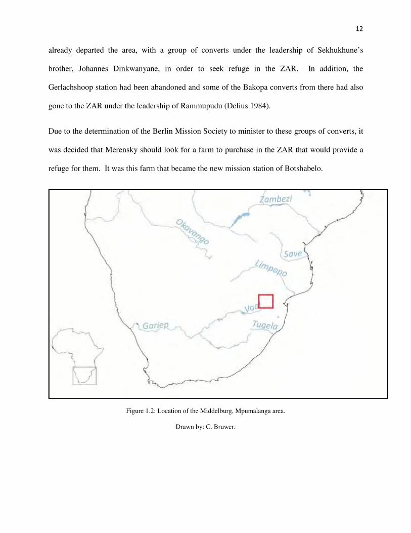
refuge for them. It was this farm that became the new mission station of Botshabelo.
Figure 1.2: Location of the Middelburg, Mpumalanga area.
Drawn by: C. Bruwer.

13
Figure 1.3: Botshabelo Mission Station relative to other major towns at the time of its establishment.
Drawn by: G. Booth.
Below is a table describing the chronology of events before, during and after the initial
establishment of Botshabelo as a mission station in the area.
N
Not to scale

14
1.1.3 Chronology of the events before, during and after the establishment of Botshabelo:
Date
1824
1857
1860
1861
1861
1863/1864
1865
1866
1873
1876
1878
1879
1880-1881
1882
1884
1892
1899-1902
1910
1914-1918
1929
1932
1939-1945
1948
1961
1970
1994
2005
2015
Event
Berlin Mission Society is established.
The first Berlin Mission Society missionaries are sent to the Transvaal.
Establishment of Gerlachshoop mission station by Merensky and Grützner.
Chief Sekwati of the Bapedi dies and Sekhukhune becomes chief.
Merensky and Nachtigal settle in the Bapedi polity and establish first mission
station at Khalatlolu.
Mission stations are established at Phatametsane and Ga Ratau.
Botshabelo Mission Station is established near Middelburg.
The three existing mission stations of Khalatlolu, Phatametsane and Ga Ratau
are abandoned due to increasing hostilities in the interior.
Johannes Dinkwanyane leaves Botshabelo with 335 followers to establish
their own settlement.
Relationships between the Bapedi polity and the local officials deteriorate and
the 1876 War breaks out.
Britain annexes the Transvaal.
The Bapedi and the Zulu are defeated by the British.
The First Anglo-Boer War is fought with the British being victorious.
Chief Sekhukhune is assassinated by his brother, Mampuru.
The Transvaal becomes the Zuid-Afrikaanse Republiek (ZAR).
German missionary Johannes Winters and locally ordained ministers, such as
Marthinus Sewuschane and some national helpers leave the BMS to establish
the Lutheran Bapedi Church.
The South African War is fought between the Boers and the British.
The ZAR becomes the Union of South Africa.
The First World War takes place and is the first truly global conflict.
New National Party with Hertzog as leader comes into power in Union of
South Africa.
Coalition government formed between Smuts and Hertzog.
The Second World War takes place.
System of Apartheid is implemented by the National Party.
The Republic of South Africa is inaugurated.
Botshabelo designated as a ‘black spot’ and forced removals ensue.
Independence is realised for a free and democratic New South Africa.
Land returned to land claimants, under the management of the Botshabelo
Community Development Trust.
Botshabelo Mission Station celebrates 150 years.

15
1.2 The historical background of Botshabelo Mission Station.
Alexander Merensky purchased the farm Boschhoek (now Toevlugt see Appendix 1) from Jan
Abraham Joubert for 500 Prussian Thalers (The Transvaal Provincial Museum Service 1989) and
co-founded the station with Carl Heinrich Grützner. The farm was located about ten kilometres
north of Middelburg and was surrounded by unoccupied Boer farms, which Merensky would
later purchase in his own name. As the Berlin Mission Society was not allowed corporate rights
within the Zuid-Afrikaanse Republiek (ZAR), Botshabelo and all the subsequent land purchases
were registered in Merensky’s name (Delius 1984). Merensky and Grützner named their new
mission station Botshabelo, meaning “place of refuge” in Sotho. The mission station is ideally
situated in a valley with ample water, fertile soil and grazing due largely to the Klein Olifants
River which runs through the property.
Figure 1.4: Alexander Merenky as a young (left) and older (right) man (Delius 1984; Google Images 2015).

16
Merensky records that he arrived at the farm with a group of dispossessed people from
Sekhukhune’s Bapedi polity where they joined a small group of Bakopa, who had already
erected huts. These inhabitants had been living in the ZAR for some time, after fleeing the initial
turmoil of the interior. Merensky describes how, during this time of establishment, the Bakopa
assisted in quickly building many huts to provide safe shelter for those living at the fledgling
mission station. After building a rudimentary mission house and church, he decided it was of
great importance to erect a fort for protection. The fort was named Fort Wilhelm. In Merensky
(1899)1, he states how this fort “resembled a peasant’s fortification”. Merensky (1899:224 as
translated by J. Stone 1992) further laments that,
alas, being surrounded by enemies, we had to sacrifice all plans of spacious roads and
beautiful settlement layout because of our security. This restriction, which had
determined the native’s form of village planning since olden times, had to do for us as
well, and force us to erect the houses of those living in the plain as closely as possible.
The plain referred to in the quote is the area that is now known as the Motse. In figure 1.4
below, the Motse can be found on the flat, open grass plain, approximately one kilometre from
the main mission complex. The remains of the mission village with its houses and stonewalled
enclosures can clearly be seen leading off from the mission station’s main road and over the
small Keerom stream. The graveyard can be found in the far south of the site. The villages on
the plain were positioned between the rocky outcrop in the south and the swampy area near the
spruit in the north. It is said, that the Bakopa were the first to live in this locale and were
1 The English translation to Merensky’s 1899 biography was provided by Jon Stone of the Department of
Architecture, University of the Witwatersrand in 1992, as part of a Conservation Policy for Botshabelo by the South
African Heritage Resources Agency (SAHRA) (Le Roux et al 2001). I have correlated the English translated
sections to the relevant German, and as such, Merensky’s book is used for referencing purposes.

17
allocated land downstream which they regarded as being very satisfactory. The Bapedi received
land to the east near the Keerom stream (Mminele 1983).
Figure 1.5: A recent satellite image of the Botshabelo Mission Station complex. See discussion in Chapter 3.
(Image from Google Earth retrieved 2017).
Merensky (1899:230 as translated by J. Stone) did not get involved in land allocation but left the
respective chiefs to distribute the land as he believed that,
if people manage as heathens to cut up the land peacefully according to the needs of the
families, they would do it even better as Christians, and held it to be of greater use, under
the circumstances, for me to abide by their customs.
Solomon Mminele (1983) who wrote about the history of Botshabelo as an education institution,
notes that the Bakopa were allowed to settle on the farm only if their chief, Rammupudu would
The Motse
Main Mission Complex Klein Olifants River
The Graveyard

18
be compliant to the authority of the Zuid Afrikaanse Republiek. One of the conditions was that
they were allowed to maintain their identity as a “tribe” but were not allowed to provide
protection to any enemies of the Republic. The Bapedi Christian refugees, on the other hand
were placed under the personal responsibility of Merensky and “were not recognised as an
organised tribe” by the Republic (Mminele 1983:29).
As mentioned previously, at its establishment the mission station only had a small church and
temporary living quarters. Slowly over time, a parsonage and other more permanent buildings
were constructed, together with a much larger church and for many years this 1873 church was
the largest church in the Transvaal Province. These buildings, together with the school
established in 1871, were all constructed using tenant and seminarian labour, those living and
studying at Botshabelo, as seen in figure 1.5 (Delius 1984; Mminele 1983).
Botshabelo became an important educational centre in the area, with the establishment of a
German School and training facilities for catechists and evangelists and by the late nineteenth
century Botshabelo was a self-sustaining mission village, which “grew to be the most successful
and noteworthy of all the Berlin Society Transvaal mission stations” (Japha et al 1993:19). The
mission station also experienced a rapid increase in population and indeed by 1880, only 15
years after the mission station’s establishment, there were already 1480 inhabitants, of which
1213 were converted and by 1882 the numbers grew to 1700 inhabitants of which 1475 were
baptised (Merensky 1899).

19
Figure 1.6: Seminarians working at Botshabelo Mission Station (Photo from the Hoffmann Collection:
624scr_950fcf5e55b21). Date unknown.
Alexander Merensky left the mission station in the 1880s, to pursue other duties in East Africa
and this ultimately led to a change in the way Botshabelo was managed and organised (Poewe
and van der Heyden 1999). He was succeeded by Carl Theodor Nauhaus in 1883, who inherited
custodianship of Botshabelo at a time when it was in a precarious position due to Merensky’s
involvement in Transvaal politics. Merensky had been very critical of the Transvaal government
and when he was appointed by the British as Justice of the Peace for the Middelburg District, the
ZAR government had lost confidence in him (Mminele 1983).
As pointed out before, education was of great importance for these missionaries and they carried
on with this pursuit even though at times this was difficult. Their educational activities were

20
consistently interrupted by various periods of unrest and war. As Mminele (1983:135) states,
during the period 1879 to 1902, “the missionaries at Botshabelo managed to remain dedicated to
providing education to those at the mission station, even during the collapse of the Bapedi polity
and two Anglo-Boer Wars”. One of the important accomplishments of the mission station
occurred in 1906, when a training institution was finally founded for the training of teachers and
Botshabelo’s educational endeavors continued. As Pakendorf (1997:265) states, “as
comprehensive as its undertaking was in building schools and providing education, concentrated
largely on primary schools; whatever further education was offered was mostly intended for
training of the mission’s own evangelists and teachers”. It must, however be remembered that
even though education was significant, it would not be subservient to the religious and spiritual
responsibilities of the missionaries.
In 1910, South Africa became a Union and the social and political landscape started to change
again. During this period, Botshabelo was a self-sufficient institution caught up in the
transformations happening within South Africa. Due to the changes occurring within the country
and particularly the internal politics of the time, the social and political landscape became
increasingly complicated due to all the different groups found within South African society. By
1914, this became even more problematic, as the Union decided to enter the First World War for
Britain. As Nasson (2014) asserts, the atrocities of the South African War still resonated within
the country and it was widely believed by certain South Africans, that Germany should be
prevented from executing similar war time acts against the people of France and Belgium. This
decision also had implications for the German citizens living in South Africa, including the
missionaries of Botshabelo (Nasson 2014). Due to the circumstances following the First World

21
War, Botshabelo was closed as a mission station from 1916 to 1926 however, the residents of the
mission village remained during this period (Mminele 1983).
Unfortunately, a consequence of becoming a Union in 1910 was a movement in South Africa
towards creating a political and social order systematically based on racial segregation (Freund
2012). One of the main causes for this is that the Nationalist Party broke away from the Unionist
Party in 1913, and they started introducing a policy where black South Africans could be
administered and suppressed (Posel 2012). This policy became most noticeable with regards to
land and land ownership. In 1913, the Land Act was instituted and this formed the foundation
for the geographical separation of people within the country. Events came to a head in 1929,
after a decade of labour conflict, when the New National Party under the leadership of Hertzog
came into power and started demanding independence from Britain (Freund 2012).
Until the outbreak of the Second World War, political power ebbed and flowed until a coalition
government was formed between the Nationalist and Unionist Parties. This however, came to an
end when Hertzog of the Nationalist Party did not want to support Britain again during this war.
South Africa still entered the war in 1939, however, under Jan Smuts as Prime Minister. By the
end of the war in 1945, South Africa had become more industrialised, which led to an increase in
global economic prosperity for the country. Unfortunately, at this time not much changed in the
policy affecting black South Africans, which only worsened in the years to come (Posel 2012).
1.2.1 Impact of Apartheid on land-ownership and education.
By 1948, even though South Africa was still part of the British Commonwealth, the country had
become more autonomous, partly due to the gradual decline of Britain after the war, and partly
due to the implications of its own economic development (Freund 2012). By this time, the

22
country started changing its internal policies and amended legislation and government
programmes, as imposed by the National Party government in power. By the early 1950s, the
country entered a political and social phase dominated by the policy of Apartheid. This policy
was gradually being implemented and “was aimed at displacing blacks and replacing them with
whites in all the more attractive niches of employment. This left teaching and preaching as
virtually the only avenues of white-collar employment open to educated blacks” (Bonner
2012:294). Among the important reactions to this political and social change was the continued
conversion to Christianity, followed by the separation from mission churches and the formation
of indigenous African Zionist Churches (Bonner 2012). Some of the reasons for this eventual
separation was the strict governance of the mission stations by the missionaries and the African
pastors, not recognising the abilities of the converted, as well as, “delayed ordinations; low pay;
lack of ownership of churches and schools that helpers and their congregations built; confusion
by helpers of self-maintenance, which missions wanted, with self-rule, which helpers wanted”
(Poewe and van der Heyden 1999:23). This was not a new phenomenon for the Berlin Mission
Society, as in 1892, Johannes Winter (a BMS missionary) left the mission society in order to
establish his own congregation with some of the African pastors and national helpers. Winter
was so respected that he was asked by the African national helpers to leave with them. Due to
his close interaction with the local African community that he ministered to, this brought about a
change in his theology. He had a theology that was about love and capitulation, which was
somewhat different from the Lutheran theology of studying and governing and organizing which
is the very essence of pietism (Poewe and van der Heyden 1999). As Ruether (2002:378) notes,
due to the fact that the Berlin missionaries were not really interested in the politics of the time,
this eventually led to “striking cultural consequences, as Christians used their new faith to
express diverse social aspirations”.

23
The new policy of Apartheid also had major implications for African education within the
country and for Botshabelo as a mission station. Prior to 1948, African education was primarily
furnished by missionaries at mission schools. However, these schools were deemed by Hendrik
Verwoerd, Minister of Native Affairs at the time, as having “provided an inappropriately
Western, liberal education aimed at an African elite” (Posel 2012:339). Urban churches and
missionary movements continued to play a significant role in African education until the
implementation of “the Bantu Education Act No. 47 of 1953, which had a major impact on
mission stations occupied by Africans all over the country. Many of these schools were founded
on mission stations, such as Botshabelo, to service the people who lived in their surrounds, for
instance the residents of the Motse or for those living further afield (Japha et al 1993). Verwoerd
envisaged a new system of mass education with a ceiling placed on the level of knowledge and
skill and in terms of the Bantu Education Act, all educational institutions were to be racially
segregated (Elphick 2012; Japha et al 1993; Mager and Mulaudzi 2012; Posel 2012). This had a
substantial impact on mission based African education and the African teaching profession all
over the country. At this time, the Berlin Mission Society still believed that it was important to
understand and study the indigenous culture and language, yet when the Bantu Education Act
was implemented, they stated few objections against it (Elphick 2012). The reason for this could
be their approach towards the spiritual, that is their religious life and that of the secular or
external world, in this case the National Party government. The Lutheran Church makes a very
clear distinction between the spiritual and the secular authority in what has become known as the
“Two Kingdoms” philosophy. The missionaries accordingly took the stance not to be involved in
the politics of the country (Nygen 2002; Pakendorf 1997).

24
As the new Education Act gained momentum, all government financial subsidies to the mission
schools were terminated by 1957, and many mission stations had to sell or lease their land and
schools to the government. At this stage, even members of the Berlin Mission Society were in
agreement that the mission schools were “placing [an] intolerable financial burden on missions”
and that these schools were merely serving a purpose of practicality and were “no longer needed
for the Christianization of Africa” (Elphick 2012:296). This led to the Berlin Mission Society
slowly withdrawing from South Africa due to financial and political reasons. Events further
escalated in 1961, for those living at Botshabelo and the Motse, when South Africa gained its
independence from Britain and became a Republic the country became even more regulated. For
an African person everything in everyday life was governed by “permits and passes or by public
prohibitions and prescriptions. All African nationalist organisations were banned in order for the
government to retain control of their ideologies and policies” (Posel 2012:347). Being policed at
all times led to frustration and bitterness, which in turn led to sporadic occurrences of violence
and resistance.
Botshabelo Mission Station and the Motse were directly affected by two types of racial
legislation; legislation relating to the occupation of land, and legislation relating to the provision
of education and health services to black South Africans (Japha et al 1993). It was legislation,
such as the Land Act of 1913 and the amended Land Act of 1936, “which consolidated the
division of South Africa into areas designated for white and black occupation” and which finally
determined the methods for the forced removals (Japha et al 1993:40). Mission stations were
only affected by these forced removals from 1969, even though widespread removals were
already happening all over the country, such as in District 6 in Cape Town and Sofiatown in
Johannesburg. During this period, population or forced removals were enforced under the

25
auspices of the Group Areas Act of 1950, which was designed to separate designated residential
areas based on racial occupation (Posel 2012).
Botshabelo, together with the Motse was officially designated a “black spot” in 1970 and the
people of the Motse were forcibly removed in 1972. A “black spot” can be described as an area
of land or a property, where black South Africans lived in what the National Government
regarded as white South Africa (Japha et al 1993). Several of the houses of the Motse were
bulldozed during the removals, and as reported in a newspaper article from THE STAR
JOHANNESBURG (Monday August 28, 1972) “the last 200 African families living at
Botshabelo have left and have been resettled at Motetema homeland near Groblersdal”.
In 1978, the Municipality of Middleburg bought the mission station for the purpose of
developing the area for tourism. Part of the land was developed into a game reserve. It was
eventually in 1983, that the last residents who still lived in the intact houses found in the Motse
were moved to new houses elsewhere on the property (TPMS 1989).
The brochure produced by the Staff of the Botshabelo Museum (1989:1) summarised Botshabelo
Mission Station as:
an important and influential centre where the Gospel was proclaimed among Black
peoples; where Black and White received education and training and where commerce
and industry were practiced. Seen against the background of its origins, Botshabelo was
also a significant centre for German culture. A good many of the people that emerged
from here have left their mark on the history of South Africa.
From the above discussion, it can be seen that Botshabelo has had a challenging but remarkable
history within the South African landscape and that the collection of houses found in the Motse is
a little known part of this history and should therefore be studied.

26
1.3 Outline of dissertation:
In the following chapter, this research project is discussed in the context of the archaeology of
the contemporary past, exploring the themes of historical and mission archaeology, together with
that of household archaeology and the archaeology of consumption. It is also in this chapter, that
the theoretical approaches are assessed.
In Chapter Three, the history of the spatial organisation of the Motse as reconstructed through the
analysis of documentary, pictorial and cartographic sources is discussed, so as to situate the
Motse in its historic setting. The first part of the field work, that is, the survey is also presented.
Chapter Four describes the excavations carried out at two of the houses found in the Motse and
their associated middens. It is this material culture recovered during the excavations that has
been analysed as discussed in Chapter Five. The analysis of the glass, ceramics and the buttons,
together with some of the other household artefacts found during excavations are described,
explained and illustrated.
In Chapter Six, a discussion of the findings of this research project are examined in the context
of the household, the architecture and the spatial organisation of the Motse, especially within a
framework of the archaeology of the contemporary past. The final chapter presents the
conclusions reached and provides a brief discussion on the future of mission stations such as
Botshabelo.

27
CHAPTER 2: THE HISTORICAL/CONTEMPOARY ARCHAEOLOGY FRAMEWORK
OF THE MOTSE.
Researchers have provided an array of historical studies of mission stations and missionaries, but
little is known about southern African mission stations archaeologically, as there have been
relatively few archaeological studies carried out on these sites. Worldwide, such research is
generally situated within the archaeological approaches concerned with understanding processes
of European colonisation and post-colonial material culture (Orser 2004; Renfew and Bahn
2009).
2.1 A brief introduction to historical archaeology and the archaeology of the contemporary past.
The people who lived in the Motse were by all accounts ordinary people living normal everyday
lives, using normal everyday material objects. It is these everyday material objects that James
Deetz, called the ‘small things forgotten’ that are central to this research (Deetz 1996). But what
is historical archaeology? A popular definition of historical archaeology is “the archaeology of
the spread of European cultures throughout the world since the fifteenth century, and their
impact on and interaction with the cultures of indigenous peoples” (Deetz 1996:5). This
definition is not the most suitable and can be problematic, as it is very restricting in its approach,
both in time and space. So, a more modern definition of historical archaeology can be described
as follows: “a multidisciplinary field that shares a special relationship with the formal disciplines
of anthropology and history, focuses its attention on the “post-prehistoric” past, and seeks to
understand the global nature of modern life” (Orser 2004:19). This definition is also somewhat
awkward, as it also focuses on a certain period, that of the “post-prehistoric” past, and
unfortunately, reference to the multidisciplinary qualities of historical archaeology is somewhat
lacking. Of importance to Orser’s definition is that it highlights the nature of historical

28
archaeology as global. Jeppson (2005:80) identifies that historical archaeological research “in the
global perspective becomes more about the study of, and the interaction between, new
inhabitants, indigenous peoples, their descendants, and the changing landscape”. Historical
archaeology is therefore global in scope and interdisciplinary in nature (Jeppson 2005).
Historical archaeology is relevant to this project because it encompasses every scale from the
smallest household artefact to the global historical description of the Berlin Mission Society.
This framework aids in the interpretation of these different narratives and so finds meaning
through the study of material culture together with history and ethnography.
This places historical archaeologists in a unique position to situate everyday material culture
relative to the larger undertakings of colonialism and consumption. That being said, it becomes
important when studying “the societies and events of the last 500 years of southern African
history, [that] we do not seek to privilege that period of time most commonly associated with the
rise and expansion of European colonialism, but rather to acknowledge that it is a period of time
most relevant to an understanding of contemporary society” (Behrens and Swanepoel 2008:25).
So, in summary, historical archaeology is consequently, the study of people and their societies
through the associated use of documentary sources, oral histories and ethnography and the
analysis of associated material culture remains (see Deagan 1982; Deetz 1996; Fagan 2001;
Little 1992; Orser 2004). So, by applying historical archaeology and its methodologies, a better
understanding of the daily lives and the households of the people who lived in the village of the
Motse in the recent past can be gained. With regards to the research on the Motse, there are
various other sources available, apart from excavation and its associated artefacts, to assist in
pulling together the narrative of Botshabelo, such as photographs, maps, various historical
documents, together with the buildings and the relevant landscape.

29
In addition, the research carried out on the houses of the Motse and its associated material culture
is situated within what some archaeologists have come to call the “archaeology of the
contemporary past/world”, because excavated assemblages date to the mid-20th
century (see
Belford 2014; Flexner 2014; González-Ruibal 2014; Harrison 2011). This framework provides
an opportunity to apply archaeology to the study of the more recent past. Contemporary
archaeology is more than just the study of human origins and cultures, or the focus on particular
time periods, this type of archaeology can be used successfully to study material culture
belonging to and occurring in the present (Harris 2011), for example, the excavated material
from the households of the Motse. Contemporary archaeology can assist in understanding the
processes - social, political, economic and religious - associated with the modern world. It is
also these issues, which unite or divide people within communities. It is along these lines that
the archaeology of the contemporary past aims to study the contemporary world; from post-1918
to the present. The history of Botshabelo and the Motse in particular, has been contradictory and
political, and as archaeology is inherently and inevitably political in nature, the past cannot be
isolated from the present. Benford (2014:3) expands on this theme and views archaeology as
part of “a continuum which stretches forwards and backwards”.
The archaeology of the contemporary past has at its core an interpretive approach in that it
examines the relationship between material culture and human experiences in the context of the
contemporary (Lamb 2004). This archaeology can assist historical archaeologists to
simultaneously focus and concentrate on the connections between present processes and those of
the recent past. As a result, archaeology can be applied to assist in explaining and understanding
the lives of the everyday people through their associated material culture. This is also true of the
residents of the Motse, whose lives were evidently not important enough to be comprehensively

30
documented within the various historical documents relating to Botshabelo and the mission
station as a whole. Archaeology, is thus a means of making “the past more accessible and
egalitarian, to recover lost, subaltern voices and in a way to close the distance between the past
and the present” (Harrison 2011:141).
Below is a discussion of the various bodies of literature within a broader historical archaeology
relevant to the study of the Motse, that of mission archaeology, household archaeology and the
archaeology of consumption.
2.2 Mission archaeology.
It is necessary to place the archaeology of mission stations and the research on the Motse within
the context of other global mission contexts. There have been numerous and diverse studies
undertaken in various parts of the world, such as in the Americas ( Deagan 2012; Graham 1998),
the Caribbean (Lenik 2011), Australia (Lydon 2005, 2009) and New Zealand (Middleton 2008,
2014).
An early and still significant study within this sub-field is that of Elizabeth Graham (1998) and
her review of the various research projects undertaken in the Americas at the time. Graham
(1998:25) concentrated on the archaeological research of mission sites in the Spanish-occupied
territories of North America and Mayan Mesoamerica. By using archaeology and its
methodologies, Graham tries to explain “the role that Christian missions and missionaries played
in the European displacement of indigenous peoples in the Americas”. These missions were also
predominately managed and financed by the Catholic Church, and this is evident in the extensive
architecture of these Spanish mission stations in the New World. Another study of interest here
is that of Kathleen Deagan (2012), where she and her associates from the University of Florida

31
used data and information recorded from 75 years of archaeological investigation carried out on
the site of the Spanish Nombre de Dios Mission/La Leche Shrine in St. Augustine, Florida in the
United States. Deagan undertook new excavations during 2009 and 2011, focusing primarily on
the Chapel of La Leche and its occupational levels from pre-Columbian through the early
Spanish colonial occupation of the sixteenth and seventeenth centuries, concentrating on the
mission occupation period through the seventeenth and eighteenth centuries, indicating that the
local residents and the missionaries resided together at the mission station by this period.
Deagan’s research aims to understand and so interpret the development of the occupation and
mission activity at the site (Deagan 2012).
In Australia, mission archaeology is a fairly new field. Jane Lydon and Jeremy Ash (2010:1)
discuss the need to make these missions key places in the history of the “colonial contact in
many settler-societies”. They argue that mission stations in Australia should not be seen only as
having positive or negative effects on the Aboriginal people. Attention should rather be placed
on the fact that these mission stations assisted these communities by providing refuge from
conflict, that is, they were places of control but also places where new cultures emerged (Lydon
and Ash 2010).
Lydon’s (2009) study of the Moravian Mission Station of Ebenezer in southeastern Victoria is
important here. Her research concentrated primarily on the mission-house, as this building was
seen as a symbol of order and authority. However, through excavation and the examination of
the documentary sources, pertaining to this fairly successful mission station, the limitations of
the missionaries’ management system together with “their ongoing battle to maintain control
over the residents, and the relative mobility and freedom of many residents” became apparent
(Lydon 2009:16).

32
With regard to the field of mission archeology here in southern Africa, it is relatively under
investigated. To date the research done on mission stations has been mainly focused on
historical, anthropological and/or architectural themes (see Comaroff and Comaroff 1991; Delius
1981; Japha et al 1993, Kirkaldy 2005; Pakendorf 1997; Vernal 2009/2012). The most notable
of the anthropological studies is that of the Comaroffs’ whose thorough anthropological research
illustrated the encounter between the British missionaries of the London Missionary Society and
the Tswana (Comaroff and Comaroff 1991). Peter Delius’s (1981) detailed research of the
Bapedi, Alan Kirkaldy’s (2005) examination of the Berlin missionaries among the Vhavenda and
Fiona Vernal’s (2009/2012) study of the Farmerfield Mission Station and its African Christian
community on the troubled Eastern Cape Frontier are all significant examples of the type of
historical analyses of the mission field.
In contrast, however, there has been relatively little archaeological research carried out on the
various mission sites within southern Africa (but see Ashley 2010; Boshoff 2004; Clift 2001;
Humphreys 1989; Jeppson 2005; Reid et al 1997).
Mission archaeology focuses on the archaeology of a range of mission sites, which can include
shedding light on the process of Christianisation by examining the material culture of mission
sites and the people who used to live on the site and who interacted with missionaries (Clift
2001; Lydon 2009). Other themes include the study of settlement patterns with regards to space
and social contact (Lenik 2011; Lydon 2009; Lydon and Burns 2010; Panich et al 2014), as well
as missionaries and culture contact and interaction (Ashley 2011; Clift 2001; Graham 1998; Lane
1999; Smith 2014). Archaeology attempts to understand mission sites through the study of the
material culture and spatially ordered remains left behind by these communities, such as that of
the Motse, thus giving added insights into the narratives of the past. Archaeology provides a

33
basis for the investigation, understanding and evaluation of relevant historical sources through
excavation and analysis. As the lives and the material remains of the everyday were not readily
documented, archaeological research can contribute in completing the broader representation of
the everyday. This being said, the “collaboration between historians and archaeologists can
greatly enrich our understanding of complex social processes in the past and together they
represent a formidable reassessment of a number of the orthodoxies in South African
archaeology, anthropology and history” (Delius and Marks 2012:251).
The various studies carried out in southern Africa include, the research conducted by Ceri
Ashley (2011) on the London Mission Society Lake Ngami Station found in the Khwebe Hills of
northern Botswana, as part of a project on the archaeology of migrations in Africa. The intention
of the study was “to explore the dynamics of human mobility and in particular the relationship
between host and immigrant communities” (Ashley 2011:36). Reid and his colleagues also
excavated in Botswana, where they investigated the Tswana and their responses to colonialism,
especially pertaining to their architecture together with the “political, military, economic and/or
religious control of one society over another” (Reid et al 1997:370).
Humphreys (1989) in his study describes Genadendal Mission Station in the Western Cape, as an
archaeological setting within the Chainoqua territory of the Khoikhoi. Harriet Clift (2001)
provided further archaeological data in her research, where she explored the ideas of cultural
contact at Genadendal Mission Station, specifically with regards to the Khoekhoen inhabitants.
This Moravian mission station was the first mission station to be established in South Africa in
1737 and it was here that the first European missionary intervention with indigenous lifestyles
took place. Clift’s (2001:v) research was to find “evidence of the Khoekhoen who lived at the
mission during the eighteenth and early nineteenth century and to explore the ways in which

34
Khoekhoe communities interacted with mission establishments as a means of reinventing
themselves in a changing world”. The Khoekhoen were a nomadic people who would arrive at
the mission station for short periods of time and only during certain seasons depending on their
migration.
In the Eastern Cape, Patrice L. Jeppson (2005: iii) “drew on ceramic assemblages from the
Farmerfield Mission Station in order to draw up a model of identity formation based on
comparative research from a variety of contexts” and in Gauteng, Willem Boshoff (2004)
conducted excavations at Gerlachshoop Mission Station found north of the Vaal River. It was
this mission station that would eventually lead in part to the establishment of the Botshabelo
Mission Station.
It has been maintained that by 1911, “southern Africa had become one of the most intensively
worked mission fields in the world. There were 693 mission stations in southern Africa,
including Mozambique, Lesotho, Zambia and Zimbabwe” (Japha et al 1993:21). So, what is
evident from the above case studies and the limited amount of research accomplished to date is
that, mission archeology offers the opportunity to explore the responses and adaptations imposed
on the indigenous inhabitants of these missions found across southern Africa. These mission
stations can take many different physical forms, and they range from a “few simple structures; in
others there were large settlements, with many houses and relatively elaborate civic buildings”
such as those found at Botshabelo Mission Station (Japha et al 1993:1).
2.3 Household archaeology
Relevant to the research on the houses of the Motse, is the increasing scholarship on household
archaeology. Wilke and Rathje first introduced the term household archaeology in a publication

35
for the American Behavioral Scientist in 1982. Wilke and Rathje (1982:618) define “the
household as the most common social component of subsistence, the smallest and most abundant
activity group”. It is by excavating these households and analysing the associated material
culture, that a clearer picture of who and how these people lived emerges. Household
archaeology can thus be an efficient unit of analysis. However, the studying of these houses
alone produces a limited view of those living in them. It is here, that household archaeology is in
a special position to assist in developing a better understanding of the household structure. It
assists in trying to understand the relationships between people within a social unit, the
relationship between these people and their material belongings and their relationship with the
world. Household archeology can thus focus on the lived experience (Allison 1998; Hodge and
Gallagher 2010; Panich et al 2014).
There have been various definitions of the household as the field has developed. These include
that of Nesta Anderson (2004:111) who maintains that “a household is a person or a group of
people who live together in one or more structures, who carry out daily activities necessary for
the maintenance and social reproduction of the group within a specific space associated with the
residence, who interacts with other households”. Hendon (1996:48), defines “the household as a
task-focused group that conducts many of its activities within a specific kind of physical setting”,
what is known as a dwelling unit, which includes the indoor and outdoor space in which people
live. Souvatzi (2014:241) describes the household as “the shared performance of a sphere of
practices consisting minimally of production, distribution, consumption, transmission, and social
reproduction”.
In the past, studies were dominated by investigations that focused purely on architectural remains
to describe household behaviour and the household and its material culture was seen as being

36
inconsequential but, as Penelope M. Allison (1999:2) mentions, household archaeology has the
ability to provide “a fuller understanding of changing domestic behaviour through a critical
analysis of the complete record of household material culture – the house, its contents and their
spatial relationships”. Mary C. Beaudry states that archaeologists should excavate these
household sites in a way that they can make “persuasive links between the life history of sites –
stratigraphic sequences and site formation processes – and episodes of household status,
upheaval, and transformation” (Beaudry 2004:254). What becomes evident, with regard to these
definitions, is that household archeology at its centre concerns itself with how people lived and
how their households were organised. Households can thus, produce a unique perspective on
understanding the past. By studying these units, information on issues such as status, production
and consumption can be examined together with larger themes such as gender, identity and
ethnicity, for instance (Pluckhahn 2010; Prossor et al 2012). Another aspect of household
archeology is that it can provide a framework for comparative analysis, such as that attempted
here on two households of the Motse. As Pluckhahn (2010:332) remarks, “an advantage to
studying the household is that it is a more discrete and definable unit of analysis than larger and
more permeable social formations such as community or polity”. By studying the houses and the
households of the Motse, a comparative study can emerge focusing on the architectural design
and settlement layout, as well as, the differences between the material cultures of these
households.
Julia Hendon (1996:46) offers another perspective here, in that “all households in a society may
be charged with the same basic tasks and interact with the same physical and social environment.
But they do not necessarily respond in the same way to external conditions or organise
themselves in the same way”. The residents of Botshabelo and the Motse were not living in

37
isolation; they were part of a greater society. This is important especially with respect to the
social, political and economic relationships between the converts who lived in the houses of the
Motse and the missionaries who managed the Botshabelo Mission Station and later, with regard
to the residents that stayed to make this village home. As previously mentioned, the Berlin
Mission Society sent missionaries to convert the indigenous population in various regions of
South Africa. The relationship between the missionaries and the converts was volatile and
wavered between submissiveness and resistance. An example of this was that the converts
received religious and educational instruction from the missionaries but they also had to provide
physical labour and rents to the mission station in return. Botshabelo was a successful enterprise
in many respects that benefited both the missionaries and the residents of the mission station.
The relationship between the missionaries and their converts and families was a complex one and
had social, political and economic implications. The mission environment and its population
were not static. There would be people arriving and departing, as well as still others participating
in the migrant labour systems (Delius 1981; Etherington 1976).
These households and their activities were therefore, not separate from what was happening in
and around them at the mission station; they were just another aspect of it (Spencer-Wood 2004;
Wood 2004). The residents of the Motse were not isolated from society; they were part of the
social, political and economic aspects of the mission station as a whole and the broader Zuid-
Afrikaanse Republiek (ZAR) society and later, as part of a changing South Africa. Therefore, it
can be said, that there are interconnections between household and larger political and economic
processes.

38
Another aspect of household theory and research is that of power dynamics. It is through
archaeological comparative studies, their spatial relationships and household material culture that
these power dynamics can be investigated (Spencer-Wood 2004).
Since settlement layout is an important characteristic of household archaeology, space becomes
an important factor. As Robin and Rothschild (2002:161) argue “archaeologists have
demonstrated that space is not simply a passive backdrop for action, but is socially constructed
and constitutive of social relations”. They believe that space retains the history and the memory
imprinted on it by the people inhabiting it through time.
Household archaeology is therefore in a position to investigate and expose the most primary and
intimate activities that take place in the home and by analysing the material culture of specified
households, a better understanding of the daily lives of the residents of the Motse can be grasped.
2.4 The archaeology of consumption.
Another applicable body of work to the investigation of the Motse is that of the archaeology of
consumption. As Paul Mullins (2004:195) asserts, archaeology is again in the unique position to
“confront the multivalent meaning of goods, probe the ideological roots of material symbolism,
and emphasize that even the most commonplace objects provide insight into meaningful social
struggles”. The development of consumption as a field of study is partially due to the Industrial
Revolution, the growth of capitalism and the shifting from a self-sufficient producer-consumer to
a totally modern consumer based household (Orser 2004). This perspective is fairly new, as
many are not really interested in the histories of acquisition and consumption of mundane
material goods. Usually, when these material goods are studied, they are viewed first and
foremost economically. It was important to realise, that these material goods could be

39
researched within the social context and the understanding of complex social relationships, such
as those relationships found within the context of mission stations (Birgit 1997; Groover 2014).
There are a collection of archaeological studies that can be defined as being rooted in the
archaeology of consumption. Either through research focused on how people acquire and convey
their understanding of goods with regards to their social, cultural and historical backgrounds or
research concentrating on the symbolic meanings of things (Cipolla 2015; Groover 2005; Meyer
1997; Mullins 2004, 2011). Historical archaeology can provide an insight in recognising the
similarities and differences of how commodities are consumed across time and space (Mullins
2011).
An interesting aspect of the archaeology of consumption is that of how people gain a sense of
empowerment through material goods. Consumption can empower people and should be seen as
more than just a process that “displays social status, evokes ethnicity, exhibits gender, or
confirms other essential identities” (Mullins 2011:135). This concept is represented within the
multifaceted relationship found between the missionaries and the residents of Botshabelo and the
Motse. Mission stations, such as Botshabelo, have added to the development of the country and,
by converting the local population and changing their customs and traditions have produced
modern consumers. Comaroff and Comaroff (1991) explore these issues through their
anthropological work. They argue that missionaries were vital to the process of colonisation, not
through politics but through their subtle colonisation of lifeways and practice. The Comaroffs
use a “material culture” framework to analyse the way the missionaries changed and transformed
indigenous practices and beliefs. They focus on materiality and so introduce their European
ideas of order, modesty and civilisation. The missionaries measured their successes by the
notable changes seen, in particular, in the architecture and settlement patterns of the villages

40
surrounding the mission stations. The missionaries of the London Missionary Society, for
example, wanted to “recast Tswana patterns of consumption” through changes in clothing habits,
changes in architecture, interiority and domesticity (Comaroff and Comaroff 1997:218).
Missionaries were ultimately and intimately involved in the colonial processes occurring within
southern Africa. It must, however, be realised that it is more difficult to assess the religious
beliefs of the converted than it is to analyse the aesthetic changes, such as architecture, clothing
and the use of everyday cultural material (see also Birgit 1997; Clift 2001).
But this was a double-edged sword, as missionaries wanted the converts to follow what they
believed to be a proper way of living by being more westernised, but were also worried that the
new consumption habits would lead to materialism rather than just fulfilling basic needs. As
Birgit (1997:329) remarks, the attitude the missionaries had towards consumption was that it was
a means to an end, “it was a vehicle for the construction of a new, modern and ‘civilized’
identity”. The fact is consumption played a vital part in conversion. So, by using archaeological
data from various households, a better understanding of the patterns of consumption can emerge.
The analysis of such material culture can place the residents of the Motse and their households
within the larger social, economic and political historical context at the regional level. As
consumers, these individuals were making consumer choices “tempered by their own individual
experiences, desires and opportunities” (Sweitz 2012:288). As industrial material goods, such
as food and household items became readily available, these items became more affordable,
especially at the turn of the century. This caused consumption of such goods to rise especially
among the lower income classes and a mass market began to emerge.
So, by studying the usage of such everyday objects, such as glass and ceramics, information on
diet, gender, literacy and status can be discerned, as well as the way people see themselves and

41
their place in society (Licence 2015). This can be said of the residents of the Motse, as most of
the excavated material culture for this research project can be situated within the twentieth
century. By this period the residents had formed their own identities and the missionaries were
no longer attempting to influence the mission station population into a westernised way of life.
These residents of the Motse were part of an emerging consumer class within South Africa, as
well as, trying to find their position in a country undergoing political change.
As can be seen from the above discussions, archaeological material from the households of the
Motse can assist in the understanding of consumption patterns, as well as, household
relationships within the contemporary past.
2.5 Theoretical perspectives: Botshabelo and the Motse.
As discussed in the previous sections, the research on the Motse is set within an
historical/contemporary archaeology framework. The aim of the study is to refine the
chronology of material changes in this area of the mission station through the analysis of
material and documentary sources and to look at the daily life through the lens of the excavated
deposits.
The Botshabelo Mission Complex, including the Motse, was established as a self-contained
community, which gradually increased in size by successful agricultural practices and social
services of which education and health were the most important (Japha et al 1993). This was not
easy, as the Berlin Mission Society had restricted financial support, which meant that these
missionaries had to manage the mission station to produce and manufacture their own materials
and products, which ultimately led the mission station to become fairly self-sustaining. There
are many processes at play here between the various individuals living on the mission station. By

42
using an interdisciplinary approach and drawing on notions of anthropology, sociology, history
together with archeology, an interpretive methodology can be utilised to investigate these
processes.
Interpretive archaeologies first came to the fore in the 1980s and 1990s. Known as post-
processualism, these archaeologists were interested in the cognitive view of culture and saw that
culture as actively constructed and changed by individuals on a contextual basis (Sharer and
Ashmore 1993). People, as individuals have their own thoughts and this in turn affects their
behaviour and how they see their world. Interpretive archaeologies assist in trying to make sense
of the past, as “it is not enough to look at adaptation to an external environment as an
explanation but also to refer to people’s attitudes and beliefs” (Johnson 1999:98). It is important
to understand past histories and material culture within their own cultural context. In order to
figure out this context, archaeologists must attempt to examine the past from a subjective point
of view, and as Lamb (2004) points out, archeologists, especially those studying the
contemporary past, cannot detach themselves from having an introspective and interactive
relationship with the people and the material culture that they are researching, as it is this
relationship between the human experience and the material culture that is significant in the
context of the contemporary environment. The interpretive archaeologies approach is recognised
when there’s an interpretive relationship between the archaeologist and his or her research topic
“with the implication of repositioning the individual as prime importance rather than just a
component with the generalised system at large” (Lamb 2004:132). However, this approach is
more suitably applied to the interpretation of particular locations and individuals or groups than
providing broad and general explanations. As Johnson (1999:106) explains, material culture is
seen as having several different meanings and values and as such the “material culture is like a

43
text and can be read, everyone who sees the text will not read it in the same way”. This notion of
hermeneutics is an important aspect as it is the study of meanings and how these meanings are
assigned to things (Johnson 1999).
For the purpose of this study, a homestead of the Motse can be viewed as a collection of
structures, comprising of a main house, with one or two additional structures found clustered
together and also comprising of garden and kraal areas demarcated by stone walls, where a group
of people lived and carried out every day activities within these indoor and outdoor spaces, thus
placing this research firmly within the sphere of household archaeology. The limited studies
previously carried out on the houses of the Motse, have largely been focused on the architecture
and by applying an interpretive methodological approach to examine the residents of these
houses, a clearer understanding can emerge. For example, was it the transformation in ideology
through the teachings of the missionaries that led the residents of the Motse to build European-
styled houses? Did they build these houses in this form as they were more simple and
straightforward to build, and what meaning did the change in shape of these houses from the
traditional round to the European-style have for the resident households living in these houses?
The houses of the Motse were also built away from the main mission complex, and can be seen
as a social and political division between the missionaries and the converts and their families.
Could these social divisions also be found with the different houses and homesteads of the Motse
and even within the household themselves? The houses are built with different structures and
areas, and can be seen as a division between the private or domestic inside of the main house,
and the public or the outside areas including the other structures, the garden, kraals and even the
paths and roads. Could the private areas of the house be interpreted as being the emergence of
the nuclear family? The inside walls being a division between household members and activity

44
areas. The residents of the Motse thus, took part in the world around them and as such cannot be
seen independently of its cultural, social and political context.
In the following chapters the Motse will be explored further and some of the answers to these
questions determined through the application of theory and methods of these sub-fields, and thus
a better understanding of the Motse and its houses during the recent historic past can emerge.

45
CHAPTER 3: BOTSHABELO AND THE MOTSE IN SPACE AND TIME
The interplay between documentary sources and archaeological data is at the methodological
core of historical archaeology. These provide the foundation for the understanding of the Motse
and its houses. Documentary, pictorial and cartographic sources often contain important
information and descriptions that can offer us insights into how the site has changed over time.
This can add to our interpretation of archaeological data both in comparative and supplementary
ways. These sources can help inform on the landscape through space and time, and can
contribute to our understanding of broader historical context, as archaeology can be partial in its
coverage depending on the excavation strategy. The depictions of houses and household objects,
people and activities contained in documentary and pictographic sources represent the
experiences at a point in time. It must, however, be remembered when studying these pictures
and related sources, that “pictorial evidence can be imbued with its own agenda and can
reproduce ideal rather than actual behaviour” (Allison 1999:13).
3.1 An introduction to the documentary/pictorial and cartographic sources on the Motse.
As part of the research on the Motse, various documentary, pictorial and cartographic sources
were consulted and examined. These material sources were accounts of visitors to the mission
station that recorded their experiences in travel journals, as well as, official documents,
photographs and maps recorded by the missionaries themselves.
There are a few but significant historical studies that discuss the Berlin Mission Society and
Botshabelo Mission Station (inter alia Delius 1984; Kirkaldy 2005; Le Roux et al 1991;
Mminele 1983) focusing primarily on the history, the architecture or on the educational history
of the site. These research projects drew on information from the meticulous documentation

46
accumulated by the missionaries. The missionaries of the Berlin Mission Society wrote
profusely about their professional and personal lives in mission reports (Missions-Berichte),
journals and in letters (Kirkaldy 2005; Poewe and van der Heyden 1999). They recorded and
documented not only their histories, but those of the people they lived among. Added to this, are
the few available travel journals of the visitors to the mission station.
Images in the form of sketches and photographs are significant in the reconstruction of the story
of the Motse and the mission station. Of great value to this research project was the database for
the Hoffmann Collection. This collection was compiled to provide knowledge, insight and
understanding through the writings and images from the work of missionaries such as Carl
Hoffmann between 1913 and 1958, as seen in figure 3.1 below. These archives with their
primary sources are indispensable with respect to the documentary and pictorial record of the
missionaries and the people who lived at Botshabelo and the Motse. The Hoffmann Collection
of Northern Sotho Cultural Heritage (http://hoffmanncollection.hu-berlin.de) was compiled by
Dr. Annekie Joubert from the Humboldt University Berlin (http://www.iaaw.hu-berlin), together
with the library archives of the University of South Africa and the University of Pretoria and is
available to researchers in digital format (http://uir.unisa.ac.za/handle/10500/4954).
Missionary, traveller and visitor accounts that were written during the first 25 years of the
Botshabelo’s existence provide a glimpse into the organisation and functioning of such an
institution. However, these colonial authors were somewhat selective in what they chose to
recount and convey regarding the mission station and used the information for their own
objectives. These sources all focus primarily on the mission station itself, and not much
information is reported on the village of the Motse. Currently, much of the available material on
Botshabelo dates to the early years of the mission station.
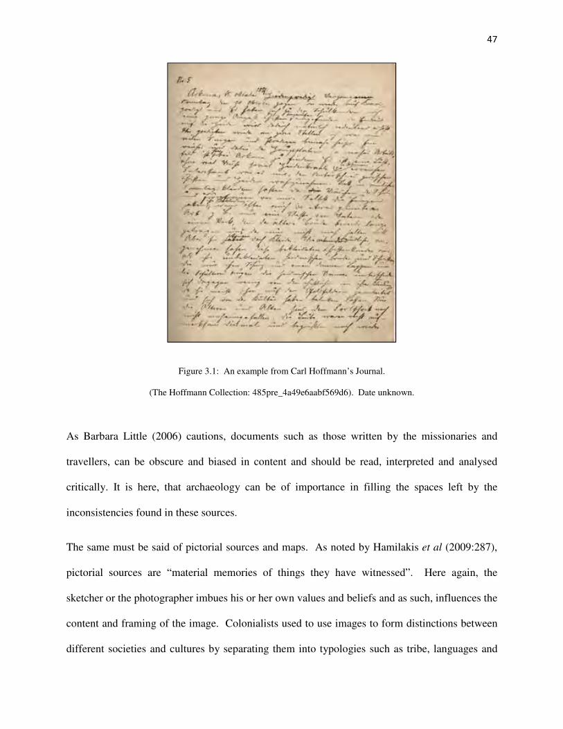
47
Figure 3.1: An example from Carl Hoffmann’s Journal.
(The Hoffmann Collection: 485pre_4a49e6aabf569d6). Date unknown.
As Barbara Little (2006) cautions, documents such as those written by the missionaries and
travellers, can be obscure and biased in content and should be read, interpreted and analysed
critically. It is here, that archaeology can be of importance in filling the spaces left by the
inconsistencies found in these sources.
The same must be said of pictorial sources and maps. As noted by Hamilakis et al (2009:287),
pictorial sources are “material memories of things they have witnessed”. Here again, the
sketcher or the photographer imbues his or her own values and beliefs and as such, influences the
content and framing of the image. Colonialists used to use images to form distinctions between
different societies and cultures by separating them into typologies such as tribe, languages and

48
racial types (Hamilakis et al 2009). Alan Kirkaldy (2005:145) in his research extensively
studied various missionary photographs of the Vhavenda. He states that one needs to learn “to
read missionary photographs as mirrors of mission ideology, to use them as guides to missionary
ideas of what is right and wrong, proofs of their ambivalence towards African cultures and –
more recently – as a privileged source for the study of material culture in African societies”. An
example of this concept can be seen in figure 3.2 below, where the missionary is portrayed as the
focused preacher and the learners being attentive and respectful to what they are being taught.
This photograph has been carefully composed, as this type of image would have been circulated
through missionary circles, as to demonstrate the good work that was being achieved.
Figure 3.2: A ‘typical’ missionary scene where the subjects are presented in an orderly and civilised
manner. (The Hoffmann Collection: 871scr_e2ee277a0f964fa). Circa 1930s.

49
During his tenure at Botshabelo, Alexander Merensky drew various maps, documenting the
spatial organisation of the mission station from its establishment onward. His drawings were an
important tool in the management of the mission station, in community planning, in addition to
showing the settler government that they were an organised and planned institution in the area.
Merensky was, in fact, a skilled mapmaker, assisting Jeppe in the production of the 1868 map of
the Transvaal (Carruthers 2003).
Maps can also be seen as statements of power and control. The maps drawn of Botshabelo and
the Motse were a means by which the missionaries expressed their ownership, power and control
of the land by demarcating how the mission lands would be distributed and utilised. Maps can
influence, support or amend social, political and historical contexts by managing the landscape
(Bendell and Harwood 2006; Duminy 2011). In this way the missionaries could manage the
physical landscape of the mission station. As Greenstock (1877:49) notes during his visit to the
mission station, the vast piece of land amounted “to five farms in one block, altogether thirty
thousand hectares”. These documents, pictorial and cartographic sources are significant in
placing Botshabelo and the Motse within the historical landscape.
In the following section the spatial information currently available is drawn from documentary,
pictorial and cartographic sources and used in order to reconstruct the establishment,
development and change in the mission village over time.

50
3.2 Botshabelo and the Motse in space.
Below are the satellite images for Botshabelo Mission Station, which is found on the farm
Toevlugt 269/JS (see topographical map in Appendix 1). The mission station is situated in a
valley with mountain ridges on either side at the confluence of two streams of the Klein Olifants
River. The first image (figure 3.3) is of the mission station itself and the church can be seen in
the shape of a cross in the centre of the image, with the Merensky parsonage on the left. The
assortment of school and commercial buildings can be observed. The rectangular walled area
observed was used for the growing of crops in earlier years. Fort Merensky (formerly Fort
Wilhelm) can distinctly be noticed on top of the hill to the east.
The prime significance of Botshabelo ultimately lay in its overall function as a successful
mission station. While emphasis is put on the official buildings comprising the main mission
station (Japha et al 1993), it is important that the surrounding environment should not be
neglected and should also be included within studies of and conservation plans for the greater
mission complex.
The second satellite image (figure 3.4) is that of the Motse, found on a grassy plain south of the
main mission station complex. The Motse is accessed by a road leading off the main dirt road of
the mission station and across the small Keerom stream. The individual homesteads with their
walled enclosures can be seen. These homesteads are currently in various stages of dilapidation
and only a fraction of the original village remains today. The Klein Olifants River can be seen in
the west and to the south of the village, which was important for both water and fertile soil for
agriculture.

51
Figure 3.3: An aerial view of the Botshabelo Mission Station complex.
(Satellite image from Google Earth Pro retrieved 2017).
Fort Merensky
Parsonage
1873 Church
Commercial buildings
Original school

52
Figure 3.4: An aerial view of the Motse.
(Satellite image from Google Earth Pro retrieved 2017).
The Motse
BaPedi Fort
Bakopa Fort ?
Graveyard
Agricultural
land
Klein Olifants River
Mission
Complex

53
3.3 Botshabelo and the Motse in time.
For the purpose of this research project, the relevant available published and archival material
will be applied to gain a clearer picture of the chronology of the Motse.
The earliest visual representation of spatial planning at Botshabelo is a sketch map dating from
the end of 1865 (?). Already on this map many of the distinctive features that have since
endured for 150 years at Botshabelo are indicated including the fort, graveyard and residential
areas. Early settlement on the Motse is indicated as taking the form of two villages. These are
labelled 14 and 15 on the drawing (figure 3.5) and named as Bakopastadt and Bapedi
respectively and represent the settlement of the groups of Bakopa and Bapedi who arrived in
tandem with Alexander Merensky in 1865. These two groups likely occupied different areas
because of pre-existing ethnic affiliations and existing political loyalties under the respective
leadership of individuals such as Rammupudu and Dinkwanyane.
This hand drawn map could have been sketched to describe the future planning for the mission
station. For example, the stippled outline of Fort Wilhelm suggests that it was still in the
planning stages or in the process of being built. Merensky was correct in assuming that the plain
was ideal for settlement, as it was nestled between two ridges and was next to the river, which
would be ideal for protection. The locale had an abundance of natural resources, such as rocks
and thatching grass for building. Furthermore, there was constant water available from two
springs located today as wells near House 11.21 and House 11.11 on the University of Pretoria
survey map, as seen in figure 3.16 and discussed in the survey section of this chapter. The
graveyard is found to the southeast of the Motse near the ravine leading to the river and is
marked as 16 on the map. The graveyard, as it is found today, is enclosed by a rectangular stone
wall and is divided into two separate sections. The old graveyard became too small and an

54
additional one was built next to it. The graveyard is one of the oldest structures on the mission
station and is an integral part of it. It is located quite a way from the main mission station
complex but is situated close to the African village (Pienaar 2014). Clearly visible at this stage
as well are the areas set aside for gardens for the residents living in the Motse area.
Figure 3.5: Hand drawn map of Botshabelo Mission Station (The Hoffmann Collection: 938scr_b305a1534b1c529).
Circa 1865.

55
Another of the first maps to have been drawn of the Botshabelo area dates to 1866 (figure 3.6).
This map illustrates the boundary line of the farm Boschoek, which Merensky bought to
establish Botshabelo. Of interest on the map, Merensky noted the names of the surrounding Boer
farmers. The farms to the east and west of Toevlugt have also been marked as not being worked
(platz unbeweknt). The two settlements of the Bapedi and the Bakopa are also depicted, as is the
graveyard.
Figure 3.6: A hand drawn map of Botshabelo by Merensky in 1866. (The Hoffmann Collection:
937scr_f20121729bbd1cf).

56
One of the first visitors to Botshabelo was Hermann Theodor Wangemann (Pakendorf 2011).
Missionary Wangemann became Director of the Berlin Mission Society in 1865, at the time of
the establishment of Botshabelo. He was very interested in the development of the South
African mission field and documented his findings through sketches and journals. The main
themes in his sketches are the landscape and the life of the mission stations. Wangemann was
one of the first to document Botshabelo and the Motse, when he visited the mission station in
1868. As can be observed in figure 3.7 below, there are huts erected along the ridge of the hill
with Fort Wilhelm on top for the safety and protection of the mission station. This indicates that
the earliest style of architecture was made of readily available materials and was quite transitory.
Because of this it is unlikely that any archeological evidence has remained. These dwellings
were replaced at a later date by stone buildings.
Figure 3.7: Fort Merensky and the first buildings at Botshabelo Mission Station (Wangemann 1868:384/385).

57
In figure 3.8, the grass domed huts of the Motse can be viewed on the grass plain, with the huts
visible on the hillside. This sketch shows primarily round structures in the villages which appear
to be organised around a central kraal. Very few square buildings are evident in the mission
settlement as a whole, except for the church and assorted mission structures that are described
and discussed by Wangemann in his documentation.
Figure 3.8: Fort Merensky on the hill with the mission station with the villages in the background (Wangemann
1868:208/209).
The map below was drawn in 1870 (figure 3.9), and concentrates on the physical landscape of
the area, which include, the ridges and the rivers. The drawing shows the bordering farms,
numbered on the map as A, B, C and D, and the year they were bought. For example, Farm A
was bought by Isaak de Jager in 1865. The numbers in the adjacent column specify the morgen,
a unit of measurement for area. In the centre of the diagram is Botshabelo with its church and

58
fort. This map, if compared to the satellite images in this document, is accurate and detailed and
already shows the general configuration of the mission station and its overall layout. The two
villages of the Bakopa and the Bapedi are indicated on the map, and are seen as part of the
greater mission station landscape. The mission station at this time was surrounded by Boer
farmers, who were not altogether happy with the presence of the mission and its inhabitants in
their midst. They feared that violence and resistance would follow the converts and followers to
the mission station during this time of internal instability in the area (Mminele 1983).
Figure 3.9: 1870 survey map. (The Hoffmann Collection: 936scr_140fef26b23642).

59
Alexander Merensky documented in detail the establishment, activities and accomplishments
taking place at the mission station in various letter, journals and in his book, written in German
Erinnerungen aus dem Missionsleben in Transvaal, 1859-1882, (Memories of Mission Life in the
Transvaal, 1859-1882), written and published in 1899.
Merensky writes in his autobiography about the events surrounding his arrival in the area and the
subsequent establishment of the mission station. He delivers a methodical narrative and the prints
throughout his book have been meticulously drawn providing significant details. The
lithographic print in figure 3.10 was drawn after 1873, when the new church was built and before
1882, when Merensky left the mission station. Fort Wilhelm’s size in the drawing is
exaggerated, together with the church and the school house, in contrast to the other structures,
thus emphasizing the permanence and safety of the community. The mission station is depicted
from the south with the church door facing the area of the Motse.
The drawing shows the Motse as having a combination of square and round structures, even
though at this stage there are predominately round huts with conical roofs, what are referred to as
“cone-on-cylinder” (rondawel) structures (Frescura 2008). Square stone-walled areas are
apparent in the image and were probably used for orchards, crops or animals, as grazing sheep
can also be seen in the foreground.
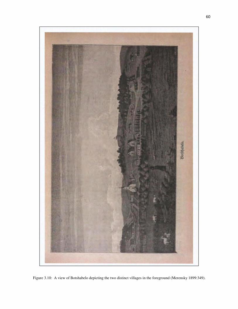
60
Figure 3.10: A view of Botshabelo depicting the two distinct villages in the foreground (Merensky 1899:349).

61
In 1877 Mr. Greenstock, a missionary from the Church of England visited Botshabelo. He was
very impressed by the way the station was being managed by Merensky, but was surprised by the
fact that the Berlin Mission Society missionaries were so poorly paid (Greenstock 1877).
Scarcely a year later in 1878, Edward Sandeman (1880) was also impressed by Merensky’s
accomplishments and the management of the mission station, especially with regards to the
construction quality of the buildings, and the fact that the local inhabitants were being trained as
ironmongers, wagon-makers and carpenters by the mission staff.
Sandeman (1880: 157) states in his text, that there was a “huge native village”, set aside from the
mission station. This was reaffirmed by General Wolseley (1880/1973), who at the time was a
veteran soldier with the British Army and who supervised the capture of Sekhukhune. He visited
Botshabelo in October 1879. The General describes the mission station as being quite a large
village that contained about 1500 inhabitants, with good school houses and a church that could
hold a congregation of 600 people. He saw the mission station as being a thriving establishment,
where many of the inhabitants had started to build houses out of stone and brick. He was
impressed with the neatness and cleanliness of the houses and the surrounding enclosed spaces
around them.
Figure 3.11 is Merensky’s last map of Botshabelo and its surrounds drawn in 1882. This map
can be seen as a representation of Merensky’s tendency to interpret the world in terms of
European values and experiences. His map is quite detailed with respects to the main mission
buildings and structures, such as the church and forts. There are two forts found in the Motse and
the cross-hatched areas on the map surrounding the two forts and along the hillside depict the
mission villages found on the mission station. These areas are not mapped in any detail and can
be seen as demarcating the separation of the main mission complex from the villages.

62
Figure 3.11 Merensky’s map of Botshabelo Mission Station (Merensky 1899:231).

63
The map also provides information on how the mission land was distributed and allocated for
various functions, such as farming and industry. The map clearly illustrates the various field
systems, already observed in Wangemann’s drawing (figure 3.8), where crops can be seen
growing in the enclosed area below the church and these field systems can also be seen in the
earlier maps (figures 3.6 and figure 3.9). Merensky (1899) describes the mission station as
having areas dedicated to the growing of mealies, millet, beans, sweet potatoes, pumpkin and
vegetables. Fruit trees were also planted, such as peach, apricot and lemon. There were cattle,
which provided fertilizer for the fields and sheep, as seen in the Wangemann’s sketches.
In Merensky’s diagram, there appears to be future planning for a grid-like pattern for the roads in
the villages and further expansion of the settlements. The mission station grew substantially
over the next few years and as Merensky states:
Botshabelo, developed more and more into a station of some significance, from where
expeditions could be mounted, and which provided safe retreat from the enemy should it
ever be needed (Merensky 1899:236 as translated by J. Stone 1992).
Merensky tends to talk about the mission station as a community, and he might have viewed the
villages as being attached to the mission station but also separate from it. However, even though
he was fully immersed in the management of the mission station, he was very much focused on
the religious, social and educational aspects of the residents of the mission station, which
stemmed from his Lutheran teachings and goals as a missionary.
By the time that Herr Wangemann returned to Botshabelo in 1886 (after Merensky’s departure),
the mission station had undergone drastic changes in the 20 years since his last visit and he
particularly describes the development of square houses. Wangemann as a result was very
pleased with the progress of the mission station as a whole (Le Roux and Fisher 1991).

64
All these accounts mention how impressed these missionaries, travellers and visitors were with
Merensky and his management of the mission station and the way the mission station was
arranged to identify itself with a European-style institution. The writers concentrate on what the
European missionaries had achieved. In contrast, very little is said in these sources about the
Motse and its residents. When the villages are mentioned they are described with words such as
‘cleanliness’, ‘neatness’ and ‘proper’ (Sandeman 1880; Wolseley 1880/1973). No mention is
made of the daily lives of the people who lived here. These descriptions can be viewed as a
separation between the missionaries and the residents of the villages. It is in these circumstances
that historical archaeology becomes important, as it provides a means to tell these narratives of
the forgotten.
The aerial photograph (figure 3.12) shows Botshabelo and the surrounding areas in 1943, 78
years after its founding. As shown in the earlier maps drawn by Merensky and the recent
satellite images, the church can be seen in the shape of a cross, with the parsonage next to it.
Fort Wilhelm (Fort Merensky) is again visible from the top of the hill behind the church,
together with various kraals for keeping sheep and cattle. As per Merensky’s 1882 layout of the
mission station, the top of the ridge was used for grazing and in the photograph good grazing
land is visible. Most of the mission buildings are located in a linear pattern along the hillside.
These buildings are all situated close to each other. The church and the parsonage are separate
from the other buildings and have open space around them. On the satellite image (figure 3.3), a
couple of new buildings are observed post-1943. Otherwise, not much has changed in the
general configuration of the mission station if compared with Merensky’s 1882’s sketch. With
regards to the Motse, however, the two different villages of the Bakopa and Bapedi cannot be
distinguished in the aerial photograph.

65
The agricultural fields described by Merensky in his book, can be clearly seen, as well as, the
orchard situated on the parcel of land found directly across the street from the church precinct.
The trees can be recognised as they are planted in rows. The agricultural land is positioned
between the main mission station complex and the village of the Motse. The two forts in the
Motse are well defined on the photograph, and can be found in the centre of the structures on
either side of the road transecting the village. It is evident from the photograph that there were
some substantial homesteads, mainly situated at the entrance to the village. Further back towards
the river, smaller homesteads and houses can be observed in a linear pattern along the roads.
These structures consist of both square and round shaped features. There are also two large
kraals (animal enclosures) erected near the river towards the graveyard. The graveyard can be
viewed at the bottom of the photograph. The graveyard was of significance to the mission
village, and as noted by Missionary Papke (1937), a teacher at the Seminary, a memorial was
held every year at the cemetery to celebrate and remember the dead.
There is an absence of documentary or pictographic sources pertaining to the spatial organisation
of the Motse in more recent years and the settlement was largely destroyed in the 1970s as a
result of the Apartheid processes. Botshabelo was designated a ‘Black Spot’ in 1970 and the
residents of the Motse were forcibly removed by 1972 (Japha et al 1993). As mentioned before,
many of the houses were bulldozed during the removals and the effects of this event are clearly
seen in the piles of stones and building rubble found at the Motse today.

66
Figure 3.12: Aerial photograph of the Botshabelo Mission Station and the Motse.
(National Geo-spatial Information. Aerial photograph 1:35000. No. 04826. Cape Town. 1943).
Agricultural lands
The 1873 Church
Fort Merensky
The Motse
The Graveyard

67
Another result of the forced removals are the white paint marks visible on a few of the houses,
for example, near the front door of Motse house 11.19 (figure 3.13). According to Le Roux and
Fisher (1991) these white marks were due to the actions taken by Mr. Peter Klaus and Mr. Hans
Gastrow, who ran across to the Motse, during the forced removals when the bulldozers were
demolishing the houses and started painting white S’s to depict that the houses were staff houses
and should be left alone. This is most probably the reason why there are still some houses left
relatively intact today.
Figure 3.13: Motse 11.19 with white paint marks still visible (Photo: Author’s own).
After the forced removals, Botshabelo was used as a teaching college until 1979 and then
became an open-air museum and nature reserve. At this time the site attracted academic interest.
The study conducted in 1991 by Schalk Le Roux and Roger Fisher from the University of
Pretoria was an architectural survey of Botshabelo, and particularly, of the Motse. This was part
of a project to restore the Motse to its original condition commissioned by the then Middelburg
Municipality. The study comprises of descriptions and sketches of the various houses and their

68
relevant condition, as they were at that time. There is also a site plan of the Motse (figure 3.16)
that assisted in the subsequent survey discussed in the following section. This site map was
originally drawn up in November 1980 by the then Transvaal Museum Services. The UP survey
team made use of the same numbering system as the original site map to keep the information
consistent. This information is significant as the site has deteriorated considerably in the past 25
years.
3.4 An overview of Botshabelo and the Motse in space and time.
At its establishment, the original houses of the Motse were pole and reed dwellings together with
grass domed huts, which evolved over time into stone, brick and plaster structures with thatched
and/or zinc roofs, of which a few remain at Botshabelo today (Frescura 2008). These houses and
their architecture, together with the associated material culture can be seen as being expressive of
the social and cultural values of the people who built and used them. This research can add
meaningful information regarding how the inhabitants of the Motse lived, especially with the
lead up to the forced removals in the 1970s. These missionaries, it can be said, measured their
successes by the noticeable changes seen, in particular with respects to the architecture and the
settlement patterns of the villages surrounding their mission stations (Comaroff and Comaroff
1997; Japha 1993; Kirkaldy 2005; Vernal 2012) as did contemporary visitors and observers
(Sandeman 1880; Wangemann 1886; Wolseley 1880/1973).
The photograph below (figure 3.14 - date unknown) depicts both huts and square built houses in
the Motse. The change from round to rectangular dwellings is a general research problem within
the southern African context due to the changing educational, social, political and economic
circumstances occurring within the country at the time. This photograph suggests that the
architectural transition was a gradual one, and even though there is no distinctive separation of

69
the two sections of the villages conveyed in the photograph, the notation at the bottom of the
photograph still indicates the two sections (Bakopa and Bapedi), as discussed in the various
documentary sources of Merensky and Wangemann, indicating that the settlement may still have
been divided along lines of ethnic affiliations.
Figure 3.14: A photograph of the Motse (The Hoffmann Collection: 590scr_92808254c55c84e). Date unknown.

70
Today the Motse can barely be described as a village, and it is difficult to notice any differences
in the architecture of the various houses and homesteads still visible in the area, as there are only
remnants in existence today. As stated by Sandeman (1880:157) in the previous section, he
noted when he visited Botshabelo in 1878; there was “a huge native village”. This was a few
years after Johannes Dinkwanyane of the Bapedi left the mission station with a small group of
converts in 1873. Subsequently there was another departure of a further group in 1892. This
could have been the reason that the two villages eventually merged to form one large village.
Naude (2007) observes in his research, that the original grass domed huts, which were common
in the region at the time (as seen in Wangemann’s and Merensky’s sketches), were replaced by
walled structures with cone-on-cylinder dwellings, as seen in figure 3.15. It is these structures
that eventually made way for the rectangular stone walled and thatched roof houses found at the
Motse today. As mentioned before, this transition in architectural styles occurred gradually over
a period of time and was not always simple and sometimes the various architectural forms were
combined in one homestead.
Through the above discussion of documentary, pictorial and cartographic sources what becomes
evident is that there is considerably more to investigate regarding the chronology of the Motse.
The settlement has changed noticeably from the first pole and reed huts at the mission station’s
establishment in 1865 to what became Merensky’s European-style institution. It developed into
a mission settlement, as described by Japha et al (1993), one that had its homesteads and houses
grouped not too far from the mission core, that of the church, the school and the other functional
buildings belonging to the mission station that benefitted all those that lived in the area. It must
be noted that the Motse’s development was a gradual one and that transition of the house
structures from round to rectangular appears more time related than associated with conversion.

71
It can be said, that the changing economic, educational and social contexts of the inhabitants of
the Motse had as much to do with such transitions, as did religious conversion and as such, it
may, in part, be a generational shift. This is a question that needs further investigation.
From the sources consulted in this chapter, it took at least a decade for the commencement of the
transition in the architecture and settlement layout that the missionaries sought and prayed for.
Figure 3.15: An early sketch of the Motse homesteads (The Hoffmann Collection: 928scr_f61a809c95dc966).
Date unknown.
The documentary/pictorial and cartographic material was significant to this project. However,
another important aspect was the carrying out of a foot survey of the Motse. In terms of this
project, an archaeological survey may be explained as the “systematic attempts to locate, identify
and record the distribution of archaeological sites on the ground and against the natural
geographical and environmental background” (Fagan 2001:528). An archaeological survey is
the methodical process by which archaeologists collect information about the location,
distribution and organisation of past cultures across a large area.

72
The survey will be discussed below, introducing the methodology used and results obtained, that
ultimately contributed to the next stage of the field work, that of archaeological excavation.
3.5 The survey of the Motse.
The survey was the starting point for the fieldwork carried out on the Motse. The survey was
undertaken with the research aims in mind, to refine the understanding of the settlement and the
architectural change over time of these homesteads and the way in which the inhabitants of the
Motse interacted with the community as observed through the material culture of the households.
Before starting the actual fieldwork, the existing information in the forms of maps, photographs
and drawings were reviewed as discussed above. Included in this was an assessment and study
of the previous survey conducted by the University of Pretoria’s Architectural Team in 1991
(figure 3.16: Le Roux and Fisher 1991). This survey was important in understanding the
orientation of the site and the information was used in conjunction with this current research to
assist in the investigation of the chronology and the settlement layout. For the purpose of
continuity, the same numbering system was used. The first house numbered on the site plan of
the Motse is house number 11.2. The University of Pretoria’s team surveyed the village moving
from west to east and documented 32 extant structures of various sizes. Two of these are water
wells numbered 11.11 and 11.21, with 11.9 being a fort and 11.16 being the other possible fort
depicted on the historical maps and visible in the aerial photograph. All the other structures were
either houses or out buildings, such as kitchens and outside toilets. However, in the original
survey conducted by the architectural team, only the most intact houses, that is, the houses
marked on the site plan were systematically documented. The area seen in the aerial photograph
(figure 3.12) towards the graveyard is littered with ruins that were not originally surveyed and
documented by the UP survey and are marked on the map as question marks (?).

73
Figure 3.16: A Copy of the Area Plan used by the UP Architectural Team in 1991 (Le Roux and Fisher 1991).

74
The 2013 survey was conducted during the annual UNISA Archaeological Field School, held at
Botshabelo Mission Station from the 3rd
to the 10th
August 2013. It was decided to carry out the
survey during the Field School, as at this time of year (winter) the grass is usually burnt or short,
which assisted greatly in the visibility of features and structures. There were also students to
assist with the actual legwork which contributed to their training in archaeological methods.
A judgmental survey was conducted on the site of the Motse and the greater Botshabelo area.
The survey provided a practical way to assess which of the homesteads would have the best
potential for excavation and where the most suitable areas for possible middens found. The
survey also concentrated on the intact houses of the Motse, and as most of the houses in the area
have been bulldozed during the forced removal large areas of the site was not plotted (as seen in
figure 3.17). As the intent of the survey was to provide adequate information that would prepare
for excavation, documentation and collection of archaeological cultural material for the study
and analysis of two (2) houses of the Motse, it was decided before the survey began that two
potential sites would be chosen, one in the east and one in the west of the village, to remain true
to the literature as discussed in Chapter 3. As a result, the survey assisted in the collection of
data about the site, the distribution and organisation of these homesteads.
The 2013 foot survey began by becoming familiar with the University of Pretoria’s architectural
teams’ survey map of the Motse. To keep the data consistent, the survey commenced on the west
side of the site, closest to the Klein Olifant’s River and walking to each intact house in this area,
they were surveyed and documented following the UP Survey method. Waypoints for the
different houses were collected using a hand held Global Positioning System (GPS) as plotted in
figures 3.17 and figure 3.18.

75
The first satellite image (figure 3.17) is that of the foot survey carried out in the Motse, starting
from the main road entering Botshabelo in the south and walking north towards the village. The
plotted areas can be seen to the west and then to the east of the village. The second satellite
image (figure 3.18) is that of the extensive foot survey done of the greater Botshabelo/Motse
area, which assisted in providing a more comprehensive picture of the landscape. This however,
was difficult because of the distances experienced between the main mission station complex, the
Motse and the property as a whole. The surrounding terrain became challenging due to the steep
and rocky topography.
Most of the extant houses found in the Motse today are rectangular, with house number 11.25
also having a cone-on-cylinder type structure within its boundary walls. This structure is found
to the back of the property.
Concerning the architecture of the structures of the Motse, structure 11.9 has been identified as
being one of the forts depicted in the cartographic sources, especially Merensky’s 1882 map.
These forts were constructed in historic times to provide security and protection to those living in
the villages at a time when the inhabitants feared reprisals from Sekhukhune (Delius 1981).
There is not much of this fort remaining today, as most of the structure has deteriorated and
collapsed. These ruins have some remnants of characteristic thicker walls and a small round
structure with loop holes, as seen in figure 3.19 and figure 3.20.
The second fort is possibly the structure identified in the University of Pretoria’s survey as
11.15, 11.16, 11.17 and 11.18. Structure 11.15 has totally collapsed, with a fallen wall in the
north east corner of 11.16 possibly being the remains of a round bastion. The surface scatter
around this area is prolific.

76
Figure 3.17: The GPS tracking of the foot survey of the Motse (August 2013).
Motse House 11.25
Motse House 11.7
Botshabelo Mission Complex

77
Figure 3.18: The GPS tracking of the foot survey of the greater Motse area. (August 2013).
Graveyard
The Motse
Klein Olifants River
Botshabelo Mission
Animal enclosure

78
Figure 3.19: A photograph of the Fort (Motse 11.9) with a loop hole (Photo: G. Booth).
Figure 3.20: The thicker wall of the Fort can be clearly seen. (Photo: G. Booth).

79
As mentioned above, it became evident during the foot survey that there was a fair amount of
surface scatter littering the entire site. These included various glass sherds and glass bottles of
various colours, as well as, various types of ceramics and metal as seen in the figure 3.21 below.
Possible middens were also identified during the survey.
Figure 3.21: A sample of the types of surface scatter found during the 2013 survey (Photo: Author’s own).
As pointed out previously, these houses have deteriorated quite significantly in the last 25 years,
as can be seen in figures 3.22, 3.23 and 3.24. As viewed in the photographs, the materials used
in the construction of the outside walls, the verandah walls and the boundary walls are all local
undressed stone. The stones were neatly packed, especially the houses’ external walls. These
walls were unplastered. The roofs were made of thatch with trusses made of poplar wood poles
(Le Roux and Fisher 1991:7 translated from Afrikaans by the author). The windows and doors
were well built and were plastered and painted white in a decorative style. Floors were initially
traditional mud floors, which were eventually covered with cement, as observed at house number
11.25.

80
Figure 3.22: Motse 11.25 as surveyed by the UP Architectural Team and by the researcher in 2013.
(Photographs on the left are from Le Roux and Fisher 1991 - photographs on the right: author’s own).
Figure 3.23: Motse 11.25 as surveyed in 1991 and then during the field work in 2013.
Figure 3.24: Motse 11.25 as surveyed in 1991 and then during the field work in 2013.
(Note how the buildings have deteriorated).

81
Figure 3.25: The wrought iron grave markers found at the graveyard. (Photo: Author’s own).
The foot survey was completed with an inspection of the graveyard. The graveyard is situated
approximately one kilometre from the church in the main mission station complex and was
probably placed at the outer border of the settlement due to the lack of suitable space around the
church. The graveyard was only used by the missionaries and the residents of the mission
settlement and presumably only includes those who had converted to Christianity (Pienaar 2014).
There are numerous headstones in the shape of metallic crosses belonging to some of the
missionaries and their families who died at Botshabelo, as seen in figure 3.25. There is a sharp
contrast between the elaborate European-style grave markers found at the entrance of the
graveyard and the many stone packed graves, some with modest headstones but most of the
graves are unknown (figure 3.26).

82
Figure 3.26: A photo of the unmarked stone cairns found in the graveyard. (Photo: Author’s own).
It became apparent during the survey that at some point there was an attempt to establish the
houses of the Motse in a grid-like pattern along the main roads found in the village. Merensky’s
1882 sketch shows a grid pattern in the area of the Motse and these roads are still visible from
north to south on the aerial photograph of 1943. In the photograph, clear linear rows of houses
and homesteads can be seen. These houses and homesteads seem to spread out from the main
access road to form little clusters between the roads in the village. It must be said, that not much
of this is evident today due to the destruction caused during the forced removals and most of the
evidence of a grid-like pattern has been destroyed. But it is mentioned in the various travel
journals that the village was found to be neat and orderly (Sandeman 1880; Wolseley 1880).
With regards to grid-patterns, the architectural team mentions that there is a diagonal road
leading from house number 30.1 to homestead 11.25, and that this road is older than the straight
roads found in the village. This fact could not be corroborated during the 2013 survey or in any

83
of the other sources. This road could simply be a cattle track used by the present inhabitants of
Botshabelo.
The foot survey of the Motse unfortunately did not contribute any additional information to that
already provided by the UP architectural survey. However, what has become apparent is that the
site has deteriorated since 1991 and is continuing to do so. A more detailed survey of the village
is needed, one that will include all the relevant structures and ruins visible so as to give a better
picture of the spatial landscape of the Motse.
The foot survey was thus, the first step in this research and provided the introduction and
orientation necessary, to lay down the foundation for the excavations that followed.
Figure 3.27: The terrain surrounding Botshabelo and the Motse (Photo: Author’s own).

84
Figure 3.28: Sketched map of the survey area in 2013 based on the UP study of 1991 showing the two selected
excavation sites. (Sketch not to scale).
(Drawn by: C.R. Booth).
Graveyard

85
CHAPTER 4: THE ARCHAEOLOGY OF THE MOTSE: THE FIELDWORK
The following is a discussion of the excavation undertaken at the Motse (figure 4.1.) The
objective of the excavation was to excavate midden deposits associated with two households, the
analysis of which would allow a clearer picture to emerge of the residents who lived in these
homesteads. The excavation, although limited in scale, yielded useful material culture that
provided valuable information regarding the houses and the households of the Motse. The
accompanying maps provide only a rudimentary introduction to the two loci discussed. Further
mapping was planned for the 2015 excavation season but due to personal circumstances this was
unfortunately not accomplished.
Figure 4.1: The Motse today (Photo: N. Swanepoel).

86
4.1 The excavation:
After the completion of the 2013 survey, it was determined that midden deposits related to two
homesteads would be excavated and analysed, one homestead each from the east and west of the
village respectively would be compared. With regards to this project, a midden can be described
as being a concentration of discarded cultural debris (Licence 2015).
There are many different definitions concerning what an excavation is (inter alia Fagan 2001;
Greene and Moore 2010; Renfrew and Bahn 2008). However, for the purposes of this research,
an excavation can be defined as “the disturbance of the ground in archaeologically controlled
conditions, may be needed to reverse the burial process” (Roskams 2007:1). It is through
careful excavation that the chronology, the consumption and the spatial organisation of the
relative households can be examined. So the aim of the excavation was to identify, define,
uncover, date and, by understanding the transformation processes, interpret each chosen
archaeological context on the site (Green and Moore 2010; Roskams 2007).
Excavations took place during the annual UNISA Archaeological Field School held from the 3rd
to the 10th
August 2014. Winter is usually the best time to excavate this area, as the grass is
shorter and/or burnt. This assists in the visibility of the outlines of the various structures.
During this period, there is also the unlikely chance of heavy rain in the interior of the country,
which can make excavating difficult and problematic.
There were 26 students in attendance who were divided into three different teams working in
three different areas around the Botshabelo Mission Station complex. Two of these teams were
working on the houses that were identified for excavation in the Motse. The first homestead that
of Motse 11.7, colloquially named by the students as ‘Pylon’, is found in the western section of

87
the village and the second house, Motse 11.25 named ‘Lemon Tree’ in the eastern part. These
houses are numbered on the survey map (figure 3.27). These two homesteads were chosen
because of their positioning in the village and their associated middens. There was also a lot of
surface scatter observed in the vicinity of these homesteads during the initial survey. The first
locus Motse homestead 11.7 consists of two stone structures, a small garden, an outside bread
oven and two kraals. In contrast, Motse homestead 11.25 has four rectangular and one cone-on-
cylinder structure. This homestead is enclosed by a small stone wall. Presently these structures
are in various stages of dereliction and collapse.
The main objective of the excavation was to identify the chronology of the occupation of these
households and to investigate the household economies of two Motse households within their
broader historical context.
4.1.1 Motse homestead 11.7 – ‘Pylon’:
Motse homestead 11.7 is found in the western part of the village, not far from the Klein Olifants
River. This homestead includes two distinctive structures, of which one is the main house, as
seen in figure 4.2, and the other, a small square structure attached to the back of the main house.
The main building faces north towards the mission station and the church. There are also two
smaller ruins found within the homestead area, which are possibly smaller outbuildings but are
most probably kraals (animal enclosures). All of these buildings were built of stone, which is
endemic to the area and the main house was originally plastered on the inside, as is evident from
the remnants visible in the inside left-hand corners of the main room.

88
Figure 4.2: Motse house number 11.7 (Photo: Author’s own).
Presently, these buildings are in various stages of collapse, and nothing of the thatch roof
remains. The stone masonry is very neat. There are five window cavities and three doors, one in
the front and two in the back. The windows and door frames have been plastered and painted
white, as seen in figure 4.2.
The main house is the largest of all the structures and is 11.64 metres in length and 9.56 metres
at its widest. It has one room in the interior at present; however, this could have been two rooms
as there is still evidence of the anchor bricks. There is a second building attached to the main
house that could perhaps have been the kitchen as seen below in figure 4.3. This structure can
also be seen on the floor plan in figure 4.9.

89
Figure 4.3: Motse homestead number 11.7 with the attached back structure (Photo: Author’s own).
The excavated midden is located at the southwest side of the homestead, in what appears to be
the backyard. It is here, that the outdoor oven (figure 4.4) is found, together with two kraals. A
garden path leading from the back door to the area of the outdoor oven can also be seen.
The midden is found between a smaller round structure to the south and a heap of collapsed
rocks facing north. The midden is approximately three metres long by two metres wide and has
taken the shape of a small hill, as seen in figure 4.5.
After the site was cleared, so as to see the structures and the surrounding area better, a site grid
was established and a trench was laid out for excavation. This was set up one metre on the
north/south and two metres on the west/east axis, so as to ensure that the grid lay lengthwise
across the top of the midden.

90
Figure 4.4: The remains of the outdoor oven. (Photo: Author’s own).
Figure 4.5: One of the two round structures with the midden visible to the right of the photograph
(Photo: Author’s own).

91
Figure 4.6: A view of Motse homestead 11.7 from one of the bulldozed houses (Photo: Author’s own).
The squares were labelled M20 and N20 and were excavated in arbitrary levels of ten
centimetres. Square M20 obtained a final depth of 80 centimetres, when the soil colour changed
to a dark brown and bed rock was reached. This square proved to be rich in material culture
including glass, ceramic and metal. Square N20 was excavated to a final level of 30 centimetres.
Unfortunately, the square had been compromised by an animal burrow in the north east corner
and was subsequently closed. The grid was subsequently extended to include squares P11 and
Q11, which were the site of another potential midden. This midden is found to the northwest,
next to the small structure attached to the main house. P11 was excavated to a level of 30
centimetres and this square contained a sizeable amount of material culture. Due to time
restraints Q11 was not excavated. In total 1.4m³ of soil was excavated from the three squares at
Motse homestead 11.7.

92
Figure 4.7: North profile of M20-N20.
Figure 4.8: Northern profile of P11.
Prepared by C.R. Booth.

93
Figure 4.9: Floor plan of the main house of Motse 11.7 based on Le Roux and Fisher (1991).
Prepared by C.R. Booth
Window
N
Main door
Motse 11.7
Structure 1
Structure 2
Window
Window
Window
Window Window
Not to scale

94
Figure 4.10: Motse homestead 11.7 locus map prepared by C.R. Booth
N20 M20
P11
1 metre
N
Rocks
Not excavated
area
Back wall of House 11.7
Round structure Round structure
Excavated area
Q11

95
4.1.2 Motse homestead 11.25 – ‘Lemon Tree’:
Motse homestead 11.25 is found in the south eastern part of the village. This homestead consists
of four rectangular buildings of various sizes and one cone-on-cylinder structure, at the far end of
the site near an animal kraal (enclosure). This group of structures appear to be well organised.
These structures are all built of stone and have evidence of being plastered in the past. The
largest of the buildings is the main house, as seen in figure 4.11. It is 9.77 metres in length and
7.38 in width and has three rooms, as can be seen on the floor plan in figure 4.17. Their function
appears to be living areas and maybe a kitchen at the centre as there is evidence of a fireplace.
Only the room to the left, as observed from the front door, still has a cement floor. There is
another structure adjacent to the main house which suggests that the homestead was enlarged at
some point (figure 4.13).
There is also another outside building found south of the main house towards the round structure
as seen in figure 4.14. This structure is 8.23 metres long by 3.68 metres wide. The only window
of this stone structure is covered by chicken mesh. The function of this building could not be
determined.
There is also a small round structure found in the south of the homestead, which appears to be a
cone-on-cylinder type structure (figure 4.15). This cone-on-cylinder structure has a diameter of
4.45 metres and is enclosed within the small boundary wall. As with Motse 11.7, these structures
were also in various stages of collapse. These structures are also built of stone and no evidence
of the thatched roof remains.

96
Figure 4.11: The main house of Motse homestead 11.25 (Photo: Author’s own).
Figure 4.12: Interior of Motse 11.25 with the white plaster and the remnants of a fire place. (Photo: Author’s own).

97
Figure 4.13: The second structure adjacent to the house of Motse 11.25 (Photo: Author’s own).
Figure 4.14: The outside building found south of the main house. (Photo: Author’s own).

98
Figure 4.15: The cone-on-cylinder structure attached to Motse house number 11.25 (Photo: Author’s own).
The midden associated with this homestead is found to the west of the main house. This midden
was fairly flat and widespread in an area of approximately ten metres. After clearing this site
from east to west, all surface material in the designated area was collected and documented. A
grid was set up running north to south in four by one metre squares (4 x 1).
These squares were labelled: K12; K13; K14 and K15, as referred to on the site map. Excavation
began in the ashy areas of K12 and K13. These squares were also excavated in arbitrary levels
of ten centimetres. It became evident that there were large rocks present together with gravel
inclusions that made excavating difficult. This was most probably collapsed walling from the
homestead. A level of 20 centimetres was reached in K12 and 30 centimetres in K13.
The grid was extended to the west, and the students began excavating in squares labelled L12
and L13 in ten centimetre levels. Square L12 attained a level of 30 centimetres, as did L13.

99
Excavation in these squares was abandoned when it became apparent that they had been
disturbed by animal activity. The excavation moved onto square L14 and a depth of 20cm was
reached with very little cultural material being uncovered. The grid was further extended to
include square L11. There were more large rocks present here that could be part of the collapsed
walling. Only a depth of 20 centimetres was attained. At the completion of the excavation,
1.4m³ of soil was removed from the seven squares at Motse homestead 11.25.
The excavations, as well as, all the excavated cultural material were thoroughly documented on
site and the artefacts carefully bagged and labelled, ready for the laboratory. The fieldwork thus,
comprised of methodical planning, surveying, excavation and collection of archaeological
material, recording and documentation in the form of field notes, photography and drawings
including stratigraphy. The above must all be done meticulously, as excavation techniques
influence the results.
Figure 4.16: Motse house 11.25 excavation area with one of the students (Photo: Author’s own).

100
Figure 4.17.: Section drawing of the west wall of L14, L13, L12 and L11.
Figure 4.18: Section drawing of the south wall.
Prepared by C.R. Booth

101
Figure 4.19: Floor plan of the main house of Motse 11.25 based on Le Roux and Fisher 1991).
Prepared by C.R. Booth
Front yard
Window
Window
Motse 11.25
Structure 1
Structure 2 Backyard wall
Front door
Low garden wall
N
Not to scale

102
Figure 4.20: Motse 11.25 locus map prepared by C.R. Booth
Motse house 11.25 west wall
Small boundary wall
K12 K13 K14 K15
L11 L12 L13 L14
N
1 metre
Excavated area
Rocks

103
Figure 4.21: Positions of excavated sites.
(Satellite image from Google Earth Pro retrieved 2017).
Motse 11.7 Motse 11.25
Main road towards the mission complex
Graveyard

104
CHAPTER 5: THE TWO HOUSES OF THE MOTSE: THE ANALYSIS
The research of the Motse is set within an historical archaeological context, with its aim to refine
the chronology of the architectural and cultural changes in this section of the mission station,
through the analysis of the combined material sources and cultural material excavated. This will
assist in determining how the residents interacted within the mission community and provide
information on their daily lives by investigating the households and their consumption patterns.
As discussed in the previous chapter, two houses of the Motse were excavated. The cultural
material associated with both houses, Motse 11.7 and Motse 11.25, consisted primarily of
ceramics, glass fragments and glass bottles of various colours, metal artefacts, plastic items and
house fragments. However, before discussing the analysis of the selected cultural material, it is
important that a brief description of the laboratory protocols that were followed be given. It is
vital that the archaeological context that was so carefully recorded in the field be preserved
throughout the laboratory procedures. The Oxford English Dictionary for Students (2006:819)
defines protocols as being “the formal record of scientific experimental observation”. It is the
standard operating procedures, a list of instructions to perform an experiment or to do an
analysis. Such protocols are also used in the processing of artefacts after an excavation. These
artefacts need to be sorted, cleaned, labelled and catalogued, identified and classified, measured,
photographed and drawn.
The material culture excavated from the Motse was sorted into artefact classes, namely glass,
ceramics, metals, beads and plastic for example. A total of 33 individual categories were
classified, as seen in Table 5.1.

105
These artefacts were then carefully sorted and cleaned and recorded on the Field Inventory Form
(Appendix 2). The artefacts were then labelled and catalogued. A catalogue number was
assigned to each find. The catalogue number includes the site name and number/the house
number/the artefact number. For example: TGVT269/11.7/01.
A unique number is given for special and small finds and these include the site name and
number/the house number/the square name/the level/the artefact number. An example of this is
TGVT269/11.25/K12/0-10cm/01. All of the catalogue numbers were recorded on the Catalogue
Forms (the complete Motse Artefacts Catalogue can be found on disc in Appendix 3).
Figure 5.1: Some metal artefacts that have been cleaned and sorted, waiting to be labelled and catalogued.
(Photo: Author’s own).
The most important point to note here is that “there are no two bags of artifacts in the world that
have the same set of identifying numbers” (Ortman et al 2005:5). In total 3018 bags of artefacts
were labelled and catalogued during the laboratory efforts on the houses of the Motse. It was
decided that the analysis for this project would focus primarily on the glass and ceramics, as

106
these assemblages would contribute in determining the chronology of the deposits of these two
houses of the Motse, as well as informing on the consumption of household members. The
buttons were analysed for comparative purposes. Analysis is therefore used to identify the
attributes, function, form, date/age, manufacturing methods and material types of the relevant
cultural material retrieved (Ortman et al 2005).
With respect to the glass analysis, the glass pieces were examined by studying the colour, rims,
lip, body and bases. During the ceramic analysis the attributes of fabric, form, decoration,
technique of decoration, colour and pattern were studied. Buttons were analysed for comparative
data.
At the time of this research, the metal assemblage was being analysed by an Honours student,
Yolandi Adams, as part of the greater Botshabelo Mission Station project. Future research will
be carried out on the faunal and botanical materials, as well as, the beads and plastics.
Figure 5.2: The buttons being labelled and catalogued. (Photo: Author’s own).

107
Table 5.1: The presence or absence of types of cultural material and its association between the
houses of Motse 11.7 and Motse 11.25.
Artefact category: Motse 11.7 Motse 11.25
Brick x
Batteries x x
Lime samples x
Fauna x x
Flora x x
Slate samples x x
Metal/tin cans x x
Ceramics x x
Glass x x
Local ceramics/pottery x
Dagga x x
Wax x
Upper grinding stone x x
Human teeth x
Chalk x
Shell x x
Concrete x
Toothpaste tubes x x
Cardboard x
Cork x
Leather x
Ochre x x
Buttons x x
Beads x x
Foil x
Fabric x x
Plastic x x
Rodent nest x x
Rubber x
Plaster x
Carpet x
Labels x
Skin lightening cream x

108
5.1 Glass.
Before the analysis, all the glass fragments were washed and sorted according to house, square
and level. Each of the diagnostic glass pieces were assigned their own catalogue numbers but
the undiagnostic glass was consigned to a sample, for example, all the undiagnostic clear glass of
the same square and level was counted and the sample bagged and assigned a catalogue number.
With regard to the analysis of the glass excavated from Motse 11.7 and Motse 11.25, the intact
vessels together with the glass fragments were examined taking bottle type or function, rim, lip,
body, base, mould seams and colour into consideration. A total of 1595 glass pieces (both intact
and fragmented) were counted and analysed for Motse 11.7 and 1136 for Motse 11.25.
The two households were analysed individually and will thus be discussed separately.
The analysis revealed that the glass vessels found at the homesteads of the Motse, included beer
and alcohol bottles, preserve jars, medicine and cosmetic vials and jars, as well as, household
containers used for poisons and disinfectants for cleaning. This glass is of various colours such
as blue, green and brown but clear glass was the most common. There were also tableware
sherds, lighting and window glass found.
5.1.1. The glass of Motse homestead 11.7.
Few individual complete bottles and distinctive pieces of glass were excavated. As most of the
glass found at the site was fragmented, these complete bottles and distinctive pieces can provide
useful information. A number of complete bottles were recovered, including alcohol (wine and
beer), food containers (sauce bottles and preserve jars), as well as, cosmetic and medicinal jars.

109
These complete bottles had makers’ marks, such as the soda mineral bottle with “The Property of
Sparkling Mineral Water Works Middelburg TVL” embossed on it, an ink pot with the name
‘STEPHENS’ and a sauce bottle with ‘TOMANGO’ embossed on it. One of the fragments is an
oval clear glass bottom with ‘TALANA’ marked on it. A circumstance that developed from the
aftermath of the First World War was that South Africa began to manufacture and produce its
own products. This made the country more self-sufficient, as observed in the development of the
glass industry by Lastovica and Lastovica (1990). TALANA Glass, which was established as
Glass Limited in 1917, marked the bases of their early bottles from 1928 with TALANA and a
letter that indicated the year of manufacture until 1952. After 1952, the bottles were marked
with a triangle and code letters to indicate the date that the batches of bottles were manufactured
(Dale Lewis pers. comm. 29 August 2015).
Most of the intact bottles from Motse 11.7 are clear in colour, except for one brown beer bottle
and one blue medicine bottle. In South Africa, coloured glass started making an appearance in
1928, and was used for descriptive purposes (Coetzee 2012). For example, blue glass was
mostly used for medicine or poison bottles. According to Mackay (1984), glass medicine bottles
starting making an appearance in the 1600s but it was really only in the latter part of the 1800s
with the emergence of patent medicines that these types of medicines became popular for use in
remote areas. All the complete bottles and jars are machine-made and have either screw or
crown tops as closures. There are two medicinal bottles that have stoppers as closures. The
alcohol bottles, the jars, two of the sauce bottles and a medicine bottle all have round bases. The
ink pot, the sauce bottle and the blue medicine bottle all have oval bases. The glue bottle with a
rubber dropper is square and the ‘TALANA’ fragment is oblong in shape.

110
All of these complete bottles are modern, as the mould markings reflect a seam running from top
to bottom in a straight line and through the lip, and are, therefore, modern glass mostly date after
the 1920s. The LENNON medicine bottle has the maker’s mark 4T49, which places this bottle
in 1949. It is very difficult however, to try and date bottles according to the various numbers
found on the bases as these are more often than not batch and registration numbers (Lastovica
and Lastovica 1990; Lewis 2014). Lennon Limited was founded in Port Elizabeth in 1850 by
Berry Grey Lennon, a pharmacist. It was only after his death in 1877 that the company
flourished, and in the 1930s it became the largest pharmaceutical company in the southern
hemisphere and is still in existence today (Coetzee 2012).
A couple of complete cosmetic jars but mostly fragments representing CHESEBROUGH and
PONDS products were also recovered. Chesebrough Manufacturing Company produced
petroleum jelly or Vaseline. It was founded in 1859 by a chemist who was interested in using oil
products for medicinal purposes. Chesebrough named his product Vaseline from the German
word for water (wasser) and the Greek word for oil (olion). His product was first patented in the
United States in 1872 and in England in 1877. Chesebrough Manufacturing Company was
distributing its products throughout the States and England by the early to mid-20th
century
(Pelser 2013). Ponds cold cream was developed by a pharmacist, Theron T. Pond of the United
States in 1846 as “Ponds Golden Treasure”. Then in 1886, the name was changed to “Ponds
Extract”. It was however, only in 1905, that “Ponds Cold Cream” emerged (Coetzee 2012).
Then in 1955, Chesebrough merged with Ponds Cream and in 1987 the company was acquired
by Uniliver (Pelser 2013). The jar, as seen in figure 5.4, has both names on the base, it most
probably post-dates the merger in 1955.

111
With regards to Coca-Cola, the soda made its debut in the 1880s as a syrup and was sold by the
glass in pharmacies or as they were known in America – drug stores. It was in 1916, during the
First World War that the trade mark hobble skirt design made its appearance (Orser 2004). As
seen in figure 5.5, the Coca-Cola bottle fragment has white decal lettering first introduced in
1957.
Figure 5.3: Bottom of a TALANA bottle. Figure 5.4: Chesebrough cosmetic jar.
Figure 5.5: A fragment of a Coke bottle. Figure 5.6: Embossed sparkling water bottle.

112
Figure 5.7: A Lennon medicine vial. Figure 5.8: A Ponds Cold Cream jar.
Figure 5.9: Glue dropper bottle. Figure 5.10: Stephens Inkwell.
(Photos: Author’s own).

113
Table 5.2: Maker’s marks from Motse 11.7.
Maker’s marks from Motse 11.7 NISP n=
Property of Sparkling Mineral Water Works Middelburg TVL
STEPHENS Inkwell
TOMANGO
PONDS CHESEBROUGH
LENNON
….WART
BREWER
OPUYT…HIED
…RIES AND WINES
WINERY FILLED B..STE
..OKTER ..IESON SE .. EWENS ESSENS
DANISH DAIRY
CHAMBERLAINS
TRADE M
.. RETORIA
SA…G OIL
Distillers Corporation
3
1
1
4
2
1
1
1
3
1
2
1
2
1
1
1
1
Colour is also of importance when identifying and dating glass vessels and fragments. Glass is
coloured through the addition of a variety of chemical oxides. For instance, cobalt is added to
make blue glass and iron oxide or borate of lime is added to make green glass. The white milk
glass used for cosmetics, such as cold creams, is produced by adding zinc or tin oxide (Lewis
2014).
White milk glass was produced as a substitute for porcelain (Mackay 1984). Cobalt blue bottles
were used as containers for either medicines or poisons. Brown and green bottles used for
household disinfectants, cleaning agents and poisons and were usually embossed or ribbed for
easier identification. Brown and green bottles were also used for alcohol such as beer (Lastovica

114
and Lastovica 1990). Glass colour therefore also informs on function type. Aqua glass can be
significant in the dating of the glass fragments. The colour is caused by too much iron found in
the sand used for the manufacturing process. When such glass is present on a site it usually
implies that it predates the 1920s. Clear modern glass became more widespread after 1920 due
to the new technologies available to glass manufacturers and so fewer impurities were present in
the glass manufacturing process. The distribution of the coloured glass of Motse 11.7 can be
observed in Table 5.3, where brown glass was the most prevalent.
Applied colour labelling made an appearance around the 1930s and can contribute to the dating
of glass fragments but this is sometimes difficult, as most of these items were mass produced.
An example of applied colour labelling found at the homestead of Motse 11.7 is that of a milk
bottle with DANISH DAIRY printed on it, as noted in figures 5.11.
Figure 5.11 and Figure 5.12: Examples of applied colour labelling found on a milk bottle and a sunflower oil bottle
(Photo’s: Author’s own).

115
Most of the bottles and jars analysed have external screw or crown tops as seen in figure 5.13.
A couple of the bottles, especially the medicine vessels had cork or glass stoppers. It was only in
1852 that the external screw thread was introduced. The internal screw top was developed in
1872 and the crown top that is so common on beer bottles in 1892 (Lewis 2014). However, the
Lastovicas’ (1990) state that the crown tops were only used at the Union Glass Ltd factory at
Talana after 1920.
There were round, oval, oblong and square bases present but no bases with pontil scars were
present in the assemblage.
Figure 5.13: A sample of the finishes of the various bottles found at Motse 11.7.
(Photo: Author’s own).

116
Table 5.3: The number of individual specimens of coloured glass found at Motse 11.7.
Colour Time Period as per Horn(2006) NISP n=
Aqua glass
White milk glass
Jade milk glass
Green / olive green
Amber or brown
Cobalt blue
Purple/pink
ca1800-1920s
ca 1890s-present
ca 1890s-present
ca 1860s-present
ca 1860s-present
ca 1890 - present
ca 1885-1920
7
13
8
22
24
11
5
NISP: 90
Figure 5.14: Distribution of coloured glass excavated at Motse 11.7.
The photographs, figures 5.15 and 5.16 show the seal and neck from a Dutch Gin bottle- olive
green in colour with OPUYT HIE embossed on it, and as per Dale Lewis (pers. comm. August
2015), this could stand for LOOPUYT SCHIEDAM, which was produced in the late 1800s and
the early 1900s. Gin distilling was the one of the main activities carried out in the town of
7
13
8
2224
11
5
0
5
10
15
20
25
30

117
Schiedam in Holland. “A ‘seal gin’ is the term used to describe a case bottle with a glass seal
applied to the shoulder” (Lastovica and Lastovica 1990:37).
Figures 5.18 and 5.19 are examples of soetolie (sweet oil) bottles, which usually consisted of
coconut oil and were used in cooking and for medicinal purposes (Lastovica and Lastovica
1990). Another example of the coloured glass recovered from Motse 11.7 is a fragment of pink
tableware (figure 5.21).
Figure 5.15 and Figure 5.16: Seal and lip from a Dutch gin bottle. (Photos: Author’s own).
In total there are 407 number of individual specimens (NISP) from the Motse 11.7 excavation, of
which 22% are coloured glass. Of the 90 fragments of coloured glass, one was pink tableware
and the other 89 were from bottles and vessels. The 317 fragments of clear glass included 67
tableware fragments, 16 lighting glass and three fragments of window glass. These represent
78% of the glass assemblage. The remaining 231 clear glass fragments are from glass vessels
and bottles and characterises 73% of the glass assemblage.

118
Figure 5.17: The types of glass from Motse 11.7.
Figures 5.18 and 5.19: Fragments of soetolie (sweet oil) bottles.
(Photos: Author’s own).
Tableware
Lighting
Window
Vessels

119
Figure 5.20: An olive green ampule. Figure 5.21: A fragment of pink tableware.
Figure 5.22: A fragment of lighting glass. Figure 5.23: Tableware most probably a milk jug.
(Photos: Author’s own).

120
Figure 5.24: A clear canning jar lid. Figure 5.25: A fragment of a saucer of jade milk glass.
(Photos: Author’s own).
The distribution of the glass described in Table 5.5 and the graph below, indicates that the lower,
less disturbed layers of deposits contained a higher artefact density on average than the surface
scatter. This could suggest that these layers were from when the site was well established. The
surface scatter collected could have been deposited through animal disturbance, such as grazing
or other processes. Square P11 had more material culture and a reason for this could be that it
was closer to the main house. Square N20 was following a similar artefact distribution to M20
before it had to be closed due to disturbance.

121
Table 5.4: Classification of the glass from Motse 11.7
Midden Square
NISP n=
Clear
n=
Colour Base Finish Mould
seams/machine
made
Surface
52
39
13
Oval
Round
4
10
Crown top
Stopper
Screw top
Cork
1
2
7
1
20
P11
105
85
20
Oval
Round
Oblong
1
Stopper
Screw top
Cork
1
17
1
17
No seams: 1
15
5
N20
47
35
12
Oval
Round
Oblong
4
7
2
Screw top
Crown top
Cork
5
1
1
5
M20
193
170
23
Oval
Round
Oblong
Square
13
30
4
2
Screw top
Crown top
Dropper
top
Cork
49
5
1
3
77
Tooled: 1

122
Table 5.5. The distribution of the glass at Motse 11.7 presented by square and unit.
Midden Square/Unit Level NISP n=
General
Surface
52
Total: 52
P11
P11
P11
P11
Surface
0-10cm
10-20cm
20-30cm
2
34
57
12
Total: 105
N20
N20
N20
0-10cm
10-20cm
20-30cm
34
9
4
Total: 47
M20
M20
M20
M20
M20
M20
M20
M20
0-10cm
10-20cm
20-30cm
30-40cm
40-50cm
50-60cm
60-70cm
70-80cm
13
5
12
33
28
44
46
22
Total: 203
Total NISP: 407

123
Figure 5.26: Distribution of the NISP for Motse 11.7.
5.1.2. The glass of Motse homestead 11.25.
The glass assemblage from Motse 11.25 during analysis was found to be very fragmented and
shrapnel-like and many of the shards/fragments were undiagnostic. There were only a couple of
bases and finishes and these were also fragmented and could not assist in dating the material.
Very few complete bottles and distinctive glass fragments were excavated. There were however,
a few noteworthy pieces found in the assemblage, included an aqua glass stopper and five
complete bottles, that of, an oval ink bottle with STEPHENS embossed on its plastic top; a glass
deodorant roll-on; a cosmetic PONDS jar; a WOODS medicine bottle for coughs and colds and
a preserves jar. All are made of clear glass, are modern with screw tops and are machine-made.
The aqua glass stopper (figure 5.27) is likely one of the oldest pieces in this assemblage and of
the excavated cultural material as a whole. Aqua glass dates from the early 1800s onwards, until
improvements in glass manufacturing in the 1920s made glass clearer with fewer impurities and
52
2
34
57
12
34
9
4
13
5
12
33
28
4446
22
0
10
20
30
40
50
60

124
glass items became more delicate and more accessible to consumers (Horn 2006). Other aqua
glass fragments were present in this assemblage, seen here in figure 5.29.
Figure 5.30 is an example of a STEPHENS Inkwell. Stephens Ink Company has a long history
that began in 1838 in the United Kingdom. By 1852, the company was the leading manufacturer
of ink writing fluids and other stationary items. The company expanded to South Africa and by
1896, had an office in Durban run by Harold Stephens. The company expanded all over the
world and the Stephens product range had 150 different kinds of inks by 1951. Slowly, due to
the introduction of the typewriter and the carbon ribbon, ink sales started to decline.2
Figure 5.27: An aqua bottle stopper. Figure 5.28: A modern bottle stopper from France.
2 Ink bottle www.stephenshouseandgarden.com/assets/ugc/docs/inkcompanytimelinerevised.pdf 12/10/2016

125
Figure 5.29: Various fragments of aqua glass. Figure 5.30: Stephens Inkwell
Figure 5.31 Wood’s medicine bottle. Figure 5.32: A preserve jar.
(Photos: Author’s own.)

126
Another branded glass bottle from the house of Motse 11.25 is the WOODS Peppermint Cough
Syrup bottle, as seen in figure 5.31. This product is originally from Australia where it was
introduced by WE Woods Limited in 1905 for the relief of coughs and colds. This company
expanded into South Africa not long after its establishment. This bottle is machine made and has
a plastic top and dates to circa 1940-1950s.3
Most of the bottles and jars analysed had external screw or crown tops. A couple of the
medicinal vessels had cork or glass stoppers as seen in figure 5.36.
Table 5.6: Coloured glass found at Motse 11.25.
Colour Time Period as per Horn(2006) Amount
Aqua glass
White milk glass
Jade milk glass
Green / olive green
Amber or brown
Cobalt blue
Purple/pink
ca1800-1920s
ca 1890s-present
ca 1890s-present
ca 1860s-present
ca 1860s-present
ca 1890 - present
ca 1885-1920
12
1
0
17
14
5
1
NISP: 50
As observed in the above table, green and olive glass was more predominant at Motse house
11.25. Green and olive glass was usually used for either alcohol or household containers
consisting of liquids such as cleaning materials and poisons.
3 Woods Cough Syrup www.collections.museum.com.au/items/1680745/html 12/10/2016

127
Figure 5.33: Distribution of coloured glass excavated at Motse 11.25.
As previously mentioned, applied colour labelling started making an appearance in the 1930s and
within this assemblage there were numerous glass pieces, especially of soda bottles, such as a
ginger beer bottle and a SPARLETTA bottle found during excavation (figure 5.34 and 5.35).
Figure 5.34: Ginger beer bottle with ACL. Figure 5.35: Crown top with neck with ACL.
(Photos: Author’s own).
12
10
17
14
5
1
0
2
4
6
8
10
12
14
16
18
NISP

128
Table 5.7: Maker’s marks from Motse 11.25.
Maker’s marks from Motse 11.25 NISP n=
STEPHENS Inkwell
PONDS CHESEBROUGH
WOODS Great Peppermint Cure
DISTILLERY Ltd
PRESSER..JA..
PHILLIPS Milk of Magnesia
SPARLETTA
1
1
1
1
1
1
1
Figure 5.36: Clear stopper and screw top lips. Figure 5.37: A complete glass deodorant ampule.
(Photos: Authors own).

129
Milk of Magnesia was developed by Charles H. Phillips as a laxative in 1873. He named his
emulsion based on its milky appearance made of a solution of 8% hydrate of magnesium with
water. His pharmaceutical company began manufacturing the product in 1880. From 1906, the
company started embossing its trademark into the bottles but the newest glass bottles from 1920
onwards have no embossments on the body only the glass makers mark on the base. This bottle
seen in figure 5.38 is most probably from the 1960s.
Figure 5.38: Phillips Milk of Magnesia. Figure 5.39: Poster for Philips Milk of Magnesia.
(Photo: Author’s own). (www.productmanufactures.blogspot.com) 4
4 Milk of Magnesia bottle www.productmanufactures.blogspot.com/.../genuine-phillips-milk-of-magnesia.html
12/10/2016

130
Table 5.8: Classification of the glass from Motse 11.25.
Midden Square
NISP n=
Clear
n=
Colour Base Finish Mould
seams/machine
made
Surface
26
10
16
Oval
Round
Oblong
Rectangular
4
3
1
1
Stopper
Screw top
Cork
1
2
1
13
K12
37
28
9
Round
Oblong
1
4
Crown top
1
12
K13
28
19
9
Round
1
3
K14
24
19
5
Stopper
Screw top
1
4
5
L11
19
14
5
Screw top
Cork
1
1
2
L12
17
16
1
Screw top
1
1
L13
26
24
2
Round
Oval
1
1
Screw top
3
5
L14
37
31
6
Round
Oval
9
1
Screw top
Crown top
9
1
12

131
Table 5.9: The distribution of the glass at Motse 11.25 presented by square and level.
Midden Square/Unit Level NISP n=
General
Surface
26
Total: 26
K12
K12
0-10cm
10-20cm
24
13
Total: 37
K13
K13
K13
0-10cm
10-20cm
20-30cm
14
10
4
Total: 28
K14
K14
0-10cm
10-20cm
13
11
Total: 24
L11
L11
0-10cm
10-20cm
11
8
Total: 19
L12
L12
0-10cm
10-20cm
12
5
Total: 17
L13
L13
0-10cm
10-20cm
20
6
Total: 26
L14
L14
0-10cm
10-20cm
10
27
Total: 37
Total NISP: 214

132
Figure 5.40: Distribution of the glass fragments per level for Motse 11.25.
The above table (Table 5.9) and associated graph indicate that the later levels (0-10cm) seem to
have higher material density overall. Square K12 is found closest to the small boundary wall just
behind the second structure of the homestead. Square L11 has the least and is situated near
rubble and collapsed walling. This could be a result of the disturbance to the site by the initial
bulldozing in the 1970s.
In total there are 214 glass fragments from Motse 11.25, of which 50 fragments or 24% are of
coloured glass. The other 164 fragments are of clear glass, which include 26 tableware
fragments; 18 lighting glass and 13 fragments of window glass. The remaining 107 (50%) clear
glass fragments are from glass vessels. In total 76% of the glass assemblage is made up of clear
glass fragments.
2624
1314
10
4
1311 11
8
12
5
20
6
10
27
0
5
10
15
20
25
30

133
Figure 5.41: Types of glass found at Motse 11.25.
With regards to the glass analysis, most of the material dates from the mid-20th
century, this
notion is confirmed for instance, by the two LENNON bottle bases which date from 1949 (4T49)
and (2T51) 1951 respectively. The TALANA base also has a date of 1951 (5 51). There are,
however, a few artefacts that possibly date from the late 19th
century / early 20th
century which
may have been subject to heirlooming.
5.1.3. Comparative analysis of the glass.
The glass analysis revealed that most of the glass excavated from these household were from
clear bottles and jars. Motse 11.7 had more glass pieces overall, yet the assemblage was more
utilitarian in nature. This could mean that the glass used by this household was more useful and
practical in function. The glass indicates that the household of the Motse 11.7 used more
foodstuffs such as sauces, oils, milk and preserves. There were also a larger percentage of
medicinal vessels and cosmetic jars found. This is not too dissimilar to the glass assemblage
excavated from Motse 11.25. However, fewer glass pieces were obtained from this household,
with a difference emerging in the amount of lighting glass and tableware recovered. There was
also more aqua glass analysed from this homestead.
Tableware
Lighting
Window
Vessels

134
Table 5.10: Comparative analysis of glass found at Motse 11.7 and Motse 11.25.
NISP n= Motse 11.7 Motse 11.25
Total pieces 407 69% 184 31%
Vessels/bottles: Coloured glass
Aqua glass 7 37% 12 63%
Jade milk glass 8 100% 0 0%
Green/olive glass 22 56% 17 44%
Amber/brown glass 24 63% 14 37%
Cobalt blue glass 11 69% 5 31%
White milk glass 13 93% 1 7%
Purple/pink glass 5 83% 1 17%
Clear glass 317 70% 134 30%
Vessels/bottles:
Medicine vessels 21 91% 2 9%
Sauces/oils 9 100% 0 0%
Alcohol/beer/wine 55 86% 9 14%
Jar/preserves 38 78% 11 22%
Cosmetics 21 57% 16 43%
Ink wells 1 50% 1 50%
Glue bottle 1 50% 1 50%
Household 1 50% 1 50%
Soda/mineral 13 57% 10 43%
Milk 8 67% 4 33%
Tableware :
Colourless 67 72% 26 28%
Coloured pink 1 100% 0 0%
Other:
Lighting glass 16 47% 18 53%
Flat glass/window glass 3 19% 13 81%

135
5.2 Ceramics.
With regards to the homesteads of the Motse, ceramic analysis was important to this study. By
examining these sherds, more information on the everyday lives of the residents of this area
could be obtained. Ceramics are items that are made from fired clay or similar materials. These
are mostly household items such as tablewares, including plates, cups and saucers and containers
such as, jars, as well as building materials such as tiles and bricks. By using the archaeological
data, collected from the glass and the ceramic analysis, a better understanding of the patterns of
consumption can emerge. By analysing the cultural material, the residents of the Motse and their
households can be placed within the larger social, economic and political activities happening
within this region during the recent historic past. As with the glass, the ceramic analysis should
be used in conjunction with all the other information attained from and about the site.
Both local and imported ceramics were recovered from the homesteads of the Motse. These
ceramics are similar to those found on other colonial-era sites around southern Africa. Ceramics
that are found on these sites are usually “categorised by their body, i.e. the clay from which the
fired ceramic is made” (Malan 2009:4). There are three basic groups, stoneware, earthenware
and porcelain, which was one of the main characteristics used to distinguish between local and
imported ceramics.
The analysis of the locally manufactured low-fired coarse earthenware will be discussed first.

136
5.2.1 The local ceramics of Motse homestead 11.7.
The same sorting, cleaning and cataloguing procedure, as discussed with regards to the glass
assemblage, was applied to the local ceramics.
Examination revealed that the local ceramics excavated at the homestead of Motse 11.7 is coarse
low-fired earthenware and was most probably made from local clay and tempered with sand and
baked in fire. This kind of earthenware is what African farming communities traditionally used
for food preparation and cooking, as well as, containers and water vessels.
Local ceramics were only excavated from Motse house 11.7. There are a total of 20 sherds,
which are brown/red in colour with black temper. There are a couple with black and grey
colouring and graphite shading and/or decorated with horizontal lines and stippling. Some of
these pottery sherds are dark and have a burnt appearance.
Only 20% of these pottery sherds were decorated.
The analyses of the local ceramic sherds excavated at Motse 11.7 are as follows:
Table 5.11: The total number of ceramic sherds excavated.
Fabric/Ware Form Decoration n=
Coarse earthenware
Pot
Horizontal lines
Stippling
Plain
1
3
16
Total: 20

137
Figure 5.42: A representation of the total number of local ceramic sherds excavated.
Figure 5.43 and Figure 5.44: The decorated local ceramics excavated.
(Photos: Author’s own).
3 3
4
2
1 1
2 2 2
0
0.5
1
1.5
2
2.5
3
3.5
4
4.5
MNV

138
Figure 5.45 and Figure 5.46: The decorated local ceramics.
(Photos: Author’s own).
Figure 5.47: Modern Bapedi pottery bearing the same decorations as those found on the sherds from Motse 11.7.
(Huffman 2007:206).

139
The four decorated sherds (as seen in figures 5.43 – 5.46), have rim notching, stippling and
horizontal lines that are synonymous with Huffman’s description of modern-day Bapedi pottery.
Below is the discussion regarding the imported ceramics of the two households of the Motse.
5.2.2 The imported ceramics of the Motse:
When analysing the imported ceramics from historical archeological sites, such as the Motse,
identification is based on three main categories, that of ware, decoration and form. These
categories are all diagnostic in nature and can all contribute to the analysis and dating of the
assemblage (Kinahan 2000; Malan 2009). With regard to ware, refined and industrial
earthenware are the most common type of ceramic found on historical archaeological sites.
These are made from soft, low-fired clay and appear fine in texture. These earthenwares are still
fairly porous and have to be glazed in order to make them totally waterproof. Earthenware can
be coarse in texture and earth-coloured or fine-grained and ranges in colour from white to grey to
yellow (Horn 2005; Malan 2009). This type of ceramic is often decorated and decoration can
“range from blue-on-white oriental patterns to polychrome hand-painted, transfer-printed, or
decal decoration, to relief- molded patterning with gilding, or any combination of the above”
(Horn 2005:3). Thus, analysing these ceramics by their decorative characteristics can also assist
in examining the ceramic assemblage. Plain white earthenware is also often found at historical
sites. The third characteristic that of form, relates to the way the vessel was used and the
functional description of form type is applied, for example, a plate, a cup or a bowl (Malan
2009).
The analysis of the two houses of the Motse began with a total sherd count for each house. The
ceramic assemblages were analysed independently by house, unit and level. When analysing the

140
ceramics from Motse 11.7 and Motse 11.25, a system for describing the ceramic vessels by body
or ware type, form type, function, colour and decoration was utilised, as described in Malan
(2009). The weight, thickness and length of each sherd were also measured. While examining
the assemblage, an estimate of the minimum number of vessels (MNV) present was obtained.
Cross mends were also taken into account. The calculation of the minimum number of vessels
was obtained by using form as the identification characteristic. This was done by taking rims,
foot rings (bases) and body fragments into consideration. This is very important, as “this is the
means to estimate the number of vessels recovered from a site, and to quantify the relative
amounts of each different type at a site” (Malan 2009:34). Where sherds could not be adequately
characterised they were classified as undiagnostic.
No complete ceramic vessels were found at either house, and very few almost complete vessels
were excavated.
5.2.2.1 The ceramics of Motse homestead 11.7.
The ceramics examined from Motse house 11.7 was determined by using the above procedure, as
set out in Malan 2009. The sherds analysed were all fragmented. In total 297 sherds of refined
industrial ware were counted, with a total of 167 minimum number of vessels (MNV). Of these,
53% were decorated and 47% were plain, undecorated industrial whiteware. All the fragments
were useful kitchen and tableware form types made up of plates, cups, bowls and jars, except for
a couple of architectural types in the shape of tiles. With regards to the ware or body type, 99%
of the assemblage is industrial ware.
Industrial wares can be defined as the “mass-produced, factory- and machine-made wares first
manufactured in Britain and later throughout the world, from approximately the mid-18th
century

141
to the present” (Malan 2009:21). These ceramics were decorated using various methods, such as
applying different colours by painting or printed designs or by adding pigments to glazes and
enamels (Malan 2009). Below is a table of the ceramic decoration of the ceramics of Motse 11.7
based on the classifications in Malan (2009).
Table 5.12: Ware and decorated ceramics recorded from Motse 11.7 with percentages.
Type of ceramic decoration Sherds MNV %
Lithographic printing 30 23 14%
Transfer printing 15 15 9%
Sponged 23 19 11%
Slipped industrial ware 8 8 5%
Gilding 13 7 4%
Lustre 5 5 3%
Relief moulded
Whiteware
4
199
2
88
1%
53%
Total 297 167 100%
Table 5.13: The classification of types of forms at Motse 11.7
Type of ceramic form Sherds MNV %
Tableware:
Cup
50
30
18%
Plates and saucers 78 41 24.5%
Kitchenware:
Jars
9
6
4%
Bowls 2 2 1%
Architectural:
Tiles
3
2
1%
Sub-Total
Undiagnostic
142
155
81
86
48.5%
51.5%
Total 297 167 100%

142
Very few stoneware pieces were recovered. Stoneware is fired at a temperature high enough that
the clay becomes vitrified and thus non-porous. It is hard, dense and opaque. Stoneware is
usually stone-coloured and can be coarse or fine-textured. These vessels were usually bottles or
jars used for the storage of food and drink and are usually glazed on the inside but left unglazed
on the exterior (Lastovica and Lastovica 1990; Malan 2009).
Figure 5.48 and Figure 5.49: Salt-glazed stoneware fragments from Motse 11.7.
(Photos: Author’s own).
Porcelain is the most refined of the ceramics and is usually white to grey-white in colour. It is
fine-textured and non-porous and is fired at high temperatures. Porcelain is seen as being
expensive and is indicative of affluence and or the presence of woman in the household (Horn
2005; Malan 2009). No porcelain fragments were discovered at house Motse 11.7.
Malan (2009) however, cautions that, care must be taken when trying to analyse ceramics from
sites that date to the 1900s, as some earthenware characteristics are similar to those of porcelain
and it becomes difficult to use these categories to accurately classify ceramics. It is for this

143
reason that a decoration-based typology was used to analyse the assemblages from the Motse
households. The various decorations observed during the ceramic analysis are discussed below.
Malan (2009) notes that lithographic printing, such as these examples seen in figures 5.50 -5.55
for Motse 11.7 and figures 5.82 – 5.89 for Motse 11.25, became the typical type of printing after
1870. These ceramics are manufactured by attaching a complete lithograph or design to the
glazed surface. Lithographic printing made an appearance in South Africa in the late 19th
century
and early 20th
century (Coetzee 2012). This kind of printing has become very popular in recent
times.
Figures 5.56 – 5.61 are examples of the transfer printed ceramics found at Motse 11.7 and figures
5.85 – 5.88 of those discovered at Motse 11.25. At first all tissue printed transfer wares were
blue in colour and this was the principal colour until 1840s. At this time multi-colour printing
came into being. During the 19th
century the blue printing became paler in colour. Transfer
printing also becomes inexpensive to produce from the late 19th
century onward and Malan
(2009:38) remarks that due to this “these materials are abundant on sites from this time period,
irrespective of social class of the inhabitants”. Transfer printing was available until the
beginning of the 20th
century (Malan 2009).
Spongeware is low-cost, mass produced earthenware decorated in bright colours. This is a type
of decoration applied to underglazed biscuit by applying pigment with a sponge. After 1845,
“the denser part of the sponge was cut into shapes such as stars, flowers and geometric designs”
(Malan 2009:27). Kinahan (2002:74) comments that because this was an inexpensive style, it
was “held in low esteem, most pieces do not carry a marker’s mark, and attribution to a specific
pottery or time period is problematic”. This decoration type was very popular on 19th
century

144
industrial wares and carried on into the early 20th
century (Malan 2009). Examples can be seen
in figures 5.62 – 5.67 for Motse 11.7 and figures 5.89 – 5.92 for Motse 11.25.
Examples of slipped industrial ware, figure 5.68 and figures 5.93 – 5.95 are earthenware with
slipped decorations, of which bands were the most popular. These bands were manufactured in
various widths of horizontal lines and stripes in different colours (Kinahan 2002). This
decoration is limited to the outside rim of the earthenware. In the 19th
century this was the
cheapest decorated ware in England and North America. A modern version termed glazed
banded ware made an appearance in the 20th
century (Malan 2009).
Gilding was also found at both houses, figures 5.69 – 5.72 for Motse 11.7 and figures 5.96 – 5.99
for Motse 11.25. This is the application of gold to the surface of a ceramic with an overglaze. As
seen in the figures, gold was used to decorate rims, to paint bands on whitewares or to highlight
moulded wares (Malan 2009).
Very few fragments of lustre decorated ceramic were uncovered. This is also an overglaze
decoration that has a thin metallic layer lying on top of the glaze. “The iridescent (mother-of-
pearl) lustre effect seen on some 19th
and 20th
century ceramics was obtained by using a glaze
containing bismuth” (Malan 2009:27) and can be seen in figures 5.73 and 5.74.
Relief moulding ceramic wares are complex-shaped, mass produced articles and can take the
form of tea cups, as seen in figures 5.75 and 5.76, and saucers, figure 5.77, 5.78, 5.100 and
5.101.
These ceramics can be fluted or spiral shaped (Coetzee 2012). It must also be remembered that
the presence of undecorated earthenware is as descriptive as the decorated fragments and can
contribute significantly to the narrative of the households of the Motse.

145
Figures 5.50; 5.51; 5.52; 5.53; 5.54and 5.55: Lithographic printing.
(Photos: Author’s own).

146
Figures 5.56; 5.57; 5.58; 5.59; 5.60 and 5.61: Transfer printing.
(Photos: Authors own).

147
Figure 5.62 and 5.63: Sponged ware.
Figures 5.64 and 5.65: These are most probably tokens made from sponged ceramic fragments.
Figures 5.66 and 5.67: Sponged ceramic fragments.
(Photos: Author’s own).

148
Figure 5.68: Slipped industrial ware.
Figures 5.69; 5.70; 5.71 and 5.72: Examples of gilding on excavated ceramics.
(Photos: Author’s own).

149
Figures 5.73 and 5.74: Modern lustre decorated ceramics.
Figures 5.75 and 5.76: Relief moulded ceramics.
Figures 5.77 and 5.78: Relief moulded saucer and a fragment of undecorated white ceramic.
(Photos: Author’s own).
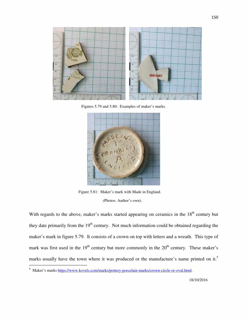
150
Figures 5.79 and 5.80: Examples of maker’s marks.
Figure 5.81: Maker’s mark with Made in England.
(Photos: Author’s own).
With regards to the above, maker’s marks started appearing on ceramics in the 18th
century but
they date primarily from the 19th
century. Not much information could be obtained regarding the
maker’s mark in figure 5.79. It consists of a crown on top with letters and a wreath. This type of
mark was first used in the 19th
century but more commonly in the 20th
century. These maker’s
marks usually have the town where it was produced or the manufacture’s name printed on it.5
5 Maker’s marks https://www.kovels.com/marks/pottery-porcelain-marks/crown-circle-or-oval.html.
18/10/2016

151
Malan (2009:30), states that “Made in England’ is a 20th
century term”. These five fragments
were the only ones found with maker’s marks on them. Maker’s marks were only found at
Motse 11.7.
Table 5.14: Maker’s marks discovered at Motse 11.7.
Figure number:
Maker’s Mark
Description
5.72
…CAETANO
SA..RO..FILNOS
A printed green crown above a
wreath with a circle in the centre
on cream ceramic.
5.73
KINGSWAY
Printed in burgundy red on
white ceramic.
5.74
MADE IN ENGLAND
CRANBERRY IA
Found on coarse beige
earthenware.
5.2.2.2 The ceramics of Motse homestead 11.25.
The same procedure was used in the analysis of Motse house 11.25, where a total 194 sherds of
refined industrial ware were examined, with a total of 92 minimum number of vessels (MNV).
Of these, 64% were decorated and 36% were plain, undecorated industrial whiteware. All the
fragments were useful form types such as plates, cups, bowls, jars and a pot lid. With regards to
the ware or body type, 99% of the assemblage is refined earthenware. Only one fragment of
stoneware was recovered from the midden. No porcelain fragments were uncovered at Motse
11.25.

152
Table 5.15: Ware and decorated ceramics recorded at Motse 11.25.
Table 5.16: Ceramic forms at Motse 11.25.
Type of ceramic decoration Sherds MNV %
Lithographic printing 16 14 15%
Transfer printing 17 17 18.5%
Sponged 10 10 11%
Slipped industrial ware 8 6 6.5%
Gilding 20 10 11%
Lustre 1 1 1%
Relief moulded 2 1 1%
Whiteware 120 33 36%
Total 194 59 100%
Type of ceramic form Sherds MNV %
Tableware:
Cup
14
9
10%
Plates and saucers 27 15 16%
Kitchenware:
Jars
3
1
1%
Bowls 3 1 1%
Pot lid 2 1 1%
Sub-Total
Undiagnostic
49
145
27
65
29%
71%
Total 194 92 100%

153
Figures 5.82; 5.83 and 5.84: Lithographic printing from Motse 11.25.
Figures 5.85 and 5.86: Transfer printing.
(Photos: Author’s own).

154
Figures 5.87 and 5.88: Transfer printing.
Figures 5.89 and 5.90: Sponged ceramics.
Figures 5.91 and 5.92: Sponged ware ceramics. (Photos: Author’s own).

155
Figures 5.93; 5.94 and 5.95: Slipped industrial ware or banded ware.
Figures 5.96 and 5.97: Ceramic fragments with gilding.
(Photos: Author’s own).

156
Figures 5.98 and 5.99: Ceramic fragments with gilding
Figures 5.100 and 5.101: Relief moulding ceramics from Motse 11.25.
Figures 5.102 and 5.103: Examples of undecorated whiteware. (Photos: Author’s own).

157
Figures 5.104 and 5.105: The remains of the pot lid excavated from Motse 11.25.
(Photos: Author’s own).
The ceramic assemblages of the two houses of the Motse included undecorated and decorated
ceramics. The assemblages were quite fragmented, especially Motse 11.25. These pieces
represented an array of table and kitchenware, including tea cups, plates, saucers, jars and bowls,
which, as seen from the discussion above, have a variety of decorative motifs. One of the
primary functions of ceramics relates to foodways. Malan (2009:38) describes foodways as, “the
whole interrelated system of food consumption, procurement, distribution, preparation and
consumption, shared by all members of a particular group”. Ceramics form part of household
artefacts and relate to the social, political and economic relationships found within the household
and the external environment. The types of ceramics found at the houses of the Motse convey
this impression.
The ceramic assemblage from Motse 11.7 has slightly more decorated sherds at 53% and 47%
plain white undecorated fragments, which compared to Motse 11.25, shows a higher decorated
percentage at 64% and only 36% are plain undecorated whiteware. However, Motse 11.7 has a
larger decorated sample, with equal counts of sponged and lithographic printing fragments, equal

158
counts of gilding and transfer printing. Motse house 11.25 has a higher count of transfer printing
and then lithographic printing. Based on the amount of decorated material found at Motse 11.25,
this household could have been of a higher social standing, as a household’s means would
influence the type of ceramics found. In the past Malan (2009:38) notes that transfer printing
was largely associated with the poor, but that no “real status conclusions can be made from the
presence alone of transfer prints from the later 19th
century” because by this stage, transfer
printing was universal on all historical sites, regardless of status. The forms of ceramics, such as
the delicate tea cups and the other colourful decorated ceramics could indicate that there were
women living here.
The household of Motse 11.7 had almost equal amounts of decorated and undecorated ceramics.
Sponged wares, as previously mentioned, as well as, lithographic printing wares were generally
mass-produced industrial wares with production continuing into the 20th
century. Some of the
same patterns especially that of the lithographic print ‘Rose’ design occurred at both loci.
Many of the ceramic types discussed here have known dates of production and manufacture and
this can be applied for relative dating, and thus give an approximate date for the site (Malan
2009). The analysis substantiated that the ceramics of these households of the Motse most
probably date from the late 19th
century / early 20th
century through to the recent past.
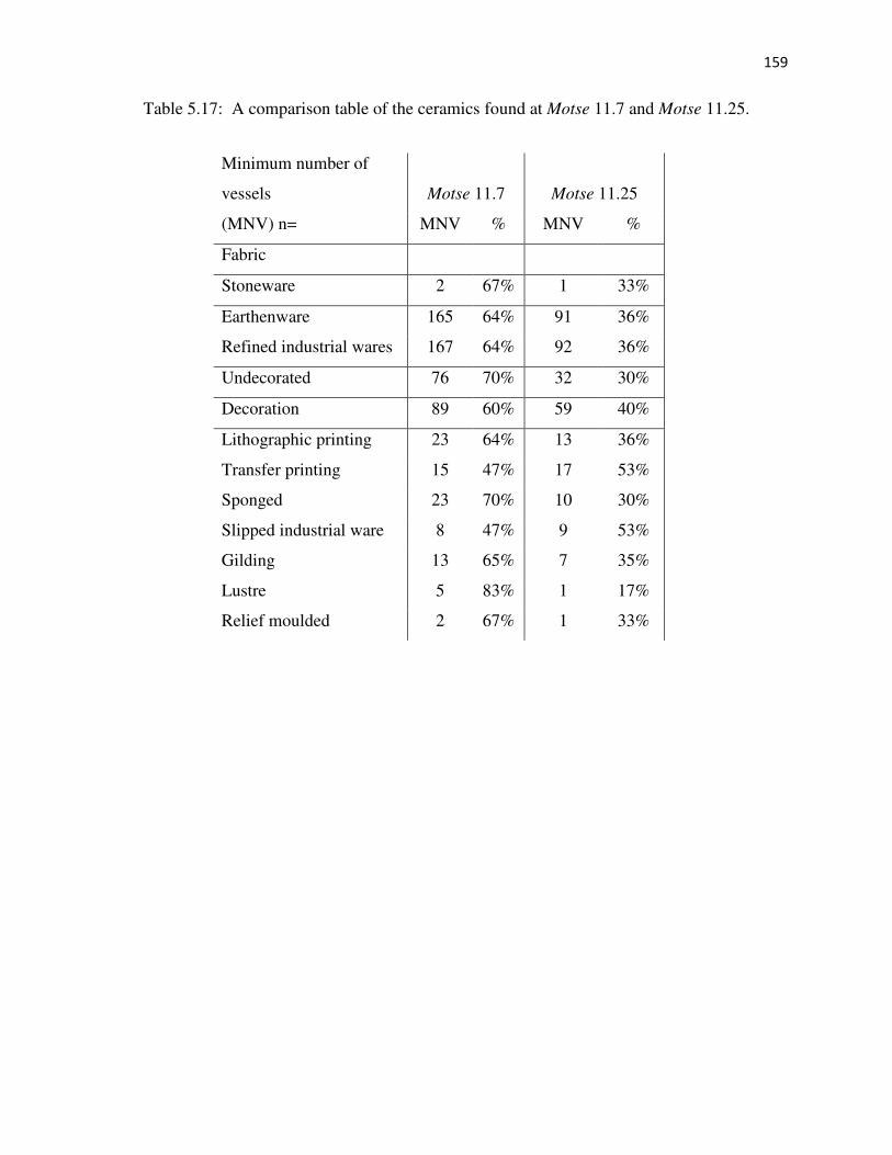
159
Table 5.17: A comparison table of the ceramics found at Motse 11.7 and Motse 11.25.
Minimum number of
vessels Motse 11.7 Motse 11.25
(MNV) n= MNV % MNV %
Fabric
Stoneware 2 67% 1 33%
Earthenware 165 64% 91 36%
Refined industrial wares 167 64% 92 36%
Undecorated 76 70% 32 30%
Decoration 89 60% 59 40%
Lithographic printing 23 64% 13 36%
Transfer printing 15 47% 17 53%
Sponged 23 70% 10 30%
Slipped industrial ware 8 47% 9 53%
Gilding 13 65% 7 35%
Lustre 5 83% 1 17%
Relief moulded 2 67% 1 33%
160
5.3 Buttons.
Buttons were also examined as part of the assemblage associated with the Motse homesteads. As
with the glass and ceramics, the buttons were carefully cleaned, sorted and catalogued. Analysis
was carried out according to material type, shape, colour and the number of holes in the button.
Thickness, diameter and weight were also measured. The analysis of the buttons was completed
in order to add data for relative dating purposes.
Shelter, food and clothing are the three basic needs for human existence and should be
researched as being part of everyday life (Rivers 1999). Buttons are part of clothing, together
with hook and eyes, belt buckles and shoe remnants that are found on historical sites. Clothing
usually does not survive and is rarely found in archaeological sites. But what little clothing is
found is usually underrepresented in archaeological sites and these artefacts should be studied as
part of the material culture, as these clothing items were important to the people who lived at the
sites (Rivers 1999). However, buttons can provide limited information regarding how the
residents actually lived and thus their main function is in assisting with the chronology of the
site. Dates are only an indication of when the buttons were manufactured and not the date of
deposition. It is for this reason that the buttons will be used in conjunction with the glass and
ceramic analysis.
5.3.1 The buttons of Motse homestead 11.7.
The word button is derived from the French “bouton” and is usually a small piece of metal or
other material, such as porcelain, ceramics, wood or plastic. A button is used to connect different
parts of clothing together by means of a buttonhole. Buttons are items that are both utilitarian

161
and fashionable. Buttons can provide information on what types of clothing were worn by the
residents of a particular historic site (Rivers 1999).
In order to examine the buttons of the Motse, a typology had to be created according to material
type and allocated a category based on the composition (Marcel 1994).
There were 34 individual buttons excavated from the homestead Motse 11.7, of which 30
different types were identified. Plastic buttons account for 79% of this total. All the buttons
except one are round. There is one square pink plastic button with 2 sew holes. Loop shanks are
present in one plastic and two metal buttons. There one metal button with “OUR OWN MAKE”
embossed on it. The button can be described as a typical trouser button. All the others are two or
4 sew-through buttons. These can all be categorised as being modern.
Buttons by the late 19th
century were becoming ordinary and mass produced and cheaper
materials were being used for manufacturing. By the early 20th
century, clothing styles became
simpler and inexpensive. Men starting adopting the 4-hole button style as the standard. Plastic
buttons started making an appearance in the 1930s but came into their own during the Second
World War as new technology emerged. The button industry switched almost entirely to plastic
after the war (Woodward 1996).

162
Table 5.18: Description of the buttons from Motse 11.7.
Material type Shape Diameter Colour No. of sew holes Count
Ceramic Round
Round
Round
3 x 11mm
3 x 19mm
5 x 11mm
White
White
Clear
4
4
1
Sub-total
1
1
1
3
Metal Round
Round
Round
Round
Round
Round
Round
4 x 17mm
3 x 14mm
10 x 24mm
13 x 12mm
3 x 17mm
2 x 18mm
7 x 14mm
Metallic
Metallic
Metallic
Metallic
Metallic
Metallic
Metallic
4
4
1
1
4
2
0
Sub-total
1
1
1
1
1
1
1
7
Plastic Round
Round
Round
Round
Round
Round
Round
Round
Round
Round
Round
Round
Round
Round
Round
Round
Square
Round
Round
Round
2 x 12mm
2 x 12mm
3 x 19mm
5 x 11mm
2 x 16mm
3 x 15mm
3 x 14mm
2 x 18mm
2 x 16mm
3 x 17mm
4 x 18mm
4 x 18mm
15 x 10mm
25 x 16mm
1 x 11mm
3 x 14mm
3 x 15mm
5 x 22mm
3 x 14mm
2 x 12mm
Brown
Cream
White
Blue/green
Cream
Clear white
Khaki
Yellow
Brown
Green
Yellow
Cream
Grey
Cream
Grey
Black
Pink
Red
Dark brown
Red
4
4
?
1
2
2
4
2
4
2
2
2
2
2
4
4
2
1
4
4
Sub-total
1
1
1
1
1
1
1
1
1
1
1
3
1
1
2
1
1
1
2
1
24
Total 34

163
Figure 5.106: The plastic buttons of Motse 11.7
Figure 5.107: The metal buttons from Motse 11.7. (Photos: Authors own).

164
5.3.2 The buttons of Motse homestead 11.25.
There were 21 individual buttons excavated at the homestead Motse 11.25, representing ten
different types. Plastic buttons only account for 29% of this total. Most of the fasteners are metal,
which included 8 fragments of press studs. There are four ceramic buttons which includes one
square white ceramic button with a key shank. All the buttons except one are round. All the
others are two or 4 sew-through buttons. There is one metal button with “MIDDLEBURG
STORE BROS” embossed on its front. This is a typical trouser button. These buttons and
fasteners can be described as being modern.
By analysing the buttons, in conjunction with the glass and ceramics, the assemblage supported
the chronology of the two loci and confirmed the data collected from the overall analysis of the
cultural material that the site possibly dates from the end of the nineteenth century and/or
beginning of the twentieth century up to recent times.
Figure 5.108 and figure 5.109: Marks embossed on the metal buttons.
(Photos: Author’s own).

165
Figure 5.110: The plastic buttons.
Figure 5.111: The metal buttons excavated.

166
Table 5.19: Description of the buttons from Motse 11.25.
Material type Shape Diameter Colour No. of sew holes Count
Ceramics Round
Round
Square
Round
6 x 12mm
2 x 11mm
8 x 11mm
1 x 10mm
White
White
White
Pearl
1
1
1
4
Sub-total
1
1
1
1
4
Metal Round
Round
Round
Round
Round
8 x 23mm
5 x 12mm
3 x 14mm
7 x 7mm
3 x 15mm
Metallic
Metallic
Metallic
Metallic
Metallic
?
Press stud bottom
Press stud top
1
4
Sub-total
1
4
5
1
1
12
Plastic Round
Round
Round
Round
Round
2 x 10mm
3 x 13mm
3 x 16mm
3 x 19mm
2 x 11mm
Yellow
Red
Mustard
Red
Beige
2
2
2
2
2
Sub-total
1
1
1
1
1
5
Total 21
5.4 Supplementary analysis.
In total 1.4m³ of soil was excavated from the middens at Motse homestead 11.7 and 1.4 m³ of
soil was also removed from the midden at Motse homestead 11.25. As seen in Table 1, there
were various types of cultural material present from the houses of the Motse. This material
consisted of building materials, such as bricks, plaster, concrete and nails and screws.
Household items such as plastic, metal tins and containers, as well as, the glass and ceramics
discussed in the previous sections, were present in the middens. Organic food products, such as
butchered soup bones and chicken bones together with apricot and peach pips were recovered.
Various packaged food items were uncovered including rice packets, margarine and yoghurt

167
wrappings. Modern medicinal packaging, such as MED LEMON, ENO and DISPIRIN
wrappings were also found. By studying the usage of these everyday items, information on the
diet, literacy, gender and status can be determined, as well as, the way the residents of the Motse
saw themselves and their place in society (License 2015).
The cultural material can contribute to the story of the residents of these homesteads. For
instance, a human tooth was found in the midden at Motse 11.25. Teeth are quite commonly
found at archeological sites. This tooth was the upper first molar from the right-hand side of the
jaw from an adult individual. From the size of the cavity found in the tooth, this person had very
poor oral health and lived in severe pain before the tooth fell out. The tooth was not pulled, as
there is no evidence of tool marks (Dr. A. Effting pers. comm. March 2015). At Motse 11.25,
there were only two intact tubes of Colgate toothpaste excavated, of which, one had an expiry
date 6 55, however, a total of five intact tubes of toothpaste were recovered of various makes,
such as Dental Care, President and Colgate from Motse 11.7. The Colgate tubes had expiry dates
embossed on them – 52021 and 5315.
Figure 5.112 and figure 5.113 are examples of the toothpaste tubes excavated. (Photos: Author’s own).

168
The cultural material unearthed at Motse 11.7 was very utilitarian in nature. This is evident in
the household items found in the ceramic, glass, plastic and metal assemblages. A large portion
of the glass assemblage is alcohol and beer bottles together with sauces, oil, milk, metal cans and
preserve bottles and jars. These are used for cooking, and could have been used in the clay oven
at the back of the house (Le Roux and Fisher 1991). There were also a larger percentage of
medicinal vessels and cosmetic jars excavated at this homestead. A larger percentage of
undecorated ceramics were analysed from this household, with more sponged and lithographic
printing emerging from the decorated ceramics.
Glass and plastic beads are present and very little clothing (except for the buttons); toiletries and
scholarly items were found. Most of the buttons analysed here were plastic and quite recent.
The same amount of cubic volume was excavated from both Motse homestead 11.7 and Motse
homestead 11.25, but the cultural material sample from Motse 11.7 was definitely larger than
that of Motse 11.25. There was also a different pattern emerging from the analysis of the cultural
material from Motse 11.25. For example, this assemblage includes items, such as silk stockings,
skin lightening creams, PONDS Cold Cream pots, a heel from a yellow high heeled shoe, wool, a
sewing needle, modern kitchen plastics and glass and plastic beads indicate that possibly it was
primarily women who lived at this homestead. With regards to the button analysis, mostly metal
press studs were analysed which are also primarily worn by women. A total of eight skin
lightening cream tubes were uncovered, of which three were imported from the USA marketed
as ARTRA Skin Tone Cream (figure 5.114). These items were only recovered from the midden
at Motse 11.25. As Thomas (2012) notes, skin lightening creams were being marketed to black
South African women from the 1930s onwards and these products were both imported and
distributed by African American companies but there were products also being made in South

169
Africa, such as Karroo Skin Lightening Cream (figure 5.115), by a company based in
Middelburg, Eastern Cape and owned by an Afrikaans businessman. By the mid-1950s
lightening creams and other similar products, were very popular and being sold in large numbers.
These products were applied to the face to conceal blemishes, to even out skin tone and to
lighten skin tones (Thomas 2012). Almost no male-specific artefacts were found.
Figure 5.114 and figure 5.115: Examples of the two types of skin lightening creams recovered from the site.
(Photos: Author’s own).
It is also evident from the analysis that very little alcohol and beer was consumed in this
household. Unfortunately, most of the glass and ceramic pieces excavated at Motse 11.25 were
very fragmented. This could have occurred when these items were discarded or when the area
was bulldozed during the forced removals. More decorated ceramics were examined from this
household, with transfer and lithographic printing being the most popular styles. Also of interest
are the ink bottles, chalk, Bic pen tops, dice and marbles found, which indicate that there were
probably teachers and scholars living here.
With regards to the food consumption of the household of Motse 11.25, the residents of this
household also bought processed foods together with conventional foodstuffs. These processed

170
items included Tastic Rice6 introduced in South Africa in 1961 and Earlybird Chicken Livers,
with Earlybird Farms7 established in 1968. These packages were unearthed fairly intact, as seen
in the figures below.
There are also metal bottle tops such as Black Cat Peanut Butter8 that was being produced since
1926. This packaging was found with cut soup bones and a few apricot and peach pips.
There was also a number of EVEREADY battery cells recovered from both sites. These were
most probably used to power radios, as there was no electricity available in the Motse, and this
can be verified by the bulbous chimney glass fragments recovered from both middens, used for
lanterns and oil lamps.
Figure 5.116: A modern packet of Tastic rice on the right next to the Tastic packet excavated from Motse 11.25.
6 Tastic Rice www.tastic.co.za 17/10/2016
7 Early Bird Farms (Pty) Ltd www.bloomberg.com/research/stocks/private/snapshot 17/10/2016
8 Peanut Butter www.iol.co.za/lifestyle/people/the-brands-that-define-mzanzi-1704594 17/10/2016

171
.
Figure 5.117: An older jar top for Black Cat Peanut Butter on the left and a modern jar top on the left.
(Photos: Author's own).
Figures 5.118 and 5.119: Examples of the tin cans excavated, this was probably a Bully Beef tin.
(Photo: Author’s own).
The Eveready Battery Company was established in 1914, when the American Eveready
Company, developer of the flashlight, merged with the National Carbon Company. This
company was responsible for the invention of the first D-size dry cell battery. In the 1920s, the

172
Eveready brand started to spread to other countries including South Africa and opened in Port
Elizabeth in 1937. It was in 1957, that the 9V transistor battery was introduced.9
Figure 5.120: Packaging for the Eveready Batteries from the 1950s. (www.eveready.com).
Figure 5.121: Fragments from an Eveready 9v transistor battery. (Photo: Author’s own).
The material culture of Motse 11.7 indicate that there were indeed also women living in this
household, as observed from the cosmetic pots and jars, the ceramic sherds and the beads for
example. The cultural material also implies that this household used traditional items, such as the
locally produced pottery discussed in section 5.2.1 and the upper grinding stone seen in figure
5.122, together with westernised household items. The cultural material from Motse 11.7 comes
9 Eveready Batteries www.eveready.com/aboutus/pages/about-eveready.aspx 17/10/2016

173
across as being more modest and utilitarian, even though there was a fair amount of alcohol and
foodstuffs consumed. This gives a sense that this household was quite social and interacted with
their community and the broader mission station settlement.
The household of Motse 11.25, as reviewed above, used more consumable and packaged items.
These packaged items were only found at this household. It could mean that these items were
purchased by residents who were working and earning, in order to be able to afford these kinds
of products. This together with the other artefacts recovered, conveys the opinion that these
residents of this household were educated working women who were well dressed and groomed.
The homestead of Motse 11.25 also lends itself to the idea that a larger family lived here as more
outbuildings are evident than the house of Motse 11.7. The cultural material indicates that it is
possible that there is a slight chronological difference between the deposits excavated from the
two households, with Motse 11.7 being older than the more modern Motse 11.25. The excavation
at Motse 11.7 was vertical in orientation, extending to sterile soil at a depth of 80cm, as opposed to the
horizontal extent of the excavation at Motse 11.25, which went to a depth of 30cm at a stone layer. It is
possible that older deposits may be present below the stone tumble.
Figure 5.115: Upper grinding stone from Motse 11.25.

174
The analysis of the two houses of the Motse has shown that regardless of the fact that the
artefacts were every day and mundane, they provide an interesting insight into the lives of the
residents and their families who lived in this part of the mission station. The analysis revealed
that the chronology for the two households range from the late 19th
century / early 20th
century
through to the mid-1970s.
These items discussed in this chapter are very basic and ordinary and yet they are important in
any household, as they assist in making families’ lives more comfortable and secure. By
analysing the glass, ceramic and button assemblages of the homesteads Motse 11.7 and Motse
11.25, together with the cultural material as a whole, an improved understanding of these
households emerges, which will be discussed in the following chapter together with the
settlement layout of this area of the mission station.

175
CHAPTER 6: THE HOUSES AND HOUSEHOLDS OF THE MOTSE:
THE DISCUSSION.
The original residents of the Motse and their descendants have long since gone, but their
everyday stories have remained in the ruins of the village. It is through archaeological
excavation and analysis that light can be shed on the domestic history of the Motse in the recent
past. The structures and middens of these two houses, Motse 11.7 and Motse 11.25, have
provided a glimpse of this through the material culture, thereby providing a better understanding
of the ordinary, everyday lives of the people who lived here.
In this chapter, the architecture and spatial organisation of the Motse will be discussed, followed
by a description of how it could have been, living in a household in a rural mission village in the
early to mid-twentieth century.
6.1 Settlement layout, spatial organisation and architecture of the Motse.
Botshabelo Mission Station was originally established as a place of refuge and safety. The
Motse is situated about one kilometre from the main mission station complex and approximately
ten kilometres from the town of Middelburg. It is located on a grass plain situated between the
Olifants River and the sharp ridges of the surrounding hills. This landscape was ideal for
settlement, as it had ample rocks for building, clay and water from the adjacent river, and grass
for the thatching of roofs. The positioning of these villages of the Bapedi and Bakopa at their
founding was intentional, and with time it placed the Motse residents within the wider mission
station community. Mission stations were primarily seen as locations where people were
encouraged to settle and through their architecture of elegant buildings and churches exhibited a
presence of colonial power and ideology (Flexner 2014). This can also be said of Botshabelo,
and in its day the church was elaborate and authoritarian. It could be viewed as a display of

176
power and control by the missionaries over the landscape, but to many of the initial residents of
the mission station, it was probably considered to be the heart of the mission station. Botshabelo
can be described as being established as a permanent settlement, with a core which provided
educational and other services to the residents and the surrounding areas, such as the Motse.
Botshabelo Mission Station can also be viewed as an institution. It has a set of formal structures,
demarcated by stone walls with regimented space and buildings, set apart from each other
depending on function. This type of institution had training facilities for religious and other
educational requirements, as well as, a boarding school and various other small scale industrial
activities (Middleton 2010; Flexner 2014). The Motse was established away from the church and
parsonage and was thus set apart from it. This could have been for both practical and political
reasons. Due to the topography of the area, space is limited around the main areas of the mission
station, which most probably could not accommodate the numbers of converts and potential
converts that followed Merensky at its establishment. It was also important for the residents of
the mission station to have access to the agricultural lands nearby. The historic maps and
documentary sources indicate there were residents living in the Motse from the beginning.
Alexander Merensky, at this time left most of the management of the Motse in the hands of the
relevant chiefs. This could be advantageous to the chiefs, as they could oversee the villages,
while keeping the missionaries at a distance.
The situation was a bit different at mission stations in the more northern rural areas outside of the
immediate political sphere of the Zuid-Afrikaanse Republiek, where the missionaries had a more
submissive and passive relationship and were essentially controlled by the local chiefs (Kirkaldy
2005). These mission settlements were generally smaller and found in remote areas of the
country where the main focus of the missionaries’ was conversion. As Flexner (2014) notes, in

177
these situations the local people were more likely to use mission resources for their own
purposes, such as needing interpreters to deal with the government administration. There was,
however, a relationship between mission institutions such as Botshabelo, and these smaller rural
mission settlements in that they served as a training ground for local pastors and mission helpers
(Kirkaldy 2005).
As discussed in Chapter 3 of this document, it is the personal and professional journals, letters
and illustrations produced by missionaries, such as Alexander Merensky, Theodore Wangemann
and Carl Hoffmann, who documented the activities of the mission stations. In term of the
broader questions being asked in this dissertation, there are several observations that can be
drawn about the changes in architectural style that occurred over time. The analysis of the
documentary and pictorial sources suggest that the transition of the house structures from the
traditional round to the European-style rectangular form appears associated with the
accumulation of a number of socio-political, cultural and economic changes rather than the
straightforward conversion of the original inhabitants. As seen in the pictorial documentation
left by Wangemann’s early sketches, the photographs in the Hoffmann Collection and the aerial
photograph of 1943, almost eighty years after conversion, there were still cone-on-cylinder
structures to be found in the village. Naude (2007:226) notes in his research regarding cone-on-
cylinder structures that mission stations were “among the first settlements where vernacular
African and European architectural traditions came together and to some extent [were] forced to
either fuse or co-exist” (also see Frescura 2008).
This transition most probably commenced within the first ten years of the establishment of the
mission station. Edward Sandeman (1880) mentioned how impressed he was by the appearance
of the large village when he visited the station in 1878. The documentary/pictorial and

178
cartographic sources show that there were initially two villages established in the Motse. These
villages possibly merged after the departure of Johannes Dinkwanyane and other groups.
General Wolseley also mentions on his visit in 1879, that he was impressed with the village and
its houses with their yards (Wolseley 1880/1973). By 1886, twenty years after the establishment
of Botshabelo, Wangemann describes how the mission station had undergone drastic changes
and that rectangular houses were more evident, however, there were still traditional round
structures present (Le Roux and Fisher 1991). The transition of these architectural styles from
cone-on-cylinder structures to European-style houses thus occurred over time and was therefore
not so straightforward as sometimes been proposed. For example, there are unroofed round
structures and rectangular buildings still visible in the aerial photograph of 1943. We do not
know at what time the round structures became unoccupied. To a certain extent, this transition
was initiated through the conversion and education of the residents by the missionaries, however,
the residents could have decided to change building styles, as square houses were easier to build,
they provided more room and natural building materials were easily available. This reiterates the
Comaroffs research on materiality and the influence of the missionaries on transformation
through dress, agriculture and architecture of the Tswana (Comaroff and Comaroff 1997).
As noted in Japha et al (1993) most mission stations were organised and planned settlement
layouts, with rectangular houses laid out in parallel rows, such as that seen at Bethanie and
Kratzenstein. In the aerial photograph of 1943 (figure 3.12), the Motse appears to follow this
pattern. Today, there is little difference in the original 1882 settlement layout depicted by
Merensky (figure 3.11) to that of the aerial photograph. However, apparently this wasn’t always
the case. It is mentioned that in the 1880s, members of the Berlin Mission Society were still
having difficulties implementing a grid-like settlement pattern for the traditional structures in

179
which most of the mission residents lived at Botshabelo and the Motse (Japha et al 1993). The
mission core is approximately the same, except for a couple of new buildings, such as the
educational facilities. The Motse location is relatively unchanged in the historical sources.
Today the Motse is a village in ruins. Through the processes and problems associated with
socio-economic issues and abandonment of Botshabelo by the Berlin Mission Society, together
with forced removals in the case of the Motse, the area has undergone a forced deterioration. An
important theme in this research is that of the residents of the Motse being forcibly removed in
1972 with many of the houses bulldozed during the removals. This act of destruction has had a
decisive impact on the Motse as an archaeological site.
In the village, there are 32 intact structures of various sizes, two water wells, a fort and possibly
the second fort still located on the site. The structures associated with the Motse, include houses
and outbuildings, such as kitchens and outside ablutions, cone-on-cylinder structures, kraals and
small walls. Architectural remains have always been important in archeological studies and in
particular small-scale structures. The information gathered from these types of structures can
provide important evidence in human behaviour (Steadman 1996). These structures can provide
important information concerning the built environment associated with the Motse and other
Berlin Mission Society stations in South Africa.
By the mid-twentieth century, there appears to be two rectangular house types present in the
Motse, as well as, numerous round structures with rectangular yards. The first type can be
described as being rectangular in shape, originally having one room with no internal walls, with
windows in asymmetrical façade facing the street, as seen in the photograph below (figure 6.1).
These houses were constructed of stone, plaster and clay with a thatched roof. These typical
house types started changing, as they were easily modified and expanded to include additional

180
rooms when needed, especially to the rear of the houses, as seen in Motse 11.7. Clear alteration
outlines can be seen where construction was undertaken. As these houses evolved to meet the
changing needs of the household, they developed into homesteads, which is the second type of
house found in the Motse. This is where yards have been created between the main house and
the other outbuildings, such as the kitchen and the outside ablutions. In this type of house,
attempts have been made to demarcate the living space by deliberately building small stone walls
creating a boundary, and thus a homestead. As part of a community, the residents of these
households most probably had a need for personal space and privacy, and so defined the
boundaries to their home. These houses also evolved by adding new rooms and some of these
rooms are divided by internal walls, as can be seen at Motse 11.25. The social relationships of
the household and the greater community can be observed in the construction of the boundary
walls and the positioning of the entrances of the various structures.
Thus, these houses of the Motse consisted of various structures and areas, and can be observed as
having a division between the private or domestic inside of the main house, and the public or
outside areas including the gardens, kraals and even the paths and roads. There is evidence that
the outside areas found between the main houses and the outside buildings were used for
socializing, work activities, as well as gardens and fruit trees. This spatial layout can be seen as
“a division between public and private space and isolation from wider society” (Lydon
2005:217). Robin and Rothschild (2002) provide a very interesting discussion on the social
dynamics of public or outdoor space. These outdoor living areas and spaces are significant to
many aspects of life. It is in these spaces that the individuals of a household interact with each
other and also with the community. It is these “social, economic and ritual activities and

181
meanings conducted in areas around and between buildings” that are of critical social importance
(Robin and Rothschild 2002:163).
Figure 6.1: An intact house of the Motse circa 1900 (TPMS 1989:11).
The structures of the Motse are examples of vernacular architecture, buildings that are
constructed “in agreement with cultural norms and without the aid of trained architects and
builders” (Orser 2004:184). These buildings are important in the research of the cultural and
historical landscape. So, with regards to this research project Botshabelo Mission Station falls
well into the definition given by Japha et al (1993:3) regarding mission stations, being that:
Missions are small rural settlements or complexes of buildings on defined pieces of land,
which were developed by and are or were controlled by a church as centres for an
existing or potential Christian community, and which cater for, or are inhabited by the
rural poor.
By studying the settlement layout, the spatial organisation and the architecture of the Motse, a
better understanding of the village and its residents in the contemporary past can be attained.
182
6.2 The households of the Motse:
Archaeology is in a unique position to study these houses and their households. As Clift (2001)
notes, there are subtleties involved in the relationship between the missionaries and the people
living at the mission station that are not always explained within the historical record. Therefore,
studying the archaeological record of the Motse is significant, as it assists in providing
information not evident in the historical documentation, as well as, presenting the importance of
researching the recent and contemporary past. Graham (1998:27) states for instance that,
historical documentation “naturally places importance on the story and views of the European
colonizers, whereas, archeology with its focus on material culture of all the inhabitants of a
mission station allows the voices of the flock to be heard”.
The early missionaries used subtle colonisation and transformed the lifeways and customs of the
early converts, and this in time brought about political and economic changes, not only in the
moral order, the community but also, in the sphere of culture and the understanding of self
(Comaroff and Comaroff 1997). It is these notions that most probably filtered down through the
years from family to family, and becomes important in the understanding of the social
relationships within these household. People create their own space, and give meaning to this
space, in relation to their social and cultural beliefs (Orser 2004).
The layouts of these homesteads are such that each house had a small garden and access to
communal land which could be used for either grazing or agriculture (Japha et al 1993). There
are also various kraals evident throughout the site that was used for herd animals, such as sheep
and cattle. The gradual move of the Motse residents from producing their own food, to a
consumer society is depicted in the material culture, as demonstrated through the glass, the
ceramics, saw cut faunal bones, as well as, the various modern packaging excavated.

183
Food consumption, as described by Malan (2009:38) includes the “procurement, distribution,
preparation and consumption, shared by all members of a particular group” or household. The
homesteads of Motse 11.7 and Motse 11.25 had assorted household items present in the middens,
such as plastic, metal cans and containers together with the glass and ceramics. As described in
Chapter 4 of this document, it was decided to excavate middens associated with two of the
houses. The first midden for Motse house 11.7 was positioned between two round structures that
were most probably kraals and near the clay oven, so an ideal place to discard household rubbish.
The second midden for Motse 11.7 is found not too far from the back wall of the main house. As
for Motse house 11.25, the midden is located on the west side of the house behind a small wall
and just outside the yard. It could be that this household threw their rubbish over the small wall
to discard it.
The research for this project concentrated on the glass and ceramic assemblages excavated from
these two houses. A large portion of the glass assemblage is alcohol and beer bottles, these
mostly found at Motse 11.7. The amount of alcohol bottles also gives the impression that this
household was social and interacting with the larger community. During the earlier years at the
mission station, it was prohibited to buy and drink alcohol especially brandy. Drinking alcohol
was seen as being impure (Merensky 1899). Drinking alcohol, even in recent times could be
seen as a form of resistance against the establishment. There is a bread oven associated with this
homestead, and it is possible that beer was used for the baking of bread. With regards to the
ceramics, there was an almost equal amount of decorated and undecorated types analysed for this
house. There were some traditional items, such as local ceramics and an upper grinding stone
still being used, together with historic household items. Most of the material culture was modest

184
and utilitarian in nature, and there seemed to be a large amount of food and drink consumed at
this household.
In contrast, Motse house 11.25, has more decorated ceramics than undecorated, with more
tableware being present. Household income would also influence the type of ceramics
discovered at a home. The items such as silk stockings, cosmetic jars, the packaged food and
medicinal items, the skin lightening creams discussed earlier, together with a lack of any male
specific items, offer the impression that there were educated, well dressed women living here.
Thus, these individuals had the means to buy butchered meat, packaged goods and various
household items for their homes. Items such as skin lightening creams and other toiletries were
expensive to purchase (Thomas 2012). With regards to the analysis for this project, the cultural
material excavated from the households indicate that it is possible that there is a slight
chronological difference between the two assemblages, with Motse 11.7 containing some older
items than the more modern Motse 11.25.
The material culture of these households can be seen as an indication of the socio-economic
status of the people living in the Motse. As Sweitz (2012) notes, households leave behind a
record of their past consumer behaviour which is reflective also of their socioeconomic class
relationships within these communities. Further, as consumers these individuals and households
were making decisions within their larger societal circumstances.
Thus, by analysing the artefacts from the two houses of the Motse, the data obtained can provide
information on the socio-economic status of the household, which in contemporary archaeology
can be very complex (Groover 2014).

185
As Hendon (1996:46) remarks, all households in a society may have similar responsibilities
regarding certain tasks and interaction within the same physical and social landscape. However,
these households “do not necessarily respond in the same way to external conditions nor
organize themselves in the same way”. This becomes evident from the analysis of the cultural
material of the residents of these two houses of the Motse. These residents were attentive to their
homes and to themselves. The consumption pattern indicates that members of these two
households were most probably working, either at Botshabelo School, in the nearby town of
Middelburg or further afield in the larger cities, such as Johannesburg. Thus, the two households
of the Motse were part of the same landscape, that of Botshabelo mission station, but responded
to social circumstances and organised themselves differently (Hendon 1996).
These mission establishments were complex settlements where various communities resided,
who maneuvered through the various aspects of colonialism every day (Panich et al: 2014). The
residents who lived in the Motse were no different. As Meyer (1997) comments in her study on
religion and material culture, mission institutions not only played a significant role in
colonialism but also in the creation of modern consumers. Archaeology is in the distinctive
position to study this, together with the meaning these goods and products had for their
consumers. These commodities are usually studied in an economic context, it is however,
important to realise that these material goods have a social and political context and the
understanding of the complex social relationships are important (Meyer 1997; Groover 2014).
Such a product is the skin lightening creams excavated from Motse 11.25, which appeared due to
an emerging African consumer market, especially after the Second World War. As Thomas
(2012:5) notes, even though skin lightening creams were primarily used by the European
population in South Africa, these products also appealed to the African and other darker races

186
“who sought to navigate social hierarchies that privileged lightness, and to achieve aesthetic
ideals rooted in both colonial and precolonial conceptions of beauty”.
As the historical and political situation changed in South Africa, mission stations, such as
Botshabelo transformed from religious to largely educational institutions during the first half of
the 20th
century, as mission schools became more important. It is here, that the residents of
villages, such as the Motse, came into contact with new ideas and customs, which included
hygiene and appearance. Unfortunately, the missionaries saw products and items, such as
cosmetics and lavish clothing as indulgent, and against what they were trying to teach, “a simple,
wholesome and largely rural way of life that they viewed was rapidly disappearing with
industrialisation and the spread of consumer capitalism in Europe and the United States”
(Thomas 2009:26). These ideas were fostered by the students being exposed to media, such as
magazines and newspapers. One of the earliest magazines was that of BANTU WORLD. This
magazine was developed in the 1930s, to offer an opinion to the more respectable African
population, such as those educated at mission schools, who worked mainly as teachers, nurses,
clerks and the clergy (Thomas 2009). Another magazine was DRUM magazine, established in
Cape Town in 1951 (as seen in figure 6.2). This magazine reported life in the 1950s and 1960s
in the larger centres such as Johannesburg and Cape Town. These types of magazines were
created primarily for the emerging African consumer market. It can be said that, it was these
mission schools that produced this market by teaching the students literacy. Through reading,
these scholars were exposed to advertisements and stories relating to them. So, even though it
was the missionary who prohibited the wearing of certain types of clothing, as well as, face and
head adornments, they laid the foundation for African consumerism through advocating dress
and cleanliness (Meyer 1997; Thomas 2009). Brigit Meyer (1997) states that this change in
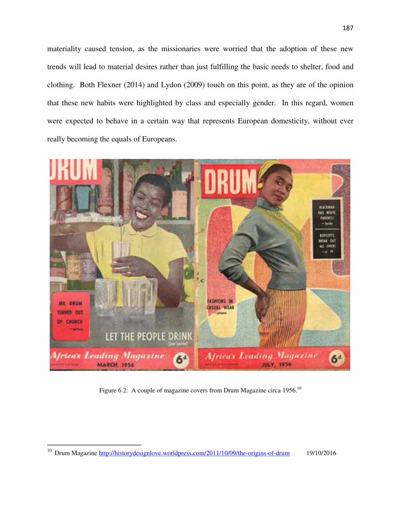
187
materiality caused tension, as the missionaries were worried that the adoption of these new
trends will lead to material desires rather than just fulfilling the basic needs to shelter, food and
clothing. Both Flexner (2014) and Lydon (2009) touch on this point, as they are of the opinion
that these new habits were highlighted by class and especially gender. In this regard, women
were expected to behave in a certain way that represents European domesticity, without ever
really becoming the equals of Europeans.
Figure 6.2: A couple of magazine covers from Drum Magazine circa 1956.10
10
Drum Magazine http://historydesignlove.worldpress.com/2011/10/09/the-origins-of-drum 19/10/2016

188
By 1945, South Africa had become more industrialised, which led to economic prosperity for the
country and by 1948, when the National Party attained power, the road for a South African
Republic had begun. It is at this time that the country started changing its internal policies and
amending legislation and government policies as imposed by the National Party (Freund 2012;
Posel 2012).
So, by the 1950s, the country entered a phase dominated by the policy of Apartheid. During this
period, population or forced removals were enforced under the interests of the Group Areas Act
of 1950, which was designed to separate designated residential areas based on racial occupation
(Posel 2012). Many mission stations in South Africa were affected by the forced removals from
1968 onwards (Japha et al 1993). As reviewed in this document, the Apartheid policy had major
implications, especially for African education within the country. Prior to this, education was
primarily provided by mission schools such as Botshabelo. It is through this policy and
especially because of the impact of the Bantu Education Act No. 47 of 1953 on the mission
schools that made many of the mission stations in South Africa obsolete. Financial support to
mission schools was reduced in 1954 and eventually terminated in 1957. Due to this most of
these teaching institutions became controlled by the government. The government gave these
mission stations a choice of either selling or leasing the school to the government or to run them
without financial support as private schools (Japha et al 1993; Mminele 1983). At first, the
members of the Berlin Mission Society at Botshabelo, decided to co-operate with the
government as they hoped that this would help them remain open.
However, by 1957, the Berlin Mission Society had reassessed the situation and transferred all
educational institutions to the government largely due to economic reasons (Mminele 1983).
The Berlin Mission Society finally decided to leave South Africa in the early 1960s, due to these
189
financial and political reasons but mostly because these schools were no longer theological in
nature (Elphick 2012).
In 1961, South Africa became a republic and the country became even more regulated. This
unfortunately affected the everyday life of the residents of the Motse and this would have
influenced the social, political and economic dynamics, which existed within these households of
the Motse and in the wider community as a whole.

190
CHAPTER 7: CONCLUSION
The goal of this research on the houses of the Motse was to refine our chronological
understanding of the development of the settlement and the architectural transition of these
homesteads, and so explore the chronology of the Motse, through the analysis of documents and
related sources and the material culture excavated.
Very little is known about the archaeology of Botshabelo Mission Station and the Motse. So by
undertaking this research, the residents of the mission station’s story can be told, one that is
important to the heritage of the country. Archaeology is in the unique position to assist in
providing a more rounded representation of how the residents of the Motse lived.
The missionaries from the Berlin Mission Society were sent to southern Africa to convert the
indigenous population and so instill a moral way of life. Through the adoption of new
architectural styles and dress, these missionaries saw these transformations as important steps to
becoming “a believer in Christ” and that changes in architecture and clothing in turn reflects
“spiritual turning and spiritual change” (Kirkaldy 2005:153-154). Thus, Christianity was
recognised by the missionaries as a means to restore peace amongst the wayward indigenous
communities (Elbourne 1995). However, this was not so simple and conversion not so straight-
forward. As Birgit Brammer (2007:24) observes, there existed “a strange duality in German
missionary policy. On the one hand, they wanted to convert all the heathens, but at the same
time, they went to great lengths to ensure that the local population maintain their culture and
avoid becoming too influenced by white people”. This idea aligned to the ethnographic policies
that were important to the missionaries and their work within these communities. The African
residents of the Motse for instance, maintained certain aspects of their culture, as can be seen in
the architecture and spatial layout of their homesteads. As Boshoff (2004:467) states, these
191
“German missionaries were European outsiders, neither colonists nor representatives of a
colonial power in South Africa. However, they formed part and were instruments of the world
wide Western colonial expansion that was taken place in Africa during the nineteenth century”.
All that is currently known of the Motse is through missionary reports and journals, as well as
traveller accounts. These material sources are the views of colonial actors and most of the
literature is centred on the main mission station and the accomplishments of the missionaries that
lived there. It can be said, that the lack of information on the Motse is also a form of power over
the residents of the village. As yet, the oral traditions and oral histories relating to the Motse still
have to be explored as important and invaluable sources.
Japha et al (1993) note that between the 1860s to the early 1950s, there were 135 mission
settlements and stations established in the then Transvaal. Some of these still remain today, but
many have been destroyed and abandoned, often as a result of the forced removals of the
residents of these settlements. Merensky (1899:347 as translated by J. Stone) remarked in 1880,
15 years after its establishment,
We can thank God heartily that here the Basutos had found something they needed: a
place of safety where they could live in peace amongst believers. All the work we, and
they, had done had been to the glory of God. The heathens who had foiled and fought us
were gone, yet we lived on in security and the station was like a hill town, safe and well-
protected.
Unfortunately, Merensky’s words would not last and almost a hundred years later, through the
policy of Apartheid the mission station and the Motse would no longer “be safe and well-
protected”.

192
Figure 7.1: Rubble from a Motse house bulldozed during the forced removals (Photo: Author’s own).
Botshabelo needs to be conserved, as it has an important place in the history of the country. As
Japha et al (1993:47) state in their study “many missions are affected by three fundamental
problems:
• they have been subjected to removals, or have lost mission land through various
processes and are therefore subject to, or are likely to become subject to legal disputes
• most are experiencing serious socio-economic problems, related mainly to levels of
poverty and changing demographic profiles
• many have lost their historic roles as centres which provided community education and
service”.
Unfortunately, the above is a description of the problems being experienced at Botshabelo today,
and the existing physical condition of the surviving mission station, is largely the result of these
various processes and problems. Today Botshabelo Mission Station can be characterised by
deterioration and decline.

193
Figure 7.2: The remains of the Botshabelo Museum in the Merensky House in 2014. (Photo: Author’s own).
Figure 7.3: Some of the old exhibits from the Botshabelo Museum. (Photo: Author’s own).

194
Botshabelo has been involved in a continuous struggle over land claims, and in 2005 the mission
station land was awarded to a 1000 families, various descendants of those who had been forcibly
removed.11
Unfortunately, this has resulted in a number of management problems for the site
which have had a deleterious effect.
In conclusion, it must be stated that Botshabelo and the Motse are significant to the history of the
country. It originated as an institute of learning and an important centre of commerce. It was
also here that the Bible was first translated into Sotho and is the foundation of the Bapedi
Evangelical Lutheran Church (Poewe and van der Heyden 1999; Swanepoel 2013). It was at
Botshabelo that Alexander Merensky drew the first comprehensive maps of the Transvaal and
South Africa, and where his good friend Karl Mauch, set off to find Great Zimbabwe (Duminy
2011). Botshabelo is also the birthplace of many prominent figures, including the geologist Hans
Merensky, the world famous Ndebele mural painter Esther Mahlanga and Gerard Sekoto, the
famous artist.
It is by drawing on the various historical sources, together with careful archaeological
investigation of the site and these households that the forgotten story of the Motse can be told.
11
www.theheritageportal.co.za 08/07/2016.

195
LIST OF REFERENCES
Allison, P.M. 1998. The Household in Historical Archaeology. Australian Historical
Archaeology 16: 16-29.
Allison, P.M. 1999. The Archaeology of Household Activities. London and New York:
Routledge.
Anderson, N. 2004. Finding the Space Between Spatial Boundaries and Social Dynamics. In:
Barile, K.S. and Brandon, J.C. (eds) Household Chores and Household Choices. Theorizing the
Domestic Sphere in Historical Archaeology: 109-120. The University of Alabama Press.
Ashley, C. 2011. Migration, missionaries and contact: recent archaeological research in the
Khwebe Hills, Botswana. Archaeology International 112: 36-41.
Beaudry, M.C. 2004. Doing the Housework: New Approaches to the Archaeology of
Households. In: Barile, K.S. and Brandon, J.C. (eds), Household Chores and Household
Choices. Theorizing the Domestic Sphere in Historical Archaeology: 255-261. The University
of Alabama Press.
Behrens, J and Swanepoel, N. 2008. Historical archaeologies of southern Africa: Precedents and
Prospects. In: Swanepoel, N., Esterhysen, E. and Bonner P. (eds) Five Hundred Years
Rediscovered: Southern African Precedents and Prospects: 23-39. Johannesburg: Wits
University Press.
Belford, P. 2014. Contemporary and Recent Archaeology in Practice. Industrial Review 36: 3-
14.
Brammer, B. 2007. Adele Steinwender: Observations of a German Woman Living on a Berlin
Mission Station as recorded in her diary. Unpublished Magister Hereditatis Culturaeque
Scientiae: Coursework (History), University of Pretoria.
Bonner, P. 2012. South African Society and Culture, 1910-1948. In: Ross, R., Mager, A.K. and
Nasson, B. (eds) The Cambridge History of South Africa Volume 2 1885-1994: 254-318.
Cambridge: Cambridge University Press.

196
Boshoff, W. 2004. The Bakopa of Boleu and the missionaries from Berlin (1860-1864): The
brief existence of Gerlachshoop, first mission station of the Berlin Missionary Society in the
ZAR. Missionalia 32 (3): 445-471.
Carruthers, J. 2003. Friedrich Jeppe: Mapping the Transvaal c. 1850-1899. Journal of
Southern African Studies 29(4): 955-976.
Cipolla, C.N. and K.H. Hayes. 2015. Colonial Consumption and Community Preservation.
From Trade Beads to Taffeta Skirts. In: Cipolla, C.N. and Hayes, K.H. (eds). Rethinking
colonialism: comparative archaeological approaches. University Press of Florida.
Clift, H. 2001. A sortie into the archaeology of the Moravian mission station, Genadendal.
Unpublished MA dissertation, University of Cape Town.
Coetzee, G.C.J. 2012. ‘N histories-argeologiese studie van die plaas Welkomkraal, Distrik
Venterstad, Noordoos-Kaap. Unpublished MA dissertation, University of South Africa.
Comaroff, J & Comaroff, J. 1991. Of Revelation and Revolution: Christianity, Colonialism and
Consciousness in South Africa Volume 1. Chicago: University of Chicago Press.
Comaroff, J & Comaroff, J. 1997. Of Revelation and Revolution: The Dialectics of Modernity on
a South African Frontier Volume 2. Chicago: University of Chicago Press.
Deagan, K. 1982. Avenues of Inquiry in Historical Archaeology. Advances in Archaeological
Methods and Theory 5: 151-177.
Deagan, K. 2012. Archaeology at 8SJ34. The Nombre de Dios Mission/La Leche Shrine, St.
Augustine. Summary report on the 1934-2011 excavations. Miscellaneous Reports in
Archaeology 62: 1-194.
Deetz. J. 1996. In Small Things Forgotten. New York: Anchor Books.
Delius, P. 1977. Migrant Labour and the Bapedi before 1869 (consulted February 2013):
http://www.sas-space.sas.ac.uk/4046/1/peter_delius.htm

197
Delius, P. 1981. From refuge to resistance: Botshabelo, Mafolofolo and Johannes
Dinkwanyane: Missionaries and converts under the authority of the Zuid-Afrikaanse Republiek,
1860-1876. Seminar presented to the African Studies Institute: 1-26. University of the
Witwatersrand (consulted February 2013): http://hdl.handle.net/10539/8664
Delius, P. 1984. The Land Belongs to Us: The Bapedi Polity, the Boers and the British in the
Nineteenth-century Transvaal. London: Heinemann.
Delius, P. 1991. Witches and Missionaries in Nineteenth Century Transvaal. Journal of
Southern African Studies 27 (3): 429-443.
Delius, P and Marks, S. 2012. Rethinking South Africa’s Past: Essays on History and
Archaeology. Journal of South African Studies 38 (2): 247-255.
Duminy, A. 2011. Mapping South Africa. A Historical Survey of South African Maps and
Charts. Jacana Publishers.
Du Preez, H., Roos, J., van Oers, R. and Verhoef, L. 2009. The Challenge of Genadendal. IOS
Press: Delft University Press.
Elbourne, E. 1995. Early Khoisan uses of Mission Christianity. In: Bredekamp, H.C. and Ross,
R. (eds) Missions and Christianity in South African History: 42-74. Witwatersrand:
Witwatersrand University Press.
Elbourne, E and Ross, R. 1997. Combating Spiritual and Social Bondage: Early Missions in the
Cape Colony. In: Elphick, R & Davenport, R (eds) Christianity in South Africa. A Political,
Social and Cultural History: 31-50. Creda Press.
Elphick. R. 2012. The Equality of Believers. Protestant Missionaries and the Racial Politics of
South Africa. University of KwaZulu-Natal Press.
Etherington, N. 1976. Mission station melting pots as a factor in the rise of South African Black
Nationalism. International Journal of African Historical Studies 9 (4): 592-605.

198
Etherington, N., Harries P and Mbenga, B.K. 2012. From Colonial Hegemonies to Imperial
Conquest 1848-1880. In: Hamilton, C., Mbenga, B.K. and Ross, R. (eds) The Cambridge History
of South Africa Volume 1 From Early Times to 1885: 319-391. Cambridge: Cambridge
University Press.
Fagan, B. 2001. In the Beginning: An Introduction to Archaeology. University of California:
Prentice Hall.
Flexner, J.L. 2014. Historical Archaeology, Contact, and Colonialism in Oceania. Journal of
Archaeological Research 22: 43-87.
Frescura, F. 2008. A case of hopeless failure – the role of missionaries in the transformation of
Southern Africa’s indigenous architecture (consulted February 2013):
www.francofrescura.co.za/MissionStations.htm
Freund, B. 2012. South Africa: The Union Years, 1910-1948 – Political and Economic
Foundations. In: Ross, R., Mager, A.K. and Nasson, B. (eds) The Cambridge History of South
Africa Volume 2 1885-1994: 369-408. Cambridge: Cambridge University Press.
Graham, E. 1998. Mission archaeology. Annual Review of Anthropology 27: 25-62.
Greene, K & Moore, T. 2010. Archaeology: An Introduction. London and New York:
Routledge.
González-Ruibal, A. 2014. Archaeology of the contemporary past. In Claire Smith (ed)
Encyclopedia of Global Archeology: 1683-1694. New York: Springer.
Greenstock, W. 1877. Mr. Greenstock’s Notes on the Transvaal from Lydenburg to Pretoria.
Mission Field. February: 48-52.
Groover, M.D. 2005. The Gibbs Farmstead: Household Archaeology in an Internal Periphery.
International Journal of Historical Archaeology 9(4): 229-289.
Groover, M.D. 2014. Defining Historical Material Trends and Consumption Groups Through
Artifact Density. Southeastern Archaeology 33: 55-67.

199
Hamilakis, Y., Anagnostopoulos, A. and Ifantidis, F. 2009. Postcards from the Edge of Time:
Archaeology, Photography, Archaeological Ethnography (A Photo-Essay). Public Archaeology:
Archaeological Ethnographies 8 (2-3): 283-309.
Harrison, R. 2011. Surface assemblages. Towards an archaeology in and of the present.
Archaeological Dialogues 18 (2): 141-161.
Harwood, J. 2006. Introduction. In: Bendall, S. (ed) To the Ends of the Earth. 100 Maps that
Changed the World. David and Charles Books.
Hendon, J.A. 1996. Archeological approaches to the organization of domestic labor: Household
practice and domestic relations. Annual Review of Anthropology 25: 45-61.
Hodge, C.J. and Gallagher, D.S. 2010. A Historical Archaeological Study of Eighteenth-Century
Newport. Three Middling Households. Early American Studies: 213-216.
Horn, J.C. 2005. Historic Artifact Handbook. Alpine Archaeological Consultants, Inc. Montrose:
Colorado.
Huffman, T.N. 2007. Handbook to the Iron Age. The Archaeology of Pre-Colonial Farming
Societies in Southern Africa. University of KwaZulu-Natal Press.
Humphreys, A.J.B. (1989). The archaeological setting of Genadendal, the first mission station in
South Africa. The Digging Stick 6: 2-4.
Japha, D., Japha, V., Le Grange, L. and Todeschini, F. 1993. Mission Settlements in South
Africa. Cape Town: University of Cape Town.
Japha, D. and Japha, V. 2002. Two Missions: Case Studies in the Meaning of Tradition in
Contemporary Development in South Africa. Traditional Dwellings and Settlements Review 8
(2): 7-20.
Jeppson, P. 2005. Material and Mystical Perspectives on Ethnicity: An Historical Archaeology
Study of Cultural Identity, National Historiography and the Eastern Cape Frontier of South
Africa, 1820-1860. Ph.D. dissertation, University of Pennsylvania, Philadelphia. University
Microfilms, Ann Arbor, Michigan.

200
Johnson, M. 2006. Archaeological Theory. An Introduction. Blackwell Publishing.
Kinahan, J. 2000. Cattle for Beads. The archaeology of historical contact and trade on the
Namib Coast. Doctoral thesis at Uppsala University. Capital Press, Namibia.
Kirkaldy, A. 2005. Capturing the soul. The Vhavenda and the missionaries, 1870-1900.
Pretoria: Protea Book House.
Kruczek-Aaron, H. 2002. Choice Flowers and Well-Ordered Tables: Struggling Over Gender in
a Nineteenth-Century Household. International Journal of Historical Archaeology 6 (3): 173-
185.
Lamb, J. 2004. The ‘Contemporary Archaeology’ of Mell Square: Developing an Interpretive
Theoretical Framework and Research Strategy for the ‘Preservation by Record’ of a 1960s
Shopping Precinct in the West Midlands. Industrial Archaeology Review 22: 129-140.
Lane, P. 1999. Archaeology, Nonconformist Missions and the ‘Colonisation of Consciousness’
in Southern Africa, c. 1820-1900. In: Insoll, T. (ed) Proceedings of the Cambridge Conference
on Case Studies in Archaeology and World Religions: 153-165 BAR International Series:
Archaeopress.
Lastovica, E and Lastovica, L. 1990. Bottles and Bygones. A Guide for South African
Collectors. Cape Town: Don Nelson Press.
Lenik, S. 2011. Mission plantations, space, and social control: Jesuits as planters in French
Caribbean colonies and frontiers. Journal of Social Archaeology 1 (1): 51-71.
Le Roux, S. and Fisher, R. (eds). 1991. Botshabelo: ‘n Documentasie van die Motse en Ander
Klein Huise. Pretoria: Departement Agritekuur: Universiteit van Pretoria.
Le Roux, S., Fisher, R. and Botes, N. 2001. Conservation Policy Botshabelo. Department of
Architecture University of Pretoria: Copyright 2001 SAHRA.
Lewis, D.C. 2014. Collecting Old Bottles and Stoneware in South Africa. Cape Town: ihilihili
press.
Licence, T. 2015. What the Victorians Threw Away. Oxford & Philadelphia: Oxbow Books.

201
Little, B.J. 1992. Text-aided archaeology. In: Little, B.J. (ed). Text-aided Archaeology: 1-6.
Boca Raton: CRC Press.
Little, B.J. 1994. People with History: An Update on Historical Archaeology in the United
States. Journal of Archaeological Method and Theory 1: 5-40.
Little, B.J. 2006. Historical Sources. In: Balme, J. and Patterson, A, (eds). Archaeology in
Practice. A Student Guide to Archaeological Analysis: 389-409. Oxford: Blackwell.
Lydon, J. 2005. ‘Our Sense of Beauty’: Visuality, Space and Gender on Victoria’s Aboriginal
Reserves, South-Eastern Australia. History and Anthropology 16 (2): 211-233.
Lydon, J. 2009. Imagining the Moravian Mission: Space and Surveillance at the Former
Ebenezer Mission, Victoria, South-Eastern Australia. Historical Archaeology 43 (3): 5-19.
Lydon, J. 2009. Fantastic Dreaming: the Archaeology of an Aboriginal Mission. Maryland:
AltaMira Press.
Lydon, J and Ash, J. (2010). The Archaeology of Missions in Australasia: Introduction.
International Journal of Historical Archaeology 14: 1-14.
Lydon, J and Burns, A. 2010. Memories of the Past, Visions of the Future: Changing Views of
Ebenezer Mission, Victoria, Australia. International Journal of Historical Archaeology 14: 39-
55.
Mackay, J. 1984. An encyclopedia of small antiques. London: Bracken Books.
Mager, A.K and Mulaudzi, M. 2012. Popular Responses to Apartheid 1948-c.1975. In: Ross,
R., Mager, A.K. and Nasson, B. (eds) The Cambridge History of South Africa Volume 2 1885-
1994: 369-408. Cambridge: Cambridge University Press.
Malan, A. 2009. An Introduction to the Identification of Ceramics Excavated from 18th
and 19th
Century Archaeological Sites. Workshop held at UNISA, 2-3 September 2009. Historical
Archaeological Research Group: University of Cape Town.

202
Marks, S. 2012. Class, Culture and Consciousness in South Africa, 1880-1899. In: Ross, R.,
Mager, A.K. and Nasson, B. (eds) The Cambridge History of South Africa Volume 2 1885-1994:
102-156. Cambridge: Cambridge University Press.
Marks, S. 2012. War and Union, 1899-1910. In: Ross, R., Mager, A.K. and Nasson, B. (eds)
The Cambridge History of South Africa Volume 2 1885-1994: 157-210. Cambridge: Cambridge
University Press.
Middleton, A. 2008. Te Puna: A New Zealand Mission Station. Springer Science + Business
Media LLC.
Middleton, A. 2010. Missionization in New Zealand and Australia: A Comparison.
International Journal of Historical Archaeology 14: 170-187.
Merensky, A. 1899. Erinnerungen aus dem Missionsleben in Transvaal, 1859-1882. Berlin:
Verslag der Berliner Mission.
Meyer, B. 1997. Christian Mind and Worldly Matters. Religion and Materiality in Nineteenth-
century Gold Coast. Journal of Material Culture 2 (3): 311-337.
Mminele, S.P.P. 1983. The Berlin Lutheran Missionary Enterprise at Botshabelo, 1865-1955:
An Historical-Educational Study. Unpublished Masters dissertation, University of the North.
Mullins, P.R. 2004. Ideology, Power and Capitalism: The Historical Archaeology of
Consumption. In: Meskell, L. and Preucel, R.W. (eds) A Companion to Social Archaeology:
195-211. Malden, MA: Blackwell.
Mullins, P.R. 2011. The Archaeology of Consumption. Annual Review Anthropology 40: 133-
144.
Nasson, B. 2014. WW1 and the People of South Africa. Cape Town: Tafelberg.
Naude, M. 2007. A legacy of rondavels and rondavel houses in the northern interior of South
Africa. The South African Journal of Art History 22 (2): 216-237.
Nygren, A. 2002. Luther’s Doctrine of the Two Kingdoms. Journal of Lutheran Ethics 2 (8): 1-
12.

203
Orser, C.E. 2004. Historical Archaeology. New York: Harper Collins.
Ortman, S.G., Baxter, E.L., Graham, C.L., Lyle, G.R., Matis, L.W., Merewether, J.A.,
Satterwhite, R.D. and Till, J.D. (2005). The Crow Canyon Archaeological Center Laboratory
Manual, Version 1. Crow Archaeological Center.
Oxford English Dictionary for University and College Students. 2006. Soanes, C and Hawker, S
(eds) Oxford University Press.
Pakendorf, G. 1997. “FOR THERE IS NO POWER BUT OF GOD”. The Berlin Mission and
the Challenges of Colonial South Africa. Missionalia 25 (3): 255-273.
Pakendorf, G. 2011. A Brief History of the Berlin Mission Society in South Africa. History
Compass 9(2): 106-118.
Panich, L.M, Afaghani, H and Mathwich, N. 2014. Assessing the Diversity of Mission
Populations through the Comparison of Native American Residences at Mission Santa Clara de
Asís. International Journal of Historical Archaeology 18: 467-488.
Papke, Herr. 1932. 12th
Circular dated 08 April 1937. Botshabelo College. Original pages
unknown. http://hoffmanncollection.hu-berlin.de.
Pelser, A.J. 2013. Final report on the archaeological investigation of a historical ash dump
associated with the Modderfontein Explosives Factory (AECL) to be impacted by the Westlake
View Industrial Development, near Modderfontein Gauteng. Report: APAC013/26b for Imperio
(PTY) Ltd.
Pienaar, L. 2014. A Spatial Analysis of the Botshabelo Graveyard, Mpumalanga. Unpublished
Honours dissertation, University of South Africa.
Pluckhahn, T.J. 2010. Household Archaeology in the Southeastern United States: History,
Trends, and Challenges. Journal of Archaeological Research 1: 331-385.
Poewe, K and van der Heyden, U. 1999. The Berlin Mission Society and its Theology: the
Bapedi Mission Church and the independent Bapedi Lutheran Church. South African Historical
Journal 40: 21-50.

204
Posel, D. 2012. The Apartheid Project, 1948-1970. In: Ross, R., Mager, A.K. and Nasson, B.
(eds) The Cambridge History of South Africa Volume 2 1885-1994: 319-368. Cambridge:
Cambridge University Press.
Prossor, L, Lawrence, S, Brooks, A and Lennon, J. 2012. Household Archaeology, Lifecycles
and Status in a Nineteenth-Century Australian Coastal Community. International Journal of
Historical Archaeology 16: 809-827.
Reid, A., Lane, P., Segobye, A., Borjeson, L., Mathibidi, N. and Sekgarametso, P. 1997. Tswana
architecture and responses to colonialism. World Archaeology 28: 370-392.
Renfrew, C & Bahn, P. 2008. Archaeology: Theories, Methods and Practice. Thames and
Hudson USA. Fifth edition.
Rivers, S. 1999. An Analysis of the Buttons from Three Historic Homes in Western Kentucky.
Ohio Valley Historical Archaeology 14: 29-35.
Robin, C. and Rothschild, N.A. 2002. Archaeological ethnographies. Social dynamics of
outdoor space. Journal of Social Archaeology 2(2): 159-172.
Roskams, S. 2007. Excavation. Cambridge Manuals in Archaeology. Cambridge: Cambridge
University Press. Fifth edition.
Ross, R., Mager, A.K. and Nasson, B. 2012. Introduction. In: Ross, R., Mager, A.K. and
Nasson, B. (eds) The Cambridge History of South Africa Volume 2 1885-1994: 1-16.
Cambridge: Cambridge University Press.
Ruether, K. 2002. Heated Debates over Crinolines: European Clothing on Nineteenth-century
Lutheran Mission Stations in the Transvaal. Journal of Southern African Studies 28 (2): 359-
378. DOI: 10.1080/03057070220140757.
Sandeman, E.F. 1975. (1880). Eight Months in an Ox-Wagon. Reminiscences of Boer Life.
Africana Reprint Library Volume One. Johannesburg: Africana Book Society.

205
Scriba, G & Lislerud, G. 1997. Lutheran Missions and Churches in South Africa. In: Elphick, R
& Davenport, R (eds) Christianity in South Africa. A Political, Social and Cultural History:
173-194. Creda Press.
Sharer, R. and Ashmore, W. 1993. Archaeology: discovering our past. California: Mayfield.
Smith, D.H. 2010. “We Wia Ragai”: Missionary Collection and Synergetic Assemblages in the
Solomon Islands 1920-1942. International Journal of Historical Archaeology 14: 188-208.
Smith, I.W.G. 2014. Schooling on the Missionary Frontier: The Hohi Mission Station, New
Zealand. International Journal of Historical Archaeology 18: 612-628.
Spencer-Wood, S. 2004. What differences does feminist theory make in researching households:
A commentary. In: Barile, K.S. and Brandon, J.C. (eds) Household Chores and Household
Choices. Theorizing the Domestic Sphere in Historical Archaeology: 232-252. The University
of Alabama Press.
Steadman, S.R. 1996. Recent research in the archaeology of architecture: Beyond the
foundations. Journal of Archaeological Research 4 (1): 51-93.
Souvatzi, S. 2014. The Social Dynamics of Everyday Life. Reviews in Anthropology 43(4):
238-259.
Swanepoel, N. 2013. The political economy of a nineteenth century mission station: The
archaeology of Botshabelo. Research proposal. University of South Africa.
Swanepoel, N. 2016. Past imperfect, present tense: the archaeology of Africa’s past 200 years.
Azania: Archeological Research in Africa: 1-21. DOI: 10.1080/0067270X.2016.1150085.
Sweitz, S.R. 2012. Consumer Strategy and Household Consumption in the Cripple Creek
Mining District, Colorado, USA. International Journal of Historical Archaeology 16: 227-266.
Thomas, L. M. 2012. FEATURE: RACE, BODIES AND BEAUTY. Skin Lighteners, Black
Consumers and Jewish Entrepreneurs in South Africa. History Workshop Journal. First
published online 7 February 2012: 1-25. DOI: 10.1093/hwj/dbr017.

206
Thomas, L. M. 2009. “Skin Lighteners in South Africa: Transnational Entanglements and
Technologies of the Self.” In: E. N. Glenn (ed) Shades of Difference: Why Skin Color Matters:
188-210. Stanford, CA: Stanford University Press.
The Transvaal Provincial Museum Service (1989). Botshabelo and its conservation: Dream or
reality. Pretoria: V&R Printing Works.
Trichardt, C. 1972. A mission crumbles. THE STAR JOHANNESBURG Monday August 28.
Vernal, F. 2009. ‘A Truly Christian Village’: The Farmerfield Mission as a Novel Turn in
Methodist Evangelical Strategies, Eastern Cape, South Africa, 1838-1883. South African
Historical Journal 61(2): 407-428.
Vernal, F. 2012. The Farmerfield Mission. A Christian Community in South Africa 1838-2008.
Oxford University Press.
Wangemann, D. 1886. Ein Zweites Reisejahr in Süd Afrika. Berlin: Missionshauses.
Wesler, K.W. 2012. Murray State University Archaeology Laboratory Procedures Manual.
Department of Geosciences: Murray State University.
Wilk, R.R and Rathje, W.L. 1982. Archaeology and the Household. Building a Prehistory of
Domestic Life. American Behavioral Scientist 25(6): 611-725.
Wolseley, G. 1880/1973. The South African Journal of Sir Garnet Wolseley 1879-1880. Cape
Town: A.A. Balkema.
Wood, M. 2004. Working-Class Households as Sites of Social Change. In: Barile, K.S. and
Brandon, J.C. (eds) Household Chores and Household Choices. Theorizing the Domestic Sphere
in Historical Archaeology: 210-232. The University of Alabama Press.

207
Internet Sources:
Black Cat Peanut Butter: www.iol.co.za/lifestyle/people/the-brands-that-define-mzanzi-1704594
Accessed on the 17/10/2016
Drum Magazine Cover Photos: http://historydesignlove.worldpress.com/2011/10/09/the-origins-
of-drum Accessed on the 19/10/2016.
Early Bird Farms (Pty) Ltd: www.bloomberg.com/research/stocks/private/snapshot Accessed on
the 17/10/2016.
Eveready Batteries: www.eveready.com/aboutus/pages/about-eveready.aspx Accessed on the
17/10/2016.
Heritage South Africa: http://wwwheritagesa.org.wp/2016/06/03/middelberg-observer-place-of-
refuge-in-ruins Accessed on the 08/07/2016.
Heritage Portal: https://diqsus.com/by/TheHeritagePortal - comment from Arthur Barlow.
Accessed on the 08/07/2016.
Hoffmann Collection of Cultural Knowledge: http://hoffmanncollection.hu-berlin.de Accessed
various times during this dissertation.
Kovels Auctioneers: https://www.kovels.com/marks/pottery-porcelain-marks/crown-circle-or-
oval.html Accessed on the 18/10/2016.
Makers Marks: https://www.kovels.com/marks/pottery-porcelain-marks/crown-circle-or-
oval.html Accessed on the 18/10/2016.
Melbourne Museum Woods Cough Syrup www.collections.museum.com.au/items/1680745/html
Accessed on the 12/10/2016.
Milk of Magnesia: www.productmanufactures.blogspot.com/.../genuine-phillips-milk-of-
magnesia.html Accessed on the 12/10/2016.
SHA: http://www.sha.org/index.php/view/page/20thCent_artifacts Accessed various times
during this dissertation – last time 12/10/2016.

208
SHA: http://www.sha.org/bottles/dating.htm Accessed various times during this dissertation –
last time 12/10/2016.
Stephens: www.stephenshouseandgarden.com/assets/ugc/docs/inkcompanytimelinerevised.pdf
Accessed on the 12/10/2016.
Tastic Rice: www.tastic.co.za Accessed on the 17/10/2016.
UNISA Institutional Repository – Carl Hoffman Papers: ADA Acc 8).
http://uir.unisa.ac.za/handle/10500/4954 Accessed various times during this dissertation.
Woodward, A. 1996. “Button”. How Products are Made. Retrieved April 20, 2016 from
www.encyclopdedia.com/topic/button.aspx.
Personal Communication:
Dr. Andy Effting: Dentist – meeting held on the 20th
March 2015.
Dale Lewis: Bottle enthusiast – meeting held on the 28th
August 2015.

209
APPENDIX 1: A TOPOGRAPHICAL MAP OF THE FARM TOEVLUGT
2529CB Lammerkop (1998): Published by the Chief Directorate: Survey and Mapping (Map Source).

210
APPENDIX 2: COMPLETED FIELD INVENTORY FORMS.
Botshabelo Mission Station: 2529CBI Toevlugt 269/JS
The Motse:
Field Inventory Form
Site: 11.7 Midden
Field date Unit Level Sorted Washed Classification Count Weight (g)
08/08/2014 M20 50-60cm Y Y Grinding stone 1 434
06/08/2014 N20 20-30cm Y Y Dagga 4 17
09/08/2014 N20 70-80cm Y Rodent nest 1 60
07/08/2014 M20 Profile Y Fabric 1 1
07/08/2014 M20 30-40cm Y Fabric 2 2
07/08/2014 M20 30-40cm Y Y Stone 1 Discard
09/08/2014 M20 70-80cm Y Ochre 1 5
08/08/2014 P11 10-20cm Y Ochre 23 25
08/08/2014 M20 50-60cm Y Y Concrete 1 92
08/08/2014 M20 60-70cm Y Y Concrete 1 3
08/08/2014 P11 10-20cm Y Y Concrete 5 27
08/08/2014 M20 Profile Y Y Concrete 4 2
06/08/2014 N20 10-20cm Y Brick 6 6
05/08/2014 N20 Burrow Y Brick 16 23
08/08/2014 P11 0-10cm Y Brick 53 168
08/08/2014 P11 10-20cm Y Brick 15 27
09/08/2014 P11 20-30cm Y Brick 29 60
04/08/2014 M20 0-10cm Y Brick 5 290
06/08/2014 M20 10-20cm Y Brick 2 2
07/08/2014 M20 20-30cm Y Brick 6 2
07/08/2014 M20 30-40cm Y Brick 35 93
08/08/2014 M20 50-60cm Y Brick 3 3
09/08/2014 M20 70-80cm Y Brick 5 11
07/08/2014 M20 20-40cm Y Brick 2 0
08/08/2014 P11 0-10cm Y Lime 137 276
08/08/2014 P11 10-20cm Y Lime 172 224
09/08/2014 P11 20-30cm Y Lime 11 26
04/08/2014 N20 0-10cm Y Lime 338 526
06/08/2014 N20 10-20cm Y Lime 82 251
06/08/2014 N20 20-30cm Y Lime 2 4
09/08/2014 N20 Burrow Y Lime 38 30
04/08/2014 M20 0-10cm Y Lime 184 437
06/08/2014 M20 10-20cm Y Lime 206 671
07/08/2014 M20 20-30cm Y Lime 27 48
07/08/2014 M20 30-40cm Y Lime 73 235
07/08/2014 M20 40-50cm Y Lime 53 106
08/08/2014 M20 60-70cm Y Lime 13 41
07/08/2014 M20 70-80cm Y Lime 12 37
07/08/2014 M20 20-40cm Y Lime 1 0
Form used for sorting and washing

211
Botshabelo Mission Station: 2529CBI Toevlugt 269/JS
The Motse:
Field Inventory Form
Site: 11.7 Midden
Field date Unit Level Sorted Washed Classification Count Weight (g)
08/08/2014 M20 Collapse Y Lime 7 2
06/08/2014 N20 10-20cm Y Slate 8 27
06/08/2014 N20 20-30cm Y Slate 5 9
08/08/2014 P11 10-20cm Y Slate 6 5
09/08/2014 P11 20-30cm Y Slate 2 4
07/08/2014 M20 40-50cm Y Slate 5 45
08/08/2014 M20 50-60cm Y Slate 3 15
08/08/2014 M20 60-70cm Y Slate 4 38
06/08/2014 N20 10-20cm Y Shell 25 1
06/08/2014 N20 20-30cm Y Shell 10 0
09/08/2014 N20 Burrow Y Shell 4 0
08/08/2014 P11 0-10cm Y Shell 2 0
08/08/2014 P11 10-20cm Y Shell 10 0
09/08/2014 P11 20-30cm Y Shell 3 0
06/08/2014 M20 10-20cm Y Shell 11 0
07/08/2014 M20 20-30cm Y Shell 22 0
07/08/2014 M20 30-40cm Y Shell 40 1
07/08/2014 M20 40-50cm Y Shell 27 0
08/08/2014 M20 60-70cm Y Shell 5 0
09/08/2014 General Surface Y Flora 1 0
08/08/2014 P11 0-10cm Y Flora 102 16
08/08/2014 P11 10-20cm Y Flora 44 16
09/08/2014 P11 20-30cm Y Flora 6 1
04/08/2014 N20 0-10cm Y Flora 3 0
06/08/2014 N20 10-20cm Y Flora 6 1
04/08/2014 M20 0-10cm Y Flora 2 0
06/08/2014 M20 10-20cm Y Flora 1 0
07/08/2014 M20 20-30cm Y Flora 2 0
07/08/2014 M20 30-40cm Y Flora 19 11
07/08/2014 M20 40-50cm Y Flora 12 8
08/08/2014 M20 50-60cm Y Flora 5 3
08/08/2014 M20 60-70cm Y Flora 3 0
09/08/2014 M20 70-80cm Y Flora 1 0
09/08/2014 N20 Burrow Y Flora 3 0
07/08/2014 M20 40-50cm Y Ochre 1 2
08/08/2014 P11 Surface Y Y Plastic (battery) 1 23
08/08/2014 P11 0-10cm Y Y Plastic 19 13
08/08/2014 P11 10-20cm Y Y Batteries 6 137
08/08/2014 P11 10-20cm Y Y Plastic 20 17
Form used for sorting and washing

212
Botshabelo Mission Station: 2529CBI Toevlugt 269/JS
The Motse:
Field Inventory Form
Site: 11.7 Midden
Field date Unit Level Sorted Washed Classification Count Weight
06/08/2014 P11 20-30cm Y Y Plastic 1 2
04/08/2014 N20 0-10cm Y Y batteries 2 86
04/08/2014 N20 0-10cm Y Y Plastic 12 10
06/08/2014 N20 10-20cm Y Y Plastic 8 10
09/08/2014 M20 Surface Y Y Plastic 5 9
04/08/2014 M20 0-10cm Y Y Plastic 23 43
06/08/2014 M20 10-20cm Y Y Plastic 11 12
06/08/2014 M20 20-30cm Y Y Plastic 4 26
07/08/2014 M20 30-40cm Y Y Plastic 7 5
07/08/2014 M20 40-50cm Y Y Plastic 12 14
08/08/2014 M20 50-60cm Y Y Plastic 3 8
08/08/2014 M20 60-70cm Y Y Plastic 5 2
08/08/2014 P11 10-20cm Y Y Local pottery 4 46
09/08/2014 P11 Surface Y Y Local pottery 3 66
06/08/2014 N20 10-20cm Y Y Local pottery 2 22
06/08/2014 N20 20-30cm Y Y Local pottery 1 3
09/08/2014 N20 70-80cm Y Y Local pottery 1 14
07/08/2014 M20 30-40cm Y Y Local pottery 2 13
07/08/2014 M20 40-50cm Y Y Local pottery 1 7
08/08/2014 M20 60-70cm Y Y Local pottery 2 7
08/08/2014 P11 0-10cm Y Y Local pottery 3 30
08/08/2014 P11 0-10cm Y Y Plastic 12 1
08/08/2014 P11 0-10cm Y Cardboard 3 13
08/08/2014 P11 0-10cm Y Y Plastic 1 1
08/08/2014 P11 0-10cm Y Y Metal bottle top 1 0
08/08/2014 P11 0-10cm Y Y Metal bottle top 1 0
08/08/2014 P11 10-20cm Y Y Fabric stocking 1 9
08/08/2014 P11 10-20cm Y Y Plastic 1 0
08/08/2014 P11 10-20cm Y Fabric 5 0
08/08/2014 P11 10-20cm Y Y Slate 1 3
08/08/2014 P11 10-20cm Y Fabric 1 0
08/08/2014 P11 10-20cm Y Y Plastic 1 0
08/08/2014 P11 10-20cm Y Y Slate 1 0
08/08/2014 P11 10-20cm Y Y Plastic 2 0
08/08/2014 P11 10-20cm Y Y Wood 1 0
08/08/2014 P11 10-20cm Y Y Battery 3 10
09/08/2014 P11 20-30cm Y Y Cork? 1 0
09/08/2014 P11 20-30cm Y Y Cork? 1 0
06/08/2014 N20 0-10cm Y Y Plastic 3 1
Form used for sorting and washing

213
Botshabelo Mission Station: 2529CBI Toevlugt 269/JS
The Motse:
Field Inventory Form
Site: 11.7 Midden
Field date Unit Level Sorted Washed Classification Count Weight (g)
06/08/2014 N20 10-20cm Y Fabric 1 6
06/08/2014 N20 10-20cm Y Fabric 1 0
06/08/2014 N20 10-20cm Y Y Slate 1 0
06/08/2014 N20 10-20cm Y Y Metal tin 1 0
06/08/2014 N20 10-20cm Y Y Toothpaste tube 1 9
06/08/2014 N20 10-20cm Y Y Toothpaste top 1 0
06/08/2014 N20 20-30cm Y Y Plastic vinyl 1 0
06/08/2014 N20 20-30cm Y Y Metal 2 0
06/08/2014 N20 20-30cm Y Y Plastic/rubber 1 0
04/08/2014 M20 0-10cm Y Cardboard 1 0
04/08/2014 M20 0-10cm Y Leather 1 0
04/08/2014 M20 0-10cm Y Leather 1 0
04/08/2014 M20 0-10cm Y Y Metal 1 0
04/08/2014 M20 0-10cm Y Y Slate 1 2
04/08/2014 M20 0-10cm Y Y Plastic 5 2
04/08/2014 M20 0-10cm Y Y Metal 1 2
06/08/2014 M20 10-20cm Y Y Slate 1 0
06/08/2014 M20 10-20cm Y Foil 4 0
06/08/2014 M20 10-20cm Y Leather 1 0
07/08/2014 M20 20-40cm Y Batteries 2 45
07/08/2014 M20 30-40cm Y Batteries 2 37
07/08/2014 M20 30-40cm Y Foil 2 0
07/08/2014 M20 30-40cm Y Y Plastic 1 0
07/08/2014 M20 30-40cm Y Chalk 1 0
07/08/2014 M20 30-40cm Y Y Metal 1 0
07/08/2014 M20 30-40cm Y Leather 1 0
07/08/2014 M20 30-40cm Y Leather 1 0
07/08/2014 M20 40-50cm Y Foil 3 0
07/08/2014 M20 40-50cm Y Fabric 1 0
07/08/2014 M20 40-50cm Y Y Plastic 2 0
07/08/2014 M20 40-50cm Y Y Glass 1 3
07/08/2014 M20 40-50cm Y Y Plastic vinyl 1 0
08/08/2014 M20 50-60cm Y Batteries 2 38
08/08/2014 M20 50-60cm Y Foil 1 0
08/08/2014 M20 50-60cm Y Batteries 3 115
08/08/2014 M20 50-60cm Y Y Plastic 1 0
08/08/2014 M20 50-60cm Y Fabric 2 0
08/08/2014 M20 50-60cm Y Leather 1 0
08/08/2014 M20 50-60cm Y Y Toothpaste tube 1 7
Form used for sorting and washing

214
Botshabelo Mission Station: 2529CBI Toevlugt 269/JS
The Motse:
Field Inventory Form
Site: 11.7 Midden
Field date Unit Level Sorted Washed Classification Count Weight (g)
08/08/2014 M20 60-70cm Y Fabric 1 2
08/08/2014 M20 60-70cm Y Y Plastic 4 0
08/08/2014 M20 Profile Y Shell 6 0
08/08/2014 M20 Profile Y Fabric 1 0
08/08/2014 P11 0-10cm Y Fauna 41 216
08/08/2014 P11 10-20cm Y Fauna 74 123
09/08/2014 P11 20-30cm Y Fauna 8 4
04/08/2014 N20 0-10cm Y Fauna 29 146
06/08/2014 N20 10-20cm Y Fauna 16 15
06/08/2014 N20 20-30cm Y Fauna 5 39
09/08/2014 N20 70-80cm Y Fauna 1 0
04/08/2014 M20 0-10cm Y Fauna 16 59
06/08/2014 M20 10-20cm Y Fauna 8 16
06/08/2014 M20 20-30cm Y Fauna 15 26
07/08/2014 M20 20-40cm Y Fauna 1 1
07/08/2014 M20 30-40cm Y Human tooth 1 3
07/08/2014 M20 30-40cm Y Fauna 73 141
07/08/2014 M20 40-50cm Y Fauna 28 163
08/08/2014 M20 50-60cm Y Fauna 31 168
08/08/2014 M20 60-70cm Y Fauna 13 14
09/08/2014 M20 70-80cm Y Fauna 7 28
09/08/2014 N20 Surface Y Y Metal 6 90
08/08/2014 P11 Surface Y Y Metal 1 70
07/08/2014 M20 Surface Y Y Metal 13 280
08/08/2014 M20 Collapse Y Y Metal 2 4
09/08/2014 M20 From wall Y Y Metal 1 73
09/08/2014 M20 From wall Y Fauna 1 7
09/08/2014 M20 From wall Y Shell 1 0
08/08/2014 P11 0-10cm Y Y Metal 94 172
04/08/2014 N20 0-10cm Y Y Metal 85 292
04/08/2014 N20 0-10cm Y Ochre 8 18
04/08/2014 M20 0-10cm Y Y Metal 60 85
08/08/2014 P11 10-20cm Y Y Metal 126 291
06/08/2014 N20 10-20cm Y Y Metal 71 282
06/08/2014 M20 10-20cm Y Y Metal 47 67
09/08/2014 P11 20-30cm Y Y Metal 69 349
06/08/2014 N20 20-30cm Y Y Metal 21 78
06/08/2014 M20 20-30cm Y Y Metal 53 124
06/08/2014 M20 20-30cm Y Flora 1 0
Form used for sorting and washing

215
Botshabelo Mission Station: 2529CBI Toevlugt 269/JS
The Motse:
Field Inventory Form
Site: 11.7 Midden
Field date Unit Level Sorted Washed Classification Count Weight (g)
07/08/2014 M20 20-40cm Y Y Metal 5 18
07/08/2014 M20 30-40cm Y Y Metal 237 586
07/08/2014 M20 40-50cm Y Y Metal 139 506
08/08/2014 M20 50-60cm Y Y Metal 194 538
08/08/2014 M20 60-70cm Y Y Metal 56 119
09/08/2014 M20 70-80cm Y Y Metal 23 35
08/08/2014 P11 Surface Y Y Button 1 0
08/08/2014 P11 0-10cm Y Y Button 4 1
08/08/2014 P11 10-20cm Y Y Press studs 11 2
08/08/2014 P11 20-30cm Y Y Button 2 3
05/08/2014 N20 0-10cm Y Y Button 2 0
05/08/2014 N20 0-10cm Y Y Safety pin 1 0
05/08/2014 N20 0-10cm Y Y Plastic toy 1 0
06/08/2014 N20 10-20cm Y Y Button 1 0
06/08/2014 N20 20-30cm Y Y Metal bottle top 1 7
06/08/2014 N20 20-30cm Y Ochre 4 0
06/08/2014 N20 20-30cm Y Y Button 1 2
05/08/2014 M20 Surface Y Y Button 4 3
05/08/2014 M20 0-10cm Y Y Button 2 1
05/08/2014 M20 0-10cm Y Y Metal 1 2
05/08/2014 M20 0-10cm Y Leather 1 2
06/08/2014 M20 10-20cm Y Y Buttons 2 1
06/08/2014 M20 10-20cm Y Fabric 4 0
06/08/2014 M20 10-20cm Y Shell 11 0
06/08/2014 M20 10-20cm Y Lead 1 0
06/08/2014 M20 10-20cm Y Ochre 3 1
06/08/2014 M20 10-20cm Y Flora 1 0
06/08/2014 M20 10-20cm Y Y Plastic 4 0
07/08/2014 M20 20-30cm Y Y Button 1 0
07/08/2014 M20 20-30cm Y Foil 3 0
07/08/2014 M20 30-40cm Y Y Button 5 1
07/08/2014 M20 40-50cm Y Y Button 4 1
08/08/2014 M20 50-60cm Y Y Button 2 3
08/08/2014 M20 60-70cm Y Y Button 2 0
09/08/2014 M20 70-80cm Y Y Button 1 0
07/08/2014 General Surface Y Y Bead 1 0
08/08/2014 Q11 Surface Y Y Bead 1 0
08/08/2014 P11 0-10cm Y Y Bead 5 0
08/08/2014 P11 10-20cm Y Y Bead 12 2
Form used for sorting and washing

216
Botshabelo Mission Station: 2529CBI Toevlugt 269/JS
The Motse:
Field Inventory Form
Site: 11.7 Midden
Field date Unit Level Sorted Washed Classification Count Weight (g)
09/08/2014 P11 20-30cm Y Y Bead 5 0
04/08/2014 N20 0-10cm Y Y Bead 8 0
06/08/2014 N20 10-20cm Y Y Bead 10 0
06/08/2014 N20 20-30cm Y Y Bead 1 0
05/08/2014 M20 0-10cm Y Y Bead 3 0
06/08/2014 M20 10-20cm Y Y Bead 2 0
07/08/2014 M20 40-50cm Y Y Bead 1 0
08/08/2014 M20 60-70cm Y Y Bead 1 0
04/08/2014 General Surface Y Y Ceramics 33 191
04/08/2014 N20 0-10cm Y Y Ceramics 44 151
06/08/2014 N20 10-20cm Y Y Ceramics 18 73
09/08/2014 N20 20-30cm Y Y Ceramics 7 32
09/08/2014 N20 70-80cm Y Y Ceramics 4 10
08/08/2014 P11 Surface Y Y Ceramics 6 23
08/08/2014 P11 0-10cm Y Y Ceramics 37 119
08/08/2014 P11 10-20cm Y Y Ceramics 53 127
09/08/2014 P11 20-30cm Y Y Ceramics 23 31
09/08/2014 M20 Surface Y Y Ceramics 3 3
04/08/2014 M20 0-10cm Y Y Ceramics 9 46
06/08/2014 M20 10-20cm Y Y Ceramics 7 30
06/08/2014 M20 20-30cm Y Y Ceramics 15 86
07/08/2014 M20 30-40cm Y Y Ceramics 14 116
07/08/2014 M20 40-50cm Y Y Ceramics 11 46
08/08/2014 M20 50-60cm Y Y Ceramics 14 106
08/08/2014 M20 60-70cm Y Y Ceramics 45 418
09/08/2014 M20 70-80cm Y Y Ceramics 5 46
04/08/2014 General Surface Y Y Glass 1 76
09/08/2014 General Surface Y Y Glass 75 1183
08/08/2014 P11 Surface Y Y Glass 2 32
08/08/2014 P11 0-10cm Y Y Glass 111 535
08/08/2014 P11 10-20cm Y Y Glass 189 1587
08/08/2014 P11 10-20cm Y Y Button 1 1
09/08/2014 P11 20-30cm Y Y Glass 48 202
06/08/2014 N20 0-10cm Y Y Glass 123 779
06/08/2014 N20 10-20cm Y Y Glass 35 677
06/08/2014 N20 20-30cm Y Y Glass 22 180
08/08/2014 M20 Profile Y Y Glass 3 22
04/08/2014 M20 0-10cm Y Y Glass 61 1089
06/08/2014 M20 10-20cm Y Y Glass 29 140
Form used for sorting and washing

217
Botshabelo Mission Station: 2529CBI Toevlugt 269/JS
The Motse:
Field Inventory Form
Site: 11.7 Midden
Field date Unit Level Sorted Washed Classification Count Weight (g)
06/08/2014 M20 20-30cm Y Y Glass 48 408
07/08/2014 M20 30-40cm Y Y Glass 175 2979
07/08/2014 M20 40-50cm Y Y Glass 166 1089
08/08/2014 M20 50-60cm Y Y Glass 173 3237
08/08/2014 M20 60-70cm Y Y Glass 259 2849
09/08/2014 M20 70-80cm Y Y Glass 56 355
09/08/2014 M20 70-80cm Y Y Local pottery 2 174
09/08/2014 M20 70-80cm Y Y Ceramics 3 18
Form used for sorting and washing

218
Botshabelo Mission Station: 2529CBI Toevlugt 269/JS
The Motse:
Field Inventory Form
Site: 11.25 Midden
Field date Unit Level Sorted Washed Classification Count Weight (g)
08/08/2014 K12 10-20cm Y Y Grinding stone 1 1231
05/08/2014 K13 0-10cm Y Dagga 4 2
07/08/2014 K13 10-20cm Y Dagga 1 2
06/08/2014 L13 0-10cm Y Dagga 3 9
07/08/2014 L13 10-20cm Y Rodent nest 1 87
07/08/2014 L12 10-20cm Y Plaster 1 12
07/08/2014 L14 0-10cm Y Plaster 1 5
04/08/2014 General Surface Y Slate 3 5
08/08/2014 L11 0-10cm Y Slate 2 1
09/08/2014 General Surface Y Dagga 9 32
08/08/2014 L11 0-10cm Y Dagga 21 35
08/08/2014 L11 10-20cm Y Ochre 3 0
06/08/2014 L13 0-10cm Y Ochre 4 3
07/08/2014 L13 10-20cm Y Dagga 2 15
07/08/2014 L14 0-10cm Y Dagga 31 15
07/08/2014 L14 10-20cm Y Ochre 4 0
08/08/2014 K12 10-20cm Y Ochre 2 0
05/08/2014 K13 0-10cm Y Ochre 3 0
08/08/2014 K13 10-20cm Y Dagga 3 3
08/08/2014 K13 10-20cm Y Ochre 3 0
08/08/2014 K14 0-10cm Y Dagga 25 6
08/08/2014 K14 10-20cm Y Ochre 4 0
08/08/2014 L11 0-10cm Y Shell 51 0
08/08/2014 L11 10-20cm Y Shell 15 0
06/08/2014 L12 0-10cm Y Shell 1 2
05/08/2014 K12 0-10cm Y Battery 1 8
05/08/2014 K12 10-20cm Y Battery 1 18
05/08/2014 K13 0-10cm Y Battery 3 38
05/08/2014 K13 10-20cm Y Battery 2 82
06/08/2014 L13 0-10cm Y Y Pencil lead 1 0
06/08/2014 K12 0-10cm Y Y Dice 1 2
05/08/2014 K12 10-20cm Y Y Marble 2 2
05/08/2014 K13 10-20cm Y Y Marble 1 5
08/08/2014 L11 10-20cm Y Y Chalk 1 2
08/08/2014 L12 10-20cm Y Y Chalk 1 2
04/08/2014 K13 0-10cm Y Y Coin 1 6
07/08/2014 L12 10-20cm Y Y Coin 1 5
04/08/2014 K12 0-10cm Y Y Film strip 1 0
07/08/2014 L14 10-20cm Y Y Film strip 4 0
Form used for sorting and washing

219
Botshabelo Mission Station: 2529CBI Toevlugt 269/JS
The Motse:
Field Inventory Form
Site: 11.25 Midden
Field date Unit Level Sorted Washed Classification Count Weight (g)
07/08/2014 L14 10-20cm Y Y Carpet 1 162
08/08/2014 L11 10-20cm Y Y Jewellery 1 0
07/08/2014 General Surface Y Y Shoe heel (w) 1 25
07/08/2014 L12 10-20cm Y Y Rubber 1 8
07/08/2014 L14 10-20cm Y Y Shoe (m/sch) 3 42
08/08/2014 L11 0-10cm Y Flora 2 0
07/08/2014 L12 0-10cm Y Flora 5 4
06/08/2014 L12 10-20cm Y Flora 4 4
05/08/2014 K12 10-20cm Y Flora 4 4
06/08/2014 L13 0-10cm Y Flora 4 0
07/08/2014 L13 10-20cm Y Flora 7 5
05/08/2014 K13 0-10cm Y Flora 1 0
05/08/2014 K13 10-20cm Y Flora 3 1
08/08/2014 K13 20-30cm Y Flora 2 0
08/08/2014 K14 0-10cm Y Flora 3 2
07/08/2014 L14 10-20cm Y Flora 1 0
04/08/2014 K12 0-10cm Y Fabric 1 0
08/08/2014 K12 10-20cm Y Fabric 1 0
05/08/2014 K13 0-10cm Y Fabric 1 0
08/08/2014 K13 10-20cm Y Fabric/stocking 1 8
08/08/2014 K14 0-10cm Y Fabric 7 0
08/08/2014 L11 0-10cm Y Fabric 2 0
06/08/2014 L12 0-10cm Y Fabric/stocking 1 8
06/08/2014 L12 10-20cm Y Fabric 1 0
06/08/2014 L13 0-10cm Y Fabric 5 0
07/08/2014 L14 0-10cm Y Fabric 3 0
07/08/2014 L14 10-20cm Y Fabric 5 14
04/08/2014 General Surface Y Y Plastic 23 142
04/08/2014 K12 0-10cm Y Y Plastic 14 13
08/08/2014 K12 10-20cm Y Y Plastic 6 10
05/08/2014 K13 0-10cm Y Y Plastic 3 25
05/08/2014 K13 10-20cm Y Y Plastic 10 27
08/08/2014 K13 20-30cm Y Y Plastic 7 6
08/08/2014 K14 0-10cm Y Y Plastic 23 15
08/08/2014 K14 0-10cm Y Y Marble /widget 1 5
08/08/2014 K14 10-20cm Y Y Plastic 8 15
08/08/2014 L11 0-10cm Y Y Plastic 12 2
06/08/2014 L11 10-20cm Y Y Plastic 5 5
06/08/2014 L12 0-10cm Y Y Plastic 5 15
Form used for sorting and washing
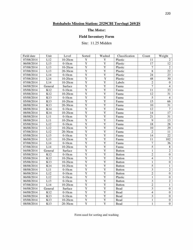
220
Botshabelo Mission Station: 2529CBI Toevlugt 269/JS
The Motse:
Field Inventory Form
Site: 11.25 Midden
Field date Unit Level Sorted Washed Classification Count Weight
07/08/2014 L12 10-20cm Y Y Plastic 11 2
06/08/2014 L13 0-10cm Y Y Plastic 17 12
07/08/2014 L13 10-20cm Y Y Plastic 7 2
07/08/2014 L13 20-30cm Y Y Plastic 8 22
07/08/2014 L14 0-10cm Y Y Plastic 24 23
07/08/2014 L14 10-20cm Y Y Plastic 48 30
07/08/2014 L14 10-20cm Y Y Labels 2 0
04/08/2014 General Surface Y Y Fauna 7 4
05/08/2014 K12 0-10cm Y Y Fauna 11 33
05/08/2014 K12 10-20cm Y Y Fauna 12 31
05/08/2014 K13 0-10cm Y Y Fauna 5 4
05/08/2014 K13 10-20cm Y Y Fauna 15 66
08/08/2014 K13 20-30cm Y Y Fauna 10 31
08/08/2014 K14 0-10cm Y Y Fauna 12 7
08/08/2014 K14 10-20cm Y Y Fauna 14 17
08/08/2014 L11 0-10cm Y Y Fauna 21 31
08/08/2014 L11 10-20cm Y Y Fauna 9 13
05/08/2014 L12 0-10cm Y Y Fauna 18 28
06/08/2014 L12 10-20cm Y Y Fauna 10 29
07/08/2014 L12 20-30cm Y Y Fauna 2 11
05/08/2014 L13 0-10cm Y Y Fauna 14 22
06/08/2014 L13 10-20cm Y Y Fauna 11 102
07/08/2014 L14 0-10cm Y Y Fauna 7 36
07/08/2014 L14 10-20cm Y Y Fauna 5 8
04/08/2014 General Surface Y Y Button 1 2
05/08/2014 K12 0-10cm Y Y Button 2 0
05/08/2014 K12 10-20cm Y Y Button 4 3
05/08/2014 K13 10-20cm Y Y Button 1 0
08/08/2014 K14 10-20cm Y Y Button 5 1
08/08/2014 L11 0-10cm Y Y Button 3 2
06/08/2014 L12 0-10cm Y Y Button 2 0
06/08/2014 L12 0-10cm Y Y Plastic 1 0
06/08/2014 L13 0-10cm Y Y Button 3 2
07/08/2014 L14 10-20cm Y Y Button 2 1
04/08/2014 General Surface Y Y Bead 3 0
04/08/2014 K12 0-10cm Y Y Bead 4 0
04/08/2014 K13 0-10cm Y Y Bead 3 0
05/08/2014 K13 10-20cm Y Y Bead 1 0
08/08/2014 K13 20-30cm Y Y Bead 1 0
Form used for sorting and washing

221
Botshabelo Mission Station: 2529CBI Toevlugt 269/JS
The Motse:
Field Inventory Form
Site: 11.25 Midden
Field date Unit Level Sorted Washed Classification Count Weight (g)
08/08/2014 K14 0-10cm Y Y Bead 3 1
08/08/2014 L11 0-10cm Y Y Bead 21 2
08/08/2014 L11 10-20cm Y Y Bead 2 0
06/08/2014 L12 0-10cm Y Y Bead 6 0
06/08/2014 L13 0-10cm Y Y Bead 8 0
07/08/2014 L14 10-20cm Y Y Bead 4 2
04/08/2014 General Surface Y Y Ceramic 39 118
04/08/2014 K12 0-10cm Y Y Ceramic 15 22
08/08/2014 K12 10-20cm Y Y Ceramic 14 31
04/08/2014 K13 0-10cm Y Y Ceramic 13 36
08/08/2014 K13 10-20cm Y Y Ceramic 9 79
09/08/2014 K13 20-30cm Y Y Ceramic 3 9
08/08/2014 K14 0-10cm Y Y Ceramic 13 16
08/08/2014 K14 10-20cm Y Y Ceramic 15 38
08/08/2014 L11 0-10cm Y Y Ceramic 15 25
08/08/2014 L11 10-20cm Y Y Ceramic 6 13
06/08/2014 L12 0-10cm Y Y Ceramic 16 31
06/08/2014 L12 10-20cm Y Y Ceramic 9 15
06/08/2014 L13 0-10cm Y Y Ceramic 19 77
08/08/2014 L13 10-20cm Y Y Ceramic 5 15
07/08/2014 L14 0-10cm Y Y Ceramic 4 7
07/08/2014 L14 10-20cm Y Y Ceramic 10 91
04/08/2014 General Surface Y Y Metal 53 1134
04/08/2014 K12 0-10cm Y Y Metal 27 62
05/08/2014 K12 10-20cm Y Y Metal 80 194
04/08/2014 K13 0-10cm Y Y Metal 54 59
05/08/2014 K13 10-20cm Y Y Metal 57 201
08/08/2014 K13 20-30cm Y Y Metal 28 161
08/08/2014 K14 0-10cm Y Y Metal 36 183
08/08/2014 K14 10-20cm Y Y Metal 56 356
04/08/2014 General Surface Y Y Wax 1 4
08/08/2014 L11 0-10cm Y Y Metal 81 215
08/08/2014 L11 10-20cm Y Y Metal 36 37
05/08/2014 L12 0-10cm Y Y Metal 29 60
07/08/2014 L12 10-20cm Y Y Metal 26 50
07/08/2014 L12 20-30cm Y Y Metal 5 8
06/08/2014 L13 0-10cm Y Y Metal 76 263
06/08/2014 L13 10-20cm Y Y Metal 60 119
09/08/2014 L13 20-30cm Y Y Metal 1 2
Form used for sorting and washing

222
Botshabelo Mission Station: 2529CBI Toevlugt 269/JS
The Motse:
Field Inventory Form
Site: 11.25 Midden
Field date Unit Level Sorted Washed Classification Count Weight (g)
07/08/2014 L14 0-10cm Y Y Metal 28 269
07/08/2014 L14 10-20cm Y Y Metal 157 864
04/08/2014 General Surface Y Y Glass 183 955
06/08/2014 K12 0-10cm Y Y Glass 89 563
05/08/2014 K12 10-20cm Y Y Glass 76 217
05/08/2014 K13 0-10cm Y Y Glass 32 48
05/08/2014 K13 10-20cm Y Y Glass 66 184
08/08/2014 K13 20-30cm Y Y Glass 11 10
08/08/2014 K14 0-10cm Y Y Glass 74 168
08/08/2014 K14 10-20cm Y Y Glass 152 781
08/08/2014 L11 0-10cm Y Y Glass 50 107
08/08/2014 L11 10-20cm Y Y Glass 21 16
05/08/2014 L12 0-10cm Y Y Glass 57 245
05/08/2014 L12 10-20cm Y Y Glass 24 35
06/08/2014 L12 20-30cm Y Y Glass 10 21
06/08/2014 L13 0-10cm Y Y Glass 93 296
06/08/2014 L13 10-20cm Y Y Glass 21 94
07/08/2014 L14 0-10cm Y Y Glass 58 188
07/08/2014 L14 10-20cm Y Y Glass 127 1551
Form used for sorting and washing

223
APPENDIX 3: MOTSE ARTEFACT CATALOGUE ON DISC