A GIS-derived integrated moisture index to predict forest composition and productivity of Ohio...
18
Introduction Ohio is typical among many midwest and eastern states in that it is undergoing a conversion of its oak-hickory forests, e.g., white oak (Quercus alba), chestnut oak (Q. prinus), scarlet oak (Q. coccinea), black oak (Q. velutina), northern red oak (Q. rubra), shagbark hickory (Carya ovata), and mockernut hickory (C. tomentosa) to primar- ily maple (Acer rubrum and A. sacc harum) and yellow poplar (Liriodendron tulipifera) forests. Data from the USDA Forest Service inventories between 1968 and 1991 (Kingsley and Mayer 1970; Dennis and Birch 1981; Griffith et al. 1993) indicate that the proportion of total overall volume in oak and hickory (Carya spp.) declined sub- stantially relative to maple, black cherry (Prunus serotina), and yellow poplar (Fig. 1). Although absolute growing-stock volumes tended to increase for most species in Ohio as the secondary forests matured, there was a shift in the relative impor- tance of species: red oaks, white oaks, and hick- ories declined by 41, 31, and 22 percent, respec- tively, while red maple, sugar maple, black cher- A GIS-derived integrated moisture index to predict forest composition and productivity of Ohio forests (U.S.A.) Louis R. Iverson, Martin E. Dale, Charles T. Scott and Anantha Prasad USDA Forest Service, Northeastern Forest Experiment Station, 359 Main Road, Delaware, OH 43015, U.S.A. Keywords: landscape ecology, site index, topography, Ohio, oak-hickory forests, integrated moisture index, GIS, spatial distribution, forest composition, DEM, resolution, scale Abstract A geographic information system (GIS) approach was used in conjunction with forest-plot data to devel- op an integrated moisture index (IMI), which was then used to predict forest productivity (site index) and species composition for forests in Ohio. In this region, typical of eastern hardwoods across the Midwest and southern Appalachians, topographic aspect and position (rather than elevation) change drastically at the fine scale and strongly influence many ecological functions. Elevational contours, soil series mapping units, and plot locations were digitized for the Vinton Furnace Experimental Forest in southeastern Ohio and gridded to 7.5-m cells for GIS modeling. Several landscape features (a slope-aspect shading index, cumulative flow of water downslope, curvature of the landscape, and water-holding capacity of the soil) were used to create the IMI, which was then statistically analyzed with site-index values and composition data for plots. On the basis of IMI values for forest land harvested in the past 30 years, we estimated oak site index and the percentage composition of two major species groups in the region: oak (Quercus spp.), and yellow poplar (Liriodendron tulipifera) plus black cherry (Prunus serotina). The derived statistical relationships were then applied in the GIS to create maps of site index and composition, and verified with independent data. The maps show the oaks will dominate on dry, ridge top positions (i.e., low site index), while the yellow poplar and black cherry will predominate on mesic sites. Digital elevation models with coarser resolution (1:24K, 1:100K, 1:250K) also were tested in the same manner. We had generally good success for 1:24K, moderate success for 1:100K, but no success for 1:250K data. This simple and portable approach has the advantage of using readily available GIS information which is time-invariant and requires no fieldwork. The IMI can be used to better manage forest resources where moisture is limiting and to predict how the resource will change under various forms of ecosystem management. Landscape Ecology 12: 331–348, 1997. 1997 Kluwer Academic Publishers. Printed in the Netherlands.
Transcript of A GIS-derived integrated moisture index to predict forest composition and productivity of Ohio...

Introduction
Ohio is typical among many midwest and easternstates in that it is undergoing a conversion of itsoak-hickory forests, e.g., white oak (Quercusalba), chestnut oak (Q. prinus), scarlet oak (Q.coccinea), black oak (Q. velutina), northern redoak (Q. rubra), shagbark hickory (Carya ovata),and mockernut hickory (C. tomentosa) to primar-ily maple (Acer rubrum and A. sacc harum) andyellow poplar (Liriodendron tulipifera) forests.Data from the USDA Forest Service inventories
between 1968 and 1991 (Kingsley and Mayer1970; Dennis and Birch 1981; Griffith et al. 1993)indicate that the proportion of total overall volumein oak and hickory (Carya spp.) declined sub-stantially relative to maple, black cherry (Prunusserotina), and yellow poplar (Fig. 1). Althoughabsolute growing-stock volumes tended to increasefor most species in Ohio as the secondary forestsmatured, there was a shift in the relative impor-tance of species: red oaks, white oaks, and hick-ories declined by 41, 31, and 22 percent, respec-tively, while red maple, sugar maple, black cher-
A GIS-derived integrated moisture index to predict forest compositionand productivity of Ohio forests (U.S.A.)
Louis R. Iverson, Martin E. Dale, Charles T. Scott and Anantha PrasadUSDA Forest Service, Northeastern Forest Experiment Station, 359 Main Road, Delaware, OH 43015,U.S.A.
Keywords: landscape ecology, site index, topography, Ohio, oak-hickory forests, integrated moisture index,GIS, spatial distribution, forest composition, DEM, resolution, scale
Abstract
A geographic information system (GIS) approach was used in conjunction with forest-plot data to devel-op an integrated moisture index (IMI), which was then used to predict forest productivity (site index) andspecies composition for forests in Ohio. In this region, typical of eastern hardwoods across the Midwestand southern Appalachians, topographic aspect and position (rather than elevation) change drastically atthe fine scale and strongly influence many ecological functions. Elevational contours, soil series mappingunits, and plot locations were digitized for the Vinton Furnace Experimental Forest in southeastern Ohioand gridded to 7.5-m cells for GIS modeling. Several landscape features (a slope-aspect shading index,cumulative flow of water downslope, curvature of the landscape, and water-holding capacity of the soil)were used to create the IMI, which was then statistically analyzed with site-index values and compositiondata for plots. On the basis of IMI values for forest land harvested in the past 30 years, we estimated oaksite index and the percentage composition of two major species groups in the region: oak (Quercus spp.),and yellow poplar (Liriodendron tulipifera) plus black cherry (Prunus serotina). The derived statisticalrelationships were then applied in the GIS to create maps of site index and composition, and verified withindependent data. The maps show the oaks will dominate on dry, ridge top positions (i.e., low site index),while the yellow poplar and black cherry will predominate on mesic sites. Digital elevation models withcoarser resolution (1:24K, 1:100K, 1:250K) also were tested in the same manner. We had generally goodsuccess for 1:24K, moderate success for 1:100K, but no success for 1:250K data. This simple and portableapproach has the advantage of using readily available GIS information which is time-invariant and requiresno fieldwork. The IMI can be used to better manage forest resources where moisture is limiting and topredict how the resource will change under various forms of ecosystem management.
Landscape Ecology 12: 331–348, 1997. 1997 Kluwer Academic Publishers. Printed in the Netherlands.

ry, and yellow poplar increased by 70, 44, 129,and 38 percent, respectively, in relative total vol-ume. This trend in relative proportions corrobo-rates a pattern seen regionwide, e.g., in Illinois(Iverson et al. 1989; Iverson 1994), Pennsylvania(Abrams and Nowacki 1992), and several othereastern states (Powell et al. 1993). This trend hasprompted a large scientific effort to assess theproblem and search for management solutions(e.g., Loftis and McGee 1993), including thisstudy designed to employ simple and portablecomputer mapping techniques to assess naturaloak regeneration capability. Management strate-gies to ‘adjust’ the natural tendencies could thenbe implemented.
Several factors contribute to the decline of oaksin eastern forests. Oaks do not regenerate wellunder closed canopies in the absence of fire, andthus are declining while more shade-tolerantspecies are thriving (Heiligmann et al. 1985; Hilt1985; Loftis and McGee 1993). In addition, whenlight and moisture are not limiting (e.g., after aclearcut), yellow poplar and black cherry growexceedingly fast, out competing the oak (Beck1990; Marquis 1990). The success of oak regen-eration after a canopy-changing disturbance seemsto follow a moisture gradient, that is, regenerationof oak is adequately only under dry conditions inwhich it can compete successfully with moremesic species.
Site index, defined as an average height of indi-vidual dominant trees in the stand at a specifiedage (e.g., the height of white oak in feet at 50years of age) has been the most widely-used site-evaluation measure in North America since theearly part of this century (Roth 1916; Frothingham1921; Mader 1963; Jones 1969). Other measures,such as vegetation approaches (e.g., ordination orclassification) or environmental approaches (e.g.,factorial or environmental ordination or soil sur-veys) also are used. A recent effort in Minnesotashows the potential of a relative stocking index(the ratio of a stand’s measured density to the‘norm’ predicted from inventory data by covertype) as a measure of site quality (Berguson et al.1994). Although site index is still favored by manyforest scientists as a direct and easy method forevaluating site productivity, this measure is limit-ed because it assumes that height growth has notbeen influenced by stand density or stand history,a situation that is difficult to confirm (Monserud1984; Berguson et al. 1994). The simple comput-er mapping technique developed for this study isintended to enhance the capability to estimate siteproductivity across landscapes.
It has been known for some time that the dis-tribution and growth (i.e., site index) of trees inthis geographic region are correlated with localtopography and soils, but these relationships aredifficult to quantify and map (Merz 1953; Trim-ble and Weitzman 1956; Trimble 1964; Carmean1965; Tajchman and Boyles 1993). McNab (1993)devised a topographic index based on eight slopegradients that was related to yellow poplar siteindex in the southern Appalachians. Fralish (1994)found a strong relationship between stand basalarea and soil and topographic factors in southernIllinois. He found this association related mostlyto the soil-water reservoir. Slope angle, aspect, andposition, and effective soil depth were the prima-ry factors controlling the amount of water in thesoil-water reservoir. White (1958) also concludedthat any measure of site productivity is mostly anestimate of the amount of available soil water, theexception being if the site has a prevailing watertable within 2 m of the surface where ground waterwould be available for tree growth (Loucks 1962).In British Columbia, Wang and Klinka (1991)
332
Fig. 1. Forest inventory trends for seven main species orspecies groups in Ohio, 1968–91. (Source: Kingsley and May-er 1970; Dennis and Birch 1981; Griffith et al. 1993)

found that the site index for lodgepole pine canbe estimated reasonably well with a soil-moisturemodel. Allen and Peet (1990) found a subjectivetopographic moisture index was correlated to acompositional gradient in Colorado. Slope angle,aspect, and position have also been combined invarious ways to relate to vegetation patterns (e.g.,Lieffers and Larkin-Lieffers 1987; Lloyd et al.1994). Host et al. (1987) reported that forest suc-cessional pathways in Michigan were stronglyrelated to topographic and edaphic conditions,again, largely via variations in moisture availabil-ity. In addition, a wetness index that features someof the same landscape elements as in this studyhas been used in hydrologic research (Beven 1986;Band and Wood 1988). A further review of pre-dictive vegetation mapping techniques can befound in Franklin (1995).
These relationships indicate that geographicinformation system (GIS) technology may be ide-ally suited to model moisture level across land-scapes, and, by extension, the potential to regen-erate oak forests. Digital elevation models (DEM)(US Geological Survey 1987) have been useful inderiving topographic features associated with land-scape processes (Jenson and Dominque 1988;Skidmore 1990; Twery et al. 1991; Garten et al.1994; Mitasova et al. 1996). Digital elevation dataalso have been used in combination with remote-ly sensed and other data to map forest composi-tion and biomass (Fox et al. 1985; Frank andThorne 1985; Iverson et al. 1994).
The objectives of this study were to: 1) evalu-ate the quality of DEM data (relative to topo-graphic and moisture indices) created at fourscales of resolution, 2) create an easily generatedmodel which estimated the integrated moistureindex (IMI) based on DEM and soils data, and 3)test the potential for using the IMI, as calibratedfrom field data, to estimate oak site index and tree-species composition of the “next forest”, that is,the forest that will result following the removal ofthe current, 100+ year-old, oak-dominated canopy.The objective with the index is to enable a sim-ple and general model of moisture that can be eas-ily implemented within a GIS, and which is notspecifically tied to the current vegetation pattern(current vegetation does not even factor into the
index), but can be specifically applied dependingon the data collected and landscape ecological ormanagement needs.
2. Methods
The objectives in this study were addressed bydeveloping the integrated moisture index based onfour factors that affect moisture levels in forestecosystems. The IMI was then applied and refinedon the study area in southeastern Ohio at four dif-ferent scales of resolution. Finally, it was used topredict site index and species composition forselected species in the study area.
2.1. Study area
The study area was the Vinton Furnace Experi-mental Forest in Vinton County, Ohio (Fig. 2). Itis part of the unglaciated Allegheny Plateau withits dissected topography and less than 100 m oftotal relief. It was carved from Pennsylvanian stra-ta consisting of a variety of sandstones, shales, andclays of variable composition, resistance, and con-tinuity of distribution (Beatley and Bartley 1959).The land was clearcut in the mid- to late-1800s tofurnish charcoal for several iron furnaces in theregion. The 475-ha forest is now owned by MeadPaper Corporation and has been managed as aresearch forest by the USDA Forest Service sincethe early 1950s. The forest has grown back withoak dominating the canopy, and has been the siteof extensive research on cutting practices anduneven- and even-age silviculture of oak-hickoryforests (e.g., Hilt and Dale 1982; Hilt 1985). Thecurrent overstory is dominated by oak and hicko-ry, and the species composition of the northerlyand southerly aspects is similar (Table 1). Condi-tions for establishment in the late 1800s likelywere influenced to a much greater degree by firethan presently, so that oaks were able to success-fully compete on either exposure (Crow 1988).
The upland forests are mostly a complex mosa-ic of oak-hickory and mixed oak communities,with some oak-yellow poplar and mixed meso-phytic communities in ravines and other mesic
333

sites (Beatley and Bartley 1959). The oak-hicko-ry (especially chestnut oak) community is indica-tive of locations with low soil moisture duringparts of the year, while yellow poplar and espe-cially yellow buckeye (Aesculus octandra) andbeech (Fagus grandifolia) are indicative of loca-tions providing constant and relatively high levelsof soil moisture. Thus, these complex mosaics aredriven primarily by the underlying complexities intopography and soils.
2.2. Integrated Moisture Index
The IMI was developed to integrate GIS-derivedtopographic and soil features of the landscape intoa single index that can be statistically related witha number of ecological processes across a land-scape (Fig. 3). The intention was to provide a rel-ative rating of moisture that can be related to spe-cific processes wherever moisture is seen to be theprimary driving factor. In this case, the resultingIMI was used to predict forest site productivityand composition, but many other ecologicalprocesses, including understory composition andrichness, soil nitrogen, aluminium, and pH, andbird distributions, are currently being related toIMI as well. Assuming reasonably similar climate,elevation, disturbance history, and soil fertilityamong upland sites, variation in plant distributionand productivity will be driven primarily by mois-ture availability. Moisture levels are higher wheredirect solar radiation is minimized (the hillshadevariable in the IMI model), in lower positions onslopes (flow accumulation) or in depressions (cur-vature), and in soils capable of storing highamounts of water (total water holding capacity).These four factors were modeled, via GIS, in theIMI.
Hillshade essentially captures the effects of dif-ferential solar radiation due to variation in slope
334
Fig. 2. The Vinton Furnace Experimental Forest located in southeastern Ohio. Grayscale shading represents the elevation of thearea. See Fig. 6a for the elevation scale bar.
Table 1. Species composition of current (120+ year old) uncutforest on southern vs. northern exposures; data are based onareas of 11 ha (southern) and 8 ha (northern) at Vinton Fur-nace Experimental Forest.
Southern Exposure Northern Exposure
No. Basal area No. Basal areastems/ha (m2/ha) stems/ha (m2/ha)
White oaks 118.3 11.8 99.0 10.5Black oaks 24.5 4.5 37.8 6.5Hickory 20.5 0.8 22.5 0.8Yellow poplar 11.4 0.7 17.8 1.4Red maple 63.5 1.7 39.5 2.0Other 14.3 0.7 29.1 1.0Total 252.4 20.4 245.8 22.2

angle, aspect, and position, and to account forshading from adjacent hills. The latter componentof hillshade was minimal because, although heav-ily dissected, the maximum relief change was lessthan 100 m and cliffs are rare in the area. Maxi-mum cumulative solar radiation over a year willoccur on steep, south-facing slopes (Lee andBaumgartner 1966). Because of the added dryingpotential of higher afternoon temperatures, maxi-mum drying of soil will occur on aspects slightlywest of south (SSW). Thus, the highest moisturelevels will be found on NNE aspects, a solarazimuth of 22 degrees. A solar altitude of 45degrees was used to approximate a growing sea-son average. The “hillshade” command in Arc/InfoGrid (Environ. Sys. Res. Inst. 1994), operating onthe digital elevation data for the site, was used tocreate a hillshade map with increasing scoresequivalent to increasing moisture content (Fig. 4a).
Flow accumulation represents the accumulatedflow of water downslope as water moves via grav-ity. It is related to position on the slope where the
bottoms of slopes accumulate much more mois-ture than ridgetops. The Arc/Info program “flowaccumulation” basically counts the number of cellssending water downslope to the cell being evalu-ated; ridgetops would have a flow accumulationof only one while the valley bottoms would havemaximum accumulation. Thus, increasing scorescontribute to increasing IMI (Fig. 4b). The mapshows the dissected nature of the area, with theroad and trail network following the ridgelines andthe many small stream valleys showing higherscores because of water flowing downslope.
Curvature is a measure of shape of the land-scape, whether it is flat, convex, or concave. TheArc/Info program “curvature” assesses surround-ing cells to calculate a curvature, with increasingpositive scores representing increasing concavity.Concave surfaces, or depressions, will accumulatemoisture and thus positively contribute to the IMI(Fig. 4c). The curvature map generally assignssmall coves and depressions with higher scores,and small knolls with lower scores. Algorithms for
335
Fig. 3. Flow diagram of the GIS process to derive IMI and related products.


flow accumulation and curvature are given in Jen-son and Domingue (1988).
Total available water-holding capacity wasderived from a digitized soil-series map, original-ly compiled at a scale of 1:15,840 by the USDANatural Resources Conservation Service. Usingthe attributes from these soil maps, soil depth (Aplus B horizons, the zones of most biologicalactivity) and available water-holding capacity (perunit depth) were multiplied to estimate the totalamount of water available to plants in the A andB horizons. In several instances, the mapping unitwas a soil complex consisting of two or more soilseries; in these cases, weighted averages were cal-culated based on the percentage of each soil seriesin the complex. There were 12 different soil seriesor complexes on the site, with a wide differencein total water holding capacity between the bot-tomland soils and the upland soils (Fig. 4d). Theupland soils are mostly shallow soils with bedrockclose to the surface, which severely restricted thetotal water-holding capacity. Soils in the valleyswere generally deeper and siltier. This pattern cre-ated a map with sharp boundaries of total avail-able water-holding capacity depending on themapped soil series/complex. A continuous soil-property map would be preferable using GIS andfuzzy logic, as is being developed by someresearchers (e.g., Zhu 1994).
Hillshade, flow accumulation, curvature, andtotal water-holding capacity were standardised toa 0 to 100 score to facilitate calculation of the IMI.Numerous iterations associated with on-site visitsand field experience were used to select the rela-tive weights to combine hillshade, flow accumu-lation, total water-holding capacity, and curvatureinto a single IMI value for the GIS model. Thefinal IMI score could then potentially range from0 to 100, with increasing scores indicating increas-ing moisture levels. The weights were not statis-tically optimized due to insufficient hard data, butthree years of testing has shown it to provideeffective results over a number of applications inOhio. We also tested the model output projectionsof percent oak with an independent data set of 24plots from another site 3 km away. The literatureand experience support the idea that, in this geo-graphic region, moisture availability is controlledby the intensity and duration of radiation (hill-
shade), micro- and macro-topography related towater infiltration and runoff (flow accumulationand curvature), and capacity of soil horizons tostore and release moisture over time (total water-holding capacity).
2.3. IMI comparison by DEM scale
Four scales of resolution were evaluated to com-pare their effectiveness in estimating IMI:
(1) Digitized contours (from the McArthur,Ohio, quadrangle 7.5-minute USGS topographicmap), which were converted to elevation points,kriged, and gridded (using commands “arcpoint”,“pointgrid” and “kriging”) into Arc/Info Grid at aresolution of 7.5 m [hereafter referred to as DIGdata];
(2) USGS 7.5-minute DEM data for theMcArthur quadrangle (1:24,000 scale, 30-m reso-lution) [24K];
(3) USGS 1:100,000 Digital Line Graph (DLG)hypsography data (elevational contours) for theWellston, Ohio, quadrangle, interpolated and ras-terized at 30-m resolution [100K]; and,
(4) USGS 3 arc-second DEM data for theColumbus-E quadrangle (1:250,000 scale), resam-pled via cubic convolution in Arc/Info Grid fromgeographic coordinates with variable-size cells toa constant cell resolution of 60 m [250K]. Infor-mation on quality and formats of (2), (3), and (4)is found in publications of the U.S. GeologicalSurvey (1987, 1989).
To calculate IMI, elevation data must be in adigital elevation model (DEM), or a grid of inter-polated cells covering the entire area. Therefore,the contoured data (DIG and 100K) had to be con-verted to DEM data. Three methods were used tointerpolate the contour data, all using Arc/InfoGrid software: “spline”, “topogrid”, and “kriging”.On the basis of optimizing correlations to the 24KDEM data (using Arc/Info’s “correlation” com-mand to compare grids), kriging was selected tocreate DEMs from the contours of the DIG and100K data (Dubrule 1984; Robertson 1987; Jour-nel 1989; Oliver and Webster 1990).
After the DEMs were built for all four sourcesof data, they had to be resampled to similar cellsizes so that direct comparisons among IMI maps
337

could be made. The DEMs had been created withcell sizes as multiples of 7.5 m: 7.5 m for DIG,30 m for 24K and 100K, and 60 m for 250K. Tosmooth the coarser data and allow consistent GISmethodology, a reduction in grid cell size to 7.5m (using “resample” with bilinear interpolation inArc/Info Grid) was conducted in even, multiplesteps; the 24K and 100K data were resampled to15, then 7.5 m, and the 250K data were resam-pled to 30, 15, and finally 7.5 m. Bilinear resam-pling uses the four nearest cells to calculate aweighted average for each cell, and the process-ing in sequential steps allowed a much moredetailed final DEM relative to, for example, direct-ly resampling the 250K data from 60 to 7.5 m. Toassess the effects of this smoothing process, allGIS processing was conducted with a grain sizeof 30 m as well as 7.5 m. In this case, resamplingwas done to increase the DIG data in multiplesteps (15, 30 m) to a cell size of 30 m.
IMI values were calculated for each scale, sep-arated into 10 classes, and compared using arealestimates by class. Additionally, pixel-by-pixelcomparisons for all map pairs (with 7.5- and 30-m grain size) were made using cross correlation,which in Arc/Info Grid yields a correlation coef-ficient between two maps.
2.4. Predicting site index and composition
Field estimates of white oak site index and per-cent composition of oaks (mostly white, chestnut,scarlet, black, and northern red), red maple, yel-low poplar, black cherry, and several minorspecies were made for twenty-three 0.04 ha plotswith known locations. These sites had been har-vested in 1965 and had regenerated in the absenceof fire. As such, they represent the ecological con-ditions that presently occur when the old, oak-dominated canopy is removed by human or natur-al causes. These plots are ecologically representa-tive of much of southern Ohio and beyond. Aver-age IMI scores were obtained for the cells occu-pying each plot (using the “zonalstats” function inArc/Info Grid), and statistically related to siteindex and percent composition of oaks, redmaples, and yellow poplar plus black cherry. Lin-ear regression was used to estimate site index,
while logistic regression was used to estimate per-cent composition (so that estimates did not extendbeyond the 0–100% range). Yellow poplar andblack cherry were combined, as were the oaks,because of their close association in the standsstudied. Linear and logistic regressions were per-formed in S-PLUS (StatSci 1993).
Regression analysis of IMI with field-plot esti-mates was used to convert the IMI scores to GIS-modeled estimates of oak site index and percentoak or percent yellow poplar plus black cherry. Noattempt was made to develop a GIS model of redmaple composition, because the IMI-maple regres-sion had an R2 near zero.
3. Results
3.1. IMI generation
The GIS-modeled map of IMI (Fig. 5a–c) revealsa general pattern of low scores (drier conditions)at the ridgetops and south to southwest facingslopes, especially where the soils are shallow. Thedeep soils and high flow accumulation along theElk Fork river (the northern boundary of the studyarea) are apparent with the highest IMI scores.Equally apparent is the extremely heterogeneousnature of the landscape; for example, one can findnearly the entire range of IMI scores within any20-ha area.
3.2. IMI comparison by DEM scale
The smoothing process, whereby coarse elevationdata (e.g., 100K and 250K) were consecutivelyresampled to a common cell size of 7.5 m, result-ed in more realistic portrayals of elevation com-pared to the original source data. However, vari-ation in the quality of data is apparent (Figs. 5–6).In the case of 250K data, misregistration placedsome ridges in the valleys and vice versa. Thisexercise once again reveals the danger in trying toextract local phenomena from coarse-resolutiondata. By contrast, the DIG, 24K, and 100K eleva-tion data appeared similar visually and statistical-ly, as confirmed by the correlation statistics (Fig.6, Table 2).
338


340
Fig. 6. Elevation maps produced from data at four scales: (a) DIG, (b) 24K, (c) 100K, and (d) 250K.
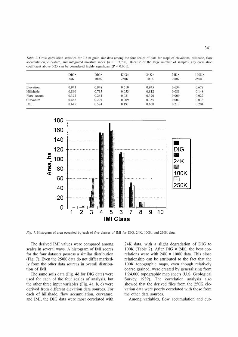
The derived IMI values were compared amongscales in several ways. A histogram of IMI scoresfor the four datasets possess a similar distribution(Fig. 7). Even the 250K data do not differ marked-ly from the other data sources in overall distribu-tion of IMI.
The same soils data (Fig. 4d for DIG data) wereused for each of the four scales of analysis, butthe other three input variables (Fig. 4a, b, c) werederived from different elevation data sources. Foreach of hillshade, flow accumulation, curvature,and IMI, the DIG data were most correlated with
24K data, with a slight degradation of DIG to100K (Table 2). After DIG × 24K, the best cor-relations were with 24K × 100K data. This closerelationship can be attributed to the fact that the100K topographic maps, even though relativelycoarse grained, were created by generalizing from1:24,000 topographic map sheets (U.S. GeologicalSurvey 1989). The correlation analysis alsoshowed that the derived files from the 250K ele-vation data were poorly correlated with those fromthe other data sources.
Among variables, flow accumulation and cur-
341
Table 2. Cross correlation statistics for 7.5 m grain size data among the four scales of data for maps of elevations, hillshade, flowaccumulation, curvature, and integrated moisture index (n = ~93,700). Because of the large number of samples, any correlationcoefficient above 0.25 can be considered highly significant (P < 0.001).
DIG× DIG× DIG× 24K× 24K× 100K×24K 100K 250K 100K 250K 250K
Elevation 0.943 0.948 0.610 0.945 0.634 0.678Hillshade 0.860 0.715 0.053 0.812 0.081 0.148Flow accum. 0.392 0.264 –0.021 0.370 –0.009 –0.022Curvature 0.462 0.291 0.009 0.355 0.007 0.033IMI 0.645 0.524 0.191 0.630 0.217 0.204
Fig. 7. Histogram of area occupied by each of five classes of IMI for DIG, 24K, 100K, and 250K data.

vature had lower correlations among scales com-pared to elevation, hillshade, and IMI (Table 2).These variables are very sensitive to subtle dif-ferences in elevation so that pixel-by-pixel corre-spondence can fluctuate widely even though trendsare similar.
When all maps were converted to a 30-m grainsize, correlation trends were similar (Table 3). Therelationships between DIG and 24K data weresomewhat stronger, and the correlation for flowaccumulation and curvature were higher for thesepairs of maps. In this case, aggregation of finely-scaled pixels averaged for a 4 × 4 cell area allowedthe spatial averaging of subtle differences, and thecorrelation were enhanced. Comparisons involvingthe 250K or 100K data generally were less corre-lated compared to data for the 7.5-m grain size.
The correlation enhancement by subsamplingcoarse (100K and 250K) data indicates the prob-able value of smoothing the coarser data via step-wise resampling with bilinear interpolation so thatabrupt changes in elevation between cells are notapparent.
3.3. Predicting site index and composition
Oak site index as determined from 18 plots wassimilarly related (R2 = 0.63–0.64) to the DIG and24K IMI estimate (Fig. 8). The 100K data did notshow a significant relationship to site index,though the slope was in the correct direction. Forthe 250K data, however, statistical and visual com-parisons indicate that these data seem unreliablefor predicting site index for individual sites.
With the DIG and 24K data, ground estimatesof percent oak composition were negatively relat-ed to IMI: the higher the moisture levels, the low-er the proportion of oak (Fig. 9). Conversely, theproportion of yellow poplar and black cherryincreased with increasing IMI scores (Fig. 10).Again, there was no significant relationshipbetween IMI for the 100K data and the proportionof oak or yellow poplar and black cherry. Redmaples are able to survive across a full spectrumof IMI values; although they seem most commonon intermediate sites, we found no statistical rela-tionship between IMI and the proportion of redmaple.
The relationships developed allowed a GISmodeling of oak site index (Fig 11a, using DIGdata only), which shows highest values in the val-ley bottoms and lowest values on upper south-fac-
342
Table 3. Cross correlation statistics for 30-m grain size data among the four scales of data for maps of elevations, hillshade, flowaccumulation, curvature, and integrated moisture index (n = ~5900). Because of the large number of samples, any correlation coef-ficient above 0.25 can be considered highly significant (P < 0.001).
DIG× DIG× DIG× 24K× 24K× 100K×24K 100K 250K 100K 250K 250K
Elevation 0.947 0.919 0.608 0.910 0.611 0.667Hillshade 0.935 0.696 0.042 0.676 0.031 0.160Flow accum. 0.565 0.307 –0.051 0.257 –0.038 –0.003Curvature 0.557 0.300 0.019 0.229 0.021 0.009IMI 0.770 0.532 0.106 0.485 0.123 0.181
Fig. 8. Linear regression relationship between oak site indexand IMI (DIG and 24K data) for 23 plots in the Vinton Fur-nace Experimental Forest. R2 values for the regression lineswere 0.64 (DIG) and 0.63 (24K).

ing slopes and ridgetops. The map visually agreeswell with data and decadal observations of thestudy area. According to our model, the overallaverage estimate for site index was 67 feet (20.4m) at base age 50.
The logistic regression-derived map of percentoak composition for DIG data shows oak to beconcentrated in relatively small, dry locationswhere site indexes are lowest (Fig. 11b). Con-versely, quite large portions of the study area areprojected to have, in the next forest, very low pro-portions of oak. A comparison of this model’s pro-jection of percent oak with that of an independentdata set of 24 plots from the northern portion ofthe study area yielded a linear regression R2 of0.70, thereby validating the reasonableness ofmodel results.
Because the regressions for yellow poplar plusblack cherry were in the opposite direction fromthe oak regressions (Figs. 9–10), the mapped pro-portions of stems in yellow poplar plus black cher-ry are inverse to that of oak (Fig. 11c). They areconcentrated in the more moist areas on the map.On the basis of the independent data set as wellas many field observations in cutover areas, themaps project reasonable estimates of the compo-sition of the primary species that has occurred orwill occur following disruption (through natural orhuman-induced effects) of the current oak-domi-nated canopy. According to our regression results,
if this disruption would occur over the entire Vin-ton Furnace Experimental Forest, one could expectan overall proportion of 34% oak and 34% yellowpoplar and black cherry in the next forest. Theremainder undoubtedly would be primarily redmaple. Of course, management activities couldchange the successional pathways predicted hereif they significantly altered the overstory or under-story structure, using various site modifications,fire, or other treatments. The predictive mapsshown here relate strictly to natural regenerationwithout human modifications after canopy re-moval.
4. Discussion
4.1. DEM evaluation
As expected, there was a general decrease in thequality of the results as the source data becamemore coarse. Estimates of slope angles, aspects,and locations of specific ridges and valleys werenot reliable with 250K data. Thus, the 250K dataare not recommended for predicting future com-position at a detailed (e.g., ridge to ridge) scale.However, the DIG and 24K data were reliable forthis application. The reliability of the 100K datais ambiguous. On the basis of correlation and visu-al analysis, 100K data seem to be closely corre-
343
Fig. 9. Logistic regression relationship between percent com-position of oaks and IMI (DIG and 24K data) for 23 plots inthe Vinton Furnace Experimental Forest. P values for the rela-tionships were 0.010 (DIG) and 0.016 (24K).
Fig. 10. Logistic regression relationship between percent com-position of yellow poplar plus black cherry and IMI (DIG and24K data) for 23 plots in the Vinton Furnace Expimental For-est; P values for the regression lines were 0.040 (DIG) and0.083 (24K).


lated to the DIG and 24K data (Table 2, Figs. 5–6),so that one would expect the IMI to be fairly reli-able. However, regressions of site index and per-cent composition were not significant for 100Kdata, unlike those for the DIG or 24K data (Figs.8–10). Further assessments of the 100K DLG dataare needed before this application can be recom-mended for detailed analysis and prediction. Itmay be that IMI differences between 100K andfiner scales are especially large only for that por-tion of the experimental forest where the fieldplots were located. However, we are confident thatthe 100K data can provide sufficient specific topo-graphic information for calculating the IMI at arelatively coarse resolution over large areas. The100K DLG data soon will be available for theentire country so that statewide or even largerregional assessments will be possible.
4.2. Integrated Moisture Index
This GIS procedure produced a realistic distribu-tion map of the IMI. In addition to the site indexand tree composition presented here, the IMI canbe related to many ecological processes which arerelated to water availability across landscapes.Increasing experience with IMI has shown it to bea valuable integrator of ecosystem function. Forexample, IMI classes are being used to stratify alandscape-level experimental design assessing theeffect of fire on mixed-oak forest communities(Iverson et al. 1996). The effects of fire on under-story, overstory, soil nutrients and pH, regenera-tion, and animal distribution are being assessed bymoisture regime. Preburn analyses show IMI to becorrelated, often the most correlated variable, tounderstory vegetation patterns (Iverson et al.1996) and species richness (S. Sutherland, per-sonal communication), litter depth (T. Hutchinson,personal communication), soil pH and nitrates (R.Boerner, personal communication), and the distri-butions for several bird species (R. Dettmers, per-sonal communication).
4.3. Site index
Field estimates of site index historically have beenproblematic because of difficulties in obtaining
adequate, free-to-grow trees for estimating heightgrowth over 50 years without disturbances (Mon-serud 1984; Berguson et al. 1994). The methodpresented here, when properly calibrated, may beas good as or even better than field methods,because it is repeatable and consistent over timeand over large areas. It is especially useful formaking relative assessments of site-specific pro-ductivity potentials across landscapes within amanagement unit. Unlike traditional measures ofsite index, it is not affected by disturbances in thecanopy (e.g., ice storms) which can artificiallyreduce estimates. For measures of site quality, thiseffect is advantageous unless the site’s potentialhas been altered significantly by a disturbance.
4.4. Composition
Reasonable estimates of proportions of oak or yel-low poplar plus black cherry were mapped via theGIS regression model used here (Fig. 11b, c).Future stands dominated by oaks will be concen-trated in low-site index areas (low IMI scores)where competition from more mesic and tolerantspecies will be minimized and oak regenerationcan proceed. If a high level of oak was the desiredfuture condition, management activities could beconcentrated on those areas with intermediate IMIscores, i.e., where oak regeneration was quite lownaturally, but where fire or group selection cutscould shift the balance in favor of oaks. Limitedmanagement resources could thus be targetedwhere they will do the most good.
The value of the IMI for predicting future com-position has a strong basis in the physiology,anatomy, and ecology of mixed oak communities.Oaks are relatively more tolerant of moisture stressbecause of the morphological and anatomical char-acteristics of oak leaves and xylem, as well as thecarbon allocation patterns that favor root growth.These characteristics allow for better growth anda competitive advantage under moisture-stressedconditions (Rogers 1990; Hodges and Gardiner1993).
Poor oak regeneration on sites of relatively highoak site index most often is due to a slow juve-nile growth rate of oak seedlings under a closedcanopy and their inability to respond quickly to
345

release after canopy disturbance. Although whiteoak seedlings may live up to 90 years in the under-story (Rogers 1990), they are slow to acclimate tochanged conditions and unable to take full advan-tage after release on good sites. Oaks are there-fore at a competitive disadvantage with the shade-tolerant red maple as advanced regeneration pro-ceeds under the current oak-dominated canopies,which typically have low light penetration. At theother extreme, oak also does not compete well infull sunlight relative to intolerant species such asyellow poplar and black cherry.
Yellow poplar and black cherry were concen-trated in the mesic sites with high oak site-indexvalues (Fig. 11a, c). If the area were to undergo asevere windstorm or harvest, or if left to proceedto old-age mortality, we would expect the patternsof distribution shown in Figure 11c for yellowpoplar and black cherry. Both species are intoler-ant to shade but have high growth rates in full sun-light (Beck 1990; Marquis 1990). On land of siteindex 75 feet or higher in the southern Appalachi-ans, yellow poplar has faster height growth up to50 years of age than any of its associates exceptwhite pine. It also expresses dominance well andmay form nearly pure stands on good sites. Bothspecies grow best in moderately moist, well-drained, and loose-textured soils, on north and eastaspects and lower slopes, in sheltered coves, andon gentle, concave slopes (Beck 1990; Marquis1990). These are precisely the locations with highIMI scores and, consequently, high concentrationsof yellow poplar plus black cherry (Figs. 5a and11c).
We did not find a significant linear relationshipbetween red maple and IMI, as red maples werefound fairly consistently over a wide range of IMI.Red maple is one of the most abundant and wide-spread trees in eastern North America (Hutnickand Yawney 1961), and probably can thrive on awider range of soil types, textures, moisture, pH,and elevation than any other forest species inNorth America (Hepting 1971; Golet et al. 1993).It is expanding in dominance throughout its rangeand is able to increase following disturbances suchas disease, windthrow, and harvesting (Bowersoxand Ward 1972; Good and Good 1972). These pat-terns also are apparent from this study; thoughfield observations tended to reveal a slightly
greater preponderance of red maple in the com-positional mix when site index was intermediate,e.g., after cutting, red maple will dominate so longas sites are not too dry (oak) or too mesic (yellowpoplar and black cherry). Also, red maple is high-ly susceptible to fire damage.
Finally, we have shown that the integratedmoisture index (IMI) can be simply derived in aGIS from readily-available topographic data(DEM) and soils maps. The index itself requiresno field assessments or current vegetation maps.It is time-invariant and is consistent between areasto be assessed. It is, however, simply an index thatneeds to be related to site-specific conditions forthe ecosystem characteristics of interest. The IMIhas been related to site productivity (site index)and to species composition in Ohio. It has alsoproven useful for predicting various ecosystemattributes such as understory vegetation patterns,species richness, soil pH and nitrates, and birdspecies distributions. We anticipate that the indexwill perform well in a variety of ecological appli-cations, though it must be calibrated to the spe-cific location and application in question. As ageneral index, it may not be optimized for any par-ticular application, but can be expected to performwell in those applications where moisture is a keydriving variable to the ecological pattern orprocess. The use of the integrated moisture indexis recommended as a site attribute for analyzingand modeling ecosystems where moisture is lim-iting.
Acknowledgements
This study was funded by the USDA Forest Ser-vice, Northeastern Forest Experiment Station. Theauthors thank Mr. Peter Sweeney for assistancewith computer automation and Drs. WilliamMcWilliams, Eric Gustafson, Thomas Jacob, andA-Xing Zhu for technical reviews.
References
Abrams, M.D. and Nowacki, G.J. 1992. Historical variationin fire, oak recruitment, and post-logging accelerated suc-cession in central Pennsylvania. Bulletin of the TorreyBotanical Club 119: 19–28.
346

Allen, R.B. and Peet, R.K. 1990. Gradient analysis of forestsof the Sangre de Cristo Range, Colorado. Canadian Jour-nal of Botany 68: 193–201.
Band, L.E. and Wood, E.F. 1988. Strategies for large-scaledistributed hydrologic simulation. Applied Mathematicsand Computation 27: 23–27.
Beatley, J.C. and Bartley, F. 1959. The primeval forests of aperiglacial area in the Allegheny Plateau. Bulletin of theOhio Biological Survey 1: 25–166.
Beck, D.E. 1990. Liriodendron tulipifera L. Yellow poplar. InSilvics of North America: 2. Hardwoods. pp. 406–416.Edited by R.M. Burns and B.H. Honkala (tech. coords.)U.S. Department of Agriculture, Agriculture Handbook654, Washington, DC. 877 pp.
Berguson, W.E., Grigal, D.F. and Bates, P.C. 1994. Relativestocking index: a proposed index of site quality. CanadianJournal of Forest Research 24: 1330–1336.
Beven, K.J. 1986. Runoff production and flood frequency incatchments of order n: an alternative approach. In ScaleProblems in Hydrology. pp. 107–131. Edited by V.K. Gup-ta, I. Rodriguez-Iturbe and E.F. Woods. D. Reidel Pub-lishing Co., Dordrecht.
Bowersox, T.W. and Ward, W.W. 1972. Prediction of advanceregeneration in mixed-oak stands of Pennsylvania. ForestScience 18: 278–282.
Carmean, W.H. 1965. Black oak site quality in relation to soiland topography in southeastern Ohio. Soil Science Societyof America Proceedings 29: 308–312.
Crow, T.R. 1988. Reproductive mode and mechanisms forself-replacement of northern red oak (Quercus rubra) – areview. Forest Science 34: 19–40.
Dennis, D.F. and Birch, T.W. 1981. Forest statistics for Ohio– 1979. U.S. Department of Agriculture, Forest Service,Resource Bulletin NE-68. 79 pp.
Dubrule, O. 1984. Comparing splines and kriging. Computersand Geosciences 10: 327–338.
Environmental Systems Research Institute. 1994. ArcDoc.(On-line documentation for Arc/Info software). Environ-mental Systems Research Institute, Redlands, CA.
Fox, L., Brockhus, J.A. and Tosta, N.D. 1985. Classificationof timberland productivity in northwestern California usingLandsat, topographic, and ecological data. Photogrammet-ric Engineering and Remote Sensing 51: 1745–1752.
Frank, T.D. and Thorn, C.E. 1985. Stratifying alpine tundrafor geomorphic studies using digitized aerial imagery. Arc-tic and Alpine Research 17: 179–188.
Fralish, J.S. 1994. The effect of site environment on forestproductivity in the Illinois Shawnee Hills. EcologicalApplications 4: 134–143.
Franklin, J. 1995. Predictive vegetation mapping: geographicmodelling of biospatial patterns in relation to environmen-tal gradients. Progress in Physical Geography 19: 494–519.
Frothingham, E.H. 1921. Height growth as a key to site. Jour-nal of Forestry 16: 754–760.
Garten, C.T., Huston, M.A. and Thoms, C.A. 1994. Topo-graphic variation of soil nitrogen dynamics at WalkerBranch watershed, Tennessee. Forest Science 40: 497–512.
Golet, F.C., Calhoun, A.J.K., DeRagon, W.R., Lowry, D.J. and
Gold, A.J. 1993. Ecology of red maple swamps in theglaciated northeast: a community profile. U.S. Departmentof Interior, Fish and Wildlife Service, Biological Report12, Washington, DC. 151 pp.
Good, N.F. and Good, R.E. 1972. Population dynamics of treeseedlings and saplings in a mature eastern hardwood for-est. Bulletin of the Torrey Botanical Club 99: 172–178.
Griffith, D.M., DiGiovanni, D.M., Witzel, T.L. and Wharton,E.H. 1993. Forest statistics for Ohio, 1991. U.S. Depart-ment of Agriculture, Forest Service, Resource Bulletin NE-128. 169 pp.
Hepting, G.H. 1971. Diseases of forest and shade trees of theUnited States. U.S. Department of Agriculture, Agricultur-al Handbook 386, Washington, DC. 658 pp.
Heiligmann, R.B., Norland, E.R. and Hilt, D.E. 1985. Uplandoak reproduction. Northern Journal of Applied Forestry 2:17–22.
Hilt, D.E. 1985. Species composition of young central hard-wood stands that develop after clearcutting. In Proceedings,5th Central Hardwood Forest Conference. pp. 11–14. Edit-ed by J.O. Dawson and K.A. Majerus. University of Illi-nois, Department of Forestry, Urbana.
Hilt, D.E. and Dale, M.E. 1982. Effects of repeated precom-mercial thinnings in central hardwood sapling stands.Southern Journal of Applied Forestry 6: 53–58.
Hodges, J.D. and Gardiner, E.S. 1993. Ecology and physiol-ogy of oak regeneration. In Oak regeneration: serious prob-lems, practical recommendations. pp. 54–65. Edited by D.Loftis and C. McGee. U.S. Department of Agriculture, For-est Service, General Technical Report SE-84. 319 pp.
Host, G.E., Pregitzer, K.S., Ramm, C.W., Hart, J.B. and Cle-land, D.T. 1987. Landform-mediated differences in suc-cessional pathways among upland forest ecosystems innorthwestern lower Michigan. Forest Science 33: 445–457.
Hutnick, R.J. and Yawney, H.W. 1961. Silvical characteris-tics of red maple (Acer rubrum). U.S. Department of Agri-culture, Forest Service, Northeastern Forest ExperimentStation, Station Paper 142, Upper Darby, PA. 18 pp.
Iverson, L.R. 1994. Forest resource trends in Illinois. Erige-nia 13: 4–19.
Iverson, L.R., Brown, S., Prasad, A., Mitasova, H., Gillespie,A.J.R. and Lugo, A.E. 1994. Use of GIS for estimatingpotential and actual forest biomass for continental southand southeast Asia. In Effects of Land-Use Change onAtmospheric CO2 Concentrations: Southeast Asia as a CaseStudy. pp. 67–116. Edited by V. Dale. Springer-Verlag,New York.
Iverson, L.R., Scott, C.T., Dale, M.E. and Prasad, A.M.G.1996. Development of an integrated moisture index for pre-dicting species composition. In Caring for the Forest:Research in a Changing World. Statistics, Mathematics andComputers. pp. 101–116. Edited by M. Kohl and G.Z. Gert-ner. Swiss Federal Institute for Forest, Snow and Land-scape Research, Birmensdorf, Switzerland.
Iverson, L.R., Oliver, R., Tucker, D., Risser, P.G., Burnett,C.D. and Rayburn, R. 1989. Forest resources of Illinois: anatlas and analysis of spatial and temporal trends. IllinoisNatural History Survey, Special Publication 11, Cham-paign, IL. 181 pp.
347

Jenson, S.K. and Domingue, J.O. 1988. Extracting topographicstructure from digital elevation data for geographic infor-mation system analysis. Photogrammetric Engineering andRemote Sensing 54: 1593–1600.
Jones, J.R. 1969. Review and comparison of site evaluationmethods. U.S. Department of Agriculture, Forest Service,Research Paper RM-51. 27 pp.
Journel, A.G. 1989. Fundamentals of Geostatistics in FiveLessons. American Geophysical Union, Washington, DC.40 pp.
Kingsley, N.P. and Mayer, C.E. 1970. The timber resourcesof Ohio. U.S. Department of Agriculture, Forest Service,Resource Bulletin NE-19. 137 pp.
Lee, R. and Baumgartner, A. 1966. The topography and inso-lation climate of a mountainous forest area. Forest Science12: 258–267.
Lieffers, V.J. and Larkin-Lieffers, P.A. 1987. Slope, aspect,and slope position as factors controlling grassland com-munites in the coulees of the Oldman River, Alberta. Cana-dian Journal of Botany 65: 1371–1378.
Lloyd, A.H., Armbruster, W.S. and Edwards, M.E. 1994. Ecol-ogy of a steppe-tundra gradient in interior Alaska. Journalof Vegetation Science 5: 897–912.
Loftis, D. and McGee, C. 1993. Oak regeneration: seriousproblems, practical recommendations. U.S. Department ofAgriculture, Forest Service, General Technical Report SE-84. 319 pp.
Loucks, O.L. 1962. Ordinating forest communities by meansof environmental scalars and phytosociological indices.Ecological Monographs 32: 137–166.
Marquis, D. 1990. Prunus serotina Ehrh. Black cherry. In Sil-vics of North America: 2. Hardwoods. pp. 594–602. Edit-ed by R.M. Burns and B.H. Honkala (tech. coords.). U.S.Department of Agriculture, Agriculture Handbook 654,Washington, DC. 877 pp.
Mader, D.L. 1963. Volume growth measurement – an analy-sis of function and characteristics in site evaluation. Jour-nal of Forestry 61: 193–198.
McNab, W.H. 1993. A topographic index to quantify the effectof mesoscale landform on site productivity. Canadian Jour-nal of Forest Research 23: 1100–1107.
Merz, R.W. 1953. Site-index estimates made easy. Journal ofForestry 51: 749–750.
Mitasova, H., Hofierka, J., Zlocha, M. and Iverson, L.R. 1996.Modeling topographic potential for erosion and depositionusing GIS. International Journal of Geographic InformationSystems 10: 629–641.
Monserud, R.A. 1984. Problems with site index: an opinion-ated review. In Forest Land Classification: Experiences,Problems, Perspectives. pp. 167–180. Edited by J. Bock-heim. University of Wisconsin, Madison.
Oliver, M.A. and Webster, R. 1990. Kriging: a method of
interpolation for geographical information systems. Inter-national Journal of Geographical Information Systems 4:313–332.
Powell, D.S., Faulkner, J.L., Darr, D.R., Zhu, Z. and Mac-Cleery, D.W. 1993. Forest resources of the United States,1992. U.S. Department of Agriculture, Forest Service, Gen-eral Technical Report RM-234. 133 pp.
Robertson, G.P. 1987. Geostatistics in ecology: interpolatingwith known variance. Ecology 68: 744–748.
Rogers, R. 1990. Quercus alba L. White oak. In Silvics ofNorth America: 2. Hardwoods. pp. 605–613. Edited byR.M. Burns and B.H. Honkala (tech. coords.). U.S. Depart-ment of Agriculture, Agriculture Handbook 654, Washing-ton, DC. 877 pp.
Roth, F. 1916. Concerning site. Forestry Quarterly 15: 3–13.Skidmore, A.K. 1990. Terrain position as mapped from a grid-
ded digital elevation model. International Journal of Geo-graphical Information Systems 4: 33–50.
StatSci. 1993. Guide to Statistical and Mathematical Analy-sis. StatSci, Seattle, WA.
Tajchman, S.J. and Boyles, R.L. 1993. Topography and soilA and B horizons in the forested Appalachian watershed.Northern Journal of American Forestry 10: 93–94.
Trimble, G.R. 1964. An equation for predicting oak site indexwithout measuring soil depth. Journal of Forestry 62:325–327.
Trimble, G.R. and Weitzman, S. 1956. Site index studies ofupland oaks in the northern Appalachians. Forest Science2: 162–173.
Twery, M.J., Elmes, G.A. and Yuill, C.B. 1991. Scientificexploration with an intelligent GIS: predicting species com-position from topography. AI Applications in NaturalResource Management 5: 45–53.
U.S. Geological Survey. 1987. Digital elevation models: U.S.Geological Survey Data Users Guide 5. U.S. GeologicalSurvey, Reston, VA.
U.S. Geological Survey. 1989. Digital line graphs from1:100,000-scale maps: U.S. Geological Survey Data UsersGuide 2. U.S. Geological Survey, Reston, VA.
Wang, Q. and Klinka, K. 1991. Relations between site indexand ecological quality of sites in sub-boreal lodgepole pineecosystems of British Columbia. In Pacific Rim Forestry –Bridging the World: 1991 SAF National Convention Pro-ceedings. SAF Publication 91-05. pp. 538–539. Society ofAmerican Foresters, Bethesda, MD.
White, D.P. 1958. Available water: the key to forest site eval-uation. In Proceedings, 1st Forest Soils Conference. pp.6–11. Edited by T.D. Stevens and R.L. Cook. MichiganState University, Department of Forestry, East Lansing.
Zhu, A.-X. 1994. A knowledge-based approach to data inte-gration for soil mapping. Canadian Journal of RemoteSensing 20: 408–418.
348