A geoarchaeological approach to the evolution of the town and port of Dover: Prehistoric to Saxon...
20
A geoarchaeological approach to the evolution of the town and port of Dover: Prehistoric to Saxon periods Martin R. Bates a, *, Barry Corke b , Keith Parfitt b , John E. Whittaker c a Department of Archaeology and Anthropology, University of Wales Trinity St David Ceredigion, Wales, SA48 7ED, United Kingdom b Canterbury Archaeological Trust, 92a Broad Street, Canterbury, Kent, CT1 2LU, United Kingdom c Department of Palaeontology, Natural History Museum, Cromwell Road, London, SW7 5BD, United Kingdom 1. Introduction Dover is located on the English Channel coast of Kent at the mouth of the River Dour (Fig. 1), where the narrow gap formed by its valley represents the only significant break in almost 20 km of chalk cliffs. This, together with the close proximity of the Continent, has ensured the site’s standing as an important port and point of entry into Britain, probably since pre-Roman times. The operational maintenance of a port here, however, has not been easy, with geographical and strategic necessities often over-riding the limitations of the available natural facilities. Thus, throughout the centuries, the harbour has had at least four different locations, dictated by ever-changing coastal topography (Biddle and Summerson, 1982; Leach, 2005). The original estuary and its associated Roman harbour have long since been infilled and much of modern Dover is built across the deep layers of sediment which fill the former haven. However, little is known of the sequence of events associated with the transformation of the area from the later prehistoric to early historic periods. Unravelling this history of harbour infilling has a long history in Dover and began in the nineteenth and first half of the twentieth century (Elsted, 1856; Knocker, 1857; Bavington Jones, 1907). These early observations were augmented by opportunistic observations prior to the Second World War (Amos and Wheeler, 1929) and formal excavations during construction and infrastructure renewal following bomb damage after the war (Threipland and Steer, 1951; Threipland, 1957; Rahtz, 1958). Widespread investigations coincided with larger scale works associated with urban regeneration during the 1970s and 1980s (Philp, 1981a, 1989) and modifications to the A20 road and town sewers in the early 1990s (Bates and Barham, 1993). Because of the urbanized character of the area, coupled with the deeply stratified nature of the sediments within the former harbour, conventional approaches to the archaeological record required adaptation. Consequently as part of the A20 works, in addition to conventional set piece excavations and watching-briefs, a series of purposive boreholes were drilled in order to recover samples through the underlying sediments to reconstruct the sedimentary sequences associated with harbour development, use and infilling. Here we report on the results of this work and present a model for the local Proceedings of the Geologists’ Association 122 (2011) 157–176 ARTICLE INFO Article history: Received 23 April 2010 Received in revised form 7 October 2010 Accepted 7 October 2010 Available online 25 November 2010 Keywords: Geoarchaeology Foraminifera Ostracods Bronze Age Boat Roman harbour Roman fort Coastal erosion ABSTRACT Dover is located at the mouth of a narrow valley that forms the only significant break in almost 20 km of chalk cliffs along the Kentish Channel coast. This, together with the close proximity of the Continent, has ensured the site’s standing as a port since pre-Roman times. However, little is known of the sequence of events associated with the transformation of the area since the later prehistoric period, and in particular the evolution of the harbour which has had at least four different locations. Work to regenerate central Dover has however provided opportunities to address these issues and we report here on geological evidence for harbour development and coastal change from the middle Holocene period to the present day. Foraminifera and ostracods recovered from boreholes and excavations in the town centre allow patterns of sedimentation to be identified and linked to archaeological finds such as the Dover Bronze Age Boat and Roman harbour installations. Radiocarbon dating, and archaeological spot-dating provides a chronological framework for these changes. In particular the later Prehistoric environments and their transformation to estuarine environments by the time of Roman activity in the area are examined (including the role of sea level change and coastal erosion). The history of sedimentation within the Roman harbour and the role played by human activity in accelerating sedimentation in the old valley mouth is also considered. Finally dune formation across former estuarine habitats is documented in the Anglo-Saxon period creating the topographic template on which the modern town is based. ß 2010 The Geologists’ Association. Published by Elsevier Ltd. All rights reserved. * Corresponding author. Tel.: +44 1570 422351. E-mail address: [email protected] (M.R. Bates). Contents lists available at ScienceDirect Proceedings of the Geologists’ Association journal homepage: www.elsevier.com/locate/pgeola 0016-7878/$ – see front matter ß 2010 The Geologists’ Association. Published by Elsevier Ltd. All rights reserved. doi:10.1016/j.pgeola.2010.10.002
-
Upload
independent -
Category
Documents
-
view
2 -
download
0
Transcript of A geoarchaeological approach to the evolution of the town and port of Dover: Prehistoric to Saxon...

Proceedings of the Geologists’ Association 122 (2011) 157–176
A geoarchaeological approach to the evolution of the town and port of Dover:Prehistoric to Saxon periods
Martin R. Bates a,*, Barry Corke b, Keith Parfitt b, John E. Whittaker c
a Department of Archaeology and Anthropology, University of Wales Trinity St David Ceredigion, Wales, SA48 7ED, United Kingdomb Canterbury Archaeological Trust, 92a Broad Street, Canterbury, Kent, CT1 2LU, United Kingdomc Department of Palaeontology, Natural History Museum, Cromwell Road, London, SW7 5BD, United Kingdom
A R T I C L E I N F O
Article history:
Received 23 April 2010
Received in revised form 7 October 2010
Accepted 7 October 2010
Available online 25 November 2010
Keywords:
Geoarchaeology
Foraminifera
Ostracods
Bronze Age Boat
Roman harbour
Roman fort
Coastal erosion
A B S T R A C T
Dover is located at the mouth of a narrow valley that forms the only significant break in almost 20 km of
chalk cliffs along the Kentish Channel coast. This, together with the close proximity of the Continent, has
ensured the site’s standing as a port since pre-Roman times. However, little is known of the sequence of
events associated with the transformation of the area since the later prehistoric period, and in particular
the evolution of the harbour which has had at least four different locations. Work to regenerate central
Dover has however provided opportunities to address these issues and we report here on geological
evidence for harbour development and coastal change from the middle Holocene period to the present
day.
Foraminifera and ostracods recovered from boreholes and excavations in the town centre allow
patterns of sedimentation to be identified and linked to archaeological finds such as the Dover Bronze
Age Boat and Roman harbour installations. Radiocarbon dating, and archaeological spot-dating provides
a chronological framework for these changes. In particular the later Prehistoric environments and their
transformation to estuarine environments by the time of Roman activity in the area are examined
(including the role of sea level change and coastal erosion). The history of sedimentation within the
Roman harbour and the role played by human activity in accelerating sedimentation in the old valley
mouth is also considered. Finally dune formation across former estuarine habitats is documented in the
Anglo-Saxon period creating the topographic template on which the modern town is based.
� 2010 The Geologists’ Association. Published by Elsevier Ltd. All rights reserved.
Contents lists available at ScienceDirect
Proceedings of the Geologists’ Association
journa l homepage: www.e lsev ier .com/ locate /pgeola
1. Introduction
Dover is located on the English Channel coast of Kent at themouth of the River Dour (Fig. 1), where the narrow gap formed byits valley represents the only significant break in almost 20 km ofchalk cliffs. This, together with the close proximity of theContinent, has ensured the site’s standing as an important portand point of entry into Britain, probably since pre-Roman times.The operational maintenance of a port here, however, has not beeneasy, with geographical and strategic necessities often over-ridingthe limitations of the available natural facilities. Thus, throughoutthe centuries, the harbour has had at least four different locations,dictated by ever-changing coastal topography (Biddle andSummerson, 1982; Leach, 2005).
The original estuary and its associated Roman harbour havelong since been infilled and much of modern Dover is built acrossthe deep layers of sediment which fill the former haven. However,little is known of the sequence of events associated with the
* Corresponding author. Tel.: +44 1570 422351.
E-mail address: [email protected] (M.R. Bates).
0016-7878/$ – see front matter � 2010 The Geologists’ Association. Published by Else
doi:10.1016/j.pgeola.2010.10.002
transformation of the area from the later prehistoric to earlyhistoric periods. Unravelling this history of harbour infilling has along history in Dover and began in the nineteenth and first half ofthe twentieth century (Elsted, 1856; Knocker, 1857; BavingtonJones, 1907). These early observations were augmented byopportunistic observations prior to the Second World War (Amosand Wheeler, 1929) and formal excavations during constructionand infrastructure renewal following bomb damage after the war(Threipland and Steer, 1951; Threipland, 1957; Rahtz, 1958).Widespread investigations coincided with larger scale worksassociated with urban regeneration during the 1970s and 1980s(Philp, 1981a, 1989) and modifications to the A20 road and townsewers in the early 1990s (Bates and Barham, 1993). Because of theurbanized character of the area, coupled with the deeply stratifiednature of the sediments within the former harbour, conventionalapproaches to the archaeological record required adaptation.Consequently as part of the A20 works, in addition to conventionalset piece excavations and watching-briefs, a series of purposiveboreholes were drilled in order to recover samples through theunderlying sediments to reconstruct the sedimentary sequencesassociated with harbour development, use and infilling. Here wereport on the results of this work and present a model for the local
vier Ltd. All rights reserved.

[()TD$FIG]
London
+ Crabble
BucklandValley
Eastern Heights
Approximate locationof buried channel
WesternHeights
SeeFig.2
Dover Harbour
N
10 km
+ Buckland
Dover
Straitsof Dover
River Dour
Fig. 1. Site location plan showing Dour Valley and the Western Docks including the approximate location of the buried channel of the Dour.
M.R. Bates et al. / Proceedings of the Geologists’ Association 122 (2011) 157–176158
evolution of the harbour area linking natural processes withhuman responses and activity.
2. Local geology and geomorphology
Bedrock in the study area is dominated by Turonian, Coniacian andSantonian Chalk of the Middle and Upper Chalk (Shephard-Thorn,1988). The valley trends in a north-west to south-east direction(Fig. 1) that contrasts with the predominant drainage pattern in thearea (Barham and Bates, 1990). Today the River Dour rises nearKearsney (just over 4 km from the sea) and is largely canalized in itslower course before entering a culvert beneath the town centre.Consequently, little of its natural predecessor is apparent today.
Sediments infilling the valley have been mapped by the BritishGeological Survey (BGS) and comprise of Alluvium, EstuarineAlluvium, Dry Valley and Nailbourne deposits in the valley bottom.Head and Head Brickearth, with Clay-with-flints cap the adjacentdownland plateau and dry valley bases (Shephard-Thorn, 1988).Within the lower Dour Valley recent work (Barham and Bates,1990; Bates et al., 2008) has demonstrated that a complexsequence of sediments are preserved ranging from coarse, angularflint gravels through peat and tufa sequences to anthropogenicsediments associated with building, construction and demolition.
Adjacent to the valley the coastline is backed by cliffs that risetoday to above 100 m. These world famous ‘White Cliffs’ are knownto be eroding and are likely to have suffered severe erosion in thepast as a result of both marine and sub-aerial processes (e.g. seeMcDakin, 1900; May, 1971; May and Heeps, 1985; Dornbusch,2005a). Marine processes operating in the North Downs coastalzone today are governed by meso- to macrotidal ranges linked tonear-shore tidal currents and subject to a trend in longshore driftfrom west to east as a result of the prevailing westerly windsdriving waves eastwards up the English Channel.
3. Archaeological and historical background
The earliest evidence for human activity within the Dour Valleywas identified in the Market Square (Fig. 2, site 1) where Rahtz(1958) reported calcined flints and a few derived worked flints ofprobable Neolithic date resting on brickearth. The most spectacu-lar evidence for prehistoric activity is that discovered in 1992 in thetown centre area (Fig. 2, Site 2) where the remains of a large, wellpreserved Bronze Age Boat were discovered (Clark, 2004). The boat,dating to c. 1550 BC, was discovered with a quantity of domesticrubbish, clearly indicating the presence of some nearby contem-porary settlement site. Bronze Age activity is also attested to by the

[()TD$FIG]
North
Saxon Shore Fort
ClassisBritannicaFort
HC1
MarketSquare
River Dour
14
Site 6
Site 1
Site 4
Site 7
Site 3
2
13 Site5
Site 10
Site 2
Site 9
Site 8
UnitarianChapel
York StRoundabout
Trench
Cannon Street
Castle Stre
et
King StreetBench Street
Queen StreetFishmonger’s
LaneLast Lane
Russell Street
Townwall Stre
et
Mill Lane
Dolphin Lane
York Street
St Mary’s Church
1. Rhatz, 19582. Clark, 20043. Elsted, 18564. Amos and Wheeler, 19295. Threipland and Steer, 19516. Threipland, 19577. Rhatz, 19588. Amos and Wheeler, 19299. Philp, 198310. Philp, 1981b
River DourCulvert
DHC1
HC2HC9
BMWS11
TS14
DBS4
DSC2
DSC1
DSC4
DSI2
DSI1
DSC5 TWS3
TW6
TWS4
TWS5
123 4
Line of early Roman harbour edge
Line of late Roman harbour edge
Fig. 2. Cross section based on borehole evidence from Dover Museum (BMW s11) to Townwall Street/Mill Lane across the probable location of the harbour mouth during the
Roman period. Note the distribution of the sands of Unit V rising steeply to the north towards the Zion Chapel site.
M.R. Bates et al. / Proceedings of the Geologists’ Association 122 (2011) 157–176 159
Langdon Bay Bronze Age hoard, found on the seabed just outsidethe Eastern Docks, quite possibly derived from a wrecked vessel(Coombs, 1976; Muckelroy, 1981) and by discoveries at CrabbleMill where a probable ‘burnt mound’ site has recently beenidentified (Parfitt, 2006; Bates et al., 2008). A small Iron Agesettlement, with an associated round house, several pits anddomestic rubbish, is known in the area of York Street (Philp, n.d.)and there was further Iron Age occupation on Castle Hilloverlooking the eastern side of the valley (Biddle, 1969).
Roman activity within the region is now well documented(Amos and Wheeler, 1929; Wheeler, 1929; Rahtz, 1958; Rigold,1969; Philp, 1981a, 1989; Booth, 2007) and consists of evidence forboth harbour and urban (including military) activity. Directevidence for Roman activity within the town centre area wasrecovered in the nineteenth century through the discovery of alarge timber structure at Dolphin Lane (Elsted, 1856; Knocker,1857; Rigold, 1969) (Fig. 2, Site 3), together with scatteredfragments of a masonry building on the western side of the river. Inthe early twentieth century important contributions to the study ofDover were first made by Amos and Wheeler in 1929 (Fig. 2, Site 4),while the first serious attempt to contextualize findings (Threip-land and Steer, 1951; Rahtz, 1958) within the layout of the harbourwere made by Rigold (1969). Subsequently, extensive excavationsconducted throughout the 1970s and 1980s greatly broadened ourknowledge of Roman Dover and proved the existence, under themodern town, of two successive forts, important civilian buildingsand further harbour installations (Philp, 1981a, 1981b, 1989).
As yet, there is no clear evidence for continuous, uninterruptedoccupation in Dover following the decline of Roman rule in the
early fifth century, but archaeological evidence does attest toAnglo-Saxon settlement inside the walls of the late Roman fort andoutside the fort, further up the Dour valley (Evison, 1987; Parfitt,1995a, 1995b; Philp, 2003), by the start of the sixth century A.D. Aminster church dedicated to St. Martin appears to have beenfounded within the late Roman fort during the late seventh century(Rigold, 1977; Philp, 2003). The exact position of the Anglo-Saxonharbour remains unknown but, at least in the early Anglo-Saxonperiod, it may have utilised the surviving remnants of the Romanfacilities, to the east of the late third century Shore fort.
Like its predecessors, the medieval town was situated on thewestern side of the valley, mostly across the site of the earlierRoman and Anglo-Saxon settlements, focused on the churches of StMartin le Grand, St Mary and St Peter, in the area of the present-dayMarket Square.
4. Recent investigations
In the early 1990s modernisation of the town’s sewer systemand the reconfiguration of the A20 from Folkestone (Bates andBarham, 1993) enabled, for the first time in the history of Dover’sextensive archaeological investigation, a structured and integratedapproach to be applied to the examination of both dry landarchaeological sites and those areas traditionally associated withwetter ground and the Roman harbour. This project (A20 Road andSewer Scheme) was the first in Dover to widely utilise geologicaland environmental archaeological approaches and methods andconsequently a range of new sources of information were appliedto archaeological interrogation. The approach adopted was

M.R. Bates et al. / Proceedings of the Geologists’ Association 122 (2011) 157–176160
designed to accommodate difficulties in undertaking set pieceexcavations in advance of construction in predominantly urbanareas where most impact was to occur within the confines of activeroad systems to which minimal disruption was vital in order toallow as near to normal operation of the town as possible. In orderto investigate the sequences preserved within the town centre areaa number of objectives were set:
1. That evidence of the stratigraphic sequences through the fullsequence of deposits could be obtained.
2. That the investigation methods allowed the full sequences to berecovered for analysis.
3. That sufficient sample material was available for dating andpalaeoenvironmental analysis.
4. That the sequence and calibrated palaeoenvironmental materialcould be combined into a series of ‘master sequences’ describingchange within the area.
5. That the master sequences could be tied to archaeologicalevidence and consequently past human activity.
The urban environment of the town centre, where access tosites was restricted to temporary road closures coupled with theexcessive depth of sediments (up to 10 m from ground surface),precluded excavated trenches through the entire sequence andconsequently boreholes were used to obtain sediments to createmaster sequences. Despite the difficulties in using geotechnicalborehole data for reconstructing buried archaeology (Bates et al.,2000) the controlled use of targeted boreholes specifically drilledfor a geoarchaeological purpose provided the framework foridentifying major stratigraphic units across the study area andallowed key sequences to be selected for detailed investigation.These observations were linked to key-hole excavations and trenchrecords and subsequently those sequences selected for investiga-tion were examined for dateable material (both archaeological andmaterial suitable for 14C dating) and microfossil analysis. Thisevidence is presented below. In all cases attempts have been madeto contextualize the developed framework with the knownarchaeological sequences from previously published literaturewithin the area.
5. Key sequences
The A20 observations (Bates and Barham, 1993) coupled tomore recent work including that at Crabble Mill (Bates et al., 2008)have demonstrated the basic sedimentary sequence that existswithin the Dour Valley downstream of Kearsney (Table 1).
Table 1Stratigraphic groups, locations, inferred palaeoenvironmental conditions and age estim
Stratigraphic
group number
Stratigraphic group Location in vall
VII Anthropogenic sediments Town centre
VI Rounded flint gravels Town centre
V Sands Town centre
IV Organic sands and silts Town centre
IIIb Bedded fine grained silts
containing angular flint clasts
Valley sides
IIIa Laminated fine grained silts Town centre
II Tufa/peat units Crabble to tow
IId Fine grained calcareous muds and silts
IIc Stromatolitic growths and tufa gravels/micrites
IIb Oncoidal tufa gravel
IIa Peat (humified/unhumified) and peaty silts
Ic Chalk rubble beds within fine grained silts Valley sides, Ar
1b Fine grained silts Valley sides, Ar
Ia Angular flint gravels Valley floor, Cr
Western Docks
Underlying all sequences below the town centre were angularflint and chalk gravels (Ia in Table 1) first described by McDakin(1900) as a gravel up to 18 feet (5.5 m) thick (Figs. 3–5).Geotechnical borehole records gathered during the A20 worksindicate that similar sediments can be traced from Crabble Milldownstream to the town centre and westwards to the formerWestern Docks Train Ferry Terminal on the Admiralty Pier (Figs. 1and 3–5). The poorly sorted, sub-angular nature of the gravels,together with the discovery of mammoth teeth in the MarketSquare and around the Admiralty Pier (Bates et al., 2008), suggestthat these gravels were laid down in cold climate conditions duringin the Pleistocene. Closely related to these gravels are the finergrained silts and gravelly silts (often denoted as brickearths ingeotechnical logs) that are recorded along the valley sides (Ib andIc, Table 1). These are present beneath the Dover Discovery Centreand are clearly visible in Figs. 4 and 5. These are likely to be coldclimate deposits (evidenced by the association of molluscs fromArchcliffe Fort – Bates and Barham, 1993) but their preciserelationship to the flint gravels has never been demonstratedwithin the Dour catchment.
Overlying the gravels, and associated with the Bronze Age Boat,is a thick sequence of tufa, peats and silts (II, Table 1; Figs. 3 and 6)documenting environmental change in the valley mouth duringthe later prehistoric period (Keeley et al., 2004; Bates et al., 2008).The sequences consist of inter-bedded tufa and compact, firmhumified peats (Fig. 6A), being replaced upwards by minerogenicsilts (IIIa, Fig. 6B). These deposits appear to have formed in afreshwater carbonate-rich floodplain or channel marginal envi-ronment. They only contain evidence for marine or brackish waterconditions towards the top, within the minerogenic silts (Keeleyet al., 2004). Age estimates for these sediment bodies indicate tufa/peat accumulation beginning in the valley by 9400 BP (Bates andBarham, 1993; Bates et al., 2008) ceasing sometime afterabandonment of the boat (post 3500 BP) (Table 2).
Evidence for brackish water and intertidal conditions within thearea is provided by the organic sands and silts found in the vicinityof the Bench Street-Market Square area (Unit IV, Table 1; Figs. 3–6and 8). These deposits vary from poorly- to well-bedded sands andsilts with a variable organic content that includes plants/wood,foraminifera, ostracods, diatoms and pollen. These sediments infilla basin-like depression that corresponds approximately to Rigold’s‘Outer Harbour’ (Rigold, 1969). Radiocarbon dates (Table 2) fromthe upper parts of these sequences date cessation of sequenceformation in the later Roman or Saxon periods.
Higher energy marine conditions are attested by the presence ofmarine sands and probable windblown sands (Unit V, Table 1,
ates (14C years B.P.) for key deposits in the Dour Valley.
ey Inferred palaeoenvironmental
conditions
Age ascriptions
Medieval to post-Medieval
Littoral situation Medieval to post-Medieval
Littoral and aeolian sand infilling
harbour basin
Late Roman to Saxon
Estuarine to freshwater wetland
infilling harbour
Roman to early Saxon
Bronze Age to Roman
Bronze Age to Roman
ncentre Carbonate rich fluvial systems
with braided channels and
surrounding damp ground,
open and closed vegetation
<3300 B.P.
>9240 B.P.
chcliffe Fort Solifluction under cold climate
chcliffe Fort Slope wash conditions
abble to Periglacial, braided channel
systems.
>10,000 B.P.

[()TD$FIG]
8
TWS4
VI
IV
II
Ia
VII
V
I b/cTWS
5
DSC4
DSC1
DSC2
ZionChapel
Sites
RR
HCT14
BMWs11
DHC1
not to horizontal scale
6
4
2
0
10
5120 65+-
8380 110+-
1740 70+-
1545 65+-1670 65+-
5135 85+-10680 50+-
Fill
Archaeologicalfill
Roundedgravel
Angulargravel
Sand
Silt
Laminations
Clay
Wall
Tufa
Organics
RomanRoad
Romanharbourstructure
Bronze Age Boat
Position of sampling points
Peat
Fig. 3. Town centre area showing boreholes and archaeological sites investigated during the last 150 years. The position of the major Roman forts as well as the inferred
position of the harbour edges are also shown beneath the modern street plan.
M.R. Bates et al. / Proceedings of the Geologists’ Association 122 (2011) 157–176 161
Figs. 3–5 and 9) in the vicinity of Bench Street and Queen Street.These demonstrably overlie the harbour infill sequences and arecoarsest beneath Townwall Street where well-rounded flintgravels (shingle?) were encountered. Inland, the deposits thinand form a wedge rising towards the south wall of the late RomanShore Fort (Fig. 3).
5.1. Unit II. Tufa/peat associations: late prehistoric sediments and
archaeology
Detailed investigation of the sequences have previously beenundertaken on sediments associated with the Bronze Age Boat inthe town centre area (Keeley et al., 2004) and upstream at Crabble
Table 2Radiocarbon age estimates from the town centre area and Buckland Churchyard.
Site code Laboratory
sample
number
Material type Sediment
unit
Str
gro
GSF 21, 0.00–0.30 m OxA-4183 Wood Organic silts IV
GSF 21, 0.30–0.40 m OxA-4184 Equistem sp. stem Organic silts IV
DSC-2, 4.99–5.01 m OxA-4185 Peat (humic acid) Organic silts IV
DSC-2, 7.09–7.11 m OxA-4186 Peat Peat/Tufa II (
TWS-5, 6.39–6.41 m GU-5323 Wood (Quercus sp.) Peat/Tufa II (
TWS-5, 6.72–6.74 m OxA-4187 Peat Peat/Tufa II
TWS-5, 6.80–6.82 m OxA-4188 Peat Peat/Tufa II
TWS-5, 6.90–6.92 m OxA-4189 Peat Peat/Tufa II (
Buckland Churchyard,
BC-90/27b, 1.78–1.87 m
Beta-38216 Peat Peat/Tufa II
DSC-2, 7.40 m Beta-279929 Peat Peat/Tufa II (
Mill (Bates et al., 2008). While the investigations associated withthe Bronze Age Boat have been quite detailed, the restricted focusof the study on samples directly relating to the boat and thedifficulty of cross-comparing the published results from differentspecialists make it difficult to assess the broader context of theresults. This is particularly the case for the setting of the boatwithin the local topography and as part of a landscape undergoinglong term change from freshwater to brackish conditions.Consequently for the sequences in the town centre area it hasbeen difficult to ascertain the true nature of the setting for the boator that of any contemporary activity on, or near, the valley floor.
Tufa and peat sequences are now well recorded across a rangeof boreholes from the town centre area (Fig. 2) and these sequences
atigraphic
up
Radiocarbon
age (years BP)
Calibrated age
(95.4% probability) BP
Calibrated age
(95.4% probability)
AD/BC
(top) 1545�65 1309–1554 (1.000) 396–641 (1.000)
1670�65 1408–1716 (1.000) 234–542 (1.000)
(top) 1740�65 1522–1823 (1.000) 127–428 (1.000)
top) 4810�95 5319–5725 (1.000) 3776–3370 (1.000)
top) 5120�65 5710–5996 (99.2) 4047–3761 (99.2)
4340�85 4808–5093 (78.4) 3144–2859 (78.4)
6315�85 7146–7422 (84.9) 5473–5197(84.9)
base) 8380�110 9090–9542 (99.8) 7593–7141 (99.8)
9240�100 10,229–10,664 (1.000) 8715–8280 (1.000)
base) 10,680�50 12,545–12,707 (1.000) 10,758–10,596 (1.000)

[()TD$FIG]
Position of Classis Britannica Fort Wall
Position ofSites 1+6
Likely position of Saxon Shore
Fort Wall
8
HC1
HC2
HC9
DBS4
MS3
DSI2 DSI
1
DolphinLane
(Site 3)
6
4
2
0
-2
10
I b/c
IV
VII
IIIa
Fig. 4. Cross section based on borehole evidence from Dover Museum (DFHC 1) to Dolphin Lane. The approximate locations (although not stratigraphic positions) of the walls
of the Classis Britannica and Saxon Shore forts are shown including a small wedge of tufa and peat sediments lying against the edge of the former estuary of the Dour.
M.R. Bates et al. / Proceedings of the Geologists’ Association 122 (2011) 157–176162
are thickest along the line of Townwall Street from York StreetRoundabout to the end of Mill Lane (Fig. 3). Tufa is absent alongmuch of Bench Street but it has been recorded in boreholes atQueen Street (Fig. 4) and intermittently along the western side ofthe valley upstream as far as Crabble (Bates et al., 2008). In theMarket Square at Site 1 (Fig. 2) Rahtz (1958) has illustrated a layerof ‘fine, clean grey silt’ resting on a surface he considered to
[()TD$FIG]
Rounded flint gravel
Tufa pellet gravel
Peat
Silt
cm
0 50
North
Fig. 5. Composite stratigraphic sequence along the eastern edge of Coffer Dam I and II. The
these deposits within which the substantial timbers of the Roman harbour construction
Bronze Age Boat was resting. Sediments (III) at the southern end of the trench contain the
represent the base of the old estuary as it rose upslope in onesection towards higher ground (Section C, Layer N). This layer,although not identified as tufa, was noted to be a ‘highly calcareousvery fine sand’ and must have been micritic tufa (see below).
Within the town centre area the sequences associated with theBronze Age Boat produced a number of different sediment bodiesand Fig. 5 illustrates a composite sequence through these deposits
Angular flint gravel
Roman harbour structure
South
III a
II a
dcII
II b
profile shows the interbedded character of the tufa/peat sequences and the cut into
were placed. The surface of the main peat unit (IIa) forms the surface on which the
evidence for the transition of the floodplain from freshwater to brackish conditions.

[()TD$FIG]
Fig. 6. (A) Tufa overlying peat in the Bronze Age Boat trench; note the presence of stromatolithic like growths in the tufa above the peat. (B) Laminated silts (III) overlying the
boat contain evidence for the on-set of brackish water conditions in the valley. (C) Tufa and peat sediments (unit II) including part of Bronze Age Boat and overlying silts (III).
M.R. Bates et al. / Proceedings of the Geologists’ Association 122 (2011) 157–176 163
along the eastern edge of the excavations. Analysis of the sedimentsshows that the base of the sequence consists of angular flint gravelswhere magnetic susceptibility values (Fig. 9) show a major peakassociated with the top of the gravels. This peak may well beassociated with weathering and pedogenesis on the gravel surface inthe late Pleistocene/early Holocene, prior to inundation. A sequenceof alternating tufa gravels and peats overlie the basal flint gravels;these are replaced upwards by finer grained silts. Three discretezones can be identified on the basis of laboratory investigation of thesediments. The lowest part of the sequence, with very low organiccontent, consists primarily of tufa pellet gravels and sands with adeclining inorganic content up-profile (IIb). The tufa commonlyconsists of well stratified gravels of sub-rounded to near sphericaloncoids (Ordonez and Garcia del Cura, 1983) (IIb). A number ofsurfaces are noted within these sequences that clearly undulate andappear to describe fluvial bar bedforms. The oncoidal levelsrepresent deposition in an active flow setting, but with much lowervelocities than are needed to mobilise the underlying siliclasticclasts and are likely to be similar to those described by Pedley (1990)which form in, and infill, braided fluvial systems, suggesting thepresence of shallow, clear moving water bodies.
A shift to peat deposition (IIa) occurs above the basal tufadeposits. The upper surface of the peat was well-humified andclearly subject to compaction and erosion prior to abandonment ofthe boat (Clark, 2004; Figure 3.11). Evidence from the molluscsamples investigated by Keeley et al. (2004) suggest this peat mayhave accumulated in a small channel isolated from the main riverflow in which slow moving water, rich in plant debris andassociated muddy areas, was dominant. The basal part of the peatis associated with a spike in inorganic content perhaps indicative ofa lag deposit within the base of this channel. Weathering,humification and erosion are attested to by the nature of theupper part of the peat and imply a major unconformity at this pointin the sequence. Pollen from the sequences has been examined byBranch and Lowe (1993) who determined that the lowest part of
this sequence contained pollen characterized by pine/hazel/elm.This spectrum was correlated with the Holocene II zone (sensu
Keeley et al., 2004) and is comparable with pollen zone CM 5 fromthe detailed pollen record published recently at Crabble Mill (Bateset al., 2008). Up-sequence, Branch and Lowe (1993) document ashift towards mixed oak forest vegetation.
Overlying the peat and boat finer grained carbonate sedimentsare present (IId, Fig. 7) where carbonate levels rise significantly atthe top of the sequence. The transition into this part of thesequence is marked by some minor peaks in inorganic materialsuggesting influx of clastic sediment immediately followingdeposition of the boat. However, through most of the sequencethese deposits consist of finer grained carbonate sediments of sandand silt sized grades of intraclast tufa with occasional thin seams ofsmall oncoids (<1 cm diameter) and contrast significantly with thetufa gravels at the base of the sequence. Stromatolitic tufa orPhytoherm boundstone (Buccino et al., 1978) (IIc) and very finemicritic silts (Schafer, 1973) (IId) also occur. Magnetic susceptibil-ity values are typically low but with a major peak below the rise incarbonate values towards the top of this zone. These sequences arecompatible with the braided system model of Pedley (1990) butsuggest channels carrying little bedload or channel margins inwhich the stromatolite domes develop on stabilized substrates.Generally lower flow velocities are indicated.
Palaeoenvironmental material associated with these upper-most tufa deposits (Keeley et al., 2004) appear to indicatedeposition in freshwater conditions within environments entirelycompatible with that indicated by the sedimentology. Pollen isdominated by non-woodland open, herb dominated vegetationwith Plantago lanceolata and Pteridium suggesting weed-infestedgrassland. However, while oligohalobous-indifferent diatomsdominate the sediments below the boat, brackish and halophilousdiatoms were noted to be present in some deposits immediatelypost-dating the boat contexts. The presence of brackish waterspecies probably corresponds with the peaks in inorganic material
[()TD$FIG]
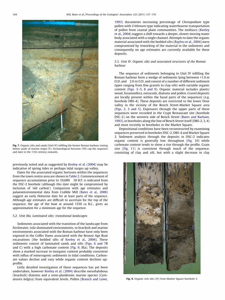
Fig. 7. Organic silts and sands (Unit IV) infilling the former Roman harbour resting
below sands of marine origin (V). Archaeological horizons (VII) cap the sequence
and date to the 11th century onwards.
[()TD$FIG]
Fig. 8. Organic rich silts (IV) from Market Square borehole 3.
M.R. Bates et al. / Proceedings of the Geologists’ Association 122 (2011) 157–176164
previously noted and as suggested by Keeley et al. (2004) may beindicative of spring tides or perhaps tidal surges up valley.
Dates for the associated organic horizons within the sequencesfrom the town centre area are shown in Table 2. Commencement ofsequence accumulation prior to 10,680 � 50 B.P. is indicated fromthe DSC-2 borehole (although this date might be compromised byinclusion of ‘old carbon’). Comparison with age estimates andpalaeoenvironmental data from Crabble Mill (Bates et al., 2008)suggest an early Holocene date for at least parts of the sequence.Although age estimates are difficult to ascertain for the top of thesequence, the age of the boat at around 1550 ca B.C., gives anapproximation for a minimum age for the sequence.
5.2. Unit IIIa. Laminated silts: transitional landscapes
Sediments associated with the transition of the landscape fromfreshwater, tufa-dominated environments, to brackish and marineenvironments associated with the Roman harbour have only beenexposed in the Coffer Dams associated with the Bronze Age Boatexcavations (the bedded silts of Keeley et al., 2004). Thesesediments consist of laminated sands and silts (Figs. 6 and 7Band C) with a high carbonate content (Fig. 9, IIIa). The depositsshow a marked increase in inorganic content probably consistentwith influx of minerogenic sediments in tidal conditions. Carbon-ate values decline and vary while organic content declines up-profile.
Little detailed investigation of these sequences has yet beenundertaken, however Keeley et al. (2004) describe mesohalobous(brackish) diatoms and a semi-planktonic marine species (Cym-
atosira belgica) from equivalent levels. Pollen (Branch and Lowe,
1993) documents increasing percentage of Chenopodium typepollen with Crithmum type indicating waterbourne transportationof pollen from coastal plant communities. The molluscs (Keeleyet al., 2004) suggest a shift towards a deeper, slower moving waterbody associated with a single channel. Attempts to date the organicmaterial associated with the bedded silts (Bayliss et al., 2004) werecompromised by reworking of the material in the sediments andconsequently no age estimates are currently available for thesedeposits.
5.3. Unit IV. Organic silts and associated structures of the Roman
harbour
The sequence of sediments belonging to Unit IV infilling theRoman harbour form a wedge of sediments lying between +1.0 mO.D. and�2.0 m O.D. and consist of a number of different sedimenttypes ranging from fine gravels to clay-silts with variable organiccontent (Figs. 3–5, 8 and 9). Organic material includes plants/wood, foraminifera, ostracods, diatoms and pollen. Gravel depositsare locally present within the basal parts of the sequences (e.g.borehole DBS-4). These deposits are restricted to the lower Dourvalley in the vicinity of the Bench Street-Market Square area(Figs. 2, 3 and 5). Exposures through the upper parts of thesesequences were recorded in the Crypt Restaurant site (boreholeDSC-2) on the western side of Bench Street (Bates and Barham,1993), in boreholes along the line of Bench Street itself (DBS-2, 3, 4)and most recently in boreholes in the Market Square.
Depositional conditions have been reconstructed by examiningsequences preserved in boreholes DSC-2, DBS-4 and Market Square3. Sediment analysis through the deposits in DSC-2 indicatesorganic content is generally low throughout (Fig. 10) whilecarbonate content tends to show a rise through the profile. Grainsize (Fig. 11) is consistent through much of the sequence,consisting of clay and silt, but with a slight decrease in clay

[()TD$FIG]
Fig. 9. Composite stratigraphy from DSC-2 through the tufa/peat, harbour fill and marine sands showing moisture, organic, carbonate and inorganic content and magnetic
susceptibility values.
M.R. Bates et al. / Proceedings of the Geologists’ Association 122 (2011) 157–176 165
content upwards. Sand is also noted to occur towards the top of thesequence. An organic silt caps this part of the sequence. Periodicemergence of the sequences above water is attested to by areas ofrooting and weathering within the sediment stack. The presence ofgravel units (e.g. in DBS-4) is indicative of higher energy flows inthe area that may indicate the location of the outfall of the Dour atlow tide. Microfossil analysis of DSC-2 (Table 3 and Fig. 12)indicates that through much of the sequence assemblages aredominated by brackish-water foraminifera (particularly Haynesina
germanica) and ostracods (Leptocythere porcellanea, L. lacertosa andL. castanea). An increase in numbers of individuals present is notedbetween �0.82 m and �1.02 m O.D. Brackish species are absentbetween 0.01 m and �0.32 m O.D. but re-appear in two horizonsabove (represented by the foraminifera Haynesina germanica andElphidium williamsoni). This brief uppermost brackish event(between 0.08 m and 0.01 m O.D.) corresponds with a coarseningin grain size of the sediments from clay-silts to sandy clay-silts(Fig. 11). Marine foraminifera are associated with the base of unitIV and with the uppermost part of the unit associated with thepresence of sand in the sequence at around 0 m O.D. Freshwaterostracods are present at two points in the sequence between�1.52 m and �1.72 m and between 0.01 m and �0.32 m O.D.; thelatter corresponding with the disappearance of the brackishspecies noted previously. Freshwater ostracods (or more correctly,‘‘non-marine’’, as these species can tolerate low salinities in thesetype of coastal situations), include Heterocypris salina, Candona
neglecta, Prionocypris zenkeri and Potamocypris zschokkei, albeit atlow numbers. This evidence, taken together, suggests deposition of
the main body of the sediment under estuarine mudflat conditions,with the initial influx associated with marine faunas. The pulse offreshwater material (0.01 m and �0.32 m O.D.) suggests the localdevelopment of a minor freshwater event, perhaps including poolformation from springs at the valley margins, however whetherthis represents a minor regressive phase cannot be determined.The earlier occurrence of freshwater ostracods, which overlapswith the onset of tidal conditions at �1.62 m O.D. and theestablishment of the initial phase of brackish mudflats, seems alsoto be related to (spring-fed) pool formation on the foreshore.Diatom floras from DSC-2 confirm that these sediments weredeposited in sub-tidal or inter-tidal situations in a brackish orsaline environment (N. Cameron, UCL, personal communication).
By contrast, boreholes DBS-4 (Table 4) and Market Square 3(Table 5) contain somewhat reduced numbers of brackishforaminiferal and ostracod species (particularly of the latter)and a much increased freshwater component (Fig. 12). In DBS-4(Table 4) the foraminifer Haynesina germanica is the only (almost)ubiquitous species present, although two horizons did containsingle examples of the agglutinating saltmarsh species Jadammina
macrescens. By contrast, the freshwater ostracod assemblagenumbered no less than 14 species in total, and populations ofseveral of them were common throughout. They includedHeterocypris salina, Candona neglecta, Prionocypris zenkeri, Cyclo-
cypris laevis and Cyclocypris ovum. These assemblages appear toindicate accumulation under freshwater/low brackish waterconditions intermediate to estuarine mudflats and saltmarsh.Occasional inputs of water from local springs are also indicated.

[()TD$FIG]
5 6pH Organic Content Carbonate Content7 89 10 100 20 30 40 50 60 70 80 0 10 20 30 40 50 60 70 80 90 100
Total P ppm0 1000 2000 3000 4000
Particle size%
Aquatic pollen including spaganium type + cheno-podium type + cyperacea
High arboreal pollen counts dominated by Tilia and Corylus
Aquatic / river edge + disturbed ground types inc Bulrush
Herbaceous pollen dominant including coastal vegetation calcareous grasslands, wetland, woodland + arable
MSFSCSi MSiFSiCESFG
600Bo
reho
le lo
g
M.O
.D.
U4
Core
log
500
400
300
200
100
0.00
-1.00
-2.00
-3.00
VII
V
IV
II
Ia
Fig. 10. Composite stratigraphy through the tufa, peat and laminated sediments of units II and IIa showing moisture, organic, carbonate and inorganic content and magnetic
susceptibility values log sequences and results.
M.R. Bates et al. / Proceedings of the Geologists’ Association 122 (2011) 157–176166
Finally in Market Square 3 (Table 5 and Fig. 12) the onlybrackish species present are the high saltmarsh foraminiferaJadammina macrescens and Haplophragmoides sp. However a richfreshwater (‘‘non-marine’’) ostracod fauna, including Heterocypris
salina, Candona neglecta, Prionocypris zenkeri, Ilyocypris bradyi andHerpetocypris cf. reptans, are all present and often in large numbers.This assemblage appears to indicate freshwater weedy pools withlocal brackish conditions and a fringing high saltmarsh thatbecomes a freshwater/semi-terrestrial environment with shallowpools towards the top.
The sequence is capped by organic silts and peats (see DSC-2,Fig. 10). These sediments were rich in Equisetum remains(Horsetail) and bulrush beneath the Crypt Restaurant sitesuggesting the development of a vegetated wetland environmentin the area once infilling of the harbour basin had occurred.
This evidence appears to indicate that accumulation of thegroup IV sediments occurred under predominantly brackish waterconditions. Estuarine mudflats appear to have dominated sea-wards (DSC-2), being replaced by saltmarsh inland (DBS-4) andupper saltmarsh around the Market Square (Fig. 12). In the MarketSquare the maximum elevation of these saltmarsh sediments is c.
+1.3m O.D. Within this area of estuarine conditions higher flowrates along the outfall of the Dour probably resulted in depositionof gravels as lags within low water channels. Locally, differentialsedimentation may have resulted in discrete areas of predomi-nantly freshwater deposition. The likely scenario, however,through this phase of activity is one of accumulating sedimentsinfilling the former harbour area.
The dating of the sequences is based on recovered finds fromthe boreholes and three 14C dates from the top of the sequence
(Table 2). Second century Roman pottery has been recovered fromthe base of this unit at the Crypt Restaurant site (MacPherson-Grant, personal communication) and large quantities of Romanmortar and cement were recovered from a gravel lying immedi-ately below organic silts sampled in the Bench Street area (Batesand Barham, 1993). This suggests accumulation began after Romanoccupation commenced in the area. Three 14C dates (Table 2) fromthe organic horizons at the top of the sequence all indicate a daterange between the 2nd and 5th century A.D. for final infilling of theharbour in this part of the valley.
The relationship between this infilling event and Romanactivity has not been directly observed within the harbourhowever, some preliminary conclusions can be drawn. The clearestevidence for the position of the original west bank of the Dour andharbour edge is that published by Rahtz (1958) on the western sideof the Market Square (Fig. 2, Site 1). Here brickearth and coomberock at around 3.00 m. O.D. sloped down more than 3 m to the east.Immediately to the south the same feature, sealed below a Romanbuilding, had been observed (Site 6; Threipland, 1957). Here thechalk block-built building was of second century date with potteryfrom the underlying make-up layers included samian ware dated c.AD 130–140. The only evidence for waterfront constructions closeto the dry ground come from Rahtz’s work (1958) at Stembrook(Site 7) where he recorded two separate Roman timber and chalkstructures interpreted as a quayside and a jetty. The quayside was achalk platform with a surface elevation of +1.90 m O.D. Sedimentscomparable to those of group IV deposits have been located atStembrook between 0 m O.D. and +2 m O.D. (Site 1) (Rahtz, 1958).The bulk of the pottery from the site is of second century date andcame from the layers deposited against the quayside and jetty

[()TD$FIG]
7.55-7.56m
7.50-7.51m
6.91-6.92m
6.87-6.88m
6.82-6.83m
6.53m-6.54m
6.25-6.26m
5.90-5.91m
5.80-5.81m
5.69-5.70m
5.60-5.61m
5.56-5.57m
5.29-5.30m
5.19-5.20m
5.12-5.14m
5.01-5.02m
3.60-3.65m
3.2-3.25m
Particle Size
Coar
se G
rave
l
10080604020
0
Med
ium
Gra
vel
Fine
Gra
vel
Coar
se S
and
Med
ium
San
dFi
ne S
and
Coar
se S
iltM
ediu
m S
iltFi
ne S
iltCl
ay
F/W O
F/W O
BF
BF BO
M.O
.D.
2
Microfossil dataParticle size distributions
0
-2
VII
V
IV
II
Ia
Fig. 11. Sedimentology and microfossil distribution from DSC-2.
M.R. Bates et al. / Proceedings of the Geologists’ Association 122 (2011) 157–176 167

Table 3Microfossils from DSC-2.
Ecology barren sand Estuarine mudflats, with two periods of spring-fed freshwater pool development on foreshore;
calcareous substrate
Tufa springs with active flow;
some associated marshy peat
Semiterrestrial
surface
? brackish freshwater
onset of tidal access and closing down of tufa springs
0.28 0.18 0.08 0.01 �0.22 �0.32 �0.42 �0.52 �0.82 �0.92 �1.02 �1.12 �1.52 �1.57 �1.62 �1.67 �1.72 �1.82 �1.87 �2.12 �2.22 �2.32
BRACKISH FORAMINIFERA
Haynesina germanica x x o o xx xxx xx x x o x
Elphidium williamsoni o x
Ammonia sp. x xx x
Elphidium waddense x
MARINE FORAMINIFERA
Ammonia batavus (ornate) o o
BRACKISH OSTRACODS
Leptocythere porcellanea o x x x x x x x
Leptocythere lacertosa x xx xx o x
Leptocythere castanea x xx x
FRESHWATER OSTRACODS
Heterocypris salina xx o
Candona neglecta x x o x o
Prionocypris zenkeri x x o o
Ilyocypris sp. o
Potamocypris zschokkei x o x x
Cryptocandona vavrai x
Pseudocandona sp. o
Cavernocypris subterranea o
Foraminifera and ostracods are recorded: o – one specimen; x – several specimens; xx – common; xxx – abundant.
M.R
.B
ates
eta
l./Pro
ceedin
gs
of
the
Geo
log
ists’A
ssocia
tion
12
2(2
01
1)
15
7–
17
61
68

[()TD$FIG]
ch chch
1
2
0
DSC – 2
DBS – 4MS3
4810 / 95 B.P.+ –
1740 / 70 B.P.+ –
BF
BFBO
BO
BOF/W
0F/W0
BF
-1
-2
F/W0
F/W0
V
IVIV
VII
I
I
II
I
IV
Brackish foraminifera
Marine foraminifera
Brackish ostracods
Freshwater ostracods
Increase in abundance of microfossils
BF
BO
F/W 0
Fig. 12. Microfossil summaries from boreholes DSC-2, DBS-4 and Market Square 3 showing distribution of material relative to Ordnance Datum.
M.R. Bates et al. / Proceedings of the Geologists’ Association 122 (2011) 157–176 169
suggesting infilling of the harbour during or after the 2nd century.It is reasonable therefore to suggest that the original constructionof these harbour structures (A and B) occurred during the laterfirst–early second centuries AD. Deliberate infilling of the harbouredge has been noted in Church Street by Threipland and Steer(1951) where five main tip-layers could be distinguished. Thelower parts of these were certainly Roman and contained severalpieces of Roman tile (one stamped [CL.B]R – the mark of the Romanfleet in British waters) and second-century pottery. At Site 1(Rahtz, 1958) the organic sediments were sealed by a succession ofRoman clay and chalk dumps deposited between the later first andfirst half of the second century AD. To the south of the MarketSquare (Site 8) Amos and Wheeler (1929) reported the presence ofthe edge of a wall or platform, built from mortared flint, chalk, tufaand greensand, at least 4.50 m long, resting on what was probablymade ground (mistaken by the authors for natural brickearth). Tothe south-west, a second century building was recorded on the siteof the old Market Hall resting upon deep layers of fill and(waterlogged) sediment (Site 9) (Frere, 1983, 334–5; see alsoWilkinson, 1994, 66). Excavations at Site 9 below the rampart ofthe Saxon Shore Fort wall exposed pre-Shore fort levels andrevealed demolished clay walls and floors again relating to asecond-century building. Further south, off Queen Street (Site 10),outside the area of the second century naval (CLBR) fort and thelater Shore fort, excavations (Grew, 1981; Mynott, 1981; Philp,
1981b) recorded a late Roman metalled road overlying deepdeposits of silt including deliberately deposited material probablyimported from elsewhere in the town centre area (dumpeddeposits), mainly of second century date, that appeared to havebeen used to infill ground on the edge of the Roman harbour.Consequently there is good evidence for harbour infilling during orshortly after the 2nd century A.D. to and against Roman structuresto a maximum elevation of +2.0 m O.D.
Another significant factor to consider is the position of the eastwall of the late Roman Shore Fort which remains to be accuratelypositioned. Substantial sections of the west and south walls havebeen excavated by Kent Archaeological Rescue Unit during the1970s and 1980s but the line of the north wall is based on Amos’sobservations at the old Royal Oak hotel (Amos and Wheeler, 1929,site 4), whilst the course of the fort’s eastern wall remains largelyunknown. Excavations on the old Market Hall site (see above, Site9) established that the south wall of the fort, towards it easternend, had been built across ground previously reclaimed from theestuary. The observations here, together with those from Sites 1and 7, strongly imply that most, if not all, of the fort’s eastern wallmust have been built across ground deliberately infilled byhumans and that the line of the wall lies close to the recentlydrilled boreholes in Market Square (Fig. 2).
Finally there is now good evidence for the existence of twomajor Roman timber structures running across the river mouth at

Table 4Microfossils from DBS-4.
Ecology Barren sand Freshwater/low brackish weedy spring-fed pool adjacent to estuarine
mudflats/saltmarsh; calcareous substrate
‘‘Habitation
surface’’ or infill
1.84 1.2 1.1 0.99 0.74 0.64 0.54 0.44 �0.06 �0.56 �0.66 �0.7 �0.76 �0.86
BRACKISH FORAMINIFERA
Haynesina germanica xx x x x x x x o
Ammonia sp. x
Elphidium williamsoni o
Jadammina macrescens o o
MARINE FORAMINIFERA
Ammonia batavus (ornate) x o x
BRACKISH OSTRACODS
Leptocythere porcellanea x o
FRESHWATER OSTRACODS
Heterocypris salina xx x x xx x xx x
Candona neglecta xx x x x x x x x o
Prionocypris zenkeri x x x x x x x x x xx o
Ilyocypris bradyi x x o x x x x x x x x o
Cypria ophtalmica x x x x o x
Cyclocypris laevis (LV>RV) x x xx x x o x x x x
Candona candida o o o
Cyclocypris ovum (RV> LV) x xx x x x x
Herpetocypris sp. x x x x x
Limnocythere inopinata o
Cyclocypris serena x x x x
Darwinula stevensoni x o
Potamocypris zschokkei o
Pseudocandona sp. o
Foraminifera and ostracods are recorded: o – one specimen; x – several specimens; xx – common.
M.R. Bates et al. / Proceedings of the Geologists’ Association 122 (2011) 157–176170
Dover. Deep excavations for a new gas-holder south of DolphinLane (site 3, Fig. 2), in 1855–6 revealed part of a massive timberharbour wall, preserved in waterlogged deposits. The structurewas buried some 6 metres (20 ft) below ground level (c.�1 m O.D.)and appeared to be running roughly east-west, at a right angle tothe modern river (Elsted, 1856; Knocker, 1857; Amos and Wheeler,1929, 52; Rigold, 1969, 90). Part of a second harbour wall wasdiscovered in September 1992 running diagonally across thenorth-east corner of a deep contractor’s excavation dug at thejunction of Bench Street and Townwall Street. Here a 3.40 m lengthof what appeared to be the base section of another massive box-framed timber structure was revealed. Neither structure is closelydated although dendrochronological analysis of timbers from the1992 structure suggested a felling date of sometime after A.D. 42(Nayling, 2001).
The observations appear to indicate a relatively simplesequence of events resulting in the infilling of the harbour duringthe later part of the 2nd century A.D. and movement of the edge ofdry ground eastwards. With the exception of the possible thindeposit of tufa at Site 2 little evidence exists for any sedimentsaccumulating in the area until deposits begin to accrete adjacent toRoman structures. Evidence from Site 2 suggests accumulation oforganic-rich sediments within the 2nd century and these depositsequate in elevation with those from Market Square BH 3 fromwhich the palaeoenvironmental information suggest local condi-tions were dominated by upper saltmarsh systems with localizedpools of freshwater perhaps issuing from local springs or the Douroutfall. It therefore seems likely that sedimentation with the BenchStreet to Market Square/Stembrook area occurred during or shortlyafter the 2nd Century A.D. The development of a sequence ofintertidal mudflats around the junction of Bench Street andTownwall Street gave way inland, to the north, to saltmarsh andupper saltmarsh accumulating against the rising edge of theestuary and harbour. Consolidation of these deposits, by deliberateinfilling (dumping) across them, occurred in the vicinity of MarketSquare in order to create conditions suitable for construction of thelater eastern Shore Fort wall.
5.4. Unit V. Sands: wind and waterlain
The final sequence of deposits beneath the substantial thicknessof Medieval and post-Medieval deposits are thick sands firstrecorded by Amos and Wheeler (1929, 54). These deposits areknown to occur within the area between Townwall Street andQueen Street, to the west of Fishmongers Lane (Figs. 2, 3, 5 and 8).The deposits form a wedge thinning inland along Bench Street andrising northwards (between datums of 2.0 m and 9.0 m above O.D.)where they come to rest against the south wall of the late Romanshore fort (Fig. 3). They consist of medium/coarse sand withoccasional lenses of well-rounded flint clasts near Townwall Streetbut are finer grained medium sands at higher elevations againstthe wall of the Shore fort (Fig. 13). Thick beds of well rounded flintclasts interdigitate with the sands along the line of TownwallStreet (parallel to the modern shore). In places the sands arebedded and exhibit both cross-bedding and sub-horizontalbedding. The sediments form a drape over the pre-existinglandscape and overlie harbour infill sediments (IV) at lowerelevations and archaeological deposits associated with the remainsof the late Roman fort at higher elevations (Barham and Bates in
Wilkinson, 1994). Late Saxon and Norman cultural levels inter-stratify within the upper levels of these sands or overlie thedeposits (Fig. 14).
The sands from immediately outside the Shore Fort wall at DHC1 (Fig. 2) are well to very well sorted and unimodal in the size rangemedium to fine sand (Barham and Bates in Wilkinson, 1994)(Fig. 13). This grain size distribution is similar to that of an aeoliansand, but slightly coarser than a typical dune sand (Tsoar and Pye,1987). By comparison the marine sand from borehole DSC-2exhibits a slightly coarser distribution (Fig. 13). Thus, derivation ofthe sands at higher elevation from the littoral sands is likely. Thesand sheet appears to have a multi-depositional form with thesands at lower elevations (including the rounded gravels) formingwithin a beach or back-beach environment through a combinationof wave over-flow and beach aggradation. Transitional from thispoint upslope are sands that were deposited across a variable slope

Ta
ble
5M
icro
foss
ils
fro
mM
ark
et
Sq
ua
re3
.
Eco
log
yS
ha
llo
wp
oo
lo
nfo
resh
ore
;
fre
shw
ate
r/se
mit
err
est
ria
l
Fre
shw
ate
r/lo
wb
rack
ish
we
ed
yp
oo
la
tb
ack
of
fore
sho
rew
ith
frin
gin
gh
igh
salt
ma
rsh
;ca
lca
reo
us
sub
stra
te
1.2
31
.22
1.1
91
.18
1.1
31
.12
0.8
30
.82
0.8
0.7
90
.77
0.7
60
.72
0.7
10
.69
0.6
80
.66
0.6
50
.63
0.6
20
.55
BR
AC
KIS
HFO
RA
MIN
IFE
RA
Ha
plo
ph
rag
mo
ides
sp.
xx
ox
xx
xo
Jad
am
min
am
acr
esce
ns
xx
xx
xx
FRE
SH
WA
TE
RO
ST
RA
CO
DS
Ca
nd
on
an
egle
cta
xx
xx
xx
xx
xx
xx
xx
xx
xx
xx
xx
xx
xx
Cy
clo
cyp
ris
ov
um
(RV>
LV)
xx
xo
xx
xx
xx
xx
xx
Ily
ocy
pri
sb
rad
yi
oo
ox
xx
xx
xx
xx
xx
xx
xx
xx
xx
xx
xx
Cy
pri
ao
ph
talm
ica
xx
Pri
on
ocy
pri
sze
nk
eri
xo
xx
xx
xx
xx
xx
xx
xx
xx
xx
xx
xx
Her
pet
ocy
pri
scf
.re
pta
ns
xx
xx
xx
xx
xx
xx
xx
x
Het
ero
cyp
ris
sali
na
xx
xx
oo
Po
tam
ocy
pri
szs
cho
kk
eio
oo
ox
Lim
no
cyth
ere
ino
pin
ata
oo
o
Ca
nd
on
aca
nd
ida
ox
Ca
nd
on
aa
ng
ula
tax
xx
xx
xx
xx
Da
rwin
ula
stev
enso
ni
x
Fora
min
ife
raa
nd
ost
raco
ds
are
reco
rde
d:
o–
on
esp
eci
me
n;
x–
sev
era
lsp
eci
me
ns;
xx
–co
mm
on
.
M.R. Bates et al. / Proceedings of the Geologists’ Association 122 (2011) 157–176 171
topography and as there is no natural source of well-sorted sandseither upslope or up-catchment suggest deposition by windtransport from deflating tidal flats at low tide is likely (Barhamand Bates, in Wilkinson, 1994). Thus the sands describe a beach anddune system built up over the former harbour infill sequence.
6. Evolution of the landscape from late Prehistoric to Saxontimes
6.1. The palaeoenvironmental context of late Prehistoric activity in
the lower Dour Valley, the impact of coastal evolution and the onset of
marine conditions
In order to understand the transformation of the lower Dourvalley from freshwater to estuarine conditions (Table 7), the natureof the late Prehistoric environment and its relationship to the coastneed to be determined. The absence of marine or estuarineconditions anywhere in the town centre area until sometimebetween the Middle Bronze Age and the Roman period isperplexing given the proximity of the coast today to the towncentre and is probably a result of changes to the local topographyduring the last 3500 years.
The distribution of gravels laid down by the late Pleistoceneriver are illustrated in Fig. 1. The southwards trend of the gravelsthrough the modern Wellington Dock and the subsequent swing tothe south-east beneath the Admiralty Pier imply the extension tothe valley through this area during the late Pleistocene. Anyextension of the valley across the area will have been associatedwith a substantial eastern side of the chalk-cut valley. This impliesthat not only was the valley form substantially longer in the latePleistocene but that significant trimming back of the valley hastaken place during the Holocene. Substantial erosion of the chalkbeyond the valley floors and margins is only likely to have occurredconsequent with rising sea levels and thus valley foreshortening isprobably a result of the coastal erosion of cliffs either side of thevalley mouth. The previous positions of the cliffs and the speed ofretreat are however difficult to quantify.
Coastal erosion along the Chalk clifflines of Kent and Sussex iswell established (e.g. McDakin, 1900; May, 1971; May and Heeps,1985; Dornbusch, 2005a) however, little information is currentlyavailable to calibrate such processes and assess the scale of erosionsince the prehistoric period. Erosion rates are primarily influencedat a regional scale by rock type (Carter, 1988) but at smaller scalesare a function of a number of factors (McDakin, 1900; Dornbusch,2005a) including rock structure, water saturation, presence/stateof aquifers, precipitation, marine processes, configuration andaspect of coastline, height of cliff, width of shore platform, natureof the beach, topography of the shore platform, presence of cliff topsuperficial deposits and human activity. Consequently, calculatingretreat rates for coastal cliff erosion is notoriously difficult.Historical literature from Dover, however, indicates that localisedcliff collapses have been a common feature of town life (Table 6).
Early attempts to calculate erosion rates was made in the late19th century by McDakin (1900) who reported rates of only half aninch [0.014 m] in a year. By contrast May and Heeps (1985) suggesta mean rate for cliff top retreat for the North Downs sector as awhole of 0.12 m/year. More recent calculations (Dornbusch,2005a) have used historical records covering the last 100 yearsor so to suggest somewhat lower average rates of cliff recession of0.07 m/year for Kentish Chalk cliffs. However, in places significantproportions of the Kent coast show almost no retreat at all oversuch time scales. Dornbusch (2005b) implies that some of thesedifferences may be a function of the fact that the coast in this partof Kent is characterized by low frequency but high magnitude cliff-fall events. For example the collapse in January 2001 when a largepiece of chalk, estimated at over 100,000 tons, collapsed from the

[()TD$FIG]
1:50
2.00m O.D.
2.30m O.D.
2.55m O.D.2.77m O.D.
2.94m O.D.
3.15m O.D.
3.95m O.D.
4.55m O.D.
1:200
60
%
40
20
100
80
COARSEGRAVEL
Saxon Shore Fort Wall
MEDIUMGRAVEL
A
FINEGRAVEL
COARSESAND
MEDIUMSAND
FINESAND
COARSESILT
MEDIUMSILT
FINESILT
CLAY
Particle Size
0
60
%
40
20
COARSEGRAVEL
MEDIUMGRAVEL
FINEGRAVEL
COARSESAND
MEDIUMSAND
FINESAND
COARSESILT
MEDIUMSILT
FINESILT
CLAY
Particle Size
0
80
100B
B
A
Fig. 13. Sand surface profile along Bench Street showing how the sand rises to the north and its landward distribution is determined by the presence of the Classis Brittanic fort
wall. Particle size diagrams from sands taken from borehole DSC-2 (A) and adjacent to the fort wall at the Heritage Centre (B) illustrate the slight differences in grade of sand at
these two locations. Inset: surface elevation of the sands along the line of Bench Street showing the declining elevation of the surface of the sands from right (seawards) to left
(inland).
M.R. Bates et al. / Proceedings of the Geologists’ Association 122 (2011) 157–176172
cliff north of Dover.Using the average rates of cliff top erosionprovided by May and Heeps (1985) of 0.12 m/year a simpleretrodiction indicates a total distance of some 420 m of coastalerosion over the last 3500 years (Table 8), since the deposition ofthe Bronze Age Boat. Using the alternative rates provided byDornbusch (2005b), of 0.07 m/year, projected retreat rates over
Table 6Major topographic events recorded for the Dover area (predominantly 19th century). Unl
by a Mr Pattenden.
Date Event type
c. 1300 AD Sea wall breeched, harbour choked with p
6/4/1580 Earthquake. Cliff collapse and outer walls
1612 Wall of the Great Pent (the Henry VIII coa
1772 Several falls of the cliff caused great alarm
14/12/1810 Seven members of family killed in cliff col
12/11/1844 Fall of cliff, 2 children killed.
18/2/1847 40,000 tons of cliff fall from Shakespeare
21/1/1849 100,000 tons of cliff fall from Shakespeare
20/1/1853 100,000 tons of cliff fall of chalk in Limek
26/2/1853 Several thousand tons of chalk fall at Cobb
5/4/1859 2 men killed by fall at Snargate Street.
12/5/1868 Great fall of cliff below Adrian Street.
15/11/1872 Cliff collapse near castle destroys 2 house
12/1/1877 S.E. Railway blocked for 2 months by fall
13/3/1881 S.E. Railway blocked by cliff fall at Abbots
3500 years would be of the order of 245 m. However, as Dornbusch(2005b) shows the calculated rates of coastal erosion for theLangdon Bay to St Margaret’s section of the coast actually varyfrom less than 0.1 m/year to in excess of 0.3 m/year. Using thesefigures retreat distances of up to 1050 m over a 3500 years timespan might be anticipated in certain situations (Table 8).However,
ess otherwise stated all events are recorded in a diary held in Dover Museum written
ebbles (Stratham, 1899).
of harbour came down (Stratham, 1899; Batcheller, 1829).
stal defences and harbour) breached during a storm (Stratham, 1899).
(Stratham, 1899).
lapse at East Cliff. Pig buried in cliff cave after fall, dug out alive after 160 days
Cliff.
Cliff.
iln Street.
lers Rock, East Cliff.
s.
of chalk cliff.
Cliff.

[()TD$FIG]
421
2
FF
F 112PIT
Fcut=
=wall
Previously
OR CLAY
SampleTaken
Rim
Sand
Sand
Sand
Occupation
Occupation
Occupation
Not Exc Below
Not Exc Below
Layer
Occupation Layerc.875 to 1000/1025 AD
c.1125/50 to 1200 AD
Exc
F
CH
CH
P
CHCH
CH
CH
FCH
CH
CHP
P
CHDatum6.15 B
BF
115
113
412
117
17
100144
111
242 172=
15
107
11
114
94
7
EastModern Tarmac
241 173=
240239
322=
267 203=
203
254=
1211
10
9
13
CH
CH
CH
Fig. 14. Sketch section through upper parts of sand sequence at Crypt site showing deposits dated to the late Saxon period based on dates derived from analysis of the
contained pottery fragments.
M.R. Bates et al. / Proceedings of the Geologists’ Association 122 (2011) 157–176 173
when attempting to retrodict cliff erosion rates into the prehistoricpast other factors also need to be taken into account. For exampleDuperret et al. (2004) suggest that rainfall patterns and associatedground saturation are important triggers to cliff collapse whileMortimore et al. (2004) suggest that further influences includestorms and frost. This has important implications when consideredin conjunction with potential phases of climate change in the past.For example the well known cold period of the Little Ice Age in the17th century (Grove, 2002) or the late Bronze Age climaticdeterioration noted by van Geel and Renssen (1998) are likely tohave enhanced cliff erosion rates in the area over periods ofwarmer/drier climate. It is interesting to note that, although withina totally different system, Allen (2002) has considered the degreeof erosion on the Severn Levels over the last 1000 years and arguesthat significant variations in long, medium and short term erosionrates can be postulated where the variations are a function of avariety of factors operating at local and regional levels and similardifferences through time in erosion rates are likely for the Channelcoast.
Thus, it is clear from the discussion that there is strongcircumstantial evidence that considerable coastal erosion hastaken place since the end of the last cold stage. Most of this erosion
would have occurred following sea level rise to near moderndatums in the area and would have varied through time. It istherefore argued that the shape of the valley (and the distance upvalley of the modern town centre area) prevented flooding of thearea by marine waters until sufficient valley foreshortening anderosion of the east side of the Dour valley had occurred. Evidencefor this foreshortening and the reduction in flow velocities of theriver in the town centre area consequent with backing up of riverwaters as the estuary approaches up stream may be seen in thechange in nature of the tufa deposits above and below the boat.Higher energy oncoid-rich gravels (IIb) dominate the environ-ment through much of the earlier part of the Holocene (Fig. 9)while finer grained micritic muds and low energy stromatoliticgrowths (IIc/d) dominate conditions following boat abandonment(Fig. 9; Table 7). This scenario also has implications for thepalaeogeographic position of the Langdon Bay hoard (a largequantity of bronze axes, of c. 1100–1000 BC, recovered from thesea floor to the east of the Eastern Docks) some 600 m from thepresent cliff line (Coombs, 1976; Muckelroy, 1981). If significantcoastal erosion has taken place in this region then the position ofthe find relative to the contemporary coast would have beendifferent (Table 8).

Table 7Summarised history of landscape changes in the western part of the town centre area in Dover based on combined geological and archaeological evidence.
M.R. Bates et al. / Proceedings of the Geologists’ Association 122 (2011) 157–176174
6.2. Roman activity and the infilling of the harbour
The onset of brackish water conditions in the lower Dour isrecorded within the bedded silts overlying the tufa deposits in thetown centre area (Table 7). These deposits remain to be fullyinvestigated and no age estimates are currently available on thetiming of this change. However this is likely to have begunsometime after 1500 BC and have been completed by the time ofthe Roman invasion of Britain.
Evidence for conditions associated with the initial infilling ofthe Roman harbour area are now available from the threeboreholes examined. The simplest explanation linking observa-tions in these boreholes with those at sites such as Stembrook(Fig. 2, site 7) and beneath the Market Square is that a major phaseof aggradation took place in the western part of the harboursometime in the 2nd to 3rd century A.D. This resulted in thecreation of saltmarshes and intertidal mudflats in the western partof the former harbour that become increasingly removed fromtidal influence inland towards the Market Square (Fig. 12). Higherenergy sediments do appear to be found intermittently in Bench
Table 8Postulated cliff recession rates, sources, calculated positions of the coastline seawards
(approximate age of Langdon Bay bronzes and the estimated distance from the cliff or coa
the coast on dry land).
Retreat rates Source Maximum
seaward position
of cliffs at 3500 B.P.
0.014 McDakin (1900) 49 m
0.07 Dornbusch (2005a) 245 m
0.12 May and Heeps (1985) 420 m
0.30 Dornbusch (2005b) 1050 m
Street and may represent the main outfall for the Dour through thisarea at low tide.
Longshore drift and the infilling of harbours is well documentedin the Dover area since at least the time of Henry VIII when a newlyconstructed harbour (the Paradise Basin) rapidly became cloggedwith sediments (Biddle and Summerson, 1982). The net movementof sediment along the south coast is likely to have broughtsubstantial quantities of sand eastwards into the mouth of theharbour as soon as flooding of the lower valley had occurred.Consequently there is undoubtedly a natural tendency for themouth of the Dour to fill with sediment. In addition the size of theriver Dour would make it extremely unlikely that sufficientdischarge was routinely channelled down the valley to flushsediment out of the harbour area. However two additional factorsneed to be taken into consideration when discussing harbour infill.These are the major timber structures known to exist within theharbour area thought to have been constructed by Romanengineers as moles for shelter/protection or mooring (Fig. 2, sites2 and 3). While the extent of neither the Dolphin Lane structure(Elsted, 1856; Knocker, 1857; Rigold, 1969) nor the more recently
of the present coast at 3500 B.P. (approx. age of Bronze Age Boat) and 3000 B.P.
st edge for the bronzes) (note the highest retreat rates place the bronzes 300 m from
Maximum
seaward position
of cliffs at 3000 B.P.
Distance from cliffs of Langdon Bay bronzes
(based on this data, approximate
3000 years since deposition)
42 m 558 m
210 m 390 m
360 m 240 m
900 m �300 m (i.e. 300 m from cliff top on dry ground)

M.R. Bates et al. / Proceedings of the Geologists’ Association 122 (2011) 157–176 175
found Townwall Street structure (Parfitt, 1993) is known, theirposition within the harbour mouth would certainly have sloweddrainage at times of low tide and acted as barriers behind whichslower moving water at high tide would have encourageddeposition of sediment. As a consequence these structures mayhave provided additional impetus to a pattern of sedimentationalready likely to have been important in the valley. If accretion ofsediments in the western part of the harbour did occur in a singlephase of infilling during or after the 2nd century A.D. then as anoperational port the western part of the harbour would haveceased to function at this time. This infilling would also haveprovided the impetus for constructing the later Shore Fort wallacross an area already partially infilled and only requiring minimallevelling up in order to create a construction platform.
6.3. Saxon activity and the creation of a beach and dune system
Deposition of the sands above the Roman harbour infillsequences has been noted across the area between Bench Streetand York Street from Townwall Street up to the southern boundaryof the late Roman Shore Fort wall. The profile of the sand surfaceclearly exhibits two trends:
Along Bench Street the elevation of the sand surface dipsnorthwards dropping by 2.5 m along the surveyed profile.
From York Street roundabout to the Saxon Shore Fort wall thesurface of the sand rises significantly by up to 6.5 m (Fig. 3).
In the vicinity of Townwall Street the sands appear to belaterally equivalent with coarse, well rounded flint gravelsdeposited under storm beach conditions (water-rolled Roman tilehas been recovered from sands on the BP site at the eastern side ofthe valley – Parfitt et al., 2006). Inland, these coarse gravels giveway beneath the Crypt site to sands with occasional beds ofrounded gravel. These gravel beds disappear beneath Bench Street.The evidence suggests that the origin of the sands derives frommarine deposition and a storm beach feature present along the lineof Townwall Street. Inland along Bench Street the profile of thesands fits that of a back beach profile with finer grained sedimentspreserved inland of the clastic beach resulting from washoverepisodes into lower energy dominated back beach environments.By contrast, sands between York Street and the late Roman Shorefort exhibit significant rise in elevations northwards resulting fromprobable aeolian activity (Table 7). This difference in interpretationappears to be underlain by the subtle grain size differencesbetween sand samples from the two areas (Fig. 13).
The initial onset of sand deposition cannot yet be dated,however it is likely that the conditions created in the town-centrearea by the infilling of the western part of the harbour allowedshoreward migration of clastic beach sands and gravels into andacross the area previously occupied by the Roman harbour. Suchtransgressive behaviour must have commenced sometime afterthe 2nd century A.D. Cessation of sand deposition is also difficult todate although a few sequences have revealed archaeologicalartefacts interstratified within the upper parts of the sequence. Forexample, Anglo-Saxon artefacts dated to A.D. 875–1025 have beenrecovered from the Crypt Restaurant site (Fig. 14) while metalledsurfaces in Bench Street contain stray Roman finds (which areprobably residual). However the significance of finds within thesands should be treated with caution due to issues relating tomigration of artefacts through dune sequences.
7. Conclusions
The evidence presented has significant implications for ourunderstanding of a number of major archaeological finds of latePrehistoric and Roman date. The nature of the evidence for the laterPrehistoric environments and the associated calculations of cliff
recession rates are of considerable importance when consideringthe location and use of the Dover Bronze Age Boat from BenchStreet as well as the context of the Langdon Bay bronzes. Ourevidence implies that not only was the Bronze Age Dour valley ofconsiderably greater extent (implying a greater distance from thesea to the final resting place of the boat (Table 7)) but that therelationship of the bronzes in Langdon Bay to the cliff line (Table 8)would have been very different at the time of deposition/loss of thebronzes. Today Langdon Bay is little more than the truncated headof a dry valley that would formerly have been significantly moreextensive, probably extending a considerable distance seawardsduring the Bronze Age. These factors consequently have animportant impact on our interpretation of the context of thefinds. The probability that the coast line was significantly closer tothe find spot at time of site creation than at the present day needsconsideration. Indeed if the highest rates for cliff recession are usedit is possible that the artefacts might have been deposited in asmall inlet developed in the base of the dry valley. In both scenariosif the bronzes were lost as part of a wreck (Muckelroy, 1981) thequestion regarding why no attempt to recover such a valuablecargo in relatively accessible conditions was made must beaddressed unless, of course deliberate deposition of the collectionoccurred. The use and function of the Bronze Age Boat may alsorequire reconsideration. Within the considerably extended valleysystem argued for here the possibility that the craft may have beenused in a riverine rather than marine context may requireconsideration.
The broader context of the landscape change in the Dour Valleyfrom freshwater to estuarine conditions as outlined here areinteresting within the context of the general patterns of coastalchange as outlined by Long et al. (2000) for the South-East ofEngland. Regional growth of peat (an estuary contraction) has beenrecorded at many locations in the SE from the Thames to the Solentbetween 6850 cal BP and 3200 cal BP (Long et al., 2000) prior toestuary expansion and transgression of marine/estuarine contextsacross freshwater ones. Despite the location and local geomorpho-logical conditions described previously the changes present inDover associated with onset of estuarine conditions in the lowervalley broadly fit this model with the shift in environments takingplace sometime after the abandonment of the Bronze Age Boat.Dates from the boat suggest an age for the boat of around 1550 BCthat is a little older than the ages indicated by Long et al. (2000) forthe onset of transgressive tendencies in the SE.
The interplay between human activity and natural processesmay also be apparent within the study area. The new evidencesuggests that infill of the harbour (western edge) during the Romanperiod was relatively rapid and, while almost inevitable, may havebeen exacerbated by Roman engineering creating barriers at theharbour mouth. High energy beach deposits have not beenidentified within the harbour area and consequently storm beachdeposits of Roman date are likely to have been present seawards ofthe harbour structures (and perhaps built up against suchstructures near to the mouth of the harbour). Once infilling ofthe area behind the outer harbour structures had taken place theconditions for landward migration of a storm beach/back barriersystem with associated dunes were created. The onshore driving ofthese sequences subsequently created the topography andlandscape within which the Anglo-Saxon occupation of the areaoccurred.
The evidence described here from the boreholes, coupled withthe opportunistic observations made during previous works andthe A20 scheme, have enabled a model for sequence developmentin the town centre area to be articulated (Table 7). Althoughprevious works (e.g. Rigold, 1969) had provided a spatial conceptfor the distribution of structures and natural topography thepresent work, for the first time, has fully integrated the

M.R. Bates et al. / Proceedings of the Geologists’ Association 122 (2011) 157–176176
archaeological and geological evidence within a process model.The model is however, likely to be overly simplistic at present andrequires additional investigation to refine it. On the basis of themodel it is clear that the evolution of the town centre area iscomplex and that human activity (particularly in the form ofRoman harbour activity) may well be intimately linked toprocesses and patterns of sedimentation.
Acknowledgments
The authors would like to thank all those who have participatedin project work associated with the A20 including Tony Barham,Paul Bennett and Peter Clark. We would thank Vaughan William-son for undertaking work on the sediments and Prof. Mike Walkerfor discussion on the dating framework. One of us (MRB) wouldalso like to thank Su Bates who put up with the endless field dayswhen much of this information was originally collected. Finally wealso thank two anonymous referees for valuable comments on thetext.
References
Allen, J.R.L., 2002. Retreat rates on soft-sediment cliffs: the contribution from datedfishweirs and traps on Holocene coastal outcrops. Proceedings of the Geologists’Association 113, 1–8.
Amos, E.G.J., Wheeler, R.E.M., 1929. The Saxon-Shore Fortress at Dover. Archaeo-logical Journal LXXXVI, 47–58.
Barham, A.J., Bates, M.R., 1990. The Holocene Prehistory and Palaeoenvironment ofthe Dour Valley Catchment. A geoarchaeological assessment report for DoverDistrict Council. Geoarchaeological Service Facility Technical Report 90/04.Geoarchaeological Service Facility, University College London, London, 132pp and Appendices.
Batcheller, W., 1829. The New Dover Guide. 7th ed. Dover.Bates, M.R., Barham, A.J., 1993. Dover A20 Road and Sewer Scheme Environmental
Archaeological and Palaeoenvironmental Field and Laboratory AssessmentReport. Geoarchaeological Service Facility Technical Report 93/03. Geoarch-aeological Service Facility University College London, London, 138 pp.
Bates, M.R., Barham, A.J., Pine, C.A., Williamson, V.D., 2000. The use of boreholestratigraphic logs in archaeological evaluation strategies for deeply stratifiedalluvial areas. In: Roskams, S. (Ed.), Interpreting Stratigraphy: Site Evaluation,Recording Procedures and Stratigraphic Analysis. Archaeopress, Oxford, BARInternational Series 910, pp. 49–69.
Bates, M.R., Barham, A.J., Jones, S., Parfitt, K., Parfitt, S., Pedley, M., Preece, R.C.,Walker, M.J.C., Whittaker, J.E., 2008. Holocene sequences and archaeology fromthe Crabble Paper Mill site, Dover, UK and their regional significance. Proceed-ings of the Geologists’ Association 119, 299–327.
Bavington Jones, J., 1907. Dover: A Perambulation of the Town, Port and Fortress.Dover.
Bayliss, A., Groves, C., McCormac, F.G., Bronk Ramsey, C., Baillie, M.G.L., Brown, D.,Cook, G.T., Switsur, R.V., 2004. Dating. In: Clark, P. (Ed.), 2004 The Dover BronzeAge Boat. English Heritage, London, pp. 250–255.
Biddle, M., 1969. The earthworks around St Mary-in-Castro. Archaeological Journal126, 264–265.
Biddle, M., Summerson, J., 1982. Dover harbour. In: Colvin, H.M. (Ed.), History of theKing’s Works, vol. 4(2), 1485–1660 (729–768).
Booth, K., 2007. The Roman Pharos at Dover Castle. English Heritage HistoricalReview 2, 5–17.
Branch, N.P., Lowe, J.J., 1993. Dover Boat: Palynological Assessment. ArchaeologicalPalynology Unit, Egham, Unpublished report.
Buccino, G., D’Argenio, B., Ferreri, V., Brancaccio, L., Ferreri, M., Panichi, C., Stanzione,D., 1978. I travertini della bassa valle del Tanagro (Campania). Studio geomor-phologia, sedimtologia e geochimico. Bollettino della Societa Geologica Italiana97, 617–646.
Carter, R.W.G., 1988. Coastal Environments. Academic Press, London.Clark, P. (Ed.), 2004. The Dover Bronze Age Boat. English Heritage, London.Coombs, D., 1976. The Dover harbour bronze find—a bronze age wreck? Archae-
ologia Atlantica 1, 193–195.Dornbusch, U., 2005a. Controls on Chalk cliff erosion in the eastern Channel.
Beaches at Risk Phase 1.Dornbusch, U., 2005b. Retreat of Chalk cliffs and downwearing of shore platforms in
the eastern Channel during the last century. Beaches at Risk Phase 1.Duperret, A., Genter, A., Martinex, A., Mortimore, R.N., 2004. Coastal chalk cliff
instability in NW France: role of lithology, fracture pattern and rainfall. In:Mortimore, R.N., Duperret, A. (Eds.), Coastal Chalk Cliff Instability. GeologicalSociety, London, Geological Society Engineering Geology Special Publication No.20, pp. 33–56.
Elsted, W.P., 1856. Note in The Archaeological Journal XIII, 98–102.
Evison, V.I., 1987. Dover: Buckland Anglo-Saxon Cemetery. Historic Buildings andMonuments Commission Report 3.
Frere, S.S., 1983. Roman Britain in 1982-Kent; Dover. Britannia 14, 334.Grew, F.O., 1981. Roman Britain in 1980 – Kent; Dover. Britannia 12, 366.Grove, J.M., 2002. The Little Ice Age, 2nd ed. Routledge, London.Keeley, H., Allison, E., Branch, N., Cameron, N., Dobinson, S., Ellis, I., Ellison, P.,
Fairbairn, A., Green, C., Hunter, R., Lee, J., Locker, A., Lowe, J., Palmer, A.,Robinson, E., Stewart, J., Wilkinson, K., 2004. The environmental evidence.In: Clark, P. (Ed.), Dover Bronze Age Boat. English Heritage, London, pp.229–249.
Knocker, E., 1857. On the Antiquities of Dover. Dover Museum and PhilosophicalInstitute, November 1857.
Leach, D., 2005. Dover Harbour Royal Gateway. Dover.Long, A.J., Scaife, R.G., Edwards, R.J., 2000. Stratigraphic architecture, relative sea
level and models of estuary development in southern England: New data fromSouthampton Water. In: Pye, K., Allen, J.R.L. (Eds.), Coastal and Estuary Envir-onments: Sedimentology, Geomorphology and Geoarchaeology. GeologicalSociety of London, London, Geological Society Special Publications 17, pp.253–280.
McDakin, Captain, 1900. Coast Erosion. Dover Cliffs. Read before the British Associ-ation 18th September 1899. Standard Office, Dover.
May, V., 1971. The retreat of Chalk Cliffs. Geographical Journal 137, 203–206.May, V., Heeps, C., 1985. The nature and rates of change on chalk coastlines.
Zeitschrift fur Geomorphologie NF. Supplementband 57, 81–94.Mortimore, R.N., Lawrence, J., Pope, D., Duperret, A., Genter, A., 2004. Coastal cliff
geohazards in weak rock: the UK Chalk cliffs of Sussex. In: Mortimore, R.N.,Duperret, A. (Eds.), Coastal Chalk Cliff Instability. Geological Society, London,Geological Society Engineering Geology Special Publication No. 20, pp. 3–32.
Muckelroy, K., 1981. Middle Bronze Age trade between Britain and Europe: amaritime perspective. Proceedings of the Prehistoric Society 47, 275–297.
Mynott, E., 1981. Zion Chapel Site, Dover. Kent Archaeological Review 66, 131.Nayling, N., 2001. Tree-ring analysis of timbers from Town Wall Street, Dover.
University of Wales Lampeter. Report for Ancient Monuments Laboratory 63/2001.
Ordonez, S., Garcia del Cura, M.A., 1983. Recent and Tertiary fluvial carbonates inCentral Spain. In: Collinson, J.D., Lewin, J. (Eds.), Modern and Ancient FluvialSystems. Special Publication of the International Association of Sedimentolo-gists 6, 485–497.
Parfitt, K. 1993. The Roman Harbour Wall. Canterbury’s Archaeology 1992–1993.Canterbury Archaeological Trust 17th Annual Report, 15. Canterbury Archaeo-logical Trust, Canterbury.
Parfitt, K., 1995a. The Buckland Saxon Cemetery. Current Archaeology 144, 459–464.
Parfitt, K., 1995b. Royal Victoria Hospital, Dover. Canterbury’s Archaeology 1993–1994 Canterbury Archaeological Trust 18th Annual Report. Canterbury Archae-ological Trust, Canterbury, pp. 20–21.
Parfitt, K., 2006. A Prehistoric ‘Burnt Mound’ site at Crabble Paper Mill, near Dover.Archaeologia Cantiana CXXVI, 219–237.
Parfitt, K., Corke, B., Cotter, J., 2006. Excavations off Townwall Street, Dover, 1996.Canterbury.
Pedley, H.M., 1990. Classification and environmental models of cool freshwatertufas. Sedimentary Geology 68, 143–154.
Philp, B.J., n.d. Buried Dover. Dover.Philp, B.J., 1981a. The Excavation of the Roman Forts of the Classis Britannica at
Dover, 1970–1977. Dover.Philp, B.J., 1981b. Zion Chapel Site, Queen Street, Dover, Kent. Excavations 1980–
1981. Archaeologia Cantiana 97, 298–299.Philp, B.J., 1989. The Roman House with Bacchic Murals at Dover. Dover.Philp, B.J., 2003. The Discovery and Excavation of Anglo-Saxon Dover. Dover.Rahtz, P.A., 1958. Dover: Stembrook and St Martin-le-Grand, 1956. Archaeologia
Cantiana 72, 111–137.Rigold, S.E., 1969. The Roman Haven of Dover. Archaeological Journal 126, 78–100.Rigold, S.E., 1977. Litus Romanum – the Shore forts as mission stations. In: Johnston,
D.E. (Ed.), The Saxon Shore. CBA Research Report No 18, pp. 70–76.Schafer, A., 1973. Zur Entstehumg von Seekreide Untersuchungen am Untersee
(Bodensee). Neues Jahrbuch fur Geologie und Palaontologie Abhandlungen,Monatshefte 1973, 216–230.
Shephard-Thorn, E.R., 1988. Geology of the country around Ramsgate and Dover.Memoir for 1:50,000 sheets 274 and 290 (England and Wales) HMSO, London,49 pp.
Stratham, S.P.H., 1899. The History of the Castle, Town and Port of Dover. London.Threipland, L.M., 1957. Excavations in Dover. Archaeologia Cantiana 71, 14–37.Threipland, L.M., Steer, K.A., 1951. Excavation at Dover, 1945–1947. Archaeologia
Cantiana 64, 130–149.Tsoar, H., Pye, K., 1987. Dust transport and the question of desert loess formation.
Sedimentology 34, 139–153.van Geel, B., Renssen, H., 1998. Abrupt climatic change around 2,650 BP in north-
west Europe: evidence for climatic teleconnections and a tentative explanation.In: Issar, A.S., Brown, N. (Eds.), Water, Environment and Society in Times ofClimatic Change. Kluwer, Dordrecht, pp. 21–41.
Wilkinson, D.R.P., 1994. Excavations on the White Cliffs Experience Site, Dover1988–1991. Archaeologia Cantiana 114, 51–148.
Wheeler, R.E.M., 1929. The Roman Lighthouses at Dover. Archaeological JournalLXXXVI, 29–46.