A Framework for Classification and Assessment of Arterial Streets (ARTISTS Report D1) (Marshall,...
101
ARTISTS Arterial Streets Towards Sustainability Contract no. EVK4-CT-2001-00059 D1 A Framework for Classification and Assessment of Arterial Streets Status: Final (Public) Prepared by: Stephen Marshall, Peter Jones and Ian Plowright University of Westminster Date: 2nd July 2004 Project Duration: 1 December 2001 to 30 November 2004 European Commission Fifth Framework Programme Key Action: City of Tomorrow and Cultural Heritage
Transcript of A Framework for Classification and Assessment of Arterial Streets (ARTISTS Report D1) (Marshall,...

ARTISTS
Arterial Streets Towards Sustainability
Contract no. EVK4-CT-2001-00059
D1 A Framework for Classification
and Assessment of Arterial Streets
Status: Final (Public)
Prepared by:
Stephen Marshall, Peter Jones and Ian Plowright
University of Westminster
Date: 2nd July 2004
Project Duration: 1 December 2001 to 30 November 2004
European Commission Fifth Framework Programme Key Action: City of Tomorrow and Cultural Heritage

ARTISTS D1
2
Preface The research reported in this document has been conducted by the ARTISTS consortium, funded by the European Commission and is part of Key Action “City of Tomorrow” in the 5th Framework. The ARTISTS consortium consists of the following contractors; Co-ordinator: Lund University, Sweden Assistant Co-ordinator: Atkins, Denmark Aristotle University of Thessaloniki, Greece Endresz Kft, Hungary Faculdade de Engenharia da Universidade do Porto, Portugal INTRA, Ingenería de Tráfico, Spain Université Libre de Bruxelles, Belgium University of Kaiserslautern, Germany University of Westminster, UK City of Malmoe, Sweden City of Copenhagen, Denmark Municipality of Kalamaria, Greece City of Porto, Portugal City of Girona,Spain City of Freiburg, Germany Transport for London, UK Danish Transport Research Institute This document is written by Stephen Marshall, Peter Jones and Ian Plowright of the University of Westminster, for the first work-package within the ARTISTS project. WP1 was led by Ian Plowright at the University of Westminster and deals with the design of an Assessment Framework. Besides the University of Westminster, specific task contributors to WP1 are Christine Krämer and Ulrike Huwer at the University of Kaiserslautern and Emmanuel d’Iteren and Sylvaine Morelle at the Université Libre de Bruxelles. Beside these major contributors all partners in the ARTISTS consortium contribute to some extent to all deliverables. The term ‘researcher’ is used throughout this document and relates equally to academic, consultant, and municipality partners within the project.

ARTISTS D1
3
Abstract The Deliverable describes the development within the ARTISTS project of a methodology for the classification and assessment of arterial streets. This links classification and assessment to and through issues of street design and regulation, street use, and performance in terms of sustainability. The report begins by summarising the findings from a review of current approaches to street classification. As currently practised, street classification is typically –
?? bound up with the classification of roads and road hierarchies; ?? oriented to addressing the accommodation of vehicular traffic; ?? related most strongly to movement of private vehicles rather than public
transport; and ?? based on idealised relationships that do not necessarily apply on the ground.
Arterial streets are currently classified based on their vehicle distribution/circulation function. A set of implicit objectives flow from this function. Currently the assigned functions do not necessarily reflect the actual uses of the street. When classification was originally undertaken in European cities it was with the intention of reconstructing these arteries to primarily serve the traffic function, around which other functions were accommodated as best they could. Although today there is greater awareness and emphasis on the need to accommodate street uses other than traffic movement, in principle, today’s practice is still typically underpinned and constrained by the conventional classification oriented to roads and traffic functions. In contrast, the ARTISTS approach to classification and assessment takes a broader perspective that balances movement function with the function of streets as urban places. The deliverable report explores and clarifies certain fundamental concepts. As a part of this, it clarifies the spatial scales of sustainability relating to arterials streets. The arterial street is re-conceptualised in ‘system’ terms. It is seen as being an element of different ‘open systems’ each operating at differing spatial scales. The arterial street is a part of (and necessary to the workings of) the ‘city system’. Along the arteries are a series of smaller scale systems consisting of the buildings, the spaces between the buildings, and the uses and activities within and between the buildings. These smaller scale ‘open systems’ along the artery, are termed ‘locales’. When assessing performance of an arterial street within ARTISTS, the researcher is looking to assess the operation of a particular street section as an artery as part of the street system as a whole, and as an urban place within the urban area as a whole, and the interplay between the two. For the purposes of this project it has been necessary to delimit the scope of what may be termed a ‘sustainable arterial street’. In order to be able to assess the issue of sustainability, it is necessary to consider how the three dimensions of sustainability – environmental, social and economic – manifest themselves in the case of urban streets. This requires recognition that a street is not a closed system, but part of a larger urban and transport system. Accordingly, the project has proposed the following as a workable definition:
“A sustainable arterial street is an arterial street whose physical and regulatory provision supports accessibility and social and economic activity while minimising the immediate and longer term negative environmental

ARTISTS D1
4
impacts of vehicles, balancing or trading-off between the immediate street role and the urban system as a whole".
The practice of classifying streets has both a descriptive element and a prescriptive element: it concerns not only the recognition of a variety of characteristic types of streets across different contexts, but allows consistent decisions to be made about their design and management over space and time. The classification approaches developed via the ARTISTS project reflect both elements. A classification framework for assigning levels of strategic significance to arteries and locales, is proposed. Certain locales will be relevant or significant at the ‘city system’ level. Similarly, arteries will vary in their strategic significance. Thus a two-dimensional classification system based on ‘Arterial Role’ and ‘Urban Place Role’ (each ordinal and assigned by the policy makers) is described. The level of ‘Urban Place’ assigned is dependent on the policy maker’s judgement as to the locale’s significance at the ‘city system’ level. The Deliverable then outlines the initial appraisal approach employed at ARTISTS case study streets. This is an approach based on a small number of indicators of performance and a long list of descriptors of street attributes that underlie and influence the ‘headline’ performance Indicators (the ‘performance’ of the system being the result of the complex interactions of the system components). The researchers sought to describe each of the case studies in terms of these components (the street attributes) to provide insight into the complex relationships underlying the measured performance. The ‘pilot Indicator’ set was based largely on existing international Indicators and those developed or employed in other projects in the Land Use and Transport Research (LUTR) cluster of the EC 5th Framework Programme. The pilot Indicators have been refined by evaluating their –
?? ‘meaningfulness’ via a series of stakeholder focus groups ?? ‘measurability’ by assessing each researcher’s experience at the case study
streets seeking to take consistent measurements or draw in comparable data relating to the pilot Indicators.
This process of refinement clarified the ‘measurability’ of the Indicators at different spatial scales, taking into account –
?? current institutional capacity to monitor; and ?? the objectives guiding a municipality’s intervention into a street and the
resources allocated to that intervention. A system of assessment is then outlined. This recognises the significance of people activity as contributing positively to social and economic dimensions of sustainability, and the significance of vehicles in affecting the environmental dimension of sustainability. A rationale for assessing the performance of streets in terms of people and vehicles is suggested. This includes an indicator of ‘movement efficiency’ – the number of people in vehicles divided by the number of vehicles – which is demonstrated for a series of case study examples.

ARTISTS D1
5
Contents 1. Introduction - 6 2. The Challenge of the Arterial Street - 10 3. Sustainability and the Arterial Street - 21
4. Proposed Classification of Arterial Streets - 34
5. Descriptors of Design, Regulation and Use - 49 6. Data Collection and Use - 61 7. Assessment - 69 8. Conclusions - 75 References - 79 Appendices Appendix 1 Rating Street Characteristics and Performance - 81 Appendix 2 Observing and Measuring People’s Activities - 89 Appendix 3 Refining and Testing Indicators - 95

ARTISTS D1
6
1. Introduction 1.1 The arterial street 1.1.1 The fundamental problem of the arterial street at the start of the twenty-first
century is that there is a mismatch between conventional principles of urban road management – which deny a role for the arterial street – and the existing ongoing reality of cities and towns full of arterial streets, that somehow have to be managed towards contemporary objectives. Accordingly, there is no clear conception of what an arterial street is, how it fits with other types of street, and how it could be managed to fulfil a role in the urban street network that could form the basis for a future more sustainable urban system.
1.1.2 The street patterns are generally the longest-lived elements of our cities.
Over the centuries certain routes within a network have ‘evolved’ that are important to the functioning of the city ‘system’. Arterial streets have become the focus for the movement of people, goods and service through the city system. In turn, the concentration of people along these routes generated local economies sustained by the ‘passing trade’. People chose to live along these arteries, attracted by the greater accessibility offered and the opportunity to ‘display one’s worth to the passers-by.
1.1.3 Around a hundred years ago European cities began experiencing a change in
the way people and goods moved along the arterial streets. The switch to motorised transport and in particular individual motorised transport shifted the balance of costs and benefits that ‘places’ and ‘people’ along arterial streets derived from the arterial role. City planners in the mid 20th century acknowledged the growing conflict between the increasingly motorised arterial role and the multitude of other uses along arterial streets. Their solution was a simplistic re-conceptualisation of the Arterial Street as a ‘road’, taking as their focus the motor vehicle and vehicle movement. The road was to be separated from all other uses (and hence people) as far as possible in order to minimise or remove this conflict. Streets were conceptualised as having (or were assigned) one of just two vehicle related functions i.e. ‘circulation’ or ‘access’. One function was seen as incompatible with (or inversely proportional to) the other. For several decades, urban streets have been conceptualised in terms of their position in an idealised road system or road hierarchy. In this system, there is no place for the traditional arterial street: only arterial roads, or local access streets. For decades, principal urban roads have had their functions for ‘circulation’ and ‘access’ separated.
1.1.4 Yet arterial streets have persisted in practice. Despite official lack of
recognition and even downright discouragement, there has been an uncomfortable ongoing accommodation of the arterial street. It turns out that arterial streets are ‘functional’ in their own way: in a way that balances movement needs within and across the city system with other urban activities conducted at places along these arteries. ARTISTS again acknowledges no conceptual or fundamental contradiction between ‘arterial use’ and other uses.
1.1.5 In the last decade or two, the advent of sustainability as a significant influence
on transport and urban policy, has reinforced the need to address the arterial

ARTISTS D1
7
street: firstly, to redress the implicit theoretical position that arterial streets are in principle sub-optimal (in principle awaiting conversion to arterial roads or local access streets), and secondly, to positively embrace the arterial street as a means of promoting more sustainable mobility and urbanity. In either case, this suggests a new approach to arterial streets, and indeed the management of the urban street network.
1.2 The ARTISTS project 1.2.1 The ARTISTS project is concerned with the design and management of
arterial streets towards sustainability. To be able to design and manage arterial streets effectively, ‘city planners’ need to be able to judge how the arterial street relates to other types of street; how an arterial street is supposed to ‘work’, and hence how its performance may be evaluated, in a way that relates to sustainability: in a broad sense this relates not only to environmental quality but to social and economic vitality and urban quality of life.
1.2.2 To develop a system for the classification and assessment of arterial streets,
there is a need for reconciliation between conventional theory and existing and future practice. Existing tools for classification and assessment of streets are inadequate, since they do not take account of the potential role of combining strategic movement with local frontage use and the numerous uses of the space between buildings – as embodied in the arterial street – and are not intrinsically geared to sustainability. While some elements have been updated – in some senses ‘bolted on’ to existing conventions originally based on an idealised traffic system – there is a need for a more integrated, coherent approach that puts the arterial street centre-stage as a key building-block of ‘sustainable’ urban structure.
1.2.3 To some extent, this means revisiting and indeed revising theory. The
ARTISTS project necessarily investigates both behind and beyond the established conventions of urban road management. It addresses both a consideration of the theoretical issues relating to arterial streets, and how these can be translated into practice. Indeed, we shall make proposals for onward practice that are to certain degrees innovative: individually and as a package.
1.3 This report 1.3.1 This report forms the main Deliverable output of Work Package 1 of the
ARTISTS project. It sets out the results of the research consortium’s consideration of issues and concepts relating to arterial streets, sustainability, classification and assessment of ‘performance’. This builds on and partially incorporates the main findings and methodologies of two earlier reports:
?? Deliverable D1.1 “A First Theoretical Approach to Classification of Arterial
Streets”, which focuses on the concept of sustainability in terms of a ‘balanced’ multiuse arterial street and proposes an approach to classification based on a primary distinction between arterial role and locale role. The term ‘arterial’ signifies the through route role of the street

ARTISTS D1
8
as part of a larger network and urban functioning; the term ‘locale’ signifies the immediate use and form of the particular locality.1
?? Deliverable D1.2 “A First Theoretical Approach to Sustainability Concepts
and Assessment Tools”, which gives consideration to the concept of sustainability and its applicability at the localised street level in order to then set out an approach to assess the ARTISTS case study streets in terms of that concept.
1.3.2 In addition to bringing forward substantial arguments from the foregoing
Deliverables, this report also builds on work undertaken in other parts of the project – in particular, feedback from tasks relating to the case study streets (which forms part of a planned iterative process within the project) – and other research into sustainability and street classification. This report sets out an integrated approach to the classification and assessment of arterial streets. The approach has been arrived at through a combination of different strands of research and practice:
Sustainability concepts ??Guidance provided by the ‘Bellagio’ principles of sustainability assessment
and the ARTISTS Description of Work (see section 3); ??Review of national (where provided by partners) and international Indicators
of sustainability; ??Consideration of sustainability and the applicability of the concept at the
localised street level. Classification ??Review of the principles of classification of roads and streets; ??Review of road and street classification practice in ARTISTS countries and
cities; ??Development of a new approach to classification appropriate for
‘sustainable arterial streets’, bearing in mind a combination of theoretical considerations and practical aspects derived from scrutiny of case study streets
Assessment ??Review of current approaches to assessment of street elements and
performance, along with associated indicators employed across partner cities/countries;
??Consideration of the theoretical approaches adopted amongst sister projects (e.g. TRANSPLUS, PROPOLIS) within the 5th Framework “Land Use and Transport” cluster (LUTR), and their emerging indicator sets;
??Review of potentially applicable approaches to evaluation; ??Clarifying the contexts in which potential indicators have meaning and the
potential to be measured.
1.3.3 ARTISTS differs from other LUTR projects in terms of the spatial scale of sustainability addressed (e.g. PROPOLIS and TRANSPLUS are both developing Indicator sets against which to test policy performance at the more strategic level/’city system’ level). The ARTISTS approach sought not to
1 In the present D1 report, the ‘locale’ is interpreted to embrace the intersection of all activities in a particular street area; whereas in Deliverable D1.1, in effect, the ‘locale role’ is interpreted to mean the activities other than ‘through movement’.

ARTISTS D1
9
replicate the strategic Indicator development, but rather derive maximum utility from its differing spatial scale (i.e. its focus at the street level) whilst ensuring some commonality with LUTR and other Indicator sets. The ARTISTS theoretical approach described here is to employ a limited list of indicators in order to assess street (‘system’) performance in terms of ‘Arterial’ and ‘Urban Place’ roles and ‘Comprehensive Sustainability’. This is allied with a detailed description of street (‘system’) attributes influencing performance. The ARTISTS level of spatial resolution permits a focus on the issue of “vitality” (cultural, social, and economic). People and street behaviours sit at the heart the described ARTISTS approaches to the assessment of ‘street life’.
1.3.4 In terms of classification, ARTISTS focuses in particular on arterial streets; it
is not directly concerned with inter-urban roads or local roads or streets, though consideration of the general principles of classification and the role of arterial streets in urban road networks requires consideration of all types of road and street to some degree.
1.3.5 Earlier Deliverables D1.1 and D1.2 explore in some detail the theoretical
possibilities for classification and assessment. This has to some extent meant going back to first principles, and ensures that a wide range of possibilities has been explored for consideration, rather than being too constrained by existing conventions. Having said that, the ultimate task of this work is to develop approaches that are useful in practice. Accordingly, the approaches here have to strike a balance between an elaborate, finely tuned theoretical stance and a robust, comprehensible, workable approach that is amenable to adoption and application in practice. The setting of that balance should become evident as the process of - ??concept and tool development; ??application of concepts and tools; and ??evaluation and refinement towards ‘ready to use tools’ is described in this report.
1.3.6 Overall, this Deliverable reports on work principally based in Workpackage 1
of the ARTISTS project, but undertaken iteratively with Workpackages 2 and 3. In this sense, this report is not wholly self-contained, but reflects and represents some work that has fed through other Workpackages, Deliverables and National Reports. Ultimately, the main components recommended for application to future practice are being incorporated in ARTISTS Deliverable D4, the ‘Design Guide for Arterial Streets’.

ARTISTS D1
10
2. THE CHALLENGE OF THE ARTERIAL STREET 2.1 Introduction 2.1.1 The main positive driver for the ARTISTS project is the need to update the
approach to the design and management of arterial streets to take account of sustainability – in effect, to target street design and management towards the ‘sustainable arterial street’.
2.1.2 There is also a second major driver related to this; it is in effect the removal of
an existing negative factor which currently is a barrier to the realisation of the sustainable arterial street, and that is to do with the existing lack of recognition of the full multi-functional role of the arterial street.
2.1.3 This chapter explains the basis of this problem by reviewing existing
principles and practice in street design and management. 2.2 The basis of the problem 2.2.1 When traffic planners looked at the urban road system in the mid 20th
century, they saw a profusion and confusion of road types performing conflicting ‘functions’. The traditional multi-functional street was seen as ‘the problem’.
2.2.2 The introduction of classification systems such as road hierarchy provided a
clear set of idealised road types, which would perform specific functions. For example, Buchanan’s system in the UK introduced a basic division between roads intended to distribute traffic and those intended to provide access to buildings (the latter category thereby including roads with street frontages, pedestrians, parking and so on):
“Basically, however, there are only two kinds of roads – distributors designed for movement, and access roads to serve the buildings” [original emphasis] (MoT, 1963:44).
2.2.3 This distinction echoes and equates with the distinction made between
‘mobility’ and ‘access’ in American practice:
“The two major considerations in classifying highway and street networks functionally are access and mobility.” (AASHTO, 1990:7).
2.2.4 Crucially, the classic interpretation of the relationship between circulation and access is that of an assumption of an inverse relationship (Figure 2.1)2. This inverse relationship means that while there are two distinct types of use of streets, there is effectively only one possible spectrum, one possible ‘dimension’ along which any street can fit. A street should either have a high circulation function and low access function, or a low circulation and high access function (or a proportionate combination in between).
2 AASHTO (1990:7). This relationship also reported in relation to Belgian practice and to Portuguese practice (Função Circulação – Mobility Function; Função Acessibilidade – Accessibility Function) in ARTISTS Document 1.1.1 (Marshall, 2002a).

ARTISTS D1
11
Primary distributor Intermediate distributors Access roads Figure 2.1 The classic inverse relationship between circulation (mobility) and access. The two variables are dependent: hence effectively only one ‘dimension’ of classification. 2.2.5 The result is that we really have only a single dimension, and a fixed
relationship between the two. This implies that if a road is first designated as a route for circulation, its access function must necessarily be minimised; conversely, a street designated as an access street should have a low circulation (through traffic) function. Effectively, due to the way circulation function is specified, the hierarchy effectively appears to be ranked by circulation function and in a sense appears dominated by traffic function (Figure 2.2).
Figure 2.2. Consequence of the fixed relationship. Street types must lie on the line representing an inverse relationship between circulation and access. The result is an idealised hierarchy, apparently ranked by traffic circulation. The examples shown are interpretations of road types from the UK.
Circulation function Access function
Access
Circulation Primary Distributor
Access road
District Distributor
Local Distributor

ARTISTS D1
12
2.2.6 There are at least two specific areas with which we can immediately take issue with this arrangement, for the particular purposes of the ARTISTS project3:
(1) Since this system is idealised, effectively based on an artificial dichotomy between circulation and access function, it fails to take account of the existing reality of a diversity of street types with mixed function, conflicting function and indeterminate function. Most urban streets – then or now – would not fit with the theoretically distinct types of distributor or access road. This misfit between ideal and reality is effectively a result of forcing access function to be the inverse of circulation, which means it is not possible in fit an arterial street with significant circulation and access function into the classification. Methodologically speaking, the result is that the conventional system is not as realistic, comprehensive or effective as it might be: it is a ‘dysfunctional’ classification!
(2) The conventional road hierarchy might once have represented an ideal system for urban road management – in a sense, it still does represent a possible idealised system for the distribution of motor traffic – but it no longer represents what is today considered an idealised system for street management, suitable for catering for a diversity of urban uses and transport modes (including public transport, walking and cycling). Therefore, the conventional system is not ideal for promoting sustainable arterial streets – not least because it disallows the combination of circulation and access implied by the arterial street (Figure 2.3).
Figure 2.3. The conventional classification has no place for the traditional arterial street. As well as not reflecting existing reality, this system no longer represents a future ideal, which would now include a role for the arterial street.
3 Other issues are observable. Some have questioned whether the combination of mid-range circulation function is compatible with mid range access function; indeed whether access function is truly a spectrum, or is rather a yes/no condition (Brindle, 1996). The conventional system is also typically lacking in adequate consideration for pedestrians or explicit consideration for public transport – and their need for linkage (Marshall, 2004).
Access
Circulation Primary Distributor, etc.
Access street, etc.
Arterial street
Recognised types lie on this spectrum
Off limits (no recognition; no guidance)

ARTISTS D1
13
2.2.7 In order for the ARTISTS project to be able to propose a new system of
design and management that properly addresses arterial streets towards sustainability, it is first necessary to be able to recognise the role of the arterial street, which implies reconfiguring the system of classification of streets to explicitly accommodate this kind of street. In turn, to do this first requires a more detailed consideration of how existing classification systems work, and how the way that they are set up explicitly or implicitly tends to promote the traffic circulation function ahead of the other urban functions.
2.3 The significance of classification 2.3.1 Classification is significant to ARTISTS because the particular subject of the
project – the arterial street – often has no clear role in existing classification systems; and especially, there is no way of characterising the ‘sustainable arterial street’ in the official classifications of any country investigated. Accordingly, it is necessary to sort out the issue of classification in order to fulfil the role and potential of the sustainable arterial street.
2.3.2 The practice of classifying streets has both a descriptive element and a
prescriptive element: it concerns not only the recognition of a variety of characteristic types of streets across different contexts, but allows consistent decisions to be made about their design and management over space and time. This can allow a diversity of ongoing measures, perhaps by different agencies along the length of a street and through time, to reinforce each other progressively towards the overall intended role of the street.
2.3.3 Classification allows the demonstration of explicitly possible viable ‘types’ of
street that represent combinations of compatible forms and uses, eg, where a certain street form is compatible with a certain amount of traffic flow and with a given level of pedestrian comfort, safety and quality of life. Particular street types can be used as ‘exemplars’ across contexts, where a design solution devised for a particular street type in one location may be transferred to solve a problem in another location. This means that where we can observe good practice in the design and management of the arterial street, then this can act as an exemplar for other locations. This avoids the situation in the past where the arterial street had no clear role model: but had to be managed either as a traffic-oriented ‘arterial road’ or as a subordinate ‘access street’.
2.3.4 Classification can also be used in a prescriptive sense, relating to the
management of the network towards a future intended more desirable or ‘idealised’ state. In conventional classification, this often meant progressive reconstruction of arterial streets to better meet their ‘function’ as roads – effectively ‘retrofitting’ them as modern urban roads – often involving the widening of carriageways, separation of pedestrians from traffic, removal of frontage access or even demolition of street frontages. For the purposes of ARTISTS, prescription would be oriented towards re-establishing the role of the arterial street and furthermore promoting the concept of the sustainable arterial street.
2.3.5 The task for ARTISTS, then, is to devise a framework sympathetic to the role
of the sustainable arterial street, such that it can both reflect the existing reality of arterial streets – performing a mix of strategic traffic and other roles – and set a future course towards a more sustainable urban street system. To

ARTISTS D1
14
reformulate street classification or hierarchy, it was first necessary to investigate the nature and content of existing street classification systems.
2.4 Principles of classification 2.4.1 ARTISTS Deliverable report D1.1 explained that the task of classification –
from typologies of cities to taxonomies of species – has at times been associated with futility, ambiguity, acrimony, effort and controversy. Far from being a simple neutral activity, it may in practice be a highly charged, complex one. When it comes to classifying roads and streets, we find a multitude of ways of categorising individual types and assembling these in sets or ‘hierarchies’.4
2.4.2 There are in principle innumerable ways of describing and potentially
classifying streets, and we find accordingly a diversity of ways of classifying streets in practice (Jones, 1986; Institution of Civil Engineers, 1994, 1996; Brindle, 1996; Marshall 2004). Classification is typically manifested in a system known as road hierarchy. Road hierarchy not only identifies different types of road (or street), but sets them in relation to each other, in terms of allowable connections between them in the network. It therefore sets out inter alia what a street is, in relationship to other kinds of roads (MoT, 1963; DoT/IHT, 1987; IHT, 1997). There is no single correct or optimal way of describing and classifying streets; what kind of classification is chosen will depend on the purpose and context of its application.
2.4.3 The complexity of the task is not least because roads and streets tend to
have ‘multiple personalities’5 – i.e., simultaneously combining different attributes, some of which are ambiguously specified in the first place. (For example, a particular street might be a radial, arterial, shopping street, where radial, arterial and shopping are independent attributes, each of which might be specified in a variety of conflicting ways). Moreover, there is sometimes ambivalence as to whether we are specifying design characteristics to help define road types, or vice versa.6
2.4.4 From the examination of the diversity of classification systems encountered in
the literature, it is apparent that there is no single optimal means of classifying street types. Examples of different themes for classification include:
?? ownership and management ?? traffic function (volume, composition) ?? role in network (location and connectivity) ?? physical form – dimensions, alignment, etc. ?? physical form – in relation to buildings, enclosure etc. ?? urban function ?? people’s activities on the street
2.4.5 The attributes expressed in a classification system will reflect the purpose of
that classification. While the individual themes above may be easily enough agreed on, the structure with which they are assembled within a classification system will vary according to different points of view, as different categories and sub-categories are formed. The very flexibility found in assembling and
4 Fuller discussion appears in Brindle (1996) and Marshall (2004). 5 Institution of Civil Engineers (1996:8). 6 Brindle (1996:69).

ARTISTS D1
15
subdividing systems of types fuels the ‘effort and controversy’ which may accompany the diversity of alternative schemas proffered by different individuals or schools of thought.
2.4.6 The act of classification is to some extent a ‘political’ act. A classification
reveals the priorities and biases (intentional or unintentional) of those making the classification. Therefore, the classification of arterial streets developed during the ARTISTS project could be seen as no more than – but no less than – a faithful reflection of the priorities of the project. This chapter proceeds to propose a set of both descriptive and prescriptive classification tools directed towards particular priorities. Any proposed new classification system must start by considering the full range of scope and themes considered in ARTISTS, and where appropriate make use of the same indicators or descriptors, but the proposed classification must work in its own right as a classification, and as such should find its own optimal structure and content, taking on board considerations of classification systems in general and lessons learned from existing road/street classifications in particular.
2.5 Classification Review 2.5.1 A systematic review of street classification in ARTISTS countries was carried
out. This was substantially reported in Deliverable D1.1. The detailed findings relating to existing practice and principles of classification per se are not replicated fully here; for those the reader is directed to consult D1.1 itself. 7 A selection of the most significant findings for onward use is presented in this section.
Classification themes
2.5.2 Each country or city has a classification set, sometimes referred to as a
hierarchy, which organises a set of street types (e.g. Table 2.1). The street types are distinguished individually – or the whole classification set graduated collectively – according to one or more classification themes. In the ARTISTS classification review, fourteen such themes were identified. Table 2.2 presents the set of themes, and Table 2.3 sets out the use of these themes in classification systems in the different countries or cities concerned.
Table 2.1 Example of a classification set or hierarchy (Source: IHT, 1997)
Road type Predominant activities Primary distributor
Fast moving long distance through traffic. No pedestrians or frontage access.
District distributor Medium distance traffic to primary network. Public transport services. All through traffic between different parts of the urban area.
Local distributor Vehicle movements near beginning or end of all journeys Access road
Walking. Use of highway by frontagers. Delivery of goods and servicing of premises. Slow moving vehicles.
Pedestrian street Walking. Meeting. Trading. Pedestrian route Walking. Some cycling in shared space. Cycle route Cycling.
7 Deliverable D1.1 reports the main findings from the Classification Review, in addition to developing a ‘first theoretical approach to classification’. The Classification Review itself is written up in most detail in ARTISTS Documents D1.1.1 and D1.1.2 (Marshall, 2002 a, b).

ARTISTS D1
16
Table 2.2 Classification themes in ARTISTS countries Theme Explanation / example 1. Traffic Speed 2. Trip Length 3. Destination Status 4. Strategic Role 5. Circulation versus Access 6. Administration 7. Network role
8. Access control
9. Traffic Volume
10. Transport Mode
11. Other Urban Users
12. Environment
13. Built Frontage
14. Road Standard
Streets with a given design speed or speed limit Streets associated with long distance or local traffic Streets linking cities or neighbourhoods Streets connecting different levels of network with different levels of urban scale Streets intended primarily for circulation or for access Streets administered by national or local authority Streets forming strategic network or local network
Streets with access controlled or uncontrolled
Streets with different traffic flows
Streets with presence of/ provision for vehicles, PT, pedestrians, etc.
Streets with presence of/ provision for frontage users
Streets with different degrees of environmental value/ sensitivity
Streets with built frontage
Streets with different road standard (e.g. width)
Table 2.3 Fourteen classification themes used to classify street types
Country or City Classification Set Classification Theme (basis for differentiation of street type)
B BA D DK K G H P E S UK UR L LC
1. Traffic Speed ?? ? ? ?????? ?????????? ? ? ?2. Trip Length (OD) ?? ? ? ? ? ?? ? ???? ? ?? ? ? ??3. Destination Size ? ? ?? ? ? ? ? ? ? ? ? ?? ? ?4. Strategic Role ?? ? ?? ?? ?? ? ? ???????? ? ? ??5. Circulation v Access
? ? ?? ? ? ? ? ???? ? ? ? ? ?
6. Administration ? ?? ? ? ? ? ? ? ? ? ? ??????7. Network role ? ? ? ? ? ? ?????? ? ? ? ? ?8. Access Control ? ? ? ? ? ?? ? ???????? ? ? ?9. Traffic Volume ? ? ? ? ? ???????? ? ? ? ? ?10. Transport Mode ?? ? ? ? ?? ? ???? ? ???? ? ? ??11. Other Urban Users
?? ? ? ? ? ? ? ?? ? ? ?? ? ? ?
12. Environment ? ? ? ? ?? ? ?? ? ? ? ? ? ? ?13. Built Frontage ? ? ?? ? ? ? ? ? ? ? ? ? ? ?14. Road standard ? ? ? ? ? ? ? ???? ? ? ? ? ?
? = Primary: used systematically to grade all street types in set; ? = Partial: used to distinguish some individual street types
B = Belgium; BA = Belgium Administrative; D = Germany; DK = Denmark; K = Copenhagen; G = Greece; H = Hungary; P = Portugal; E = Spain; S = Sweden; UK = UK; UR = UK Residential; L = London; LC = London Borough of Camden.

ARTISTS D1
17
2.5.3 Table 2.3 gives an impression of the scatter of different kinds of theme used to classify streets in the ARTISTS city/country cases. This demonstrates how for any particular classification system, typically more than one theme will be employed, either to distinguish individual street types or to categorise a full set of street types. There will often be a single primary classification theme – such as Strategic Role in the case of the Belgian functional classification (the first column, B) – which differentiates all street types in the set systematically. In addition, an individual street type may have additional characterisation pegged to it, such as a type with high strategic role being equated with long trip length, or low strategic role associated with pedestrian use, but where trip length and pedestrian use are not themes used systematically across the whole range of types in the set.
Relationships between street roles and hierarchy
2.5.4 As a separate part of the research exercise, project researchers from each country interpreted the road hierarchy / classification system in their own country in terms of four variables:
1. Position in hierarchy (hierarchical score – where the higher numerical score indicates position higher in the hierarchy); 2. General traffic ‘function’/ standard of provision for general motor traffic; 3. Net sustainable mode score – obtained by scoring positively for provision for public transport, cycling and walking, less the degree of provision for general motor traffic); 4. Urban role.
2.5.5 The results found positive association between (1) and (2), and between (3) and (4); and negative association between (1,2) and (3,4) (Figure 2.4).
Figure 2.4 Relationships between hierarchy and roles of the street. (Simplified, adapted from Deliverable 1.1)
2.5.6 Figure 2.4 demonstrates the traffic-oriented tendency of existing
classifications, and the lack of representation of street types with both high traffic ‘function’ and high sustainability or urban ‘function’.
Ideal versus actual 2.5.7 Overall, the classification systems exhibit a strong influence of a theoretical
‘inverse relationship’ between ‘circulation function’ and ‘access function’. While there may be a certain degree of association between main arteries and roads (e.g. high speed, high flow, strategic traffic distributors) and
Hierarchy
Traffic function
Hierarchy
Urban role
Hierarchy
Sustainable modes
Sustainable modes
Urban role

ARTISTS D1
18
between minor routes and streets (e.g. low speed, low flow, local frontage streets) this is a somewhat artificial or idealised relationship.
2.5.7 The most significant lessons taken onward within ARTISTS are now
summarised below.
Main lessons from Classification Review
2.5.8 There is a diversity of classification themes used in the nine countries studied, yet within the individual variations, there is a fairly consistent pattern, and similar types and roles across contexts can clearly be seen. Of a total of 39 classification themes that were originally considered as potential themes for classifying street type (Deliverable D1.1), only fourteen were found in official classification systems (Table 2.2, 2.3). Of these fourteen themes, only six (the first six in the Tables) were systematically applied, in the sense of being used to distinguish street type across the whole spectrum of types in a given classification set.
2.5.9 The existing classifications studied were found to be strongly related to traffic
and transport related criteria: to the strategic role of streets (relating position in network to inter-urban or intra-urban linkages) and to the generally applicable ‘inverse relationship’ between traffic circulation function and access function of streets. That said, on closer inspection, these transport related criteria tend to relate to transport network features, rather than observed use of the network. In particular, traffic flow hardly features at all as a criterion for distinguishing street type, arterial or otherwise; and in no case did any classification system use traffic flow methodically as a grading for street type across the spectrum.
2.5.10 Explicit sustainability criteria were not found to feature strongly in the
classification themes of the existing classifications. They feature intermittently, often in relation to individual cases, but in no case are they used as the primary basis for organising all types in a classification.
2.5.11 In general, public transport is not strongly represented. Indeed, no dedicated
public-transport related categories of street type were found. The presence of sustainable modes is mainly recorded in the case of pedestrians and cyclists, and these are limited to the bottom end of the hierarchy – not the middle to upper range in which arterial streets would be found.
2.5.12 Similarly, such environmental criteria as there are tend to apply at the lower
end of the hierarchy. In particular, the recognition of the built-frontage of streets is weak – the classifications could easily be mistaken for (and are often simply based on) road classifications. Reference to non-transport uses of streets were very limited (to occasional references to residents or ‘frontagers’). The public space aspect of streets was found to be more or less entirely absent.
2.6 Further Interpretations 2.6.1 Beyond Deliverable D1.1, it has been possible to further analyse the different
kinds of classification theme and how conventional classifications work. An analysis of street type in relation to network structure was carried out which connects directly to issues of concern to ARTISTS (Marshall, 2004).

ARTISTS D1
19
2.6.2 As noted earlier, although current conventional classifications tend to be dominated by traffic-related themes, these conventional classifications are not to any significant extent based on actual traffic flow. None of the six systematically employed classification themes is based on traffic flow. The traffic-orientation of these conventional classifications must therefore be related to some other kind of ‘traffic function’.
2.6.3 It is suggested that classification themes can be organised in four principal
groups: those classifying by form; by use; by relation; by designation. ??Form relates to immediate physical form: such as presence of buildings or
number of carriageways, number of traffic lanes, etc.; ??Use refers to actual observed activity, such as use of streetspace by
pedestrians or vehicles, including types of use and intensity of use; ??Relation refers to street types defined by their relation to other streets or
other contextual features. For example, a ‘radial street’ is essentially defined by its position with respect to a wider set of routes, and is in principle independent of form or use;
??Designation refers to sections of street directly allocated a status, regulatory category or kind of label. For example, the administrative status of a road is allocated, by a process outside the form or use of the road on the ground (Marshall, 2004).
2.6.4 It is argued that the conventional classification by ‘function’ is actually
classification by designation, since the function can be assigned independently of actual use or form. In practice, this designation of function is typically based on relation – the relationship of a particular route within the network. This in turn has been shown to relate to the property of ‘arteriality’: the condition by which all strategic routes form a single contiguous network.8
2.6.5 Retrospective analysis of the six principle ARTISTS classification themes
demonstrates that these are all consistent with the designation, typically arranged spatially according to the principle of arteriality.
2.6.6 Therefore, we can conclude that conventional classification is based not on
traffic flow nor traffic function, but a kind of ‘network function’ relating to an abstract kind of property known as arteriality. It is because arteriality is an abstract property that it works: it is more or less stable over the length of a street and over time; it can be easily retrofitted to existing networks (since it is independent of actual form or use on the ground), and finally, it has a robust logic, that allows a neat ordering of routes in a network (and spatial nesting of sub-networks) and hence a neat ranking of types.
2.7 Conclusions 2.7.1 This chapter has provided an analysis of the challenge of arterial streets,
which stems in the first place from the lack of recognition of the arterial street in conventional practice, and the lack of orientation to sustainability.
2.7.2 In effect, current classification of streets is largely based on the classification
for roads, geared somewhat to traffic-related topics, and hardly take account 8 The property of arteriality was noted in Deliverable D1.1 (where it was described as ‘hierarchical contiguity’) and is further discussed and interpreted by Marshall (2004). The property was first identified by Morrison (1966) in the context of cartography and network structure.

ARTISTS D1
20
of ‘more sustainable’ travel modes nor the wider functions of urban streets. The conventional systems actually practised in the different countries could, for the most part, be simply termed road classifications. These classification systems still largely reflect their original development as optimising road layout in idealised ‘hierarchies’ of ‘distributor roads’, associated with low density open-plan layouts of segregated roads largely devoid of buses or significant pedestrian activity. Once, that was perhaps the ideal model for urban development, but whatever its merits, it is almost diametrically opposite the vision of sustainable urban streets which this project is addressing.
2.7.3 The chapter has reviewed classification systems in ARTISTS countries and to
some extent ‘deconstructed’ the issue of classification. This analysis has suggested the following points: ?? Classification themes may be recognised as being based on form, use,
relation or designation. ?? Function is most closely identified as a kind of designation, rather than
being based directly on form or use; ?? This designation is typically arranged to related to a topological property
known as ‘arteriality’. Effectively, this topological consideration means that streets are classified according to the structural role they play in the network;
?? In effect, this means that the ‘functional’ nature of the classification is most directly related to the network function of a street (ie, as a link in the network);
?? To the extent that this kind of classification is geared to the strategic road system, it tends to place strategic traffic considerations more highly in the ranking than local or non-traffic urban uses of streets;
?? This is why conventional classification tends to effectively manifest itself as a ‘traffic oriented’ classification.
2.7.4 Conventional approaches such as classification are therefore part of the
problem. They can and should be part of the solution. Later in this Deliverable, what has been learned in the ‘deconstruction’ of classification can be used to inform how to reconstruct a system of classification better suited to today’s needs. In order to do this, it is first necessary to consider the main driver for this change in approach: sustainability.

ARTISTS D1
21
3. SUSTAINABILITY AND THE ARTERIAL STREET 3.1 Introduction 3.1.1 For the purposes of this project, sustainability is here interpreted as an all-
embracing concept, and one that relates to the ultimate objective of the design of arterial streets.
3.1.2 Accordingly, sustainability is not seen as an ‘optional’ desirable objective of a
street. It is not the case that some ‘virtuous’ streets aspire to sustainability, while others are somehow following some other more ‘pragmatic’ objectives, such as relating to business needs. All streets are part of a system that is to be optimised for sustainability. And as long as sustainability includes the social and economic attributes that are related to human settlements, cities and societies, then it is the whole street system that must be considered.
3.1.3 This chapter first discusses general concepts of sustainability, and then
progressively focuses the scope of the interpretation of sustainability towards the subject of arterial streets.
3.2 Sustainability concepts 3.2.1 At the project outset, the researchers ranged over the concept of
sustainability and its development within the international agenda (see Deliverable D1.2). A variety of definitions of sustainable development were reviewed. When attempting to define what is meant by sustainability in general terms, there is a wide range of existing definitions to work from. Definitions of sustainability specifically within the urban context are less numerous. None were found to relate directly to urban arterial streets.
3.2.2 Some of the key characteristics of urban sustainability that are often
mentioned in the literature and in policy documents are, among others: ?? intergenerational equity; ?? intragenerational equity (including social equity, geographical equity
and equity in governance); ?? protection of the natural environment (and living within its carrying
capacity); ?? minimal use of non-renewable resources; ?? economic vitality and diversity; ?? community self-reliance; ?? individual well-being; and ?? satisfaction of basic human needs.
3.2.3 There is considerable debate within the academic community, planning agencies and other organisations over the relative importance of each of these urban sustainability characteristics, and there is even disagreement on whether all of them should be included when developing sustainability goals. However, there is agreement that the urban sustainability concept points to the necessity of introducing environmental considerations to the policy debate over the future of our cities. Some maintain that environmental considerations should now be paramount in this debate, while others call for a more holistic approach that balances environmental, economic and social concerns. Two conclusions were drawn from the review:

ARTISTS D1
22
?? The term sustainability is used daily and widely and yet there is no
consensus as to a concrete definition. This lack of clarity combined with wide spread use may appear contradictory but “As a destination, sustainability is like truth and justice – concepts not readily captured in concise definitions” (Schaller, 1993).
?? There is no single "best" definition of urban sustainability, since different
communities are likely to develop slightly, or even significantly, different conceptualisations of urban sustainability, depending on their current economic, environmental and social circumstances, on community judgements and on cultural aspects.
3.2.4 The definition of sustainable development proposed by the World
(Brundtland) Commission on Environment and Development “…… development which meets the needs of the present without compromising the ability of future generations to meet their own needs” (WCED, 1987) was selected as a starting point from which to build a definition of the sustainable arterial street. Whilst one of the earlier definitions, it is still widely employed and remains frequently cited. It places emphasis on the qualitative more than the quantitative, emphasising development rather than growth and need rather than demand. Working from such a perspective poses a challenge for ARTISTS in terms of assessing the qualitative rather than just the quantitative and identifying needs rather than demands for future policy to balance and meet.
3.2.5 The inherent dynamism of cities, however, combined with extensive inter-
urban spatial economic linkages, makes it particularly difficult to think of the urban environment within the context of sustainable development as defined by the Brundtland Commission. It treats sustainable development in temporal rather than geographical terms and is concerned with inter-generation effects. For ARTISTS, this conception posed challenges. The ARTISTS project’s guiding definition (and resultant methodology) needed to reflect the dynamism and evolutionary nature of cities and streets,
“Buyers, sellers, administrators, streets, bridges, and buildings are always changing, so that a cities coherence is somehow imposed on a perpetual flux of people and structures. Like the standing wave in front of a rock in a fast-moving stream, a city is a pattern in time. “ (Holland, 1995).
3.2.6 Hardi and Zdan have offered a refinement of the Brundtland definition that addresses some of the limitations: “Sustainable development is not a “fixed state of harmony”. Rather, it is an ongoing process of evolution in which people take actions leading to development that meets their current needs without compromising the ability of future generations to meet their own needs” (Hardi & Zdan, 1997)
3.2.7 Following from the above considerations leads to a possible first definition of
what a sustainable arterial street might be:
"The sustainable arterial street is a flexible and responsive space that meets the needs of current users of the street system without compromising the ability of future users to meet their own needs".

ARTISTS D1
23
Use of sustainability considerations 3.2.8 A broad review was undertaken of both sustainability and street –
?? audit; ?? appraisal; and ?? assessment
methodologies practiced across the countries represented by the ARTISTS project partners. Several of these were drawn on when developing the appraisal approach piloted at the ARTISTS case study streets. Significant amongst these approaches is that developed by URBED (Urban & Economic Development Group consultants) for assessing the ‘health’ of town centres9. URBED emphasised that while Indicators enable the general state of health of a centre to be assessed, they do not explain where the strengths and weaknesses lie or why a centre is performing the way it is, a centre’s health being multidimensional. Similarly in ARTISTS the researchers investigated whether-
?? a few indicators might be developed and practically employed to assess arterial street performance; and
?? an appraisal approach might be developed capable of describing the many ‘system components’ and their interactions, that underlie the proposed ‘headline’ Indicators.
3.2.9 When developing the Indicators to be piloted at the case study streets, a
series of Indicator sets were reviewed10 including –
?? Indicators from URBED (two key Indicators they suggest are pedestrian flow (vitality) and ‘yield’ (viability));
?? international sustainability monitoring indicators (UN and OECD); and at the European level, the then emerging transport and environmental monitoring (TERM) indicators and other indicator sets; and
?? those under development within other 5th Framework LUTR projects. 3.2.10 For its methodological guide ARTISTS researchers looked to the –
?? Measurement and Indicators Program of the International Institute of Sustainable Development (IISD)11. This initiative aims to identify practical guidelines which can assist performance measurement projects to select and apply sustainable development; and
?? ‘Bellagio Principles’ for gauging progress towards sustainable development. Ten principles were selected by a group of practitioners and researchers from five continents12. These principles serve as guidelines for an assessment process including the choice and design of Indicators, their interpretation and the communication of the results.
3.2.11 The Bellagio principles deal with four aspects of assessing progress toward
sustainable development. Principle 1 deals with the starting point of any assessment - establishing a vision of sustainable development and clear
9 URBED (1994). 10 See D1.2, Appendix 2. 11 Hardi P. (1997). 12 Bellagio, Italy, being the meeting place.

ARTISTS D1
24
goals that provide a practical definition of that vision in terms that are meaningful for the decision-making unit in question. Principles 2 through 5 deal with the content of any assessment and the need to merge a sense of the overall system with a practical focus on current priority issues. The last principles deal with key issues of the process of assessment and with the necessity for establishing a continuing capacity for assessment. Assessment of progress towards sustainable development should be based on the following steps:
? Guiding vision and goals:
1. what is meant by sustainable development should be clearly defined.
? Holistic perspective: 2. inclusion of a review of the whole system as well as its parts ; 3. consideration of the well-being of social, ecological and economic sub-systems ; 4. consideration both of positive and negative consequences of human activities.
? Adequate scope:
5. to adopt a time horizon long enough to capture both human and (eco)system time scales, thus responding to needs of future generations as well as those current to short-term decision making.
? Practical focus:
The assessment should be based on: 6. an explicit set of categories or an organising framework that links visions and goals to indicators and assessment criteria; 7. a limited number of key issues for analysis; 8. a limited number of indicators or indicator combinations to provide a clearer signal of progress; 9. standardising measurement wherever possible to permit comparison; 10. comparing indicator values to targets, reference values, ranges, thresholds, or direction of trends, as appropriate.
3.2.12 Key conceptual points taken for the above are the need for:
?? a clear definition of sustainability ?? a holistic approach – economy, society, environment ?? equity ?? clarity regarding temporal and spatial scales ?? participation ?? institutional capacity to monitor progress
3.2.13 The Bellagio principles also highlight some key practical considerations –
relating to the need for a limited number and kind of assessment components – that will need to be taken into account for actual application within ARTISTS.
Delimitation of scale and scope

ARTISTS D1
25
3.2.14 The ARTISTS project ‘Description of Work’ did not make clear the spatial
scales of sustainability to be addressed. The project title ‘Arterial Streets Towards Sustainability’, can refer to both sustainability of the street itself and to that street’s context in a more sustainable city or nation. The difficulty is that these scales are all interlinked. The smaller the scale the harder it is to know where to draw the line13.
3.2.15 The spatial scale issue is reflected within the 5th Framework LUTR cluster.
The PROPOLIS project for example, considers city level strategies for moving towards sustainability, and Indicators by which to assess progress. Many of the policy approaches considered by PROPOLIS are intended to influence travel demand and hence the impacts arising from vehicle use along the city arteries. PROPOLIS is developing tools by which to assess noise, CO2, NO2
and other emissions from those arteries. In contrast, ARTISTS looks at city sustainability from the ‘other end of the telescope’. Being aware of the spatial scale of sustainability enables the researchers be clearer about the scope of the ARTISTS methodology and potential Indicators. For example, it is not useful or meaningful to attempt to quantify emissions of CO2
from a length of a case study street. Such components of sustainability become more meaningful as the city scale is approached.
3.2.16 It is clearly outside the scope of this project to resolve all the issues
concerning the definition, assessment and application of the concept of sustainability. What ARTISTS will attempt is to selectively adopt and adapt certain sustainability concepts that are useful towards the specific application to the design and management of arterial streets. In order to be practicable this must be relatively simple and limited in scope. In effect the primary aim cannot be to advance understanding of sustainability overall, but more modestly to advance understanding and practice of the design of arterial streets in the direction of sustainability - compared with conventional approaches.
3.2.17 The EC PROPOLIS project provides some useful insights into the
interpretation of sustainability for application to a land-use transport project:
“By definition, a city, as such, cannot be sustained unless all of its (relevant) components are sustainable. However, evaluating the sustainability of an urban system as a whole does not fit within the scope of the present context [i.e., a land use-transport project]. The mere fact that we are not looking at the totality of the urban system but parts thereof does not allow us to measure its degree of absolute sustainability, even in principle. And, it would not seem to make sense to judge the absolute sustainability of any subsystems (e.g. land use and transport) because they will not be sustained if the rest of the system collapses. In the wider context, it is similarly unclear whether urban sustainability - again in absolute terms – is a meaningful concept. This is because, by definition, the sustainability of a system, which is dependent on an external system, cannot be evaluated without examining also the external system (which then loses its ‘externality’).” (PROPOLIS Final report, pp27-28)
13 Niu et al. (1993).

ARTISTS D1
26
3.3.18 In other words, any urban subsystem cannot be assessed in terms of absolute sustainability. The PROPOLIS project (Planning and Research of Policies for Land Use and Transport for Increasing Urban Sustainability) is considering the land use-transport system as a subset of the overall urban system. The scope of ARTISTS is even more narrowly defined: in addressing just the street system, and within that the subset of arterial streets.
3.3.19 A key insight that follows from the above is that an individual street cannot be
assessed in terms of sustainability without considering its role in the whole system. One street might be assessed as ‘greener’ than another, say, in terms of literally having more vegetation. But as long as the concept of sustainability includes not only immediate environmental considerations, but social and economic ones, then it is not possible to absolutely rank one street higher than another in terms of overall sustainability. Or rather, it is not possible to draw the conclusion that a street type ranking higher in terms of sustainability is absolutely preferable to one ranking lower, when considering the functions of all streets in the system.
3.3.20 For example, a motorway bypass and a pedestrianised old town street form
part of a complementary system; the motorway bypass may be necessary for overall economic sustainability, just as the old town street supports local social and economic activity. One cannot simply convert all streets to ‘pedestrian streets’ or ‘local streets’ and expect to have a functioning city.
3.2.21 In conclusion, then, a conceptual model is needed that accommodates
sustainability within the context of arterial streets that acknowledges that the role and performance of each street is inextricable from the overall street system, with the street effectively operating at several spatial scales.
3.3 The street as a system 3.3.1 How the street is conceptualised has implications for how its performance is
to be assessed. What is it that the researcher or city planner is assessing the performance of? A concept is needed that not only reflects the evolutionary nature of cities and sustainability, and issues relating to the spatial scale of sustainability, but that also can accommodate the complex relationship between built structure, space, people and vehicles that is the street. The ARTISTS researchers have drawn insights from Ecology which is based on an understanding of ‘open systems’ operating through a web of interdependencies at many different levels, each system incomplete at its own level and interacting with other systems at other scales in order to become a whole system. A system being … “a perceived whole whose elements ‘hang together’ because they continually affect each other over time and operate toward a common purpose”. (Senge et al, 1994).
3.3.2 For the purpose of the ARTISTS project, the arterial street has been similarly
conceptualised in ‘open system’ terms. Significantly, it can be seen how a street operates at least at two spatial scales: ?? Firstly, there is the scale of a whole city, or even nation. Here, a street is
a ‘line on the map’ – a linear link; a conduit of movement from A to B. ?? But, at the local scale, the street becomes an area – in fact, a space, a
vessel of urban activity.

ARTISTS D1
27
3.3.3 The street as ‘line’ and the street as ‘area’ is a simple geometric distinction, but one that clearly differentiates two of the most important contrasting roles of the street: this can be equated with street as ‘artery’ and street as ‘urban place’: the former associated with transport planning, the latter with urban planning and design. Awareness of consideration of the interacting roles of streets at different scales is a key consideration of the ARTISTS project.
3.3.4 The ‘open system’ concept brings ‘fuzziness’ to the assessment of arterial
streets. The street as ‘open system’ is not definable as just the space between the hard edges of two building lines. It includes the buildings themselves and the activities within, and meshes with other systems. The same concept also brings clarity. The researcher is not restricted to the notion of the street as a single linear space. Hopkins et al (1987) had previously offer a word of caution when attempting to assess the street environment and define street boundaries “…it might be questioned whether the street itself is an appropriate unit for determining individuals’ perceptions of environmental quality or whether a larger definition (e.g. shopping area) or smaller definition (parades, arcade, precincts) might be the unit on which people judge the environmental quality.” The ‘open system’ concept allows the conceptualisation and hence assessment of differing ‘places’ along the same street.
3.3.5 The above concept of the urban arterial street highlights the need for a
classification tool that reflects their duality – ?? their role as artery, a key component of the city system; and ?? a series of places, cells of differing form and activity, a set of smaller scale
systems. 3.3.6 The concept was developed into that of a set of ‘cells’ or ‘small-scale
systems’ types, given the name ‘Locales’. The concept of the locale was suggested in ARTISTS Deliverable D1.1 and will be returned to in the context of classification in Chapter 4.
3.4 The Sustainable Arterial Street 3.4.1 This project has drawn on, considered and explored a number of
interpretations of sustainability. In doing so, it recognises that sustainability is to some extent an amorphous concept, and that although it may be characterised by objective indicators, in the end the scope of sustainability and the weighting and prioritisation of any key indicators will be to a greater or lesser extent subjective.
3.4.2 Yet, conversely, although the concept itself may be difficult to pin down
definitively, and although the sustainability debate is often discussed in terms of abstraction quite remote from ‘people in the street’, the concept of sustainability can provide a framework within which to assemble a range objectives for public policy (including urban space and street management), in a way that addresses real tangible concerns of people on streets, such as the ability to cross the road, the speed of traffic, space for pavement cafes, and so on.
3.4.3 The definition of Sustainable Arterial Street now proposed is intended to
relate as far as possible to the scope of analysis and assessment within

ARTISTS D1
28
ARTISTS. This means that, since the sustainable arterial street is effectively an ‘ideal model’ type of street which arterial streets should aspire to, it must be definable in a way that can actually assessed in practice.
3.4.4 Accordingly, a sustainable arterial street could be defined this way:
“A sustainable arterial street is an arterial street whose physical and regulatory provision supports accessibility and social and economic activity while minimising the negative environmental impacts of vehicles, balancing or trading-off between spatial and temporal scales.” Behind this statement lie a number of points, unpacked in turn below.
Arterial street
3.4.5 An arterial street is taken to mean a multi-functional urban street, combining
through movement and other urban functions, where the through movement function has relatively high strategic significance.
3.4.6 The definition and scope of the term ‘arterial’ will be subject of further
discussion later. Basically, the term arterial recognises the role (or combination of roles) different from minor streets; indeed the combination of roles is a potential source of conflict which gives rise for the need to resolve in present practice (and the present project).
3.4.7 A street is taken to mean an urban road with built frontages and/or where
other urban activities take place.
Physical design and regulatory provision 3.4.8 City design professionals and policy makers use physical designs and
regulatory measures to create a built environment that can influence and support ‘more sustainable use’ of streets (Figure 3.1).
Figure 3.1. The purpose of design and regulation is to support use 3.4.9 For example, installation of quality paving, or regulating parking, might create
an environment that encourages more walking and less driving. Mostly there is a clear conceptual distinction between physical and regulatory measures (although road markings blur the distinction). But the mechanism is the same: in the interest of the public in general, the professionals make changes to physical and regulatory provision to encourage certain types of behaviour by individual users of the street.
Social and economic sustainability
3.4.11 Social and economic sustainability are difficult to define. They are often used
loosely and differently in different contexts. And although precise definitions
Design &
Regulation
Use

ARTISTS D1
29
could be offered, different individuals, schools of thought or societies would all have different opinions as to what these would entail, since they depend on opinions on what is an ideal society or an ideal economy. This project does not have the scope to (re)invent definitive statements about social or economic sustainability. However, it can make suggestions that may be ‘meaningful and manageable’ in the context of design and management of arterial streets.
3.4.12 It is proposed that ‘sustainable use’ can be reckoned in terms of social and
economic interactions.
Social and economic interactions 3.4.13 For the purpose of this project, social and economic interactions are taken to
be intrinsically ‘good’. 3.4.14 People seeing and hearing each other and meeting and engaging with each
other in public space is taken to be ‘good’ as a whole, although not all individual encounters will be positive. Behind this lies the general urban design tenet that ‘people places’ are good places, and that there is generally a positive surveillance value to the presence of people, which would mostly outweigh the threatening presence of gangs or criminals. Streets that support or promote social interaction are therefore considered to promote quality of a life through a good social environment.
3.4.15 Economic interaction and trade is also considered to be ‘good’. This means
that the illegal street trader, the beggar, and the consumer who visits a street to buy ‘environmentally unfriendly’ food or furniture are all considered to be engaged in positive transactions. This project cannot track the cause and effect of whether these activities are counter-productive or harmful, but in general and in most cases there is a general assumption that ‘trade is good’. An active street with people doing business is considered a desirable goal. City authorities generally wish to see more trade, more visitors, more business, not less.
3.4.16 This benefit of social and economic activity may be direct – on-street trading
or social interaction; or indirect, relating to travel through to engagement at another location. This is consistent with conventional assumptions about the regional or national economy, where travel is assumed to be associated with pursuing some economic or social objective; transport infrastructure providers may be able to direct their designs towards more sustainable travel, but cannot necessarily hope to tackle ‘unsustainable journey purposes’.
3.4.17 Therefore, in general, for a given type of street performing a given role in the
street system, streets with more people going about their business (whether walking, driving, playing or sitting in pavement cafes, and whether or not engaged in direct social or economic activity) are considered to be contributing more to social and economic sustainability, other things being equal.
3.4.18 What this means is that if two streets perform the same role within the street
system, with respect to contribution to functioning of the city system as a whole, and have the same environmental performance, then the street with more people activity will contribute more to social and economic sustainability. The caveat on ‘other things being equal’ with respect to

ARTISTS D1
30
environmental performance means, of course, that a street whose intensity of use is based on greater vehicular throughput will not necessarily be more sustainable overall.
3.4.19 This may be regarded as a somewhat simple basis to judge social and
economic value, but it is suggested, at least, as an advance on simply assuming that vehicular activity – whether traffic flow or turnover of parking or servicing – is intrinsically ‘good’, by contributing directly or indirectly to economic and social goals.
Negative environmental impacts
3.4.20 Environmental impacts can arise directly from the design of the built
environment or infrastructure, or indirectly as the physical or regulatory environment of the street supports or promotes different kinds of use. Environmental impacts are considered negative if they directly harm well-being, or if they discourage social and economic activity.
3.4.21 For example:
?? Planting of streets trees can directly benefit air quality and quality of life; conversely, the removal of trees may be considered a direct negative impact on air quality and quality of life;
?? Providing a wide street might encourage high traffic speeds which imposes negative environmental impacts on the quality of life of other street users;
?? A street with trees removed or fast moving traffic may deter people from walking, and reduce local economic activity.
3.4.22 The first of these is primarily a direct infrastructure design issue and is less
concerned with ‘sustainable use’. Therefore, building on the earlier simplification about concentrating on sustainable use, we can concentrate on the second and third kinds of impact.
3.4.23 A sustainable arterial street should minimise these negative environmental
impacts – any negative impacts of the design and regulatory environment on direct well-being and social and economic activity.
3.4.24 Different impacts have different character that could be judged differently by
different people. For example: ?? More traffic might increase surveillance at night promoting personal
security at the expense of poorer road safety; ?? Devices to slow traffic speeds might reduce accident risk and severity but
might worsen emissions and hence health (or reduce economic performance, and hence indirectly health) (e.g. PROPOLIS project, final report).
3.4.25 Therefore there is no single answer to one design outcome necessarily being
‘better’ than another. Different indicators of ‘sustainability’ cannot necessarily be added up (or they could be added up but not necessarily agreed by all). Although data may be assembled ‘objectively’, the judgement as to how many injury accidents equate with a fatal accident, or the relative risk of long term ill health versus sudden death, is in the end subjective. Nevertheless, some means of incorporating these must be sought.

ARTISTS D1
31
Spatial scale 3.4.26 There is a balance or trade-off to be struck between impacts on the
immediate locality of the street and the wider urban area. A variety of spatial scales may be recognised; for the purposes of this project at least five may be of particular use: 1. The street area between buildings. 2. Property immediately adjoining the street – buildings and frontage uses. The physical design, regulation and use of (1) will affect use of (2) and the physical design, regulation and use of (2) will affect the use of (1). 3. The local area immediately around the street, including side streets. The conjunction of (1) and (2) will affect (3), for example, conditions on the arterial might push traffic on to side streets, or affect the viability of local shops affecting local residents not actually on the arterial itself. 4. The whole urban area. What may be best for local residents – for example reducing the arterial role of a street – may not be best for the urban area as a whole. 5. External – the rest of the region, country or world.
3.4.27 What is ‘more sustainable’ will therefore depend on which spatial scale is
being addressed, and whether the emphasis is on the local or the global. There is no single answer here to deciding whether one street is ‘more sustainable’ than another.
3.4.28 Within a single frame of reference, such as sustainability at the level of an
urban area, it would be possible to judge that Option 1 for Street A has, say, a better impact than Option 2 for that street.
3.4.29 A problem comes when there is no agreement or incentive to maximise the
good of all, but to particularise benefits for a particular country, city or street at the expense of the others. This is a political issue.
Temporal scale
3.4.30 As with spatial scale, there is a balance or trade-off to be struck between the
more immediate and the further away, ie, between short term benefits and impacts versus long terms benefits and impacts. A classic case is the short term benefit of using internal combustion engines versus the long term degradation of the environment due to pollutants.
3.4.31 A fundamental difference between spatial scale and temporal scale is, of
course, that the future is uncertain; the future has no constituency; we cannot fully anticipate the needs of future generations or make deals with them; there is no reciprocity possible. These arguments become rather philosophical as well as political.
3.4.32 So the problem it is not just a matter of a short-term outlook ignoring the
future (as an individual country might ignore other nations), but the inability to anticipate what the future’s needs are, and the inability to really distribute resource depletion and material benefit across the short and long term (e.g. the future cannot as it were ‘return us the favour’ in advance).
3.4.33 One way of dealing with this is to rationalise the issue of temporal scale
according to the delimitation of the scope of enquiry. This project is not dealing with even a whole urban system of a single settlement, never mind a

ARTISTS D1
32
whole national or global ecosystem. The street system can only ever be a component part of the urban system or the wider transport system.
3.4.34 The major long term sustainability issues tend to relate to irreversible
changes such as resource depletion or complex changes such as global warming. In the context of a project about streets, we can assume as a simplification that vehicles that do not use fossil fuels are ‘more sustainable’ (from the long term environmental perspective) than those that do. Therefore, electric and human-powered modes are ‘more sustainable’ than cars and buses. The time dimension is therefore not overlooked, but it is as it were embedded or distributed into the consideration of individual modes.
3.4.35 The effect is to assume for simplicity that the ‘sustainable street’ that is good
for today is also a good starting point for the ‘sustainable street’ for tomorrow. This is not to say that streets and needs won’t change; but that what happens to be the best for ‘now’ at any point – which will change over time – is as good a target as any to aim for. This is a pragmatic approach but also a logically valid one, since we cannot really trade-off between the present and future (unlike a spatial trade-off between, say, street A being for traffic and street B for pedestrians).
3.4.36 A result of this approach is that the problems of depletion of global fossil fuel
reserves and contribution to global warming are effectively ‘factored in’ to the disbenefits associated with fossil fuel burning vehicle types using today’s streets. This is considered appropriate for a project targeted at addressing urban streets, rather than the overall fate of the planet.14
3.4.37 A final point to note with respect to temporal scale is that at the small scale, it
is possible to trade off use of streets between different uses and users, for example:
?? Seasonal use of a street for periodic events (e.g. closure at festival time);
?? Use of street at different times of day, for example, allowance of different kinds of vehicle to access the street, whether for through movement or parking / servicing; and
?? Junction and pedestrian crossing signal phases grant use of particular sections of street for use by different users, over cycles measured in minutes or seconds.
Conclusions on the sustainable arterial street
3.4.38 A key insight drawn form this chapter is that any individual street cannot be
assessed in terms of sustainability without considering its role in the whole system. The role and performance of each street is inextricable from the overall street system, with the street effectively operating at several spatial scales.
3.4.39 Overall, the consideration of sustainability in this project and report has had to
be relatively simple and limited in scope. In effect the aim is to advance
14 A parallel here is that just as ‘sustainable building design’ is likely to consider the sustainability of construction materials, or the sustainability of heating systems, it would not necessarily be expected to extend to considering if the building users were using the building for ‘unsustainable purposes’ (e.g. air travel agent) or if the location of the building relied upon car travel.

ARTISTS D1
33
approaches to the design of arterial streets in the direction of sustainability, compared with conventional approaches, even if a single final ‘end point’ of sustainability is not possible to define absolutely.
3.4.40 In short, the approach has been to consider sustainability in terms of
sustainable use of streets, reckoned to be positively equated with social and economic interactions supported, and negatively related to adverse environmental impacts. This means that, for example, traffic flow and traffic speed are not considered intrinsically as parameters to be maximised of themselves, but that sustainable performance is positively equated with any social and economic benefits arising from the flow of people and goods (at given speeds), and negatively with the environmental impact of those vehicles and those speeds.
3.4.41 Bearing in mind the development of the argument in this chapter overall, we
could recast the proposed definition of the sustainable arterial street as follows: “An arterial street whose physical and regulatory provision supports accessibility and social and economic activity while minimising the immediate and longer term negative environmental impacts of vehicles, balancing or trading-off between the immediate street role and the urban system as a whole.”

ARTISTS D1
34
4. CLASSIFICATION OF ARTERIAL STREETS 4.1 Introduction 4.1.1 ARTISTS developed a first theoretical approach to classification whose
background principles are explained and demonstrated in detail in Deliverable D1.1. For onward development and application, the key principles were taken and formed into more practice-oriented classifications. These have to boil down a multitude of theoretical possibilities – necessarily explored in full as a first theoretical stage – into a smaller, simpler set of attributes.
4.1.2 We now develop systems of classification by proposing how onward
‘unfolding’ of dimensions built into the conventional system can create a new classification that is at once grounded in the existing system but is somewhat ‘evolved’ from it to meet current and future needs.
4.2 The purpose of classification 4.2.1 The purpose of classification is here intended to identify a range of street
types – including a range of arterial streets types and others – that reflects the different functions of different kinds of street in the overall street system.
4.2.2 As noted in Chapter 2, there are many ways of classifying streets, and indeed
arterial streets (ARTISTS D1.1). The purpose of classification is essentially to recognise different kinds of street that may be managed in different ways to serve different purposes; in a way that allows consistent decisions to be made about streets’ design and management over space and time. This is like a ‘division of labour’, that can boost efficiency to the overall benefit to the whole.
4.2.3 For example, if all public space were treated in the same way, then all streets
would be trying to act as traffic conduits, as trading places, as play areas, as meeting places, and so on. But street management can intervene and take, say, two parallel streets, and make one more efficient as a traffic conduit, and the other more amenable as a local environmental space.15
4.2.4 Therefore, although ARTISTS is by its nature trying to better address
multifunctional streets, we should not forget that some degree of functional division can be beneficial.
4.2.5 Classification therefore provides a reference point against which assessment
may be targeted (Figure 4.1).
15 Classification of streets is therefore in principle similar to designating different parts of streetspace for different uses – like the fundamental distinction between carriageway and footway – to better serve both the needs of vehicles and pedestrians.

ARTISTS D1
35
Figure 4.1. Classification identifies the function of a street, against which performance is assessed.
4.2.6 Assessment of performance relies on first identifying the objective of street
management related to the intended function or role of a given street. In the context of ARTISTS, this function will relate to orientation towards different kinds of sustainability. If a given arterial street is supposed to act as a ‘bus corridor’, or a ‘local high street’, then assessing ‘performance’ only in terms of traffic flow would miss the point. Therefore, although quite distinct kinds of exercise in practice, assessment and classification are closely linked in purpose.
4.3 Development of proposed classification 4.3.1 This section develops an approach to classification that acknowledges the
roles a street plays in the overall street system. The approach starts by decoupling the conventionally fixed relationship between ‘circulation function’ and ‘access function’, to allow street types to have any combination of both as independent variables. In particular, this allows arterial streets to feature in the system: streets that combine a high circulation function with a high access function (incorporating the connotation of a street having built frontages in the first place).
4.3.2 Such a system is in principle capable of representing a wider spectrum of
existing street types, that can to some extent highlight where there are conflicts between a high degree of through traffic movement and competing urban functions and uses (pedestrian activity, pavement cafes, street traders, seating areas, and so on). Highlighting the existence of ‘problem areas’ is potentially one of the useful purposes of a classification system in the first place; allowing trade-offs to be explicit, and allowing comparative cases across contexts to be identified, when it comes to finding solutions to those problems.16
Conceptual basis
4.3.3 The concepts of a street as ‘strategic link for circulation’ versus street as ‘local place for occupation’ are familiar and intuitively comprehensible; and these different roles seem to somehow signify two of the distinct uses of a street that are sometimes in conflict, or at least in competition for use of space.
4.3.4 However, the system proposed here is based on the premise that circulation
and occupation are not fundamentally mutually exclusive activities. Circulation comprises people moving about, some in vehicles; and occupation implies people occupying space, some of them moving about.
16 The recognition of problem types explicitly features in German classification system (D1.1).
Classifi-cation
Assess-
ment

ARTISTS D1
36
4.3.5 The fundamental basis for the proposed system is premised on the linking of
two ideas: 1) That any street, street section or locale has a combination of an arterial function and what will be termed an urban place function; 2) That both arterial function and urban place function will depend not only on the immediate attributes of the locale (including physical form and demand for use), but on the wider street and urban system considered as a whole.
4.3.6 The basis of the classification itself is the designation of the function of a
street within a strategic frame of reference, in such a way that this allows decisions to be made about how to allocate a particular area of street space to different street uses and users. The classification effectively considers the function of a particular street section (locale) in a strategic sense in relation to the whole street system, or relative all other street sections (locales).
4.3.7 Hence, the trade-off of the street-space in a particular locale will be affected
not only by the immediate demands placed on that locale, but its strategic significance relative to the wider city context.
4.3.8 This means that in designing street-space within the locale, there will be a
simultaneous trade-off between immediate demands for space and time (for pedestrians to cross; for one stream of traffic to turn right or left across another stream; for street trading, etc.) and the overall functioning of the city.
4.3.9 This has the effect that it would be possible, in principle, to have two locales
with identical demand in terms of immediate movements of vehicles and activities of people for use of the street space, but different design solutions (space and time allocations) could be appropriate according to the relative position of each locale with respect to the whole. In other words, there is not a mechanistic or simply deterministic decision making process within the locale (if traffic flow = x, then width = y). There is, rather, a sense of feedback between each locale and the whole system, between roadspace supplied and demand across the system.
4.3.10 The classification is based on two independent variables, termed arterial
connection and urban place. These very loosely equate with circulation and occupation (or movement and access) – although their definition is set up in a particular way that is conceptually distinct from these, as will now be demonstrated.
Arterial connection
4.3.11 Arterial connection relates to the relative significance of a street section as a
link in the network (in principle this relates upwards to national or international scale significance). As with conventional classification (as discussed in Chapter 2), this is most directly based on the structural role of a link in the network, rather than actual traffic flow or movement, although in practice is often likely to be equated with movement and flow.
4.3.12 In effect, the arterial status of a link in the network is based on the scale of
significance of the network it belongs to. In Figure 4.2, the A roads would represent streets of city-wide or national significance, while B roads are of district level significance, and C roads of local significance.

ARTISTS D1
37
Figure 4.2 A three level ‘hierarchy’ of streets, based on the arterial role of streets as links in the network
4.3.13 The designation of the status of a particular link will be determined by the
topological role in the network structure, based on judgement of a number of issues, including the traffic flow on the link, the capacity of the link, the destination status of the trips that pass along it, and so on.
Urban place
4.3.14 This relates to the relative significance of a street locale as an urban place in
the whole urban system (in principle this relates upwards to national or international scale significance).
4.3.15 Therefore, the status of urban place is – like arterial connection - related to
geographical scale. In Figure 4.3 the A class urban places would represent places of city scale significance; the B class could represent district centres and C local centres or areas.
Figure 4.3 A three level ‘hierarchy’ of street spaces,
based on their status as urban places
The two-dimensional framework 4.3.16 Each street section (locale) is classified according to its status as an arterial
connection and as an urban place. These are independent variables. They can therefore be arranged as a two-dimensional classification framework, rather than the linear ranking typical of conventional practice (Figure 4.4).

ARTISTS D1
38
Figure 4.4 Each street section (locale) is classified according to two criteria: its status as an arterial connection and as an urban place.
4.3.17 Arterial connection and urban place are both ordinal entities; although they
may well be informed by contextual data, including quantitative data, they are in the end allocated by designation. This designation is based on geographical significance in both cases, so both axes have the same scale. This puts arterial connection and urban place intrinsically on an equal footing, therefore allowing a real sense of balance between ‘right of way’ versus ‘right of place’.
4.3.18 Accordingly, any street locale can be judged as to whether its arterial role is
relatively more significant than its role as an urban place (Figure 4.5).
Figure 4.5 The relative significance of a street’s role as an artery and as an urban place is demonstrated
4.3.19 Any street or set of streets (street locales) may then be classified in relation to
each other. Figure 4.6 shows the above classification applied to selected streets in London.
Urban place
Arterial
Urban place role (ordinal, by assignation)
Arterial role (ordinal, by assignation)
A
B
C
Camden High Street/ Camden Market
A502
This suggests urban place role > arterial role, which can assist in assessment and prioritising of design and assessment of the locale
C B A

ARTISTS D1
39
Figure 4.6 Classification system applied to selected London streets 4.3.20 From this kind of plot it is therefore possible to distinguish different types of
street. These types are defined by their combination of arterial and urban place role. (Figure 4.7). Such a typology includes the general class ‘arterial street’ and within this a series of sub-classes or individual types of arterial street.
Figure 4.7 Different types of street can be recognised according to their combination of roles as artery and urban place.
4.3.21 These types may be represented as ‘cells’ in the two-dimensional framework
(Figure 4.8). The number of types recognised (related to the number of levels recognised) and their labels would depend on the context of application. Here, a generic notation is used to assist the demonstration of the cellular basis of the classification. However, in practice, probably more specific terms would be used, appropriate to the institutional context and language of application (for example, labels such as in Figure 4.7).
Urban place (ordinal, by assignation)
Arterial role (ordinal, by assignation)
Camden High Street/
Camden Market
Oxford Street Marylebone Road
(at Edgware (at Baker Road) Street)
Marylebone High Street Tollington Rd 7 Sisters shops
A503
Urban place
Arterial
City boulevard
National highway
District ‘high street’
Local residential street
Service road
Arterial streets
Arterial road
Non-arterials

ARTISTS D1
40
Figure 4.8. Classification framework as set of cells or ‘periodic table’
‘Access only’ means virtually zero arterial status: the street section only has a role to provide immediate access to adjoining premises, and does not perform a ‘through’ arterial role. ‘Non place’ means a virtually zero urban place role; in practice this implies a road or highway that does not perform as public space, and may not have public access other than by vehicle. 4.3.22 In conclusion, the key features of the system are:
?? This framework serves to classify any street locale in strategic terms – that is, it relates the significance of the locale with respect to the whole city, according to the two independent dimensions of arterial connection and urban place.
?? The units on each axis are comparable – they relate to geographical scale –
for example, district distributor, district centre. ?? This system is felt to provide a good balance between simplicity and
complexity. It is complex enough to give a 2D spread of types of street, but by limiting to 2D is easily graspable by users.
?? Because the way they are defined, arterial function and urban place are not
mutually exclusive, but an arterial street can combine both, in principle. 4.4 The street-space trade-off 4.4.1 Classification is effectively used to guide appropriate street provision in terms
of physical design and regulation (Figure 4.9).
Figure 4.9. Classification is used to guide physical design and regulation.
Classifi-cation
Design &
Regulation
Ae Ad Ac Ab Aa
Be Bd Bc Bb Ba
Ce Cd Cc Cb Ca
De Dd Dc Db Da
Ee Ed Ec Eb Ea
Arterial ways/roads
Arterial streets
Non-arterial streets
Non-arterial ways/roads
Urban place
National
City
District
Access-only
Local
Non place
Local District City Nation-al
Art
eria
l

ARTISTS D1
41
4.4.2 The two-dimensional system of classification introduced in this chapter effectively sets the framework against which street-space trade-offs take place within the locale.
4.4.3 The simple logic is shown diagrammatically in Figure 4.10 and illustrated
pictorially in Figure 4.11: ?? Streets with higher arterial function relative to urban place may
allocate a greater proportion of street space (and/or signal time) to through traffic;
?? Streets with higher urban place value relative to arterial function may allocate a greater proportion of street space (and/or signal time) to pedestrians, crossing movements, other activities, etc.
High arterial connection relative to urban place: More space for through
movement
Figure 4.10 Trade-off of street-space at the micro level is guided by the role of the street determined at the strategic (macro) level
High urban place to Low arterial connection:
More space for non through activities
Narrower running carriageway – high value of urban place relative to arterial connection
Wider running carriageway – higher value of arterial connection relative to urban place
Figure 4.11 Illustration of alternative treatments

ARTISTS D1
42
4.4.4 Alternatively the trade-off could be made through time (Figure 4.12): High urban place to
Low arterial connection Even urban place and
arterial connection Low urban place to
High arterial connection
High proportion of time to
pedestrians crossing Medium proportion of time to
pedestrians crossing Low proportion of time to
pedestrians crossing
Figure 4.12 Representation of trade-off in time
Conflict resolution
4.4.5 In any particular circumstance, a conflict may be resolved in the first instance: (1) internally, by the design of the locale: ?? the physical layout of the streetspace; or ?? management of flows in time as well as space; or (2) if not possible, by adjusting the intended role of the locale as a street section: ?? by downgrading the arterial role (if the functioning and value as an urban
place is immovable and inextricable with that particular street space, whereas the arterial traffic could be rerouted) or
?? by downgrading the urban place role (if the urban place functions could more satisfactorily be catered for off-line, in a case where arterial traffic cannot easily be rerouted).
This demonstrates the potential for feedback between street management, performance assessment and strategic classification (recognition of role).
4.4.6 Possible adjustment operations are illustrated in Figure 4.13.
(a) artery diverted round urban place
(b) artery downgraded
arterial role incompatible
with urban place role
(c) urban place moved off-line
(d) urban place
downgraded
Figure 4.13 Where the arterial role is incompatible with the urban place role, it may be necessary to displace one role or downgrade the status of one or other role

ARTISTS D1
43
4.4.7 In addition to these adjustments in the two dimensions of the streetspace, other possibilities in principle are adjustments in the third dimension (overbridge or underpass) or the fourth dimension (separation of movement / activities in time). (These are issues of detailed design, that lie outside the scope of this report)
4.4.8 The adjustment would take account of not only the relative significance, but
any absolute limits. For example, in a settlement with only one through road, any locale along the through road would demand recognition as an arterial (where the arterial connection could not be rerouted); urban place might be absolutely determined by a particular location that could not be physically or functionally relocated.
4.4.9 An example of how this process may be associated with actual street
management practice is given in Figure 4.14.
(a) Trafalgar Square before (b) Trafalgar Square after
(c) The North Terrace is one possible alternative for the route of the A4 Figure 4.14 The case of Trafalgar Square, London. The redesign of the North Terrace of Trafalgar Square effectively involved weighing up the relative need for the particular stretch of road to form part of a strategic route (the A4 between London and Bristol) or as forming part of a nationally significant urban space (Trafalgar Square). The question first involves weighing up the relative significance of the A4 as an arterial route and Trafalgar Square as an urban place. However, the ultimate choice is not a trade-off between the A4 and Trafalgar Square as such, but the degree to which that particular space (i.e. the North Terrace) necessarily forms part of the A4 or part of Trafalgar Square.
Bristol
City of London
A4
Trafalgar Square
Possible alternative routeings of A4
North Terrace
Trafalgar
Square

ARTISTS D1
44
4.5 The street section as locale 4.5.1 The ARTISTS system here is effectively based on the consideration of two
scales simultaneously: the design or regulation of street space at the local level is guided by the relative role or function of that street space considered relative to the system as a whole.
4.5.2 While the arterial role of a street section as a linear link in the network is
already familiar (Figure 4.15 a), the urban place function is less well recognised. These two functions intersect and play out on each section of street. The ARTISTS system uses the term ‘locale’ to signify the sense of a street section as a specific area of street-space at the micro scale (Figures 4.15 b).
4.5.3 The arterial status of a street will normally remain constant along the length of
a street, whereas the urban place status will vary according to the combination of forms and uses in each particular locale (Figure 4.15 c).
4.5.4 Arterial role and urban place are considered independent variables, which is
why they can form the basis of a two-dimensional classification framework (Figures 4.4 to 4.8). Although these roles are clearly distinct, they do however relate to the provision of space for use by people engaged in different activities, from through passage in vehicles to static pedestrian activities.
(b) A street section can also be identified as a locale. This locale represents a ‘cell’ of street-space – a section of street as an area. It is symbolically represented here as a square, implying that neither linear dimension (length or breadth) takes precedence a priori.
(c) A whole street is made up of a succession of locales. Since the street is a continuous artery, there requires to be compatibility between adjacent ‘cells’ or sections of street-space, with linear consistency of arterial role. Figure 4.15. The street operates as both a ‘link’ and a series of ‘locales’ that combine arterial and urban roles.
(a) The street as a link. At the wide scale of a city, a street section is seen as a link in the street network.

ARTISTS D1
45
4.5.5 When we look more closely at the ‘strategic through flow’ at the scale of a particular locale, then the flow manifests itself as individual moving people and vehicles. In other words, at the scale of the locale – the street as an area – the conflict of strategic versus local or circulation versus access is simply a conflict between different users competing for the use of the same area, or the same paths of movement in space and time (Figure 4.16).
(a) Any section of any street can be regarded as an individual locale
(b) A locale is an area of street-space used for through movement and a variety of other urban activities.
Figure 4.16 At the micro scale, both ‘arterial’ and ‘urban place’ functions resolve themselves as demand for the use of street-space. 4.5.6 A particular street, street section or locale therefore can and does perform
both functions of circulation and occupation (not necessarily one in inverse proportion to the other). This mix will to some extent best be catered for by a functional division of the space for different uses; or, where space must serve both, there may be a need to have a functional division by time instead. These functional divisions can effectively be seen as trading off finite space (and/or time) between different uses and users.
4.6 Descriptors that influence classification 4.6.1 This chapter has suggested how a street may be classified according to its
status as an artery and as an urban place. What remains to be suggested is how to allocate these status values to a particular street section.
4.6.2 It is suggested that both arterial and urban place status will be influenced by a
range of usually inter-linked factors based on topological position in the network structure and the existing design (form), regulation and use of the street sections concerned (Figure 4.17).
Figure 4.17 Classification is informed by existing design, regulation and use.
Classifi-cation
Design & Regulation (Existing)
Use
(Existing)

ARTISTS D1
46
4.6.3 For example, in conventional classification, the status of a street will usually be influenced by a number of factors including position in the network, traffic flow, frontage use, and so on. Two points must be made here:
?? Although conventional classification is based on designated function rather than directly on existing form or use, the designation will be influenced by existing form and use indirectly. For example, a road that is already wide and busy is more likely to be recognised as an arterial than a narrow quiet road serving the same origin and destination, other things being equal;
?? Although the existing aspects of form and use may often be precisely quantifiable individually, the way in which these are combined to designate status is not usually transparent, and is often in effect subjective.
4.6.4 In the ARTISTS system, the classification is also one of designation that is no
more or less subjective than conventional systems, but attempts to be more transparent. It also differs from conventional systems in clearly separating arterial and urban place roles as independent, as opposed to being inversely proportional or mutually exclusive.
4.6.5 Examples of possible influencing factors are given in Table 4.1 and presented
in Figure 4.18 below. Table 4.1 Examples of factors influencing the classification of street sections (locales) Arterial Urban place Location: Position in network Use: Traffic flow People flow Trip length (trip origin-destination) Destination status Form: Available width / capacity Speed etc.
Location: Historical identity and sense of place Use: Types of building use / land use Types of use of street-space Form: Type and character of building form Presence of seating, greenery, etc. Character of streetscape, street furniture, etc.
Figure 4.18 Factors influencing designation of status
Urban place
Arte
rial c
onne
ctio
n
Position in networkTraffic flowPeople flowTrip length
Destination statusWidth / capacity
SpeedHistorical identity and sense of place Types of building use Types of use of streetspace Type and character of building form Presence of seating, greenery, etc. Character of streetscape, street furniture, etc.

ARTISTS D1
47
Arterial descriptors 4.6.6 The arterial descriptors are those that provide information useful towards
making a judgement on the arterial status of a particular locale performing as a link in the street network.
4.6.7 Judgement could be based on a full set of data or could be based on a single
key descriptor. The idea here is to present possible descriptors; each city or country authority may used different ones (or may use judgement intuitively without any explicit systematic procedure of doing so). This means that it is not necessary to exhaustively collect data on all fronts, when in the end the decision will be to a greater or lesser extent subjective.
4.6.8 The judgement itself is to determine the role of a particular link in the network.
This will be influenced by some combination of demand and supply factors. In other words, street sections forming part of a corridor of high demand are more likely to be considered to have a high arterial function; conversely, street sections with a high capacity and potential suitability for forming a high arterial function route would also be candidates for forming part of an arterial route.
4.6.9 In the end, the status of a particular link will be strongly influenced by the
status of adjoining links, and their relation to the overall pattern of routes of different arterial status.17 This means that a particular locale that forms a necessary part of a sequence of links forming a continuous arterial route could be considered to have a high arterial status even if the particular section was of low standard or had relatively low flow.
Urban place descriptors
4.6.10 Again, these are a suggested list of possible descriptors. It is not necessary to
consider all exhaustively, but they are descriptors that could be considered as part of assisting the judgement.
4.6.11 The judgement itself is to determine the relative ‘urban place’ significance of a
particular locale relative to all other locales. 4.6.12 This means, for example, that a street with a certain kind of specialist shops
or department stores associated with high urban status (e.g. only found in larger cities) would be considered higher ranking as a shopping street (place) than another street which had only local shops. The status of the shops here is, of course, in principle independent of the arterial status of the street. One could have ‘city status’ on a street that performed a local arterial role, or local shops on a primary (city status) arterial. The ‘shopping status’ indicator would then be considered alongside all the other urban place indicators to help guide the decision as to the relative status of the locale in urban place terms.
4.6.13 Note that presence of people could feature towards both arterial connection
and urban place significance. 4.6.14 Note also that while the judgement of arterial status would be expected to be
carried out, as conventionally, by a roads authority, the judgement of urban 17 This relates to the property of ‘arteriality’ coined by Morrison (1966) and further developed and discussed by Marshall (2004).

ARTISTS D1
48
status of a particular locale is likely to be most suitable to be carried out by the planning authority, which normally is charged with making decisions of urban status and land use.
4.7 Conclusions 4.7.1 This Chapter has demonstrated a classification systems where:
?? a street is classified according to two independent criteria, namely arterial connection and urban place;
?? arterial connection relates to the significance of a street as a link in the overall road network;
?? urban place relates to the significance of a street as urban place relative to the overall urban system;
?? arterial connection and urban place both relate to geographical scale of significance (effectively, area at the macro scale), and this allows a direct comparison of the relative significance of arterial and urban place functions of a street;
?? this classification can then be used as a basis for trading off street space (area at the micro scale) to support those functions.
4.7.2 This is considered an advance on conventional classification, for the purpose
of ARTISTS, in that: ?? since arterial connection and urban place are not assumed to be inversely
related, it is possible to classify any and every street. Therefore, the classification can readily accommodate the arterial street;
?? the classification allows the arterial function of the street to be traded off against the urban place function on an explicit and transparent basis;
?? the classification sets a clear framework against which assessment towards sustainability may be made.

ARTISTS D1
49
5. DESCRIPTORS OF DESIGN, REGULATION AND USE 5.1 Introduction 5.1.1 The ARTISTS project has considered a range of descriptors of design,
regulation and use in order to inform what kinds of street redesign may be possible and desirable, given the current attributes of a street and its intended function.
5.1.2 There are three principal uses of indicators to be considered:
(1) Descriptive indicators, of (a) design and regulation and (b) use; which are used to base judgement of what is the arterial function of a street, and what is the urban place significance of a street. These descriptors fall within the sphere of Classification and has been addressed in Chapter 4; (2) Descriptive indicators of physical design and regulatory provision, used to assess the baseline position from which the interventions of street design and management are applied, including the physical limitations on what can actually be done within the constraints of a particular locale. These descriptors fall within the scope of the ‘design and regulation’ (Figure 5.1); (3) Performance indicators or sustainability indicators, which are used to determine what level of performance – in terms of sustainability – a street has (in relation to its intended functional role).
5.1.3 The overall framework for considering the relationships between
classification, design and regulation, assessment, and use, is shown in Figure 5.1.
Figure 5.1. Framework of relationships
5.1.4 The basic workings are: ?? Classification informs what should be designed and regulated; ?? Design and regulation supports use; ?? Use is taken as the direct influence on performance; ?? Assessment of performance is relative to functional classification
Classifi-cation
Assess-
ment
Design &
Regulation
Use
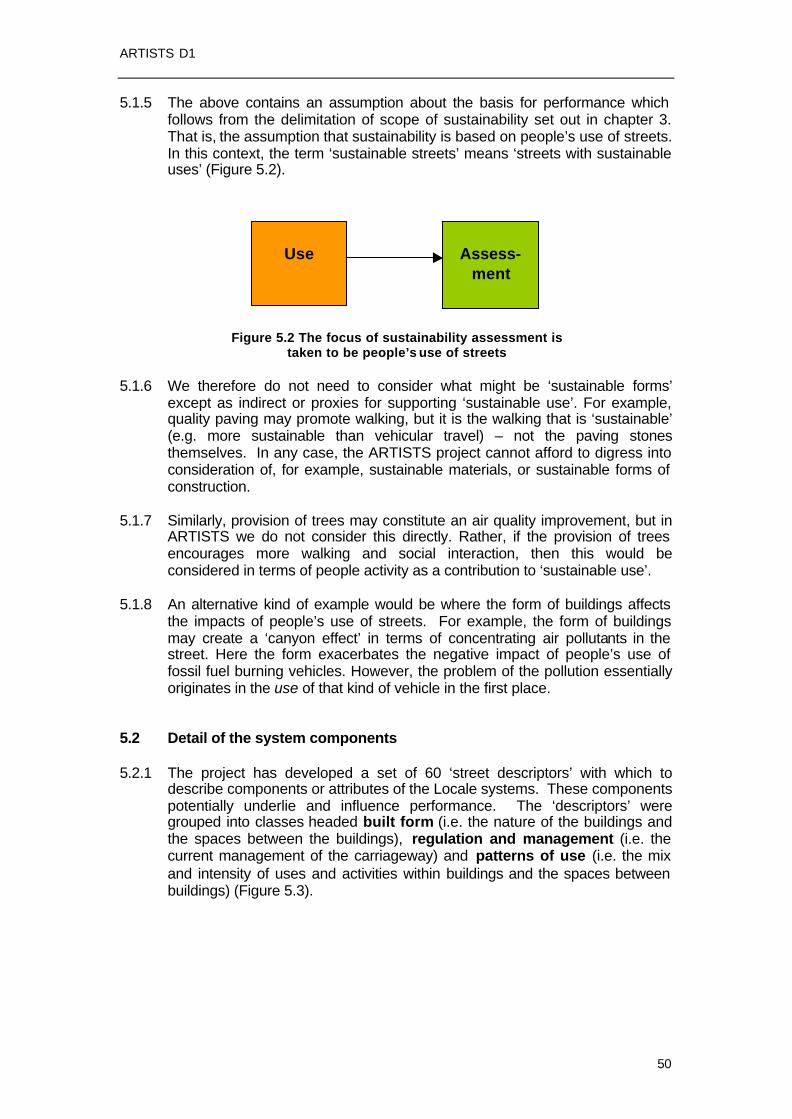
ARTISTS D1
50
5.1.5 The above contains an assumption about the basis for performance which follows from the delimitation of scope of sustainability set out in chapter 3. That is, the assumption that sustainability is based on people’s use of streets. In this context, the term ‘sustainable streets’ means ‘streets with sustainable uses’ (Figure 5.2).
Figure 5.2 The focus of sustainability assessment is taken to be people’s use of streets
5.1.6 We therefore do not need to consider what might be ‘sustainable forms’
except as indirect or proxies for supporting ‘sustainable use’. For example, quality paving may promote walking, but it is the walking that is ‘sustainable’ (e.g. more sustainable than vehicular travel) – not the paving stones themselves. In any case, the ARTISTS project cannot afford to digress into consideration of, for example, sustainable materials, or sustainable forms of construction.
5.1.7 Similarly, provision of trees may constitute an air quality improvement, but in
ARTISTS we do not consider this directly. Rather, if the provision of trees encourages more walking and social interaction, then this would be considered in terms of people activity as a contribution to ‘sustainable use’.
5.1.8 An alternative kind of example would be where the form of buildings affects
the impacts of people’s use of streets. For example, the form of buildings may create a ‘canyon effect’ in terms of concentrating air pollutants in the street. Here the form exacerbates the negative impact of people’s use of fossil fuel burning vehicles. However, the problem of the pollution essentially originates in the use of that kind of vehicle in the first place.
5.2 Detail of the system components 5.2.1 The project has developed a set of 60 ‘street descriptors’ with which to
describe components or attributes of the Locale systems. These components potentially underlie and influence performance. The ‘descriptors’ were grouped into classes headed built form (i.e. the nature of the buildings and the spaces between the buildings), regulation and management (i.e. the current management of the carriageway) and patterns of use (i.e. the mix and intensity of uses and activities within buildings and the spaces between buildings) (Figure 5.3).
Use
Assess-
ment

ARTISTS D1
51
Physical Design
Buildings Space between Buildings
Regulation / Management
Building use Use of space between buildings
Patterns of Use
In Buildings In the Space Between Buildings
Figure 5.3 Elaborated framework components 5.2.2 As can be seen in Figure 5.3, a distinction is made between street-space
between buildings lines and the buildings themselves. This gives six sub-categories in all, listed below and illustrated in Figure 5.4: ?? Buildings – the physical form of the buildings adjoining the street; ?? Building use – designated or permitted use; ?? Use of buildings – actual use of and activities within buildings; ?? Streetscape – the physical form of the space between buildings –
including the carriageway, sidespace, street furniture, trees and landscaping;
?? Regulated street-space – the street-space as modified by regulations, such as permitting or prohibiting certain uses;
?? Street activity – the use made of the space between buildings – including both circulation of people and vehicles and other urban activities (sitting, eating, playing, etc.)
Physical design provides the physical foundation on which regulation/management operates; it also provides an ultimate physical constraint on the type and intensity of activities which may take place.
Regulation applies to the use of buildings, infrastructure and public space. It effectively adds an extra layer of intervention, that comes between form and use.
People use streets by using the physical buildings and spaces, moderated by any regulations.

ARTISTS D1
52
Street as Locale (character section)
Space between Buildings
Buildings
Physical Design/ Form
Streetscape
Built form
Regulation
Markings etc
Permitted uses
Use
Use of streetspace Actual uses
Figure 5.4 Components for street description 5.2.3 Following the framework suggested in Figures 5.3 and 5.4, each street under
consideration is divided into character sections or Locales and systematically described under the headings of ‘Form’ ‘Regulation/ Management’ and ‘Use’: ?? Form relates to the physical form of buildings and the layout of the
streetscape. ?? Regulation/Management relates to the temporal and spatial management
of both the carriageway and ‘side space’ indicated by signs and markings. ?? Use relates to the observed patterns and intensity of activity within the
space between the buildings and within the buildings.
Describing Form
5.2.4 The descriptors of street Form that are applied to each street character section or Locale can be grouped under two broad headings:
?? Building characteristics
?? Space between buildings characteristics
5.2.5 Descriptors of buildings cover both their physical shape and the quality and significance of the structures. The space between buildings includes both physical measures of distances between frontages and the various features provided in this public space (greenery, lighting, etc.). Several useful measures can be derived from these descriptors, such as the ratio of street

ARTISTS D1
53
width to building height. The set of street Form descriptors is shown in Table 5.1.
Describing Regulation and Management
5.2.6 The regulation and management regime is described in terms of the markings and signs used to control and prioritise use of the space between buildings. Street regulation/ management includes the allocation of space on the carriageway (traffic lanes, parking spaces, etc.) and traffic regulation (e.g. traffic speed limits). The set of Regulation/Management descriptors is shown in Table 5.2

ARTISTS D1
54
Table 5.1 Street Form Descriptors
Theme Secondary Theme Descriptor Disaggregation
Average height of roofline Side of street Building height
No. of floors (average/minimum/ maximum)
Side of street
Metres of frontages Side of street
Metres of space between frontages Side of street
Spacing of buildings
Ratio of frontages to space between Side of street
Nos. (% of total) Side of street Inactive frontages
Frontage metres (% of total) Side of street
Historical importance
No. of historically important buildings Side of street
No. of doorways per 100 metres Side of street
% inactive building line Side of street
Building characteristics
Transparency
% illuminated building l ine Side of street
Average/maximum/ minimum distances between opposing building lines
Street width
Average/maximum/ minimum width of public space
Average/maximum/ minimum width per side of street
Side space width
Average/maximum/ minimum across total width of street
Side of street
Type of median Median
Average width
Carriageway width Average/maximum/ minimum (including median space)
Trees, greenery Type of greenery
Surface materials Street furniture etc.
Type of furniture
Guard railing, bollards
Type of railing or bollards
Quality of lighting of carriageway Lighting
Quality of lighting of footways
People spaces No. and location of spaces for people to gather
Space between buildings
Street proportions Ratio, street width to building height

ARTISTS D1
55
Table 5.2 Street Regulation/Management Descriptors
Theme Secondary Theme
Descriptor Disaggregation
Traffic circulation One way or two way working
Speed limit Designated speed limit
Length of traffic calmed section Traffic calming
% of section subject to traffic calming
Traffic lanes No. of marked lanes Direction of traffic
Average marked/ provided lane width Lane width
Average visual width (e.g. allowing for different surface materials)
Tram lanes: number/width
Bus lanes: number/width
Cycle lanes: number/width
Allocation of carriageway
Taxi lanes: number/width
Parking bays: number/width; % of kerbspace
Vehicle/person type Allocation of kerbspace
Loading bays: Number/width; % of kerbspace
Cycle tracks: number/width Allocation of side space
Footways: number/width
No. of signalised crossings
No. of other marked crossings
No. of unmarked crossings
Pedestrian crossings
No. of over/ underpasses
No. of signalised junctions
No. of roundabouts
Road junctions
No. of other junctions
No. of stops
Regulation/ management
Bus/tram stops
Stop provision (waiting area, real-time information..)

ARTISTS D1
56
Describing Use
5.2.7 Descriptors of street use are applied to each character section/Locale falling under three broad headings:
?? Movement;
?? Street activities (space between buildings);
?? Land use characteristics (in buildings).
Table 5.3 Street Use Descriptors
Theme Secondary Theme Descriptor Disaggregation
Average annual daily vehicle flow Vehicle type, direction Traffic flow
Peak hour vehicle flow Vehicle type, direction
Average occupancy per vehicle type Cars, buses, taxis, trams, etc
People flow
Total person flows, per hour, average annual day
Public transport reliability
Bus/tram: average delay (minutes)
Pedestrian footway activity
Flow at busiest point in the peak
Pedestrian crossing activity
Flow at busiest point in the peak
No. of parked vehicles; % occupancy By vehicle type
Move-ment
Parking/loading activity
No. of loading vehicles; % occupancy By vehicle type
Number of people in the street
Street activities
Number of activities in the street
Number of establishments by type Land use categories Upper floor land use
Floor area by type Land use categories
Number of establishments by type Land use categories Ground floor land use
Floor area by type Land use categories
Number of parking spaces By vehicle type
Land use character-istics
Off-street parking/ loading
Number of loading spaces By vehicle type

ARTISTS D1
57
5.2.8 Movement can be measured in various ways, including vehicular traffic flow, composition and predictability of journey times; here we are interested in all forms of traffic, including cyclists and public transport vehicles, vehicle occupancy and the resulting numbers of people moving along the artery. Street activities relate primarily to observations of people and the activities they are engaged in while in the street (window shopping, sitting etc.). Finally, land use characteristics include both land use category and information on the numbers of employees and residents along the street. The employed set of street use descriptors is shown in Table 5.3.
Table 5.4: Applied Pilot Indicators
Theme Secondary Theme Indicator Possible Disaggregation
Movement Efficiency Ratio of: Total number of people moving through the locale To: Total number of vehicles moving through the locale
Average rental value Number of workplaces
Economy
Viability of businesses
Vacancy rates
Retail, offices
Traffic deaths Gender, age, mode
Traffic injuries (serious/slight)
Gender, age, mode
Safety (traffic-related casualties)
Traffic speeds Vehicle-related Security Reported crime Person-related
Unemployment rates
Average incomes
Affluence/deprivation
Residential rents/property prices
Medical prescriptions issued
Society
Health
Incidence of heart disease
SO2 NO2
Air quality
PM10 Outdoor daytime
Environment
Noise Outdoor nightime

ARTISTS D1
58
Measuring Performance 5.2.9 The pilot performance Indicators against which the ARTISTS streets were
assessed are shown in Table 5.4. These were employed with a view to broadly assessing how well the street is performing in terms of sustainability and quality of life aspirations. They are grouped under the three broad headings of Economy, Society and Environment.
5.2.10 The pilot performance Indicators (after their application at the ARTISTS case
study streets) have been evaluated regarding the degree to which each is measurable (i.e. is information relating to each indicator readily available, obtainable, estimable?) and meaningful (ie what do stakeholders consider important about the case study streets and do the pilot performance indicators reflect this?). The results and implications of the evaluation are addressed next.
5.3 Key indicator set 5.3.1 From the long list of 60 potential indicators, a more limited set of 11 key
indicators was identified, which were felt to be most useful for the purposes of the project, in terms of being ‘meaningful’ and ‘manageable’. These are discussed with respect to the headings ‘built from’, ‘streetscape’ and ‘street activity’ in the following sub-sections.
(1) Street use (activities)
5.3.2 By studying the “patterns of use” or activities within a Locale we gain an
understanding of the current user groups and their relative size. We also are able to assess the degree to which the Locale is “multiuse” rather than “single use”, and to make an assessment as to the degree to which “through” uses and “Locale” activities are in conflict. Five core descriptors have been identified under this dimension:
1.1 Movement Efficiency 1.2 Presence of Vehicles (traffic volume) 1.3 Presence of People (No. of people – through flow, circulating) 1.4 Activities in the Street (No. of activities – diversity of activities) 1.5 Speed of Vehicles (relates to accident risk and health factors18)
The core descriptors 1.1, 1.3 and 1.4 are usually associated with social and economic benefits. Descriptors 1.2 and 1.5 are often associated with environmental disbenefits.
(2a) Streetscape
5.3.3 Three core descriptors have been identified under this dimension:
2.1 Enclosure (building height : street width ratio). 2.2 Lateral Spacing of Buildings (frontage : space between frontage ratio)
18 Here, speed is regarded as an environmental disbenefit to the users of the Locale (both pedestrians and occupants of other vehicles). The benefits of speed – as perceived by the vehicle user – are considered in terms of through flow of people (persons per hour).

ARTISTS D1
59
2.3 Greenery (degree to which Greenery influences the street): Trees may be as important as buildings in creating definition (Jacobs, 1993). As well as their general aesthetic appeal, trees and other greenery can have a compensatory effect on the visual and other psychological impacts of higher traffic levels (Topp, 1984; Appleyard, 1981).
2.4 Road Engineering. The degree to which the street has been reengineered as a road affects its ability to support other activities.
(2b) Buildings
5.3.4 Two core descriptors have been identified here:
2.5 Connecting Public and Private Realms (number of doorways per 100m of building line)
2.6 Transparency (proportion of the building frontage that is ‘active’)
Whilst the street requires definition and enclosure, it also requires “transparency” particularly at ground level (at the meeting of the horizontal and vertical planes). There needs to be a softening of the edge between the public and private realms. This can be achieved visually with glass frontages but more strongly with doorways allowing movement between the two realms. Rather than blank walls, the street requires windows and opening doors to allow visual and actual movement between the public and private realms, to provide interest and an added sense of security. It is important that the frontages are “active” in order to provide greater interest and a sense of surveillance. The existence of active frontages/ground level activity appears to be one of the key factors associated with higher levels of pedestrian activity (Space Syntax, 2001).
5.3.5 The list of 11 descriptors is summarised in Table 5.5. Examples of application
of these are given in Appendix 1.

ARTISTS D1
60
Table 5.5: Core Descriptors Dimension Theme Criterion
1.1 People to vehicle movement ratio
Traveller volume to vehicle traffic volume
1.2 Presence of vehicles Traffic volume 1.3 Presence of people Pedestrian volume 1.4 No of activities No of activities/behaviours
in space between buildings
Use 1. Street use (activities)
1.5 Speed of vehicles Speed ( 85th percentile km/hr)
2.1 Enclosure Width to height ratio 2.2 Lateral spacing of buildings
Spacing of buildings (ratio of frontage to space between buildings)?
2.3 Greenery Degree to which greenery influences the street
2(a) Streetscape
2.4 Road engineering The degree to which the street has been reengineered/built as a road
2.5 Connecting public and private realms
Number of doorways per 100m of building line
Form
2(b) Buildings
2.6 Transparency Degree of transparency between public and private realms at ground floor level offered by windows and doors.

ARTISTS D1
61
6. DATA COLLECTION AND USE 6.1 Introduction 6.1.1 This section of the Deliverable outlines the application of the initial appraisal
approach, the underlying principles of which were described in Section 4. Appraisal has two stages ‘surveying’ and ‘analysis’ although in reality there is considerable overlap between the two. This section reports primarily on the former i.e. the process of information gathering conducted at each of the forty case study streets. The ‘case study reports’19 contain the pictorial, diagrammatic and written analysis.
6.1.2 Information gathering was guided primarily by two tools:
?? The ‘Review Frame’20 that structures the gathering of information
regarding street attributes, facilitating the detailed description of Locales. The Review Frame was built around the street attribute descriptors listed in tables 5.1, 5.2, 5.3 combined with guidance on measurement, and space for the recording of the information gathered. The Review Frame also drew on and drew together current approaches to street related assessment from across the ARTISTS partner countries. It attempts to serve several purposes, drawing together elements/approaches from Town Centre Health Checks and Street User Audits, reducing certain aspects of the street to ticks and scores or short comment made within the Review Frame. It is also intended to structure analysis of street attributes in a comprehensive manner reflecting the complexity of the street. Here the Review Frame draws on elements of urban design, i.e. area appraisal and townscape appraisal.
?? The ‘Indicator Checklist’ (based on the pilot performance indicators)
was used for an initial quick survey to assess likely indicator-related information availability, and to record information relating to the pilot indicators.
6.1.3 The approach to appraisal outlined within this section, was developed and
piloted with the intention of it being refined for recommendation to municipalities/city planners. It did however serve a variety of purposes within the ARTISTS project, some of which required information to be recorded in spreadsheet form for further analysis. These other uses of the gathered information are noted below.
Assessment of change over time
6.1.4 The ARTISTS case study streets were split into two categories:
?? ‘Reconstructed’ Streets having recently undergone a ‘significant’ planned intervention; and
?? ‘Unchanged’ Streets where there had not been a ‘significant’ intervention within the last 30 years.
19 Contained within the National Reports at http://www.tft.lth.se/artists/national_reports.htm 20 Appended to Deliverable D1.2

ARTISTS D1
62
At each reconstructed street, the Review Frame and Indicator Checklists were employed to gather information with which to describe each of the cases studies the year before and year after ‘reconstruction’. At all of the case studies, the Review Frame and Indicator Checklist were also employed with the intention of describing baseline conditions circa 1970, and current conditions. All available information was entered into spreadsheets with the intention of making comparisons between current and baseline conditions, and those just before and after reconstruction. The current and baseline (where available) condition information were compared with a view to gaining an understanding of ‘long-term’ change at each of the case study streets. Assessment of some of the temporal changes is briefly outlined in certain of the case study reports, and is the focus of ARTISTS Deliverable D2.3 ‘Short and long-term effects of arterial street design and traffic control’. The analysis underlying Deliverable D2.3 was based primarily on the spreadsheet information.
Assessment of relationships between street attributes and pilot performance Indicators
6.1.5 An investigation of correlations between street attribute descriptors and pilot
indicators was based on the spreadsheet information. The results are given in Deliverable 2.1.
6.1.6 There was a further sub-category of unchanged case study street referred to
as ‘Demonstration’ case studies. At this sub set of case studies, the ARTISTS researchers would go on to work with ‘stakeholders’ to develop design proposals. At each of these Demonstration case studies, more detailed surveying of people numbers and activities (see section 6.4 and Appendix 2) was undertaken.
6.1.6 As well as there being the different temporal points for which information was
gathered, information gathering was also based on differing spatial scales. For each pilot performance indicator (reconstructed streets), data were gathered for the ‘case study area’ and a wider ‘reference area’ that provided a ‘control’ against which to identify the net impact of street reconstruction. Each of the two area types were defined by the researcher.
6.2 Information gathering areas – defining the spatial scope 6.2.1 For conceptual reasons, data availability reasons and assessment purposes,
the information gathering was undertaken based on three types of ‘area’. Needs expanded text here on ‘reasoning’ for this

ARTISTS D1
63
Study Area
6.2.2 Conceptualising the street as a series of ‘open systems’ poses a challenge for the researcher. The geographical scope of research into street attributes and the pilot Indicators will be ‘fuzzy edged’ and depends on the attributes under investigation. For example, when considering ‘Viability’ the researchers did not restrict data gathering to the prime retail properties fronting the case study street. An attempt was made to include the secondary retail sites in the side streets that ‘feed – off’ the case study street sustained by the ‘browsing shopper’ or visitor to the case study street. For other Indicators (e.g. Vehicle Speed), it was appropriate for the researcher to restrict their focus to the case study street itself. The shape and extent of the Study Area were also dictated by the geographical scale and zoning of existing data sets. For example, the UK Census of Population small area statistics are available for rather randomly shaped ‘Enumeration Districts’. These do not neatly follow the sides of arterial streets. Thus, depending on the Indicator or street attribute under consideration (and the encoding of existing data sets relating to them), the Study Area was redefined by the researcher. Character Section Definition
6.2.3 The researchers also subdivided each of their case study streets into
separate ‘Character Sections’. In effect, a character section represents a locale having a homogenous character – or defines a locale on the basis of homogeneous character – where homogeneity is considered at a level of resolution appropriate to the analysis. This means that a character section should be homogeneous with respect to the key parameters used to influence its classification. For example, if a street abruptly changes in frontage use (e.g. from being an arterial shopping street to an arterial residential road), then this break in character would represent the boundary between character sections or locales. This allows the sections to be classified differently.
6.2.4 The Character Sections were the basis for the collection, analysis and presentation of information relating primarily to street attribute descriptors. Selection of different Character Sections was largely down to subjective judgement, based on marked differences in physical aspects of the street such as street width, building height, building age, greenery etc.
Reference Area Definition
6.2.5 Deliverable D1.2 proposed assessing performance relative to an appropriate ‘Reference Area’ within the case study city. The reference areas were used like ‘controls’ against which to consider the relative change in performance of given case study streets before and after reconstruction. Each researcher decided upon the reference area(s) based on suitability for comparison purposes and the geographical coverage and zoning of existing data sets. For example many existing London data sets distinguish between central, inner and outer London and between borough areas. The reference areas thus tended to be the borough within which the case study fell, or the relevant wider area (i.e. central, inner or outer London), depending on the pilot indicator and zoning of the relevant data set.

ARTISTS D1
64
6.3 Data gathering 6.3.1 The case study street assessments were based on both existing data
(gathered by a desktop exercises) and new data (derived form ‘surveys’) conducted by the researchers. The availability of existing data varied between case studies. Each researcher investigated the availability of relevant land use data, building height data, maps of parking restrictions etc, and then decided what additionally had to be obtained via new surveys. Thus after setting the geographical scope of the study area and deciding on Character Sections and reference areas, each researcher prepared an information acquisition plan.
6.3.2 Many of the Street Attributes are relatively unchanging e.g. Built Form
Attributes and could be surveyed any time of the day/week or year. ‘Greenery’ is clearly seasonally dependant and was surveyed whilst trees were in leaf. The assessment of light from lighting columns, was made after dark. Pedestrian movement, people activities and Level of Service were surveyed at the busiest time of the day/week. Equipped with:
?? Maps on which to draw and make notes out on site ?? Coloured pencils and pens ?? Note pad ?? Copies of the Review Frame (one per character section) on which to
record information and make notes ?? Camera
the researcher made several ‘sweeps’ of the case study character sections, recording information relating to different street attributes during the various ‘sweeps’. These ‘sweep’ surveys were intended to record many of the aspects of Built Form, Regulation and Management and Patterns of Use. Except when recording pedestrian numbers, street activities and Level of Service, and patterns of vehicle use, surveys were undertaken at any time, any day of the week etc, and/or undertaken in stages. The researcher conducted these surveys, either making –
?? a few ‘slow’ sweeps of the study area recording information relating to many of the attributes during each sweep; or
?? several ‘quick’ sweeps recording information for only one or two attributes during each sweep.
The Review Frame was used to record notes and comments either while at the case study street or back at the office.
6.4 Additional guidance – street attributes 6.4.1 The case study appraisals were guided primarily by the Review Frame and
the questions and guidance notes within it. Some additional guidance relating to certain aspects of “Built Form” and “Patterns of Use” analysis and reporting was given within an internal ‘Case Study Guide’. This included guidance on:
Built Form Building Height
6.4.2 For each Character Section, researchers were advised to make quick
sketches of building height/street width, whilst out on site. Precise street widths were later measured from scale plans. If the researcher lacked access

ARTISTS D1
65
to building height data, these were estimated based on the number of floors. Building height was taken as the height to the roofline.
6.4.3 The researchers made additional notes and comment on matters such as the
sense of enclosure or any ‘canyon effect’ resulting from the building height / street width relationship.
Active/Inactive Frontages
6.4.4 The length and location of ‘inactive frontages’ (i.e. ground floor facades lacking transparency between the public and private realms) and pedestrian (as opposed to vehicle) doorways opening onto the public realm were sketched onto scaled plans whilst on site.
Historically Important Buildings or Significant Structures
6.4.5 The landmarks within each study area/character section (i.e. the buildings or other structures that add most to a sense of place and/or aid legibility) were noted on plans along with a short written description. Photographs were also taken for inclusion within the Case Study Report. Deciding on a landmark is a somewhat subjective exercise and proved challenging in some ‘older’ streets with many ‘important’, ‘imposing’ or ‘visually interesting’ buildings. Researchers were advised to close their eyes, try to visualise the street and then note the buildings they used to place or orientate themselves.
Quality of Built Fabric
6.4.6 When recording the ‘quality of the built fabric’, the researcher was again making a somewhat subjective assessment. Within each character section they noted the state of repair, decoration and cleanliness of the buildings and the impression these gave, along with their view as to the design quality, the degree to which buildings complement each other and the level of detail and interest the buildings offer. Again the researchers supplemented their written appraisals with photographs.
Side Space Width, Median Strip, Width Between Side Space
6.4.7 In each character section records were made as to how the horizontal plane had been physically apportioned. This did not always require on-site surveying. Frequently plans were available showing the current street layout. Generally, cross-sections were sketched by the researcher at the case study street, then these were used along with photographs and scale maps to

ARTISTS D1
66
prepare scale drawings back at the desk. The researchers additionally noted any median strip, its purpose(s) and method of construction, and the same for the ‘side space’21.
Trees and Other Greenery
6.4.8 The Review Frame allowed the researchers to record the effect that greenery
is having in each character section, by ticking “yes/no” to one of five statements e.g. “Green shapes the street space and is an important formative element, unmistakable of the street”. The location of greenery was recorded on plans as part of the appraisal, and photographs taken to illustrate the effect of the greenery. Street Surfaces, Furniture, and Other Aspects of the Fabric of the Horizontal Plane
6.4.9 Just as the quality of the Built (vertical) Fabric was appraised, the researcher
also judged and recorded the quality of the fabric of the horizontal plane. At each character section, the researcher photographed surface materials and street furniture, and recorded their impression as to how well maintained these are, and how might they be influencing noise levels, walkability / cyclability, access for people with disabilities etc. Guardrails
6.4.10 The location and length of pedestrian guardrails were recorded and
photographs taken. Notes were made as to its judged purpose e.g. ‘to prevent pedestrians using the median strip to cross the road’, ‘to ‘force’ pedestrians to use a ‘staggered’ crossing rather than walk straight across the carriageway’; ‘to deter car parking’ People Spaces
6.4.11 Places for people to congregate, sit etc. were noted on maps and
photographed. If the case study was a Reconstructed Street then notes were made regarding the age of the place (i.e. are they ‘historic’ spaces or newly created as part of the change). Patterns of Use Pedestrian Movement and Street Activity
6.4.12 Surveying of pedestrian movement and people activities potentially requires a
great deal of effort and resource. Hence two approaches were employed – ?? rapid case study observation and estimation; and ?? detailed case study surveying
differing in effort and rigour. The rapid appraisal was suggested for all case studies except the Demonstration Cases. The researcher would note their impression of the numbers and density of pedestrians along the street with dots sketched on a plan, creating a dot density diagram. They similarly
21 “Side space” is the area at the edge of the carriageway not used for movement of motorised vehicles. It will include the footway and constructed cycle track and parking bays etc. (see Deliverable D2.1).

ARTISTS D1
67
record the most common stationary activities such as standing at bus/tram stops, standing at market stalls or window shopping or sitting (a different colour dot for each activity). These impressions were supplemented with photographs. At the Demonstration Cases fuller survey and analysis was undertaken (see Appendix 2). Vehicle Flow, Occupancy, Traffic Composition
6.4.13 The gathering of information relating to vehicle flow, traffic composition and
occupancy was largely a desktop exercise. City authorities generally had this information available (although it varied in age, and classes of vehicle counted etc). Predominant Land Use, Ground Floor Use, Vacancies Off-Street Parking
6.4.14 The ARTISTS project researcher team developed a standardised land use
classification system, which was employed across all case studies. The classes are –
?? Residential ?? Public Service ?? Retail ?? Industrial ?? Office/other business?? Other
For case study streets where there were no adequate suitable existing records of land uses, these were surveyed by the researcher. Land use classes for each building were recorded on a plan. Total floor areas for each use class were estimated based on the building footprints and numbers of floors, using a spreadsheet. Vacant properties/floor space were also recorded as part of the land use survey, if such data were not already available.
6.5 Additional guidance – pilot performance indicators 6.5.1 All the pilot performance indicators were quantitative Indicators, in that they
relied on count data derived from measurement, modelling or surveys, as opposed to Satisfaction or Perception Indicators relying on attitude surveys or focus groups. They were by and large dependent on there being existing data sets. The availability and nature of existing data sets differed between partner countries. In particular, the frequency at which data are gathered differed between country. In many instances, considerable further data manipulation was required in order that they could be employed as an ARTISTS pilot Indicator.
6.5.2 The researchers sought to standardise pilot Indicator analysis and
presentation as far as possible, whilst acknowledging the variety in existing data sets across case studies, cities and countries. Each researcher employed a standardised pilot Indicator Checklist in an initial scoping survey. The checklist was built around the list of pilot Indicators (Table 4.4) with additional headings and columns structuring the process of decision making regarding –
?? Case Study Area,

ARTISTS D1
68
?? Reference Area, ?? where to obtain data, and ?? whether further data manipulation would be required.
6.5.3 In order to make an assessment of long-term change in performance, data
were sought for each of the pilot Indicators from around 1970. At each of the Reconstructed Case Study streets attempts were made to gather data relating to the pilot Indicators for both the year before ‘reconstruction’ and the year after. However, for many of the pilot Indicators, such as ‘residential population’ for which data tends to be gathered at infrequent intervals, the researcher could only work with data gathered at the set frequency. For other Indicators where data are continually collected (e.g. ‘traffic related casualties’), it was often possible to make such an assessment of short-term change.
6.5.4 Certain of the pilot Indicators could only be based on existing data sets e.g.
‘residential population’, ‘working population’, ‘traffic related casualties’, ‘crime’, or the results of modelling conducted by others e.g. ‘air pollutant concentrations’. Other pilot Indicators drew on existing data where these were available, but could practically be derived by surveys conducted by the ARTISTS researchers if necessary. These Indicators included ‘speed’. Detailed guidance regarding vehicle speed measurement was provided in the ‘Case Study Guide’. ‘Movement Efficiency’ was based on existing counts of vehicle flows and the occupancy similarly derived from existing data or from surveys conducted by the researchers. Property capital value, rents and yield were derived from existing data sets (were available) or surveys undertaken by the researchers. For example, at the London case studies, estimates were based on the results of telephone surveys conducted with estate agents. ‘Noise’ levels were estimated for each of the case studies using a standard method based on factors including traffic volumes, vehicle speed and building height.
6.5.5 The pilot Indicator list included air pollutant concentrations as a proxy
Indicator of effects on health. Early in the process of checking potential data availability, it became clear that a consistent and appropriate direct Indicator of ‘Health’ would not be found. Thus each researcher selected a ‘local’ Health Indicator based on the best available data.
6.5.6 Details of further exploration, refinement and testing of indicators is given in
Appendix 3.

ARTISTS D1
69
7. ASSESSMENT 7.1 Introduction 7.1.1 The role of assessment is to determine to what extent a particular street or
locale is performing relative to its target function. In the context of ARTISTS, that target function will be performance as an arterial street – ultimately towards being a ‘sustainable arterial street’ – which implies some combination of arterial role, urban place role, and orientation towards sustainability.
7.1.2 Performance assessment is therefore not simply an indication of use, but an
assessment of use relative to target function, as defined through classification. This means that different streets with the same amount of use – say, traffic volume – could be interpreted as having different levels of performance, if those streets have different target functions.
7.1.3 Following the proposed definition of the sustainable arterial street, this can be
seen as aiming to maximise social and economic interaction and minimise negative impacts of vehicles.
7.1.4 As discussed previously, this involves different combinations of trade-off
regarding the use of particular street space area (and time) for different users. One cannot simply shut out all vehicles, as the street system would cease to function. Therefore, it is necessary to bear in mind that a street system is likely to require different kinds of sustainable arterial streets, performing complementary functions, that collectively add up towards overall sustainability. Assessment can therefore be used to help judge if a particular street section has the right balance in accommodating the different activities.
7.2 Basis of performance assessment 7.2.1 Traditionally, the performance of a street has often effectively been taken as
little more than the performance of a street as a road, with level of service evaluated by performance indicators such as capacity or flow. At the simplest level, accommodating more traffic to meet demand would be considered better. But this fails to take account of the number of people carried (or the amount of goods transported), or the use of the street space for non movement activities.
7.2.2 Performance measurement therefore needs to take account of both people
and vehicles. Focus on people 7.2.3 Therefore a starting point here is to take people – rather than vehicles – as
the fundamental basis for evaluating the positive performance of a street; where ‘people’ means people whether in vehicles or not, or whether in transit or simply occupying space for other uses.
7.2.4 People can be judged as the measure of the success of a place. Therefore, a
street that it improved by investment in quality materials, trees, street furniture, and so on, is by this logic only considered successful if people use

ARTISTS D1
70
the space.22 In turn, the people’s use of the street contributes to social and economic interaction and hence social and economic dimensions of sustainability (Chapter 3).
7.2.5 Using people as the most basic positive performance indicator is to some
extent a simplification, but this is no more simplistic than using, say, vehicle capacity to indicate performance, as has often been the case conventionally.
Vehicles
7.2.6 If people represent the plus side – the positive contribution to social and
economic sustainability – then vehicles represent the minus side, in terms of environmental disbenefits.
7.2.7 It is the presence and movement of vehicles in a locale that causes the
different kinds of disbenefit to other users of the street. These disbenefits include aspects of displacement, disturbance and danger (Marshall, 2004): ?? disbenefits due to the presence of vehicles, even if they are not in use
(e.g., space consumption, visual intrusion); ?? disbenefits due to vehicles having their engines running, even if they are
not getting anywhere (e.g., noise, emissions, energy consumption, etc.); ?? disbenefits due to the motion of vehicles (e.g., accident risk23).
7.2.8 Seen in this way, all vehicles – including bicycles and buses – in principle
contribute some environmental disbenefit, albeit that in the case of the bicycle the impact is usually almost practically negligible. The greater the number of the more damaging vehicle types, the greater the overall disbenefit.
‘People over vehicles’
7.2.9 By accounting for people and vehicles separately, we can more clearly
conclude that the presence of people is ‘good’ – an indicator of potential or actual social and economic activity – and that the presence and motion of vehicles is ‘bad’ – displacement, disturbance and danger. Therefore, the use of streets by people in vehicles can be seen to include a positive component associated with the people and a negative component associated with the vehicles.
7.2.10 This clearly relates to the familiar assumption that high vehicle occupancy is
good for efficiency and sustainability. For example, buses are familiarly considered ‘greener’ than cars because they tend to carry more people using fewer vehicles. The formulation above simply puts the underlying principle of ‘people over vehicles’ first, in which case the typical positive performance of buses is an example. It also, however, allows in principle for the fact that an individual bus may cause more damage than an individual car, and this intrinsic vehicular disbenefit is only outweighed if the bus actually does carry more people.
7.2.11 The implied shift in emphasis from the conventional assessment based on
vehicle flow (with or without considering pedestrians) to assessment by
22 This is equivalent to considering ‘exposure to noise’ as an indicator rather than ‘noise’, since it is how noise affects people that is the key. 23 Here, accident risk is considered an environmental disbenefit, since to any particular street user, it is an externally imposed disbenefit just like noise or pollution.

ARTISTS D1
71
people flow and presence / movement of vehicles is shown in Figure 7.1. The term presence / movement of vehicles is used here to keep in mind that disbenefits are not necessarily directly related to flow per se.
Figure 7.1. New Characterisation of the Relationship Between Use and Performance. This demonstrates the conceptual decoupling of the positive and negative effects of vehicle flow, into a positive component related to people flow and a negative component related to vehicle presence / movement. 7.2.12 Movement of people does not normally imply an intrinsic benefit to a
particular locale of itself, but is normally associated with accessing places. Therefore, the benefit associated with through flow of people within a locale is effectively acknowledging the contribution that movement makes to people accessing other places, and social and economic benefits accruing in those other locations.
Movement efficiency
7.2.13 The movement of people is essential to the achievement of access within the
City system. However the less efficiently movement along the arteries is achieved (i.e. the greater the number of vehicles employed to move a given
Conventional
Proposed
Vehicle flow
Pedestrians
Street use
Presence / movement of vehicles
Net environmental disbenefit
Flow of people to access places
Pedestrians engaged in other local urban
activities
Net social and economic benefit

ARTISTS D1
72
number of people), the greater will be the impacts arising in the Locales the artery passes through, and the less space there is for the street space to accommodate other uses and activities within the Locales.
7.2.14 The indicator of movement efficiency is the ratio of the follow of people in
vehicles to the flow of vehicles within a locale. This effectively equates with flow passing a given point, or net flow though a given area. It may be used as a proxy for the assumed overall social and economic benefit relative to environmental disbenefit.
7.2.15 The indicator ‘Movement Efficiency’ therefore links to the core of the
ARTISTS project’s definition of the sustainable arterial street. It says something meaningful about the - ?? efficiency with which the artery is allowing passage of people to enable
social and economic activity (outside the locale); ?? likely levels of impact on the users of the locale by users of vehicles
(where vehicles have different degrees of disbenefit, including disbenefits associated with long term environmental degradation).
7.2.16 It would be possible to suggest other indicators that would take into account
the total number of people and vehicles in a locale, including pedestrians within the locale (not flowing directly through), and the presence of parked vehicles, etc. This was not further developed within the ARTISTS project, but the basic rationale set out herein would readily allow extension to a ‘higher resolution’ assessment, where the context and data availability permitted.
7.3 Application 7.3.1 The ARTISTS researchers found that vehicular traffic flow data are generally
available. This suggests that vehicular traffic volume could be employed as a coarse proxy indicator for the impacts arising (at the locale level) from vehicular movement along arterial streets.
7.3.2 The researchers also found that vehicle occupancy information tends to be
available (if often in rather a coarse form). Combining vehicular traffic vehicle flow and occupancy rates for each mode provides an indication of numbers of people moving along the artery in vehicles.
7.3.3 ‘Movement Efficiency’ ratios have been estimated from available data at a
sub set of ARTISTS case study streets. The range of ‘people in vehicles: vehicle’ ratios observed at the ARTISTS case study streets has been subdivided into five classes (A to E) to provide a ‘benchmark’ against which any other arterial street can be coarsely compared without the need for extensive and costly new surveying. The ARTISTS cases studies have been similarly employed to derive a set of 5 traffic volume classes to produce a ‘presence of vehicles’ indicator.
7.3.4 The data on ‘movement efficiency’ are presented in a scatter plot, Table 7.1.
The significance of two extreme values may be noted: ?? The point furthest to the left (medium-high people flow: low vehicle
flow) is George Street in Croydon (London), a bus, tram, taxi only street. At the survey point, the street carries the average number of people for the ARTISTS case studies listed above, but does so with only a tenth of the average number of vehicles;

ARTISTS D1
73
?? The point to the far right is Marylebone Road, which has a high traffic volume (and a correspondingly high people flow).
Table 7.1: ‘Movement Efficiency’ at case study streets Street Peak Hour
Motor Vehicles
People Using Vehicles
People/ Vehicles
Amargerbogade 1170 4320 3.7
Frederiksundsvej 1970 4987 2.5
Jagtveg 1640 4167 2.5
Jyllingevej-Sallingvej 2780 4623 1.7
Valby Langgade 780 1861 2.4
Vigeslev Alle 1820 4498 2.5
Jagtveg 1640 4167 2.5
Seven Sisters Road 1534 4344 2.8
Brixton Road 2602 8376 3.2
Bayham Street 1797 4431 2.5
George Street 180 5253 29.2
Marylebone Road 5248 7610 1.5
Old Kent Road 2629 5477 2.1
Bismarkallee 2064 2360 1.1
Andrianoupoleos Street 2460 5890 2.4
Egeou Street 480 1290 2.7
Ethnikis Antistasis Avenue 2110 5090 2.4
T. Ikonomidi Street 665 1167 1.8
Plastira Street 1450 3960 2.7
Th. Sofouli Street 1285 3150 2.5
Muzeum-Karoly krt. 3285 7630 2.3
Rua do Amial 810 5090 6.3
Rua do Campo Alegre 1400 6670 4.8
Av. Fernão Magalhães 1880 5360 2.9
Ramalde/Paranhos 1080 5520 5.1
MEAN 1792 5565
7.3.5 The movement efficiency criterion has been used in the case study work
elsewhere in the ARTISTS project (ARTISTS National Reports).
7.4 Relation to function and street-space trade-off 7.4.1 By the assessment rationale presented in this report, a street can perform
well in terms of sustainability if it supports social and economic activity while minimising environmental disbenefit. There are different ways of achieving a good ratio of benefit to disbenefit: for example, one could achieve above average social and economic activity, or below average vehicular disbenefit.
7.4.2 As implied earlier, vehicular disbenefits can be related to different vehicle
types and their use (size and weight, engine type, speed…). These are not entirely independent variables in practice, since a certain engine type is required to propel a vehicle of a given weight at a given speed. They also relate to people-carrying benefit, as faster large capacity vehicles can carry more people in a given unit of time.
People to vehicle ratios at ARTISTSCase Study Streets
0
1000
2000
3000
4000
5000
6000
7000
8000
9000
0 1000 2000 3000 4000 5000 6000
Motor vehicles
Peo
ple
usi
ng
veh
icle
s

ARTISTS D1
74
7.4.3 The people-carrying benefit and vehicular disbenefit may also be related to the kind of role a particular arterial street is intended to play relative to a particular kind of performance (Figure 7.2).
Figure 7.2 Different street types suggesting different types of performance 7.4.4 In Figure 7.2, Point A could represent one kind of sustainable arterial street,
having a relatively high arterial function and a relatively low urban place function. This type of street could be suited to a design and regulation that supported relatively high speeds (conventional urban traffic speeds) geared especially towards high occupancy vehicles (implying larger motor vehicles) – maximising people flow through the locale. In other words, this combination of design and regulation would support the role of such a street functioning in this position on the classification.
7.4.5 To boost the overall performance of the street system, the pattern of such
arterial streets should be geared to maximise the use of high occupancy vehicles (eg make for an efficient bus network).
7.4.6 In contrast, Point B could represent another kind of sustainable arterial street,
having a relatively high urban place status and relatively low arterial function (at least for an ‘arterial street’). Such kind of street could be suited to relatively low impact vehicles (lower speed, lower weight, low emission vehicles) albeit lower capacity vehicles, but suitable for greater compatibility with more sensitive environmental amenity.
7.4.7 The pattern of these arterial streets would be suited to correspond with places
of high attractiveness as ‘people places’ – where people wish to congregate. 7.4.8 In effect, both streets representing A and B could be ‘sustainable’ in having
high people/ vehicle ratio; though they would achieve these in different ways: ?? A would have particularly high number of people relative to vehicles; ?? B would have particularly low number of vehicles relative to people.
7.4.9 The foregoing links performance assessment back to different kinds of street
type (classification), which in turn provides the rationale for onward design and regulation.
Urban place
Art
eria
l con
nect
ion A
B

ARTISTS D1
75
8. CONCLUSIONS 8.1 This report has provided a rationale for linking the classification, design and
regulation, use and performance assessment of arterial streets. These conclusions present the main findings for onward application, concentrating on the topics of classification and assessment, the core focus of this report.
Classification 8.2 From the consideration of classification of streets, some key points have
emerged, which simultaneously challenge perceptions about conventional classification, and yet lead towards resolution between existing understanding of the principles of classification and onward development of a classification appropriate for a study aiming to encourage sustainable arterial streets.
8.3 Firstly, urban roads and streets are generally not classified at present by
traffic flow; nor even strictly by traffic ‘function’, but if anything by network function. This is to do with the way routes link together in a strategic network – the property of ‘arteriality’ – to do with network geometry rather than flow of vehicles.
8.4 Secondly, it is established that the paradigm or model in which each street
has a ‘circulation’ function and an ‘access’ function that are inversely proportional – and that any urban road tends to emphasise one rather than the other – cannot hold for the arterial street. The arterial street typically has both a high degree of circulation and a high degree of frontage access. It simply does not fit a position on the spectrum from high circulation/low access function to low circulation/high access function.
8.5 That much has been apparent for many years: what we can further add now
is that while there is apparently a contrast and indeed often a conflict between through traffic and local activity competing for the use of street space – a perceived contrast between ‘strategic routes’ and ‘local routes’ and between ‘strategic traffic’ and ‘local traffic’ – on closer inspection we see that any conflict simply arises due to competing use of space, with conflicting paths of vehicle and people. This is independent of whether the traffic is itself ‘strategic’ or ‘local’. The conflict of circulation is always manifested at the local level, in a specific stretch of street space, or locale.
8.6 Put another way – and linking back to the first key point (para. 8.3) – what we
can say is that for ‘network function’ there is no conflict between the ‘strategic’ and the ‘local’: because sections of road labelled ‘strategic’ or ‘local’ are mutually exclusive and complementary. But for circulation, there is conflict: but this is between individual vehicles and people competing for the use of a specific area of streetspace, whether the movement is inherently strategic or local in nature.
8.7 Network function – or strategic role – is effectively an abstract assignation
that may be allocated or retrofitted to any street. What this means is that the trade-off can be seen as one between allocating space (and time) to individual vehicles and people within a specific locale. However, the resolution of this trade-off is informed by the significance of a street’s arterial role relative to its significance as an urban place.

ARTISTS D1
76
8.8 A third key point relates to how conventional classification is effectively by designation. One reason why roads and streets are classified according to designated function is precisely because – indeed, only possible because – it is largely independent of form or use. Designation is effectively allocated subject to judgement, by a given roads authority, rather than having to be faithfully or transparently tied to any empirical observation of form or use. This means that conventional classification by ‘function’ is effectively at least as subjective as any other. This finding de-emphasises the specific historical significance of ‘objective classification.’ However, it allows arterial role to be recognised as an ordinal ranking that may be comparable to (and may be contrasted or traded off with) an ordinal ranking of urban place. While the designation of arterial status is conventionally carried out by the roads authority, the designation of urban place status is envisaged to be carried out by – or at least in consultation with – the planning authority. It is implicit that this procedure would need to be harmonised in practice.
8.9 These three key considerations demonstrate how our understanding of the
topic of arterial streets has advanced since the outset of the project. This provides a useful foundation for onward development of a classification of locales along arterial streets and an assessment of their degree of sustainability.
8.10 Following from this understanding, a strategic classification has been
developed. This is based on identifying a street’s combination of arterial role and urban place role: ?? The determination of arterial role takes account of the position and
‘network function’ of the street section as a link in the urban road network. The designation of arterial role to a link will also take some account of the form and use of the locale constituting that link, in relation to all other links/locales.
?? The determination of urban place will take account of the relative significance of the form and use of a particular locale relative to all other urban places/locales. The assignation of high urban place significance will therefore require judgement based on not only the locale itself, but implicitly requires consideration of all other locales.
?? In both cases, then, arterial role and urban place role are relative rankings based on consideration of the functioning of the whole city, and possibly the national or international scale.
?? Once the arterial role and urban place significance have been established, this indicates the envisaged role of the street section within the whole urban/ national system. This then ‘positions’ the street section, and its performance can be benchmarked against other sections of the same type (i.e.. the same ‘cell’ in the classification, Figure 4.8).
Sustainability and Assessment
8.11 Just as streets are considered as part of a whole street system, it is
acknowledged that the sustainability of individual streets is not easily separable from the sustainability of the street system overall. Since it is outside the scope of this project to tackle a system of sustainability assessment that addresses the whole city system, it has been necessary for the ARTISTS rationale to focus on the concept of sustainability appropriate for the assessment of the performance off streets.

ARTISTS D1
77
8.12 In the first instance, an ‘experimental’ and resource intensive method of assessing the performance of arterial streets (via a series of pilot indicators and a long list of street attribute descriptors) was developed for test application at the project case study streets. Conclusions drawn from the evaluation of this approach include –
?? both ‘measurability’ and ‘meaningfulness’ of the pilot indicators vary
depending in part on the scale of the intervention proposed for the street and the resources allocated to undertake the intervention (and undertake baseline line and operational phase assessments);
?? the approach sought to respond to and reflect all dimensions of the street and most of its attributes; however not all of these were to be the subject of the ‘Design Guide’ that the ARTISTS project is working towards developing; and
?? municipalities currently appear to lack the institutional capacity to apply/monitor the pilot indicators to arterial streets at the strategic/city system level.
Thus a series of less resource intensive classification and assessment tools have been developed.
8.13 As a convenient simplification, sustainability performance is taken to relate to
people’s use of streets. People’s use of streets as pedestrians is therefore taken to equate positively with socio-economic activity and hence social and economic sustainability within that locale. The impact of people’s use of streets on environmental sustainability is effectively considered in terms of the negative impacts of vehicles.
8.14 Vehicle flow may be conceptually separated into two factors: a benefit
associated with the flow of people in the vehicles, and a disbenefit associated with the vehicles themselves.
8.15 The Sustainable Arterial Street may therefore be defined as “An arterial street
whose physical and regulatory provision supports accessibility and social and economic activity while minimising the immediate and ongoing negative environmental impacts of vehicles, balancing or trading-off between the immediate street role and the urban system as a whole.”
Final reflections
8.16 The system of classification developed here is considered to be both robust
and transparent, and suitable for addressing the multi-functional nature of arterial streets. This system is grounded in some of the bas ic principles underlying conventional classification (such as arterial status relating to network function) while replacing or adapting those conventions (such as the presumed inverse relationship between movement and access, and assumed orientation to vehicular movement) to suit present needs, of accommodating and promoting sustainable arterial streets.
8.17 In the case of sustainability assessment, the grounding in precedent or
adaptation from convention is less straightforward. This is partly because of the inherent difficulties, in principle, in pinning down the concept of sustainability – and the lack of precedent in doing so for sustainable streets (as opposed to, say, sustainable vehicles or sustainable cities) – and partly

ARTISTS D1
78
due to the reliance of assessment on the practicability of data availability and analysis.
8.18 In this context, the system of assessment developed herein is proposed as
one possible rationale for assessment of ‘arterial streets towards sustainability.’ The assessment is relatively simple, in order to be practical. In any case, the assessment methods rely on some interpretation of sustainability; they are therefore ultimately dependent on the extent to which it is possible to define and operationalise the concept of sustainability in the context of individual streets. The system herein is considered to give a reasonable balance between something that is simple enough to be usable, and something that has a consistent rationale that could in principle allow higher-resolution treatment where circumstances might permit.
8.19 Taken together, this report provides an integrated system or conceptual
framework that relates classification, street design and regulation, street use and performance assessment. This provides a basic rationale for working with these components, even if, in application, the individual components are tailored differently to different circumstances. This is of course quite natural, as in each national or city context, the principles would be expected to be applied and adapted to suit the local conditions – and this relates to an explicit aim of ARTISTS to reflect local diversity.
8.21 The various classification and assessment concepts and indicators have been
developed and applied iteratively within the project, in conjunction with parallel case study work reported in the ARTISTS project National Reports, Deliverables D2 and D3. Those that are taken forward and recommended for application to future practice are being incorporated in ARTISTS Deliverable D4, the ‘Design Guide for Arterial Streets’.

ARTISTS D1
79
9. References AASHTO (1990) A Policy on Geometric Design of Highways and streets, 1990.
Washington, D.C.: American Association of State Highway and Transportation Officials.
Appleyard, D. (1981) Livable Streets. Berkeley: University of California Press Brindle, R. (1996) Road hierarchy and functional classification, in Ogden, K. W. and
Taylor, S. (eds.) Traffic Engineering and Management. Melbourne: Institute of Transport Studies, Department of Civil Engineering, Monash University.
DoT/IHT (1987) Roads and Traffic In Urban Areas. London: HMSO. Hardi, P. (1997) Measurement and Indicators Program of the International Institute
for Sustainable Development, in Moldan B & Bilharz S. (eds) Sustainability Indicators. Report of the project on Indicators of Sustainable Development. Scope 58. Publ. By Wiley & Sons
Hardi, P and Zdan, T (eds) (1997) Assessing Sustainable Development: Principles in Practice. Winnipeg: International Institute for Sustainable Development
HBS (2001) Hanbuch fur die Bemessung von Strassenverkehrsanlagen. Koln: Forschungsgesellschaft fur Strassen- und Verkehrswesen e. V.
Holland, J (1995) Hidden Order: How Adaption Builds Complexity. Reading: Addison-Wesley.
Hopkins, P.G. May, A.D. and Turvey, I.G. (1987) Pedestrian Amenity: On Street Survey Design (Working Paper 243). Leeds: Institute for Transport Studies, The University of Leeds
IHT (1997) Transport in the Urban Environment. London: Institution of Highways and Transportation.
Institution of Civil Engineers (1994) Managing the Highways Network. London: Institution of Civil Engineers.
Institution of Civil Engineers 1996) Which Way Roads? London: Thomas Telford Publishing on behalf of the Institution of Civil Engineers.
Jacobs, A.B. (1993) Great Streets. London: MIT Press. Jones, I. D. (1986) A review of highway classification systems, in Traffic Engineering
and Control, 27 (1), 27–30. Marshall, S. (2002a) Systematic Analysis of Classification Systems. ARTISTS
Document 1.1.1, Version 1.1. London: University of Westminster. Marshall, S. (2002b) Thematic Catalogue. ARTISTS Document 1.1.2, Version 1.0.
London: University of Westminster. Marshall, S. (2002c) A First Theoretical Approach to Classification of Streets .
ARTISTS Deliverable D1.1. London: University of Westminster. Marshall, S. (2004) Streets and Patterns. London: Spon Press. Morrison, A. (1966) Principles of road classification for road maps, in Cartographic
Journal, 3 (1), 17–30. MoT (1963) Traffic in Towns. London: HMSO. Niu, W-Y. Lu, J. J. and Khan, A. A. (1993) ‘Spatial Systems Approach to Sustainable
Development: A Conceptual Framework’. Environmental Management, vol17(2) Schaller, N (1993) ‘The Concept of Agricultural Sustainability’. Agriculture,
Ecosystems and Environment, vol 46, pp89-97 Senge, P et al (1994) The Fifth Discipline Fieldbook: Strategies and tools for building
a learning organization. London: Nicholas Brealey, Space Syntax (2001) Towards a ‘Walkability’ Index: An Objective Approach to
Forecasting Pedestrian Flows in London. London: Unpublished report prepared for Transport for London
TERM (EU Transport and Environment Reporting Mechanism) (2001) Indicators Tracking Transport and Environment Integration in the European Union, Environmental Issue Report No23. Copenhagen: OPOCE EEA

ARTISTS D1
80
Topp, H.H. (1984) ‘Umfeldverträgliche Verkehrsbelastbarkeit Städtischer Strassenein Kompensatorischer Ansatz.’ Stasse und Autobahn, vol 11, pp465-473
TRANSPLUS (2002) Analysis of Land Use and Transport Integration Indicators. Unpublished document internal to the TRANSPLUS project.
Tripp, H. A. (1950) Road Traffic and its Control. (2nd ed.). London: Edward Arnold. URBED (Urban and Economic Development Group) (1994) Vital and Viable Town
Centres: Meeting the Challenge. London: HMSO WCED (World Commission on Environment and Development) (1987) Our Common
Future. Oxford: Oxford University Press

ARTISTS D1
81
Appendix 1 Rating Street Characteristics and Performance Dimension (1) Street Use Theme 1.1 Movement Efficiency
Criterion Ratio of Numbers of People in Motor Vehicles to Number of Motor Vehicles in the Peak Hour
Category E People/vehicles < 1.5
Category D People/vehicles = 1.5 to 3
Category C People/vehicles = 3 to 4.5
Category B People/vehicles = 4.5 to 6
Category A People/vehicles > 6
People (life) must flow along the arteries in order to maintain the city system. However, the less efficiently this is done, the greater will be the impacts arising form each person moving, and the less space (and time) there will be for the street to accommodate other activities.
Adrianoupoleos Street, Kalam aria People/vehicles = 2900/2100 = 1.4 Marylebone Road, London People/vehicles = 7610/5248 = 1.45 George Street, Croydon (Bus ,Tram, Taxi only) People/vehicles = 5,200/180 = 29
Street Peak Hour
Motor Vehicles
People Using Vehicles
People/ Vehicles
Amargerbogade 1170 4320 3.7
Frederiksundsvej 1970 4987 2.5
Jagtveg 1640 4167 2.5
Jyllingevej-Sallingvej 2780 4623 1.7
Valby Langgade 780 1861 2.4
Vigeslev Alle 1820 4498 2.5
Jagtveg 1640 4167 2.5
Seven Sisters Road 1534 4344 2.8
Brixton Road 2602 8376 3.2
Bayham Street 1797 4431 2.5
George Street 180 5253 29.2
Marylebone Road 5248 7610 1.5
Old Kent Road 2629 5477 2.1
E
C
D
B
A
People to vehicle ratios at ARTISTSCase Study Streets
0
1000
2000
3000
4000
5000
6000
7000
8000
9000
0 2000 4000 6000
Motor vehicles

ARTISTS D1
82
Theme 1.2 Presence of Vehicles
Criterion Traffic Volume (Annual Average Daily Flow)
Category E 24hr AADF > 90,000
Category D 24hr AADF > 60,000 to 90,000
Category C 24hr AADF = 30,000 to 60,000
Category B 24hr AADF = 10,000 to 30,000
Category A 24hr AADF < 10,000
In general terms, the greater the number of vehicles, the greater will be the negative impacts arising in the form of air pollutants, noise etc. The greater the noise and the visual intrusion arising from the traffic, the more people will seek to avoid or escape the street.
Marylebone/Euston Road, London > 90,000 vehicles/24hr
Barcelona Street, Girona George Street, Croydon (Bus,Tram, Taxi only)
Theme 1.3 Presence of People
Criterion Pedestrian Flow (Pedestrians/5mins)
Category E Pedestrians/5min < 10
Category D Pedestrians/5min 10 to 50
Category C Pedestrians/5min 50 to 150
Category B Pedestrians/5min > 150 to 300
Category A Pedestrians/5min > 300
The fewer people in the street the less vibrant and vital a place feels. However, not all Locales would be expected to have large numbers of people in the space between buildings. One should expect the “Local High Street and “Main Shopping Street” to be the most vital and have the greatest street life.
Habsburgerstrasse, Freiburg <10 pedestrians/5mins Camden High Street, London >500 pedestrians/5mins
E
C
D
B
A
E
C
D
B
A

ARTISTS D1
83
Theme 1.4 Activities in the Street
Criterion Number of Activities Taking Place in the Space Between Buildings
Category E None
Category D Few
Category C Several
Category B Many
Category A Very many
The street is not only for movement. There are a host of other activities that can and do take place in the spaces between buildings. These may range from sitting at café tables, through standing talking, window shopping or shopping at market stalls, to standing or sitting at bus and tram stops. Just as the ideal is a mix of uses within buildings, so there needs to be supported variety of activi ties in the spaces between the buildings.
Vigerslev Allé, Copenhagen
Brixton Road, London Camden Town, London
Theme 1.5 Speed of Vehicles
Criterion 85th Percentile Vehicle Speed
Category E V85 > 70 km/h
Category D V85 = 60 to 70 km/h
Category C V85 = 50 to 60 km/h
Category B V85 = 40 to 50 km/h
Category A V85 = 30 to 40 km/h
Depending on the degree to which the street has been re-engineered as a road, the greater the speed the greater the impacts in terms of number and severity of accidents (or at least the perception of danger), severance, noise etc.
Adrianoupoleos Street, Kalamaria 85th percentile speed = 106 km/h Karl-Kister-Straße, Freiburg 85th percentile speed = 38 km/h
E
C
D
B
A
E
C
D
B
A

ARTISTS D1
84
Dimension (2a) Form of Streetscape Theme 2.1 Enclosure
Criterion Building Height to Street Width Ratio
Playa Height to width < 1:6
Height to width =1:3 to 1:6
Optimum Height to width = 1:3
Height to width = 1:3 to 1:1
Canyon Height to width > 1:1
The street can be considered a “room”. The buildings shape it and give it definition. If the building height is low compared to the street width, then definition and a sense of enclosure are lost. If the buildings are high compared to the width of the street, then enclosure can be too great and oppressive.
Old Kent Road, London Height to width 1: 10 Marylebone/Euston Rd, London Height to width 2: 1
M i n
O p t I m u m
M a x
Optimum ratio
Maximum ratio
Definition provided by trees E.g. on Boulevard
Minimum ratio
Based on diagrams by Llewelyn – Davies (2000)

ARTISTS D1
85
Theme 2.2 Lateral Spacing of Buildings
Criterion Ratio of Frontage to Space Between Frontages
Category E Frontage : Space < 1:1.5
Category D Frontage : Space = 1:1 to 1:1.5
Category C Frontage : Space = 1:0.5 to 1:1
Category B Frontage : Space = 1:0 to 1:0.5
Category A Frontage : Space = 1:0
The street can be considered a “room”. The buildings shape it and give it definition. The greater the spacing between buildings, the less defined
Old Kent Road, London Barcelona Street, Girona
Less horizontal spacing and greater definition Greater horizontal spacing and less definition
E
C
D
B
A

ARTISTS D1
86
Theme 2.3 Greenery
Criterion Degree to which Greenery Influences the Street
Category E There is no greenery
Category D Greenery has no influence on the street. It is only sporadic.
Category C Greenery does not shape the street. Greenery and other installations cancel each other
Category B Greenery has an influence on the street and outweighs “technical” installations
Category A Greenery shapes the street and is an important formative element, unmistakable in the street
Greenery is capable of compensating for some of the negative impacts of higher traffic flows. It can also soften some of the “hard” road related installations in the street and often adds shape and definition to the street, the tree canopy acting as the ceiling to the “room” of the street.
Barcelona Street, Girona Marti I Pujol Street, Badalona Barcelona Street, Girona
E
C
D
B
A
Greenery has an influence on the street Greenery has no influence on the street

ARTISTS D1
87
Theme 2.4 Degree of Road Engineering
Criterion Extent to which the “street” has been re-engineered as a “road”.
Category E Fully constructed as a “road”
Category D
Category C Intermediate
Category B
Category A Fully constructed as a “street”
The greater the degree the street has been reconstructed as a single use (ie vehicle distribution) ‘road’ the less able it is to support the needs of other Locale users. The sustainable arterial street is one that meets the needs for access within the City system, whilst also meeting the needs of Locale users.
Marylebone Road, London George Street, Croydon
E
C
D
B
A

ARTISTS D1
88
Dimension (2b) Form of Buildings Theme 2.5 Connecting Public and Private Realms
Criterion Number of Doorways per 100m of Building Line
Category E Doorways/100m = 0
Category D Doorways/100m = 1 to 7
Category C Doorways/100m = 8 to 15
Category B Doorways/100m = 16 to 23
Category A Doorways/100m > 24
The street needs to have connections between the public and private realms. This can and should be real via doorways but can also be visual connection via windows (see below)
Gran Via Street, Sabadell Jagtvej, Cope nhagen George Street, Croydon
Theme 2.6 Transparency
Criterion Proportion of the building frontage that is “active”
Category E < 20% active
Category D 20 – 40% active
Category C 40 – 60% active
Category B 60 – 80% active
Category A > 80% active
There needs to be visual connection between public and private realms in order to add interest, provide real or at least a sense of surveillance and hence security
Barcelona Street, Girona Eschholzstraße, Freiburg Brixton Road, London
E
C
D
B
A
E
C
D
B
A

ARTISTS D1
89
Appendix 2. People in the Street - Observing and Measuring People’s Activities (Internal guidance given to ARTISTS researchers for use at the case study streets)
A. Pedestrian Movement The study area should be visited to ‘scope’ the survey. The busiest times should be focused on in the survey, or strong variation in activities picked up (e.g. weekend market). However, the detail and ofsurveying will have to be tailored to the resources available. People should be counted from locations referred to here as ‘gates’. Gates should be focused on the case study street but, streets and possibly on other parallel streets should also be considered (depending on scoping review). Ideally these gates should cover the entire study area. However, if survey resources limited, gates may be ‘scattered’ as indicated below.
At each gate, pedestrians should be counted and direction recorded, for 5 minutes. It is also suggested that the observer make an assessment of the ‘level of service’ at each gate (based on the descriptions yet to be circulated) during each five minutes survey. The observer then moves onto another gate and counts there for five minutes, and so on. Experience in London has shown that counting for 5 minutes and then scaling the results up to pedestrians per hour, provides an acceptable balance between accuracy and efficiency. (However, as the example below illustrates, if disaggregating and only observe small numbers of children, it may not be appropriate to try and factor up small numbers of children). Gates should be grouped so that the observer can walk in a loop, stopping for five minutes at each gate and hence hopefully covering 8 to 10 gates per hour. Pedestrians crossing the case study street should be counted in a similar manner. If disaggregating, it is suggested that the focus on age and/or sex (e.g. unaccompanied children, accompanied children and adults). Those scoping the survey may wish to disaggregate further depending on the nature of the location and users observed during scoping. E.g. in central London counts, pedestrians are often recorded as “suits” (i.e. they look like they are working in London), “tourists” and “casuals” (i.e. they look like they are Londoners but not on a working day/trip). It

ARTISTS D1
90
should be remembered that pedestrian activity can show pronounced peaks. Thus movement by the surveyors between gates should be planned so that gates on the case study street are all being observed/covered during the peak. Researchers should avoid observing at one gate on the case study street during the peak and further down the street missing the peak. It is suggested that surveying take place from 8.00 am to 8.00pm although in many cities scoping may show that street life continues much later and hence surveying should be extended. If observing a weekday, it is suggested that Mondays or Fridays be avoided unless surveying some weekly event that falls on one of those days (e.g. a market). Also please try and avoid the day after a public holiday and a rainy day (not always possible, especially in England). For each survey, the date and weather conditions should be recorded. The gates and gate groups should be drawn onto an appropriate scaled map (e.g. 1:1250) and numbered. The counts at each gate should be recorded in a spreadsheet as shown below.
Date: 26 Sept
Weather: Cloudy but warm and dry.
Time Category gate A1 gate A2 gate A3 gate B1 gate B2 8-9.00am unaccompanied children 0 0 2 0 3 accompanied children 1 2 3 2 5 adults 56 24 26 45 68 TOTAL 57 26 31 47 76 Factored up to hour unaccompanied children 0 0 24 0 36 accompanied children 12 24 36 24 60 adults 672 288 312 540 816 TOTAL 684 312 372 564 912
Level of Service C B B C D
9-10.00am unaccompanied children 0 accompanied children 1 adults 56 TOTAL Factored up to hour unaccompanied children 0 accompanied children 12 adults 672 TOTAL
Level of Service C

ARTISTS D1
91
At all case studies, the researcher should use the guidance below to assess and record the pedestrian level of service. Number of pedestrians along per m² (density) (in the peak hour)
Quantity [pedestrian/m²]
A = 0,10 B = 0,25 C = 0,40 D = 0,70 E = 1,80 F > 1,80
(source: HBS 2001, Germany)
level of service: Pedestrians A Pedestrians basically move in desired paths without altering their movements in response to other pedestrians. Walking speeds are freely selected, and conflicts between pedestrians are unlikely. B Sufficient area is provided to allow pedestrians to freely select walking speeds, to bypass other pedestrians, and to avoid crossing conflicts with others. At this level, pedestrians begin to aware of other pedestrians, and to respond to their presence in the selection of walking path. C Sufficient space is available to select normal walking speeds, and to bypass other pedestrians in primarily unidirectional streams. Where reverse direction or crossing movements exist, minor conflicts will occur, and speeds and volume will be somewhat lower. D Freedom to select individual walking speed and to bypass other pedestrians is restricted. Where crossings or reverse-flow movements exists, the probability of conflicts is high, and its avoidance requires frequent changes in speed and position. The LOS provides reasonably fluid flows; however, considerable friction and interaction between pedestrians is likely occur. E Virtually all pedestrians would have their normal walking speed restricted, requiring frequent adjustment of gait. At the lower range of this OS, forward movement is possible only by “shuffling”. Insufficient space is provided for passing of slower pedestrians. Cross- or reverse-flow movements are possible only with extreme difficulties. Design volumes approach the limit of walkway capacity, with resulting stoppages and interruptions to flow. F All walking speeds are severally restricted, and forward progress is made only by “shuffling”. There is frequent, unavoidable contact with other pedestrians. Cross- and reverse-flow movements are virtually impossible. Flow is sporadic and unstable. Space is more characteristic of queued pedestrians than of moving pedestrian streams. (source: HBS 2001, Germany and HCM, USA)

ARTISTS D1
92
B. Pedestrian Route Surveys Some pedestrians should be followed. The observers should stand at entries to the case study street (e.g. side street, bus stop, station etc) and choose a person entering the street to follow at random. They should draw the path taken (using different coloured pen for different category of pedestrian). If the pedestrian stops very briefly, they should continue to be followed. If they go into a phone box, go into a shop, go to a bus stop, etc then this “destination” location/activity should be noted and the observer return to the starting point and then follow another person. This will provide us with some indication of the types of activities people arriving are undertaking. Obviously this needs to be conducted carefully. Observers should avoid drawing attention to themselves.
It is suggested that observations be made from each chosen entry point for a minimum of 30 minutes, before moving to the next chosen point C. Stationary Activities Survey Stationary activities should also be recorded. The street should be broken into areas within each of which the observer can walk all way round, recording and counting people activities (other than pedestrian activity) in an hour. The observer should be equipped with coloured pens to represent the categories of people (e.g. child unaccompanied, child accompanied, adult) and a paper plan (one plan for each hour). Using the appropriately coloured pen, the observer should note the location of each person and activity engaged in by means of consistent symbols e.g.

ARTISTS D1
93
Green/public spaces attached to or forming part of the street, should be considered for inclusion in the survey. The extracts below indicate the sort of resulting pictures we would be aiming for. However, survey resources may necessitate only the more active places and locations (indicated via scoping) are surveyed and not the whole case study street for the whole day.

ARTISTS D1
94
D. Crossing Surveys During scooping, the street should be subdivided into “points” and/or “gates”. Points are places where pedestrian crossing activity is concentrated probably at purposely created crossings (e.g., “zebra” crossings, signal crossings, signal junctions with a pedestrian phase). Gates are lengths of street (possibly between points) along which people tend to cross at more random points
Each gate and point should be observed for 5 minutes and the number of people crossing that gate or at that point should be recorded and their path recorded.
Each gate and point should then be observed for 15 minutes, and pedestrians arriving at the kerb wishing to cross selected at random. The time from point of arrival at the kerb to crossing to the opposite kerb should be recorded and then the average crossing time calculated for each crossing point/crossing gate.

ARTISTS D1
95
Appendix 3 – Refinement and Testing of Indicators Having undertaken the case study appraisals24 and assessed performance based on the pilot indicators, the ARTISTS project team undertook a series of evaluations. These evaluations looked back to the guiding ‘Bellagio’ principles and sought to test the pilot indicators (and some of the other tools developed within the project) against some of these principles. The evaluations were of three types – ?? An Evaluation of Indicator ‘Measurability’ - ARTISTS researchers employed a questionnaire to evaluate their own experiences of attempting to gather information relating to each of the pilot Indicators at the case study streets. ?? An Evaluation of Indicator ‘Meaningfulness’ - Focus groups have been conducted at the ARTISTS ‘Demonstration’ Case Study Streets. Primarily a part of a participatory design process to develop options for change at Demonstration Cases, they were also an opportunity to evaluate the degree to which the pilot Indicators represented issues of relevance, importance and significance to stakeholders25. ?? A less formal evaluation off the research process and tools underdevelopment, conducted via the project consortium meetings. The latter provided greater clarity regarding the spatial and temporal boundaries of the project and in particular the ‘Guidelines for the Reconstruction of Arterial Streets’ (Deliverable D4) that ARTISTS is working to develop. Whilst the ‘Review Frame’ guided process of appraisal had sought to respond to and embrace the complexity and all dimensions of the street, it proved to be a ‘resource hungry’ approach. In the light of their experience with this approach, the project team considered and clarified the dimensions of the street that are the priorities for the project, and hence classification and assessment. Test of pilot indicator meaningfulness (evaluation by focus group) Focus group facilitators were provided with a tabulated list of the ARTISTS pilot Indicators, against which they could rank – ?? the importance attached by the focus group participants to the issue each pilot
Indicator relates to; and ?? how well the participants believed the street was performing on that issue within
each of the agreed Locales. Facilitators tended to tailor these lists and the ways in which they were used within the different focus groups. Often the participants extended the list of important Indicators / issues to include certain street ‘descriptors’ drawn from the ‘Review Frame’. Occasionally focus groups made reference to the ‘level of service concept’. Despite the variation in approach adopted in the focus groups, and the complex nature of the ‘problematic street’ a general pattern did emerge. There was reasonable confirmation that the pilot Indicator headings were meaningful to stakeholders in that they relate to issues considered important by the stakeholders. The one clear exception is ‘Health’. When asked which Indicator headings should be
24 Described in the ‘National Reports’ following the approach outlined in Section 6 of this report. 25 The results of this evaluation of pilot indicator ‘meaningfulness’ is set out in the internal report ‘ARTISTS FG1 and FG2 – Evaluation Report’.

ARTISTS D1
96
dropped from the ARTISTS pilot list based on the outcome of the focus group, facilitators commonly reported ‘Health’ as not being meaningful and hence should be dropped. The indicator ‘Movement Efficiency’ tended to be reinterpreted as (or confused with) ‘Ease of Movement” by stakeholders. Movement efficiency is perhaps a parameter of most direct interest to the public authority manager or designer, who means to optimise the performance of the street for users in general; whereas ease of movement is of more direct interest to the individual user. Some focus groups prioritised certain groups of travellers in terms of the relative ease of movement to be aimed for (e.g. cyclists over car drivers). However, generally, with the exception of ‘Health’, the pilot Indicator headings reflected meaningful policy goals and meaningful Indicators with which to judge movement towards or away from those goals. Test of Indicator ‘Measurability’ (evaluation of researcher experiences) Upon completion of the initial case study street appraisals, the ARTISTS partners most involved in the data gathering / provision at six of the nine case study cities, recorded their experiences of measurement, collation or estimation of the pilot Indicators. These are summarised in Tables A3.1 and Table A3.2. The first table records whether or not data were available or potentially available at the appropriate spatial scale, etc. The second records the researcher’s view as to whether these are useful Indicators based on the availability of data and/or their measurability. The only pilot indicator emerging as one where data are consistently available is ‘Safety’, expressed in terms of the numbers of traffic casualties.


ARTISTS D1
98
Table A3.1: ARTISTS Researchers’ Experience of Gathering Pilot Indicator Related Information
Indicator Themes and Headings
Project Partners’ Experiences Comment
Primary Theme
Secondary Theme Indicator
No data available
Data available but not at appropriate scale (e.g. population data not available at street level, only available based on relatively large areas)
Data available but very difficult to access/ not in a useful form
Data readily available in an accessible form and at appropriate spatial scale
Data potentially available in an accessible form and at appropriate spatial scale, but difficult getting for the ARTISTS project
There are no existing data. We did the surveying ourselves. It was a lot of effort
There are no existing data. We did the surveying ourselves. It did not require a lot of effort
We had another experience (please describe in the comments section to the right)
Economy Viability Commercial Rents Retail: Average rent price per square metre per year C B AD E F
“We have rent prices per square metres per month, especially for homes, in business they differ a lot” (Germany) “Values vary a lot and with the type and dimension of the spaces” (Portugal)
Retail: Vacant floor space BCF A D E
Retail: Number of shops / retail workplaces BF AD E C
Office: Average rent price per square metre per year CF B AD E F
“We have rent prices per square me tres per month, especially for homes, in business they differ a lot” (Germany) “Values vary a lot and with the type and dimension of the spaces” (Portugal)
Office: Vacant floor space BCF A D E
Office: Number of office workplaces BF AD E C
All businesses: Average rent price per square metre per year C B AD E F
“We have rent prices per square metres per month, especially for homes, in business they differ a lot” (Germany) “Values vary a lot and with the type and dimension of the spaces” (Portugal)
All businesses: Vacant floor space BCF A D E All businesses: Number of workplaces BF AD E C
Society Vitality Residential population 0-17 years of age CE ADF B
“The actual existent data is provided from the CENSOS 01, which it wasn't available at time of the data collection” (Portugal)
18-64 years of age CE ADF B 65 years and older CE ADF B
Total population CE ABDF Working population Number of jobs B CF AD “Number of "labour force" was available” (Germany)

ARTISTS D1
99
Seriously injured two-wheelers (excluding killed) C AB DF E
“Data exists only for each street (not each reference area) so we used the data for the entire city - data treatment was necessary because the existent data wasn't organized as asked here” (Portugal)
Slightly injured two-wheelers C AB DF E
Seriously injured in motorised vehicles (excluding killed) C AB DF E Safety Slightly injured in motorised vehicles C AB DF E Total number of serious road injuries (excluding killed) C B ADF E
Total number of slight road injuries C B ADF E Total number of killed and injured C B ADF E Total number of accidents C B ADF E
Vehicle speed Average speed of motorised vehicles in km/h, e.g. 44 ABCDEF How is this measurable? (Danmark) “Not at this level measurable” (Germany)
V85 of motorised vehicles in km/h, e.g. 62 ABCDEF “Not at this level measurable” (Germany) How is this measurable? (Danmark)
Security Reported crime Number of sex and violence crimes BCF E AD Number of vehicle thefts BCF E AD Number of Arson, burglary, other thefts, robbery, vandalism BCF E AD
Total number of penal and criminal offences BCF E AD
Affluence/ Unemployment Number of unemployed residents CEF AD B
“Good available but in percent of the working people” (Germany) “The actual existent data is provided by the CENSOS 01, which wasn't available at time of the data collection” (Portugal)
Deprivation Number of working residents CEF ABD “Only working resistance (employees) with the duty for national insurance. Also available are commuter” (Germany)
Income Average total income per resident per year BEF C AD Average job income per resident per year BCEF AD Average transfer income per resident per year BCEF D AD
Residentia l rents/ Homes: Average price for rent of a flat for one year C B F AD E
“The state/municipality value each owner -home every second year - in order to tax land and buildings. These values have been used” (Danmark)
purchase price Homes: Purchase price per owner-occupied flat BC A E DF “We have the price per m² for building land” (Germany) Homes: Vacant rental flats BCEF AD
Homes: Number of homes E A BDF C
“and number of residential buildings” (Germany) “Data available was organized by neighbourhoods, therefore it was necessary their aggregation” (Portugal)
Homes: Number of people who changed address BCE A D F
“moving to Freiburg (from outside), moving out (from Freiburg), moving in (within Freiburg), moving out (within Freiburg)” Germany

ARTISTS D1
100
Health
Prescriptions and sick days Medical prescription issuing rate BCF AD E
“This is the number of people on special sickleave. More than 120 consecutive sickdays” (Danmark)
Number of sick days per job per year BCF A DE Number of early retired residents BCF AD E
Air pollutant concentrations SO2 (max hour) CE BF A D
“We could get all air pollution data based on a model, but the price was very high” (Danmark) “Total Emission, not only traffic” (Germany)
SO2 (max 24 hours) CEF B A D “Data was available for a small number of places where measurements are being made” (Portugal)
SO2 (yearly average) CEF B A D NO2 (max hour) AF B CE D
NOx (yearly average) BF A CE D “Data was available for a small number of places where measurements are being made” (Portugal)
PM10 (yearly average) F AB CE D Pb (yearly average) AEF B C D
CO (max hour) EF AB C D CO (yearly average) EF AB C D Ozone (max hour) EF B AC D
Ozone (yearly average) EF B AC D
Environment Air Quality Emissions (traffic) pollutants SO2 BCE F A D
NO2 ABCF D NOx BC AEF D
PM10 ABCF AE D Pb ABCEF D CO BC AEF D
Noise Outdoor Outdoor daytime noise levels ABDEF C Measured how? (Danmark)
Outdoor Outdoor night time noise levels ABCDEF
(Key: A=Sweden, B=Portugal, C=Belgium, D=Denmark, E=United Kingdom, F=Germany)

ARTISTS D1
101
(Key: A=Sweden, B=Portugal, C=Belgium, D=Denmark, E=United Kingdom, F=Germany)
Table A3.2: ARTISTS Researchers’ Assessment of Indicator ‘Measurability’
Primary Theme
Secondary Theme Indicator
Passes the test as an Indicator in that it
is readily measurable or
suitable data are available
Yes No Economy Viability Commercial Rents Retail: Average rent price per square metre per year E ABCDF Retail: Vacant floor space E ABCDF Retail: Number of shops / retail workplaces CE ABDF Office: Average rent price per square metre per year E ABCDF Office: Vacant floor space E ABCDF Office: Number of office workplaces CE ABDF All businesses: Average rent price per square metre per year E ABCDF All businesses: Vacant floor space E ABCDF All businesses: Number of workplaces CE ABDF
Society Vitality Residential population 0-17 years of age ABCDF E
18-64 years of age ABCDF E 65 years and older ABCDF E Total population ABCDF E Working population Number of jobs ACD BEF Safety Seriously injured two-wheelers (excluding killed) ABCDEF Slightly injured two-wheelers ABCDEF Seriously injured in motorised vehicles (excluding killed) ABCDEF Slightly injured in motorised vehicles ABCDEF Total number of serious road injuries (excluding killed) ABCDEF Total number of slight road injuries ABCDEF Total number of killed and injured ABCDEF Total number of accidents ABCDEF Vehicle speed Average speed of motorised vehicles in km/h, e.g. 44 F ABCDE V85 of motorised vehicles in km/h, e.g. 62 F ABCDE Security Reported crime Number of sex and violence crimes D ABCEF Number of vehicle thefts D ABCEF Number of Arson, burglary, other thefts, robbery, vandalism D ABCEF Total number of penal and criminal offences D ABCEF Affluence/ Unemployment Number of unemployed residents ABCDF E Deprivation Number of working residents ABCD EF Income Average total income per resident per year ACD BEF Average job income per resident per year ABCDEF Average transfer income per resident per year ABCDEF Residential rents/ Homes: Average price for rent of a flat for one year EF ABCD purchase price Homes: Purchase price per owner-occupied flat DE ABCF Homes: Vacant rental flats ABCDEF Homes: Number of homes BCD AEF Homes: Number of people who changed address ABCDEF