a dictionary of - archaeology - UW Canvas
640
-
Upload
khangminh22 -
Category
Documents
-
view
0 -
download
0
Transcript of a dictionary of - archaeology - UW Canvas


A D I C T I O N A R Y O F
ARCHAEOLOGY
E d i t e d b y
IAN SHAWAND
ROBERTJAMESON

A D I C T I O N A R Y O F
ARCHAEOLOGY

Copyright © Blackwell Publishers Ltd 1999
First published 1999
2 4 6 8 10 9 7 5 3 1
Blackwell Publishers Ltd
108 Cowley Road
Oxford OX4 1JF
UK
Blackwell Publishers Inc.
350 Main Street
Malden, Massachusetts 02148
USA
All rights reserved. Except for the quotation of short passages for the purposes of criticism and review, no part of this
publication may be reproduced, stored in a retrieval system, or transmitted, in any form or by any means, electronic,
mechanical, photocopying, recording or otherwise, without the prior written permission of the publisher.
Except in the United States of America, this book is sold subject to the condition that it shall not, by way of trade or
otherwise, be lent, resold, hired out, or otherwise circulated without the publisher’s prior consent in any form of bind-
ing or cover other than that in which it is published and without a similar condition including this condition being
imposed on the subsequent purchaser.
British Library Cataloguing in Publication Data
A CIP catalogue record for this book is available from the British Library.
Library of Congress Cataloging-in-Publication Data
A dictionary of archaeology / edited by Ian Shaw and Robert Jameson.
p. cm.
Includes bibliographical references.
ISBN 0–631–17423–0 (alk. paper)
1. Archaeology—Dictionaries. I. Shaw, Ian, 1961– .
II. Jameson, Robert.
CC70.D53 1999
930.1'03—dc21 98–5900000000000000000000000000000000 00000000000000000000
CIP000 000000000000000000000000 00000000000000000000
Typeset in Ehrhardt and Frutiger
by Grahame & Grahame Editorial, Brighton
Printed in Great Britain by TJ Press International, Padstow, Cornwall
This book is printed on acid-free paper

Contents
List of Illustrations vi
List of Contributors xi
Preface and Acknowledgements xii
Bibliographical Abbreviations xiv
A–Z Entries 1

Figures1 Abu Ghurob Plan and reconstruction drawing
of the sun temple of Nyuserra at Abu Ghurob,
Egypt. Source: W. Stevenson Smith: The art andarchitecture of ancient Egypt, 2nd edn (Harmonds-
worth: Pelican, 1981), figs 124, 125.
2 Abydos Schematic plan of the area of late
Gerzean settlement excavated by Eric Peet at
Abydos, Egypt. Source: M.A. Hoffman: Egyptbefore the pharaohs (London: Ark, 1980), fig. 44.
3 Altyn-depe Plan of the mound at Altyn-depe,
Southern Turkmenistan, showing the main
features of the Eneolithic–Bronze Age settlement.
Source: V.M. Masson: Altyn-depe: Raskopki gorodabronzovogo veka v Juzhnom Turkmenistane(Leningrad, 1991).
4 An-yang (A) Plan of typical royal burials
(M1129, M1400 and M1422) at Hsi-pei-kang, An-
yang, with long ramps leading down to the tombs,
and numerous single and multiple burials arranged
alongside; (B) structural model of the An-yang
urban network during the Shang period, based on
archaeological foci. Source: Chang Kwang-chih:
Shang China (New Haven and London, 1980),
p. 130.
5 Asmar, Tell Limestone statues of worship-
pers, 0.34 m high, with eyeballs of inlaid shell, found
buried in the shrine of an Early Dynastic temple at
Tell Asmar. Source: J. Black and A. Green: Gods,demons and symbols of ancient Mesopotamia: an illus-trated dictionary (BMP, 1992), fig. 1.
6 Axum Granite stele, Axum, Ethiopia. Source:
G. Connah: African civilizations (Cambridge
University Press, 1987), fig. 4.2.
7 Ban Chiang Late Period painted pottery from
Ban Chiang, southeast Asia, showing the great vari-
ety of decorative motifs. Source: C.F.W. Higham:
The archaeology of mainland Southeast Asia(Cambridge, 1989), fig. 4.25.
8 Boxgrove Plot of the results of a discriminant
analysis, showing two distinct groups of percussors.
Source: F. Wenban-Smith: JAS 16 (1989), fig. 3.
9 Bush Barrow Grave goods from rich ‘Wessex’
tradition graves dating to the mid-2nd millennium
BC at Bush Barrow, Wiltshire. Source: T. Darvill:
Prehistoric Britain (London, 1987), fig. 55a.
10 chamber tomb Archetypal three-dimensional
reconstruction showing the different elements of a
chamber tomb under its mound. Source: R.
Joussaume: Dolmens for the dead (London, 1987),
fig. 1.
11 Chemagel Chemagel, an east African Iron
Age settlement of the ‘Sirikwa hole’ type, as exca-
vated in 1964. Source: J.E.G. Sutton: A thousandyears of East Africa (BIEA, 1990), p. 44.
12 Ch’ü-fu Eastern Chou walled city of Ch’ü-fu
(the capital of the kingdom of Lu), showing features
of the city revealed in the 1977-8 excavations.
Source: T.F. Munford: Burial patterns of the Chouperiod: the location and arrangement of cemeteries inNorth China, 1000-200 BC (Ph.D. thesis, Australian
National University, 1985), fig. 6.
13 cylinder seal Banqueting scenes depicted on
a Sumerian cylinder seal of the Early Dynastic
Period. Source: H. Crawford: Sumer and theSumerians (Cambridge University Press, 1991),
fig. 6.6.
14 Daimabad Copper buffalo from the
Daimabad hoard (Prince of Wales Museum,
Bombay).
15 Danebury Plans of the two major phases of
the Danebury hillfort: the 6th century BC (left) and
the 4th century BC (right). Source: B. Cunliffe:
Anatomy of an Iron-Age hillfort (London, 1983),
figs 29–31.
16 Dar-es-Soltane II The partial skull and
mandible of an adult hominid found in layer 7 at
Dar-es-Soltane II (drawing by P. Laurent). Source:
A. Debénath et al.: L’Anthropologie 90 (1986), fig. 2.
17 frostmarks Frost and snowmarks over
Illustrations

showing the completed burial chamber as it was
being roofed in (painting by Caroline Sassoon).
Source: Thurstan Shaw.
24 inductively coupled plasma-atomic emis-sion spectrometry (ICP–AES) Schematic
diagram of an inductively coupled plasma-atomic
(ICP) system. Source: M. Thompson, and J.N.
Walsh: A handbook of inductively coupled plasmaspectrometry (London: Blackie, 1983), fig. 1.2.
25 Japan, 4 (a) Kofun-period bronze mirror
found in the mounded tomb of Kannonyama No.
51, Hyogo prefecture, and map of mainland Japan
showing the distribution of mirrors of the same
type, as well as the location of Tsubai Otsukayama
tomb which may well be the epicentre of the distri-
bution, (b) contour plans of three typical examples
of the characteristic ‘keyhole shaped’ tombs of the
Kofun period in Japan, and map showing concen-
trations of keyhole-shaped tombs on the Japanese
mainland. Source: A. Ono, H. Harunari and S. Oda,
ed.: Zukai: Nihon no Jinrui Iseki (Tokyo University
Press, 1992).
26 Khafajeh Reconstruction of the Temple
Oval at Khafajeh (c.2750–2350), consisting of two
concentric oval enclosure walls surrounding a
platform approached by a flight of steps and sur-
mounted by an inner sanctuary of an unknown deity
(tentatively indicated here by the inner rectangular
structure). Source: H. Crawford: Sumer and the
Sumerians (Cambridge University Press, 1991),
fig. 4.16.
27 Kostenki-Borshevo Upper Palaeolithic
‘Venus figurine’ from Kostenki-Borshevo, central
Russia. Source: A. Velichko, ed.: Arheolojia i paleo-geografija pozdnego paleolita russkoi rauniny(Moscow: Nauka, 1981).
28 Linearbandkeramik Longhouse 6 of the
LBK culture at Olszanica, Poland. Source: S.
Milisauskas and J. Kruk: ‘Archaeological investiga-
tions on Neolithic and Bronze Age sites in
south-eastern Poland’, Cave studies in European pre-history, ed. D. Bogucki (Boca Raton, 1993), p.73,
fig. 3.
29 Maikop Early ‘landscape’ design incised on a
silver bowl of the 3rd millennium BC found at
Maikop (now in the Hermitage, St Petersburg).
Source: H. Frankfort: The art and architecture of theancient Orient, 4th edn (Harmondsworth: Pelican,
1970), fig. 243.
30 Maltese temples The evolution of the
‘Maltese temples’: (A) a rock-cut tomb, Xemxija,
buried features may show either negatively (left) or
positively (right). At first, a buried feature with
fill of raised organic content may remain warmer
than its surroundings (left), but after a prolonged
cold spell it may become colder (right). Source:
O. Braasch: Luftbildarchäologie in Süddeutschland(Stuttgart, 1983).
18 Hallstatt Selection of objects found in Tomb
507 at Hallstatt, c.7th century BC. Source: Trésors desprinces celtes, exh. cat. (Paris, 1987), fig. 47a.
19 Harappa Plan of Harappa, type-site of the
early Harappan civilization of the Indus Valley,
showing the citadel mound, the mounds of the
ruined lower town to the east, granaries and circu-
lar brick platforms (thought to be working areas for
processing grain) to the north and, to the south, one
of the few cemeteries known from the Harappan
civilization (marked R37). Source: B. and R.
Allchin: The rise of civilization in India and Pakistan(Cambridge, 1982), fig. 7.2.
20 Hierakonpolis The underlying map in this
illustration shows areas of low density Predynastic
settlement in the Hierakonpolis area, and the possi-
ble continuation of that settlement beneath the
present floodplain. The tomb of a king of this period
(inset A) is known as the ‘Painted tomb’ because of
its striking murals (inset B). In the floodplain stands
the walled town of Hierakonpolis, dating to the
Dynastic period; this represents a smaller but
denser form of settlement, exhibiting monumental
architecture such as the Early Dynastic palace and
gateway (inset C). Source: B.J. Kemp: AncientEgypt: anatomy of a civilization (Cambridge
University Press, 1989), fig.11.
21 human evolution Simplified chronological
chart of the evolution of modern humans, together
with a simplified chart of the first appearance of
early humans in various regions around the world
(drawn by Paul Graves-Brown).
22 Ife Ife culture, plan of the main artefact con-
centrations at the Obalara’s Land site (labelled
A–J), including terracotta heads modelled in natu-
ralistic and schematic styles. Source: P.S. Garlake
WAJA 4 (1974).
23 Igbo-Ukwu Igbo Ukwu, Igbo Richard: (A)
schematic plan of the relative position of objects on
or near the floor of the burial chamber, including
numerous copper anklets, three tusks and (1) pec-
toral plate (2) skull (3) circle of spiral copper bosses
set in wood (4) beaded armlets (5) copper handle for
calabash (6) tanged copper fan-holder, (7) bronze
horseman hilt and (8) crown (B) reconstruction
viiILLUSTRATIONS

shoulder blade (scapula) and a freshwater turtle
under-shell (plastron) from ancient China, both
incised with the queries of diviners. Source: G.L.
Barnes: China, Korea and Japan (Thames and
Hudson, 1993).
40 Painted Grey Ware Map showing the distri-
bution of Painted Grey Ware in the Ganga Valley
region of India. Source: M. Lal: ‘The settlement
pattern of the Painted Grey Ware culture of the
Ganga valley’, Recent advances in Indo-Pacific pre-history, ed. V.N. Misra and P. Bellwood (New
Delhi, 1985), fig. 1.
41 pit-and-comb culture Rock carvings of (A)
hunting and (B) fishing scenes, Karelian pit-and-
comb culture, Lake Onega region, Russia.
42 P’u-yang-shih P’u-yang ‘shaman tomb’
(no. 45), China, showing how concentrations of
shells were arranged in the shapes of animals.
Source: WW 3 (1988), fig. 5.
43 pyramid Cross-sections of the major pyra-
mids built during the 3rd and 4th dynasties in
Egypt, drawn to the same scale. Source: M. Lehner:
The Complete Pyramids (Thames and Hudson,
1997), p. 16.
44 regression analysis Graphs showing (A)
best-fit linear regression line for the decrease in
Oxford pottery with increasing distance from the
kilns (the dotted line shows the decrease in New
Forest Pottery away from the New Forest kilns); (B)
decrease in Oxford pottery away from the kilns
(filled circles indicate sites which may have been
reached using water transport; open circles indicate
sites not easily reached by water). Source: M.G.
Fulford and I.R. Hodder: ‘A regression analysis of
some late Romano-British fine pottery: a case
study’, Oxoniensia 39 (1974), figs 1 and 3.
45 Sarazm Eneolithic–Bronze Age settlement at
Sarazm, Tadjikistan: (1) walls of Sarazm III, (2)
walls of Sarazm II, (3) walls of Sarazm I, (4) ditches,
(5) hearths. Source: A. Isakov: ‘Excavations of the
Bronze Age settlement of Sarazm’, The Bronze agecivilization of Central Asia, ed. P. Kohl (Armonk,
1981), fig. 3.
46 Seima–Turbino Bronze celts of the
Seima–Turbino tradition. Source: E.N. Chernykh
and S.V. Kuz’minykh: ‘Pamyatniki seiminsko-
turbinskogo tipa v Evrazii’, Epoha bronzy lesnoipolosy SSSR, ed. O.N. Bader (Moscow, 1987),
fig. 42.
47 Shang-ts’un-ling Plan of one of the chariot
burials from Shang-ts’un-ling and a reconstruction
(B) lobed temple, Mgarr East, (C) trefoil temple,
with later cross-wall, Skorba West, (D) 5-apse tem-
ple, Ggantija South, (E) 4-apse temple, Mnajdra
Central, (F) 6-apse temple, Tarxien Central; the
scale measures 3 m. Source: D. Trump: ‘Megalithic
architecture in Malta’, The megalithic monuments ofwestern Europe, ed. C. Renfrew (London, 1981),
p. 65.
31 Mari Wall-painting from Mari known as
‘The investiture of Zimri-Lin’, showing the King
before the goddess Ishtar and other deities. Source:
J. Oates: Babylon, 2nd ed. (Thames and Hudson,
1986), fig. 42.
32 Mask site Spatial distribution of all item
points over the Mask site, identified by cluster
assignment in the 13-cluster solution (the shaded
areas are hearths). Source: R. Whallon: ‘Un-
constrained clustering for the analysis of spatial
distributions in archaeology’, Intrasite spatial analy-sis in archaeology, ed. H. Hietala (Cambridge
University Press, 1984), fig. 15.
33 Mawaki Late Jomon clay mask from the
Mawaki site, Ishikawa prefecture, Japan (h. 128
mm). Source: K. Suzuki (ed.): Jomonjin no seikatsuto bunka. Kodaishi Fukugen (Tokyo: Kodansha,
1988), fig. 222.
34 Maya Intricate Maya carving on the side of
Stele 31, Tikal, Guatemala. Source: W. Coe, Tikal
Project, University Museum, University of
Pennsylvania, Philadephia.
35 Mohenjo-Daro Plan of the citadel of
Mohenjo-Daro. Source: B. and R. Allchin: The riseof civilization in India and Pakistan (Cambridge
University Press, 1982), fig. 7.10.
36 Nan Madol Plan showing extent of platform
structures at Nan Madol, Ponape, which supported
houses, tombs and temples. Source: P. Bellwood:
Man’s conquest of the Pacific (New York: Oxford
University Press, 1979).
37 Nuri Plan and cross-section drawing of the
tomb of the 25th-dynasty ruler Taharqo, the earli-
est pyramid at Nuri, Nubia. Source: M. Lehner: Thecomplete pyramids (London, 1997), p. 196.
38 Old Bering Sea culture Intricately carved
harpoon head, Old Bering Sea culture, Alaska.
Source: O.W. Geist and F.G. Rainey: Archaeologicalexcavations at Kukulik, St Lawrence Island, Alaska(Washington D.C.: University of Alaska
Publications, 1936), fig. 41.
39 ‘oracle bones’ ‘Oracle bones’: a bovid
viii ILLUSTRATIONS
58 Tikopia Paleogeographic reconstruction of
the Tikopia environment at three points in time
Source: P. Kirch and D.E. Yen: Tikopia: The pre-history and ecology of a Polynesian outlier (BMP,
1982), fig. 124.
59 tomba di giganti Plan of tomba di giganti,
Li-Mizzani, Palau, Sardinia. Source: R. Joussaume:
Dolmens for the dead (London, 1987), fig. 53.
60 Ubaid Male and female baked clay figurines of
the Ubaid period (5th millennium BC) from Eridu
and Ur (drawn by Tessa Rickards). Source: J. Black
and A. Green: Gods, demons and symbols of ancientMesopotamia: an illustrated dictionary (BMP, 1992),
fig. 64.
61 Yayoi Yayoi period bronze bell-shaped
dotaku from Sakuragaoka, Hyogo prefecture, Japan.
Source: M. Komoto and S. Yamasaki: Yayoi Jidaino Chisiki (Tokyo: Tokyo Bijustsu Kokogaku
Shirizu, 1984), fig. 28-1.
Maps1 Africa, 1: North Some major sites in the
region.
2 Africa, 2: West Major prehistoric sites in the
region.
3 Africa, 3: East Major prehistoric sites in the
region.
4 Africa, 4: Southern Some major prehistoric
sites in the region.
5 Africa, 5: Central Some major prehistoric
sites in the region.
6 America, 1: Arctic North Major sites in the
region with individual entries in the Dictionary.
7 America, 2: Western North Major sites in
the region with individual entries in the Dictionary.
8 America, 2: Western North Distribution of
the four main cultural traditions in western North
America (the Plateau Pithouse Tradition, the
Pebble Tool Tradition, the Stemmed Point
Tradition and the Fluted Point Tradition).
9 America, 3: Southwestern North Major
sites in the region with individual entries in the
Dictionary.
10 America, 4: Eastern North Major sites in
the region with individual entries in the Dictionary.
11 America, 5: Mesoamerica and CentralArchaeological sites and cultural areas.
drawing of the chariot, 1st millennium BC. Source:
Anon.: Shang-ts’un-ling Kuo-kuo mu-ti (Peking,
1959).
48 Sintiou-Bara Long-distance trade contacts
indicated by finds at Sintiou-Bara and the extent of
the ‘culture area’ (drawn by Philip Allsworth-
Jones).
49 statistical cycle Flow chart illustrating the
concept of the statistical cycle (drawn by Clive
Orton).
50 statue-menhir Corsican statue-menhirs: (A)
Filitosa V, (B) Nativu, (C) Barbaggiu, (D) Filitosa
IV (drawn by Philip Howard). Source: R.
Whitehouse: ‘Megaliths of the Central Medit-
erranean’, The megalithic monuments of WesternEurope, ed. C. Renfrew (London, 1981), fig. 9.
51 Sumbar Grave goods from the Sumbar
cemetery. Source: I.N. Khlopin: Jugo-zapadnajaTurkmenija v epohu pozdnei bronzy (Leningrad,
1983).
52 Swahili harbour towns Stone buildings of
the 14th- and 15th-century Swahili harbour town of
Songo Mnara, part of the Kilwa group complex.
The mosques can be identified by their mihrab pro-
jections in the qibla wall facing north to Mecca; the
larger houses on the plan can be seen to contain inte-
rior courtyards; the small circles on the plan
represent wells. Source: J.E.G. Sutton: A thousandyears of East Africa (BIEA, 1990).
53 Tǎrtǎria Inscribed clay tablets from Tǎr-
tǎria, Transylvania, Romania. Source: A. Whittle:
Neolithic Europe: a survey (Cambridge, 1985),
fig. 3.15.
54 Ta-wen-k’ou Division of the Ta-wen-k’ou
culture into three phases as reflected in the pottery
styles. Source: Anon.: Ta-wen-k’ou (Peking, 1974),
fig. 91.
55 Teotihuacán Isometric view of the ceremo-
nial structures lining the main north-south axis of
Teotihuacán, known as the Street of the Dead.
Source: M.E. Miller: The art of ancient Mesoamerica(Thames and Hudson, 1986), fig. 41.
56 Teshik-Tash Reconstruction drawing of the
head of a Neanderthal, based on the skull found at
Teshik-Tash. Source: V.A. Ranov: DA 185 (1993).
57 Tikal Map of the central part of the Mayan
city of Tikal, Guatemala; (1–5) Temples I–V, (6)
Temple of Inscriptions, (7) Great Plaza, (8–14)
Reservoirs. Source: M.D. Coe: The Maya, 2nd edn
(Thames and Hudson, 1980), fig. 53.
ixILLUSTRATIONS

x ILLUSTRATIONS
28 Persia, Persians Major sites in ancient Persia.
29 Swahili harbour towns The locations of the
Swahili harbour towns.
30 Syria–Palestine Major sites in ancient
Syria–Palestine.
Tables1 America, 5: Mesoamerica and CentralMesoamerica: the relationship of the three regional
Mesoamerican chronologies to the overall Meso-
american chronology. Source: R.E. Blanton et al.:
Ancient Mesoamerica: a comparison of change in threeregions (Cambridge University Press, 1981).
2 America, 6: South Chronologies of the prin-
cipal regions of South America.
3 America, 6: South Chart showing the approx-
imate dates of the major sites and cultural traditions
in Peru and Bolivia.
4 America, 6: South Chart showing the approx-
imate dates of the major sites and cultural traditions
in Ecuador, Brazil and the Amazon.
5 America, 6: South Chart showing the approx-
imate dates of the major sites and cultural traditions
in Argentina, Chile, Colombia and Venezuela.
6 Anasazi Chronology of the Anasazi cultures.
7 Anatolia Chronology of Anatolia.
8 Asia, 2: South Chronology of the four princi-
pal regions of Southern Asia.
9 Asia, 3: Southeast Chronology of Southeast
Asia.
10 China Chronology of China from the Shang
period to modern times.
11 CIS and the Baltic states Chronological
table for the Upper Palaeolithic to Iron Age.
12 Egypt Chronology of Egypt.
13 Japan Chronology of Japanese prehistory.
14 Mesopotamia Chronology of Mesopotamia.
15 Namazga The cultural sequence at Namazga.
16 Nubia Chronology of Nubia.
17 Persia, Persians Chronology of the
Achaemenid Dynasty.
18 Syria-Palestine Chronology of Syria–
Palestine.
19 Tripolye Correlation and dating of Tripolye
and Cucuteni phases.
12 America, 6: South Major sites in the region
with individual entries in the Dictionary.
13 Anatolia Major sites in the region with in-
dividual entries in the Dictionary.
14 Arabia, pre-Islamic Some major sites in the
region.
15 Asia, 1: Central Major sites in the region
mentioned in the main text or with individual
entries in the Dictionary.
16 Asia, 2: Southern Some major archaeological
sites in the region.
17 Asia, 3: Southeast Major archaeological sites
in the region.
18 Axum Prehistoric and Axumite sites in
Ethiopia and Eritrea.
19 Cape Krusenstern Plan of Cape Krusen-
stern, showing excavated settlements from various
periods (after J.L. Giddings and D.D. Anderson:
Beach ridge archaeology of Cape Krusenstern(Washington, D.C., 1986), fig. 6).
20 China The distribution of the main Neolithic
cultures of China, c.5000 BC (left) and c.4000–3000
BC (right). The arrows on the right indicate inter-
actions between the various later cultures. Source:
Chang Kwang-chih: The archaeology of ancientChina, 4th ed. (New Haven and London, 1986).
21 CIS and the Baltic states Some major
Palaeolithic, Mesolithic and Neolithic sites in the
CIS and the Baltic states, as well as selected Greek
colonies and Scythian barrows.
22 Egypt Major sites in the region mentioned in
the main text or with individual entries in the
Dictionary.
23 Japan Major sites in the region mentioned in
the main text or with individual entries in the
Dictionary.
24 Lake Nasser The principal archaeological
sites in the area flooded by Lake Nasser, Egypt.
25 Mesopotamia Major sites in Mesopotamia
which are mentioned in the main text or have indi-
vidual entries in the Dictionary.
26 Nubia Major sites in Nubia which are men-
tioned in the main text or have individual entries in
the Dictionary.
27 Oceania The distribution of Austronesian
languages in Oceania.

Contributors
Consultant editorsAfrica – Kevin McDonald
America – Dean Snow
ContributorsPhilip Allsworth-Jones PA-J
Graeme Barker GB
Noel Barnard NB
William Billeck WB
Sheridan Bowman SB
Karen Bruhns KB
Roy Carlson RC
Timothy Champion TC
Mike Cowell MC
David Crossley DC
Pavel Dolukhanov PD
David Gibbins DG
Roberta Gilchrist RG
Chris Gosden CG
Paul Graves-Brown PG-B
Frances Griffith FG
Charles Higham CH
Ian Hodder IH
Richard Hodges RH
Tom Huffman TH
Ray Inskeep RI
Robert Jameson RJA
Richard Jefferies RJE
Simon Kaner SK
Geoffrey King GK
Kevin McDonald KM
F. Massagrande FM
George Milner GM
Peter Mitchell PM
Steven Mithen SM
Paul Nicholson PTN
Clive Orton CO
Marilyn Palmer MP
Robert W. Park RP
J. Jefferson Reid JJR
Colin Renfrew CR
Peter Reynolds PRE
Prudence Rice PRI
Ian Shaw IS
Carla Sinopoli CS
John Sutton JS

The principal aim of this dictionary is to provide
readers with a reference tool for the terms, tech-
niques and major sites in archaeology, but it is also
intended to reflect the constant state of flux in the
discipline. This is a difficult balancing act in a con-
cise volume. Presenting archaeology as a process
rather than as a body of knowledge implies that
particular sites, cultures, methodologies and con-
ceptual models must also be described in a way that
is in some sense ‘provisional’ and open to change.
The degree to which the entries succeed in this
varies from one subject area to another, but we hope
that the book as a whole conveys a sense of the chal-
lenges, ambiguities and theoretical context of
archaeology as well as the surveyed and excavated
data.
We have attempted to make the contents of the
dictionary as comprehensive and up-to-date as
possible in terms of method and theory. As far as the
historical coverage is concerned, the major omission
is of classical Greek and Roman history and sites,
except where these impinge on other areas (e.g.
Roman colonies in North Africa). It is tempting to
justify this in terms of the very thorough coverage
of the archaeology of the classical world that can be
found in recent reference works (e.g. Speake, 1994;
Hornblower and Spawforth, 1996). Our real moti-
vation, however, was to make room for a much more
comprehensive coverage of previously neglected
areas, such as the archaeology of China, Japan and
Oceania, as well as longer articles on theory and
methodology. To help readers gain an overview of
the archaeology of the various geographical regions,
many concise essays with regional site maps and
cross-references to relevant sites are included in the
dictionary (see selective list below).
Otherwise, readers will find little to surprise
them in the way the dictionary is structured. It is
arranged alphabetically, and adopts the usual con-
ventions for a work of this kind (in the belief that
very few readers read ‘How To Use’ pages in dic-
tionary-style reference works, or remember them
for long if they do). It is common for reference
editors to argue that cross-references should only be
used where they lead the reader to substantial
further information about the entry that they are
reading. This is certainly the most economical
approach, but it does make it cumbersome to let
readers know that, for example, a comparable site
also has an entry in the dictionary, or that a discus-
sion of the archaeology of the region exists (whether
or not it greatly adds to the discussion of the indi-
vidual site). We have therefore adopted a more
flexible but inevitably more arbitrary approach, ask-
ing ourselves whether the reader might find it usefulto be reminded that a related subject possesses its
own entry in the dictionary.
As far as the dating of sites and artefacts is con-
cerned, we have tried to ensure that the dates cited
as BC or AD by contributors are best-estimates in
calendar years. Where radiocarbon dating has been
used to date a site, we encouraged authors to
supply an educated guess as to the approximate cal-
ibrated (i.e. calendar) date, and wherever possible
to avoid lengthy discussions of dating. This is
clearly not ideal, but we felt that in a brief reference
work such as this it was better than asking authors
to select out or average radiocarbon dates, or to
present these dates without the necessary date
ranges and contextual qualifications – this would
only have given a falsely ‘scientific’ impression. As
some compensation, the site bibliographies can be
used to locate more detailed discussions of the
dating of sites.
The Wade–Giles method of romanization is used
in the articles dealing with the archaeology of
China. Despite increasing use, over the last decade,
of the mainland Chinese p’in-yin system, the
Wade–Giles system remains the standard by sheer
weight of accumulated publication over the last cen-
tury, and by virtue of its continuing use in current
and forthcoming publications in English (including
Chang Kwang-chi, 1986).
The bibliographies that follow virtually every
entry are arranged in chronological order of publi-
cation, so that either the primary or the most recent
sources can be readily found.
Preface andAcknowledgements

theory, neo-evolutionism, nomads, nomothetic (general-
izing) approaches, normative explanations, n-transforms,
paradigm, phenomenology, post-processual archaeology,
post-structuralism, processual archaeology, pulse theory,
refuse deposition, secondary products revolution, sign
and symbol, site catchment analysis, structuralism,
symbolic archaeology, systems theory, theory and theory
building, wave of advance, world systems theory.
AcknowledgementsWe would like to thank Alyn Shipton, John Davey, Lorna
Tunstall and Tessa Harvey for their support (and enor-
mous patience) while waiting for this volume to emerge.
We are also grateful to Louise Spencely and Brian Johnson
for their hard work on the production and design of the
book. The many archaeologists who have contributed to
this volume have shown great perseverance during the
seemingly everlasting process of commissioning and
editing such a lengthy work. Above all we are grateful
to Justyna, Ann, Nia and Elin whose lives have been
intermittently disrupted by this book.
Ian Shaw
Robert Jameson
ReferencesG. Speake: A dictionary of ancient history (Oxford, 1994);
Chang Kwang-chi: The archaeology of ancient China, 4th
edn (New Haven and London, 1986); S. Hornblower and
A. Spawforth: The Oxford Classical dictionary, 3rd edn
(Oxford, 1996).
Major entries on continents, countries and regionsAfrica, America, Arabia (pre-Islamic), Asia, Axum,
China, CIS and the Baltic States, Egypt, Europe (medieval
and post-medieval), Japan, Lowland Maya, Nubia,
Oceania, Persia
Major entries on archaeological theoryAnnales, antiquarianism, behavioral archaeology,
catastrophe theory, central place theory, chaos theory,
cognitive archaeology, contextual archaeology, core–
periphery models, covering laws, critical archaeology/
theory, culture history, decision theory, diffusionism,
ethnoarchaeology, ethnography, experimental archae-
ology, falsification, feminist archaeology, foraging theory,
forensic archaeology, formal analysis, functionalism,
gender archaeology, hydraulic despotism, inductive and
deductive explanation, landscape archaeology, logical
positivism, logicism, Marxist archaeology, middle-range
xiiiPREFACE
BibliographicalAbbreviations
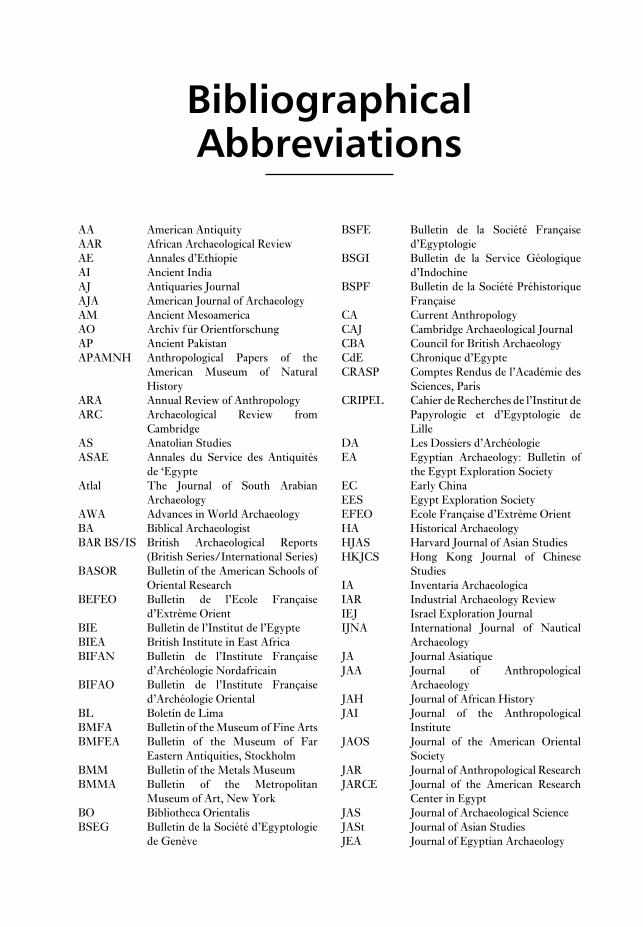
AA American Antiquity
AAR African Archaeological Review
AE Annales d’Ethiopie
AI Ancient India
AJ Antiquaries Journal
AJA American Journal of Archaeology
AM Ancient Mesoamerica
AO Archiv für Orientforschung
AP Ancient Pakistan
APAMNH Anthropological Papers of the
American Museum of Natural
History
ARA Annual Review of Anthropology
ARC Archaeological Review from
Cambridge
AS Anatolian Studies
ASAE Annales du Service des Antiquités
de ‘Egypte
Atlal The Journal of South Arabian
Archaeology
AWA Advances in World Archaeology
BA Biblical Archaeologist
BAR BS/IS British Archaeological Reports
(British Series/International Series)
BASOR Bulletin of the American Schools of
Oriental Research
BEFEO Bulletin de l’Ecole Française
d’Extrème Orient
BIE Bulletin de l’Institut de l’Egypte
BIEA British Institute in East Africa
BIFAN Bulletin de l’Institute Française
d’Archéologie Nordafricain
BIFAO Bulletin de l’Institute Française
d’Archéologie Oriental
BL Boletín de Lima
BMFA Bulletin of the Museum of Fine Arts
BMFEA Bulletin of the Museum of Far
Eastern Antiquities, Stockholm
BMM Bulletin of the Metals Museum
BMMA Bulletin of the Metropolitan
Museum of Art, New York
BO Bibliotheca Orientalis
BSEG Bulletin de la Société d’Egyptologie
de Genève
BSFE Bulletin de la Société Française
d’Egyptologie
BSGI Bulletin de la Service Géologique
d’Indochine
BSPF Bulletin de la Société Préhistorique
Française
CA Current Anthropology
CAJ Cambridge Archaeological Journal
CBA Council for British Archaeology
CdE Chronique d’Egypte
CRASP Comptes Rendus de l’Académie des
Sciences, Paris
CRIPEL Cahier de Recherches de l’Institut de
Papyrologie et d’Egyptologie de
Lille
DA Les Dossiers d’Archéologie
EA Egyptian Archaeology: Bulletin of
the Egypt Exploration Society
EC Early China
EES Egypt Exploration Society
EFEO Ecole Française d’Extrème Orient
HA Historical Archaeology
HJAS Harvard Journal of Asian Studies
HKJCS Hong Kong Journal of Chinese
Studies
IA Inventaria Archaeologica
IAR Industrial Archaeology Review
IEJ Israel Exploration Journal
IJNA International Journal of Nautical
Archaeology
JA Journal Asiatique
JAA Journal of Anthropological
Archaeology
JAH Journal of African History
JAI Journal of the Anthropological
Institute
JAOS Journal of the American Oriental
Society
JAR Journal of Anthropological Research
JARCE Journal of the American Research
Center in Egypt
JAS Journal of Archaeological Science
JASt Journal of Asian Studies
JEA Journal of Egyptian Archaeology

Research Center in Egypt
NGM National Geographic Magazine
NSSEA Newsletter of the Society for the
Study of Egyptian Antiquities
OAHSP Ohio Archaeological and Historical
Society Publication
OUSPA Otago University Studies in
Prehistoric Anthropology
PA Pakistan Archaeology
PAnth Plains Anthropologist
PEFEO Publications de l’Ecole Française
d’Extrème Orient
PEQ Palestine Exploration Quarterly
PPS Proceedings of the Prehistoric
Society
PSAS Proceedings of the Seminar for
Arabian Studies
PSBA Proceedings of the Society of
Biblical Archaeologists
QAL Quaderni di Archeologia della Libia
RCHME Royal Commission on the Historical
Monuments of England
SA Scientific American
SAAB South African Archaeological
Bulletin
SAJS South African Journal of Science
SCWW Ssu-ch’uan wen-wu
SJA Southwestern Journal of
Anthropology
SMA Suomen muinaismuistoydistyksen
aikakauskrija
TAPS Transactions of the American
Philosophical Society
TLAPEPMO Travaux du Laboratoire
d’Anthropologie, de Préhistoire et
d’Ethnologie des Pays de la
Méditerranée Occidentale
TP T’oung Pao
TSCYY Ti-ssu-chi yen-chiu
UJ Uganda Journal
WA World Archaeology
WAJA West African Journal of Archaeology
WW Wen-wu
YCHP Yen-ching hsüeh pao
YJSS Yenching Journal of Sinological
Studies
ZÄS Zeitschrift für Ägyptische Sprache
und Altertumskunde
ZDMG Zeitschrift der Deutschen
Morganländischen Gesellschaft
JESHO Journal of the Economic and Social
History of the Orient
JFA Journal of Field Archaeology
JHSN Journal of the Historical Society of
Nigeria
JICS Journal of the Institute of Chinese
Studies
JJRS Japanese Journal of Religious
Studies
JMA Journal of Mediterranean
Archaeology
JNES Journal of Near Eastern Studies
JOS Journal of Oman Studies
JRAI Journal of the Royal Anthropological
Institute
JRAS Journal of the Royal Asiatic Society
JSA Journal de la Société des
Américanistes
JSS Journal of the Siam Society
JSSEA Journal of the Society for the Study
of Egyptian Antiquities
JWP Journal of World Prehistory
KCH Khao Co Hoc
KK K’ao-ku
KKHP K’ao-ku hsueh-pao
KSIA Kratkiye soobshcheniya Institua
Arkheologii akademiii nauk SSSR
LAA Latin American Antiquity
LAAA Liverpool Annals of Archaeology
and Anthropology
LS Libyan Studies
MASI Memoirs of the Archaeological
Survey of India
MDAIK Mitteilungen des Deutschen
Archäologischen Instituts,
Abteilung Kairo
MDOG Mitteilungen der Deutsche Orient-
Gesellschaft
MIAS Materialy i issledovanija po
arheologii SSSR
MJA Midcontinental Journal of
Archaeology
MQRISA Modern Quaternary Research in
Southeast Asia
MS Monumenta Serica
MSGI Mémoires du Service Géologique de
l’Indochine
NA Nyame Akuma
NAR Norwegian Archaeological Review
NARCE Newsletter of the American
xvBIBLIOGRAPHICAL ABBREVIATIONS

ToJustyna, Ann, Nia and Elin

AAS see ATOMIC ABSORPTION
SPECTROPHOTOMETRY
Abadiya see HIW-SEMAINA REGION
Abkan see CATARACT TRADITION
Abri Pataud Large collapsed rock-shelter of the
Upper Palaeolithic in the village of Les Eyzies,
southwest France. From around 35,000 BC, the site
was intermittently occupied over many thousands
of years, providing evidence of tools, hearths and
living areas from the early AURIGNACIAN through
to the Proto-Magdelanian or later. Excavated in the
1950s and 1960s, the radiocarbon dating of the cul-
tural sequence at Abri Pataud has greatly clarified
the absolute chronology of the early Upper
Palaeolithic. Various engraved and painted lime-
stone plaques and a female figure in bas-relief were
recovered from the Périgordian VI level.
Palaeolithic excavation techniques were signifi-
cantly refined at Abri Pataud. First the excavator,
Movius, developed a rigid suspended grid system to
help control the excavation area. Second, the
stratigraphy was determined by test trenches dug on
either side of the edges of the main excavation. This
allowed Movius to expose extensively and examine
in situ the occupation layers in between the trenches.
The analysis of the finds from Abri Pataud has been
marked by an innovative and extensive use of
attribute analysis (e.g. Bricker and David).H.L. Movius Jr., ed.: ‘Excavation of the Abri Pataud, Les
Eyzies (Dordogne)’, American School of PrehistoricResearch 30/31 (1977); H. Bricker and N. David:
‘Excavation of the Abri Pataud, Les Eyzies (Dordogne):
the Périgordian VI (Level 3) assemblage’, American Schoolof Prehistoric Research 34 (1984).
RJA
Abu Ghurob Egyptian sun temple, 10 km
southwest of Cairo, built by the 5th dynasty ruler
Neuserra (c.2400 BC) and dedicated to the sun-god
Ra. It consisted of an upper temple, including a
stone-built obelisk and open courtyard with traver-
tine altar, as well as a causeway and valley temple.
Its plan must therefore have been similar to Old
Kingdom pyramid complexes such as those at
SAQQARA and ABUSIR. The excavation of Abu
Ghurob, by the German archaeologists Ludwig
Borchardt, Heinrich Schäfer and F.W. von Bissing
(1898–1901), was a typical example of late 19th cen-
tury ‘clearance’, designed primarily to recover
choice relief blocks for European collections.F.W. von Bissing et al.: Das Re-Heiligtum des Königs Ne-Woser-Re, 3 vols (Leipzig, 1905–28); D. Wildung:
Ni-User-Re: Sonnenkönig-Sonnengott (Munich, 1985).
IS
Abu Habba see SIPPAR
Abu Hureyra, Tell Settlement site dating to the
EPIPALAEOLITHIC, the ACERAMIC NEOLITHIC and
the ceramic Neolithic (c.8000–5000 BC), which
covers an area of 11.5 ha on the southern bank of
the Euphrates in northern Syria. It was excavated
in 1972–3 by Andrew Moore as part of the res-
cue work in advance of the construction of a new
Euphrates dam (Moore 1975; Moore et al, forth-
coming). The archaeological remains of Neolithic
mud-brick houses at Abu Hureyra – like those at
the roughly contemporaneous sites of Bouqras (in
Syria) and AIN GHAZAL (in Jordan) – provide a
foretaste of the more urbanized culture which was
to emerge most strikingly at ÇATAL HÜYÜK in
Anatolia.A.M.T. Moore: ‘The excavation of Tell Abu Hureyra in
Syria: a preliminary report’, PPS 41 (1975), 50–77; T.
Molleson, G. Comerford and A.M.T. Moore: ‘A
Neolithic painted skull from Tell Abu Hureyra, northern
Syria’, CAJ 2/2 (1992), 230–33; A.M.T. Moore, G.
Hillman and A. Legge: Abu Hureyra on the Euphrates(forthcoming).
IS
Abu Roash (Abu Rawash) Egyptian cemetery at
the northern end of the Memphite necropolis,
10 km west of Cairo, which was excavated by Emile
Chassinat in 1901. The earliest remains at the
site are mud-brick mastaba-tombs, which contain
artefacts bearing the names of the 1st-dynasty kings
A
A Dictionary of ArchaeologyEdited by Ian Shaw, Robert Jameson
Copyright © Blackwell Publishers Ltd 1999

complex of Djedefra, but only its burial chamber
has survived into modern times.
F. Bisson de la Roque: Rapport sur les fouilles d’Abu-Roasch, 3 vols (Cairo, 1924–5); V. Maragioglio and C.
Rinaldi: L’architettura della piramidi Menfite V (Rapallo,
1966); C. Desroches Noblecourt, ed.: Un siècle de fouillesfrançaises en Egypte, 1880–1980 (Paris, 1981), 44–53; M.
Vallogia: Le complex funraire de Radjedef Abu Roash: tat dela question et perspectives de recherches, BDFE 130 (1994),
5–17.
IS
Aha and Den (c.3000–2900 BC). The main surviving
structure at the site is the 4th-dynasty unfinished
pyramid of King Djedefra (c.2528–2520 BC), which
was evidently originally intended to be cased in red
granite. To the east of the pyramid Chassinat
uncovered the remains of a mortuary temple, a
trench intended to hold a solar boat (like those at
GIZA), and a cemetery of Old Kingdom private
tombs. In the mid-19th century, the German
Egyptologist Lepsius noted the presence of a ruined
mud-brick pyramid about 2 km to the south of the
2 ABU ROASH
Figure 1 Abu Ghurob Plan and reconstruction drawing of the sun temple of Nyuserra at Abu Ghurob, Egypt.
Source: W. Stevenson Smith: The art and architecture of ancient Egypt, 2nd edn (Harmondsworth: Pelican, 1981), figs
124, 125.

of the relocated Great Temple has been maintained
so that the sanctuary is still illuminated twice a year.W. MacQuitty: Abu Simbel (London, 1965); C.
Desroches-Noblecourt and C. Kuentz: Le petit templed’Abou Simbel, 2 vols (Cairo, 1968); T. Säve-Söderbergh,
ed.: Temples and tombs of ancient Nubia (London, 1987).
IS
Abusir Egyptian royal necropolis and temple
site, located 25 km west of Cairo. The major archae-
ological remains at Abusir are the pyramids of four
of the 5th-dynasty kings (Sahura, Neferirkara,
Neuserra and Neferefra (c.2458–2392 BC) and the
sun temple of Userkaf (c. 2465–2458 BC), which
were first scientifically excavated by Ludwig
Borchardt. During the 1980s and 1990s other parts
of the site, including the mastaba of Ptahshepses,
the mortuary temple of Neferefra, the pyramid
complex of Queen Khentkawes (mother of Sahura
and Neferirkara) and several Late Period shaft
tombs (including that of the chief physician
Udjahorresnet), have been excavated by a Czecho-
slovakian team. The contents of papyrus archives
discovered in the mortuary temple of Neferirkara
have shed useful light on the structure and mech-
anisms of Egyptian Old Kingdom temple
administration, especially when combined with
archaeological evidence from sites such as
DAHSHUR, GIZA and SAQQARA.L. Borchardt: Das Grabdenkmal des Königs Ne-user-Re(Leipzig, 1907); ––––: Das Grabdenkmal des Königs Nefer-ir-ka-Re (Leipzig, 1909); ––––: Das Grabdenkmal desKönigs Sahu-Re (Leipzig, 1910–13); H. Ricke: DasSonnenheiligtum des Königs Userkaf (Cairo, 1965;
Wiesbaden, 1969); P. Kaplony: ‘Das Papyrus Archiv von
Abusir’, Orientalia 41 (1972), 180–244; P. Posener-
Kriéger: Les archives du temple funéraire de Neferirkare (Lespapyrus d’Abousir), 2 vols (Cairo, 1976); M. Verner:
Preliminary excavation reports in ZÄS (1982–).
IS
Abydos (anc. Abdjw) Pharaonic site on the west
bank of the Nile, 50 km south of Sohag. Abydos was
inhabited from the late predynastic to the Christian
period (c.4000 BC–AD 641). As well as the Early
Dynastic royal necropolis of Umm el-Qaðab (dating
to c.3000–2649 BC), the site includes the temple of
the canine god Osiris-Khentimentiu (Kom el-
Sultan), the temples of Seti I and Ramesses II, the
Osireion (an archaizing ‘dummy tomb’ of Osiris),
an extensive settlement and numerous graves and
cenotaphs of humans and animals. During the sec-
ond half of the 19th century the site was excavated
by Auguste Mariette and Emile Amélineau, whose
techniques amounted to little more than treasure
hunting.
Abu Salabikh Cluster of mounds comprising
the site of a 4th–3rd millennium Sumerian town
(the ancient name of which is uncertain) near the
site of NIPPUR. The site was excavated by Nicholas
Postgate mainly during the 1980s. One of the
mounds consists of deposits dating to the Uruk
period (c.4300–3100 BC) but the others date princi-
pally to the Early Dynastic phase (c.2900–2350 BC);
the site was evidently occupied in the later periods,
but the Sumerian remains are close to the modern
ground-level. The survey and excavation at Abu
Salabikh from the 1970s onwards has included a
number of innovative techniques; on the West
Mound, for instance, the whole Early Dynastic sur-
face was investigated by scraping off the uppermost
deposits, thus enabling the walls and features to be
accurately planned over a wide area of the town
(Postgate 1983). The exposure of large areas of
mud-brick walling across the site has provided the
excavators with an unusual opportunity to analyse
large-scale settlement patterns within a Sumerian
city (Matthews et al. 1994).J.N. Postgate: ‘Abu Salabikh’, Fifty years of Mesopotamiandiscovery, ed. J. Curtis (London, 1982), 48–61; ––––: AbuSalabikh excavations I: The West Mound surface clearance(London, 1983); ––––: ‘How many Sumerians per
hectare? – probing the anatomy of an early city’, CAJ 4/1
(1994), 47–65; W. Matthews et al.: ‘The imprint of living
in an early Mesopotamian city: questions and answers’,
Whither environmental archaeology?, ed. R. Luff and P.
Rowley-Conwy (Oxford, 1994).
IS
Abu Shahrein see ERIDU
Abu Simbel Pair of Egyptian rock-temples,
280 km south of Aswan, built by Ramesses II
(c.1290–1224 BC). The ‘Great Temple’ is dedicated
to the king and the principal Egyptian deities,
Amon-Ra, Ra-Horakhty and Ptah. Its sanctuary is
precisely located so that the rays of the rising sun
penetrate to the inner sanctum on two days of the
year (22 February and 22 October), thus illuminat-
ing four statues in the inner sanctum. The ‘Small
Temple’ is dedicated to the king’s wife, Nefertari.
Both temples were carved into the cliffs to the west
of the Nile, with colossal statues of the king and
queen sculpted along the outer façades. Abu Simbel
was among the Nubian monuments saved from
LAKE NASSER (the reservoir created by the con-
struction of the Aswan High Dam). In the late
1960s, in an operation costing some $40 million,
the temples were dismantled into separate blocks
and then reassembled at a location 64 m higher and
200 m to the west of the original site. The alignment
3ABYDOS

cultural continuity between the adjacent late
pre-dynastic Cemetery U and the royal graves dated
to ‘Dynasty 0’, the beginning of the Early Dynastic
period (Dreyer 1992).A Mariette: Abydos: description des fouilles exécutées surl’emplacement de cette ville, 2 vols (Paris, 1869–80);
W.M.F. Petrie: The royal tombs of the earliest dynasties, 2vols (London, 1900–1); B.J. Kemp: ‘The Egyptian 1st
dynasty royal cemetery’, Antiquity 41 (1967), 22–32; M.A.
Hoffman: Egypt before the pharaohs (New York, 1979),
150–4; D. O’Connor: ‘Boat graves and pyramid origins:
new discoveries at Abydos, Egypt’, Expedition 33/3
(1991), 5–17; G. Dreyer: ‘Recent discoveries at Abydos
Cemetery U’, The Nile Delta in transition: 4th–3rd millen-nium BC, ed. E.C.M. van den Brink (Tel Aviv, 1992),
293–9.
IS
accelerator mass spectrometry (AMS) As
used in RADIOCARBON DATING, AMS selects and
counts the 14C atoms in the sample relative to the
many orders of magnitude higher number of 13C or12C atoms (see CONVENTIONAL RADIOCARBON
DATING). Mass spectrometry differentiates
between charged particles of very nearly the same
mass, travelling at the same velocity, by subjecting
them to a magnetic field. The heavier particles are
deflected least. An accelerator, used in conjunction
with mass spectrometry, increases the velocity of
the particles which enhances differentiation. AMS
needs only of the order of 1 mg of carbon (e.g. the
amount that could be derived from about 0.5 g of
bone) but precision is limited, typically ± 60 years
at best.J.A.J. Gowlett and R.E.M. Hedges, eds Archaeologicalresults from accelerator dating (Oxford, 1986); H.E. Gove:
‘The history of AMS, its advantages over decay counting:
applications and prospects’, Radiocarbon after four decades:an interdisciplinary perspective, ed. R.E. Taylor, A. Long
and R.S. Kra (Berlin and New York, 1992).
SB
accllahuasi Houses in which INCA ‘chosen
women’ (i.e. women removed from child-bearing to
prepare beer and to weave for the state) lived and
worked.G. Gasparini and L. Margolis: Inca architecture (Indiana,
1980), 56, 67, 192, 264; B. Cobo: Inca religion and customs,trans. R. Hamilton (Texas, 1990), ch. 37.
KB
Açemhöyük (anc. Burushkhattum) Settlement
mound in the central plain of Anatolia, which has
been identified with the city of Burushkhattum
(the HITTITE Purushkhanda). The site has
been excavated since 1963 by Nimet Özgüç, reveal-
ing occupation levels stretching back to the 5th
The scientific analysis of the site began with
Flinders Petrie, who re-excavated the Early
Dynastic royal tombs between 1899 and 1901.
Peet’s 1913 season included the excavation of a
small circular area of settlement dating to the late
predynastic period (Gerzean: c.3500–3000 BC),
including an assemblage of over 300 stone tools, a
midden and several hearths (discussed in Hoffman
1979). Although Peet simply dug two trenches
through an area with a diameter of about 30 m, this
was nevertheless the first scientific examination of
an Egyptian settlement of the predynastic period,
predating even Gertrude Caton-Thompson’s pio-
neering work at the stratified settlement of
Hammamia (see el-BADARI).
By re-analysing the results of the excavations of
Petrie and Eric Peet, Barry Kemp (1967) has
deduced that the Early Dynastic royal tombs were
complemented by a row of ‘funerary palaces’ to the
east, which may well have been the prototype of
the mortuary temples in Old Kingdom pyramid
complexes. In 1991 the excavations of David
O’Connor revealed further support for this theory
in the form of a number of Early Dynastic
wooden boat graves near the Shunet el-Zebib, best
surviving of the ‘funerary palaces’ (O’Connor
1991). Since 1973 German excavators have re-
examined the Early Dynastic royal cemetery and its
vicinity; their findings include conclusive proof of
4 ABYDOS
N
Culinary zoneCulinary zone
Habitation zoneHabitation zone(charcoal stained soil)(charcoal stained soil)
Trenc
h “B”
Trenc
h “B”
Tren
ch “
A”
Tren
ch “
A”
HearthsHearths
Culinary zone
Habitation zone(charcoal stained soil)
“Borer” zone
Trenc
h “B”
Tren
ch “
A”
Hearths
Osireion Kiln
0 10 m
Figure 2 Abydos Schematic plan of the area of the
late Gerzean settlement excavated by Eric Peet at
Abydos, Egypt. Source: M.A. Hoffman: Egypt before thepharaohs (London: Ark, 1980), fig. 44.

other vessels were carved from stone or moulded
from ‘white ware’ (lime plaster). There is some evi-
dence for metalworking, particularly at the
anatolian site of ÇAYÖNÜ TEPESI, which is situated
about 20 km from an abundant source of copper,
but there is no evidence of smelting, suggesting that
only naturally occurring copper was being used.
There are already substantial indications of long-
distance commerce, with obsidian trade-routes
emanating from such sites as Asikli Hüyük, where
abundant evidence of extraction and processing has
been obtained.
At many Levantine sites of the Aceramic
Neolithic, such as Jericho and Ain Ghazal, the rit-
uals for the disposal of the dead involved burial of
bodies beneath the living rooms of the houses
(rather than in a separate cemetery), followed by the
removal of the cranium and the burial of the
scraped, painted or (more typically) plastered
skulls. This behaviour has been interpreted as evi-
dence of the veneration of dead ancestors.O. Bar-Yosef: ‘The pre-pottery period in the Southern
Levant’, Préhistoire du Levant, eds J. Cauvin and P.
Sandaville (Paris, 1981); T. Watkins et al.: ‘Qermez Dere
and the early Aceramic Neolithic of northern Iraq’,
Paléorient 15 (1989), 19–24; H.-D. Bienert: ‘Skull cult in
the prehistoric Near East’, Journal of Prehistoric Religion 5
(1991), 9–23.
IS
Achaemenid see PERSIA
Acheulean (Acheulian) Name given to a series
of tool traditions of the Lower Palaeolithic linked by
the presence of roughly symmetrical bifacial hand-
axes and cleavers. Named after the site of
Saint-Acheul in France, Acheulean-type assem-
blages are found widely across Africa (where they
first evolved, and where they follow the simple
Olduwan-type industries, see AFRICA 5.1), Europe
and parts of Asia (from the Near East through to the
Indian subcontinent); Acheulean assemblages are
not present in the Far East. Some scholars have
suggested that the wide regional spread of
the Acheulean industries may be associated with the
appearance and dispersion of HOMO ERECTUS.
However, Acheulean-type industries are also
associated with later homo sapiens, and were pro-
duced over such a range of time and region that it is
best to regard the term simply as shorthand for Old
World assemblages that exhibit very roughly the
same level of technology. Acheulean assemblages
vary considerably in terms of their exact con-
stituents and the sophistication of the lithic
technology, and may also include many simple tools
millennium BC. The city reached a peak of
prosperity in stratum 5, dating to the Middle
Bronze Age (c.2000–1500 BC), when the colonies of
Old ASSYRIAN merchants were thriving at Kanesh
(KÜLTEPE), Hattusas (BOGHAZKÖY ) and Burush-
kattum itself. It is to this phase that Özgüç dates a
massive Hittite palace complex, which is still only
partially excavated.N. Özgüç: ‘Excavations at Açemhöyük’, Anadolu 10
(1966), 1–52; J. Mellink: ‘Archaeology in Asia Minor’,
AJA 71 (1967), 160–1 [section by Özgüç on the excava-
tions at Açemhöyük]; N. Özgüç: ‘An ivory box and a stone
mould from Açemhöyük’, Turk Tarih Kurumu: Belleten 40
(1976), 555–60.
IS
Aceramic Neolithic Phase of the Neolithic
period in the ancient Near East preceding the
introduction of pottery, which corresponds to Pre-
Pottery Neolithic B and C in the Levant
(c.8500–7000 BC). Some settlements during this
period, such as AIN GHAZAL, JERICHO and ABU
HUREYRA, reached a size of 10 hectares, but most
were much smaller. The subsistence base com-
bined cereal-crop cultivation and domestication of
animals with a fairly high proportion of hunting
and gathering. Some of the most important evi-
dence for early food production and domestication
has been excavated at Tell Aswad in Syria, but
many other sites show that the transition from
hunters and gatherers to settled agriculturalists was
a slow and complex process. At Suberde and Çan
Hasan, in southern Turkey, there has been con-
siderable debate as to whether the many species of
animals were wild or domesticated, while at
Munhata in Israel there is ample evidence of cereal
processing, in the form of sickles, querns and
grindstones, but the botanical evidence suggests
that only wild species of grain were being
exploited.
Most of the earlier Aceramic communities were
still living in the circular mud huts typical of
the preceding NATUFIAN and Proto-Neolithic
(Pre-Pottery Neolithic A) periods, but many
later settlements, such as Beidha in Jordan and
Bouqras in Syria, consisted of more elaborate recti-
linear buildings. The stratigraphic sequence at
MUREYBET, beside the Euphrates in Syria, shows
the transition from the Natufian to the Proto-
Neolithic and Aceramic Neolithic.
The technological advances of the period are
best exemplified in the arid conditions of the
Nahal Hemar cave site, where fragments of mats,
basketry, wooden-handled sickles and lengths of
cord have been preserved. In the absence of pottery,
5ACHEULEAN

Chronologies in Old World Archaeology I, ed. R.W. Ehrich
(Chicago, 1992), 465–90; R.V. Joshi: Stone Age cultures ofcentral India (Pune, 1978).
CS
adaptionist Term sometimes used to describe
an assumption that all change in the archaeological
and human evolutionary record has come about
as a physiological or behavioural adjustment to
contemporary (particularly environmental) con-
ditions. An archaeological example might be the
tendency to try to relate the changes in material
culture during the Mesolithic to the climate
change at the beginning of the Holocene, rather
than to internal cultural dynamics or the classic
culture-historical explanations (i.e. migration and
diffusion).
RJA
Addaura (Grotta Addaura, MontePellegrino, Addaura II) Small cave on Monte
Pellegrino near Palermo, Sicily, that houses a series
of engravings of animals (bovines, deer and horses)
and a very fine and rare example of figurative cave
art. One lightly incised set of engravings depicts
horses, cattle and a woman. A more striking, and
more boldly incised, set of engravings depicts a
series of largely naked dancers, who seem to wear
head-dresses and sometimes beak-like masks, sur-
rounding two figures who seem to be tied by a cord
stretching from their heads to their necks. This
‘scene’, beautifully drawn in a free and essentially
naturalistic style, has been variously interpreted as
a ritual dance, an endurance rite of initiation, an
execution, and a re-enactment of the capturing of
animals. There is no substantial archaeological con-
text within the cave; similarities with the engravings
at LEVANZO, and flints found in the locality, suggest
a date in the 9th or 10th millennium BC, during the
Epigravettian.I. Marconi Bovio: Bollettino di paletnologia Italiana (1953),
5.
RJA
Addi Galamo (Azbi Dera; Haouli Assarou;
Makalle) Ethiopian site of the pre-Axumite and
Axumite periods, located about 100 km east of
AXUM. A stone figure of a seated woman, similar to
two pre-Axumite statues excavated at HAOULTI-
MELAZO, was discovered at Addi Galamo in
association with an altar dedicated to Almouqah, the
moon-god worshipped both in northern Ethiopia
and South Arabia.A. Caquot and A.J. Drewes: ‘Les monuments receuillis à
Maqalle’, AE 1 (1955), 17–51; A. Shiferacu: ‘Rapport sur
based on flakes; in many regions, there are contem-
porary lithic traditions that lack handaxes and
cleavers and are therefore not generally termed
‘Acheulean’. Industries which contain Acheulean
tool-types but which also show evidence of the
LEVALLOIS TECHNIQUE, are sometimes badged as
‘Evolved Acheulean’. See also HUMAN EVOLUTION
and PALAEOLITHIC.
actualism, actualistic studies One of the
principal interpretive techniques employed in mod-
ern historical sciences. Actualism has been defined
by G.G. Simpson (1970: 84) as ‘the confrontation
of the [prehistoric] record with the knowledge of
present processes’. Although the term is used rel-
atively infrequently in archaeological literature,
actualistic studies underlie such archaeo-
logical subdisciplines as ETHNOARCHAEOLOGY and
EXPERIMENTAL ARCHAEOLOGY, and are under-
taken particularly in association with MIDDLE
RANGE THEORY.G.G. Simpson: ‘Uniformitarianism: an inquiry into prin-
ciple, theory, and method in geohistory and biohistory’,
Essays in evolution and genetics in honor of TheodosiusDobzhansky, ed. M.K. Hecht and W.C. Steere (New
York, 1970), 43–96; L.S. Binford: ‘Middle-range research
and the role of actualistic studies’, Bones: ancient men andmodern myths (New York, 1981), 21–30.
IS
Adamgarh Group of rock outcrops located
100 km south of the site of BHIMBETKA in the
Vindhya Hills of Madhya Pradesh, India.
Ramachandra V. Joshi excavated in 18 locales and
identified a stratigraphic sequence spanning the
Lower and Middle Palaeolithic periods, with
the most significant remains being from later
microlithic levels. The absolute dates of these lev-
els are distinctly uncertain, as only two radiocarbon
dates are available: a calibrated radiocarbon date of
c.6410–5705 BC from a microlithic level, and an
anomalous date of c.1100–805 BC from a ‘Lower
Palaeolithic’ level (Possehl and Rissman 1991:
475–6). The early date for the microlithic level is
comparable to dates from BAGOR in Rajasthan. In
these levels, stone tools are found in association with
domestic dog, sheep and goat, as well as wild cattle,
buffalo, deer and pig. No evidence has been found
for the cultivation of domestic plants. In higher
strata, microliths are found in association with chal-
colithic, Iron Age and even medieval ceramics,
and may represent a technology with a very long
duration.G.L. Possehl and P. Rissman: ‘The chronology of pre-
historic India: From earliest times to the Iron Age’,
6 ACHEULEAN

ecclesiastical furniture imported from the eastern
Mediterranean. The site was next excavated by
Italian archaeologists, revealing considerable ad-
ditional evidence of Axumite trade with the
Mediterranean region as well as with India and
Arabia (Paribeni 1907). No archaeological remains
earlier than the 3rd century AD have yet been found
at Adulis. There is, however, good reason to sup-
pose that the port was in existence from a
considerably earlier date, since it is mentioned by
Pliny the Elder and other writers of the 1st and 2nd
centuries AD. It was probably part of the same trade
network as the port of HAFUN on the coast of
Somalia. The port of Adulis eventually declined in
the 7th century AD, when its role in international
trade had diminished.R. Paribeni: ‘Richerche sul luogo dell’antica Adulis’,
Monumenti Antichi, Reale Accademia dei Lincei 18 (1907),
437–572; F. Anfray: ‘Deux villes axoumites: Adoulis et
Matara’, Atti del IV Congresso Internazionale de StudiEtiopici (Rome, 1972), 752–65; ––––: ‘The civilization of
Aksum from the first to the seventh century’, General his-tory of Africa II, ed. G. Mokhtar (Paris, Berkeley and
London, 1981), 362–80; S. Munro-Hay: ‘The foreign
trade of the Aksumite port of Adulis’, Azania 27 (1982),
107–25; ––––: ‘The British Museum excavations at
Adulis, 1868’, AJ 69/1 (1989), 43–52.
IS
Aegean Bronze Age see CYCLADIC; MINOAN;
MYCENAEAN
aerial archaeology Term covering all appli-
cations of airborne reconnaissance for the purposes
of archaeology, including AIRBORNE REMOTE
SENSING. The photo-interpretation techniques
used by archaeologists are closely related to those
employed in geographical mapping, geological
prospection and vegetation surveying (St Joseph
1977). The subject comprises two basic elements:
(1) the recovery of archaeological information
from air photographs, usually vertical and not
necessarily taken for archaeological purposes, and
(2) the execution of aerial reconnaissance, where the
act of recognition of archaeological information is
made by an airborne observer, usually flying in a
normal light aircraft (preferably high-wing) using
hand-held cameras to record the features recog-
nised. The term also embraces the analysis and
study of the resulting archaeological material.
Aerial photographs are used for the discovery of
new sites (such as standing structures, shadow sites,
CROPMARKS, SOILMARKS and dampmarks), the
mapping of archaeological material, the illustration
and comprehension of large or complex sites and
landscapes, and the monitoring of the condition
la découverte d’antiquités trouvées dans les locaux du
gouvernement général de Magallé’, AE 1 (1955), 13–15.
IS
Adena Term used in North American archae-
ology to describe a group of sites in the middle Ohio
River valley, particularly in southern Ohio and
northern Kentucky, most of which date to the half-
millennium following 500 BC. The best-known
sites are earthen mounds, many of which have a dis-
tinctive conical shape, and other earthworks. Many
mounds were built over places where one or more
large, special-purpose structures were previously
located. The mounds were built gradually through
the addition of graves and layers of earth. They
contain different kinds of graves, including log-
lined tombs with skeletons and valued artefacts,
such as copper bracelets. Adena mounds were
often built in prominent places, presumably
serving as important landmarks for nearby dis-
persed populations.K.B. Farnsworth and T.E. Emerson, (eds): EarlyWoodland archaeology (Kampsville, 1986), 564–95.
GM
Adrar Bous One of about 25 ‘younger granite’
volcanic ring complexes characteristic of the Air
massif in the northwestern part of the Ténéré
desert, northeastern Niger, consisting of a central
granite upland, a discontinuous peripheral de-
pression, an outer circle of low hills, and a dry lake
bed to the southeast. The region was investigated by
the Mission Berliet in 1959, by J.D. Clark and his
colleagues in 1970, and by J.P. Roset from 1978
onwards. On the basis of various sites located in
1970, nine main lithostratigraphic units were dis-
tinguished, with three lacustrine phases of
diminishing amplitude separated by two drier
periods.J.D. Clark et al.: ‘The geomorphology and archaeology of
Adrar Bous, Central Sahara: a preliminary report’,
Quaternaria 17 (1973), 245–97; J.P. Roset et al.: ‘La faune
de Tin Ouaffadene et d’Adrar Bous 10, deux gisements
archéologiques de l’Holocène ancien au Niger nord-
oriental’, Géodynamique 5/1 (1990), 67–89; A.B. Smith:
‘Terminal Palaeolithic industries of Sahara: a discussion
of new data’, Studies in African Archaeology IV, eds. L.
Krzyzaniak et al. (Poznan, 1993), 69–75.
PA-J
Adulis (Zulla) Red Sea port, closely connected
with the ancient city of AXUM. Located about 4 km
inland from the Gulf of Zulla (or Annesley Bay) in
the northeastern highlands of Ethiopia. In 1868
R. Holmes of the British Museum cleared a church,
discovering a number of pieces of prefabricated
7AERIAL ARCHAEOLOGY

1931). In Britain, during the 1920s and 1930s, aerial
reconnaissance and photography were used to
record both the earthworks of HILLFORTS and
Celtic fields (Crawford and Keiller 1928) and the
traces of sites surviving below ground, recognized
through CROPMARKS (Crawford and Keiller 1928;
Deuel 1971: 72–83; Allen 1984). All the principal
means of identifying archaeological features from
the air had been classified by Allen before 1940
(Riley 1946; Allen 1984).
In the Second World War the use of vertical
photography for intelligence purposes provided a
stimulus for its archaeological use, particularly as a
number of archaeologists were employed in photo-
interpretation. John Bradford examined wartime
vertical photographs of the Mediterranean area and
undertook his own photographic missions, achiev-
ing the identification, mapping and comprehension
of very large areas of archaeological remains,
notably in Tuscany and Apulia, and the identifica-
tion of centuriation in a number of areas of Roman
settlement (Bradford 1957; Jones 1987).
During the 1950s there was an increase in those
undertaking reconnaissance for oblique photogra-
phy, notably J.K.S. St Joseph in Britain and R.
Agache in France, and the results of their more
intensive researches greatly expanded the range of
terrain to which the method was applied. More
recently, numerous practitioners operate in Britain
and most of western Europe, and since 1989 relax-
ations of airspace control over eastern Europe have
permitted the beginning of civilian reconnaissance
there. In some countries, such as Britain, France
and Germany, work is now frequently undertaken
on a regional basis, which allows both the rapid
exploitation of suitable ground and meteorological
conditions and the integration of aerial study with a
detailed comprehension of the area’s archaeology in
general (Wilson 1975; Maxwell 1983; Léva 1990;
Griffith 1990). For general discussions of the his-
tory of aerial archaeology see Crawford (1954), St
Joseph (1951), Deuel (1971) and Riley (1987).
2. Mapping. Both vertical photographs and rectified
oblique photographs can be used in mapping, and
they may cover upstanding as well as buried
features. Vertical photographs are taken in regular
exposures by cameras mounted in the underside of
an aircraft flown in a straight path. The exposures
are timed to produce overlaps between the
frames, so that two adjacent frames provide a three-
dimensional effect (which can be scaled) when
viewed through a stereoscope. Oblique pho-
tographs are taken individually using hand-held
equipment, usually through the open window of
a light aircraft banked toward the subject. If
and use of known archaeological features or land-
scapes. This last is a powerful tool for the
management and protection of the archaeological
resource. Aerial photographs can also be used for
the discovery, mapping, monitoring and illustration
of underwater sites (see MARITIME ARCHAEOLOGY),
where conditions of visibility permit.
Techniques of photo-interpretation are also used
for broader environmental work, such as the identi-
fication and mapping of wetlands, palaeochannels
(see OC EO), colluvial or alluvial deposits, land-use
or vegetation patterns for predictive purposes, or
the provision of information on the wider setting of
an area of archaeological interest.
The impact of aerial archaeology has been sub-
stantial (Maxwell 1983). Its practice has permitted
extensive surveys of inhospitable terrain; the map-
ping of complex archaeological landscapes; and,
perhaps most fundamentally, the recognition of
archaeological sites and landscapes the above-
ground traces of which have been totally lost
through cultivation or other causes. This has fre-
quently revolutionized the perception of past
settlement patterns and densities. Examples may be
found in all countries where a programme of recon-
naissance has been pursued, ranging from the
transformation of the understanding of Roman
Britain since the first Ordnance Survey Map of
Roman Britain in 1928 to the great expansion
of knowledge regarding sites of the Neolithic period
in much of central and western Europe on soils that
have long been cultivated, and the study of great
areas of the American deserts. However, data re-
covered from the air are always subject to a range of
distorting factors, which means that they should
never be used uncritically or without a full appreci-
ation of their inherent limitations and biases.
1. The history of aerial archaeology. The earliest air
photographs date from the 19th century, and the
first known archaeological air photograph was of
Stonehenge, taken from a captive balloon in 1906.
During the First World War the possibilities of air-
borne archaeology were appreciated by British and
German fliers operating in the Near East, where
well-preserved but unknown remains, particularly
Roman, were observed and photographed (Beazeley
1919). The value of aerial photographs to archae-
ology was recognised almost as early as their utility
for general geographical mapping. After the war,
work continued in North Africa and the Near East,
recording remote and extensive sites and frontier
works whose mapping would have been difficult by
other means (Beazeley 1919; Poidebard 1934). In
America, the new techniques were also being
applied to the mapping of extensive sites (Judd
8 AERIAL ARCHAEOLOGY

record, and new classificatory systems may be
needed to describe the results (Edis et al. 1989;
Whimster 1989). Description and analysis alone
may be the initial object, but frequently the results
of aerial archaeology will be directly integrated with
data from many other classes of study, from ground
finds to placenames and documentary sources.
5. Illustration and comprehension. Air photographs
are important for illustrative purposes. They may
summarize the topography or morphology of a com-
plex site, they may demonstrate its landscape or
cultural context, or the relative siting of elements of
a whole (a town and its siegeworks), or they can be
the only way to present some inaccessible or very
extensive sites, such as the NAZCA LINES in Peru.
For tracing and illustrating surviving relict land-
scape elements such as boundary features, an air
photograph may be more subtle than a map.
6. Upstanding sites – standing structures or shadowsites. Some archaeological sites are ‘discovered’
from the air because they have never been visited on
the ground. Others may be visible on the ground
only as low earthworks, either from inherent slight-
ness or as a result of decay or destruction, including
the effects of cultivation. Such earthworks are fre-
quently recognized from the air through their
accompanying vegetation variations: gorse, for
instance, may outline field banks on moorland.
Aerial photography is used in mapping large tracts
of difficult terrain or in the recognition of slight or
discontinuous earthwork features. The aerial
archaeologist will seek to exploit unusual con-
ditions. The low sunlight of winter, or of sunrise
and sunset (two different angles), small variations in
vegetation cover, slight flooding, the effects of dri-
ven snow lodging against or in features, or marks in
frost or snow due to differential melting, may allow
slight earthworks to be recorded clearly.
Earthworks may show as parchmarks or differential
vegetation growth in summer (for further dis-
cussion of the recognition of upstanding sites see
Crawford and Keiller 1928; Wilson 1975: 27–39;
Lyons and Avery 1977).
7. Buried features. Archaeological features surviving
solely below modern ground-level can sometimes
be identified from the air, as variation between
buried features and the surrounding material can
produce differential markings in surface vegetation.
These are often only apparent either in extremes or
points of change of climatic conditions. Depending
on ground, crop and weather conditions, buried fea-
tures may manifest themselves to the observer as
dampmarks, CROPMARKS, SOILMARKS, or
FROSTMARKS.
For case-study see SAMARRA.
taken at an appropriate interval, pairs of oblique
photographs can also be used to provide a quasi-
stereo effect.
Air photographs are used for mapping at all
scales. Applications vary from extensive areas
where other forms of mapping, or even site location,
would be difficult, to detailed plotting of limited
areas. Examples range from work to locate entire
forts on the Near Eastern Roman limes (Poidebard
1934; Kennedy and Riley 1990) to the use of aerial
photographs for the discovery and mapping of large
numbers of defensive sites in the Rewa Delta, Fiji
(Parry 1977), the use of AIRBORNE REMOTE
SENSING and multispectral imagery in the
American mid-west and the detailed photogram-
metric plotting of purpose-flown vertical cover of
Bodmin Moor, Cornwall (Johnson 1983; RCHME,
forthcoming). The Bodmin Moor photography
resulted in high quality mapping of 150 km2 of a
dense archaeological landscape, subsequently veri-
fied by ground survey. There have also been
projects concerned with the systematic plotting of
oblique photographs for one area taken over many
years, such as the DANEBURY region (Palmer 1984).
Aerial photography has been used in rescue-driven
transcriptions of the archaeology of the English
gravel terraces, as revealed by cropmarks, following
the publication of A matter of time (RCHME
1960). Photography and subsequent transcription
at single sites have permitted detailed study of
buried features, as in the work concentrating on the
Roman town of Wroxeter (Wilson 1984).
3. Techniques. Features may be transcribed from air
photographs by a variety of techniques (Wilson
1982; Maxwell 1983; Riley 1987), such as pho-
togrammetry (e.g. Lyons and Avery 1977, Avery
and Lyons 1981), geometric transformation (Riley
1987: 66–72) and computer rectification. Sketch
plotting is sometimes used for simple sites with
good ground control. In computer rectification
fixed points are identified on both photograph and
map, and the detail is then plotted by transforma-
tion to map coordinates in either two or three
dimensions. Image enhancement techniques can
fruitfully be applied to digitized material (Becker
1990).
4. Photo-interpretation, description and classification.
The archaeological interpretation of air
photographs depends on the interpreter’s appreci-
ation of the potential causation of both
archaeological and non-archaeological elements.
(Wilson 1982; Riley 1987: 60–89). The description
and classification of recorded features is complex,
since it relies on largely two-dimensional evidence,
not all familiar in the excavated archaeological
9AERIAL ARCHAEOLOGY

Antiquity 64 (1990), 14–33; D. Kennedy and D. Riley:
Rome’s desert frontier from the air (London, 1990); C. Léva,
ed.: Aerial photography and geophysical prospection inarchaeology: proceedings of the second international sym-posium (Brussels, 1990); RCHME: Air and ground surveyof Bodmin Moor, Cornwall (forthcoming).
FG
AES See AUGER ELECTRON SPECTROSCOPY
AfricaSections: 1 North Africa; 2 West Africa; 3 East
Africa; 4 Southern Africa; 5 Central Africa
1 North AfricaNorth Africa is a huge region measuring over
4000 km west to east from the Moroccan coast
opposite the Canary Islands to the Egyptian border
near the Nile, and over 2000 miles north to south
from the Tangier/Tunis coast to the southern
borders of the Sahara with the Sahel. There are
three principal geographical features: the northern
littoral zone, with its predominantly Mediterranean
landscape and climate; the ‘Maghreb’ or north-
western uplands – the Atlas mountains in Morocco
rising over 3000 m above sea level, and the extension
from them of hill country across northern Algeria
into Tunisia (with the outlier of the Gebel Akhdar
range in Cyrenaica); and the Saharan desert, an
unforgiving expanse of rock, gravel and sand inter-
spersed occasionally with upland ‘islands’, the
highest of which, like the Hoggar and Tibesti, are
almost as high as the Atlas mountains.
1.1. Early prehistory. In 1995, the mandible of an
early hominid (Australopithecus afarensis), was
found at Koro Toro in the Bahr-el-Ghazal region,
providing evidence for the first inhabitants of the
region, probably about 3–3.5 million years ago
(Brunet et al. 1995). Before this find, the earliest
remains of human activity in the region were
Oldowan-style chopper (see OLDUVAI) and flake
industries, such as those from Sidi Abderrahman on
the Moroccan coast and AIN HANECH (McBurney
1960) in the Algerian uplands, as well as part of a
human skull from YAYO in Chad (Coppens 1965),
all of which date between about 1 and 1.5 million
years BP. Sequences of ACHEULEAN industries
follow, probably made by Homo erectus populations.
During the arid phases of the Pleistocene, people
retreated from the interior to the coastal areas, or to
better-watered locations within the Sahara, whereas
in cooler phases the hunter-gatherers were able to
spread out across the interior as the Sahelian climate
and environment spread from between 200 to as
much as 500 km northwards (Van Campo 1975;
G.A. Beazeley: ‘Air photography in archaeology’
Geographical Journal 55 (1919), 109–27; O.G.S. Crawford
and A. Keiller: Wessex from the air (Oxford, 1928); N.M.
Judd: ‘Arizona’s prehistoric canals from the air’,
Explorations and fieldwork of the Smithsonian Institution in1930 (Washington, D.C., 1931), 157–66; A. Poidebard: Latrace de Rome dans le désert de Syrie: le limes de Trajan à laconquète arabe; recherches aériennes (1925–1932) (Paris,
1934); D.N. Riley: ‘The technique of air-archaeology’
AJ 101 (1946), 1–16; J.K.S. St Joseph: ‘A survey of pio-
neering in air-photography past and future’, Aspects ofarchaeology in Britain and beyond: essays presented toO.G.S. Crawford, ed. W.F. Grimes (London, 1951),
303–15; O.G.S. Crawford: ‘A century of air-
photography’, Antiquity 112 (1954) 206–10; J. Bradford:
Ancient landscapes (London, 1957); RCHME: A matter oftime (London, 1960); R. Agache: Détection aérienne de ves-tiges protohistoriques, gallo-romaines et médiévaux (Amiens,
1970); L. Deuel: Flights into yesterday (London, 1971); R.
Agache and B. Bréart: Atlas d’archéologie aérienne dePicardie (Amiens, 1975); R.J.A. Jones and R. Evans: ‘Soil
and crop marks in the recognition of archaeological sites
by air photography’, Aerial reconnaissance for archaeology,
ed. D.R. Wilson (London, 1975), 1–11; D.R. Wilson, ed.:
Aerial reconnaissance for archaeology (London, 1975);
J.K.S. St Joseph, ed.: The uses of air photography, 2nd edn
(London, 1977); T.R. Lyons and T.E. Avery: Remote sens-ing: a handbook for archaeologists and cultural resourcemanagers (Washington, 1977); J.T. Parry: Ring ditch forti-fications in the Rewa Delta, Fiji: air photo interpretation andanalysis (Suva, 1977); R. Agache: La Somme pre-Romaineet Romaine (Amiens 1978); American Society of
Photogrammetry: Manual of Photographic Interpretation,
4th edn (Washington, 1981); T.E. Avery and T.R. Lyons:
Remote sensing: aerial and terrestrial photography forarchaeologists (Washington, 1981); D.R. Wilson: Air photointerpretation for archaeologists (London, 1982); O.
Braasch: Luftbildarchäologie in Süddeutschland (Stuttgart,
1983); N.D. Johnson: ‘The results of air and ground sur-
vey of Bodmin Moor, Cornwall’, The impact of aerialreconnaissance on archaeology, ed. G.S. Maxwell (London,
1983), 5–13; G.S. Maxwell, ed.: The impact of aerial recon-naissance on archaeology (London 1983); G.W.G. Allen:
‘Discovery from the air’, Aerial Archaeology 10 (1984)
[whole issue]; R. Palmer: Danebury, an Iron Age hillfort inHampshire: an aerial photographic interpretation of itsenvirons (London, 1984); D.R. Wilson: ‘The plan of
Viroconium Cornoviorum’, Antiquity 58 (1984), 17–20;
G.D.B. Jones: Apulia I: Neolithic settlement in the Tavoliere(London, 1987); D.N. Riley: Air photography and archae-ology (London, 1987); J. Edis, D. MacLeod and R.
Bewley: ‘An archaeologist’s guide to classification of crop-
marks and soilmarks’, Antiquity 63 (1989), 112–26; R.P.
Whimster: The emerging past: air photography and theburied landscape (London, 1989); H. Becker: ‘Combination
of aerial photography with ground magnetics in digital
image processing’, Aerial photography and geophysicalprospection in archaeology: proceedings of the second inter-national symposium, ed. C. Léva (Brussels, 1990), 25–36;
F.M. Griffith: ‘Aerial reconnaissance in Britain in 1989’
10 AERIAL ARCHAEOLOGY
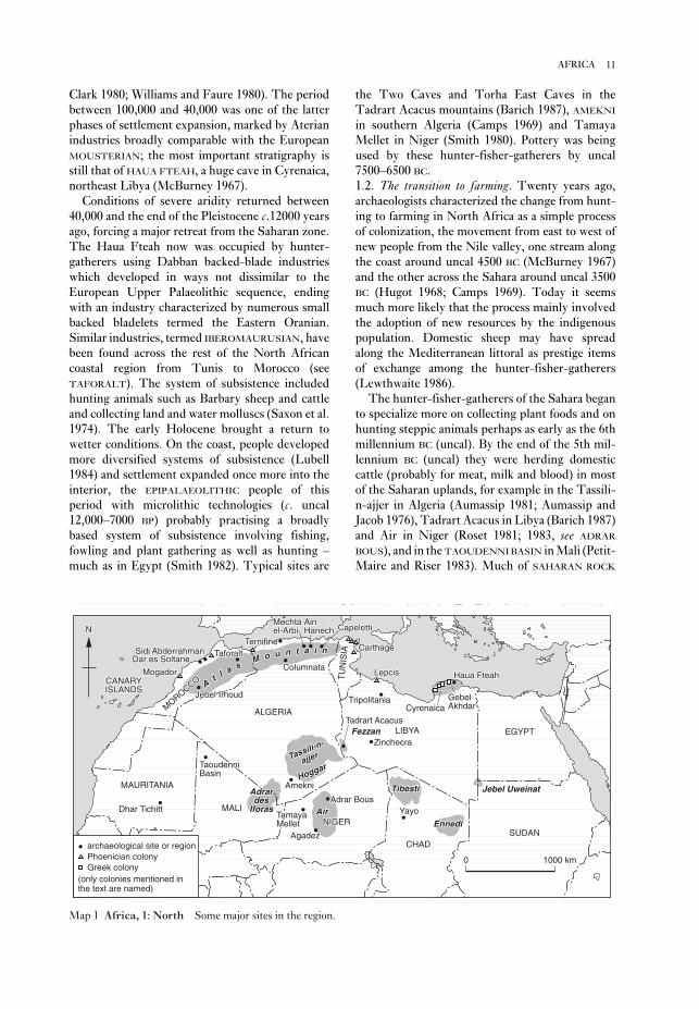
the Two Caves and Torha East Caves in the
Tadrart Acacus mountains (Barich 1987), AMEKNI
in southern Algeria (Camps 1969) and Tamaya
Mellet in Niger (Smith 1980). Pottery was being
used by these hunter-fisher-gatherers by uncal
7500–6500 BC.
1.2. The transition to farming. Twenty years ago,
archaeologists characterized the change from hunt-
ing to farming in North Africa as a simple process
of colonization, the movement from east to west of
new people from the Nile valley, one stream along
the coast around uncal 4500 BC (McBurney 1967)
and the other across the Sahara around uncal 3500
BC (Hugot 1968; Camps 1969). Today it seems
much more likely that the process mainly involved
the adoption of new resources by the indigenous
population. Domestic sheep may have spread
along the Mediterranean littoral as prestige items
of exchange among the hunter-fisher-gatherers
(Lewthwaite 1986).
The hunter-fisher-gatherers of the Sahara began
to specialize more on collecting plant foods and on
hunting steppic animals perhaps as early as the 6th
millennium BC (uncal). By the end of the 5th mil-
lennium BC (uncal) they were herding domestic
cattle (probably for meat, milk and blood) in most
of the Saharan uplands, for example in the Tassili-
n-ajjer in Algeria (Aumassip 1981; Aumassip and
Jacob 1976), Tadrart Acacus in Libya (Barich 1987)
and Air in Niger (Roset 1981; 1983, see ADRAR
BOUS), and in the TAOUDENNI BASIN in Mali (Petit-
Maire and Riser 1983). Much of SAHARAN ROCK
Clark 1980; Williams and Faure 1980). The period
between 100,000 and 40,000 was one of the latter
phases of settlement expansion, marked by Aterian
industries broadly comparable with the European
MOUSTERIAN; the most important stratigraphy is
still that of HAUA FTEAH, a huge cave in Cyrenaica,
northeast Libya (McBurney 1967).
Conditions of severe aridity returned between
40,000 and the end of the Pleistocene c.12000 years
ago, forcing a major retreat from the Saharan zone.
The Haua Fteah now was occupied by hunter-
gatherers using Dabban backed-blade industries
which developed in ways not dissimilar to the
European Upper Palaeolithic sequence, ending
with an industry characterized by numerous small
backed bladelets termed the Eastern Oranian.
Similar industries, termed IBEROMAURUSIAN, have
been found across the rest of the North African
coastal region from Tunis to Morocco (see
TAFORALT). The system of subsistence included
hunting animals such as Barbary sheep and cattle
and collecting land and water molluscs (Saxon et al.
1974). The early Holocene brought a return to
wetter conditions. On the coast, people developed
more diversified systems of subsistence (Lubell
1984) and settlement expanded once more into the
interior, the EPIPALAEOLITHIC people of this
period with microlithic technologies (c. uncal
12,000–7000 BP) probably practising a broadly
based system of subsistence involving fishing,
fowling and plant gathering as well as hunting –
much as in Egypt (Smith 1982). Typical sites are
11AFRICA
S A H A R A
ALGERIAALGERIAMOROCCO
MOROCCO AAtt ll aa ss
MM oo uu nn tt aa ii nnSidi AbderrahmanSidi AbderrahmanDar es SoltaneDar es Soltane
MogadorMogadorCANARYCANARYISLANDSISLANDS Jebel IrhoudJebel Irhoud
TaforaltTaforaltTernifineTernifine
ColumnataColumnata
AinAinHanechHanech
MechtaMechtael-Arbiel-Arbi CapelettiCapeletti
TU
NIS
IAT
UN
ISIA CarthageCarthage
LepcisLepcis
TripolitaniaTripolitania
Tadrart AcacusTadrart AcacusTadrart Acacus
ZinchecraZinchecraFezzanFezzanFezzan LIBYALIBYA
CyrenaicaCyrenaicaGebelGebelAkhdarAkhdar
Haua FteahHaua Fteah
TaoudenniTaoudenniBasinBasin
AdrarAdrardesdes
IforasIforasMALIMALI
MAURITANIAMAURITANIAMAURITANIA AmekniAmekniHoggarHoggar
Tassili-n-
Tassili-n-
ajjerajjer
Adrar BousAdrar BousAirAir
NIGERNIGER
AgadezAgadez
TamayaTamayaMelletMellet
TibestiTibesti
YayoYayo
CHADCHAD
EnnediEnnedi
Jebel UweinatJebel Uweinat
SUDANSUDAN
EGYPTEGYPT
NN
ALGERIAMOROCCO At l a s
M o u n t a i nSidi AbderrahmanDar es Soltane
MogadorCANARYISLANDS Jebel Irhoud
TaforaltTernifine
Columnata
AinHanech
Mechtael-Arbi Capeletti
TU
NIS
IA Carthage
Lepcis
Tripolitania
Tadrart Acacus
ZinchecraFezzan LIBYA
CyrenaicaGebelAkhdar
Haua Fteah
Dhar Tichitt
TaoudenniBasin
Adrardes
IforasMALI
MAURITANIA AmekniHoggar
Tassili-n-
ajjer
Adrar BousAir
NIGER
Agadez
TamayaMellet
Tibesti
Yayo
CHAD
Ennedi
Jebel Uweinat
SUDAN
EGYPT
archaeological site or regionPhoenician colonyGreek colony
(only colonies mentioned inthe text are named)
0 1000 km
N
Map 1 Africa, 1: North Some major sites in the region.

homeland of the Garamantes described by
Herodotus (Daniels 1970; 1989).
By the 3rd century BC Carthaginian supremacy
over the western Mediterranean was threatened by
the expanding power of Rome, the bitter Punic
Wars finally ending with the destruction of
Carthage in 146 BC. Under Julius Caesar and
Augustus direct Roman control was concentrated in
Tunisia behind Carthage, but in the 1st and 2nd
centuries Roman Africa extended from the former
client-states of Mauritania and Numidia (roughly
the western and eastern Maghreb respectively) east-
wards across northern Libya to Cyrenaica (Fentress
1979, Raven 1993). The incorporation of the North
African littoral and Maghreb into the Roman world
also had a profound impact on the peoples living in
the frontier zone to the south.C.B.M. McBurney: The Stone Age of northern Africa(Harmondsworth, 1960); Y. Coppens: ‘An early hominid
from Chad’, CA 7 (1965), 584–5; C.B.M. McBurney: TheHaua Fteah (Cyrenaica) and the Stone Age of the south-eastMediterranean (Cambridge, 1967); H. Hugot: ‘The origins
of agriculture: the Sahara’, CA 9 (1968), 483–9; G. Camps:
Amekni: Néolithique ancien du Hoggar (Paris, 1969); M.C.
Chamla: Les hommes epipaléolithiques de Columnata, Algérieoccidentale (Paris, 1970); C. Daniels: The Garamantes ofsouthern Libya (Cambridge, 1970); E.T. Saxon et al.:
‘Results of recent investigations at Tamar hat’, Libyca 22
(1974), 49–91; M. Van Campo: ‘Pollen analyses in the
Sahara’, Problems in prehistory – North Africa and theLevant, ed. F. Wendorf and S. Marks (Dallas, 1975),
45–64; G. Aumassip and J.P. Jacob: ‘Les grottes de Ti-n-
Hanakaten au Tassili des Ajjers’, Archeologia 94 (1976),
28–37; P.J. Munson: ‘Archaeological data on the origins of
cultivation in the southwestern Sahara and their impli-
cations for West Africa’, Origins of plant domestication, ed.
J.R. Harlan et al. (The Hague, 1976), 187–210; B.D.
Shaw: ‘Climate, environment and prehistory in the
Sahara’, World Archaeology 8 (1976), 133–48; M.C.
Chamla: ‘Le peuplement de l’Afrique du Nord de l’epi-
paléolithique à l’époque actuelle’, L’Anthropologie 82
(1978), 385–430; R.C.C. Law: ‘North Africa in the age of
Phoenician and Greek colonization’, Cambridge History ofAfrica II, ed. J.D. Fage (Cambridge, 1978), 87–147; L.
Bacchielli: ‘Contatti fra ‘Libya’ e mondo egeo nell’età del
bronzo: una conferma’, Rendiconti Accademia Lincei 34
(1979), 163–8; E. Fentress: Numidia and the Roman army(Oxford, 1979); C. Roubet: Economic pastorale préagricoléen Algérie orientale: le Néolithique de tradition Capsienne(Paris, 1979); J. Boardman: The Greek overseas (London
1980); J.D. Clark: ‘Human populations and cultural adap-
tations in the Sahara and Nile during prehistoric times’,
The Sahara and the Nile, ed. M.A.J. Williams and H.
Faure (Rotterdam, 1980), 527–82; A.B. Smith: ‘The
neolithic tradition in the Sahara’, The Sahara and the Nile,
ed. M.A.J. Williams and H. Faure (Rotterdam, 1980),
451–65; M.A.J. Williams and H. Faure, eds: The Saharaand the Nile (Rotterdam, 1980); G. Aumassip: ‘Ti-n-
Hanakaten (Tassili-n-Ajjers, Algérie): Bilan de 6
ART may reflect the changing ideologies of Saharan
societies during the transition from hunting to
herding between about uncal 6000 and 3000 BC,
though the precise correlations with climatic change
are still unclear. It is generally agreed that signifi-
cant aridity was established by about 2500 BC, but it
is still debatable whether the early phase of cattle
pastoralism correlated with the beginnings of the
trend to aridity or, as Muzzolini, for example,
argues, with an oscillation towards a moister cli-
mate, which he calls a ‘Neolithic wet phase, between
4500 and 2500 BC (Muzzolini 1993). While the cli-
matic context of early pastoralism therefore remains
unclear, the increasing importance of sheep and
goats over cattle in the 4th and 3rd millennia BC
(Aumassip and Delibrias 1983; Barich 1987) sug-
gests increasingly arid conditions.
The nature of settlement over the next 2000 years
is unclear. The climate and environment of the
modern Sahara had developed by c.2500 BC
(Shaw 1976). Neolithic-style pottery continued in
use in Cyrenaica long after it went out of use in
the northern Mediterranean (Bacchielli 1979;
Baldassarre 1987; Tiné 1987). Egyptian sources of
this period indicate occasional contacts with the
pastoralist ‘Tjehenu’ and ‘Tjemehu’ peoples in
Libya (Leahy 1990), and there is archaeological evi-
dence for predominantly pastoral societies further
west in Algeria (Roubet 1979), the ancestors of the
modern Berbers (Camps 1982). Cereal cultivation
may not have begun in the Saharan oases until the
later 2nd and early 1st millennia BC on the evidence
of such sites as DHAR TICHITT in Mauritania
(Munson 1976) and ZINCHECRA in the Libyan
Fezzan (Van der Veen 1992), in both cases associ-
ated with sedentary competitive societies in
fortified settlements; in the Fezzan, it may also have
coincided with the construction of the first foggarasfor channelling floodwaters to the fields.
1.3. From Phoenician and Greek colonization toRomanization. In the 8th and 7th centuries BC, the
Phoenicians from the eastern Mediterranean estab-
lished colonies on the North African coast from
LEPCIS in Libya to MOGADOR in Morocco (Law
1978) and the Greeks settled in Cyrenaica soon
afterwards (Boardman 1980). The colonies traded
for raw materials with their hinterlands promoting
the development of Berber client-kingdoms there,
and several such as Carthage also became the end-
points for tans-Saharan trade: pottery, glass and
metalwork went south in return for commodities
such as salt, skins, ivory and slaves. The best evi-
dence for indigenous settlement in the desert at this
time is from Zinchecra in the Libyan Fezzan, the
12 AFRICA

annual rainfall from south to north (currently
<1600 mm on the coast and >5 mm in some parts
of the Sahara). Mangrove swamp and rain forest are
succeeded by belts of Guinea, Sudan, and Sahel
savanna, and then by the desert itself. Between the
forest and Guinea savanna zones there is a belt of
‘derived savanna’, thought to have been brought
about by human action (farming and fire). Savanna
should be understood not as a tree-less plain but as
a mixture of grass and woodland, the latter moister
in the south and drier in the north. Sahel, as pointed
out by Connah, is the Arabic word for ‘shore’; the
sea it faced was the desert, and the towns which
eventually developed in this area were ‘ports’. At
one area on the south coast, the ‘Dahomey Gap’, the
savanna comes down to the sea, and there are also
patches of montane vegetation on the Fouta Djallon
and Cameroun highlands. In West Africa generally
high elevations are rare, but in the central Sahara
the Adrar des Iforas, Hoggar, Tassili-n-Ajjer, Air,
and Tibesti mountains all rise <1000 metres.
Except for the lake Chad and river Niger drainage
systems, most rivers flow more or less direct to the
sea.
In terms of present-day political geography,
West Africa is split into a number of nation states,
the boundaries of which were established in colonial
times, when French and English also came into use
as official languages. These boundaries are certainly
important, in this context because different
Francophone and Anglophone traditions have had
a marked effect on the development of archaeologi-
cal research in the countries concerned, but there is
no correspondence between them and other div-
isions which have been of historic significance in
West Africa. Thus the number of major ethnic
groups (some the centre of historic kingdoms such
as the Yoruba, the Hausa, and the Ashanti) far
exceeds the number of nation states and does not
coincide with them, and the same is true of the
major African languages. These can however be
grouped into three large language families which are
represented in this region: Nilo-Saharan, Afro-
Asiatic, and Niger-Congo. Some tentative attempts
have been made to link these language families to
events in prehistory. Nilo-Saharan is the most
internally diversified and the most fragmented geo-
graphically, hence it has been suggested that it is the
most ancient; its speakers according to Sutton may
have created an AQUATIC CIVILIZATION at
the beginning of the Holocene. Niger-Congo is the
most widespread, including many languages spoken
in West Africa, as well as Bantu, and it is a popular
hypothesis that the Bantu peoples spread to most of
Central and Southern Africa from an original base
campagnes de fouilles’, Libyca 28–9 (1981), 115–27; J.P.
Roset: ‘Les plus vieilles céramiques du Sahara’,
Archéologie (1981), 43–50; G. Camps: ‘The beginnings of
pastoralism and cultivation in northwest Africa and the
Sahara: origins of the Berbers’, Cambridge History of AfricaI (Cambridge, 1982), 548–623; P.E.L. Smith: ‘The late
palaeolithic and epipalaeolithic of northern Africa’,
History of West Africa I, ed. J.F.A. Ajadi and M. Crowder
(Cambridge, 1982), 342–409; G. Aumassip and G.
Delibrias: ‘Age des dépôts néolithiques du gisement de
Ti-n-Hanakaten (Tassili-n-Ajjes, Algérie)’, Libyca 30–31
(1983), 207–11; N. Petit-Maire and J. Riser: Sahara ouSahel? Quaternaire récent du Bassin de Taoudenni (Mali)(Marseilles, 1983); J.P. Roset: ‘Nouvelles données sur le
problème de la Néolithisation du Sahara méridional: Air
et Tenéré, au Niger’, Cahiers ORSTOM 13/2 (1983),
199–42; D. Lubell: ‘The Capsian palaeoeconomy in the
Maghreb’, Origins and early development of food-producingcultures in north-eastern Africa, ed. L. Krzyzaniak and M.
Kobusiewica (Poznan, 1984), 453–5; J. Lewthwaite: ‘The
transition to food production: a Mediterranean perspec-
tive’, Hunters in transition, ed. M. Zvelebil (Cambridge,
1986), 53–66; I. Baldassarre: ‘Tracce dell’abitato pre-
battiaco ad ovest dell’Agora di Cirene’, QAL 12 (1987),
17–24; B. Barich: Archaeology and environment in theLibyan Sahara (Oxford, 1987); S. Tiné: ‘Ceramica pre-
battiaca nell’area cirenea’, QAL 12 (1987), 15–16; C.
Daniels: ‘Excavation and fieldwork among the
Garamantes’, LS 20 (1989), 45–61; A. Leahy, ed.: Libyaand Egypt c.1300–750 BC (London, 1990); M. Van der
Veen: ‘Garamantian agriculture: the plant remains from
Zincechra, Fezzan’, LS 23 (1992), 7–39; A. Muzzolini:
‘The emergence of a food-producing economy in the
Sahara’, The Archaeology of Africa: food, metals and towns,ed. T. Shaw, P. Sinclair, B. Andah and A. Okpoko
(London, 1993), 227–39; S. Raven: Rome in Africa, 3rd
edn (London, 1993); M. Brunet et al.: ‘The first
Australopithecine 2,500 km west of the Rift Valley, Chad’,
Nature 378 (1995), 273–5.
GB
2 West AfricaConventionally, West Africa is taken to be bounded
on the north by the Tropic of Cancer and on the
south and west by the Atlantic ocean; in modern
political terms, its eastern boundary is often taken
to coincide with the frontiers of Nigeria and Niger,
but geographically and historically there are valid
reasons to include Chad and Cameroun also. As
Thurstan Shaw says, West Africa is a well-defined
region which has its own historical ‘personality’;
perhaps because, as Mabogunje and Richards put
it, a gradual dessication of the Sahara in recent mil-
lennia has given it an ‘island-like character’.
Contrasting vegetational zones have been recog-
nised by both Francophone and Anglophone
writers (A. Chevalier and R.W.J. Keay) trending
broadly from west to east and reflecting decreasing
13AFRICA
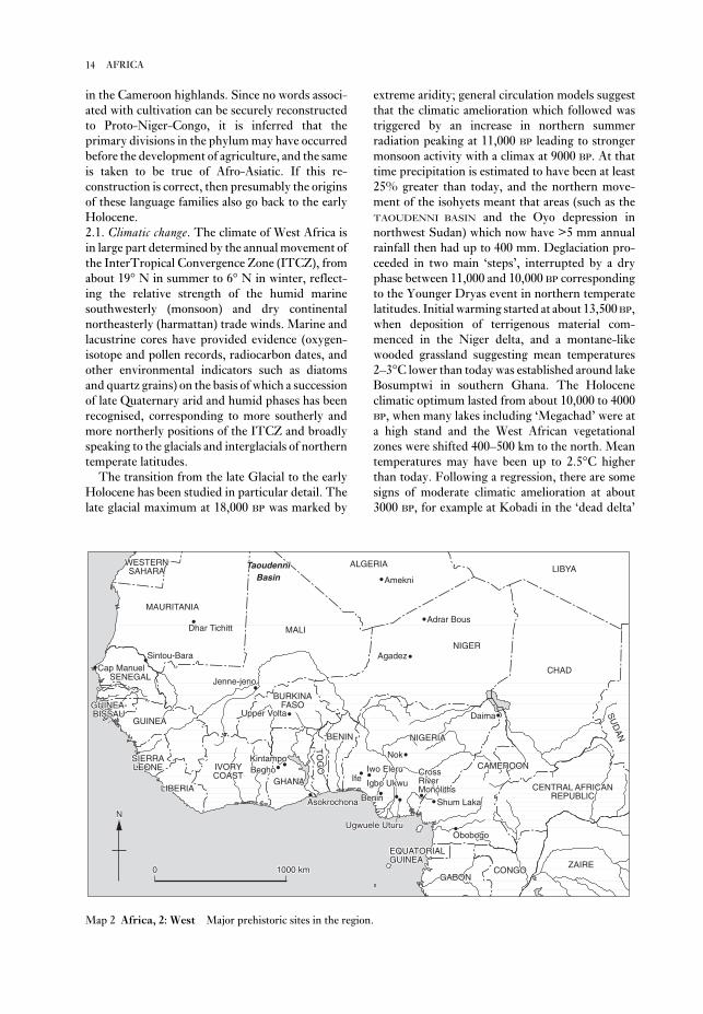
extreme aridity; general circulation models suggest
that the climatic amelioration which followed was
triggered by an increase in northern summer
radiation peaking at 11,000 BP leading to stronger
monsoon activity with a climax at 9000 BP. At that
time precipitation is estimated to have been at least
25% greater than today, and the northern move-
ment of the isohyets meant that areas (such as the
TAOUDENNI BASIN and the Oyo depression in
northwest Sudan) which now have >5 mm annual
rainfall then had up to 400 mm. Deglaciation pro-
ceeded in two main ‘steps’, interrupted by a dry
phase between 11,000 and 10,000 BP corresponding
to the Younger Dryas event in northern temperate
latitudes. Initial warming started at about 13,500 BP,
when deposition of terrigenous material com-
menced in the Niger delta, and a montane-like
wooded grassland suggesting mean temperatures
2–3°C lower than today was established around lake
Bosumptwi in southern Ghana. The Holocene
climatic optimum lasted from about 10,000 to 4000
BP, when many lakes including ‘Megachad’ were at
a high stand and the West African vegetational
zones were shifted 400–500 km to the north. Mean
temperatures may have been up to 2.5°C higher
than today. Following a regression, there are some
signs of moderate climatic amelioration at about
3000 BP, for example at Kobadi in the ‘dead delta’
in the Cameroon highlands. Since no words associ-
ated with cultivation can be securely reconstructed
to Proto-Niger-Congo, it is inferred that the
primary divisions in the phylum may have occurred
before the development of agriculture, and the same
is taken to be true of Afro-Asiatic. If this re-
construction is correct, then presumably the origins
of these language families also go back to the early
Holocene.
2.1. Climatic change. The climate of West Africa is
in large part determined by the annual movement of
the InterTropical Convergence Zone (ITCZ), from
about 19° N in summer to 6° N in winter, reflect-
ing the relative strength of the humid marine
southwesterly (monsoon) and dry continental
northeasterly (harmattan) trade winds. Marine and
lacustrine cores have provided evidence (oxygen-
isotope and pollen records, radiocarbon dates, and
other environmental indicators such as diatoms
and quartz grains) on the basis of which a succession
of late Quaternary arid and humid phases has been
recognised, corresponding to more southerly and
more northerly positions of the ITCZ and broadly
speaking to the glacials and interglacials of northern
temperate latitudes.
The transition from the late Glacial to the early
Holocene has been studied in particular detail. The
late glacial maximum at 18,000 BP was marked by
14 AFRICA
WESTERNWESTERNSAHARASAHARA LIBYALIBYALIBYA
MALIMALI
IVORYIVORYCOASTCOAST
GHANAGHANA
SIERRASIERRALEONELEONE
LIBERIALIBERIA
SENEGALSENEGAL
BURKINABURKINAFASOFASO
TO
GO
TO
GO
BENINBENIN
NIGERNIGER
NIGERIANIGERIA
CAMEROONCAMEROON
CHADCHAD
CENTRAL AFRICANCENTRAL AFRICANCENTRAL AFRICANREPUBLICREPUBLIC
GABONGABON
EQUATORIALEQUATORIALEQUATORIALGUINEAGUINEA
CONGOCONGOZAIREZAIRE
SU
DA
NS
UD
AN
GUINEAGUINEA
GUINEA-GUINEA-BISSAUBISSAU
MAURITANIAMAURITANIAMAURITANIA
Dhar TichittDhar TichittDhar Tichitt
Cap ManuelCap ManuelSintou-BaraSintou-Bara
BeghoBeghoKintampoKintampo
AsokrochonaAsokrochona
IfeIfeIwo EleruIwo Eleru
BeninBenin
Igbo UkwuIgbo Ukwu
Ugwuele UturuUgwuele Uturu
Shum LakaShum Laka
ObobogoObobogo
NokNok
DaimaDaima
AgadezAgadez
Adrar BousAdrar Bous
ALGERIAALGERIA
AmekniAmekni
TaoudenniTaoudenniBasinBasin
Jenne-jenoJenne-jeno
NN
00 1000 km1000 km
Upper VoltaUpper VoltaUpper Volta
CrossCrossRiverRiverMonolithsMonoliths
WESTERNSAHARA LIBYA
MALI
IVORYCOAST
GHANA
SIERRALEONE
LIBERIA
SENEGAL
BURKINAFASO
TO
GO
BENIN
NIGER
NIGERIA
CAMEROON
CHAD
CENTRAL AFRICANREPUBLIC
GABON
EQUATORIALGUINEA
CONGOZAIRE
SU
DA
N
GUINEA
GUINEA-BISSAU
MAURITANIA
Dhar Tichitt
Cap ManuelSintou-Bara
BeghoKintampo
Asokrochona
IfeIwo Eleru
Benin
Igbo Ukwu
Ugwuele Uturu
Shum Laka
CrossRiverMonoliths
Obobogo
Nok
Daima
Agadez
Adrar Bous
ALGERIA
Amekni
TaoudenniBasin
Jenne-jeno
Upper Volta
N
0 1000 km
Map 2 Africa, 2: West Major prehistoric sites in the region.

has suggested may have been a special forest
adaptation.
The ‘Middle Stone Age’ is generally regarded as
the equivalent of the MOUSTERIAN as recognized in
North Africa at JEBEL IRHOUD and HAUA FTEAH.
Again it is widely distributed throughout the region
and usually takes the form of simple LEVALLOIS-
based industries, for which there is a minimum
radiocarbon date of uncal 33,400 ± 2500 BP at
Bilma. At Adrar Bous and elsewhere in the Sahara
the MSA is succeeded by the ATERIAN and this
according to Tillet may have been associated with
an Upper Ghazalian humid period immediately
preceding the last glacial maximum at 18,000 BP.
Since the Aterian at DAR ES-SOLTANE II and three
other sites on the Moroccan coast is associated with
anatomically modern man, it would be logical to
assume that the same is true in the Sahara.
2.3. Late Stone Age or ‘Neolithic’? Acute unresolved
questions of terminology, in part arising from
different Anglophone and Francophone
approaches, abound in West African prehistory,
particularly in regard to the ‘Neolithic’ and the arte-
factual or economic criteria regarded as sufficient
for its recognition. Thus, in the Sahara, at AMEKNI
and other sites, Gabriel Camps distinguished a
‘Neolithic of Sudanese Tradition’ on the basis of its
pottery alone, in the absence of any trace of
domestication. Although J.D. Clark was at one time
inclined to accept this formulation as a ‘pre-pastoral
Neolithic’, the majority of Anglophone writers have
rejected the concept, and have sought other ex-
planations for the lifestyle adopted by what
Muzzolini now refers to as ‘epipalaeolithic pottery-
users’. Sutton’s description of this lifestyle as an
‘aquatic civilization’ has been criticized on various
grounds; less controversial is the McIntoshes’
suggestion of a ‘lacustrine tradition’ within the
overall framework of the LSA. Whatever frame-
work is chosen, the early appearance of pottery in
the Sahara and the wide geographical spread of what
may be described at least as a ‘horizon-style’ is of
undoubted importance. Originally, Camps claimed
the pottery from Amekni at 8050 ± 80 BP was the
oldest in the Sahara, and there were other sites in
the same time bracket, which encouraged the idea
of independent invention. More recently, J.P. Roset
has located even older sites (none with evidence of
domestication) in the vicinity of Adrar Bous, and
also at Tagalagal 200 km to the southwest where
pottery with dotted wavy line decoration is dated to
9370 ± 130 BP. Although the ‘lacustrine tradition’ is
for the most part confined to the early Holocene, as
in the Taoudenni basin, the McIntoshes emphasize
that the ‘old Saharan life-style’ carried on later at
of the Niger and at lake Bosumptwi, before another
regression set in, but in the Sahara dessication had
already taken hold and the present climatic regime
had been established.
Even during the Holocene climatic optimum
there were arid episodes which interrupted occu-
pation at individual sites, for example in the
Taoudenni basin and at ADRAR BOUS; indeed in
the first of two general surveys of West African pre-
history S.K. and R.J. McIntosh considered it
possible to generalize the split between an earlier
‘lacustrine tradition’ and a later ‘pastoralist period’
at this site to apply to the whole region, but they
subsequently took the view that it constituted no
more than a ‘regional anomaly’. Later movements
of the ITCZ within the ‘privileged area’ of the
Inland Niger Delta provided one of the essential
ingredients of the PULSE THEORY developed by R.J.
McIntosh.
2.2. Earliest settlement. In northern Chad an
AUSTRALOPITHECUS mandible and upper pre-
molar were discovered by a team under the
direction of Michel Brunet in 1995–6 at a locality
45 km east of Koro Toro (see AFRICA 1). These finds
were associated with apparently undisturbed fauna
in a geological context which suggests that this was
a lakeside environment. By comparison with
analogous finds in East Africa, the fauna should date
to the mid-Pliocene, about 3–3.5 million years ago.
The hominid remains were at first compared to
A. Afarensis, but are now recognized as a separate
species ‘Australopithecus bahrelghazali’. Also in
northern Chad, other hominid remains, with fauna
but without artefacts, were discovered by F. and Y.
Coppnes in 1961 at Angamma; at first themselves
attributed to Australopithecus, they are now
regarded as nearer to HOMO ERECTUS and would
thus be comparable with those found at TERNIFINE
in Algeria, in an Acheulean context.
ACHEULEAN sites are frequent in the region and
(as at El-Beyyed in Mauritania) they are often
associated with old lake deposits, suggesting that
occupation at that time also took place during
climatically favourable episodes, although so far
there is only one absolute age determination (from
Lagreich in Mali) where two burnt handaxes have a
TL date of 282,000 ± 56,000 BP. Some well-known
sites (such as those on and around the Jos Plateau in
Nigeria) were discovered as a result of mining oper-
ations, but others (such as Sansandé in Senegal,
Bilma and Blaka Kallia in Niger) have been ex-
cavated or investigated systematically in recent
years. In the southern part of the region, as at
ASOKROCHONA, other sites have been attributed to
the Sangoan industrial complex, which J.D. Clark
15AFRICA

Shell middens as such of course continued in
existence long after this, and it is known that they
could build up quite rapidly, as in the case of Dioron
Boumak, also on the Senegalese coast, where 10 m
of deposits were accumulated in >500 years in the
1st and 2nd millennia AD.
A human burial described as ‘proto-Negroid’ was
found at the base of the succession at Iwo Eleru with
a date of 11200 ± 200 BP. The burials at Amekni
associated with pottery at 8050 ± BP, and others at
Saharan sites, have also been attributed to
Negroids; but in the Taoudenni basin at Hassi el
Abiod at 6970 ± 130 BP and at Kobadi as recently as
3335–2415 BP, a distinctive population of MECHTA-
AFALOU type has been identified on the basis of
large samples (89 and 97 skeletons respectively); so
it will be for future research to work out what were
the relations between these two different popu-
lations in the region during this period.
2.4. Domestication and agriculture. The most im-
portant domestic animals in West Africa, and the
first to be introduced into the region, are cattle,
sheep and goats. The latter are descended from wild
Asian progenitors, not the Barbary sheep
(Ammotragus lervia), and have been found as early
as 6800 ± 350 BP at Haua Fteah in northeastern
Libya. Gautier suggests that domestic cattle may
also have been present, but so far there is no evi-
dence of that. Sheep and/or goats have been found
in large numbers from 6530 ± 250 BP onwards at
CAPÉLETTI in northeastern Algeria, in levels
attributed to the ‘Neolithic of Capsian Tradition’,
thus forming the basis (in Roubet’s words) of a
‘pastoral pre-agricultural economy’. Bovids were
also present and these, despite Gautier’s doubts, are
described by J. Clutton-Brock as the ‘earliest
securely dated finds’ of cattle on the continent.
Claims of older finds, going back to 9500 BP, have
been made for Bir Kiseiba and NABTA PLAYA in the
Egyptian desert, but the status of these ‘exciting . . .
troublesome large bovids’ (Gautier 1987: 180)
remains in doubt. Part of the problem lies in the
difficulty of distinguishing cattle bones from those
of their possible wild progenitor the aurochs (Bosprimigenius) known to have been present both in the
Nile valley and the Maghreb, where it was hunted
by the CAPSIAN inhabitants.
There are also problems arising from the fact that
different kinds of cattle are present in West Africa,
some of which developed distinctive local charac-
teristics. Humpless cattle (Bos taurus) both
longhorn (‘ndama’; shown in the rock paintings of
the Sahara) and dwarf shorthorn (‘muturu’) are
present in ‘refuge areas’, and the latter’s natural
immunity to trypanosomiasis indicates that it has
some favourable localities, such as Kobadi and the
lower levels at DAIMA, where however the inhabi-
tants also kept domestic cattle.
South of the Sahara, Thurstan Shaw, following
his excavations of the 1940s at Bosumpra cave, at
one time proposed the creation of a ‘Guinea
Neolithic’: ‘a more or less homogeneous culture
of post-Pleistocene date’ characterized by the co-
existence of microlithic quartz artefacts, ground
stone axes, and pottery. Since, as he later said,
this hypothesis was framed ‘before any Childean
thinking had reached him’ he considered that
the economy was ‘probably based on hunting
and collecting’. Subsequently he advocated the
abandonment of this term and its replacement by
Late Stone Age, which had, as his own excavations
at IWO ELERU showed, both an aceramic and a
ceramic phase. A similar succession has been
demonstrated at a number of sites, including
Bosumpra (re-excavated by A.B. Smith) and SHUM
LAKA. The approximate dates for the introduction
of pottery at these three sites are 5210 ± 100, 5570
± 60, and 3810 ± 60 BP respectively. An earlier date
of 6340 ± 250 BP for comb-stamped pottery comes
from an open site near Konduga on the Bama ridge
southwest of Lake Chad. Nevertheless, the fact that
all these dates are significantly later than those in
the Sahara, and that some decorative motifs are
shared in common, suggests that a mechanism of
diffusion (of ideas and techniques if not of people)
was at work. Microliths (taken to imply the use of
a bow and arrow) are still regarded by Shaw as a
hunting and presumably savanna adaptation; by
contrast, he draws attention to the fact that the stone
inventories of certain sites in the presently forested
southwestern part of the region (Kakimbon,
Yengema, and Blandè) are non-microlithic. In the
opinion of the McIntoshes, however, the signifi-
cance of the dichotomy between microlithic
industries and those characterized by ‘hoes’ or
‘picks’ remains difficult to evaluate.
Factory sites and shell middens constitute
specialized occupations at this time. Examples of
the former are CAP MANUEL, UGWUELE-UTURU,
and Manianbugu near Bamako. Technically,
Manianbugu is very similar to Cap Manuel and is
likewise classified as ‘Neolithic’; it has a few frag-
ments of pottery and is only 2 km distant from
another site (Sotuba) where its dolerite roughouts
could well have been brought to a finished state. A
shell midden with pottery and quartz artefacts on
the coast of Ghana at the Gao lagoon has an age
range from 5860 to 5510 BP, and a similar site with
pottery and bone artefacts on the Senegalese coast
at Khant has an age range from 5650 to 4220 BP.
16 AFRICA
two relatively early sites (where osteological evi-
dence is absent) there are artefactual indications of
their presence: at IGBO-UKWU (c. 9th century AD)
there is a bronze hilt in the form of a man on horse-
back, and at SINTIOU BARA (which is approximately
contemporary) there are numerous horse trappings
of copper and iron. The domestic chicken has been
positively identified at JENNE-JENO prior to AD 850
and Kevin MacDonald has demonstrated that it can
be distinguished from francolins and the helmeted
guinea fowl (Numida meleagris), the latter being the
only domestic species that certainly originated in
the continent.
By contrast, the majority of the cultivated plants
in West Africa are indigenous to the region, and
there is every reason to think that they were
domesticated locally. Unlike the Near East, as
Harlan points out, there was no single nuclear area,
and domestication is likely to have been a gradual
process, involving protection, transplantation, and
selection of certain species, the wild progenitors
and relatives of which in many cases still exist and
are also exploited in case of need. There is therefore
no rigid dichotomy between wild and domesticated
forms, certainly so far as the forest area is con-
cerned. While the botanical and linguistic evidence
for domestication in this region is good, however,
the process is still poorly documented archaeologi-
cally, particularly in regard to dating.
In the savanna area, cereals are most important,
notably bulrush millet (Pennisetum glaucum), guinea
corn (Sorghum bicolor), African rice (Oryza glaber-rima), and two species of Digitaria known as black
and white acha or fonio. The latter grows on poor
soils, particularly on the Jos Plateau and the Fouta
Djallon, and is not widely known in the outside
world, but besides being highly palatable it plays a
crucial role in the belief systems of some peoples,
particularly the Dogon. Cultivated millet is claimed
at Amekni at 8050 ± 80 BP but the basis for this is
slight, and its first definite reappearance is at DHAR
TICHITT in Munson’s phase 6 at 2947 ± 153 BP. The
earliest proven occurrence of African rice is at
JENNE-JENO in phase 2 of the settlement between 50
and 400 AD. In the forest area, tubers and oil-
plants are particularly significant. There are many
varieties of yams, of which the Guinea yam
(Dioscorea rotundata) is the most important, and the
many uses of the oil palm (Elaeis guineensis) are
recognized world-wide. Elaeis guineensis is well
documented in archaeological contexts at
Bosumpra from 5210 ± 100 BP and at Kintampo and
OBOBOGO from about 3700 BP onwards, and in non-
archaeological contexts at Lake Bosumptwi and the
Niger delta. It is, however, not the only oil-plant.
long been living in the forests of the south. Dwarf
cattle were identified by Carter and Flight at
KINTAMPO and Gautier thinks they may have been
present at Ntereso also, in the period from 3700 to
2770 BP. They were accompanied by dwarf goats of
the trypano-tolerant type which also survives in the
area today. Stahl’s doubts about the dwarf cattle
presumably arise from the difficulty (admitted by
Carter and Flight) of distinguishing their bones
from those of the forest buffalo (Syncerus caffernanus) known to have been hunted for example by
the inhabitants of Shum Laka. Humped zebu cattle
(Bos indicus), now predominant in the region,
probably constitute an independent domestication
and were introduced from Asia within the last 2000
years, as illustrated artefactually by the changeover
from humpless to humped forms among the clay
figurines of phases II and III at Daima.
By plotting dated sites between Capéletti and
Kintampo, Thurstan Shaw was able to present an
‘isochronic diagram of the spread of cattle’ from
north to south over a 3000-year period. With the
information available to him in 1975, this was as he
said an ‘artefact of the present state of research’, but
Gautier’s revised map of 1987 does not differ in its
essentials from this, except so far as the Nile valley
is concerned. Shaw suggested that the movement
would essentially have been in two phases, at first to
take up the grazing grounds in the Sahara before
5000 BP, and then to move out of them as dessication
set in after 4500 BP (when the southward movement
of the tsetse fly along with the ITCZ would have
opened up hitherto closed areas). This constitutes
the ‘pastoralist period’ of the McIntoshes, as at
Adrar Bous. Among the new dates listed by
Gautier, perhaps the most interesting are those
from the Tadrart Acacus in southwest Libya, which
according to him now provides the ‘most complete
archaeozoological sequence’ in the Central Sahara.
It seems that both Uan Muhuggiag and Ti-n-Torha
North were occupied by cattle, sheep and/or goat
keepers after 7440 BP, and if so these sites clearly
rival Haua Fteah, if not Bir Kiseiba and NABTA
PLAYA.
None of the other domestic animals in West
Africa can claim a comparable antiquity. Horses and
donkeys (the latter descended from the African wild
ass Equus africanus) are known from Egyptian
pharaonic contexts, and Roger Blench claims that
horses including dwarf varieties have been present
in West Africa for 2500 years, but as J. Clutton-
Brock points out there are problems in
distinguishing their remains from those of other
equids. Certainly in later times the horse played an
unimportant role in West African prehistory, and at
17AFRICA

wood’ factor which affected the dates from Agadez
may have been operative here too. The low shaft
furnaces in use at these sites were of the non-
slag-tapping variety, although at Lejja (near Opi)
<500 cylindrical blocks at first thought to constitute
a ‘bloom bank’ have been shown to consist of slag
which was drawn off intermittently into pits. The
normal product of these furnaces was low carbon
content wrought iron, although on occasions
medium carbon content steel and cast iron could be
produced.
Iron smelting continued to be a vital part of the
West African scene until well into the 20th century,
when colonial importation of cheap steel, deforest-
ation due to excessive demand for charcoal, and
shortage of skilled labour finally put an end to it.
Current research on iron working in the region has
tended to move away from what Kense and Okoro
describe as the ‘vexing, and perhaps increasingly
irrelevant, question’ of its origin towards other
themes, such as the impact of the technology on
society, the place of the iron workers in that society,
and associated myths and rituals, of which the
celebrated Nok terracottas may be one of the first
expressions.
The introduction of iron did not mean that other
metals ceased to be used. There is some evidence
that tin working was practised at sites of the Nok
culture, and at the end of the 1st millennium AD
remarkable virtuosity in metal working was shown
both at IGBO-UKWU in southeastern Nigeria and at
Sintiou Bara on the banks of the Senegal river. At
Igbo-Ukwu both copper and bronze were employed
and considerable reliance was placed on the lost wax
(or lost latex) technique. At Sintiou Bara the
emphasis was on brass, as well as alloys of copper
and silver, and techniques included riveting, wire-
drawing, and annealing to produce elaborate
composite objects. Iron was produced in low shaft
furnaces of the slag-tapping variety. ‘Bronzes’
(which are in fact mainly of brass) are of course
characteristic of the well-known art works pro-
duced in IFE and BENIN in the first part of the 2nd
millennium AD.
2.6. Towns and trade. Igbo-Ukwu, the dating of
which aroused such controversy, no longer seems
anomalous either chronologically or in any other
way, in the light of evidence now available from
elsewhere in the region. In 1904 Louis Desplagnes
excavated a burial mound and wooden chamber at
el-Oualadji in Mali which has now been dated to AD
1025 ± 70; the ritual indicated is reminiscent of
Igbo-Ukwu, and parallels the description of the
burial procedures for the kings of Ghana given by
the Arabic traveller al-Bakri in 1068. At Ton-
The shea butter tree (Butyrospermum paradoxum) is
important today in the savanna area, and although
the incense tree (Canarium schweinfurthii) is now
less well known, it was in the past obviously much
appreciated, since it has been found with Elaeis at
Bosumpra, Kintampo, and Obobogo, and at the
first of these sites a process can be discerned
whereby Elaeis gradually displaced it. Cowpeas
(Vigna unguiculata) may also have been present at
Kintampo, and here as elsewhere including Amekni
there was obviously much gathering of useful if
non-domesticated plants such as the African nettle
tree (Celtis integrifolia). In later times the im-
portance of the trade in kolanuts (especially Colanitida) is historically documented, as is that of spices
such as Afromomum melegueta, the so-called ‘grains
of paradise’ on account of which European sailors
named Liberia the ‘Grain Coast’.
Later, many crops were imported to West Africa,
from America (maize, cassava, and sweet potatoes)
and East Asia (cocoyams, bananas, and plantains –
the latter perhaps as much as 3000 years ago), but
still the most prestigious feast for a man from the
forest area today might consist of ‘grasscutter’ (cane
rat, as known at Shum Laka), pounded yam, and
okra or egusi soup, washed down with ‘palm wine’
– indigenous products all.
2.5. From stone to metal. The sequence of techno-
logical stages in the Near East, whereby the
working of native copper preceded copper smelting
and was succeeded by iron smelting, has yet to
be demonstrated in West Africa. A careful re-
examination of the data from the AGADEZ region
has shown no solid evidence for copper working
there prior to 3000 BP, and the industry which was
established between 2800 and 2040 BP produced a
relatively small number of artefacts. The same is
true of Akjoujt in Mauritania, although it has been
estimated that 40 metric tons of malachite ore may
have been mined at that site during the period of its
existence between 2776 and 2350 BP.
Taruga, an iron working site belonging to the
NOK culture with dates ranging from 2541 to 2042
BP, was long regarded as the earliest of its type, but
it has now been equalled at Opi in southeastern
Nigeria (2305–2080 BP) and at Obobogo in south-
ern Cameroon (2310–2120 BP). The fact that there
are similar dates from the Agadez region
(2440–2010 BP) and also from the middle Ogooué
river in Gabon (2480–2310 BP) indicates that this
technology came into use at about the same time
over a very wide area. A slightly earlier date of 2628
± 120 BP from Do Dimmi southeast of the Air
massif in Central Niger is not out of line with this,
although it has been suggested that the same ‘old
18 AFRICA

and tin), and enamelled pottery of a type which is
well known in the Maghreb. The site has eight
radiocarbon dates in the range AD 400–1050, which
in Thilman’s view form a coherent series, although
the McIntoshes, following their recent work at
Tioubalel and Siouré, are inclined to place reliance
only on the more recent ones. These dates are
paralleled at Saré Tioffi near Podor (AD 370–1384)
and at Ogo (AD 930–1160) in the Sintiou Bara
‘culture area’.
The ‘Islamic contact’ period, in Shaw’s termi-
nology, was followed by a ‘coastal contact’ and then
by an ‘inland contact’ period in the years from 1475
onwards. He expects that during this time archae-
ology will only ‘occasionally’ have much to
contribute. But even here, as Wesler has shown, it
may have ‘exciting potential’, since the opportunity
exists to merge ‘traditionally disparate data and
methodologies’ to gain a coherent picture of a
‘society in transition’.
2.7. Conclusions. There is no lack of theoretical
issues relevant to ‘mainstream’ archaeology in the
study of West Africa’s past, and nor are these of the
‘dry as dust’ variety. Commenting on the con-
troversy over the dating of the earliest pottery in the
Sahara and the Nile valley, Posnansky and
McIntosh remarked in 1976 that this was ‘a com-
plicated, and often emotional, problem’. Such
problems are not rare, and the arguments advanced
become emotionally loaded whenever any particu-
lar reconstruction of the past can be shown to favour
either importation from outside the region or
autochthonous development within it. These are
not neutral issues. Even in the obtaining of radio-
carbon dates, as Posnansky and McIntosh
commented, there are ‘underlying sampling biases
of an ideological as well as of a geographical nature’
and researchers tend to ‘find what they are looking
for’. Terminology is a perennial battleground, and
one in which it is peculiarly difficult to reach any-
thing resembling objectivity, even supposing the
validity of that concept is granted. All this in a vast
area where the data are still very sparse and the
published data even more so. In 1979 Calvocoressi
and David observed that there were ‘less than 20
good monographic treatments of major sites from
the whole of West Africa’, and the situation has not
much improved since then. But even when more
data are available, rival interpretations will persist,
and (unless human nature changes) will very likely
tend to reflect the origins and assumptions of those
who advance them, ‘insiders’ and ‘outsiders’, black
and white, African and European.
didarou, not far away, burial mounds associated
with megalithic alignments have been dated
between AD 635 and 670, which perhaps makes the
date of AD 170 claimed for some of the CROSS RIVER
monoliths not altogether implausible. In over-
lapping areas of Senegambia about 1500 burial
mounds and 1000 megalithic alignments with single
or collective burials have been located and again an
early date is indicated for some of them. Thus, the
burial mounds at Ndalane and Rao have been dated
at AD 793 ± 119 and AD 1199 ± 100, and the mega-
lithic alignments at Tiékène-Boussoura and
Sine-Ngayène at AD 790 ± 220 and 1083 ± 117,
respectively. It is clear, as Calvocoressi and David
(1979: 14) comment, that by AD 500 in this area
‘large communities organised in complex societies
were engaged in inter-regional and inter-areal
trade’.
This evidence, together with that for the early
growth of towns such as Jenne-jeno, has combined
to undermine the ‘external stimulus’ model which
for long maintained that the development of trade
and urbanism in the region was dependent on
impulses coming from the Islamic world. The evi-
dence from Igbo-Ukwu argues in favour of its
technological independence, and revised dates for
BEGHO suggest that it and the other Akan kingdoms
in the forest also grew up independently. The
origins of Benin are considered to be ‘still unclear’,
but early dates for Ife are now matched by those
from Old Oyo where the ‘Digoun phase’ goes back
to a period between AD 765 and 1140. This is not to
deny that external trade had a role to play, and in
the model proposed by Horton the rise and decline
of Ife was much influenced by it. The status of Niani
as a capital of the old state of Mali is still in dispute
(in part because the radiocarbon dates fall into two
disparate groups) but Koumbi Saleh (dated
between AD 550 and 1720) is generally thought to
correspond to the capital of Ghana and (not only in
the latest phase) it shows clear signs of Arabic influ-
ence. The same is true of Tegdaoust, which has
been tentatively identified as the town of
Aoudaghost, known to have been destroyed by the
Almoravids in AD 1054.
The reality of the trans-Saharan trade in raw
materials was proved by Monod’s discovery of a
‘ship-wrecked’ camel caravan at Ma’den Ijâfen in
the desert of Majâbat al-Koubrâ which had been
carrying cowries and <2000 brass rods south. The
find was dated to AD 1130 ± 80 on the basis of
material from the mats and ropes which had en-
circled them. It has also been demonstrated at
Sintiou Bara, in the form of cowries, glass beads,
non-ferrous metals (brass, copper and silver alloys,
19AFRICA

sea sedimentation off the Niger delta’, Oceanologica Acta1 (1978), 217–32; D. Calvocoressi and N. David: ‘A new
survey of radiocarbon and thermoluminescence dates for
West Africa’, JAH 20/1 (1979), 1–29; O. Davies: ‘The
Ntereso culture in Ghana’, West African culture dynamics:archaeological and historical perspectives, ed. B.K. Swartz
and R.E. Dumett (The Hague, Paris and New York,
1980), 205–22; J.F. Saliège et al.: ‘Premières datations de
tumulus pré-islamiques au Mali: site mégalithique de
Tondidarou’, CRASP 291/D (1980), 981–4; G. Thilmans
and A. Ravisé: Sintiou-Bara et les sites du fleuve (Dakar,
1980); M.A. Sowunmi: ‘Aspects of Late Quaternary
vegetational changes in West Africa’, Journal ofBiogeography 8 (1981), 457–74; M. Raimbault and M.
Dembélé: ‘Les ateliers préhistoriques de Manianbugu
(Bamako, Mali)’, BIFAN 45/B (1983), 219–76; M.R.
Talbot et al.: ‘Preliminary results from sediment cores
from Lake Bosumptwi, Ghana’, Palaeoecology of Africaand the Surrounding Islands 16 (1984), 173–92; P.M.
Fontes et al.: ‘Prospection archéologique de tumulus et de
buttes tumuliformes dans la région des lacs au Mali,
Datations par le radiocarbone’, CRASP 301/3 (1985),
207–12; J.C. Ritchie et al.: ‘Sediment and pollen evidence
for an early to mid-Holocene humid period in the eastern
Sahara’, Nature 314 (1985), 352–5; J.E. Kutzbach and
F.A. Street-Perrott: ‘Milankovitch forcing of fluctuations
in the level of tropical lakes from 18 to 0 kyr BP’, Nature317 (1986), 130–4; F. Gasse et al.: ‘The arid-humid tran-
sition in the Sahara and the Sahel during the last
deglaciation’, Nature 346 (1990), 141–6; M. Raimbault
and O. Dutoru: ‘Découverte de populations mechtoides
dans le Néolithique du Sahel malien (gisement lacustre de
Kobadi); implications paléoclimatiques et paléoanthro-
pologiques’, CRASP 310/III (1990), 631–8; P. Breunig et
al.: ‘Recent archaeological surveys in Borno, northeast
Nigeria’, NA 37 (1992), 10–17; K.C. MacDonald: ‘The
domestic chicken (Gallus gallus) in sub-Saharan Africa: a
background to its introduction and its osteological
differentiation from indigenous fowls (Numidinae and
Francolinus sp.)’, Journal of Archaeological Science 19
(1992), 303–18; S.K. and R.J. McIntosh and H. Bocoum:
‘The Middle Senegal Valley Project: preliminary results
from the 1990–91 field season’, NA 38 (1992), 47–61;
K.W. Wesler: ‘The introduction of imported ceramics in
Nigeria: an archaeological perspective’, WAJA 22 (1993)
109–132; R.T. Loftus et al.: ‘Evidence for two indepen-
dent domestications of cattle’, Proceedings of the NationalAcademy of Sciences of the USA 91 (1994), 2757–61; M.
Brunet et al.: ‘The first australopithecine 2500 kilometres
west of the Rift Valley (Chad)’, Nature 378 (1995), 273–5.
PA-J
3 East AfricaLying astride the Equator from the Western Rift
Valley to the shores of the Indian Ocean, East
Africa encompasses highly contrasting environ-
ments. These range from montane rain-forests to
dry bushlands and semi-desert in the northeast
bordering Somalia. Areas of cool high grasslands
General bibliographyJ.M. Dalziel: The useful plants of West Tropical Africa(London, 1937) [new edition in preparation, H.M.
Burkill, Royal Botanic Gardens, Kew]; G.W. Lawson:
Plant life in West Africa (London, 1966); J.R.A. Harlan:
‘Agricultural origins: centers and noncenters’, Science 174
(1971), 468–74; C.T. Shaw: ‘Holocene adaptations in
West Africa: the Late Stone Age. Early Man News 3–4
(1978–9), 51–82; S.K. and R.J. McIntosh: ‘West African
prehistory’, American Scientist 69 (1981), 602–13; J.F.A.
Ajayi and M. Crowder, ed.: History of West Africa 1, 3rd
edn (Harlow, 1985); P. Allsworth-Jones: ‘The earliest
human settlement in West Africa and the Sahara’, WAJA17 (1987), 87–128; G. Connah: African civilizations, pre-colonial cities and states in tropical Africa: an archaeologicalperspective (Cambridge, 1987); A. Gautier: ‘Prehistoric
men and cattle in North Africa: a dearth of data and a
surfeit of models’, Prehistory of arid North Africa, ed. A.E.
Close (Dallas, 1987), 163–87; W.L. Prell and J.E.
Kutzbach: ‘Monsoon variability over the past 150,000
years’, Journal of Geophysical Research 92 (1987), 8411–25;
S.K. and R.J. McIntosh: ‘From stone to metal: new per-
spectives on the later prehistory of West Africa’, JWP 2
(1988), 89–133; A.M. Lézine: ‘West African paleoclimates
during the last climatic cycle inferred from an Atlantic
deep-sea pollen record’, Quaternary Research 35 (1991),
456–63; C.T. Shaw, P. Sinclair, B. Andah and A. Okpoko,
ed.: The archaeology of Africa: food, metals and towns(London and New York, 1993).
Dating bibliographyThe Journal of African History has produced some invalu-
able surveys summarizing new radiocarbon dates from
West Africa and commenting on their significance.
Authors, dates, volumes and page numbers are as follows:
F. Willett, 12 (1971), 339–70; C. Flight 14 (1973), 531–54;
M. Posnansky and R.J. McIntosh, 17 (1976), 161–95; D.
Calvocoressi and N. David, 20 (1979), 1–29; J.E.G. Sutton
23 (1982), 291–313; S.K. and R.J. McIntosh, 27 (1986),
413–42. This series of articles also provides a unique
account of the ebb and flow of research in West Africa over
the last 25 years.
Specific bibliographical references (unless mentionedunder individual site/culture entries)R.W.J. Keay: ‘Derived savanna – derived from what?’,
BIFAN 21/A (1959), 427–38; M. Brunet et al.:
Australopithecus bahrelghazali, une nouvelle espèce
d’hominid ancien de la région de Koro Toro (Tchad)’,
CRASP, série IIa, 322 (1966), 907–13; P.L. Carter and C.
Flight: ‘A report on the fauna from the sites of Ntereso and
Kintampo rock shelter 6 in Ghana: with evidence for
the practice of animal husbandry during the second mil-
lennium BC’, Man 7 (1972), 277–82; A.B. Smith:
‘Radiocarbon dates from Bosumpra cave, Abetifi, Ghana’,
PPS 41 (1975), 179–82; F.A. Street and A.T. Grove:
‘Environmental and climatic implications of late
Quaternary lake-level fluctuations in Africa’, Nature 261
(1976), 385–90; L. Pastouret, H. Chamley, G. Delibrias,
J.C. Duplessy and J. Thiede: ‘Late Quaternary climatic
changes in Western Tropical Africa deducted from deep-
20 AFRICA
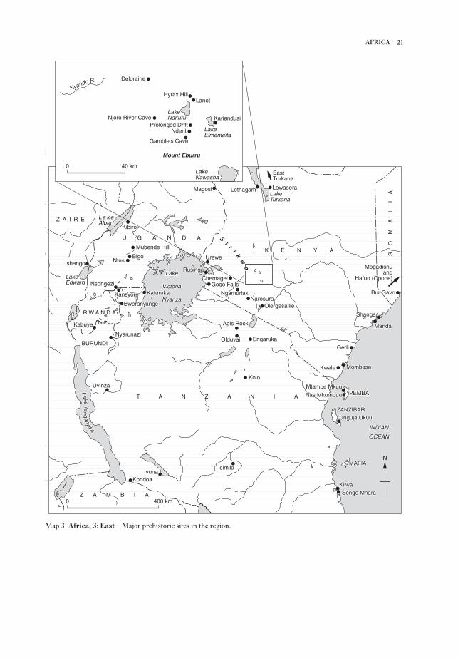
21AFRICA
N
0 400 km
0 40 km
Deloraine
Hyrax HillLanet
Njoro River Cave
Nderit
Gamble’s Cave
Mount Eburru
KariandusiProlonged Drift
Bur GavoBur Gavo
ShangaShanga
MandaManda
MogadishuMogadishuandand
Hafun (Opone)Hafun (Opone)
SO
MA
LI
AS
OM
AL
IA
SO
MA
LI
A
GediGedi
MombasaMombasaKwaleKwale
Mtambe MkuuMtambe Mkuu
Ras MkumbuuRas Mkumbuu PEMBAPEMBA
Unguja UkuuUnguja UkuuZANZIBARZANZIBAR
INDIANINDIAN
OCEANOCEAN
MAFIAMAFIA
KilwaKilwaSongo MnaraSongo Mnara
IsimilaIsimilaIvunaIvuna
KondoaKondoa
Z A M B I AZ A M B I AZ A M B I A
UvinzaUvinza
NyarunaziNyarunazi
BURUNDIBURUNDI
KabuyeKabuye
R W A N D AR W A N D AR W A N D A
BweranyangeBweranyangeBweranyange
KansyoreKansyore
NsongeziNsongezi
IshangoIshangoBigoBigo
NtusiNtusi
Mubende HillMubende Hill
U G A N D AU G A N D AU G A N D A
KibiroKibiroZ A I R EZ A I R EZ A I R E
MagosiMagosi
UreweUrewe
ChemagelChemagelGogo FallsGogo Falls
NgamuriakNgamuriak
LothagamLothagam
NarosuraNarosura
Apis RockApis Rock
EngarukaEngarukaOlduvaiOlduvai
KoloKolo
KaturukaKaturuka
RusingaRusinga
K E N Y AK E N Y AK E N Y A
T A N Z A N I AT A N Z A N I AT A N Z A N I A
LLaakkeeTTaann
ggaannyyiiikkaa
LakeLakeLake
VictoriaVictoria
NyanzaNyanza
LakeLakeLakeEdwardEdwardEdward
L a k eL a k eAlbertAlbertAlbert
SSii
rrii
kkww
aa
LakeLakeLakeTurkanaTurkanaTurkana
EastEastTurkanaTurkana
LowaseraLowasera
OlorgesailieOlorgesailie
Bur Gavo
Shanga
Manda
Mogadishuand
Hafun (Opone)
SO
MA
LI
A
Gedi
MombasaKwale
Mtambe Mkuu
Ras Mkumbuu PEMBA
Unguja UkuuZANZIBAR
INDIAN
OCEAN
MAFIA
KilwaSongo Mnara
IsimilaIvuna
Kondoa
Z A M B I A
Uvinza
Nyarunazi
BURUNDI
Kabuye
R W A N D A
Bweranyange
Kansyore
Nsongezi
IshangoBigo
Ntusi
Mubende Hill
U G A N D A
KibiroZ A I R E
Magosi
Urewe
ChemagelGogo Falls
Ngamuriak
Lothagam
NarosuraOlorgesailie
Apis Rock
EngarukaOlduvai
Kolo
Katuruka
Rusinga
K E N Y A
T A N Z A N I A
LakeTan
ganyika
Lake
Victoria
Nyanza
LakeEdward
L a k eAlbert
Si
ri
kw
a
LakeTurkana
EastTurkana
Lowasera
Nyando R.
LakeNakuru
LakeElmenteita
LakeNaivasha
Map 3 Africa, 3: East Major prehistoric sites in the region.

‘hominid gangs’. In many ways eastern Africa in the
1960s and 1970s took the centre-stage in field
studies of human cultures (including those of
existing hunter-gatherers). Work by specialist
sub-teams set new models and directions for
archaeology world-wide.
The achievement of independence by most
African countries in the years around 1960 stimu-
lated new intellectual directions in the continent, in
particular demands for precolonial histories of the
peoples of Africa. African studies, which had pre-
viously been oriented largely towards cultural and
social anthropology, were redirected in the 1960s
with a more avowedly historical purpose. This
required the exploitation on a new scale of oral-
historical, comparative-linguistic and especially
archaeological approaches, in order to reconstruct
the Iron Age and the development of African agri-
cultural and pastoral populations. Since much of
this stimulus came from the schools of History in
the new African universities and African studies
institutions world-wide (in contrast to the ‘pre-
historic’ tradition of most Stone Age research),
archaeologists working in Africa have become
conscious of two ‘camps’; and gatherings of
Africanist archaeologists have in recent years
witnessed an increasing Iron Age representation
(with some of the contributions being of essentially
local historical rather than continental interest, or
else heavily concerned with demonstrating regional
cultures, their ceramics and their dating by radio-
carbon).
Nevertheless, the growing emphases on environ-
mental understanding and other broad conceptual
issues (as well as the organizational and logistical
factors involved in field research) have ensured a
fair maintenance of intellectual liaison, and some
remarkable instances of specific co-operation,
between the ‘prehistoric’ and the ‘historical’
wings of African archaeology. One of the prime
concerns of African historians in the 1950s and
1960s was to vindicate the oral testimonies of king-
doms and their royal genealogies, sometimes
claiming twenty or more generations. Accordingly,
in the interlacustrine region of western Uganda and
adjacent countries, considerable archaeological
effort was put into locating and investigating former
capitals of known kingdoms and sites associated
with legendary rulers. While this line of research
focused on the later Iron Age and recent centuries
in particular districts, a broader historical concern
(in south-central and west-equatorial as well as
eastern Africa) has been the spread of Bantu
languages, a phenomenon increasingly recognized
as being associated with an expansion of early Iron
(notably in the regions of volcanic uplift border-
ing the two rifts) contrast with medium-altitude
plateaus (both wooded and cleared) as well as humid
lowlands and the coastal belt.
From the 1920s to 1950s the main archaeological
emphasis was on the Stone Age which was con-
sidered in its pan-African, and indeed broader Old
World context, and at the same time closely linked
with the study of Pleistocene geology. Both
Wayland in Uganda, working in the Western Rift
and the Lake Victoria basin, and Louis Leakey in
the Eastern Rift and adjacent highlands were con-
cerned with constructing a chronology for East
Africa, based on recognition of sequences of lake
levels and volcanic activity, with the assistance of
stratified mammalian fossils and broad classes of
stone tools. In this way they endeavoured to estab-
lish a sequence of Stone Age cultures, distinguished
in the traditional manner by tool types and flaking
techniques and correlated with the European
sequence – with the further attempt to correlate the
succession of ‘pluvial’ and ‘interpluvial’ periods in
East Africa with glacials and interglacials of higher
latitudes.
From the mid-20th century, with the expansion
of scientific interest and the development of new
research methods (including radiometric dating),
much of this geo-archaeological sequence and its
theoretical base, has been refined or overturned
(notably the supposed pluvial-glacial correspon-
dences). Instrumental to these discussions and to
generating fertile lines of field research – which
placed East Africa in its continental context – was
the Panafrican Congress on Prehistory and
Quaternary Studies: this first met in Nairobi in
1947, on Louis Leakey’s initiative, and has since
regularly reconvened in different places in Africa
(Francophone as well as Anglophone). At the same
time the enhanced international interest in eastern
Africa as the homeland of mankind (see also HUMAN
EVOLUTION), especially following the sensational
discoveries at OLDUVAI in 1959–60, stimulated a
more sophisticated approach to both field methods
and interpretation, and to the interdependence of
archaeological and ecological studies. Such ad-
vances were by no means confined to the quest for
earliest humans and their antecedents two and more
million years ago, but were applied to the whole
sequence of Early, Middle and Late Stone Age (as
generally classified for convenience south of the
Sahara). Here the leadership of Desmond Clark and
his team of able students was influential in pro-
viding a modern scientific and intellectual context,
to the exciting if somewhat erratic publicity which
accompanied the discoveries of the Leakeys and the
22 AFRICA

ported ceramics, as well as Islamic stone architec-
tural styles and correlations with Arabic written
sources. However, by the end of the 1980s, with
more varied strands of studies of interior East Africa
and the Indian Ocean, the relevance of historical
and archaeological interests to each other has come
to be better appreciated – as has the integration of
East Africa into the study of the world as a whole.S. Cole: The prehistory of East Africa (rev. edn, New York,
1963; London, 1964); Azania (1966–) [the annual journal
of the British Institute in Eastern Africa]; J.D. Clark: Theprehistory of Africa (London, 1970); R. Oliver and J.D.
Fage, ed.: Cambridge History of Africa I–III (Cambridge,
1977–82); D.W. Phillipson: The later prehistory of easternand southern Africa (London, 1977); UNESCO: GeneralHistory of Africa I–II (1981); D.W. Phillipson: Africanarchaeology (Cambridge, 1985); P.T. Robertshaw, ed.: Ahistory of African archaeology (London, 1990); J.E.G.
Sutton: A thousand years of East Africa (Nairobi, 1990).
JS
4 Southern AfricaSouthern Africa is a subcontinent of contrasts.
Climatically, rainfall is the most important factor,
with a winter rainfall pattern dominant in its south-
western corner. Over the remaining western third
of South Africa rainfall may fall all year round, but
is high only along the coast; the rest of the sub-
continent has a summer rainfall régime, with
precipitation highest over its eastern half. Except
for the Zambezi River and its tributaries, the west-
ward-flowing Orange/Vaal system is the most
extensive drainage system; most other rivers,
including the Limpopo, drain into the Indian
Ocean. Surface water is rare over the subcontinent’s
western half and much of Botswana and Namibia
lack permanent rivers. Defining these drainage
systems, the most important topographic feature is
the Great Escarpment, of which the Drakensberg
and the highlands of eastern Zimbabwe are the most
prominent components, while the Cape Fold Belt is
a further mountain range lying between the
Escarpment and the southwestern coastline of
South Africa. Running around all but the northern
margin of the subcontinent, which is defined by the
watershed between the Zambezi/Cunene rivers and
those of the Congo Basin, it separates the lower-
lying lands towards the coast from a higher interior
plateau that trends gradually away towards the
northwest, where it is occupied by the Kalahari; a
southerly extension of the Rift Valley system is
represented most obviously by Lake Malawi.
Ecologically, the northern half of southern Africa
is a savanna region populated by browsing and
mixed-feeding ungulates, with miombo and mopanewoodland dominant in Zambia and Malawi. The
Age cultivators with distinctive ceramics around
2000 years ago (see discussion in EARLY IRON AGE).
As both these subjects have developed, moving
beyond mere concerns for oral-historical or linguis-
tic correlations, they have encouraged a range of
cultural, social, economic and technological con-
siderations. The importance of agricultural history
(and of an archaeological approach to it) is being
increasingly reflected in excavations of settlement
sites as well as studies of ancient field systems and
their environments.
Similar ecological and techno-cultural concerns
have been extended into Late Stone Age studies,
and especially into what has been called (since Louis
Leakey’s first surveys) the ‘Neolithic’ of the high
grasslands of Kenya and northern Tanzania. The
term Neolithic has never been precisely or con-
sistently defined in East Africa: some archaeologists
emphasize pottery and stone bowls among the
advanced aspects of pre-Iron Age technology, while
others have supposed that the term refers to the
introduction of food-production, i.e., pastoralism
and even agriculture (perhaps deluding themselves
with an exaggerated local dating, as with the
‘PASTORAL NEOLITHIC’). However, these develop-
ments of the final millennia BC are gradually coming
to be studied together with those of the Iron Age as
part of the historical experience of the East African
populations. An important concomitant has been
the increasing amount of ethnographic recording,
especially of rural industries such as iron-working,
potting and house-building, and also of settlement
spacing, resource catchment, cattle-herding
strategies and hunter-gatherer societies and tech-
niques. Ethnoarchaeological theory in the 1980s
drew heavily on the East African experience (seeETHNOARCHAEOLOGY).
While some aspects of interior Iron-Age research
have been rather narrowly conceived within local
historical contexts, the study of the Swahili coast –
which related very obviously between the 9th and
16th centuries AD to the Indian Ocean, the Islamic
heartlands and the wider world – has been
largely pursued as a separate subject (see SWAHILI
HARBOUR TOWNS). Some East African scholars
have tended to see the history and archaeology of
the coast as somewhat foreign, and the pioneers of
Swahili archaeology, Kirkman and Chittick, in par-
ticular, made little concession to the intellectual gulf
between their work and that of other East African
archaeologists, which manifested itself in the 1960s.
This divergence derived partly from the different
methods of study employed at the coastal sites and
partly from the contrasting dating evidence, with
coastal chronologies relying extensively on im-
23AFRICA
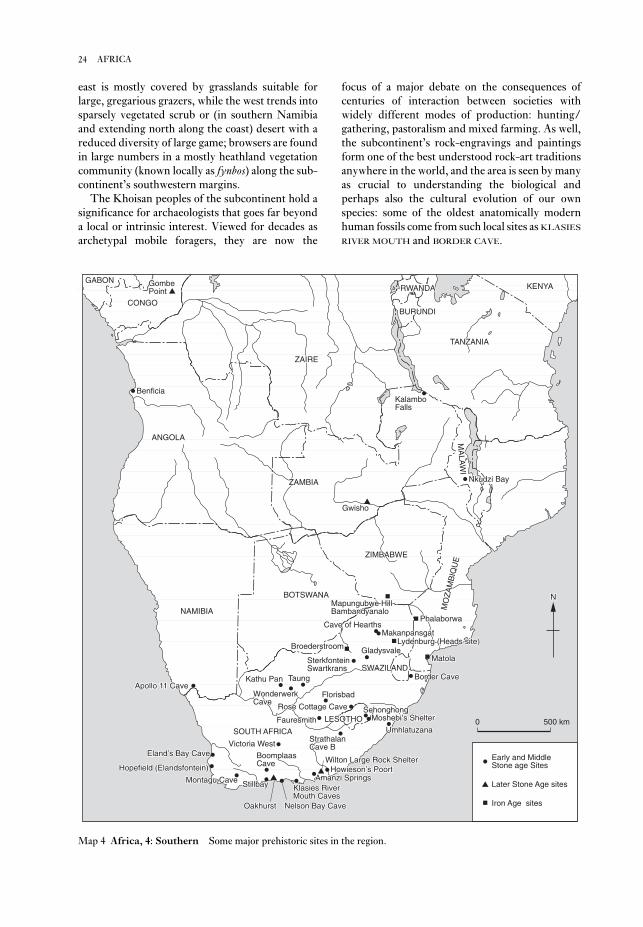
focus of a major debate on the consequences of
centuries of interaction between societies with
widely different modes of production: hunting/
gathering, pastoralism and mixed farming. As well,
the subcontinent’s rock-engravings and paintings
form one of the best understood rock-art traditions
anywhere in the world, and the area is seen by many
as crucial to understanding the biological and
perhaps also the cultural evolution of our own
species: some of the oldest anatomically modern
human fossils come from such local sites as KLASIES
RIVER MOUTH and BORDER CAVE.
east is mostly covered by grasslands suitable for
large, gregarious grazers, while the west trends into
sparsely vegetated scrub or (in southern Namibia
and extending north along the coast) desert with a
reduced diversity of large game; browsers are found
in large numbers in a mostly heathland vegetation
community (known locally as fynbos) along the sub-
continent’s southwestern margins.
The Khoisan peoples of the subcontinent hold a
significance for archaeologists that goes far beyond
a local or intrinsic interest. Viewed for decades as
archetypal mobile foragers, they are now the
24 AFRICA
ANGOLAANGOLA
ZAMBIAZAMBIA
RWANDARWANDA
CONGOCONGO
GABONGABON
ZAIREZAIRE
KENYAKENYAKENYA
BURUNDIBURUNDI
TANZANIATANZANIA
MA
LAW
IM
ALA
WI
MA
LAW
I
MO
ZA
MB
IQU
E
MO
ZA
MB
IQU
E
ZIMBABWEZIMBABWE
BOTSWANABOTSWANABOTSWANA
SWAZILANDSWAZILAND
LESOTHOLESOTHO
SOUTH AFRICASOUTH AFRICASOUTH AFRICA
NAMIBIANAMIBIA
BoomplaasBoomplaasCaveCave
StillbayStillbay
OakhurstOakhurst
Montagu CaveMontagu Cave
Nelson Bay CaveNelson Bay Cave
Klasies RiverKlasies RiverMouth CavesMouth Caves
Amanzi SpringsAmanzi SpringsHowieson’s PoortHowieson’s PoortHowieson’s Poort
StrathalanStrathalanCave BCave B
FauresmithFauresmith
Eland’s Bay CaveEland’s Bay Cave
Apollo 11 CaveApollo 11 CaveApollo 11 CaveKathu PanKathu Pan
WonderwerkWonderwerkCaveCave
TaungTaung
FlorisbadFlorisbad
Rose Cottage CaveRose Cottage CaveMoshebi’s ShelterMoshebi’s ShelterMoshebi’s Shelter
UmhlatuzanaUmhlatuzana
SehonghongSehonghong
Border CaveBorder Cave
GladysvaleGladysvaleSterkfonteinSterkfonteinSwartkransSwartkrans
MakanpansgatMakanpansgatCave of HearthsCave of Hearths
GwishoGwisho
Nkudzi BayNkudzi Bay
KalamboKalamboFallsFalls
BenficiaBenficia
GombeGombePointPoint
Victoria WestVictoria WestVictoria West
Wilton Large Rock ShelterWilton Large Rock Shelter
BroederstroomBroederstroom
Mapungubwe HillMapungubwe HillBambandyanaloBambandyanalo
MatolaMatola
Lydenburg (Heads site)Lydenburg (Heads site)
PhalaborwaPhalaborwa
NN
Early and MiddleStone age Sites
Later Stone Age sites
Iron Age sites
0 500 km
Hopefield (Elandsfontein)Hopefield (Elandsfontein)
ANGOLA
ZAMBIA
RWANDA
CONGO
GABON
ZAIRE
KENYA
BURUNDI
TANZANIA
MA
LAW
I
MO
ZA
MB
IQU
E
ZIMBABWE
BOTSWANA
SWAZILAND
LESOTHO
SOUTH AFRICA
NAMIBIA
BoomplaasCave
Stillbay
Oakhurst
Montagu Cave
Nelson Bay Cave
Klasies RiverMouth Caves
Amanzi SpringsHowieson’s Poort
StrathalanCave B
Fauresmith
Hopefield (Elandsfontein)
Eland’s Bay Cave
Apollo 11 CaveKathu Pan
WonderwerkCave
Taung
Florisbad
Rose Cottage CaveMoshebi’s Shelter
Umhlatuzana
Sehonghong
Border Cave
GladysvaleSterkfonteinSwartkrans
MakanpansgatCave of Hearths
Gwisho
Nkudzi Bay
KalamboFalls
Benficia
GombePoint
Victoria West
Wilton Large Rock Shelter
Broederstroom
Mapungubwe HillBambandyanalo
Matola
Lydenburg (Heads site)
Phalaborwa
N
Map 4 Africa, 4: Southern Some major prehistoric sites in the region.

used by recent southern African hunter-gatherers.
Examples found already in Pleistocene LSA con-
texts include ostrich eggshell and bone beads, bored
stone digging stick weights, tortoiseshell bowls,
ostrich eggshell containers (sometimes decorated
with incised geometric designs) and bone (arrow?)
points. Such similarities encourage archaeologists
in their use of ethnographic data to interpret the
archaeological record, though with a growing recog-
nition of the value of looking beyond southern
Africa for appropriate analogies.
Four or five broadly successive artefact traditions
are generally recognized within the southern
African Later Stone Age. Although the very
earliest LSA assemblages are amorphous, quartz-
dominated microlithic occurrences, between 19,000
and 12,000 BP the systematic production of un-
retouched bladelets from highly distinctive bladelet
cores distinguishes Robberg assemblages, which are
found across South Africa, Lesotho and Swaziland.
These bladelets were used in a diverse range of tasks
as the cutting edges of composite artefacts; those
formally retouched tools (scrapers, adzes, backed
microliths) that do occur are always rare. Broadly
contemporary with the Robberg, the Maleme
Industry of southwestern Zimbabwe retains some
MSA features, while macrolithic assemblages are
found at sites in Namibia.
Very different assemblages are found across the
Pleistocene/Holocene boundary. Dating to roughly
12–8000 BP they are grouped within the OAKHURST
Complex and cover a much wider area than the
Robberg, extending north of the Limpopo to
include sites in Zimbabwe and Namibia. Several
regional industries are recognized, largely from
differences in raw material usage: Kuruman in the
Northern Cape Province, Lockshoek across much
of South Africa’s interior plateau, ALBANY in the
Cape Fold Mountains and their adjacent coast-
lands, Pomongwan in Zimbabwe. The Oakhurst
differs from the Robberg in that bladelets are
extremely rare, coarser-grained rocks tend to be
preferred and flakes and scrapers (virtually the only
retouched tools) are larger. Much higher numbers
of beads, other ornaments and bone tools are also
found after 12,000 BP, perhaps signalling an
increased role for exchange as a means of mini-
mizing ecological risk and/or a transformation in
social relations.
Zambia, Malawi and northern Zimbabwe fall
into a different cultural province from the rest of the
subcontinent. MSA assemblages, well documented
at sites such as Mumbwa Cave, were replaced by
19,000 BP by microlithic traditions known locally as
Nachikufan. Though similar to the Robberg in
4.1. The Middle and Later Stone Ages. Southern
African archaeologists distinguish two very gen-
eralized stone-working traditions within the last
150–200,000 years. The older of these, the Middle
Stone Age (MSA), is characterized by the produc-
tion of flakes and flake-blades, some of them
retouched to form scrapers, knives, points or backed
pieces. Prepared core technology is not as strongly
developed a feature as it is of roughly contemporary
Middle Palaeolithic technologies, but many flakes
and flake-blades do have faceted platforms; true
Levallois cores sometimes occur.
Although some regional industries have been
identified (e.g. the Orangian Industry on South
Africa’s central plateau) detailed classification of
Middle Stone Age assemblages is generally avoided:
there are few long sequence sites and chronological
controls, especially for open-air locations, are poor.
Instead, four broadly successive stages are recog-
nised. Dated by reference to the global oxygen
isotope stage curve, they are: MSA 1 (stage 6); MSA
2 (stages 5e–5b, the Last Interglacial); the
HOWIESON’S POORT (stages 5a/4); MSA 3 (stage 3).
Within these stages assemblages vary widely in arte-
fact morphology, core types and raw material. In
broad terms the MSA 1 has very few retouched
pieces with points completely absent; the MSA 2
features relatively large flake-blades, as well as
scrapers and both unifacial and bifacial points
(including those previously known as STILLBAY);
the Howieson’s Poort shows enhanced use of
finegrained rocks and includes high frequencies
of segments and other backed pieces, some of
microlithic proportions; and the MSA 3 is highly
variable, but clearly post-Howieson’s Poort in age.
While MSA 1 assemblages may have been produced
by archaic hominids, anatomically modern human
fossils have been found with more recent MSA
assemblages at several sites in South Africa.
However, still at issue is the extent to which this
physical modernity necessarily implies similarities
in cultural behaviour and potential, with unequivo-
cal evidence for art and jewellery, for example, only
found (e.g. at APOLLO 11 CAVE and BORDER CAVE
respectively) after 40,000 BP.
For a long time debate has persisted on the date
of the transition between Middle and Later Stone
Age (LSA) technologies, but an emerging consen-
sus, based on data from sites such as BOOMPLAAS,
ROSE COTTAGE CAVE and SEHONGHONG, now
locates this for the area south of the Limpopo to
around 21,000 BP. Characteristic of most LSA
assemblages is an emphasis on the production of
microliths, but more significant in a behavioural
sense are similarities with the material culture
25AFRICA

Despite growing social and economic complexity
in some parts of the subcontinent, there is no evi-
dence that any of the plant or animal resources
indigenous to southern Africa were independently
domesticated. However, for much of the last 2000
years the region’s hunter-gatherers have been in
close contact with food-producing societies. In the
southwestern part of the sub-continent these con-
tacts were with Khoi-speaking pastoralists, whose
linguistic affiliations suggest an ultimate origin in
north-central Botswana; sheep were presumably
acquired here originally from Iron Age farmers.
Recent accelerator dates show sheep present in the
Cape Fold Belt c.1900 BP, though associations with
the local introduction of pottery are not clearcut. As
with recent dates suggesting that pottery appeared
in southeastern southern Africa several hundred
years before the oldest known Iron Age villages, this
raises the possibility that ceramics were adopted
ahead of, or by different means from, the local
establishment of food-producing communities and
encourages archaeologists to consider the active
roles played by hunter-gatherers in the develop-
ment of pastoralist and farming societies.
Side by side with pastoralists and Iron Age
farmers, hunter-gatherer populations survived
across most of southern Africa well into the colonial
era, in some places (e.g. much of the eastern half of
the subcontinent) gradually being assimilated into
farming societies, in others (e.g. the Riet River
Valley of South Africa) acquiring livestock of
their own and elsewhere (e.g. the Caledon Valley)
developing a range of exchange, ritual and economic
ties with food-producers. Here and across much of
the Karoo, hunter-gatherers made pottery of their
own, with Smithfield ceramics (often associated
with more macrolithic stone tool assemblages)
a widespread tradition. South of the Limpopo,
the nineteenth century saw the LSA end with the
final displacement of hunter-gatherers and
pastoralists and their incorporation into local
Bantu-speaking communities or South Africa’s
emerging ‘Coloured’ population. In both Namibia
and Botswana, however, thriving communities of
Khoi-speaking pastoralists and Bushmen survive
today.
4.2. The history of Stone Age archaeological researchin southern Africa. The general trends in the study
of the southern African Stone Age have broadly
paralleled developments in other parts of the world.
Beginning with essentially antiquarian observations
in the mid-nineteenth century, the 1920s saw the
emergence of a concern with the description and
classification of stone tools and the interpretation of
their spatial distributions, notably in terms of popu-
having evidence of bored stones, worked bone and
jewellery, the Nachikufan is typified by the pro-
duction of backed (as opposed to unmodified)
bladelets and points. Once established this pattern
of artefact manufacture also shows more continuity
than is evident further south; there is no Zambian
or Malawian equivalent of the Oakhurst Complex
and Nachikufan-like assemblages continued to be
produced in some areas, such as western Zambia,
until recent centuries.
Beginning around 9500 years ago in Namibia
and Zimbabwe, but occurring only from 8000 BP
south of the Limpopo, a different technological tra-
dition is found. This WILTON complex marks a
return to a microlithic technology, but is only
superficially similar to the Robberg. Both made
extensive use of fine-grained rocks, but the Wilton
was not a bladelet technology. Instead, it was
geared to the systematic manufacture of a wide
range of scrapers and backed microliths (especially
segments in its earlier stages) generally made on
small flakes. Microwear shows that scrapers were
used to work skins, but perhaps mostly in finer,
decorative work, with backed microliths used in a
variety of cutting tasks as knives, and perhaps also
as arrow armatures.
Holocene microlithic assemblages continued to
be made in many parts of southern Africa until
the nineteenth century, though with changes in the
details of scraper design and the kinds of backed
microliths produced. A general trend in many areas
is for the frequency of adzes (widely interpreted as
woodworking implements) to increase during the
last 4000 years, a pattern linked in the Thukela
Basin of KwaZulu-Natal and elsewhere to increased
use of underground plant foods, for the exploitation
of which wooden digging sticks would have
been needed. Comparable developments are also
observable in other parts of the subcontinent and
may be linked to the development of more elaborate
burials (as a means of establishing claims to local
landscapes) and greater use of other small-sized
food resources, such as fish, shellfish and ground
game. At the same time the archaeological record
exhibits an increasing regionalization of material
culture, although only rarely is this formally recog-
nized in archaeological nomenclature. One of the
best examples of this regionalization is the distrib-
ution of pressure-flaked stone arrowheads and
backed microliths across Lesotho, the Free State
and the eastern Karoo: recent studies suggest this at
least partly correlates with ostrich eggshell and
seashell bead exchange networks and with the dis-
tribution of rock-paintings of fish belonging to the
mormyrid family.
26 AFRICA

Late (AD 1000–1850). Some believe this new life-
style emerged as the result of the diffusion of
individual traits, but the archaeological evidence
does not support this interpretation. As Robinson’s
excavations at MABVENI in Zimbabwe first showed
in the 1960s, the diagnostic features occur together.
Although there are pitfalls, archaeologists use
ceramic styles in Central and Southern Africa to
trace the origins and movements of Iron Age people.
David Phillipson’s Chifumbadze classification,
somewhat modified by Thomas Huffman, identi-
fies three principal divisions and therefore ‘streams’
of movement: (1) the UREWE Tradition, which con-
tains firstly a KWALE Branch, including SILVER
LEAVES/MATOLA in southern Africa and secondly
an Nkope Branch, including Ziwa and Gokomere in
Zimbabwe, and Kamnama and Kumadzulo (or the
Dambwe group) in Zambia; (2) the Kalundu
Tradition, which includes Benfica in Angola,
KAPWIRIMBWE and Kulundu in Zambia, Sinoia in
Zimbabwe and Matakoma, BROEDERSTROOM,
Lydenburg and Msuluzi in South Africa. A direct
cultural continuum in southern Africa from the
Kalundu Tradition to modern Shona and from
Kwale to Swahili in East Africa show that the
Chifumbadze complex of styles was made by
Eastern Bantu speakers. Other ceramic traditions
are associated with Western Bantu speakers in
the Congo basin. It is likely that Western Bantu
speakers moved from the Nigeria/Cameroon
homeland into the Congo Basin as rootcrop agri-
culturalists, perhaps by 1000 BC, before Eastern
Bantu evolved.
A current debate concerns the movement of
Eastern Bantu speakers into East, Central and
Southern Africa and the nature of their society.
Excavations at Broederstroom show that more cat-
tle were herded than faunal samples indicate and
that by this time (at least) settlement organization
followed the ‘CENTRAL CATTLE PATTERN’ (i.e. a
settlement pattern centred on a ‘male domain’ com-
prising a central cattle byre, elite burials and a
‘men’s court’). These people therefore valued
hereditary leadership, a patrilineal ideology, cattle
brideprice and a religion based on their ancestors.
The early presence of the central cattle pattern
disproves a once commonly held theory that the
Late Iron Age was heralded by the development of
cattle rearing around AD 1000. The most significant
event at this time was the evolution of the
Zimbabwe culture at K2 and MAPUNGUBWE. The
Indian Ocean trade with Swahili that was so impor-
tant in this evolution began somewhat earlier, and
glass beads are found throughout Zimbabwe in 9th-
century contexts. Unrelated stimuli at the same
lation movements and the effects of different raw
materials on assemblage composition. The basic
terminology (including the local ‘Three Age
System’ of Early, Middle and Later Stone Ages)
invented then by A.J.H. Goodwin and C. Van Riet
Lowe continues in use today.
Beginning around 1959 when Desmond Clark
argued that different environmental conditions had
affected assemblage character in different parts of
the subcontinent, a strongly ecological focus has
prevailed in the region’s research tradition. The
work of Hilary Deacon, initially at Melkhoutboom
and subsequently with a focus on Boomplaas and
KLASIES RIVER MOUTH, along with the research of
John Parkington and his colleagues in the Western
Cape are two of several projects that have em-
phasized the study of prehistoric subsistence
economies, adaptation to local ecologies and palaeo-
environmental reconstruction. More recently, there
has been a partial shift from these people-to-nature
focused studies to others that emphasize people-to-
people approaches, especially the study of social and
ideological change. This shift derives in part from
the use of San ethnography in rock art interpreta-
tion and the impact of rock art research on other
archaeological studies, notably in foregrounding
questions of ideology and social relations.
Recent studies that place the study of social,
rather than simply ecological, change at the top of
their agenda include those of Lyn Wadley in
Gauteng and the Free State and of Aron Mazel
in the Thukela Basin of KwaZulu-Natal; the poten-
tial of rock art for understanding social change has
been explored by David Lewis-Williams, Thomas
Dowson and others.
PM
4.3. The Iron Age. Environmental data indicate that
significant climatic shifts took place during the Iron
Age, and wetter periods facilitated Iron Age ex-
pansion. Southern Africa has a somewhat varied
environment; it lies south of the equator, therefore
winters are dry and most rain falls in the summer,
from November to March. Hunter–gatherers still
lived throughout this diverse area in the Iron
Age, but archaeologists consider this period to rep-
resent a cultural break with the past, since a new
way of life and a fresh set of beliefs appear. Pole-
and-daga houses, raised grain-bins and sunken
storage pits represent settled agricultural villages,
while bones of domestic small and large livestock,
furnace, forge and metal slag, and pottery decor-
ated in a distinctive set of styles are also
characteristic.
Scholars commonly place these African Iron Age
remains in two main phases: Early (AD 1–1000) and
27AFRICA

‘The climate of the last 2000 years in southern Africa’,
Holocene 2 (1992), 271–8.
TH
5 Central AfricaCentral Africa is usually defined geographically as
the area lying between the Niger, Nile and Zambezi
river basins, and south of the Lake Chad basin. For
the purposes of this work it comprises the modern
states of Zaire, Congo-Brazzaville, Gabon,
Equatorial Guinea, the Central African Republic, as
well as northern Angola and southern Cameroon.
The most outstanding ecological feature of this zone
is the presence of the Central African rainforest,
filling the central depression of Africa and extend-
ing to the west African coastlands, and to the edge
of the Central African lakes region. The prehistoric
fluctuations of the rainforest’s geographical cover-
age are uncertain, but evidence would suggest that
its size has fluctuated substantially in response to
arid and humid phases generated by the inter-
tropical convergence zone. As its borders are
savanna–forest mosaics, giving way to typical
Sudanian savannas to the north and south, and
montane grasslands and forests to the east
and northwest. The heart of Central Africa is
traversed by the powerful Zaire (Congo) River,
which is the region’s principal hydrological net-
work.
Most of the modern inhabitants of Central Africa
speak Bantu languages with some populations in the
north of the region speaking other Niger–Congo
languages, or languages of the Nilo–Saharan
language phylum. However, it is likely that this lin-
guistic uniformity over-printed a much greater
linguistic diversity during the past few thousand
years. It should be noted that the modern inhabi-
tants of the Central African rainforest include both
‘Bantu’ and ‘pygmy’ populations, with the latter
usually being in a client relationship to the former.
It has been suggested that these Niger–Congo
speaking pygmy populations are the acculturated
remnants of the rainforest’s original inhabitants,
although the time depth of both the pygmoid phys-
ical type and the initial occupation of the rainforest
environment remain uncertain.
5.1. The earliest evidence for hominid occupations inCentral Africa. The existence of pre-Acheulean
industries in Central Africa has long been a debated
topic, with most finds coming from fluvially
reworked contexts near principal channels in
the Zaire basin and consisting mainly of heavily
rolled ‘choppers’. The most plausible pre-
Acheulean sites are in the region of Lunda
(northeast Angola), where a number of relatively
time caused Western Bantu speakers with
LUANGWA style pottery to move south across
Zambia, ultimately forming the so-called ‘matri-
lineal belt’. As a possible consequence, speakers of
the Eastern Bantu, Sotho-Tswana and Nguni
languages moved into southern Africa during the
13th century. Sotho-Tswana did not occupy the
open highveld of the Transvaal and Orange Free
State until the climate became warmer and wetter
in the 16th century. Another warm episode in the
mid- to late-18th century permitted the widespread
cultivation of maize in Natal and the Transvaal.
Population increases followed by drought and
famine contributed to the great military stress of the
difaqane (a Sotho term meaning literally ‘the
hammering’, used to refer to the violent period in
the late 18th century AD, which led to the popu-
lation movements of the 1820s and 1830s). In
response, Sotho-Tswana in the interior aggregated
into large towns of several thousand people (such as
Olifantspoort and MOLOKWANE), and some Nguni
moved as far away as Tanzania, Malawi, Zambia
and Zimbabwe.
TH
Stone Age bibliographyR.R. Inskeep: The peopling of southern Africa (Cape Town,
1978); R.G. Klein, ed.: Southern African prehistory andpalaeoenvironments (Rotterdam, 1984); J.E. Parkington
and M. Hall, ed.: Papers in the prehistory of the western Cape(Oxford, 1987); L. Wadley: The Later Stone Age of thesouthern Transvaal: social and ecological interpretations(Oxford, 1987); J.D. Lewis-Williams and T.D. Dowson:
Images of power (Johannesburg, 1989); A.D. Mazel:
‘People making history: ten thousand years of hunter-
gatherer history in the Thukela Basin’, Natal MuseumJournal of Humanities 1 (1989), 1–189; A.I. Thackeray:
‘The Middle Stone Age south of the Limpopo River’,
JWP 6 (1990), 385–440; L. Wadley: ‘The Pleistocene
Later Stone Age south of the Limpopo River’, JWP 7
(1993), 243–96; Journals: South African ArchaeologicalBulletin; Southern African Field Archaeology.
PM
Iron Age bibliographyK.R. Robinson: ‘An Early Iron Age site in the Chibi
District, Southern Rhodesia’, SAAB 16 (1961), 95–102;
T. Maggs: Iron Age communities of the southern highveld(Pietermaritzberg, 1976); D.W. Phillipson: The later pre-history of eastern and southern Africa (London, 1977); R.M.
Gramly: ‘Expansion of Bantu-speakers versus develop-
ment of Bantu language and African culture in situ: an
archaeologist’s perspective’, SAAB 33 (1978), 107–12; T.
Maggs: ‘Msuluzi confluence: a seventh century Early Iron
Age site on the Tugela River’, Annals of the Natal Museum24 (1980), 111–45; T.M. Evers: Excavations at the
Lydenburg Heads site, eastern Transvaal, South Africa’,
SAAB 37 (1982), 16–33; P.D. Tyson and J.A. Lindesay:
28 AFRICA

stone knapping process represented at a main
‘workshop’ site and a ‘living area’ (Cahen 1976).
The assemblages at Kamoa appear on typological
grounds to belong to the Evolved Acheulean; being
dominated by sidescrapers on flakes, possessing
both handaxes and picks, and featuring rare
examples of LEVALLOIS nuclei and flakes.
Geological indications and a pollen core suggest
that the locality was occupied during an arid period,
when the area was open savanna. The site has not
been directly dated, but on comparison with other
unreworked assemblages have been found which
lack bifaces and consist predominantly of core
choppers and sidescrapers on flakes (Clark 1966).
Other such assemblages in Zaire and the Central
African Republic are not universally accepted.
Acheulean sites, particularly those of the evolved
Acheulean, are much more widespread and easily
confirmed. One of the most extensively and
systematically excavated Acheulean sites in Central
Africa is that of Kamoa (Zaire), which has supplied
important spatial information on the stages of the
29AFRICA
CONGOCONGO
GABONGABON
Z A I R EZ A I R EZ A I R E
K E N Y AK E N Y AK E N Y A
BURUNDIBURUNDI
T A N Z A N I AT A N Z A N I AT A N Z A N I A
MA
LAW
IM
ALA
WI
MOZAMBIQUEMOZAMBIQUE
Z I M B A B W EZ I M B A B W EZ I M B A B W E
BOTSWANABOTSWANABOTSWANA
SWAZILANDSWAZILAND
LESOTHOLESOTHO
SOUTH AFRICASOUTH AFRICASOUTH AFRICA
NAMIBIANAMIBIA
Z A M B I AZ A M B I AZ A M B I A
ANGOLAANGOLA
LakeLakeTanganyikaTanganyikaTanganyika
LakeLakeVictoriaVictoria
RWANDARWANDARWANDA
LakeLakeMalawiMalawiMalawi
NkopeNkope
Ingombe IledeIngombe IledeKalomoKalomo
KapwirimbweKapwirimbwe
LakeLakeKaribaKaribaKariba
MabveniMabveniGreatGreatZimbabweZimbabweDanangombeDanangombe
Bambata CaveBambata Cave
ManekweniManekweni
DivuyuDivuyu
ToutswemogalaToutswemogala
Silver LeavesSilver Leaves
MolokwaneMolokwane
BroederstroomBroederstroom Maputo MatolaMaputo Matola
VumbaVumbaTotengToteng
Sofala 1Sofala 1
Sofala 2Sofala 2
ChibueneChibuene
KumadzuloKumadzulo
INDIANINDIANINDIAN
OCEANOCEANOCEAN
ATLANTICATLANTICATLANTIC
O C E A NO C E A NO C E A N
NN
1000 km1000 km
CONGO
GABON
Z A I R E
K E N Y A
BURUNDI
T A N Z A N I A
MA
LAW
I
MOZAMBIQUE
Z I M B A B W E
BOTSWANA
SWAZILAND
LESOTHO
SOUTH AFRICA
NAMIBIA
Z A M B I A
ANGOLA
LakeTanganyika
LakeVictoria
RWANDA
LakeMalawi
Nkope
Ingombe IledeKalomo
Kapwirimbwe
LakeKariba
MabveniGreatZimbabweDanangombe
Bambata Cave
Manekweni
Divuyu
Toutswemogala
Silver Leaves
Molokwane
Broederstroom Maputo Matola
VumbaToteng
Sofala 1
Sofala 2
Chibuene
Kumadzulo
INDIAN
OCEAN
ATLANTIC
O C E A N
N
1000 km0
Map 5 Africa, 5: Central Some major prehistoric sites in the region.

Laka have been dated to at least uncal 30,000 BP and
contain three different quartz microlithic indus-
tries. From an Ash Member, overlying these lower
sediments a group of human burials has been found
dating to uncal c.7000 BP. These remains of at least
15 individuals, are associated with a microlithic
quartz industry, and thus constitute the largest Late
Stone Age mortuary population yet known from
Central Africa. The future laboratory analyses of
materials from the Shum Laka excavations have the
potential to profoundly change our perception of
ancient economy and populations at the edge of the
rainforest.
It is interesting that all early microlithic occur-
rences in sub-Saharan Africa (Matupi, Shum Laka,
HOWIESON’S POORT) seem to be associated with
open savanna environments or savanna – forest
ecotones. At their early stages at least, they are
certainly not associated with deep forest environ-
ments, and indeed some authors (Ambrose and
Lorenz 1990) have suggested that open environ-
ments, greater residential mobility (with greater
information exchange), and the need for lighter
(longer range) weapons and a more flexible toolkit
may have conspired to stimulate the development of
microlithic industries in Africa.
By uncal c.15,000 BP microlithic technology had
become virtually universal in Central Africa.
Indeed, the Central African microlithic techno-
complex was to continue in Central Africa in some
localities until uncal c.2000 BP.
5.3. The ‘Stone to Metal Age’ and the ‘Bantu expan-sion’. The advent of ceramic technology was
comparatively late in Africa south of the equator,
considering that the first Saharan ceramics rank
amongst some of the most ancient in the world. In
most of the region ceramics appear along with
polished stone tools only after uncal 4000 BP, how-
ever there are a few notable exceptions.
The coastal Sablières de Libreville (Gabon) hold
within them several localities where ceramics and
microliths have been found within discrete ash lens
dated to between uncal 6450 and 4870 BP (Clist
1995). Many scholars have asserted that these
ceramics might be somehow intrusive, due to high
subsurface mobility in unconsolidated sand
deposits. However, as further sites in coastal
Gabon, such as Nzogobeyok and Rivière Denis,
have been found to have similar associations at
comparable dates, the integrity of these finds is
becoming more probable. If these datings are
accurate, they indicate that in at least some instances
pottery was appropriated or developed by Central
African hunter-gatherers well before the ‘Bantu
Expansion’.
assemblages should date to uncal c.200,000 BP.
Other important Acheulean localities in Central
Africa include the sites of the Sangha region in the
Central African Republic, where assemblages com-
prising all stages of the Acheulean (lower, middle
and upper) have been identified (Lanfranchi and
Clist 1991). The Lunda region of Angola has like-
wise supplied lower and upper Acheulean
industries.
SANGOAN localities are very numerous in Central
Africa, although the best dated and most well-
known occurrences are on its fringes. The original
sequences for the post-Acheulean stone age in-
dustries of the region were built by J. Colette at
GOMBE POINT (Zaire), however the stratigraphic
integrity of these sequences are now in doubt
(Cahen 1976). Regardless, macrolithic ‘core tool’
industries – sometimes with and sometimes without
a Levallois component – occupy the period between
c.200,000 and 40,000 years ago in Central Africa.
Neither palaeoclimatic studies, nor archaeological
research has allowed us to view with precision the
environmental context of these early occupations,
and particularly whether they were within or with-
out the rainforest.
5.2. The first microlithic industries. Some of the
earliest MICROLITHIC industries in the world are
found in Central Africa. These include the impor-
tant sites of MATUPI CAVE (Zaire) and SHUM LAKA
(southern Cameroon), where microlithic quartz
industries have been shown to date at or before the
‘radiocarbon barrier’ of uncal 40,000 BP.
Matupi Cave is located in eastern Zaire, almost
on the Ugandan frontier. Palynological and faunal
evidence suggests that the cave was surrounded by
savanna vegetation, but in proximity to gallery or
rain forest throughout its ‘Late Stone Age’ occu-
pation. The earliest stone industry at Matupi
(c.<40,700 to uncal 32,000 BP) is characterized by a
fully microlithic reduction technique (bipolar cores
with small flakes and bladelets), but lacking true
geometric microliths. Geometric microliths, pre-
sumably used in making composite tools only begin
to occur at uncal c.32,000 to 21,000 BP, coupled with
substantial numbers of pièces esquillées, presumably
for wood-working (Van Noten 1982).
Shum Laka is one of the most recently researched
rockshelter sites in Central Africa, with fieldwork
only being completed there by Pierre de Maret and
his team in 1994. Preliminary information from
palynological, faunal and macrobotanical analyses
show that it, like Matupi, was probably situated on
a savanna–forest ecotone for most of its occupation
(an ecotone being an area bordering two different
ecological zones). The lower sediments at Shum
30 AFRICA

but featuring dates on associated charcoal falling
between uncal 2800 and 2000 BP. Associated
material culture from excavations has been rather
sparse but includes some ceramics, ground stone
and lithics (David 1982). In terms of function, these
monuments have usually been viewed as territorial
or group lineage markers.
The expansion of ceramic-using groups into the
Central African forest and the Zaire Basin has been
studied in recent years by the German River
Reconnaissance Project (Eggert 1993). Their work
established the existence of three cultural groups in
the river basin on the basis of ceramic analysis.
These included: the Imbonga Group (uncal
2400–2000 BP, no associated iron or stone tools), the
Batalimo Group (uncal 2100–1600 BP, no associated
iron, but associated polished stone axes common at
the ‘type site’ of Batalimo, Central African
Republic) and the Pikunda–Munda Group (uncal
2000–1700 BP, clearly associated with iron arte-
facts). It is unclear at this point whether or not the
technological variability encountered in these
groups is simply an artefact of sampling.
Unfortunately no economic evidence for these
groups is yet available.
The earliest indications of iron metallurgy in
Central Africa come from Gabon in the Ogooué
basin. There, certain localities at Otoumbi (Middle
Ogooué) and Moanda (Upper Ogooué) have sup-
plied some of the earliest dates for iron furnaces yet
known in Africa (Otoumbi 2: 2640 ± 70 and 2400 ±
50 uncal BP; Moanda 1: 2350 ± 140 uncal BP and
Moanda 2: 2330 ± 90 uncal BP). There is some
controversy surrounding these dates since contem-
porary occupations in the same region are still
essentially ‘Neolithic’ in material culture (Clist
1995). However, it should be remembered that the
transfer to iron technology everywhere in Africa
was a gradual process, with little immediate change
in material culture and only a slow proliferation of
metal artefacts. Indeed, by uncal 2000 BP iron tech-
nology was very widespread in central Africa.
5.4. Complex societies: the case of the Luba kingdomand its antecedents. It would seem that by the late 1st
millennium AD several complex societies were in
existence along the Zaire basin. Certainly by the
time of European contact in the 15th century,
the impressive, urbanized kingdom of Kongo
already controlled the mouth of the Zaire river and
the kingdom of Teke occupied much of what is
now Congo-Brazzaville. However, archaeological
evidence for the background to these polities is
rather scarce when compared with that for the
kingdom of Luba.
The historic kingdom of Luba existed during the
The beginnings of the expansion of Niger–
Congo speakers of the Bantu Super-Family into
Central Africa has been placed by historical lin-
guists at around uncal 4000 BP. The current
consensus is that the core area for this expansion
may be found in the Cameroon grassfields. It would
seem that the first Bantu-speaking immigrants into
Central Africa arrived before the beginnings of
metallurgy, but with ceramics, polished stone tools
and small livestock. The initial population move-
ments could have been encouraged by the
beginnings of the recent arid phase around uncal
4500 BP – opening savanna corridors into the rain-
forest. Additionally, it would seem that some
migration was maritime (between southern
Cameroon, Equatorial Guinea, and Gabon), since
the island of Bioko was occupied by local seafarers
around uncal 4000 BP (Vansina 1990; Clist 1995).
As research has progressed over the past few
decades, it has become evident that it is no longer
possible to trace a clean line in Central Africa
between one period when groups were using stone
tools and another in which iron implements were
employed. Thus, to alleviate confusion, de Maret
(1995) has suggested the use of Stone to Metal Age
(or SMA) as a term for this technologically transi-
tional period (c.4,000–2,000 uncal BP). Within the
Central African SMA there would appear to be a
wide diversity of local ceramic traditions and
associated technologies and economies.
The sites of OBOBOGO and Nkang (Cameroon)
provide us with some of our clearest economic evi-
dence for this period. At Obobogo, ceramics, oil
palm endocarps and the fruits of the tree Canariumschweinfurthii have been associated in disposal or
storage pits with dates of between uncal 3625 and
2120 BP while at Nkang domesticated ovicaprines
are present at around uncal 2,500 BP (de Maret
1995). These sites seem to mark the first docu-
mented occurrences of a vegecultural and small
livestock management economy which appears to
have slowly expanded within the Central African
forests around uncal, 2000 BP potentially along river
corridors.
Also in the 3rd millennium BP (uncal) interesting
developments were taking place in the savanna of
the Central African republic. There, in the Bouar
region, numerous megalithic monuments (called
locally tazunu) were being constructed. These
tazunu, which number in the hundreds, consist
primarily of stone aggregations of approximately
10 m in diameter and 1 to 2 m in height, with a
series of monoliths placed at or around their
summit. Six tazunu have been excavated and dated,
providing absolutely no evidence for inhumations,
31AFRICA

l’Afrique Centrale, ed. R. Lanfranchi and B. Clist
(Libreville, 1991), 234–41; M. Eggert: ‘Central Africa and
the archaeology of the equatorial rainforest: reflections on
some major topics’, The archaeology of Africa: food, metalsand towns, eds. T. Shaw, P. Sinclair, B. Andah and A.
Okpoko (London, 1993), 289–33; B. Clist: Gabon:1000,000 ans d’Histoire (Libreville, 1995); P. de Maret:
‘Pits, pots and far-west streams’, The growth of farmingcommunities in Africa from the Equator southwards, ed.
J.E.G. Sutton [Azania special volume 29–30] (Nairobi,
1995), 318–23.
KM
Agade see AKKADIAN
Agadez Region situated southwest of the Air
massif, central Niger, which was investigated by
Danilo Grébénart in 1978–81; it contains abundant
remains, both above and below the Tigidit scarp,
attributed to the Neolithic, Copper and Iron Ages,
and the medieval period; most interest has centred
on the early Copper Age, because of Grébénart’s
claim that ‘an autonomous centre for the working of
native copper’ developed here at that time. A total
of 42 radiocarbon dates from 17 sites belonging to
four phases of settlement is summarized as follows:
[Phase: number of sites; number of dates; date range
BP]: Neolithic (6; 8; 3390 ± 100–2795 ± 105). CopperI (3; 15; 4140 ± 90–2900 ± 100). Copper II (5; 15;
2800 ± 90–2040 ± 90). Iron I (3; 4; 2440 ± 90–2010
± 90).
The scheme implies that the early Copper Age in
the Agadez region preceded and ran parallel with
the Neolithic and that the late Copper Age was like-
wise largely contemporaneous with the early Iron
Age. Some copper slag was analysed by J.R. Bourhis
and R.F. Tylecote, but they did not agree in their
interpretation, and a third opinion was therefore
sought from N.J. van der Merwe, who with his
colleagues has provided a complete reassessment of
the sites attributed to the Copper Age, particularly
Afunfun 175, where according to Grébénart more
than 100 furnaces representative of the early period
have been identified. Of the 18 structures excavated
at this site, only furnace 1 produced a large quantity
of fused material, and two samples of this were
shown to consist of fayalitic iron-smelting slag,
directly dated by accelerator mass spectrometry to
1510 ± 100 BP. The structure itself was identified as
a burnt-out tree stump, and, as van der Merwe
comments, ‘a span of more than two millennia’
therefore separates the formation of this structure
from ‘its use as an iron-smelting furnace’. Only four
of the other structures attributed to the early
Copper Age are considered to be definitely furnaces
18th and 19th centuries in and around the riverine
Upemba Depression of eastern Zaire. However, the
Luba kingdom has important antecedents which are
only attested by the archaeological record (de Maret
1991). Between c.AD 700 and 900, the Upemba
Depression was already occupied by an apparently
stratified society, featuring graves of differential
status and including symbols of wealth and power
(non-functional ‘ceremonial’ axes and cylindrical
anvils) which would still have been recognizable as
legitimation symbols at the time of the Luba
Kingdom. This cultural phase, termed the Early
Kisalian, was followed by a more sophisticated
expression of the same cultural tradition, the Classic
Kisalian (c.AD 900–1300). The graves of the
Classic Kisalian reached a level of unparalleled rich-
ness, often holding in excess of 20 finely made
Kisalian pots and quantities of copper bangles,
necklaces, bracelets, fishhooks and spearheads, as
well as objects in ivory and iron. Subsequently
grave-goods decreased in quantity and diversity
being replaced in the following Kabambian cultural
phases (c.AD 1300–1700) by collections of copper
croissettes (cross-shaped ingots which seem to have
acted as a currency in parts of Central Africa at that
time).
The wealth of the Kisalian period in the Upemba
Depression seems to have been based upon two
factors: first the abundance of freshwater fish
resources in the region which allowed the formation
of large sedentary settlements and even the export
of dried fish, and secondly a proximity to the
‘copperbelt’ of southern Zaire and northern Zambia
which allowed local elites to participate in the dis-
tribution web of copper to the coast and the interior.
Interestingly, a contemporary polity at the southern
end of the Upemba Depression – the Katotian –
whilst featuring similar pottery and grave goods to
the Kisalian, also possessed cowries, Conus shells
and glass beads as tangible markers of connection
with the Indian Ocean trade.J.D. Clark: The distribution of prehistoric culture in Angola(Diamang, 1966); D. Cahen: ‘Nouvelles fouilles à la Pointe
de la Gombe (ex-Pointe de Kalina), Kinshasa, Zaire’,
L’Anthropologie 80 (1976), 573–602; N. David: ‘Tazunu:
megalithic monuments of Central Africa’, Azania 17
(1982), 43–8; F. Van Noten, ed.: The archaeology ofCentral Africa (Graz, 1982); S.H. Ambrose and K.G.
Lorenz: ‘Social and Ecological Models for the Middle
Stone Age in Southern Africa’, The emergence of modernhumans: an archaeological perspective, ed. P. Mellars
(Edinburgh, 1990), 3–33; J. Vansina: Paths in the rain-forests: toward a history of political tradition in equatorialAfrica (London, 1990); R. Lanfranchi and B. Clist: Auxorigines de l’Afrique Centrale (Libreville, 1991); P. de
Maret: ‘L’archéologie du royaume Luba’, Aux origines de
32 AFRICA

A Group, A Horizon Semi-nomadic Neolithic
culture, characterized by black-polished and
‘eggshell’ handmade pottery, which flourished in
Lower Nubia from the mid-4th millennium BC
until at least 2800 BC (i.e. roughly contemporary
with the Egyptian late predynastic period and 1st
dynasty). The term ‘A Group’ was first used
by George Reisner (1961). W.Y. Adams later
attempted (unsuccessfully) to replace it with
the term ‘A Horizon’ in order to tone down the
migrationist implications of Reisner’s designation
(see DIFFUSIONISM). A-Group cemeteries have
been excavated at a number of sites, including
Qustul and Sayala.G. Reisner and A.J. Arkell: A history of the Sudan, 2nd edn
(London, 1961), 37–45; H. Nordström: Neolithic andA-group sites (Stockholm, 1972), 17–32; W.Y. Adams:
Nubia: corridor to Africa, 2nd edn (Princeton, 1984),
118–32; H.S. Smith: ‘The development of the A-Group
“culture” in northern Lower Nubia’, Egypt and Africa, ed.
W.V. Davies (London, 1991), 92–111.
IS
Agua Blanca Village in the Manabí province of
Ecuador, which provides a prime example of a
grass-roots approach to archaeological education
and site preservation. An intense drought in
Manabí in the 1970s led to intensified logging as
an alternative to the failing agricultural system. In
addition to destroying the forest, the local people
looted the archaeological sites they encountered,
selling the artefacts to a local dealer for much-
needed cash. In 1979 the Machalilla National Park
was created to preserve the forest and fauna of the
Ecuadorian coast. No provision was made for
communities such as Agua Blanca which were
within the park boundaries. In the same year an
archaeological project was inaugurated, with the
aim of surveying the valley, including a large,
important Manteño-culture (AD 1300–1500) site.
The head of the project, Colin McEwan, moved
into the village hall in 1980; this made the project
highly visible, and interested local people were able
to ask about the project and about archaeology in
general. This interest led to impromptu classes
in archaeology, and as the project grew to include
excavation, more members of the community were
incorporated and trained in archaeological method-
ologies by María Isabel Silva. Both the visibility of
all parts of the project and the direct involvement
of some community members brought the past
directly into the community and it became a source
of interest and community pride – something that
belonged to them, as well as a source of income for
some. A small exhibit organized in the town led to
of some kind, and there are only four samples of
fayalitic copper-smelting slag, most of them being
no more than partially vitrified soils. Only furnace
8 has both a radiocarbon date (3660 ± 110 BP) and a
residue containing 1% copper, but because of the
proven use of fossil charcoal at the site, van der
Merwe warns, even this date cannot be taken at face
value until it is supported by a thermoluminescence
date on the fired lining of the furnace. All in all,
therefore, the evidence for metallurgy in Niger
prior to 3000 BP ‘must remain in doubt’ (Killick et
al. 1988: 390).
The same doubts do not apply to the late Copper
Age, characterized by standard non-tapping shaft
furnaces and distinctive red melilite slag, the
product of a true smelting process. Grébénart
emphasizes that only 85 m3 of slag has been re-
covered and that over a thousand year period the
mean annual production of copper will have been no
more than 8.5–17 kg. The smelters therefore were
itinerant craftsmen and the manufacture of metal
was only an occasional activity. The small artefacts
produced were hot-hammered, and the lost-wax
technique was unknown, although there were some
moulded ingots, and some bronze and brass alloys
were used mainly for jewellery.
Iron- and copper-working continued in this
region during the medieval period, at Marandet
and Azelik respectively, the latter probably being
equivalent to the town of Takedda visited by Ibn
Battuta in AD 1354.D. Grébénart: ‘Characteristics of the final Neolithic and
Metal ages in the region of Agadez (Niger)’, Prehistory ofarid North Africa, ed. A.E. Close (Dallas, 1987), 287–316;
D. Killick et al.: ‘Reassessment of the evidence for early
metallurgy in Niger, West Africa’, JAS, 15 (1988),
367–94; D. Grébénart: ‘L’âge du cuivre au Sahara central
et occidental’, Sahara 5 (1992–3), 49–58.
PA-J
Agordat Set of four small settlement sites in
western Eritrea, Ethiopia, none of which have yet
been excavated or properly dated, although surface
finds of ground stone tools and figurines suggest
that they may have been connected with the Nubian
C GROUP of the late 3rd millennium BC. This would
indicate possible links between the cereal-based
Neolithic cultures of northern Ethiopia and the Nile
Valley.A.J. Arkell: ‘Four occupation sites at Agordat’, Kush 2
(1954), 33–62.
IS
Agrab, Tell see DIYALA REGION
33AGUA BLANCA
east, at the foot of which lay a walled settlement con-
taining many elaborately sculpted Hindu and Jain
stone temples. Some of the latter are free-standing
structures while others are CAVE TEMPLES carved
into the surrounding hills.R.S. Gupte: The art and architecture of Aihole (Bombay,
1962); S. Rajasekhara: Early Chalukya art at Aihole (New
Delhi, 1985).
CS
Ain Ghazal Very large Pre-Pottery Neolithic
(see ACERAMIC NEOLITHIC) and Yarmukian
(ceramic Neolithic) settlement-site adjacent to
Amman in Jordan, which was occupied during the
8th, 7th and 6th millennia BC. Gary Rollefson’s
excavations (from 1983 onwards) uncovered two
pits containing sets of anthropomorphic statues
dating to the Pre-Pottery Neolithic B period, as well
as a third pit containing fragments of plaster from a
plastered skull. The statues range from 35 cm to
90 cm in height and are made up of lime plaster
modelled around armatures of reed and twine, the
eyes being applied in the form of a bituminous sub-
stance. Similar statues, perhaps used in religious
ceremonies, were also found at JERICHO and Nahal
Hemar, a cave to the southwest of the Dead Sea.G.O. Rollefson: ‘Ritual and ceremony at Neolithic Ain
Ghazal’, Paleorient 9/2 (1983), 29–38; ––––: ‘Early
Neolithic statuary from Ain Ghazal (Jordan)’, MDOG 116
(1984), 185–92; A.H. Simmons and G.O. Rollefson:
‘Neolithic Ain Ghazal (Jordan): interim report on the first
two seasons, 1982–1983’, JFA 11 (1984), 387–95; G.O.
Rollefson et al.: ‘Neolithic cultures at Ain Ghazal, Jordan’,
JFA 19 (1992), 443–70.
IS
Ain Hanech see AFRICA 1
Ain Mallaha see NATUFIAN
Ainu Term used to describe former fisher-hunter-
gatherers who also practised some millet cultivation
and occupied the islands of Hokkaido in Japan and
Sakhalin in the Russian Federation. Ainu culture
developed out of the SATSUMON and OKHOTSK
cultures. Historically formulated ethnic groups first
documented in the 16th–17th centuries AD, they
have long been mistakenly identified as the direct
successors to the Jomon populations of Japan (seeJAPAN 2–3).H. Watanabe: The Ainu ecosystem: environment and groupstructure (Seattle, 1973); Y. Fukasawa: ‘Emishi and the
Ainu: from an archaeological point of view’, Paper pre-
sented at ‘Japanese archaeology in protohistoric and early
historic period: Yamato and its relations to surrounding
populations’: international symposium at the University
an interest in building a more permanent one, and
funds were obtained for a local museum and cultural
hall. The entire town participated in the construc-
tion of these buildings; discussions and outside
speakers were organized; and a site exhibit was
installed.
The Agua Blanca project was based on respect for
local people and on a recognition of their ex-
pressed needs and wishes; the project has increased
community solidarity, giving members the strength
and the skills to deal with outside planners who do
not normally consider country peoples’ needs in
their projects. Looting has ceased, as short-term
gains are passed up for long-term advantages,
including employment within the park, the build-
ing and maintenance of tourist facilities, and work
as guides.C. Hudson and C. McEwan: ‘Focussing pride in the past:
Agua Blanca, Equador’, Museum 154/2 (1987), 125–8;
M.I. Silva and C. McEwan: ‘Machalilla: el camino de
integración’, Colibrí 2/5 (1989), 71–5; P. Norton, ed.:
5000 años de ocupación: Parque Nacional Machalilla(Quito, 1992).
KB
Aguada Site in northwestern Argentina, dating
to c.AD 600–1200, best known for its elaborate
bronze ornaments and ceramics decorated with
supernatural feline or ‘draconian’ motifs which
have inspired considerable interest in the diffusion
of motifs and/or mythic themes throughout the
Andes.A.R. Gonzalez: Las placas metálicas de los Andes del Sur(Mainz am Rhein, 1992).
KB
Ahar see BANAS
ahu Sacred stone structures found in central and
eastern Polynesia, but also in New Zealand. Ahutook the form of lines of stones or, more commonly,
a platform. The most famous are the ahu of EASTER
ISLAND, which acted as a platform on which the
famous statues were placed. Thor Heyerdahl con-
sidered the Easter Island ahu to have a South
American derivation, but their widespread occur-
rence throughout Polynesia demonstrate their
Pacific origin.P. Bellwood: Man’s conquest of the Pacific (New York,
1978), 329–30; P.V. Kirch: The evolution of Polynesianchiefdoms (Cambridge, 1984), 264–78.
CG
Aihole Town-site of the 6th–12th centuries AD
(Chalukya and Rastrakuta periods), in Mysore,
India, consisting of a large fortified hill in the south-
34 AGUA BLANCA

to expand eastwards. This ambition culminated in
their seizure of Egypt and the foundation of Cairo in
AD 969. Sites such as Ajdabiya mark the first impor-
tant Islamic foundations in Libya after the Islamic
conquest. Beyond their intrinsic interest, the
Fatimid sites in Libya provide a background against
which to set the subsequent ‘efflorescence regime’
after it had been subsumed by the cultural vitality
of Egypt. The ceramics from Ajdabiya and other
Libyan sites form a corpus that generally precedes
the eclipse of north African after 1051 when the
Fatimid Caliph al-Mustansir sent the Bani Hilal
and the Bani Sulaym nomads to attack his former
supporters in North Africa.A. Abdussaid: ‘Early Islamic monuments at Ajdabiyah’,
Libya Antiqua I (1964), 115–19; D. Whitehouse: ‘The
excavations at Ajdabiyah: an interim report’, LS 3–4
(1972–3) [interim reports]; G.R.D. King: ‘Islamic archae-
ology in Libya, 1969–1989’, LS 20 (1989), 193–207.
GK
Akhetaten see AMARNA, (TELL) EL-
Akhmim (anc. Ipu, Khent-Mim) Egyptian site
on the east bank of the Nile opposite the modern
city of Sohag. Akhmim has been occupied continu-
ously from the Early Dynastic period to the present
day. The pharaonic settlement at Akhmim was the
centre of the 9th nome (province) of Upper Egypt,
but because of extensive quarrying of the buildings
in the 14th century AD, little has survived either of
the pharaonic town or of the temples of Min, the
god of fertility. The Old and Middle Kingdom
rock-tombs and a well-preserved 18th-dynasty
rock-cut chapel were examined by Percy Newberry
in 1910, and the former were re-examined by
Naguib Kanawati during the 1980s. Colossal statues
of Ramesses II and his wife Meritamun were ex-
cavated in the 1990s by Egyptian archaeologists.P.E. Newberry: ‘The inscribed tombs of Ekhmim’, LAAA4 (1912), 101–20; K.P. Kuhlmann: ‘Der Felstempel des
Eje bei Akhmim’, MDAIK 35 (1979), 165–88; N.
Kanawati: Rock tombs of El-Hawawish: the cemetery ofAkhmim, 6 vols (Sydney, 1980–); K.P. Kuhlmann:
Materialen zur Archäologie und Geschichte des Raumes vonAchmim (Mainz, 1983); E.J. Brovarski: Akhmim in the OldKingdom and First Intermediate Period, Milanges Gamal
Eddin Mokhtar I (Cairo, 1985).
IS
Akkad, Akkadian The term Akkadian was used
from the early 3rd millennium BC to refer to the
Semitic-speaking people who gradually sup-
planted the non-Semitic SUMERIANS in central
Mesopotamia. Sargon the Great (sharru-kin: ‘the
true king’) established the Akkadian dynasty
of Bonn, 1992; H. Utagawa: ‘The “sending back” rite in
Ainu culture’, JJRS 19/2–3 (1992), 255–70.
SK
Air see AFRICA 1; SAHARAN ROCK ART
airborne remote sensing Term used for the
aerial recording of data in wavelengths outside
the visible range. The necessary equipment may
be borne by satellites or by aircraft flying in
systematic patterns – as in normal vertical
photography.
The only form of extra-visible photography used
in conventional archaeological reconnaissance is the
use of infra-red photographic film, either black and
white or false colour, where in some conditions the
data recorded in the near infra-red waveband can
enhance the information visible to the naked eye.
Infra-red photography is used by some aerial
archaeologists as a valuable ancillary to other films.
The other forms of electromagnetic energy (of
which the visible range forms a small part) recorded
either through photography or digital imaging
include the ultra-violet, the near, middle and
thermal infra-red, and the microwave. Imaging
from aircraft can provide direct evidence of
archaeological features, as well as a wide range
of information on geology, vegetation, climate,
land-use, hydrology etc. Information from airborne
remote-sensing is often enhanced by recording
different wavelengths simultaneously – this is
known as multispectral imaging and may be com-
bined with conventional photography. Although
the resolution of satellite material available for
civilian use is not yet good enough for the recog-
nition of most archaeological features, it is already
valuable for predictive purposes.P.J. Curran: Principles of remote sensing (New York, 1985);
S.A. Drury: A guide to remote sensing: interpreting images ofthe earth (Oxford, 1990); J. Allsop and D. Greenbaum:
‘Airborne remote sensing of alluvial deposits in the recon-
naissance of potential archaeological sites’, Proceedings ofthe Third National Archaeological Sciences Conference 1991,
ed. J. Szymnaski.
FG
Ajanta see CAVE TEMPLE
Ajdabiya Site on the coast of Libya, which is one
of several Fatimid settlements of the 10th century AD
that were established during the revival of the coastal
region for the first time since the Islamic conquest.
A mosque and a fortress (qasr) were among the
buildings constructed at Ajdabiya as a result of the
ambition of the Fatimid Caliphs in Tunisia (Ifriqiya)
35AKKAD, AKKADIAN

Alaca Hüyük see HITTITES
Alalakh see ATCHANA, TELL
Albany industry (Oakhurst industry) Term
applied to a group of southern African Stone Age
assemblages found south of the Zambezi River, but
known mostly from sites south of the Limpopo
River. The industry is characterized by the
presence of large scrapers (L< 20 mm), but
bladelets, bladelet cores and backed microliths tend
to be either absent or extremely rare. Other formal
tools in stone are rare. In coastal sites bone is used
for points (probable fish gorges), spatulas, and
beads. Rare bored stones (digging-stick weights) are
recorded, and engraved stones are known from two
sites. It is sometimes referred to as the Oakhurst
industry after the site of OAKHURST (Sampson
1974); assemblages generally fall between uncal
12,000 and 8000 BP, and intervene stratigraphically
between the Late Pleistocene microlithic Robberg
Industry and the Holocene microlithic WILTON
INDUSTRY. Mitchell (1988: 247) has argued that the
shift from the Robberg to the Albany reflects the
adoption of the bow and arrow. See also AFRICA 4.1.R.G. Klein: ‘Environment and subsistence of prehistoric
man in the southern Cape Province, South Africa’, WA 5
(1974), 249–84; C.G. Sampson: The Stone Age archaeologyof southern Africa. (New York, 1974); J. Deacon: The LaterStone Age settlement of southernmost Africa (Oxford, 1984);
P. Mitchell: The early microlithic industries of southernAfrica (Oxford, 1988).
RI
Aleutian tradition Distinctive tradition of the
Aleutian Islands and the westernmost Alaska
Peninsula, which dates from 2500 BC through to
historic times. The assemblages are characterized
by flaked stone implements, including knives and
stemmed points.D.E. Dumond: The Eskimos and Aleuts (London, 1987).
RP
Alexandria Greco-Roman city on the Medit-
erranean coast of Egypt which was founded by
Alexander the Great on the site of an earlier
Egyptian settlement called Raqote. The latter has
survived only in the form of the pre-Ptolemaic sea-
walls to the north and west of the island of Pharos.
Alexandria was a cultural melting pot, particularly
during the Ptolemaic and Roman periods (c.332
BC–AD 395), when the population gradually
expanded, reaching about half a million by the
middle of the 1st century BC. The major Greco-
Roman monuments were the Library, the Museum,
(c.2317–2150 BC), the first Semitic-speaking empire
in Mesopotamia, which eventually disintegrated as
a result of the incursions of nomads such as the
AMORITES and GUTIANS. The location of Akkad (or
Agade), the Akkadian capital city, remains un-
certain, although various sites have been suggested;
it is thought most likely to be in the region of KISH
OR BABYLON. From the time of Sargon onwards the
CUNEIFORM script was used to record the Akkadian
language, and the Sumerian tongue was preserved
only in certain names and archaisms.H. Weiss: ‘Kish, Akkad and Agade’, JAOS 95 (1975),
434–53; J. Oates: Babylon, 2nd edn (London, 1986),
22–59; G. Roux: Ancient Iraq, 3rd edn (Harmondsworth,
1992), 146–60.
IS
Ak-Kaya (Zaskal’naya) Group of Palaeolithic
shelters in the Red Ravine near the village
of Vishennoye in the Crimea, 50 km east of
Simferopol. The group, which includes 13 sites,
was discovered in 1964 by V.F. Petrun and ex-
cavated in the 1970s and 1980s by Y.G. Kolosov.
The site of Zaskal’naya 5 comprises eight
MOUSTERIAN levels with abundant faunal remains,
numerous hearths and a rich flint inventory similar
to that of the upper level of KIIK-KOBA CAVE (also
in the Crimea). A fragment of a human skull
(occipital bone), found in a trench pit further down
the slope beneath the main concentration of finds,
may belong to a female Neanderthal. Zaskal’naya 6,
70 m uphill from Zaskal’naya 5, consists of five
Mousterian levels. Level 3 contained the remains of
burials of five children, aged 8–12 years old, classed
as Homo sapiens neanderthalensis. The skeletal evi-
dence is morphologically similar to that from
Kiik-Koba, TESHIK TASH in Uzbekistan and some
Palestinian NEANDERTHALS (see AMUD, MOUNT
CARMEL). Sedimentation and pollen evidence
suggests that the Mousterian sequence of Ak-Kaya
belongs to the early stages of the Würm glacial.Yu.G. Kolosov: ‘Akkaiskie must’erskie stoyanki i
nekotorye itogi ih izučenija’ [The Ak-Kaya Mousterian
sites and some results of their studies], Issledovaniepaleolita v Krymu [Palaeolithic studies in the Crimea], ed.
Yu.G. Kolosov (Kiev 1979), 33–55.
PD
Akrotiri see THERA
Aksum see AXUM
al- The prefix al- is disregarded in the alphabeti-
cal sequence of this dictionary. For example,
al-KUFA.
36 AKKAD, AKKADIAN

alignments in the architectural elements of sophis-
ticated monumental buildings; two famous
examples are the passage alignments at the main
temple of ABU SIMBEL, Egypt, and the passage
grave of KNOWTH, Ireland.S. Heggie: Megalithic science (London, 1981); C.L.N.
Ruggles: Megalithic astronomy, BAR BS 123 (Oxford
1984); A Ghosh, ed.: an encyclopaedia of Indian archaeology(New Delhi, 1989).
RJA
Aligrama see GANDHARA GRAVE CULTURE
Ali Kosh, Tepe Mound in the Deh Luran valley
of southwestern Iran (LURISTAN); it consists of a
sequence of Epipalaeolithic occupation remains
similar to those at the nearby site of TEPE SABZ, the
earliest of which (the ‘Bus Mordeh phase’) date to
c.8000–7000 BC. During this first phase the settle-
ment was already made up of small mud-brick
houses and the subsistence base included a combi-
nation of goat-herding and hunting. The principal
strata at the site comprise the ‘Ali Kosh phase’
(c.7000–6000 BC), during which cultivated emmer
and barley began to be used, and the repertoire of
artefacts expanded to include a new range of butch-
ery tools. The excavations of Hole and Flannery at
Ali Kosh and other sites of similar date in the Deh
Luran region have produced a great deal of in-
formation on the origins of food production in the
Near East (Hole et al. 1965; 1969).F. Hole and K.V. Flannery: ‘Excavations at Alikosh, Iran,
1961’, Iranica antiqua 2 (1962), 97–148; F. Hole, K.V.
Flannery and J.A. Neely: ‘Early agriculture and animal
husbandry in Deh Luran, Iran’, CA 6 (1965), 105–6; F.
Hole et al.: Prehistory and human ecology in the Deh Luranplain: an early village sequence from Khuzistan, Iran (Ann
Arbor, 1969).
IS
Alişar Hüyük (anc. Ankuwa?) Hittite city site
in Cappadocia, about 200 km from Ankara,
the ceramic sequence from which forms part of the
basis for the Bronze Age chronology of Anatolia
from the mid-3rd millennium onwards. The site
was excavated by Hans von der Osten and Erich
Schmidt in 1927–32. In level II (c.2300–1900 BC)
they found distinctive ‘Cappadocian’ painted pot-
tery as well as cuneiform tablets from a karum(settlement of Old Assyrian merchants) like that at
KANESH. Later levels at Alişar (III–VII) corre-
sponded to the Hittite empire and successive phases
of Phrygian, Achaemenid, Seleucid, Parthian,
Roman and Seljuk domination.H. von der Osten: Alishar Hüyük, 3 vols (Chicago, 1937).
IS
the Serapeum (a temple of the god Sarapis, which
may have incorporated part of the Alexandrian
library), the Caesarium, a Roman stadium and Kom
el-Shugafa (funerary catacomb dating to the first
two centuries AD). On a peninsula about 1.5 km off
the coast of Alexandria was the early Ptolemaic
multi-storey pharos, which was the first known
lighthouse in the world. It appears to have collapsed
in the 12th century AD, but in 1995 French marine
archaeologists, working on the sea-bed near the Qait
Bey Islamic-period fortress, lifted a number of frag-
ments of stone believed to derive from it (Empereur
1996).P.M. Fraser: Ptolemaic Alexandria, 3 vols (Oxford, 1972);
A.K. Bowman: Egypt after the pharaohs (London, 1986),
204–33; J.-Y. Empereur: ‘Alexandria: the underwater site
near Qaitbay fort’, EA 8 (1996), 7–10.
IS
alignment In its strictest sense, the term ‘align-
ment’ refers to a class of simple prehistoric
monuments that consist either of two or more
stones marking a straight line, or a single marker set
up to form a line in conjunction with a natural
feature such as a mountain top. Alignments are
often assumed to mark some astronomically or
mythically significant point on the horizon.
Some of the greatest concentrations of stone
alignments are found in Britain (such as the
numerous small alignments found on Dartmoor)
and Brittany (the most famous alignments in the
world are found at CARNAC), where the majority
seem to date from the 3rd or early second mil-
lennium BC. However, simple alignments are
present in regions all around the world, notably
India (North Karnataka), Indonesia and Malaysia.
In the remoter regions of the world, alignments
continue to be discovered; for example, the align-
ments recently surveyed at the Old Kingdom
quarry site of Hatnub in the Eastern desert of
Egypt, where simple rows of small monoliths seem
to have been erected by the visiting quarriers as
temporary shrines.
Apart from defining a specific class of monu-
ments, the term alignment is used widely in the
sub-discipline of archaeoastronomy to indicate any
astronomically significant line incorporated in more
complex monuments. These alignments often take
the form of a selection of the very large number of
possible ‘lines’ that can be drawn between the stones
of complex megalithic structures such as STONE
CIRCLES; the difficulty of proving that such align-
ments were intentional on the part of the builder is
discussed in Heggie (1981). The term alignment is
also used to describe the creation of astronomical
37ALIŞAR HÜYÜK
spontaneous fission fragment emission. Alpha
recoil tracks are thus more difficult to identify
reliably and the technique has found little appli-
cation in archaeology.W.H. Huang and T.E.R.M. Walker: ‘Fossil alpha particle
recoil tracks’, Science 155 (1967), 1103–4; E.G. Garrison
et al.: ‘Alpha-recoil tracks in archaeological ceramic
dating’, Archaeometry 20 (1978), 39–46.
SB
Altamira Principal example of Upper Palaeo-
lithic (Magdelanian/Solutrean) cave art in
Cantabrian Spain, near the town of Santillana del
Mar, decorated from perhaps 16,000 BP onwards.
Of the animals depicted, bison and red deer are the
most numerous with about 50 representations of
each. (The faunal remains in the Solutrean and
Magdalenian stratigraphic levels associated with
the art are dominated by red deer, with bison and
horse second and third). The Great Hall or Hall of
Bison, a chamber c.10 by 20 m, is impressively
decorated with large engraved and brightly
coloured polychrome images of 16–19 bison up to
2 m long, a horse and a large red deer (hind). The
bison, which may have been painted as a com-
position by a single artist, may represent a herd in
the rutting season or being driven together by
hunters; the care with which the bison are depicted
may reflect the prestige of the bison as hunting prey.
In a terminal chamber, Altamira presents a series of
enigmatic masks and signs. There are also stencilled
hands and painted hands. Together with EL
CASTILLO, Altamira has produced the finest series
of mobiliary art plaques in Cantabria – especially
scapulae engraved with red deer.H. Breuil and H. Obermaier: The cave of Altamira atSantillana del Mar, Spain (Madrid, 1935); M.A. García
Guinea: Altamira (Madrid, 1979); L.G. Freeman et al.:
Altamira revisited (Chicago, 1987).
RJA
Altyn-depe (Altintepe) Large settlement of
Eneolithic/Bronze Age in Southern Turkmenistan,
located in the interfluve of the Meana and Chaacha
rivers. The first settlement dates to the NAMAZGA I
period in the 5th millennium BC; by the end of the
4th millennium the site was a large centre, with
ceramics dominated by the ‘GEOKSYUR style’ and
rich burials that suggest social stratification. In
the mid-3rd millennium BC, the introduction of the
potter’s wheel and other social and cultural changes
mark the gradual transformation of the site into a
proto-urban centre – the most significant in Central
Asia – with a large cult building and a number of
smaller sanctuaries and temples. The highest
allées couvertes French archaeological term
related to the English archaeological term ‘gallery
grave’, which describes a set of Neolithic and
Chalcolithic monumental tombs that lack a well-
defined entrance passage (i.e. are not PASSAGE
GRAVES) and which have elongated (up to 20 m
long) rectangular chambers (sometimes with
vestibules), and which are often constructed of
parallel rows of orthostats. The classic regions in the
study of allées couvertes are Britanny and, especially,
the Paris Basin, where they are associated with the
late Neolithic SOM CULTURE and date largely to the
later 3rd millennium BC and after. In Brittany,
the chambers are often above ground, and covered
with an oval mound. In the Paris Basin, most
chambers are cut into the earth or rock (up to 2 m
deep), and were often roofed with timber at ground-
level; there may be no mound at all. The chambers
usually possess ante-chambers, and the main
chamber is commonly entered via a roundish open-
ing cut through a transverse slab. Many alléescouvertes are decorated with a repeated set of
schematic motifs, notably reliefs of two breasts,
sometimes with a necklace, and hafted axes. The
SOM culture also disposed of its dead in hypogeés,
typically rectangular, sometimes with an ante-
chamber, hollowed out of solid chalk, and in pits.
All of these tomb types tend to be associated
with the practice of collective burial (of up to 350
individuals).J. Howell: ‘The later Neolithic of the Paris Basin’, AncientFrance 6000–2000 BC, ed. C. Scarre (Edinburgh, 1983),
64–8; C. Masset and P. Soulier: Alleés couvertes et autresmonuments funéraires du néolithique dans la France (Paris,
1995).
RJA
alpha recoil dating Scientific dating tech-
nique used on the minerals in ceramics or lava flows.
The process is similar to FISSION TRACK DATING,
but using the much more frequent alpha decay of
the naturally occurring 238U, 235U and 232Th chains.
When a nucleus emits an alpha particle, it recoils
and creates a damage track. If the various decay
chains are present in known concentrations and
each is in equilibrium (or the disequilibrium is
quantified), then the number of tracks per unit of
time can be calculated. Heating anneals any previ-
ous damage. In principle, the number of tracks
present since the last heating of the material can be
counted after suitable etching of a prepared surface,
thus allowing the age of minerals to be inferred.
Although alpha recoil tracks are much more
numerous than fission tracks, they are also much
shorter because the recoil is less energetic than
38 ALLÉES COUVERTES

In the Ramessid period (c.1307–1070 BC) Amara
West probably replaced SOLEB as the seat of the
Deputy of Kush (Upper Nubia), and the town may
also have served as a staging post for gold-mining
expeditions and a centre for trade with the Selima
Oasis. There are extensive urban remains as well as
cemeteries of the New Kingdom and the Ballana
period (c.AD 400–543). The pharaonic walled town
– described by its excavator H.W. Fairman as one
of the best preserved settlements in the Nile valley
– covered an area of about 60,000 square metres and
was occupied between about 1400 and 1070 BC. It
incorporated a stone-built temple of Ramesses II, a
set of vaulted store-rooms and an extensive area of
extra-mural house remains. Amara East is the site
of a town and temple of the MEROITIC period (c.300
BC–AD 350).
degree of urbanization was attained during the
Middle Bronze Age (end of the 3rd and early 2nd
millennia BC). Social differentiation and craft spe-
cialization were marked, the site layout revealing
isolated elite and craftsmen quarters as well as a cult
centre in the form of a ZIGGURAT-type structure on
a stepped platform. See also ASIA 1.1/1.2 for a
discussion of urbanization at Altyn-depe within a
regional context.V.M. Masson: Pervye civilizacii (Leningrad, 1989);
––––: Altyn-depe: Raskopki goroda bronzovogo veka vJuzhnom Turkmenistane (Leningrad, 1991).
PD
Amara Nubian site 180 km south of Wadi Halfa,
consisting of two separate archaeological zones to
the east and west of the Nile: Amara West and East.
39AMARA
0 100 m
Coppermound
Mound ofthe FuneralChamber
Centralsquare
Highmound
Concentration
of domestic
architecture
Millingtools
Craftsman’squarter
Smallsquare
Moundof the wall
Figure 3 Altyn-depe Plan of the mound at Altyn-depe, Southern Turkmenistan, showing the main features of the
Eneolithic–Bronze Age settlement. Source: V.M. Masson: Altyn-depe: Raskopki goroda bronzovogo veka v JuzhnomTurkmenistane (Leningrad, 1991).

2/2 (1992), 147–66; B.J. Kemp and S. Garfi: A survey ofthe ancient city of el-‘Amarna (London, 1993).
IS
Amarna Letters see AMARNA (TELL) EL-
Amekni Rock outcrop site 40 km west–-
northwest of Tamanrasset, southern Algeria,
excavated by Gabriel Camps in 1965 and 1968.
Ashy deposits up to 1.65 m thick, between boulders
on the eastern side of the site, produced an occu-
pation characterized as ‘Neolithic of Sudanese
Tradition’, largely on the basis of the pottery, which
consisted of simple round-bottomed vessels ex-
tensively decorated with comb impressions
including dotted wavy line motifs. There were no
polished stone axes or bone harpoons. Three human
burials (two children and one adult) were described
as ‘negroid’, and there was an exclusively wild
mammalian fauna dominated by dorcas gazelle,
bohor reedbuck, and giant buffalo. The presence of
fish (Clarias and Lates) and freshwater bivalves
indicates that the climate was significantly more
humid than at present, with rivers which flowed all
the year round. Besides Celtis sp., the abundant
pollen analysed produced 263 examples of
Gramineae, of which two (at a depth of 1.4 m) were
identified as cultivated bulrush millet (Pennisetumsp.), although this attribution is not now generally
accepted. Four radiocarbon dates span the period
from 8670 to 5500 BP. The early occurrence of
pottery (with which the human burials at the site
were associated) encouraged Camps to claim that
pottery vessels had been independently invented in
the Saharan region by at least 8050 ± 80 BP.G. Camps: Amekni, Néolithique ancien du Hoggar (Paris,
1969); A. Gautier: ‘Prehistoric men and cattle in North
Africa: a dearth of data and a surfeit of models’, Prehistoryof arid North Africa, ed. A.E. Close (Dallas, 1987), 163–87.
PA-J
AmericaSections: 1 Arctic North America; 2 Western North
America; 3 Southwestern North America; 4 Eastern
North America; 5 Mesoamerica and Central
America; 6 South America
1 Arctic North AmericaThe extreme conditions in the Arctic region of the
North American continent have led to some of
the most fascinating adaptations of human life any-
where on earth. The region is delimited to the south
by the tree line (which also marks the southernmost
edge of the tundra), and extends some 11,000 km
H.W. Fairman: Preliminary excavation reports in JEA 24,
25, 34 (1938, 1939, 1948); B.J. Kemp: ‘Fortified towns in
Nubia’, Man, settlement and urbanism, ed. P.J. Ucko et al.
(London, 1972), 651–6; P.A. Spencer: Amara West(London, 1997).
IS
Amarna, (Tell) el- (anc. Akhetaten) Ancient
Egyptian city, located about 280 km south of Cairo,
founded by the pharaoh Akhenaten (c.1353–1335
BC). It is the best-preserved Egyptian settlement of
the New Kingdom, including several temples,
palaces and other public buildings, as well as large
numbers of mud-brick private houses. The city
was abandoned soon after Akhenaten’s death,
having been occupied for only about 25–30 years;
this unusually brief period of occupation has made
the site ideal for spatial and statistical analyses
(Kemp 1984–95, Shaw 1992, Kemp and Garfi
1993), providing an important body of socio-
economic data. Although much of the western
side of the city has been covered by modern culti-
vation, enough of the ceremonial centre and
surrounding residential quarters has survived to
enable the site to serve as an example of town plan-
ning and social patterning in 18th-dynasty Egypt.
The original population of the city has been esti-
mated at about 20,000, most of whom would have
lived in the so-called ‘south suburb’, stretching
between the central city and the modern village of
Hagg Qandil. There are two groups of nobles’
rock-tombs at the northern and southern ends of
the semi-circular bay of cliffs to the east of the city.
The remains of the tombs of Akhenaten and his
family, located several kilometres to the east of the
cliffs, were rediscovered in the late 1880s (Martin
1974–89), but they have suffered greatly from
vandalization.
In the centre of the city a cache of cuneiform
tablets was discovered in and around a building
identified as the House of Correspondence; these
texts, all but three of which were written in
AKKADIAN, consisted of letters sent between the
late 18th-dynasty pharaohs and the rulers of
cities and states in Syria-Palestine, Mesopotamia
and Anatolia. The ‘Amarna Letters’ have provided
a great deal of evidence concerning Egypt’s politi-
cal influence and foreign policy in the New
Kingdom (Moran 1992).N. de G. Davies: The rock tombs of El Amarna, 6 vols
(London, 1903–8); T.E. Peet et al.: The city of Akhenaten,
3 vols (London, 1923–51); G.T. Martin: The royal tomb atel-Amarna, 2 vols (London, 1974–89); B.J. Kemp, ed.:
Amarna reports I–VI (London, 1984–95); W. Moran: TheAmarna letters (Baltimore, 1992); I. Shaw: ‘Ideal homes in
ancient Egypt: the archaeology of social aspiration’, CAJ
40 AMARA

including snowhouses, toggling harpoons, large and
small watercraft, drag floats and dog traction.
During the last glaciation, the westernmost part
of the Arctic formed the uplands of BERINGIA, the
first part of the Americas occupied by humans.
However, most authorities agree that the earliest
sites found in Alaska are somewhat later, and may
be assigned to the PALEO-ARCTIC TRADITION. This
is succeeded by the ARCTIC SMALL TOOL
TRADITION (or ASTt), whose bearers also became
the first humans to occupy the Canadian Arctic and
Greenland. In Alaska, the ASTt is followed by the
NORTON TRADITION, while in the Eastern Arctic it
is followed by the DORSET CULTURE. The cultures
of the THULE TRADITION developed in the area
around the Bering Strait and subsequently spread,
in part through population movement, throughout
the entire Arctic region except the Aleutian Islands.
The present-day Inuit peoples (i.e. the people
formerly described as Eskimos) are the cultural and
biological descendants of the Thule.
Despite the fact that archaeological research in
the Arctic presents a number of unique challenges
(including excavation into permafrost, short field
seasons and immense logistical problems), it has
made a number of valuable contributions to archae-
ology generally. The majority of Arctic research
until the mid-1980s focused on filling gaps in its
from the Aleutian Islands in the west to Greenland
and Labrador in the east.
In terms of geomorphology, the Arctic includes
high mountains, sedimentary plain, exposed
bedrock and lowlands, most of it with little or no soil
development. For humans, the winter landscape
also includes the frozen sea ice. In Alaska,
Greenland and Labrador this is often a wide strip of
landfast ice along the coast, while in the Canadian
Arctic Archipelago the channels between the
islands freeze completely for much of the year. The
Arctic is also characterized by the persistence of
cold (long winters and short cool summers); perma-
frost (year-round frozen ground); large seasonal
differences in the amount of sunlight; and by the
paucity of plant foods suitable for humans.
Human populations in the Arctic have, of necess-
ity, relied on animal resources to a far greater extent
than foraging populations elsewhere. The most
important terrestrial species are caribou, musk-ox,
arctic fox and arctic hare, while the most important
marine resources include seal, walrus, whale, polar
bear and arctic char. Economically, most communi-
ties have made use of both terrestrial and marine
resources, either through migrating through an
‘annual round’, encompassing land and sea, or
through trade. Over time, the INUIT developed a
complex technology to deal with their environment,
41AMERICA
SiberiaSiberia
AlaskaAlaska
BeringBeringSeaSea
AAllleeuuttiiiaann
IIsslllaannddss
Point HopePoint Hope
ChukchiChukchiSeaSea
Cape KrusensternCape Krusenstern
OnionOnionPortagePortage
Old CrowOld CrowFlatsFlats
Kodiak IslandKodiak Island
TTrreeee llliiinnee
BaffinBaffinBeechey IslandBeechey Island
DevonDevon
VictoriaVictoria
BanksBanks
BoothiaBoothiaPeninsulaPeninsula
AdelaideAdelaidePeninsulaPeninsula
King WilliamKing WilliamIslandIsland
HudsonHudsonBayBay
Somerset IslandSomerset Island
Nettilling LakeNettilling Lake
LabradorLabrador
L’Anse auxL’Anse auxMeadowsMeadows
NewfoundlandNewfoundland
GreenlandGreenland
ARCTICARCTICOCEANOCEAN
The shaded area within theThe shaded area within thebox shows very approximatelybox shows very approximatelythe area of Beringiathe area of Beringia
UtqiagvikUtqiagvik
EllesmereEllesmere
Siberia
Alaska
BeringSea
Aleutian
Islands
Point Hope
ChukchiSea
Cape Krusenstern
OnionPortage
Old CrowFlats
Kodiak Island
Tree line
BaffinBeechey Island
Devon
Victoria
Banks
BoothiaPeninsula
AdelaidePeninsula
King WilliamIsland
HudsonBay
Somerset Island
Nettilling Lake
Labrador
L’Anse auxMeadows
Newfoundland
Greenland
ARCTICOCEAN
The shaded area within thebox shows very approximatelythe area of Beringia
Utqiagvik
Ellesmere
Map 6 America, 1: Arctic North Major sites in the region with individual entries in the Dictionary.

hypotheses and propositions focused on the
economies of ecology, that is, the way in which
the energy is cycled through the food chain’. Thus,
concepts like optimal FORAGING THEORY have
proven particularly amenable to testing in the
Arctic environment using both ethnographic and
archaeological data.L.R. Binford: Nunamiut ethnoarchaeology (New York,
1978); D. Damas, ed.: Handbook of North AmericanIndians, V: Arctic (Washington, D.C., 1984); M.S.
Maxwell: Prehistory of the Eastern Arctic (Orlando, 1985).
RP
2 Western North AmericaWestern North America comprises an area of
2,577,000 sq. km west of the Rocky Mountains,
south of the Yukon, and north of southern
California. It was the home of an estimated 413,000
aboriginal peoples in the early 19th century
(Kroeber 1939: table 18), by which time introduced
diseases may have already reduced the size of the
population. Population density per 100 sq. km
varied from as little as one person in the desert
regions of the Great Basin to as high as 95 in the
Queen Charlotte Islands on the northern coast.
Coniferous forests typify the coast from northern
California to Alaska, and woodworking was highly
developed. In the higher parts of the interior, pines
predominated, whereas in low-lying areas vegeta-
tion varied from grass to sagebrush to desert. Seeds
in the Great Basin and acorns in California were
vital to subsistence. Major rivers breach the moun-
tain ranges separating the interior from the coast
and the anadromous salmon was the basic food
resource on the coast and the interior plateaux.
The common feature of the aboriginal cultures in
this area was that subsistence was based entirely on
fishing, hunting, and gathering wild plant foods.
Permanent winter villages (i.e. settlements with
permanent structures serving as a home-base but
normally fully occupied only during the winter
months) with storage facilities and seasonal hunting
or foraging camps were characteristic of those
regions with large salmon runs or acorn harvests,
whereas short-term seasonally occupied camp sites
typified the less well endowed regions. The village
was the basic socio-political unit in the former, and
the band in the latter. Kinship and reciprocal
obligations united people from adjacent villages and
bands into social networks frequently referred to as
‘tribes’.
Technology varied, but the basic tool kit – the
bow and arrow, harpoon, fish hook, nets for hunting
or fishing, and the digging stick – was used every-
where. Stone-grinding tools were important in
culture history, but the extensive ethnographic
literature documenting Inuit ways of life in the
recent past has proved invaluable in interpreting
the data recovered through archaeology, and in pro-
viding a basis for constructing models that can be
tested utilizing the archaeological record. Human
adaptations to the Arctic have generally employed a
much more complex technology than that of
foragers in lower latitudes, and at many sites the
large material culture component of this technology
has been preserved due to burial in permafrost.
Given the rich ethnographic record, we can gen-
erally employ analogy with some confidence to
understand the functions of the many artefact types
and, by inference, the ecological significance of
changes in technology over time. For these reasons,
material culture has long been – and continues to be
– an important focus of Arctic archaeological
research.
The North American Arctic has also provided an
important context for ethnoarchaeology, perhaps
the most influential example being Lewis Binford’s
work in Alaska (e.g. MASK SITE). His studies of cari-
bou hunting and butchering by the Nunamiut led
him to develop his MIDDLE RANGE THEORY, which
has the potential for linking patterns of archaeologi-
cal findings with patterns of prehistoric behaviour.
Specifically, Binford developed a method of
analysing faunal remains based on a particular
species’ ‘economic anatomy’, which is essentially a
measure of the differential utility (such as
nutritional value or percentage of bone to meat) of
various anatomical portions of an animal carcass as
determined by ‘ACTUALISTIC STUDIES’. Given
that this set of relationships can be considered to
have remained constant from the past into the
present (as long as evolution has not significantly
altered the anatomy of the species in question and
basic human perceptions of these portions have not
changed), the analysis of the anatomical portions
represented in the faunal remains from an archaeo-
logical site can provide information concerning the
economic behaviour of the people who produced
the faunal assemblage.
Probably the most important contribution of
Arctic archaeology derives from the nature of the
Arctic environment itself and from the constraints
that it imposes on human adaptations to this region.
The extreme cold imposes unusually high
energy requirements on humans living there, and
these requirements were met almost exclusively by
the consumption of meat obtained from hunting.
These facts have led Moreau Maxwell (1985: 3) to
argue that the archaeological data recovered from
the Arctic provide ‘abundant materials for testing
42 AMERICA

interactions, has been used to guide some ex-
planations of culture change, although models
based on DIFFUSIONISM and migration are also
employed. ETHNOGRAPHIC ANALOGY is widely
used.
2.1. Cultural taxonomy. There are four culturally
defined areas: the Northwest Coast, the Columbia-
Fraser Plateau, the Great Basin, and Central
California. A method of cultural classification based
on propinquity and degree of similarity of artefact
assemblages (Willey and Phillips 1958) is widely
used. The concept of the ‘cultural tradition’, imply-
ing continuity of whole cultures through time, is the
largest unit of synthesis and is applied both region-
ally and across western North America as a whole.
Cultures are frequently subdivided into a number
of chronological phases defined on the basis of some
aspect of culture content – styles or frequencies of
projectile points, burial types, houses etc. – which
vary in one or more aspect from phase to phase. The
term ‘component’ is widely used to refer to the
expression of a phase at a particular site. For exam-
ple, there are 18 components of the MARPOLE
phase, which means that there are 18 spatially dis-
crete assemblages assignable to the Marpole phase.
Such components are usually from different sites,
and the term ‘multiple component site’ means that
there are components of more than one phase at the
site.
2.2. Early period. The generally accepted chron-
ology in all regions (except the Northwest Coast
north of the Canada–United States border) places
the western FLUTED POINT TRADITION at the
beginning of the sequence. There is some debate as
to whether this tradition is earlier or later than the
intermontane STEMMED POINT TRADITION. The
Fluted Point Tradition has estimated dates of 9500
to 9000 BC, based on CROSS-DATING with sites in
eastern and southwestern North America. The
majority of radiocarbon dates for the Stemmed
Point Tradition, on the other hand, are between
8500 and 6000 BC, but there are dates from two sites,
FORT ROCK CAVE (Bedwell 1973) and Smith Creek
Cave (Bryan 1988: 53–72) which if correct would
place the beginning of this tradition earlier than
9500 BC. On the coast north of the United
States–Canada border the PEBBLE TOOL
TRADITION is the earliest, first attested at NAMU in
c.7700 BC (Carlson 1991: 85–95). Further north in
southeast Alaska the MICROBLADE TRADITION
radiocarbon-dated at HIDDEN FALLS to 7060 BC is
the best-documented early cultural tradition (Davis
1989).
2.3. Middle period. From about 6000 BC to AD 1 was
a time of cultural growth, technological exchange
seed-rich areas. Wood and basketry containers
were widely used. The highest achievements in the
arts and crafts were the monumental wood
sculptures of northern coastal peoples, and the
superb basketry of the central Californians.
Spirit power and SHAMANISM typified the
religious system. Archaeological research indicates
that these ethnographic patterns extended far back
into prehistory. Relative dating methods such as
superposition and association and the comparative
method underlie the chronologies and CULTURE
HISTORY syntheses of this area. SYSTEMS THEORY,
particularly cultural-environmental-demographic
43AMERICA
KwatnaKwatnaNamuNamu
KeatleyKeatleyCreekCreek
MarpoleMarpole
Pender CanalPender Canal
HokHokOzetteOzette
Five MileFive MileRapidsRapids
PacificPacificPacificOceanOceanOcean
NN
00 200 km200 km
EastEastWenatcheeWenatchee
KwatnaNamu
KeatleyCreek
Marpole
Pender Canal
HokoOzette
EastWenatchee
Five MileRapids
PacificOcean
N
0 200 km
Lind CouleeLind Coulee
Five Mile RapidsFive Mile Rapids
Fort Rock CaveFort Rock Cave
DietzDietz
DangerDangerCaveCave
Calico HillsCalico Hills
AreaAreaof mainof mainmapmap
PacificPacificPacificOceanOceanOcean
Lind Coulee
Five Mile Rapids
Fort Rock Cave
Dietz
DangerCave
Calico Hills
Areaof mainmap
PacificOcean
Map 7 America, 2: Western North Major sites in
the region with individual entries in the Dictionary.

woodworking and social ranking had developed. In
the Columbia-Fraser Plateau, permanent winter
villages emerged by 3000 BC and by 2000 BC they
became the norm with the development of the
PLATEAU PITHOUSE TRADITION. In the Great
Basin seasonal transhumance and exploitation of
varied ecological niches with emphasis on seed
gathering and hunting became the standard way of
life. In California acorn processing with hopper-
mortars began, leading to the development of
permanent villages and a considerable increase in
population.
2.4. Late period. The late period, from AD 1 to
European contact at about AD 1800, was character-
ized by further elaboration of the cultural patterns
developed earlier, and the chief technological
change was the replacement of the atlatl by the bow
and arrow. Simple pottery vessels began to be made
in the Great Basin, while ceramic figurines were
produced both in the Great Basin and the lower
Columbia River. Increased warfare and probably
slavery occurred on the Northwest Coast. The
cultures of the late period in western North
America are typified by localized styles of artefacts
such as arrow points, harpoon heads, seed-grinding
tools and celts.A.L. Kroeber: Cultural and natural areas of native NorthAmerica (Berkeley, 1939); G. Willey and P. Phillips:
Method and theory in American archaeology (Chicago,
1958); S.F. Bedwell: Fort Rock Basin prehistory and en-vironment (Eugene, 1973); M.J. Moratto, ed.: Californiaarchaeology (London, 1984); W.L. d’Azevedo, ed.:
Handbook of North American Indians II: Great Basin(Washington, 1986); T.H. Richards and M.K. Rousseau:
Late prehistoric cultural horizons on the Canadian plateau(Burnaby, B.C., 1987); A.L. Bryan: ‘The relationship of
the stemmed point and fluted point traditions in the Great
Basin’, Early human occupation in far western NorthAmerica: the Colvis-Archaic interface, ed. J.A. Willig, C.M.
Aitkens and J.L. Fagan (Carson City, 1988); S.D. Davis:
The Hidden Falls site, Baranof Island, Alaska, Alaska
Anthropological Association Monographs Series
(Fairbanks, 1989); W. Suttles, ed.: Handbook of NorthAmerican Indians VII: Northwest Coast (Washington,
1990); R.L. Carlson: ‘Namu periodization and C-14
chronology’, The economic prehistory of Namu, ed. A.
Cannon (Burnaby, B.C., 1991).
RC
3 Southwestern North AmericaThe geographical ‘Greater Southwest’ region of
North America lies within the area defined by
104°–115° west longitude and 29°–39° north lati-
tude. A more informal and southern-oriented
region is bounded by Las Vegas, New Mexico to
Las Vegas, Nevada and Durango, Colorado
to Durango, Mexico. The United States portion of
among the earlier cultural traditions, increased
efficiency in exploiting local environments, regional
divergence, and growth of nuclear areas of cultural
elaboration. During this time the atlatl remained in
use, while atlatl projectile points notched for hafting
superseded earlier fluted, stemmed, and foliate
forms in most regions. Microblade technology
spread south as far as the Columbia River by 4800
BC. The Namu data indicate that by 4000 BC salmon
had become the staple item of subsistence on the
Northwest Coast. The evidence from PENDER
CANAL shows that by 1500 BC the Northwest Coast
art style, the memorial potlatch, and advanced
44 AMERICA
PacificPacificPacificOceanOceanOcean
Plateau PithousePlateau PithouseTraditionTradition
Pebble ToolPebble ToolPebble ToolTraditionTradition
StemmedStemmedPoint TraditionPoint TraditionPoint Tradition
FlutedFlutedPointPointTraditionTradition
NN
500 km500 km
PacificOcean
Plateau PithouseTradition
Pebble ToolTradition
StemmedPoint Tradition
FlutedPointTradition
CANADA
USA
MEXICO
N
0 500 km
Map 8 America, 2: Western North Distribution of
the four main cultural traditions in western North
America (the Plateau Pithouse Tradition, the Pebble
Tool Tradition, the Stemmed Point Tradition and the
Fluted Point Tradition.

floodwater farming along the lower Colorado River
and hunter-gatherer in the surrounding desert.
Prehistoric cultures become less distinct in
the 1400s prior to the close of prehistory with the
Spanish expedition of Francisco Vasquez de
Coronado in 1540. Historic PUEBLO peoples of the
northern Southwest are descendants of the Anasazi,
and probably also the Mogollon, although the
assignment of specific languages to prehistoric
regional groups is complicated and uncertain. The
relationship between the Hohokam and the river
Pima and desert Tohono O’odham (Papago)
remains unclear, while most scholars accept that
Colorado River Yumans are descendants of the
Patayan.L.S. Cordell: Prehistory of the Southwest (New York,
1984); J.J. Reid and D.E. Doyel, eds: Emil W. Haury’s pre-history of the American Southwest (Tucson, 1986); L.S.
Cordell and G.J. Gumerman, eds: Dynamics of Southwestprehistory (Washington, D.C., 1989).
JJR
4 Eastern North AmericaMany different cultures over the past 12,000 or
more years occupied the part of North America that
stretches from the high, rugged western mountains
eastwards to the Atlantic Ocean. During that long
period Native American populations increased, and
in most places gradually shifted from mobile
hunting-and-gathering to settled agricultural ways
of life. While villagers late in prehistory grew crops
such as maize, beans, squash, and several native
cultigens, they never completely gave up collecting
wild plants, fishing, and hunting game, especially
white-tailed deer.
Tributaries of the Mississippi River drain much
of this region. Several major rivers flow eastwards
before joining the Mississippi River, the mightiest
being the Missouri. The largest of the eastern tribu-
taries is the Ohio River with headwaters in the
Appalachian mountains. Numerous shorter rivers
flowing directly into the Gulf of Mexico, Atlantic
Ocean, or Hudson Bay drain the rest of this region,
including the Great Lakes. This vast region is
more arid towards the west and colder to the
north. Vegetation patterns vary accordingly. In the
vicinity of the Mississippi River, typically west of it,
dense eastern forests are replaced by grasslands,
first tall-grass and then short-grass prairies as the
land becomes drier. Continental climatic conditions
are to some extent ameliorated near the Atlantic
Coast and Great Lakes. Modern vegetation patterns
were established several millennia after humans
first appeared in this region. Climate changes since
that time continued to exert strong influences on
the Southwest, consisting of Arizona, most of New
Mexico, southern Utah and southern Colorado, has
received most archaeological attention and is the
area usually meant by the term American
Southwest in discussions of prehistory.
Desert precipitation and temperature regimes,
differential distribution and seasonal availability of
surface water, and extremes of elevation all set
severe constraints on prehistoric human adaptation.
Three broad adaptations are recognized: (1) hunt-
ing and gathering augmented by gardening
according to local, mountain conditions, (2) rainfall
and runoff agriculture on the Colorado Plateau and
(3) irrigation farming along desert rivers.
PALEOINDIAN big-game hunters and gatherers
of the CLOVIS culture (c.9,500–9000 BC) had
shifted to small-game hunting and gathering by
the end of the Pleistocene and the beginning of the
Archaic period (c.9000 BC–AD 1), while big-game
bison hunting continued on the Plains beyond the
eastern border of the Southwest. The appearance
of maize between 1200 and 500 BC led to the devel-
opment of ANASAZI (AD 1–1540) and SINAGUA
(AD 700–1450) villages based on rainfall and runoff
agriculture on the Colorado Plateau and to the
establishment of long-term HOHOKAM communi-
ties (AD 200–1450) dependent on irrigation
farming of Sonoran Desert river valleys and
basins. The mountain-adapted MOGOLLON (AD
200–1400) pursued a semi-sedentary hunter-gath-
erer way of life augmented by gardening. The
poorly known PATAYAN (AD 800–1450) practised
45AMERICA
SnaketownSnaketown
VentanaVentanaCaveCave
Casa GrandeCasa Grande
MaranaMaranaMurrayMurraySpringsSprings
LehnerLehner
CasasCasasGrandeGrande(Paquime)(Paquime)
Bat CaveBat CaveBluff VillageBluff VillageGrasshopper PuebloGrasshopper Pueblo
Carter Ranch PuebloCarter Ranch Pueblo
Pueblo BonitoPueblo Bonito(Chaco Canyon)(Chaco Canyon)
BlackwaterBlackwaterDrawDraw
Cliff PalaceCliff Palace(Mesaverde)(Mesaverde)
DangerDangerCaveCave
FolsomFolsom
NN
COLORADOCOLORADO
ARIZONAARIZONA NEWNEWMEXICOMEXICO
TEXASTEXAS
Snaketown
VentanaCave
Casa Grande
MaranaMurraySprings
Lehner
CasasGrande(Paquime)
Bat CaveBluff VillageGrasshopper Pueblo
Carter Ranch Pueblo
Pueblo Bonito(Chaco Canyon)
BlackwaterDraw
Cliff Palace(Mesaverde)
DangerCave
FolsomCalicoHills
N
NEVADA
UTAHCOLORADO
CALIFORNIA ARIZONA NEWMEXICO
TEXAS
MEXICO0 500 km
Map 9 America, 3: Southwestern North Major
sites in the region with individual entries in the
Dictionary.

geographical distributions, all covering vast areas.
By c.8000 BC fluted points were replaced by other
kinds of points, the sizes and shapes of which varied
greatly over time and space (it should be noted that
dates for archaeological units in Eastern North
America vary from one region to another; the ones
used here pertain most closely to the mid-western
and southeastern parts of the Eastern Woodlands).
From c. 8000 BC onwards, regional traditions
defined by various kinds of artefacts tended to get
smaller as populations increased, people focused on
more restricted areas, and ways of life became more
sedentary.
Archaic hunting and gathering ways of life varied
according to the opportunities and constraints of
different environmental settings. Early Archaic
the ways people lived. They include a warmer and
dryer interval c.6500–3000 BC, the Hypsithermal,
and a four-century-long colder period starting
about AD 1400, the Little Ice Age.
The earliest people, called PALEOINDIANS, were
hunters who possessed the distinctive lanceolate,
fluted projectiles of the FLUTED POINT TRA-
DITION. Those west of the Mississippi River
hunted big game, particularly bison, for at least part
of their diet. To the east, which is where the major-
ity of fluted points have been found, they pursued
more generalized hunting and gathering. A highly
mobile way of life is indicated by short-term occu-
pation sites and numerous projectile points
fashioned from stones derived from distant sources.
Roughly contemporaneous points have different
46 AMERICA
Hell GapHell Gap
Olsen-ChubbockOlsen-Chubbock
Bonfire ShelterBonfire Shelter
AztalanAztalan
CahokiaCahokia
SpiroSpiro
EmeraldEmeraldMoundMound
MoundvilleMoundville
KolomokiKolomoki
OcmulgeeOcmulgee
EtowahEtowah
Town CreekTown Creek
JamestownJamestown
ThunderbirdThunderbird
MeadowcroftMeadowcroftRockshelterRockshelter
RussellRussellCaveCave
CrystalCrystalRiverRiver
MiamisburgMiamisburgTurnerTurner
HopewellHopewell
Mound CityMound City
HarnessHarnessSeipSeip
SerpentSerpentMoundMound
NewarkNewark
MariettaMarietta
SerpentSerpentMoundMound
PovertyPovertyPointPoint
KosterKoster
LamokaLamoka
NN
00 500 km500 km
Hell Gap
Olsen-Chubbock
Bonfire Shelter
Aztalan
Cahokia
Spiro
EmeraldMound
Moundville
Kolomoki
Ocmulgee
Etowah
Town Creek
Jamestown
Thunderbird
MeadowcroftRockshelter
RussellCave
CrystalRiver
MiamisburgTurner
Hopewell
Mound City
HarnessSeip
SerpentMound
Newark
Marietta
SerpentMound
PovertyPoint
Koster
Lamoka
N
0 500 km
Map 10 America, 4: Eastern North Major sites in the region with individual entries in the Dictionary.

emphasis on growing plants. Burials in mounds
referred to as ADENA (c.500 BC–AD 1) in the middle
Ohio River valley indicate that important people in
local communities enjoyed greater access to exotic
goods, including mica and copper bracelets, than
most members of their societies.
Native cultigens were an important component
of Middle Woodland diets (c.150 BC–AD 500).
These people tended to live in small villages or dis-
persed communities, although in some places deep
middens developed from repeated occupations of
particularly attractive spots. People who had
achieved high status in their local communities were
buried in mounds. They were interred with finely
crafted artefacts including pottery and objects made
of nonlocal materials such as copper, marine shell,
mica, and obsidian. Many of the largest Middle
Woodland mounds and the most impressive earth-
works consisting of circular and square
embankments were built in the middle Ohio River
valley, particularly in southern Ohio. The mounds
and artefacts, known collectively as HOPEWELL
after a site in Ohio, were associated with many,
but not all, societies of this period. They were dis-
tributed across much of the Eastern Woodlands, as
well as up the Missouri River into the eastern
Plains.
The subsequent Late Woodland period, begin-
ning c.AD 500, was a time of more limited
interregional exchange, greater regionalism in
cultural complexes, and population growth. Late
in the 1st millennium AD the bow-and-arrow spread
throughout this broad geographical region, and
intergroup conflicts increased. At this time many,
but not all, groups placed more reliance on maize,
which soon became a critical staple of diets.
The Late Woodland period is said to extend to
the time of contact with Europeans in the Great
Lakes, Northeast, and mid-Atlantic regions, and
localized archaeological complexes are given names
such as Monongahela and Iroquois. Regional tra-
ditions distributed across the Plains into the
Midwest after c.AD 1000 are referred to by other
names, such as Plains Village, Middle Missouri,
Oneota, and FORT ANCIENT. These tribally organ-
ized, sedentary villagers lived along the major rivers
of the Plains and in the resource-rich parts of the
northern Eastern Woodlands. Villages were often
enclosed by defensive palisades after c.AD 1000.
Inter-group conflicts intensified several centuries
later, sometimes with devastating effects on indi-
vidual villages, such as a 14th-century massacre at
Crow Creek on the Missouri River. Throughout the
late prehistoric period, small constellations of
villages linked by unstable alliances jockeyed
(c.8000–6000 BC) groups moved frequently, and
their sites were correspondingly ephemeral with
few features such as hearths and shallow pits. By the
Middle Archaic (c.6000–3000 BC), some groups
were living for much of the year in particularly
favourable resource-rich spots. Thick middens
heavily laden with cultural debris developed along
the banks of some midcontinental rivers and
shallow lakes. The onset of the Hypsithermal,
marked by an eastward expansion of grasslands
through the Midwest, caused some populations to
aggregate alongside wetlands. In what is now
Kentucky and Tennessee, people often settled
where mussels were plentiful. These sites, which
gradually developed into great piles of shell, con-
tinued to be used into the Late Archaic
(c.3000–1000 BC). Shell heaps dating to this time
also developed near ocean shorelines, particularly
along the south Atlantic and Gulf coasts, through
the repeated use of especially favourable places.
Archaic diets varied according to the resources
locally available. In the midcontinent in particular,
people increasingly came to rely on several native
plants that yield great numbers of starchy and oily
seeds. These weedy species grow well in disturbed
habitats, and they would have thrived in the nutri-
ent enriched soils of human encampments. By the
2nd millennium BC, several of these plants dis-
played morphological features indicating that they
had been domesticated. Changes in life were accom-
panied by alterations in artefact assemblages.
Ground-stone tools such as grooved axes,
plummets (net weights), and spearthrower weights
(bannerstones) were common by the Middle
Archaic. During the Late Archaic, vessels were
being carved from steatite that outcrops in the
Appalachian mountains. Pottery first appeared by
c.2500 BC at sites along the south Atlantic coast.
Some interregional exchange of non-local raw
materials and items such as decorated bone
pins took place during the Middle Archaic. Such
interactions consisted of down-the-line reciprocal
exchanges, and they increased in Late Archaic
times. The POVERTY POINT mound group in north-
eastern Louisiana and related sites, dated to c.1000
BC, were unusually well supplied with non-local raw
materials that were fashioned into objects used for
utilitarian and other purposes.
By c.500 BC, pottery had become common across
much of this broad geographical region.
Archaeologists often use pottery as the principal
defining characteristic of variously dated Early
WOODLAND cultures. People at this time were
living increasingly sedentary ways of life. In many
parts of the Eastern Woodlands they placed greater
47AMERICA

5 Mesoamerica and Central AmericaMesoamerica is a ‘culture area’, a geographical
region in which a number of individual societies,
prehistoric and contemporary, share marked
cultural similarities despite being differentiated by
political, linguistic, religious, and other distinctions
(see Kirchoff 1943). The northern boundary of the
Mesoamerican culture area stretches east–west
across the vast arid lands of northern and north-
central Mexico, while its southern boundary, more
difficult to define, runs generally north–south
through tropical forests of central Honduras and
western Nicaragua. In terms of today’s political
boundaries, the culture area includes most of
modern Mexico and most or all of the Central
American countries of Guatemala, Belize, El
Salvador, western Honduras, western Nicaragua
and northwestern Costa Rica. The prehistoric
cultures of the eastern portions of Honduras,
Nicaragua and Costa Rica, plus all of Panama, are
grouped together and are known collectively either
as the ‘Intermediate Area’ (i.e. intermediate
between the civilizations of Mesoamerica and the
Andes of South America) or by the region’s modern
political designation, Central America.
In terms of geology, topography, climate, flora
and fauna, the lands of Mesoamerica display a great
deal of variability, from snow-covered mountains to
arid desert to lush tropical forest to coastal swamps.
Dramatic differences in elevation, soils, mean tem-
peratures and rainfall often occur within relatively
small areas, creating a complex mosaic of ecological
settings, patterns of resource distribution and agri-
cultural potential for the prehistoric societies of
Mesoamerica. Mesoamerican environments are
most broadly distinguished as highland and low-
land. The highlands are formed by the Sierra
Madre mountain chain running north–south
through Mexico and eastward into southern
Guatemala and then south through western Central
America. The mountainous region is tectonically
active, and OBSIDIAN from its many volcanoes was
a valued resource for stone tools. The principal low-
land area lies in eastern Mesoamerica, where the
limestone shelf of the Yucatán peninsula comprises
parts of Mexico, northern Guatemala and Belize.
Another important lowland region is the coastal
plain along the western and southern Gulf of
Mexico.
Prehistoric Mesoamerica falls into two main
parts: eastern Mesoamerica, occupied by speakers
of Mayan languages (see LOWLAND MAYA) and
western Mesoamerica, or Mexico west of the
Isthmus of Tehuantepec, occupied by diverse cul-
tures (see AZTECS, MIXTECS, TEOTIHUACAN and
for advantageous positions, which often entailed
movement from one place to another. These people
relied on mixed subsistence strategies based in large
part on maize, although there was considerable
regional variability. In the western part of this area
bison hunting was an important part of the annual
cycle. Wild rice was collected by people in the Great
Lakes area. Fish, typically caught with nets, varied
in importance depending on their availability.
In the southern Midwest and Southeast, Late
Woodland is followed at c.1000 by the
MISSISSIPPIAN period. These societies, as well as
contemporaneous Caddoan groups west of the
Mississippi, included the most populous and organ-
izationally complex sociopolitical systems to exist in
this broad region during pre-Columbian times.
These agricultural peoples tended to live in chief-
doms consisting of one or more principal
settlements surrounded by closely affiliated small
communities. The most important settlements were
often marked by flat-topped earthen mounds that
supported buildings used by high-ranking people.
The largest of these sites was CAHOKIA in south-
western Illinois. Individuals of high status inherited
their positions, often lived in large houses, and were
buried with highly valued artefacts indicative of
their prestigious positions. Warfare among these
societies was common, and large sites in particular
were frequently defended by palisades, which were
often reinforced by stout bastions and deep ditches.
Throughout this area, Native American cultures
with roots extending back thousands of years
changed quickly following the arrival of Europeans
in the 16th century AD. Groups were decimated by
new diseases and most of them were displaced, gen-
erally in a westward direction. Ways of life were
transformed through access to horses and various
valued trade goods, especially guns, and by the
incorporation of Native Americans into the expand-
ing political and economic spheres of Euroamerican
powers. Currently popular images of Native
Americans are more closely related to conditions in
these turbulent years than they are to life in more
distant times.K.B. Farnsworth and T.E. Emerson, eds.: Early Woodlandarchaeology (Kampsville, 1986); B.D. Smith: ‘The archae-
ology of the southeastern United States: from Dalton to de
Soto, 10,500–500 BP’, Advances in world archaeology, ed.
F. Wendorf and A.E. Close (Orlando, 1986), 1–92; ––––:
Rivers of change: essays on early agriculture in eastern NorthAmerica (Washington, D.C., 1992); D.G. Anderson: TheSavannah River chiefdoms: political change in the late pre-historic Southeast (Tuscaloosa, 1994); K.H. Schlesier, ed.:
Plains Indians, AD 500–1500 (Norman, 1994).
GM
48 AMERICA

period in eastern Mesoamerica (cf. MacNeish
1983), in highland Mexico a number of scholars
have investigated the beginnings of agriculture and
sedentary settlement during these millennia (seeTEHUACAN). The principal cultigens of
Mesoamerica – corn (Zea mays), several varieties of
beans (Phaseolus) and squash (Cucurbits), peppers
(Capiscum), tomatoes and avocados, as well as non-
food cultigens such as cotton – were domesticated
during this time. Mesoamerican peoples domesti-
cated dogs and turkeys, but they lacked
domesticated animals for milk, hides, meat and
transportation; they also lacked wheeled transport
vehicles, although wheeled toys have been found.
The development, florescence and decline of
large, complex societies in Mesoamerica took place
during three broad time periods known as the
ZAPOTECS) speaking a great variety of languages. In
each of these areas further subregional distinctions
are made, often on the basis of cultural similarities
and differences coinciding roughly with physio-
graphic divisions (e.g. Gulf coast cultures, highland
and lowland Maya cultures, BASIN OF MEXICO,
valley of Oaxaca, trans-isthmian cultures, etc.).
Mesoamerica has a long history of human occu-
pation, with several sites dating back 10,000 or more
years. These have yielded remains of late
Pleistocene fauna and/or artefacts typical of
PALEOINDIAN hunters elsewhere in the New
World. The ARCHAIC or Preceramic period, dating
roughly 7000–2500 BC in Mesoamerica, is a period
of cultural adaptations to changing Holocene envi-
ronments in the New World. While there has been
relatively little archaeological attention to this
49AMERICA
Valley of Mexico
FloralPark
Swasey
Eastern LowlandsMajor Archaeological
Periods
Mayapan
Chichén Itsá
Puuc
Tzakol
Tepeu
Chicanel
Mamom
Xé
Valley of OaxacaCeramic Phases
Monte Albán V
Monte Albán IV
Monte Albán IIIB
Monte Albán IIIA
Monte Albán II
Monte Albán Late I
Monte Albán Early I
Rosario
Guadalupe
San José
Tierras Largas
NeutralTerminology
Late Horizon
SecondIntermediate
MiddleHorizon
FirstIntermediate
EarlyHorizon
InitialCeramic
CeramicPhases
Late Aztec
Early Aztec
Mazapan
Coyotlatelco
Metepec
Xolalpan
Tlamimilolpa
Miccaotli
Tzacualli
Patlachique
Ticoman
Zacatenco
Ixtapaluca
MajorMesoamerican
Period
LatePostclassic
EarlyPostclassic
LateClassic
EarlyClassic
LatePreclassic
orFormative
MiddlePreclassic
orFormative
EarlyPreclassic
orFormative
RadiocarbonYears
– 1500
– 1400
– 1300
– 1200
– 1100
– 1000
– 900
– 800
– 700
– 600
– 500
– 400
– 300
– 200
– 100
– AD
– 100
– 200
– 300
– 400
– 500
– 600
– 700
– 800
– 900
– 1000
– 1100
– 1200
– 1300
– 1400
– 1500
– 1600
BC
Table 1 America, 5: Mesoamerica and Central Mesoamerica: the relationship of the three regional
Mesoamerican chronologies to the overall Mesoamerican chronology. Source: R.E. Blanton et al.: Ancient Mesoamerica:a comparison of change in three regions (Cambridge University Press, 1981).

However, features of settlement layout, population
density, regional integration, rulership and polity,
agricultural organization and productivity and
economic interaction varied considerably from area
to area.
The Postclassic period in Mesoamerica is often
described in terms of a contrast with the Classic, the
differences being seen in greater emphasis on (or
evidence for) militarism, mercantile activity
(especially maritime) and a more ‘secular’ character
of rulership. The period is usually divided around
AD 1200 into Early and Late subdivisions. The
Early Postclassic period in central Mexico is best
known from the TOLTEC site of TULA, and in the
Maya lowlands by sites such as CHICHÉN ITZÁ. The
Late Postclassic period in central Mexico is domi-
nated by the Triple Alliance ‘empire’ of the
AZTECS, and their relations with other regional
states (see MIXTECS, TARASCANS, and ZAPOTECS).
In the Maya region a number of relatively small
sites are important as capitals of regional kingdoms
in the highlands (IXIMCHE, UTATLAN and Zaculeu)
or confederacies in the lowlands (e.g. MAYAPAN).
Much of what we know about Late Postclassic
society and economy comes from indigenous
writings, such as tribute or king lists (see CODICES;
HIEROGLYPHIC WRITING), as well as documents
written by the first Spaniards to visit the area.
Preclassic (or Formative), Classic and Postclassic.
The dating of each of these intervals varies in east-
ern vs. western Mesoamerica and each period has
numerous subdivisions in which archaeologists
have traced events and processes specific to
particular sites or regions. Nonetheless, some broad
features are shared throughout the culture area.
The Preclassic or Formative period, dating from
c.2500 BC to AD 0/200, was characterized by the
beginnings of most of the major characteristics of
Mesoamerican civilizations. These include: monu-
mental architecture of stone, with temple-pyramids
arranged at the cardinal directions around open
plazas; hieroglyphic writing systems used to record
celestial/calendrical observations and the achieve-
ments of rulers; art systems characterized by
sculpted stone, slipped and painted pottery, and
portable objects of carved jade; and elaborate sys-
tems of status symboling for elite individuals and
lineages through local and imported goods (such as
jade, shells, feathers), evidenced most dramatically
in mortuary ritual (see CHALCHUAPA, IZAPA,
LOWLAND MAYA, OLMEC and SAN JOSÉ MOGOTE).
The Classic period, dating to c.AD 0–700 in
central Mexico (e.g. MONTE ALBAN; TEO-
TIHUACAN) and AD 200–900 in the lowland Maya
area, is characterized by the full development
and expression of these evolving characteristics.
50 AMERICA
TamaulipasTamaulipas
TulaTulaTeotihuacánTeotihuacán
CacaxtlaCacaxtlaCholulaCholula
Basin ofBasin ofMexicoMexico
TlaxcalaTlaxcalaTehuacánTehuacán
CempoalaCempoala
ChalcatzingoChalcatzingo
TenochtitlánTenochtitlánTarascansTarascans
TlatilcoTlatilco
OxtotitlánOxtotitlán
MitlaMitla
San JoséSan JoséMogoteMogote
Mix
teca
Mix
teca
MontéMontéAlbánAlbán
SanSanLorenzoLorenzo
LaLaVentaVenta
PalenquePalenque
BonampakBonampak
Paso de laPaso de laAmadaAmada
IzapaIzapaZaculeuZaculeu
IximchéIximché
UtatlanUtatlan
M E X I C O
M E X I C O
RRiiióó MMoottaassuuaa
KaminaljuyúKaminaljuyúChalchuapaChalchuapa
CerénCerén
CopánCopánQúiriguaQúirigua
GreaterGreaterNicoyaNicoya
TikalTikalNakbeNakbe
MAYAMAYA
LOWLANDSLOWLANDS
El MiradorEl Mirador
CuelloCuello
ChenesChenesPuucPuuc
MayapánMayapánChichén ItzáChichén Itzá
DzibilchaltúnDzibilchaltún
RRiiióó LLeerrmmaa
RRiiióó BBaalllssaass
RRiiióó UUssuummaacciiinnttaa
GUATEMALAGUATEMALAGUATEMALA
EL SALVADOREL SALVADOREL SALVADOR
HONDURASHONDURASHONDURAS
NICARAGUANICARAGUANICARAGUA
COSTACOSTARICARICA
BELIZEBELIZEBELIZE
CaribbeanCaribbean
SeaSea
Gulf ofGulf of
MexicoMexicoMexico
PACIFICPACIFIC
OCEANOCEAN
Cultural subregions or areasCultural subregions or areasCultural subregions or areas
Archaeological sitesArchaeological sites
Modern political unitsModern political units 00 500 km500 km
NN
eewwRR
iiivveerr
BELIZEBELIZEBELIZE
NN
SayilSayil
Tamaulipas
TulaTeotihuacán
CacaxtlaCholula
Basin ofMexico
TlaxcalaTehuacán
Cempoala
Chalcatzingo
TenochtitlánTarascans
Tlatilco
Oxtotitlán
Mitla
San JoséMogote
Mix
teca
MontéAlbán
SanLorenzo
LaVenta
Palenque
Bonampak
Paso de laAmada
IzapaZaculeu
Iximché
Utatlan
M E X I C O
Rió Motasua
KaminaljuyúChalchuapa
Cerén
CopánQúirigua
GreaterNicoya
TikalNakbe
MAYA
LOWLANDS
El Mirador
CuelloRío BecChenesPuuc
MayapánChichén Itzá
Dzibilchaltún
Rió Lerma
RióPa
nucu
Rió Balsas
Rió Usumacinta
GUATEMALA
EL SALVADOR
HONDURAS
NICARAGUA
COSTARICA
BELIZE
Caribbean
Sea
Gulf of
Mexico
PACIFIC
OCEAN
Cultural subregions or areas
Archaeological sites
Modern political units 0 500 km
N
ewR
iver
BELIZE
N
Sayil
Map 11 America, 5: Mesoamerica and Central Archaeological sites and cultural areas.

foraging and inland hunting. In all areas there are
beginning to be local sequences, and some
researchers use named periods (often the same as
those of the Northern Andes, as ‘evolutionary’
schemes fit local ideologies), but there are few, if
any, agreed upon general organizations of time and
culture aside from the recognition of a Paleoindian,
and perhaps an Archaic, horizon.
The contact and Spanish colonial periods
in Mesoamerica began with the fall of
TENOCHTITLAN, the Aztec capital, to Hernan
Cortés in 1521. Subsequent European conquest and
conversion of native peoples to Catholicism
throughout Mesoamerica and Central America
involved not only subjugation and relocation, but
also a massive decline in population due to in-
troduced diseases.P. Kirchoff: ‘Mesoamerica’, Acta Americana 1 (1943)
92–107; R.E. Blanton, S.A. Kowalewski, G. Feinman and
J. Appel: Ancient Mesoamerica, a comparison of change inthree regions, 2nd edn (Cambridge, 1993); R.S. MacNeish:
‘Mesoamerica’, Early man in the New world, ed. R. Shutler,
Jr. (Beverly Hills, 1983) 125–35; R.E.W. Adams:
Prehistoric Mesoamerica (Norman; 1991); M. Porter
Weaver: The Aztecs, Maya and their predecessors, 3rd edn
(New York, 1993).
PRI
6 South AmericaThere are six principal regions in South America:
the Central Andes (Peru, Bolivia, Northwest
Argentina, northern Chile), the Northern Andes
(Ecuador and Colombia), Venezuela, the Amazon
(including the Guianas and the upper Paranä/La
Plata system), the Planalto (southeastern Brazil,
including the Planalto proper, parts of the Chaco,
and the coastal strip) and the Southern Cone
(southern and eastern Argentina, including the
Pampas and Patagonia, southern Chile and Tierra
del Fuego). The Central Andes region encompasses
three very different environmental zones: coastal
desert and oases, montane basins and valleys,
forested eastern Andes. There are no macro-
schemes in common use for the Amazon region; in
the western Amazon sites are usually dated/classi-
fied according to the scheme in the adjacent Andean
country. The same is true for the eastern Caribbean
littoral, the Planalto, the Southern Cone and south-
ern Chile. Sites and cultural traditions are dated
through chronometric methods, usually radio-
carbon dating, or by rough comparison with dated
sites of the same tradition. The reliance upon few or
poorly associated radiocarbon dates is one of the
major problems in South American archaeology.
Human occupation in most areas of south
America began in the PALEOINDIAN period; the
Archaic (nomadic to semisedentary foraging
cultures) is well developed in the Planalto and is
beginning to be explored elsewhere. Agricultural
communities begin as early as the 4th millennium
BC in Brazil, whereas in the southern cone the
Paleoindian adaptation gave way to variations on the
Fuegian/Patagonian tradition of coastal hunting/
51AMERICA
Central Andes (Peru, Bolivia, NorthwestArgentina, Northern Chile)
Paleoindian Period ?12,000 – ?6000 BC
Preceramic (Archaic)(Early or Non-Cotton) 6000 – 3000 BC
Late (Cotton) 3000 – 2000 BC
Initial Period 2300 – 1200 BC
Early Horizon (Chavin expansion) 1200 – 400 BC
Early Intermediate Period c.400 BC – c.AD 500Middle Horizon (Huari
expansion or empire) AD 550 – 900Late Intermediate Period AD 900 – 1438Late Horizon
(Inca empire) AD 1438 – Spanish Conquest
Northern Andes (Ecuador and Colombia)
Paleoindian ?12,000 – ?6000 BC
Archaic 6000 – 3000 BC
Formative 3000 – 500 BC
Regional Development 500 BC – AD 500Integration (in Colombia,
Chiefdoms) AD 500 – c.1450Inca (only in Ecuador) c.1450 – Spanish Conquest
Venezuela
Paleoindian ?12,000 – ?6000 BC
Mesoindian ?6,000 – 5000 BC
Neoindian I c.5000 – 1000 BC
Neoindian II 1000 BC – AD 300Neoindian III AD 300 – 1000Neoindian IV AD 1000 – 1500Neoindian V AD 1500 – 1600
Note:There are no macro-schemes in common use forthe Amazon region; in the western Amazon, sitesare usually dated/classified according to thescheme in the adjacent Andean country. The sameis true for the eastern Caribbean littoral (thescheme given above for Venezuela is debated), thePlanalto, the Southern Cone and southern Chile.Sites and cultural traditions are dated throughchronometric methods, usually radiocarbon, or byrough comparison with dated sites of the sametradition. The reliance upon few or poorlyassociated radiocarbon dates is one of the majorproblems in South American archaeology.
Table 2 America, 6: South Chronologies of the
principal regions of South America.
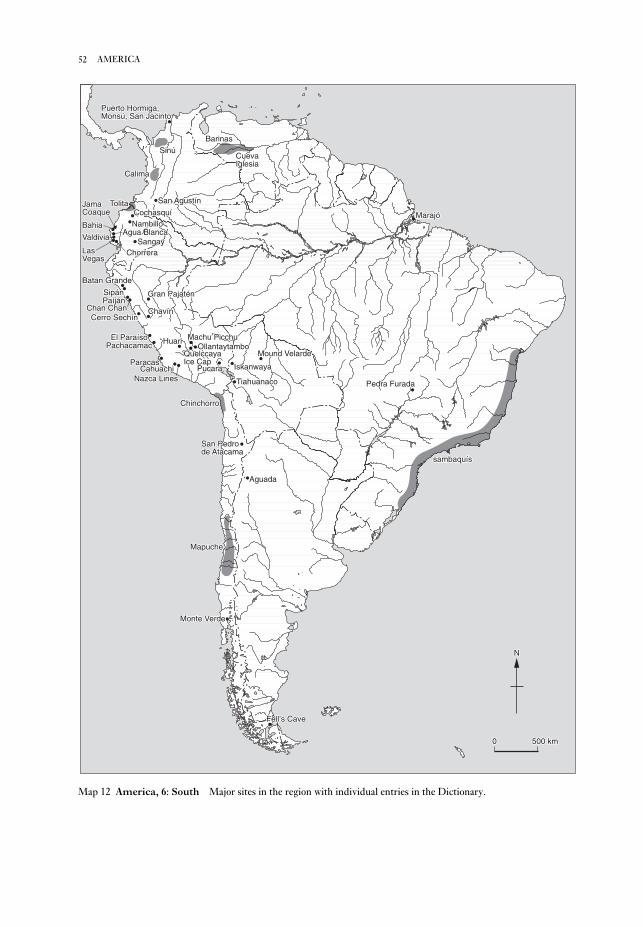
52 AMERICA
Batan GrandeBatan Grande
SipánSipánSipánPaíjánPaíján
ParacasParacas
Gran PajaténGran PajaténGran Pajatén
Cerro SechínCerro SechínCerro SechínChavínChavín
El ParaísoEl ParaísoEl ParaísoPachacamacPachacamac
Chan ChanChan Chan
CahuachiCahuachiNazca LinesNazca Lines
HuariHuari Machu PicchuMachu PicchuOllantaytamboOllantaytambo
QuelccayaQuelccayaIce CapIce Cap
PucaraPucara IskanwayaIskanwaya
ChinchorroChinchorro
Mound VelardeMound VelardeMound Velarde
San PedroSan Pedrode Atacamade Atacamade Atacama
AguadaAguada
MapucheMapuche
Monte VerdeMonte VerdeMonte Verde
Fell’s CaveFell’s Cave
Agua BlancaAgua BlancaBahiaBahia
JamaJamaCoaqueCoaque
ChorreraChorrera
CochasquíCochasquíCochasquíNambilloNambillo
LasLasVegasVegas
ValdiviaValdivia SangaySangay
TolitaTolita
CalimaCalima
San AgustínSan Agustín
SinúSinú
Puerto Hormiga,Puerto Hormiga,Monsú, San JacintoMonsú, San JacintoMonsú, San Jacinto
BarinasBarinas
CuevaCuevaIglesiaIglesia
MarajóMarajóMarajó
Pedra FuradaPedra Furada
sambaquíssambaquíssambaquís
NN
00 500 km500 km
TiahuanacoTiahuanaco
Batan Grande
SipánPaíján
Paracas
Gran Pajatén
Cerro SechínChavín
El ParaísoPachacamac
Chan Chan
CahuachiNazca Lines
Huari Machu PicchuOllantaytambo
QuelccayaIce Cap
Pucara Iskanwaya
Chinchorro
Mound Velarde
San Pedrode Atacama
Aguada
Mapuche
Monte Verde
Fell’s Cave
Agua BlancaBahia
JamaCoaque
Chorrera
CochasquíNambillo
LasVegas
Valdivia Sangay
Tolita
Calima
San Agustín
Sinú
Puerto Hormiga,Monsú, San Jacinto
Barinas
CuevaIglesia
Marajó
Pedra Furada
sambaquís
N
0 500 km
Tiahuanaco
Map 12 America, 6: South Major sites in the region with individual entries in the Dictionary.

logical investigation into the local community (e.g.
AGUA BLANCA).
A general vision of the prehistory of the continent
is possible, although there are major gaps in
knowledge, as well as considerable debates con-
cerning the meaning of the archaeological data.
Despite recurrent claims of very ancient sites in the
Americas (e.g. PEDRA FURADA), the best evidence
suggests an initial Paleoindian occupation of South
America no earlier than c.12,000 BC. The evidence
from the currently earliest known site, MONTE
VERDE, indicates that there must be earlier sites
north of Chile and, with the PAIJÀN sites (Peru), it
suggests that there was a mixed economy among
these earliest immigrants.
6.1. Prehistory. South American archaeology has not
been noted for innovation in the areas of method or
theory. Sadly, many projects are so underfunded
that a radiocarbon date is cause for rejoicing. In
terms of theory, diffusion (often intercontinental),
variations on themes of cultural ecology (such as
maritime theories of the development of complex
societies), or various evolutionary schemes have
been the commonest frameworks on which the
scanty data are displayed. In recent years the major
advances have been in building a more reliable, and
larger, data base, in ETHNOARCHAEOLOGY (such as
CUEVA IGLESIA and MAPUCHE), in EXPERIMENTAL
ARCHAEOLOGY (such as the study of INCA stone
masonry) and in projects which integrate archaeo-
53AMERICA
Inca
Sip
án
Vic
ús
Cer
roS
echí
nP
aijá
n
Cha
n C
han
Ear
lyS
icán
Mid
dle
Sic
ánLa
teS
icán
NorthCoast
Inca
Naz
ca c
ultu
re
Peru
Years
– 1600
– 1500
– 1400
– 1300
– 1200
– 1100
– 1000
– 900
– 800
– 700
– 600
– 500
– 400
– 300
– 200
– 100
– AD
– 100
– 200
– 300
– 400
– 500
– 600
– 700
– 800
– 900
– 1000
– 2000
– 3000
– 4000
– 5000
– 6000
– 7000
– 8000
BC
Bolivia
CentralCoast
Inca
El P
araí
so
Pac
haca
mac
orac
le o
nly
NorthernSierra
Inca
Cha
vín
de H
uánt
ar
Gra
n P
ajat
én
?
Sierra
Inca
Mol
lo a
ndIs
kanw
aya
Tiah
uana
coLow
erM
ound
Vel
arde
Upp
erM
ound
Vel
arde
?
LowlandsSouthernSierra
Hua
riP
ucar
aK
illke
Inca
SouthCoast
Par
acas
?
?
Table 3 America, 6: South Chart showing the approximate dates of the major sites and cultural traditions in Peru
and Bolivia.

life, the northern Andean cultures were extremely
late to develop state formations. What may be
chiefdoms appear in Ecuador with CHORRERA, and
long-distance trade procuring luxury goods for the
emerging elite is seen at Pirincay, on a major access
route to the Amazon. Later coastal Ecuadorian
cultures, especially BAHIA/JAMA COAQUE and La
Tolita, are more noteworthy for the quality of their
representational ceramics and the sophistication of
their metallurgy than for any complex political
developments. Virtually nothing is known of the
contemporary tropical lowland sites, such as
HUAPULA (previously known as Sangay) save that
they have impressive earthworks and were
involved in exchange with the highlands. In addi-
Hunting/foraging cultures continued in the
Southern Cone from the terminal Pleistocene until
the modern era at sites such as FELL’S CAVE. The
move towards an archaic/incipience agricultural
pattern began earliest in the equatorial regions; LAS
VEGAS (Ecuador) shows the utilization of the para-
mount cultigen of the Americas, Zea mays, as early
as 5500 BC. By 3000 BC, nearby VALDIVIA had
well-established agriculture and the same site
includes evidence that ceramics had entered the
Andean world (ceramics are earlier on the
Caribbean littoral at PUERTO HORMIGIA, MONSÚ
and SAN JACINTO, although in non-agricultural
contexts).
Precocious in terms of ceramics and sedentary
54 AMERICA
Ecuador
Years
– 1600
– 1500
– 1400
– 1300
– 1200
– 1100
– 1000
– 900
– 800
– 700
– 600
– 500
– 400
– 300
– 200
– 100
– AD
– 100
– 200
– 300
– 400
– 500
– 600
– 700
– 800
– 900
– 1000
– 2000
– 3000
– 4000
– 5000
– 6000
– 7000
– 8000
BC
Brazil and the Amazon drainage
Marajó
Mar
ajoa
ra p
hase
Man
guer
ias
phas
e
For
mig
a ph
ase
Aru
a
Ana
natu
ba p
hase
?
MinasGerais/Piaui
“Pla
nalto
trad
ition
”
Ped
ra F
urad
a
San
gay
(Hua
pula
trad
ition
)
AmazonNorthernSierra
Inca
Cho
chas
quí
Esmeraldas and Tumaco(“Tolita Cultures”)
Bal
sal/N
eret
e
Tiao
ne
Late
Ata
cam
esE
arly
Ata
cam
es
Mor
roIn
guap
i II
Ingu
api I
and
Tach
ina
Imbi
líC
héva
le
South/CentralCoast
Gua
ngal
a
Bah
ía a
nd J
ama
Coa
que
Man
teño
-Hua
ncav
ilca
Agu
a B
lanc
aLa
s V
egas
Cho
rrer
a
?
Val
divi
a
?
Coast
maj
or o
ccup
atio
nS
amba
quí t
radi
tion
?
?
Table 4 America, 6: South Chart showing the approximate dates of the major sites and cultural traditions in
Ecuador, Brazil and the Amazon.

ifying the landscape to support their numbers.
In the southern Andes, SAN PEDRO DE ATACAMA
formed an important element of northern procure-
ment systems because of its proximity to copper and
turquoise sources, and its grazing facilities for llama
caravans. The region supported sedentary villages
that produced fine ceramics and textiles, but were
receivers, not donors, in terms of religious practices
and the iconography associated with them. The
uniqueness of southern Andean cultures is ex-
emplified by CHINCHORRO, with its elaborate
techniques of artificial mummification. The
Chinchorro culture is found as far south as south-
ern Peru, but it seems to have had no impact on
Peruvian groups, which were already embarking on
tion, relatively small political units are found in
Colombia, where SAN AGUSTÍN exemplifies the
elaboration of mortuary rituals and shamanistic
practices in a setting of small, independent politi-
cal units. To the north, the Ilama and CALIMA
cultures show elaborate ceramics, metalworking,
and communal undertakings, such as drained field
systems, but without a centralized political power.
Immense raised field systems are found in the
SINÚ region of Colombia, in Barinas in western
Venezuela (where they are likewise attached to
populous, but quite small, ranked social groups)
and in the Llanos de Mojos of eastern Bolivia,
where the relatively early site of MOUND VELARDE
and related areas attest to dense populations mod-
55AMERICA
Venezuela
Years
– 1600
– 1500
– 1400
– 1300
– 1200
– 1100
– 1000
– 900
– 800
– 700
– 600
– 500
– 400
– 300
– 200
– 100
– AD
– 100
– 200
– 300
– 400
– 500
– 600
– 700
– 800
– 900
– 1000
– 2000
– 3000
– 4000
– 5000
– 6000
– 7000
– 8000
BC
Dab
ajur
o tr
aditi
on
Maracaibo-Coro
Chile
Inca
Agu
ada
Argentina
Valleserrana
Inca
Arica Coastand Pisagua
Chi
ncho
rro
?
?
Tierra delFuego
Fel
l’s C
ave
?
Araucania
potte
ryM
apuc
he
?
Colombia
Barinas
La B
etan
ia
drai
ned
field
s
Cue
va Ig
lesi
a
LowerOrinoco
Los
Bar
ranc
osB
arra
ncas
Son
soYo
toco
Ilam
a
Cauca CaribbeanCoast
Sin
úS
an J
acin
toP
uert
o H
orm
iga
Magdalena
San
Aug
ustín
Pha
ses
Som
brill
asH
urqu
eta
Prim
aver
aIs
nos
Table 5 America, 6: South Chart showing the approximate dates of the major sites and cultural traditions in
Argentina, Chile, Colombia and Venezuela.

doms, but no political unification is visible and cul-
tural unification is not outstanding.
In coastal Peru at this time a number of larger
states arose, notable among them the Sicán of
Lambayeque who were key players in the
SPONDYLUS SHELL trade with Ecuador and who
buried their elite at BATAN GRANDE. The slightly
later Chimu kingdom with its capital at the peculiar
city of CHAN CHAN, expanded over much of the
north coast until they too fell to the military expan-
sion of the Inca Empire under Topa Inca – the man
whose father Pachacuti had founded the empire and
built one of its best known sites, MACHU PICCHU.
The Inca expansion continued into Ecuador where
small highland chiefdoms such as Cochasquí fell
amidst considerable bloodshed. The Inca were
encircling the large Manteño kingdoms, such as that
at AGUA BLANCA, which controlled the lucrative
distribution of the Spondylus shell. The Spanish
invasions, heralded by an epidemic of smallpox or
measles which entered western South America via
the spanish colony at Buenos Aires, stopped the
Inca conquests and ultimately put an end to
the unique series of indigenous cultures of the
South American continent.G. Reichel-Dolmatoff: Goldwork and shamanism (Bogotá,
1988); R.L. Burger: Chavín and the origins of Andean civi-lization (New York and London, 1992); A.R. Gonzales:
2000 años de arte precolombino en la Argentina (Buenos
Aires, 1992); M.E. Moseley: The Incas and their ancestors:the archaeology of Peru (London and New York, 1992); A.
Prouse: Arqueologia Brasileria (Brasilia, 1992); W. Alva
and C.B. Donnan: Royal tombs of Sipán (Los Angeles,
1993); M. Malpass, ed.: The provincial Inca: archaeologi-cal and ethnohistorical assessment of the impact of the Incastate (Iowa, 1993); R.F. Townsend, ed.: The ancientAmericas: art from sacred landscapes (Chicago, 1993); K.O.
Bruhns: Ancient South America (Cambridge, 1994); T.D.
Dillehay, ed.: Tombs for the living: Andean mortuary prac-tices (Washington, D.C., 1995); T. Heyerdahl et al.: Thepyramids of Tucumé: the quest for Peru’s forgotten city (New
York, 1995); D. Levine, ed.: ‘Les derniers Incas: civil-
izations précolombiennes en Equateur’, DA 214 (1996); A.
Oyuela-Caycedo: ‘The study of collector variability in the
transition to sedentary society in northern Columbia’,
JWP 10 (1996), 49–92; H. Silverman: ‘The formative
period in the south coast of Peru: a critical review’, JWP10 (1996), 95–146.
KB
amino acid dating Scientific method used by
archaeologists to date such faunal remains as bones,
teeth and shells. Amino acids are the building blocks
of proteins; a particular amino acid can exist in more
than one form (L & D isomers) depending on the
three-dimensional arrangement of the molecules
about the central carbon atom. If, rather than one
the process of cultural intensification that led to
state formation in the 1st millennium BC. Argentina
was likewise culturally and politically peripheral:
the decorative arts are highly developed in AGUADA
and its ancestral cultures, but large urban centres,
ceremonial architecture and state organization were
unknown.
It was in the central Andean region of Peru and
highland Bolivia that complex societies, often urban
and often forming large territorial units, emerged.
Late preceramic sites such as EL PARAÍSO indicate
considerable population growth and, perhaps, some
central authority, while CERRO SECHÍN shows that
warfare was an early element in the formation of
political units. CHAVÍN, the characteristic religion,
art style and technologies of which spread widely
through the central Andes, was the first inter-
national culture of this region; its influence on
contemporary and future cultures was tremendous.
On the south coast, PARACAS utilized Chavín
images in ceramics (although not in the elaborate
embroidered textiles) and echoes of Chavín are seen
in the religious art of PUCARA, the first of the alti-plano states. The Early Intermediate Period Nazca
culture shows an early development of the Andean
pilgrimage tradition at the ceremonial centre of
CAHUACHI; the NAZCA LINES are concerned with
ceremonial processions and lineage rituals. On the
north coast the centralization of power and wealth
can be seen in the SIPÁN burials. This period ended
in considerable disruption and population move-
ment; the QUELCCAYA ICE CAP suggests that a
major drought was a causal factor in these political
realignments (since the annual ice layers – rather
like tree rings – indicate severe disruptions of
normal highland winter rains), although the grow-
ing power of the Middle Horizon HUARI state was
contributory.
Under the Huari, the oracle of PACHACAMAC
became powerful; it survived the empire’s collapse
to continue as an advisor to rulers under the Inca.
In the altiplano, TIAHUANACO succeeded Pucara as
the major political power, establishing a large state
whose urban capital was supported by large systems
of raised fields throughout the Titicaca Basin. The
religion of both Tiahuanaco and Huari show icono-
graphic evidence of a Chavín heritage. With the
slow collapse of Tiahuanaco, the political scene in
the altiplano changed to multiple small kingdoms,
such as Mollo, whose major site was the planned
town of Iskanwaya. By the 15th century tropical
forest sites such as Gran Pajatén were flourishing.
The tropical forest regions, whether western
Andean slope (NAMBILLO) or the Amazon proper
(MARAJÓ) may have developed fairly large chief-
56 AMERICA

and aminozones; given common thermal histories,
the D/L ratios are used to link strata or regions of
similar age. Teeth can also be used to determine age
at death; in certain circumstances racemization at
body temperature during the life-time of the indi-
vidual can be significant relative to that post mortem.
Amino acid ratios can also be used to determine
effective palaeotemperature if the age of the sample
is known.P.M. Masters: ‘Amino acid racemisation dating – a
review’, Dating and age determination of biological materials,ed. M.R. Zimmerman and J.L. Angel (London, 1986),
39–58; G. Sykes: ‘Amino acid dating’, Quaternary datingmethods – a user’s guide, ed. P.L. Smart and P.D. Frances
(Cambridge, 1991), 161–76.
SB
Amlash see MARLIK, TEPE
Amman Islamic-period site in the modern capi-
tal of Jordan. The citadel of Amman (Qalða) is the
only administrative building of the early Islamic
period to have been excavated extensively, apart
from the palaces at AL-KUFA and JERUSALEM (and
the latter has yet to be published). The Umayyad
structures were built within the walled Roman
citadel of the 2nd century AD, which had been
reused in the Byzantine period. In the Umayyad
period it became the administrative centre for al-
Urdunn (Jordan and northern Palestine). The
resulting Umayyad reconstruction of c.AD 735
included an axial street system leading to a formal
reception chamber, built in the SASANIAN manner
with four iwâns and stone carved decoration. The
excavations by Spanish and British teams conclu-
sively demonstrated that this structure was in fact
Umayyad and overturned earlier stylistic analysis
that had suggested that the four-iwân structure was
a product of the Sasanian occupation after the fall of
Jerusalem in 614. The citadel was destroyed by
earthquake in 747–8 but it continued to be used
during Abbasid and Fatimid times until the 11th
and 12th centuries. It was reoccupied in the
Ayyubid period but fell out of use in the 14th
century.A. Almagro: El palacio Omeya de Amman I: la arquitectura(Madrid, 1983); A. Northedge, ed.: Studies on Roman andIslamic ðAmmân I: history, site, architecture (Oxford, 1992).
GK
Amorites Ancient Near Eastern people first
attested in the mid-3rd millennium BC; they were
initially nomadic but eventually settled in large
numbers throughout Mesopotamia and the Levant
during the 2nd millennium BC. Their name comes
carbon atom (the chiral carbon), there are two at the
centre of the asymmetry then four forms can exist
(e.g. L-isoleucine D-isoleucine, L-alloisoleucine
and D-alloisoleucine). Living organisms produce
proteins containing only L-isomers. Racemization
is the conversion of the L-form of an amino acid to
a D-form. The reaction is reversible, leading ulti-
mately to an equilibrium between the proportions
of L- and D-forms. Strictly the term epimerization
is used when the conversion involves only one of the
possible chiral carbon atoms (e.g. L-isoleucine to
D-alloisoleucine), but racemization is often used to
describe all interconversions.
Racemization begins after death or, for example
in tooth enamel, once the protein is formed and is
no longer being renewed. If the rate constant of
the racemization is known, then measurement of the
D/L amino acid ratio will enable the time since
death to be calculated. The interconversions used in
dating are L to D aspartic acid and L-isoleucine
(L-Ile) to D-alloisoleucine (D-aIle). Techniques
such as high performance liquid chroma-
tography enable these D/L ratios to be
determined with reasonable precision. The so-
called racemization rate constant is in fact highly
temperature-dependent, increasing exponentially
with temperature, thus there is typically an increase
of two orders of magnitude in the rate for a temper-
ature increase from 0 to 25°C (it is also
species-dependent). In theory the rate constant can
be determined from experiments at elevated tem-
perature, but to convert a D/L ratio to a date also
requires an effective temperature over the period of
burial to be assumed: this affects the accuracy of the
technique i.e. whether the result is biased.
In the ‘calibrated’ method, the rate constant is
found using a sample the age of which is known by
other means and the temperature history of which
parallels that of the samples to be dated. However,
the accuracy of this method depends on the specific
circumstances and, particularly, on how accurately
the calibration sample is dated and reflects the
thermal history of the unknowns.
The equilibrium ratio and the racemization rate
(and hence temperature) determine the upper age
limit; for aspartic acid this is of the order of 100,000
years and for L-Ile to D-aIle is several million years.
The materials most often dated are teeth and
mollusc shell. Amino acid dates on bone tend to be
unreliable; because of its more open structure, there
is the risk of contamination by amino acids from
ground water, and there is evidence to suggest that
the kinetics of the racemization process are not
straightforward. Much work has been done on
mollusc shells in determining aminostratigraphy
57AMORITES

Orientalia Lovaniensia Periodica 16 (1985), 49–57; J.N.
Postgate: Early Mesopotamia: society and economy at thedawn of history (London, 1992), 82–7.
IS
el-Amra Egyptian predynastic site, 60 km south
of modern Sohag, which is the type-site for the
‘Amratian’ cultural phase or NAQADA I period
(4000–3500 BC; see EGYPT 1). Amratian cemeteries
have been excavated at several sites in the Nile
Valley, stretching from Khor Bahan in Lower
Nubia up to Matmar in Middle Egypt.D. Randall MacIver and A.C. Mace: El Amrah and Abydos,1899–1901 (London, 1902).
IS
Amratian period see EGYPT 1
Amri Settlement site of the INDUS CIVILIZA-
TION, consisting of two mounds near the edge of the
alluvial plain of the Lower Indus valley, Pakistan.
The excavations of Nani Gopal Majumdar in 1929
first revealed that the valley was occupied during
the Early Indus period. The excavations of Jean-
Marie Casal in 1959–62 enabled the occupation to
be divided into two main periods, Ia–d
(c.3700–3000 BC) and II (not yet accurately dated),
followed by a phase of decline (period III).
Period Ic, the best documented Early Indus level
at Amri, is characterized by distinctive cellular
structures built of stone and mud brick, that appear
to have been used for grain storage, as well as chert
blades, bone tools and wheel-made ceramics decor-
ated with painted motifs. Period-II Amrian sherds
were mixed with HARAPPAN ceramics, but by
period III the local forms had disappeared and the
site had begun to diminish in size, with a Mature
Indus ceramic style dominating. Several other sites
with local Amrian ceramics have been identified in
the Lower Indus region, including Gazi Shah and
the fortified sites of Tharro and Kohtras Buti.
Amri’s long chronological sequence provides evi-
dence for local pre-Indus developments, with
affinities to KOT DIJI and Kili Ghul Muhammad (seeQUETTA), with a gradual introduction of mature
Indus material culture, and eventual replacement of
local material forms by characteristic Indus goods.
The recognition of the interaction of local and
regional processes highlights the complex historical
processes of the 4th–3rd millennia BC in Pakistan,
as local traditions are incorporated into the pan-
regional traditions of the Indus Civilization.N.G. Majumdar: Explorations in Sind (Delhi, 1934); J.-M.
Casal: Fouilles d’Amri, 2 vols (Paris, 1964); ––––: ‘Amri:
An introduction to the history of the Indus civilization’,
from the Akkadian word Amurrum which in turn
derives from the Sumerian term Martu (‘west’),
used to describe both the western desert and the
tribes who emanated from that area. The Amorites
first appear in texts of the Early Dynastic III
period (c.2600–2350 BC) either as the despised
Bedouin in the desert to the west of the Euphrates
or as foreign labourers or mercenaries living in
the Sumerian city-states of Mesopotamia. The
Amorite language (a west Semitic dialect) has sur-
vived only in the form of personal names, since
the Amorites themselves wrote in AKKADIAN, the
language of the first Semitic-speaking empire in
Mesopotamia.
After the fall of the Ur III dynasty (c.2150–2000
BC), the Amorites not only seized power in most of
the existing cities of Sumer and Akkad but also
established powerful new settlements. At the same
time they spread into the Levant, where they
dominated most of the Middle Bronze Age Syro-
Palestinian polities, e.g. Yamhad (see ATCHANA,
TELL), until the arrival of another nomadic West
Semitic group, the ARAMAEANS, in the late 2nd
millennium BC.
The widespread establishment of Amorite and
Elamite kingdoms, replacing the earlier city-states,
appears to have had a lasting (and revitalizing) effect
on the socio-economic development of Meso-
potamia and the Levant, significantly reducing the
power of the temples and gradually transferring the
ownership of the land into the hands of individuals.
The integration of nomadic tribes into sedentary
life is clearly a complex process (see Postgate 1992;
Kamp and Yoffee 1980; see also NOMADS), and the
history of the Amorites is more easily discernible in
the textual evidence than in surviving archaeologi-
cal traces of their material culture. As with the later
influx of Aramaeans into Mesopotamia, the more
settled Amorites of the 2nd millennium BC appear
to have adopted most of the cultural attributes of the
peoples whom they supplanted, thus reducing their
own impact on the archaeological record. Postgate
(1992: 86) points out that ‘in Mesopotamia the
Amorites are integrated so completely into society
that no trace of them survives the fall of the 1st
Dynasty of Babylon’.J.R. Kupper: Les nomades en Mésopotamie au temps des roisde Mari (Paris, 1957); G. Buccellati: The Amorites of the UrIII period (Naples, 1963); A. Haldar: Who were theAmorites? (Leiden, 1971); K.A. Kamp and N. Yoffee:
‘Ethnicity in ancient Western Asia during the early second
millennium BC: archaeological assessments and ethno-
archaeological perspectives’, Bulletin of the AmericanSchools of Oriental Research 237 (1980), 85–104; N. Weeks:
‘The Old Babylonian Amorites: nomads or mercenaries?’,
58 AMORITES
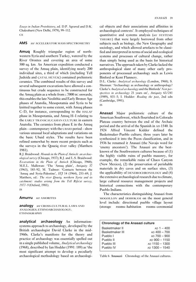
cal objects and their associations and affinities in
archaeological contexts’. It employed techniques of
quantitative and systems analysis (see SYSTEMS
THEORY) that were largely borrowed from other
subjects such as biology, the New Geography and
sociology, and which allowed artefacts to be classi-
fied and interpreted in terms of social and ecological
systems and processes of cultural change, rather
than simply being used as the basis for historical
narratives. The approach taken by Clarke lacked the
anthropological slant of many other early pro-
ponents of processual archaeology such as Lewis
Binford or Kent Flannery.D.L. Clarke: Analytical archaeology (London, 1968); S.
Shennan: ‘Archaeology as archaeology or anthropology?
Clarke’s Analytical archaeology and the Binfords’ New per-spectives in archaeology 21 years on’, Antiquity 63/241
(1989), 831–5; I. Hodder: Reading the past, 2nd edn
(Cambridge, 1991).
IS
Anasazi Major prehistoric culture of the
American Southwest, which flourished in Colorado
Plateau country between the end of the Archaic
period and the arrival of the Spanish in AD 1540. In
1924 Alfred Vincent Kidder defined the
Basketmaker-Pueblo culture; three years later he
synthesized it into the Pecos classification, and in
1936 he renamed it Anasazi (the Navajo word for
‘enemy ancestors’). The Anasazi are the best-
known of the Southwestern cultures because of (1)
the highly visible ruins of pueblo masonry, for
example, the remarkable ruins of Chaco Canyon
(New Mexico), (2) the preservation of perishable
materials in dry caves and on surface sites, (3)
the applicability of DENDROCHRONOLOGY and (4)
the extensive archaeological research due to climate,
large cultural resource management projects and
historical connections with the contemporary
Pueblo Indians.
The characteristics distinguishing Anasazi from
MOGOLLON and HOHOKAM on the most general
level include: directional pueblo village layout
(storage rooms–habitation rooms–ceremonial
Essays in Indian Protohistory, ed. D.P. Agrawal and D.K.
Chakrabarti (New Delhi, 1979), 99–112.
CS
AMS see ACCELERATOR MASS SPECTROMETRY
Amuq Roughly triangular region of north-
western Syria and southern Turkey, watered by the
River Orontes and covering an area of some
500 sq. km. An American expedition conducted a
survey of the Amuq plain, identifying nearly 200
individual sites, a third of which (including Tell
Judeida and ÇATAL HÜYÜK) contained prehistoric
ceramics. The combined results of this survey and
several subsequent excavations have allowed a con-
tinuous but crude sequence to be constructed for
the Amuq plain as a whole from c.7000 BC onwards;
this enables the late Neolithic and Early Bronze Age
phases of Anatolia, Mesopotamia and Syria to be
knitted together to some extent, with Amuq phases
C–D, for instance, corresponding to the HALAF
phase in Mesopotamia, and Amuq H–I relating to
the EARLY TRANSCAUCASIAN CULTURE in eastern
Anatolia. The ceramics from phase E in the Amuq
plain – contemporary with the UBAID period – show
various unusual local adaptations and variations on
the basic Ubaid styles. The results have been
refined somewhat by more recent projects such as
the surveys in the Qoueiq river valley (Matthers
1981).R.J. Braidwood: Mounds in the Plain of Antioch: an archae-ological survey (Chicago, 1937); R.J. and L.S. Braidwood:
Excavations in the Plain of Antioch (Chicago, 1960);
M.E.L. Mallowan: ‘The ðAmuq plain’, Antiquity 37
(1963), 185–92; M. Tadmor: ‘Contacts between the
ðAmuq and Syria-Palestine’, IEJ 14 (1964), 253–69; J.
Matthers, ed.: The river Qoueiq, northern Syria and itscatchment: studies arising from the Tell Rifaðat survey,1977–9 (Oxford, 1981).
IS
Amurru see AMORITES
analogy see CROSS-CULTURAL LAWS AND
ANALOGIES; ETHNOARCHAEOLOGY;
ETHNOGRAPHY
analytical archaeology An information-
systems approach to archaeology, developed by the
British archaeologist David Clarke in the mid-
1960s. Clarke’s manifesto for the theory and
practice of archaeology was essentially spelled out
in a single published volume, Analytical archaeology(1968), described by Ian Hodder (1991: 189) as ‘the
most significant attempt to develop a peculiarly
archaeological methodology based on archaeologi-
59ANASAZI
Chronology of the Anasazi culture
Basketmaker II AD 1 – 400Basketmaker III AD 400 – 700Pueblo I AD 700 – 900Pueblo II AD 900 – 1150Pueblo III AD 1150 – 1300Pueblo IV AD 1300 – 1540
Table 6 Anasazi Chronology of the Anasazi cultures.

Tsegi phase (AD 1250–1400) and consists of 154
rooms. The analysis of the site (Dean 1969), in-
cluding comparison with the nearby Betatakin cliff
dwelling, is one of the most influential studies in
Southwestern American archaeology.
Anasazi sites in New Mexico include Arroyo
Hondo, Aztec, Chetro Ketl, Grab Quivira,
Hawikuh, Pecos, PUEBLO BONITO, Salmon and
Shabik’eshchee, and those in Colorado include
CLIFF PALACE, Sand Canyon and Yellow Jacket.
Arroyo Hondo, a 1100-room site located in the
northern Rio Grande region, is one of the largest of
the Anasazi pueblos; it was excavated in 1971–4 (see
Schwarz 1979–93).R.G. Montgomery et al.: Franciscan Awatovi (Harvard,
1939); A.V. Kidder: An introduction to the study ofSouthwestern Archaeology (New Haven, 1962); J.S. Dean:
Chronological analysis of Tsegi phase sites in northeasternArizona (Tucson, 1969); W. Smith: Painted ceramics of thewestern mound at Awatovi (Harvard, 1971); D.W.
Schwartz, ed.: Arroyo Hondo archaeological series, 8 vols
(Santa Fe, 1979–93); G.J. Gumerman and J.S. Dean:
‘Prehistoric cooperation and competition in the western
Anasazi area’, Dynamics of Southwestern prehistory, ed.
L.S. Cordell and G.J. Gumerman (Washington, D.C.,
1989), 99–148; R.G. Vivian: The Chacoan prehistory of theSan Juan Basin (New York, 1990); E.C. Adams and K.A.
Hays: Homol’ovi II: archaeology of an ancestral Hopivillage, Arizona (Tucson, 1991).
JJR
Anatolia The modern region of Anatolia in
Turkey corresponds to the area described by
Classical writers as Asia Minor, but in pre-Classical
times it was by no means a discrete political
unit, and parts of it were dominated at different
times by several different civilizations, from the
HITTITES and CIMMERIANS to the kingdoms of
URARTU and PHRYGIA (table 7). In purely geo-
graphical terms, Anatolia is sometimes defined as a
wide ‘land-bridge’ between Europe and Asia, effec-
tively linking together the northern and southern
coasts of the Mediterranean. See map, opposite, for
principal sites.J. Mellaart: The archaeology of ancient Turkey (Oxford,
1978); O.R. Gurney: The Hittites, 2nd edn
(Harmondsworth, 1981); S. Lloyd: Ancient Turkey: atraveller’s history of Anatolia (London, 1989); M. Roaf:
Cultural atlas of Mesopotamia and the Ancient Near East(New York and Oxford, 1990).
‘anatomically modern’ humans (AMH)Term used to describe the first hominids in the line
of HUMAN EVOLUTION that, in anatomical terms,
resemble modern humans and belong to the sub-
species Homo sapiens sapiens. It is a somewhat
confusing term since, like other hominid species,
rooms–burial and trash areas); curvilinear kivas
(circular, D-shaped and keyhole-shaped ceremonial
chambers); primary flexed inhumation of the
deceased; lamboidal head deformation; use of full-
grooved axes; and black-on-grey utility pottery
thinned by coil-and-scrape and fired in a non-
oxidizing atmosphere.
There are also regional variants, or ‘branches’, of
the Anasazi, which are distinguished by ceramic
and architectural differences. The western Anasazi
branches (Kayenta, Virgin, Fremont and Winslow)
are often grouped together under the term Kayenta
branch, while the eastern Anasazi branches (Chaco,
Mesa Verde and Rio Grande) are more distinct both
in space and time. Finer subdivisions of the
Anasazi, known as ‘provinces’ are also recognized.
The Anasazi sequence from Basketmaker to
Pueblo (see Table 6), which is framed in the Pecos
classification, is used to label overall phases and
periods, but these are not coincident throughout the
various branches of the culture. The span of about
200 years for each period, which was even more pro-
nounced in the original 1927 formulation,
influenced the perception of gradual cultural
change throughout the Southwest.
The Anasazi were dependent on maize culti-
vation from the earliest period (Basketmaker II)
onwards; they developed dry- and runoff-farming
techniques to permit the expansion of farmsteads
throughout much of the Colorado Plateau, while
more complicated water-control systems supported
the large populations and rituals of the Pueblo II
period Chaco expansion. The abandonment of the
upper San Juan River drainage by AD 1300 is
attributed to agricultural problems caused by the
effects of drought, erosion and lowered water tables.
The expansion of Numic speakers into the region
may also have contributed to its desertion. This
contraction of Anasazi territory led ultimately to the
historic settlement pattern of the Pueblos – Hopi,
Zuni, Acoma and Rio Grande villages – which were
encountered by Vasquez de Coronado’s expedition
in 1540.
The major Anasazi sites in the state of Arizona
are Allentown, Antelope House, Awat’ovi,
Betatakin, Homol’ovi, Kiatuthlanna, Kiet Siel.
Awat’ovi (a Hopi pueblo on the southern edge of
Antelope Meas, Hopi Reservation) consists of about
1300 ground-floor rooms and about 25 rectangular
kivas. Homol’ovi comprises six sites (Homol’ovi
I–IV, Chevelon and Cottonwood Creek ruins),
dated between AD 1250 and 1400, and the region as
a whole figures prominently in the migration
legends of the Hopi. Kiet Siel is a cliff dwelling in
Tsegi Canyon, which was occupied during the
60 ANASAZI
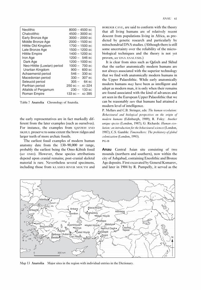
BORDER CAVE, are said to conform with the theory
that all living humans are of relatively recent
descent from populations living in Africa, as pre-
dicted by genetic research and particularly by
mitochondrial DNA studies. (Although there is still
some uncertainty over the reliability of the micro-
biological techniques and the theory is not yet
proven, see DNA ANALYSIS.)
It is clear from sites such as Qafzeh and Skhul
that the earlier anatomically modern humans are
not always associated with the superior technology
that we find with anatomically modern humans in
the Upper Palaeolithic. While early anatomically
modern humans may have been as intelligent and
adept as modern man, it is only when their remains
are found associated with the kind of advances and
art seen in the European Upper Palaeolithic that we
can be reasonably sure that humans had attained a
modern level of intelligence.
P. Mellars and C.B. Stringer, eds: The human revolution:Behavioural and biological perspectives on the origin ofmodern humans (Edinburgh, 1989); R. Foley: Anotherunique species (London, 1987); G. Richards: Human evo-lution: an introduction for the behavioural sciences (London,
1987); C.S. Gamble: Timewalkers: The prehistory of globalcolonization (London, 1993).
PG-B
Anau Central Asian site consisting of two
mounds (northern and southern), now within the
city of Ashgabad, containing Eneolithic and Bronze
Age deposits. First excavated by General Komarov,
and later in 1904 by R. Pumpelly, it served as the
the early representatives are in fact markedly dif-
ferent from the later examples (such as ourselves).
For instance, the examples from QAFZEH AND
SKHUL preserve to some extent the brow ridges and
larger teeth of more archaic fossils.
The earliest fossil examples of modern human
anatomy date from the 130–90,000 BP range,
probably the earliest being the Omo-Kibish fossil
(see OMO). However, these species attributions
depend upon cranial remains; post-cranial skeletal
material is rare. Nevertheless several specimens,
including those from KLASIES RIVER MOUTH and
61ANAU
BelbaseBelbaseBeldibiBeldibi
HaçilarHaçilarHaçilarKonyaKonya
Çatal HüyükÇatal HüyükSuberdeSuberde
Can HasanCan HasanMersinMersin
KaratepeKaratepeZinjirliZinjirli
MalatyaMalatyaCayönüCayönüCayönüTepesiTepesi
AltintepeAltintepe
KültepeKültepe
Alisar HüyükAlisar HüyükBoghazköyBoghazköyBoghazköy
Alaca HüyükAlaca HüyükAlaca HüyükAnkaraAnkara
Asikli HüyükAsikli HüyükAsikli Hüyük
GordionGordion
IstanbulIstanbul
HisarlikHisarlik
IzmirIzmirBeyçesultanBeyçesultanBeyçesultan
00 300 km300 km
AçemhöyükAçemhöyükNemrut DaghNemrut Dagh
Beldibi
HaçilarKonya
Çatal HüyükSuberde
Can HasanMersin
KaratepeZinjirli
Nemrut Dagh
MalatyaCayönüTepesi
Altintepe
Kültepe
Alisar Hüyük
Açemhöyük
Boghazköy
Alaca HüyükAnkara
Asikli Hüyük
Gordion
Istanbul
Hisarlik
IzmirBeyçesultan
0 300 km
BelbaseN
Map 13 Anatolia Major sites in the region with individual entries in the Dictionary.
Neolithic 8000 – 4500 BC
Chalcolithic 4500 – 3000 BC
Early Bronze Age 3000 – 2000 BC
Middle Bronze Age 2000 – 1500 BC
Hittite Old Kingdom 1700 – 1500 BC
Late Bronze Age 1500 – 1200 BC
Hittite Empire 1400 – 1200 BC
Iron Age 1200 – 546 BC
Dark Age 1200 – 1000 BC
Neo-Hittite (Luwian) period 1000 – 700 BC
Urartian Kingdom 900 – 600 BC
Achaemenid period 546 – 330 BC
Macedonian period 330 – 307 BC
Seleucid period 305 – 64 BC
Parthian period 250 BC – AD 224Attalids of Pergamum 230 – 133 BC
Roman Empire 133 BC – AD 395
Table 7 Anatolia Chronology of Anatolia.

centres vying for supremacy. This centralization
focused on the person of the overlord, manifested in
the royal cult of the ‘God who is king’. Angkor grew
as successive rulers instituted extensive building
programmes. These included palaces, reservoirs for
water storage and reticulation, and temple mausolea
(such as the Bayon mausoleum at Angkor Thom).
The last served as burial places for rulers and their
close kin, and as temples for worshipping the dead
ruler. The Khmer overlords embraced Hinduism
and, less often, Buddhism. A network of roads
radiated from Angkor, and surplus produce from
the provinces was assigned to the maintenance of
the numerous temples and their functionaries. With
time, a complex hierarchy of offices developed, and,
from 1181 onwards, under Jayavarman VII, build-
ing programmes reached such a scale that the
sustaining area became exhausted. Angkor began as
a ceremonial centre, but in later stages must have
incorporated a large secular population. There
followed a decline in central power and ultimately
Angkor fell to a Thai invasion.
1. Angkor Thom. At the heart of the city was a
massive square-walled precinct known as Angkor
Thom. It consisted of an area of 9 sq. km
surrounded by 8-metre high walls and a 100 m
wide moat. The walls and moat represent the
mountain range and ocean which bounds the cos-
mos. Outside each main gate there is a stone
representation of a battle between the heavenly and
underworld gods over a serpent; these depict gods
and demons churning the ocean to extract the
liquor of immortality. The enclosed area, which
was more a sacred precinct than a residential area,
contains the Phimeanakas or royal palace, while the
centre is dominated by the Bayon, Jayavarman’s
temple mausoleum. Jayavarman considered him-
self the apotheosis of the Buddha, therefore the
mausoleum includes 50 towers, each decorated
with a huge image of the Buddha. Wheatley (1983)
contends that these represent the Buddha multi-
plying himself to confuse his enemies. Fish carved
on the exterior walls indicate the netherworld
below the oceans, portraying the Bayon itself as the
home of the gods. The building was erected with-
out the care of the nearby Angkor Wat, during the
building frenzy which characterized Jayavarman’s
reign.
2. Angkor Wat. Built as the temple mausoleum of
Suryavarman II (AD 1113–50), Angkor Wat is the
most famous of the many structures at Angkor. It
was conceived on a giant scale, the outer moat
enclosing an area of 195 ha. The enclosure incor-
porates a series of square walled precincts which
culminate with five central sandstone towers in the
basis for the initial stratigraphic division of Eneo-
lithic to Bronze Age assemblages in the region
(Anau I–IV). The lower stratigraphic unit (Anau I)
first identified at the northern mound was later sub-
divided into two sub-units (A and B). The pottery
of this stage quite distinct from that of the other
early type site in the region, JEITUN, and consists of
thin-walled drinking vessels, often with concave
bases, with painted geometric decorations. Later
this pottery was identified at a number of sites in
southern Turkmenistan (Koushut, Mondjukly and
Chakmali), and also in Iranian Khorassan, in the
upper Atrek valley. The age of Anau IA is estimated
by Kohl (1984) as 5200–4800 BC.P.L. Kohl: Central Asia: Palaeolithic beginnings to the IronAge (Paris, 1984); V.M. Masson: Pervye civilizacii(Leningrad, 1989).
PD
Ancient Near East see ANATOLIA;
MESOPOTAMIA; SYRIA-PALESTINE
Anghelu Ruju Largest rock-cut cemetery of the
Sardinian Copper Age. The tombs, entered via a
shaft or along a ramp, consist of a main oval or
rectangular chamber with smaller secondary and
sometimes tertiary chambers. Some of the main
chambers are decorated with relief carving, for
example framing the doorways or depicting horned
bulls’ heads. Tombs in other related cemeteries are
also provided with striking architectural details: at
Sant’ Andrea Priu-Bonorva carving imitates
raftered roofs, while at Mandra Antine-Thiesi a
roof is painted with a red rafter pattern and with
a decoration of white spirals on black. Bell-beakers
and material of the Ozieri culture – including some
schematic female figurines – recovered from the
tombs of Anghelu Ruju suggest a date at the end of
the 3rd millennium BC.A. Taramelli: Alghero: nuovo scavi nella necropole pre-istorica, Anghelu Ruju, Monumenta Antichi 19 (1908), col.
397; M. Guido: Sardinia (London, 1963), 49–51.
RJA
Angkor Complex of over 250 stone monuments
in northwest Cambodia, which formed the centre of
the Khmer state from the late 9th century AD until
its destruction in 1431. The site’s name derives
from the Sanskrit term nagara, or holy city, but it
was originally known as Yasodharapura after its
founder, Yasovarman I. Established by the ruling
dynasty of Jayavarman II in AD 802, the Khmer
state was based on a major change in political organ-
ization in which central authority over provinces
replaced the previous system of numerous court
62 ANAU

III deposit containing picks, pigment, ochre and
spatulas, and may date to c.13,000–14,000 BC.S. de Saint-Mathurin and D. Garrod: ‘La frise sculptée
du Roc-aux-sorciers à Angles-sur-l’Anglin (Vienne)’,
L’Anthropologie 55 (1951), 413–23; S. de Saint-Mathurin:
‘Les sculptures rupestres du Roc-aux-Sorciers’, Dossiersd’Histoire et Archéologie 131 (1988), 42–9.
RJA
Annales Influential French school of historians
(linked to the journal Annales: économies, sociétés,civilizations, published from 1929) which gained
currency among Anglophone historians and
geographers in the 1970s. The first important
example of the Annaliste approach in history (also
known as ‘structural history’ or ‘total history’) was
Ferdinand Braudel’s study of the Mediterranean
region in the 16th century AD, published in 1949,
which was divided into three sections, each
corresponding to a kind of temporal ‘wave-length’:
(1) analysis of the interaction between physical
geography and cultural change during what he
described as the longue durée (the ‘long term’, i.e.
very long periods of time such as centuries and
perhaps even millennia); (2) the study of the forces
(or conjonctures) which affect culture and society in
the moyenne durée (medium term, i.e. decades or
generations); (3) the study of the world of the éven-ements (events) or incidents within the lifetimes of
individuals, i.e. traditional narrative-style political
history.
Within the medium- and long-term frames,
Braudel sought to understand the mentalités (world-
views or ideologies) that characterized different
social, geographical or ethnic groupings over very
long periods of time. He was then able to study the
more ephemeral évenements within the explanatory
context of the long-term mentalités. John Bintliff
(1991:8) argues that ‘as a theory of how the world
works, and how we can reconcile in a single method-
ology the general and the particular, the event and
the general trend, the individual and the commu-
nity or society, Braudel’s Structural History is a
landmark with inexhaustible potential’, although he
notes that Braudel ultimately fails to solve the
problem of properly linking long-term change with
rapid short-term events. Emmanuel Le Roy
Ladurie’s description of medieval life in the 14th-
century village of Montaillou (Ladurie 1975) is
somewhat more successful in terms of linking
events with long-term cycles in such areas as
economics and demography.
The original Annales approach is defined by
Stoianovitch (1976: 19) as ‘the attempt by French
scholars to adapt economic, linguistic, sociological,
form of lotus buds – the tallest such ‘TEMPLE
MOUNTAIN’, rising to a height of 65 m. The walls
were decorated with bas reliefs, the longest ever
recorded. Thus, the outer terrace incorporates over
800 m of reliefs to a height of 2 m. These portray
scenes from Indian epics and the life of the king
himself, whose posthumous name, Parama-
visnuloka, means ‘one who has gone to the supreme
world of Visnu’.
Cosmic imagery permeates the structure of
Angkor Wat. The length of the central raised
precinct measures 365.37 hat (the Khmer unit
of measurement), thus symbolizing the number of
days in the year. The four major axial distances
of the great causeway correspond to the four eras in
the Hindu conception of time. The layout of the
temple mountain permitted the prediction of
eclipses and as the sun progresses on its annual
round so, in the earlier part of the year, it illumi-
nates the bas reliefs of the creation, while during
the autumn equinox it highlights scenes from the
Battle of Kurukshetra. This link with the sun is
reflected also in the King’s name, for Surya-
varman, a Sanskrit name, means ‘protegé of the
sun’.L.P. Briggs: ‘The ancient Khmer empire’, TAPS 4/1
(1951); B.P. Groslier: Angkor: art and civilization(London, 1966); P. Wheatley: The pivot of the four quarters(Chicago, 1971), 437–8; R. Stencel et al.: ‘Astronomy and
cosmology at Angkor Wat’ Science 193 (1976), 281–7; P.
Wheatley: Nagara and commandery (Chicago, 1983);
C.F.W. Highman: The archaeology of mainland SoutheastAsia (Cambridge, 1989).
CH
Angkor Borei see FUNAN
Angkor Thom see ANGKOR
Angkor Wat see ANGKOR
Angles-sur-l’Anglin (Le Roc-aux-sorciers)Two cave-shelter sites exhibiting Upper Palaeo-
lithic art, situated in Vienne, France. Part of the
very fine low-relief (and originally painted) friezes
which decorated the walls and ceiling remain in situ,
while fallen fragments are stored in the Musée des
Antiquités Nationales, St Germain-en-Laye. The
friezes depict bison, horses (including remarkable
horse heads), ibex and other animals; there is also a
famous deep engraving of three ‘Venuses’ – in fact,
female thighs and pubic triangles in half-profile,
quarter profile and full view – and an engraved and
painted male head. The sculptures were sealed in a
‘Final Magdelanian’ layer just above a Magdalenian
63ANNALES

between the centripetality of the Mediterranean
region in the Neolithic period and its centrifugality
in the Bronze Age and later.
In one of the most impressive applications of the
approach, John Bintliff (1991: 19–26) combines (1)
anecdotal evidence of incidents (évenements) of
famine and debt in the Boeotian region of central
Greece in the late 3rd and early 2nd century BC,
with (2) the 2nd-century Greek historian Polybius’
accounts of trends of economic decline in Boeotia in
the moyenne durée, and (3) archaeological evidence
indicating the gradual depopulation of the land-
scape and reduction in the size of settlements, as a
result of a long-term agricultural cycle that appears
to be operating in successive phases of four or five
centuries.
The early Annales school set out by Braudel
complements the PROCESSUAL ARCHAEOLOGY
later championed by Lewis Binford and Colin
Renfrew, in that both are concerned with POSI-
TIVIST analysis of long-term, anonymous processes
of change (and Braudel’s mentalités are in some
respects similar to Binford’s ‘laws’ of cultural
dynamics), as opposed to the more particularist
aspects of traditional political history. Ironically,
the more recent exponents of the Annales approach
(e.g. Ladurie) have moved away from positivism
and environmental determinism towards a concern
with symbols, individuals and évenements that
aligns them more closely with the POST-PROCES-
SUAL archaeologists. However, Bintliff (1991: 1–6)
suggests that the Annales style of archaeological
analysis and interpretation can be very effective
precisely because it combines complementary
aspects of both processual and post-processual
approaches.F. Braudel: La Méditerranée et le monde méditerranéen àl’époque de Philippe II (Paris, 1949) [trans. S. Reynolds,
London, 1972]; E.L. Ladurie: Montaillou (Paris, 1975); T.
Stoianovitch: French historical method: the Annales para-digm (Ithaca, 1976); C.C. Lamberg-Karlovsky: ‘The
longue durée of the Ancient Near East’, De l’Indus auxBalkans, receuil Jean Deshayes, ed. J.-L. Huot, M. Yon and
Y. Calvet (Paris, 1985), 55–72; I. Hodder: Archaeology ofthe long term (Cambridge, 1987); J. Lewthwaite: ‘The
Braudelian beaker: a Chalcolithic conjuncture in western
Mediterranean prehistory’, Bell beakers of the westernMediterranean, ed. W.H. Waldren and R.C. Kennard
(Oxford, 1987), 31–60; J. Bintliff, ed.: The Annales schooland archaeology (Leicester and London, 1991); A.B.
Knapp, ed.: Archaeology, Annales and ethnohistory(Cambridge, 1992) [reviewed by G.L. Barnes, JESHO37/4 (1994), 328–31].
IS
Anshan see PERSIA; and TAL-I MALYAN
geographic, anthropological, psychological, and
natural-science notions to the study of history
and to infuse an historical orientation into the
social and human sciences’. In practice, this meant
that Annales school historians turned away from
treating history as a chronology of political events,
and instead used a much wider, multidisciplinary
approach to explain social change over extended
periods of time.
The Annales school was applied to archaeologi-
cal data from the 1980s onwards, partly as a means
of encouraging a more multidisciplinary approach
to archaeological data, but partly also as a means of
dealing with an archaeological dilemma: how to
harmonize the analysis of the archaeological
remains of the activities of individuals with the
study of long-term trends of social, cultural and
economic change. The Annales school also offers
some possible solutions to the difficulty of recon-
ciling textual and archaeological sources employed
by protohistoric and historical archaeologists. In
comparing Annaliste historians with Annaliste
archaeologists, the American prehistorian Patricia
Galloway notes that both tend to be concerned
primarily with a similar form of data, whether
‘censuses, ledgers, baptismal records, and customs
declarations’ or ‘potsherd counts, records of burial
layouts, and distribution of sites over a landscape’
(quoted in Bintliff 1991: 115). Archaeologists, how-
ever, have encountered some difficulties in agreeing
on the lengths of time to which Braudel’s three
temporalities correspond, e.g. is the longue durée a
period of centuries or millennia, and is something
like the Neolithic Revolution an évenement?James Lewthwaite (1987: 31) has taken a
Braudelian stance on the BEAKER PHENOMENON of
the European Chalcolithic period (c.2500–1800 BC),
arguing that ‘it is possible to recognise the Beaker
conjoncture proper (the introduction of west-central
European cultural traits into the western Medit-
erranean) as immediately consequent upon a
previous conjoncture of intensified interaction
throughout the Mediterranean’. He envisages the
Beaker phenomenon as a conjoncture taking place
amid various long-term processes of the Neolithic–
Bronze Age longue durée, such as ‘high pressure,
pan-Mediterranean innovation and interaction’
(e.g. the commercial and colonial achievements of
the Phoenicians, Greeks and Carthaginians), ‘low
pressure situations of continental impingement on
the Mediterranean’ (e.g. the erruptions of the Celts
and Galatians and, in later times, the Crusades).
The Beaker phenomenon would thus arguably be
(1) a conjoncture within the process of ‘continental
impingement’, and (2) an ‘epochal turning point’
64 ANNALES

between the antiquary and the early archaeologist
was therefore the concern with physical antiquities
as opposed to ancient texts. The key difference is
that antiquaries tended to be interested in antiqui-
ties alone rather than their archaeological and
cultural contexts.
The best-known of the 17th-century antiquaries
was John Aubrey (1626–97), whose studies of
Stonehenge and Avebury, published in his
Monumenta Britannica (c.1675), led him to identify
them as the temples of the druids (see Hunter 1975).
However, the scholar who probably brought the
world of antiquarianism closest to the brink of early
archaeology was William Stukeley (1687–1785),
whose theodolite surveys and perspective drawings
of STONEHENGE and AVEBURY, as well as his recog-
nition of prehistoric field systems, lead Piggott to
describe him as a ‘field archaeologist’.T.D. Kendrick: British Antiquity (London, 1950); M.
Hunter: John Aubrey and the realm of learning (London,
1975); S. Piggott: William Stukeley (London, 1985); J.M.
Levine: Humanism and history (Cornell, 1987); S. Piggott:
Ancient Britons and the antiquarian imagination: ideas fromthe Renaissance to the Regency (London, 1989); B.G.
Trigger: A history of archaeological thought (Cambridge,
1989), 27–72.
IS
Antrea Find-site of early Mesolithic objects near
the hamlet of Antrea-Korpilahti, 15 km east of
Viborg. The site is now in Russia, about 20 km
southeast of the Russo-Finish border, and it was
first reported by Pälsi in 1920. The finds included
a fishing net, which consisted of double-threaded
cord, made from the bast of willow bark, with 18
oblong pine-bark floats and sink stones. The stone
implements included adzes and a chisel with its
working edge hollowed by polishing to a gouge-like
form. Among the bone and antler implements was
a knife handle made from a pointed piece of elk
shin-bone; a hollow chisel made from a tubular
bone; a short stout point; a knife-like tool with
traces of engraved lines. Samples of the net and the
bark float presented uncalibrated dates of 9230 ±
210 BP (Hel-269) and 9310 ± 140 BP (Hel-1301).S. Pälsi: ‘Ein steinzeitlicher Moorfund’, SMA 28 (1920),
1–19; V. Luho: ‘Die Suomusjärvi-Kultur’, SMA 66
(1967), 1–120; D.L. Clarke: The earlier Stone Age settle-ment in Scandinavia (Cambridge, 1975).
PD
Anuradhapura Ancient capital of Sri Lanka
(c.AD 200–1000), located on the Aruvi river, 170 km
northeast of Colombo. The walled core (citadel
area) of the city and its surrounding Buddhist
monasteries extended over an area of about
Antequera Group of passage graves of the 3rd
millennium BC near the town of Antequera, about
40 km north of Malaga, Spain. Some of the finest
monuments of their type in Iberia, the most in-
teresting architecturally is the Cueva de Romeral,
the circular mound (90 m diam.) of which covers a
dry-stone passage roofed with megaliths and two
round dry-stone chambers. The larger chamber
(4.5 m diam.) is connected to the smaller one,
which contains a supposed ‘altar’ slab, by a short
secondary passage. Both chambers have domed
corbelled roofs – topped with a slab – and the tomb
is thus sometimes described as a ‘THOLOS’-type
construction, after the (otherwise unrelated)
beehive-shaped tombs of the Aegean. Underneath
the mound (c.50 m diam.) of the Cueva de la Menga
a short passage leads to an exceptionally large, oval
(6.5 m wide) megalithic chamber roofed with huge
capstones supported by three pillars. An orthostat
in the passage is decorated with anthropomorphic
figures and a star-like design. The long (originally
c.30 m) passage of the Cueva de la Viera, under a
mound of 60 m diameter, is lined and roofed with
megaliths; the passage, the chamber, and an
additional space beyond the small slab-built
chamber are all entered via porthole slabs.C. de Mergelina: ‘La necrópolis tartesia de Antequera’,
Actas y memórias de la Sociedad Español de Antropología,Etnografía y Prehistoria 1 (1922), 37–90; R. Joussaume:
Dolmens for the Dead, trans. A. and C. Chippendale
(London, 1988), 188–94.
RJA
antiquarianism Term used to refer to the
study of the ancient world before archaeology
emerged as a discipline. Antiquarianism first
appeared in the 15th century as a historical branch
of Renaissance humanism. Perhaps the earliest
writer to be specifically described as an ‘antiquario’
was the Italian epigrapher Felice Feliciano
(1433–80), but there were many other European
scholars in the early 15th century who were study-
ing ‘antiquities’ (although the word ‘antiquity’ was
not used in its modern sense until Andrea Fulvio’s
Antiquitates urbis of 1527).
Most of the early antiquaries were more
historians than proto-archaeologists or pre-
historians, although the archetypal antiquary was
increasingly distinguished from the historian by his
supposed obsession with ancient objects, particu-
larly in the form of the so-called ‘cabinet of
curiosities’ (typically consisting of coins, medals
and flint arrowheads); these were often disparaged
by contemporaries in comparison with collections
of sculpture or paintings. The overriding link
65ANURADHAPURA

An-yang (Anyang: ‘ruins of Yin’) Area of settle-
ment and funerary sites in the province of Ho-nan,
China, which was both the last capital of the SHANG
dynasty (c.1400–1122 BC, see CHINA 2) and the first
major region of China to be subjected to intensive
modern excavation. The earliest excavations took
place between 1928 and 1937, in and around the vil-
lage of Hsiao-t’un and in the major ‘royal’ tomb area
at Hsi-pei-kang (also known by the names of nearby
villages such as Wu-kuan-ts’un-pei-ti and Hou-
chia-chuang). The work was directed by Li Chi and
scholars of the Academia Sinica, Peking, and
included the recovery of some 17,000 inscribed
ORACLE BONES and turtle plastrons from the storage
pit, YH 127, during the winter of 1936–7; they were
carefully lifted out of the ground as a solid mass of
material, thus allowing a precise record of each frag-
ment’s original placement to be made during the
cleaning process. A similar find of some 5000
inscribed oracle bones in 1972 at the Hsiao-t’un
Nan-ti site has added to the considerable volume of
these invaluable primary documents (see CHINA 3).
The principal tombs at Hsi-pei-kang are mainly
of a characteristic cross-shape with ramps leading
from the original ground level to the floor of the
tomb pit (figure 4A). The occupant (presumably
royal) was laid in a wooden chamber built to a height
of about 3 m together with a large quantity of grave
goods of which only a small number remains
because of robbery in recent and earlier times.
Outside the chamber, and along the ramps, further
goods were placed and sacrificial victims (human as
well as animal) were interred.
Nearby in this funerary area, and possibly related
to the royal tombs, are many small burials (single
and multiple – some with skulls only, others with
bodies only), horse-burials, pits with elephants and
other animals, and chariots. Settlement sites
include appreciably large foundations of many
layers of rammed earth (hang-t’u) in the Hsiao-t’un
Locus North sector which have been classed as
‘palace foundations’. Sufficient evidence remained
to show that wooden structures comprising posts
resting on stone supports, with wattle-and-daub
walls, and thatched roofs had been built on these.
Elsewhere the dwelling remains of the general
populace consisted mainly of semi-subterranean
structures of round shape which appear to have
differed little from the pit-houses of the late
Neolithic period. Workshop areas were evident
and the various industrial activities in which much
of the populace was engaged seem to have been con-
centrated in areas of specialized manufacturing:
large quantities of stone knives were found in one
sector, bone arrowheads in another, shell and jade
40 sq. km. Architectural remains include palaces,
stupas and a rock-cut temple.J. Uduwara: Illustrated guide to the Museum of Archaeology,Anuradhapura (Anuradhapura, 1962); S.U. Deraniyagala:
‘The citadel of Anuradhapura 1969: excavations in the
Gedige area’, Ancient Ceylon 2 (1972), 48–169; C.
Wikramgange: Abhayagiri Vihara Project, Anuradhapura:first report of excavations (Colombo, 1984).
CS
66 ANURADHAPURA
A
B
Figure 4 An-yang (A) Plan of typical royal burials
(M1129, M1400 and M1422) at Hsi-pei-kang, An-yang,
with long ramps leading down to the tombs, and
numerous single and multiple burials arranged
alongside; (B) structural model of the An-yang urban
network during the Shang period, based on
archaeological foci. Source: Chang Kwang-chih: ShangChina (New Haven and London, 1980), p. 130.

the last being microlithic (Leakey 1936). The site
was more thoroughly excavated by Michael
Mehlman in 1975–6; his excavation of nine metres
of deposits yielded vast quantities of lithic artefacts
and animal bones, as well as pottery in the upper
layers, thus providing confirmation of a long (if
punctuated) sequence encompassing much of what
is informally called the African Middle and Late
Stone Age, and spanning the Upper Pleistocene and
Holocene. Much of Leakey’s nomenclature –
together with the theories concerning the evolution
of cultures to which it is related – is now redundant;
and some of the ‘intermediate’ categories, such as
‘Magosian’, may result from the mixing of deposits
(as at MAGOSI itself).L.S.B. Leakey: Stone Age Africa (Oxford, 1936), 59–67;
M.J. Mehlman: ‘Excavations at Nasera Rock’, Azania 12
(1977), 111–18.
JS
Apollo 11 Cave Large cave-site in the Huns
Mountains, south-west Namibia, which presents
evidence for some of the earliest art in Africa. Four
distinct levels of MSA (Middle Stone Age) assem-
blages include one showing affinities with the
HOWIESON’S POORT industry, radiocarbon-dated to
uncal >48,000 BP, and including worked ostrich
eggshell and a pebble with faint traces of red paint.
Above the MSA (Middle Stone Age) level there is
an early LSA (Later Stone Age) level (uncal
19,760–12,510 BP) which may be a local (and early)
expression of the ALBANY INDUSTRY, with ostrich
eggshell beads, bone beads, bone tools and ostrich
eggshell containers. Later levels contain typical
Holocene microlithic assemblages (WILTON
INDUSTRY) with an early commencing date of uncal
10,420 BP. The cave is most notable for a group of
seven painted tablets of stone recovered as a group
from an horizon dating to between uncal 25,500 and
27,500 BP, associated with MSA artefacts. The
paintings include an animal thought to be a feline,
but with human hind legs, suggesting a direct link
with therianthropic paintings of Holocene age.E. Wendt: ‘“Art Mobilier” from Apollo 11 Cave, South
West Africa: Africa’s oldest dated works of art’, SAAB, 31
(1976), 5–11.
RI
Aqar Quf see KASSITES
Aquatic civilization (or ‘aqualithic’) Term
coined by John Sutton to describe ‘communities
whose livelihood and outlook on life revolved
around lakes and rivers’. The aqualithic sites occu-
pied a belt or arc in ‘Middle Africa’ (much of it now
working remains in another. In at least two areas, a
few ingots of copper and tin, hundreds of clay
moulds and crucible fragments demonstrated the
extent of bronze manufacturing.
Excavations have continued at the site and in its
vicinity since the 1950s; finds of considerable
importance have been reported, among which
the Fu Hao tomb ranks supreme. The finds
include numerous bronze vessels and other bronze
artefacts: helmets, chariot fittings, weapons, orna-
ments, etc., together with stone sculptures, carved
ivory and bone, jade, lacquer, sacrificial burials of
chariots and horses, all illustrating many aspects of
Shang culture and daily life. It has thus been possi-
ble to reconstruct from the archaeological loci and
associated evidence a model of the urban network
which constituted the Shang capital (figure 4B).Cheng Te-k’un: Archaeology in China II: Shang China(Cambridge, 1960); D.N. Keightley: Sources of Shang his-tory: the oracle-bone inscriptions of Bronze Age China(Berkeley, 1978); Chang Kwang-chih: Shang China(New Haven and London, 1980); D.N. Keightley, ed.: Theorigins of Chinese civilization (Berkeley, 1983); Chang
Kwang-chih: The archaeology of ancient China, 4th edn
(New Haven and London, 1986); Chang Kwang-chih, ed.:
Studies of Shang civilization (New Haven, 1986).
NB
apadana Persian term for the reception hall in
the palaces of the Achaemenid rulers (c.538–331
BC), such as those at PASARGADAE, PERSEPOLIS and
SUSA. It usually consisted of a vast rectangular
building with its roof supported by dozens of
columns, often built on a terrace and surrounded by
columned porticoes. The Persepolis apadana had
porticoes on three sides and towers at each corner;
its 36 stone columns were each almost 20 m in
height and were surmounted by impressive capitals
in the form of bulls. The architectural antecedents
of the apadana are perhaps to be found in the square
columned halls at pre-Achaemenid sites such as
HASANLU, and perhaps even in Urartian structures,
such as the palace building at ALTINTEPE.E.F. Schmidt: Persepolis I (Chicago, 1953), 70–90; R.
Ghirshman: ‘L’apadana de Suse’, IA 3 (1963), 148–60; H.
Frankfort: The art and architecture of the ancient Orient, 4th
edn (Harmondsworth, 1970), 351–5.
IS
Apis Rock (Nasera) Inselberg incorporating a
large rock-shelter, located on the high eastern side
of the Serengeti plain in northern Tanzania. Apis
Rock was first investigated by Louis Leakey in
1932, who identified a sequence running through
‘Developed Levalloisian’, ‘Proto-Stillbay’ and
‘STILLBAY’ proper to ‘MAGOSIAN’ and ‘WILTON’,
67AQUATIC CIVILIZATION (OR ‘AQUALITHIC’)
‘The African aqualithic’ Antiquity, 51 (1977), 25–34; A.B.
Smith: ‘The Neolithic tradition in the Sahara’, The Saharaand the Nile, ed. M.A.J. Williams and H. Faure
(Rotterdam, 1980), 451–65; B.W. Andah: ‘Early food pro-
ducing societies and antecedents in Middle Africa’, WAJA17 (1987), 129–70; P. Robertshaw: ‘Gogo Falls, excava-
tions at a complex archaeological site east of Lake
Victoria’, Azania 26 (1991) 63–195.
PA-J
Arabia, pre-Islamic The pre-Islamic archaeo-
logical remains of the Arabian peninsula are still
poorly known, owing to a relative dearth of ex-
cavation in Yemen and Saudi Arabia, although a
great deal of evidence is beginning to emerge con-
cerning the pre-Islamic Gulf region. There were
earlier European explorers in the region, such as
Johann Wild, Carsten Niebuhr and Joseph Pitts in
the early 17th century, but the first to examine the
antiquities in any detail were the late 19th-century
travellers, Charles Doughty (who particularly
studied the NABATAEAN city of Madain Salih),
Charles Huber and Sir Richard Burton. The
archaeological remains of Central Arabia, particu-
larly the rock carvings (some possibly dating as early
as 10,000 BC), were investigated by Harry St John
Philby in the 1930s and 1950s. Most modern
researches have concentrated along the Gulf coast,
including excavations on the islands of BAHRAIN,
FAILAKA and UMM AN-NAR. The first genuine
stratigraphic excavation of a pre-Islamic site in
Arabia was undertaken in 1950–1 at Hajar Bin
Humeid, uncovering at least 19 major phases of
occupation (c.1000 BC–AD 500) and providing an
extremely useful chronological sequence of south-
west Arabian ceramics (Van Beek 1969).
The survey of the site of Dosariyah, in eastern
Saudi Arabia, has revealed UBAID (c.5000–3800 BC)
ceramics imported from Mesopotamia, as well as
faunal remains probably indicating early domesti-
cation of sheep and goats. Evidence of early contacts
with Mesopotamia has also survived at a number of
other sites, such as Hafit, a mountain ridge in south-
eastern Arabia, where JEMDET NASR (c.3100–2900
BC) pottery and beads (as well as locally produced
artefacts) were excavated in a number of burial-
cairns. A much later Arabian site with strong
Mesopotamian connections is Tayma (or Teima), a
settlement in the Hejaz area of northwestern
Arabia, which assumed surprising importance in
the mid-6th century BC, when the neo-Babylonian
ruler Nabonidus chose to spend about a decade
there in preference to his capital, BABYLON
(perhaps as part of an attempt to forge an alliance
with the Arabs against the PERSIANS). The
very dry) from Senegal in the west to Kenya in the
east, in the period of 10,000–4000 BP. The culture
was characterized archaeologically by bone har-
poons and by independently invented pottery
decorated with wavy and dotted wavy line motifs, of
the type first recognized by A.J. Arkell at Khartoum
(see EARLY KHARTOUM). Created by a Negroid
population probably bearing some relation to the
present-day speakers of J.H. Greenberg’s
Nilo–Saharan language family, it was a ‘non-
Neolithic’ culture, i.e. not associated with either
agriculture or domestication, but with a pottery-
based ‘new gastronomy’ constituting a ‘soup,
porridge, and fish-stew revolution’. According to
Sutton, the success of the aquatic lifestyle may have
hampered the spread of the ‘Neolithic’ in Africa,
but nonetheless under its impact the aquatic cul-
tural complex began to break up from around 7000
BP onwards. What followed were no more than late
‘regional revivals’ such as that characterized by
KANSYORE ware in Kenya. ‘In the long run the
aquatic way of life was unable to compete with
the food-producing one’.
Subsequent modifications to, or criticisms of,
Sutton’s model relate to its chronology, archaeo-
logical content and philosophical basis: (1) A.B.
Smith points out that, following the appearance of
domestic cattle, sheep and/or goats in the Sahara at
about 7000 BP, the region was dominated by
pastoralists, and it is difficult to be certain that these
were the same people as the preceding lake dwellers.
Kansyore ware in Kenya (if indeed it can be con-
nected to that in the rest of the area) also turns out
not to be so late after all, according to Peter
Robertshaw. Hence Sutton’s ‘lacustrine tradition’
may be confined to the early Holocene. (2) The cul-
tural unity of the area, which is supposed to belong
to the Neolithic of Sudanese Tradition, has been
much exaggerated, according to T.R. Hays. There
may have been a Khartoum ‘horizon-style’ in the
pottery, but otherwise there is little to link the dis-
parate settlements of the Sahara in the early
Holocene. (3) B.W. Andah takes issue with the
‘non-Neolithic’ emphasis of Sutton’s work, since he
believes it distracts attention from the possibilities
and processes of indigenous African development
of agriculture, and in his view tends to portray the
early Holocene inhabitants of the area as mere
passive reactors to their environment.J.E.G. Sutton: ‘The aquatic civilization of Middle Africa’,
JAH 15 (1974), 527–46; T.R. Hays: ‘An examination of
the Sudanese Neolithic’, Proceedings of the PanafricanCongress of Prehistory and Quaternary Studies VIIth sessionAddis Ababa 1971, ed. Abebe Berhanou, J. Chavaillon and
J.E.G. Sutton (Addis Ababa, 1976), 85–92; J.E.G. Sutton:
68 AQUATIC CIVILIZATION (OR ‘AQUALITHIC’)

During the 1st millennium BC southern Arabia
was dominated by the Qatabanaeans, Minaeans and
Sabaeans, as well as the kingdom of Hadramaut.
The Qatabanaeans had their capital at Timnað
(Hajar Kohlan); this was a walled city occupied con-
tinuously from the mid-1st millennium BC until its
destruction after defeat by the people of Hadramaut
in the 1st century AD. About 2 km to the north of
the walled city of Timnað was a cemetery in which
rich grave goods, including items of statue and
jewellery, were found. The Minaeans’ capital was
Qarnawu.
The Sabaeans have left behind an extensive
corpus of texts (von Wissmann 1975–82; Kitchen
1994: 80–111, 190–222). Their capital city, Marib,
was a 15-hectare site in the Wadi Dhana in north-
ern Yemen, excavated in the 1950s and 1970s.
Facing the city, on the opposite side of the wadi, was
the temple of Haram Bilqis, while the wadi itself
was the site of a large dam, contemporary with the
excavation of Tayma has revealed continued links
with Mesopotamia after the time of Nabonidus, in
the form of a set of stone reliefs incorporating
Achaemenid-style motifs.
The site of Hili 8, excavated by S. Cleuziou, is
one of several settlements of the 3rd to early 2nd
millennium BC in southeastern Arabia. The ex-
cavation of Hili 8 has enabled the material culture
of Bronze Age Arabia to be arranged into a coherent
sequence, with regard to pottery and architecture,
as well as demonstrating the use of oasis farming,
including very early exploitation of sorghum,
possibly pre-dating its use in Africa. Both Hili 8 and
Maysar, a Bronze-Age site in Oman, are associated
with the Umm an-Nar cultural phase. The evidence
of copper processing at Maysar is of some signifi-
cance in that copper appears to have been the
primary material exported from the district of
Magan (a Mesopotamian term which probably
referred to the whole of Oman).
69ARABIA, PRE-ISLAMIC
TaymaTayma
MedinaMedina
MeccaMecca
RedRedRedSeaSeaSea
MaribMarib
Hajjar BinHajjar BinHumeidHumeid
YEMENYEMEN
TimnaTimna
HareidhaHareidha
SOUTHSOUTHYEMENYEMEN
OMANOMAN
HafitHafitHili 8Hili 8
Umm an-NarUmm an-Nar
UAEUAE
QATARQATARQATAR
BahrainBahrain PersianPersianGulfGulf
FailakaFailakaKuwaitKuwait
RiyadhRiyadh
S A U D IS A U D IS A U D I
A R A B I AA R A B I AA R A B I A
NN
Tayma
Medina
Mecca
RedSea
Marib
Hajjar BinHumeid
YEMEN
Timna Hasnel-Urr
Hareidha
SOUTHYEMEN
OMAN
Maysar
HafitHili 8
Umm an-Nar
UAE
QATAR
Bahrain PersianGulf
Dosariyah
FailakaKuwait
Riyadh
S A U D I
A R A B I A
N
0 500 km
Map 14 Arabia, pre-Islamic Some major sites in the region.

well as settling in the region to the east of the
northern Euphrates, which became known as ‘Aram
of the rivers’. They also began to make incursions
into Mesopotamia, settling in the KHABUR valley at
the ancient site of HALAF, renamed Guzana, and
establishing numerous kingdoms within Babylonia.
By the 8th century BC, however, the resurgent
Assyrians were apparently able to profit from dis-
cord between the various Aramaean states, perhaps
even temporarily uniting with the Babylonians in
order to drive them out of many of their
Mesopotamian and northern Syrian strongholds.
In terms of religion and material culture, the
Aramaeans often appear to have integrated with
the local populations where they settled, although
at Tell Halaf there are the remains of a temple
usually interpreted as a specifically Aramaean foun-
dation. Undoubtedly their most enduring impact
on the Near East was achieved through the spread
of the Aramaic language and script. Their language
gradually replaced Akkadian in Babylonia, while
the script, derived from the PHOENICIAN alphabet
and ancestral to modern Arabic, eventually
completely replaced the cuneiform script in
Mesopotamia.
The study of the archaeological and textual evi-
dence for the Aramaeans presents an intriguing
instance of the difficulties encountered in defining
and identifying the material culture of a group with
essentially nomadic origins and traditions. This
problem also contributes to the general uncertainty
as to the means by which the Aramaeans apparently
spread so effectively across the Near East – as with
the HYKSOS in Egypt, their eventual military
defeats are well documented, but it is not clear
whether they had originally gained control through
invasion or simply through gradual infiltration (see
Dupont-Sommer 1949; Postgate 1974).S. Schiffer: Die Aramäer (Leipzig, 1911); A. Dupont-
Sommer: Les Araméens (Paris, 1949); A Malamat: ‘The
Aramaeans’, Peoples of Old Testament Times, ed. D.J.
Wiseman (London, 1973), 134–55; J.N. Postgate: ‘Some
remarks on conditions in the Assyrian countryside’,
JESHO 17 (1974), 225–43; H. Tadmor: ‘The aramaiza-
tion of Assyria: aspects of western impact’, Mesopotamienund seine Nachbaren, ed. H.J. Nissen and J. Renger (Berlin,
1982), 449–70.
IS
Aramaic see ARAMAEANS
Ar-Ar see ARGON-ARGON DATING
Ararat see URARTU
city. See also HATRA, ISLAMIC ARCHAEOLOGY andAL-RABADHA.E. Anati: Rock art in central Arabia (Louvain, 1968); G.W.
van Beek: Hajar Bin Humeid: investigations at a pre-Islamicsite in South Arabia (Baltimore, 1969); D. O’Leary: Arabiabefore Muhammad (New York, 1973); H. von Wissmann:
Die Geschichte von Sabað, 2 vols (Vienna, 1975–82); ––––:
Die Mauer der Sabäerhauptstadt Maryab (Istanbul, 1976);
J.F.A. Sawyer and D.J.A. Clines, ed.: Midia, Moab andEdom (Sheffield, 1983); D.T. Potts, ed.: Araby the blest:studies in Arabian archaeology (Copenhagen, 1988); D.T.
Potts: The Arabian Gulf in antiquity, 2 vols (Oxford, 1990);
A. Invernizzi and J.-F. Salles, ed.: Arabia antiqua:Hellenistic centres around Arabia (Rome, 1993); K.A.
Kitchen: Documentation for ancient Arabia I (Liverpool,
1994).
IS
Aramaeans Cultural group of the Ancient Near
East whose origins are a matter of some debate: their
West Semitic dialect (Aramaic), resembling Arabic,
suggests an Arabian homeland, but the archaeo-
logical and textual evidence appear to indicate that
they initially emerged from the region of the
FERTILE CRESCENT in the late 2nd millennium BC.
They are perhaps to be equated with the Ahlamu,
first mentioned in one of the ‘Amarna Letters’
(c.1350 BC; see EL-AMARNA), particularly as an
inscription of Tiglath-Pileser I in the late 12th
century BC uses the term ‘Ahlamu-Aramaeans’.
Like their predecessors the AMORITES, they were
clearly originally bedouins, but by the 12th century
BC they had begun to settle over an increasing area,
arranging themselves into territories dominated by
particular tribal groups. The tribal names each con-
sisted of the word bit (‘house’) followed by the name
of their principal ancestor, such as Bit-Adini.
Nicholas Postgate (1974) has argued that – in north
Mesopotamia at least – the Aramaeans may have
been restricted to particular fortified towns, since
there is little archaeological evidence for small rural
settlements in the surrounding areas during the
Middle Assyrian period. Indeed the fertile land of
north Mesopotamia appears to have been under-
used during the period of Aramaean incursions, and
correspondingly there seems to be considerable evi-
dence for a deliberate programme of resettlement in
the area during the Neo-Babylonian period
(c.625–539 BC).
In Syria the Aramaeans took control of a number
of AMORITE and CANAANITE areas, including
Hama and Damascus, and posed a persistent threat
to the kingdom of Israel during the reigns of David
and Solomon (c.1044–974 BC). In the 10th century
BC they appear to have occupied several other cities
in the Levant, including ZINJIRLI and Til Barsip, as
70 ARABIA, PRE-ISLAMIC

magnetic iron oxide grains in clay. These grains are
usually very small and each behaves in effect like a
magnet; under normal circumstances they are ran-
domly oriented and there is no net magnetization.
If, however, the clay is heated sufficiently, the
thermal energy enables partial re-arrangement and
alignment with the earth’s magnetic field to occur.
When the clay cools there is a net, albeit weak,
magnetization reflecting both the direction and
intensity of the prevailing field of the earth.
The temperatures required are typically
500–700 °C, depending on the size, shape and
mineralogy of the grains. Temperatures above
about 300 °C lead to TRM that is stable over
periods of the order of 100,000 years. Magnetization
of grains acquired at significantly lower tempera-
tures is unstable and there is a tendency to re-align
with the earth’s field as it changes; this component
of the magnetization is referred to as viscous.In principle, both intensity and directional
changes can be used for dating. However, intensity
variation does not have the sensitivity of directional,
although it does have the advantage of being usable
on samples no longer in situ, such as sherds of
pottery. It has also occasionally been used to good
effect in authenticity testing. Using direction
changes requires in situ samples, for example, kilns
or hearths, and sample orientation must be known.
This is now often done by attaching a plastic disc
which is levelled and marked with the direction of
geographic north. To avoid distortion of the ancient
field direction by the magnetism of the structure
itself, it is usual to select 12 to 16 sampling positions
on a structure such as a kiln. Accurate measure-
ments can be achieved with sample sizes of typically
1 cubic cm in modern magnetometers. Using incli-
nation measurements only, it may be possible to
date other ceramics if their function or shape dictate
which way up they would have been standing when
fired, for example, tiles stacked on end.
In addition to TRM, ferrimagnetic grains can
align with the earth’s magnetic field through
deposition (as in lake sediment), and, provided
there is no bioturbation or turbulence, a continuous
magnetic record is recorded with depth (depositionalremnant magnetism: the study of which is one aspect
of PALEOMAGNETIC DATING). Samples are ex-
tracted by coring. Lake sediment sequences, the
organic content of which has been dated by radio-
carbon, provide the basis of many of the
archaeomagnetic calibration curves but the accur-
acy and precision of the archaeomagnetic dates
derived are then limited by those of RADIOCARBON
DATING, and in particular by the problems of radio-
carbon calibration. Reference data using TRM
Araya Late Palaeolithic (30,000 BP–10,000 BC)
site in Niigata prefecture, Japan, radiocarbon-dated
to 13,200 BP. It is famous as the typesite for Araya
burins (made on the ends of large broad flakes which
had been previously blunted by abrupt and direct
retouch), which are widely distributed throughout
northeast Asia.C. Serizawa: ‘Niigata-ken Araya iseki ni okeru saisekkijin
bunka to Araya-gata chokokuto ni tsuite’, [A new micro-
blade industry discovered at the Araya site, and the
Araya-type graver] Dai Yonki Kenkyu 1/5 (1959), 174–81
[English abstract]; C.M. Aikens and T. Higuchi: The pre-history of Japan (London 1982), 74–8.
SK
L’Arbreda Cave in Catalonia, which – together
with that of El Castillo near Santander – has pro-
duced the earliest dates for Aurignacian UPPER
PALAEOLITHIC artefacts in Western Europe. With
accelerated radiocarbon dates in the uncal
38,000–40,000 BP range, these sites are significantly
earlier than those of the classic French Perigordian
sequence, largely dated from ABRI PATAUD. The
L’Arbreda dates are much closer to those of
43,000–40,000 BP known for Eastern Europe (e.g.
Bacho Kiro cave in Bulgaria). It is claimed that
L’Arbreda shows a rapid transition from
MOUSTERIAN to Aurignacian, perhaps implying a
rapid replacement of indigenous populations.J.L. Bischoff et al.: ‘Abrupt Mousterian/Aurignacian
Boundary at c. 40 ka bp: Accelerator 14C dates from
L’Arbreda cave (Catalunya, Spain)’, JAS 16 (1989),
563–76.
PG-B
archaeomagnetic dating Scientific dating
technique based on changes in the intensity and
direction of the earth’s magnetic field with time
(secular variation). Since the time dependence is not
predictable, the measurements need to be calibrated
with reference to material of known age.
The earth’s magnetic field has two components,
dipole and non-dipole. The dipole component
arises from electric currents in the fluid part of the
core and the non-dipole from the boundary region
between the mantle and the core. The field is
characterized by its intensity and direction, both of
which vary, but the rate of intensity variation is
relatively small. Direction is defined by declination(the angle between magnetic north and true geo-
graphic north) and inclination (or angle of dip: the
angle from horizontal at which a freely suspended
compass needle would lie). The majority of
archaeological applications of archaeomagnetism
use thermoremanent magnetism (TRM) of ferri-
71ARCHAEOMAGNETIC DATING

hearths has been excavated. Like some Russian
sites, these structures utilised mammoth tusks in
their construction. Among Châtelperronian assem-
blages, Arcy is unique for the presence of bone
points and pierced tooth pendants – no bone tools
are known from other Châtelperronian sites. If the
Châtelperronian is indeed the work of NEANDER-
THALS, Arcy represents crucial evidence for the
development of an indigenous Upper Palaeolithic
tradition alongside the AURIGNACIAN.C. Farizy, ed.: Paléolithique moyen récent et paléolithiquesupérieur ancien en europe (Nemours, 1990).
PG-B
ard marks Linear scoring of ancient land
surfaces caused by an early form of plough (the
‘ard’), which broke the ground surface but did not
turn the sod. Ard marks usually consist of a series
of roughly parallel lines in one direction, with
another series forming the ‘criss-cross’ necessary to
thoroughly break up the ground. The marks are
most often preserved under European Neolithic
barrows, and there is a continuing debate as to
whether they occur in this context simply because
barrows act to preserve a small part of the ancient
landscape (the most likely reason in most cases, see
Kristiansen 1990), or whether they represent a
‘ploughing ritual’ performed to consecrate the area
of the funerary monument.K. Kristiansen: ‘Ard marks under barrows: a response to
Peter Rowley-Conwy’, Antiquity 64 (1990), 332–7.
RJA
Arene Candide Cave on the western Ligurian
coast, Italy, which has provided an important series
of cultural sequences and human and animal bone
assemblages dating from the Epigravettian to the
Middle Neolithic. The bones of about 20 individu-
als of the Epigravettian period buried in graves at
the site were contemporary with the remains of
deer, wild boar, bear, birds and plentiful mollusc
shells. Molluscs and wild animals remained an
important part of the diet during the early
Neolithic, after which there was an increase in the
importance of domesticated animals (goats and
sheep) and grain; many querns and some milk
strainers have been found. The earliest Neolithic
levels at Arene Candide provided an interesting
collection of CARDIAL pottery, where the design is
limited to wide horizontal or zig-zag bands. The
cardial pottery levels are followed by a much more
developed ceramic assemblage, including typical
Ligurian square-mouthed pots decorated with
scratched and red and white encrusted designs.
on structures dated historically or my dendro-
chronology clearly have the advantage.
The variation in the earth’s magnetic field is
cyclical but not predictable. Hence a particular
combination of declination and inclination may not
be unique, and other broad chronology indicators
may be needed to resolve the problem. Never-
theless, where reference curves exist for a region,
accuracies of a few decades may be possible. The
size of the region over which a calibration curve can
be used is typically 50 to 100 km, because of the
localized variation in the non-dipole component of
field.D.H. Tarling: Palaeomagnetism (London, 1983); A.J.
Clark, D.H. Tarling and M. Noel: ‘Developments in
archaeomagnetic dating in Britain’, JAS 15 (1988),
645–68; M.J. Aitken: Science-based dating in archaeology(London, 1990), 225–61.
SB
Archaic see AMERICA 4
Arctic Small Tool tradition (ASTt)Widespread tradition of the North American
Arctic, which has been dated to between c.2200 and
800 BC. It is characterized by finely made micro-
blades, spalled burins, small side and end scrapers,
and side and end blades. The tradition as a whole
incorporates a number of other cultural entities,
including the Denbigh Flint complex in northern
Alaska, the Independence I and Pre-DORSET
CULTURES in Arctic Canada, and the Sarqaq
culture in Greenland. The ASTt does not appear
to be related to the preceding PALEO-ARCTIC
TRADITION, and its most likely source is Eastern
Siberia. ASTt peoples were the first humans to
occupy the Canadian Arctic archipelago and
Greenland, apparently entering those regions from
Alaska in a rapid population movement around
2000 BC.D. Damas, ed.: Handbook of North American Indians V:
Arctic (Washington, D.C., 1984).
RP
Arcy-sur-Cure Series of caves/rock shelters on
a river terrace in the Yonne region, France, which
is one of the most important early Upper Palaeo-
lithic sites in Europe. Each cave or shelter has
yielded MOUSTERIAN and CHÂTELPERRONIAN
artefacts dating to c.35,000–34,000 and
33,000–34,000 BP respectively, making Arcy one of
the latest known Châtelperronian sites. Moreover,
the material culture of these caves is particularly
unusual. In the Grotte du Renne, and possibly in
other caves, evidence of structures with central
72 ARCHAEOMAGNETIC DATING

true age of cooling will result. In Ar-Ar dating, use
of an ISOCHRON plot allows other sources of con-
taminating 40Ar to be detected and circumvented in
the age evaluation (for example, the slope of a plot
of 40Ar/36Ar vs. 39Ar/36Ar will be related by known
constants to age and the 40Ar/36Ar intercept will
indicate the origin of the initial 40Ar (the atmos-
pheric 40Ar/36Ar ratio is 295.5). The isochron plot
requires that the different minerals measured have
the same crystallization times (i.e. age), are ‘closed
systems’ and have the same initial 40Ar/36Ar ratio.
Deviation from linearity can indicate incorporation
of older detrital material.For bibliography see POTASSIUM-ARGON DATING.
SB
Arikamedu Harbour town of the 1st and 2nd
centuries AD, located on the Indian Ocean in Tamil
Nadu, southeast India. Excavations at Arikamedu
by Mortimer Wheeler yielded not only local
glass and ceramics but also significant quantities
of Mediterranean artefacts, including Roman
amphorae, terra sigillata, raw glass, glass beads and
vessels.R.E.M. Wheeler: ‘Arikamedu: an Indo-roman trading-
station on the east coast of India’, AI 2 (1946), 17–24; V.
Begley and R.D. De Puma, eds: Rome and India: theancient sea trade (Madison, 1991), 125–56.
CS
Arkin, Arkinian A group of Palaeolithic sites
near the village of Arkin (3 km from Wadi Halfa) in
northern Sudan, incorporating Arkin 8 and 5. Arkin
8 is a late ACHEULEAN encampment with traces of
some of the earliest known domestic structures in
Egypt and Sudan. Arkin 5 is a Middle Palaeolithic
site with distinct clusters of MOUSTERIAN artefacts.
Because of its low percentage of finished tools Arkin
5 has been identified as a manufacturing site, but
Hoffman (1979) suggests that the inhabitants might
have simply been re-using ostensibly unfinished
tools. The region of Arkin is also the type-site for
one of the two earliest microlithic industries of the
EPIPALAEOLITHIC (or Final Palaeolithic) period in
northern Sudan, known primarily from DIBEIRA
West 1 (DIW 1) near Arkin. Both Arkinian and
SHAMARKIAN sites consist of groups of stone tools
and appear to have been the seasonal encampments
of small groups of hunters and foragers.W. Chmielewski: ‘Early and Middle Palaeolithic sites near
Arkin, Sudan’, The prehistory of Nubia I, ed. F. Wendorf
(Dallas, 1968), 110–47; R. Schild, M. Chmielewska and H.
Wieckowska: ‘The Arkinian and Shamarkian industries’,
The Prehistory of Nubia II, ed. F. Wendorf (Dallas, 1968),
651–767; M.A. Hoffman: Egypt before the pharaohs (New
York, 1979); W. Wetterstrom: ‘Foraging and farming in
These are followed by layers that yielded Lagozza-
style pottery.L. Bernabo Brea: ‘Le Culture preistoriche della Francia
meridionale e della Catalogna e la successione stratigrafica
della Arene Candide’, Revista di Studi Liguri 15 (1949),
149–56; P. Francalacci: ‘Dietary reconstruction at Arene
Candide cave (Liguria, Italy) by means of trace element
analysis’, JAS 16 (1989), 109–24.
RJA
Argin see ARKIN
Argissa Settlement mound near Larisa in
Thessaly, northern Greece. Excavations by V.
Milojcic (1955–8) revealed an important cultural
sequence for the region, running from an early ‘pre-
ceramic’ phase (which may, in fact, show evidence
of pottery) through Proto-Sesklo, Dimini and
Mycenaean phases. The earliest Neolithic evidence
at Argissa is associated with ill-defined structures
and earth hollows; dwellings later in the Neolithic
were timber-framed mudwall constructions. At
Argissa, as in other Greek sites of the early Neolithic
such as NEA NIKOMEDIA, sheep/goats tend to be
more strongly represented in faunal evidence than
cattle/pig.V. Milojcic et al.: Die deutschen Ausgrabungen auf derArgissa-Magula in Thessalien (Bonn, 1962).
RJA
argon-argon (Ar-Ar) dating Scientific dat-
ing technique related to POTASSIUM-ARGON
(K-Ar) dating but offering significant advantages.
The basis of the two techniques is the same, but in
Ar-Ar dating the 40K content is determined by con-
verting some of it to 39Ar by neutron activation
(standards of known K-Ar age determine the neu-
tron flux). This enables the ratio of 40Ar to 39Ar (and
hence 40Ar to 40K) to be determined by mass
spectrometry on the same sample, thus avoiding
sample inhomogeneity. Indeed 40Ar/39Ar measure-
ment can now be made on single mineral grains of
about 1 mm diameter (equivalent to a sample weight
of about 1 mg) using argon laser fusion to release the
gas. Furthermore, by measuring the isotopic ratio
of the gas released by the sample during stepped
heating to progressively higher temperatures, the
reliability of the ‘closed system’ assumption (seePOTASSIUM-ARGON DATING) can be assessed: the
age should be constant with temperature.
As in K-Ar dating, measurement of 36Ar allows a
correction to be made for atmospheric 40Ar incor-
porated in the mineral on cooling. However, if the
initial 40Ar is of non-atmospheric origin (e.g. from
nearby outgassing rocks) a K-Ar age in excess of the
73ARKIN, ARKINIAN

some doubt on Petrie’s sequence dates 40–80.
Cluster analysis. On the basis of Kaiser’s ceramic
studies and the evidence of changing size and spa-
tial distribution of graves, the Armant cemeteries
can be seen to have spread gradually northwards. In
order to build up a more detailed picture of socio-
economic differentiation over time, Bard (1988) has
used CLUSTER ANALYSIS to examine the patterning
of the Armant funerary assemblages. Since many of
the Armant graves had been plundered or incom-
pletely recorded, Bard used BMDP K-means
cluster analysis with Euclidean distance, since this
is the best type of cluster analysis for situations
where there are cases with missing values in the
VARIABLES. The specific variables used for the
analysis were the totals of decorated and un-
decorated pots, quantities of ‘W-ware’, grave size
and artefacts made from ‘new materials’ (e.g. agate,
carnelian and ivory).
This cluster analysis showed that there were two
relatively clear groups of richer and poorer burials
throughout most of the predynastic period at
Armant, which Bard interprets as an indication of a
relatively unchanging two-tiered social system,
rather than the process of increasing social com-
plexity which is usually associated with the gradual
move towards urbanization. Bard suggests that the
situation at Armant is not necessarily typical of the
Egyptian late predynastic as a whole, since the types
of burial goods found in the Armant graves appear
to be characteristic of a small farming village, show-
ing little tendency towards the kind of increasing
social stratification found in the cemeteries of the
early town at NAQADA. Bard points out, however,
that the interpretation of the cluster analysis might
be undermined if the elite graves of the final pre-
dynastic phase at Armant had simply been located
elsewhere (perhaps on the floodplain rather than the
desert, as Fekri Hassan has shown for Naqada).R. Mond and O.H. Myers: The Bucheum, 3 vols (London,
1934); ––––: Cemeteries of Armant I (London, 1937); ––––:
Temples of Armant: a preliminary survey (London, 1940);
W. Kaiser: ‘Zur inneren Chronologie der Naqadakultur’,
Archaeologia Geographica 6 (1957), 69–77; K. Bard: ‘A
quantitative analysis of the predynastic burials in Armant
cemetery 1400–1500’, JEA 74 (1988), 39–55.
IS
Armorican First and Second Series gravesTwo series of rich tumuli of the Early Bronze Age
in Brittany, France, divided by Cogné and Giot
(1951) with reference to the grave-goods. The first
group tends to present high quality flint arrow-
heads, bronze daggers and sometimes axes (e.g.
KERNONEN); the second group tends to contain a
Egypt’, The archaeology of Africa: food, metals and towns,ed. T. Shaw, P. Sinclair, B. Andah and A. Okpoko
(London, 1993), 165–226 [184–5].
IS
Armant (anc. Iunu-Montu) Egyptian site
located on the west bank of the Nile, 9 km south-
west of Luxor, which was excavated by Robert
Mond and Oliver Myers in the early 1930s. The
principal features of Armant are its extensive pre-
dynastic and A-GROUP cemeteries, a small area of
predynastic settlement, and a stone-built temple of
Montu, the god of war. The latter dates from the
11th dynasty to the Roman period (c.2040 BC–AD
200), but it was largely destroyed in the late 19th
century. The so-called Bucheum, at the northern
end of the site, is the necropolis of the sacred bekh-
bulls and the ‘Mother of buchis’-cows, dating from
c.350 BC to AD 305.
Seriation. By the excavation standards of the time
(i.e. the early decades of the 20th century), the
necropolis at Armant is probably one of the most
assiduously documented predynastic sites. Werner
von Kaiser and Kathryn Bard have therefore been
able to analyse the cemeteries statistically in modern
times, in order to study the chronology (Kaiser
1957) and socio-economic structure (Bard 1988) of
the late predynastic period (c.4000–3000 BC). The
excavated predynastic remains at Armant consist of
a small area of settlement (Area 1000) and about 250
graves (Areas 1400–1500), all located on the desert
edges. Although they clearly date to the Naqada
I–III periods (see EGYPT 1), neither the settlement
nor the cemeteries were excavated in a proper strati-
graphic manner, and it follows that the pottery
cannot be automatically arranged in a vertical (i.e.
chronological) sequence.
Kaiser identified three basic groups of ceramics,
the distribution of which acts as a guide to the tem-
poral and spatial growth of the cemeteries. Kaiser’s
work at Armant, as well as at other predynastic
sites, such as Naqada, Mahasna and el-Amra,
demonstrated that the middle dates in Petrie’s
‘sequence dating’ system (a method of relative
dating based on typological trends in funerary
vessels, see SERIATION) were partially inaccurate.
Archaeological support for Kaiser’s new sequence
was provided by Caton-Thompson’s stratigraphic
excavation of the late predynastic settlement at
Hammamia. His new method of seriation has
resulted in a revised relative chronology dividing
the late predynastic period into three basic phases.
He has also called into question Petrie’s hypothe-
sized stylistic progression for the ‘W-ware’
(wavy-handled vessels) at Armant, thus casting
74 ARKIN, ARKINIAN

strated that there were six further Halafian levels
below Mallowan’s lowest stratum. Hijara distin-
guished three broad ceramic phases of the Halafian
period at Arpachiyah, the earliest of which was built
directly on the natural soil and consisted of rec-
tangular mud-brick buildings rather than the
circular tholoi of the later levels. In the latest
Halafian strata (i.e. Mallowan’s TT7–10), Hijara
also identified a wall separating the tholoi from the
rest of the Halafian settlement, perhaps indicating
that the buildings served a religious rather than
domestic function.M.E.L. Mallowan and C. Rose: ‘Prehistoric Assyria: the
excavations at Tell Arpachiyah, 1933’, Iraq 2 (1935),
1–178; T.E. Davidson and H. McKerrell: ‘The neutron
activation analysis of Halaf and ‘Ubaid pottery from Tell
Arpachiyah and Tepe Gawra’, Iraq 42 (1980), 155–67; J.
Curtis: ‘Arpachiya’, Fifty years of Mesopotamian discovery,
ed. J. Curtis (London, 1982), 30–6.
IS
Arras culture Iron Age culture (4th–1st cen-
turies BC) of eastern Yorkshire, England, known
largely from its barrows with pit burials. Some
burials contain elaborate cart burials, as at the type
site of Arras, and at Wetwang Slack and Garton
Slack (Dent 1985). At the latter site, four cart
burials outside the main cemetery contained dis-
mantled two-wheeled carts with iron tyres and hubs
laid underneath a flexed skeleton; grave goods
included iron swords in iron and bronze scabbards
with circular open chapes characteristic of the
earlier La Tène, iron horse-bits and an iron mirror
and bronze container. Because the barrows and the
cart burials are similar to La Tène burials found in
the Seine valley and north France around the 5th
century BC, the Arras culture is often cited as an
example of immigration into, or invasion of, the
British Isles (at least, by an aristocratic elite) during
the later 1st millennium BC.J. Dent: ‘Three cart burials from Wetwang, Yorkshire’,
Antiquity 59 (1985), 85–92.
RJA
arrow straightener Prehistoric stone plaques
characterized by a carved and worn groove, which
are thought to have been used to smooth arrow-
shafts.
Arroyo Hondo see ANASAZI
Arslantepe see MALATYA
Arzawa see BEYÇESULTAN
pottery vessel (especially a four-handled jar), some-
times with a bronze dagger. Both groups of tumuli
are large, the First Series producing most of the
exceptionally sized examples; the First Series tombs
are concentrated in Finestère and Morbihan near
the coast, while the Second Series graves tend to
occur inland. First Series tombs tend to be earlier,
although the chronological relationship is complex
and as yet not fully resolved. The flint arrowheads,
bronze daggers and occasional stone wristguards
found in the First Series can be compared to the
‘prestige item’ assemblages found with Beaker
pottery elsewhere in Europe, though Beakers them-
selves are not present.
Armorican series and Wessex. The Armorican graves
– particularly the First Series – are comparable to
the barrows in southern Britain produced by
the WESSEX CULTURE. The most important
differences in the material assemblages are that the
Wessex graves lack the emphasis on elaborate
arrowheads and the long ‘sword’ daggers found in
Brittany, do not tend to show such accumulations
of axes and other weaponry, and are accompanied
by Beakers; the most important assemblage
similarities are the shared Armorico-British daggers
and, at the level of individual sites, the hilt decor-
ation of gold pins at Kernonen and BUSH BARROW.J. Cogné and P.-R. Giot: ‘L’âge de bronze ancien en
Bretagne’, L’Anthropolgie 55 (1951), 425–44; J. Briard: Lestumulus d’Armorique (Paris, 1984); D.V. Clarke et al.:
Symbols of power at the time of Stonehenge (Edinburgh,
1985), 128–40.
RJA
Arpachiyah, Tell Prehistoric site dating to the
5th and 6th millennia BC, located 6 km northeast of
the site of Nineveh in the Mosul region of northern
Iraq. It was excavated by Max Mallowan in 1933,
his attention having been drawn to the site by
Campbell Thompson’s discovery of surface finds of
HALAF pottery in 1928. Mallowan hoped that by
excavating the easily accessible Halafian strata at
Arpachiyah he would shed further light on the con-
text of the Halaf pottery which he had discovered in
the deepest strata at Nineveh in 1932. At
Arpachiyah he identified ten building phases
(TT1–10): the four uppermost of which (TT1–4)
contained the distinctive painted pottery of the
UBAID period (c.5000–3800 BC), while the six lower
phases were Halafian in date (c.5500–4500 BC). In
levels TT7–10 he discovered a large group of
unusual circular (perhaps domed) structures, which
he described as tholoi because their shape resembled
that of a Mycenaean THOLOS tomb.
In 1976 the excavations of Ismail Hijara demon-
75ARZAWA

F.R. Allchin: Neolithic cattle keepers of the Deccan(Cambridge, 1963).
CS
AsiaSections: 1 Central Asia; 2 South Asia; 3 Southeast
Asia. The archaeology of Western Asia is discussed
in the following articles: ANATOLIA; ARABIA;
ISLAMIC ARCHAEOLOGY; MESOPOTAMIA; SYRIA-
PALESTINE.
1 Central AsiaThe prehistory and archaeology of this vast area
is to some extent dependent upon its diverse
geography. The larger part of Central Asia is taken
up by the Turanian Lowland: a huge trough filled
with clastic deposits. An impressive belt of folded
mountains separates this region from the Iranian
and Indian lowlands to the south. This mountain-
ous belt, oriented roughly northwest to southeast,
comprises the Kopet Dag (or Koppeh Dagh, the
northern ridge of the Khorassan Mountains),
Pamir, Alai and Tien Shan. The northern fringe of
the Kopet Dag forms ‘piedmont foothills’: a cluster
of alluvial fans shaped by numerous streams. The
climate is continental and very dry (mostly under
250 mm of rainfall annually). The wettest areas are
found on the northern slopes of folded mountain
belts (350–450 mm), while the foothills of the Kopet
Dag are very rich in groundwater. Central Asia
drains inwards: its major basins (the Caspian Sea,
the Aral Sea) have no outlet to the oceans.
Arzhan Large barrow of around the 8th to 7th
centuries BC located in the valley of the Uyuk river,
Republic of Tuva (southern Siberia), Russia. Dis-
covered and excavated by M.P. Gryaznov in
1971–4, the chamber contained burials of a ‘king’
and ‘queen’, the skeletons of 15 human attendants
and 160 horses. Grave goods included horse gear,
weapons and works of art in the SCYTHIAN
tradition.M.P. Gryaznov: Aržan: carskii kurgan ranne-skifskogovremeni [Arzhan: a royal kurgan from early Scythian
times] (Leningrad, 1970).
PD
Ashdod see PHILISTINES
Ashkelon see PHILISTINES
ash-mound sites Characteristic sites of the
south Indian Neolithic period in modern Karnataka
(c.2800–1500 BC), consisting of low mounds of
burnt cattle dung and associated faunal remains
and artefacts. They have been interpreted by
Allchin (1963: 162–7) as the remains of series of cat-
tle pens which were repeatedly burnt and rebuilt
over several phases. The precise reasons for burn-
ing remain unknown, whether accidental, for
hygienic reasons, or for ritual purposes (Allchin
1963: 76). Associated materials include domestic
cattle bones, hand-made ceramics, chipped stone
blades and cores, ground stone axes and grinding
stones.
76 ARZHAN
Ca
spia
n
Se
aC
asp
ian
S
ea
Kara KumKara KumKara KumDesertDesertDesert
Kyzyl KumKyzyl KumKyzyl KumDesertDesertDesert
SarykamyshSarykamyshSarykamysh
Ust-UrtUst-UrtUst-UrtPlateauPlateau
JebelJebel
JeitunJeitunSumbarSumbar
AshkhbadAshkhbad
NamazgaNamazga
Kara-DepeKara-Depe
GeoksyurGeoksyur
YazYaz
AltyndepeAltyndepe KhauzKhauz
KelteminarKelteminarrelated sitesrelated sites
BukharaBukharaSamarkandSamarkand SarazmSarazm
TeshikTeshikTashTash
SapalliSapalli TermezTermez
AkchaAkchaDashlyDashly
TillyaTillya
TashkentTashkent
Hissar-Hissar-related sitesrelated sites
KK oo pp ee tt DD aa gg hh
Aral SeaAral Sea
AFGHANISTANAFGHANISTANAFGHANISTAN
TAJIKISTANTAJIKISTANTAJIKISTAN
KYRGYZSTANKYRGYZSTANKYRGYZSTAN
PAKISTANPAKISTANPAKISTAN
KASHMIRKASHMIRKASHMIR
Ca
spia
n
Se
a
Kara KumDesert
Kyzyl KumDesert
Sarykamysh
Ust-UrtPlateau
Jebel
JeitunSumbar
Ashkabad
Namazga
Kara-Depe
Geoksyur
Yaz
Altyndepe Khapuz
Kelteminar-related sites
BukharaSamarkand Sarazm
TeshikTash
Sapalli Termez
AkchaDashly
Tillya
Tashkent
Hissar-related sites
Uzboi
K o p e t D a g h
Aral Sea
UZBEKISTAN
TURKMENISTAN
IRANAFGHANISTAN
TAJIKISTAN
KYRGYZSTAN
KAZAKHSTAN
PAKISTAN
KASHMIR
KAZAKHSTAN
N
0 300 km
Map 15 Asia, 1: Central Major sites in the region mentioned in the main text or with individual entries in the
Dictionary.
Greater Balkans, the northwestern off-shoot of the
Kopet Dag. A third cave, Kaylyu, lies in a cliff of
the Caspian Sea in the Krasnovodsk peninsula
(Okladnikov 1955: 1966). A number of Mesolithic
sites have also been discovered in the eastern part of
Central Asia: the cave of Machai (Islamov 1975);
Obishir 1 and 5 in the southern Fergana valley; Tut-
Kaul, Sai-Sayod, Oshkhona and others in the
western Pamir (Ranov 1993).
Around 6000 BC, judging from a series of AMS
datings for the site of Jeitun in Turkmenistan, the
earliest farming settlements in Central Asia began
to appear in the foothills of the Kopet Dag, and
especially the northern foothills of the Khorassan
Mountains. They belong to the JEITUN culture, and
were predominantly agricultural (especially einkorn
wheat), with stock-breeding (mostly sheep and
goats) supplemented by hunting (Masson 1971;
Harris et al. 1993).
The next stage in the early agricultural sequence
of Central Asia is referred to as Anau IA and dates
to 5200–4800 BC (Kohl 1984). Several clusters of
Anau IA sites are distinguishable: the western
group (west of Ashgabad), the central group (near
Kaakhka), and a group in the eastern part of the
‘piedmont foothills’ (the Meana-Chaacha inter-
fluve). Local differences in stock-breeding become
apparent: pig being the most numerous in the west-
ern group, with either sheep/goat, or cattle,
dominating elsewhere. Domestic architecture
became technically more sophisticated: complexes
of houses built of mud-bricks of a standard size and
separated by narrow alleys.
In the subsequent stage in the cultural sequence,
referred to as NAMAZGA I and dating from 4800 to
4000 BC (Kohl 1984), the number and size of settle-
ments (and presumably population levels) increase
particularly in the central foothills (Namazga 50 ha,
and Kara-depe, 6–8 ha). The settlements usually
consisted of a large number of one-roomed houses
without marked social distinctions; towards the end
of the period, the houses tend to form denser
clusters but there are no obvious defensive walls.
Smaller agricultural settlements appeared further
east in the Tedjen delta. The intensification of
agriculture depended upon the development of irri-
gation, which is clear around the settlement
of Namazga and, particularly, in the Tedjen delta.
The first half of the 4th millennium BC, corre-
sponding to the Middle Eneolithic, is known locally
as Namazga II. Sites cluster around Ashgabad and
in the northeast piedmont foothills, notably
Namazga, Kara-depe and ALTYN-DEPE. The proto-
urban nature of these settlements is particularly
striking in the northeastern sector, where there is a
The southern part of Turanian Lowland is occu-
pied by the two huge deserts of Kara Kum and
Kyzyl Kum. The coarse clay and sand deposits
found here were deposited by the Amy-Darya
(Oxus) and Syr Darya rivers, which repeatedly
changed their course during the Pleistocene and
Holocene. The scarce desert vegetation of much of
this area contrasts with rich tugai forests (poplar,
willow, tamarisk etc.) restricted to river valleys. The
northern part of the Turanian Lowland forms an
undulating plain covered by steppe-like vegetation.
Until comparatively recently, the now-barren
slopes of the mountains were covered by deciduous
forests offering a great variety of wild fruit trees; the
foothills of Kopet Dag still support a wide variety
of wild cereals.
1.1 Cultural sequence. The earliest evidence of
hominids in the region comes from the long loess
sequences in the Southern Tadjik depression. At
one of the sites, KULDURA, archaic choppers were
found in fossil soils exhibiting a reverse polarity,
suggesting an age of c.800,000 years (Ranov 1993).
A sequence of loess deposits in southwest
Tadjikistan suggests an uninterrupted settlement of
that area throughout the entire Pleistocene. Sites in
other areas allegedly belong to Lower Palaeolithic:
the cave of Sel Ungur in Fergana valley, and
Kul’bulak, southeast of Tashkent. Several finds of
bifacial tools have been reported from southern
Kazakhstan.
More than 100 Mousterian sites, apparently
belonging to the early stadials of the last glaciation
(radiocarbon dates from the sites of Ogzi-Lichik
and Khoudji suggest an age of 40–30,000 years)
demonstrate a degree of cultural diversity in the
Middle Palaeolithic: artefacts can be grouped into at
least four typologies (Ranov 1993). The deliberate
burial of a Neanderthal child at TESHIK-TASH
suggests some kind of ‘religious’ beliefs.
The stratified site of Shugou was found in
Tadjikistan, at an altitude of c.2000 m above sea-
level. The site consists of five levels which yielded
radiocarbon dates from 35,000 to 10,000 years BP.
The stone industries include Mousterian and
Upper Palaeolithic tools, end-scrapers and points
being the most numerous. This combination of
Mousterian and Upper Paleolithic artefacts is also
typical of another site, found in the city of
Samarkand, Uzbekistan. Judging from the location
of sites and faunal remains, these were seasonal
camps left by hunters procuring wild animals such
as horse, camel, red deer and goat.
Mesolithic sites are found almost exclusively in
the mountainous regions – notably, the cave sites
Jebel and Dam-Dam-Cheshma 1 and 2 in the
77ASIA

cultural development emerged in the north of
Central Asia, on the Turanian Lowland. In con-
ditions of increased rainfall (the ‘Lyavlyakan
pluvial’), a network of settlements based entirely on
foraging strategies emerged along numerous water-
ways – and especially along the Amu Darya river,
which flowed directly to the Caspian Sea, via
Sarykamysh lake and Uzboi. A large cluster of sites
is located in the ancient deltas of Amu-Darya,
notably Akcha-Darya, and along the Zerafshan
further south. Numerous sites are also situated in
the Amu-Darya–Syr-Darya interfluve, in the prox-
imity of the fresh-water lakes of that area
(Vinogradov and Mamedov 1975; Vinogradov
1981).
The faunal remains at these sites consist of wild
animals adapted to tugai forests, open steppes and
desert mountains (red deer, fallow deer, boar, saiga,
gazelle, camel etc.). Hunting waterfowl and fishing
were also important. Food-gathering included a
wide spectrum of plants (pomegranate, apricots,
wild olives), small animals (e.g. tortoise) and
molluscs (Okladnikov 1955; Vinogradov 1981). The
stone inventories include grinding stones, mortars
and pestles as well as blades with sickle gloss
(Korobkova 1969). Vinogradov (1981: 139) des-
cribes a sophisticated technology for harvesting and
processing wild plants. The remains of rectangular
houses, with the roof supported by posts, were
identified at a number of sites. Some of the sites,
particularly in the Akcha-Darya delta, are of a con-
siderable size and of a permanent character.
In the mountain valleys of western Tadjikistan
numerous food-gathering groups, known collec-
tively as the ‘HISSAR culture’, survived over a
considerable period of time (7000 to around 2000
BC) (Amosova et al., 1993). The sites are of a con-
siderable size (0.75–0.5 ha) and include stone floors
and hearths.
The development of early metal-working com-
munities, based on the cultural contacts with the
Geojksyur and other agricultural areas and on rich
local metallurgical resources, is exemplified at the
site of SARAZM in the Middle Zerafshan Valley,
dated to 3250–2750 BC (Isakov 1981).
The environment of Central Asia changed
dramatically between 3200 BC and 2500 BC, as lev-
els of rainfall dropped. The Sarykamysh lake, and
numerous other lakes in the Kyzyl-Kum, gradually
dried up; the Uzboi river ceased to exist soon after.
This may be connected to a contemporary change
in settlement pattern in the Kopet Dag foothills
further south. Over a short time-span –
c.2170–2050 BC (Dolukhanov et al. 1985) – the large
proto-urban settlements (notably, Altyn-depe and
marked settlement hierarchy (Masson 1989). At
least two settlements, Altyn-depe and Ingynly-
depe, exceeded 15 hectares; the former was
encircled by a wall 1.5 m thick with rectangular
towers. A network of settlements based on irrigated
agriculture evolved in the Tedjen delta (Khlopin
1964).
The Namazga III stage (or Late Eneolithic)
corresponds to the second half of the 4th millen-
nium BC. There was remarkable increase in
urbanization, particularly in the central and north-
eastern sectors of the Kopet Dag piedmont.
Namazga and Altyn-depe grew to 30 ha each – while
smaller sites tended to diminish or to disappear.
Agricultural settlements also emerged further east
in Central Asia in the Murghab delta (Margiana)
(Masimov 1981).
The Namazga IV stage, or Early Bronze Age,
corresponds to the first half of the third millennium
BC. Settlements continued to grow: Namazga and
Altyn-depe reached c.50 and 25 ha, respectively
(Mason 1991). Yet the general settlement pattern
changed considerably: settlements totally disappear
from the Tedjen delta, although they are still
present in the Murghab delta (Masimov 1981).
Agricultural settlements spread into the inter-
montane valleys of the Kopet Dag; settlements and
cemeteries appeared in the SUMBAR valley of west-
ern Kopet Dag (Khlopin 1983).
During the Middle Bronze Age, or Namazga V
stage, of the second half of the 2nd millennium BC,
the development of proto-urban civilization in the
south of Central Asia reached a climax. The ex-
cavation of Altyn-depe (Masson 1991) revealed
advanced social stratification and craft special-
ization: the settlement included an elite quarter, a
potter’s area, a sanctuary and a priest’s house.
There is clear evidence for monumental architec-
ture in the form of a ‘ziggurat’-like structure on a
high stepped platform, and for long-distance trade
in prestige goods.
Agricultural settlements continued to develop in
the Murghab delta, and there is evidence for agri-
cultural expansion further east, into the area of
historic Bactria. Agricultural settlements north and
south of Oxus Sapalli-tepe in southern Tadjikistan
and the Dashly group in northern Afghanistan
(Askarov 1973; Sarianidi 1977) show a cultural
development similar to that of Margiana in the
Murghab delta. The agricultural communities of
the intermontane valleys of the western Kopet Dag
(Khlopin 1983) developed rather differently, and a
particular cultural tradition of catacomb graves
developed.
At the same time, a totally different line of socio-
78 ASIA

while other were of a medium (Chust: 4 ha) and
small (under 1 ha) size. There is no clear evidence
of fortifications.
During the middle of the 1st millennium BC, the
greater part of Central Asia became the eastern
satrapies of the Achaemenid empire. Achaemenid
sources mention several Central Asian tribes (the
Bactrians, the Sacae and the Choresmians) in
connection with military expeditions mounted
against Egypt and Greece. By this time (the 6th
to 4th centuries BC) major cities existed in all
the principal regions of Central Asia: Gyaur-
Kala (Merv), Kakaly-Gir (Khorezmia), Afrosiab
(Sogdiana) etc. After the conquest of Alexander
(329–327 BC), and until 130 BC, a major
Greco-Bactrian kingdom dominated cultural
developments in Central Asia. The impressive
urban centres of that time combine local cultural
traditions with Hellenistic influences.
The involvement of central Asia in trans-
continental trade (it occupied a central position
along the ‘Great Silk Road’) further enhanced the
urban economies and culture. In the first and
second centuries AD, Central Asia became part of
the Kushan Kingdom, the establishment of which
coincided with the spread of Buddhism.
The SASSANIAN (i.e. Iranian) offensive against
Kushan, combined with pressure from nomadic
groups in the north, eventually destroyed the king-
dom in the 4th century. Between the downfall of the
Kushan Kingdom and the Arab conquest of the 8th
century a number of independent cultural centres
developed in various parts of the Central Asia.
Perhaps the most interesting example is the urban
site of Pendjikent, east of Samarkand, which has
provided outstanding examples of early medieval
art and architecture in Central Asia in the 5th to
early 6th centuries AD (Belenitsky 1969).
1.2 Growth and decline of proto-urban cultures inCentral Asia: analysis. The large land-locked area of
Central Asia had limited contacts with the outer
world, so that internal and external developments
are relatively easy to distinguish. Agriculture can be
first identified in the better watered ‘piedmont
strip’ of the Turkmeno-Khorassan mountains in
the late 5th to early 4th millennia BC. This area is
particularly suited to early forms of agriculture:
wild varieties of barley and wheat still form con-
siderable stands on the mountain slopes. Vavilov
(1926) considered this area as the ‘Turkmeno-
Khorassan sub-centre’ of the West Asian centre of
origin of cultivated plants.
The earliest agricultural settlements here belong
to the ‘Jeitun culture’, and are found on both sides
of the Khorassan Mountains, in southern
Namazga) disappeared. Numerous small villages
(less than 2 ha) emerged in their place, and stock-
breeding became much more important.
At the same time, in the northern part of Central
Asia, there was gradual but fundamental shift to a
predominantly stock-breeding economy. Yet even
in areas with a semi-desert environment, large
permanent settlements emerged. The economy of
the site of Batai in northern Kazakhstan, dated
using radiocarbon to around 2900 BC (Zaibert
1993), was entirely based on horse-breeding (99.9%
of the faunal remains). However, the remains of
numerous dwellings, workshops and storage pits
leave no doubt that this was an established settle-
ment.
In the same period, sites appeared in some areas
of western Central Asia that exhibit marked
similarities to the steppe cultures of the north
(Andronovo, TIMBER GRAVE CULTURE); the
cemetery of Kokcha-3 in the delta of Amu-Darya
contained bronze objects that have analogies with
those from sites in northern Kazakhstan and further
to the west. Several sites in the Akcha Darya delta
yielded imported Andronovo wares.
The contemporary Tazabagiab settlements
present evidence of developed stock-breeding com-
bined with irrigated agriculture (in river deltas).
Andronovo-influenced local variants of a similar
subsistence pattern can be identified in the
Tashkent oasis, in eastern and central Kazakhstan,
northern Kirghizia and Fergana Valley.
The interesting ‘Yaz I’ complex of the Namazga-
Anau area of southeast Turkmenistan developed
during the early 1st millennium BC (the early site of
Tillya 1 has been dated using radiocarbon to
1140–940 BC). Combining stock-breeding (showing
an ever-increasing amount of horse bones) with
irrigated agriculture, Yaz I-type sites exhibit
impressive fortifications (‘citadels’) often built on
thick brick platforms. The predominance of hand-
made ware, and the style of certain bronze artefacts,
suggest that this culture resulted from an invasion
of the area by ‘steppe’ groups from the north.
The ‘Chust culture’ which emerged in the
Fergana Valley during the late second to early first
millennia BC may have had a more agricultural
economy, although the evidence is not clear. It has
been suggested (Kohl 1984), that the culture
resulted from the contact of local pastoral groups
with agricultural newcomers; there is also evidence
of cultural contacts with Eastern Turkestan
(Xinjiang). The earlier sites have been radiocarbon
dated to c.1500–1100 BC, but the later sites are not
yet securely dated. The largest settlements
(Dalversin, Ashkal-depe) were in excess of 25 ha,
79ASIA

Eventually, the entire area north and south of the
Khorassan Mountains was incorporated into a
major socio-cultural network that exhibited most of
the common features of ‘civilization’: a hierarchy
of sedentary settlements; craft specialization and an
increasingly regulated the work force; wide dis-
tribution of material goods; and emerging social
stratification. This network, referred to as ‘pre-
historic Turan’ by Biscone and Tosi (1979) and as
‘l’Iran exterieur’ by Amiet (1988), was linked by
multiple ties with the main trade centres in the
Indus Valley, eastern Iran and Elam. Kohl (1989)
has even suggested a Bronze Age ‘world system’ of
interconnected civilised areas which embraced the
entire Middle East and included the Caucasus,
Central Asia and the Indus Valley. This system con-
sisted of localized areas bound together by trade
links and by a constant movement of people, ideas
and symbols.
At the same time, as described above, a different
network was formed to the north, in the plains of the
Turanian Plateau, by foraging communities. Thus
two major socio-cultural networks are identifiable
in the Central Asia during the wetter period: the
agricultural network, restricted mainly to the Kopet
Dag foothills and the deltaic plains in the south and
linked by numerous ties with the centres of agri-
cultural civilization in the Middle East and Indus
Valley; and the foraging network, situated pre-
dominantly along the waterways of the otherwise
desert-like Turanian lowland. Yet, the artefactual
assemblages leave one in no doubt that the two net-
works were bound together by intensive social,
economic and cultural contacts. The spread of
pottery production may be viewed as an adoption
of the southern technological innovation by the
northern ‘Mesolithic’ groups, and the continuing
similarity in the ornamental patterns on the pottery
is proof of constant cultural contacts. Korobkova
(1969: 146–8) stresses the similarity in the tech-
nique of manufacture of sickle blades in the
Jeitunian and Zerafshan groups.
As described above, the environment of Central
Asia dramatically changed around 3200–2500 BC.
The proto-urban settlements in the south (notably,
Altyn-depe and Namazga) gave way to numerous
small villages leading to what has been termed a
‘crisis of urbanization’ around 2170–2050 BC
(Biscone 1977; Dolukhanov et al. 1985). Spectacu-
lar changes also occurred in the semi-desert and
steppe areas to the north, where the entire hydro-
logical system of Amu-Darya-Sarykamysh-Uzboi
gradually collapsed. The pastoral economy became
the dominant strategy of survival throughout the
entire steppe belt of Eurasia.
Turkmenistan and northern Iran. In spite of the
rich local resources, early agriculture in the central
Asia clearly resulted from the contacts between
local Mesolithic groups and early farmers in the
agricultural heartland further south in the Zagros
foothills.
The further spread of agriculture during the next
stage (Namazga I), east into the Tedjen delta, is seen
by Khlopin (1964) as resulting from the outflow of
surplus population from the Kopet Dag foothills.
Subsequently, a dense network of agricultural
settlements arose in these foothills and the deltaic
plains, some of which reached impressive
dimensions (e.g. Namazga). The settlement net-
work was bound together by multiple trade and
social links. At the same time, there is an increasing
evidence of long-distance trade with the areas in the
south, particularly in prestige items intended for
the emerging elite e.g. lapis-lazuli and alabaster
imported from Afghanistan and Iran.
Contacts with the outside world became yet more
intense during the first half of the 4th millennium
BC (Namazga II period). Typical Namazga II
ceramics and terracottas have been identified in the
Quetta assemblage in northern Baluchistan, while
strong cultural parallels in pottery styles, anthro-
pomorphic figurines, stamp steals and burial rites
can be seen in distant sites such as Mundihgak
(Afghanistan) and Shahr-i-Sokhta (Sistan, eastern
Iran).
During the second half of the 4th millennium BC
(Late Eneolithic, or Namazga III stage), when a
remarkable phase of urbanization took hold in the
central and northeastern sectors of the Kopet Dag,
and agricultural settlements emerged in the
Murghab delta (Margiana) further east (Masimov
1981), the cultural influence of Central Asia is clear
throughout northern Iran. This is demonstrated in
pottery assemblages from Khorassan, the Gorgan
Plain and the northern fringes of the Iranian plateau
(including Tepe Hissar). Again, Central Asian
styles appear further south at Quetta in Baluchistan,
Mundighak in Afghanistan and Shahr-i-Sokhta in
Sistan. At the latter site, Namazga III-related
pottery comprises 40% of the corpus of painted
pottery.
During the Middle Bronze Age, or Namazga V
(later 2nd millennium BC), proto-urban civilization
developed strongly in the south of Central Asia.
As described above, the excavation of Altyn-depe
(Masson 1991) revealed a social elite and in-
dications of the long-distance trade in prestige
goods (e.g. ivory). Two seals with the signs in the
Proto-Indus script prove the presence of individuals
(presumably merchants) from the Indus Valley.
80 ASIA

gations increased in the 1930s. At first, most work
was carried out by archeological institutions based
in Moscow and Leningrad, but local bodies soon
started to appear. Long-term projects were set up,
notably the Zerafshan Expedition led by A.
Yakubovsky, and the Termez Expedition headed by
M.E. Masson. The Khorezmian Archaeological
and Ethnographic Expedition led by S.P. Tolstov in
1937 was the most ambitious project, and remains
an important milestone in archaeology of Central
Asia. This project, which included Uzbekistan and
Turkmenistan, pioneered sophisticated field tech-
niques, including air reconnaissance, and
concentrated on the study of the socio-economic
development, irrigation and ethnoarchaeology of
various prehistoric and historic groups. Perhaps the
most spectacular single find was made by A.P.
Okladinkov in 1937, when he discovered a
Neanderthal burial at TESHIK-TASH in Uzbekistan.
In the 1940s and early 1950s local archaeological
institutions were set up by the newly constituted
Academies of Sciences of the Central Asian
republics. The South Turkmenistan Complex
Archaeological Expedition, attached to the Turk-
menistan Academy of Sciences, was organized by
M.E. Masson in 1946. Several important projects
developed under this organizational umbrella,
including the study of Mesolithic sites (including
JEBEL) by A. Okladnikov in 1947–52; systematic
excavations of Eneolithic and Bronze Age sites by
Kuftin in the 1940s–1950s; the study of Neolithic
sites including Jeitun and a large group of pre-
historic sites in the GEOKSYUR oasis by V.M.
Masson, I.N. Khlopin and Sarianidi in 1955–62; the
excavations of Bronze Age sites including ALTYN-
DEPE by V.M. Masson and others since 1965; the
investigations of prehistoric economies and irri-
gation systems by G.N. Lisitsyna; explorations in
SUMBAR Valley by Khlopin in 1977–92; and many
other projects.
After 1971, archaeological investigations in
Uzbekistan were coordinated by the Institute of
Archaeology based in Samarkand, and were
attached to the Uzbek Academy of Sciences.
Highlights during the 1970s and 1980s included the
excavation of Mesolithic sites in the Fergana Valley
by U. Islamov; the exploration of the complex
Bronze Age site of Sapalli-tepe by A. Askarov; and
the investigation of the 2nd millennium BC Chust
culture (described below) in the eastern Fergana
Valley by A. Zadneprovsky.
In Tadjikistan, the most spectacular achieve-
ments include the exploration of the Sakae kurgans
by A.N. Bershtam in the 1940s and 1950s; the ex-
cavation of the early medieval city of Penjikent by
In the south, the small village economy was
gradually absorbed into the world of ‘aggressive
pastoralism’. This process manifested itself in the
spread of new ideological symbols: the catacomb
burial ritual is often viewed as an incursion from the
steppe cultures of the north, and has suggested to
many authorities the complete collapse of proto-
urban civilization and even a barbarian occupation
(Kohl 1984). However, given the aridization of the
climate, the transition to a pastoral economy may
instead have been a response to acute ecological
crisis. Heightened competition for scarce resources
can lead to a sharpened sense of group identity and
the maintenance of group boundaries (Hodder
1982: 193). Perhaps this ecological crisis under-
mined the economic, cultural and economic system
that incorporated the agricultural south into the
greater network of early Middle Eastern civil-
ization, and caused its replacement by a very
different network of pastoral chiefdoms – a network
that eventually dominated the greater part of the
semi-desert and steppe area of Eurasia.
Two distinct processes of social integration are
thus distinguishable in prehistoric Central Asia.
The first consisted of a large social network con-
sisting of the centres of early agricultural civilization
and a linked, if distinctive, ‘foraging periphery’.
The unity of this network was based on the circu-
lation of goods, ideas and symbols. The second
process, generated by a quite different ecology and
economy, manifested itself as a multitude of local-
ized powerbases emitting strong symbolic signals of
cohesive group identity.
1.3 History of archaeology in Central Asia.
Archaeological investigation of Central Asia started
soon after the Russian conquest of the region in the
mid to late 19th century. P.I. Lerch was one of
the first to conduct excavations in the lower Amu
Darya, in 1867. The excavations of Old Samarkand
(Afrosiab), initiated by the Russian military in 1875,
were conducted by N.I. Veselovsky later that
century and still later by V.L. Vyatkin. In the 1880s,
General Komarov started exploring the first pre-
historic site: he opened up two mounds at ANAU,
near Ashkhabad. The first archaeological museum
was opened in Samarkand in 1896, where an
Archaeological Society was set up soon after.
The excavations of Anau were resumed in 1904
by an American multi-disciplinary team led by R.
Pumpelly. These excavations established the first
cultural sequence in Central Asia, covering the
Eneolithic, Bronze and Iron Ages. Important dis-
coveries (including the site of NAMAZGA) were
made in 1916–26 by D.D. Bukinich, an irrigation
engineer, and the intensity of archaeological investi-
81ASIA

asian state’, Archaeological thought in America, ed. C.C.
Lamberg-Karlovsky (Cambridge, 1989), 218–40; V.M.
Masson: Pervye civilizacii (Leningrad, 1989); V.M.
Masson: Altyn-depe: Raskopki goroda bronzovogo veka vJuzhnom Turkmenistane (Leningrad, 1991); A.G.
Amosova et al.: ‘Les énigmes de la culture de Hissar’, DA183 (1993), 14–21; P.M. Dolukhanov: Environment andethnicity in the ancient Middle East (Avebury, 1993); D.R.
Harris, V.M. Masson et al.: ‘Investigating early agricul-
ture in Central Asia: new research at Jeitun,
Turkmenistan’, Antiquity 67 (1993), 324–38; V.A. Ranov:
‘Tout commence au Paléolithique’, DA 185 (1993), 4–13;
V.F. Zaibert: Eneolit Uralo-Irtyshskogo mezhdurech’ja(Petropavlovsk, 1993).
PD
2 South AsiaThe modern countries of Pakistan, India, Nepal,
Bangladesh, and Sri Lanka incorporate significant
environmental, cultural, and historic diversity.
From north to south, major geographic zones
include: the Himalayas, the broad alluvial plains of
the Indus River and its tributaries, and the Ganges
and Yamuna Rivers, and the now-extinct Ghaggar-
Hakra River located to the east of the Indus; the
Vindhya and Aravalli Hills that define the northern
boundary of central India and are crossed by the
Narbada and Tapti rivers; and peninsular India,
consisting of a central plateau and narrow coastal
plains. Although some degree of interaction and
A.M. Belenitsky since 1951; the investigations of
Bronze Age barrows by B.A. Litvinsky in the 1960s;
the discovery of early Palaeolithic sites by V.A.
Ranov; and the exploration of the HISSAR culture by
Ranov et al. In recent years, A.I. Isakov, in collabor-
ation with French scholars, has excavated
the Eneolithic-Bronze Age site of Sarazm in the
Zerafshan valley. British archaeologists are active in
several major archaeological projects in the Central
Asia, including environmental and archaeological
investigations on and around the site of JEITUN
(Harris et al. 1993).N.I. Vavilov: Studies on the origin of cultivated plants(Leningrad, 1926); A.P. Okladnikov: ‘Peshchera Djebel –
pamjatnik drevnei kul’tury prikaspiiskih plemjon
Turkmenii’, Trudy Yutake 7 (1955), 11–219; I.N.
Khlopin: Geoksjurskaja gruppa poselenii epohi eneolita(Leningrad, 1964); G.N. Lisitzyna: Oroshaemoe zemledelieepohi neolita na juge Turkmenii (Moscow, 1965); A.P.
Okladnikov: ‘Paleolit i mezolit Srednei Azii’ in V.M.
Masson, ed., Srednjaja Azija v epohu kamnja i bronzy(Moscow and Leningrad, 1966); A.M. Belenitsky: CentralAsia (London, 1969); G.F. Korobkova: ‘Orudija truda i
hozjaistvo neoliticheskih plemjon Srednei Azii’, Materialyi issledovaniya po arheologii SSSR 158 (Leningrad, 1969);
V.M. Masson: Poselenie Djeitun (Leningrad, 1971); A.
Askarov: Sapallitepa (Tashkent, 1973); U. Islamov:
Peshchera Machai (Tashkent, 1975); A.V. Vinigradov and
E.D. Mamedov: Pervobytnyi Ljavljakan (Moscow, 1975);
R. Biscione: ‘The crisis of Central Asian urbanization in
the 2nd millennium BC and villages as an alternative
system’ in Le Plateau Iranien et l’Asie centrale des Originesà la Conquête Islamique (1977), Colloques Internationaux
du CNRS; V.I. Sarianidi: Drevnie zemledel’cy Afganistana(Moscow, 1977); R. Biscione and M. Tosi: ‘Protoistoria
degli Stati Iuranici’, Annali dell ‘ Istituto UniversitarioOrientale, 1979, Supplement no. 20; A. Isakov:
‘Excavations of the Bronze Age settlement of Sarazm’ in
P.L. Kohl, ed., The Bronze Age civilization of Central Asia(Armonk, 1981), 273–86; I.S. Masimov: ‘The study of
Bronze Age sites in the Lower Murhgab’ The Bronze Agecivilizations of Central Asia, ed. P.L. Kohl (Armonk,
1981), 104–20; A.V. Vinogradov: Drevnie ohotniki irybolovy Sredneaziatskogo Mezhdurech’ja (Moscow, 1981);
I. Hodder: The present past (London, 1982); I.N. Khlopin:
Jugo-zapadnaja Turkmenija v epohu pozdnei bronzy(Leningrad, 1983); P.L. Kohl: Central Asia: Palaeolithicbeginnings to the Iron Age (Paris, 1984); P.M. Dolukhanov
et al.: ‘Serija radiouglerodnyh datirovok poselenii epohi
bronzy na Namazga-depe’, Sovetskaya arheologiya 4
(1985), 118–24; J.-F. Jarrige: ‘Les styles de Geoksyur et de
Quetta et la question des rapports entre les régions au nord
et au sud de l’Hindu Kush à la fin du 4e et au début du 3e
millénaires’, L’Asie centrale et ses rapports avec les civil-ization orientales, des origines à l’âge du fer (Paris, 1985),
95–102; P. Amiet: ‘Elam et Bactrianne’, L’Asie centrale etses rapports avec les civilization orientales, des origines à l’âgedu fer (Paris, 1988), 27–30; P.L. Kohl: ‘The use and abuse
of world system theory: the case of the “pristine” west
82 ASIA
Pakistan/Northwest India Early agricultural communities c.6500 – 4000 BC
Early Indus 4000 – 2600 BC
Mature Indus 2600 – 1900 BC
Late Indus 1900 – 1300 BC
Ganges ValleyOchre coloured pottery 1800 – 1400 BC
Painted grey ware 1300 – 600 BC
Northern black polished ware 600 – 50 BC
Deccan plateau and Southern IndiaEarly agricultural villages c.3000 – 2000 BC
Malwa 1800 – 1400 BC
Jorwe – early 1400 – 1000 BC
Jorwe – late 1000 – 700 BC
Iron Age c.800 BC ?
Early Historic IndiaMauryan empire 324 – 184 BC
Sunga dynasty 184 – 73 BC
Kanva dynasty 73 – 28 BC
Satavahana dynasty 50 BC – 225 AD
Gupta period AD 320 – 647
Table 8 Asia, 2: South Chronology of the four
principal regions of Southern Asia.

RIWAT, BHIMBETKA, SANGHAO, and sites in the
HUNSGI VALLEY of Karnataka, the Palaeolithic tra-
ditions of Rajasthan, and the Potwar Plateau of
Pakistan is providing evidence for a long sequence
of occupation from the Lower Palaeolithic through
the Mesolithic period.
The transition to an agricultural economy
occurred at widely different times in the different
regions of South Asia. The earliest agricultural
settlement is the site of MEHRGARH in western
Pakistan, with domesticated sheep, goat, cattle,
barley and wheat from the 7th millennium BC.
population movement occurred throughout pre-
historic and historic periods, the South Asian past
is best viewed as a complex mosaic, with consider-
able variation in ethnic groups, ways of life, and the
pace and nature of cultural and technological
change.
2.1 Prehistory. Knowledge of the South Asian
Palaeolithic has been hampered by the paucity of
primary sites and a reliance on surface finds and
typological parallels to stone tool traditions in
Africa and Europe to develop chronological frame-
works. Recent work on important sites such as
83ASIA
SutkagenSutkagenDorDor
AmriAmri
Kot DijiKot DijiGanweriwalaGanweriwala
DabarkotDabarkotHarappaHarappa
ShahiShahiTumpTump KulliKulli
NalNal
NaushahroNaushahroDamb SadaatDamb Sadaat
Kili GhulKili GhulMuhmammadMuhmammad Sur JangalSur Jangal
AjantaAjanta
BodhgayaBodhgaya
SarnathSarnath
ElloraEllora
AiholeAihole
BhuvaneshvarBhuvaneshvar(Sisulpalgarh)(Sisulpalgarh)
PolonnaruvaPolonnaruva
HunsgiHunsgi
AdamgarhAdamgarh
BhimbbetkaBhimbbetka
LLuu
nniiiRR..
Rohri hillsRohri hills
SanghaoSanghao
BagorBagor
BrahmagiriBrahmagiri
NasikNasik
VaranasiVaranasi(Rajghat)(Rajghat)
ArikameduArikamedu
LumbiniLumbini
HastinapuraHastinapura
AnuradhapuraAnuradhapura
PiklihalPiklihal
ChandoliChandoliDaimabadDaimabadJorweJorwe
AharAhar KausambiKausambi
BurzahomBurzahomCharsadaCharsada
TaxilaTaxila
HallurHallur
TekkalakotaTekkalakotaUtnurUtnur
InamgaonInamgaon
MehrgarhMehrgarh
PirakPirak
LoebanrLoebanr
AtranjikheraAtranjikhera
RawalpindiRawalpindi
NN
00 500 km500 km
Chanhu-DaroChanhu-DaroSutkagenDor
Amri
Mohenjo-Daro Kot Diji
Ganweriwala
DabarkotHarappa
Kalibangan
Lothal
ShahiTump Kulli
Nal
NaushahroDamb Sadaat
Kili GhulMuhmammad Sur Jangal
Ajanta
Bodhgaya
Sarnath
Ellora
Aihole
Bhuvaneshvar(Sisulpalgarh)
Polonnaruva
Hunsgi
Adamgarh
Bhimbbetka
Lu
niR.
Rohri hills
Sanghao
Bagor
Brahmagiri
Nasik
Varanasi(Rajghat)
Arikamedu
Lumbini
Hastinapura
Anuradhapura
Piklihal
ChandoliDaimabadJorwe
Navdatoli
Ahar Kausambi
BurzahomCharsada
Taxila
Hallur
TekkalakotaUtnur
Inamgaon
Mehrgarh
Pirak
Loebanr
Atranjikhera
Rawalpindi
N
0 500 km
Chanhu-Daro
PAKISTAN
NEPAL
INDIA
Map 16 Asia, 2: South Some major archaeological sites in the region.
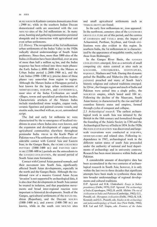
and small agricultural settlements such as
TEKKALAKOTA are found.
In the early first millennium BC, iron appeared.
In the northwest, cemetery sites of the GANDHARA
GRAVE CULTURE are of this period, and the centres
of CHARSADA and TAXILA arose; the impact of
Achaeminid, Parthian, Scythian, and Greek civi-
lizations were also evident in this region. In
southern India, the 1st millennium BC is character-
ized by the appearance of megalithic tombs, such as
those from Brahmagiri.
In the Ganges River Basin, the GANGES
CIVILIZATION emerged, first as a network of small
competing city states centred at sites such as
KAUSAMBI, ATRANJIKHERA, HASTINAPURA,
RAJGHAT, Mathura and Noh. During this dynamic
period the Buddha and Mahavira (the founder of
JAINISM) preached and many of South Asia’s
historic religious and cultural traditions emerged.
In 324 BC, the Ganges region and much of India and
Pakistan were united into a single polity, the
MAURYAN empire, which lasted until 184 BC.
Following the decline of the Mauryans, South
Asian history is characterized by the rise and fall of
countless historic states and empires, formed
through cycles of conquest and collapse.
2.3 Archaeological research. The earliest archaeo-
logical work in south Asia was initiated by the
British in the 18th century and formalized through
the founding of the Asiatic Society in 1784 and the
Archaeological Survey of India in 1854. In the 1920s
the INDUZ CIVILIZATION was discovered and large-
scale excavations were conducted at HARAPPA,
MOHENJO-DARO and related sites. Following in-
dependence in 1947, archaeological work in the
different nation states of south Asia proceeded
under the authority of national and local depart-
ments of archaeology and in university contexts.
Research has been most intensive within India and
Pakistan.
A considerable amount of descriptive data has
been accumulated in the two centuries of archaeo-
logical research in South Asia; however, it is only
within the last two to three decades that significant
attempts have been made to synthesize these data
into broader understandings of regional develop-
ments and cultural traditions.D.P. Agrawal and D.K. Chakrabarti: Essays in Indianprotohistory (Delhi, 1979); D.P. Agrawal: The archaeologyof India (Copenhagen, 1982); B. and R. Allchin: The rise ofcivilization in India and Pakistan (Cambridge, 1982); G.L.
Possehl, ed.: Harappan civilization (Delhi, 1982); K.A.R.
Kennedy and G.L. Possehl, eds: Studies in the archaeologyand palaeoanthropology of South Asia (New Delhi, 1984);
B.B. Lal and S.P. Gupta, eds: Frontiers of the Indus
BURZAHOM in Kashmir contains domesticates from
c.2900 BC; while in the southern Indian Deccan
domesticated cattle are associated with the ASH
MOUND sites of the 3rd millennium BC. In many
areas, hunting and gathering communities persisted
alongside and in interaction with agricultural and
even urban settlements.
2.2. History. The recognition of the 3rd millennium
urban settlements of the Indus Valley in the 1920s
radically altered understandings of South Asian
prehistory. Since then, more than 1000 sites of the
Indus civilization have been identified, over an area
of more than half a million sq km, and the Indus
sequence has been refined into three main phases:
the Early Indus (c.4000–2600 BC), the Mature or
Urban Indus period (c.2600–1900 BC), and the
Late Indus (1900–1300 BC); precise dates of these
phases vary somewhat from region to region.
Although the Mature Indus or Harappan period is
best known for the large urban settlements of
MOHENJO-DARO, HARAPPA, and GANWERIWALA,
most sites of the Indus Civilization are small
villages, towns and specialized production locales.
Characteristic artefacts of the Mature Indus
include standardized stone weights, copper tools,
ceramic figurines and painted ceramic vessels, and
steatite seals, inscribed with an, as yet, untranslated
script.
The 2nd and early 1st millennia BC were
characterized by the re-emergence of localized tra-
ditions in areas where Indus sites were known, and
the expansion and development of copper using
agricultural communities elsewhere throughout
peninsular India. PIRAK in the Kachi Plain of
Pakistan was a 9 ha settlement with evidence of con-
siderable contact with Central Asia and Eastern
Iran; in the Ganges Basin, the OCHRE COLOURED
POTTERY (1800–1400 BC) and PAINTED GREY
WARE (1300–600 BC) periods are the antecedents to
the GANGES CIVILIZATION, the second period of
South Asian state formation.
Contact with Central Asian pastoral nomads, and
their movement into South Asia, significantly
affected South Asian developments, especially in
the north and the Ganges Basin. Although the tra-
ditional view of a massive Central Asian Aryan
‘invasion’ is not supported by archaeological data, it
is also clear that developments in South Asia cannot
be treated in isolation, and that population move-
ments and broad inter-regional reaction were
important to historical developments. South of the
Ganges, agricultural settlements of the BANAS tra-
dition (Rajasthan), and the Deccani MALWA
(1800–1400 BC), and JORWE (1400–700 BC) are
known, while in the south ASH MOUND sites
84 ASIA
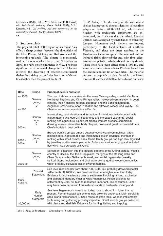
3.1 Prehistory. The drowning of the continental
shelves has prevented the consideration of maritime
adaptation before 4000–5000 BC, when raised
beaches with prehistoric settlements are en-
countered, but it is clear that the inland, forested
uplands were occupied by small bands of transitory
foragers. Numerous rock shelters are known,
particularly in the karst uplands of northern
Vietnam, and these are often ascribed to the
Hoabinhian technocomplex. The material culture
included flaked river cobbles and, with time, edge-
ground and polished adzeheads and pottery sherds.
These sites have been dated from 11000 BC, and
some late contexts in northern Thailand lasted into
the 3rd millennium BC or even later. The material
culture corresponds to that found in the lowest
levels of thick coastal shell middens found on raised
Civilization (Delhi, 1984); V.N. Misra and P. Bellwood,
eds: Indo-Pacific prehistory (New Delhi, 1985); M.L.
Kenoyer, ed.: Old problems and new perspectives in thearchaeology of South Asia (Madison, 1989).
CS
3 Southeast AsiaThe physical relief of the region of southeast Asia
offers a sharp contrast between the floodplains of
the Chao Phraya, Mekong and Red rivers and the
intervening uplands. The climate is monsoonal,
with a dry season which lasts from November to
April, and rains which commence in May. The most
significant environmental change in the Holocene
involved the drowning of extensive continental
shelves by a rising sea, and the formation of shore-
lines higher than the present sea level.
85ASIA
Principal events and sites
The rise of states or mandalas in the lower Mekong valley, coastal Viet Nam,Northeast Thailand and Chao Phraya valley. Increased centralisation in courtcentres, Indian inspired religion, statecraft and the Sanskrit language.Angkorian Mandala founded in AD 802 and attracted widespread loyalty. HanChinese set up commanderies in Bac Bo.
Iron-working, centralisation and formation of chiefdoms. Initial contact withIndian traders and Han Chinese armies and increased exchange, socialranking and agriculture. Specialist bronze-workers produce ceremonialdrinking vessels, decorative body plaques, bowls and great decorated drums.Chiefly burials in boat coffins.
Bronze-working spread among autonomous lowland communities. Oresmined in hills, ingots traded and implements cast in lowlands. Increase inranking within small communities. Some family groups had high rank signifiedby jewellery and bronze implements. Subsistence wide-ranging and includedrice which was probably cultivated.
Settlement expansion into the tributary streams of the Khorat plateau, middlecountry of Bac Bo, the Tonle Sap plains, margins of the Mekong delta andChao Phraya valley. Settlements small, and social organisation weaklyranked. Stone implements and shell were exchanged between communitieswhich probably cultivated rice in swamp margins.
Sea level rose sharply from about 7000-4000 BC; probably drowned coastalsettlements. At 4000 BC, sea level stabilised at a higher level than today.Evidence for rich sedentary coastal settlement involving ranking, exchangeand elaborate mortuary ritual at Khok Phanom Di. Pollen evidence forsettlement by 4700 BC. Marine resources important, rice consumed. Lattermay have been harvested from natural stands in freshwater swampland.
Sea level began much lower than today, rose to about 3m higher than atpresent. Former coastal settlements now drowned under sea. Main survivingsites inland rock shelters. Limited range of stone tools, wooden implementsfor hunting and gathering probably important. Small, mobile groups collectedwild plants and shellfish. Evidence for hunting, fishing and trapping.
PeriodDate
AD 1500Generalperiod
D
500 BC
Generalperiod
C
2000 –500 BC
Generalperiod
B
Generalperiod
A
3000 BC
CoastalSettlement
5000 –1500 BC
EarlyHunter-
Gatherers
10,000 BC
AD 200
Table 9 Asia, 3: Southeast Chronology of Southeast Asia.

industry, they are often referred to as a coastal
Neolithic, but there is as yet no biological evidence
for agriculture.
The earliest evidence for rice cultivation within
village communities belongs to the 3rd millen-
nium BC, when settlements were established in the
beaches in Vietnam. These midden sites, which
have been assigned to several regional cultures (Ha
Van Tan 1980) can be in excess of 10 m deep, and
sometimes contain inhumation cemeteries. Due to
their rich material culture, which includes pottery,
polished stone implements and a stone and bone
86 ASIA
Khok PhlapKhok Phlap
Ban KaoBan Kao
Ban Tha KaeBan Tha Kae
Khao WongKhao WongPrachanPrachan
Khok Phanom DiKhok Phanom Di
Khao Chan NgamKhao Chan Ngam
Khok CharoenKhok Charoen
BanBanTamyaeTamyae
Ban Chiang HianBan Chiang Hian
Non Nok ThaNon Nok Tha
Non Nong ChikNon Nong Chik
Ban Na DiBan Na DiBan Phak TopBan Phak TopBan Phak Top
Ban ChiangBan ChiangPhu LonPhu Lon
Quynh VanQuynh VanQuynh Van
Dong DauDong DauGo MunGo Mun
Phung NguyenPhung Nguyen
Hang GonHang GonDoc ChuaDoc Chua
Spirit CaveSpirit Cave Banyan Valley CaveBanyan Valley CaveBanyan Valley Cave
Steep Cliff CaveSteep Cliff Cave
Bac Son SitesBac Son Sites
Son ViSon Vi
Hoa Binh sitesHoa Binh sites
Laang SpeanLaang Spean
OngbahOngbah
Co LoaCo LoaViet KheViet Khe
Bim SonBim SonLach TruongLach TruongLach Truong
NonNonChaiChai
Muang Fa DaetMuang Fa Daet
Non DuaNon DuaPhimaiPhimai
ChansenChansen
Si ThepSi Thep
Muang SimaMuang SimaLopburiLopburi
U ThongU Thong
Pong TukPong TukPong Tuk
Ku BuaKu Bua
Nakhon PathomNakhon Pathom
IsanapuraIsanapura
Thala BorivatThala Borivat
Chau XaChau Xa
Tra KieuTra KieuMi SonMi Son
CabanCaban
Thanh HoThanh Ho
Po NagarPo Nagar
Prasat Pram LovenPrasat Pram LovenAngkor BoreiAngkor Borei
Oc EoOc Eo
Sa HuynhSa Huynh
Tam MyTam My
Sab ChampaSab Champa
Ban Don Ta PhetBan Don Ta PhetBan Don Ta Phet
Thamen ChaiThamen Chai
Ban Kho NoiBan Kho Noi
Ban MuangBan MuangPhrukPhruk
Ban AngBan AngBan AngDong SonDong Son
Chau CanChau Can
NN
300 km300 km
Gulf ofGulf ofSiamSiam
South ChinaSouth ChinaSeaSea
Khok Phlap
Ban Kao
Ban Tha Kae
Khao WongPrachan
Khok Phanom Di
Khao Chan Ngam
Khok Charoen
BanTamyae
Ban Chiang Hian
Non Nok Tha
Non Nong Chik
Ban Na DiBan Phak Top
Ban ChiangPhu Lon
Quynh Van
Dong DauGo Mun
Phung Nguyen
Hang GonDoc Chua
Spirit Cave Banyan Valley Cave
Steep Cliff Cave
Bac Son Sites
Son Vi
Hoa Binh sites
Laang Spean
Sai Yok
Ongbah
Co LoaViet Khe
Bim SonLach Truong
NonChai
Muang Fa Daet
Non DuaPhimai
Chansen
Si Thep
Muang SimaLopburi
U Thong
Pong Tuk
Ku Bua
Nakhon Pathom
Isanapura
Thala Borivat
Chau Xa
Tra KieuMi Son
Caban
Thanh Ho
Po Nagar
Prasat Pram LovenAngkor Borei
Oc Eo
Sa Huynh
Tam My
Sab Champa
Ban Don Ta Phet
Thamen Chai
Ban Kho Noi
Ban MuangPhruk
Ban AngDong Son
Chau Can
N
300 km
Gulf ofSiam
South ChinaSea0
Map 17 Asia, 3: Southeast Major archaeological sites in the region.

The rest of mainland Southeast Asia, however,
saw the development of indigenous states which
drew heavily on Indian religious and political
notions of leadership and statehood. These influ-
ences involved Hinduism and Buddhism. The
former was particularly popular in Cambodia, and
the latter in central Thailand where early indi-
cations of contact with India are known from Ban
Don Tha Phet and Chausen. From about 200 AD,
such polities are known from the lower Mekong
area, where they have been subsumed under the
name FUNAN. The best-known site is OC EO, a
rectangular area of about 450 ha which lies at the
centre of a web of canals linking it with other sites.
Subsequent polities developed in central Cambodia
(Vickery 1986), and inscriptions in Sanskrit and
archaic Khmer provide the names of the overlords
and stress the worship of Siva. Analagous polities
(Higham 1989: 297–306) are found on the coast of
Vietnam, where Cham was spoken. This is an
Austronesian language, probably brought from
island Southeast Asia in the late prehistoric period.
In Central Thailand, the polities characterized by
the DVARAVATI CULTURE developed, and here the
language spoken was Mon, a close relative of
Khmer. The most successful and powerful state,
however, was established at ANGKOR on the
northern shore of the Tonle Sap (Great Lake) of
Central Cambodia in the early 9th century AD. The
rulers, responsible for such monuments as Angkor
Wat and the Bayon (see ANGKOR), exerted their
influence over much of the mainland until the
fifteenth century AD, when Angkor was sacked by
an invading Thai army.
In 1983, Bayard proposed four successive
cultural periods to describe the prehistoric
sequence in northeast Thailand. General Period A
antedated metallurgy, and saw weak social ranking.
Period B involved the use of copper-based metal-
lurgy associated with increased social ranking, but
still within small, autonomous communities. The
next period witnessed the use of iron as well as
bronze, and the development of chiefdoms based on
large, moated centres. Finally, General Period D
involved the development of states. This scheme
has since been more widely applied to other parts of
lowland Southeast Asia. The dating of these phases
is tentatively: A: 21500–1500 BC; B: 1500–600 BC;
C: 600 BC–AD 200; and D: from AD 200. The
scheme has been applied more widely by Charles
Higham (1989).
3.2 Archaeological research. The archaeology of
mainland Southeast Asia effectively began after the
incorporation of Vietnam, Cambodia and Laos into
the French colonial empire, and was stimulated by
tributary stream valleys of the major rivers. Over 50
sites of the PHUNG NGUYEN culture above the con-
fluence of the Red and Black rivers in Vietnam have
been identified. In northeast Thailand, there are
such early contexts at BAN CHIANG and BAN PHAK
TOP, while several sites are known in central
Thailand, for example BAN KAO, Non Pa Wai and
KHOK PHANOM DI. All incorporated a sophisticated
ceramic industry, inhumation burials and grave
goods which include pottery vessels and jewellery
often exotic to the region. A widespread feature was
the decoration of pottery with parallel incised lines
infilled with impressions. Rice was often used as a
ceramic temper, but it is not possible to deduce
whether such chaff was from a wild or cultivated
variety. The only firm evidence for the latter comes
from Khok Phanom Di, an estuarine site with a
mortuary sequence revealing about 20 successive
generations of the same family groups. The associ-
ated grave offerings suggest that status was obtained
through personal achievement rather than kinship.
By the mid-2nd millennium BC, copper-based
metallurgy was widespread. Southeast Asia is rich
in copper, tin and lead, and two mining complexes
in the Khao Wong Prachan valley of central
Thailand and the PHU LON hill in northeast
Thailand have been examined. The earliest mining
and smelting activity at both has been dated to about
1500 BC. At Khao Wong Prachan the ores contain
significant quantities of arsenic, and tin was not
used. The smelting sites there reveal the production
of circular ingots, as well as socketed axes and pro-
jectile points. Away from the ore sources, there are
several village sites within which bronze socketed
axes, spearheads and arrowheads were cast in
bivalve clay or sandstone moulds, while bracelets
were cast using the lost-wax technique.
Until the mid-1st millennium BC, metallurgy was
undertaken in small-scale enterprises, perhaps even
as a dry season activity. Copper and bronze artefacts
were included as grave offerings alongside stone,
ivory, ceramic and shell items. But from about 500
BC, a number of major cultural changes took place.
In the Khao Wong Prachan valley, there is evidence
for iron smelting and forging. Use of this metal
spread rapidly. Indian mercantile expansion led to
a two-way exchange, particularly with strategically
placed coastal or riverine communities, such as BAN
DON TA PHET. Bronze bowls, ladles, decorative
plaques, and above all drums, reveal the establish-
ment of specialized workshops. The DONG SON
CULTURE in northern Vietnam, which best exem-
plifies these changes, became increasingly exposed
to Chinese expansion, and by the 1st century AD it
had been incorporated into the Han empire.
87ASIA

fortress at Askut’, JARCE 5 (1966), 23–7; S. Tyson Smith:
Askut in Nubia: the economics and ideology of Egyptianimperialism in the second millennium BC (London, 1995).
IS
Asmar, Tell (anc. Eshnunna) Site of a
SUMERIAN city-state to the north-east of modern
Baghdad, Iraq. The cult-centre at the site has
yielded an extraordinary series of religious stat-
ues (see figure 5). See DIYALA REGION for further
discussion.
Asokrochona Site of a Stone Age lithic work-
shop near the coast east of Accra, Ghana. The site
was located by Oliver Davies in 1958 and excavated
by S.E. Nygaard and M.R. Talbot, and by B.W.
Andah, in 1972–4. The principal archaeological
horizon occurs on or at the top of what Nygaard and
Talbot call an ironstone gravel of well-rounded
laterite fragments (the Asokrochona Formation)
said to have been formed under semi-arid
conditions, beneath red aeolian sand (the Nungua
Formation) which contains a few Middle Stone Age
artefacts. The main archaeological occurrence has
the foundation of the École Française d’Extrême
Orient in 1898. Early excavations were undertaken
under the auspices of the French colonial adminis-
tration, with particular encouragement from the
École Française and the Geological Service of Indo-
China. Coastal shell-midden sites, inland rock
shelters, and large settlements, such as Dong Son,
were used to establish an archaeological sequence,
although most energy was directed to the large
historic sites, particularly Angkor.
Such efforts were effectively terminated by the
Second World War and the Vietnamese–French
conflict. From the 1960s, Western archaeologists
began research in Thailand, and the Vietnamese
inaugurated their own programme. The former
introduced the full range of Western methodology
and interpretative structures, while the latter
largely remained within the pre-war French para-
digm, with some Soviet influence.O.R.T. Jause: Archaeological research in Indo-China III:
The ancient dwelling site of Dong-S’on (Thanh-Hoa,Annam) (Cambridge, MA, 1958); Nguyen Phuc Long:
‘Les nouvelles recherches archéologiques au Vietnam’,
Arts Asiatiques 31 (1975) [entire issue]; Ha Van Tan:
‘Nouvelles recherches préhistoriques et protohistoriques
au Viet Nam’, BEFEO 68 (1980), 113–54; J.C. White: BanChiang (Philadelphia, 1982); D.T. Bayard: ‘Rank and
wealth at Non Nok Tha’, Southeast Asian archaeology atthe XV Pacific Science Congress, ed. D.T. Bayard (Otago,
1984), 87–128; ––––: ‘A tentative regional phase chronol-
ogy for northeast Thailand’, Southeast Asian Archaeologyat the XV Pacific Science Congress, ed. D.T. Bayard
(Otago, 1984), 161–8; M. Vickery: ‘Some remarks on early
state formation in Cambodia’, Southeast Asia in the 9th to14th centuries, ed. D.G. Marr and A.C. Milner (Canberra
and Singapore, 1986), 95–115; I.C. Glover: Early tradebetween India and Southeast Asia (Hull, 1989); C.F.W.
Higham: The archaeology of mainland Southeast Asia(Cambridge, 1989); ––––: Khok Phanom Di (Fort Worth,
1993).
CH
Askut Island Upper Nubian site at the southern
tip of LAKE NASSER, primarily consisting of an
Egyptian fortress of the Middle Kingdom
(c.2040–1640 BC) and a Nubian settlement of the
Christian period (c.AD 550–1500), both excavated
by the University of California during the early
1960s. Since a high percentage of the interior of the
12th-dynasty fortress is occupied by the remains of
mud-brick granaries, it has been suggested that
Askut may have been an emergency supply depot
for the Egyptian army rather than a straightforward
garrison.A. Badawy: ‘Preliminary report on the excavations by the
University of California at Askut’, Kush 12 (1964), 47–53;
––––: ‘Archaeological problems relating to the Egyptian
88 ASIA
Figure 5 Asmar, Tell Limestone statues of
worshippers, 0.34 m high, with eyeballs of inlaid shell,
found buried in the shrine of an Early Dynastic temple
at Tell Asmar. Source: J. Black and A. Green: Gods,demons and symbols of ancient Mesopotamia: an illustrateddictionary (BMP, 1992), fig. 1.

of Qalat Shergat (ancient Assur), located beside the
Tigris, midway between modern Mosul and
Baghdad, appears to date back at least to the Early
Dynastic II period (c.2750–2600 BC), but it
remained a relatively obscure settlement until the
19th century BC, when colonies of merchants from
Assur began to establish profitable colonies beside
some of the major Anatolian cities, hundreds of
miles to the north of Assur itself (see KÜLTEPE).
Under the successful AMORITE ruler Shamshi Adad
I (c.1813–1781 BC) an Assyrian empire was estab-
lished, with its capital initially at Shubat-Enlil
(Tell Leilan) and later at Assur. The political
machinations and administrative structure of the
Old Assyrian empire are recorded in an archive of
more than 20,000 cuneiform tablets excavated from
the Syrian city of MARI. For over 400 years after the
rise of the Babylonian ruler Hammurabi (who
sacked Mari in 1757 BC), the Assyrians were over-
shadowed by BABYLON to the south and MITANNI
to the north, but eventually – under Ashuruballit I
(c.1363–1328 BC) – they regained their in-
dependence. It was, however, not until the late 10th
century BC that the Assyrians regained control of
northern Mesopotamia in the reign of Adad-Nirari
II (c.911–891 BC). The Late Assyrian empire, which
was centred on the three major cities of Kalhu
(NIMRUD), NINEVEH (Tell Kuyunjik) and Dur-
Sharrukin (KHORSABAD), expanded rapidly over an
area stetching from modern Iran to the
Mediterranean. At Maltaï, about 60 km from
Mosul, there are three rock-carved reliefs of the
reign of Sennacherib (c. 704–681 BC) depicting pro-
cessions of Assyrian deities (Bachmann 1927).
Although Esarhaddon (c.680–669 BC) succeeded
in conquering Egypt, the Assyrian heartland was
under increasing attack from the Medes and the
Babylonians; ultimately, in 612 BC the whole empire
crumbled and Nineveh itself was destroyed. For a
few years after the sack of Nineveh the Assyrians
appear to have fought a rearguard action from the
Syrian city of Harran (Sultantepe), which had pre-
viously been an important commercial centre of the
empire, but overall control of Mesopotamia had by
then been irretrievably ceded to the neo-Babylonian
rulers.D. Oates: Studies in the ancient history of northern Iraq(London, 1968), 19–41 [early development of Assyria]; W.
Andrae: Das wiedererstandene Assur, 2nd edn (Munich,
1977) [the German excavations at Assur, 1903–14]; J.
Reade: Assyrian sculpture (London, 1983); J. Curtis and
J. Reade, eds: Art and empire: treasures from Assyria in theBritish Museum (London, 1995).
IS
commonly been regarded as SANGOAN (although
local names for it have also been proposed) and it is
the most extensively excavated and most fully pub-
lished site representative of this entity in West
Africa. There are over 20,000 artefacts, of which
around 2500 are tools and cores, the remainder con-
sisting principally of flakes, manuports, chips and
chunks. The tools include a few handaxes, picks,
and core-axes, as well as other heavy and light duty
components, mainly of quartz and quartzite. There
is no fauna, and the dating of the site remains
hypothetical.O. Davies: The Quaternary in the Coastlands of Guinea(Glasgow, 1964); S.E. Nygaard and M.R. Talbot: ‘Interim
report on excavation at Asokrochona, Ghana’, WAJA 6
(1976), 13–19; B.W. Andah: ‘The early palaeolithic in
West Africa: the case of Asokrochona coastal region of
Accra, Ghana’, WAJA 9 (1979), 47–85; S.E. Nygaard and
M.R. Talbot: ‘Stone age archaeology and environment on
the southern Accra plains, Ghana’, NAR 17 (1984), 19–38;
P. Allsworth-Jones: ‘The earliest human settlement in
West Africa and the Sahara’, WAJA 17 (1987), 87–128.
PA-J
assemblage Set of artefacts, not necessarily of
the same type, recovered from a specific archaeo-
logical context. Distinct groups of artefacts (for
instance, flints that have been manufactured using
a particular technique) from different assemblages
may be categorized as an INDUSTRY. Distinctive
assemblages or industries whch recur in different
contexts are often taken as indicators of a specific
culture; however, archaeologists have become
increasingly wary of assuming that distinctive
assemblages of material culture necessarily indicate
wider linguistic and social groupings (see CULTURE
HISTORY).
The term ‘assemblage’ is sometimes used more
loosely to describe artefacts grouped together for
the purposes of argument or analysis, or in a
particular collection.
RJA
Assiut see ASYUT
associated, association see CONTINGENCY
TABLE
Assur see ASSYRIA
Assyria, Assyrians Semitic state and people
whose origins perhaps lay in the desert surrounding
the upper Tigris; they first appeared in northern
Mesopotamia in the 3rd millennium BC, and their
name derives from the city of Assur which they
established in northern Mesopotamia. The tell-site
89ASSYRIA, ASSYRIANS

few surviving remains of the city of Aswan itself
since the area has continued to be occupied up to
modern times. The tombs of Qubbet el-Hawa,
which date mainly to the Old and Middle
Kingdoms (c.2649–1640 BC), contain important
reliefs and inscriptions, including the ‘funerary
biographies’ of important officials such as the 6th-
dynasty provincial governor Harkhuf. Elephantine
has been excavated by a German team since the
1970s (Kaiser et al. 1972–95). It has proved possible
to trace the gradual enlargement of the town of
Elephantine from the early Dynastic period to
the Roman period (c.2900 BC–AD 395), thus con-
tributing to the understanding of processes of
urbanization in pharaonic Egypt.E. Edel: Die Felsengräber der Qubbet el-Hawa bei Assuan(Wiesbaden, 1967–); W. Kaiser, G. Dreyer and S.
Seidlmayer: Regular preliminary reports on Elephantine
excavations in MDAIK 28–51 (1972–95); E. Bresciani and
S. Pernigotti: Assuan: il tempio tolemaico di Isi. I blocchidecorati e iscritti (Pisa, 1978).
IS
Aswan High Dam see LAKE NASSER
Asyut (anc. Djawty) Site in Egypt, roughly mid-
way between Cairo and Aswan, which was the
ancient capital of the 13th Upper Egyptian nome(province), where, according to many surviving
texts, the principal cult-centre of the wolf-god
Wepwawet was located. The archaeological remains
consist primarily of the rock tombs of the local elite,
dating from the 9th dynasty to the Ramessid period
(c.2134–1070 BC). The so-called ‘biographical’
inscriptions on the walls of the tombs of the 1st
Intermediate Period and Middle Kingdom
(c.2134–1640 BC) provide historical information on
the struggle between the rulers of HERAKLEOPOLIS
MAGNA and THEBES.F.L. Griffith: The inscriptions of Siut and Der Rifeh(London, 1889); G.A. Reisner, ‘The tomb of Hepzefa,
nomarch of Siñt’, JEA 5 (1919), 79–98; H. Thompson, Afamily archive from Siut (Oxford, 1934).
IS
Atchana, Tell (Açana; anc. Alalakh) Settlement
mound by the River Orontes in northwestern Syria,
which was the site of Alalakh, the capital of a small
kingdom in the 2nd millennium BC. It appears to
have particularly prospered in c.1550–1400 BC,
when it was one of the westernmost vassals of the
HURRIAN kingdom of MITANNI. It was excavated by
Leonard Woolley in 1937–9 and 1946–9, revealing
an unusual temple of the 24th century BC, and the
palaces of two of its rulers, Yarim-Lim (c.1750 BC)
ASTt see ARCTIC SMALL TOOL TRADITION
Asturian Mesolithic stone and bone industry
linked to the shell-midden sites or concheros of
northern Spain. The Asturian lithic industry is
crude and has a high proportion of heavy duty tools,
including a unifacial pick; compared to the AZILIAN
it exhibits a relatively high proportion of serrated
artefacts and a relatively low proportion of backed
bladelets. The Asturian was identified as a distinct
‘culture’ after excavations by the Count of Vega del
Sella at the cave of El Penicial (Asturias) in 1914.
Strauss and Clark have more recently argued
against this, suggesting that the concheros should be
viewed as the middens of specialized exploitation
sites which operated within an integrated Azilian-
Asturian Mesolithic economy. However, the
contemporaneity of the Azilian and Asturian is not
yet quite proven, and González Morales has criti-
cized this FUNCTIONALIST interpretation.G.A. Clark: ‘Site functional complementarity in the
Mesolithic of northern Spain’, The mesolithic in Europe,
Papers presented at the Third International Symposium,
Edinburgh, ed. Clive Bonsall (Edinburgh, 1985),
589–603; M.R. González Morales: ‘Asturian resource
exploitation: recent perspectives’, The mesolithic in Europe;
L.G. Strauss: Iberia before the Iberians (Albuquerque,
1992), 217–29.
RJA
Asuka District in Nara prefecture, Japan, which
was the centre of the introduction of Buddhism
from the Asian continent in the 6th–7th centuries
AD. Early palace sites and temples, including the
site of Asuka-dera, the first Buddhist temple in
Japan and Kawahara-dera, are now protected as part
of a special historical district. The Fujiwara Palace
site has also been excavated. The region was the
centre of the Ritsuryo state until the capital was
moved to HEIJO in AD 710.K. Tsuboi: ‘The excavation of ancient palaces and
capitals’, Acta Asiatica 63 (1992), 87–98.
SK
Aswad, Tell see ACERAMIC NEOLITHIC
Aswan (anc. Swnt, Syene) Pharaonic site in
Upper Egypt at the northern end of LAKE NASSER.
On the eastern bank of the Nile are the town,
temples and granite quarries of Aswan itself, while
the Old and Middle Kingdom rock-cut tombs of
Qubbet el-Hawa are situated on the opposite bank.
In the centre of the Nile at Aswan are the town and
temples of the island of Elephantine. Apart from
two small Ptolemaic and Roman temples there are
90 ASTT

eastern Morocco. Apart from the Maghreb, the
Aterian has a very wide extension in North Africa
and the Sahara, as far as Cyrenaica and the Egyptian
desert in the east (HAUA FTEAH and the oases of
Kharga and Bir Tarfawi) and the TAOUDENNI and
Northern Chad basins in the south (including
ADRAR BOUS).
J.D. Clark suggests that within the Aterian as a
whole various ‘culture areas’ or ‘traditions’ may be
distinguished, characterized by distinctive artefact
forms, such as bifacially worked foliate points,
which are particularly numerous southeast of the
Hoggar mountains. Tanged points (implying
hafting) in his view constitute the first unequivocal
evidence for simple compound tools in the palaeo-
lithic record. Chronologically, the Aterian in
the Maghreb is commonly regarded as falling in the
interval 40,000–20,000 years ago, and there are a
number of finite radiocarbon dates in this range; as
well as OSL (optically stimulated luminescence)
and TL (thermoluminescence) dates now available
from Chaperon Rouge in northwestern Morocco
indicative of an occupation at 28,200 ± 3300 BP.
Nevertheless, minimum or infinite radiocarbon
dates for Taforalt suggest that the Aterian there
may be >40,000 years old, and the finding of
Aterian artefacts in or above Tyrrhenian beach
deposits in the vicinity of Oran, western Algeria,
would be consonant with this.
At HAUA FTEAH, Charles McBurney detected
possibly tanged pieces and a ‘strong hint of Aterian
affinities’ in layers XXXII–XXXI, corresponding
to a period >43,400 BP, and at Bir Tarfawi the
tanged pieces originally identified as Aterian are
likely to date to the end of the sequence around
60,000 years ago. The Aterian in the Sahara is
generally considered to be relatively late, corre-
sponding to the Upper Ghazalian humid period
c.30–20,000 years ago. An upper limit is provided
by a date of 18,600 ± 400 BP from Ekouloulef in
the Air mountains. At Adrar Bous and Bilma the
Aterian is preceded by Middle Stone Age industries
which Tillet places in the Lower Ghazalian humid
period c.40–35,000 years ago; while ‘probably com-
parable to the Mousterian in the Maghreb’ such
industries in his view might represent a local origin
for the Aterian and constitute its early phase in this
area. The Aterian is associated with anatomically
modern man at DAR-ES-SOLTANE II and three other
sites on the Moroccan coast.J. Tixier: ‘Procédés d’analyse et questions de terminologie
conçernant l’ étude des ensembles industriels du
paléolithique récent et de l’epipaléolithique dans l’Afrique
du Nord-ouest’, Background to evolution in Africa, ed.
W.W. Bishop and J.D. Clark (Chicago, 1967), 771–820;
and Niqmepa (c.1500 BC), the former including a
BIT-HILANI. Woolley also explored the neighbour-
ing port of el-Mina, at the mouth of the Orontes,
which was used primarily during the Achaemenid
period (c.538–331 BC).
The site of Alalakh consisted of 17 strata in all,
stretching from the Chalcolithic period (c.3500 BC)
until the early 12th century BC, when it may have
been destroyed by the SEA PEOPLES. Stratum VII,
dating to the 18th century BC, when the city was
part of the AMORITE kingdom of Yamhad, included
a cache of cuneiform tablets, inscribed in Akkadian,
which first enabled Woolley to identify the site as
Alalakh. Another archive, discovered in stratum IV
and dating to the 15th and 16th centuries BC, has
shed a great deal of light on the society and
administration of Mitanni and its relations with
the HITTITES, providing a useful comparison
with the slightly later diplomatic correspondence
from EL-AMARNA (Wiseman 1953). Sidney Smith
(1940) was able to use the Alalakh stratigraphy and
textual evidence to construct a general chronology
for the northern Levant in the 2nd millennium BC.
A group of carved ivory objects excavated from
the same stratum show the same mixture of external
influences as the wall-paintings at NUZI, one of the
easternmost cities of Mitanni. The style of palace
architecture at Alalakh, both before and after the
Hurrian domination, is part of a local tradition,
using stone foundations, basalt orthostats and a
great deal of plaster-clad timber. The maintenance
of different local architectural traditions at Alalakh
and Nuzi suggests that there was no overall
Mitannian palatial style.S. Smith: Alalakh and chronology (London, 1940); D.J.
Wiseman: The Alalakh tablets (London, 1953); C.L.
Woolley: Alalakh: an account of the excavations at TellAtchana in the Hatay, 1937–49 (London, 1955).
IS
Aterian Palaeolithic industrial complex, named
by Maurice Reygasse in the 1920s, after the site of
Bir el-Ater in the Oued Djebbana, eastern Algeria,
at first on the basis of a distinctive ‘fossile directeur’,
the tanged point. The industry as a whole was later
defined by Jacques Tixier as a LEVALLOIS facies of
the MOUSTERIAN, in which tanged tools of various
kinds (not only points) constituted up to one
quarter of the retouched artefacts. François Bordes
observed that the many technological and typologi-
cal elements common to both Mousterian and
Aterian suggested that the second derived from
the first. This is supported by stratigraphic
superposition of these industries at Témara, north-
western Morocco, and at Taforalt and Rhafas,
91ATERIAN

all elements in a given sample. The precision and
accuracy are high (1–2% for major components)
and a very wide range of elements can be quantified
but this does not include certain non-metals such as,
for example, oxygen, carbon, nitrogen or chlorine.
The sensitivity may be increased, and detection
limits lowered to the ultra-trace level, by using
electrothermal instead of flame atomization. This
uses a graphite tube, into which the sample is
injected and through which the light is directed,
that is electrically heated to about 3000°C which
atomizes the sample and generates a transient
absorption signal.
AAS – first applied in the early 1970s – has been
used extensively to analyse a wide range of archaeo-
logical materials such as copper-based alloys of all
periods, flint, slag, pottery and glass. Applications
include artefact characterization, technology and
provenance investigations. AAS is beginning to be
challenged by ICP-AES (INDUCTIVELY COUPLED
PLASMA-ATOMIC EMISSION SPECTROMETRY) as an
alternative technique for chemical analysis of
sampleable inorganic materials.M.J. Hughes et al.: ‘Atomic absorption techniques in
archaeology’, Archaeometry 18 (1976), 19–37; W.J. Price:
Spectrochemical analysis by atomic absorption (Wiley, 1979).
MC
Atranjikhera Multi-period site on the Kali
Nanga tributary of the Ganges in Uttar Pradesh,
India, consisting of a single mound (about 40 ha in
area). Excavations in the 1960s and 1970s showed
that there were seven phases of the site, the first four
of which – OCHRE COLOURED POTTERY, BLACK
AND RED WARE, PAINTED GREY WARE and
NORTHERN BLACK POLISHED WARE – date to late
prehistoric and early historic periods (c.1800–50
BC). Twenty-three coins of the Nanda, MAURYAN
and Sunga dynasties were recovered from the levels
dating to the Northern Black Polished Ware period
(c.600–50 BC), when the site reached its maximum
extent, with densely packed mud-brick and fired
brick buildings and a massive defensive wall. Seealso GANGES CIVILIZATION.R.C. Gaur: Excavations at Atranjikhera (Delhi, 1983).
CS
Atrib, Tell (anc. Hwt-Heryib, Athribis) Egyptian
settlement site located in the central Delta region
near the modern town of Benha, 40 km north of
Cairo. The principal surviving features of Tell
Atrib are a temple dating to the time of Amasis
(c.570–526 BC), the tomb of Queen Takhut (c.590
BC) and extensive urban, religious and funerary
remains of the Greco-Roman period (c.332 BC–AD
C.R. Ferring: ‘The Aterian in North African prehistory’,
Problems in Prehistory: North Africa and the Levant, ed.
F. Wendorf and A.E. Marks (Dallas, 1975), 113–26; F.
Bordes: ‘Moustérien et Atérien’, Quaternaria 19 (1976–7),
19–34; J.D. Clark: ‘Human populations and cultural adap-
tations in the Sahara and Nile during prehistoric times’,
The Sahara and the Nile, ed. M.A.J. Williams and H.
Faure (Rotterdam, 1980), 527–82; A.E. Close: ‘Current
research and recent radiocarbon dates from Northern
Africa’, JAH 21 (1980), 145–67; G. Delibrias et al.: ‘Gif
natural radiocarbon measurements IX’, Radiocarbon 24
(1982), 291–343; T. Tillet: ‘The palaeolithic and its en-
vironment in the northern part of the Chad basin’, AAR 3
(1985), 163–77; A. Debénath et al.: ‘Stratigraphie, habitat,
typologie et devenir de l’Atérien marocain: données
récentes’, L’Anthropologie 90 (1986), 233–46; L. Wengler:
‘Position géochronologique et modalités du passage
Moustérien–Atérien en Afrique du Nord, L’exemple de la
grotte du Rhafas au Maroc oriental’, CRASP, Série II 303
(1986), 1153–6; J.P. Tixier et al.: ‘Nouvelles données sur
la situation chronologique de l’Atérien du Maroc et leurs
implications’, CRASP, Série II, 307 (1988), 827–32; F.
Wendorf et al.: Egypt during the Last Interglacial: theMiddle Palaeolithic of Bir Tarfawi and Bir Sahara East(New York and London, 1993).
PA-J
Atestine culture see ESTE
atomic absorption spectrophotometry(AAS) Quantitative technique of chemical
analysis applicable to metals, ceramics, glass and
lithics for major, minor and trace element analysis.
The technique relies on the principle that electron
energy level changes in atoms may be stimulated by
the absorption of light at element-specific wave-
lengths. A small sample is required, typically 10 mg
when applied to metals, and usually this must be in
solution.
The basic instrument consists of a light source
emitting the spectrum for the element being
measured (e.g. copper), a flame through which the
light is directed and sample atomized, and a mono-
chromator measuring the intensity of light
transmitted through the flame at a specific wave-
length characteristic of the element. Solutions are
introduced into the flame via a nebulizer with a
capillary uptake tube. While the sample solution is
sprayed into the flame, any atoms of the element
being measured will respond by absorbing some of
the light from the lamp. The absorbance recorded
is proportional to the quantity of the element in the
flame and hence in the solution. Standard solutions
of known concentration are measured initially to
calibrate for each element.
The technique is sequential for each element,
although one solution is normally used to measure
92 ATERIAN

Aurignacian is strongly associated with the early
stages of CAVE ART.
The Aurignacian industry was first recognized in
the Périgord region of France, where it succeeds the
MOUSTERIAN rather before 35,000 BP. However,
the industry seems to appear rather earlier in
Central Europe, where it is associated with well-
crafted MOBILIARY ART. The oldest Aurignacian in
Europe (c.40,000 BP) has been identified in the
Middle Danube and the Balkans. It seems probable
that the Aurignacian is intrusive in both Central and
Western Europe, and that its appearance is associ-
ated with the replacement in Europe of the
NEANDERTHALS by ANATOMICALLY MODERN
HUMANS. See UPPER PALAEOLITHIC for further
discussion.
Aurignacian assemblages are traditionally
divided into different stages (I–V) according to the
typology of their bone tools. Stages I and perhaps II
may still be useful classifications, but controlled
excavation at sites such as ABRI PATAUD has
suggested the need for more subtle schemes defined
by the comparative frequency of different kinds of
tool and tool attribute.C. Gamble: The Palaeolithic settlement of Europe(Cambridge, 1986); J.F. Hoffecker and C.A. Wolf, eds:
The early Upper Palaeolithic, BAR IS 437 (Oxford, 1988).
RJA
Australia see OCEANIA
Australian core tool and scraper traditionTraditionally, archaeologists have assigned to this
single tradition all tools dating from before about
5000 years ago from across the Australian continent:
‘horsehoof’ cores and steep-edged scrapers are the
most characteristic elements. However, the
similarity of assemblages across the continent may
simply be due to common functions, such as
shaping wood and hides and cutting meat, rather
than any sort of cultural or stylistic cohesion. The
homogeneity has anyway been over-emphasized,
and recently archaeologists have begun to stress that
regional tool types exist (such as the thumbnail
scrapers in Tasmania, and the edge-ground axes of
northern Australia and Papua New Guinea). Seealso OCEANIA 1.J.P. White and J.F. O’Connell: A prehistory of Australia,New Guinea and Sahul (Sydney, 1982), 64–70.
CG
Australian small tool tradition Generic
term used to describe the blade tools, delicately
retouched to make a variety of points and backed
blades, produced across the continent from about
395). The site as a whole has been severely damaged
by the activities of sabbakhin (farmers plundering
ancient mud-brick for use as fertilizer), one of
whom discovered a large cache of Late Period
(c.712–332 BC) jewellery in 1924. During the 1980s
and 1990s a team of Polish archaeologists have con-
centrated on the excavation of the Greco-Roman
town.A. Rowe, ‘Short report on the excavation of the Institute
of Archaeology Liverpool at Athribis (Tell Atrib)’, ASAE38 (1938), 523–32; P. Vernus: Athribis (Cairo, 1978); K.
Mysliwiec and T. Herbich: ‘Polish archaeological activi-
ties at Tell Atrib in 1985’, The Archaeology of the NileDelta: problems and priorities, ed. E.C.M. van den Brink
(Amsterdam, 1988), 177–203.
IS
attribute/attribute state see VARIABLE
auger electron spectroscopy (AES) Quali-
tative and quantitative non-destructive surface
technique particularly suited to light-element
chemical analysis. In principle, the technique is
related to energy dispersive X-ray analysis using
a scanning electron microscope (SEM EDX).
Electron excitation causes ionization of atoms in the
specimen but, instead of the re-arrangement which
would cause a fluorescent X-ray photon to be emit-
ted, there is an internal conversion which results in
the release of low-energy electrons. The electron
energy is specific to a particular element and is sub-
ject to small changes due to chemical effects,
specifically the valance state of the element. The
technique is therefore capable of detecting the pres-
ence of compounds, such as oxides, on metal
surfaces and has been applied to the analysis of pati-
nas. The surface layer analysed is of the order of
10–2 μm in depth.M. Polak et al.: ‘Auger electron spectroscopy applied to
archaeological artefacts’, Archaeometry 25 (1983), 59–67.
MC
Aurignacian Early Upper Palaeolithic industry
(c.38000–28000 BC) that presents a full blade tech-
nology and a wide range of tools, including carinate
(thick) scrapers, burins, endscrapers, and blades
with a distinctive ‘scalar’ (or ‘Aurignacian’) retouch
around their margins. The Aurignacian, named
after the Aurignac shelter in the French Pyrenees,
is also characterized by a rich bone industry that
includes bone points and awls (see also MOBILIARY
ART). It seems highly probable, if not quite certain,
that Aurignacian assemblages were produced solely
by Homo sapiens sapiens. In France and Spain, the
93AUSTRALIAN SMALL TOOL TRADITION

Archaeologically, it is unclear whether Austra-
lopithecines made tools of any kind. Although some
possible examples have been proposed, it is prob-
able that the earliest OLDOWAN tools, dating to c.2.3
million years ago, were in fact made by the larger
brained HOMO HABILIS.R. Foley: Another unique species (London, 1987); G.
Richards: Human evolution: an introduction for the be-havioural sciences (London, 1987); C.S. Gamble:
Timewalkers: The prehistory of global colonization (London,
1993), 47–73.
PG-B
Austrasia see KEMPEN PROJECT
Avaris see DABðA, TELL EL-
Avebury Late Neolithic ceremonial complex,
including a massive HENGE and stone circles, situ-
ated in Wiltshire, England near the contemporary
earthwork at Silbury Hill. Sherds of Windmill Hill,
PETERBOROUGH and GROOVED WARE were ex-
cavated from the bottom of the henge ditch; this,
and comparison with other large Wessex henges
(e.g. Durrington Walls), suggests that construction
may have begun soon after 2600 BC. The main
henge consists of a massive ditch (originally 9 m
deep) with external bank, breached by four
entrances, two of which were originally approached
via stone processional avenues. The roughly circu-
lar great stone ring (c.330 m in diameter) is erected
along the inner edge of the ditch. Inside the great
ring are the remains of two precisely laid-out
smaller stone circles (c.100 m in diameter). In the
centre of the northern inner circle three large stones
originally formed a simple open-ended enclosure
(The Cove); the centre of the southern ring was
marked by a very large stone (The Obelisk) and an
enigmatic, roughly triangular arrangement of
smaller stones. One of the (restored) stone avenues
follows a curving route to a terminal ritual site,
known as The Sanctuary, where excavation has
revealed three successive circular arrangements of
posts. Whether the posts supported roofs or formed
free-standing timber circles is unclear, but they
were eventually replaced by two small concentric
rings of stones.
Recent surveys and excavations indicate that the
area between the West Kennet Avenue and West
Kennet Long Barrow once contained two roughly
circular enclosures, the larger one concentric,
ringed by palisades of oak timbers set in trenches
about 2 m deep. The enclosures are of uncertain
function, perhaps comparable to the palisade en-
closure at Mount Pleasant henge in Dorset; they
5000 years ago to the present day. The regional
variations of the tradition derive from a variety of
techniques: Kimberley points, for instance, are
bifacially flaked, while Bondi points, a type of
backed blade first found on Bondi beach, are uni-
facially flaked. There are geographical differences
in the distributions of these types – backed blades,
for example, occur less commonly in tropical
Australia – but these regional variations are
presently inadequately researched.D.J. Mulvaney: The prehistory of Australia (Melbourne,
1975), 210; J.P. White and J.F. O’Connell: A prehistory ofAustralia, New Guinea and Sahul (Sydney, 1982), 106–25.
CG
Australopithecus Originally discovered by
Raymond Dart in 1925, the inappropriately named
Australopithecus – ‘Southern Ape’ – was not recog-
nized as a human ancestor until the PILTDOWN
HOAX was unmasked in the 1950s. Since the 1970s,
it has become clear that Australopithecines were the
progenitors of modern humans, but that there were
a number of species at different times and in
different parts of Africa, not all of which were
ancestral to our own lineage.
The earliest known hominids belong to the
species Australopithecus afarensis, discovered at
HADAR and later also represented by fossils from
LAETOLI. While Afarensis was a full biped, its mode
of walking was somewhat different to modern
humans and its forelimbs retained adaptation for
climbing. It was a relatively small-brained hominid
(c.450–500 cm3), although calculated body weights
range from 30 to 80 kg. These wide differences have
led to controversy as to whether the large and small
afarensis are sexual dimorphs of the same species, or
members of different species. In all, one might view
Australopithecus as a bipedal ape similar to other
modern great apes.
Some time around 3 million years ago, the basal
species of Australopithecines began to diverge into
distinct species/subspecies. Just how these relate to
the origin of genus Homo, in the shape of HOMO
HABILIS, is not at all certain. But it is clear that
Australopiths did diverge between the gracile
Australopithecus africanus and the more robust A.aethiopicus (represented by the WT 17 000 fossil
from WEST TURKANA). This latter branch then led
to other robust, small-brained species (A. robustusand A. boisei) whilst the gracile form probably led to
the genus Homo. Nevertheless, it is clear that for
some considerable time between 1.8 and 1.1 million
years ago, robust and gracile Australopithecines
coexisted with both Homo habilis and HOMO
ERECTUS.
94 AUSTRALIAN SMALL TOOL TRADITION

funerary remains at Axum can contribute to the
understanding of the function and symbolism of
the Axumite stelae. Phillipson argues that the stelae
served as grave-markers, representing a tradition
which was modified after the people of Axum had
adopted Christianity in the 4th century AD. He
may represent a relatively late ritual phase at
Avebury, a few centuries after the construction of
the main megalithic structures.A. Burl: Prehistoric Avebury (London, 1979); A. Whittle:
‘A late Neolithic complex at West Kennet, Wiltshire,
England’, Antiquity 65 (1991), 256–62.
RJA
Awat’ovi see ANASAZI
axe-money Small bronze artefacts, apparently
manufactured in northern Peru beginning c.AD 900
and traded to Ecuador for Spondylus shells.D. Hosler et al.: Axe-monies and their relatives (Dumbarton
Oaks, 1990).
KB
Axum City in the Ethiopian highlands, founded
in the 3rd century AD, perhaps by migrants from
southern Arabia. It was the capital and type-site of
the Axumite culture. The remains include several
groups of tall, narrow, stone stelae (up to 33 m in
height), as well as tombs, monolithic platforms and
urban material. The sites of three monumental
multi-roomed buildings, known as Enda Mika’el,
Enda Semon and Ta’akha Mariam, were excavated
by a German expedition (Littmann et al. 1913).
These massive structures, each standing on a
masonry podium and consisting of up to three
storeys, were identified by the excavators as the res-
idences of the rulers of Axum. In 1966–8, a fourth
structure, the ‘Dongur Mansion’, was excavated
(Anfray 1972); this 40-room complex, covering an
area of about 3000 square metres and dating to the
7th century AD, was interpreted as an elite ‘villa’
rather than a royal palace. Excavations elsewhere at
Axum have revealed a number of smaller stone
buildings, suggesting that it was an extensive urban
site throughout the 1st millennium AD.
In the early 1970s a geoarchaeological study
(Butzer 1981) and a settlement pattern survey
(Michels 1979: 22-4) were conducted across a wide
area around Axum. Both suggested that natural
resources were unequally distributed in north-
eastern Ethiopia during the 1st millennium AD,
leading to a distinct clustering of sites. Graham
Connah (1987: 91) argues that population pressure
brought about by differential access to resources in
Axumite Ethiopia could have been a crucial influ-
ence on the course of Ethiopian history.
In the 1990s, the excavations of the British
Institute of East Africa, directed by David
Phillipson (1994), concentrated on the examination
of the archaeological context of Stele 1, showing
that the investigation of the impressive stone-built
95AXUM
Figure 6 Axum Granite stele, Axum, Ethiopia.
Source: G. Connah: African civilizations (Cambridge
University Press, 1987), fig. 4.2.

African civilization of Late Antiquity (Edinburgh, 1991);
D. Phillipson: ‘The significance and symbolism of
Aksumite stelae’, CAJ 4/2 (1994), 189–210.
IS
Ayla/al-Aqaba Islamic urban site which was the
port of Palestine and formed the link with the Red
Sea as well as serving as a strategic point on the pil-
grim road from Egypt to the Hijaz. Although urban
remains had not been suspected at the site before
excavations commenced in 1986, Ayla must now be
regarded as comparable with such better-known
foundations as al-FUSTAT, al-KUFA and al-Basra in
terms of its archaeological importance for the
understanding of early Islamic settlements.
The town was fortified, and such features as its
points out that, as the Axumite rulers were gradu-
ally Christianized, ‘erection of storeyed stelae was
abandoned, but certain features of earlier graves and
markers were retained, implying some continuity in
underlying tradition’. See also ADULIS, MATARA
and YEHA.E. Littmann et al.: Deutsche Aksum Expedition, 2 vols
(Berlin, 1913); H. Monneret de Villard: Aksum: richerchedi topografia generale (Rome, 1938); F. Anfray:
‘L’archéologie d’Axoum en 1972’, Paideuma 18 (1972),
60–78; J.W. Michels: ‘Axumite archaeology: an introduc-
tory essay’, Aksum, ed. Y.M. Kobishchanov (Philadelphia,
1979), 1–34; K. Butzer: ‘Rise and fall of Axum, Ethiopia:
a geoarchaeological interpretation’, AA 46/3 (1981),
471–95; G. Connah: African civilizations, Precolonial citiesand states in tropical Africa: an archaeological perspective(Cambridge, 1987), 76–84; S. Munro-Hay: Aksum: an
96 AXUM
Addis AbabaAddis AbabaMelka-KuntureMelka-Kunture
Lago OdaLago Oda
Aw
ash
Aw
ash
OmoOmo
LakeLakeLakeTurkanaTurkana
K E N Y AK E N Y AK E N Y A
S O M A L I AS O M A L I AS O M A L I A
HadarHadar
Gulf of AdenGulf of Aden
LalibelaLalibelaGouzaraGouzara
Lalibela CaveLalibela Cave
GondarGondar
AdulisAdulis
KohaitoKohaitoYehaYeha
Haoulti-MelazoHaoulti-MelazoAxum and GobedraAxum and Gobedra Addi GalamoAddi Galamo
MataraMatara
Debra DamoDebra Damo
KhartoumKhartoum
S U D A NS U D A NS U D A N
Red Sea
Red Sea
S A U D IS A U D IS A U D I
A R A B I AA R A B I AA R A B I A
NN
00 300 km300 km
DJIBOUTIDJIBOUTI
Addis AbabaMelka-Kunture
Lago Oda
Aw
ash
Omo
LakeTurkana
K E N Y A
S O M A L I A
Hadar
Gulf of Aden
LalibelaGouzara
Lalibela Cave
Gondar
Adulis
KohaitoYeha
Haoulti-MelazoAxum and Gobedra Addi Galamo
Matara
Debra Damo
Khartoum Agordat
S U D A N
Red Sea
Y E M E N
N
0 300 km
Nile
S A U D IA R A B I A
E T H I O P I A
DJIBOUTI
E R I T R E A
Map 18 Axum Prehistoric and Axumite sites in Ethiopia and Eritrea.

excavated in 1874 at Abri Duruthy in France
(Landes), but MAS D’AZIL (Ariège) and La Tourasse
(Haute-Garonne) are regarded as its type-sites. The
character of an Azilian assemblage has never been
strictly defined; many definitions are essentially
negative, stressing the poverty of Azilian lithic
industries in comparison to the Magdalenian
(which may be partly due to a tendency to use
lower-grade flint) and the paucity of its art. The
strongest positive indicators are flat single-row
Azilian harpoons (often with button-hole per-
forations) and curious painted AZILIAN PEBBLES.
Where these indicators are absent Azilian assem-
blages are identified by their high proportion of
backed bladelets and small end-scrapers; a low (but
variable) proportion of burins; and the presence of
Azilian points (double-pointed backed blades).
Because the character of the Azilian is indistinct
at both chronological ends, there has been a
proliferation of terms such as ‘Azilian-like’ or ‘epi-
Azilian’. ‘Azilian’ points and even flat harpoons are
found in Magdalenian contexts (Bahn), while a
probable chronological overlap with ‘true’
Mesolithic entities such as the Asturian has led to
suggestions of a complex relationship (see
ASTURIAN).
P. Bahn: Pyrenean prehistory (Warminster, 1984), 45; J.A.
Fernández-Tresguerres Velasco: ‘Thoughts on the tran-
sition from the Magdalenian to the Azilian in Cantabria:
evidence from the Cueva de Los Azules, Asturias’, Themesolithic in Europe, Papers presented at the Third
International Symposium, Edinburgh, ed. Clive Bonsall
(Edinburgh, 1985), 582–8; L.G. Strauss: Iberia before theIberians (Albuquerque, 1992), 194–216, 227–9.
RJA
Azilian pebbles The AZILIAN is characterized
by the replacement of the rich naturalistic mobiliary
and parietal art of the preceding Magdalenian with
a rather limited art of a much simpler geometric
style. This art is occasionally manifested on bone
tools, but most characteristically on the famous
painted and occasionally engraved Azilian pebbles
found in great concentrations at MAS D’AZIL and
Rochdane in France; examples are also known from
another 35 sites in France, Spain, Switzerland and
Italy. Single and multiple dots and strokes running
across the width of the pebbles are the most
common motifs; more complex designs include
crosses, wavy lines, and longitudinal lines hatched
with short strokes. The motifs are usually painted
in red, or occasionally black, but some are engraved.
D’Errico’s examination of engraved pebbles has
cast doubt on suggestions that the dots and strokes
represent some kind of hunting tally or lunar cycle
towers, the organization of its gates and its central
terapylon all recall Roman legionary camps in
southern Jordan and Egypt. The site has been
attributed to the reign of the third Caliph Uthman
in about AD 650. Rising water has prevented the
excavations reaching virgin soil, but there can be no
doubt that the site’s discovery transforms the
understanding of Umayyad and even pre-Umayyad
activity in southern Palestine and Jordan. It also
provides a focus for the study of the early Islamic
period in the Red Sea, an area that has been
neglected by archaeologists.D. Whitcomb: ‘Excavations in Aqaba: first preliminary
report’, ADAJ 31 (1987), 247–66; ––––: ‘A Fatimid resi-
dence in Aqaba, Jordan’, ADAJ 32 (1987), 207–24; ––––:
‘The Misr of Ayla: settlement of al-ðAqaba in the early
Islamic period’, The Byzantine and early Islamic Near EastII: land use and settlement patterns, ed. G.R.D. King and
A. Cameron (Princeton, 1994), 155–70.
GK
Ayn Asil see DAKHLA OASIS
Ayutthaya Capital of the Thai kingdom, founded
by King U-Thong or Ramathibodi in AD 1351, and
sacked by the Burmese in 1767. Located on the
Chao Phraya River, 50 km north of Bangkok, it
was the centre of Thai power and culture for four
centuries. It was, however, prone to attacks by the
Burmese, suffering a major setback when it was
destroyed and sacked in 1569. Under King Narai
(1656–88), however, the Thais entered a period of
strong diplomatic and trade relationships with the
West. A 17th-century plan prepared by de la
Loubére, a member of a French diplomatic mission,
shows the location of the royal palace, the arsenal,
port, market and area occupied by the populace.
There were also buildings of the Dutch, Portuguese
and French missions. After its final destruction in
1767, the Thai leadership retreated to the marshy
delta of the Chao Phraya river in the vicinity of
Bangkok.D.K. Wyatt: Thailand, a short history (New Haven, 1984),
61–9.
CH
Azania see HAFUN; RHAPTA
Azilian Industry or ‘culture’ transitional between
the Upper Palaeolithic (Magdalenian) and Meso-
lithic, c.10,000–7000 BC. Because the Azilian
appears at the end of the last glaciation it has tra-
ditionally been regarded as marking the beginning
of cultural and technological adaptions to a post-
glacial environment. The Azilian was first
97AZILIAN PEBBLES

Aztecs More properly known as the Mexica, the
Aztecs were late migrants into central Mexico and
came to dominate much of western Mesoamerica
during the Late Postclassic period (AD 1200–1521).
According to Mexica myth and history, which
emphasize their humble CHICHIMEC origins, they
left their home of Aztlán (whence the name Aztec)
and arrived in the BASIN OF MEXICO at some time
in the late 13th or early 14th century. A despised,
nomadic group, led by their patron deity
Huitzilopochtli and serving as mercenaries for the
more powerful indigenous city-states in the basin,
the Mexica finally (c.AD 1325) settled successfully
on an island in the western part of Lake Texcoco
and established what would become their capital,
Tenochtitlán. It covered an area of approximately
12 sq. km, with a population estimated at
125,000–200,000. Likened by early European
visitors to Venice, the island was criss-crossed by a
system of canals that facilitated easy canoe-
transport on the lake and throughout the basin.
There were two main ceremonial precincts on the
island, the largest having some 72 buildings, in-
cluding temples, priests’ quarters, ball-courts (seeBALLGAME), COATEPANTLI (‘serpent-walls’) and
tzompantli (‘skull-racks’). The principal temple,
known today as the ‘Templo Mayor’, had twin
structures dedicated to the gods Huitzilopochtli
and Tlaloc; it was rediscovered by accident in 1978
during subway construction in central Mexico
city. During the following five years the
multidisciplinary investigations of Mexican archae-
ologists, biologists and geologists at the Templo
Mayor (Matos Moctezuma 1988) revealed a great
complex of buildings including a tzompantli, a
CHACMOOL, sculptures, ceramics and several
smaller temples.
During the 14th and 15th centuries the Aztecs
developed political and marital ties with their
more powerful neighbours. In 1430 the NAHUATL-
speaking Mexica became part of and eventually
dominated an alliance with two of these polities, the
Acolhua of Texcoco and the Tepanecs of Tlacopan.
This ‘Triple Alliance’ was the core of the ‘Aztec
empire’ which expanded throughout western
Mesoamerica during the following century.
The area dominated by the Triple Alliance
included some 50–60 city-states in central Mexico,
with an estimated total population of 1–2.5 million
people. In addition, the ‘empire’ incorporated about
40 conquered tributary provinces in the hinterland,
representing approximately 5–6 million people.
There is considerable argument about the degree to
which this can truly be considered an empire
(Conrad and Demarest 1984: 11–83; Smith 1986),
notation; however the repeated combinations of
motifs does seem to some extent to be ordered,
which may suggest a simple syntax.C. Couraud and P. Bahn: ‘Azilian pebbles in British
collections: a re-examination’, PPS 48 (1982), 45–52; C.
Couraud: L’art Azilien: origine, survivance, XXe supplé-
ment à Gallia Préhistoire (Paris, 1985); F. D’Errico:
‘Palaeolithic lunar calendars: a case of wishful thinking?’,
CA 30/1 (1989), 117–18; ––––: L’art gravé Azilien: de latechnique à la signification (Paris, 1994).
RJA
Azmak, Tell Settlement mound 6 km east of
Stara Zagora in Bulgaria, formed between the 5th
and 3rd millennium BC. Excavations between
1960 and 1963 by Georgi Georgiev provided a
vital cultural sequence for the Neolithic and
the Eneolithic of Bulgaria. Georgiev identifies the
Azmak phases as equivalent to KARANOVO phases I,
III, V, VI and VII. The earliest houses were
rectangular and square in plan, and made of clay-
covered wicker supported by posts; the inner walls
of houses from Azmak Neolithic II and Azmak
Eneolithic IV were painted with geometric patterns.
The pottery from most of the Neolithic period is
polished with mainly white geometric decoration on
a red ground (Karanovo I), while the sides of some
of the later Neolithic vessels were enlivened with
small figures in relief. Schematic figurines in bone,
clay and marble were discovered in all levels,
including one particularly fine marble example
from Neolithic I.G. Georgiev: ‘The Azmak mound in southern Bulgaria’,
Antiquity 39 (1965), 6–8.
RJA
Aztalan Late prehistoric ‘mound center’ located
on the bank of the Crawfish River in southern
Wisconsin, eastern North America. An embank-
ment and a strong wooden palisade with regularly
spaced bastions once encompassed an area of about
9 ha, several earthen mounds, a plaza and living
areas. Additional mounds are located on high
ground near the site, but outside the palisade. At its
peak, in about AD 1100–1300, Aztalan had strong
ties to more southerly MISSISSIPPIAN sites, particu-
larly CAHOKIA. It has long been regarded as an
outlier in the overall geographical distribution of
Mississippian sites.L.G. Goldstein and J.D. Richards: ‘Ancient Aztalan: the
cultural and ecological context of a late prehistoric site in
the Midwest’, Cahokia and the hinterlands: MiddleMississippian cultures of the Midwest, ed. T.E. Emerson and
R.B. Lewis (Urbana, 1991).
GM
98 AZILIAN PEBBLES

capital from a boat and maintaining siege for 90
days.G.C. Vaillant: Aztecs of Mexico (New York, 1966); N.
Davies: The Aztecs, a history (Norman, 1973); E.E. Calnek:
‘The internal structure of Tenochtitlan’, The valley ofMexico, ed. E.R. Wolf (Albuquerque, 1976) 287–302; M.
Harner: ‘The ecological basis for Aztec sacrifice’,
American Ethnologist 4 (1977) 117–35; F.E. Berdan: TheAztecs of central Mexico, an imperial society (New York,
1982); G.W. Conrad and A. Demarest: Religion and empire(Cambridge, MA, 1984); M. Smith: ‘The role of social
stratification in the Aztec empire: a view from the
provinces’, American Anthropologist 88 (1986) 70–91; E.
Matos Moctezuma: The great temple of the Aztecs: treasuresof Tenochtitlan (London, 1988); S.D. Gillespie: The Azteckings: The construction of rulership in Mexica history(Tucson, 1989); I. Clendinnen: Aztecs (Cambridge, MA,
1991).
PRI
Azykh Cave Stratified cave site with early
Palaeolithic sequence, situated on the southern
slopes of the Little Caucasus, in the Nagorno–
Karabakh region (Azerbaidjan/Armenia). Pebble-
based industries, reminiscent of the Oldowan in
Eastern Africa (see OLDUVAI), were discovered in
the lower levels; these have shown the inverse mag-
netic polarity identified as the Matuyama
palaeomagnetic epoch (before 735,000 BP). The
overlaying strata contained ACHEULEAN- and
MOUSTERIAN-type industries. In 1968, a fragment
of a mandible of a hominid (Azykhanthropus) was
found in the Acheulean layer of the Azykh Cave; it
is generally viewed as belonging to a ‘PRE-
NEANDERTHAL’ species.A.A. Velichko et al.: ‘Paleogeografija stojanki Azyh –
drevneišego poselenija pervobytnogo čeloveka na territorii
SSSR’ [‘Palaeogeography of the Azykh site – the oldest
dwelling site in the territory of the USSR’], Izvestiya ANSSSR. ser. geograf., (1980/3), 20–35; V.P. Lyubin:
‘Paleolit Kavkaza’ [The Palaeolithic of the Caucasus],
Paleolit Kavkaza i Severnoi Azii [The Palaeolithic of the
Caucasus and Northern Asia], ed. P.I. Boriskovsky
(Leningrad, 1988), 9–142.
PD
for Triple Alliance control of these distant areas was
weak, provincial rebellions were frequent and there
was no standing imperial army. In addition, local
dynasties were usually allowed to maintain their
position after marriage to a member of one of the
royal families of the Triple Alliance. The primary
objective of imperial expansion seemed to be the
incorporation of new populations from which to
draw regular payments of tribute. This expansion
was aided by regular reports, from pochteca, or
long-distance traders, who some scholars claim
acted as state agents in their travels throughout
Mesoamerica and provided estimates of the tribute-
paying potential of distant regions. Tribute coming
in from the conquered provinces was itemized in
lists, such as the Codex Mendoza, which reveal that
Triple Alliance demands were staggering: literally
tons of corn, beans, amaranth, CACAO and countless
other goods poured into Tenochtitlan as part of
annual assessments.
Among the most famous – or infamous – features
of Aztec society were the practices of human sacri-
fice and cannibalism. Although argued by some to
be strategies for adding protein to an otherwise
meat-deficient diet (see Harner 1977), there is
broader agreement that human sacrifice and canni-
balism were ritual practices. Aztec religion
demanded regular offerings of blood to nourish the
sun god and maintain the universe, and the sacrifice
of brave warriors was the offering of choice.
Warriors and other sacrificial victims were sancti-
fied through this act and it was a special privilege
for the living to consume their flesh. Although the
Aztecs apparently suffered several famines, during
which they consumed all the grain stored in their
storehouses, there is virtually no evidence support-
ing protein deficiency given the ready availability of
fish, game and domesticated dogs.
Hernán Cortés and his army, accompanied by the
enemies of the Aztecs, the people of Tlaxcala,
arrived in the Basin of Mexico in 1519. After a
series of skirmishes and retreats, the Spaniards con-
quered the Aztecs in 1521 by attacking the island
99AZYKH CAVE

Babadan A One of a series of Early Palaeolithic
sites in Miyagi prefecture. The oldest well-dated
site in Japan, it ended the long-standing controversy
over the dating of the Japanese Early Palaeolithic
(pre-30,000 BP). Circular scrapers, awls, knife-
shape tools and gravers of agate and chalcedony
were found on a surface overlain by a pumice layer
dated by TEPHROCHRONOLOGY to c.130,000 BP.M. Okamura: ‘Babadan A’, Ancient Japan, ed. R. Pearson
(Washington, D.C., 1992).
SK
Babel, Tower of see BABYLON
Babylon (Hilla) The ancient site of Babylon
(Akkadian: ‘gate of the gods’), located in southern
Iraq 80 km south of Baghdad, was initially only a
provincial city during the Ur III period
(c.2150–2000 BC), but it flourished from the reign
of Hammurabi (c.1792–50 BC) until Sasanian times
(c.AD 224–651). At about 850 ha, Babylon was the
largest ancient Mesopotamian city; it was first
identified correctly by Claudius James Rich and
then excavated by Austin Henry Layard in 1850.
The most significant excavations were undertaken
by Robert Koldewey in 1899–1917 and by German
and Iraqi archaeologists from 1958 onwards. The
height of the water-table has tended to restrict most
excavation to the Neo-Babylonian (CHALDAEAN)
dynasty (c.625–539 BC), when the political power of
the Babylonians probably reached its greatest
height.
For the First Dynasty of Babylon (c.1894–1595
BC) other sites have proved more informative, par-
ticularly MARI, Tell Shimshara and Tell el-Rimah,
where both excavation of houses and temples and
the translation of surviving royal archives of
thousands of cuneiform tablets have provided
invaluable evidence concerning the society,
economy, administration and religion of the Old
Babylonian period. Although the Babylonian elite
arrived in Mesopotamia as late as the end of the 3rd
millennium BC (probably originating in the desert
to the west of Babylon), they were Semitic speaking
and readily adopted the customs of the indigenous
peoples: the art, architecture and writings of
Babylonia are therefore very much within the
Mesopotamian tradition.
In the Neo-Babylonian period, the city of
Babylon was surrounded by a large, baked-brick
inner wall as well as an extremely long outer wall
with a circumference of some 8 km, which is
described by Herodotus. The inner city, divided
into eastern and western sectors by the Euphrates,
was entered via eight gates, each named after a deity,
the most elaborate of which was the Ishtar Gate,
with its facade of coloured glazed bricks.
Immediately to the west of this gate was the
southern palace, built by the neo-Babylonian ruler
Nebuchadnezzar II (c.604–562 BC) and possibly the
site of the Hanging Gardens. It was in this building
that Belshazzar (c.550 BC) may perhaps have wit-
nessed the Biblical ‘writing on the wall’, and where
Alexander the Great is supposed to have died. The
principal buildings in the city would originally have
been the ziggurat and temple dedicated to Marduk,
the most important Babylonian deity, although
ironically the ziggurat – which was called
Etemenanki but was almost certainly the original
‘Tower of Babel’ – has now been reduced to a shape-
less pit.R. Koldewey: The excavations at Babylon (London, 1914);
H. Figulla and W.J. Martin: Letters and documents of theOld Babylonian period (London and Philadelphia, 1953);
J. Oates: Babylon, 2nd edn, (London, 1986); H.W.F.
Saggs: The Babylonians (London, 1995).
IS
Babylonia see BABYLON
backed blade Flint blade with at least one edge
blunted by secondary retouch, apparently to allow
the tool to be handled more comfortably. Backed
blades were first produced in the early Upper
Palaeolithic, and curved backed blades
(Châtelperron points) are diagnostic of the
CHÂTELPERRONIAN (Lower Périgordian).
RJA
B
confirmation of Petrie’s cemetery-based pre-
dynastic ‘sequence dates’ (see SERIATION).
In 1989 Diane Holmes and Renée Friedman re-
examined the predynastic sites in the el-Badari
region, finding that 50% of them were being
affected by modern activities, some having been
completely destroyed. This project, which also
included a number of small test excavations, is a rare
instance of the application of a CRM (cultural
resource management) approach to an Egyptian
site. Caton-Thompson had suggested that the
small quantities of Amratian pottery found at
Hammamia, deriving from strata amounting to only
about 5% of the total depth of deposits, were an
indication that the site had gone into temporary
decline during the Amratian period (c.4000–3500
BC). Holmes and Friedman (1989), however, argue
(on the basis of two test-pits in Caton-Thompson’s
strip ‘H’) that the relative dearth of Amratian
ceramics may actually be an indication that the
Badarian ceramics were more of a regional tradition
and that the Badarian period may therefore have
overlapped chronologically with the Amratian.G. Brunton et al.: Qau and Badari, 3 vols (London,
1927–30); G. Brunton and G. Caton-Thompson:
The Badarian civilization and prehistoric remains nearBadari (London, 1928); ––––: Mostagedda and the Tasianculture (London, 1937); ––––: Matmar (London, 1948); G.
Caton-Thompson and E.H. Whittle:
‘Thermoluminescence dating of the Badarian’, Antiquity49 (1975), 89–97; W. Kaiser: ‘Zur südausdehnung der
vorgeschi-chtlichen Deltakulturen und zur frühen
Entwicklung Oberägyptens’, MDAIK 41 (1985), 61–87;
D.L. Holmes and R.F. Friedman: ‘The Badari region
revisited’, Nyame Akuma 31 (1989), 15–18; D.L. Holmes:
‘Archaeological cultural resources and modern land-use
activities: some observations made during a recent survey
in the Badari region, Egypt’, JARCE 29 (1992), 67–80.
IS
Badarian see EL-BADARI; EGYPT: PREHISTORIC
baetyls see LOS MILLARES
Baghdad see ISLAMIC ARCHAEOLOGY
Bagor Open-air site located on an ancient sand
dune along the Kothari River in eastern Rajasthan,
India, excavated by V.N. Misra. Three chronologi-
cal phases were defined. In Phase I, radiocarbon
dated to c.5300–3800 BC, chert microlithic tools
were associated with domestic sheep/goat, and wild
fauna, providing early evidence for animal domesti-
cation in Rajasthan. Structural remains include
stone pavements and circular stone alignments,
perhaps hut foundations. In Phase II, MICROLITHIC
Bacsonian Culture identified in the province of
Bac Son in north Vietnam in the 1920s by the
French archaeologist Henri Mansuy. The sites,
comprising small rock shelters from which both for-
est and aquatic resources were exploited by mobile
foragers, were located in the limestone uplands on
the northern border of the Red River delta, and have
been dated to c.5000–8000 BC. They were dis-
tinguished from the contemporary HOABINHIAN
culture by the greater incidence of edge-ground
stone artefacts – an innovation which preceded the
first evidence for the use of pottery. The rock
shelters contrast with the larger, permanent settle-
ments of farmers found in coastal locations from
about 4000 BC (e.g. Quynh Van), once the sea level
– which had risen rapidly in the Holocene period –
stabilized (see COASTAL NEOLITHIC).H. Mansuy: ‘Stations préhistoriques dans les cavernes du
massif calcaire de Bac-Son (Tonkin)’, BSGI 11/2 (1924).
CH
el-Badari Area of Upper Egypt stretching for
about 30 km between Matmar and Qau, where
numerous predynastic cemeteries are located.
These include Mostagedda, Deir Tasa and the
cemetery of el-Badari itself, as well as at least one
early settlement at Hammamia. The region was first
investigated by Guy Brunton and Gertrude Caton-
Thompson between 1922 and 1931. Many of the
finds from this region constitute the original
basis for the ‘Badarian period’, the earliest phase of
the Upper Egyptian predynastic sequence
(c.5500–4000 BC; see EGYPT 1). The Badarian graves
have yielded distinctive pottery vessels (particularly
red-polished ware with blackened tops), as well as
terracotta and ivory anthropomorphic figures, slate
palettes, stone vases and flint tools. The assem-
blages of funerary equipment from the predynastic
cemeteries at el-Badari have been subjected to a
number of statistical analyses attempting to clarify
the chronology and social history of the Badarian
period (e.g. Kaiser 1985).
The Badarian settlement of Hammamia was first
examined by Gertrude Caton-Thompson in the
1920s. Her pioneering approach to the site involved
a wide survey area across the surrounding desert,
which amounted to an early form of SITE CATCH-
MENT ANALYSIS (not usually supposed to have
been introduced until the work of Higgs and Vita-
Finzi in the late 1960s). Her excavation of about half
of the area of stratified predynastic settlement
remains at Hammamia was unusually meticulous
and systematic; she divided the site into strips of
5 × 10 m squares and excavated them in arbitrary
30 cm levels. She provided the first stratigraphic
101BAGOR

ever, present the most detailed evidence of costume,
ornament, and the gender and occupational associ-
ations of these to be found in the northern Andes.
Regional surveys in the Jama Valley combined with
site testing and paleobotanical investigations are
slowly adding a cultural setting to the figurines.T. Cummins: ‘La tradición en el arte prehispanico
Ecuatoriano: la cerámica de Chorrera y Jama-Coaque’,
Signos Amerindios: 5000 años de arte precolombino enEcuador, ed. F. Valdez and D. Veintimilla (Paris, 1992),
63–81; T. Zeidler and D. Pearsall, ed.: Regional archae-ology in northern Manabí, Ecuador I: Environment, culturalchronology, and agricultural production (Pittsburgh, 1993).
KB
Bahrain (anc. Dilmun) Island in the Persian
Gulf where remains dating from the Palaeolithic to
the Islamic period have been excavated. From
the late Uruk period (c.3500–3100 BC) onwards the
name Dilmun was used in southern Babylonian
cuneiform texts to refer to the eastern Arabian
mainland, where goods from the east were obtained
by trade. By the late 3rd millennium BC, however,
the term was applied to Bahrain alone, since it had
apparently become the most convenient entrepot
for trade-goods from the Oman peninsula, Iran and
the INDUS CIVILIZATION. The principal pre-
Islamic sites on Bahrain include the temple at
Barbar dating to c.2200–1500 BC; the fortified city
at Rañs al-Qalñat; a ‘well-temple’ at Diraz; the burial
mounds at Rifaña dating to the late 3rd millennium
BC (the earliest major cemetery on the island), and
a town with central temple as well as cemeteries in
the region of Sar (thousands of burial mounds
dating from the late 3rd millennium BC to the 3rd
century AD).T.-G. Bibby: Looking for Dilmun (New York, 1970); D.T.
Potts, ed.: Dilmun: new studies in the archaeology and earlyhistory of Bahrain (Berlin, 1983); H.A. al-Khalifa Shaika
and M. Rice, eds: Bahrain through the ages: the archaeology(London, 1986); H. Crawford: ‘Dilmun reconsidered’,
Antiquity 71 (1997), 701–8.
IS
Balambai see GANDHARA GRAVE CULTURE
Balat see DAKHLA OASIS
Balawat, Tell (anc. Imgur-Enlil) Assyrian city
site in northern Iraq, 16 km north of TELL NIMRUD.
The site is best known for the 16 embossed bronze
bands surviving from the massive gates erected by
the late Assyrian ruler Shalmaneser III (c.858–824
BC), each leaf of which measured 4 × 2 m; the
figurative designs accompanied by cuneiform in-
scriptions depict Shalmaneser’s major exploits,
tools continued, handmade pottery appeared, and
copper arrowheads with affinities to artefacts of the
contemporary INDUS CIVILIZATION have been
found, perhaps implying trade or contact. Two
radiocarbon dates are available from this period:
c.3395–3160 BC and c.2645–2310 BC (Possehl and
Rissman 1992:477). Phase III is characterized by
historic pottery and iron fragments, dated (on the
basis of artefact form) to c.600 BC–AD 200. Burials
are found from all three phases, associated with the
habitation area.V.N. Misra: ‘Bagor: A late Mesolithic settlement in north-
west India’, WA 5 (1973), 92–100; G.L. Possehl and P.
Rissman: ‘The chronology of prehistoric India: from
earliest times to the Iron Age’, Chronologies in Old Worldarchaeology I, ed. R.W. Ehrich (Chicago, 1992).
CS
Bahariya Oasis Fertile depression in the
Libyan Desert, located about 200 km west of
the Nile, which was occupied by Egyptians from at
least as early as New Kingdom until the Roman
period (c.1500 BC–AD 395). One of the most signifi-
cant sites in the region is a group of tombs of
26th-dynasty (c.600 BC) Egyptian governors of the
oasis situated near the modern town of Bawit. The
site of el-Hayz, at the southern end of the oasis, con-
sists of a Roman garrison, a basilica and a small
settlement dating to the Roman and Christian
periods (c.30 BC–AD 641). In the immediate vicinity
of Bawit are a number of other sites, including the
19th-dynasty tomb of the provincial governor
Amenhotpe Huy (c.1250 BC), a necropolis of sacred
birds associated with the worship of the gods Thoth
and Horus (dating to the 26th dynasty and
Ptolemaic and Roman periods), the remains of a
Roman triumphal arch and two temples dating to
the 6th and 4th centuries BC respectively.A. Fakhry: Bahria oasis, 2 vols (Cairo, 1942–50); ––––: Theoases of Egypt II (Cairo, 1974); L. Giddy: Egyptian oases:Bahariya, Dakhla, Farafra and Kharga during pharaonictimes (Warminster, 1987).
IS
Bahia and Jama-Coaque Two closely related
cultures on the central coast of Ecuador, dating to
the Regional Development Period (500 BC–AD 500).
They are best known from their elaborate figurines
of musicians, dancers and members of the elite with
exotic costumes and a wealth of jewellery. High
tides at Los Esteros near Manta uncovered a
pyramid with a large number of these figures
arranged along the stages, looking out to sea; other-
wise, little is known of the contexts of the figures or
of other aspects of these cultures. They do, how-
102 BAGOR

period (c.2500 BC) until recent times. Variants of the
game spread southward as far as Costa Rica, north-
ward into the southwestern United States and
eastward into the Caribbean. In prehispanic
Mesoamerica the game was played in rectangular
fields or courts with vertical or sloping walls,
usually of masonry at the larger sites. In some areas
the architecture was elaborated with goal-like rings
on the walls and carved markers in the playing floor.
Depictions of the ballgame on ceramic vessels show
players wearing elaborate ornamental and/or
protective paraphernalia on the head, waist and
limbs. Many variants of the soccer-like game
existed in terms of numbers of players, rules of play,
scoring and consequences of loss or victory (which
often involved human sacrifices). All of these
characteristics suggest that the Mesoamerican ball-
game was a ceremonial activity carried out by elites.
While it is occasionally considered to have been
pure sport, more common interpretations focus
on such phenomena as celestial/calendrical ritual,
cycles of death and renewal (especially agricultural),
symbolic warfare and dynastic celebrations.V.L. Scarborough and D.R. Wilcox, eds: TheMesoamerican ballgame (Tucson, 1991); L. Schele and
Mary Ellen Miller: The blood of kings: Dynasty and ritualin Maya art (London, 1992).
PRI
Balof Cave Limestone doline (sink-hole) on
northern New Ireland, Papua New Guinea, with
occupation horizons from 15,000 years ago through
to the present. The site probably represents a camp-
site, and reveals the changing range of animals that
were hunted; it also provides evidence for the intro-
duction of animals, such as the cuscus (Flannery
and White 1991). The raw material for the tools may
have been obtained some distance from the site: the
obsidian certainly derives from TALASEA.T.F. Flannery and J.P. White: ‘Animal translocations’,
National Geographic Research and Exploration 7 (1991),
96–113; J.P. White et al.: ‘The Balof shelters, New
Ireland’, Report of the Lapita Homeland Project, ed. J. Allen
and C. Gosden (Canberra, 1991), 46–58.
CG
balsa South American log raft generally made of
the very light-weight wood of Ochromo piscatoria, a
tree found in coastal Ecuador. Balsas were first
developed for river transport, but in late prehistory
became very large and were utilized in trade pass-
ing along the coast from southern Colombia to
northern Peru and, perhaps, further afield.J. Estrada: La balsa en la historia de la navegaciónEcuatoriana (Guayaquil, 1990).
KB
including a journey to the ‘source’ of the Tigris (i.e.
a point where it disappears underground for several
kilometres) and the campaigns against the Urartians
and Chaldaeans. The first unprovenanced frag-
ments of the gate appeared on the art market in
1876, and in 1877–8 Hormuzd Rassam excavated at
Tell Balawat, discovering further fragments as well
as the remains of another gate erected by
Shalmaneser’s father, Ashurnasirpal II. However,
doubt was unjustifiably cast on Rassam’s work, and
it was not until fragments of another bronze gate,
again dating to the time of Ashurnasirpal II, were
excavated, that the origins of the gates of
Shalmaneser were placed beyond any question (see
Lloyd 1980).H. Rassam: Asshur and the land of Nimrod (New York,
1897), 207–8; L.W. King: Bronze reliefs from the Gates ofShalmaneser (London, 1915); M. Mallowan: Twenty-fiveyears of Mesopotamian discovery (London, 1956), 79; S.
Lloyd: Foundations in the dust: the story of Mesopotamianexploration, 2nd edn (London, 1980), 150–4; J. Curtis:
‘Balawat’, Fifty years of Mesopotamian discovery, ed. J.
Curtis (London, 1982), 113–19.
IS
Ballana Post-Meroitic Nubian cemetery located
some 15 km south of ABU SIMBEL, Egypt. It is the
type-site of the Ballana (or X-Group) period, which
lasted from the decline of the MEROITIC empire
in c.AD 350 to the arrival of Christianity in Nubia in
c.AD 550. Both Ballana and the nearby contem-
porary cemetery of Qustul were excavated in the
1930s (Emery and Kirwan 1938) but they are now
submerged under LAKE NASSER. Many of the dis-
tinctive tumulus burials at Ballana and Qustul,
nearly 200 of which were excavated, contain evi-
dence of human sacrifice in the form of the bodies
of retainers buried alongside the pre-Christian
rulers of Lower Nubia. The drift sand and low
scrub covering the tumuli at Ballana has helped to
preserve the graves from the widespread plunder-
ing that affected the earlier elite Kushite cemeteries
of MEROE and NAPATA.W.B. Emery and L.P. Kirwan: The royal tombs of Ballanaand Qustul (Cairo, 1938); B.G. Trigger: ‘The Ballana
culture and the coming of Christianity’, Africa inAntiquity: the arts of ancient Nubia and the Sudan I, ed. S.
Wenig (New York, 1978), 107–11; W.Y. Adams: Nubia:corridor to Africa, 2nd edn (Princeton, 1984), 404–13; B.
Williams: Excavations between Abu Simbel and the Sudanfrontier IX: Noubadian X-Group remains from royalcemeteries, (Chicago, 1991).
IS
ballgame Ritual game played with a rubber ball
throughout Mesoamerica from the Preclassic
103BALSA
cance of an early date for pottery and sheep in Zimbabwe’,
SAAB 38 (1983), 88–92; J. Denbow: ‘A new look at the
later prehistory of the Kalahari’, JAH 27 (1986), 3–28;
T.N. Huffman: Iron Age migrations: the ceramic sequence insouthern Zambia ( Johannesburg, 1989).
TH
Bamboo Annals (Chu-shu-chi-nien, Zhus-
hujinian) Chronological list of Chinese rulers
with brief records of major events concerning each
reign. These annals originally comprised brush-
written tablets of split bamboo found among the
plunder of a tomb which, at the time (c.AD 280), was
thought to have been that of Hsiang Wang of Wei,
who died in 295 BC. There was no other such reign
list extant apart from the dynastic list (San-tai shih-
piao) in Ssu-ma Ch’ien’s Shih-chi (‘memoirs of the
historian’), which was the first comprehensive
history of China, compiled between 104 and 87 BC.
Contemporary descriptions of the discovery of
the Bamboo Annals show that the tablets had
been partly destroyed, disarranged, and offered
ancient scholars considerable difficulties in the
transcription/interpretation of the ancient charac-
ters. The original version of the resultant form of
the Annals was lost before Sung times, but has been
reconstructed in part from citations (deriving from
one or more of the earlier copies) which have been
assembled from pre-Sung compilations (i.e. the Ku-pen: ‘ancient text’ reconstruction).
A version of the Annals of highly doubtful
authenticity has been extant since Sung times (the
Chin-pen: ‘current text’); this version has been
rather uncritically used as a basis, in recent
attempts by several American scholars, to establish
the chronology of Shang and Western Chou (i.e.
with the Chou conquest of Shang fluctuating in and
around 1045 BC). In China, since the 1950s,
the favoured chronological system (in which the
conquest is dated to 1027 BC) has been established.
Based on the Ku-pen version, it is essentially
dependent upon a single sentence deriving from the
text of a commentary; this interpretation was origi-
nally proposed by Ch’en Meng-chia and
introduced to the West by Bernard Karlgren
(1945).B. Karlgren: ‘Some weapons and tools of the Yin
Dynasty’, BMFEA 17 (1945), 101–44; Fang Shih-ming
and Wang Hsiu-ling: Ku-pen Chu-shu-chi-nien chi-cheng(Shanghai, 1981); D.N. Keightley: ‘The Bamboo Annals
and Shang-Chou chronology’, HJAS 38/2 (1978),
423–38; D.S. Nivison: The dates of Western Chou (1981);
E.L. Shaughnessy: ‘The “Current” Bamboo Annals and
the date of the Zhou conquest of Shang’, HJAS 46/1
(1986), 149–80; N. Barnard: ‘Astronomical data from
ancient Chinese records and the requirements of histori-
Bambandyanalo Part of a complex of Iron Age
sites (Mapungubwe, Bambandyanalo, K1 and K2),
which are perhaps more correctly referred to as K2,
located on the farm Greefswald in the northwestern
Transvaal, South Africa, just south of the conflu-
ence of the Shashi and Limpopo Rivers. K2 is the
oldest of the localities, being settled by c.AD 950 and
abandoned by c.1070, although K2-type occupation
continued on the southern terrace of
MAPUNGUBWE HILL. In its earliest stages the K2
settlement covered a very large area, surrounding a
large central cattle kraal. Later, the cattle were
kraaled elsewhere and an enormous ash heap accu-
mulated over the old kraal area, to a depth of 6 m.
Sanga and Afrikander cattle, sheep and goats were
important, and the domestic dog was present.
Agriculture was practised from the beginning. Iron
and copper were smelted and ivory was both traded
(to Arabs in exchange for beads) and used exten-
sively for personal adornment. Human burials and
several cattle burials were found in the ash mound.
Trade beads were re-processed on the site, to make
large cylindrical beads.G.A. Gardner: Mapungubwe II (Pretoria, 1963); E.A.
Voigt: ‘Iron Age herders of the northern Transvaal, South
Africa, in the first millennium AD’, Animals and archae-ology 3: early herders and their flocks, ed. J. Clutton-Brock
and C. Grigson (Oxford, 1984).
RI
Bambata pottery Thin, extensively decorated
pottery first found overlying WILTON deposits in
Bambata Cave in the Matopos hills of Zimbabwe.
Later excavations yielded a caprine tooth and a date
of 90 BC, although the association is not secure.
Archaeologists have found Bambata pottery with
Late Stone Age material in open sites around the
Makadikadi pans in Botswana and in rock shelters
with post-classic Wilton in the Waterberg and
Magliesberg mountains of the Transvaal. As a rule
the stone industries remain unchanged and the style
lacks local antecedents; the pottery is therefore a
‘trait intrusion’. Consequently Bambata figures in
debates about moving frontiers and the origins of
pastoralism in southern Africa. Huffman places it
within the Kalundu Tradition (see AFRICA 4) and
believes it is part of BENFICA rather than a style of
its own. A village site dated at AD 150 at Toteng in
Botswana yielded domestic cattle as well as small
stock. Independent climatic evidence suggests it
was drier at this time, and cattle may have been
brought through open savanna along the Congo
coast from Cameroon.J.F. Schofield: ‘A report on the pottery from Bambata
Cave’, SAJS 37 (1941), 361–72; N.J. Walker: ‘The signifi-
104 BALSA
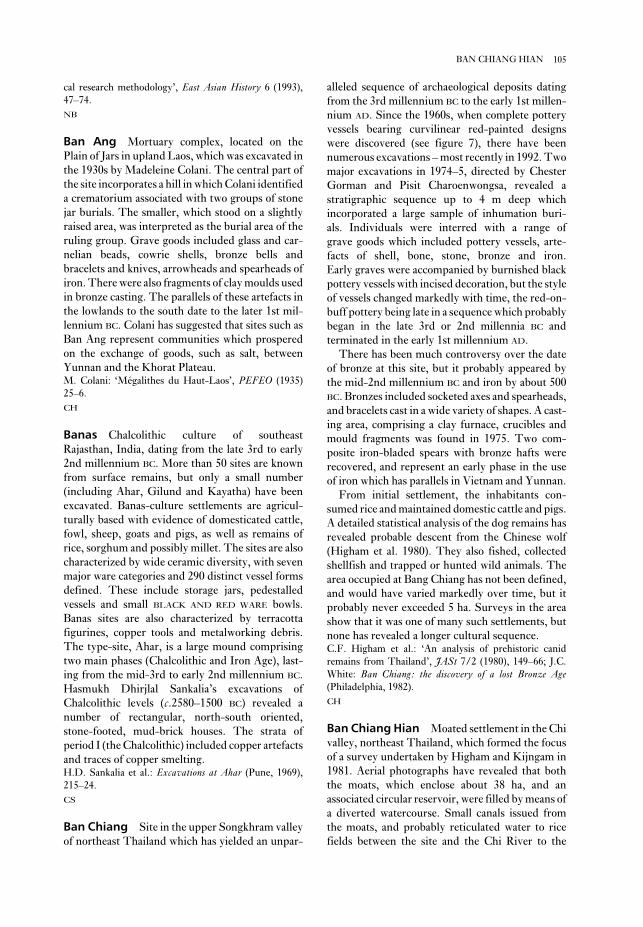
alleled sequence of archaeological deposits dating
from the 3rd millennium BC to the early 1st millen-
nium AD. Since the 1960s, when complete pottery
vessels bearing curvilinear red-painted designs
were discovered (see figure 7), there have been
numerous excavations – most recently in 1992. Two
major excavations in 1974–5, directed by Chester
Gorman and Pisit Charoenwongsa, revealed a
stratigraphic sequence up to 4 m deep which
incorporated a large sample of inhumation buri-
als. Individuals were interred with a range of
grave goods which included pottery vessels, arte-
facts of shell, bone, stone, bronze and iron.
Early graves were accompanied by burnished black
pottery vessels with incised decoration, but the style
of vessels changed markedly with time, the red-on-
buff pottery being late in a sequence which probably
began in the late 3rd or 2nd millennia BC and
terminated in the early 1st millennium AD.
There has been much controversy over the date
of bronze at this site, but it probably appeared by
the mid-2nd millennium BC and iron by about 500
BC. Bronzes included socketed axes and spearheads,
and bracelets cast in a wide variety of shapes. A cast-
ing area, comprising a clay furnace, crucibles and
mould fragments was found in 1975. Two com-
posite iron-bladed spears with bronze hafts were
recovered, and represent an early phase in the use
of iron which has parallels in Vietnam and Yunnan.
From initial settlement, the inhabitants con-
sumed rice and maintained domestic cattle and pigs.
A detailed statistical analysis of the dog remains has
revealed probable descent from the Chinese wolf
(Higham et al. 1980). They also fished, collected
shellfish and trapped or hunted wild animals. The
area occupied at Bang Chiang has not been defined,
and would have varied markedly over time, but it
probably never exceeded 5 ha. Surveys in the area
show that it was one of many such settlements, but
none has revealed a longer cultural sequence.C.F. Higham et al.: ‘An analysis of prehistoric canid
remains from Thailand’, JASt 7/2 (1980), 149–66; J.C.
White: Ban Chiang: the discovery of a lost Bronze Age(Philadelphia, 1982).
CH
Ban Chiang Hian Moated settlement in the Chi
valley, northeast Thailand, which formed the focus
of a survey undertaken by Higham and Kijngam in
1981. Aerial photographs have revealed that both
the moats, which enclose about 38 ha, and an
associated circular reservoir, were filled by means of
a diverted watercourse. Small canals issued from
the moats, and probably reticulated water to rice
fields between the site and the Chi River to the
cal research methodology’, East Asian History 6 (1993),
47–74.
NB
Ban Ang Mortuary complex, located on the
Plain of Jars in upland Laos, which was excavated in
the 1930s by Madeleine Colani. The central part of
the site incorporates a hill in which Colani identified
a crematorium associated with two groups of stone
jar burials. The smaller, which stood on a slightly
raised area, was interpreted as the burial area of the
ruling group. Grave goods included glass and car-
nelian beads, cowrie shells, bronze bells and
bracelets and knives, arrowheads and spearheads of
iron. There were also fragments of clay moulds used
in bronze casting. The parallels of these artefacts in
the lowlands to the south date to the later 1st mil-
lennium BC. Colani has suggested that sites such as
Ban Ang represent communities which prospered
on the exchange of goods, such as salt, between
Yunnan and the Khorat Plateau.M. Colani: ‘Mégalithes du Haut-Laos’, PEFEO (1935)
25–6.
CH
Banas Chalcolithic culture of southeast
Rajasthan, India, dating from the late 3rd to early
2nd millennium BC. More than 50 sites are known
from surface remains, but only a small number
(including Ahar, Gilund and Kayatha) have been
excavated. Banas-culture settlements are agricul-
turally based with evidence of domesticated cattle,
fowl, sheep, goats and pigs, as well as remains of
rice, sorghum and possibly millet. The sites are also
characterized by wide ceramic diversity, with seven
major ware categories and 290 distinct vessel forms
defined. These include storage jars, pedestalled
vessels and small BLACK AND RED WARE bowls.
Banas sites are also characterized by terracotta
figurines, copper tools and metalworking debris.
The type-site, Ahar, is a large mound comprising
two main phases (Chalcolithic and Iron Age), last-
ing from the mid-3rd to early 2nd millennium BC.
Hasmukh Dhirjlal Sankalia’s excavations of
Chalcolithic levels (c.2580–1500 BC) revealed a
number of rectangular, north-south oriented,
stone-footed, mud-brick houses. The strata of
period I (the Chalcolithic) included copper artefacts
and traces of copper smelting.H.D. Sankalia et al.: Excavations at Ahar (Pune, 1969),
215–24.
CS
Ban Chiang Site in the upper Songkhram valley
of northeast Thailand which has yielded an unpar-
105BAN CHIANG HIAN

millennium BC, together with crucible fragments
indicating local bronze casting. A group of inhuma-
tion burials, associated with shell and stone
jewellery, dated from this early period. There was a
break in the ceramic tradition c.500 BC, after which
north. Few such large moated sites have been ex-
cavated, and a limited sounding made near the
centre of this settlement usefully revealed a 6 m
deep cultural sequence, with basal layers containing
red-on-buff painted pottery dated to the late 2nd
106 BAN CHIANG HIAN
Figure 7 Ban Chiang Late Period painted pottery from Ban Chiang, southeast Asia, showing the great variety of
decorative motifs. Source: C.F.W. Higham: The archaeology of mainland Southeast Asia (Cambridge, 1989), fig. 4.25.

but the range of vessel forms is considerable, and
their complexity indicates a mastery of the medium.
The second phase saw a change to red or black
burnished pottery. The two most recent graves con-
tained iron implements. Radiocarbon dating
suggests that the graves of the first and second
phases date to 2500–1500 BC; as bronze was not
present Sørensen labelled these phases Early and
Late Neolithic. The grave goods included many
polished stone adzeheads and a small quantity
of shell jewellery, both indicating the existence of
exchange networks.P. Sørensen and T. Hatting: Archaeological investigationsin Thailand II: Ban Kao I: The archaeological material fromthe burials (Copenhagen 1967).
CH
Ban Muang Phruk Settlement of the later 1st
millennium BC located close to the eastern dry-
season shore of Lake Kumphawapi, Thailand. The
site was identified in 1980 during a survey by
Higham and Kijngam that was designed to docu-
ment the settlement pattern of village communities
as it related to the long sequence then known from
BAN CHIANG. A small excavation revealed that the
site was first occupied from about 500 BC; it may
therefore be an example of the way in which settle-
ments dating from relatively late in the prehistoric
sequence of northeast Thailand expanded onto the
heavier clayey soils near the lake edge in contrast to
an earlier preference for soils of the low terrace.
Some sites of the General Period C (c.600 BC–AD
200) were large and moated (see BAN CHIANG HIAN)
but most, like Ban Muang Phruk, remained small
and undefended.C.F.W. Higham and A. Kijngam: ‘The test excavation at
Ban Muang Phruk’, Prehistoric investigations in northeastThailand, ed. C.F.W. Higham and A. Kijngam (Oxford,
1984), 34–5.
CH
Ban Na Di One of the few prehistoric sites in
northeast Thailand to have been examined ex-
tensively (1981), this settlement and cemetery site
is located adjacent to a stream which flows into Lake
Kumphawapi. The lowest layer, dated to the late
2nd millennium BC by radiocarbon, included occu-
pation evidence in the form of pits, hearths and
fragments of bronze. This was followed by a
cemetery phase, manifested in at least two clusters
of inhumations, which probably ended in the
second half of the 2nd millennium BC. The graves
yielded a common range of pottery vessels, mostly
of local manufacture. One cluster, however, con-
tained the majority of exotic grave goods, including
the first evidence for iron forging and the domestic
water buffalo was found. The extensive earthworks
which ring the site have not been dated directly, but
may belong to the later 1st millennium BC. Such
sites, which are thickly distributed in the Mun and
to a lesser extent the Chi valleys, are usually seen as
evidence for the development of local chiefdoms.P. Chantaratiyakarn: ‘The Middle Chi research pro-
gramme’, Prehistoric investigations in northeast Thailand,
ed. C.F.W. Higham and A. Kijngam (Oxford, 1984),
565–643.
CH
Ban Don Ta Phet Cemetery site of the late 1st
millennium BC, located on the western margins of
the Chao Phraya lowlands in central Thailand,
which has furnished an unparalleled body of evi-
dence for early exchange between this area and
India. Its strategic position at the eastern end of a
historic exchange route to Burma may well account
for the wealth of the grave goods. The inhumations,
ringed by a ditch and probably reinterred from else-
where, were discovered in 1975 and excavated by
first Chin You-di and then Ian Glover. The grave
goods include many pottery vessels, iron tools and
weapons and, most significantly, a range of bronze
bowls bearing incised decoration that includes
scenes of houses and people. These bowls were
made of a very high tin bronze requiring con-
siderable technical expertise; similar bronze bowls
have been found in Indian contexts, for example at
the Bhir mound at TAXILA. There are also beads of
agate, carnelian and glass, some of which match
those known from India in the 2nd and 3rd
centuries BC, as well as a splendid lion in carnelian.
The radiocarbon dates confirm that the site was
occupied in the 4th–3rd centuries BC. Glover has
stressed that this site reveals the nature and early
date of the exchange of ideas and goods between
India and Southeast Asia, an ingredient often cited
as contributing to the local development of complex
societies.I.C. Glover et al.: ‘The cemetery of Ban Don Ta Phet,
Thailand. Results from the 1980–1 season’ South AsianArchaeology 1981, ed. B. Allchin and M. Sidell
(Cambridge, 1984), 319–30; I.C. Glover: Early tradebetween India and Southeast Asia (Hull, 1989).
CH
Ban Kao Site of the first major excavation of a
prehistoric cemetery in Thailand. In 1961–2, Per
Sørensen uncovered 44 inhumations, which he
divided into three mortuary phases. The earliest
included a distinctive variety of unpainted pottery
with parallels in Malaysia and peninsula Thailand,
107BAN NA DI

Banteay Chmar Temple mausoleum in north-
west Cambodia, constructed for the deified crown
prince Srindrakumara by the Angkorean overlord
Jayavarman VII (1181–1219 AD). One of the largest
such monuments, Banteay Chmar is surrounded by
a substantial wall and is associated with a reservoir.
The walls are richly ornamented in bas-reliefs,
including a well-known naval battle between the
Khmer of ANGKOR and the invading CHAMS which
took place shortly before the accession of
Jayavarman.L.P. Briggs: ‘The ancient Khmer empire’, TAPS 4/1
(1951), 1–295.
CH
Ban Tha Kae Large settlement (1200 × 800 m)
located 15 km southwest of the copper deposits of
the KHAO WONG PRACHAN VALLEY in central
Thailand. In the face of the systematic removal of
the mound by civil contractors and looting, ex-
cavation has elucidated a three-phase cultural
sequence. The first probably belongs to the latter
half of the 2nd millennium BC, a period when the
copper mines to the northeast were being exploited,
and is represented by a cemetery in which bronze
bracelets, pottery vessels and shell and stone
jewellery were found as grave goods. Phase 1 also
saw the local manufacture of shell bracelets from
tridacna, a marine species. The second phase, dating
from about 500 BC, saw the first use of iron, and the
presence of imported glass beads, while the final
phase represents the DVARAVATI CULTURE. The
remains of a small early and a large later moat have
not yet been related to the cultural sequence.S. Natapintu: ‘Ancient settlement at Ban Tha Kae in
Lopburi’, Muang Boran 10/4 (1984).
CH
Bantu see AFRICA 5
Banyan Valley Cave see HOABINHIAN
Baradostian see SHANIDAR
Barinas Culture in Venezuela dating from the
6th or 7th century AD to the Conquest.
Investigations in the western Orinoco plains and the
adjacent Andean piedmont have been dedicated to
the study of the origins and development of chief-
doms. Such evidence as immense earthworks,
including pyramidal mounds, a three-level settle-
ment pattern with a regional centre at Gaván, status
differentiation in household and grave goods, and
long-distance trade appearing c.AD 500 suggest that
growing populations had led to the establishment of
most of the bronze artefacts, all the clay figurines of
cattle, elephant, deer and humans, most shell beads,
all the exotic stone bracelets and, at the end of the
sequence, the only iron implements from this
mortuary phase. This suggests that one social group
consistently secured access to exotic goods obtained
by exchange. A clay-lined pit for heating copper and
tin was contemporary with the graves.C.F.W. Higham and A. Kijngam, eds: Prehistoric investi-gations in northeast Thailand (Oxford, 1984).
CH
Ban Phak Top Settlement mound, radiocarbon-
dated to the 2nd millennium BC, located 15 km west
of BAN NA DI in northeast Thailand. It was system-
atically looted during the 1970s, leaving parts of the
modern village littered with prehistoric human
remains, broken pottery vessels, clay figurines and
ivory bracelet fragments. In 1976 Schauffler ex-
cavated a small area on the edge of the mound – the
only undisturbed area he could find – but dis-
covered no burials. The pottery is black, burnished
and covered with curvilinear parallel bands infilled
with punctate impressions which match the style of
the early ceramics from BAN CHIANG.W. Schauffler: ‘Archaeological survey and excavation of
Ban Chiang culture sites in northeast Thailand’,
Expedition 18 (1976), 27–37.
CH
Ban Tamyae Settlement site discovered during
a survey of the Phimai region, which was a major
Khmer centre in the upper reaches of the Mun
valley of northeast Thailand. The lowest of nine
layers contained bronze remains, while layer 7 pro-
vided the earliest evidence for iron working at this
site. Cattle and pig remains were recovered, and the
earliest bones of the water buffalo appeared in layer
4; no burials were found. The large pottery sample
was used to divide the sequence into four phases.
The first, named after Ban Tamyae itself, was dated
1000–600 BC (layers 8–9) and represents the period
immediately prior to the marked social changes
associated with the development of chiefdoms in
Southeast Asia (see ASIA 3; BAN CHIANG HIAN; CO
LOA; DONG SON CULTURE and NON DUA). At Ban
Tamyae this change is recognized by first the Prasat
period (600–200 BC) and then the Classic Phimai
phase (200 BC–AD 300).D. Welch: ‘Settlement pattern as an indicator of socio-
political complexity in the Phimai region’, in SoutheastAsian archaeology at the XV Pacific Science Congress, ed.
D.T. Bayard (Otago, 1984), 129–51.
CH
108 BAN NA DI

goods (e.g. BUSH BARROW), although secondary
burials were often later dug into the mound. In
Britain, barrows were constructed in a variety of
shapes: simple bowl barrows are the most common
shape, often with a ditch and/or bank; bell barrows,
often associated with the richer barrows of
the WESSEX CULTURE, have a berm between the
mound and the ditch surrounding it; disc, pond and
saucer barrows occur more rarely. In Central
Europe, there is a limited number of very rich buri-
als in the Early Bronze Age, while the TUMULUS
COMPLEX of the Middle Bronze Age is character-
ized by barrow construction. In Eastern Europe, the
Bronze Age was marked by a series of mound (or
‘kurgan’) building cultural complexes known as the
PIT GRAVE, CATACOMB GRAVE and TIMBER GRAVE
CULTURES.
(3) A smaller number of large and richly
furnished princely tumuli, usually circular, began
to be constructed in the Iron Age (such as the late
Hallstatt tombs of VIX and HOCHDORF), and
barrows continued to be erected in the early
medieval period – for example, burials of the
SUTTON HOO type.
RJA
Barsippa see BORSIPPA
Barumini (Su Nuraxi) The site of Su Nuraxi,
near Barumini, is the pre-eminent example of the
Sardinian NURAGHE form of fortification; largely
built in the 2nd millennium BC, it was excavated
from 1940 by Giovanni Lilliu. The construction
sequence is not quite certain, but it seems the first
part of the fortress to be built was a tower of basalt
blocks about 19 m tall, in the first half of the 2nd
millennium BC. Some centuries later, possibly in
the later 2nd millennium or early 1st millennium
BC, this tower was strengthened and its shape
altered, and four massive round towers were built
abutting it. Like the early tower, these were multi-
storied and contained skilfully vaulted rooms. This
whole core fortification was finally encircled with
seven further smaller towers linked by straight
sections of walling. Outside this wall is a settlement
of about 60 round huts built of the same massive
blocks. Barumini was partly destroyed and rebuilt
at least once in its history, before being abandoned
in the 7th century BC.G. Lilliu: ‘Il nuraghe di Barumini e la stratigrafia
nuragica’, Studi Sardi, xii–xiii, part 1 (1952–4), 90–469;
––––: La civiltà nuragica (Milan, 1982); G. Webster: Theprehistory of Sardinia (1996).
RJA
chiefdoms whose descendants were the Conquest
period Caquetó Nation.C. Spenser and E. Redmond: ‘Pre-Hispanic chiefdoms of
the Western Venezuelan Llanos’, WA 24/1 (1992),
135–57.
KB
Barnenez Perhaps the most famous of the com-
plex Neolithic chambered tombs of Brittany,
Barnenez is also among the earliest, having been
radiocarbon dated to around 5750 ± 150 BP uncal.
The trapezoidal monument (over 70 m long) was
built of drystone and megaliths in two stages: the
earliest cairn covers five passage graves, while
the secondary cairn, built onto the first, conceals a
further six; the passages are arranged side by side
and vary from 5–12 m in length. Excavations by
Giot et al. from 1955 revealed that tiers of drystone
revetments were used to strengthen the body of the
cairn; the round and polygonal chambers were
constructed using combinations of drystone
and/or orthostats, and are roofed with false
corbelling or capstones. The megaliths of certain of
the chambers are decorated with megalithic art;
those of Chamber H, which was the central and
most monumental chamber in the primary cairn,
exhibit wavy lines, axes and curves.P.R. Giot: Barnenez, Carn, Guennoc (Rennes, 1987).
RJA
barrow (tumulus) Generic term for the vari-
ously shaped earth and rubble mounds used to
cover and mark burials in prehistoric Europe; where
the covering is of heaped stones it is more precise to
use the term cairn, while ‘tumulus’, although some-
times interpreted as synonymous with barrow, is
best used to embrace both categories of monument
as well as the occasional ancient mound with no
apparent burial (such as the greatest European
tumulus, Silbury Hill, near Avebury in Wiltshire,
southern England). Barrow building in prehistoric
Europe may be broadly divided into three phases:
(1) The large barrows of the Early to Middle
Neolithic, which follow various regional styles.
These mounds usually covered a wooden mortuary
house or megalithic chambers, housing the remains
of multiple bodies. The barrows are often sub-
rectangular, such as the KUJAVIAN barrows of
Poland or the earthern long barrows of southern
Britain; however, many circular examples also exist.
Barrows and cairns covered many tombs of
MEGALITHIC construction.
(2) The numerous, and usually smaller, circular
barrows of the Bronze Age, which usually housed
individual primary burials and accompanying grave
109BARUMINI

organization of metallurgical production and state-
directed trade in a network that covered much of
western South America; the development and
organization of industrial level ceramics produc-
tion; and the existence of a four-tier social
organization among the Sicán elite. An unlooted
‘royal’ tomb discovered in 1991 provided a context
for the elaborate gold work, including the huge
mummy masks, characteristic of this culture.I. Shimada: ‘The Batan-Grande-La Leche archaeological
project: the first two seasons’, JFA 8:4 (1981), 405–46;
––––: ‘Perception, procurement and management of
resources: archaeological perspectives’, Andean civiliza-tion and ecology, ed. S. Masudo et al. (Tokyo, 1985),
357–99; I. Shimada and J. Merkel: ‘A Sicán tomb in Peru’,
Minerva 4/1 (1993), 18–25; Y. Masuda, T. Yamaqudi and
I. Shimada, ed.: Shikan Hakkutsoten – Ogen no Miyako[Exhibition of Sicán excavation – golden capitol] (Tokyo,
1994); I. Shimada and J.A. Griffin: ‘Precious metal objects
of the Middle Sicán’, SA 270 (1994), 82–9.
KB
Bat Cave Set of adjacent rockshelters on the
southern margin of the San Agustin Plains in west-
central New Mexico. The initial excavation of the
site by Herbert Dick in 1948 and 1950 yielded the
earliest maize in North America, radiocarbon dated
to c.6000 BP. The re-excavation of Bat Cave by
W.H. Wills in 1981 and 1983 led to a reassessment
of the data, setting the appearance of maize and
squash in North America at c.1200 BC.W.H. Wills: Early prehistoric agriculture in the AmericanSouthwest (Santa Fe, 1988).
JJR
batôn de commandement see BATÔN
PERCÉ
batôn percé Antler tool-type of unknown func-
tion that forms part of the Magdalenian (and
occasionally Aurignacian) industry in the Upper
Palaeolithic, for example at La Madeleine in the
Dordogne. Often decorated, they consist of a length
of reindeer antler with a hole drilled through, and
may have served as arrow straighteners. When this
artefact type was first recognized it was given the
misleading name of batôn de commandement, and this
is the name used in the earlier literature.
RJA
baulk (balk) Unexcavated strips deliberately
preserved by archaeologists between excavated
trenches. Baulks are useful for a number of practi-
cal reasons (access, photography, survey stations),
but primarily because they allow the excavator to
see a vertical section of stratigraphy at the edge of
Bascomb Down see BUTSER ANCIENT FARM
Bashu see PA-SHU
Basin of Mexico Interior highland valley or
structural basin in central Mexico, which was a
favoured location of human settlement from
Formative times (c.2500 BC) onwards. It is now
the site of Mexico City (see also AZTECS;
TENOCHTITLAN; TEOTIHUACAN). Located at an
average altitude of 2200 m (about 7000 feet), the
basin originally held a series of interconnected
lakes, the largest of which is known as Lake
Texcoco; the Spaniards began draining the lake
after the Conquest.E.R. Wolf, ed.: The valley of Mexico. Studies in pre-hispanicecology and society (Albuquerque, 1976); W.T. Sanders et
al.: The basin of Mexico: ecological processes in the evolutionof a civilization (New York, 1979).
PRI
Basta, Tell (anc. Per-Bastet, Bubastis) Temple
and town in the eastern Nile Delta, 80 km northeast
of Cairo, which flourished from the 4th dynasty
to the late Roman period (c.2649 BC–AD 395).
The main excavated features of the site are the
red granite temple of the cat-goddess Bastet, the
ka-temples of Teti and Pepy I (c.2323–2255 BC),
the temples of Atum and Mihos and the ‘jubilee
chapels’ of Amenemhat III and Amenhotep III, as
well as a series of vaulted mud-brick cat cemeteries
and adjacent ateliers to the north of the city.
Bubastis reached its peak when it became the capital
of Egypt in the 22nd dynasty (c.945–712 BC). The
site provides a particularly satisfying instance of the
successful combination of textual and archaeo-
logical data in that some of the details of Herodotus’
architectural description of the temple of the cat-
goddess Bastet (History II, 59–60) were confirmed
by the excavations of Edouard Naville (1891).E. Naville: Bubastis (1887–1889) (London, 1891); L.
Habachi: Tell Basta (Cairo, 1957); C.C. Van Siclen III:
‘The city of Basta: an interim report’, NARCE 128 (1984),
28–39.
IS
Batan Grande Immense site of the Sicán
culture, in the Lambayeque Valley of Peru, dating
to the Middle Horizon and Late Intermediate
Period (c.AD 550–1438). It consists of a ceremonial
precinct of some eight large adobe pyramid com-
plexes, most of which are apparently mortuary
structures. A long-term archaeological project in
this precinct (and in adjacent habitation and pro-
duction areas) has delineated the familial
110 BASCOMB DOWN

Clarke (1970) and reinterpreted in Lanting and van
der Waals (1972).D.L. Clarke: Beaker pottery of Great Britain and Ireland(Cambridge, 1970); J.N. Lanting and J.D. Van Der Waals:
‘British beakers as seen from the Continent’, Helenium 12
(1972), 20–46; R.J. Harrison: The beaker folk: Copper Agearchaeology in Western Europe (London, 1980); W.H.
Waldren and R.C. Kennard, eds: Bell Beakers of the WestMediterranean (Oxford, 1987).
RJA
‘beaker phenomenon’ Term used to describe
the spread and adoption of a set of similar material
culture, notably pottery beakers, across broad areas
of Europe, especially Atlantic Europe, during the
later 3rd millennium BC. The beaker phenomenon
is recognized largely from burials, where the richer
interments are characterized by gravegoods such as
daggers (at first flint, then copper), archery equip-
ment (especially stone wristguards), jewellery made
of exotic materials such as jet and gold and in
characteristic shapes such as the ‘V-perforated
button’ – and, of course, the characteristic ‘bell-
shaped’ pottery beaker. The earliest bell beaker
assemblages in northern European contexts are
truly ‘Neolithic’ – there is no sign of metallurgy.
Later assemblages boast early tanged copper
daggers and metal beads and other jewellery and are
usually classified as ‘Copper Age’ or ‘Early Bronze
Age’.
Regions exhibiting beaker material include areas
bordering the Atlantic and North Sea such as the
Low Countries, Britain, Brittany, southwest and
southern France, Spain and Portugal (the southern
countries exhibiting some of the earliest forms of
beaker); beaker assemblages and traits also appear
along the upper Rhine, along the Rhône, and on
some of the Mediterranean islands. In the past,
archaeologists (e.g. Abercromby 1902) regarded the
spread of beakers and their associated material
culture as evidence for the movement of people (as
invaders, traders or colonizers); it was often
assumed that they travelled by sea, as the areas first
and most characteristically affected appeared to be
maritime or accessible by great rivers such as the
Rhône or Rhine. It became clear, however, that
different elements of the beaker material culture
originated in different regions of Europe. For
example, despite the fact that very early styles of
beaker can be identified in Iberia (the Maritime-
style beaker), the bell beaker form itself seems to
have derived from earlier beaker forms in the Rhine
delta area (where an important early decorated
variant is known as the All-Over Ornamented or
AOO beaker), and is perhaps ultimately derived
the excavated area. When sites have very complex
or confused stratigraphies, the trenching strategy
often makes use of multiple baulks, while sites with
simpler stratigraphies tend to be excavated ex-
tensively using few or no baulks (see OPEN-AREA
EXCAVATION).
RJA
Bawit see BAHARIYA OASIS
Bayesian approach, Bayesian statisticsApproach to statistics which allows previous results
or experience to be taken into account and to influ-
ence future results; for this reason it is sometimes
called subjective analysis, in contrast to classical (or
objective, or frequentist, statistics). At its heart lies
Bayes’ Theorem, which enables prior PROBABILI-
TIES to be combined with data to yield posterior
probabilities, that express a researcher’s degree of
belief about a subject in the light of both the data
and previous experience. The approach makes
heavy demands on computer time, but develop-
ments in statistical theory and computer hardware
are reducing this problem. Buck et al. (1996) have
applied the approach to RADIOCARBON DATING,
SPATIAL ANALYSIS, provenancing, SERIATION and
DENDROCHRONOLOGY, and further uses can be
expected.T.R. Bayes: ‘An essay towards solving a problem in the
doctrine of chances’, Philosophical Transactions of theRoyal Society 53 (1763), 370–418; C.E. Buck et al.:
‘Combining archaeological and radiocarbon information:
a Bayesian approach to calibration’, Antiquity 65 (1991)
808–21; D.A. Berry: Statistics: a Bayesian perspective(Belmont, 1995); C.E. Buck et al.: Bayesian approach tointerpreting archaeological data (Chichester and New York,
1996).
CO
Bayon see ANGKOR
beakers In its generic sense, this term can be
used to describe any flat-based (and usually handle-
less) drinking cup, made of any material.
Archaeologists tend to use the term more particu-
larly to describe the tall, decorated, pottery drinking
vessels that are a distinctive element in various late
Neolithic and Copper Age cultural assemblages
in Europe such as the CORDED WARE COMPLEX
and the later bell beakers of the ‘BEAKER
PHENOMENON’. Well-fired, and usually boldly
decorated with simple repeated geometric orna-
ment within zones, beakers are most often found as
grave-goods; the stylistic evolution of bell beakers
in the Low Countries and Britain is described in
111‘BEAKER PHENOMENON’
Beechey Island Site where Sir John Franklin’s
ships Erebus and Terror wintered in 1845/6 during
their attempt to navigate the Northwest Passage.
Three sailors died that winter and were buried on
the island. In 1984 and 1986 Owen Beattie tem-
porarily exhumed from the permafrost the perfectly
preserved bodies and autopsied them. Hair samples
later confirmed the hypothesis that lead poisoning,
probably from food sealed in cans with lead solder,
was already affecting the crews during that first
winter and may have contributed to the eventual
death of the remaining 126 sailors by the summer of
1848.O. Beattie and J. Geiger: Frozen in time (Saskatoon, 1987).
RP
Begarawiya see MEROE
Begho Site of a market town in the Brong Ahafo
region of western Ghana, made up of four quarters
1–2 km from each other. On the basis of six radio-
carbon dates obtained from the Brong quarter, the
excavator, Merrick Posnansky, concluded that
the town was occupied from around AD 1430 to
1710 (520–240 BP) and that it attained a peak of
prosperity towards the beginning of the 17th
century. Local manufactures included objects of
iron and ivory, beads, ceramics and textiles, and
Posnansky considered that there was a continuity in
material culture between the ancient inhabitants
and their modern descendants. Notable finds
included two ivory side-blown trumpets, still
important in ceremonials today, and Posnansky
(1976: 56) suggested that this instrument ‘spread
south from Mali, together with a knowledge of
brass-working, systems of weights, building
methods and ceramic forms’. These items were
transmitted in turn from forest fringe states such as
Bono Manso to Asante, which was the most impor-
tant of the Akan kingdoms in the forest, and
subsequently a centre of the gold trade. It is now
known, however, that the town is older than pre-
viously suspected. Two radiocarbon dates obtained
by L.B. Crossland in 1975 from the Nyarko quarter
indicate an occupation in the 11th and 12th
centuries AD (905 ± 80 and 830 ± 80 BP). The view
hitherto accepted that Begho and similar towns
grew up in response to traders coming down from
JENNE may therefore be, as Posnansky and
McIntosh (1976: 166) comment, ‘in need of some
alteration’.M. Posnansky: ‘Archaeology and the origins of the Akan
society in Ghana’, Problems in economic and social anthro-pology, ed. G. de G. Sieveking et al. (London, 1976),
49–59; M. Posnansky and R. McIntosh: ‘New radiocarbon
from the earlier CORDED WARE beakers; metallurgy
and some styles associated with it seem more likely
to have spread from Iberia, where they are known in
an earlier period from centres such as LOS
MILLARES. Furthermore, styles and influences
seemed to flow back to supposed ‘originating’ areas
as well as forward to ‘invaded’ areas, and there
seemed to be some regions where elements of the
beaker cultural complex were adopted while other
elements were ignored. For all these reasons,
the idea of a single colonizing or itinerant ‘beaker
folk’ as an explanation of the phenomenon has fallen
out of favour.
While it still seems possible that in some areas
movements of people were involved in the spread of
the beaker cultural assemblage, archaeologists now
prefer to view it as primarily a social phenomenon.
According to this interpretation, the beaker phe-
nomenon represents a ‘package’ of elite material
culture, probably associated with particular prac-
tices (e.g. warrior drinking rituals) and perhaps with
a radical change in social organization. Much has
been made of the fact that traces of pollen found in
some beakers suggest it may have been associated
with the drinking of mead or other forms of alcohol;
the importance of daggers and archery equipment
in beaker burials suggests a cult of the warrior, while
the richness of some of the jewellery has been
termed ‘individualizing’. The fact that beaker
burials are generally single male inhumations, often
under round barrows, contrasts sharply with the
more ‘collective’ burials of the early and middle
Neolithic (although single burials in round barrows
are now recognized in a few regions before the
beaker assemblages arrived). Andrew Sherratt
traces the origin of the dynamic underlying the bell-
beaker phenomenon in northwest Europe as far
back as the introduction of specialized ‘liquid
handling’ and drinking vessels in southeast and
central Europe from the 4th millennium onwards.
He associates the spread of beakers with the spread
of other novelties from the east (horses, woolly
sheep) and perhaps the export from the west of
metals. Most authorities now accept that the ex-
planation for the spread of the beaker material
culture package lies in its symbolic strength and in
the changing nature of societies in Early Bronze Age
Europe. See BEAKER for further bibliography.J. Abercromby: ‘The oldest Bronze-Age ceramic type in
Britain’, Journal of the Royal Anthropological Institute 32
(1902), 373–97; A. Sherratt: ‘The emergence of elites:
Earlier Bronze Age Europe’, The Oxford IllustratedPrehistory of Europe, ed. B. Cunliffe (Oxford, 1994),
244–77.
RJA
112 ‘BEAKER PHENOMENON’

M.B. Schiffer: Formation processes of the archaeologicalrecord (Albuquerque, 1987).
IS
Behistun see BISITUN
Beidha see ACERAMIC NEOLITHIC
Belbaşe Rock-shelter on the coast of southern
Turkey which was excavated by Envor Bostanci in
the early 1960s. It has given its name to an Upper
Palaeolithic regional culture typified by a combina-
tion of rock engravings and a distinctive microlithic
assemblage consisting of points, tanged arrowheads
and blades. Although Belbase itself is the type-site,
the most impressive collection of Belbase material
has been excavated from the lower strata at the
Beldibi rock-shelter, which is itself the typesite for
the succeeding MESOLITHIC ‘Beldibi culture’
(characterized by a hunting and fishing subsistence
pattern and early pottery production).E.Y. Bostanci: ‘The Belbasi industry’, Belleten 26 (1962),
253–72; ––––: ‘The Mesolithic of Beldibi and Belbasi’,
Antropoloji 3 (1965), 91–134.
IS
Beldibi see BELBAŞE
Bellows Beach One of the earliest Hawaiian
sites on the island of O’ahu, this beach site lies near
a permanent stream. The site shows evidence of
house structures, cooking facilities and evidence
of subsistence, as well as burials. The site may
date to 1700 BP, although this early date has been
questioned by Spriggs and Anderson (1993), who
feel there is no evidence for the settlement of Hawaii
prior to 1400 BP.P.V. Kirch: The evolution of Polynesian chiefdoms(Cambridge, 1984), 244–5; M. Spriggs and A. Anderson:
‘Late colonization of East Polynesia’, Antiquity 67 (1993),
200–17.
CG
Bender, Tell el- see KISH
Benfica Site on the coast of Angola, a little south
of Luanda, the chief interest of which lies in the
occurrence of a small sample of pottery considered
to have Early Iron Age affinities in a shell midden
with Later Stone Age artefacts, and with radio-
carbon dates of uncal 1810 and 1770 BP. The date
would be very early for Iron Age in such a locality,
and the possibility cannot be ignored that the affini-
ties may lie with older pottery traditions of the
dates for Northern and Western Africa’, JAH 17 (1976),
161–95.
PA-J
behavioral archaeology, behaviorismForm of PROCESSUAL ARCHAEOLOGY devised by
the American archaeologist Michael Schiffer in the
1970s. Schiffer’s ideas, set out in the book
Behavioral archaeology, were concerned with the
diversity of human behaviour in the past, and the
dialogue between behaviour and the environmental
context. His body of method and theory was based
on the premise that cultural and natural ‘trans-
forms’ (C-TRANSFORMS and N-TRANSFORMS)
converted the ‘systemic context’ (i.e. the original set
of dynamic relationships within ancient material
culture and society) into the ‘archaeological context’
(the ‘distorted’ form of the cultural material ex-
amined by archaeologists). Behavioral archaeology
is therefore primarily concerned with SITE
FORMATION PROCESSES. He suggested that many
archaeological projects, such as Robert Whallon’s
SPATIAL ANALYSIS of occupation floors (1974),
were deeply flawed because they failed to dis-
tinguish between systemic and archaeological
contexts.
Lewis Binford (1981) argued that Schiffer’s
approach was based on a dubious ‘Pompeii
premise’. That is, just as the Roman city of
Pompeii was preserved by volcanic ash without
being abandoned or allowed to deteriorate, so the
original behavioural systems were envisaged by
Schiffer as perfect frozen systems. ‘What Schiffer
has described is . . . not a picture of a cultural system
but a slice of “history” in the literal sense of the
word’. Whereas Schiffer defined practices such as
the cleaning out of hearths as C-transforms, Binford
argued that these were part of the archaeological
record itself, not ‘distortions’ of some original
perfect system. Despite such criticism, Schiffer’s
behavioral archaeology has permanently affected
perceptions of the archaeological record. Indeed, it
might be argued that it is precisely by means of the
distinction between systemic and archaeological
contexts that the ‘Pompeii premise’ can be avoided.
See GRASSHOPPER PUEBLO for a discussion of the
application of behavioral archaeology to the study of
complexity.M.B. Schiffer: ‘Archaeological context and systemic con-
text’, AA 37/2 (1972), 156–65; R. Whallon: ‘Spatial
analysis of occupation floors II: the application of nearest
neighbour analysis’, AA 39 (1974), 16–34; M.B. Schiffer:
Behavioral archaeology (New York, 1976); L.S. Binford:
‘Behavioral archaeology and the “Pompeii premise”’,
Journal of Anthropological Research 37/3 (1981), 195–208;
113BENFICA

from the savanna country to the north around the
middle of the 1st millennium AD. The available
radiocarbon dates for the moment however relate
only to the later stages of this process, at Ohovbe
650 ± 50 and at Idu 530 ± 80 BP (AD 1300 and
1420). Within the city, Connah found some evi-
dence for early settlement at the Clerks’ Quarters
site, where a well-like cistern extending to a depth
18 m below present ground surface contained the
remains of at least 41 young women (with bracelets,
finger-rings, and beads) who had apparently been
sacrificed. Charcoal associated with the mass burial
produced radiocarbon dates of 770 ± 105 and 640 ±
90 BP (AD 1180 and 1310). At the Benin Museum
site, Connah found some lumps of edge-laid
potsherd pavement beneath charcoal with a radio-
carbon date of 645 ± 105 BP (AD 1305); but he
suggested that these were not necessarily connected
with IFE, where a similar technique was employed.
He argues that, in general, the origins of the city are
‘still unclear’; and, as Thurstan Shaw comments,
excavations to date ‘have not thrown light’ on the
relative validity of the various chronological
schemes which have been proposed for its ‘bronze’
artefacts. An analysis of the metal objects found
associated with the mass burial at the Clerks’
Quarters site showed that they did consist of tin
bronze, but the more recent works of art for which
the city is famous are in fact of leaded brass. In
terms of their TRACE ELEMENTS (nickel, arsenic,
and antimony) and lead isotope ratios these arte-
facts are distinct from those of IFE and
IGBO-UKWU, suggesting that they formed a sep-
arate tradition. On the other hand, a TL date of 530
± 60 BP (AD 1420) has been obtained on the clay
core of a ‘bronze’ casting generally believed to
portray an Oni of Ife and to provide good evidence
of a link between these two cities. Three more
Benin ‘bronzes’ TL-dated to the 16th century AD
are also said to show evidence of the same stylistic
connection.G. Connah: The archaeology of Benin (Oxford, 1975); F.
Willett and S.J. Fleming: ‘A catalogue of important
Nigerian copper-alloy castings dated by thermo-
luminescence’, Archaeometry 18/2 (1976), 135–46; T.
Shaw: Nigeria: its archaeology and early history (London,
1978); P.J. Darling: Archaeology and history in SouthernNigeria: the ancient linear earthworks of Benin and Ishan(Oxford, 1984); G. Connah: African civilizations, pre-colonial cities and states in tropical Africa: an archaeologicalperspective (Cambridge, 1987).
PA-J
Bering land bridge see BERINGIA
equatorial forest region to the northeast, not neces-
sarily associated with the ‘Iron Age’.J.R. dos Santos Junior and C.M.N. Everdosa: ‘A estacao
arqueologica de Benfica, Luanda’, Revista da Faculdade deÇiençias da Universidaed de Luanda 5 (1970), 33–51; C.
Everdosa: Arqueologia Angolana (Lisbon, 1980).
RI
Beni Hasan Egyptian necropolis located in the
cliffs to the east of the Nile about 23 km north of
modern el-Minya. The site dates from the 6th to
12th dynasties (c.2323–1783 BC) and is best known
for the rock-cut tombs of the Middle Kingdom
provincial governors of the ‘oryx’ nome (province).
The walls of several of these tomb-chapels are
decorated with painted scenes from daily life (such
as trading, warfare and wrestling) and episodes
from funerals. At the southern end of the site is a
New Kingdom rock-cut temple (the Speos
Artemidos) dedicated to the lioness-goddess Pakhet
and dating to the 15th century BC.P.E. Newberry et al.: Beni Hassan, 4 vols (London,
1893–1900); J. Garstang: Burial customs of ancient Egypt(London, 1907); S. Bickel and J.-L. Chappaz: ‘Missions
épigraphiques du Fonds de l’Egyptologie de Genève au
Speos Artemidos’, BSEG 12 (1988), 9–24.
IS
Benin City in southern Nigeria, well-known
internationally on account of the 4,000–7,000
‘bronze’ artefacts seized and transported to Europe
by a British expeditionary force in 1897 (now in the
British Museum). The city was surrounded by an
earthen wall and ditch, with a total vertical height
of 16–17 m and a circumference of 11.5 km, which
was sectioned by Graham Connah during his ex-
cavations of 1961–4 and found to post-date 610 ±
105 BP (AD 1340). In his view this did not contra-
dict the oral tradition which attributes the building
of the wall to Oba Ewuare at around AD 1450.
Connah contrasted the city wall with a network of
linear earthworks surrounding it: the former had a
defensive purpose, whereas the latter – the result of
many different events spread over a long period of
time – did not. This interpretation has been con-
firmed by Patrick Darling, who has surveyed about
1500 km of the network, which he estimates to have
a total length of >16,000 km and an average total
vertical height of nearly 3 m. The network stretches
in an ellipse for about 100 km to the northeast of
Benin, which is in fact on its periphery. Darling
suggests that the earthwork (or ‘iya’) builders, the
ancestors of the present Bini and Ishan Edo-
speaking peoples, came as sedentary rotational
bush-fallow farmers in a ‘migratory wave front’
114 BENFICA

B Group Term coined by George Reisner to
describe the latter stages of the Neolithic A GROUP
in Nubia from c.2800 to 2300 BC. The B-Group
culture was intended to fill a supposed chronologi-
cal gap between the end of the A Group and the
beginning of the C Group, but most archaeologists
are now agreed that the B Group never existed.
When Smith (1966: 95–6) reanalysed the ex-
cavations undertaken by Reisner and Firth in
Cemetery 7 at Shellal, which formed the original
basis for the B Group, he was able to demonstrate
that most of the graves identified by the excavators
as ‘B-Group’ were either completely devoid of arte-
facts, too disturbed to be properly recorded or more
characteristic of the preceding A group or succeed-
ing C Group.G. Reisner: Archaeological survey of Nubia: report for1907–8, I (Cairo, 1910), 18–52; H.S. Smith: ‘The Nubian
B-group’, Kush 14 (1966), 69–124; ––––: ‘The develop-
ment of the A-Group “culture” in northern Lower
Nubia’, Egypt and Africa, ed. W.V. Davies (London,
1991), 92–111.
IS
Bhimbetka Hill containing a cluster of pre-
historic cave sites located in the Vindhya Hills of
Madhya Pradesh, India. Excavations in more than
a dozen caves were conducted by V.N. Misra,
Vishnu S. Wakankar and Susanne Haas in 1972–7.
The most significant of these sites, Cave III
F-23, yielded a 4 m thick deposit divided into
eight major stratigraphic levels. Levels 6–8 con-
tained ACHEULEAN artefacts, including cleavers,
handaxes, scrapers and flake tools; some LEVALLOIS
flaking was evident. Level 5 (radiocarbon-dated to
c.16,000–14,000 BC) was defined as Middle Palaeo-
lithic: flake and blade tools increased in this period,
and cleavers and handaxes declined in frequency. In
Upper Palaeolithic Level 4, flake and blade tools
again increased in frequency and decreased in
size. Artefacts from Levels 4–8 were predominantly
made of quartzite, with infrequent use of
chalcedony or chert.
The tools from levels 1–3 were dramatically
different from those found in the earlier levels:
chert and chalcedony tools predominated and the
technology was primarily microlithic. Ground-
stone artefacts, bone tools and burials also appeared
during levels 1–3, and calibrated radiocarbon dates
range from c.5000 BC to 1000 AD, thus providing
evidence of the long continuity of microlithic tra-
ditions in Central India.
Over 500 caves in the Bhimbetka region con-
tained paintings dating from late prehistoric
(‘microlithic’) until comparatively recent times.
Beringia Widely believed to be the route by
which humans populated the Americas, Beringia
was a massive landmass periodically exposed during
the last glaciation due to lowered sea levels in the
shallow Bering and Chukchi seas between Siberia
and Alaska. This vast plain, sometimes called the
Bering land bridge, appears to have been a
steppe–tundra environment that supported herds
of large mammals. It was drowned for the last time
approximately 14,000 years ago, taking with it any
archaeological sites that would have documented
this important human migration.B.M. Fagan: The great journey (London, 1987).
RP
Beth Shan see SCYTHOPOLIS
Beth Yerah see KHIRBET KERAK
Beyçesultan Anatolian Bronze Age site consist-
ing of two settlement mounds located in the upper
reaches of the Meander river valley, near Civril in
southwestern Turkey. The excavations of Seton
Lloyd and James Mellaart in 1954–9 revealed a long
stratigraphic sequence of 40 occupation levels,
stretching from the late Chalcolithic to the late
Bronze Age (c.4750–1200 BC), which has served as
a linchpin for the early chronology of southwestern
Anatolia. The lowest levels include a number of
unusual mud-brick shrines dating to the 5th mil-
lennium BC; more elaborate versions of the same
type of shrine were excavated from Middle and Late
Bronze Age strata at the site.
The Middle Bronze Age phase incorporates the
remains of a vast colonnaded palace with state-
rooms on an upper floor (a piano nobile like that in
the palace of Yarimlim at TELL ATCHANA), which
was pillaged and burnt to the ground in c.1750 BC.
The late Bronze Age settlement includes numerous
‘MEGARON’-style houses (consisting of rectangular
halls with open porticoes along their long sides). At
this time Beyçesultan may have been part of the
kingdom of Arzawa, which was contemporary with
the MYCENAEANS and HITTITES, but there is no
written evidence to confirm this hypothesis
(Mellink 1967).S. Lloyd and J. Mellaart: Beyçesultan, 3 vols (London,
1961–72); S. Lloyd: ‘Bronze Age architecture of Anatolia’,
Proceedings of the British Academy 49 (1963), 153–76; M.J.
Mellink: ‘Beyçesultan: a Bronze Age site in southwestern
Turkey’, BO 24 (1967), 3–9; J. Mellaart and A. Murray:
Beyçesultan III/2: Late Bronze Age and Phrygian pottery(London, 1995).
IS
115BHIMBETKA

economic stimulus and as a social strata able to form
political and economic relationships between the
individual units of a segmentary society. The con-
cept of the ‘big man’ has become familiar to many
archaeologists through the work of Marshall Sahlins
(especially Sahlins 1963). As a result, a loosely
defined term in social anthropology has come to be
associated in archaeology with Sahlins’s redistribu-
tive model. This model is not universally accepted
by social anthropologists, and has been sharply crit-
icized (see Binford 1983). Van der Velde (1990)
represents an interesting attempt to distinguish ‘big
men’ from chiefs in the archaeological record.M.D. Sahlins: ‘Poor man, rich man, big man, chief: politi-
cal types in Melanesia and Polynesia’, Comparative studiesin society and history 5 (1963), 285–303; ––––: Stone ageeconomics (London, 1974); L. Lindstrom: ‘“Big man”: a
short terminological history’, American Anthropologist 83
(1981), 900–5; L. Binford: In pursuit of the past (London,
1983), 216–20; P. van der Velde: ‘Bandkeramik social
inequality – a case study’, Germania 68/1 (1990), 21.
RJA
Bigo Largest of several bank-and-ditch com-
plexes in the undulating cattle country of western
Uganda, dating to the mid-Iron Age (c.13th–15th
centuries AD). The earthworks consist of a central
set of enclosures on a rise overlooking the papyrus-
choked swamps of the Katonga river, and an outer
work which, with a secondary extension, encloses
over 300 ha. With various additions the earthworks
measure altogether some 10 km; the V-shaped
ditches were cut 3–5 metres into the rock. The
banks of upcast material inside the ditches have
considerably eroded. Excavations by Shinnie in
1957 and Posnansky in 1960 confirmed that the
central earthworks of Bigo contained a settlement,
one related, by its distinctive roulette-decorated
pottery, to the bigger agricultural-pastoral settle-
ment of Ntusi nearby. In the mid-Iron Age, cattle
became the main source of wealth, power and
patronage in the interlacustrine region.P.L. Shinnie: ‘Excavations at Bigo, 1957’, UJ 24 (1960),
16–28; M. Posnansky: ‘Bigo bya Mugenyi’, UJ 33 (1969),
125–50; J.E.G. Sutton: ‘The antecedents of the inter-
lacustrine kingdoms’, JAH 34 (1993), 33–64.
JS
billes see CHASSÉEN
Bim Son Cemetery of the Chinese HAN
DYNASTY located in northern Vietnam. From the
1st century AD, the valleys of the Red and Ma rivers
were incorporated forcibly into the Han Empire.
The rich indigenous culture of DONG SON
withered, and a Chinese system of provincial
The subject-matter of the prehistoric paintings
included hunting and dancing scenes, with de-
pictions of a wide range of animals including
rhinoceros, bison, elephant, tiger, fish and fowl.V.N. Misra: ‘The Acheulian succession at Bhimbetka,
Central India’, Recent advances in Indo-Pacific prehistory,
ed. V.N. Misra and P. Bellwood (New Delhi, 1985),
35–47; V.S. Wakanakar: ‘Bhimbetka: The stone tool
industries and rock paintings’, Recent advances in Indo-Pacific prehistory, ed. V.N. Misra and P. Bellwood (New
Delhi, 1985), 176–7; Y. Mathpal: Prehistoric rock paintingsof Bhimbetka (New Delhi, 1984).
CS
Bhir see TAXILA
Big Game Hunting Tradition Outdated and
inaccurate term referring to the subsistence
strategies of late Pleistocene PALEOINDIAN hunter-
gatherers of North and South America. The
derivation of this term was based on the alleged
focus of the Paleoindian hunters of c.12,000 BP on
large Pleistocene megafauna such as mammoth and
mastodon. The widespread focus on ‘big game’ was
commonly used to explain the generally similar
kinds of Paleoindian artefacts found throughout
much of the western hemisphere. In contrast,
recent research focuses on recognition of the tem-
poral and regional variation in the diet and other
cultural characteristics of late Pleistocene hunter-
gatherers.D. Dragoo: ‘Some aspects of Eastern North American
prehistory’, AA 41 (1926), 3–27; D. Meltzer and B. Smith:
‘Paleoindian and early Archaic subsistence strategies in
Eastern North America’, Foraging, collecting, and harvest-ing, ed. S.W. Neusius (Carbondale, 1986), 3–31; J.
Stoltman and D. Baerries: ‘The evolution of human
ecosystems in the eastern United States’, Late-Quaternaryenvironments of the United States II: The Holocene, ed. H.
Wright (Minneapolis, 1983), 252–368.
RJE
‘big house’ see CASA GRANDE
‘big man’ Term adopted by anthropologists
after c.1935 to describe the leading figures of
Melanesian society. The term was coined to replace
the potentially misleading ‘chief’, with its con-
notations of extensive, formally recognized, and
inherited power. In contrast, anthropologists noted
that Melanesian leaders seemed obliged to achieve
and continually maintain their influence through
strength of character, exchange of shell valuables,
economic success (in pig production etc.), sponsor-
ship of feasts, and consensus leadership. In doing so,
it has been claimed, the chiefs act both as an
116 BHIMBETKA
Bir Tarfawi see ATERIAN
Birs Nimrod see BORSIPPA
birth house see MAMMISI
Bishapur see SASANIAN
Bisitun (Behistun) The so-called Rock of
Bisitun, situated about 30 km east of Kermanshah
in western Iran, is decorated with a stele of the
Achaemenid ruler Darius I (522–486 BC). The stele
was carved into a carefully prepared and polished
surface at a height of 122 m above ground-level;
it consists of a scene depicting the king himself,
under the protection of the god Ahuramazda, and
a trilingual CUNEIFORM inscription in Elamite,
Persian and Babylonian. This inscription was
copied by the intrepid Sir Henry Rawlinson in
1835–47, providing him with the first real break-
through in the decipherment of the cuneiform
script.H.C. Rawlinson: ‘The Persian cuneiform inscription at
Bisitun’, Journal of the Royal Asiatic Society 10 (1847),
i–lxxi.
IS
Biskupin Fortified lakeside settlement of the
early Iron Age, 75 km north of Poznań in Poland.
Discovered in 1933, on a peninsula in Lake
Biskupin, this water-logged and well-preserved site
dates from the 7th–8th century BC and is associated
with the Lusatian culture (manifest across much of
central Europe from the end of the 2nd millennium
BC to c.400 BC). The settlement was surrounded by
a breakwater of rows of oak and pine stakes. Within
this was a rampart 6 m high, built of a system of
interlocking log ‘boxes’ filled with earth/sand and
then plastered with clay. A gateway through the
rampart was guarded by a watchtower. Occupied by
up to 1000 people, the oval settlement was encircled
by a road and dissected by 11 further roads which
gave access to rows of two-roomed houses. The
houses were again built of logs, typically measured
9 × 8 m; the roads of the settlement were paved with
clay-covered logs. Finds include incised vessels
encrusted with white or painted with red, numerous
bronze and many iron tools, ornaments and
weapons, as well as a simple wooden plough and a
solid wheel. The site is now a major tourist centre
and has been partly reconstructed.J. Kostrewski: ‘Biskupin: an early Iron Age village in
Western Poland’, Antiquity 12 (1938), 311–17; W.
Niewiarowski et al.: ‘Biskupin fortified settlement and its
environment in the light of new environmental and
government was imposed. Archaeologically, this is
best expressed in the Chinese burial grounds, of
which Bim Son is one of the best known. Burials
were placed in brick structures comprising a num-
ber of rooms. The dead were interred with rich
grave goods, including iron weapons and bronze
ornaments, mirrors and bowls.O.R.T. Janse: Archaeological research in Indo-China, I
(Cambridge, MA, 1947).
CH
binary opposition see STRUCTURALISM
Birka The island of Bjork lies in Lake Malaren,
30 km west of Stockholm in the parish of Adels.
Since the Middle Ages the island has been associ-
ated with the Viking-age centre called Birka in
9th-century written sources. Ansgar, a Frankish
monk, journeyed here by sea in the 820s, and was
given permission to preach Christianity. Modern
excavations were launched in 1872 by Hjalmar
Stolpe, a natural scientist and entomologist. Stolpe
trenched the Black Earth site in the western bay,
and then from 1874, on the occasion of a visit by the
World Archaeological Congress, he began 20 years
of systematic excavations of about 1100 burial
mounds. Stolpe’s excavations were remarkable for
his scale field drawings made on graph paper. These
revealed the richness of the Viking Age archaeology,
and the far-flung connections maintained by the
islanders between the 9th and 10th centuries.
Stolpe’s records were eventually catalogued and
published by Holger Arbman in the 1940s. There
followed small-scale excavations in the Black Earth
site in 1969–71, and the large 1990–4 open-area
excavation in the same place. These show that Birka
was first settled in the early to mid-8th century,
when the first jetties were made beside the harbour.
Craftsmen gathered around the jetties who had
trading connections from the later 8th to mid-9th
centuries primarily with the Franks (probably via
DORESTAD). By the 10th century, new jetties had
been made overlying the earlier ones. Birka’s prin-
ciple connections were now with the eastern Baltic
and, to a lesser extent, Byzantium. By the 11th
century Birka had been eclipsed by other settle-
ments around the lake. Birka appears to have been
a winter fair as well as a proto-urban site serving the
kings of central Sweden whose estate centre was on
the adjacent island of Adelso.H. Arbman: Schweden und das Karolingische Reich(Stockholm, 1937); ––––: Birka I, Die Graber (Stockholm,
1940–3); B. Ambrosiani and H. Clark, eds: Early investi-gations and future plans (Stockholm, 1992).
RH
117BISKUPIN

Singh: History and archaeology of Black-and-Red Ware(Delhi, 1982).
CS
Blackdog Cemetery Eastern or Santee Sioux
cemetery site of the mid-19th century AD, located
on a sandy river terrace in Dakota County,
Minnesota, North America. The cultural desig-
nation ‘Sioux’ is used to refer to a large association
of related tribes – including the Dakota – which
once inhabited the woodlands and plains from
western Wisconsin to the Rocky Mountains. Ethno-
historic sources suggest that the 19th-century
Dakota people were egalitarian, hunter-gatherer
horticulturalists who occupied large villages during
the summer and divided into smaller, mobile family
groups during the rest of the year. The cemeteries
were associated with the villages, often positioned
above them on high terraces.
The period during which the Blackdog burial site
was in use (AD 1830–60) has been indicated both by
a documented reference to the village in 1835 and
by the presence of datable artefacts, including
beads, medals, buttons, a coin and Euro-American
ceramics. A total of 39 individuals were interred in
24 different burials, aligned in linear fashion along
the river terrace, including 20 coffin burials and two
wrapped in birch bark or cloth. Roughly equal
numbers of male and female were recovered, with
approximately equal representation of adult and
juvenile.
Distinguishing sex and gender in the BlackdogCemetery M.K. Whelan (1991) has examined the
documentary and burial data from the Blackdog
burial site. She considers historical archaeology to
be important in revealing the ways in which gender
is represented in archaeological deposits. Because of
the range of additional sources available for correla-
tion she believes that the study of gender in
prehistory will be able to draw upon historical
studies as a source of MIDDLE-RANGE THEORY.
As the first stage of her analysis of the Blackdog
cemetery, Whelan stresses that sex and gender must
be distinguished analytically. She suggest that non-
western definitions of gender can only be perceived
archaeologically if we reject any biological equation
for gender. In addition, she refers to ethnographic
investigations of Native American groups which
have identified berdache, individuals who in enter-
ing adulthood elect to change the gender ascription
of their youth. In such societies multiple genders
are present. Biological sex is not the determinant
factor in creating gender, but rather personal
preference, or supernatural visions can be the shap-
ing factors.
archaeological studies’, The Wetland Revolution inPrehistory, ed. B. Coles (Exeter, 1992), 81–92.
RJA
bit-hilani (Hittite: ‘gate-house’?) Type of
palatial structure which has been excavated at vari-
ous sites in the Mesopotamia and the Levant,
c.1400–600 BC. It consisted of one or two parallel
rectangular rooms with a pillared portico in front
(consisting of one to three wooden columns on elab-
orate stone bases) and sometimes a set of small
rooms to the rear, as well as a staircase adjoining the
portico which would probably have led to an upper
storey consisting of living quarters. In its original
form, at north Syrian sites such as TELL ATCHANA,
ZINJIRLI, TELL HALAF and Tell Tayanat, the bit-hilani was an independent structure, and an even
earlier example may even have been found in the
palace of Yarim-Lim at Tell Atchana, dating to the
18th century BC. Much later, at the Assyrian cities
of KHORSABAD and NINEVEH in the 9th–8th
centuries BC, a simplified form of the portico was
used as a kind of gate-house attached to the front of
palatial complexes. Although there are clearly
strong similarities between the north Syrian and
Assyrian styles of porticoed palatial buildings,
Frankfort (1970: 283–4) argues that they were
essentially separate architectural traditions, not
deriving from a common prototype.H. Frankfort: ‘The origin of the bit-hilani’, Iraq 14 (1952),
120–31; ––––: The art and architecture of the ancient Orient,4th edn (Harmondsworth, 1970), 151–2, 282–9.
IS
Black-and-Red Ware Widespread ceramic style
found at sites throughout India during the 1st and
2nd millennia BC. Black-and-Red Ware vessels
tend to be similar in terms of surface colour and
treatment (with black interiors and red burnished
exteriors with blackened upper portions), but they
vary greatly in form, and cannot be attributed to a
single cultural tradition. Three interpretations of
the firing technology have been proposed (see Singh
1982: 57–65). The origin of this widespread ware is
controversial, and its diverse chronological and
spatial context precludes a simple explanation.
Singh (1982: 424–5) has proposed that the ware may
first have developed in LOTHAL where some of the
earliest dated vessels have been recovered, and then
expanded in a process of ‘multi-directional diffu-
sion and multi-dimensional proliferation’.H.N. Singh: ‘Black-and-Red Ware: a cultural study’,
Essays in Indian protohistory, ed. D.P. Agrawal and D.K.
Chakrabarti (New Delhi, 1979), 267–83; S. Gurumurthy:
Ceramic traditions in south India (Madras, 1981); H.N.
118 BISKUPIN

Black Pottery Culture see LUNG-SHAN
Blackwater Draw Former small pond in
eastern New Mexico, USA, which was a favoured
hunting location during the LLANO and FOLSOM
cultures of the PALEOINDIAN period. Many
separate kills of small numbers of mammoths and
extinct species of bison occurred in and on the
edges of the pond, suggesting that the animals were
killed when their legs became mired in the sedi-
ments on the pond bottom. In addition, temporary
camp sites have been found near the pond margins.
The site is primarily known for several CLOVIS kill-
and-butchery locations of mammoths, but there
are also bison kills. Folsom kills were limited to
bison. The site is of special importance in that the
Clovis to Folsom sequence was first demonstrated
here with reference to the stratigraphy of the kill
localities.J. Hester: ‘Blackwater, Locality No. 1: a stratified, early
man site in eastern New Mexico’, Publications of the FortBurgwin Research Centre 8 (Dallas, 1972); A Boldurian:
‘Lithic technology at the Mitchell locality of Blackwater
Draw: a stratified Folsom site in eastern New Mexico’,
PAnth 35 (1990), 1–115.
WB
blade Long, thin flakes of hard stone such as flint
or obsidian. Conventionally, a blade is differenti-
ated from a simple flake in that it is at least twice as
long as it is wide and has roughly parallel sides. In
Palaeolithic stone industries, blade production pre-
dominates after about 35,000 BC and helps define
the Middle to Upper Palaeolithic transition.
Typically, blades are produced in batches from
carefully prepared cores; they often served as
projectile points.
RJA
Blemmyes Nomadic group in the Eastern
Desert of Lower Nubia who flourished during the
BALLANA, or X-Group, phase (c.AD 350–550).
They are generally identified as the ancestors of
the modern Beja people of Sudan. Along with the
Nobatae (the inhabitants of Lower Nubia during
the late Meroitic and Ballana periods), the
Blemmyes are mentioned by such ancient historians
as Olympiodorus of Thebes (early 5th century AD)
and Procopius (6th century AD).A. Paul: A history of the Beja tribes of the Sudan, 2nd edn
(London, 1971); W.Y. Adams: Nubia: corridor to Africa,
2nd edn (Princeton, 1984), 382–429; P. Rose: The after-math of the Roman frontier in Lower Nubia (unpublished
Ph.D. thesis, Cambridge, 1993).
IS
Skeletal remains from the Blackdog site were
analysed independently of artefacts associated with
each burial, using multivariate sexing and ageing
methods where possible. The following results were
obtained: 6 men, 6 women, 27–9 sex indeterminate;
16 adults, 16 juveniles and 7–9 indeterminate age.
No absolute age or sex artefact correlates were
found, and no artefacts related to subsistence activi-
ties were present in the grave goods. When gender
was examined without reference to sex, certain arte-
facts appeared to suggest gender categories.
Artefacts with documented ritual associations
(pipestone pipes, mirrors, pouches) were associated
with seven people; when compared with evidence
for biological sex, six of this group were male. The
predominance of male sex in this group suggests a
gender category because sex played an important,
although not exclusive, role in defining member-
ship. The woman in this group was young (20–25
years) and associated with more artefacts of more
types than any other in the cemetery. This woman’s
burial may be indicative of a berdache who elected to
change gender ascription. Whelan also suggests that
gender categories may have been signalled by dress,
and in particular that the size and colour of
wampum beads were used to distinguish masculine
and feminine dress. In contrast, little artefact
correlation was present in juvenile burials, leading
Whelan to suggest that children were considered as
a separate gender. Status of burial was considered
according to the number of artefacts and types
accompanying a burial. Male and female status was
revealed to be comparable, in keeping with the
egalitarian descriptions provided by ethnographic
and ethnohistoric sources.
Whelan’s study is important in a number of
respects. First she concludes that a gendered
division of labour cannot be observed from Dakota
burials, possibly indicating that burial was reserved
to signal more symbolic gender differences. Second,
the status of children’s burials suggests that three or
more gender categories may exist. Finally, she
demonstrates that ritual status among the Blackdog
people may have been a category of gender more
often held by men, but not exclusive to them. The
occurrence of a young female skeleton accompanied
by artefacts found more commonly with men seems
to suggest that it was possible for individuals to
transcend categories of gender based partly on
biological differences, in order to be accepted into a
social category not linked to their biological sex.M.K. Whelan: ‘Gender and historical archaeology:
Eastern Dakota patterns in the 19th century’, HA 25/4
(1991), 17–32.
RG
119BLEMMYES

R.E.W. Adams and R.C. Aldrich: ‘A re-evaluation of the
Bonampak murals: a preliminary statement on the paint-
ings and texts’, Third Palenque Round Table, 1978, Part 2,
ed. M.G. Robertson (Austin, 1980), 45–59; M.E. Miller:
The murals of Bonampak (Princeton, 1986).
PRI
Bondi point see AUSTRALIAN SMALL TOOL
TRADITION
Bonfire Shelter Stratified bison-jump site in
southern Texas Great Plains which has three major
bone deposits. The bone beds resulted from bison
that were driven over the cliff edge above the
shelter. Bone Bed 1 contains extinct Late Pleisto-
cene animals, and based on the presence of charcoal
and bone breakage patterns is suspected to be the
result of human activity. Bone Bed 2 contains
the remains of 120 bison and several Plainview and
a FOLSOM point of the PALEOINDIAN period, and is
radiocarbon dated to 8000 BC. The most recent
bone bed contains the remains of 800 bison and
projectile points of the Archaic period and is radio-
carbon dated to 650 BC.D. Dibble: ‘On the significance of additional radiocarbon
dates from Bonfire Shelter, Texas’, PAnth 15
(1970), 251–4; –––– and D. Lorrain: ‘Bonfire Shelter: a
stratified bison kill site, Val Verde County, Texas’,
Miscellaneous Papers 1, Texas Memorial Museum (Austin,
1968).
WB
Boomplaas Cave Stone Age cave in the Cape
Folded Mountain Range, a few miles west of
Oudtshoorn, in the southern Cape, South Africa.
The cave has a succession of archaeological layers
spanning the past 80,000 years. A HOWIESON’S
POORT variant of the MSA (Middle Stone Age) is
overlain by ‘typical’ MSA dated to uncal 32,000 BP.
Above this are levels containing Late Pleistocene
microblade (Robberg) assemblages, macrolithic
(ALBANY) assemblages from the end of the
Pleistocene, microlithic assemblages dating to
the Holocene (WILTON), and an early sheep-herd-
ing occupation dated to uncal 1700 BP. Associated
with a late part of the Wilton occupation were over
60 small storage pits evidently used to store the oil-
rich fruits of Pappea capensis. Combined charcoal
and faunal studies trace clear environmental
changes through the Last Glacial Maximum and
into the Holocene.H.J. Deacon: ‘Excavations at Boomplaas Cave – a
sequence through the Upper Pleistocene and Holo-
cene in South Africa’, WA 10/3 (1970), 241–57; ––––:
‘Late Pleistocene palaeoecology and archaeology in
the southern Cape, South Africa’, The human revolution,
blood residue analysis see RESIDUES
Bluff Village MOGOLLON pithouse village in
the Forestdale Valley, east-central Arizona, which
was excavated by Emil W. Haury in 1941 and 1944.
The Mogollon is a major prehistoric culture of the
American Southwest characterized by pithouses
and coil-and-scraped pottery. DENDROCHRONO-
LOGICAL dates of c.AD 300 from the Bluff Village
site supported the notion that the Mogollan culture
was of great antiquity and was culturally indepen-
dent of the ANASAZI – a thesis first put forward by
Haury in 1936.E.W. Haury: Mogollon culture in the Forestdale Valley,East-Central Arizona (Tucson, 1985).
JJR
boat ethnography see MARITIME
ARCHAEOLOGY
Bodh Gaya Sacred Buddhist site about 100 km
south of modern Patna, in Uttar Pradesh, India,
where the Buddha received enlightenment beneath
the bodhi-tree. Construction at the site occurred
from the death of Buddha in the 5th century BC
until the 15th century AD. The principal feature of
Bodh Gaya is the Mahahbodhi complex dating to
the 7th century AD and consisting of a massive brick
temple.D. Mitra: Buddhist monuments (Calcutta, 1971), 60–6.
CS
Boghazköy (anc. Hattusas) see HITTITES
bolas South American weapon for hunting in
open grassland consisting of two or more weights
connected by cords or thongs. The bolas is thrown
at the legs of the fleeing prey, felling it for dispatch
with another weapon.
Bonampak (Mayan: ‘painted wall’) A small
LOWLAND MAYA centre located along the
Usumacinta River, in Chiapas, Mexico. Bonampak
is particularly known for its spectacular Late
Classic (c.AD 600–900) murals on the walls of three
rooms in a single structure. Room 1 shows a scene
of ritual preparations, with a richly costumed ruler
and attendants, including an orchestra; Room 2
shows a raid and the judgment of captives on the
stairs of a structure; and Room 3 shows a dance and
bloodletting ceremony. Thought to represent the
record of an actual event occurring around AD 790,
the murals are painted in an unusual naturalistic
style and provide a wealth of detail on royal cos-
tuming.
120 BLOOD RESIDUE ANALYSIS
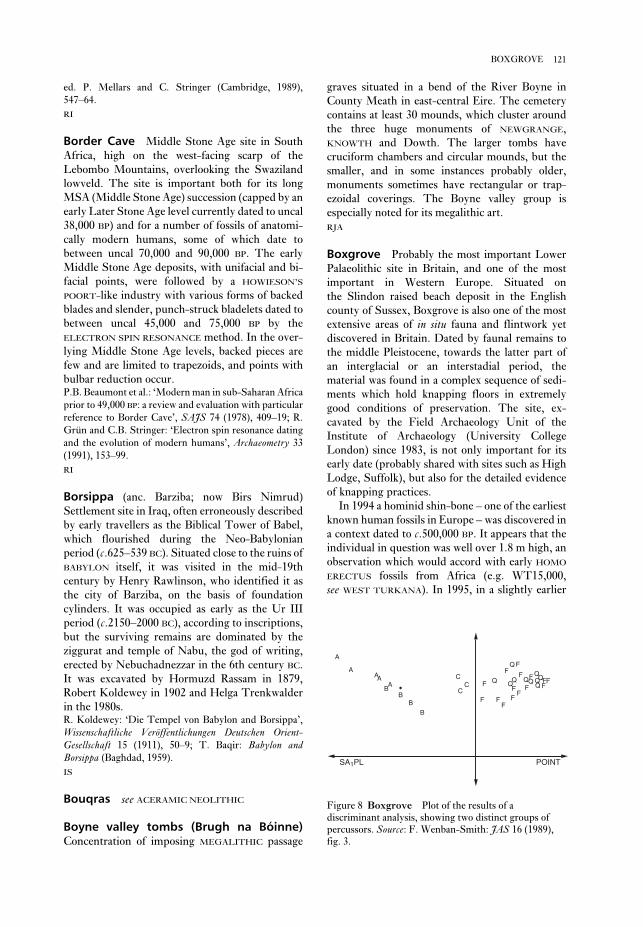
graves situated in a bend of the River Boyne in
County Meath in east-central Eire. The cemetery
contains at least 30 mounds, which cluster around
the three huge monuments of NEWGRANGE,
KNOWTH and Dowth. The larger tombs have
cruciform chambers and circular mounds, but the
smaller, and in some instances probably older,
monuments sometimes have rectangular or trap-
ezoidal coverings. The Boyne valley group is
especially noted for its megalithic art.
RJA
Boxgrove Probably the most important Lower
Palaeolithic site in Britain, and one of the most
important in Western Europe. Situated on
the Slindon raised beach deposit in the English
county of Sussex, Boxgrove is also one of the most
extensive areas of in situ fauna and flintwork yet
discovered in Britain. Dated by faunal remains to
the middle Pleistocene, towards the latter part of
an interglacial or an interstadial period, the
material was found in a complex sequence of sedi-
ments which hold knapping floors in extremely
good conditions of preservation. The site, ex-
cavated by the Field Archaeology Unit of the
Institute of Archaeology (University College
London) since 1983, is not only important for its
early date (probably shared with sites such as High
Lodge, Suffolk), but also for the detailed evidence
of knapping practices.
In 1994 a hominid shin-bone – one of the earliest
known human fossils in Europe – was discovered in
a context dated to c.500,000 BP. It appears that the
individual in question was well over 1.8 m high, an
observation which would accord with early HOMO
ERECTUS fossils from Africa (e.g. WT15,000,
see WEST TURKANA). In 1995, in a slightly earlier
ed. P. Mellars and C. Stringer (Cambridge, 1989),
547–64.
RI
Border Cave Middle Stone Age site in South
Africa, high on the west-facing scarp of the
Lebombo Mountains, overlooking the Swaziland
lowveld. The site is important both for its long
MSA (Middle Stone Age) succession (capped by an
early Later Stone Age level currently dated to uncal
38,000 BP) and for a number of fossils of anatomi-
cally modern humans, some of which date to
between uncal 70,000 and 90,000 BP. The early
Middle Stone Age deposits, with unifacial and bi-
facial points, were followed by a HOWIESON’S
POORT-like industry with various forms of backed
blades and slender, punch-struck bladelets dated to
between uncal 45,000 and 75,000 BP by the
ELECTRON SPIN RESONANCE method. In the over-
lying Middle Stone Age levels, backed pieces are
few and are limited to trapezoids, and points with
bulbar reduction occur.P.B. Beaumont et al.: ‘Modern man in sub-Saharan Africa
prior to 49,000 BP: a review and evaluation with particular
reference to Border Cave’, SAJS 74 (1978), 409–19; R.
Grün and C.B. Stringer: ‘Electron spin resonance dating
and the evolution of modern humans’, Archaeometry 33
(1991), 153–99.
RI
Borsippa (anc. Barziba; now Birs Nimrud)
Settlement site in Iraq, often erroneously described
by early travellers as the Biblical Tower of Babel,
which flourished during the Neo-Babylonian
period (c.625–539 BC). Situated close to the ruins of
BABYLON itself, it was visited in the mid-19th
century by Henry Rawlinson, who identified it as
the city of Barziba, on the basis of foundation
cylinders. It was occupied as early as the Ur III
period (c.2150–2000 BC), according to inscriptions,
but the surviving remains are dominated by the
ziggurat and temple of Nabu, the god of writing,
erected by Nebuchadnezzar in the 6th century BC.
It was excavated by Hormuzd Rassam in 1879,
Robert Koldewey in 1902 and Helga Trenkwalder
in the 1980s.R. Koldewey: ‘Die Tempel von Babylon and Borsippa’,
Wissenschaftliche Veröffentlichungen Deutschen Orient-Gesellschaft 15 (1911), 50–9; T. Baqir: Babylon andBorsippa (Baghdad, 1959).
IS
Bouqras see ACERAMIC NEOLITHIC
Boyne valley tombs (Brugh na Bóinne)Concentration of imposing MEGALITHIC passage
121BOXGROVE
POINT
F
F
FF
FF
F F
FF
F
F FFQ
QQQ
QQQQ
Q
QC
CC
BB
B
BA
AA
SA1PL
A
A
F
Figure 8 Boxgrove Plot of the results of a
discriminant analysis, showing two distinct groups of
percussors. Source: F. Wenban-Smith: JAS 16 (1989),
fig. 3.

calendar dates. For consistency, ‘present’ is
defined as AD 1950. See RADIOCARBON DATING
for a discussion of the alternative international
conventions.
Brahmagiri Cemetery and settlement site
located in the Indian Deccan region (in modern
Karnataka) and dating to the South Indian Iron Age
of the 1st millennium BC, although the precise
chronology of the site remains controversial
(McIntosh 1983). Excavated features include 10
domestic structures assigned by Mortimer Wheeler
(1947) to three phases/cultures – Brahmagiri Stone
Axe, Megalithic and Andhra. There are also about
300 tombs dating to the Megalithic period; the
burials include rectangular cists, ‘cist-circles’
(granite-slab cists surrounded by stone circles)
and pit-circles. The inhumations were multiple and
often included secondary burials, with a variety of
associated artefacts, including BLACK-AND-RED
WARE vessels (many with graffiti), stone beads and
iron and copper tools.R.E.M. Wheeler: ‘Brahmagiri and Chandravalli 1947:
Megalithic and other cultures in Chitaldurg District,
Mysore State’, AI 4 (1947–8), 181–310; A. Sundara: Theearly chamber tombs of South India (Delhi, 1975); J.
McIntosh: ‘Dating the South Indian megaliths’, SouthAsian Archaeology 1983, eds J. Schotsmans and M. Taddei
(Naples, 1985), 467–93.
Brak, Tell Mesopotamian urban site located at
the southern end of the Khabur basin in north-
eastern Syria, about 30 km northeast of the modern
town of Hasseke. The tell was occupied from c.6000
to 1500 BC and covers an area of about 40 ha, making
it the largest surviving settlement site in the Khabur
region. It was first excavated in 1937–8 by Max
Mallowan (1947), who discovered a series of
temples of the URUK period (c.4300–3100 BC) and a
large public building dating to the AKKADIAN and
UR III periods (c.2317–2000 BC). The latter was
initially identified as a ‘palace’ of the Akkadian ruler
Naram-Sin, but is now interpreted as a massive
storehouse (Crawford 1991: 89–90).
From 1976 onwards, the excavations of David
and Joan Oates (Oates 1977, 1982; Oates and Oates
1994) have revealed that Brak was already the site of
a substantial city (surrounded by smaller satellite
towns) during the Uruk period and maintained its
importance well into the 2nd millennium BC. The
significance of the site may have derived partially
from its location on the route between Sumer and
the Anatolian copper mines of Ergani Maden. Oates
(1982: 71) therefore suggests that the gradual
diminution of the settlement after the Agade period
context, a human tooth was found in association
with over one hundred flint hand-axes and the
butchered bones of a rhinoceros.
Experimental archaeology and statistical analysis atBoxgrove. Wenban-Smith used a combination of
EXPERIMENTAL ARCHAEOLOGY and canonical
variates analysis (CVA, a form of DISCRIMINANT
ANALYSIS) to suggest the most likely material used
as percussors in flint-knapping at Boxgrove. He
replicated bifaces made at the site, using a variety of
materials as percussors, both ‘hard-hammer’ (flint,
cortical flint and quartzite) and ‘soft-hammer’ (ani-
mal bone and antler). The waste flakes from this
exercise were kept and 13 variables were recorded
on each. The data, consisting of the average values
of these variables for each of 50 batches of flakes
produced by each method, were subjected to CVA
to discover which variables contributed to the
differences between the flakes produced by the dif-
ferent methods. It was found that over 80% of the
differences between batches was accounted for by
the first two axes, and that when plotted the data
separated into two distinct groups, ‘soft-hammer’ to
the left and ‘hard-hammer’ to the right along the
first axis.
At this stage, the position of a sample of ‘real’
flakes from the site was plotted against the axes
defined by the replicated flakes. They fell clearly
into the ‘soft-hammer’ area of the plot, strongly
suggesting that the bifaces at Boxgrove had been
made in this way. This suggestion, if true, has con-
siderable implications for the level of organization
of the occupants of the site. Although the analysis
can be criticized for using variables of different
types and scales (which is almost inevitable, given
the need to use more than just metrical character-
istics), the technique does seemed to have coped
with this and to have produced useful results.M.B. Roberts: ‘Excavation of the lower paleolithic site at
Amey’s Eartham Pit, Boxgrove, West Sussex: a prelimi-
nary report’ PPS 52 (1986), 215–45; F. Wenban-Smith:
‘The use of canonical variates for determination of biface
manufacturing technology at Boxgrove Lower Palaeo-
lithic site and the behavioural implications of this
technology’, JAS 16 (1989), 17–26.
CO/PG-B
BP, bp The convention BP indicates years ‘before
present’, in contrast to years BC or AD. Thus c.2000
BP indicates a date at around the start of the
Christian era.
The convention bp is used by the British journal
Antiquity, and many of its readers, to indicate a date
measured in ‘radiocarbon years’ before present i.e.
a date that has not been calibrated so as to give true
122 BOXGROVE

excavated by Mason, revealing Negro skeletons,
metal slag, storage pits, pole-and-daga houses and
grainbins, characteristic Kwale pottery and the
bones of domesticated animals. The low proportion
of cattle to small stock (1:42) is similar to other EIA
sites and has led to the mistaken belief that cattle-
based bridewealth and economic dominance did not
develop until herds naturally increased after AD
800. Renewed excavations, SOIL PHOSPHOROUS
ANALYSIS and PHYTOLITH (silica residue in grasses
and sedges) studies show that there were at least five
homestead centres containing small stock or cattle
byres, prestige burials in a cattle byre, grain storage
pits smeared with cow dung and storage pits with
washed-in cattle dung. This evidence for the
‘CENTRAL CATTLE PATTERN’ shows that faunal
remains do not directly indicate the economic and
social importance of livestock. Phytolith counts
indicate the climate was warmer and wetter than
today.R.J. Mason: ‘Early Iron Age settlement at Broederstroom
24/73, Transvaal, South Africa’, SAJS 77 (1981), 401–16;
T.N. Huffman: ‘Broederstroom and the origins of cattle-
keeping in southern Africa’, African Studies 49 (1990),
1–12; ––––: ‘Broederstroom and the Central Cattle
Pattern’, SAJS 89 (1993), 220–6.
TH
Bubastis see BASTA, TELL
Bucheum see ARMANT
Bug-Dniestrian Late Mesolithic and early
Neolithic cultural tradition identified at sites on the
rivers Dniestr and Southern Bug in Moldova and
Ukraine, and principally investigated by V.N.
Danilenko and V.I. Markevich. The fullest cultural
sequence was established at a group of sites near the
town of Soroca (Soroki), on the narrow flood-plain
of the river Dniestr (Moldovia). The aceramic levels
(3 and 2) of Soroki 1 have been radiocarbon dated,
and this suggests respective calendar dates of
c.6500 and c.6400 BC. The remains of two oval-
shaped semi-subterranean dwellings were found.
The stone inventory, of Mesolithic character,
included end-scrapers trapezes, triangles and
retouched blades. The faunal remains belong
largely (80–90%) to wild animals (especially roe
deer and red deer), plus a few bones of domesticates
including pig and cattle. The deposits contained
numerous fish bones (e.g. roach, pike, sturgeon and
catfish) and several hundred shells of molluscs.
The pottery-bearing levels at Soroki 2 and Soroki
5 have been radiocarbon dated, suggesting calendar
dates of 5800–5500 BC. The ratio of domesticates
might relate to the Babylonians’ exploitation of new
sources of copper.M.E.L. Mallowan: ‘Excavations at Brak and Chagar
Bazar’, Iraq 9 (1947), 1–258; D. Oates: ‘The excavations
at Tell Brak, 1976’, Iraq 39 (1977), 233–44; ––––: ‘Tell
Brak’, Fifty years of Mesopotamian discovery, ed. J. Curtis
(London, 1982), 62–71; H. Crawford: Sumer and theSumerians (Cambridge, 1991); D. Oates and J. Oates: ‘Tell
Brak: a stratigraphic summary, 1976–93’, Iraq 56 (1994),
167–76.
IS
broch Round dry-stone defensive structure of
the 1st millennium BC, examples of which are con-
centrated in Shetland, Orkney, Caithness and the
Western Isles in Scotland. Traditionally the term
‘broch’ has been restricted to the more elaborate
circular examples of a diverse family of compact
fortified buildings erected in the Scottish Iron
Age; the famous broch of MOUSA forms, in effect,
a type site. Mackie has attempted to regularize the
term by selecting the technically sophisticated high
hollow-built wall, which often contains chambers
and a staircase to an upper floor, as a principal
defining feature (Mackie 1965). However, Hedges
(Hedges and Bell 1980) and others have argued
that simpler round fortified structures such as the
early (c.600 BC) Bu Broch, Stomness, are also true
brochs. A solution to this, partly semantic, prob-
lem is provided by Armit who argues that Mackie’s
elaborate brochs are best classified as ‘tower
brochs’ within a wider category of round houses,
thus freeing the term ‘broch’ to be used more
loosely (Armit 1990).
Traditionally, brochs have been consigned to a
relatively brief interval after the 1st century BC.
However, modern excavations have made this late
dating seem unlikely, and even the developed
‘tower brochs’ may have been emerging a century or
so earlier. Recent explanations of the origins of the
broch (e.g. Armit 1990) have discarded the idea of
migrants from the south, preferring to stress local
prototypes and the broch’s functional and symbolic
importance in the negotiation of power.E. Mackie: ‘The origin and development of the broch and
wheelhouse building cultures of the Scottish Iron Age’,
PPS 31 (1965), 93–146; J. Hedges and B. Bell: ‘That tower
of Scottish prehistory – the broch’, Antiquity 54 (1980),
87–94; I. Armit: ‘Broch building in northern Scotland’,
WA 21 3 (1990), 435–45.
RJA
Broederstroom Type-site of the first phase of
Early Iron Age (EIA) occupation in the central
Transvaal, dated to between the 4th and 7th
centuries AD. Situated west of Pretoria, the site was
123BUG-DNIESTRIAN

Ukraine] (Kiev, 1969); V.I. Markevich: Bugo-Dnestrovskaya kul’tura na territorii Moldavii [The
Bug-Dniestrian culture on the territory of Moldavia]
(Kishinev, 1974); P.M. Dolukhanov: Ecology and economyin neolithic Eastern Europe (London, 1979); M.
Zvelebil and P. Dolukhanov: ‘The transition to farming in
Eastern and Northern Europe’, JWP/III (1991), 233–78.
PD
Buhen Egyptian urban site in Lower Nubia,
which was first examined in 1819 but mainly ex-
cavated at the time of the UNESCO Nubian
Campaign, between 1957 and 1964 (Emery et al.
1979). The settlement was founded in the Old
Kingdom (c.2649–2150 BC) or perhaps even in the
Early Dynastic period (c.3000–2649 BC), probably
as a centre for Egyptian mining and quarrying ex-
peditions in Nubia. An impressive array of
mud-brick fortifications were constructed around
the settlement in the 12th dynasty (c.1991–1783
BC), enabling it to serve as a military garrison domi-
nating the area to the north of the second Nile
cataract. The settlement had a basic grid-iron plan,
comprising a number of rectangular blocks sep-
arated by six major streets. The subsequent New
Kingdom town was much more of a ‘colony’ than a
fortress, since the southern frontier of Egypt had by
then been pushed further south than the fourth
Nile cataract, leaving Buhen in comparatively safe
territory.R.A. Caminos: The New Kingdom temples of Buhen, 2 vols
(London, 1974); H.S. Smith: The fortress of Buhen: Theinscriptions (London, 1976); W.B. Emery et al.: The fortressof Buhen: The archaeological report (London, 1979).
IS
Bükk culture Regional successor culture to the
LINEARBANDKERAMIK, centered on the Bükk
mountains of northeast Hungary and east Slovakia,
with some sites in south Poland. Bükk pottery is
made of a fine alluvial clay, generally globular in
shape, thin walled and well fired. Typically, it is
decorated with bands of incised ornament forming
spirals and wavy, sometimes geometric, patterns.
The decoration may be encrusted with white or
yellow paste; some vessels have painted motifs.
Settlements associated with Bükk pottery include
large and small open-air sites, as well as a large pro-
portion of caves in upland areas – a mixture of
settlement type that may indicate transhumance.J. Lichardus: Studien zur Bükker Kultur, Saabrücker
Beiträge zur Altertumskunde 12 (Bonn, 1974).
RJA
Bur Gavo see SWAHILI HARBOUR TOWNS
among the faunal remains increased, reaching in
several cases 50% (pig, cattle); the wild animals
were still largely roe deer and red deer. The number
of wild animals represented in the faunal analysis
was much greater (over 90%) at the sites on the
Southern Bug. Impressions of emmer, einkorn and
spelt wheat were identified on potsherds. Oval
semi-subterranean dwellings were constructed
at several sites. The lithic industry retained a
Mesolithic character. The coarse pottery, made
with an admixture of sand, crushed shells or organic
matter, is dominated by spherical and biconical
bowls decorated by rows of wavy lines, shell impres-
sions and finger-nail impressions. These ceramics
reveal similarities with the ‘barbotine’ type pottery
of the Balkan early Neolithic. At the sites of Soroki
5 and Baz’kov Island (the Southern Bug), fragments
of imported LINEARBANDKERAMIK pottery have
been found.
Foraging to farming transition. Danilenko (1969) and
V.I. Markevich (1974) argue that the Bug-
Dniestrian reflects a gradual transition from
foraging to agriculture, citing the impressions of
cereals on the potsherds; the occurrence of blades
with sickle-gloss; hoe-like implements made of red-
deer antler, and querns; and the gradual increase of
the rate of domesticates in the faunal remains from
the earlier to the later phase. However, P.M.
Dolukhanov (1979) argues that the situation of the
Soroki and other Bugo-Dniestrian sites makes agri-
culture very unlikely. The sites were located on a
narrow stony flood-plain, covered with meadow
soils poor in humus; the nearest arable land lies 5 km
away, cut off from the settlement by almost im-
passable slopes. Thin archaeological deposits, and
the lack of permanent dwelling structures, suggests
that the sites were occupied seasonally by small
groups of foragers; the ‘farming’ evidence may be
explained by intensive cultural and economic con-
tacts with nearby communities of farmers. It seems
likely that the grain, pigs and cattle (which, in
number, never exceeded eight individuals) were
procured in exchange for the products of hunting
and food-gathering. The blades with sickle gloss,
the querns, and the hoe-like implements could all
have been used for harvesting and processing wild
plants. The occurrence of cultural contacts with
farmers is further substantiated by the resemblance
between the pottery, as well as by the direct import
of Linearbandkeramik ware in the later stages. The
Bugo-Dniestrian sites may thus be viewed as
belonging to the ‘availability phase’ of the proto-
Neolithic, as described by Zvelebil and Dolukhanov
(1991).V.N. Danilenko: Neolit Ukrainy [The Neolithic of the
124 BUG-DNIESTRIAN

remains dating to Period I include pit-dwellings,
handmade ceramics, ground stone axes and a wide
array of bone and antler tools. Period II is character-
ized by mud-brick and wooden structures, one
containing a stone slab engraved with a hunting
scene, and many incorporating primary and
secondary burials, some with dogs, wolves and ibex
in association with human inhumations. In Period
III a rough semi-circle of large standing stones was
erected, and wheel-made pottery began to be used.
Unfortunately, few indications of subsistence
patterns have survived.R.N. Kaw: ‘The Neolithic culture of Kashmir’, Essays inIndian protohistory, ed. D.P. Agrawal and D.K.
Chakrabarti (New Delhi, 1979), 219–28; U. Sant:
Neolithic settlement pattern of northeastern and northernIndia (Delhi, 1991), 154–69.
CS
Bush Barrow (Wilsford G5) Bronze Age round
barrow in Wiltshire, England, close to Stonehenge,
which covered one of the richest burials of the
WESSEX CULTURE. Dug into in 1808, the grave-
goods included some of the finest and richest
Burial Mound Period Term used in North
American archaeology to refer to a chronological
phase stretching from c.1000 BC to AD 700, which
roughly corresponds to the WOODLAND period.
The expression – rarely used now – first appeared
in a synthesis of Eastern North American prehistory
published by Ford and Willey in 1941. Later,
Willey (1966) used the term as a period designator
in An introduction to North American archaeology,
subdividing it into two phases. Burial Mound I
(1000 to 300 BC) included Tchefuncte, Deptford,
Candy Creek and ADENA cultures, now classified as
Early Woodland. Burial Mound II (300 BC–AD 700)
included Marksville, HOPEWELL, and Weeden
Island, now classified as Middle and/or Late
Woodland. Cultural traits associated with the
Burial Mound Period include pottery, burial
mounds and agriculture (Stoltman 1978).J. Stoltman: ‘Temporal models in prehistory: an example
from eastern North America’, CA 19 (1978), 703–46; G.
Willey: An introduction to American archaeology I: Northand Middle America (Englewood Cliffs, 1966).
RJE
burin Multi-purpose blade tool, usually made of
flint, which presents a gouging or chisel-like work-
ing edge formed by removing a distinctive flake or
‘burin spall’. Burins are one of the tool types that
appear in the richer assemblages of the Upper
Palaeolithic, helping to differentiate them from the
Middle Palaeolithic.
burin spall see BURIN
burnishing Process of smoothing and polishing
hardened, but not yet fired, clay vessels with a
rounded tool such as a pebble or smooth bone. By
compacting the clay, the permeability of the pot
surface is reduced and a high shine (sometimes
slightly facetted from the burnisher’s strokes) is
produced. The term is distinct from ‘polish’, which
should strictly be reserved for the buffing-up of
pottery surfaces after firing.
RJA
Burushkhattum see AÇEMHÖYÜK
Burzahom Settlement and cemetery site in the
Srinigar Valley of Kashmir, dating to the Kashmiri
Neolithic of the 3rd millennium BC. Located by De
Terra and Patterson in 1935, Burzahom was ex-
cavated by the Indian government from 1960 to
1971. Four chronological phases have been defined,
ranging from the Neolithic (periods I–II) to the
early historic period (IV: 324 BC–AD 347). The
125BUSH BARROW
Figure 9 Bush Barrow Grave goods from rich
‘Wessex’ tradition graves dating to the mid-2nd
millennium BC at Bush Barrow, Wiltshire. Source:
T. Darvill: Prehistoric Britain (London, 1987), fig. 55a.
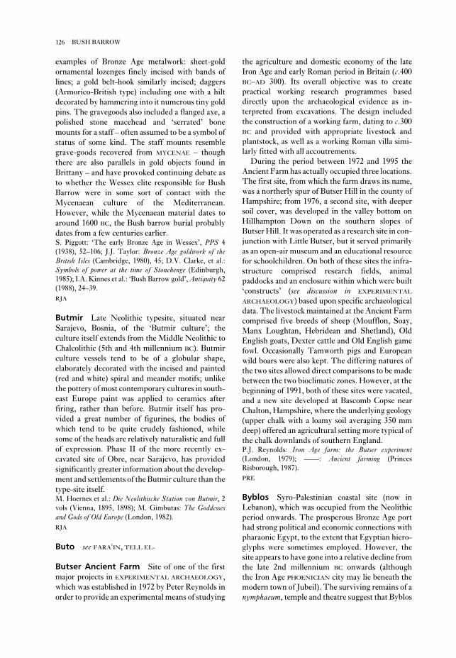
the agriculture and domestic economy of the late
Iron Age and early Roman period in Britain (c.400
BC–AD 300). Its overall objective was to create
practical working research programmes based
directly upon the archaeological evidence as in-
terpreted from excavations. The design included
the construction of a working farm, dating to c.300
BC and provided with appropriate livestock and
plantstock, as well as a working Roman villa simi-
larly fitted with all accoutrements.
During the period between 1972 and 1995 the
Ancient Farm has actually occupied three locations.
The first site, from which the farm draws its name,
was a northerly spur of Butser Hill in the county of
Hampshire; from 1976, a second site, with deeper
soil cover, was developed in the valley bottom on
Hillhampton Down on the southern slopes of
Butser Hill. It was operated as a research site in con-
junction with Little Butser, but it served primarily
as an open-air museum and an educational resource
for schoolchildren. On both of these sites the infra-
structure comprised research fields, animal
paddocks and an enclosure within which were built
‘constructs’ (see discussion in EXPERIMENTAL
ARCHAEOLOGY) based upon specific archaeological
data. The livestock maintained at the Ancient Farm
comprised five breeds of sheep (Moufflon, Soay,
Manx Loughtan, Hebridean and Shetland), Old
English goats, Dexter cattle and Old English game
fowl. Occasionally Tamworth pigs and European
wild boars were also kept. The differing natures of
the two sites allowed direct comparisons to be made
between the two bioclimatic zones. However, at the
beginning of 1991, both of these sites were vacated,
and a new site developed at Bascomb Copse near
Chalton, Hampshire, where the underlying geology
(upper chalk with a loamy soil averaging 350 mm
deep) offered an agricultural setting more typical of
the chalk downlands of southern England.P.J. Reynolds: Iron Age farm: the Butser experiment(London, 1979); ––––: Ancient farming (Princes
Risborough, 1987).
PRE
Byblos Syro-Palestinian coastal site (now in
Lebanon), which was occupied from the Neolithic
period onwards. The prosperous Bronze Age port
had strong political and economic connections with
pharaonic Egypt, to the extent that Egyptian hiero-
glyphs were sometimes employed. However, the
site appears to have gone into a relative decline from
the late 2nd millennium BC onwards (although
the Iron Age PHOENICIAN city may lie beneath the
modern town of Jubeil). The surviving remains of a
nymphaeum, temple and theatre suggest that Byblos
examples of Bronze Age metalwork: sheet-gold
ornamental lozenges finely incised with bands of
lines; a gold belt-hook similarly incised; daggers
(Armorico-British type) including one with a hilt
decorated by hammering into it numerous tiny gold
pins. The gravegoods also included a flanged axe, a
polished stone macehead and ‘serrated’ bone
mounts for a staff – often assumed to be a symbol of
status of some kind. The staff mounts resemble
grave-goods recovered from MYCENAE – though
there are also parallels in gold objects found in
Brittany – and have provoked continuing debate as
to whether the Wessex elite responsible for Bush
Barrow were in some sort of contact with the
Mycenaean culture of the Mediterranean.
However, while the Mycenaean material dates to
around 1600 BC, the Bush barrow burial probably
dates from a few centuries earlier.S. Piggott: ‘The early Bronze Age in Wessex’, PPS 4
(1938), 52–106; J.J. Taylor: Bronze Age goldwork of theBritish Isles (Cambridge, 1980), 45; D.V. Clarke, et al.:
Symbols of power at the time of Stonehenge (Edinburgh,
1985); I.A. Kinnes et al.: ‘Bush Barrow gold’, Antiquity 62
(1988), 24–39.
RJA
Butmir Late Neolithic typesite, situated near
Sarajevo, Bosnia, of the ‘Butmir culture’; the
culture itself extends from the Middle Neolithic to
Chalcolithic (5th and 4th millennium BC). Butmir
culture vessels tend to be of a globular shape,
elaborately decorated with the incised and painted
(red and white) spiral and meander motifs; unlike
the pottery of most contemporary cultures in south-
east Europe paint was applied to ceramics after
firing, rather than before. Butmir itself has pro-
vided a great number of figurines, the bodies of
which tend to be quite crudely fashioned, while
some of the heads are relatively naturalistic and full
of expression. Phase II of the more recently ex-
cavated site of Obre, near Sarajevo, has provided
significantly greater information about the develop-
ment and settlements of the Butmir culture than the
type-site itself.M. Hoernes et al.: Die Neolithische Station von Butmir, 2vols (Vienna, 1895, 1898); M. Gimbutas: The Goddessesand Gods of Old Europe (London, 1982).
RJA
Buto see FARAðIN, TELL EL-
Butser Ancient Farm Site of one of the first
major projects in EXPERIMENTAL ARCHAEOLOGY,
which was established in 1972 by Peter Reynolds in
order to provide an experimental means of studying
126 BUSH BARROW

site, this early farming settlement near Prague in
central Bohemia in the Czech Republic consisted of
longhouses (up to 45 m in length) built of posts,
with possible grain stores and pits. The economy
was based upon emmer wheat and the raising of
cattle. See LINEARBANDKERAMIK for further dis-cussion and bibliography.
RJA
was still of some importance during the time of the
Roman empire.P. Montet: Byblos et l’Egypte, 2 vols (Paris, 1928); M.
Dunand: Fouilles de Byblos (Paris, 1939–58); J.-F. Salles:
La nécropole “k” de Byblos (Paris, 1980).
IS
Bylany One of the principal early (1953–4) ex-
cavations of a Linearbandkeramik or LBK culture
127BYLANY

14C see RADIOCARBON DATING
Caban see CHAM
cacao The pod-like fruits of the cacao tree
(Theobroma cacao) contain large oval seeds, which
the pre-hispanic inhabitants of Mesoamerica
ground into a powder and mixed with water and
chiles – and/or honey and maize gruel – to create a
beverage. Cacao seeds or beans were also used as a
medium of exchange by the Aztecs and perhaps by
earlier Mesoamerican societies. The pods and seeds
often appear as decorative motifs on pottery and
other art; residue analysis has confirmed the
presence of cacao in a ceramic vessel found in an
Early Classic (c.AD 200–600) burial at the
LOWLAND MAYA site of Río Azul. Cacao trees were
cultivated in limited areas of rich, fertile lowland
soils.J.E.S. Thompson: ‘Notes on the use of cacao in Middle
America’, Notes on Middle American Archaeology andEthnology 128 (1956), 95–116; D. Stuart: ‘The Rio-Azul
cacao pot: epigraphic observations on the function of a
Maya ceramic vessel’, Antiquity 62 (1988), 153–7; A.
Gómez-Pompa et al.: ‘The sacred cacao groves of the
Maya’, LAA 1 (1990), 247–57.
PRI
Cacaxtla Fortified site in southwest Tlaxcala,
Mexico, dating to the 8th–10th centuries AD,
known for its mural paintings. The style and con-
tent of the paintings are similar to those of the
lowland Maya site of BONAMPAK; they depict a
battle scene between elaborately attired (and
vanquished) lowland Maya(?) and victorious high-
land (Teotihuacano?) peoples, as well as winged
images of patron deities.M. Foncerrada de Molina: ‘Mural painting in Cacaxtla
and Teotihuacán cosmopolitanism’, Third Palenque RoundTable, 1978, Part 2, ed. M.G. Robertson (Austin, 1980),
183–98.
PRI
Cahokia Major MISSISSIPPIAN ‘mound center’
located in the Mississippi River floodplain in
Illinois, eastern North America. The site covered
13 sq. km and consisted of residential areas, plazas
and over 100 mounds, widely scattered over
bottomland ridges, with the most heavily occupied
areas located on high ground alongside an
abandoned river channel. The central focus of the
site is a large, rectangular plaza surrounded by
mounds, including Monks Mound, the largest pre-
historic mound in the United States. Cahokia was
occupied for many hundreds of years, rising to
regional prominence in about AD 1000. The site and
surrounding region were virtually abandoned by
1400.M.L. Fowler: The Cahokia atlas (Springfield 1989); G.R.
Milner: ‘The late prehistoric Cahokia cultural system of
the Mississippi River valley: foundations, fluorescence,
and fragmentation’, JWP 4 (1990), 1–43.
GM
Cahuachi The largest known site of the Nazca
culture, situated in the Nazca Valley, Peru, and
dating to the Early Intermediate Period (c.400
BC–AD 500). It consists of a large number of large
platforms, built on cores of existing hills, with
associated walled spaces. Cahuachi was a pilgrimage
centre, uninhabited for much of the time but con-
nected by geoglyphs across the high desert with the
urban ‘Site 165’. Comparisons to modern pilgrim-
age patterns and Andean concepts of space suggest
that Cahuachi and Site 165 may have been lower
and upper (hatun and hurin). Cahuachi is associated
with strange-shaped hills, later modified into
platforms and walled areas for temporary occu-
pation, perennial water sources, and with an
echoing phenomenon, being the sacred half of the
dual organization typical of Andean sociopolitical
constructs.H. Silverman: Cahuachi in the ancient Nasca world (Ames,
1993).
KB
Caihouluan see TS’AI HOU LUAN
caitya Structure built to house a sacred Buddhist
relic, such as a notable image of the Buddha.
C
Calico Hills Controversial lithic site located in
an alluvial fan deposit in southeastern California.
Assemblages consist of surface finds and flaked
objects excavated from a depth of over 5 m. Bifaces
found on the surface are part of the Manix Lake
complex and are clearly artefactual. The sub-
surface finds consist of thousands of pieces of flaked
chert, some of which resemble struck flakes and
simple stone tools. These few objects are a highly
selected sample sorted by archaeologists from
thousands of pieces of fractured chert and are con-
sidered by many archaeologists to be GEOFACTS.
This has led to investigations of how to differenti-
ate quarry debris from early primitive industries
(Glennan 1976: 43–61) and distinguish pseudo-
artefacts produced by natural forces from real
artefacts (Haynes, 1973). Dates range from 500,000
BP, based on the geology (Haynes 1973), to about
80,000–125,000 BP for the site surface and 200,000
BP at its base, determined by uranium-thorium
assays of CaCO3 (see URANIUM-SERIES DATING).C.V. Haynes: ‘The Calico site: artefacts or geofacts?’,
Science 181 (1973), 305–10; W.S. Glennan: ‘The Manix
Lake lithic industry: early lithic tradition or workshop
refuse?’ Journal of New World Archaeology 1 (1976), 43–62;
W.C. Schuiling, ed.: Pleistocene man at Calico (Redlands,
1979).
RC
Calima Region of southwestern Colombia with a
long cultural tradition (c.1000 BC –Conquest; see
AMERICA 6) beginning with the Ilama Phase (Early
Calima, 1st millennium BC), whose finely incised
and painted ceramics and hammered gold work
show an elaborate development of shamanistic
beliefs, the ritual use of coca, and an appreciation of
the animal life around them. Ilama is ancestral to
Yotoco (Calima, AD 100–7/1100)), known for its
large hammered gold ornaments. These can now be
related to distinctive modelled and organic resist-
painted pottery as well as habitation sites consisting
of series of artificial terraces which had rectangular
houses on them. The Calima culture was also char-
acterized by large-scale drained field and road
systems, and the burial of the dead in shaft-and-
chamber tombs. A terminal pre-Conquest phase,
Sonso, has also been identified.M. Cardale de Schrimpff et al.: Calima: trois cultures pré-colombiennes dans le sud-oueste de la Colombie (Lausanne,
1991).
KB
Canaanites Term used to describe the people
occupying Palestine and southwestern Syria from at
least the beginning of the Middle Bronze Age
calcite banding Layers in stalagmitic calcite
giving luminescence due to humic and fulvic acids
derived from soil. These layers appear to be annual
and thus could provide a high resolution climatic
indicator (e.g. calcite growth is rainfall-dependent
and stable isotope analysis provides temperature
information).A. Baker et al.: ‘Annual growth banding in a cave stalag-
mite’, Nature 364 (1993), 518–20.
SB
calcium-41 dating see RADIOCALCIUM
DATING
calendars, Mesoamerican Mesoamerican
peoples recorded time and history by means of
several calendars that counted days and also multi-
ples of days roughly analogous to months, years and
larger units of time. Two primary calendars were in
use throughout Mesoamerica and both recorded
cycles of time by day or month names and numbers.
One was a very ancient calendar, known to the
AZTECS as Tonalpohualli, which was composed of
20 day names or signs prefixed by a number from 1
to 13 (e.g. 5 Cimi or 9 Xochitl). The same names
and numbers coincided every 260 days. The other
was a 365-day calendar, approximating our solar
year, which consisted of 18 named ‘months’ of 20
days each, counted from 0 to 19 (as 0 Pop, 1 Pop, 2
Pop, etc.); the last five days of the year (known
as Uayeb among the Maya and Nemontemiamong the Aztecs) were considered unlucky. Most
Mesoamerican peoples used both calendars simul-
taneously to record time. The Maya, for example,
recorded time on their STELAE by means of the
simultaneous cycling of the two calendars and also
by use of the ‘long count’ (itself an absolute method
of recording time from a given starting date, rather
than a calendar).
The cycling of the two calendars defined another
important interval of time for Mesoamerican
peoples. For any particular numbered day in the
260-day calendar to coincide with any particular day
and month in the 365-day calendar, the calendars
had to cycle through 18,980 days, or 52 years. The
beginning and ending of this 52-year cycle, known
by archaeologists as the ‘Calendar Round’, was cel-
ebrated widely throughout Mesoamerica, as, for
example, in the Aztec new fire ceremony.M.S. Edmonson: The book of the year: Middle Americancalendrical systems (Salt Lake City, 1989); M.E. Miller and
K. Taube: The gods and symbols of ancient Mexico and theMaya: an illustrated dictionary of Mesoamerican religion(London, 1993), 48–54.
PRI
CANAANITES
(c.2649–2150 BC) to a human head in the Middle
Kingdom (c.2040–1640 BC). From the 19th dynasty
(c.1307–1196 BC) onwards the lids took the form of
the heads of the mythical Sons of Horus. The last
surviving set of royal canopic equipment was made
for the Late Period ruler Apries (589–570 BC). The
term ‘canopic’ (an Egyptological term derived from
the misconception that human-headed jars were
worshipped at the town of Canopus in the Egyptian
Delta) was also applied to a type of Etruscan
cinerary urn in the form of a sculpture of the
deceased, the head serving as the lid and the arms
as the handles. Many Etruscan canopics were found
at the Italian site of Clusium and date to between the
6th and 3rd centuries BC.R. Gempeler: Die Etruskischen Kanopen (Einsiedeln,
1974); C. Dolzani: Vasi Canopi (Milan, 1982); A. Dodson:
The canopic equipment of the kings of Egypt (London, 1994).
IS
Cape Gelidonya see GELIDONYA
Cape Krusenstern One of the richest site local-
ities in the North American Arctic, located on
Kotzebue Sound, Alaska. Here, clearly separated by
an impressive horizontal stratigraphy produced
by the accumulation over thousands of years of 114
separate beach ridges (see map 19), there are
remains deriving from the Denbigh Flint complex,
Old Whaling, Choris, NORTON TRADITION,
IPIUTAK, Birnirk, THULE and more recent occupa-
tions.J.L. Giddings: Ancient men of the Arctic (New York, 1967);
–––– and D.D. Anderson: Beach ridge archaeology of CapeKrusenstern (Washington, 1986).
RP
Capéletti Cave at an altitude of 1580 m above sea
level on the northern slopes of the Aurès mountains
south of Constantine in northeastern Algeria. It was
excavated by Colette Roubet in 1968, and four dis-
tinct occupation horizons attributed to the
‘Neolithic of Capsian Tradition’ have produced 7
radiocarbon dates ranging from 6530 to 4340 BP.
The mammalian fauna is dominated by domestic
sheep and/or goat which account for 70–90% of the
identified bones and which must have been in-
troduced into the area. Bovids are important in the
uppermost horizon only, where their bones con-
stitute 25% of the total. According to Achilles
Gautier, it is not completely clear whether they
were domesticated or not. In Roubert’s interpret-
ation, the inhabitants (who also relied on seasonal
collection of plant resources and land snails) prac-
tised a ‘pastoral, pre-agricultural’ transhumant
(c.2000 BC) onwards. The geographical term
Canaan is much easier to define than the cultural or
ethnic traits of its Bronze Age inhabitants.
Numerous Egyptian and Mesopotamian texts refer
to the Canaanites from the 15th century BC onwards
and the beginning of the Iron Age (c.750 BC) is usu-
ally considered to represent the end of the
Canaanite culture, but there are major problems in
attempting either to assess the origins of the
Canaanites or to correlate the written references
with archaeological sites. Kenyon (1966) argued
that the Canaanites emerged during the period of
AMORITE incursions into Syria-Palestine at the end
of the 3rd millennium BC, and were in fact ‘urban-
ized Amorites’, whereas Millard (1973: 38) suggests
that the situation was much more complex:
‘Palestine received a motley array of peoples and
influences. Should the amalgam be designated
Canaanite? . . . If the name was used by the natives
of the area, then either they survived the various
invasions, retaining some sense of identity . . . or the
name was assumed by their conquerors, or simply
applied to any denizens or products of the region.’
If the term is taken to refer simply to the inhabi-
tants of Palestine in the 2nd and early 1st millennia
BC then the major Canaanite cities would include
Hazor, BETH SHAN and MEGIDDO. Canaanite per-
sonal names in the AMARNA letters and the UGARIT
archives suggest that the population was a mixture
of Semites, Hurrians and Indo-Europeans. In
c.1600 BC the West-Semitic speaking Canaanites
began to write texts using an alphabet of 32 letters,
which was perhaps derived partly from the
Egyptian HIERATIC script. The Canaanite alphabet
evolved into the PHOENICIAN script and was
eventually to form the basis for the Greek, Hebrew
and Arabian alphabets.T. Bauer: Die Ostkanaanäer (Leipzig, 1926); J. Gray: TheCanaanites (London, 1964); K. Kenyon: Amorites andCanaanites (Oxford, 1996); A.R. Millard: ‘The
Canaanites’, Peoples of Old Testament times, ed. D.J.
Wiseman (Oxford, 1973), 29–52.
IS
Can Hasan see ACERAMIC NEOLITHIC
canonical variates analysis seeDISCRIMINANT ANALYSIS
canopic jar Egyptian stone or ceramic funerary
vessel containing the entrails extracted from a
mummified body; four canopic jars were commonly
placed in the tomb alongside the sarcophagus. The
shapes of the lids of the four jars developed from
a basic convex form in the Old Kingdom
130 CANAANITES

with some rolled artefacts; in situ archaeological
material was found in layer II amid large ankaratrite
boulders, which also constituted the basal beach
deposit. The great majority of the industry is made
of ankaratrite, and because of the presence of a
number of bifacially worked tools it was in the past
variously classified by different authors as either
‘Toumbian’ or ‘Sangoan’. Descamps eliminated
many misunderstandings by his careful study of
these artefacts, establishing their characteristic
breakage patterns by refitting, and lumping them all
together as one broad category (‘pièces allongées’).
These and what he termed pushplanes (‘rabots’)
made up the great majority of the retouched tools;
but the context and significance of this industry
were made much clearer by the other elements
found in situ in layer II, including one polished stone
axe and 130 fragments of potsherds, as well as a
number of fishbones (some of them in anatomical
connection). He therefore unambiguously defined
the industry as a specialized facies of the Neolithic.
A terminus ante quem was provided by two radio-
carbon dates on shells from layer III of 2880 ± 80
and 2839 ± 127 BP, and by relying on the radio-
carbon dates from AMEKNI to provide a maximum
starting point, Descamps considered that the site
most probably dated to a period between 4000 and
8000 BP. As a hypothesis he suggested that the tools
were used for woodworking and that – since the use
of boats is indicated not only by the fishbones but
also by the presence of similar artefacts on the Ile
economy, retreating to the lower slopes during the
winter. It is suggested that the system of animal
husbandry in force until recently among the
Berbers of the area differed little from that of their
Neolithic predecessorsC. Roubet: ‘Une économie pastorale, pré-agricole en
Algérie orientale: le néolithique de tradition Capsienne’,
L’Anthropologie 82 (1978), 583–6; –––– and P.L. Carter:
‘La domestication au Maghreb: état de la question’, Originand early development of food-producing cultures in north-eastern Africa, ed. L. Krzyzaniak and M. Kobusiewicz
(Poznan, 1984), 437–51; A. Gautier: ‘Prehistoric men and
cattle in North Africa: a dearth of data and a surfeit of
models’, Prehistory of arid North Africa, ed. A.E. Close
(Dallas, 1987), 163–87.
PA-J
Cap Manuel Stone workshop site at the
southern extremity of the Cape Verde peninsula, on
a promontory within the city of Dakar, Senegal; dis-
covered in 1942 and excavated by C. Descamps in
1967–8. The site is on the eastern sheltered side of
the promontory; the numerous finds are con-
centrated over an area up to 100 m from the shore
at the foot of a 30 m cliff of ankaratrite, the volcanic
rock of which the promontory consists. The strat-
igraphy and chronology of the site were established
principally by means of a 6 m² trench excavated to
a depth of 2.80 m starting at a point 3.50 m above
sea level. Beneath recent colluvial and storm beach
deposits, layer III contained traces of a shell midden
131CAP MANUEL
Early IpiutakEarly Ipiutak
Old Whaling (winter)Old Whaling (winter)
Old Whaling (summer)Old Whaling (summer)
LagoonLagoon
RecentRecent
RecentRecent
BirnirkBirnirkRecentRecent
IpiutakIpiutak
IpiutakIpiutak
IpiutakIpiutak
IpiutakIpiutak IpiutakIpiutak
Early Western ThuleEarly Western ThuleEarly Western Thule
IpiutakIpiutakIpiutakIpiutak
Late Western ThuleLate Western ThuleLate Western Thule
IpiutakIpiutakRecentRecent
Chukchi SeaChukchi Sea
NNN
Early Ipiutak
Old Whaling (winter)
Old Whaling (summer)
Lagoon
Recent
Recent
BirnirkRecent
Ipiutak
Ipiutak
Ipiutak
Ipiutak Ipiutak
Early Western Thule
IpiutakIpiutak
Late Western Thule
IpiutakRecent
Chukchi Sea
Map 19 Cape Krusenstern Plan of Cape Krusenstern, showing excavated settlements from various periods (after
J.L. Giddings and D.D. Anderson: Beach ridge archaeology of Cape Krusenstern (Washington, D.C., 1986), fig. 6).

nied by a gruel made from boiled grasses, garnished
with nuts, and perhaps seasoned with wild herbs
and shallots’ (Lubell et al. 1976: 919). According
to Chamla, 24 individuals have so far been found
in eastern Algerian Capsian contexts, of which
10 are of MECHTA-AFALOU and 14 of ‘Proto-
Mediterranean’ type, the latter being regarded as
immigrant. This scenario is disputed by Lubell and
his colleagues, who emphasize population con-
tinuity in this area and therefore development insitu from the Iberomaurusian onwards. See alsoKENYA CAPSIAN.G. Camps: Les civilizations préhistoriques de l’Afrique duNord et du Sahara (Paris, 1974); D. Lubell et al.: ‘The
Capsian escargotières’, Science 191 (1976), 910–20; M.C.
Chamla: ‘Le peuplement de l’Afrique du Nord de l’épi-
paléolithique à l’époque actuelle’, L’Anthropologie 82
(1978), 385–430; D. Lubell et al.: ‘Continuity in the
Epipaleolithic of Northern Africa with emphasis on the
Maghreb’. AWA 3 (1984), 143–91.
PA-J
carbon isotope analysis Carbon exists in
three isotopes of which two, 12C and 13C, are stable;
the latter has a natural abundance of about 1%.
Variations in the abundances of these, and other,
light element stable isotopes can arise through
physical and chemical factors which fractionate
between lighter and heavier isotopes leading to
changes in the isotopic ratio. The ratio (13C/12C) is
usually measured by gas source mass spectrometry
on samples converted to carbon dioxide. Results are
expressed in the form δ13C, which is the difference
in the ratio in ‘parts per mil’ (parts per thousand)
from the carbonate reference material Pee Dee
belemnite (PDB, ratio 0.0112372). The δ13C value
may be positive, enriched in 13C relative to the ref-
erence, or negative, depleted in 13C.
The δ13C value of archaeological material is of
interest for several reasons. It is, for example, essen-
tial to measure the 13C/12C ratio of radiocarbon
samples in order to correct for the likely natural
fractionation of 14C relative to 12C (see RADIO-
CARBON DATING). The δ13C value is also used, in
conjunction with that of δ18O (OXYGEN ISOTOPE
ANALYSIS), as a means of characterizing and prov-
enancing carbonates, particularly the marble used
for Classical sculpture and building construction.
Carbon isotopes are also exploited in studies of
ancient diet because the fractionation effects of the
two plant photosynthesis pathways, C3 and C4, lead
to differences in δ13C value. Herbivores take on a
δ13C value related to the plant groups consumed and
thus their dietary source may be deduced. This
approach has been used, for example, to show the
aux Serpents, 4 km out to sea – the site served as a
kind of ‘naval dockyard’. This explanation, how-
ever, could not apply to Diack, a site otherwise very
similar to Cap Manuel, but lying well inland 30 km
east of Thiès.C. Descamps: Contribution à la préhistoire de l’ouestSénégalais (Dakar, 1979).
PA-J
Capsian Palaeolithic industry, named by
Jacques de Morgan in 1909 after the town of Gafsa
in southern Tunisia, and with a chronological
range of c.10,000–6,500 BP. Generally regarded
as ‘EPIPALAEOLITHIC’, it is conventionally divided
into two units: Typical and Upper Capsian; both
have backed bladelets, but the Typical Capsian
has a heavier component including large numbers
of burins, and the Upper Capsian a lighter com-
ponent including geometric microliths of various
kinds.
Geographically, the Capsian is concentrated on
the High Constantine Plains of northeastern
Algeria and in adjacent parts of Tunisia. The tech-
nology and typology of this industry have been
intensively studied since its first identification, and
successive models have been proposed to chart its
development: at first a unilinear scheme proposed
by Raymond Vaufrey in 1935, then a binary scheme
in which the Capsian was seen to develop in parallel
with the IBEROMAURUSIAN proposed by Lionel
Balout in 1955, and then a scheme inspired by the
concept of ‘branching evolution’ espoused by
Gabriel Camps in 1974. In all these schemes, the
Capsian led on to a ‘Neolithic of Capsian Tradition’
as at CAPÉLETTI. All were rejected on epistemol-
ogical grounds by David Lubell and his colleagues,
who recognize instead two major ‘regional tra-
ditions’ in the eastern and western parts of
the Maghreb, both developing from the
Iberomaurusian and therefore not intrusive to the
area. The Capsian is particularly well known for its
open-air sites, in which land snails form a promi-
nent part of the occupational debris, often referred
to as ‘escargotières’. One such site was partially
excavated by Lubell and his colleagues at Ain
Misteheyia southwest of Tébessa in eastern
Algeria, as a result of which he estimated that
snails in fact accounted for probably no more than
one sixth of the animal protein consumed. The
majority was provided by large vertebrates such as
horse, gazelle, aurochs, and hartebeest. A general
pattern of rotating settlement was discerned, with
intermittent residency at any one site, and the likely
Capsian diet is described as ‘a stew containing
meat, snails, and some plants, perhaps accompa-
132 CAP MANUEL

carination help to give many pots their distinctive
profile, and it is thus an important visual identifier
in pottery classification.
RJA
Carmel see MOUNT CARMEL
Carnac region Neolithic funerary and mega-
lithic ceremonial complex, including the largest set
of ALIGNMENTS in the world, situated near
the town of Carnac in Morbihan, Brittany. Near the
hamlet of Le Menec, 11 rows of stones lead away
from a large oval ring of stones. Close by are the
Kermario alignments (seven main rows of over 1000
stones), which are associated with a large earth
mound originally topped with a standing stone. The
nearby Kerlescan alignments (13 rows of c.540
stones) are associated with an arrangement of mega-
liths in a rounded square. The smaller alignments
at Petit Menec, a walk away, contain about 100
stones.
Despite clumsy restoration in the 19th century,
the Carnac alignments share a number of features:
they seem not to have been intended as straight lines
(as a whole the rows curve gently and some indi-
vidual lines wander badly); the gaps between the
rows tend to be wider in the middle of the lines;
the heights of the megaliths become lower as one
walks along them, and then may rise again at the
end. It also seems likely that at least the Le Menec
and Kermario alignments originally had rings of
megaliths at both ends. There has been an attempt
by Thom and others (Thom and Thom 1971, 1972)
to prove that the alignments have an astronomical
significance. While there is evidence for concern
with the major solar events, and possibly some
major lunar events, claims that the alignments con-
tain sophisticated astronomical alignments and
subtle geometry are not yet generally accepted by
archaeologists.
The Carnac area also boasts huge, early standing
stones – notably the fallen Grand Menhir Brisé at
Locmariaquer (originally Europe’s tallest menhir,
at over 20 m). There are also a series of distinctive
long mounds known as ‘Carnac mounds’ (e.g. Er
Grah, 120m long with megalithic chamber) that
contain particularly rich grave goods, notably the
jadeite polished stone axes found within the massive
Tumulus de Saint-Michel. In terms of relative
chronology, the Carnac mounds and large standing
stones seem to be the earliest major monuments
in the Carnac region (late 5th millennium onwards),
the passage graves rather later (late 4th millennium
onwards), while the major alignments seem to date
from the 3rd millennium.
spread in consumption of maize (a C4 plant)
through parts of North America in areas where
consumption of C3 plants had previously pre-
dominated.N. Herz and M. Waelkens: Classical marble: geochemistry,technology, trade (Dordrecht, 1988); N.J. van der Merwe:
‘Light stable isotopes and the reconstruction of prehistoric
diets’, New developments in archaeological science, ed. A.M.
Pollard (Oxford, 1992), 247–64.
MC
Carchemish (Djerablus) City in northern Syria,
125 km northeast of Aleppo, located at a crucial
crossing-point on the Euphrates. Occupied from
the Neolithic period until the Roman empire, it
prospered particularly during the Bronze Age, both
as a major HITTITE town during the Old Kingdom
and Empire (c.1680–1205) and as an important
post-Hittite centre in the 1st millennium BC, with
impressive fortifications similar to those at the con-
temporary (though slightly larger) site of ZINJIRLI.
The post-Hittite phase of the site is characterized
by a considerable number of sculpted basalt reliefs
carved with Hittite hieroglyphs, as well as rare
examples of neo-Hittite statuary, which were ex-
cavated by Leonard Woolley.D.G. Hogarth et al.: Carchemish, 3 vols (London,
1914–52); H.G. Güterbock: ‘Carchemish’, JNES 13
(1954), 102–14; M.E.L. Mallowan: ‘Carchemish: re-
flections on the chronology of the sculpture’, AS 22
(1972), 63–85.
IS
cardial ware Form of impressed ware that com-
prises the earliest type of pottery (7th–5th
millennium BC) in the coastal regions of the central
and west Mediterranean. Cardial ware vessels are
decorated by pressing the serrated edge of the
Cardium shell into the clay. Cardial ware is found in
Liguria (e.g. ARENE CANDIDE), southern France,
Spain, Sardinia and Corsica. A few examples of
cardial ware are now known from west-central
France (Charente-Maritime), outside the Medit-
erranean region. Early cardial ware may have
functioned as a prestige object in exchange – a
suggestion supported by the fact that in many con-
texts the earliest cardial ware is noticeably finer than
the later cardial ware (the so-called ‘epicardial
ware’).
RJA
carination Term used to describe the angle
formed when the surface of a pottery vessel changes
direction, usually forming a shoulder or creating a
distinct rim. The use, placing and angle of
133CARNAC REGION

Cronin, another social anthropology graduate
student, analysed black-on-white ceramics from a
number of sites investigated by Martin, discovering
that design elements of different pottery types at a
single site were more similar than the design
elements on the same type at different sites. The
implications for the transmission of design infor-
mation – and thus for the inferring of features of
social organization – were immediately apparent.
The first season of excavation at Carter Ranch, in
the summer of 1961, was designed to test the prop-
osition that analysis of ceramic decoration could
provide access to prehistoric social organization. It
was afterwards, in the autumn of 1961, that Lewis
Binford joined the Chicago faculty. The 1962 sea-
son at Carter Ranch clearly shows Binford’s
influence on fieldwork in the use of SAMPLING
STRATEGIES and in the investigation of room
function.
Proceeding from Cronin’s original insight,
Longacre interpreted the spatial clustering of
ceramic design elements in different sections of the
pueblo as an indication of the localization of female
potters maintained over several generations by
matrilocal residence and matrilineal descent. His
doctoral dissertation (Archaeology as anthropology:a case study), which was presented in 1963 and pub-
lished in 1970, embodies Martin’s long-term
interest in social organization and Binford’s
theoretical concerns; its methodological flaws, such
as the assumption that pots were locally made and
Longacre’s general inattention to SITE FORMATION
PROCESSES, were to characterize processual archae-
ology as a whole.
The component of processual archaeology
relating to social organization was thus nurtured by
Paul Martin in the laboratories of the University of
Chicago and the Field Museum, as well as in the
prehistoric sites of the American Southwest such as
Carter Ranch.G.P. Murdock: Social structure (New York, 1949); F.
Eggan: Social organization of the Western Pueblos (Chicago,
1950); P.S. Martin and J.B. Rinaldo: Sites of the ReservePhase (Chicago, 1950); L.R. Binford: ‘Archaeology as
anthropology’, AA 28 (1962), 217–25; W.A. Longacre:
Archaeology as anthropology: a case study (Tucson, 1970).
JJR
Carthage see AFRICA 1
Casa Grande Late Classic period HOHOKAM
site on the Gila River near Coolidge, Arizona,
dating to c.AD 1300–1400, which was visited by
Father Eusebio Kino in 1694. It contains the only
extant Hohokam ‘big house’: a four-storey adobe
A. Thom and A.S. Thom: Journal for History of AstronomyII (1971), 147; III (1972), 11, 151; P.R. Giot et al.:
Préhistoire de la Bretagne (Rennes, 1979); D. Heggie:
Megalithic science (London, 1981); A. Burl: From Carnacto Callanish (London, 1993).
RJA
‘cart burials’ see KISH
Carter Ranch Pueblo Pueblo of 39 rooms
located in the Hay Hollow Valley, east-central
Arizona, occupied between AD 1100 and 1225.
Domestic rooms were built of stone masonry
around a plaza containing a D-shaped kiva. A
detached circular great kiva was located 10 m north-
west of the PUEBLO.
The birth of processual archaeology. Carter Ranch
Pueblo was excavated by Paul S. Martin and John
B. Rinaldo of the Southwest Expedition of the
Chicago Field Museum of Natural History, and
the ceramics were analysed by W.A. Longacre,
effectively marking the beginning of contemporary
American archaeological research into social organ-
ization. During this critical time, Lewis R. Binford
arrived at the University of Chicago to fuse ad-
ditional theoretical and methodological elements,
especially an ecological focus, with indigenous soci-
ological concerns to form the initial paradigmatic
statement of PROCESSUAL ARCHAEOLOGY.
The University of Chicago had long been a
bastion of social anthropology, and in the late 1940s
Paul Martin and John Rinaldo were inspired by
Fred Eggan’s seminar on social structures to specu-
late on features of prehistoric social organization in
Sites of the Reserve phase, Pine Lawn Valley, west-
ern New Mexico (Martin and Rinaldo 1950).
George Peter Murdock’s Social structure and Fred
Eggan’s Social organization of the western pueblos,published in 1949 and 1950 respectively, provided
comparative and historical support to archaeologi-
cal investigations in the American Southwest.
During the 1950s, Martin directed his interest in
social organization into settlement pattern research,
which was the prevailing analytical problem of the
period (see SPATIAL ANALYSIS). Together, Paul
Martin and the University of Chicago team laid
the foundations for the emergence of processual
archaeology.
In 1959, William Longacre was hired by Martin
to conduct an archaeological survey in east-central
Arizona during the summer, and that autumn he
became a graduate student in the Department of
Social Anthropology at the University of Chicago.
In the following year he continued his survey work.
During the 1960–1 academic year, Constance
134 CARNAC REGION

items are of uncertain function but have also been
found in Malta, Greece (Lerna) and Turkey (Troy).P. Orsi: ‘La necropoli sicula di Castelluccio (Siracusa)’,
Boll. di Paletnologia Italiana 18 (1892); L. Bernabo Brea:
Sicily before the Greeks (London, 1966), 103; P.E. Arias:
‘Monumenti funerari della prima e media età del bronzo
nella Sicilia centro meridionale’, Sicilia Archeologica 46–7
(1981), 73–86.
RJA
Catacomb-grave culture Bronze Age culture
of the beginning of the 2nd millennium BC, rep-
resented primarily by kurgans (burial mounds) in
the steppe regions of Ukraine and southern Russia;
it was first identified by V.A. Gorodtsov in 1901–3
in the Seversi Donets river area. The so-called
‘catacomb’ graves consist of mounds covering rec-
tangular or oval shafts leading to a burial chamber,
or ‘pit-grave’; the chamber usually contains only
one or, rarely, two or three skeletons, laid in a con-
tracted posture on their sides. The burials include
red ochre. The grave-goods consist of pottery, stone
maceheads, and flint spearheads and arrowheads.
Bronze implements are common and include
shaft-hole axes, adzes, chisels and ornaments
(temple rings, spirals, rings, beads, pendants); their
typology reflects the influence of the northern
Caucasus (e.g. MAIKOP). The tools were manu-
factured from arsenic-rich copper ores, presumably
obtained from the Donets Basin. Several burials
(e.g. Malaya Ternovka in the Lower Dniepr area)
contain copper slag, ingots and sets of foundry and
casting tools; they are thought to be the graves of
metalsmiths. Silver rings and amber pendants have
been found in several catacomb graves near
Donetsk. In another grave, near the village of
Bolotnoe in the Crimea, the remains of a woven bag
with wheat-ears have been found; the same grave
contained four wheels and the wheel axis of a cart.
Settlements belonging to the same culture have
been found in the catchment area of the river Ingul
and along the lower stretches of the Southern Bug;
they are situated on promontories of the upper river
terraces, and some houses have stone foundations.
The faunal remains consist mainly of the bones of
cattle and sheep/goat.S.N. Bratchenko and O.G. Shaposhnikova:
‘Katakombnaja kul’turno-istoričeskaja obščnost’ [The
Catacomb cultural-historical entity], ArheologiyaUkrainskoi SSR [The archaeology of the Ukrainian SSR],
ed. D.Ya. Telegin (Kiev, 1985), 403–19.
PD
Çatal Hüyük One of the largest known
Neolithic sites in the Near East, located in the
Konya plain of southern Anatolia, about 11 km from
building with astronomical alignments set in an
adobe-walled compound. Other walled compounds
at the site enclose platform mounds (flat-topped
mounds of earth) and residential structures.D.R. Wilcox and L.O. Shenk: The architecture of the CasaGrande and its interpretation (Tucson, 1977).
JJR
Casas Grandes (Paquime) Prehistoric site
covering an area of about 36 ha in northern
Chihuahua, Mexico, excavated in 1959–61 by the
Amerind Foundation, under the direction of
Charles Di Peso. Both the excavated artefacts and
the architectural features of the site, such as blocks
of adobe rooms, plazas, platform mounds and ball-
courts (see BALLGAME), show pronounced
Mesoamerican affiliation, interpreted by Di Peso as
evidence of a mercantile (pochteca) network oper-
ating throughout the American Southwest with
Casas Grandes as the trading centre. The abandon-
ment of the site, once thought to have taken place in
c.AD 1340 at the end of the Diablo phase of the
Medio period, is now placed in the early 15th
century AD.C.C. Di Peso et al.: Casas Grandes: a fallen trading centerof the Gran Chichimeca, 8 vols (Dragoon, 1974); D.I.
Woosley and J.C. Ravesloot, eds: Culture and contact;Charles Di Peso’s Gran Chichimeca (Albuquerque, 1993).
JJR
Castelluccian culture Sicilian culture of the
Early Bronze Age, dating to the second half of
the 3rd and the early 2nd millennium BC and
defined after the investigation of the site of
Castelluccio by Paolo Orsi in 1892–3. The distinc-
tive pottery is a slipped red ware of vessels such as
handled cups, bowls and amphorae painted in black
(sometimes edged in white) with complex and often
dense fields of geometric patterning; there is also an
incised dark ware. At Castelluccio, c. 25 km inland
from Noto in southeast Sicily, there are numerous
rock-cut tombs with single and double chambers,
and porticos carved to give the effect of pillars
flanking the entrance. Castelluccian settlement
seems to have varied from small farmsteads and
hamlets to more substantial villages such as that at
Melilli, the latter sometimes displaying defensive
walls with semi-circular bastions in a manner that
parallels certain settlements elsewhere in the
Mediterranean (e.g. Lerna, Greece). Another trait
which reveals Mediterranean contacts is the pro-
duction of embossed bone plaques (e.g. Cava della
Signora, Castelluccio) which may be schematic
representations of deities; these finely decorated
135ÇATAL HÜYÜK

(University College London) 24 (1987), 43–56; ––––: Thedomestication of Europe (Oxford, 1990), 3–21; ——, ed.:
On the surface: Çatalhöyük 1993–95 (Cambridge, 1997).
IS
‘cataract tradition’ Group of three Nubian
Neolithic ‘industries’ – the Gemaian, Qadan and
Abkan – located primarily in the area of the second
Nile cataract and dating to c.16000–3000 BC (see
Shiner 1968: 535). The Abkan, first identified by
O.H. Myers at Abka, was roughly contemporary
with the KHARTOUM NEOLITHIC and
SHAMARKIAN cultures. The assemblages are
characterized mainly by flake tools, with high pro-
portions of denticulates, lightly retouched scrapers,
borers and groovers. Abkan lithics and ceramics –
reddish-brown open bowls – are stylistically similar
to those of the BADARIAN culture, and there is also
evidence of contact with the Khartoum Variant
culture (see KHARTOUM NEOLITHIC). Abkan
groups appear to have relied primarily on fishing
and herding for their subsistence; evidence of hunt-
ing or gathering is sparse. The Qadan (c.15000 to
11,000 BP, roughly contemporary with the
ARKINIAN), is characterized by a strong degree of
variability in the proportions of types of microlithic
tools; this appears to indicate a very diverse sub-
sistence base comprising fishing, hunting and
gathering. The processing of wild grain is attested
by the presence of SICKLE-SHEEN on many Qadan
microliths (Unger-Hamilton 1988). Cemeteries of
Qadan graves, consisting of shallow pits covered by
stone slabs, have been excavated at JEBEL SAHABA
and Tushka.O.H. Myers: ‘Abka re-excavated’, Kush 6 (1958), 131–41;
J. Shiner: ‘The cataract tradition’, The prehistory of NubiaII, ed. F. Wendorf (Dallas, 1968), 535–629 (611–29); M.
Hoffman: Egypt before the pharaohs (New York, 1979),
85–98; R. Unger-Hamilton: Method in microwear analysis:prehistoric sickles and other stone tools from Arjoune, Syria(Oxford, 1988).
IS
catastrophe theory Mathematical theory that
can be used to explain sudden change and collapse
in systems that seem otherwise relatively stable,
without relying upon a single major cause.
Essentially, the mathematical relationships
described in catastrophe theory show how even
small changes in a variable (i.e. a factor governing
change) can lead to very rapid system overloads.
Invented by the French mathematician René Thom
(1975), the theory was first adapted to analyse
processes of change in the archaeological record by
Colin Renfrew (1978). With the mathematician
modern Çumra. A section of the 32-acre site was
excavated by James Mellaart in the 1960s (1967;
1975), revealing 14 building phases radiocarbon-
dated to the period 6250–5400 BC, roughly
contemporary with the Levantine Pre-pottery
Neolithic B or AMUQ A-B periods (see ACERAMIC
NEOLITHIC). The subsistence at Çatal Hüyük was
based on cattle domestication and irrigation agri-
culture, with crops including emmer, einkorn and
barley, as well as field peas, acorns, pistachios and
almonds. Mellaart’s study of the carbonized organic
remains from the site as well as the evidence for
early metallurgy were both exceptional achieve-
ments for an excavation in the 1960s.
The site is perhaps best known for the paintings,
ox skulls and relief sculptures decorating the inter-
nal walls of many of the houses, including
protuberances interpreted as female breasts (some-
times incorporating boar-tusks and vulture-beaks)
and figures of women apparently giving birth to
wild beasts, as well as paintings of humans dressed
as vultures apparently engaged in funeral rites. As
at many other Near Eastern Neolithic sites, the
corpses were buried beneath the floors of houses. At
Çatal Hüyük, however, the burial customs also
involved the deliberate excarnation of the bodies
and the removal of the skulls, which were placed in
baskets on the floors of some of the houses.
Ian Hodder has re-examined the GENDER dis-
tinctions and symbolic relationships of the house
decoration, deducing that ‘early material symbol-
ism is involved in the celebration and control of the
wild, and that the control relates to social power
through the representation of male and female and
through the organization of space’ (Hodder 1990:
10–11). This study of the Çatal Hüyük house decor-
ation forms part of the basic thesis of Thedomestication of Europe, in which he interprets the
emergence of the European Neolithic as ‘a social-
symbolic process’ in which ‘animals, plants, clay,
death, and perhaps reproduction are all “natural”
phenomena which are “cultured” and brought
within the control of a social and cultural system’
(Hodder 1990: 18–19). Beginning in the 1990s,
Hodder undertook new excavations at the site,
partly in order to address the question of whether,
as Mellaart had suggested, craftwork was under-
taken in a specialized area of the site rather than
within the individual houses.J. Mellaart: Çatal Hüyük: a Neolithic town in Anatolia(London, 1967); ––––: The Neolithic of the Near East(London, 1975), 98–111; I. Todd: Çatal Hüyük (Menlo
Park, 1976); I. Hodder: ‘Contextual archaeology: an in-
terpretation of Çatal Hüyük and a discussion of the origins
of agriculture’, Bulletin of the Institute of Archaeology
136 ÇATAL HÜYÜK

cation-ratio dating Dating technique applied
to rock varnish on stone artefacts and petroglyphs,
based on differences in the rate at which cations
(positively charged ions) such as K+ and Ca2+ are
leached out relative to the less soluble Ti4+. For
absolute dating, a cation leaching curve must be
established using independently dated rocks from
the region of interest. The methodology of the tech-
nique is not without controversy.R.I. Dorn: ‘Cation-ratio dating: a new rock varnish age-
determination technique’, Quaternary Research 20 (1983),
49–73; P.R. Bierman and A.R. Gillespie: ‘Accuracy of
rock-varnish chemical analyses: implications for cation-
ratio dating’, Geology 19 (1991), 196–9 [see also various
comments and replies in Geology 20 (1992), 469–72].
SB
causewayed camp (causewayed en-closure) Type of sub-circular early Neolithic
enclosure demarcated by one to four concentric
rings of ‘interrupted ditches’ – that is, ditches with
long sections left undug to form apparent ‘cause-
ways’. The camp at WINDMILL HILL (late 4th
millennium BC) is the type-site, while those at
Crickley Hill in Gloucestershire, Hambledon Hill
in Dorset, and Haddenham in Cambridgeshire are
the most recently and thoroughly excavated. Since
their identification there has been much discussion
over whether causewayed camps functioned as
defensive structures or as livestock enclosures
(both ideas undermined by the incompleteness of
the ditches, though the material dug from these
may have formed continuous banks at some sites);
permanent settlements or temporary meeting and
trading places; or even as religious monuments.
The mystery is heightened by an apparent lack of
evidence at Windmill Hill for permanent struc-
tures (although pottery and other debris show that
the site was regularly frequented), and by the dis-
covery there of human bones deposited in the
ditches that had apparently been taken from the
nearby chamber tomb of WEST KENNET; more
recently human bones and skulls and two complete
burials were excavated from the ditches at
Hambledon Hill. It is often suggested that the
causewayed camps signal the evolution of chief-
doms and the formation of larger and more
complex population groups than are generally rec-
ognized at the very beginning of the Neolithic.
However, as more sites have been excavated there
has also been an increasing tendency to try to treat
these complex sites individually, rather than as a
homogenous class.I.F. Smith: Windmill Hill and Avebury – excavations byAlexander Keiller 1925–39 (Cambridge, 1965); ––––:
Kenneth Cooke, Renfrew went on to develop appli-
cations of catastrophe theory to archaeology
(Renfrew and Cooke 1979); one of the chapters in
this volume is a study of changes in settlement
pattern, in which Renfrew and the theoretical
physicist Tim Poston examine whether changes in
settlement pattern (e.g. from scattered farmsteads
to nucleated villages) might be induced by such
local factors as changes in soil fertility or agri-
cultural techniques, rather than by external
influences (e.g. conquest or sudden environmental
change). This hypothesis, however, is explored in
terms of the more abstract mathematical notion that
– as catastrophe theory would suggest – ‘discon-
tinuous behaviour arising from continuous change
in the variables in one of these frameworks can
radically affect the variables in the other’ (Renfrew
and Cooke 1979: 459). Radical socio-economic
changes, such as those reflected in the archaeologi-
cal record of the Cyclades in the late 3rd millennium
BC might therefore be ascribed not to ‘external
agencies’ but to ‘a cascade of catastrophes, the state
variables of one acting as control variables of the
next so as to produce a sequence of changes – a
domino effect, to use the political jargon of the
1960s’.
As well as explaining cultural collapse, cat-
astrophe theory can be used to explain sudden
change and innovation in societies, when there does
not seem to be any single major cause. However, the
ability of the theory to cope with the complexity of
social systems is compromised by the fact that
Thom’s mathematics can only deal with four vari-
ables at once. Renfrew himself comments that ‘such
a procedure can in itself allow us to define more
closely the special or unique features of the indi-
vidual process, but it will never predict the infinite
complexity and variety of each individual case’
(Renfrew and Cooke 1979: 505), while Thom points
out: ‘It is tempting to see the history of nations as a
sequence of catastrophes between metabolic forms
. . . But in a subject like mankind itself, one can see
only the surface of things’ (Thom 1975: 320).R. Thom: Structural stability and morphogenesis (Reading,
MA, 1975); A.C. Renfrew: ‘Trajectory discontinuity and
morphogensis’, AA 43 (1978), 203–22; –––– and K.L.
Cooke, eds: Transformations: mathematical approaches tocultural change (New York, 1979), 418–506; P.T.
Saunders: An introduction to catastrophe theory(Cambridge, 1980); A.C. Renfrew et al., eds: Theory andexplanation in archaeology (New York, 1982).
IS
catchment analysis see SITE CATCHMENT
ANALYSIS
137CAUSEWAYED CAMP (CAUSEWAYED ENCLOSURE)

to this generalization include the scene of ‘swim-
ming deer’ at Lascaux.
Attempts to analyse the contents of cave art in
more detail have tended to focus on the following
issues: the style of the art, and what this can tell us
about the relative chronology of the works; the sub-
jects of the art, and what this can tell us about the
concerns of Palaeolithic hunters; the relationship
between the different works of art within any one
cave, and what we can deduce from this about
Palaeolithic society.
Henri Breuil, the leading figure in French cave
art studies in the first part of this century, was the
first to put forward a widely accepted scheme for
the evolution of different styles of cave art. He
described two evolutionary schemes, one for art that
he interpreted as belonging to the Aurignacian and
Perigordian periods (as defined from tools found
within archaeological deposits) and one for the later
and apparently more sophisticated art of the
Solutrean and Magdalenian periods. In both
schemes, Breuil tended to date the simpler, cruder
or more schematic examples of art as earlier than the
more naturalistic (life-like), complex or detailed
examples.
In Breuil’s time, one popular explanation for the
art was that creativity was a natural human desire
once human intellect had fully evolved – usually
summed up as the ‘art for art’s sake’ argument.
However, it was increasingly recognized that much
cave art is executed deep into cave systems, not
near the cave entrance where hunters might be
living or camping in the area lit by natural light. It
therefore seemed more likely to some authorities
that the art was linked to religious or superstitious
rituals. The first attempts to specify the nature of
these rituals linked them to the idea of ‘sympathetic
magic’: hunters painted the animals as a way of
gaining a greater understanding and control over
their prey.
André Leroi-Gourhan, arguably the second great
theorist of cave art after Breuil, formally defined a
series of stages in Palaeolithic art (Styles I–IV),
which again assumed that the art evolved through a
series of steps from the relatively stiff hieratic art of
his Style I in the Aurignacian and Gravettian
through to the graceful naturalistic art of his Style
IV in the later Magdalenian. Leroi-Gourhan’s
scheme was not universally accepted, although as a
widely-read attempt to categorize cave art styles it
gained a descriptive currency of its own. Some pre-
historians felt that it was dangerous to try to fit the
corpus of Palaeolithic art into rigid evolutionary
schema, given the huge range of the art, the vast
length of the tradition (at the most conservative
‘Causewayed enclosures’, Economy and settlement inNeolithic and Early Bronze Age Britain and Europe, ed.
D.D.A. Simpson (1971), 89–112; R.J. Mercer: HambledonHill: a neolithic landscape (Edinburgh, 1980); C. Evans:
‘Excavations at Haddenham, Cambs: a “planned” en-
closure and its regional affinities’, Enclosures and defencesin the Neolithic of Western Europe, ed. C. Burgess et al.
(Oxford, 1988), BAR IS 403; I. Hodder: ‘The Haddenham
causewayed enclosure’, Theory and practice in archaeology(London, 1992), 213–40.
RJA
cave art Term used to describe the art of the
Upper Palaeolithic, especially the paintings and
engravings on the walls of caves and rockshelters
(the parietal art) rather than the smaller figurines
and carvings (the MOBILIARY ART). To begin with,
many authorities doubted the authenticity of
the images, most notoriously in the case of the
important cave of ALTAMIRA in Spain, discovered
in 1879 but not accepted as genuine until the early
years of this century. Since then a series of caves
have been opened up and recorded, from LASCAUX
in 1940 to CHAUVET CAVE, discovered as recently as
December 1994.
The techniques adopted by Palaeolithic artists
include drawing and painting with fingers and
sticks in red (often ochre) and/or black (often
charcoal, sometimes manganese dioxide); engraving
and incision; low relief in the living rock or clay;
and mixtures of all these approaches. Sometimes
the surface of the rock is lightly cleaned or prepared
before the work is executed, and artists often made
use of naturally smoother areas of wall and natural
alcoves or ‘panels’. Some works make use of
natural bulges in the rock, or the line of cracks or
crevices, as part of the composition or to accentuate
a feature.
Two characteristics of cave art stand out. The
first is that the subjects of Palaeolithic art are
primarily individual animals, particularly the larger
mammals of the Palaeolithic environment. There
are virtually no depictions of vegetation or land-
scape, and only a few and rather dubious depictions
of insects; there are relatively few depictions of
smaller mammals, fish and birds. The second
characteristic is that, with some famous exceptions,
the art is a collection of depictions of individual
animals. The depictions on any given panel may be
gathered together in loose composition, or panels
may be arranged in a way that seems to be de-
liberately balanced; but ‘scenes’ in which there is an
attempt to associate animals with each other, to
relate them by perspective or scale, or to introduce
any sense of narrative, are rare. Famous exceptions
138 CAUSEWAYED CAMP (CAUSEWAYED ENCLOSURE)

realized; and that, while particularly brilliant
‘schools’ or epochs of art are identifiable, it is wrong
to try and string these together into a stylistic
hierarchy (see CHAUVET CAVE).
Difficulties with the more fashionable social
explanations have led some archaeologists back to
neo-economic or utilitarian interpretations. Strauss
(1992), for example, points out that rejection of the
‘hunting magic’ hypothesis may have been hasty. It
is true that while red deer are economically impor-
tant in Cantabria, and reindeer predominate in the
faunal assemblages of the French Pyrenees and
Dordogne, neither animal is represented as often or
as dramatically as the bison (e.g. Altamira) or horse
(e.g. LASCAUX) in those areas respectively. But
what if bison and horse represented vital, and
challenging, prey in times of scarcity? Might the art
not have focused on the critical, rather than the
staple, hunted species? Mithen (1990) goes further,
suggesting that the art could have acted as a sort of
mnemonic or teaching aid for the bison/horse
hunting strategies precisely because they were
more difficult and more rarely applied.
The complex variety of explanations offered to
ethnographers by modern cave artists such as
Australian aborigines and the San of southern
Africa suggests that there is unlikely to be a single
‘interpretation’ of cave art that holds true for all
sites and over the millennia in which the art was
produced. While the vitality of cave art in the
particular region of southern France and northern
Spain may well be explicable in palaeoeconomic
terms (i.e., an optimal regional climate concen-
trated populations of hunters), reducing the
complex internal dynamics (style, subject) of this
cultural tradition to single neo-FUNCTIONALIST
social or economic ‘explanations’ seems less and
less plausible. See also EL CASTILLO, LES
COMBARELLES, LES TROIS FRÈRES and LE TUC
D’AUDOUBERT.P. Ucko and A. Rosenfeld: Palaeolithic cave art (London,
1967); N.K. Sandars: Prehistoric art in Europe (London,
1968), 72–140; H. Laville et al.: Rockshelters of the Périgord(New York, 1980); A. Lerois-Gourhan: The dawn ofEuropean art (Cambridge, 1982); P. Bahn and Jean Vertut:
Images of the Ice Age (London, 1988); J.D. Lewis-Williams
et al.: ‘The signs of all times: entoptic phenomena in
Upper Palaeolithic art’, CA 24 (1988), 201–45; S. Mithen:
‘Looking and learning: Upper Palaeolithic art and in-
formation gathering’, WA 19 (1988), 297–327; ––––:
Thoughtful foragers (Cambridge, 1990); C. Gamble: ‘The
social context for European Palaeolithic art’, PPS 57
(1991), 3–15; L.G. Strauss: Iberia before the Iberians: theStone Age prehistory of Cantabrian Spain (Albuquerque,
1992); R. Layton: Australian rock art: a new synthesis(Cambridge, 1994); Jean-Marie Chauvet et al.: Chauvet
estimate, 15,000 years) and – above all – the lack of
reliable independent dating. Ucko and Rosenfeld
(1967) represented a more cautious and less sys-
tematizing approach to understanding cave art.
Prehistorians also attempted to put forward more
sophisticated arguments concerning the moti-
vation of the cave artists. Quantitative and spatial
analysis of the species of animals represented
seemed to show a discrepancy between the animals
that were actually being hunted (as reflected in
faunal analysis of the bones of animals in the
archaeological layers in some of the caves) and
the animals that were being painted. This seemed to
undermine the argument that the paintings in some
way facilitated hunting. If the paintings did not
relate directly to hunting, might they represent
mythologies, or totems of clans or lineages, or even
some more complex symbolism? Leroi-Gourhan
constructed an involved theory, related to
STRUCTURALIST analysis, which explained the
groupings of the animals and signs in terms of
male/female symbolism.
One of the problems with such complex explana-
tions is that they rarely seem to hold true for more
than the sample of art used in their formulation;
another is that any detailed interpretation of the
spatio-symbolic nature of a body of art depends
upon the art having been executed in the same
period. This is often a difficult assumption to make.
In the past, cave art could only be dated indirectly
by one of three means: by assigning it to the same
broad period as the tool types found in the archaeo-
logical layers associated with the art; by dating
organic remains found within the archaeological
layers; or by comparison with art of similar styles.
The first two approaches can only give the broadest
indication of the age of a body of cave art (rather
than demonstrating how individual works relate
to one another chronologically), while the last
approach leads almost inevitably to circular
arguments.
More recently, the new technique of
ACCELERATOR MASS SPECTROMETRY (which can
analyse very tiny amounts of organic material) has
begun to be used to radiocarbon date the charcoal
used in the paintings themselves. This offers
archaeologists their first chance to date individual
drawings directly, and it is probably only after a
prolonged campaign of AMS dating that we will be
able to build up a reliable picture of the stylistic and
chronological relationships of cave art as a whole.
Already, AMS dates are beginning to suggest that
cave art may have begun much earlier than
expected; that some caves will represent a much
more complex and episodic picture than is presently
139CAVE ART

R.S. Gupte and B.D. Mahajan: Ajanta, Ellora andAurangabad caves (Bombay, 1962), 32–106; W. Spink:
Ajanta to Ellora (Bombay, 1967); T.V. Pathy: Ellora, artand culture (New Delhi, 1980); R. Parimoo et al., ed.: Theart of Ajanta: new perspectives (New Delhi, 1991); G.H.
Malandra: Unfolding a mandala: the Buddhist cave templesat Ellora (Albany, 1993).
CS
Çayönü Tepesi Tell-site dating to the Pre-
pottery Neolithic B period (see ACERAMIC
NEOLITHIC) and located in southeastern Turkey
beside a tributary of the Tigris, about 20 km from
the ancient copper and malachite mines of Ergani
Madem. The oval mound, excavated by Çambel
and Braidwood (1970), comprises five major strata
radiocarbon-dated to c.7500–6800 BC. The sur-
viving faunal remains from the lower strata show
that animals were being hunted (only the dog had
been domesticated) and wild emmer, einkorn,
pistachio, almond and vetch were being exploited.
The two upper strata (IV–V), however, contain evi-
dence of the domestication of sheep, goat and pigs,
alongside continued hunting of deer and aurochs.
The site also presents exceptional evidence for the
spatial organization of architecture and the differ-
entiation of areas of activity.H. Çambel and R.J. Braidwood: ‘An early farming village
in Turkey’, Scientific American 222 (1970), 50–6.
IS
Celts, Celtic Terms used to describe a loosely
defined prehistoric linguistic and ethnic group in
Iron Age Europe, as well as the related (histori-
cal and modern) Welsh, Irish and Scots Gaelic
ethnic and linguistic communities. The term carries
with it a confusing bundle of meanings, depending
on whether it is being used by archaeologists,
historians or linguists.
To linguists, Celtic is a branch of the archaic
Indo-European language family. Its earliest form
(‘common’ or ‘proto-’ Celtic) is identifiable as a dis-
tinct language from the 5th century BC in
south-central Europe, though it surely existed prior
to this. In the 1st millennium, or before, Celtic
speakers spread through much of Europe, notably
into France (the Galli, or Gauls), Spain (the
Celtiberi), and the Balkans and Asia Minor
(the Galatae). Historians first learn about the early
Celts, or keltoi, from the accounts of classical
authors, notably Herodotus (c.450 BC). Soon
after, the movement of Celtic warriors and tribal
migrations brought them into conflict with the
classical world, most infamously in the sack of
Cave: The discovery of the world’s oldest paintings, trans. P.
Bahn (London, 1996).
RJA
Cave of Hearths Site in the Transvaal, South
Africa, in the Makapan valley, 10 km east of
Potgietersrus, which has yielded important
hominid remains. The cave is notable for the dis-
covery of a fragment of juvenile mandible, generally
described as archaic HOMO SAPIENS, in association
with Late ACHEULEAN artefacts. The sequence
includes three levels of Acheulean material and six
levels of MSA (Middle Stone Age), LSA (Later
Stone Age) and Iron Age deposits. The name refers
to a thick bed of ash in the lowest levels of the cave,
which, in fact, represented naturally ignited bat
guano. True hearths, however, occur in the upper-
most Acheulean layers.R.J. Mason: Prehistory of the Transvaal (Johannesburg,
1962).
RI
cave temple Type of temple or monastery
carved into the rock outcrops common in the west-
ern Deccan region of India (in Maharashtra and
northern Andra Pradesh) and dating to the period
between the 2nd century BC and the 8th century AD.
Among the best-known of Buddhist or Hindu cave-
temple sites are Ajanta, Ellora, AIHOLE, Karli,
Elephanta, Bedsa and Bhaja. The earliest examples
imitated the forms of wooden temples, particularly
the apsidal-ended Buddhist chaitya-hall.
Ajanta comprises 28 Buddhist temples and
monasteries carved into the cliffs of a deep basalt
gorge near Aurangabad in the Deccan plateau of
western India. Built in two phases (the 2nd and 5th
centuries AD respectively), the cave temples con-
tain elaborately sculpted columns, ceilings and
Buddhist stupas and images. Several of the temples
incorporate elaborate murals depicting scenes from
the life of the Buddha, portrayed in the idiom of
courtly life as experienced by the 5th-century
Gupta sponsors of the most elaborate shrines.
Ellora, located about 30 km northwest of the city of
Aurangabad, consists of a long sequence of cave
temples extending for 2 km along the face of a basalt
escarpment. The southern cluster of 12 temples,
dating to the 7th and 8th centuries AD and dedicated
to Buddhist deities, are the earliest at the site. There
are also 17 Hindu temples dating from the 7th–9th
centuries AD and five 9th-century Jain temples. The
most elaborate of the cave temples incorporates the
monolithic Kailasa Hindu temple within an
enormous rock-hewn chamber with a two-storeyed
entranceway.
140 CAVE ART

Celtic linguistic area, and is closely associated with
peoples identified in ancient sources as Celtic, but
it is by no means certain that all Celtic-speaking
peoples produced Celtic art, or that Celtic art was
produced exclusively by peoples speaking Celtic
languages.T.G.E. Powell: The Celts (London, 1958); B. Cunliffe: TheCeltic world (London, 1979); P.S. Wells: Culture contactand culture change (Cambridge, 1980); David Crystal: TheCambridge Encyclopedia of Language (Cambridge 1987),
302–3; B. Cunliffe: Greeks, Romans and Barbarians: spheresof interaction (London, 1988).
RJA
Celtic art Popular name for the distinctive art-
style of the late Iron Age LA TÈNE culture, which
evolved from about 480 BC. Celtic art is largely a
decorative art, manifest on metal weaponry,
jewellery, horse equipment, and serving vessels,
though with some significant bronze and stone
statuary. It is known mainly from burials and votive
offerings. The extent to which the La Tène style of
art can be equated with a distinct Celtic ethnicity is
uncertain (see CELTS, CELTIC). The origins of La
Tène art lie to some extent with the motifs and
decorated metalwork of the earlier Iron Age (the
HALLSTATT period). Throughout the La Tène,
local elites obtained objects from the Mediterranean
world, just as the Hallstatt chieftains had done. But
to a far greater extent they encouraged the produc-
tion of local craft, reinterpreting a range of objects
– some of imported type (e.g. copies of Etruscan
wine flagons) and some of purely Central European
origin (bronze horse fittings etc.). The local elites of
the Marne–Moselle region seem to have especially
strong connections with the Etruscans, manifested
in the distribution of imported beaked bronze wine
flagons.
The La Tène art-style was described by its most
famous historian, Paul Jacobstahl, as emerging from
three roots: the art of contemporary classical
societies of the Mediterranean; the art of east (the
animal art style of the Scythian tribes, but also
iconography of Persian civilization); and local
native styles (principally the style of the early Iron
Age in central Europe, the HALLSTATT). The
classical influence is most obvious, with Celtic
metalworkers taking motifs such as the palmette
and lotus bud, but reworking and often trans-
forming them.
Following Jacobstahl, the art can be divided up
into five styles, although the relationships are com-
plex. The ‘Early Style’ of the 5th/early 4th century
BC is largely known from objects taken from chief-
tains’ graves in the western Celtic region such as
Rome in the early 4th century BC and the later sack
of Delphi (279 BC).
Later authorities (notably Caesar in his des-
cription of the conquest of Gaul), paint a broad
picture of Celtic society as the classical world per-
ceived it: tribal, war-like, obsessed with personal
valour and honour, with important kinship relation-
ships but a rather fluid power structure based upon
standing within the tribe. ‘Standing’ seems to have
depended on an admixture of lineage, deeds,
wealth, and number and standing of followers –
reinforced by oratory skills and control of crafts-
men. The religion of the early Celts is dimly
understood, partly through the iconography in
CELTIC ART and the importance of votive offering
places such as SOURCES DE LA SEINE, partly
through late and atypical shrines and cult art such
as those found at ENTREMONT, and partly through
myths and legends recorded much later in the Irish
and Welsh early medieval period.
On the Continent, the Celtic language family
died out completely (Celtic Breton is a re-
introduction from southern England in the 5th
century AD). The surviving Celtic languages are
thus all derivatives of the common Celtic intro-
duced into the British Isles before the Roman
Conquest. Debate continues as to when Celtic
groups first settled in Britain. Conservative esti-
mates suggest they arrived in Ireland in the 4th
century BC, where common Celtic then developed
into Goidelic or Gaelic Celtic (known to linguists as
Q-Celtic), later spreading to the Isle of Man and
Scotland. Other Celtic groups entered mainland
Britain (e.g. see ARRAS) in the later 1st millennium,
where the British Celtic dialect (known to linguists
as P-Celtic) developed. This linguistic group was
later pushed west and north by the Anglo-Saxon
invasions of the 5th century AD, leading to the divi-
sion between Cornish and Welsh dialects.
Although modern Celtic ethnicity is sharply
defined by contrast with Anglo-Saxon or English
linguistic and cultural groups, the ethnic identity of
prehistoric speakers of Celtic languages is much
more obscure. It is not absolutely certain that all the
groups labelled as Celtic by ancient historians actu-
ally spoke common Celtic, and still less certain that
they regarded themselves as members of a distinct
cultural family. Because language is archaeologi-
cally invisible in prehistoric peoples, the classic
indicator of ‘Celtic’ identity to the archaeologist
studying the prehistory of continental Europe is the
production of decorative art in the curvilinear LA
TÈNE art style, popularly known as ‘CELTIC ART’.
This style, which developed from the earlier
HALLSTATT art style, was certainly produced in the
141CELTIC ART

multi-faceted, and does not form an easily bounded
corpus: at the one end of Europe it fades into
regional traditions that relate more closely to
Eastern and classical predecessors (IBERIAN ART),
while at the other it evolves into the Insular La Tène
style (the name given to Celtic art in Britain before
the Roman Conquest). Although Brittany and
Britain are strongly associated with the later survival
of ‘Celtic’ culture into the early medieval period,
these more westerly regions were originally periph-
eral to the heartland of La Tène Celtic culture. It
was only in the last couple of centuries BC, when cer-
tain regions may have received an immigrant elite
(see ARRAS CULTURE), that Britain developed a
strong tradition based on imported art objects.
The fact that much Celtic art, for all its styles and
regional traits, remains recognizably ‘Celtic’ despite
such different manifestations is probably the result
of the widespread elite and chiefdom networks of
Celtic society – most La Tène art is found in elite
burials – and because of the migration of peoples in
the period, as recorded by classical authors.P. Jacobstahl: Early Celtic art (Oxford, 1944); N.K.
Sandars: Prehistoric art in Europe (Harmondsworth 1968),
346–431; J. Driehaus: ‘Zum Grabfund von
Waldalgesheim’, Hamburger Beitrage zure Archäologie, 1
(1971), 100–13; R. Megaw and J.V.S. Megaw: Celtic art(London, 1989).
‘Celtic field’ Misnomer commonly applied to
prehistoric fields in Britain of any period. Some of
these do indeed date to the Iron Age, but many date
to the Bronze Age. See FIELD SYSTEMS.
Cempoala The site of a large Totonacan-
speaking community of the Postclassic period (c.AD
900–1521) on the Gulf coastal plain of Veracruz,
Mexico, Cempoala was a tributary province of the
AZTEC empire. Visited by Hernán Cortés and his
men in 1519, it was the first major Mesoamerican
city to be seen by the Spaniards. The Cempoala
region was the subject of archaeological research in
the late 19th century and in more recent years
the site has undergone major excavation and
reconstruction as a tourist site but no English-
language publication has yet appeared.I. Kelly and A. Palerm: The Tajin Totonac (Washington,
D.C., 1952).
PRI
cenotaph burial Although deliberately grave-
like in form and/or contents, cenotaph ‘burials’ do
not contain human remains. Usually identified by
the presence of characteristic grave goods – some of
the richest gold objects from the cemetery at VARNA
KLEIN ASPERGLE (Württemburg), and includes a
famous series of flagons (e.g. Basse-Yutz, Lorraine
and Dürrnberg-bei-Hallein, Austria) decorated
with heads and fantastic animals. It employs deco-
rative designs and friezes made up of quite tightly
controlled repeated motifs as well as bold and rela-
tively naturalistic figurative work. The influence of
Etruscan, Greek and Near Eastern art is clear –
most obviously in the form of the vessels.
The ‘Waldalgesheim’ of the 4th century develops
from this into a much less naturalistic, curvilinear
style. It is named after a female aristocrat’s grave of
about 330 BC in the Hunsrück-Eifel, which con-
tained a gold neck-ring, arm-rings and other
jewellery and horse fittings decorated with plant
motifs flowing into each other in a continuous and
very characteristic manner (sometimes termed
‘continuous vegetal’). Elements of human and
animal faces and bodies are subtly incorporated into
the art. Although the Waldalgesheim burial is a late
barrow, the style is more characteristically found in
objects from the flat cemeteries of southern
Germany, Italy, Switzerland and central and south-
east Europe.
The ‘Plastic’ style, perhaps from the late 4th
century on, used raised motifs in a distinctively
three-dimensional, almost sculptural, style –
notably on a series of heavy armrings. The
characteristic of Plastic objects is that, rather than
having two-dimensional decoration placed on the
surface of an artefact, the shape of the object is made
a part of the decorative scheme. In contrast to the
Plastic style the ‘Sword Style’, known largely from
swords and scabbards left as votive offerings at sites
in Hungary and Switzerland (including LA TÈNE
itself ), is based on two-dimensional engraving. It
includes some figurative scenes, but is characterized
largely by delicate abstract designs of curvilinear
interlacing, or geometric interlocking, lines. Like
the other Celtic styles, the triskel, lotus bud,
palmette and tendril-like motifs are recurring
devices.
Monumental Celtic art can be divided into rare
examples of large stone pillars decorated with curvi-
linear, abstracted designs using floral motifs and
triskels (notably Pfalzfeld, Rhineland and the later
Turoe Stone, County Galway, Ireland) that are very
much like the metalwork designs translated into
stone, and a Mediterranean-influenced series of
religious statues and architectural elements from
sites such as Roquepertuse and ENTREMONT in
southern France.
It should be stressed that all the styles described
above are artificial impositions upon a complex set
of regional and stylistic relationships. Celtic art was
142 CELTIC ART

provide a general theory to explain the variations in
the size and distribution of towns. He put forward
three initial premises: that settlements performed
economic or service functions; that there was a
human tendency to centralization; and that the
supply of goods was the reason for the existence of
towns. In any region, certain goods and services will
be provided, and efficiency means that their supply
will concentrate in particular sites called ‘central
places’. Not all services or goods will be available in
all centres, and people will be prepared to travel
different distances for different goods; there will
therefore be a hierarchy of levels of central places,
so that the larger the range of goods or services
offered, the smaller the number of sites providing
them.
The theory assumes that all people in the region
will require access to at least one centre of each level
of the hierarchy, and that the resulting pattern of
centres and hinterlands will be efficiently orga-
nized. In purely geometrical terms, the most
efficient method of dividing a landscape into a
pattern of such equal areas is by packing it with
hexagonal territories, each with the central place at
its centre; the central places themselves are thus
distributed in a regular network at the points of a
pattern of equilateral triangles. The different levels
of the hierarchy would in turn be distributed in such
a way that a centre at one level would have a hex-
agonal pattern of six centres of the next order down
dependent on it, and so on down through the levels.
There are a number of different geometrical ways in
which this relationship between one order and the
next order down can be structured, which
Christaller suggested were associated with prin-
ciples of marketing, transport or administration.
Christaller’s particular concern with the urban
geography of southern Germany in the 1930s led
him to suggest that the principle of marketing was
the determining factor in structuring the spatial
relationship between central places.
However, as Christaller himself recognized,
social and economic formations other than modern
capitalism might generate very different structuring
principles. Germany in the 1930s was a money-
based economy with a highly organized system of
state financing. In other societies, settlement
systems may have been equally determined by the
demands of exchange, but the modes of exchange
such as tribute collection, especially of bulky staple
commodities rather than prestige valuables, may
have resulted in very different patterns. Christaller
emphasized the economic or service function of
settlements; in pre-capitalist societies, however,
such functions were only weakly developed and
were recovered from cenotaphs – they are often
assumed to act as symbolic memorials for individu-
als whose bodies could not be recovered for reasons
such as warfare or natural disaster.
RJA
cenote Hispanicization of the Yucatec Mayan
dz’onot, a cenote is a sinkhole, a natural well formed
by dissolution of limestone bedrock. Because
cenotes were important sources of water, they were
a focus for human settlement in the water-deficient
Yucatán peninsula; they were also centres of ritual
and sacrifice (see CHICHÉN ITZÁ, DZIBILCHALTUN).C.C. Coggins and O.C. Shane III: Cenote of sacrifice. Mayatreasures from the sacred well at Chichén Itzá (Austin, 1984).
PRI
Central Andes see AMERICA 6
central cattle pattern Form of settlement
organization in Iron Age Central Africa that was
characterized by a central cattle byre containing
grain storage pits and elite burials and a men’s court
nearby, together forming a ‘male domain’. Outer
areas of houses and grain-bins, associated with
women, are arranged according to some pattern of
seniority expressed through left and right, starting
with a principal house upslope of the court and
byre. In parallel with this idiom of status the main
house contains a right-male/left-female distinction.
At right angles another distinction between front-
secular and back-sacred activities informs
behaviour not only in the main house but also the
household and whole settlement. According to
ethnographic evidence, this specific pattern is
associated only with Eastern Bantu speakers who
have hereditary leaders, brideprice in cattle, a belief
in the daily influence of ancestors and a patrilineal
ideology concerning biological descent (i.e. blood
from the father).T.N. Huffman: ‘Archaeology and ethnohistory of the
African Iron Age’, ARA 11 (1982) 133–50; A. Kuper:
Wives for cattle: bridewealth and marriage in southern Africa(London, 1982).
TH
central place theory Theoretical model for
the spatial ordering of sites, based on the ideas pub-
lished by German geographer Walter Christaller in
1935 (translated into English in 1966). Central place
theory was particularly popular among archae-
ologists in the 1970s, at the height of the New
Archaeology (see PROCESSUAL ARCHAEOLOGY).
Christaller was interested in the geography of
southern Germany in the 1930s, and he sought to
143CENTRAL PLACE THEORY

was the remains of what has tentatively been
identified as a painted codex (see CODICES), pre-
served by the ash.P.D. Sheets, ed.: Archaeology and volcanism in CentralAmerica (Austin, 1983); ––––, H.F. Beaubien and M.
Beaudry: ‘Household archaeology at Cerén, El Salvador’,
AM 1 (1990) 81–90.
PRI
Cernavodǎ Archaeological complex situated in
the lower Danube valley near the Black Sea coast
in east Romania, the most significant part of which
consists of the largest cemetery of the Neolithic
Hamangia culture, excavated in the 1950s by D.
Berciu; a later settlement forms the type-site of the
Eneolithic Cernavodǎ culture. The 400 or so
extended inhumations of the Hamangia cemetery
date to the late 5th and 4th millennium BC; typical
gravegoods are a black burnished pot and jewellery
in the form of stone and Spondylus shell beads.
Stylized pottery figurines are also relatively
common, and represent an unusual instance in
southeast Europe of figurines recovered from a
funerary context. They include two exceptionally
carefully conceived and well-made seated figures
(Berciu 1960), apparently of a man and woman; the
man sits on a low stool, his face resting on his hands,
while the woman sits on the floor, her arms on one
knee that is bent up towards her body.D. Berciu: ‘Neolithic figurines from Rumania’,
Antiquity 34 (1960), 283–4; ––––: Cultura Hamangia(Bucharest, 1966); M. Gimbutas: The goddesses and gods ofold Europe (London, 1982); N. Sandars: Prehistoric art inEurope (London, 1985; 1st edn 1968), 184–6.
RJA
Cerro Sechín Large platform temple and room
complex in the Casma Valley, Peru, dating to the
Initial Period (c.2300–1200 BC). The complex is
decorated with more than 300 stone reliefs show-
ing warriors, trophy heads, and disarticulated
human body parts, an indication that warfare
had early become an activity considered worthy of
commemoration in public architecture.L. Samaniego et al.: ‘New evidence on Cerro Sechín,
Casma Valley, Peru’, Early ceremonial architecture in theAndes, ed. C.B. Donnan (Washington, D.C., 1985),
165–90.
KB
C Group (C Horizon) Lower Nubian cultural
phase lasting about 700 years and roughly contem-
porary with the Egyptian Old and Middle
Kingdoms and 1st and 2nd Intermediate Periods
(c.2300–1500 BC) as well as with KERMA in Upper
Nubia. The term C Group essentially refers to the
should more properly be seen as facets of social
relationships. Other assumptions include a def-
erence to ‘efficiency’ and ‘rationality’ and an
expectation of a regular system of sites. Pedlars and
carriers, periodic markets and fairs provide alterna-
tive models of distribution, while the peripatetic
migrations of some medieval European rulers show
that the state could be financed in other ways than
from a single central place.
For archaeologists, the theory seems to provide a
way of using settlement data (often available in con-
siderable quantities and to a high standard,
particularly from modern surveys) to answer
questions about the nature of the social organization
of past societies. However, there are particular
operational problems in applying the theory to
archaeological data, such as the recognition of the
functions performed at putative central places. It
has sometimes been assumed that size of site is a
good indication of the range of functions per-
formed, but the justification for this assumption has
seldom been examined. So far, the most successful
applications of the theory have been to societies
which shared at least some of the characteristics of
the modern capitalist world, such as the towns of the
Roman provinces, where a market distribution
system and territorially organized government pre-
vailed, or to settlement patterns where exchange
systems are assumed to have played a prominent
role in the determination of settlement locations, as
in the DIYALA REGION in Iraq. Occasionally, as in a
study of the settlement system around MOUND-
VILLE (Alabama, USA), the underlying
assumptions have been questioned and alternative
patterns tested.W. Christaller: Central places in southern Germany, trans.
C.W. Baskin (Englewood Cliffs, 1966); I. Hodder and C.
Orton: Spatial analysis in archaeology (Cambridge, 1976);
C.A. Smith: Regional analysis (London and New York,
1976).
TC
Cerén (Joya de Cerén) Town-site of the
Mesoamerican Classic period located in west-
central El Salvador. The excavators of the site used
geophysical detection methods (ground penetrating
radar and RESISTIVITY SURVEY) to determine the
location of residential structures buried by 5 m of
volcanic ash (tephra) from the eruption of Laguna
Caldera volcano, which took place suddenly (i.e.
while the settlement was still occupied) around AD
600. Removal of roughly 5000 cubic metres of ash
by power shovel allowed the excavation of several
households of the early Classic period (c.AD
300–600). On an interior bench in one of the houses
144 CENTRAL PLACE THEORY

the Halaf period and the first phase of the Early
Dynastic. By the reign of the AMORITE ruler
Shamshi Adad I (c.1813–1781 BC), the construction
of an impressive ceremonial centre suggests that
Chagar Bazar had become an important admini-
strative centre in the Old ASSYRIAN empire.M.E.L. Mallowan: ‘Excavations at Tell Chagar Bazar and
an archaeological survey of the Habur region, 1934–5’,
Iraq 3 (1936), 1–86; ––––: ‘Excavations at Tell Chagar
Bazar and the archaeological survey of the Habur region,
second campaign, 1936’, Iraq 4 (1937), 91–117; ––––:
‘Excavations at Braq and Chagar Bazar’, Iraq 9 (1947),
1–258.
IS
Chalcatzingo Site of the Early-to-Middle
Formative period (c.2000–1000 BC), located in
Morelos, Mexico. The town of Chalcatzingo, incor-
porating early public architecture built of stone and
earth, played an important role in trade between the
Gulf coast and highland Mexico. Monument 1, a
petroglyph showing an elaborately attired person
seated in a cave, has been compared to OLMEC art
from LA VENTA.D.C. Grove, ed.: Ancient Chalcatzingo (Austin, 1987).
PRI
Chalchuapa Sizable Maya site of the Middle
and Late Preclassic periods (c.800 BC–AD 300),
located in the highlands of El Salvador. The growth
of the settlement was truncated by the eruption of
Ilopango volcano in the 3rd century AD.R.J. Sharer, ed.: The prehistory of Chalchuapa, El Salvador,
3 vols (Philadelphia, 1978).
PRI
Chaldaeans (Akkadian: Kaldu) Ancient Near
Eastern people who, like the ARAMAEANS, were
originally nomadic. Since they also spoke a West
Semitic dialect similar to Aramaic, there has been
some debate as to whether they may simply have
been a southern branch of the Aramaeans (Dietrich
1970). They are first mentioned in the ASSYRIAN
annals of the 9th century BC, when Shalmaneser III
waged war against three Chaldaean tribes in
southern Iraq (Bit-Amukani, Bit-Dakuri and Bit-
Yakin). Their origins are uncertain: by the time
they appeared in the late Assyrian texts of the 9th
century BC, however, they were settled in the area
of southern Mesopotamia surrounding the lower
courses of the Tigris and Euphrates, roughly
corresponding to SUMER. Although they were still
organized in tribes ruled by sheikhs, they led sed-
entary lives, owning herds of cattle and horses, and
material culture at a number of archaeological sites
in Lower Nubia which are later than the A GROUP
and earlier than the towns and temples of the
Egyptian New Kingdom. C-Group assemblages are
particularly characterized by black-topped hand-
made pottery bearing incised white decoration. The
archaeological entity probably corresponds to the
geographical zone of Wawat, which is frequently
mentioned in contemporary Egyptian texts.
Unfortunately, most of the physical evidence con-
cerning the C-Group culture derives from
cemeteries such as those at Aniba, FARAS and
Dakka, rather than from settlements. It has there-
fore proved difficult, despite the extensive
archaeological survey undertaken during the
UNESCO Nubian campaign of the 1960s, to
identify the overall C-Group settlement pattern.
Similarly, such factors as their social and political
organization (probably tribal), their economy
(probably based on cattle-herding) and their com-
mercial and religious links with Egypt tend to be
primarily deduced from funerary data. It has been
suggested that the Egyptian domination of Lower
Nubia from the early 12th dynasty onwards may
have prevented the C Group from establishing
closer links with the Kushite kingdom of Kerma.M. Bietak: Studien zur Chronologie der Nubischen C-Gruppe (Vienna, 1968); T. Säve-Söderbergh, ed.: Middle
Nubian sites: Scandinavian Joint Expedition to Nubia 4/1
(Uddevalla, 1989), 6–14; D. O’Connor: ‘Early states along
the Nubian Nile’, Egypt and Africa, ed. W.V. Davies
(London, 1991), 145–65.
IS
chacmool Type of stone sculpture representing
a reclining human figure with a bowl or plate held
on its stomach, usually found at the entrance to
Postclassic temples in Mesoamerica, such as
CHICHÉN ITZÁ, QUIRIGUA, TENOCHTITLAN and
Tula (see TOLTECS).M.E. Miller: ‘A re-examination of the Mesoamerican
chacmool’, Art Bulletin 67 (1985), 7–17.
PRI
Chaco Canyon see ANASAZI; PUEBLO BONITO
Chagar Bazar Extensive settlement of the pre-
historic HALAF period (c.5500–4500 BC) located in
northern Mesopotamia, about 30 km northwest of
TELL BRAK in Syria. The site was excavated by Max
Mallowan during the 1930s, revealing deep Halaf
stratigraphy, with a number of painted sherds of the
SAMARRA period (c.5600–5000 BC) in the lowest
levels. The settlement appears to have been
abandoned for about 1500 years between the end of
145CHALDAEANS

surrounded by brick walls, a berm and moat, with
traces of an extension wall to the south. Another
fortified Cham centre in the Amaravati region was
Tra Kieu, dating to the 1st millennium AD; it was
excavated in the 1920s by J.Y. Claeys, who un-
covered sanctuary foundations and a defensive wall.
It has been suggested that Tra Kieu was the historic
centre of Simhapura.M.H. Parmentier: Inventaire descriptif de monuments Camsde l’Annam (Paris, 1918); J.Y. Claeys: ‘Configuration du
site de Tra-Kieu’, BEFEO 27 (1927), 469–82.
CH
chamber tomb General term for all those col-
lective tombs of the Neolithic and early Bronze Age
period in Europe that have extant stone or rock-cut
chambers. In fact, many earthen long barrows also
originally had chambers, but these were of wood –
recent excavations suggest that posts of monumen-
tal size were sometimes used – and have long since
decayed. The usual features of a built chamber
tomb include: the chamber(s) itself, with drystone
or MEGALITHIC walls that support capstone(s) or
controlling the profitable trade-routes with the
Gulf.
In the 8th century BC, Chaldaean sheikhs took
control of BABYLONIA. Merodach-Baladan II, the
sheikh of Bit-Yakin (c.721–710 BC), appears to have
temporarily succeeded in uniting the various
Chaldaean tribes, but eventually the Assyrian rulers
Sargon II and Sennacherib recaptured Babylonia
and the SEALAND in the early 7th century BC. The
second period of Chaldaean domination came after
the death of the Assyrian king Ashurbanipal,
when the sheikh Nabopolassar regained control of
Babylon and established the Neo-Babylonian
dynasty (c.625–539 BC). It is a measure of the
Chaldaeans’ political and economic abilities that his
illustrious successor, Nebuchadnezzar II, was able
to raise Babylon to its greatest period of prosperity.M. Dietrich: Die Aramäer Südbabyloniens in derSargonidenzeit (700–648) (Neukirchen-Vluyn, 1970); J.
Oates: Babylon, 2nd edn (London, 1986), 110–35.
IS
Cham Austronesian language spoken in the
powerful polities which developed in coastal
Vietnam in the 1st millennium AD. The language
has its closest parallels in island Southeast Asia, and
some uncertainty surrounds the timing and nature
of the initial settlement of Austronesian speakers in
an area otherwise dominated by speakers of
Austroasiatic languages.
The Cham ceremonial centre of Caban, located
near Qui Nhon in Vietnam, was probably occupied
between AD 800 and 1200 (although there are no
inscriptions therefore the dating is uncertain).
According to their own inscriptions, the Cham-
speaking occupants of the coastal tract of central
Vietnam divided themselves into at least four
regional polities: Amaravati, Vijaya, Kauthara and
Panduranga. Each polity constructed major temple
sanctuaries as well as walled enclosures. Caban,
strategically located beside the confluence of two
streams, may have been the centre of Vijaya. The
site consists of a rectangular enclosure (1400 ×
1100 m), orientated on the cardinal points of the
compass, the centre of which is dominated by a large
sanctuary structure.
Po Nagar was a Cham ceremonial centre within
the polity of Kauthara, south Vietnam. The six
surviving sanctuaries at Po Nagar were built
between the 7th century AD and AD 1256 as foci for
the worship of Siva. Like other Cham polities,
Kauthara succumbed in the 13th century AD to the
southward expansion of the Vietnamese.
Chau Xa, a small (c.25 ha) rectangular Cham
settlement in the area of Amaravati, Vietnam, is
146 CHALDAEANS
Figure 10 chamber tomb Archetypal three-
dimensional reconstruction showing the different
elements of a chamber tomb under its mound. Source: R.
Joussaume: Dolmens for the dead (London, 1987), fig. 1.

E.J.H. Mackay: Chanhu-Daro excavations 1935–36 (New
Haven, 1943); M. Vidale: ‘Specialized producers and
urban elites: on the role of craft industries in Mature
Harappan urban contexts’, Old problems and new perspec-tives in the archaeology of South Asia, ed. J.M. Kenoyer
(Madison, 1989), 171–81.
CS
Chansen Substantial moated site of the 1st mil-
lennia BC and AD, located in the Central Plain of
Thailand. The cultural sequence has been divided
into six phases, the first two of which are late pre-
historic (800 BC–200 AD). The second has yielded
an ivory comb decorated with a goose, two horses
and Buddhist symbols reflecting early contact with
India. The material from the second and third
phases (200–650 AD) includes tin amulets, pottery
stamps, decorated bronze bells and the stone
moulds used to cast jewellery. These correspond to
the finds from many other sites of a similar date
which were in exchange contact with Indian
merchants. This is further confirmed at Chansen by
the presence of pottery which originated in Sri
Lanka. In phase 5, a moat was constructed round
the site, with a diameter of 640 m, associated with a
rectangular reservoir. The increased quantity
of pottery, and its parallels with sites of the
DVARAVATI CULTURE, suggests that in its final two
phases, the population grew and the site took its
place as one of many large moated sites ascribed to
the first civilization in the valley of the Chao Phraya
River.B. Bronson and G.F. Dales: ‘Excavations at Chansen,
Thailand, 1968, 1969: a preliminary report’, AsianPerspectives 15/1 (1973) 15–46.
CH
chaos theory, chaology Branch of mathe-
matics and science concerned with systems whose
diachronic development (although governed by
such deterministic equations as Newton’s Law of
Motion) is essentially unpredictable. A key
characteristic of chaos theory is that it can help us
to explain how major systemic changes can be
sparked off by apparently minor changes in system
variables. The term chaos was first used, in its
scientific sense, by T.-Y. Li and J.A. Yorke (1975).
Chaos theory is neither a scientific ‘law’ nor one
particular view of the world – rather it is a collec-
tion of mathematical, numerical and geometrical
techniques, which, according to Ali Çambel (1993:
16) manages to combine both determinism and
chance within the same paradigm.
‘Chaos’ means the condition of ‘unpredict-
ability’, in that complex systems of the type
corbelled roofs; an entrance, which may lead
directly into the chamber or into a connecting pas-
sage; a covering mound of stone or earth, sometimes
strengthened or retained with drystone walling;
embellishments to the exterior of the tomb, such as
a façade of megaliths, a forecourt in front of the
entrance,or a kerb of stone slabs around the base of
the mound. Chamber tombs in Europe, which in
the main housed collective burials, are commonly
divided into two main groups: GALLERY GRAVES
and PASSAGE GRAVES.R. Joussaume: Dolmens for the Dead, trans. A. and C.
Chippindale (London, 1988).
RJA
Chan Chan Capital of the protohistoric Chimu
kingdom, located in the Moche Valley, northern
Peru, and dating to the Late Intermediate Period
(AD 900–1438). The city consists of 11 huge walled
enclosures (ciudadelas) which contain elaborate
meeting, living, and storage facilities, and multi-
roomed, platform-like burial structures, which
originally contained huge quantities of sacrifices
and goods. The ciudadelas are surrounded by
smaller walled compounds, large areas of humble
dwellings where craftworkers, farmers, labourers,
and others lived, walk-in wells, sunken fields, and
cemeteries, protected by a large wall on the north.M.E. Moseley and K. Day, eds: Chan Chan: Andean desertcity (Albuquerque, 1982); M.E. Moseley and A. Cordy-
Collins eds: The northern dynasties: kingship and statecraftin Chimor (Washington, D.C., 1990).
KB
Ch’ang-sha (Changsha) see CH’U
Chanhu-Daro Three mounds dating to the 3rd
millennium BC, located on the Indus river, 130 km
south of MOHENJO-DARO in Pakistan. Excavated by
Mackay in the 1930s, the site has been divided
into three phases: Mature HARAPPAN and two
post-Harappan periods (Jhukar and Jhangar). The
Harappan architectural remains include rect-
angular structures built on mud-brick platforms
and oriented with regard to a major street. Although
the site had been much disturbed by brick
robbing, excavations and surface survey have
revealed extensive traces of Harappan manufac-
turing processes. Vidale (1989: 171, 181) has
suggested that Chanhu-Daro was a small regional
centre of the Harappan civilization whose inhabi-
tants were involved in the manufacture of a number
of important commodities, many of which were
then transferred to Mohenjo-Daro and other urban
centres of the INDUS CIVILIZATION.
147CHAOS THEORY, CHAOLOGY

A. Bocquet and A. Houot: ‘La vie au Néolithiques:
Charavines, un village au bord d’un lac il y a 5000 ans’,
Histoire et Archéologie, Les Dossiers, vol. 64 (1982).
RJA
chariot pit-burials (China) see SHANG-TS’UN-
LING
Charsada (anc. Pushkalavati, Peukolaotis)
Multi-mound urban site dating from the 6th
century BC to the 7th century AD, located along the
Swat river near modern Peshawar, Pakistan.
Charsada was excavated in 1958 by Mortimer
Wheeler. Its four phases – pre-Alexander,
Alexander, NORTHERN BLACK POLISHED WARE
(NBPW) and Gandharan – include abundant evi-
dence of international contacts, such as links with
the Persian empire in the pre-Alexander period
(c.530–327 BC). In the late 4th century BC, as the
local capital of a small polity, Charsada was heavily
fortified with ditches and ramparts. However, in
327 BC it was conquered by Alexander the Great and
occupied for a brief time by Greek armies. In the
ensuing NBPW period (300–150 BC) a local ceramic
form, the ‘lotus bowl’, emerged.R.E.M. Wheeler: Charsada (Oxford, 1962).
CS
Chasséen Cultural complex of the Middle
Neolithic of France, broadly contemporary with –
and related to – the other major cultural complexes
of west-central Europe in the mid Neolithic, the
MICHELSBERG and the CORTAILLOD. In the north
of France it succeeds the first farming culture, the
LINEARBANDKERAMIK, while in the south it
succeeds groups transitional from the first pottery-
using CARDIAL WARE cultures.
The Chasséen is named after the type-site
Chassey-le-Camp (Cote-d’Or), and most authori-
ties recognize the following cultural traits: fine,
smooth-surfaced pottery, commonly round-based
pottery with carinated rims, that is usually undecor-
ated, except for a special class of highly decorated
ritual ceramics called VASE SUPPORTS; a lithic
industry that emphasizes blade technology; the use
of honey-coloured flint over a wide area and the
frequent occurrence of obsidian (implying exten-
sive exchange networks); the occurrence of small
polished stone balls or billes; association with
ditched enclosures; in the south of France, the
replacement of largely cave and rock-shelter sites
with open-air settlements; the increasing use of
interfluvials and plateau regions for farming, in
contrast to earlier LBK valley bottom sites, and an
apparent emphasis on wheat and barley crop grow-
described above may quickly develop in un-
predictable ways, although some features of the
system can be statistically defined. An alternative
means of defining and analysing complex systems is
CATASTROPHE THEORY, which was developed by
the French mathematician René Thom in 1972,
and utilized as a means of explanation by some
archaeologists in the late 1970s (particularly Colin
Renfrew).
Archaeological applications of chaos theory have
tended to revolve around environmental change.
T.K. Park (1992), for instance, argues that
relatively minor changes in weather may have
resulted in the major social change apparent in the
Nile valley during the late 4th and early 3rd mil-
lennia BC, and in the Jordan Rift in the 9th
millennium BC. He points out that many early civi-
lizations appear to have developed within the
context of ‘flood recession agriculture’, with its
‘potential for high returns per unit of labour’, but
that the emergence of social and economic stratifi-
cation might be ultimately determined by ‘the
chaotic pattern of the floods’. Thus the inherent
uncertainties of flood recession agriculture (i.e. the
tendency for there to be occasional disastrously high
or low floods) do not promote stability but instead
encourage the development of both socio-economic
stratification and diversification into other means of
subsistence, such as foraging or pastoralism. Park
(1992: 107) therefore suggests that the ‘model of
harmonious and balanced ecosystems’ should be
replaced by a model of ‘continuously changing
adaptations to a more chaotic environment’.T.-Y. Li and J.A. Yorke: ‘Period three implies chaos’,
American Mathematical Monthly 82 (1975), 985–92; J.
Gleick: Chaos: making a new science (New York, 1987);
T.K. Park: ‘Early trends towards class stratification:
chaos, common property, and flood recession agriculture’,
American Anthropologist 94 (1992), 90–117; A.B. Çambel:
Applied chaos theory: a paradigm for complexity (San Diego
and London, 1993).
IS
Charavines Neolithic village of the earlier 3rd
millennium BC, situated on the edge of Lake
Paladru in Isère, France. The site is now under-
water and has yielded some of the best-preserved
organic evidence of the French Neolithic. The
village was occupied in two phases from about 2800
BC, and consisted of rectangular houses grouped
together in rows. The approach to the settlement
from the landward side was closed by a palisade.
The structural timbers of the houses were remark-
ably well-preserved underwater, as were a range of
wooden implements.
148 CHAOS THEORY, CHAOLOGY

belong to the full Chasséen: Guilane (1970) has
identified one such in western Languedoc, while
Escalon de Fonton (1980) has identified another at
Fontbrégoua in the Var.J. Arnal: ‘A propos de la “néolithisation” de l’Europe occi-
dentale’, Zephyrus 1 (1950), 23–7; J.P. Thévenot:
‘Eléments Chasséens de la céramique de Chassey’, RevueArchéologique de l’Est, 20 (1969), 7–95; J. Guilane, ed.: Lescivilizations Néolithiques du Midi de la France(Carcassonne, 1970); A. Gallay: Le néolithique moyen duJura et des plaines de la Saône: contribution à L’etude desrelations Chassey-Cortaillod-Michelsberg (1977); M.
Escalon de Fonton: ‘Circonscription de Provence-Alpes-
Côte-d’Azur’, Gallia Préhistoire 23 (1980), 525–47.
RJA
‘Chasséo-Michelsberg’ see CHASSÉEN
Châtelperronian (Lower Périgordian) Stone
industry of the Upper Palaeolithic, distinguished by
the presence of curved BACKED BLADES
(Châtelperron points), found in central and south-
west France. The status of the Châtelperronian
industry has formed a key debate in Upper
Palaeolithic studies. Although technologically it is a
blade-based industry, and therefore Upper
Palaeolithic in nature, it has many characteristics of
the MOUSTERIAN assemblages of the Middle
Palaeolithic that in Europe are closely associated
with Neanderthal populations. Though not yet
certain, it seems likely that the Châtelperronian
(like the SZELETIAN of central Europe and the
ULUZZIAN of Italy) was produced by local
Neanderthal populations acculturated by contem-
porary anatomically modern humans who were
responsible for the AURIGNACIAN cultural assem-
blage. At certain key sites (e.g. ROC DE COMBES) this
contemporaneity is attested by the inter-stratifica-
tion of Aurignacian and Châtelperronian layers. In
some of the literature, the Châtelperronian is called
the ‘Lower Périgoridan’ and linked with a later
industry characterized by backed blades, the
GRAVETTIAN or ‘Upper Périgordian’.
RJA
Chau Can see DONG SON CULTURE
Chauvet Cave Cave with mural art of the
Upper Palaeolithic, located in the gorges of
the Ardèche in south-east France. Discovered as
recently as December 1994 by Jean-Marie Chauvet
(after whom the cave is named) and others, the cave
consists of a series of galleries and caverns over half
a kilometre long decorated with single and grouped
examples of paintings (red and, predominantly,
ing with concomitant increase in the number of
sickles and querns.
Culture or material culture complex? The Chasséen
was first closely defined as a culture by Arnal
(1950), and though the finer points of Arnal’s sub-
division of the Chasséen were quickly discarded as
unworkable, the concept of a distinct and unitary
Chassey culture took root. In many ways this was a
logical way of interpreting the evidence: apart from
the similarities between the material cultures evi-
denced in different regions, the middle Neolithic
also saw the first evidence for prolonged contact
between northeast France (the initial Neolithic of
which was associated with an offshoot of the LBK
phenomena) and the south and west, which devel-
oped their first farming communities more slowly
and in contact with the other first farming cardial or
Impressed Ware cultures of the Mediterranean. As
the concept of the Chasséen became central to the
understanding of the French Neolithic, archaeol-
ogists began to give the concept universal core
features, and to assume that the material culture
similarities implied a deeper ethnic homogeneity
(an approach now characterized as the CULTURE
HISTORY approach to archaeology). A central
question in early discussions of the Chasséen cul-
ture was therefore where the ‘culture’ came from, or
which region of France it formed in. Some authori-
ties pointed to the similarity between some
Chasséen decorative motifs and those on the
square-mouthed pottery tradition in North Italy,
others suspected local evolution in Languedoc.
More recently, however, there has been a shift of
emphasis in understanding the Chasséen. Like
other cultural phenomenon in prehistory (e.g. the
BEAKER PHENOMENON) it is now seen as an
agglomeration of cultural traits over time, which
may not have been invented in the same region or in
the same period, and which do not necessarily imply
an ethnic identity. It is clear, for example, that
the most distinctive ceramic manifestation of the
Chasséen, the vase supports, are concentrated in
certain areas (particularly Languedoc and Brittany),
occur less frequently in other ‘Chasséen’ areas, and
may not occur at all in other regions. Furthermore,
in northern France the Chasséen at many sites is
now recognized as having features of the
Michelsberg cultural complex – at Jonquières there
are both repoussé buttons and baking plates
(Michelsberg) and vase supports (Chasséen) –
which suggests that the term ‘Chasséo-
Michelsberg’ might be more accurate than a term
suggesting a single culture. Furthermore, research
has begun to identify assemblages of an early
Middle Neolithic character that do not seem to
149CHAUVET CAVE
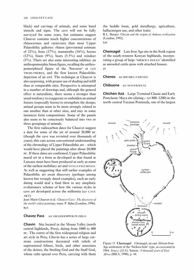
the heddle loom, gold metallurgy, agriculture,
hallucinogen use, and other traits.R.L. Burger: Chavín and the origins of Andean civilization(London, 1992).
KB
Chemagel Late Iron Age site in the Sotik region
of the south-western Kenyan highlands, incorpo-
rating a group of large ‘SIRIKWA HOLES’ identified
as unroofed cattle-pens with attached houses.
JS
Chenes see RIO BEC/CHENES
Chibuene see MANEKWENI
Chichén Itzá Large Terminal Classic and Early
Postclassic Maya site (dating c.AD 800–1200) in the
north-central Yucatan Peninsula, one of the largest
black) and carvings of animals, and some hand
stencils and signs. The cave will not be fully
surveyed for some years, but estimates suggest
Chauvet contains much higher concentrations of
rhinoceroses and carnivores than most Upper
Palaeolithic galleries: rhinos (provisional estimate
of 22%), lions (17%), mammoths (16%), horses
(12%), bison (9%), bears (5.5%) and reindeer
(5%). There are also some interesting oddities: an
anthropomorphic bison figure, recalling the anthro-
pomorphized figure of the ‘Sorceror’ at LES
TROIS-FRÈRES, and the first known Palaeolithic
depiction of an owl. The technique at Chauvet is
also surprising, with greater use of shading and infill
than at comparable sites. Perspective is attempted
in a number of drawings and, although the general
effect is naturalistic, there seems a stronger than
usual tendency to exaggerate or embolden an animal
feature (especially horns) to strengthen the design;
animal groups seem to be more strongly related to
one another than at other sites, and may in some
instances form compositions. Some of the panels
also seem to be consciously balanced into two or
three groupings of animals.
The first radiocarbon dates for Chauvet suggest
a date for some of the art of around 30,000 BC
(though the cave was revisited over thousands of
years); this cuts across conventional understanding
of the chronology of Upper Palaeolithic art – which
would have placed the paintings after about 20,000
BC. If these dates are confirmed, Upper Palaeolithic
mural art in a form as developed as that found at
Lascaux must have been produced as early as some
of the earliest mobiliary art and VENUS FIGURINES.
As well as suggesting that still earlier examples of
Palaeolithic art await discovery (perhaps among
known but wrongly dated examples), such an early
dating would deal a final blow to any simplistic
evolutionary scheme of how the various styles in
cave art developed across the millennia (see CAVE
ART).Jean-Marie Chauvet et al.: Chauvet Cave: The discovery ofthe world’s oldest paintings, trans. P. Bahn (London, 1996).
RJA
Chavez Pass see GRASSHOPPER PUEBLO
Chavín Site located in the Mosna Valley (north
central highlands, Peru), dating from 1000 to 400
BC. The centre of the first widespread religion and
art style in Peru, Chavín has a series of large cut-
stone constructions decorated with reliefs of
supernatural felines, birds, and other associates
of the deities, the Smiling God and the Staff God,
whose cults spread over Peru, carrying with them
150 CHAUVET CAVE
mound entrancepassage
gate posts
drawbar
guardhouse
guardhouse
stockade
sunkencattle-pen
Stockade
kitchen
forecourt
smooth(living room)
uneven floor(small stock)
eroded
mound
0 5 m
Figure 11 Chemagel Chemagel, an east African Iron
Age settlement of the ‘Sirikwa hole’ type, as excavated in
1964. Source: J.E.G. Sutton: A thousand years of EastAfrica (BIEA, 1990), p. 44.

it as the earliest of the Neolithic cultures, but this
view was later demonstrated to be incorrect, since
Chi’i-chia culture has generally been found strati-
graphically later than the YANG-SHAO culture.
Several hundred sites have been excavated, yielding
pottery with some characteristic types, such as
the flat-bottomed narrow-necked kuan-jar, and
occasional finds of copper artefacts. Some of the
latter may actually be intrusive from the Chung-
Yüan culture.J.G. Andersson: ‘Researches into the prehistory of the
Chinese’, BMFEA 15 (1943); Chang Kwang-chih: Thearchaeology of ancient China, 4th edn (New Haven, 1986),
280–6.
NB
Chichimecs Semi-nomadic hunting and horti-
cultural peoples living on the northwestern fringes
of ancient Mesoamerica. The Chichimecs were
generally regarded as ‘barbarians’ by the settled
peoples to the south. A series of migrations during
the epi-Classic and Postclassic (c.AD 700–1521)
periods brought the Chichimecs into the BASIN
OF MEXICO, where they gradually integrated
and intermarried with urban, farming peoples of
the basin. Many Postclassic peoples, including the
TOLTECS, the Mexica or AZTECS and the TARA-
SCANS, claim to have had their origins among the
Chichimecs.P. Kirchoff et al., eds: Historia Tolteca-Chichimeca(Mexico, 1976).
PRI
Chin ( Jin) An ancient state in China of con-
siderable importance. It originally comprised the
territory known as T’ang which was enfeoffed to a
younger brother (Shu-yu) of Ch’eng Wang, third
king of CHOU (1115–1078 BC). Following the re-
establishment of the ROYAL DOMAIN in a small
area between Chin and Cheng in 771 BC, Chin
became a major power during the Ch’un-ch’iu
period and supported the tottering rule of the
kings of Chou. In Chan-kuo times Chin was
divided into three states: Han, Chao, and Wei,
however, the Chin ruling house retained a more or
less nominal status until 349 BC. Archaeologically,
Chin is best known for the major bronze manufac-
turing sites around HOU-MA, and the vast number
of brush-written jade tablets (datable c.490 BC)
containing ‘oaths of allegiance’ discovered amongst
a complex of some 400 pits in which were buried
‘sacrificial’ animals (mainly sheep, some horses
and cattle).Li Hsüeh-ch’in Tung-Chou yü Ch’in-tai wen-hua, 1984
(trans. Chang Kwang-chih, 1985: Eastern Zhou (Chou)
and wealthiest in Mesoamerica, perhaps best known
for its complex architecture, its CENOTE and its
huge ballcourt (see BALLGAME). The Chichén Itzá
ballcourt is the largest in Mesoamerica, with a ‘play-
ing field’ measuring some 146 m long and 36 m
wide. The vertical sides of the court, 8 m in height,
rise above a sloping, sculptured basal apron show-
ing two teams of elaborately dressed players facing
each other. The central figure is a decapitated
player, with serpents of blood gushing from the
headless neck. A large ball in front of the figure is
decorated with a skull.
Chichén Itzá has often been called ‘Toltec-
Maya’, because its architecture is a blend of
Mexican and Maya traits. Some buildings are con-
structed in the PUUC Maya style, while others are
built in what has been considered the TOLTEC style,
with distinctive serpent columns, colonnades,
CHACMOOL sculptures and benches with atlantean
figures. Still other structures, such as the
TZOMPANTLI (or ‘skull racks’), show more general
similarities with central Mexican architecture.
Chichén Itzá was the site of one of the earliest
major archaeological projects in the Maya lowlands
from 1923 to 1937, under the sponsorship of the
Carnegie Institution of Washington and directed
by the famous Maya archaeologist Sylvanus G.
Morley. Despite this long period of excavations,
the chronological position of Chichén Itzá –
especially the relation of the Mexican and Maya
architectural phases – is still poorly understood.
The traditional interpretation of the site (Tozzer
1957) is strongly based on Mesoamerican leg-
ends telling of the flight of QUETZALCOATL from
Tula, and Chichén Itzá was thought to have had
two sequential (and ethnically distinct) building
occupation periods: Maya and then intrusive
Toltec. More recent analyses (Lincoln 1986)
have argued for a much greater ‘overlap’ or even
contemporaneity between the two episodes of the
site, forcing a still-incomplete reconsideration
of the Early Postclassic period in the northern
lowlands.A.M. Tozzer: Chichén Itzá and its cenote of sacrifice: a com-parative study of contemporaneous Maya and Toltec(Cambridge, MA, 1957); C.E. Lincoln: ‘The chronology
of Chichén Itzá: a review of the literature’, Late lowlandMaya civilization: classic to postclassic, ed. J.A. Sabloff and
E.W. Andrews V (Albuquerque, 1986) 141–96.
PRI
Ch’i-chia culture (Qijia) Early Neolithic
culture in China, named after the type site at Ch’i-
chia-p’ing, Kuang-ho-hsien, Kan-su. When Johan
G. Andersson first reported it in 1923, he regarded
151CH’IN

southeast and the semi-tropical hill-country of
the Liang-kuang.
The major rivers flow more or less ‘horizontally’
across to the Pacific in a west–east direction, only
to a small extent running through different major
climatic and vegetational zones. There are various
detailed geographical and cultural subdivisions of
and Qin (Ch’in) Civilizations); *anon., Hou-ma ming-shu[The Hou-ma Oaths of Allegiance Jade Tablets],
Shanghai, 1976.
Ch’in (Qin) An ancient state located in the west
of China (Shen-hsi and Kan-su) which was en-
feoffed as one of the chu-hou (a princely state, the
rulers of which were given the title kung, ‘Duke’)
by the Chou king, P’ing Wang, for its services
during the crucial period ultimately leading to the
removal of the Chou capital in 771 BC to the east at
Lo-yi (Lo-yang) – whence commences EASTERN
CHOU. The Ch’in state was then established in the
homeland of the CHOU. As a consequence, the still
extant styles of Late Western Chou in both pottery
and bronze strongly influenced Ch’in art and
design in the ensuing centuries; but concurrently,
local Ch’in art merged with the adopted forms so
giving rise to the sometimes rather crude castings,
particularly in such vessels as TING and KUEI, so
characteristic of Ch’in bronzes during Ch’un-ch’iu
times (771–481 BC). The innovative TUI appears in
this period, while in Chan-kuo times (480–255 BC)
such distinctive vessels as the Mou-vase and Hu-Hu-flask made their debut. Interestingly, the
distribution of characteristic tomb structures of
Ch’in, many hundreds of which have been discov-
ered throughout China, provide a valuable
potential in the study of the rise and expansion of
this state. The story of Ch’in’s ascendancy and
ultimate subjugation of the other Chinese states
and their unification under Shih-huang-ti is well
known. Although the Ch’in empire was short-lived
(221–207 BC), it decisively established the imperial
theme that was to prevail in China from Han
(206 BC–AD 220) and continue practically up to the
present.Li Hsüeh-ch’in Tung-Chou yü Ch’in-tai wen-hua, 1984
(trans. Chang Kwang-chih, 1985: Eastern Zhou (Chou)
and Qin (Ch’in) Civilizations); Ch’in-shih-huang-ling ping-ma yung-k’ang [The Terracotta Army of Ch’in
Shih-huang-ti], 2 vols, 1988.
NB
China The present-day boundaries of China
cover an area of about 9,600,000 sq. km: slightly less
than Europe, slightly more than the USA. There is
considerable variation in the topography, climate
and vegetation, including the subarctic taigaof Manchuria, the arid deserts and steppes of
Mongolia, the cold inhospitable wastes of the
Tibetan plateau, the highly fertile Red Basin of Ssu-
ch’uan, the temperate alluvial plains of the Yellow
River Valley, the river-dissected tablelands of the
152 CH’IN
S
Pre ShangEarly Shang 2000 – 1650 BC
Middle Shang 1650 – 1400 BC
Late Shang 1400 – 1123 BC
Early Western Chou 1122 – 1001 BC
Middle Western Chou 1000 – 878 BC
Late Western Chou 877 – 772 BC
Early Ch’un-ch’iu 771 – 670 BC
Middle Ch’un-ch’iu 669 – 570 BC
Late Ch’un-ch’iu 569 – 482 BC
Early Chan-kuo 481 – 395 BC
Middle Chan-kuo 394 – 310 BC
Late Chan-kuo 309 – 221 BC
Ch’in Shih Huang Ti 221 – 210 BC
Erh Shih Huang Ti 209 – 208 BC
San Shih Huang Ti 207 BC
Western Han 206 BC – 24 AD
Eastern Han 25 – 220 AD
Three Kingdoms 221 – 264 AD
Western Chin 265 – 316 AD
Eastern Chin 317 – 419 AD
Northern & Southern Dynasties 420 – 581 AD
Sui 581 – 617 AD
T’ang 618 – 906 AD
Five Dynasties 907 – 960 AD
(Liao 907 – 168)(Chin 1115 – 1234)
Sung 960 – 1126 AD
(Southern Sung 1127 – 1280)Yuan 1280 – 1368 AD
Ming 1368 – 1644 AD
Ch’ing 1644 – 1911 AD
Note:The chronology presented in the above table is generally basedupon the orthodox system. Note that there is no Hsia period; thiscould be considered to lie somewhere in the 'Pre-Shang' section,while Shang comprises essentially the archaeological eras: Erh-li-t'ou, Erh-li-kang, and An-yang. These three sub-divisions ofShang are assessed with reference to both radiocarbon andorthodox dates, and then ‘rounded-off’ mathematically. Orthodoxdates from the Chou conquest of Shang onwards are high-lighted by bold figures. Each of the periods: Western Chou,Ch’un-ch’iu, and Chan-kuo, are mathematically sub-divided intoequal parts. From Ch’in onwards, the dynastic divisions arehighly simplified.
Table 10 China Chronology of China from the Shang
period to modern times.

By c.5000 BC several distinct regional Neo-
lithic cultures had crystallized: YANG-SHAO,
TA-WEN-K’OU, MA-CHIA-PANG, HO-MU-TU and
TA-P’EN-KENG; during the ensuing two millennia,
interconnections gradually developed between
them (see map 20, showing the diagrammatic
distribution of the principal Neolithic cultures).
Foci of research and interpretation in Chinese
archaeology now tend towards appraisals of the
settlement patterns, the nature of building con-
struction, social organization, religious practices,
and various other aspects of daily life that can be
determined from archaeological context, such as
the extent of agriculture and domestication of ani-
mals, the variety of prey hunted or fished, and the
technical levels of lithic and ceramic industries.
Much of the better-preserved data naturally derive
from funerary goods and are systematically
studied in terms of the site stratigraphy, particu-
larly with reference to ceramics, which offer
significant variations in the materials employed,
developments in mode of manufacture (in particu-
lar, the increasing use of the potters’ wheel),
and developments in design and decoration. SERI-
ATION of such site data, often allied with the
results of radiocarbon (and occasionally thermolu-
minescence) dating, have provided chronological
frameworks – of varying levels of dependability –
which form the bases for comparisons between one
China, although the country can be demarcated
simply into Northern, Central and Southern
China. The Yellow River Valley played a special
role in the establishment of the formative eras of
the Chinese civilization, following the advent of
metallurgy and then writing (see EASTERN CHOU,
WESTERN CHOU and SHANG.) Chang Kwang-chih
(1986) has therefore made the useful proposal that
China should be divided into three ecological
areas: the Yellow River Valley, the ‘southern
deciduous zone’, and the ‘northern forests and
steppes zone’.
1. Prehistory. As a result of tremendous advances in
archaeological discovery over the last few decades,
the concept of the Chung-yüan (the central plains
of the Yellow River Valley) as the fountainhead of
Chinese civilization and culture has been
challenged, and its significance will doubtless be
open to some further degree of modification, but
probably not in its entirety. The debate hinges on
the question of what constitutes a ‘civilization’ and
what is to be accepted as the starting point thereof.
Neolithic cultures, and their Palaeolithic ante-
cedents, throughout continental China are now seen
to have contributed appreciably towards the ulti-
mate development of civilization in the
Chung-yüan, no less than the comparable contri-
butions of their counterparts have in other cultural
regions of the ancient world.
153CHINA
Yang-shaoYang-shaoTa-wen-k’ouTa-wen-k’ouTa-wen-k’ou
Ma-chia-pangMa-chia-pang
Ho-mu-tuHo-mu-tu
Ta-p’en-k’engTa-p’en-k’eng
Ta-lung-t’anTa-lung-t’an
Ta-hsiTa-hsi
Hsin-loHsin-lo
00 1000 km1000 km
Yang-shaoTa-wen-k’ou
Ma-chia-pang
Ho-mu-tu
Ta-p’en-k’eng
Ta-lung-t’an
Ta-hsi
Hsin-lo
MONGOLIA
CHINA
N
0 1000 km
N
00 1000 km1000 km
Yang-shaoYang-shaoTa-wen-k’ouTa-wen-k’ouTa-wen-k’ou
Ma-chia-pangMa-chia-pang
Ho-mu-tuHo-mu-tu
Feng-pi-l’ouFeng-pi-l’ouFeng-pi-l’ou
Shan-peiShan-peiTa-hsiTa-hsi
Hung-shanHung-shan
T’an-shih-shanT’an-shih-shan
Shih-hsiaShih-hsia
T’u-chuT’u-chu
Yang-shaoTa-wen-k’ou
Ma-chia-pang
Ho-mu-tu
Feng-pi-l’ou
Shan-peiTa-hsi
Hung-shan
T’an-shih-shan
Shih-hsia
T’u-chu
0 1000 km
MONGOLIA
CHINA
Map 20 China The distribution of the main Neolithic cultures of China, c.5000 BC (left) and c.4000–3000 BC (right).
The arrows on the right indicate interactions between the various later cultures. Source: Chang Kwang-chih: Thearchaeology of ancient China, 4th ed. (New Haven and London, 1986).
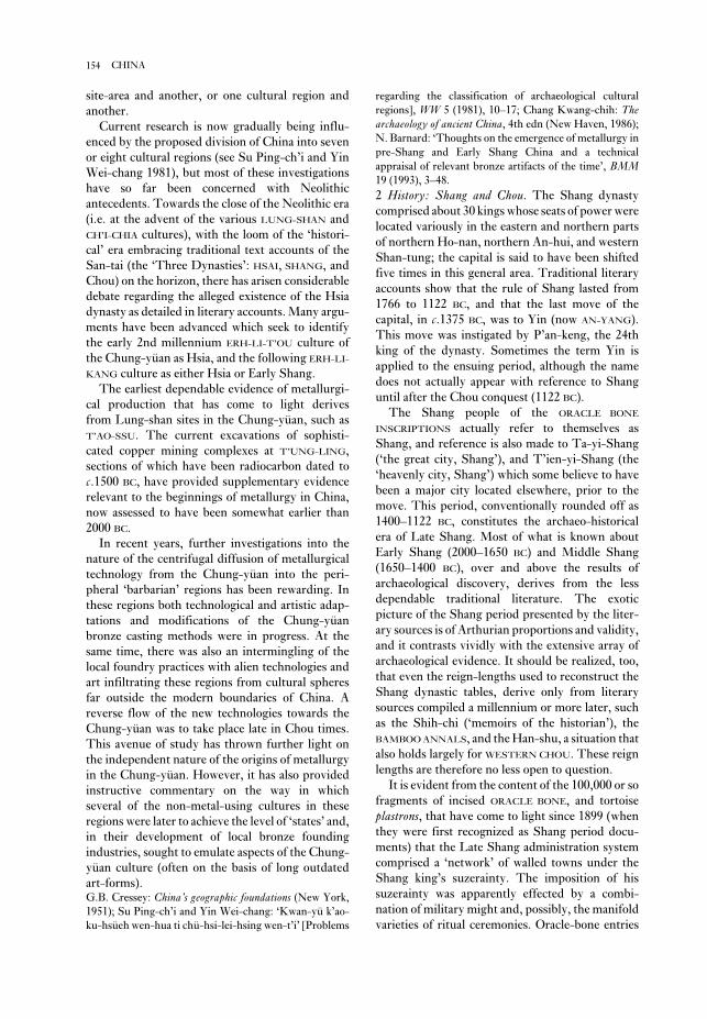
regarding the classification of archaeological cultural
regions], WW 5 (1981), 10–17; Chang Kwang-chih: Thearchaeology of ancient China, 4th edn (New Haven, 1986);
N. Barnard: ‘Thoughts on the emergence of metallurgy in
pre-Shang and Early Shang China and a technical
appraisal of relevant bronze artifacts of the time’, BMM19 (1993), 3–48.
2 History: Shang and Chou. The Shang dynasty
comprised about 30 kings whose seats of power were
located variously in the eastern and northern parts
of northern Ho-nan, northern An-hui, and western
Shan-tung; the capital is said to have been shifted
five times in this general area. Traditional literary
accounts show that the rule of Shang lasted from
1766 to 1122 BC, and that the last move of the
capital, in c.1375 BC, was to Yin (now AN-YANG).
This move was instigated by P’an-keng, the 24th
king of the dynasty. Sometimes the term Yin is
applied to the ensuing period, although the name
does not actually appear with reference to Shang
until after the Chou conquest (1122 BC).
The Shang people of the ORACLE BONE
INSCRIPTIONS actually refer to themselves as
Shang, and reference is also made to Ta-yi-Shang
(‘the great city, Shang’), and T’ien-yi-Shang (the
‘heavenly city, Shang’) which some believe to have
been a major city located elsewhere, prior to the
move. This period, conventionally rounded off as
1400–1122 BC, constitutes the archaeo-historical
era of Late Shang. Most of what is known about
Early Shang (2000–1650 BC) and Middle Shang
(1650–1400 BC), over and above the results of
archaeological discovery, derives from the less
dependable traditional literature. The exotic
picture of the Shang period presented by the liter-
ary sources is of Arthurian proportions and validity,
and it contrasts vividly with the extensive array of
archaeological evidence. It should be realized, too,
that even the reign-lengths used to reconstruct the
Shang dynastic tables, derive only from literary
sources compiled a millennium or more later, such
as the Shih-chi (‘memoirs of the historian’), the
BAMBOO ANNALS, and the Han-shu, a situation that
also holds largely for WESTERN CHOU. These reign
lengths are therefore no less open to question.
It is evident from the content of the 100,000 or so
fragments of incised ORACLE BONE, and tortoise
plastrons, that have come to light since 1899 (when
they were first recognized as Shang period docu-
ments) that the Late Shang administration system
comprised a ‘network’ of walled towns under the
Shang king’s suzerainty. The imposition of his
suzerainty was apparently effected by a combi-
nation of military might and, possibly, the manifold
varieties of ritual ceremonies. Oracle-bone entries
site-area and another, or one cultural region and
another.
Current research is now gradually being influ-
enced by the proposed division of China into seven
or eight cultural regions (see Su Ping-ch’i and Yin
Wei-chang 1981), but most of these investigations
have so far been concerned with Neolithic
antecedents. Towards the close of the Neolithic era
(i.e. at the advent of the various LUNG-SHAN and
CH’I-CHIA cultures), with the loom of the ‘histori-
cal’ era embracing traditional text accounts of the
San-tai (the ‘Three Dynasties’: HSAI, SHANG, and
Chou) on the horizon, there has arisen considerable
debate regarding the alleged existence of the Hsia
dynasty as detailed in literary accounts. Many argu-
ments have been advanced which seek to identify
the early 2nd millennium ERH-LI-T’OU culture of
the Chung-yüan as Hsia, and the following ERH-LI-
KANG culture as either Hsia or Early Shang.
The earliest dependable evidence of metallurgi-
cal production that has come to light derives
from Lung-shan sites in the Chung-yüan, such as
T’AO-SSU. The current excavations of sophisti-
cated copper mining complexes at T’UNG-LING,
sections of which have been radiocarbon dated to
c.1500 BC, have provided supplementary evidence
relevant to the beginnings of metallurgy in China,
now assessed to have been somewhat earlier than
2000 BC.
In recent years, further investigations into the
nature of the centrifugal diffusion of metallurgical
technology from the Chung-yüan into the peri-
pheral ‘barbarian’ regions has been rewarding. In
these regions both technological and artistic adap-
tations and modifications of the Chung-yüan
bronze casting methods were in progress. At the
same time, there was also an intermingling of the
local foundry practices with alien technologies and
art infiltrating these regions from cultural spheres
far outside the modern boundaries of China. A
reverse flow of the new technologies towards the
Chung-yüan was to take place late in Chou times.
This avenue of study has thrown further light on
the independent nature of the origins of metallurgy
in the Chung-yüan. However, it has also provided
instructive commentary on the way in which
several of the non-metal-using cultures in these
regions were later to achieve the level of ‘states’ and,
in their development of local bronze founding
industries, sought to emulate aspects of the Chung-
yüan culture (often on the basis of long outdated
art-forms).G.B. Cressey: China’s geographic foundations (New York,
1951); Su Ping-ch’i and Yin Wei-chang: ‘Kwan-yü k’ao-
ku-hsüeh wen-hua ti chü-hsi-lei-hsing wen-t’i’ [Problems
154 CHINA

ever, unless some major find of unambiguous pur-
port turns up, the problem of Shang and Chou
chronology will remain unsolved and continue to
fuel academic exercises of debatable value.
The Chou dynasty, comprising 35 rulers, was
originally located in the area of present-day Chou-
yuan. It established its hegemony over Shang and
most of the then ‘civilized’ (as opposed to ‘bar-
barian’) areas of China, instituting an
administrative system similar to Western-style
feudalism. The first half of the period is termed
WESTERN CHOU (1122–771 BC), which ends with
the transfer of the ROYAL DOMAIN eastwards from
Hao and Feng (near present-day Hsi-an) to Lo-yi
(near Lo-yang). This is followed by the EASTERN
CHOU period (770–255 BC), which in turn is divided
into the Ch’un-ch’iu and Chan-kuo phases
(770–482 BC and 481–221 BC respectively). With
the ascendancy of CH’IN towards the close of the
Chan-kuo period, the last decades of this phase are
sometimes classed as falling within the Ch’in
period.
Since the establishment of the modern political
regime in China, the Chinese use of the term
‘feudalism’ (rendered as feng-chien) has been influ-
enced by ideology. The so-called feudal institutions
in China are actually quite different to those of the
late 9th to early 13th centuries AD in western and
central Europe, from which the term feudalism
(feodalus, feodalité) derives. However, because of the
preoccupation of Chinese writers with the existence
of a ‘slave society’ during Shang, the concept of a
‘feudal society’ has been extended from Chou to
Ch’ing.
The Western Chou period, at its inception and
for several centuries thereafter, manifests many of
the characteristics of feudalism as detailed by Ch’i
Ssu-ho (1948) and further elaborated by Creel
(1970). However, the latter’s working definition of
feudalism, as ‘a system of government in which the
ruler personally delegates limited sovereignty over
portions of his territory to vassals’ (Creel 1970:
320), is, like most others, open to debate. Never-
theless, there exist a remarkable number of similar
features, so much so that it is as well to recollect
Marc Bloch’s observation: ‘it is by no means im-
possible that societies different from our own
should have passed through a phase closely re-
sembling that which has just been defined. If so, it
is legitimate to call them feudal during that phase’
(Bloch 1961: 446).
During Eastern Chou (771–255 BC) the power of
the Chou kings reached a low ebb and with the rise
of the ‘Five Hegemons’ (wu-pa), powerful rulers of
states who, one after the other, practically usurped
record numerous military and punitive expeditions,
while the role of the hunt (which is one of the most
frequently mentioned royal activities) may well be
significant. The numerous place-names recorded in
connection with both military and hunting ex-
peditions offer plenty of opportunity for academic
argument among those who attempt to identify the
archaic names with present-day geographical
features and similarly named localities.
Such documents as the records of expeditions to
Ch’iang-fang (‘the Ch’iang regions’) for the capture
of Ch’iang peoples as well as for sacrificial and
menial purposes, have been eagerly cited by
Marxist-inspired writers in an effort to follow the
Marxist model of history. (The nature of the chung(‘the multitudes’) would need to be defined without
bias, as a step towards clarification of the status and
role of peasants, craftsmen, and soldiers in Shang
society.) Thus the ‘approved’ periodization of
Chinese history since 1949 follows the evolutionary
stages of human society according to Marx and
Engels (and Kuo Mo-jo’s interpretations thereof):
primitive society, slave society, feudal society, and
capitalistic society (see Kuo Mo-jo 1954). Much has
been written on the problems of ‘periodization’
since 1945 (when Kuo changed his earlier interpret-
ation of Shang as a ‘primitive society’ to that of a
‘slave society’). There are more than a score of
‘systems’ which attempt to establish the date of
the Chou conquest of Shang which, in both the
archaeological literature (inscribed bronze ritual
vessels) and the traditional literary sources, is
ascribed to Wu Wang, the first king of the newly
established dynasty. These systems disagree on the
date of the conquest (which ranges from 1122 BC –
the orthodox date used here – to 1111, 1110, 1088,
1078, 1075, 1066, 1063, 1050, 1045, 1027 and 1018
BC), and there is also conflict among the historico-
literary sources with regard to the reign-lengths of
individual kings.
The Bamboo Annals have exerted a considerable
influence on the chronological problem but the
value of this semi-archaeological document as an
historical source is very much open to question.
Attempts to establish the chronology have further
sought to employ astronomical data as recorded in
the traditional literature along with reign-years and
event-dates recorded in the bronze inscriptions, but
these generally lack the names of the kings in
question, and only occasionally record the year of
reign, while there are numerous problems attending
the interpretation of the events recorded. Art-
historical assessments of vessel typology and
decoration are often cited in support of one
favoured chronology or another. To sum up, how-
155CHINA
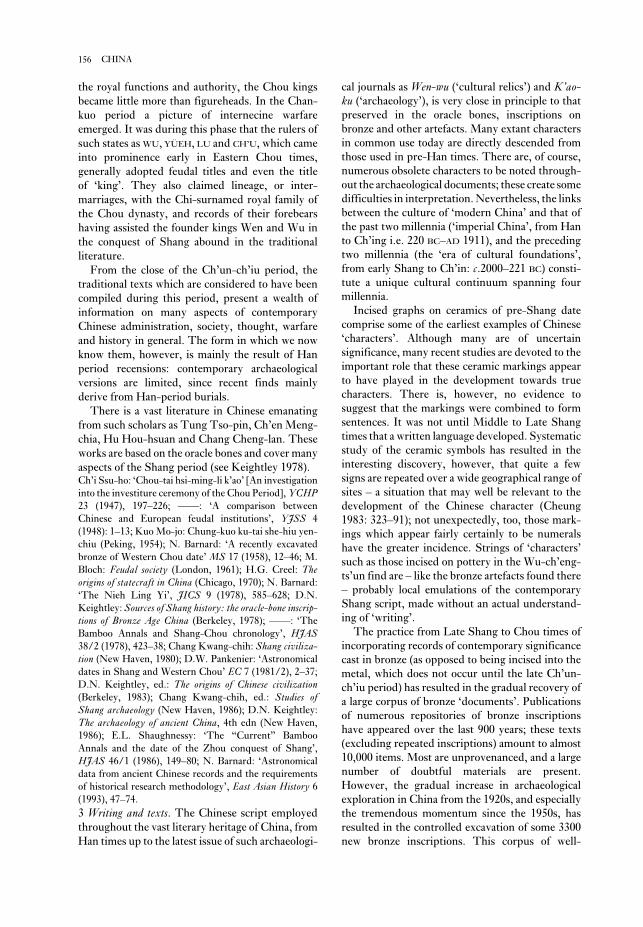
cal journals as Wen-wu (‘cultural relics’) and K’ao-ku (‘archaeology’), is very close in principle to that
preserved in the oracle bones, inscriptions on
bronze and other artefacts. Many extant characters
in common use today are directly descended from
those used in pre-Han times. There are, of course,
numerous obsolete characters to be noted through-
out the archaeological documents; these create some
difficulties in interpretation. Nevertheless, the links
between the culture of ‘modern China’ and that of
the past two millennia (‘imperial China’, from Han
to Ch’ing i.e. 220 BC–AD 1911), and the preceding
two millennia (the ‘era of cultural foundations’,
from early Shang to Ch’in: c.2000–221 BC) consti-
tute a unique cultural continuum spanning four
millennia.
Incised graphs on ceramics of pre-Shang date
comprise some of the earliest examples of Chinese
‘characters’. Although many are of uncertain
significance, many recent studies are devoted to the
important role that these ceramic markings appear
to have played in the development towards true
characters. There is, however, no evidence to
suggest that the markings were combined to form
sentences. It was not until Middle to Late Shang
times that a written language developed. Systematic
study of the ceramic symbols has resulted in the
interesting discovery, however, that quite a few
signs are repeated over a wide geographical range of
sites – a situation that may well be relevant to the
development of the Chinese character (Cheung
1983: 323–91); not unexpectedly, too, those mark-
ings which appear fairly certainly to be numerals
have the greater incidence. Strings of ‘characters’
such as those incised on pottery in the Wu-ch’eng-
ts’un find are – like the bronze artefacts found there
– probably local emulations of the contemporary
Shang script, made without an actual understand-
ing of ‘writing’.
The practice from Late Shang to Chou times of
incorporating records of contemporary significance
cast in bronze (as opposed to being incised into the
metal, which does not occur until the late Ch’un-
ch’iu period) has resulted in the gradual recovery of
a large corpus of bronze ‘documents’. Publications
of numerous repositories of bronze inscriptions
have appeared over the last 900 years; these texts
(excluding repeated inscriptions) amount to almost
10,000 items. Most are unprovenanced, and a large
number of doubtful materials are present.
However, the gradual increase in archaeological
exploration in China from the 1920s, and especially
the tremendous momentum since the 1950s, has
resulted in the controlled excavation of some 3300
new bronze inscriptions. This corpus of well-
the royal functions and authority, the Chou kings
became little more than figureheads. In the Chan-
kuo period a picture of internecine warfare
emerged. It was during this phase that the rulers of
such states as WU, YÜEH, LU and CH’U, which came
into prominence early in Eastern Chou times,
generally adopted feudal titles and even the title
of ‘king’. They also claimed lineage, or inter-
marriages, with the Chi-surnamed royal family of
the Chou dynasty, and records of their forebears
having assisted the founder kings Wen and Wu in
the conquest of Shang abound in the traditional
literature.
From the close of the Ch’un-ch’iu period, the
traditional texts which are considered to have been
compiled during this period, present a wealth of
information on many aspects of contemporary
Chinese administration, society, thought, warfare
and history in general. The form in which we now
know them, however, is mainly the result of Han
period recensions: contemporary archaeological
versions are limited, since recent finds mainly
derive from Han-period burials.
There is a vast literature in Chinese emanating
from such scholars as Tung Tso-pin, Ch’en Meng-
chia, Hu Hou-hsuan and Chang Cheng-lan. These
works are based on the oracle bones and cover many
aspects of the Shang period (see Keightley 1978).Ch’i Ssu-ho: ‘Chou-tai hsi-ming-li k’ao’ [An investigation
into the investiture ceremony of the Chou Period], YCHP23 (1947), 197–226; ––––: ‘A comparison between
Chinese and European feudal institutions’, YJSS 4
(1948): 1–13; Kuo Mo-jo: Chung-kuo ku-tai she-hiu yen-
chiu (Peking, 1954); N. Barnard: ‘A recently excavated
bronze of Western Chou date’ MS 17 (1958), 12–46; M.
Bloch: Feudal society (London, 1961); H.G. Creel: Theorigins of statecraft in China (Chicago, 1970); N. Barnard:
‘The Nieh Ling Yi’, JICS 9 (1978), 585–628; D.N.
Keightley: Sources of Shang history: the oracle-bone inscrip-tions of Bronze Age China (Berkeley, 1978); ––––: ‘The
Bamboo Annals and Shang-Chou chronology’, HJAS38/2 (1978), 423–38; Chang Kwang-chih: Shang civiliza-tion (New Haven, 1980); D.W. Pankenier: ‘Astronomical
dates in Shang and Western Chou’ EC 7 (1981/2), 2–37;
D.N. Keightley, ed.: The origins of Chinese civilization(Berkeley, 1983); Chang Kwang-chih, ed.: Studies ofShang archaeology (New Haven, 1986); D.N. Keightley:
The archaeology of ancient China, 4th edn (New Haven,
1986); E.L. Shaughnessy: ‘The “Current” Bamboo
Annals and the date of the Zhou conquest of Shang’,
HJAS 46/1 (1986), 149–80; N. Barnard: ‘Astronomical
data from ancient Chinese records and the requirements
of historical research methodology’, East Asian History 6(1993), 47–74.
3 Writing and texts. The Chinese script employed
throughout the vast literary heritage of China, from
Han times up to the latest issue of such archaeologi-
156 CHINA

directed towards (and in turn strongly tempered by)
the traditional literature. The accumulated back-
ground of archival and intellectual activity, which is
embodied in a vast volume of publications, many of
the extant original printings of which date back to
Sung times (c.AD 1100), is now receiving renewed
attention from a variety of directions.
Research devoted to the newly discovered
archaeological documents is gradually being pub-
lished. Studies of the new materials have led to
intensive researches into the traditional literature
and have already resulted in revisions, modifi-
cations, and confirmations of age-old concepts.
There is a constant process of review concerning the
interpretations of individual characters, phrases,
and even whole passages of text, as preserved
throughout numerous commentaries from Han
times. A renaissance in the age-old study of the tra-
ditional literature has thus been in progress over the
last few decades, and has exerted a considerable
influence over interpretations of archaeological
data.Tsien Tsuen-Hsuin: Written on bamboo and silk: the begin-nings of Chinese books and inscriptions (Chicago and
London, 1963); M. Loewe: Records of Han administration,
2 vols (Cambridge, 1967); N. Barnard: The Ch’u silk manu-script: translation and commentary (Canberra, 1973);
Cheung Kwong-yue: ‘Recent archaeological evidence
relating to the origin of Chinese characters’, Origins ofChinese civilization, ed. D.N. Keightley (Berkeley, 1983),
323–91.
4. The history of the archaeology of China. Two major
features have characterized research and writing
since the beginnings of modern archaeology in
China over 60 years ago. First, there has been wide-
spread use of western-style approaches in
fieldwork, as well as the adoption (and adaptions) of
western-style interpretational assessments of the
data unearthed. Where these activities are directed
to pre-Shang Neolithic contexts, the approach
differs little from that of archaeology in other pre-
historic cultural spheres. There are, however, fewer
applications of the mathematical and statistical
approaches of ‘NEW ARCHAEOLOGY’, the nature of
which has only recently begun to be discussed in
China (e.g. Huo Wei 1992).
Not unexpectedly, the more impressive ex-
cavations which relate so closely to the formative
eras of Chinese culture, from Early Shang to Ch’in
(c.2000–221 BC) occupy much the larger proportion
of the published reports and associated studies.
This is largely because of the vast quantity of textual
documentation unearthed: oracle bone texts,
inscribed bronzes, bamboo tablets, and silk manu-
scripts. We have already noted the marked effect of
provenanced historical documents is now available
as a means of control. Inscriptions range from large
documents of 500 or so characters to groups of as
few as five or six characters. Inscriptions of less than
five characters are generally of the ‘clan-sign’ type
(i.e. the phrase ‘X has cast this vessel’ followed by a
clan-sign). Interpretations of the archaeological
documents still tend to be influenced too strongly
by long-established concepts engendered by the
traditional literature. Nevertheless, studies over
the last century, and particularly over the last few
decades, have succeeded in clarifying the nature of
the culture and civilization of Shang and Chou (seeCHINA 2 above). The bronze documents, however,
being the products of the ruling classes, naturally
require supplementary evidence from the widest
possible range of archaeological data to obtain a rea-
sonably reliable and more general view of the society
of the time.
The earliest examples of brush-written charac-
ters are on Shang oracle bones and ceramics.
Presumably, during Late Shang and Western Chou
bamboo, wood, and perhaps even silk, provided the
ground for the writing of substantial amounts of
text. It was not until Late Ch’un-ch’iu (c.600 BC),
however, that writings on these materials entered
the archaeological context. The most common
surviving brush-written texts are INVENTORIES OF
TOMB FURNISHINGS, usually recorded on wooden
or bamboo strips. Other subjects include writings
on fortune-telling, laws and ordinances, lists of
punishments and state annals.
As far as writings on silk are concerned, the
longest surviving single text is the Ch’u silk manu-
script, which was the product of tomb robbery in
Ch’ang-sha in the 1930s and is about 950 characters
in length. From Han tombs, however, there are
particularly impressive finds of archaeological
documents such as those from WU-WEI (Mo-chui-
tzu), Kan-su; Yün-meng (Shui-hu-ti), Hu-pei;
Lin-yi-hsien (Yin-chüeh-shan), Shan-tung; HSIN-
YANG, Ho-nan; Ch’ang-sha, and Pao-shan, Hu-pei.
The subject-matter comprises tomb inventories,
astrological works, maps, medical works, contem-
porary versions of the transmitted traditional
literature, and lost texts of various kinds. The docu-
ments are often of substantial size; many are written
on strips of bamboo or wood and bound together
with cord, while others are written on scrolls of silk.
Recovery of textual data from ancient burials has
invariably been heralded in China as an event of
special importance. There has been a tradition of
palaeographic studies, literary, philosophical, and
historical writing, and textual criticism for 2000
years. Since Han times, these efforts have been
157CHINA

structed buildings to house them (and museums to
display the treasures unearthed), and, of course, the
organization of overseas exhibitions, are all ex-
cellent money-making investments.
This contrasts with the rudimentary level of
preservation of archaeological artefacts character-
istic of numerous provincial and lesser museums,
despite the continual appearance of articles relating
to conservation techniques in the archaeological
journals. The frequent instances of untreated
‘bronze disease’ among items on display is but one
indication of this. Few such museums have proper
conservation facilities let alone staff with adequate
expertise to engage even in stop-gap measures.
There are, of course, exceptions to be observed
among the comparatively few better-endowed
museums where conservation activities and
laboratory research have progressed appreciably –
often the latter is conducted in co-operation with
outside research laboratories.
Scientific examination of the materials unearthed
has progressed well in several archaeological insti-
tutes and museums, but there is an appreciable lack
of equipment and qualified staff, while a consider-
able quantity of potentially valuable data remains
unexamined, or incompletely examined, in many
institutes and museums throughout the country –
much of it lying dormant in store-rooms where
access is limited. Generally, however, this situation
has been balanced by the extensive publication of
detailed and exact measurements of site areas,
building foundations, kilns, skeletal remains, and of
the vast quantities of artefacts unearthed; as well
as the considerable proportion of fine quality draw-
ings, décor rubbings, adequate and gradually
improving photographic coverage, and quite
detailed descriptive notes on individual artefacts.
Along with these data, radiocarbon assessments,
elemental analyses, microscopic examinations, and
other such laboratory-derived information are
occasionally incorporated where the institutes con-
cerned have been fortunate enough to obtain the
interest of outside laboratories to undertake such
work.
Because of the comparative paucity of scientifi-
cally derived information, and the lack of
experience of many of the report compilers in the
use of such data (when it does become available),
misleading interpretations occur at times. One has
to turn to the reports on major finds to discover
examples of the more extensive and reliable appli-
cations of laboratory examination, or to such
periodic publications as Tzu-jan k’o-hsüeh-shih yen-chiu [Studies in the History of Natural Science],
Peking, and Wen-wu pao-hu yü k’ao-ku k’o-hsüeh
the traditional literature (and also, since 1949, that
of 19th- and 20th-century ideological influences)
upon the manner in which the overall archaeologi-
cal context is assessed.
The influx of western influences is to be noted
mainly in the conduct of fieldwork (since the late
1920s), museum conservation (from the 1950s),
applications of science (from the 1970s), systematic
methods in the study of archaeological data (grad-
ually, but with increasing acumen, over the whole
period), and, over the last decade a welcome
tendency among some writers to break away from
the ideological restraints imposed since 1949. The
importance of archaeological data to the historian
has, of course, long been realized. Indeed, we
should recall that before the modern era China had
already developed critical approaches to history,
notably in the 17th and 18th centuries, although
these unfortunately languished until the late 19th
century. Revivals of historical criticism thence
stemmed from the works of K’ang Yu-wei, Hu
Shih, Ku Chieh-kang, Liang Chi-ch’ao, and others
who were strongly influenced by (or had studied
in) the West. In the realm of archaeology, however,
it was mainly through the persuasive expositions of
the theoretical evolutionary models of Marx and
Engels by Kuo Mo-jo in the 1930s, that these
politically acceptable (albeit somewhat antiquated
and materialistic) approaches were to come into
their own after the events of 1949. They still
remain an issue to be weighed carefully by users
of Chinese archaeological reports and secondary
writings.
Considerable time and effort is spent on the
reconstruction and repair of archaeological artefacts
but, unfortunately, often without subjecting the
materials to thorough scientific scrutiny beforehand
so as to elicit all data of possible significance. Much
of the reconstruction work, however, is of a high
standard – especially where materials of exceptional
significance are concerned, e.g. the bronze chariot
and horses (No. 2) found in a pit burial to the west
of the tomb mound of Shih-huang-ti, the ‘terracotta
army’ to the east of the mound, numerous indi-
vidual items ranging from Neolithic pottery
through textiles, brush-written bamboo tablets,
lacquer-ware, to gold, silver, bronze and iron arte-
facts. Owing to the ravages of time and burial
conditions, restoration work is also occupied with
the production of facsimile representations of the
original artefacts; the results are usually excellent.
Possibly, these activities might seem to savour of
the financial aspects of ‘making the past work for the
present’. The preparation of major archaeological
sites as tourist attractions, some with especially con-
158 CHINA

compilation of bibliographies – the practice adopted
here is simply to use the term ‘Anon.’.Kuo Mo-jo: Chung-kuo ku-tai she-hui yen-chiu[Researches into Ancient Chinese Society] (Peking, 1930);
A.W. Hummel: The autobiography of a Chinese historian(Leiden, 1931); C.S. Gardner: Chinese traditional histori-ography (Cambridge, MA, 1938); Li Chi and Wan
Chia-pao: Ku-ch’i-wu yen-chiu chuan-k’an [Researches
into ancient vessels], 5 vols (Taipei, 1964–72); Chang
Ching-hsien: Chung-kuo nu-li she-hui [Chinese slave
society] (Peking, 1974); Chang Kwang-chih: Shang civi-lization (New Haven, 1980); Lu Pen-shan and Hua
Chüeh-ming: ‘T’ung-lü-shan Ch’un-ch’iu lien-t’ung
shu-lu ti fu-yüan yen-chiu’ [Reconstructional researches
into the Ch’un-ch’iu period smelting furnaces of T’ung-
lü-shang], WW 8 (1981), 40–5; Anon.: Ch’in-ling erh-haot’ung-ch’e-ma [The bronze horse and chariot No. 2 of the
Ch’in Mound] (Peking, 1983); Anon.: Ch’in-shih-huang-ling ping-ma yung-k’ang [The terracotta warriors pit of the
Ch’in-shih-huang-ti mound], 2 vols (Peking, 1988); An
Chih-min: ‘Hua-nan tsao-ch’i Hsin-shih-ch’i te 14C tuan-
tai ho wen-t’i’ [Problems attending the early Neolithic
periodization in South China on the basis of radiocarbon
dates], TSCYY (1989), 123–33; Huo Wei: ‘P’ing Ao
Mi’Hsin k’ao-ku-chia-p’ai’ [A critical assessment of the
New Archaeology school in Europe and America], SCWW1 (1992), 8–13.
NB
chinampa Aztec term for a highly productive
system of raised-field intensive agriculture prac-
tised along the shallow lakeshore in central Mexico
(and elsewhere), whereby rich organic muck from
the lake bottom was dug up to build a network of
rectangular plots. Canals between the plots pro-
vided drainage and allowed access by canoe.
Chinampas were primarily associated with the
AZTECS (in the Postclassic period) but may also
have been constructed in TEOTIHUACAN times (the
Classic period).P. Armillas: ‘Gardens in swamps’, Science 174 (1971)
653–704.
PRI
Chinchorro Culture of northern coastal Chile
and far southern coastal Peru, between c.4000 and
1000 BC. These were the only South American
people to develop artificial MUMMIFICATION:
internal organs were removed, sticks inserted along
the limbs to make a rigid body, the muscles
plumped out with grass; the body was then covered
with clay, painted and given a mask of human hair.
Not all Chinchorro bodies were given this treat-
ment, but males, females and children in roughly
equal numbers were mummified in this way.B. Bittman: ‘Revision del problema Chinchorro’,
Chungara-Arica 9 (1982), 46–79; B.T. Arriaza: Beyond
[Sciences of Conservation and Archaeology],
Shanghai. Although techniques of dating archaeo-
logical remains such as thermoluminescence are in
use, radiocarbon assessments have played the major
role to date. Dendrochronological conversions still
continue to follow the DLW (Damon, Long and
Wallick) tables of 1972. In using the radiocarbon
data, care is required. Sampled materials and their
site associations are not always clear, while risky
materials such as shell and bone are usually allowed
the same status as more reliable charcoal, wood, etc.
In the case of wood, however, it is seldom indicated
specifically where the sample has been taken (e.g.
from heart-wood or sap-wood). Radiocarbon-dated
sites that have been reported with merely a single
dated sample are treated in the archaeological
literature on much the same level as sites with
multiple dates, and clusters thereof. Far too often
‘mid-point dates’ are regarded as the actual date!
Secondary studies using these data require careful
assessment at practically all stages of reading.
However, improvements have steadily been taking
root: An Chi-min’s recent assessment of the nature
of the anomalies attending the Neolithic period-
ization in South China on the basis of radiocarbon
dates (An Chin-min 1989: 123–33), is an indication
of current trends towards more cautious interpret-
ative approaches.
Replication experiments involving the re-
constructions of kilns, the baking of pottery,
reconstructions of smelting furnaces, the casting of
bronze vessels of various types in mould-assemblies
following known ancient approaches, and other
such experimental investigations, employing where
possible comparable raw materials, have been con-
ducted in both Mainland China and Taiwan. Very
useful information at the technical level has resulted
and this has allowed more effective assessments of
the archaeological data.
Since the 1950s, and especially in the 1990s, the
variety and rate of publication of Chinese archaeo-
logical reports has been phenomenal. In this
dictionary, only a minute proportion of the available
materials is cited directly – precedence has been
given to English language sources (translations and
secondary works) to enable the general reader to
follow up on the thumbnail sketches offered here;
of these, one or more items have been chosen –
among other considerations – because of the
extensive lists of reference materials consulted and
recorded in them. For Chinese and Japanese
language publications a free translation of titles is
given. In the case of mainland Chinese reports
where the authorship comprises one or more insti-
tutes – a most awkward custom when it comes to the
159CHINCHORRO
TALUD-TABLERO construction, is now surmounted
by a Catholic church. Postclassic Cholula is also
associated with the manufacture and wide distri-
bution of a brightly-coloured, polychrome ceramic
known as the ‘Mixteca-Puebla’ style.I. Marquina, co-ord.: Proyecto Cholula, SerieInvestigaciones 19 (Mexico, 1970).
PRI
Choris culture see NORTON TRADITION
Chorrera Series of related fishing and agri-
cultural village cultures in coastal Ecuador during
the Formative Period (c.3000–500 BC) whose
ceramic style was traded and copied throughout
Ecuador and may have influenced early ceramic
styles, including the coastal CHAVÍN ones, of
northern Peru. These cultures were instrumental in
the development of long-distance trade networks to
procure exotic stones and other items (including
metal) for the emerging elites.C. Zevallos Mendez: ‘Informe preliminar sobre el
Cementerio Chorrera, Bahia de Santa Elena, Ecuador’,
Revista del Museo Nacional 34 (1965–6), 20–7; K.O.
Bruhns: ‘Intercambio entre la costa y la sierra en el
Formativo Tardío: nuevas evidencias del Azuay’,
Relaciones culturales en el area ecuatorial del Pácifico durantela Epoca Precolombina, ed. J.-F. Bouchard and M. Guinea
(Oxford, 1989), 57–74.
KB
Chou dynasty (Zhou dynasty) see CHINA 2;
EASTERN CHOU; WESTERN CHOU
Choukoutien Complex cave site near Beijing,
China, where in 1927 Davidson Black found
hominid fossils which he named SinanthropusPekinensis (‘Peking Man’). The fossils have more
recently been identified with HOMO ERECTUS
although they differ from the early African ex-
amples. The lower deposits are now thought to date
from c.4–500,000 BP. Unfortunately many of the
original fossils were destroyed during the Second
World War and only casts remain. The associated
archaeological remains for this period resemble the
developed Oldowan (see OLDUVAI) chopper/flake
industries, although the ACHEULEAN, biface-based
technology had by that point existed for nearly one
million years in Africa.
Choukoutien is also noted for early evidence of
the use of fire, although no identifiable hearths
have been found, unlike those claimed for the
roughly contemporary site of Terra Amata in
France. The Upper Cave has yielded fossil
hominids dating from 20–30,000 BP, which, whilst
death: the Chinchorro mummies of ancient Chile(Washington, D.C., 1995).
KB
Ch’ing-lien-kang (Qingliangang) see TA-WEN-
K’OU
Ch’i-shan (Qishan) see WESTERN CHOU
chi-squared test One of a number of ways
of examining the ‘fit’ between two or more sets of
DATA, or one set and a theoretical MODEL, when the
data consist of the numbers of objects that fall into
various categories, for example the numbers of arte-
facts of different types on two or more sites. Tests
of a dataset against a model are known as
GOODNESS-OF-FIT tests; comparisons of datasets
give rise to CONTINGENCY TABLES.S. Shennan: Quantifying archaeology (Edinburgh, 1988),
70–6; M. Fletcher and G.R. Lock: Digging numbers(Oxford, 1991), 115–25.
CO
Choga Mami Prehistoric site in eastern central
Iraq, at the edge of the Mesopotamian plain.
Excavations during the 1960s revealed strata of the
late SAMARRA period (c.5000 BC) containing
ceramics known as Choga Mami Transitional; this
discovery is important since the upper strata at
TELL ES-SAWWAN, the classic Samarra site, have
been eroded away. The ‘Transitional’ ceramics
resemble early UBAID pottery from sites in southern
Iraq, such as Eridu and Hajji Muhammed, perhaps
indicating that the origins of the Ubaid culture are
to be found in the Samarra period. The late Samarra
settlement at Choga Mami, as at Tell Songor in the
Hamrin Basin, consists primarily of grid-planned
multi-room buildings; like Tell es-Sawwan, it was
contained within an enclosure wall.Preliminary reports by J. Oates in Sumer 22/25 (1966,
1969) and Iraq 31/34 (1969, 1972); J. Oates: ‘Choga
Mami’, Fifty years of Mesopotamian discovery, ed. J. Curtis
(London, 1982), 22–9.
IS
Choga Mami Transitional see SAMARRA
Choga Zanbil see ELAM
Cholula Large site in Puebla, Mexico, occupied
since Preclassic times but best known for the role it
played in the Postclassic period (c.AD 900–1521).
Cholula has been identified as a centre of the
QUETZALCOATL cult, and its enormous main
temple-pyramid, with episodes of Classic-period
160 CHINCHORRO

manuscript from Ch’ang-sha, includes sections of
rhymed text which are among the longest unearthed
to date. Very impressive finds such as the TS’AI HOU
LUAN tomb, the TSENG HOU YI tomb, the HSI-
CH’UAN, HSIA-SSU tombs, the Pao-shan Tomb
No. 2, and the well-known Western Han period MA-
WANG-TUI Tomb No. 1, along with such recent
discoveries of the mining complexes at T’UNG-LÜ-
SHAN, JUI-CH’ANG, and Nan-Ling, demonstrate the
fact that Ch’u and several of the states under its con-
trol, comprised one of the most highly cultured
regions of Ch’un-ch’iu and Chan-kuo times.N. Barnard: ‘The origin and nature of the art of Ch’u – a
necessary prelude to assessments of influences from the
Chinese sphere into the Pacific’, Proceedings of the FirstNew Zealand International Conference on Chinese Studies(Hamilton, 1972), 1–47; Li Hsüeh-ch’in: Hou-ma ming-shu [The Hou-ma oaths of allegiance texts] (Shanghai,
1976); ––––: Eastern Zhou and Qin civilizations, trans.
Chang Kwang-chih (New Haven, 1985).
NB
Ch’ü-fu (Qufu) Ancient city site in Shan-tung,
China, which was the capital of LU, the territory
enfeoffed to Po-ch’in, son of Tan, Duke of Chou,
who, as tradition tells us, acted as regent during the
clearly modern, are said not to resemble modern
Chinese.H.L. Shapiro: Peking man (London, 1976); Jia Lanpo and
Huang Weiwan: The story of Peking man (Oxford, 1990).
PG-B
Chou-yüan (Zhouyuan: ‘the plains of Chou’)
Archaeologically rich area in China, c.70 km
(east–west) by 20 km (north–south), which
embraces mainly modern Fu-feng, Chi’-shan,
Feng-hsiang and Wu-kung. Large numbers of
inscribed bronzes (many from storage pit burials)
figure prominently among the various finds from
numerous sites in the area. However, the name
‘Chou-yüan’ has become associated with the
excavations around Feng-ch’ü-ts’un, near Ch’i-
shan-hsien, where two pits in the precincts of
palace (or, temple?) remains radiocarbon dated to
1295–1241 BC have yielded over 17,000 ORACLE
BONES, 292 of which were inscribed. These
artefacts not only indicate the practice of SCAPULI-
MANCY by the Chou people but also shed light upon
the nature of Chou civilization before it subjugated
the SHANG city-state in 1122 BC. See also CHINA 2
and WESTERN CHOU.Ch’en ch’uan-fang: Chou-yüan yü Chou-wen-hua [Chou-
yüan and the Chou culture] (Shanghai, 1988).
NB
chron see PALAEOMAGNETIC DATING
Ch’u (Chu) Major Chinese state which
flourished in the EASTERN CHOU period (771–255
BC), the legendary origins of which are ascribed to
the reign of Ch’eng Wang of Chou (c.1100 BC), at
which time it was named Ching. It was eventually
extinguished by the CH’IN polity in 253 BC. At the
height of its power, the state of Ch’u extended from
eastern Shen-hsi to the lower Yangtze Valley and
from the north well into Ho-nan and northern An-
hui thence southwards as far as the Tung-t’ing Lake
region in southern Hu-pei and northern Hu-nan.
Ch’u, along with WUR and YÜEH, was regarded as
a more or less ‘barbarian’ entity outside the pale of
the MIDDLE STATES. In terms of material culture,
however, it was a highly cultured region with very
advanced levels in mining technology, metallurgy,
weaving and embroidery, woodworking and join-
ery, lacquerware, music, calligraphy, various
writings and poetry. The bulk of Eastern Chou lit-
erary remains have been unearthed from various
Ch’u sites. Poetry (rhymed metric verse) plays a
leading role in the compilation of many of the
bronze inscriptions (especially those from the state
of Ts’ai under Ch’u suzerainty); while the Ch’u silk
161CH’Ü-FU
0 1 km
K’ung-lin
(ii)
(i)
(iii)(iv)
Palace/templearea
Present-day townof Ch’ü-fu
Eastern Chou wallEastern Chou roadwaysEastern Chou waterway
Industrial areas
Areas of pounded earthAreas of habitations
Eastern Chou city gatesBurial areas
(i) Wang-fu-t’ai(ii) Yao-p’u(iii) Hsi-pei-chiao(iv) Tou-chi-t’ai
N
Figure 12 Ch’ü-fu Eastern Chou walled city of Ch’ü-
fu (the capital of the kingdom of Lu), showing features
of the city revealed in the 1977-8 excavations. Source:
T.F. Munford: Burial patterns of the Chou period: thelocation and arrangement of cemeteries in North China,1000-200 BC (Ph.D. thesis, Australian National
University, 1985), fig. 6.

modified. It now seems that in the earliest periods
the Chung-yüan was only one of several major
cultural regions each with indigenous roots extend-
ing appreciably into high antiquity. Some, such as
TZ’U-SHAN and related cultures in southern Ho-
pei, PEI-LI-KANG in Ho-nan, HO-MU-TU, in
Shang-tung, TA-P’EN-K’ENG, Taiwan (incorporat-
ing also the southeast coastal areas of China),
variously date back to at least 5000 BC, a few even
earlier. Thus up to the historical level (c.2000–1500
BC), increasing attention has been given to the
regional developments of the several major
Neolithic cultural regions and the variant character-
istics of each, while the nature and extent of cultural
interplay between them is gradually being clarified.
However, from historical times in China, essentially
the age of metallurgy and writing, the centrifugal
nature of the development of Chinese civilization
with its spread from the MIDDLE STATES (i.e. the
major states under Chou suzerainty centred in
the Chung-yüan) outwards into the peripheral
‘barbarian’ regions, where regional modifications
embodying local cultural concepts intermingled
with the incoming Chung-yüan influences, has
become much clearer. At the same time, the entry
of alien influences into the outermost of the periph-
eral ‘barbarian’ regions is to be noted.Su Ping-ch’i and Yin Wei-chang: ‘Kwang-yu k’ao-ku-
hsueh wen-hua ti chu-hsi-lei-hsing wen-t’i’ [Problems
regarding the classification of archaeological cultural
regions] WW 5 (1981), 10–17; Chang Kwang-chih: Thearchaeology of ancient China, 4th edn (New Haven, 1986).
NB
Chu-shu-chi-nien (Zhushujinian) see BAMBOO
ANNALS.
Ch’u silk manuscript (Ch’u-tseng-shu,
Chuzengshu) see CHINA 3
‘Cimmerians’ see TIMBER-GRAVE CULTURE
circumscription theory Theory that explains
how cultural development is influenced by environ-
mental constraints. The theory was first put
forward by Robert Carneiro (1970) in an attempt to
explain the origins of the state in the Andes. He
argued that communities relying on the farming of
narrow valleys for their subsistence were effectively
‘circumscribed’, i.e. a point could easily be reached
at which no further land was available for ex-
ploitation. This circumscription, combined with
population growth, generates conflict between
different settlements and thus encourages the
development of chiefdoms and subordinate,
minority of Ch’eng Wang, the second king of the
newly-established feudal kingdom of Chou which
followed upon the SHANG conquest (1122 BC).
Ch’ü-fu was also the birthplace of Confucius, who
was supposedly also buried here. According to the
Shih-chi [The memoirs of the historian], the burial
of Confucius was to the north of Lu-ch’eng [Ch’ü-
fu]; the tumulus still marked as his tomb lies
several hundred metres north of the ancient wall.
The site-area is centred around the villages of
Chou-kung-miao and Hsiao-pei-kuan; the latter
two having been the loci of earlier excavations.
The excavators seek to date some burials (M44,
M57, and M35) in the Wang-fu-t’ai cemetery area
in the western side of the ancient city from as early
as Early Western Chou (1122–1001 BC) but, as well
demonstrated by T.F. Munford (1985: 41–55),
among other factors, the close similarities of the
burials and funerary furnishings generally with
those of the SHANG-TS’UN-LING cemetery site do
not allow a dating much earlier than Ch’un-ch’iu
times (771–481 BC).Anon.: Ch’ü-fu Lu-kuo-ch’eng [The ancient city of Ch’ü-
fu of the state of Lu] (Ch’i-nan, 1982); T.F. Munford:
Burial patterns of the Chou period: the location and arrange-ment of cemeteries in North China, 1000–200 BC (Ph.D.
thesis, Australian National University, 1985).
chullpa Burial house or tower, characteristic of
the central and southern Andean highlands.
chultun Underground cistern, usually bell-
shaped with a narrow mouth, found around
domestic settlement in the LOWLAND MAYA area
and used for storage of water or food.D. Puleston: ‘The chultuns of Tikal’, Expedition 7 (1965)
24–9; P.A. McAnany: ‘Water storage in the Puuc region
of the northern Maya lowlands: a key to population esti-
mates and architectural variability’, Precolumbianpopulation history in the Maya lowlands, ed. T.P. Culbert
and D.S. Rice (Albuquerque, 1990) 263–84.
PRI
Chung-yüan (Zhongyuan; ‘central plains’)
Region in central China largely embraced by the
adjoining areas of the provinces of Ho-nan, Shen-
hsi, and Shan-hsi; comprising the confluence of the
Huang-ho (‘Yellow River’) Basin with those of
the Wei-shui and the Fen-ho. Long regarded as the
very cradle of Chinese civilization, it has also been
referred to as the ‘nuclear area’ and roughly co-
incides with the territories of the MIDDLE STATES
of Chou times. With the rapid and extensive rate
of archaeological discovery over the last three
decades, however, and the application of radio-
carbon dating (see CHINA 2), this concept has been
162 CH’Ü-FU
tem of mountain ridges, plateaux and uplands in
southern and eastern Siberia and the far east. The
region includes the largest rivers of Eurasia drain-
ing to the Arctic Ocean (the Lena, Ob/Irtysh,
Northern Dvina); Pacific Ocean (the Amur);
Caspian Sea (the Volga); Black Sea (the Dniepr) and
Baltic Sea (the Western Dvina, Neva). The climate
is markedly continental, with cold winters (below
50°C in Yakutia) and mild or warm summers. The
greater part of Russian territory is taken up by the
tundra and forest vegetation zones. A treeless
steppe corridor stretches from Southern Russia via
Northern Caucasus and South Urals into southern
Siberia.
1 Prehistory. The earliest evidence of hominids in
the region is provided by the lower levels of AZYKH
CAVE in the Caucasus, palaeomagnetically dated to
>735,000 years ago. The archaic stone assemblages
at the site of KOROLEVO (on the upper Tisza River
in the Western Ukraine) are geologically dated to
the Mindel-Günz interglacial (780–730,000 years
ago). A group of sites with archaic stone inventories,
including pebble tools and scrapers, have been dis-
covered in the loess sections in the south
Tadjikistan. The oldest site (Kouldoura) has been
found in a buried soil below the Brunhes-
Matuyama geomagnetic boundary, c.735,000 years
ago (Ranov 1993).
The Caucasus was intensively settled during the
MOUSTERIAN epoch (c.110,000–40,000 BP), as is
clear from the cave-sites of Azykh, KUDARO and
many others. Mousterian sites are also located near
Volgograd (Sukhaya Mechetka), near Kursk
(Khotylevo) and in a few other areas of European
Russia, as well as in Moldova and in the Ukraine
(the Crimean cave sites of KIIK-KOBA, AK-KAYA and
others). At the site of STAROSL’YE the skeleton of
an anatomically modern human was found within
the Mousterian layer.
During the Upper Palaeolithic (c.40,000–15,000
BP), a network of dwelling sites developed in
European Russia, Ukraine and Moldova, notably
in the basins of the Middle Don, Middle Dniepr
and Dniestr. The earliest sites of the KOSTENKI-
BORSHEVO group on the River Don (belonging to
the Streletskian tradition) retain elements of the
Mousterian. A fully developed Upper Palaeolithic
tradition (Kostenkian) emerged between 24,000
and 21,000 BP.
In the 1930s, Russian archaeologists identified
substantial structures made of mammoth bones at a
number of Upper Palaeolithic sites in the Russian
Plain: Kostenki 1, stratum 1, Kostenki 11 stratum
1, Kostenki 4 and others. The quality of evidence at
these sites invites sophisticated analysis; for
tribute-paying communities. According to
Carneiro’s theory, the process of territorial conflict
provided a continuous stimulus to the development
of the state in coastal Peru.
In collaboration with the Egyptologist Kathryn
Bard, Carneiro takes a similar approach to the
question of the rise of the state in the Nile valley
(Bard and Carneiro 1989). They suggest that five
principal factors were involved: a concentration of
food resources (both in the earlier Predynastic for
hunting and fishing and in the late Predynastic
for cereal crops); the circumscription of the Nile
valley by the desert on either side; increasing popu-
lation pressure; gradual change in society; and the
development of warfare. A sixth crucial factor pro-
duced a situation somewhat different to that in the
Andes – the concept of the Egyptian divine ruler,
which Carneiro believes to have contributed to the
final integration of a set of chiefdoms which might
otherwise have been continually at war.R.L. Carneiro: ‘A theory of the origin of the state’, Science169 (1970), 733–8; ––––: ‘Political expansion as an ex-
pression of the principle of competitive exclusion’, Originsof the state: the anthropology of political evolution, ed. R.
Cohen and E.R. Service (Philadelphia, 1978), 205–23; K.
Bard and R.L. Carneiro: ‘Patterns of predynastic settle-
ment: location, social evolution, and the circumscription
theory’, CRIPEL 11 (1989), 15–23.
IS
Cîrna Mid-second millennium Bronze Age
cremation cemetery near the Danube in Oltenia,
Romania, consisting of c.500 urns buried in about
200 pits about 1m deep. Many of the urns and
accompanying vessels (bowls and cups), are
impressed and incised with tendril-like designs and
arcade or swag-like motifs, often terminating in
spirals. Associated with the urns were a series of
similarly decorated schematic bell-shaped figurines
(c.20cm high), apparently of women wearing
dresses.V. Dumitrescu: Necropola de incineratie din epoca bronzu-lui de la Cîrna (Bucharest, 1961).
RJA
CIS and the Baltic states This region, essen-
tially the European part of the ex-USSR plus
Siberia, presents a huge range of archaeological
sites, cultures and natural landscapes. Two huge
plains – the Russian (East European) and West
Siberian, separated by the Ural mountains – make
up the western part of the Russian territory. The
Altai mountains flank the West Siberian plain in the
south. The eastern part consists of the Central
Siberian Plateau, Central Yakut Plain and the sys-
163CIS AND THE BALTIC STATES
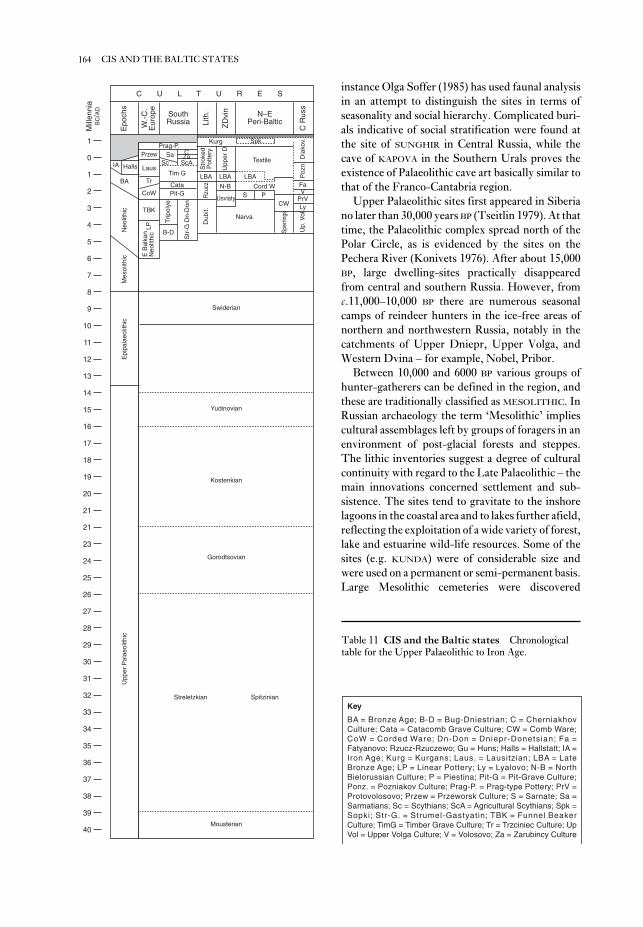
instance Olga Soffer (1985) has used faunal analysis
in an attempt to distinguish the sites in terms of
seasonality and social hierarchy. Complicated buri-
als indicative of social stratification were found at
the site of SUNGHIR in Central Russia, while the
cave of KAPOVA in the Southern Urals proves the
existence of Palaeolithic cave art basically similar to
that of the Franco-Cantabria region.
Upper Palaeolithic sites first appeared in Siberia
no later than 30,000 years BP (Tseitlin 1979). At that
time, the Palaeolithic complex spread north of the
Polar Circle, as is evidenced by the sites on the
Pechera River (Konivets 1976). After about 15,000
BP, large dwelling-sites practically disappeared
from central and southern Russia. However, from
c.11,000–10,000 BP there are numerous seasonal
camps of reindeer hunters in the ice-free areas of
northern and northwestern Russia, notably in the
catchments of Upper Dniepr, Upper Volga, and
Western Dvina – for example, Nobel, Pribor.
Between 10,000 and 6000 BP various groups of
hunter-gatherers can be defined in the region, and
these are traditionally classified as MESOLITHIC. In
Russian archaeology the term ‘Mesolithic’ implies
cultural assemblages left by groups of foragers in an
environment of post-glacial forests and steppes.
The lithic inventories suggest a degree of cultural
continuity with regard to the Late Palaeolithic – the
main innovations concerned settlement and sub-
sistence. The sites tend to gravitate to the inshore
lagoons in the coastal area and to lakes further afield,
reflecting the exploitation of a wide variety of forest,
lake and estuarine wild-life resources. Some of the
sites (e.g. KUNDA) were of considerable size and
were used on a permanent or semi-permanent basis.
Large Mesolithic cemeteries were discovered
164 CIS AND THE BALTIC STATES
Kurg
Streletzkian Spitzinian
C U L T U R E S
1
0
1
2
3
4
5
6
7
8
9
10
11
12
13
14
15
16
17
18
19
20
21
21
23
24
25
26
27
28
29
30
31
32
33
34
35
36
37
38
39
40
Epo
chs
W.-
C.
Eur
ope
SouthRussia Li
th.
ZD
vin N–E
Peri-Baltic
C R
uss
Prag-P.Spk.
Textile Dia
kov.
ZaC
CataPit-G
Tim G
ScAScSaPrzew
Laus
Tr
CoW
BA
IA Halls
Neo
lithi
c TBK
E B
alka
nN
eolit
hic
LP
B-D
Trip
olye
Str
-G D
n-D
on
Dub
it.R
zucz
LBA
Str
oked
Pot
tery
Upp
er D
LBA LBA
N-B
Usviaty
Cord WS P
Narva
CW
Sper
rings
Up.
Vol
LyPrVVFa
Poz
n
Mes
olith
icE
pipa
laeo
lithi
cU
pper
Pal
aeol
ithic
Swiderian
Yudinovian
Kostenkian
Gorodtsovian
Mousterian
Mill
enni
aB
C/A
D
Key
BA = Bronze Age; B-D = Bug-Dniestrian; C = CherniakhovCulture; Cata = Catacomb Grave Culture; CW = Comb Ware;CoW = Corded Ware; Dn-Don = Dniepr-Donetsian; Fa =Fatyanovo: Rzucz-Rzuczewo; Gu = Huns; Halls = Hallstatt; IA =Iron Age; Kurg = Kurgans; Laus. = Lausitzian; LBA = LateBronze Age; LP = Linear Pottery; Ly = Lyalovo; N-B = NorthBielorussian Culture; P = Piestina; Pit-G = Pit-Grave Culture;Ponz. = Pozniakov Culture; Prag-P. = Prag-type Pottery; PrV =Protovolosovo; Przew = Przeworsk Culture; S = Sarnate; Sa =Sarmatians; Sc = Scythians; ScA = Agricultural Scythians; Spk =Sopki; Str-G. = Strumel-Gastyatin; TBK = Funnel BeakerCulture; TimG = Timber Grave Culture; Tr = Trzciniec Culture; UpVol = Upper Volga Culture; V = Volosovo; Za = Zarubincy Culture
Table 11 CIS and the Baltic states Chronological
table for the Upper Palaeolithic to Iron Age.
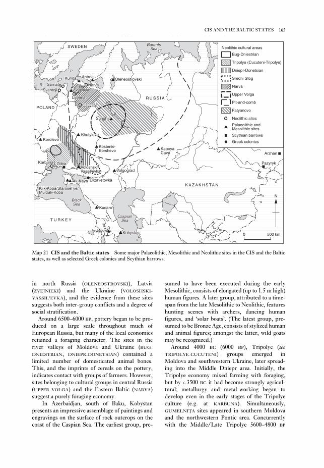
sumed to have been executed during the early
Mesolithic, consists of elongated (up to 1.5 m high)
human figures. A later group, attributed to a time-
span from the late Mesolithic to Neolithic, features
hunting scenes with archers, dancing human
figures, and ‘solar boats’. (The latest group, pre-
sumed to be Bronze Age, consists of stylized human
and animal figures; amongst the latter, wild goats
may be recognized.)
Around 4000 BC (6000 BP), Tripolye (seeTRIPOLYE-CUCUTENI) groups emerged in
Moldova and southwestern Ukraine, later spread-
ing into the Middle Dniepr area. Initially, the
Tripolye economy mixed farming with foraging,
but by c.3500 BC it had become strongly agricul-
tural; metallurgy and metal-working began to
develop even in the early stages of the Tripolye
culture (e.g. at KARBUNA). Simultaneously,
GUMELNIŢA sites appeared in southern Moldova
and the northwestern Pontic area. Concurrently
with the Middle/Late Tripolye 5600–4800 BP
in north Russia (OLENEOSTROVSKI), Latvia
(ZVEJNIEKI) and the Ukraine (VOLOSHSKI-
VASSIL’EVKA), and the evidence from these sites
suggests both inter-group conflicts and a degree of
social stratification.
Around 6500–6000 BP, pottery began to be pro-
duced on a large scale throughout much of
European Russia, but many of the local economies
retained a foraging character. The sites in the
river valleys of Moldova and Ukraine (BUG-
DNIESTRIAN, DNIEPR-DONETSIAN) contained a
limited number of domesticated animal bones.
This, and the imprints of cereals on the pottery,
indicates contact with groups of farmers. However,
sites belonging to cultural groups in central Russia
(UPPER VOLGA) and the Eastern Baltic (NARVA)
suggest a purely foraging economy.
In Azerbaidjan, south of Baku, Kobystan
presents an impressive assemblage of paintings and
engravings on the surface of rock outcrops on the
coast of the Caspian Sea. The earliest group, pre-
165CIS AND THE BALTIC STATES
Bug-Dniestrian
Tripolye (Cucuteni-Tripolye)
Dniepr-Donetsian
Sredni Stog
Narva
Upper Volga
Pit-and-comb
Fatyanovo
Neolithic sites
Greek colonies
Scythian barrows
Palaeolithic andMesolithic sites
Neolithic cultural areas
KundaKunda AntreaAntrea
ZvejniekiZvejnieki
OleneostrovskiOleneostrovski
KapovaKapovaCaveCave
VolgogradVolgograd
KobystanKobystanAzykhAzykh
KudaroKudaro
Ak-KayaAk-Kaya
Kiik-Koba/Starosel’ye/Kiik-Koba/Starosel’ye/Kiik-Koba/Starosel’ye/Murzak-KobaMurzak-Koba
Voloshski-Voloshski-Vassil’evkaVassil’evkaVassil’evka
KorolevoKorolevoKhotylevoKhotylevo
Kostenki-Kostenki-BorshevoBorshevo
SunghirSunghir
OlbiaOlbia
ElizavetovkaElizavetovka
PazyrykPazyryk
ArzhanArzhan
SarnateSarnateSventojiSventoji
NarvaNarva
LubanaLubana
UsvyatyUsvyaty
KarbunaKarbuna
CaspianCaspianSeaSea
BlackBlackBlackSeaSea
R U S S I AR U S S I AR U S S I A
K A Z A K H S TA NK A Z A K H S TA NK A Z A K H S TA N
POLANDPOLANDPOLAND
SWEDENSWEDENSWEDEN
T U R K E YT U R K E YT U R K E Y
BarentsBarentsSeaSea
Kunda Antrea
Zvejnieki
Oleneostrovski
KapovaCave
Volgograd
KobystanAzykh
Kudaro
Ak-Kaya
Kiik-Koba/Starosel’ye/Murzak-Koba
Voloshski-Vassil’evka
KorolevoKhotylevo
Kostenki-Borshevo
Sunghir
Olbia
Elizavetovka
Pazyryk
Arzhan
SarnateSventoji
Narva
Lubana
Usvyaty
Karbuna
CaspianSea
BlackSea
R U S S I A
K A Z A K H S TA N
POLAND
SWEDEN
T U R K E Y
BarentsSea
N
0 500 km
Map 21 CIS and the Baltic states Some major Palaeolithic, Mesolithic and Neolithic sites in the CIS and the Baltic
states, as well as selected Greek colonies and Scythian barrows.

tombs’ in the Southern Siberia (PAZYRYK,
ARZHAN). A number of predominantly agricultural
groups – sometime called ‘agricultural Scythians’
and often regarded as ‘pre-Slavs’ – emerged in the
forest-steppe area.
In the course of the 1st millennium AD, plough
agriculture gradually spread into the forested areas
of central Russia. The first archaeologically identi-
fiable Slavic antiquities (with ‘Prague-type
pottery’) emerged in Central and Eastern Europe in
the 6th century AD. The first Slavonic urban
centres (Ladoga, Novgorod, Kiev and others)
emerged in the densely populated agricultural areas
along the major waterways (Volkhov, Ilmen,
Dniepr) in the 8th century AD. In the 9th century
these areas became the target of Viking intrusions.
In the second half of the 10th century AD, the
greater part of Eastern Slavic groups united to form
the Kievan Rus: the first major state in the region.
3 The history of archaeology in the region. The first
archaeological excavations in Russia were made in
Russia in the early 18th century during the reign of
Peter the Great. The excavations of the Slavic
barrows near Ladoga (Brandenburg 1985) and the
acquisition of gold objects from Scythian barrows in
Siberia (Rudenko 1962) are typical of this phase of
enquiry. In 1846, the Russian Archaeological
Society was founded in St. Petersburg. In 1859, the
Imperial Archaeological Commission was set up
within the Ministry of the Imperial Court. During
the 19th century, Russian archaeologists concen-
trated on the excavation of classical sites: Greek
colonies on the Black Sea coast (where the ex-
cavators included L. Stefani, V.V. Latyshev and
M.I. Rostovtseff), SCYTHIAN sites (I.E. Zabelin and
S.A. Zhebelev), Bronze Age sites in the Southern
Russia, including the famous MAIKOP barrow (N.I.
Veselovsky), and the PIT-GRAVE, CATACOMB and
TIMBER-GRAVE tumuli (V.A. Gorodtsov); and the
Slavic antiquities of Central and Northern Russia
(N.E. Brandenburg, A.A. Samokvasov and D.Y.
Spitsyn).
From the 1870s onwards, Russian scholars
carried out the excavations of Palaeolithic sites at
KOSTENKI-BORSHEVO (I.S. Polyakov) as well as in
the Ukraine and in Siberia. During these years,
Neolithic sites were discovered south of Ladoga
Lake (A.A. Inostrantsev), as was the Fatyanovo
cemetery (A.S. Uvarov), and the Bronze Age
Volosovo site (I.S. Polyakov).
At a methodological level, V.A. Gorodtsov
(1908) outlined the principles of typological classi-
fication of prehistoric materials. At the same time,
Gorodtsov was one of the first to introduce the con-
cept of an ‘archaeological culture’ to the Russian
(4500–3400 BC), a cultural tradition known as the
SREDNI STOG, characterized by horse-breeding,
developed in the neighbouring steppe area. Various
groups of foragers continued to live in the forested
areas of East-European Plain. PIT-AND-COMB
POTTERY, exclusively associated with foraging
economies, spread across vast areas of central and
northern Russia. The tradition of ‘pile dwelling’
emerged at a number of lake sites in the Western
Dvina catchment (e.g. USVYATY).
From about 3000 BC, the Tripolye culture
entered its final stage, characterized by a gradual
disintegration of the single cultural tradition into a
number of differently oriented metallurgical
centres (e.g. Usatovo and Sofievka). The Tripolye
complex ultimately ended in a total collapse of the
agricultural economy: from 2800 BC, the predomi-
nantly pastoral PIT-GRAVE tradition spread through
the South Russian steppes. At about the same time
(c.3000–2300 BC), the Corded Ware tradition
emerged, comprised of several local groups, widely
spread across northwestern and central Russia. One
of these groups (Fatyanovo) spread far to the east.
Stock-breeding became an important element in the
economy of many of these groups, but foraging
remained the dominant strategy in a number of
areas (North Belorussian sites in the Usyvaty area,
late Neolithic sites in the Lubana area of Latvia, the
sites belonging to the ‘coastal tradition’ in ŠVENTOJI
and elsewhere).
In the forested area of European Russia, from the
late 2nd to early 1st millennium BC, there seems to
have been a gradual increase in the importance of
stock-breeding as well as the development of local
metallurgical and metal-working tradition. The
main source of copper ores for these groups were
the Uralian and South Siberian deposits. At some
stage, the influence of Uralian groups which con-
trolled the production and distribution of bronze
tools became apparent in a wider area from Finland
to Lake Baikal (e.g. the SEIMA-TURBINO complex).
2 Iron Age. Agriculture, allegedly of a swidden type
(Petrov 1968), spread through the forested area of
European Russia during the early Iron Age (1st mil-
lennium BC). A number of fortified settlements
(GORODIŠČE) emerged, and several cultural groups
are identifiable, e.g. STROKED POTTERY, DNIEPR-
DVINIAN, MILOGRADIAN and others (Sedov 1982).
The predominantly nomadic SCYTHIANS left
numerous barrows in the ‘steppe corridor’ of
southern Russia and Ukraine. The Scythian groups
developed political and economic relationships with
the Greek colonies and city-states on the Black Sea
(e.g. OLBIA, Elizavetovka). Their cultural influence
extended far to the east, as evidenced by the ‘royal
166 CIS AND THE BALTIC STATES

Lower and Middle Palaeolithic, was an egalitarian
‘primitive herd’. This was replaced by a matriarchal
‘clan society’ at the transition to the Upper
Palaeolithic. The remains of Palaeolithic ‘long
houses’ were cited as one piece of evidence for this
change. This theory was later much criticized: G.P.
Grogor’ev (1968) convincingly argued that no
major social differences are detectable through the
Palaeolithic, that the nuclear family had already
existed in the Lower Palaeolithic, and that there was
no evidence for clan organization in the Upper
Palaeolithic.
In the period after the Second World War, the
Marxist approach took the form of a ‘sociological
archaeology’ based on the early agricultural civi-
lizations of Central Asia (e.g. Masson 1976;
Alyokshin 1986). A different strand in Soviet
archaeology concentrated on the analysis of pre-
historic technology, and culminated in the works of
S.A. Semenov, G.F. Korobkova and their disciples
who pioneered the technique of USE-WEAR
ANALYSIS (Semenov 1964; Semenov and
Korobkova 1983). Like their counterparts in the
West, Soviet archaeologists continually debated
the proper aims of archaeology. According to one
school of thought, e.g. Yu.N. Zakharuk (Zakharuk
1969) and V.F. Henning (Henning 1983) the prime
objective of archaeology is to isolate an ‘ideal’ social
model of human society – the ‘archaeological
sources’ (such as artefacts) providing the means to
discover this.
Another school of thought, often referred to as
‘strict archaeology’ and exemplified by L.S. Klejn
(1991), G.S. Lebedev (1992) and their followers,
focused their attention on the development of the
theoretical base of archaeology and on the strict
definition of basic concepts. This approach, similar
in some ways to the ideas advanced by David Clarke
in his ‘ANALYTICAL ARCHAEOLOGY’, examines the
relations between artefact, attribute, type and
culture. For example, ‘type’ in these schemes is
often viewed as a ‘system of attributes’ (Lebedev
1979). Proponents of this school argue that only
after completing an ‘internal synthesis’ can
archaeologists proceed to ‘historical synthesis’, i.e.
to the interpretation of archaeological entities in
terms of social, economic, ethnic and cultural
processes.
The dual approach of Soviet archaeologists to
archaeological entities was particularly clear in their
treatment of archaeological ‘cultures’ – ‘culture’
being universally recognized as the basic archaeo-
logical concept. The approach that stemmed from
the theories of Spitsyn and Gorotsov, assuming
a direct equation of archaeological cultures with
discipline (Gorodtsov 1908). Both he and A.A.
Spitsyn (Spitsyn 1899) adhered to the cultural-
ethnic theory which equated ‘archaeological
culture’ with ethnicity. On 18 April 1919, Lenin
signed a decree establishing the Russian Academy
for the History of Material Culture (RAIMK),
which replaced the Imperial Archaeological
Commission. The establishment of this centralized
archaeological structure in the new Communist
state was instigated by Nikolai Y. Marr
(1865–1934), a Marxist linguist and archaeologist.
The structure of Soviet archaeology was repeat-
edly modified until the 1970s, when at least three
hierarchical levels could be distinguished: All-
Union; Republic; and regional. All-Union
institutions were entitled to carry out archaeologi-
cal investigations on the whole territory of the
USSR; they included the Research Institutes of the
Academy of Sciences of the USSR in Moscow, St.
Petersburg (earlier Leningrad) and Novosibirsk.
Each Soviet republic had either its own Institute of
Archaeology (as in Ukraine and Georgia) or
Departments of Archaeology within the Institutes
of History (as in the Baltic republics, Belarus and
elsewhere). Archaeological investigations were also
carried out by major universities, and national (e.g.
the State Museum of History, Moscow) and local
museums.
The excavation techniques adopted in the USSR
encouraged the large-scale exposure and stripping
of archaeological layers. Great attention was
attached to the identification of various types of
structures, and to the distribution of artefacts
within these structures. The minute application of
this technique resulted in some outstanding
achievements, such as the identification of
Palaeolithic dwellings in the 1930s.
At a theoretical level, MARXIST historical
materialism was the dominant epistemology in the
Soviet archaeology. In accordance with this, archae-
ology was viewed as a part of history and was
oriented towards the study of the evolution of
society and culture. The Marxist approach greatly
encouraged interpretations of a ‘sociological’ kind,
and Soviet archaeology focused on the identifi-
cation of three paramount elements in ancient
cultures: technology, social organization and
ideology. In the 1930s, Soviet archaeologists (e.g.
Ravdonikas 1930) promoted the ‘stadial concept’ of
prehistory, which viewed prehistory as a sequence
of ‘socio-economic formations’ (a concept which
greatly influenced V. Gordon Childe). In the 1930s
and 1940s, P.P. Efimenko (1938a) and P.I.
Boriskovsky (1950) advanced a theory according to
which the basic social structure, characterizing the
167CIS AND THE BALTIC STATES

(Moscow and Leningrad, 1961); S.I. Rudenko: Sibirskajakollekcija Petra I [The Siberian Collection of Peter I],
Svod arheologicheskih istochnikov [Collection of
Archaeological Records], D 3–9 (Moscow, 1962); S.A.
Semenov: Prehistoric technology, trans. N.W. Thomson
(Bath, 1964); Yu. N. Zakharuk: ‘Problemy
arheologičeskoi kul’tury’ [The problems of archaeological
culture], Arheologija 17 (1964), 12–42; V.Yu. Braichevsky:
‘Teoretičny osnovy doslidžen’ etnogenezu’ [Theoretical
basis of ethnogenetic studies], Arheologija 2 (1965), 46–56;
V.S. Sorokin: Andronovskaja kul’tura [The Andronovo
Culture], Svod arheologičeskih istochnikov [Collection of
Archaeological Records], 133/2 (Moscow, 1966); P.P.
Tretyakov: ‘Finno-ugry, balty i slavjane na Dnepre i Volge[The Finno-Ugrians, Balts and Slavs on the Dniepr and
Volga] (Moscow and Leningrad, 1966); G.P. Grigor’ev:
Nacčalo verhnego paleolita i proiskhoždenie Homo sapiens[The beginnings of the Upper Palaeolithic and the origin
of Homo sapiens] (Leningrad, 1968); Yu.N. Zakharuk: ‘O
metodologii sovetskoi arheologii I eë problemah’ [On the
methodology of Soviet archaeology and its problems],
Sovetskaja arheologija 3 (1969), 11–20; G.P. Grigor’ev:
‘Kul’tura i tip v arheologii: kategorii analiza ili real’nost?’
[Culture and type in archaeology: analytical units or re-
alities?], Transaction of the All-Union Session on the Resultsof Archaeological and Ethnographic Field Investigations in1971 (Baku, 1972), 5–9; M.I. Artamonov: Kimmeriitsy iskify [The Cimmerians and Scythians] (Leningrad, 1974);
V.M. Masson: Ekonomika i social’nyi stroi drevnih
obščestv [Economy and social pattern in ancient societies]
(Leningrad, 1976); G.S. Lebedev: ‘Arheologičeskii tip kak
sistema priznakov’ [The archaeological type as a system of
attributes], Tipy v kul’ture [Types in culture], ed. L.S.
Klejn (Leningrad, 1979), 74–87; V.V. Sedov: Vostočnyeslavyane v VI–XIII vekah [The Eastern Slavs in the
6th–13th centuries AD], Arheologija SSSR (Moscow,
1982); V.F. Henning: Predmet i ob’jekt nauki arheologii[The subject-matter of archaeology] (Kiev, 1983); S.A.
Semenov and G.F. Korobkova: Tehnologija drevnihproizvodstv [Technology of prehistoric production]
(Leningrad, 1983); N.E. Brandenburg: Kurgany JuznogoPriladoz’ja [Barrows of the south Ladoga area], Materialy
po arheologii Rossii [Materials on the archaeology of
Russia] (St. Petersburg, 1985); V.A. Alyokshin:
Social’naja struktura i pogrebal’nyi obrjad drevnezem-ledel’ceskih obscesty Srednei Azii i Bliznego Vostoka [The
social structure and burial rites of early agricultural
societies in Middle Asia and the Near East] (Leningrad,
1986); L.S. Klejn: Arheologičeskaja tipologija [An archaeo-
logical typology] (Leningrad, 1991); G.S. Lebedev:
Istorija otečestvennoi arheologii 1700–1917 [History of
Russian archaeology, 1700–1917] (St. Petersburg, 1992).
PD
Cishan see TZ’U-SHAN
Cliff Palace Largest cliff dwelling in the
American Southwest, consisting of 217 rooms and
33 kivas, occupied by the ANASAZI in the 13th
ethnicities, remains the leading paradigm among
many Russian and Ukrainian archaeologists, such as
A.Y. Bryusov (1956), Y.N. Zakharuk (1964), M.Yu
Braichevsky (1965). This approach, in particular,
informed those Soviet archaeologists who de-
veloped theories related to the origin of the Slavs
(e.g. Tretyakov 1966; Lyapushkin 1961; Sedov
1982) and the SCYTHIANS (e.g. Artamonov 1974).
However, another group of scholars (e.g. Zhukov
1929; Sorokin 1966; Grogir’ev 1972) tended to view
archaeological cultures as purely taxonomic units.
GeneralP.P. Efimenko: Dorodovoe obščestvo: Očerki po istorii per-vobytnogo obščestva [Pre-clan society: essays on the history
of primitive society] (Leningrad, 1938a); V.P. Petrov:
Podsečnoe zemledelie [Swidden cultivation] (Kiev, 1968);
V.I. Konivets: Paleolit Krainego Severo-Vostoka Evropy[Palaeolithic of the extreme northeast of Europe]
(Moscow, 1976); S.M. Tseitlin: Geologija paleolilaSevernoi Azii, [Geology of the Palaeolithic of Northern
Asia] (Moscow, 1979); L.L. Zaliznjak: Ohotniki nasevernogo olenja Ukrainskogo Polesja epohi final’nogo pale-olita. [Final Palaeolithic reindeer hunters of the Ukrainian
Polesye] (Kiev, 1981); V.V. Sedov: Vostočnye slavjane vVI–XIII vekah [The Eastern Slavs in the 6th–13th
centuries AD] (Moscow, 1982); O. Soffer: The UpperPalaeolithic of the Central Russian Plain (Orlando, 1985);
V. Ranov: ‘Tout commence au Paléolithique’, DA 185
(1993), 4–13.
History of archaeology in the regionA.A. Spitsyn: ‘Rasselenie drevne-russkih plemën po
arheologičeskim dannym’ [The settlement of early Slavic
tribes according to archaeological evidence]. Žurnal minis-terstva prosveščenija (St. Petersburg, 1898/9), 301–40;
V.A. Gorodtsov: Russkaja doistoričeskaja keramika[Russian prehistoric pottery], Transactions of the 11th
Russian Archaeological Congress (Kiev, 1901); ––––:
Pervobytnaja arheologija [Prehistoric archaeology]
(Moscow, 1908); V.S. Zhukov: ‘Voprosy metodologii
vydelenija kul’turnyh elementov i grupp’ [On the method-
ology of the identification of cultural elements and
groups], Kul’tura i byt neselenija Central’no-Promyšlennoioblasti [Culture and mode of life of the population of the
Central Industrial District] (Moscow, 1929); V.I.
Ravdonikas: ‘Za marksistskuju istoriju material’noi
kul’tury’ [Marxist history of material culture], IzvestijaGAIMK (1930/7), 3–4; P.P. Efimenko: Pervobytnoeobšcestvo: Ocerki po istorii paleolithiceskogo vremeni[Primitive society: essays on the history of Palaeolithic
epoch] (Leningrad, 1938b); P.I. Boriskovsky: Načalnyietap pervobytnogo obščestva [The initial stage of primitive
society] (Leningrad, 1950); A.Ya. Bryusov:
‘Arheologičeski kul’tury i etničeski obščnosti’
[Archaeological culture and ethnic entities], Sovetskajaarheologija 26 (1956), 5–27; I.I. Lyapushkin:
‘Dneprovskoe lesostepnoe levoberež’e v epohu železa’
[The forest-steppe Dniepr left-bank in the Iron Age],
MIAS 104 [Materials on the archaeology of the USSR]
168 CIS AND THE BALTIC STATES

Stanford: ‘Clovis origins and adaptations: an introductory
perspective’, Clovis: origins and adaptations, ed. R.
Bonnichsen and K. Turnmire (Corvallis, 1991), 1–13; D.
Meltzer: ‘Is there a Clovis adaptation?’, From Kostenki toClovis: Upper Palaeolithic Paleo-Indian adaptations, ed. O.
Soffer and N. Praslov (New York, 1993), 293–310.
RJE/JJR
cluster analysis Techniques of MULTI-
VARIATE STATISTICS, with the common aim of
dividing a collection of objects into groups or
clusters on the basis of the similarity between each
pair of objects. ‘Similarity’ can be regarded as the
statistical equivalent of the spatial proximity of
objects (see MULTIVARIATE STATISTICS); groups
should ideally consist of objects which are close to
each other but further from objects in other groups.
There are many measures of distance; for continu-
ous data the most common is Euclidean distance
(the multivariate equivalent of a ‘crow-fly’ distance
on a map, in contrast to, for example, distances
measured along roads). Archaeologists experi-
mented with various techniques in the 1960s and
1970s; the most commonly used now are k-means
cluster analysis and Ward’s method. The main
criticisms of cluster analysis are that it creates
clusters whether any exist naturally in the data or
not, and that the choice of the number of clusters is
often arbitrary. The k-means method partly meets
these objections by providing diagnostic statistics
which can be used to suggest the best number of
clusters in a DATASET. For case-studies seeARMANT and MASK SITE.R.M. Cormack: ‘A review of classification’, Journal of theRoyal Statistical Society Series A, 134 (1971), 321–67; J.E.
Doran and F.R. Hodson: Mathematics and computers inarchaeology (Edinburgh, 1975), 173–86, 180–4
[K-means]; B.S. Everitt: Cluster analysis, 2nd edn
(London, 1980), 16–7 [Ward’s method]; C.R. Orton:
Mathematics in archaeology (Glasgow, 1980), 46–55; S.
Shennan: Quantifying archaeology (Edinburgh, 1988),
196–208; M.J. Baxter: Exploratory multivariate analysis inarchaeology (Edinburgh, 1993).
CO
‘Coastal Neolithic’ (Vietnam) Many coastal
regions of Southeast Asia incorporate the remains
of raised shorelines on which are located prehistoric
settlements. These sites, dating from after c.4000
BC, were sited to take advantage of rich coastal
resources, and excavations reveal the remains of
shellfish and fish, as well as pottery vessels, polished
stone artefacts including large hoes, and in-
humation cemeteries. In Vietnam, these sites are
referred to as ‘coastal Neolithic’, but to date there
appear to be no surviving biological remains to
century AD. It was discovered in 1888 by Richard
Whetherill, a local cowboy and explorer of
Southwestern prehistoric sites, while he was look-
ing for stray cattle on Mesa Verde (now a National
Park) in southwestern Colorado.F. McNitt: Richard Wetherill: Anasazi (Albuquerque,
1957).
JJR
Clogg’s Cave Limestone cave and rock shelter
in the Buchan region of Victoria, Australia. The
basal deposits contain extinct megafauna, with no
human associations, dating back to 23,000 BP.
The earliest occupation is associated with
the AUSTRALIAN CORE TOOL AND SCRAPER
TRADITION dating to 17,000 BP; increasing use of
the cave between 13,000 and 9000 BP is associated
with backed blades on chert, quartz and jasper. The
cave is one of the few Pleistocene sites dug in
Victoria.J. Flood: ‘Pleistocene man at Clogg’s Cave: his tool kit and
environment’, Mankind 9 (1974), 175–88; ––––:
Archaeology of the dreamtime (Sydney, 1983), 23–8.
CG
Clovis PALEOINDIAN culture, dating from
c.10,000 to 9,000 BC, evidence of which occurs
throughout much of North America. Clovis sites
are identified by the presence of the distinctive
Clovis fluted projectile point; these lanceolate
bifaces are distinguished from later projectile points
by a shallow flake scar or ‘flute’ that extends from
the point’s base, approximately one-third up each
face of the tool. Clovis is the earliest Paleoindian,
big-game hunting culture of North America and is
one of the complexes making up the LLANO tradi-
tion. On the basis of linguistic, dental and genetic
evidence, Clovis is hypothesized to have been the
New World ‘founding culture’. Traits shared with
Palaeolithic sites in eastern Europe include large
blades, end-scrapers, burins, unifacial flake tools,
shaft wrenches, cylindrical bone points, flaked
bone, red ochre and worked tusks. Examples of
major sites are Naco, LEHNER and MURRAY SPRING
(Arizona), BLACKWATER DRAW (New Mexico),
Dent (Colorado) and EAST WENATCHEE (Washing-
ton state). Clovis people hunted a wide variety of
Late Pleistocene animals, including now-extinct
forms of mammoth and bison, as well as smaller
animals like deer. Although poorly represented in
the archaeological record, plant foods were un-
doubtedly important as well.E.W. Haury et al.: ‘The Lehner mammoth site, south-
eastern Arizona’, AA 25 (1959), 2–34; G. Frison:
Prehistoric hunters of the High Plains (New York, 1991); D.
169‘COASTAL NEOLITHIC’ (VIETNAM)

the early Holocene until the appearance of pottery
in c.AD 1–200. Cochise was defined in 1941 by
Edwin Sayles and the geologist Ernst Antevs, on the
basis of buried sites in the Whitewater Draw region
of southeastern Arizona. The developmental
sequence is divided into three stratigraphically dis-
tinct stages: Sulphur Spring (c.10,000–8000 BP),
Chiricahua (up to 3500 BP) and San Pedro
(c.3500–2000 BP). The relationship with CLOVIS
remains unclear, although chronometric evidence
does not support contemporaneity. The discon-
tinuity between Sulphur Spring and Chiricahua is
less than current stratigraphic and chronometric
evidence indicates. The validity of Sayles’ ‘Cazador
stage’, transitional between Sulphur Spring and
Chiricahua, has been seriously questioned follow-
ing the re-examination of deposits at the
Whitewater Draw localities. Reinvestigation of BAT
CAVE reliably dates the introduction of maize and
squash to c.1200 BC. Cochise, long thought to have
been ancestral to the MOGOLLON culture, is con-
sidered by many to have a similar link with the
HOHOKAM. The major sites of the culture are
VENTANA CAVE and Cienega Creek in Arizona, and
Bat Cave and Tularosa Cave in New Mexico.E.W. Haury: The stratigraphy and archaeology of VentanCave (Tucson, 1950); E.B. Sayles: The Cochise culturalsequence in southeastern Arizona (Tucson, 1983); N.H.
Wills: Early prehistoric agriculture in the AmericanSouthwest (Santa Fe, 1988).
JJR
Coclé Culture which flourished between AD 500
and 1100 in the south-central Panama province of
the same name. It is known primarily for its gold
objects and polychrome pottery decorated with
crested birds, dogs, reptiles, marine creatures and
insects. The typically small Coclé sites, such as
SITIO CONTE and Río Cano, are located along rivers;
they appear to be the centres of chiefdoms. The
structural remains are built of earth, and sites typi-
cally lack stone masonry; lines of stone pillars or
columns in association with ‘altar’-like boulders are
often found.S.K. Lothrop: Coclé: an archaeological study of centralPanama, Memoirs of the Peabody Museum, Harvard
University 8 (Cambridge, 1942); O.F. Linares: Studies inPre-columbian art and archaeology 17 (Washington, D.C.,
1977) [section on ‘Ecology and the arts in ancient
Panama’].
PRI
codices (sing. codex) Mesoamerican ‘books’
made from the beaten bark of the fig tree or deer
skin. They were usually sized and coated with lime
indicate the presence of agriculture or stock raising.
It might be that the inhabitants cultivated root
crops, such as yam or taro, but equally they could
have been sedentary hunter-gatherers. The best-
known ‘coastal Neolithic’ cultures in Vietnam are
called after the sites of Da But, Cai Beo, Hoa Loc,
Bau Tro and Quynh Van. Thac Lac (in central
Vietnam), probably dating to c.3000–2000 BC,
incorporates ceramics richly ornamented with par-
allel bands infilled with impressions recalling those
found at PHUNG NGUYEN sites.
Two radiocarbon dates suggest that the upper
layers of the six-metre-deep midden at Quynh Van
(in northern Vietnam) belong to the mid-4th mil-
lennium BC. Excavations have uncovered 31
inhumation graves; unusually, for a site of this date,
there were no polished stone implements. Although
usually ascribed to the ‘Coastal Neolithic’, Quynh
Van might just as well have been a sedentary settle-
ment whose inhabitants exploited the wealth of the
marine habitat rather than practising agriculture.Ha Van Tan: ‘Nouvelles récherches prehistoriques et
protohistoriques au Viet Nam’, BEFEO 68 (1980) 113–54.
CH
coatepantli (Nahuatl: ‘serpent-wall’) Meso-
american structure of the Postclassic period (c.AD
900–1521) consisting of a long stone wall placed
within or surrounding a ceremonial precinct,
decorated with relief carvings of serpents and/or
sacrifice. There are surviving examples at
TENOCHTITLAN and Tula (see TOLTECS).
PRI
Cochasquí Residential site of the so-called Cara
Phase peoples in northern Ecuador during the
Integration Period (c.AD 500–1450), consisting of
15 rectangular earthen pyramids with ramps and a
large number of circular funerary platforms cover-
ing shaft-and-chamber tombs. Each of the
pyramids had one or more perishable structures on
their tops. Cochasquí was the residence of the
chiefly and noble families of one of the small
kingdoms that characterized late period highland
Ecuador.U. Oberem: Cochasquí: estudios arqueologicos, ColecciónPendoneros, 3 vols (Otavalo, 1981); S.J. Athens: ‘Ethnicity
and adaptation: the Late Period-Cara occupation in
Northern Highland Ecuador’, Resources, power, and inter-regional interaction, ed. E. Schortman and P. Urban (New
York, 1992), 93–219.
KB
Cochise Archaic, pre-ceramic hunter-gatherer
culture of the southern American Southwest from
170 ‘COASTAL NEOLITHIC’ (VIETNAM)

programmatic statements in the first writings of the
New Archaeology.
Certainly Kent Flannery in his early overview of
Mesoamerican prehistory offered an early example
of what he termed ‘contextual analysis’ (Flannery
1976), applied in the cognitive sphere, and in the
same volume Robert Drennan considered the role
of religion in social evolution, working very much
in the functional-processual tradition. Flannery and
Marcus have gone on to produce innovatory work
on ritual and religion (Flannery and Marcus 1983;
Marcus and Flannery 1994). Another early and sig-
nificant contribution was Martin Wobst’s
pioneering study of style and communication
(Wobst 1977).
Cognitive-processual archaeology went beyond
its functional-processual predecessor, however, by
attempting to apply valid generalizations not only to
material aspects of culture but also to the cognitive
sphere. This undertaking recognized that ideology
is an active force within societies and must be given
a role in explanations – as Marxist and neo-Marxist
thinkers have long argued. However, if general-
izations about human cognitive behaviour are to be
made, this must be on the basis of research, not
through the formation and application of some a
priori principle, in the manner of many MARXIST
ARCHAEOLOGISTS.
Cognitive archaeology, although working in the
processual tradition, does not overlook the role of
the individual. The notion of the ‘cognitive map’ is
a useful one (Renfrew 1987), making explicit
the world view which each individual carries in the
mind’s eye. The shared beliefs and concepts of
the community are in some ways the aggregate
of those of the individuals who constitute it. This
approach, which is termed by some philosophers
‘methodological individualism’ (Bell 1994), is
common enough in the systematic social sciences.
For instance the economic decisions of the
individual are considered in the field of micro-
economics, and their aggregate effects in
macroeconomics. The philosophy of science has its
own contributions to make to the understanding of
the role of the individual in society.
Cognitive archaeology acknowledged, too, that
material culture is to be seen as an active force in
constituting the world in which we live. As Hodder
(1986) has argued, individuals and societies con-
struct their own realities, and material culture has
an integral place within that construction. The
scope of cognitive archaeology can be outlined in
several ways (see Renfrew and Bahn 1991: 339–70).
For instance, it may be divided into two very broad
fields: pre-sapient and sapient. It is now well
plaster, painted with HIEROGLYPHIC texts and then
folded like a screen.F.B. de Sahagún: The Florentine Codex: general history ofthe things of New Spain, 12 books in 13 vols, trans. A.J.O.
Anderson and C. Dibble (Santa Fe, 1950–82); J.E.S.
Thompson: The Dresden Codex (Philadelphia, 1972); K.
Ross: Codex Mendoza: Aztec manuscript (Fribourg, 1978);
‘Special section: rethinking Mixtec codices’, AM 1/1
(1990).
PRI
Cody Complex One of several complexes of the
PLANO culture of the PALEOINDIAN period in
the northern Great Plains of the United States. The
tool assemblage consists of projectile points, flake
tools, scrapers, gravers, wedges, choppers, bifaces,
hammer stones, and bone tools that are often found
with bison kill and processing sites. Diagnostic tools
are both Eden and Scottsbluff projectile points
types as well as Cody knives. The Horner site in
northwestern Wyoming is the type site for the Cody
Complex, and is estimated to date between
8000–5500 BC. The Cody Complex lies strati-
graphically between the Alberta and Frederick
complexes at the HELL GAP site.C. Irwin-Williams et al.: ‘Hell Gap: Paleo-Indian occu-
pation on the High Plains’, PAnth 18 (1973), 40–53; G.
Frison and L. Todd: The Horner site: the type site of theCody cultural complex. (New York, 1983).
WB
cognitive archaeology Study of the ways of
thought of past societies (and sometimes of indi-
viduals in those societies), as inferred from
surviving material remains. Cognitive archaeology,
or the archaeology of the human mind, can be
recognized as a theme in the New Archaeology of
the 1960s and 1970s, but it did not gain a distinct
identity until the early 1990s. Like environmental
archaeology, however, it is very much part of a
wider enterprise of archaeology: the study of the
whole human past. In humans, thought and action
(or at least sustained action) are inseparable. For
that reason Marcus and Flannery, for instance,
prefer to speak of ‘holistic’ rather than ‘cognitive’
archaeology, in their approach to the study of
Zapotec ritual at the Mesoamerican site of SAN JOSE
MOGOTE (Marcus and Flannery 1994: 55).
Whereas the so-called POST-PROCESSUAL
ARCHAEOLOGY of the late 1980s and early 1990s
was largely anti-processual in its aims and rhetoric,
cognitive archaeology developed directly and with-
out hiatus from the functional-processual
archaeology of earlier decades. It represented a
change of emphasis towards cognitive issues, which
had been somewhat neglected after a few initial and
171COGNITIVE ARCHAEOLOGY

one. As we shall see, both approaches inevitably rely
upon the insights and intuitions of the modern
investigator: the creative, and in that sense subjec-
tive, aspects of scientific enquiry are not in doubt.
It is a common misconception of the scientific
method, deriving largely from the polemic of
Bourdieu, that it is somehow inhuman, mechanistic
or lacking in creativity. On the contrary, the role of
the individual, as noted above, has to be considered
systematically, as the approach of methodological
individualism allows (Bell 1994). For the cognitive-
processual archaeologist, it is enough that this
approach should generate insights into how ancient
minds worked, and into the manner in which that
working shaped their actions.
For the interpretive archaeologist, working in the
grand tradition of idealists like Collingwood, this
is not enough. One seeks, instead, to ‘enter
the mind’ of early individuals through some
effort of active empathy. This experience of
‘being’ that other, long-dead person, or at least
undergoing an experience to be compared with
theirs, is what characterizes the subjective, idealist
and interpretationist approach of the anti-
processual and ‘post-modern’ archaeologist (seePOST-PROCESSUAL ARCHAEOLOGY). The cogni-
tive-processual archaeologist is sceptical of the
validity of this empathetic experience, and sceptical
too of the privileged status which must inevitably be
claimed by the idealist. As in the conduct of all
scientific enquiry, it is not the source of the insight
which validates the claim, but the explicit nature of
the reasoning which sustains it and the means by
which the available data can be brought into
relationship with it. As Popper (1968) long ago
emphasized, validation rests not upon authority but
on testability and on the explicitness of the argu-
mentation, even if testing is not always, in practice,
an easy undertaking.
The scope of cognitive archaeology roughly co-
incides with the various ways in which humans use
symbols:
1 design, in the sense of coherently structured,
purposive behaviour;
2 planning, involving time scheduling and
sometimes the production of a schema prior to
carrying out the planned work;
3 measurement, involving devices for measur-
ing, and units of measure;
4 social relations, with the use of symbols to
structure and regulate inter-personal behaviour;
5 the supernatural, with the use of symbols to
commune with the other world, and to mediate
between the human and the world beyond;
documented that about 100,000 years ago our own
species, Homo sapiens sapiens, became established in
parts of Africa, and that by 40,000 years ago it had
dispersed over much of the globe. The development
of the cognitive faculties of the earlier hominids,
which formed a crucial part in the processes leading
to the emergence of Homo sapiens, constitutes the
‘pre-sapient’ area of cognitive archaeology. What,
for instance, is the relationship between tool-
making and cognitive abilities? When and how did
language emerge?
The sapient field of cognitive studies, on the
other hand, is concerned with the human story
over the past 40,000 years. The hardware (i.e. our
brain power) may have changed little over this
time-span, but the changes in our ‘software’ (i.e.
‘culture’) have brought about radical transforma-
tions. Organized hunting requires the deployment
of sophisticated cognitive faculties (Mithen 1990),
and it has been suggested that Palaeolithic CAVE
ART was used as part of an educational process by
which the young were initiated into and intro-
duced to the society and social store of knowledge
and experience which this necessitated. The emer-
gence of settled village life and then of cities, the
use of writing and of developing technologies such
as metallurgy, the rise of organized religion and of
widely influential ideologies, the development
of states and empires: all of these have their cogni-
tive aspects, as indeed do farming origins (see
Hodder 1990). Moreover, although some of these
developments may be traced in quite different
parts of the world, each area followed its own
trajectory of development: the ‘software’ was in-
dependently generated. Part of the challenge
of cognitive archaeology is to analyse the ways in
which the formation of symbolic systems, in each
particular case, moulded and conditioned later
developments.
The focus of cognitive archaeology is the special
human ability to construct and use symbols (see alsoSIGN AND SYMBOL). A symbol is something which
stands for, or represents, something else: ‘a visible
sign of an idea or quality or of another object’
(Webster’s Collegiate Dictionary 1925: 974 ‘symbol’).
The word derives from the Greek ‘to place
together’, and the notions of juxtaposition (of X by
Y) and of metaphor (where X is equated with Y) are
closely related. The cognitive-processual archaeol-
ogist focuses on the ways in which symbols were
used. This may be contrasted with the attempt to
seek the ‘meaning’ of symbols, which would gen-
erally be the object of the anti-processual or
interpretive archaeologist (see CONTEXTUAL
ARCHAEOLOGY). The distinction is an important
172 COGNITIVE ARCHAEOLOGY
or material – spoken words may reasonably be
regarded as symbols – but no-one could doubt that
all representations are symbols. We have perhaps
not yet sufficiently considered the momentous
nature of the step taken when clay was first
modelled to produce, for instance, a small rep-
resentation of the human form, or when a sharp
implement was first used to carve the outline of an
animal on a piece of bone. The creation and pres-
ervation of representations offers us great potential
for considering a number of important cognitive
steps, from the first application of pigment in some
ice age cave to the great fresco cycles of the Italian
Renaissance.
It is in the archaeology of historic periods, where
written texts are available, that the most rapid
progress in cognitive archaeology can perhaps be
made. The problem in periods when such records
are available is generally one of relating the archaeo-
logical and the textual evidence (for if elucidation of
the material evidence carries pitfalls, that of the
written text is still more perilous, as the critical
theorists have so effectively shown). (It seems
unnecessary, by the way, to follow the post-
modernist fashion of regarding everything,
including the archaeological record, as ‘text’: the
archaeological record is usually a palimpsest, and
the notion of ‘reading a text’ can hardly be applied
to the randomly accumulated detritus of the
centuries.) A message, if it is to be decoded, has to
have been encoded in the first place. Here there is
need for much further research on the semiotics of
non-verbal communication. For the historical
archaeologist (along with the Near Eastern special-
ist, the Classicist or the Mayanist) the challenge is
to use the available texts in such a way that they can
be applied to the inferences drawn from the material
remains. The theoretical problems in reconciling
such disparate bodies of evidence have yet to be
systematically addressed.
There are numerous published case-studies of
cognitive archaeology, ranging from research into
the specific cognitive changes that characterized the
emergence of modern humans (Mellars 1991) to
the analysis of the symbolism of Classical Greek
portraiture (Tanner 1992). The adoption of a cog-
nitive approach often forces archaeologists to
address fundamental questions which would
previously have been ignored or avoided, such as
‘How religious were the ancient Egyptians?’ (Kemp
1995), ‘Is there a place for aesthetics in archae-
ology?’ (Taylor et al. 1994) and ‘How did ancient
people perceive the landscapes in which they lived?’
(Bradley 1994).E. Cassirer: An essay on man (New Haven, 1944); L.A.
6 representation, with the production and use of
depictions or other iconic embodiments of reality.
The distinction between planning and design is
not always a clear one, since so much human be-
haviour involves both. For instance the builders of
the MALTESE TEMPLES of the 3rd millennium BC
produced small models in limestone of the struc-
tures which they had built or were to build. It is
difficult now to know whether the model preceded
or succeeded the construction of the building itself.
In either case, however, the model is a represen-
tation of the relevant part of the cognitive map in
the mind of the modeller, and such material rep-
resentations help to make more concrete the
concept of the cognitive map itself. Of course cog-
nitive maps are involved in all planning and design:
in such cases they are models for the future. But if
the former were the case (i.e. model before con-
struction), this is a good example of both planning
and design. In some cases, however, it is useful to
emphasize the distinction between the two. For
instance, in the production of stone tools (Gowlett
1984; Davidson and Noble 1989; Wynn 1991), raw
material may have had to be acquired from some
distant source. There is no doubt that the use of the
material in some cases entails a deliberate journey
undertaken at least in part to secure its acquisition.
That implies planning, in the sense of time-
structuring of a more complex kind. Comparable
structuring of manufacturing processes has been
considered in terms of the ‘chaîne opératoire’ (the
ordered chain of actions etc., leading towards the
transformation of a given material towards the
manufacture of a product (Karlin and Julien 1994),
and time structuring has been emphasized by
Marshack (1991) in his consideration of Palaeolithic
mobiliary art. In a different sense it was involved in
the solar and lunar alignments of some of the
European MEGALITHIC monuments and STONE
CIRCLES (Heggie 1981).
The cognitive issues involved in tool production
are often subsumed under the term ‘design’. It has
long been assumed that the production of most arte-
facts, for instance of such stone tools as Acheulean
handaxes, involves the use of a mental template,
which serves to guide the person producing the
artefact. But, as one example of cognitive archaeo-
logical investigation has shown, the production of
an artefact type need not depend upon any
sophisticated conceptualizing, nor need it presume
the use of language (Bloch 1991). ‘Representation’,
the sixth symbolic category in the list, comes very
close to the literal meaning of the term ‘symbol’, as
defined above. Of course not all symbols are visible
173COGNITIVE ARCHAEOLOGY

cognitive-processual approach seeCOGNITIVE ARCHAEOLOGY
collapse, Lowland Maya see COPÁN;
LOWLAND MAYA
Co Loa see DONG SON CULTURE
colorimetric analysis Method of quantitative
chemical analysis relying on the formation of a
coloured compound in solution. The coloured com-
pound is specific to the element being measured and
it absorbs in the uv/visible region with an intensity
proportional to concentration.
MC
Columnata see AFRICA 1
Commagene see NEMRUT DAGH
cone mosaics see STIFTMOSAIK
confidence interval Term used in statistical
analysis to describe a range of values between which
the value of a particular PARAMETER is thought to
lie, together with a percentage representing the
level of confidence with which this can be expressed
(see PARAMETER ESTIMATION). In BAYESIAN
STATISTICS this figure expresses a level or strength
of belief; in classical statistics it represents the
frequency with which repeated SAMPLES can be
expected to include the true value of the parameter
within their confidence interval, e.g. with a 90%
confidence interval, 90% of samples would include
the true value.S. Shennan: Quantifying archaeology (Edinburgh, 1988),
301–9; M. Fletcher and G.R. Lock: Digging numbers(Oxford, 1991), 70–3.
CO
confirmatory data analysis (CDA) Term
used to describe such classical approaches to
statistical analysis as HYPOTHESIS TESTING, as
opposed to the more open-minded techniques of
EXPLORATORY DATA ANALYSIS (EDA).
Confucius (K’ung-tzu; Kongzi) see CH’U-FU;
LU
Con Moong Cave located on the Cuc Phuong
massif, south of the Red River Delta in Vietnam. It
has an unusually long stratigraphic sequence,
beginning with the late Pleistocene SON VI culture
and terminating in a layer ascribed to the
HOABINHIAN. The early stone industry was domi-
White: The science of culture (New York, 1949); K.R.
Popper: Conjectures and refutations (New York, 1968); R.
Drennan: ‘Religion and social evolution in Formative
Mesoamerica’, The early Mesoamerican village, ed. K.V.
Flannery (New York 1976), 345–68; K.V. Flannery:
‘Contextual analysis of ritual paraphernalia from
Formative Oaxaca’, The early Mesoamerican village, ed.
K.V. Flannery (New York, 1976), 333–45; M. Wobst:
‘Stylistic behaviour and information exchange’, For theDirector: essays in honor of James B. Griffin, ed. C.E.
Cleland (Ann Arbor, 1977), 317–42; D.C. Heggie:
Megalithic science, ancient mathematics and astronomy inNorthwest Europe (London, 1981); C. Renfrew: Towardsan archaeology of mind (Cambridge, 1982); K.V. Flannery
and J. Marcus, eds: The Cloud People: divergent evolutionof the Zapotec and Mixtec civilizations (New York, 1983);
J.A. Gowlett: ‘Mental abilities in early man: a look at some
hard evidence’, Hominid evolution and community ecology,
ed. R.A. Foley (London, 1984), 167–92; I. Hodder:
Reading the past, 1st edn (Cambridge, 1986); C. Renfrew:
‘Problems in the modelling of socio-cultural systems’,
European Journal of Operational Research 30 (1987),
179–92; I. Davidson and W. Noble: ‘The archaeology of
perception: traces of depiction and language’, CA 30
(1989), 125–56; I. Hodder: The domestication of Europe(Cambridge, 1990); S. Mithen: Thoughtful foragers: a studyof prehistoric decision making (Cambridge, 1990); M. Bloch:
‘Language, anthropology and cognitive science’, Man 26
(1991), 183–98; M. Donald: Origins of the modern mind(Cambridge, 1991); A. Marshack: ‘The Taï plaque and
calendrical notation in the Upper Palaeolithic’, CAJ 1/1
(1991), 25–61; P. Mellars: ‘Cognitive changes and the
emergence of modern humans’, CAJ 1/1 (1991), 63–76;
C. Renfrew and P. Bahn: Archaeology, theories, methods andpractice (London, 1991), 339–70; T. Wynn: ‘Tools,
grammar and the archaeology of cognition’, CAJ 1/2
(1991), 191–206; J.J. Tanner: ‘Art as expressive symbol-
ism: civic portraits in Classical Athens’, CAJ 2/2 (1992),
167–90; C. Renfrew et al.: ‘What is cognitive archae-
ology?’, CAJ 3/2 (1993), 247–70; J.A. Bell: Reconstructingprehistory, scientific method in Archaeology (Philadelphia,
1994); R. Bradley, ‘Symbols and signposts – understand-
ing the prehistoric petroglyphs of the British Isles’, Theancient mind: elements of cognitive archaeology, ed. C.
Renfrew and E. Zubrow (Cambridge, 1994), 95–106; C.
Karlin and M. Julien, ‘Prehistoric technology: a cognitive
science?’, The ancient mind: elements of cognitive archae-ology, ed. C. Renfrew and E. Zubrow (Cambridge, 1994),
152–64; J. Marcus and K.V. Flannery: ‘Ancient Zapotec
ritual and religion’, The ancient mind: elements of cognitivearchaeology, ed. C. Renfrew and E. Zubrow (Cambridge,
1994), 55–74; C. Renfrew and E. Zubrow, eds: The ancientmind: elements of cognitive archaeology (Cambridge, 1994);
M. Taylor, T. Vickers, H. Morphy and C. Renfrew: ‘Is
there a place for aesthetics in archaeology?’, CAJ 4/2
(1994), 249–69; B.J. Kemp: ‘How religious were the
ancient Egyptians?’, CAJ 5/1 (1995), 25–54.
CR
174 COGNITIVE ARCHAEOLOGY

investigation; individual action and systemic adap-
tation; and historical and ahistorical perspectives.
Hodder’s advocacy of a contextual archaeology
sprang from a belief that the relationship between
material culture and society is complex and inter-
active. In particular, material culture has a symbolic
value that is not only important in itself, but also
liable to distort the interpretation of more obvious
technical, economic and social functions.
Furthermore, this symbolic value varies not only
from culture to culture, but even from situation to
situation. To understand societies via their material
culture, archaeologists must be able to interpret
how the symbolic meaning of material culture is
manipulated within a specific context by individu-
als and groups in pursuit of disparate social
strategies (see SYMBOLIC ARCHAEOLOGY).
Within archaeology, ‘context’ is traditionally
used to indicate either the depositional or cultural
environment of an artefact. Contextual archaeology
extends the term to include the whole network of
relationships that give symbolic meaning to an
object. In addition to being more extensive, ‘con-
text’ in this sense is also more specific: it is the
unique location of each element within the network
that defines its meaning, just as the position of
words within a sentence determines meaning in
language. Hodder has stressed that contextual
analysis includes examination of materialist as well
as symbolic functions, of an object’s place within a
MODE OF PRODUCTION as well as within a symbolic
code. He has also stretched the term to include a
probing of the ‘context of the archaeologist’ (see alsoLOGICISM). However, when used by other
archaeologists, the term tends to focus on the con-textually defined symbolic use of material culture.
The two main criticisms of contextual archae-
ology seem paradoxical: that it simply describes
what archaeologists do anyway, and that it makes
archaeology impossible because it demands full
contextual evidence. Hodder’s response to the first
criticism was that he simply sought to make explicit
and to extend certain existing procedures; to the
second he replied that, in some instances, proper
analysis would be impossible. We should, he argued,
accept that the symbols on a cave wall will remain
scarcely readable if they cannot be related to evi-
dence from different types of site – that is, if they
lack a context. Contextual archaeology has been
accused of being full of contradictions: it was born
of anthropological research but denies cross-
cultural laws; it stresses the unique contextual
meaning of evidence, but recommends interpret-
ation through a whole network of contexts; it
searches for coherence and correspondences in a
nated by a flaked technology, but in the succeeding
Hoabinhian layer 3, we find the first evidence of
edge grinding and polishing. The cave was the focus
of hunting and gathering, and the faunal remains
include wild cattle and water buffalo, rhinoceros,
forest birds and the water turtle.Ha Van Tan: ‘The Hoabinhian in the context of Viet
Nam’, Vietnamese Studies 46 (1976) 127–97.
CH
contextual archaeology Influential epis-
temological approach defined and promoted by
the Cambridge theoretician Ian Hodder during the
1980s. Building upon a sustained critique of
PROCESSUAL ARCHAEOLOGY, Hodder attempted
to draw archaeologists away from a methodology
based on the natural sciences and back towards a
methodology rooted in the historical tradition.
An explanation of contextual archaeology is best
preceded by a brief survey of Hodder’s general
theoretical position. Hodder particularly criticized
SYSTEMS THEORY, which he regarded as having
been applied with a materialist bias that denied the
formative (as opposed to justificatory or concealing)
power of IDEOLOGY. He also believed that systems
theory assigned an overly passive role to the indi-
vidual and offered an inadequate explanation of
change through time. According to Hodder, adap-
tive mechanisms that regulate systems do not
properly explain change because they cannot
explain how societies ‘choose’ between a great
variety of actions that possess the same potential
systemic value. Hodder also disputed the claim that
hypothetico-deductive methods ought to replace
inductive reasoning, and asserted that MIDDLE-
RANGE THEORY was unlikely to provide a platform
for truly objective analysis of archaeological evi-
dence. Hodder accepted that theories should be
validated by a continuing examination of coherence
and correspondence with the basic data, but insisted
that the hypothetico-deductive method must be
supplemented by intuitive insights arising from
personal experience and from an attempt to get
‘inside’ past events and imagine the motives of the
individuals concerned. He admitted the usefulness
of general theory (not laws) and ETHNOGRAPHIC
ANALOGY, but only when these are grounded in
proper ‘contextual’ explanation. He also admitted
certain ‘universal principals of meaning’ (such as
the organization by contrasts, identified in
STRUCTURALIST analysis). In the context of the
1980s, his ideas may be summarized as an attempt
to redress the balance between contextual and cross-
cultural interpretations; idealist and materialist
explanations; inductive and hypothetico-deductive
175CONTEXTUAL ARCHAEOLOGY

conventional radiocarbon datingRADIOCARBON DATING methods in which the beta
particles from the decay of the 14C atoms are
counted using either liquid scintillation or gas
counting (see ACCELERATOR MASS SPEC-
TROMETRY). Only 1% of the 14C atoms present
decay every 80 years, hence about 3–5 g of carbon
(equivalent to about 200 g of bone) are needed. Not
to be confused with the convention for quoting
radiocarbon dates.
SB
Copán Site in northwestern Honduras in the
‘southeastern periphery’ of the LOWLAND MAYA
area, known for its extraordinary stelae (see STELE,
MESOAMERICAN) and architecture, including a
large ballcourt (see BALLGAME) and HIEROGLYPHIC
stairway. A long-term, multi-disciplinary, inter-
national research project has focused on the elite
architecture, inscriptions and dynastic history, and
burial patterns of Copán, as well as on settlement
patterns, population change and land use in the
large Copán valley area. This project has led to re-
vision of many long-standing interpretations of the
site’s history.
Like many Maya sites, Copán is best known for
its architecture and monuments dating to the
Classic period (c.AD 300–900). Nevertheless,
the Copán region clearly had a long settlement
history going back to the late Early Preclassic period
(c.1000–800 BC). A small rectangular house with
associated domestic artefacts was found in ex-
cavations, deeply buried under a later residential
compound. In the same area a series of Middle
Preclassic (c.800–300 BC) burials were uncovered,
richly furnished with jade beads and other items
and ceramics with incised motifs typical of OLMEC
culture. Occupation in the Late Preclassic period
(c.300 BC–AD 300) was not substantial, a situation
Fash (1991: 71) describes as an ‘anomaly’ given the
striking developments during this period at places
like KAMINALJUYU to the southwest and in the
lowlands to the north.
Copán’s participation in Classic period Maya
culture was traditionally believed to have been the
result of colonization of the area by elite settlers
from the Petén region to the north, who brought
with them the lowland Maya STELE cult. The first
stele with a ‘long count’ date at Copán dates to AD
485. Recent investigations, however, have revised
this view, leading to the conclusion that the stele
cult with its associated HIEROGLYPHIC WRITING
and ‘long count’ dating, typical Maya architecture,
polychrome pottery, divine kingship and other
way that comes very close to PROCESSUAL
ARCHAEOLOGY, but at the same time it promotes
subjective understanding through ‘insight’. Finally,
it argues for the importance of individual action and
complete contextual evidence within a discipline
that is largely unsuited to these concerns – certainly,
the more convincing studies explicitly adopting
Hodder’s approach have tended to make use of
detailed ethnographic or ethnohistorical, evidence.
Despite these flaws, ‘contextual’ analysis proved
a founding and influential strand within POST-
PROCESSUAL ARCHAEOLOGY. Recapitulated and
somewhat redefined by its originator in a collected
series of essays (Hodder 1992), it occupies the
centre ground of the theoretical debate when com-
pared to more recent and extreme relativist
positions within the post-processual movement.I. Hodder: The present past (London, 1982); ––––: Thearchaeology of contextual meanings (Cambridge, 1987); B.
Trigger: History of archaeological thought (Cambridge,
1989), 348–57; I Hodder: The domestication of Europe(Oxford, 1990); ––––: Reading the past, 2nd edn
(Cambridge, 1991), 121–55; ––––: Theory and practice inarchaeology (London, 1992).
RJA
contingency table A table used in the statisti-
cal analysis of archaeological DATA to show the
numbers of objects which take certain values of two
(or more) VARIABLES, which are usually discrete
but may be grouped values of continuous variables.
The aim is to discover whether variables are associ-
ated, i.e. whether certain values of one occur more
(or less) frequently with certain values of another
than would be expected if there were no relationship
between them. For example, one might investigate
whether certain types of finds occur particularly on
certain types of site. Analysis is most commonly car-
ried out by use of the CHI-SQUARED TEST; modern
methods include log-linear analysis and
CORRESPONDENCE ANALYSIS.Y.M.M. Bishop, S.E. Fienberg and P.W. Holland:
Discrete multivariate analysis (Cambridge, 1975) [log-
linear analysis]; J.E. Doran and F.R. Hodson: Mathematicsand computers in archaeology (Edinburgh, 1975), 54–6; S.
Shennan: Quantifying archaeology (Edinburgh, 1988),
70–4, 89–99; K. Barclay, M. Biddle and C. Orton: ‘The
chronological and spatial distribution of the objects’,
Object and economy in medieval Winchester, ed. M. Biddle
(Oxford, 1990), 42–73 [Winchester]; M. Fletcher and
G.R. Lock: Digging numbers (Oxford, 1991), 115–25
[general].
CO
continuous variable see VARIABLE
176 CONTEXTUAL ARCHAEOLOGY
rolites are particularly valuable as direct evidence of
prehistoric diet, though they are generally not pre-
served with sufficient regularity to form an
independent test for the vagaries of faunal and
botanical analysis. Perhaps the most remarkable
concentrations of well-preserved human coprolites
have been found in cave-sites in the American
south-west (e.g. Bryant 1974).V.M. Bryant: ‘Prehistoric diet in south-west Texas: the
coprolite evidence’, AA 39 (1974), 407–20; V.M. Bryant
and G. Williams-Dean: ‘The coprolites of man’, SA 232
(1975), 100–9; G. Hillman: ‘Plant foods in ancient diet: the
archaeological role of palaeofaeces in general and Lindow
Man’s gut in particular’, Lindow Man: the body in the bog(London, 1986), 99–115.
RJA
Coptic Term used to describe the Christian
period in Egypt, lasting from the end of the Roman
domination to the Islamic conquest (c.AD 400–641),
which is broadly contemporary with the Byzantine
period elsewhere in the Near East. The art histori-
cal definition of ‘Coptic’ is somewhat vague, since
the term is often applied not only to the material
culture of the Christian period but also to material
from the late Roman period in the 3rd and 4th
centuries AD (‘proto-Coptic’) and the early
medieval period (c.AD 700–1200). The Coptic
language and alphabet, which combines Greek let-
ters with six signs taken from DEMOTIC, were used
throughout the Christian period in Egypt. The
liturgies and Biblical texts of the Coptic church are
still written and spoken in the Coptic language. The
archaeology of the Coptic period has been com-
paratively neglected, compared with the excavation
of pharaonic and Greco-Roman sites, but a few
expeditions in the late 20th century (such as the
German study of the pilgrimage centre of Abu Mina
at Maryut, to the west of Alexandria, see Grossman
1986), have begun to address this yawning gap. In
addition, examples of early Coptic art and monu-
mental architecture have survived at such isolated
and still-flourishing Coptic monasteries as St
Anthony’s in the Eastern Desert and St Catherine’s
in the Sinai peninsula.C.C. Walters: Monastic archaeology in Egypt (Warminster,
1974); P. Grossmann: Abu Mina: a guide to the ancientpilgrimage center (Cairo, 1986); J. Kamil: Coptic Egypt(Cairo, 1987); G. Gabra: Cairo, the Coptic Museum and oldchurches (Cairo, 1993).
IS
corbelled arch The ‘false’ or cantilevered arch
used in LOWLAND MAYA construction, having the
form of an inverted ‘V’ and topped with a flat cap-
stone rather than a fitted keystone. Compared to the
characteristics of Maya civilization, developed
locally (Fash 1991).
Copán has also contributed to our understanding
of the complex patterns of the Classic LOWLAND
MAYA collapse. Fash (1991) sees the political
collapse as a consequence of inter-elite competition
and possibly inter-ethnic conflict, while acknowl-
edging the role of population growth and the
consequent stresses on agricultural productivity.
Regardless of the causes, the more refined chronolo-
gies afforded by OBSIDIAN HYDRATION DATING
(Webster and Freter 1990) from residential con-
struction have indicated that the ‘collapse’ at Copán
was a prolonged process, rather than a sudden event,
with the closing stages of the Late Classic (Coner
phase) occupation of the site extending until per-
haps as late as AD 1200. The last centuries of the
Late Classic period were accompanied by popu-
lation movements away from the civic-ceremonial
centre into more peripheral areas of the valley.D. Webster and A. Freter: ‘Settlement history and the
classic collapse at Copan: a redefined chronological per-
spective’, LAA 1 (1990) 66–85; W.L. Fash: Scribes,warriors and kings. The city of Copán and the ancient Maya(London, 1991); ‘The archaeology of ancient Copan’, AM3 (Spring, 1992) [several authors].
PRI
Coppergate (York) The Coppergate ex-
cavations in York, which took place between 1976
and 1981, revealed the remains of the wattle-built
workshops at the back of a line of four 10th-century
tenements. The remains are the main feature of the
Jorvik Centre, an influential ‘Viking experience’ in
which the modern visitor takes a train – a type of
time-capsule – back through the ages to Anglo-
Scandinavian York in the age of King Eric
Bloodaxe. Statuesque figures among the ruins speak
a Viking dialect, and smells add to the atmosphere.
The visitor passes through a reconstruction of the
museum before entering a traditional museum. The
‘experience’ illustrates Viking urbanism and in-
dustrial productivity, and lays emphasis upon
archaeology as a technologically-based science.Richard Hall: The Viking dig (London, 1984).
RH
‘Copper Hoard Culture’ see OCHRE
COLOURED POTTERY (OCP)
coprolites (palaeofaeces) Ancient cop-
ralites, sometimes called palaeofaeces, are the
preserved remains of human or animal defecation.
Their survival is usually as a result of dessication,
waterlogging, mineralization or charring. Cop-
177CORBELLED ARCH

ground under mounds) can be identified in a broad
region stretching between Denmark and the
Ukraine. In the earlier 3rd millennium, across much
of the area manifesting the Corded Ware, the
settlement pattern seems to become more dispersed,
with settlement units tending to consist of small
hamlets and farmsteads; this has been interpreted as
indicating a general shift in subsistence strategies
towards ‘expansive’ (rather than intensive) farming
with the adoption of the plough in agriculture, and
a greater emphasis on stock-breeding (seeSECONDARY PRODUCTS REVOLUTION). See alsoFATYANOVO for description of the eastern Europeanvariant of the Corded Ware complex.A. Sherratt: ‘The transformation of early agrarian Europe:
the later Neolithic and Copper Ages 4500–2500 BC’, TheOxford illustrated prehistory of Europe, ed. B. Cunliffe
(Oxford, 1994), 190–3.
RJA
core-periphery models Theoretical models
concerned with how social, economic, cultural and
political relationships between societies bring about
change. Like PEER-POLITY INTERACTION models,
they emphasize the importance of relationships
with external societies for the understanding of
social change, rather than purely internal factors or
interaction with the environment; in this case,
however, the relationships are essentially unequal.
The most detailed example of such a model is
the historian Immanuel Wallerstein’s analysis of
the emergence of European world domination in the
early modern period (see WORLD SYSTEMS
THEORY). Although Wallerstein was not concerned
with pre-capitalist societies, the potential appli-
cation of his ideas to earlier societies has attracted
archaeological attention.
The models envisage a contrast between a core,
or centre, and a periphery. The core may comprise
more than one political entity, but has a broadly
common culture, characterized as technologically,
economically and politically more developed than
the periphery. The periphery may be very ex-
tensive, and is typically a supplier of labour or raw
materials. The relationship between core and
periphery is asymmetric in the sense that the
economic advantages flow to the centre from
the periphery, but also in the sense that social,
economic and political conditions at the centre
affect, or even determine, those at the periphery,
but not vice versa. The model as originally de-
veloped was specifically economic, and needs
reinterpretation for pre-capitalist societies. In pre-
history, economic activity can seldom be entirely
isolated from the social sphere. Core–periphery
true arch it is much weaker and this limitation
contributed to the typically thick walls and narrow
rooms of Classic Maya buildings.E.H. Thompson: ‘The genesis of the Maya arch’,
American Anthropologist 13 (1911), 501–16; A.L. Smith:
‘The corbelled arch in the New World’, The Maya andtheir neighbours, ed. C.L. Hay et al. (New York, 1977),
202–21.
PRI
corbelling Simple roofing technique involving
the creation of dome or beehive-shaped roofs by
laying over-lapping courses of masonry closer and
closer to the centre of the space to be covered. Fine
examples of early corbelling can be seen in the
Neolithic chambered tombs of ANTEQUERA in
Spain; the Mycenaean THOLOS tombs of Greece
in the later 2nd millennium represent the most
sophisticated use of the technique.
RJA
Corded Ware complex Cultural complex of
northern Europe in the earlier 3rd millennium BC
(c.2900–2500 BC) characterized by the production
of beakers (tall handle-less vessels with everted
rims) decorated on their upper half with impres-
sions of cords; polished stone axes with bored
shaft-holes and curving ‘battle-axe’ type blades; and
individual male burials covered by circular mounds.
There are also occasional finds of small items made
of copper in Corded Ware contexts, identifying it as
a Late Neolithic/Copper Age transitional culture.
Manifested across much of the North European
plain from Scandinavia and the Rhineland and
Switzerland through into Russia, the Corded Ware
complex, like the BELL BEAKER PHENOMENON to
which it is in some senses a predecessor, has in the
past been taken to represent a movement of specific
peoples through Europe in the 3rd millennium BC
(most often, nomadic pastoralists from the Russian
steppe lands to the east). However, many scholars
now interpret the presence of the complex as indi-
cating the adoption of a cultural ‘package’ by local
populations. Because the funerary rite tends to be
individual rather than communal, and because the
most notable gravegood has been interpreted as a
battleaxe (there is also some evidence to link the dec-
orated beakers to the use of alcohol in drinking
ceremonies), the advent of the Corded Ware culture
is sometimes taken as indicating the spread of an
aggressive, individualizing male warrior culture (a
view summarized in Sherratt 1994). It is not yet
clear where this package of material culture was first
adopted, although a set of early male burials set in
pits under low mounds (rather than laid on the
178 CORBELLED ARCH

the typesite, Cortaillod). The Neuchâtel lakeside
villages also include numerous well-preserved sites
from the Bronze Age.
The Neolithic Cortaillod cultural complex
succeeds the Egolzwil in Switzerland, and is
broadly contemporary with – and related to – the
other major cultural complexes of west-central
Europe in the Middle Neolithic, the Michelsberg
and the Chasséen. Typical features of Cortaillod
pottery assemblages are lugs, cordons and high
‘S-profile’ jars; the presence of lamps, large
numbers of antler beakers and the use of birchbark
appliqué decoration help distinguish the material
culture of the Cortaillod from that of the Chasséen.
Although there is no evidence for metalworking in
the Cortaillod, a few metal objects (beads and flat
axes) are found, probably imported from the
neighbouring Pfyn or Michelsberg regions.
Typically, Cortaillod villages comprised 15–25
houses, built on a wooden frame fixed into soft
ground, with sloping roofs and walls made of firm
poles and plaster.
There are also various Late Bronze Age sites
along the Neuchâtel shoreline, known and planned
from aerial surveys. In the early 1980s, ambitious
underwater rescue excavations took place at the site
of Cortaillod-Este, revealing a settlement that grew
into a cluster of around 17 houses and which was
associated with a series of dams and pallisades. Like
most of the Swiss prehistoric ‘lake villages’ the
settlement was located on soft ground near the edge
of the lake, rather than being built on piles in the
water itself as early interpreters tended to surmise.
The original oak posts of the basic house structures
are well preserved, revealing houses c.8–15m long
in regular, dense narrow rows oriented north-west
by south-east. Dendrochronology has allowed the
development of the settlement (1009–955 BC) to be
minutely charted, although given the small size of
the village (estimated population: 150–400), the
claim that the planning was in some sense ‘proto-
urban’ seems enthusiastic.B. Arnold: Cortaillod-Este et les villages du lac de Neuchâtelau Bronze final, Archéologie neuchâteloise 6 (Sainte-
Blaise, 1990).
RJA
cost-benefit analysis see DECISION THEORY
Cotswold-Severn (Severn-Cotswold) tombsRegional group of megalithic and/or drystone
tombs constructed in south-west Britain from the
early 4th millennium BC; they are concentrated to
the east of the River Severn in the Cotswold hills,
but also occur more sporadically in southeast Wales,
models in archaeology concentrate on long-distance
connections, identified particularly through
exchange of exotic goods, and the role they play in
the social reproduction of the societies concerned.
Examples include the relationship between
Mesoamerica and the cultures of the Mexican
American West, described with other case studies
in Champion (1989).M. Rowlands et al.: Centre and periphery in the ancientworld (Cambridge, 1987); T. Champion, ed.: Centre andperiphery: comparative studies in archaeology (London,
1989).
TC
core tool and scraper tradition seeAUSTRALIAN CORE TOOL AND SCRAPER
TRADITION
correspondence analysis Technique of
MULTIVARIATE ANALYSIS which was originally a
French technique but made its way into the
English-speaking world via Scandinavia and South
Africa. It is similar in some ways to PRINCIPAL
COMPONENTS ANALYSIS (PCA), but designed for
use on two-way tables of discrete DATA (seeCONTINGENCY TABLES). Like PCA, it extracts axes
of maximum variability (here called inertia), against
which objects can be plotted. It differs from PCA in
its metric (measure of distance); the distance
between two rows (or columns) of a table is the CHI-
SQUARED STATISTIC that would be derived from a
comparison of the two.J.-P. Benzecri et al.: L’analyse des donnees, 2: L’analyse descorrespondances (Paris, 1973); E. Bolviken et al.:
‘Correspondence analysis: an alternative to principal com-
ponents analysis’, WA 14 (1982) 41–60; M.J. Greenacre:
Theory and applications of correspondence analysis (New
York, 1984); T. Madsen, ed.: Multivariate archaeology(Aarhus, 1988); M.J. Baxter: Exploratory multivariateanalysis in archaeology (Edinburgh, 1993).
CO
corrosion product Chemical compound, or
usually a mixture of compounds, formed through
the natural chemical reaction of a metal artefact
with its environment. Although most obvious
on the surface of the metal it is also likely to be
present internally. Most corrosion products are
mixtures including oxides, hydroxides, carbonates
or chlorides.
MC
Cortaillod Cultural complex of the Middle
Neolithic in Switzerland, identified by Emil Vogt in
1934 and known largely from lakeside villages,
especially around Lake Neuchâtel (the location of
179COTSWOLD-SEVERN (SEVERN-COTSWOLD) TOMBS

be tested empirically. The relationship between the
covering law, starting conditions and outcome is
deduced logically. Thus, this use of covering laws
falls into the more general hypothetico-deductive
means of scientific enquiry (see INDUCTIVE AND
DEDUCTIVE EXPLANATION).
One key developer of the approach was the
philosopher of science, Carl Hempel. Hempel
differentiated the kind of covering law argument in
which the conclusion is logically certain (deductive-
nomological explanations) from the kind of
scientific argument that employs the laws of prob-
ability to suggest how likely a conclusion is
(statistical, or inductive probabilistic, ex-
planations). Statistical explanations are not
deduced, but they still make use of covering laws,
together with laws of probability and sometimes
logic, to generate meaningful statements about the
world. Hempel maintained that these two covering
law or generalizing means of enquiry – deductive-
nomological explanation and inductive probabilistic
explanation – described most valid routes of
enquiry. See also NOMOTHETIC ARGUMENTS.
This general approach hugely influenced the
New Archaeology of the 1960s. It implied that a
principal aim of archaeologists should be the dis-
covery and confirmation of laws, through a process
of formulating hypotheses that could be tested
against archaeological data. This seemed likely to
shift the discipline towards the formulation of gen-
eral theories of the kind seen in geography and
anthropology, as opposed to the more traditional
particularist, historical approach. It also suggested
that archaeological practice should be slanted
toward problem solving and theory testing, rather
than the ‘theory neutral’ collection of evidence to be
evaluated later on. As a network of tested theory
evolved, and became accepted as generalizing
(covering) laws and law-like propositions, it was
hoped that it would become possible to interpret
individual sites with more certainty and to test
higher-level theories concerning social dynamics.
In practice, the formulation and verification of
universal laws proved elusive. There was a con-
tinuing debate about the most useful definition and
application of an archaeological ‘law’, and in
particular how to discover whether a law was simply
descriptive or contained within it the ‘cause’ of a
relationship between statements (a much more
ambitious project). There was also disagreement
about whether the aim of archaeology was to use
covering laws to elucidate archaeological cultures,
or whether it was to use archaeological cultures to
identify covering laws. In practice, it proved
difficult to put observations of archaeological
from Brecon to the Gower Peninsula. The group
was traditionally defined morphologically and
culturally within a geographical framework (e.g.
Daniel 1950), but recent researchers have preferred
a simple geographic definition (Darvill 1982). The
chambers are usually covered by long wedge-
shaped mounds, which may have indented or
concave façades or well-developed ‘horned’ fore-
courts. The most impressive Cotswold–Severn
monument is that of WEST KENNET, which forms
something of a type-site, while the laterally
chambered tomb at Hazleton near Cheltenham is
the most recently and painstakingly excavated
(Saville 1990). Useful guides to the extensive litera-
ture may be found in Daniel (1970) and Darvill
(1982).G. Daniel: The prehistoric chambertombs of England andWales (Cambridge, 1950); ––––: ‘Megalithic answers’,
Antiquity 44 (1970), 260–9; T.C. Darvill: The megalithicchambered tombs of the Cotswold–Severn region (Highworth,
1982); A. Saville et al.: Hazleton North (London, 1990).
RJA
covering laws In archaeology, as in other
sciences, an attempt to explain a phenomenon may
consist of an attempt to show that it falls under a law
‘covering’ similar phenomena – a law which
suggests a particular outcome or a particular
relationship between two sets of evidence. A cover-
ing law does not have to be sophisticated or answer
an important question, but it does have to be general
and to be formulated so as to be true in every situ-
ation where the stated conditions hold. A covering
law is not the only way to forge a relationship
between data and different levels of theory explain-
ing that data (see THEORY AND THEORY BUILDING),
but the approach lies at the centre of certain key
debates in the philosophy of science and has played
an important role in the continuing debate about the
merits of PROCESSUAL ARCHAEOLOGY.
The belief in the centrality of covering, or
general, laws in philosophical and scientific enquiry
formed the dominant strand of the LOGICAL
POSITIVIST movement from the late 1940s. In this
movement, the covering law approach to describing
and explaining events in the world was taken to its
extreme. It was assumed that the only true or use-
ful kind of explanation was the strictly logical result
of a combination of covering (general) laws and
initial (starting) conditions. Because the outcome is
governed by logic, it is predictable – providing the
starting conditions are true and the law has been
proved empirically. In the logical positivist project,
covering laws themselves were to be discovered by
rigorously formulating hypotheses which could then
180 COTSWOLD-SEVERN (SEVERN-COTSWOLD) TOMBS

405–12; D.W. Read and S.A. LeBlanc: ‘Descriptive state-
ments, covering laws, and theories in archaeology’, CA 19
(1978), 307–35; P.J. Watson, S.A. LeBlanc and C.L.
Redman: Explanation in archaeology: an explicitly scientificapproach (New York and London, 1971); G. Gibbon:
Explanation in archaeology (Oxford, 1989), 86–7.
RJA
Craig Mound see SPIRO
Criş culture see STARČEVO-KÖRÖS-CRIŞ
CULTURE
critical archaeology A primarily American
school of archaeological theory, which closely
resembles POST-PROCESSUAL ARCHAEOLOGY in
that it comprises a rather eclectic mixture of
approaches, drawing on Marxism, STRUC-
TURALISM and CRITICAL THEORY, being united
primarily by the rejection of POSITIVISM and
PROCESSUAL ARCHAEOLOGY. Most ‘critical
archaeologists’ have also been heavily influenced by
the view that archaeology has an active, politicized
role to play in the presentation of the past to the
public, whether through museum displays,
degree programmes or other media (see, for
instance, Leone 1986; Potter 1990). Despite such
demonstrable similarities to post-processualism,
the more Marxist-inspired proponents of the criti-
cal approach have been criticized by the
post-processualists Michael Shanks and Chris
Tilley (1987) for crusading against ideological (par-
ticularly capitalist) bias in archaeology, instead of
adopting the kind of radical pluralist, hyper-
relativist approach which assumes that there are
many equally defensible views of the same set of
archaeological data.M.P. Leone: ‘Symbolic, structural and critical archae-
ology’, American archaeology: past and future, eds D.J.
Meltzer et al. (Washington, D.C., 1986), 415–38; M.
Shanks and C. Tilley: Archaeology and social theory(Cambridge, 1987); V. Pinskie and A. Wylie, eds: Criticaltraditions in contemporary archaeology (Cambridge, 1989);
B.P. Potter, Jr.: ‘The “what” and “why” of public
relations for archaeology: a postscript to DeCicco’s public
relations primer’, AA 55/3 (1990), 608–13.
IS
critical theory Anti-POSITIVIST, anti-modernist
theory espoused by the academic, intellectual pro-
ponents of western MARXISM, who react to the
pervasive and dominant nature of capitalism
by stressing that empirical, logical positivist
analysis is not truly objective but heavily biased
and value-laden by the IDEOLOGIES of scientists.
The movement, inaugurated by Max Horkheimer,
phenomena into language that facilitated logical
deduction or testing without instantaneously in-
terpreting the phenomena in such a way as to
compromise the exercise. It was also not clear that a
laborious statement of definitions and assumptions
increased the value, or acceptance, of an archaeo-
logical statement. Gibbon (1989) suggests that most
processual archaeologists side-stepped the problem
of stating definitions and assumptions in such a way
as to make their hypothesis testable; they did this by
offering up preliminary ideas that were sub-
sequently rarely pursued in any systematic way.
Reviewing the New Archaeology project twenty
years after its inception, he concludes: ‘no non-
trivial general laws of cultural process were ever
systematically tested and formally confirmed or
falsified: no formal covering-law model ex-
planations were ever presented except in “they
would look like this” illustrative examples; no
deductive theory nets were ever formally proposed’
(1989: 91).
However, the failure of the more dogmatically
‘scientific’ New Archaeologists to produce a varied
and useful body of tested and useful covering laws
does not mean that the New Archaeology project –
in its wider definition – failed. The more pragmatic
search for covering laws that would provide a robust
link between archaeological evidence and human
behaviour in the form of MIDDLE-RANGE THEORY
stimulated excellent and novel research: even critics
of the covering law approach in archaeology recog-
nize great value in the better studies of SITE
FORMATION PROCESSES. It may also be that the
covering law approach in the discipline has left a
useful legacy in the relatively more explicit formu-
lation and assessing of hypotheses – whether or not
this assessment leads to formal testing and the pos-
iting of a covering law. On a more abstract level,
many of the arguments about the validity of the
covering law approach continue to be revisited in
the ongoing debate in archaeology about the
usefulness and validity of cross-cultural and
ETHNOGRAPHIC ANALOGIES and law-like state-
ments, and the relationship between the aims of
archaeology and those of the other social sciences.C.G. Hempel: ‘Studies in the logic of explanation’,
Philosophy of Science 15 (1948), 135–75; ––––:
‘Deductive–nomological vs statistical explanation’,
Minnesota Studies in the Philosophy of Science, vol. 3, ed. H.
Feigl and G. Maxwell (Minneapolis, 1962); ––––: Aspectsof scientific explanation (New York, 1965); L. Binford:
‘Smudge pits and hide smoking: the use of analogy in
archaeological reasoning’, AA 32 (1967), 1–12; ––––:
‘Some comments on historical versus processual archae-
ology’, SJA, 24 (1968), 267–75; J.M. Fritz and F.T. Plog:
‘The nature of archaeological explanation’, AA 35 (1970),
181CRITICAL THEORY

from the air as ‘cropmarks’, where differential
growth reveals their presence below growing crops.
The study of cropmarks has revealed that areas
where archaeological features are now least readily
apparent as surviving structures may be those
where past activity has been most intense. These are
often the lighter soils, such as those on gravels,
which are often under almost constant cultivation
over millennia. The archaeological record is other-
wise biased toward areas with abundant stone, those
which have not been subject to significant later
cultivation and land-use change, and marginal or
upland areas, whether in the deserts of the
American mid-west or the upland moors of Britain.
Aerial reconnaissance, combined with modern
intensive fieldwalking techniques, partially
redresses the balance. However, the identification
of ‘sites’ as cropmarks depends not only on the
highly variable effects of climate, crops, soil types
and agricultural regimes, but also on the character
of the archaeology. It provides an effective means of
recognition for some site types such as ditched
enclosures, but if enclosure were by a hedge, its
cropmark visibility would be almost non-existent.
Unenclosed settlement can usually only be recog-
nized where substantial pits or structural
foundations survive, and many classes of site,
including virtually all of the pre-Neolithic archaeo-
logical record of Europe, offer little susceptibility to
this technique. Thus, while the results of aerial
reconnaissance in filling out the understanding of
the rich archaeological resources of some areas
have been immense, the limitations must be
remembered. Cropmarks are most common when
soil moisture deficit in a particular soil affects a crop
during its peak moisture demand. This varies from
crop to crop: while the phenomenon is common-
est in cereals in summer, cropmarks may be
recorded in maize in September, or roots in autumn
or winter. Although not regularly producing crop-
marks, grass can sometimes produce very clear
marks (‘grassmarks’ or ‘parchmarks’). Non crop
plants – weeds – may also grow differentially, pick-
ing out features.
Cropmarks occur in either positive or negative
form, depending on the relationship of feature and
surrounding material. Normally, positive crop-
marks manifest themselves as stronger, denser or
taller growth in the maturing crop, or as a slightly
later ripening, evident as colour variation. These
types of marks are produced by such features as
ditches and pits. Negative cropmarks (in grass,
parchmarks), where the buried features are less
moisture-retentive than their surroundings, such as
walls or road surfaces, appear as stunting, parching
the director of the Frankfurt Institute for Social
Research in the 1920s (hence the term ‘Frankfurt
School’, which is sometimes applied to the earliest
phase of critical theory), also stresses the early
(Hegelian) writings of Marx and avoids the
economic determinism of orthodox Marxism –
focusing instead on analysis of the role of the
superstructure, and ideology in particular. The
approach was adopted by many anthropologists
from the 1970s onwards, and by a number of
American archaeologists in the 1980s and 1990s
(see CRITICAL ARCHAEOLOGY). Critical theorists
argue that even their own analyses are indissociable
from the social and ideological context in which
they take place (hence the anti-positivist stance);
they therefore concentrate on the hermeneutics
of their subject (i.e. the process of interpretation
itself), attempting, by discriminating between the
various possible versions of the past, to emancipate
people from dominant ideologies. Hodder (1991:
178) argues that critical theory is fatally flawed by
the fact that it is itself a value-laden and ideologi-
cally biased phenomenon: ‘If the past is ideology,
how can we presume to argue that only certain in-
tellectuals [i.e. critical theorists and critical
archaeologists] can see through ideology to identify
the social reality?’M. Horkheimer and T. Adorno: Dialectic of enlightenment(New York, 1972); D. Held: Introduction to critical theory:Horkheimer to Habermas (Berkeley, 1980); I. Hodder:
Reading the past, 2nd edn, (Cambridge, 1991), 174–80.
IS
Crô Magnon Rock-shelter site at Les Eyzies,
France, where the first ANATOMICALLY MODERN
HUMAN (AMH) human remains were discovered in
the 19th century. It became the type-site for AMH
populations, often known in the older literature as
‘Cro-Magnon man’, in contrast to NEANDERTHAL
populations.
RJA
cromlech This term has fallen out of use in
Britain, but like the term ‘dolmen’ it was once used
to indicate a simple megalithic structure consisting
of uprights supporting a capstone – especially when
there was no extant covering mound. In France and
Iberia, the term cromlech is used to identify a quite
different class of megalithic structure: rings of free-
standing stones such as those found in the CARNAC
REGION of France and the Evora region of Portugal.
RJA
cropmarks Non-upstanding features, archaeo-
logical or otherwise, can often be distinguished
182 CRITICAL THEORY

porary with or later than x. Where the date of the
import from culture x is known, culture y can some-
times be dated. Before the advent of absolute dating
methods elaborate chronologies were constructed
using the cross-dating method, often relying on
similarities between objects in two cultures as well
as actual imports from one culture to another. This
comparison of similarities made the technique one
of the key elements in the diffusionism of Childe
and others, as well as in the hyper-diffusionism of
Elliot-Smith and his school. Re-assessment by
radiocarbon showed that many of these supposed
links based on similarities were invalid.V.G. Childe: The dawn of European civilization (London,
1925); C. Renfrew: Before civilization (London, 1973),
30–2.
PTN
Cross River Monoliths Set of 295 carved
boulders, recorded by P.A. Allison in 1961–2 and
described by him as a ‘remarkably isolated
phenomenon’, located at 39 sites in a 900 sq. km area
northwest of Ikom in southeastern Nigeria. They
occur mostly in groups, of which 10 are circular, but
there are some single stones on the periphery. Most
are of basalt, although some are of shelly limestone,
and they vary in height from less than 0.5 m to 2 m.
The present Ekoi-speaking inhabitants of the area
know them as ‘Akwanshi’, memorials for the an-
cestors. The Ekoi are divided into seven main clans,
traditionally forming two antagonistic groups, each
headed by a chief priest or Ntoon. According to
Allison (1968: 26), recognizably different styles
coincide with present clan boundaries, suggesting
that the carvings were made by their predecessors:
‘the decorations on the figures probably represent
tribal marks, tattooing or body painting’. He con-
sidered that the monoliths of the Nta clan were the
prototype for all the others, since they show the
greatest variety of styles (from the phallic columns
at Oyengi onwards) and the traditions about them
are better preserved. Relying on information about
the succession of the 39 Ntoons of the Nta, and
assuming that the art of stone carving developed
only after the establishment of their line, Allison
argued that the carvings had probably been made
from the early 16th century AD onwards. The only
excavation conducted in the area, that by Ekpo Eyo
at the Nnam clan site of Emangabe in 1983, pro-
duced a radiocarbon date of considerably greater
antiquity 1780 ± 50 BP (AD 170); but he warns that
this seems ‘rather early’ and ‘must be viewed with
great caution’ (Eyo 1986).P.A. Allison: Cross River monoliths (Lagos, 1968); E. Eyo:
‘Alok and Emangabe stone monoliths: Ikom, Cross River
or early ripening. Sites revealed in relief may be
recorded in oblique lighting conditions. There is
also a wide diversity of ‘abnormal’ types of crop-
mark, including reversal.
Cropmarks may have other causes than those
described above: if germination marks are seen in a
developing crop, this may relate to moisture content
(particularly where either the buried feature or the
surrounding subsoil is waterlogged), or it may
derive from variation in the warmth-retaining
characteristics, through factors such as moisture-
retention or humic or stone content, allowing earlier
sprouting of seed; FROSTMARKS are products of a
similar process. Cropmarks can derive from
SOILMARKS, where variation in soil colour affects
the reflectance and heat-retaining capacity of the
soil, and hence crop growth.R.J.A. Jones and R. Evans: ‘Soil and crop marks in the
recognition of archaeological sites by air photography’,
Aerial reconnaissance for archaeology, ed. D.R. Wilson
(London, 1975): 1–11; D.R. Wilson; Air photo interpreta-tion for archaeologists (London, 1982), 53–70; G.W.G.
Allen: ‘Discovery from the air’, Aerial Archaeology 10
(1984) [whole issue].
FG
cross-cultural laws and analogies When
archaeologists attempt to explain archaeological
data and build plausible theories, they often try to
relate archaeological evidence to the evidence seen
in other cultures (past or present). These analogies
may relate to low-level theorizing, such as how a
particular implement was used, or to higher level
theories such as those concerning the emergence of
agriculture or the reasons for a cultural collapse.
Analogies are often constructed very loosely – for
example, an attempt to increase the plausibility of a
particular explanation by showing that a similar set
of evidence can be linked to a similar kind of be-
haviour or event in another culture. Sometimes,
however, archaeologists try to make the link
between the analogy and the archaeological
phenomena under investigation more rigorous (see
discussion of formal and relational analogy in
ETHNOARCHAEOLOGY), either to increase the
plausibility of the analogy in that particular
instance, or as an attempt to build a COVERING LAW
– that is, a law that is held to be true in all equivalent
instances.
RJA
cross dating A method of relative dating from
artefacts, whereby the occurrence of a foreign object
of culture x found in association with objects of
culture y is taken to mean that y must be contem-
183CROSS RIVER MONOLITHS

Cuello Site in northern Belize, which is the most
extensively excavated Middle Formative village in
the Maya lowlands, although occupation extends
considerably later. The first suite of radiocarbon
dates associated with early Swasey-phase pottery
from the site suggested extremely – perhaps un-
believably – early dates for the establishment of a
farming village in the lowlands in the late 3rd mil-
lennium BC (Hammond 1977). These dates were
associated with pottery, corn and other domesti-
cated plant remains and vestiges of perishable
houses on low stone platforms. Assays of new
carbon samples (Andrews and Hammond 1990),
however, argue for a more orthodox revised dating
for this material in the early 1st millennium BC. The
burial evidence suggests that social ranking began as
early as the 7th century BC.N. Hammond: ‘The earliest Maya’, SA 236 (1977)
116–33; E.W. Andrews and N. Hammond: ‘Redefinition
of the Swasey phase at Cuello, Belize’, AA 55 (1990)
570–84.
PRI
Cuevo Iglesia One of some 40 caves in the
southwestern Bolivar state of Western Venezuela,
dating from about 1000 BC to the present day. The
cave contains pictographs and is the only known
example with over a hundred motifs. Work with
shamans of the local Piaroa Indians (who still use the
cave as a cemetery) has enabled an understanding of
the significance of the rock art to the present-day
indigenous peoples.F. Scaramelli: Las pinturas rupestres del Parguaza: mito yrepresentación (Ph.D. thesis, Universidad Central de
Venezuela, Caracas).
KB
cultural lag Term used particularly in the field
of Chinese archaeology to refer to the time element
involved in the passage of technical, artistic, and
other cultural influences from the source of origin
to distant cultures. The concept, as applied to
Chinese metallurgy, takes into account not only the
period of passage of technical ‘know-how’, but also
that which followed its assimilation after arrival,
i.e. the ensuing period of experiment and modifi-
cation, the search for metals (the development of
mining and smelting operations, and/or trade for
metals), the manufacture of simple artefacts from
two-piece mould-assemblies developing in time
to more complex core-cast artefacts, articulated
joinery, thence the casting of containers (generally
in two-piece mould-assemblies). While it is not
always easy to state precisely the length of this
State of Nigeria’, Art in Africa – reality and perspectives ina study of the history of African arts, ed. E. Bassani
(Modena, 1986), 101–4.
PA-J
Crystal River North American site located near
the mouth of Crystal River on Florida’s north
central peninsular Gulf Coast. It consists of a
complex of sand and shell burial – and PLATFORM-
MOUNDS, earthworks and midden heaps that were
constructed and used over several hundred years.
The lower portion of the centrally-located burial
mound appears to be associated with the Deptford
(Yent Complex) occupation (AD 100–500). Exotic
artefacts from this part of the mound (copper ear-
spools, sheet mica, quartz crystals) indicate ties to
HOPEWELLIAN-affiliated groups elsewhere in the
southeastern or mid-western United States. The
upper parts of the burial mound and an associated
platform-mound and enclosure appear to have been
built during the ‘Weeden Island’ period (AD
400–800).G. Willey: ‘Archaeology of the Florida Gulf Coast’,
Smithsonian Miscellaneous Collections 113 (Washington,
D.C., 1962); J. Milanich: Archaeology of PrecolumbianFlorida (Gainesville, 1994), 215–21; B. Weisman: CrystalRiver: a ceremonial mound center on the Florida Gulf Coast(Tallahassee, 1995).
RJE
Ctesiphon see PARTHIANS; SASANIANS
c-transforms Abbreviation for ‘cultural for-
mation processes’, a term coined by the American
archaeologist Michael Schiffer (e.g. 1976, 1987)
to describe the ways in which human activities
(such as burial practices or treatment of refuse)
affect archaeological remains. C-transforms and
N-TRANSFORMS were the two distinct types of ‘SITE
FORMATION PROCESSES’ outlined by Schiffer in his
description of BEHAVIORAL ARCHAEOLOGY. The
term ‘c-transforms’, in addition to referring to the
cultural influences on the original formation of
the archaeological record, was also applied by
Schiffer to such post-depositional activities as
ploughing, looting or even the act of archaeological
excavation itself.M.B. Schiffer: Behavioral archaeology (New York, 1976);
L.S. Binford: ‘Behavioural archaeology and the “Pompeii
premise”’, JAR 37/3 (1981), 195–208; M.B. Schiffer:
Formation processes of the archaeological record(Albuquerque, 1987).
IS
Cucuteni-Tripolye see TRIPOLYE
184 CROSS RIVER MONOLITHS
American archaeology. There were, however, also
numerous misuses and abuses of the idea of culture-
history, such as the work of hyper-diffusionists (seeDIFFUSIONISM) and nationalists (including
Kossinna). Culture historians are also sometimes
accused of assuming the dominance of cultural
norms (shared sets of rules and expectations; seeNORMATIVE EXPLANATIONS). It is of course via
norms, expressed through material culture, that
archaeologists are able to identify distinct cultures
in the archaeological record in the first place – but
in some cultural-historical explanations this can
lead to a down-playing of cultural dissention,
cultural dynamics and the actions of individuals. It
can also lead to an unwarranted equating of material
culture with non-material culture facies such as lan-
guage, religion and ritual, and political structure (as
an example of the dangers of this approach, see‘BEAKER PHENOMENON’).
In the 1960s, the term ‘culture history’ began to
be employed in a more derogatory manner to
describe ‘traditional’ attitudes that were in direct
opposition to the study of ‘culture process’ as
espoused by New Archaeology (or PROCESSUAL
ARCHAEOLOGY). New Archaeologists argued that
scientific and anthropological principles should be
applied to archaeological evidence in the search
for an understanding of how past societies func-
tioned – often in terms of SYSTEMS THEORY. This
allowed them to downplay the traditional cultural
historian’s favoured mechanisms of cultural change
and diversity (i.e. cultural and technological in-
vention, migration of peoples, diffusion) in favour
of concepts such as the multiplier effect and
systemic adaption to environmental change (seeSYSTEMS THEORY). Certain proponents of the New
Archaeology also emphasized the search for uni-
versal laws of culture process over and above the
importance of cultural diversity and difference –
although some scholars (e.g. Hogarth 1972) con-
tinued to argue that archaeology was essentially a
culture-historical discipline.
The reaction against processual archaeology
from the late 1970s led some archaeological
theorists to re-examine the culture-historical tra-
dition. For example, CONTEXTUAL ARCHAEOLOGY
returned to a more historical and ‘particularist’
stance, although it attempted to understand the
relationship between culture and the material
culture of the archaeological record in a more
sophisticated fashion than in traditional culture-
historical studies (e.g. Hodder 1982).G.F. Klemm: Allgemeine Cultur-Geschichte derMenschheit, 10 vols (Leipzig, 1843–52); E.B. Tylor:
Primitive culture (London, 1871); E. Meyer: Geschichte des
‘cultural lag’, the important point is that the process
was not instantaneous.N. Barnard and Satö Tamotsu: Metallurgical remains ofancient China (Tokyo, 1975); ––––: ‘Bronze casting tech-
nology in the peripheral “barbarian” regions’, BMM 12
(1987), 3–37.
NB
culture-historical theories see CULTURE
HISTORY
culture history Term used to describe a broad
range of archaeological approaches that use histori-
cal explanatory principles to examine changes in
culture. The origins of cultural-historical archae-
ology are to be found in the late 18th century, when
the word culture (which had once been applied
simply to the practice of agriculture) began to be
used by German ethnologists to describe rural or
tribal ways of life in contrast to the ‘civilized’ socio-
economic activities of city-dwellers (e.g. Klemm
1843–52). By the late 19th century, scholars such as
E.B. Tylor (1871) and Eduard Meyer (1884–1902)
were writing about culture in its broader, more
modern sense of ‘a particular form, stage or type of
intellectual development or civilization’.
Trigger (1989: 163) argues that the systematic
definition of a whole sequence of interacting groups
of ‘archaeological cultures’, such as the CYCLADIC
or TRIPOLYE cultures, did not fully emerge until the
nationalistically-motivated attempts of the German
archaeologist Gustaf Kossinna (1911) to establish
the origins of the INDO-EUROPEAN peoples. From
this point until the emergence of NEW ARCHAE-
OLOGY, the idea of prehistory and history as long
sequences of spatial and temporal mosaics of
cultures was firmly established. Whereas 19th-
century scholars had primarily viewed cultural
change in terms of an evolution from primitive to
advanced forms of culture and technology, the
cultural-historical archaeologists of the early 20th
century began to describe and analyse changes in
the archaeological record in terms of the emergence
and movement of different (but not necessarily
more ‘advanced’) cultural groupings. Needless to
say, such archaeologists did not self-consciously
proclaim any programmatic ‘culture history’
approach to archaeology – the term itself was rarely
used until the advent of New Archaeology (see
below).
The work of such pioneering archaeologists as
Gordon Childe (1925), James Ford and Gordon
Willey (1941), working within the culture history
framework, did a great deal to establish meaningful
chronological foundations for European and
185CULTURE HISTORY

parallel linear banks with external ditches, forming
ceremonial ‘avenues’. The avenues are often closed
at both ends by a continuation of the bank and ditch.
Over 30 British examples are now known, the
longest being the Dorset Cursus in southern
England which extends about 9 km across the chalk
downlands. The banks of the Dorset Cursus are
about 90 m apart and incorporate two long barrows.
The other cursus monuments vary greatly in size
(typically under 1 km in length and below 45 m in
width), but often incorporate or seem related to
other Neolithic ritual enclosures (henges, square
‘mortuary enclosures’) or funerary monuments.
The term ‘cursus’ derives from 18th-century
speculation that they may be the remains of race-
tracks; modern interpretations tend to favour the
idea of processional avenues, perhaps linking up
complex ritual landscapes. Excavation suggests that
they were built from around 3000 BC onwards (the
Dorset Cursus is associated with PETERBOROUGH
ware); not all were built in one phase – excavations
have shown that some have been extended, while
others are composed of a series of separately con-
structed sections.R.J.C. Atkinson: ‘The Dorset Cursus’, Antiquity 29
(1955), 4–9; R. Bradley: The Dorset cursus (London, 1986).
RJA
Cuzco Capital of the INCA empire, located in a
high valley in the Peruvian Andes. Although there
had been an occupation in the city area since the
Early Horizon, imperial Cuzco was defined as
the sacred centre of the Inca realm by Pachacuti
Inca Yupanki (crowned AD 1438), the founder of
the Inca empire. Pachacuti sponsored a major build-
ing programme and many of the remaining Inca
buildings can be ascribed to his architects.
Inca Cuzco was laid out in the form of a puma and
was a sacred place where ordinary people were not
permitted to live. Among the most notable struc-
tures were the Coricancha (the Temple of the Sun,
now under the church of Santo Domingo), with its
garden of gold and silver plants and animals;
the Haucaypata, the huge central square where the
ruler watched public rituals and made (public) solar
observations from a stone platform (an usnu); and
the ‘fortress’ of Sacsayhuaman above the city, with
its famous cyclopean walls. Most of these buildings
and spaces are now much destroyed and modern
construction tops the much finer Inca foundations.J. Rowe: An introduction to the archaeology of Cuzco(Washington, D.C., 1944); S. Niles: Callachaca: style andstatus in an Inca community (Iowa, 1987).
KB
Alterthums, 5 vols (Stuttgart, 1884–1902); G. Kossinna:
Die Herkunft der Germanen (Leipzig, 1911); V.G. Childe:
The dawn of European civilization (London, 1925); J.A.
Ford and G.R. Willey: ‘An interpretation of the pre-
history of the eastern United States’, AmericanAnthropologist 43 (1941), 325–63; A.C. Hogarth:
‘Common sense in archaeology’, Antiquity 46 (1972),
301–4; I. Hodder: The present past: an introduction toanthropology for archaeologists (London, 1982); B.G.
Trigger: A history of archaeological thought (Cambridge,
1989), 148–205.
IS
culture process see PROCESSUAL
ARCHAEOLOGY
cuneiform Earliest known writing system,
which emerged in SUMER during the early 3rd mil-
lennium BC. Probably evolving originally from
simple tokens, the cuneiform script rapidly estab-
lished itself as the principal medium for diplomatic
communication and economic transactions
throughout the Ancient Near East, until it was
eventually replaced by the alphabetic Aramaic
script (see ARAMAEANS). The initial breakthrough
in the decipherment of the cuneiform script was
made in the 1830s when Henry Rawlinson studied
Darius I’s trilingual inscriptions at BISITUN.D. Schmandt-Besserat: ‘From tokens to tablets’, VisibleLanguage 15 (1981), 321–44; J.N. Postgate: ‘Cuneiform
catalysis: the first information revolution’, ARC 3 (1984),
4–18; J. Oates and S.A. Jasim: ‘Early tokens and tablets in
Mesopotamia: new information from Tell Abada and Tell
Brak’, WA 17 (1986), 348–62; C. Walker: Cuneiform(London, 1987); J.N. Postgate: Early Mesopotamia: societyand economy at the dawn of history (London and New York,
1992), 51–70; D. Schmandt-Besserat: Before writing(Austin, 1992); H.J. Nissen: Archaic book-keeping: earlywriting and techniques of the economic administration in theAncient Near East (Chicago, 1993).
IS
cup marks Simple cup-shaped depressions that
were pecked out on megaliths, natural boulders and
outcrops in northern Britain and certain other areas
of Europe. When the cup mark is enclosed by one
or more concentric circles the motifs are known as
‘cup-and-ring’ marks. In these cases, the concentric
circles are sometimes traversed by a radial groove,
often referred to in the literature as a ‘gutter’, or
may be incomplete. Cup marks are difficult to date,
but seem to have been made during the later
Neolithic, the Bronze Age (especially) and possibly
the Iron Age.
RJA
cursus Neolithic monuments consisting of two
186 CULTURE HISTORY

known as the ‘Plaistos group’, presents a distinctive
assemblage of grave-goods: marble collared vases
(or kandela) with a bulbous body and pedestal,
marble bowls, and a form of figurine that is more
three-dimensional and detailed than usual.
During ECII settlements seem to be located in
more defensible positions, and they gain fortifi-
cations. From the middle of the 3rd millennium
the Cycladic culture began to influence sites on the
Greek mainland, and Cycladic material is found in
Early Minoan II and III contexts. There are de-
velopments across the whole range of material
culture (summarized in Renfrew 1991), but the
most dramatic is the development of the marble
figurines described below. In the late Early
Cycladic settlements developed in coastal locations,
and during the succeeding Middle Bronze Age
phase these became the sites of true ports and towns
– an example is the site of Akrotiri on THERA. From
the Middle Bronze Age, the influence of Minoan,
and subsequently Mycenaean, civilizations in-
creased – illustrated most dramatically by the
Theran wall-paintings. After these early
Mediterranean civilizations disappeared, the
Cyclades became absorbed in the wider
Mediterranean cultural world and lost their early
cultural and artistic distinctiveness.
Cycladic figurines. The classic expression of the
early Cycladic culture is a series of figurines pro-
duced during ECII, simple but not schematic like
the ECI examples. Most are less than 50 cm in
height, though there are monumental examples
(e.g. Renfrew 1991, pl 103). The figurines conform
to strict conventions: carved facial detail is
restricted to the prominent nose (eyes and hair were
sometimes painted on); the arms are folded over
stomach/chest; the legs are defined by a groove or
full incision rather than being fully separated; there
is little attempt to convey volume by carving fully
in the round. Many of the sculptures may also
follow a convention of proportion (Renfrew 1991,
ch. XI).C. Renfrew: The emergence of civilization: the Cyclades andthe Aegean in the third millennium BC (London, 1972);
––––: The Cycladic spirit (London, 1991).
RJA
Cyclopean masonry Type of walling that con-
sists of large polygonal blocks of stone, either
shaped or in their natural form, carefully fitted
together to provide a continuous – but not
necessarily smooth – wall. (By contrast, MEGA-
LITHIC architecture is composed of large unshaped
or only slightly shaped stones which may rest
against or on top of each other, but which rarely give
cybernetics Body of scientific theory that
attempts to understand and measure the control
mechanisms that regulate and characterize
mechanical, electronic, biological and other sys-
tems. A core feature of cybernetics is the analysis of
communication and information flows between
different elements within a system. Although the
term cybernetics is used rarely in archaeology,
certain core concepts have been imported as part of
SYSTEMS THEORY.
RJA
Cycladic culture Culture which developed on
the Cyclades Islands in the southern Aegean
during the phase known as the Early Bronze Age or
Early Cycladic (c.3300–2000), characterized by a
series of fine figurines made from the local marble.
Most of the evidence of the culture is from its –
much looted – cemeteries, which are relatively small
and which suggest a degree of social differentiation:
the richest graves may contain more than one
figurine and multiple marble bowls, together with
painted pottery or even special items such as the
silver diadem found at Dokathismata.
Throughout their history the cultures of the
islands seem to have been linked culturally and to
some extent economically, at first by canoe traffic –
canoes are shown on early pottery – and later by
sailing ships. The islands also offered the mainland
important sources of obsidian (Melos) in the
Neolithic and, later, metals. The Early Cycladic
cultural assemblage seems to have evolved out of the
local Neolithic, as expressed at SALIAGOS and
KEPHALA. The Early Cycladic is generally divided
into at least two phases: the Early Cycladic I (ECI)
or Grotta-Pelos culture (3300–2700) and the Early
Cycladic II (ECII) or Keros-Syros culture
(2700–2300). Many scholars recognize an Early
Cycladic III or Kastri phase (ECIII), lasting a few
centuries after the end of the ECII.
The known ECI settlements are generally small
and unfortified. There was only limited use of metal
during the ECI, and obsidian continued to provide
many of the tools. The phase is characterized by a
form of cylindrical lidded vessel (or pyxis) with
finely incised decoration, by fine marble bowls and
ornaments, and especially by a series of very simple
but finely made schematic marble figurines. These
‘violin’ or ‘fiddle’ figurines (so-called after their
shape) are flat, headless and largely plain except for
the incised lines that occasionally delineate the
pubic region etc. Most of the marble-work has been
recovered from the cemeteries of simple slab-built
cist-tombs. A particularly rich set of burials,
assumed to date from near the end of ECI and
187CYCLOPEAN MASONRY

walls of Inca sites such as CUZCO.
RJA
cylinder seal Stone cylinder carved with relief
decoration, which was rolled across wet clay items
(particularly cuneiform documents or jar-stoppers)
in order to indicate their genuineness or prove their
ownership. Developed as an alternative to stamp
seals, particularly in Mesopotamia during the late
4th to 1st millennia BC, it was eventually replaced
by the increasing use of stamp-seals and ring-bezels.
The complex variations in size, style and design
make cylinder seals extremely useful in terms of
iconographic analysis and the dating of the archae-
ological features in which they are found.A.M. Gibson and R.D. Biggs: Seals and sealing in theAncient Near East (Malibu, 1977); B. Teissier: AncientNear Eastern cylinder seals from the Marcopoli collection(Berkeley, 1984); D. Collon: First impressions: cylinder sealsin the Ancient Near East (London, 1987).
IS
Cyrenaica see AFRICA 1
a continuous surface without the aid of drystone
infilling). Cyclopean masonry is named after
Cyclops, the mythical one-eyed giant of Greek
legend, whom the ancient Greeks supposed to have
constructed the massive MYCENAEAN fortifications
in the Cyclopean style. The term is now applied
elsewhere in the world – for instance, to describe the
188 CYCLOPEAN MASONRY
Figure 13 cylinder seal Banqueting scenes depicted
on a Sumerian cylinder seal of the Early Dynastic
Period. Source: H. Crawford: Sumer and the Sumerians(Cambridge University Press, 1991), fig. 6.6.

Dabða, Tell el- (anc. Avaris) Egyptian settlement
site in the eastern Delta, immediately to the south of
modern QANTIR, where the Ramessid city of
Piramesse grew up from the late 14th century BC
onwards. The ancient town, temples and cemeteries
of Avaris, covering an area of about two square
kilometres on a natural mound partly surrounded by
a lake, have been excavated by the Austrian archae-
ologist Manfred Bietak since 1966. The work has
been spread over a number of different sites within
the region of Tell el-Dabða, comprising a complex
series of phases of occupation ranging from the 1st
Intermediate Period to the 2nd Intermediate Period
(c.2150–1532 BC). The deep stratigraphy at Tell el-
Dabða has allowed the changing settlement patterns
of a large Bronze Age community to be observed
over a period of many generations. Bietak’s ex-
cavations indicate that the Egyptian settlement at
Avaris was transformed into the capital of the
HYKSOS in the 2nd Intermediate Period (1640–1550
BC), when it effectively became the centre of a Syro-
Palestinian colony within the Delta.
In the early 1990s the principal focus of attention
in Bietak’s work was the substructure of a sub-
stantial building (probably a palace) of the Hyksos
period, located at Ezbet Helmi at the western side
of Tell el-Dabða. The site has achieved particular
prominence because of the discovery, in 1991, of
numerous fragments of early 18th-dynasty wall-
paintings in the ancient gardens adjoining the
structure. These depictions include scenes of ‘bull-
leaping’ closely resembling those excavated from
the Middle Bronze Age palace at Knossos as well as
from two sites in the Levant (Kabri and Alalakh).
The paintings may indicate that people of Aegean
origins were living within Avaris itself.M. Bietak: Avaris and Piramesse: archaeological explorationin the eastern Nile delta (London and Oxford, 1981); W.V.
Davies and L. Schofield, eds: Egypt, the Aegean and theLevant: interconnections in the second millennium BC
(London, 1995); M. Bietak: Avaris (London, 1996).
IS
Dabar Kot Large settlement mound, about
70 ha in area, located in the Thal river in the Loralai
valley of northern Pakistan. Limited excavations
were conducted by Aurel Stein in 1929, followed by
the surface surveys of Walter Fairservis and
Sadurdin Khan in the 1950s. The site incorporates
evidence for a very long occupation, from the 3rd
millennium BC to the 1st millennium AD. Artefacts
from the site include pre-Harappan and Mature
Harappan material (see INDUS CIVILIZATION),
including such painted ceramics as pre-Harappan
Kili Ghul Muhammad (see QUETTA) and Periano
wares and Mature Harappan black-on-red pottery.
Other artefacts from pre-Harappan and Mature
Harappan levels include terracotta figurines and
copper and flint tools. Materials from early historic
levels include iron tools and Buddhist figurines; a
large unexcavated structure in the upper levels of
the site may be the remains of a Buddhist religious
complex.W.A. Fairservis: ‘Archaeological surveys in the Zhob and
Loralai District, West Pakistan’, Anthropological Papers ofthe American Museum of Natural History 47 (1959),
277–478.
CS
Dabban see AFRICA 1
Dabenarti see MIRGISSA
Dahshur Egyptian cemetery of pyramids and
mastaba-tombs, forming part of the southern end of
the Memphite necropolis, which was used for royal
burials during the Old and Middle Kingdoms
(c.2649–1640 BC). The two earliest attempts at true
pyramids (the Red Pyramid and the Bent Pyramid)
were built at Dahshur by Sneferu (c.2575–2551 BC);
the Bent Pyramid has retained more of its stone
outer casing than any other pyramid. There are also
three Middle Kingdom pyramids at Dahshur,
belonging to Amenemhat II, Senusret III and
Amenemhat III; these make up the northern ex-
tension of the royal cemetery that grew up around
the 12th-dynasty capital, Itj-tawy, probably located
near EL-LISHT about 25 km to the south.J. de Morgan: Fouilles à Dahchour, 2 vols (Vienna,
1895–1903); A. Fakhry: The monuments of Sneferu at
D

M.K. Dhavalikar: ‘Daimabad bronzes’, Harappan civi-lization, ed. by G.L. Possehl (New Delhi, 1982) 361–6;
S.A. Sali: Daimabad 1976–79 (New Delhi, 1986).
CS
Dakhla Oasis Fertile region in the Libyan
Desert, about 300 km to the west of modern Luxor,
where the remains of circular stone huts indicate
that the area was settled by sedentary groups as early
as the EPIPALAEOLITHIC period (c.9000–8500 BP;
McDonald 1991). A village of the Old Kingdom
(c.2649–2150 BC) and a group of associated 6th-
dynasty mastaba-tombs have been excavated near
the modern village of Balat (Giddy and Jeffreys
1980; Giddy 1987), and a cemetery of the 1st
Intermediate Period (c.2150–2040 BC) has been dis-
covered near the village of Amhada. These remains
suggest that the pharaohs had already gained con-
trol of areas beyond the confines of the Nile valley
by the end of the Early Dynastic period. Later ruins
include a Ramessid temple of the goddess Mut
(c.1130 BC), near Azbat Bashindi, a Greco-Roman
necropolis (c.332 BC–AD 395), a temple of the
Theban triad (Amun, Mut and Khonsu) at Deir el-
Hagar, a temple of Thoth at el-Qasr, Roman tombs
at Qaret el-Muzawwaqa, and a Roman settlement
and temple at Ismant el-Kharab (Hope 1994).H.E. Winlock, ed.: Dakhleh Oasis (New York, 1936); L.L.
Dahshur, 2 vols (Cairo, 1959–61); D. Arnold: DerPyramidenbezirk des Königs Amenemhet III in Dahschur I
(Mainz, 1987).
IS
Daima Settlement mound 5 km from the
Nigeria–Cameroon frontier and 45 km south of
the shore of Lake Chad in northeastern Nigeria,
excavated by Graham Connah in 1965–6. The site
is located on flat clay plains subject to annual flood-
ing and known as ‘firki’ from their propensity to
crack during the dry season. The mound, 250 ×
170 m in size, was sectioned by means of main cut-
ting VIII, which was 50 × 6 m at ground level and
11.5 m deep. The sequence produced eight radio-
carbon dates in the range 2520–890 BP, but they are
in part problematical because of stratigraphic inver-
sions and imperfect agreement between results
based on charcoal and those based on animal bones.
A division of the apparently continuous occupation
into three phases (I: 550 BC–AD 50, II: AD 50–700,
and III: AD 700–1150) is suggested by plotting all
the dates against depth and drawing a best-fit curve
through them. In Graham Connah’s opinion, phase
III represents a more affluent society with a more
complex culture; nonetheless it continued the same
distinctive exploitation pattern as before. Adopting
an explicitly ecological model, he has labelled this
‘the firki response’. Very probably those who put it
into effect (the ‘So’ people) were Chadic speakers,
who only gradually came under Kanuri control
from the 14th century AD onwards.G. Connah: Three thousand years in Africa: man and hisenvironment in the Lake Chad region of Nigeria (Cambridge,
1981).
PA-J
Daimabad Chalcolithic mound, about 50 ha in
size, located on a tributary of the Godavari river
in Maharashtra, India. The excavations of
Deshpande (1958–9), Nagaraja Rao (1974) and S.A.
Sali (1975–7) have documented five main phases:
Savalda (c.2200–2000 BC), a locally defined Late
HARAPPAN phase (c.2000–1800 BC), Daimabad
(c.1800–1600 BC), MALWA (c.1600–1400 BC) and
JORWE (c.1400–1000 BC), each distinguished by
changes in ceramic styles, architecture and funerary
remains. The most dramatic discovery from
Daimabad was a unique undated hoard found by a
local farmer in 1974. This consisted of four massive
bronze sculptures: an elephant, a rhinoceros, a
buffalo and an ox-drawn cart with human occupant.
Dhavalikar (1982: 366) has suggested that these
bronzes probably date to the Late Harappan period
and may have been imported.
190 DAHSHUR
Figure 14 Daimabad Copper buffalo from the
Daimabad hoard (Prince of Wales Museum, Bombay).

dampmarks see SOILMARKS; AERIAL
ARCHAEOLOGY
Danangombe (Dhlo Dhlo) Large Khami-
period settlement, with a population in excess of
5000, which was the capital of the ruling Rozwi
dynasty in Zimbabwe from the 1690s onwards.
The first ruler was the famous Changamire
Dombolakonachingwango who is credited with
destroying the PORTUGUESE TRADING FEIRA of
Dambarare and forcing the Portuguese to retreat to
the Zambezi. The ruling dynasty in Venda today
were originally Rozwi, or closely related to them,
and they moved south of the Limpopo River in the
1690s during this initial Rozwi expansion.
Danangombe was mentioned in a Portuguese docu-
ment in 1831, but it may have been abandoned
shortly before then. Because it continued well into
the historic period, Danangombe forms an impor-
tant bridge between archaeological data and Shona
and Venda ethnography. The settlement organ-
ization found here serves as a model that can be
applied to older sites such as GREAT ZIMBABWE.D.R. MacIver: Mediaeval Rhodesia (London, 1906); G.
Caton-Thompson: The Zimbabwe culture: ruins and re-actions (Oxford, 1931); D. Beach: The Shona and Zimbabwe900–1850 (Gwelo, 1980); T.N. Huffman: Snakes andcrocodiles: power and symbolism in ancient Zimbabwe(Johannesburg, 1996).
TH
Danebury Iron Age hillfort of c.550–100 BC
located in Hampshire, England, which from 1969
was subjected to an intensive series of excavations
led by Barry Cunliffe. The defences consisted of a
massive timber-revetted inner rampart and ditch
encircled by a later and slighter rampart and ditch,
and an outer ditch – giving a total area of 16.2 ha.
The excavations revealed a heavily used and to some
extent planned interior filled by: a central road run-
ning across the fort between the two entrances, and
later subsidiary roads; circular ‘houses’ (6–9 m
diameter), either built of stakes and wattle and
daub, or of continuous plank walls; concentrations
of storage pits; and small shrines. Like other Wessex
hillforts, Danebury was found to contain numerous
settings of four or six posts, which are usually in-
terpreted as raised granaries. The low ratio of
houses to storage facilities suggests that Danebury
may have functioned more as a form of regional
storehouse than as a settlement; this interpretation
is supported by the analysis of the plant remains,
which suggests that the grain was collected from a
number of different growing environments. (The
complex question of the control of this ‘storehouse’
Giddy and D.G. Jeffreys: ‘Balat: rapport préliminaire des
fouilles à ðAyn Asil, 1979–80’, BIFAO 80 (1980), 257–69;
––––: Egyptian oases: Bahariya, Dakhla, Farafra andKharga during pharaonic times (Warminster, 1987);
M.M.A. McDonald: ‘Technological organization and
sedentism in the epipalaeolithic of Dakhleh Oasis, Egypt’,
AAR 9 (1991), 81–109; C. Hope: ‘Excavations at Ismant
el-Kharab in the Dakhleh Oasis’, EA 5 (1994), 17–18.
IS
Dalton Tradition dating from c.8500 to 7900 BC,
evidence of which has been found throughout
much of the southeastern United States, with
particularly dense concentrations of sites in the cen-
tral Mississippi River valley. Dalton toolkits are
characterized by distinctive, nonfluted projectile
points which are lanceolate in outline with a concave
base. Also represented are hafted, bifacially flaked
Dalton adzes. Differences between Dalton toolkits
and those of earlier PALEOINDIAN cultures are
probably attributable first to the transition from
Late Pleistocene to Holocene environmental con-
ditions and secondly to the exploitation of different
kinds of plants and animals.A. Goodyear: ‘The chronological position of the Dalton
Horizon in the southeastern United States’, AA 47 (1982),
382–95; D. and P. Morse: Archaeology of the centralMississippi Valley (New York, 1983) 71–97.
RJE
Damascus see ISLAMIC ARCHAEOLOGY
Damb Sadaat Pre-Harappan mound site
located near modern Quetta in northern Pakistan
near the strategic Bolan Pass linking South to
Central Asia. In the 1950s Walter Fairservis identi-
fied three chronological phases stretching from
c.3400 to 2500 BC, according to calibrated radio-
carbon dates. The first phase (Period I), comprising
remains of mud-brick architecture, painted
ceramics, including Kechi Beg polychrome and red
paint wares and QUETTA black-on-buff ware, bone
implements and a stone-blade industry, shows
affinities with the earlier site of Kili Ghul
Muhammad. In period II, plain and painted Quetta
wares dominated the ceramic assemblage; a ceramic
seal, and copper dagger and fragments were also
recovered. Quetta wares declined in period III and
were replaced by Sadaat black-on-red or buff wares.W.A. Fairservis: ‘Excavations in the Quetta Valley, West
Pakistan’, APAMNH 45 (1956), 169–402; S. Asthana:
Pre-Harappan cultures of India and the Borderlands (New
Delhi, 1985).
CS
191DANEBURY

with the BIG GAME HUNTING TRADITION of the
earlier period.J.D. Jennings: Danger Cave, Memoirs of the Society for
American Archaeology 14, (1957).
RC
Danzantes see MONTE ALBAN
Dapenkang see TA-P’EN-K’ENG
Dar es-Soltane II Cave on the Moroccan coast
6 km southwest of Rabat (excavated by André
Debénath from 1969 onwards), 200 m from the
cave of Dar-es-Soltane I (excavated by Armand
Ruhlmann in 1937–8). Five metres of deposit at the
front of the cave produced traces of human occu-
pation in layers 2 (Neolithic), 3 (Epipalaeolithic)
and 6 (ATERIAN). The remains of at least three
hominids (one adult partial skull and mandible, one
adolescent mandible, and one juvenile calvaria)
were found over a quarter-square-metre area
beneath a sandstone block in layer 7 (marine sands
resting on bedrock) and are regarded as being
associated with the Aterian. The skull was studied
by Denise Ferembach, who came to the con-
clusion that it represented a robust HOMO SAPIENS
is critically addressed in Bradley, 1984.) At the same
time Danebury seems to have been in use through-
out much of its history – contradicting a model for
Iron Age hillforts as temporary refuges in times of
crisis.R. Bradley: The social foundations of prehistoric Britain(London, 1984), 135–9; B.Cunliffe: Danebury: an Iron AgeHillfort in Hampshire (London, 1984–91), 5 vols; critical
review of vols 1 and 2 by J. Collis in PPS 51 (1985), 348–9;
B. Cunliffe: ‘Danebury: the anatomy of a hillfort exposed’,
Case studies in European prehistory, ed. P. Bogucki (Boca
Raton, 1993), 259–85.
RJA
Danger Cave Site near Great Salt Lake, Utah,
in western North America, which provided a
10,000-year sequence of short-term occupations,
forming the basis for the so-called Desert Culture,
a way of life limited by and adapted to the extreme
environmental conditions of the Great Basin.
Based partly on ethnographic analogy with the
Shoshone and partly on inference from the artefac-
tual and contextual data derived from the
excavation of Danger Cave, this long-stable life-
style of small nomadic bands intensively exploiting
a desert environment provides a sharp contrast
192 DANEBURY
N
houses
4-posters
shrines
pit clusters
ramparts
EARLY
LATE
0 250 m
Figure 15 Danebury Plans of the two major phases of the Danebury hillfort: the 6th century BC (left) and the 4th
century BC (right). Source: B. Cunliffe: Anatomy of an Iron-Age hillfort (London, 1983), figs 29–31.

hominids always display a ‘very robust masticatory
apparatus and a pronounced megadonty’ and such
features could explain why the first discoveries
were considered to be ‘more primitive than they
actually are’.A. Debénath: ‘Découverte de restes humains probable-
ment atériens à Dar es Soltane (Maroc)’, CRASP, série D,
281 (1975), 875–6; D. Ferembach: ‘Les restes humains de
la grotte de Dar-es-Soltane 2 (Maroc) campagne 1975’,
Bulletins et Mémoires de la Société d’Anthropologie de Paris3 (1976), 183–93; K.P. Oakley et al.: Catalogue of fossilhominids, Part 1: Africa, 2nd edn (London, 1977); A
Debénath et al.: ‘Position stratigraphique des restes
humains paléolithiques marocains sur la base des travaux
récents’, CRASP, série II, 294 (1982), 1247–50; A.
Debénath et al.: ‘Stratigraphie, habitat, typologie et
devenir de l’Atérien marocain: données récentes’,
L’Anthropologie 90 (1986), 233–46; R.G. Klein: The humancareer (Chicago and London, 1989); A. Debénath: ‘Les
Atériens du Maghreb’, DA 161 (1991), 52–7; J.J. Hublin:
SAPIENS with characteristics intermediate between
those of JEBEL IRHOUD and the MECHTA-AFALOU
population associated with the IBEROMAURUSIAN.
In her view, therefore, the remains from this cave
testify to a local evolutionary transformation from
archaic to anatomically modern man in northwest
Africa. R.G. Klein comments that ‘the skull
exhibits no features that distinguish it significantly
from most modern human skulls, yet the popula-
tion it represents inhabited Morocco at the same
time that Neanderthals occupied Europe’. Five
more individuals of the same type (four adult and
one juvenile) are known from Aterian layers at
three other sites on the Moroccan coast: El
Harhoura I (Grotte Zouhrah), Témara (Grotte des
Contrebandiers), and Tangier (Mugharet el-
Aliya). The remains from the last two sites were
originally identified as pre-Neanderthal or
Neanderthal; but, as J.J. Hublin comments, these
193DAR ES-SOLTANE II
0 5 cm
Figure 16 Dar-es-Soltane II The partial skull and mandible of an adult hominid found in layer 7 at Dar-es-Soltane
II (drawing by P. Laurent). Source: A. Debénath et al.: L’Anthropologie 90 (1986), fig. 2.

logical event for which the age is actually required.
In radiocarbon dating, for example, an articulated
bone in a grave can readily be associated with the
burial event, but mature wood charcoal fragments
in the fill of a ditch are of little or no value in dating
the cutting of the ditch. Similarly a piece of volcanic
rock in an archaeological level will provide a date
only for the formation of the rock, not its incorpo-
ration within the sediment, but archeological finds
sandwiched between two volcanic layers must lie
within the limits defined by these terminus results:
whether these provide a sufficiently detailed
chronology will depend on the circumstances. One
further prerequisite is that no factor affects the
intrinsic value of the time-dependent variable,
other than the time dependence itself. In URANIUM-
SERIES DATING of calcite, for example, the sample
must be a closed system, preventing migration of
uranium in or out of the calcite once it has formed,
and in RADIOCARBON DATING pre-treatment tech-
niques are used to remove any contaminating
carbon acquired post mortem.
The techniques used in archaeological dating can
be broadly categorized as based on radioactive
decay or spontaneous fission (ALPHA RECOIL,
FISSION TRACK, POTASSIUM-ARGON, RADIOCAL-
CIUM, RADIOCARBON, URANIUM-SERIES); based on
climatic change (CALCITE BANDING, DEN-
DROCHRONOLOGY, ICE CORES, OXYGEN ISOTOPE,
CHRONOSTRATIGRAPHY, VARVES); based on
particular properties of materials (AMINO
ACID RACEMIZATION, ARCHAEOMAGNETISM,
CATION-RATIO, ELECTRON SPIN RESONANCE,
FLUORINE UPTAKE, NITROGEN LOSS IN
BONE, PALAEOMAGNETISM, OPTICALLY STIMU-
LATED LUMINESCENCE, TEPHROCHRONOLOGY,
THERMOLUMINESCENCE), and based on diffusion
processes (OBSIDIAN HYDRATION, NITROGEN PRO-
FILING AND SODIUM PROFILING). Not all of these
in fact have an inherent time-dependence; some
(e.g. ARCHAEOMAGNETISM) require calibration by
other techniques, or at best provide only a very
rough indication of chronology (e.g. flourine
uptake). A number of other techniques (not listed
here) have time ranges applicable to geological
problems.
Scientific dating techniques quote an error term
which is the precision (reproducibility) at the 1 level
i.e. there is a 68% chance, if the result is accurate(i.e. unbiased), that the true age will lie between –1
and +1 of that quoted. Equally there is a 32%
chance (i.e. nearly 1 in 3) that it will not. The prob-
ability increases to 95% for the range –2 to +2.G. Faure: Principles of isotope geology, 2nd edn (New York,
1986); M.J. Aitken: Science-based dating in archaeology
‘Recent human evolution in northwestern Africa’
Philosophical Transactions of the Royal Society of London,
series B, 337/1280 (1992), 185–91.
PA-J
data Archaeological data consist of measure-
ments made on archaeological objects (using the
term in the widest possible sense, to include for
example artefacts, features, assemblages, sites), as
well as counts of such objects. Measurements
include physical measurements (e.g. lengths and
weights), scientific determinations (e.g. chemical
analyses), other descriptive characteristics (e.g.
colour), and assignments of objects to categories
(i.e. types). Each measurement or characteristic is
known as a VARIABLE; a set of variables measured
on a collection of objects is known as a dataset. A
dataset in tabular form, usually with rows rep-
resenting objects and columns representing
variables, is called a data matrix. The fundamental
problem of using statistics in archaeology is
QUANTIFICATION, i.e. the reduction of collections
of objects to datasets. Some objects, such as build-
ing plans, are so complex that their data must take
account of internal relationships (e.g. between
rooms) as well as measurements and counts.J.E. Doran and F.R. Hodson: Mathematics and computersin archaeology (Edinburgh, 1975), 93–114; S. Shennan:
Quantifying archaeology (Edinburgh, 1988), 8–21; C.
Dallas: ‘Relational description, similarity and classifi-
cation of complex archaeological entities’, Computerapplications and quantitative methods in archaeology 1991,
ed. G.R. Lock and J. Moffett (Oxford, 1992), 167–78.
CO
data matrix see DATA
data reduction see REDUCTION OF DATA
data set see DATA
dating techniques Scientifically-based dating
techniques have a number of prerequisites. There
must be a time-dependent variable, which ideally is
accurately and precisely measureable and its time
dependence must be well-known (e.g. the quantity
of 40Ar relative to 40K in POTASSIUM-ARGON
DATING defined by radioactive decay and hence the
half-life of 40K). There must be a point which can
be defined as being ‘time zero’ (for example, the
point of death of an animal in RADIOCARBON
DATING, the firing of a pot in THERMOLUMINES-
CENCE, or the solidification of a lava flow in
POTASSIUM-ARGON DATING). This time zero and
the sample dated must be relatable to the archaeo-
194 DAR ES-SOLTANE II
of the ‘decision tree’. This is a representation of the
sequence of sub-decisions one must pass through to
reach a final decision as to how to behave. For
instance the manufacture of an arrow with a stone
point involves decisions about raw materials,
knapping methods, arrowhead form, hafting
methods and so on. As each sub-decision is made,
certain options are opened and others closed to the
decision maker. In analysing a prehistoric artefact
such as an arrowhead or a pottery vessel, one might
attempt to recreate the path taken through a de-
cision tree and contrast this with the paths taken to
produce a similar, but significantly different, arte-
fact. Some of the most effective uses of decision
trees have been found in computer simulation mod-
els. For instance Aldenderfer (1978) used this as a
framework for simulating the manufacture, use and
discard of stone tools by Australian aborigines.
Decision trees have also been used in anthropologi-
cal studies of farming, concerning choices about
which crops to plant (e.g. Barlett 1980) and this
approach could be effectively applied to the study
of prehistoric agriculture.
The choices made at each node in the decision
tree are often the result of a conscious process of
weighing up the costs and benefits of following each
of the alternative paths. This cost-benefit analysis is
a very important element in a wide range of theories
concerning decision making, especially those de-
riving from economics and ecology. Often these
approaches rely on the development of models
which have explicitly defined goals for the decision
maker, such as the maximization of net utility gain,
as in FORAGING THEORY.
Further aspects of decision theory that have been
applied to archaeology include the distinction
between the acquisition of information and the pro-
cessing of information. The first of these may be
from numerous different sources, such as personal
experience and the experiences of others. Such
information may be passed between individuals in
various media, such as talking in formal (teaching)
or informal contexts, or by means of material
culture. For instance, Palaeolithic CAVE ART has
been interpreted as a means of storing and trans-
mitting information (e.g. Pfeiffer 1982: Mithen
1988). Information processing is the means by
which all the different bits of information are com-
pared and evaluated so that a final decision can be
made. This can be usefully studied with simplified
mathematical MODELS of decision rules. For
instance, Mithen (1990) used simple algorithms to
define the probability of particular types of game
being hunted by Mesolithic foragers, taking into
account different hunting goals as well as the
(London, 1990); P.L. Smart and P.D. Frances, eds:
Quaternary dating methods – a user’s guide (Cambridge,
1991).
SB
Dawenkou see TA-WEN-K’OU
‘dawn man’ see PILTDOWN MAN HOAX
Dead Sea Scrolls see QUMRAN
Debeira see DIBEIRA
Debra Damo Site in the northern Ethiopian
highlands dating primarily to the post-Axumite
period (c.AD 1000–1500), and including a 10th- or
11th-century monastic church. The walls and
windows of the church, which is stone-built rather
than rock-hewn as at LALIBELA, incorporate many
of the characteristics of the monolithic Axumite ste-
lae (see AXUM). The town of Debra Damo appears
to have been part of an extensive medieval com-
mercial network, and excavated trade items include
a hoard of over a hundred Indian coins dating to the
3rd century AD, as well as textiles imported from
Coptic and Islamic Egypt between the 6th and 12th
centuries.D.H. Matthews and A. Mordini: ‘The monastery of
Debra Damo, Ethiopia’, Archaeologia 97 (1959); D.
Buxton: The Abyssinians (London, 1970), 97–102.
IS
decision theory Body of theory used by
archaeologists to understand the nature of ancient
processes of decision making. Since the 1970s,
archaeologists have become increasingly interested
in attempting to understand the short-term de-
cisions made by people in the past. Such work often
sees long-term cultural evolution as no more than
the accumulated consequences of short-term de-
cisions made by individuals throughout prehistory.
In fact, ‘decision theory’ represents a whole range
of theories, which share concepts but also exhibit
unique elements due to the particular disciplines in
which they were developed. For instance a very
quantitative approach to decision making has been
developed in economics which focuses on max-
imizing benefits to costs, while in psychology
several approaches, such as ‘social judgement
theory’, have been explored, laying greater stress on
the use of cues from the natural environment in
forming judgements about how to act (e.g.
Hammond et al. 1980).
Several aspects of these approaches have been
adopted in archaeological studies. First is the notion
195DECISION THEORY

Deh Luran see TEPE ALI KOSH,TEPE SABZ
Deir el-Bahari Egyptian site on the west bank of
the Nile opposite Luxor, comprising temples and
tombs dating from the early Middle Kingdom to
the Ptolemaic Period. The site consists of a deep
bay in the cliffs containing the remains of the
temples of Nebhepetra Mentuhotep II (c.2035 BC),
Hatshepsut (c.1460 BC) and Thutmose III (c.1440
BC), as well as private tombs contemporary with
each of these pharaohs. The temple of Hatshepsut
is the best-preserved of the three, consisting of
three colonnaded terraces incorporating chapels to
Hathor, Anubis and Amun. An 11th-dynasty shaft
tomb at the southern end of Deir el-Bahari
(plundered in 1875 and excavated in 1881) yielded
a cache of some 40 royal mummies from the Valley
of the Kings, reinterred there by 21st-dynasty
priests. Another mummy cache (consisting of more
than one hundred and fifty 21st-dynasty priests)
was discovered in 1891.E. Naville: The temple of Deir el-Bahari, 7 vols (London,
1894–1908); H.E. Winlock: Excavations at Deir el-Bahari,1911–31 (New York, 1942); ––––: The slain soldiers ofNebhepetre Mentuhotep (New York, 1945); J. Lipinska:
Deir el-Bahari II: The temple of Tuthmosis III (Warsaw,
1974); D. Arnold: The temple of Mentuhotep at Deir el-Bahari (New York, 1979).
IS
Deir el-Ballas Egyptian settlement site on the
west bank of the Nile some 45 km north of modern
Luxor, which was probably originally a staging post
in the reconquest of northern Egypt by Kamose and
Ahmose (c.1600–1500 BC). Peter Lacovara (1985)
interprets the early New Kingdom phase of Ballas
as a prototype of the ‘royal city’, foreshadowing
such later settlements as GUROB, MALKATA and EL-
AMARNA.W. Stevenson Smith: The art and architecture ofAncient Egypt (Harmondsworth, 1958, rev. 1981),
278–81; P. Lacovara: Survey at Deir el-Ballas (Malibu,
1985).
IS
Deir el-Bersha Egyptian site on the east bank of
the Nile 40 km south of el-Minya, which dates
from the Old Kingdom to the Christian period
(c.2649 BC–AD 641). Deir el-Bersha is known
primarily for a row of tomb chapels in the cliffs,
most of which were constructed for 12th-dynasty
provincial governors (c.1991–1783 BC). Closer to
the river are a church and monastery (Deir Anba
Bishuy) which were at their peak during the 6th and
7th centuries AD.P.E. Newberry and F.L. Griffith: El-Bersheh, 2 vols
processes by which information about such
phenomena as past hunting success are processed.
Parameters within Mithen’s equations controlled
the strength of past experience over current de-
cisions in the form of a ‘memory’ factor.
Meta-decision making, i.e. deciding how a par-
ticular decision should be made, is a further
important concept in decision theory. There is a
large body of theory developed for group decision-
making. This explores how a consensus is reached
and how the views of certain individuals may
emerge as more or less prominent within the group.
The study of foraging behaviour has benefited
most from the use of decision theory, in the form of
foraging theory. Similarly, our understanding of
early technology is being developed by greater
attention to the costs and benefits of particular
manufacturing methods. For instance, Bleed (1986)
has drawn a distinction between ‘maintainable’ and
‘reliable’ hunting weapons, each having different
sets of costs and benefits, while Torrence (1983,
1989) employed the efficient use of time and energy
as the critical variable for explaining the design of
hunter-gatherer tool kits in different environments.M. Aldenderfer: ‘Creating assemblages by computer
simulation: the development and uses of ABSIM’,
Simulations in archaeology, ed. J. Sabloff (Albuquerque,
1978), 67–117; P. Barlett, ed.: Agricultural decision making(New York, 1980); K. Hammond, G. McClelland and J.
Mumpower: Human judgement and decision making:theories, methods and procedures (New York, 1980); J.
Pfeiffer: The creative explosion: an inquiry into the origins ofart and religion (New York, 1982); R. Torrence:
‘Time-budgeting and hunter-gatherer technology’,
Hunter-gatherer economy in prehistory, ed. G.N. Bailey
(Cambridge, 1983), 11–22; P. Bleed: ‘The optimal design
of hunting weapons: maintainability or reliability’, AA 51
(1986), 737–47; S. Mithen: ‘Looking and learning: in-
formation gathering and Upper Palaeolithic art’, WA 19
(1988), 297–327; R. Torrence, ed.: Time, energy and stonetools (Cambridge, 1989); S. Mithen: Thoughtful foragers: Astudy of prehistoric decision making (Cambridge, 1990).
SM
decision tree see DECISION THEORY
deductive-nomological explanations seeCOVERING LAWS
deductive statistical explanation seeINDUCTIVE AND DEDUCTIVE EXPLANATION
deep sea cores see OXYGEN ISOTOPE
CHRONOSTRATIGRAPHY
deffufa see KERMA
196 DECISION THEORY

economy, one less specialized than in the following
Sirikwa period. The choice of site was determined
by the presence of springs, frequented by wild
animals as well as by cattle and their herders, at the
foot of Londiani mountain.S.H. Ambrose: ‘Excavations at Deloraine, Rongai, 1978’,
Azania 19 (1984), 79–104; J.E.G. Sutton: ‘Deloraine:
further excavations and the Iron Age sequence of the
Central Rift’, Azania 28 (1993).
JS
DEM (Digital Elevation Model) see GIS
demic diffusion The spread of an innovation
or cultural trait as a result of the cumulative effect
of multiple small-scale movements of people. By
contrast, ‘colonization’ implies an organized and
often large-scale movement of people, and ‘cultural
diffusion’ need not imply any physical movement of
populations at all. Ammerman and Cavalli-Sforza
hypothesized that demic diffusion provided the
mechanism behind their WAVE OF ADVANCE model
for the spread of farming.
RJA
demotic Ancient Egyptian writing system
which developed out of the HIERATIC script and
eventually replaced the latter by the 26th dynasty
(c.600 BC).
Denbigh Flint complex see ARCTIC SMALL
TOOL TRADITION
Dendera (anc. Iunet, Tentyris) Site of a well-
preserved temple of the goddess Hathor, situated in
Upper Egypt and built and decorated between 125
BC and AD 60. There are only a few remaining traces
of the pre-Ptolemaic temple, which was founded at
least as early as the 6th dynasty (c.2280 BC). The
neighbouring necropolis dates back to the Early
Dynastic period (c.3000–2649 BC).A. Mariette: Denderah, 4 vols (Paris, 1870–3); E. Chassinat
and F. Daumas: Le temple de Dendara, 6 vols (Cairo,
1934–52); H.G. Fischer: Dendera in the 3rd millennium BC
(New York, 1968); F. Daumas: Dendera et le templed’Hathor (Cairo, 1969).
IS
dendrochronology Dating technique based
on tree rings. In temperate climates, where there is
a contrast between the seasons, trees usually grow
by the addition of an annual ring. The growth
region is a thin band of cells (the cambium), which
lies between the bark and the sapwood. Division of
these cells adds new bark to the outer side of the
cambium and new sapwood to the inside. The rings
(London, 1892); E. Brovarski et al.: Bersheh reports I
(Boston, 1992).
IS
Deir el-Medina Egyptian site on the west bank
of the Nile opposite Luxor, situated in a bay in the
cliffs midway between the RAMESSEUM and
MEDINET HABU, excavated primarily by Ernesto
Schiaparelli (1905–9) and Bernard Bruyère
(1917–47). The settlement now known as Deir el-
Medina was called the Place of Truth in the New
Kingdom; it was inhabited by the workmen who
built the royal tombs in the VALLEY OF THE KINGS
between the early 18th dynasty and the end of the
Ramessid period (c.1550–1070 BC). Nearby are
the remains of the tombs of many of the workmen
as well as a temple dedicated to various gods, which
was founded in the reign of Amenhotep III (c.1370
BC) and almost completely rebuilt in the reign of
Ptolemy IV (c.210 BC).B. Bruyère: Rapport sur les fouilles de Deir el Medineh, 17
vols (Cairo, 1924–53); E. Schiaparelli: Relazione sui lavoridella missione archaeologica italiana in Egitto II (Turin,
1927); J.J. Janssen: Commodity prices from the Ramessidperiod (Leiden, 1975); M.L. Bierbrier: The tomb-builders ofthe pharaohs (London, 1982); L. Meskell: ‘Deir el-Medina
in hyperreality: seeking the people of pharaonic Egypt’,
JMA 7/2 (1994), 193–216.
IS
Deloraine Iron Age site located in an area of
modern farm land in the elevated stretch of the
Kenya Rift Valley. The site first came to archaeo-
logical attention in the 1960s when rich deposits of
cattle bones and a unique type of pottery were
observed in the farm tracks, together with obsidian
tools and flakes and iron-working waste. The results
of four separate sets of excavations between the
1960s and 1980s (by Mark Cohen, Neville Chittick,
Stanley Ambrose and John Sutton), together with
several radiocarbon tests, confirm a dating late in
the 1st millennium AD, and help fill the gap in the
local archaeological sequence between the final Late
Stone Age (‘PASTORAL NEOLITHIC’) and the later
Iron Age Sirikwa period (see SIRIKWA HOLES).
Indeed the pottery has certain elements in common
with that of the preceding ELMENTEITAN facies of
the ‘Neolithic’; and, while Deloraine is indisputably
an Iron Age site, the presence of obsidian may argue
for its being transitional. As an early Iron Age mani-
festation in the high grasslands, it is very distinct
culturally (especially in its ceramics) from the better
known Early Iron Age of the Bantu regions of east-
ern Africa. The plentiful cattle bones indicate a
strong – but not exclusively – pastoral base to the
197DENDROCHRONOLOGY

turies after the formation of that ring. Sapwood cor-
rections are based on typical sapwood ring numbers.
For oak in Britain, 95% of mature trees have
between 19 and 50 sapwood rings, with the number
also increasing the higher up the trunk: an average
figure of 30 is therefore used. The value, however,
varies geographically.
Measurement of relative ring widths requires a
radial section and ideally a full cross-section of the
wood, as this will help to identify missing rings
(years of little or no growth) and false rings (years
where growth is arrested and then restarts) which
may not appear the same around the whole circum-
ference (oak is less prone to these effects than
conifers: a ring is unlikely to be missing for more
than a short section of circumference). For less
destructive sampling, coring can be used, but this
usually destroys the sapwood and a wedge sample is
also required of the sapwood and sapwood–-
heartwood boundary. Panels for panel paintings
were cut radially to avoid warping: a small amount
of planing or sanding of an edge therefore exposes
the radial sequence.
Long chronologies have been built up for a
number of areas of the world e.g. nearly 7000 years
for bristlecone pines in California, some 7500
years on oak in northern Ireland and a combined oak
and pine chronology extends 11,000 years in
Germany. For the Mediterranean area, linkage of a
number of floating chronologies (using oak, cedar of
Lebanon, pine and juniper) is near and will provide
a sequence stretching back at least 5000 years. Apart
from this last, each of the long chronologies has
been used to provide the accurate calendar scale for
a RADIOCARBON DATING calibration curve.
The study of tree-rings started in climatology,
and this aspect of their use has received something
of a revival, not least because narrow rings in the
Irish oak sequence appear to correlate with climatic
deterioration as a result of volcanic eruptions such
as that of Santorini (Thera), the island in the
Cyclades, where a volcano erupted in c.1500 BC,
burying the settlement of Akrotiri.M.G.L. Baillie: Tree-ring dating and archaeology (London,
1982); D. Eckstein: Dendrochronological dating(Strasbourg, 1984); M.G.L. Baillie and M.A.R. Munro:
‘Irish tree rings, Santorini and volcanic dust veils’, Nature332 (1988) 344–6.
SB
depositional remnant magnetism seeARCHAEOMAGNETIC DATING
Der, Tell ed- see SIPPAR
are usually well-defined due to differences in the
cells produced at different times of the year. For
some species, but not all, the width of each ring
depends largely on prevailing climatic conditions,
such as temperature and rainfall. Thus, for a living
tree, counting backwards from the cambium layer
gives the age of a particular ring, and its relative
thickness indicates whether the growing season was
good or bad in that year and locality. Trees of a
single species growing in the same locality should
have a similar pattern of ring widths, uniquely
defined by their common history. This is the basis
of dendrochronological cross-dating: being able to
associate a tree-ring sequence of unknown age with
one of known age by matching one pattern with
another.
Long chronologies (‘master curves’) are estab-
lished starting with living trees, or timbers where
the ‘zero age’ ring is present and the year of felling
known. The timescale is then extended by using
large felled timbers which have patterns sufficiently
overlapping the existing chronology to be certain of
a unique match (for example from early buildings
and archaeological excavations). Relative ring width
patterns for several timbers are averaged to avoid
the idiosyncracies of any individual tree, and to
verify the validity of the linkages. In the process of
establishing a master chronology, it is not un-
common to have a ring width pattern, the time span
of which is inherently known, but which has not yet
been linked to the sequence: this is a ‘floating
chronology’.
For an archaeological sample, accurate dendro-
chronological dating requires that three criteria be
satisfied: there must be a master chronology for the
given species and region; there must be sufficient
rings present to ensure a unique match is found with
the master chronology; and the sapwood rings must
be present. Typically about 100 rings are needed.
The presence of sapwood is often the most stringent
criterion. The heartwood of a living tree is itself no
longer alive, and chemical changes have occurred
which help to preserve the timber. The sapwood on
the other hand is softer and, because it trans-
ports the sap, is prone to insect attack and decay;
furthermore, woodworking techniques will often
remove the sapwood prior to usage of the timber. If
all of the sapwood is present, a precise date for the
last year of growth is possible, and sometimes even
the season of felling. If only some of the sapwood is
present, a sapwood correction can be made and a
likely age range determined. However, if the sap-
wood–heartwood boundary is missing, the date of
the last ring provides only a terminus post quem for
the felling of the tree which could have been cen-
198 DENDROCHRONOLOGY

recognized as cultivated bulrush millet (Pennisetumsp.), the remainder belonging to wild species such
as cram-cram (Cenchrus biflorus). Millet became
increasingly important from phase 6 onwards,
although Munson did not believe that there was an
independent in situ development of plant domesti-
cation in this area.
By contrast, Holl considers that the sites on the
plateau and the plain were contemporary, forming
a single complex system, and he lists 24 radiocarbon
dates (including some rejected by Munson) to
demonstrate this point; they stretch from 3850 ±
250 to 2170 ± 105 BP. According to this interpret-
ation, the agro-pastoralists occupied the plateau,
where almost all the grain impressions of millet have
been found, during the rainy season and moved to
the plain during the dry season, when they were
obliged to collect ‘emergency foods’ such as cram-
cram. A new model has therefore transformed the
data by realigning them along a geographical rather
than a chronological axis.P.J. Munson: ‘Archaeological data on the origins of culti-
vation in the southwestern Sahara and their implications
for West Africa’, Origins of African plant domestication, ed.
J.R. Harlan, J.M.J. de Wet and A.B.L. Stemler (The
Hague and Paris, 1976), 187–209; A. Holl: ‘Subsistence
patterns of the Dhar Tichitt Neolithic, Mauritania’, AAR3 (1985), 151–62; ––––: ‘Habitat et sociétés préhistoriques
au Dhar Tichitt (Mauritanie)’, Sahara 2 (1989), 49–60
[comment by P.J. Munson: 106–8].
PA-J
Dian see SHIH-CHAI-SHAN
Diana ware Expertly fired late Neolithic red
ware, identified following excavations near the
Lipari ‘acropolis’ on the Aeolian Islands, but also
common through Sicily and southern Italy from the
early 4th millennium BC. Diana ware is quite dis-
tinct from earlier wares in the region in both its
colour and form; the vessels exhibit angular profiles
and cylinder (‘trumpet’) lugs. It seems to be a little
later than, or overlapping with, SERRA D’ALTO
ware.
RJA
Dibeira Nubian site 20 km north of the second
Nile cataract, which has now been submerged under
LAKE NASSER. Dibeira West (on the western bank
of the Nile) included the principal site of the
ARKINIAN period: DIW 1. This consists of 13 oval
concentrations of burnt stones, chipped artefacts
(including microlithic flakes, blades and double-
platform cores) and a few bones of fish and animals:
the remains of a seasonal encampment of hunters
Dereivka see SREDNI STOG
descriptive statistics see REDUCTION OF
DATA
Deverel-Rimbury Bronze Age pottery style of
southern England (Wiltshire, Dorset etc.) associ-
ated with the development of urnfield cremation
burials in Britain in the middle to late 2nd mil-
lennium BC. Deverel Rimbury pottery is
characterized by a distinctive set of large urns (the
main types are ‘bucket’, ‘barrel’ and ‘globular’ urns)
found with cremation burials in large flat cemeteries
and at settlement sites. The settlements associated
with Deverel-Rimbury pottery are sometimes open,
but often consist of rectilinear banked enclosures
with circular huts inside; they are often linked to
extensive systems of CELTIC FIELDS.
RJA
Devil’s Lair This site helped to show that the
southwest of Australia was populated prior to
30,000 years ago. Situated in the extreme southwest
of Western Australia, the lowest artefactual levels
date back to 33,000 years ago and intensive occu-
pation ceased around 12,000 BP. The site is
especially remarkable for its early bone tools (29,000
BP), and bone beads made from kangaroo long bone
dating to 12,000 to 15,000 years ago.C. Dortch: ‘Devil’s Lair: an example of prolonged cave use
in south-western Australia’, WA 10 (1979), 258–79.
CG
Dhar Tichitt Southward-facing 60 m high sand-
stone plateau and cliff overlooking a sandy plain
with interdunal depressions in the presently deser-
tic south central part of Mauritania. The site covers
an area of 44 × 15 km and contains 46 ‘Neolithic’
sites, 43 on the plateau, with elaborate drystone
walled enclosures, and 3 on the plain, without such
features. Investigations by Patrick J. Munson in
1967–8 and by Augustin Holl in 1980–1 have led to
contrasting interpretations of the subsistence
economy and settlement history of the area.
Munson distinguishes eight separate phases of
occupation, extending, on the basis of 15 radio-
carbon dates which he considers reliable, from 3365
± 114 to 2465 ± 135 BP. With increasing dessication,
the focus of settlement moved from the plain to the
plateau, and the inhabitants, who were at first pre-
dominantly hunters and fishers, became mainly
herders and cultivators. Domestic animals include
goats and/or sheep and cattle. Munson obtained
593 latex casts of identifiable grain impressions on
potsherds from sites in the area, of which 400 were
199DIBEIRA

later 19th century, when ethnologists such as
Friedrich Ratzel and, later, Franz Boas, began to
argue that independent invention of significant
technological advances was highly unlikely to have
happened more than once, implying that diffusion
or migration would have to be disproved by
archaeologists if they were to convincingly sub-
stantiate the independent origin or evolution of an
(already known) idea in any given region.
In the most extreme form, ‘hyper-diffusionists’
argued that there was a single point of origin for all
cultural innovations. W.J. Perry (1923) and Grafton
Elliot Smith (1923, 1933), for instance, promoted
the idea that ancient Egypt was the ultimate source
of human civilization. For decades, various
archaeologists continued to argue that the design of
MEGALITHIC monuments spread originally from
the Near East via various regions of Europe. Even
after it became clear that a Near Eastern origin was
unlikely, diffusionist studies built up an elaborate
family tree of megalithic tomb styles describing
various waves of tomb-style spreading from
southern Europe into western and northern
regions.
Gordon Childe, and many other archaeologists of
his generation, continued to lean on the mechanism
of diffusion to explain how complex technologies
(notably, the development of farming, but also
metallurgy etc) spread from the Near East to west-
ern Europe, although in Childe’s accounts there is
an increasing emphasis on the economic environ-
ment in which diffusion acted. As Marxist thought
influenced his belief, he laid greater stress on the
internal evolution of social relations as the prime
mover of change, rather than the simple introduc-
tion of technological advance. However, for many
Western archaeologists, diffusion remained the
principal explanation for cultural change until the
development of radiocarbon dating dealt some
diffusionist explanations a death blow. In his
revolutionary study of prehistoric Europe, Beforecivilization, Colin Renfrew (1973) used new and
controversial radiocarbon dating to suggest that the
MEGALITHIC tradition may have been invented in
several different areas at once and could not have
followed the diffusionist path mapped out in
previous decades. Later, Renfrew’s writings also
highlighted the fact that metallurgy seemed to have
developed independently in southeastern Europe
and could not have diffused from the Near East.
In the same period, proponents of PROCESSUAL
ARCHAEOLOGY began to put forward new ways in
which change and cultural innovation could arise
out of the disposition of social systems, using
SYSTEMS THEORY. It became ‘too easy’ to argue
and fishers occupied annually during the Nile flood.
There were also remains of a substantial settlement
dating to the Nubian Christian period (c.AD
550–1500), where the population is estimated at
about 200–400, as in the contemporary towns of
Meinarti and Arminna. At Dibeira East (on the
eastern bank of the Nile) there was a C-GROUP-style
cemetery of shaft-graves (lined with flat stone slabs
and covered with rough stone ring-shaped super-
structures) but the sherds derive from Egyptian
pottery of New Kingdom date (c.1550–1070 BC).P. Shinnie: Preliminary excavation reports in Kush 11–13
(1963–5); R. Schild et al.: ‘The Arkinian and Sharmarkian
industries’, The Prehistory of Nubia II, ed. F. Wendorf
(Dallas, 1968), 651–767.
IS
diet breadth see FORAGING THEORY
Dietz Multiple-component surface site found on
a series of pluvial lake terraces in eastern Oregon
(c.9500–5000 BC), western North America. Spatial
analysis of the horizontal location and elevation of
each artefact has permitted reconstruction of
FLUTED POINT and STEMMED POINT TRADITION
occupation surfaces across the paleo-landscape.
The discrete two-level distribution of point types
has been correlated with the two successive shore-
lines. The superimposition of shoreline deposits in
parts of the lake basin shows that the shoreline re-
lating to the Stemmed Point Tradition artefacts,
dated by radiocarbon to 7660 ± 100 BP (AA-3932),
is younger than the shoreline associated with arte-
facts of the Fluted Point Tradition, which has been
cross-dated to c.9500–9000 BC by typological com-
parison with Fluted Point sites outside the area.J.A. Willig et al., eds: Early human occupation in far west-ern North America: the Clovis-Archaic interface (Carson
City, 1988); J.A. Willig: Broad spectrum adaptations at thePleistocene-Holocene boundary in far western North America(unpublished Ph.D. thesis, Department of Anthropology,
University of Oregon, Eugene, 1989).
RC
diffusionism Tendency to explain cultural
change and cultural similarities in terms of the
adoption of technologies and stylistic traits
from neighbouring or trading-partner cultures.
Diffusion differs from migration in that it does not
imply the physical movement (or replacement
of) peoples. Together with migration, cultural
diffusion was the favoured mechanism of change for
many CULTURAL HISTORIANS writing about pre-
historic peoples before the advent of PROCESSUAL
ARCHAEOLOGY. This was particularly true from the
200 DIBEIRA

distribution-free statistics see NON-
PARAMETRIC STATISTICS
diversity Term that can be used to signify either
‘richness’, i.e. the number of different types of arte-
fact in an assemblage, or the related concept of
‘evenness’, which deals instead with the relative
proportions of each different type. The concept of
diversity is invariably complicated by the problem
of sample-size. The clear statistical relationship
between quantity of artefacts and diversity of types
is so strong and overriding that it tends to obscure
the more subtle reasons for variations in diversity.
This problem was encountered in several case-
studies published in the early 1980s, such as an
analysis of hunter-gatherer ‘aggregation sites’ in
prehistoric Iberia (Conkey 1980). Margaret Conkey
attempted to overcome the effect of differences in
sample size by using ‘indices’ of diversity (similar to
those used by plant scientists, see Pielou 1977: 292).
In 1984, Keith Kintigh argued that this kind of
‘information-theoretic’ index of diversity was an
inadequate measure, since it attempted to combine
both quantity and diversity in a single number,
whereas the two aspects of quantification should be
treated separately. He suggested that a better
method of assessing the significance of different
levels of diversity was to use a computer program
which creates a SIMULATION of the process of
diversification itself, thus producing an ‘expected
diversity’ for each sample size, which can then pro-
vide a meaningful comparison with the actual
diversity.
The basic principles of Kintigh’s method have
been criticized, particularly in the work of
Schlanger and Orcutt in the Dolores river valley, in
southwest Colorado. Schlanger and Orcutt (1986)
suggest first that there is a problem of circularity
(when the same data that are used to simulate
expected diversity for different sample sizes are also
then compared with that expected diversity), and
second that the use of Kintigh’s simulation program
constitutes an assumption that ‘assemblages contain
items chosen at random in accordance with some
unchanging, culturally determined probability’ and
therefore ignores SITE FORMATION PROCESSES.E.C. Pielou: Mathematical ecology (New York, 1977);
M.W. Conkey: ‘The identification of prehistoric hunter-
gatherer aggregation sites: the case of Altamira’, CA 21
(1980), 609–30; K.W. Kintigh: ‘Measuring archaeological
diversity by comparison with simulated assemblages’, AA49 (1984), 44–54; S.H. Schlanger and J.D. Orcutt: ‘Site
surface characteristics and functional inferences’, AA 51
(1986), 296–312.
IS
that change was simply introduced from outside –
even where the key features of change made it clear
that diffusion had indeed operated, the focus of the
archaeologist was now to be the reason why change
was accepted and the effect that change in one (e.g.
the technology) subsystem had on another (e.g. the
political). In the case of domesticates and farming,
for example – which, in the broadest sense, certainly
did diffuse from east to west – the focus of enquiry
is now the complex reasons for acceptance (and
rejection) of various elements of the farming
revolution and their rate of acceptance. The diffu-
sion of knowledge and technologies remains a key
concept – but the idea of diffusion as the primary,
necessary and sufficient cause of change has sunk
forever.F. Ratzel: Anthropogeographie (Stuttgart, 1882–91); G.A.
Reisner: Archaeological survey of Nubia, Bulletin no. 3(Cairo, 1909); W.J. Perry: The children of the sun (London,
1923); G.E. Smith: The ancient Egyptians and the origin ofcivilization (London, 1923); ––––: The diffusion of culture(London, 1933); A.C. Renfrew: Before civilization: Theradiocarbon revolution and prehistoric Europe (London,
1973); B.G. Trigger: A history of archaeological thought(Cambridge, 1989), 150–5.
RJA
Dilmun see BAHRAIN
Diospolis Parva see HIW-SEMAINA REGION
disc core see LEVALLOIS TECHNIQUE
discrete variable see VARIABLE
discriminant analysis (canonical variates analy-
sis) A technique of MULTIVARIATE STATISTICS
concerned with discovering which VARIABLE, or
combination of variables, best distinguish (‘dis-
criminate’) between predefined groups of objects.
This problem can be visualised as choosing the
angle from which to view a group of clouds, so that
one sees as much ‘air’ between them, and as little
overlap, as possible. Also called canonical variates
analysis (CVA), these techniques can be used
to clarify the outcome of a CLUSTER ANALYSIS, or
to probe a typology handed down by a specialist.
The groups should in theory have the same internal
variability, but the technique seems to be ROBUST,
and good results can be obtained even when this
requirement is not met. For a case-study seeBOXGROVE.J.E. Doran and F.R. Hodson: Mathematics and computersin archaeology (Edinburgh, 1975), 209–13; S. Shennan:
Quantifying archaeology (Edinburgh, 1988), 286–8.
CO
201DIVERSITY
12 Sumerian sculptures – representing worshippers
rather than the god himself – were discovered.
Although the deity traditionally associated with
Eshnunna in later periods was Tishpak, an inscrip-
tion from the nearby ‘palace’-building suggests that
the god worshipped in the Square Temple may have
been Abu, god of vegetation. A seal found in the
immediate vicinity of the temple provides evidence
of links with the INDUS CIVILIZATION.
From the point of view of the history of archae-
ology in Mesopotamia, the overwhelming
significance of the Diyala basin lies in Robert
Adams’ choice of the region for the first of his sur-
veys in the early 1960s. Adams (1965) effectively
revolutionized the discipline by transferring the
focus from individual excavated sites to overall
settlement patterns and contexts, borrowing such
ideas as settlement-ranking from geography, and
using newly-available statistical and computerized
methods to avoid the flaws and biases that were
inherent in earlier distribution maps.
Case-study: central place theory. Intensive field
survey in the Diyala region revealed evidence for
the development of the prehistoric settlement pat-
tern. The Early Dynastic I (early 3rd millennium
BC) pattern in particular has been analysed to test
the utility of CENTRAL PLACE THEORY. The settle-
ments vary considerably in size, and can be grouped
into a range of sizes from large towns down to ham-
lets. There is little direct evidence for site function,
and surface area is therefore taken as a measure of
the range of services offered by a site; this assump-
tion is critical to the analysis, and needs further
investigation.
The analysis of the distribution of the settlements
in the various size classes in the Diyala region shows
some degree of correspondence with expectations
derived from the theory, in particular a measure of
regularity of spacing between sites of the same size
and some nesting of smaller sites around larger
ones. The hexagonal latticing predicted by the
classic theory is not found, however, and the pattern
is more rectangular, possibly due to the importance
of water and the effect of the parallel orientation of
the local water-courses. Sites in the smaller size
groups are located on lines between larger sites,
suggesting a locational principle based on the
importance of transport, although this is not
reflected in the contemporary documentary evi-
dence. The analysis would suggest that a centrally
organized settlement system was emerging in which
exchange and transport were significant determin-
ing factors.H. Frankfort and T. Jacobsen: The Gimilsin temple and thepalace of the rulers of Tell Asmar (Chicago, 1940); P.
Divuyu Settlement site of the 7th and 8th cen-
turies AD in the Tsodilo Hills of northern
Botswana. Faunal remains indicate an emphasis on
fishing and small stock herding rather than cattle
(in a ratio of 160:8). The analysis of the iron and
copper objects at the site offers a useful
archaeometallurgical study and lays the ground-
work for future comparisons. Denbow associates
the ceramics with the ‘Western Stream’ (i.e.
Kalundu Tradition) in South Africa and Mandingo
Keyes near the Congo River mouth. A MULTI-
DIMENSIONAL ANALYSIS, however, shows that
Divuyu belongs to a new ‘tradition’ that includes
Naviundu near Lumbabashi as well as Mandigo
Keyes. The locations and styles of the ceramics
indicate that Western Bantu-speaking peoples pro-
duced this second tradition. The population of
Divuyu thus shared a linguistic and cultural back-
ground with a broad arc of people around the
southern fringes of the equatorial forest.J. Denbow: ‘Congo to Kalahari: data and hypotheses about
the political economy of the western stream of the early
Iron Age’, AAR 8 (1990), 139–76.
TH
Diyala region Large basin of cultivable land
covering an area of about 1000 sq. km around the
confluence of the rivers Tigris and Diyala in north-
ern Iraq, to the northeast of modern Baghdad. Five
major SUMERIAN city-states – Tell Asmar
(Eshnunna), KHAFAJEH, Tell Agrab, Ischali and
TELL HARMAL – are located in the Diyala plains. All
five towns were established at least as early as the
Protoliterate phase and flourished during the Early
Dynastic period (c.2900–2350 BC). Much of the
perceived character of the Early Dynastic period is
based on data from these towns, although ironically
they were probably relatively peripheral sites
(Crawford 1991: 65). The deep and detailed strat-
igraphy excavated at these sites by Henri Frankfort,
Thorkild Jacobsen and Seton Lloyd has enabled
artefacts from Sumerian sites elsewhere in southern
Mesopotamia to be assigned to the three main
phases of the Early Dynastic period. By the Isin-
Larsa period (c.2025–1763 BC) the Diyala region
had become a definite political grouping, which was
known collectively as the kingdom of Eshnunna; its
main cult centres were at Tell Asmar and Ischali.
In the first phase of the Early Dynastic period the
nucleus of Tell Asmar appears to have consisted of
an amorphous one-roomed shrine surrounded by
houses. During the second phase this shrine was
transformed into the Square Temple (a complex
consisting of three sanctuaries and resembling an
Early Dynastic house in plan), in which a cache of
202 DIVUYU

Spencer (New York, 1984), 411–83; R.L. Cann et al.:
‘Mitochondrial DNA and human evolution’, Nature 325
(1987), 31–6; M. Stoneking and R.L. Cann: ‘African
origin of human mitochondrial DNA’, The human revo-lution, ed. P. Mellars and C. Stringer (Edinburgh, 1989),
17–30; S. Pääbo: ‘Ancient DNA: extraction, character-
isation, molecular cloning, and enzymatic amplification’,
Proceedings of the National Academy of Sciences of the USA86 (1989), 1939–43; M.H. Wolpoff: ‘Multi-regional evo-
lution: the fossil alternative to Eden’, The humanrevolution, ed. P. Mellars and C. Stringer (Edinburgh,
1989), 62–108; C. Cataneo et al.: ‘Identification of ancient
blood and tissue – ELISA and DNA analysis’, Antiquity65 (1991), 878–81; G. Eglinton and G.B. Curry, eds:
Molecules through time: fossil molecules and biologicalsystematics (London, 1991); M. Hoss et al.: ‘DNA damage
and DNA sequence retrieval from ancient tissues’, NucleicAcids Research 24/7 (1996), 1304–7; A.C. Stone et al.: ‘Sex
determination of ancient human skeletons using DNA’,
American Journal of Physical Anthropology 99/2 (1996),
231–8.
IS
Dniepr-Donetsian Neolithic cultural tradition
identified from dwelling sites and cemeteries
found mainly in the river basins of the Dniepr
and Severski Donets (in Ukraine and Belarus), and
dating from perhaps 5000 to 3000 BC. The culture
was identified in 1927–33 and was intensively
studied in the 1950s and 1960s by D. Ya. Telegin
(1961, 1968). The sites are usually located on the
river flood-plains. In rare cases, the remains of small
oval-shaped semi-subterranean dwellings can be
identified. The economy was based predominantly
on hunting (aurochs, red deer, wild board, elk),
fishing and food-collecting. Rarely, and only at the
later sites, the bones of domesticated animals are
found (cattle, pig, sheep/goat). An impression of
barley (Hordeum sativum) was identified on a
potsherd at the site of Vita Litovskaya near Kiev.
The stone inventory includes geometric
microliths of Mesolithic type, bifacially retouched
arrowheads and spearheads, and large polished
axes.
The earliest stage of the cultural tradition, which
is often viewed as an independent cultural unit, is
represented by the Strumel-Gastyatin group of
sites near Kiev. The sites yielded fragments of large
conical vessels decorated with rows of comb impres-
sions. The following types of ceramics are typical of
the Dniepr-Donetsian proper: (1) egg-shaped
wide-mouthed pots with pointed base and a straight
or slightly flaring rim; (2) wide-mouthed pots with
a pointed base and a straight rim; (3) spherical bowls
with a pointed bottom, a short cylindrical neck and
a straight or everted rim; (4) hemispherical bowls
Delougaz and S. Lloyd: Presargonic temples in the Diyalaregion (Chicago, 1942); P. Delougaz: Pottery from theDiyala region (Chicago, 1952); R.M. Adams: Land behindBaghdad: a history of settlement on the Diyala Plains(Chicago and London, 1965); P. Delougaz et al. Privatehouses and graves in the Diyala region (Chicago, 1967); G.A.
Johnson: ‘A test of central place theory in archaeology’,
Man, settlement and urbanism, ed. P.J. Ucko, R. Tringham
and G.W. Dimbleby (London, 1972), 769–85; S. Lloyd:
The archaeology of Mesopotamia (London, 1978), 93–134;
H. Crawford: Sumer and the Sumerians (Cambridge, 1991),
29–47, 65–9.
TC
D/L ratio see AMINO ACID DATING
DNA analysis Extraction and characterization
of ancient DNA (deoxyribonucleic acid) in order to
study genetic change. This area of archaeology has
experienced considerable growth in the 1990s, with
the application of newly developed techniques in
microbiology to ancient human and faunal remains.
The majority of genetic information is stored in the
nuclei of human body cells, but some DNA is also
contained in the cells known as mitochondria,
which are only inherited from mothers – unlike
nuclear DNA, this so-called mitichondrial DNA
(mtDNA) preserves a better record of the genetic
make-up of human ancestors.
The Swedish biologist Svante Pääbo has made
many pioneering contributions to DNA analysis,
especially in his early work on extraction and
cloning of DNA from Egyptian mummies
and Archaic-period American Indians. The de-
velopment of techniques such as polymerase chain
reaction, enabling the extraction of very small
quantities of DNA from bones and teeth, as
opposed to soft tissues, has opened the way to
studying the genetic relationships between the fossil
remains of early hominids. Rebecca Cann and
others (see Cann et al. 1987; Stoneking and Cann
1989) put forward the controversial hypothesis, on
the basis of mtDNA extracted from 147 modern
women, that all humans may be descended from a
single woman who lived in Africa in c.200,000 BP.
Milford Wolpoff (Wolpoff et al. 1984, 1989) offers
the alternative view that modern humans may have
emerged roughly simultaneously in several differ-
ent regions of the world. More recently, Pääbo may
have proved that NEANDERTHALS were not ances-
tral to modern Homo sapiens by establishing clear
genetic differences between the two.M. Wolpoff et al.: ‘Modern Homo sapiens origins: a gen-
eral theory of hominid evolution involving the fossil
evidence from East Asia’, The origins of modern humans: aworld survey of the fossil evidence, ed. F.H. Smith and F.
203DNIEPR-DONETSIAN
on the Russian-Latvian border). The rate of
domesticates in the faunal remains varies between
40–80%: pigs make up about a third of the assem-
blage; cattle around 24%; sheep/goat around
20–23%; horse around 15% (Sedov 1970). The
crops included bread and spelt wheats; naked and
hulled barley (Krasnov 1971).V.F. Isaenko et al.: Očerki po arheologii Belorussii [Essays
on the archaeology of Belarus] (Minsk, 1970); V.V. Sedov:
Salvjane Verhnego Podeprov’ja i Podvin’ja [The Slavs of
the Upper Dniepr and Dvina area] (Moscow, 1970); Yu.A.
Krasnov: Rannee zemledelie i životnovodstvo v lesnoi poloseVostočnoi Evropy [Early stock-breeding and agriculture in
the forest belt of Eastern Europe] (Moscow, 1971).
PD
Doc Chua Located on the edge of the Be River
to the east of the Mekong Delta, Vietnam, this site
yielded 50 bivalve sandstone or clay moulds when
excavated in 1976–7. The moulds were used for
casting bronze bells, tanged arrowheads, socketed
spearheads, harpoons and chisels. Several of the
moulds had been rejected due to imperfections. The
typology of the bronzes is closely matched in north-
east Thailand at NON NOK THA, BAN CHIANG and
BAN NA DI, and the calibrated radiocarbon dates of
1420 and 608 BC are well within the expected range.
The distance of this site from the nearest likely
copper and tin sources (200 km to the north and
west) reveals the distance over which ingots were
exchanged.Le Xuan Diem: ‘Ancient moulds for casting bronze arte-
facts from the Dong Nai basin’, Khao Co Hoc[Archaeology] 24 (1977), 44–8 [in Vietnamese].
CH
Doian Term applied to Late Stone Age assem-
blages in south-western Ethiopia and adjacent parts
of Somalia, following Desmond Clark’s work in the
1940s. These assemblages are distinguished from
the broad category of WILTON industries by being
less markedly microlithic and containing more deli-
cately flaked pieces, including leaf-shaped and
hollow-based points. Some late facies are said to
occur with pottery.J.D. Clark: The prehistoric cultures of the Horn of Africa(Cambridge, 1954), esp. 226 ff.
JS
Doigahama An Early to Middle Yayoi commu-
nity cemetery in Yamaguchi prefecture, Japan
(c.300–100 BC). Analysis of 300+ bodies supports
the model of immigration at the beginning of the
Yayoi period (see JAPAN 3). There was considerable
variation in burial form, including multiple, partly
with a flat bottom and a straight rim. The ornament
consists of rows of comb impressions, incised lines,
geometric patterns (triangles, rhombi, rectangles)
formed using closely-set strokes. The patterns are
generally similar to those of the BUG-DNIESTR
ceramics, while the practice of using strokes to make
geometric patterns is similar to the stroke-
ornamented ware of the Funnel Beaker tradition in
Central Europe.
The Dniepr-Donetsian tradition produced
several large cemeteries, which feature at least two
types of burial rite. Burials belonging to an earlier
stage were made in deep oval ditches. Later burials
were made in rectangular graves filled in with earth
mixed with red ochre. The richer graves of the latter
type contained prestige ornaments, in copper and
gold, and stone mace-heads. The cemeteries of
Yasinovatski, Osipovski and Nikol’ski have been
radiocarbon dated, and in calendar years date to
between 5200–4500 BC.D.Ya. Telegin: ‘K voprosu o dnepro-donetskoi
neolitičeskoi kul’ture’ [On the problem of the Dniepr-
Donetsian neolithic culture], Sovetskaja arheologija 4
(1961), 26–40; ––––: Dnipro-Donec’ka kul’tura [The
Dniepr-Donetsian culture] (Kiev, 1968); P.M.
Dolukhanov: Ecology and economy in Neolithic EasternEurope (London, 1979).
PD
Dniepr-Dvinian Iron-Age culture identified in
the catchment areas of the upper western Dvina and
Dniepr, in northwest Russia, northeast Belarus
and northern Ukraine during the 1st millennium
BC. The hillfort settlements are usually located on
morainic hills, close to lakes and river valleys. In the
early stages (7th–2nd centuries BC) there were no
artificial fortifications, but turf walls and ditches
appeared during the 2nd–1st centuries BC. The size
of the hillforts varies from 400 to 3,000 sq. m. (usu-
ally 800–1,500 sq. m). Two types of houses are
distinguishable: small (3.0 to 3.2 m) and long (3.0 to
10–14 m). Both had hearths in the middle of the
living space, and wooden posts supporting the roof
and walls. The material remains included numerous
ceramics (flat-bottomed red-grey pots) and iron
implements, including sickles, daggers, axes, spear-
and arrowheads and ornaments (brooches, rings
and bracelets). Bronze implements were manu-
factured from the ingots imported from the area
west of the Urals; at a site near Nakvasino on the
upper Dniepr there was a remarkable find of a
mould for a Scandinavian type of celt. The bone
tools are similar to those of central Russia. Several
specialized smelting and forging sites have been
found (e.g. Chernaya Gora near the town of Sebezh
204 DNIEPR-DONETSIAN

were interred in wooden boat coffins. Eight such
burials have been found at Chau Can, in the Red
River valley of Vietnam, where the coffin wood has
been radiocarbon-dated to the unexpectedly early
date of 1000–400 BC, although this may simply
reflect the age of trees used to make the coffins.
Apart from the human skeletons, much organic
material has survived at Chau Can, including the
wooden haft of a bronze axe, a bamboo ladle and a
spear handle. In the Viet Khe burial, on the north-
ern margins of the Red River delta, the boat coffin
is 4.5 m long and contained over 100 artefacts,
mainly of bronze. Calibrated radiocarbon dating
suggests that this burial took place in about 400 BC,
and may be compared to the burials at Chau Can,
although in this case no primary interment was
found.
Although most Dong Son archaeological sites
comprise cemeteries, investigations at Co Loa (a
moated settlement of the later 1st millennium BC
located on the Red River floodplain, 15 km north-
west of Hanoi) confirm the historic sources in
revealing at least one large, central, defended site
which has been widely interpreted as a chiefly
centre. The moat at Co Loa surrounds three sets of
ramparts, which have been dated by literary and
archaeological evidence to at least the 3rd century
BC. In 1982, excavations uncovered a Heger 1
bronze drum (one of four basic types of southeast
Asian bronze drums, according to a descriptive
system suggested by the Austrian F. Heger in 1902).
The drum, like others of the Heger 1 type, was
richly decorated with scenes showing warriors with
feathered head-dresses, war canoes, houses and a set
of four drums being played from a wooden
platform. Co Loa also contained over 100 bronze
socketed ploughshares or hoes, and a cache of
several thousand bronze arrowheads was found out-
side the defended area. Other similar sites probably
existed in other parts of the Red River delta area and
the Ma valley (Higham 1989: 190–209).
Dong Son, the type-site of the culture, is located
on the southern bank of the Ma River in northern
Vietnam. It was first examined in 1924 by the
French customs official Pajot, who encountered
inhumation graves associated with bronze spear-
heads, decorated axes, ornamented plaques and
drums. More recently, Vietnamese excavations
have shown that there was a rapid transition from
the Go Mun to the early Dong Son culture at this
site. Decoration on the drums indicates that the
people were given to ceremony and display in which
the drums themselves played a significant part. It
was formerly thought that the Dong Son bronze
industry had its origins in China or even eastern
crouched and extended inhumation. Most Yayoi
burials have heads oriented eastwards.T. Kanaseki et al.: ‘Yamaguchi-ken Doigahama iseki’
[Doigahama site, Yamaguchi prefecture], Nihon nokobunka no seisei, ed. Nihon Kokogaku Kyokai (Tokyo,
1961), 223–61 [in Japanese]; C.M. Aikens and T. Higuchi:
The prehistory of Japan (London, 1982), 204–6.
SK
dolmen see CROMLECH
Dong Dau Prehistoric settlement site covering 3
hectares, located just north of the Red River, which
forms the type-site for the Dong Dau phase of the
Vietnamese prehistoric sequence in the Red River
valley. Excavations in 1965 and 1967–8 revealed a
stratigraphy 5–6 m thick, the earliest phase belong-
ing to the PHUNG NGUYEN culture. Such sites are
rarely deeply stratified, and at Dong Dau it was
possible to trace the development of the Phung
Nguyen pottery tradition into the cultural phase
named after Dong Dau itself. The Phung Nguyen
tradition of ornamenting pottery with incised
designs continued into this phase, and there was a
vigorous bone industry, including the production of
harpoons. Stone jewellery, such as pierced ear orna-
ments, were fashioned, and rice remains reveal an
agricultural subsistence base.
Whereas the Phung Nguyen sites have very little
evidence for copper-based technology, there is no
doubt that metal casting became fully established in
northern Vietnam during the Dong Dau culture,
the sandstone and clay moulds as well as the cast
axeheads and fishhooks being closely paralleled in
northeast Thailand and at DOC CHUA. Towards the
end of the 2nd millennium BC, the Dong Dau devel-
oped into the GO MUN culture, a period which saw
a further increase in the number of bronze im-
plements cast in the Red River valley.Ha Van Tan: ‘Nouvelles recherches préhistoriques et
protohistoriques au Viet Nam’, BEFEO 68 (1980),
113–54.
CH
Dongodien see EAST TURKANA; NDERIT
Dong Son culture One of the most complex
manifestations of centralized chiefdoms in main-
land Southeast Asia, originating in the 1st
millennium BC in the lower valley of the Red River,
Vietnam. The culture is characterized by its inhu-
mation cemeteries, which contain an impressive
range of bronze artefacts such as the famous Dong
Son bronze drums.
In a handful of Dong Son cemeteries, the dead
205DONG SON CULTURE
vingian neighbours. By 720 it was finally in
Merovingian hands, and from then on served inter-
mittently for the Franks. Throughout this period it
is mentioned as a port at which Anglo-Saxon monks
disembarked. Its role was undoubtedly developed
under the Carolingians when it became one of the
greatest centres in Europe.
Coins bearing a distinctive symbol of a ship were
minted at Dorestad in the early 9th century, and its
status as a toll station is mentioned in numerous
sources. The coin evidence suggests that Dorestad’s
economic decline had begun by 830, when its mint
ceased to function. This coincided with the first
recorded Viking attack of 834. From 841 or 850 it
was actually in Viking hands. After this the raids
continued, and by the 860s a combination of
raids and the silting up of the river brought about
its final abandonment. Its functions thereafter were
taken over by Tiel and Deventer.
Van Es’ investigations indicate that Dorestad
covered at least 40 hectares by the 9th century. It
appears to have been composed of several zones.
Alongside the river lay the harbour. Only part of
this was excavated, showing that this consisted
of plank walkways (each about 8 m wide) which
were supported on wooden piles and extended out
into the Kromme Rijn. Behind these lay a road
approximately 3 m wide which ran along the
original river bank.
On the other side of the road lay a line of build-
ings with their longitudinal axes towards the river.
Each building would appear to have had its own
walkway, an extension of the plot of land in which
it lay. Possibly each building occupied an enclosed
yard. Behind these buildings lay a cemetery at De
Heul containing as many as 2350 individuals. In the
centre of the cemetery was found a rectangular
wooden building, about 8 × 15 m, which has been
interpreted as a church.
North of the cemetery, beyond the riverbank
settlement, lay a complex of farms, identified by
their accompanying granaries. Each farm was situ-
ated in its own farmyard with its own well. The
buildings themselves were bow-shaped, post-built
structures similar to rural dwellings known from
this region. Most buildings were internally divided
into two sections of unequal length with opposing
entrances in each side wall. Roads also ran through
this part of Dorestad. To the south (i.e. to the west
of the de Heul cemetery) lay another sector of the
settlement. This contained another cemetery (De
Engk) comprising a further 1000 inhumations. The
surrounding sector remains undefined. South of
this, occupying Middelweg, it has been proposed
that there lay a Roman fort, from which the earliest
Europe, but research on the DONG DAU and GO
MUN cultures has provided clear evidence that it
had local origins.F. Heger: Alte Metalltrommeln aus Südost-Asien (Leipzig,
1902); O.R.T. Janse: Archaeological research in Indo-ChinaIII: The ancient dwelling site of Dong-S’on (Thanh-Hoa,Annam) (Cambridge, MA, 1958); Luu Tran Tieu: KhuMo Co Chau Can (Hanoi 1977) [Vietnamese-language
description of the excavation of Chau Can]; Ha Van Tan:
‘Nouvelles recherches préhistoriques et protohistoriques
au Viet Nam’, BEFEO 68 (1980), 113–54; P. Wheatley:
Nagara and commandery (Chicago, 1983), 91–3; C.F.W.
Higham: The archaeology of mainland Southeast Asia(Cambridge, 1989).
CH
Dongzhou see EASTERN CHOU
Dorestad Urban site in the Netherlands, the
archaeological investigations of which constitute
perhaps the most ambitious open-area study of a
medieval site in Europe. L.J.F. Janssen carried out
the first excavations in 1842 for the Rijksmuseum
van Oudheden at Leiden; by 1859 Janssen was con-
vinced that this was the site of the celebrated
Carolingian port of Dorestad. Further campaigns
were led by J.H. Holwerda in the 1920s. From a
methodological standpoint, the massive 30 ha ex-
cavations from 1967 by W.A. van Es for the Dutch
State Archaeological Service remain a remarkable
undertaking.
Van Es, a Roman archaeologist by training, was
faced with the destruction of the site by a new
housing development. Convinced that the tra-
dition of trenching early medieval emporia (e.g.
BIRKA, Haithabu, IPSWICH and Kaupang) failed to
provide any topographical data which, in turn,
might demonstrate the function and political
character of the site, he adopted mechanical means
to expose as much of the settlement as possible.
This controversial decision was not uniformly
accepted at the 1972 Göttingen conference on early
medieval towns, but the results affirmed van Es’
decision.
Dorestad lies beneath the modern small town of
Wijk bij Duurstede where the most northerly
branch of the Rhine splits into the river Lek and the
Kromme Rijn. The 7th- to 9th-century written
sources indicate that it was located within the bi-
furcation of the rivers. The sources indicate that as
early as the mid-7th century it was a mint for the
gold trientes of the Frankish moneyer Madelinus.
At this time it lay within Frisia, although it may
have been under Merovingian dominance. By the
early 8th century the centre lay in territory disputed
between Radbod of Frisia and his Mero-
206 DONG SON CULTURE

Canadian Arctic around AD 1000, the Dorset had
largely or entirely disappeared for reasons that are
not well understood.M.S. Maxwell: Prehistory of the Eastern Arctic (Orlando,
1985).
RP
Dosariyah see ARABIA; PRE-ISLAMIC
Dotawo, Kingdom of, see GEBEL ADDA
double spout and bridge bottle Type of
closed vessel common in much of Andean South
America in which two spouts on the top of the ves-
sel are connected by a handle.
dromos see THOLOS
Dura Europus see PARTHIANS
Dur Kurigalzu see KASSITES
Dur-Sharrukin see KHORSABAD
Dur-Untash-Napirisha see ELAM
Duweir, Tell ed- see LACHISH
Dvaravati culture Complex polity which
emerged in the central plain of Thailand between
about AD 200 and 950. The name derives from two
silver medallions found under a sanctuary at
Nakhon Pathom in central Thailand, which pro-
claim that the building was the meritorious work of
the King of Sri Dvaravati. Nakhon Pathom and U
Thong are the best known of several large moated
settlements; such sites contain substantial religious
buildings which reveal a preference for Buddhism,
although Hindu gods such as Siva were also
worshipped.
U Thong was occupied at least from the begin-
ning of the first millennium AD; the moats enclose
an area of about 1690 by 840 m, and numerous foun-
dations for Buddhist buildings have been
uncovered. Excavations by J. Boisselier have
revealed the foundations of an assembly hall and 3
octagonal STUPA bases. An inscription on copper,
dated stylistically to the mid-7th century AD,
records the accession of Harsavarman to the lion
throne. It is feasible to see U Thong and other large
moated sites, such as Nakhon Pathom, as competing
centres within the polity of the Dvaravati culture.
Excavations at Nakhon Pathom, the largest of the
moated ceremonial centres, have concentrated on
Buddhist buildings, and the nature of any secular
Merovingian trading settlement would have
evolved.
Dorestad was pre-eminently a trading settle-
ment founded about 630, which, to judge from
the dendrochronological dates obtained from the
wooden piles found in the river, was significantly
enlarged in c.675. The influx of coins found in the
excavations, many of them minted at Dorestad,
indicates that its economic boom occurred between
c.775 and c.825. The range of objects found at
Dorestad indicates that it served the central
Rhineland as an entrepot. Wooden barrels for trans-
porting wine (re-used as the linings of wells) have
been provenanced to the central Rhineland as has a
huge proportion of the pottery (made either at
Mayen or at production sites in the Vorgebirge
Hills). Mill-stones, glass vessels and a range of
minor stone objects were produced in the same
region. Most scholars believe that these goods were
shipped on via the Dutch archipelago and via
the Frisian port of Medemblik, to places along the
north German littoral, and as far north as the port
of Ribe in western Jutland.
Products brought southwards remain a mystery.
Only Baltic amber attests a two-way traffic.
However, goods like slaves, furs, salt, honey, wax
and possibly precious metals (to judge from the
written sources) passed through the settlement en
route for Merovingian and Carolingian centres to
the south. Van Es’ decision means that Dorestad
represents a key site in North Sea archaeology; it is
a measure of economic and political activity in a for-
mative age for the European community. In
addition, its material culture is a well-dated point of
reference for the archaeology of post-classical
northwestern Europe.W.A. van Es and W.J.H. Verwers: Excavations at Dorestad1, the harbour: Hoogstraat I (Amersfoort, 1980); ––––:
‘Dorestad centred’, Medieval archaeology in theNetherlands, ed. J.C. Besteman, J.M. Bos and H.A.
Heidinga (Maastricht, 1990), 151–82.
RH
Dorset culture Culture that occupied the
Canadian Arctic from 550 BC until at least AD 1000.
Best known for exquisite miniature carvings –
perhaps the paraphernalia of SHAMANS – the
Dorset culture appears to have been a more
successful adaptation to the conditions of this
region than the preceding ARCTIC SMALL TOOL
TRADITION cultures (from which it developed).
This is demonstrated by the huge area occupied by
Dorset groups, and by evidence that they had per-
fected winter hunting on the sea ice. However, by
the time the THULE culture spread across the
207DVARAVATI CULTURE

1959); E. Lyons: ‘The traders of Ku Bua’, Archives of theChinese Art Society of America 19 (1965), 52–6; J.
Boisselier: Nouvelles connaissances archéologiques de la villed’U-T’ong (Bangkok 1968); P. Wheatley: Nagara andCommandery (Chicago, 1983), 199–219.
CH
Dzibilchaltún Large LOWLAND MAYA city
located in the dry northwestern corner of the
Yucatán peninsula. Occupation extended from
Middle Preclassic times into the Late Postclassic
(i.e. c.1000 BC–AD 1400). The population declined
in the Early Classic, peaking at about 25,000 during
the Late Classic period, and dropped again in the
Early Postclassic. With a large CENOTE at its centre,
Dzibilchaltún consists of about 8000 structures
arranged in numerous groupings, some joined by
SACBES; many buildings of the Late Classic period
(c.AD 600–900) feature PUUC-style architecture.
The structural remains of the site cover nearly
20 sq. km, with rural agricultural populations living
in the surrounding 100 sq. km. Located near the
salt-producing regions of coastal Yucatán,
Dzibilchaltún probably played an important role in
the Maya salt trade.E.W. Andrews IV: ‘Dzibilchaltun, a northern Maya
metropolis’, Archaeology 21 (1968) 36–47; E.B. Kurjack:
Prehistoric lowland Maya community and social organ-ization: a case study at Dzibilchaltun, Yucatan, Mexico(New Orleans, 1974); E.W. Andrews V: ‘Dzibilchaltun’,
Supplement to the Handbook of Middle American Indians I,
ed. V.R. Bricker and J.A. Sabloff (Austin 1981), 313–41.
PRI
dzimbahwe see GREAT ZIMBABWE
structures remains to be clarified. Covering an
area of 3700 × 2000 m, the site is dominated by a
number of Buddhist sanctuaries.
At the site of Ku Bua, the moats and ramparts,
which follow a roughly rectangular outline, cover an
area of 2000 × 800 m, and are dominated by a central
Buddhist temple; several other ruined structures
are visible within the moats. The Buddhist temple
and other buildings were decorated in stucco. Some
representations show upper-class individuals or
prisoners being chastised; the depiction of Semitic
merchants stresses the importance of exchange to
the Dvaravati economy.
The few inscriptions which have survived show
that the vernacular language of the Dvaravati
culture was Mon. The presence of an upper stratum
in Dvaravati society is shown by the two terracotta
‘toilet trays’ from Nakhon Pathom, which bear
numerous symbols of royalty. Early in the 11th
century AD, the area came under strong influence
from the expansionary and powerful rulers of
ANGKOR, who probably exerted political control
over the occupants of the Chao Phraya valley there-
after.
The early phases of the Dvaravati culture corre-
spond to the FUNAN polities in the lower Mekong
and trans-Bassac area of Vietnam, but the full de-
velopment was contemporary with the ZHENLA
CULTURE and the early period of Angkor. A
series of competing polities centred on the large
moated sites, rather than a single state, is the
more likely interpretation of the political organ-
ization of the Dvaravati (see also MANDALA).P. Dupont: L’archéologie Mi Mone de Dvaravati (Paris
208 DVARAVATI CULTURE

Early Dynastic (Mesopotamia) One of the
earliest periods of the Sumerian civilization (seeSUMER), which was divided into three phases (ED
I–III: c.2900–2350 BC) defined primarily by ex-
cavations in the DIYALA REGION. Also known as the
‘pre-Sargonic period’.
Early Dynastic (Egypt) The first two (or,
according to some chronologies, the first three)
dynasties of pharaonic Egypt, c.3000–2649 BC. Also
known as the Archaic period.
Early Historical periods see JAPAN 5
early (‘archaic’) Homo sapiens The species
Homo sapiens has its origins some 400,000 years ago,
although the first fossils attributed to our species are
not actually ‘anatomically modern’, this being true
only of the later subspecies Homo sapiens sapiens (seeANATOMICALLY MODERN HUMANS). Early Homosapiens fossils from Petralona in Greece, Swans-
combe in Kent, Heidelburg, Broken Hill/Kabwe
(central Africa see SANGOAN) and the Dali skull
from China exhibit a high cranial vault with associ-
ated reduction of the facial bones and teeth which
sets them apart from HOMO ERECTUS. Brain sizes
for these hominids fall within the modern human
range at 1100–1400 cm3. Given their African and
European distribution, it has been suggested that
early Homo sapiens constituted the ancestors of both
anatomically modern humans and NEANDER-
THALS. Others wish to classify the Neanderthals
separately as Homo neanderthalensis.C.B. Stringer: ‘Human evolution and biological adap-
tation in the Pleistocene’, Hominid evolution andcommunity ecology, ed. R. Foley (London, 1984), 55–84; G.
Richards: Human evolution: an introduction for the be-havioural sciences (London, 1987); C.S. Gamble:
Timewalkers: The prehistory of global colonization (London,
1993).
PG-B
Early Iron Age (East Africa) Widespread cul-
tural complex with a related set of distinctive
pottery wares most of which date to the early and
mid-1st millennium AD, although those in the
region west of Lake Victoria date back as early as
the latter part of the 1st millennium BC. The distri-
bution excludes the drier, more northerly parts of
East Africa and the Eastern Rift Valley and flanking
high grasslands; it fits remarkably closely with that
of Bantu languages in south-central as well as east-
ern Africa. Following the arguments of Posnansky,
Oliver and Fagan in the early 1960s and the research
thus provoked (see Soper 1971), it is generally held
that this Early Iron Age (‘EIA’) complex indicates
the rapid expansion of speakers of eastern Bantu
with a new iron-based and agricultural economy. Its
emergence from the older, pre-Iron Age western
Bantu in the forest zone remains a subject of debate.
The East African Early Iron Age has several
known regional variants, one of the most important
of which is Urewe, found at sites around Lake
Victoria and westwards to Rwanda, Burundi, the
Western Rift Valley and the forest edge in Zaire.
The type-site of Urewe (the exact location of which
is more correctly called Ulore) is close to the Lake
in western Kenya, where collections were made by
Archdeacon W.E. Owen in the 1940s. Some occur-
rences of Urewe ironwork and pottery (formerly
described as ‘dimple-based’) are about 2000 years
old, but claims for much earlier dates, such as 500
BC or earlier, have generally been discounted. Apart
from their ‘dimpled’ bases, Urewe and related Early
Iron Age pottery vessels are distinguished by
bevelled rims and decoration in patterns of grooves
and scrolls.
Beyond the Eastern Rift Valley, towards the coast
and extending southwards, the Early Iron Age is
represented by the related Kwale pottery, begin-
ning in about the 2nd and 3rd centuries AD. Kwale
pottery was first recognized and defined by Robert
Soper (1967), the type-site being in the Kwale hills
behind Mombasa. Other derivatives of Urewe
further south in Tanzania and beyond have com-
parable dating in the early-mid 1st millennium AD
(e.g. UVINZA and KALAMBO). The term ‘Mwitu tra-
dition’ has been proposed recently for much of this
widespread early Iron Age phenomenon. Before the
E

kuo period (480–255 BC). The former coincides
with Ch’un-ch’iu Tso-chuan [The Tso commentary
on the Ch’un-ch’iu], a literary source with detailed
accounts of that era which, in the form we know
now, has been transmitted from Han times. The
latter period coincides with similarly trans-
mitted literary sources such as the Chan-kuo-ts’e[‘Intrigues’ of the Warring States] and the Kuo-yü[Discourses of the States].
It was during the Eastern Chou period that sov-
ereignty of the Chou kings gradually came to an
end, while the major states were largely occupied
with internecine warfare; one or another briefly
gaining ascendency. Yet, at the same time, there was
marked progress towards the foundation of the
historico-literary culture together with the develop-
ment of philosophical concepts that were to mould
the future two millennia of ‘imperial’ China’s cul-
ture. Much of this cultural development was
proscribed during the CH’IN dynasty (Ch’in from
255 BC had rapidly conquered the remaining states
and established in 221 BC the short-lived Empire
under its name), but then restored under the Han
dynasty (206 BC–AD 220).
Very valuable finds relating to the cultures of the
various MIDDLE STATES and to such ‘barbarian’
states as CH’U, WU, YÜEH, PA, SHU and TIEN have
shed considerable light upon the manner in which
both technological and artistic influences from the
Middle States were adapted and modified by
the ‘barbarian’ states. These peripheral regions,
however, also influenced certain technological and
artistic developments in the Middle States (Barnard
1987). The discovery of iron casting and the devel-
opment of malleable cast-iron technology emerged
early in the Eastern Chou period.M. Hsiao: ‘Shih-lun Chiang-nan Wu-kuo ch’ing-t’ung-
ch’i’ [Thoughts on the bronzes of the State of Wu from
Chiang-nan], WW 5 (1984), 11–15; Li Hsüeh-ch’in:
Eastern Zhou and Qin civilizations, trans. Chang Kwang-
chih (New Haven, 1985); Chang Kwang-chih: Thearchaeology of ancient China, 4th edn (New Haven, 1986),
394–9; N. Barnard: ‘Bronze casting technology in the
peripheral “barbarian” regions’, BMM 12 (1987), 3–37;
D.B. Wagner: ‘Toward the reconstruction of ancient
Chinese techniques for the production of malleable cast
iron’, East Asian Institute Occasional Papers 4 (1989), 1–72;
––––: Iron and steel in ancient China (Leiden, 1993).
NB
East Turkana Area east of Lake Turkana
(Rudolf) in northern Kenya, which has been
celebrated since the 1960s for its volcanic-ash and
lake beds containing Early Stone Age materials and
Lower Pleistocene and Plio-Pleistocene fossils.
With regard to the history of the discovery of early
end of the 1st millennium AD, however, as these
agricultural and iron-using communities adjusted,
stabilized and differentiated as regional Bantu-
speaking groupings in their various local
environments across sub-equatorial Africa, the
ceramic continuity also broke up. Pottery groups of
the later Iron Age and recent times vary from one
region to another and generally contrast with those
of the Early Iron Age.M.D. Leakey et al.: Dimple-based pottery from CentralKavirondo, Coryndon Memorial Museum Occasional
Papers 2 (Coryndon, 1948); R.C. Soper: ‘Kwale’, Azania2 (1967), 1–17; ––––: ‘Early Iron Age sites in north-east-
ern Tanzania’, Azania 2 (1967), 19–36; ––––:
‘Radiocarbon dating of “dimple-based ware” in western
Kenya’, Azania 4 (1969), 148–53; –––– ed.: ‘The Iron Age
in eastern Africa’, Azania 6 (1971) [whole volume]; D.W.
Phillipson: The later prehistory of Eastern and SouthernAfrica (London, 1977).
JS
Early Khartoum see KHARTOUM MESOLITHIC
Early Transcaucasian culture see KURA-
ARAXIAN
Easter Island Easternmost Polynesian island,
first settled around 1400 BP from central eastern
Polynesia. Easter Island presents one of the poorest
terrestrial and marine floras and faunas in the
Pacific. Its prehistory is divided into three phases:
early (1400–1000 BP), Ahu Moai phase (1000–500
BP) and the Huri Ahu phase (500 BP to European
contact in AD 1722). The famous statues, AHU and
temple complexes were constructed in the middle
phase and may have been destroyed in the wars of
the last phase.P. McCoy: ‘Easter Island’, The prehistory of Polynesia, ed.
J. Jennings (Canberra, 1979), 135–66; P.V. Kirch: Theevolution of Polynesian chiefdoms (Cambridge, 1984),
264–78.
CG
Eastern Anatolian Bronze Age see KURA-
ARAXIAN
Eastern Chou (Tung-Chou; Dongzhou) Chinese
cultural phase lasting from 771 to 255 BC, which was
in many respects the most formative era in the
history of China. It occupies the latter half of
the Chou dynasty (1122–220 BC, see CHINA 2) which
followed the shift of the ROYAL DOMAIN from its
WESTERN CHOU location near Hsi-an to that of Lo-
yang.
The period is divided into two main eras: the
Chu’un-ch’iu period (770–481 BC) and the Chan-
210 EARLY IRON AGE

porary Sumerian town of KISH, identifying Tell
Mardikh as Ebla and casting light for the first time
on the history of northern Syria during the late 3rd
millennium BC (Pettinato 1981). The archive,
written in both Sumerian and ‘Eblaite’, a previously
unknown form of the Semitic family of languages
(i.e. similar to Ugaritic and Hebrew), was found in
the ruins of Palace G, dating to c.2400–2250 BC.
Until the discovery of the archive very little was
known about northern Syria before the 2nd millen-
nium BC, and it had not been suspected that there
were such powerful 3rd-millennium Syrian city-
states interacting with the Early Dynastic cities of
SUMER and northern Mesopotamia (e.g. LAGASH
and MARI).
In the 23rd century BC the Bronze Age city was
sacked by the early Akkadian ruler Naram-Sin, and
by c.2000 BC it appears to have been completely
destroyed. The city nevertheless continued to
thrive in the Middle Bronze Age until it was sacked
by the HITTITES in c.1600 BC, and there are numer-
ous subsequent settlement strata, including traces
of occupation as late as the 7th century AD.C. Bermant and M. Weitzmann: Ebla: an archaeologicalenigma (London, 1979); P. Matthiae: Ebla: an empire redis-covered, trans. C. Holme (London, 1980); G. Pettinato:
The archives of Ebla: an empire inscribed on clay (New York,
1981).
IS
eboulis (éboulis) Fragments of naturally fallen
rock which often form the bulk of the archaeological
deposit in caves and rock shelters. The rate and type
of eboulis deposition, and its subsequent alteration
by natural processes, are often used as indicators of
climate in the archaeology of the Upper Palaeolithic
in Europe.F. Bordes: A tale of two caves (New York, 1972), 11, 28–36;
H. Laville et al.: Rock shelters of the Périgord (London,
1980), 51–73.
RJA
Eburran see KENYA CAPSIAN
Ecbatana see MEDES
Eda see EXPLORATORY DATA ANALYSIS
Edfu (anc. Djeb, Apollonis Magna) Egyptian site
consisting of a large stone temple complex, dating
to the period between the reigns of Ptolemy III and
XII (c.237–57 BC), and the adjacent ruins of a city
inhabited from the early pharaonic period until the
Christian (Byzantine) and Islamic periods. The
earliest remains at Edfu have made it the type-site
hominid remains, the finds made in this region – at
Koobi Fora and other sites – by Richard Leakey and
Glynn Isaac followed up those at OLDUVAI
(Tanzania) and in the OMO valley (Ethiopia). Apart
from the controversy over the classification and
dating of the remarkable ‘1470’ skull, generally held
now to be a representative of HOMO HABILIS dated
at about 1.75 million years old (see Reader 1988),
this region has produced other Homo habilis and
HOMO ERECTUS specimens (the latter from 1.5 mil-
lion years), as well as both robust and gracile
australopithecines (see AUSTRALOPITHECUS), some
well over 2 million years old.Y. Coppens et al., eds: Earliest man and environments in theLake Rudolf basin (Chicago, 1976); G. Meave and R.E.
Leakey, eds: Koobi Fora Research Project I: The fossilhominids and an introduction to their context, 1968–74(Oxford, 1978); J. Reader: Missing links: the hunt forearliest man, 2nd edn (London, 1988).
JS
East Wenatchee Single component câche site
on the upper Columbia River in eastern
Washington state, western North America, which
contained the largest CLOVIS fluted points ever
found, as well as ‘preforms’, and bevelled bone arte-
facts. TEPHROCHRONOLOGY was used to date the
câche: grains of volcanic ash from the eruption of
Glacier Peak in the nearby Cascade Mountains
dated at 9300 BC adhering to the lower face of the
points indicate a date of deposition shortly after this
eruption.P.J. Mehringer, Jr.: ‘Clovis cache found – weapons of
ancient Americans’, NGM (1988), 500–3; –––– and F.F.
Foit, Jr.: ‘Volcanic ash dating of the Clovis cache at East
Wenatchee, Washington’, National Geographic SocietyResearch 6/4 (1990), 495–503.
RC
Eberdingen-Hochdorf see HOCHDORF
Ebla (Tell Mardikh) Town-site 55 km southwest
of Aleppo in northern Syria, which flourished in the
Early to Late Bronze Age. In its earliest phase Tell
Mardikh was the site of a protohistoric village of the
late 4th millennium BC, followed by an early proto-
Syrian settlement containing substantial remains of
KHIRBET KERAK ware. The Bronze Age city, with
an estimated population of many thousands, was
divided into four main quarters, as well as an
acropolis including palaces and administrative
structures.
Between 1974 and 1976 Italian archaeologists
excavated an archive of about 6000 fragmentary clay
tablets, incised with texts written in a cuneiform
script similar to that used in the roughly contem-
211EDFU

Egypt, consisting of the Nile Valley, the Delta, the
oases and the eastern and western deserts, is in an
unusual geographical position at the junction of
three continents. Its northern border faces towards
Europe (across the Mediterranean), its southern
and western borders are in Africa and its eastern
border is separated from Western Asia only by the
Sinai desert and the Red Sea.
1 Prehistory. Egypt’s earliest inhabitants appeared
during the Palaeolithic period in the grasslands of
northeastern Africa (c.700,000 BC). With the onset
of a drier climate (c.25,000 BC) the Eastern and
Western Deserts began to form, evidently forcing
the early Egyptians to move into the Nile Valley.
There is evidence at some terminal Palaeolithic sites
in Egypt (e.g. WADI KUBBANIYA and TUSHKA) for
an unexpectedly early phase of experimentation
with plant domestication. In the EPIPALAEOLITHIC
period (c.10,000–7000 BC) several semi-nomadic,
hunting and fishing cultures emerged in the
Western Desert (see NABTA PLAYA) and the Nile
valley (see ELKAB and FAIYUM REGION). By about
5300 BC, as the climate moistened, numerous
for the ‘Edfuan’, a group of non-microlithic Palaeo-
lithic industries in Upper Egypt, which are roughly
contemporary with the HALFAN industry (the latter
being found further to the south, in the Wadi Halfa
area of Nubia). The temple of Horus at Edfu is the
best-preserved major Ptolemaic religious structure
in Egypt. The study of the inscriptions has enabled
Egyptologists to reconstruct many of the details of
the daily rituals within the temple, including the
feeding, bathing and clothing of the cult-image of
the god in his sanctuary (Fairman 1954).M. de Rochemonteix and E. Chassinat: Le Temple d’Edfou(Paris, 1892; Cairo, 1918–); K. Michalowski et al.: TellEdfou, 4 vols (Cairo, 1937–50); H.W. Fairman: ‘Worship
and festivals in an Egyptian temple’, Bulletin of the JohnRylands Library, Manchester 37 (1954), 165–203; B.J.
Kemp: ‘The early development of towns in Egypt’,
Antiquity 51 (1977), 185–200; S. Cauville: Edfou (Cairo,
1984).
IS
Edfuan see EDFU
edge effects see NEAREST NEIGHBOUR
ANALYSIS
EDXRF see X-RAY FLUORESCENCE
SPECTROMETRY
Effigy Mound Culture Late WOODLAND
peoples who lived in what is now Wisconsin (and
parts of neighbouring states) in eastern North
America from c.AD 600 to 1200. They built
variously shaped mounds, and the name Effigy
Mound Culture comes from the animal shapes of
many mounds, although conical and linear mounds
also occur. Burials and hearths are frequently found
in these low, often large mounds. The mounds are
usually clustered together in groups, typically in
locally prominent places. They perhaps served as
the focus of group activities for widely distributed,
semi-sedentary populations.W.M. Hurley: ‘The Late Woodland stage: effigy mound
culture’, The Wisconsin Archeologist 67 (1986), 283–301;
L.G. Goldstein: ‘Landscapes and mortuary practices: a
case for regional perspectives’, Regional approaches tomortuary analysis, ed. L.A. Beck (New York, 1995),
101–21.
GM
Egypt (Arab Republic of Egypt; anc. Kemet,
Aegyptus) The Egyptian section of the Nile
Valley descends for 800 km from the Sudan border
to Cairo, then continues for a further 240 km along
each of the major Delta branches down to the
Mediterranean coast. The modern country of
212 EDFU
Palaeolithic 700,000 – 5000 BC
Lower Palaeolithic 700,000 – 100,000 BC
Middle Palaeolithic 100,000 – 30,000 BC
Upper Palaeolithic 30,000 – 10,000 BC
Epipalaeolithic (Elkabian, Faiyum B) 10,000 – 5500 BC
Predynastic 5500 – 3000 BC
Badarian (Faiyum A,Merimda) 5500 – 4000 BC
Amratian (Merimda, el-Omari A) 4000 – 3500 BC
Early Gerzean (el-Omari B) 3500 – 3200 BC
Late Gerzean (protodynastic, Macadi) 3200 – 3000 BC
Dynastic period 3000 – 332 BC
Early Dynastic period (Dynasty 1–2) 3000 – 2649 BC
Old Kingdom (Dynasty 3–6) 2649 – 2150 BC
1st Intermediate period (Dynasty 7–11) 2150 – 2040 BC
Middle Kingdom (Dynasty 11–13) 2040 – 1640 BC
2nd Intermediate period (Dynasty 14–17) 1640 – 1550 BC
New Kingdom (Dynasty 18–20) 1550 – 1070 BC
3rd Intermediate period (Dynasty 21–25) 1070 – 712 BC
Late period (Dynasty 25–30) 712 – 332 BC
Greco-Roman period 332 BC – AD 395
Macedonian period 332 – 304 BC
Ptolemaic period 304 – 30 BC
Roman period 30 BC – AD 395
Christian period (‘Coptic’) AD 395 – 641
Islamic period AD 641 –
Table 12 Egypt Chronology of Egypt.

213EGYPT
Mediterranean SeaMediterranean SeaMediterranean Sea
AlexandriaAlexandria
NaukratisNaukratis
SaisSais
Tell el-FaracinTell el-FaracinTell el-FaracinBehbeit el-HagarBehbeit el-Hagar
MendesMendesTanisTanis
Qantir + Tell el-DabcaQantir + Tell el-DabcaQantir + Tell el-DabcaTell BastaTell Basta
Tell el-MaskhutaTell el-Maskhuta
MerimdaMerimda
Tell AtribTell Atrib
HeliopolisHeliopolisCairoCairoMacadiMacadiMacadiel-Omariel-Omari
Bitter LakesBitter LakesBitter Lakes
GizaGizaAbu RoashAbu Roash
Abu Ghurob + AbusirAbu Ghurob + AbusirAbu Ghurob + AbusirMemphisMemphisSaqqaraSaqqara
DahshurDahshurFaiyum regionFaiyum regionQasr el-SaghaQasr el-Sagha
el-Lishtel-LishtTarkhanTarkhan
MeidumMeidumHawaraHawara
el-Lahunel-LahunGurobGurobHerakleopolis MagnaHerakleopolis Magna
el-Hibael-Hiba
BBaa
hhrr
YYuu
sssseeff Beni HasanBeni Hasan
Hermopolis MagnaHermopolis Magna Deir el-BershaDeir el-Bershael-Amarnael-Amarna
el-Badariel-Badari
HatnubHatnubMeirMeir NileNileNileAsyutAsyut
Deir el-GebrawiDeir el-Gebrawi
HammamiyaHammamiya
AkhmimAkhmim
DenderaDenderaAbydosAbydos
el-Amrael-AmraHiw Semaina regionHiw Semaina region
Deir el-BallasDeir el-BallasKoptosKoptosNaqadaNaqada
Luxor (Thebes)Luxor (Thebes)ArmantArmant
GebeleinGebelein el-Mocallael-Mocallael-Mocalla
EsnaEsnaElkabElkab
HierakonpolisHierakonpolisEdfuEdfu
Wadi Shatt er-RigalWadi Shatt er-RigalGebel el-SilsilaGebel el-Silsila
Kom OmboKom Ombo
ElephantineElephantine AswanAswanPhilaePhilae
Serabit el-KhadimSerabit el-Khadim
SINAISINAI
Red SeaRed SeaRed Sea
Mediterranean Sea
Alexandria
Naukratis
Sais
Tell el-FaracinBehbeit el-Hagar
MendesTanis
Qantir + Tell el-DabcaTell Basta
Tell el-Maskhuta
Merimda
Tell Atrib
HeliopolisCairoMacadiel-Omari
Bitter Lakes
GizaAbu Roash
Abu Ghurob + AbusirMemphisSaqqara
DahshurFaiyum regionQasr el-Sagha
el-LishtTarkhan
MeidumHawara
el-LahunGurobHerakleopolis Magna
el-Hiba
Ba
hr
Yu
ssef Beni Hasan
Hermopolis Magna Deir el-Bershael-Amarna
el-Badari
HatnubMeir NileAsyut
Deir el-Gebrawi
Hammamiya
Akhmim
DenderaAbydos
el-AmraHiw Semaina region
Deir el-BallasKoptosNaqada
Luxor (Thebes)Armant
Gebelein el-Mocalla
EsnaElkab
HierakonpolisEdfu
Wadi Shatt er-RigalGebel el-Silsila
Kom Ombo
Elephantine AswanPhilae
Serabit el-Khadim
SINAI
Red Sea
N
0 100 km
Map 22 Egypt Major sites in the region mentioned in the main text or with individual entries in the Dictionary.

E.J. Baumgartel: The cultures of prehistoric Egypt, 2 vols
(Oxford, 1955–60); W.B. Emery: Archaic Egypt(Harmondsworth, 1961), 30–1; E.J. Baumgartel: Petrie’sNaqada excavation: a supplement (London, 1970); A.J.
Arkell: The prehistory of the Nile valley (Leiden, 1975);
M.A. Hoffman: Egypt before the pharaohs (New York,
1979); ––––: ‘A rectangular Amratian house from
Hierakonpolis’, JNES 39 (1980), 119–37; B.G. Trigger:
‘The rise of Egyptian civilization’, Ancient Egypt: a socialhistory, ed. B.G. Trigger et al. Cambridge, 1983), 1–70;
E.C.M. Van den Brink, ed.: The Nile Delta in transition:4th–3rd millennium BC (Tel Aviv, 1992); B. Midant-
Reynes: The prehistory of Egypt trans. I. Shaw (Oxford,
2000) A.J. Spencer: Early Egypt (London, 1993); K. Bard:
‘The Egyptian predynastic: a review of the evidence’, JFA21 (1994), 265–88.
2 Pharaonic period. The historical period in Egypt
began with the unification of the country into a
single state in c.3000 BC, which appears to have
coincided with the appearance of many of the
accepted components of the state: urbanization,
literacy and bureaucracy. Whereas the chronology
of the prehistoric and predynastic periods is based
primarily on stratigraphy, seriation and radiometric
methods of dating, the historical period (usually
divided into thirty ‘dynasties’ in accordance with
the History compiled by the Egyptian historian
Manetho in the 3rd century BC) relies primarily on
an elaborate framework of textual evidence.
During the Early Dynastic period (c.3000–2649
BC) the fundamental elements of pharaonic civiliza-
tion took shape, from the development of the
elaborate funerary architecture of the elite to
the codification of temple rituals and the evolution
of complex systems of taxation and government.
The Old Kingdom (c.2649–2150 BC) was character-
ized archaeologically by the appearance of stone
architecture, particularly in the form of royal
PYRAMID complexes such as the Step Pyramid of
Djoser (c.2620 BC) at SAQQARA and the Great
Pyramid of Khufu (c.2540 BC) at GIZA. Only a few
traces of Old Kingdom settlements have survived,
therefore the evidence for daily life and socio-
political change derives primarily from religious
and funerary contexts. A general decline in royal
architecture is observable by the 6th dynasty
(c.2323–2150 BC). The proliferation of funerary
monuments among the provincial elite of the
6th–8th dynasties has been interpreted as evidence
of a gradual decentralization of power, leading to
the social instability of the 1st Intermediate Period
(c.2150–2040 BC).
At the height of the Middle Kingdom
(c.2040–1640 BC) the pharaohs of the 12th dynasty
(mostly called Amenemhat or Senusret) re-
established the traditional political hierarchy and
Neolithic communities had begun to settle along the
course of the Nile.
The late Neolithic period in Egypt, generally
described as the ‘predynastic’, began in the late 6th
millennium BC. A relative chronology for the Upper
Egyptian predynastic period (i.e. the AMRATIAN
and GERZEAN periods), was first created by
Flinders Petrie in the early 1900s (see SERIATION).
When Caton-Thompson and Brunton excavated in
the el-Badari region (1924–6), they found strati-
graphic confirmation of Petrie’s dating system (at
Hammamia) and considerable evidence of the earli-
est Upper Egyptian phase, the Badarian period (see
el-BADARI; c.5500-4000 BC). Petrie’s sequence dates
1 to 30 – which he had been careful to leave un-
allocated – were duly assigned to the various phases
of the Badarian. Although radiocarbon and thermo-
luminescence dates from el-Badari suggest that the
period stretched back at least as early as 5500 BC,
Brunton’s pre-Badarian – or ‘Tasian’ – phase has
been discredited since the 1960s (Hoffman 1979:
142). It has proved somewhat difficult to make
direct comparisons between the culture of northern
and southern regions of Egypt, since the sites in
Upper (southern) Egypt are mainly cemeteries
while those in Lower Egypt are mainly settlement
remains. Excavations from the 1970s onwards,
however, have begun to obtain more information on
Upper Egyptian settlements and Delta cemeteries
(see van den Brink 1992).
Cemeteries dating to the Amratian phase (also
known as Naqada I; c.4000–3500 BC) have been
excavated at several sites in Upper Egypt, stretch-
ing from Deir Tasa in the north to the Lower
Nubian site of Khor Bahan. A rectangular Amratian
house has been excavated at Hierakonpolis
(Hoffman 1980) and small areas of late Gerzean
settlement were excavated at ABYDOS (Peet 1914: 2)
and el-Badari (Baumgartel 1970: 484). The earliest
Neolithic remains in Lower Egypt are the Faiyum A
encampments excavated by Caton-Thompson
(1926). The Faiyum A culture was followed by that
of MERIMDA BENI SALAMA, the latest phase of
which was roughly synchronous with the settle-
ments and cemeteries of EL-OMARI, south of Cairo.
The next phase in the Lower Egyptian predynastic
is attested at MAðADI, a settlement and cemetery
dating from the early to mid-4th millennium BC.
Excavations during the 1980s at Minshat Abu Omar
and TELL EL-FARAðIN have begun to provide crucial
new evidence for the transition to the Early
Dynastic period.T.E. Peet: ‘The year’s work at Abydos’, JEA 1 (1914),
37–39; G. Caton-Thompson: ‘The Neolithic industry of
the Northern Faiyum Desert’, JRAI 56 (1926), 309–23;
214 EGYPT

social and religious customs as well as artistic and
architectural conventions.
See also COPTIC and ISLAMIC ARCHAEOLOGY.J. Baines and J. Malek: Atlas of ancient Egypt (Oxford,
1980); B.G. Trigger et al.: Ancient Egypt: a social history(Cambridge, 1983); A.K. Bowman: Egypt after the pharaohs(London, 1986); B.J. Kemp Ancient Egypt: anatomy of acivilization (London, 1989); H. Sancisi-Weerdenburg and
A. Kuhrt: Achaemenid History IV: Asia Minor and Egypt:old cultures in a new empire (Leiden, 1991); J. Malek, ed.:
Cradles of civilization: Egypt (Sydney, 1992); I. Shaw (ed.):
The Oxford History of Ancient Egypt (Oxford, 2000).
IS
Ekron see PHILISTINES
el- The prefix el- is disregarded in the alphabeti-
cal sequence of this dictionary. For example,
el-BADARI.
Elam, Elamite Earliest known kingdom in the
region of modern Khuzistan, southwestern Iran.
The ‘proto-Elamite’ phase is known from the exca-
vations of strata of the late 4th millennium BC at
such sites as SUSA, SHAHR-I SOKHTA and Tepe
Yahya, although it has been suggested that the
Elamites began to arrive in Iran during the 5th mil-
lennium BC. Elam is the Biblical version of Hamalti(‘land of god’), the name given to their homeland
by the early Bronze Age inhabitants of the allu-
vial southwestern Iranian plateau. The Elamite
language, recorded both in the proto-Elamite
script and Babylonian CUNEIFORM, was probably
originally related to the Dravidian languages of the
southern Indian subcontinent. Although the proto-
Elamite script was gradually replaced by cuneiform,
the language continued to be used in the
Achaemenid period (c.538–331 BC), when many
royal inscriptions were trilingual (Old Persian,
Babylonian and Elamite), and it effectively survived
into medieval times in the form of the Khozi
language.
The kingdom of Elam essentially emerged out of
the fusion of the neighbouring polities of Susa and
Anshan, and the cultural development of Elam
during the 3rd millennium BC is largely known
from the excavations at these two sites. Positioned
astride the main land-routes between the INDUS
CIVILIZATION, the Gulf and Mesopotamia, the
Elamites were able to profit from the trade in such
commodities as silver, tin and diorite. They also
periodically invaded Mesopotamia, contributing to
the fall of certain dynasties (including UR III) and
posing a constant threat to the stability of the
region. At Haft Tepe, about 15 km south of Susa,
built royal pyramid complexes at DAHSHUR, EL-
LAHUN and EL-LISHT. The southward extension of
the political border into Lower Nubia is indicated
by the archaeological remains of large mud-brick
fortresses (such as BUHEN, MIRGISSA and SEMNA)
stretching down to the 3rd Nile cataract (Kemp
1989: 166–80). Both the material remains and the
historical records show that numerous commercial
and political links with the Near East and the
Aegean were being established. The Delta region
was gradually infiltrated by Asiatic peoples, leading
eventually to the establishment of a series of foreign
(‘HYKSOS’) dynasties in Lower Egypt during the
2nd Intermediate Period (c.1640–1550 BC).
The New Kingdom (c.1550–1070 BC) began
with the expulsion of the Hyksos, as the rulers of
the Theban region once more extended their rule
across the whole country. The pharaohs of the
18th–20th dynasties included Thutmose III and
Ramesses II, whose policies of expansion in Nubia
and the Levant brought them into direct conflict
with the empires of the MITANNI and the
HITTITES. The New Kingdom ended in economic
and political decline, as Egypt temporarily dis-
integrated into a number of principalities vying for
the kingship of the country as a whole. During the
3rd Intermediate Period (c.1070–712 BC) and the
Late Period (c.712–332 BC) the reigns of native
pharaohs were interspersed with dynasties of
Libyan and Nubian rulers, and Egypt was con-
quered first by the Assyrians and then by the
Persians. Opinions differ as to whether accultur-
ation took place during the two periods of Persian
domination (525–404 BC and 343–332 BC), but it
seems clear that Egypt had effectively become a
‘satrapy’, politically and economically absorbed
into the Persian empire (for discussion of Egypt as
part of the Achaemenid empire see Sancisi-
Weerdenburg and Kuhrt 1991).
In 332 BC the Egyptians were ostensibly ‘liber-
ated’ by Alexander the Great, and subsequently
ruled by his two Macedonian successors
(323–304 BC). During the ensuing Ptolemaic
period (304–30 BC) the archeological and historical
evidence seem increasingly to indicate fundamental
socio-economic continuity with the dynastic
period, although – as with the Persian periods – the
Ptolemaic administrative and economic structure
has not yet been properly researched. Nevertheless,
the Ptolemaic rulers clearly continued to construct
temples dedicated to Egyptian deities (see EDFU,
DENDERA and PHILAE). Even after the country’s
absorption into the Roman empire (30 BC–AD 395),
the material culture of Egypt appears to have
retained much of its native character, in terms of
215ELAM, ELAMITE

climatic changes extending through the Holocene.
At times the coastal niche was virtually abandoned,
probably in favour of the mountains 50 km to the
east.J. Parkington and M. Hall: Papers in the prehistory of thewestern Cape, South Africa (Oxford, 1987); J. Parkington
et al.: ‘Holocene coastal settlement patterns in the western
Cape’, The archaeology of prehistoric coastlines, ed. G.
Bailey and J. Parkington (Cambridge, 1988), 22–41.
RI
Elandsfontein Farm close to Hopefield,
100 km north of Cape Town, South Africa, where
wind erosion of the thick sand deposits of the
countryside has exposed a rich fossil horizon in bays
between dunes, over an area of some 5 sq. km.
Associated with the fossils are numerous
ACHEULEAN artefacts, and a fossil human skull-cap
and fragmentary mandible. On faunal grounds
the artefacts and human remains (archaic HOMO
SAPIENS) are assigned to some part of the Middle
Pleistocene.R. Singer and J. Wymer: ‘Archaeological investigations at
the Saldahna skull site in South Africa’, SAAB 25 (1968),
63–74.
RI
El Castillo Cave site in the Santander region of
north Spain with an important Palaeolithic culture
sequence and a rich inventory of cave art. The site
was excavated before the First World War, but was
not fully published until 1984 (Cabrera).
Excavations at the cave entrance revealed one of the
most complete culture-stratigraphic sequences in
Cantabria, including one or more horizons of
Acheulean, Mousterian, Aurignacian, Gravettian,
Solutrean, Magdalenian, Azilian, Bronze Age and
Medieval. The cave art at the site, in both red
and black pigments, includes over 150 images of
bison, horse, ibex, deer etc. There is an unusually
large concentration of stencilled hands (in red),
sometimes clustered together, and dots and signs.
There are also some polychrome paintings of bison
that are often compared to those at ALTAMIRA, and
which recent radiocarbon dating suggests may date
to about 11,000 BC.H. Alcalde del Rio, H. Breuil and L. Sierra: Les cavernesde la région cantabrique (Monaco, 1911); V. Cabrera: ElYacimiento de la Cueva de ‘El Castillo’ (Madrid, 1984).
RJA
electron probe microanalysis (EPMA)Quantitative surface analysis technique combining
some of the principles of X-RAY FLUORESCENCE
SPECTROMETRY (XRF) with those of the scanning
electron microscope (SEM). The technique uses a
are the remains of another important city, Kabnak,
which was built by the Elamite ruler Tepti-Ahar in
the mid-14th century BC. Although the size of the
whole city, including several ziggurats, palaces and
vaulted royal burials, has been estimated at some
30 ha, only a small part of the site has so far been
excavated (Negahban 1969).
In the reign of Untash-Napirisha (c.1260–1235
BC) a new capital city, Dur-Untash-Napirisha, was
constructed at Choga Zanbil, about 40 km to the
southeast of Susa; the population was supplied with
water from the River Kharkheh via a canal 50 km in
length. The site included a distinctively Elamite
style of ZIGGURAT, the first three stages of which
have survived into modern times, and it has been
suggested that this palace/temple complex, like the
ziggurat and palace at the Kassite city of DUR-
KURIGALZU, may have formed a large royal
funerary temple. At the eastern side of the city the
remains of the so-called Funeral Palace have been
excavated – this building contained five sub-
terranean tombs in which the cremated remains of
certain members of the Elamite royal family may
have been buried, as at Kabnak and Susa. The town
went into a comparative decline after Untash-
Napirisha’s death and it was eventually sacked by
the ASSYRIANS in the mid-7th century BC. By the
late 6th century BC both Elam and Mesopotamia
had been absorbed into the Achaemenid empire (seePERSIA).R. de Mecquenem and J. Michalon: Recherches à TchogaZanbil (Paris, 1953); P. Amiet: Elam (Auvers-sur-Oise,
1966); R. Ghirshman: Tchoga Zanbil I–II (Paris, 1966–8);
E.O. Negahban: ‘Haft Tepe’, Iran 7 (1969), 173–7; P.
Meriggi: La scrittura proto-elamica (Rome, 1971); C.C.
Lamberg-Karlovsky: ‘The proto-Elamites on the Iranian
plateau’, Antiquity 52 (1978), 114–20; E. Carter and
M.W. Stolper: Elam: surveys of political history and archae-ology (Berkeley, 1984); F. Hole, ed.: The archaeology ofwestern Iran (Washington D.C. and London, 1987).
IS
Elands Bay Cave Coastal cave located 200 km
north of Cape Town, in a headland immediately
south of the outlet of Verloren Vlei (a coastal lake
occupying the last 14 km of the seasonal river of the
same name). The history of occupation at Elands
Bay Cave and a dozen Holocene sites in the vicinity
comprises a series of ‘pulses’ of occupation
spanning an estimated 100,000 years, from the
Middle to Late Stone Age. These pulses are shown,
in a major research programme, to be intimately tied
to changing patterns of resource availability, with
the encroachment of the shoreline following the low
sea level of the Last Glacial Maximum low and the
216 ELAM, ELAMITE

diamagnetic) properties. In a strong and slowly
varying magnetic field, microwaves of a given
frequency passing through the sample will be
absorbed. Maximum, or resonance, absorption for
a given microwave frequency occurs at a field
strength characteristic of the particular para-
magnetic centre.
ESR signals are referred to by their ‘g-values’:
the g-value is proportional to the ratio of microwave
frequency to magnetic field strength and is always
near to 2, the free electron value. The strength of
the signal reflects the trapped electron population
and therefore age.
In principle, the same range of materials is
datable as for TL, provided they produce an
appropriate radiation-induced ESR signal. ESR can
also be used for other materials that cannot be
heated e.g. aragonite, which dissociates on heating,
and materials with an organic component which will
burn on heating, such as bone and tooth. In prac-
tice, bone cannot, in fact, be dated because its
degree of crystallinity changes with time, and the
technique has largely been used for dating calcite
and tooth enamel from Palaeolithic sites (for both,
the ESR age evaluated is the time since crystal for-
mation when the initial ESR signal was negligible).
Application to burnt flint and other stone is still
under development.
Evaluation of the radiation dose-rate in tooth
enamel is complex. Although a thin layer (about
100 μm) can be removed to simplify the alpha
dosimetry, the enamel is not sufficiently thick to
allow removal of all of the layer (about 2 mm)
affected by beta radiation from the soil. This com-
plicates the dosimetry calculation but also requires
that the sediment directly in contact with the tooth
must be collected. Furthermore, any adhering
dentine or cement must be considered, particularly
as this has typically up to 100 times more uranium
than the enamel itself. Uranium is also the dominant
contribution from the enamel, and, as in the other
tooth components, this is acquired during burial,
thus disequilibrium must be considered and a model
for uranium uptake with time must be assumed
(early uptake or linear uptake; see also URANIUM
SERIES DATING): this affects the accuracy of the
date (i.e. the degree to which the ESR date is
biased). The dosimetry is simplest for big teeth (e.g.
of a mammoth); because the uranium concentration
profile across the enamel is U-shaped, use of
only the inner portion would remove not only the
external beta contribution but also most of the in-
ternal uranium thereby minimizing the dependence
on the uptake model. When such large teeth are not
available, bovid and horse teeth are suitable, but
focused electron beam, comparable to that
employed in SEM, to analyse small areas or spots,
about 0.1 to 1 μm across, on the surface of a speci-
men. The electrons excite X-ray emission in the
material by a process analogous to XRF and with
similar restrictions on the depth of analysis. The X-
rays are detected and quantified by energy
dispersive or wavelength dispersive XRF pro-
cedures. Although the measurement itself is
non-destructive, the material being analysed must
be polished flat and must be small enough to fit
inside the evacuated chamber below the electron
column. Hence, it is usual to work with small,
sectioned, polished and mounted samples –
although small artefacts such as coins have been
analysed in situ on a prepared edge. Locating the
spot to be analysed is achieved using an integral
optical microscope, or by an SEM type image, and
precision adjustments of the stage supporting the
specimen.
Since the material is analysed in a vacuum (a
requirement of the electron beam) the X-rays of the
light elements (e.g. below silicon) are readily
quantifiable in addition to heavier elements. The
technique is therefore suitable for the examination
of silicate-based materials, and in this context has
been applied to glass and slags, but is also appli-
cable to metals. Examples include work on
copper-based alloys, coins and slag inclusions in
iron artefacts. Since the analysis of very small areas
is involved, EPMA excels in the study of specific
phases or inclusions in materials. For bulk or large
area analysis it is necessary to analyse a number of
points on the specimen, a process which can usu-
ally be automated, and combine or average the
results. The technique is primarily for major
and minor element analysis although with
WDXRF detection some trace analysis is possible
(see X-RAY FLUORESCENCE SPECTROMETRY).
Hence applications are usually directed at identi-
fication and technical studies rather than, for
example, provenance.P.J. Potts: A handbook of silicate rock analysis (Glasgow,
1992).
MC
electron spin resonance (ESR) datingScientific dating technique the basic principles of
which are the same as for THERMOLUMINESCENCE
(TL) dating, where the age is the ratio of the total
radiation dose received and the effective radiation
dose-rate: similar methodology is used to determine
these factors as in TL dating. In ESR, however, the
trapped electrons are detected by their para-
magnetic (i.e. normally magnetic, as opposed to
217ELECTRON SPIN RESONANCE (ESR) DATING
of the East African highlands and Rift Valley.
The Elmenteitan dates to the 1st millennium BC,
probably extending into the 1st millennium AD and
continuing alongside the earliest iron-using com-
munities in the broader region. It is defined by its
pottery types, long two-edged blades and other
tools made from local obsidian, which distinguish it
from other cultures of this region and period.
Certain features may derive from the older ‘KENYA
CAPSIAN’. As a specialization, the Elmenteitan is
fairly restricted to the elevated central part of the
Rift and the plateau grasslands to the west, and is
associated with the herding of cattle and goats
(and/or sheep). Attempts have been made to recon-
struct the Elmenteitan economy and ecology
through ethnoarchaeological studies of Maasai now
inhabiting the same region (Robertshaw 1990: esp.
chapters 3 and 13) and by reference to the pre-
Maasai Sirikwa people of the late Iron Age (seeSIRIKWA HOLES). See also GAMBLE’S CAVE andNGAMURIAK.P.T. Robertshaw: ‘The Elmenteitan: an early food-
producing culture in East Africa’, WA 20 (1988), 57–69;
–––– ed.: Early pastoralists of south-western Kenya (Nairobi
1990).
JS
El Mirador LOWLAND MAYA city of the Late
Preclassic period (c.300 BC–AD 300), located in
northern Petén, Guatemala, with perhaps the most
monumental public architecture in the Maya area.
The site covers approximately 16 sq. km and the
mapped structures, numbering about 200, include
three enormous building complexes, an acropolis,
causeways, reservoirs and a wall enclosing the
sacred precinct. Very little of the site was occupied
during the Classic period (c.AD 300–900).R.T. Matheny: ‘Investigations at El Mirador, Petén,
Guatemala’, National Geographic Research 2 (1986)
332–53.
PRI
El Paraíso The largest of the terminal
Preceramic sites of Peru, located on the central
Peruvian coast and dating to c.1600 BC. The 11
architectural units, huge complexes of rooms and
platforms used as residences, workshops and
perhaps for ceremonial purposes, cover over 58 ha
along the Chillón River. The giant platforms were
constructed of bags of stones filling rooms; their
uniform nature may indicate that some sort of
labour tax was already in existence.J. Quilter et al.: ‘Subsistence economy of el Paraíso: an
early Peruvian site’, Science 251 (January 1991), 277–88.
KB
those with thin enamel layers, such as deer, are
avoided. Dependence of the ESR age on the uptake
model is also a function of relative levels of internal
dose-rate to gamma dose-rate from the sediment.
In ESR dating of calcitic cave deposits, the
radiation dose (as in TL dating) is dominated by the
gamma dose from the cave environment which can
be very non-uniform. Travertine from open-air
sites has also been dated by ESR; its organic content
generally makes it unsuitable for TL dating.
Typical precision of the technique is ± 10% of
the age, based on dating several samples from the
same context. Its upper age range is similar to that
of TL dating, being influenced by similar factors i.e.
signal saturation, signal stability and radiation dose-
rate. The technique has recently been applied to the
Palaeolithic cave site of Pech de L’Azé (see Grün et
al. 1991).R. Grün: ‘Electron spin resonance (ESR) dating’,
Quaternary International 1 (1989), 65–109; –––– and C.B.
Stringer: ‘Electron spin resonance dating and the evo-
lution of modern humans’, Archaeometry 33 (1991),
153–99; R. Grün et al.: ‘ESR chronology of a 100,000-year
archaeological sequence at Pech de L’Azé II, France’,
Antiquity 65 (1991), 544–51.
SB
Elephantine see ASWAN
Elkab (anc. Nekheb) Site in Egypt on the east
bank of the Nile, about 80 km south of Luxor, con-
sisting of prehistoric and pharaonic settlements,
early 18th-dynasty rock-tombs, remains of temples
dating from the Early Dynastic period to the
Ptolemaic period, as well as part of the walls of a
monastery. The rock-tombs include that of Ahmose
son of Ibana, an admiral in the Theban war against
the HYKSOS rulers, c.1550 BC. A number of
well-stratified EPIPALAEOLITHIC campsites, radio-
carbon-dated to c.6400–5980 BC, were discovered in
1967; these are the type-sites of the Elkabian
microlithic industry.J.E. Quibell: El-Kab (London, 1898); P. Vermeersch: ‘Les
Fouilles d’Elkab’, ZDMG 17 (1969), 32–8; ––––:
‘L’Elkabien. Une nouvelle industrie epipaléolithique à
Elkab en Haute Egypte: sa stratigraphie, sa typologie’,
CdE 45 (1970), 45–68; P. Derchain and P. Vermeersch:
Elkab, 2 vols (Brussels and Louvain, 1971–8).
IS
Elkabian see ELKAB; EPIPALAEOLITHIC
Ellora see CAVE TEMPLE
Elmenteitan One of the best defined
‘advanced’ Late Stone Age (or ‘Neolithic’) cultures
218 ELECTRON SPIN RESONANCE (ESR) DATING

empiricism Approach to science and the social
sciences which maintains that useful knowledge can
only be obtained by observing scientific and social
phenomena as manifested empirically (i.e. in the
external or ‘real’ world), rather than by abstract or
conceptual formulations. Explanations based on
intuition, faith or complex concepts not securely
linked to real-world phenomena, are rejected or
classified as inferior.
Empiricism as a means of discovering truths
about the world was born out of the mode of
scientific enquiry, based on physical observation
and experimentation, developed from the 17th
century onwards in the natural sciences. In the
philosophy of science, empiricism informs the POS-
ITIVIST approach. It reached its most extreme form
in the LOGICAL POSITIVIST (or logical empiricist)
movement that centred on the University of Vienna
in the 1920s and 1930s. This movement, which
included mathematicians, philosophers and social
scientists, denied the usefulness of any statement
that could not be proved empirically – a stance some-
times labelled as ‘verificationism’ (see alsoVERIFICATION and FALSIFICATION).
In archaeology, the term ‘empirical research’ is
sometimes used to describe research that centres on
the collection of ‘hard’ archaeological data or (more
loosely) that emphasizes the primacy of such data.
As an extension, empirical generalisations include
fields such as taxonomy and classificatory schemes.
The term ‘empiricist’, on the other hand, usually
implies a value judgement. Thus Shanks and Tilley
(1987: 10–11) argue that, in empiricism, ‘theoreti-
cal reflection is always systematically discouraged in
favour of the primacy of facts or methodologies
geared to producing such facts’. Empirical
approaches and empiricism therefore form the
backdrop to much of the argument in archaeologi-
cal theory concerning the usefulness and likelihood
of gaining ‘objective’ truth about the past from
archaeological evidence (see also THEORY AND THE-
ORY BUILDING).P.J. Watson, S.A. LeBlanc and C.L. Redman: Explanationin archaeology: an explicitly scientific approach (New York
and London, 1971); M. Shanks and C. Tilley: Archaeologyand social theory (Cambridge, 1987).
RJA
energy dispersive X-ray fluorescence seeX-RAY FLUORESCENCE SPECTROMETRY
Engaruka Site located at the foot of the Rift
Valley escarpment in northern Tanzania, which is
renowned in African archaeology as one of the very
few instances of sub-Saharan Iron Age fields that
Elsloo Settlement and cemetery of the
LINEARBANDKERAMIK culture, located in
the Dutch province of Limburg. Successive
hamlets of about 5–15 longhouses (up to 37 m long)
were erected; the remains of about 95 houses
have been excavated. The houses were built of sub-
stantial posts supporting wooden and
wattle-and-daub walls. Over 70 inhumations and
around 40 cremations were excavated from the
cemetery, the inhumations attracting the most
grave goods (pottery, adzes, flints etc.).P.J.R. Modderman: Linearbandkeramik aus Elsloo andStein, 3 vols (Leiden, 1970); ––––: ‘Elsloo, a Neolithic
farming community in the Netherlands’, Recent archaeo-logical excavations in Europe, ed. R. Bruce-Mitford
(London, 1975), 260–87.
RJA
emblem glyph A Mesoamerican glyph (see
HIEROGLYPHS, MESOAMERICAN) that serves as a
name or ‘emblem’ of a particular LOWLAND MAYA
site, its ruling dynasty, or the territorial polity con-
trolled by the site or dynasty. First identified by
Heinrich Berlin in 1958, emblem glyphs began to be
used by the Maya in the Early Classic period (c.AD
200–500).H. Berlin: ‘El glifo “emblema” en las inscripciones mayas’,
JSA n.s. 47 (1958) 111–19; J. Marcus: Emblem and Statein the Classic Maya Lowlands (Washington D.C., 1976).
PRI
Emerald Mound Site of the Plaquemine
culture of the MISSISSIPPIAN tradition on the lower
Mississippi River. The site dates to AD 1250–1600
and was occupied by Indians ancestral to the
Natchez. The second largest ceremonial mound in
the United States, it is a natural hill that has been
modified into a flat-top mound that covers 8 acres
and is 35 feet tall. A 30-ft and a 10-ft mound stand
atop the large mound, perhaps supporting temples
or the residence of chiefs. Descriptions of Natchez
culture and social organization described by French
traders in the early 18th century have been used as
models of Mississippian society. Natchez society
was a chiefdom that had two basic classes: com-
moners and nobles. Nobles were further divided
into ‘suns’, ‘nobles’, and ‘honoureds’, with the per-
son who occupied the position of Great Sun being
the highest ranking individual.J. Cotter: ‘Stratigraphy and area tests at the Emerald and
Anna mound sites’, AA 17 (1951), 18–32; C. Hudson: TheSoutheastern Indians (Knoxville, 1976); I. Brown:
‘Plaquemine architectural patterns in the Natchez Bluffs
and surrounding regions of the lower Mississippi valley’,
MJA 10/2 (1985), 251–305.
WB
219ENGARUKA

‘The Sin temple at Khafajeh and the En-Gedi temple’,
IEJ 22 (1972), 10–15.
IS
Entremont Iron Age oppida strategically situ-
ated in Provence, France, on both the inland route
to the Alpine passes and the route between Italy and
Spain. Taken by the Romans in 123 BC, it was
the capital of the Ligurian Celtic tribe the Saluvii.
The hillfort is a triangular hilltop enclosure, with
ramparts and drystone walls and towers, containing
small blocks of single-room houses, evidence of
food-processing including an olive press, and slag
heaps of iron and copper ore. Near the centre of the
settlement was a sanctuary, within which were frag-
mentary skulls and evidence that skulls – probably
war trophies, perhaps of Roman soldiers – had been
nailed to posts. Entremont is the richest find-site of
Celtic stone statuary, an art-form adopted by the
Celts under the influence of the Mediterranean
civilizations. Examples occur at other south Gaul
centres, especially Roquepertuse; in southern
France, such statuary was produced from about
250–100 BC. At Entremont the largest group of
sculptures is of seated ‘gods’ or warriors, though
there are standing figures and a smaller equestrian
statue. In the seated figures, the legs are crossed
beneath the body, and a hand may touch a carving
of a decapitated head with half-closed eyes, while
the other hand originally held some iron symbol,
perhaps a thunderbolt. The sculptural style is
relatively naturalistic, with some stylization of the
face. There are also carved architectural elements,
notably a pillar depicting a pile of skulls.F. Benoît: Entremont capitale celto-ligure des Salyens deProvence (Aix-en-Provence, 1957); ––––: ‘The Celtic
oppidum of Entremont, Provence’, Recent archaeologicalexcavations in Europe, ed. R. Bruce-Mitford (London,
1975), 227–60.
RJA
Eoanthropus see PILTDOWN MAN HOAX
eolith Naturally formed pieces of stone found in
deposits in Europe ranging in date from the early
Pleistocene back to the Miocene. When they were
first identified by archaeologists in the 1860s, they
were thought to be very crude pre-Palaeolithic tools
(e.g. de Mortillet 1897). By the early 20th century,
however, many experiments concerning the
appearance of natural and human types of flaking
(e.g. Warren 1905) were beginning to demonstrate
that eoliths were not artefacts.G. de Mortillet: Formation de la nation française (Paris,
1897); S.H. Warren: ‘On the origin of eolithic flints by
can be discerned in the landscape. Along with the
terraced hillsides of Nyanga in Zimbabwe, it con-
tributes to the reconstruction of African
agricultural and settlement history. Together with
associated nucleated villages, the Engaruka field
system belongs to the later Iron Age, about three to
six centuries ago. When the Engaruka ‘ruin field’
came to notice early in the century it was hailed as
‘a lost metropolis’; and Louis Leakey’s brief investi-
gation in 1935, while noting its likely agricultural
significance, did not dispel the romantic notion of a
‘city’ with a population numbering ‘30–40 thousand
at least’ (Leakey 1936). Later excavations by Hamo
Sassoon in the 1960s and Peter Robertshaw in 1982
in the villages, together with John Sutton’s study of
the fields and recognition of the complex irrigation
system (Sutton 1978; 1986), show that at its height
Engaruka’s population would have reached
5–10,000 people intensively cultivating a minimum
of 2000 ha.L.S.B. Leakey: ‘Preliminary report on examination of the
Engaruka ruins’, Tanganyika Notes and Records 1 (1936),
57–60; H. Sassoon: ‘New views on Engaruka’, JAH 8
(1967), 201–17; J.E.G. Sutton: ‘Engaruka and its waters’,
Azania 13 (1978), 37–70; P.T. Robertshaw: ‘Engaruka
revisited’, Azania 21 (1986), 1–26; J.E.G. Sutton: ‘The
irrigation and manuring of the Engaruka field system’,
Azania 21 (1986), 27–51; –––– ed.: ‘History of African
agricultural technology and field systems’, Azania 24
(1989) [whole volume]; ––––: A thousand years of EastAfrica (Nairobi, 1990), 32–41.
JS
Engedi (Ayn Gedi) Settlement site in Israel,
located in the Judaean Desert near the west bank of
the Dead Sea. It was occupied from the
CHALCOLITHIC to the Byzantine period, reaching
its greatest prosperity in the 3rd century BC
(stratum III), when a Hellenistic fortress was con-
structed at the summit of the tell. The main part of
the site (Tell el-Jurn) was excavated by B. Mazar
and I. Dunayevski between 1949 and 1964. In 1962,
excavations to the west of the town revealed a late
Chalcolithic sacred enclosure entered by two gate-
ways and incorporating a 20 m long sanctuary which
may have been the principal religious centre for the
Judaean district, and it has been suggested that
the enormous hoard of copper objects at NAHAL
MISHMAR may have derived from the Engedi
sanctuary. The pottery from the area of the shrine
was roughly contemporary with that of TELEILAT
EL-GHASSUL (c.3300–3200 BC).B. Mazar: ‘Excavations at the oasis of Engedi’, Archaeology16 (1963), 99–107; D. Ussishkin: ‘The “Ghassulian
temple” in Ein Gedi and the origin of the hoard from
Nahal Mishmar’, BA 34 (1971), 23–39; A. Kempinski:
220 ENGARUKA

MESOLITHIC (c.9500–7500 BC). During this inter-
val the material culture complexes in Europe, such
as the AZILIAN, exhibit certain aspects of
MAGDALENIAN technology and subsistence (and
make use of many of the same sites) but lack key
cultural indicators of the Upper Palaeolithic such as
developed art; at the same time these cultures lack
microlithic technology, and so have fallen outside
the traditional classification of the ‘Mesolithic’.
Confusingly, the term is also occasionally used, in
the European context, to denote the entire interval
between the Magdalenian and the farming cultures
of the first NEOLITHIC phase (i.e. including the
Mesolithic).
In north Africa and the Ancient Near East the
term is applied to the final phase of the Palaeolithic.
Like the European Mesolithic, the Egyptian and
Lower Nubian Epipalaeolithic is characterized
mainly by its innovative lithic technology
(microlithic flake tools) and its chronological pos-
ition, neatly filling the gap between the Nilotic
Upper Palaeolithic and Neolithic phases (i.e.
c.10,000–5500 BC). The Lower Egyptian Faiyum B
(or Qarunian) culture was an Epipalaeolithic phase
preceding the Faiyum A Neolithic. The manufac-
ture of backed and truncated blades at the Faiyum
B sites shows that some Upper Palaeolithic tech-
niques were still used, while the presence of
hollow-base arrowheads like those at Faiyum A and
Merimden sites provides a technological link with
the lithic industries of the early Neolithic. The first
Upper Egyptian Epipalaeolithic site was discovered
at ELKAB by the Belgian archaeologist Pierre
Vermeersch (1970). The well-stratified settlement
remains, radiocarbon-dated to 6400–5980 BC and
including over 4000 geometric microlithic tools,
formed the basis of a new cultural phase: the
Elkabian. The deposits at Elkab were seasonal river-
side encampments dependent on fishing for
subsistence, as were the ARKINIAN and
SHAMARKIAN industries of the Lower Nubian
Epipalaeolithic.P. Vermeersch: ‘L’Elkabien: une nouvelle industrie epi-
paléolithique Elkab en Haute Egypte: sa stratigraphie, sa
typologie’, CdE 45/89 (1970), 45–68; B.J. Trigger: ‘The
late Palaeolithic and Epi-Palaeolithic of northern Africa’,
Cambridge history of Africa I, ed. J.D. Clark (Cambridge,
1982), 342–409.
IS/RJ
equilibrium theory see SYSTEMS THEORY
Erebuni see URARTU
Erech see URUK
natural causes, especially by the foundering of drifts’,
Journal of the Royal Anthropological Institute 35 (1905),
337–64; A.S. Barnes: ‘The differences between natural
and human flaking on prehistoric flint implements’,
American Anthropologist 41 (1939), 99–112; D.K. Grayson:
‘Eoliths, archaeological ambiguity, and the generation of
“middle-range” research’, American archaeology, past andfuture, ed. D.J. Meltzer et al. (Washington D.C., 1986),
77–133.
IS
epigraphy Practice of recording and copying
ancient texts and pictures, which is employed at
archaeological sites throughout the world but most
frequently in Egypt, the Near East, Greece, Rome,
China and Mesoamerica. The earliest known epi-
graphers were the Chinese scholars of the Song
dynasty (AD 960–1279) who produced drawings
and transcriptions of inscribed bronze and jade
objects dating from the SHANG dynasty
(c.1500–1027 BC). In the 15th century AD Cyriacus
of Ancona, an Italian merchant and perhaps the first
European archaeologist worthy of the name, estab-
lished the western tradition of epigraphy with his
copies of monuments in Greece. The earliest
systematic epigraphic expedition was the team of
savants sent to Egypt by Napoleon to compile
detailed hand-copies of the major decorated monu-
ments of the pharaonic period (published in
1809–22 as the Description de l’Egypte).
One of the most common 19th-century epi-
graphic practices was the taking of ‘squeezes’,
obtained by pressing wet paper against the decor-
ated surface, but this technique is now rarely used
since it can sometimes damage the surface of the
monument. Modern epigraphers use a combination
of simple tracing (on polythene or acetate film) and
photogrammetry to obtain accurate and com-
prehensive copies, whether of petroglyphs,
tomb-paintings or temple reliefs.R. Weiss: The Renaissance discovery of classical antiquity(Oxford, 1969); R. Caminos and H.G. Fischer: AncientEgyptian epigraphy and palaeography (New York, 1976);
B.K. Swartz: ‘Recording standards for petroglyphs and
pictographs’, JFA 8 (1981), 118–9; C. Ogleby and L.J.
Rivett: Handbook of heritage photogrammetry (Canberra,
1985); D. Elisseeff: China: treasures and splendors (Paris,
1986).
IS
Epipalaeolithic Loosely defined chronologi-
cal/cultural classification applied in some regions
of the world to the last phase of the Palaeolithic
period. In the past, researchers of European pre-
history have sometimes used the term to describe
the period between the Palaeolithic and the
221ERECH

the artefactual context comprises stone, shell, and
bone implements and a rich inventory of pottery
utensils – several of these adapted currently, and
others later, in the design of bronze vessels.
Decoration on the bronze vessels was quite rudi-
mentary. Other than symbols incised in ceramics,
no signs of a written script appear. The status of the
site would seem to be one generally comparable to
other Shang city-state complexes as at Erh-li-kang
and AN-YANG.Chang Kwang-chih: The archaeology of ancient China,
4th edn (New Haven, 1986); Yin Wei-chang: ‘A re-
examination of Erh-li-t’ou culture’, Studies of Shangarchaeology, ed. Chang Kwang-chih (New Haven, 1986),
1–13.
NB
Eridu (Abu Shahrein) Sumerian town-site
located near the marshes of southern Iraq, which
flourished during the Ubaid period (c.5000–3800
BC) and the Early Dynastic period (c.2900–2350
BC). The town was once located on the River
Euphrates, which now runs some distance to the
north. One of the oldest cities in the world, the ex-
cavations of Fuad Safar and Seton Lloyd
between 1946 and 1950 have revealed some 14 m
of occupation dating to the UBAID culture
(c.5000–3800 BC). It was the cult-centre of the river-
god Enki, and a temple dedicated to this deity has
survived from the Ubaid 4 period (c.4000 BC),
roughly contemporary with similar temples at
URUK and TEPE GAWRA. The site is now dominated
by a mud-brick ZIGGURAT dating to the UR III
period (c.2150–2000 BC). One of the earliest
‘palaces’ in Mesopotamia was discovered in Early
Dynastic III strata at Eridu.R.C. Thompson: ‘Abu Shahrain in Mesopotamia in 1918’,
Archaeologia 70 (1918–20), 101–44; A. Jalil Jawad: ‘The
Eridu material and its implications’, Sumer 30 (1974),
11–46; F. Safar, M.A. Mustafa and S. Lloyd: Eridu(Baghdad, 1981).
IS
Erligang see ERH-LI-KANG
Erlitou see ERH-LI-T’OU
Ertebølle culture Late Mesolithic culture of
southern Scandinavia, principally known from a
series of large SHELL MIDDEN sites and dated
4500–3200 BC. The Ertebølle is particularly in-
teresting as a culture with a hunting and gathering
economy that also used pottery. Like earlier
Mesolithic communities, the lithic technology is
characterized by microliths (trapeze and rhomboid
Erh-li-kang (Erligang) Early phase of the Shang
culture of CHINA (sometimes referred to as Middle
Shang), c.1650–1400 BC, pre-dating the levels at
AN-YANG (Late Shang: c.1400–1122 BC), found in
an extensive area, much of which lies beneath the
modern city of Cheng-chou. Its main period of
occupation was earlier than that of An-yang, and has
been identified with the traditional record of a city
of Ao which was one of the seven changes of capital
traditionally supposed to have occurred in Shang
times. Evidence suggesting a highly stratified and
specialized society, with associated variations in
areas of domicile, has gradually come to light
despite the fact that much of the excavation is of a
salvage nature. The picture of the Erh-li-kang city
which emerges is, in many ways, close to that of
the far better excavated An-yang sites; but the
appreciable advances in metallurgy here had not as
yet, apparently, been accompanied by any form of
succinctly written records, let alone an embryo
literature.Chang Kwang-chih: Shang civilization (New Haven,
1980); An Chin-huai: ‘The Shang city at Cheng-chou and
related problems’, Studies of Shang archaeology, ed. Chang
Kwang-chih (New Haven, 1986), 15–48; Chang Kwang-
chih: The archaeology of ancient China, 4th edn (New
Haven, 1986).
NB
Erh-li-t’ou (Erlitou) Name assigned to the Early
Shang city site south of the village of Erh-li-t’ou
near Yen-shih, in Ho-nan, China. There has been
considerable controversy as to whether the Erh-li-
t’ou culture, or the lower two (of the four distinct)
levels thereof, is that of traditional HSIA; or whether
it should be classed as Early Shang. It is strati-
graphically intermediate between LUNG-SHAN and
ERH-LI-KANG – the latter more generally accepted
as a Shang phase. Radiocarbon datings suggest a
range of c.2100–1800 BC. Foundations of palatial
buildings originally of timber frames, with wattle-
and-daub walls, and gabled roofs, constructed upon
rectangular stamped earth platforms, some tombs
with remnants of lacquered coffins, a small number
of bronze chia- and chüeh-wine cups (and recently
also a ting-cauldron and a ku-beaker) and other
bronze implements, turquoise ‘inlaid’ bronze
plaques, and carved jades serve to indicate the
appreciable qualitative advances attained over the
earlier Lung-shan levels. The size of the larger of
two extensive ‘palace’ foundations in Level III
located at the centre of the site, is 108 m in length
and 100 m in width, upon which other structures
were built, and constitutes one of the earliest such
structures excavated to date. However, the bulk of
222 ERH-LI-KANG

dence, was built on the site of a temple of Thutmose
III (c.1479–1425 BC).S. Sauneron: Esna, 5 vols (Cairo, 1959–67); D. Downes:
The excavations at Esna 1905–1906 (Warminster, 1974); F.
Wendorf and R. Schild, eds: Prehistory of the Nile valley(New York, 1976), 289–91l.
IS
Esnan see ESNA
ESR see ELECTRON SPIN RESONANCE DATING
Este (anc. Ateste) From about 650 BC this town
in the region of Padua, northeast Italy became the
centre of a rich Iron Age culture which produced a
distinctive style of art. Manifested especially on
beaten and chased bronzework belts, ornaments and
vessels (situlae), and also on ceramic vessels, the art
is influenced by that of the Etruscans and the classi-
cal Greeks, and employs a series of animal and
‘orientalizing’ motifs (winged gryphons, sphinxes)
derived from the civilizations of the ancient Near
East. These objects were probably largely made in
Este itself, and have been recovered from many
tombs in the area, but they were traded across a
wider region. Este artefacts influenced a later phase
of decorated bronzework and situlae found in the
wide region of north Italy, Austria and Slovenia (seeSITULA ART).
RJA
estimated vessel equivalent (eve) seeQUANTIFICATION
estimation see PARAMETER ESTIMATION
Ethiopia, pre-Axumite and Axumite seeADULIS, AXUM, MATARA; YEHA
Ethiopia, medieval see DEBRA DAMO;
LALIBELA
Ethiopia, post-medieval see GONDAR
ethnoarchaeology Term used to describe
studies of contemporary societies undertaken in
order to see how material culture relates to other
aspects of society (social, ideological, economic,
environmental, technical). Whereas modern
material culture studies often straddle many
disciplines from anthropology and sociology to
folklore, media and subculture studies, ethno-
archaeology differs in that it is specifically directed
towards the asking of archaeological questions
about the interpretation of material remains, thus
shaped), but there are also groundstone im-
plements; the pottery is characterized by plain jars
with pointed bases, and oval bowls. The economy
seems to have been a sophisticated exploitation of
maritime and riverine resources, including shellfish
(particularly oysters) and sea mammals such as
seals. In comparison to other Mesolithic economies,
the range of sites used by the Ertebølle is quite com-
prehensively studied, and apparently included
semi-sedentary sites as well as specialized hunting
sites for particular species. While the site of
Ertebølle, a large shell midden site in north
Denmark, reveals a range of fauna and long-term
exploitation, the remains at Aggersund in the same
region are dominated by the whooper swan –
suggesting that this site acted as a winter swan
hunting station. The Danish site of Ringkloster
also seems to have been a specialist station, this
time for hunting wild pig and pine marten. It
has been suggested that the degree of specialization
in exploitation of resources increased markedly in
the Ertebølle, as compared to earlier cultures in the
Scandinavian Mesolithic (the Maglemose and
the Kongemose). As a procurement strategy, it is
perhaps best explained by FORAGING THEORY,
which attempts to understand and model the
decision-making strategies of hunters and gather-
ers. The increase in specialization may also be
related to an increase in population. Some Ertebølle
sites exhibit excellent preservation of organic
remains. Tybrind Vig yielded fish hooks with line
attached, made by weaving plant fibres together;
two canoes with wooden paddles carved with decor-
ations were also found.P. Rowley-Conwy: ‘Sedentary hunters: the Ertebølle
example’, Hunter-Gatherer Economy in Prehistory, ed. G.
Bailey (Cambridge, 1983), 111–30.
RJA
Eshnunna see TELL ASMAR
Eskimo see AMERICA 1; INUIT; MASK SITE
Esna (anc. Iunyt, Ta-senet, Latopolis) Upper
Egyptian site located on the west bank of the
Nile, 50 km south of Luxor, where important
late Palaeolithic remains have been found. The
‘Esnan’ lithic industry flourished alongside the
QADAN, Afian and SEBILLIAN industries during the
Sahaba-Darau period (a phase of high seasonal
flooding, c.13,000–10,000 BC). The principal
archaeological remains from later periods are the
sacred necropolis of the Nile perch (Lates niloticus)and the Ptolemaic and Roman temple of Khnum
(c.180 BC–AD 249), which, according to textual evi-
223ETHNOARCHAEOLOGY
being tested. Considerable success was claimed in
relation to what Michael Schiffer (1976) termed N-
TRANSFORMS, the natural transformations of
materials and archaeological data. Bone TAPHON-
OMY, ceramic breakage and abrasion, USE-WEAR
TRACES all proved susceptible to generalization.
Indeed, the boundary between ethnoarchaeology
and EXPERIMENTAL ARCHAEOLOGY became
blurred, as both in the ethnographic and laboratory
contexts, archaeologists tried to understand the nat-
ural processes which formed the archaeological
record (Schiffer 1987). More detailed ethno-
archaeological fieldwork was conducted, for
example by Binford (1978) among the North
American Nunamiut in his attempt to understand
hunter-gatherer carcass use and discard behaviour
(see REFUSE DEPOSITION).
In the 1980s and 1990s archaeologists became
increasingly concerned with Schiffer’s C-
TRANSFORMS – the cultural processes which lead to
the formation of the archaeological record (Schiffer
1976). Here there has been ethnographic work
directed towards an understanding of the symbol-
ism of material culture (e.g. Hodder 1982b) and the
social use of space (e.g. Moore 1986). But there has
been a lack of consensus about how these cultural
transformations should be understood. On the one
hand, some uses of ethnography have placed their
observations within general ecological or evolution-
ary models; thus Binford’s Nunamiut work
explored the relationship between hunter-gatherer
strategies of resource procurement and ecological
parameters. On the other hand, ethnography has
been used to demonstrate the historical specificity
of material practices. For example, burial practices
can be related to attitudes to death which are
historically contingent (e.g. Parker Pearson 1982).
Discard practices too can be understood as socially
constructed and as manipulated in specific
historical contexts (Moore 1986). Rather than
emphasizing the cross-cultural nature of archaeo-
logical dependence on ethnography, such studies
tend to lead to a recognition of the importance of
direct historical analogy. In the latter case, instances
of cultural continuity between past and present are
used as the basis for the transfer of information from
ethnographic or ethnohistoric groups into the past.
Thus, in many parts of the world outside Europe,
and to some extent in Europe, ethnographic in-
formation concerning local groups can be used to
aid the interpretation of archaeological evidence of
presumed ancestral groups (e.g. Flannery and
Marcus 1983). Where such continuities cannot be
demonstrated, the problem becomes one of evalu-
ating the relevance of ethnographic information to
linking archaeology and ETHNOGRAPHY as integral
parts of the same subdiscipline.
Although the word ‘ethnoarchaeology’ had been
used by J.W. Fewkes as early as the turn of the
century, it was not until the rise of the New
Archaeology (see PROCESSUAL ARCHAEOLOGY) and
the increased application of more rigorous scientific
procedures in the 1960s that the subdiscipline of
ethnoarchaeology expanded. By this time, the
questions that were being asked of ethnography by
archaeologists were becoming too specific for
ethnographers to provide the answers. Eth-
nographers had often failed to provide detailed
descriptions of material culture, detailed maps and
plans, or detailed accounts of residues and discard
processes.
Ethnographic analogies are used in archaeology
in two very different ways. In the first, the ethno-
graphic information is used to support or ‘test’ an
archaeological hypothesis. Thus, archaeologists
might often have ideas that seem unlikely until
supported by ethnographic examples. The underly-
ing claim is that an hypothesis can be supported by
showing that it is an example of widely found
relationships. The more cross-cultural examples
that are found, the more plausible is the archaeo-
logical hypothesis. Thus, much effort has been
directed towards demonstrating that in small-scale
societies women are involved in gathering plants or
arable farming and in domestic pottery production
(Balfet 1965; Watson and Kennedy 1991). It is very
difficult, on archaeological evidence alone, to
demonstrate that women gathered plants or made
pots (see also GENDER ARCHAEOLOGY). The diffi-
culty with such uses of ethnography to support
archaeological hypotheses is that the widespread
nature of certain cultural features does not prove
their existence in a particular case in the past.
In a second, and very different use of ethno-
graphic analogies, the ethnographic information is
used as a source of ideas which then have to be
tested against the archaeological data. Lewis
Binford (1967) argued that ethnography should be
used to suggest hypotheses from which deductions
could be drawn (the HYPOTHETICO-DEDUCTIVE
METHOD) and tested against the archaeological
data. Such testing depends on having some in-
dependent yardsticks so that the past can be
measured. During the 1970s and 1980s, especially
in North America, the use of ethnography intensi-
fied in order to develop ‘MIDDLE-RANGE THEORY’
(Raab and Goodyear 1984). These theories are
claimed to be of a general nature, and to be in-
dependent of the specific hypothesis (which might
often be based on ethnographic analogy) that is
224 ETHNOARCHAEOLOGY

‘Middle range theory in archaeology: a critical review of
origins and applications’, AA 49 (1984), 255–68; A. Wiley:
‘The reaction against analogy’, Advances in archaeologicalmethod and theory, ed. M. Schiffer (New York, 1985); H.
Moore: Space, text and gender (Cambridge, 1986); M.B.
Schiffer: Formation processes of the archaeological record(Albuquerque, 1987); D. Miller: Material culture and massconsumption (Oxford, 1989); P.J. Watson and M.C.
Kennedy: ‘The development of horticulture in the
Eastern Woodlands of North America: women’s role’,
Engendering archaeology, ed. J.M. Gero and M.W. Conkey
(Oxford, 1991), 255–75; C. Tilley: Material culture as text:the art of ambiguity (London, 1993).
IH
ethnographic analogy seeETHNOARCHAEOLOGY
ethnography The anthropological observation
and study of contemporary societies and cultures.
For many archaeologists, particularly in the New
World, their discipline is indissolubly linked with
anthropology in that it contributes to a general com-
parative understanding of human beings and their
culture. In the Old World, archaeology has closest
ties with history; without the broader umbrella of
anthropology, ethnography has been identified as a
specific source for ideas about the past. At times
archaeologists in Europe have been suspicious of
drawing ethnographic parallels, wary of trans-
ferring information between specific historical
contexts. But the dependence of archaeology on
analogies with the present is too pervasive to under-
mine the general close relationship between
archaeology and ethnography.
By the 16th century AD, travels to North America
had led to the emergence of an image of native
peoples which was used in the reconstruction of the
lives of ancient Britons (Orme 1981: 3–12). In
the 18th century, Thomas Pownall compared the
culture of North American Indians with the an-
tiquities of the British Isles and developed the
uniformitarian principle, some version of which is
at the basis of all use of ethnography in archaeology:
‘Man is, in the natural course of his being, always
the same thing under the same circumstances’
(Pownall 1795, quoted by Orme 1981: 13). In 1865,
John Lubbock interpreted ancient remains by
drawing parallels with what he termed ‘modern
savages’.
It was General Pitt Rivers’ ethnographic knowl-
edge, as well as his military interest in firearms,
which allowed him to develop archaeological
approaches to stylistic variation and change through
time. In the United States at the end of the 19th
century, the Moundbuilder controversy was settled
past archaeological contexts. For an extended
example, see IGBO-UKWU.
A distinction can be made between formal and
relational analogies (Wylie 1985). In using formal
analogies, similarities between past and present
contexts are sought, and differences are identified
but deemed irrelevant to the transfer of information
from past to present concerning unknown issues.
For example, similarities in the form of present and
past post-hole arrangements might lead to the
transfer of information concerning the use of those
arrangements in the construction of houses
(Hodder 1982a). Such formal arguments are
supported by demonstrating the closeness of the
similarities and/or their widespread cross-cultural
occurrence.
Relational analogies, on the other hand, are more
concerned with the causal relations between the
items deemed similar, different or unknown
within the two contexts being compared. The rel-
evance of the analogy has to be demonstrated by
showing not only similarities in form, but also in
meaning or function within determinant historical
situations. The emphasis can again be cross-
cultural, emphasizing the generality of certain links
between material residues and the behaviour which
produced them. However, few non-trivial general-
izations have been identified concerning
c-transforms. Alternatively, emphasis is placed on
in-depth understanding (or ‘thick’ description) of
the specific contexts being compared and of the
regularity of behaviour within historical trajec-
tories. Even when direct historical analogy cannot
be demonstrated, relational analogies can be used to
enhance the understanding of specific societies in
the distant past (e.g. Tilley 1993) – given careful
contextual consideration of all types of data within
the societies being compared.J.W. Fewkes: ‘The prehistoric culture of Tusayan’,
American Anthropologist 9 (1896), 151–73; H. Balfet:
‘Ethnographic observations in North Africa and archaeo-
logical interpretation: the pottery of the Maghreb’,
Ceramics and man, ed. F.R. Matson (Chicago, 1965),
161–77; L.R. Binford: ‘Smudge pits and hide smoking:
the use of analogy in archaeological reasoning’, AA 32
(1967), 1–12; M.B. Schiffer: Behavioral archaeology (New
York, 1976); L.R. Binford: Nunamiut ethnoarchaeology(New York, 1978); R. Gould and M.B. Schiffer, eds:
Modern material culture (New York, 1981); B. Orme:
Anthropology for archaeologists (London, 1981); I. Hodder:
The present past (London, 1982a); ––––: Symbols in action(Cambridge, 1982b); M. Parker Pearson: ‘Mortuary prac-
tice, society and ideology: an ethnoarchaeological study’,
Symbolic and structural archaeology, ed. I. Hodder
(Cambridge, 1982); K. Flannery and J. Marcus: The cloudpeople (New York, 1983); L.M. Raab and A.C. Goodyear:
225ETHNOGRAPHY

particular, demonstrated the material wealth of the
early medieval period. A significant development
was Hjalmar Stolpe’s excavations of the Viking-
period cemetery at BIRKA, Sweden (Ambrosiani and
Clarke 1992). Stolpe, a natural scientist, made scale
drawings of his excavations. He took a keen interest
in the historical importance of the cemetery which
led to a series of major publications by Holger
Arbman in the 1930s and 1940s; the most notable of
these was Schweden und das Karolingische Reich(Arbman 1937) which illustrated how the material
culture located early medieval Sweden within
the Carolingian economic sphere. By contrast, the
study of church architecture has evolved slowly as a
subdiscipline of art history. Major studies of Early
Christian churches in the later 19th century, for
example, by G.B. De Rossi (1864–77) in Italy or G.
Baldwin Brown in the case of Anglo-Saxon
churches in England (1903), led to major studies
such as Richard Krautheimer’s Corpus basilicarumchristianarum Romae (1937–77) of the major early
medieval churches of Rome.
In the early 20th century the discipline developed
slowly. While Roman towns became the subject of
large-scale exavations, medieval occupation levels
were literally shovelled away. Nevertheless,
museum curators actively promoted the collection
of medieval objects. E.T. Leeds at the Ashmolean
Museum, Oxford, for example, encouraged the
young T.E. Lawrence to search building sites for
medieval objects. By the 1930s such incidental finds
were being rigorously catalogued by British,
German and Scandinavian museum directors.
R.E.M. Wheeler in London supported G.C.
Dunning to make a systematic survey of finds from
London (Hurst 1982), and later commissioned John
Ward-Perkins to prepare a catalogue of medieval
finds. Urban archaeology before 1939 was also
advanced by Herbert Jankuhn’s excavations at
Haithabu, financed by the Nazi party to
demonstrate the early commercial prowess of
German merchants in Slavic areas (see Arnold
1990). Jankuhn’s important excavations showed the
need for adopting prehistoric methodologies which
in turn might provide new sources of information
for the historian.
The obliteration of many European towns during
the Second World War provided the opportunity
for systematic urban excavations. From medieval
Cologne to Anglo-Saxon Southampton, a new
school of rescue archaeologist came to the fore.
These excavations provoked an interest among
historians in post-classical remains, giving rise to
investigations of deserted rural sites. Large-scale
excavations of early medieval coastal villages in
when John W. Powell and Cyrus Thomas demon-
strated similarities between archaeological material
concerning mound sites and contemporary Indian
material culture in the same areas (Hodder 1982:
35). Throughout the early 20th century a cautious
acceptance of the need for drawing ethnographic
parallels in archaeology was widespread, if little
theorized. Archaeology remained separate from,
but closely related to, ethnography. The term
ETHNOARCHAEOLOGY is used to describe ethno-
graphic studies that are undertaken specifically in
order to solve archaeological problems. For an
ethnographic case-study see IGBO-UKWU.J. Lubbock: Pre-historic times, as illustrated by ancientremains, and the manners and customs of modern savages(London, 1865); B. Orme: Anthropology for archaeologists(London, 1981); I. Hodder: The present past (London,
1982).
For further bibliography see ETHNOARCHAEOLOGY.
IH
Etowah Major MISSISSIPPIAN ‘mound center’
located along the Etowah River in northwestern
Georgia, eastern North America. Etowah was occu-
pied for several centuries and for much of this
period it was one of the most important sites in the
region. Three large mounds and several smaller
ones, along with plaza and habitation areas, were
constructed within a 21 ha area. The site was pro-
tected by a strong palisade with bastions and a deep
ditch. Excavations in one of the large mounds
uncovered many burials with ornate SOUTHERN
CULT artefacts, as well as lines of postmoulds from
fences which once screened the mortuary area
from view.L.H. Larson: ‘Archaeological implications of social strat-
ification at the Etowah site, Georgia’, AA Memoir 25
(1971), 58–67; ––––: ‘Functional considerations of war-
fare in the Southeast during the Mississippi period’, AA37 (1972), 383–92.
GM
Europe, medieval and post-medieval1 Medieval Europe; 2 Post-Medieval Europe
1 Medieval EuropeThe origins of medieval archaeology – the study of
the material culture of the period from c.AD 400 to
1500 in Europe – lie in the mid- to later 19th century
as amateur archaeologists excavated burial mounds
of all periods and as the scope of architectural
history was enlarged to encompass small churches.
The discovery of post-classical artefacts in British,
French and Scandinavian burial mounds, in
226 ETHNOGRAPHY

developed far beyond the scope of classifying
churches and burial mounds (note Carver’s
research design at SUTTON HOO: Carver 1992) to
become a historical instrument of singular impor-
tance because it sheds light on the peasantry as well
as elites. In the late 20th century, medieval archae-
ology probably accounts for the greater share of
public monies spent on archaeology in western
Europe. However, while its academic place has been
safeguarded by teaching posts in most European
universities, it is still poorly represented in research
terms. Its future appears to rest firstly upon collab-
oration between archaeologists and all branches of
history, and secondly upon regionally based profes-
sional archaeologists in local government concerned
with curating the past.
See also HUSTERKNUPP, IPSWICH, KEMPEN
PROJECT, RABITA DE GUARDAMAR, ROCCA SAN
SILVESTRO, ST GALL PLAN, SAN VINCENZO AL
VOLTURNO, SARÇHANE, SERÇE LIMAN, TINTAGEL
and VORBASSE.G.B. de Rossi: Roma Sotterranea Cristiana (Rome,
1864–77); G. Baldwin Brown: The arts in early England(London, 1903); H. Arbman: Schweden und dasKarolingische Reich (Stockholm, 1937); J.G. Hurst: ‘A
review of archaeological work’, M.W. Beresford and J.G.
Hurst, eds, Deserted medieval village studies (London,
1971), 76–89; J.W. Hayes: Late Roman pottery(London, 1972); W. Janssen: Studien zur Wustungsfrage imfrankischenzwischen Rhein, Mosel und Eifelnordrand(Cologne, 1975); J.G. Hurst: ‘The pottery’, The archae-ology of Anglo-Saxon England, ed. D.M. Wilson (London,
1976), 283–348; T.W. Potter: The changing landscape ofsouth Etruria (London, 1979); J.G. Hurst: ‘Gerald
Dunning and his contribution to Medieval Archaeology’,
Medieval Ceramics 6 (1982), 3–20; C.L. Redman: Qsar es-Seghir, an archaeological view of medieval life (Orlando,
1986); D. Manacorda and E. Zanini: ‘The first millennium
AD in Rome: from the Porticus Minucia to the Via delle
Botteghe Oscure’, The birth of Europe, ed. K. Randsborg
(Rome, 1989), 25–32; B. Arnold: ‘The past as propaganda
in Nazi Germany’, Antiquity 64 (1990), 464–78; J.C.
Besteman: ‘North Holland AD 400–1200: turning tide or
tide turned?’, Medieval archaeology in the Netherlands, ed.
J.C. Besteman, J.M. Bos and H.A. Heidinga (Assen,
1990), 91–120; B. Ambrosiani and H. Clarke: Early in-vestigations and future plans (Stockholm, 1992); M. Carver,
ed.: The age of Sutton Hoo (Woodbridge, 1992).
RH
2 Post-medieval EuropeTerm used to describe research into the archaeology
of Europe during the centuries since 1500. This
subdiscipline has developed in the past 30 years, as
a result of the increasing realization that physical
evidence has a significant contribution to make to
the understanding of the economic history of the
Frisia had begun in the 1930s under the direction of
A.E. van Giffen; after the war excavations at
Feddersen Wierde and later on, at Wijster revealed
hitherto unexpected data on domestic architecture,
production and, indeed, agrarian life in general.
Similarly, the archaeology of villages was recog-
nized by economic historians like M.W. Beresford
and W.G. Hoskins as a vital new source of data
about the peasantry. The excavations at WHARRAM
PERCY, North Yorkshire, started in 1952 gave rise
to deserted village excavations and to the study of
rural sites throughout Europe (Hurst 1971). The
systematic recording of churches, as major village
buildings, much influenced by West German
detailed studies emulating the recording of classical
monuments, evolved in parallel with rural ex-
cavations. Such systems led effectively to the
re-calibration of churches hitherto dated by archi-
tectural historians on the bases of their stylistic
features.
With stratigraphic excavations came the oppor-
tunity to date material culture. Major studies of
Late Roman pottery (Hayes 1972) and of medieval
pottery by scholars throughout western Europe
made it possible by 1980 to reconstruct regional
settlement history from south Etruria, north of
Rome (Potter 1979) to the Eifel mountains (Janssen
1975), the Dutch polders (Besteman 1990) and East
Anglia (Hurst 1976). Such patterns, when in-
tegrated with the evidence from rescue excavations
made in towns, provided a historical geography for
the post-classical period. From 1980 onwards, the
scope of this evidence was enlarged, as the open-
area excavation techniques introduced in the 1960s
by Martin Biddle in his excavations at Winchester
(see OLD MINSTER) have been adopted throughout
western Europe.
New topographic insights derived from, for
example, the excavations at the Cripta Balbi, Rome
(Manacorda and Zanini 1989), Marseilles,
DORESTAD and Birka, provide the measured con-
textual information on which to hang patterns of
production, distribution and consumption. A
popular illustration of this development is the
Jorvik Centre at York where the York
Archaeological Trust have reconstructed a 10th-
century street frontage of workshops found during
rescue excavations (see COPPERGATE). Perhaps the
most provocative illustration of this trend was
Charles L. Redman’s excavations of the later
medieval port of QSAR-ES-SEGHIR in Morocco
(Redman 1986), where probability and judgement
sampling strategies were employed to examine the
patterning of material within the town.
With such data, post-classical archaeology has
227EUROPE, MEDIEVAL AND POST-MEDIEVAL

ing, metalworking by farmer-smiths whose fuel
came from new coal-mines as well as from wood-
lands, areas of pastoral farming where textile
production developed from a by-employment to
become the driving force of local economies (seeRCHME 1985). These combinations of occupations
leave characteristic traces; they also gave rise to
signs of wealth in the form of improved domestic
buildings: the study of vernacular architecture, and
of the houses and grounds of the better-off, is linked
to the relict-landscapes which result from industrial
activities, as well as to the growing productivity of
agriculture, spurred on by the demands of a rising
population.
The identification of landscapes in which multi-
ple occupations have been practised has been
enhanced by excavation and field survey which has
led to an understanding of technological change in
early industry. The iron industry has been the sub-
ject of many excavations, particularly in Britain,
where bloomeries, blast furnaces and forges have
been examined. In Spain, field and archive work has
demonstrated the key features of the Catalan forges
of the Basque country, while in France, the work of
the Inventaire National has provided high-quality
published surveys of ironworking districts in the
regions of Châteaubriant, Ardennes, Normandy
and the French Alps (see Ministère de la Culture
1991, 1992). Some progress has been made in Italy
with the study of the characteristic bergamasqueblast furnaces of Tuscany and the Alpine regions.
The glass industry has been the subject of
increasing interest: this is another occupation which
in most areas was dependent on the management of
woodlands for fuel. Excavations carried out on post-
medieval furnace-sites include examples in
England, Finland, France, Germany, Italy,
Switzerland and the Czech and Slovak republics.
The field archaeology of the post-medieval
period is assisted by the precision with which many
artefacts found on excavations and during field-
walking can be dated. Of particular importance is
the occurrence of clay-tobacco-pipes, found in
post-1600 deposits, and datable to narrow limits as
a result of close studies of types and makers’
marks (Oswald 1975). The study of post-medieval
ceramics is of great importance, for many types of
pottery were traded over considerable distances (seeHurst et al. 1986), and regional decoration and
design were influenced by exotic items. Of particu-
lar importance were far-eastern imports of
porcelain and the extent to which they inspired
imitation amongst the makers of tin-glazed earthen-
ware in the Mediterranean region and in northwest
Europe.
post-medieval period. The impetus for the develop-
ment of post-medieval archaeology has arisen not
only from the need to provide complementary evi-
dence in answering historical questions but also
from archaeological and conservational interest in
the post-medieval monuments themselves.
Archaeological effort has been devoted to topics
for which archives are sparse, for despite the growth
of record-keeping in the 16th century and after,
many activities generated little written material or,
where anything was set down, it was unlikely to be
preserved. Even where archives are at first sight
substantial, they are essentially quantitative, and
there is rarely description or comment, apart from
some aspects of land surveys, or depositions in legal
cases. Correspondence on economic as opposed to
political matters is relatively rare. Practice, of
course, varied over Europe. In Britain, for example,
written evidence for property transfer survives
unevenly until (and in many regions well beyond)
the beginnings of deed registration in the 18th
century. In France, by contrast, notarial registers
are an important surviving source from the Middle
Ages onwards. Where the qualitative emphasis is
absent from the written record, valuable evidence
can frequently be derived from the archaeology of
structures, standing or buried, the land which
surrounded them, the possessions of their occu-
pants, or the products or residues of crafts and
industries.
Over Europe as a whole there is a basic context of
economic change into which the archaeological evi-
dence can be fitted. Population growth, after the
epidemics of the later middle ages, led to new
settlement, more intensive agriculture, employ-
ment in urban and rural industries which fed new
markets, and the growth of towns, whether centres
of trade or of government. In many areas successive
development has left relict landscapes which illus-
trate these changes, and overlie features of the
Middle Ages (as in the case of post-medieval
enclosed fields overlying medieval ridge and
furrow).
One facet of landscape history is of particular
importance in the period between the 15th and the
19th centuries: industry. Before the growth which
characterizes the Industrial Revolution period,
industry was predominantly rural. All over Europe
there can be found examples of communities where
individuals combined industrial and agricultural
work, and this is recognized as a key to the under-
standing of many post-medieval landscapes.
There are valleys where industries have made
intensive use of water power, mining areas linked to
managed woodlands which provided fuel for smelt-
228 EUROPE, MEDIEVAL AND POST-MEDIEVAL

periods. Prehistoric buildings, on the other hand,
are usually known only through patterns of post and
stake holes and often very little else. Creating a
superstructure based on this kind of data often
requires artistic licence or even pure imagination.
However, the attempt can focus the attention of
excavators on explaining why such a structural
interpretation is right or wrong. At the very least, a
construct can provide an idea of the space contained
by a building and the material requirements for its
construction.
At Butser Ancient Farm, a construct of a late Iron
Age house was created on the basis of the archaeo-
logical data from Pimperne Down in Dorset, where
two double ring houses (one built immediately after
the other in the same location) were excavated, each
taking the form of an outer ring of stakeholes with a
diameter of 12.9 m and an inner ring of postholes
with a diameter of 9.9 m (see Reynolds 1994: 4–10).
The sheer quantity of materials required for the
Butser construct was remarkable: over 200 mature
trees, mostly oak averaging 0.3 m at the butt, some
ten tonnes of clay to make the daub (for the wattle-
and-daub outer wall) and twelve tonnes of thatching
straw to cover the roof.
The second category of experiment is ‘process
and function’: this involves the examination of the
ways in which things actually work. It embraces
trials with ards (such as the ways in which they
stir the soil and the effect of the soil on the ard
itself), the manufacture of ancient tools such as the
vallus (and the testing of their efficiency or other-
wise), as well as the building of kilns and the study
of their use in firing pottery.
One of the most significant process-and-func-
tion experiments was carried out at Butser Ancient
Farm with regard to the creation of underground
grain storage silos. Although excavations have
often demonstrated the use of underground silos at
all periods, there is very little documentary evi-
dence for the practice (Tacitus, Germania, 16 and
Pliny, Natural History 18, 306) and many archaeol-
ogists in the 1970s began to express doubts as to
whether the large pits typically found on Iron Age
sites could have been used for this purpose.
Experimental pits dug into a number of different
rock types at Butser, however, indicated that it was
perfectly feasible to store grain in this way in
England for a period of at least 18 years. It was
demonstrated that the same pit could be used over
and over again without any deleterious effect on
the grain. These experiments also examined
different types of lining for which there was puta-
tive archaeological evidence. A basketry-lined pit
proved unusable after the first year, since the wood
Not to be underestimated is the extent to which
research in the post-medieval archaeology of
Europe and the historical archaeology of colonial
regions outside Europe are inter-linked. This is par-
ticularly true of work in the lands bordering the
north Atlantic: many artefacts produced in Europe
are found in north America, often in closely-dated
contexts which in turn help to confirm the chron-
ology of production and trade. See also INDUSTRIAL
ARCHAEOLOGY.A. Oswald: Clay pipes for the archaeologist (Oxford, 1975);
T.S. Reynolds: Stronger than a hundred men: a history ofthe vertical water wheel (Baltimore, 1983); Ministère de la
Culture: Les forges du pays de Châteaubriant (Paris, 1984);
H.F. Cleere and D.W. Crossley: The iron industry of theWeald (Leicester, 1985); Royal Commission on the
Historical Monuments of England (RCHME): Ruralhouses of the Lancashire Pennines (London, 1985); J.G.
Hurst et al.: Pottery produced and traded in North-WestEurope 1350–1650 (Rotterdam, 1986); Royal Commission
on the Historical Monuments of England: Houses of theNorth York moors (London, 1987); Ministère de la
Culture: La Métallurgie du fer dans les Ardennes(XVIe–XIXe) (Paris, 1988); F. Verhaeghe and M. Otte:
Archéologie des temps modernes (Liege, 1988); D.W.
Crossley: Post-medieval archaeology in Britain (Leicester,
1990); H. Horat: Der Glasschmelzofen des PriestersTheophilus (Bern, 1991); M. Mendera: Archeologia e storiadella produzione del vetro preindustriale (Siena, 1991);
Ministère de la Culture: La Métallurgie Normande (Caen,
1991); ––––: Fonte, fer, acier: Rhìne-Alpes (Lyon, 1992).
DC
experimental archaeology Archaeological
approach that seeks to explore and test interpret-
ations, theories and hypotheses by practical
experimentation. Although experimentation has
long been used by archaeologists, the subdiscipline
was fundamentally changed from the 1960s
onwards, with the inauguration of several large-
scale projects, including the OVERTON DOWN
earthwork, the BUTSER ANCIENT FARM (both in
England) and the Experimental Centre at Lejre in
Denmark.
Experimental archaeology can be divided into
five distinct categories: construct, process and func-
tion, simulation, probability trials and technological
innovation. The ‘construct’ is perhaps the simplest
type of experiment to explain, not least because it
has the greatest visual and physical impact. The
term ‘construct’ is deliberately used here to differ-
entiate an experimental building from a
‘reconstruction’, the latter being those buildings for
which sufficient material evidence has survived to
allow their accurate reconstruction, as in open-air
museums devoted to the preservation and re-
construction of buildings from earlier historical
229EXPERIMENTAL ARCHAEOLOGY

categories with the added component of seeking
and outcome. The ideal example of this type of ex-
periment is the long series of agricultural trials
carried out at the Butser Ancient Farm since 1972.
Any agricultural trial is subject to the five basic
criteria of farming: climate, soil, crop or cereal type,
the nature of treatment and finally pests and pesti-
lences. The probability trial is extremely complex in
terms of recording all of these variables and pre-
senting the results within the strict parameters of
the experiment. In order that the results are
acceptable to the agriculturalist/agronomist, ex-
perimental design must take account of modern
agricultural research design and sampling tech-
nique. For example, the area cultivated has to be
large enough to allow the sample to completely
ignore a metre-wide perimeter band around the
crop, in order to avoid an ‘edge effect’.
The final category of experiment, technological
innovation, covers attempts to improve or enhance
archaeological practice (whether excavation tech-
nique or methods of prospection). For example, the
initial use of RESISTIVITY SURVEY was an experi-
ment, and its adoption as an archaeological tool only
came after a series of trials.
Experiment is central to the practice of archae-
ology, forcing reappraisal and focusing on anomalies
and absurdities; it is no more than the application of
deductive logic reinforced by physical testing: with-
out experiment, archaeology would stagnate into
endless repetition and unquestioned typologies.
The use of experiment has increasingly brought sci-
entific discipline to bear upon a subject steeped in a
more traditional, humanistic way of thinking.
For a non-European case-study see INCA and
TIAHUANACO.J. Coles: Experimental archaeology (London, 1979); P.J.
Reynolds: Iron Age farm: the Butser experiment (London,
1979); ––––: Ancient farming (Princes Risborough, 1987);
D.W. Harding et al.: An Iron Age settlement in Dorset(Edinburgh, 1993); P.J. Reynolds: Experimental archae-ology: a perspective for the future (Leiden, 1994); M. Bell et
al.: The experimental earthwork project 1960–1992(London, 1996).
PRE
exploratory data analysis (EDA) An
approach to statistical analysis advocated by Tukey
(1977), which explores archaeological DATASETS in
an open-minded way and looks for patterns in them.
It is contrasted with classical methods such as
HYPOTHESIS TESTING and PARAMETER ESTI-
MATION, sometimes called confirmatory data
analysis, which seek to prove or disprove a particu-
lar point of view. EDA is of most value in
became an ideal substrate for concentrating micro-
organisms; a clay-lined pit, on the other hand,
worked extremely well for many years. The clay
simply acted as a barrier against any further pene-
tration of water, although its own humidity
accelerated germination of the grain and slightly
increased the loss rate.
The third category of experiment – the simu-
lation trial – is best exemplified by the experimental
earthwork, such as those constructed at Overton
Down in 1962 and Wareham Down in 1963. These
were both massive replicas of ditch-and-bank earth-
works containing various deliberately buried
artefacts, which have been excavated at various
intervals in order to investigate the processes of
deterioration and change in the archaeological
record. An experimental earthwork was also con-
structed at Butser Ancient Farm in 1976 as a
simulation of the typical ditch and bank which
surrounded small settlements of the Bronze and
Iron Ages, thus allowing the examination of erosion
patterns in so far as they created specific layers in
the ditch profile when excavated. The Butser earth-
work, based on an actual Iron Age example at East
Castle in Dorset, showed the remarkable speed at
which vegetation began to encroach, generally
serving to stabilize the structure as a whole. In 1984,
a series of sections were cut across the ditch on the
east, south and north sides of the enclosure with
totally unexpected results. It is normal to find on
archaeological ditches that the layers are not evenly
distributed in the sense that one side always seems
to have a greater quantity of material than the other.
This has often been used to argue that the side with
the greatest deposit is the side where the bank was
located. However, the experimental ditch showed
exactly the opposite. The reason is not difficult to
isolate. It seems that the skewed deposition of
material is caused directly by the pattern of vegeta-
tive growth on the inner elements of the ditch and
bank.
As a result of the pilot scheme at Butser, a major
experimental design was implemented, involving
the construction of much more complex octagonal
earthworks at three sites in Britain: the National
Science Museum Reserve Collection at
Wroughton, near Swindon (in 1985); the grounds of
Fishbourne Roman Palace at Chichester (also in
1985); and Bascomb Down, the new site of the
Butser Ancient Farm, in Hampshire (in 1992). Each
of these is accompanied by a meteorological station
and each one is monitored annually to record the
vegetation cover.
The fourth category of experiment is the prob-
ability trial, which is a combination of the first three
230 EXPERIMENTAL ARCHAEOLOGY

1977); S. Shennan: Quantifying archaeology (Edinburgh,
1988), 22–3.
CO
Eynan see AIN MALLAHA
MULTIVARIATE STATISTICS, in which a con-
firmatory approach is both difficult and unrealistic,
and the data are difficult to visualize. It therefore
makes extensive use of VISUAL DISPLAY OF DATA.J.W. Tukey: Exploratory data analysis (Reading, MA,
231EYNAN
Failaka Small island in the northern Arabian/
Persian Gulf, 20km from the coast of Kuwait. A
settlement dating to the 2nd millennium BC has
been excavated in the south-western corner, as well
as the remains of a Hellenistic town. The Danish
and French excavations since the early 1960s have
dated the 2nd-millennium architectural sequence
by identifying seven phases of ceramics between
2000 and 1200 BC, although there are also a few
isolated earlier finds, such as Early Dynastic stamp
and cylinder seals. In the section of the island
designated F6 the Danish expedition uncovered a
large elite building containing a columned court re-
sembling that in the Sinkashid temple at URUK,
with which it seems to have been roughly contem-
porary. X-RAY FLUORESCENCE analysis for the
distinctive glazed pottery and faience vessels on
Failaka has suggested that they may be locally made,
since the ratio of magnesium to calcium is un-
paralleled elsewhere in the pre-Islamic Near East
(Pollard and Hõjlund 1983).
Failaka’s extensive contacts with Mesopotamia
and Bahrain are indicated by the discovery of large
numbers of cuneiform documents and seals,
suggesting that the island was first colonized by
Mesopotamia during the Isin-Larsa period
(c.2025–1763 BC). Potts (1990: 291–2) argues that
the population of Failaka has consistently been
multi-ethnic, citing the presence of Old Babylonian
inscriptions and KASSITE ceramic forms as well as
Dilmun seals (see BAHRAIN), imported pottery from
the Iran and the Oman peninsula, an inscribed
sherd bearing AMORITE names, and one seal bearing
an Indus inscription (see INDUS CIVILIZATION).
There are important Seleucid and early Islamic
settlements on the island, the latter with a so-called
‘Sasanian’ church in its centre.A. Pollard and F. Hõjlund: ‘High-magnesium glazed
sherds from Bronze Age tells on Failaka, Kuwait’,
Archaeometry 25 (1983), 196–200; J.-F. Salles, ed.:
Failaka: fouilles françaises 1983 (Lyons, 1984); Y. Calvet
and J.-F. Salles, ed.: Failaka: fouilles françaises 1984–1985(Lyons, 1986); P. Kjaerum: ‘Architecture and settlement
patterns in 2nd millennium Failaka’, Proceedings of theSeminar for Arabian Studies 16 (1986), 77–88; D.T. Potts:
The Arabian Gulf in antiquity, 2 vols (Oxford, 1990), I,
261–97, II, 154–96.
IS
Faiyum region (anc. She-reshy, Moeris) Large
fertile depression in the Egyptian Western Desert
about 60 km to the southwest of Cairo, covering an
area of some 12,000 sq. km. Before the Palaeolithic
period it had a huge salt-water lake at its centre, but
this eventually became linked to the river Nile by
the Bahr Yusef canal, thus transforming it into the
fresh-water Lake Moeris. The earliest inhabitants
of the Faiyum were the EPIPALAEOLITHIC ‘Faiyum
B’ people, who were succeeded by the Neolithic
‘Faiyum A’ culture in c.5500 BC (Caton-Thompson
and Gardner 1934). Although the Faiyum gained a
degree of importance in the Middle Kingdom
(c.2040–1640 BC), the surviving remains are domi-
nated by Greco-Roman towns such as Bacchias
(Kom el-Atl), Karanis (Kom Aushim) and Tebtunis
(Tell Umm el-Breigat).G. Caton-Thompson and E.O. Gardner: The DesertFayum (London, 1934); H. Geremek: Karanis, commu-nauté rurale de l’Egypte romaine au IIe–IIIe siècle de notreére (Warsaw, 1969); E. Husselman: Karanis: excavations ofthe University of Michigan in Egypt, 1928–35 (Michigan,
1979); A.K. Bowman: Egypt after the pharaohs (London,
1986), 142–55.
IS
Fakhariya, Tell see MITANNI
falsification Process of attempting to disprove a
theory or hypothesis by testing it against the em-
pirical evidence (via observation or experiment). A
sustained but unsuccessful attempt to falsify any
given theory thus increases that theory’s plausibility
– although it can never prove the universality of
the theory. Falsification is the opposite process to
VERIFICATION, which presents the evidence for
believing that a statement or theory is true. Karl
Popper, one of the most influential philosophers of
science this century, advanced falsification, rather
than verification, as the key activity of science. This
seemed to answer a paradox in the philosophy of sci-
F

found in the course of the excavations. Harriet
Martin (1988: 127) argues that the findspots of the
cuneiform archives at Shurrupak, primarily in large
houses on the central and southern rises of the
mound, support Diakonov’s assertion that the Early
Dynastic economic system consisted of ‘household’
units controlling large numbers of workers
(Diakonov 1963).E. Heinrich and W. Andrae, ed.: Fara, Ergebnisse derAusgrabungen der Deutschen Orient-Gesellschaft in Fara undAbu Hatab 1902/3 (Berlin, 1931); I.M. Diakonov: ‘The
commune in the Ancient Near East as treated in the works
of Soviet researchers’, Soviet Anthropology andArchaeology 2 (1963), 32–46; H. Martin: Fara: a re-construction of the ancient Mesopotamian city of Shuruppak(Birmingham, 1988).
IS
Farafra Oasis (anc. Ta-iht) Fertile depression
located in the Egyptian Western Desert, about
300 km west of Asyut. The smallest of the major
Egyptian oases, it is first mentioned in texts dating
to the Old Kingdom (c.2649–2150 BC), but the
earliest known sites are the Roman-period settle-
ments and cemeteries at Ain el-Wadi and Wadi Abu
Hinnis (c.30 BC–AD 395) and the remains of an
Early Christian town (c.AD 450 BC).H.J.L. Beadnell: Farafra Oasis (Cairo, 1901); L. Giddy:
Egyptian oases: Bahariya, Dakhla, Farafra and Khargaduring pharaonic times (Warminster, 1987).
IS
Far’ah, Tell el- (southern Palestine) seePHILISTINES
Far’ah, Tell el- (Biblical Tirshah) Settlement
site near modern Nablus in northern Palestine,
which was occupied from the Pre-pottery Neolithic
period (see ACERAMIC NEOLITHIC) to the 8th
century BC, when the town was destroyed by the
Assyrians. The Chalcolithic levels at the site contain
sherds of Ghassulian pottery (see TELEILAT EL-
GHASSUL) as well as flint and basalt artefacts.R. de Vaux: ‘The excavations at Tell el-Farah and the site
of the ancient Tirzah’, PEQ (1956), 125–40; J. Mallet:
Tell-el-Far’ah (Paris, 1973).
IS
Faraðin, Tell el- (anc. Pe and Dep, Per-Wadjet,
Buto) Cluster of three mounds in the northwest-
ern Delta of Egypt. The site comprises a temple
complex and the remains of two towns occupied
from late predynastic times until the Roman period
(c.3300 BC–AD 395). Textual sources have identi-
fied Buto with ‘Pe and Dep’, the semi-mythical
predynastic twin-capitals of Lower Egypt, but the
ence: how could the universal truth of laws ever be
established from the verification of their truth in a
finite number of instances? Popper’s approach
seemed to answer this paradox without reducing
scientific endeavour to logically certain, but drasti-
cally limited, statements in the way that the more
extreme positivist approaches threatened to (seeLOGICAL POSITIVISM).
In essence, Popper argued that advances in
science did not arise out of linear generalizations
from the particular at all. Instead, scientists
invented theory using existing theory and reasoning
that often could not be justified logically. The
rigour of science arose out of the determined
attempt to find an instance in the real world that did
not conform to the theory as formulated (and which
would thus falsify it). In that both stress the impor-
tance of scientific methodology, the positivist
approach and the falsification approach may seem
quite similar. Yet taken to the extreme, positivism
discounts the usefulness of any statement that
cannot be verified. Whereas philosophies of science
that stress falsification are able to accept as mean-
ingful and useful a variety of frameworks and
approaches that lead to theories, providing these
theories lead to useful (non-obvious, clear and
unambiguous) hypotheses formulated in such a way
that they are open to falsification in the real world.
(see also INDUCTIVE AND DEDUCTIVE
EXPLANATION; VERIFICATION; THEORY AND
THEORY BUILDING.)K. Popper: Conjectures and refutations: the growth ofscientific knowledge (London, 1963; 4th edn, 1985); P.J.
Watson, S.A. LeBlanc and C.L. Redman: Explanation inarchaeology: an explicitly scientific approach (New York and
London, 1971).
RJA
Fara, Tell (anc. Shuruppak) Tell-site comprising
the remains of the Sumerian city of Shuruppak,
located in the Mesopotamian alluvial plain midway
between Baghdad and the Gulf. The city originally
lay on the banks of the western branch of the
Euphrates, but the river has moved gradually west-
wards. The earliest settlement remains date to the
Jemdet Nasr period (c.3200–2900 BC). The city
grew rapidly, reaching a size of some 100 hectares
by the Early Dynastic period (c.2900–2350 BC), but
it appears to have been abandoned at the end of the
3rd millennium BC. The site was excavated by a
German expedition in 1902–3 and an American
expedition in 1931. The term ‘Fara period/style’ is
used to describe distinctive cuneiform tablets of the
Early Dynastic IIIa period and CYLINDER SEALS of
Early Dynastic II, large numbers of which were
233FARAðIN, TELL EL-
elevated sites, close to river valleys or lakes. The
number of flat graves varies from two to ten in the
early stage, to perhaps 125 in the later stages. The
dead were usually interred in a contracted posture
(males laid on their right side, head to the west;
females on their left side, head to the east); burial
goods included stone, bone and metal implements,
ceramics and animal bones.
Shaft-hole axes were usually found near the head
in the male graves; in the juvenile graves they were
put at the feet. Copper battle-axes, usually in bark
cases, were found exclusively in the richer graves.
Female graves contained numerous ornaments
made of animal bones and teeth and, in rare cases,
metal (bracelets, rings, pendants) or amber. The
metal objects were manufactured predominantly
from the local ore (copper sandstone of the
Middle Volga). Pottery consists mainly of beakers
and amphorae, ornamented with rows of cord im-
pressions, incised lines and geometric patterns.
The animal bones belonged largely to domestic
pig and sheep/goat. The bones of wild animals (e.g.
brown bear, reindeer, elk, wild board, roe deer, fox)
are less numerous; fish bones and the shells of river
molluscs are also present.
Radiocarbon dates obtained from Turginivi
cemetery (Moskva-Klyazma) and Volosovo-
Danilovo cemetery (Upper Volga) suggest a
calendar date range of 2300–2000 BC, although
settlements with Corded Ware assemblages in the
Eastern Baltic (e.g. ŠVENTOJI and USVYATY) have
yielded earlier dates of c.2800–2300 BC.D.A. Krainov: Drevneišaja istorija Volgo-Okskogomeždureč ja: Fatjanovskaja Kul’tura II tysjač -eletie do n.e.[The ancient history of the Volga-Oka interfluve:
Fatyanovo culture of the 2nd millennium BC] (Moscow,
1972).
PD
Fauresmith Proposed variant of the South
African ACHEULEAN, named in 1926 after a town in
the Orange Free State, South Africa. The industry
is characterized by the small size and refined finish
of its handaxes. It seems, however, that it may
simply be a raw material variant (lydianite) of the
normal Acheulean of the region. A URANIUM
SERIES DATING of uncal 200,000 BP at Rooidam
indicates a likely date for a ‘Fauresmith’ site.A.J.B. Humphreys: ‘The role of raw material and the con-
cept of the Fauresmith’, SAAB 25 (1970), 139–44; B.J.
Szabo and K.W. Butzer: ‘Uranium-series dating of
lacustrine limestones from pan deposits with final
Acheulian assemblage at Rooidam, Kimberley District,
South Africa’, Quaternary Research 11 (New York, 1979),
257–60.
RI
predynastic strata were not located until the 1980s
(von der Way 1992). Von der Way’s excavations
appear to have revealed a cultural sequence in which
Lower Egyptian predynastic pottery types were
gradually being replaced by Upper Egyptian Early
Dynastic wares.W.M.F. Petrie and C.T. Currelly: Ehnasya (Cairo, 1904);
M.V. Seton-Williams and D. Charlesworth: Preliminary
reports in JEA 51–3, 55 (1965–7, 1969); T. von der Way:
‘Excavations at Tell el-Faraðin/Buto in 1987–1989’, TheNile Delta in transition: 4th–3rd millennium BC, ed. E.C.M.
van den Brink (Tel Aviv, 1992), 1–10.
IS
Faras (anc. Pachoras) Site located on the border
between modern Egypt and Sudan, which was
initially a small Egyptian fortress dating from the
Middle Kingdom (c.2040–1640) to the 18th–19th
dynasties (c.1550–1196 BC) when five Egyptian
temples were built. It continued to function as a
religious centre after the departure of the
Egyptians, and during the Christian period
(c.AD 550–1500) it was one of the most important
bishoprics in Nubia, the cathedral and bishop’s
palace having survived very well (Michalowski
1962–74). The stratified pottery from the site, as
well as the paint-layers and stylistic development of
the cathedral murals, have contributed significantly
to the development of a chronological framework
for Christian Nubia. Polish archaeologists saved
169 painted murals from the cathedral (now in the
national museums at Warsaw and Khartoum)
before it was flooded by LAKE NASSER.K. Michaelowski, S. Jakobielski and J. Kubinska: Faras,4 vols (Warsaw, 1962–74); ––––: Faras: Centre artistiquede la Nubie chrétienne (Leiden, 1966); W.Y. Adams:
Nubia: corridor to Africa, 2nd edn (Princeton, 1984), 226,
472–84.
IS
Fatyanovo Fatyanovo sites – almost ex-
clusively cemeteries – are spread over vast areas of
northeastern Europe, from the Ilmen Lake in the
west to the Middle Volga in the east, and are gen-
erally viewed as the eastern variant of the CORDED
WARE culture. The culture was first identified by
A.S. Uvarov, A.A. Spitsyn, and V.A. Gorodtsov in
the late 19th–early 20th centuries and was
thoroughly investigated by D.A. Krainov from the
1940s onwards (Krainov 1972).
Based on the typology of the distinctive battle-
axes and pottery, Krainov distinguished several
local variants: Dvina-Ilmen; Moskva-Klyazma;
Upper Volga; Oka-Desna and Sura-Sviyaga (or
Balanovo group, often regarded as an independent
cultural tradition). The cemeteries are usually on
234 FARAðIN, TELL EL-

mainly of critique. The first published works
exposed androcentrism, or male-bias, in archaeo-
logical interpretation (Conkey and Spector 1984).
Subsequent discussions included the problems
of male-bias in the language of archaeology
(e.g. ‘mankind’), the invisibility of women in the
historiography of the discipline, and stereotyped
images of men and women in popular books and
museum presentation (e.g. Jones and Pay 1990).
Like other disciplines, within archaeology the fem-
inist critique of androcentrism was followed by
‘remedial’ research on women, predominantly con-
cerned with identifying women in archaeological
contexts, and finally by a broader reconceptualiza-
tion of existing subject fields as gender archaeology
(Wylie 1991).
The initial criticisms of male-bias in archaeologi-
cal education and employment have been followed
up with extensive surveys of the archaeological pro-
fession in America, Australia, Britain, Germany
and Scandinavia, and new syllabi have been pro-
posed for incorporating gender into archaeological
teaching (Spector and Whelan 1989). A survey of
the profession in Britain has shown that while
women are relatively well-represented numerically
in archaeology (35%), they are discriminated
against in a number of ways. Despite holding equal
academic qualifications they are less likely to hold
management positions or to achieve professional
qualifications; they are concentrated in the lower
salary bands and levels of responsibility, and they
specialize in particular areas of archaeological com-
petence, especially finds, post-excavation research
and environmental archaeology; they are least likely
to be employed in university teaching and archaeo-
logical administration (Morris 1992).
To date, the major contribution of feminist
archaeology to academic research has been its
critique of the mainstream discipline and its chal-
lenge to existing methodologies and research
priorities. However, the results of reinterpretations
and theory-building have recently come to fruition
through contributions to gender archaeology.
Feminist concerns with the origins of sexual
inequality that dominated early studies have been
superseded by issues such as female agency, the
cultural construction of the category of ‘woman’,
and the role of women in cultural transformations
related to technology, agriculture, religion and
social formations (Gero and Conkey 1991; Seifert
1991). The feminist critique continues to unmask
male-bias in the definition of academic research,
but the male agenda is now replaced with new
analyses and interpretations (e.g. Gilchrist 1993).
Recent feminist archaeology has integrated a more
feedback see SYSTEMS THEORY
feira see PORTUGUESE TRADING FEIRAS
Fell’s Cave Site in Tierra del Fuego, Chile, dat-
ing from PALEOINDIAN times (c.12000–6000 BC) to
the historic period. Fell’s Cave and Palli Aike Cave
were discovered in the 1930s and were the first
Paleoindian sites to be investigated in South
America. They are still among the very few sites
with a long stratigraphic sequence showing the
transition from Paleoindian hunters of megafauna
to hunters of modern animals and from pre-
historic to historic (the latest occupation at the cave
being the historic Ona culture).J.B. Bird and M. Bird: Travels and archaeology in SouthChile, ed. J. Hyslop (Iowa, 1988).
KB
feminist archaeology Term used to encompass
the concerns of feminists in archaeology. Feminists
acknowledge that structured inequalities exist
between men and women, and they are committed
to challenging and transforming these structures.
Within archaeology, feminists seek to expose and
remedy male-bias in archaeological interpretation
and education, inequalities in professional employ-
ment, male-bias in the presentation of archaeology
to the public, and to consider issues of female
agency as part of a broader programme of GENDER
ARCHEOLOGY.
In common with the wider feminist movement,
feminist archaeology consists of diverse political
and theoretical interest groups. The majority of
feminists in archaeology might be described as
‘empiricist’ feminists who work largely within the
accepted academic standards of the discipline.
More radical ‘standpoint’ feminists question the
structures within which archaeological knowledge
is constructed, sometimes suggesting a greater
validity for explicitly feminist research. Because of
its critical approach, feminist archaeology has
sometimes been viewed as allied to CRITICAL
ARCHAEOLOGY or POST-PROCESSUAL ARCHAE-
OLOGY. Few feminist archaeologists support
intuitive interpretations of the past based on the
subjectivity of being a woman. Moreover, feminist
archaeologists have largely resisted the view that an
‘essential’ category of woman can be studied in the
past, proposing instead that gender is socially con-
structed and culturally specific.
While feminism has been influential in anthro-
pology for some 20 years, its impact has been
apparent in archaeology only from the 1980s. In its
primary phase, feminist archaeology consisted
235FEMINIST ARCHAEOLOGY

may have originally been cultivated in the central
part of the Fertile Crescent.H. Holbaek: ‘Domestication of food plants in the Old
World’, Science 130 (1959), 365–72.
IS
fibula (pl. fibulae) Metal and metal composite
clothes pins, consisting of a bow, pin and catch,
which were used throughout Europe in the 1st mil-
lennium BC. Proto-type fibulae seem to have
developed in the late 2nd millennium BC, and
during the 1st millennium BC these evolved into
such a variety of designs that they have proved
a useful adjunct to pottery as chronological
indicators.J. Alexander: ‘The history of the fibula’, Archaeologicaltheory and practice, ed. D.E. Strong (London, 1973),
217–30; J. Alexander and S. Hopkin: ‘The origins and
early development of European fibulae’, PPS 48 (1982),
401–16.
RJA
field systems Substantial evidence of pre-
historic land systems survives in areas of north-west
Europe, and particularly in moorland and upland
areas of western and northern Britain. The land
systems fall into two main classes: extensive linear
banks and ditches that are usually supposed to have
been constructed to control livestock, and which are
often called RANCH BOUNDARIES; and ‘field
systems’, which delineate cultivated areas. The
shape of these cultivated areas is made apparent
through surviving LYNCHETS and dykes, or
through low stone walls or lines of stone and
boulder clearance. In Britain, extensive field
systems of square, or more often rectangular, fields
seems to have been laid out from the early 2nd mil-
lennium BC. They are especially well preserved in
moorland and downland areas, such as Dartmoor
and Shetland, since these have often not been used
for intensive agriculture since the prehistoric
period; in these areas field systems are often associ-
ated with hut circles and other enclosures, and the
size of the fields and their proximity to the settle-
ments often suggests a division into hoe plots,
ard-ploughed fields, and livestock enclosures.
Fleming (1978) provides a classic regional survey in
his analysis of the parallel reaves (stone-built walls)
of Dartmoor. The marking out of fields seems to
represent a move toward a more organized and
possibly more intensive use of viable land, and may
be a symptom of pressure on existing land
resources; it has also been suggested that the climate
became warmer and milder in the late 2nd millen-
nium BC, making upland regions more
humanistic approach to the past, seeking to illumi-
nate ‘the interpersonal and intimate aspects of
social settings’ (Gero and Conkey 1991: 15) and to
present more ‘inclusive’ archaeological interpret-
ations (Spector 1991: 389) which will engage
audiences of different genders, classes, ethnicities
and ages.M.W. Conkey and J.D. Spector: ‘Archaeology and the
study of gender’, Advances in Archaeological Method andTheory 7 (1984), 1–38; J.D. Spector and M.K. Whelan:
‘Incorporating gender in archaeology courses’, Gender andanthropology: critical reviews for research and teaching, ed.
S. Morgan (Washington D.C., 1989), 65–94; S. Jones and
S. Pay: ‘The legacy of Eve’, The politics of the past, ed. P.
Gathercole and D. Lowenthal (London, 1990), 160–71;
D.J. Seifert, ed.: ‘Gender in historical archaeology’,
HA 25/4 (1991) [whole issue]; J.M. Gero and M.W.
Conkey, eds: Engendering archaeology: women in prehistory(Oxford, 1991); J.D. Spector: ‘What this awl means:
towards a feminist archaeology’, Engendering archaeology:women in prehistory, ed. J.M. Gero and M.W. Conkey
(Oxford, 1991), 388–406; A. Wylie: ‘Gender theory and
the archaeological record. Why is there no archaeology of
gender?’, Engendering archaeology: women in prehistory, ed.
J.M. Gero and M.W. Conkey (Oxford, 1991), 31–54: E.
Morris, ed.: Women in British archaeology, IFA Occasional
Paper 4 (London, 1992); R. Gilchrist: Gender and medievalmonasticism: the archaeology of religious women (London,
1993).
RG
Ferrières Late neolithic culture of southern
France, the type site of which is the dolmen of
Ferrières-les-Verreries in Hérault, near Mont-
pellier. Ferrières pottery is distinctively decorated
with incised lines and motifs such as chevrons and
‘garlands’. The culture is known mainly from ex-
cavations within caves, although it is also found
associated with late Neolithic dolmens (as at the
type site) and open-air sites towards the east are
known.X. Gutherz: ‘Le groupe de Ferrières’, Le Groupe deVéraza et la Fin des Temps Néolithiques dans le Sud de laFrance et la Catalogne, ed. J. Guilane (Toulouse, 1980),
217–21.
RJA
Fertile Crescent Crescent-shaped region, the
geographical extent of which was originally defined
as stretching from the Levant (its ‘western horn’) to
the Mesopotamian river basin (its ‘eastern horn’),
although later fieldwork on the peripheries has
extended the term to include Anatolia and Eastern
Arabia. It is traditionally regarded as the region in
which the earliest civilizations arose. There is some
evidence to suggest that certain important early
plants, such as emmer wheat, barley and grapes,
236 FEMINIST ARCHAEOLOGY

fire-altars see KALIBANGAN
fire altar, fire temple From at least the time
of the MEDES onwards, some of the people living in
the geographical area now occupied by Iran
worshipped a single deity, Ahuramazda. Much
later, their religion, Zoroastrianism, was to become
the state religion under the Sasanians. Open-air
altars on which a sacred fire was burnt formed a
focus of worship. Such altars are depicted on rock
carvings at Achaemenid sites such as Naqsh-i
Rustam, while the earliest surviving ‘fire temple’ –
containing a square mud-brick altar covered in
white stucco – was constructed in the 8th century
BC at Tepe Nush-i Jan. More controversial are
claims that the origins of Zoroastrianism can be
traced back to the late 3rd or early 2nd millennium
BC in central Asia (Sarianidi 1994).K. Schippmann: Die Iranischen Feuerheiligtumer (Berlin,
1971); R. Boucharlat: ‘Monuments religieux de la Perse
achémenide, état des questions’, Temples et sanctuaires:séminaire de recherche 1981–1983 (Lyons, 1984), 119–37;
V. Sarianidi: ‘Temples of Bronze Age Margiana: tra-
ditions of ritual architecture’, Antiquity 68 (1994), 388–97.
IS
First Series see ARMORICAN FIRST AND
SECOND SERIES GRAVES
First Temperate Neolithic Term occasionally
used to describe the first fully formed neolithic (ie
farming) cultures of temperate southeast Europe. It
includes cultures such as STARČEVO, KÖRÖS, CRIŞ
and KARANOVO I.
Firuzabad see SASANIAN
fish tail point Projectile point characteristic of
the period 6000–5000 BC in much of South and
Central America. It has a wide tang with a convex
end which somewhat resembles a fish’s tail.
fission track dating Scientific dating tech-
nique used more in geology than archaeology. It is
based on the infrequent spontaneous fission of 238U
into two roughly equal nuclei, the fission fragments,
which are ejected in opposite directions. These
nuclei are large, charged and have high energies. As
they pass through the matrix they ionize atoms
along their path; in an insulating material, to
neutralize the charge, these atoms displace and
there is a resultant track of damage, some 10–20μm
long and a few angstroms wide, which can be made
visible by suitable chemical etching. Under the
microscope, the number of tracks per unit area is
agriculturally viable. (For comparison, ENGARUKA
offers an example of a recently studied field system
in sub-Saharan Africa.)J.G. Evans et al., eds: The effect of man on the landscape,
CBA Research Reports xi and xxi (London, 1975, 1978);
A. Fleming: ‘The prehistoric landscape of Dartmoor: part
1’, PPS 44 (1978), 97–123; J.C. Barrett and R.J. Bradley,
eds: Settlement and society in the British Later Bronze Age,
BAR BS 83 (Oxford, 1980); G. Wainwright and K. Smith:
‘The Shaugh Moor project: second report – the en-
closure’, PPS 46 (1980), 65–122; G. Barker, ed.:
Prehistoric communities in northern England (Sheffield,
1981). R. Mercer: Farming practice in British prehistory(Edinburgh, 1981).
RJA
Fiji see OCEANIA 2
Filitosa Situated on a small hill in the Taravo
Valley of southern Corsica, this Bronze Age site
consists of a circuit of Cyclopean masonry – built
around rocky outcrops – enclosing tower structures
of the TORRE type that have been radiocarbon dated
to about 1750–1500 BC. One of these was built
partly of re-used statue menhirs, and other statue-
menhirs have been found in the area. As well as
many fragments, at least 13 complete anthropo-
morphic menhirs have now been located, making
Filitosa the most prolific site of its kind. The statues
seem to be schematic representations of the warriors
of the period: most have either a dagger or a long
sword, and some have holes bored in their heads
that may have been used to attach horns. The
statue-menhirs must predate the tower structures,
but possibly not by more than a few centuries.R. Grosjean: Filitosa, haut lieu de la Corse préhistorique(Sartène, 1975); R. Whitehouse: ‘Megaliths of the Central
Mediterranean’ in The megalithic monuments of WesternEurope, ed. C. Renfrew (London, 1981), 55–9.
RJA
Fine Orange Ware Fine-textured orange-paste
pottery manufactured in a variety of forms and
widely traded throughout the MAYA LOWLANDS
during the Postclassic period (c.AD 900–1521).
NEUTRON ACTIVATION ANALYSES indicate that the
vessels were manufactured in the western Maya
lowlands at various still-undetermined locations in
the drainage of the Usumacinta River, on the west-
ern periphery of the lowlands.J.A. Sabloff et al.: ‘Analyses of fine paste ceramics’,
Excavations at Seibal, Department of Petén, Guatemala,
Peabody Museum of Archaeology and Ethnology,
Memoirs 15/2, (Cambridge, MA, 1982).
PRI
237FISSION TRACK DATING

tools, and salmon remains, belongs to the PEBBLE
TOOL TRADITION.L.S. Cressman et al.: Cultural sequences at the Dalles,Oregon (Philadelphia, 1960); D.G. Rice: The Windust phasein lower Snake River region prehistory (Pullman, 1972);
L.S. Cressman: Prehistory of the Far West (Salt Lake City,
1978).
RC
Florisbad Warm springs on the South African
highveld, close to Bloemfontein, Orange Free State,
where an important human fossil skull was dis-
covered in 1932. The skull was assigned to the
group of archaic HOMO SAPIENS and estimated to be
between 100,000 and 200,000 years old. The com-
plicated sequence of spring deposits contains
various MSA (Middle Stone Age) horizons.T.F. Dreyer: ‘The archaeology of the Florisbad deposits’,
Argeologiese Navorsing van die Nasionale Museum,
Bloemfontein 1/15 (1938), 183–90; K. Kuman and R.J.
Clarke: ‘Florisbad – new investigations at a Middle Stone
Age hominid site in South Africa’, Geoarchaeology 1/2
(1986), 103–25.
RI
fluorine uptake Like uranium, fluorine is
taken up both by the inorganic (hydroxyapatite)
part of bone and by teeth post mortem and its con-
centration level with distance into the bone (fluorineprofile) gives an indication of age. The concentra-
tion of fluorine in the bone differs depending on the
burial environment and its use is limited to relative
dating. It was used to expose the PILTDOWN MAN
forgery (see also URANIUM SERIES DATING andNITROGEN IN BONE).K.P. Oakley: ‘Analytical methods of dating bones’, Scienceand Archaeology, ed. D. Brothwell and E. Higgs (London,
1969), 35–45; G. Coote and S. Holdway: ‘Radial profiles
of fluorine in archaeological bone and teeth: a review of
recent developments’, Archaeometry: an Australian per-spective, ed. W. Ambrose and P. Duerden (Canberra,
1982), 251–62.
SB
Fluted Point Tradition A cultural tradition
found throughout North America, except in the
coastal regions of Canada north of the United States
border and in the far north. In the west many sites
simply consist of undated surface finds of distinc-
tive CLOVIS fluted points (Davis and Shutler 1969;
Carlson 1983). The most important sites are EAST
WENATCHEE, DIETZ, and China Lake (Davis 1978).
There are no accepted radiocarbon dates and date
estimates of 9500–9000 BC are based on cross-dating
with sites in the Southwest and with associated
tephra at EAST WENATCHEE. The subsistence
counted. The 238U content is determined by induc-
ing fission, by exposure to thermal neutrons, in235U, the natural abundance ratio of 235U to 238U is
1:138. The induced number of fission tracks is then
counted. Heating the material to a sufficiently high
temperature restores order to the matrix, so that
recently formed glass, for example, has no fission
tracks but they build up with time. It is assumed
that the tracks, once formed, are stable. Track size
is an indicator of stability and whether the material
was initially heated to a sufficiently high tem-
perature to anneal all tracks not of archaeological
relevance.
The probability of 238U fission is extremely low
(approximately 8 × 10–17 per year). Thus the
number of tracks is small (and difficult to identify
reliably) unless the uranium content is high or the
material is very old. For zircon, the uranium con-
tent is typically between 100 and 1000 ppm, and
ages as low as a few hundred years are measurable
in theory. The random errors depend on the
number of tracks counted, but systematic errors are
more critical and depend on the value used for the238U fission probability (which is not well known)
and track stability. In archaeology the technique has
largely been used for dating volcanic glass and
minerals (usually zircon) associated with deposits
containing hominid remains.A.J. Hurford: ‘Fission track dating’, Quaternary datingmethods – a user’s guide, ed. P.L. Smart and P.D. Frances
(Cambridge, 1991), 84–107; G.A. Wagner and P. van der
Haute: Fission-track dating (Dordrecht, Borton and
London, 1992).
SB
Five Mile Rapids Locality on the Columbia
River near the Dalles, Oregon, western North
America, where two sites (35-WS-1, 35-WS-4)
provided the first long sequence of local prehistory
(dating from c.7800 BC to contact), as well as evi-
dence of the importance of salmon fishing by
5700 BC (Cressman et al. 1960). SERIATION of
assemblages from the non-contiguous excavation
units was achieved by comparison of percentage
frequencies of points, blades, blade fragments, end
scrapers, and peripherally flaked cobbles. The
cultural-historical model tested was that the
Oregon Coast was first populated from the con-
tinental interior. The initial early component lacks
both salmon bones and diagnostic artefacts, but is
generally assigned to the Windust phase (Rice 1972:
164; Cressman 1978: 134), a local variant of the
STEMMED POINT TRADITION. The succeeding
component, characterized by foliate bifaces, pebble
238 FISSION TRACK DATING

out much evidence of planning. Huts often show
evidence of hearths and large storage vessels. There
are a few more complex Fontbouisse settlements,
notably the enclosed and (arguably) fortified sites of
Lébous and Boussargues (Hérault), which exhibit a
drystone enclosure wall, built onto which are a
series of round drystone structures. The excavator
(Arnal) has interpreted Lébous as a settlement
defended by a bastioned wall. This would invite
analogies with other Mediterranean cultures with
bastioned defended enclosures of the same date
(such as the LOS MILLARES culture) – however,
other authorities have suggested that the circular
wall structures are shepherds huts and that the
walling is too insubstantial to justify calling Lébous
‘fortified’.J. Arnal: ‘Le Lébous: un château préhistorique’,
Archéologia 58 (1973).
RJA
Font de Gaume Palaeolithic painted and en-
graved cave, 2 km from Les Eyzies, France. About
200 animals are depicted, often superimposed upon
each other. Most of the art is thought to date to the
Magdalenian (from c.15,000 to 10,000 BC); the
superimposition and the various styles have
inspired various schemes of relative dating.
Discovered in 1901 by Denis Peyrony, analysis by
Henri Breuil in 1910 identified around 80 bison,
40 horses, 23 mammoths, and 17 reindeer or deer;
polychrome friezes of the bison in the Main Gallery
are particularly remarkable.L. Capitan, H. Breuil and D. Peyrony: La caverne de Font-de-Gaume aux Eyzies (Dordogne) (Monaco, 1910); P.
Daubisse et al.: La grotte de Font-de-Gaume (Périgueux,
1984).
RJA
foraging theory Body of theory used to
explain variability in the foraging behaviour of indi-
viduals and groups. Developed in evolutionary
ecology during the 1960s, it has been used in
anthropology and archaeology since the 1970s.
Foraging models specifically address the issues of
‘patch choice’, diet breadth and group size. In
archaeology, one of the most promising applications
is to explain variability in the contents of faunal
assemblages across space and time; of course, one
must also take into account the many and complex
effects of assemblage formation and SITE
FORMATION PROCESSES. Archaeological appli-
cations of foraging theory may take the form
of quantitative models, or may simply use con-
cepts drawn from foraging theory without explicit
modelling.
pattern of people associated with fluted points is
usually that of the BIG GAME HUNTING
TRADITION; however, some researchers now
believe that megafauna may only have been part of
a more diverse subsistence strategy that is less easily
discernible within the archaeological record.E.L. Davis and R. Shutler, Jr.: Recent discoveries of flutedpoints in California and Nevada (Carson City, 1969),
154–69; ––––, ed.: The ancient Californians:Rancholabrean hunters of the Mojave Lakes country (Los
Angeles, 1978); R.L. Carlson: ‘The far west’, Early man inthe New World, ed. R.S. Shutler (Beverly Hills, 1983),
73–96; R. Bonnischsen and K.L. Turnmire, eds: Clovisorigins and adaptations (Corvallis, 1991).
RC
Folsom Late PALEOINDIAN tradition (c.9000–
8500 BC) which followed the LLANO tradition on the
Great Plains and in other parts of western North
America. The type-site, located eight miles west of
modern Folsom in New Mexico, was discovered by
George McJunkin, a black cowboy. It was excavated
in 1926–7 by Jesse Figgins of the Denver Museum
of Natural History, revealing the first North
American instance of a clear association between
the undisturbed remains of human activity in the
Pleistocene and the articulated bones of an extinct
animal (Bison antiquus). Folsom-tradition hunters
heavily exploited the large herds of bison that
roamed the Great Plains at this time, using new
hunting strategies, such as the cul-de-sac tech-
nique, to kill many bison at one time. Much of what
is known about Folsom culture comes from the
excavation of such bison-kill sites (thus probably
giving undue emphasis to this aspect of the Folsom
way of life). The Lindenmeier site in Colorado,
however, appears to have been a Folsom campsite.
Folsom projectile points are fluted like CLOVIS
points, but smaller, thinner and with the flute
extending almost to the tip of the point.E. Wilmsen: Lindenmeier: a Pleistocene hunting society(New York, 1978); –––– and F.H.H. Roberts:
Lindenmeier, 1934–1974: concluding report on investigation(Washington D.C., 1978).
RJE/JJR
Fontbouisse culture Late Neolithic to Chal-
colithic culture of southern France. Fontbouisse
pottery is finely finished in a variety of forms,
decorated with complicated incised motifs (‘gar-
land’ patterns, chessboard patterns etc.). The
distribution of the culture is similar to that of the
FERRIÈRES culture, but is concentrated in open-air
settlements (rather than cave sites). Fontbouisse
settlements typically comprise small numbers of
huts (5–15) built rather closely together, but with-
239FORAGING THEORY

energetic gain, while the risks relate to the un-
predictable fluctuations in these. The constraints
acting on a forager when making decisions must also
be considered. These may be various but the most
important is the information with which a forager
has to make his or her decisions.
The aim of foraging models which use a cost-
benefit analysis is to set up templates against which
the observed/inferred behaviour of real foragers
can be compared. By this means an attempt can be
made to assess whether the correct efficiency
criteria and set of constraints have been identified.
Often the modelling process is one of gradual
refinement as particular variables are included or
excluded from the model, and as the model becomes
more complex and realistic. In this respect, one of
the most important benefits from the development
of foraging models is derived from the modelling
process itself which encourages clear, explicit
thinking about past foraging behaviour.
The application of foraging theory to ecology and
anthropology/archaeology has taken place in two
stages. The early models tended to be rather crude
and deterministic: the efficiency criterion was
almost always the rate of energetic gain, and limited
constraints on foragers’ behaviour were included.
Foragers were often assumed to have complete
information about available resources. Since the late
1970s, more sophisticated and interesting models
have been developed (e.g. Winterhalder and Smith
1981). In these, greater emphasis is placed on
variability within the natural environment, the role
of stochastic factors during foraging activity and the
minimization of risk as a foraging goal. Information
flow and the lack of knowledge about the environ-
ment play a critical role in these models. The
problem with such models is that they become
mathematically complex.
A complementary approach has been to try to
model the proximate decision-making itself, i.e. the
psychological processes people actually use to make
decisions (see Mithen 1989), rather than to derive
optimal foraging strategies for use as templates. In
this case, we become more concerned with the ‘rules
of thumb’ that may lead decision makers towardsoptimal strategies, i.e. ones that are meliorizing.
Case Study: Mesolithic foraging in SouthernScandinavia. The later Mesolithic period of
southern Scandinavia (c.7500–5000 BP) is
characterized by a large series of settlements with
well-preserved faunal remains. Considerable inter-
site variability has been identified, in terms of the
frequency of different species and the season of year
when they were exploited. Concepts and models
The underlying assumption behind foraging
theory is that the decision rules used by predators
have been shaped by natural selection to result in
‘efficient’ foraging, and thus reproductive success.
The models and applications are not concerned
with the question of whether behaviour is in any
sense ‘optimal’, but with identifying the efficiency
criteria (or ‘foraging goals’) of a particular forager.
Goals may include: the maximization of the rate
of energy gain; the minimization of time spent
foraging (and hence exposure time for predation);
the minimization in the variance of the food
supply. Human foragers are likely to use a com-
bination of such goals and to frequently switch
goals.
Two of the most important models are the diet
breadth (prey choice) model and the patch-use
model. The first concerns the number and character
of prey items within the diet. Assuming a random
encounter with prey types, which of these should be
exploited by the forager, and which ignored, if
he/she is to achieve the foraging goal? Appropriate
applications of this model might be with carcass
scavenging in the Lower Palaeolithic (e.g. Lake
1994) or Mesolithic hunting in the forests of
northern Europe (see case-study below).
The patch-use model is applicable when prey
types are heterogeneously distributed and a ‘patch’
refers to a discrete resource or set of resources. It is
concerned with two questions: which patch to
choose and how long to remain within it. For the
latter, the ‘marginal value’ theorem has been de-
veloped. This states that one should remain within
a patch until its marginal rate of energetic gain falls
below that of the average for the environment as a
whole. The patch-use model is appropriate for
studying Upper Palaeolithic economies in south-
west Europe for which we can think of foragers as
choosing between different patches, either in terms
of biomes (e.g. coastal, mountain) or resources (e.g.
red deer, salmon or ibex). Patch-use models have
been used in the analysis of the foraging behaviour
of modern hunter-gatherers such as the Alyawara
aborigines of Australia (O’Connell and Hawkes
1984).
In building such models it is necessary to define
the costs, benefits and risks acting upon a forager
with a hypothesized foraging goal. Costs may be
measured in time, energetic requirements or raw
materials – or some combination of these. For hunt-
ing, costs are often divided between search and
handling times, i.e. the time spent in locating a prey
item and that spent killing, butchering and pre-
paring it for consumption. Benefits may similarly be
measured in terms of the material acquisition and
240 FORAGING THEORY

mates and an assumed foraging goal and set of con-
straints for the Mesolithic hunters, a foraging
strategy (i.e. a series of choices made at each time of
the year) could be predicted. From this strategy
certain expectations for the character of the archae-
ological record could be established on the basis of
simple mathematical equations. These, and expec-
tations derived from the use of alternative foraging
goals, could be compared against the real data to
examine which provides the best fit. The ‘best-fit’
model would then supply a useful indication of the
probable foraging strategy.
The prey-choice model might be used to explore
the exploitation of one particular patch in more
detail. For instance, a recent study (Mithen 1990:
chs 4–6) has built a model for the exploitation of
large terrestrial game (such as red deer, wild pig and
roe deer) by Mesolithic foragers. These animals
were exploited by ‘encounter foraging’ in the forests
of Denmark and Sweden. By drawing on literature
concerning the behaviour of these species and
ethnographic studies of hunting, it was possible to
estimate the probability of encounter, the utility,
pursuit time, processing costs and the risk involved
for each species. By using computer SIMULATION
methods various different foraging goals were
explored for the Mesolithic foragers and it was
found that when the goal of increasing the rate of
energetic gain was adopted, the resulting archaeo-
logical record had significant similarities to that
from southern Sweden. The foraging patterns
arising from this goal involved considerable
variation in the opportunities to acquire game (i.e.
they involved high risk), and the study suggested
that such risk was ameliorated by the exploitation of
other resources in other patches, such as plants and
freshwater fish.B. Winterhalder and E.A. Smith: Hunter-gatherer foragingstrategies: ethnographic and archaeological analysis(Chicago, 1981); P. Rowley-Conwy: ‘Sedentary hunters:
the Ertebølle example’, Hunter-gatherer economy in pre-history, ed. G.N. Bailey (Cambridge, 1983), 111–26; E.A.
Smith: ‘Anthropological applications of optimal foraging
theory: a critical review’, CA 24 (1983), 625–51; J.
O’Connell and K. Hawkes: ‘Food choice and foraging sites
among the Alyawara’, Jar 40 (1984), 504–35; B.
Winterhalder: ‘Diet choice, risk and food sharing in a
stochastic environment’, JAA 5 (1986), 369–92; P.
Rowley-Conwy: ‘Animal bones in Mesolithic studies:
recent progress and hopes for the future’, Mesolithic north-west Europe: recent trends, ed. P. Rowley-Conwy, M.
Zvelebil and H.-P. Blankholm (Sheffield, 1987), 74–89; S.
Mithen: ‘Modelling hunter-gatherer decision making:
complementing optimal foraging theory’, Journal ofHuman Ecology 17/1 (1989), 43–89; L. Larson: ‘The
Mesolithic of southern Scandinavia’, JWP 4 (1990),
drawn from foraging theory (and DECISION
THEORY) can be used to explain such patterning.
The analysis of faunal assemblages by specialists
such as Peter Rowley-Conwy (1983, 1987) has
resulted in sophisticated models for the Mesolithic
settlement pattern involving the use of base camps,
some of which may have been occupied for long
periods if not on a sedentary basis, and a wide range
of specialist task-specific sites. Such models are
simply descriptive of Mesolithic foraging; to actu-
ally explain it we need to turn to foraging theory.
Rowley-Conwy has suggested that Danish sites
such as ERTEBØLLE, Bjørnsholm and Meilgaard are
likely to have been large base camps and possibly
permanent settlements. These are found in ‘gen-
eralized’ locations that give access to coastal,
terrestrial and freshwater resources. Often the
faunal remains from these sites indicate that they
were occupied at all seasons of the year.
Complementing these large settlements are a range
of smaller sites with smaller faunal assemblages
marking locations where specialized hunting activi-
ties were undertaken in particular seasons. For
instance Åggersund contains very high frequencies
of Whooper swan, and the evidence indicates winter
occupation, while Vaengo Sø, located on a small
islet a few metres from the shore, has an assemblage
of whale bones and is likely to have been a location
where stranded whales were exploited.
A similar range of sites is found in southern
Sweden. Here the large multi-phase settlement-
cemetery site of Skateholm has a remarkably diverse
faunal assemblage indicating hunting in all biomes
and all seasons of the year. Other sites, such as
Segebro, may also have been large base camps,
while sites such as Agerod 1:D and Agerod V, with
assemblages dominated by red deer, appear to be
small-scale hunting camps probably used in specific
seasons.
Foraging theory can be drawn upon to help
explain the nature of these faunal assemblages. In
essence, they represent the results of choices made
by Mesolithic foragers, such as the decision to hunt
swans at Åggersund in the winter or to hunt red deer
from Agerod V. To explain the variability in the
archaeological record it is necessary to try to under-
stand why such choices were made. In this light we
might consider the different resources or biomes as
‘patches’ and use notions from the patch-use model.
To do so, we would need to estimate the costs,
benefits and risks of exploiting each of the alterna-
tive patches at any particular moment. For this, it
would be necessary to draw on an understanding of
the ecology of these species and the nature of
Mesolithic technology. On the basis of these esti-
241FORAGING THEORY
set of stringent legal parameters if they are to ensure
that their evidence is admissable in a court of law:
‘Appropriate authority has to be received before
removal or disturbance; access routes have to be
defined; and the handling of the material via a
defined and logged chain of custody is critical.’T.D. Stewart: Essentials of forensic anthropology(Springfield, 1979); C.C. Snow: ‘Forensic anthropology’,
ARA 11 (1982), 97–131; D. Morse et al.: Handbook offorensic archaeology and anthropology (Tallahassee, 1983);
A. Boddington et al., eds: Death, decay and reconstruction:approaches to archaeology and forensic science (Manchester,
1987); J. Hunter, C. Roberts and A. Martin: Forensicarchaeology (London, 1996); W.D. Haglund and M.H.
Sorg, eds: Forensic taphonomy: the postmortem fate of humanremains (Boca Raton, New York and London, 1997).
IS
formal analogy see ETHNOARCHAEOLOGY
formal analysis Approach to archaeological
data that concentrates on the form of the data rather
than the content, the aim being to analyse patterns
and to try to understand the cultural or environ-
mental rules according to which they were
constructed. Dorothy Washburn (1983), for
example, focuses on the arrangement of design
motifs decorating pottery vessels, rather than
analysing the meaning of the individual motifs. She
thus attempts to define the nature of the societies
producing the pottery through their adherence to
certain principles of design. Formal analysis also
often places little emphasis, in the first instance, on
the cultural context in which artefacts were pro-
duced. It can be applied not only to pottery
decoration but also to architecture, site planning
and any other arranged body of data.
Shanks and Tilley (1987: 98–9) point out that it
is possible to explore the formal structure of
material culture by treating the archaeological data
as if it were a written text, arguing that objects in the
archaeological record are connected with one
another by a system of connections similar to the
grammars, codes and syntax of language (seeCOGNITIVE ARCHAEOLOGY for a related discus-
sion). Bill Hillier (1996) uses a similar linguistic
approach as the basis for his formal analysis of the
‘syntax of space’, i.e. the way in which space is
manipulated and divided up by humans as they
impose themselves on their environment. See alsoPOST-STRUCTURALISM, STRUCTURALISM andSYSTEMS THEORY.B. Hillier et al.: ‘Space syntax’, Environment and Planning,
Series B3 (1976), 147–85; R. Fletcher: ‘Settlement studies
(micro and semi-micro)’, Spatial archaeology, ed. D.L.
Clarke (New York, 1977); D. Washburn, ed.: Structure and
257–309; S. Mithen: Thoughtful foragers: a study of pre-historic decision making (Cambridge, 1990); M. Lake:
Simulating early hominid foraging behaviour (unpublished
Ph.D. thesis, University of Cambridge, 1994).
SM
forces of production see MARXIST
ARCHAEOLOGY; MODE OF PRODUCTION
forensic archaeology Form of archaeology in
which the data is examined and interpreted within
a legal context, usually with the aim of assisting
criminal investigations. As Hunter et al. (1996: 11)
point out: ‘There is a theme common to the work of
archaeologists and the work of investigating police
officers; both endeavour to understand the nature,
sequence, and underlying reasons for certain events
in past time.’
The origins of forensic archaeology as a sub-
discipline may be traced back either to the
18th-century origins of forensic science itself or to
the emergence of forensic anthropology in the USA
from the 19th century onwards. It has been
suggested that George Dorsey, an anthropologist
based in Chicago in the late 19th century, may have
been the earliest genuine forensic scientist: Adolf
Luetgert, a sausage manufacturer, was arrested for
the murder of his wife, and Dorsey was able to iden-
tify her remains among the bones from a vat in
Luetgert’s factory. In 1971, the physical anthro-
pology section of the American Academy of
Forensic Sciences was established, and five years
later a course in forensic anthropology began to be
taught at Florida State University (see Snow 1982).
When forensic anthropologists are called in to
examine a set of remains, they usually attempt to
answer the following five questions: (1) Are the
remains human? (2) How many individuals are rep-
resented? (3) What was the interval of time since
death? (4) Can the individual(s) be identified? (5)
What was the cause and manner of death?
The growth of forensic archaeology in Britain is
a relatively modern phenomenon, compared with
its long history in the USA. As recently as 1983,
outrage was expressed by some professional
archaeologists at the relatively crude nature of a
police excavation of a garden in north London
where a multiple murderer had buried the remains
of his victims. After this event, closer co-operation
between the British police and archaeologists led to
a gradual adaptation of archaeological techniques
to the very specific demands of forensic ex-
amination. Thus, as Hunter et al. (1996: 16) point
out, forensic archaeologists have to operate within a
242 FORAGING THEORY

Great Basin (Washington D.C., 1942); ––––: ‘Western
prehistory in the light of carbon 14 dating’, SouthwesternJournal of Anthropology 7 (1951), 289–313; D.G. Rice: TheWindust phase in lower Snake River region prehistory(Pullman, 1972); S.F. Bedwell: Fort Rock Basin pre-history and environment (Eugene, 1973).
RC
Franchthi cave Cave site northwest of Porto
Kheli on the coast of the southern Argolid penin-
sula, Greece. Excavations at the site (1967–79) have
produced a unique stratigraphic sequence from
c.18,000–4000 BC that is helping to clarify the
region’s transition from hunting and gathering to an
economy based upon agriculture and domesticated
animals. The seasonal use of Franchthi may have
begun in the Upper Palaeolithic, possibly at the
time of the final Würm glaciation c.18,000 BC. The
faunal remains in the earlier periods are dominated
by horse, giving way to red deer and bison by the
early Mesolithic. Lentils, vetches, almonds, wild
oats and barley were gathered in this period. The
later Mesolithic, in the 8th millennium BC, is
marked by the use of obsidian (apparently brought
by sea 150 km from the island of Melos) and by the
exploitation of large fish such as tunny. About
7000 BC, after a possible gap in occupation,
domesticated sheep and goats were suddenly intro-
duced, together with emmer wheat and two-row
hulled barley. Their introduction is associated with
polished stone axes, flint sickles and millstones. At
about the same time pottery appears and a new
occupation area was established just to the north-
west of the cave (named ‘Paralia’ by the excavators).
It has been suggested (e.g. Whittle 1994) – but not
yet proven – that Franchti represents an example of
the adoption of agriculture and animal husbandry
by a native Mesolithic population that was in touch
by sea with early farming communities of the east-
ern Mediterranean. Paralia was occupied for much
of the Greek Neolithic (i.e. until c.4000BC) and its
excavation has provided usefully controlled ex-
amples of Neolithic pottery, figurines and obsidian.T.W. Jacobsen, general ed.: Excavations at FranchthiCave, Greece, Fascicles 1– (Bloomington and Indianopolis,
1987–); A. Whittle: ‘The first farmers’, The OxfordIllustrated Prehistory of Europe, ed. B. Cunliffe (Oxford,
1994), 138.
RJA
frostmarks/snowmarks These marks are
formed in the same way as dampmarks (seeSOILMARKS), but may be seen in aerial photographs
of bare soil or, less usually, low vegetation. They are
formed by the differential melting – either positive
cognition in art (Cambridge, 1983); M. Shanks and C.
Tilley: Social theory and archaeology (Oxford, 1987),
98–105; I. Hodder: Reading the past, 2nd edn (Cambridge,
1991), 37–41; B. Hillier: Space is the machine (New York,
1996).
IS
formation processes see SITE FORMATION
PROCESSES
Fort Ancient Late Prehistoric cultural tradition
(c. AD 1000–1700) in North America, instances of
which have been found throughout the middle Ohio
River valley including portions of extreme southern
Indiana, southern Ohio, central and eastern
Kentucky, and western West Virginia. Important
Fort Ancient sites include Madisonville, Anderson
and Hardin Village. Through time, Fort Ancient
communities increased in size and complexity,
although never developing chiefdom-level societies
like their MISSISSIPPIAN contemporaries who lived
to the south and west. Fort Ancient diet was based
on a combination of cultivated plants (maize, beans,
squash), nuts and wild game (elk, bear, white-tailed
deer, turkey).P.S. Essenpreis: ‘Fort Ancient settlement: differential
response at a Mississippian-Late Woodland interface’,
Mississippian settlement patterns, ed. B.D. Smith (New
York, 1978), 141–67; D. Pollack and A.G. Henderson:
‘Toward a model of Fort Ancient society’, Fort Ancientcultural dynamics in the Middle Ohio Valley, ed. A.G.
Henderson (Madison, 1992), 218–94.
RJE
Fort Rock Cave Site in the pluvial lakes region
of eastern Oregon, in western North America,
which was first excavated in 1938 by Luther
Cressman. Finds included woven sandals of the
early 7th millennium BC, which were among the
first samples to be dated by RADIOCARBON analysis
(Cressman 1942; 1951). It was also at Fort Rock
Cave that TEPHROCHRONOLOGY was first
employed in western North America, with sub-
sequent dating of the Mount Mazama tephra at
about 4800 BC. Another series of excavations took
place at the site in 1966–7 (Bedwell 1973), when
quantitative analyses using CHI-SQUARED TESTS
and an F-test to analyse variance were employed.
The earliest radiocarbon date of 11250–720 BC (Gak
1738) is from Bedwell’s excavations. This is suspect
because of the large standard deviation and the
associated artefact types which, at other sites, are
dated about 2000 years younger. The earliest com-
ponent at Fort Rock Cave belongs to the
intermontane STEMMED POINT TRADITION.L.S. Cressman: Archaeological researches in the northern
243FROSTMARKS/SNOWMARKS

in southern Vietnam. Some scholars prefer the
Sanskrit term MANDALA, meaning a circle, rather
than the word ‘state’ when describing Funan; the
former brings with it the notion of a polity with fluid
boundaries ringed by like entities, and centred on
the overlord and his ability to attract and retain fol-
lowers. Inscriptions reveal the adoption of Sanskrit
names for rulers, while archaeology has confirmed
the presence of moated cities such as the coastal
settlement of OC EO, substantial brick buildings and
intensive trade contacts with both India and the
Mekong hinterland.
It seems likely that the capital of the Funan polity
was the site of Angkor Borei, 70 km south of Phnom
Pehn. Two Chinese visitors in the mid-3rd century
AD described the area as Funan, noting walled
settlements, palaces, taxation and a writing system
(evidently of Indian origin). Angkor Borei is a nodal
centre within the canal system, lying at the northern
end of a 90 km canal linking it to OC EO. Coinage of
Roman and Iranian origin shows that the Funan
region was itself a nodal point in a trade route con-
necting the Roman and Chinese empires. Centres
were linked by a network of canals, which would
have been used in the moving of goods and as a
means of draining the flat lowlands of floodwater.
By the middle of the 6th century AD, the centre of
political power had moved to the middle Mekong,
with the establishment of the mandalas of the
ZHENLA CULTURE (AD 550–800).C. Jacques: ‘ “Funan”, “Zhenla”: the reality concealed by
these Chinese views of Indochina’, Early South East Asia,
ed. R.B. Smith and W. Watson (Oxford, 1979), 371–9; P.
Wheatley: Nagara and Commandery (Chicago, 1983).
CH
functionalist argument, functionalism In
its widest sense, an approach to describing and
or negative – of frost or snow over buried features,
caused by their different heat-retaining properties.
The same feature may produce either positive or
negative marks, as the cause is the variation in the
coefficient of heating between the buried feature
and the surrounding subsoil. These marks have
been a key source of information in much Central
European flying in recent years (Braasch 1983). In
addition, the visibility of low earthworks may be
increased in conditions of frost and snow (seeAERIAL ARCHAEOLOGY for general discussion).O. Braasch: Luftbildarchäologie in Süddeutschland(Stuttgart, 1983).
FG
Fufeng (Fu-feng) see WESTERN CHOU
Fu-hao see AN-YANG
Fukui Cave Site in Nagasaki prefecture, Japan,
which has yielded sherds from the oldest dated
ceramic vessels in the world. Radiocarbon-dated to
12,700 BP, the earliest sherds were thin-walled and
decorated with thin appliqué strips of clay and were
associated with typical Late Palaeolithic obsidian
microliths, indicating continuity between the non-
ceramic Palaeolithic and the Jomon period (seeJAPAN 1–2).Y. Kamaki and C. Serizawa: ‘Nagasaki-ken Fukui
doketsu’ [Fukui Cave, Nagasakai Prefecture], Nihon noDoketsu Iseki [Cave sites in Japan] (Tokyo, 1967); C.M.
Aikens and T. Higuchi: The prehistory of Japan (London,
1982), 99–104.
SK
Funan The earliest known state in Southeast
Asia, which dates to AD 100–550 and was centred on
the flat and low-lying land west of the Bassac River
244 FROSTMARKS/SNOWMARKS
+4°
+3°
+2°
+1°
0°C–1°
+4°
+3°
+2°
+1°
0°C
Figure 17 frostmarks Frost and snowmarks over buried features may show either negatively (left) or positively
(right). At first, a buried feature with fill of raised organic content may remain warmer than its surroundings (left), but
after a prolonged cold spell it may become colder (right). Source: O. Braasch: Luftbildarchäologie in Süddeutschland(Stuttgart, 1983).

‘multiplier effect’ and catastrophe theory.
In archaeology, there has also been a tendency to
give primacy to economic or materialist functions.
An example might be the argument put forward by
Lewis and Sally Binford (1969) that MOUSTERIAN
assemblages excavated in southwestern France
were different toolkits, used for different functional
tasks, rather than being the equipment used by
different ethnic groups as Francois Bordes had pro-
posed (Bordes and de Sonneville-Bordes 1970;
Mellars 1970).
Trigger (1989, 247) uses the term ‘environmental
functionalism’ as a catch-all to describe those
accounts of cultures, written from the 19th century
on, that give environmental circumstance or change
(for example, the distribution of LINEARBAND-
KERAMIK settlement in relation to LOESS soil) a
primary role in the explanation of culture and cul-
tural change. Here the environment is seen as
precipitating a functional response in a whole
society. While often offering an explanation for
social change over time, such explanations tend to
be deterministic: that is, they tend to assume that
the functionalist response manifest by a society is
the only possible response.A.R. Radcliffe-Brown: The Andaman Islanders(Cambridge 1922); B. Malinowski: ‘The group and the
individual in functional analysis’, American Journal ofSociology 44 (1939), 938–64; S.R. and L.R. Binford: ‘A
preliminary analysis of functional variability in the
Mousterian of Levallois facies’, AmericanAnthropologist 68 (1969), 238–95; F. Bordes and D. de
Sonneville-Bordes: ‘The significance of variability in
Palaeolithic assemblages’, WA 2 (1970), 61–73; P.A.
Mellars: ‘Some comments on the notion of “functional
variability” in stone tool assemblages’, WA 2 (1970),
74–89; G.R. Willey and J.A. Sabloff: A history of Americanarchaeology, 2nd edn (San Francisco, 1980), 130–80; R.
Dunnell: ‘Five decades of American archaeology’,
American archaeology: past and future, ed. D. Meltzer et al.
(Washington D.C., 1986), 23–49; G. Clark: Economic pre-history: papers on archaeology (Cambridge, 1988); B.G.
Trigger: A history of archaeological thought (Cambridge,
1989), 244–88.
RJA
al-Fustat Site on the edge of Cairo in Egypt,
which is one of the most extensively excavated of the
great urban sites of the Islamic period. The extent
of its ruin fields and the depth of medieval over-
burden is so vast that relatively little of the site has
been exposed. Resources to clear such great areas
have always been limited; had they been available,
the site may have been revealed as an Islamic
Pompeii. A particular problem at al-Fustat, how-
ever, is the tendency of builders in all periods to
explaining societies and cultures that recognizes a
functional relationship between different elements
within society, or a functional relationship between
society as a whole and its wider environment.
Functionalist arguments often explain the nature of
a particular social phenomenon by reference to the
contribution it makes to the continuation of a
society of a particular character. Functional
descriptions of the internal workings of societies
and cultures tend to assume that all significant
elements of societies serve describable functions or
purposes, and are interdependent – which implies
that change in one element or institution leads to
change in society as a whole. In this sense, a
functionalist paradigm underlies many classic
explanations of the growth of complexity in civil-
izations, such as Wittfogel’s theory of HYDRAULIC
DESPOTISM. Functionalist assumptions also under-
lie the descriptive and explanatory approach known
as SYSTEMS THEORY, as well as much MARXIST
theory and interpretation.
Although functionalist explanations do not really
form a systematized body of thought, the function-
alist approach to explaining the internal workings of
a society can be traced back to the works of Émile
Durkheim (1858–1917), a founder of modern
sociology. Durkheim developed the concept of a
social system composed of functionally related parts
– he often used the analogy of the organs of the body
– in opposition to contemporary explanations for
the existence of social institutions based on the
random circumstances of history and cultural en-
vironment (essentially, the CULTURE HISTORY
approach). Although Durkheim recognized the
importance of historical analysis, his work focused
on the mechanisms which held society together at
any one time. This relative disinterest in the mech-
anisms of change can also be seen in the work of later
‘functionalist’ anthropologists such as Radcliffe-
Brown (e.g. Radcliffe-Brown 1922) or Bronislaw
Malinowski (e.g. Malinowski 1939). In sociology,
functionalist explanation reached a peak in
elaboration with the work of Talcott Parsons
(1902–79) who developed a school of ‘structural-
functionalism’. This was based on the idea that
systems and subsystems functioned in various ways
to achieve four things: adaptation to the physical
environment; goal attainment; integration (i.e.
social cohesion and orderliness); and latency
(i.e. system stability). However, functionalist ex-
planations were heavily criticized in sociology from
the 1960s onwards because they tended to ignore
change over time. This has also proved to be a weak-
ness in archaeological applications of systems
theory, though mitigated by concepts such as the
245AL-FUSTAT

Final publication is still awaited, but Kubiak’s study
is a model of what can be achieved with the syn-
thesis of texts and archaeological results.R. Guest: ‘The foundation of Fustat and the Khittahs
of that town’, JRAS (1907), 49–83; J.-C. Garcin:
‘Toponomie et topographie urbaines médiévales au Fustat
et au Claire’, JESHO 37 (1984), 113–55; W.B. Kubiak: Al-Fustat: its foundation and early development (Cairo, 1987);
G.T. Scanlon: ‘Al-Fustât: the riddle of the earliest settle-
ment’, The Byzantine and early Islamic Near East II: landuse and settlement patterns, ed. G.R.D. King and A.
Cameron (Princeton, 1994), 171–9.
GK
Funnel Beaker culture (Funnel Neck
Beaker) see TRB
strike down to bedrock when digging foundations.
This has disrupted the traces of the earliest occu-
pation on the site. Based on texts and archaeology,
W. Kubiak (1987) has produced a masterly in-
terpretation of the planning and evolution of early
al-Fustat. In the early period, fuelled by immigra-
tion from Arabia and Syria and the revenue of
taxation, al-Fustat sucked technical skills from
Alexandria that allowed rapid development of its
industries in the fields of glass, ceramic and textile
production.
The excavations of George Scanlon (1994) have
lent support to the textual evidence suggesting that
the city was given a coherent street plan in about
AD 700. Scanlon’s work also attests to the complex-
ity of the water and sewage system of the town.
246 AL-FUSTAT
gallery grave One of the two main types of
Neolithic chambered tomb (the other being the
PASSAGE GRAVE), defined by an elongated chamber
or ‘gallery’ that is entered directly – rather than via
a passage. In some examples the galleries make a
‘dog’s leg’. The more complex examples have side
chambers and an end chamber opening off the main
gallery, in which case the main gallery effectively
functions as a passage; this can make the distinction
between a gallery grave and a passage grave con-
fusing, the essential difference being that in a
complex gallery grave the central gallery is nearly
always as high and wide as the subsidiary chambers,
whereas in a passage grave the passage is of
markedly inferior dimensions and the chamber is
designed as the focal point of the tomb. As a general
rule gallery graves are covered by a sub-rectangular
(often wedge-shaped) mound, while passage graves
have round tumuli. The SEVERN-COTSWOLD
tombs are perhaps the most well-researched group
of gallery graves in Britain. Variants of the gallery
grave design include the ‘segmented gallery graves’,
such as the Clyde group, in which the gallery is sub-
divided by slabs.
RJA
Gamble’s Cave One of two adjacent rock-
shelters with substantial internal and external Stone
Age deposits. The site, overlooking Lake
Elmenteita in the Eastern Rift Valley in Kenya, was
formed by wave action in the wet period of the early
Holocene when the level of Lake Elmenteita rose to
combine with Lake Nakuru, forming a vast expanse
of water that overflowed into the Nile basin. The
archaeological potential of Gamble’s Cave was
appreciated in the 1920s by Louis Leakey (1931)
who thus undertook one of the first excavations of
note in East Africa. The upper deposits contained
‘ELMENTEITAN’ lithics and pottery; below were
encountered various stages of a blade tradition
which Leakey at first called ‘Kenya Aurignacian’,
and later ‘KENYA CAPSIAN’. The lowest levels of the
site lie on a beach sand and are now dated to
c.7000–5000 BC (much later than Leakey had im-
agined); finds here include a bone harpoon frag-
ment of Nile basin type and a few sherds of pottery
also of the Nilotic and Saharan ‘AQUALITHIC’ (or
‘Khartoum horizon’ style) of the early Holocene.L.S.B. Leakey: The Stone Age cultures of Kenya colony(Cambridge, 1931), 90–175; J.E.G. Sutton: ‘New radio-
carbon dates for eastern and southern Africa’, JAH 13
(1972), 3–4.
JS
game theory Mathematical formalization of
the processes of making decisions and formulating
strategies (see also DECISION THEORY) which was
first developed in the 1940s by the American math-
ematician John von Neumann (see Neumann and
Morgenstern 1964). It has subsequently been
applied to many areas of study, such as evolution-
ary biology, philosophy, psychology and
economics. The application of game theory to
archaeological data involves the assessment and
quantification of the probabilities and values of
various outcomes of action which might be chosen
in particular cultural and environmental contexts.
In the field of human evolution, John Maynard
Smith (1988) introduced the concept of an ESS
(evolutionarily stable strategy), i.e. a strategy which
dominates the human population in question, and
therefore has to be able to compete successfully
against other similar strategies. As Richard
Dawkins (1989: 282) puts it: ‘An ESS is a strategy
that does well against copies of itself.’J. von Neumann and O. Morgenstern: The theory of gamesand economic behaviour, 3rd edn (New York, 1964); J.
Maynard Smith: Games, sex and evolution (London, 1988);
R. Dawkins: The selfish gene, 2nd edn (Oxford, 1989).
IS
Gandhara The Gandhara period is a distinctive
stylistic phase in South Asian Buddhist art, dating
to the 1st–3rd centuries AD. The period is named
after its geographic centre, the Gandhara region
(comprising the Peshawar Valley in northwest
Pakistan and Afghanistan) and corresponds to the
period of Central Asian rule known as the Kushana
period (late 1st to mid-3rd century AD). The
G

Urban settlements of the Ganges civilization are
found over a wide area in the fertile valleys of the
Ganges and Yamuna rivers. Important sites include
ATRANJIKHERA, Ahicchatra, HASTINAPURA,
KAUSAMBI, Mathura, Noh, Patilaputra and Ujjain.
The importance of the Ganges region has been
recognized since the start of the 20th century but
substantial archaeological research did not begin
until the 1940s and 1950s, with the excavations of
Ahicchatra, Hastinapura and Kausambi (only the
work at Hastinapura and Kausambi having been
fully published). Excavations have in general been
small in scale, and little is known of the overall plans
of sites. Regional settlement pattern surveys have
been conducted in the Kanpur district by Makhan
Lal (1984) and around Kausambi by George Erdosy
(1985).A. Ghosh: The city in early historical India (Simla, 1973);
M. Lal: Settlement history and rise of civilization in Ganga-Yamuna Doab (Delhi, 1984); R. Thapar: From lineage tostate: social formations in the mid-first millennium BC in theGanga valley (Bombay, 1984); G. Erdosy: ‘Settlement
archaeology of the Kausambi region’, Man andEnvironment 9 (1985), 66–79.
CS
Gangetic hoards About seventy-five copper
hoards, most with very poor provenances, are
known from a variety of regions in late prehistoric
India, including the Ganges Basin, Chota Nagpur
and northern Rajasthan, but little is known of their
function or the circumstances of their deposition.
The Ganges Basin hoards are the best-known, and
copper finds there are often associated with
the problematic OCHRE COLOURED POTTERY of the
2nd millennium BC. The copper artefacts include
flat and shouldered celts, double-axes, swords,
harpoons, lance-heads, bracelets and anthropomor-
phic figures. The Gangetic hoards probably dated
to the 2nd millennium BC, but it is important to
note that none of them have been dated and no
radiocarbon dates are available. A range of in-
terpretations concerning the producers of these
hoards have been raised, including such suggestions
as Western Asian influence, Indo-Aryans, displaced
Harappans, and local tribal populations (Agrawal
1982: 210). Agrawal, however, has cautioned
against accepting any of these views without
improved spatial and chronological control.D.P. Agrawal: The Copper-Bronze Age in India (Delhi,
1971); ––––: The archaeology of India (Copenhagen 1982),
203–10; P. Yule: ‘On the function of the prehistoric
copper hoards of the Indian subcontinent’, South Asianarchaeology, 1983, ed. J. Schotsmands and M. Taddei
(Naples, 1985), 495–508.
CS
Gandhara period is also frequently described as the
Indo-Greek period of Buddhist sculpture, since
clear Greek and Roman influence can be seen in the
facial features and draped robes of the numerous
stone sculptures of the Buddha that characterize
this period.V.A. Smith: The Oxford History of India, 4th edn (Delhi,
1981), 151, 154–5; S.J. Czuma: Kushan sculpture: imagesfrom early India (Cleveland, 1985), 18–25.
CS
Gandhara grave culture Characteristic proto-
historic cemetery sites in the region of Swat,
Pakistan. According to calibrated radiocarbon
dates, these sites range from the late 2nd millen-
nium to the end of the 1st millennium BC.
Important cemetery sites include Katelai, Loebanr
and Timargarha; little is known of settlement sites
from this period, though some small test ex-
cavations have been conducted at Balambai and
Aligrama.
The Gandharan graves are rectangular pits,
sometimes enclosed within stone circles and
covered by stone slabs. Most contain primary in-
humations of one or two individuals, but there are
also remains of cremations and secondary burials.
Two horse burials are known from Katelai, and an
iron bit was recovered at Timargarha. The graves
contain large quantities of undecorated wheel-made
pottery, including tall, slender jars and beakers and
pedestal vessels; throughout the material culture
there are strong parallels with sites in eastern Iran.
It has been suggested that the cemeteries may con-
tain remains of peoples from diverse ethnic
backgrounds, with the cremation graves most
strongly associated with populations who originated
to the west of the Swat region. Terracotta female
figurines and pins of copper and bronze are com-
monly found at Gandhara sites, but iron artefacts
are rare until after 400 BC.A.H. Dani et al.: ‘Timargarha and the Gandhara grave
culture’, AP 3 (1967), 1–407; C. Silva Antonini and G.
Stacul: The proto-historic graveyards of Swat, 2 vols (Rome,
1972); ––––: ‘Inhumation and cremation in Northwest
Pakistan at the end of the second millennium BC, SouthAsian archaeology, ed N. Hammond (Cambridge, 1973).
197–201.
CS
Ganges civilization The second phase of urban-
ization in South Asia, which emerged in the mid-1st
millennium BC, more than a thousand years after
the collapse of the INDUS CIVILIZATION; it corre-
sponds with the origins of historic Indian
philosophical, religious and historic traditions.
248 GANDHARA

1935); A.L. Perkins: The comparative stratigraphy of earlyMesopotamia (Chicago, 1949); A.J. Tobler: Excavations atTepe Gawra II (Philadelphia, 1950); T.E. Davidson and H.
McKerrell: ‘The neutron activation analysis of Halaf and
‘Ubaid pottery from Tell Arpachiyah and Tepe Gawra’,
Iraq 42 (1980), 155–67; J.-D. Forest: Les pratiquesfunéraires en Mésopotamie du Vème millenaire au début duIIIème (Paris, 1983).
IS
Gawra period see TEPE GAWRA
Gaza see PHILISTINES
Gebel Adda Hilltop fortress in Nubia, 5 km
south of Abu Simbel, now submerged by LAKE
NASSER. Like QASR IBRIM, Gebel Adda was a major
urban centre in Lower Nubia from the late
MEROITIC period to medieval times
(c.AD 100–1600). The remains include a large
BALLANA-period cemetery (c.AD 350–550) and a
complex of large brick-built domestic structures
identified as the palace of the rulers of Dotawo, a
Christian kingdom which is thought to have lasted
from about AD 1144 to 1484 (Millet 1967: 61–2).
Adams (1984: 535) agrees that Gebel Adda must
have been important during the Dotawo phase but
dismisses the identification of the palace as pure
conjecture.N. Millet: Preliminary reports in JARCE 3/6
(1964,1967); W.Y. Adams: Nubia: corridor to Africa, 2nd
edn (Princeton, 1984), 349–51, 532–5.
IS
Gebel Barkal see NAPATA
Gebel Moya see JEBEL MOYA
Gebel Sahaba see JEBEL SAHABA
Gebel el-Silsila (anc. Khenw, Kheny) Egyptian
site consisting of sandstone quarries and rock-cut
shrines and stelae located on either side of the Nile
some 65 km north of Aswan. The quarries were in
use from the 18th dynasty to the Roman period
(c.1550 BC–AD 395), while the shrines date mainly
to the New Kingdom (c.1550–1070 BC). There are
also rock-carved drawings and graffiti in the cliffs
dating back to the late predynastic period
(c.3400–3000).R.A. Caminos and T.G.H. James: Gebel el Silsilah I
(London, 1963).
IS
Gebel Uweinat see JEBEL UWEINAT
Ganweriwala Large unexcavated urban site of
the Harappan culture located in the Cholistan
region of Pakistan. Identified by M. Rafique
Mughal in a regional survey along the ancient
course of the Hakra river (1974–7), it is one of 174
sites dating to the Mature Harappan period (seeINDUS CIVILIZATION), out of a total of 377 proto-
historic sites recorded in the region. The extent of
surviving surface remains suggests that the site
originally covered an area of about 85.5 ha, roughly
comparable with the mounded areas of MOHENJO-
DARO and HARAPPA.M.R. Mughal: Archaeological explorations in Cholistan(Islamabad, 1989); ––––: ‘The protohistoric settlement
patterns in the Cholistan Desert’, South Asian archaeology,1987, ed. M. Taddei (Rome, 1990), 143–56.
CS
Gaochengxian see KAO-CH’ENG-HSIEN
garbage see REFUSE DEPOSITION
Gath see PHILISTINES
Gavrinis Neolithic passage-grave situated on an
island in the Morbihan gulf off Brittany, France.
Gavrinis, which was constructed towards the end
of the 4th millennium BC, is exceptional in
the density and quality of the MEGALITHIC art
that decorates the orthostats of its passage and
chamber. The motifs include concentric arcs,
U-shapes, spirals, crook-shapes and repeated axe-
heads, and on some stones the designs are carefully
arranged in panels in a way that is very unusual in
Neolithic art.C.T. Le Roux: Gavrinis et les îles du Morbihan (Paris, 1985)
RJA
Gawra, Tepe Tell-site in northern Iraq, north-
east of modern Mosul, which flourished
particularly during the Ubaid and Uruk periods
(c.5000–3100 BC). It is the only site in northern
Mesopotamia where pre-Uruk monumental
architecture has been excavated. The excavations
of E. Speiser and Charles Bache (1927–38),
which revealed 20 stratified levels, were origi-
nally intended to expose the entire site but the
financial support ultimately proved unequal to
the task. The earliest known strata at Gawra date
to the HALAF period (c.5500–4500 BC), which
include pottery suggested by NEUTRON ACTI-
VATION ANALYSIS to have been imported from
workshops at TELL ARPACHIYAH (Davidson and
McKerrell 1980).E.A. Speiser: Excavations at Tepe Gawra I (Philadelphia,
249GEBEL UWEINAT

provided the hull’s integral strength (see MARITIME
ARCHAEOLOGY).
These wrecks have fuelled debate over whether
late Bronze Age maritime transport in the Eastern
Mediterranean was primarily in the hands of
Mycenaean Greeks, Egyptians, or Cannanites
(Syro-Palestinians), the last being favoured by
Bass. What seems clear is the role of Cyprus, both
in trans-shipment and for its own produce, since
TRACE ELEMENT ANALYSIS has indicated a
Cypriot origin for the copper. The wider issue of
the mechanism of transport also remains un-
resolved, although the presence of mercantile
equipment and some relatively humble goods
suggests some commerce. The possibility that the
Ulu Burun ship contained a ‘royal’ consignment
accords with a primitivist model of the Bronze Age
economy in which socially-embedded mechanisms
such as reciprocity and redistribution are para-
mount; Anthony Snodgrass, for instance, has
stressed the evidence for Mycenaean bronze-work-
ing being under close centralized control, and has
shown that the Ulu Burun ingots would have pro-
vided enough bronze to equip the army of an
average Mycenaean kingdom (Snodgrass 1991:
15–20).
Underwater archaeological techniques. The ex-
cavation of the Gelidonya wreck in 1960 was the
first compelling demonstration of archaeology
underwater. Bass showed both that archaeologists
could dive and that an adequately funded, equipped
and staffed expedition could survey and excavate to
the same standards as land archaeology. Tools
pioneered at that and subsequent excavations
include the ‘vacuum airlift’, for clearing spoil, and
the underwater communications booth. Equally
important was the discovery that standard tech-
niques of measuring and recording on land required
only slight modification, including baseline
triangulation, PLANE-TABLE LEVELLING and note-
taking. More recent technical developments have
included computer-linked acoustic and electronic
devices for site survey. Bass has also set the standard
for wreck publication (e.g. Bass 1967; Bass and Van
Doorninck 1982).G.F. Bass: Cape Gelidonya: a Bronze Age shipwreck(Philadelphia, 1967); G.F. Bass and F.H. Van Doorninck,
Jr.: Yassi Ada 1: a seventh century Byzantine shipwreck(College Station, 1982); C. Pulak: ‘The Bronze Age ship-
wreck at Ulu Burun, Turkey: 1985 campaign’, AJA 92
(1988), 1–37; G.F. Bass, C. Pulak, D. Collon and J.
Weinstein: ‘The Bronze Age shipwreck at Ulu Burun:
1986 campaign’, AJA 93 (1989), 1–29; G.F. Bass:
‘Evidence of trade from Bronze Age shipwrecks’, BronzeAge trade in the Mediterranean, ed. N.H. Gale (Jonsered,
1991), 69–82; A. Snodgrass: ‘Bronze Age exchange: a
Gedi Best-known of the SWAHILI HARBOUR
TOWNS, located near Malindi, a short distance
inland from the Kenyan coast. Although it is un-
exceptional in terms of the history of Swahili
harbour towns, it is of paramount importance for
the study of East African stone architecture (domes-
tic, mortuary and religious) of the 14th–15th
centuries AD, since the ruins of coral-rag buildings
are unusually well preserved and readily accessible.
The mosques, houses and presumed palace were
excavated and cleared by James Kirkman and
studied architecturally by Peter Garlake. Chinese
ceramics, which were traded indirectly across the
Indian Ocean, have been instrumental in dating
the site, which was probably still occupied in the
16th century.J.S. Kirkman: Men and monuments on the East African coast(London, 1964).
JS
Gelidonya Cape on the coast of southwestern
Turkey where a Bronze Age wreck, dating to
c.1200 BC and located at a depth of 27 m, was ex-
cavated by George Bass in 1960 and again in
1987–8. The cargo comprised at least 34 ‘oxhide’
copper ingots, as well as disc-shaped and oval
copper ingots, tin ingots, and broken bronze tools
(probably scrap). Other finds included a swage
block, whetstones, a jar of glass beads, stone mace-
heads and polishers, an oil lamp, five scarabs, a
cylinder seal, polished stone balance-pan weights
and a sword.
In 1982 a similar but more opulent wreck dating
to c.1325 BC was reported at a depth of 44–51 m at
Ulu Burun, where excavations have been conducted
since 1984 by Bass and Cemal Pulak from the
Institute of Nautical Archaeology at Texas A & M
University. The estimated 12 tonnes of cargo
include 250+ ingots, mainly copper oxhide (but also
disk and bun), and several tin; 100 ‘Canaanite’
amphorae (many containing turpentine); seven
pithoi (one containing Cypriot pottery); 100 kg of
cobalt-blue glass ingots, the earliest known; murex
shells; ostrich egg-shells; ebony logs; and ivory
(elephant tusk and hippopotamus teeth). The
extensive catalogue of small finds includes musical
instruments (five tortoise-shell sound-boxes), the
earliest known diptych (wooden writing tablet), a
gold cup, jewellery, rock-cut seals (one a gold scarab
of the Egyptian Queen Nefertiti), fishing equip-
ment, tools, and a câche of weapons. The ship
was equipped with at least 24 stone anchors and was
constructed by pegged mortise-and-tenon, the
technique preferred by later Greco-Roman ship-
wrights in which the shell rather than the frames
250 GEDI

femininity. Material correlates for gender are
problematic in a number of ways. Often their identi-
fication requires an exclusive sexual division of
labour, when in most cases a degree of task-sharing
can be expected. In addition, the approach adopts a
static and descriptive definition of gender. To date,
empirical studies of gender archaeology remain
somewhat controversial. Disagreement exists over
the forms of analogy on which to base archaeological
interpretations, in particular whether ethnographic
or ethnohistoric sources should be used, and
whether a methodology exists which will unlock
gender in archaeological assemblages.
Gender archaeology developed initially from
within the American tradition of PROCESSUAL
ARCHAEOLOGY (Conkey and Spector 1984), and
shared with it a primary concern with methodo-
logical issues. The first studies sought to make
gender visible in the archaeological record by
identifying men’s and women’s work and their
attendant activity areas. In the ‘task differentiation’
methodology proposed by Janet Spector, links are
sought between the social definitions of gender and
its material aspects. Spector began with ethno-
graphically well-documented examples in which
men’s and women’s tasks could be examined
according to the social composition of task groups,
the frequency, duration and season of task perfor-
mance, the environment and community (or site)
location of various tasks, and the artefacts, struc-
tures and facilities associated with tasks. From this
she suggested that it would be possible to extrap-
olate to undocumented groups. However, in
applying this methodology to archaeological assem-
blages associated with the Wahpeton people of East
Dakota, Spector concluded that the method pro-
vided only a means for organising data. She
suggested that the full interpretation of this data
could be fulfilled by moving to a more narrative way
of writing about native Americans (Spector 1991).
Gender archaeologists have come to agree that
gendered interpretations cannot be delivered
according to a particular methodology, but rather as
the result of asking new questions of archaeological
data.
While American gender archaeology first con-
centrated on the relationship of gender to the
organisation of production, European approaches
were influenced by a long-standing tradition which
studied gender as a descriptive category of material
culture linked to biological sex, explored particu-
larly in relation to Anglo-Saxon grave goods (e.g.
Pader 1982).
Approaches influenced by STRUCTURALIST
ARCHAEOLOGY gave greater emphasis to the
minimalist position’, Bronze Age trade in theMediterranean, ed. N.H. Gale (Jonsered, 1991); 15–20.
DG
gender archaeology A term encompassing
varied approaches to the archaeological study of
gender in past societies. Gender is defined as a
socially and culturally constructed category of
difference between men and women, as distinct
from the fixed categories of biological sex. Gender
archaeology emerged during the 1980s in
American, British and Scandinavian archaeology,
in response to feminist critiques which declared
mainstream archaeology to be male-biased in its
chosen topics and methods of analysis (seeFEMINIST ARCHAEOLOGY).
Gender is considered to be a major structuring
principle of all societies. It classifies male and
female roles, informs attitudes and relations
between the sexes and constructs social identity
through an imagery of gender. While not synony-
mous with biological sex, gender can be viewed as
the social construction of values invested in the
sexual differences between men and women. The
proponents of gender archaeology view gender as a
social relationship subject to constant negotiation
and change, and therefore specific to each time and
place. This social (as opposed to biological) def-
inition of gender is used to challenge previous
interpretations which accepted present-day gender
stereotypes as timeless, objective and ‘natural’.
At first the concept of gender was found to be dif-
ficult to test archaeologically. In contrast to
biological sex, which is easily approached through
skeletal evidence, the social definition of gender
seemed to offer no empirical evidence. The earliest
studies sought to identify material correlates indi-
cative of the presence of men and women in
excavated material. Such correlates might take the
form of particular artefacts, tools or grave goods,
which when recovered through excavation would
suggest the activities of men or women. This
approach is still prevalent in many studies which
seek to identify from ethnographic and ethno-
historic sources artefacts representative of women’s
activities. Once such correlates have been estab-
lished, archaeological evidence is scrutinised for the
presence of women (e.g. McEwan 1991). While
important for redressing the imbalance of earlier
male-dominated narratives, such studies may be
more correctly termed the archaeology of women.
In contrast to approaches which seek to identify
women, gender archaeology takes as its starting
point the relationship between men and women and
the changing definitions of masculinity and
251GENDER ARCHAEOLOGY

ations can be achieved from a strongly developed
theoretical position that focuses on gender as agency
(Gero and Conkey 1991). Gender archaeology has
developed into a new phase in which its proponents
demonstrate the invalidity of traditional method-
ologies and interpretations and provide alternatives.
For example, in her study of 19th-century
American ceramic assemblages, Anne Yentsch
has moved away from previous methods of
artefact pattern analysis, which enumerate artefacts
primarily according to a description of their
materials (see SPATIAL ANALYSIS), to a gendered
approach which considers the functions of vessels
and the activities of men and women which they
represent (Yentsch 1991).
This more mature gender archaeology considers
the cultural formulation of constructs such as the
household, family and gender domains, considering
for example the role of differential male and female
mobility in constructing domesticity and household
in the 19th-century American West (Purser 1991).
The active nature of gender and material culture is
explored through case-studies of changing male and
female space (for example in medieval monasticism,
Gilchrist 1993) and women’s choices in consumer
goods in maintaining gender roles and social values
in 19th-century New York (Wall 1991). Many
studies now emphasize the fluid nature of gender
and examine the mechanisms through which
change is enacted. In American gender archaeology
a great deal of emphasis has been placed on tran-
sitions brought about through European
colonialism and colonization of North and South
America.
No single approach or method dominates gender
archaeology, but its proponents are united in de-
fining gender as a socially created and historically
specific force. The majority link its practice with the
resolution of feminist aims to reinterpret the past
through the reclamation of women as subjects.
Problems remain surrounding the use of ethno-
graphic and ethnohistorical analogies and in
resolving the gulf between gender theory and
archaeological data. Few fully developed case
studies have been published, and the majority of
successful examples rely heavily on documentary
and ethnographic evidence as a starting point for
analysis.
Case study: gender archaeology and the domesticationof plants in the Eastern Woodlands of North America.
Watson and Kennedy (1991) explore the assump-
tions of gender implicit in explanations of the
domestication of plants, proposing a more active
role for women in this process. Before the feminist
critique, characterisations of the sexual division of
symbolic dimensions of gender, characterizing it as
a system of signification composed of series of
binary oppositions expressed through material
culture. Artefacts and forms of decoration were
viewed as being organized according to opposites
such as decorated: undecorated, raw: cooked, male:
female, and so on. Some of these studies considered
forms of material culture as a means of mediating
tensions between men and women, so that objects
ordered according to binary oppositions could
maintain gender relations or facilitate strategies for
their change (Braithwaite 1982; Sorensen 1987).
Although such binary oppositions were generally
viewed as having been socially constructed, they
nevertheless implied a universal contradiction
between male and female cultural categories. Such
universals are contradictory to the social definition
of gender, in which gender relations and imagery
are culturally specific and constantly changing.
Moreover the concept of binary oppositions insists
that gender is always dualistic, constructed of male
and female categories. More recently gender
archaeologists have suggested that alternative struc-
tures may be anticipated in the gender relations of
past societies, in which three, four or any number
of genders may have existed (Gilchrist 1991) e.g.
BLACKDOG CEMETERY.
Gender studies influenced by CONTEXTUAL
ARCHAEOLOGY sought to explore the potential
meanings of gender derived from archaeological
context. For example, representations of women
depicted in a range of data types from Bronze Age
Denmark were explored in order to comment on
long-term changes in gender relations (Gibbs 1987)
and archaeological deposits have been used to
suggest gender domains within settlements in Iron
Age Noord-Holland (Therkorn 1987).
More recently, gender archaeology has been
approached through the adoption of gender as an
analytical category in organizing archaeological data
and enquiries (Gero and Conkey 1991; Seifert
1991). Much of this work highlights the role of
women, but does so within a critical framework
which seeks to evaluate female agency in major
cultural transformations, such as state formation
and the development of forms of agriculture and
new technologies. Gender is employed as the basis
of a conceptual framework which challenges exist-
ing interpretations and reclaims women as subjects
active in the formation of the archaeological record.
The primary concern is no longer the need to find
empirical methods of testing for gender in archaeo-
logical data. Indeed, American gender archaeology
now challenges the positivist tradition in which it
was initially based, arguing that gendered interpret-
252 GENDER ARCHAEOLOGY

ties must have been responsible for the successful
introduction of maize agriculture.
They conclude that some, if not all, of the species
would have required special, self-conscious, and
deliberate treatment to convert them to garden
crops, and, on the basis of ethnographic com-
parisons, suggest that plant domestication was
carried out by Late Archaic women acting in-
tentionally and drawing from an accumulated body
of knowledge. Watson and Kennedy acknowledge
that we may never know exactly who domesticated
plants in the Eastern Woodlands, and that their pre-
ferred explanation relies only on ethnographic
evidence. However, in contrast with previous
androcentric approaches, assumptions on the sexual
division of labour are made explicit in their in-
terpretation and the sources of analogy on which
they base their conclusions are made clear. Despite
its ethnographic basis, their explanation of plant
domestication is no less valid or testable than other
interpretations. It challenges existing perceptions in
that it attributes a major cultural transformation to
deliberate female agency, and raises the status of
women in hunter-gatherer societies from passive to
active.
See also BLACKDOG CEMETERY.M. Braithwaite: ‘Decoration as ritual symbol: a theoreti-
cal proposal and an ethnographic study in Southern
Sudan’, Symbolic and structural archaeology, ed. I. Hodder
(Cambridge, 1982), 80–8; E.J. Pader: Symbolism, socialrelations and the interpretation of mortuary remains (Oxford,
1982); M.W. Conkey and J.D. Spector: ‘Archaeology and
the study of gender’, Advances in Archaeological Methodand Theory 7 (1984), 1–38; G. Prentice: ‘Origins of plant
domestication in the Eastern United States: promoting the
individual in archaeological theory’, SoutheasternArchaeology 5 (1986), 103–19; L. Gibbs: ‘Identifying
gender representations in the archaeological record: a con-
textual study’, The archaeology of contextual meanings, ed.
I. Hodder (Cambridge, 1987), 79–87; B.D. Smith: ‘The
independent domestication of the indigenous seed-
bearing plants in Eastern North America’, Emergenthorticultural economies of the Eastern Woodlands, ed. W.
Keegan (Carbondale, 1987), 3–47; M.L.S. Sorensen:
‘Material order and cultural classification: the role of
bronze objects in the transition from Bronze Age to Iron
Age Scandinavia’, The archaeology of contextual meanings,ed. I. Hodder (Cambridge, 1987), 90–101; L. Therkorn:
‘The interrelationships of materials and meanings: some
suggestions on housing concerns within Iron Age Noord-
Holland’, The archaeology of contextual meanings, ed. I.
Hodder (Cambridge, 1987), 102–10; ‘Women and archae-
ology’, ARC 7.1 (1988) [whole issue]; J.M. Gero and
M.W. Conkey, eds: Engendering archaeology: women inprehistory (Oxford, 1991); R. Gilchrist: ‘Women’s
archaeology? Political feminism, gender theory and
historical revision’, Antiquity 65 (1991), 495–501; B.G.
McEwan: ‘The archaeology of women in the Spanish New
labour suggested men to be strong, dominant
hunters and women to be weaker, more passive
beings hampered by their reproductive responsi-
bilities and therefore confined to plant gathering.
This study combines archaeological and ethno-
historic data to review explanations for the origins
and early development of plant cultivation and
domestication in the Eastern WOODLAND of North
America, 7000–2000 years before present. Three
phases have been suggested to date: 7000 BP gourd-
like cucurbits and bottle gourds appear in
archaeological deposits in Eastern USA; 3500 BP
domesticated forms of native cultigens, the weedy
plants sump weed, chenopod and sunflower, begin
to appear; 2000–1000 BP maize varieties begin to be
developed.
Explanations for the domestication of native
cultigens are often ‘co-evolutionary’, that is plants
are thought to have gradually domesticated them-
selves alongside human habitations (Smith 1987).
On the basis of ethnographically documented
associations between women and horticulture,
Watson and Kennedy propose that plants were
domesticated by intentional soil disturbance and
repeated introduction of seeds by women. They
suggest that this process would have accompanied
everyday activities: the construction of houses,
windbreaks, storage and refuse pits, drying racks,
earth ovens and hearths. From ethnographic and
ethnohistoric accounts, they are confident that such
activities can be associated primarily with women.
Nevertheless, they conclude that where the role of
women in such co-evolutionary schemes is recog-
nized it is still accorded a passive status.
In contrast, the introduction of the cucurbita
gourd and bottle gourd is considered to have been a
deliberate introduction through trade with tropical
areas (Prentice 1986). It is assumed that an in-
tentional act of domestication, or any major
innovation, can only take place when introduced by
a person of high status, such as a specialist or
SHAMAN. In this interpretation, gourd domesti-
cation was linked to trade and ceremony and was
therefore a male innovation. When viewed as a high
status act of innovation, Watson and Kennedy note
that typically androcentric interpretations no longer
consider plant domestication to be connected with
women.
In relation to maize agriculture, they suggest
that it was purposefully cultivated in hospitable
climates, such as that around Lake Erie, in the
southern Great Lakes, from AD 800–900. They
infer from this deliberate acclimatisation of a new
species that the women gardeners of the native
cultigens in Middle and Late Woodland communi-
253GENDER ARCHAEOLOGY

The following Geoksyur period, which parallels
Namazga III, is represented by at least two settle-
ments: Geoksyur I with a settled area of 10–12 ha,
and the much smaller Chong-depe in the north. A
canal 5 km long was constructed north of the site of
Geoksyur I, a considerable feat of irrigation. The
first half of the 3rd millennium BC saw a collapse of
agricultural settlement in the Geoksyur oasis. The
only site attributed to this period, Khapuz, was
located south of the delta.I.N. Khlopin: Geoksjurskaja gruppa poselenii epohi eneolita(Leningrad, 1964).
PD
Geometric and Protogeometric Terms
used to describe phases in the pottery, and by ex-
tension cultural, sequence of ancient Greece in the
early 1st millennium BC. The phases are defined
largely with reference to artefacts recovered from
burials in the region of Athens. The Protogeometric
(c.1050–900 BC) developed from the ‘Sub-
Mycenaean’ style – itself a very simple geometric
style – that prevailed in the centuries immediately
following the collapse of the MYCENAEAN civil-
ization. Protogeometric pottery is characterised by
wheel-made fine wares decorated with carefully
executed but quite plain geometric designs. In the
Geometric (c.900–750 BC) phase, these designs
grew more elaborate and cross-hatching and other
more detailed decoration was adopted; towards the
end of this period stylized animals started to be used
in bands of decoration on exceptional vessels. The
Late Geometric (c.750–700 BC) describes the final
period of the Geometric during which a fine series
of vessels – especially large funerary urns – began to
be produced with much more complicated scenes
including narrative art. The style is still
geometrized and schematic, often with bodies rep-
resented by triangles, but this art is the predecessor
of the figurative art of archaic classical Greece.A.M. Snodgrass: The Dark Age of Greece (Edinburgh,
1971); N. Coldstream: Geometric Greece (London, 1977);
A.M. Snodgrass: Archaic Greece: the age of experiment(London, 1980).
RJA
geometric pottery (China) Type of pottery
of the late Neolithic and Bronze Age in China,
bearing paddle-impressed decoration including
geometric designs such as circles, parallel lines,
wavy lines, cross-hatches, spirals, chevrons. This
decorative form developed from the Late Neolithic
onwards and reached a peak of production during
the Shang and Chou periods, persisting into Han
and later. It is found largely at sites in the lower
World’, HA 25/4 (1991), 33–41; M. Purser: ‘“Several
Paradise Ladies are visiting in town”: gender strategies in
the Early Industrial West’, HA 25/4 (1991), 6–16; D.J.
Seifert, ed.: ‘Gender in historical archaeology’, HA 25/4
(1991) [whole issue]; J.D. Spector: ‘What this awl means:
towards a feminist archaeology?’, Engendering archae-ology: women in prehistory, ed. J.M. Gero and M.W.
Conkey (Oxford, 1991), 388–406; D.D. Wall: ‘Sacred
dinners and secular teas: constructing domesticity in
mid-19th century New York’, HA 25/4 (1991), 69–81;
P.J. Watson and M.C. Kennedy: ‘The development of
horticulture in the Eastern Woodlands of North America:
women’s role’, Engendering archaeology: women in pre-history, ed. J.M. Gero and M.W. Conkey (Oxford, 1991),
255–75; A. Yentsch: ‘Engendering visible and invisible
ceramic artifacts, especially diary vessels’, HA 25/4
(1991), 132–55; R. Gilchrist: Gender and medieval monas-ticism: the archaeology of religious women (London, 1993);
R.P. Wright, ed.: Gender and archaeology (Philadelphia,
1996); S.M. Nelson: Gender in archaeology (Walnut Creek,
1997).
RG
general laws see COVERING LAWS
General Periods A–D see ASIA 3
geofacts Term used to describe objects, particu-
larly lithics, that have been created by natural
geological processes rather than human activity (see,
for instance, CALICO HILLS).
Geographical Information Systems seeGIS
Geoksyur Agricultural oasis in the Tedjen delta,
Southern Turkmenistan, containing a number of
early Neolithic and Bronze Age sites excavated in
the 1950s and 1960s. The initial settlement
occurred during the NAMAZGA I stage, in the 6th to
5th millennium BC, and seems to have been the
result of influx from the overpopulated foothills
of the Kopet Dag and the deltaic plains (ie the
Namazga region).
The settlements of this period (e.g. Dashliji-
depe) consisted of rectangular houses; larger
rectangular buildings, thought to belong to the
social elite, offer some evidence for social stratifi-
cation. The irrigation system developed in this
period consisted of several canals drawing water
from the main branch of the delta. The number of
sites considerably increased during the subsequent
Yalangach and Mullali periods (which correspond
to Namazga II), the largest settlement, Geoksyur I
reaching 25 ha. The settlement of Yalangach-depe,
which contained a central structure built upon a
platform, was surrounded by a wall.
254 GENDER ARCHAEOLOGY
Beersheba region has led to the use of the term
‘Beersheba-Ghassul civilization’ to refer to the
southern Palestinian Chalcolithic phase, although
there are ‘Beersheba’ sites both earlier and later than
those of the Ghassulian, and the early stages of the
Beersheba culture are characterized by sub-
terranean housing. The rich hoard of copper
artefacts found at the Ghassulian cave-site of
NAHAL MISHMAR is an indication of the sophisti-
cation of metalworking during this phase.A. Mallon et al.: Teleilat Ghassul I (Rome, 1934); R.
Koeppel: ‘Ma’adi und Ghassul’, Biblica 18 (1937),
443–50; ––––: Teleilat Ghassul II (Rome, 1940); J. Perrot;
‘A propos du Ghassoulien’, Syria 29 (1952), 403–5; R. de
Vaux: ‘Palestine during the Neolithic and Chalcolithic
periods’, Cambridge Ancient History, eds I.E.S. Edwards et
al., 3rd edn (Cambridge, 1970), 499–538 [522–31].
IS
Ghassulian see GHASSUL, TELEILAT EL-
giant’s grave see TOMBA DI GIGANTI
Girsu see TELLOH
GIS (Geographical Information Systems)Computer technique consisting of a set of tools
for the storage, manipulation, retrieval, trans-
formation, display and analysis of geographical,
environmental and spatial data (such as site or arte-
fact distribution in the landscape). The basic
geographical elements that are dealt with in GIS are
the point, the line and the polygon (area). Data in
GIS can be organized either in ‘raster format’ (a line
being represented by a series of contiguous cells
with the same value in a grid) or in ‘vector format’
(a line being represented by a series of points joined
together in a reference system).
The raster format is suitable for the storage of
continuous data, such as elevation or distance from
given points, and discrete data, such as soil types,
while the vector format is suitable for the storage
of linear data, such as road systems, hydrology,
coastlines. Raster-based systems generalize the data
into a grid with a loss of precision, but they allow
boolean and algebraic operations to be carried out.
Vector-based systems are considerably more
precise than raster-based systems in storing the
data, but the operations that can be performed on
the data are limited. The way the data is organized
dictates the type of analysis that can be carried out:
SPATIAL ANALYSIS and MULTIVARIATE ANALYSIS
are only possible on raster data (e.g. multiple
REGRESSION of site location with regard to
elevation, orientation, soil type and distance from
Yangtze valley, southern Chiang-su, northern Che-
chiang, Chiang-hsi (e.g. Wu-ch’eng-ts’un), and
throughout much of eastern South China and
coastal areas.Chang Kwang-chih: The archaeology of ancient China, 4th
edn (New Haven, 1986), 195.
NB
geophysical survey Technically, any survey
designed to investigate the physical structure of the
soils and geology of a region or site. In archaeology,
a geophysical survey almost always refers to the use
of non-invasive surveying techniques such as the
RESISTIVITY SURVEY or MAGNETIC SURVEY.
Gerzean see EGYPT 1; NAQADA
Gezer (Tell el-Jezari) Settlement site in Israel,
midway between Tel Aviv and Jerusalem, which
was occupied continuously from before the Middle
Bronze Age (c.2000–1600 BC) until the time of the
Crusades. The town of Gezer was well-placed to
benefit from the principal commercial routes along
the Levantine coast, although its defences – com-
prising thick fortified walls and glacis – clearly
indicate the disadvantages of its strategic location.
The excavations of 1902–9 and 1964–73 have
revealed nearly 30 major strata containing evidence
not only of the local Canaanite population but also
of cultural contact with the Egyptians, Philistines
and Persians.R.A.S. Macalister: Excavation of Gezer, 3 vols (London,
1912); W.G. Dever et al.: Gezer, 2 vols (Jerusalem,
1970–4).
IS
Ghassul, Teleilat el- Type-site of the Ghass-
ulian culture (c.4500–3400 BC), consisting of a
cluster of three small Chalcolithic tell-sites located
on the plain to the north of the Dead Sea in Jordan.
The site as a whole is characterized by four major
phases, the most recent of which (stratum IV) con-
tains evidence of agriculture (including sickle
blades and silos), early metalworking (copper arte-
facts), weaving and pottery, as well as substantial
stone-built and mud-brick houses, some decorated
with unusual painted wall-plaster bearing geo-
metric and figurative designs. A large cemetery,
consisting of CIST burials and micro-dolmens, has
been excavated at ‘Adeima, several kilometres to the
east, although it is not clear whether this was
directly connected with the settlement at Ghassul.
The ‘Ghassulian’ is one of the most distinctive
and widespread Chalcolithic assemblages in
Palestine. The discovery of similar sites in the
255GIS (GEOGRAPHICAL INFORMATION SYSTEMS)

(Harmondsworth, 1993); M. Lehner: ‘A contextual
approach to the Giza pyramids’, AO 32 (1985), 136–58.
IS
Gla Mycenaean fortress in the northeast of the
Copais plain, Greece. With walls stretching for over
2 km, and four gateways including a double-gate,
this is one of the most impressively fortified
Mycenaean sites, although the walls are not as thick
as at the other great Mycenaean fortresses of
MYCENAE and Tiryns. Although there is frag-
mentary evidence of frescoes, and the buildings in
the inner enclosure are often referred to as a palace,
Gla’s main function may have been as a strategically
important stronghold. From the gates, roads once
led out across the plain, while around the Lake
Copais region there is evidence for a system of
Mycenaean dykes that may once have turned ex-
tensive areas of marsh into productive farmland.
RJA
Gladysvale Ancient cavern/fissure system con-
taining rich deposits of fossils suggestive of an age
of around 2.5 million years BP, lying a few miles east
of Johannesburg, South Africa. The site has been
the subject of several (unpublished) investigations,
but acquired new interest in 1992 with the discovery
of two hominid teeth thought to represent AUSTRA-
LOPITHECUS AFRICANUS.L.R. Berger, A.E. Keyser and P.V. Tobias: ‘Gladysvale:
first early hominid site discovered in South Africa since
1948’, American Journal of Physical Anthropology 92
(1993), 107–11.
RI
glass weathering layers Layers within the
weathered crust of glasses which are produced at an
approximately constant rate, but which cannot re-
liably be used to date the glass.R.G. Newton: ‘The enigma of the layered crusts on some
weathered glasses, a chronological account of the investi-
gations’, Archaeometry 13 (1971), 1–9.
SB
glyphs see HIEROGLYPHS, MESOAMERICAN
Goat’s Hole see PAVILAND
Gobedra Palaeolithic/Neolithic rockshelter near
AXUM in the highlands of Tigre, Ethiopia, where
excavations have revealed deeply stratified Stone
Age remains dating back to c.10,000 BC, including
both blade (Clark’s ‘mode 4’, i.e. long parallel-sided
blades produced from prismatic cores) and backed
microlithic industries. Ceramics and a camel-tooth
water), while network analysis is only possible
on vector data (e.g. speed and the best way to
reach point A from point B along the local Roman
roads).
As each cell in a raster-based system can only
contain one number, each variable must be kept in
a separate map called an overlay. All overlays with
information about one region must be referenced
on the same coordinate system and must cover
exactly the same area on the ground. Anything that
can be quantified on the nominal scale or above can
be used as a variable in a GIS overlay. The possi-
bility of combining variables of a different nature
facilitates the creation of predictive models. These
models work by identifying all of the points in the
area under analysis in which the sum of the values
of all the variables reaches a certain threshold. By
giving different weights to the variables it is possible
to determine their relative importance.
Starting from a set of altitude contours or points,
a GIS package can interpolate a continuous surface,
thus reducing the error due to the gap between two
contour lines on a map. An interpolated elevation
surface is known as a DEM (Digital Elevation
Model) and can be used to calculate the slope and
orientation of the area.P.A. Burrough: Principles of Geographical InformationSystems for land resources assessment (Oxford, 1986); K.M.
Allen et al.: Interpreting space: GIS and archaeology(London, 1990); V. Gaffney and Z. Stančič: GISapproaches to regional analysis: a case study of the Island ofHvar (Ljubljana, 1991).
FM
Giyan, Tepe see LURISTAN
Giza The Giza plateau, on the very edge of
modern Cairo, is the site of one of the royal necrop-
olises of the Old Kingdom, incorporating the Great
Pyramid of Khufu (c.2540 BC), as well as the pyra-
mid complexes of his successors Chephren
(c.2500 BC) and Mycerinus (c.2480 BC), the Great
Sphinx (see SPHINX) and the MASTABA-TOMBS of
important members of the nobility. In the New
Kingdom the Spinx became the focal point of the
cult of the sun-god Horemakhet. Although it is one
of the most well-known archaeological sites in the
world, surveyed and excavated by countless archae-
ologists from Flinders Petrie to George Reisner, the
first systematic survey of the plateau as a whole was
not undertaken until the 1980s (Lehner 1985).W.M.F. Petrie: The pyramids and temples of Gizeh(London, 1883); H. Junker: Giza, 12 vols (Vienna,
1929–55); G.A. Reisner and W. Stevenson Smith: Ahistory of the Giza necropolis, 2 vols (Cambridge, MA,
1942–55); I.E.S. Edwards: The pyramids of Egypt, 5th edn
256 GIS (GEOGRAPHICAL INFORMATION SYSTEMS)
The range of implements cast in bronze included
socketed axeheads, chisels, spear and arrowheads
and bracelets. A single sickle has also been re-
covered, together with a human figure cast with the
lost-wax method.Ha Van Phung and Nguyen Duy Ti: Di Chi Khao Co HocGo Mun [The excavation of the archaeological site of Go
Mun] (Ha Nôi 1982) [in Vietnamese].
CH
Gondar The most impressive of the surviving
post-medieval sites in the northern Ethiopian high-
lands, located just to the north of Lake Tana. For
the first few hundred years after the decline of the
Axumite civilization the medieval ‘emperors’ of
northern Ethiopia were semi-nomadic, ruling the
country from a succession of temporary camps. But
from about 1500 onwards a number of more
permanent capital cities were established. During
the 17th-18th centuries AD, the village of Gondar
was transformed into the first capital city of post-
medieval Ethiopia, with the earliest ‘castle-palace’
at its centre.D. Buxton: The Abyssinians (London, 1970), 52–4.
IS
Gondwanaland see OCEANIA
goodness-of-fit In statistical analysis this term
is used by archaeologists to describe a measure of
how well a DATASET can be represented, or ‘fitted’,
by a specified DISTRIBUTION. The null hypothesis
(see HYPOTHESIS TESTING) that it does not fit can
be tested by a goodness-of-fit test. The most
common test, appropriate for discrete DATA, i.e.
data that can take only certain specified values, is the
chi-squared test; for continuous data the
Kolmogorov-Smirnov test is preferable. Exam-
ination of the ‘residuals’ (the difference between the
actual and the fitted values) often yield valuable
insights into the problem being studied.J.E. Doran and F.R. Hodson: Mathematics and computersin archaeology (Edinburgh, 1975), 292–5; S. Shennan:
Quantifying archaeology (Edinburgh, 1988), 65–70; M.
Fletcher and G.R. Lock: Digging numbers (Oxford, 1991),
91–102.
CO
Gordion see PHRYGIANS
Grächwil One of a group of Hallstatt tumulii
close to the hamlet of Grächwill, near Berne in
Switzerland. Roughly excavated in the mid-19th
century, the tomb was found to contain, among
other bronze objects and pottery, an extraordinary
were found in the microlithic levels, indicating the
earliest Ethiopian evidence for the transition to
the Neolithic, c.4500–3000 BC, although the seeds
of cultivated finger millet (Eleusine coracana) ini-
tially reported by Phillipson (1977) were
subsequently radiocarbon-dated and found to be
recent intrusions. Later levels at the site contain evi-
dence for domesticated cattle in the 1st millennium
BC.D.W. Phillipson: ‘The excavation of Gobedra rock-
shelter, Axum: an early occurrence of cultivated finger
millet in Northern Ethiopia’, Azania 12 (1977), 53–82.
IS
Godin Tepe see MEDES
Gogo Falls Rich and complex late Holocene site
located on the Kuja river, near to Lake Victoria in
south-western Kenya. The three distinct cultural
traditions at Gogo Falls were revealed by Peter
Robertshaw in the early 1980s. Represented are (1)
KANSYORE pottery and lithics, dating probably to
the final millennia BC, which are frequently associ-
ated with lakes, rivers and their fish resources; (2)
‘pastoral Neolithic’ ELMENTEITAN occupation of
around 2000 years ago, previously identified only in
higher and more open grasslands to the east; and (3)
EARLY IRON AGE remains of the Urewe variety,
probably dating to about the 2nd–6th centuries AD.P.T. Robertshaw: ‘Gogo Falls: a complex site east of Lake
Victoria’, Azania 26 (1991), 63–195.
JS
Gombe Point (formerly Kalina Point) Stone
Age site at Kinshasa, Zaire, which was first ex-
cavated in 1925. The 3–5 metres of silty sand were
long thought to contain a sequence of post-
ACHEULEAN industries representative of the whole
of the southern Zaire Basin. Re-excavation in 1973
and 1974, however, showed that the assemblages
were in fact mixed, with numerous conjoins, often
separated vertically by more than a metre.J.R.F. Colette: ‘Complèxes et convergences en pré-
histoire’, Bulletin de la Société royaume belged’Anthropologie et de Préhistoire 50 (1935), 49–192; D.
Cahen and J. Moeyersons: ‘Subsurface movements of
stone artefacts and their implications for the prehistory
of central Africa’, Nature, 266 (1977), 812–5.
RI
Go Mun Cultural phase of the Bronze Age in
Vietnam, dated to c.1000–600 BC, and thus immedi-
ately preceding the rich DONG SON bronze culture
of the Red River valley. The type-site is located
above the junction of the Red and Black rivers, and
was excavated over a ten-year period from 1961.
257GRÄCHWIL

site made a significant contribution to the develop-
ment of BEHAVIORAL ARCHAEOLOGY during its
excavation as part of the University of Arizona Field
School between 1963 and 1992.
There was a small population at Grasshopper
during the Great Drought (AD 1276–1299), but it
grew exponentially during the ensuing period of
high rainfall (1300–1330), through the aggregation
of local inhabitants and immigration from as far
away as the Colorado Plateau. The extent of the
immigration has been deduced from compositional
analysis of ceramics and TRACE-ELEMENT analysis
of tooth enamel. The abandonment of the pueblo
was gradual, perhaps beginning as early as 1325,
with movement to satellite communities during
a time of reduced rainfall ending in 1355. The
latest tree-ring date of AD 1373 accords with an esti-
mated abandonment of the pueblo and surrounding
region by 1400.
The long-term mountain Mogollon subsistence
strategy of hunting (mule deer, turkey, rabbit and
squirrel), gathering (pinyon, acorn, walnut, agave
and cactus) and gardening (maize, beans and
squash) shifted rapidly with the population increase
of the early 1300s to a total reliance on maize agri-
culture. Community organization comprised
individual households, groups of households
sharing religious rooms, and four male societies,
which provided community leaders. At least two
ethnic groups – Mogollon and Anasazi – lived
together at Grasshopper in apparent harmony.
Behavioral archaeology and the ‘complexity debate’.The research at Grasshopper was initially guided by
the questions and aims of the CULTURE HISTORY
approach to archaeology, but in 1966 it began to be
influenced significantly by PROCESSUAL ARCHAE-
OLOGY. By the mid-1970s it was clear that a
research programme based on processual archaeol-
ogy lacked the necessary conceptual tools to unite
explanatory goals with the realities of prehistoric
remains. Eventually processual theorists were to fill
this void with MIDDLE RANGE THEORY, but in the
interim behavioral archaeology emerged to provide
a comprehensive approach to the archaeological
record. Behavioral archaeology is best-known from
Michael Schiffer’s work on SITE FORMATION
PROCESSES. This research focus aimed to provide a
sharp scientific edge and a strong POSITIVIST
character to the understanding of the formation of
the archaeological record, the first step in a
sequence of research objectives that include the
reconstruction and explanation of human behaviour
(where, when, what and why). The programme pro-
vides a conceptual framework and procedures for
generating authentic, verifiable reconstructions of
Greek bronze ‘hydria’ dating from about 570 BC.
The vessel, now held in the Musée d’Histoire de
Berne, sported a detailed representation of the
‘Mistress of the animals’ – an icon derived from
the Near East – with an eagle on her head and
surrounded by lions grasping hares. Like the
cauldron from VIX in eastern France, the piece is a
dramatic manifestation of the trade that grew up
between the Mediterranean civilizations and the
Hallstatt ‘chieftains’ in the mid-1st millennium BC.K. Zimmerman: ‘Grächwil’, Trésors des princes celtes, ed.
J.-P. Mohen et al., exh. cat. (Paris, 1987), 244–6.
RJA
grammars, generative see STRUCTURALISM
Grand Pressigny flint Distinctive honey-
coloured iron-rich flint dug from the valleys of the
Claise and Creuse at Grand Pressigny (Indre-et-
Loire), France, during the Neolithic. It was used to
make daggers, sickles and other fine implements.
Some of the daggers are over 10 cm in length, care-
fully pressure-flaked along the cutting edge, and
were probably prestige rather than functional
objects. Although there have been claims of Grand
Pressigny flint in middle Neolithic contexts, it is
really a late Neolithic material, and is often the only
exotic material found in allées couvertes of the late
Neolithic SOM CULTURE of the Paris basin. It is also
found in the Midi and in Switzerland in the same
period (the 3rd millennium BC).
RJA
Gran Pajatén Site in Amazonian Peru dating
to the Late Intermediate Period (AD 900–1438) and
the Late Horizon (AD 1438–Conquest). Also known
as Abiseo, this is perhaps the largest and most elab-
orate site in the montaña (the precipitous forest on
the eastern side of the Andes). It has been the focus
of numerous ‘discoveries’ by explorers, travellers,
and other passers-by. It consists of a number of
large circular masonry buildings, some with
mosaics depicting humans or birds, on platforms.D. Bonavia: Las ruinas de Abiseo: informe presentado alMuseo Nacional de Antropología y Arqueología de Lima(Lima, 1968); G.A. Savoy: The search for the lost cities of theAmazon (New York, 1970); T. Lennon: ‘Investigaciones
arqueológicals en el Parque Nacional Río Abiseo, San
Martín’, BL 62 (1989), 43–56.
KB
Grasshopper Pueblo Pueblo of 500 rooms on
the White Mountain Apache Reservation, east-
central Arizona, which was occupied by people of
the MOGOLLON culture from AD 1275 to 1400. The
258 GRÄCHWIL

earlier Upper Palaeolithic, notably the eastern
Gravettian of the later layers at Willendorf which
yielded the famous figurine from that site (seeVENUS FIGURINES), the baked clay figurines of
Dolní Věstonice and the many art objects found at
Kostenki; there are also relatively elaborate burials
(see SUNGHIR).
RJA
Great Langdale Neolithic quarry and ‘axe
factory’ in the Lake District of England. Since the
site’s discovery by Brian Bunch in 1947, numerous
subsidiary quarry, scree exploitation and working
floor areas have been identified in the vicinity of
Langdale and nearby Scafell Pike. Finished axes
made from the fine-grained Langdale tuffs seem to
have been manufactured over a considerable period,
from the Early Neolithic to the Beaker period.
Great Langdale axe distribution Great Langdale is
the most prolific stone-source for axes in Britain.
The handaxes (categorized at a national level as
Group VI) were roughed out at the site itself; their
distribution is concentrated in Yorkshire and
Lincolnshire, and to a lesser extent in the Midlands
and in eastern and southern Britain. It has been
suggested that as Langdale axes cluster around
Humberside, the Humberside area might be a
distributional centre to which the axes were trans-
ported in bulk – which would imply directional
trade. However, the concentrations can be
accounted for more simply by village-to-village
reciprocal exchange, and this seems to have been
confirmed by Chappell’s detailed analysis of spatial
patterning and morphological variability.B. Bunch and C. Fell: ‘A stone-axe factory at Pike of
Stickle, Great Langdale, Westmorland’, PPS 15 (1949),
1–20; S. Chappell: Stone axe morphology and distribution inNeolithic Britain, BAR BS 177; 2 vols (Oxford, 1987); P.
Claris and J. Quartermaine: ‘The Neolithic quarries and
axe-factory sites of Great Langdale and Scafell Pike: a new
field survey’, PPS 55 (1989), 1–25.
RJA
Great Wall of China (wan-li-ch’eng) seeHSIUNG-NU
Great Zimbabwe Large stone-walled complex
which has given its name to Zimbabwe, the Central
African country in which it is located. Many schol-
ars used to believe that the PHOENICIANS or
SABAEANS built the town, but archaeologists have
shown that it is the product of a Shona-speaking
society. Period Ia at Great Zimbabwe is now
well-dated as a 5th-century AD occupation by agro-
pastoralists (with BAMBATA or Gokomere pottery)
past behaviour that can form the basis of explan-
atory models.
During the early 1980s, a debate emerged
between the two groups of researchers studying
14th century pueblo ruins at Grasshopper and
Chavez Pass respectively. These two sites are situ-
ated only about 75 km apart, in the mountains of
east-central Arizona. Chavez Pass is interpreted as
representing a level of social complexity bordering
on statehood and characterized by stratification,
social inequality and coercive decision making by an
elite class managing the trade and allocation of
scarce commodities. Grasshopper, on the other
hand, is considered to be similar to a generalized
ethnographic model of Western Pueblo organ-
ization, structured by kinship, ritual and
non-kin-based societies (sodalities). The Grass-
hopper research, beginning with a thorough
consideration of formation processes, proved able to
provide credible accounts of variability in the
archaeological record in terms of human behaviour
rather than extraneous natural or cultural processes.J.J. Reid, M.B. Schiffer and W.L. Rathje: ‘Behavioural
archaeology: four strategies’, American Anthropologist 77
(1975), 864–9; M.B. Schiffer: Behavioral archaeology(New York, 1976); W.A. Longacre, S.J. Holbrook and
M.W. Graves: Multidisciplinary research at GrasshopperPueblo (Tucson, 1982); M.B. Schiffer: Formation processesof the archaeological record (Albuquerque, 1987); J.J. Reid:
‘A Grasshopper Perspective on the Mogollon of the
Arizona Mountains’, Dynamics of Southwest Prehistory, ed.
L.S. Cordell and G.J. Gumerman (Washington D.C.,
1989), 65–97; G. Brown, ed.: Technological change in theChavez Pass region, north-central Arizona (Tempe, 1990).
JJR
Gravettian (Upper Périgordian) Upper
Palaeolithic industry dating from perhaps 26,000 BC
or earlier to around 19,000 BC, traditionally
regarded as successive to the AURIGNACIAN, the
first industry of the Upper Palaeolithic – although
it is now known to be interstratified or mixed with
the Aurignacian at a number of sites and must there-
fore be to some extent contemporary with the later
Aurignacian. The Gravettian lithic industry is
characterised by backed blades, end scapers and dis-
tinctive points, including shouldered points; it has
various regional expressions, some of which include
Noailles burins. The ‘eastern Gravettian’ is the
expression of the industry in Central Europe at very
rich sites such as Pavlov and Dolní Věstonice and in
Russia at sites such as SUNGHIR and KOSTENKI-
BORSHEVO, and is characterized by some distinctive
tool types such as Kostenki-type shouldered points.
The eastern Gravettian is associated with some of
the finest figurines and ornaments known from the
259GREAT ZIMBABWE

To function, each dzimbahwe had to have five com-
ponents: a raised palace at the back (the Hill Ruin at
Great Zimbabwe), providing ritual seclusion for the
sacred leader; a place for followers in front (high-
density housing units around the bottom of the Hill
Ruin); a public court for equal justice; an area for
royal wives, who were indispensable to political
alliances (Lower Valley enclosures); and a circle of
soldiers and medicine to guard against physical and
magical danger. According to a more controversial
interpretation, some dzimbahwe also contained
special enclosures (like the Great Enclosure at
Great Zimbabwe) that appear to have been schools
for large-scale initiations. Commoner homesteads
in rural areas followed the ‘CENTRAL CATTLE
PATTERN’ (see VUMBA). The elite Zimbabwe spatial
pattern, generated by class distinction and sacred
leadership, evolved at K2 and Mapungubwe, as the
Shona society there was transformed by the tre-
mendous wealth from the East Coast gold and ivory
trade (see SWAHILI HARBOUR-TOWNS). Dzimbahweand their leaders were ranked in a political hierarchy
that archaeologists can reconstruct by comparing
settlement sizes. During the Zimbabwe phase,
Great Zimbabwe was the largest, sheltering an esti-
mated 18,000 people. As the supreme capital, it
controlled a vast network of trade and tribute
involving metals, cattle, grain and other items. It
was probably abandoned because control over the
hinterland collapsed, rather than because of
ecological degradation. Several small chiefdoms
were established at this time south of the Limpopo
River and north into Mashanoland. The historically
known Torwa dynasty based at Khami near
present-day Bulawayo was the principal successor.R.N. Hall: Great Zimbabwe (London, 1905); D.R.
MacIver: Mediaeval Rhodesia (London, 1906); G. Caton-
Thompson: The Zimbabwe culture: ruins and reactions(Oxford, 1931); R. Summers, K.R. Robinson and A.
Whitty: ‘Zimbabwe excavations, 1958’, Occasional PapersNational Museums of Southern Rhodesia 3/23A (1961),
157–332; P.S. Garlake: Great Zimbabwe (London, 1973);
C.K. Brain: ‘Human food remains from the Iron Age of
Zimbabwe’, SAJS 70 (1974), 303–9; C. Thorp: Faunalremains as evidence of social stratification at GreatZimbabwe, MA thesis (Johannesburg, 1984); T.N.
Huffman: ‘Iron Age settlement patterns and the origins of
class distinction in southern Africa’, AWA 5 (1986),
291–338; T.N. Huffman and J.O. Vogel: ‘The chronology
of Great Zimbabwe’, SAAB 46 (1991), 61–70.
TH
Grimaldi Group of caves and rockshelters on
the north Italian coast near Ventimiglia, near the
French frontier, notable for its Upper Palaeolithic
evidence. The industries, which prehistorians
several metres below the first stone walls. Period Ib
is an 8th century Zhizo occupation. Period II
(AD 1150–1220) encompasses the first occupation
by proto-Shona people with Gumanye pottery; the
deposit is still several metres below the stone
walling. Great Zimbabwe could not, therefore, have
been built before the 13th century AD, eliminating
completely any question of construction by ancient
Egyptians, Phoenicians, Sabaeans and Pre-Muslim
Arabs.
During Period III (AD 1220–1275), MAP-
UNGUBWE to the south became important, and
Gumanye pottery incorporated some Mapungubwe
elements. Period IV (AD 1275–1420/50) brackets
the rise and florescence of Great Zimbabwe: Period
IVa (AD 1275–1300) is a transitional stage in the
ceramic sequence (Keith Robinson’s ‘Class 3 influ-
enced by Class 4’) and marks the first stone walling,
large population and control over long-distance
trade. Period IVb (AD 1300–1450) encompasses
characteristic Zimbabwe pottery and the main
occupation, while IVc (AD 1450–1550) covers a
small occupation in the lower valley, after the town
had been largely abandoned.
Archaeologists use three types of free-standing
stone walls at Great Zimbabwe (defined by
Anthony Whitty) to date individual buildings or
features. P-coursing (uneven granite blocks laid in
uneven and short courses) dates from AD 1275 to
about 1350, and Q-coursing (regular blocks laid in
even and long courses with a systematic batter)
dates from its evolution in the Great Enclosure at
about 1350 to the end of Great Zimbabwe. Terrace
walls with P- and Q-coursing encircle the north and
west sides of the central hill.
Whitty placed his third type, R-coursing (poorly
fitted, irregular stones wedged together into a rough
vertical face), at the end of his P/Q sequence, but
subsequent research shows that R-coursing was in
use at the same time as both P- and Q-coursing.
Generally, Zimbabwe builders used P- and
Q-coursing for important structures, such as the
Hill Ruin and the Great Enclosure, while R--
coursing was employed for perimeter walls and
outlying structures.
The distribution of ruins with similar architec-
ture demarcates the Zimbabwe culture area. Some
300 of these dzimbahwe are known in present-day
Zimbabwe, eastern Botswana, northern Transvaal
and Mozambique. Archaeologists divide these
settlements into two phases: Zimbabwe
(AD 1275–1450) and Khami (AD 1450–1830).
Portuguese records and Shona tradition show that
the principal social dynamic of the Zimbabwe
culture was class distinction and sacred leadership.
260 GREAT ZIMBABWE

name emphasizes the wide but patchy distribution
of the type across the British Isles and Ireland; in
fact, it forms an important part of pottery assem-
blages in Orkney, Wessex, Yorkshire and Essex. In
these regions, Grooved Ware has been recorded at
most types of site: domestic (Skara Brae), funerary
(Boyne Valley tombs) and ceremonial (the henges of
Wessex). However, its representation within
assemblages can be idiosyncratic: it is very rare at
the great henge of Avebury, but abundant at nearby
Marden. The traditional ‘first option’ in the ex-
planation of a distinctive form of pottery – that it
represents the expression of a definable cultural
entity – is precluded in the case of Grooved Ware
by the geographically sporadic distribution.
Instead, Bradley (1984) has suggested that Grooved
Ware was adopted asynchronously, as a part of a
system of ‘prestige items’, in those regions of
Britain that show evidence of relative economic
dynamism and social complexity. As the ware seems
to occur earliest in the north of Britain, this may be
its area of origin, although there are no obvious
ceramic precedents for its form or decorative style;
it has also often been remarked that certain motifs
that occur occasionally on Grooved Ware vessels,
such as spirals, seem to be derived from the mega-
lithic art found in the Boyne Valley tombs (and on
associated maceheads etc.), which is also present in
the Orkney tombs and villages.G. Wainwright and I. Longworth: Durrington Walls: ex-cavations 1966–1968 (London, 1971), 234–306; R.
Bradley: The social foundations of prehistoric Britain(London, 1984), 46–67; G. Wainwright: The henge monu-ments (London, 1989), 32–41; A. Gibson and A. Woods:
Prehistoric pottery for the archaeologist (Leicester, 1990),
64–6, 173–6.
RJA
Guanghan see KUANG-HAN
Gumban see PASTORAL NEOLITHIC
Gumelniţa (Gumelnitsa) Chalcolithic culture
spread across areas of Romania, Bulgaria, southern
Moldova and southwestern Ukraine (Odessa
district), identified by V. Dumitrescu (1924).
Gumleniţa sites, usually unfortified tells, are
located on river terraces (e.g. the Danube and Prut)
and on the shores of fresh-water lakes. Their
economy was based on agriculture and stock-
breeding; domestic cattle, sheep/goat, pig and
horse, in that order of importance, make up about
90% of the faunal assemblage. Crops included
einkorn, emmer and spelt wheats; hulled and naked
barley; and millet. Remains of two-storeyed
variously relate to the Gravettian or the Noillian/
Perigordian V, are sometimes termed ‘Grimaldian’.
They are associated with a series of Upper
Palaeolithic burials, the earliest of which exhibit a
prognathism that may suggest a part-Neanderthal
ancestry. Grimaldi is the source of a series of
important, mainly steatite, Upper Palaeolithic
figurines retrieved in mysterious circumstances in
the late 19th century. Most of the figurines are
featureless with bulbous breasts and buttocks; the
legs of the more complete examples join to form a
point which may have been used to plant the
figurines in the ground. One detached and finely
detailed head has a hairstyle marked by incisions.
Many of the figurines, which may relate to the
‘Gravettian’ levels, are now known only through
brief descriptions or poor illustrations.D. Collins: ‘The Palaeolithic of Italy in its European con-
text’, Italian Archaeology I, BAR S41 (Oxford), 61; H.
Delporte: L’image de la femme dans l’art préhistorique(Paris, 1979), 96–109, 315.
RJA
Grimes Graves Late Neolithic flint mining
complex in Norfolk, England, dating in its principal
phase from about 2100 BC. The site, which consists
of perhaps 500 galleried shafts, represents one of the
most developed early extractive industries in
Britain. The main phase of mining is strongly
associated with Grooved Ware pottery and seems to
have come to an end in the first part of the 2nd mil-
lennium BC. The shafts were sunk to exploit a
particularly fine seam of black flint that occurs at a
depth of around 12 m. Around 90 antler picks used
by the miners were recovered from a shaft with two
galleries excavated by Roger Mercer in 1971, and it
is estimated that this shaft alone would have yielded
eight tons of flint.R.J. Mercer: Grimes Graves, Norfolk 1971–72 (London,
1981), 2 vols; Ian Longworth et al.: ‘Excavations at Grimes
Graves, Norfolk 1972–1976’, Fascicule 2: ‘The Neolithic,
Bronze Age and Later Pottery’ (London, 1988).
RJA
Grooved Ware (Rinyo-Clacton) Characterized
by profuse grooved ornament in repeated geometric
patterns, this fine pottery was produced in Britain
during the 3rd millennium BC. The shape of the
vessels is also distinctive, being either splay-sided
bowls or flat-bottomed bucket, barrel and flowerpot
forms; it is thus possible to identify the occasional
undecorated ‘Grooved Ware’ vessels. Grooved
Ware was first identified at Rinyo in Orkney and
Clacton in Essex, and although it is no longer
referred to as the Rinyo-Clacton style, this earlier
261GUMELNIŢA

must have superseded an early 18th-dynasty village.W.M.F. Petrie: Kahun, Gurob and Hawara (London,
1890); ––––: Illahun, Kahun and Gurob (London, 1891);
W.L.S. Loat: Gurob (London, 1905); G. Brunton and R.
Engelbach: Gurob (London, 1927); B.J. Kemp: ‘The
harim-palace at Medinet el-Ghurab’, ZÄS 15 (1978),
122–33; A.P. Thomas: Gurob: a New Kingdom town, 2 vols
(Warminster, 1981).
IS
Gutians Ancient Near Eastern people of the late
3rd millennium BC whose origins were perhaps in
the northern ZAGROS region of Mesopotamia.
Along with the AMORITES and ELAMITES, the
Gutians appear to have made a significant contri-
bution to the decline of the AKKADIAN dynasty in
the mid-22nd century BC, and texts from
Hammurapi’s reign indicate that they also troubled
the emerging First Dynasty of Babylon in the early
19th century BC. The king-lists suggest that there
was a single Gutian dynasty consisting of 21 rulers
and lasting for approximately 80 years
(c.2200–2120 BC), but there is little evidence –
whether archaeological or textual – to suggest that
the Gutians made any enduring cultural impact on
Mesopotamia.J. Gadd: ‘The dynasty of Agade and the Gutian invasion’,
Cambridge Ancient History I/2, ed. I.E.S. Edwards et al.,
3rd edn (Cambridge, 1971), 417–63 [457–63]; W.W.
Hallo: ‘Gutium’, Reallexikon der Assyriologie 3 (1971),
708–20.
IS
Guzana see TELL HALAF
Gwisho Group of mounds located on the south
flank of the Kafue River, 80 miles southwest of
Lusaka, Zambia, where a set of hot springs lie along
the margin of the wooded uplands and the grassy
lowlands of the Kafue valley bottom. Three hot-
spring mounds have been excavated, revealing
intermittent occupation over a period of 400 years,
from around uncal 4,700 BP onwards. The excellent
preservation of plant and animal remains provides a
vivid picture of material culture and diet. The
material includes both winter and summer indi-
cators and the sites were evidently used at all
seasons for the exploitation of both adjacent eco-
zones. Thirty-five burials indicate a population
described as ‘Large Khoisan’.C. Gabel: Stone Age hunters of the Kafue: the Gwisho A site(Boston, 1965); B.M. Fagan and F.L. van Noten: Thehunter-gatherers of Gwisho (Tervuren, 1971).
RI
dwellings, 13 to 7 m in size, have been found at the
site of Ozyornoe in the Danube-Dniestr interfluve.
Three ritual burials have been identified at the site
of Bolgrad in the same area, comprised of two
burials of skulls, and a burial of a child in a con-
tracted posture on a stone pavement with a polished
beaker at its feet. The radiocarbon dates suggest a
calendar date of around 4700–4200BC.V. Dumitrescu: ‘Découvertes de Gumelniţa’, Dacia, n.s.
(1924/1), 407–23; S.N. Bibikov: ‘Pam-jatki kul’turi
Gumel’nitsja n territorii URSR’ [Gumelniţa sites in the
territory of the Ukrainian SRS], Arheologija Ukrains’koiRSR [Archaeology of the Ukrainian SSR], ed. D. Ya.
Telegin (Kiev, 1971), 210–13; E. Comsa: ‘Querques
remarques sur l’évolution de la culture Gumelniţa’,
Balcanica VII (Beograd, 1976), 14–43; L.V. Subbotin: ‘O
sinhronizacii pamjatnikov kul’tury Gumelnica n nižnem
Poduvav’je’ [On the synchronization of the Gumelniţa
sites in the Lower Danube area], Arheologičeskiissledovanija Severo-Zapadnogo Pročernomor’ja [Archaeo-
logical investigations in the Northwestern Pontic area]
(Kiev, 1978), 29-40.
PD
Gundestrup cauldron Partly gilded silver
vessel composed of a simple basin and side-wall
plaques decorated in repoussé in Animal Style,
found disassembled in the Gundestrup peat bog in
Jutland, Denmark in Jutland in 1891. The superb
workmanship is paralleled in Thracian work from
the 4th century BC on, and the most recent analysis
of its origins suggests that it may be a southeast
European work of the 2nd century BC – possibly
carried north as war booty – although Gaul
c.100 BC–AD 200 has also been suggested. Certain
parts of the complex iconography (particularly an
antlered god or shaman figure) seem to be Celtic-
influenced; others derive from Greek and even
Indian mythology.A. Berquist and T. Taylor: ‘The origin of the Gundestrup
Cauldron’, Antiquity 61 (1987), 10–24.
RJA
Guran, Tepe see LURISTAN
Gurob (Medinet el-Ghurob; anc. Mi-wer)
Egyptian site at the southeastern end of the Faiyum
region, which was excavated between 1888 and
1920. The principal settlement at Gurob is
identified with the textually-attested town of Mi-
wer, which was established by Thutmose III
(c.1479–1425 BC) as a royal ‘harim’, and appears to
have flourished in the reign of Amenhotep III
(c.1391–1353 BC). Kemp (1978) has synthesized
the results of the various excavations to gain an
impression of the New Kingdom harim-town which
262 GUMELNITA
Habuba Kebira (including Tell Qannas) Site of
an important settlement of the late URUK period
(c.3300–3100 BC), located on the right bank of the
Euphrates in northern Syria. Excavated during
the 1970s by Dietrich Sürenhagen and Eva
Strommenger, Habuba is one of the best surviving
examples of town planning from the 4th millen-
nium BC. The 18-hectare city was surrounded on
three sides by a huge mud-brick buttressed wall,
while its eastern side was protected by the river.
There are two fortified gateways in the western
wall, and at the southern end of the city is an
acropolis (Tell Qannas) surmounted by a series of
temples. The settlement is divided in two along its
north-south axis by a wide potsherd-paved road,
and the southern side (still unexcavated) in-
corporates a harbour area. Harvey Weiss (1985:
81–2) suggests that colonies in Syria, such as
Habuba and the nearby Jebel Aruda, were estab-
lished in order to supply the cities of the
Mesopotamian heartland with certain commodities
unavailable in the south, such as mineral resources
or animal skins.E. Strommenger: Habuba Kabira: ein Stadt vor 5000Jahren (Mainz, 1980); H. Weiss: ‘Protohistoric Syria and
the origins of cities and civilization’, Ebla to Damascus: artand archaeology of ancient Syria, ed. H. Weiss (Seattle,
1985) 77–83; G. Algaze: The Uruk world system (Chicago,
1993).
IS
Habur see KHABUR
Haçilar Southwestern Anatolian Neolithic settle-
ment, the earliest strata of which contain ACERAMIC
NEOLITHIC architectural remains dating to at least
as early as the 7th millennium BC. The surviving
evidence of flora and fauna indicates that the in-
habitants relied on a combination of hunting and
farming. Little artefactual material has survived
in these deposits; James Mellaart (1970: 309)
suggests that more objects would have been left on
the floors if the early Neolithic settlement had been
destroyed abruptly by fire rather than gradually
abandoned. The next major phase, the ‘Late
Neolithic’ (levels IX–VI), has been radiocarbon-
dated to c.5750–5600 BC (Mellaart 1970: 313), and
the material culture indicates a move away from
the earlier subsistence base to a purely agricultural
diet. The final phase, the early Chalcolithic
(c.5600–4700 BC), includes a totally excavated for-
tified village (levels I–II) which is larger than the
similar fortress constructed at Mersin almost a mil-
lennium later. The Haçilar fortress is a typical
example of a Western Asiatic Chalcolithic settle-
ment, with its two-storey mud-brick houses,
potters’ workshops and communal well. The
Chalcolithic sequence at Haçilar ends in a con-
flagration which seems to have destroyed the entire
village.Preliminary excavation reports by James Mellaart in AS8–11 (1958–61); ––––: Excavations at Haçilar, 2 vols
(Edinburgh, 1970).
IS
Hadar Early hominid site in the Afar depression
of northeastern Ethiopia, about 300 km north of
Addis Ababa. Numerous postcranial Australop-
ithecine remains, dating to about 3.5 million years
ago, were discovered at Hadar, including almost
half of an Australopithecus africanus (or afarensis)skeleton, nicknamed ‘Lucy’ (Johanson and Edey
1981). Acheulean tools were found in the upper
layers, while flaked-cobble artefacts were found at
levels dated to about 2.6 million years ago (Roche
and Tiercelin 1980), too late to have been associated
with the Australopithecine remains. As at OMO, the
site has been dated by PALAEOMAGNETISM and
POTASSIUM ARGON DATING, as well as by the study
of several thousand fossilized bones of mammals
found throughout Pliocene and Pleistocene levels
(White et al. 1984).D.C. Johanson and M. Taieb: ‘Plio-Pleistocene hominid
discoveries in Hadar, Ethiopia’, Nature 260 (1976), 293–7;
H. Roche and J.J. Tiercelin: ‘Industries lithiques de la for-
mation plio-pleistocène d’Hadar, Ethiope’, Proceedings,8th Panafrican Congress of Prehistory, ed. R.E. Leakey
and B.A. Ogot (Nairobi, 1980), 194–9; D.C. Johanson and
M.A. Edey: Lucy: the beginnings of humankind (London,
1981); T.D. White et al.: ‘Hadar biostratigraphy and
H

settlements consisting of a mixture of rectilinear
architecture and small mud-brick beehive-shaped
huts or storerooms (known as tholoi by analogy with
the Mycenaean tomb-type), rather than the large
multi-roomed houses of the preceding HASSUNA
and Samarra cultures. Typical Halaf artefacts
included flint and obsidian tools, female terracotta
figurines, and amulets in the form of gabled houses
or double-axes, but it was the pottery, fired in two-
chamber kilns, that was the most distinctive (and
widely traded) aspect of the assemblage. More
recently excavated Halaf-period strata at YARIM
TEPE and various sites in the Hamrin basin (Watson
1983) have helped to refine the perception of the
Halaf culture.M.F. von Oppenheim: Tell Halaf: A new culture in oldestMesopotamia (London, 1933); H. Schmidt: Tell Halaf I:Die prähistorischen Funde (Berlin, 1943); D. Frankel:
Archaeologists at work: studies on Halaf pottery (Worcester,
1979); T.E. Davidson and H. McKerrell: ‘The neutron
activation analysis of Halaf and Ubaid pottery from Tell
Arpachiyah and Tepe Gawra’, Iraq 42 (1980), 155–67; P.J.
Watson: ‘The Halafian culture: a review and synthesis’,
The hilly flanks and beyond, ed. T.C. Young et al. (Chicago,
1983), 231–50; G. Roux: Ancient Iraq, 3rd edn
(Harmondsworth, 1992), 55–9.
IS
Halaf period, Halaf culture see TELL HALAF
Halawa Valley On eastern Moloka’i in the
Hawaiian Islands, Halawa is a broad deep valley
with a permanent stream, and is one of a number of
Hawaiian valleys to be surveyed archaeologically
(Kirch 1984). Permanent settlement was estab-
lished around 1400 BP, when it was restricted to the
mouth of the valley. From 650 BP there was a major
extension of settlement into the interior of the
valley, and rectangular buildings were erected on
stone-faced terraces; agricultural terraces were also
built at this time, as well as irrigation systems.
These were considerably extended from 300 BP
onwards, as was the amount of public architecture
in the valley, demonstrating the links between the
intensification of agriculture and the intensification
of social interactions.P.V. Kirch and M. Kelly, eds: Prehistory and humanecology in a windward Hawaiian valley: Halawa valley,Moloka’i (Honolulu, 1975); P.V. Kirch: The evolution ofPolynesian chiefdoms (Cambridge, 1984), 243–63.
CG
Halfan Late Palaeolithic industry in Sudan and
Egypt, characterized primarily by the lithic assem-
blages found at hunting and fishing encampments
along a 360 km stretch of the Nile Valley, from the
hominid evolution’, Journal of Vertebrate Paleontology 4
(1984), 575–83.
IS
el-Hadr see HATRA
Hafit see ARABIA; PRE-ISLAMIC
Haft Tepe see ELAM
Hafun (Opone) Site of an early maritime trading
settlement on the coast of Somalia, at the eastern-
most point of the African continent. Investigations
by the British Institute in Eastern Africa have
revealed two principal periods of activity at Hafun:
the 1st century BC and the 3rd–5th centuries AD.
Ras Hafun appears to have served as a stopping
point for ships plying between the Red Sea and
India, and also as a link for the trade of Azania (East
Africa) as far as the port of RHAPTA. The Periplus ofthe Erythraean Sea, a Greek document of the 1st
century AD, refers to Hafun as Opone.H.N. Chittick: ‘An archaeological reconnaissance in the
Horn: the British-Somali expedition 1975’, Azania 11
(1976), 117–33; M.C. Smith and H.T. Wright: ‘The
ceramics from Ras Hafun in Somalia: notes on a classical
maritime site’, Azania 23 (1988), 115–46.
JS
Hajar bin Humeid see ARABIA, PRE-ISLAMIC
Hajji Muhammed see UBAID
Halaf, Tell (anc. Guzana) Type-site of the Halaf
period of protohistoric northern and eastern
Mesopotamia (c.5500–4500 BC) which was roughly
contemporary with the early UBAID culture in
southern Mesopotamia. Tell Halaf, a large settle-
ment mound situated by the Khabur river on the
border between Turkey and Syria, was excavated by
Baron Max Freiherr von Oppenheim in 1899–1929.
He concentrated mainly on the remains of the
ARAMAEAN town of Guzana, dating to the 1st mil-
lennium BC, although his excavations below the
floor-level of the palace revealed earlier strata of
exquisite hand-made, black and red painted
pottery. It was not until the excavation of
Halaf–period strata at other sites, such as NINEVEH
and TELL ARPACHIYAH, that this ‘Halaf ware’ was
recognized as one of the essential characteristics of
material culture in Mesopotamia overlapping with
the SAMARRA and UBAID periods. The Halaf phase
was, as a matter of geographical necessity,
characterized by a ‘dry farming’ subsistence pattern
(i.e. based on rainfall rather than irrigation) and
264 HADAR

Hallstatt, it is conventional to divide the Hallstatt
period into Hallstatt A (1200–1000BC) and
Hallstatt B (1000–800/750 BC) in the later Bronze
Age; and Hallstatt C (800/750–600 BC) and
Hallstatt D (600–450 BC) in the early Iron Age. The
Hallstatt is also often broken up geographically into
an ‘east’ Hallstatt (Austria, Poland etc) and ‘west’
Hallstatt (south Germany, east France).
Hallstatt A and B belong to the period of the
URNFIELD COMPLEX of the later Bronze Age. This
era is characterised by cremation burial in large
pottery urns, often with short cylindrical necks and
wide bodies. Grave goods include swords in range
of standardized shapes – those discovered at the site
of Hallstatt, as elsewhere, were often extremely
finely made and decorated (e.g. amber pommels) –
and a range of bronze pins and other ornaments.
Although urnfield burials are not much differ-
entiated in terms of grave structure, the number and
richness of grave goods varies greatly and pre-
sumably reflects a social elite. A quite specific range
of symbols was used in bronze decoration, including
sun symbols, waterfowl and wagons. Unlike the
cemeteries, settlements are not well documented
but seem to consist largely of groups of farmsteads;
excavations at one site at Hascherkeller in Lower
Bavaria indicate that a range of crafts (weaving,
bronze ornament casting, potting) were carried out
even at smaller settlements (Wells 1993).
Hallstatt C marks the beginning of the Iron Age,
during which iron implements and weaponry
second cataract northwards up to the region of KOM
OMBO. Dated to the period between about 18,000
and 15,000 BC, the Halfan assemblages include
some unusually small tool types, manufactured with
an unusual LEVALLOIS technique and used to pro-
duce compound tools such as harpoons and arrows.
The encampments generally appear to be smaller
than those of their KHORMUSAN predecessors.A.E. Marks: ‘The Halfan industry’, The prehistory ofNubia I, ed. F. Wendorf (Dallas, 1968), 392–460.
IS
half-life The time taken for half of a given
number of atoms of a radioactive isotope to decay
e.g. the half-life of 14C (see RADIOCARBON DATING)
is 5730 years.
Hallstatt Cultural phase of the late Bronze Age
and the first part of the Iron Age in central Europe,
named after a site close to Lake Hallstatt near
Salzburg in the Austrian Alps. The site itself con-
sists of the remains of a large cemetery, in an area
made rich from the Bronze Age onwards by salt-
mining – there are many ancient mine galleries in
the locality. The inhumations and cremations (over
2000 burials have been found) are associated with
numerous grave-goods, including pottery, finely
made swords and other weaponry, horse fittings,
and ornaments such as FIBULAE.
Following the German archaeologist Paul
Reinecke, who first classified the material from
265HALLSTATT
Figure 18 Hallstatt Selection of objects found in Tomb 507 at Hallstatt, c.7th century BC. Source: Trésors des princesceltes, exh. cat. (Paris, 1987), fig. 47a.

coast near trading river systems – a pattern begun
with the establishment of Al Mina on the Orontes
in Syria before 800 BC, Naucratis on the Nile
Delta in Egypt in the 7th century BC etc. Unlike
these early colonies, but like other colonies estab-
lished on the Spanish and Black Sea coasts in the 7th
and 6th centuries, the contacts Massalia established
with its non-urban hinterland had a fundamental
impact on the political and economic structure of
the region. In the case of Massalia, ‘luxury’ goods
such as decorated bronzes, fine pottery and wine
flowed north; archaeological evidence for the goods
obtained by the Greeks is lacking, but perhaps they
secured slaves, furs, salt and iron.
Many of the imported goods are connected with
wine consumption (Greek painted cups, Etruscan
flagons, bowls and kraters), and seem to have
formed prestige goods for the local elites. It may
be that this form of ‘conspicuous consumption’
reflects the importance of feasting and gift exchange
between elites at such meetings in the establishment
of social dominance. In one developed version of
this argument (summarised in Nicholson 1989), it
is posited that the Greeks initiated the ‘trade’ by
presenting local chieftains with elaborate presents
in exchange for access to raw materials. The local
leaders then used these exotic gifts to enhance their
prestige and passed on the material as gifts to sub-
ordinate leaders. It is argued, though impossible to
prove, that the gift-giving and receiving became
intensely competitive, leading to an inflationary
spiral in the exchange economy, with local leaders
demanding ever more costly items to gather and
permit passage of goods. As they developed trading
relationships with the region north of the Black
Sea, and elsewhere in Europe, it is possible that
the Greeks discovered a cheaper or less problem-
atic source of goods. Whatever the cause, the
trading/exchange relationship between the Greek
world and the early Celtic chiefdoms ended in
crisis: at the end of Hallstatt D centres such as the
Heuneburg are destroyed or quickly decline. As
the established prestige-goods economy of the west
Hallstatt region sank in importance, elites of ad-
jacent regions grew in strength and inventiveness:
the Hallstatt/La Tène transition seems to mark a
shift in regional power as well as a cultural and artis-
tic evolution.S. Frankenstein and M.J. Rowlands: ‘The internal
structure and regional context of early Iron Age society in
south-western Germany’, Institute of ArchaeologyBulletin 15 (1978), 73–112; P.S. Wells: Culture contact andculture change: Early Iron Age Central Europe and theMediterranean world (Cambridge, 1980); N. Freidin: Theearly Iron Age in the Paris Basin, BAR IS 131 (Oxford,
gradually replace bronzes, and central Europe
begins to reveal contact with Italy, perhaps facili-
tated by earlier trade in salt. Inhumation burial
under barrows replaces cremation burial, and
burials are more strongly differentiated by wealth.
Hallstatt D is the period of the great Hallstatt
princely burials, which present extremely rich
inventories of gravegoods as well as four-wheeled
funerary carts – an especially elaborate example is
the HOCHDORF cart, covered in iron sheeting.
However, many decorative objects continue to use
the typically Hallstatt motifs of the waterbird, sun
and wagon; Reinecke contrasted this early Iron Age
Hallstatt material culture with the material in the
succeeding LA TÈNE style (the classic period of
CELTIC ART), which evolved after c.450BC and gives
its name to the second half of the Iron Age.
Mediterranean trade and the growth of social com-plexity. The archaeology of the early Iron Age
(Hallstatt D) in central and central-western Europe
is dominated by a series of massive hillfort settle-
ments, such as the famous HEUNEBURG and MONT
LASSOIS hillforts, associated with a sequence of
extremely rich princely burials such as those
of KLEIN ASPERGLE or VIX. The hillforts of this
period represent a complexity of organization in
economy and society that outstrips anything seen
before the 6th century BC; they are often regarded
as ‘proto-urban’ in the sense that they demonstrate
a concentration of population, a degree of planning
in their layout or architecture, and specialised craft
production centres. It is also during Hallstatt D (i.e.
c.600–475 BC) that direct trading with the
Mediterranean region and Mediterranean entrepots
such as Massalia in southern France develops. The
richer Hallstatt sites (e.g. Vix, Heuneberg) are often
located near important river valley trading routes,
particularly those that link northern and central
Europe to the Mediterranean. The material culture
of these sites is characterized by imports from the
Mediterranean region, and by Mediterranean-
influenced local production; in one of its building
phases, the Heuneburg fortifications were rebuilt in
mudbrick in a Mediterranean-influenced style.
Much of the discussion of the early Hallstatt
archaeological record centres on the question of
whether the particularly rich and powerful chief-
doms of Hallstatt D arose as a direct result of trading
relationships with the civilised world (e.g.
Frankenstein and Rowlands 1978).
The prime example of an early Greek trading
entrepôt, Massalia (or Massilia, now Marseilles) in
southern France, was founded in the 6th century
BC. The establishment of Massalia followed a Greek
pattern of settling colonies and entrepots on the
266 HALLSTATT

Bulgaria) of the late 5th/early 4th millennium
BC. Makers of a dark-coloured impressed and bur-
nished pottery, the most famous site of the
Hamangia culture is the cemetery of CERNAVODǍ
where 400 or so extended inhumations are accom-
panied by stone jewellery, Spondylus shell beads and
stylized pottery figurines.D. Berciu: Cultura Hamangia (Bucharest, 1966).
RJA
Hammamia see EL-BADARI
Han dynasty Chinese chronological phase
dating from 206 BC to AD 220. Following the down-
fall of the short-lived empire of CH’IN, and the
unsuccessful attempt of the aristocratic Hsiang Y to
re-establish the old Chou form of federalism (seeCHINA 2), Liu Pang (of peasant origin) finally
defeated the former, and so established the empire
of Han. The new centralized imperial form of
government was gradually to take shape, with its
marked emphasis on the roles of scholars and
officials, and with the Confucian doctrine suitably
applied to the exigencies of the new regime (see LU
for brief discussion of Confucius). This general
pattern persisted over the next two millennia. It was
also during Han that the empire expanded over
most of the area of present-day China, overland
contacts with the civilizations of the West (includ-
ing Rome) were first recorded, and tremendous
progress was made in the arts, science, technology
and commerce.H.H. Dubbs: The history of the former Han dynasty, 3 vols
(Baltimore, 1938–55); M. Loewe: Records of Han adminis-tration, 2 vols (Cambridge, 1967); Y Ying-shih: Trade andexpansion in Han China (Berkeley, 1967); M. Loewe:
Everyday life in early imperial China (London, 1968); H.
Bielenstein: The bureaucracy of Han times (Cambridge,
1980).
NB
Hang Gon Settlement site in the Dong Nai
valley, southern Vietnam. The site was disturbed by
a bulldozer and subsequently examined by Saurin
in 1960, when the surface finds recovered included
three sandstone moulds for casting an axe and ring-
headed pins. A late 3rd millennium BC radiocarbon
date from the organic crust on the surface of pot-
sherd has been used to support an early date for
bronze metallurgy in Southeast Asia, but there was
no stratigraphic relationship between the dated
material and the moulds.E. Saurin: ‘Station préhistorique à Hang-Gon près Xuan
Loc’, BEFEO 51 (1963), 433–52.
CH
1982); P. Nicholson: Iron Age pottery production in theHunsrück-Eifel-Kulture, BAR IS 501 (Oxford, 1989);
M.L.S. Sorensen and R. Thomas: The Bronze Age-IronAge transition in Europe, BAR IS 483 (Oxford, 1989); P.S.
Wells: ‘Investigating the origins of temperate Europe’s
first towns: Excavations at Hascherkeller, 1978 to 1981,
Case studies in European prehistory, ed. P. Bogucki (Ann
Arbor, 1993), 181–203.
RJA
Hallur Prehistoric settlement on the Tunga-
bhadra river in Karnataka, India, which was
excavated by Nagaraja Rao in 1965. It consists of
two phases: the Neolithic-Chalcolithic (early 2nd
millennium BC) and the early Iron Age (BLACK-
AND-RED WARE period; late 2nd millennium BC).
Circular houses with earthen floors and interior
hearths were found in the earlier phase, along with
food remains dominated by cattle and domesticated
millet. The iron artefacts recovered from the second
phase have been identified as the earliest iron im-
plements in southern India (Nagaraja Rao 1971:
139–41).M.S. Nagaraja Rao: Protohistoric cultures of the Tungahadravalley (Dharwar, 1971).
CS
Hama (pre-Islamic) see ARAMAEANS
Hama (Islamic) Ayyubid and Mamluk citadel
(11th–14th centuries AD), excavated in 1931–8. Still
one of the most important Syrian TELLS so far
studied, the Hama citadel – like other fortifications
on the Islamic side of the frontier with the
Crusaders – was rebuilt in the 12th century. The
ceramics recovered were somewhat imprecisely
recorded in terms of stratigraphy, but the ex-
cavation remains a central point of reference for the
studies of Syrian ceramics of the 12th–14th
centuries. The chronology of these ceramics is now
being revised in the light of excavations at AL-
RAQQA, ðAna, Qalðat Jabar and other Syrian sites.V. Poulsen: ‘Les Poteries médiévales’, Hama: fouilles etrecherches de la Fondation Carlsberg 1931–38 IV/2
(Copenhagen, 1957), 115–283; D. Sourdel: ‘Hamât’,
Encyclopedia of Islam, 2nd edn (Leiden, 1971); A.
Northedge et al.: Excavations at ðÂna (Warminster, 1988);
C. Tonghini: Qalðat Jaðbar: a study of a Syrian fortified siteof the late 11th–14th century (unpublished Ph.D. thesis,
University of London, 1995).
GK
Hamadan see MEDES
Hamangia culture Late Neolithic culture of
the lower Danube Black Sea region (Romania and
267HANG GON

which is taken up by two principal mounds (AB and
E) and a number of smaller ones.
The site has been excavated by Rai Bahadur Daya
Ram Sahni (1920–25), Madho Sarup Vats
(1925–34), Sastri (1937–41), Mortimer Wheeler
(1946) and M.R. Mughal (1966). The current ex-
cavations (Meadow 1991) indicate continuous
occupation from pre-urban Early Harappan to the
post-urban Late Harappan period. Brick quarrying
by 19th-century British railway builders resulted in
disturbances of archaeological deposits and little is
known of the original urban plan and architectural
style. The architectural fragments that have been
excavated provide evidence for multi-roomed
rectangular structures built on unbaked brick
platforms.
The structures and platforms at Harappa, con-
structed of standardized unbaked or fired bricks in
the typical Indus 1:2:4 size ratio, were arranged
along streets, and evidence for an extensive system
of drains and wells also exists. The ‘citadel
mound’ (AB), 18m high, consisted of massive mud-
brick platforms and revetment walls, containing
numerous wells, drains and fragmentary structural
remains. Recent excavations on the eastern mound
(E) have revealed an enclosure wall and gateway,
structures of baked and unbaked brick arranged into
streets, and several superimposed pottery kilns.
Evidence for production of a range of other special-
ized craft goods has been identified from surface
remains. The excavations on Mound F uncovered
circular fired-brick platforms interpreted by
Wheeler (1947: 77–8) as threshing floors, and a
large structure often construed as a granary.
Two distinct areas of burials have been excavated
– the Mature Harappan Cemetery R37, with more
than 200 graves, and the post-urban Cemetery H.
Artefacts from the Early Harappan levels include
painted ceramics similar to KOT DIJI style ceramic
vessels, as well as ceramic bangles, and animal and
human figurines. Typical Mature Harappan arte-
facts include steatite seals, terracotta figurines,
FAIENCE, shell, stone and ceramic ornaments and a
wide range of wheel-made ceramic vessels. The
types of pottery range from undecorated wares to
black painted red ware storage and serving vessels,
including the characteristic dish on stand, painted
in naturalistic motifs including leaves, birds,
fish, and herbivorous mammals, and trees. Late
Harappan artefacts include the distinctive
Cemetery H ceramic burial urns, painted in black,
with common motifs including the peacock, bull,
stars, leaves, and trees, within parallel black bands.M.S. Vats: Excavations at Harappa (Delhi, 1940); R.E.M.
Wheeler: ‘Harappa 1946: the defences and Cemetery
Haoulti-Melazo Axumite site in the Ethiopian
highlands, located about 10 km southwest of the city
of AXUM itself, which was excavated by Jean
Leclant and Henri de Contenson during the 1950s.
The principal building is a stone-built sanctuary in
which numerous votive deposits have been found,
including figurines representing domesticated
animals and women. The pre-Axumite phase of the
site has yielded South Arabian stelae, a pair of
unusual limestone statues of seated women and an
elaborate limestone throne, all of which indicate the
cultural influence of South Arabia on the early
development of the site.J. Leclant: ‘Haoulti-Mélazo 1955–1956’, AE 3 (1959),
43–81; H. de Contenson: ‘Les monuments d’art Sud-
Arabe découverts sur le site de Haoulti (Ethiopie) en
1959’, Syria 39 (1962), 64–87; ––––: ‘Les fouilles à
Haoulti-Mélazo en 1958’, AE 5 (1963), 1–52.
IS
Harappa Large urban site of the INDUS CIVIL-
IZATION, dating to the 3rd millennium BC and
located along the ancient course of the river Ravi, a
tributary of the Indus, Pakistan. The total area
covered by Harappa is about 150 ha, almost half of
268 HAOULTI-MELAZO
560
550
560540
550560
570
550
560
540
540
550
550
560
560
540
540540
Harappa VillageHarappa Village
PolicePolicestationstation
Mound EMound E
N. gatewayN. gatewayWorkmen’sWorkmen’squartersquarters
WorkingWorkingfloorsfloors
GranariesGranaries
CITADELCITADELMound ABMound AB
RuinedRuinedSeraiSerai
RR iii vv ee rr bb ee dd
W. gatewaysW. gatewaysandand
terracesterraces
Harappa Village
Policestation
Mound E
N. gateway
W. gatewaysand
terraces
Workmen’squarters
Workingfloors
Granaries
Cemetery 14
Cemetery R37
CITADELMound AB
To Montgomery18 miles
RuinedSerai
To Mohenjo Daro400 miles fortification investigated in 1946
excavated buildings and cemetery
inferred fortification
R i v e r b e d
540
540
Figure 19 Harappa Plan of Harappa, type-site of the
early Harappan civilization of the Indus Valley, showing
the citadel mound, the mounds of the ruined lower town
to the east, granaries and circular brick platforms
(thought to be working areas for processing grain) to the
north and, to the south, one of the few cemeteries known
from the Harappan civilization (marked R37). Source: B.
and R. Allchin: The rise of civilization in India andPakistan (Cambridge, 1982), fig. 7.2.

Harran (pre-Islamic) see ASSYRIA
Harran (Islamic) Islamic site which is one of the
few in the Turkish part of Jazira to have been ex-
cavated, although the results have never been
properly published. The excavations mainly had
the effect of clarifying K.A.C. Creswell’s studies of
the Great Mosque, but had they been completed
they would have been far more significant, since the
site had survived very well, having avoided obliter-
ation by Crusader period fortifications or modern
settlement. Harran is far older than the Islamic
period, but it is especially interesting as a site where
paganism survived as late as the Caliph al-
Maðmun’s visit in AD 830. It was the last capital of
the Umayyads under Marwan II (744–750) who
built a mosque. Under Salah al-Din (Saladin),
much of the Umayyad mosque was rebuilt between
1171 and 1184 and in this later period the site relates
to Ayyubid and Mamluk sites in northern Syria and
Seljuk sites in Anatolia.D.S. Rice: ‘Mediaeval Harrân’, AS 2 (1952), 36–84;
K.A.C. Creswell: Early Muslim architecture I/2 (Oxford,
1969), 644–8; G. Fehérvari: ‘Harrân’, Encyclopedia ofIslam. 2nd edn (Leiden, 1971).
GK
Hasanlu Bronze Age to Iron Age settlement site
located to the south of Lake Urmia in northwestern
Iran, which was first excavated by Aurel Stein in
1936. The site was occupied from the early 3rd mil-
lennium BC onwards, and the artefactual record of
the second half of the 2nd millennium BC was
characterized by a distinctive style of burnished
black or grey pottery. However, it was during the
11th–9th centuries BC that the settlement
flourished, when it was the principal city of the
Manneans, a non-Indo-European people whose
territory surrounded Lake Urmia. Stratum IV, the
Mannean phase, includes the remains of a large
palace complex. The site was eventually destroyed
in c.800 BC, probably at the hands of the rulers of
URARTU. The American excavations between 1959
and 1977 have revealed the bodies of the city’s last
defenders as well as weaponry, jewellery and metal-
work. Among the metalwork, was a unique gold
bowl decorated with motifs including deities,
chariots and animals thought to be connected with
HURRIAN mythology; the bowl is thought to be
some centuries earlier in date than the phase of
destruction.A. Stein: Old routes of western Iran (London, 1940),
390–404; M.J. Mellink: ‘The Hasanlu Bowl in Anatolian
perspective’, IA 6 (1966), 72–87; O.W. Muscarella:
‘Hasanlu in the 9th century’, AJA 75 (1971), 263–6;
R37’, AI 3 (1947), 58–130; R.H. Meadow, ed.: Harappaexcavations, 1986–1990 (Madison, 1991).
CS
Hargeisan Term used to describe the Late
Stone Age industries of the Holocene in northern
Somalia (Somaliland) and bordering Ethiopia. Like
KENYA CAPSIAN, the Hargeisan industries are dis-
tinguished from the general run of the East African
Late Stone Age (see WILTON) by the marked blade-
and-burin element, the variety of types of point and,
conversely, a less pronounced microlithic tendency.J.D. Clark: The prehistoric cultures of the Horn of Africa(Cambridge, 1954), 218–9.
JS
Hariri, Tell see MARI
Harmal, Tell (anc. Shaduppum) Small town-
site of the Early Dynastic period (c.2900–2350 BC)
at the eastern edge of modern Baghdad, which was
excavated in 1946 by the Iraqi archaeologist Taha
Baqir. It was a small but well fortified town in-
corporating three temples. Cuneiform tablets found
at the site identify it as the ancient city of
Shaduppum (‘the treasury’), a peripheral adminis-
trative centre of the Sumerian state of ESHNUNNA
in the DIYALA REGION.T. Baqir: Tell Harmal (Baghdad, 1959).
IS
Harness (Edwin Harness Mound) The largest of
14 earthen mounds comprising the Liberty
Earthworks, Ross County, Ohio (USA). It is associ-
ated with the Middle WOODLAND period
(c.200 BC–AD 400, see HOPEWELL) cultural mani-
festation. Mound investigations began in the early
19th century and continued, intermittently, until
the 1970s. The presence of numerous human
burials, many containing exotic materials (such as
copper, mica and galena), indicates that the
Harness mound was a Hopewell mortuary
facility. Archaeological investigations conducted
in 1976–7 revealed the remains of a Hopewell
civic-ceremonial building at the base of the mound.
Radiocarbon dates suggest that this building was
constructed in about AD 300.N. Greber: ‘A comparative study of site morphology and
burial patterns at Edwin Harness and Seip Mounds 1
and 2’, Hopewell archaeology: the Chillicothe conference, ed.
D. Brose and N. Greber (Kent, OH, 1979), 27–38;
N. Greber: Recent excavations at the Edwin Harness Mound,Liberty Works, Ross County, Ohio, MJA Special Paper
No. 5 (Kent, OH, 1983).
RJE
269HASANLU

materials from this period include wheel-made grey
ware pottery vessels and Buddhist figurines.B.B. Lal: ‘Excavations at Hastinapur and other ex-
plorations in the upper Ganga and Sutlej Basin, 1950–52’,
AI 14 (1958), 4–48; T.N. Roy: The Ganges civilization(New Delhi, 1983), 30–3, 84–6.
CS
Hathial see TAXILA
Hatnub Ancient name for the site of a set of
travertine quarries situated 18 km southeast of el-
Amarna, on the eastern side of the Nile in Middle
Egypt. The inscriptions, graffiti and archaeological
remains of the workers’ settlements show that it was
intermittently exploited for about 3000 years, from
the reign of Khufu (c.2551–2528 BC) until the
Roman period.R. Anthes: Die Felseninschriften von Hatnub (Leipzig,
1928); I.M.E. Shaw: ‘A survey at Hatnub’, Amarna reportsIII, ed. B.J. Kemp (London, 1986), 189–212; ––––:
‘Pharaonic quarrying and mining: settlement and pro-
curement in Egypt’s marginal regions’, Antiquity 68
(1994), 108–19.
IS
Hatra (el-Hadr) Pre-Islamic town-site in the
central Jazira steppe about 250 km northwest of
Baghdad, which emerged during the SELEUCID
period (c.250 BC) as a small caravan town and meet-
ing place. By the end of the 1st century BC it had
become the capital of the kingdom of Araba, which
lay at the edge of the PARTHIAN empire. The forti-
fied town, covering an area of over 300 ha, became
a centre of Parthian resistance to the Romans as well
as an important cult centre, but in AD 233 it was
captured by the Roman army. A few years later the
town was sacked by the SASANIANS (some of whose
siege equipment was excavated in the surrounding
region) and was then effectively abandoned.W.I. al-Salihi: Hatra (Baghdad, 1973); J.K. Ibrahim: Pre-Islamic settlement in Jazirah (Baghdad, 1986).
IS
Hattusas (Boghazköy) see HITTITES
Haua Fteah Large cave site, forming the roofed
portion of an oval, sediment-filled limestone
dissolution shaft (120 × 70 metres in size) not far
from the coast on the northern slopes of the Gebel
el Akhdar in Cyrenaica, northeastern Libya. In
1951–5, Charles McBurney excavated a 14 m deep
trench inside the cave, consisting of a main cutting
(11 × 9 m) and a basal deep sounding (2.5 × 1.5 m),
still without reaching bedrock. In analysing this
single stratigraphic column, McBurney concen-
––––: The catalogue of ivories from Hasanlu (Philadelphia,
1980).
IS
Hassuna, Tell Type-site of the Hassuna cultural
phase of the 6th millennium BC, which has been
found at a number of sites in northern
Mesopotamia. The sequence of three Neolithic
camp sites in the lowest excavated strata at Tell
Hassuna, a few kilometres to the south of Mosul,
constitute the earliest traces of settled life in the
plains of northern Mesopotamia. The next phase in
the site’s history is Hassuna Ib, which is probably
contemporary with stratum I at the more southerly
site of TELL ES-SAWWAN. The beginnings of the
Hassuna culture (including elaborate mud-brick
buildings and carved stone artefacts) have in fact
been found at Tell es-Sawwan, rather than at the
type-site itself. The people of the Hassuna phase
typically relied on the cultivation of a variety of
forms of grain (emmer, einkorn, bread wheat and
barley) and built settlements consisting of streets of
multi-room mud-brick houses with plastered
walls; some of the dead (particularly children and
adolescents) were buried, along with grave-goods
(pottery and stone vessels and alabaster statuettes),
under the floors of houses, although unidentified
extramural cemeteries must also exist. There are
two phases of Hassuna ceramics: ‘archaic’ and
‘standard’, the latter being more skilfully decorated
and painted in a thicker brown paint. Tell
Shemshara, a settlement in the lower Zab valley, is
an aceramic version of the Hassuna culture, with no
evidence of pottery until the onset of the Samarra
phase in c.5600BC.S. Lloyd and F. Safar: ‘Tell Hassuna’, JNES 4 (1945),
255–89; C.S. Coon: ‘Three skulls from Hassuna’, Sumer 4
(1950), 93–6; T. Dabagh: ‘Hassuna pottery’, Sumer 21
(1965), 93–111; P. Mortensen: Tell Shimshara: theHassuna period (Copenhagen, 1970).
IS
Hassuna period see HASSUNA, TELL
Hastinapura Large multi-mounded site, lo-
cated along an ancient course of the Ganges river in
modern Uttar Pradesh, India, which may have been
the site of the capital of the Kaurava kingdom. It
dates from the early 2nd millennium BC to c.AD 300
and is mentioned in the Mahabharata. A few
features in the lowest excavated levels may date to
the OCHRE COLOURED POTTERY period (pre-
1200 BC). The site was reoccupied from c.200 BC
until c.AD 300, with the construction of fired brick
buildings oriented along cardinal directions;
270 HASANLU

Hawara Egyptian royal necropolis in the south-
east corner of the Faiyum region, dominated by the
12th-dynasty pyramid complex of Amenemhat III
(c.1800 BC), which was excavated by Flinders Petrie
in 1888–9 and 1910–11. The mortuary temple
immediately to the south of the pyramid may
originally have been similar to the complex sur-
rounding the Step Pyramid of Djoser (c.2620 BC) at
SAQQARA. Known to Classical authors as the
‘Labyrinth’, the temple was visited by Herodotus,
who gave an account of a complex of 3000 rooms
and many winding passages. In the surrounding
cemetery Petrie found some of the most impressive
Faiyum mummy-portraits dating to the Roman
period (c.30 BC–AD 395).W.M.F. Petrie: Hawara, Biahmu and Arsinoe (London,
1889); ––––: Kahun, Gurob and Hawara (London, 1890);
––––, G.A. Wainwright and E. Mackay: The Labyrinth,Gerzeh and Mazguneh (London, 1912); A.B. Lloyd: ‘The
Egyptian Labyrinth’, JEA 56 (1970), 81–100; D. Arnold:
‘Das Labyrinth und seine Vorbilder’, MDAIK 35 (1979),
1–9.
IS
Hazleton see COTSWOLD-SEVERN TOMBS
Hazor see CANAANITES
heavy mineral analysis Destructive analytical
technique used in pottery studies, whereby heavy
minerals (specific gravity >2.9) are separated from
the lighter fraction by flotation of the crushed
sample in a liquid of known specific gravity, such as
Bromoform. The heavy minerals sink in this liquid
and can then be examined using a polarizing micro-
scope. The technique is mainly applied to sandy
fabrics which may not lend themselves to exam-
ination in thin section since the heavy minerals are
present in low concentrations relative to the mass of
undiagnostic quartz. The heavy mineral suite (e.g.
kyanite, zircon etc.) can be compared to the heavy
mineral assemblage in sands from known localities
and thus helps to provenance the pottery.D.P.S. Peacock: ‘The heavy mineral analysis of pottery: a
preliminary report’, Archaeometry 10 (1967), 97–100; D.F.
Williams: ‘The Romano-British black-burnished indus-
try: an essay on characterisation by heavy mineral
analysis’, Pottery and early commerce, ed. D.P.S. Peacock
(London, 1977), 163–220.
PTN
Hebrews see ISRAEL, ISRAELITES
Heijo Site of the palace and capital of the
Ritsuryo state in Nara prefecture Japan from AD 710
to 784. The capital was laid out on a grid-plan after
trated on questions of chronology and long-term
culture change, as reflected above all in the lithic
artefacts, particularly their metrical attributes.
Eighteen radiocarbon dates were obtained for the
upper part of the sequence, but for the lower part
McBurney relied upon a combination of other
methods, and in doing so he pioneered approaches
later to be tested and tried at sites such as KLASIES
RIVER MOUTH and BORDER CAVE. Interpolating
and extrapolating from the radiocarbon dates, and
making use of estimated rates of sedimentation,
McBurney calculated the age of the basal deposits
at about 90–100,000 years BP; within the sequence
there were warmer and colder episodes (as shown by
sedimentological and faunal analyses) which he
equated with the last interglacial, the last glacial,
and the current interglacial periods respectively.
The occurrence throughout the sequence of
molluscs used for food (Patella coerula and Trocusturbinatus) permitted a palaeo-temperature analysis
of their shells and the comparison of these results
with those obtained on Mediterranean DEEP-SEA
CORES where the foraminifera showed similar
fluctuations; these in turn could be compared with
Caribbean cores for which absolute dates had been
obtained by the Pa/Th method (see URANIUM
SERIES DATING).
In McBurney’s view, the ‘industrial traditions’ at
the Haua could be seen ‘growing and developing’,
subject to ‘sudden outbursts or mutations’ and also
to ‘decay and atrophy’, ‘in a manner strangely
similar to the evolutionary history of organisms’
(McBurney 1967: 14). The various changes in the
cultural sequence were almost invariably in-
terpreted as evidence of migration and/or
population replacement, although the ultimate
origins for such movements usually remained
unknown. Whatever imperfections or limitations
may be detected in the excavator’s methods and
theoretical assumptions, however, it remains true
(as recognised by P.E.L. Smith) that the Haua is
‘the most important Upper Pleistocene site known
in North Africa.’C.B.M. McBurney: The Haua Fteah (Cyrenaica) and theStone Age of the Southeast Mediterranean (Cambridge,
1967); P.E.L. Smith: ‘A key site on the Mediterranean’,
Science 164 (1969), 705–8; C.B.M. McBurney:
Archaeology and the Homo sapiens sapiens problem inNorthern Africa. Lecture in honour of Gerrit Heinrich Kroom(Amsterdam–Harlem, 1977); A.E. Close: ‘The place of the
Haua Fteah in the late palaeolithic of North Africa’, StoneAge prehistory, ed. G.N. Bailey and P. Callow (Cambridge,
1986), 169–80.
PA-J
271HEIJO

of rocks that were weights for a tipi in the Frederick
level.C. Irwin-Williams et al.: ‘Hell Gap: Paleo-Indian oc-
cupation on the High Plains’, PAnth 18 (1973), 40–53.
WB
Hembury (or Southwestern) ware Type of
early Neolithic pottery of the very end of the 5th
millennium and earlier 4th millennium BC, named
after a causewayed enclosure in Devon, and found
throughout southwest England (and as far east as
Wiltshire). Hembury ware is in the form of round-
based open and rimmed bowls, often with lugs in a
variety of shapes (and sometimes perforated).
Peacock (1969) demonstrated that the gabbroic
clay from which most Hembury ware is made comes
from the Lizard Peninsular at the tip of Cornwall;
it appears to have been a prestige ware, made by
skilled potters and traded or exchanged over con-
siderable distances.D.P.S. Peacock: ‘Neolithic pottery production in
Cornwall’, Antiquity 43 (1969), 145–9.
RJA
Hemmamieh (Hammamia) see EL-BADARI
Hemudo see HO-MU-TU
henge Ditched and banked circular and sub-
circular ritual enclosures of the British Neolithic
and Bronze Age. The ditch is usually internal to the
bank (unlike most historic defensive enclosures),
although there are exceptions to this rule (notably
Stonehenge); occasionally there is a bank both
inside and outside the ditch. Henges can be as small
as 10 m or less in diameter, while the most massive
examples (e.g. the later examples in Wessex,
notably DURRINGTON WALLS, Mount Pleasant,
Marden, AVEBURY and Dorchester) can be over
400 m in diameter. There is usually one entrance (a
‘Class I’ henge), or two (a ‘Class II’ henge), most
often opposed, entrances. Exceptional sites, such as
Avebury, have up to four entrances. Class I henges
seem to be the earliest, with examples dating from
the late 4th millennium BC onwards, with Class II
henges dating from the mid-3rd millennium into
the late 2nd millennium. The Class II henges are
also more likely to enclose major stone circles, and
are often associated with GROOVED WARE pottery.
When excavated, many henges have revealed
features such as internal settings of wooden posts.
Exceptionally, at Durrington Walls and other major
Wessex henges, these settings are concentric and
massive and have been interpreted as the posts of
huge wooden buildings, lying within the banks
the design of the Chinese capital of Chang-an and
measured 4.3 × 4.8 km. The palace site was ex-
cavated from 1952 onwards, and was bought by the
government to protect it from development in 1961.
Plans of excavated palace buildings are reproduced
in surface landscaping and some of the buildings
and parts of the wall have been reconstructed using
a combination of traditional and modern building
techniques.K. Tsuboi and M. Tanaka: The historic city of Nara: anarchaeological approach (Paris and Tokyo, 1991).
SK
Heliopolis (Tell Hisn; anc. Iwnw) Egyptian site
of the pharaonic period which is now largely
covered by the northwestern suburb of Cairo. It was
the site of the first known sun temple, dedicated
to the god Ra-Horakhty and probably dating back to
the early Old Kingdom (c.2600 BC). Excavations
have also revealed a Predynastic cemetery, the
tombs of the 6th-dynasty chief priests of Heliopolis,
and a necropolis of ‘Mnevis-bulls’ dating to the late
New Kingdom (c.1300–1070 BC). The only major
monument still in situ is a pink granite OBELISK
from the reign of Senusret I (c.1971–1926 BC). The
obelisks now in New York and London (Cleopatra’s
Needles) both date to the New Kingdom phase of
the site (c.1550–1070 BC).W.M.F. Petrie and E. Mackay: Heliopolis, Kafr Ammarand Shurafa (London, 1915); F. Debono: The predynasticcemetery at Heliopolis (Cairo, 1988).
IS
Helladic Term used to describe the Bronze Age
of central and southern Greece, just as Cycladic and
Minoan describe the Bronze Age cultural sequences
of the Aegean islands and Crete, respectively. The
Helladic is divided into Early (3000–2000BC),
Middle (2000–1550BC) and Late (1550–1050BC),
with Late Helladic corresponding to the
MYCENAEAN period.
RJA
Hell Gap Site in southeastern Wyoming which
has given its name to a type of PALEOINDIAN pro-
jectile point and also to a complex of the PLANO
Culture. The Hell Gap site consists of a stratified
series of short-term campsites where bison was the
predominant animal represented. Stratigraphy and
point types at the Hell Gap site firmly established
the Paleoindian sequence of Goshen, FOLSOM,
Midland, Agate Basin, Hell Gap, Alberta, CODY,
and Frederick complexes. Possible dwellings are
represented by post-mould patterns at the Midland
and Agate Basin levels and a circular arrangement
272 HEIJO

Hermopolis Magna (el-Ashmunein; anc.
Khmun) Egyptian site located close to the mod-
ern town of Mallawi, which was the cult-centre of
the god Thoth and capital of the 15th Upper
Egyptian province. It was subject to extensive plun-
dering in the early Islamic period, but there are still
many remains of temples dating to the Middle and
New Kingdoms, including a pylon (ceremonial
gateway) constructed by Ramesses II
(c.1290–1224 BC). The latter contained stone blocks
quarried from the abandoned temples at the nearby
site of EL-AMARNA (c.1353–1335 BC). There is also
a comparatively well-preserved COPTIC basilica
built entirely in a Greek architectural style and
reusing stone blocks from a Ptolemaic temple.G. Roeder: Hermopolis 1929–39 (Hildesheim, 1959); J.D.
Cooney: Amarna reliefs from Hermopolis in American col-lections (Brooklyn, 1965); G. Roeder and R. Hanke:
Amarna-reliefs aus Hermopolis, 2 vols (Hildesheim,
1969–78); A.J. Spencer: Excavations at el-Ashmunein, 4
vols (London, 1983–93).
IS
Heshbon see HISBÂN
Hesy, Tell el- Settlement site on the southern
Palestinian coastal plain, 26 km northeast of Gaza.
The deepest strata date to the Early Bronze Age
(c.3000–2100 BC) and the most recent archaeo-
logical remains comprise a Muslim cemetery of the
17th and 18th centuries AD. Flinders Petrie argued
that the site was that of ancient LACHISH (now
identified with Tell ed-Duweir), while William
Albright suggested that it was the CANAANITE city-
state of Eglon mentioned in the Bible (Joshua 10:
34–7), a theory which has still been neither proved
nor disproved.
Investigated by Petrie in 1890, this tell-site was
the first in the Palestinian region to be excavated
using scientific stratigraphic techniques. The for-
tunate exposure of a large number of strata, as a
result of floodwater erosion, enabled Petrie to estab-
lish an evolutionary typology (or SERIATION) of
pottery types that could then be applied to the
sections of stratigraphy in other parts of the site. He
also used CROSS DATING, based on stratified
Egyptian imports, to link the local chronology with
that of Egypt. The site was subsequently excavated
by Frederick Bliss, whose methods involved the
pioneering use of a site GRID system involving a
network of 5-foot squares. In 1892, Bliss’s ex-
cavations in one of the Late Bronze Age strata
(‘City III’) unearthed a cuneiform tablet bearing
a letter written in Akkadian by an Egyptian col-
onial official called Pa’pu. This document, roughly
of the henge. There may also be pits, cists and
burials or associated standing stones. A relatively
small number of henges enclose stone circles; where
this is so, the ditch and bank of the henge may
remain an imposing element of the site, as at
Avebury, or become a relatively minor boundary
marker as at STONEHENGE. (Slightly confusingly,
the term henge is derived from the name of
Stonehenge – ‘hanging stone’ – which as a site is by
no means a typical example of the henge class of
monument.) Henges occasionally have bank-and-
ditch ceremonial avenues leading up to their
entrances, as at Stonehenge, and are sometimes also
associated with another class of enigmatic ritual
monument, the CURSUS.
Henges occur across much of Britain, although
there are marked regional concentrations – notably
in southern Britain (Wessex) and the Orkneys (e.g.
the Stones of Stenness and Brodgar). They seem to
have replaced the CAUSEWAYED ENCLOSURES of
the earlier Neolithic in providing a ritual focus for
communities. Although they are generally classed
as ritual (i.e. non-domestic, non-utilitarian) struc-
tures, henges are so varied in their size,
development over time, and the internal structures
they exhibit, that the nature of that ritual must have
varied considerably.R.J.C. Atkinson et al.: Excavations at Dorchester, Oxon(Oxford, 1951); A. Burl: Stone circles of the British Isles(Yale, 1976); A.F. Harding and G.E. Lee: Henge monu-ments and related sites of Great Britain: Air photographicevidence and catalogue, BAR BS 175 (Oxford, 1987).
RJA
Herakleopolis Magna (Ihnasya el-Medina;
anc. Henen-nesut) Egyptian town 15 km west of
modern Beni Suef, which reached its peak as the
capital of the 9th and 10th dynasties during the 1st
Intermediate Period. The surviving remains
include two New Kingdom temples (one dedicated
to the ram-god Harsaphes) and the nearby necrop-
olis of Sedment el-Gebel incorporating a cemetery
of the 1st Intermediate Period and Greco-Roman
rock-tombs. There are also a settlement, cemetery
and temple of the Third Intermediate Period
(1070–712 BC), which have been excavated during
the 1980s.E. Naville: Ahnas el Medineh (Heracleopolis Magna)(London, 1894); W.M.F. Petrie: Ehnasya 1904 (London,
1905); J. Padro and M. Pérez-Die: ‘Travaux récents de la
mission archéologique espagnole à Hérakleopolis Magna’,
Atken München 1985 II, ed. S. Schoske (Hamburg, 1989),
229–37; M. Pérez-Die: ‘Discoveries at Heracleopolis
Magna’, EA 6 (1995), 23–5.
IS
273HESY, TELL EL-

silk cloth. This Heuneburg-Hohmichele pattern of
a defended settlement with rich satellite burials is
repeated at other chiefly residences of the period
such as the Hohenasperg near Stuttgart (the richest
grave here is KLEINASPERGLE) and MONT LASSOIS
in eastern France (associated with the VIX burial).E. Gersbach: ‘Heuneburg – Aussensiedlung-Jüngere
Adelsnekropole: Eine historische studie’, MarburgerBeiträge zur Archäologie der kelten, 1 (1969), 29; W.
Kimmig: ‘Early Celts on the Upper Danube: the ex-
cavations at the Heuneburg’, Recent archaeologicalexcavations in Europe, ed. R. Bruce-Mitford (London,
1975), 32–65.
RJA
el-Hiba (anc. Teudjoi, Ancyronpolis) Ancient
Egyptian settlement and necropolis comprising
remains dating from the late New Kingdom to the
Greco-Roman period (c.1100 BC–AD 395). The date
of the foundation of the pharaonic town of Teudjoi
is not known – the range of ceramics and depth of
stratigraphy revealed by excavations in 1980
suggest that it was founded during the New
Kingdom or earlier. In the 21st and 22nd dynasties
(c.1070–712 BC) Teudjoi became an important
frontier settlement between the two areas controlled
by the cities of HERAKLEOPOLIS MAGNA and
HERMOPOLIS MAGNA respectively. It was during
this period that the large temple of Shoshenq I was
built. After a period of decline the town regained its
importance under the name of Ancyronpolis in the
Greco-Roman period (c.304 BC–AD 395), when it
developed into a military settlement.
Surface survey and sampling strategies. The earliest
excavators at el-Hiba tended to focus either on the
Greco-Roman settlement (Ranke 1926; Paribeni
1935) or on the cemeteries, where a number of
caches of Greek and demotic papyri were found
(Grenfell and Hunt 1906; Turner 1955). In 1980,
Robert Wenke undertook a surface survey of the
whole site and a set of test excavations among the
settlement remains. This procedure involved
the use of surface sampling, which was initially
intended to take the form of a series of randomly
selected transects (i.e. a form of ‘probabilistic
sampling’, see SAMPLING STRATEGIES) from which
deductions about the site as a whole might be made
by statistical means. However, the ancient con-
struction methods at el-Hiba had involved the
movement of debris across the site and, in the post-
depositional phase, varying degrees of looting and
disturbance had taken place in different locations.
Wenke was therefore forced to adopt a more
pragmatic non-probabilistic sampling design in
which artefacts were collected from relatively
contemporary with the ‘AMARNA letters’, was the
first item of Egyptian diplomatic correspondence to
be excavated outside Egypt.
From 1969 onwards the site has been surveyed
and excavated by the American Schools of Oriental
Research (Fargo and O’Connell 1978; Blakely et al.
1980–93), with the principal aim of re-evaluating
the stratigraphy described by Petrie and Bliss. In
addition to clarifying many details of the site’s
history, the American expedition has studied the
changing climate and landscape of the coastal plain,
in order to view the settlement in its full environ-
mental and geomorphological context.W.M.F. Petrie: Tell el-Hesy (London, 1891); F.J. Bliss: Amound of many cities (London, 1894); V.M. Fargo and
K.G. O’Connell: ‘Five seasons of excavation at Tell el-
Hesy’, BA 41 (1978), 165–92; J.N. Tubb and R. Chapman:
Archaeology and the Bible (London, 1990), 26–9; J.A.
Blakely et al., eds: Tell el-Hesi, 5 vols (Winona Lake,
1980–93).
IS
Heuneburg, the Early Iron Age (Hallstatt)
hillfort near the upper reaches of the Danube in
Baden-Württemberg, southern Germany. In most
of its phases defended with timber and rubble forti-
fications, in the late 6th century BC the hilltop of the
Heuneburg was (uniquely for Iron Age northern
Europe) partly encircled with mud-brick walling on
stone foundations and given projecting rectangular
bastions. This is perhaps the most striking archaeo-
logical manifestation of the way in which the
HALLSTATT elites copied Mediterranean inven-
tions and styles, also shown in the imported items
and artistic motifs and styles revealed in the
princely burials of the period – e.g. HOCHDORF. (It
seems doubtful whether mudbrick defences were
suited to the wetter northern European climate, and
it has been argued that the bastions were not use-
fully arranged – the innovations were abandoned in
the next phase of building.) The Heuneburg settle-
ment evidence includes amphorae, perhaps
originally filled with wine, sherds of black-figure
Greek vases (imported from the Greek trading
centre of Massalia in southern France, founded
c.600 BC) and other exotic items and materials such
as coral. The Heuneburg may itself may have been
a centre for the manufacture of elite items, includ-
ing high quality wheel-made ceramics, and
evidence of metal-working shops.
The Heuneburg is surrounded by a series of rich
princely wagon graves, notably the 13m-high
Hohmichele. The burials of this barrow (probably
6th century BC) were robbed, but fragments suggest
a rich set of gravegoods and include a very rare find of
274 HESY, TELL EL-
ranged from the identif ication of further predynas-
tic sites (including a probable shrine, see Hoffman
et al. 1986) to the analysis of social and economic
differentiation in the early town (Hoffman 1974).J.E. Quibell and F.W. Green: Hierakonpolis, 2 vols
(London, 1900–2); B.J. Kemp: ‘Photographs of the decor-
ated tomb at Hierakonpolis’, JEA 59 (1973), 36–43;
B. Adams: Ancient Hierakonpolis (Warminster, 1974);
M.A. Hoffman: ‘The social context of trash disposal in the
Early Dynastic Egyptian town’, AA 39 (1974), 35–50;
M.A. Hoffman et al.: ‘A model of urban development for
the Hierakonpolis region from predynastic through Old
Kingdom times’, JARCE 23 (1986), 175–87; B. Adams:
The fort cemetery at Hierakonpolis (excavated by JohnGarstang) (London, 1988); ––––: Ancient Nekhen:Garstang in the city of Hierakonpolis (New Malden, 1995).
IS
hieratic Ancient Egyptian script which was
introduced by the end of the Early Dynastic period
(c.2649 BC). Unlike the more elaborate
HIEROGLYPHS, from which it presumably evolved,
it was basically a cursive script (but should not be
confused with ‘cursive hieroglyphs’). The earliest
surviving hieratic documents date to the 4th
dynasty (c.2500 BC). Scribes were able to use
hieratic for more rapid writing on papyri and
ostraca, and their education was in hieratic rather
than hieroglyphs.R.J. Williams: ‘Scribal training in ancient Egypt’,
JAOS 92 (1972), 214–21; W.V. Davies: Egyptian hiero-glyphs (London, 1987), 21–3.
IS
hieroglyphs (Greek: ‘sacred carved [letters]’)
Sections: 1 Egyptian; 2 Mesoamerican
1 EgyptianEgyptian writing system dating from the late pre-
dynastic period (c.3200 BC) to the 4th century AD.
The hieroglyphic script, which comprised rows or
columns of pictograms, ideograms and phono-
grams, was deciphered by Jean-François
Champollion in 1822. The key to Champollion’s
success lay in his knowledge of the COPTIC language
and his detailed study of the ROSETTA STONE,
which was inscribed with a decree of Ptolemy V
Epiphanes (196 BC) written out three times in
different scripts (Greek, DEMOTIC and hiero-
glyphs), thus enabling both hieroglyphs and
demotic to be compared directly with a known
ancient language. Because hieroglyphs were mainly
employed to decorate religious or funerary artefacts
and architecture, they were essentially somewhat
inflexible and conservative. Not unexpectedly,
undisturbed parts of the site or from locations in-
tuitively considered to be more ‘informative’.
Because this design was not sufficiently com-
prehensive or systematic, it proved impossible to
transform the samples into a computerized in-
terpolation map of artefact-densities, as Wenke had
originally intended. The samples instead formed
the basis for interpretation of specific locations
within the site (such as exposed surfaces below
the foundations of the town enclosure wall, where
stratigraphic layers predating the 21st dynasty were
identified) and ‘somewhat general observations
about el-Hiba, none of which could be rigorously
tested and confirmed’ (Wenke 1984: 12). While
these results were less satisfactory than originally
hoped, they show that even severely disturbed
Nilotic sites such as el-Hiba can provide new infor-
mation with the use of non-probabilistic sampling
designs specifically adapted to the site.B. Grenfell and A. Hunt: The Hibeh papyri I (London, 1906);
H. Ranke: Koptische Friedhofe bei Karara und der AmontempelScheschonks I. bei el Hibe (Berlin, 1926); E. Paribeni:
‘Rapporto preliminare su gli scavi di Hibeh’, Aegyptus 15
(1935), 385–404; E.G. Turner: The Hibeh papyri II
(London, 1955); R.J. Wenke: Archaeological investigations atel-Hibeh 1980: Preliminary report (Malibu, 1984); G.A.
Wainwright: El-Hibeh and Esh Shurafa and their connectionwith Herakleopolis and Cusea, ASEA 27 (1927), 76–104.
IS
Hiba, Tell el- see LAGASH
Hierakonpolis (Kom el-Ahmar) Egyptian set-
tlement and necropolis, some 80 km to the south of
modern Luxor, which flourished during the late
predynastic and Early Dynastic periods
(c.4000–2649 BC). The walls of the Gerzean-period
Tomb 100, now lost, were decorated with import-
ant late predynastic paintings (making this the first
Egyptian tomb to have decorated interior walls); see
figure 20 overleaf. It was during the work of James
Quibell and Frederick Green on the town-site of
Hierakonpolis that a number of protodynastic
ceremonial artefacts, including the Narmer Palette
(Egyptian Museum, Cairo) and Scorpion Macehead
(Oxford, Ashmolean), were discovered in the so-
called ‘Main Deposit’, between two walls connected
with the Old Kingdom temple. Unfortunately the
report of Quibell and Green’s publication of this
find was lacking in accurate plans and stratigraphic
sections, therefore the original archaeological con-
text of the assemblage is uncertain.
A new phase of survey and excavation in the
Hierakonpolis region has been underway since
the 1970s. The results of this more recent work have
275HIEROGLYPHS

276 HIEROGLYPHS
B
AC
Tomb 100 Early Dynastic palacewall and gateway
Figure 20 Hierakonpolis The underlying map in this illustration shows areas of low density Predynastic settlement
in the Hierakonpolis area, and the possible continuation of that settlement beneath the present floodplain. The tomb of
a king of this period (inset A) is known as the ‘Painted tomb’ because of its striking murals (inset B). In the floodplain
stands the walled town of Hierakonpolis, dating to the Dynastic period; this represents a smaller but denser form of
settlement, exhibiting monumental architecture such as the Early Dynastic palace and gateway (inset C). Source: B.J.
Kemp: Ancient Egypt: anatomy of a civilization (Cambridge University Press, 1989), fig.11.

advances have been made recently in deciphering
Mayan glyphic texts through an increased under-
standing of individual elements (e.g. verbs) and
syntax. Nonetheless, there is still some disagree-
ment among epigraphers and archaeologists as to
how much of the content is ‘factual’ political history
as opposed to dynastic propaganda.
In Mexico, few if any texts are known from the
large site of TEOTIHUACAN, although glyphs –
often shared with other Mesoamerican languages
– appear on murals, pottery and in other contexts.
Because of the lack of evidence for readable texts,
we know little about Teotihuacan’s system of
government, and apparently the site’s admini-
strators relied on oral histories or other methods for
record-keeping. By contrast, MIXTEC codices from
Postclassic (c.AD 900–1521) Oaxaca, like those of
the Maya, reveal much about dynastic histories,
genealogies and marital alliances, as well as pro-
viding territorial ‘maps’. ZAPOTEC writing has a
long history beginning roughly 600 BC and similarly
records political events, conflicts and alliances, in
addition to genealogical information, tribute
records and ‘maps’ of lands. No large corpus of
codices exists for the Zapotecs, unfortunately.
AZTEC glyphic writing systems, like Zapotec, are
more pictorial and less phonetic as compared to
Mayan writing and relied heavily on contextual
details to convey much of the information. Many of
the surviving Aztec codices are tribute lists written
after the conquests and have notations on them in
Spanish.
The knowledge of how to ‘write’ (or inscribe)
glyphic texts was probably fairly limited in
Mesoamerica, and perhaps restricted to
elite/priestly sectors of society. It is not known to
what degree Mesoamerican peoples could read the
texts, although the strong pictorial quality of most
of the signs and the public placement of many of the
texts (e.g. on stelae) suggests a minimal level of
comprehension. Many texts may have been ‘scripts’
performed or chanted with musical accompani-
ment, rather than simply read.T. Proskouriakoff: ‘Historical implications of a pattern of
dates at Piedras Negras’, AA 25 (1960), 454–75; J.E.S.
Thompson: Maya hieroglyphic writing (Norman, 1960);
T.P. Culbert, ed.: Classic Maya political history: hiero-glyphic and archaeological evidence (Cambridge, MA,
1991); Michael D. Coe: Breaking the Maya code (London,
1992); J. Marcus: Mesoamerican writing systems: propa-ganda, myth and history in four ancient civilizations(Princeton, 1992).
PRI
hilani see BIT-HILANI
therefore, the vocabulary and syntax of the script
appears always to have been somewhat antiquated
compared with the spoken version of Egyptian.
Nevertheless, the written language itself went
through three fundamental phases: early, middle
and late.C.A. Andrews: The Rosetta Stone (London, 1981); J.R.
Baines: ‘Literacy and ancient Egyptian society’, Man 18
(1983), 572–99; J.D. Ray: ‘The emergence of writing in
Egypt’, WA 17/3 (1986), 390–8; W.V. Davies: Egyptianhieroglyphs (London, 1987).
IS
2 MesoamericanFrom Preclassic times onward, various Meso-
american civilizations used symbols (called glyphs,
or hieroglyphs) to record language. The earliest
Mesoamerican writing is thought to be the name
signs associated with the Danzantes at MONTE
ALBAN in Oaxaca, Mexico, in the Late Preclassic
period. Later, painted or carved glyphic texts
appear on a variety of media, including stelae (seeSTELE), CODICES, building elements such as lintels
or murals and portable objects of pottery, jade,
bone, or carved stone. Relatively few examples of
Classic-period Mesoamerican books (codices) are
known, partly because they were perishable, but
also because the Spaniards destroyed many of them
as examples of ‘idolatry’ and ‘heathenism’ practiced
by the indigenous Mesoamerican peoples they
encountered in the 16th century AD.
In eastern Mesoamerica, Mayan writing is
believed to be derived from a poorly understood tra-
dition in the isthmian region of Mesoamerica. It is
first found among the LOWLAND MAYA as brief
inscriptions on portable objects and later appears in
extensive texts on stelae or building elements. The
writing style is syllabic and highly pictorial, con-
sisting of glyphs representing ideas (ideographs),
words (logographs) and phonetic signs. Texts are
read from top to bottom and left to right. It was long
thought that texts and images were impersonal ref-
erences to deities (e.g. Thompson 1960). However
in the late 1950s, the identification of EMBLEM
GLYPHS, plus Tatiana Proskouriakoff’s (1960)
determination that some of the stelae at the site of
Piedras Negras recorded the birth and accession of
rulers, provided compelling evidence for interpret-
ing the texts as history. Archaeologists then began
to realize that most Maya texts are political, ritual,
or calendrical, recording dynastic histories,
genealogies and events in the lives of their rulers, as
well as astronomical observations and calendrical
rituals (see CALENDARS, MESOAMERICAN). Great
277HILANI

in that it resembles an actual hat made of birch-bark
recovered from the contemporary burial at
HOCHDORF. The Hirschlanden sculpture is
especially important as the earliest large-scale
figurative sculpture found in prehistoric Europe;
this and certain parallels in the stiff pose suggest
that its sculptor may have been influenced by the
kouroi of Greece.J.-P. Mohen: ‘Hirschlanden’, Trésors des princes celtes,eds. J.-P. Mohen et al., exh. cat. (Paris, 1987); W.
Kimmig: ‘Eisenzeitliche Grabstelen in Mitteleuropa’,
Studi de Paletnologia in onore di Salvatore M. Puglisi(Rome, 1985), 591–615.
RJA
Hisarlik (anc. Troy) Fortified Bronze Age settle-
ment site on the western coast of Turkey which has
been identified with the Homeric city of Troy.
Excavated by Heinrich Schliemann and Wilhelm
Dörpfeld between 1871 and 1890, the site presents
a multi-phase fortress in a geographical location
closely resembling that described in the Iliad.
Schliemann and Dörpfeld were pioneering in their
use of scientific stratigraphic excavation on a tell-
site (see Daniel 1950: 166–9). However, the stratum
which Schliemann identified as that corresponding
to the period of the Trojan War (c.1250–1200 BC)
eventually turned out – when the site was re-
excavated by Carl Blegen in 1932–8 – to belong to a
much earlier stage in the site’s history (c.2000 BC).
Until the early 1990s there was also great un-
certainty regarding the present whereabouts of a
hoard of 259 items of jewellery of the 3rd mil-
lennium BC, which Schliemann excavated from this
erroneously dated stratum (therefore romantically
described as ‘Priam’s Treasure’), but it is now
known that the objects are in the Pushkin Museum
in Moscow, having been removed from Berlin at the
end of the Second World War.H. Schliemann: Troy and its remains (London, 1875);
––––: Ilios, the city and country of the Trojans (London,
1880); C.W. Blegen et al.: Troy, 4 vols (Princeton,
1950–8); G. Daniel: A hundred years of archaeology(London, 1950), 166–9; C.W. Blegen: Troy and theTrojans (London, 1963); J.M. Cook: The Troad: anarchaeological and topographical study (London, 1973); J.
Yakar: ‘Troy and Anatolian Early Bronze Age chron-
ology’, AS 29 (1979), 51–68; C. Moorehead:
The lost treasures of Troy (London, 1994); H. Duchêne: Thegolden treasures of Troy (London, 1996); I. Antonova et al.:
The gold of Troy: searching for Homer’s fabled city (London,
1996).
IS
Hisban (Heshbon) Islamic-period site in Jordan
which, although not a key site in its own right, has
Hili see ARABIA, PRE-ISLAMIC
hillfort Loosely-defined term used to group
together a range of prehistoric sites. (Not all sites
known as ‘forts’ were built primarily for defence,
and not all fortifications occupy hill-tops – though
this is certainly true of most.) Although defended
hilltop sites are now known from the Neolithic (see
CAUSEWAYED CAMP) and the earlier Bronze Age,
significant numbers of massively defended sites
appear only from the Late Bronze Age in the 1st mil-
lennium BC. A variety of constructional techniques
were used, most commonly timber framework or
lacing with an earth or rubble core, or drystone,
though with occasional departures such as the mud-
brick of the 6th-century phase at the HEUNEBERG in
southern Germany. With regard to design, the sim-
pler enclosures of the Bronze Age gave way to
complex defences in the last few centuries BC, for
example the elaborate, winding, heavily defended
gateways at Maiden Castle, southern England. In
southern England, the forts may be divided into an
early group, often containing round houses and
probable grain stores, and a more elaborate group
constructed in the last few centuries of the first mil-
lennium that show planned interiors, including a
division between grain and residential areas
(Cunliffe 1978), and which are distant relations of
the more sophisticated continental OPPIDA. Though
many of the structures in this period are self-
evidently defensive, they surely also acted as
expressions of ‘tribal’ identity and power, and per-
haps as centres of ritual. While the continental
oppida (e.g. MANCHING) and a few of the later
British forts may have been permanently occupied,
and show evidence for manufacturing and as centres
of trade, most hillforts probably acted only as tem-
porary defensive or gathering points for people,
livestock and stored produce. The complexities of
understanding the function and history of one Iron
Age hillfort are illustrated by the extensive ex-
cavations at DANEBURY in southern England.B. Cunliffe: Iron Age communities in Britain (London,
1978).
RJA
Hirschlanden Tumulus of the 6th century BC,
situated in Baden-Württemberg, Germany, which
consisted of a central burial and secondary inhuma-
tions under a slab- and stone-bordered round
mound. The mound was probably originally
crowned by an imposing sculpture of a phallic
warrior (ht. 1.5 m), found at the site in three pieces,
who wears a conical helmet, belt and collar, and
grasps a dagger. The hat is particularly interesting
278 HILI

Eric Schmidt in 1931–2, the earliest strata at the site
(Hissar I), dating to the late Chalcolithic period
(c.5000–4000 BC), consisted of mud-brick buildings
accompanied by quantities of this distinctive ware,
decorated with geometrical motifs. The next strati-
graphic layer (Hissar II) appears to have strong
connections with the proto-ELAMITE culture and
incorporates a large number of lapis lazuli beads,
suggesting that the city was playing an important
role in the Mesopotamian trade with the quarries at
Badakshan. However, the settlement reached its
peak of prosperity in the Hissar III phase
(c.2000–1550 BC, although see Gordon 1951 for a
discussion of the dating problems), when a number
of large public/ceremonial buildings were con-
structed. Among these was the ‘Burnt Building’; its
function is still a matter of some debate, but a season
of further excavation in 1976 seems to have pro-
vided confirmation that it was a cult-place or
sanctuary rather than a fortification, as the original
excavators had suggested (Dyson 1977).E.F. Schmidt: Excavations at Tepe Hissar (Philadelphia,
1937); D.H. Gordon: ‘The chronology of the third cul-
tural period at Tepe Hissar’, Iraq 18 (1951), 40–61; R.H.
Dyson: ‘Tepe Hissar: Iran revisited’, Archaeology 30
(1977), 418–30; –––– and S.M. Howard, eds: TappehHesar (Florence, 1989).
IS
Hittites Indo-European people who are initially
encountered in the archaeological record of
Anatolia during the late 3rd millennium BC, when
they are probably to be identified with the early
LUWIANS. Two further ‘waves’ of Hittite migra-
tion, probably emanating from the area of the Black
Sea, culminated in the domination of the central
Anatolian plateau, which was already known as
Hatti; eventually the invaders took on the name of
their new homeland, becoming known as Hatti or
Hittites. At central Anatolian settlement sites such
Alaca Hüyük the phases of pre-Hittite (or ‘Hattian’)
occupation are followed immediately by the
remains of typical Hittite structures, often using a
CYCLOPEAN style of stone architecture.
Hattusas (now Boghazköy), was an important
Hittite settlement from the late 3rd millennium
onwards, and – like KANESH and many other
Cappadocian sites – it incorporated a small satelite
settlement of Old Assyrian merchants during the
early 2nd millennium BC. By the mid-17th century
BC it had become the Hittite capital, and the
Boghazköy archive of cuneiform tablets has pro-
vided the principal basis for the reconstruction of
their history, particularly after Bedrich Hrozny’s
decipherment of the Hittite language (Hrozný
considerable historical significance with regard to
the study of early Islamic ceramics in Jordan and the
neighbouring territories. It was on the basis of
the excavated material from Hisban that a chronol-
ogy for unglazed wares in the area was proposed by
James Sauer (1971, 1986). Until this point, the
study of Islamic ceramics was principally based on
glazed wares and tended to ignore unglazed wares.
Hisban placed these ceramics from Jordan within a
chronology that embraced the Late Hellenistic,
Roman, Byzantine, Umayyad and Ayyubid/
Mamluk periods. The Hisban chronology and
typology was subsequently refined by work at other
sites (as the bibliography below reflects), with
studies based on ceramics from Caesaraea, AMMAN,
Pella, Bayt Raðs, AYLA and elsewhere.J.A. Sauer: Heshbon pottery 1971: a preliminary report onthe pottery from the 1971 excavations at Tell Hesbân(Berrien Springs, 1971); ––––: ‘Umayyad pottery from
sites in Jordan’, The archaeology of Jordan and other sites,ed. L. Geraty and L. Herr (Berrien Springs, 1986),
301–30; A. Walmsley: ‘Architecture and artefacts from
Abbasid Fihl: implications for the cultural history of
Jordan’, The fifth conference on the history of Bilâd al-Shâmduring the Abbasid period II, ed. M.A. Bakhit and R. Schick
(Amman, 1991), 135–59; D. Whitcomb: ‘Reassessing the
archaeology of Jordan in the Abbasid period’, Studies onthe history and archaeology of Jordan IV (Amman, 1992),
385–90.
GK
Hissar Group of sites in the mountain valleys of
southeastern Tadjikistan, first discovered by A.P.
Okladnikov in the 1940s and 1950s, and intensively
studied by V.A. Ranov and others since the
mid-1960s. Some of the sites were of a considerable
size and consisted of several cultural layers (e.g.
Tutkaul and Sai-Sayed). Subsistence strategies
were predominantly hunting and food-collecting;
stock-breeding appeared only at a later stage.
Certain sites contained permanent dwellings with
hearths, while others were seasonal hunting-camps.
The lithic industry combined polished tools with
microliths and archaic choppers and chopping
tools. The lower level of Tutkaul has been dated to
c.7100–7000 BC in calendar years. At some sites, the
late Hissar levels are directly overlain by Bronze
Age deposits dated to c.2000 BC.A.G. Amosova et al.: ‘Les enigmes de la culture de Hissar’,
DA 185 (1993), 14–21.
PD
Hissar, Tepe This site, located near Damghan in
Iran, was identified in the 1920s as the illicit source
of a particular style of painted pottery that had
begun to appear on the art market. Excavated by
279HITTITES

number of respects from that found in the associ-
ated cemeteries.W.M.F. Petrie: Diospolis Parva: the cemeteries of Abadiyehand Hu (London, 1901); K. Bard: ‘Predynastic settlement
patterns in the Hiw-Semaineh region, Upper Egypt’,
Nyame Akuma 32 (1989), 2–4.
IS
Hoabinhian Stone Age culture in Southeast
Asia, named after the Hoa Binh province of
northern Vietnam, south of the Red River delta,
where Madeleine Colani identified and excavated a
number of rock shelters in the 1920s. The cultural
remains included a flaked stone industry, with
edge-ground implements and pottery in the upper
layers of some sites. Animal bones included extant
species, and there was much evidence for fishing
and shellfish collecting. Radiocarbon dates from
this region fall between 9000–5000 BC. Subsequent
research in island as well as mainland Southeast
Asia has identified other sites, mainly rockshelters,
with a similar material culture and chronology, and
these too have been labelled Hoabinhian. Solheim
(1972) has sought the origins of agriculture in these
sites, but so far with no convincing evidence.
Hoabinhian-style material dated to the 4th mil-
lennium BC and later is documented at sites such as
the Banyan Valley Cave, a set of large caves located
next to a stream in precipitous karst country in
northern Thailand. Excavations in 1972–3 revealed
a material culture based on flaked stone im-
plements, associated with animal and plant remains
that indicted exploitation of the surrounding forest
and stream margins. The upper layers at Banyan
Valley Cave contained pottery remains, small slate
knives and edge-ground adzes as well as 110 rice
husks. Yen (1977) has concluded that the husks
were probably harvested from wild stands. The
basal layers have been radiocarbon-dated to the 4th
millennium BC, but the upper contexts date as late
as the 1st millennium AD, long after rice was a culti-
vated crop in the lowlands of Southeast Asia. This
late context for the upper layers at Banyan Valley
Cave is most unusual, and a detailed report on the
material dated is required before its affinities (if
any) with the Hoabinhian can be assessed.M. Colani: ‘L’âge de la pierre dans la province de Hoa
Binh’, MSGI 13/1 (1927); W.G. Solheim: ‘An earlier
agricultural revolution’, SA 206/4 (1972), 34–41; D.E.
Yen: ‘Hoabinhian horticulture: the evidence and the
questions from Northwest Thailand’, Sunda and Sahul,eds J. Allen et al. (New York and London, 1977), 567–99;
T.E.G. Reynolds: ‘Excavations at Banyan Valley Cave,
northern Thailand. A report on the 1972 season’, AsianPerspectives 31/1 (1992), 38–66.
CH
1915). The sacred site of Yazilikaya – a series of
rock-carved images of Hittite deities – is located
about 2 km to the northeast of Hattusas.
There were two principal phases in Hittite
history: the Old Kingdom (c.1680–1420 BC), when
they consolidated their control over central
Anatolia, and the ‘Empire’ (c.1420–1205 BC),
during which they came into conflict – and diplo-
matic contact – with the other major powers in the
region: Egypt, Assyria and Mitanni. The invasion
of the SEA PEOPLES in the early 12th century BC
appears to have instigated their decline. In the ensu-
ing five centuries the ‘neo-Hittites’ (or
Syro-Hittites) dominated part of eastern Anatolia
and northern Syria, notably at Karatepe,
CARCHEMISH and ZINJIRLI, but their political influ-
ence was considerably diminished. It was in the
neo-Hittite phase that the ‘Hittite hieroglyphs’
came into use – the discovery of a bilingual
Phoenician/Hittite hieroglyph text at Karatepe has
helped greatly in the slow process of their de-
cipherment (although it appears that most of the
hundred or so texts consist simply of names and
titles).B. Hrozný: ‘Die Lösung des hethitischen Problems’,
MDOG 56 (1915), 17–50; K. Bittel et al.: Bogazköy-Hattusa, 14 vols (Berlin, 1952–87); E. Akurgal: The art ofthe Hittites (London, 1962); K. Bittel: Hattusha: the capi-tal of the Hittites (New York, 1970); I.J. Winter: ‘On the
problems of Karatepe: the reliefs and their context’, AS 29
(1979), 115––51; J.G. Macqueen: The Hittites and theircontemporaries in Asia Minor, 2nd edn (London, 1986);
O.R. Gurney: The Hittites, 2nd edn (Harmondsworth,
1990).
IS
Hiw-Semaina region (Diospolis Parva) Group
of Egyptian sites dating from the predynastic period
to the Roman period, situated on the east bank of
the Nile in Upper Egypt. The 15 km region was sur-
veyed and excavated by Flinders Petrie in 1898–9,
and it was his excavation report on the predynastic
cemeteries of Abadiya and Hiw (Petrie 1901) that
provided him with the necessary data to create the
first relative chronology of the late predynastic
period (see SERIATION). In 1989 Kathryn Bard con-
ducted a fresh survey of the area; although she
discovered that the predynastic Cemeteries U and
R and the Old Kingdom mastaba at Cemetery A had
been destroyed, she was able to re-examine a few
surviving patches of predynastic settlement, of
which Petrie had made only cursory mention in his
report. Bard (1989: 4) notes that the range of pottery
from the settlement-sites HG and SH differs in a
280 HITTITES

periods: Pioneer, Colonial and Sedentary
(c.AD 1–1150). Unlike other cultural traditions of
the Southwest, there are no DENDRO-
CHRONOLOGICAL dates for the Hohokam; instead,
its chronology is based on a combination of ceramic
SERIATION and CROSS-DATING, as well as radio-
carbon and ARCHAEOMAGNETIC DATING. Haury
returned to Snaketown in 1964–5 to resolve
questions of chronology, and this further galvanized
the single-site focus of Hohokam studies. However,
during the 1970s and 1980s, urban expansion and
federally funded water projects necessitated ex-
tensive survey and excavation in Hohokam
territory, the results of which have begun to form
the basis for a broader regional picture.
The Hohokam cultural sequence is most
conveniently divided into a Preclassic period
(c.AD 200–1150), and a Classic period (c.AD
1150–1450), with the former encompassing the
Pioneer, Colonial and Sedentary periods devised by
Haury and Gladwin. The distinctive artefacts and
behavioural characteristics of the Preclassic period
include pottery thinned by paddle and anvil; red-
on-buff decorated pottery with simple repetitive
designs of people, desert animals and geometric
shapes; clay figurines and effigy vessels; palettes,
censers and other ceremonial items made of stone;
brush houses arranged in extended family clusters
dispersed in villages along major water courses;
ballcourts (see BALLGAME) serving a public/ritual
function; and cremation of the dead.
The Classic period is marked by a decrease in
red-on-buff pottery and the appearance of distinc-
tive Roosevelt Red Ware (SALADO) ceramics; adobe
construction of houses and brush structures within
adobe-walled compounds; extensive irrigation
systems; public/ritual architecture of adobe ‘great
houses’ and platform mounds; funerary practices
including both inhumation and cremation.
Throughout the Hohokam sequence, the material
culture indicates that there was a strong and con-
tinuing connection with the agricultural peoples to
the south, in modern northern Mexico.
The historical occupants of the southern Arizona
desert – Tohono, O’odham (Papago) and Pima – are
considered by many to be descendants of the
Hohokam, but the evidence is more circumstantial
than conclusive. The major sites of the Hohokam
culture are CASA GRANDE, Hodges, La Ciudad, Las
Colinas, Los Muertos, MARANA, Pueblo Grande,
Roosevelt 9:6, Snaketown and VENTANA CAVE.E.W. Haury: The Hohokam (Tucson, 1976); P.L. Crown
and W.J. Judge, eds: Chaco and Hohokam (Santa Fe, 1991);
G.P. Gumerman, ed.: Exploring the Hohokam(Albuquerque, 1991); V.L. Scarborough and D.R.
el-Hobagi see MEROITIC
Hochdorf (Eberdingen-Hochdorf) Rich barrow
burial of the Celtic HALLSTATT period, associated
with the fortified settlement of Hohenasperg in
Baden-Württemberg, Germany. The barrow,
which was constructed between c.550–500 BC,
covered a wood-lined chamber hung with patterned
woollen and linen coverings; the organic grave-
goods at Hochdorf are preserved to an unusual
extent, and include a shallowly conical hat, made of
birch-bark, of the type worn by the contemporary
HIRSCHLANDEN figure. Within the chamber the
remains of a Celtic chieftain lay on a unique bronze
couch that was decorated with horse-drawn wagons
and sword-dancers. The grave goods included a
four-wheeled wagon and drinking horns, while
pieces of sheet gold-work (such as shoe-coverings)
had apparently been manufactured at the site
specifically to dress the corpse. The richness of the
burial and the presence of an imported Greek
cauldron encourage comparison with the roughly
contemporary burial at VIX in eastern France.J. Biel: ‘The late Hallstatt chieftain’s grave at Hochdorf’,
Antiquity 55 (1981), 16–18; ––––: Der Keltenfürst vonHochdorf (Stuttgart, 1985); –––– et al: ‘Hochdorf’, Trésorsdes princes celtes, exh. cat., ed. J.P. Mohen et al. (Paris,
1987), 95–188.
RJA
Hohokam Major prehistoric culture of the
American Southwest, which lasted from the end of
the Archaic period to the arrival of the Spanish in
AD 1540. The Hohokam were peasant farmers who
practised irrigation along the major rivers of the
Sonoran desert of southern Arizona and northern
Mexico. They cultivated corn, beans, squash, agave
and cotton, and exploited Sonoran desert wild plant
resources, especially cactus and legumes. During
the Classic period, the Hohokam participated in the
‘Mexican’ expansionism that spread the temple
mound/plaza complex throughout the agri-
culturally based societies of North America.
The Hohokam culture was defined by Harold S.
Gladwin and Emil W. Haury in the 1930s on the
basis of (1) extensive surveys to assess the extent of
red-on-buff pottery (2) the excavation of two sites:
Roosevelt 9:6 in 1931 and Snaketown in 1934–5,
and (3) Haury’s dissertation of 1934 in which he
analysed Frank H. Cushing’s excavation of Los
Muertos.
Snaketown, a large multi-component site on
the Gila river, south-central Arizona, served as the
type-site and as the centre for debates concerning
Hohokam chronology, which comprised three
281HOHOKAM
The site of Vallonnet in France may be still earlier
at c.9000,00 BP. See also HUMAN EVOLUTION.R. Foley: Another unique species (London, 1987); G.
Richards: Human evolution: an introduction for thebehavioural sciences (London, 1987); C.S. Gamble:
Timewalkers: The prehistory of global colonization (London,
1993).
PG-B
Homo habilis Discovered by Louis Leakey in
the OLDUVAI deposits of East Africa, Homo habilisappears to be the link between the AUSTRAL-
OPITHECINES and HOMO ERECTUS. With a brain
size of c.750 cm3, and as the probable maker of
OLDOWAN flake and core tools, habilis seems to have
been considerably more ‘human-like’ than the
Australopithecines, although anatomically it
retained climbing adaptations in the structure of its
arm and hand. Although initially considered one
species, H. habilis, like Australopithecus, now
appears to have had a gracile form (represented by
the 1470 skull from KOOBI FORA) and a more robust
form (as represented by OH 62 from Olduvai and
the 1813 skull from Koobi Fora). It is thus argued
that a distinct species H. rudolfensis should be
named for the gracile habilines, and that the robust
examples are more closely related to the
Australopithecenes. See also HUMAN EVOLUTION.G. Richards: Human evolution: an introduction for thebehavioural sciences (London, 1987).
PG-B
Homol’ovi see ANASAZI
Homo sapiens see EARLY (‘ARCHAIC’) HOMO
SAPIENS
Ho-mu-tu (Hemudu) Prehistoric Chinese cul-
ture that was more or less contemporary with the
Ma-chia-pang culture and datable from c.5000 to
3500 BC, on the basis of a long series of calibrated
radiocarbon dates. Traces of the Ho-mu-tu culture
were first found in 1973 near Ho-mu-tu village, Yu-
yao-hsien, Che-chiang, China, but it has since been
identified at more than 20 sites around Hang-chou
Bay.Anon.: ‘Ho-mu-tu ye-chih ti-yi chi’i fa-chüeh pao-kao’
[Report on the excavations of Level 1 at the Ho-mu-tu
site], KKHP 1 (1978), 39–94: Chang Kwang-chih: Thearcheology of ancient China, 4th edn (New Haven, 1986),
208–12.
NB
Hongshanhou see HUNG-SHAN-HOU
Hopefield see ELANDSFONTEIN
Wilcox, eds: The Mesoamerican ballgame (Tucson, 1991);
S.K. Fish, P.R. Fish and J.H. Madsen: The Marana com-munity in the Hohokam world (Tucson, 1992).
JJR
Hoko Waterlogged site with perishables (c.1000
BC–AD 250) and adjacent rock shelter (c.AD
1000–1850) at the mouth of the Hoko River on the
Strait of Juan de Fuca in northwest Washington
state, USA. Numerous wooden fish hooks, cordage,
basketry, woodworking tools, hafted microliths and
several wood carvings depicting stylized birds were
found in the waterlogged component. The rock
shelter contained 1300 separately analysed
layers/features in 3.5 m of vertical shell midden
deposit. The overall contents of the site served as
the basis for a model of local prehistory based on
economic decision-making involving exponential
population growth, territorial circumscription, and
critical resource stress.D.R. Croes and E. Blinman, eds: Hoko River: a 2500 yearold fishing camp on the Northwest Coast of North America(Pullman, 1980); –––– and S. Hackenberger: ‘Hoko River
archaeological complex: modeling prehistoric Northwest
Coast economic evolution’, Research in economic anthro-pology, ed. B.L. Isaac (London, 1988), 19–87.
RC
Homo erectus Early species of hominid,
although increasingly controversial as a species def-
inition since fossils attributed to erectus span more
than one million years between 1.8 and 0.3 million
years. It may well be that the early specimens, such
as OLDUVAI hominid 9 or WT 15000 are not of the
same species as later examples from JAVA and
China. All are, however, characterised by heavy
brow ridges and a low cranial vault, in contrast to
specimens from the succeeding stage in human
evolution (known as EARLY HOMO SAPIENS). All
appear to have an essentially modern, if robust,
skeleton – the evidence from the virtually complete
skeleton of a boy (WT 15 000) from WEST
TURKANA indicates that these hominids matured
much more rapidly than modern humans (at
c.12 years old the boy was already 1.68 m tall). In
terms of intelligence, Homo erectus has a brain size
of between 850–1000 cm3, considerably larger than
the earlier HOMO HABILIS and approaching the low
end of the modern range. They made and developed
the ACHEULEAN technology (bifaces and flakes) and
colonized large areas of Europe and Asia. Isernia la
Piretta, the earliest site of hominid occupation in
Europe at c.730,000 BP, is assumed to be the prod-
uct of Homo erectus. The location has produced
chopper and flake implements, but as yet no fossils.
282 HOHOKAM
Hou-ma-chen (Houmazhen) Bronze casting
foundry site excavated at Niu-ts’un-ku-ch’eng,
Hou-ma-shih, Shan-hsi, China, of Late Ch’un-
ch’iu–Early Chan-kuo date (c.600–400 BC), located
in the area traditionally ascribed to the ancient city,
Hsin-t’ien, to which CH’IN moved the state capital
c.583 BC. In and around Hou-ma are the remains of
at least five ancient cities – all once within the
boundaries of the ancient state of Ch’in. Valuable
light has been thrown on the highly advanced
foundry technology of the period, particularly the
complex nature of ceramic models, moulds,
pattern-blocks and cores (see Barnard and Satö
1975). Several well-known bronzes in Western
collections (Weber 1973) exhibit decor closely
matching that in the Hou-ma pattern-blocks and
moulds.Site reports in KK 5 (1959), 222–8 and WW 8/9 (1960),
11–14; N. Barnard: Bronze alloys and bronze casting inancient China (Tokyo, 1961); G.W. Weber, Jr.: The orna-ments of late Chou bronzes, a method of analysis (New
Brunswick, 1973); N. Barnard and Satö Tamotsu:
Metallurgical remains of ancient China (Tokyo, 1975); B.W.
Keyser: ‘Décor replication in two late Chou bronze
Chien’, Ars Orientalis 11 (1979), 127-62.
NB
Houmazhen see HOU-MA-CHEN
Howieson’s Poort Middle Stone Age (MSA)
cave-site near Grahamstown, E. Cape, South
Africa, which is the type site for the Howieson’s
Poort industry (formerly a ‘culture’). This is a vari-
ant MSA industry with backed blades of various
forms (obliquely blunted, trapezes, segments etc.).
Four radiocarbon dates of uncal 11,120 to 19,600 BP
exist for the type-site, but are inexplicable in
relation to the indications of age from other sites,
especially KLASIES RIVER MOUTH, where an age in
the order of uncal 70,000 BP is indicated.P. Stapleton and J. Hewitt: ‘Stone implements from a
rock-shelter at Howieson’s Poort near Grahamstown’,
SAJS, 24 (1927), 574–87; –––– : ‘Stone implements from
Howieson’s Poort, near Grahamstown’, SAJS, 25 (1928),
399–409.
RI
Hrazany Celtic oppidum of c.75 acres built on a
spur about 50 km south of Prague in the Czech
Republic. The fortifications, pierced by four gates,
consist of a stone wall and a clay and gravel fill.
Timbers were spaced vertically along the stone
wall and transversely through the fill as a way
of strengthening the structure. Two phases of con-
struction have been identified, both of which burnt
down; the older structure was destroyed
Hopewell Large Middle WOODLAND site (c.200
BC–AD 400) located in the central Scioto region of
Ross County, Ohio, which is the type site for the
Ohio Hopewell ‘culture’. The site consists of a large
two-part earth and stone enclosure (the Great
Enclosure), two smaller enclosures, and more than
40 mounds, the largest of which, Mound 25, was
described in the 19th century as consisting of three
conjoined mounds measuring 10 m high, 152 m
long, and 55 m wide. Excavations yielded large
quantities of exotic Hopewell artefacts including
obsidian bifaces, copper geometric and zoomorphic
figures, axes, adzes, plates, ear ornaments and
bracelets, and copper, silver and meteoric iron
beads.W. Moorehead: The Hopewell mound group of Ohio(Chicago, 1922); N. Greber and K. Ruhl: The Hopewellsite; a contemporary analysis on the work of Charles C.Willoughby (Boulder, 1989).
RJE
Horgen culture Late Neolithic culture of the
mid- to late-3rd millennium BC, identified by Vogt
in 1938 at lake-edge sites across Switzerland,
especially in the north and east. It succeeds the
Swiss PFYN and CORTAILLOD cultural complexes at
many sites and seems to be contemporary with, and
may in some sense be derived from, the SOM
CULTURE of the Paris basin. Like the SOM, the
ceramic assemblages are of poor quality, largely
consisting of large flat-based tubs with steep and
thick walls. Burial rites are not as developed as in
the SOM, although Horgen material is sometimes
found associated with dolmens; surprisingly, metal
objects are apparently scarcer even than in earlier
Pfyn and Cortaillod contexts.J. Winiger: Das Neolithikum der Schweiz (Basle, 1981);
––––: Feldmeilen Vorderfeld: Der Ubergang von der Pfynerzur Horgener Kultur, Antiqua 8, Publications de la Société
Suisse de Préhistoire et d’Archéologie (Verlag Huber,
Frauenfeld, 1981).
RJA
horsehoof core Tapered cores, part of the
AUSTRALIAN CORE TOOL AND SCRAPER
TRADITION, in which the edge overhangs the
narrow end of the core. Their shape is either due to
heavy use or resharpening, or because these cores
had flakes removed until further flaking became
impossible without re-sharpening. Horse hoof
cores are distributed widely over the continent.D.J. Mulvaney: The prehistory of Australia (Melbourne,
1975), 175; J.P. White and J.F. O’Connell: A prehistory ofAustralia, New Guinea and Sahul (Sydney, 1982), 65.
CG
283HRAZANY
originally lacquered structures had almost com-
pletely disintegrated, and the only surviving human
remains were 24 teeth apparently deriving from
three individuals. The 1900+ items of funerary
equipment have generated great interest, particu-
larly the group of over 480 bronzes, which, in both
structural design and decor, are markedly influ-
enced by Shang and Western Chou stylistic
elements, combined with obviously local aspects.Anon.: ‘Chiang-hsi Hsin-kan Ta-yang-chou Shang-mu
fa-chüeh chien-pao’ [Report on the excavation of the
Shang Period tomb at Ta-yang-chou, Hsin-kan, Chiang-
hsi], WW 19 (1991), 1–2.
NB
Hsin-yang (Xinyang) Site of CH’U culture finds
in Ho-nan, China, noted especially for the rich
funerary furnishings: fine quality lacquer-ware,
musical instruments, cabinet-making wood sculp-
tures, intricate bronze castings and inlay work,
deriving from Tombs 1 and 2 of Early–Middle
Chan-kuo date (c.480–300 BC), excavated at
Ch’ang-t’ai-kuan 20 km north of Hsin-yang,
between 1957 and 1958. The two tombs comprised
massive rectangular wooden structures forming the
seven-divisions’ mausoleum (kuo).Anon.: Ho-nan Hsin-yang Ch’u-mu ch’u-t’u wen-wu [Relics
excavated from the Ch’u tombs at Hsin-yang] (Cheng-
chou 1959); Anon.: Hsin-yang Ch’u-mu [The Ch’u Tombs
at Hsin-yang] (Peking, 1986).
NB
Hsiung-nu (Xiongnu) General term applied to
certain of the tribal peoples of ancient China who
inhabited the Northern Regions (pei-fang) i.e. north
of the Great Wall, which was built gradually from
Late Western Chou times to withstand their in-
cursions into the MIDDLE STATES. The Great Wall
was made into a unified structure by the ruler of
CH’IN, who became known as Shih-huang-ti, the
‘First Emperor’ of China. This protective structure
of pounded earth, stone and brick, stretches across
some 6000 km of mountainous terrain, grasslands
and deserts; and in succeeding dynasties has been
rebuilt time and again at an enormous cost in human
life and effort.
The Hsiung-nu rose to prominence during the
Late Chan-kuo period (c.3rd century BC) and began
to decline during the Eastern Han period (c.1st -
century AD). Later they were also referred to as the
Shen-yu. The geographical and ethnographical
situation, past history, and the later rise to power of
one, or other, of the various tribal peoples of the
Northern Regions is complex; many of the names
applied to these peoples are recorded throughout
c.100–50 BC; the more recent structure later in the
1st century BC.L. Jansová: ‘Celtic oppida in Bohemia’, Recent archaeo-logical finds in Czechoslovakia, ed. J. Filip (Prague, 1966);
––––: Hrazany: das keltische oppidum in Böhmen (Prague,
1986).
RJA
Hsia (Xia) Name of a mythical Chinese dynasty
supposedly preceding the SHANG period. Archae-
ologists sometimes apply the term ‘Hsia’ to certain
sites of the essentially Neolithic era before Shang.
The term is even applied to ERH-LI-T’OU sites
whose labelling as ‘Early Shang’ is equally un-
certain.Ts’ao Heng Hsia: Shang, Chou k’ao-ku-hsüeh lun-wen-chi(Peking, 1980); Chang Kwang-chih: The archaeology ofancient China, 4th edn (New Haven, 1986), 305–16.
NB
Hsiao-t’un (Xiaotun) see AN-YANG
Hsi-ch’uan, Hsia-ssu (Xichuan, Xiasi) Site in
the southwestern Ho-nan province of China, con-
sisting of 30 or so Ch’u tombs of Ch’un-ch’iu-Han
date (c.600–200 BC), located along the ridge of
Lung-shan. Both the ridge and a Buddhist temple
(known as Hsia-ssu) at the foot of the hill were sub-
merged under the waters of the Tan-chiang
Reservoir but were partly exposed when the waters
subsided in October, 1977. During the following
two years, 24 tombs and five chariot burials were
excavated. It is clear from the inscriptions that these
were royal burials, and one of the tombs (M2, the
largest) has been associated with Kung-tzu Wu (son
of Chuang Wang of Ch’u) known to have died in
552 BC.Anon.: Hsi-ch’uan Hsia-ssu Ch’un-ch’iu Ch’u-mu [The
Ch’un-ch’iu period tombs of Hsia-ssu, Hsi-ch’uan]
(Peking, 1991).
NB
Hsin-kan, Ta-yang-chou-hsiang (Xingan,
Dayangzhou-xiang) Site in Chiang-hsi, China,
where, in September 1989, a large rectangular tomb
was discovered lying 2.15 m below the present
urface level. The suggested dating to the Late
Shang period (c.1400–1122 BC) was later seemingly
confirmed by radiocarbon dating of rotted wood
remants of part of the tomb structure which com-
prised a kuo-chamber (8.22 × 3.6 m) with the
kuan-coffin (2.34 × 0.85 m) lying in the centre. At
both ends of the burial pit were a number of
erh-tsang-t’ai (‘second-level platforms’), each
measuring 2.5 m in length. These wooden and
284 HRAZANY

Huapula (previously Sangay) Series of immense
earthworks in the southern Ecuadorian Amazon,
dating from 400 BC onwards. The long platforms
are arranged in geometric patterns and one platform
has a ‘feline’ geoglyph. Related sites also have huge
earthworks, including terrace systems and flattened
ridge tops with architectural remains. Material in
the fill of these sites is related to imported ceramics
found in adjacent highland sites, an indicator of the
early importance of highland-lowland exchange in
the Andean region.G. Porras and I. Pedro: Investigaciones arquelógicas a lasfaldas del Sangay: tradición Upano (Quito, 1987); E.
Salazar: ‘The Sangay complex revisited’, The EcuadorianFormative, ed. J. Raymond and R. Burger (Washington,
D.C., in press).
KB
Huari Immense urban site in the Central
Peruvian highlands dating to the Early Inter-
mediate Period and Middle Horizon
(c.400 BC–AD 900). It has a peculiar architectural
style of high-walled compounds with multi-storey
long narrow rooms. The unique art style, expressed
in polychrome ceramics and woollen tapestry,
features supernatural beings related to those of
CHAVÍN and TIAHUANACO. Huari established a
short-lived but very large empire in Peru and pro-
foundly influenced later events in the central
Andes.W.H. Isbell and G.F. McEwan, eds: Huari administrativestructure: prehistoric monumental architecture and stategovernment (Washington, D.C., 1991); K. Schreiber: Wariimperialism in Middle Horizon Peru (Ann Arbor, 1992).
KB
human evolution The study of human evolu-
tion has always been riven by controversy, partly
because of the extremely patchy data upon which it
relies. The primate origin of humanity, in itself
undisputed, is a good example of this. Humans
belong to the ‘hominoid’ family which includes the
‘great apes’. Originating in the Miocene period
(23–25 million years ago), the fossil record illus-
trates hominoid divergence from Old World
Monkeys. However, the record is particularly poor
for the late Miocene (c.8-5 million years ago), and
no fossils directly demonstrate the divergence of
modern African apes from the hominid lineage.
It is now accepted that Proconsul and other early
Miocene ‘apes’ represent common ancestors of all
living primates, but that their anatomy was sub-
stantially different from living primates. The
long-armed ‘suspensory’ locomotion typified by
the Gibbon only developed later in the Miocene.
both the archaeological documents and traditional
literature (see CHINA 3).Lin Kan: Hsiung-nu-shih lun-wen hsuan-chi [A selection of
studies on the Hsiung-nu] (Peking, 1983); Cheng Dalin:
The Great Wall of China (Hong Kong, 1984) [excellent
illustrations].
NB
Hu see HIW-SEMAINA REGION
huaca Word used by the INCA to refer to a sacred
place and, by extension, now often used to indicate
an archaeological monument or site. Hence also
huaco, an ancient artefact (usually a ceramic vessel),
huaquería, clandestine excavation of archaeological
sites and huaquero, a looter.
Huang-niang-niang-t’ai (Huangniangniangtai)
Site of the CH’I-CHIA culture, near Wu-wei-hsien,
Kan-su, China. It was first excavated in 1957–9 and
has been regarded as an important site because
of the finds of 30 or more copper artefacts (two of
which were analysed spectroscopically) among an
otherwise Neolithic context. The reporters of the
site believe that evidence of metalworking is
present. Similarly, finds of copper artefacts in
other Kan-su sites (Ta-ho-chuang, Yung-ching-
hsien, Ch’in-wei-chia and Yung-ching-hsien)
with calibrated radiocarbon assessments dating
from as early as c.2000 BC have given rise to the
opinion that a COPPER AGE preceded the Chinese
Bronze Age. However, in recent years, the gradual
appearance of the more sophisticated alloy, bronze
(albeit, in some instances, probably to be classed as
a ‘high copper’ alloy) in the direct casting of arte-
facts in sectional moulds of even earlier date
unearthed from such Ho-nan sites as Mei-shan,
Lin-ju-hsien, WANG-CH’ENG-KANG, Teng-fung-
hsien, P’ING-LIANG-T’AI, Huai-yang-hsien, and
T’AO-SSU, Hsiang-fen-hsien, continue to support
the working hypothesis that in China metallurgy
originated in the CHUNG-YÜAN area, independent
of other metallurgical cultures elsewhere in the
ancient world (Barnard 1961; Barnard and Satö
1975).N. Barnard: Bronze alloys and bronze casting in ancientChina (Tokyo, 1961); –––– and Satö Tamotsu:
Metallurgical remains of ancient China (Tokyo, 1975); An
Chih-min: ‘Several problems relating to bronze vessels of
the early periods in China’, EC 8 (1982–3), 53–75; Sun
Shu-Yün and Han Ju-pin: ‘Preliminary studies of bronze
vessels of the early periods in China’, EC 9/10 (1983–5),
261–89.
NB
285HUMAN EVOLUTION

million years). Late 19th-century research estab-
lished four major glacial cycles during the
Pleistocene, but it now appears that there were at
least 16. Moreover, the coldest ‘stadial’ periods
were relatively short, beginning and ending very
suddenly, whereas, for the most part, climates
maintained an intermediate level that was neither
glacial nor interglacial. This pattern has major
implications for our understanding of the coloniza-
tion of higher latitudes, and is complicated by the
fact that, as a result of tectonic movements in the
earth’s crust, no two glacial-interglacial cycles have
been the same. One reason, then, for the haphazard
evidence for human evolution lies with climatic
change. The late Miocene, for example, witnessed
extreme aridity in North Africa and the Near East,
limiting fossil evidence for African Primates.
2 Bipedalism. Above all other characteristics,
bipedalism distinguishes the hominid (human)
lineage from those of other apes. We and our an-
cestors are the only apes whose hind limb, pelvis,
spinal column and skull are specifically adapted for
upright locomotion. Apart from the relatively com-
plete fossils of AUSTRALOPITHECUS from HADAR,
the now famous fossil footprints from LAETOLI
prove that our ancestors have been bipeds for at
least 3.7 million years. However, the bipedalism of
early hominids differed from our own; their arm
and hand appearing to retain an adaptation for tree
climbing, and even the pelvic structure of
NEANDERTHALS differs from that of modern
humans (see KEBARA).
The reasons for the origins of bipedalism remain
obscure, but attempts to explain it are a feature of
the study of human origins. Like science in general,
studies of human origins are presented as narra-
tives, as stories. In recent years a more reflexive
awareness has promoted study of narrative struc-
ture in accounts of human evolution. In particular,
Landau suggests that accounts of human origins
share narrative structures with folklore and myth.
Most models involve a vital gift (like many a talis-
man in folklore) and hominids, like folk-tale heroes,
are generally represented as the underdog, facing
the terrors of savannah life with only their magic
gift, be it fire, technology or intelligence, to aid
them.
While Landau’s account may seem too fanciful in
some respects, the general desire to present co-
herent accounts of human origins has tended to
distort the evidence. Bipedalism is one example of
this tendency, and is often represented as the essen-
tial gift which enabled humans to rise (literally and
metaphorically) above nature. Freed hands make
tools and carry food or children; an upright body
Contrary to earlier theory, the late Miocene
Sivapithecus (known from Africa and Asia
c.10-15 million years ago) was the ancestor not of
humans, but of the orang-utan. Whilst the relation-
ship of other middle and late Miocene apes to living
apes remains unclear, research using micro-
biological techniques has recently filled some of
the gaps in our knowledge of ape evolution. Protein
and DNA comparisons indicate that the African
apes (including humans) diverged from Asian
orang-utans around 15 million years ago. Ape and
human lineages diverged between 4 and 6 million
years ago. Here again, however, controversy con-
tinues; the validity of some analytical techniques
has been questioned and any firm dating by
‘molecular clocks’ remains a distant prospect (see
below).
1 Climate. Many new sources of data, such as ICE
CORES and deep-sea cores (see OXYGEN ISOTOPE
CHRONOSTRATIGRAPHY) have produced a detailed
picture of the history of Earth’s climate. It is clear
that human evolution took place within a complex
pattern of climatic and vegetational change,
particularly during the Pleistocene (the last two
286 HUMAN EVOLUTION
??
ModernHomo sapienssapiens
Homo sapiensneanderthalensis Early “anatomically”
modern humans
“archaic”Homo sapiens
Homo erectus
Homo rudolfensis??
Homo habilisAustralopithecusrobustusAustralopithecusBoisei
Australopithecusafricanus Australopithecus
aethiopicus??
Australopithecusafarensis
Levant
Date(MillionYears)
0.01Myr
0.05Myr
0.1Myr
1Myr
3Myr
6Myr
Colonization
Americas
Australia
Europe
South-EastAsia?
AllSub-SaharanAfrica
East Africa
?
Figure 21 human evolution Simplified
chronological chart of the evolution of modern humans,
together with a simplified chart of the first appearance of
early humans in various regions around the world
(drawn by Paul Graves-Brown).
modern apes (brain sizes c.500 cm3), but their
relative body size is hotly disputed. The earliest
members of genus Homo had brain sizes of c.800 cm3
and their appearance coincides with the first stone
tools (see PALAEOLITHIC). But the connection is not
necessarily causal. With the appearance of HOMO
ERECTUS, around 1.6 million years ago, brain sizes
already approached the lower end of the modern
range at about 900–1000 cm3.
Meanwhile, attempts to correlate intelligence
with developments in technology have proved
problematic (see Mithen 1996). Human technology
before 40,000 years ago was simple, and changed
very slowly, despite changes in brain size and the
colonization of new habitats. In any case, those
modern peoples who are known to possess simple
technologies are demonstrably as intelligent as
anyone else! More recent theories stress social inter-
action, social grooming and deception as driving
forces in increasing intelligence. However, evidence
to support ‘collegiate’ models of hominid social life
is elusive.
5 Origin of modern humans. The origin of ‘anatomi-
cally modern’ humans is probably the most
interesting and controversial aspect of human
evolution studies. A few years ago, genetic studies
led to the proposal of an African genetic ‘Eve’ from
whom all modern humans were meant to have
descended. Anatomical evidence conformed to this
view, but the archaeological data had to be con-
torted to fit the theory. The studies were criticized
for technical reasons and more recent work suggests
that a larger, but still relatively small, number of
females contributed to the modern human gene
pool. Whatever the truth of this, the early ‘modern’
fossils seem to show that our ancestors originated in
Africa around 100–200,000 years ago (seeANATOMICALLY MODERN HUMANS, QAFZEH,
SKHUL, MOUNT CARMEL), colonizing Europe and
Asia between 50–40,000 years ago. Not all palaeo-
anthropologists accept this ‘out of Africa’
hypothesis, some arguing that archaic humans
present in many regions of the world evolved into
modern humans, and that gene flows between these
populations later on account for the relative simi-
larity of human populations, rather than a single
‘original’ population from Africa or the Near East.
However, there is now a considerable weight of evi-
dence against this view (see QAFZEH, SKHUL andKEBARA).
That said, the fate of ‘archaic’ hominids (e.g. in
Europe, NEANDERTHALS) is debatable. Proponents
of the ‘out of Africa’ origin of the modern human
population have sometimes claimed that ‘modern’
humans replaced ‘archaic’ humans because of more
remains cooler in tropical climates or thus enables
the development of a larger brain. And yet, the
fossil record confirms that bipedal locomotion
evolved several million years before the appearance
of stone tools or significant increases in hominid
intelligence.
Similarly, it has often been assumed that human
intelligence itself evolved to facilitate tool making
and associated subsistence adaptations. Yet, again,
we know that the major changes in human brain size
took place over a period of two million years and had
virtually ceased by the time rapid technological
change took place in the Upper Palaeolithic. In each
case, the need to create a causal account has led to
the teleological connection of (possibly) unrelated
events and processes. The need to tell a coherent
story has led many to overlook the essential lesson
of Darwinism – that evolutionary processes are hap-
hazard and never progress towards a pre-ordained
objective.
3 Origins of tool use. Undisputed evidence of stone
tool making dates from at least 2.3 million years ago
in both East and South Africa (see HADAR, OMO andOLDUVAI GORGE). The earliest stone industries
consist only of crude flakes and choppers, the latter
being, quite possibly, only cores. Bifacial stone
tools, or ‘handaxes’, appear in their crudest form
around 1.6 million years ago, and persist in pro-
gressively refined forms until only 30–40,000 years
ago. By around 200,000 years ago the first
LEVALLOIS tools appear – flake-based implements
struck from a prepared, ‘tortoise shaped’ core. The
refined Levallois ‘recourante’ produced more, and
more blade-like flakes, eventually being replaced by
blade/core techniques around 40,000 years ago.
Blade-based tools are struck from a prismatic
shaped core, exploiting the volume of the material,
rather than simply its surface.
The authorship of stone tools is a controversial
topic. Whilst most assume that the earliest stone
tools were the work of genus Homo (see HOMO
HABILIS), there is some suggestion that early flake
tools were made by Australopithecus. Similarly there
is some dispute about the authorship of blade-based
‘Upper Palaeolithic’ tools. Traditionally, these have
been regarded as the exclusive work of ‘modern’
humans, but evidence from Neanderthal sites such
as St Césaire seems to contradict this.
4 Intelligence and social life. Evidence of early
hominid intelligence is, of necessity, indirect. Brain
size can give some indication, but here it must be
remembered that the brain is scaled to body size,
and that modern human brain size is extremely
variable (c.1000–2000 cm3). Australopithecines
appear to have been no more encephalized than
287HUMAN EVOLUTION

Pacific, dates of c.30,000 years BP for the New
Hebrides confirm that sea travel was possible in the
Upper Palaeolithic.
The colonization of America is, and always has
been, controversial. Although dates as early as
30,000 years BP have been claimed for sites in Brazil,
a colonization across the Bering Strait land bridge
probably occurred around 14–15,000 years ago, as
the Wisconsin ice sheet retreated across North
America (see BERINGIA and PALEOINDIANS). Extant
dates indicate a relatively rapid exploration of the
continent with dates of c.11,000 BP for Fells cave in
Tierra del Fuego. However, hominid colonization
of the globe was not complete until around AD 1100
if not later still – New Zealand, for example, was not
discovered by humans until AD 1000 (see OCEANIA).
7 Gender in human evolution. It is only within the last
15 years or so that gender has become a focus in the
study of human origins (see Dahlberg 1981: Conkey
and Gero, 1991). The customary image of ‘Man the
Hunter’ has survived, despite some evidence to the
contrary; the dominant role of men as providers of
meat continues to be assumed in contemporary the-
ories of human origins.
Although a number of sources exist for inference
of gender relations during evolution, many are con-
troversial. Large differences in body size between
Australopithecines have been interpreted as evi-
dence for sexual dimorphism, whereby female
hominids, like other primates, would be smaller
than their male counterparts. This would have
dietary consequences and would imply a radically
different social structure from that of modern
humans. However, evidence for a large degree of
sexual size difference in early hominids is contro-
versial since skeletal variation may, in fact,
represent the existence of different species.
Most other inferences about gender relations
tend to be drawn from modern human and primate
analogies. The particularities of human sexual
behaviour and anatomy have been co-opted into a
variety of theories. In particular, sexual character-
istics have been linked with the origin of a
monogamous pair bond between male and female.
Such a pair bond would, it is argued, enable females
to obtain food from male hunting activities and pro-
tection for their offspring. In return, males would
be sure of their paternity. However, this idea, which
has appeared in many forms, is often contradicted
by the evidence. It has been difficult to establish
that human sexual characteristics are commensu-
rate with monogamy, and this ambiguity has been
underlined by ethnographic evidence for wide-
spread polygamy of various kinds.
Moreover, it has become clear that in modern
complex social, intellectual and technical abilities.
However, Neanderthals at least could perform
many of the complex tasks supposedly reserved for
‘modern’ humans; making Upper Palaeolithic types
of stone tools (the Châtelperronian industry – seeARCY-SUR-CURE and ROC DE COMBE) and probably
bone tools as well. It also seems probable that
‘archaic’ humans buried their dead and cared for the
injured and disabled.
‘Archaic’ and ‘modern’ appear to have coexisted
for some time (see ROC DE COMBE), but did the
populations intermix? Strenuous efforts to discount
the humanity of Neanderthals have not succeeded
in obscuring their essentially human qualities. But
at the same time they were certainly very different
from any living human beings. Ultimately, the
encounter between ‘archaic’ and ‘modern’ humans
may prove too have been too ephemeral an event to
have left a discernible trace, and this problem is
compounded by climatic conditions in the early part
of the last glacial which were not favourable to the
deposition of archaeological remains.
6 Colonization. As discussed above, it is now widely
accepted that hominids originated in Africa,
although other locations (particularly Europe and
South East Asia) and multiple locations have been
suggested. On current evidence, the earliest
hominids, Australopithecines, evolved in East
Africa and subsequently spread throughout sub-
Saharan Africa. Homo habilis is also known only
from Africa, and hence the first phase of ‘out of
Africa’ colonization began with Homo erectus,perhaps around 1 million years ago (given dates
from ISERNIA and JAVA). Whether EARLY HOMO
SAPIENS, as represented by the Swanscombe or
Petralona skulls, constituted a distinct wave of
colonists is a moot point – these hominids might
have evolved indigenously from Homo erectus.African ‘anatomically modern’ humans,
NEANDERTHALS, and perhaps East Asian Homo(e.g. CHOUKOUTIEN), seem likely to have evolved
in situ from the Homo erectus/ early Homo sapienspopulation.
However, the evolution of European modern
humans from Neanderthals seems highly unlikely.
Although the Asian situation could turn out to be
different, it seems reasonable to attribute the very
rapid phase of colonization in the late Pleistocene,
represented in many places by changes in fossil
types and material culture, to the dispersal of a
single population of ‘modern’ humans. Increasingly
detailed data for this dispersal have emerged in the
last ten years. For example, it is clear that Australia
and New Guinea were colonized at least
40,000 years ago. Meanwhile, in the Western
288 HUMAN EVOLUTION

Joussaume: Dolmens for the Dead, trans. A. and C.
Chippindale (London, 1988), 43–6.
RJA
Hung-shan-hou (Hongshanhou) Chinese cul-
ture named after a settlement-site in Liao-ning,
northeast China, which was discovered in 1908 by
Japanese archaeologists. The nature of the culture
has been more clearly defined as a result of the ex-
cavation of stratified sites throughout the
surrounding area since the 1970s. It is distributed
along river valleys in the highlands of southeastern
Inner Mongolia and western Liao-ning and prob-
ably dates to c.4000–2500 BC. There seems to have
been some contact with the Yang-shou culture in
the Yen-shan Mountains east of Peking.
The Hung-shan-hou culture is remarkable for
its sophisticated kiln structures – some with double
firing chambers and chimney structures; the pottery
was handmade, mostly plain but some decorated
with comb incisions, rocker-stamped, appliqués, or
painting (red and black pigments). There are also
small clay ‘venus’ figurines of apparently pregnant
women, jade ornaments of fine workmanship, and a
variety of stone implements: axes, hoes, knives, mor-
tars and pestles, arrow-heads, have been recovered.
Of particular importance are the large-scale ceremo-
nial stone mounds and burials, and open-air altars of
circular and rectangular shape, and the ‘Goddess
temple’ (nü-shen-miao) excavated at Niu-ho-liang,
Liao-ning. The temple site yielded a ceramic head
and shoulders from a life-size statue of a ‘fertility
goddess’ which, along with other statues of varying
sizes, has been the source of great debate among
Chinese scholars. It has been suggested that the
origin of the later traditional text references to
Hou-t’u (‘sovereign mother earth’) might have some
kind of association with this cultural complex, while
the ‘pig-dragon’ jade artefacts may represent sup-
plementary deities (see Childs-Johnson 1991).Anon.: Hung-shan-hou, Ch’ih-feng – prehistoric sites atHung-shan-hou, Chi’in-feng, in the province of Jehol,Manchukuo (Tokyo, 1938); Chang Kwang-chih: Thearchaeology of ancient China, 4th edn (New Haven, 1986),
181–8; E. Childs-Johnson: ‘Jades of the Hongshan
culture: the dragon and fertility cult worship’, ArtsAsiatiques (1991), 82–95.
NB
Hunsgi Valley in the Gulbarga district of
Karnataka, India, that has been the focus of in-
tensive survey by K. Paddaya (1982), along with the
adjacent Baichbal Valley (Paddaya 1991). Paddaya’s
research has focused on Palaeolithic remains and the
palaeoenvironmental context. About one hundred
hunter-gatherer and agrarian societies, males are far
from being the only providers of nutrition. Indeed,
it may be argued that the role of ‘Woman the
Gatherer’ is more important than that of ‘Man
the Hunter’. This situation has tended to be
obscured by the symbolic and social importance
accorded to hunting and its products – an impor-
tance usually promoted by men.
In summary, whilst gender is undoubtedly a key
factor in understanding human evolution, reliable
evidence for differences in gender roles, or for prac-
tices of mating and parental investment, is hard to
find. This is particularly true of archaeological evi-
dence, since it is virtually impossible to ascribe
gender roles to the material culture of Palaeolithic
sites without perpetuating the unjustified assump-
tions that men hunt whilst women remain in the
domestic sphere.R.B. Lee and I. DeVore: Man the hunter (Chicago, 1968);
F. Dahlberg, ed.: Woman the gatherer (New Haven, 1981);
N.M. Tanner: On becoming human (Cambridge, 1981); G.
Beer: Darwin’s plots: evolutionary narrative in Darwin,George Eliot and nineteenth century fiction (London, 1983);
R. Foley: Another unique species (London, 1987); G.
Richards: Human evolution: an introduction for the be-havioural sciences (London, 1987); J. Diamond: ‘Island
occupation’, Nature 339 (1989), 605–6; D. Haraway:
Primate visions (London, 1989); P. Mellars and C.B.
Stringer, eds: The human revolution: behavioural and bio-logical perspectives on the origin of modern humans(Edinburgh, 1989); M. Conkey and J. Gero: Engenderingarchaeology: women and prehistory (London, 1991); P.M.
Graves: ‘New models and metaphors for the neanderthal
debate’, CA 32/5 (1991), 513–42; M. Landau: Narrativesof human evolution (London, 1991); C.S. Gamble:
Timewalkers: The prehistory of global colonization (London,
1993); S. Mithen: The prehistory of the mind: a search forthe origins of art, religion and science (London, 1996).
PG-B
hunebed (pl. hunebedden) Distinctive form of
megalithic chamber tomb, constructed from large
and often roundish glacial erratics, examples of
which are concentrated in northern Holland
(Drenthe). The rectangular chambers, often
entered through one of the long sides via a short
roofed or unroofed passage, are commonly built of
pairs of orthostats supporting capstones; perhaps
for this reason the chambers of the more spectacu-
lar examples tend to be elongated rather than
widened. The oval mound covering the chamber is
usually edged around the whole of its perimeter
with large boulders. The hunebedden were con-
structed in the 4th millennium BC and are associated
with the early and middle Neolithic TRB CULTURE.R. Klok: Hunebedden in Nederland (Haarlem, 1979); R.
289HUNSGI

are uncertain, although they are sometimes linked
with the Early Transcaucasian Culture of the 3rd
millennium BC (see KURA-ARAXIAN). Like the
MEDES and PERSIANS, the Hurrians may have
been the distant descendants of the Indo-Aryan
peoples who gradually moved from Central Asia
down into Iran and the Indian subcontinent. The
agglutinative Hurrian language, preserved in the
form of cuneiform texts (including horse-training
manuals), belongs to the ‘Asianic’ group of
languages, like that of URARTU. Their material
culture is typified by grey pottery goblets decorated
with buff-painted floral and geometrical motifs
(known variously as Hurrian, Atchana or Billa
ware), which are clearly distinguishable from the
plainer pottery of their contemporaries in Syria and
northern Iraq. However, apart from the distinctive
Mitannian CYLINDER SEALS (see Frankfort 1939:
273–84), it has proved difficult to distinguish a
specifically Hurrian style of art or architecture.
Hurrian place names and personal names begin
to feature in cuneiform texts during the Akkadian
and Ur III periods (c.2317–2000 BC). In terms of
archaeological remains, they appear at the far
northern edges of Mesopotamia during the 3rd mil-
lennium BC, but by the early 2nd millennium BC
they had spread over a wide area of the region
between northern Syria (see TELL ATCHANA) and
northeastern Iraq (see NUZI). Eventually, in
c.1500 BC, several small Hurrian states banded
together to form the polities of Hanigalbat and
MITANNI, which flourished during the 15th and
14th centuries BC between the Zagros mountains
and the coast of the northern Levant, severely cur-
tailing the expansion of the Egyptian and KASSITE
empires.H. Frankfort: Cylinder seals: a documentary essay on the artand religion of the Ancient Near East (London, 1939); I.J.
Gelb: Hurrians and Subarians (Chicago, 1944); F.
Imparati: I Hurriti (Florence, 1964); H. Frankfort: The artand architecture of the ancient Orient, 4th edn
(Harmondsworth, 1970), 248–62; M.A. Morrison and
D.I. Owen et al. ed., Studies on the civilization and cultureof Nuzi and the Hurrians, 6 vols (Winona Lake, 1981–94);
G. Wilhelm: The Hurrians (Warminster, 1989).
IS
Hu-shu (Hushu) Chinese culture first dis-
covered in the early 1950s and named after the
type-site, near Chiang-ning-hsien, Chiang-su,
China. It now appears to have been concentrated in
areas around Nanking and Chen-chiang, and is
characterized by dwelling sites located on raised
mounds, houses with baked floors and walls, stone
implements including sickles, adzes, knives, hoes
ACHEULIAN sites were identified in eight seasons of
survey (Paddaya 1991: 118), most in primary undis-
turbed contexts, with 12 secondary sites (i.e.
resulting from water transport). Sites were located
through surface survey. Surface distributions range
in area from only a few square meters to
50–60 sq. ms, and Paddaya has divided the sites into
four size-categories on the basis of spatial extent and
artefacts (1991: 118–19). On the basis of site size,
distribution and their topographic and environ-
mental context, he has proposed that the Hunsgi
sites constitute the remains of seasonal camps, with
movement occurring between large dry-season
occupations and smaller wet-season sites.K. Paddaya: The Acheulian culture of the Hunsgi Valley(Pune, 1982); B.J. Szabo, T.S. McKinney, T.S. Dalbey
and K. Paddaya: ‘On the age of the Acheulian culture of
the Hunsgi-Baichbal valleys, Peninsular India’, Bulletinof the Deccan College Post-Graduate and ResearchInstitute 50 (1990), 317–21; K. Paddaya: ‘The Acheulian
culture of the Hunsgi-Baichbal Valleys, Peninsular India:
a processual study’, Quartar 41 (1991), 111–38.
CS
Huo-shao-kou (Huoshaogao) Cemetery site
near Yu-men-shi, Kan-su, China, which was ex-
cavated in 1976, but has not yet been reported in
sufficient detail to allow a full assessment of its
significance. From 312 burials surveyed, more than
200 metal artefacts were obtained from 106 burials
(a remarkably high proportion for a CH’I-CHIA site);
66 of the artefacts have been examined in the
laboratory. Dating of this cemetery is based upon
calibrated radiocarbon assessments from the nearby
settlement area; these range from c.2000 to 1600 BC.
This part of Kan-su is known to have been the
region, Ch’iang-fang, into which the Shang made
frequent incursions as evidenced in the oracle bone
prognostications (see CHINA 3) to obtain human
sacrificial victims. The Ch’iang were mainly sheep-
herders, and their burials often include the bones of
dogs, pigs and oxen, as well as great quantities
of sheep, together with rams’ horns in pairs and of
varying sizes.An Chih-min: ‘Some problems concerning China’s early
copper and bronze artifacts’, EC 8 (1982–3), 53–75; S.Y.
Sun and J.P. Han: ‘A preliminary study of early Chinese
copper and bronze artifacts’, EC 9/10 (1983–5), 261–89;
N. Barnard: ‘Thoughts on the emergence of metallurgy in
pre-Shang and early Shang China and a technical
appraisal of relevant bronze artefacts of the time’, BMM,Sendai (1993), 3–48.
NB
Hurrians Non-Semitic people of the Ancient
Near East, whose ethnic and geographical origins
290 HUNSGI

coercive political systems (part of Wittfogel’s
motivation in putting forward this theory being a
post-World War II desire to explain the origins of
authoritarianism). He differentiated between
primitive hydraulic societies, and state-centred
hydraulic societies distinguished by a professional
bureaucracy.
Although the theory was grounded in study of
early Chinese civilization, Wittfogel himself
pointed to his theory’s applicability to irrigated
civilizations in the Near East, Mesoamerica and
elsewhere. While Wittfogel’s argument has proved
attractive to many of those searching for a ‘prime
mover’ in the development of early civilizations, it
has also been heavily criticized: 1 It is unclear (both
within the theory, as originally stated, and from the
archaeological data) whether large-scale irrigation
systems are a cause or an effect of a centralized politi-
cal system. 2 Wittfogel is imprecise in his separation
of primitive and state-centred systems. 3 Many of
his archaeologically identified irrigation systems,
even those associated with advanced civilizations,
are of a simple type. Yet even quite complex irri-
gation systems do not seem to require centralized or
specialized management systems (e.g. Hunt and
Hunt 1974: 3). 4 It is difficult to separate Wittfogel’s
managerial prime mover from other possible effects
of irrigation that might also promote the develop-
ment of hierarchies (e.g. increased productivity and
population; differential yields). 5 The association of
elites with water control often appears to be oppor-
tunistic, or even simply justificatory, rather than
managerial in any economically beneficial sense.K. Wittfogel: Oriental despotism: a comparative study oftotal power (New Haven, 1957); ––––: ‘Chinese society: an
historical survey’, JASt 16 (1967), 343–64; E. and R.
Hunt: ‘Irrigation, conflict and politics: a Mexican case’,
Irrigation’s impact on society, ed. T. Downing and
McGuire Gibson (Tucson, 1974), 129–57; K.W. Butzer:
Early hydraulic civilization in Egypt (Chicago, 1976); M.
Hoffman Egypt before the pharaohs (New York, 1979),
312–17.
RJA
Hyksos (heka-khaswt, ‘rulers of foreign lands’)
Term commonly used to refer to the Asiatic rulers
(and, by extension, their subjects) who gradually
moved into the Nile Delta during the late Middle
Kingdom (c.1800–1640 BC), apparently gaining
control of at least part of Lower Egypt during the
2nd Intermediate Period (c.1640–1550 BC).
Although the settlements, cemeteries and temples
at eastern Delta sites of this era (e.g. TELL EL-DABðA
and TELL EL-YAHUDIYA) are dominated by arte-
facts characteristic of Syro-Palestinian Middle
hammers, etc., and also arrow-heads and net-
sinkers. Domestic animals included cattle, sheep,
pigs, and dogs; pottery was of a hand-made sandy
red ware and also a fine paste black-skinned
polished type with geometric designs. Signs of
small-scale bronze-casting operations and scapuli-
mancy appear in the early stages. Comparatively
late-arriving influences from Late Shang and Chou
may be traced among the locally produced bronze
wares; and there are some intrusions of Chung-yüan
bronzes (a few inscribed). Impressive local bronze
castings with obvious attempts to emulate the latter
(but without inscriptions) have been excavated
within the boundaries of the ancient state of WU
which gradually rose to prominence in the area in
Late Ch’un-ch’iu and Chan-kuo times (i.e. from
c.600 BC onwards). Recent study of casting tech-
nology and methods of incorporating décor among
bronzes from Tan-t’u-hsien, Yen-tun-shan, and
Tan-yang-hsien have shown interesting aspects of
local adaptations of CHUNG-YÜAN technology as
well as vessel design.Chang Kwang-chih: The archaeology of ancient China,
4th edn (New Haven, 1986), 394–9; N. Barnard ‘Bronze
casting technology in the peripheral “barbarian” regions’,
BMM 12 (1987), 3–37.
NB
Husterknupp The first major motte-and-bailey
castle excavation made in 1934, and 1949–51, this
site lay in the Erft valley close to Cologne. As a type-
site it illustrated the complex evolution of private
fortifications from the later Carolingian age.
Excavations showed four major periods: first, a 9th-
to 10th-century sub-rectangular fortified area in the
bend of the river; second, over the demolished first
phase, a low mound was raised; in phase three a true
motte (an earthen mound) was created with a
crescent-shaped bailey to the east: this probably
dates to the 11th century; finally, a brick-built castle
dated to c.1244 replaced the timber structures.A. Herrnbrodt: Der Husterknupp, eine niederrheinischeBurganlage des frühen Mittelalters-Cologne (Böhlau, 1958).
RH
hüyük see TELL
hydraulic despotism In 1957 Karl Wittfogel
put forward a FUNCTIONALIST theory to relate the
evolution of despotic Chinese society to the highly
centralized management of the massive Chinese
irrigation system. At the heart of his theory of
‘hydraulic despotism’ was the contention that the
organizational needs of large-scale irrigation
systems necessitated or facilitated the creation of
291HYKSOS

on the grounds that the critical value (the smallest
difference between null hypothesis and observed
value that would lead to rejection) decreases in-
definitely as the sample size increases.J.E. Doran and F.R. Hodson: Mathematics and computersin archaeology (Edinburgh, 1975), 51–4; C.R. Orton
Mathematics in archaeology (Glasgow, 1980), 200–14; S.
Shennan: Quantifying archaeology (Edinburgh, 1988),
50–61; M. Fletcher and G.R. Lock: Digging numbers(Oxford, 1991), 60–2.
CO
hypothetico-deductive method seeINDUCTIVE AND DEDUCTIVE EXPLANATION
Hyrax Hill Neolithic and Iron Age site, located
on a small rocky eminence at the eastern edge of
Nakuru town in the elevated stretch of the Eastern
Rift Valley in Kenya. The site is central to the study
of the later archaeology of the East African high-
lands and Rift Valley. Its archaeological potential
was first recognized by Louis Leakey in the 1920s
and later confirmed by Mary Leakey’s excavations
on both sides of the hill (Sites I and II) in 1937–8,
which revealed a pre-Iron Age (‘Neolithic’) phase
and two late Iron Age occupations including a series
of SIRIKWA HOLES. Further excavations between
1964 and 1990, including those of the British
Institute in Eastern Africa on Site II (Sirikwa), have
refined the dating and cultural associations in the
context of later regional research (Sutton 1987).
Excavations at Hyrax Hill II in 1985–6 have
enhanced knowledge of the Sirikwa (pre-Maasai)
pastoral culture. During the Maasai period, prob-
ably in the 18th or 19th century AD, there was
renewed occupation of Site I by people with a
derived Sirikwa style of pottery; this was possibly
a camp (with burial place) of a specialized iron-
working and hunting/ivory-trading community.M.D. Leakey: ‘Report on the excavations at Hyrax Hill,
Nakuru, Kenya Colony, 1937–1938’, Transactions of theRoyal Society of South Africa 30/4 (1945) [whole volume];
J.E.G. Sutton: ‘Hyrax Hill and the Sirikwa’, Azania 22
(1987), 1–36.
JS
Bronze Age II culture, the sculptures apparently
commissioned by the Hyksos rulers are character-
ized by the style and iconography of Middle
Kingdom Egyptian rulers.J. von Beckerath: Untersuchungen zur politischen Geschichteder zweiten Zwischenzeit in Ägypten (Glückstadt and New
York, 1965); J. Van Seters: The Hyksos, a new investigation(New Haven, 1966); B.J. Kemp: ‘Old Kingdom, Middle
Kingdom and Second Intermediate Period’, AncientEgypt: a social history, ed. B.G. Trigger et al. (Cambridge,
1983), 71–182; M. Bietak: Avaris (London, 1996); E.D.
Oren, ed.: The Hyksos: new historical and archaeologicalperspectives (Philadelphia, 1997).
IS
hypercoherence see SYSTEMS THEORY
hyper-diffusionism see DIFFUSIONISM
hypostyle hall Type of large columned hall
which was one of the most characteristic elements
of Egyptian temples, e.g. EDFU and LUXOR. The
great Hypostyle Hall in the Temple of Amun at
KARNAK is the largest ever built, comprising
134 columns, each reaching a height of about 20 m.
hypothesis testing (statistical) A branch of
statistical analysis concerned with the verification
or rejection of statistical hypotheses about the
values of PARAMETERS. For example, an archaeol-
ogist studying changes in cooking practices over a
period may choose as a parameter the change in the
capacity of cooking pots over the period. A certain
value (called the null hypothesis, and reflecting
the simplest possible situation, e.g. no change in the
capacity of cooking pots) is chosen in advance and
compared with the estimated value of the parameter
based on data from a sample. If the PROBABILITY of
the difference between the two being greater than
observed is less than a pre-specified level (known as
the size, or SIGNIFICANCE LEVEL, of the test), then
the null hypothesis is rejected, otherwise it is
accepted. The procedure is conservative, in that the
evidence has to be strongly against the null hypoth-
esis before it can be rejected. It has been criticized
292 HYKSOS

‘Iberian art’ Term used to describe the material
culture – in particular, sculptural and decorative
art – of indigenous peoples of the Iberian peninsu-
lar as it developed under the successive influences
of eastern Mediterranean civilizations from the
7th century BC. The first such ‘Iberian art’ was pro-
duced under the influence of the Phoenicians – the
earliest colonists and traders with Iberia – who
established ‘Tartessos’ at the end of the 7th century
BC, probably at the mouth of the River
Guadalquivir in southern Spain. One of the earliest
eastern Mediterannean intrusions into the west,
Classical authors refer to Tartessos as both a region
and as a specific place or city; it has not been
identified with any individual archaeological site,
but was apparently established to gain access to tin,
bronze, silver and copper from Iberia and perhaps
Brittany and the Scilly Isles.
The trading relationships that the Phoenicians of
Tartessos and other eastern Mediterraneans estab-
lished with local elites, and the objects and
craftsmen introduced into the area, profoundly
affected indigenous traditions – and transformed
the economy and social development of the region
(see HALLSTATT for a parallel phenomenon in con-temporary central Europe). Adopting some of the
basic forms (e.g. carved funerary monuments etc.)
and motifs (e.g. mythical animals such as the
sphinx) of the eastern Mediterranean, craftsmen
working for local chieftains – apparently sometimes
within specific workshops or schools – established
their own artistic language. Their most distinctive
products were jewellery made using new techniques
(granulation, filigree etc.) and sculptural carving in
soft sandstone. The finest monumental work of this
early period is the (funerary?) monument of Pozo
Moro (Albacete), built before 500 BC, which con-
sisted of a stepped base and monumental sculpture
including lions at each corner.
From the middle of the 6th century BC, Greek
influence in Iberia began to weigh more heavily than
Phoenician influence. This is reflected in the almost
life-size carvings of mythical animals and humans
produced during the later 6th and 5th centuries,
including sphinxes, griffins, lions and armed
warriors. From the early 5th to the 4th century BC
a series of remarkable sculptural works were pro-
duced, often as part of elite funerary architecture or
sanctuary sculptures – the most famous and com-
plete being the so-called ‘Lady of Elche’, dating to
c.450 BC and discovered in Alicante in the mid-19th
century. This essentially naturalistic sculpture
depicts a goddess in a severe figurative style, but
elaborately dressed and adorned in a manner quite
distinct from Classical models. Iberian art of the
later centuries BC is particularly manifest in decora-
tive art, including silver dishes and elaborate
jewellery. As the region fell under Roman domi-
nation, Iberian art faded as a distinct material
culture.
RJA
Iberomaurusian Palaeolithic industry, named
by Paul Pallary in 1909, on the basis of material from
La Mouillah, southwest of Oran, western Algeria.
The ‘baroque’ name (as Gabriel Camps calls it) was
chosen in order to indicate the industry’s supposed
occurrence in southern Spain as well as the
Maghreb. The name has continued to be used,
despite the fact that this supposition was shown to
be false, and that an alternative name of ‘Oranian’
(as employed by Charles McBurney at HAUA
FTEAH) was proposed in the 1930s. Generally
regarded as ‘EPIPALAEOLITHIC’, the industry is
dominated by backed bladelets, although there is a
macrolithic component, and some bone tools, the
most characteristic of which is an oblique bevel-
edged knife. Geographically, the industry is
concentrated along the shores of the Maghreb,
although it does also extend inland, and sites with
analagous occurrences have been shown to exist not
only in Cyrenaica but also in the Nile valley. Since
there is no technological or typological continuity
between the Iberomaurusian and the preceding
ATERIAN industrial complex, and there is also a
chronological hiatus between them, Camps and his
predecessors have tended to regard the industry as
intrusive to the Maghreb. He and his colleagues
I

past climate is complex. Very high dust and acidity
in ice cores can be the result of volcanic eruptions;
assumed correlations have been used indirectly to
date important eruptions such as that of Santorini
(Thera).C.U. Hammer et al.: ‘Dating of Greenland ice cores by
flow methods, isotopes, volcanic debris, and continental
dust’, Journal of Glaciology 20 (1978), 3–26; D.J. Schove
and R.W. Fairbridge: Ice-cores, varves and tree-rings(Rotterdam, 1984).
SB
ideology The notion of ideology originated in
the work of Karl Marx, who identified bodies of
ideas and beliefs that promoted the interests of the
ruling class while hiding or obscuring the concerns
of the working classes. For Marx, ‘ideology’ was
essentially determined by, and supportive of, the
existing economic and political structure, although
what he meant by the term often has to be inferred
from his writings on other Marxist themes.
Since Marx, various thinkers have used the
notion of ideology in a wider sense, to describe
the tendency of individuals or groups to manipulate
cultural symbols in order to achieve political or
social aims. The characteristics of all ideologies are
therefore derived from the cultures in which they
are embedded. Particular sectors of societies use
ideology for their own ends; thus, in highly strati-
fied class-based societies (such as pharaonic EGYPT
or medieval Europe), different ideologies are used
by particular classes. In more egalitarian societies
(such as that of the Aboriginal Australians),
ideology appears to develop along gender- or age-
based lines.
See also CRITICAL ARCHAEOLOGY, CRITICAL
THEORY, MARXIST ARCHAEOLOGY, POST-
PROCESSUAL ARCHAEOLOGY and THEORY AND
THEORY BUILDING for a discussion of the impactof modern ideologies on the practice and theory ofarchaology.K. Kristiansen: ‘Ideology and material culture: an
archaeological perspective’, Marxist perspectives in archae-ology, ed. M. Spriggs (Cambridge, 1984); D. Miller and C.
Tilley, eds: Ideology, power and prehistory (Cambridge,
1984); R.H. McGuire and R. Paynter, eds: The archae-ology of inequality (Oxford, 1991); [see also review: C.
Tilley, Antiquity 67 (1993), 178–9].
IS
Ife City in southwestern Nigeria, widely reputed
to be the ‘spiritual capital’ of the Yoruba people; this
status, while it has helped to focus attention on Ife,
also has attendant dangers, since, as Robin Horton
(1979: 139) remarks, ‘the scholar attempting to
delve into the city’s past is entering a sensitive,
have also tended to emphasize its distinctiveness
from the CAPSIAN and other ‘hypermicrolithic’
industries such as those at Columnata, Koudiat
Kifène Lahda, and Kef el-Kerem.
The earliest radiocarbon dates for the industry
now known are 21,900 ± 400 and 20,600 ± 500 BP
from Taforalt and Tamar Hat, and the latest is
8220 ± 820 BP from el-Haouita. If Close (1986) is
right, the Oranian at Haua Fteah may go back to
18,620 ± 150 BP. Both open-air and cave sites are
known, and Camps emphasizes the great thickness
of deposits which may exist in the latter. The
Iberomaurusian is associated exclusively with a
population of MECHTA-AFALOU type. A total of 282
individuals so far have been found in Ibero-
maurusian contexts in the Maghreb, 183 of these
having been found in a cemetery at Taforalt and 50
in another at Afalou.G. Camps: Les civilizations préhistoriques de l’Afrique duNord et du Sahara (Paris, 1974); D. Lubell, et al.:
‘Continuity in the Epipaleolithic of Northern Africa with
emphasis on the Maghreb’, AWA 3 (1984), 143–91; A.E.
Close: ‘The place of the Haua Fteah in the late palaeolithic
of North Africa’, Stone Age prehistory, ed. G.N. Bailey and
P. Callow (Cambridge, 1986), 169–80; M. Raimbault: ‘Les
cultures cromagnoides africaines’, DA 161 (1991), 58–67.
PA-J
Iblis, Tall-i Settlement site located in the central
Zagros mountains of Iran, roughly contemporary
with Tepe Yahya and Tall-i Bakun as well as the
UBAID period of Mesopotamia. The distinctive
mud-brick single-storeyed houses of the second-
earliest stratum at Iblis (‘level 1’) each consisted of
a central group of storerooms surrounded by living
rooms with red-plastered floors. The faunal
remains from the lowest stratum (‘level O’) upwards
indicate that goats and dogs, as well as possibly
sheep and cattle, were domesticated, while such
animals as the aurochs and gazelle were still being
hunted. The cultivation of bread and wheat also
dates back to the earliest phase. The economic
activities of the inhabitants of Iblis also appear to
have included the procurement and trading of
copper and steatite.J. Caldwell: Investigations at Tal-i Iblis (Chicago, 1967).
IS
ice cores In polar glaciers, annual ice layers,
defined by variations in dust content and acidity,
have been counted back some 14,000 years in long
cores (errors are typically a few years per thousand).
There is also variation in O18 (see OXYGEN ISOTOPE
ANALYSIS and OXYGEN ISOTOPE CHRONO-
STRATIGRAPHY) with depth, but its relationship to
294 IBEROMAURUSIAN

development, one of the few to survive being at
Obameri, excavated by Oliver Myers in the 1960s.
At that time the grove measured 60 m2 and the
shrine 25 m2; it is typical of many in Ife, in that
the fragments of terracotta found were judged to
have been ‘dug up and reburied’ annually as part of
the festivities for the god, and a radiocarbon date
of 220 ± 100 BP (AD 1730) confirmed that some of
these activities were quite recent. Something of an
emotionally charged area’ subject to ‘extra-
academic pressures and sanctions’. It is said to be
home to 401 deities, the last being the ruler or Oni,
who claims descent from Oduduwa the founder of
the dynasty. In 1943, Kenneth Murray established
that there were at least 120 shrines in the city, most
of them originally situated in groves, small patches
of forest often with sacred ‘peregun’ trees. Many of
the groves have been destroyed by modern urban
295IFE
J
I
H
GE
FC
D A
B
sections
terracotta, pottery
bone
stone
iron
2.3N
0 1 2 m
42 41
40
quarried
2.3
2.32.2
2.3
1917
2124
1415
3437
34
2.1nails
2.1
2.3
2.1
Li
ne
o
f
ba
nk
na
ils
L i n e o f b a n k
52
44
53
12
54 5110
11
2.12.2
7?
quarried
Figure 22 Ife Ife culture, plan of the main artefact concentrations at the Obalara’s Land site (labelled A–J), including
terracotta heads modelled in naturalistic and schematic styles. Source: P.S. Garlake WAJA 4 (1974).

up to now been published. The pavements were
frequently constructed around complete buried
pots (interpreted by Garlake as libation jars) and
semicircular cut-aways were convincingly shown to
represent altars. The overall orientation of the pave-
ments at the two sites was consistent enough to
justify the claim that they represented deliberate
urban planning. At Lafogido 15 pots surmounted
by terracotta animal heads were arranged in a
rectangular formation around a potsherd pavement,
which suggested to Ekpo Eyo that this was a
primary occurrence, a royal temple or tomb. A
primary context has also been claimed for the terra-
cotta sculptures overlying the potsherd pavements
at Ita Yemoo. Two of the pavements were found
underlying the town wall sectioned by Willett,
suggesting that the walled city encompassed a much
smaller area than that occupied when the ‘potsherd
pavement period’ was at its height. A date of
600 ± 100 BP (AD 1350) for one of the pits beneath
the wall provides a terminus post quem for its
construction.
Among the elements making up the corpus of
‘Classical’ Ife art, it is the terracotta sculptures and
‘naturalistic bronzes’ that have attracted the most
attention, ever since Léo Frobenius unearthed them
at the Olokun grove in 1910–11. The terracottas are
more numerous and varied, including a composite
group from the Iwinrin grove which is claimed to be
the ‘largest single’ such object ever made in Africa.
The majority of terracottas are naturalistic, but
there is no doubt that schematic representations
were made at the same time, since both have been
found together at Obalara’s Land and are shown
side by side on one of the libation jars from the site
(Garlake 1974: fig. 6 and pl.xlvi). As Shaw empha-
sizes, the ‘naturalistic bronzes’ (which are actually
of copper or leaded brass) are few in number, < 30,
of which 18 were recovered from the Wunmonije
compound in 1938–9 and seven from Ita Yemoo in
1957. Fagg and Willett suggested that they rep-
resent royal or chiefly personages and that they were
made for a ‘royal ancestor cult, probably associated
with some form of divine kingship’ (Fagg and
Willett 1962: 361). They may have been used in
connection with second burial (‘ako’) ceremonies.
In view of their stylistic homogenity, Shaw (1981:
112) expressed the opinion that they might be ‘the
work of one generation, even perhaps of a single
great artist’. It is now possible to test this proposi-
tion, and to assess the relationship between
the ‘bronzes’ and the other elements making up the
‘Classical’ Ife complex, because seven TL dates
have been obtained on their clay cores at Ita Yemoo
and Wunmonije (Shaw 1981: fig 5). The dates from
archaeologist’s nightmare, the practice of deliberate
reburial renders the distinction between primary
and secondary contexts more than usually difficult
and necessary. Thus, at a site on Odo Ogbe street,
where there are also much older deposits, Ekpo Eyo
found that a terracotta head in a ‘scoop’ of earth
with a radiocarbon date of 320 ± 95 BP (AD 1630)
had itself been reburied. The ‘artefact concen-
trations’ excavated by Peter Garlake at Obalara’s
Land, ‘an extra-ordinarily diverse range of objects
to a considerable extent purposefully arranged’
(Garlake 1974: 143), included a group of already
damaged terracottas covered with red clay. They
are interpreted as part of a shrine, with four radio-
carbon dates in the range 760–480 BP
(AD 1190–1470). The practice of ‘burial and rebur-
ial’ therefore goes back to what has been termed the
‘Classical’ period of Ife.
By the term ‘Classical’, W.B. Fagg and Frank
Willett, who first coined it, meant to refer to a ‘type
period’ in the history of the city characterized by
‘naturalistic bronzes’ and terracottas, but it has sub-
sequently been taken to include edge-laid potsherd
pavements, and it is now more usual to refer to the
‘potsherd pavement’ period as marking the high
point of the city’s early development. Thurstan
Shaw and Garlake list 25 radiocarbon dates
currently available from seven excavated sites in Ife,
of which Shaw attributes 13 to this period, with in
addition 10 pre- and two post-pavement dates
(Shaw 1981: figs 2–4). Most important of the pre-
pavement sites is Orun Oba Ado, excavated by
Willett, with five dates in the range 1390–960 BP
(AD 560–990). Pavement period ‘one component’
sites, apart from Obalara’s Land, include Woye
Asiri and Lafogido, excavated by Garlake and Ekpo
Eyo respectively. Excluding one anomalous result,
there are four dates from Woye Asiri in the range
815–545 BP (AD 1135–1405) and one from Lafogido
of 840 ± 95 BP (AD 1110). Also important is Ita
Yemoo, excavated by Willett in 1957–63, but here,
as Garlake puts it, the dates cover a long period and
are ‘not internally consistent’: three underlie pave-
ments and two (associated with terracotta
sculptures) overlie them, whereas two came from
‘pit or well fills’. Taking all the dates together and
calibrating them, Shaw concluded that the
‘potsherd pavement period’ in Ife extended from
about AD 1100 to 1450.
The nature of the potsherd pavements can be
most clearly discerned at Obalara’s Land and Woye
Asiri (Garlake 1974: figs 3–4; 1977: figs 4–8) – not
an accident, if we accept the author’s claim that,
apart from his own work, ‘not a single comprehen-
sive or detailed report on any excavation in Ife’ has
296 IFE

Oduduwa’ period by Ade Obayemi (‘prince of icon-
oclasts’ as Horton calls him) in an attempt to
downgrade the role of the Oduduwa dynasty in the
history of the city. If this period is considered to
extend up to the time of the building of the town
wall, as Obayemi suggests, then clearly it would
embrace all the years of Ife’s greatness. Whatever
might be thought of this controversial suggestion,
the results of the excavations at Obalara’s Land and
Woye Asiri have tended to confirm that there are
indeed elements of continuity between the early city
and the Yoruba ‘spiritual capital’ of today. Thus,
the pottery wares recovered include bowls of
‘isasun’ and ‘agbada’ type; two iron artefacts from
Obalara’s Land are similar to ‘ogboni staves’ used
by ‘Ifa’ diviners (Garlake 1974: fig. 10); and ‘ogboni’
motifs can also be discerned on certain pottery
vessels from this site (Garlake 1974; fig. 6). The
same vessels also show gagged heads and decapi-
tated bodies, a reminder that human sacrifice at Ife
was not forbidden until 1886 (Fagg and Willett
1962: 362).
Ife’s relationship with Nok and Benin. Willett
stressed the African-ness of Ife’s artistic achieve-
ments (shown in the characteristic body
proportions of the ‘bronzes’ and terracottas) in part
no doubt as an antidote to Frobenius’s suggestion
that the city was a lost Greek Atlantis, and he
endeavoured to trace its roots to the NOK culture on
stylistic grounds. In view of the chronological gap,
others have doubted whether there are adequate
reasons for linking the two except ‘in a remote and
very generalized way’. There are much stronger
grounds in local tradition to link Ife and BENIN. It
is said that as late as AD 1888 the heads of the Obas
of Benin were brought for burial at Orun Oba Ado,
in recognition of the fact that the dynasty sprang
from there. Willett’s excavations failed to provide
confirmation of this point, but at Obalara’s Land
and Woye Asiri a surprisingly large number of
artistic motifs were found which did connect them:
leopards’ heads, human heads with snakes issuing
from the nostrils, ‘cat’s whiskers’ and keloid
scarifications, snakes, and rectangular panels
behind the altars. The available radiocarbon and
TL dates are not inconsistent with the tradition of
a link between the two cities, but this and all other
aspects of Ife’s early development await further
investigation.F. Willett: ‘Ife and its archaeology’, JAH 1 (1960), 231–48;
W. Fagg and F. Willett: ‘Ancient Ife: an ethnographical
summary’, Actes du IV Congrès Panafricain de Préhistoireet de l’Etude du Quaternaire, section III, pré- et protohistoire(Tervuren, 1962), 357–73; O.Myers: ‘Excavations at Ife,
Nigeria’, The West African Archaeological Newsletter 6
Wunmonije are in the range 510–415 BP (AD
1440–1535), whereas two pieces from Ita Yemoo
come to 585 ± 70 and 530 ± 50 BP (AD 1365 and
1420) respectively. Taken together the dates
suggest that the ‘bronzes’ occur towards the end of
the ‘Classical’ period in Ife. By contrast, the earliest
casting in Ife style is now known to occur at Tada
on the Niger > 200 km north of the city, where the
so-called ‘seated figure’ has a TL date of 625 ± 60 BP
(AD 1325). A ‘standing figure’ from the same site
has a date of 585 ± 55 BP (AD 1365) but whereas
its affinities are uncertain the seated figure has
been described as the ‘supreme masterpiece of Ife
founding’ (Willett and Fleming 1976: 139).
Other elements of material culture associated
with the ‘Classical’ period include tubular blue glass
beads (‘segi’), manufactured locally as shown by
numerous fragments of crucibles found in ex-
cavated contexts and widely exported to other parts
of West Africa, and quartz stools. Horton indeed
suggests (1979: 88, 107–8) that the symbolic role of
these items – particularly the beads which form an
essential component of Yoruba royal crowns (‘ade’)
– may have been greater than that of the naturalis-
tic sculptures. Iron working also played an
important role, as shown by its ritual representation
in the form of a > 50 kg pear-shaped lump in the
shrine of Ogun Ladin, artefacts excavated at
Obalara’s Land, and slag and tuyères found at Woye
Asiri. The evidence of local manufacture at the last
site contrasts sharply with the fact that up to now no
such positive indications have been found for the
‘bronzes’ for which the city is justly famous.
Research questions arising from the still fragmen-
tary record of Ife’s archaeological and historical past
include the following:
Reasons for Ife’s rise and decline. In the model pro-
posed by Horton (in which ‘causal priority’ is given
to geographic, technological, and economic factors
rather than to politics and religion), Ife’s rise to
power in the period from AD 900 to 1450 and its
subsequent decline are due to changing patterns of
trade between the forest and coastal areas on the one
hand and the Sahara and savanna on the other. Ife
originally controlled a ‘central trade route’ but was
subsequently cut off and bypassed by the successor
states of Benin and Oyo. The Tada ‘bronzes’
mentioned above are relics of the once flourishing
trade route from Ife to Gao. Graham Connah (1987:
148–9) warns however that the ‘external stimulus
hypothesis remains untested . . . until we know far
more about the archaeology of the first millennium
AD within the forest’.
Continuity and discontinuity in Ife’s history. The early
centuries of Ife’s history have been termed the ‘pre-
297IFE

All the sites together produced 685 artefacts of
copper and bronze (weighing > 74 kg) of which 110
are counted as major pieces: > 165,000 beads of
glass and stone; and 21,784 potsherds, the majority
consisting of characteristic ancient ‘Igbo-Ukwu
ware’ with deep grooving, protuberant bosses, and
patterns reminiscent of basketwork; and other
objects, including some iron artefacts and iron slag,
three ivory tusks, and fragments of textiles and
calabashes. It is the metalwork which has attracted
the most attention, on account of what W.B. Fagg
called its ‘strange rococo, almost Fabergé-like
virtuosity’. Whereas the copper was worked by
smithing and chasing, the bronze (actually, leaded
bronze with on average 6.5% tin and 8% lead) was
cast using a ‘lost wax’ (or, more probably, a ‘lost
latex’) technique. The resulting products have
seemed to many, as Denis Williams has put it, to
constitute ‘an exquisite explosion without
antecedent or issue’ (Williams 1974: 119). Apart
from the question of the raw materials employed for
metalworking and their implications in terms of
indigenous versus imported technology, contro-
versy has centred around two topics arising directly
from Thurstan Shaw’s work: (1) dating and (2) the
possible ethnographic interpretation of these finds.
Dating. Shaw originally obtained five radiocarbon
dates on the following materials: wood from the
stool in Igbo Richard 1100 ± 120 BP; charcoal from
Igbo Jonah pit VI 1075 ± 130 BP; charcoal from Igbo
Jonah pit IV 1110 ± 110, 505 ± 70, and
1110 ± 145BP. Four of these dates therefore fell in
the 9th century AD and one (an ‘odd man out’) in
the 15th. Shaw explained that the younger date
might well be due to contamination from the
modern clay pit above pit IV, and indicated that
the balance of probability was very much in favour
of a 9th century date. In his view, none of the other
evidence contradicted this conclusion; the most
difficult point concerned the beads, many of which,
in the opinion of Alex du Toit and W.G.N. van der
Sleen, must have had an Indian or Venetian origin
and been imported, perhaps via Egypt. In the ensu-
ing controversy, summarized by Shaw in 1975,
there were both those who defended a younger and
an older date (in particular because the latter
seemed to confirm the antiquity of the Ibo people)
and he himself was ‘caught in the cross-fire between
the contending parties’. At the Pan-African
Congress in 1983 he was able to announce that he
had obtained three more dates from the British
Museum, but these were subsequently revised, as
follows: wood from the stool in Igbo Richard
940 ± 370BP; charcoal from Igbo Jonah pit
IV 1260 ± 310 and 1100 ± 260BP (Shaw 1995a:
(1967), 6–11; 7 (1967), 4–6; M.A. Fabunmi: Ife shrines (Ife,
1969); F. Willett: ‘A survey of recent results in the radio-
carbon chronology of Western and Northern Africa’,
JAH 12 (1971), 339–70; F. Willett: ‘Archaeology: chapter
VIII’, Sources of Yoruba history, ed. S.O. Biobaku (Oxford,
1973), 111–39; E. Eyo: ‘Odo Ogbe Street and Lafogido:
contrasting archaeological sites in Ile-Ife, Western
Nigeria’, WAJA 4 (1974), 99–109; P.S. Garlake:
‘Excavations at Obalara’s Land, Ife: an interim report’,
WAJA 4 (1974), 111–48; F. Willett and S.J. Fleming: ‘A
catalogue of important Nigerian copper-alloy castings
dated by thermoluminescence’, Archaeometry 18/2 (1976)
135–46; P.S. Garlake: ‘Excavations on the Woye Asiri
family land in Ife, Western Nigeria’, WAJA 7 (1977),
57–95; R. Horton: ‘Ancient Ife: a reassessment’,
JHSN 9/4 (1979), 69–149; A. Obayemi: ‘Ancient Ile-Ife:
another cultural reinterpretation’, JHSN 9/4 (1979),
151–85; T. Shaw: ‘Ife and Raymond Mauny’, Le sol, laparole et l’écrit: mélanges en hommage à Raymond Mauny(Paris, 1981), 109–35; G. Connah: African civilizations,precolonial cities and states in tropical Africa: an archaeolog-ical perspective (Cambridge, 1987).
PA-J
Igbo-Ukwu Town 40 km southeast of Onitsha,
southeastern Nigeria, where excavations carried out
by Thurstan Shaw in 1959–60 (on behalf of the
Nigerian Federal Department of Antiquities) and in
1964 (on behalf of the Institute of African Studies,
University of Ibadan) identified a cultural complex
associated with a series of fine coppers and bronzes.
The excavations were at three sites, all on land
owned by a local family called Anozie, which in
order to distinguish them have been christened Igbo
Isaiah, Igbo Richard, and Igbo Jonah. Public atten-
tion was first drawn to this area in 1938, when Isaiah
Anozie recovered a number of bronze artefacts
while digging a cistern in his compound, although
it subsequently became clear that finds had been
made at the other two sites as far back as 1922. Shaw
established that the three sites were functionally
distinct but also shared many traits in common;
hence he regarded them all as belonging to what he
termed the ‘Igbo-Ukwu culture’. The results of his
excavations were published in meticulous detail in
two large volumes in 1970, thanks to a subvention
from the Ford and Rockefeller Foundations. His
principal objective, as he said, was to make the pri-
mary data available to others, and his philosophy
was to ‘keep separate what is description and obser-
vation and what is interpretation’ (Shaw 1977: 109).
He published a shorter and more popular account
in 1977, and these two works (as well as Shaw’s later
papers) provide the essential baseline for any con-
sideration of the finds at Igbo-Ukwu and the
controversies which have subsequently surrounded
them.
298 IFE

burial as that of a priest king or ‘ozo’ titled man.
Ray, emphasizing what he calls the ‘communicative
uses of material culture . . . within a culturally and
historically determined structure of meaning’,
suggests that the symbols of lineage authority at
Igbo Isaiah served to reinforce the strategy of social
control practised by the elders and title-holders,
whereas the ‘material metaphor’ of the snake as
divine messenger appearing on the copper crown of
the ‘Eze Nri’ at Igbo Richard underlined his role as
divine representative. The ‘historical metaphor’ of
the ‘children of Nri’ (male and female, each bearing
characteristic ‘ichi’ scarification marks) is clearly
seen on the ‘altar stand’ from Igbo Isaiah. Not
everyone is convinced of the utility of these
parallels. John Sutton (1991: 149) considers that
this line of enquiry ‘encourages a synchronic and on
1995b). Calibrating the results according to the
dendrochronological calender, Shaw concludes that
seven of the eight dates indicate that the finds
belong to a period between the 8th and 11th
centuries AD. Both old and new dates are in very
close agreement, and Shaw has expressed the hope
that this controversy can now be allowed to ‘die
down’ so that attention can be focused on other
problems.
Ethnographic interpretation. In his original report,
Shaw drew attention to the fact that the finds at
Igbo-Ukwu might be interpreted by reference to
the ‘Eze Nri’ institution first investigated by
M.D.W. Jeffreys in the 1930s. This idea has been
taken up and expanded by M.A. Onwuejeogwu and
K. Ray. The institution exists both at Agukwu
and at Oreri, immediately north of Igbo-Ukwu, and
in fact Shaw ascertained that the land on which the
sites are located had originally belonged to Oreri.
The repository at Igbo Isaiah is therefore in-
terpreted as having been an ‘obu’ or lineage temple
used in connection with the title system, and the
299IGBO-UKWU
0 1
metre
Pectoral plate, IR 407
Skull
Circle of spiralcopper bossesset in wood,IR 454
Copper handlefor calabash,IR 464
Beaded armlets,IR 416 andIR 417
Tanged copperfan-holder IR 432
Bronze horsemanhilt, IR 350
Crown, IR 337and IR 343
Figure 23 Igbo-Ukwu Igbo Ukwu, Igbo Richard: (A)
schematic plan of the relative position of objects on or
near the floor of the burial chamber, including numerous
copper anklets, three tusks and (1) pectoral plate (2) skull
(3) circle of spiral copper bosses set in wood (4) beaded
armlets (5) copper handle for calabash (6) tanged copper
fan-holder, (7) bronze horseman hilt and (8) crown (B)
reconstruction showing the completed burial chamber as
it was being roofed in (painting by Caroline Sassoon).
Source: Thurstan Shaw.

the Andean region. The Incas were originally one of
many small, warring tribes found in the Peruvian
highlands after the collapse of HUARI. Under their
ninth ruler, who renamed himself Pachacuti
(‘earthquake’) when a series of military victories
over local rulers led him to usurp the throne, the
Inca rapidly expanded across the highlands and
then the coast, eventually controlling most of the
central and south Andean area and the Ecuadorian
highlands. Throughout this area, the Inca intro-
duced their own peculiar ceramic and architectural
styles and their official religion, itself invented by
Pachacuti to serve the ideological needs of his new
empire. Inca architecture, especially the finely-cut
stone architecture that typifies many important
buildings, has long entranced the western world.
Inca stone working The very fine fitting and often
immense stones used in important Inca construc-
tions has been a subject of considerable speculation,
much of it risible (i.e. extra-terrestrials or travelling
Asians, Africans and Europeans), over the years. A
combination of experimental archaeology and
architectural analysis has allowed researchers to
reconstruct the methods and procedures used in
Inca stone work, and to better understand the con-
ceptualization of projects and the organization of
labour in the Inca state.
In 1979 Jean-Pierre Protzen, an architect at the
University of California, became interested in
the subject, and began fieldwork aimed at re-
constructing the process from quarrying
methodologies to working the stones and erecting
structures (buildings, terrace walls, etc.). Work at
the largely destroyed Sacsahuaman (the stones from
which were moved downhill to reconstruct Cuzco
in a European mode) and at unfinished parts of
Ollantaytambo indicated that the Inca character-
istically worked the top of a block when the block
was in place, fitting the stones by a trial and error
method and using stone dust as an indication of
when to work a block down. Transport of the stones
was accomplished by means of chutes, and by
dragging stones with the help of wooden sleepers
(perhaps), although the huge stones of terrace walls
seem to have been quarried on site and moved very
little. Protzen’s work indicates that the Inca, like
other South American peoples, used relatively
simple technologies pushed to their utmost. It re-
inforces ideas concerning the value of time put into
the manufacture of luxury goods, in this case the
finely worked stone walls of royal and religious
buildings.J.H. Rowe: ‘Inca culture at the time of the Spanish con-
quest’, Handbook of South American Indians 2 (1946),
183–330; ––––: ‘The origins of creator worship among the
occasion a sentimental approach’ which ‘tends to
emphasize the ritual and ceremonial aspects of art
and wealth at the expense of addressing squarely the
question of how that wealth would have been
amassed’. He therefore opposes ‘the supposition of
timeless continuity’ as likely to hinder further
progress in understanding Igbo-Ukwu. This dis-
cordant note suggest that the ability of these sites to
generate controversy is far from exhausted.T. Shaw: Igbo-Ukwu: an account of archaeological dis-coveries in eastern Nigeria, 2 vols (London, 1970); D.
Williams: Icon and image (New York, 1974); T. Shaw:
‘Those Igbo-Ukwu radiocarbon dates: facts, fictions and
probabilities’, JAH 16/4 (1975), 503–17; ––––:
Unearthing Igbo-Ukwu: archaeological discoveries in easternNigeria (Ibadan, 1977); K. Ray: ‘Material metaphor, social
interaction and historical reconstructions: exploring pat-
terns of association and symbolism in the Igbo-Ukwu
corpus’, The archaeology of contextual meanings, ed. I.
Hodder (Cambridge, 1987), 66–77; V.E. Chikwendu et
al.: ‘Nigerian sources of copper, lead and tin for the Igbo-
Ukwu bronzes’, Archaeometry 31/1 (1989), 27–36; P.
Craddock: ‘Man and metal in ancient Nigeria’, BritishMuseum Magazine 6 (1919), 9; J.E.G. Sutton: ‘The inter-
national factor at Igbo-Ukwu’, AAR 9 (1991), 145–60; T.
Shaw: ‘Further light on Igbo-Ukwu, including new radio-
carbon dates’, Proceedings of the 9th Congress of thePan-African Association of Prehistory and Related Studies,Jos, 1983, ed. B. Andah, P. de Maret and R. Soper (Ibadan,
1995a), 79–83; ––––: ‘Those Igbo-Ukwu dates again’, NA44 (1995b), 43.
PA-J
Ihnasya el-Medina see HERAKLEOPOLIS
MAGNA
Impressed ware see CARDIAL WARE
Inamgaon Large Chalcolithic site on the Bhima
river in Maharashtra, India, consisting of five
mounds spanning the MALWA and early and late
JORWE periods (c.1800–700 BC). Excavations have
uncovered over 130 structures and 260 burials, as
well as evidence for pottery kilns and substantial
constructions relating to defence and irrigation,
including a large embankment of the early Jorwe
period. Domesticates known from the site include
rice, wheat, barley, lentil, pea and millets, as well as
humped cattle, dog, sheep and goat, and domestic
horse. Wild fauna including deer, antelope, mon-
goose, hare, turtle, and fish were also recovered. M.K. Dhavalikar et al.: Excavations at Inamgaon, 2 vols
(Pune, 1988).
CS
Inca South American cultural group whose
empire represents the last great expansionist state in
300 IGBO-UKWU

suggested instead that the first agriculturalists in
the Near East were Indo-Europeans, and that the
Indo-European language accompanied the spread
of farming from Anatolia, across Europe, after
c.6500 BC; a related hypothesis has been advanced
by Krantz (1988).C. Renfrew: Archaeology and language: the puzzle of theIndo-European origins (Cambridge, 1987); critically
reviewed in Quarterly Review of Archaeology 9, 1988, by
C.C. Lamberg-Karlovsky and M. Gimbutas; G. Krantz:
Geographical development of European languages (New
York, 1988); J.P. Mallory: In search of the Indo-Europeans:language, archaeology and myth (London, 1989); C.
Renfrew: ‘They ride horses, don’t they?: Mallory on the
Indo-Europeans’, Antiquity 63 (1989), 43–7.
RJA
inductive and deductive explanation Phil-
osophers of science identify two fundamental ways
of generating and validating descriptive and
explanatory theories about phenomena in the
world: inductive explanation and deductive ex-
planation.
Inductive explanations begin with particular
observations about the real world. These obser-
vations are then used to build the generalizations
and links that constitute theories. Archaeologists
often use inductive thinking when trying to in-
terpret the evidence that they are gathering from an
individual site. For example, archaeologists may
notice that an unusual kind of pottery seems to
occur repeatedly in a ritual context; they may move
from this series of real-world observations to
suggest that the pottery is ‘ritual pottery’.
In contrast, deductive explanation begins with
theory-building. A series of premises are built up,
from which, logically, a particular conclusion mustbe deduced. From this theory, the archaeologist can
derive various hypotheses that must be true if the
theory is valid (given that a hypothesis is simply an
untested assertion of the relationship between
certain aspects of a theory). At this point, the
archaeologist can turn to the real world and try to
substantiate his or her theory by testing the associ-
ated hypotheses against the evidence. If the
evidence contradicts the hypothesis, then both
the hypothesis and (if the logic is correct) the theory
as formulated must be untrue. Because this approach
depends upon posing hypotheses and deducing
logical relationships, it is often known as the
hypothetico-deductive method.
Although these are the two polar approaches to
theory building, there are various compromises and
extensions. For example, many archaeologists use
an essentially inductive form of reasoning to suggest
Inca’, Culture in history: essays in honour of Paul Radin, ed.
S. Diamond (New York, 1960); E. Guillén: ‘El enigma de
las momias Incas’, BL 5/28 (1983), 29–42; J. Hyslop: Incasettlement planning (Austin, 1990); J. Idrovo: ‘Arquitectura
y urbanismo en Tomebamba, Ecuador’, Beiträge zuAllgemeinen Verlagleichenden Archäologi 13 (1993),
254–330; J.-P. Protzen: Inca architecture and construction atOllantaytambo (Oxford and New York, 1993).
KB
incensario (incense burner, censer) Pottery
vessel used to burn incense, usually some kind of
tree resin (e.g. Protium copal), and found through-
out Mesoamerica in all periods. There are many
different varieties and they are often elaborately
modelled and painted with figures of costumed
deities.M. Goldstein: ‘The ceremonial role of the Maya flanged
censer’, Man 12 (1977), 402–20; J.C. Berlo: ‘Artistic
specialization at Teotihuacan: the ceramic incense
burner’, Precolumbian art history: selected readings, ed. A.
Cordy-Collins (Palo Alto, 1982), 83–100.
PRI
India see ASIA, SOUTH
Indo-European Indo-European is the name
given by linguists to a family of languages found
across a broad area from northern India and Iran to
western Europe, including the Germanic and
Romance tongues. These languages can be shown to
share certain words, especially the names of certain
trees and the words for ‘horse’ and ‘wheeled
vehicles’. The way in which these modern
languages are related is best explained by their
having had a common root language, which at some
unknown point spread throughout the ‘Indo-
European’ area. Various attempts have been made
to identify the likely original homeland of the speak-
ers of this archaic Indo-European language – the
so-called Proto-Indo-Europeans – although linking
linguistic and archaeological evidence is notoriously
difficult. One approach to the problem seemed to be
to identify the earliest cultures to domesticate
horses and to use wheeled vehicles. Partly because
the early Bronze Age KURGAN cultures of the
Pontic-Caspian steppe qualify on both counts, and,
as mobile pastoralists are assumed to have had a
propensity for migration or invasion, they have
traditionally been regarded as strong contenders.
However, there is no direct evidence that these
peoples spoke an Indo-European language, or that
they invaded central or western Europe, and this
traditional interpretation (fully described and dis-
cussed in Mallory 1989), was challenged in 1987 by
Colin Renfrew. In a controversial analysis Renfrew
301INDUCTIVE AND DEDUCTIVE EXPLANATION

from a sample excited in an argon plasma. The
technique is a development of OPTICAL EMISSION
SPECTROMETRY using a high temperature plasma
(6000–10,000°K), a more stable and efficient atom-
ization source than an electric arc. It is applicable to
metals, ceramics, glass and lithics and will quantify
from major down to trace or ultratrace levels in
some cases. Samples are required to be in solution
and must be dissolved in high purity reagents,
normally a mixture of concentrated acids. This
operation must be carefully planned to ensure
complete dissolution of the sample.
Samples are introduced into the plasma via a neb-
ulizer which disperses the solution as an aerosol (see
figure 24). The plasma temperature causes electron
energy-level transitions within atoms of the ele-
ments in the sample which result in the emission of
light at wavelengths characteristic of the individual
elements present. It is necessary to measure the
intensity of specific wavelengths corresponding to
each element being quantified; this can be achieved
by rapid scanning of the spectrum, measurement at
preset wavelengths or a combination of both. The
light intensities are proportional to the element con-
centrations in the plasma and hence in the solution.
The instrument is calibrated using standard sol-
utions containing known concentrations of the
elements to be quantified.
The analysis is effectively simultaneous and typi-
cally 20 or more elements may be measured in one
solution. The technique is applicable to the same
range of materials as AAS (ATOMIC ABSORPTION
SPECTROPHOTOMETRY) but has several advantages
including speed, fewer interferences, linearity of
calibration over wide concentration ranges and the
ability to measure certain important elements such
as sulphur and phosphorus. The earliest appli-
cations in archaeology have been on ceramics and
glass.M. Thompson, and J.N. Walsh: Handbook of inductivelycoupled plasma spectrometry (London, 1983); M.P.
Heyworth et al.: ‘The role of inductively coupled plasma
spectrometry in glass provenance studies’, Archaeometry1986 (Athens, 1988), 661–9.
MC
inductively coupled plasma-mass spec-trometry (ICPMS) Method of quantitative
chemical and isotopic analysis which combines
the features of the two techniques of ICP-
AES (INDUCTIVELY COUPLED PLASMA-ATOMIC
EMISSION SPECTROMETRY) and mass spectrometry
to produce a versatile trace and ultratrace. Samples,
which must be in solution, are introduced into an
argon plasma, similar to a conventional ICP, but
those theories worth careful consideration. They
may then analyse the theories, forming hypotheses
to describe the nature of the relationship between
the theory and the underlying data. At this
point, the archaeologist may test these hypotheses
against the evidence in a very similar way to the
hypothetico-deductive method. If the hypotheses
do not survive the test, they are amended until the
formulation of the theory accords with the evidence
in the most plausible way. Although in archaeology
the data available may not allow very thorough test-
ing, this method, sometimes called the analyticalinductive approach, combines the practicality of the
inductive approach with some of the rigour of
the deductive approach.
In some circumstances, it may be possible to test
an archaeological theory using statistical method-
ologies and probability analysis – particularly where
those methods have themselves suggested an
unusual and interesting relationship between
variables in a sample. Essentially, these approaches
demonstrate the likelihood of the relationship seen
in the sample data having occurred by chance or by
sampling error, and thus its significance in in-
terpreting real-world relationships. When
statistical tests are used to assess the plausibility of
an inductive explanation, the conclusion is some-
times called an inductive statistical (or probabilistic)
explanation. (Deductive statistical explanations also
exist, but are rarely applicable in the discipline of
archaeology.) It is important to stress that tests that
prove a significant and strong relationship between
variables do not themselves prove an inductive
theory – they merely strengthen the argument that
the particular correlations observed are unlikely to
have happened by chance. For example, a careful
statistical analysis of the ‘ritual pottery’ mentioned
above might reveal whether the fact that the pottery
was found only in the ritual contexts was a statisti-
cally significant association; but statistical analysis
could never prove that the pottery was used for
‘ritual’ purposes.
The relationship between these modes of enquiry
and the use of general or universal laws is discussed
further in the entry on COVERING LAWS. See alsoTHEORY AND THEORY BUILDING.P.J. Watson et al.: Explanation in archaeology: an explicitlyscientific approach (New York and London, 1971); G.
Gibbon: Explanation in archaeology (Oxford, 1989).
RJA
inductively coupled plasma-atomic emis-sion spectrometry (ICP-AES) Method of
quantitative chemical analysis based on the
measurement of the spectrum of atomic emission
302 INDUCTIVE AND DEDUCTIVE EXPLANATION

ization emerged out of the local traditions of the
early 3rd millennium BC focused on several
small regional centres (e.g. AMRI and HARAPPA). It
may be divided into three basic phases:
Early Harappan (c.4000–2600 BC), Mature
Harappan (c.2600–1900 BC) and Late Harappan
(c.1900–1300 BC). The excavated remains at a num-
ber of Indus sites provide evidence of a complex and
varied subsistence economy involving a wide range
of methods of irrigation. Plant domesticates
included wheat, barley, millets, pulses, vegetables
and, in some areas, rice. Domesticated animals
included cattle, water-buffalo, sheep and goat; wild
animals and fish were also consumed (Meadow
1989; Weber 1991).
More than a thousand Indus-civilization sites
have been found across a range of environmental
zones in Pakistan, Afghanistan and northern India.
The Indus period was characterized by the develop-
ment of a complex 4- or 5-level hierarchy of
settlements, concentrating on several major urban
centres such as MOHENJO-DARO and Harappa.
Other first-level cities were GANWERIWALA,
this is used as an ion source for a quadrupole mass
spectrometer. Thus, instead of measuring the
atomic emission from the sample, the mass spec-
trum is recorded. The concentrations of elements
are therefore determined by measurement of their
individual isotopes after calibrating with standard
solutions of known concentrations. Detection limits
are uniformly lower than ICP-AES or flame AAS
(ATOMIC ABSORPTION SPECTROPHOTOMETRY).
The technique is also capable of determining
isotope ratios. However, currently, the precision of
these does not match the method of thermal
ionisation mass spectrometry conventionally used,
for example, for lead isotope ratios.K.E. Jarvis et al.: Handbook of inductively coupled plasmamass spectrometry (Glasgow, 1992).
MC
inductive statistical explanation seeINDUCTIVE AND DEDUCTIVE EXPLANATION
Indus civilization The earliest urban society of
South Asia, the Indus (or Harappan) civil-
303INDUS CIVILIZATION
polychromator
diffraction grating
photomultipliersbehind exit slits
computerwith associated software
VDU teletype
transferoptics
plasma
observation zone
R.F. coil
generator
auxiliary gas
outer (plasmacoolant) gas
aerosol (+ injector gas)
argoninjector gas
nebulizer
drain
peristaltic pump
solution auto sampler
interface
(analog digital)
Figure 24 inductively coupled plasma-atomic emission spectrometry (ICP–AES) Schematic diagram of an
inductively coupled plasma-atomic (ICP) system. Source: M. Thompson, and J.N. Walsh: A handbook of inductivelycoupled plasma spectrometry (London: Blackie, 1983), fig. 1.2.

in others, such as Harappa, occupation continued at
a much smaller scale.
A variety of factors appear to have contributed to
the decline of the Indus civilization, possibly
including changing cultural and historical factors
such as the overextension of economic and ritual
networks (Kenoyer 1991; 370), as well as environ-
mental changes that would have affected
agricultural potential, such as the movement of the
Indus river-course to the east and the drying up of
the densely settled Ghaggar-Hakra region, where
GANWERIWALA was located (Misra 1984). No evi-
dence exists for extensive destruction or conflict at
the end of the Indus period; instead there appear to
have been localized patterns of depopulation or
migration, and a return to more localized archaeo-
logical traditions.I. Mahadevan: The Indus script: texts, concordance andtables (Delhi, 1977); G.L. Possehl, ed.: Ancient cities ofthe Indus (New Delhi, 1979); S. Ratnagar: Encounters: thewesterly trade of the Harappa Civilization (Delhi, 1981);
G.L. Possehl: Harappan civilization (New Delhi, 1982); J.
Shaffer: ‘Harappan culture: a reconsideration’, HarappanCivilization, ed. by G.L. Possehl (Delhi, 1982), 41–50;
S.C. Malik: ‘Harappan social and political life’, Frontiersof the Indus Civilization, ed. B.B. Lal and S.P. Gupta
(Delhi, 1984), 201–10; V.N. Misra: ‘Climate, a factor in
the rise and fall of the Indus Civilization’, Frontiers of theIndus Civilization, ed. by B.B. Lal and S.P. Gupta (Delhi,
1984), 461–90; R.H. Meadow: ‘Continuity and change in
the agriculture of the Greater Indus Valley: the palaeo-
ethnobotanical and zooarchaeological evidence’, Oldproblems and new perspectives in the archaeology of SouthAsia, ed. by J.M. Kenoyer (Madison, 1989), 61–74; D.K.
Chakrabarti: The external trade of the Indus Civilization(Delhi 1990); M.R. Mughal: ‘Further evidence of the
Early Harappan culture in the Greater Indus Valley’,
South Asian Studies 6 (1990), 175–200; J.M. Kenoyer:
‘The Indus Valley tradition of Pakistan and Western
India’, JWP 5 (1991), 331–85; G.L. Possehl: ‘Revolution
in the urban revolution: The emergence of Indus
Civilization’, Annual Review of Anthropology 19 (1991),
261–82; S.A. Weber: Plants and Harappan subsistence(New Delhi, 1991); W.A. Fairservis: The Harappancivilization and its writings (New Delhi, 1992).
CS
industrial archaeology Subdiscipline that
developed in archaeology during the mid-20th
century to investigate the tangible evidence of the
social, economic and technological development of
the industrial era. The period covered extends from
the early 18th century to the first decades of the
20th, although some would include all of the 20th
century. Industrial archaeology has also been
defined as a thematic discipline dealing with the
methods by which humankind have achieved their
Rakhigari (80 ha in area) and possibly Dholavira;
second-level towns of 10–50 ha include
KALIBANGAN and Judeirjo Daro; and third-level
towns in the 5–10 ha range include AMRI, LOTHAL
AND CHANU-DARO. The smallest level of town, at
1–5 ha, comprised such settlements as KOT DIJI,
Balakot, SUTKAGEN DOR and NAUSHARO. There
were also many smaller sites, such as pastoral camps
and specialized craft-production locales.
There has been much debate regarding the social
and political organization of the Indus civilization;
excavated remains at Mohenjo-Daro and other sites
reveal complex urban plans, monumental construc-
tions and a highly developed economic structure
(Shaffer 1982; Malik 1984; Kenoyer 1991: 366–9).
Indus sites, however, are still lacking in many of the
traits characteristic of other early civilizations, such
as warfare, royal burials and unambiguously identi-
fied palaces and temples. This may partly be a
function of the poor quality of many of the early
excavations conducted in the 1920s–1940s, which
still provide most of the data on the Indus civil-
ization. However, the situation may also reflect the
fact that the archaeological models commonly
applied to early states are perhaps unable to account
for the full range of variability in ancient civil-
izations. For example, Kenoyer has suggested that
Indus political structure may have been structured
around several groups of semi-autonomous elites
(1991:369), with an over-arching coherence in
material culture and possibly ideology (Possehl
1991: 273–4), rather than being characterized by a
well-integrated bureaucratic and administrative
structure familiar to scholars of ancient Egypt and
Mesopotamia.
During the Early Indus period (c.4000–2600 BC),
the Indus Valley and surrounding highlands were
characterized by the emergence of a number of
localized regional traditions (e.g. AMRI, Nal, KOT
DIJI, Kili Ghul Muhammad, Hakra). This was a
period in which many of the traits that would
characterize the succeeding urban period appeared,
including specialized craft production, long-
distance trade, intensification of agriculture and
stock rearing, as well as the emergence of status dif-
ferentiation and the development of large central
settlements with monumental architecture.
The Mature Indus period emerged from this
complex of localized traditions, but there is some
disagreement as to whether this transition was
sudden and dramatic (e.g. Possehl 1991) or the
result of more gradual continuous transformations
(Mughal 1990; Kenoyer 1991). The urban phase of
the Indus civilization ended in c.2100–1900 BC: in
some areas sites were abandoned completely, while
304 INDUS CIVILIZATION

(Trinder 1992). The volunteer preservation move-
ment is responsible for hundreds of sites in Britain
as well as overseas, and local and state authorities
have also become aware of the heritage value of
industrial archaeological sites. The most important
of these in Great Britain is the IRONBRIDGE GORGE
in Shropshire, which was designated in 1986 as a
UNESCO World Heritage Site.
In the 1980s and early 1990s serious attempts
were made to move beyond the early preoccupation
with recording and preserving the monuments of
the industrial period and to consider how the study
of these can contribute to the understanding
of society within that period. The dynamic force of
industry has shaped human development and
changed the landscape during the 19th and 20th
centuries, and the monuments of industry must be
considered in their cultural context.
It is possible to argue that the ample documen-
tary evidence for the past two centuries renders any
study of the monuments unnecessary, but until the
20th century the written word was the province of
a minority, and the special value of industrial
archaeology lies in illuminating the living and
working conditions of the majority of people.
Documentary evidence also gives a misleading
impression of the pace and scope of change by con-
centrating on the innovative and spectacular,
whereas the archaeological evidence of the indus-
trial period illuminates the extent of technological
inertia both in certain industries, such as textiles,
leather and small metal wares, and also between
regions in Britain and Europe. Industrial archae-
ology has played a major role in the interpretation
of social and economic aspects of the industrial
period under-represented in the documentary
record such as workers’ housing, pre-locomotive
railways, food processing, mineral extraction and
processing, and lime-burning.
However, the availability of documentary evi-
dence for the industrial period means that many of
the techniques of archaeology need to be re-
examined to accommodate a wider range of
evidence than is usual for other periods of archae-
ology. The use of documentary evidence in
conjunction with field evidence can enable the
sequence of development of both structures and
sites to be determined by methods other than ex-
cavation. Anomalies in structural evidence can
often be solved by reference to maps, drawings,
photographic or even oral evidence. For example,
the beam engine on the Glyn Pits colliery site near
Pontypool, South Wales, ended its working life as a
pumping engine in the 1920s, but it can be shown
to have been first built as a pumping and winding
material civilization and modified the environment
in which they live (Raistrick 1972), but the all-
embracing nature of this definition is impossible to
put into practice.
The discipline originated in the 1950s in Britain,
after the post-war preoccupation with renewal had
led to the destruction of much of the landscape
associated with industrialization. Industrial archae-
ology was born out of an attempt to preserve
selected relics of the period when Britain was the
world leader in the process of industrialization – a
process which probably had a more rapid and
fundamental effect on material culture than any that
had gone before.
Industrial archaeology, then, grew from concern
about the future of standing structures rather than
as an academic study concerned with deriving infor-
mation from the tangible evidence of a period of the
past. It was a spontaneous growth, resulting in
volunteer activity on an immense scale in both
preservation and recording. The CBA (Council for
British Archeology) tried to give some shape to the
latter by the introduction of record cards, which
eventually grew into the NRIM (National Record of
Industrial Monuments). The latter was based first
at the University of Bath under R.A. Buchanan and
later subsumed into the NMR (National
Monuments Record) of the RCHME (Royal
Commission on the Historical Monuments of
England). The RCHME has come to play an
important role in industrial archaeology, under-
taking specific surveys and spearheading an attempt
to ensure that sites and structures dating up to 1945
are included on both the NMR and Sites and
Monuments Records. English Heritage has also
taken due account of industrial archaeology in its
Monuments Protection Programme by com-
missioning the first comprehensive surveys of a
range of industries so that priorities can be assessed
and more industrial monuments included in the
Schedules.
The Association for Industrial Archaeology,
which was set up in 1973 to represent the interests
of industrial archaeology, attempts to hold a balance
between the volunteers who have dominated in-
dustrial archaeology in the past and the
professionals, as well as publishing the major
British journal in the field, Industrial ArchaeologyReview (IAR). Industrial archaeology is no longer
solely the province of Britain, and The
International Committee for the Conversation of
the Industrial Heritage (TICCIH) was set up in
1978. Many of its members have contributed to the
Blackwell Encyclopedia of Industrial Archaeology,
which sets the discipline in its world context
305INDUSTRIAL ARCHAEOLOGY

tion, internal organisation and power systems were
considered for each period of mill building.
Publication included detailed studies of the selected
sites and gazetteers of all mill sites visited which can
be followed up in the publicly accessible archive.
Together with the forthcoming survey of East
Cheshire, which has concentrated on the housing
and factories associated with both silk and cotton
mills, these surveys provide a model for other large-
scale surveys of industrial structures (Giles and
Goodall 1992; Williams and Farnie 1992; Calladine
and Fricker 1993).
The impact of industrial activity on the landscape
as a whole is little understood (see LANDSCAPE
ARCHAEOLOGY), but landscape surveys are vital in
elucidating the context of structures such as, for
example, the relationship of transport and power
systems to mines, quarries and ironworks as has
been shown by Stephen Hughes of the RCAHMW
(Royal Commission on Ancient and Historical
Monuments in Wales). He has illuminated
the relationship between the linear features of the
Montgomeryshire and the Swansea Canal, together
with a system of tramways which eventually
extended the hinterland of the latter into the Brecon
Beacons, and the trading patterns and settlements
which they both served and generated. The canals
and their feeders were also used as sources of power
and both details and drawings are provided of the
iron furnaces and foundries using water-wheels to
drive bellows as well as a range of mills for corn-
grinding, saw-milling and fulling.
Limestone was an important commodity and
detailed investigation has been carried out on the
limekilns to be found along the routes. The canals
and tramways influenced settlement patterns,
ranging from the isolated but complex depots at
Sennybridge and Cnewr on the Brecon Forest
Tramroad through the large warehouses at
Newtown and Welshpool on the Montgomeryshire
Canal to the many isolated houses at locks and
wharves also to be found on the latter, many in a dis-
tinctive black and white patterned style. Detailed
archaeological investigation has also been carried
out on the engineering features of all the transport
systems. Hughes demonstrates the importance of
context, in its sense as the cultural environment
of artefacts, in industrial archaeology.
Generally, PROCESSUAL ARCHAEOLOGY has had
little impact on industrial archaeology, largely
because the availability of evidence has led to fact
replacing hypothesis in interpretations.
Functionalism has dominated the study of struc-
tures and artefacts, and there has been little
attention paid to their symbolic value within the
engine in 1845 by relating site anomalies (such as
redundant pits and the external gearing of the
engine) with the surviving documentary evidence.
On the other hand, industrial archaeologists
could make better use of other techniques of archae-
ology for the industrial period. Excavation has been
little practised except on sites of non-ferrous
mining and iron furnaces, especially those of the
charcoal era. Environmental archaeology could
illuminate vanished landscapes as well as patterns of
consumption, while artefacts could be used to reveal
patterns of distribution in relation to the transport
networks which have hitherto only been considered
on an historical basis. Post-excavation work lags
sadly behind that for other periods of archaeology,
partly because there are few reference collections of
artefacts for the period.
Industrial archaeology has also tended to be
particularly site specific, and there have been few
national or international attempts to compare struc-
tures or even artefacts in such a way that they can
be arranged into typological sequences that might
illuminate technological development, with the
exception of prime movers such as wind and water
mills or steam engines. Structures concerned with
non-ferrous metal mining and ore-dressing have
been considered in the British context, while
the surveys of textile mills undertaken by the
RCHME provide the most comprehensive
typological surveys of industrial buildings to date.
A report, Mills in the 80s, commissioned by the
county councils of Greater Manchester and West
Yorkshire in 1984, quantified the decline of the tra-
ditional textile industries of these areas and drew
attention to the large numbers of redundant textile
mills. Since the demolition of many mills was
inevitable, the RCHME undertook a pilot survey in
a small area of West Yorkshire and followed this
with an initial survey, using early 20th century,
25 inch Ordnance Survey maps as a basis. A
standard report form was used on brief site visits to
over 1800 sites, enabling comparisons to be made
between mills which could be in the woollen,
worsted, linen, silk, cotton, carpet, shoddy and
mungo branches of the industry.
The sites for more detailed study were chosen to
demonstrate the development of the factory system,
the structural evolution of textile mills and the
effect of mills on the landscape: this resulted in
surveys of about a 10% sample. The Greater
Manchester survey followed a similar methodology,
but unlike West Yorkshire, the mills were mainly
for cotton and comparisons were simpler, resulting
in a chronologically-based typology in which size
and layout, external details, methods of construc-
306 INDUSTRIAL ARCHAEOLOGY

Later excavations by David Phillipson (1969)
dated the burial zone to the 13th and 14th centuries
AD. Other contemporaneous Ingombe Ilede sites
are known near copper deposits in the Urungwe
district of Zimbabwe, and Peter Garlake (1970) has
identified them with the VaMbara mentioned in the
16th-century Portuguese documents.B.M. Fagan et al.: Iron Age cultures in Zambia II (London,
1969); D.W. Phillipson and B.M. Fagan: ‘The date of the
Ingombe Ilede burials’, JAH 10 (1969), 199–204; P.S.
Garlake: ‘Iron Age sites in the Urungwe district of
Rhodesia’, SAAB 25 (1970), 25–44.
TH
Ingharra, Tell see KISH
interval estimate see PARAMETER
ESTIMATION
Inuit Term used to describe the Arctic-adapted
populations (formerly described as Eskimos) who
live in the region from eastern Siberia to Greenland.
These communities are, and were, quite diverse,
but they all follow a way of life that contrasts sharply
with that of the Indian populations to the south of
the tree line.
Perhaps the most characteristic Inuit settlement
pattern (one found in the Canadian Arctic) involved
spending winter, spring and summer in three
different ecological niches. Thus, the winter was
spent in temporary snowhouse communities out on
the sea ice while hunting seals at their breathing
holes; the spring was spent at the coast, hunting
basking seals; and the late summer was spent
further inland, hunting caribou. Biological, linguis-
tic and archaeological evidence indicates that the
Inuit (and the Aleuts of the Aleutian Islands) are
distinct from all the other aboriginal populations of
the Americas, and probably derive from a more
recent population movement out of Asia. See also
AMERICA 1 for discussion of the archaeology of
Arctic North America.D. Damas, ed.: Handbook of North American Indians, V:
Arctic (Washington, D.C., 1984).
RP
inventories of tomb furnishings (China)Chinese custom of incorporating lists of artefacts
that were placed alongside the occupants of burials.
The use of such inventories seems to have begun in
late Ch’un-ch’iu times (c.570–481 BC) but is princi-
pally characteristic of the CH’U culture. Although
there is already a large corpus of inventories (the
systematic survey of which would lead to the
compilation of a very useful vocabulary of con-
material culture of the period, except where
structures are regarded as ‘flagships’ in new tech-
nological developments. The use of CONTEXTUAL
ARCHAEOLOGY might help to explain the often
non-functional elaboration of both structures and
artefacts of the industrial period.A. Raistrick: Industrial archaeology: an historical survey(London, 1972); S.R. Hughes, ‘The Swansea Canal:
navigation and power supplier’, IAR 4 (1979–80), 51–69;
R.A. Buchanan: Industrial archaeology in Britain, 3rd edn
(London, 1980); C. Giles and I.H. Goodall: ‘Framing a
survey of textile mills: RCHME’s West Riding ex-
perience’, IAR 9 (1986), 71–81; S.R. Hughes: Thearchaeology of the Montgomeryshire Canal (Aberystwyth,
1988); IAR 10 (1988): Textile mills special issue; S.R.
Hughes: The Brecon Forest tramroads (London, 1990); M.
Palmer: ‘Industrial archaeology: working for the future’,
IAR 14 (1991), 17–32; C. Giles and I.H. Goodall:
Yorkshire textile mills, 1770–1930 (London, 1992); M.
Williams and D.A. Farnie: Cotton mills in GreaterManchester (London, 1992); B. Trinder, ed.: TheBlackwell Encyclopedia of industrial archaeology (Oxford,
1992); A. Calladine and J. Fricker: East Cheshire textilemills (London, 1993); N. Cossons: The BP Book of indus-trial archaeology, 3rd edn (Devon, 1993).
MP
industry Set of artefacts characterized by a par-
ticular technology, technological style or
morphology, and drawn from a number of different,
but contextually related, ASSEMBLAGES. The evol-
utionary history of an industry, or a related set of
industries, is often referred to as a TRADITION.
RJA
information flow see SYSTEMS THEORY
infrastructure see MARXIST ARCHAEOLOGY
Ingombe Ilede Iron Age site near Churundu in
Zambia which is famous for its rich burials and evi-
dence for long-distance trade. Two cemeteries were
found by the Zambian Water Department in the
1960s. A cemetery on the southern edge of the site
yielded 31 burials, mostly consisting of infants,
children and young adults with few grave goods. In
contrast, the central cemetery contained adults
richly adorned with gold beads, copper, bangles, sea
shells, glass beads and, in some cases, cloth. Four
burials were associated with metalworking im-
plements such as iron tongs, wire-drawing plates,
hammerheads and, in two of them, iron gongs.
These links between wealth, status and metalwork-
ing are characteristic of Western Bantu speakers,
and the ceramic style is related to the Naviundu
complex (see DIVUYU and LUANGWA).
307INVENTORIES OF TOMB FURNISHINGS (CHINA)
hunting culture’, Anthropological Papers of the AmericanMuseum of Natural History, 42 (1948), 1–276.
RP
Ipswich Major Anglo-Saxon town in England,
the origins of which lie in the 7th century AD. Its
significance in terms of the archaeology of medieval
Europe was indicated by rescue excavations in the
1950s. As with many other urban sites, the oppor-
tunity to investigate the town’s origins was
restricted by the vagaries of renewal of the present
city. Conscious of this, Keith Wade devised a strati-
fied sampling scheme in order to deploy rescue
excavations to reconstruct the topography of the
Anglo-Saxon town (Wade 1978). Small develop-
ments and watching-briefs were used in the 1970s
to plot the extent of the settlement. Following this,
as large developments occurred, middle-sized ex-
cavations were undertaken to chart the stratigraphic
and detailed topographic characteristics of the
Anglo-Saxon town.
Finally, in the 1980s, two large areas of the
modern town were redeveloped, providing
the means to test historical hypotheses devised from
the preceding investigations. Excavations from
1974–90 show that Ipswich was founded as a small
riverside trading site in the early 7th century. Its
expansion to cover an area as large as 50 hectares
occurred in the later 8th century, when a grid of
gravelled streets was laid out. Parts of the town at
this time were given over to industrial activities;
at least one other part was occupied by a royal
palace. Ipswich was thereafter developed in the
Anglo-Scandinavian and Norman periods on this
original grid. Only about 2% of the town has been
fully excavated, but the innovative sampling pro-
gramme permits a discussion of the site as a whole
as opposed to its topographic elements.K. Wade: ‘Sampling at Ipswich: the origins and growth of
the Anglo-Saxon town’, Sampling in contemporary Britisharchaeology, ed. J. Cherry et al. (Oxford, 1978), 279–84;
––––: ‘Ipswich’, The rebirth of towns in the WestAD 700–1050, ed. R. Hodges and B. Hobley (London,
1988), 93–100.
RH
Ironbridge Gorge Industrial archaeological site
in Shropshire, England, which was designated as a
UNESCO World Heritage site in 1986. A recog-
nizable landscape of industries spanning more than
two centuries grew up at a point where the River
Severn cuts through the Coalbrookdale coalfield.
By 1700 there were coal mines, potteries, saltworks,
glasshouses and limeworks in the area. In 1709,
Abraham Darby I (1678–1717) rebuilt a derelict
temporary terms for an extensive variety of arte-
facts), only a small number of short individual
studies have been made. Among the factors in-
hibiting such research are the occasionally poor
quality of reproduction of the original brush-
written tablets, the often incomplete presentation of
individual inventories (in archaeological publi-
cations) and the difficulties encountered in gaining
access to the original materials.N. Barnard: ‘The nature of the Ch’in “reform of the
script” as reflected in archaeological documents excavated
under conditions of control’, Ancient China: studies in earlycivilization, ed. D.T. Roy and Tsuen-hsuin Tsien (Hong
Kong, 1978), 181–213.
NB
Inyanga culture Located in the eastern high-
lands of Zimbabwe, the remains of the Inyanga
culture include agricultural terraces, water furrows,
pit structures (so-called ‘slave pits’) and hilltop
forts. European settlers once thought that this area
was the ‘grain basket’ for Great Zimbabwe, but
radiocarbon dates have placed the Inyanga occu-
pation in the 17th to 19th centuries, proving that the
two cultures were independent of one another.
Although extensive, the terraces are best explained
by small-scale shifting agriculture. The pit struc-
tures comprise huts and grain-bins on a raised
platform around a stone-lined pit, whose depth
depends on the angle of slope. Cattle pens have been
found outside these homesteads in large complexes,
as exemplified by Ziwa (formerly Van Niekerk).
The forts contain various European military
features such as internal banquettes and loopholes
for guns. The ceramic style and the oral traditions
suggest that this culture was the product of Barwe-
Hwesa people (Sena linguistic division of Bantu)
who had been in close contact with the Portuguese
in the Sena district of Mozambique. Barwe-Hwesa
descendants living to the north today keep pigs, and
the ancient pits may well have been pens for these
animals.R. Summers: Inyanga prehistoric settlements in SouthernRhodesia (Cambridge 1958); T.N. Huffman: ‘Radiocarbon
date from Zimbiti Ruin, Inyanga’, SAJS 71 (1975), 247–8.
TH
Ipiutak culture Alaskan culture of the NORTON
TRADITION, dating from the first through the ninth
centuries AD. It takes its name from a site near Point
Hope that contained over 60 semi-subterranean
houses and a cemetery. Some of the elaborate ivory
carvings from the graves suggest links to the
Scytho-Siberian art style of Asia.H. Larsen and F. Rainey: ‘Ipiutak and the Arctic whale
308 INVENTORIES OF TOMB FURNISHINGS (CHINA)
side situation recommended itself to bands of late
HOMO ERECTUS hunter-gatherers. Acheulean
deposits of roughly similar date have been ex-
cavated at KALAMBO FALLS, about 300 km to the
west of Isimila, and somewhat earlier Acheulean
remains were discovered at OLORGESAILIE in the
Kenyan Rift Valley.F.C. Howell et al.: ‘Isimila, an Acheulean occupation site
in the Iringa highlands, Tanganyika’, Actes du IVe congrèspanafricain de préhistoire, Section III, ed. G. Mortel-
mans and J. Nenquin (Tervuren, 1962), 43–111; C.L.
Hansen and C.M. Keller: ‘Environment and activity
patterning at Isimila korongo, Tanzania’, AmericanAnthropologist 73 (1971), 1201–11.
JS
Isin-Larsa period After the fall of Ibbi-Sin, the
last king of the Ur III dynasty in Mesopotamia, in
c.2000 BC, there ensued a period of more than
200 years in which the regions of SUMER and
AKKAD were fragmented into numerous city-states,
with no single dynasty dominating the country as
the rulers of Ur had done. Since the rival towns of
Isin and Larsa were paramount among these states,
the term ‘Isin-Larsa’ is usually applied to the period
from c.2025 to 1763 BC. By the reign of Ishme-
dagan (c.1950 BC), the city of Isin was exacting
tribute from many of the towns of southern
Mesopotamia, including Ur and Nippur. The site
of Isin (modern Ishan Bahriyat), located in southern
Iraq 25 km south of NIPPUR, was excavated by a
German expedition in the 1970s (Hrouda 1977–81).
Even at its peak Isin was unable to control the cities
of LAGASH and Larsa, and it was the latter that
eventually supplanted Isin, gaining control of the
holy city of Nippur. The site of Larsa, located at
Senkera, about 48 km north of modern Nasriya, was
excavated by French archaeologists from 1968 until
the early 1980s (Huot 1983).B. Hrouda: Isin-Ishan Bahriyat, 2 vols (Munich,
1977–81); J.-L. Huot, ed.: Larsa et ðOueili, travaux de1978–1981 (Paris, 1983); J. Oates: Babylon, 2nd edn
(London, 1986).
IS
Iskanwaya The largest site of the Mollo culture,
situated in Bolivia and dating from c.AD 1000 to
1500. The material culture at Iskanwaya is
essentially a local style of the southern highlands,
comprising a planned town of stone masonry with
rectangular houses grouped around patios,
east–west streets, and running water available to the
agglutinated house groups. Infants were buried in
the houses, while adults were placed in chullpas(burial houses or towers).H. Boero Rojo: La incredible ciudad prehispanica de
charcoal blast furnace and was the first ironmaster
to smelt iron successfully using coke. The world’s
first major iron bridge was built across the Severn
between 1777 and 1781: a network of tub-boat
canals with six inclined planes linked the coalfield
and brickworks with the river; factories manu-
facturing porcelain and decorative tiles were
established. New iron furnaces were built at Blists
Hill in the mid-19th century, and the coal and iron
companies constructed a variety of housing for their
workforce, together with schools, churches and
chapels.
Because later industrial development took place
on more major coalfields, much of the early land-
scape, including the unique Darby Furnace and
Iron Bridge, survived. In 1967, the Ironbridge
Gorge Museum Trust was set up to preserve the
area at a time when development was imminent
with the construction of Telford New Town. A
number of museums subsequently opened within
the Gorge and the Ironbridge Institute is a
centre for postgraduate work in INDUSTRIAL
ARCHAEOLOGY.N. Cossons and B.S. Trinder: The Iron Bridge: symbol ofthe Industrial Revolution (Bradford-on-Avon, 1979); C.
Clark: The Ironbridge Gorge (London, 1993).
MP
Isanapura (Banteay Prei Nokor) see ZHENLA
CULTURE
Isernia la Piretta see HOMO ERECTUS
Isfahan see MASJID AL-JAMIð
Ishango Midden site located on the Zaire side of
Lake Edward in the Western Rift Valley, Ishango
is of exceptional archaeological and palaeo-
environmental importance for the study of the
Upper Pleistocene and Holocene of equatorial
Africa, including among its finds probably the
earliest bone harpoons in Africa, comprising a
sequence from biserial to uniserial.A.S. Brooks and C.C. Smith: ‘Ishango revisited’, AAR 5
(1987), 65–86.
JS
Ishchali (anc. Neribtum) see DIYALA REGION
Isimila Erosion gully in the southern highlands
of Tanzania, containing one of the world’s finest
and densest collections of handaxes, cleavers and
other tools of ACHEULEAN type. The artefacts have
eroded from lake-beds, dated very approximately at
0.25–0.5 million years old. It appears that the lake-
309ISKANWAYA

It is also only very recently that environmental
issues have achieved any prominence in Islamic
archaeology, and far less palaeobotanical material
has been gathered from Islamic-period sites in the
Near and Middle East than from sites of earlier date.
In the past, bones, molluscs or material recovered
by flotation have generally been neglected in
Islamic-period excavations and much remains to be
done in this area. The excavation at SIRAF was dis-
tinguished by the concern shown with flotation to
recover environmental material and the effort made
to study human remains. Particular issues in the
history of cultivation are related to the Islamic
period such as the introduction of coffee, and the
mild narcotic qat. The study of palaeobotanical
material from future fieldwork in Yemen will be a
useful means to determine the antiquity of the use
of these commodities.
The paucity of well-excavated and well-reported
Islamic sites with reliable stratigraphy has affected
the study of Islamic ceramics. A plethora of un-
stratified objects on the art market and in museums
has contributed to a chronology that is sometimes
based on stylistic analysis, while aesthetic interest in
Islamic glazed ceramics contributed to the fact that
unglazed wares were once virtually ignored. Only in
the past 20 years or so have early Islamic and
Ayyubid/Mamluk unglazed ceramics started to be
understood on the basis of work in Jordan (seeHISBAN), but the relevance of this work to the
surrounding countries has still to be assessed. In
Iraq and the Arabian Gulf, the glazed and unglazed
ceramic traditions of the 4th–8th century AD are
only now beginning to be distinguished, to allow the
old but all-embracing label ‘SASANIAN-Early
Islamic’ to be abandoned.
Islam has been an urban religion from its in-
ception in the 7th century AD and the study of its
archaeology has therefore necessarily often been
concerned with sites which are still located in
thriving cities. There are relatively few abandoned
major urban sites, which is a reflection of the
success of the key centres and newly founded towns
of the early centuries of Islam. The excavation of
settled Islamic towns presents problems of retrieval
that are common to all urban archaeology. These
have been exacerbated in many places by the
fragility of building materials such as coral, sea-
stone, sandbrick and clay, by the intensity of
modern development and also sometimes by
inadequately applied antiquities protection
legislation.
There are certain problems that are peculiar to
the Islamic context, such as the absolute religious
embargo on the disturbance of Muslims’ graves.
Iskanwaya (La Paz, 1977) [photographic documentation];
A.J. Arellano: Mollo: investigaciones arqueológicas (La Paz,
1985).
KB
Islamic archaeology Study of the material
remains of the Islamic period and the excavation of
Islamic sites, both of which have, until recently,
been a relatively neglected field. This situation
arises partly from the sheer quantity of standing
Islamic monuments and material in museums,
archives and libraries which have provided
researchers with much to study without the need to
embark on excavation. Furthermore, archaeological
interest in the Near East has tended to stress the
ancient, Biblical and classical pre-Islamic past. In
the worst cases, the emphasis on periods predating
Islam has led to the loss of Islamic occupation levels
or they have been treated in a cursory manner.
However, in recent years greater attention has been
given to Islamic archaeology, and researchers have
particularly studied the transition from the late
antique to the early Islamic periods.
Islamic archaeology first received encourage-
ment with the emergence of independent Arab
states after the First World War, which led to
growing interest in Islamic sites in Iraq and Egypt.
In recent years, this concern with indigenous heri-
tage has spread to other Arab and Islamic
countries.
The continuing emphasis on monumental build-
ings in Islamic archaeology is partly a result of the
importance of Islamic architecture within the art
of the period, but it also reflects the influence of
K.A.C. Creswell (1932–40; 1952–59), who virtually
created the study of Islamic architecture. Creswell’s
legacy extends to Islamic archaeology where ex-
cavations have tended to concentrate on key
monumental structures such as mosques or palaces.
Only more recently has Islamic archaeology become
concerned with issues of settlement and environ-
ment. This concern with the study of monuments
rather than the use of excavation has contributed to
the neglect of such areas as the Red Sea, central
Arabia and Libya (where traditions of building in
coral and clay have ensured relatively rapid
collapse and disintegration of Islamic-period archi-
tecture), and has also discouraged research in areas
where the remains are retrievable principally by
excavation. It is only very recently that archaeol-
ogists have turned their attention to more
ephemeral remains of occupation, such as ceramic
scatters and shell middens (the latter marking
the long tradition of pearling on the shores of the
Arabian Gulf).
310 ISKANWAYA

ment of ceramics and glass production. The exca-
vations at Siraf give a detailed picture of
the transition from the town’s pre-Islamic origins
through to its decline after the 12th century, and
these are now complemented by the results from
JULFAR on the Arabian coast of the Gulf which
thrived from the 14th century through to
Portuguese and late Islamic times. Less work has
been undertaken on Islamic sites of the Saudi coast
and Oman although important studies of ceramics
have been accomplished (Whitcomb 1975, 1978).
The later Islamic period is generally less well
studied through archaeology.
Some areas that are likely to be important in
terms of Islamic archaeology are relatively little
known either because of their inaccessibility and
insecurity or because of the language of publication.
Thus, for instance, parts of northern Africa and
Afghanistan or Kurdistan have received only
limited attention in recent years, because of politi-
cal instability, while the excavations at sites in the
Islamic territories of the old Soviet Union are
relatively little known because they have been pub-
lished in Russian or central Asian languages. While
such factors are not directly archaeological their
practical consequences cannot be ignored.
The increasing costs of excavation in the Near
East have been partly responsible for a growth in the
use of cheaper forms of research instead, such as
regional surveys, and a great deal of Islamic occu-
pation has therefore been noted along with that of
earlier periods. Surveys have been especially inten-
sive in Jordan and this has contributed to our
understanding of the settlement pattern in the
Islamic period. Although surveys have taken place
in the neighbouring countries they have not been
conducted with the same intensity. Fieldwork on
Islamic sites has only recently begun in Yemen,
where the Islamic period has generally been
neglected, and the same is true in the United Arab
Emirates (UAE) at Abu Dhabi (see King et al.
1995). The surveys that were undertaken in the
northern UAE by Beatrice de Cardi laid the foun-
dations for the growing body of archaeology that has
emerged there in recent years (de Cardi and Doe
1971; de Cardi 1972), while at Suhar in Oman, sur-
vey results remain the main information available
on this major Indian Ocean site (Costa and
Wilkinson 1987). In Saudi Arabia, apart from AL-
RABADHA, the main body of information for Islamic
archaeology is based on field survey.
The building of dams in northern Iraq led to
intensive archaeological survey in an area where
little work had previously been done on Islamic sites
(Ball et al. 1989). However, many areas have still not
The study of human bones to assess age of death or
disease is therefore unlikely to make much progress
in Islamic archaeology, although the excavations at
Siraf were remarkable in that they produced rare
material concerning burial practices in the early
Islamic period. Other factors of a religious nature
also have an effect on archaeological retrieval. The
Holy Cities of Mecca and Medina have never been
accessible to archaeologists and their rebuilding in
recent years has been so comprehensive that much
– if not all – of their record is irremediably lost.
Excavation in mosques is either difficult or im-
possible, and they are usually under the jurisdiction
of the religious foundations (Awqaf), rather than
antiquities authorities. The Awqaf naturally give
priority to the maintenance of places of prayer as
they stand, or to their renewal, rather than to the
excavation of the past.
Early Baghdad, the Round City founded in
AD 762 by the Abbasid Caliph al-Mansur, is lost
under the modern city and the only extant buildings
are associated with the 13th century AD or later.
Understanding of Baghdad’s urban plan has there-
fore largely been a matter of literary research
correlated with topographical observations, rather
than excavation (see Massignon 1912; Le Strange
1924; Adams 1965; Lassner 1970). By contrast,
Damascus is more accessible, with its classical and
Islamic city plan extant and well-recorded in the
early years of this century (Watzinger and
Wulzinger 1921–4; Sauvaget 1949). For archaeo-
logical retrieval, the problems that Damascus
represents are those of any similar currently settled
city with as much as four metres of later deposit
covering the antique and early Islamic site. The
eventual clarification of key archaeological issues
(such as the location of the palace of Muðwiya, the
Qubbat al-Khadrað) can only be solved when and if
access to possible sites within the city becomes
available, a standard problem of urban archaeology.
The evolution of Damascus from a Roman and
Byzantine city into an Islamic city is parallel to the
process at the excavated sites of Jarash (Zayadine
1986), Pella (Smith 1973; Smith and Day 1989;
Walmsley 1991, 1992), AMMAN, SCYTHOPOLIS or
Tiberias (Stacey 1995) where flourishing
Roman/Byzantine cities continued with an active
life into the Umayyad period and beyond.
With so much urban archaeology from the early
periods lost or inaccessible, the sites of al-FUSTAT,
Caesaraea (Lenzen 1983), AMMAN, SAMARRA,
NISHAPUR, AL-RAQQA and SUSA in Iran (Rosen-
Ayalon 1974) provide the most important
archaeological evidence available for the nature of
early Islamic urban sites as well as for the develop-
311ISLAMIC ARCHAEOLOGY

F. Zayadine, ed.: Jerash archaeological project I(1981–1983) (Amman, 1986); P.M. Costa and T.J.
Wilkinson: ‘The hinterland of Sohar: archaeological sur-
veys and excavations within the region of an Omani
seafaring city’, JOS 9 (1987), 1–238; S. Thomas Parker:
The Roman frontier in central Jordan: interim report of theLimes Arabicus Project, 1980–85 (Oxford, 1987); W. Ball,
D. Tucker and T.J. Wilkinson: ‘The Tell al-Hawa pro-
ject: archaeological investigations in the north Jazira,
1986–87’, Iraq 51 (1989), 1–66; R.H. Smith and L.P. Day:
Pella of the Decapolis II (Wooster, 1989); T.J. Wilkinson:
‘Extensive sherd scatters and land use intensity: some
recent results’, JFA 16 (1989), 31–46; F. Zayadine, ed.:
Jerash archaeological project II: 1984–1988 (Paris, 1989);
A. Walmsley: ‘Architecture and artefacts from Abbasid
Fihl: implications for the cultural history of Jordan’, Thefifth conference on the history of Bilâd al-Shâm during theAbbasid period II, ed. M.A. Bakhit and R. Schick (Amman,
1991), 135–59; ––––: ‘Fihl (Pella) and the cities of North
Jordan during the Umayyad and Abbasid periods’, Studieson the History and Archeology of Jordan IV (Amman, 1992),
377–84; P.-L. Gatier: ‘Villages du Proche-Orient proto-
byzantin (4ème–7ème siècles): étude régionale’, Land useand settlement patterns, ed. G.R.D. King and A. Cameron
(Princeton, 1994), 17–48 [for an overview of the litera-
ture]; H.I. Innes: ‘Settlements and settlement patterns
and central Transjordania, c.550–750’, Land use and set-tlement patterns, ed. G.R.D. King and A. Cameron
(Princeton, 1994), 49–93 [another overview]; M.G.
Moroney: ‘Late Sasanian and early Islamic Iraq’, Land useand settlement patterns, ed. G.R.D. King and A. Cameron
(Princeton, 1994), 221–9; G.R.D. King, D. Dunlop, J.
Elders, S. Garfi, A. Stephenson and C. Tonghini: ‘A
report on the Abu Dhabi Islands archaeological survey
(1993–4)’, PSAS 25 (1995), 63–74; D. Stacey: The archae-ology of Early Islamic Tiberias (unpublished Ph.D. thesis,
University of London, 1995).
GK
isochron Method, usually graphical, used in a
number of scientific dating techniques to determine
the age of an archaeological level when not all nec-
essary data are available. It requires a series of
samples with different characteristics, but all of the
same age and having the missing data in common.
In ARGON-ARGON dating, for example, knowledge
of the initial 40Ar value is essential to the accuracy of
the technique. It may be atmospheric in origin, in
which case the 40Ar/36Ar ratio can be used to pro-
vide a correction, but it may also have a component
from outgassing of nearby rocks during solidifi-
cation. Using samples of different mineralogy, and
therefore different 40K content, an isochron plot of40Ar/36/Ar vs.39Ar/36Ar has a slope related by
known constants to the age of the samples and the
intercept gives their initial 40Ar/36Ar value. In
THERMOLUMINESCENCE (TL) dating, if the
environmental dose-rate is unknown, TL measure-
been examined from the point of view of Islamic-
period settlement patterns. The process of survey
also breaks the tendency in earlier Islamic archaeo-
logical studies to concentrate on particular
buildings rather than the entire site. Interpretations
based on studies earlier in this century have often
entered the literature and become authoritative.
However, the reinvestigation of Samarra, like
recent work in Jordan, has offered a very much more
complex picture, arising from survey over large
areas as much as excavation of specific sites. The
methodology of the work carried out at Samarra is
a model for future research on large sites, com-
bining current approaches to ceramic retrieval
and interpretation, and the use of AERIAL
PHOTOGRAPHY. It is likely to prove especially use-
ful when a large tract of land is involved and when
rapid development, especially for agriculture,
threatens site integrity.L. Massignon: Mission en Mésopotamie II (Cairo, 1912); K.
Watzinger and C. Wulzinger: Damaskus, 2 vols (Berlin,
1921–4); G. Le Strange: Bagdad during the AbbasidCaliphate (Oxford, 1924); J. Sauvaget: ‘Le plan antique de
Damas’, Syria 26 (1949), 314–58; A.A. Duri: ‘ðAbbâsids’,
Encyclopedia of Islam, 2nd edn (Leiden, 1960); R.McC.
Adams: The land behind Baghdad: a history of settlement onthe Diyala plains (Chicago, 1965); J. Lassner: The topog-raphy of Baghdad in the early Middle Ages (Detroit, 1970);
B. de Cardi and B. Doe: ‘Archaeological survey in the
northern Trucial states’, East and West 21/3–4 (1971),
225–76; ––––: ‘Archaeological survey in Northern Oman,
1972’, East and West 25 (1972), 9–75 [with sections by C.
Vita-Finzi and A. Coles]; R.H. Smith: Pella of theDecapolis I (Wooster, 1973); M. Rosen-Ayalon: La poterieIslamique (Paris, 1974); D.S. Whitcomb: ‘The archaeol-
ogy of Oman: a preliminary discussion of the Islamic
periods’, JOS 1 (1975), 123–57; O. Grabar et al.: City inthe Desert: Qasr al-Hayr East, 2 vols (Cambridge, 1978);
D.S. Whitcomb: ‘The archaeology of al-Hasâ’ oasis in the
Islamic period’, ATLAL 2 (1978), 95–113; K.A.C.
Creswell: Early Muslim architecture (Oxford, 1932–40;
1969; New York, 1979); ––––: The Muslim architecture ofEgypt (Oxford, 1952–9; New York, 1979); J.-P. Sodini
and G. Tate et al.: ‘Déhès (Syrie du Nord): campagnes
I–III (1976–1978): recherches sur l’habitat rural’, Syria 57
(1980), 1–304; D.L. Kennedy: Archaeological explorationson the Roman frontier in north-east Jordan (Oxford, 1982);
G.W. Bowersock: Roman Arabia (Cambridge, MA, 1983);
C.J. Lenzen: The Byzantine/Islamic occupation atCaesaraea Maritima as evidenced through the pottery(unpublished Ph.D. thesis, Drew University, 1983); J.-M.
Dentzer: Hauran I: recherches archéologiques sur la Syrie dusud à lépoque hellénistique et romaine, 2 vols (Paris, 1985–6);
H. Kennedy: ‘From Polis to Madina: urban change in
Late Antiquity and early Islamic Syria’, Past and present106 (1985), 3–27; M. Sartre: Bostra des origines à l’islam(Paris, 1985); S. Thomas Parker: Romans and Saracens: ahistory of the Arabian frontier (Winona Lake, 1986);
312 ISLAMIC ARCHAEOLOGY

which survived until attacks by the Assyrians in
722BC (Israel) and Babylonians in 587BC (Judah).N.K. Gottwald: The tribes of Yahweh (New York, 1979);
L.E. Stager: ‘Merenptah, Israel and Sea Peoples: new light
on an old relief’, Eretz-Israel 18 (1985), 56–64; G.W.
Ahlström: Who were the Israelites? (Winona Lake, 1986); I.
Finkelstein: The archaeology of the Israelite settlement(Jerusalem, 1988); D.B. Redford: Egypt, Canaan and Israelin ancient times (Princeton, 1992), 257–82; K.W.
Whitelam: The invention of ancient Israel: the silencing ofPalestinian history (London, 1996).
IS
Isturitz Palaeolithic cave c.35 km south of
Bayonne (Pyrénées-Atlantiques) which contains a
fine group of low-relief carvings. The carvings,
which were probably also painted originally,
include a fine reindeer, a horse, a rough cave bear,
and part of a mammoth. Excavations by Emmanuel
Passemard (1913–22) and by Réne and Suzanne de
Saint-Périer (1928–47) revealed evidence from the
Mousterian, Aurignacian, Upper Périgordian,
Solutrean, Magdalenian and Azilian; the carvings
were sealed in Magdalenian levels and probably
date from this phase. The mobiliary art recovered
from Isturitz is spectacularly rich, including bâtonsdeeply carved with curvilinear designs, some
engravings of bison wounded with arrows, and a
rare ‘scene’ showing two human figures.R. and S. de Saint-Périer: La Grotte d’Isturitz, Archives de
L’institut de Paléontologie Humaine 7/17/25 (Paris,
1930, 1936, 1954); H. Delporte: L’image de la femme dansl’art préhistorique (Paris, 1979).
RJA
Itazuke Early Yayoi site (c.300–100 BC) in
Fukuoka prefecture, Japan with an extensive paddy
field system. Remains of fields, canals and embank-
ments provided important evidence for the
organisation of wet rice agriculture, and water-
logged conditions preserved many wooden tools, as
at Toro. Palaeobotanical remains have proved that
rice was grown in the preceding final Jomon period
(c.1000–300 BC).T. Mori and T. Okazaki: ‘Fukuoka-ken Itatsuke iseki’
[Itatsuke site, Fukuoka prefecture] Nihon noko bunka noseisei, ed. Nihon Kokogaku Kyokai (Tokyo, 1961); C.M.
Aikens and T. Higuchi: The prehistory of Japan (London,
1982), 199–204.
SK
Itj-tawy see FAIYUM REGION; EL-LISHT
Iwajuku Late Palaeolithic site in Gunma prefec-
ture, Japan which produced the first conclusive
evidence for the Japanese Palaeolithic. During
ments and radioactivity analysis of different types
and size of grain can be used to produce an isochron
and determine age.
The term may also be used to denote regions or
markers of the same age, e.g. tephra layers from the
same eruption found in different localities (seeTEPHROCHRONOLOGY).
SB
Israel, Israelites The archaeological and histori-
cal definitions of the terms Hebrew and Israel have
been obfuscated by the political struggles between
modern Israelis and Arabs in the Middle East. The
Biblical account of the origins of the people of Israel
(principally recounted in Numbers, Joshua and
Judges) often conflicts both with non-Biblical tex-
tual sources and with the archaeological evidence
for the settlement of CANAAN in the late Bronze Age
and early Iron Age.
Israel is first textually attested as a political entity
in Egyptian texts of the late 13th century BC and the
Egyptologist Donald Redford argues that the
Israelites must have been emerging as a distinct
group within the Canaanite culture during the
century or so prior to this. It has been suggested that
the early Israelites were an oppressed rural group of
Canaanites who rebelled against the more urbanized
coastal Canaanites (Gottwald 1979). Alternatively,
it has been argued that the Israelites were survivors
of the decline in the fortunes of Canaan who estab-
lished themselves in the highlands at the end of the
late Bronze Age (Ahlström 1986: 27). Redford,
however, makes a good case for equating the very
earliest Israelites with a semi-nomadic people in the
highlands of central Palestine whom the Egyptians
called Shasu (Redford 1992: 269–80; although see
Stager 1985 for strong arguments against the iden-
tification with the Shasu). These Shasu were a
persistent thorn in the side of the Ramessid
pharaohs’ empire in Syria-Palestine, well-attested
in Egyptian texts, but their pastoral lifestyle has left
scant traces in the archaeological record. By the end
of the 13th century BC, however, the
Shasu/Israelites were beginning to establish small
settlements in the uplands, the architecture of
which closely resembles contemporary Canaanite
villages.
In the 10th century BC Solomon ruled over an
Israelite kingdom that had overcome both
Canaanites and PHILISTINES, emerging as the pre-
eminent polity in the Levant. At Solomon’s capital,
JERUSALEM, only the bare foundations of his fabled
temple and palace have survived. After his reign, the
territory was split between the kingdoms of Israel
(capital: Samaria) and Judah (capital: Jerusalem),
313IWAJUKU
analysed, and fully published site of its type in
Nigeria to date.D.R. Brothwell and T. Shaw: ‘A late Upper Pleistocene
Proto-West African negro from Nigeria’, Man 6/2 (1971),
221–7; T. Shaw and S.G.H. Daniels: ‘Excavations at Iwo
Eleru, Ondo State, Nigeria’, WAJA 14 (1984) [monograph
comprising entire issue].
PA-J
Iximché Capital of the Cakchiquel Maya in the
western highlands of Guatemala, established in
the late 15th century after the Cakchiquels rebelled
against their former allies, the Quiché. After the
Spanish conquest of UTATLÁN, Cakchiquels of
Iximché first allied with the Spaniards against the
Quiché, then drove the Spaniards out and fought
against them before falling in defeat.J.F. Guillemin: ‘The ancient Cakchiquel capital of
Iximche’, Expedition 9 (1967), 22–35; ––––: ‘Urbanism
and hierarchy at Iximche’, Social process in Maya pre-history, ed. N. Hammond (London, 1977), 227–64.
PRI
Izapa Located on the rich, CACAO-producing
Pacific coastal plain of Chiapas, Mexico, Izapa is
best known for its Middle and Late Preclassic
(c.800 BC–AD 300) monumental art and architec-
ture, which comprise some 80 structures arranged
around plazas and roughly 250 sculptured stone
monuments. The Late Preclassic Izapan art style on
stelae (see STELE) and altars presents narrative and
allegorical scenes showing elaborately clad humans
together with birds, animals and vegetation. Long
regarded as a direct stylistic link between earlier
OLMEC art and later MAYA iconography, the Izapan
style – which is also found at the highland site
of KAMINALJUYÚ – is now viewed as a unique
development.V.G. Smith, ‘Izapa relief carving’, Studies in Pre-Columbian art and archaeology 27 (Washington, D.C.,
1984).
PRI
excavations in 1949 definite artefacts, including
handaxes, scrapers and flakes, were recovered from
the middle layers of the Kanto loam, dated to
20,000–14,000 BP.S. Sugihara: ‘The stone age remains found at Iwajuku,
Gunma prefecture, Japan’, Meiji Daigaku Bungakubukenkyu hokoku 1 (Tokyo, 1956); C.M. Aikens and T.
Higuchi: The prehistory of Japan (London, 1982), 42-6.
SK
Iwo Eleru Rockshelter situated 24 km northwest
of Akure, southwest Nigeria, which was excavated
by Thurstan Shaw and Steve Daniels over a four-
month period in 1965. Located 25 km from the
present northern boundary of the rain forest, it was
deliberately chosen for investigation in order to test
the conflicting hypotheses either that the forest
could not have been occupied before the introduc-
tion of iron tools or that the occurrence of ground
stone axes in presently forested areas implied that it
had been so occupied. Excavations to a maximum
depth of 1.5 m over an area of about 90 m2 on the
southward facing platform and talus produced an
abundant Late Stone Age sequence with > 500,000
artefacts and a consistent block of radiocarbon
dates, which allowed the excavators (despite the
homogeneity of the deposits) to propose its division
into four distinct periods (corresponding to eight
‘time vector plane’ groups according to Daniels on
the basis of his analysis of the stone industry).
The Late Stone Age sequence at Iwo Eleru has
been radiocarbon-dated to c.11,200–2000 BP. There
is a surface layer of ash (whence the name of the site
in Yoruba) and some recent and Iron Age
potsherds. With regard to the original hypotheses,
the stratigraphic sequence demonstrates that there
was a Late Stone Age occupation in what is now a
forested area, and tentative correlations can be made
between its likely environmental history and the
progression of material culture at the site. Iwo Eleru
is the most extensively excavated, exhaustively
314 IWAJUKU

Jaffa see PHILISTINES
Jainism Religion founded in the 6th century BC
by Varadahaman Mahavira, a contemporary of
the Buddha and a nobleman from Vaisali (a centre
of the GANGES CIVILIZATION). Mahavira travelled
throughout the Ganga-Yamuna region, preaching
a faith of ascetism and a denial of the existence of a
supreme deity. A major ethical principle of Jain
belief is ahimsa (the practice of non-injury to any
living thing). Mahavira is believed to be the last of
the 24 Tirthankaras or Jain saviours.
Early Jain monuments date to the MAURYAN
ruler Ashoka (273–232 BC) and the faith soon spread
throughout India, with Jain temples and sculptures
coexisting with Buddhist, and later Hindu con-
structions. A major Jain site of the 9th–10th century
AD is Shravana Belgola in Karnataka, South India.
Numerous stone shrines flank a stairway on a gran-
ite hill surmounted by a monolithic sculpture of the
naked saint Bahubali, the son of the first
Tirthankara; at 17.7 m tall this is the largest free-
standing sculpture in India.V.A. Smith: The Oxford History of India, 4th edn (Delhi,
1981), 76–80; G. Michell: The Penguin guide to the monu-ments of India I (Harmondsworth, 1989), 24–5, 466–8.
CS
Jamestown North American historic-period
site, situated beside the James River in southeastern
Virginia, which was the location of the first perma-
nent English settlement in North America.
Established in AD 1607, the town was the seat of the
first legislative assembly in the English colonies,
and was the scene of Bacon’s Rebellion in 1676–7.
Research at Jamestown has revealed much about the
daily lives of colonial Virginia residents during
the 17th and 18th centuries. Archaeological investi-
gations conducted during the 1990s have focused on
locating the settlement’s original stockade, which
until recently, was thought to have been destroyed
by flooding and erosion.W. Kelso: Jamestown rediscovery I (Richmond, 1995); C.
Orser and B. Fagan: Historical archaeology (New York,
1995), 25–6; W. Kelso: Jamestown rediscovery II
(Richmond, 1996).
RJE
Japan The Japanese archipelago lies off the west
coast of the Asian continent. The main islands
(Hokkaido, Honshu, Shikoku and Kyushu) are
located mainly in the temperate zone, but the
extreme northeast is subarctic and the far southwest
is subtropical. The archipelago catches the edge of
the monsoon and has great regional and seasonal
differences in climate and vegetation. In general,
cold dry winters contrast with hot humid summers.
The Japan Sea coast of Hokkaido and northern
J
before 130,000 BC
30,000
10,000
7500
5000
3500
2500/2000
1000
300
100 BC
100 AD
300
400
500
710
794
Early
Late
Incipient
Initial
Early
Middle
Late
Final
Early
Middle
Late
Early
Middle
Late
Nara period
Heian period
Palaeolithic
Jomon
Early Historic
Yayoi
Kofun
Table 13 Japan Chronology of Japanese prehistory.

316 JAPAN
Tsubai Otsukayama
0 200 km
0 5 cm
0 100 m
Figure 25 Japan, 4 (a) Kofun-
period bronze mirror found in the
mounded tomb of Kannonyama
No. 51, Hyogo prefecture, and map
of mainland Japan showing the
distribution of mirrors of the same
type, as well as the location of
Tsubai Otsukayama tomb which
may well be the epicentre of the
distribution, (b) contour plans of
three typical examples of the
characteristic ‘keyhole shaped’
tombs of the Kofun period in
Japan, and map showing
concentrations of keyhole-shaped
tombs on the Japanese mainland.
Source: A. Ono, H. Harunari and S.
Oda (ed.): Zukai: Nihon no JinruiIseki (Tokyo University Press,
1992).
(a)
(b)
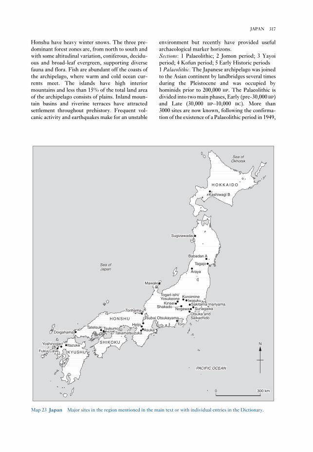
environment but recently have provided useful
archaeological marker horizons.
Sections: 1 Palaeolithic; 2 Jomon period; 3 Yayoi
period; 4 Kofun period; 5 Early Historic periods
1 Palaeolithic. The Japanese archipelago was joined
to the Asian continent by landbridges several times
during the Pleistocene and was occupied by
hominids prior to 200,000 BP. The Palaeolithic is
divided into two main phases, Early (pre-30,000 BP)
and Late (30,000 BP–10,000 BC). More than
3000 sites are now known, following the confirma-
tion of the existence of a Palaeolithic period in 1949,
Honshu have heavy winter snows. The three pre-
dominant forest zones are, from north to south and
with some altitudinal variation, coniferous, decidu-
ous and broad-leaf evergreen, supporting diverse
fauna and flora. Fish are abundant off the coasts of
the archipelago, where warm and cold ocean cur-
rents meet. The islands have high interior
mountains and less than 15% of the total land area
of the archipelago consists of plains. Inland moun-
tain basins and riverine terraces have attracted
settlement throughout prehistory. Frequent vol-
canic activity and earthquakes make for an unstable
317JAPAN
ItazukeItazukeYoshinogariYoshinogari
Fukui CaveFukui Cave KYUSHUKYUSHUKYUSHU
SHIKOKUSHIKOKUSHIKOKU
DoigahamaDoigahamaTatetsukiTatetsuki TsukumoTsukumo AsukaAsuka
TakamatsuzukaTakamatsuzuka
HeijoHeijo
TorihamaTorihama
H O N S H UH O N S H UH O N S H UToroToro
KinseiKinsei
Togari-ishi/Togari-ishi/YosukeoneYosukeone
ShakadoShakado
MawakiMawaki
KuroimineKuroimineIwajukuIwajuku
SunagawaSunagawaSakitama InariyamaSakitama Inariyama
Otsuka andOtsuka andSaikachidoSaikachido
ArayaAraya
TagajoTagajo
Babadan ABabadan ABabadan A
SugizawadaiSugizawadai
Kashiwagi BKashiwagi B
H O K K A I D OH O K K A I D OH O K K A I D O
PACIFIC OCEANPACIFIC OCEAN
NN
00 300 km300 km
Sea ofSea ofOkhotskOkhotsk
Sea ofSea ofJapanJapan
Tsubai OtsukayamaTsubai Otsukayama
ItazukeYoshinogari
Fukui Cave KYUSHU
SHIKOKU
DoigahamaTatetsuki Tsukumo Asuka
Takamatsuzuka
Heijo
Tsubai Otsukayama
Torihama
H O N S H UToro
Kinsei
Togari-ishi/Yosukeone
Shakado
Mawaki
KuroimineIwajuku
SunagawaSakitama Inariyama
NogawaOtsuka andSaikachido
Araya
Tagajo
Babadan A
Sugizawadai
Kashiwagi B
H O K K A I D O
Sea ofOkhotsk
Sea ofJapan
PACIFIC OCEAN
N
0 300 km
Map 23 Japan Major sites in the region mentioned in the main text or with individual entries in the Dictionary.

repeated occupations led to characteristic circular
settlement plans as at Nishida. While the settle-
ment of central Honshu suddenly declined at the
end of the Middle Jomon, the appearance of large
shell middens along the Pacific coast of eastern
Honshu reflected the development of sophisticated
fishing cultures in the Late Jomon. These contin-
ued into the Final Jomon, and resisted the advance
of rice agriculture which had already appeared in
Kyushu. There was widespread intensive ritual
activity in the later part of the period, as at KINSEI,
with the development of community cemeteries
such as TSUKUMO and social differentiation as at
KASHIWAGI B.
3 Yayoi period (300 BC–AD 300). The cultivation of
paddy rice began in Japan in the 1st millennium BC.
Introduced from the continent, the arrival of this
new subsistence strategy had a revolutionary effect
on the course of Japanese prehistory and has pro-
vided the staple foodstuff of Japanese populations
until the present. The spread of rice farming and
associated sets of material culture derived from
the continent constitute the Yayoi period
(300 BC–AD 300), which is named after a location in
Tokyo where Yayoi pottery was first discovered.
Divided into Early, Middle and Late phases (Early:
300–100 BC, Middle: 100 BC–AD 100, and Late:
AD 100–300), it was characterised by wet-rice agri-
culture at sites such as ITAZUKE, the use of bronze
and iron, increasing social differentiation, and war-
fare and trade with the Asian continent.
Yayoi pottery comprises mainly utilitarian long-
necked jars, wide-mouthed pots, deep basins and
pedestalled bowls with simple geometric designs.
Particularly in the Early Yayoi, there is considerable
difference between assemblages from western
Japan, where styles are close to Continental types,
and eastern Japan, where there is much more con-
tinuity from Jomon styles.
Settlements such as TORO consist of small low-
land communities of tightly packed pit houses with
raised storehouses. They are often moated, as at
YOSHINOGARI. In the Late Yayoi in some regions
there was a shift to upland locations, probably for
defensive purposes. Beliefs were largely related
to rice agriculture and included divination.
Ceremonial bronze swords and bell-shaped dotakuderived from more utilitarian Continental models.
Inhumation was the main burial form, although
there was considerable variation as at DOIGAHAMA.
By the Late Yayoi, many small polities and some
regional chiefdoms had arisen. Elite mound burials
of the Late Yayoi such as TATETSUKI are ancestral
to the mounded tombs of the succeeding Kofun
period.
at IWAJUKU. Palaeolithic sites mainly consist of
lithic scatters and piles of burnt cobbles within a
cultural layer as at NOGAWA. The occupational
histories of settlements are being extensively
studied through the use of lithic refitting at sites
such as SUNAGAWA in Tokyo. Most Palaeolithic
artefacts in Japan are chipped stone tools which
show morphological developments in tandem with
the continent.
Although there is still considerable controversy
over when humans first occupied Japan, sites such
as BABADAN A suggest dates of at least 130,000 BP
and probably considerably earlier. The earliest
human remains are from Minatogawa and Mikkabe
in Okinawa, and date to 18,000 BP. Early Palaeo-
lithic technology comprised pebble tools, large flake
tools and large blade flakes. The Late Palaeolithic
began with the appearance of blade tools and is
divided into four phases. Phase II (from 25,000 BP)
was characterized by considerable regional vari-
ability of blade manufacturing techniques including
the side-blow method, reflecting adaptation to
locally available materials, some of which, notably
obsidian and sanukite, were transported over long
distances. Microlithic technology characterised
Phase III, from 14,000 BP. Phase IV, synonymous
with the Incipient Jomon (see below), included the
earliest pottery associated with microcores (in
western Japan) and with edge-polished axes and
stemmed points (in eastern Japan).
2 Jomon period. At the beginning of the Holocene
the landbridges which had connected Kyushu and
Siberia to the continent at various times during the
Pleistocene were finally submerged and Japan
entered the Jomon period, during which many
regional cultures of affluent foragers waxed and
waned.
The six phases of the Jomon period are:
Incipient (10,000–7500 BC), Initial (7500–5000 BC),
Early (5000–3500 BC), Middle (3500–2500/
2000 BC), Late (2500/2000–1000 BC) and Final
(1000–300 BC). The oldest dated pottery is from the
Incipient Jomon layers at FUKUI CAVE, but was
associated with Late Palaeolithic lithics. The Initial
Jomon was the formative stage in the Jomon tra-
dition, while the archetypal Jomon way of life based
around settled villages was established in the Early
Jomon in a milieu of climatic warming and high
sea-levels. Early Jomon settlements such as
TORIHAMA had considerable impact on the sur-
rounding environment, and present elaborate
architecture as at SUGIZAWADAI. The Middle
Jomon cultures in central Honshu represent a peak
of cultural complexity seen at sites such as
SHAKADO, TOGARI-ISHI AND YOSUKEONE. Long
318 JAPAN

capital was established at Heian-kyo in modern
Kyoto. The 8th century saw the consolidation of the
Ritsuryo state, and military campaigns against the
Ezo and Emishi from border garrisons such as
TAGAJO.
The early chronicles, the KOJIKI and NIHON
SHOKI provide many details of life in the Early
Historic periods. Further written evidence has been
provided by the discovery of large numbers of
wooden tablets containing invaluable information
about the movement of peoples and goods and the
bureaucracy. Palaces, capital sites and local
administrative centres have been excavated; these
centres controlled the 58 provinces and three
islands of the Yamato state. The provinces were
further divided into 300–500 counties, which had
their own administrative centres, often associated
with a Buddhist temple.T. Akazawa, S. Oda and I. Yamanaka: The JapanesePalaeolithic: a techno-typological study (Tokyo, 1980);
T.E.G. Reynolds and G.L. Barnes: ‘The Japanese
Palaeolithic: a review’, PPS 50 (1984), 49–61; T. Akazawa
and C.M. Aikens, eds: Prehistoric hunter-gatherers in Japan(Tokyo, 1986); R.J. Pearson et al., eds: Windows on theJapanese past: Studies in archaeology and prehistory (Ann
Arbor, 1986) [pp. 397–404, Early Historic period];
K. Tsuboi, ed. Recent archaeological discoveries in Japan(Paris and Tokyo, 1987); T.E.G. Reynolds and S.C.
Kaner: ‘Japan and Korea at 18,000 BP’, The world at 18,000BP. Volume 1, High latitudes, ed. O. Soffer and C. Gamble
(London, 1989); S. Kaner: ‘The Western-language
Jomon’, Hoabinhian, Jomon, Yayoi, Early Korean States:bibliographic reviews of Far Eastern Archaeology 1990, ed.
G.L. Barnes (Oxford 1990), 31–62; H. Ishino: ‘Rites and
rituals of the Kofun period’, JJRS 19/2–3 (1992),
191–216; R. Pearson: Ancient Japan (Washington, D.C.,
1992); K. Tsuboi, ed.: Archaeological studies of Japan. Acta
Asiatica 63 (Paris, 1992); D. Denoon et al., eds: Multi-cultural Japan: Palaeolithic to postmodern (Cambridge,
1996).
SK
Jarmo Typical small Neolithic tell-site in
northern Iraq, consisting of 16 strata of occupation,
11 dating to the ACERAMIC NEOLITHIC phase.
Between 1948 and 1955 the site was excavated by
R.J. Braidwood, revealing square houses made of
pisé, containing ovens and sunken clay basins. The
characteristic artefacts include microliths as well as
flint sickles, saddle querns, rubbers and mortars and
pestles. These tools, along with the carbonized
remains of cultivated grains and the bones of
domesticated cattle, sheep and pigs, clearly indicate
a highly developed agriculturally-based economy,
the aceramic phase of which has been assigned by
radiocarbon dating to as early as c.6750BC. The term
4 Kofun period (AD 300–710). By the 4th century AD
the process of state formation was already under-
way in western Japan and by the 8th century the
fully developed Ritsuryo state controlled much of
the archipelago. This process dominated the Kofun
period which is divided into three phases: Early
(AD 250/300–400); Middle (AD 400–500) and Late
(AD 500–600 in Kinai and AD 500–710 in other
regions). During the Early phase, large keyhole-
shaped mounded tombs, such as TSUBAI
OTSUKAYAMA, appeared (see figure 25). These
tombs, usually surrounded by earthenware haniwafunerary sculptures, derive in part from the
mounded tombs of the preceding Yayoi period
such as TATETSUKI, but also reflect Chinese influ-
ences seen in qualitative differences in scale,
construction and grave goods. Pottery was the
unglazed earthenware called Haji ware, which
derived from Yayoi ceramic tradition.
The Middle Kofun saw the introduction of the
Chinese writing system (seen in inscriptions as at
SAKITAMA INARIYAMA), civil engineering projects,
such as irrigation canals, and large scale land-
clearance for agriculture, along with an increase
in the importance of dry-field cultivation. These
changes in land-use underlay the development of
land reforms. The late 5th century AD was marked
by the appearance of Sue pottery, a grey stoneware
initially imported from the Korean peninsula and
subsequently produced in Japan for funerary
purposes.
Major social and political changes occurred in the
Late Kofun. Burial in mounded tombs was no
longer the preserve of chieftains, and many small
round circular tombs appeared for lesser nobles and
landowners. In the Kinai region the YAMATO state
appeared, based at the capital at Fujiwara. Tombs
such as TAKAMATSUZUKA show how the aristoc-
racy were buried.
Throughout the Kofun period, status divisions
between communities became marked within a pre-
dominantly dispersed settlement pattern. Major
regional centres have been identified as at Narutaki
in Wakayama Prefecture. Residences of local chiefs
have been found at Mitsudera, along with
commoners’ settlements as at KUROIMINE.
5 Early Historic periods (AD 710–1183). The Early
Historic periods in Japan began with the arrival of
Buddhism in the middle of the 6th century AD. The
7th century AD is named after the political centre at
ASUKA, and witnessed the first written law codes,
the first centralised government and the first
Chinese-style city plan at Fujiwara. In AD 710 the
capital was moved to HEIJO, near present-day Nara
city. The Nara period lasted until 794 when a new
319JARMO

Srednjaja Azija v epohu kamnja i bronzy, ed. V.M. Masson
(Moscow and Leningrad, 1966).
PD
Jebel Barkal see GEBEL BARKAL
Jebel Irhoud Site in southern Morocco where
LEVALLOIS-MOUSTERIAN artefacts have been
found in association with early hominid remains. It
consists of a ‘solution cavity’ filled with 8 m of
Pleistocene deposits on the eastern side of a karstic
limestone outcrop 55 km southeast of modern Safi.
It was discovered in 1960, in the course of mining
operations for barytes, and was investigated from
1961 onwards by Emile Ennouchi. The faunal
remains that he recovered include about 30 mam-
malian species, some of which have Middle
Pleistocene affinities, but their exact stratigraphic
provenance is unknown. A small excavation was
conducted by Jacques Tixier in 1967 and 1969, as a
result of which 22 layers were identified, the lower
ones (8–21) revealing traces of human occupation
and an industry classified as a Mousterian of
Levallois facies.
Five hominid fossils have been found in the cave:
two adult crania (Irhoud 1 and 2), one juvenile and
one adult mandible (Irhoud 3 and 5), and one
juvenile humerus (Irhoud 4). Only the last speci-
men, excavated by Tixier in 1969, has a precise
stratigraphic position, at the base of his layer 18.
Five ELECTRON SPIN RESONANCE dates have been
obtained on horse teeth from just above it, but as
Jean-Jacques Hublin remarks, their very wide range
(90–125 or 105–190,000 years ago, depending on
the assumptions employed) seems inconsistent
with the ‘close stratigraphic origin’ of the samples
employed. On faunal grounds it is considered likely
that the site may be up to 150,000 years old. The
hominids, as at HAUA FTEAH, were at first con-
sidered to be Neanderthal, but more recently
Hublin and his colleagues have thrown doubt on
this interpretation. They are now considered to be
archaic Homo sapiens (lacking distinctive
Neanderthal apomorphies) somewhat similar to if
slightly more primitive than QAFZEH and SKHUL.
They are the probable forerunners of the anatomi-
cally modern hominids associated with the
ATERIAN in Morocco, as at DAR ES-SOLTANE II.E. Ennouchi: ‘Un néandertalien: l’homme du Jebel Irhoud
(Maroc)’, L’Anthropologie 66 (1962), 279–99; M.H. Day:
Guide to fossil man, 3rd edn (London, 1977); J.J. Hublin,
A.M. Tillier and J. Tixier: ‘L’humérus d’enfant
moustérien (Homo 4) du Jebel Irhoud (Maroc) dans son
contexte archéologique’, Bulletins et Mémoires de la Société
‘Jarmoan’ is used by Braidwood et al. (1983: 13) to
describe the Mesopotamian ‘early village farming
community’ exemplified not only at Jarmo but also
at such sites as ALI KOSH, Ganj Dareh and Tepe
Guran (see LURISTAN).R.J. Braidwood: ‘Jarmo: a village of early farmers in Iraq’,
Antiquity 24 (1950), 189–95; J. Mellaart: The Neolithic ofthe Near East (London, 1975), 80–2; L.S. Braidwood et al.,
eds: Prehistoric archaeology along the Zagros flanks(Chicago, 1983).
IS
Java The Javan sites of Trinil, Sangiran and
Ngandong (Solo) provide some of the earliest evi-
dence of hominid occupation in Asia. Found by
Eugene Dubois in 1890, the Trinil beds yielded
fossil teeth and cranial bones (‘Java Man’) later
attributed to HOMO ERECTUS. The site is now
thought to date from c.700,000 BP. The Sangiran
site, discovered by von Koenigswald, produced
fossil crania of a similar date. Ngandong, previously
called Solo, has produced fossils of EARLY HOMO
SAPIENS which resemble those from Africa (e.g.
Broken Hill/Kabwe, see SANGOAN), Europe
(e.g. Petralona) and also the Dali skull from Shaanxi
province in China. The Ngandong fossils are said to
be dated to between 200,000 and 150,000 years BP.
A very early potassium-argon date of 1.8 million
years has recently been proposed for the site of
Mojokerto, with dates of 1.66 million years for the
Sangiran material. However, the relationship
between the tested materials and the fossils is very
dubious.
PG-B
Jebel Mesolithic cave in southwestern Turk-
menistan, in the southern fringe of the Greater
Balkan ridge, the northern off-shoot of the Kopet
Dag, 3 km north of the dry Uzboi valley. The
cave was discovered and excavated by Okladnikov,
who distinguished ten levels. Charcoal from level
4 suggests an approximate calendar date of
5100–5000 BC. Lithic materials include microliths
(triangles, trapezes, segments), as well as small end-
scrapers and retouched blades. Faunal remains
include numerous desert species (tortoise, agama,
lizard), and numerous fish bones. Similar assem-
blages have been identified in neighbouring caves
(Dam-Dam-Cheshma 1 and 2), as well as in the
Kaylyu cave off the Caspian coast, south of
Krasnovodsk.A.P. Okladnikov: ‘Peshchera Djebel–pamjatnik drevnei
kul’tury prikaspiiskih plemjon Turkmenii’, Trudy Yutake7 (1955), 11–219; ––––: ‘Paleolit i mezolit Srednei Azii’,
320 JARMO

matter probably reflecting changes in subsistence
practices as in other examples of SAHARA ROCK ART.A.M. Hasanein Bey: The lost oases (New York, 1925),
228–9; K. el-Din and H. Breuil: ‘Les gravures rupestres
du Djebel Ouenat’, Revue Scientifique 66 (1928), 105–17;
H.A. Winkler: Rock drawings of southern Upper Egypt(London, 1939); W.P. McHugh: ‘Some archaeological
results of the Bagnold-Mond expedition to the Gilf Kebir
and Gebel Uweinat, southern Libyan Desert’, JNES 34
(1975), 31–62.
IS
Jeitun (Jeitun-depe) Early farming site in Turk-
menistan, Central Asia, located at the margin of the
alluvial fan of a small stream, Kara-su, within the
southern sand ridge of the Kara-Kum desert, north
of Ashgabad. A series of AMS radiocarbon
measurements suggest an age of c.6000 BC; this and
related sites represent the earliest farming economy
in Central Asia (see also ASIA 1.1).
The site at Jeitun consisted of several rectangu-
lar one-roomed houses, 20–30 sq.m each, made of
clay bricks, with hearths and adjacent courtyards.
Domestic einkorn wheat formed 90% of the cereals
identified. Stock-breeding was as important as agri-
culture, with domesticated goats and sheep
predominant. Hunting remained an important
source of meat, gazelle and onager being the most
commonly exploited wild animals. In the early
period about 12% of the pottery corpus consisted of
distinctive hand-made cylindrical or conic bowls
decorated by simple red painted patterns on a
yellow background. Several figurines of humans
and animals were also found. The lithic technology
is dominated by microliths reminiscent of the
Caspian Mesolithic.
The largest cluster of Jeitunian sites is found in
Ahala, or the central Kopet Dag oasis. Jeitun-
related sites are also found in the southern foothills
of the Khorassan Mountains, in northern and
eastern Iran, while an eastern cluster of sites is
located in the interfluve of the Meana and Chaacha
rivers.V.M. Masson: Poselenie Djeitun (Leningrad, 1971); D.R.
Harris, V.M. Masson et al.: ‘Investigating early agricul-
ture in Central Asia: new research at Jeitun,
Turkmenistan’, Antiquity 67 (1993), 324–38.
PD
Jemdet Nasr Type-site of the transitional phase
between the late Uruk period and the Early
Dynastic I period in southern Iraq. The Jemdet
Nasr period (c.3100–2900 BC) was initially defined
by a distinctive style of painted pottery (buff-
coloured jars painted with red and black designs),
d’Anthropologie de Paris, 4 (1987), 115–42; ––––: ‘Recent
human evolution in northwestern Africa’, PhilosophicalTransactions of the Royal Society of London, series B,
337/1280 (1992), 185–91; F. Amani and D. Geraads: ‘Le
gisement moustérien du Djebel Irhoud, Maroc: précisions
sur la faune et la biochronologie, et description d’un
nouveau reste humain’, CRASP, série II, 31 (1993),
847–52.
PA-J
Jebel Moya Occupation site in the central Nile
Basin of Sudan, the earliest phases of which date to
the KHARTOUM MESOLITHIC. Purely on the basis
of estimations of the rate of stratigraphic sedi-
mentation Addison tentatively estimated the date of
the initial occupation of Jebel Moya at c.1000 BC,
but radiocarbon dates taken by J.D. Clark in the
early 1970s suggest that the earliest occupation in
Jebel Moya and the surrounding region dated
to c.8000–7000 BP, while the main phase dated to
c.4300 BP. The pottery from the earliest deposits at
the site, decorated with ‘dotted and wavy-line’
impressed patterns, is of a similar type to that of
Central Saharan cultures dating back to c.9000 BP.
Caneva (1991) therefore suggests that the original
settlement at Jebel Moya may have been one of the
first parts of the Nile valley to come into contact
with groups of pastoralists from the Central Sahara
in c.8000 BP.F. Addison: Jebel Moya (Oxford, 1949); I. Caneva: ‘Jebel
Moya revisited: a settlement of the 5th millennium BC in
the middle Nile Basin’, Antiquity 65 (1991), 262–8.
IS
Jebel Sahaba see QADAN
Jebel Uweinat Neolithic settlement and rock-
art site in southeastern Libya, first examined by
Hasanein Bey (1925) and Kemal el-Din (el-Din and
Breuil 1928). The Uweinat rock carvings, similar to
those in the Gilf Kebir, include depictions of
giraffes, elephants, ostriches, wild asses and gazelle.
After Myers’ 1937–8 survey of the region, Winkler
(1939) made the first serious attempt to divide the
drawings into different chronological phases and to
reconstruct the social systems and subsistence
patterns of the artists. However, McHugh (1975)
has reanalysed the results of Myers’ expedition.
Whereas Winkler had argued that the engraved
drawings, dealing mainly with hunting, were ex-
ecuted by male artists and the paintings, mainly of
pastoral scenes, were by women, McHugh’s revised
chronology shows that the engraved drawings
simply predate the paintings, the change in subject-
321JEMDET NASR

obtained, in good stratigraphic sequence, in the
range from 2160 to 550 BP, supported by three
others from the adjacent tells of Hambarketolo and
Kaniana. The settlement shrank prior to the
abandonment of the site, which was complete by
AD 1468. The exclusively Iron Age cultural
sequence is used by the McIntoshes to argue against
an Islamic ‘external stimulus’ model for the devel-
opment of trade and urbanism in the Western
Sudan, since the archaeological sequence revealed
at Jenne-jeno is ‘too big, too early, too far south’ to
fit (McIntosh and McIntosh 1980: II, 448). Instead
they propose a model based on indigenous trade
networks and the PULSE THEORY.S.K. and R.J. McIntosh: Prehistoric investigations in theregion of Jenne, Mali: a study in the development of urban-ism in the Sahel (Oxford, 1980); R.J. and S.K. McIntosh:
‘The 1981 field season at Jenne-jeno: preliminary results’,
NA 20 (1982), 28–32; S.K. and R.J. McIntosh: ‘Recent
archaeological research and dates from West Africa’, JAH27 (1986), 413–42.
PA-J
Jericho (Tell es-Sultan) Tell site in the Jordan
valley which dates back to at least as early as the
NATUFIAN period (c.11000–9300 BC), presumably
deriving its early prosperity from the proximity of
the Ain es-Sultan, an abundant source of water for
irrigation purposes. The subsequent phases at Jericho
provide a good basis for the study of the early
ACERAMIC NEOLITHIC (Pre-Pottery Neolithic A),
when Jericho was an unusually substantial
settlement, as well as the later Aceramic Neo-
lithic (Pre-Pottery Neolithic B), the Pottery
Neolithic and the Bronze Age. The Natufian and
Proto-Neolithic levels provide crucial evidence of
the gradual development of agriculture, although
there was poor recovery of environmental data com-
pared with more recently investigated sites such as
AIN GHAZAL. In common with the rest of the
Levant, the stratigraphy indicates a gap of about
500 years between the end of the Aceramic Neo-
lithic and the emergence of the Pottery Neolithic in
the 6th millennium BC, presumably as a result of the
impact of a drastic climatic change disrupting
the subsistence and settlement pattern. By the Late
Bronze Age the city had regained its prosperity
and became an important CANAANITE city. Little
evidence has survived to cast and direct light on the
well-known Biblical siege of the city when it was
captured from the Canaanites by Joshua and the
Israelites.E. Sellin and C. Watzinger: Jericho (Leipzig, 1913);
Preliminary excavation reports by J. Garstang in LAAA19–23 (1932–6) and by K. Kenyon in PEQ 84–92
first excavated in strata between the Uruk and Early
Dynastic phases at Jemdet Nasr in 1925, as well as
by the apparent proliferation of a deeply drilled
style of cylinder seal.
Most other aspects of Jemdet Nasr material cul-
ture (including the majority of the pottery) are
virtually indistinguishable from the preceding
Uruk period (c.4300–3100 BC), and few sites have
yielded sufficiently continuous stratigraphy from
Uruk to Early Dynastic I to allow Jemdet Nasr
material to be properly characterized. Finkbeiner
and Röllig (1986) have therefore suggested that the
Jemdet Nasr ware – which is relatively rare com-
pared with other ceramics of the same period –
might be better interpreted as a geographical vari-
ant of the Uruk culture rather than an indication of
post-Uruk date. The balance of opinion, however,
still favours the retention of a Jemdet Nasr period,
on the grounds that there are other ceramics
peculiar to the period (Killick in Finkbeiner and
Röllig 1986), as well as a distinctive type of semi-
pictographic CUNEIFORM tablet (Nissen 1986).
Jemdet Nasr pottery was excavated not only at other
sites in Mesopotamia but also at sites in Oman and
along the Gulf coast (e.g. Hafit, see ARABIA, PRE-
ISLAMIC), clearly indicating a wide trading network
like that of the Uruk period.
Jemdet Nasr itself, located in southern Iraq about
30 km northeast of Babylon, consists of several tells
covering a total area of about 15 ha, which were first
excavated by Steven Langdon and Christian
Watelin in 1925–8. A substantial mud-brick struc-
ture of the Jemdet Nasr period, identified by
Langdon as a temple and by Watelin as a palace, is
likely to have been an administrative structure, par-
ticularly in view of the tablets inscribed with ‘Uruk
III’ texts that were found inside it.E. Mackay: Report on excavations at Jemdet Nasr, Iraq(Chicago, 1931); H. Field and R.A. Martin: ‘Painted pot-
tery from Jemdet Nasr’, AJA 39 (1935), 310–20; U.
Finkbeiner and W. Röllig, eds: Gamdat Nasr: period orregional style? (Wiesbaden, 1986); H.J. Nissen: ‘The
Archaic texts from Uruk’, WA 17 (1986), 317–34; R.J.
Matthews: ‘Excavations at Jemdet Nasr, 1989’, Iraq 52
(1990), 25–40 [preliminary report on the excavations of
the late 1980s].
IS
Jenne-jeno Tell located 3 km southeast of
modern Jenne, between the Niger and Bani rivers,
in the southwestern part of the Inland Niger Delta
of Mali; excavated by Susan and Roderick
McIntosh in 1977 and 1981. The mound measures
760 × 550 m and rises to a height of 8 m above the
floodplain. A total of 22 radiocarbon dates were
322 JEMDET NASR

stricted Late Jorwe (c.1000–700 BC), found only in
the Bhima River Valley (Dhavalikar 1988:13). Early
Jorwe sites are distributed across much of modern
Mahrashtra; a few, such as DAIMABAD, INAMGAON
and Prakash, are about 20 ha in area, but most are
comparatively small sites covering about 2–3 ha.
The site of Jorwe itself was excavated by
Hasmukh Dhirajlal Sankalia and Shantaram
Bhalchandra Deo in the early 1950s. Typical Jorwe
ceramic ware has red or orange surface colour,
sometimes painted with black geometric designs.
Jorwe sites are also characterized by the presence of
groundstone axes, copper tools and ornaments, and
a distinctive blade and microlith industry.H.D. Sankalia and S.B. Deo: The excavations at Nasik andJorwe, 1950–51 (Pune, 1955); M.K. Dhavalikar: The firstfarmers of the Deccan (Pune, 1988).
CS
Jui-ch’ang-shih (Ruichangshi) Ancient mining
complex near the city of Jui-ch’ang, Chiang-hsi,
China, on the eastern slopes of T’ung-ling (‘Copper
Ridge’). The earliest sector of the mines has been
dated to the Middle Shang period (c.1650–1400 BC)
on the basis of calibrated radiocarbon assessments
clustering around 1400 BC (see T’UNG-LING MINES).
These dates suggest that metallurgy not only
appeared somewhat earlier in China than was pre-
viously thought but was also probably an
independent discovery. The development of metal-
lurgy in the CHUNG-YÜAN area relied on the
procurement of copper from such sources as Jui-
ch’ang-shih.Yang Li-hsin: ‘Wan-nan ku-tai t’ung-k’uang ch’u-pu
k’ao-ch’a yu yen-chiu’ [Preliminary researches into the
ancient mines of the Wan-nan region], WWYY 3 (1988),
181–90; Hua Chüeh-ming, Liu Shih-chung, J. Head and
N. Barnard: ‘The ancient mines of T’ung-ling, Jui-ch’ang,
Chiang-hsi’ (in preparation).
NB
Julfar Town in the United Arab Emirates, which
was the immediate predecessor of the city of Raðs al-
Khaimah, and the main town on the eastern side
of the Arabian Gulf in the later Islamic period. It is
the only site of this date to have been excavated
in the area. Although Julfar is mentioned in texts of
the 7th century AD, no remains earlier than the
14th century have yet been excavated. When
the Portuguese dominated the Gulf in the 16th
century, Julfar enjoyed great prosperity as the
regional trading entrepôt, with its commercial net-
work reflected in the quantities of Chinese,
Vietnamese and Thai ceramics recovered, along
(1952–60); K. Kenyon: Excavations at Jericho, 2 vols
(London, 1960–5); J.R. Bartlett: Jericho (Cambridge,
1982).
IS
Jerusalem Situated in the ancient Judaean
region of ISRAEL, Jerusalem dates back to the Early
Bronze Age (c.3000 BC), when it was probably
founded by an AMORITE tribe, the Jebusites, who
called it the ‘Foundation of Salem’ (Salem being an
Amorite deity). It was captured by the ISRAELITES
under David in c.1000 BC, and the ‘City of David’
became the capital of the Israelite kingdom, and
subsequently the capital of the Kingdom of Judah.
In AD 70 the city was destroyed by the Roman
emperor Titus as a result of a Jewish revolt, but a
new city (Aelia Capitolina) was founded by Hadrian
in 135. In 638 an Arab army led by Caliph Omar Ibn
al-Khattab conquered the city, but it was captured
by Crusaders in 1099, eventually falling to Saladin
in 1187 and becoming part of the Ottoman
empire in 1516.
The site of the ancient city was first excavated
by Lieutenant Charles Warren in the late 1860s,
although his work was dogged by political and logis-
tical problems. Warren’s unorthodox methods
involved the digging of deep shafts with long pas-
sages leading away from the foot of each, but he
nevertheless produced a fairly comprehensive
overview of the site. Since then, it has been exca-
vated by a steady stream of different excavators,
including Frederick Bliss and Kathleen Kenyon.
The principal surviving features are a rock-cut
water tunnel dating to the 8th century BC, remains
of the Herodian palace and temple (c.AD 40–44),
the Church of the Holy Sepulchre (built by
Constantine in AD 335), the Mamluk–Ottoman
city-walls and the late 7th-century Dome of the
Rock (built over the site of King Solomon’s temple).M. Avi-Yonah et al.: Jerusalem (Jerusalem, 1973); K.M.
Kenyon: Digging up Jerusalem (London, 1974); J. Perrot,
ed.: ‘Jerusalem: 5000 years of history’, DA (special issue,
March 1992); G.J. Wightman: The walls of Jerusalem fromthe Canaanites to the Mamluks (Sydney, 1993).
IS
Jin see CH’IN
Jomon period (10,000–300BC) see JAPAN 2
Jorwe Type-site of the Jorwe period, a phase of
the Indian Deccan Chalcolithic divided into Early
Jorwe (c.1400–1000BC) and the more spatially re-
323JULFAR

coastal fan, sandbars forming offshore, and the sil-
tation of creeks. The process is very rapid, and
geomorphological study was a major feature of the
field research at the site. Although geomorphology
is rarely brought to bear in ISLAMIC ARCHAE-
OLOGY, the unstable and evolving nature of the east
Arabian coast makes it an important aspect of field-
work in the area.B. de Cardi and B. Doe: ‘Archaeological survey in the
northern Trucial states’, East and West 21 (1971), 225–76;
J. Hansman: Julfar: an Arabian port (London, 1985);
G.R.D. King: ‘Excavations of the British team at Julfar,
Ras-al-Khaimah, United Arab Emirates’, PSAS 20–2
(1990–2) [interim reports on the 1989–1992 seasons];
C. Hardy-Guilbert: ‘Julfar, cité portuaire du Golfe arabo-
persique à la periode islamique’, Archéologie islamique 2
(1991), 162–203; T. and H. Sasaki: ‘Japanese excavations
at Julfar – 1988, 1989, 1990 and 1991 seasons’, PSAS 22
(1992), 105–20; D. Kennet and G.R.D. King: ‘Jazirat al-
Hulayla – early Julfar’, JRAS, 3rd series, 4/2 (1994),
163–212; R. Stocks: ‘Wadi Haqîl survey, November 1992’,
PSAS 26 (1996), 145–63.
GK
with Indian glass bangles and Iranian pottery.
These ceramics were major contributors to the
dating of the local ceramics which came from the
nearby kilns in Wadi Haqil.
Julfar underwent a great expansion, whereby a
14th century settlement consisting of huts was
replaced by large sand-brick houses arranged in a
grid-like pattern of streets. Its first small sand-brick
mosque was reconstructed to accommodate a grow-
ing congregation, and a series of five mosques was
eventually built one above the other as the congre-
gation expanded. Mosques are a useful register of
demographics as all adult males are required to
attend Friday prayers, therefore any congregational
mosque can be expected to be large enough to
accommodate at least the maximum adult male
population. The Julfar excavation was unique in
Arabian archaeology in the opportunity that it
offered to trace the changing plan of a mosque on
the same site over time.
Around Julfar, the landscape is very mobile with
wadi gravels descending from the mountains to the
324 JULFAR

K2 see BAMBANDYALANO
Kabáh see PUUC
Kabuye One of several areas of Rwanda and
adjacent countries of interlacustrine East Africa
which has yielded spectacular evidence of early
iron-working, including furnace shafts built of
hand-moulded clay coils (‘decorated bricks’), and
fine specimens of Urewe pottery (see EARLY IRON
AGE), mostly dating to c.1500–2200 years ago. Seealso KATURUKA in the nearby Buhaya region of
Tanzania.F. Van Noten et al: Histoire archéologique du Rwanda(Tervuren, 1983).
JS
Kabwe see SANGOAN
Kachemak see KODIAK TRADITION
Kadero KHARTOUM NEOLITHIC site in the
central Nile basin of central Sudan, about 20 km
north of Khartoum. The settlement middens and
cemeteries of Kadero show evidence of the domes-
tication of cattle and the cultivation of cereal crops
as early as c.4000 BC. By the end of the 3rd millen-
nium, however, it appears that Kadero and the rest
of the central Nile region were virtually deserted, as
the focus of Neolithic settlement shifted north-
wards into Lower Nubia.L. Krzyzaniak: ‘The Neolithic habitation at Kadero
(Central Sudan)’, Origin and early development of food-producing cultures in northeastern Africa, ed. L. Krzyzaniak
and M. Kobusiewicz (Poznan, 1984), 309–15; ––––:
‘Early farming in the Middle Nile Basin: recent discover-
ies at Kadero (Central Sudan)’, Antiquity 65 (1991),
515–32.
IS
Kadesh see QADESH
Kahun see EL-LAHUN
Kalambo Falls Site in Zambia, at the south end
of Lake Tanganyika, of a small basin in which sands,
clays and rubble beds have accumulated, together
with archaeological deposits in various degrees of
disturbance, from ACHEULEAN times down to the
Early Iron Age (excavated by J.D. Clark 1956–66).
Several Acheulean floors dated to at least 110,000 BP
by AMINO ACID RACEMIZATION, are important not
only for the completeness of their assemblages, but
also for their association with well preserved plant
remains (logs, twigs, nuts, fruits, seeds, leaves,
reeds and pollen). Several pieces of wood and bark
are believed to be artefacts, and there is clear
evidence of fire, possibly man-made. An arc of
stones may mark the site of a hut or windbreak. The
succession includes Acheulean, SANGOAN,
LUPEMBAN, Later Stone Age and Early Iron Age
material, including a good suite of radiocarbon
dates. The Iron Age village was occupied from the
4th to the 11th centuries AD and later, and has
yielded objects of iron, a copper bangle and several
deep pits of uncertain use.J.D. Clark: The Kalambo Falls prehistoric site I
(Cambridge, 1969); G.L. Isaac: ‘The earliest archaeologi-
cal traces’, The Cambridge history of Africa I, ed. J.D. Clark
(Cambridge, 1982), 202–4.
RI
Kalhu see NIMRUD, TELL
Kalibangan Large Harappan site (see INDUS
CIVILIZATION) located on the southern bank of the
Ghaggar River in Rajasthan, India, which was ex-
cavated by Braj Basi Lal and Bal Krishen Thapar
(1961–9). It consists of two main mounds (KLB
1 and 2), a third smaller mound and a Harappan
cemetery. Two chronological phases have been
defined through a series of nearly 40 cali-
brated radiocarbon dates (Lal 1979: 94): Early
Harappan (c.2920–2550 BC) and Mature Harappan
(c.2600–1990 BC). Five Early Harappan building
K

conclusions’, JAH 9 (1968), 191–211; J.O. Vogel:
Kumadzulo: an Early Iron Age village site in southernZambia (Lusaka, 1971); T.N. Huffman: Iron Age migra-tions: the ceramic sequence in southern Zambia(Johannesburg 1989).
TH
Kaminaljuyú Large centre in the northern
valley of Guatemala that flourished from the
Middle Preclassic to the Classic period (i.e.
c.800 BC–AD 900). Kaminaljuyú is believed to have
controlled the large El Chayal OBSIDIAN quarry as
well as the trade network that distributed it
throughout the Maya highlands and lowlands.
Strong influences from TEOTIHUACAN in the Early
Classic period (c.AD 300–600), seen in the architec-
ture, pottery and burials, were uncovered by early
excavations (Kidder et al. 1946) and interpreted in
terms of conquest of this site by the central
Mexicans. Later work at other sites elsewhere in the
valley suggests that a ‘PORT OF TRADE’ existed in
the region and involved complex three-way trading
relationships between Teotihuacán, Kaminaljuyú
and the lowland Maya.A.V. Kidder et al.: Excavations at Kaminaljuyu,Guatemala, C.I.W. Pub. 561 (Washington, D.C., 1946);
K.L. Brown: ‘The valley of Guatemala: a highland port of
trade’, Teotihuacan and Kaminaljuyu: a study in prehistoriccultural contact, eds W. T. Sanders and J.W. Michels
(University Park, 1977), 205–395.
PRI
Kanesh see KÜLTEPE
Kansyore Type of East African pottery, named
after an island in the Kagera river which flows into
the west side of Lake Victoria. Kansyore pottery
illustrates pre-Iron Age cultural and economic
developments in the Lake region and perhaps over
a broader area of East Africa. In view of its texture,
open shapes and profuse indented decoration, a
derivation from the early Holocene pottery of the
Nile Valley ‘Aqualithic’ or ‘Khartoum horizon’ has
been surmised; this theory is supported by the lake-
side, riverbank and island situations of many
Kansyore sites (see AQUATIC CIVILIZATION; Sutton
1977). Other archaeologists consider such com-
parisons superficial and deceptive, regarding
Kansyore pottery as a late development in the final
two millennia BC, that is shortly before the Iron
Age. Radiocarbon results (Robertshaw 1991) tend
to support this dating, but they are not entirely
unambiguous, and the possibility of these late man-
ifestations emerging from a much more ancient
phases from Mound KLB 1 provide evidence of
dense mud-brick architecture (including standard-
ized brick sizes) and massive enclosure walls.
Typical artefacts of the period include terracotta
figurines, ground stone and flaked stone imple-
ments, ornaments including copper, shell, and
ceramic bangles, and agate, carnelian, shell,
and copper beads, and six different ceramic wares,
including black and white painted red wares, large
storage jars with a textured (sandy slip) surface, and
buff or grey wares decorated with black and white
floral, faunal, and curvilinear motifs (Lal 1979:
70–4). A nearby field has revealed evidence for
Early Harappan PLOUGHMARKS.B.K. Thapar: ‘Synthesis of the multiple data as obtained
from Kalibangan’, Radiocarbon and Indian archaeology, ed.
D.P. Agrawal and A. Ghosh (Bombay, 1973), 264–71;
B.B. Lal: ‘Kalibangan and the Indus civilization’, Essays inIndian protohistory, ed. D.P. Agrawal and D.K.
Chakrabarti (Delhi, 1979), 65–97; ––––: ‘Some reflections
on the structural remains at Kalibangan’, Frontiers of theIndus Civilization, ed. B.B. Lal and S.P. Gupta (New
Delhi, 1985), 55–62.
CS
Kalina Point see GOMBE POINT
Kalomo culture Central African Iron Age cul-
ture, first identified by Ray Inskeep as a result of
excavations at Kalundu mound about 5 km south-
east of Kalomo. Bryan Fagan later excavated Isamu
Pati 16 km to the west, and the long stratigraphic
succession at the two sites was virtually the same. As
research progressed, however, the cultural affinities
of the ceramic units were reassessed. Inskeep
originally placed the entire sequence in the Kalomo
culture, but David Phillipson excluded the lower
unit, renaming it the Kalundu Early Iron Age (EIA)
group. Based on excavations at Kumadzulo and
other sites, Joseph Vogel excluded the upper unit at
Isamu Pati, restricted the concept to Fagan’s
11th–12th century mid-Kalomo, and derived it
from the Shongwe EIA Tradition (Situmpa-
Kumadzulo-Dambwe) in the Victoria Falls area.
The MULTIDIMENSIONAL ANALYSIS of material
from Gundu, 90 km northeast of Kalomo,
prompted Huffman to separate Shongwe and re-
instate the late Kalomo pottery at Isamu Pati. Thus
in the 13th–14th centuries AD, Kalomo was
contemporaneous with Kangila and INGOMBE
ILEDE.R. Inskeep: ‘Some Iron Age sites in northern Rhodesia’,
SAAB 17 (1962), 136–80; B.M. Fagan: Iron Age cultures inZambia I (London, 1967); D.W. Phillipson: ‘The Early
Iron Age in Zambia: regional variants and some tentative
326 KALIBANGAN

D.W. Phillipson: ‘The Early Iron Age site at
Kapwirimbwe, Lusaka’, Azania 3 (1968), 87–105; ––––:
The later prehistory of eastern and southern Africa (London,
1977); T.N. Huffman: Iron Age migrations: the ceramicsequence in southern Zambia (Johannesburg, 1989).
TH
K-Ar see POTASSIUM-ARGON DATING
Karanog MEROITIC settlement-site and ceme-
tery (c.300 BC–AD 350), located in Lower Nubia
about 60 km south of Aswan. By the 3rd century AD,
it had become a major town. Unlike other Meroitic
centres (e.g. Faras or Qasr Ibrim) it was protected
by a huge three-storey mud-brick ‘castle’ rather
than a surrounding enclosure wall. Adams (1976)
has suggested that Lower Nubian towns such as
Karanog may have been controlled by local feudal
rulers rather than being part of the Upper Nubian
Meroitic kingdom itself.C.L. Woolley and D. Randall–MacIver: Karanog, theRomano-Nubian cemetery (Pennsylvania, 1910); ––––:
Karanog, the town (Pennsylvania, 1911); W.Y. Adams:
‘Meroitic north and south: a study in cultural contrasts’,
Meroitica 2 (1976), 11–26.
IS
Karanovo Large tell near Nova Zagora in the
Tundza valley of central Bulgaria that has pro-
vided an important cultural and pottery sequence
from the earliest Neolithic, in perhaps the 7th mil-
lennium BC, through the Copper Age to the
Bronze Age. Karanovo levels I–IV are Neolithic;
V–VI are Chalcolithic; VII is Early Bronze Age.
Karanovo I is important as the type site of an early
farming culture – very roughly contemporary with
other early farming cultures in eastern Europe
such as STARČEVO – which appears at other sites in
central and southern Bulgaria (notably AZMAK
tell). It is characterized by white bowls painted in
red with geometric designs (with some instances of
incised and plastic decoration), including a distinc-
tive vessel form – the pedestalled bowl. The first
phase of the settlement may already have com-
prised over 50 small (c.7 m square) houses –
although some estimates suggest no more than 15
or so – set closely together in rows. The houses
were simple and timber framed, with hearths and
ovens. Level II continues the cultural tradition
established in level I, although the ceramic decora-
tion is relatively less rich. Karanovo III is Middle
Neolithic, while IV and V are Late Neolithic.
Level VI represents a rich Gumelniţa culture
phase, with distinctive bowls painted with graphite
eastern African tradition is not ruled out. The fish-
ing element is pronounced at the more typical
Kansyore sites on rivers flowing into Lake Victoria
(Kansyore Island itself and, on the eastern side,
Ugunja and GOGO FALLS), all of which are situated
above rapids where preferred species of fish can be
caught.S. Chapman: ‘Kansyore Island’, Azania 2 (1967), 165–91;
J.E.G. Sutton: ‘The African aqualithic’, Antiquity51 (1977), 25–34; P.T. Robertshaw: ‘Gogo Falls: a
complex site east of Lake Victoria’, Azania 26 (1991),
63–195.
JS
Kao-ch’eng-hsien (Gaochengxian) see T’AI-
HSI-TS’UN
Kapova Cave (Kapovaya, Shulgan Tash) Upper
Palaeolithic cave with rock paintings, situated in the
southern Urals in the valley of the Belaya River,
200 km south of the town of Ufa, Bashkirstan,
Russia. The cave, a rare example of Upper
Palaeolithic rock art in eastern Europe, was dis-
covered by A.V. Ryumin in 1959 and investigated
by O.N. Bader in the 1960s and 1970s. Since 1982
the site has been excavated by V.E. Shchelinsky.
The paintings, in four separate galleries, represent
animals (mammoth, horse, rhinoceros) and signs
and geometric symbols (trapezes, triangles, a
truncated cone, a square with loops). Two radio-
carbon dates obtained from samples of charcoal
indicate dates of around 14680±150 (LE-3443) and
13390±300 (GIN-4853) BP.O.N. Bader: Kapovaya peščra [Kapova Cave] (Moscow,
1965); V.E. Shchelinsky: ‘Some results of new investiga-
tions at the Kapova Cave in the southern Urals’, PPS 55
(1989), 181–91.
PD
Kapwirimbwe Early Iron Age facies (cultural
subdivision) in Zambia, named after a site on the
outskirts of Lusaka. Along with Chondwe and
Kalundu it formed the original core of David
Phillipson’s Western Stream. The cluster of styles
has been renamed the Kalundu Tradition to avoid
confusion with the historical classification of Bantu
languages. Multidimensional stylistic analyses show
that Kapwirimbwe is related to the ‘LYDENBURG
Tradition’ (see also BAMBATA POTTERY) and other
similar facies in South Africa and that it was the
product of Eastern Bantu speaking people. The full
settlement organization is not yet known, but the
excavation of the type-site yielded storage pits,
cattle bones and metal-working debris.
327KARANOVO

Karmir Blur see URARTU
Karnak (anc. Ipet-sut) Massive collection of
Egyptian temples and shrines, covering over a
hundred hectares in the northeastern area of
modern Luxor and dating from at least as early as
the Middle Kingdom (c.2040–1640 BC) until the
end of the Roman period (c.AD 395). It comprises
three major sacred ‘precincts’ dedicated to the
deities Amon-Re, Mut and Monthu, each of which
was surrounded by trapezoidal mud-brick en-
closure walls. The enclosures also included a
number of smaller temples dedicated to Ptah, Opet
and Khonsu respectively. The earliest axis of the
temple of Amon-Re extended from west to east,
incorporating the Great Hypostyle Hall of
Ramesses II (c.1290–1224 BC), which is over 0.5 ha
in area. The second axis extended the temple south-
wards and included the so-called ‘cachette court’,
where thousands of royal and private statues were
discovered hidden under the floor. Karnak lay at the
heart of the city of Thebes (anc. Waset), which
served as one of the most important Egyptian
administrative centres for much of the pharaonic
period.G. Legrain: Les Temples du Karnak (Brussels, 1929);
Centre Franco-égyptien d’étude des temples de Karnak:
Cahiers de Karnak, 6 vols (1943–82); P. Barguet: Le templed’Amon-Re à Karnak: essai d’exégèse (Cairo, 1962).
IS
Kartan culture Tool assemblage consisting of
steep-edged scrapers and HORSE HOOF CORES,
found mainly around Kangaroo Island and the
adjacent mainland of South Australia. The tools
have been picked up largely from surface scatters,
but are thought to be Pleistocene in age. The pre-
dominant distribution is around lagoons, streams
and swamps.R.J. Lampert: The great Kartan mystery (Canberra, 1981).
CG
karum see ASSYRIA, KÜLTEPE
Kashiwagi B A series of five Late Jomon bank-
enclosed cemeteries in Hokkaido, Japan
(c.2500–1000 BC). One contained 21 burials within
the central enclosure, 18 in the surrounding bank
and a further five outside the bank. This spatial
organization, along with the varied burial forms and
grave goods, indicates complex social relations at a
time of ecological change.F. Ikawa-Smith and F. Kanjodori: ‘Communal cemeter-
and a rich copper industry with copper axes
exhibiting carefully cast-in shaftholes; by Karan-
ovo VI, the size of houses had increased
substantially.
V. Mikov: ‘The prehistoric mound of Karanovo’,
Archaeology 12 (1959), 88–97; S. Hiller and G. Georgiev:
Tell Karanovo (Salzburg, 1984, 1986, 1987).
RJA
Karatepe see HITTITES
Karbuna (Corbuna) Hoard and settlement
related to the early phases of the TRIPOLYE cul-
ture, located near the village of the same name in
Central Moldova. The hoard was secreted in an
anthropomorphic vessel, which had been placed in
a storage pit dug between the dwellings of the
Tripolye settlement. The vessel contained 852
artefacts, of which 444 were copper implements
such as spiral bracelets, cylindrical beads, various
plates (including anthropomorphic examples) and
various types of copper celts. The tools were
forged, and the copper ore originated from the
Balkan-Carpathian region.
G.P. Sergeev: ‘Rannetripol’skii klad u sela Karbuna’ [An
early Tripolye hoard near the village of Karbuna],
Sovetskaya arheologija 1 (1963), 135–51; N.V. Ryndina:
Drevneišee metalloobrabatyvajueščee proizvodstvo VostočnoiEvropy [The most ancient metal-working industry of
Eastern Europe] (Moscow, 1971).
PD
Kariandusi ACHEULEAN site of Middle Pleisto-
cene age in an area of diatomite beds in the Kenya
Rift Valley, overlooking Lake Elmenteita. It was
examined by Louis Leakey in the 1920s and more
recently by Gowlett. Kariandusi’s cleavers, hand-
axes and other tools are remarkable for being made
of obsidian, available from nearby Mount Eburru
and the Naivasha basin. The dating is unclear, but
some layers could be as much as 0.75 million years
old. The site and its surrounds have been affected
by rift faulting as well as gully erosion and lake-level
changes, rendering them instructive for geological
and geomorphological demonstration.
L.S.B. Leakey: The Stone Age cultures of Kenya colony(Cambridge, 1931); J.A.J. Gowlett: ‘Acheulian sites in the
Central Rift valley, Kenya’, Proceedings of the 8thPanafrican Congress of Prehistory 1977 (Nairobi, 1980),
213–7.
JS
328 KARANOVO

that the Kassite administration was not only un-
usually stable but also characterized by a move
towards a more ‘feudal’ form of society, in which the
concept of the king as sole ‘law-giver’ was gradually
eroded by the transfer of land into communal and
tribal ownership.K. Balkan: Kassitenstudien I (New Haven, 1954); K. Jaritz:
‘Quellen zur Geschichte der Kassu-Dynastie’,
Mitteilungen des Instituts für Orientforschung 6 (1958),
187–265; U. Seidl: ‘Die babylonischen Kudurru-reliefs’,
Baghdader Mitteilungen 4 (1968), 7–220; J.A. Brinkman:
Materials and studies for Kassite history I (Chicago, 1976);
J. Oates: Babylon, 2nd edn (London, 1986), 83–104.
IS
Katelai see GANDHARA GRAVE CULTURE
Kathu Pan Shallow 3 ha basin in the northwest
Cape region, South Africa, which has yielded
significant evidence of the African Stone Age. The
site is seasonally flooded and the floor is formed of
variable strata of peat, silty sand, gravel, and calci-
fied sand, to a depth of up to 11 m below the modern
surface, overlying 40 m of calcrete and 30 m of
sands, clays and gravels. The massive calcrete and
subjacent deposits are of Tertiary age. Excavations
by P. Beaumont (1979–90) revealed mainly shallow
deposits of Holocene age. However, where there has
been collapse, into solution cavities in the Tertiary
calcretes, longer sequences are exposed. At KP1
two Acheulean horizons (one designated
‘FAURESMITH’) are overlain by Middle Stone Age
and Later Stone Age occurrences. Pollen and faunal
remains enhance the significance of the site.P.B. Beaumont: ‘Kathu Pan’, Guide to archaeological sitesin the northern Cape, ed. P.B. Beaumont and D. Morris
(Kimberley, 1990), 75–100.
RI
Katuruka Located near the western shore of
Lake Victoria in north-western Tanzania, this site,
together with other sites excavated by Peter
Schmidt, has stimulated discussion about the
nature and dating of the East African EARLY IRON
AGE. In local tradition Katuruka is associated with
a king, Rugamora Mahe, who is thought to have
ruled in the 18th century AD. The main archaeo-
logical materials however, including plentiful
remains of iron-working, both here and at other
sites associated with the same ruler or culture-hero,
belong to the Early Iron Age. They include fine
examples of Urewe pottery, and have been dated to
about 2000 years ago. Certain of the radiocarbon
results from Katuruka suggested at first that the
ies of the late Jomon in Hokkaido’, Pacific Northeast Asiain prehistory, ed. C.M. Aikens and S.N. Rhee (Pullman,
1992), 83–90.
SK
Kassites (Akkadian: Kashshu) Ancient Near
Eastern non-Semitic people who were originally
based in the central ZAGROS (roughly correspond-
ing to the Luristan area of modern Iran), to the
south of the homeland of the GUTIANS and Lullubi.
They emerged from obscurity in the early 2nd mil-
lennium BC, achieving political control of
Mesopotamia, during the 16th–13th centuries BC at
roughly the same time as the rise of the HURRIANS
and HITTITES in Anatolia. Like most other new
arrivals in Mesopotamia, the Kassites are initially
visible only through their unusual personal names,
which began to appear in cuneiform texts in
Babylonia during the 17th century BC, indicating
their gradual peaceful influx into the population,
usually as agricultural workers. Although no texts
written exclusively in the Kassite language have
survived, their language was clearly agglutinative
and possibly related to Elamite.
In terms of material culture the most important
surviving site of the Kassite period is Aqar Quf,
west of modern Baghdad, where the city of Dur
Kurigalzu was founded by Kurigalzu I (c.1400BC).
Much of the art and architecture at Aqar Quf –
including an unusually well-preserved ziggurat and
the painted palace of the 12th-century Kassite ruler
Marduk-apla-iddin – is distinctly Babylonian in
appearance, indicating the degree to which the
Kassite rulers of Babylon had simply assimilated
the indigenous material culture. However, there are
a number of Kassite innovations, such as the use of
moulded baked bricks for the external decoration
of buildings, the introduction of the KUDURRU (a
ceremonial stele recording land transfers), and the
increased use of horses in warfare. The CYLINDER
SEALS of the Kassite period included a number of
innovative geometrical and figurative motifs as well
as the archaizing use of lengthy cuneiform texts in
the Sumerian language. There are also a number of
surviving buildings which appear to be Kassite
rather than Babylonian in style, and the earliest sur-
viving Kassite temple is the shrine constructed by
Karaindash (c.1465 BC) at URUK.
Although the Kassite dynasty in Babylonia is
regarded as a comparative ‘dark age’, this is partly a
result of the neglect of archaeologists, since
thousands of surviving Kassite-period documents
(including an extensive archive from NIPPUR)
remain unpublished. Oates (1986: 101–2) argues
329KATURUKA

B. Hayden and J. Ryder: ‘Prehistoric cultural collapse in
the Lillooet area’, AA 56 (1991), 50–65; B. Hayden and J.
Spafford: The Keatley Creek Site and Corporate GroupArchaeology (Vancouver, 1993).
RC
Kebara, Kebaran The recently excavated
materials from Kebara, one of the caves in the
MOUNT CARMEL region of Israel, are important in
the story of HUMAN EVOLUTION for a number of
reasons. Firstly, thermoluminescence dates for the
site indicate occupation by NEANDERTHALS
around 60,000 years ago – much later than the
ANATOMICALLY MODERN HUMAN occupation of
the Qafzeh cave (see QAFZEH AND SKHUL). Similar
datings for the Tabun site (see MOUNT CARMEL)
seem to confirm that ‘modern’ humans were in the
Levant before the Neanderthals. The skeletal
material is also of some significance, since
Neanderthal burials at the site have provided the
most complete Neanderthal pelvis yet known. This
fossil seems to indicate differences from modern
humans in locomotion, due to the wider separation
of the hip joints. (It had earlier been believed that
the wider Neanderthal pelvis was associated with
longer pregnancies and hence larger foetus size.)
Finally, the fossil material includes a Neanderthal
hyoid bone. This laryngeal bone appears the same
as that of modern people, apparently contradicting
claims that the Neanderthals were incapable of
speech.
In 1931 Francis Turville-Petre found the first
remains of the ‘Kebaran complex’ in Kebara cave.
Dating to c.18,000–11,000 BC, this is the earliest
group of Levantine EPIPALAEOLITHIC industries,
roughly contemporary with the Mushabian com-
plex and eventually evolving into (or superseded by)
the ‘Geometric Kebaran’ and the NATUFIAN. Some
Kebaran sites were only small seasonal encamp-
ments, but others were larger settlements occupied
throughout the winter months and showing evi-
dence of the exploitation of fish and cereals such as
wheat and barley. Kebaran toolkits typical include
groundstone mortars and pestles as well as bladelets
and microliths.B. Arensberg et al.: ‘A Middle Palaeolithic human hyoid
bone’, Nature 338 (1989), 758–60; D.O. Henry: From for-aging to agriculture: the Levant at the end of the Ice Age(Philadelphia, 1989), 151–77; O. Bar-Yosef et al.: ‘The
excavations in Kebara Cave, Mount Carmel’, CA 33/5
(1992), 497–550.
PG-B/IS
Kechi Beg see QUETTA
origins of this Early Iron Age between the great
lakes might be considerably older. On the basis of
these dates and results obtained at Katuruka,
Kemondo Bay and other sites nearby, as well as
experiments in furnace building and smelting and
the use of ethnographic analogies, Schmidt (1978)
argued that the local early iron technology was
remarkably sophisticated and original, obtaining
exceptionally high temperatures through preheated
air; this proved to be a source of considerable con-
troversy in African archaeology from the 1960s to
1980s (e.g. Rehder 1986).P.R. Schmidt: Historical archaeology: a structural approachto an African culture (Westport, 1978); S.T. Childs and
P.R. Schmidt: ‘Experimental iron smelting’, African ironworking: ancient and traditional, ed. R. Haaland and P.
Shinnie (Oslo and Oxford, 1985); J.E. Rehder: ‘Use of
preheated air in primitive furnaces: comment on views
of Avery and Schmidt’, JFA 13 (1986), 351–3.
JS
Kausambi City of the early Historic period,
located by the Yamuna River, about 50 km west of
modern Allahabad, India. Excavations conducted
by Govardhan Rhaj Sharma (1949–50) exposed
remains dating from the PAINTED GREY WARE
period (c.1300–600 BC) to the 6th century AD.
Massive earth (and later brick) fortifications, cut by
11 gateways, enclose the northern, western and
eastern edges of the settlement. Architectural
remains include a standing column of the
MAURYAN PERIOD, and Sharma’s excavations
revealed brick residential and defensive structures,
altars, a Buddhist monastery and STUPA founda-
tion, and a large building tentatively interpreted as
a palace. Surviving artefacts include terracotta
figurines, iron tools and weapons, and many types
of coins and seals.K.K. Sinha: ‘Stratigraphy and chronology of early
Kausambi – a reappraisal’, Radiocarbon and Indian archae-ology, ed. D.P. Agrawal and A. Ghosh (Bombay, 1973),
231–8; G.R. Sharma: Excavations at Kausambi, 1949–1950(New Delhi, 1974).
CS
Keatley Creek Village site consisting of 115
house-pits on the Fraser River near Lillooet in
western North America, which was excavated by
Brian Hayden from 1986 to 1994. The excavation of
21 housepits and 13 smaller pits revealed a sequence
of occupations from 2000 BC to AD 1000 belonging
to the PLATEAU PITHOUSE TRADITION.
Occupation at the site ended with the failure of the
salmon runs because of catastrophic landslides on
the Fraser River.
330 KATURUKA

ohotniki i rybolovy Sredneaziatskogo Mezhdurech’ja(Moscow, 1981).
PD
Kemondo Bay see KATURUKA
Kempen project Survey of the archaeology of
an area of the southern Netherlands organized by
the University of Amsterdam since 1981 adopting
‘a historico-anthropological perspective’. The
major objective was to analyse the ways in which
early medieval society in the area changed in
response to intensified contacts with the core
regions of Austrasia (the heart of the Frankish king-
dom). This has involved intensive field survey,
excavations of villages and cemeteries, notably at
Dommelen, an analysis of the written sources and
the place-name evidence. The data showed
dramatic changes in the later 7th and the early 8th
centuries AD, as the area became dependent upon
Austrasia.F. Theuws: ‘Landed property and manorial organisation
in Northern Austrasia: some considerations and a case
study’, Images of the past: studies on ancient societies innorthwestern Europe, ed. N. Roymans and F. Theuws
(Amsterdam, 1991), 299–407.
RH
Kenniff Cave This sandstone cave in southern
Queensland produced the first evidence for the
Pleistocene occupation of Australia, with a date of
19,000 BP from the lowest levels. The site was also
important in distinguishing the AUSTRALIAN CORE
TOOL AND SCRAPER TRADITION found in the lower
layers, from the AUSTRALIAN SMALL TOOL
TRADITION in the upper part. The cave was rich in
artefacts and contains rock art.D.J. Mulvaney and E.B. Joyce: ‘Archaeological and geo-
morphological investigations on the Mt Moffatt Station,
Queensland, Australia’, PPS 31 (1965), 147–212.
CG
Kenya Aurignacian see KENYA CAPSIAN
Kenya Capsian Term used to encompass most
of the Late Stone Age industries of the Eastern Rift
Valley and flanking highlands of Kenya, although
their stages or facies have been better defined
recently (Ambrose 1984). Essentially the same as
Louis Leakey’s ‘Kenya Aurignacian’, they are
typically blade industries made of obsidian obtained
from Mount Eburru and other nearby sources in the
Lake Naivasha basin; most archaeological occur-
Kefkalesi see URARTU
Kelteminar Early cultural tradition of Central
Asia named after a site located in the Amu-Darya
Syr-Darya interfluve in Khoresmia, Central Asia.
The Kelteminar ‘culture’ is often described as
‘Neolithic’ in the literature because of technological
developments (particularly the adoption of pot-
tery); however, the economy was entirely based on
hunting and gathering. The type site was first
identified by Tolstov in 1939, and later intensively
explored by Gulyamov, Islamov, Vonogradov,
Mamedov and others.
Kelteminar as a hybrid Neolithic/Mesolithic culture.
The development of the Kelteminar complex co-
incided with the wet climatic phase (the Lyavlyakan
pluvial), which became noticeable in the Turanian
lowland c.6000 BC. At that time, the Amu Darya
river was flowing directly to the Caspian Sea, via
Sarykamysh lake and Uzboi. A great number of sites
emerged along this waterway. A large cluster of sites
is located in the ancient deltas of Amu-Darya,
notably Akcha-Darya, and along the Zerafshan
further south.
Numerous sites were found in the Amu-Darya
Syr-Darya interfluve, notably in the Lyavlyakan
area in the present-day Kyzyl-Kum desert. This
clustering is due to the large number of fresh-water
lakes that formed in the area during the climactic
optimum (Vinogradov and Mamedov 1975;
Vinogradov 1981). Pollen analysis shows that the
river floors were covered by tugai forests of fir, pine,
birch, alder, oak, hornbeam and hazel. The faunal
remains found at Kelteminar sites consist of wild
animals adapted to tugai forests, open steppes and
desert mountains (red deer, fallow, deer, boar,
kulan, saiga, gazelle, mouflon, camel etc.). Hunting
of water fowl (mallard, teal, grebe, cormorant,
golden eye etc.) and fishing (pike, carp, catfish,
pike-perch) were also important. Food-gathering
included a wide spectrum of edible plants (pom-
egranate, apricots, wild olives), small animals
(tortoise, agama) and molluscs (Vinogradov 1981).
The lithic technology included grinding stones,
mortars and pestles as well as blades with sickle
gloss. However, the absence of domesticated cere-
als suggest that subsistence was based entirely on
foraging strategies, and Vinogradov (1981) suggests
that these tools were used for harvesting and pro-
cessing wild plants. The pottery style reveals
contacts with truly agricultural groups to the south
(e.g. ANAU, JEITUN and NAMAZGA).A.V. Vinogradov and E.D. Mamedov: PervobytnyiLjavljakan (Moscow, 1975); A.V. Vinogradov: Drevnie
331KENYA CAPSIAN

craftwork, including fine metalwork, faience tiles,
mica and ivory ornamentation, and the distinctive
handmade, tulip-shaped Kerma pottery vessels (the
latter primarily discovered in funerary contexts).
Kerma-cultures graves usually consisted of an earth
tumulus covering a burial pit in which the deceased,
clothed in leather and decorated with jewellery, was
frequently laid on a bed. The accompanying
funerary equipment typically included weaponry,
ox-hides and ox-skulls, suggesting that large num-
bers of oxen may have been slaughtered as part of
the funeral ceremony. This ceremony may also have
involved large-scale human sacrifice, to judge from
the substructures of the main tumuli at
Kerma itself, where George Reisner (1923) ex-
cavated subdivided corridors containing hundreds
of human skeletons which may be the remains of
retainers buried alive at the time of the ruler’s
burial.G.A. Reisner: Excavations at Kerma I–V, 2 vols
(Cambridge, MA, 1923); B. Gratien: Les cultures Kerma:essai de classification (Lille, 1978); D. O’Connor: ‘Kerma
and Egypt: the significance of the monumental buildings
Kerma I, II and XI’, JARCE 21 (1984), 65–108; C. Bonnet
et al.: Kerma: royaume de Nubie (Geneva, 1990); C.
Bonnet: ‘Excavations at the Nubian royal town of Kerma:
1975–91’, Antiquity 66 (1992), 611–25.
IS
Kernonen Early Bronze Age tumulus in
Finistère, France, that belongs to a rich group of
graves known as the Armorican First Series (seeARMORICAN FIRST AND SECOND SERIES). The
round mound, about 50 m in diameter and 6 m high,
covered a rectangular dry-stone chamber about 5 m
long; on the wooden floor of this chamber and
within three wooden boxes laid upon it were bronze
axes, daggers, flint arrowheads and an amber
pendant. The daggers (one of which is long enough
to be termed a ‘sword’) originally had hilts of wood
studded with gold pins, and this and the general
form and richness of the grave have encouraged
comparison with the BUSH BARROW grave of the
WESSEX CULTURE in southern Britain.J. Briard: ‘Un tumulus du bronze ancien Kernonen en
Plouvorn (Finestère)’, L’Anthropologie 74 (1970), 5–56;
––––: Les tumulus d’Armorique (Paris, 1984); D.V. Clarke
et al.: Symbols of power at the time of Stonehenge(Edinburgh, 1985), 129–35.
RJA
Keros-Syros culture Alternative name for the
Early Cycladic II phase (c.2700–2300 BC) of the
CYCLADIC CULTURE, defined by the large
Chalandriani cemetery on Syros and the site of
rences are within 100 km of these sources and the
term ‘Eburran’ is therefore preferred by some
recent workers. The industries range in date from
early in the Holocene (if not the terminal
Pleistocene) through perhaps as much as 10,000
years, with some late derivations in the final mil-
lennia BC. Although later manifestations of this
tradition contain increasing numbers of crescents,
small tools and flakes, the Kenya Capsian rarely
became truly microlithic; backed blades, outilsécaillés, various scrapers and blade-derived tools
remained distinctive.L.S.B. Leakey: The Stone Age cultures of Kenya colony(Cambridge, 1931); S.H. Ambrose: ‘The introduction of
pastoral adaptations to the highlands of East Africa’, Fromhunters to farmers; the causes and consequences of food pro-duction in Africa, ed. J.D. Clark and S.A. Brandt (Berkeley,
1984), 212–39.
JS
Kephala Settlement and cemetery on the island
of Kea, dated to about 4000 BC, revealing some of
the earliest evidence for copper-working in the
Cyclades. The cemetery of built stone tombs or cists
is also the earliest known in the islands, and was
found to contain finely worked marble vessels and
terracotta figurines. The site is seen as a precursor
of the classic CYCLADIC CULTURE.J.E. Coleman: Keos I: Kephala, a Late Neolithic settlementand cemetery (Princeton, 1974).
RJA
Kerma Settlement site of the early 2nd millen-
nium BC, near the third Nile cataract in Upper
Nubia, which is among the earliest surviving towns
in tropical Africa. It appears to have been the capital
of the kingdom of Kush during the Egyptian Old
and Middle Kingdoms; it is therefore the type-site
for the Kerma culture (c.2500–1500 BC). The site of
Kerma incorporates a large settlement, a cemetery
of tumulus-graves and two enigmatic mud-brick
structures – known as the deffufa – dating to the
17th century BC. The L-shaped western deffufa,
perhaps a fortress or temple (Bonnet 1981), is in the
centre of the town, while the eastern deffufa, per-
haps a funerary chapel, is part of the cemetery at the
southern end of the site; each of them was originally
an almost solid block of mud bricks covering an area
of roughly 1500 sq.m.
The people of the Kerma (or Kushite) culture
were located largely in Upper Nubia and were
roughly contemporary with the Lower Nubian C
GROUP. The archaeological remains at Kerma-
culture sites are characterized by a rich variety of
332 KENYA CAPSIAN
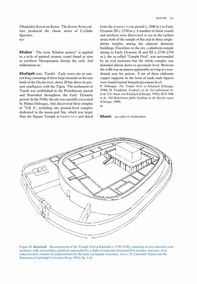
from the JEMDET NASR period (c.3200 BC) to Early
Dynastic III (c.2350 BC). A number of ritual vessels
and artefacts were discovered in situ in the earliest
strata both of the temple of Sin and in three single-
shrine temples among the adjacent domestic
buildings. Elsewhere in the city, a platform-temple
dating to Early Dynastic II and III (c.2750–2350
BC), the so-called ‘Temple Oval’, was surrounded
by an oval enclosure but the whole complex was
denuded almost down to pavement level. Between
the walls was an annexe apparently serving as a resi-
dential area for priests. A set of three elaborate
copper supports in the form of nude male figures
were found buried beneath pavement level.P. Delougaz: The Temple Oval at Khafajah (Chicago,
1940); H. Frankfort: Sculpture of the 3rd millennium BC
from Tell Asmar and Khafajeh (Chicago, 1942); H.D. Hill
et al.: Old Babylonian public buildings in the Diyala region(Chicago, 1990).
IS
Khami see GREAT ZIMBABWE
Dhaskaleio Kavos on Keros. The Keros-Syros cul-
ture produced the classic series of Cycladic
figurines.
RJA
Khabur The term ‘Khabur pottery’ is applied
to a style of painted ceramic vessel found at sites
in northern Mesopotamia during the early 2nd
millennium BC.
Khafajeh (anc. Tutub) Early town-site in east-
ern Iraq consisting of three large mounds on the east
bank of the Diyala river, about 20 km above its pre-
sent confluence with the Tigris. The settlement of
Tutub was established in the Protoliterate period
and flourished throughout the Early Dynastic
period. In the 1930s, the site was carefully excavated
by Pinhas Delougaz, who discovered three temples
in ‘Tell A’, including one ground-level complex
dedicated to the moon-god Sin, which was larger
than the Square Temple at ESHNUNNA and dated
333KHAMI
Figure 26 Khafajeh Reconstruction of the Temple Oval at Khafajeh (c.2750–2350), consisting of two concentric oval
enclosure walls surrounding a platform approached by a flight of steps and surmounted by an inner sanctuary of an
unknown deity (tentatively indicated here by the inner rectangular structure). Source: H. Crawford: Sumer and the
Sumerians (Cambridge University Press, 1991), fig. 4.16.

Mesolithic are often described as ‘midden settle-
ments’, due to the accumulation of human debris
but lack of permanent dwellings. The ready avail-
ability of game and fish appears to have facilitated a
sedentary lifestyle without agriculture. Apart from
the burials within the Early Khartoum settlement-
site no Khartoum Mesolithic cemeteries have yet
been found. Adams (1984: 112) has pointed out that
the precocious appearance of pottery-production
seems to be a typical instance of North African cul-
tures’ tendency to absorb technological innovations
without accepting their ecological concomitants.
The development of the Khartoum Mesolithic is
effectively the reverse process to that of the
Levantine PRE-POTTERY NEOLITHIC, in which
domestication preceded ceramics.A.J. Arkell: Early Khartoum (London, 1949); W.Y.
Adams: Nubia: corridor to Africa, 2nd edn (Princeton,
1984), 110–12.
IS
Khartoum Neolithic By the early 4th millen-
nium BC the KHARTOUM MESOLITHIC of Central
Sudan was gradually being superseded by the
Khartoum Neolithic (c.4000–3000 BC), initially
described by A.J. Arkell as the Shaheinab culture,
after its original type-site el-Shaheinab. There are
similarities between the Khartoum Neolithic
material remains and those of the ‘Khartoum
Variant’ sites in southern Lower Nubia (Shiner
1968). The pottery of the Khartoum Neolithic was
closely related to that of the Mesolithic (being
decorated with ‘dotted wavy-line’ motifs rather
than the simple wavy lines of the Mesolithic). The
Khartoum Neolithic communities also continued to
employ a similar repertoire of microlithic tools for
fishing and hunting, but their subsistence pattern
was characterized by one major development:
faunal evidence of the domestication of animals
(usually goat). See also KADERO.A.J. Arkell: Shaheinab (London, 1953); C.M. McBurney:
The Stone Age of northern Africa (Harmondsworth, 1960),
244; J. Shiner: ‘The Khartoum Variant industry’, The pre-history of Nubia II, ed. F. Wendorf (Dallas, 1968), 768–90;
H. Nordström: Neolithic and A-Group sites (Stockholm,
1972), 136–9, 212–20; F. Hassan, ‘Chronology of the
Khartoum “Mesolithic” and “Neolithic” and related sites
in the Sudan: statistical analysis and comparisons with
Egypt’, AAR 4 (1986), 83–102.
IS
Khartoum Variant (c.4000–3000 BC) seeKHARTOUM NEOLITHIC
Khao Chang Ngam Rock-art site in northeast
Thailand which includes a well-known scene of a
row of men, women and children with a dog, with
one man firing an arrow. These painted scenes are
related to a series of rock-art sites in the region. No
dating evidence has yet been obtained, but a pre-
historic context is highly likely.P. Charoenwongsa et al.: An inventory of rock art sites innortheast Thailand (Bangkok, 1985).
CH
Khao Wong Prachan Valley Region of
central Thailand that was the focus of intensive
mining, smelting and casting of copper ore from
1500 to 300 BC. The ore was extracted from mines,
crushed and sorted, and smelted in bowl crucibles.
Ingots, projectile points and socketed axe heads
were among the objects cast, the metal being a nat-
urally high-arsenic copper. No evidence for alloying
with tin has been found. There is also early evidence
for iron forging, dating to c.600 BC.A. Bennet: ‘The contribution of metallurgical studies to
Southeast Asian archaeology’, WA 20/3 (1989), 329–51.
CH
Kharga Oasis The southernmost and largest of
the major Egyptian oases, located in the Libyan
Desert about 175 km west of Luxor. Traces of
Middle Palaeolithic (MOUSTERIAN) occupation
were discovered by Gertrude Caton-Thompson
(1952). In the pharaonic period, strong links appear
to have been established with the Egyptian culture
in the Nile valley, but most of the surviving archi-
tectural remains of settlements, temples and
cemeteries date from the Ptolemaic period onwards.G. Caton-Thompson: Kharga Oasis in prehistory (London,
1952); L. Giddy: Egyptian oases: Bahariya, Dakhla,Farafra and Kharga during pharaonic times (Warminster,
1987), passim.
IS
Khartoum Mesolithic The Khartoum Meso-
lithic (initially known as the Early Khartoum
culture, after its typesite) was widespread in the
Khartoum and Shendi areas of the Nile Valley from
c.6000 to 3500 BC. First recognized by A.J. Arkell,
it is characterized by evidence for a hunting and
fishing subsistence pattern highly adapted to the
riverine environment. The material culture
includes microlithic tools and hand-made ‘wavy-
line’ globular ceramics (decorated with fish-bones
or rocker-stamps), but there is no indication
of plant or animal domestication. The semi-
permanent encampments of the Khartoum
334 KHAO CHANG NGAM

Siam in Thailand. After several small excavations,
a major research programme took place in 1985
under the direction of Charles Higham and
Rachanie Thosarat Bannanurag. This included
excavation, flotation of a sample of all contexts and
coring for sediment and pollen analysis. It was
found that the site had been occupied between 2000
and 1500 BC. The excavations of 1985 encountered
a sequence which began with industrial and occu-
pation remains, then involved a cemetery, and
finally reverted to a pottery-making area.
A remarkable feature of the cemetery was the
pace with which the deposits accumulated. Within
four centuries, the mound rose by 6 m. The
cemetery pattern reveals that groups of individuals
were laid out in clusters on a chequer-board pattern;
as time went by, the dead were eventually buried
above their ancestors. Two such groups have been
traced through about 20 generations.C.F.W. Higham et al.: ‘Human biology, environment and
ritual at Khok Phanom Di’, WA 24/1 (1992), 35–54;
C.F.W. Higham and R. Bannanurag: The excavation ofKhok Phanom Di, a prehistoric site in central Thailand I: Theexcavation, chronology and human burials (London, 1990).
CH
Khok Phlap Cemetery site located west of the
Chao Phraya River in central Thailand. The site
was formerly located on or near the coast.
Excavations there by Sod Daeng-iet encountered a
cemetery in which people were inhumed in associ-
ation with pottery vessels, shellfish remains and
stone, bronze and turtleshell jewellery. Although
not scientifically dated, the typology of the artefacts
suggest that the site belongs to the 1st century BC.S. Daeng-iet: ‘Khok Phlap: a newly discovered prehistoric
site’, Muang Boran 4/4 (1978) 17–26.
CH
Khor Musa see KHORMUSAN
Khormusan Final Lower Nubian and Upper
Egyptian lithic tradition of the Middle Palaeolithic
period, named after Khor Musa (near Wadi Halfa
in the northern Sudan) where the first Khormusan
assemblage was identified at site 1017. Dating from
about 45,000 to 15,000 BC, it is roughly con-
temporary with the Dabban industry (see HAUA
FTEAH). The typical Khormusan site comprises an
area of debris close to the Nile, covering several
thousand square metres and consisting of numerous
clusters of artefacts around hearths (i.e. small
encampments rather than continuous stretches of
Khirbet Kerak (Beth Yerah) One of the largest
tell-sites in the Levant, situated immediately to the
southwest of Lake Tiberias, 35 km east of Haifa. It
was excavated between 1944 and 1964, revealing 23
strata dating from the end of the Chalcolithic period
(c.3200 BC) to the 5th century AD, when it became
the site of a Byzantine church. Khirbet Kerak
gave its name to an important Early Bronze Age cul-
ture of the 3rd millennium BC in Syria-Palestine
which appears to have been a Levantine version of
the EARLY TRANSCAUCASIAN CULTURE in
Anatolia. The Khirbet Kerak culture, roughly con-
temporary with the Early Dynastic phase in SUMER,
is particularly characterized by red and red-and-
black burnished pottery often decorated with
geometrical motifs. Extensive traces of Khirbet
Kerak ware have survived at other sites in the
Levant, including JERICHO, BETH SHAN, Tell
Judeida and UGARIT.R.B.K. Amiran: ‘Connections between Anatolia and
Palestine in the Early Bronze Age’, IEJ 2 (1952), 89–103;
B. Maisler, M. Stekelis and M. Avi-Jonah: ‘The excava-
tions at Beth Yerah (Khirbet el-Kerak)’, IEJ 2 (1952),
165–73, 218–29.
IS
Khmer see ANGKOR; BAN TAMYAE; KOH KER;
LOPBURI; PHIMAI
Khoisan see AFRICA 4
Khok Charoen Cemetery of 44 extended inhu-
mation buria ls, located in the Pa Sak valley, a
tributary of the Chao Phraya River in central
Thailand. When excavated by Watson and Loofs-
Wissowa in 1966–7, the site yielded grave-goods
such as pottery vessels, marine shell jewellery and
stone adzeheads; no copper-based artefacts were
found. The considerable variation in the quantity of
goods deposited with individual burials may
indicate some ranking, or at least differential per-
sonal achievement. Two thermoluminescence dates
of 1180 and 1080 BC have been derived from
the mortuary pottery, but when compared to
the pottery typology these seem too late by
500–1000 years.W. Watson: ‘Khok Charoen and the early metal age of
Central Thailand’, Early South East Asia, ed. R.B. Smith
and W. Watson (Oxford 1979), 53–62.
CH
Khok Phanom Di Large settlement (5 ha) and
cemetery site dated to c.2000–1500 BC, located on a
former shoreline now about 24 km from the Gulf of
335KHORMUSAN

Frankfort, T. Jacobsen and C.B. Altmann: Khorsabad, 2
vols (Chicago, 1936–8); A. Poebel: ‘The Assyrian king list
from Khorsabad’, JNES 1 (1942), 247–306; T.A. Busink:
‘La Zikkurat de Dur-Sarukin’, Comptes rendus de latroisième rencontre Assyriologique internationale (Leiden,
1954), 105–22; H. Frankfort: The art and architecture of theancient Orient, 4th edn (Harmondsworth, 1970), 143–54,
170–4, Figs 196–9.
IS
Kiet Siel see ANASAZI
Kiik-Koba Oldest Palaeolithic cave-site in the
Crimea (Ukraine), situated in the valley of the river
Zuya, 25 km east of Simferopol. The sequence, dis-
covered and excavated in the 1930s by G.A.
Bonch-Osmolovsky, included two MOUSTERIAN
occupation levels. the upper level included an arti-
ficial enclosure made of large cobbles, and two
burials of NEANDERTHALS – one adult and one
child (5–8 months old). The bodies had been laid
close to each other in contracted postures.G.A. Bonch-Osmolovsky: ‘Itogi izhučcenija krymskogo
paleolita’ [Results of studies of the Crimean Palaeolithic],
Transactions of the INQUA Conference, vol. vi (Moscow,
1934), 114–83.
PD
Kili Ghul Muhammad see QUETTA
Kilwa see SWAHILI HARBOUR TOWNS
Kinsei Late/Final Jomon settlement in
Yamanashi prefecture, Japan (c.2500–300 BC).
Thirty-five buildings including a row of Final
Jomon stone-paved houses were associated with a
series of adjoining circular and rectangular stone
burial cists interspersed with phallic standing
stones and ritual deposits of juvenile wild boar and
religious artefacts.T. Niitsu and Y. Yamaki: Kinsei iseki II [The Kinsei site
II] (Kofu, 1989).
SK
Kintampo Village in Central Ghana which has
given its name to the ‘Kintampo culture’, first
identified by Oliver Davies. The culture is known
from both open-air and rockshelter sites, as at
Ntereso and Kintampo respectively, and it is
characterized by the following elements: stone rasps
(described by Davies as ‘terracotta cigars’), polished
stone axes and arm rings, grooved abrading stones
and grinding stones, comb-stamped pottery, and
settlement). The toolkit virtually always consists of
LEVALLOIS flakes and cores, burins and denticu-
lates, with a wide diversity of tool-sizes, while the
surviving organic remains suggest that food-
sources ranged from catfish to wild cattle, gazelles,
antelopes and hippopotami.A.E. Marks: ‘The Khormusan: an Upper Pleistocene
industry in Sudanese Nubia’, The Prehistory of Nubia I, ed.
F. Wendorf (Dallas, 1968), 315–91; M.A. Hoffman: Egyptbefore the pharaohs (New York, 1979), 70–7.
IS
Khorsabad (anc. Dur-Sharrukin) Tell-site of
one of the most important cities of the Assyrian
empire, located in northern Iraq, 24 km northeast of
Mosul. It was a new capital founded by Sargon II
(c.721–705 BC) on a virgin site, apparently built in
less than ten years. But its duration as capital was
even briefer than that of its Egyptian counterpart,
the city of Akhetaten at EL-AMARNA; in 704 BC
Sargon’s city was abandoned in favour of NINEVEH
by his successor Sennacherib after Sargon had been
killed in battle. Unlike el-Amarna, however, the
settlement continued to be occupied for almost a
century after it had fallen out of royal favour, until
its destruction at the end of the Assyrian empire in
612 BC. The principal elements of the main citadel
at Dur-Sharrukin, constructed on a terrace about
16 m in height at the northern corner of the city,
were a seven-stage ziggurat with each storey
originally painted a different colour, the palace of
Sargon (decorated with frescoes, painted reliefs and
glazed bricks), the palace of his brother Sinahusur,
and the temple of Nabu (linked to the main palace
by a stone viaduct). ‘Palace F’, in the southwestern
corner of the city, incorporates a form of BIT-
HILANI (a type of pillared building), perhaps
deliberately borrowing from Aramaean architecture
in Syria; it was used as an arsenal for storage of
weapons and booty, as at Nineveh and NIMRUD.
The site was excavated in 1843–4 by Paul-Emile
Botta, who transported some of the LAMASSU
(colossal statues of winged bulls) from the palace
gateways to Paris, where they were the first sub-
stantial Mesopotamian sculptures to be displayed in
a European museum. Unfortunately many other
statuary and reliefs from Khorsabad were lost in the
Tigris while in transit for France. The site was also
excavated by Victor Place in 1851–5, and in 1930–5
Gordon Loud discovered a new king-list (Poebel
1942) and uncovered large areas of temples and
houses which had escaped Botta’s notice.P.E. Botta and E. Flandin: Les monuments de Ninive, 5 vols
(Paris, 1849–50); M. Pillet: Khorsabad: les découvertes deVictor Place en Assyrie (Paris, 1918); G. Loud, H.
336 KHORMUSAN

the Flood. First identified in 1873, the site was ex-
cavated by Henri de Genouillac in 1912 and by an
Anglo-American expedition between 1923 and
1933. There are strata dating to the UBAID and
URUK periods, but the main occupation dates to the
JEMDET NASR and Early Dynastic periods
(c.3200–2350 BC).
The site includes one of the earliest known
Mesopotamian ‘palaces’ (Moorey 1964) as well as a
number of cemeteries of the Early Dynastic period.
Cemetery Y includes several ‘cart burials’, which
were at first identified as the ‘chariot burials’ of
Sumerian ‘princes’ (Langdon and Watelin 1934).
There are probably seven such graves, each
originally containing several human bodies in asso-
ciation with a large wheeled vehicle drawn by a
bovid. The dating and significance of the cemetery
are both subjects of some debate, but the latest evi-
dence suggests that they are the burials of non-royal
individuals of the ED II phase (Moorey 1978).
There are also substantial neo-Babylonian and
Sasanian remains.S. Langdon and C. Watelin: Excavations at Kish, 3 vols
(Paris, 1924–34); P.R.S. Moorey: ‘The “plano-convex
building” at Kish and early Mesopotamian palaces’, Iraq26 (1964), 83–98; McG. Gibson: City and area of Kish(Miami, 1972); ––––: The Oxford–Chicago excavations atKish (1923–33) (Oxford, 1978).
IS
kitchen midden, shell midden Term used
in a general sense to describe an archaeological
deposit formed largely of refuse from food prepara-
tion and, in a more particular sense, to describe large
mounds of shells (with associated cultural debris)
found at some coastal sites. Examples of the latter
include the ASTURIAN complex in northern Spain
and the ERTEBØLLE culture in Denmark and
Scandinavia. Another group is located at the mouth
of the Tagus in Portugal. While shell middens are a
particular feature of Mesolithic Atlantic economies,
they also exist in the Mediterranean – for example,
Île de Riou in the bay of Marseilles has impressive
limpet middens perhaps dating from 6000–5000 BC.
The site is associated with very early Neolithic pot-
tery and querns, which suggests that shellfish
remained part of some local economies even after
elements of farming systems were adopted.
Recent studies of shell middens have tended to
stress that although they often form the most
impressive physical evidence of a hunting-
gathering economy, in overall nutritional terms
they may only form a minor or seasonal part of
a much more complicated foraging strategy.
Even where marine resources underpinned a
burnt daub with wooden pole and/or thatch im-
pressions. Kintampo 6 rockshelter, excavated by
Colin Flight in 1967–8 (60 sq. m) and by Ann B.
Stahl in 1982 (3 sq. m), has provided a particularly
important stratigraphic sequence, in which the
Kintampo culture was preceded by a so-called
‘Punpun phase’. Flight emphasized the distinction
between the two. In his view, the Kintampo culture
alone was characterized by a food producing econ-
omy, and he regarded it as intrusive to the area. By
contrast, Stahl points out that in the portion of the
site excavated by her there was a stratigraphic over-
lap between Punpun and Kintampo pottery, and
she also believes that there was no decisive eco-
nomic break between the two cultures. The
Kintampo culture alone had domestic goats and/or
sheep, but in Stahl’s view the bones earlier identi-
fied as domestic cattle may have belonged to forest
buffalo. Elaeis guineensis, Canarium schweinfurthii,and Celtis sp. occur throughout the sequence, as do
legume-like seeds earlier identified by Flight as cul-
tivated cowpeas (Vigna unguiculata).
Stahl therefore proposes an alternative model for
the origins of food production in the area and the
Kintampo culture, whereby an indigenous Late
Stone Age population interacted with an incoming
one to produce a distinctive local adaptation based
on a fusion of autochthonous and exotic traits.
There was a progressive introduction of diagnosti-
cally Kintampo elements, and the development of
a ‘garden hunting’ economy. A set of 18 radio-
carbon dates from six sites with Kintampo and/or
Punpun occupations span the period from 3700 to
2770 BP.C. Flight: ‘The Kintampo culture and its place in the eco-
nomic prehistory of West Africa’, Origins of African plantdomestication, ed. J.R. Harlan et al. (The Hague/Paris,
1976), 211–21; A.B. Stahl: ‘Reinvestigation of Kintampo
6 rock shelter, Ghana: implications for the nature of cul-
ture change’, AAR 3 (1985), 117–50.
PA-J
Kisalian see AFRICA 5
Kish (Tell el-Uhaimir, Tell Ingharra, Tell el-
Khazna and Tell el-Bender) One of the most
important SUMERIAN cities, surviving in the form
of a group of mounds covering an area of some four
square kilometres in southern Iraq, about 20 km to
the east of BABYLON. The rulers appear to have
exercised some kind of hegemony over the other
towns of the Early Dynastic period (c.2900–2350
BC); according to the Sumerian King List, the king-
ship was lowered down from heaven to Kish after
337KITCHEN MIDDEN, SHELL MIDDEN

tion of deposits to the right of Cave 1, including
human occupational debris, against the cliff, in
what is referred to as Shelter 1A. Cave 1C is a small
cavern devoid of human occupation, to the right of
Cave 1, and buried by the deposits of Shelter 1A.
Shelter 1B lies to the left of Cave 1, separated by a
spur of rock.
The sites were first excavated by Singer and
Wymer in 1967 and 1968, and subsequently in
1984–6 by H.J. Deacon, for the purpose of recover-
ing environmental data and samples for a range of
dating techniques. The combined main site sedi-
ments (16 m) contain a long sequence of MSA
(Middle Stone Age) occupations designated MSA
I, MSA II, HOWIESON’S POORT, and MSA III,
which has become the standard reference for the
MSA in the southern part of South Africa. On a
combination of dating techniques and environmen-
tal data the MSA I material dates to before
110,000 uncal BP and MSA II material to
c.90,000–c.70,000 uncal BP. Howieson’s Poort is less
clearly dated to a span of several thousand years
around 70,000 uncal BP. ANATOMICALLY MODERN
HUMAN remains are associated with MSA I and
MSA II in cave 1, shelter 1A, and shelter 1B.R. Singer and J. Wymer: The Middle Stone Age at KlasiesRiver Mouth in South Africa (Chicago, 1982); H.J. Deacon:
‘Late Pleistocene palaeoecology and archaeology in the
southern Cape, South Africa’, The human revolution, ed.
P. Mellars and C. Stringer (Edinburgh, 1989), 547–64.
RI
Kleinaspergle (Klein Aspergle, Kleiner Asperg)
Massive rounded tumulus (8 m high and 60 m in
diameter) covering the richest of the Iron Age
‘princely graves’ that lie at the foot of the hillfort of
Hohenasperg in Baden-Württemberg, Germany.
Unlike most of the princely tumuli associated
with major hillforts, Kleinaspergle is dated to the
La Tène A period, rather than the earlier Hallstatt
D period. (The settlement at Hohenasperg has
never been properly excavated because it is over-
lain by a medieval castle, but was presumably
still in use at the time of the Kleinaspergle in-
terment.) When the tomb was partially excavated in
1879 the main chamber was found to have been
robbed in antiquity, but a secondary chamber con-
tained a series of exotic imports and artefacts of
Celtic manufacture in a fully developed ‘Early
La Tène’ style (see LA TÈNE). The imports, an
Etruscan stamnos and Attic red-figure ware with
locally added gold mounts, securely date the tomb
to the second half of the 5th century BC (perhaps
430/20 BC). The Celtic items reveal the influence
hunter-gatherer economy, sea-bird catching, egg-
collecting and fishing may have been more
important components in terms of their nutritional
value. At the same time, at some sites shellfish may
have represented a crucial ‘stand-by’ resource at
times of the year when other resources were very
limited (see also FORAGING THEORY and NAMU).C. Bonsall, ed.: The Mesolithic in Europe (Edinburgh,
1985).
RJA
kiva Type of ceremonial structure found at
PUEBLO sites in the southwestern region of North
America, c.AD 1–1540. Kivas are usually at least
partly subterranean and shapes vary, with curvi-
linear forms (e.g. circular, D-shaped and
keyhole-shaped) being particularly characteristic of
ANASAZI settlements (e.g. PUEBLO BONITO). The
largest kivas (known as ‘great kivas’) probably
served as the ceremonial centres for whole commu-
nities; these can be up to 10 m in diameter.
IS
Kivik The reconstructed rectangular chamber
under this round tumulus of the late 2nd millen-
nium BC, located in Skåne in Sweden, is lined with
a unique corpus of Bronze Age decorated slabs. The
slabs present a series of scenes and motifs (boats,
axes, spoked wheels) related to contemporary rock
art, but more carefully arranged into horizontal
zones. The most striking scenes show a charioteer –
the earliest depiction of such in northern European
art – moving behind four warriors, and a scene in
which eight robed figures stand on either side of
what may be an altar. The engravings may relate to
the funerary rites of the entombed. The tomb was
in a poor condition before its investigation, and the
small amount of associated material does not allow
for a precise dating.C.-A. Moberg: Kiviksgraven (Stockholm, 1975); K. Barup
et al.: Kivik (1977); N. Sandars: Prehistoric art in Europe(London, 1985; 1st edn 1968), 286–8.
RJA
Klasies River Mouth Caves A number of
caves and rockshelters with evidence of prehistoric
occupation, situated along a short stretch of coast,
close to the mouth of the Klasies River, 84 km west
of Port Elizabeth, South Africa. Five of these form
a cluster referred to as the main site. Cave 1 is a sea-
cut cave at about 6–8 m above sea level. Cave 2 is
situated in the cliff above, at 18–20 m above sea
level and was made accessible by a huge accumula-
338 KITCHEN MIDDEN, SHELL MIDDEN
painting. Themes include formal processions and
religious festivals, athletes somersaulting over
bulls, dancing girls, pictures of animals (monkeys,
cats, deer) within landscapes, marine scenes (flying
fish etc) and decorative schemes based around
banding and floral motifs. The style is flexible,
naturalistic and full of life; later examples are more
monumental and rigid and betray Mycenaean
influence.A.J. Evans: Palace of Minos at Knossos (London, 1921–36);
M. Ventris and J. Chadwick: Documents in MycenaeanGreek (Cambridge, 1973); G. Cadogan: Palaces of MinoanCrete (London, 1976); M.S.F. Hood and D. Smyth:
Archaeological survey of the Knossos area (London, 1981);
J.W. Graham: The palaces of Crete (Princeton, 1987); R.
Hägg and N. Marinatos: The function of the Minoan palaces(Stockholm, 1987); P. Halstead: ‘On redistribution and
the origin of the Minoan-Mycenaean palatial economies’
Problems in Greek prehistory, ed. E.B. Frence and K.A.
Wardle (Bristol, 1988), 519–30; J.W. Myers et al.: Theaerial atlas of ancient Crete (London, 1992).
RJA
Knowth One of three giant Neolithic PASSAGE
GRAVES in the famous BOYNE VALLEY group,
Knowth was excavated from 1960 by George Eogan
and probably dates from the end of the 4th millen-
nium BC. The conical mound has an oval
groundplan (80 × 90 m) and covers two opposed
megalithic passage-graves: Knowth East (40 m long
with an elaborate cruciform and corbelled chamber)
and West (24 m long). Like nearby NEWGRANGE,
the external perimeter of the mound was lined with
kerbstones (127). Knowth also produced one of the
finest examples of Neolithic decorative art: a flint
macehead delicately carved with spirals and faceted
lozenges.G. Eogan: Knowth and the passage-tombs of Ireland(London, 1986)
RJA
Kobadi see AFRICA 2
Kobystan see CIS AND THE BALTIC STATES
Kodiak tradition Tradition known from the
Pacific Eskimo region around Kodiak Island in
southwestern Alaska, where it replaced the Ocean
Bay tradition around 2500 BC. It is characterized by
a wide variety of polished slate implements. The
period from 1500 BC to AD 1000 is known as
the Kachemak stage of the Kodiak tradition, and
is distinguished by an increasingly elaborate
material culture. The introduction of aspects of
of the Mediterranean world, and include a flagon in
the Etruscan-influenced high-shouldered beaked
form – paralleled in the classic flagons from Basse-
Yutz – as well a series of gold mountings and a
plaque; two drinking horn ends strongly suggest
Scythian influence.W. Kimmig: ‘Klein Aspergle’, Trésors des princes Celtes,eds. J.P. Mohen et al., exh. cat. (Paris, 1987), 255–64;
––––: Das Kleinaspergle (Stuttgart, 1988).
RJA
k-means see CLUSTER ANALYSIS
Knossos Foremost palace complex of the
MINOAN culture of Crete, excavated by Arthur
Evans in (principally) 1921–35. The material from
Knossos allowed Evans to divide the Minoan
chronology into three main phases: Early, Middle
and Late. The site was first occupied during the
Neolithic period, from the 7th millennium BC
onwards. After a little-understood formative Early
Minoan period, a substantial palace was built
around 2000 BC; this was surrounded by a town but
excavations of this and later phases have concen-
trated on the palace and only a few Knossos
townhouses have been excavated. This first palace
seems to have been destroyed by an earthquake in
around 1700 BC. The grandest palace was then con-
structed, and continued in use until the
14th century BC – significantly after the massive
volcanic explosion on the island of Santorini once
thought to have precipitated Knossos’s destruction
(see THERA). It seems clear that from 1700 BC, at
least, Knossos was the pre-eminent settlement on
Crete, but the nature of its relations with other
palace sites is still debated. In the final years before
its destruction Knossos may have been controlled
by princes of the MYCENAEAN civilization that had
arisen on the Greek mainland.
The palace consists of a central court sur-
rounded by suites of ceremonial rooms and storage
and work rooms. The complex was built on two (or
even three) storeys; the upper floors were of mud-
brick laced with timber, possibly to strengthen
them against tremors and earthquakes. The design
displays sophisticated architectural features such
as light wells, stone-lined drainage channels
and clay piping, dressed stone colonnades and
plastered interior walls. The rooms included stor-
age magazines, royal reception rooms and shrines.
Certain rooms are decorated with elaborate wall-
paintings, the surviving examples of which mostly
date from about 1550 BC onwards. Knossos and
Thera provide the principal examples of Minoan
339KODIAK TRADITION

east end of a plaza, an arc-shaped village surround-
ing the plaza, and a number of smaller mounds
located both inside and outside the village. Mound
A measures 60 × 100 m at the base and is 17 m high.
Several of the smaller mounds contained evidence
of elaborate mortuary events involving the burial of
high status individuals. The village occupation and
most mound construction date to between AD 300
and 500.W. Sears: Excavations at Kolomoki: final report (Athens,
GA, 1956); J. Bense: Archaeology of the SoutheasternUnited States: Paleoindian to World War I (New York,
1994), 170–5.
RJE
Kolo rock paintings The most important col-
lection of hunter-gatherer art in eastern Africa,
located in the Kondoa district of north-central
Tanzania. While the finest concentration is on a
series of rock-shelters around Kolo (on the escarp-
ment overlooking the Maasai Steppe), their
distribution is much broader, extending from
Kondoa into districts to west and northwest. Most
of the painted rock-shelters were occupied on
several occasions, and some of them possess deep
sequences of Late Stone Age deposits spread over
several millennia. Rarely however is it possible to
correlate individual layers with particular paintings,
therefore archaeologists’ aspirations of employing
the evidence of the paintings, alongside the exca-
vated bones and lithics, to illustrate the succession
of cultures and economies of Late Stone Age
hunter-gatherers have been frustrated except in a
general way. Attempts have been made to re-
construct a sequence of painting styles, especially
by noting superpositions; but the results seem to be
of limited validity.H.A. Fosbrooke, L.S.B. Leakey et al.: Tanganyika Notesand Records 29 (1950), 1–61; M.D. Leakey: Africa’s van-ishing art (London, 1983).
JS
kom see TELL
Kom el-Ahmar see HIERAKONPOLIS
Kom Medinet Ghurob see GUROB
Kom Ombo (anc. Ombos) Egyptian stone-built
temple and settlement site located 40 km north of
Aswan, with surviving structural remains dating
from at least as early as the 18th dynasty
(c.1550–1070 BC). There are also a number of
THULE culture from northern Alaska by AD 1000
marked the end of the Kodiak tradition.D.E. Dumond: The Eskimos and Aleuts (London, 1987).
RP
Kofun period (AD 300–710) see JAPAN 4
Koh Ker Court centre of Jayavarman IV
(AD 928–942), located 80 km northeast of ANGKOR.
Founded as a rival to Angkor, then under the con-
trol of Harsavarman I and Isanavarman II,
Jayavarman IV was responsible for the construction
of Prasat Thom, one of the largest temple mausolea
known from the Angkorean period. It was associ-
ated with a large reservoir and a range of secular
buildings, which matches the usual configuration of
a cult centre of this period. The art style, particu-
larly on the stone lintels, represents a number of
innovations giving rise to the so-called Koh-Ker
style.L.P. Briggs: ‘The ancient Khmer empire’, TAPS 4/1
(1951), 1–295.
CH
Kojiki One of the two earliest surviving chroni-
cles of Japan, compiled under the Ritsuryo state as
part of the legitimization of the ruling dynasty
(the other being the Nihon Shoki). The Kojiki
was compiled in AD 712 and consists primarily of a
brief mythology and genealogical lists. Both the
Kojiki and the Nihon Shoki were based on earlier,
non-extant texts, the Teiki and Kyuji, and supple-
mented by four later works (together with which
they comprised the Six Ancient Histories). They
provide important documentary evidence for the
Kofun period (see JAPAN 4).D.L. Philippi, trans.: Kojiki (Tokyo and Princeton, 1968).
SK
Kolmogorov-Smirnov test see GOODNESS-
OF-FIT
Kolomiishchina (Kolomiiscina) seeTRIPOLYE
Kolomoki North American site, covering some
150 ha in the Chattahoochee River valley of south-
western Georgia, at which the primary occupation
is characteristic of the Weeden Island culture
(found along the Gulf Coastal Plain in the Late
WOODLAND period). Kolomoki consists of a large,
rectangular PLATFORM-MOUND (Mound A) at the
340 KODIAK TRADITION

able cultural continuity, and seem quite different to
the other Acheulean assemblages of central and
western Europe: choppers are common, handaxes
are atypical, and there is an early development of the
LEVALLOIS TECHNIQUE.V.N. Gladilin: Problemy rannego paleolita vostočnoi Evropy[The problems of the early Palaeolithic in Eastern Europe]
(Kiev 1976).
PD
Körös culture see STARČEVO (STARČEVO-
KÖRÖS-CRIŞ) CULTURE
Kostenki-Borshevo Group of Upper Palaeo-
lithic open-air sites situated in the valley of the
River Don, 40 km south of the town of Voronezh,
in central Russia. Discovered by I.S. Polyakov in
1879, the sites have been excavated since the 1920s
by P.P. Efimenko, and later by N.D. Praslov and
others. There are 24 sites in the group, 10 of which
are multi-layered. At the oldest sites, two distinct
cultural traditions are recognizable: the Streletzkian
and Spitzinian. The Streletskian, characterized by
archaic MOUSTERIAN-like tools, side-scrapers and
laurel-leaf points, is represented at sites such as
Kostenki 1, stratum 5; Kostenki 6, stratum 5;
Kostenki 12, stratum 3. In the latter case, charcoal
from stratum 1a (i.e. the layer considerably above
the Streletskian level) has been radiocarbon dated
to 34700 ± 700 BP (GrN 7758). The fauna
included horse, mammoth, reindeer, wolf, red deer,
rhinoceros and polar fox.
Upper Palaeolithic sites scattered over the sur-
rounding region (see SEBILIAN). The Ptolemaic and
Roman temple, cleared by Jacques de Morgan in
1893, is an unusual structure divided into two
halves, with one dedicated to the crocodile-god
Sobek and the other to the hawk-god Haroeris.J. de Morgan et al.: Kom Ombos, 2 vols (Vienna, 1909).
IS
Kom el-Shuqafa see ALEXANDRIA
Kondoa see KOLO ROCK PAINTINGS
Koobi Fora see EAST TURKANA
Koptos (Qift, anc. Kebet) Egyptian site located
on the east bank of the Nile about 40 km north of
Luxor. The surviving settlement remains at Koptos
date back to the beginning of the historical period
(c.3000 BC), including three colossal limestone
statues of the local fertility god Min and various
other items of ‘preformal’ sculpture, which were
excavated by Flinders Petrie in an Early Dynastic
context at the temple of Min. The upstanding
remains of the temple date mainly to the New
Kingdom and later (for a description of preformal
art at Koptos and other Early Dynastic Egyptian
sites see Kemp 1989: 64–91). To the east of the main
city site there are cemeteries dating to the late pre-
dynastic period (c.3300–3000 BC), when NAQADA,
situated almost opposite Koptos on the west bank,
was the dominant town in the region. The Greek
and Roman remains at Koptos have been studied by
Claude Traunecker and Laure Pantalacci (1989).W.M.F. Petrie: Koptos (London, 1896). A.J. Reinach:
Rapports sur les fouilles de Koptos (Paris, 1910); B.J. Kemp:
Ancient Egypt: anatomy of a civilization (London, 1989);
C. Traunecker and L. Pantalacci: ‘Le temple d’Isi à El
Qual’a près de Coptos’, Akten München 1985 3, ed.: S.
Schoske (Hamburg, 1989), 201–10.
IS
Korolevo Stratified Palaeolithic site, situated on
the high terrace of the Tisza river, in the
Transcarpathian region of the Western Ukraine
near the Hungarian border. The site was discovered
in 1974 by V.N. Gladilin and comprises 14 levels,
including seven ACHEULEAN and six MOUSTERIAN
strata; the upper stratum allegedly belongs to an
early stage of the Upper Palaeolithic. The archaeo-
logical deposits range in date from the
Günz-Mindel interglacial to the Early Würm. The
five Acheulean levels at Korolevo show consider-
341KOSTENKI-BORSHEVO
Figure 27 Kostenki-Borshevo Upper Palaeolithic
‘Venus figurine’ from Kostenki-Borshevo, central
Russia. Source: A. Velichko (ed.): Arheolojia ipaleogeografija pozdnego paleolita russkoi rauniny(Moscow: Nauka, 1981).

Borševskogo raiona na Donu [The Palaeolithic of the
Kostenki-Borshevo area on the Don] (Leningrad, 1982).
PD
Koster North American prehistoric site located
on thick alluvial and colluvial deposits along the
eastern edge of the lower Illinois River in Greene
County, Illinois. Large-scale excavations con-
ducted during the 1970s revealed that these
deposits contained at least 23 stratigraphically dis-
tinct cultural horizons dating from the Early
Archaic to the Late Prehistoric periods (8000
BC–AD 1000). Investigation of these deposits
yielded a continuous record of Holocene soil for-
mation, deposition, and human occupation in west
central Illinois. Of particular importance is the late
Middle Archaic Helton phase dating from c.3800 to
2900 BC. Analysis of cultural materials from the
Helton-phase occupation zones has provided
important new insights on trends toward sedentism
during the mid-Holocene.T. Cook: Koster: an artifact analysis of two Archaic phasesin West Central Illinois (Evanston, 1976); J. Brown and R.
Vierra: ‘What happened in the Middle Archaic?
Introduction to an ecological approach to Koster Site
archaeology’, Archaic hunters and gatherers in the AmericanMidwest, ed. J. Phillips and J. Brown (New York, 1983),
165–95; E. Hajic: Koster Site archaeology I: stratigraphyand landscape evolution (Kampsville, 1990).
RJE
Kot Diji Type-site of the Kot Dijian, a local cul-
ture which preceded the emergence of the INDUS
CIVILIZATION. The site is located on an ancient
flood channel of the Indus River, about 40 km east
of MOHENJO-DARO, and was excavated by F.A.
Khan in 1955–7. Sixteen main occupation levels
have been identified at Kot Diji; the three upper-
most levels date to the Mature Indus period
(c.2600–1900 BC), including the remains of mud-
brick structures containing typical HARAPPAN
ceramic forms, steatite seals, terracotta figurines
and copper implements. The 13 earlier levels
belong to the ‘Kot Dijian’ period (roughly equiva-
lent to the pre- and early Harappan phases
elsewhere in the Indus region), which is dated by
three calibrated radiocarbon dates to the first half of
the 3rd millennium BC. A thick layer of charred
materials separates Kot Dijian from Harappan
materials, but it is uncertain whether this apparent
disaster was natural or caused by human activity. A
large stone and mud-brick perimeter wall was con-
structed early in the Kot Dijian period, enclosing
5 m thick deposits of superimposed structures.
The lithic inventory of the Spitzinian lacks any
archaic elements and is characterized by a high
proportion of end-scrapers, a variety of burins, and
scaled pieces. It has been investigated at two sites:
Kostenki 12 (stratum 2) and Kostenki 17 (stratum
2). The latter site was radiocarbon dated to
32000 +2000/–1600 BP (GrN-10512). The faunal
remains consist of wolf, horse, bison, reindeer,
mammoth, polar fox, hare and antelope-saiga.
A later industry known as the ‘Gorodtsovian’ is
also present at the sites (eg Kostenki 14, stratum 2).
It presents a developed Upper Palaeolithic tech-
nology with a variety of small end-scrapers,
scaled pieces, knives and a peculiar bone industry
which includes spatulae. Radiocarbon dating at
Kostenki produced several dates; the oldest are
32700 ± 700 BP (GrN-7758) and 25100±150 BP
(LE-1437). The fauna includes horse, hare, red
deer, rhinoceros, reindeer, mammoth, wolf,
antelope-saiga, bison and polar fox. Another dis-
tinct industry, of uncertain age but with
characteristic points, end-scrapers and scaled
pieces (Telmanian), has been identified in the
upper stratum of Kostenki 8. The fauna consists of
wolf, hare, mammoth, horse, polar fox, cave lion
and bison. A sample of charcoal from the under-
lying stratum 2 has been radiocarbon dated to
27700 ±750 BP (GrN-10509).
A fully developed Upper Palaeolithic tradition
(Kostenkian) is represented at the site of Kostenki
1, stratum 1. A series of radiocarbon measurements
range from 24100±500 to 21300±400 BP. The fauna
consists of mammoth (more than 100 individuals),
wolf, hare, polar fox, fox, horse, reindeer, brown
bear and musk ox. The lithic inventory includes
burins (the most common type), end-scrapers
and a characteristic type of shouldered point
(the ‘Kostenki-type’). Stratum 1 of Kostenki 1 con-
tained over 150 specimen of ‘mobiliary art’:
anthropomorphic and zoomorphic figurines. The
female figurines made of mammoth ivory and marl
are the most common type. Amongst the zoomor-
phic types, mammoths, lionesses and brown bears
may be recognized; see also GRAVETTIAN and‘VENUS’ FIGURINES.
One of the most outstanding achievements of
Soviet archaeology in the 1930s was the discovery
of structures consisting of mammoth bones –
usually interpreted as dwellings. Two such struc-
tures were located in stratum 1 of Kostenki 1. They
are oval-shaped (36 by 14–15 m), oriented southeast
to northwest, and have a row of hearths along one of
the axes. The structures are surrounded by 10–12
storage pits.N.D. Praslov and A.N. Rogachev, eds: Paleolit Kostenki-
342 KOSTENKI-BORSHEVO

Two lower levels contain Acheulean-type
industries, while the upper levels produced
Levallois-Mousterian assemblages.V.P. Lyubin: Moust’erskie kul’tury Kavkaza [The
Mousterian cultures of the Caucasus] (Leningrad, 1977);
––––: ‘Paleolit Kavkaza’ [The Palaeolithic of the
Caucasus], Paleolit Kavkaza i Severnoi Aziii [The
Palaeolithic of the Caucasus and Northern Asia], ed.P.I.
Boriskovsky (Leningrad, 1988), 9–142; V.P. Lyubin:
‘Hronostratigrafija paleolita Kavkaza’ [The chrono-
stratigraphy of the Caucasian Palaeolithic], Rossijskajaarheologija 1 (1993), 5–14.
PD
kudurru (Akkadian: ‘frontier/limit’) Type of
Mesopotamian boundary stone in the form of a
cone, oval or cylinder, decorated with reliefs depict-
ing human figures and religious symbols, and often
carved with cuneiform decrees or real estate con-
tracts, as well as lists of threats to those who
transgressed them. Textual references indicate that
boundary stones were already in use in SUMERIAN
times but they became particularly common in
northern Mesopotamia during the KASSITE dynasty
(c.1600–1100 BC) when the AKKADIAN term
kudurru was introduced. Their inscriptions were
often copied onto clay tablets and placed in temples,
while the stones themselves served as physical
tokens of land ownership, perhaps deriving
originally from the rough boulders used to denote
the edges of plots of agricultural land.U. Seidl: ‘Die babylonischen Kudurru-reliefs’, BaghdaderMitteilungen 4 (1968), 7–220; I.J. Gelb, P. Steinkeller and
R.M. Whiting: Earliest land tenure systems in the Near East:ancient kudurrus (Chicago, 1991).
IS
al-Kufa Islamic-period site in Iraq, which
includes the only Umayyad period palace studied
in the eastern Islamic world. The excavations
carried out at al-Kufa in 1938, 1953 and 1956 were
limited to the palace, which reflects the strong
influence of SASANIAN architecture on early
Islamic building. Its construction (in c.AD 670) is
attributed very specifically to ðUbayd b. Abihi, the
Umayyad governor of Iraq. This interpretation
connects the textual evidence on ðUbayd’s well-
known career in Iraq as governor with the earliest
palace on the site. While plausible, the association
of structures and sites with specific individuals and
events means that the earlier or subsequent life of a
site tends to be ignored. The same process has
occurred to some extent at AL-WASIT and to a
degree is the result of excavating so that archae-
ology fills out the historical gaps, rather than
Typical Kot Dijian artefacts include terracotta
figurines, ground stone tools and chert sickle-blades
and projectile points, as well as wheel-made
ceramics, buff or red in surface colour and decor-
ated with black or brown paint. Distinctive
decorative motifs on Kot Diji ceramics include
bands of wavy lines and fish-scale patterns.
Ceramics in the Kot Diji style occur at a number of
contemporaneous sites in the lower Indus area
and beyond, including HARAPPA, AMRI, Gumla and
Rahmen Dehri (Agrawal 1982).F.A. Khan: ‘Excavations at Kot Diji’, PA 5 (1965), 11–85;
D.P. Agrawal: The archaeology of India (Copenhagen,
1982), 129–35.
CS
kouros and kore (pl. kouroi, korai) Life-size
marble sculptures of nude young men (kouroi) and
dressed maidens (korai) produced in archaic Greece
from the early 6th century BC until the early 5th
century BC. The early kouroi reveal the strong influ-
ence of Egyptian conventions for standing male
statues – stiff upright posture, strongly symmetri-
cal except for one foot placed in front of the other –
but the canon develops to form the basis of classical
Greek sculpture. Some of the kouroi seem to have
been offerings to the Gods Apollo and Poseidon,
while the korai were strongly associated with the
cult of Athena at Athens.
RJA
Kuang-han see SAN-HSING-TUI
Ku Bua see DVARAVATI CULTURE
Kudaro Group of stratified cave-sites on the
southern slopes of the Greater Caucasus, in
Southern Ossetia, Georgia. The faunal remains at
each of the Kudaro sites are dominated by cave bear.
The lower levels contain an ACHEULEAN-type
assemblage, recently dated by means of THERMO-
LUMINESCENCE to 360,000–350,000 BP (Lyubin
1993). The upper levels yielded typical LEVALLOIS-
MOUSTERIAN assemblages, radiocarbon dated to
44150±2400/1850 BP (GrN-6079).
Kudaro 3 is situated in the same valley at 1564 m
above sea-level. The lower layers contained
Acheulean-type industries, overlain by Mousterian
deposits. The low concentration of finds suggests
that the cave acted as a temporary camp-site.
Tsona Cave is situated on the southern slope of
Mount Bub, at an altitude of 2100 m, near the
sources of the Kvirila river in Southern Ossetia.
343AL-KUFA

were threatened by a rising tree-line after the glacial
maximum.
The swamp was cultivated in a series of discon-
tinuous phases, with major episodes of use around
6000 and 2000 years ago. These are associated with
a complex system of mounds and drains, which
together created a mosaic of wet and dry environ-
ments, good for growing root crops adapted to both
sets of conditions. The discontinuous use of the
swamp can be linked with farming practices in
the region as a whole: the swamp was used at times
of crisis in the dry-land farming system, and was
abandoned when innovations (such as soil tillage or
tree fallowing) extended the range and increased the
yields from the dry-land sector.
Coincident with the first ditches at Kuk is
the earliest evidence of the ‘wealth economies’ of the
Highlands, in the form of polished axes and coastal
sea shells. The link between production and
exchange further explains the history of swamp use.
The root crops grown in the swamp may have been
used to support pig herds rather than people, at least
from 6000 years ago onwards. In the Highlands
today, the pig provides the point of articulation
between subsistence on the one hand, and exchange
and social standing on the other. Pigs are basic to all
forms of exchange, and individuals wishing for
success in exchange networks must intensify sub-
sistence production to support more pigs. Those
with access to swamp lands in the past (and present)
could grow large amounts of root crops even when
areas outside the swamp were degraded through
over-exploitation.
It follows that the history of this early site cannot
be explained simplistically in terms of nutritional
requirements. Rather, the Kuk evidence shows that
throughout the Holocene there has been a dynamic
relationship between elements of the farming sys-
tem and the demands of the social system that it was
designed to provision.J. Friedman and M. Rowlands, eds: The evolution of socialsystems (London, 1977), 419–55; J. Golson: ‘No room at
the top: agricultural intensification in the New Guinea
Highlands’, Sunda and Sahul, etc. J. Allen et al. (London,
1977); T. Bayliss-Smith and J. Golson: ‘A Colocasian rev-
olution in the New Guinea Highlands’, Archaeology inOceania 27 (1992), 1–21; P. Swadling and G. Hope:
‘Environmental change in New Guinea since human
settlement’, The naive lands, ed. J. Dodson (Melbourne,
1992).
CG
Kuldura Site in the Southern Tadjikistan de-
pression offering the earliest evidence for hominid
presence in Central Asia. Discovered and studied
allowing the archaeology to lead the interpretation
of the site.M.A. Mustafâr: ‘Taqrîr awwalî ðan at-tanqîb fî’l Kûfa l’l-
mawsim al-thâlith’, Sumer 12 (1956), 2–32. [translated
into English by C. Kessler, Sumer 19 (1957), 36–65];
K.A.C. Creswell: Early Muslim architecture I/1 (Oxford,
1969), 46–58; H. Djait: ‘Al-Kûfa’, Encyclopedia of Islam,
2nd edn (Leiden, 1971); ––––: Al-Kufa: naissance de laville islamique (Paris, 1986).
GK
Kujavian barrows Polish earthen barrows of
the late 5th and early 4th millennium BC, named
after the region of Kujavia (in which they are con-
centrated). They consist of a trapezoidal or almost
triangular mound that is higher and wider at the end
oriented to the east. The eastern part of the mound
usually covers an individual (occasionally paired or
multiple) extended inhumation, which may be
accompanied by a simple range of grave goods
(collared jars, scrapers, arrowheads, amber beads
etc.). The Kujavian graves are thus interesting
exceptions to the – apparently – collective burials
that are found in most monumental tombs in the
Neolithic in Europe. Some of the Kujavian mounds
may have contained a wooden chamber, or been
built over the site of a wooden structure.R. Joussaume: Dolmens for the Dead, trans. A. and C.
Chippindale (London, 1988), 27–30.
RJA
Kuk swamp Situated near Mount Hagen in the
Western Highlands of Papua New Guinea, and dat-
ing from after about 9000 years BP, this site offers
the earliest evidence for agriculture in Oceania. Kuk
has provided insight into changing forms of sub-
sistence and the mutual relationship between food
production, exchange and social hierarchy.
Around 9000 years ago a clay fan was laid down
in the swamp, possibly as a result of erosion on the
slopes around the swamp caused by human clear-
ance. This clay fan was drained artificially,
providing the first evidence of a tradition of ditch
digging in the Highlands which has continued until
today (Bayliss-Smith and Golson 1992). The exact
use of the swamp at this period is unknown, but it
may well have been used for growing root crops
such as taro, which respond well to wet conditions.
Swamp cultivation is itself just one element in
Pleistocene land management in the Highlands:
there is also evidence in various areas of tree clear-
ance through burning (Swadling and Hope 1992).
Burning may have been carried out in order to sus-
tain areas of grassland useful for hunting, which
344 AL-KUFA

M.A. Stein: ‘An archaeological tour in Gedrosia’, Bulletinof the Archaeological Survey of India 43 (1931), 155–63; S.
Piggott: Prehistoric India (Harmondsworth, 1950), 96–9,
110–3; J.M. Casal: ‘Nindowari: a chalcolithic site in south
Baluchistan’, PA 5 (1966), 51–5; W.A. Fairservis: Theroots of ancient India (Chicago, 1971), 205–7; G.L.
Possehl: Kulli: an exploration of ancient civilization in Asia(Durham, CA, 1986).
CS
Kültepe (anc. Kanesh) Tell-site near Kayseri in
the Cappadocian plain of central Turkey, which was
first identified as Kanesh, an important Bronze Age
capital city, when it was excavated by the Czech
archaeologist Bedrich Hrozny between 1925 and
1926. The main settlement, dating back to the
mid-3rd millennium BC, was already an impressive
town of substantial mud-brick buildings and is
probably to be equated with the Early Bronze Age
city of Nesa mentioned in Mesopotamian texts of
the late 3rd millennium BC. The Indo-European
inhabitants of Nesa and the surrounding kingdom –
the Nesites – gradually took control of the Anatolian
plateau and by the 2nd millennium BC had become
known as the HITTITES. The archaeological signifi-
cance of Kültepe derives mainly from Hrozny’s
discovery of an archive of thousands of Old
Assyrian cuneiform tablets in an area of extra-mural
settlement dating to the 19th and 20th centuries BC.
Out of about a hundred excavated houses, more
than seventy have yielded caches of tablets, mainly
consisting of business documents.
The archive indicates that although this village at
the edge of Kanesh was ostensibly identical to the
main city in terms of its material culture, it was in
fact a karum – a colony of merchants from the
Mesopotamian city of Assur about 1600 km to
the south, who were exchanging tin and textiles for
Anatolian gold, silver and copper. The karum was
occupied from c.1950 to 1850 BC, when it appears to
have been destroyed by fire. Surviving texts indi-
cate that there were also Old Assyrian trading
colonies at other Hittite cities, including
Burushattum (probably AÇEMHÖYÜK), Boghazköy
(see HITTITES), and ALISAR HÜYÜK.B. Hrozny: ‘Rapport préliminaire sur les fouilles tché-
coslovaques du Kültepe’, Syria 8 (1927), 1–12; T. Özgüç:
Kültepe-Kanis (Ankara, 1959); P. Garelli: Les Assyriens enCappadoce (Paris, 1963); L.L. Orlin: Assyrian colonies inCappadocia (The Hague, 1970); M.T. Larsen: The OldAssyrian city-state and its colonies (Copenhagen, 1976); M.
Ichisar: Les archives cappadociens du marchand Imdilum(Paris, 1981); J.N. Postgate: Early Mesopotamia: societyand economy at the dawn of history (London, 1992), 211–6.
IS
by Ranov and Dodonov, the principal evidence
consists of a small number of artefacts (including
typical choppers and chopping tools) within the
11th and 12th (LOESS) levels of a sequence of fossil
soils. Palaeomagnetic measurements revealed a
reversed polarity compatible with the Matuyama
epoch (i.e. older than 0.7 million years). Artefacts
were also found in the upper levels of the fossil
soils, the ages of which range from 500,000 to
300,000 BP.V.A. Ranov: ‘Tout commence au Paléolithique’, DA 185
(1993), 4–13.
PD
Kulli Complex The large mound-site of Kulli,
in southern Baluchistan, Pakistan (excavated by
Auriel Stein in 1928) forms the type-site of the
poorly dated Kulli Complex of the 3rd millennium
BC, which includes more than 80 sites widely dis-
tributed throughout the Baluchistan highlands.
The largest Kulli Complex site is the c.50 hectare
site of Nindowari, about 15 km south of Kulli,
where the excavations of Jean-Marie Casal have
revealed HARAPPAN occupation levels preceded
by evidence for Kulli Complex remains of a sub-
stantial urban settlement, including monumental
architecture and an enclosure wall. The roughly
contemporary Kulli settlements at Mehi and SHAHI
TUMP have cemeteries associated with them. Mehi
is a circular mound (about 100 m in diameter) in
southern Pakistan, where Auriel Stein, Stuart
Piggot and Walter Fairservis excavated a settlement
with traces of stone architecture, and an adjacent
cemetery in which the cremated bodies were placed
in painted ceramic vessels.
Typical Kulli Complex artefacts include painted
ceramics decorated in black or black and red, with
geometric and naturalistic motifs, such as rows of
caprids, fish or bulls, on a variety of bowl- and jar-
forms. The sites are also characterized by
perforated vessels (identical to those from sites of
the INDUS CIVILIZATION), ceramic figurines of
bulls and women, triangular cakes of terracotta
(which are thought to have been used for the reten-
tion of heat in cooking fires), copper tools and
carnelian beads, many having close parallels with
coeval lowland sites of the INDUS CIVILIZATION. In
addition, two Indus stamp seals were recovered in
excavations at Nindowari, suggesting intensive
interaction between upland Kulli and lowland
Indus societies of the 3rd millennium BC. Gregory
L. Possehl has therefore suggested that the Kulli
complex is best viewed as the highland form of the
Indus Civilization (1986:61).
345KÜLTEPE

and unfortified, were located mainly in the inter-
montane depressions of the Greater and Little
Caucasus (the Kura, Kura-Araxes and Ararat
plain), penetrating into the surrounding mountains.
Several local variants are distinguishable (Sagona
1984): rectangular wattle-and-daub houses re-
inforced with posts are characteristic for Georgia,
while in Armenia, mud-brick circular buildings
with adjoining non-residential structures are more
typical. In the more mountainous areas, settlements
tend to be fortified.
The economy was agricultural and well-
developed, with draught animals commonly
employed and a wide spectrum of crops including
bread, spelt, club and emmer wheats; hulled and
naked barley; Italian millet; flax, grape-wine and
various fruits. Transhumant stock-breeding was
practised, and sheep and goat were the principal
domesticates. A key feature of the Kura-Araxian
tradition was the developed metallurgy and metal-
working of arsenic bronze and other copper
alloys, based on the local ores. Workshops in
Transcaucasia produced large quantities of arma-
ments and working tools (various types of axes,
knives, daggers, spearheads, sickles, awls, chisels)
and ornaments (spirals, bracelets, pendants, pins,
bears, ear-rings etc.). Another peculiarity of the
Kura-Araxian assemblage is its pottery: silvery,
lustrous black-burnished cups and jars, decorated
with spirals.
Kura-Araxian sites are known in northwestern
Iran (Geoy Tepe, Yanik Tepe, Godin Tepe) and in
the upper Euphrates basin in eastern Turkey
(Karaz, Putlur, Guzelova etc.). Assemblages similar
to the Kura-Araxian are attested at KHIRBET
KERAK-type sites near the Sea of Galilee and on the
Plain of Antioch. Radiocarbon dating of samples
from the Transcaucasian sites suggests calendar
dates in the range 4000–2500 BC; in Anatolia of
around 4400–2000 BC; and in Syria and Palestine of
about 3600–2200 BC.A.G. Sagona: The Caucasian region in the Early BronzeAge, BAR IS 214 (Oxford, 1984); K.Kh. Kushnareva:
Yužnyi kavkaz v IX–II tys. do n.e. [The Southern
Caucasus in the 8th–2nd millennium BC] (St. Petersburg,
1993); P.M. Dolukhanov: Environment and ethnicity in theAncient Middle East (Aldershot, 1994).
PD
kurgan cultures see CATACOMB GRAVE
CULTURE; PIT-GRAVE CULTURE; SCYTHIANS;
TIMBER-GRAVE CULTURE
Kurnub see NABATAEANS
Kumadzulo see AFRICA 4.3
Kumma see SEMNA
Kunda Mesolithic site in northern Estonia,
110 km east of the city of Tallinn, in the coastal area
of the Finnish Gulf. Mesolithic remains were found
upon a hill (Lammäsmgi) in the middle of the peat
bog, and in the bog itself, in a layer of marl. The
bones of elk form 96% of the faunal remains; the
rest is brown bear, wild pig, wild horse and seal.
Flint and quartz implements include tanged arrow-
heads of Swiderian type, burins, scrapers, backed
bladelets and microliths. The numerous bone and
antler tools included a ‘Lyngby’ antler axe, fish-
hooks and picks. Radiocarbon dating suggests a
calendar date of c.7200–4900BC.
The term ‘Kunda’ is also used to denote a
Mesolithic cultural tradition (the ‘Kunda culture’)
that spread across Estonia, northern Latvia and
neighbouring regions of northwestern Russia. The
earliest site, Pulli, is situated on the bank of the
Pärmu river, in southwestern Estonia, in the strati-
fied deposits of a lagoon of the Yoldia Sea. The
fauna includes elk, brown bear and beaver.
The Kunda-type industry comprises tanged points,
points and adzes, and radiocarbon measurements
suggest a calender date of c.8000 BC.
The stratified site of Narva was originally located
on the southern shore of an inshore lagoon, 110 km
east of Kunda. The faunal remains were dominated
by elk (37–55%) and also included red deer, wild
pig, roe deer, brown bear and seal. Radiocarbon
dating of charcoal and wood suggests calendar dates
of 6650–4900 BC.
The Mesolithic site of Osa, in the depression of
Lubana Lake in eastern Latvia, has yielded bones
of wild pig (40.5%) and elk (24.5%), and radio-
carbon dating of wood from the cultural stratum
suggests calendar dates of 6650–4900 BC.
Sites attributed to the Kunda culture have also
been found near the town of Luga (130 km south of
St Petersburg), and near the town of Velizh, in the
upper stretches of the Western Dvina (Smolensk
oblast’, Russia).R. Indreko: Die mittlere Steinzeit in Estland (Uppsala,
1948); L. and K. Jaanits: ‘Frühmesolithische Siedlung von
Pulli’, Izvestija AN Estonskoi SSR 24 (1975), 64–70.
PD
Kura-Araxian Bronze-Age culture spread largely
through Transcaucasia and dating from the 4th to
3rd millennium BC. The settlements, both fortified
346 KUMADZULO

D. Dunham: The royal cemeteries of Kush, I: El-Kurru(Boston, 1950); R. Morkot: ‘The empty years of Nubian
history’, Centuries of darkness, ed. P. James et al. (London,
1991), 204–19.
IS
Kush see KERMA; EL-KURRU; NAPATA; NUBIA;
NURI
Kuyunjik, Tell see NINEVEH
Kwale see EARLY IRON AGE
Kwatna Locality on the central coast of British
Columbia halfway between Bella Bella and Bella
Coola, incorporating a group of sites which provide
evidence of the last 2000 years of local prehistory to
c.AD 1840. The sites illustrate the value of the direct
ethnographic approach to survey in that they
were identified from Bella Coola oral tradition
(McIlwraith 1948: 19–20) and then located by
archaeological survey (Hobler 1990).T.F. McIlwraith: The Bella Coola Indians (Toronto,
1948); P.M. Hobler: ‘Prehistory of the Central Coast
of British Columbia’, Handbook of North AmericanIndians VII, ed. W. Suttles (Washington, D.C. 1990),
298–305.
RC
Kuroimine A Late Kofun village site in Gunma
prefecture, Japan, part of a landscape buried in the
mid-6th century AD by a violent eruption of Mount
Haruna. Roads, fields and habitation enclosures
containing storage facilities, cattle sheds and houses
have been recovered providing detailed information
about the lives of ordinary people of the period.H. Tsude: ‘Kuroimine’, Ancient Japan, ed. R. Pearson
(Washington, D.C., 1992), 223–5.
SK
el-Kurru Napatan funerary site on the Dongola
reach of the Nile in Upper Nubia. The earliest part
of the cemetery at el-Kurru (c.1000–751 BC) con-
sists of the tumuli of the rulers of the kingdom of
Kush, the political centre of which was the district
of NAPATA (which also incorporates Sanam, Gebel
Barkal and NURI). The tombs of later Napatan
rulers at el-Kurru (c.751–653 BC) consisted of small
Egyptian-style pyramidal superstructures, each
with an undecorated rectangular funerary chapel
built against its east face. The subterranean burial
chambers, all of which have been plundered, were
reached by long flights of steps from an entrance at
ground-level to the east of the pyramid. There is
also a group of 24 horse burials dating to the same
period as the pyramidal tombs. In about 653 BC the
Napatan royal cemetery transferred to Nuri, about
15 km to the north.
347KWATNA

Laang Spean Cave located in the valley of the
Stung Sangker in western Cambodia. Excavations
there by Mourer revealed five cultural layers; the
intermittent occupation has been dated by radio-
carbon from 7000 BC to about AD 900. During the
second occupation phase (4000 BC), there was a rich
stone industry matching in many respects that
described in northern Vietnam as HOABINHIAN,
together with cord-marked and impressed pot-
sherds. The occupants exploited aquatic resources,
for the remains of crabs, turtles and shellfish were
recovered. The foragers of Laang Spean also
hunted rhinoceros, deer, cattle and monkey.C. and R. Mourer: ‘Laang Spean and the prehistory of
Cambodia’, MQRISA 3 (1977), 29–56.
CH
Labná see PUUC
Lachish (Tell ed-Duweir) Palestinian city lo-
cated about 45 km southwest of JERUSALEM, which
was first occupied by troglodites in the late
Chalcolithic period (c.3500 BC), but particularly
flourished during the Bronze Age and early Iron
Age (c.1450–587 BC). In the 18th century BC the
settlement was transformed into a HYKSOS fortress,
but by the early 16th century BC it was in the hands
of the Egyptians. Subsequent phases were charac-
terized by Canaanite, Israelite, Persian and
Hellenistic material.H. Torczyner et al.: Lachish I (London, 1938); O. Tufnell,
C.H. Inge and L. Harding: Lachish II–IV (London,
1940–58); Y. Aharoni: Investigations at Lachish (LachishV) (Tel Aviv and Tokyo, 1975).
IS
lacquer (chi’i, qi) Coloured varnish made from
the sap of the rhus verniciflua tree (indigenous to
China and Japan) and applied to such materials as
wood, bamboo, bronze and silk. Remnants of
lacquered wood have been excavated from burials as
early as Shang times (c.2000–1122 BC) in China.
Although offering the artist a medium for practi-
cally complete freedom of expression, there is little
suggestion of such aesthetic use of lacquer in the
MIDDLE STATES prior to EASTERN CHOU times
(771–255 BC). In these earlier periods the art-forms
of lacquer-ware were as restricted and convention-
alized as the contemporary bronze decoration.
In the Eastern Chou period there was extensive
use of lacquer-ware; CHU’U sites have yielded large
quantities and varieties of vessels and other artefacts
with exquisite paintings in lacquer depicting
mythical beings and intricate interlacery with a
marked freedom of artistic expression. Bronze ves-
sels with cast-in recesses, filled with a paste of
powdered silica, natural copper ores, and other
materials (see TSENG HOU YI TOMB), were usually
covered with a layer of lacquer. Occasionally the
entire surface of a bronze vessel was painted with
lacquer, as in finds from such sites as the Western
Han Lo-po-wan tombs near Kuei-hsien, Kwang-
hsi (Anon. 1988: pls iv–vii). In Han times
(206 BC–AD 220) even greater artistic attainments
are to be seen as, for example, the coffin lid in Tomb
1 of the MA-WANG-TUI site, Ch’ang-sha.Shang Ch’eng-tso: Ch’ang-sha ch’u-t’u Ch’u ch’i-ch’i t’u-lu[Illustrations of Ch’u lacquerware unearthed in Ch’ang-
sha] (Peking, 1957); Li Cheng-kuang, ed.: Han-taich’i-chi’i yi-shu [The art of lacquer of the Han Period]
(Peking, 1987); Anon.: Kuang-hsi Kuei-hsien Lo-po-wanHan-mu [The Han tombs of Lo-po-wan, Kuei-hsien,
Kuang-hsi] (Peking, 1988).
NB
‘lacustrine tradition’ see AQUATIC
CIVILIZATION
Laetoli Early hominid site in Tanzania, located
on the edge of the Serengeti plain very close to
OLDUVAI gorge, where Mary Leakey excavated a
sequence of Pleistocene and Pliocene aeolian tuffs
with a date of 3.5–4 million years ago. She dis-
covered remains of gracile Australopithecine jaws
and teeth (either AUSTRALOPITHECUS afarensis or
africanus), which are probably of similar date and
species to the fossil remains excavated at HADAR in
L

335 m. This settlement is thought to have initially
housed the officials responsible for the royal mor-
tuary cult but eventually appears to have developed
into a town with its own haty-ð (mayor). The site has
also yielded a large number of HIERATIC papyri,
dating to the late Middle Kingdom
(c.1850–1750 BC) and ranging from religious docu-
ments to private correspondence.W.M.F. Petrie: Kahun, Gurob and Hawara (London,
1890); ––––: Illahun, Kahun and Gurob (London, 1891);
––––, G. Brunton and M.A. Murray: Lahun II (London,
1923); B.J. Kemp: Ancient Egypt: anatomy of a civilization(London, 1989), 149–57.
IS
Lake Eyasi see AFRICA 5
Lake Mojave Complex see STEMMED POINT
TRADITION
Lake Mungo One of a series of relict Pleistocene
lakes in western New South Wales, Australia, last
full around 15,000 years ago. A dune system formed
to the northeast of the lake on which people camped,
and these deposits contain prehistoric remains
dating back to 35,000 years ago. The remains
include a human burial (with ochre) and a
cremation, as well as large numbers of stone tools.
Fish, shellfish and birds (derived from the lake) are
found, as well as terrestrial fauna; some remains are
deposited as single episodes, others as longer term
deposits which may represent base camps. The
main species of fish to be found, golden perch, are
mostly of a similar size, suggesting the use of nets;
a number of bone points have been found which
may have been netting needles. After the lakes dried
up, human activity declined markedly, and repre-
sents a major shift in the human exploitation of
western New South Wales.J. Bowler et al.: ‘Pleistocene human remains from
Australia’, WA 2 (1970), 39–60; A. Ross et al.: ‘The
peopling of the arid zone: human-environment inter-
actions’, The naive lands, ed. J. Dodson (Melbourne,
1992), 76–114.
CG
Lake Nasser In 1902 the construction of the first
Aswan Dam at the 1st Nile cataract in Upper Egypt
led to the creation of the vast reservoir of Lake
Nasser, threatening to engulf many of the archaeo-
logical sites of Lower Nubia. The American
archaeologist George Reisner was therefore
appointed as the director of the first international
‘salvage campaign’ in the history of archaeology. It
Ethiopia. A number of footprints left by hominids
and other animals in associated deposits of ashy
mud have also provided crucial evidence of
Australopithecus’ bipedalism. The Laetoli deposits
contained no artefacts, unlike the Hadar deposits,
where a few stone tools – of a somewhat later date
than the Australopithecine remains – were found.M.D. Leakey and R.L. Hay: ‘Pliocene footprints in the
Laetolil beds at Laetoli, northern Tanzania’, Nature 278
(1979), 317–23; M.P. Leakey and J.M. Harris, eds:
Laetoli: a Pliocene site in northern Tanzania (Oxford,
1987).
JS
Laga Oda Site of two painted rock-shelters in
the Dire Dawa region of Ethiopia, dating to at least
16,000 BP. The paintings include depictions of
many different types of animals, such as cattle,
giraffes, antelopes, elephants and buffalo. One of
these incorporates a sequence of almost a thousand
painted figures stretching for about 50 m along the
top of the wall. The occupation debris excavated
inside the shelters comprises artefacts of the
WILTON INDUSTRY.S. Cole: The prehistory of East Africa (London, 1964), 242;
J.D. Clark and M.A.J. Williams: ‘Recent archaeological
research in southeastern Ethiopia, 1974–5’, AE 11 (1978),
19–42.
IS
Lagash (Tell el-Hiba) Large tell-site in southern
Iraq, consisting of the remains of the SUMERIAN
capital city of the Lagash Dynasty (c.2570–
2342 BC). It was first excavated by Robert Koldewey
in 1887, who suggested that it was only a cemetery-
site, but American excavations since 1968 have
produced firm evidence that this site, rather than
TELLOH (actually ancient Girsu), was the location
of the capital of the city-state of Lagash. The exca-
vated structures include a temple of Ningirsu
(named Bagara) and an oval sanctuary dedicated to
the goddess Innana (named Ibgal).V.E. Crawford: ‘Lagash’, Iraq 36 (1974), 29–35; D.P.
Hansen: ‘Al Hiba, 1968/76’, Sumer 34 (1978), 72–85.
IS
Lagreich see AFRICA 2
el-Lahun Located at the eastern edge of the
FAIYUM REGION, about 100 km southeast of Cairo,
el-Lahun is the site of the pyramid complex of
Senusret II (c.1897–1878 BC) and, beside its valley
temple, the remains of ancient Hetep-Senusret, a
rectangular, planned town, measuring about 384 by
349LAKE NASSER

DabodDabod
NewNewKalabshaKalabsha
HighHighDamDam
QirtassiQirtassi
Kurkur OasisKurkur Oasis
Beit el-WaliBeit el-WaliBeit el-WaliKalabshaKalabsha
Tropic of CancerTropic of Cancer
Dunqul OasisDunqul OasisDendurDendur
Gerf HusseinGerf HusseinQubanQuban
el-Sabuael-SabuaNew SabuaNew Sabua
DerrDerr
AnibaAniba
QasrQasrIbrimIbrim
Abu SimbelAbu SimbelGebel el-AddaGebel el-AddaBallanaBallana
QustulQustul
Wadi HalfaWadi Halfa
BuhenBuhen
Dabod
NewKalabsha
HighDam
Qirtassi
Kurkur Oasis
Beit el-WaliKalabsha
Tropic of Cancer
Dunqul OasisDendur
Gerf HusseinQuban
el-Maharraqa
el-SabuaNew Sabua
Derr
Aniba
QasrIbrim
Abu SimbelGebel el-AddaBallana
Qustul
Wadi Halfa
Buhen
N
0 40 km
hitherto-neglected study of towns and cities, thus
also ensuring that many Egyptologists were trained
in the more exacting scientific methods and
approaches required by settlement archaeology.A.E. Weigall: Report on the antiquities of Lower Nubia(Cairo, 1907); W.Y. Adams: Nubia: corridor to Africa, 2nd
edn (Princeton, 1984), 81–90; T. Säve-Söderbergh, ed.:
Temples and tombs of ancient Nubia (London, 1987).
IS
Lake Turkana see EAST TURKANA
Lalibela Medieval religious and urban site,
located to the east of Lake Tana in the Ethiopian
highlands, which was the capital of the Zagwe
dynasty during the 12th and 13th centuries AD. The
twelve distinctive rock-cut churches of the Lalibela
region, first described by the Portuguese explorer
Alvares in the early 16th century, owe a great deal
to the architecture of the preceding Axumite period
(see AXUM). All of the churches are basilican in plan,
apart from the cruciform church of St George, a
spectacular 10.6-metre-high structure hewn from
one block of stone and located in a deep pit.M. della Corte: Lalibela (Rome, 1940); I. Bidder: Lalibela(Cologne, 1959); G. Gerster: Churches in rock (London
and New York, 1970).
IS
Lalibela Cave Neolithic rock-shelter located to
the east of Lake Tana in the Ethiopian highlands,
where material dating to the mid-1st millennium BC
was excavated by Joanne Dombrowski. The in-
habitants of the shelter appear to have had a
subsistence base including cattle herding and the
cultivation of barley, chickpea and certain legumes.J. Dombrowski: ‘Preliminary report on excavations in
Lalibela and Natchabiet Caves, Begemeder’, AE 8 (1970),
21–9.
IS
Iamassu Akkadian term used to refer to the
colossal sculptures of human-headed winged bulls
or lions which were erected as guardian figures in
the entrances to temples and palaces at late
ASSYRIAN sites such as KHORSABAD and TELL
NIMRUD, as well as at later Achaemenid sites such
as PERSEPOLIS.
IS
Lamoka North American prehistoric site located
in Schuler County in central New York state.
Archaeological investigations conducted at Lamoka
was this ‘Archaeological Survey of Nubia’ that pro-
duced the first evidence for several phases of
indigenous Nubian culture (the so-called A, B, C
and X Groups), thus effectively refuting the
commonly held belief that ancient Nubia was cul-
turally dependent on Egypt.
From 1929 to 1934 there was a second Survey of
Nubia, as a result of the enlargement of the Aswan
Dam in 1932, but the most impressive campaign –
necessitated by the construction of the much larger
High Dam at Aswan (the Sadd al-ðAli) which was
completed in 1971 – took place during the 1960s
and early 1970s. The new dam, over 4 km wide and
about 100 m high, transformed Lake Nasser into a
much larger reservoir, over 500 km in length.
Whereas the two previous major phases of Nubian
exploration had concentrated on the simple record-
ing of threatened sites by mapping and excavation,
the UNESCO-sponsored Nubian Salvage
Campaign also included the ambitious dismantling
of 14 entire stone temple complexes (including
ABU SIMBEL, Aksha, Amada, Beit el-Wali, Derr,
Kalabsha and PHILAE) so that they could be moved
and rebuilt in new locations outside the area to be
covered by the expanded Lake Nasser.
Apart from the accumulation of new data con-
cerning the early history of Nubia, the Campaign
acted as an important catalyst by focusing the atten-
tions of archaeologists in the Nile valley on the
350 LAKE NASSER
Map 24 Lake Nasser The principal archaeological
sites in the area flooded by Lake Nasser, Egypt.

logical landscape, concentrating instead on
attempts to understand the ways in which natural
and architectural features were experienced by
humans in the past, and how the ancient modifica-
tion of the landscape can be interpreted as a
reflection of ancient cognitive processes (see Bender
1993; Hirsch and O’Hanlon 1995).C. Vita-Finzi and E.S. Higgs: ‘Prehistoric economy in the
Mount Carmel area of Palestine: site catchment analysis’,
PPS 36 (1970), 1–37; M. Aston and T. Rowley: Landscapearchaeology: an introduction to fieldwork techniques on post-Roman landscapes (Newton Abbot, 1974); C. Bowen and P.
Fowler: Prehistoric land allotment (Oxford, 1978); M.
Aston: Interpreting the landscape: landscape archaeology inlocal studies (London, 1985); B. Bender, ed.: Landscape:politics and perspectives (Oxford and Providence, 1993); P.
Hirsch and M. O’Hanlon, eds: The anthropology of land-scape: between place and space (Oxford, 1995).
IS
Lanet see SIRIKWA HOLES
Langi tombs see TONGA
Lang Rongrien Cave located in Krabi Province,
southern Thailand, with deposits from the
Pleistocene and Holocene. The excavator, Douglas
Anderson, identified four stratigraphic units. The
uppermost included four burials with a material
culture similar to that from BAN KAO to the north.
These overlay a series of lenses incorporating
HOABINHIAN material, dated 7500–8300 BP, that
contained faunal remains indicating access to the
sea. Below these, there was a 1.5 m deposit of rock-
fall which concealed a series of layers that included
hearths and stone tools dating as far back as
37,000 BP. It is most unusual to find a sequence
which covers the end of the Pleistocene through to
the Holocene in Southeast Asia, and Anderson
has been able to relate the material culture to the
changing climate and sea level during that period.D. Anderson: Lang Rongrien rockshelter (Philadelphia,
1990).
CH
L’Anse aux Meadows Site at the northern tip
of Newfoundland, where Norse colonists from
Greenland constructed and briefly occupied a small
settlement approximately 1000 years ago. Eight
turf-walled structures, similar to examples known
from Greenland and Iceland, were found to contain
a small number of Norse artefacts. The only site in
the Americas with evidence of a Norse occupation,
L’Anse aux Meadows is often cited as proof that
Lake Site by William Ritchie in the 1920s and 1930s
led to the definition of the ‘Lamoka Complex’,
characterized by choppers, narrow-bladed, small
projectile points, bevelled adzes and antler
pendants. Radiocarbon dates indicate that the
Lamoka Lake phase dates to 2500–2000 BC. In 1932,
Ritchie used his Lamoka Lake data to define the
Archaic Stage, denoting an early level of cultural
development based on hunting, fishing and gather-
ing of wild plant foods, and lacking pottery,
agriculture and the smoking pipe.W. Ritchie: ‘The Lamoka Lake Site’, Researches andTransactions of the New York State ArchaeologicalAssociation (New York, 1932); ––––: The archaeology ofNew York State (New York, 1969).
RJE
landscape archaeology School of archaeol-
ogy which lays particular emphasis on the wider
geographical and topographical surroundings of
archaeological sites. Even in the early 19th century,
the Swedish prehistorian Jens Worsaae was insist-
ing that archaeological remains could only be
understood in relation to the ancient environment.
This kind of wide-focused environmental
FUNCTIONALISM exemplified by Robert Grad-
mann’s study of the links between LOESS soils and
Neolithic settlements, was undoubtedly the fore-
runner of landscape archaeology. Although there
has been a tendency, for much of the 20th century,
to regard single, isolated sites as the real focal points
of archaeology, this view has been gradually weak-
ened by such methodological developments as
AERIAL PHOTOGRAPHY, SPATIAL ANALYSIS and,
more recently, GIS and ‘space syntax’ (see FORMAL
ANALYSIS). On a methodological level, by the late
1960s Claudio Vita-Finzi and Eric Higgs (1970) had
introduced the concept of ‘SITE CATCHMENT
ANALYSIS’, involving the quantitative analysis of
the economic potential of territory surrounding a
settlement site. The later development of foraging
theory attempts to apply similar decision analysis to
the procurement strategies of hunter-gatherers. In
the 1970s, landscape archaeology was established as
a full subdiscipline, when Aston and Rowley (1974)
applied landscape-oriented methodology to the
study of boundaries and field systems in the English
Middle Ages, and when Bowen and Fowler (1978)
analysed Iron Age patterns of land-use.
In the 1990s, the influence of such
theoretical approaches as STRUCTURALISM, POST-
STRUCTURALISM and PHENOMENOLOGY has led
many archaeologists and anthropologists to adopt
less economic and functional views of the archaeo-
351L’ANSE AUX MEADOWS

lifting their heads above the water as they swim
across a river.
At Lascaux the animals tend to have dis-
proportionately large bodies, and small heads and
legs – sometimes referred to as the ‘Lascaux style’.
The artists may have used scaffolding to make some
depictions that are high up on the cave walls, and
they left behind them numerous pieces of pigment
mineral (ochre, manganese dioxide), simple lamps
and tools that may have been used for engraving.
Unfortunately the archaeological layers in the cave
were never fully excavated and are now largely lost,
but evidence of radiocarbon dating, pollen analysis
and tool typology suggest that some (not necessarily
all) of the paintings may date to around 15,000 BC.
Lascaux is now closed to the public, but Lascaux
II, a replica of the Hall of the Bulls and the Painted
Gallery, has been created nearby. Lascaux II offers
an example of a radical solution to a common
dilemma in the management of ancient monuments
– how to balance the demands of site conservation
with those of public access and education.A. Leroi-Gourhan et al.: Lascaux inconnu, XIIe
supplément à Gallia Préhistoire (Paris, 1979); –––– and
––––: Lascaux: art et archéologie (Perigueux, 1984); B. and
D. Delluc: ‘Lascaux II: a faithful copy’, Antiquity 58
(1984), 194–6; M. Ruspoli et al.: The case of Lascaux: thefinal photographic record (London, 1987).
RJA
laser microprobe Generic term for analytical
techniques which incorporate a power laser to excite
or sample small areas on a material. The laser
excitation may be coupled with a variety of tech-
niques including optical emission spectroscopy
(OES) and INDUCTIVELY COUPLED PLASMA–
ATOMIC EMISSION SPECTROMETRY (ICPAES).
MC
lashkari Bazar Islamic palace in Afghanistan
dated to the 10th–12th centuries AD, which consti-
tutes an important link back to Abbasid and central
Asian traditions of architecture and painting (seeASIA 1). Lashkari Bazar characterizes the cultural
milieu of the Ghaznavid rulers of eastern Iran and
modern Afghanistan and the context in which the
Seljuk Turks were Islamicized before going on to
dominate Iran, Iraq and Anatolia in the 11th and
12th centuries. The Ghaznavid palace shows
the impact of Abbasid influence from Baghdad and
SAMARRA on the courts of these aspiring Muslim
princes. For example, its axial symmetry is a re-
current characteristic of the Islamic palace tradition
represented at AL-KUFA and Samarra, and ulti-
Newfoundland was the ‘Vinland’ of the Norse
sagas.R. McGhee: Canada rediscovered (Hull, 1991).
RP
Lapita cultural complex Pacific archaeo-
logical assemblages characterized by distinctive
pottery decorated by fine-toothed stamps, shell
artefacts, obsidian and polished stone axes found
from the Bismarck Archipelago to Tonga and
Samoa. Dating from 3500 to 2000 BP, Lapita repre-
sents the first colonization of many areas of the
western Pacific, and is regarded as one of the
principal sources of Polynesian culture. At the same
time, opinions differ as to whether the complex con-
stitutes evidence for a specialized trade item, a
single widespread (Austronesian-speaking?) group
or even ‘some entity which is archaeologically rec-
ognizable, without having any clear social
equivalent’ (Chippendale 1996: 733). See alsoMUSSAU ISLANDS, OCEANIA 2, TALASEA.R.C. Green: ‘Lapita’, The prehistory of Polynesia, ed.
J. Jennings (Canberra, 1979), 27–60; P.V. Kirch and
T. Hunt: Archaeology of the Lapita cultural complex(Seattle, 1988); M. Spriggs, ed.: Lapita design, form andcomposition (Canberra, 1990); J.C. Galipaud, ed.: PoterieLapita et peuplement (Nouméa, 1992); C. Chippendale:
Editorial, Antiquity 70 (1996), 729–39; W.R. Ambrose:
‘Contradictions in Lapita pottery, a composite clone’,
Antiquity 71 (1997), 525–38.
IS/CG
Larsa see ISIN-LARSA PERIOD
Lascaux Most famous of France’s decorated
caves of the Upper Palaeolithic, situated near
Montignac in the Dordogne. Discovered in 1940,
the parietal art consists of more than 600 paintings
and 1500 engravings, many of which may date from
the same period (according with Leroi-Gourhan’s
style III). The ‘Hall of the Bulls’ is covered with
paintings, including four massive black aurochs
over 5 m in length, and an unidentified or ‘mytho-
logical’ animal with two very straight horns. The
‘Axial Gallery’ includes the famous image of a leap-
ing cow and some very elegant horses. Deeper into
the cave is a scene, possibly with narrative meaning
– highly unusual in Upper Palaeolithic art – show-
ing a bird-headed man associated with a bison
(which he appears to have speared), with a bird-
symbol on a ‘stick’ nearby. In another apparent
‘scene’ in the ‘Nave’ area of the cave, the heads of a
group of deer are shown; although the interpret-
ation is uncertain, they seem to be in the act of
352 L’ANSE AUX MEADOWS

Tène came to form the typesite for a distinctive
La Tène art-style (see CELTIC ART) found through-
out much of Europe – from north Italy to south
Poland, from Britain to Romania – from the early
5th century BC (conventionally, after 480 BC).
While some elements of this style, and material
culture generally, is related to that of the preceding
HALLSTATT phase D, three major socio-economic
changes help to define the La Tène period. Firstly,
the upper Danube region ceases to be the epicentre
of rich burials and exotic objects; instead the region
notable for wealthy objects is in the Hunsrück-Eifel
area of Germany, straddling the lower Mosel river.
Hallstatt D burials are also known in this area, but
it is only from the early 5th century BC that burials
in this region start to be accompanied by exception-
ally rich objects. Other rich areas during the La
Tène include the central Rhine region, Champagne
in eastern France, Belgium and the Thames valley
in England.
Secondly, while strikingly rich objects, such as
gold torcs and bronze vessels, mark out certain
elite burials, even the Hunsrück-Eifel La Tène in-
humations do not exhibit the huge tumuli and
massive clusters of rich objects so characteristic of
the classic Hallstatt D burials; in the La Tène
period, the impression is of wealth spread more
consistently and evenly across the regional elites.
Although barrow burial does persist in the
Hunsrück-Eifel, in most areas La Tène burials are
simpler extended inhumations in small cemeteries.
Of the burials accompanied by grave goods, the men
have weapons (sword, spear, shield) and/or jew-
ellery usually in the form of a brooch. The women
tend to have multiple brooches and other female-
specific jewellery such as bracelets, torcs and
finger-rings.
Thirdly, while objects continued to be imported
from Greek and Etruscan cities of the Medi-
terranean, they seem to have been accessed from
northern Italy, via the Alps, rather than from the
Greek trading entrepot of Massalia. In the Hallstatt
period, the impression is of a small number of indi-
vidually powerful chieftains dealing directly with
traders from Massalia – and thus occasionally being
offered extraordinary gifts such as the Vix krater. In
the La Tène period, the impression is of an elite
with a less dependent trading relationship with the
Mediterranean world.
Studies indicate that the richest burials of the
Hunsrück-Eifel area seem related to distributions of
haematite iron ore, indicating one possible source of
wealth through control of an increasingly important
raw material. As in the Hallstatt period, salt extrac-
tion proved a source of wealth, as evidenced by the
mately derives from SASANIAN models. One of the
most important discoveries at the palace was
the group of wall-paintings that were excavated
in the throne room, representing military figures
standing in formal attendance on the prince. Their
dress provides a good indication of textile decor-
ation for the period and the frontality of their pose
links them with pre-Islamic murals from central
Asia.D. Schlumberger et al.: Lashkari Bazar: une résidenceroyale ghaznide et ghoride (Paris, 1978).
GK
Las Vegas Semi-sedentary culture in coastal
Ecuador from c.7000 to 4500 BC, which was gather-
ing or beginning to cultivate corn (Zea mays) and
which had elaborate burial customs including the
combination of past secondary burials with new
ones and, in one case, the burial of a pair of lovers
in an intimate position.K.E. Stothert: La prehistoria temprana de la península deSanta Elena, Ecuador: cultura Las Vegas (Guayaquil,
1988).
KB
La Tène Archaeological site on the shore of Lake
Neuchâtel, Switzerland, that has lent its name to the
second part of the Iron Age in central and western
Europe. The La Tène period begins after the
HALLSTATT period ends in the 5th century BC and
continues until the Roman Conquest; it is usually
divided into La Tène I (c.480–220 BC), La Tène II
(c.220–120 BC), and La Tène III (120 BC – Roman
Conquest).
From at least the 1850s, the inundated site of La
Tène was well known to antiquarians as a source of
interesting objects. The lowering of water levels in
Lake Neuchâtel in the 1870s allowed Emil Vouga to
make a series of excavations, followed by his son
Paul Vouga in 1907–17. The thousands of objects
recovered included decorated and undecorated
weaponry (especially swords, decorated scabbards),
other iron implements, pottery etc. Although there
is evidence at the site of what may be two small
bridges, wooden walkways, and several buildings, it
is still not entirely clear what kind of site La Tène
was – settlement, trading harbour, or (most prob-
ably) a place where votive objects were ritually
deposited into the shallow waters of the lake. Most
of the objects date from the middle of the La Tène
period in the 3rd century BC, so the site of La Tène
is not representative of the La Tène period as a
whole.
The distinctively decorated objects found at La
353LA TÈNE

Laussel Upper Palaeolithic rock shelter near Les
Eyzies in the Dordogne, France, famed for a series
of carved blocks uncovered during the site’s
excavation (1908–14). The blocks were found partly
covered by a GRAVETTIAN deposit, but they could
conceivably have been produced in an earlier
period. The carvings form a frieze, consisting of a
few engravings of animals, three low-relief
‘Venuses’, one male and an enigmatic double figure.
The most striking ‘Venus’ stands plump and nude,
holding up a bison or ibex horn.G. Lalanne and J. Bouyssonie: ‘Le gisement paléolithique
de Laussel’, L’Anthropologie 50 (1946); H. Delporte:
L’image de la femme dans l’art préhistorique (Paris, 1979),
60–6.
RJA
La Venta Gulf coast OLMEC site in Tabasco,
Mexico, with primarily late Middle Formative
occupation (c.1000–600 BC). The site is best known
from early excavations in Complex A, a group of
earthen mounds arranged around a plaza on a north-
south axis of symmetry. Particularly notable are La
Venta’s numerous caches and ‘massive offerings’ of
deeply buried deposits of jade and serpentine,
including mosaic jaguar masks and an elaborate
stone sculptural tradition. Another distinctive
feature of the site are the four ‘colossal heads’ carved
from massive boulders of basalt, each weighing
many tons. These heads wear helmet-like head-
dresses with distinctive motifs (e.g. a jaguar paw or
eagle talons) and have such highly individualized
features as to be considered portraits, probably of
rulers (see Clewlow et al. 1967; Grove 1981).C.W. Clewlow, Jr., R.A. Cowan, J.F. O’Connell and C.
Benemann: Colossal heads of the Olmec culture,
Contributions of the University of California
Archaeological Research Facility 4 (Berkeley, 1967); R.F.
Heizer, P. Drucker and J.A. Graham: Investigations at LaVenta, 1967, Contributions of the University of California
Archaeological Research Facility 520 (Berkeley, 1968),
1–34; D.C. Grove: ‘Olmec monuments; mutilation as a
clue to meaning’, The Olmec and their neighbors, essays inmemory of Matthew W. Stirling, ed. E.P. Benson
(Washington, D.C., 1981), 49–68; W.F. Rust and R.J.
Sharer: ‘Olmec settlement data from La Venta, Tabasco,
Mexico’, Science 242 (1988) 102–4.
PRI
LBK see LINEARBANDKERAMIK
lead-210 (210Pb) dating (1) Scientific dating
technique applicable to lead and lead white pigment
and based on isotopes in the 238U decay series (see
also URANIUM SERIES DATING). When in equi-
objects from Dürrnberg bei Hallein near Salzburg.
Iron and salt were probably more important in local
trade, while gold and slaves and fine weaponry per-
haps contributed to the trade south of the Alps.
Hillforts continued to be a feature of the settle-
ment hierarchy, along with smaller villages and
single homesteads. However, in the 3rd and 2nd
centuries BC, some settlements such as MANCHING
in Bavaria (over 380 ha) developed to an un-
precedented size and were apparently permanently
and densely occupied. These characteristics, some-
times described as ‘proto-urban’, seem to have been
driven by trade (Manching is close to the Danube
and controlled an important crossing point) and to
a lesser extent by a growth in craft production and
specialisation. Whether such OPPIDA qualify as
‘proto-urban’ depends largely on how that term is
defined: there is some evidence to suggest
specialised craft production (metal-working, glass-
making, amber-working etc), the minting of coins,
dedicated craft areas, dedicated ‘shops’ or trading
and storage spaces, and semi-organized planning of
the settlement layout; there is no evidence to sug-
gest strict planning, public buildings, carefully
thought out drainage systems, properly surfaced
roads etc.P. Vouga: La Tène: monographie de la station (Leipzig,
1923); J.M. De Navarro: The finds from the site of La TèneI: Scabbards and the swords found in them (London, 1972);
B. Cunliffe: Greeks, Romans and Barbarians: spheres ofinteraction (London, 1988); P. Nicholson: Iron Age potteryproduction in the Hunsrück-Eifel-Kultur, BAR IS 501
(Oxford, 1989); N. Roymans: Tribal societies in northernGaul (Amsterdam, 1990).
RJA
Laugerie Haute/Basse Laugerie Haute and
Laugerie Basse are two rockshelters of the Upper
Palaeolithic near Les Eyzies in the Dordogne,
France. Laugerie Basse provided its 19th century
excavators with a number of superb art objects,
apparently from the later Magdalenian. The ‘Venus
impudique,’ an ivory figurine lacking the usual
exaggerated breasts but with a carefully detailed
pubic region, was one of the earliest pieces of artmobilier to be discovered (1864). A particularly
interesting antler plaque is engraved with a swollen-
bellied woman lying beneath the legs of a deer.
Laugerie Haute yielded a much longer archaeo-
logical sequence from late Aurignacian,
GRAVETTIAN and SOLUTREAN through into the
early MAGDALENIAN.H. Delporte: L’image de la femme dans l’art prèhistorique(Paris, 1979), 32–6.
RJA
354 LA TÈNE

compound. However, because of the association of
lead with other metalliferous ores, it is more usual
to provenance artefacts of other metals such as silver
and copper which contain small amounts of lead
derived from their respective ore sources. This
assumes that no additional lead, from a potentially
different source, has been subsequently introduced
by alloying, since lead from different sources in the
same artefact cannot be distinguished.
As a method of provenancing smelted metals, it
is superior to the use of TRACE ELEMENT ANALYSIS
because the concentrations of trace elements are
usually modified by the processes of smelting and
refining. The lead isotope ratios, on the other hand,
are not significantly altered by chemical factors.
The fractionation due to physical and chemical
effects, of primary consideration for light element
isotopic ratios, is insignificant for lead because the
relative differences in mass between the isotopes is
small compared with other elements, such as
oxygen.N.H. Gale and Z.A. Stos-Gale: ‘Lead isotope studies in
the Aegean’, New developments in archaeological science, ed.
A.M. Pollard (Oxford, 1992), 63–108.
MC
Lébous see FONTBOUISSE CULTURE
Lehner Kill site of the CLOVIS culture located in
the San Pedro Valley, southern Arizona, where
remains of mammoth, bison, horse and possibly
camel have been excavated. The site has been
RADIOCARBON dated to c.11,000 BP.E.W. Haury, E.B. Sayles and W.W. Wasley: ‘The Lehner
mammoth site, southeastern Arizona’, AA 25 (1959),
2–34.
JJR
Lei-ku-tun (Leigudun) see TSENG HOU YI
TOMB
Lemek see NGAMURIAK
Lengyel culture Farming culture of the
Neolithic (c.4500–3800 BC) that developed in
Hungary and spread into the Czech Republic,
Slovakia (especially southern Moravia) and
southern Poland. The Lengyel culture postdates
the earliest farming culture in the region (the LBK)
and seems to have emerged from the Vinča cultural
complex; it is closely related to the Tisza culture to
the south. A characteristic pottery form is a bowl
with a high hollow pedestal. Copper was used in the
librium, 226Ra and 210Pb have equal activities (decay
rate per gramme). The smelting of lead ores leaves
little 226Ra in the lead. The decay of the 210Pb is then
dominated by its 22-year HALF-LIFE as it returns to
equilibrium with the new 226Ra activity level. The
smaller the 226Ra to 210Pb activity ratio, the more
recent the sample. The age limit of the method is
about 150 years; it has been successfully applied to
authenticity testing of lead white in oil paintings.B. Keisch: ‘Art and atom: two dating methods based on
measurements of radioactivity’, Application of science inexamination of works of art, ed. W.J. Young (Boston, 1970),
193–8.
SB
lead-210 (210Pb) dating (2) Disequilibrium
between 222Rn and 210Pb can also be caused by eman-
ation of the former, which is a gas; this has been used
for dating ground waters and peat (age range as
above).F. el-Daoushy: ‘The value of 210Pb in dating Scandinavian
aquatic and peat deposits’, Radiocarbon 28 (1986),
1031–40.
SB
lead isotope analysis Scientific technique
consisting of the measurement of proportions of
lead isotopes in an artefact, which is used primarily
in provenance studies. Naturally occurring lead
contains four stable isotopes of which three, 206Pb,207Pb and 208Pb, are formed in part from the decay of
associated radio-isotopes (i.e. radioactive isotopes)
of uranium and thorium whilst the fourth, 204Pb, is
not of radiogenic origin. Once separated from their
parent radio-isotopes, as in the formation of an ore
deposit, the proportions of the lead isotopes are
fixed and are partly dependent on the geological age
of the deposit and the mechanism of its formation.
Different ore bodies tend to have different isotopic
ratios and this provides the basis for the use of lead
isotope analysis in provenance studies. The differ-
ences are nevertheless small and need to be
measured with high precision and accuracy, usually
by thermal ionization mass spectrometry which will
routinely determine ratios to within ±0.1%. By
comparison, the variation within a single ore body
is rarely greater than ±0.3%. The three ratios207Pb/206Pb, 208Pb/206Pb and 206Pb/204Pb are
normally used and all need to be taken into account
to maximise the differentiation of sources.
MULTIVARIATE STATISTICAL methods have been
used for characterization.
The method is of course only applicable to arte-
facts containing lead, either in metallic form or as a
355LENGYEL CULTURE
Le Petit-Chasseur Situated in the Rhône
Valley in Switzerland, this Neolithic complex of the
4th millennium BC includes a settlement, a cist
cemetery and an alignment built at the end, as well
as a series of cists and chamber tombs of the
Chalcolithic. The latter are especially interesting as
they reutilize a series of earlier anthropomorphic
slabs. These slabs, probably produced in the later
3rd millennium BC, depict precisely carved jew-
ellery (double-spiral pendants) and weapons
(copper daggers that resemble the Italian
‘Remedello’ type) as well as finely executed sun-
burst and geometrical motifs. Different authorities
trace this style of art and the motifs to the Caucasus
(Gimbutas) or the Mediterranean region (Gallay);
many of the motifs are repeated in the art of Val
Camonica.A. Gallay: ‘Recherches préhistoriques au Petit-Chasseur à
Sion’, Helvetica Archaeologia 10–22 (1972), 35–61; O.J.
Bocksberger: Le site préhistorique du Petit-Chasseur (Sion,Valais), 4, Horizon supérieur secteur accidental et tombesBronze ancien, Cahiers d’archéologie Romande, 13/14
(Lausanne, 1978); A. Gallay: ‘Stèles néolithiques et prob-
lématique archéologique’, Archives Suisses d’AnthropologieGénerale xlii (1978), 75–103.
RJA
Leptolithic (‘light stone’) Term used (in-
frequently, nowadays) to describe industries
characterized by thin blade lithic technology (i.e.
industries of the Upper Palaeolithic onwards), as
opposed to cruder flake technology (i.e. mainly
industries of the Middle Palaeolithic).
RJA
Lerna Site of an Early Helladic fortified town
near the sea and the village of Myloi, in the Argolid,
Greece. The most prominent building in the settle-
ment was an apparent palace or administrative
complex known as the ‘House of Tiles’ – notable for
its early use of stone and terracotta tiles as roofing
materials. There are also fragmentary Middle
Helladic and Mycenaean remains, including two
shaft graves.J.L. Angel: Lerna II: The people (Princeton 1971); J.L.
Caskey: A guide to Lerna (1977).
RJA
Les Combarelles Decorated cave of the Upper
Palaeolithic, situated 4 km west of Les Eyzies,
France. The cave, in effect a long narrow gallery
about 240 m in length, is renowned for its collection
of engravings, which are executed in both fine and
deeply-cut styles; a few drawings in black are also
Lengyel culture, but for ornaments only. The
Lengyel culture is associated with a series of dis-
tinctive enclosures consisting of roughly circular
interrupted ditches and palisade-ditches; the
evidence from Slovakian Lengyel I and Lengyel II
sites suggests that these were surrounded by
rectangular post-built houses (Pavúk 1991). The
function of the enclosures is still debated, but at
certain sites they seem to represent non-utilitarian
ritual areas.J. Pavúk and S. Sistra: ‘The Neolithic and Eneolithic’,
Archaeological research in Slovakia, Xth International
Congress of Prehistoric and Protohistoric Sciences,
(Nitra, 1981); J. Pavúk: ‘Lengyel-culture fortified settle-
ments in Slovakia’, Antiquity 65 (1991), 348–57.
RJA
Lepcis see AFRICA 1
Lepenski Vir Mesolithic to Neolithic settlement
on the banks of the Danube in Serbia. The most
interesting phases of the site, dating from c.6000BC
for perhaps 800 years (Phases I and II), exhibit the
unusual combination of a pre-ceramic fishing,
hunting and gathering economy with permanent
settlement and monumental art. The huts are trap-
ezoidal with mortar and stone-paved floors and
hearths with spits, apparently for grilling fish from
the nearby river. The art takes the form of boulders
carved to represent the heads of ‘fish-men’. Closely
associated with the huts, these perhaps represent
some deity or ancestor, and are arguably the earliest
monumental figurative art in Europe. Fish were an
important part of the economy of Lepenski Vir, but
there is also evidence for pig, deer and wild ox; the
rich stone industry includes artefacts that may have
been used for grinding seeds or nuts. There was also
a developed bone and antler industry. Over 80
burials have been excavated in and around the
houses. There has been some controversy over
radiocarbon dates which suggest that Phases I and
II are contemporary with the introduction of farm-
ing into the area by the STARČEVO-CRIŞ culture,
and their implications. It seems possible that the
unusual settlement and sculptural activity at the site
was a response by the indigenous hunting and gath-
ering community to the proximity of the first
farming culture of the region.D. Srejovic: Lepenski Vir (London, 1972); B. Prinz:
Mesolithic adaptions on the Lower Danube (Oxford, 1987),
BAR IS 330, 32–43; B. Voytek and R. Tringham:
‘Rethinking the Mesolithic: the case of south-east
Europe’, The Mesolithic in Europe, ed. C. Bonsall
(Edinburgh, 1985), 492–9.
RJA
356 LENGYEL CULTURE

compared to the three-dimensional sculptures of
nearby TUC D’AUDOUBERT, and its passages physi-
cally connect to the cave of Enlène with its
abundance of finely incised PLAQUETTES.R. Bégouën and H. Breuil: Les cavernes du Volp: Trois-Frères – Tuc D’Audoubert (Paris, 1958); D. Vialou: L’artdes grottes en Ariège Magdalénian, XXIIe supplément a
Gallia préhistoire (Paris, 1986), 99–188; R. Bégouën and
J. Clottes: ‘Le Trois Frères after Breuil’, Antiquity 61
(1987), 180-–7.
RJA
Le Tuc d’Audoubert Cave in Ariège region of
France (next to the Trois Frères cave system)
within which a unique Upper Palaeolithic clay
sculpture of two bison was found in 1912. The bison
(one female, one presumably male) are about 60 cm
in length and modelled in high relief from clay dug
from the floor of the cave; the outlines and the
details of hair and eyes are carefully executed. The
footprints of children apparently walking on their
heels, surround the bison, and have led to specu-
lation that the work formed part of some initiation
ceremony. The cave also contains engravings of
bison, horses etc. and signs; archaeological layers,
dated by radiocarbon to about 14,000 BC in the
MAGDALENIAN, suggest (but do not prove) a date
for the sculpted bison.R. Bégouën and H. Breuil: Les cavernes du Volp: Trois-Frères – Tuc d’Audoubert (Paris, 1958); R. Bégouën and
J. Clottes: ‘Grotte du Tuc d’Audoubert’, L’art des cavernes(Paris, 1984), 410–15.
RJA
Leubingen see ÚŇETICE
Levallois technique (method) Term used to
describe the production of large standardized flint
flakes from cores that have been prepared in such a
way that the shape of the flake to be struck off is pre-
determined. Levallois tool production, named after
the Seine valley site of Levallois-Peret in France, is
characteristic of the Middle Palaeolithic and certain
MOUSTERIAN industries (c.100,000–35,000). How-
ever, the technique was also used to a limited extent
in the Lower Palaeolithic and in the (Levantine)
Upper Palaeolithic; this range of use means that the
Levallois method must be thought of as a distinc-
tive technique rather than as a specific industry.
Flint knappers using the Levallois method con-
trolled the eventual shape of the flake by carefully
preparing a flint nodule, roughing it out to give a
flattened face and a carefully designed striking plat-
form. It has been argued that the steps needed to
present. The art includes well over 100 horses, and
37 bison, as well as bears, lions, reindeer, mam-
moths, ibex and deer. A fox, fish and snake (all
unusual subjects in cave art) have also been
identified. The engravings are densely grouped and
superimposed; Leroi-Gourhan regarded the cave as
one of the clearest examples of his theory of ‘topo-
graphic organization’. The art seems to date from
the MAGDALENIAN, perhaps from 15,000 BC to
around 12,000 BC.L. Capitan, H. Breuil and D. Peyrony: Les Combarelles auxEyzies (Dordogne) (Paris, 1924); C. Barrière: ‘L’art pari-
etal de la Grotte des Combarelles’, Travaux de l’institutd’art préhistorique de Toulouse 23/25/27/29 (1981, 1983,
1985, 1987); A. Leroi-Gourhan: The dawn of European art(Cambridge, 1982).
RJA
Lespugue Series of shallow caves in Haute-
Garonne, France, which yielded an extraordinary
ivory ‘Venus’ figurine. The figurine is featureless
and has greatly exaggerated breasts, buttocks and
upper legs treated in such a balanced and geo-
metrical manner that the piece verges on the
abstract. An area of incised lines running down
from the buttocks may represent clothing. The
figurine has been assigned by some scholars to
the Aurignacian, but seems more likely to belong
the Upper Périgordian or GRAVETTIAN.H. Delporte: L’image de la femme dans l’art préhistorique(Paris, 1979), 32–6.
RJA
Les Trois Frères Cave in Ariège, France, with
one of the richest collections of CAVE ART in the
French Pyrenees. Les Trois-Frères is decorated
with many fine engravings of horses and bison, as
well as certain famous engravings of a bird, an out-
line of a bear with circles inside it, and a lioness.
There are also a few paintings, and some of the
engravings are part painted. The area known as
‘The Sanctuary’ contains a series of famous panels
of engravings of bison, horses and reindeer.
Unusually for Palaeolithic art, this area also con-
tains an anthropomorphic figure, depicted with
phallus; known as the ‘Sorcerer’, the stance is
human, while the antlered head and limbs show
animal characteristics (especially deer). Les Trois
Frères is one of the best-preserved of Upper
Palaeolithic caves, and recent researchers have dis-
covered bones, artefacts and bear’s teeth stuffed
into crevices in its walls. The style and occupation
evidence suggest a date in the Magadalenian for the
art. The engraved art of Les Trois Frères can be
357LEVALLOIS TECHNIQUE

peach, melon, water chestnut, and a variety of
peanut (including a well known early American
variety). A high level of agriculture is indicated by
the survival of the bones of domestic animals such
as water-buffalo, pig, dog and sheep, although the
discovery of net sinkers, wooden floats, boat
remains, paddles of wood, and the remains of mol-
luscs, turtle and fish, suggest that there was also an
aquatic subsistence-base. This diet was evidently
supplemented by hunting, judging from the pres-
ence of bones of such wild animals as deer, boar and
fox. Black pottery of fine, soft paste, turned on the
wheel, and finally polished to a high surface lustre,
is characteristic of the culture. A certain amount of
evidence has emerged to suggest that human sacri-
fice accompanied some of the burials.Chang Kwang-chih: The archaeology of ancient China, 4th
edn (New Haven, 1986), 253–61.
NB
Lind Coulee Camp site in eastern Washington
state, western North America, which dates to
c.7000–6600 BC. Research at this site had the effect
of initiating interdisciplinary research in archae-
ology, geology, zoology and pedology in the
Columbia Plateau (Daugherty 1956). Further work
with refined techniques of microstratigraphy
integrated with paleoecology, geochronology,
TEPHROCHRONOLOGY and zooarchaeology was
undertaken in the 1970s (Moody 1978). Granulo-
metric and chemical analyses of four monolithic
sections showed that the site deposits were flood-
plain sediments deposited within a period of 50–200
years. Spatial and associational analyses of artefacts
and fauna demonstrated that the site was occupied
during the spring season on at least seven different
occasions. The artefactual remains belong to the
intermontane STEMMED POINT TRADITION.R.D. Daugherty: ‘Archaeology of the Lind Coulee site,
Washington’, Proceedings of the American PhilosophicalSociety 100, (1956), 223–278; U.L. Moody:
Microstratigraphy, paleoecology, and tephrochronology of theLind Coulee Site, Central Washington (Ph.D. thesis,
Department of Anthropology, Washington State
University, 1978).
RC
Lindow Man (Lindow 2) Well-preserved ‘bog
body’ recovered from Lindow Moss in Cheshire,
England, which has been subjected to a uniquely
thorough scientific examination (Stead et al.).
Before his body was dumped in the bog pool, the
man had apparently been the victim of a ritual
killing: he had been struck on the head, garrotted,
produce the final tool, and the forethought this
implies, demand considerably more skills of the
knapper than later blade-based industries (this is
not to imply that it is superior as a technology). The
residual cores from which Levallois flakes have
been struck are often known as ‘tortoise cores’ due
to their regularly facetted appearance; sometimes
more flakes were struck off in a more continuous
manner so as to leave an especially regular and
round core, often called a ‘disc core’.A. Berthelet and J. Chavaillon, eds: The use of tools byhuman and non-human primates (Oxford, 1993); E. Boëda:
Le concept Levallois (Paris, 1994); N. Schlanger:
‘Understanding Levallois’, CAJ 6/2 (1996), 231–54.
RJA
Levant see SYRIA-PALESTINE
Levantine art see SPANISH LEVANTINE ROCK
ART
Levanzo The small island of Levanzo off the
western end of Sicily, possess a cave (‘Cala dei
Genovesi’) decorated with a series of elegantly
incised bovines, deer and horse outlines, as well as
a rough sketch of figures. The figures, apparently
costumed and wearing some sort of headdress,
including in one instance a bird-bill like mask, show
similarities with the more developed scene at
ADDAURA. An incised sketch of a bovine was found
detached from the wall and within an Epigravettian
deposit, suggesting that the art may be dated to
about the 9th millennium BC.
RJA
Liang-chu (Liangzhu) Neolithic culture named
after the type-site near Hang-chou, Che-chiang,
China. It is known from excavations as early as 1930,
being an offshoot of the earlier Ma-chia-pang
culture, which it replaced. Liang-chu is a mani-
festation of the LUNG-SHAN culture of the lower
Yangtze Valley, dated c.3500–2250 BC on the basis
of calibrated radiocarbon assessments. In Che-
chiang and Chiang-hsi are several other sites
belonging to this culture, such as Ch’ien-shan-yang
and Shui-t’ien-pan, where rectangular buildings
(each 5–20 sq.m in area) were built on flat ground,
with walls originally made up of timber frames
and wattle-and-daub. Agricultural implements
included flat perforated spades, sickles and
rectangular and semi-lunar knives with holes, as
well as remains of rice grains, certain species of
358 LEVALLOIS TECHNIQUE

and his neck had been cut. The body, probably
dating from the 1st century AD, has proved to be an
object lesson in the potential complications of the
radiocarbon dating process (see Gowlett et al.
1989).I.M. Stead et al.: Lindow Man: the body in the bog (London,
1986); J.A.J. Gowlett et al.: ‘Radiocarbon accelerator
(AMS) dating of Lindow Man’, Antiquity 63 (1989), 71–9.
RJA
Linear A/B see MINOAN; MYCENAEAN
Linearbandkeramik (LBK, Linear Pottery,Danubian I) culture Early agricultural culture
distributed across much of central and western
Europe, named after its distinctive pottery with
incised linear decoration. From the later 6th mil-
lennium BC, the LBK sites spread from northern
Hungary in the east to the Paris Basin in the west,
clustering in fertile valley and loess soil areas near
water; in many areas, such as Germany and the
Netherlands, the LBK provides the first evidence
of the introduction of farming, pottery and settle-
ments. The uniformity of the culture in its earliest
stages suggests that this involved a movement of
people rather than acculturation of the indigenous
Mesolithic population. In most regions, it is not
necessary to envisage long-distance migrations: the
budding-off of settlements and small-scale move-
ments of farmers in search of new land seems more
probable in what has been termed a WAVE OF
ADVANCE. In some of the eastern distribution
(Romania) and again to the west (Dutch Limburg)
elements of the lithic industry associated with
the LBK seem to indicate that there was a limited
degree of acculturation with the existing Meso-
lithic hunting and gathering population (Clark
1980).
The LBK does not spring from any obvious
cultural precursor, although elements may be
derived from the Körös culture in Hungary. Apart
from its pottery – most characteristically rounded
bowls decorated with incised curvilinear lines – it
is defined by settlements of impressive free-stand-
ing long-houses built of posts (commonly 6–30 m
long), with walls filled in using woven branches
plastered with mud; a dispersed or ‘hamlet’ settle-
ment distribution (occasionally loosely organised
villages as at Bylany on the Bohemian plain, in the
Czech Republic, and ELSLOO in southern
Holland); cultivation of emmer and einkorn wheat,
barley and legumes; a restricted range of domesti-
cated animals (cattle mainly, some sheep/goat
and pig); groundstone tools and, in some areas,
359LINEARBANDKERAMIK (LBK, LINEAR POTTERY, DANUBIAN I) CULTURE
62-68
45-68
46-68
51-68
47-68 48-68 49-68
50-68 52-68
OLSZANICA B1LONGHOUSE 6
N
30°
Grid
Pits
PostmoldPostmoldSmall soilstainLarge darksoil stain
Wall trench
0 5 Metres
Figure 28 Linearbandkeramik Longhouse 6 of the
LBK culture at Olszanica, Poland. Source: S.
Milisauskas and J. Kruk: ‘Archaeological investigations
on Neolithic and Bronze Age sites in south-eastern
Poland’, Cave studies in European prehistory, ed. D.
Bogucki (Boca Raton, 1993), p.73, fig. 3.

carbonized and entering the archaeological record
than, say, pulses. A fuller picture of the LBK econ-
omy might be of intensive garden-plot cultivation
near the settlements, including lentils and peas,
with a more extensive and possibly rotational field
system cultivation of wheat rather further away.
Ethnographic and ethno-historical accounts
support the possibility of this more complex model:
economies can be a mix of fixed plot, simple
swidden, complex swidden and so on. Intensive
agriculture is not necessarily synonymous with
fixed plot agriculture: some riverine sites with very
fertile or annually flooded soils can be cultivated
permanently without employing intensive tech-
niques; by contrast, in shifting cultivation intensive
techniques are sometimes used to temporarily off-
set a progressive deterioration in productivity
caused by a growth in weeds and a lowering of
fertility.E. Boserup: The conditions of agricultural growth: the eco-nomics of agrarian change under population pressure(London, 1965); B. Soudsky: Bylany (Prague, 1966); J.
Kruk: Neolithic settlement of southern Poland, BAR IS93,
ed. and trans. by J.M. Howell and N.J. Starling (Oxford,
1980); P.J.R. Modderman: Linearbandkeramik aus Elsloound Stein, 3 vols (Leiden, 1970); G. Clark: Mesolithic pre-lude (Edinburgh, 1980), 74; A. Whittle: Neolithic Europe:A survey (Cambridge, 1985), 73–95; M. Ilett: ‘The Early
Neolithic of north-eastern France’, Ancient France6000–2000, ed. C. Scarre (Edinburgh, 1987), 6–33; I.
Hodder: The domestication of Europe (Oxford, 1990); A.
Whittle: ‘Radiocarbon dating of the Linear Pottery cul-
ture: the contribution of cereal and bone samples’,
Antiquity 64 (1990), 297–302; P. Bogucki and R. Grygiel:
‘The first farmers of Central Europe: a survey article, JFA20 (1993), 399–426.
RJA
el-Lisht Egyptian Middle Kingdom necropolis
which includes the pyramid complexes of the two
earliest 12th-dynasty rulers, Amenemhat I and his
son Senusret I (c.1991–1926 BC, located on the west
bank of the Nile about 50 km south of Cairo. The
pyramids were built at this site as a result of the
creation of the new royal city, Itj-tawy, the remains
of which have not been found (probably lying
beneath the cultivated land to the east of el-Lisht).
Amenemhat I’s pyramid was originally about 58 m
high, with an internal rubble core including lime-
stone blocks taken from Old Kingdom buildings at
SAQQARA and its mortuary temple was located on
the east side; the valley temple has not yet been
located. Senusret I’s complex, at the southern end
of the site, is also of limestone and originally 61 m
high.W.K. Simpson, ‘The residence of It-towy’, JARCE 2
obsidian. The houses are flanked by linear pits
(from which soil was extracted for daubing the
walls) and by storage pits. Some settlements are
associated with small cemeteries, inhumation being
the dominant rite, with cremations at exceptional
sites such as Elsloo; pottery, stone tools and orna-
ments accompanied some burials, but there is little
evidence of any social stratification. The Spondylusshells (see SPONDYLUS) often found with burials
indicate extensive exchange, as do many of the
polished stone and flint artefacts – for example, a
distinctive fine ‘chocolate’ flint naturally occurring
in southern Poland is found in LBK sites in north-
ern Poland and Slovakia. The early homogeneity
of the LBK culture eventually fractures, giving
rise to regionally distinctive successor cultures
such as the RÖSSEN and STROKE-ORNAMENTED
WARE.
LBK and shifting agriculture. Many early archaeolo-
gists describing the early agriculture of Europe
implicitly assumed a model of agricultural tech-
nique and field organisation in which extensive
agriculture gave way over time to intensive agricul-
ture. The assumption was first made explicit by
Boserup (1965). The work of Soudsky at Bylany
supported this hypothesis, by seeming to establish
that the LBK employed an extensive SWIDDEN
AGRICULTURE involving the rotation of sites
(Brandwirtschaft) and manual cultivation. However,
it was soon pointed out that swidden agriculture in
Europe in historical times has been confined to
marginal soils that are quite unlike the rich LOESS
soils associated with LBK sites. In addition, the
LBK material culture seems to lack the technology
necessary to continually clear large tracts of virgin
forest, and there is anyway little evidence in the
pollen record for this.
Instead, Kruk (1980) argued that the LBK sites
in Poland were of a fixed-plot character. His argu-
ment was based essentially on the fertility of the soil,
and the distribution of sites, which seemed to show
that the first LBK farmers strongly favoured sites
on terraces and lower levels of river valleys (i.e. dry
and flooded alluvial soils). Experimental archae-
ology has demonstrated that high-fertility soils can
retain a high level of fertility over many years. It had
also never been quite clear in the earlier theory why
LBK sites themselves should have shifted, as
opposed to only the fields.
At present, the agricultural evidence from the
Polish LBK is dominated by wheat, which is not a
crop particularly suited to fixed-plot agriculture,
but this is very probably the result of differential
preservation: the food processing associated with
wheat means that it has far more chance of being
360 LINEARBANDKERAMIK (LBK, LINEAR POTTERY, DANUBIAN I) CULTURE

had actually been forested, leading to the conclusion
that its real benefit, compared with other soils, was
the fact that it was more easily tilled (Clark 1974).R. Gradmann: ‘Beziehung zwischen pflanzengeographie
und Siedlungsgeschichte’, Geographische Zeitschrift 12
(1906), 305–25; M. Hellmich: Die Besiedlung Schlesiens invor- und frühgeschichtlicher Zeit (Breslau, 1923); F. Bordes:
Recherches sur les limons quaternaires du bassin de la Seine(Paris, 1953). J.G.D. Clark; ‘Prehistoric Europe: the
economic basis’, Archaeological researches in retrospect, ed.
G.R. Willey (Cambridge, 1974), 31–57; D.N. Eden and
R.J. Furkert: Loess: its distribution, geology and soils(Rotterdam, 1988).
IS
logical positivism As a philosophy of science,
POSITIVISM reached its most extreme form in the
logical positivist (or logical empiricist) movement
that centred on the University of Vienna in the
1920s and 1930s, and which was further developed
as a philosophy of science in the 1940s and 1950s.
This movement, which included mathematicians,
philosophers and social scientists, denied the
usefulness of any statement that could not be
proved empirically – a stance sometimes labelled as
‘verificationism’.
Logical positivists endorsed the hypothetico-
deductive approach to theory building (seeINDUCTIVE AND DEDUCTIVE EXPLANATION), and
regarded the use of COVERING LAWS as the most
useful way of discovering truths about the world. As
a philosophy of science it was largely defunct by the
1960s, although elements of the positivist approach
continued to influence leading philosophers of
science (e.g. Karl Popper). The key weaknesses of
the approach might be summarized as: the problem
of developing a value-free observational language;
the impossibility of ever proving that any law was
truly universal and true (since the discovery of a sin-
gle exception to the law at some future time would
render the law invalid); the difficulty of making any
direct connection between empirical observations
and useful (i.e. higher levels of) theory; the comple-
mentary difficulty of truly separating ‘theory’ from
‘fact’ in the way that the rigorous methodology
demanded; the impossibility of impartially testing
hypotheses. There had always been doubts over
whether a method of enquiry based essentially on
mathematical physics could usefully inform
methods of enquiry in other areas, particularly the
social sciences. There was also the test of time:
logical positivism could not be shown to have
advanced scientific methodology in any meaningful
way, while other veins of philosophical enquiry
began to highlight the usefulness of inductive
(1963), 53–64; D. and F. Arnold: The south cemeteries ofLisht, 3 vols (New York, 1988–92).
IS
Llano PALEOINDIAN tradition which is with-
out known cultural antecedents. The period is
divided into the Llano (9,500–9,000 BC), FOLSOM
(9,000–8,000 BC), and PLANO cultures (8,000–5,000
BC). The diagnostic artefact of the Llano culture is
the fluted CLOVIS projectile point. Other artefacts
include prismatic blades, flake scrapers, bone fore-
shafts, bone wrenches, chopping tools, and hammer
stones, and grinding stones. The culture occurs
across the United States east of the Rocky
Mountains and into northern Mexico. It is primar-
ily known from sites, such as BLACKWATER DRAW,
where solitary large mammals including mam-
moths, mastodons, camelids, bison, and horse, were
killed and butchered by small bands of hunter-gath-
erers. Mortuary and camp sites are less well known
and the population was sparse and transient.
Subsistence is thought to have focused on the hunt-
ing of large mammals, but there is some evidence of
the use of small animals and plant foods.E.H. Sellards: Early man in America (Austin, 1952); H.
Irwin and M. Wormington: ‘Paleo-Indian tool types in the
Great Plains’, AA 25 (1970), 24–34.
WB
Loebanr see GANDHARA GRAVE CULTURE
loess Wind-blown yellowish dust which covers
about a tenth of the land surface of the earth and is
particularly extensive in northwest and central
Europe, China, Alaska and the Mississippi and
Ohio valleys of the USA. It serves as a useful indi-
cator of climate change, in that it tends to be
redeposited only in cold, dry conditions, therefore
it usually alternates with the forest soils character-
istic of warmer, wetter climate, as in the Paris basin,
where François Bordes (1953) identified a sequence
of loess and forest soils, each associated with differ-
ent Palaeolithic industries.
Loess provided the basis for the fertile soils that
facilitated the emergence of agriculture in early
Neolithic Europe. As early as 1898, the geologist
Robert Gradmann noted a close correlation
between the occurrence of loess deposits and the
patterning of LINEARBANDKERAMIK (LBK) sites in
Europe (Gradmann 1906). It was at first assumed
that the attraction of loess to early farmers was the
relative lack of trees (see Hellmich 1923), but from
the 1940s onwards pollen analysis showed that loess
361LOGICAL POSITIVISM

structs (1980), Gardin discusses a number of differ-
ent texts describing archaeological activities (e.g.
catalogues of artefacts or syntheses of prehistoric
culture-histories), analysing the assumptions made
by archaeologists when categorizing, describing or
interpreting archaeological data. He makes the
point that archaeological interpretation is not
served well by the predominantly narrative form of
most publications and site reports, suggesting that
such dynamics are better encapsulated in flow
charts. Logicist approaches have been applied to
such diverse topics as the SPATIAL ANALYSIS of
Tuareg campsites (Gallay 1988) and the in-
terpretation of Greco-Bactrian coinage (Guillaume
1990).J.-C. Gardin: Archaeological constructs: an aspect of theo-retical archaeology (Cambridge, 1980); A. Gallay: ‘Vivre
autour d’un feu: analyse ethnoarchéologique de campe-
ments Touaregs du Hoggar’, Bulletin du Centre Genevois d’Anthropologie 1 (1988); ––––: ‘Logicism: French
archaeological theory’, Antiquity 63 (1989), 27–39; O.
Guillaume: Analysis of reasonings in archaeology: the case ofGraeco-Bactrian and Indo-Greek numismatics (Oxford,
1990).
IS
log-linear analysis see CONTINGENCY TABLE
Long Count see CALENDARS (MESOAMERICAN)
Lopburi In the environs of this regional centre in
central Thailand are a series of diverse archaeo-
logical monuments. The Lopburi artillery site is the
location of an important late prehistoric cemetery
dating to the late 1st millennium BC and containing
graves accompanied by bronze artefacts and local
evidence for bronze casting. Later, a centre of the
DVARAVATI CULTURE was located at Lopburi; a
rendition of the Buddhist wheel of the law,
inscribed in Pali (the court language), was found
within the precinct of the town. Lopburi was also
a local centre of the expansive Khmer civilization,
and the centre of the modern town is still domi-
nated by the sandstone lotus towers of a Khmer
sanctuary.P. Wheatley: Nagara and Commandery (Chicago, 1983),
208.
CH
Los Millares Fortified Copper Age settlement
and cemetery situated on a promontory about 20 km
from Almería in southeast Spain. The largest pre-
historic settlement and funerary complex in the
region, it was excavated primarily by Almagro and
reasoning in the history of scientific advance, and to
examine the importance of the contexts within
which scientific thought was formulated.
Although some strands of positivist thought
remain influential, logical positivism in its more
extreme form had become unfashionable among
philosophers of science well before some of its
central ideas were advanced by archaeological the-
orists. Despite the fact that many of the weaknesses
in the logical positivist project identified above
apply with particular force to the discipline of
archaeology, certain concepts and approaches –
particularly regarding the importance of linking
arguments logically where possible, the importance
of formulating general laws, and the testing of
these against observable data – influenced the
rhetoric and practice of the PROCESSUAL
ARCHAEOLOGY of the 1960s. In part, this may have
been because archaeology had remained an essen-
tially historical discipline in terms of its
explanation of cultures, if not in terms of tech-
nique: positivism provided a counterpoint, and a
means of critique. Some elements of debate – for
example, the usefulness of general laws and how
they can be legitimately applied – are perennial
concerns in the discipline and continue to be
discussed, often using concepts and language
borrowed from the positivists.
see EMPIRICISM; FALSIFICATION; NOMOTHETIC
APPROACHES; POSITIVISM; VERIFICATION.P.J. Watson, S.A. LeBlanc and C.L. Redman: Explanationin archaeology: an explicitly scientific approach (New York
and London, 1971); G. Gibbon: Explanation in archae-ology (Oxford 1989), 8–34, 35–60
RJA
logicism, logicist archaeology An approach
in archaeological theory that embraces several dis-
tinct concepts put forward by Francophone
archaeologists during the 1970s and 1980s. Logicist
archaeologists have attempted to remedy the
problems of conventional and post-modern archae-
ological theory by concentrating on the underlying
structure of archaeological publications and in-
terpretations rather than on the nature of the
archaeological remains themselves. This dissection
of the process of archaeological explanation itself is
not as destructive as it may seem, since the essential
aim of logicism in archaeology is to reveal the
foundations of proposed interpretations as well as
their flaws.
The use of a self-conscious logicist approach is
particularly evident in the work of Jean-Claude
Gardin and Alain Gallay. In Archaeological con-
362 LOGICAL POSITIVISM

Stylistic links. Apart from developments in the
Aegean, the closest parallels for the Millaran defen-
sive architecture are the fortified VNSP sites in
Portugal and the bastioned fortification of Lébous
at Hérault in southern France. The circular
chamber-tombs are often termed tholoi, after the
(much later and therefore unrelated) beehive-
shaped tombs of the Greek mainland; the possibility
of a link with the rather less similar but roughly con-
temporary tholos-style tombs of Crete is discussed
in Joussaume (1988), but in all probability the
tombs are a local development.M. Almagro and A. Arribas: Poblado y la necrópolis mega-líticas de Los Millares (Madrid, 1963); C. Renfrew: Theemergence of civilization: the Cyclades and the Aegean in thethird millennium BC (London, 1972); A. Arribas et al.:
‘Excavaciones en Los Millares (Santa Fe, Almería):
Campanas de 1978 y 1979’, Cuadernos de PrehistoriaGranadina 4 (1979), 61–109; R. Chapman: ‘The mega-
lithic tombs of Iberia’, Antiquity and Man: essays in honourof Glyn Daniel, ed. B. Cunliffe et al. (London, 1981),
93–106; A. Arribas and F. Molina: ‘Bell Beakers in Los
Millares’, Bell Beakers of the Western Mediterranean, ed.
W.H. Waldren and R.E. Kennard, BAR IS 331(1),
(Oxford, 1987), 133–46; R. Joussaume: Dolmens for thedead, trans. A. and C. Chippindale (London, 1988), 182–8;
R. Chapman: Emerging complexity: the later prehistory ofsouth-east Spain, Iberia and the West Mediterranean(Cambridge, 1990).
RJA
Lothagam The most important of several
‘Aqualithic’ sites in the Lake Turkana region of
Kenya (see AQUATIC CIVILIZATION), which was in-
vestigated by L.H. Robbins. Other Aqualithic sites
in this basin are known in the OMO valley (in
Ethiopia) to the north and at Lowasera to the east of
the lake. The carved bone harpoons relate to those
of lake and riverside sites of the Middle Nile and
Sahara 6–9 millennia ago. The Lothagam area has
also yielded fossil remains of early hominids,
possibly AUSTRALOPITHECUS, which has been
dated to about five million years BP (see WEST
TURKANA).L.H. Robbins: ‘A recent archaeological discovery in the
Turkana district’, Azania 2 (1967), 69–73; D.W.
Phillipson: ‘Lowasera’, Azania 12 (1977), 1–32.
JS
Lothal Harappan (INDUS CIVILIZATION) settle-
ment and extramural cemetery located at the head
of the Gulf of Cambay in Gujarat, India, excavated
by Shikaripur Ranganatha Rao of the Archaeo-
logical Survey of India. Five chronological phases
were defined at Lothal: I–IV date to the Mature
Arribas in the 1950s. It is the principal example of
a group of about 20 sites with related evidence (the
‘Millaran’ culture), and parallels the VILA NOVA DE
SÃO PEDRO (VNSP) culture of Portugal. Among the
most interesting features of the Los Millares site are
its elaborate defences: the spur on which the main
settlement is situated is cut across by a wall over
300 m long that is strengthened by a fortified gate-
way and 19 semi-circular and square bastions, and
behind this main wall are lesser walls. Numerous
other dry-stone ‘forts’ – the most elaborate consist-
ing of a tower surrounded by bastioned walls –
defend the approaches; excavations in 1982 revealed
that these are contemporary with the main settle-
ment. The settlement inside the main defence,
which has yielded Beaker pottery including early
comb-decorated vessels and later incised examples
(see BEAKER PHENOMENON), was supplied with
water by means of a simple ‘aqueduct’. The wall and
one of the cemetery tombs have been dated using
radiocarbon to a calendar date of before 3000 BC, but
the site probably represents several phases of con-
struction during the whole of the 3rd millennium
BC.
Los Millares cemetery and social stratification.
Outside the defences of the settlement is a cemetery
of more than 85 tombs. The commonest form of
tomb is a PASSAGE GRAVE with a circular or sub-
circular chamber under a circular mound. The
chambers, which may once have been painted with
gypsum and which often have paved floors, have
corbelled roofs and may be lined with stone slabs;
the mounds often have several concentric circles of
revetment walls, and the perimeter may be similarly
edged with slabs. One characteristic feature of the
Los Millares cemetery is that the passages,
chambers, and sometimes side-chambers tend to be
entered via port-hole slabs; another is the presence
of settings of small plain ‘stelae’ or baetyls im-
mediately outside some of the tombs. Other tombs
in the cemetery lack passages, or have megalithic
chambers of a rectangular or sub-triangular shape.
The tombs yielded a range of ‘prestige’ goods and
materials, including ostrich egg-shell and ivory
from North Africa – cited by Renfrew (1972) as
examples of directional trade – amber, jet, fine flint
daggers, copper daggers, and stone plaques; a com-
mon decorative motif is a design resembling two
eyes – the ocular motif – which also appears on a
series of schematic carved bone ‘idols’. The grave-
goods are not distributed evenly (Chapman 1981),
and together with the elaborate architecture of
many of the tombs, and the relative complexity of
the settlement architecture, this suggests the exist-
ence of social ranking.
363LOTHAL

including PALENQUE, Piedras Negras and
Yaxchilán). Subdivisions of lowland Maya culture
may also be distinguished on the basis of distinctive
architectural criteria, as, for example, the RIO
BEC/CHENES and PUUC regions in the northern
lowlands of the peninsula.
There is little evidence for occupation of the
region during the Early Preclassic period
(c.2500–800 BC; see MacNeish 1983 and COPAN)
and it is not until the Middle Preclassic period,
beginning around 900 BC or later, that small scat-
tered settlements have been identified. Because
these are located primarily along the major river
courses draining the southern lowlands, it has been
concluded that the early settlers moved into the
region by following rivers and streams. These first
villagers, as seen at sites like CUELLO, seem to have
settled on well-drained terrain, where they lived in
perishable houses on low platforms built near the
plots where they grew corn, beans and squash; they
also made pottery in a variety of colours and shapes
and seem to have had access to highland goods such
as OBSIDIAN. Through the next centuries the num-
bers of people living in the lowlands grew and began
filling into interior regions. By the end of the
Middle Preclassic, c.300 BC, they were constructing
large stone temple-pyramids, as for example at the
site of NAKBE in northern Petén.
The Late Preclassic period (c.300 BC–AD 200)
was a period of dramatic population growth and
expansion in the lowlands. By the end of this period
(sometimes called the Terminal Preclassic or
Protoclassic) many of the characteristics of the
Classic period had developed, including complex
masks and other decoration on building facades, the
CORBELLED ARCH, erection of stelae, HIERO-
GLYPHIC WRITING, elaborate elite burials and the
use of polychrome pottery. Multiple factors seem to
have been operating to bring about the transition to
the complex Maya civilization seen in later
centuries. Population growth and the demands of
feeding large numbers of people on a primarily
slash-and-burn farming system could have led to
agricultural intensification in some areas, including
reduced fallow cycles or agro-engineering efforts
such as terracing or raised fields. Competition for
scarce resources may have led to increased conflict,
as evidenced by the presence of defensive walls
around a few sites. Trade in exotic goods, including
obsidian, jade, marine shells, feathers and other
items was an increasingly important elite activity.
Far from being simply a prelude to Classic period
greatness, the Late Preclassic period was a period of
expansion and dynamic achievement and several
large sites with impressive architectural construc-
Indus period, with calibrated radiocarbon dates
from c.2460 to 2140 BC (Possehl 1989: 32), while
phase V contains material from the Late Harappan
period (calibrated radiocarbon dates, c.2000 BC and
1700 BC; Possehl 1990: 32). The settlement was
initially enclosed within a rectilinear mud-brick
wall measuring 400 × 300m, but it later expanded
beyond this enclosure. Rao defined several discrete
areas at Lothal, including a southern ‘acropolis’ and
northern ‘lower town’. Rao also excavated a large
trapezoidal fired-brick-lined basin (214 × 36m),
which he interpreted as a Harappan harbour,
although Leshnik (1968) has suggested that it may
actually have been an irrigation basin.L.S. Leshnik: ‘The Harappan port at Lothal: another
view’, American Anthropologist 70 (1968), 911–22; S.R.
Rao: ‘Lothal, le port de l’empire de l’Indus’, Archaeologia29 (1969), 64–73; ––––: Lothal: 1955–62 (New Delhi,
1979); G.L. Possehl: Radiocarbon dates for South Asianarchaeology (Philadelphia, 1989); S.R. Rao: Dawn anddevolution of the Indus civilization (New Delhi, 1991).
CS
Lowasera see LOTHAGAM
Lower Palaeolithic see PALAEOLITHIC
Lowland Maya The Lowland Maya area,
heartland of development of Classic Maya civiliza-
tion, is centred on the Yucatán peninsula,
comprising the modern political regions of northern
Guatemala (the Department of El Petén), Belize
and the states of Yucatán, Quintana Roo, Campeche
and part of Tabasco and Chiapas in Mexico. The
inhabitants of the lowlands speak a number of
Mayan languages. By far the most widespread is
Yucatecan, including Yucatec, Lacandon, Itza and
Mopan; Yucatec is spoken throughout the northern
Yucatán peninsula, whereas the others are spoken
only in small isolated pockets. The Classic Maya
may have spoken Cholan Mayan, including Chorti,
Chol and Chontal, which are now found on the
southeastern and western peripheries of the low-
lands; a fourth Cholan language, Cholti, is now
extinct.
The lowlands are customarily discussed by
archaeologists in terms of several subregions. These
may be based on gross geographical criteria: for
example, the northern lowlands (the northern
Yucatán peninsula), the southern lowlands (Petén
and Belize), the southeastern periphery (south-
eastern Guatemala and northern Honduras, i.e. the
region of COPAN AND QUIRIGUÁ) and the western
periphery (e.g. the Usumacinta [river] region,
364 LOTHAL
lands was devoid of settlement by about AD 1000.
Populations did indeed decline dramatically, but in
some smaller centres and especially in rural regions
occupation continued into Postclassic times.
Possible causes of the collapse have been heavily
debated and include environmental factors
(drought, crop failure, soil exhaustion; see Rice and
Rice 1984), disease, internal social disruptions
(uprisings, continual elite warfare) and external
conflicts. Most archaeologists agree that the col-
lapse was an elite phenomenon and was
multi-causal, with different factors operating more
or less simultaneously in different places (see COPAN
for further discussion of the collapse).
During the period of the collapse, however, the
northern lowlands experienced an unparalleled cul-
tural florescence during the Terminal Classic and
Early Postclassic periods (see Sabloff and Andrews
1986). From about AD 700–1000 the sites of the
PUUC region, such as SAYIL and Uxmal, Cobá to the
east and also Chichén Itzá in the north-central
peninsula, grew and prospered. According to Maya
myth and history, Chichén Itzá fell to an alliance
between MAYAPAN and Izamal around AD 1200 and
its inhabitants fled after the city was sacked.
The Late Postclassic period in the lowlands dates
from roughly AD 1200 to the time of European con-
tact/conquest in the early 16th century (although
conquest of some remote regions, such as Petén,
Guatemala, did not take place until 1697). In the
northern lowlands the Late Postclassic period is
known from sites such as Tulum, a small port and
trading/pilgrimage centre perched on the edge of
the peninsula overlooking the Caribbean Sea and
MAYAPAN, in the northwest part of the peninsula.
The region was integrated politically into a con-
federacy or ‘league’ of 16 provinces or states,
centred in Mayapán.
In the southern lowlands, the Late Postclassic
period has been poorly known until recently. Only
a few sites, such as Lamanai in Belize and Topoxté
in Petén, provide evidence of continuity of occu-
pation from the time of the Classic ‘collapse’ until
European contact. At the time of the coming of the
Spaniards there was a series of small Maya chief-
doms or kingdoms scattered throughout the area. In
central Petén four lineages with separate capitals
were integrated by a kind of confederacy centred on
Late Petén-Itzá, similar to that of MAYAPAN.
However, the antiquity of this arrangement is
unknown.T.P. Culbert, ed.: The classic Maya collapse (Albuquerque,
1973); S. Garza T. and E.B. Kurjack: Atlas arqueológico delestado de Yucatán, 2 vols (Mexico, 1980); W. Ashmore:
Lowland Maya settlement patterns (Albuquerque, 1981);
tion, such as EL MIRADOR, Uaxactún and Cerros,
date to this interval.
The Classic period is customarily divided into
Early (AD 200–600) and Late (AD 600–900) inter-
vals. The Early Classic period is the time of
expansion of the STELE cult throughout the low-
lands from its apparent centre of development in the
region of TIKAL and many sites are ‘named’ in
inscriptions by reference to a particular EMBLEM
GLYPH. The period is also marked by contacts with
TEOTIHUACAN, as evidenced by architectural
details (TALUD-TABLERO-style buildings), motifs
on buildings and stelae (e.g. images of the rain-god
Tlaloc), cylinder tripod pottery and distinctive
green obsidian. The end of the Classic period in
parts of the southern lowlands, especially near
Tikal, is marked by a ‘hiatus’ a perplexing interval
of 60 or so years during which very few stelae were
erected and elite burials were accompanied by grave
goods of lesser quality and quantity.
The Late Classic period is best known in the
southern lowlands, where large cities surrounded
by dense rural settlement (see Ashmore 1981)
covered the landscape. Cities consisted of com-
plexes of stone and masonry buildings, including
temple-pyramids and elite residential and adminis-
trative structures (such as palaces and acropolises);
many of these were decorated with paint, mosaics
and stuccoed and modelled reliefs. Other architec-
tural forms found at large lowland centres included
courts for playing the BALLGAME, causeways or
SACBES joining complexes at the site, and reser-
voirs. The lowlands were heavily settled during this
time, with total population estimates running into
the millions. The size and distribution of archaeo-
logical sites suggests that population densities
might have strained the ability of the agricultural
technologies to meet the needs for food.
Hieroglyphic texts speak of increased military
activity, alliances between sites and frequent battles
with the attendant capture of rival kings.
In the southern lowlands, the end of the Classic
period is marked by the events of the ‘collapse’,
which signalled a dramatic finale to elite culture (see
Culbert 1973). Population declined precipitously
and early Postclassic remains are found primarily at
smaller site centres, in rural areas and around the
peripheries of the former Classic core.
The collapse, beginning about AD 800, is marked
by the cessation, over a century or longer, of most
of the distinctive features of elite culture, such as
STELAE, sumptuary burials, monumental construc-
tion and polychrome pottery manufacture. Most
of the largest centres were also abandoned, leading
to the traditional view that the entire southern low-
365LOWLAND MAYA
present distribution of Bantu languages. New lin-
guistic research, along with settlement studies and
ceramic analyses, have modified this interpretation.
Rather than being related to Kalundu (see KALOMO
CULTURE), the ceramic style is linked with the
Naviundu complex (see DIVUYU), and associated
with Western Bantu. At a general level Western
Bantu speakers differ from Eastern Bantu in that
they trace biological descent through the mother;
they also own few, if any, cattle, emphasize brideser-
vice, and traditionally have non-hereditary leaders.
The distribution of Luangwa pottery does not
extend far south of the Zambezi River, and its pat-
terning reflects the formation of the ‘matrilineal belt’
across Central Africa.D.W. Phillipson: ‘Iron Age history and archaeology in
Zambia’, JAH 15 (1974), 1–25; T.N. Huffman: ‘Ceramics,
settlements and Late Iron Age migrations’, AAR 7 (1989),
155–82.
TH
Luba see AFRICA 5.4
Lucy see AUSTRALOPITHECUS; HADAR;
OLDUVAI
Lumbini Religious site located in the Himalayan
foothills of Nepal, believed to be the birthplace of
the Buddha. The remains include an inscribed
sandstone column of the MAURYAN ruler Asoka
(273–232 BC), several STUPAS (many now largely
destroyed), temples, monastic complexes and an
artificial pond enclosed by brick terraces. Evidence
of construction at the site ranges in date from the
3rd century BC to the 10th century AD.D. Mitra: Buddhist monuments (Calcutta, 1971), 58–60;
B.L. Pradhan: Lumbini-Kapilwastu-Dewadaha (Kathman-
du, 1979).
CS
luminescence dating seeTHERMOLUMINESCENCE; OPTICALLY
STIMULATED LUMINESCENCE DATING.
Lung-shan (Lungshan) Neolithic culture in
China (c.4000–2000 BC), out of which many of the
essential aspects of Chinese civilization began to
emerge, including the production of wheel-turned
pottery and li-style ceramics; the building of
hang-t’u structures, walled settlements and large
buildings on raised hang-t’u platforms; the
emergence of early writing and SCAPULIMANCY (seeCHINA 3); an increase in differential burials and
R.S. MacNeish: ‘Mesoamerica’, Early man in the NewWorld, ed. R. Shutler, Jr. (Beverly Hills, 1983), 125–35;
S.G. Morley, G.W. Brainerd and R.S. Sharer: The ancientMaya, 4th edn (Stanford, 1983); D.S. and P.M. Rice:
‘Lessons from the Maya’, Latin American Research Review19 (1984), 7–34; J.A. Sabloff and E.W. Andrews V, eds:
Late lowland Maya civilization: classic to postclassic(Albuquerque, 1986); J.A. Sabloff: The new archaeologyand the ancient Maya (New York, 1990).
PRI
Lo-yang (Luoyang) see EASTERN CHOU;
WESTERN CHOU
Lu Ancient Chinese state which was enfeoffed to
Po-ch’in, son of Chou-kung, the Duke of Chou,
early in the WESTERN CHOU period (c.1115 BC). Its
capital was situated in the vicinity of present day
CHU’Ü-FU, Shan-tung, China. Chou-kung, brother
of Wu-wang, the conqueror of SHANG and first king
of the Chou dynasty, was ‘regent’ during the minor-
ity of Ch’eng-wang, the second king of Chou. These
historical personages have been verified in contem-
porary and later inscribed bronzes.
Lu was also the home state of Confucius
(fl.c.500 BC), whose existence has, however, yet to
be archaeologically demonstrated. In the traditional
literature, so strongly flavoured with Confucian
concepts, there is, not unexpectedly, a wealth of
detail but it is often of dubious validity. A vast liter-
ature, largely of Western Han and later compilation,
has built up around the figure of Confucius. The
indirect rôle of Confucian concepts, through the
traditional literature, on interpretational matters
requires constant review (see CHINA 2). A large num-
ber of works on Confucianism have been published
by the Committee on Chinese thought (Chicago and
Stanford, 1953–62), mainly under the editorship of
A.F. Wright.H.G. Creel: Confucius, the man and the myth (London,
1951); Shigeki Kaizuka: Confucius, trans. G. Bownas
(London, 1956); Anon.: Ch’ü-fu Lu-kuo ku-ch’eng [The
ancient city of Ch’ü-fu of the state of Lu] Ch’i-nan, 1982).
NB
Luangwa Central African Late Iron Age ceramic
tradition found at sites such as Twickenham Road in
Zambia. As part of his ‘Two Stream’ hypothesis,
David Phillipson thought that the Luangwa
Tradition developed north of the Copperbelt out of
a Western Stream (i.e. Kalundu) unit similar to the
Chondwe culture. According to this scheme, cattle-
based societies with Luangwa pottery spread
throughout the subcontinent, establishing the
366 LOWLAND MAYA

Luni industries Middle Palaeolithic stone tool
industry first identified by V.N. Misra from surface
sites in the Luni River Valley of southern Rajasthan,
India. Common tool types include concave and con-
vex scrapers, carinated scrapers, burins, points,
handaxes, cleavers and adze blades. Luni artefacts
have been found in two main contexts: working
floors near ancient lake beds and in association with
river gravels. Rhyolite is the most common raw
material, but quartzite and quartz were also used.L.S. Leshnik: ‘Prehistoric explorations in North Gujarat
and parts of Rajasthan’, East and West 118 (1968),
295–310; B. Allchin, A. Goudie and K. Hegde: The pre-history and palaeogeography of the Great Indian Desert(London, 1978), 166–96.
CS
lunulae Crescent-shaped chest ornaments man-
ufactured from sheet gold in the 2nd millennium
BC. Lunulae are the most magnificent of a range of
beaten and incised goldwork associated with the
‘food vessel’ and BEAKER cultures of the British
Isles. Their distribution is concentrated in Ireland,
and they were probably hammered out of gold
plucked from the streams of western Britain. Many
lunulae are decorated with repeated geometric
(often triangular) motifs and parallel lines, particu-
larly around their rims and near their terminals.
Unlike most contemporary prestige items, lunulae
occur mainly as isolated finds and never as burial
goods; this suggests they were used as votive offer-
ings, and perhaps also that they were not owned by
individuals.J. Taylor: Bronze Age goldwork of the British Isles(Cambridge, 1980).
RJA
Luoyang (Lo-yang) see EASTERN CHOU;
WESTERN CHOU
Lupemban industry see SANGOAN
Luristan Mountainous region of western Iran in
which a number of early agricultural sites have been
excavated, including Tepe Asiab, Tepe Guran,
Tepe Giyan and Tepe Sarab. The earliest of these
is Asiab, located in the Kermanshah region, where
pit-like circular depressions and the surviving
bones of goats indicate an early 7th-millennium
semi-nomadic herding community living in tents or
reed huts. Tepe Guran dates to a slightly later stage
in the Neolithic of western Iran; its eight-metre-
deep stratigraphy dates from c.6500 to 5500 BC,
marked variations of mortuary wealth; more
efficient kiln design; a greater variety of domesti-
cated animals; the placement of human sacrifices
under building foundations; signs of violence
indicative of warfare; and evidence for the killing of
captives.
The Lung-shan period was once described as the
‘Black Pottery Culture’ and viewed as the succes-
sor of the ‘Painted Pottery Culture’ (seeYANG-SHAO), thus resulting in a ‘two culture
theory’ of the Chinese Neolithic. These earlier
interpretations of its significance, however, have
undergone appreciable revision since the 1950s.
The concept of a ‘Lungshanoid expansion’ was
advanced and maintained until the late 1970s, then
more or less discarded in favour of a ‘Lungshanoid
horizon’ (Chang 1986a: 234). Following the course
of archaeological discovery over the ensuing
decades, the formulation of ‘spheres of interaction’
is now favoured as a more suitable basis for in-
terpretation of the growing corpus of
archaeological data.
In China, however, much of the study of archaeo-
logical assemblages may, perhaps, be classed as
SERIATION (see CHINA 4). Accordingly, the Lung-
shan has been compartmentalized into such general
regions as the Shan-tung Lung-shan culture, the
Middle Yellow River Valley Lung-shan cultures
(Eastern, Northern, and Western Ho-nan
Lungshan), Shan-hsi Lung-shan, and Shan-hsi
Lung-shan, and the related LIANG-CHU, CH’I-CHIA
and Ch’ing-lung-ch’üan III cultures. It has also
been subdivided into phases, and it is likely that
future research will concentrate on the interplay
between the different geographical and chrono-
logical sections.
In the Shen-hsi and Ho-nan phases of the Lung-
shan, especially the latter, the earliest signs of metal
production appeared, although this evidence is
somewhat complicated by the arguments relating to
the existence of HSIA and the beginnings of the
Shang period (see CHINA 2). Nevertheless, towards
the close of the Lung-shan period, the development
of metallurgy and writing clearly heralds the rise of
civilization in China and the concept of a nuclear
area from which influences began to spread centri-
fugally throughout the ‘barbarian’ peripheral
regions.Chang Kwang-chih: Shang China (New Haven, 1980);
––––: The archaeology of ancient China, 4th edn (New
Haven, 1986a); ––––, ed.: Studies of Shang archaeology(New Haven, 1986b).
NB
367LURISTAN

profitably be examined in complete isolation
from contemporaneous developments in cereal
cultivation.P. Calmeyer: Datierbare Bronzen aus Luristan undKirmanshah (Berlin, 1969); H. Frankfort: The art andarchitecture of the ancient Orient, 4th edn
(Harmondsworth, 1970); C.L. Goff: ‘Excavations at Baba
Jan, 1968: third preliminary report’, Iran 8 (1970),
141–56; H. Thrane: ‘Tepe Guran and the Luristan
bronzes’, Archaeology 23 (1970), 27–35; C.L. Goff:
‘Luristan before the Iron Age’, Iran 9 (1971), 131–52; L.
Vanden Berghe: ‘Excavations in Push-i Kuh, tombs pro-
vide evidence in dating typical Luristan bronzes’,
Archaeology 24 (1971), 263–70; P.R.S. Moorey: Ancientbronzes from Luristan (Oxford, 1974); F. Hole:
‘Rediscovering the past in the present: ethnoarchaeology
in Luristan, Iran’, Ethnoarchaeology: implications ofethnography for archaeology, ed. C. Kramer (New York,
1979), 192–218.
IS
Luwians Indo-European-speaking people who
appear to have established themselves in south-
western Anatolia by the late 3rd millennium BC;
they were perhaps responsible for violent destruc-
tion levels in settlements such as Alaça Hüyük and
Hisarlik. It has been suggested that these invaders
in fact constituted the earliest wave of ‘HITTITES’
(in the broadest sense of the term). The Luwian
language at least seems to have survived well into
the neo-Hittite phase (early 1st millennium BC),
when one of its dialects was transcribed into the
so-called Hittite hieroglyphs.J.D. Hawkins: ‘Some historical problems of the hiero-
glyphic Luwian inscriptions’, AS 29 (1979), 153–67.
IS
Luxor Theban religious site dedicated to the cult
of the fertility god, Amun Kamutef. Known as the
ipet resyt (‘southern harem’), the first major parts
of Luxor temple were constructed in the reign of
Amenhotep III (c.1391–1353 BC) and it was aug-
mented by successive pharaohs (including
Ramesses II and Alexander the Great). It was con-
structed largely as a suitable architectural setting for
the culmination of the Festival of Opet, which com-
prised a ritual procession of divine images from
KARNAK. The main purpose of this festival was to
allow the reigning king annually to reinforce his
power by uniting with his royal ka (spiritual essence
or double) in the temple sanctuary. It was trans-
formed into a shrine of the imperial cult in the
Roman period and eventually partially overbuilt by
the mosque of Abu Haggag. In 1989 a cachette of
exquisitely carved and well-preserved 18th-dynasty
showing a gradual transition from an aceramic cul-
ture and ephemeral clusters of huts to more
permanent Neolithic settlement characterized by
pottery and domed ovens which are similar to those
excavated at JARMO in Iraq. Tepe Sarab, like Asiab,
appears to have been a seasonally occupied settle-
ment; the earliest levels at Sarab are contemporary
with the upper strata at Guran, according to cali-
brated radiocarbon dates ranging from 6006 ± 98 to
5655 ± 96 BC (see Radiocarbon 1963).
Luristan is best known for the unprovenanced
‘bronzes’ that began to appear on the antiquities
market in large quantities in 1928–30 (although
some examples had already been acquired by the
British Museum in the 19th century). These dis-
tinctive bronze artefacts, mainly from late Bronze
Age and early Iron Age tombs in the Zagros region,
include ritual buckets, pinheads, horse-gear,
daggers, axes, shields, pole-tops and standards.
Some have reliable provenances, such as those
excavated at Baba Jan, Kuh-i Dast, Pusht-i Kuh and
Surkh Dum (see Vanden Berghe 1971), permitting
the formulation of a basic chronology placing them
mainly in the first half of the 1st millennium BC
(Moorey 1974). In general, however, their in-
terpretation is hampered by the fact that ‘objects
deriving from other places are given the fashionable
label by dealers’ Frankfort 1970: 340).
There appears to have been a sharp decline in
Luristan metalworking after the emergence of the
Achaemenian empire in the late 6th century BC,
perhaps as a result of the centralization of craft-
workers in the vicinity of such cities as Pasargadae
and Persepolis (see PERSIA). The debate over the
origins and development of the bronzes has centred
on the question of whether they can be directly as-
sociated with a particular cultural group, such as the
KASSITES or the ancestors of the Medes.
The excavations at such seasonally occupied
Neolithic sites as Tepe Asiab and Tepe Sarab have
been complemented by ethnographic work under-
taken by Frank Hole and Sekandar
Amanolahi-Baharvand among the modern pastoral
nomads of Luristan (Hole 1979). Through a com-
bination of interviews and observation they found
that the fundamental differences between the
settled agriculturalists and the nomads related to
forms of accommodation and quantity of equip-
ment. They also noted that the nomads’ seasonal
movements were surprisingly short, wherever
possible exploiting regions where summer and win-
ter pastures are only a few kilometres apart. The
modern nomads were almost entirely independent
of the settlements, leading Hole to suggest that the
raising of animal stock in the early Neolithic might
368 LURISTAN
recorded 50 km to the east). Small finds include
beads of iron, copper, and shell, and pieces of
worked bone and ivory. The site is securely dated
to the early 6th century AD. Opinion is divided as to
whether the ceramics owe their origin to move-
ments from the north, or from the east coast.R.R. Inskeep and T.M. Maggs: ‘Unique art objects in the
Iron Age of the Transvaal’, SAAB, 30 (1975), 114–38;
T.M. Evers: ‘Excavations at the Lydenburg heads site,
eastern Transvaal, South Africa’, SAAB 37 (1982), 16–33.
RI
lynchet (‘cultivation terrace’) ‘Positive lynchets’
are formed by the build up of slopewash deposits
along the edge of field boundaries as a result of
ploughing. Erosion on the downslope side of the
boundary creates ‘negative lynchets’. They are well
documented in the so-called CELTIC FIELDS, while
long strip lynchets are characteristic of post-Roman
agriculture.Ordnance Survey: Field archaeology in Great Britain(Southampton, 1973), 141.
PTN
stone statuary was excavated from beneath the floor
of the court of Amenhotep III.A. Gayet: Le temple de Louxor (Cairo, 1894); L. Bell,
‘Luxor temple and the cult of the royal ka’, JNES 44
(1985), 251–94; M. El-Saghir, The discovery of the statuarycachette of Luxor temple (Mainz, 1991).
IS
L’yalova culture see PIT-AND-COMB
Lydenburg (Heads site) Village site of the
Early Iron Age just east of the town of Lydenburg
in the eastern Transvaal, South Africa. The site, on
sloping ground above a small stream, is heavily
eroded, and the only structural features so far
revealed by excavation are a dozen shallow pits con-
taining variable quantities of bone, iron slag,
charcoal, pottery, stone, and daga (puddled clay)
from pole and daga huts. The most notable finds are
the remains of seven terracotta heads, unique in the
Early Iron Age of eastern and southern Africa
(although a fragment, unassociated, has been
369LYNCHET
Maðadi Late predynastic/protodynastic settle-
ment and cemeteries located about 5 km south of
Cairo, dating to c.3600–2900 BC. Maðadi is the type-
site of the final culture in the Lower Egyptian
predynastic sequence, roughly equivalent to the late
Gerzean (Naqada III) phases at such Upper
Egyptian sites at HIERAKONPOLIS and ABYDOS (seeEGYPT: PREHISTORIC). The settlement at Maðadi,
consisting mainly of wattle and daub oval huts, is
thought to have acted as an important entrepôt,
controlling trade between Upper Egypt and the
Levant and probably also exploiting the copper
reserves of the Sinai peninsula (Rizkana and
Seeher 1984). Cemetery South at Maðadi is the
earliest of the three cemeteries, and the 468 graves
shallow round pits sometimes covered with
rough stone blocks – are among the first Lower
Egyptian funerary contexts to show pro-
nounced variations in quality of funerary
equipment, thus suggesting the appearance of social
stratification.M. Amer: ‘Annual report of the Maadi excavations, 1935’,
CdE 11 (1936), 54–7; M.A. Hoffman: Egypt after thepharaohs (New York, 1979), 200–14; I. Rizkana and J.
Seeher: ‘New light on the relation of Maadi to the Upper
Egyptian cultural sequence’, MDAIK 40 (1984), 237–52;
––––: Maadi, 4 vols (Mainz, 1987–90).
IS
Mabveni Earliest cultural ‘package’ of the
Central African Early Iron Age (EIA), dating to
the 2nd–6th centuries AD. Mabveni was the first site
to show that EIA people were newcomers
with a new way of life and set of beliefs.
Keith Robinson uncovered raised grain-bin
supports, an underground storage pit, remains
of domestic cattle, sheep/goat teeth, metal slag
and characteristic pottery of the Gokomere facies
of NKOPE. The pottery differs somewhat from
that of Ziwa, the next Nkope facies to the north,
and this may be due to a merge with an
earlier Kulundu Tradition occupation such as
BAMBATA.K.R. Robinson: ‘An early Iron Age site from the Chibi
District, southern Rhodesia’, SAAB 16 (1961), 75–102;
T.N. Huffman: ‘Cattle from Mabveni’, SAAB 30 (1975),
23–4.
TH
Macassans Sailors from the southern Celebes
port of Macassar in present-day Indonesia, who
visited northern Australia to collect and process
bêche-de-mer (sea-cucumber). These visits may date
back over a thousand years.C.C. Macknight: The voyage to Marege (Melbourne,
1976).
CG
Ma-chia-pang (Majiabang) see HO-MU-TU;
LIANG-CHU; YANG-SHAO
Machu Picchu The fabled ‘lost city’ of the INCA
– located in the Urubamba Valley, Peru – was in
reality the country residence of Pachacuti Inca
Yupanki, the founder of the Inca empire. It is
remarkable for its preservation, for the numbers of
shrines and religious edifices (Pachacuti was
extremely interested in religious matters, having
founded the state religion), and for its setting in a
precipitous, forest-covered landscape with views of
various snow-capped (and hence sacred) moun-
tains. In modern times, Machu Picchu and related
ruins are in danger because of their popularity with
tourists.H. Bingham: Machu Picchu, a citadel of the Incas: report ofthe explorations and excavations made in 1911, 1912, and1915 under the auspices of Yale University and the NationalGeographic Society (Oxford, 1930); L. Meisch: ‘Machu
Picchu: conserving an Inca treasure’, Archaeology 38/6
(1986), 18–25; J.H. Rowe: ‘Machu Picchu a la luz de
documentos del siglo XVI’, Histórica 14/1 (1990),
139–45.
KB
Macon Plateau see OCMULGEE
Madrague de Giens Site near Toulon in
southern France where a Roman wreck of
M

Research Report 38 (London, 1979); ––––, ed.: The pre-history of Orkney (Edinburgh, 1985).
RJA
Magan see UMM AN-NAR
Magdalenian Final industry of the Upper
Palaeolithic of Western Europe, centred on south-
west France and northern Spain in the period
between about 15,000 and 10,000 BC. The Mag-
dalenian, named after the type-site of La
Madeleine, is traditionally divided into Mag-
dalenian I–VI (Breuil 1912) by means of the
typology of the rich bone, ivory and antler industry
(including spearthrowers, harpoons and BÂTONS
PERCÉ (i.e. bâtons-de-commandement); this series has
been extended backwards to include the primitive
‘Magdalenian 0’ uncovered at LAUGERIE HAUTE.
However, the validity of the series is now doubted,
and Abbé Breuil’s strict evolutionary sequence
from the various bone points and bâtons of the
Lower Magdalenian (I–III) through to the increas-
ingly complex prototype, single-row and
double-row harpoons of the Upper Magdalenian
(Magdalenian IV–VI) has largely been abandoned.
The bone typology has never been satisfactorily tied
to a stone tool typology; indeed Laville et al. (1980:
295) suggest that Magdalenian stone assemblages
are best divided simply in two, equating with
Magdalenian 0–I and Magdalenian II–VI. In this
scheme, the earliest lithic assemblage is character-
ized by certain AURIGNACIAN traits (e.g. carinate
scrapers) and later by raclettes. The later assem-
blage is rich in burins and backed bladelets.
Although the classic Magdalenian is concen-
trated around southern France and northern Spain,
certain features of the complex are present in other
parts of western Europe (Britain, Germany) and in
Poland; Praslov et al. (1989) cite assemblages from
Russia (e.g. Yudinovo on the Sudost River) that
seem related to the Magdalenian lithic assemblages.H. Breuil: Les subdivisions du Paléolithique supérieur etleur signification, Comptes Rendus de 14e Congrès
International d’Antropologie et d’Archéologie Pré-
historique (Geneve, 1912); H. Laville et al.: Rockshelters ofthe Perigord (New York, 1980); N.D. Praslov et al.: ‘The
steppes in the late Palaeolithic’, Antiquity 63 (1989),
784–92.
RJA
Maghzalya, Tell Aceramic Neolithic settle-
ment site on the Sinjar plain to the west of Mosul in
northwestern Iraq. The village covered one hectare
and, with its curving buttressed enclosure wall, is
c.70–50 BC was discovered in 1967 at a depth
of 18 m. It was excavated in 1971–83 by Patrice
Pomey and André Tchernia. The main cargo
consisted of wine stored in about 6000–7000
amphorae, with a filled weight of some 350–400
tonnes; there were also consignments of black-
gloss table ware and red coarseware. The
forty-metre hull was magnificently preserved,
and is a fine example of shell-first mortise-
and-tenon construction (see MARITIME
ARCHAEOLOGY). The excavation at Madrague de
Giens has improved understanding of exchange
mechanisms in pre-conquest Gaul, the economic
behaviour of the Roman elite, and the organization
of wine production. Alongside luxury commerce,
the coarseware is one of many instances of wrecks
providing evidence on long-distance trade in mun-
dane, utilitarian goods, a possibility previously
denied by primitivist models of the ancient econ-
omy.A. Tchernia, P. Pomey and A. Hesnard: L’épave romainede la Madrague de Giens (Paris, 1978); A. Tchernia: Levin de l’Italie Romaine (Paris, 1986); A.J. Parker: ‘The
wines of Roman Italy’, Journal of Roman Archaeology 3
(1990), 325–31; ––––: Ancient shipwrecks of theMediterranean and the Roman provinces (Oxford, 1992),
249–50.
DG
Maes Howe Neolithic PASSAGE GRAVE on
Mainland in the Orkney Islands, Scotland – one of
the most finely built examples of the chamber tomb
tradition. Constructed in about 2750 BC, it consists
of a passage 12 m long, lined with huge but thin
megaliths and built in two sections of different
height, leading into a vaulted chamber of about
4.5 metres square. This chamber has small square
cells set into three of its walls above the floor-level,
internal buttresses in each of the corners, and a cor-
belled roof. The impression given by the interior is
almost ‘architectural’ – the builders have used the
thin and regularly fractured local slabs of flagstone
to great symmetrical effect. The chamber is sur-
rounded by a stepped stone cairn, heaped over with
earth and rubble to form a round mound, the whole
now measuring about 35 m in diameter and 7.3 m
high. The tomb was excavated by Gordon Childe
(1954–5) and Colin Renfrew (1973–4), but the
chamber had been largely empty for centuries:
runic inscriptions on the chamber walls reveal that
the tomb was entered during the medieval period by
Vikings.V.G. Childe: ‘Maes Howe’, Proceedings of the Society ofAntiquaries of Scotland 88 (1954–6); C. Renfrew:
Investigations in Orkney, Society of Antiquaries of London
371MAGHZALYA, TELL

following broad chronological scheme (1) broad-
blade assemblages with obliquely blunted points
(roughly equivalent to the Maglemosian) (2)
narrow-blade assemblages with a more varied range
of microlith shape, especially in the scalene triangle
shape (this phase seems to originate in southern
France) (3) blade and trapeze industries across
Europe, but not the United Kingdom.S.K. Kozłowski, ed.: The Mesolithic in Europe (Warsaw,
1973); P. Rowley-Conwy: ‘Between cavepainters and crop
planters: aspects of the temperate European Mesolithic’
Hunters in transition, ed. M. Zvelebil (Cambridge, 1986),
17–29.
RJA
magnetic survey Common geophysical survey
technique that makes use of a magnetometer to
measure minor fluctuations in the earth’s magnetic
field at specific points on an archaeological site.
Anomalies in the magnetic field suggest that the
underlying area has been disturbed in some way,
possibly by ancient buried structures. In particular,
magnetic surveys can be helpful in locating rubbish-
filled ditches and pits, kilns, hearths, and features
lined with fired clay. Like the other main geo-
physical survey technique, the soil RESISTIVITY
SURVEY, magnetometer surveys are a form of
relative measurement and the results have to be
carefully interpreted. Unlike resistivity surveys,
they are not affected by the amount of moisture
retained in the soil, but care has to be taken to allow
for natural fluctuations in the earth’s magnetic field
and, sometimes, to make sure that metal objects that
may affect the results are removed from the surface
of the site before the survey. Furthermore, many
natural features and modern features also produce
magnetic anomalies. Typically, the survey pro-
cedure might involve taking readings at one metre
intervals across a grid laid out over the site using the
most common type of magnetometer, a proton
magnetometer. After correcting the readings for
any general fluctuations in the magnetic field
during the course of the survey, the data can be
plotted out to reveal features of potential interest.A. Clark: Seeing beneath the soil: prospecting methods inarchaeology (London, 1990).
RJA
magnetometer see ARCHAEOMAGNETIC
DATING; MAGNETIC SURVEY
Magosi, Magosian Stone Age rock-shelter
located beside natural cisterns in a dry part of north-
eastern Uganda, which was once thought to
the earliest known fortified settlement in Meso-
potamia. An area of about 4,500 sq. m was excavated
by Soviet archaeologists in 1977–80, revealing a
series of rectangular clay houses with stone-built
foundations and stone-paved, plastered floors. The
15 occupation strata contained flint arrowheads and
obsidian sickle blades, as well as stone rubbing
stones, querns and pestles. The presence of wild
and domesticated barley and emmer wheat, along-
side faunal remains suggesting the hunting of wild
bulls, indicates that the assemblage at Maghzalya
was essentially characteristic of the ‘Jarmoan’ cul-
ture (c.7000–6000 BC; see JARMO). The site has been
compared with ACERAMIC NEOLITHIC (Pre-Pottery
Neolithic B) settlements in Syria and Anatolia, such
as TELL ABU HUREYRA, ÇAYÖNÜ TEPESI and
MUREYBET (Merpert et al. 1981: 62).N.Y. Merpert, R.M. Munchaev and N.O. Bader:
‘Investigations of the Soviet expedition in northern Iraq,
1976’, Sumer 37 (1981), 22–54; N. Yoffee and J.J. Clark,
ed.: Early stages in the evolution of Mesopotamian civiliz-ation: Soviet excavations in northern Iraq (Tucson, 1993).
IS
Maglemosian (Maglemosean) Widespread
family of early Mesolithic industries, extending
from Britain across the North European Plain,
defined in the Magle Mose bogland area of Zealand,
Holland. The lithic industry is characterized by
the presence of axes obliquely blunted points and
flints in the shape of large isoceles triangles. The
presence of microliths (tiny worked flints) and
axes (presumed to represent evidence of in-
creased wood-working in the more thickly forested
Holocene environment) differentiate the assem-
blages from those of the Upper Palaeolithic.
The Maglemosian is often contrasted with the
other two main assemblage types of the Meso-
lithic, the SAUVETERRIAN and the TARDENOISIAN.
However, the exact distribution of the
Maglemosian really depends on how loosely or
tightly the characteristics of the industry are
defined – modern researchers tend to stress that
variation between assemblages can arise from dif-
ferent environmental contexts and different
preservation as much as from ‘cultural’ differences.
It is now felt unwise, for example, to assume that the
sites of northern Britain with ‘Maglemosian’ char-
acteristics (most famously, STAR CARR) are
culturally distinct from the non-Maglemosian low-
land sites. Rowley-Conwy suggests that rather than
debating how to assign each site, it might be better
to break the Mesolithic of France, the United
Kingdom and the North European Plain into the
372 MAGHZALYA, TELL

By comparing the Maikop finds to similar
assemblages from a number of sites, Russian
archaeologists (Iessen 1950; Munchaev 1970) have
identified a ‘Maikopian culture’, which is con-
centrated in the northwestern Caucasus, but which
influenced the northeastern Caucasus and
Transcaucasia. A.A. Iessen (1963) has distin-
guished two stages in the development of the
Maikopian tradition: the Maikop proper and the
Novosvobodnaya. The former is characterized by
large rectangular burial chambers beneath kurgans,
while the Novosvobodnaya-type kurgans contained
dolmens. Iessen (1950) dates the Maikop culture to
the middle/second half of the 3rd millennium BC,
while a more recent series of radiocarbon
measurements for the Ust’-Jegutinsky cemetery,
near the town of Cherkessk, suggest calendar
dates of c.2500–2400 BC. However, the detailed
chronology of the culture, and its relationships
with the (broadly contemporary) north-Caucasian
variant of CATACOMB-GRAVE CULTURE and
the KURA-ARAXIAN in Transcaucasia, remain
unclear.A.A. Iessen: ‘Khronologii bol’ših kubanskih kurganov’
[The chronology of the Great Kuban kurgans], Sovetskajaarheologija 12 (1950), 157–202; ––––: ‘Kavkaz i Drevnii
Vostok v IV–III tysjačeletii do n.e.’ [The Caucasus and the
Ancient East in the 4th–3rd millennium BC], KSIA 93
(1963), 3–14; R.M. Munchaev: Kavkaz na zare bron-zovogo veka [The Caucasus on the eve of the Bronze Age]
(Moscow, 1970).
PD
Majiabang see MA-CHIA-PANG
illustrate the ‘intermediate’ stage between the
African Middle and Late Stone Ages, that is essen-
tially the transition from LEVALLOIS flake
industries towards a microlithic one (‘WILTON’
type), around the end of the Pleistocene. Such con-
clusions were based on E.J. Wayland’s excavations
in the 1920s. Re-examination in the 1960s (Pos-
nansky and Cole 1963) indicated that much of the
supposedly ‘transitional’ materials in the Magosi
stratigraphy resulted from mixing of those from
higher and lower levels. ‘Magosian’ levels elsewhere
(notably at APIS ROCK in Tanzania) have been
similarly reinterpreted, just as the concept of a lin-
ear progression of stone-age cultures defined by tool
types and lithic technology has become less
fashionable.M. Posnansky and G.H. Cole: ‘Recent excavations at
Magosi, Uganda’, Man (O.S.) 1963 [article no.133].
JS
Maiden Castle see HILLFORT
Maikop Famously rich series of Bronze Age bur-
ial mounds (kurgans), located in the North
Caucasus (Russia) and discovered and excavated in
1897 by N.I. Veselovsky. The largest of the mounds
was 11 m high; burial chambers contained pottery,
metal tools and ornaments, and two golden and 14
silver vessels. Among the remarkable finds were
gold figurines of bulls and lions, originally sewn
onto garments; gold and silver bull-figurines adorn-
ing canopies; gold beads and rings; gold, silver,
turquoise and carnelian beads; copper axes, tanged
axes and spearheads. Some of these prestige items
were of Middle Eastern origin.
373MAJIABANG
Figure 29 Maikop Early
‘landscape’ design incised on
a silver bowl of the 3rd
millennium BC found at
Maikop (now in the
Hermitage, St Petersburg).
Source: H. Frankfort: The artand architecture of the ancientOrient, 4th edn
(Harmondsworth: Pelican,
1970), fig. 243.

Hayes: ‘Inscriptions from the palace of Amenophis III’,
JNES 10 (1951), 35–40; B.J. Kemp and D. O’Connor: ‘An
ancient Nile harbour: University Museum excavations at
the Birket Habu’, International Journal of NauticalArchaeology and Underwater Exploration 3/1 (1974),
101–36.
IS
Maltai see ASSYRIA
Maltese temples Group of around 24 archi-
tecturally similar ritual buildings erected on the
Mediterranean islands of Malta and Gozo
c.3500–2500 BC, representing some of the earliest
sophisticated stone architecture in the world. The
islands’ first inhabitants, who may have arrived
from Sicily in the 5th millennium BC, built simple
stone and mud-brick ritual structures, exemplified
by a small oval-roomed ‘shrine’ at Skorba. These
structures, together with rock-cut tombs created in
the 4th millennium BC, provide possible ante-
cedents for the temples. Even so, the temples were
a precocious development, unparalleled elsewhere
in the Mediterranean. Their typological evolution
remains unclear, but the most complicated designs
appear to be elaborations of an early ‘three-leaf
clover’ shaped groundplan (e.g. Ggantija South).
Nearly all the temples have monumental concave
facades, in front of which rituals were probably per-
formed; the later examples are built entirely of
large, well-tooled blocks. Trilithons form imposing
temple entrances and the upper courses of walls are
Makapansgat Oldest of the South African sites
that have yielded remains of AUSTRALOPITHECUS
AFRICANUS, located in the ancient Limeworks
cavern system, containing bone-rich breccia, ten
miles east–northeast of Potgietersrus, central
Transvaal, South Africa. On faunal grounds the site
is thought to be around three million years old.
Raymond Dart’s osteodontokeratic (bone, tooth
and horn) ‘culture’ proposed on the basis of finds
from this site is now explained in terms of the
natural factors affecting bone accumulation and
preservation in ancient limestone caverns.C.K. Brain: The Transvaal ape-man-bearing cave deposits(Pretoria, 1958); J.M. Maguire: ‘Recent geological, strati-
graphic and palaeontological studies at Makapansgat
Limeworks’, Hominid evolution: past, present and future,
ed. P.V. Tobias (New York, 1985).
RI
Makouria see NUBIA
Malatya (Arslantepe; anc. Melitene) The mod-
ern Turkish town of Malatya is built over the ruins
of a Hellenistic/Roman town but the adjacent tell-
mound of Arslantepe dates back to the Bronze Age
and early Iron Age. This earlier settlement flour-
ished during the late Hittite and Syro-Hittite
periods (c.1300–700 BC), but there are also strata
dating back to the 4th millennium BC, which con-
tain ceramic material comparable with URUK and
TEPE GAWRA, as well as numerical tablets and
Uruk-style CYLINDER SEALS, suggesting that the
Sumerians had established extensive trading links
as far north as the Anatolian plateau.L. Delaporte: Malatya Arslantepe (Paris, 1940); S.M.
Puglisi and P. Meriggi: Malatya I (Rome, 1964).
IS
Malkata Egyptian settlement and palace site of
the early 14th century BC, situated at the southern
end of western Thebes, opposite modern Luxor,
which was excavated in 1888–1918 (Tytus 1903;
Hayes 1951) and the early 1970s (Kemp and
O’Connor 1974). It comprises several large official
buildings (including four probable palaces)
built by the 18th-dynasty ruler Amenhotep III
(c.1391–1353 BC), as well as kitchens, store-rooms,
residential areas and a temple dedicated to the god
Amun. To the east of Malkata are the remains of a
large artificial lake evidently created at the same
time as Amenhotep III’s palaces (Kemp and
O’Connor 1974).R. de P. Tytus: A preliminary report on the pre-excavationof the palace of Amenhotep III (New York, 1903); W.
374 MAKAPANSGAT
A B C
F E
D
Figure 30 Maltese temples The evolution of the
‘Maltese temples’: (A) a rock-cut tomb, Xemxija, (B)
lobed temple, Mgarr East, (C) trefoil temple, with later
cross-wall, Skorba West, (D) 5-apse temple, Ggantija
South, (E) 4-apse temple, Mnajdra Central, (F) 6-apse
temple, Tarxien Central; the scale measures 3 m. Source:
D. Trump: ‘Megalithic architecture in Malta’, Themegalithic monuments of western Europe, ed. C. Renfrew
(London, 1981), p. 65.

several Malwa sites, including INAMGAON and
NAVDATOLI.H.D. Sankalia, S.B. Deo and Z.D. Ansari: ChalcolithicNavdatoli (Pune, 1971); M.K. Dhavalikar: ‘Early Farming
Cultures of Central India’, Essays in Indian protohistory,
ed. D.P. Agrawal and D.K. Chakrabarti (Delhi, 1979),
229–45 (relevant pages of article, 236–43); ––––: ‘The
Malwa Culture in Maharashtra’, Srinidhih: perspectives inIndian archaeology, art, and culture, ed. K.V. Raman
(Madras, 1983), 17–21; ––––: The first farmers of theDeccan (Pune, 1988).
CS
Malyan, Tal-i (anc. Anshan) Largest surviving
PROTO-ELAMITE site, located in southern Iran to
the north of modern Shiraz, which was excavated by
William Sumner in the 1970s. The lower strata
include the remains of ‘Banesh’-period houses with
wall-paintings (Nickerson 1977), dating to the 4th
millennium BC. After the 3rd millennium BC it
became known as Anshan, and, together with the
city of SUSA, it formed the nucleus of the kingdom
of ELAM. In the early 7th century BC, after a short
period of relative obscurity, the city of Anshan was
conquered by Teispes, the son of Achaemenes (the
founder of the Achaemenid dynasty) and became an
important city of the PERSIAN empire, along with
PERSEPOLIS and PASARGADAE.J. Hansman: ‘Elamites, Achaemenians and Anshan’, Iran10 (1972), 101–26; Preliminary reports on the Tal-i
Malyan excavations by W. Sumner published in Iran12–14 (1975–6); J.W. Nickerson: ‘Malyan wall paintings’,
Expedition 19 (1977), 2–6.
IS
mammisi (birth-house) Invented Coptic term,
literally meaning ‘place of birth’, which was first
used by the Egyptologist Jean-François Cham-
pollion to refer to the buildings in several Late
Period, Ptolemaic and Roman temples (e.g. EDFU
and DENDERA), in which the birth of the god was
celebrated. It may have its origins in the reliefs con-
cerning the divine birth of the king in temples
dating at least as early as the 18th dynasty
(c.1550–1307 BC), such as LUXOR and the temple of
Hatshepsut at DEIR EL-BAHARI.E. Chassinat: Le mammisi d’Edfou, 2 vols (Cairo, 1939);
F. Daumas: Les mammisi des temples égyptiens (Paris, 1958);
J. Junker and E. Winter: Das Geburtshaus des Tempels derIsis in Philä (Vienna, 1965).
IS
Man-ch’eng (Mancheng) Han-Dynasty site in
the province of Ho-pei, China, where two tombs
(M1 and M2), each hewn from the solid rock in a
skilfully curved inwards to facilitate roofing (prob-
ably of timber and thatch). The use of large blocks
of stone has led many authorities to describe the
temples as MEGALITHIC, even though the stones are
carefully dressed and there seems to be no connec-
tion with the megalithic tradition of the Atlantic
seaboard. The care taken over temple design is
revealed by the possible architectural models dis-
covered at Tarxien (limestone carving) and Hagar
Qim (terracotta). A love of architectural detail is
also apparent in the underground complex of the
Hypogeum. Here, a rock-cut temple connected to
tombs reproduces in high-relief carving the lintels
and orthostats of the surface temples; the monu-
ment performed a funerary role in its final phases
but may not have been constructed with that inten-
tion. The Hypogeum has preserved wall decoration
in the form of painted spirals. Many of the surface
temples must also have been plastered and painted,
while others are still adorned with simple ‘area pit-
ting’ and low-relief carvings. The most striking
carvings are of beautifully balanced spiral designs;
at the late temple of Tarxien there are also simple
animal friezes. The Maltese monuments are
believed to have been temples partly because they
contain no evidence of burials and partly because
interior features (such as decorated stone ‘altars’)
suggest repeated ceremonies. This theory is cor-
roborated by the surviving half of a giant statue at
Tarxien, which seems to represent a hugely corpu-
lent, skirted deity; smaller examples have been
found at other temples.J.D. Evans: The prehistoric antiquities of the Maltese Islands(London, 1971); D. Trump: ‘Megalithic architecture in
Malta’ The megalithic monuments of Western Europe, ed. C.
Renfrew (London, 1981), 64–76.
RJA
Malwa Cultural phase in the Indian Deccan
region (c.1800–1400 BC), named after the
Chalcolithic sites on the Malwa plateau, to the east
of the BANAS valley. The Malwa culture is defined
by buff or orange-slipped pottery painted in
black and dark brown. Painted motifs are typically
found on the upper section of vessels, and
include linear and triangular geometric designs,
along with naturalistic motifs including plants,
animals and human figures (Dhavalikar 1979: 238).
Settlements were small, consisting of wattle and
daub houses, and the inhabitants exploited a range
of domesticated plant and animal resources in-
cluding domestic wheat, barley, lentils and peas, as
well as wild deer, fish and domestic cattle and pig.
Small quantities of copper tools are known from -
375MAN-CH’ENG

cated ‘shops’ or trading and storage spaces, and
semi-organized planning of the settlement layout;
there is no evidence to suggest strict planning,
public buildings, carefully thought out drainage
systems, properly surfaced roads etc. Interestingly,
the site is not in an easily defensible location and as
late as the end of La Tène C Manching was still an
open settlement – though ramparts of the murus
gallicus type enclosing c.380 ha were added in La
Tène D.Die Ausgrabungen in Manching, various volumes (Stutt-
gart, n.d.) [no author cited].
RJA
Manda see SWAHILI HARBOUR TOWNS
mandala Term used by I.W. Mabbett and O.W.
Wolters to describe the indigenous states of
Southeast Asia. In Indian political philosophy, the
mandala was perceived as a circle or polity, sur-
rounded by other such circles. Adjacent circles were
seen as enemies, but other mandalas might be
fostered as allies. The resultant polities were based
more on the notion of the centre manifested by its
leader, but with fluid boundaries, than a state with
fixed territorial limits. The durability of a mandala
depended on the charisma of its leader, and the con-
cept becomes less useful following the
establishment of ANGKOR, when a degree of per-
manence based on a dynastic succession was
achieved.
Several variables can be identified in any attempt
to understand how such complex centralized
polities developed. The first and critical point is
that Southeast Asian societies had reached a con-
siderable level of sophistication by the end of the 1st
millennium BC. The craft specialization seen in the
field of pottery at KHOK PHANOM DI (2000–1500
BC) is further attested at BAN DON TA PHET in the
expertise associated with bronze working. Iron
forging was also widespread, and some communi-
ties, as at NON CHAI, had grown in size to the point
that we can easily envisage regional centres of politi-
cal and economic power. The leaders within such
networks encountered new opportunities when
both Chinese and Indian contact quickened towards
the end of the 1st millennium BC. Those which
commanded strategic locations, as on a frequented
coast or riverine exchange node, were able to con-
trol the flow of a new range of exotic goods and
ideas. Glass and etched carnelian beads are the
physical evidence, but of equal importance was
the selective adoption of political, legal and, above
all, religious ideas originating in India.
hillside 1.5 km southwest of Man-ch’eng-hsien,
were excavated in 1968. M1 was the tomb of
Liu Sheng, Prince Ching of Chung-shan-kuo
(d. 113 BC), and M2, contained his concubine, Tou-
Wan (named Chun Hsu). Tomb M1 measured
51.7 m long, 37.5 m wide and 6.8 m high, with an
overall volume of 2,700 cubic metres, while the
equivalent dimensions in M2 are 49.7 m, 65 m,
7.9 m and 3000 cubic metres. It has been estimated
that it would have taken about a year to hollow out
M1 with present-day excavation facilities, using a
labour-force of 100 men.
The two tombs yielded more than 4000 artefacts,
including chariots and horses, a suit of ‘fish-scale
armour’ (yü-lin-chia) comprising 2859 lames of per-
forated wrought iron, jade, pottery, lacquer, bronze
vessels, complex bronze articulated joinery, bronze
(and some iron) chariot and equine equipment, gold
and silver medical implements (for acupuncture?),
textile fragments and coins. The bodies were both
clothed in jade suits, the larger comprising about
2500 individually shaped pieces, each piece being
interlocked with the next by means of gold wire-like
thread.Anon: Man-ch’eng Han-mu fa-chüeh pao-kao [Report on
the excavation of the Han tombs at Man-ch’eng] (Peking,
1980); Hua Chüeh-ming: Chung-kuo ye-chu-shih lun-chi[Collected essays on the history of Chinese metallurgy]
(Peking, 1986), 65–70.
NB
Manching One of the largest of the OPPIDA of
the late Iron Age, in the vicinity of the Danube in
Bavaria, south Germany, which flourished in the
2nd and 1st centuries BC. The earliest stage of the
site is known only through a small inhumation
cemetery, but it probably began as a small cluster of
farmsteads during the middle part of the La Tène
(La Tène B). Favoured by its location on a major
trade route (attested, for example, by the presence
of Mediterranean ceramics from the south and raw
amber from the north). Manching developed into a
trade and manufacturing centre. By the end of La
Tène C it had become one of the most populous
centres in western and central Europe. Extensive
excavations have revealed streets laid out from east
to west, lined with small houses; other structures
include longer buildings and buildings enclosed in
palisades. Whether Manching qualifies as being
‘proto-urban’ depends largely on how that term is
defined: there is some evidence to suggest spe-
cialised craft production (high-quality pottery,
metal-working, glass-making, amber-working etc),
the minting of coins, dedicated craft areas, dedi-
376 MAN-CH’ENG

metres inland from the Mozambique coastal town
of Vilanculos. Paul Sinclair’s work at nearby
Chibuene shows that this coastal stretch was the
source of glass beads found at Schroda, K2 and
MAPUNGUBWE. An occupation of the 12th–13th
centuries AD, predating the stone enclosure at
Manekweni, may be associated with this trade; the
main occupation encompasses both the Zimbabwe
and Khami periods. Barker’s faunal analyses
showed that cattle made up 40–50% and small stock
30–35% of the bone sample associated with the
enclosure, while a commoner midden contained
only 16% cattle and 50% small stock. Besides this
status difference, no calves and few old beasts were
present. Barker’s environmental study suggests that
cattle had to be kept some distance away during the
dry season because of the tsetse fly and poor surface
water. As a result of these findings, Peter Garlake
proposed that most Zimbabwe-period sites were
temporary pastoral nodes on a transhumance cycle;
his interpretation, however, is not supported by
Portuguese records, by Shona and Venda traditions
or by archaeological data pertaining to settlement
organization and political hierarchies.P.S. Garlake: ‘An investigation of Manekweni,
Mozambique’, Azania 11 (1976), 25–47; G. Barker:
‘Economic models for the Manekweni Zimbabwe,
Mozambique’, Azania 13 (1978), 71–100; P.S. Garlake:
‘Pastoralism and Zimbabwe’, JAH 19 (1978), 479–93;
P.J.J. Sinclair: ‘Chibuene: an early trading site in southern
Mozambique’, Paideuma 28 (1982), 150–64.
TH
Mangaasi Pacific pottery style with incised and
applied-relief decoration which dates from 2700 BP
until about 700 years ago; it is thus contemporary
with, and post-dates, the LAPITA CULTURAL
COMPLEX. It is best known from Vanuatu, but is
also known from the Solomon islands, New
Caledonia and Fiji. Some of the later assemblages
from the Bismarck Archipelago bear some resem-
blance to this style.J. Garanger: Archéologie des Nouvelles-Hebrides (Paris,
1972).
CG
Manneans see HASANLU
mano see METATE
Mapuche Modern indigenous group of people
in southern central Chile. Ethnoarchaeological
studies of the Mapuche have yielded important
Saivism, the worship of Siva, was prominent in
providing emerging leaders with the means
whereby semi-divine status could be obtained. The
temples to Siva, and other members of the Hindu
pantheon, are prominent in the archaeological
record in the middle Mekong polities of the
ZHENLA CULTURE, while Buddhism was favoured
among the polities of the DVARAVATI CULTURE in
the Chao Phraya valley. Leaders also adopted the
Sanskrit language in taking exotic names and having
commemorative stelae erected to advertise their
achievements and status.
The critical role of attracting followers to the
court centres provided the challenge of sustaining
them with food and water. The drought of the long
dry season was overcome by digging large reservoirs
and moats around the centres, and these served a
dual purpose, since, apart from supplying water and
aquatic food, they also symbolized the lakes around
Mount Meru, the home of the Hindu gods. If the
moats represented the lakes, then the temples
within were stone representations of the sacred
mount. As the rulers assumed the aura of divinity,
so their temples were transformed into personal
mausolea, where they were worshipped in life as in
death.
The identification of agricultural intensification,
quickening exchange, the provision of food for
specialist craftsmen and soldiers, religious legit-
imization and establishment of both a legal code and
rights of accumulating tribute allow us some insight
into the interrelationships between key variables.
The archaeological manifestation of this trend is
seen in the many court centres, as at Isnapura, MI
SON, MUANG FA DAET, MUANG SIMA and U
Thong. Archaeology has tended to concentrate on
the more visible central temples and sacred
precincts at the expense of secular remains. We can
therefore not be sure of the extent to which a per-
manent populace would qualify such centres as
urban rather than cermonial centres. Excavations
away from the large and obvious surviving remains
would contribute to this important issue, but at
present we can be assured from surviving Chinese
accounts that Isanapura, at least, included a sub-
stantial royal palace and population measured in
thousands rather than hundreds.I.W. Mabbett: ‘Kingship at Angkor’, JSS 66/2 (1978),
1–58; O.W. Wolters: History, culture and religion inSoutheast Asian perspectives (Singapore 1982).
CH
Manekweni Royal settlement of the Zimbabwe
period (see GREAT ZIMBABWE), situated a few kilo-
377MAPUCHE

Polynesia (southern Marquesas, Tuamotus,
Societies, Australs and Cooks). There are variations
from island to island, but most marae seem to be late
prehistoric, dating from the last few hundred years.K.P. Emory: ‘A re-examination of the east Polynesian
marae’, Studies in Oceanic culture history, ed. R.C. Green
and M. Kelly (Auckland, 1970), 73–92; P. Bellwood:
Man’s conquest of the Pacific (New York, 1978), 329–30.
CG
Marajó Large island at the mouth of the Amazon
in Brazil, where remains of villages on high artificial
platforms, groups of ovens, and large cemeteries of
urn burials with elaborate polychrome ceramics
have been found, all dating to the Marajoara phase
(c.AD 1000–1500). Marajó is currently the focus of
an argument concerning the ability of the relatively
poor and often seasonally inundated lands to sup-
port large sedentary populations. This argument
has considerable bearing not only on the recon-
struction of Amazon prehistory, but upon political
rhetoric and development schemes in the Amazon
today.A.C. Roosevelt: Mound builders of the Amazon: geophysicalarchaeology at Marajo Island, Brazil (Orlando, 1991); B.J.
Meggers: ‘Amazonia: real or counterfeit paradise?’, TheReview of Archaeology 13/2 (1992), 25–40.
KB
Marana Platform-mound community of the
Hohokam culture, dating to the early Classic period
(AD 1100–1300), located in the northern Tucson
Basin, southern Arizona. Full-coverage survey
directed by Paul and Suzanne Fish of the Arizona
State Museum has revealed multiple agricultural
technologies and underlined the importance of
agave as a food and fibre crop.S.K. and P.R. Fish and J.H. Madsen: The Marana com-munity in the Hohokam world (Tucson, 1992).
JJR
Marden Massive HENGE monument in
Wiltshire, England, radiocarbon dated to 2000 BC.
The bank and internal ditch form a 14 ha in-
complete oval, punctured by two entrances. The
henge encloses the remains of at least one circular
timber structure (10.5 m in diameter) and, like
nearby Avebury and comparable ceremonial struc-
tures at Durrington Walls and Mount Pleasant, it is
associated with GROOVED WARE.G.J. Wainwright: ‘The excavation of a later Neolithic
enclosure at Marden, Wiltshire’, A J, 51 (1971).
RJA
information concerning the delineation and utiliza-
tion of ritual space, including ceremonial plazas and
elite burial mounds and the iconography of material
goods in a series of interconnected small chiefdoms.
The mechanics of social evolution and change
among the Mapuche have considerable bearing on
archaeological theory concerning cultural change
and the development of complex societies.T.D. Dillehay: ‘Mapuche ceremonial landscape, social
recruitment, and resources rights’, WA 22/2 (1990),
225–41; ––––: ‘Keeping outsiders out: public ceremony,
resource rights, and hierarchy in historic and contem-
porary Mapuche society’, Wealth and hierarchy in theIntermediate area, ed. F.W. Lange (Washington, D.C.,
1992).
KB
Mapungubwe Hill Part of a complex of Iron
Age sites on the farm Greefswald, N. Transvaal,
South Africa (see BAMBANDYALANO). This site is
particularly notable for the rich haul of gold objects
from a grave on the summit of the hill. Subsequent
excavations show that it was occupied initially from
the late 10th century AD. The original population
was replaced about AD 1100 when earlier structures
were burned, Bambandyanalo was abandoned, and
new settlement was restricted to Mapungubwe
summit and the southern terrace slopes. Stone
walling is associated with the hilltop settlement.
The ‘gold burial’ evidently belongs to a late stage of
the occupation, prior to final abandonment of the
site about AD 1200. The economy was based on live-
stock supported by cultivation of millet, sorghum
and beans; iron, copper and gold were smelted on
the site, and fine ceramics produced. The site was
probably the political centre of a group of depen-
dent settlements engaged in trading networks
extending to the east coast. It is probably no coinci-
dence that the decline of Mapungubwe is
accompanied by the rise of the Zimbabwe state (see
GREAT ZIMBABWE) and a new Arab dynasty at
Kilwa on the coast (see SWAHILI HARBOUR TOWNS).L. Fouché, ed.: Mapungubwe: ancient Bantu civilizationon the Limpopo (Cambridge, 1937); G.A. Gardner:
Mapungubwe II (Pretoria, 1963); J.F. Eloff and A. Meyer:
‘The Greefswald sites’, Guide to archaeological sites in thenorthern and eastern Transvaal, ed. E. Voigt (Pretoria,
1981), 7–22.
RI
Maputo Matola see SILVER LEAVES
marae A combination of rectangular court and
raised platform used for ritual purposes in central
378 MAPUCHE

the ruler of Mari in the presence of various deities,
including Ishtar in the form of the goddess of war.
An unusual FUNCTIONALIST architectural in-
terpretation has been applied to the palace and its
most important courtyard (al-Khalesi 1978).
Undoubtedly the most important discovery in
the palace at Mari is the archive of some 23,000 Old
Babylonian cuneiform tablets dating from c.1810 to
1760 BC (Dossin et al. 1946–). The cache includes
scientific and economic texts, as well as several
thousand items of diplomatic correspondence,
including a vital set of letters between the ruler of
northern Mesopotamia, Shamshi-Adad, and his
son, Yasmah-Adad, the ruler of Mari. This archive,
still incompletely published, provides enormously
detailed information on the society and history of
the northern Mesopotamian cities in the 18th
century BC.G. Dossin, J.R. Kupper, J. Bottéro, M. Birot et al: Archivesroyales de Mari (Paris, 1946–). [ongoing series, currently
nearly thirty volumes consisting of transliterations and
translations of the cuneiform texts from Mari]; A. Parrot:
Mission archéologique à Mari II: le palais, 3 vols (Paris,
1958–9); ––––: Mari, capitale fabuleuse (Paris, 1974); Y. al-
Khalesi: The court of the palms: a functional interpretationof the Mari palace (Malibu, 1978); J. Margueron:
Recherches sur les palais mésopotamiens de l’âge due bronze(Paris, 1982).
IS
Marib see ARABIA, PRE-ISLAMIC
Marietta Earthworks and mound complex
located along the Muskingum River in southeastern
Ohio (USA), near the confluence of the
Muskingum and Ohio rivers (c.200 BC–AD 400).
The site consists of two large square earthworks
enclosing 20 and 11 ha, respectively. A graded
‘roadway’ extends about 180 m from the west side
of the larger earthwork. Several large flat-topped
mounds are located inside the larger earthwork,
while the smaller one contains four conical mounds.
A large conical mound surrounded by a ditch and
exterior wall is located just to the east of the smaller
square earthwork. The Marietta Works are associ-
ated with the Middle WOODLAND (HOPEWELL)
cultural manifestation.J. Maclean: ‘Ancient works at Marietta, Ohio’, OAHSP 12
(1903), 37–66; G.E. Squier and W.H. Davis: Ancient mon-uments of the Mississippi Valley (Washington, D.C., 1848
reprinted 1973).
RJE
marine archaeology see MARITIME
ARCHAEOLOGY
Mardikh, Tell see EBLA
Mari (Tell Hariri) Mesopotamian city site,
located beside the River Euphrates on the border
between modern Syria and Iraq, which was occu-
pied continuously from the Jemdet Nasr period
(c.3200–2900 BC) to the Seleucid dynasty
(c.305–64 BC). Mari was the principal commercial
centre on the trade route between Syria and
Babylonia; the Early Dynastic remains include a
number of substantial mud-brick buildings identi-
fied as temples and palaces, although Margueron
(1982: 86) argues that the buildings identified as
royal residences by the excavator, André Parrot,
may have actually been sanctuaries.
The settlement flourished during the Old
Babylonian period (c.1894–1595 BC) and it is to
the early part of this phase that the extensive
palace complex of Zimri-Lim has been dated. The
complex comprises over three hundred rooms,
including stables, storerooms, archives and
bitumen-lined bathrooms, covering a total area of
over two and a half hectares. It was never rebuilt
after its destruction at the hands of the Babylonian
ruler Hammurabi in c.1759 BC, although ironically
this has ensured unusually good preservation, with
some of the mud-brick walls still standing to a
height of five metres and often bearing fragments of
plaster and paintings. One surviving mural depicts
379MARINE ARCHAEOLOGY
Figure 31 Mari Wall-painting from Mari known as
‘The investiture of Zimri-Lim’, showing the King before
the goddess Ishtar and other deities. Source: J. Oates:
Babylon, 2nd ed. (Thames and Hudson, 1986), fig. 42.

are fundamentally similar, with adaptations such as
air-bags for raising artefacts and air-lifts for remov-
ing spoil (Dean et al. 1992). The treatment of
waterlogged wreck materials has been at the fore-
front of archaeological conservation (e.g. Pearson
1987). Underwater fieldwork, however, is typically
8–15 times more expensive than that on land, and
time and performance on-site are constrained by
depth and conditions. The situation has been
improved to some extent by the provision of time-
saving survey equipment, such as SHARPS (sonic
high accuracy ranging and positioning system), and
the use of mixed-gas SCUBA, substituting a dif-
ferent inert gas for nitrogen, which in air-diving
becomes dangerously toxic below 50 m and must
also be allowed to dissipate from the bloodstream as
the diver surfaces. Excavation in abyssal depth may
eventually be possible using robots and manned
submersibles (Gibbins 1991). Most work, however,
will doubtless continue to take place in shallow
water, at depths of less than 30 m, where sites are
easier to investigate and often provide information
comparable with that obtained from deeper wrecks.
The evolution of nautical technology has domin-
ated maritime scholarship, with over a hundred
well-preserved hulls excavated worldwide (Steffy
1994). In the Mediterranean, the Ulu Burun wreck
(see GELIDONYA), dating to the 14th century BC,
demonstrates the early foundation of mortise-
and-tenon construction, in which planks were
edge-joined and the frames added later. This con-
struction technique is best exemplified by ships of
the late Roman Republic (c.150–27 BC), such as
MADRAGUE DE GIENS, and it may only have been
replaced by wholly frame-first construction a few
centuries before the appearance in the Med-
iterranean of sturdy northwestern European ships
such as the cog (13th-century AD). Many wrecks of
the Roman Imperial period (c.27 BC–AD 476) are
below the minimum acceptable size for seagoing
ships inferred from ancient authors, underlining
the unreliability of historical evidence for the study
of ancient economics and technology (Houston
1988). The socio-economic implications of ship size
and shell-first construction – requiring more
artistry and labour than frame-first – are now being
explored. Also of interest are the sewn hulls of the
Archaic Greek period (c.750–480 BC); this tech-
nique, easier but less durable, may reflect the
scarcity of specialist shipwrights in the ‘Dark Age’
following the collapse of Bronze Age Aegean civiliz-
ation (Mark 1991).
Ethnography and experimentation (seeARCHAEOETHNOGRAPHY and EXPERIMENTAL
ARCHAEOLOGY) have improved understanding of
maritime archaeology Study of the material
evidence for human activity on the seas and inland
waterways. The main concern of maritime archae-
ology is shipwrecks; other aspects include boat
ethnography and experimentation, the recording of
submerged coastal structures (such as harbours),
and the anthropology of seafaring communities.
One specialization, nautical archaeology, primarily
concerns ship and boat technology. The term
underwater (or at sea marine) archaeology refers to
the package of techniques necessary to carry out
underwater investigations to the standards of land
archaeology.
As well as being complex artefacts of great in-
trinsic interest, wrecked hulls often contain
assemblages of artefacts that offer unique infor-
mation about seaborne transport. One strength is
the typical nature of a wreck as a contemporaneous
assemblage that was not consciously pre-selected
for discard. It has unusually fine grain, or high reso-
lution and integrity as a body of evidence, owing to
the relative homogeneity, respectively, of the events
or conditions whose by-products are present in
the deposit, and of the agents responsible for
those materials. A wreck cargo allows the pottery
typologist to establish contemporaneous form vari-
ability, and a close date can be obtained from
associated finds such as coins. The archaeologist of
trade has an unparalleled opportunity to study
packaged consumables in transit. In addition to
their inferential advantages, wrecks are waterlogged
sites that commonly preserve organic materials
ranging from timbers to foodstuffs.
Underwater archaeology is conventionally dated
from 1960, when George Bass excavated a wreck of
the late 2nd millennium BC at GELIDONYA, south-
western Turkey, and demonstrated that scientific
wreck investigation was possible (Bass 1966). The
major technical breakthrough occurred 18 years
earlier, however, when Jacques Cousteau and
Emile Gagnan perfected the ‘aqualung’ (or
SCUBA: ‘self-contained underwater breathing ap-
paratus’), a regulated compressed-air device that
allows untethered access to the maximum safe air-
diving depth of about 50 m. The archaeological
significance of the first ancient wrecks reported by
sport divers, off the south coast of France in the late
1940s, was swiftly recognized, but many sites were
looted, and some excavations amounted to little
more than salvage. Since 1960, matters have
improved, with more diving archaeologists, many
high-quality underwater projects world-wide, bet-
ter protective legislation, and specialist institutes
and journals.
Underwater and land techniques of excavation
380 MARITIME ARCHAEOLOGY

tion. Similarly, the material culture of shipboard
life may be seen to reflect societal norms of be-
haviour and expression, as well as the constraints
and adaptations of that life-style (e.g. Gould 1983:
37–64).
Another aspect of maritime middle-range theory
is the quantification of actual sailings which may be
suggested by wrecks, an acute problem if wreck data
are to provide a ‘statistics’ of transport. The pro-
portion of known to actual wrecks is a function of
the extent of exploration, taking into account sea-
routes, the relative likelihood of wrecks in shallow
waters, and the visibility of different types of cargo
in different preservational circumstances. Wreck
incidence among unrecorded sailings may be esti-
mated from comparative historical data, if the
parameters appear similar; an example is the use of
medieval maritime assurance records to gauge
wreck incidence.
The most influential theorist in maritime archae-
ology has been Muckelroy, a Cambridge proponent
of NEW ARCHAEOLOGY, whose achievements
included a rigorous approach to site evaluation (see
above), the application of spatial and statistical
analysis, and a systemic model of shipboard dynam-
ics. A group of American anthropologists more
explicitly advocated HYPOTHETICO-DEDUCTIVE
methods which seek behavioural regularities and
underline the cross-cultural similarities of maritime
data (Gould 1983). Various attempts have been
made to adopt post-processual approaches, includ-
ing CONTEXTUAL ARCHAEOLOGY and FEMINIST
ARCHAEOLOGY (Spencer-Wood 1990) The most
important recent development has been the notion
of the ‘maritime cultural landscape’ (Westerdahl
1992), stressing the cellular nature and interrela-
tionships of maritime regions, and encompassing
the totality of evidence for seafaring, coastal settle-
ment and inland influences; this has given a new
focus for general accounts of ships and shipping
(e.g. Hutchinson 1994), and a wider context for the
study of regional traditions in ship and boat tech-
nology (e.g. Westerdahl 1994). The impetus to
these developments continues to be the archaeolog-
ical characterization and publication of sites,
including ports and their wrecks (e.g. Marsden
1994), ‘treasure’ wrecks (Marken 1994), recent his-
toric wrecks in the Americas and elsewhere (Bass
1988), and ancient Mediterranean wrecks, which
now amount to over 1300 known sites (Parker
1992).
For case-studies see GELIDONYA, MADRAGUE DE
GIENS, and SERÇE LIMAN.G.F. Bass: Archaeology underwater (London, 1966); S.
McGrail: ‘Aspects of experimental boat archaeology’,
ship construction and performance, for instance
among prehistoric craft of northwestern Europe
(McGrail 1987). Omani dhows and Sri Lankan out-
riggers are among traditional craft that have been
recorded (e.g. Kapitän 1991). Full-scale sailing
replicas have included a 4th century BC Hellenistic
Greek merchantman and a 9th century AD Norse
boat (‘Kyrenia 2’ and ‘Gokstad faering’ respec-
tively; see McGrail 1977; Gould 1983: 189–206);
other reconstructions have been more conjectural,
based on written accounts and artistic depictions,
although some cases, such as the reconstruction of
a Greek trireme (Morrison and Coates 1986), are
very convincing.
Theorists have predominantly addressed the
bridge between wreck and ship, part of the maritime
variant of MIDDLE-RANGE THEORY (Gibbins 1990).
The need for site formation and assemblage analy-
sis is heightened by the ‘fine grain’ of wrecks, their
unfamiliarity, and the prevalence of sites in which
material is missing or disordered. Pioneering
research was carried out by Keith Muckelroy, who
developed a methodology based on the ‘scrambling’
and ‘extracting’ effects of the wreck process
(Muckelroy 1978). His primary case study for these
methods was the Kennemerland, a wreck dating to
the 17th century AD for which manifests had sur-
vived, making it an excellent example of historical
archaeology. At undocumented wrecks, the likely
components of shipboard material may be inferred
from similar but better-preserved assemblages (e.g.
Parker 1992).
Muckelroy’s preservational categories of British
wrecks, correlated with variables such as depth,
slope and current, have a Mediterranean counter-
part (Parker 1980), and have led to work on
environmental transforms (e.g. Ferrari and Adams
1990), artefactual contamination (Parker 1981), and
the distinction between a scattered wreck and other
sites of similar appearance, such as an anchorage or
eroded shore deposit (Muckelroy 1979).
Research is increasingly concentrating on the
study of trade and the anthropology of seafaring. A
particular challenge is the integration of maritime
data into a wider archaeological or historical con-
text, and the development of appropriate research
strategies. Thus, in the study of Roman amphorae,
a cargo is a reflection not only of transport but also
of production, packaging and consumption
(MADRAGUE DE GIENS). Questions to be asked of
wreck data may arise from the complementary
investigation of kiln or wharf-side deposits. A
recent example is a programme of ceramic
NEUTRON ACTIVATION ANALYSIS in which the
wreck results highlight the organisation of produc-
381MARITIME ARCHAEOLOGY

2nd/early 1st millennium BC, and is particularly
characterized by gold and silver vessels and jew-
ellery. The grave goods bear certain resemblances
to items at contemporaneous ASSYRIAN, Mannean
and SCYTHIAN sites.E.O. Negahban: A preliminary report on Marlik excavation:Gohar Rud expedition: Rudbar 1961–1962 (Tehran, 1964);
C.K. Wilkinson: ‘Art of the Marlik culture’, BMMA 24
(1965), 101–9; E.O. Negahban: Metal vessels from Marlik(Munich, 1983); ––––: Marlik: the complete excavationreport, 2 vols (Philadelphia, 1996).
IS
Marpole Type-site of the Marpole culture in the
Strait of Georgia region of the northwest coast of
North America. This large, deep habitation site,
consisting mostly of a SHELL MIDDEN situated at
the mouth of the Fraser river in British Columbia,
was first investigated around the turn of the century
by archaeologists H.I. Smith and Charles Hill-
Tout, and then again in the 1950s by Charles E.
Borden. The major monograph which defines the
Marpole phase and culture by comparison with
other sites in the Strait of Georgia region was
written by David Burley in 1980.
The eighteen components of the Marpole
phase were dated to between 400 BC and AD 400
using a combination of three approaches: MULTI-
DIMENSIONAL SCALING and Manhattan city block
metric distances, SPATIAL ANALYSIS based on a
two-dimensional plot of scaled distances, and a set
of chronologically-ordered radiocarbon dates. SYS-
TEMS THEORY has also been used to create a model
of the development of the Marpole cultural sub-
systems (Burley 1980).D.V. Burley: Marpole: anthropological reconstructions of aprehistoric Northwest Coast culture type Burnaby, 1980);
C.E. Borden: ‘Prehistoric art of the Lower Fraser Region’,
Indian art traditions of the Northwest Coast, ed. R.L.
Carlson (Burnaby, 1983), 131–66.
RC
Marquis of Tsai see TS’AI HOU LUAN TOMB
Marxist archaeology Marxists regard each
human society as defined and shaped by its MODE
OF PRODUCTION, which comprises both ‘forces of
production’ (i.e. science, technology and all other
human and natural resources) and ‘relations of pro-
duction’ (i.e. the ways in which people relate to one
another in order to facilitate the production and dis-
tribution of goods).
Among Western archaeologists, Gordon Childe
was famously influenced by Marxist theory, par-
Sources and techniques in boat archaeology, ed. S. McGrail
(London, 1977), 23–45; K.W. Muckelroy: Maritimearchaeology (Cambridge, 1978); ––––: ‘The Bronze Age
site off Moor Sand, near Salcombe, Devon. An interim
report on the 1978 season’, IJNA 8 (1979), 189–210; A.J.
Parker: ‘The preservation of ships and artefacts in ancient
Mediterranean wreck sites’, Progress in Underwater Science5 (1980), 41–70; ––––: ‘Stratification and contamination
in ancient Mediterranean shipwrecks’, IJNA 10 (1981),
309–35; R.A. Gould, ed.: Shipwreck anthropology(Albuquerque, 1983); J.S. Morrison and J.F. Coates: TheAthenian trireme (Cambridge, 1986); S. McGrail: Ancientboats in northwestern Europe (London, 1987); C. Pearson,
ed.: Conservation of marine archaeological objects (London,
1987); G.F. Bass: Ships and shipwrecks of the Americas(London 1988); G.W. Houston: ‘Ports in perspective:
some comparative materials on Roman merchant ships
and ports’, AJA 92 (1988), 553–64; B.J. Ferrari and J.
Adams: ‘Biogenic modifications of marine sediments and
their influence on archaeological material’, IJNA 19
(1990), 139–51; D.J.L. Gibbins: ‘Analytical approaches in
maritime archaeology: a Mediterranean perspective’,
Antiquity 64 (1990), 376–89; S. Spencer-Wood, ed.:
‘Stretching the envelope in theory and method’,
Underwater Archaeology: Proceedings from the Society forHistorical Archaeology Conference, ed. T.L. Carrell
(Tucson, 1990), 20–45; D.J.L. Gibbins: ‘Archaeology in
deep water – a preliminary view’, IJNA 20 (1991), 163–8;
G. Kapitän: ‘Records of native craft in Sri Lanka’, IJNA20 (1991), 23–32; S.E. Mark: ‘Odyssey 5.234–53 and
Homeric ship construction: a reappraisal’, AJA 95 (1991),
441–5; M. Dean, B. Ferrari, I. Oxley, M. Redknap and K.
Watson: Archaeology underwater: the NAS guide to prin-ciples and practice (London, 1992); A.J. Parker: Ancientshipwrecks of the Mediterranean and the Roman provinces(Oxford, 1992); C. Westerdahl: ‘The maritime cultural
landscape’, IJNA 21 (1992), 5–14; G. Hutchinson:
Medieval ships and shipping (London, 1994); M.W.
Marken: Pottery from Spanish shipwrecks 1500–1800(Gainesville, 1994); P. Marsden: Ships of the port ofLondon, first to eleventh centuries AD (London, 1994);
J.R. Steffy: Wooden ship building and the interpretation ofshipwrecks (College Station, 1994); C. Westerdahl, ed.:
Crossroads in ancient shipbuilding (Oxford, 1994); D.J.L.
Gibbins: ‘The Roman wreck of c.AD 200 at Plemmirio,
near Siracusa (Sicily): fifth interim report’, IJNA 24
(1995); J.P. Delgado, ed.: The British Museum encyclopediaof underwater and maritime archaeology (London, 1997).
DG
Marlik Tepe Early Iron-Age cemetery-site near
the Caspian Sea in northwestern Iran, consisting of
rich CHAMBER-TOMB burials in which the deceased
were often laid on stone slabs. About 20 of the tombs
(varying between 2 and 5 m in length) were exca-
vated by an Iranian expedition in 1961–2. The
Marlik culture – also known as the Amlash culture
after the nearby site of that name – dates to the late
382 MARITIME ARCHAEOLOGY

our views of past peoples; in a more self-critical
sense, this has proved to be a key strand of enquiry
in POST-PROCESSUAL ARCHAEOLOGY.
See CHINA 2 for a discussion of the application ofMarxist theory to the SHANG culture, and see alsoCRITICAL THEORY.M. Bloch, ed.: Marxist analyses and social anthropology(London, 1975); S. Frankenstein and M. Rowlands: ‘The
internal structure and regional context of Early Iron Age
society in south-western Germany’, Bulletin of the Instituteof Archaeology, 15 (1978), 73–112; J. Friedman and M.
Rowlands, ed.: The evolution of social systems (London,
1978); J. Gledhill: ‘Time’s arrow: anthropology, history,
social evolution and Marxist theory’, Critique ofAnthropology 16 (1981), 3–30; M. Spriggs, ed.: Marxistperspectives in archaeology (Cambridge, 1984); M. Bloch:
Marxism and anthropology (Oxford, 1985); B.G. Trigger:
A history of archaeological thought (Cambridge, 1989),
212–43, 251–63, 340–7; I.M. Diakonoff and P.L. Kohl,
eds: Early Antiquity (Chicago, 1991); I. Hodder: Readingthe past, 2nd edn (Cambridge, 1991), 57–79; R.H.
McGuire: A Marxist archaeology (New York, 1992).
IS
Masada (Aramaic; mezad, ‘fortress’) Naturally
fortified settlement located on a plateau at the edge
of the Judaean desert, beside the Dead Sea. It was
occupied from at least the Chalcolithic period
(c.4000 BC) onwards but it flourished particularly
during the Iron Age. Most of the surviving cere-
monial buildings and fortifications date to the
Hasmonean Dynasty and the period of Roman
domination of Syria-Palestine; Herod the Great
(c.37–4 BC) constructed a palace complex, like that
at the fortress of Herodium, as well as granaries,
baths and water cisterns. In AD 73 the site achieved
lasting fame as the stronghold in which almost a
thousand Zealots committed mass suicide rather
than surrender to the 10th Roman Legion; there is
good archaeological evidence for the Zealots’ re-use
of the Herodian palace, including the construction
of a synagogue and a pair of ritual baths (mikvah).
The discovery of a cache comprising an ostracon
and two Biblical scrolls suggests connections with
the Essenes at QUMRAN.M. Avi-Yonah et al.: ‘Masada, survey and excavations,
1955– 1956’, Israel Exploration Journal 7 (1957), 1–60; Y.
Yadin: Masada (London, 1966).
IS
Masjid al-Jamið (Isfahan) Mosque in the
Iranian city of Isfahan, the underlying foundations
of which were examined during restoration, thus
presenting an unusual archaeological opportunity,
since Islamic religious concerns tend to prevent ex-
ticularly in the emphasis he placed on the forces of
production as the most fundamental influences on
prehistoric economies, societies and ideologies.
However, his promotion of DIFFUSIONISM as a
motor of social advance ran counter to Russian
Marxist belief at the time. Childe’s ambivalence
prefigured the significant divide that came to exist
between ‘Soviet-style’ Marxism and the ‘neo-
Marxist’ theory employed by some Western
archaeologists in the late 20th century (e.g. Spriggs
1984).
Neo-Marxists employ Marxist analysis and con-
cepts without necessarily accepting orthodox
Marxist explanations and research priorities. They
form a heterogeneous group, although recurring
themes in their work include: contradictions
between social groups with different relations to the
mode of production; contradictions as a motor for
social change – often put forward as an antidote to
the homeostatic (stabilizing) mechanisms assumed
in a purely SYSTEMS THEORY approach to social
dynamics; and concern with ideology and symbol-
ism and its relation to economic exploitation and
political power. Perhaps the key difference between
orthodox and neo-Marxist analysis, mirrored in
modern archaeological writing, is the discussion
over whether the ‘base’ of any social structure (in
essence, the way in which the relations of produc-
tion are organized) determines, or is simply in
dialogue with, the legal and political ‘super-
structure’. A central concern of neo-Marxist
analysis is the exploration of the latter proposition.
At the same time, the explicitly political content
of modern Marxist archaeology is often low, and in
the case of many studies the label ‘Marxist’ says
more about the intellectual stance of the writer than
the content of the research, or even the nature of the
interpretation. Furthermore, useful Marxist con-
cepts have been absorbed into a whole range of
enquiries that are not explicitly Marxist – notably
economic theory, structure, relations between social
entities, ideology and symbolism. For example, a
combination of Marxism, STRUCTURALISM and
anti-positivism is said to have at least partially
inspired the emergence of ‘SYMBOLIC ARCHAE-
OLOGY’ in the 1980s. The idea that symbolic
ideologies mask realities, but also actively transform
social relations, is one of the more obvious neo-
Marxist influences. Similarly, archaeological
discussions of pre-state social systems often reveal
a creative mix of concepts and non-exclusive
approaches ranging from neo-Marxism to economic
FUNCTIONALISM and SYSTEMS THEORY. As a final
example, Marxist theorists are keenly aware of the
effect of dominant world-views on the shaping of
383MASJID AL-JAMIð (ISFAHAN)

located at the eastern edge of the Delta, 15 km west
of modern Ismailiya and the Suez Canal. On the
basis of its ancient name, Per-Temu, the site was
identified with the Biblical city of Pithom, but more
recent excavations (Holladay 1982) have disproved
this theory, demonstrating that there was a HYKSOS
level below the remains of the city. The late period
town was founded by Necho II (c.610–595 BC), and
it was still flourishing in the Roman period. The
fluctuating importance of the site appears to have
been closely linked to the fortunes of the Wadi
Tumilat, through which an ancient canal connected
the apex of the delta with the Red Sea.H.E. Naville: The store-city of Pithom and the route ofthe Exodus (London, 1885); J.S. Holladay, Jr.: Cities of theDelta III: Tell el-Maskhuta (Malibu, 1982).
IS
Mask site Modern Eskimo site in north-central
Alaska, studied by Lewis Binford (1978) as part of
his ethnoarchaeological work concerning the
material culture of prehistoric hunter-gatherers.
The site is a hunting stand, where men congregated
cavation when such buildings are still in use. The
core of the standing mosque is Seljuk (11th century
AD) and its innovative domed plan was the inspira-
tion of numerous other Seljuk and post-Seljuk
mosques in Iran, Anatolia, Egypt and elsewhere.
However, excavation revealed the foundations of
the 9th- and 10th-century Buyid mosque, a period
for which monuments in Iran are extremely rare.
The excavation showed the proximity of the
mosque’s design to those of Iraq and elsewhere in
the 9th century and the continuing impact of
SASANIAN building techniques in southwestern
Iran.E. Galdieri: Isfahan: Masgid-i Guma 2 vols (Rome,
1972–3).
GK
Masjid-i Suleiman see PERSIA, MAP 28
Maskhuta, Tell el- (anc. Per-Temu Tjeku)
Town-site and capital of the 8th nome of Lower
Egypt during the Late Period (c.712–332 BC),
384 MASJID AL-JAMIð (ISFAHAN)
N
C
A A
A
CCCC C
C
C C CCCC
CCCC
CCCCCCCC CCC
CCC CCC
C CCCCC
CCCC CC
C
CCCC
CCC
6B D
1
1
1
1D
D 1 1AAA
AA
6
66
A 4 4AA
4 44
4
14
AA
4A
AABAAA99 BBBB BA BB55
55
2
3335555555555555
5
55 55
55
5
5
24
24
44
22222 2
3 2222 23 3322 2
333 3 2 2
222
22
92
2 2299
9999
999
BB BB B BB
BBB
BB B BBBD99 B BB
99 BBB9 B
9 BBB B
DDDD
D DC
DDD
DD D DD DD
D
D D DD DD
DDD
BBBDD
B B
9 B D DD D DDBDDD
DD
DDDD
DDDCC
8888A
8888888A88888
8 8 8 8 C7
D
7 177
1
AAA
2
A
B
A2
A2
AAAAAAA
AAA99999
BBBBB9
9922
223
22
2
22
23333553335
35
3333335533333
3355
55
6
11 1
7
Figure 32 Mask site Spatial distribution of all item points over the Mask site, identified by cluster assignment in the
13-cluster solution (the shaded areas are hearths). Source: R. Whallon: ‘Unconstrained clustering for the analysis of
spatial distributions in archaeology’, Intrasite spatial analysis in archaeology, ed. H. Hietala (Cambridge University
Press, 1984), fig. 15.

spatial analysis in theory and practice (Aarhus, 1991),
75–90.
CO
mastaba-tomb (Arabic: mastaba, ‘bench’) Type
of Egyptian tomb with a rectangular block-shaped
superstructure, used from the 1st dynasty
(c.3000 BC) until the end of the Old Kingdom
(c.2150 BC) primarily in the vicinity of Cairo and the
Faiyum. The most basic form of mastaba consisted
of a subterranean burial chamber surmounted by a
rectangular superstructure made of mud-bricks or
stone masonry, usually incorporating offering
niches or chapels.A.J. Spencer: Death in ancient Egypt (Harmondsworth,
1982), 45–111; N. Cherpion: Mastabas et hypogées d’AncienEmpire: le problème de la datation (Brussels, 1989).
IS
Matara Settlement site of the pre-Axumite and
Axumite periods, located in the Ethiopian high-
lands. The earliest occupation levels (dated to
c.500–300 BC) include artefacts showing consider-
able South Arabian influence (as at YEHA); the
stratigraphy of this phase has also helped to corrob-
orate the pre-Axumite ceramic sequence, which was
previously based primarily on typologies and
seriation. By the 8th century AD Matara had
acquired a new importance as an Axumite town,
perhaps as a result of its geographical position
roughly midway between AXUM and ADULIS. The
prosperity of the town at this time has been demon-
strated by the discovery of a hoard of Roman and
Byzantine goldwork, as well as the excavation of
several large, multi-room houses similar to those of
the elite at Axum.F. Anfray: ‘Matara’, AE 7 (1967), 33–88.
IS
Matenkupkum Limestone cave on New
Ireland, Papua New Guinea (see OCEANIA 2), inhab-
ited between 35,000 and 10,000 years ago. It
demonstrates that humans had settled the western
Pacific islands by the late Pleistocene, and it is the
earliest evidence of island occupation in the world
outside southeast Asia. There were low levels of
occupation until around 20,000 years ago, with a
limited range of animals and stone tools derived
from the local rivers; after that date, there is evi-
dence of the introduction of animals, obsidian from
New Britain, and structural evidence such as
hearths.J. Allen et al.: ‘Human Pleistocene adaptations in the
tropical island Pacific: recent evidence from New Ireland,
to watch for game and plan hunting strategies.
Binford studied the activities that took place, such
as watching for game, eating and talking, crafts,
target shooting, how much time was spent on each,
and the related discard or placement of items that
took place.
Robert Whallon (1984) used Binford’s study of
the Mask site as the basis for the first application his
technique of UNCONSTRAINED CLUSTERING. The
data consisted of the exact locations of objects of five
types across the site: large bones, bone scraps, wood
scraps, tools and projectiles, as well as the positions
of hearths and large stones. The first step in the
analysis was to smooth the spatial distribution of
each type to give a smooth contoured surface the
height of which represented the density of objects of
that type (see TREND SURFACE ANALYSIS). At each
point where an object was located, the height of each
surface was calculated and expressed as a percent-
age of the total of all the heights at that location.
A data matrix consisting of the percentages of all
the types at all the locations, measured in this way,
was subjected to CLUSTER ANALYSIS. The ‘best’
number of clusters was not clear, so both the 7--
cluster and the 13-cluster solutions were plotted
(see Fig. 32). Some of the clusters defined in this
way formed single contiguous groups of locations,
while others formed small numbers of such groups.
Finally, Whallon interpreted these clusters in terms
of activities that had taken place on the site, such as
eating, wood-carving, target practice.
Despite being acclaimed as a major advance in
SPATIAL ANALYSIS, Whallon’s approach seems to
have serious defects. It seems to complicate rather
than simplify or elucidate: from five object types,
some with very simple distribution patterns, it
derived either 7 or 13 clusters, most of which had
two or more sub-clusters. Several spurious clusters
were caused by the smoothing technique spreading
the density of object types well beyond the area
that they actually occupy. Thus a cluster described
as comprising 25% of a particular type may
have had none of that type within its borders. The
root cause seems to be a mismatch between the
attempt to define edges of areas, with the use of
smoothing techniques which blur any such distinc-
tions. It seems unlikely that this technique would
perform well on a real archaeological site of any
complexity.L.R. Binford: ‘Dimensional analysis of behaviour and site
structure: learning from an Eskimo hunting stand’ AA 43
(1978), 330–61; R. Whallon: ‘Unconstrained clustering
for the analysis of spatial distributions in archaeology’,
Intrasite spatial analysis in archaeology, ed. H. Hietala
(Cambridge, 1984), 242–77; H.P. Blankholm: Intrasite
385MATENKUPKUM

empire (c.324–184 BC) extended from its core
region of Magadha in the Ganges Valley to cover
most of South Asia. Prominent rulers include
Chandragupta (324–301 BC) and Asoka
(273–232 BC). Most knowledge of the Mauryan
period derives from such historical sources as the
reports of the Seleucid ambassador (c.302 BC) and
the Arthashastra, a political exegesis on the nature
of kingship attributed to Kautilya, a Mauryan
government official (324–301 BC), the preserved
text of which was probably written down at some
unknown time after the Mauryan period itself.
Wooden architecture was prevalent at the Mauryan
capital of Pataliputra (modern Patna), leaving little
archaeological trace.
See also KAUSAMBI and TAXILA.R. Thapar: Asoka and the decline of the Mauryas (Oxford,
1961); V.A. Smith: The Oxford history of India, 4th edn
(Delhi, 1981), 94–163.
CS
Mawaki Early to Final Jomon site in Ishikawa
prefecture, Japan (5000–300 BC; see JAPAN 2 for dis-cussion of Jomon period). Fish remains suggest
year-round occupation. The bones from hundreds
of dolphins were recovered form the Early–Middle
Jomon layers suggesting large-scale communal
exploitation. A Late Jomon clay mask and rebuilt
circular arrangements of large wooden posts
from the Final Jomon point to increased ritual
activity in the later phases of the site.T. Hiraguchi: ‘Catching dolphins at the Mawaki site,
central Japan, and its contribution to Jomon society’,
a Greater Australian outlier’, Antiquity 63 (1989), 548–61;
C. Gosden and N. Robertson: ‘Models for Matenkupkum:
interpreting a late Pleistocene site from southern New
Ireland, Papua New Guinea’, Report of the LapitaHomeland Project, ed. J. Allen and C. Gosden (Canberra,
1991), 20–45.
CG
material culture studies see ACTUALISM;CONTEXTUAL ARCHAEOLOGY;ETHNOARCHAEOLOGY; FORMAL ANALYSIS
Matola Early Iron Age site on the outskirts of
Maputo, Mozambique, dated to the 2nd–5th cen-
turies AD. This single-component site was the
subject of excavations in 1975 and 1982. No struc-
tural features have been found, and little in the way
of organic remains. The chief interest of the site lies
in its early date, and the clear affinities of the pot-
tery with ceramics of the Early Iron Age (KWALE
ware) in the coastal hinterland of Kenya, dated to
the 2nd and 3rd centuries AD: a key element in the
argument for a coastwise spread of early farming
communities from the north.T. Cruz e Silva: ‘First indications of Early Iron Age in
southern Mozambique: Matola IV 1/68’, Proceedings of the8th Panafrican Congress of Prehistory and QuaternaryStudies Nairobi, 5 to 10 September 1977, ed. R.E. Leakey
and B.A. Ogot (Nairobi, 1980); J. Morais: The early farm-ing communities of southern Mozambique, Studies in African
Archaeology 3 (Stockholm 1988).
RI
Matupi Later Stone Age (LSA) cave in the Ituri
Forest, Zaïre, excavated in 1974. The site is import-
ant for its indication that LSA microlithic
industries were present from 30,000 uncal BP and
possibly much earlier. Also, there is evidence that
during the late Paleistocene, at least from the Last
Glacial Maximum and through most of the
Holocene, the site was in savannah country, with
the forest margin an estimated 10 km to the west.
The encroachment of the forest is thus a very recent
phenomenon. The earliest industries contain few
shaped tools; later assemblages contain more
retouched pieces, but few geometrics. Reamers and
a bored stone are present at levels dating to
20,000 uncal BP.F. Van Noten: ‘Excavations at Matupi Cave’, Antiquity 51
(1977), 35–40.
RI
Mauryan period First unified state of the
Indian subcontinent as a whole. The Mauryan
386 MATENKUPKUM
Figure 33 Mawaki Late Jomon clay mask from the
Mawaki site, Ishikawa prefecture, Japan (h. 128 mm).
Source: K. Suzuki (ed.): Jomonjin no seikatsu to bunka.Kodaishi Fukugen (Tokyo: Kodansha, 1988), fig. 222.

Smith: Mayapan, Yucatan, Mexico (Washington, D.C.,
1962).
PRI
Maysar see ARABIA, PRE-ISLAMIC
Meadowcroft Rockshelter Deeply stratified
rockshelter in southwestern Pennsylvania which
has yielded some of the earliest evidence of human
occupation in eastern North America. A series of
more than fifty radiocarbon dates indicates that
human occupation of the site extended from
c.12,500 BC to AD 1000. Flaked stone artefacts
Pacific Northeast Asia in prehistory, ed. C.M. Aikens and
S.N. Rhee (Pullman, 1992), 35–46.
SK
Ma-wang-tui (Mawangdui) Earthen mound,
16 m in height, located 4 km from Ch’ang-sha city,
in the province of Hu-nan, China. The central part
was excavated early in 1972 and revealed a tomb of
the Han period (206 BC–AD 220). This tomb (M1)
is remarkable for the excellent preservation of the
body and internal organs of the occupant, a 50-year-
old female of short stature. Details from the autopsy
of the cadaver showed a variety of ills leading up to
her death, including coronary arteriosclerosis, pul-
monary tuberculosis and gall-stones. Another tomb
(M3), excavated in 1973 and precisely dated to
168 BC, is especially noted for the preservation of a
large quantity of writings on silk, amounting to well
over 10,000 characters. There are some 20 varieties
of writings (several illustrated) dealing with such
subjects as contemporary philosophical themes,
early historical events, military information, astro-
nomical and calendrical matters, geography and
medicine.Anon.: Ch’ang-sha Ma-wang-tui yi-hao Han-mu [The Han
period tomb No. 1, Ma-wang-tui, Ch’ang-sha] (Peking,
1973); ––––: Ch’ang-sha Ma-wang-tui yi-hao Han-mu ku-shih yen-chiu [Examination of the ancient cadaver from
Tomb No. 1 Ma-wang-tui, Ch’ang-sha] (Peking, 1980);
––––: Ma-wang-tui Han-mu po-shu [Silk manuscripts
from the Han tomb at Ma-wang-tui], vols 1/3/4 (Peking,
1980–85); Ho Chien-chün and Chang Wei-min: Ma-wang-tui Han-mu [The Han period tomb of Ma-wang-tui]
(Peking, 1982).
NB
Maya see LOWLAND MAYA
Mayapán Small walled settlement in the
northern LOWLAND MAYA area of Mexico.
Mayapán, incorporating an area of 4 sq. km, with a
population of approximately 12,000 people, was the
centre of a confederacy of 16 states during the Late
Postclassic period. Headed by the Cocom family,
this confederacy broke down, however, and after a
revolt against the Cocoms sometime around
AD 1450 the city was burned and its inhabitants fled.
The site’s main ceremonial complex, said to be a
smaller and poorly constructed copy of CHICHÉN
ITZÁ, is known for distinctive temple structures and
human-figure INCENSARIOS. Structures and
ceramics similar to those of the Mayapán are found
at Late Postclassic sites throughout the Maya
lowlands.H.E.D. Pollock, R.L. Roys, T. Proskouriakoff and A.L.
387MEADOWCROFT ROCKSHELTER
Figure 34 Maya Intricate Maya carving on the side of
Stele 31, Tikal, Guatemala. Source: W. Coe, Tikal
Project, University Museum, University of
Pennsylvania, Philadephia.

for women. The cranium was usually elongated
with a protruding glabella and the face short and
broad with low rectangular orbits and a wide
interorbital region. The mandible was massive with
a short vertical ramus and gonial eversion. Evulsion
of the upper incisors, and sometimes the lower ones
as well, was a common cultural practice among the
members of this group.
According to Marie-Claude Chamla, a ‘graciliz-
ation’ process can be observed among the 114
‘Mechtoids’ found in the cemetery of Columnata,
but nonetheless the type persisted in the Maghreb
through the Capsian and Neolithic periods until
Protohistoric times, when it was finally over-
whelmed by an incoming ‘Proto-Mediterranean’
population. The type is sufficiently well character-
ized to have been recognised in areas far from the
Maghreb, particularly at Wadi Halfa and Jebel
Sahaba in the Nile valley and at Hassi el Abiod in
the TAOUDENNI BASIN, in various archaeological
contexts. Lubell et al. (1984) take objection to the
typological approach employed in earlier studies.
Their MULTIVARIATE ANALYSIS of 6 cranial and
facial measurements on 68 individuals from
4 groups in the Maghreb (Iberomaurusian,
Columnatian, Capsian and Neolithic) showed in
their view that these populations constituted ‘an
almost indistinguishable mass’, and they used this
as an argument in favour of population continuity
in the area and against any ‘Proto-Mediterranean’
incursion. Nevertheless, they were obliged to con-
cede that Iberomaurusian males did still form ‘a
distinct, relatively homogeneous and identifiable
group’. With regard to the origins of the Mechta-
Afalou population, an apparent contradiction has
been found to exist between the palaeontological
and the archaeological data. There is a technologi-
cal and typological contrast, and a chronological
hiatus, between the Iberomaurusian and the pre-
ceding ATERIAN industrial complex; yet, as Denise
Ferembach (1986) has shown, the specimens
associated with the Aterian at DAR ES-SOLTANE II
and other Moroccan sites can well be regarded as
ancestral to those of Mechta-Afalou type. She pro-
poses to bridge the gap by postulating a hypothetical
migration of the Aterian people to Europe and their
return in the guise of Iberomaurusian culture, a
‘tragic adventure’ which Gabriel Camps rejects as
‘incredible.’ Olivier Dutour, on the other hand,
points out that anatomically modern populations
did exist at this time in the Nile valley, at WADI
KUBBANIYA and Nazlet Khater 4 (the latter dated to
33,470 ± 360 BP), and that this is relevant when con-
sidering the origins of the ‘Cromagnoids’ in North
Africa as a whole.
associated with the earlier occupation zones include
an unfluted, lanceolate projectile point, prismatic
blades, retouched unifacial (Mungai) knives and
gravers. Despite the early dates, all of the faunal
material associated with the early components is
essentially modern. Some archaeologists have chal-
lenged the early dates because of the possibility of
contamination from coal. Meadowcroft has also
yielded information about the ways in which sub-
sequent Archaic, WOODLAND and Late Prehistoric
peoples adapted to changing Holocene environ-
mental conditions.J. Adovasio and R. Carlisle: ‘Pennsylvania pioneers’.
Natural History 95 (1986), 20–7; J. Adovasio, J. Donahue
and R. Stuckenrath: ‘The Meadowcroft Rockshelter
radiocarbon chronology: 1975–1990’, AA 55 (1990),
348–54; K. Tankersley and C. Munson; ‘Comments on
the Meadowcroft Rockshelter radiocarbon chronology
and the recognition of coal contaminants’, AA 57 (1992),
321–6.
RJE
mean (arithmetic) Statistical term used to
describe one of many ‘measures of central tendency’
of a VARIABLE, indicating a ‘typical’ value. It is the
sum of the values of the variables, divided by the
number of values, often referred to as the ‘average’.
For instance, the mean length of 20 flint flakes
would be the sum of their lengths divided by 20.J.E. Doran and R.F. Hodson: Mathematics and computersin archaeology (Edinburgh, 1975), 38; S. Shennan:
Quantifying archaeology (Edinburgh, 1988, 35–8; M.
Fletcher and G.R. Lock: Digging numbers (Oxford, 1991),
34–8.
CO
Mecca see ISLAMIC ARCHAEOLOGY
Mechta-Afalou Population type or ‘race’,
defined by Marcellin Boule and Henri V. Vallois in
1934, on the basis of skeletal material from two sites
in eastern Algeria: Mechta el-Arbi, excavated by
Gustave Mercier and Albert Debruge in 1907–23,
and Afalou bou Rhummel, excavated by Camille
Arambourg in 1928–30. The first site is a CAPSIAN
‘escargotière’ and the second an IBEROMAURUSIAN
rock shelter, hence the type was from the beginning
associated with at least two different ‘EPIPALAEO-
LITHIC’ industries in the Maghreb.
Classically, the Mechta-Afalou population,
which is regarded as ‘Cromagnoid’, is said to be
characterized by considerable robustness of form,
with marked sexual dimorphism. The average
height was 1.72–1.74 m for men and 1.62–1.64 m
388 MEADOWCROFT ROCKSHELTER

321 silver items buried in a bronze vessel in
c.600 BC.W. Culican: The Medes and Persians (London and New
York, 1965); D. Stronach: ‘Tepe Nush-i Jan, a mound in
Media’, BMMA 27 (1968); J. Curtis: Nush-i Jan III: Thesmall finds (London, 1984).
IS
median Statistical term referring to the ‘middle’
one of a set of values of a VARIABLE, or the mid-
point of the middle two if there is an even number
of them. Thus the median diameter of three pots,
the diameters of which are 15 cm, 20 cm and 40 cm,
would be 20 cm, whereas the MEAN diameter would
be 25 cm. Sometimes this value is used as an alterna-
tive to the mean, especially in NON-PARAMETRIC
STATISTICS.J.E. Doran and F.R. Hodson: Mathematics and computersin archaeology (Edinburgh, 1975), 39; S. Shennan:
Quantifying archaeology (Edinburgh, 1988), 38–40; M.
Fletcher and G.R. Lock: Digging numbers (Oxford, 1991),
33–4.
CO
medieval archaeology see EUROPE,MEDIEVAL AND POST-MEDIEVAL 1
Medina see ISLAMIC ARCHAEOLOGY
Medinet Habu (anc. Djamet; Jeme) Egyptian
temple complex of the New Kingdom (c.1550–1070
BC) at the southern end of the Theban west bank,
opposite modern Luxor. Most of the archaeological
and epigraphic work at the site was undertaken by
the Chicago Epigraphic Survey in the 1920s and
1930s. The earliest section of the complex was a
small temple built by Hatshepsut and Thutmose III
in the early 15th century BC, but this was eclipsed
about 300 years later by the construction of the mor-
tuary temple of Ramesses III (c.1198–1166 BC).
Murnane (1980) discusses the significance of New
Kingdom mortuary temples. See also RAMESSEUM
(on which the basic plan of Ramesses III’s mortuarytemple was modelled).Epigraphic Survey, Chicago: Medinet Habu, 8 vols
(Chicago, 1930–70); U. Hîlscher: The excavation ofMedinet Habu, 5 vols (Chicago, 1934–54); W.J. Murnane:
United with eternity: a concise guide to the monuments ofMedinet Habu (Chicago and Cairo, 1980).
IS
megalithic From the early Neolithic onwards,
megalithic (literally, ‘large stone’) architecture
formed one of the most distinctive and enduring
G. Camps: Les civilizations préhistoriques de l’Afrique duNord et du Sahara (Paris, 1974); K.P. Oakley, B.G.
Campbell and T.I. Molleson: Catalogue of fossil hominids,Part 1: Africa, 2nd edn (London, 1977); M.C. Chamla:
‘Le peuplement de l’Afrique du Nord de l’épi-
paléolithique à l’époque actuelle’, L’Anthropologie 82
(1978), 385–430; D. Lubell, P. Sheppard and M. Jackes:
‘Continuity in the Epipaleolithic of Northern Africa with
emphasis on the Maghreb’, AWA 3 (1984), 143–91; P.M.
Vermeersch, E. Paulissen, G. Gijselings, M. Otte, A.
Thoma, P. van Peer and R. Lauwers: ‘33,000 yr old chert
mining site and related Homo in the Egyptian Nile Valley’,
Nature 309 (1984), 342–4; D. Ferembach: ‘Les hommes
du paléolithique supérieur autour du Bassin
Méditerranéen’, L’Anthropologie 90 (1986), 579–87; G.
Camps: ‘Un Scénario de “préhistoire catastrophe”,
l’odysée des Atériens et le retour des Ibéromaurusiens’,
Bulletin de la Société Préhistorique Française 84/3 (1987),
67–8; O. Dutour: ‘Les Cro-Magnons sont-ils originaires
de Nord de l’Afrique?’, DA 161 (1991) 68–73.
PA-J
Medes Indo-Iranian people who are first men-
tioned in cuneiform texts in the early 1st
millennium BC, although they probably settled in
northern and western Iran as early as the 14th cen-
tury BC. Possible early Median sites are Tell Gubba,
in the Hamrin Basin, and Tille Höyük in southern
Anatolia. The Medes were at first dominated by the
late ASSYRIAN rulers of the 9th–8th centuries BC,
but by c.700 BC – benefitting from the political
vacuum left by the collapse of ELAM – they had
begun to create their own empire, covering large
areas of Iran, northern Mesoptamia and eastern and
central Asia Minor (where they inherited much of
the kingdom of URARTU). Between 614 and 612 BC
they conquered the Assyrian cities of Assur,
Nineveh and Kalhu, although it was their allies the
Babylonians who eventually inherited the principal
Assyrian territories. The capital of Media was
the western Iranian city of Ecbatana (modern
Hamadan), which later became an important
PERSIAN city under the Achaemenid dynasty. In the
mid-6th century BC Cyrus the Great defeated
the Medes, thus effectively absorbing Media
into the empire of the Persians, their former vassals.
The material culture of the Medes is still rel-
atively undocumented, and few Median textual
records have survived; although their palace at
Ecbatana has not yet been excavated, the fortified
sites of Godin Tepe and Tepe Nush-i Jan, both
situated close to Ecbatana, were investigated during
the 1960s and 1970s. The Central Temple at Tepe
Nush-i Jan appears to have incorporated a FIRE
ALTAR dating to the 8th century BC, while the ex-
cavations of the main fortress revealed a cache of
389MEGALITHIC

1984), suggesting that some more elaborate tombs
reveal signs of internal social competition. Various
studies have also tried to link megalithic monu-
ments to territories and to calculate local
populations (notably Renfrew 1976).
Another long-running theme within megalithic
studies has been the attempt to identify ALIGN-
MENTS in the orientation of the covering barrows
and architectural elements of the tombs. The roof-
box of NEWGRANGE is the most dramatic example
of this, apparently aligned to allow winter sun to fill
the chamber around the time of the winter solstice.
More recently, studies (e.g. Hodder, 1992) have
attempted to reveal the symbolism of Neolithic
tombs as ‘houses for the dead’, while there have
been renewed attempts to understand the ritual
breaking of pottery, feasting and other activities that
seem often to have taken place in the tomb fore-
court. There have been suggestions, too, that the
symbols and curvilinear designs of megalithic art
found most notably on Breton and Irish passage
tombs (surveyed by Shee Twohig, 1981) may
be related to SHAMANISTIC practices (Lewis-
Williams, 1993).C. Renfrew: ‘Megaliths, territories and populations’,
Acculturation and continuity in Atlantic Europe, ed. S. De
Laet (Bruges, 1976), 198–220; C. Renfrew, ed.: The mega-lithic monuments of western Europe (London, 1981); E. Shee
Twohig: The megalithic art of Western Europe (1981); R.
Bradley: The social foundations of prehistoric Britain(London, 1984); R. Joussaume: Dolmens for the dead;megalith building throughout the world (London, 1988); I.
Hodder: ‘Burials, houses, women and men in the
European Neolithic’, Theory and practice in archaeology,
ed. I. Hodder (London, 1992), 45–83; J.D. Lewis-
Williams and T.A. Dawson: ‘On vision and power in the
Neolithic: evidence from the decorated monuments’, CA34 (1993), 55–65.
RJA
megalithic yard Since at least the time of the
antiquary William Stukeley in the mid-18th
century, researchers into the megalithic stone
circles of the British Isles have suggested that the
structures were laid out using a standard unit of
measurement. The strongest exponent of the idea in
recent years was Professor Alexander Thom, who in
1955 analysed the diameters of 46 megalithic rings
and found that they tended to be set at multiples of
about 1.657 m. Heggie (1981) summarizes the
evidence, concluding that there is a case for a regu-
lar unit of measurement, but that it need not have
been as precise or as standardized as Thom has
claimed.A. Thom: ‘A statistical examination of the megalithic sites
in Britain’, J.R. Stat. Soc, A118 (1955), 275–95; A. and
features of prehistoric European architecture. The
term megalithic is applied to any prehistoric monu-
ment or building that makes use of very large,
unshaped blocks of stone as a principal component
– although earth, rubble, drystone and timber often
form subsidiary materials. By contrast, when blocks
are carefully shaped and fitted – in Mycenaean
architecture, for example – the term CYCLOPEAN is
preferred. (STONEHENGE and the MALTESE
TEMPLES, built of carefully shaped stones but con-
ventionally regarded as prime examples of
megalithic design, are among the exceptions that
prove this rule.)
There are two key expressions of megalithic
building: tomb-building in the Neolithic (dis-
cussed in this article), and the erection of
ceremonial monuments in the Neolithic and the
Bronze Age (see STONE CIRCLES). Megalithic
tombs are known throughout much of north-
western and western Europe, particularly along the
Atlantic seaboard. They are commonly grouped
into key architectural forms such as PASSAGE
GRAVES, GALLERY GRAVES and ALLÉES
COUVERTES, with many regional variants such as
the BOYNE VALLEY passage graves and SEVERN-
COTSWOLD gallery graves (Joussaume 1988
provides a regional survey). Until the advent of
radiocarbon dating, there were many attempts to
trace the evolution of these regional styles through
an inter-linked evolutionary tree, sometimes taken
to begin in Iberia, Egypt or the Near East (see alsoDIFFUSIONISM). However, during the 1960s radio-
carbon dates led archaeologists such as Colin
Renfrew to suggest that the Breton tombs were
among the earliest examples: the chronological
sequences suggested by the diffusionary schemes
thus became untenable, and it was suggested that
megalithic construction might have been invented
independently in several regions. The emphasis
shifted to trying to understand why groups build-
ing megalithic structures were receptive to the idea
of monumental architecture, rather than the con-
struction of elaborate stylistic family trees.
Such explanations have stressed the collective
and (supposedly) egalitarian nature of many of the
burials; the monumental effect of the building
within the natural landscape; and the ‘legitimizing’
symbolism of maintaining contact with dead ances-
tors. This suggests to many researchers that
megalithic tombs were linked to concerns about
establishing rights over agricultural land, and the
reinforcement of social cohesion – perhaps in
answer to pressure from neighbouring groups.
Other analyses have thrown doubt on the egalitarian
nature of burial in megalithic tombs (e.g. Bradley
390 MEGALITHIC

Meidum Egyptian funerary site, located at
the entrance to the Faiyum basin, where one of the
earliest pyramid complexes was constructed. The
stone-built pyramid at Meidum is thought to have
been built by Sneferu (c.2575–2551 BC) for the
burial of his father Huni. Since Sneferu also con-
structed two pyramids for himself at DAHSHUR, in
the southern part of the Memphite necropolis, he is
generally regarded as the first Egyptian ruler to
experiment with the engineering techniques
necessary to accomplish the transition from the
‘step-pyramids’ of the 3rd-dynasty rulers (seeSAQQARA) to the ‘true pyramids’ of the 4th dynasty
at GIZA. The Meidum pyramid is surrounded by
the rubble of its outer masonry, evidently indicating
a dramatic collapse perhaps resulting from un-
satisfactory methods of construction – opinions
differ, however, as to whether the collapse took
place before the completion of the monument
(Mendelsson 1973) or as late as the 14th century BC
(Edwards 1974). The pyramid is surrounded by a
number of MASTABA-TOMBS of similar date,
including those of Nefermaat and Ity, which con-
tained surviving decoration in the form of inlaid
pigments and paintings depicting scenes of daily life
(including the famous ‘Meidum geese’).W.M.F. Petrie: Meydum (London, 1892); ––––, E.
Mackay and G.A. Wainwright: Meydum and Memphis III(London, 1910); K. Mendelsson: ‘A building disaster at
the Meidum pyramid’, JEA 59 (1973), 60–71; I.E.S.
Edwards: ‘The collapse of the Meidum pyramid’, JEA 60
(1974), 251–2.
IS
Meir Group of decorated rock-cut tombs in
Middle Egypt (about 50 km northwest of modern
Asyut) dating to the 6th and 12th dynasties
(c.2323–2150 and 1991–1783 BC respectively). The
tombs, badly pillaged during the 19th century, were
excavated and recorded by Aylward Blackman over
the course of several seasons between 1912 and
1950. They contained the funerary remains of the
governors of Cusae, as well as members of their
families. There are few remaining traces of the town
of Cusae itself, about 7 km to the east, which was the
capital of the 14th province of Upper Egypt.A.M. Blackman: The rock tombs of Meir, 6 vols (London,
1914–53).
IS
Melanesia see OCEANIA 2
Melka-Kunture Site in Ethiopia where
very deep ACHEULEAN/OLDOWAN stratigraphy
A.S. Thom: ‘The megalithic yard’, Measurement andcontrol 10 (1977), 488–92; D. Heggie: Megalithic science(London, 1981), 32–60.
RJA
megaron Distinctive architectural form em-
ployed in the Aegean Bronze Age, and typically
consisting of a large hall with a central hearth, one
or more anterooms, and a porch. The most famous
examples form key elements of the great
MYCENAEAN palaces such as PYLOS, built in the
second half of the 2nd millennium BC.
RJA
Megiddo (Tell el-Mutesellim) CANAANITE –
and later ISRAELITE – settlement in the southern
Jezreel valley of Israel, about 35 km southeast of
Haifa. Megiddo was the setting for the Egyptian
king Thutmose III’s victory over MITANNI in
c.1503 BC, and it was subsequently transformed into
an Egyptian garrison during the 15th and 14th
centuries BC. Tell el-Mutesellim was identified
with Megiddo when it was first excavated by
J. Schumacher in 1903–5. The subsequent ex-
cavations of Clarence Fisher and Yigael Yadin
revealed approximately twenty-five major phases of
occupation from the Chalcolithic period (c.3300 BC)
to the Persian domination (c.4th century AD).C.S. Fisher: Excavations of Armageddon (Chicago, 1929);
C. Watzinger: Tell el-Mutesellim II (Leipzig, 1929); R.S.
Lamon and G.M. Shipton: Megiddo I (Chicago, 1939); G.
Loud: The Megiddo ivories (Chicago, 1939); ––––: MegiddoII (Chicago, 1948); G.I. Davies: Megiddo (Cambridge,
1986).
IS
Mehi see KULLI COMPLEX
Mehrgarh Early agricultural settlement dating
back to the 7th millennium BC, located in the Kacchi
plain in western Pakistan. The site of Mehrgarh,
comprising a series of mounds spread along the
banks of the Bolan River, was excavated from 1974
to 1986 by Jean-François Jarrige. The stratigraphy
at Mehrgarh has been divided into seven periods, of
which the earliest three belong to the Neolithic
period, when agriculture was first developing in
South Asia.B. and R. Allchin: The rise of civilization in India andPakistan (Cambridge, 1982), 105–8; J.-F. Jarrige:
‘Chronology of the earlier periods of the greater Indus as
seen from Mehrgarh, Pakistan’, South Asian archaeology,1981, ed. B. Allchin (Cambridge, 1984), 21–8.
CS
391MELKA-KUNTURE
to date from the New Kingdom onwards, although
a survey of the entire site undertaken by the Egypt
Exploration Society in the 1980’s (Jeffreys 1985) has
begun to reveal aspects of the earlier phases of the
city.W.M.F. Petrie: Memphis I (London, 1909); R. Anthes:
Mitrahina 1956 (Philadelphia, 1965); D.G. Jeffreys: Thesurvey of Memphis (London, 1985); –––– and A. Tavares:
‘The historic landscape of Early Dynastic Memphis’,
MDAIK 50 (1994), 143–74.
IS
Mendes (anc. Per-banebdjedet) Egyptian settle-
ment site consisting of two mounds (Tell el-Rub’a
and Tell Timai) in the central Nile Delta, about
95 km north of Cairo. At the northwestern edge of
Tell el-Rub’a is a cemetery of rams sacred to the
local ram-god Banebdjedet. The site was already
occupied in the late predynastic period and by the
26th dynasty it had developed into one of the prin-
cipal Lower Egyptian cities.H. De Meulenaere and P. Mackay: Mends II (Warminster,
1976); D.J. Brewer and R.J. Wenke: ‘Transitional late pre-
dynastic-Early Dynastic occupations at Mendes: a
preliminary report’, The Nile Delta in transition: 4th–3rdmillennium BC, ed. E.C.M. van den Brink (Tel Aviv, 1992),
191–7.
IS
Merimda Beni Salama Egyptian prehistoric
site (c.4880 to 4200 BC), about 25 km northwest of
Cairo, which is the earliest surviving predynastic
village in Lower Egypt, preceded only by the
less substantial FAIYUM A encampments along
the northern shores of Lake Qarun. It is the type-
site of the Merimda phase of the Lower Egyptian
predynastic (Neolithic) sequence, roughly corres-
ponding to the late BADARIAN and AMRATIAN
periods in Upper Egypt. The principal features of
the Merimda assemblage were decorated pottery,
pear-shaped stone maceheads, chipped stone axes,
saw-edged sickle-blades, spindlewhorls, bone har-
poons, fish-hooks and diorite vases. It used to be
suggested that the contrast with the microlithic
technology of the preceding EPIPALAEOLITHIC
period was so great that the Merimda population
must have been an intrusive non-Egyptian group.
However, earlier Egyptian sites in the eastern
Sahara, such as NABTA PLAYA, show strong evi-
dence of continuous cultural development from the
Epipaleolithic toolkit to that of the Neolithic.H. Junker: Vorläufer Bericht über die Grabung der Akademieder Wissenschaften in Wien auf der neolitischen Siedlung vonMerimde-Beni Salâme, 6 vols (Vienna, 1929–40); B.J.
Kemp: ‘Merimda and the theory of house burial in pre-
(stretching back to over 1.5 million years ago) was
excavated. Finds have included lithics as well as the
remains of hominids, but the excavations them-
selves have not yet been fully published.F. Hours: ‘Le Middle Stone Age de Melka-Kunturé:
résultats acquis en 1971’, Documents pour Servir à l’Histoiredes Civilizations Ethiopiennes 4 (1973), 19–29; J.
Chavaillon: ‘Mission archéologique Franco-Ethiopienne
de Melka-Kontouré’, L’Ethiopie avant l’Histoire 1 (1976),
1–22.
IS
Melos see PHYLAKOPI
Meluhha Akkadian word referring to an un-
identified geographical zone that is frequently
mentioned in cuneiform texts from SUMER. Along
with Magan (see UMM ANN-NAR), it was part of an
extensive trading network centred on the Persian
Gulf during the Akkadian and Ur III periods
(c.2317–2000 BC) (see Tosi 1984). A seal from the
Akkadian period apparently bears a depiction show-
ing a Meluhhan acting as interpreter on behalf of a
group of foreigners (Lamberg-Karlovsky 1981). In
the 2nd and 3rd millennia BC the term probably
refers to the INDUS CIVILIZATION, but by the 1st
millennium BC it may have designated NUBIA.C.C. Lamberg-Karlovsky: ‘Afterword’, Bronze Age civi-lization of Central Asia, ed. P. Kohl (New York, 1981),
386–7; M. Roaf: ‘Weights on the Dilmun standard’, Iraq44 (1982), 137–42; M. Tosi: ‘Early maritime cultures of
the Arabian Gulf and the Indian Ocean’, Bahrain throughthe ages, ed. Shaikha Haya al Khalifa and M. Rice
(London, 1984), 94–107; K. Kitchen: Documentation forancient Arabia I (Liverpool, 1994), 153–62.
IS
Memphis (anc. Mn-nfr) Located only 30 km
from the head of the Egyptian Delta, the ancient
city of Memphis occupied a crucial geographical
position at the junction between Upper and Lower
Egypt. It was the principal city of Egypt from
c.3000 BC to the Arab conquest of AD 641, and the
Memphite necropolis extended from ABU ROASH in
the north, through SAQQARA to DAHSHUR in the
south. The remains of the city of Memphis have
suffered greatly from the proximity of the suburbs
of modern Cairo, but archaeologists from the early
1800s to the present day have gradually pieced
together parts of the network of temples, palaces
and private houses, including the palaces of
Merenptah (1213–1203 BC) and Apries (589–570
BC), and a large temple complex dedicated to the
local god Ptah. Most of the recorded buildings tend
392 MELKA-KUNTURE

actually translating the surviving texts.J. Garstang et al.: Meroe: city of the Ethiopians (Oxford,
1911); D. Dunham and S. Chapman: The royal cemeteriesof Kush, III–V (Boston, 1952–63); P.L. Shinnie: Meroe: acivilization of the Sudan (London, 1967); –––– and F.J.
Kense: ‘Meroitic iron working’, Meroitic Studies, ed. N.B.
Millet and A.L. Kelley (Berlin, 1982), 17–28; L. Török:
Meroe city: an ancient African capital (London, 1997); D.
Wildung, ed.: Sudan: ancient kingdoms of the Nile (Paris,
1997), 204–417.
IS
Mersa Matruh (anc. Paraetonium) Site of a
lagoon and harbour on the Egyptian Mediterranean
coast, about 200 km west of Alexandria, which was
the Ptolemaic city of Paraetonium. A small settle-
ment of the Late Bronze Age (c.1400–1150 BC),
situated on an island in the lagoon to the east of the
Ptolemaic town, appears to have been occupied by
colonists from the Eastern Mediterranean. The
material excavated on the island includes large
quantities of Cypriot, Syro-Palestinian, Minoan
and Mycenaean potsherds, indicating extensive
trading contacts between the Aegean region and the
north African coast at the time of the Egyptian New
Kingdom (c.1505–1070 BC). The earliest traces of
Egyptian occupation in the area are the remains of
a fortress built by Ramesses II (c.1290–1224 BC) at
Zawiyat Umm el-Rakham, about 20 km to the west
of Paraetonium.D. White: ‘The 1985 excavations on Bates’ Island, Marsa
Matruh’, JARCE 23 (1986), 51–84; ––––: ‘Provisional
evidence for the seasonal occupation of the Marsa Matruh
area by Late Bronze Age Libyans’, Libya and Egypt, ed.
M.A. Leahy (London, 1990), 1–14.
IS
Mersin (Yümüktepe) Neolithic and Chalcolithic
tell-site near the southern coast of Turkey, at the
western edge of the plain of Adana, which was ex-
cavated by John Garstang (1953). The presence of
HASSUNA, HALAF and UBAID ceramics in the
Chalcolithic levels has enabled the site’s chrono-
logical sequence to be synchronized with sites in
Mesopotamia. The stratum dating to the mid-5th
millennium BC (level XVI) contained the remains of
a mud-brick fortress surrounded by a thick en-
closure wall complete with towered gateway and
slit windows. Although the fortress was somewhat
smaller than the earlier citadel at HAÇILAR, its de-
fensibility was greatly enhanced by its location at
the summit of the Neolithic settlement mound; the
surviving piles of sling-pellets indicate the principal
weapon used by its defenders. Each of the houses
consisted of a single room and a walled courtyard.
historic Egypt’, CdE 43 (1968), 22–33; M.A. Hoffman:
Egypt after the pharaohs (New York, 1979), 167–81; J.
Eiwanger: Merimde-Benisalâme, 2 vols (Mainz, 1984–8).
IS
Meroe, Meroitic Town in the Butana region of
Sudan, excavated by John Garstang (1911), George
Reisner (Dunham and Chapman 1952–63) and
Peter Shinnie (1967), which became the centre of
the Kushite kingdom in the Meroitic period
(c.300 BC–AD 350). Near the town is the site of
Begarawiya, a cemetery of small pyramidal royal
tombs of the Meroitic period, the earliest of which
were located in the south. The settlement includes
a number of two-storeyed palaces, a temple of Isis
dating to the Napatan period (c.1000–300 BC) and a
temple of Amun which was established in the 7th
century BC and elaborated in the 1st century AD. To
the east of the town there was also a temple of
Apedemak, the Nubian lion-god, dating to the 3rd
century BC. The presence of large slag heaps once
led to the suggestion that iron-smelting was an
important part of the city’s economy, which per-
haps involved the supply of iron to the rest of Africa.
More recently, however, it has been pointed out
that the quantities of iron artefacts found either in
the settlement or in the cemetery are by no means
unusually high – it is therefore likely that iron did
not become an important economic factor until the
post-Meroitic period.
The Meroitic period was roughly contemporary
with the Ptolemaic and Roman periods in Egypt.
The archaeological traces of commerce with Greco-
Roman Egypt have survived both in the form of a
cache of ebony and ivory, excavated at the trading
centre of Wad Ban Naga, and the numerous
imported grave goods which are found alongside the
distinctive Meroitic pottery and metalwork at sites
such as FARAS, GEBEL ADDA and KARANOG.
The material culture and political structure of the
Meroitic period do not seem to have differed greatly
from their NAPATAN counterparts, the main indi-
cation of the transferral of power from Napata to
MEROE being the appearance of royal cemeteries at
Begarawiya near Meroe in the early 3rd century BC.
This was the first truly literate phase of indigenous
Nubian culture. There were two forms of script
used to write the Meroitic language; one comprised
23 signs derived from the Egyptian hieroglyphic
system and the other was a more cursive script
similar to DEMOTIC. Although Francis Griffith
succeeded in deciphering the script in 1909, the lack
of any surviving languages derived from the ancient
Meroitic tongue has hindered most attempts at
393MERSIN

herd animals died away in favour of forest-loving
fauna such as boar and roe deer. The flooding of the
North Sea and the creation of the English Channel,
separating Britain from Europe, were only the most
dramatic events in a general flooding of low-lying
coastal areas and river valleys.
In early accounts of the Mesolithic, the disap-
pearance of the specialized herd-animal hunting
economy as a result of this climatic change seemed
to explain the period’s ‘cultural impoverishment’ –
i.e. the absence of rich naturalistic art and im-
pressive stone and bone industries. This change in
material culture is now seen in a more positive light,
as a gradual and successful adaptation to a more
broadly based economy and more varied diet. The
economic and material culture advances made
during the Mesolithic include extensive forest
clearance and an associated technology of mattocks,
and tree-felling axes; elaborate seasonal scheduling
of resource exploitation; domestication of the dog;
the use of the bow and the development of
microlithic technology; the development of river
canoes and sea-going craft together with sophisti-
cated fishing gear including the first evidence for
nets and hooks; skis; and long-range exchange net-
works evidenced by the spread of Mediterranean
obsidian and Polish chocolate-coloured flint.
Furthermore, while Mesolithic assemblages are
rarely visually impressive, microliths originally
formed the cutting edge of a sophisticated and
adaptable composite tool-type that made a far more
efficient use of flint resources than its Palaeolithic
predecessors. An important point is the proportion
of arrowheads in Mesolithic assemblages (up to
60% in Tardenoisian assemblages), which is dis-
tinctly higher than in the Magdalenian and has led
to the characterisation of the Mesolithic as ‘essen-
tially the era of hunting with a bow’.
The components of the diversifying Mesolithic
economy show great variation from region to
region, and the new methodological approach of
FORAGING THEORY is increasingly applied to try to
explain these complex strategies. In the Pyrenees
and in many areas of northern and western Europe,
red deer (e.g. STARR CARR) and wild pigs became
a principal prey, while at sites in both northern
and southern Europe (e.g. FRANCHTHI) there is
evidence for specialized marine fishing. The
impressive shellfish middens of the ASTURIAN and
ERTEBØLLE economies attest to intense, but prob-
ably seasonal, exploitation of coastal resources.
There is general agreement that the Mesolithic
economy made increasing use of plant foods,
although, hazelnuts aside, the direct evidence for
this remains relatively puny. Some scholars have
A larger multi-roomed building to the south of the
gate was perhaps occupied by the ruler of the settle-
ment. The fortress was destroyed by fire in the late
Chalclithic but the site was re-settled in the Middle
Bronze Age and subsequent occupation continued
until the Islamic period.J. Garstang: Prehistoric Mersin (Oxford, 1953); I.E.S.
Edwards, C.J. Gadd and N.G.L. Hammond, eds.:
Cambridge Ancient History I/1, 3rd edn (Cambridge,
1970), 317–26.
IS
Mesolithic (Middle Stone Age) Period
sandwiched between the Palaeolithic (Old Stone
Age) and Neolithic (New Stone Age), and often
taken to begin with the onset of the Holocene at the
end of the last Würm glaciation and to end, at
various times in various regions, with the advent of
food production. This rather awkward definition
reflects the retarded interest shown in the period by
early archaeologists: for a long time the term
Mesolithic was simply a catch-all for the un-
interesting time between the glories of Palaeolithic
art and the economic and social ‘revolution’ of the
Neolithic. Graham Clark (1980) records the reasons
why the term Mesolithic tended to be avoided by
archaeologists (e.g. Childe) earlier this century, and
charts the first uses of the term.
A more positive definition of the period is that it
begins with the invention of geometric microliths;
the interval between the MAGDALENIAN and this
shortened Mesolithic is then reclassified as the
EPIPALAEOLITHIC. This can confuse the wide-
ranging reader, however, as the term Mesolithic is
rarely employed in the archaeology of southeast
Europe, north Africa and south-west Asia. Instead
‘Epipalaeolithic’ is generally used to describe any
assemblages after the main Würm glaciation that
have a microlithic component. Furthermore micro-
liths can occur in non-Mesolithic contexts (seeMICROLITH).
Mesolithic cultural adaptions. Like the other major
divisions of prehistory, the Mesolithic is associated
with fundamental socio-economic (as well as
technological) changes. Some authorities (e.g.
Kozłowki 1973, p.332) have regarded the term
Mesolithic as synonymous with the particular type
of hunting, fishing and gathering economy that
evolved as a response to post-glacial environmental
changes such as afforestation. This adaption is most
marked in northern and western Europe, where
from c.8000 BC to c.6000 BC a rise in temperature led
to the end of dry, open cold environments in favour
of dense woodlands, especially of hazel. The great
394 MERSIN

Mesopotamia Region of western Asia roughly
corresponding to modern Iraq. The name Meso-
potamia (‘between the two rivers’) refers to the
dependence of this large area on the rivers
Euphrates and Tigris, both of which flow from
Anatolia down to the Persian Gulf.
See AKKAD, ASSYRIA, BABYLON, CHALDAEANS,
DIYALA REGION and SUMER.H. Frankfort: The art and architecture of the ancient Orient,4th edn (Harmondsworth, 1970), 20–2, 138–40; M. Roaf:
Cultural atlas of Mesopotamia and the Ancient Near East(New York and Oxford, 1990); H. Crawford: Sumer andthe Sumerians (Cambridge, 1991), 73–6; J.N. Postgate:
Early Mesopotamia: society and economy at the dawn ofhistory (London, 1992).
meta-decision making see DECISION
THEORY
been tempted to see ‘pre-adaptations’ to the coming
agricultural revolution in the intensifying use of
plant resources, suggesting that a primitive form of
animal husbandry developed in the Mesolithic.
They also point to the domestication of the dog, the
development of storage facilities and associated
semi-sedentism, and the social developments
reflected in the advent of ‘cemeteries’ in some
regions and the increasing deposition of grave
goods. See also discussion in CIS AND THE BALTIC
STATES 1.J.G.D. Clark: The Mesolithic settlement of northern Europe(Cambridge, 1936); S.K. Kozłowski, ed.: The Mesolithic inEurope (Warsaw, 1973); G. Clark: Mesolithic prelude(Edinburgh, 1980, 3–5; M. Zvelebil, ed.: Hunters in tran-sition: Mesolithic societies of temperate Eurasia and theirtransition to farming (Cambridge, 1986); C. Bonsall, ed.:
The Mesolithic in Europe (Edinburgh, 1989); G.L. Peterkin
et al. eds: Hunting and animal exploitation in the LaterPalaeolithic and Mesolithic of Eurasia, Archaelogical
Papers of the American Anthropological Association 4.
(1993).
RJA
395META-DECISION MAKING
Tell AgrabTell Agrab
BaghdadBaghdadSipparSippar
KhafajehKhafajehTell AsmarTell Asmar
TellTellHarmalHarmal
Dur KurigalzuDur Kurigalzu
Tell UqairTell UqairCtesiphonCtesiphon
Jemdet NasrJemdet NasrKishKish
BabylonBabylon
BorsippaBorsippa
Tell es-SawwanTell es-SawwanSamarraSamarra
QermezQermezDeraDeraTellTellTayaTaya
MaltaiMaltai TepeTepeGawraGawra
KhorsabadKhorsabad
Yarim Tepe +Yarim Tepe +Yarim Tepe +Tell MaghzalyaTell Maghzalya
NinevehNineveh
TellTellHassunaHassuna
Umm DabaghiyahUmm Dabaghiyah
HatraHatra AssurAssur
Tell NimrudTell NimrudTell BalawatTell Balawat
Tell ArpachiyahTell Arpachiyah
ShanidarShanidarZawi ChemiZawi Chemi
NuziNuzi
JarmoJarmoKarim ShahirKarim Shahir
ZarziZarzi
TigrisTigrisTigris
Tell AbadaTell Abada
Choga MamiChoga Mami
I R A NI R A N
Tepe SarabTepe Sarab
Tepe GuranTepe Guran
TepeTepeSabzSabz
Tepe Ali KoshTepe Ali Kosh
TigrisTigrisTigrisI R A QI R A Q
Abu SalabikhAbu SalabikhNippurNippur
IsinIsin Tell FaraTell Fara
TellohTellohLagashLagash
Hajji MuhammedHajji MuhammedLarsa + Tell el- AwayliLarsa + Tell el- AwayliLarsa + Tell el- Awayli
UbaidUbaid UrUrEriduEridu
KUWAITKUWAITKUWAIT
S A U D IS A U D I
A R A B I AA R A B I A
IshchaliTell Agrab
BaghdadSippar
KhafajehTell Asmar
TellHarmal
Dur Kurigalzu
Tell UqairCtesiphon
Jemdet NasrKish
Babylon
Borsippa
Tell es-SawwanSamarra
QermezDeraTellTaya
Maltai TepeGawra
Khorsabad
Yarim Tepe +Tell Maghzalya
Nineveh
TellHassuna
Umm Dabaghiyah
Hatra Assur
Tell NimrudTell Balawat
Tell Arpachiyah
ShanidarZawi Chemi
Nuzi
JarmoKarim Shahir
Zarzi
Tigris
Tell Abada
Choga Mami
I R A N
Tepe AsiabTepe Sarab
Bisitun
Tepe Guran
TepeSabz
Tepe Ali Kosh
TigrisI R A Q
Abu SalabikhNippur
Isin Tell Fara
TellohLagash
Hajji MuhammedLarsa + Tell el- Awayli
Ubaid UrEridu
KUWAIT
S A U D I
A R A B I A
Euphrates
N
0 100 km
Map 25 Mesopotamia Major sites in Mesopotamia
which are mentioned in the main text or have individual
entries in the Dictionary.
PrehistoryPalaeolithic period 70,000 – 12,000 BC
Epipalaeolithic period 12,000 – 9300 BC
Mesolithic period 9300 – 7500 BC
Aceramic Neolithic period 7500 – 6000 BC
Pottery Neolithic (Proto-Hassuna) 6000 – 5800 BC
Hassuna period 5800 – 5500 BC
Samarra period 5600 – 5000 BC
Halaf period 5500 – 4500 BC
Ubaid period 5000 – 3800 BC
HistoryUruk period 4300 – 3100 BC
Jemdet Nasr period 3100 – 2900 BC
Early Dynastic I 2900 – 2750 BC
Early Dynastic II 2750 – 2600 BC
Early Dynastic III 2600 – 2350 BC
Lagash Dynasty 2570 – 2342 BC
Akkadian Dynasty 2317 – 2150 BC
Ur III period 2150 – 2000 BC
Isin-Larsa period 2025 – 1763 BC
First Dynasty of Babylon 1894 – 1595 BC
Old and Middle Assyrian periods 1800 – 884 BC
Mitannian empire 1480 – 1300 BC
Second Dynasty of Isin 1157 – 1026 BC
Second Dynasty of the Sealand 1026 – 1005 BC
Assyrian empire 883 – 612 BC
Ninth Dynasty of Babylon 713 – 626 BC
Neo-Babylonian (Chaldaean) Dynasty 625 – 539 BC
Achaemenid period 538 – 331 BC
Macedonian period 330 – 307 BC
Seleucid period 305 – 64 BC
Parthian (Arsacid) period 250 BC – AD 224Sasanian Dynasty AD 224 – 651
Table 14 Mesopotamia Chronology of
Mesopotamia.

Archaeology of Heceta Island: A survey of 16 timber harvestunits in the Tongass National Forest, Southeastern Alaska(Pullman, 1985); S.D. Davis: The Hidden Falls site,Baranof Island, Alaska Anthropological Association
Monograph (Fairbanks, 1989).
RC
microburin see MICROLITH
microlith Small flint blade, or fraction of blade,
often defined as less than 5 mm long and 4 mm
thick. Microliths are regarded as the archetypal tool
technology of the MESOLITHIC. However, it is now
recognized that some industries in the Upper
Palaeolithic also manufactured microliths –
although they form a much smaller fraction of the
lithic assemblages. For example, microliths occur to
a limited extent in the MAGDALENIAN, and quite
substantially in other Upper Palaeolithic tool-kits
(e.g. the Zarzian assemblages in the Zagros, for
instance at SHANIDAR, and the CAPSIAN of North
Africa). Microliths can be made by striking a very
small core (just like making a normal flint blade), or
by taking a larger blade, notching it, and then snap-
ping a small portion off. This latter process
produces tiny waste chips known as microburins
and is known as the ‘microburin method’. Single
microliths were sometimes used as the tip of an
implement, weapon or arrow. However, multiple
microliths also seem to have been hafted together to
form composite cutting edges on tools.
RJA
Micronesia see OCEANIA 2
microwear see USE-WEAR TRACES
midden settlement see KHARTOUM
MESOLITHIC
Middle Missouri Tradition Tradition of the
Plains Village period which begins in about AD 1000
and has direct cultural continuity with the Mandan
Indians. Compact villages of earthlodges where a
duel subsistence strategy of corn agriculture and
bison hunting was practiced are found along the
Missouri River and its tributaries from Iowa to
North Dakota. The villages were fortified and occa-
sionally show evidence of conflict. Settlements
shifted through time several hundred miles up the
Missouri River, apparently because of warfare with
the Arikara Indians. The area vacated by the villages
metate A flat or trough-like stone slab, used
with a handstone (mano) to grind softened corn
kernels into a flour.
PRI
meteoritic iron (China) see T’AI-HSI-TS’UN
Mexica see AZTECS
Miamisburg Large conical earthen mound in
southern Ohio, which is the largest ADENA (Early
WOODLAND c.1000–200 BC) burial mound in the
state, measuring at least 90 m in diameter and over
24 m high when first investigated during the
mid-19th century. Archaeological investigation of
the site is so far limited to the excavations under-
taken by local citizens in 1869, consisting of a shaft
descending from the top of the mound to 0.6 m
below its base. This effort located a human burial
2.5 m below the mound top and a feature consisting
of overlapping flat stones situated about 7 m below
the mound summit.Anon.: ‘The Indian Mound, Miamisburg, Ohio’, OAHSP14 (1905), 346–7.
RJE
Michelsberg-Pfyn see PFYN
Microblade Tradition Early cultural tradition
of the northern Northwest Coast of North America,
dating to c.7500–2500 BC, which was typified by the
presence of microblade technology and the near
absence of bifacial tools. It probably derived from
the PALEO-ARCTIC TRADITION of interior Alaska,
which appears to have emerged several hundred
years earlier. The Microblade Tradition is found in
the territory occupied by speakers of Tlingit, Haida,
and Athabascan-Eyak languages, and may consti-
tute the material culture of the ancestors of these
peoples, who introduced microblade technology
into northern North America from Siberia.
Microblade technology spread south from this
region to already occupied sites such as NAMU. The
earliest known Microblade Tradition sites are
Hidden Falls (Davis, 1989) and Ground Hog Bay,
while the remains at Chuck Lake (Ackerman et. al
1985) and the Queen Charlotte Islands are slightly
later; their locations are indicative of a maritime
tradition.R.L. Carlson: ‘The far west’, Early man in the New World,
ed. R.S. Shutler (Beverly Hills, 1983), 73–96; R.E.
Ackerman, K.C. Reid, J.D. Gallison and M.E. Roe:
396 METATE

actually the result of natural site formation
processes. However, it has been suggested (e.g.
Wylie 1989) that ethnoarchaeological studies
characteristically rely too heavily on the biases and
research agenda of the individual investigator. It has
also been pointed out that present-day analogies can
only be applied to the past if sufficient aspects of
culture or nature are assumed to have been constant
over the course of time.
Since the early 1980s, and especially in Europe,
proponents of POST-PROCESSUAL ARCHAEOLOGY
have either abandoned middle-range theory on the
grounds of its supposed excessive scientism
(Shanks and Tilley 1987) or transformed it into a
set of approaches geared to the complexities and
particularities of a specific set of archaeological
remains (rather than attempting to identify a set of
broadly applicable dynamics). There have also been
attempts to argue that middle-range theory was
doomed to failure for formal reasons; Joseph
Kovacik (1993: 31–2), for instance, uses the argu-
ments of the French philosopher J.F. Lyotard to
suggest that middle-range theory is a ‘translation
device, yet translation is only operable between two
genres of discourse within a single phrase universe,
and not between two phrase universes’.
In assessing the contribution of middle range
theory, it is important to be remember the dual
objective of its original proponents. Even critics
acknowledge that there has been some success in
terms of amassing a body of theory of use to archae-
ologists when making ‘low level’ interpretations of
archaeological evidence, especially concerning non-
cultural site formation processes. Attempts to build
a body of theory dealing with how archaeological
data relates to cultural processes have not proved
successful in terms of building secure COVERING
LAWS; however, the original project aimed only to
produce a body of theory that was applicable
beyond the particular, and most critics concede that
attempts to test middle-range theory have proved
useful in forging a more explicit and disciplined
approach to building ethnographic analogies.
In the second important aim – to link the grow-
ing body of middle range theory to general theory
in a way that would allow grander economic and
social theories to be tested – even many processual
archaeologists admit that the project is incomplete.
The debate centres around whether the incomplete-
ness is inevitable: outside the natural sciences,
general theories gain plausibility through such a
complex relationship with data and other theory
sets that, some argue, middle-range theory in its
strictest sense will only ever prove to be a small part
of the process of verifying (or refuting) them.
was occupied by Coalescent Tradition sites attrib-
uted to the Arikara.W. Wood: An interpretation of Mandan culture history.
River Basin Survey Papers 39, Bulletin 198, Bureau of
American Ethnology, Smithsonian Institution
(Washington, D.C., 1967); D. Lehmer: Introduction toMiddle Missouri archeology. Anthropological Papers 1,
National Park Service (Washington, D.C., 1971); R.
Windham and E. Lueck: ‘Cultures of the Middle
Missouri’, Plains Indians, AD 500–1500, ed. K.S. Schlesier
(Norman, 1994) 149–75.
WB
middle-range theory Theoretical and meth-
odological development introduced by the
American archaeologists Lewis Binford (1968,
1977, 1981) and Michael Schiffer (1972) as a
possible means of bridging the gap between archae-
ological data and general theory (i.e. the
establishment of testable hypotheses and
COVERING LAWS). The term ‘middle-range theory’
was first coined by Binford, who argued that in
order to make robust inferences, archaeology ‘must
develop an appropriate language and instruments
for measuring variables . . . in the archaeological
record’. Such a language and instruments – or mid-
dle-range theory – would be devised and tested in a
range of intellectual contexts. It could then be
applied to justify inferences in other instances,
helping archaeologists to avoid simply building up
‘post hoc accommodative arguments’ (Binford
1981). Moreover, the inferential techniques com-
prising middle-range theory would be specifically
archaeological, and suited to linking observations
of archaeological data to interpretation. They would
provide a tested and certain platform on which
more general theories (for example, about social
dynamics) could be postulated and tested. During
the 1970s and 1980s, the attempt to build and apply
a body of middle-range theory was a significant part
of the broader movement towards a PROCESSUAL
ARCHAEOLOGY.
A key example of middle-range theory – and
perhaps its most lasting endeavour – was the
attempt to build a body of theory that explained
SITE FORMATION PROCESSES. In building
these theories, it became clear that most middle-
range theory depended on ACTUALISM or ETHNO-
ARCHAEOLOGY to elucidate the logical links
between human behaviour and the found archaeo-
logical site. Binford (1984), for instance, has used
middle-range theory to explore the possibility that
many of the supposedly cultural aspects of the
archaeological record in the Lower Palaeolithic
(such as big-game hunting by early hominids) are
397MIDDLE-RANGE THEORY

Millaran culture see LOS MILLARES
Milogradian Iron Age culture of the 7th to
3rd centuries BC, situated in the catchment area of
the upper Dniepr river (i.e. northern/central
Belarus and the neighbouring area of western
Russia and northern Ukraine). The settlements
usually take the form of hillforts (gorodišče) and are
located on the upper river terraces, and on hills in
the wetland areas. They are of considerable size
(15,000–20,000 sq. m) and often include two rows
of fortifications (turf walls and ditches). The inner
enclosures are often densely packed with rectangu-
lar (4 × 4 m) houses, built of wooden posts and with
hearths. The outer enclosure tends to have few
houses and was probably intended for corralling
animals. Several types of spearhead, iron belt and
bronze bracelet have direct analogies in the LA TÈNE
assemblages of Central Europe. A hoard near the
village of Gorshkovo (near Mozyr, southern
Belarus) contained 11 bronze and silver bracelets of
La Tène-type dated to the 5th–3rd centuries BC.
Contact with SCYTHIAN groups further south is
documented by numerous finds of Scythian-style
arrowheads, ear-rings and hammer-headed pins.
All the sites include slag, fragments of crucibles
and blacksmith’s instruments, denoting the local
smelting and forging of iron. The rate of domesti-
cates (mainly cattle and horse) in the faunal remains
varies between 70 and 90%. Numerous finds of
sickles and querns, as well as the impressions
of grains (wheats, barley, millet) reveal a highly
developed agricultural economy. Both surface
graves and kurgan barrows are known; the burial
rites included cremation and inhumation. No less
than 10 cemeteries have been found: one of the
largest, Gorshkovo, included 70 shallow oval-
shaped graves with cremated human remains,
fragments of ceramics and iron implements (arrow-
heads, rings and pins). Cemeteries with kurgan
barrows are also known, e.g. Duboi, near Brest.
One of the barrows contained a grave with the
remains of two adults and one child; the grave goods
included a golden ear-ring, an iron arrowhead and
fragments of a hand-made vessel, suggesting that
this was an elite burial.P.N. Tretyakov: Finno-urgy, balty i slavjane [The Finno-
Ugrians, Balts and Slavs] (Moscow and Leningrad, 1966);
V.F. Isaenko et al.: Očerki po arheologii Belorussi (Essays on
the archaeology of Belarus] (Minsk, 1970).
PD
Mimbres see MOGOLLON
L.R. Binford: ‘Some comments on historical versus
processual archaeology’, SJA 24/3 (1968), 267–75. M.B.
Schiffer: ‘Archaeological context and systemic context’,
AA 37/2 (1972), 156–65; L.R. Binford, ed.: For theorybuilding in archaeology (New York, 1977); L.R. Binford:
Nunamiut ethnoarchaeology (New York, 1978); ––––, ed.:
Bones: ancient men and modern myths (New York, 1981);
––––: Faunal remains from Klasies River Mouth (New
York, 1984); L.M. Raab and A.C. Goodyear: ‘Middle
range theory in archaeology: a critical review of origins and
applications’, AA 49 (1984), 255–68; M. Shanks and C.
Tilley: Social theory and archaeology (Cambridge, 1987);
M.A. Wylie: ‘The dilemma of interpretation’, Critical tra-ditions in contemporary archaeology, ed. V. Pinsky and A.
Wylie (Cambridge, 1989); I. Hodder: Reading the past:Current approaches to interpretation in archaeology, 2nd edn
(Cambridge, 1991); P. Kosso: ‘Method in archaeology:
middle range theory as hermeneutics’, AA 56/4 (1991),
621 ff; J.J. Kovacik: ‘Archaeology as dialogue: Middle
Range Theory and Lyotard’s concept of phrase’, ARC12/1 (1993), 29–38; B.G. Trigger: ‘Expanding middle-
range theory’, Antiquity 60/264 (1995), 449–58.
IS
Middle States (Chung-kuo, Zhongguo) Chinese
geographical term which is most usefully applied to
those ‘princely states’ (chu-hou) that were under
Chou feudal suzereignty along with the ROYAL
DOMAIN in the 1st millennium BC (see CHINA 2,
EASTERN CHOU and WESTERN CHOU). The
identification of the geographical locations of
the ‘states’ themselves has proved difficult. In the
philosophical works Meng-tzu and Hsün-tzu,
the term is used in a similar way, but in the Ta-hsüeh[The great learning] and the Shi-chi [Memoirs of
the historian] – particularly the latter – the Middle
States are defined in direct contrast to the ‘bar-
barian’ regions lying outside the borders of the
‘states’. There is only one instance of the phrase in
contemporary inscribed bronzes; it suggests the
ROYAL DOMAIN and adjacent states, but there is no
further detail.H.G. Creel: The origins of statecraft in China (Chicago,
1970), 196, note 1.
NB
migration period Chronological term used
in Medieval Archaeology to describe the period
between the 5th and 7th centuries when the Roman
empire was gradually displaced by ‘barbarians’. The
material culture of the phase is reminiscent of that
of the late Roman period in Asia and eastern
Europe.Martin Carver, ed.: The age of Sutton Hoo (Woodbridge,
1992).
IS
398 MIDDLE-RANGE THEORY

Around 1600 BC, these first palaces were
destroyed – apparently by earthquakes. They
were almost immediately rebuilt, and the visible
remains today at sites such as Knossos, Phaistos,
Mallia and Zakros are largely those of the post-1600
BC complexes. At Knossos, the rebuilding included
extensive use of ashlar masonry, stone and wooden
pillars, and elegant doorways. The new palace
included impressive architectural features such as
the paved and colonnaded ‘Grand Staircase’, lead-
ing up through three storeys. The palace walls were
carefully engineered with foundations of large stone
blocks and walls with timber lacing to minimize the
effect of tremors, while light wells and verandahs
kept the palace airy and open; there is evidence for
drains and fresh-water piping. Walls were plastered
or finished with gypsum, and the reception and
(possibly) cult rooms were decorated with wall-
paintings.
Writing seems to have been devised locally by the
Minoans, developing from a stylized pictographic
script with linear symbols. Linear A script was
widely used in Crete, at Phylakopi, Ayia Irini,
THERA etc; although it has not been deciphered, the
signs show some similarities with Linear B and it
was probably used for much the same purposes.
Linear B, which probably developed from Linear A,
perhaps at Knossos, seems mainly to have been used
to record ownership of goods and for administrative
purposes – there is no evidence of religious or diplo-
matic use (Ventris and Chadwick 1973).
Minoan religion is still largely mysterious. The
presence of lustral basins and the quasi-religious
ritual depicted in many Minoan murals has led
some to consider the ceremonial rooms of the
palaces as shrines or ritual centres rather than as
secular ‘reception rooms’. Outside the palaces,
from the earliest period hilltops and caves seem to
have sometimes become special places for making
votive offerings (including clay figurines). Some
sites have yielded numerous figurines of animals
and humans in worship poses. Evans believed
Minoan religion centred around a single goddess of
fertility, but this is now discounted – a pantheon
of more or less local deities seems more likely.
Perhaps the most remarkable of the Minoan arts
was that of wall-painting. There is fragmentary evi-
dence from the late Neolithic period on, but the
finest examples are from the Middle Minoan period
at KNOSSOS and THERA. There is a wide variety of
themes, from monkeys and birds depicted at
Knossos, and the many human and divine scenes, to
the famous scenes of youths ‘bull-leaping’. The
style is essentially naturalistic, graceful and fluid; it
inspired, but is distinct from, the more static and
Minaeans see ARABIA, PRE-ISLAMIC
mindalá Corporate, mainly hereditary, group of
professional traders specializing in long distance
trade of gold, cotton and luxury goods of late pre-
hispanic northern Ecuador.F. Salomon: ‘Pochteca and mindalá: a comparison of long-
distance traders in Mesoamerica and Ecuador’, Journal ofthe Steward Anthropological Society 9: 1–2 (1977–8),
231–46.
KB
Minoan civilization Civilization of Bronze
Age Crete, identified by Sir Arthur Evans after a
series of excavations between 1921 and 1935 at
the palace and city site of KNOSSOS. Based on the
ceramic material from Knossos, Evans divided
the Minoan chronology into three main phases:
Early (c.3000–2000 BC), Middle (2000–1550 BC)
and Late (1550–1100 BC); the phases are defined in
stylistic terms and the precise chronology remains
contentious.
During the Early phase, before 2000 BC, Minoan
culture is believed to have developed inde-
pendently, perhaps with influence from the Troad,
though the archaeological evidence for this period
is scant aside from some impressive THOLOI and
rectangular tombs that housed increasingly elabor-
ate grave goods (including cult figurines and gold
jewellery). From 2000 BC, palaces developed in
association with towns, and Crete began to develop
the first true civilization of Europe. Substantial
fragments of the first major palaces (2000–1600 BC)
have been discovered at Knossos, Mallia and
Phaistos. Like the later palaces, each is defined by
extensive storage rooms often with massive storage
jars or pithoi filled with oil, corn and wine; paved
‘public’ areas; finely built or decorated ‘reception’
rooms; and concentrations of luxury materials and
craft items. Sealings (clay impressed using carved
seal-stones) and inscribed tablets, apparently used
for administration, are also present. Although the
architectural complexes such as Knossos are called
‘palaces’, it is by no means certain that they were
ruled by secular kings; it is equally possible to
imagine political or religious oligarchies, or some
more subtle political mechanism. With the develop-
ment of these early palaces, however, Crete is
clearly divided up into centralized palace economies
(see below); in the early stages, and perhaps
throughout most of the following centuries, the
palaces seem to have been politically independent
of each other while culturally and economically
interlinked.
399MINOAN CIVILIZATION

haps institutionalized and exaggerated the process
for their own benefit. The further implication is
that this elite subverted a part of this surplus to
support an increasingly specialized, and dependent,
‘service’ economy of administrators and craftsmen.
There is relatively little evidence of Minoan society
outside the major centres, but a limited number of
excavations suggest that smaller Minoan settle-
ments may have had distinctly larger ashlar
buildings at their centre which may have controlled
the settlements for the benefit of larger centres;
‘villa’ type buildings without associated settlements
may also have dotted the countryside, organizing
and controlling the pressing of olives and grapes.
THERA, although Minoan-influenced rather than
strictly Minoan, provides the most detailed
evidence for how a street in a Minoan settlement
might have looked. The importance of international
trade to the palace system is increasingly clear. The
workshops depended upon imported tin and copper
– various stores of ox-hide ingots have been dis-
covered. Recent discoveries at TELL EL-DABðA
(ancient Avaris) in the Nile delta, including an
apparent Minoan sanctuary with wall-paintings of
bull-leapers, suggest that a distinct colony of Cretan
merchants may have existed there in the 16th
century BC. Minoan pottery is known from as far
south as Aswan, and Cretans (‘Keftiu’) are pictured
in a few Egyptian wall paintings.A.J.Evans: Palace of Minos at Knossos (London, 1921–36);
J.D.S. Pendlebury: The archaeology of Crete (London,
1939); M. Ventris and J. Chadwick: Documents inMycenaean Greek (Cambridge, 1973); G. Cadogan:
Palaces of Minoan Crete (London, 1976); H. Van
Effenterre: Le palais de Mallia et al cité minoenne (Rome,
1980); M.S.F. Hood and D. Smyth: Archaological surveyof the Knossos area (London, 1981); P.P. Betancourt: Thehistory of Minoan pottery (Princeton, 1985); J.W. Graham:
The palaces of Crete (Princeton, 1987); R. Hägg and N.
Marinatos: The function of the Minoan palaces (Stockholm,
1987); P. Halstead: ‘On redistribution and the origin of the
Minoan – Mycenaean palatial economies’, Problems inGreek prehistory, ed. E.B. French and K.A. Wardle
(Bristol, 1988), 519–30; M. Bietak: ‘Minoan wall-
paintings unearthed at ancient Avaris’ EgyptianArchaeology: Bulletin of the EES 2 (1992), 26–8; J.W.
Myers et al.: The aerial atlas of ancient Crete (London,
1992); K.A. Wardle: ‘The palace civilizations of Minoan
Crete and Mycenaean Greece, 2000–1200 BC’, The Oxfordillustrated prehistory of Europe, ed. B. Cunliffe (Oxford,
1994) 202–43.
RJA
Minyan ware Distinctive ware characteristic of
the Middle Helladic period (2000–1400 BC) in
Greece. The first wheel-made ware in Greece, and
formal MYCENAEAN style of mural painting. Other
Minoan artforms include elaborate carved stone
vessels, and figurines cast in bronze and other
materials, for example the bare-breasted ‘god-
desses’ wreathed in snakes made from faience from
the temple repositories in Knossos. Hard-stone
seals were also manufactured; used for ornament as
well as sealing, the drilled designs include mythical
beasts such as the griffin, and divinities.
The widespread influence of Minoan civilization
is apparent at sites such as THERA. Minoan art
and the concept of the ‘palace economy’ funda-
mentally influenced the development of the
MYCENAEAN civilization of the Greek mainland,
which developed from about 1550 BC. From
the mid-15th century BC (Late Minoan period) the
Mycenaeans came to dominate Crete and the
Aegean. The Mycenaean influence is manifest in a
growing Mycenaean-style of wall-painting at
Knossos – for example, the ‘throne-room’ design –
and the use of Linear B (which is related to ancient
Greek). While it is often assumed that the
Mycenaeans exerted political and economic control
over some of the palace economies, the nature of
their hegemony is still debated.
In around 1425 BC, virtually all the known sites
on Crete were destroyed by fire and were then aban-
doned. The volcanic eruption on Santorini (Thera)
was once believed to have caused this wave of
destruction, but the eruption is now dated to at least
a century or so too early and this theory has been
abandoned. The only palace to survive was
Knossos, which seems to have been occupied for a
further generation or two, arguably by an elite that
shows a marked increase in Mycenaean influence –
particularly in the adoption of Linear B script,
deciphered by Michael Ventris as Mycenaean
Greek.
The palace economies as ‘redistributive centres’. It
seems clear from the evidence of archives and the
massive storage rooms that palaces such as Knossos
gathered together and controlled much of the agri-
cultural and craft produce of the economy. It is
often assumed that the palaces therefore functioned
as the nodal point of a ‘redistributive economy’,
with a political or quasi-religious elite bringing
together surpluses which could be redistributed to
ameliorate the uncertainties of agricultural produc-
tion. To keep control of the surpluses and to keep a
tally of the work and reward of craftsmen, a more
sophisticated writing system – Linear A – replaced
the earlier hieroglyphic system. If the ‘redistribu-
tive’ model of the palace economy is accepted, one
implication is that storage centres might have
become vulnerable to control by an elite – who per-
400 MINOAN CIVILIZATION

Mississippian Term used to describe archaeo-
logical complexes distributed across the southern
Midwest and Southeast in North America that
share certain similarities in artefact inventories,
architectural features, subsistence practices and
sociopolitical organization. Although dates vary
from one region to another, Mississippian societies
had developed in many places by AD 1000. Some of
them were contacted by mid-16th century Spanish
expeditions. These were sedentary agricultural
peoples who grew maize and other cultigens,
hunted game, fished, and collected wild plants.
They lived in ranked societies known as chiefdoms,
although some were more populous and powerful
than others. Principal sites were marked by mounds
which served as platforms for important buildings,
including residences for highly ranked people,
charnel houses for the bones of their ancestors, and
community-related structures.B.D. Smith, ed.: Mississippian settlement patterns (New
York, 1978); D.G. Anderson: The Savannah River chief-doms: political change in the late prehistoric Southeast(Tuscaloosa, 1994); J. Muller: Mississippian politicaleconomy (New York, 1991).
GM
Mitanni HURRIAN kingdom in northern Meso-
potamia and the Levant which flourished during
the 14th and 15th centuries BC. The heartland of
Mitanni appears to have been the fertile area
between the upper Tigris and Euphrates now
known as the plain of el-Jazira, which forms a
natural link between northern Iraq and Syria.
Although Mitanni was at first assumed to be a
separate entity from the land of the Hurrians (see
Contenau 1934), the two are now generally agreed
to have been virtually synonymous by the mid-2nd
millennium BC at least (Liverani 1962).
At its height, the empire of Mitanni severely
curbed Egyptian ambitions in Syria (see MEGIDDO)
and also checked the resurgence of ASSYRIA and
BABYLONIA in Mesopotamia. However, by the late
14th century BC, when the rulers of Mitanni were
in correspondence with the Egyptian pharaohs of
the 18th dynasty (see EL-AMARNA), the Mitannian
sphere of influence had begun to diminish, probably
in direct response to the growth of the Hittite
empire.
Although much of the general population of
Mitanni was clearly Hurrian, there is some con-
troversy regarding the ethnic origins of their ruling
elite. Many of the names of the rulers and deities are
Indo-Aryan rather than Hurrian, and the term
applied to the aristocracy as a whole, maryannu
closely related to wares found in Asia Minor in the
same period, it is very finely produced with a
polished surface and elegantly angular forms
including ‘wine goblet’ and two-handled bowls.
Minyan ware was named by Schliemann following
his excavations at ORCHOMENOS in Boeotia, Greece
– the seat of the legendary King Minyas. The
earliest and most common Minyan ware, produced
from the end of the 3rd millennium BC until around
1500 BC, is fired so as to be uniformly grey (Grey
Minyan); a rarer variant (Yellow Minyan) appeared
around 1700–1600 BC and continued to be
produced into the 15th century BC. Minyan ware
was used contemporaneously with other forms
including painted, handmade forms – Minyan itself
is undecorated aside from wheel-turned ridging –
and in its latest stages it is found associated with
Mycenaean ware.
RJA
Mirgissa (anc. Iken?) Egyptian site of the 2nd
and 1st millennia BC, located in Lower Nubia,
immediately to the west of the southern end of the
2nd Nile cataract, 350 km south of modern Aswan
(now submerged under LAKE NASSER). The site was
dominated by a large rectangular Middle Kingdom
fortress surrounded by a ditch and inner and outer
enclosure walls. Covering a total area of some 4 ha,
it was the largest of 11 fortresses built in the reign
of the Egyptian Middle Kingdom pharaoh Senusret
III (c.1878–1841 BC) between the 2nd and 3rd
cataracts, protecting the royal monopoly on trade
from the south. On the island of Dabenarti, about
1 km east of Mirgissa, are the remains of a small
unfinished fortified mud-brick garrison, apparently
of similar date.D. Dunham: Second cataract forts II: Uronarti, Shalfak,Mirgissa (Boston, 1967), 141–76; J. Vercoutter: Mirgissa,
3 vols (Paris and Lille, 1970–6); S.T. Smith: Askut inNubia (London, 1995).
IS
Mi Son (Mi-son’n) The greatest of all CHAM
religious centres, situated in the province of Quang-
nam in central Vietnam. Building commenced in
the 7th century AD under Vikrantavarman I;
numerous sanctuaries, characterized by single-
chambered structures surrounded by rectangular
walls, were added until the reign of Jayaindra-
varman in the 11th century AD.M.H. Parmentier: Inventaire descriptif de monuments Camsde l’Annam (Paris, 1918).
CH
401MITANNI

Antiquus 1 (1962), 253–7; I.M. Diakonoff: ‘Die Arier im
Vorderen Orient: Ende eines Mythos’, Orientalia 41
(1972), 91–120; A. Dobel, F. Asaro and H.V. Michel:
‘Neutron activation analysis and the location of
Wassukanni’, Orientalia 46 (1977), 375–82; H. Klengel:
‘Mitanni: Probleme seiner Expansion und politische
Struktur’, Revue hittite et asianique 36 (1978), 94–5; G.
Wilhelm: The Hurrians (Warminster, 1989);
For further bibliography see HURRIANS.
IS
Mitla see ZAPOTEC
Mixtecs One of two major cultural and linguis-
tic groups in the Oaxaca region of Mesoamerica (the
other group being the ZAPOTECS), the Mixtecs
occupied the western portions of the state during
the Late Postclassic period (c.AD 1200–1521).
Known for exquisite metal and lapidary work and
their CODICES that tell of the genealogies of their
kings, the Mixtecs also used parts of MONTE ALBAN
at times in the Late Postclassic.R. Spores: The Mixtec kings and their people (Norman,
1967); K.V. Flannery and J. Marcus, eds: The cloud people:divergent evolution of the Zapotec and Mixtec civilizations(New York, 1983); ‘Special section: rethinking Mixtec
codices’, AM 1/1 (1990) [whole journal]; J. Monaghan:
The covenants with earth and rain: exchange, sacrifice andrevelation in Mixtec sociality (Norman, 1995).
PRI
moa Large flightless bird of the ratite family
found only in New Zealand and hunted to extinc-
tion by the 18th century (at the latest). Large moa
hunting and butchery sites are common in the
South Island of New Zealand.A. Anderson: Prodigious birds: moas and moa hunting inprehistoric New Zealand (Cambridge, 1989).
CG
mobiliary art (art mobilier, portable art)Generic term used to describe smaller movable
art objects. In the Upper Palaeolithic, it contrasts
with the parietal or cave art of the same period. The
term itself implies no particular style or period
within the Upper Palaeolithic: it embraces the
smaller sculptures, such as the ‘VENUS FIGURINES’,
clay objects, the engraved and sculpted bone and
antler tools, and other decorated objects such as
PLAQUETTES. Although mobiliary art is defined as
art that is portable, it should not be assumed that all
these different types of objects (especially the
plaquettes) were actually moved from site to site.
Mobiliary art has been found in various regions
(‘young warriors’) may derive from an Indo-Aryan
word. However, it has been argued that such Indo-
Aryan connections were already characteristic of
the areas occupied by the Mitannians rather than
their elite in particular (Diakonoff 1972). In
archaeological terms, Mitannian sites are character-
ized by fine white-painted pottery (‘Nuzi ware’) and
objects made from frit. A small Hurrian temple has
been excavated at the Syrian site of TELL BRAK,
which was evidently a Mitannian town of some
importance.
Neutron activation analysis and the search forWashshukanni. The location of the capital of
Mitanni, Washshukanni, may be Tell Fakhariya,
but this is a matter of some debate, and the two best-
documented Mitannian sites (TELL ATCHANA and
NUZI) lie at the western and eastern edges of the
kingdom respectively. In the 1940s and 1950s, three
archaeological expeditions were launched specifi-
cally in order to find Washshukanni (McEwan and
Moortgat working at Tell Fakhariya, and Lauffray
at Tell Chuera), but none produced any conclusive
evidence.
In the 1970s, the problem was instead
approached with the use of NEUTRON ACTIVATION
ANALYSIS. This method is most commonly applied
to pottery, but in this case it was used to attempt to
determine the geographical origins of a set of 13 clay
cuneiform letters sent from Tushratta, king of
Mitanni, to the Egyptian king Akhenaten in the
mid-14th century BC (Dobel et al. 1977). It was
hoped by this means to arrive at an approximate idea
of the location of Washshukanni, where the letters
(found at EL-AMARNA in the Middle Egypt) might
be assumed to have originated. The distinctive
‘Tushratta fingerprint’ resulting from the analysis
of the 13 tablets could therefore be compared with
a number of different locations in the region. There
were marked differences between the ‘Tushratta’
and Tell Fakhariya profiles, particularly with
regard to the proportions of nickel, thorium and
hafnium, thus suggesting that this site should per-
haps be finally abandoned as a possible location of
Washshukanni. Although there was evidence to
suggest a reasonable amount of diversity in terms of
the chemical composition of clays in different parts
of the Khabur triangle, none of the sampled clays
within this region could be matched up with the
‘Tushratta’ profile. The geographical position of
Washshukanni therefore remains something of an
enigma, until clay samples are sampled from other
areas associated with Mitanni, such as the Middle
Khabur valley.G. Contenau: La Civilization des Hittites et des Mitannienes(Paris, 1934); M. Liverani: ‘Hurri e Mitanni’, Oriens
402 MITANNI

socialist (Marx and Engels 1962: 43–56). According
to Marx himself, writing in 1859, ‘The mode of pro-
duction in material life determines the general
character of the social, political and intellectual
processes of life’ (Marx and Engels 1962: 362).
Some archaeologists (particularly Soviet and neo-
Marxist researchers, See RUSSIA 3 and MARXIST
ARCHAEOLOGY) have used this concept to describe
the means by which cultural transformations occur.
Thus Dean Saitta and Art Keene (1990) have stud-
ied prehistoric village formation in the PUEBLO
culture of north America, identifying a communal
mode of production which does not lead to egalitar-
ianism (as traditional Marxism might have
suggested).K. Marx and F. Engels: Selected works I (Moscow, 1962);
J. Friedman: ‘Tribes, states and transformations’, Marxistanalyses and social anthropology, ed. M. Bloch (London,
1975); J. Friedman and M. Rowlands, eds: The evolutionof social systems (London, 1978); D. Saitta and A. Keene:
‘Politics and surplus flow in prehistoric communal
societies’, The evolution of political systems: sociopolitics insmall-scale sedentary societies, ed. S. Upham (Cambridge,
1990), 203–24.
IS
Mogador see AFRICA 1
Mogollon Major prehistoric culture of the
American Southwest, which lasted from the end of
the Archaic period to the arrival of the Spanish in
AD 1540. It was defined in 1936 by Emil W. Haury
on the basis of extensive surveys of the mountains
of east-central Arizona and west-central New
Mexico in 1931. In 1933 Haury also excavated
Mogollon Village along the San Francisco River
and, in 1934, Harris Village in the Mimbres Valley.
Haury’s original definition was of a Mogollon cul-
ture characterized by true pithouses and
coil-and-scraped, brown pottery – polished plain
(Alma Plain), red-slipped (San Francisco Red), and
decorated red-on-brown (Mogollon Red-on-
brown). After AD 1000 Haury felt that the Mogollon
lost their identity through assimilation with the
ANASAZI. Current researches subscribe to Erik
Reed’s interpretation that a separate Mogollon
identity can be traced after AD 1000 and in some
regions up to the abandonment of the Arizona
mountains around AD 1400. These distinctive
characteristics include: PUEBLO village layout
focusing inward on a plaza; rectangular KIVAS
within room blocks; primary extended inhumation
of the deceased; vertical-occipital head deforma-
tion; the three-quarter groove axe; and brown
across the whole Euroasian land mass, from west-
ern France to Siberia, and thus has a far wider
distribution than parietal art; as it is generally recov-
ered from an archaeological context, and is often
made of organic material, it is usually also easier to
date.J. Clottes, ed.: L’art des objets au paléolithique 2 vols (Paris,
1990).
RJA
model (mathematical) A simplified rep-
resentation of a complex reality, ranging from small
‘tactical’ issues such as the break-up of pottery, to
large ‘strategic’ problems such as the spread of agri-
culture. The nature of the simplification depends
on the uses of the model. Consisting of one or more
mathematical statements and/or equations des-
cribing chosen aspects of a topic, it may range from
a simple descriptive statement about a single
VARIABLE (e.g. the size of pottery fragments) to a
large interrelated set of equations which are
intended to reproduce the workings of some system
or process (e.g. a foraging system, see SIMU-
LATION). Models form an essential link between
archaeological THEORY and DATA (see STATISTI-
CAL CYCLE); the extent to which they are made
explicit depends on the complexity of the situation
and the numeracy of the archaeologist. Many meth-
ods of statistical analysis are based on a model
in which a certain VARIABLE has a certain
STATISTICAL DISTRIBUTION; if this condition is
not met (i.e. the model is incorrect), the use of the
technique may not be valid. Techniques for
examining whether a DATASET is adequately
described by a particular model are known as
GOODNESS-OF-FIT tests. If no model (distribution)
can be found which appears to fit a particular
dataset, it can be studied by the use of NON-
PARAMETRIC STATISTICS, which do not rely on
such assumptions.D.L. Clarke: Models in archaeology (Cambridge, 1972);
A.J. Ammerman and L.L. Cavalli-Sforza: ‘A population
model for the diffusion of early farming in Europe’ Theexplanation of culture change, ed. C. Renfrew (London,
1973), 343–57 [spread of farming]; C. Renfrew, ed.: Theexplanation of culture change (London, 1973); J.E. Doran
and F.R. Hodson: Mathematics and computers in archae-ology (Edinburgh, 1975), 26–8; C.R. Orton: Mathematicsin archaeology (Glasgow, 1980), 20–1 [general].
CO
mode of production Marxist term used to
describe the various socioeconomic stages through
which different cultures are thought to pass, i.e.
tribal, ancient, asiatic, slave, feudal, capitalist and
403MOGOLLON

the Mogollon of the Arizona Mountains’, Dynamics ofsouthwest prehistory, ed. L.S. Cordell and G.J. Gumerman
(Washington, D.C., 1989), 65–97.
JJR
Mohenjo-Daro Large multi-mound urban
centre of the INDUS CIVILIZATION, dating to the 3rd
millennium BC and located beside the Indus River
in southern Pakistan. Excavators since the 1920s
have included John Marshall (1921–2), Ernest
Mackay (1927–31), Mortimer Wheeler (1950) and
George Dales (1964–6). The total area of the site is
about 200 ha, and the two principal mounds (a
smaller ‘citadel’ to the west and a larger, lower east-
ern mound) cover an area of about 85 ha. This dual
mound plan is found at other sites of the INDUS
CIVILIZATION, including HARAPPA and
KALIBANGAN and is often taken as evidence of rigid
and highly formalized town planning. While
corrugated pottery often with patterned, incised or
painted designs.
The Mogollon developmental sequence is most
simply divided into three periods. The Early
Pithouse period began around AD 200, with the
addition of plain brown pottery to a late Archaic
artefact assemblage and ended in the AD 600s
around the time that red-on-brown decorated
pottery appeared. The Late Pithouse period ends
with construction of masonry pueblos around
AD 1000 in the Mimbres Valley of New Mexico and
from 100 to 200 years later, as pueblo architecture
moved westward into the Arizona mountains. The
Mogollon Pueblo period ends with the abandon-
ment of the mountains by AD 1400. The latest
tree-ring dates attributable to the Mogollon are in
the 1380s.
The Mogollon were a hunting, gathering and
sometimes gardening people, adapted primarily to
the mountain uplands and secondarily to the ad-
jacent desert lowlands of Arizona and New Mexico.
A southern boundary in the present-day Mexican
states of Sonora and Chihuahua is undefined.
Loosely defined regional subdivisions or branches
are a product of archaeologists working within the
paradigm of CULTURE-HISTORICAL THEORY in ex-
ploring isolated areas with long, continuous
occupations. These areas include New Mexico: the
Mimbres Valley (Mimbres branch), San Francisco
Valley (Pine Lawn Branch); Arizona: Point of Pines
(Black River branch), San Simon Valley (San
Simon branch) and Forestdale Valley (Forestdale
branch). The hemispherical ceramic bowls of the
Mimbres branch (often used as funerary offerings),
bearing depictions of people, animals naturalistic
scenes and geometric forms, are unique among pre-
historic North American cultures.
The Jornada branch defined in the El Paso
area seems to have been a distant relative of the
mountain-adapted Mogollon. By abandoning
the mountains to take up full-time farming, the
Mogollon merged archaeologically with the other
pueblo farmers of the northern Southwest. The
Mogollon cannot be linked positively to a historical
group. The major Mogollon sites in Arizona are
Bear, Bluff, Crooked Ridge, Turkey Creek and
GRASSHOPPER; and those in New Mexico are
Harris, Mogollon Village, Cameron Creek, Galaz,
Mattocks and Swarts.J.J. Brody: Mimbres painted pottery (Santa Fe, 1977); S.A.
LeBlanc: The Mimbres people (London, 1983); E.W.
Haury: Mogollon culture in the Forestdale Valley, east-central Arizona (Tucson, 1985); J.J. Reid and D.E. Doyel,
eds: Emil W. Haury’s prehistory of the American Southwest(Tucson, 1986); J.J. Reid: ‘A Grasshopper perspective on
404 MOGOLLON
N
Fortifications
AssemblyHall
Tower
Stair
GranaryBath
(Stupa)
‘College’
0 50 metres
Figure 35 Mohenjo-Daro Plan of the citadel of
Mohenjo-Daro. Source: B. and R. Allchin: The rise ofcivilization in India and Pakistan (Cambridge University
Press, 1982), fig. 7.10.

The test is commonly used in archaeology for
describing ceramic or lithic objects. Though other
types of hardness test are available, they are mainly
applied to other material, and the Mohs scale
remains a useful and widely used field test in both
geology and archaeology.F. Mohs: Treatise on mineralogy, trans. W. Haidinger
(London, 1825).
PTN
Mollo see ISKANWAYA
Molokwane (Selonskraal) Extremely large
Sotho-Tswana town in the Transvaal dated to
the end of the 18th century AD. A series of home-
steads and wards each based on the ‘CENTRAL
CATTLE PATTERN’, forms the town, and virtually
every level of administration was present. At this
time the Sotho-Tswana lived in anomalously large
settlements compared to others with political strati-
fication of equal (or even greater) complexity. This
concentrated settlement pattern at Molokwane has
usually been attributed to the comparatively dry
environment, traditional cultural preferences or
greater social stratification. However, archaeological
data show not only that this urbanization only began
after AD 1750 but also that the climate was wetter.
Large towns such as Molokwane were probably
formed by the aggregation of small settlements with
the chief’s capital for mutual protection during the
unprecedented military stress of the 18th and 19th
centuries AD. Urbanism continued throughout
most of the 19th century and is now an important
element of Sotho-Tswana culture.T.N. Huffman: ‘Archaeological evidence and conven-
tional explanations of Southern Bantu settlement
patterns’, Africa 56 (1986), 280–98; R.J. Mason: Origins ofblack people of Johannesburg and the Southern WesternCentral Transvaal AD 350–1880 (Johannesburg, 1986);
J.C.C. Pistorius: Molokwane, an Iron Age Bakwena village:early Tswana settlement in the western Transvaal(Johannesburg, 1992).
TH
Mombasa see SWAHILI HARBOUR TOWNS
Monks Mount see CAHOKIA
monothetic culture see POLYTHETIC
CULTURE
Monsú see PUERTO HORMIGA, MONSÚ AND
SAN JACINTO
planning is evident within urban sites, with their
formal road and drainage systems, it is important to
note that large Indus sites typically consist of
multiple mounds, and research during the 1990s has
increasingly demonstrated considerable inter-site
variability in site plan (Kenoyer 1991: 352).
Several monumental structures have been found
on the western mound of Mohenjo-Daro, includ-
ing three identified as a ‘granary’, ‘college’ and
‘assembly hall’ respectively, as well as the ‘great
bath’: a large basin lined with brick and plaster and
surrounded by a portico and a series of rooms, often
interpreted as a ritual structure. The precise func-
tions of these structures are unknown, but they
clearly represent a considerable investment of
human labour and planning (Kenoyer 1991: 353).
The eastern mound is characterized by dense
blocks of domestic architecture arranged into a
gridiron pattern of streets equipped with brick
drains. A project of mapping and surface survey
during the 1980s–1990s (Jansen 1989) has revealed
artefactual patterns characteristic of specialized
craft production areas, but no cemetery has yet been
located. Mohenjo-Daro is threatened by a rising
water-table and a UNESCO project is currently
attempting to save the site from destruction.S.J. Marshall: Mohenjo-daro and the Indus civilization(London, 1931); E.J.H. Mackay: Further excavations atMohenjodaro (New Delhi, 1938); M. Jansen: ‘Some prob-
lems regarding the Forma Urbis Mohenjo-Daro’, SouthAsian archaeology 1985, ed. K. Frifelt and P. Sorensen
(London, 1989), 247–54. J.M. Kenoyer: ‘The Indus
Valley tradition of Pakistan and Western India’, JWP 5
(1991), 331–85.
CS
Mohs scale A scratch (scelerometric) test for
hardness, named after Friedrich Mohs
(1773–1839). Hardness is determined using a set of
standard minerals, the steps between which are
unequal. In order of increasing hardness these are:
Mineral Equivalent Item for Field Tests1 Talc Can be scratched with fingernail
2 Gypsum Can be scratched with fingernail
3 Calcite Can be scratched with copper coin
4 Fluorite Easily scratched with knife
5 Apatite Can be scratched with knife
6 Orthoclase Can be scratched with steel file
7 Quartz Can be scratched with window
glass
8 Topaz
9 Corundum
10 Diamond
405MONSÚ

industry. The LSA material post-dates 218 uncal BP
and contains delicate backed blades and bifacially
flaked barbed and tanged arrowheads.P.L. Carter: ‘Moshebi’s shelter’, Lesotho Notes andRecords, 8 (1969), 13–23; –––– and J. Vogel: ‘The dating
of industrial assemblages from stratified sites in eastern
Lesotho’, Man n.s. 9 (1974), 557–70.
RI
Motupore An island near Port Moresby, the
capital of Papua New Guinea (see OCEANIA 2),
which is the traditional home of the Motu people.
Excavations uncovered evidence of pottery produc-
tion, shell bead manufacturing and domestic debris
dating back to 800 BP. In oral historical traditions
the island is connected with the production of
pottery for hiri trading expeditions to the Gulf of
Papua, where the pottery was exchanged for sago.
Archaeological evidence demonstrates a rise in
intensity of both production and trade over eight
centuries, as well as the extensive nature of local
trading interactions.J. Allen: ‘Fishing for wallabies: trade as a mechanism for
social interaction, integration and elaboration on the
central Papuan coast’, The evolution of social systems, ed.
J. Friedman and M. Rowlands (London, 1977), 419–55;
––––: ‘Pots and poor princes: a multidimensional
approach to the role of pottery trading in central Papua’,
The many dimensions of pottery, ed. S.E. van der Leeuw and
A Pritchard (Amsterdam, 1984).
CG
mound center see AZTALAN; CAHOKIA;
ETOWAH; MISSISSIPPIAN; MOUNDVILLE
Mound City Earthwork and mound complex
dating to the Middle WOODLAND period (c.200
BC–AD 400, see HOPEWELL) and situated in the
Scioto River valley, Ross County, Ohio (USA).
When first reported in 1848, the site consisted of a
large square earthwork enclosing c.5 ha and con-
taining at least 24 earthen mounds. Excavation of
several of the mounds in the 1920s revealed a variety
of Hopewell mortuary features, including the
‘Great Mica Grave’ found in Mound 13. Many of
the mortuary features contained Hopewell-series
pottery and exotic artefacts, such as animal-effigy
and plain-platform pipes, obsidian projectile
points, copper effigies of animals and humans,
plates, beads, axes and marine-shell cups.W. Mills: ‘Exploration of the Mound City Group’,
OAHSP 31 (1922), 422–584.
RJE
Montagu Cave Cave in the Cape Folded
Mountain Range, in the SW Cape, South Africa,
160 km east of Cape Town. Rich ACHEULEAN hori-
zons occur, but with no organics, and no dating. An
MSA (Middle Stone Age) layer is assigned to the
HOWIESON’S POORT industry, with radiocarbon
dates (five ranging from 19,100 to 50,000, and
>38,000 uncal BP LSA (Later Stone Age) occupa-
tions at the site are undated but fall typologically
within the range of the WILTON industry.C.M. Keller: Montagu Cave in prehistory: a descriptiveanalysis (Berkeley, 1973).
RI
Monte Albán see ZAPOTECS
Monte Verde Cold-forest/tundra settlement in
southern Chile, which is currently the earliest well-
dated PALEO-INDIAN site in the Americas. The
remains of wood and skin huts are associated with a
larger y-shaped structure, a hafted stone tool,
BOLAS, and abundant plant remains, including non-
local species such as potato.T.D. Dillehay: Monte Verde: a late Pleistocene settlement inChile (Washington, D.C., 1989).
KB
Mont Lassois Natural outcrop commanding
the Seine valley in the eastern France, 6 km north
of Châtillon-sur-Seine, which was crowned with
massive fortifications (2.7 km perimeter) in the 6th
century BC. Mont Lassois was the means by which
the local Celtic chieftans exerted control over a river
valleys trade route that led eventually to the
Mediterranean; the great wealth and contact with
the civilized world that this control afforded are
vividly demonstrated by the contents of the princely
tomb of VIX nearby.R. Joffroy: L’Oppidum de Vix (Paris, 1960); ––––: Vix et sestrésors (Paris, 1979).
RJA
mortuary temple see MEDINET HABU;
PYRAMID; RAMESSEUM
Moshebi’s Shelter Stone Age rockshelter in
southeastern Lesotho excavated in 1969 by P.
Carter. An earlier and a later MSA (Middle Stone
Age) level are overlain by LSA (Later Stone Age)
material. The MSA industries contain interesting
blade elements, those in the later industry being
notably smaller. Backed pieces in the later industry
invite comparison with the HOWIESON’S POORT
406 MONTAGU CAVE

Moundville and Summerville phases, AD 1000 to 1600,
Mississippi Archaeology 22 (1987), 1–31; V.P. Steponaitis:
‘Contrasting patterns of Mississippian development’,
Chiefdoms: power, economy, and ideology, ed. T. Earle
(Cambridge, 1991), 193–228; P.D. Welch, Moundville’seconomy (Tuscaloosa, 1991).
TC
Mount Carmel Group of Middle and Upper
Palaeolithic cave-sites to the east of Haifa in Israel,
which were excavated by Dorothy Garrod in
1927–35. At Tabun cave she found a series of
MOUSTERIAN levels of occupation, including a
NEANDERTHAL burial. In the Tabun and
(Mugharet) el-Wad caves Garrod found remains
spanning the crucial period of transition between
the Middle and Upper Palaeolithic, as well as later
strata dating to the Mesolithic and NATUFIAN
periods (Garrod and Bate 1937). In 1931–2 the
excavations of Ted McCown at the nearby Skhul
rock-shelter revealed 10 human burials (including
the skull of a child) in association with Lower
Mousterian artefacts similar to those at Tabun.
René Neuville excavated similar human remains at
the Qafzeh cave, and it was suggested that the
remains from QAFZEH AND SKHUL represented dif-
ferent elements within a Levantine population
which was evolving from Neanderthals into
anatomically modern humans in about 40,000 BP
(McCown and Keith 1939), although uncertainty
remained as to whether this population was ‘evolu-
tionary’ or ‘hybrid’. This speculation, however, was
superseded by Arthur Jelinek’s re-examination of
Tabun, revealing 85 strata, as opposed to Garrod’s
six layers, which suggested that this Mousterian
occupation site probably dated back to 90,000 BP
(Jelinek 1981). In 1988, the TL DATING of burnt
stone flakes from the Qafzeh burials produced a
date of 92,000 ± 5000 BP, thus indicating that
anatomically modern humans had arrived in the
Levant 50,000 years earlier than previously thought
(Vandermeersch 1989).
The Mount Carmel region also includes Nahal
Oren, an important stratified occupation site which,
like the upper strata at el-Wad, dated from the
Kebaran (c.16,000–14,000 BC) to the ACERAMIC
NEOLITHIC (c.8000–5500 BC). The NATUFIAN
levels at Nahal Oren (c.11000–9300 BC) included a
small cemetery alongside a settlement consisting of
circular drystone huts.D.A.E. Garrod and D.M.A. Bate: The Stone Age of MountCarmel I (Oxford 1937); T.D. McCown and A. Keith: TheStone Age of Mount Carmel II (Oxford, 1939); D.R.
Brothwell: ‘The people of Mount Carmel: a reconsider-
ation of their position in human evolution’, PPS 27 (1961),
Mound Velarde Site in Bolivia dating from
c.AD 100 to the early 20th century, which is still one
of the very few stratified lowland sites in this part of
the world to have been investigated. An earthen
‘island’, one of a large number of artificial living
platforms connected by long causeways and sur-
rounded by drained field systems on the seasonally
inundated Llanos de Mojos. The upper stratum
contained urn burials and painted tripod bowls,
while the ceramics from the lower stratum show
stylistic ties with both the Andes and the Amazon.E. von Nordenskiold: ‘Urnengräber und Mounds im
Bolivienischen Flachlande’, Baessler Archiv 3/1 (1912),
210–56.
KB
Moundville Large ‘mound center’ in the valley
of the Black Warrior River, Alabama, USA, which
is one of the largest MISSISSIPPIAN sites in the
south-eastern United States, and the focus of an
important regional group. Mound construction
began by the late 11th century AD, and Moundville
came to dominate neighbouring smaller mound
centers by the 13th century. This control, however,
had faded by the 16th century. The site extends
over 120 ha, and contains at least 20 large earthen
mounds, most of which are distributed around a
large rectangular plaza. Other sites in the settlement
system are smaller, but include 10 minor centres
each with a single mound. Elite burials are found at
these centres, with the highest ranking at
Moundville itself.
The well defined settlement cluster and the
presence of the single large site at Moundville sug-
gests that this is a case of a unified chiefdom
society. The Moundville settlement system has
been used to test theories of settlement location in
chiefdom societies, in particular a version of
CENTRAL PLACE THEORY modified to recognize
labour service and tribute payment, whether in sta-
ple commodities or luxury goods, as the dominant
modes of economic activity rather than retail mar-
keting as in Walter Christaller’s original model. In
such a system the costs of providing labour or trib-
ute would require that the subordinate centres be
located significantly nearer to the main central
place than would otherwise be the case. The actual
settlement system fits the expectations of such a
model, although other factors such as local
exchange, political rivalry or even warfare may also
have been important factors.V. Steponaitis, ‘Location theory and complex chiefdoms’,
Mississippian settlement patterns, ed. B.D. Smith (London
and New York, 1978), 417–53; C.S. Peebles: ‘The rise and
fall of the Mississippian in western Alabama: the
407MOUNT CARMEL

be identified after perhaps 160,000 BP and lasts until
c.40,000 BP in Europe.
Traditionally, this technological shift was
thought to be very closely associated with the early
forms of homo sapiens and especially with the emer-
gence of NEANDERTHAL MAN – the Mousterian
date range roughly coincides with that of skeletal
evidence for the Neanderthals. However, the
relationship between Mousterian technology and
human evolution is now recognised to be signifi-
cantly more complex: at some sites ANATOMICALLY
MODERN HUMANS have been found in levels that
yield ‘Mousterian’ technology – for example, at the
site of STAROSEL’YE. Like the evidence from
QAFZEH AND SKHUL caves in the Near East, this
suggests that ‘modern’ humans made ‘Mousterian’
tools. Furthermore, towards the end of the
Neanderthal date range, around 40,000 to
35,000 BP, the remains of Neanderthals seem to be
associated with early variants of Upper Palaeolithic
(ie non-Mousterian) blade-based technology,
such as the CHÂTELPERRONIAN in France, the
SZELETIAN of central Europe and the ULUZZIAN of
Italy. At St Césaire, for example, a cave site in the
Charente region of France, a Neanderthal burial has
been found in apparent association with Upper
Palaeolithic Châtelperronian tools.
Parts of eastern Europe, and particularly
the Caucasus, were intensively settled during the
Mousterian epoch as is clear from the cave-sites of
Azykh, KUDARO and many others. Mousterian sites
are also located near Volgograd (Sukhaya
Mechetka), near Kursk (Khotylevo) and in a few
other areas of European Russia, as well as in
Moldovia and in the Ukraine (the Crimean cave
sites of KIIK-KOBA, AK-KAYA and others). Many
sites reveal sequences of Acheulean and later
Mousterian levels, including KUDARO in Georgia;
the five Acheulean levels at KOROLEVO seem dif-
ferent to the other Acheulean assemblages of central
and western Europe: choppers are common, hand-
axes are atypical, and there is an early development
of the Levallois technique.
Whatever the precise relationship between tool
industry and anatomical evolution, some archaeolo-
gists associate the more advanced Mousterian tool
assemblages with a shift in human capabilities,
notably in terms of conceptualisation and tool
design. Steven Mithen (1996: 119), for example,
notes that considerable skills were needed to en-
visage and knap flint tools using this new ‘prepared
core technology’. It is less certain whether this
advance was essentially limited to the technological
sphere, or whether it signified a more general
advance in social and environmental intelligence
155–9; A. Jelinek: ‘The Middle Palaeolithic of the Levant:
synthesis’, Préhistoire du Levant, ed. J. Cauvin and P.
Sanlaville (Paris, 1981); B. Vandermeersch: ‘The
evolution of modern humans: recent evidence from south-
west Asia’, The human revolution, ed. P. Mellars and C.
Stringer (Edinburgh, 1989), 155–64.
IS
Mousa Scottish Iron Age broch (defensive stone
tower) on the islet of Mousa off mainland Shetland,
probably built largely in the 1st century BC and
occupied and internally modified up to the 3rd
century AD. Although Mousa has not been properly
excavated, it is important as the finest surviving
example of the BROCH class of monuments in
Scotland. (It survived almost intact because there
were no subsequent settlements nearby, and thus
no stone robbing.) It consists of a massive drystone
tower over 13 m high and 15 m in external diameter,
tapering towards the top. After a single solid dry-
stone wall to a height of nearly 4 m, the wall becomes
a hollow double-skinned structure bounded by
stone lintels at regular intervals to preserve its
strength. The most architecturally striking feature
of Mousa is a stairway with stone steps that runs up
through this hollow wall from the first-floor height
to the top of the building. The tower wall also con-
tained several intramural cells, while its internal
face is ledged so as to support a timber framework
(gallery or floor) of some kind. It is uncertain
whether the tower was ever roofed.Inventory of Shetland, Royal Commission on the AncientMonuments of Scotland (Edinburgh, 1946), 48–55.
RJA
Mousterian One of the key industries of the
Early (or ‘Middle’) PALAEOLITHIC, it succeeded
the ACHEULEAN and related industries and pre-
ceded the first industries of the Upper Palaeolithic.
The Mousterian differs from earlier industries in
that it is based on flakes produced from carefully
prepared cores using the LEVALLOIS TECHNIQUE;
as these smaller flake-based implements become
dominant in assemblages, heavier handaxes tend to
disappear. It was first identified at the French site
of Le Moustier in the Dordogne, although variants
are recognised across Europe, the Near East and
parts of Asia; in western Europe, the relationship
between the industries of the Palaeolithic has been
clarified at sites such as PECH DE L’AZÉ in the
Dordogne valley, which in the 1950s yielded a
sequence of Acheulean and Mousterian deposits.
Industries based on flakes had begun to emerge
before 200,000 BP, while the classic Mousterian can
408 MOUNT CARMEL

a small independent polity contemporary with those
of the DVARAVATI CULTURE. Muang Sima was
probably the centre of a polity which, to judge from
the Khmer as well as Sanskrit text, was orientated
towards the polities of the middle Mekong in
Cambodia.H. Quaritch-Wales: Dvaravati: the earliest kingdom ofSiam (London 1969), 100–5.
CH
Mubende Hill Hilltop shrine in west-central
Uganda, dating from the mid-Iron Age to modern
times, which contains ritual objects of various ages
(up to the present). Like other shrines in the inter-
lacustrine region, that of Mubende Hill stands on an
archaeological site of the mid-Iron Age, dating
approximately to the 14th century AD. With its tall
and ancient ‘witch tree’, it is renowned as a centre
of religion, healing and traditional lore; some
scholars (e.g. Lanning 1966, Sutton 1993) consider
that it was also an ancient royal capital. The pottery
from Robertshaw’s excavations of 1987 (see Sutton
1993) relates Mubende to the same cultural com-
plex as NTUSI and BIGO.E.C. Lanning: ‘Excavations at Mubende Hill’, UJ 30
(1966), 153–63; J.E.G. Sutton: ‘The antecedents of the
interlacustrine kingdoms’, JAH 34 (1993), 33–64.
JS
Muguruk see SANGOAN
multidimensional scaling (mdscal) A way
of reducing the dimension of a MULTIVARIATE
DATASET such as the shapes of artefacts as
expressed by a set of measurements made on each
one. For example, it enabled the shapes of a set of
Iron Age fibulae to be plotted as points on a two-
dimensional SCATTERGRAM, although it took many
dimensions to accurately describe the shapes. The
number of dimensions is reduced one at a time to
the required number (usually two). At each step the
distances between each pair of objects are calculated
and ranked in size order; the aim is to preserve this
order, as far as possible, as the pattern is squeezed
down to one fewer dimension, so as to preserve the
overall pattern of the objects in the space. The
extent to which the order has to be distorted is called
the strain. Mdscal can produce very good results on
a small dataset, but it is very demanding of com-
puter time, and it is difficult to tell whether the
‘best’ result has been achieved. It has been relatively
little used since a period of experimentation in the
1970s.J.B. Kruskal: ‘Multidimensional scaling in archaeology:
reflected in hunting strategy, shelter construction
and burial of the dead. At AK-KAYA (Zaskal’naya)
in the Crimea, Zaskal’naya 5 comprises eight
Mousterian levels with abundant faunal remains,
numerous hearths and a rich flint inventory.
Nearby, Zaskal’naya 6 contained the remains of
burials of five children, aged 8–12 years old, and
classed as Homo sapiens neanderthalensis; the skeletal
evidence is morphologically similar to that from
KIIK-KOBA in Crimea, TESHIK TASH in Uzbekistan
and some Palestinian Neanderthals (see WADI
AMUD, MOUNT CARMEL). At Kiik-Koba, the two
Mousterian occupation levels included an upper
level with an artificial enclosure made of large
cobbles, and two burials of Neanderthals – one adult
and one child (5–8 months old) laid close to each
other in contracted postures. For further discussionand bibliography, see PALAEOLITHIC.S. Mithen: The prehistory of the mind (London, 1996).
RJA
MSA (=Middle Stone Age) See AFRICA 4
Muang Fa Daet Large moated site located in
the Chi valley, northeast Thailand. In its final form,
the defences enclosed 171 ha, and a large rectangu-
lar reservoir lay outside the moats. It is possible to
define three possible enclosures, suggesting that the
site was progressively enlarged. The interior con-
tains numerous decorated sema stones, Buddhist
markers of sacred precincts. These are decorated
with scenes from the life of the Buddha, but one also
depicts city walls manned by defenders, an image of
the defences that once surrounded such sites.
Muang Fa Daet has not been dated archaeologically
and was probably occupied for a lengthy period, for
a mound in the northern part of the site is covered
by prehistoric pottery. The main building period,
however, belongs to the later 1st millennium AD and
corresponds to the central Thai sites of the
DVARAVATI CULTURE.H. Quaritch-Wales: Dvaravati: the earliest kingdom ofSiam (London, 1969), 105–13.
CH
Muang Sima One of a handful of large moated
settlements of the late 1st millennium AD in north-
east Thailand, this site is strategically situated in the
upper Mun Valley so as to control traffic between
the Central Plain and Khorat Plateau. The site has
not been extensively excavated, but an inscription
records a gift of cattle, water buffalo and slaves to
the temple by the overlord of Sri Canasa, probably
409MULTIDIMENSIONAL SCALING (MDSCAL)

extreme climatic conditions no doubt produced the
first instances accidentally. Grafton Elliot Smith
(1923) argued that the apparent spread of mummi-
fication was an example of DIFFUSIONISM, but
there is now little support for this theory that the
process was invented in Egypt and then dissemi-
nated throughout the world, along with other
innovative aspects of the pharaonic culture.
1. Egypt. Burials of the predynastic period in Egypt
(c.5500–3000 BC) were spontaneously mummified
by the desiccating effect of the desert sand in which
they were buried. The earliest Egyptian technique
of artificial mummification, involving only linen
wrappings and resin, was developed at least as early
as the 2nd dynasty (c.2770–2649 BC), but by the 4th
dynasty more elaborate methods of embalming had
been developed. At first only the heart, liver, lungs
and intestines were removed and preserved separ-
ately in four CANOPIC JARS. In later times the brain
tissue was extracted through the nostrils and the
torso itself was dehydrated by covering with
powdered natron. There are no surviving descrip-
tions of mummification from the pharaonic period,
but the later accounts of Greek writers such as
Herodotus (c.450 BC) indicate that the entire
process took about 70 days, including the precise
placing of numerous prophylactic amulets among
the linen wrappings.
Most surviving Egyptian mummies date to the
New Kingdom (c.1550–1070 BC) or later, although
the earliest surviving example is the body of a man
called Waty dating to the 5th dynasty (c.2400 BC),
from a tomb at Saqqara. The mummified bodies of
many of the New Kingdom pharaohs were discov-
ered at Western Thebes, having been reinterred in
two caches, one in the tomb of Amenhotep II (in the
VALLEY OF THE KINGS) and the other in a shaft-
tomb at DEIR EL-BAHARI. From the Late Period
onwards millions of mummified animals, such as
falcons, ibises and cats, were dedicated at the tem-
ples of such deities as the cat-goddess Bastet and the
crocodile-god Sobek, resulting in the creation of
vast mummy-filled catacombs, such as the sacred
animal necropolises at Saqqara and Tuna el-Gebel.
2. Americas. In Peru, the earliest surviving mum-
mies are the four eviscerated and desiccated bodies
found at Tres Ventanas Cave and dated at between
4000 and 2000 BC. The funerary rites of the
PARACAS and INCA cultures of Peru, dating to
c.900–200 BC and AD 1200–1534 respectively,
involved the burial of desiccated bodies wrapped in
a variety of materials, including cotton, cactus-fibre
net, matting and basketry. Among the ANASAZI
people of North America (c.AD 1–1300) desiccated
bodies were placed in pits, stone-lined cists and
time is not the only dimension’, Mathematics in thearchaeological and historical sciences, ed. F.R. Hodson,
D.G. Kendall and P. Tautu (Edinburgh, 1971), 119–32;
J.E. Doran and F.R. Hodson: Mathematics and computersin archaeology (Edinburgh, 1975), 213–7.
CO
multiplier effect see SYSTEMS THEORY
multivariate dataset, multivariate statis-tics Branch of statistics concerned with the
simultaneous behaviour of two or (usually) more
VARIABLES. The approaches used are often
EXPLORATORY, rather than concerned with
PARAMETER ESTIMATION or HYPOTHESIS TEST-
ING, and the VISUAL DISPLAY of data is an
important tool. The starting point of such analyses
is frequently the presentation of a DATASET (such
as a set of chemical analyses made on a series of arte-
facts) as points in a multidimensional space, each
point representing an object and each dimension a
VARIABLE. The distribution of the points in the
multidimensional space may be analysed (seeCLUSTER ANALYSIS), or the number of variables/
dimensions may be reduced (using techniques such asCORRESPONDENCE ANALYSIS, DISCRIMINANT
ANALYSIS, MULTIDIMENSIONAL SCALING, andPRINCIPAL COMPONENTS ANALYSIS) so that the
results may be reproduced graphically or analysed
using conventional statistical processes.J.E. Doran and F.R. Hodson: Mathematics and computersin archaeology (Edinburgh, 1975), 132–264; S. Shennan:
Quantifying archaeology (Edinburgh, 1988), 166–297; M.J.
Baxter: Exploratory multivariate analysis in archaeology(Edinburgh, 1993).
CO
mummification (Arabic: Mummiya, ‘bitu-
men’) The flesh and skin of humans and animals
have sometimes been inadvertently preserved in
particularly waterlogged, arid or frozen contexts
(see BEECHEY ISLAND, LINDOW MAN, mammoth
and Tollund man. However, the term ‘mummi-
fication’ is more properly applied to instances of
deliberate, artificial preservation. The concept of
the physical survival of the body after death was
fundamental to the funerary practices of many
ancient cultures, and a wide range of methods of
artificial mummification were practised in Egypt,
America, Libya, Siberia, China, Japan, Australia
and Melanesia. Not unexpectedly, mummification
has invariably been adopted in those extreme geo-
graphical locations (such as the Sahara, the Andes
and the Siberian steppes, see PAZYRYK) where
410 MULTIDIMENSIONAL SCALING (MDSCAL)

than 1 mm in diameter) to ‘very coarse’ (more than
10 mm diameter).
There are several colour charts other than the
Munsell Book, such as the Ostwald Colour
Album, which was used to describe the colours of
ceramics at the Egyptian site of ARMANT in the
1930s, the Schwaneberger chart (designed for
philatelists), and the charts produced by the
Japanese Colour Research Institute in Tokyo (see
Coles 1972: 204).
In some instances, such as the accurate recording
of the colours of ancient wall paintings, electronic
measuring systems have been adopted. The
Minolta CR–221, for instance, employs silicon pho-
tocells and a data processor to store and analyse
colour measurements, displaying the results in the
form of five different methods of colour notation,
including the Munsell system (see Billmeyer, Jr.
and Saltzman 1981; Strudwick 1991).J. Coles: Field archaeology in Britain (London, 1972);
Munsell Color Company: Munsell soil color charts(Baltimore, 1975); F.W. Billmeyer, Jr. and M. Saltzman:
Principles of colour technology (New York, 1981); N.
Strudwick: ‘An objective colour-measuring system for the
recording of Egyptian tomb paintings’, JEA 77 (1991),
43–56.
IS
Muqayyar, Tell el- see UR
Mureybet Tell site comprising deposits dating
to the NATUFIAN and ACERAMIC NEOLITHIC
periods (c.9000–7000 BC), located next to the
Euphrates in Syria. There were three major phases:
a Natufian hunters’ camp, a Proto-Neolithic cluster
of circular mud huts and an Aceramic Neolithic vil-
lage consisting of large, rectangular stone-built
structures, some incorporating the bones and
horned skulls of wild oxen, as in the later settlement
at ÇATAL HÜYÜK. Although the animals and cereal
crops on which the inhabitants of Mureybet
relied for their subsistence were apparently un-
domesticated, it has been suggested that the wild
barley may have been brought to the area from the
Anatolian region of Gaziantep, almost 150 km away.M. Van Loon: ‘The Oriental Institute excavations at
Mureybet, Syria’, JNES 27 (1968), 264–90; J.C. Cauvin:
‘Nouvelles fouilles à Tell Mureybet (Syrie) 1971–72.
Rapport préliminaire’, Les Annales Archéologiques ArabesSyriennes 22 (1972), 105–15; ––––: Les premiers villages deSyrie-Palestine du IXe au VIIe millénaire avant J.C.(Lyons, 1978).
IS
caves along with funerary offerings such as baskets
and weapons. See also CHINCHORRO and MUMMY
BUNDLE. For mummification in Siberia see PAZYRYK.G.E. Smith: The ancient Egyptians and the origin of civil-ization (London, 1923); J.E. Harris and K.E. Weeks:
X-raying the pharaohs (New York, 1973); K.E. Stothert:
‘Unwrapping an Inca mummy bundle’, Archaeology 32/4,
(1979), 8–17; A. Cockburn and E. Cockburn, eds:
Mummies, disease and ancient cultures (Cambridge, 1980);
C.A. Andrews: Egyptian mummies (London, 1984); A.R.
David: ‘Mummification’, Ancient Egyptian materials andtechnology, ed. P.T. Nicholson and I. Shaw (Cambridge,
1999).
IS
mummy bundle Term used to describe the
form often taken by cadavers in Andean South
America. The seated or flexed body is wrapped in
layers of clothing and other textiles as well as arte-
facts and plant offerings, forming a large bundle.
See also MUMMIFICATION 2.K.E. Stothert: ‘Unwrapping an Inca mummy bundle’,
Archaeology 32/4, (1979), 8–17.
KB
Munhata see ACERAMIC NEOLITHIC
Munsell colour charts Set of eight charts,
comprising 251 standard colours, derived from a
Soil Survey Manual which forms part of Handbook
18 of the U.S. Department of Agriculture (based on
a system devised between 1900 and 1912 by an
American artist, Alfred Munsell). The so-called
‘Munsell Book of Color’ (or, more usually, the
smaller version known as the ‘Munsell Soil Color
Charts’) is commonly used by archaeologists as a
standard means of identifying and naming colours
of such features as soils, sediments, pigments and
pottery fabrics.
With use of the Munsell charts, soils or fabrics
can be labelled with an alphanumeric defining
three variables: hue (e.g. R = red, GY = green--
yellow), value (lightness or darkness measured
from 0 to 10) and chroma (i.e. saturation or purity).
Each sheet of the book is perforated with holes so
that both the archaeological sample and the
Munsell colour chip can be viewed simultaneously.
Thus, a yellowish-brown sample from a given layer
at a site might correspond to a colour chip defined
in the Munsell Book as 10YR 3/4. Munsell books
usually also include a chart facilitating the distinc-
tion between deposits according to different
‘granular and crumb structures’, i.e. variation in
texture from ‘very fine’ (comprising grains less
411MUREYBET

posts and plant remains (which demonstrate that all
the tree crops in use in Melanesia today were
exploited 3000 years ago), as well as large samples
of pottery, obsidian, worked shell and faunal
remains. Pottery at the sites may have been traded
during the Lapita period, as was obsidian during all
periods.P.V. Kirch; ‘Lapita and Oceanic cultural origins: ex-
cavations in the Mussau Islands, Bismarck Archipelago,
1985’, JFA 14 (1987), 163–80; P.V. Kirch et al.: ‘Mussau
Islands prehistory: results of the 1985–6 excavations’,
Report of the Lapita Homeland Project, ed. J. Allen and C.
Gosden (Canberra, 1991), 144–63.
CG
Mwitu tradition see EARLY IRON AGE
Mycenae, Mycenaeans Mycenae is the prin-
cipal surviving site of the Mycenaean civilization of
late Bronze Age Greece, comprising a citadel palace
and concentric rings of richly furnished shaft
graves. The site began as a substantial but un-
remarkable Middle HELLADIC settlement until,
around 1650 BC, a richer culture developed, based
on the local Helladic but adopting many MINOAN
artistic and cultural conventions. The earliest
evidence for this culture is a circle of shaft graves on
the citadel excavated in the 1950s, known as ‘Circle
B’. These graves contained local Helladic material
culture, pottery that reveals influences from the
CYCLADIC CULTURE, stone vases imported from
Crete, and sword-types that are derived from Crete.
This mix of material culture and the form of the
earliest graves in Circle B – a simple, relatively
shallow pit burial that is similar to other pit graves
in southern Greece in this period – proves that the
Mycenaean civilization developed locally rather
than representing an intrusion.
A slightly later set of shaft graves (c.1550–1500
BC), excavated earlier by Heinrich Schliemann and
thus rather confusingly called Circle A, had formed
the type-site for the Mycenaean civilization. (It now
seems clear that the latest Circle B graves may be
almost contemporary with the earliest Circle A
graves.) Like the earlier circle, stelae were set over
these shafts, some plain and some decorated with
carvings of spirals, warriors, chariots etc. Again like
Circle B, the grave goods in Circle A are a hetero-
geneous mix, including simple implements and
jewellery as well as extraordinary gold and silver
works of art revealing both strong local traditions
and connections with Crete and other Med-
iterranean regions. The most remarkable items
from Circle A include a silver bullshead rhyton that
Murray Springs Kill site of the CLOVIS culture,
located in the San Pedro Valley, southeastern
Arizona, 20 km north of the LEHNER site. Both the
main site, including the remains of mammoth, bison
and possibly horse, and an associated temporary
camp site have been dated to 11,000 BP.C.V. Haynes and E.T. Hemmings: ‘Mammoth-bone shaft
wrench from Murray Springs, Arizona’, Science 159
(1968), 186–7.
JJR
Murzak-Koba Mesolithic cave site in the valley
of the river Chernaya, Balaklava region, Crimea
(Ukraine). The site was discovered and excavated
by S.N. Bibikov in 1936–8. The faunal remains
include wild goat, wild pig, red deer, wild cat,
brown bear and dog. The stone industry includes
geometric microliths (trapezes, lunates and tri-
angles). The bone industry consisted of harpoons,
awls, arrowheads, needles and pendants. The cul-
tural stratum included burials of a female, 20–25
years of age, and a male 40–50 years old. Finger
bones in both of the female’s hands had been
amputated during her life-time.S.N. Bibikov: ‘Grot Murzak-Koba – navaja pozdne-
paleolitičeskaja stojanka v Krymu’ [Murzak-Koba cave –
a new Late Palaeolithic site in the Crimea], Sovetskajaarheologija 3 (1940), 159–78; E.A. Vekilova: ‘Kamennyi
vek Kryma: nekotorye itogi’ [The Crimean Stone Age:
some conclusions], MIAS 173 (Leningrad, 1971), 117–62.
PD
Mushabian complex Term applied in the late
1970s to a set of EPIPALAEOLITHIC assemblages
from sites in Wadi Mushabi and the surrounding
region of northeastern Sinai. As a result of the
discovery of similar sites in the Negev and
southern Jordan, the Mushabian has been identi-
fied as a ‘complex’ of different microlithic
assemblages spread throughout the arid parts of the
southern Levant, all dated by radiocarbon to
c.14,170–11,700 BP. The Mushabian material
culture typically consists of chipped stone tools,
occasionally accompanied by groundstone, bone or
shell artefacts.D.O. Henry: From foraging to agriculture: the Levant at theend of the Ice Age (Philadelphia, 1989), 124–49.
IS
Mussau Islands Extensive excavations on these
Pacific islands by Kirch have uncovered a series of
sites from the LAPITA CULTURAL COMPLEX and
later periods. Some sites, such as those on Eloaua
Island, are waterlogged and have preserved wooden
412 MURRAY SPRINGS

for defensive walling, bastions and gateways –
notably the massive post and lintel gates such as the
Lion Gate with its unique sculpture of two lions
either side of a relief column. However, the
Cyclopean style was also used for a series of dams,
bridges and culverts which reveal an extensive
Mycenaean road system radiating from Mycenae.
Within the walls of Mycenae, as at Thebes and
perhaps Orchomenos in Boetia, and the unde-
fended site of PYLOS in Messenia, palace complexes
have been identified that have parallels with, but are
much smaller than, the palace complexes of Minoan
Crete. Like the Minoan palaces, the Mycenaean
examples have ceremonial areas (MEGARON units),
administrative areas (the archive at Pylos is the
clearest evidence of this), areas for storage of agri-
cultural produce such as oil and textiles and
sometimes luxury items; and evidence of specialist
manufacture. With the rise of the palaces, a script
(Linear B) came to be used for administration,
derived from Minoan Linear A but recording a dif-
ferent language – Mycenaean Greek. However, the
Mycenaean palaces are organized on quite different
principles to those of Crete. Rather than centring on
an open courtyard they focus on a ceremonial
‘megaron’: a long rectangular hall approached via a
porch and (often) an anteroom, usually surrounded
by subsidiary rooms. Judging from evidence at
Pylos, the megaron rooms possessed galleries and
central hearths. Mycenaean frescoes are heavily
influenced by their Minoan predecessors, but
evolved a distinct and less naturalistic (more static)
style.
The Mycenaean palaces are often associated with
groups of villas of enigmatic function: they may be
housing for an elite, or have administrative func-
tions like the West House group at Mycenae (which
has a megaron element). Other houses, with the
finer rooms on the second storey and storage areas
beneath – rather like better-preserved counterparts
on THERA – may have housed merchants (e.g. the
House of the Oil Merchant near the citadel of
Mycenae).
The evidence for Mycenaean religion is limited,
although there was an apparent ‘cult centre’ at
Mycenae itself with altars and large figurines of
worshippers, clay snakes, and the famous Room of
the Fresco which seems to depict two goddesses
facing one another, one with a staff, the other with
a sword. The megara themselves may have been at
the centre of cult ceremonies. The Pylos archives
suggest that there were localized pantheons of gods,
rather than a single well-defined set of deities.
It is often assumed that the palaces acted as
administrative and redistributive centres, for which
is almost certainly the work of a Cretan artisan, and
a series of five goldsheet ‘death masks’ that are
Helladic and have no real Cretan parallels. There
are also items made locally but showing Cretan
stylistic influence.
The sudden efflorescence of material culture at
Mycenae has been explained in the past in terms of
an incursive Minoan aristocracy, or of Helladic
plundering of Crete. In fact, the mix of relative con-
tinuity in pottery styles with the presence of striking
imported goods and a wider adoption of exotic
styles seems more likely to be the result of a local
polity building power and wealth, perhaps through
trade, and then adopting selected elements of the
richest cultures in the wider region. (The process
may even be comparable to the importing and adap-
tion of classical artistic styles and motifs by the
HALLSTATT chiefdoms of north and west Europe
in the last few centuries BC.) Between its genesis
soon after 1700 BC, until its height in around
1450 BC, Mycenaean cultural influence spread
throughout the Aegean, directly influencing
Minoan society.
Later Mycenaean civilization. There is only frag-
mentary evidence for defensive structures and
palaces contemporary with the shaft graves at
Mycenae – as at other sites, the earliest structures
were obliterated by later building and landscaping.
The earliest well-preserved monumental buildings
are the various major THOLOS tombs and chamber
tombs, the greatest of which began to be built in the
early to mid-14th century BC. From the 14th
century BC, roughly in the same period that Minoan
society on Crete largely collapsed probably due to
warfare or invasions, massive Cyclopean walls were
erected at Mycenae, presumably replacing less
impressive fortifications. Similar walls defend the
citadels of TIRYNS, GLA, Athens and lesser sites,
and many of these fortifications were extended or
embellished in the 13th century; Mycenae and
Tiryns were given extraordinary corbelled stone
passageways leading out from the defences to their
water supplies. The traditional, but arguably mis-
placed, association of Mycenaean culture with war
and hero-culture is partly due to these impressive
fortifications and partly due to Homer’s descrip-
tions of battles and heroic deeds which some
scholars believe are based on narratives of events
and myths passed down from the Mycenaean era.
The use of ‘Cyclopean’ architecture, which
seems to have evolved in the Greek Argolid, is very
notable in Mycenean architecture: structures and
walling using massive, flat-surfaced but irregularly
shaped ashlar stone. Cyclopean walling is best
evidenced at Mycenae and Tiryns, where it is used
413MYCENAE, MYCENAEANS

last Mycenaeans and their successors (Oxford, 1964); C.
Blegen: The palace of Nestor at Pylos (Princeton, 1966); G.
Mylonas: Mycenae and the Mycenaean Age (Princeton,
1966); M. Ventris and J. Chadwick: Documents inMycenaean Greek (Cambridge, 1973) [contents of Linear
B tablets from Pylos and Knossos]; J. Hooker: MycenaeanGreece (London, 1976); J. Chadwick: The Mycenaeanworld (Cambridge, 1977); A. Harding: The Mycenaeansand Europe (London, 1984); Th. Palaima and C.
Shelmerdine, eds: Pylos comes alive: industry and adminis-tration in a Mycenaean palace (New York, 1984); K. Kilian:
‘The Mycenaeans Up To Date’, Problems in Greek prehis-tory, ed. E.B. French and K.A. Wardle (Bristol, 1988).
RJA
there is archival evidence at Pylos; a few Linear B
script tablets have also been recovered from
Mycenae. It is also sometimes argued that they
encouraged a specialization of local economies, for
which there is less direct evidence. Although the
wealth of the burials, the sculpture (e.g. Lion Gate)
and myth suggest that Mycenae was pre-eminent
among the Mycenaean fortresses, it is not clear
whether it dominated the other sites economically
or politically.G. Karo: Die Schactgräber von Mykenai (Munich,
1930–3); A.J.B. Wace: Mycenae: an archaeological historyand guide (Princeton, 1943); V.R. d’A. Desborough: The
414 MYCENAE, MYCENAEANS

NAA See NEUTRON ACTIVATION ANALYSIS
Nabataea, Nabataeans Geographical area
and people in northern Arabia, first attested in the
annals of the Assyrian King Ashurbanipal
(c.669–627 BC); at this date the Nabataeans were
a nomadic group occupying the region of Tayma
and Madain Salih (see ARABIA, PRE-ISLAMIC). In
archaeological terms, Nabataean sites are character-
ized by the production of extremely fine
eggshell-like painted ceramics. It is thought that
the Nabataeans controlled the area through
which the traders of incense and spices passed,
on their way from Hadramaut in the south to
the Levant and Egypt in the north. Undoubtedly
the most celebrated Nabataean site is Petra, in west-
ern Jordan, which was initially an Edomite
settlement. It became the Nabataean capital in
the 5th century BC and rapidly developed into a
powerful commercial centre, famous for its rock-
cut tombs, temples, palaces and houses, surrounded
by a complex system of channels and cisterns sup-
plying water to the city. The Nabataeans widened
the narrow approach to Petra, via the gorge known
as the Sik, and paved the surface with limestone
slabs.
The Nabataean settlement of Kurnub (perhaps
ancient Mampsis), 35 km southeast of Beersheba,
was probably founded in the 1st century AD, reach-
ing a peak of prosperity under the Roman
emperors Trajan and Hadrian. It was spread over
three small hills, with the major phase consisting of
a set of fortified buildings arranged around an
internal courtyard. Some of the houses were decor-
ated with elaborate frescoes, and one contained a
cache of silver tetradrachms hidden in about
AD 220. It was eventually sacked by the Arabs in
c.635.
The typical Nabataean architecture at Petra and
Madain Salih combines elements of Assyrian,
Babylonian and Hellenistic styles, as well as some
distinctive indigenous motifs, such as the ‘crow-
step’ surmounting many of the monuments. The
Nabataean script, representing a mixture of
Aramaic and early Arabic, is similar to the con-
temporary alphabets of the Levant, and its cursive
form closely resembles the Qufic script.M.A. Murray: Petra: the rock-city of Edom (London,
1939); P.C. Hammond: The Nabataeans (Gothenburg,
1973); J.I. Lawlor: The Nabataeans in historical porportion(Grand Rapid, 1974); J.S. McKenzie: The architecture ofPetra (Oxford, 1990); ‘Petra et la royaume des Nabatéens’,
DA 163 (1991) [entire issue devoted to Petra and the
Nabataeans].
IS
Nabta Playa Prehistoric settlement in the
Libyan Desert, about 100 km west of Abu Simbel.
The Nabta Playa depression incorporates a con-
tinuous sequence of deposits from the terminal
Palaeolithic (c.7300 BC) to the early Neolithic
(c.4000 BC). Several areas of the site were excavated
by Wendorf and Schild in 1974–7 as part of the
Combined Prehistoric Expedition to the Western
Desert of Egypt. The findings at Nabta Playa – as
well as other sites in the Western Desert, such as
el-Kortein Playa and el-Gebel el-Beid Playa –
suggest that groups inhabiting the desert and savan-
nah regions of northeast Africa must have played an
important role in the introduction of cattle
pastoralism, farming and trading practices into the
Nile valley.F. Wendorf and R. Schild: Prehistory of the Eastern Sahara(New York, 1980), 84–97, 144–65, 389–98; B. Midant-
Reynes: Préhistoire de l’Egypte (Paris, 1992), 76–9.
IS
Nahal Hemar see ACERAMIC NEOLITHIC
Nahal Mishmar Cave-site in Israel where a
cache of more than 600 copper artefacts relating to
the Ghassulian culture (see GHASSUL, TELEILAT
EL-) was discovered in 1960. Among the objects
were intricately worked maces, crowns and scep-
tres, the appearance of which is remarkably ornate
and sophisticated for the Chalcolithic period. It has
been argued that the hoard may have derived from
the ENGEDI sanctuary.
N
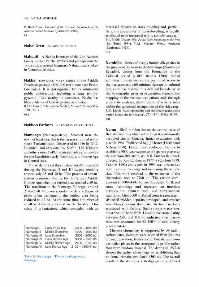
increased reliance on stock-breeding and, particu-
larly, the appearance of horse-breeding, is usually
attributed to an increased aridity (see also ASIA 1).P.L. Kohl: Central Asia: Palaeolithic beginnings to the IronAge (Paris, 1984); V.M. Masson: Pervye civilizacii(Leningrad, 1989).
PD
Nambillo Series of deeply buried village sites in
the jungles of the western Andean slope (Northwest
Ecuador), dating from the Formative to the
Colonial period (c.3000 BC–AD 1500). Radial
sampling through soil coring permitted access to
the PALAEOSOLS with minimal damage to cultural
levels and has resulted in a detailed knowledge of
the stratigraphy prior to excavation, topographic
mapping of the various occupations and, through
phosphate analyses, identification of activity areas
within the sequential occupations of the ridge top.R.D. Lippi: ‘Paleotopography and phosphate analysis of a
buried jungle site in Ecuador’, JFA 15/1 (1988), 85–97.
KB
Namu Shell-midden site on the central coast of
British Columbia which is the longest continuously
occupied site in Canada. Initial excavation took
place in 1969–70 directed by J.J. Hester (Hester and
Nelson 1978). Hester used ecological factors to
establish a 9000-year sequence of separate phases at
the site from 7000 BC to AD 1800. Further fieldwork
directed by Roy Carlson in 1977–8 (Carlson 1979;
Cannon 1991) and again in 1994 was directed at
refining the chronology and increasing the sample
size. This work resulted in the extension of the
chronology back to 7700 BC. The earliest com-
ponents (c.7000–4500 BC) are dominated by flaked
stone technology and represent an interface
between the PEBBLE TOOL and MICROBLADE
traditions. After 3000 BC flaked stone is rare, exten-
sive shell-midden deposits developed, and artefact
assemblages became dominated by bone artefacts
associated with fishing. Stable-CARBON ISOTOPE
ANALYSIS of bone from 13 adult skeletons dating
between 2500 and 800 BC indicated that marine
resources accounted for 93–100% of total dietary
protein intake.
The site chronology is supported by 39 radio-
carbon dates. Samples were selected from features
during excavation, from specific burials, and from
particular places in the stratigraphic profile rather
than from random charcoal. The dating in 1977–8
altered the earlier chronology by establishing that
no faunal remains pre-dated 4500 BC. The overall
result of the dating is a stratigraphically defined
P. Bard-Adon: The cave of the treasure: the finds from thecaves in Nahal Mishmar (Jerusalem, 1980).
IS
Nahal Oren see MOUNT CARMEL
Nahuatl A Nahua language of the Uto-Aztecan
family, spoken by the AZTECS and perhaps also the
TOLTECS; a related language, Nahuat, was spoken
in Veracruz, Mexico.
Nakbe LOWLAND MAYA centre of the Middle
Preclassic period (c.800–300 BC) in northern Petén,
Guatemala. It is distinguished by its substantial
public architecture, including a large temple-
pyramid. Like nearby EL MIRADOR, Nakbe has
little evidence of Classic period occupation.R.D. Hansen: ‘The road to Nakbe’, Natural History (May
1991), 8–14.
PRI
Nakhon Pathom see DVARAVATI CULTURE
Namazga (Namazga-depe) Situated near the
town of Kaakhka, this is the largest stratified tell in
south Turkmenistan. Discovered in 1916 by D.D.
Bukinich, and excavated by Kuftin, I.N. Khlopin
and others since 1949, the site provides a framework
for the Eneolithic (early Neolithic) and Bronze Age
in Central Asia.
The settled area at the site dramatically increased
during the Namazga II and III stages, reaching
respectively 25 and 30 ha. The process of urban-
ization continued during the Early and Middle
Bronze Age when the settled area reached c.50 ha.
The transition to the Namazga VI stage, around
2170–2050 BC, corresponded with a collapse of
proto-urban settlement, the settled area being
reduced to c.2 ha. At the same time a number of
small settlements appeared in the locality. This
crisis of urbanization, which coincided with an
416 NAHAL MISHMAR
Namazga I Early Eneolithic 5800 – 4000 BC
Namazga II Middle Eneolithic 4000 – 3500 BC
Namazga III Late Eneolithic 3500 – 3000 BC
Namazga IV Early Bronze Age 3000 – 2500 BC
Namazga V Middle Bronze Age 2500 – 2100 BC
Namazga VI Late Bronze Age 2100 – 1800(?) BC
Table 15 Namazga The cultural sequence at
Namazga.

there were also tomb and temple structures, some of
which are amongst the largest stone structures in
the Pacific. Much of the construction may well have
taken place in the last few hundred years, although
the origins of the artificial islands may be much
older.P. Bellwood: Man’s conquest of the Pacific (New York,
1979), 289–92.
CG
Nan-Yüeh (Nanyue) see YÜEH
naos Type of Egyptian shrine used to house the
cult-image or sacred bark of the god in the inner-
most rooms of temples. Usually taking the form of
rectangular chests or boxes of wood or stone, naoi
were also used as containers for funerary statues and
mummified animals. Egyptian ‘naophorous’ statues
portray the subject holding a shrine, sometimes
containing a divine image.G. Roeder: Naos, 2 vols (Leipzig, 1914).
IS
Napata, Napatan District of Sudan on the
Dongola Reach of the Nile, about 30 km south-
west of the 4th cataract, which was settled in
the mid-15th century BC as a southern outpost
of the Egyptian empire in Nubia. The site incorpor-
ates funerary remains, possible palace buildings and
chronology of six periods, ranging from 7770–140
BC to AD 1460–80 (Cannon 1991: Table B–1). The
site continued to be occupied with little evidence of
culture change until the time of European contact.
X-RAY FLUORESCENCE analysis was undertaken
on 194 obsidian artefacts from Namu in order to
determine their source and infer trade patterns
(Carlson 1995). This study showed that by 7000 BC
obsidian was reaching NAMU through trade with
sources 100 miles away. This trade in obsidian
occurred throughout the occupation span, with
most obsidian deriving from sources 100–200 miles
distant, although a small amount during the 3rd
millennium BC came from as far away as Oregon,
600 miles distant.J. Hester and S. Nelson, eds: Studies in Bella Bella pre-history (Burnaby, 1978); R.L. Carlson: ‘The early period
on the Central Coast of British Columbia’, CanadianJournal of Archaeology 3 (1979), 211–28; A. Cannon:
‘Radiographic age determination of Pacific salmon:
species and seasonal inferences’, JFA 15 (1988), 103–8; A.
Cannon: The economic prehistory of Namu (Burnaby, 1991);
R.L. Carlson: ‘Trade and exchange in prehistoric British
Columbia’, Prehistoric exchange systems in North AmericaII, ed. T.G. Baugh and J.E. Ericson (New York, 1995).
RC
Nan Madol On the island of Ponape in eastern
Micronesia, Nan Madol is a series of artificial plat-
forms in a shallow lagoon. Many of the basalt
platforms supported dwelling houses; however,
417NAPATA, NAPATAN
Nakap Hafen
N
Figure 36 Nan Madol Plan showing extent of platform structures at Nan Madol, Ponape, which supported houses,
tombs and temples. Source: P. Bellwood: Man’s conquest of the Pacific (New York: Oxford University Press, 1979).

by HIERAKONPOLIS and ABYDOS. About 3 km
northwest of modern Naqada is a large MASTABA-
TOMB which perhaps belonged to Neithhotep, a
female relative of the 1st-dynasty ruler Aha. A small
stone step-pyramid of unknown purpose, located
near the village of Tukh, is one of seven small pyra-
mids of unknown function erected at different sites
from Seila down to Aswan, possibly in the reign of
the 3rd-dynasty ruler Huni (c.2599–2575 BC). For
the Naqada period see EGYPT 1.W.M.F. Petrie and J.E. Quibell: Naqada and Ballas(London, 1896); J. De Morgan: Recherches sur les originesde l’Egypte 2 vols (Paris, 1896–7); J.J. Castillos: ‘An analy-
sis of the tombs in the predynastic cemeteries at Nagada’,
JSSEA 10 (1981), 97–106; W. Davis: ‘Cemetery T at
Naqada’, MDAIK 39 (1983), 17–28; K. Bard: ‘The
evolution of social complexity in predynastic Egypt: an
analysis of the Nagada cemeteries’, JMA 2/2 (1989),
223–48.
IS
Naqsh-i Rustam see PERSIA
Narosura see PASTORAL NEOLITHIC
Narva Neolithic cultural tradition named after a
cluster of three sites (Narva-Riigikula 1, 2 and 3)
located on the lower stretches of the Narova River,
on the border between Estonia and Russia.
Discovered and excavated by N.N. Gurina between
the 1950s and the 1980s, the sites are situated on a
ridge of sand-dunes and include the remains of
oval-shaped semi-subterranean dwellings (6–7 m in
diameter). The faunal remains – practically
identical at all three sites – include elk (which pre-
dominates), wild boar, aurochs, red deer, brown
bear, waterfowl (ducks and swans), and many seals.
The bones of a medium-sized whale were found at
one of the sites. Pike, perch, salmon and catfish
were identified among the numerous fish bones.
The chipped stone inventory consists of numerous
arrow- and spearheads, large scrapers, axes and
adzes. The prolific bone and antler industry
includes arrow- and spearheads, harpoons, axes,
adzes, ‘hoe-like’ tools and fish-hooks. The so-called
Narva-type pottery includes pots with either
rounded or pointed bases, decorated with comb
impressions, notches, strokes, and small pits which
formed horizontal rows and zigzag patterns.
Similar assemblages have now been identified in
Latvia (Lubana), south of St. Petersburg, on the
upper Western Dvina, northwest of Smolensk
(Rudnya-Serteya) and, a later variety, in Lithuania
(ŠVENTOJI).
an unusual temple of Amun at Gebel Barkal (‘Pure
Mountain’, see Kendall 1986), a partially excavated
settlement at the southern end of the site, and prob-
ably also a settlement on the opposite bank,
although this has not yet been satisfactorily exam-
ined. The wider region of Napata includes three
other sites: the extensive settlement and funerary
remains at Sanam (see Griffith 1922) and the royal
cemeteries at EL-KURRU and NURI. By the early
10th century BC, Napata had emerged as the
political centre of the kingdom of Kush, which had
previously been centred on the city of KERMA. The
Kushite kings of the Napatan period controlled
trade along the northern road through the desert to
the town of Kawa and the southern route towards
MEROE. Although Meroe eventually became the
new Kushite capital from the early 6th century BC
onwards, Napata continued to be of some im-
portance throughout the MEROITIC period (c.300
BC–AD 350).F. Ll. Griffith: ‘Oxford excavations in Nubia’, LAAA 9
(1922), 67–124; B.G. Haycock: ‘Towards a better under-
standing of the kingdom of Cush (Napata-Meroê)’, SudanNotes and Records 49 (1968), 1–16; D. Dunham: The royalcemeteries of Kush, 4 vols (Boston, 1950–7); ––––: TheBarkal temples (Boston, 1970); J. Leclant: Preliminary
reports on excavations at Gebel Barkal, Orientalia 43–
(1974– ); T. Kendall: Gebel Barkal epigraphic survey 1986:preliminary report to the Visiting Committee of theDepartment of Egyptian Art (Boston 1986); J.H. Taylor:
Egypt and Nubia (London, 1991), 38–45.
IS
Naqada (anc. Nubt, Ombos) Egyptian site con-
sisting of a number of areas of cemeteries and
settlements of the predynastic and pharaonic
periods, located about 26 km north of Luxor on the
west bank of the Nile. When Flinders Petrie
excavated two of the predynastic cemeteries (Tukh
and el-Ballas) in 1895, he initially identified the
contents of the graves as the remains of foreigners
(the so-called ‘New Race’), dating them to the 1st
Intermediate Period (c.2180 BC). Soon afterwards,
however, he realized that the material was pre-
historic, and the grave goods from Naqada (as well
as HIW-SEMAINA) formed the basis for his
SEQUENCE DATING system. Cemetery T at Naqada
is a collection of 57 brick-built and richly equipped
graves which are thought to have belonged to the
ruling elite of the late Naqada II (or Gerzean)
period.
The site also includes the remains of a pre-
dynastic walled town (the ‘South Town’) founded
at least as early as 3600 BC. By the Early Dynastic
period, this settlement had probably been eclipsed
418 NAPATA, NAPATAN

Social archaeology: beyond subsistence and dating, ed. C.
Redman et al. (New York 1978), 201–23; D.O. Henry:
From foraging to agriculture: the Levant at the end of the IceAge (Philadelphia, 1989), 179–228; O. Bar-Yosef and F.R.
Valla, eds: The Natufian culture in the Levant (Ann Arbor,
1991).
IS
Naukratis (anc. Pi-meryet) City in the Egyptian
Western Delta which is best known for the period
during the 7th century BC when it was officially
established by Psamtek I as the first Greek trading
colony within Egypt. By the 4th century BC it had
become a polis; many of the surviving buildings –
including temples dedicated to Apollo, Aphrodite,
Hera and the Dioskouroi – are Greek establish-
ments dating from this period onwards, but there
are also remains of an Egyptian temple of Amun and
Thoth.W.M.F. Petrie and E.A. Gardner: Naukratis I: 1884–5(London, 1886); J. Boardman: The Greeks overseas(Harmondsworth, 1964), 117–35; W.D.E. Coulson and A.
Leonard, Jr.: Cities of the Delta, I: Naukratis: preliminaryreport on the 1977–1978 and 1980 seasons (Malibu, 1981);
–––– and ––––: ‘The Naukratis project 1983’, Muse 17
(1983), 64–71.
IS
Nausharo Mound site near the Neolithic site of
MEHRGARH in the Kachi Plain of Pakistan. The
recent excavations of Jean-François Jarrige (1989)
have revealed a continuous archaeological sequence
spanning four phases (Samzun 1992: 245) from the
Late Mehrgarh Period to the Early and Mature
Indus periods (c.2900–2000 BC; see INDUS
CIVILIZATION). The early occupations at Nausharo
are contemporaneous with the latest levels at
Mehrgarh (Mehrgarh VII), and many features of
the ceramic styles and architecture show continuous
development leading up to the Mature Indus, with
local styles persisting alongside Indus styles. The
architectural remains in the Mature Indus levels
include large mud-brick platforms and multi-room
structures. Although the precise relations between
Early and Mature Indus levels are uncertain at pre-
sent, Samzun (1992: 252) has suggested that
Nausharo was characterized by a formative
transition that reflects strong links between
Baluchistan and the Indus Valley. These kinds of
active interactions between upland and lowland
regional traditions may have played a seminal role
in the rise of the urban Mature Indus civilization.J.-F Jarrige: ‘Excavations at Nausharo, 1987–88’, PA 24
(1989), 21–68; A. Samzun: ‘Observations on the charac-
teristics of the Pre-Harappan remains, pottery, and
N.N. Gurina: ‘Iz istorii drevnih plemjon zapadnyh
oblastei SSSR’ [A history of the ancient tribes in the west-
ern area of the USSR], MIAS 114, (Moscow and
Leningrad, 1970).
PD
Nasik Large settlement-mound located about
18 km north of Bombay, on the Godavari River in
Maharashtra, India. It dates from the late 2nd mil-
lennium BC to the 18th century AD and was
excavated by H.D. Sankalia and S.B. Deo in
1950–51. The earliest Chalcolithic occupation
levels, including microliths, ochre-slipped pottery
(sometimes decorated with red or black paint) and
domestic pig, date to the JORWE period. A gap of
about 500 years separates Chalcolithic levels from
the later historic occupations. Small huts with earth
and post walls, ceramic ring wells, and NORTHERN
BLACK POLISHED WARE ceramics and copper coins
are found in the earliest historic level (c.400–50 BC);
no structures were excavated from later periods
(Sankalia and Deo 1955).H.D. Sankalia and S.B. Deo: The excavations at Nasik andJorwe, 1950–51 (Pune, 1955), 1–146; M.K. Dhavalikar:
The first farmers of the Deccan (Pune, 1988), 71.
CS
Natufian Term applied to the latest of the
Levantine ‘EPIPALAEOLITIC’ periods, which lasted
from c.11000 to 9300 BC and was named after the
Wadi el-Natuf in Israel. Most excavated Natufian
sites are in the region of Syria-Palestine, although
the nature of the remains at BELDIBI suggest
that the culture probably reached parts of southern
Anatolia. The Natufian constituted a trans-
itional stage in Palestine between the exploitation
of wild cereals in the KEBARAN period
(c.18000–11000 BC) and the emergence of recog-
nizable methods of plant and animal domestication
in the Pre-Pottery Neolithic period (c.9300–5500
BC; see ACERAMIC NEOLITHIC). Natufian sites are
characterized by distinctive flint assemblages as
well as grindstones, storage pits and hearths. The
botanical evidence clearly indicates a subsistence
base combining hunting, gathering and early
agriculture.
At Ain Mallaha, near Lake Huleh, nine
Natufian stone-paved round huts have been
excavated, each measuring about 3.5–5 m in diam-
eter. Debate concerning the Natufian centres
primarily on the degree to which wild or domesti-
cated species of cereals and animals were being
exploited.G.A. Wright: ‘Social differentiation in the early Natufian’,
419NAUSHARO

of the Eastern Rift Valley in Kenya. Nderit ware is
highly distinctive because of its soft texture, open
basket shapes, profuse or overall decoration in
patterns of incised lines or indentations (further to
imitate basketry) and internal decoration (the
result apparently of pressing grass into the
clay before firing). It was first identified by Louis
Leakey in 1931 at sites in the Nakuru-
ELMENTEITA basin under the ‘Gumban A’ variant
of the ‘Neolithic’.
Both in the Nakuru-Elmenteita and Lake
Turkana basins, Nderit pottery frequently occurs
on or close to shore-lines of mid-Holocene date; a
lacustrine and fishing (late ‘Aqualithic’) association
has therefore been argued (see AQUATIC CIVIL-
IZATION). However, the economic and cultural
orientations may be more complex, since the
remains of domesticated livestock (cattle, goats and
sheep) dating to the 3rd millennium BC have been
found in association with Nderit pottery beside
Lake Turkana (notably at Dongodien). In the ele-
vated Nakuru-Elmenteita basin neither the dating
nor the associations are so secure. Not infrequently
this pottery occurs with or close to cairn burials with
stone bowls, which are loosely classified as
‘Neolithic’.L.S.B. Leakey: The Stone Age cultures of Kenya colony(Cambridge, 1931), 198–9; F. Marshall et al.: ‘Early
domestic stock at Dongodien, northern Kenya’, Azania 19
(1984), 120–7.
JS
Neanderthals Type of hominid named after a
site in the Neander valley in Germany. The place of
Neanderthals in human evolution has always been
controversial. Early reconstructions presented
them as ape-like primitives, but more recent
evidence has rehabilitated both their anatomy and
intelligence. Although more stocky than
ANATOMICALLY MODERN HUMANS, and with a
different pelvic and cranial structure (see KEBARA),
Neanderthals may have been as intelligent as
‘moderns,’ and were capable of making Upper
Palaeolithic stone tools and possibly bone tools also
(see ARCY-SUR-CURE). At St Césaire, a cave site in
the Charente region of France, a Neanderthal burial
has been found in apparent association with Upper
Palaeolithic CHÂTELPERRONIAN tools. Much as the
QAFZEH AND SKHUL caves demonstrated that
‘modern’ humans did make MOUSTERIAN tools, St
Césaire is the first indication that ‘archaic’ humans
such as Neanderthals made the technological tran-
sition to the Upper Palaeolithic. Although it now
seems likely that Neanderthals became extinct
artefacts at Nausharo, Pakistan (2700–2500 BC)’, SouthAsian archaeology 1989, ed. J.-F Jarrige (Madison, 1992),
245–52.
CS
nautical archaeology see MARITIME
ARCHAEOLOGY
Navdatoli Large Chalcolithic settlement-
mound located on the southern bank of the Narbada
River in Madhya Pradesh, India, which was
excavated in the mid-1950s. The earliest levels were
assigned to the MALWA period, stretching from
c.2100 to 1600 BC, according to a series of eight
calibrated radiocarbon dates (Sankalia et al. 1971),
while later levels have been dated to the JORWE
period. House form is consistent throughout the
sequence and consists of circular and rectangular
earthen and wattle-and-daub dwellings. M.K.
Dhavalikar has suggested that Navdatoli was a
centre of trade in copper and shell artefacts during
the Chalcolithic period (1988: 53).H.D. Sankalia, S.B. Deo and Z.D. Ansari: ChalcolithicNavdatoli (Pune, 1971); M.K. Dhavalikar: The first farm-ers of the Deccan (Pune, 1988), 44, 53.
CS
Naviundu see DIVUYU
Nazca Lines Geoglyphs formed by clearing the
loose gravel from the sandy/stony substrate in
the Pampa de Nazca and the nearby deserts
in southern Peru, dating mainly to the Early
Intermediate Period (c.400 BC–AD 500). The geo-
glyphs, which are associated with the Nazca culture
(best known for its elaborate polychrome ceramics),
consist of lines, rectangles, spirals and rare repre-
sentational forms. Interpretations of these forms
include astronomical markers, clan insignia, and
ceremonial pathways to family or ethnic huacas,especially those of origin or of fertility. Recent
studies have put them in their temporal and cultural
context and indicate that they were an integral part
of a distinctive Andean means of defining sacred
space.E. Hadingham: Lines to the mountain gods: Nazca and themysteries of Peru (New York, 1987); A. Aveni: The lines ofNazca (Philadelphia, 1990); H. Silverman: ‘New evidence
for the date of the Nazca Lines’, Antiquity 65 (1991),
208–20.
KB
Nderit Type of Neolithic pottery found in parts
420 NAUSHARO

ascertain whether the distribution of the objects of
a single class is aggregated, random or uniform, or
whether the distributions of two (or more) classes of
objects are associated. Its main drawbacks are that
it can only deal with small-scale patterns, and that it
suffers from ‘edge-effects’: since the true nearest-
neighbour of an object near the edge of a site may
lie outside the site, the wrong object may be called
its nearest-neighbour, leading to over-statement of
the nearest-neighbour distance.P.J. Clark and F.C. Evans: ‘Distance to nearest neighbour
as a measure of spatial relationships in populations’
Ecology 35 (1954) 445–53; I.R. Hodder and C.R. Orton:
Spatial analysis in archaeology (Cambridge, 1976), 38–51.
CO
negative feedback see SYSTEMS THEORY
negative painting Type of black on red/white
decoration found on pottery vessels throughout the
Americas. A fired vessel was dipped in a plant resin
solution, those parts which were to remain the base
color were painted with clay solution and the vessel
was exposed to the fire, charring the resin. When
cool, the dry masking clay was brushed off reveal-
ing the ‘negative’ design.
KB
Nelson Bay Cave Large Middle/Later Stone
Age coastal cave at Plettenberg Bay, 450 km east of
Cape Town, South Africa. Excavations have
revealed MSA (Middle Stone Age) occupation, fol-
lowed by an hiatus until around 19,000 uncal BP,
after which there is a fairly continuous sequence
embracing the Robberg microblade industry
(c.19,000–11,000 uncal BP), Albany non-microlithic
industry (c.11,000–?6000 uncal BP), WILTON
microlithic industry (? 6,000–3300 uncal BP), con-
cluding with a macrolithic industry (3300–500
uncal BP) reminiscent of the earlier ALBANY
INDUSTRY. It has been argued that the Wilton
occurrences reflect sporadic seasonal visits to the
coast by makers of those artefacts during a pro-
tracted hot dry period inland. The rich faunal
remains reflect shifts in the coastline, drowning rich
grazing land (Robberg). Marine resources are abun-
dantly exploited from around 11,000 uncal BP, and
fishing was highly specialized during the Holocene.
A rich bone and shell industry is associated with the
post-Wilton industry.J. Deacon: The Later Stone Age of southernmost Africa(Oxford, 1984). R.R. Inskeep: Nelson Bay Cave, CapeProvince, South Africa; the Holocene levels (Oxford, 1987).
RI
around 30–32,000 years ago, rather than forming
one of our direct ancestors, the exact causes of this
extinction may not be as simple as ‘replacement’ by
more intelligent ‘modern’ humans. See also
TESHIK-TASH.M. Shackley: Neanderthal man (Hampden, 1980); C.B.
Stringer and C. Gamble: In search of the Neanderthals(London, 1993); P. Mellars: The Neanderthal legacy: anarchaeological perspective from western Europe (Princeton,
1996).
PG-B
Nea Nikomedia Tell on the Macedonian Plain
of northern Greece, with later Neolithic layers
overlying an important early Neolithic settlement
dated to the 8th millennium BC – one of the earliest
farming sites in Europe. Partial excavation by
Robert Rodden and Graham Clark (1961–3)
revealed individual rectangular houses with mud
and reed walls reinforced by wooden poles, and an
economy based on growing wheat, barley and
lentils, and on herding sheep and goats (with some
pigs and cattle). Obsidian was imported from the
Cyclades (Melos). The earliest pottery is relatively
thin-walled and is sometimes decorated with finger
impressions; wares were often painted with tri-
angles, wavy lines etc. in red on a cream ground.
The early settlers also moulded schematic clay
figurines of men and, especially, of women with
exaggerated thighs. There are occasional animal
sculptures (with amphibian features) in serpentine
stone; one building, which seemed to be at the
centre of a cluster of smaller buildings, contained
three of these animal figures and a concentration of
five female figurines and has been interpreted as
having a special, possibly religious, function.R. Rodden: ‘Excavations at the Early Neolithic site of Nea
Nikomedeia, Greek Macedonia,’ PPS 28 (1962), 267–88;
R. Rodden: ‘An Early Neolithic village in Greece’, SA212/4 (1965), 82–92.
RJA
nearest-neighbour analysis Branch of
SPATIAL ANALYSIS which uses as data the distance
from each object in the study to the one nearest to
it (its ‘nearest-neighbour’). Some techniques use
the distance to second- or third-nearest-neighbour.
Such techniques are most suited to the study of local
(small-scale) spatial patterns (such as the distri-
bution of artefacts of a certain type on a site), and
require the location of each object to be accurately
plotted. They are mainly used in intra-site SPATIAL
ANALYSIS. The average nearest-neighbour distance
can be compared with a theoretical value to
421NELSON BAY CAVE

neo-evolutionism School of archaeological
thought which is based on the idea that human
behaviour and cultural change are characterized by
distinct patterns and mechanisms that can be
explained in terms of processes of evolutionary
change. Neo-evolutionist theories therefore include
the well-known Childean concepts of the ‘Neolithic
revolution’ and ‘urban revolution’ (see Childe
1951). Whereas 19th century evolutionists were
prepared to accept that cultural change might have
resulted from deliberate human attempts to change
their environment for the better, neo-evolutionists
are fundamentally deterministic, arguing that
humans have always sought to maintain traditional
ways of life, with the dominant roles in cultural
change being played by such uncontrollable factors
as economics, demography or technology. From the
1940s onwards, neo-evolutionary ethnologists such
as Leslie White (1959) and Julian Steward (1955)
argued that the effect of the environment could
mean that very different cultures might arise from
identical social processes, and by the 1960s, a num-
ber of American archaeologists were adopting
similar neo-evolutionary approaches (e.g. Meggers
1960). However, after the emergence of the mature
processual archaeology of the 1970s and 1980s,
many neo-evolutionary approaches began to appear
somewhat simplistic. Trigger (1989: 374), for
instance, argues that ‘it has become clear that cul-
tural change is far more diversified than any
neo-evolutionary view of parallel or even multilin-
ear evolution has countenanced’. See also SOCIAL
DARWINISM.V.G. Childe: Social evolution (New York, 1951); J.
Steward: Theory of culture change (Urbara, 1955); L.A.
White: The evolution of culture (New York, 1959); B.J.
Meggers: ‘The law of cultural evolution as a practical
research tool’, Essays in the science of culture, ed. G.E. Dole
and R.L. Carneiro (New York, 1960, 302–16; E.R.
Service: Primitive social organization (New York, 1962);
––––: Origins of the state and civilization (New York, 1975);
B.G. Trigger: A history of archaeological thought(Cambridge, 1989), 289–94, 373–4.
IS
neo-Hittites see HITTITES
Neolithic Term used to describe the final phase
of the Stone Age, following the MESOLITHIC. The
Neolithic begins at widely differing dates in differ-
ent regions of the world. For example, in the Middle
East the period starts as early as the 10th millennium
BC, while the onset of the Neolithic is identified
across much of northern and central Europe with
Nemrik (Nemrik 9) Large settlement of the Pre-
pottery Neolithic period (see ACERAMIC
NEOLITHIC) in northern Iraq (c.7500–6500 uncal
BC), covering about 2 ha and comprising three or
four phases. In its latest phase, it consisted pri-
marily of round houses (and occasional rectangular
structures) built with the tauf or pisé technique. The
rich surrounding environments (including forests
and steppes) facilitated the development of a stable
sedentary community relying for subsistence on
domesticated sheep, goats, cattle and pigs as well as
cereals. The inhabitants had clearly reached a
transitional stage between hunting and gathering
and a combination of animal husbandry and agri-
culture (the latter attested by groundstones
and mortars). QERMEZ DERE and TELL
MAGHZALYA are the nearest similar sites in terms of
subsistence and craftwork. S.K. Kozłowski argues
that the strong similarities between the chipped
stone industries of Nemrik and of proto-Hassuna
sites may indicate that the origins of the HASSUNA
culture are to be found at Nemrik.S.K. Kozłowski: Nemrik 9: a pre-pottery Neolithic site inIraq (Warsaw, 1990).
IS
Nemrut Dagh Mountain-top sanctuary of the
1st century BC, situated 250 km northeast of
Gaziantep, in the Taurus range of eastern Turkey.
One of a number of ‘dynastic shrines’ built by the
rulers of Commagene, which was the last in-
dependent kingdom in Asia Minor in the 1st century
BC (and was eventually absorbed into the Roman
empire in AD 72). The principal features of Nemrut
Dagh are the colossal stone sculptures and
mausoleum (50 m high and 150m in diameter)
erected by Antiochus I (c.69–34 BC). The fragmen-
tary Greek inscriptions indicate that the statuary
represented the Achaemenid and Seleucid rulers
whom Antiochus claimed as his ancestors, as well as
a variety of syncretic gods, such as Apollo-Mithras
and Zeus-Oromasdes. The site was examined by
Karl Humann and Otto Puchstein in 1890 and
Friedrich-Karl Dörner between 1939 and 1963, but
the burial chamber of Antiochus has not been
located.T. Fischer: ‘Zum Kult des Antiochos I von Kommagene
für seine Seleukidischen Ahnen’, Mitteilungen desDeutschen Archäologischen Instituts (Istanbul) 22
(1972), 141–50; D.H. Sanders, ed.: Nemrut Dagi: thehierothesion of Antiochus I of Commagene (Winona Lake,
1995).
IS
422 NEMRIK

only much later (see SECONDARY PRODUCTS
REVOLUTION).C.M. McBurney: The Stone Age of northern Africa(Harmondsworth, 1960); J. Mellaart: Çatal Hüyük: aNeolithic town in Anatolia (London, 1967); H. Nordström:
Neolithic and A-Group sites (Stockholm, 1972); J. Mellaart:
The Neolithic of the Near East (London, 1975); J. Kruk:
The neolithic settlement of southern Poland, BAR IS 93
(Oxford, 1980); D. Trump: The prehsitory of theMediterranean (1980); R. Mercer: Farming practice inBritish prehistory (Edinburgh, 1981); R.J. Ammerman and
L.L. Cavalli-Sforza: The Neolithic transition and the genet-ics of population in Europe (Princeton, 1984); A. Whittle:
Neolithic Europe: a survey (Cambridge, 1985); F. Hassan:
‘Chronology of the Khartoum “Mesolithic” and
“Neolithic” and related sites in the Sudan: statistical
analysis and comparisons with Egypt’, AAR 4 (1986),
83–102; M. Svelebil, ed.: Hunters in transition(Cambridge, 1986); T. Darvill: Prehistoric Britain(London, 1987); P. Bogucki: Forest Farmers and stock-herders: early agriculture and its consequences innorth-central Europe (Cambridge, 1988); I. Hodder: Thedomestication of Europe (London, 1990); P. Vermeersch
and P. van Peer, eds: Contributions to the Mesolithic inEurope (Leuven, 1990); B. Midant-Reynes: Préhistoire del’Egypt (Paris, 1992), 118–22; P. Bogucki, ed.: Case studiesin European prehistory (Boca Raton, 1993), chaps. 3, 4, 5;
B. Cunliffe, ed.: The Oxford illustrated prehistory of Europe(Oxford, 1994), esp. 136–202.
RJA
Neribtum see ISCHALI
Nettilling Lake Locality in the interior of
southern Baffin Island in the Canadian Arctic, with
evidence of the Inuit and, particularly, THULE,
cultures. A thorough study of the site by Douglas
Stenton has greatly enhanced our understanding of
the Thule economy.
For most of the 20th century, research on the
Thule focused on sites that were occupied during
the winter, and on maritime adaptations. The
winter sites are usually located on the coast, and
the faunal remains tend to derive from marine
mammals. Sites occupied during other seasons of
the year are found both on the coast and in the in-
terior, but these often contain far fewer artefactual
and faunal remains and have thus received far less
archaeological attention. As a result, interpretations
of Thule subsistence and settlement tended to stress
the maritime element.
However, Stenton’s surveys in the Nettilling
Lake vicinity in the 1980s revealed the importance
of terrestrial environments to the Thule. In a -
multi-disciplinary project, Stenton explored the
environmental and archaeological records of
the arrival of the farming LINEARBANDKERAMIK
(LBK) culture between the 6th millennium BC
(Hungary) and the 4th millennium BC (northwest
Europe). Although the Neolithic was originally
defined with reference to presence of ground and
polished stone tools in lithic assemblages, it quickly
became associated with a major set of cultural and
economic changes including the use of pottery, the
domestication of animals, agriculture and sedentary
living. Up until the 1950s, and the widespread use
of radiocarbon dating, it tended to be assumed that,
in each region, these changes occurred together as a
package. In some regions, it has become apparent
that this is an over-simplification. In the Near East,
the slightly cumbersome term pre-pottery Neo-
lithic (see ACERAMIC NEOLITHIC) had to be adopted
to describe the early agricultural villages of the
Levant before they started making pottery.
Conversely, in some coastal Mediterranean areas
pottery (see CARDIAL WARE) and perhaps, animal
domestication seems to have arrived before the full
adoption of cereal agriculture. In other areas,
hunters and gatherers seem to have evolved
sedentary or semi-sedentary settlements before the
advent of farming (e.g. LEPENSKI VIR), or to have
adopted the use of pottery and apparent Neolithic
stone industries without developing a farming econ-
omy. An example of the latter is the Central Asian
KELTEMINAR ‘culture’, often described as ‘Neo-
lithic’ in the literature because of technological
developments (particularly the adoption of pottery),
though the economy was entirely based on hunting
and gathering.
Western European definitions of the Neolithic
answer this question by focusing on subsistence
economy as the defining criterion. For example,
Ammerman and Cavalli-Sforza (1984: 35) state
explicitly that they ‘adopt an economic approach to
the classification of sites and cultures: the neolithic
transition refers to the shift from hunting and
gathering to food production,’ (by which they mean
food production based upon domesticated cereals
and animals). However, in the literature of eastern
Europe, the appearance of pottery at a site is
normally enough to classify it as Neolithic. As a
result, pottery-using hunting and gathering
cultures of the Baltic tend to be called Neolithic
in the eastern European literature, but Mesolithic in
western European accounts.
As a further complication, it is becoming clearer
that even where the key constituents of the food-
producing revolution (domesticated animals,
domesticated cereals, permanent settlement and
storage) arrived contemporaneously, certain
features of a developed farming economy emerged
423NETTILLING LAKE

neutron activation analysis (NAA) Radio-
metric method of quantitative chemical analysis
particularly used for TRACE ANALYSIS and ultra-
trace analysis of pottery and lithics but also
applicable to metals. Although the technique is, in
principle, non-destructive, it is normal to work
with samples rather than complete artefacts
because of the residual induced radioactivity. The
samples (in solid form, and typically 100 mg for
ceramics) are exposed to a suitable source of neu-
trons, usually in a reactor, which converts some
stable isotopes into radio-isotopes (i.e. radioactive
isotopes) of the same element by neutron capture.
In the course of their decay, many of these radio-
isotopes emit gamma-rays with characteristic
energies. After irradiation, the spectrum of
gamma-ray energies from each sample is measured,
or counted, using a solid-state detector similar to
that used for EDXRF (energy dispersive X-RAY
FLUORESCENCE). Individual element isotopes are
identified by their characteristic gamma-ray ener-
gies with intensities proportional to the amounts
present. Comparison with the spectra of similarly
irradiated standards, after correction for decay of
the radio-isotopes, enables the element concentra-
tions in the sample to be calculated.
Potentially, a large number of elements may be
determined but the range partly depends on the
irradiation time, the neutron flux and, particularly,
the time elapsed between irradiation and spectrum
counting. Elements with radio-isotopes of very
short HALF-LIFE (e.g. A1 and Mg) decay rapidly
and must be measured at the reactor site. Normally
counting begins a few days after irradiation and
typically 30 elements are routinely detectable
in ceramics. This includes the rare earth elements
(e.g. lanthanum, cerium, samarium etc), with
detection limits approaching 100 ppb, which are
important for provenancing ceramics. The
technique has some advantages for trace analysis
of silicate-based materials because sample prep-
aration is minimal and drillings can be analysed
directly unlike for AAS (ATOMIC ABSORPTION
SPECTROPHOTOMETRY) and ICP-AES (INDUCT-
IVELY COUPED PLASMA-ATOMIC EMISSION
SPECTROMETRY) where the samples must be
completely dissolved. Some elements are not
quantifiable by conventional NAA, however, a
notable example being lead which is not activated.
The technique has made a considerable contri-
bution to provenance studies of pottery and other
ceramics largely based on procedures devised by
Perlman and Asaro (1969). There can be few
pottery types which have not been analysed by
NAA at some time. Work on metals has also
the Nettilling Lake region in order to under-
stand the relationship between caribou population
dynamics and Thule settlement and subsistence –
particularly mobility patterns (Binford 1980) and
predation strategies.
In addition to food, caribou provided skins for
the warm winter clothes that allowed hunters to
forage for other species through the extreme cold of
winter. A survey of ethnographic sources revealed
that adults required between five and seven cari-
bou skins per year for winter clothing, plus
additional skins for tents, blankets or kayaks.
Thus, a family of five might need at least two dozen
skins per year.
However, caribou are an unstable resource; the
population fluctuates in a cyclic fashion – some-
times being reduced by up to 90%. Stenton
demonstrated that documented, large-scale climatic
changes do not adequately account for such fluctu-
ations: they appear to be intrinsic to the species.
Therefore, prehistoric Thule groups inhabiting the
coast of southern Baffin Island must have devised
ways of coping with the sporadic and unpredictable
population crashes.
Based on the analysis of finds from 15 Thule sites
at Nettilling Lake (including semi-subterranean
houses, tent rings, burials, hearths, hunting blinds,
kayak stands, caches and Inukshuk), Stenton con-
cluded that when the caribou were numerous, the
Thule hunted them from coastal settlements; the
hunting tactics during these periods can be charac-
terized as having ‘logistical mobility’. However,
when caribou were scarce, the Thule moved into the
interior around Nettilling Lake, and relied to a
greater extent on ‘residential mobility’ in order to
obtain caribou. A detailed analysis of faunal remains
from the Nettilling Lake sites – employing
Binford’s (1978) utility indices – suggests that most
of the animals were hunted in close proximity to the
residential camps. Further, most were female, indi-
cating non-selective procurement. Thus, Stenton’s
research suggests that a flexible settlement system
allowed the Thule to survive the fluctuations in
caribou populations.L.R. Binford: Nunamiut ethnoarchaeology (New York,
1978); ––––: ‘Willow smoke and dogs’ tails: hunter-
gatherer settlement systems and archaeological site
formation’, AA 45 (1980), 4–20; D.R. Stenton: ‘Caribou
population dynamics and Thule Culture adaptations on
Southern Baffin Island, N.W.T.’, Arctic Anthropology 28
(1991), 15–43; ––––: ‘The adaptive significance of caribou
winter clothing for Arctic hunter-gatherers’, êtudes/Inuit/Studies 15 (1991), 3–28.
RP
424 NETTILLING LAKE

rear wall of the chamber, forms one of the few
certain examples of Neolithic astronomical ALIGN-
MENTS. The cruciform chamber has a
false-corbelled roof that is nearly six metres high;
the side-chambers were found to contain large
stone basins. Newgrange was excavated and heavily
restored by Michael O’Kelly, and has been dated by
radiocarbon to about 3200 BC (e.g. 2465 ±40; 2250
±45 BC).M.J. O’Kelly: Newgrange (London, 1982).
RJA
Ngamuriak see PASTORAL NEOLITHIC
Niaux Decorated case of the Upper Palaeolithic,
situated 4 km from Tarascon-sur-Ariège in the
Pyrenees, France. One of the largest decorated
cave systems, Niaux contains engravings scored
on its clay floor, including a fish and a bison
wounded by arrows. The walls of the famous
‘Salon Noir’ are dominated by bison, horses, ibex
and deer boldly outlined in black (probably char-
coal). Some of the depictions are carefully detailed
– horses wearing winter coats, for example – and
were probably drawn in the middle or later
MAGDALENIAN.
L-R. Nougier and R. Robert: Niaux (Toulouse, 1954); A.
Beltrán et al.: La Cueva de Niaux (Zaragoza, 1973); D.
Vialou: L’art des grottes an Ariège Magdalénian, XXIIe
supplément à Gallia préhistoire (Paris, 1986), 295–322
[detailed description; spatio-symbolic analysis].
RJA
Nicoya The region of northerwestern Costa Rica
(and including southwestern Nicaragua in ‘Greater
Nicoya’), sometimes seen as an extreme southern
‘sub-area’ of Mesoamerica. The region is particu-
larly known for its polychrome pottery
manufactured after about AD 500.F.W. Lange, ed.: Costa Rican art and archaeology(Boulder, 1988).
PRI
Nihon Shoki One of the two earliest surviving
chronicles of Japan, compiled under the RITSURYO
state as part of the legitimization of the ruling
dynasty (the other being the KOJIKI). Compiled in
the 8th century (a little later than the Kojiki), it
provides a fuller account of imperial lineages,
legendary events and reign chronicles up to the
reign of Empress Jito (AD 696). Both the Kojiki and
the Nihon Shoki were based on earlier, non-extant
texts, the Teiki and Kyuji, and supplemented by
included provenancing but usually only in
support of other techniques such as lead isotope
analysis.I. Perlman and F. Asaro: ‘Pottery analysis by neutron
activation’, Archaeometry 11 (1969), 21–52; S.J. Parry:
Activation spectrometry in chemical analysis (New York,
1991).
MC
‘New Archaeology’ Term used to describe
PROCESSUAL ARCHAEOLOGY when it was first
emerging in the 1960s. See also ANALYTICAL
ARCHAEOLOGY, BEHAVIORAL ARCHAEOLOGY,
COVERING LAWS, FUNCTIONALISM and SYSTEMS
THEORY.
Newark Large earthworks and mounds com-
plex dating to the Middle WOODLAND period
(c.200 BC–AD 400). Located in Licking County,
Ohio (USA), it is associated with the HOPEWELL
cultural manifestation. The site, covering about
5 sq. km, is located on an elevated plain near the
junction of two forks of the Licking River. The site
contains three major sections consisting of octago-
nal, square and circular earthworks, each enclosing
8–20 ha, and connected by corridors formed by
pairs of parallel earthworks or roadways. Several
smaller circular enclosures are located outside the
major ones. Smaller conical and pyramidal mounds
are constructed within some of the large earth-
works.G.E. Squier and W.H. Davis: Ancient monuments of theMississippi Valley (Washington, D.C., 1848 repr.1973); C.
Thomas: ‘Report on the mound exploration of the Bureau
of Ethnology’, Twelfth annual report of the Bureau ofEthnology (Washington, D.C., 1894).
RJE
‘new gastronomy’ see AQUATIC
CIVILIZATION
Newgrange The most famous example of the
BOYNE VALLEY group of passage graves in Eire. It
comprises a vast circular cairn c.80m across and
12 m high, retained by a drystone wall that is lined
around its base with 97 megaliths – some of which
are decorated with classic examples of
MEGALITHIC ART. The monument was also encir-
cled by a ring of free-standing monoliths, 12 of
which survive. The orthostats of the passage (19 m
long) support roof slabs; at the very front of the pas-
sage a unique ‘window-box’, made of slabs
arranged so as to allow the beams of the winter sol-
stice sunrise to enter the tomb and illuminate the
425NIHON SHOKI

tary gear and stores of booty from foreign cam-
paigns (some of which remain unexcavated).A.H. Layard: Nineveh and its remains (London, 1849);
R.D. Barnett: A catalogue of the Nimrud ivories with otherexamples of Ancient Near Eastern ivories in the BritishMuseum (London, 1957); M.E.L. Mallowan: Nimrud andits remains, 2 vols (London, 1966); ––––: The Nimrudivories (London, 1978); I.J. Winter: ‘Is there a southern
style of ivory carving in the early 1st millennium BC?’, Iraq43 (1981), 101–30; G. Herrmann: Ivories from RoomSW37, Fort Shalmaneser, 2 vols (London, 1986).
IS
Nindowari see KULLI COMPLEX
Nineveh (Tell Kuyunjik and Tell Nebi Yunus)
City site in northern Iraq occupied continuously
from the HASSUNA period (c.5800–5500 BC) until
the Middle Ages. The enormous depth of pre-
historic stratigraphy (constituting as much as 75%
of the mound and including the NINEVITE 5 phase)
has given the site an additional importance quite
apart from its historical significance as one of the
major cities of the ASSYRIAN empire (c.883–612 BC).
Although, along with the rest of Assyria, it was
destroyed by the Medes in 612 BC, it nevertheless
survived into the Sasanian period and was finally
supplanted by the town of Mosul, in the suburbs of
which it now lies. The two principal mounds –
Kuyunjik and Nebi Yunus – have yielded a great
deal of evidence regarding the Assyrian empire.
The city reached its peak in the reign of
Sennacherib (c.704–781 BC, when it was the
Assyrian capital, and its ruins include Senna-
cherib’s stone palace and the ‘arsenal’ of his son
Esarhaddon (c.680–669 BC). However, among the
most crucial finds for Assyriologists was the North
Palace of Ashurbanipal (c.669–627 BC), excavated
by Rassam in 1853; this contained not only a series
of exquisite stone-carved reliefs depicting the royal
lion-hunt (Barnett 1976) but also the ‘library’
of Ashurbanipal, consisting of tens of thousands of
cuneiform tablets. This library is probably the most
important collection of texts from Mesopotamia,
including versions of the Epic of Gilgamesh and the
Epic of Creation, as well as vast numbers of religious
and scientific documents.P.-E. Botta and E. Flandin: Monument de Ninive découvertet décrit par M.P.-E. Botta, mesuré et dessiné par M.E.Flandin, 5 vols (Paris, 1849–50); V. Place: Ninive etl’Assyrie, 3 vols (Paris, 1867–80); A.H. Layard: The mon-uments of Nineveh (London, 1853); R.D. Barnett:
Sculptures from the North Palace of Ashurbanipal atNineveh (London, 1976); J.M. Russell: Sennacherib’s‘palace without rival’ at Nineveh (Chicago, 1991); J. Curtis
four later works (together with which they com-
prised the Six Ancient Histories). The provide
important documentary evidence for the Kofun
period (see JAPAN 4).W.G. Aston, trans.: Nihongi: chronicles of Japan from theearliest times to AD 697 (Tokyo, 1924).
SK
Nimrud, Tell (anc. Kalhu; Biblical Calah) City-
site located between the Tigris and Zab rivers
about 30 km south of Mosul in northern Iraq,
which was the location of the second capital of the
ASSYRIAN empire in the 9th–7th centuries BC.
Kalhu was founded as a provincial city by
Shalameser I in the 13th century BC, but in
c.864 BC Ashurnasirpal II transformed it into a new
royal capital, in place of Assur, and is said to have
installed an ARAMAEAN population there. It was
eventually replaced as capital by KHORSABAD and
finally NINEVEH.
The main citadel of Kalhu, in the southwest
corner of Tell Nimrud, was among the first
archaeological sites to be excavated in Meso-
potamia, when the ziggurat and temples of Ninurta,
Ishtar and Kidmuru, as well as the magnificent
southwestern palace of Ashurnasirpal were un-
covered by Austen Henry Layard in 1845–7. There
were also palaces belonging to Shalmaneser III,
Tiglath-Pileser III and Esarhaddon, whose reigns
spanned the period of c.858–680 BC. From the
palace gateways Layard extracted colossal
LAMASSU guardian figures in the form of winged
bulls, which were laboriously conveyed back to his
sponsors, the British Museum. He also sent back a
selection of sculpted and inscribed stone slabs from
the palace walls, the so-called Black Obelisk of
Shalmaneser III (which provided one of the first
concrete links with the Bible through its depiction
of Jehu the King of Judah at the feet of the Assyrian
ruler) and the famous ‘Nimrud ivories’. The huge
hoard of ivory sculptures and inlay, many of which
were coated in gold leaf, almost certainly derive
from the Levantine section of the empire, although
there is still debate concerning their styles and
provenance (Winter 1981).
Just over a century after Layard’s work, the site
was further excavated by Max Mallowan and David
Oates between 1950 and 1963, resulting in the dis-
covery of more ivories, clay cuneiform tablets and
numerous stone reliefs, including Ashurnasirpal’s
inscription describing the re-founding of the city.
The 1950s excavations also uncovered private
houses and a richly equipped arsenal known as Fort
Shalmaneser, including rooms stacked with mili-
426 NIHON SHOKI

6 (1980), 93–7; E.C. Stone: Nippur neighbourhoods(Chicago, 1987).
IS
Nishapur Site in northeastern Iran (Khurasan),
which is one of the most extensively excavated
Iranian Islamic sites. The finds, which included
paintings, decorative plaster, metalwork and ceram-
ics all bear witness to the importance of Khurasan
as the prosperous industrial heartland of pre-
Mongol Iran. The excavations of 1935–40 were
halted by the Second World War and concluded
afterwards, by which time the tells had been heavily
looted by the local treasure hunters. The publi-
cation of the ceramics remains one of the most
significant studies of excavated material from
eastern Iran and provides an archaeological context
for the large amount of unprovenanced material
from Khurasan that appears on the art market and
in museums.C.K. Wilkinson: Nishapur: pottery of the early IslamicPeriod (New York, 1973); J.A. Allan: Nishapur: metalworkof the early Islamic period (New York, 1982); C.K.
Wilkinson: Nishapur: some early Islamic buildings and theirdecoration (New York, 1986).
GK
nitrogen in bone Bone nitrogen content de-
creases post mortem with the breakdown of proteins.
Fluorine and uranium contents increase with
uptake from the burial environment (see FLUORINE
UPTAKE and URANIUM SERIES DATING). In com-
bination, these have been used as indicators of
relative date and were instrumental in exposing the
PILTDOWN MAN HOAX.K.P. Oakley: ‘Analytical methods of dating bones’, Scienceand archaeology, ed. D. Brothwell and E. Higgs (London,
1969), 35–45.
SB
nitrogen profile dating Scientific dating
technique, the principles of which are similar to
those of OBSIDIAN HYDRATION dating. The extent
of the diffusion of nitrogen into the carved surface
of non-porous stones, such as jade, flint and
possibly marble, is a function of the time that has
elapsed since the carving of the stone (and is also
temperature-dependent). An essential prerequisite
is that there is no initial nitrogen in the stone. The
technique, although suggested nearly 20 years ago,
has only begun to be developed in the 1990s, using
secondary ion mass spectrometry (SIMS) to deter-
mine the nitrogen profile.K.V. Ettinger and E.L. Frey: ‘Nitrogen profiling: a
and J. Read, eds: Art and empire: treasures from Assyria inthe British Museum (London, 1995).
IS
Ninevite 5 One of the three major styles of pot-
tery in Mesopotamia in the early 3rd millennium
BC. The ‘Ninevite 5’ ware is a style of pottery bear-
ing painted and incised decoration which was first
discovered in level 5 of a deep sounding at Nineveh.
Ninevite 5 pottery dated to the period immediately
after the URUK phase in northern Mesopotamia and
was roughly contemporary with the EARLY
TRANSCAUCASIAN ware of eastern Anatolia and the
Levant, the ‘scarlet ware’ of the Diyala region and
JEMDET NASR–Early Dynastic pottery in Sumer
and Akkad. Unlike these phases in southern
Mesopotamia, the Ninevite 5 sites so far excavated
(e.g. CHAGAR BAZAR) show few signs of developing
urbanism. Much of the recent archaeological infor-
mation on this cultural phase derives from rescue
excavations in northern Iraq (the Saddam Dam
Salvage Project, including Tell Mohammed Arab)
and northeastern Syria (including Tell Leilan).G.M. Schwartz: ‘The Ninevite 5 period and current
research’, Paléorient 11 (1985), 52–70; M. Roaf and R.G.
Killick: ‘A mysterious affair of style: the Ninevite V
pottery of northern Mesopotamia’, Iraq 49 (1987),
199–230.
IS
Nippur (Nuffar) Early Mesopotamian city-site
and cult-centre of Enlil, the most important
Sumerian deity, located in southern Iraq, about
150 km southeast of Baghdad. Although not
politically powerful in itself (except for a period in
the late 3rd millennium BC, when it may have been
the seat of the Third Dynasty of UR), the approval
of the city’s priests of Enlil was generally regarded
as essential for the legitimate rule of SUMER and
AKKAD from the early 3rd millennium BC onwards.
The settlement remains comprise one of the largest
tells in Mesopotamia, about 1 km in diameter, up to
20 m in height, and ranging in date from the UBAID
period (c.5000–3800 BC) until the Middle Ages.
There is a distinct gap in the archaeological record
at Nippur between the Old Babylonian and Kassite
strata (i.e. c.1750–1550 BC), which mirrors the
dearth of textual evidence from the cities of
southern Iraq during the same period.V. Crawford: ‘Nippur, the Holy City’, Archaeology 12
(1959), 74–83; G.F. Dales and D.P. Hansen: ‘The temple
of Innana, Queen of Heaven at Nippur’, Archaeology 15
(1962), 75–84; D.E. McCown and R.C. Haines: Nippur 2
vols (Chicago, 1967–78); H.T. Wright: ‘Problems of
absolute dating in protohistoric Mesopotamia’, Paléorient
427NITROGEN PROFILE DATING

National Museums of Rhodesia A4 (1971), 20–44; K.R.
Robinson: Iron Age occupation north and east of the MulanjePlateau (Zomba, 1977).
TH
Nkudzi Bay Cemetery of late 18th- and 19th-
century date located at the southwest corner of Lake
Malawi. It is the type locality for a distinctive class
of pottery (Nkudzi ware) of the recent end of the
Later Iron Age of Malawi, and is thought to mark
the arrival in the area of the people known as the
Bisa (Wisa), described as ‘great travellers and
traders with the coast’.R.R. Inskeep: Preliminary investigation of a proto-historiccemetery at Nkudzi Bay, Malawi (Livingstone, 1965); K.R.
Robinson: The Iron Age of the Southern Lake area ofMalawi (Zomba, 1970).
RI
Nobatae see BLEMMYES; MEROITIC
Nogawa Late Palaeolithic site in Tokyo, Japan,
located in the Musashino Uplands of the Kanto
loam, which has provided a clear stratigraphic
sequence for the Japanese Palaeolithic (pre-
30,000 BP–10,000 BC). One of many important
Palaeolithic sites in the region excavated since the
1970s. Evidence for hearths and lithic clusters was
recovered, suggesting a number of activity areas.
The site is also important as an early example of
a broad-area excavation of a Palaeolithic site.
Obsidian tools have been dated using FISSION
TRACK to a range between 21,600–9,500 BP. The
obsidian was transported into the area from sources
outside the Kanto Plain.C.M. Aikens and T. Higuchi: The prehistory of Japan(London, 1982), 46–51.
SK
Nok Valley in the Chori hills southwest of the Jos
Plateau, Central Nigeria, which has given its name
to the ‘Nok culture’ or – as some scholars describe
it – the Nok ‘artistic tradition’. Characterized
principally by dramatically stylized terracotta
figurines, most of them recovered from alluvial
deposits in the course of industrial mining oper-
ations, the ‘Nok culture’ extends over an area of
about 480 × 160 km.
Three non-alluvial sites have been excavated:
Samun Dukiya (in the Nok valley itself), Taruga,
and Katsina Ala (south of the river Benue). At
Taruga 13 iron smelting furnaces were found, as a
result of which the ‘Nok culture’ has now been
proposed dating technique for difficult artefacts’,
Proceedings of the 16th International Symposium onArchaeometry and Archaeological Prospection, Edinburgh1976, ed. E.A. Slater and J.O. Tate (Edinburgh, 1980),
293–311.
SB
Njoro River Cave Pre-Iron Age site in the ele-
vated stretch of the Eastern Rift Valley in Kenya,
famous for its numerous cremated burials excavated
by Louis and Mary Leakey in 1938. The burials
were accompanied by stone bowls, grind-stones and
rubbing stones, several types of beads and orna-
ments as well as various carbonized organic objects,
including basketry, string, ivory (perhaps pestles),
a gourd and a wooden vessel (possibly for milk).
Obsidian tools and pottery also buried there relate
to the ELMENTEITAN, although the radiocarbon
dating of Njoro River Cave to the end of the 2nd
millennium BC (Merrick and Monaghan 1984)
places it half a millennium earlier than Elmenteitan
settlements dated so far. The site remains unique,
although partly comparable pre-Iron Age burials
are known from other caves along the same river and
higher up the Mau escarpment.M.D. and L.S.B. Leakey: Excavations at the Njoro RiverCave (Oxford, 1950); H.V. Merrick and M.C. Monaghan:
‘The date of the cremated burials in the Njoro River Cave’,
Azania 19 (1984), 7–11.
JS
Nkope Multi-component Iron Age site at the
southern end of Lake Malawi, which is the type-site
of a Central African cultural tradition. ‘Nkope’
material is stratified under Mawudzu and Nkudzi
material at the site of Nkope itself. Similarities with
KWALE on the East African coast and UREWE in
the interior show that Nkope pottery is part of the
Early Iron Age Urewe Tradition. The term Nkope
formerly corresponded to David Phillipson’s
‘Highland Facies of Eastern Stream’, but it now
applies to a branch of the Urewe ceramic tra-
dition that included Situmpa, Ziwa and Gokomere.
The Ziwa sequence in northeast Zimbabwe (run-
ning from 6th-century Ziwa, via 8th-century
Coronotion, to 10th-century Maxton) parallels the
changes from Nkope to 10th-century Kapeni and
from Kwale to the 10th-century ceramics at KILWA.
This parallel process of cultural change in widely
separated areas of Africa strengthens the argument
that the Ziwa and Nkope sequences had common
origins.K.R. Robinson: The Iron Age of the Southern Lake area ofMalawi (Zomba, 1970); T.N. Huffman: ‘A guide to the
Iron Age of Mashonaland’, Occasional Papers of the
428 NITROGEN PROFILE DATING

husbandry, for whom agriculture is their most
important means of subsistence (i.e. farmers who
each keep a small amount of livestock).
As far as the origins of nomadism are concerned,
it was once widely believed that nomadic pastoral-
ists were simply hunter-gatherers who had begun to
domesticate the animals that they had previously
hunted. However, this essentially evolutionary view
of nomadism has been largely disproved by the dis-
covery of numerous Near Eastern sites where
hunting and gathering was immediately followed
by agriculture (see ACERAMIC NEOLITHIC andNATUFIAN). The more recent consensus, therefore,
is that nomads are almost invariably agriculturally-
based groups who have been forced to give up
cultivation through migration (or restriction) to
more marginal land. This ecological approach to the
emergence of nomadic life-styles, has, however, in
its turn, also met with opposition, mainly in the
form of anthropologists and archaeologists who
believe that it is not usually environmental
pressures but cultural ones (i.e. political, social or
technological changes) that are responsible for the
nomadic pastoralist adaptation. Thus R.B. Ekvall
(1961) argues that the mobility of the Tibetan
nomadic way of life served as a defensive response
against the actions of an aggressive state. Some of
the most recent case-studies and analyses of the
problem (e.g. Lynch 1983) have argued that
nomadism is invariably the result of both ecological
and cultural pressures.
The archaeological study of nomads is still
relatively underdeveloped, compared with the
study of sedentary groups. Most substantial contri-
butions to the subject have concentrated on north
Africa and the Middle East. Karim Sadr (1991) has
analysed the nature of nomadism in northeast
Africa, while J.R. Kupper (1957) and Roger Cribb
(1991) have both devoted monographs to the study
of Ancient Near Eastern nomads.
Sadr uses such methods as the quantification of
density of artefacts and the study of SITE
FORMATION PROCESSES to distinguish between
long, medium and short-term occupations in Egypt,
Sudan and Ethiopia. He suggests that these north-
eastern African nomads largely emerged through a
process of symbiosis with developing states; thus,
for instance, he argues that the appearance of
nomadism in Upper Nubia in the late 3rd millen-
nium BC was directly related to the emergence of a
powerful late Predynastic agricultural economy in
Upper Egypt and Lower Nubia, leading the Upper
Nubian population to switch voluntarily from a
mixed economy to the more specialized exploitation
of the hinterland at the margins of the state.
recognized as an exclusively Iron Age phenomenon.
Ten radiocarbon dates at Taruga range from 2541
to 2042 BP, making it one of the earliest iron smelt-
ing sites in West Africa, and a number of TL dates
on figurines from other sites (including Nok itself)
are in agreement with this. It is suggested that the
figurines (of which about 200 are now known) had
most likely a magico-religious significance, whether
as field altars or in connection with iron smelting.B.E.B. Fagg: Nok terracottas (Lagos, 1977); D.
Calvocoressi and N. David: ‘A new survey of radiocarbon
and thermoluminescence dates for West Africa’, JAH20/1 (1979), 1–29; T. Shaw: ‘The Nok sculptures of
Nigeria’, SA 244/2 (1981) 114–23.
PA-J
nomads Mobile hunter-gatherers or pastoral-
ists. According to Barth (1973), true pastoral
nomads should be defined as an ethnic group among
whom no subsistence activity other than pastoral-
ism is practised (a modern example of which would
be the Kababish, a nomadic tribe based in the semi-
arid Kordofan region of western Sudan, see Asad
1970). In such a group, seasonal movement would
be virtually inevitable as a result of the need for large
areas of different types of pasture land.
Whereas some archaeologists have chosen to
define ‘nomads’ simply as any mobile group (e.g.
Taylor 1972), most would agree that the term
generally refers to herding societies whose seasonal
movements are primarily dependent on the search
for fresh pastures (see Cribb 1991). This nomadic
pastoralism is usually distinguished from other
types that may be more sedentary or may combine
herding with forms of cultivation. Various attempts
have been made to assess how these different
degrees of nomadism and pastoralism should be
categorized. Goldschmidt (1979), for instance, dis-
tinguishes between (1) flat-land nomads herding
large groups of livestock (either mounted or
pedestrian, and including some who also cultivate
crops to some extent) and (2) mountain-dwelling
transhumants herding smaller numbers of stock.
Khazanov (1984), on the other hand, suggests that
there are six categories: (1) highly mobile pastoral
nomads with no agriculture at all, (2) semi-nomadic
pastoralists who practise some agriculture, (3) semi-
sedentary pastoralists, among whom agriculture is
more important than herding, (4) practisers of
‘herdsman husbandry’, most of whom are seden-
tary, with a small set of herdsmen looking after the
livestock. (5) Yaylagh (or transhumant) pastoralists
exploiting different ecological zones in highland
regions, and (6) practisers of sedentary animal
429NOMADS
19th century between these two approaches. Many
of the early writings of Emile Durkheim, who
attempted to found a ‘science’ of sociology (seeFUNCTIONALISM), advocate adopting the nomo-
thetic approach and a POSITIVIST methodology of
truth-seeking (Durkheim 1895). On the other hand,
Max Weber (1864–1920), who with Durkheim is
often named as a co-founder of modern sociology,
argued that the concept of universal laws was help-
ful in the natural sciences, but that the social
sciences should remain focused on explaining the
causes of social phenomena and events within a
particular historical context. Weber’s argument was
not a rejection of positivist methodology per se, but
a denial of its usefulness as an interpretative tool
given the importance and complexity of context
when seeking to understand human actions (i.e.
within the social sciences).
In archaeology, the general concern in the social
sciences over the relative value of nomothetic and
individualizing approaches resurfaced as part of the
debate between traditional and PROCESSUAL
ARCHAEOLOGY in the 1960s. It continues to be a
significant point of reference (and rhetoric) in
the writings of post-processual and ‘contextual’
archaeologists.
See also CONTEXTUAL ARCHAEOLOGY, THEORY
AND THEORY-BUILDING and COVERING LAWS.
E. Durkheim: Les règles de la méthode sociologique (Paris,
1895); M. Weber: Economy and society (1922; Berkeley,
1978).
RJA
Non Chai Late prehistoric settlement in the
upper Chi Valley, northeast Thailand. Excavations
by Pisit Charoenwongsa in 1978 revealed a deep
stratigraphy dated to between 400 BC and AD 200,
proving that substantial settlements had developed
in Thailand by the beginning of the 1st millennium
AD. The site has been destroyed through use as land
fill and we have no information on domestic struc-
tures, layout, or whether it was once moated. Iron
was present throughout the occupation, as were
glass beads; clay moulds for casting bracelets and
bells evidence a local bronze industry. The pottery
is mainly red-slipped, offering a contrast to the con-
temporary layers at BAN CHIANG HIAN, where
the ceramics bore red-painted designs, and to Non
Dua, where the designs included red bands painted
over a cord-marked surface. A series of such large
central sites in the valley of the Chi, each with its
own pottery styles, suggests that chiefdom centres
(and small village communities in their orbit) were
emerging during the late prehistoric period.
Cribb’s work (1991), concentrating particularly
on the camps of modern Anatolian pastoralists,
shows the ETHNOARCHAEOLOGICAL potential of
the subject. Although he is very successful in
demonstrating the great complexity of Near Eastern
nomadic life, his case-studies have limited appli-
cations to the investigation of nomadism elsewhere
in the world and arguably he does not go far enough
towards establishing general archaeological criteria
for the definition of non-sedentary settlement sites
or camps.
See also AMORITES, ARAMAEANS, CHAL-
DAEANS, CHICHIMECS, LURISTAN, PALEO-INDIAN,
PAZYRYK, PIT-GRAVE CULTURE and SCYTHIANS.E. Bacon: ‘Types of pastoral nomadism in central and
southwest Asia’, SJA 10/1 (1954), 44–68; J.R. Kupper:
Les nomades en Mésopotamie au temps des rois de Mari (Paris,
1957); R.B. Ekvall: ‘The nomadic pattern of living among
Tibetans as preparation for war,’ American Anthropologist63 (1961), 1250–63; T. Asad: The Kababish Arabs: power,authority and consent in a nomadic tribe (New York, 1970);
W.W. Taylor: ‘The hunter-gatherer nomads of northern
Mexico: a comparison of the archival and archaeological
records’, WA 4/2 (1972), 167–79; W. Watson: ‘The
Chinese contribution to eastern nomad culture in the pre-
Han and early Han periods’, WA 4/2 (1972), 139–49; F.
Barth: ‘A general perspective on nomad-sedentary
relations in the Middle East’, The desert and the sown, ed.
C.M. Nelson (Berkeley 1973), 11–21; W. Weissleder, ed.:
The nomadic alternative: modes and models of interaction inthe African-Asian deserts and steppes (The Hague, 1978); W.
Goldschmidt: ‘A general model for pastoral social
systems’, Pastoral production and society, Proceedings of
the international meeting on nomadic pastoralism, Paris,
1–3 December 1976, ed. L’équipe écologie (Cambridge,
1979), 15–29; T.J. Barfield: The Central Asian Arabs ofAfghanistan: pastoral nomadism in transition (Austin,
1981); T.F. Lynch: ‘Camelid pastoralism and the
emergence of Tiwanaku civilization in the south-central
Andes’, WA 15/1 (1983), 1–15; A.M. Khazanov: Nomadsand the outside world (Cambridge, 1984); R. Cribb:
Nomads in archaeology (Cambridge, 1991); K. Sadr: Thedevelopment of nomadism in ancient northeast Africa(Philadelphia, 1991).
IS
nomothetic (generalizing) approachesPhilosophers of the social sciences use the term
‘nomothetic’ to describe approaches that attempt to
verify meaningful generalizations about human
history and social organization, and to formulate
these into law-like statements. The nomothetic
approach contrasts with the more traditional ‘indi-
vidualizing’ approach to history and sociology that
explains social events and phenomena by reference
to the particular.
A tension has existed (in explicit form) since the
430 NOMADS

revealed stratified inhumations, individuals being
buried with pottery vessels resembling those from
the later part of the sequence at Non Nok Tha.R.A. Buchan: The three-dimensional jig-saw puzzle: aceramic sequence from NE Thailand (MA thesis, University
of Otago, 1973).
CH
non-parametric statistics A diverse collec-
tion of statistical techniques, with the common
feature that they do not depend on an assumption
that the DATA come from a particular STATISTICAL
DISTRIBUTION (for example, it has been argued that
the sizes of rim sherd fragments follow a distribu-
tion known as the log-normal distribution). For this
reason they are sometimes called distribution-free
statistics. They are often based on the order (RANK)
of the observations rather than their values. For
example, in comparing the length of flints from two
assemblages, one would take account of the fact that
one of the assemblages yielded the five smallest
flints, rather than that the flints had lengths of
30 mm. Some well-known tests are the median test,
runs test, sign test and Wilcoxon–Mann–Whitney
test.J.E. Doran and F.R. Hodson: Mathematics and computersin archaeology (Edinburgh, 1975), 54–6; M. Fletcher and
G.R. Lock: Digging numbers (Oxford, 1991), 85–90.
CO
Non Pa Wai Prehistoric mound with evidence of
early metallurgy, located in the copper-rich KHAO
WONG PRACHAN VALLEY, central Thailand. The
mound covers an area of 5 ha and contains three
principal layers. The lowest comprises a cemetery
dated to the 3rd millennium BC, in which inhu-
mation burials were found associated with a range
of pottery vessels and jewellery of shell and stone;
no metal was found. There follow two further lay-
ers representing intensive copper-ore processing
and smelting, followed by the casting of ingots and
some artefacts. A burial cut from this layer yielded
a socketed axe and associated bivalve clay moulds.
The artefacts and ingots are made from a copper
with significant quantities of arsenic, but no tin
bronze. Vincent Pigott and Surapol Natapintu, the
excavators, have obtained radiocarbon dates that
chart the use of metals from 1500 BC. The huge
quantity of copper-processing remains shows how
the ore was smelted in bowl crucibles and cast into
circular ingots.V.C. Pigott: ‘Pre-industrial mineral exploitation and
metal production in Thailand’, Masca Journal 3/5 (1986)
170–4.
CH
D.T. Bayard, P. Charoenwongsa and S. Rutnin:
‘Excavations at Non Chai, northeastern Thailand’, AsianPerspectives 25/1 (1986), 13–62.
CH
Non Dua Moated site first settled in the 1st mil-
lennium BC in the lower Chi Valley, which for at
least the last two millennia has lain at the centre of
a vigorous and continuing salt extraction industry.
The site is adjacent to an extensive exposure of rock
salt, round which deep mounds have accumulated.
Excavations by Charles Higham and Hamilton
Parker in 1969–70 in one of these have shown that
early salt working did indeed take place during the
occupation period of Non Dua. Using landsat
images, John Parry has identified a canal linking
moats at the site with the Lam Siao Yao stream.
This suggests a development of water control and
reticulation, as at the contemporary site of BAN
CHIANG HIAN.C.F.W. Higham: ‘The prehistory of the southern Khorat
Plateau, with particular reference to Roi Et Province’.
MQRSEA 3 (1977), 103–42; J.T. Parry: ‘The investigative
role of Landsat-TM in the examination of pre- and pro-
tohistoric water management sites in northeast Thailand’,
Geocarto International 4 (1992), 5–24.
CH
Non Nok Tha Cemetery site of the 2nd millen-
nium BC located in the Upper Chi valley of
northeast Thailand. From 1965 to 1968, Down
Bayard excavated over 200 burials with grave goods
that included a small number of bronze axes and
bracelets, sandstone casting moulds, many pottery
vessels and some stone adzeheads. Due to a lack of
well-provenanced dating material and the unclear
stratigraphy, the chronological sequence at the site
is difficult and controversial. There have been
claims for a very long sequence, with bronze occur-
ring as early as the 4th millennium BC, but it is more
likely that the bronze phases at the site belong to the
2nd millennium BC. Bayard has controversially pro-
posed that the burials represent two distinct
affiliated groups on the basis of the differences in
pottery forms found in the graves.D.T. Bayard: Non Nok Tha, the 1968 excavation: pro-cedure, stratigraphy and a summary of the evidence (Otago,
1972).
CH
Non Nong Chik Burial site located within Phu
Wiang, a large sandstone monadnock about 10 km
south of NON NOK THA in northeast Thailand.
Limited excavations by Higham and Parker in 1970
431NON PA WAI

systems theory) have been similarly criticized. By
contrast, recent trends in archaeological explana-
tion (e.g. CONTEXTUAL ARCHAEOLOGY) have
tended to stress the diversity of ways in which
material culture can be used and the importance of
both the individual and the individual social con-
text. Taken to the extreme, this reaction against
‘normative’ explanation can lead to a rather self-
defeating form of archaeological introspection (seePOST-PROCESSUAL ARCHAEOLOGY). In modera-
tion, it encourages a useful sensitivity to the social
mechanisms that lead to norms in culture, and to the
particular contexts in which norms may be aban-
doned or even subverted.
RJA
Northern Black Polished Ware (NBPW)Widespread ceramic ware of the late 1st millennium
BC (c.600–50 BC) which is primarily associated with
the early historic cities of the Ganges and Yamuna
river valleys (see GANGES CIVILIZATION), although
NBPW sherds have also been found at sites in
Nepal, Gujarat and the Deccan plateau. It is
possible that the start of the NBPW period may
have overlapped with the PAINTED GREY WARE
phase (c.1300–600 BC) at some sites.
The NBPW ceramics were wheel-made and
expertly fired; common forms included bowls,
dishes, lids and carinated jars. The vessels were
slipped with highly polished and burnished black or
grey surfaces, some bearing painted decorations in
yellow and light red consisting of simple linear
bands, wavy lines and circular motifs. Usually
found in association with other ceramics, their
low frequencies suggest that they may have been
used for specialized functions or restricted to an
elite.M.R. Bannerjee: The Iron Age in India (New Delhi, 1965),
240–3; H.C. Bhardwaj: ‘Some technical observations on
NBPW’, Potteries in ancient India, ed. B.P. Sinha (Patna,
1969), 174–84; V. Tripathi: The Painted Grey Ware: anIron Age culture of northern India (Delhi, 1976), 47–50.
CS
Norton tradition Alaskan tradition comprising
the Choris, Norton and IPIUTAK cultures, which
persisted from 1000 BC until AD 800 in some areas.
Assemblages typically contain flaked stone tools
similar to the Denbigh Flint complex (see ARCTIC
SMALL TOOL TRADITION), but most also include
pottery and oil lamps.D.E. Dumond: The Eskimos and Aleuts (London, 1987).
RP
normal distribution The STATISTICAL DIS-
TRIBUTION most commonly used by archaeologists.
It is defined by a mathematical equation, but is col-
loquially known as the ‘bell-shaped curve’. Its value
to archaeologists lies not so much in the rare occa-
sions on which it actually occurs in archaeology (e.g.
uncalibrated RADIOCARBON DATES), but in the fact
that the MEANS of many distributions which
describe archaeological DATASETS have a normal
distribution, even when the original distribution is
far from normal.S. Shennan: Quantifying archaeology (Edinburgh 1988),
101–12.
CO
normalization Statistical term that archae-
ologists often use to describe a process which is
more properly called STANDARDIZATION. It is
correctly used to denote the process of transform-
ing a DATASET to make it fit a NORMAL
DISTRIBUTION, for example by taking the loga-
rithm of each value.S. Shennan: Quantifying archaeology (Edinburgh, 1988),
108–12.
CO
normative explanations These explanations
interpret individual cultural phenomena by relating
them to cultural ‘norms’ or sets or shared beliefs and
practices held in common with other members of
the same cultural group. It might be argued that
archaeology, as a discipline that is obliged to con-
struct meaning from partial but complex
assemblages of material culture, is inevitably drawn
to normative explanation: it is often by this means
that archaeologists find patterns and correlations in
the archaeological record to begin with. At the same
time, normative explanations can lead to simplistic
assumptions: that a similarity in the material
culture implies shared aims, or even shared mental
templates and world-views. Normative ex-
planations are therefore sometimes criticized on the
grounds that they mask variability in the archaeo-
logical record, or mask variability in behaviour even
where material culture is indeed similar. Normative
explanations also tend not to offer a useful frame-
work for explaining change over time, as they
encourage archaeologists to look upon similarity,
alone, as meaningful.
Traditional culture-historical archaeological
narratives are often accused of normative bias (e.g.
in assuming a homogeneous cultural identity);
certain approaches in processual archaeology (e.g.
the description of social dynamics in terms of
432 NORMAL DISTRIBUTION

433N-TRANSFORMS
Noyen-sur-Seine Extensively excavated
middle Neolithic enclosure in the Seine valley,
France, close to an earlier site of the Mesolithic with
remarkably well-preserved organic evidence. The
Neolithic site (c.3 ha) consists of a series of ditches
and interrupted pallisades of more than one phase.
It yielded evidence of hearths and storage pits, and
the excavators recognized areas of cereal processing
and stock control. The pottery represents a mix of
CHASSÉEN and MICHELSBERG styles. The Meso-
lithic site preserved the organic remains of large fish
traps, a basket and a pine dug-out canoe dating from
c.7000 BC; faunal evidence included red deer, boar,
waterfowl, pike and eel.C. and D. Mordant: ‘Noyen-sur-Seine, habitat
néolithique de fond de vallée alluviale’, Gallia Préhistoire,
20 (1977), 229; D. and C. Mordant: ‘Noyen-sur-Seine: a
Mesolithic waterside settlement’ The Wetland Revolutionin Prehistory, ed. B. Coles (Exeter, 1992), 55–64.
RJA
Nsongezi Stone Age occupation site on the
Ugandan side of the Kagera valley (the Tanzanian
border), which contains an array of materials of the
Middle and Upper Pleistocene. The artefacts range
from ACHEULEAN to ‘SANGOAN’ (regarded as
intermediate between Early and Middle Stone
Age) and probably Middle Stone Age itself. After
Wayland’s pioneer work early in the 20th century,
the site was examined in detail by Glen Cole
(1967). Since all the deposits are in secondary allu-
vial situations with complex stratification lacking
fossils, dating is very unclear. While the Sangoan
(cum-Middle Stone Age?) could be less than a
quarter of a million years old, the Acheulean could
stretch back for twice that period or more, although
at the time that Cole worked at Nsongezi a much
later and more constricted dating of the African
upper Acheulean and transition to the Middle
Stone Age was assumed.
The nearby Nsongezi rock-shelter contains Late
Stone Age materials of Holocene date. The upper
deposits, although confused, have been dated to
recent millennia, with pottery of KANSYORE and
EARLY IRON AGE (Urewe) types. These are better
represented on Kansyore itself, an island in the
Kagera below the rock-shelter.S. Pearce and M. Posnansky: ‘The re-excavation of
Nsongezi rock-shelter’, UJ 27 (1963), 85–94; G.H. Cole:
‘The Later Acheulean and Sangoan of southern Uganda’,
Background to evolution in Africa ed. W.W. Bishop and
J.D. Clark (Chicago and London, 1967), 481–528.
JS
Ntereso see AFRICA 2
n-transforms Abbreviation for ‘non-cultural
formation processes’, a term coined by the
American archaeologist Michael Schiffer to
describe the ways in which natural activities (such
as wind, rain or frost) affect archaeological remains.
N-transforms and C-TRANSFORMS (cultural forma-
tion processes) are the two fundamental types of
Schiffer’s SITE FORMATION PROCESSES, whereby
the ‘systemic context’ is transformed into the
archaeological context’ (see BEHAVIOURAL ARCHAE-
OLOGY). Whereas c-transforms would include such
cultural events as the discarding of rubbish, the
demolition of buildings or the burial of a corpse,
n-transforms involve purely environmental change,
such as the effects of erosion, weathering, earth-
quakes or the activities of animals.
N-transforms have been further subdivided by
Wood and Johnson (1976) into various categories
of natural ‘disturbance processes’, including
pedoturbation (soil formation), faunalturbation
(disturbance by animals), floralturbation (dis-
turbance by plants), cryoturbation (freeze-thaw
action), graviturbation (mixing and movement of
debris under the influence of gravity), argillitur-
bation (the expansion and contraction of clays),
aeroturbation (effects of wind and soil-gas),
aquaturbation (effects of water under pressure),
crystalturbation (growth and deterioration of
crystals) and seismiturbation (earthquakes).
Karl Butzer (1982: 101–2), for instance, has
demonstrated the effects of running water (aqua-
turbation) on the horizontal patterning of Middle
Stone Age lithics at Alexandersfontein, near
Kimberley, South Africa, and the tendency of ‘soil-
frost sorting’ (cryoturbation) at Torralba, a
Pleistocene site in central Spain, to produce rings of
stones that appeared man-made but were actually
entirely natural. The artificially constructed earth-
works at OVERTON DOWN and Wareham Down are
practical, experimental attempts to understand
n-transforms (see EXPERIMENTAL ARCHAEOLOGY).
See also TAPHONOMY.M.B. Schiffer: Behavioral archaeology (New York, 1976),
15–6; R. Wood and D.L. Johnson: ‘A survey of disturb-
ance processes in archaeological site formation’, Advancesin archaeological method and theory 1, ed. M.B. Schiffer
(New York 1978), 315–81; K.W. Butzer: Archaeology ashuman ecology (Cambridge, 1982), 100–22; M.B. Schiffer:
Formation processes of the archaeological record(Albuquerque, 1987); P.J. Fowler, ‘The experimental
earthworks 1958–88’, Annual Report of the Council forBritish Archaeology 39 (1988–9), 83–98.
IS
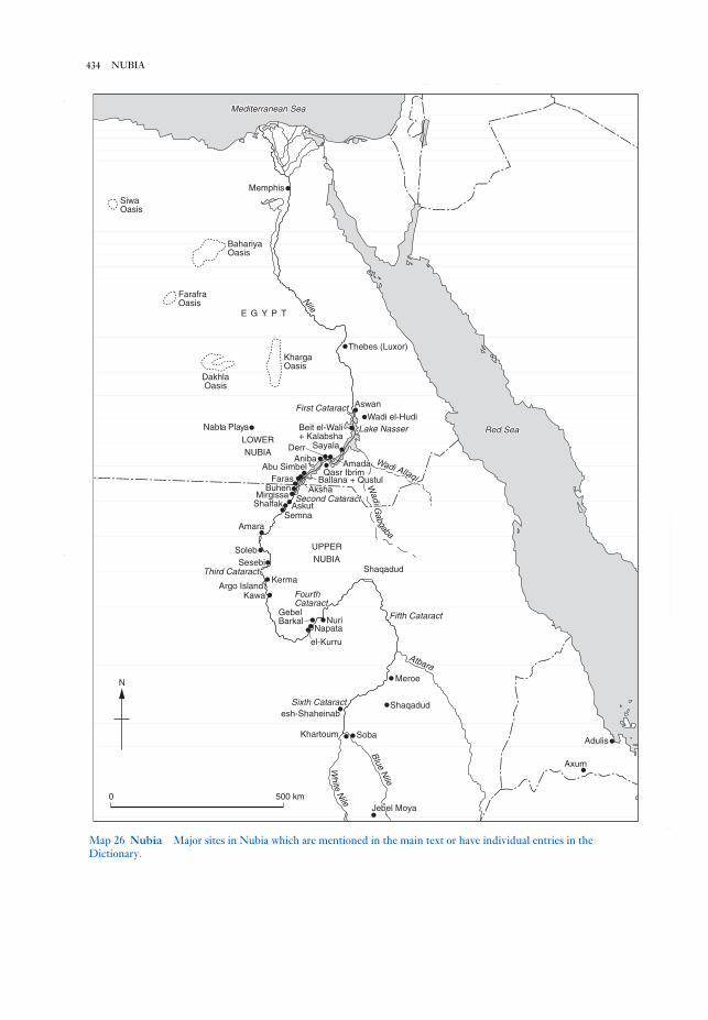
434 NUBIA
Abu SimbelAbu Simbel
NileNileNile
BahariyaBahariyaOasisOasis
FarafraFarafraOasisOasis
E G Y P TE G Y P T
Thebes (Luxor)Thebes (Luxor)KhargaKhargaOasisOasis
DakhlaDakhlaOasisOasis
First CataractFirst CataractFirst Cataract AswanAswan
Wadi el-HudiWadi el-HudiLake NasserLake NasserLake NasserBeit el-WaliBeit el-WaliBeit el-Wali
+ Kalabsha+ KalabshaSayalaSayala
AmadaAmadaQasr IbrimQasr Ibrim
AnibaAniba
LOWERLOWERNUBIANUBIA
Nabta PlayaNabta PlayaNabta Playa
WWaaddiii AAllllllaaqqiii
WWaaddiiiiii GG
aabbggaabbaa
Second CataractSecond CataractSecond CataractAkshaAksha
FarasFaras Ballana + QustulBallana + QustulBuhenBuhen
MirgissaMirgissaAskutAskutShalfakShalfak
SemnaSemnaAmaraAmara
SolebSolebSesebiSesebi
Third CataractThird CataractThird CataractKermaKerma
Argo IslandArgo IslandKawaKawa FourthFourth
CataractCataractGebelGebelBarkalBarkal
NapataNapata
el-Kurruel-Kurru
NuriNuri Fifth CataractFifth Cataract
AtbaraAtbara
MeroeMeroe
Sixth CataractSixth Cataract ShaqadudShaqadudesh-Shaheinabesh-Shaheinab
SobaSobaKhartoumKhartoum
Blue Nile
Blue Nile
WWhhiiittee
NNiiilllee
Jebel MoyaJebel Moya
AxumAxum
AdulisAdulis
UPPERUPPERNUBIANUBIA
ShaqadudShaqadud
Mediterranean SeaMediterranean SeaMediterranean Sea
MemphisMemphis
SiwaSiwaOasisOasis
Red SeaRed SeaRed Sea
Abu Simbel
Nile
BahariyaOasis
FarafraOasis
E G Y P T
Thebes (Luxor)KhargaOasis
DakhlaOasis
First Cataract Aswan
Wadi el-HudiLake NasserBeit el-Wali
+ KalabshaSayala
AmadaQasr Ibrim
AnibaDerr
LOWERNUBIA
Nabta Playa
Wadi Allaqi
Wadi G
abgaba
Second CataractAksha
Faras Ballana + QustulBuhen
MirgissaAskutShalfak
SemnaAmara
SolebSesebi
Third CataractKerma
Argo IslandKawa Fourth
CataractGebelBarkal
Napata
el-Kurru
Nuri Fifth Cataract
AtbaraMeroe
Sixth Cataract Shaqadudesh-Shaheinab
SobaKhartoum
Blue Nile
White
Nile
Jebel Moya
Axum
Adulis
UPPERNUBIA
Shaqadud
Mediterranean Sea
Memphis
SiwaOasis
Red Sea
N
0 500 km
Map 26 Nubia Major sites in Nubia which are mentioned in the main text or have individual entries in the
Dictionary.

the X Group or Ballana period (see BALLANA andBLEMMYES) and the Christian and Islamic periods.
For discussion of the history of the archaeological
exploration of Nubia see LAKE NASSER.B.G. Trigger: Nubia under the pharaohs (London, 1976);
D. O’Connor: Ancient Nubia: Egypt’s rival in Africa(Philadelphia, 1983); W.Y. Adams: Nubia: corridor toAfrica, 2nd edn (Princeton, 1984); T. Säve Söderbergh:
Temples and tombs of ancient Nubia (London, 1987); P.L.
Shinnie: Ancient Nubia (London, 1996); D.A. Welsby:
The kingdom of Kush: the Napatan and Meroitic empires(London, 1996).
IS
Nuffar see NIPPUR
null hypothesis see HYPOTHESIS TESTING
nuraghi (nuragi) Defensive fortifications of
the Sardinian Bronze Age, composed of massive
stone-block (CYCLOPEAN) towers. The towers,
which are shaped like truncated cones and may be
10–20 m high, enclose one or more floors of,
generally, corbel-vaulted rooms; frequently a spiral
staircase leads to the upper floor. Reliable absolute
dates and associated pottery sequences are only
slowly becoming available, but the nuraghi may
have developed during the early to mid-2nd mil-
lennium BC, with complex nuraghi being built from
about 1200 BC; many nuraghi were used and
adapted until or beyond the Roman invasion of
238 BC. Mycenaean pottery has been found at some
sites, and in the past Mycenaean architecture has
been suggested as a prototype for nuraghic
corbelled vaulting – though the early dates now
suggested make a local origin more likely. The
majority of the c.7000 nuraghic structures on
Sardinia are single towers, and are presumed to
have been the strongholds of the most powerful
local families, while perhaps also acting as refuges
and storehouses for the general community. The
idea of the nuraghi as aristocratic centres of a
‘clientage’ system is developed in Webster (1996).
The later complex nuraghi exhibit multiple
subsidiary towers or bastions, curtain walls, and
associated villages of predominantly round houses
(e.g. BARUMINI). These complex nuraghi are some-
times presumed to have been ‘proto-castles’, acting
as centres for a regional power in an essentially feu-
dal system (Lilliu 1982) or, less dramatically, as the
seats of petty chieftains (Webster 1991).
Nuraghic civilization. The builders of the nuraghi
also constructed enclosed votive wells and ‘tomba
di giganti’ – elongated stone-corridor tombs with
Nubia Ancient geographical area which corres-
ponds to the zone between modern Aswan and
Khartoum, i.e. northern Sudan and southernmost
Egypt. From at least as early as the 4th millennium
BC until the Middle Ages Nubia has served as a
crucial conduit, through which the raw materials of
tropical Africa passed northwards en route for the
civilizations of the Mediterranean and Western
Asia. The region is punctuated by six Nile
‘cataracts’, a series of rocky areas of rapids marking
the abrupt geological changes characterizing this
section of the Nile valley. In terms of modern
political boundaries, Nubia encompasses both
northern Sudan and the southern end of Egypt,
although most of the Egyptian section of Nubia has
been submerged since the completion of the High
Dam at Aswan in 1971 (see LAKE NASSER).
The material culture of the Palaeolithic period is
broadly similar throughout the lower Nile valley,
but the industries and ‘traditions’ of the Final
Palaeolithic, Mesolithic and Neolithic periods are
the first real indications of the existence of a number
of culturally distinct groups in the Nubian section
of the valley (see ABKAN, ARKINIAN, EPIPALAEO-
LITHIC, KHARTOUM MESOLITHIC and KHARTOUM
NEOLITHIC). The subsequent history of Nubia was
barely known until the survey and excavation
undertaken by George Reisner in the first few
decades of the 20th century, which enabled the
various phases of indigenous Nubian culture to be
delineated: the A GROUP, the C GROUP, the kingdom
of Kush (divided chronologically into the KERMA
culture and the NAPATAN and MEROITIC periods,
435NURAGHI (NURAGI)
Lower Palaeolithic 700,000 – 100,000 BC
Middle Palaeolithic 100,000 – 26,000 BC
Upper Palaeolithic 26,000 – 10,000 BC
Final Palaeolithic (Arkinian) 10,000 – 6000 BC
Khartoum Mesolithic 6000 – 3500 BC
Khartoum Neolithic/CataractTradition (Gemaian, Qadanand Abkan industries) 4000 – 3000 BC
A Group (A Horizon) 3500 – 2800 BC
C Group (C Horizon) 2300 – 1500 BC
Kerma culture 2500 – 1500 BC
New Kingdom (Egyptian occupation) 1540 – 1070 BC
Napatan period 1000 – 300 BC
25th dynasty (Nubian ruleover Egypt) 712 – 664 BC
Meroitic period 300 BC – AD 350X Group (X Horizon,
Noba, Ballana) AD 350 – 550Christian period AD 550 – 1500Islamic period AD 1500 –
Table 16 Nubia Chronology of Nubia.
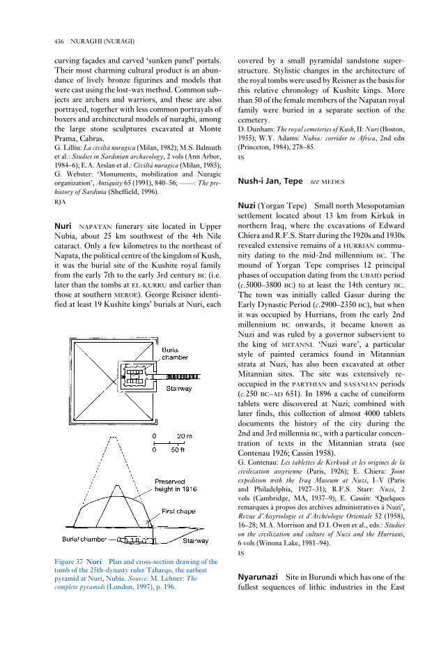
covered by a small pyramidal sandstone super-
structure. Stylistic changes in the architecture of
the royal tombs were used by Reisner as the basis for
this relative chronology of Kushite kings. More
than 50 of the female members of the Napatan royal
family were buried in a separate section of the
cemetery.D. Dunham: The royal cemeteries of Kush, II: Nuri (Boston,
1955); W.Y. Adams: Nubia: corridor to Africa, 2nd edn
(Princeton, 1984), 278–85.
IS
Nush-i Jan, Tepe see MEDES
Nuzi (Yorgan Tepe) Small north Mesopotamian
settlement located about 13 km from Kirkuk in
northern Iraq, where the excavations of Edward
Chiera and R.F.S. Starr during the 1920s and 1930s
revealed extensive remains of a HURRIAN commu-
nity dating to the mid-2nd millennium BC. The
mound of Yorgan Tepe comprises 12 principal
phases of occupation dating from the UBAID period
(c.5000–3800 BC) to at least the 14th century BC.
The town was initially called Gasur during the
Early Dynastic Period (c.2900–2350 BC), but when
it was occupied by Hurrians, from the early 2nd
millennium BC onwards, it became known as
Nuzi and was ruled by a governor subservient to
the king of MITANNI. ‘Nuzi ware’, a particular
style of painted ceramics found in Mitannian
strata at Nuzi, has also been excavated at other
Mitannian sites. The site was extensively re-
occupied in the PARTHIAN and SASANIAN periods
(c.250 BC–AD 651). In 1896 a cache of cuneiform
tablets were discovered at Nuzi; combined with
later finds, this collection of almost 4000 tablets
documents the history of the city during the
2nd and 3rd millennia BC, with a particular concen-
tration of texts in the Mitannian strata (see
Contenau 1926; Cassin 1958).G. Contenau: Les tablettes de Kerkouk et les origines de lacivilization assyrienne (Paris, 1926); E. Chiera: Jointexpedition with the Iraq Museum at Nuzi, I–V (Paris
and Philadelphia, 1927–31); R.F.S. Starr: Nuzi, 2
vols (Cambridge, MA, 1937–9); E. Cassin: ‘Quelques
remarques à propos des archives administratives à Nuzi’,
Revue d’Assyriologie et d’Archéologie Orientale 52 (1958),
16–28; M.A. Morrison and D.I. Owen et al., eds.: Studieson the civilization and culture of Nuzi and the Hurrians,6 vols (Winona Lake, 1981–94).
IS
Nyarunazi Site in Burundi which has one of the
fullest sequences of lithic industries in the East
curving façades and carved ‘sunken panel’ portals.
Their most charming cultural product is an abun-
dance of lively bronze figurines and models that
were cast using the lost-wax method. Common sub-
jects are archers and warriors, and these are also
portrayed, together with less common portrayals of
boxers and architectural models of nuraghi, among
the large stone sculptures excavated at Monte
Prama, Cabras.G. Lilliu: La civiltà nuragica (Milan, 1982); M.S. Balmuth
et al.: Studies in Sardinian archaeology, 2 vols (Ann Arbor,
1984–6); E.A. Arslan et al.: Civiltà nuragica (Milan, 1985);
G. Webster: ‘Monuments, mobilization and Nuragic
organization’, Antiquity 65 (1991), 840–56; ––––: The pre-history of Sardinia (Sheffield, 1996).
RJA
Nuri NAPATAN funerary site located in Upper
Nubia, about 25 km southwest of the 4th Nile
cataract. Only a few kilometres to the northeast of
Napata, the political centre of the kingdom of Kush,
it was the burial site of the Kushite royal family
from the early 7th to the early 3rd century BC (i.e.
later than the tombs at EL-KURRU and earlier than
those at southern MEROE). George Reisner identi-
fied at least 19 Kushite kings’ burials at Nuri, each
436 NURAGHI (NURAGI)
Figure 37 Nuri Plan and cross-section drawing of the
tomb of the 25th-dynasty ruler Taharqo, the earliest
pyramid at Nuri, Nubia. Source: M. Lehner: Thecomplete pyramids (London, 1997), p. 196.

tions of 1960) are therefore in secondary situations
and do not lend themselves to site-activity analyses
as attempted on other East African sites.J. Nenquin: Contributions to the study of the prehistoriccultures of Rwanda and Burundi (Tervuren, 1967).
JS
African interlacustrine region, dating from the
latter part of the Early Stone Age (Late
ACHEULEAN and SANGOAN) to the Middle and
Later Stone Age. All the deposits are riverine; the
archaeological materials (brought to light during
alluvial tin-mining, followed by Nenquin’s excava-
437NYARUNAZI

Oakhurst LSA (Later Stone Age) large rock-
shelter located 22 miles east of George, Cape
Province, South Africa. Excavated in the 1930s, the
shelter provided the first direct stratigraphical
evidence for the relationship between the entities
known then as Smithfield and WILTON, currently
seen as ALBANY and Wilton. The site is notable for
the 31 burials recorded, often with various grave
goods. Basal levels may contain MSA (Middle
Stone Age) material.A.J.H. Goodwin: ‘Archaeology of the Oakhurst Shelter,
George’, Transactions of the Royal Society of South Africa,
25/3 (1938), 230–324; J. Deacon: Guide to archaeologicalsites in the southern Cape. (Stellenbosch, 1979).
RI
Oakhurst Industry see ALBANY INDUSTRY
obelisk (Gk obeliskos) Ancient Egyptian upright
vertical shaft, generally of stone or wood, tapering
gradually from top to bottom and surmounted by a
pyramidion (miniature pyramid). Obelisks were
first erected as part of the worship of the sun-god,
with the pyramidion representing the sacred benben-
stone (perhaps originally a symbol of the primeval
mound of creation). In later periods pairs of obelisks
were placed in front of the entrances to tombs and
temples, as at Karnak and Luxor. An unfinished
granite obelisk, probably dating to the 18th dynasty
(c.1450 BC), is still in situ at the Aswan quarries.E. Iversen: Obelisks in exile (Copenhagen, 1972); L.
Habachi: The obelisks of Egypt (London, 1978);
R. Hayward: Cleopatra’s needles (Buxton, 1978).
IS
oblique photographs see AERIAL
ARCHAEOLOGY
Obobogo Village site near Yaoundé,
Cameroon, excavated by Pierre de Maret in 1980–3,
where traces of Late Stone Age occupation have
been dated to 6020 ± 505 BP. The main ‘Neolithic’
settlement has been dated to between 3625 and
2635 BP, with reliable radiocarbon age determina-
tions for the first occurrence of iron slag at
2310 ± 100 and 2120 ± 70 or 150 BP. A number of
pits (also known from about 10 other comparable
sites in the area) may have been used for storage,
construction or rubbish disposal purposes.
Excavated materials include flat-bottomed pottery
vessels and polished axes of dolerite, as well as
organic remains including nuts of Elaeis guineensisand Canarium schweinfurthii, and charcoal indica-
tive of forest species. De Maret suggests that there
is a good parallel between developments at Obobogo
and those at sites attributed to the ‘KINTAMPO
culture’ in Ghana.P. de Maret: ‘Le contexte archéologique de l’expansion
Bantu en Afrique centrale’, Les peuples Bantu, migrations,expansion et identité culturelle I, ed. Th. Obenga (Libreville
and Paris, 1989), 118–44; A. Holl: ‘Néolithique:
Cameroun’; ‘L’âge du fer ancien: Cameroun’, Aux originesde l’Afrique Centrale, ed. R. Lanfranchi and B. Clist (Paris,
1991), 148–54, 192–6.
PA-J
obsidian Natural glass formed by the cooling of
siliceous magmas from volcanic eruptions and an
important resource for stone tool-making. Obsidian
was highly valued and widely traded because of its
sharp edges, although its brittleness somewhat
limits its usefulness in certain activities. Because the
chemical composition of obsidian sources varies
sensitively, artefacts can be ‘fingerprinted’ by
archaeologists and traced to their original source
flows, allowing reconstruction of ancient trade net-
works. Artefacts can also be dated by the OBSIDIAN
HYDRATION method (see COPAN), in which age is
determined from the degree of alteration of the
surface since flaking of the tool, as measured with a
special microscope. For Japanese use of obsidian seeNOGAWA; for Mesoamerican use see TEOTIHUACÁN
and TOLTECS; for North American use see NAMU; forAncient Near Eastern use see ACERAMIC NEOLITHIC;
for East Africa see KARIANDUSI; for Europe seeCYCLADIC CULTURE; and for Oceania see
TALASEA.A. Lucas: ‘Obsidian’, ASAE 47 (1947) 113–23; R.S.
O

central Australian deserts to the small atolls of the
remote Pacific. The region was settled progres-
sively over a period of at least 60,000 years, with
human groups moving into Australia at that date
but not reaching New Zealand, the last major land-
mass on earth to be settled, until around AD 800. As
far as we know, even the earliest of these groups
were fully modern humans, and Oceania provides a
series of case studies in the colonizing abilities of
human beings.
Oceania can be divided in a number of ways,
depending on the criteria used. Flora and fauna
provide a unifying factor: the vast majority of the
plants and the animals of the region derived
from Gondwanaland, a super-continent comprising
South America, southern Africa, India, Antarctica,
Sahul (Australia and Papua New Guinea) and New
Zealand. The most famous descendants of the
Gondwanaland faunas are the marsupials of Sahul
and the flightless birds, such as the emu and the
extinct MOA. When people first entered the Oceanic
region from southeast Asia, they left behind the
familiar placental mammals of that region and
encountered a whole new range of marsupial
species. The only placental mammals found in
Oceania today are humans and those species (such
as pig, dog and chicken) introduced by humans.
Plant species show more continuity than animals,
with the rainforests of Papua New Guinea and the
western Pacific sharing many plants in common
with southeast Asia. However, many of the plants of
Papua New Guinea and especially Australia would
have been unfamiliar, such as the eucalypts, desert
faunas and southern Australian rainforests.
Over the last century it has been established that
the main source of species for the island Pacific
is Sahul and island southeast Asia rather than
the Americas. There is, however, a major bio-
geographic divide at the eastern end of the Solomon
Island chain: east of that point there were no
endemic animal species and the structure of plant
communities is far simpler (except in New
Zealand). The lack of plants and animals may have
proved a major barrier to colonizing humans:
human groups reached the Solomon chain by
almost 30,000 years ago, but do not seem to have
moved east of this until around 3500 BP. The
Chatham Islands, to the east of New Zealand, were
possibly the last part of the Pacific to be settled in
prehistoric times – probably by a group known as
the Moriori, from the South Island of New Zealand,
about 300 years ago.
Sections: 1 Australia and Tasmania; 2 Melanesia,
Polynesia and Micronesia
1 Australia and Tasmania. An example of one of the
Santley: ‘Obsidian trade and Teotihuacan influence
in Mesoamerica’, Highland-Lowland interaction inMesoamerica: interdisciplinary approaches, ed. A.G. Miller
(Washington, D.C., 1980), 69–124; R.L. Carlson: ‘Trade
and exchange in prehistoric British Columbia’, Prehistoricexchange systems in North America II, ed. T.G. Baugh and
J.E. Ericson (New York, 1995).
PRI
obsidian hydration dating Scientific dating
technique based on the thickness of the hydration
layer on a struck surface of obsidian; the layer is the
result of the diffusion of water and its thickness
depends not only on the time since exposure of the
surface, but also on temperature and the type of
obsidian (i.e. its source). It does not, however,
depend on humidity, as the water uptake is small
and there is sufficient in any environment. For a
given temperature, the layer thickness increases
according to the square root of the age.
Typical layer thicknesses are 1–50 μm
(1 μ = 0.001 mm) and can be measured by optical
microscopy of a polished section prepared from a
V-shaped section at right angles to the surface. The
measurement precision is about ±0.1 μm but it may
be possible to improve this to ±0.02 by using new
techniques. An error of 10% in the thickness
measurement produces an error of 20% in the age
estimate. The diffusion rate constant for a particu-
lar type (source) of obsidian can be determined by
measurements at elevated temperature that induce
a hydration layer in a short period. Deducing the
effective burial temperature is less straightforward,
particularly over long periods with significant
climatic change (a similar problem is encountered in
AMINO ACID DATING). Large systematic errors
in age estimate could result, since the rate constant
increases exponentially with temperature. The age
range depends, at the lower end, on having a layer
thickness that is measurable and thus on the rate
constant and therefore temperature and, at the
upper end, it largely depends on the preservation of
the original surface. Published dates range from 200
to 100,000 years.
See also NITROGEN PROFILE DATING andSODIUM PROFILE DATING.
R.E. Taylor, ed.: Advances in obsidian glass studies –archaeological and geochemical perspectives (New Jersey,
1976).
SB
Oceania Oceania stretches from Papua New
Guinea and Australia in the west, to EASTER
ISLAND and the Hawaiian Islands in the east. It
offers a huge diversity of environment, from the
439OCEANIA

obliged to adapt during the last glaciation. Modern
humans first entered Tasmania 35,000 years ago, at
which time they were the most southerly people on
Earth. During the height of the last glaciation, they
lived in a sub-antarctic landscape close to upland
glaciers. In the southwest of Tasmania, in an area
today covered by temperate rainforest, seven lime-
stone caves have been excavated which show that
people inhabited this region from 35,000 years ago
to the end of the Pleistocene. Glaciers existed at the
upper end of mountain valleys in the region, reach-
ing their maximum extent 18,000 years ago. At
lower altitudes, grasslands and herbfields attracted
wallabies and emus. These species were preyed
upon by humans, who left huge amounts of bone in
the caves. For instance, in Nunamira cave in the
Florentine valley 200,000 pieces of bone were
recovered from a cubic metre of soil, and 90% of
this bone was from one species: the red-necked
wallaby. The presence of emu eggshell shows that
these sites were occupied in late winter and early
spring, the most difficult period of the year in this
subantarctic landscape. It is likely that people were
moved through these areas seasonally. Bone points
dating back to 26,000 years ago indicate the work-
ing of hides and other pliable materials, perhaps to
make clothing.
By contrast, at the other end of the Sahulian con-
tinent, from about 35,000 years ago, humans
occupied the limestone caves of New Ireland, just
south of the equator. Here the temperature and
most ancient Australian sites is Malakunanja, a large
rockshelter near the Arnhem Land escarpment in
northern Australia. The shelter contained 4 m of
deposit, the upper 2.6 m of which yielded stone
tools. The lowest artefact-bearing layers have been
dated using thermoluminescence to around 50,000
years ago, which would make Malakunanja one of
the oldest inhabited sites in Australia – but the
dating has aroused controversy. Other early sites
include DEVIL’S LAIR, where artefact-bearing layers
date from before 33,000 years ago. Sites such as
Burrill Lake rock shelter, a large sandstone rock
shelter on the south coast of New South Wales, first
occupied c.20,000 years ago, preserve HORSE-HOOF
CORES and other elements of the early AUSTRALIAN
CORE TOOL AND SCRAPER TRADITION in the lower
layers, while around 5000 BP there was a change to
backed blades and tool types of the later
AUSTRALIAN SMALL TOOL TRADITION (Lampert
1971). KENNIFF CAVE helped archaeologists to dis-
tinguish these two generic tool traditions, while
CLOGG’S CAVE provides another example.
A.R. Radcliffe-Brown, the eminent anthropolo-
gist, famously described Australian Aborigines as
‘an unchanging people in an unchanging land-
scape’. Archaeology has given the lie to this
statement across the continent (e.g. the LAKE
MUNGO in New South Wales), but perhaps
nowhere more so than in Tasmania, where evidence
from the Pleistocene has demonstrated the great
range of environments to which humans were
440 OCEANIA
N
Map 27 Oceania The distribution of Austronesian languages in Oceania.

over, to be superseded by the incised wares of the
Vuda (900–400 BP) and Ra (400 BP–present) phases.
In the Lapita period, settlement is all coastal; from
the Vuda and Ra phases thousands of forts are
known, which vary in size and layout from one part
of Fiji to another.
Polynesia is often thought of as a triangle, with
the Hawaiian group, Easter Island and New
Zealand as its three points. In contrast to the di-
versity of the Melanesian populations, Polynesians
all speak closely-related Austronesian languages
(see map 27 opposite), and are linked by material
culture (e.g. the AHU) and social structure (Kirch
1984). Much of the prehistory of Polynesia has been
written in culture-historical terms, with many
scholars identifying Polynesian origins in southeast
Asia, where the Austronesian languages are thought
to have originated. The Polynesian islands range in
size from New Zealand (501,776 sq. km) to tiny
islands with relatively huge populations, such as
Anuta (0.4 sq. km), and are distributed from the
equator to sub-antarctic climes. Their cultural
history thus provides a good example of how diverse
environments can effect change upon one related
cultural group; here, the anthropological work of
Sahlins (1958) has considerably influenced the
practice of archaeology.
Maoris, the indigenous inhabitants of New
Zealand (probably east Polynesian in origin), arrived
in New Zealand between 800 and 1000 years ago. As
recorded in oral histories and the archaeological evi-
dence, there may well have been settlement by more
than one group: the north and south islands of New
Zealand demonstrate different histories, with agri-
culture based around sweet potato mainly restricted
to the north island, and the fortified PA (earthworks)
and the largest MOA hunting sites known from the
south island. TONGA represents another Polynesian
island with a complex cultural history, while
HALAWA VALLEY is an example of a number of alleys
in the Hawaiian islands that have now been surveyed
archaeologically.
Micronesia, which lies to the east of island south-
east Asia and to the north of both Melanesia and
western Polynesia, is the area of the Pacific least
researched by archaeologists. The earliest dated
entry of humans into Micronesia is roughly con-
temporary with the first moves into Polynesia, at
around 3500 BP. The colonists possessed a broadly
similar material culture, especially in the form of
red-slipped pottery. As in Polynesia, anthro-
pological investigations have heavily influenced
archaeology, and one focus of interest has been the
growth of stratified societies, such as the Yapese
‘empire’, over the last few hundred years.
rainfall throughout the last glaciation were little dif-
ferent from today, creating a fully tropical
environment. The fact that people adapted to such
diverse environments in different parts of the
Greater Australian continent soon after the first col-
onization of that continent testifies to an
extraordinary flexibility of response.
2 Melanesia, Polynesia and Micronesia. Outside
Australia, the rest of the Pacific is conventionally
divided into Melanesia, Ploynesia and Micronesia.
Melanesia encompasses the area from Papua New
Guinea to Fiji; it thus includes the large islands of
the western Pacific and those which were settled
first, although, as noted above, Papua New Guinea
has a mixed history, having been joined to Australia
until 8000 years ago and first settled as early as
c.40,000 years ago. Ancient sites in the region
include the New Ireland site of MATENKUPKUM.
The later site of BALOF CAVE, again on New Ireland,
provides evidence for the translocation of animals,
while KUK SWAMP, in the Western Highlands of
Papua New Guinea, offers some of the earliest
evidence for farming in the world, going back to
9000 BP. The evidence from Kuk also illuminates
the link between Oceanic economic production and
social relations, as does the much later evidence
from MOTUPORE. New Britain, the largest island in
the western Pacific, is tectonically active, with a ring
of volcanoes on the north coast that produced the
widely-traded obsidian at TALASEA. New Britain’s
prehistory goes back 35,000 years, and open sites
such as Yombon have been preserved by volcanic
ashes (Pavlides 1993). Extensive excavations in the
Arawe Islands on the south coast have revealed
many sites with evidence of the LAPITA CULTURAL
COMPLEX – a key cultural phenomenon in early
Western Pacific prehistory – as well as providing a
full picture of the island’s later prehistory (Gosden
et al. 1989).
TIKOPIA, a small island (4.6 sq. km) first settled
in the Lapita period, lies 200 km north of Vanuatu
and 200 km southeast of the Santa Cruz Islands in
the Pacific. Recent in-depth studies of the island
provide a classic example of the interdependence
between landscape, society and subsistence – a
recurring theme in Pacific archaeology. Tikopia
also exemplifies the way in which the natural flora
and fauna of many Pacific islands has been sub-
stantially replaced by introduced species – the
notion of ‘TRANSPORTED LANDSCAPES’.
Fiji, on the eastern border of Melanesia, was
again settled at the time of the Lapita complex. Fiji’s
prehistory is mainly distinguished by changing
pottery styles: Lapita styles last until around
2000 BP, when Navatu impressed pottery takes
441OCEANIA

script of India dated to the late 1st or early 2nd
century AD. Further examples of Indian scripts
suggest that the site was still occupied three
centuries later. A great deal of gold jewellery was
found, incorporating a variety of precious and semi-
precious stones comprising virtually the entire
available range. Pottery was also locally manu-
factured, and sandstone moulds for casting bronze
and tin jewellery were recovered.
The date, monumentality and location of Oc Eo
make it highly likely that it was a site of the FUNAN
polity, which was described by two chinese
emissaries of the Wu emperor, Kang Dai and Zhu
Ying, in about AD 250. They reported a country
with cities, kings, palaces and a taxation system.
There was evidently also contact with India, since
the same Chinese emissaries mention that they met
a representative of the Murunda king in India.L. Malleret: L’archéologie du Delta du Mekong (Paris
1959–63).
CH
Ochre Coloured Pottery (OCP) Ceramics
associated with the early occupants of the Ganges–
Yamuna river basin of northern India c.1800–1400
BC. The OCP ceramics include a wide variety of
vessel forms including jars and bowls, pedestalled
bowls, and miniature forms (Dikshit 1979: 291),
typically wheel-made, poorly fired and coated with
a red or orange slip or wash, sometimes with incised
or painted decoration.
Remains of the OCP period are known from a
number of sites, including Ahichchatra, ATRAN-
JIKHERA and HASTINAPURA. OCP sites have
sometimes been grouped into a single cultural
tradition, associated with the similarly defined
‘copper hoard culture’ (see GANGETIC HOARDS),
but several specialists have cautioned against this,
citing regional variations in vessel forms and surface
treatment, and poor chronological and stratigraphic
control at many sites. In 1971, the Archaeological
Survey of India organized a conference on the OCP
in which it was acknowledged that OCP sites should
be divided into a western and eastern geographic
zone, each with distinctive forms (Gupta 1971–2).
The association of OCP ware with copper hoards
is also unclear; both have been found in a number of
different contexts, but provenance data is poor and
D.P. Agrawal (1982: 208) has suggested that their
association is at present only circumstantial, there-
fore much more research needs to be done to
evaluate their relations.S.P. Gupta, ed.: ‘Proceedings of the seminar on OCP and
NBP’, Puratattva 5 (1971–72):1–104; K.N. Dikshit: ‘The
Ochre Coloured Ware settlements in Ganga-Yamuna
Anthropological knowledge about recent social
forms has tended to influence archaeologists. Thus
Australia is seen as the ‘hunter-gatherer’ continent,
settled by egalitarian groups with few of the social
divisions found amongst farmers. Melanesia has
provided anthropological studies of ‘BIG MAN’
social forms in which personal standing is achieved
through manipulating subsistence and trade, rather
than through inheritance. (The history of trading
systems and their social consequences is central to
much of the archaeology undertaken in Papua New
Guinea.) In both Micronesia and Polynesia, the
growth of chiefdom societies, in places such as Yap,
Tonga and Hawaii, has formed the central issue.
Much archaeological work in Oceania has been
by American scholars, influenced by the NEO-
EVOLUTIONARY school of anthropologists who
worked in the area from the 1950s to the 1970s.M. Sahlins: Social stratification in Polynesia (Seattle,
1958); R.J. Lampert: Burrill Lake and Currarong(Canberra, 1971); E.L. Frost: ‘Fiji,’ The prehistory ofPolynesia, ed. J. Jennings (Canberra, 1979), 61–81; J.
Davidson: The prehistory of New Zealand (Auckland,
1984); P.V. Kirch: The evolution of Polynesian chiefdoms(Cambridge, 1984); Gosden et al.: ‘The Lapita sites of the
Bismarck Archipelago’, Antiquity 63 (1989), 561–86; A.
Anderson and M. McGlone: ‘Living on the edge: pre-
historic land and people in New Zealand’, The naive lands,ed. J. Dodson (Melbourne, 1992), 199–241; C. Pavlides:
‘Archaeological research at Yombon, West New Britain,
Papua New Guinea’, Archaeology in Oceania 28 (1993),
55–9; J. Allen and J.F. O’Connell, eds: Transitions:Pleistocene to Holocene in Australia and Papua New Guinea[published as special number of the journal Antiquity, 69:
(1995) 265].
CG
Oc Eo Rectangular site enclosed by five ramparts
and four moats, and covering 450 ha, located in the
transbassac region of southern Vietnam. Oc Eo is
the key site for appreciating the timing and manner
of the entry of Southeast Asia into the great trading
network which linked China with India and Rome
in the early centuries of the Christian era.
Aerial photographs reveal that Oc Eo was linked
by canals to other sites in this flat, low-lying deltaic
terrain. Excavations in 1944 by Mallaret uncovered
large stone and brick structures in the central area
and the remains of industrial activity, such as glass
and metal working. A wealth of material items,
excavated or purchased from local looters, shows
that the site was occupied from the 2nd century AD.
Malleret recovered two Roman medallions minted
during the reigns of Antoninus Pius (AD 138–161)
and Marcus Aurelius (AD 161–180), Iranian
coinage, and jewellery engraved in the Brahmi
442 OCEANIA

the mid-6th century and flourished especially in the
5th–4th centuries BC, when a network of agri-
cultural settlements appeared in the hinterland.
The density of Greek settlement declined in the late
3rd century BC. The city further declined in
the 2nd–1st centuries BC, when it was controlled by
the SCYTHIAN kings. There was a substantial
development in the 1st–3rd centuries AD, and in the
middle of the 2nd century AD, a Roman garrison
was stationed in Olbia. The city ceased to exist in
the 4th century AD.E.I Levi, ed.: Olvia: temenos i hora (Leningrad, 1964);
S.D. Kryzhytsky: Olvia (Kiev, 1985).
PD
Old Bering Sea culture This, and the closely
related Okvik culture, represent the earliest phase
of the THULE TRADITION (1st–6th century AD).
Sites are found primarily on islands in the Bering
Strait, but are also known on the adjacent Siberian
shores. The economy is based primarily on the
exploitation of sea mammals. The complex and
intricate carving styles found on most implements
– not seen on similar items from later in the Thule
tradition – have been interpreted as having magical
significance, and may indicate close cultural ties
with societies in east Asia.O.W. Geist and F.G. Rainey: ‘Archaeological excavations
at Kukulik, St Lawrence Island, Alaska’, MiscellaneousPublications of the University of Alaska 2 (1936); H.B.
Collins: ‘Archaeology of St Lawrence Island, Alaska’,
Smithsonian Miscellaneous Collections 96 (1937).
RP
Old Copper Term used in North American
archaeology to refer to the copper artefacts of the
Late Archaic period (c.3000–1000 BC) found
throughout the Lake Superior Basin, particularly in
eastern Wisconsin. Once thought to represent the
remains of a specific culture (Old Copper Culture),
Doab’, Essays in Indian protohistory, ed. D.P. Agrawal and
D.K. Chakrabarti (Delhi, 1979), 285–99; D.P. Agrawal:
The archaeology of India (Copenhagen, 1982), 198–210.
CS
Ocmulgee (Macon Plateau) Early MISSISSIP-
PIAN site in central Georgia (USA) that is thought
to intrude into the area from about AD 950–1150,
but there is also recent consideration of the role of
indigenous cultures in its development. The site
contains several large mounds, fortifications,
household areas and extensive sets of ridges and
furrows for agricultural fields. The most famous
structure is a subterranean building 13 m in
diameter that has been interpreted as a council
chamber. It contains 47 niches (thought to be seats)
around the perimeter of the structure, and a raised
clay platform ‘throne’ in the shape of a bird with
three seats.C.H. Fairbanks: ‘The Macon earth lodge’, AA 12 (1946),
94–108; D.J. Hally, ed.: Ocmulgee archaeology, 1936–1986(University of Georgia Press, Athens, 1994).
WB
Ogooué Basin see AFRICA 5
Ohemir, Tel el- see KISH
Okhotsk Marine-oriented culture found around
the coast of the Okhotsk Sea in the islands of
Hokkaido, Japan and Sakhalin (Russia), as well as in
the southern Kuriles between the 8th and 14th
centuries AD. Characterized by large hexagonal
houses, elaborate bone working and bear ritualism,
it is contemporary with the SATSUMON culture.C.M. Aikens and D.E. Dumond: ‘Convergence and
common heritage: some parallels in the archaeology of
Japan and western north America’, Windows on theJapanese past, ed. R. Pearson, K. Hutterer and G.L.
Barnes (Ann Arbor, 1986), 163–78.
SK
Okvik culture see OLD BERING SEA CULTURE
Olbia Important Greek (Ionian) colony, later a
city-state, situated on the Bug-Dniestr Liman(estuary), near the town of Ochakov in the Ukraine.
The site has been excavated by Russian and
Ukrainian archaeologists since the 1850s. The
earliest Greek settlement emerged on the island of
Berezan in the Bug-Dniestr estuary in the late 7th
century BC. The Olbia township appeared in
443OLD COPPER
Figure 38 Old Bering Sea culture Intricately carved
harpoon head, Old Bering Sea culture, Alaska. Source:
O.W. Geist and F.G. Rainey: Archaeological excavationsat Kukulik, St Lawrence Island, Alaska (Washington
D.C.: University of Alaska Publications, 1936), fig. 41.

scientific principles. The Biddles subsequently
employed the same methods at two other medieval
sites in England: Repton minster church and St
Albans cathedral.M. Biddle: ‘Archaeology, architecture, and the cult of
saints in Anglo-Saxon England’, The Anglo-Saxon church,
ed. L. Butler and R. Morris (London, 1986), 1–31; B.
Kjølbye-Biddle: ‘The seventh-century minster at
Winchester interpreted’, The Anglo-Saxon Church, ed. L.
Butler and R. Morris (London, 1986), 196–209.
RH
Olduvai, Oldowan Gorge in Tanzania which
has become almost synonymous with the quest for
human origins, following the discoveries of the
remains of early humans and near-humans made by
Mary and Louis Leakey from 1959 onwards. The
massive erosion gully – about 100 m deep – cuts
through the southern edge of Serengeti plain, facing
Ngorongoro and the Crater Highlands. It reveals a
succession of Pleistocene lake-beds, the lowest
nearly two million years old. The obvious
geochronological and palaeo-environmental im-
portance of this unparalleled sequence of exposed
deposits is enhanced by their containing fossilized
bones of numerous animals (in most cases extinct
species of modern African genera). Equally import-
ant is the stratified succession of Early Stone Age
tools and flakes, mostly of the ACHEULEAN (hand-
axe) tradition, but in the lower beds, dating before
1.5 million years, belonging to the Oldowan (some-
times called ‘pebble-tool’) tradition.
The geological and palaeontological importance
of Olduvai was recognised by Hans Reck, who
worked there in 1913, but unfortunately his
materials were lost during the First World War. In
1931 he returned to Olduvai with Louis Leakey,
who quickly appreciated the site’s archaeological
potential, although it was not until 1959, after
several subsequent expeditions, that significant
fossils of early man and near-man were discovered
at the site. That year the find of the Zinjanthropusskull (nicknamed ‘Nutcracker Man’ because of its
massive jaw and teeth) set the scene for much more
intense research effort and international funding.
At the time it was believed that the low bed con-
taining Zinjanthropus was only 0.5 million years old,
and that this specimen might represent the makers
of the associated tools. Both views were rapidly
overturned in a flurry of scientific activity and
debate. It was established by POTASSIUM-ARGON
tests that this bed with the skull and tools was about
1.75 million years old: this more than tripled the
chronology of the whole Olduvai sequence, and by
extension the Pleistocene worldwide – let alone
these artefacts are now recognized as having been
manufactured by a variety of Late Archaic groups
that lived throughout the Great Lakes region.
Much that is known about Old Copper derives from
vandalized cemeteries such as the Oconto, Osceola
and Reigh sites in Wisconsin, providing a rather
biased view of the cultures that produced these arte-
facts. The native copper used to manufacture the
artefacts came from sources in Wisconsin and
Michigan, of which Isle Royale (Michigan) is the
best known. The most common Old Copper arte-
facts are awls, tanged knives, projectile points,
semi-lunar objects or crescents, gouges and axes.T. Ritzenthaler, ed.: ‘The Old Copper culture of
Wisconsin’, The Wisconsin Archaeologist 38 (1957),
185–329; R. Mason: Great Lakes archaeology (New York,
1981), 181–99; J. Stoltman: ‘The Archaic tradition’,
Wisconsin archaeology: background for cultural resourceplanning, ed. W. Green, J. Stoltman and A. Kehoe
(Madison, 1986), 207–38.
RJE
Old Crow Flats Locality in Yukon, Canada,
that has provided controversially early radiocarbon
dates for the arrival of humans in the Americas.
The redeposited river deposits produced quantities
of modified bone from extinct animals, and a
small number of undoubted artefacts. A caribou-
tibia fleshing tool produced the early date of
c.27,000 ± 3000 BP; however, a recent AMS date on
the flesher produced an age of only 1350 ± 150 BP.
In fact, all the undisputed artefacts have been shown
to be less than 3000 years old. While, many of the
modified bones do appear to be Pleistocene in age,
their status as artefacts remains in doubt.R. Morlan et al.: ‘Accelerator Mass Spectrometry dates on
bones from Old Crow Basin, Northern Yukon Territory’,
Canadian Journal of Archaeology, 14 (1990), 75–92.
RP
Old Minster (Winchester) West Saxon
Cathedral, which was excavated in 1962–9 by
Martin Biddle and Birthe Kjølbye-Biddle, where
they developed OPEN-AREA EXCAVATION tech-
niques that have been subsequently adopted
throughout western Europe. The Biddles un-
ravelled the complex of robber trenches left after
the building was demolished in AD 1093–4, to illus-
trate how the cathedral evolved. The Old Minster
was founded in AD 648 by King Cenwalh, then
enlarged in the 9th and 10th centuries. The
painstaking excavations showed that the architec-
tural development of a great basilica could be
documented archaeologically if excavated following
444 OLD COPPER

Ravdonikas in 1936–8 and N.N. Gurina in the
1950s, the total number of graves is estimated at
more than 400 (170 were excavated). The burials
were 0.60–1.20 m below the ground surface, usually
singly (16 double burials and three triple burials), in
an extended posture facing east; after inhumation,
the bodies had been sprinkled with red ochre. Four
individuals in the northern part of the cemetery
were interred in funnel-shaped shafts 1.3–1.8 m
deep, in a standing posture facing west.
Hunting equipment (such as bone and stone
points, bone daggers, slate knives, harpoons, fish-
hooks and quivers) prevails in male graves. Female
graves, in general poorer than the male examples,
contained household artefacts, flint blades, awls,
polishers, burins and scrapers, as well as perforated
beaver incisors and snake-effigy figures. One of the
shaft graves contained six beaver mandibles. The
grave goods included 42 sculptured or ornamented
objects, including representations of elk, snakes and
humans carved in stone, wood and bone. After a
multivariate analysis of the grave goods, O’Shea and
Zvelebil (1984) concluded that the cemetery
belonged to a relatively large and stable population
with considerable internal social differentiation. It
also seems that there was an active regional
exchange network which included a wide variety of
raw materials and exotic goods (e.g. arrowheads and
knives made of grey flint). A recent series of radio-
carbon dates suggests a time-span of 6500 to
6300 BC in calendar years.N.N. Gurina: Oleneostrovskii Mogil’nik, MIAS 47
(Moscow and Leningrad, 1956); J. O’Shea and M.
Zvelebil: ‘Oleneostrovski Mogilnik: reconstructing social
and economic organization of prehistoric forages in
northern Russia’, JAA 3 (1984), 1–40.
PD
Ollantaytambo see INCA
Olmec Name given to the Middle Formative
society that flourished on the Gulf coastal plain of
Veracruz and Tabasco, Mexico, c.1400–400 BC.
The term ‘Olmec’ also refers to an unrelated group
of 16th-century peoples in highland Puebla,
Mexico, but when used by archaeologists ‘Olmec’
almost invariably refers to the Formative period
culture.
The Gulf coast Olmec were one of several com-
plex societies to develop out of late Preceramic and
Early Formative village traditions in Mesoamerica
and during the Middle Formative these groups
maintained extensive contacts with each other. The
precise origins of Olmec culture are still being
human history and the Stone Age succession in
Africa. At the same time Leakey denied that
Zinjanthropus was the toolmaker or even an early
form of human, but assigned it to the genus of near-
humans, AUSTRALOPITHECUS, already recognised
in South Africa. By designating this species
Australopithecus (Zinjanthropus) boisei, Leakey
further argued that another bipedal species was
represented among the Olduvai fossils in the same
geological beds, one with a bigger brain and more
adept hands. This one, which he regarded as human
and the early stone toolmaker, he named HOMO
HABILIS. Despite initial doubts about Leakey’s
‘juggling’ of the pieces of skulls and limb-bones and
criticisms of the sensational manner of announcing
scientific discoveries, this view of the earliest
tool-making humans existing alongside austra-
lopithecine hominids in eastern Africa about two
million years ago has prevailed in outline.
Further important fossils, of both Lower and
Middle Pleistocene age, were found at Olduvai in
the early 1960s, and Mary Leakey continued work-
ing there long after, concentrating on the lithic
sequence and interpretation of site-activities, while
Richard Hay completed a parallel study of the
complex volcanic and lacustrine geology. With
further fossil discoveries in the region and also in
northern Kenya and Ethiopia, the Olduvai dis-
coveries came to be viewed in fuller context. This
showed that earliest mankind, Homo habilis,extended back beyond the Olduvai sequence to
perhaps 2.5 million years; while australopithecines,
from which earliest Homo would have emerged in
time, stretch back to twice that age. The matching
of the australopithecine skeleton (nicknamed
‘Lucy’) found at HADAR in the eastern Ethiopian
Rift Valley with the footprints unearthed by Mary
Leakey at LAETOLI, near Olduvai, under volcanic
ash dating to 3–4 million years ago, demonstrates,
despite notorious academic rivalries and scientific
disputes, the essentially collaborative and accumu-
lative nature of the advancement of knowledge of
human evolutionary history in the changing African
environment of the whole Pleistocene span.L.S.B. Leakey et al.: Olduvai Gorge I–V (Cambridge,
1965–94); R.L. Hay: The geology of Olduvai Gorge(Berkeley, 1976); J. Reader: Missing links: the hunt forearliest man 2nd edn (London, 1988).
JS
Oleneostrovski mogil’nik (‘Oleneostrovski
cemetery’) The largest MESOLITHIC cemetery in
Europe is on the Oleni (Reindeer) island in Onega
Lake, in Russian Karelia. Excavated by A.I.
445OLMEC

M.S. Coe: America’s first civilization (New York, 1968);
M.D. Coe and R.A. Diehl: In the land of the Olmec, 2 vols
(Austin, 1980); E.P. Benson, ed.: The Olmec and theirneighbors (Washington, D.C., 1981); R.J. Sharer and D.C.
Grove, eds: Regional perspectives on the Olmec (Cambridge,
1989).
PRI
Olorgesailie One of the best studied
ACHEULEAN sites of between 0.5 and 1 million years
ago, situated low in the Eastern Rift Valley in
southern Kenya. Olorgesailie was from time to time
a favoured lake- or waterside site at which groups of
HOMO ERECTUS hunter-gatherers camped, per-
haps seasonally. The concentrations of handaxes,
cleavers and other tools and debitage result from
erosion and mixing in small gullies; nevertheless,
working from their spatial distribution and associa-
tions, as well as the environmental pointers
provided by the deposits themselves and fossil
bones of various animals, Glynn Isaac produced
a classic study of site-use, activity patterns and
economic exploitation of local resources in the Early
Stone Age. Together with work at other eastern
African Acheulean sites (ISIMILA, NSONGEZI,
OLDUVAI and KALAMBO FALLS) in the 1960s,
Olorgesailie in Isaac’s interpretation illustrated the
employment within a single population of varied
tool-kits for different activities – from butchering
and skinning to woodworking and heavy-duty
pounding and digging – as opposed to the tra-
ditional archaeological fashion of defining ‘cultures’
and their successions by specific diagnostic stone
tools.G.Ll. Isaac: Olorgesailie (Chicago, 1977).
JS
Olsen-Chubbuck PALEO-INDIAN kill site in
Colorado, dated to 8200 BC, containing Planview
projectile points of the PLANO Culture associated
with the remains of extinct species of bison. A herd
of bison was driven into a gully and about 200
animals of all ages and both sexes were killed. The
first animals in the gully were trampled by the
stampeding herd behind them and the later
animals were killed by hunters. Only a few of
the animals were butchered. Disarticulation
patterns revealed that the animals were systemati-
cally butchered and that animal parts varied in
value.J. Wheat: ‘A Paleo-Indian bison kill’, Scientific American216/1 (1967), 44–53.
WB
debated, as there is little evidence for large Early
Formative populations in the region. Many archae-
ologists see evidence of ties to Pacific coastal regions
of Chiapas and Guatemala and the trans-isthmian
zone. The Gulf coast’s broad rivers and fertile
floodplains would have been attractive to early
farmers.
Most sites in the Olmec area are relatively poorly
known archaeologically, the exceptions being SAN
LORENZO TENOCHTITLAN (see Coe and Diehl
1980) and LA VENTA. These and other Olmec sites
provide evidence for the early development of some
of the characteristics of public architecture in
Mesoamerica, chiefly the construction of pyramidal
mounds and their arrangement around open plazas.
Mounds at Olmec sites are constructed of earth,
with floors and surfaces of different coloured clays
and sands. Olmec culture traditionally has been best
known through its art style, which featured monu-
mental basalt stone sculptures in the form of human
heads, possibly representing Olmec rulers, and
‘altars’, perhaps serving as thrones. Portable art
included carved objects of green stone (jadeite,
serpentine, or other minerals), often depicting a
‘WERE-JAGUAR’.
Objects in the Olmec style have been found
widely throughout Mesoamerica during the
Middle Formative period at sites such as CHAL-
CATZINGO and Oxtotitlán (a cave in Guerrero,
best known for its Olmec-related painting of a cos-
tumed figure in a green bird suit, seated atop an
altar or throne). Olmec objects include pottery
with ‘Olmec-like’ motifs, carvings and paintings in
the ‘Olmec style’ and other ‘Olmecoid’ artefacts.
They are usually found together with objects of
local manufacture and local stylistic traditions. It is
clear from these distributions that much of what
is distinctively Gulf coast Olmec was transmitted
to other groups in Mesoamerica, but the meaning
and mechanisms of this transmission are un-
certain. Interpretations have generally been
polarized into two camps. One view of the Olmec
sees them as Mesoamerica’s first civilization, the
cultura madre, and the Olmec are credited with
bringing civilization to the rest of the region
through trade, religious proselytization or politi-
cal unification (see Coe 1968). Another view sees
the Olmec as one of many Middle Formative
societies in Mesoamerica (see PASO DE LA AMADA;
SAN JOSE MOGOTE) in which elite groups were
emerging and competing for resources (see papers
in Sharer and Grove 1989); the widespread
stylistic features are interpreted as part of shared
ideology, kin identification, and/or systems of
status symbols.
446 OLMEC

Sørensen’s research, although limited by the
activities of looters, revealed that the dead were
interred in wooden boat coffins, one of which
has been dated to the last four centuries BC. Apart
from iron implements, Sørensen has described
five bronze drums of clear DONG SON affinities
decorated with flying birds, human figures and
geometric motifs. Bronze earrings, bracelets and a
high-tin bronze bowl were also present. These rich
graves contrast with ten burials without boat
coffins, but containing a similar range of iron arte-
facts. Sørensen has suggested that the differences
between these and the coffin burials reflect social
status rather than chronology. The presence of such
rich interments might well be explained by
exchange up and down the river valley and the
wealth generated from access to the local lead ores.P. Sørensen: ‘The Ongbah cave and its fifth drum’, EarlySouth East Asia, ed. R.B. Smith and W. Watson (Oxford,
1979), 443–56.
CH
Onion Portage Deeply stratified inland site
located on the Kobuk River, Alaska. The earliest
levels include remains from the Akmak and Kobuk
complexes of the PALEO-ARCTIC TRADITION. The
site appears to have functioned as a hunting station
to intercept caribou crossing the river here; alterna-
tively, it may have been used for fishing.D.D. Anderson: ‘A Stone Age campsite at the gateway to
America’, SA 218/6 (1968), 24–33.
RP
open-area excavation Style of excavation,
also known as ‘open excavation’ or ‘stripping’
whereby large areas of an archaeological site are
exposed, without the use of permanent BAULKS
or sections, which can often have the effect of
obscuring the excavator’s full view of each cultural
horizon. The technique was introduced from the
1940s onwards (see, for instance, Bersu 1940) as a
replacement for the earlier GRID system of excava-
tion favoured by Mortimer Wheeler, which is
unsuitable for many types of site, especially those
which have little vertical stratigraphy but cover very
wide areas. The open-area system was used to great
effect in the influential OLD MINSTER excavations
at Winchester in the 1960s. It has been found to be
particularly appropriate for sites incorporating tim-
ber buildings, where it is often essential to be able
to see the whole plan (e.g. the post-Roman settle-
ment at Cheddar, see Rahtz 1979). Even highly
stratified sites, such as the Romano-British settle-
ment of Wroxeter, which would previously have
el-Omari Group of Egyptian Neolithic sites
about 12 km south of Cairo, consisting of three set-
tlements and two associated cemeteries, which form
the basis for the el-Omari phase of the Lower
Egyptian predynastic. Despite some dispute over
the radiocarbon dates from the el-Omari sites, the
two main settlements (el-Omari A and B) are now
thought to have been occupied throughout the 4th
millennium BC, making them roughly contempo-
rary with the late Amratian and Gerzean phases in
Upper Egypt (see EGYPT: PREHISTORIC). Both el-
Omari A and B comprised numerous circular wattle
and daub huts, as well as storage pits, with tools and
organic remains showing that they cultivated
emmer wheat and barley. They buried their dead
within the confines of the village, equipping them
with relatively few grave-goods. The fact that the
slightly later el-Omari C settlement (with which at
least two separate cemeteries are associated)
included chisel-shaped arrowheads suggests that it
was still inhabited in Early Dynastic times
(c.3000–2649 BC).F. Debono: ‘La civilization prédynastique d’El Omari
(nord d’Hélouan)’, BIE 37 (1956), 329–39; F. Debono and
B. Mortensen: El Omari: a Neolithic settlement and othersites in the vicinity of Wadi Hof, Helwan (Mainz, 1990); B.
Midant-Reynes: Préhistoire de l’Egypte (Paris, 1992),
118–22.
IS
Omo Early hominid site in the lower basin of the
Omo river, southwest Ethiopia. The long sequence
of Pliocene and Pleistocene deposits – the thickest
fossiliferous stratigraphy in east Africa – have
yielded many thousands of fossil remains both of
early hominids and mammals such as elephants,
pigs and hippopotami. The hominid remains in the
earlier deposits, dated by POTASSIUM ARGON
DATING, PALAEOMAGNETISM and faunal analysis
to about 3 million years ago (Brown et al. 1985),
have been identified as Australopithecus africanusand boisei (see AUSTRALOPITHECUS). The upper
levels contain remains of HOMO HABILIS and HOMO
ERECTUS dated to about 1.4 million years ago.M.H. Day: ‘Omo human skeletal remains’, Nature 222
(1969), 1135–8; G.E. Kennedy: ‘The emergence of Homo
sapiens: the post-cranial evidence’, Man 19 (1984),
94–100; F.H. Brown et al. ‘An integrated Plio-Pleistocene
chronology for the Turkana basin’, Ancestors, ed. E.
Delson (New York, 1985), 82–90.
IS
Ongbah Large cave containing rich burials of
the 1st millennium BC, located in the upper reaches
of the Khwae Yai River in central Thailand. Per
447OPEN-AREA EXCAVATION

complex than average settlement. Bradley (1984)
provides a short critique of the use of the term in
Britain.R. Bradley: The social foundations of prehistoric Britain(London, 1984), 150–2; J.R. Collis: Oppida: earliest townsnorth of the Alps (Sheffield, 1991).
RJA
optical emission spectrometry (OES)Analytical technique which was one of the first to
become established as a means of analysing the trace
elements in artefacts made from metal, glass and
pottery. Originally it required a small amount of
material to be dissolved in acid, but more recently
lasers have been used to vaporize small parts of the
sample, making the technique essentially non-
destructive. Atoms in a sample are excited by a laser
beam or electrical charge. The near-ultra-violet and
visible light released from them at the end of
this excitation is dispersed by a quartz prism or
diffraction grating and can then be analysed as a
pattern of black lines on photographic film. Each
element has its own characteristic wavelength,
while its concentration can be estimated by the
intensity of the line (measured using a densi-
tometer). The technique can be used in provenance
studies, although recent work has favoured other
techniques, such as X-RAY FLUORESCENCE
SPECTROMETRY above OES.J.S. Tite: Methods of physical examination in archaeology(London, 1972), 260–4.
PTN
optically stimulated luminescence (OSL)Scientific dating technique, the principles of which
are the same as for THERMOLUMINESCENCE
DATING, but light, rather than heat, is used to
stimulate the emission of the luminescence signal.
OSL has been developed for use on unheated sedi-
ments exposed to sunlight prior to deposition. The
disadvantage of TL for such materials is un-
certainty about the degree to which the geological
TL signal was removed (bleached) prior to deposi-
tion. Laboratory bleaching to determine the
residual signal may over- or under-bleach relative to
what actually happened in the past and thus lead to
systematic error in the age estimate. Light stimu-
lation on the other hand empties only the most
bleachable traps and does so rapidly; it therefore
mimics the natural exposure more closely, and
samples that have received only a short natural
exposure should nevertheless be datable.
Green laser light is most often used for quartz-
rich sediments and it has been found that infrared
been regarded as prime candidates for the grid
system, have been successfully excavated with the
open-area method. The grid, block or trench
systems are however still sometimes preferred for
certain types of site, such as BARROWS or rock
shelters, where it is essential to be able to see all of
the stratigraphic phases at once.G. Bersu: ‘Excavations at Little Woodbury’, PPS 6
(1940), 30–111; A. Steensburg: Farms and water mills inDenmark (Copenhagen, 1952); P.A. Rahtz: The Saxon andMedieval palaces at Cheddar (Oxford, 1979).
IS
Opone see HAFUN
oppidum (pl. oppida; Lat: ‘defended adminis-
trative centre or town’) During the later La Tène
period in Gaul, from the 2nd century BC, there
developed a series of large regional centres, some of
which Julius Caesar in his reports of campaigns in
the region, referred to as ‘oppida’ – a label that has
stuck. Many of these oppida were defended, but
unlike earlier hillforts of the 2nd and early 1st mil-
lennium BC, most seem to have been permanently
and densely occupied. The more complex examples
seem to have acted as tribal capitals, trade and dis-
tribution centres, and are often located near
significant trade routes. Caesar mentions the
presence of Italian merchants in some oppida.
There is also considerable evidence at sites such as
MANCHING in Bavaria, Germany, for a planned
street lay-out, directional trade and specialized
industries. Oppida probably also functioned as
centres of political power, although this is difficult
to prove, and they sometimes provide evidence of
the minting of coinage. Because of these different
functions, oppida are often held to be in some sense
‘proto-urban’, although there is little evidence of
the public buildings, monumental temples and
memorials that Caesar would have associated with a
truly urban centre.
There is a concentration of large and apparently
complex sites in France and southern Germany, but
a similar phenomenon is represented by sites in
eastern Europe such as Staré Hradisko in Moravia
and to a much lesser extent in southern Britain – the
internal evidence from massively defended sites
such as DANEBURY is not as impressively complex
as that from Manching. It should be noted that the
term oppidum has rather different meanings to dif-
ferent writers: for some it should only be used when
there is proof that the oppidum acted as a seat of
regional power, or had a mint, while others use the
term in a relative sense, to indicate a larger and more
448 OPEN-AREA EXCAVATION

warfare. Even so mundane a matter as a royal
toothache was the subject of oracular query, which
generally manifested an appreciably advanced form
of written expression. Since 1899, when inscribed
oracle bones (then described as ‘dragon bones’)
were first discovered, a vast corpus of literature has
accumulated (see Serruys 1974 and Keightley
1978).P.L.-M. Serruys: ‘The language of the Shang oracle bone
inscriptions’, TP 60/1–3 (1974), 12–120; D.N. Keightley:
Sources of Shang history: The oracle-bone inscriptions ofBronze Age China (Berkeley, 1978); Takashima-Ken’ichi:
‘An evaluation of the theories concerning the Shang
oracle-bone inscriptions’, Journal of International Studies15/16 (1988–9), 11–54.
NB
Oranian see IBEROMAURUSIAN
Orchomenos Mycenaean THOLOS tomb and
fragmentary ruins of a Mycenaean acropolis in
Boeotia, Greece. The tholos tomb, known as the
‘Treasury of Minyas’, is the finest outside
MYCENAE. It has a diameter of c.14 m, and is closely
related in design to the Treasury of Atreus at
Mycenae; it is probably of about the same date, soon
after 1400 BC. A side-chamber preserves some of the
finest Mycenaean carved stone reliefs, consisting of
curvilinear and floral motifs. The nearby acropolis
has yielded evidence for frescoes and large rooms –
possibly indicating a Mycenaean palace complex.
Heinrich Schliemann excavated at Orchomenos,
and found here a distinctive wheel-made ware that
can be used for feldspars. In both cases, the lumi-
nescence emission is at shorter wavelength which
enables the detection system to be designed to dis-
criminate against the stimulating wavelengths.
Because of the sensitivity of the OSL signal to
light, samples must not be inadvertently exposed to
light either during collection or laboratory prepara-
tion. For collection, either blocks can be cut from a
sediment section or a container can be driven in;
surfaces exposed to light are removed in the labora-
tory. The range of sediments to which OSL has
been applied include LOESS, river channel and
lacustrine silts, dune, beach and cover sands. The
lower age limit is typically a few thousand years to
provide a measurable signal and, in quartz, for the
effect of recuperation (a non-radiation signal that
grows in after bleaching) to be negligible. Upper age
limits are determined by signal stability, saturation
of the signal (i.e. no further growth with radiation
dose) and radiation dose-rate (see THERMO-
LUMINESCENCE DATING). For the most common
feldspar signal in fine-grained sediments, the possi-
bility of mean life of the order of 100,000 years for
the stability of the luminescence centre is still a
matter of some debate.A.G. Wintle: ‘Luminescence dating of aeolian sands: an
overview’, The dynamics and environmental context ofaeolian sedimentary systems, ed. K. Pye (London, 1993)
49–58; ––––: ‘Recent developments in optical dating of
sediments’, Radiation Protection Dosimetry 47 (1993),
627–35.
SB
oracle bones (chia-ku(wen); jiaguwen) Term
used in the archaeology of China to refer to the div-
inatory queries and assessed divine responses
recorded on animal scapulae (SCAPULIMANCY) and
turtle plastrons (PLASTROMANCY) by means of
incised characters. Most texts were incised directly
into the surface of the bone or carapace, but in some
cases tracings with styli are applied on top of prior
writings with brush and ink. Pyro-scapulimancy
significantly pre-dates the SHANG era (i.e. before
2000 BC) and was practiced by the Neolithic
peoples of China on the bones of various animals,
consisting of the incising of actual legible text.
‘Writing’, in the form of isolated symbols of
probably associable meanings, exists in the incised
marks on ceramics of YANG-SHAO, LUNG-SHAN,
CHI’I-CHIA, and other Neolithic cultures; however,
it is only in Late Shang times that the earliest
instances of incised divinatory queries and answers
appear in pyro-scapulimancy. The queries to the
ancestors and the gods cover a multitude of subjects
from harvest and rainfall to hunting expeditions and
449ORCHOMENOS
Figure 39 ‘oracle bones’ A bovid shoulder blade
(scapula) and a freshwater turtle under-shell (plastron)
from ancient China, both incised with the queries of
diviners. Source: G.L. Barnes: China, Korea and Japan(Thames and Hudson, 1993).

ologists in 1962 as an exercise in EXPERIMENTAL
ARCHAEOLOGY. Their aim was both to obtain a
better understanding of the process of creating an
earthwork and to find out what happened to such a
monument (and various materials buried within it)
through the passage of time. This was the first
archaeological experiment that was designed to out-
live its progenitors. The proposal was that the ditch
and bank would be regularly sectioned after one
year, then two years, then four years, and thereafter
on a binomial progression until 128 years had
passed.
The Overton Down earthwork was constructed
on upper chalk on the open downs. In 1963 a second
earthwork, of exactly the same proportions and
design, was built on sandy acidic soil at Wareham
Down. Both are linear earthworks, intended to
simulate prehistoric boundaries, where the bank
was set at some distance from the ditch, creating two
elements rather than an integrated unit. With the
advances made in scientific archaeology during
the 1980s and 1990s, especially with regard to soil
sciences, these earthworks have provided a wealth
of invaluable data to enhance the understanding
of the archaeological evidence from actual sites.
The 32-year report on Overton (Bell et al.
1996) included SEM (SCANNING ELECTRON
MICROSCOPE) analyses of buried materials such as
wood, textiles and bone, as well as studies of soil
micromorphology and chemistry.P.A. Jewell and G.W. Dimbleby: ‘The experimental
earthwork on Overton Down, Wiltshire, England’, PPS32 (1966), 313–42; M. Bell, P.J. Fowler and S.W. Hillson:
The experimental earthwork project 1960–1992 (London,
1996).
PRE
Oxtotitlán see OLMEC
Oxus treasure Celebrated hoard of about 150
complete and fragmentary gold and silver objects
(including figurines, bracelets and model chariots)
and 1500 coins of uncertain provenance and mixed
date, which appeared on the art market in about
1880, although they are said to have been discovered
a few years earlier at or near Takht-i Kuwad by the
Oxus river (Curtis 1989). Most of the objects have
been identified stylistically as Achaemenid (4th–5th
century BC), but many of the coins date as late as the
3rd century BC. Since the ‘treasure’ was simply sold
to a British collector at Rawalpindi (now in
Pakistan), its original archaeological context can
now only be conjectured. It is considered likely that
the dealers in Rawalpindi attempted to enhance the
he named MINYAN WARE (after the legendary King
Minyas who is associated with the site).R. Hope Simpson: Mycenaean Greece (New Jersey, 1981).
RJA
orientalizing Term sometimes used to describe
artefacts, particularly art objects, produced outside
the Ancient Near East but showing the influence of
eastern civilizations or cultures. An example of an
‘orientalizing’ tradition is the SITULA ART pro-
duced in the sub-Alpine region in the later 1st
millennium BC.
RJA
OSL see OPTICALLY STIMULATED
LUMINESCENCE
‘osteodontokeratic culture’ seeMAKAPANSGAT
otolith Minute calcareous concretion found in
the inner ear of some vertebrates, especially fish.
Otoliths can be recovered by fine wet sieving of
archaeological deposits and are useful indicators
of fish species, size of fish and even the season in
which the fish were caught.P.A. Mellars and M.R. Wilkinson: ‘Fish otoliths as indi-
cators of seasonality in prehistoric shell middens: the
evidence from Oronsay (Inner Hebrides)’, PPS 46 (1980),
19–44.
RJA
Otsuka Middle Yayoi moated settlement and
associated cemetery in Yamanashi prefecture,
Japan (c.100 BC–AD 100; see JAPAN 3). An area of
130 × 200 m was enclosed by a 2 m deep and up to
4 m wide fortification ditch, probably with an outer
bank. Over 90 buildings were excavated, of which
up to 30 were occupied contemporaneously. These
were clustered into groups of a couple of large
buildings and a raised floor storehouse. The 25
ditch-and-mounded graves from the associated
Saikachido cemetery, 100 m southeast of the settle-
ment, represent the burials of an elite class who
resided at Otsuka.C.M. Aikens and T. Higuchi: The prehistory of Japan(London, 1982), 240–1.
SK
‘Oueili, Tell el- see UBAID
Overton Down Experimental earthwork in
Wiltshire, constructed by a group of British archae-
450 ORCHOMENOS

greatest effect on the 18O value of the foraminifera
is ice volume. Temperature-dependent fraction-
ation also occurs on evaporation and precipitation of
water; the net result is that in a glacial period,
because of the quantity of water locked up in the
large ice masses, ocean waters have higher 18O
values than during interglacial periods: the differ-
ence is about 1%O. The 18O value of foraminifera is
therefore a climate indicator. Sediments are
sampled by coring: with depth through a core, there
are alternating periods of high and low 18O values.
Warm stages are labelled with odd numbers and
cold ones with even numbers. Smaller fluctuations
within these are usually given letters (e.g. 5a, 5c and
5e are warm peaks in Stage 5, while 5b and 5d are
the cold troughs).
The dating of oxygen isotope records was
initially achieved by the use of RADIOCARBON
DATING on organic material in the top 30,000 years
of the sediment core and by identification of the
Brunhes-Matuyama polarity reversal at 730,000
years (see PALAEOMAGNETIC DATING); prior to the
development of URANIUM SERIES DATING, in-
terpolation between these assumed a constant
sedimentation rate.
The timescale is now based on orbital forcing of
climate, i.e. calculation of the effect on climate of
changes in the earth’s orbit with time, in turn
caused by changes in gravitational pull with
changing configuration of the planets. The orbital
parameters are eccentricity (the degree to which the
orbit is ellipsoidal, the period of relevance being
100,000 years), tilt (the angle between the equa-
torial plane and the orbital plane, the period of
relevance being approximately 41,000 years) and
precession (the wobble in the rotation about the
earth’s axis, the average period being 22,000 years).
The recognition of all of these periods in the oxy-
gen isotope record was the key factor in the
acceptance that climate is controlled by changes in
the earth’s orbit.
Correlation with the terrestrial climatic record
has been clearly demonstrated for the long LOESS
sequences of China where alternating warm and
cold periods are represented by PALAEOSOLS and
loess layers respectively; pollen sequences in coastal
sediments have also been used. For other sites,
where the record is discontinuous, correlation is
assumed and assignment of a particular series of
layers to isotope stages depends on the particular
combination of climatic indicators and age indi-
cators found in those layers (e.g. flora, fauna,
geomorphology, absolute dates).N.J. Shackleton: ‘Oxygen isotope analyses and Pleistocene
temperatures re-assessed’, Nature 215 (1967), 15–17;
value of the hoard by adding other objects of differ-
ent dates and provenances (such as SCYTHIAN and
Egyptian). The original assemblage was perhaps
part of a temple treasury (and/or a hoard valued for
its precious weight) in an Achaemenian city.O.M. Dalton: The treasure of the Oxus (London, 1964); J.
Curtis: Ancient Persia (London, 1989).
IS
oxygen isotope analysis Oxygen exists in
three isotopes, two of which are important in
archaeology: 16O and 18O. The latter has a natural
abundance of about 0.2%. Variations in the abun-
dances of these isotopes can arise through physical
and chemical factors which fractionate between the
lighter and heavier isotopes leading to changes in
their isotopic ratio. The ratio (18O/16O) is usually
measured by gas source mass spectrometry on
samples converted to carbon dioxide. Results are
expressed in the form δ18O which is the difference
in the ratio in ‘parts per mil’ (parts per thousand)
from a reference material. This is usually
‘standard mean ocean water’ (SMOW) with a18O/16O ratio of 0.0020052. The δ18O value may be
positive, enriched in 18O relative to the reference, or
negative, depleted in 18O. The δ18O value of water
is temperature-dependent and is used as a palaeo-
temperature indicator. Another major application
of oxygen isotope measurements is in provenance
studies. It has been successfully applied to Classical
marble where the δ18O value, in conjunction with
that of CARBON ISOTOPE ANALYSIS, has been used
to characterize raw material sources and provenance
sculpture and building stone.N. Herz and M. Waelkens: Classical marble; geochemistry,technology, trade (Dordrecht, 1988); P.J. Potts: A handbookof silicate rock analysis (Glasgow, 1992).
MC
oxygen isotope chronostratigraphyMethod for correlating, and hence dating, deep sea
sediments based on climate variations recorded in
the 18O values (see OXYGEN ISOTOPE ANALYSIS) of
foraminifera with depth. Because the ocean-
sedimentary record is continuous, the climatic
stages identified within it are used as a global
reference for terrestrial sites of the Quaternary and
earlier, replacing the old Ice Age system (e.g.
Mindel-Riss-Würm previously used in the Alpine
regions of Europe).
The 18O values of the carbonate tests of
foraminifera reflect that of the surrounding waters.
Fractionation (a temperature-dependent process)
occurs on uptake of the oxygen, however, the
451OXYGEN ISOTOPE CHRONOSTRATIGRAPHY

‘The surplus economy of the Central Northwest Coast’,
Research in economic anthropology (London, 1988), 149–78;
G.C. Wessen: ‘The use of shellfish resources on the
Northwest Coast: the view from Ozette’, Research ineconomic anthropology, ed. B.L. Isaac (London, 1988),
179–210; S.R. Samuels, ed.: House structure and floormidden: Ozette Archaeological Research Reports 1 (Pullman,
1991).
RC
Ozieri culture Farming culture of the Late
Neolithic and Eneolithic of Sardinia, identified
from excavations at the cave of San Michele near
Ozieri. The pottery is finely made, often slipped or
burnished, and is typically decorated with
impressed or incised, and sometimes filled or
hatched, concentric curvilinear or geometric
designs. The Ozieri culture produced schematic
marble figurines (e.g. that from Senorbí) which
have been compared to the famous CYCLADIC
examples, as well as figurines (e.g. that from
Macomer) in a contrasting ‘naturalistic’ style.
Perhaps the most distinctive late Ozieri creations
are the multi-roomed, decorated rock-cut tombs,
found singly or in cemeteries, such as ANGHELU
RUJU, where Ozieri pottery is found in association
with bell BEAKERS.
M. Guido: Sardinia (London, 1963); D.H. Trump: ‘The
Bonu Ighinu Project and the Sardinian Neolithic’, Studiesin Sardinian Archaeology I, eds. M.S. Balmuth and R.J.
Rowland, Jr. (Ann Arbor, 1984), 1–22.
RJA
–––– and N.D. Opdyke: ‘Oxygen isotope and palaeo-
magnetic stratigraphy of equatorial Pacific core V28–238:
oxygen isotope temperatures and ice volumes on a 105 year
and 106 year scale’, Quaternary Research 3 (1973), 39–55;
J.D. Hayes, J. Imbrie and N.J. Shackleton: ‘Variations in
the earth’s orbit: pacemaker of the ice ages’, Science 194
(1976) 1121–32; J. and J.Z. Imbrie: ‘Modeling the climatic
response of orbital variations’, Science 207 (1980), 943–53;
F.C. Bassinot et al.: ‘The astronomical theory of climate
change and the age of the Brunhes-Matuyama magnetic
reversal’, Earth and Planetary Science Letters 126 (1994),
91–108.
SB
Ozette Village site of the Makah Indians, situ-
ated on the Washington coast of western North
America, dating to c.AD 1450–1950. The village was
covered by catastrophic mud slides while still
occupied, resulting in the preservation of wooden
tools, baskets, blankets and sculpture. David
Huelsbeck (1988) quantified food resources, on the
basis of ethnographic analogy and actual faunal
remains, in an attempt to determine whether the
surpluses attested ethnographically are detectable
archaeologically. Detailed spatial analyses of
variations in shellfish assemblages within, between
and outside houses have provided data from which
inferences can be made regarding social status and
resource ownership (Wessen 1988).R.D. Daugherty and J. Friedman: ‘An introduction to
Ozette art’, Indian art traditions of the Northwest Coast, ed.
R.L. Carlson (Burnaby, 1983), 183–98; D.R. Huelsbeck:
452 OXYGEN ISOTOPE CHRONOSTRATIGRAPHY

pa Earthwork forts of varying size and complexity
mainly found in the North Island of New Zealand.
Some were defended food stores, whereas others
have convincing evidence of intensive occupation.
There are estimated to have been 6000 pa, most of
which were constructed in the last 600 years.G. Irwin: Land, pa and polity (Auckland, 1985).
J. Davidson: The prehistory of New Zealand (Auckland,
1984).
CG
Pachacamac Site of an important oracle and
centre of a major variant of the HUARI religion
and art style in central coastal Peru from the Middle
Horizon period to the Conquest (c.AD 550–1500). It
became a large urban centre in the Middle Horizon
(c.AD 550–900), dwindled to a ceremonial centre
with the Huari collapse, but remained important
enough for the Inca to consult the oracle and to
build an ACCLLAHUASI and a major temple to the
sun at the site.M. Uhle: Pachacamac (Philadelphia, 1991) [reprint of the
1903 edition of the book with a new introduction by Izumi
Shimada].
KB
Paiján The earliest cultural group identified in
Peru and one of the few PALEO-INDIAN traditions to
have direct association with extinct fauna (La
Cumbre site). A series of inland workshop sites
(about 15 km from the northern coast of Peru)
show the process of fabrication of the characteristic
tool, the ‘Paiján point’ (a long, narrow tanged point
apparently used for fishing), from a block to a bi-
facial blank to the point itself. Other tools and faunal
remains show a mixed economy based upon fishing
large species, shore-line collecting and fishing, and
land hunting.C. Chauchat: Préhistoire de la côte nord du Pérou: lePaijanien de Cupisnique (Paris, 1993).
KB
Painted Grey Ware (PGW) Widespread
ceramic type in southern Asia, found at over 450
early Iron Age sites in the Indo-Gangetic Basin
between c.1300 and 600 BC (although the chron-
ology is controversial, see Lal 1980). The
wheel-made ceramics (mainly bowl and dish forms)
are thin, extremely well-made and uniformly fired,
with a variety of black-painted motifs, including
swastikas, spirals, lines and circles. PGW vessels
typically comprise only 7–10% of a site’s total
ceramics; they are associated with the appearance of
iron in the Ganges basin (Lal 1984: 61) and Makhan
Lal, Bal Krishen Thapar and others have suggested
that the introduction of iron and PGW ceramics
resulted from movement of population into the
Ganges region from Iran and Central Asia (Lal
1984: 66). The inhabitants of PGW sites were
small-scale agriculturalists and herders, living in
riverside settlements (about 1.7–3.4 ha in size) such
as Ahichhatra, ATRANJIKHERA, HASTINAPURA,
Mathura and Noh. See figure 40 overleaf.V. Tripathi: The Painted Grey ware: an Iron Age culture ofnorthern India (Delhi, 1976); M. Lal: ‘Date of Painted
Grey Ware culture: a review’ Bulletin of the Deccan CollegeResearch Institute 39 (1980), 65–77; ––––: Settlement his-tory and rise of civilization in the Ganga-Yamuna Doab(Delhi, 1984), 55–66; ––––: ‘The early settlement pattern
of the Painted Grey Ware culture of the Ganga Valley’,
Recent advances in Indo-Pacific prehistory, ed. V.N. Misra
and P. Bellwood (New Delhi, 1985), 373–81.
CS
Pai-Yüeh see YÜEH
Pakistan see ASIA, SOUTH
palaeofaeces see COPROLITES
Palaeolithic (‘Old Stone Age’) The first and
longest division of the Stone Age, the Palaeolithic is
essentially a technological classification starting
with the products of the earliest toolmaking
hominids, perhaps 2.5 million years ago, and end-
ing with the onset of the Holocene in the 9th
millennium BC and the technological changes that
P

are also associated with later Homo Sapiens. These
later industries are often grouped together and
termed ‘ACHEULEAN’ – the term is a badge for
industries of the same general level of technology,
and does not imply cultural connections.
From perhaps 250,000 years ago, and particularly
from after 150,000 years ago, the more advanced
tool-making that involved preparation of cores and
greater skills in design appeared – notably the use of
the LEVALLOIS TECHNIQUE. At the same time,
heavier handaxes tend to disappear from assem-
blages. According to traditional terminology, this
technological change marks the beginning of the
Middle Palaeolithic, and is closely associated with
the early forms of Homo sapiens and especially
with NEANDERTHALS (rather before 100,000 BP to
35,000 BP). A key industry of this type is
the MOUSTERIAN tradition, first recognized at the
French site of Le Moustier. Some archaeologists
associate these more advanced tool assemblages
with a shift in human capabilities, notably in terms
characterize the succeeding MESOLITHIC period.
Although originally defined with reference to stone
industries alone, the term Palaeolithic came to
imply a hunting and gathering economy and various
cultural characteristics. Traditionally, it is divided
into the Lower and Middle Palaeolithic (treated
here), and the UPPER PALAEOLITHIC.
The Lower Palaeolithic begins with the first
stone tools produced by hominids (found in layers
classified by geologists as Early to Middle
Pleistocene), from the simplest flake tools of the
Oldowan industries around 2.5 million years ago to
the relatively crude bifacial handaxes made from
perhaps 1.5 million years ago until about 250,000
years ago. The Oldowan flake industries are associ-
ated first with HOMO HABILIS, and then with
various early hominids that make up the story of
HUMAN EVOLUTION. The later tool industries of
the Lower Palaeolithic, characterized by roughly
symmetrical bifacial handaxes and cleavers, seem to
be linked to the appearance of HOMO ERECTUS and
454 PALAEOLITHIC (‘OLD STONE AGE’)
Jullundur
Ludiana
Amritsar
Chandigarh
Saharanpur
MuzaffarnagarBijnor
Nainital
MeerutDelhi
GurgaonBulandshahar
Aligarh
Etah
R.Ganga
MainpuriBharatpurJaipur
R. Chambal
R. Yamuna
Kanpur
Lucknow
Fatehpur
BandaAllahabad
Basti
Gonda
Bahraich
Gorakhpur
R. GhagharaR. Sai
R. Gomati
NE
PA
L
R. Luni
Bikaner
SuratgarhR. Ghaggar
0 200 km
Figure 40 Painted Grey Ware Map showing the distribution of Painted Grey Ware in the Ganga Valley region of
India. Source: M. Lal: ‘The settlement pattern of the Painted Grey Ware culture of the Ganga valley’, Recent advancesin Indo-Pacific prehistory, ed. V.N. Misra and P. Bellwood (New Delhi, 1985), fig. 1.

only in the types of material studied and time
scale of application. Key areas of interaction are
the establishment of regional reference curves of
directional measurements versus time and the
global applicability of polarity changes resulting
from a reversal in the main dipole of the earth’s
magnetic field.
In periods of normal polarity, a compass needle
points northwards; in periods of reversed polarity it
points southwards. The major ‘recent’ periods, or
‘chrons’, are Brunhes (normal polarity, from the
present back to about 0.78 million years),
Matuyama (reversed polarity, 0.78 to 2.48 million
years) and Gauss (normal polarity, 2.48 to 3.40 mil-
lion years). Within these phases are shorter
‘subchrons’: Blake (reversed, 104–7 thousand
years), Jaramillo (normal 0.90–0.97 million
years), Olduvai (normal, 1.67–1.87 million years,
(normal, 2.01–2.04 million years) and Réunion
II (normal 2.12–2.14 million years). All of these
chrons and subchrons are global events, in contrast
to localized polarity reversals such as Laschamp-
Olby (30–45,000 years). The time-scale for the
boundaries between these is largely based on
POTASSIUM-ARGON dating of volcanic minerals
which record the field direction on cooling.D.H. Tarling: Palaeomagnetism (London and New York,
1983); F.C. Bassinot et al.: ‘The astronomical theory of
climate change and the age of the Brunhes-Matuyama
magnetic reversal’, Earth and Planetary Science Letters 126
(1994), 91–108.
SB
palaeosols Type of buried or fossil soil which
can yield chronological and palaeoenvironmental
information. The study of the formation and nature
of palaeosols is known as palaeopedology.
Palenque LOWLAND MAYA site of the Classic
period (c.AD 300–900) in Chiapas, Mexico, known
for its beautiful buildings and sculpture. Dynastic
histories and portraits of rulers were carved on stone
panels on temples and palaces, rather than on stelae
as elsewhere in the lowlands. The tomb of the ruler
Pacal, who died in AD 683, underlies the Temple of
the Inscriptions and is entered through a stairway
that descends through the centre of the pyramid
construction, a rare feature in Maya construction.M.G. Robertson: The sculpture of Palenque I: The Templeof the Inscriptions (Princeton, 1983); L. Schele:
‘Architectural development and political history of
Palenque’. City-states of the Maya: art and architecture, ed.
E.P. Benson (Denver, 1986) 110–38.
PRI
of conceptualization (tool design, hunting strategy,
perhaps shelter construction, burial of the dead).
Increasingly, however, the distinction between the
Middle and Lower Palaeolithic is not thought to be
very clear or useful, and archaeologists have begun
to refer instead to an Early Palaeolithic (i.e. Lower
and Middle Palaeolithic combined).
In most accounts, a sharp distinction is still
drawn between this Early Palaeolithic and the Later
or UPPER PALAEOLITHIC – a period in which a
much wider range of cultural artefacts, including
complex CAVE ART, began to be produced. This
exponential growth in human culture, and the
emergence and proliferation of distinct cultural
assemblages expressed through tools and other
cultural artefacts, has been linked by some scholars
to the final and most significant step in the evolution
of the human mind (Mithen 1996).C. Gamble: The Palaeolithic settlement of Europe(Cambridge, 1986); P. Allsworth-Jones: The Szeletian andthe transition from Middle to Upper Palaeolithic in CentralEurope (Oxford, 1986); J.K. Kozłowski: ‘The transition
from the Middle to the early Upper Palaeolithic in Central
Europe and the Balkans’, The early Upper Palaeolithic, ed.
J.F. Hoffecker and C.A. Wolf, BAR IS 437 (Oxford,
1988), 193–237; P. Mellars and C. Stringer, eds: Thehuman revolution (Edinburgh, 1989); E. Trinkhaus, ed.:
The emergence of modern humans (Cambridge, 1989); N.
Barton et al., eds: The Late Glacial in North-west Europe:human adaption and environmental change at the end of thePleistocene (London, 1992); T. Akazawa et al., eds: Theevolution and dispersal of modern humans in Asia(Tokyo, 1992); H.L. Dibble and P. Mellars: The middlePalaeolithic: adaption, behaviour and variability (Phila-
delphia, 1992); C. Gamble: Timewalkers: the prehistory ofglobal colonisation (Stroud, 1993); K.R. Gibson and T.
Ingold: Tools, language and cognition in human evolution(Cambridge, 1993); B. Hayden: ‘The cultural capacities of
Neanderthals: a review and re-evaluation’, Journal ofHuman Evolution 24 (1993), 113–46; C. Stringer and C.
Gamble: In search of the Neanderthals (London, 1993); H.
Knecht et al., eds: Before Lascaux: the complex record of theearly Upper Palaeolithic (Boca Raton, 1993); M.H. Nitecki
and C.V. Nitecki: Origins of anatomically modern humans(New York, 1994); S. Kuhn: Mousterian lithic technology(Princeton, 1995); S. Mithen: The prehistory of the mind: asearch for the origins of art, religion and science (London,
1996).
RJA
palaeomagnetic dating Scientific dating
technique based on changes in the intensity and
direction of the earth’s magnetic field with time;
changes that are recorded in a range of materials
(e.g. lava flows, lake sediments etc.). The physical
principles of palaeomagnetic dating and ARCHAEO-
MAGNETIC DATING are the same: the difference lies
455PALENQUE

‘Earliest hunters and gatherers of South America’, JWP6/2 (1992), 145–204.
KB/RJE
Palliser Bay Situated at the south end of the
North Island of New Zealand, the bay contains a
series of sites ranging from early settlements
(c.800 BP), with gardens attached, to burials at
Washpool that reveal signs of dietary stress. A
further feature of the sites is evidence for environ-
mental degradation of both land and marine
environments, caused by soil erosion through
vegetation clearance.B.F. and H.M. Leach, eds: Prehistoric man in Palliser Bay(Wellington, 1979); J. Davidson: The prehistory of NewZealand (Auckland, 1984), 39–41, 53–55, 166–7.
CG
pan-grave culture The term ‘pan-grave’
refers to an unusual type of shallow circular in-
humation found at a number of small cemetery sites
(typically consisting of up to a hundred burials)
between Deir Rifeh in Upper Egypt and Tushka in
Lower Nubia during the late Middle Kingdom and
2nd Intermediate Period (c.1800–1550 BC). The
human remains and assemblages excavated at pan-
grave cemeteries such as Balabish and Mostagedda
– including distinctive black-topped or incised
pottery bowls, mother of pearl bracelets, the skulls
and horns of sheep, ox and gazelle, and various
weapons – comprise a material culture clearly dis-
tinct from the two more widespread Nubian
cultures of the period, C GROUP and KERMA. In
addition pottery apparently of a pan-grave style has
been found at Egyptian settlements in the north
(e.g. EL-LAHUN and ABYDOS) and at forts further to
the south (e.g. MIRGISSA and Quban). These finds
perhaps lend support to suggestions that the pan-
grave people, if they are indeed a distinct ethnic
group, are to be identified with the ‘Medjay’, a
people of the Eastern Desert, known only from
texts, who often served as mercenaries in the
Egyptian army.M. Bietak: Ausgrabungen in Sayala-Nubien 1961–1965.Denkmäler der C-Gruppe und der Pan-Gräber-Kultur(Vienna, 1966); E. Strouhal and J. Jungwirth:
‘Anthropological problems of the Middle Empire and
Late Roman Sayala’, Mitteilungen der AnthropologischenGesellschaft in Wien 101 (1971), 10–23; B.J. Kemp: ‘Old
Kingdom, Middle Kingdom and Second Intermediate
Period’, Ancient Egypt: a social history, ed. B.G. Trigger et
al. (Cambridge, 1983), 71–182 (169–71); K. Sadr: ‘The
Medjay in southern Atbai’, Archéologie du Nil Moyen 4
(1990), 63–86.
IS
Paleo-Arctic tradition Lithic tradition of the
earliest well-documented human occupation of
the North American Arctic, between 8000 and
5000 BC. The culture is only known from lithic arte-
facts, especially microblades and small bifaces, and
the most diagnostic artefacts are wedge-shaped
microcores. The sites with evidence of the tradition,
such as ONION PORTAGE, are found in Alaska; they
are all terrestrial (as opposed to marine) sites, but
this may simply be a result of rising sea levels
drowning the coastal sites. There is presently little
evidence to link the Paleo-Arctic tradition to later
occupations in the Arctic, although it seems
possible that manifestations in southwestern
Alaska, especially the KODIAK TRADITION, may be
derived from the Paleo-Arctic tradition.D.E. Dumond: The Eskimos and Aleuts (London, 1987).
RP
Paleoindian Term used to describe the earliest
period of prehistoric settlement in the Americas,
extending from the arrival of the first inhabitants
(before 10,000 BC) to the beginning of the Archaic
period (c.8000 BC). The Paleoindians were nomadic
and semi-nomadic hunting and gathering peoples
who entered North America via the Bering Straits
and moved south through the many different envi-
ronments of the Americas, reaching southern Chile
by c.12,000 BC (see MONTE VERDE). The North
American Paleoindian period comprises three suc-
cessive cultural traditions: LLANO, FOLSOM and
PLANO. Paleoindian cultures are extremely varied,
although all initially depended upon hunting of
now-extinct species, such as mammoth, giant sloth
and bison. There has in the past been over-emphasis
by scholars upon big-game hunting, given that con-
temporary studies show foraging for plants and
shoreline gathering and fishing to have been just as
important among many of these earliest Americans,
leading to an early invention of agriculture in areas
where sedentism and foraging economies were
earliest established (LAS VEGAS). Many Early
Paleoindian groups manufactured fluted Clovis or
Folsom projectile points, while lanceolate forms
like Agate Basin and Eden were made by later
groups on the Great Plains.T.D. Dillehay and D.J. Meltzer: The first Americans:search and research (Ann Arbor, Boston and London,
1991); B. Lepper and D. Meltzer: ‘Late Pleistocene
human occupations of the Eastern United States’, Clovis:origins and adaptations, ed. R. Bonnichsen and K.
Turnmire (Corvallis, 1991), 175–84; D. Stanford: ‘Clovis
origins and adaptations: an introductory perspective’,
Clovis: origins and adaptations, ed. R. Bonnichsen and K.
Turnmire (Corvallis, 1991), 1–13; T.D. Dillehay et al.:
456 PALEO-ARCTIC TRADITION
the 1920s. That the burials pertain to the very end
of the Early Horizon (c.400 BC) has been fixed by
other investigations, but knowledge regarding most
aspects of the burials and the societies that made
them is very incomplete.
Paracas mummies and textiles have been known
since 1911, but most studies regarding them have
been concerned with unlineal stylistic chronologies
and/or considerations of textile iconography.
These investigations have generally ignored con-
text, save for the general provenance of south coast,
Paracas culture. Studies by Anne Paul, using each
excavated MUMMY BUNDLE itself as a single
analytical unit have added immeasurably to our
knowledge of Paracas culture. Her studies show
that the very different Linear and Block Colour
styles – the former depicting a human/feline/bird
deity (the so-called ‘Oculate Being’) in a geometric
manner, and the latter depicting realistic figures of
supernatural figures, humans dressed as super-
naturals, animals and objects – are contemporary
and, presumably, intended for different uses.
Experimental studies of how long embroideries take
to produce (using a skilled embroideress), com-
paring these data to the amounts of clothing and the
quantities of decoration represented in the textiles
of each bundle, have resulted in a considerably more
sophisticated understanding of wealth in this
ancient society (since the bundles vary immensely
in the number and quality of textiles). Paul’s work
also bolsters ideas that in Peru time equalled wealth
(i.e. the more time spent on fabrication of an object,
the more value it had).A. Paul and S. Niles: ‘Identifying hands at work on a
Paracas mantle’, Textile Museum Journal 25 (1985), 5–15;
A. Paul: Paracas ritual attire: symbols of authority in ancientPeru (Norman, 1990); ––––: Paracas: art and architecture:object and context in South Coastal Peru (Ames, 1991).
KB
paradigm Conceptual framework or canon of
scientific practice, forming the context for a
particular set of theoretical conditions and objec-
tives, examples of which in archaeology arguably
include the CULTURE-HISTORICAL and the
various POST-PROCESSUAL approaches. The view
of science set out by Thomas Kuhn (1962)
suggests that different ‘research paradigms’, e.g.
STRUCTURALIST or MARXIST ARCHAEOLOGY, are
each sustained and controlled by a ‘research com-
munity’. Kuhn argues, however, that these
paradigms cannot be compared with one another,
since they are each characterized by a complete-
ly different vocabulary, frame of reference and
P’an-lung-ch’eng (Panlongcheng) Important
site of the SHANG period (c.2000–1122 BC) located
near the village, She-k’ou, Huang-p’i-hsien in the
province of Hu-pei, China. It comprises a walled
enclosure 290 × 260 m with cemeteries on three
sides (Lou-tzu-wan, Yang-chia-wan, and Li-chia-
tsui). The enclosure walls are built of hang-t’u layers
and the moat surrounding the site was apparently
10 m wide. Within the walls was a large hang-t’uplatform (60 × 10 m) upon which large rectangular
houses were built. One of the houses consisted of a
hall 34 × 6 m in area, with four inner divisions
surrounded by a long verandah at the edges of
which were found 43 postholes probably indicating
the supports of a lean-to roof. Of the three cemetery
areas, the richest burials excavated are those in the
Li-chia-tsui locus, comprising pit tombs with
wooden chambers (elaborately carved and painted
in lacquer on the exterior) and coffins. Among the
several burials reported to date, were bronze, jade,
wooden and ceramic artefacts.R.W. Bagley: ‘P’an-lung-ch’eng: a Shang city in Hupei’,
Artibus Asiae 39 (1977), 165–219; Chang Kwang-chih;
Shang civilization (New Haven, 1980), 298–305; An Chih-
huai: ‘The Shang city at Cheng-chou and related
problems’, Studies of Shang archaeology, ed. Chang
Kwang-chih (New Haven, 1986), 28, 35–8, 71.
NB
Pan-p’o (Banpo) see YANG-SHAO
Papua New Guinea see OCEANIA 2
papyrus Material manufactured from the pith of
the papyrus plant (Papyrus cyperus) in ancient
Egypt, which was used as a writing surface from at
least as early as the 1st dynasty (c.3000–2770 BC).
Until the widespread adoption of parchment (4th
century AD) and linen paper (7th century AD),
Egyptian papyrus was employed throughout the
Roman empire.M.L. Bierbrier, ed.: Papyrus: structure and usage (London,
1986); R. Parkinson and S. Quirke: Papyrus (London,
1995).
IS
Paracas Important early culture of the Andes
region. The burials found on the Paracas Peninsula
of southern Peru are justly famous for the elabor-
ately embroidered textiles which envelop the dead.
Despite their fame, however, there has been
relatively little scientific study of the burials since
the initial excavations of Tello and Mejia Xesspe in
457PARADIGM

SAMPLE. Such estimates may be given in the form
of a single value (point estimates, e.g. 2000 BP) or
ranges (interval estimates, e.g. 2000 ± 80 BP). The
latter are usually given as CONFIDENCE
INTERVALS; for point estimates their PRECISION is
of key importance.J.E. Doran and F.R. Hodson: Mathematics and computersin archaeology (Edinburgh, 1975), 42–51; C.R. Orton:
Mathematics in archaeology (Glasgow, 1980), 90–4; S.
Shennan: Quantifying archaeology (Edinburgh, 1988),
301–13.
CO
parchmarks see AERIAL ARCHAEOLOGY;CROPMARKS
parietal art Term used to describe art executed
on rock walls, usually within caves or rockshelters
(from the French pariétal, itself derived from the
Latin paries or wall), and especially Palaeolithic
CAVE ART.
Parthians (Parthava: ‘mounted warrior’) From
c.250 BC to AD 224, a large area of the ancient Near
East was dominated by the Parthians. They first
appear in the mid-1st millennium BC as the in-
habitants of a province of the Seleucid empire to the
east of the Caspian Sea. In the mid-3rd century BC
the Parthian rulers Arsaces and Tiridates con-
quered large areas to the north of the modern
Iranian border, establishing the first of a series of
capitals at Nysa (in Turkmenistan), but it was
Mithridates I who took advantage of the ailing for-
tunes of the Seleucid empire to push southwards in
the mid-2nd century BC, establishing a military
camp on the opposite side of the Tigris from
Seleucia; this camp was to be the site of the final
Parthian capital, Ctesiphon. The Parthian (or
Arsacid) dynasty established cities at HATRA, Dura-
Europus, Firuzabad and Takht-i Sulaiman, using a
style of architecture featuring the iwan and employ-
ing paintings and relief decoration characterized
principally by their ‘frontality’.
Many aspects of Parthian material culture (e.g.
styles of pottery, small objects and burial practices)
vary widely from one region to another. The
tendency for 19th-century excavators to focus on
Mesopotamia and Susiana resulted in the accidental
discovery of many Parthian and Sasanian remains in
the process. Much is therefore known about the
Parthians from such Mesopotamian sites as
NINEVEH and URUK, rather than from sites in the
original Parthian heartland.O. Reuther: Die Ausgrabungen der Deutschen Ktesiphon-
viewpoint. He not only makes a clear distinction
between paradigm and theory, the latter being a
subset of the former, but also proposes that all the-
ories are affected by the subjective paradigm (or
‘world-view’) within which they were created,
therefore no theory can claim to be truly objective.
In 1968, David Clarke described archaeo-
logical theory before New Archaeology as
‘pre-paradigmatic’ in that it was too undisciplined
and incoherent to constitute any sequence of
Kuhnian research paradigms. Preucel and Hodder
(1996: 4) take this a stage further by making the
point that: ‘While we . . . agree that our under-
standing of the archaeological past has dramatically
increased after over a century of research, we are
concerned that this seems to imply that all of our
theories have been equally progressive and that cul-
ture history has somehow been superseded or that
processual is being replaced by post-processual
archaeology’.
E.L. Sterud (1973), on the other hand, views
the various phases in the history of archaeology
as an evolutionary sequence of ‘scientific revolu-
tions’ created by innovative scholars such as
Oscar Montelius, Gordon Childe and Lewis
Binford. Bruce Trigger (1989: 5) suggests that
there was a sequence of major paradigms
between the mid-18th and mid-20th centuries
(e.g. ANTIQUARIAN, CULTURE-HISTORICAL and
FUNCTIONALIST) but that these were implicit
and unconsciously held positions, as opposed to
the more self-conscious and polemical paradigms
of the late 20th century (e.g. CONTEXTUAL
ARCHAEOLOGY or POST-STRUCTURALIST
ARCHAEOLOGY).T.S. Kuhn: The structure of scientific revolutions,(Chicago, 1962) [2nd edn 1970]; D.L. Clarke: Analyticalarchaeology (London, 1968); E.L. Sterud: ‘A para-
digmatic view of prehistory’, The explanation of culturalchange: models in prehistory, ed. A.C. Renfrew
(Cambridge, 1973), 3–17; D.J. Meltzer: ‘Paradigms and
the nature of change in American archaeology’, AA 44
(1979), 644–57; L.R. Binford and J.A. Sabloff:
‘Paradigms, systematics and archaeology’, JAR 38
(1982), 137–53; B.G. Trigger: A history of archaeologicalthought (Cambridge, 1989) 4–12; R.W. Preucel and I.
Hodder, eds: Contemporary archaeology in theory: a reader(Oxford, 1996).
IS
parameter estimation Branch of statistics
concerned with making the best possible estimates
of the parameters of a STATISTICAL DISTRI-
BUTION, e.g. the mean date of a RADIOCARBON
determination, on the basis of DATA from a
458 PARADIGM

The two states were extinguished by CH’IN in 316
BC.N. Barnard and Satö Tamotsu: Metallurgical remains ofancient China (Tokyo, 1975); Li Hsueh-ch’in: EasternZhou and Qin civilizations, trans. Chang Kwang-chih
(New Haven, 1985); N. Barnard: ‘Bronze casting tech-
nology in the peripheral “barbarian” regions’, BMM 12
(1987), 3–37.
NB
Paso de la Amada Early Formative village on
the Pacific coastal plain of Chiapas, Mexico, dating
to c.1700–1200 BC. It has provided evidence of early
sedentism and social ranking that predates the
OLMEC florescence.J.F. Ceja Tenorio: Paso de la Amada: an early Preclassic sitein the Soconusco, Chiapas, Mexico, Papers of the New
World Archaeological Foundation 49 (Provo, 1985).
PRI
passage grave One of the two main types of
Neolithic chambered tomb (the other being the
GALLERY GRAVE), defined by a well-differentiated
passage – typically about one metre wide and just
under a metre tall – leading through a covering
mound or cairn to a taller and broader chamber.
The chamber, which sometimes has side-chambers,
may be constructed of megaliths, drystone, or both;
the tomb is usually covered by a circular mound,
which may be ringed with kerbstones. Passage
graves occur particularly in the Iberian Peninsula,
Brittany (where the earliest radiocarbon dates, of
before 4500 BC, have been recorded), Wales (e.g.
BRYN CELLI DDU), Scotland (notably the MAES
HOWE group in the Orkneys) and Ireland. Perhaps
the most impressive examples are those of the
BOYNE VALLEY, which are decorated with of the
megalithic art that tends to be associated with pas-
sage graves.
RJA
pastoralism Mode of subsistence consisting of
the rearing of livestock (usually cattle, sheep or
goats) and a process of constant movement between
two or more different areas of pasture. In some
cases, pastoralism is adopted as only one part of an
agriculturally-based, semi-sedentary culture, while
in other, more extreme cases, a wholly nomadic
lifestyle is adopted. For further discussion and bibli-ography see NOMADS and PASTORAL NEOLITHIC.W. Goldschmidt: ‘A general model for pastoral social
systems’, Pastoral production and society, Proceedings of
the international meeting on nomadic pastoralism, Paris,
1–3 December 1976, ed. L’équpe écologie (Cambridge,
Expedition (Berlin, 1930); R. Ghirshman: Parthes etSassanides (Paris, 1962); M.A. Colledge: The Parthians(London, 1968); N.C. Debevoise: A political history ofParthia (Chicago, 1938, repr. 1969); E. Mathiesen:
Sculpture in the Parthian empire, 2 vols (Aarhus, 1992).
IS
particle induced gamma-ray emission(PIGME) Non-destructive prompt nuclear
analysis technique using a particle beam, usually of
protons, to excite gamma-ray emission in materials.
The technique, which is useful for light element
analysis, is often used in conjunction with
PARTICLE INDUCED X-RAY EMISSION (PIXE) since
both require similar particle sources.J.R. Bird, P. Duerden and D.J. Wilson: ‘Ion beam tech-
niques in archaeology and the arts’, Nuclear ScienceApplications 1 (1983) 357–526.
MC
particle induced X-ray emission (PIXE)Non-destructive technique for multi-element
chemical analysis related to X-RAY FLUORESCENCE
which makes use of a particle beam. Instead of using
an X-ray source to stimulate fluorescence, a beam
of particles is used, usually protons, generated by a
cyclotron or similar source and directed at the
specimen. The fluorescent X-rays produced are
detected using an energy dispersive spectrometer.
The technique can be used to analyse artefacts in situbut, like XRF, only of the surface. Detection limits
are lower than conventional EDXRF and the beam
may be focused to analyse small areas (about 1 μm).
The technique has been applied to metals, ceramics
and lithics.S.J. Fleming and C.P. Swann: ‘The application of PIXE
spectrometry to bronze analysis’, Masca Journal 3 (1985),
142–9.
MC
Pasargadae see PERSIA
Pa-Shu (Ba-Shu) Two ancient states of the 1st
millennium BC on the western periphery of China,
in and around present-day Ssu-ch’uan but also
extending into parts of Hu-pei and Kuei-chou. Shu
and Pa only rarely occur in the traditional texts, and
they are generally mentioned together; there does
not seem to be any marked cultural distinction
between them. Like many other leaders in these
peripheral ‘barbarian’ regions, the rulers of Shu
adopted the Chinese title of ‘king’ and ascribed to
themselves an appropriate lineage (see CHINA 2).
459PASTORALISM

D.P. Collett and P.T. Robertshaw: ‘Dating the Pastoral
Neolithic of East Africa’, AAR 1 (1983), 57–74; S.H.
Ambrose: ‘The introduction of pastoral adaptations to the
highlands of East Africa’, From hunters to farmers; thecauses and consequences of food production in Africa, ed. J.D.
Clark and S.A. Brandt (Berkeley, 1984), 212–39; P.T.
Robertshaw: Early pastoralists in south-western Kenya(Nairobi, 1990).
JS
Pataliputra see MAURYAN PERIOD
Patayan Poorly known prehistoric culture of the
American Southwest dating to c.AD 800–1540. The
Patayan practised floodwater farming along the
lower Colorado River and hunting and gathering in
the surrounding desert. They are thought to have
been ancestral to Yuman-speaking groups.R.H. McGuire and M.B. Schiffer, eds: Hohokam andPatayan (New York, 1982).
JJR
patch/patch-use model see FORAGING
THEORY
Paviland Site of a cave known as the Goat’s Hole
on the Gower Peninsula of Wales, which has yielded
an Upper Palaeolithic (possibly AURIGNACIAN)
burial and an important collection of tools. The
original excavator, William Buckland in 1823,
believed the ruddle-stained partial skeleton to be
that of a woman, and it became famous as the ‘Red
Lady of Paviland’. In fact, the remains are those of
a young man, who was buried with ivory rods, ivory
arm rings and, possibly, the skull of a mammoth.
Although the dating is uncertain, it is probably the
earliest known formal burial in Britain, dating to
between 20,000 and 25,000 years ago. The tool
typology suggests the cave was occupied as early as
the MOUSTERIAN.R.M. Jacobi: ‘The upper Palaeolithic in Britain, with
special reference to Wales’, Culture and environment in pre-historic Wales, ed. J.A. Taylor, BAR BS 76 (Oxford, 1980),
15–99.
RJA
Pazyryk Group of five large barrows in the
eastern Altai Mountains, Gorno-Altai Republic
(southern Siberia), constructed for the elite of
the local SCYTHIAN-related nomadic group in the
5th–4th centuries BC. Discovered by S.I. Rudenko
in 1924, and excavated by him in 1929 and 1947–9,
the earthern mounds were covered by cairns of
rocks, under which a lens of frozen soil formed soon
1979), 15–29; R. Cribb: ‘Greener pastures: mobility,
migration and the pastoral mode of subsistence’,
Production Pastorale et Société 14 (1984), 11–46.
IS
Pastoral Neolithic Currently fashionable term
used to summarize the pre-Iron Age East African
cultures with pottery and other advanced techno-
logical features of the final millennia BC in the
Eastern Rift Valley, flanking highlands and adjacent
plains of Kenya and northern Tanzania. The
Pastoral Neolithic comprises the former ‘Gumban’
and ‘stone bowl’ cultures (names now redundant),
as well as the ELMENTEITAN (late in the sequence
and restricted geographically) and later facies of the
‘KENYA CAPSIAN’ (or ‘EBURRAN’). It should be
noted, however, that the criteria for using the term
‘Neolithic’ – whether technological or economic –
have not been clearly agreed in sub-Saharan Africa,
and some archaeologists prefer to avoid the label
altogether.
Narosura, a Pastoral Neolithic site in the Kenyan
highlands, west of the Rift Valley on the Loita
plains, is situated beside a small river where cattle-
keepers camped or congregated seasonally.
Radiocarbon dating and the study of comparative
archaeological evidence (such as the types of
ceramics and stone bowls) suggest that Narosura
was occupied by c.3000 BP, a full millennium before
the inception of the local Iron Age. Together with
Tunnel Rockshelter further north, it has produced
the best dated evidence for early pastoralism in the
East African highlands. The lithic industry seems
to derive from the KENYA CAPSIAN tradition.
The most revealing of several ‘PASTORAL
NEOLITHIC’ sites in the Lemek valley on the high
grasslands of the eastern Mara plains in south-
western Kenya is Ngamuriak, which was excavated
by Peter Robertshaw and the British Institute in
Eastern Africa in the 1980s, and is assigned to the
ELMENTEITAN tradition of about 2000 years ago
more or less, shortly before the Iron Age.
Ngamuriak’s importance lies in the discovery of
structural remains, which are very rare for this
period in East Africa. Attempts have been made to
understand the nature of the settlement, its pastoral
economy and herding strategy, by spatial analytical
methods and detailed finds studies, including Fiona
Marshall’s faunal analyses (Robertshaw 1990).S. Cole: The Prehistory of East Africa (New York, 1963),
274–5; K. Odner: ‘Excavations at Narosura, a stone bowl
site’, Azania 7 (1972), 25–92; J.R.F. Bower et al.: ‘Later
Stone Age/Pastoral “Neolithic” in Central Kenya,’
Azania 11 (1977), 119–46; D.W. Phillipson: The later pre-history of Eastern and Southern Africa (London, 1977);
460 PASTORALISM

archaeological succession (New York, 1980); R. Grün et al.:
‘ESR chronology of a 100,000-year archaeological
sequence at Pech de I’Azé II, France’, Antiquity 65 (1991),
544–51.
RJA
Pech-Merle Large and beautifully preserved
Upper Palaeolithic painted cave in Lot, France.
The paintings and engravings include mammoth,
bison, horses, aurochs and deer, and some quite
schematic representations of humans, as well as
complicated patterns of dots and hand stencils. The
main gallery contains a famous frieze of black out-
line drawings of mammoth, bison, horses and
aurochs which seem to form a composition,
and which could conceivably have been executed in
a single painting session by one artist. There is also
a collection of finger-tracings; these are largely
indecipherable but include mammoth and a few
female outlines. The most striking frieze at
Pech-Merle shows two spotted horses with dis-
proportionately small heads, bordered by stencilled
hands. Dating the art is difficult, but it may have
been created in three or four main phases between
perhaps 20,000 BC and 14,000 BC; the spotted
horses are thought to be relatively early.A. Lemozi: La grotte-temple du Pech-Merle: un nouveausanctuaire préhistorique (Paris, 1929); M. Lorblanchet: ‘Les
dessins noirs du Pech-Merle’, XXIe Congrés Préhistoriquede France (Montauban, 1981), I, 178–207.
RJA
Pedra Furada One of many PALEOINDIAN
rockshelter sites in the Minas Gerais region of
Brazil, it is distinguished by a claim of extreme
antiquity (30,000+ years ago). However, the lithics
and the remains of wall paintings seem to pertain to
a considerably later period (c.6000–5000 BC), and
there remain unresolved problems with the context
of the radiocarbon dates.N. Guidon and G. Delibrias: ‘C-14 dates point to man in
the Americas 32,000 years ago’, Nature 321 (1986),
769–71; T.D. Dillehay et al.: ‘Earliest hunters and gath-
erers of South America’, JWP 6/2 (1992), 145–204.
KB
peer polity interaction Term coined by the
British archaeologist Colin Renfrew to refer to
the tendency for regional groups of polities (small-
scale, independent cultural entities) to experience
similar organizational and cultural transfor-
mations roughly simultaneously, as a result of the
polities’ interaction with one another. This inter-
action might take numerous forms, ranging from
after the interments. Due to this permanent re-
frigeration, organic matter such as objects of wood,
leather, fur and textiles – as well as the mummified
bodies of humans and horses – were uniquely
preserved. The rectangular tomb-shafts under the
barrows, oriented east-west, contained human
burials in a log chamber, with horse burials in the
northern part of the shaft. The finds include a four-
wheeled carriage, a large felt carpet, and various art
objects.S.I. Rudenko: Frozen tombs of Siberia (London, 1970).
PD
PCA see PRINCIPAL COMPONENTS ANALYSIS
Pebble Tool Tradition The basal cultural
tradition of the Northwest Coast of North America
north of the Strait of Juan de Fuca, which is defined
on the basis of the co-occurrence of unifacial pebble
tools, leaf-shaped bifaces, and simple flaked stone
tools (Carlson 1983). The earliest dated component
(7700 BC) was excavated in the lowest 30 cm of
stratigraphy at NAMU. At one time it was thought
that assemblages of pebble tools without bifaces
constituted an early part of the tradition pre-dating
the Wisconsin glaciation (Borden 1969), but pedo-
logical work and radiocarbon dating have proved
this incorrect (Haley 1987). The Pebble Tool
Tradition is centred on the territory occupied by
Salishan and Wakashan speakers and may represent
the material culture of their ancestors.C.E. Borden: ‘Early population movements from Asia into
western North America’, Syesis 2/1–2 (1969), 1–13; S.D.
Haley: The Pasika Complex cobble reduction strategies on theNorthwest Coast, Ph.D. thesis, Department of Archae-
ology, Simon Fraser University (Burnaby, 1987); R.L.
Carlson: ‘The Far West’, Early man in the New World, ed.
R.S. Shutler (Beverley Hills, 1983), 73–96; ——:
‘Cultural antecedents’, Handbook of North AmericanIndians VII, ed. W. Suttles (Washington DC, 1990), 60–9.
RC
Pech de l’Azé Palaeolithic cave and shelter sites
situated 2 km north of the Dordogne valley in
France, which, when excavated by François Bordes
in the 1950s, yielded a classic sequence of
ACHEULEAN and MOUSTERIAN deposits. The care-
ful study of sediments and pollen allowed the
evidence of the lithic industries (Acheulean type,
Typical Mousterian, Denticulate Mousterian and
Ferrassie Mousterian) to be associated with a
sequence of climatic changes.F. Bordes: A tale of two caves (New York, 1972); Laville et
al.: Rock shelters of the Périgord: geological stratigraphy and
461PEER POLITY INTERACTION

mouth of the Fraser River in British Columbia.
Excavation was undertaken to test Kroeber’s (1939)
model that Northwest Coast culture developed in
the protected Gulf Islands. The project showed that
complex culture with woodworking, sophisticated
art, social ranking, memorial ‘potlatch’, use of
masks, and SHAMANISM developed there from
extant maritime-based culture between 2000
and 1500 BC. Since the art at Pender Canal is
intellectually appealing, complicated and cultured,
it probably constitutes evidence (through ETHNO-
GRAPHIC ANALOGY) for the existence of beliefs in
spirit power, shamanism and social ranking. Stable
CARBON ISOTOPE ANALYSIS (Chisholm 1986)
demonstrated an overwhelmingly marine diet
throughout the sequence, the chronological phases
of which are supported by 45 radiocarbon dates,
including 27 using ACCELERATOR MASS
SPECTROMETRY. Faunal analysis has shown the
seasonal nature of the later part of the occupation.A.L. Kroeber: Cultural and natural areas of native NorthAmerica (Berkeley, 1939); B.S. Chisholm: Reconstructionof prehistoric diet in British Columbia using stable-carbonisotopic analysis, Ph.D. thesis, Department of
Archaeology, Simon Fraser University (Burnaby, 1986);
R.L. Carlson: ‘Northwest Coast culture before AD 1600’,
The North Pacific to 1600, ed. E.A. Crownhart-Vaughn
(Portland, 1991), 109–36; D. Hanson: Late prehistoric sub-sistence in the Strait of Georgia region of the Northwest Coast,Ph.D. thesis, Department of Archaeology, Simon Fraser
University (Burnaby, 1991); R.L. Carlson and P.M.
Hobler: The Pender Canal excavations and the developmentof Coast Salish culture (Vancouver, 1993).
RC
periodization see CHINA 2
Persepolis see PERSIA
Persia The Persians, like their neighbours the
MEDES, were an Indo-Iranian group whose heart-
land lay in the region of modern Iran during the 1st
millennium BC. The land of ‘Parsua’, apparently
situated next to URARTU and to the south of Lake
Urmia, is first mentioned in the annals of the
ASSYRIAN king, Shalmaneser III (c.858–824 BC). In
the first half of the 1st millennium there appear to
have been two separate regions occupied by
Persians, one next to the Medes’ territory in the
central Zagros and the other in the area surround-
ing the Elamite city of Anshan, modern TAL-I
MALAYAN, in southern Iran. In the early 7th–
century BC Anshan was captured by the Persian
king Teispes or perhaps by his father Achaemenes,
the founder of the Achaemenid dynasty which was
comparatively overt practices such as trade and
warfare to the less concrete processes of information
exchange and competition. The concept of peer
polity interaction has been applied to a number of
different case-studies, such as Aegean city-states
and islands (Renfrew and Wagstaff 1982; Renfrew
and Cherry 1986), HOPEWELLIAN settlements and
Iron-Age chiefdoms. Shanks and Tilly (1987), how-
ever, argue that – like other strands of the area of
theory that they call ‘FUNCTIONALIST social
archaeology’ – studies of peer polity interaction
have tended to be concerned with social systems (i.e.
patterning and organization) without reaching any
real understanding of social structures (the ‘rules and
concepts which give meaning to the system’).C. Renfrew and M. Wagstaff, eds: An island polity: thearchaeology of exploitation in Melos (Cambridge, 1982),
264–90; A.C. Renfrew and J. Cherry, eds: Peer polity inter-action and socio-political change (Cambridge, 1986); M.
Shanks and C. Tilley: Social theory and archaeology(Cambridge, 1987), 41–2, 51–3.
IS
Peiligang see P’EI-LI-KANG
P’ei-li-kang (Peiligang) Neolithic culture dating
to c.6500–5000 BC and related to the TZ’U-SHAN
culture. Named after the type-site, in Hsin-cheng-
hsien, province of Ho-nan, China, it is the most
extensively excavated of a growing number of pre-
YANG-SHAO sites of this recently recognized
cultural horizon, and P’ei-li-kang is perhaps the
term that should be applied to several other cultures
(including Tz’u-shan), all datable, on the basis of
calibrated radiocarbon assessments, to the range
6500–5000 BC, and with distinctive ceramic types
and many features in common. The pottery was
entirely hand-made, mostly of a coarse, sandy paste,
with firing temperatures ranging from 700 to
960°C. The surfaces of the vessels were mainly
plain, with some decoration (cord-marks, comb-
marks, appliqués, incisions, and press-and-pick
designs).Chang Kwang-chih: The archaeology of ancient China, 4th
edn (New Haven, 1986), 87–95.
NB
‘Peking man’ see CHOUKOUTIEN
Pemba see SWAHILI HARBOUR TOWNS
Pender Canal Multi-component village site
(c.3000 BC–AD 1500) on Pender Island off the
462 PEER POLITY INTERACTION

prising a succession of palaces built by Darius I and
his successors, each of which incorporated elements
derived from Egyptian, Median, Babylonian and
Greek architecture. Although the city was
destroyed by Alexander the Great in 330 BC, it is
one of the best surviving settlement sites in
ultimately to mould the Persian empire. At this time
the royal capital may have been at Anshan itself
(Hansman 1972).
The two principal cities of the Persian heartland
in the 5th and 6th centuries BC were Pasargadae and
Persepolis (Takshi-i Jamshid), the latter com-
463PERSIA
HasanluHasanlu
ZiwiyeZiwiye
MarlikMarlikTepeTepe
KhurvinKhurvin
CaspianCaspianSeaSea
YarimYarimTepeTepe
Tepe HissarTepe Hissar
I R A NI R A N
EcbatanaEcbatana
Goldin TepeGoldin TepeGoldin Tepe
BisitunBisitun
Nush-i JanNush-i Jan
Tepe GiyanTepe GiyanTepe SialkTepe Sialk
Tepe GuranTepe Guran
Haft TepeHaft TepeHaft TepeSusaSusa
ChogaChogaZanbilZanbil
Masjid-i SuleimanMasjid-i Suleiman
I R A QI R A Q
KUWAITKUWAITKUWAITFailakaFailaka
PersianPersianGulfGulf
S A U D IS A U D I
A R A B I AA R A B I A
Tal-i MalyanTal-i MalyanTal-i Malyan
Tall-i BakunTall-i BakunPersepolis + Naqsh-i RustamPersepolis + Naqsh-i Rustam
PasargadaePasargadae
ShahdadShahdad
Tal-i IblisTal-i Iblis
Tepe YahyaTepe YahyaTepe Yahya
BahrainBahrain
HasanluTakht-iSulaiman
Ziwiye
MarlikTepe
Khurvin
CaspianSea
YarimTepe
Tepe Hissar
I R A N
Ecbatana
Godin Tepe
Bisitun
Nush-i Jan
Tepe GiyanTepe Sialk
Tepe Guran
Haft TepeSusa
ChogaZanbil
Masjid-i Suleiman
I R A Q
KUWAITFailaka
PersianGulf
S A U D I
A R A B I A
Tal-i Malyan
Tall-i BakunPersepolis + Naqsh-i Rustam
Pasargadae
Shahdad
Tal-i Iblis
Tepe Yahya
Bahrain
N
0 1000 km
Map 28 Persia, Persians The major sites in ancient Persia.

tradition, the practice and the potentialities of Near
Eastern architecture . . . it would seem that the
Persians drew on the traditions of their native crafts
when they directed the hosts of foreign craftsmen
collected at Persepolis and Susa’.E. Schmidt: Persepolis, 3 vols (Chicago, 1953–70); R.
Ghirshman: Iran from the earliest times to the Islamic con-quest (Harmondsworth, 1962); W. Culican: The Medes andPersians (London and New York, 1965); ––––: Imperialcities of Persia: Persepolis, Susa and Pasargadae (London,
1970); H. Frankfort: The art and architecture of the ancientOrient, 4th edn (Harmondsworth, 1970); A. Bausoni: ThePersians (London, 1971); J. Hansman: ‘Elamites,
Achaemenians and Anshan’, Iran 10 (1972), 101–26; D.B.
Stronach: Pasargadae (London, 1978); L. Vanden Berghe:
Bibliographie analytique de l’archéologie de I’Iran ancient(Leiden, 1979); J.E. Curtis: Ancient Persia (London,
1989).
IS
Peterborough ware Later Neolithic impressed
ware of southern and eastern England, dating to
perhaps 3000–2500 BC. Defined by R.A. Smith,
Peterborough ware has a distinctive carination and
is often heavily decorated. Now recognized as an
important regional style within a wider late
Neolithic impressed ware tradition, it was once
regarded as the principal ware across late Neolithic
Britain. Peterborough ware can be broken down
into three distinct styles: Ebbsfleet, round-based
bowls with wide necks and undeveloped rims,
cross-hatching and herring-bone decoration;
Mortlake, round based with heavy developed rim
and profuse and varied decoration; Fengate, with
sides that taper down to a tiny flat base, heavy
accentuated collar, and decoration that is a develop-
ment from Mortlake. Although Ebbsfleet seems to
be the earliest substyle of Peterborough ware, all
three variants seem to have been in contemporary
use at some sites (e.g. WEST KENNET long barrow
in Wiltshire).
RJA
Petra see NABATAEANS
petrography see PETROLOGICAL ANALYSIS
petrological analysis Term referring, strictly
speaking, to the study of all aspects of rocks, notably
their origin, mineralogy, texture and structure. In
recent years, however, archaeologists have made
much use of ceramic petrology, the application of
these geologically derived methods to pottery. The
main techniques used are macroscopic examination,
the ancient Near East. The tombs of four of the
Persian kings (Darius I, Xerxes, Artaxerxes and
Darius II) were carved out of the cliffs of Naqsh-i
Rustam, 6 km north of Persepolis. Pasargadae was
founded by Cyrus the Great (c.559–350 BC) soon
after his conquest of Media and Lycia, and he is said
to have employed Lydian masons in the construc-
tion and embellishment of the buildings within the
fortified citadel, including palaces guarded by
winged bulls in the Assyrian tradition, a sacred
precinct with fire altars on stone platforms, and the
megalithic tomb of Cyrus. In the late 6th century BC
Darius transformed the former Elamite city of SUSA
into the administrative capital of the empire, con-
structing an immense palace that incorporated both
Babylonian-style courtyards and typically Persian
columned halls and porticoes. One of the most dis-
tinctive features of Persian cities was the
widespread use of the APADANA, a square columned
chamber flanked by porticoes and functioning
primarily as an audience hall.
At its height in c.500 BC, the Persian empire
extended from Libya to the Indus region and from
Babylonia to western Turkey, comprising about 20
‘satrapies’, each contributing regular tax and tribute
to the Persian king. Although a great deal of the
characteristic material culture of the Persian empire
was drawn from conquered territories, it has been
pointed out that their art and architecture are
unified by the tendency towards an essentially
decorative style. Henri Frankfort (1970: 377–8)
draws attention to the close iconographic connec-
tions between Achaemenian monumental and
applied art: ‘The oddities of the architecture – the
scattering of buildings over platforms, the elon-
gated columns, their number, the bizarre capitals –
all this betrays the direction of people foreign to the
464 PERSIA
Cyrus the Great 559 – 530 BC
Cambyses II 529 – 522Smerdis 552Darius I 521 – 486Xerxes I 485 – 465Artaxerxes I 464 – 425Xerxes II 424Sogdianus 424Darius II 423 – 405Artaxerxes II 404 – 359Artaxerxes III 358 – 338Arses 337 – 336Darius III 335 – 330
Table 17 Persia, Persians Chronology of the
Achaemenid Dynasty.

unique assemblage of decorative elements drawn
from other Neolithic ceramic styles (including some
RÖSSEN decorative elements). Likewise, while the
lithic equipment is closest to Swiss CORTAILLOD
assemblages, the perforated axe hammers resemble
those found in MICHELSBERG contexts. A limited
range of metal objects are known and – unlike the
Cortaillod – crucibles and other evidence suggest
local metalworking.J. Winiger: Das Fundmaterial von Thayngen-Weier imRahmen der Pfyner Kultur (Basle, 1971); M. Sakellarides:
The economic exploitation of the Swiss area in the Mesolithicand Neolithic periods, BAR IS 67 (Oxford, 1979), 48–50, J.
Winiger: Das Neolithikum der Schweiz (Basle, 1981).
RJA
Phalaborwa Important centre for iron and
copper smelting from the 8th century AD onwards,
located in the eastern Transvaal, South Africa.
Small villages occupied flat ground at the foot of
volcanic hills, and in the harsh environment of the
Transvaal Lowveld the economy was probably
dependent on trade in metal products rather than on
locally produced foodstuffs. The site has particu-
larly yielded detail on mining and smelting
technology and logistics. Pottery production under-
goes no change in technology or style from the 11th
to the 19th century, and provides clear links with
the modern northeastern Sotho people.N.J. van der Merwe and T.K. Scully: ‘The Phalaborwa
story: archaeological and ethnographic investigation of a
South African Iron Age group’, WA 3/2 (1971), 178–96;
N.J. Van der Merwe and D.J. Killick: ‘Square: an iron
smelting site near Phalaborwa’, South AfricanArchaeological Society Goodwin Series 3 (1979), 86–93.
RI
phenomenology The science of phenomena
(i.e. anything that can be apprehended via the
senses), a philosophical approach formulated by
Edmund Husserl (1931), was based on the idea of
the experiences of the self, in contrast to the
empirical approach of POSITIVISM inaugurated by
Auguste Comte in the early 19th century. Husserl’s
ideas found their way into psychology and sociology
via the work of Martin Heidegger (1962) and Alfred
Schütz, eventually exerting some influence on
geography (e.g. Taun 1977; Relph 1985), anthro-
pology and archaeology. Most of the applications of
phenomenology have so far been restricted to
European sites dating from the Mesolithic to the
early Bronze Age.
Chris Tilley (1994) takes a phenomenological
approach to the archaeological landscapes of the
Mesolithic and Neolithic in Wales and Dorset,
THIN SECTIONING, HEAVY MINERAL ANALYSIS
and chemical analyses. These analyses can be used
in provenance studies, or for the simple description
of the characteristics of a stone or ceramic artefact,
in which case it is more properly called petrography.D.R.C. Kempe and A.P. Harvey, eds: The petrology ofarchaeological artefacts (Oxford, 1983).
PTN
Peukolaotis see CHARSADA
Peu Richardien pottery Heavily decorated
pottery style of the Late Neolithic in France, named
after an enclosure site in Charente, that makes use
of incised and relief decoration in bold motifs –
notably oculi (eye motifs). Originally regarded as
defining an intrusive culture – many authorities
believed the oculi signified an Iberian origin – the
style is now interpreted as having evolved locally in
the mid-4th millennium BC, adopting selected
‘Mediterranean’ motifs. The lithic material associ-
ated with Peu Richardien pottery is not distinctive,
but the ware is associated with a series of sites that
are the most strongly fortified settlements in the
French Neolithic. Champs Durand (Vendée), for
example, is surrounded by three concentric ditches-
and-banks (the rock-cut ditches are up to 2.5 m
deep), one of the entrances being gated and flanked
by a drystone ‘tower’. Entrances at other Peu
Richardien sites (e.g. Peu-Richard itself) are pro-
tected by elaborately curved banks (entrance
works). As at all surviving Peu Richardien sites,
there is little evidence for domestic structures inside
the banks of Champs Durand, but this is probably
because of poor preservation – the pottery
and refuse etc. suggests that this was a defended
settlement.R. Joussaume: Champ Durand à Nieul-sur-l’Autize(Vendée): Site préhistorique fortifié (La Roche-sur-Yon,
1980); C. Scarre, ed.: Ancient France (Edinburgh, 1983).
RJA
Pfyn (Michelsberg-Pfyn) Regional Swiss Neo-
lithic culture, known from lake-side settlements
and other sites in the Lake Zurich and Lake
Constance region, and distinguished from the
related Michelsberg cultural complex in 1959 by J.
Driehaus. Dating from the first half of the 3rd mil-
lennium BC, it is the earliest major Neolithic culture
over much of northeast Switzerland, and is securely
stratified below the succeeding late Neolithic
HORGEN culture at a number of sites. Pfyn pottery
is characterized by flat-bottomed vessels and a
465PHENOMENOLOGY

E. Husserl: Phenomenological philosophy, trans. W.R.B.
Gibson (London, 1931); M. Heidegger: Being and time(Oxford, 1962); Y.-F. Taun: Space and place: the perspec-tive of experience (London, 1977); E. Relph: ‘Geographical
experiences and being-in-the-world: the phenomeno-
logical origins of geography’, Dwelling, place andenvironment, ed. D. Seamon and R. Mugerauer (New
York, 1985), 15–32; M. Edmonds: ‘Interpreting causeway
enclosures in the past and in the present’, Interpretivearchaeology, ed. C. Tilley (Oxford, 1993), 99–142; J.
Thomas: ‘The politics of vision and the archaeologies of
landscape’, Landscape: politics and perspectives, ed. B.
Bender (Oxford and Providence, 1993), 19–44; C. Tilley:
A phenomenology of landscape: places, paths and monuments(Oxford and Providence, 1994).
IS
Philae The original island site of a temple of the
goddess Isis, located about 7 km south of Aswan.
The surviving elements of the sandstone temple,
dating from the 30th dynasty to the late Roman
period, was transferred to the nearby island of
Agilqiyya during the early 1970s in order to save it
from the rising waters of LAKE NASSER. The
worship of Isis at Philae appears to have survived
well into the Christian era, and it was not until the
reign of Justinian (c.AD 535) that the temple was
finally closed down.H. Junker: Der grosse Pylon des Tempels der Isis in Philä(Vienna, 1958); –––– and E. Winter: Das geburtshaus desTempels der Isis in Philä (Vienna, 1965); E. Vassilika:
Ptolemaic Philae (Leuven, 1989).
IS
Philistines People in Iron Age Palestine who
were probably the descendants of the Late Bronze
Age Peleset, identified as one of the invading SEA
PEOPLES in the annals of the eighth year of the
reign of the Egyptian pharaoh Ramesses III
(c.1194–1163 BC). Later in the same king’s reign,
Papyrus Harris states that Peleset troops were
employed as mercenaries in the Egyptian army. The
Biblical Philistines, however, are not attested until
the 10th century BC by which time they appear to
have established themselves in the Pentapolis, a
group of five cities along the Palestinian coastal
plain: Gaza, Ashkelon, Ashdod, Ekron and Gath.
Moshe Dothan’s excavations at Ashdod in 1962–9
revealed a burnt layer dating to the 13th century BC,
corresponding perhaps to the Levantine campaign
of the pharaoh Merenptah or, alternatively, to the
arrival of the Sea Peoples in Palestine.
During the early Iron Age, Ashdod, Ashkelon
and Gezer (the three cities of the Pentapolis that
have been excavated) were characterized by a dis-
asking the question: ‘why were particular locations
chosen for habitation and the erection of monu-
ments as opposed to others?’. The aspects of the
archaeological record which would traditionally be
used to answer this question (e.g. climate, soils,
availability of resources, demography, technology
and territoriality) are characterized by Tilley
(1994:2) as ‘the function of a contemporary myth-
making in which an exclusively modernist Western
logic has simply been superimposed on the past’. He
therefore concentrates primarily on ‘the symbolics
of landscape perception and the role of social
memory in choice of site location’, arguing that
these need to be taken into account alongside con-
ventional factors of the type listed above.
Archaeologists have made numerous attempts to
understand the function(s) performed by Early
Neolithic CAUSEWAYED CAMPS (large circular
monuments enclosed by concentric ditches), pro-
ducing such suggestions as meeting places, animal
enclosures, trading areas or sanctuaries. Whereas
the landscapes within and around the ‘camps’ are
often studied only in terms of two-dimensional
maps and plans, Mark Edmonds (1993) uses practi-
cal observations and first-hand experience of the
monuments in an attempt to appreciate their impact
on the individuals who built them and who were no
doubt buried in the closely associated earthen long
BARROWS.
Julian Thomas (1993) presents a similarly phe-
nomenological perspective on the development of
the Neolithic and early Bronze Age landscapes
around AVEBURY in north Wiltshire, stressing that
‘the emergence of the monumental complex cannot
be understood entirely from plans and distribution
maps, but requires a consideration of the
positioning of persons in relation to the monu-
ments’. By walking through and around the site and
experiencing at first hand the spatial constraints
and visual particularities of the archaeological and
natural features, Thomas gains a sense of Avebury
as a complex in which the various elements were
arranged in such a way as to reflect different indi-
viduals’ access to power and knowledge. Thus, for
instance, ‘The Obelisk . . . stood at the centre of a
series of nested spaces, separated by barriers which
impeded rather than totally closed off access, and
which rendered activities at the centre obscure and
partial rather than totally invisible’, while, the
Avebury henge, on the other hand, ‘serves to draw
in far more people than the chambered tombs
through its sheer size, but as the same time its
architecture functions to classify them more rigor-
ously through their movements and access to
knowledge and performance’.
466 PHENOMENOLOGY

Phoenicians West-Semitic-speaking, maritime
people of the east Mediterranean coast during the
1st millennium BC, who were perhaps the immedi-
ate descendants of the CANAANITES (although the
identification of the Canaanites themselves is
problematic); Donald Redford (1992: 299), for
instance, describes them as ‘coastal Canaanites’, and
D.R. ap Thomas (1973: 262) asserts that they were
‘Canaanites, culturally, and indeed racially also’. It
was the Greeks who referred to them as
‘Phoenicians’, but they described themselves
simply in terms of their individual cities of origin.
These towns along the Syro-Palestinian coastal
strip ranged from Arvad and Amrit in the north, via
Byblos and Sidon, to Tyre and Ushu in the south.
There were also Phoenician settlements in Cyprus,
Sicily, Sardinia, Crete and north Africa, but the
best-known Phoenician colony - Carthage - was to
gain control of large areas of the Mediterranean
region during the late 1st millennium BC, at a time
when the Levantine Phoenicians were absorbed into
the Assyrian and Persian empires.
Phoenician material culture, like that of the
Canaanites, is characterized primarily by its eclecti-
cism and tendency to draw ideas and technology
from surrounding peoples – their pottery is essen-
tially Aegean in nature whereas their styles of
ivory-carving and cylinder-seals owe a great deal to
Egypt and Mesopotamia respectively (the alpha-
betic fitter’s marks on the backs of the ‘NIMRUD
ivories’ probably indicate a Phoenician origin). The
Phoenician alphabetic script is closely related to
that of the Canaanites, from which it appears to have
developed, although the signs also show indications
of the influence of cuneiform. Bernal (1987:
317–438) discusses the gradual changes in modern
western attitudes to the Phoenicians; he argues that
the growth of anti-Semitism between the 1880s and
World War II caused many scholars to belittle
the Phoenicians’ role in the emergence of Greek
civilization.D. Harden: The Phoenicians (Harmondsworth, 1971);
D.R. ap Thomas: ‘The Phoenicians’, Peoples of OldTestament times, ed. D.J. Wiseman (Oxford, 1973),
259–86; P.M. Bikau: ‘The late Phoenician pottery
complex and chronology’, Basor 229 (1978), 47–56; M.
Bernal: Black Athena: the Afro-Asiatic roots of Classicalcivilization (London, 1987); D. Redford: Egypt, Canaanand Israel in ancient times (Princeton, 1992).
IS
photomicrograph Photograph of an object, or
part of an object, taken through a microscope. Such
photographs can be made using any type of micro-
scope, from the simple optical microscope to
tinctive material culture, although opinions differ as
to whether these settlements can be described as
‘Philistine’ (Dothan and Freedman 1967–71).
Several other sites in northern Palestine (including
Jaffa and Tell el-Far’ah) are characterized by sherds
of ‘Philistine pottery’, a painted ware combining
Aegean, Canaanite and Egyptian shapes and decor-
ation (Dothan 1982), as well as unusual forms of
religious and funerary architecture thought to be
influenced by the Philistines’ Aegean origins.
Jonathan Tubb (1990: 80) considers that the
correlation between the archaeological remains and
the textually-attested Philistines is unequivocal:
‘There are very few cases in which archaeologists
are able to tie pots to people with any degree of cer-
tainty. In the case of Philistine pottery, however, the
relationship is secure, and indeed this has provided
the means by which it has been possible to chart the
progress and expansion of the Philistines subse-
quent to their initial settlement’. Nancy Sandars
(1985: 169) prefers to regard the Biblical Philistines,
the Peleset and the Iron Age settlements with
‘Philistine pottery’ as three separate entities,
although she agrees that ‘a linguistic connection
between Egyptian plst (Peleset) and Philistine must
be conceded’ (Sandars 1985: 164).M. Dothan and D.N. Freedman: Ashdod, 3 vols (Tel Aviv,
1967–71); K.A. Kitchen: ‘The Philistines’, Peoples of OldTestament times, ed. D.J. Wiseman (Oxford, 1973), 53–78;
T. Dothan: The Philistines and their material culture (Yale
and London, 1982); N. Sandars: The Sea Peoples: warriorsof the ancient Mediterranean, 1250–1150 BC 2nd edn
(London, 1985), 164–77; J.N. Tubb: ‘Biblical archaeol-
ogy: a synthesis and overview’, Archaeology and the Bible,
ed. J.N. Tubb and R.L. Chapman (London, 1990), 41–93;
T. and M. Dothan: Peoples of the Sea: the search for thePhilistines (New York, 1992); D.M. Howard, Jr.:
‘Philistines’, Peoples of the Old Testament world, ed. A.J.
Hoerth et al. (Grand Rapid, 1994).
IS
Phimai Major religious and administrative
Khmer centre located in a strategic position in the
upper Mun Valley of northeast Thailand. The
central enclosed precinct has been restored, the
large central tower of the principal temple being
18 m high. Phimai was also an important site during
the later prehistoric period, and excavations have
revealed rich burials of the later 1st century BC in
association with a lustrous black burnished style of
pottery.L.P. Briggs: ‘The ancient Khmer empire’, TAPS 4/1
(1951), 1–295.
CH
467PHOTOMICROGRAPH

Khorat Plateau, such as NON NOK THA and BAN NA
DI, have yielded sandstone and clay moulds,
suggesting that casting was often undertaken away
from the mines.V.C. Pigott and S. Natapintu: ‘Archaeological investi-
gations into prehistoric copper production: the Thailand
archaeometallurgy project’, The beginnings and uses ofmetals and alloys, ed. R. Maddin (Boston 1986), 156–62.
CH
Phung Nguyen Prehistoric settlement, located
above the confluence of the Red and Black rivers in
northern Vietnam, that has given its name to the
earliest metal-using culture of the region. Extensive
excavations (1959–68) uncovered a rich material
culture in which polished stone adzeheads, chisels
and stone bracelets were particularly well repre-
sented, together with pottery vessels bearing ornate
parallel-incised designs infilled with impressions.
Over 50 similar sites have now been identified and
ascribed to the Phung Nguyen culture; 11 of these
have yielded fragments of bronze, but no complete
artefacts. There is no corpus of radiocarbon dates,
but the culture probably belongs to the period
2500–1500 BC.Nguyen Ba Khoach: ‘Phung Nguyen’, Asian Perspectives23/1 (1980), 23–54.
CH
Phylakopi Principal prehistoric settlement on
the obsidian-producing island of Melos in the
Cyclades. Excavations conducted between 1896 and
1899 at Phylakopi (see Atkinson et al.) helped to
establish the framework of Cycladic prehistory, and
revealed the successive influence of the Minoan
and Mycenaean civilizations on the island; these
early investigations have recently been supple-
mented by the work of Colin Renfrew and others.
From 1600 BC Phylakopi was impressively fortified,
and possessed at least one major building of proba-
ble administrative function. A Linear A clay tablet
has been recovered, as have fragments of graceful
Minoan-inspired frescoes. Renfrew’s detailed
description of a later (1360–1100 BC) shrine at
Phylakopi has elucidated our understanding of
MYCENAEAN religion, and is interesting as an
unusually systematic attempt to relate archaeo-
logical evidence to ritual.T.D. Atkinson et al.: Excavations at Phylakopi in Melos,Society for the Promotion of Hellenic Studies
Supplementary Paper No. 4 (London, 1904); C. Renfrew
and M. Wagstaff, eds: An island polity (Cambridge, 1982);
––––: The archaeology of cult: the sanctuary at Phylakopi(London, 1985).
RJA
polarizing or scanning electron microscopes. The
photographs may be required for record purposes
or as a stage in further examination such as image
analysis.Kodak Ltd: Photography through the microscope (New
York, 1974).
PTN
Phrygia, Phrygians The Phrygians were not a
single cultural group but a ‘federation’ or ‘coalition’
of tribal peoples from eastern Europe who invaded
Anatolia in the late 2nd millennium BC, effectively
displacing the HITTITES. The Phrygian kingdom
comprised most of central Anatolia, bordered to the
west by the independent cities along the Aegean
coast, to the south by Cilicia and to the east by
Assyria. The history of Phrygia is derived mainly
from Mesopotamian and Greek textual sources,
starting with the Assyrian annals of the mid-12th
century BC, when they are described as ‘Mushki and
Tabal’.
Many early Phrygian settlements were built on
the ruins of Hittite towns such as Alaça Hüyük and
Boghazköy, but the 8th century capital was
Gordium (the modern mound of Yasi Hüyük,
90 km west of Ankara). Despite its massive stone
and timber fortifications Gordium was eventually
pillaged by the CIMMERIANS in c.685 BC, but con-
tinued in use until at least the 6th century BC. The
adjacent cemetery consisted of about 80 tumulus-
graves, including the 50 m high ‘tomb of Midas’,
containing the skeleton of an unknown 60-year-old
ruler, along with wooden furniture, 169 bronze
vessels and a bag containing 165 fibulae. Elsewhere,
primarily in isolated mountain-top locations, the
Phrygians of the 8th century BC erected stone sculp-
tures, many carved with inscriptions in their own
distinctive alphabet which is still undeciphered
(Barnett 1953).R.D. Barnett: ‘The Phrygian rock-façades and the Hittite
monuments’, BO 10 (1953), 77–82; E. Akurgal: PhrygischeKunst (Ankara, 1955); C.H.E. Haspels: The highlands ofPhrygia: sites and monuments, 2 vols (Princeton, 1971); R.S.
Young: Gordion (Ankara, 1975); S. Lloyd: Ancient Turkey:a traveller’s history of Anatolia (London, 1989), 61–7.
IS
Phu Lon Southeast Asian copper source on the
southern bank of the Mekong River, northeast
Thailand, which was exploited from the mid-2nd
millennium to the end of the 1st millennium BC.
The mine shafts and the deep deposits of ore pro-
cessing, smelting and casting residue probably
represent seasonal activity. Sites on the adjacent
468 PHOTOMICROGRAPH

about 13 km north of Lewes, in the English county
of Sussex. At the time they were thought to be
evidence of the so-called ‘missing link’, a hominid
which was halfway between ape and man, dated to
c.75,000 BP. In the second edition of his Outline ofhistory (1925), H.G. Wells confidently described
the so-called ‘dawn man’ (Eoanthropus) as ‘an
intermediate form between the Heidelberg man and
the Neanderthal man . . . a member of a number of
species of sub-human running apes of more than
ape-like intelligence’. By the 1950s, however, such
analyses as FLUORINE UPTAKE demonstrated con-
clusively that the find was an elaborate hoax,
involving the deliberate juxtaposition of a modern
cranium and the mandible of an orang-utan. Since
then, the controversy has centred not so much on
the find itself as the identity of the perpetrator of the
hoax, who was at first thought to be Charles
Dawson. It now, however, seems likely that the
major culprit was Arthur Keith, an anatomist
whose enthusiasm for the concept of ‘tertiary man’
(i.e. a Tertiary date for HOMO SAPIENS) seems to
have led him to fabricate the evidence to support his
theories.C. Dawson: ‘The Piltdown skull’, Hastings and East SussexNature 2 (1913), 73–82; H.G. Wells: The outline of history,
2nd edn (London, 1925); J.S. Weiner: The Piltdownforgery (Oxford, 1955); R. Millar: The Piltdown men(London, 1974); C. Blinderman: The Piltdown inquest(Buffalo, 1986); F. Spencer: Piltdown: a scientific forgery(London, 1990).
IS
Pirak Post-Harappan settlement-mound located
on the Kachi Plain near the foot of the strategic
Bolan Pass, Pakistan. Pirak is about 9 ha in area and
there is a great deal of continuity in material culture
and settlement-plan, which spans three chrono-
logical phases from the late 2nd to the early
1st millennium BC. Architectural remains
include rectangular multi-room houses with rows of
small rectangular wall niches, and complexes
of larger interconnected buildings with evidence for
specialized craft production activities, including
flaked flint blades, bone and ivory tools. Rice was
evidently the most important crop at Pirak, but
traces of millet, sorghum, wheat, barley (and other
wild and domesticated plants), as well as the
domesticated horse, Bactrian camel and cattle have
also been found.
Contact between the occupants of Pirak and
contemporary communities in Central Asia,
Afghanistan and Iran, such as ANAU, Yaz, Tillya
Tepe, TEPE YAHYA, and SHAHR-I SOKHTA
(Jarrige 1985), is demonstrated by similarities in
phytoliths (Gk. ‘plant stones’) Microscopic
deposits of silica formed in the epidermal cells of
plants. The silica, absorbed from groundwater,
resists decay and the differently shaped phytoliths
it forms within the plant cells have a restricted but
useful taxonomic value. A very few plants, notably
certain forms of maize, produce sets of phytoliths
that can be distinguished at species level after care-
ful size and morphological analysis (Piperno 1984).
However, most phytoliths are family specific or
non-specific. A crude form of phytolith analysis
uses the density of silica within soils as an indicator
of past grass cover; the future of more subtle means
of analysis depends on the success of basic research
in the variability of phytolith morphology and the
effect upon phytolith sets of PRE- and POST-
DEPOSITIONAL PROCESSES.D.M. Pearsall; ‘Phytolith analysis: applications of a new
paleoethnobotanical technique in archaeology’, AmericanAnthropologist 84/4 (1982), 862–71; D.R. Piperno: ‘A
comparison and differentiation of phytoliths from maize
and wild grasses: use of morphological criteria’, AA 49/2
(1984), 361–83; A. Powers: ‘Phytoliths: animal, vegetable
and mineral?’, Science and archaeology, ed. E.A. Slater and
J.O. Tate, BAR BS 196, ii (Oxford, 1988), 459–72.
RJA
Piklihal Neolithic settlement in the Raichur
District of southern India, consisting of two
Neolithic phases dating from the late 3rd to the
early 2nd millennium BC, and later Iron Age and
early Historic levels (Allchin 1960). Domestic cattle
are common in both Neolithic phases, along with
remains of sheep, goats, tortoises and shellfish.
Artefacts include hand-made ceramics, ground
stone axes, blade tools and terracotta cattle-
figurines. Cattle, gazelle, sheep and goat are
depicted in rock-drawings on nearby boulders and
cave-walls.F.R. Allchin: Piklihal excavations (Hyderabad, 1960);
––––: Neolithic cattle keepers of South India (Cambridge,
1963), 59.
CS
Pikunda-Munda Group see AFRICA 5.3
Piltdown Man hoax Palaeontological forgery
which was widely accepted as fact for the first half
of the 20th century. Fragments of a skull, a
mandible and various EOLITHS and animal bones
were found in 1912 by Charles Dawson (a solicitor
with an interest in geology and archaeology) and
Arthur Smith Woodward (a palaeontologist) at the
site of Barkham Manor near Piltdown Common,
469PIRAK

these cases, the pit-and-comb levels are stratified
above those of the ‘Upper Volga’ cultural complex.
At a later stage, the pit-and-comb tradition
expanded over a wide area of the East European
Plain: up to the White Sea and Kola peninsula in the
north, Latvia and Belarus in the west, the Urals in
the east, the northern Ukraine and the middle
stretches of River Don in the south. Several local
variants are recognizable: Ryazanian, Belevian,
Karelian, the White Sea etc. Pit-and-comb sites are
usually situated on the flood-plains of small rivers,
and on the shores of lakes, and in central Russia
they have often been discovered in large peat-bogs.
In many cases, the remains of oval-shaped, semi-
subterranean dwellings have been revealed, and, at
the site of Sakhtysh, a rectangular dwelling with a
total floor area of 200 sq. m was identified. The
economy of pit-and-comb sites was based entirely
on foraging. The following species were identified
at the Ust’-Rybezhna site south of the Ladoga Lake
(St Petersburg district): elk, aurochs, wild boar,
brown bear, reindeer, seal, numerous birds, catfish
and perch.
Rock carvings (PETROGLYPHS) concentrated on
granite outcrops along the shores of Lake Onega
offer one of the most outstanding features of the
Karelian pit-and-comb culture. One of the most
impressive assemblages, Besov Nos (Devil’s Cap),
comprises 116 compositions including birds, fish,
elk, red deer, seals, beaver, human figures, and
three boats with oarsmen. Another group of petro-
glyphs is situated in the mouth of the River Vyg, in
the coastal area of the White Sea; boats and hunting
scenes are the most common motifs. Based on their
height above the water-level, the rock carvings have
been dated to between 2800 and 1800 BC.V.P. Tret’yakov: Kul’tura jamočno-grebenčatoi keramiki vlesnoi polose evropeiskoi časti SSSR [The pit-and comb
culture in the European part of the USSR] (Leningrad,
1972); S.V. Oshibkina et al.: Iskusstvo kamennogo veko [Art
of the Stone Age] (Moscow, 1992).
PD
pit-grave culture (Russ. yámnaya). Bronze
Age cultural tradition which spread over a vast area
of Russia, from the Urals in the east to the low
Danube in the west, in the course of the late 3rd and
early 2nd millennia BC; it was first identified by
V.A. Gorotsov in 1901–3. The most characteristic
feature of the pit-grave culture are burial pits
(‘yama’ in Russian) of rectangular or, rarely, oval
shape, covered by burial mounds (kurgans). For
this reason it is sometimes called the first ‘kurgan
culture’ of the Bronze Age, preceding the
technology, and the presence of certain artefacts,
especially compartmented bronze seals, copper
strainers, flint points and ceramic figurines. The
faunal remains and figurines representing horses
have been linked by Jean François Jarrige to the
increasing importance of the horse and pastoral
nomads throughout the Eurasian steppes at this
time, and he suggests that they may represent
direct evidence of the emergence of a complex and
dynamic inter-regional interaction network
(1985: 58).J.F. Jarrige: Fouilles de Pirak, 2 vols (Paris, 1979); ––––:
‘Continuity and change in the north Kachi Plain’, SouthAsian Archaeology, 1983, ed. J. Schotsmans and M. Taddei
(Naples, 1985), 35–68.
CS
Piramesse see QANTIR; TELL EL-DABðA
pit-and-comb Style of pottery characteristic of
Middle Neolithic sites on the East European Plain,
consisting of conic-bottomed vessels of various
sizes decorated with comb impressions and small
pits that form horizontal bands. During the later
phases, more complicated patterns appear. In
several cases stylized waterfowl (usually duck) may
be recognized. By extension, the term is used to
denote the Middle Neolithic cultural tradition in
the same area. The earliest pit-and-comb sites are
located in the catchment of the Upper Volga and
Oka (central Russia) and are often considered as an
independent cultural entity (the ‘L’yalovo culture’).
Sites such as Sakhtysh (see below), Yazykovo 1 and
Ivanovskoye 3 (see also UPPER VOLGA) have yielded
calibrated dates of around 4000–3500 BC. In all
470 PIRAK
A
B
Figure 41 pit-and-comb Rock carvings of (A)
hunting and (B) fishing scenes, Karelian pit-and-comb
culture, Lake Onega region, Russia.

three consecutive waves of ‘kurgan people’ (identi-
fied with speakers of Indo-European), beginning
with the pit-grave culture, pushed to the west, to
the north, and later expanded southwards through
the Caucasus to occupy Asia Minor. Some groups
moved on towards India, while the others remained
in the steppe, and pressed into the Iranian plateau
and Central Asia. Variations of this hypothesis have
been accepted by many scholars, including Merpert
(1968) and Mallory (1989).
The main deficiency of the hypothesis resides in
the direct indentification of archaeological entities
(ie the pit-grave or kurgan ‘culture’) with linguistic
and/or ethnic groups. It seems more likely that the
emergence of pit-grave assemblages was related to
the social development of various local Bronze Age
communities. It represents an expression of social
stratification, and the emergence of chiefdom-
type nomadic social structures. The development of
nomadic chiefdoms was accompanied by the in-
tensification of inter-group information exchange
between what were essentially heterogeneous social
groups. These processes, which might be compared
to the social dynamics underlying the later BEAKER
PHENOMENON of western Europe, need not imply
any large-scale migration; neither are they related to
the spread of the Indo-European language.N.Ya. Merpert: Drevneišaja istorija naselenija stepnoi polosyVostočnoi Evropy [The most ancient history of the popu-
lation of the steppe belt of Eastern Europe] (Moscow,
1968); M. Gimbutas: ‘The beginning of the Bronze Age
in Europe and the Indo-Europeans: 3500–2500 BC’,
Journal of Indo-European Studies 1 (1973), 163–214;
O.G. Shaposhnikova: ‘Jamnaja kul’turno-istoričeskaja
obščnost,’ Arheologija Ukrainskoi SSR [Archaeology of
the Ukrainian SSR], col. 1, ed. D. Ya. Telegin (Kiev,
1985), 325–36; J.P. Mallory: In search of Indo-Europeans:language, archaeology and myth (London, 1989); G.A.
Pashkevich: Paleoetnobotaničeski nahodki na territorii(Neolit-bronza): Katalog [Palaeothnobotanical finds
in the territory of Ukraine (Neolithic-Bronze Age):
catalogue] (Kiev, 1991).
PD
Plains Village Period Period from c.AD 1000 to
1850, which developed out of (or replaced) the
PLAINS WOODLAND PERIOD in the Great Plains of
the United States. It is made up of the Middle
Missouri, Central Plains, and Coalescent traditions.
Tribes with long residence in the Plains that derive
from these traditions are the Mandan, Hidatsa,
Arikara, Pawnee and Wichita. Sedentary settle-
ments consisting of a few to several hundred
earthlodges were situated along major rivers during
this period. Historically the inhabitants of these
CATACOMB GRAVE culture and the TIMBER-GRAVE
culture. In the case of the pit-grave culture, the
kurgans are of various sizes, and in some cases
several stages in their construction may be distin-
guished. The pits were often covered with wooden
slabs. Reed, grass and/or red ochre lined the bot-
tom of the pits. The red ochre also covered the body
of the dead, and may have been an essential element
of the mortuary rites. In some cases, wheels or even
the remains of complete wheeled carts were found
inside the pits (e.g. Storozhevaya Mogila, near
Dnepropetrovsk on the Dniepr). The position of
the skeletons – mostly on the back or on the side
with legs contracted – finds an obvious antecedent
in the SREDNI STOG tradition. Other Sredni Stog
features may be seen in the stone cairns, cromlechs
and anthropomorphic stelae incorporated in the
kurgan constructions.
The economy of the pit-grave culture was based
on stock breeding. In the upper layer of Mik-
hailovka (Shaposhnikova 1985) nearly 90% of the
determined faunal remains belonged to the domes-
ticates such as cattle (38%), sheep/goat (32.5%)
and horse (17.6%). It is assumed that oxen were
used as draught animals. At the same time, there is
evidence that crops were grown at some sites; this
is true of the middle layer at Mikhailovka where
the impressions of emmer wheat, hulled barley and
millet have been identified (Pashkevich 1991). In
its final stage, this settlement grew to a size of
1.5 ha, and was surrounded by fortifications which
included stone ramparts and ditches.
The western outposts of the pit-grave culture
stretch to northern Bulgaria, Hungary and
Romania, where so called ‘ochre graves’ are found
(e.g. Hamangia-Baia tumuli in Dobruja, the area
between the Lower Danube and the Black Sea). The
mortuary rite includes kurgans with stone cairns
and cromlechs and all the usual elements of pit-
grave mortuary practice.
According to N.Ya. Merpert (1968), the pit-
grave sites formed a distinct ‘cultural-historic
entity’ based on a common subsistence economy
(predominantly nomadic stock-breeding) and
common ideology (the kurgan mortuary rite,
primarily). According to Merpert, this entity came
about from the integration of numerous local tra-
ditions over a vast area: from the Urals in the east,
to the Lower Danube in the west. Basing her
analysis on some formal elements of the burial
ritual, and the cord ornamentation of the pottery,
Gimbutas (1973) expands the ‘kurgan culture’ to a
still wider area: to the Balkans, central and northern
Europe, the Caucasus and even to the Near East.
According to Gimbutas, between 4000 and 2500 BC,
471PLAINS VILLAGE PERIOD

burial mounds on the overlooking bluffs.M. Adair: Prehistoric agriculture in the Central Plains,Publications in Anthropology 16, University of Kansas,
(Lawrence, 1988); D. Benn: Woodland cultures on thewestern prairies: the Rainbow Site investigations, Report 18,
Office of the State Archaeologist, (Iowa City, 1990).
WB
plane-table levelling/survey Method of sur-
veying – now rarely used – whereby a map is drawn
on a carefully levelled, centred and orientated table,
using an alidade to sight on various points.
Plano The last of three PALEOINDIAN cultures
that are found east of the Rocky Mountains in the
United States and Canada. The period extends
from c.8000 to 5000 BC, and artefacts include a
gradually changing sequence of types of lanceolate
projectile points, scraping tools and knives. Several
regional and temporal complexes have been identi-
fied. In the Great Plains, small bands of
hunter-gatherers attacked solitary bison, or killed
herds of bison by driving them into gullies, as at
OLSEN-CHUBBUCK, or over jumps, as at BONFIRE
SHELTER. Habitation sites, such as HELL GAP, are
poorly known. In the eastern United States, sites of
this period are placed in the early ARCHAIC period.H. Irwin and M. Wormington: ‘Paleo-Indian tool types
in the Great Plains’, AA 25 (1970), 24–34;
D. Stanford: ‘The Jones-Miller site: an example of Hell
Gap bison procurement strategy’, PAnth, Memoir 14
(1978), 90–7.
WB
plano-convex brick Type of rectangular mud
brick (usually unbaked) with a distinctive domed
upper surface often retaining the maker’s thumb-
marks, which was employed in southern
Mesopotamia during the Early Dynastic and
Akkadian periods (c.2900–2150 BC).
planum method Style of excavation involving
the removal of successive layers of arbitrary depth
(‘spits’) across an entire site (or, more often, the
whole of a feature within a site). After the removal
of each spit the whole surface is recorded, with all
find-spots being recorded in three dimensions. The
method is particularly suitable in dealing with
deposits where there are comparatively few solid
features such as walls or floors.
plaquettes Small stone, bone, antler or ivory
blocks, flattened on one side and often decorated,
villages practised a duel subsistence strategy of agri-
culture and bison hunting. They lived in the
permanent earthlodge villages in the spring, when
corn, beans, and squash were planted in the river
bottomlands, and returned to the villages in the
autumn, for harvest. The summer and part of
the winter were spent in tipis away from the villages
on an extended buffalo hunt. Contact with Spanish,
French, English and American traders, explorers
and naturalists began in the 16th century AD,
but continuous contact did not occur until the 18th
century.W. Wood: An interpretation of Mandan culture history.
River Basin Survey Papers 39, Bulletin 198, Bureau of
American Ethnology, Smithsonian Institution (Washing-
ton, D.C., 1967); D. Lehmer: Introduction to MiddleMissouri archeology. Anthropological Papers 1, National
Park Service (Washington, D.C., 1971); S. Ahler, T.
Thiessen and M. Trimble: People of the willows: the pre-history and early history of the Hidatsa indians (Grand
Forks, 1991).
WB
Plains Woodland Period Beginning about
500 BC and continuing to about AD 1000, the
cultures in the level-to-rolling Great Plains of
the United States show evidence of general
relationships with peoples to the east of the area
inhabited by the people of the WOODLAND period.
This eastern orientation is designated the Plains
Woodland period. Diagnostic features of the
Plains Woodland that are derived from the eastern
woodlands are conoidal-shaped ceramic vessels,
projectile point styles, and linear and conical burial
mounds.
Plains Woodland sites occur from Canada to
Texas, but are concentrated in the eastern Great
Plains, along major rivers, such as the Missouri,
and their tributaries. Subsistence was predomi-
nantly based on hunting, fishing and gathering of
wild plants, but incipient horticulture of local
plants and imported cultigens, such as corn,
became increasingly important through time.
There is variation geographically and temporally
across the Great Plains in the importance of culti-
vation and in the types of animals hunted. It is only
the later Plains Woodland sites, and then those in
the eastern Plains, that cultivation becomes an
important factor. Bison was a major food source in
the northern and western Plains, while deer was
more important on the eastern Plains. Habitations
consisted of small villages and camps that are
often deeply buried; they were usually situated in
the river valleys, while burials, often accompanied
by shell beads and stone tools, were placed in
472 PLAINS VILLAGE PERIOD

continuity throughout but is divisible on stylistic
grounds into three successive cultural horizons,
each correlated with environmental changes. The
bow and arrow appears in the latest horizon, dating
to c.AD 500.T.H. Richards and M.K. Rousseau: Late prehistoriccultural horizons on the Canadian Plateau (Burnaby, 1987).
RC
platform-mound Term used in the archae-
ology of North America to describe flat-topped
mounds of earth usually serving as platforms for
domestic or ceremonial buildings. The alternative
term ‘temple mound’ is sometimes employed in
eastern North America.
plumbate ware A widely traded type of
pottery found throughout Mesoamerica during the
Early Postclassic period (c.AD 900–1200), believed
to have been manufactured on the Pacific coastal
plain of Mexico and Guatemala. Its name derives
from the distinctive hard, iridescent, lead-gray
surface that was initially thought to have been a true
lead glaze. Technological analyses (including spec-
tography and wet chemistry) have shown that it is a
slip made of fine iron-rich clay, fired (often to vitri-
fication) in a reducing atmosphere.A.O. Shepard: Plumbate: a Mesoamerican trade ware(Washington, D.C., 1948); H. Neff: ‘The theoretical and
methodological lessons of Shepard’s research on Plumbate
ware’, The ceramic legacy of Anna O. Shepard, ed. R.L.
Bishop and F.W. Lange (Boulder, 1991), 177–204.
PRI
Pluvial Lakes Tradition see STEMMED POINT
TRADITION
point estimate see PARAMETER ESTIMATION
Polonnaruva Historic capital of Sri Lanka in
the 6th–13th centuries AD, although occasionally
secondary to the alternative capital of ANURAD-
HAPURA. The site was enclosed within fortification
walls and associated with massive irrigation
reservoirs. The surviving architecture includes
residential remains, administrative buildings, royal
palaces and reception halls, as well as a Buddhist
STUPA and monasteries.Ministry of Cultural Affairs, Sri Lanka: A guide toPolonnaruwa (Colombo, 1982). P.L. Prematilleke:
Alanana Parivena Polonnaruva: archaeological excavationreport, April–September 1981 (Sri Lanka, 1982).
CS
which were manufactured by the hunters and
gatherers of the Western European Upper
Palaeolithic. They are often found in groups, such as
the numerous examples recovered from Montastruc,
France (now held in the British Museum). The dec-
orated examples commonly depict animals – such as
horses, deer and bison – but also present are occa-
sional human figures, schematized designs and
repeated simple motifs. Their subject inventory is
thus comparable to Palaeolithic mural art. The
designs are either incised (possibly originally filled
with ochre) or in very low relief. The maximum
dimension of plaquettes is nearly always below
30 cm, and they are usually classed as MOBILIARY or
portable art. However, Sieveking points out that
there is little evidence of curation, and it seems likely
that the creation and display of plaquettes formed
part of repeated ceremonies at particular habitation
sites and that they were then simply discarded.A. Sieveking: Engraved Magdalenian plaquettes, Bar IS 369
(Oxford, 1987).
RJA
plastromancy Chinese method of divination by
the turtle shell (plastron) to seek the advice of the
gods and ancestors regarding projected activities.
During the Late SHANG period (c.1400–1123 BC),
the practice was accompanied by the incising of
texts and has thus provided valuable information on
many aspects of Shang life. Although it seems pos-
sible that turtles were reared in captivity to ensure
a supply of shells for the daily ritual of divination,
marginal notations incised in the plastrons indicate
that non-Shang sources apparently contributed up
to as many as 1000 shells at a time, suggesting that
a considerable proportion came from outlying
regions (Keightley 1978: 11–12). The preparation
of the shells and bones for divination was a pains-
taking process, in which hollows were drilled into
the rear surfaces to receive an application of heat –
the nature of the heat source is uncertain (see CHINA
3 and SCAPULIMANCY).D.N. Keightley: Sources of Shang history: The oracle-boneinscriptions of Bronze Age China (Berkeley, 1978).
NB
Plateau Pithouse Tradition Cultural tra-
dition in the Fraser-Thompson drainage system of
the interior plateau of south central British
Columbia, dating to c.2000 BC–AD 1850. The tra-
dition was formulated on the basis of detailed
comparative analysis of the cultural content and
ecological context of components from 78 excavated
sites, supported by 244 radiocarbon dates. It shows
473POLONNARUVA

population is therefore that part of the target popu-
lation which is actually available for study, because
other parts (such as urban land in a field survey) are
inaccessible.J.E. Doran and F.R. Hodson: Mathematics and computersin archaeology (Edinburgh, 1975), 94–9; J.F. Cherry,
C. Gamble and S. Shennan: ‘General introduction:
attitudes to sampling in British archaeology’, Sampling incontemporary British archaeology, ed. J.F. Cherry,
C. Gamble and S. Shennan (Oxford, 1978), 1–8; S.
Shennan: Quantifying archaeology (Edinburgh, 1988),
298–328.
CO
portable art see MOBILIARY ART
port of trade Term used in Mesoamerican
archaeology to refer to a politically neutral area,
where representatives of political entities (often
rivals) met for purposes of conducting carefully
regulated commercial transactions.
Portuguese trading feiras Trading stations
established by the Portuguese in Central Africa
during the mid-16th century AD. The Portuguese
encountered the Zimbabwe culture (see GREAT
ZIMBABWE) while searching for a sea route to India.
Recognizing the potential profit in capturing the
Indian Ocean gold and ivory trade from the Swahili
(see SWAHILI HARBOUR-TOWNS), they established a
fort in 1505 AD at Sofala, near present-day Beira in
Mozambique. In the 1560s they established a
number of feiras, or trading stations, in the Mutapa
(or Monomatapa) kingdom in northeastern
Zimbabwe, where they traded glass beads and cloth
for gold and ivory. The best known feiras were
Luanze, Dambarare near Mazoe, Ongoe, and
Massapa at the base of Mount Fura (modern Mt
Darwin). Commonly, the feira comprised a number
of individual trading stores owned by merchants
living in Sena and Tete on the Zambezi. The stores
were rectangular structures made with sun-dried
bricks, surrounded by a rectangular ditch and palli-
sade. Each store was separated from its neighbours
by a few hundred metres, the whole settlement
stretching along a river or watershed for a kilometre
or more. Large and important settlements included
a chapel and garrison.D.P. Abraham: ‘Maramuca: an exercise in the combined
use of Portuguese records and oral tradition’, JAH 2
(1961), 211–25; P.S. Garlake: ‘Seventeenth-century
Portuguese earthworks in Rhodesia’, SAAB 21 (1966),
157–70; ––––: ‘Excavations at the seventeenth-century
Polynesia see OCEANIA 2
polythetic culture Cultures are often defined
in terms of recurrent patterns and similarities in the
material culture evidence within a specific geo-
graphical and chronological area. A monotheticculture would be a grouping of traits where eachtrait is distinctive to that culture. A polytheticculture is a cultural grouping defined by a distinctivemix of cultural traits, though each individual trait
may be identifiable in the surrounding cultural
environment. A polythetic culture may therefore
arise as a particular set of overlappings of cultural
influences, undermining the idea of cultures as an
exclusive and absolute ethnic definition. In the real
world, most cultures possess both unique and
shared traits, but it can be useful to classify cultures
as relatively mono- or polythetic.
RJA
‘Pompeii premise’ see BEHAVIORAL
ARCHAEOLOGY
Po Nagar see CHAM
Pong Tuk The first major site in Thailand con-
taining evidence for the adoption of Buddhism, it
was originally thought to date to the 2nd century
AD, but P. Dupont now dates a bronze statue of the
Buddha to the 6th century AD at the earliest.
Located in the western edge of the Central Plain, it
incorporates the foundations of a series of religious
structures, including a STUPA, a CAITYA and what
is probably a VIHARA (meeting hall). A bronze
Roman lamp of the 1st–2nd centuries AD has also
been found there, providing an index of the wide-
spread trading network within which sites such as
Pong Tuk operated.G. Coedes: ‘The excavations of Pong Tuk and their
importance for the ancient history of Siam’, JSS 21
(1928), 195–209; R.H. Robinson: The Buddhist religion: ahistorical introduction (Belmont, 1970).
CH
population In statistical analysis a ‘population’
is the aggregate of objects about which a researcher
wishes to make statements, often on the basis of
DATA taken from a SAMPLE. Archaeologists often
distinguish between a target population (e.g. the
total original set of stone tools in use at a particular
Palaeolithic site) and the corresponding sampled
population (e.g. the tools which have actually
survived in the archaeological record). The sampled
474 POLYNESIA

D.T. Nash and M.D. Petraglia, eds: Natural formationprocesses and the archaeological record. BAR IS 352 (Oxford,
1987).
IS
posthole (American: ‘postmold’) Small man-
made pit visible as a smudge on the surface of an
archaeological deposit, where a wooden post has
once been pushed into the ground surface. Usually
the decayed remains of the wood enable the post-
hole to be differentiated from the surrounding
deposit. Several long-term experiments were car-
ried out at the Princes Risborough Laboratory of
the Building Research Establishment in the 1970s
in order to determine the rates of decay of posts
made from different types of wood (see Morgan
1975; Barker 1982: 89–91). At some sites, such as
the Romano-British town of Wroxeter, large areas
of settlement have been mapped almost entirely on
the basis of postholes. See also STAKEHOLES.J.W. Morgan: ‘The preservation of timber’, TimberGrower 55 (1975); P. Barker: Techniques of archaeologicalexcavation 2nd edn (London, 1982), 77–94, 254–67, figs
23–5, 31.
IS
post-medieval archaeology see EUROPE,MEDIEVAL AND POST-MEDIEVAL 2
post-positivism see POST-PROCESSUAL
ARCHAEOLOGY
post-processual archaeology Any attempt
to reach a satisfactory definition of this body of
archaeological theory is frustrated by the fact that,
as its name implies, it is a disparate set of approaches
united only by a sense of revolt against the
domination of the subject by PROCESSUAL,
FUNCTIONALIST and POSITIVIST theory. The term
post-processual archaeology was coined by Ian
Hodder in 1986 in the first edition of Reading thepast (see Hodder 1991, the second edition), and
is now usually taken to encompass approaches
such as CONTEXTUAL ARCHAEOLOGY, CRITICAL
ARCHAEOLOGY, CRITICAL THEORY, FEMINIST
ARCHAEOLOGY, MARXISM, PHENOMENOLOGY and
POST-STRUCTURALISM.
For many archaeologists, the movement is
exemplified by two books published in 1987, in
which Michael Shanks and Chris Tilley sought to
overturn many of the sacred cows of a ‘New
Archaeology’ that had ceased to be radical or
revisionist and which, by the 1980s, had itself
Portuguese site of Dambarare, Rhodesia’. Proceeding andTransactions Rhodesia Scientific Association 54 (1969),
23–61.
TH
positive feedback see SYSTEMS THEORY
positivism Philosophy of science developed
from the early 19th century that influenced the
‘New Archaeologists’ of the 1960s (see PROCESSUAL
ARCHAEOLOGY). Set in train by the early French
social scientist and thinker, Auguste Comte
(1798–1857), positivism described an approach to
truth-seeking that set aside simple hypothesizing
and metaphysical discussion of the ‘inner essences’
and motivations that gave rise to social phenomena,
in favour of careful observation and experiment
regarding how social phenomena manifested them-
selves and related to each other in the real world.
This essentially EMPIRICAL approach to under-
standing society may originally have been a reaction
against the intellectual anarchy of revolutionary and
post-revolutionary France (and the resulting social
and political chaos), which seemed inferior to the
explanations of the natural world as revealed by
the methodologies of the physical sciences in the
18th and early 19th century. Positivism informed
the much more rigorously formulated LOGICAL
POSITIVIST movement in the early 20th century,
and it was partly through the aims and method-
ologies of this (now defunct) school of philosophy
that it influenced processual archaeology.C. Hempel: Aspects of scientific explanation (New York,
1965).
RJA
post-depositional theory One of the five
bodies of theory postulated by David Clarke in 1973
(published as Clarke 1979: 83–103). Whereas pre-
depositional and depositional theory are primarily
concerned with the establishing of links between
individual human activity, social practices and the
environment, as well as the exploration of con-
nections between these phenomena and the
archaeological record, post-depositional theory is
concerned with the many influences that are
brought to bear on the archaeological record, such
as the ploughing of fields, the looting of tombs or
the effects on the soil of freezing and drought. It is
therefore broadly similar to the ‘N-TRANSFORMS’ of
Michael Schiffer’s BEHAVIORAL ARCHAEOLOGY,
while pre-depositional and depositional theory
equate with his ‘C-TRANSFORMS’.D.L. Clarke: Analytical archaeologist (New York, 1979);
475POST-PROCESSUAL ARCHAEOLOGY

analysed largely by reference to meanings within
themselves (and, perhaps, within the mind of the
reader of the text).
This contrasted with many structuralist analyses
– for example, the work of Lévi-Strauss (seeSTRUCTURALISM) – which examined structures in
cultural communications as a way of illuminating
society itself, and which often searched for univer-
sal laws and truths. Post-structuralist critiques
proclaimed the autonomy of the cultural text from
the social context that had produced it, and focused
instead on meaning relationships within the indi-
vidual text and the mind of the reader. The
autonomous text was no longer explained by, or
important because of, its relationship with ‘real’
social phenomena.
Post-structuralists criticized the ‘scientific’
approach of structuralism, which had led to over-
dependence on simplistic notions such as binary
oppositions. Leading post-structuralist thinkers
included the French theorist Jacques Derrida, who
stressed for example that the meaning of a word
arises from past uses in other texts and contexts, and
cannot be understood simply by analysing its formal
position within a system of structures. Derrida
also insisted that the reader or speaker of a text
played equal part in giving the text meaning:
speech should not be privileged over writing, and
writer should not be privileged over reader. Derrida
denied that a ‘final’ meaning of any text could be
discovered: instead the post-structuralist critic’s
deconstruction of the text offered only one account
of (or interaction with) its possible meanings.
Careful analysis of the meaning structures within a
text could lead a text to deconstruct and thus ‘sub-
vert’ itself. But there was no final objective truth,
simply an ever-evolving set of insightful interpret-
ations. The French philosopher-historian Michel
Foucault (1926–84) hugely influenced post-
structuralist thought in the 1970s, stressing that
communicated knowledge is structured into ‘dis-
cursive formations’, and therefore helps to shape
society and social institutions.
The intellectual currents summarized above can
be seen as influences on various approaches in
archaeology. In particular, the antagonism to pos-
itivism and the certainties of science, the stress
placed on reflexive modes of thought, and the idea
of the reader as active rather than passive, surface as
powerful features of Ian Hodder’s influential
CONTEXTUAL ARCHAEOLOGY. This and other
approaches that developed in archaeology in the
late 1970s and early 1980s came to be bundled
together as POST-PROCESSUALIST rather than post-
structuralist, partly because the processual
become very much the established approach in the
discipline. Shanks and Tilley (1987b) argue that
IDEOLOGY – consciously or unconsciously –
informs virtually all archaeological description and
interpretation, and that there is no truly objective
set of data or conclusions, given that all approaches
are inevitably coloured by ideological biases and
constraints. Furthermore, not even the awareness
of such self-limitations can relieve archaeologists
of their ideological baggage – an argument that
is founded in the concerns of POST-
STRUCTURALISM. The solution put forward
forcefully by Shanks and Tilley is the adoption of a
combination of relativism and CRITICAL THEORY,
whereby, instead of striving for an unattainable set
of archaeological ‘truths’ or ‘facts’, archaeologists
should pursue self-consciously ideologically
informed approaches to their data, in other words:
‘polemic and rhetoric should be an essential part of
archaeological text production to stimulate the
reader to be a producer of the text’s meaning and its
relation to the meaning of the past, not a passive
consumer of a bland and smooth narrative . . .
inviting acquiescence rather than critical reflection’
(1987b: 207). One of the most recent manifestations
of post-processual archaeology is ‘interpretive
archaeology’ (see, for instance, Tilley 1994).M. Shanks and C. Tilley: Re-constructing archaeology(London, 1987a); ––––: Social theory and archaeology(Cambridge, 1987b); B.G. Trigger: A history of archaeo-logical thought (Cambridge, 1989), 348–57; I. Hodder:
Reading the past, 2nd edn (Cambridge, 1991), 156–81; N.
Yoffee and A. Sherratt, eds: Archaeological theory: who setsthe agenda? (Cambridge, 1993); C. Tilley, ed.:
Interpretative archaeology (Oxford, 1994) [see review: I.
Hodder, CAJ 5/2 (1995), 306–9]; I. Hodder et al., eds:
Interpreting archaeology; finding meaning in the past(London, 1995); R.W. Preucel and I. Hodder, eds:
Contemporary archaeology in theory: a reader (Oxford,
1996).
IS
post-Shamarkian see SHAMARKIAN
post-structuralism Intellectual movement
that emerged in several disciplines during the 1960s
as a reaction against – and development of – STRUC-
TURALISM. The essence of post-structuralism is
that it stressed the ‘significatory’ nature of linguis-
tic and cultural constructions. If, as the Swiss
linguist Ferdinand de Saussure originally
explained, words and other signs were linked in
only an arbitrary way to the external world, and
gained meaning largely through their relationship
with other signs, then cultural ‘texts’ had to be
476 POST-PROCESSUAL ARCHAEOLOGY

advanced more cautiously in his own CONTEXTUAL
ARCHAEOLOGY, Hodder chooses to stress the
‘objectivity of the data’ – that is, inherent qualities
within sets of archaeology data that help us to sort
likelihoods from unlikelihoods (see also THEORY
AND THEORY BUILDING).
Post-structuralism, as a self-conscious intellec-
tual approach, has faded away in most disciplines in
which it was identifiable as a moving force in
the 1970s and 1980s. In archaeology, post-
structuralism in its purest but least ‘archaeological’
form may continue to be of interest as a way of criti-
cizing archaeological texts themselves – of analysing
the ways in which they structure meaning, and as a
useful technique within the subdiscipline of histori-
ography. In shaping approaches to primary
archaeological material, it has had an unintended
but perhaps more important effect: by making clear
the destructiveness of extreme relativism, it has
forced post-processualist archaeologists to consider
again the nature of objectivity and truth in the
discipline, and to realize that these concerns remain,
whether or not it is the ambition of the archaeologist
to construct universal laws.F. Baker and J. Thomas, eds: Writing the past in the present(Lampeter, 1990); I. Bapty and T. Yates, eds: Archaeologyafter structuralism (London, 1990); B. Olsen: ‘Roland
Barthes: from sign to text’, Reading material culture, ed. C.
Tilley (Oxford, 1990); C. Tilley, ed.: Reading materialculture (Oxford, 1990); I. Hodder: Theory and practice inarchaeology (London, 1992).
RJA
potassium-argon (K-Ar) dating Scientific
dating technique, which, in archaeology, has
mainly been used for dating volcanic deposits asso-
ciated with early hominid remains in East Africa,
notably at OLDUVAI GORGE and KOOBI FORA. It
has also been the main technique used to estab-
lish the timescale of the geomagnetic reversal
and oxygen isotope sequences (see PALAEO-
MAGNETIC DATING and OXYGEN ISOTOPE
CHRONOSTRATIGRAPHY).
The principles of the technique lie in the decay of
the 40K isotope of potassium, comprising 0.00117%
of naturally occurring potassium. The half-life of40K is 1250 million years. The decay product of
interest is the stable 40Ar isotope of the gas argon, the
probability of formation for which is 11.2%. As a
first approximation it is assumed that, being a gas,
the amount of argon in a rock on formation from the
molten state is zero, and from this time the 40Ar
builds up from decay of 40K. Also from this initial
time, it is assumed that the system is closed to 40K
and 40Ar i.e. their concentrations change only due to
approach in archaeology (particularly North
American archaeology) dominated the discipline
much more than structuralist approaches – the
intellectual reaction was thus overtly ‘anti-
positivist’ rather than ‘anti-structuralist’ – but also
because early post-processualist theorists in archae-
ology did not adopt a fully post-structuralist stance.
Just as post-structuralist approaches in literary
criticism and sociology led some writers to conclude
that finding objective truths about texts or social
institutions was an impossible (or endless) task,
so post-structuralist approaches in archaeology
suggested to some that objective provable knowl-
edge of past societies is also unattainable. The
complexities of deconstruction were rarely
attempted as a mode of analysis of archaeological
evidence, but the intellectual rhetoric gave a
powerful prop to those who sought to counter the
bold attempts by processualist archaeologists to
formulate and apply general laws.
For some time, the language of post-
structuralism was clearly visible in the dialectic
between processualists and post-processualists, but
it seemed that the discipline would be spared a
concerted attempt to build a ‘post-structuralist’
archaeology. In the early 1990s, however, a series of
texts (e.g. Bapty and Yates 1990; Baker and Thomas
1990; Olsen 1990) adopted a much more radical
post-structuralist stance. At the extreme, the idea
that an archaeologist can or should attempt to reach
the original meaning of an action that produced part
of the archaeological text (i.e. the motive of the pre-
historic ‘author’) is discounted. Archaeological
data, like texts, are simply systems of structured
differences, with arbitrarily assigned meanings that
will be interpreted differently by different readers
(even within the ancient society, let alone the
modern society of the archaeologist). As a result,
the possible interpretations of the archaeological
text are endless, and it is impossible and, more
importantly, fruitless, to attempt a single ‘objective’
interpretation of the past. It is the analysis of the
subjective nature of the archaeological interpret-
ation, rather than the ancient society itself, that is
privileged.
Hodder (1992: 160–8), whose own work stresses
the complexity of interpreting symbolism and
material culture within past societies, rejects this
extreme post-structuralist approach. He argues that
in valuing the importance of present interpretation
more highly than what it tells us about the past the
archaeologist is in danger of undermining archae-
ology’s special purpose and value – and of
disappearing into a quagmire of relativism. Instead,
faced with the extreme version of ideas that he had
477POTASSIUM-ARGON (K-AR) DATING

wide array of exotic materials at the Poverty Point
site has led some researchers to speculate that
the site was a regional economic centre. More than
100 additional Poverty Point culture sites are known
for the region.J. Ford and C. Webb: Poverty Point: a late Archaic site inLouisiana (New York, 1956); R. Neuman: An introductionto Louisiana archaeology (Baton Rouge, 1984), 90–112.
RJE
Prasat Pram Loven (Plain of Reeds) Low-
lying area near the Mekong Delta in Vietnam,
where an important early Sanskrit inscription was
found. It records that Gunavarman consecrated a
footstep of Visnu, and also that this prince was sent
to the area to reclaim marshland. G. Coedes has
dated the text on stylistic grounds to the 6th century
AD, and the reference to drainage recalls the ex-
tensive network of canals found in this area which
provided not only transport and communication,
but also the control by drainage of the annual
Mekong floods.G. Coedes, ‘Deux inscriptions Sanskrites de Fou-nan’,
BEFEO 31 (1931) 1–23.
CH
precision In the statistical analysis of archaeo-
logical DATA, the precision of a PARAMETER
ESTIMATE indicates how close it is likely to be to the
true value, for example the ± of a RADIOCARBON
DATE indicates how close to the quoted date the
true date is likely to lie. The STANDARD
DEVIATION of the estimate is often used to express
this. It should not be confused with the accuracyof an estimate, which is the actual difference
between it and the true mean, and is usually
unknown.
CO
pre-depositional theory see BEHAVIORAL
ARCHAEOLOGY; C-TRANSFORMS; POST-
DEPOSITIONAL THEORY
prehistoric Term used since the mid-19th cen-
tury to indicate the period of human history before
writing was invented or (in most cases) introduced
into a region. The complex etymology of the term
is discussed by Clermont and Smith (1990).N. Clermont and P. Smith: ‘Prehistoric, prehistory, pre-
historian . . . who invented the terms?’, Antiquity 64
(1990), 97–102.
RJA
radioactive decay and build-up respectively. The
K-Ar age can then be determined by measurement
of these concentrations. Total potassium can be
readily determined by analytical techniques such as
ATOMIC ABSORPTION SPECTROPHOTOMETRY.
The 40Ar is measured, relative to a known amount of38Ar, by mass spectrometry of the gas released on
fusion by a separate sample.
If there has been reheating, recrystallization or
weathering of the rock, or hydration or devitrifi-
cation of glassy materials, the closed system
assumption will be invalid. Another problem is
incorporation of detrital material which can lead to
high K-Ar ages. Dating of different mineral
fractions will reveal these problems, as the ages
will vary. The assumption of initial zero concen-
tration of 40Ar is also problematic because
atmospheric argon (typically 1% of the atmos-
phere) is usually incorporated by minerals as
they cool. Fortunately this can be detected and
corrected for using 36Ar which comprises about
0.34% of atmospheric argon. Incorporation during
cooling of non-atmospheric 40Ar from the out-
gassing of surrounding rocks is more of a problem,
but can be detected by the ARGON-ARGON tech-
nique.
Given the long half-life of 40K, the lower age limit
of the technique is the constraint in archaeological
applications. For minerals with a high potassium
content, samples as young as 1000 years can be
dated, but the error terms are high (typically
±100%). At 100,000 years, however, errors of ±5%
are achievable, but these increase with decrease of
the potassium content.G. Faure: Principles of isotope geology, 2nd edn (New York,
1986); D.A. Richards and P.L. Smart: ‘Potassium-argon
and argon-argon dating’, Quaternary dating methods –user’s guide, ed. P.L. Smart and P.D. Fraces (Cambridge,
1991), 37–44.
SB
Poverty Point Prehistoric site in northeastern
Louisiana, along the western edge of the Mississippi
River valley, which is the type site for the Poverty
Point culture (c.1500–1000 BC). It consists of six
large concentric semicircular earthworks with a
maximum diameter of about 1200 m, several large
earthen mounds, and an associated habitation area.
The excavated artefacts include evidence of a well-
developed lapidary technology in which exotic raw
materials (such as jasper, steatite, fluorite and
galena) were used to manufacture beads, plummets
and pendants. Distinctively-shaped baked clay
objects are also common. The presence of such a
478 POTASSIUM-ARGON (K-AR) DATING

Mathematics in archaeology (Glasgow, 1980), 56–62; S.
Shennan: Quantifying archaeology (Edinburgh, 1988),
245–70; M.J. Baxter: Exploratory multivariate analysis inarchaeology (Edinburgh, 1993).
CO
probabilistic approach see COVERING LAWS
probability In classical statistics, the probabil-
ity that a VARIABLE takes certain values is the
proportion of occasions in which it would take those
values in a large number of repeated experiments or
SAMPLES. For example, the probability that a single
transect of a field survey would cross a certain site
is the proportion of all the possible but hypothetical
transects that would cross the site. Partly in
response to the difficulty of applying this definition
to situations in which repeated sampling is not pos-
sible, e.g. in taking RADIOCARBON DATES,
BAYESIAN STATISTICS were developed, in which
the interpretation of probability is subjective – a
researcher’s degree of belief that a variable will take
certain values.J.E. Doran and F.R. Hodson: Mathematics and computersin archaeology (Edinburgh, 1975), 30–71; C.R. Orton:
Mathematics in archaeology (Glasgow, 1980), 219–20.
CO
processual archaeology Approach which
was adopted by many American and some western
European archaeologists during the 1960s and
1970s, formally beginning with the argument set
out by Kent Flannery (1967) that ‘culture process’
(rather than ‘CULTURE HISTORY’) was the true
aim of archaeological research. Whereas culture-
historical archaeologists, such as Gordon Childe
and Gordon Willey, had been concerned primarily
with the transformation of archaeological data into
prehistoric narratives, Flannery suggested that the
archaeologist ought to be seeking out the basic
systems or predictable sets of laws and mechanisms
(e.g. geological, ecological or social) which brought
into existence the constituents and patterns of the
archaeological record.
The practitioners of archaeology since its begin-
nings had been mainly educated in classics and
history, whereas the so-called ‘New Archaeology’ of
the 1960s opened the field up to the methods and
theory of geography, sociology and the information
sciences. A key feature of processual archaeology as
practised was the use of quantitative methods to
analyse features and patterns within the archaeo-
logical record (see, for instance, SPATIAL ANALYSIS).
Evidence was presented in a more ‘scientific’ style
Pre-Pottery Neolithic see ACERAMIC
NEOLITHIC
Pre-Sargonic period see EARLY DYNASTIC
PERIOD (MESOPOTAMIA)
pressure flaking Technique for retouching
flint by applying pressure to the edge of a flake,
using a pressure flaking tool (often of bone, antler
or wood), rather than by striking the flake. Pressure
flaking allows a much greater degree of precision
and enables skilled flint knappers to detach regular
flat flakes. Experimental work suggests that some
knappers in the Upper Palaeolithic were pre-
heating flints in hearths to make the material more
amenable to pressure flaking.
RJA
prey-choice model see FORAGING THEORY
primary silt, primary fill, rapid silt Term
used to describe the debris (comprising silt, scree
and fallen turf) which accumulates at the bottom of
a freshly dug ditch, usually taking about a decade or
two to form. Once the ditch has become somewhat
wider and shallower, a ‘secondary silt’ forms over
the top of the primary deposit.
principal components analysis (PCA) A
branch of MULTIVARIATE STATISTICS which rep-
resents multivariate archaeological DATASETS
(for example the results of analysing a set of arte-
facts for a series of chemical elements) by a
SCATTERGRAM in two dimensions, accompanied
by related useful statistics. The principal com-
ponents are combinations of the original
VARIABLES, and represent a rotation of the original
space to better show the pattern of the points in it.
The first axis of such a plot is the first principal
component of the dataset, i.e. the axis which
achieves the greatest possible dispersion of the
points when they are plotted along it. The second
axis is the one at right angles to the first which
achieves the greatest possible dispersion not already
accounted for by the first, and so on. It is a useful
technique of EXPLORATORY DATA ANALYSIS (EDA),
provided that the variables are all continuous and
can be measured on the same scale. If the variables
are measured on different scales, it may still be
possible to use PCA, provided the data are first
STANDARDIZED.J.E. Doran and F.R. Hodson: Mathematics and computersin archaeology (Edinburgh, 1975), 190–7; C.R. Orton:
479PROCESSUAL ARCHAEOLOGY

characteristic and contentious part of the project
turned out to be the creation of reliable and useful
middle-range theory. Michael Schiffer’s BE-
HAVIORAL ARCHAEOLOGY, conceived as a critique
of simplistic interpretations of patterning in the
archaeological record, was probably the most ambi-
tious attempt to lay down a set of rules governing
the processes of site formation and cultural devel-
opment. The approaches adopted by Flannery,
Clarke, Binford, Schiffer and many other proces-
sual archaeologists had much in common, but at the
time there were many very public arguments con-
cerning such issues as the validity or relevance of the
approach. Perhaps the only real consensus among
the most vocal proponents of processual archaeol-
ogy was the sense that there could be no return to
culture history.
Since the early 1980s, the cruder versions of
processual archaeology have been increasingly criti-
cized for their tendency towards determinism of
various sorts as well as the occasional predilection
for ‘number-crunching’ as an end in itself. Ian
Hodder (1991: xiv) has pointed out that this
propensity has, if anything, been accentuated by
the methods of funding archaeology, in the
1990s, which have become increasingly geared
towards science-based projects, thus threatening to
‘nudge archaeology not towards a fruitful integra-
tion with science . . . but towards a narrow
scientism’. It was primarily in reaction to this per-
ception of processual archaeology as an attempt by
archaeologists to ape ‘real scientists’ that the
earliest exponents of POST-PROCESSUAL ARCHAE-
OLOGY (Shanks and Tilley 1987a; 1987b; Hodder
1991) set out their more humanistic, subjective and
‘self-critical’ approaches to the interpretation of the
past.
Renfrew and Bahn (1991: 405) suggest that
COGNITIVE ARCHAEOLOGY should be regarded as a
further development of the processual school rather
than a reaction against it. They thus make a dis-
tinction between the earlier ‘functionalist
processual’ approaches characterized by the work of
Schiffer and Binford in the 1970s and 1980s, con-
trasting these with the ‘cognitive-processual’
approaches of the late 1980s and 1990s (e.g.
Renfrew and Zubrow 1994).
See CARTER RANCH PUEBLO for a discussion of theemergence of processual archaeology in America, par-ticularly with regard to the study of socialorganization.K.V. Flannery: ‘Culture history v. culture process: a
debate in American archaeology’, SA 217 (1967), 119–22;
L.R. Binford: ‘Some comments on historical versus
processual archaeology’, SJA 24/3 (1968), 267–75; D.L.
with much greater use of graphs, diagrams, flow
charts, and schematic plans and maps. The focus of
investigation shifted towards questions that
involved ‘harder’ or more scientifically accessible
data such as economy, settlement hierarchies,
population densities, materials analysis etc., and
away from attempts to understand the motivation
of individuals or interpret evidence in ‘non-
functional’ ways. Rather than simply presenting
archaeological interpretation as self-evident, or as a
plausible narrative full of insightful ideas, archaeo-
logical theses and reports were increasingly
constructed so as to clarify the links between state-
ment and evidence.
At a more philosophical level, the idea of the
archaeological site as a means of obtaining one or
more cultural ‘snapshots’ from within a long
historical sequence, was to be replaced by the sense
that every artefact or assemblage was part of some
form of pattern that could be scientifically decoded
if the archaeologist could only determine the uni-
versal laws governing site formation processes,
cultural factors or ecological determinants. The
nature and identity of such laws could be investi-
gated not only by the traditional techniques of
survey and excavation, but also by such methods as
ETHNOARCHAEOLOGY, ACTUALISTIC STUDIES
and EXPERIMENTAL ARCHAEOLOGY.
There were initially at least two strands of New
Archaeology, consisting of the ANALYTICAL
ARCHAEOLOGY of the British archaeologist David
Clarke and the processual and FUNCTIONALIST
approaches being set out by Lewis Binford.
Whereas Clarke’s approach was primarily con-
cerned with the different ways of interpreting
archaeological remains (particularly the use of
statistics), Binford began to move gradually away
from traditional archaeological data, pursuing
instead the kinds of ethnographic information that
could serve as links and analogues between ancient
and modern material cultures. This project under-
lined the POSITIVIST nature of the New
Archaeology, and drew on the COVERING LAW
approach to knowledge gathering that characterized
the LOGICAL POSITIVIST project. By making
explicit and testing a body of theory (Binford’s
‘MIDDLE-RANGE THEORY’) that linked archaeolog-
ical data and low-level theorizing more securely to
interpretation of human behaviour at archaeological
sites, the New Archaeologists hoped to build a plat-
form of secure statements about the past from
which they could infer and test general theories
about social dynamics. Although many processual
archaeologists held that their ultimate aim was the
construction of a body of general theory, the most
480 PROCESSUAL ARCHAEOLOGY
Protosinaitic Early alphabetic script of the
mid-2nd millennium BC, discovered in the form of
rock-carved inscriptions at Egyptian mining sites in
the Sinai peninsula (particularly SERABIT EL-
KHADIM).W.F. Albright: The Protosinaitic inscriptions and their de-cipherment (Harvard, 1966); W.V. Davies: Egyptianhieroglyphs (London, 1987), 57–61.
IS
proxemics Study of the spatial aspects of
human social interaction.
Pucara Large urban site in southern Peru, which
was occupied for a single period from 100 BC to
AD 100. The religious art features a female deity
with a llama and a warrior with feline character-
istics, trophy heads, incised polychrome ceramics
with mythic figures, and full round stone sculptures
of humans and deities; these artistic features were
extremely influential on contemporary cultures of
the altiplano and northern Chile. The settlement is
built of adobe upon stone foundations, and the
major structure is a U-shaped temple with stone cist
tombs in the courtyard.A.L. Kidder: Some early sites in the northern Lake TiticacaBasin (Washington, D.C., 1943); S.J. Chávez:
‘Archaeological reconnaissance in the province of
Chumbivilcas, South Highland Peru’, Expedition 30/3
(1988), 27–38.
KB
pueblo (Spanish: ‘village’) Term used to
describe the historic stone-masonry or adobe-built
settlements of the American Southwest, such as the
ANASAZI town, PUEBLO BONITO. Each pueblo con-
sists of many rooms, often several storeys in height.
JJR
Pueblo Historical and present-day cultural
group in the American Southwest, who are thought
to be the descendants of the prehistoric ANASAZI,
MOGOLLON and HOHOKAM groups. The term is
also used to describe the five latest phases in the
Anasazi chronological sequence, from c.AD 700 to
the present.E.P. Dozier: The Pueblo Indians of North America (New
York, 1970).
JJR
Pueblo Bonito Located in Chaco Canyon,
northwestern New Mexico, Pueblo Bonito is the
most famous ANASAZI pueblo in the American
Clarke: Analytical archaeology (London, 1968); P.J.
Watson: ‘Archaeological interpretation, 1985’, Americanarchaeology: past and present, ed. D.J. Meltzer, D.D.
Fowler and J.A. Sabloff (Washington, D.C., 1986); T.K.
Earle and R.M. Preucel: ‘Processual archaeology and the
radical critique’, CA 28 (1987), 501–38; M. Shanks and C.
Tilley: Re-constructing archaeology (London, 1987a); ––––
and ––––: Social theory and archaeology (Cambridge,
1987b); R. Preucel, ed.: Between past and present: issues incontemporary archaeological discourse (Carbondale, 1990);
I. Hodder: Reading the past 2nd edn (Cambridge, 1991); C.
Renfrew and P. Bahn: Archaeology: theories, methods andpractice (London, 1991); C. Renfrew and E.B. Zubrow,
eds: The ancient mind: elements of cognitive archaeology(Cambridge, 1994).
IS
Proconsul see RUSINGA
profile Vertical section that can be used to view
both the stratigraphy and the horizontal relation-
ships of the various natural and cultural features
making up an archaeological site. The term is also
used to refer to drawings of such sections.
Prolonged Drift Waterside Late Stone Age site
located in ELMENTEITA, in the elevated stretch of
the Kenya Rift Valley; it lies on or adjacent to a site
previously called ‘Long’s Drift’ by Louis Leakey:
hence the jocular nomenclature. Prolonged Drift
was investigated by Glynn Isaac, Charles Nelson
and colleagues in the late 1960s. The faunal
remains, analysed by Diane Gifford-Gonzalez
(Gifford et al. 1980), provide an important model
for reconstructing the economy and ecology of later
African hunter-gatherers and early (‘Neolithic’)
pastoralists.D.P. Gifford, G.Ll. Isaac and C.M. Nelson: ‘Predation
and pastoralism at Prolonged Drift: a Pastoral Neolithic
site in Kenya’, Azania 15 (1980), 57–108.
JS
Protogeometric see GEOMETRIC AND
PROTOGEOMETRIC
Protoliterate period The earliest historical
phase in the history of SUMER, defined by Frankfort
(1970: 381) as comprising most of the URUK period
and the whole of the JEMDET NASR period, when
Sumerian writing and art were both emerging in
Mesopotamia.H. Frankfort: The art and architecture of the ancient Orient,4th edn (Harmondsworth, 1970).
481PUEBLO BONITO

ever, constitutes a privileged area, a hydrological
and landform labyrinth making up an ‘unusual geo-
morphological anomaly’, which provided a
functionally advantageous setting for agricultural
experimentation, population expansion, and the
development of a clustered urbanism in which
major settlements were surrounded by numerous
satellites.
3 Society. This by itself was not sufficient, since the
intensification of specialization demanded by a
developing urbanism depended also on the elab-
oration of a shared ideology, which was achieved
(and finds its echo today) in the pattern of settle-
ment of the IND, where different ethnic groups
pursue different subsistence occupations but are
bound together by well recognized mutual obli-
gations.R.J. McIntosh: The pulse theory: genesis and accommodationof specialization in the inland Niger Delta of Mali (Houston,
1988).
PA-J
Punt East African region to which Egyptian tra-
ding missions were being sent from at least the early
3rd millennium BC. Scenes of Punt and its inhabi-
tants are depicted on the second terrace of the
Temple of Hatshepsut at DEIR EL-BAHARI
(c.1460 BC). Many missions evident departed from
the ports of Quseir or Mersa Gawasis on the west
coast of the Red Sea, but there is still some dispute
concerning the precise geographical location of
Punt. It was once commonly considered to have
been in the region of modern Somalia – Herzog
(1968) even suggests an upper Nile location – but
the fauna and flora depicted at Deir el-Bahari sug-
gest that Punt was located in southern Sudan or the
Eritrean region of Ethiopia (Kitchen 1971; 1993).R. Herzog: Punt (Glückstadt, 1968); K.A. Kitchen: ‘Punt
and how to get there’, Orientalia 40 (1971), 184–207; ––––:
‘The land of Punt’, The archaeology of Africa, ed. T. Shaw
et al. (London, 1993), 587–608.
IS
Pushkalavati see CHARSADA
Puuc A subregion of LOWLAND MAYA culture,
centred on the low Puuc hills in northwestern
Yucatán. The region has given its name to a Late-
Terminal Classic (c.AD 800–1000) architectural
style characterized by fine veneer masonry and elab-
orate mosaic facades. This is best seen on sites
within the region, such as SAYIL, Labná and Kabáh,
but also appears at CHICHÉN ITZÁ.H.E.D. Pollock: The Puuc: an architectural survey of the hill
Southwest. Consisting of 800 rooms, 60 kivas, three
great kivas and two platform mounds, it was in-
habited throughout the Pueblo II period
(AD 900–1150) and was the centrepiece of the
CHACO culture.S.H. Lekson: Great Pueblo architecture of Chaco Canyon,New Mexico (Albuquerque, 1986); S.H. Lekson, T.C.
Windes, J.R. Stein and W.J. Judge: ‘The Chaco Canyon
community’, Science 259 (1988), 100–109; R.G. Vivian:
The Chacoan prehistory of the San Juan Basin (New York,
1990).
JJR
Puerto Hormiga, Monsú and San JacintoGroup of sites on the Caribbean littoral near
Cartagena in northern Colombia, dating from 3800
to 3300 BC, which have yielded the earliest well-
dated ceramics in the Americas. Puerto Hormiga
and Monsú are shell mounds, and San Jacinto is a
seasonal camp site where plants were roasted in pits.
The ceramic assemblages from all three are tech-
nically and aesthetically complex, but bear little
resemblance to each other. There is no evidence of
either agriculture or the use of ceramics in cooking.G. Reichel-Dolmatoff: ‘The cultural context of early fiber
tempered pottery in Colombia’, The Florida Anthropologist25/2 (1972), 1–2; ––––: Monsú: un sitio arqueológico(Bogotá, 1985); C.A. Oyuela: ‘Dos sitios arqueológicos con
desgrasante de fibra vegetal en la Serranía de San Jacinto’,
Boletín de Arqueología 2/1 (1987), 5–26.
KB
pulse theory Model put forward by Roderick
McIntosh to account for the origins of urbanism in
the Inland Niger Delta (IND) of Mali in the 1st mil-
lennium AD. It is assumed that this was an
indigenous development, not dependent on the
stimulus of outside trade, representing an elab-
oration of existing trends, not a revolutionary event.
The model presupposes the interaction of three
local factors – climatic, geomorphological and social
– which may have brought it about:
1 Climate. The climate of West Africa is in large part
determined by the north–south movement (or
‘pulse’) of the InterTropical Convergence Zone
(ITCZ). Annually, this causes the alternating dry
and wet seasons which characterize the region; in
addition, it is known that over millennia the position
of the ITCZ has varied, periods of desiccation co-
inciding with its southerly displacement and vice
versa. It was during a northern swing of the ITCZ
that the IND will have been occupied, but the popu-
lation will have been constrained by previous soil
damage from following the pulse further north.
2 Geomorphology. The floodplain of the IND, how-
482 PUEBLO BONITO

of Ko Hung (c.AD 283–343) there are references to
the san ch’iao: the dragon-ch’iao, the tiger-ch’iao,
and the deer-ch’iao. Possibly the explanation of the
frequently depicted ‘man-beast’ or alter ego motif
throughout Chinese art from Shang times might
also be sought here. Tomb 45 is therefore thought
to have been that of a SHAMAN, together with his
three travelling companions.Anon.: ‘Ho-nan P’u-yang Hsi’shui-p’o yi-chih fa-chüeh
pao’, WW 3 (1988), 1–6; D. Bulbeck, ed.: Ancient Chineseand Southeast Asian bronze cultures (Taipei, 1996).
NB
pylon (Greek: ‘gate’) Classical term for the
Egyptian ceremonial gateway or bekhenet used in
temples from at least the Middle Kingdom to the
Roman period (c.2040 BC–AD 395), probably sym-
bolizing the horizon. The basic structure of a pylon
country of Yucatan and northern Campeche, Mexico(Cambridge, MA, 1980).
PRI
P’u-yang-shih (Puyangshi) Site of the YANG-
SHAO Neolithic culture, which was excavated in
March, 1987, at Hsi-shui-p’o near the southwest
corner of the city of P’u-yang, province of Ho-nan,
China. It is remarkable for three groups of animal
representations laid out with molluscan shells, one
in Tomb 45 and the other two to the south of the
tomb. The group in Tomb 45 comprised a dragon
and a tiger; the second group, a dragon with a spider
near its head, and a tiger on the back of which is a
deer; the third group, a dragon with a man riding on
its back, and again a tiger. The excavators consid-
ered that there was a ritual significance attending
these, thus suggesting the possibility of a connec-
tion with the much later Taoism: in the Pao-p’u-tzu
483PYLON
N
B
H46
C
H34
A
M45
M45
M54
D
M45M46
B’H34
H51
A’
D’
0 30 cm
Figure 42 P’u-yang-shih P’u-yang ‘shaman tomb’ (no. 45), China, showing how concentrations of shells were
arranged in the shapes of animals. Source: WW 3 (1988), fig. 5.

unfortified, and appears to have been the seat of a
local chief or king. It was built during the Late
Helladic IIIb pottery phase, indicating that it
flourished during the 13th century BC, until being
destroyed by fire. The complex centres on a
MEGARON, consisting of a vestibule and portico
leading in from a courtyard to a great ‘throne-room’
with hearth and frescoes, store-rooms (especially
for olive oil), and a wine magazine. The walls are of
rubble on the ground floor, with ashlar facades and
fine plaster on the interiors. Other decoration
includes painted and fluted columns, and fresco
painting in the Mycenaean style (i.e. Minoan influ-
enced, but conventionalized and less naturalistic).
Upper stories are of mud brick, and the sophisti-
cated design includes lightwells and a drainage
system. Pylos is especially important because it con-
tained an archive of Linear B script tablets; these
represent a series of administrative records, naming
16 tributary localities in the Messenian plain.
consists of two massive towers of rubble-filled
masonry tapering upwards, surmounted by a
cornice and linked in the centre by an elaborate
doorway. Ancient depictions of pylons show that
the deep vertical recesses visible along the facades
of surviving examples were intended to hold flag
staffs.T. Dombardt: ‘Der zweitürige Tempelpylon altägyp-
tischer Baukunst und seine religiöse Symbolik’, EgyptianReligion 1 (1933), 87–98; P.A. Spencer: The Egyp-tian temple: a lexicographical study (London, 1984), 193–4.
IS
Pylos Mycenaean palace located on the hill at
Ano Englianos in the Messenian plain, Greece.
Together with the sites of MYCENAE and TIRYNS, it
offers the most impressive evidence of the
Mycenaean culture of the Greek Bronze Age. In
contrast to these other sites, Pylos is completely
484 PYLON
Figure 43 pyramid Cross-sections of the major pyramids built during the 3rd and 4th dynasties in Egypt, drawn to
the same scale. Source: M. Lehner: The complete pyramids (Thames and Hudson, 1997), p. 16.

ABYDOS and the Step Pyramid complex at
SAQQARA. In the reign of the 5th-dynasty ruler
Unas, the internal chambers began to be inscribed
with funerary spells now known as the Pyramid
Texts.
In the 18th dynasty, the pharaohs began to be
buried in the subterranean rock-tombs of the
VALLEY OF THE KINGS, instead of pyramids, and
the royal mortuary temples were constructed some
distance away from the royal burials themselves.
Hundreds of years later the pyramid form was
revived, albeit on a smaller scale, by the Napatan
and Meroitic kings of Nubia (see MEROE, NAPATA
and NURI).
See also ABU ROASH, GIZA, HAWARA, EL-LAHUN,
EL-LISHT, MEIDUM and NAQADA.
2 Mesoamerica. The term ‘pyramid’ is sometimes
applied to certain Mesoamerican religious buildings
(see Kubler 1973): see LOWLAND MAYA, MESO-
AMERICA, PALENQUE TALUD-TABLERO,
TEOTIHUACAN and TIKAL.R.O. Faulkner: The ancient Egyptian Pyramid Texts(Oxford, 1969); G. Kubler: ‘Iconographic aspects of archi-
tectural profiles at Teotihuacan and in Mesoamerica’, Theiconography of Middle American sculpture (New York
1973), 24–39; D. Arnold, Building in Egypt: pharaonicstone masonry (Oxford, 1991); I.E.S. Edwards, Thepyramids of Egypt, 5th edn (Harmondsworth, 1993).
IS
C. Blegen: The palace of Nestor at Pylos (Princeton, 1966);
M. Ventris and J. Chadwick: Documents in My-cenaean Greek (Cambridge, 1973); J. Chadwick: TheMycenaean world (Cambridge, 1977); Th. Palaima and C.
Shelmerdine, eds: Pylos comes alive: industry and admini-stration in a Mycenaean palace (New York, 1984).
RJA
pyramid1 Egypt and Nubia. Pyramid-shaped super-
structures were used for Egyptian royal tombs from
the 3rd dynasty to the end of the Middle Kingdom
(c.2649–1640 BC); throughout the rest of the
pharaonic period private tombs occasionally in-
corporated small-scale ‘pyramidia’. The first
‘step-pyramids’ appear to have developed initially
out of the rectangular royal and private
MASTABATOMBS of the Early Dynastic period
(c.3000–2649 BC), but by the end of the 3rd dynasty
the first smooth-sided ‘true pyramid’ had been con-
structed at DAHSHUR. Over the next thousand years
the pyramid gradually acquired a range of symbolic
meanings. The full-scale ‘pyramid complex’, con-
sisting of a pyramid with its mortuary and funerary
temples (the two temples being linked by a long
causeway), had evolved by the beginning of the 4th
dynasty, but its origins can be discerned in the royal
tombs and ‘funerary palaces’ at Early Dynastic
485PYRAMID

Qadan see CATARACT TRADITION
Qadesh (Tell Nebi Mend) Syro-Hittite Bronze
Age city where the famous battle between the
Egyptians and the Hittites was fought in c.1290 BC.
In 1921 it was identified with the site of Tell Nebi
Mend next to the River Orontes, which was ex-
cavated by Maurice Pézard in 1921–2 and by Peter
Parr in the 1970s. The investigation of the massive
tell, measuring about a kilometre in length and over
30 m in height, revealed strata dating back at least
as early as the 2nd millennium BC, when it may have
been an AMORITE settlement. After the Syro-
Hittite period the site continued to be occupied in
the early Iron Age, during which time a large
wooden-columned palace was constructed.M. Pézard: Qadesh, mission archéologique à Tell Nebi Mend(Paris, 1931); H. Goedicke: Perspectives on the Battle ofKadesh (Baltimore, 1985); S.J. Bourke: The transitionfrom the Middle to the Late Bronze Age in the northernLevant: the evidence from Tell Nebi Mend, Syria (unpub-
lished Ph.D. thesis, University of London, 1992).
IS
Qafzeh and Skhul Cave sites in the MOUNT
CARMEL region of Israel which have yielded the
earliest fossils of ANATOMICALLY MODERN
HUMANS outside Africa. Thermoluminescence
analyses of burnt flint indicate that the burials in
these caves, including a child with grave goods, are
dated to c.90–100,000 BP (Vandermeersch 1989).
These dates are significantly earlier than those
derived from the nearby caves of Tabun and
KEBARA which produced NEANDERTHAL fossils,
suggesting that ‘modern’ humans had colonized
the Levant before the Neanderthals. Qafzeh and
Skhul are also notable for the fact that ‘modern’
human remains are associated with MOUSTERIAN
technology, thereby undermining the claim that
‘anatomical’ modernity is necessarily to be equated
with superior technology (which itself is
often rather dubiously equated with superior
intelligence).B. Vandermeersch: ‘The evolution of modern humans:
recent evidence from southwest Asia’, The human revo-lution, ed. P. Mellars and C. Stringer (Edinburgh, 1989),
155–64.
PG-B
Qannas, Tell see HABUBA KEBIRA
Qantir (anc. Piramesse) Egyptian city-site in the
eastern Delta near modern Khatana, which was
established by Seti I (c.1306–1290 BC) and became
an important centre of power during the Ramessid
period. Excavations have revealed a mud-brick
palace of Ramesses II (Hayes 1937) as well as
Ramessid military barrack-rooms and workshops
(Pusch 1996). By the beginning of the 3rd
Intermediate Period (c.1070 BC) the city had dimin-
ished in importance and a great deal of its stonework
was eventually transferred to the Late Period
temples at TANIS and BUBASTIS.W.C. Hayes: Glazed tiles from a palace of Ramesses II atKantir (New York, 1937); E. Uphill: The temples of PerRamesses (Warminster, 1984); E. Pusch: ‘Pi-Ramesses-
beloved-of-Amun, Headquarters of thy chariotry:
Egyptians and Hittites in the Delta Residence of the
Ramessides’, Pelizaeus Museum: the Egyptian collection,
ed. A. Eggebrecht (Mainz, 1996), 126–45.
IS
Qarnawu see ARABIA, PRE-ISLAMIC
Qasr al-Hayr al-Gharbi Extensive Islamic-
period site in the desert southwest of Palmyra,
Syria, which was founded as a monastery in the 6th
century AD by Harith b. Jabala, a Ghassanid prince
allied to the Byzantines. According to its foundation
inscription, it was expanded by the Caliph Hisham
in AD 727 – a rare case of precise dating and attri-
bution among Umayyad palaces. Its ornate
fortress-like doorway echoes Byzantine models in
form but the ornamental plaster reflects SASANIAN
influence and presages the dominant position of
plaster in Islamic decoration. A similar synthesis
of Mediterranean and eastern influences occurs in
Q

pillared rooms approached by sloping causeways. In
the Ptolemaic period the site retained its importance
and a temple was constructed by Ptolemy IV and VI
(221–145 BC).W.M.F. Petrie: Antaeopolis (London, 1930); H.
Steckeweh: Die Fürstengräber von Qâw (Leipzig, 1936).
IS
Qau-Matmar see EL-BADARI
Qermez Dere EPIPALAEOLITHIC and ACER-
AMIC NEOLITHIC settlement in the northern plains
of Iraq, excavated in the 1980s by Trevor Watkins.
The proto-Neolithic levels, dating to about 8000
BC, include the remains of several circular mud
huts with sunken floors. The contents of these
structures included stone hearths, stone and plas-
ter pillars and scattered human skulls, suggesting
that, like the houses at ÇATAL HÜYÜK, they may
have played a ritualistic role in the life of the com-
munity. The lithic remains are similar to those at
MUREYBET in Syria as well as those at Karim
Shahir, M’lefaat and NEMRIK in the eastern Zagros
region.T. Watkins and D. Baird: Qermez Dere: the excavation ofan Aceramic Neolithic settlement near Tel Afar, N. Iraq(Edinburgh, 1987).
IS
Qijia see CH’I-CHIA
Qin see CH’IN
Qingliengang (Ch’ing-lien-kang) see TA-WEN-
K’OU
Qinglongquan see CH’ING-LUNG-CH’UAN
Qishan (Ch’i-shan) see WESTERN CHOU
Qsar es-Seghir Medieval port midway between
Tangier and Ceuta on the Moroccan shore, guard-
ing the Strait of Gibraltar. The port was founded in
the 12th century AD as an Islamic town, taken by the
Portuguese as a colony in the 15th century, and
finally abandoned in the 16th century. Between
1974 and 1981, about 5000 sq. m were excavated,
following a sampling strategy (see SAMPLES,
SAMPLING STRATEGIES) based upon a set of 19
excavation units each 9 × 9 m, designed by Charles
Redman. As an illustration of probability and
the floor paintings from the palace, one of which is
a Sasanian-style hunting scene, while the other
includes a representation of the Greek earth-
goddess Gea. The palace stands at the centre of an
extensive agricultural estate, equivalent to Roman
latifundia. Such sites as Qasr al-Hayr al-Gharbi,
Qasr al-Hayr al-Sharqi (northeast of Palmyra, see
Grabar et al. 1978), and Khirbat al-Mafjar (between
JERUSALEM and AMMAN) all reflect the Umayyads’
heavy investment in agricultural development, and
in recent years the diversity of roles served by
these Umayyad ryural sites has been increasingly
recognized.D. Schlumberger: ‘Deux fresques omeyyades’, Syria 25
(1946), 86–102; K.A.C. Creswell: Early Muslim architec-ture 1/2 (Oxford, 1969), 506–18; O. Grabar et al.: City inthe desert: Qasr al-Hayr East, 2 vols (Cambridge, 1978); D.
Schlumberger: Qasr el-Heir el-Gharbi (Paris, 1986).
GK
Qasr al-Hayr al-Sharqi see QASR AL-HAYR AL-
GHARBI
Qasr Ibrim (anc. Pedeme, Primis) Site of a forti-
fied settlement in Lower Nubia, located on the edge
of LAKE NASSER, about 240 km south of Aswan.
The earliest evidence of occupation dates to the
11th dynasty (c.2000 BC), but the major surviving
building is a Nubian cathedral dating to the 8th
century AD. The other architectural remains
include four New Kingdom rock-shrines
(c.1640–1070 BC) and several temples dating from
the 25th dynasty (c.700 BC) to the late MEROITIC
period (c.AD 250). The cemeteries, situated to the
north and south of the town-site, date principally to
the Meroitic, BALLANA, Christian and Islamic
phases of the site’s history.J. Plumley et al.: Preliminary reports on the EES ex-
cavations, JEA 50– (1964–); R.A. Caminos: The shrinesand rock inscriptions of Ibrim (London, 1968); A.J. Mills:
The cemeteries of Qasr Ibrim (London, 1982).
IS
Qatabaneans see ARABIA, PRE-ISLAMIC
Qau el-Kebir (Tjebu; Antaeopolis) Necropolis
in Egypt, located about 55 km southeast of the
modern city of Asyut. The site is known primarily
for the massive funerary complexes of the 12th-
dynasty governors and other officials of the 10th
Upper Egyptian nome, which were probably the
largest provincial tombs of their time. They were
modelled on royal pyramid complexes, taking the
form of rock tombs fronted by terraced courts and
487QSAR ES-SEGHIR

refers to the measuring of the amounts of different
TYPES of pottery in assemblages (Orton 1993;
Orton, Tyers and Vince 1993). Because pottery is
almost always found broken, it cannot simply be
counted like other classes of artefact. For many
years (c.1916–60) the usual way was to count indi-
vidual sherds; more recently, however, various
other methods of quantifying pottery have been
proposed, such as weight, number of vessels rep-
resented and ‘eves’ (estimated vessel-equivalents,
in which each measurable fragment is recorded as
the appropriate fraction of a whole vessel).J.E. Doran and F.R. Hodson: Mathematics and computersin archaeology (Edinburgh, 1975), 99–114; S. Shennan:
Quantifying archaeology (Edinburgh, 1988), 8–21; M.
Fletcher and G.R. Lock: Digging numbers (Oxford, 1991),
5–8; C.R. Orton: ‘How many pots make five?’,
Archaeometry 35 (1993), 169–84; ––––, P.A. Tyers and
A.G. Vince: Pottery in archaeology (Cambridge, 1993),
166–81.
CO
Quelccaya Ice Cap Glacier in the Peruvian
southern Andes which has yielded cores providing
a detailed precipitation record some 1500 years
long. Highland precipitation feeds the oasis valleys
of the coast where irrigation supported large, often
urban, polities from the Early Horizon (1200–400
BC) onwards. In the 6th century AD major changes
can be observed in the archaeological record as the
Moche state collapsed and its population moved
inland to the necks of the valleys. Similar events are
noted to the north in the Lambayeque Valley and to
the south in the Lima and NAZCA valleys. Although
hampered by poor chronologies, these cataclysmic
cultural events may well be connected to a
detectable series of droughts in the 6th and 7th
centuries AD, causing economic and political dis-
ruption and necessitating withdrawal inland to the
heads of the irrigation systems.L.G. Thompson, E. Moseley-Thompson, J.F. Bolzan and
B.R. Koci: ‘A 1500 year record of tropical precipitation in
ice cores from the Quelccaya Ice Cap, Peru’, Science 229
(1985), 971–3; I. Shimada, C. Barker-Schaaf, L.G.
Thompson and E. Moseley-Thompson: ‘Cultural impacts
of severe draughts in the prehistoric Andes: application of
a 1500 year ice core precipitation record’, WA 22/3 (1991),
247–70.
KB
Quetta Valley in Baluchistan, Pakistan,
incorporating several important pre-Harappan
settlements, including Kili Ghul Muhammad,
Kechi Beg and DAMB SADAAT. Quetta ceramics
include plain ware and black-on-buff painted
judgement sampling it represents an innovative
project in medieval archaeology. Redman not only
examined the topographic features of the two very
different phases of the port’s history, but also used
the sampling scheme to evaluate the spatial
patterning of material culture.C.L. Redman: Qsar es-Seghir, an archaeological view ofmedieval life (Orlando, 1986).
RH
quadrant method Excavation technique, based
on the grid or box system, which is used primarily
on roughly circular sites such as round barrows.
Four quadrants of the site are excavated, leaving
baulks between them. On a smaller scale, the quad-
rant system may sometimes be used to excavate
such features as POSTHOLES or pits (although
in such cases no baulks are left).
quadrat analysis Branch of SPATIAL ANAL-
YSIS which uses as DATA the counts of objects of one
or more classes in cells of a grid imposed on the
region or site being studied (e.g. the fragments of
stone tools spread across prehistoric occupation
floors). The size of the cells can be chosen to match
the scale of the patterning being sought, provided
that it is greater than the precision with which the
locations of the objects have been measured. The
technique is suited to both intra-site and inter-site
SPATIAL ANALYSIS. The variation between counts
in different cells can indicate whether the distri-
bution of a class of objects is aggregated, random or
uniform; associations between the distributions of
two or more classes can also be studied. The main
drawbacks of the approach are (i) it can only reliably
detect square or rectangular patterns, and (ii) the
choice of scale of patterning is arbitrary. The latter
has been partly overcome by the dimensional
analysis of variance used by Whallon (1973).P. Grieg-Smith: Quantitative plant ecology (London,
1964); R. Whallon: ‘Spatial analysis of occupation floors:
the application of dimensional analysis of variance’, Theexplanation of culture change, ed. C. Renfrew (London,
1973), 115–30; I.R. Hodder and C.R. Orton: Spatialanalysis in archaeology (Cambridge, 1976), 33–8.
CO
quantification In a general sense, quantifi-
cation is the process of choosing the VARIABLES
(and their values) by which a set of archaeological
objects can be described. This is not as easy as it
sounds, and gives rise to theoretical and practical
problems, sometimes known as the ‘coding
problem’. In a specific archaeological sense, it
488 QSAR ES-SEGHIR

composite with many aspects, including god of
learning, creator god and Venus as morning star
and/or evening star. Quetzalcoatl was also a power-
ful symbol of city and legitimate royal authority for
urban peoples throughout Postclassic Mesoamerica
(c.AD 900–1521).D. Carrasco: Quetzalcoatl and the irony of empire. Mythsand prophecies in the Aztec tradition (Chicago, 1982).
PRI
quipu Mnemonic device used by the INCA
people of South America for accounting by means
of a series of knotted strings recording numerical
information in a decimal system. A quipu generally
consisted of a series of cords attached to a main cord;
each string represented a single number in a series
of overhand knots with a totals string attached to the
other side so that numbers and totals could be read
by running the thumb nail over the knots. The
colour of the cords was also apparently important in
encoding. Quipus were used for keeping accounts of
all kinds, and could also be used to preserve non-
numerical information, although the means of
encoding such data is now lost. Quipus appeared in
Peru in the Middle Horizon and were still used
in some isolated communities.M. Ascher and R. Ascher: The code of the quipu: a study inmedia, mathematics, and Culture (Ann Arbor, 1981); C.
Mackey, ed.: Quipu y yupana: colección de escritos (Lima,
1990).
KB
Quiriguá A small (4 sq km) LOWLAND MAYA
centre of the Classic period (c.AD 200–900) lying on
the floodplain of the Motagua River in the lowlands
of southeastern Guatemala. Famed for its beautiful
STELAE the site’s ceremonial architecture includes
a ballcourt (see BALLGAME), an acropolis, and
numerous temple-pyramids and palaces arranged in
groups around plazas. Quiriguá is believed to have
been founded during the Early Classic period (c.AD
300–600) by an elite group from Petén, perhaps to
control riverine commerce that represented high-
land, lowland and Central American interests.
Quiriguá’s prosperity occurred during the reign of
the ruler Cauac Sky (AD 724–784), who in AD 737
captured and executed the ruler of COPAN, 18
Rabbit. Much later, the arrival of a new ruling
group may be signalled by the recovery of a
CHACMOOL from the site, but Quiriguá seems to
have been abandoned around AD 900.R.J. Sharer: Quiriguá, a classic Maya centre and its sculp-tures (Durham, NC, 1990).
PRI
vessels, typically decorated with black
painted motifs located between parallel rows of
horizontal lines. Common Quetta motifs include
curvilinear, zigzag and diagonal lines, along with
crosses, leaves, a variety of geometric forms and
occasional plant and animal motifs (bull, ibex or
gazelle, fish and bird). Other Quetta decorated
wares (Quetta Wet Ware) bore fabric impressions
and plastic motifs such as ridges or stamped
designs. Quetta ceramics have been found at
numerous sites of the 4th millennium BC both
within the Quetta valley itself and beyond (e.g.
MEHRGARH and SUR JANGAL).
The archaeological remains at Kechi Beg cover
an area measuring only 46 × 23 m, and a single 8 ×
3 m trench was excavated by Walter Fairservis in
the early 1950s. Although there were few surviving
architectural remains, the site yielded several dis-
tinctive ceramic types, including Kechi Beg
Polychrome and Kechi Beg Red Painted Ware,
which have been found at other sites in the Quetta
region.
Kili Ghul Muhammad is a small settlement
mound (only about 0.5 ha in area) at which Walter
Fairservis, on the basis of a single trench (excavated
in 1950–1), defined four chronological periods,
from the mid-5th to mid-4th millennium BC. The
only absolute dates are from Period I, the rest of the
sequence being dated within a relative sequence by
ceramic wares. The earliest phase, dated by cali-
brated radiocarbon dates to the mid-late 5th
millennium BC, included the remains of wattle-and-
daub huts, domesticated animals (sheep, goat and
cattle), bone points and flaked and ground stone
lithics; mud-brick architecture appeared near the
end of this period. The fourth phase at Kili Ghul
Muhammad featured a new style of polychrome
pottery of the Kechi Beg black-on-buff and white-
on-dark painted styles.W.A. Fairservis: ‘Excavations in the Quetta Valley, West
Pakistan’, APAMNH 45 (1956), 169–492; S. Ashthana:
Pre-Harappan cultures of India and the Borderlands (New
Delhi, 1985), 70–3, 120–4.
CS
Quetzalcoatl The Mesoamerican feathered- or
plumed-serpent deity of the Classic and Postclassic
periods (c.AD 300–1521), known by the LOWLAND
MAYA as Kukulcán and by the highland Maya as
Gucumatz. Closely identified with Tollan (seeTOLTECS), Quetzalcoatl is a complex concept,
simultaneously a historical human figure (Topiltzin
Quetzalcoatl), a deity and a symbol. Like most
Mesoamerican gods, Quetzalcoatl the deity is a
489QUIRIGUÁ

Despite the appointment of an editorial team in
1953, the manuscripts are still only partially pub-
lished.J.P.M. van der Ploeg: Excavations at Qumran (London,
1958); J.M. Allegro: The Dead Sea Scrolls: a reappraisal(Harmondsworth, 1964); P.R. Davies: Qumran(Guildford, 1982); R.H. Eisenman and M. Wise: The DeadSea Scrolls uncovered (Shaftesbury and Rockport, 1992).
IS
Qustul see BALLANA
Quynh Van see COASTAL NEOLITHIC
Qumran Cave site near the remains of Khirbet
Qumran, to the northwest of the Dead Sea in Israel,
about 13 km south of Jericho. It was here that the
Dead Sea Scrolls, comprising fragments of leather
inscribed with sections of the Old Testament and
the Apocrypha, were discovered by a goatherd in
1947. Khirbet Qumran was the religious settlement
of a group of Jews known as Essenes, which was
destroyed by the Romans in c.AD 66–70. One of the
rooms at Khirbet Qumran has been tentatively
identified as the ‘library’ in which the Dead Sea
Scrolls would have originally been stored, before
being hidden away in the nearby caves when the
community was first threatened by the Romans.
490 QUMRAN
al-Rabadha Islamic settlement in Saudi Arabia,
located to the west of Medina on the pilgrim road
known as Darb Zubayda (after the consort of Harun
al-Rashid, the fifth Abbasid Caliph of Baghdad, AD
786–809). Al-Rabadha was the first major Islamic-
period site to be investigated in Saudi Arabia, and
its occupation sequence may be of relevance to sites
further west around Medina and elsewhere in the
Hijaz.
The pilgrim road ran from AL-KUFA in Iraq to
Mecca, with a branch to Medina, and although
much older as a trans-Arabian caravan route, it was
greatly developed in the late 9th century AD with
numerous sites expanded with facilities to ease the
passage of pilgrims to Mecca. There was a pre-
Islamic settlement at al-Rabadha where copper was
smelted in small quantities. The site was a major
camel pasturage before Islam, and great quantities
of camel bones were retrieved. Under the Muslims,
al-Rabadha became a state pasturage for camels.
The pre-Islamic levels produced ceramics that had
affinities with the pre-Islamic Arabian traditions
better known in the south, but with the Umayyad
period, ceramics of the types known from Jordan
begin to appear. In the Abbasid period the site
went through a phase of massive expansion, with a
large public water-tank and an extraordinarily large
number of small water tanks under houses and other
structures. In the 9th century, lustreware and
other fine glazed ceramics were imported in quanti-
ties from Iraq, and this process of bringing in luxury
wares probably holds true at the numerous stations
all along the Darb Zubayda.S.A. Al-Râshid: Darb Zubaydah: the pilgrim road fromKufa to Mecca (al-Riyâd, 1980); ––––: Al-Rabadhah: aportrait of early Islamic civilization in Saudi Arabia (al-
Riyâd, 1986).
GK
Rabita de Guardamar An Islamic settlement
situated near Alicante in southeastern Spain, which
was excavated in 1984–7. It comprises three
separate long structures, possibly belonging to a
caliph recorded in AD 944. Three phases of stone-
built structures were identified, of a type now
recognized as early Arabic in southern Spain
and the Balearic islands. The excavations have
special importance for the sequence of 9th- to 11th-
century pottery, including jars, amphorae,
lamps and red-painted tableware. A number of
Arabic inscriptions and graffiti were found in the
excavations.R.A. Ruiz: La Rabita Califal de las Dunas de Guardamar(Alicante, 1989).
RH
racemization see AMINO ACID DATING
radiocalcium dating Scientific dating tech-
nique for bone based on the formation of 41Ca by the
interaction of cosmic-ray neutrons with 40Ca in
the top metre or so of soil. Calcium in the soil is
taken up by plants and thus by animals to form
bone. The HALF-LIFE of 41Ca is about 100,000 years,
and the method is theoretically applicable over the
past 300,000 years. On death, however, the activity
of the 41Ca concentration does not simply decrease
by radioactive decay, as is the case for 14C (seeRADIOCARBON DATING). Instead, cosmic rays can
continue to form 41Ca in the bone unless it is well
shielded by an overburden of a few metres of soil or
rock. Other problems are, firstly, that the initial
activity of 41Ca is not well known but depends on the
local and variable soil make-up, and, secondly, that
the activity is very low (typically 1 part 41Ca to 1014
of 40Ca).M. Raisbeck and F. Fiou: ‘Possible use of 41Ca for radio-
active dating’, Nature 277 (1979), 42–4; R. Middleton, D.
Fink, J. Kelin and P. Sharma: ‘41Ca concentrations in
modern bone and their implications for dating’,
Radiocarbon 31 (1989), 305–10.
SB
radiocarbon dating Scientific dating tech-
nique based on the amount of the radioactive
isotope of carbon, 14C, (relative to stable 12C or 13C)
left in an organic sample. 14C is formed in the upper
R

amounts to about 400 years, but the effect is
variable. Freshwater molluscs and aquatic plants
are subject to the hard-water effect: the uptake of
carbon, of various sources and ages, from ground-
water. This is often associated, but not directly
correlated, with the presence of calcium ions result-
ing from dissolution of calcium carbonate which, in
radiocarbon terms, is infinitely old.
The upper age limit is determined by the ability
to detect very low 14C levels above background;
typically it is in the region of 40,000 years, but with
isotopic enrichment on a large sample it has been
possible to extend the method to 75,000 years. The
lower limit is about 200 years because of the mutual
interference of the fossil fuel effect (depletion of the
atmospheric 14C/12C ratio by burning of large
quantities of fuel such as coal which started in the
19th century) and the bomb effect (production of
large quantities of 14C by nuclear weapons testing).
The error terms achievable on the radiocarbon
result depend on the sample size, but are typically
50–100 radiocarbon years; high precision dating can
achieve ±20 radiocarbon years (but requires 3 to 4
times more sample than normal CONVENTIONAL
RADIOCARBON DATING). The calibration of a
radiocarbon result plus associated error, however,
gives one or more age ranges, the length of which
depends on the form of the calibration curve at that
point. It may have a steep or shallow slope, or it may
be wiggly, giving rise to several possible calendar
dates corresponding to one radiocarbon result.
Radiocarbon results cannot, therefore, be used to
give a relative chronology other than in a crude way
and where the events are separated by several
centuries.
Calibration curves are constructed by high-
precision radiocarbon dating of groups of tree
rings (usually 10 or 20) for which there are dendro-
chronological dates. At present there is a continuous
curve going back some 8000 years (a further 2000
are yet to be replicated). Calibrated dates can only
be faithfully represented by probability distri-
butions which fully take account of both the error
term on the radiocarbon results and the effect of
wiggles in the calibration curve. To generate prob-
ability distributions requires the use of a computer
program. Such programs implicitly use Bayesian
methodology with the eminently reasonable a prioriassumption that, in the absence of any information
to the contrary, all calendar ages for the event being
dated are equally likely.
The established convention for quoting radio-
carbon results gives them in uncalibrated years
(uncal) BP, where 0 BP is 1950 AD. They are rounded
to the nearest 10 years (5 if the error term is less than
atmosphere by the action of cosmogenic neutrons
on 14N. It forms carbon dioxide and rapidly mixes
through the atmosphere; it enters plant life via
photosynthesis and animal life via the food chain.
Assuming a constant production rate, there is an
equilibrium between formation and decay so that
the biosphere has a known 14C/12C ratio. After death
of a plant or animal, exchange with the biosphere
ceases, and the 14C level decreases by radioactive
decay with a HALF-LIFE of 5730 years. Relative to a
modern standard, the measured 14C/12C ratio will in
principle yield the age of the sample. In practice,
production varies because of varying cosmic ray
flux caused by changes in the earth’s magnetic field
and sunspot activity. The radiocarbon age of a
sample is therefore not the same as calendar age. A
plot of radiocarbon dates on tree rings versus their
DENDROCHRONOLOGICAL ages (a calibration
curve) over the past 7000 years shows a broad,
approximately sinusoidal variation superimposed
on which are relatively short-term wiggles (due to
magnetic field and sunspot effects respectively).
Thus at about 5000 BC radiocarbon results are some
700 years too young, but at around 50 BC there is no
major difference.
Datable samples are organic materials, such as
bone and wood. Each type of sample must be
appropriately pre-treated to remove possible
carbon-containing contaminants, such as calcium
carbonate, from the burial environment, and is then
converted to whatever form needed for the particu-
lar measurement process used (see ACCELERATOR
MASS SPECTROMETRY and CONVENTIONAL
RADIOCARBON DATING). Modern reference
standards (14C/12C ~ 10-12), made from oxalic acid,
are also measured, as are background samples
having no 14C activity left. A fractionation correc-
tion is applied to the measured 14C/12C ratio using
the δ13C value (see CARBON ISOTOPE ANALYSIS).
Apart from the problems of calibration (below),
specific problems arise for particular types of
sample and environment. Only the protein part
of bone is accurately datable, this precludes
cremated bone, as the protein has been lost. Tree-
rings cease exchange with the biosphere shortly
after formation, hence radiocarbon dating of wood
or charcoal from a mature long-lived species does
not date the time of felling or burning but formation
of the specific rings dated, indeed the result can be
in error by many centuries. Marine species also
show radiocarbon ages that are too old because they
take up carbon, directly or indirectly, from the
oceans, and the upwelling of 14C depleted deep
water means that surface water has an apparent
radiocarbon age relative to the atmosphere: this
492 RADIOCARBON DATING

Ramesseum Mortuary temple of the Egyptian
pharaoh Ramesses II (c.1290–1224 BC), located on
the west bank of the Nile at Thebes (modern
Luxor). The principal building – where the
funerary cult of the king was celebrated – is a typi-
cal stone-built New Kingdom temple, consisting of
two successive courtyards (each entered through a
pylon), a hypostyle hall with surrounding annexes,
leading to a room for the sacred ‘bark’ (a ritual boat
containing a cult image) and the sanctuary. The
complex includes the remains of a royal palace and
large numbers of mud-brick granaries and store-
rooms. The Ramesseum is among the most
prominent of the West Theban monuments. Its
reliefs and architecture, as at other funerary com-
plexes such as MEDINET HABU, provide a great deal
of evidence regarding the rituals relating to the royal
funerary cult.J.E. Quibell: The Ramesseum (London, 1898); W. Helck:
Die Ritualdarstellungen des Ramesseums I (Wiesbaden,
1972).
IS
ranch boundaries Term sometimes applied in
Britain to linear earthworks constructed from the
2nd millennium BC that are assumed to mark out
prehistoric land divisions and/or to have controlled
livestock. They are most apparent on downland
(e.g. the Berkshire Downs), perhaps simply for
reasons of preservation. ‘Ranch boundaries’ are
often associated with smaller rectangular enclosures
of the later Bronze Age and with banjo-shaped
enclosures of the later 1st millennium BC – both of
which seem to have been used to corral livestock,
although they might also have divided arable land.
RJA
rank If a certain VARIABLE, such as length or
weight, is measured on a set of archaeological
objects, the RANK of a chosen object is its position
when the objects are arranged in order (either
increasing or decreasing) of their values of that
variable (e.g. 5th smallest, 3rd largest). See NON-
PARAMETRIC STATISTICS.
CO
rapid silt see PRIMARY SILT
al-Raqqa Islamic-period site in Syria, at which
excavations commenced in 1982, exposing a large
area of the extensive ruins. Al-Raqqa is the most
important Abbasid (AD 750–1258) palace and
town to have been examined in recent years, its
50 years) and calculated on the ‘Libby half-life’ of
5568 years (named after the founder of the tech-
nique). Each result is ideally quoted with its error
(±1 σ), and its laboratory reference e.g. 2020 ±50
BP (BM-2558). Calibration corrects to the more
accurate 5370 year half-life. The accepted conven-
tion for quoting specific individual calibrated
results is cal BC or cal AD with the confidence level
and calibration method.W.G. Mook and H.T. Waterbolk: Handbook forarchaeologists No. 3, European Science Foundation, Radio-carbon Dating (Strasbourg, 1985); S. Bowman:
Radiocarbon dating (London, 1990); C.E. Buck et al.:
‘Combining archaeological and radiocarbon information:
a Bayesian approach to calibration’, Antiquity 65 (1991),
808–21; S. Bowman: ‘Using radiocarbon: an update’,
Antiquity 68 (1994), 838–43; See also the journal
Radiocarbon.
SB
radiometric dating Any scientific dating tech-
nique in which the age is directly determined by
radioactive decay (or grow-in): see RADIOCARBON
DATING, URANIUM SERIES DATING, POTASSIUM-
ARGON DATING, RADIOCALCIUM DATING,
FISSION TRACK DATING.
Rajghat Settlement site of the GANGES CIVIL-
IZATION, consisting of several mounds located on a
small plateau to the east of the sacred city of
Varanasi (modern Banaras) in Uttar Pradesh, India.
Excavations by the Banaras Hindu University
(1957–69) documented occupation from the 8th
century BC onwards, characterized by a local tradi-
tion of BLACK AND RED WARE ceramics, followed by
NORTHERN BLACK POLISHED WARE (NBPW) lev-
els of the 6th–3rd centuries BC. No PAINTED GREY
WARE period is found at this site, and the NBPW
appears to have been incorporated into a local
ceramic tradition, in which Black and Red Ware and
other local plain wares continued. The site attained
urban status only near the end of the NBPW period,
and reached its maximum extent in the 1st–3rd cen-
turies AD, from which period the remains of mud-
and fired-brick structures have survived. This lat-
est phase was also characterized by mould-made
human and animal terracotta figurines, seals, seal-
ings and die-struck coins. The site was occupied
until the 12th century AD.A.K. Narain and T.N. Roy: Excavations at Rajghat(Varanasi, 1976); T.N. Roy: The Ganges Civilization (New
Delhi, 1983), 50–3, 96–8.
CS
493AL-RAQQA

which seeks to reduce large amounts of DATA to a
much smaller number of ‘summary statistics’ which
still give a good impression of the overall pattern of
the data. This approach concentrates on producing
tables of summary statistics in which any pattern is,
hopefully, obvious to the reader. The most common
summary statistics of a single VARIABLE are its
MEAN and its STANDARD DEVIATION. The collec-
tive term ‘descriptive statistics’ is also used.J.E. Doran and F.R. Hodson: Mathematics and computersin archaeology (Edinburgh, 1975), 38; A.S.C. Ehrenberg:
Data reduction (London, 1975); S. Shennan: Quantifyingarchaeology (Edinburgh, 1988), 33–5.
CO
refuse deposition The study of refuse dep-
osition has played an increasingly important role in
archaeology, not only in terms of excavation but also
in terms of ETHNOARCHAEOLOGY, EXPERIMENT-
AL ARCHAEOLOGY and other forms of ACTUALISM.
For example, Lewis Binford (1983: 144–92) has
studied the behavioral patterns among modern
Nunamiut and Bushmen in order to obtain a better
understanding of prehistoric hunter-gatherers’ use
of camp-space, including such depositional features
as ‘drop zones’, ‘toss zones’ and ‘aggregate dump-
ing areas’. Since the 1970s, William Rathje’s
Garbage Project has used archaeological techniques
to analyse patterns of refuse disposal in modern
Tucson, Arizona (Rathje 1974).
According to the model of site formation
processes put forward by Michael Schiffer (1976;
see BEHAVIORAL ARCHAEOLOGY), there are three
basic modes of refuse deposition: primary (i.e.
material discarded at point of use), secondary
(material moved away from point of use as a result
of maintenance or cleaning) and de facto types of
refuse (material deposited at the time of a site’s
abandonment). Some PROCESSUAL archaeologists
have therefore argued that the understanding of
the mechanisms of deposition relies largely on the
ability to distinguish between these three modes of
refuse disposal. By the early 1980s it was clear to
many archaeologists that this was too simplistic an
approach; Binford, for instance, argued that when
Schiffer’s model was applied to the Joint Site
(Arizona), it was incapable of distinguishing
between (a) the de facto refuse left behind by a
sedentary community at the time of a site’s
abandonment, and (b) the primary refuse sub-
sequently left by groups reusing the ruins as a
camp-site (Binford 1981).
Trigger (1989: 360) argues, on the basis of ethno-
graphic research, that ‘artifacts and artifact debris
importance being on the level of SAMARRA. The
recent excavations have defined both early Abbasid
al-Raqqa and also Harun al-Rashid’s town and
palace at al-Rafiqa, exposing the walls and towers of
the fortifications. Earlier assumptions regarding the
date of the well-known Bab Baghdad have been
overturned and it is now associated with the med-
iaeval rather than the early Abbasid period. The
excavations have also clarified the nature of the town
in the Ayyubid period when kilns producing fine
glazed wares were established to the south of the
Friday Mosque. The excavation at these kilns along
with recent work at other north Syrian sites is likely
to greatly improve the dating and spread of the so-
called ‘Raqqa-wares’ in the 12th–13th century.M. Meinecke: ‘al-Rakka’, Encyclopedia of Islam, 2nd edn
(Leiden, 1971); V. Porter: Medieval Syrian pottery (Raqqaware) (Oxford, 1981).
GK
Ras Mkumbuu see SWAHILI HARBOUR TOWNS
Ras Shamra see UGARIT
raster format see GIS
ratio variable see VARIABLE
recumbent-stone circles Regional group of
Neolithic stone circles found in County Cork and
County Kerry in Ireland, so-named because each
ring contains a single horizontally placed stone.
There are usually two orthostats, acting as ‘portals’,
opposite the recumbent stone, while the rest of the
megaliths are graded down in height toward
the recumbent. Barber (1973) held that the axes
of the circles were oriented in an astronomically
significant manner; Heggie (1981) summarizes the
arguments against this.J. Barber: ‘The orientation of the recumbent stone circles
of the south-west of Ireland’, Journal of the Kerry archae-ology and history society, vi (1973), 26–39; D. Heggie:
Megalithic science (London, 1981), 182–4.
RJA
‘Red Lady of Paviland’ Misnomer for a
famous ruddle-stained skeleton of a young man
found at PAVILAND CAVE on the Gower Peninsular,
south Wales.
reduction of data An analytical approach to
archaelogical DATA, advocated by Ehrenberg,
494 AL-RAQQA

objects from the archaeological record. The
simplest linear regression, seeks the best straight-
line relationship between two variables, and studies
the differences (known as residuals) between the
ideal and actual data. The extent to which
the relationship can be described as a straight line
(i.e. that one variable can be exactly predicted from
the other) is measured by the correlation coefficient,
which can vary from –1 for an exact negative
relationship through 0 for no linear relationship to
+1 for an exact positive relationship. The term
correlation is also used more generally (but
wrongly) to mean association (see CONTINGENCY
TABLE). More complex types of regression are
curvilinear regression (more complicated relation-
ships between two variables) and multiple
regression (relationship between one ‘dependent’
variable and several ‘independent’ ones).
Case-study: regression analysis and the distribution ofRoman pottery. Regression has been used to good
effect in SPATIAL ANALYSIS; for instance, Fulford
and Hodder (1974) used regression analysis to study
the distribution of late Roman pottery from
the north Oxfordshire kilns. They calculated the
are more likely to be abandoned in the localities
where they were used in temporary hunter-gatherer
sites than in larger and more sedentary ones, where
the disposal of waste material was much more
highly organized’. Nevertheless it has proved diffi-
cult to validate even very general cross-cultural
observations about refuse disposal.W. Rathje: ‘The Garbage Project: a new way of looking at
the problems of archaeology’, Archaeology 27 (1974),
236–41; M.B. Schiffer: Behavioral archaeology (New
York, 1976); L.R. Binford: ‘Behavioral archaeology and
the “Pompeii premise”’, JAR 37/3 (1981), 195–208; G.
Hammond and N. Hammond: ‘Child’s play: a distorting
factor in archaeological distribution’, AA (1981), 634–6; B.
Hayden, and A. Cannon: ‘The corporate group as an
archaeological unit’, JAA 1 (1982), 132–58; L.R. Binford:
In pursuit of the past (London, 1983); M.B. Schiffer:
Formation processes of the archaeological record(Albuquerque, 1987); B.G. Trigger: A history of archaeo-logical thought (Cambridge, 1989).
IS
regression analysis Techniques for examin-
ing the relationship between two (or more)
continuous VARIABLES, each measured on a set of
495REGRESSION ANALYSIS
150100500
100
50
20
10
5
1miles
A
Per
cent
age
of O
xfor
d P
otte
ry
150100500
20
0miles
B
10
Per
cent
age
of O
xfor
d P
otte
ry
Figure 44 regression analysis Graphs showing (A) best-fit linear regression line for the decrease in Oxford pottery
with increasing distance from the kilns ( the dotted line shows the decrease in New Forest Pottery away from the New
Forest kilns); (B) decrease in Oxford pottery away from the kilns (filled circles indicate sites which may have been
reached using water transport; open circles indicate sites not easily reached by water). Source: M.G. Fulford and I.R.
Hodder: ‘A regression analysis of some late Romano-British fine pottery: a case study’, Oxoniensia 39 (1974), figs 1
and 3.

residues Term used to describe material sur-
viving on the surfaces of artefacts. For example,
residues of such organic substances as blood, hair,
bone or cartilage on butchery tools may be identi-
fied and characterized (and, more recently,
subjected to DNA ANALYSIS). Useful evidence
survives only in a small number of depositional con-
ditions and environments. Blood residues, for
instance, tend to survive primarily in such pro-
tected areas of artefacts as step fractures at the edge
of undetached stone flakes.J. Eisele: Survival and detection of blood residues on stonetools (Reno, 1994); R. Fullagar, J. Furby and B. Hardy:
‘Residues on stone artefacts: state of a scientific art’,
Antiquity 70 (1996), 740–4; N. Tuross, I. Barnes and
R. Potts: ‘Protein identification of blood residues on ex-
perimental stone tools’, JAS 23 (1996), 289–96.
IS
resistivity survey Technique of non-
destructive prospection which was first developed
by Schlumberger in 1912, as a means of oil ex-
ploration. It relies on the principle that different
deposits beneath the ground offer different re-
sistance to the passage of an electric current,
depending largely on the amount of water present.
A damp pit will offer less resistance than the sur-
rounding soil, while a brick wall will present more
resistance. Unusual types of material give anom-
alous readings that can be plotted in terms of their
depth and location.
If the soil conditions are right, and agricultural
practice and modern digging has not confused the
area too much, resistivity surveys can be an efficient
way of locating major structural features across an
extensive archaeological site. A typical resistivity
survey comprises a linear array of copper rods laid
out at regular intervals, with a source of electricity
and a meter to measure the resistance at various
depths. The resistance is measured along a number
of different depths, thus being shown graphically as
a set of lines showing the fluctuations in resistance
at various depths. Because resistivity surveys
measure relative values, they are more effective in
some conditions than others. In very wet soils, for
example, it may be difficult to distinguish features
that reduce resistivity. Resistivity surveys are often
used to plan excavation strategies, or to generate a
sketch map of major features in the immediate
vicinity of an excavation. They may be used in con-
junction with another principal geophysical
surveying technique, the MAGNETIC SURVEY. The
technique has been used at many sites throughout
the world (see, for instance, the work of Ian
Mathieson at the ancient Egyptian sites of el-
proportions of this ware at contemporary sites in
southern England, and plotted them against the dis-
tances of the sites from the kilns (Fig. 44A).
Although, as expected, the proportion decreased as
distance from the kilns increased, this pattern was
not followed consistently, and there was much
unexplained variation.
However, when the sites were divided into two
groups – those with easy access by water from the
kilns, and those without – the position became much
clearer. Each group could be fitted closely by its own
regression line, the two lines differing greatly. The
sites with access by water had a very shallow regres-
sion line, showing that the proportion of the ware
decreased only slowly with distance from the kilns,
while the other sites had a much steeper regression
line, with the proportion decreasing much faster
with distance from the kilns (Fig. 44B).
Although this study could be criticized because
(i) the proportions were based on counts of sherds,
and (ii) the sites were not necessarily exactly con-
temporary, so chronological differences may have
entered the picture, it clearly shows two distinct
groups of sites, and suggests a reasonable interpret-
ation of the difference between them – that the main
form of transport of this ware was by water.M.G. Fulford and I.R. Hodder: ‘A regression analysis of
some late Romano-British fine pottery: a case study’,
Oxoniensia 39 (1974), 26–33; J.E. Doran and F.R. Hodson:
Mathematics and computers in archaeology (Edinburgh,
1975), 61–5; C.R. Orton: Mathematics in archaeology(Glasgow, 1980), 116–24; S. Shennan: Quantifying archae-ology (Edinburgh, 1988), 114–89; M. Fletcher and G.R.
Lock: Digging numbers (Oxford, 1991), 103–14.
CO
Remigia Rockshelter and cave site with one of
the most striking concentrations of SPANISH
LEVANTINE ROCK ART, in the Gasulla ravine, in
Castellón, Spain. The figures, mainly of archers,
vary from about 0.05 m to 0.5 m tall, and are painted
in red and occasionally black. There are also animals
such as deer, boars and goats (including herds of
animals as well as single examples); other depictions
have been interpreted as beehives, spiders etc. The
most famous ‘scene’ at Remigia seems to show an
execution: archers wave their bows above their
heads as their victim lies in front of them, pierced
with up to ten arrows.A. Beltrán: Rock art of the Spanish Levant (Cambridge,
1982).
RJA
Reshnoe see SEIMA-TURBINO
496 REGRESSION ANALYSIS
gold and has a single riveted handle. It is related in
design to a series of small cups made out of gold,
silver, amber and shale which have been recovered
from roughly contemporary Early Bronze Age
contexts across Western Europe. Joan Taylor (in
D.V. Clarke et al. 1985) suggests that the piece may
even have been made in the same workshop as
the plainer gold cup from Fritzdorf, Germany; the
similarities between these finely crafted objects
highlights the emergence of a series of regional but
connected elites, choosing to define themselves by
their possession of supra-regional ‘prestige objects’.A.F. Harding: The Mycenaeans and Europe (London,
1984), 108; D.V. Clarke et al.: Symbols of power at the timeof Stonehenge (Edinburgh, 1985), 115–19, 191–2, ill. 4.44.
RJA
Rimah, Tell el- Site in Mesopotamia dating
from the Old Assyrian to the Middle Assyrian
period (c.1726–1206 BC) which was excavated by
David Oates in the 1960s in order to gain better
understanding of events in Assyria in the early 2nd
millennium BC. The site included a temple and
ziggurat complex which were in use throughout
most of the 2nd millennium. These buildings were
initially axial and symmetrical, with the use of
sophisticated vaulting and decoration comprising
half-columns and niches.D. Oates: ‘The excavations at Tell al-Rimah, 1964, 1965,
1966’, Iraq 27–9 (1965–7); S.M. Dalley, C.B.F. Walker
and J.D. Hawkins: The Old Babylonian tablets from Tell el-Rimah (London, 1976); S.M. Dalley: Mari and Karana:two Old Babylonian cities (London, 1984).
IS
Río Bec/Chenes Regional architectural styles of
the Classic period LOWLAND MAYA (c.AD 300–900),
found in the area of the Yucatán peninsula just
north of Petén, Guatemala. Both styles feature elab-
orate mosaic façades similar to the PUUC style, but
Río Bec is distinguished by the use of false-terraced
pyramid towers, while the closely related Chenes
style has monster-mask doorways.D.F. Potter: ‘Prehispanic architecture and sculpture in
central Yucatán’, AA 41/4 (1976), 430–48; P. Gendrop:
‘Dragon-mouth entrances: zoomorphic portals in the
architecture of central Yucatan’, Third Palenque RoundTable 1978, Part 2, ed. M.G. Robertson (Austin, 1980),
138–50.
PRI
Riwat Palaeolithic site (Site 55) in the SOAN
Valley, southeast of Rawalpindi, Pakistan, which
has been thermoluminescence dated to a minimum
Amarna, Memphis and Saqqara: Mathieson 1984;
Mathieson and Tavares 1993).C. Carr: Handbook on soil resistivity surveying: interpret-ation of data from earthen archaeological sites (Evaston,
1982); I. Mathieson: ‘A resistivity survey at el-Amarna’,
Amarna Reports I, ed. B.J. Kemp (London, 1984), 99–123;
–––– and A. Tavares: ‘Preliminary report of the National
Museums of Scotland Saqqara Survey Project, 1990–91’,
JEA 79 (1993), 17–31.
IS
Rhapta The principal harbour of ancient Azania
(East Africa), which is documented in an
Alexandrine Greek text of the 1st century AD (ThePeriplus of the Erythraean Sea). The archaeological
site of Rhapta has not yet been located, despite
searches along the Tanzanian and Kenyan shores
and estuaries (cf. the roughly contemporaneous
port of HAFUN). Rhapta’s exports were ivory,
tortoise-shell, rhino-horn and pearly shells; the
shipping was largely in South Arabian hands but
connected with both India and Roman Egypt.L. Casson: The Periplus Maris Erythraei: text with intro-duction, translation and commentary (Princeton, 1989).
JS
Rhohri industry Palaeolithic stone tool indus-
try identified from the Rhohri hills located to the
east of the Indus River near Sukkar in Sind
Province, Pakistan. Numerous chert nodules are
still visible on the hill tops and in 1975 a brief sur-
vey conducted by Bridget Allchin, Andrew Goudie
and Karunarkara Hegde resulted in the identifica-
tion of numerous lithic production sites, dating
from the Middle Palaeolithic, Upper Palaeolithic
and INDUS CIVILIZATION. These surface sites were
dated according to typological variation in lithic
forms; no absolute dates are available. The Middle
Palaeolithic artefacts include scrapers, cleavers,
chopping tools, flakes, blades and cores, while those
from the Upper Palaeolithic sites are characterized
by higher frequencies of blades and blade cores.
The Indus period sites provide evidence for large-
scale blade production at discrete working floors or
activity areas.B. Allchin, A. Goudie and K. Hegde: The prehistory andpalaeogeography of the Great Indian Desert (London, 1978),
273–94.
CS
Rillaton Round barrow in Cornwall, England,
which yielded the Rillaton gold cup – perhaps the
single most famous object produced by the ‘WESSEX
CULTURE’. The piece is made of corrugated sheet
497RIWAT

Roc de Combe Sited on a tributary of the
Dordogne, the cave/shelter of Roc de Combe is
probably the only known site with reliable inter-
stratification of CHÂTELPERRONIAN and
AURIGNACIAN deposits. In a sequence from the
MOUSTERIAN through to GRAVETTIAN/Upper
Périgordian, the basal layer dating to the
Upper Palaeolithic (layer 10) is fragmentary, but
layers 9 and 7 are clearly Early Aurignacian, while
layer 8 is clearly Châtelperronian. Given the now
prevailing view that the Châtelperronian was the
indigenous product of NEANDERTHALS, whereas
the Aurignacian is intrusive, this site gives conclu-
sive evidence that ANATOMICALLY MODERN
HUMANS and Neanderthals coexisted in Western
Europe for some time. Unfortunately, it is difficult
to tell exactly how long this coexistence lasted.
PG-B
Roc de Sers Upper Palaeolithic rockshelter in
Charente, France, in which blocks of carved lime-
stone depicting animals such as ibex, horses and
bison (0.30–0.70 m tall) were found during the
1920s. The most famous block depicts two ibexes
facing each other, their body outlines and curved
horns boldly delineated in deep relief. Like the
reliefs at the comparable site of ANGLES-SUR-
L’ANGLIN the sculptures were originally painted;
unlike the works found at that site, they were carved
on blocks already detached from the cave wall, and
were apparently set up to run as a single decorated
frieze around the walls of the shelter. The Solutrean
archaeological material found in the cave suggests
that the sculptures may date from some time after
20,000 BC.H. Martin: La frise sculptée et l’atelier solutréen du Roc deSers (Paris, 1928); H. Delporte: ‘La frise sculptée du Roc
de Sers’, DA 131 (1988), 38–9.
RJA
Rollright Stones Middle to Late Neolithic
monument near Chipping Norton, England, which
consists of a stone circle (the King’s Men), an earlier
portal dolmen (the Whispering Knights) and a
monolith (the King Stone). The King’s Men are the
remnants of what was possibly a continuous and
almost perfectly round (33 ± 1 m) lightly embanked
stone circle with a portal entrance to the southeast.G. Lambrick: The Rollright Stones (London, 1988).
RJA
Romanelli Vast cave on the Mediterranean
coast, c.15 km from Otrante in southern Italy, which
age of 45,000 BP. Along with numerous quartzite
flakes, blades and cores, the remains at the site
include a linear boulder alignment, a stone-lined
pit, and possible post-holes. It has been interpreted
as a lithic procurement site or hide processing
location.R.W. Dennell, H.M. Rendell, M. Halim and E. Moth: ‘A
45,000-year-old open-air Palaeolithic site at Riwat,
Northern Pakistan’, JFA 19 (1992), 17–33.
CS
robust A statistical technique is said to be robust
if it performs well even when the MODEL on which
it is based does not hold for the DATA being con-
sidered. For example, although Wenban-Smith’s
use of DISCRIMINANT ANALYSIS at BOXGROVE was
based on assumptions about the VARIABLES which
did not hold in practice, it performed well and gave
useful results. Discriminant analysis can be said to
be robust in this respect. Robustness is a desirable
property, but difficult to study because there are
many different ways in which data can depart from
a model.
CO
Rocca San Silvestro Situated in a hill over-
looking the coastal plain of western Tuscany near
the town of Campiglia Marittima, Rocca San
Silvestro is a remarkably well-preserved 11th- to
13th-century mining village. The greater part of the
village was excavated between 1984 and 1993, and a
systematic survey was made of mines in its environs.
The excavations revealed a highly controlled feudal
operation, managed for the Pisans by a local family
occupying the small rocca (fortified tower). A
romanesque church with a compact graveyard con-
taining hundreds of burials was situated beside a
piazza on the north side of the rocca. Well-built,
two-floor dwellings gathered within the walls,
around the contours on the east side of the hill. The
communal olive press was found at the northern
extent of the dwellings. Copper, lead and bronze
were worked on the western side of the hill, each
within its own enclosure. Silver for coinage was
extracted here too. Iron, by contrast, was worked in
a forge immediately outside the south gate of the
village. Twenty-metre-deep shafts for the extrac-
tion of the minerals were excavated in the valley
below. By AD 1350 the large village had been
deserted, as the Pisans sought new, richer mineral
sources in Sardinia.R. Francovich: Rocca San Silvestro (Rome, 1992).
RH
498 RIWAT

was found in 1799. It was inscribed with the same
text written three times over in different scripts
(hieroglyphics, demotic and Greek), thus providing
Jean-François Champollion with the key to the
decipherment of Egyptian hieroglyphs. The text
itself was actually a decree issued at Memphis and
dated to 27 March, 196 BC, the anniversary of
Ptolemy V Epiphanes’ coronation.C.A. Andrews: The Rosetta Stone (London, 1981); S.
Quirke and C.A. Andrews: The Rosetta Stone: a facsimiledrawing (London, 1988).
IS
Rössen Early Neolithic culture of central and
southern Germany characterized by dark, highly
polished pottery, some plain and some decorated
with geometric motifs such as diamonds or zigzags,
and a stone industry including shoe-last celts and
disc bracelets. This stone industry is closely related
to the earlier LINEARBANDKERAMIK culture, the
first farming culture of the region. Rössen material
succeeds the LBK, and may be partially contempor-
aneous with the Stichbandkeramik (SBK seeSTROKE-ORNAMENTED WARE), another LBK
development, in south-west Germany. It persists
longer than the SBK, and so is also a contemporary
of early Michelsberg (the principal ‘middle
Neolithic’ culture of the region). A notable differ-
ence between the Rössen and the LBK in most areas
is the layout of the houses: the LBK houses are long
rectangular/trapezoidal whereas Rössen examples
have a less regular shape and tend to be squarish. At
the late Rössen settlement of Berry-au-Bac, for
example, a (probably defensive) ditch and inner
palisade mark out an area of 2–3 ha, within which
stand four timber buildings, the largest of which is
20 m long by 10 m wide, with deep postholes and
foundation trenches. At a few Rössen sites in
Germany, however, the longhouses are of a notably
long, trapezoidal shape that is much more closely
related to earlier LBK forms.
RJA
Rouffignac Deep cave apparently embellished
with Magdalenian engravings and black-outline
drawings, situated near Les Eyzies, France.
Unusually, the cave is dominated by represen-
tations of mammoth (c.150) and there are no deer or
oxen; it also has a unique frieze of large rhinoceros.
The authenticity of some, or even all, of the works
of art has been questioned; Barrière’s well-
illustrated but uncritical account was denounced in
the editorial of Antiquity cited below, which usefully
summarizes the arguments.
has given its name to a distinctive late Upper
Palaeolithic industry of c.10,000 BC. This industry,
which is stratified over an earlier but meagre
MOUSTERIAN or Upper Palaeolithic cultural layer,
comprises points and burins similar to the
GRAVETTIAN/Upper Périgordian tradition but
scrapers and microburins that parallel later indus-
tries such as the AZILIAN. The Romanellian
industry, often described as ‘EpiGravettian’, is
associated at Romanelli with concentrations of wall
engravings and engraved art mobilier.RJA
rongorongo Undeciphered Easter Island script,
which some have interpreted as a copy of European
writing, but using indigenous symbols, whereas
others have seen it as an indigenous mnemonic
device connected with rituals.A. Metraux: Ethnology of Easter Island (Honolulu, 1940);
P. McCoy: ‘Easter Island’, The prehistory of Polynesia, ed.
J. Jennings (Canberra, 1979), 135–66.
CG
Rose Cottage Cave MSA (Middle Stone Age)
cave site in the Orange Free State, South Africa,
located a few kilometres east of Ladybrand. First
excavated between 1943 and 1946 by B.D. Malan,
the 7 m deep succession of deposits has been a
matter of controversy for most of the intervening
time. New excavations and reassessment of Malan’s
records and material by L. Wadley have done much
to clarify the situation. The succession commences
with a pre-HOWIESON’S POORT expression of the
MSA, followed by classic Howieson’s Poort, pos-
sibly divisible for the first time into two or three
phases, followed by a variant MSA persisting to
between 27,000 and 20,000 uncal BP, and antici-
pating, in its later stages, the ensuing Robberg
industry (13,360–9250 uncal BP). The succession
concludes with Oakhurst/Albany levels
(9250–8380 uncal BP) and typical WILTON material.
Associated charcoals indicate a shift from grass and
heathland in the Late Pleistocene to grass, scrub
and woodland in the Holocene.L. Wadley and P. Harper: ‘Rose Cottage Cave revisited:
Malan’s Middle Stone Age collection’, SAAB 44 (1989),
23–32; ––––: ‘Rose Cottage Cave: background and a pre-
liminary report on the recent excavations’, SAAB 46
(1991), 125–30.
RI
Rosetta Stone Black granitic stele (British
Museum EA24), which derives its name from the
village of el-Rashid in the Egyptian Delta, where it
499ROUFFIGNAC

‘Ruins of Yin’ (Yinxu) see AN-YANG
Rusahinili see URARTU
Rusinga Island on the eastern (Kenyan) side of
Lake Victoria, where remains dating from some 15
to 20 million years ago, have been excavated.
Rusinga is a relic of a collapsed Miocene volcano,
and, together with other sites with volcanic deposits
of this period, it has yielded valuable and varied
fossils of early African fauna. Especially important
for the study of the evolution of higher primates is
the anthropoid-ape ‘Proconsul ’ skull, discovered at
Rusinga by Louis and Mary Leakey in 1948.
Proconsul is now generally regarded as a member of
the Dryopithecine group, represented in both Asia
and Africa.S. Cole: The prehistory of East Africa (New York, 1963),
87–8.
JS
Russell Cave Multi-component prehistoric site
in northeastern Alabama along the western edge of
the Tennessee River valley. Archaeological investi-
gations conducted during the 1950s and 1960s
revealed seven stratigraphic zones. The bottom
three strata contained cultural material dating from
the Early to Late Archaic periods. Three radio-
carbon dates calibrated between 4030 and 4360 BC
were associated with a Middle Archaic ‘Morrow
Mountain’ component (the Morrow Mountain
phase (c.5300–3500 BC), identified by distinctive
stemmed projectile points, was first defined at sites
in the North Carolina piedmont). Late Archaic
artefacts resembling those found at the well-known
Tennessee River shell middens were found above
the Middle Archaic stratum. The upper four strata
contained ceramic and lithic artefacts dating to the
WOODLAND and MISSISSIPPIAN periods.J. Griffin: Investigations at Russell Cave. (Washington,
D.C., 1974); J. Walthall: Prehistoric Indians of theSoutheast: achaeology of Alabama and the Middle South(Tuscaloosa, 1980).
RJE
C. Barrière: L’art parietal de Rouffignac (Paris, 1982);
Editorial of Antiquity 58 (1984), 167–8.
RJA
Royal Domain (ch’i, chi) Geographical area
under the direct control of the kings of Chou, in the
feudal-like administrative set-up which was estab-
lished in China in WESTERN CHOU times
(1122–771 BC; see CHINA 2). The exact nature and
extent of the Royal Domain is a matter for debate:
some rather fanciful views allege that the vast size
of the ‘royal domain’, as compared to the ‘princely
states’, arose towards the close of the EASTERN
CHOU era (771–255 BC) and in the early centuries
of Western HAN (206 BC–AD 24). These views still
tend to temper most reconstructions of the past
(see Creel 1970: 363–6), despite the increasing
array of relevant archaeological evidence (seeCHINA 3).H.G. Creel: The origins of statecraft in China (Chicago,
1970), 363–6; Ch’en ch’uan-fang: Chou-yuan yü Chou-wen-hua [Chou-yüan and the culture of Chou] (Shanghai,
1988).
NB
Rudna Glava Copper mine of the 5th millen-
nium BC in northeast Serbia. Rudna Glava is the
most intensively investigated early mining site in
the central Balkans – 30 or so shafts have been ex-
cavated – and the site has helped to prove the
autonomy and scale of copper metallurgy in
the region. The ore (malachite and azurite) was
extracted from horizontal and vertical shafts (up to
20 m deep) using antler picks and stone pounds
to break up deposits which may already have been
weakened by fire-heating and sudden dowsing with
water. The mines have only been dated indirectly
by their association with VINČA ware (Vinča D).
The site was also worked, as an iron ore mine, in the
Roman period.B. Jovanovic: ‘The origins of copper mining in Europe’,
SA 242/5 (1980), 114–20; M. Gimbutas: ‘Copper mining
in Old Europe, 5000–4000 BC, Quarterly Review ofArchaeology 4/1 (March 1983), 2.
RJA
Ruichangshi see JUI-CH’ANG-SHIH
500 ROUFFIGNAC
Sabaeans see ARABIA, PRE-ISLAMIC
Sab Champa One of two moated sites in central
Thailand to exhibit a substantial prehistoric occu-
pation prior to the development of the DVARAVATI
CULTURE. Excavations have uncovered prehistoric
inhumations associated with pottery vessels and
with the moulds used for bronze casting.M. Veerapan: ‘The excavation of Sab Champa’, EarlySouth East Asia, ed. R.B. Smith and W. Watson (Oxford
1979), 337–41.
CH
Sabrières de Libreville see AFRICA 5.3
Sabz, Tepe Neolithic settlement site in the
Kuzistan region of southwestern Iran that has given
its name to the Sabz phase, dating to the late 6th
millennium BC. The earliest Sabz assemblages show
great continuity with the preceding Muhammad
Jaffar phase, in terms of the ceramics and
microlithic tools, as well as the remains of plastered
mud-brick houses, built on stone foundations (with
the addition, in the Sabz phase, of party-walls made
of tauf). The painted buff Sabz ware is closely
related to the Susiana A–D ceramic sequence
defined at Neolithic SUSA. It has been suggested
that the scale of flax production at Tepe Sabz may
be an indication of the introduction of irrigation
(Hole et al. 1965).F. Hole, K.V. Flannery and J. Neely: ‘Early agriculture
and animal husbandry in Deh Luran, Iran’, CA 6 (1965),
105–6; F. Hole and K.V. Flannery: ‘The prehistory of
southwestern Iran: a preliminary report’, PPS 33 (1967),
147–206.
IS
sacbe (Mayan: ‘white road’) Mayan term for a
causeway, perhaps ceremonial, constructed of stone
and rubble and paved with plaster, traversing often
rough terrain to join two sites or architectural com-
plexes within a site. At the Classic Maya site of Coba
(in the northeastern Yucatan peninsula), for
example, at least ten sacbeob crisscross the site
centre and extend out to satellite sites within Coba’s
orbit. One of these, joining Coba to Yaxuna (south
of CHICHÉN ITZÁ) is 100 km long; one leading to Ixil
is 20 km in length.W.J. Folan, E.R. Kintz and L.A. Fletcher: Coba: a ClassicMaya metropolis (New York, 1983).
PRI
saff tomb Arabic term (meaning ‘row’) which is
used to describe an unusual type of ancient
Egyptian royal rock-tomb, fronted by a court lined
on three sides with rows of pillars, built in the el-
Tarif area of western Thebes during the 1st
Intermediate Period (c.2150–2040 BC). A number of
private saff-tombs have also been excavated at
ARMANT and DENDERA.D. Arnold: Gräber des Alten und Mittleren Reiches in El-Tarif (Mainz, 1976).
IS
Saharan rock art ‘Rock art’ (engravings and
paintings on rock surfaces such as boulders, cliff
faces and rock-shelter walls) is distributed across
the whole of North Africa (see AFRICA 1), from west-
ern Mauretania to the Nile Valley, and from the
Atlas mountains to the Ennedi hills of Chad, with
another concentration further south in the
mountains of Ethiopia. It is in the upland regions
that Saharan rock art has been found: the Tassili-n-
Ajjer/Hoggar region in southern Algeria (the
Tassili covering the northern half of the upland
massif, the Hoggar covering the southern half, seemap 1) and its offshoot the Tadrart Acacus in west-
ern Libya. Other major sites include Adrar des
Iforas (across the Mali/Algeria border), Air (in
Niger), Tibesti and Ennedi (in Chad) and JEBEL
UWEINAT (on the borders of Libya, Egypt and
Sudan). There is also rock art in the lower-lying
Fezzan area.
Several tens of thousands of paintings and
engravings have now been registered, even though
many regions are still poorly explored. Although
many 19th-century European explorers reported
S

‘Round Head’ paintings, and thirdly, that the main
corpus of early rock art in general was contemporary
with the transition from hunting to herding in the
Sahara (Muzzolini 1986, 1990, 1991, 1993). The
most recent radiocarbon dates indicate that cattle
and sheep herding had appeared in the Sahara by
5000 or 5500 BC. The Equid and Camel motifs are
certainly late in the rock art tradition, but again
there are many indications of contemporaneity, and
there is general agreement that most of them prob-
ably date from about 1500 BC onwards, reflecting
contact between the Saharan peoples with Egypt
and later also with the Phoenicians and Greeks
(Muzzolini 1982a, 1982b).
Detailed studies of the Fezzan material by Le
Quellec (1987) support Muzzolini’s arguments for
regional diversity and stylistic mixing after about
4000 BC, rather than a long sequence of widespread
styles beginning much earlier in the Holocene. In
the Adrar des Ifroras in Mali, too, the Big Game
and Pastoral motifs appear to be more or less
contemporary, separated from a later set of
pictographs indicative of horse and camel herding
(Dupuy 1989, 1990). Dupuy (1992) links the two
groups of material respectively with the ancestral
peoples of present-day Fulani pastoralists and
Tuareg conquerors.
The period of the transition from hunting to
herding in the Sahara was characterized by signifi-
cant climatic fluctuations, with increasing aridity
over time. Rather than seeing the rock art as literal
representations of hunting or herding, as before,
therefore, Le Quellec (1987), Smith (1993) and
Muzzolini (1995) have suggested that most of it is
probably best understood in terms of the changing
ideologies of Saharan peoples at a time of major
transformations in life-styles in response to en-
vironmental change. They draw parallels with the
role of rock art (both the art of making it, and
the completed ‘text’) in the complex ideologies
of the Kalahari San (Lewis-Williams 1981, 1982,
1983), in which it operates as encoded messages in
activities such as initiation rites. Smith suggests that
the animals drawn acted as metaphorical inter-
mediaries between humans and the spirit world,
interpreted by specialist SHAMANS. The analysis of
the Saharan rock art in such terms promises to yield
considerable insights into the social and cognitive
transformations experienced by societies as they
changed from hunting to herding. ACCELERATOR
MASS SPECTROMETRY dating applied to pigments
also offers the hope of considerable refinements in
the chronology of the art.G.-B.-M. Flamand: Les pierres écrites (Paris, 1921); L.
Frobenius: Ekade Ektab: die Felsbilder Fezzans (Leipzig,
seeing rock paintings and drawings in their travels
across the Sahara, the first systematic studies by
archaeologists were those of G.-B.-M. Flamand
(1921) and Raymond Vaufrey (1939) in the western
desert, and Leo Frobenius (1937) and Paolo
Graziosi (1937; 1939; 1942) in the eastern desert.
These studies indicated a broad chronological
division between an earlier style (showing game and
stock such as cattle), which is assumed to be pre-
historic in date, and a later style (with scenes of
horses, chariots and camels) which is presumed to
reflect contact between the Saharan population and
peoples such as the Egyptians, although no absolute
dating evidence was available for either.
In the 1950s and 1960s, efforts were made by
Henri Lhote (1958; 1965) and F. Mori (1965) to
refine and date the development of the art.
Developmental stages in the material were estab-
lished by detailed typological studies, based on
analyses of style and technique augmented by in-
ferences from patina, overlay, and archaeological
and historical correlations, and occupation deposits
in decorated caves or rock shelters were excavated
for material for radiocarbon dates: the latter could
at least indicate a general date for the paintings by
association or, better still, date them from the
occurrence in the occupation deposits of objects
decorated in the same style, or even pieces of
the rock art that had flaked off the walls into the
deposits.
These studies indicated five main styles/periods:
(1) Big Game, with incised pictographs of animals
such as elephant, buffalo, crocodile, hippopotamus,
giraffe and rhinoceros, a savannah fauna indicating
a period of much greater moisture in the Sahara
than today; (2) Round Heads – paintings of round-
headed humans; (3) Pastoral or Cattle – paintings
and engravings of humans herding cattle; (4) Equid
– incised and painted scenes with horses; and (5)
Camel – incised and painted scenes with camels.
Radiocarbon dates in the Libyan Tadrart Acacus
indicated dates of c.7000 uncal BP for the Round
Head style and c.5000 uncal BP for the Pastoral style
(Mori 1965). The Big Game motifs were variously
regarded as Palaeolithic or Mesolithic in date. The
Horse and Camel styles also included depictions of
chariots and other motifs indicating contact with
the Egyptian and classical civilizations.
The validity of these typological sequences, how-
ever, is now very doubtful. Muzzolini, in particular,
has argued in a series of studies, firstly, that the Big
Game motifs (also termed ‘Bubaline’) form a style
or school of designs, not an initial phase of rock art,
secondly that they were in fact contemporary with
the Pastoral or Cattle motif along with many of the
502 SAHARAN ROCK ART
half of the 1st millennium BC, and the grave goods
include iron spearheads, knives and sickles as well
as bronze spearheads and bells and exotic stone
jewellery. Double animal-headed stone pendants
from this area are paralleled in DONG SON,
Philippine and central Thai contexts. The mortu-
ary ritual is so unlike any other in prehistoric
Southeast Asia that there is a serious case for con-
sidering the Sa Huynh culture as intrusive. The
sites are located in the same region as the later CHAM
polities, and could well have been ancestral to the
Austronesian-speaking Chams themselves.W.G. Solheim II: ‘Sa-Huynh related pottery in Southeast
Asia’, Asian Perspectives 3 (1959), 177–88; Trinh Can and
Pham Van Kinh: ‘Excavation of the urnfield of Tam My’
Khao Co Hoc 23 (1977), 49–57 [in Vietnamese].
CH
Saikachido see OTSUKA
St Césaire see NEANDERTHALS
St Gall Abbey Abbey in Switzerland which was
the first monastic site to be planned in detail. The
plan comprised a schematic red-ink drawing com-
posed of five separate pieces amounting to an overall
size of 0.77 × 1.12 m., which is now in the
Stiftsbibliothek (Ms. 1092) of the Abbey of St Gall.
This drawing depicts the plan of a monastery at
c.AD 820, and a dedication indicates that it was a
specific building project made at the request of the
Abbot Gozbert of St Gall.
The plan has been the subject of much debate
because Walter Horn proposed that it was a para-
digm for all early medieval monasteries (Horn and
Born 1979); Jacobsen 1992). It depicts a medieval
monastic lay-out, showing an abbey-church with an
attached cloister, surrounded by a variety of service
and other buildings. Excavations at St Gall indicate
that the plan was never realized, whereas ex-
cavations at nearby Mittelzell, Reichenau suggest
that the draughtsman was using local architectural
ideas already developed there (Zettler 1990).W. Horn and E. Born: The Plan of St Gall (Berkeley,
1979); W. Jacobsen: Der Klosterplan von St Gallen und DieKarolingische Architektur (Berlin, 1992); A. Zettler: ‘Der
St Galler Klosterplan: Überlegungen zuseiner Herkunft
und Entstehung’, Charlemagne’s heir, new perspectives onthe reign of Louis the Pious (814–840), ed. P. Godman and
R. Collins (Oxford, 1990), 655–90.
RH
Saint-Michel-du-Touch Settlement site in
the suburbs of Toulouse, Haute-Garonne, south
1937); P. Graziosi: ‘Preistoria del Fezzan’, Reale SocietàGeografica Italiana (1937), 243–74; ––––: L’Arte rupestredella Libia (Naples, 1939); R. Vaufrey: L’art rupestre Nord-Africain (Paris, 1939); P. Graziosi: L’arte rupestre dellaSahara Libico (Florence, 1942); H. Lhote: A la découvertedes fresques du Tassili (Paris, 1958); ––––: ‘L’évolution de
la faune dans les gravures et les peintures rupestres du
Sahara et ses relations avec l’évolution climatique’,
Miscelánea an Homenaje al Abate Henri Breuil, 1877–1961(Barcelona, 1965), 83–118; F. Mori: Tadart Acacus (Turin,
1965); J.D. Lewis-Williams; Believing and seeing: symbolicmeanings in southern San rock art (London, 1981); ––––:
‘The economic and social context of southern San rock
art’, CA 23 (1982), 476; A. Muzzolini: ‘Les climats
Sahariens durant I’Holocene et la fin du Pleistocene’,
TLAPEPMO (1982a), 1–38; ––––: ‘La ‘periode des chars’
au Sahara: I’hypothèse de l’origine égyptienne du cheval
et du char’, Les chars préhistoriques du Sahara, ed. G.
Camps and M. Gast (Aix en Provence, 1982b), 45–56; J.D.
Lewis-Williams: The rock art of southern Africa(Cambridge, 1983); A. Muzzolini: L’art rupestre pré-historique des massifs centraux Sahariens (Oxford, 1986);
J.-L. Le Quellec: L’art rupestre du Fezzan septentrional(Libye); Widyan Zreda et Tarut (Wadi esh-Shati)(Oxford, 1987); C. Dupuy: ‘Les gravures naturalistes de
l’Adrar des Iforas (Mali) dans le contexte de l’art rupestre
saharien’, TLAPEPMO 9 (1989), 151–74; ––––:
‘Réalization et perception des gravures rupestres stylisées
de l’Adrar des Iforas (Mali)’ TLAPEPMO 10 (1990),
93–109; A. Muzzolini: ‘The sheep in Saharan rock art’,
Rock Art Research 7 (1990), 93–109; ––––: ‘Proposals for
up-dating the rock-drawing sequence of the Acacus’, LS22 (1991), 7–30; C. Dupuy: ‘Trois milles ans d’histoire
pastorale au sud du Sahara’, Préhistoire et AnthropologieMéditerranée 1 (1992), 105–26; A. Muzzolini: ‘The emer-
gence of a food-producing economy in the Sahara’, Thearchaeology of Africa, ed. T. Shaw et al. (London, 1993),
227–39; A.B. Smith: ‘New approaches to Saharan rock art
of the ‘Bovidian period’, Environmental change and humanculture in the Nile basin and northeast Africa, ed. L.
Krzyzaniak et al. (Poznan, 1993), 77–90; A. Muzzolini: Lesimages rupestres du Sahara (Toulouse, 1995).
GB
Sahul see OCEANIA
Sa Huynh Prehistoric urnfield cemetery in
coastal Vietnam, discovered in 1909. Excavations
led to the recovery of 120 large lidded jars, disposed
in groups, which contained cremated human
remains. Numerous other such sites have been
found, all concentrated in the coastal tract of central
and southern Vietnam (e.g. Tam My, where the
cremated bones of the dead were placed in large
lidded jars, and the grave goods included iron spear-
heads, knives and sickles, as well as bronzes).
Calibrated radiocarbon dates fall within the second
503SAINT-MICHEL-DU-TOUCH

Sakitama Inariyama Keyhole-shaped mounded
tomb in Saitama prefecture, Japan, which contained
one of the few datable inscriptions from the Kofun
period (see JAPAN 4). A sword was shown by X-ray
analysis to bear an inscription of 115 Chinese
characters referring to a date of AD 471 or 531, com-
memorating the service of a regional chief to the
central YAMATO authority. (See figure 25.)W. Anazawa and J. Manome: ‘Two inscribed swords from
Japanese tumuli: discoveries and research on finds
from the ‘Sakitama-Inariyama and Eta-Funayama
tumuli’, Windows on the Japanese past, ed. R. Pearson, K.
Hutterer and G.L. Barnes (Ann Arbor, 1986), 375–96.
SK
Salado Late prehistoric culture in the American
Southwest, primarily in southeastern Arizona and
southern New Mexico. The geographical range
and temporal span (c.AD 1280–1500) are defined by
the occurrence of Roosevelt Red Ware ceramics
(including Pinto, Gila and Tonto polychrome);
associated cultural characteristics include adobe
and rock-adobe construction of PUEBLOS,
PLATFORM MOUNDS and walled compounds.
There are three models with which the Salado
can be interpreted. The first and oldest model
regards it as a distinct culture formed late in pre-
history either by the merging of ANASAZI and
MOGOLLON elements or by a specialized adaptation
of the HOHOKAM. The second interprets Salado not
as a culture but as a multi-ethnic phenomenon
resulting from the demographic upheaval of the
abandonment of the Colorado Plateau, rapid popu-
lation increase in the central Arizona mountains,
and expansion out of Chihuahua into southern New
Mexico and Arizona. The Lake Roosevelt/Tonto
Basin region, considered to be the Salado heartland
in the first model, reflects the multi-ethnic use of
the area. Ethnic co-residence during Salado times is
to be seen in the mixture of architectural con-
ventions: cliff dwellings with rectangular and
T-shaped doors; rambling checkerboard-style,
cobbled masonry pueblos; platform mounds; and
walled compounds. The third model interprets the
weak unity of Salado as indicative of a cult or
ideological system, cross-cutting different ethnic
groups.B.A. Nelson and S.A. LeBlanc: Short-term sedentism in theAmerican Southwest (Albuquerque, 1986); P.L. Crown:
Ceramics and ideology (Albuquerque, 1994).
JJR
Saliagos On this tiny Greek island, a Neolithic
settlement has yielded some of the earliest radio-
France, of the Middle Neolothic CHASSÉEN
complex. A palisade and a series of deep ditches
mark off the promontory on which the site is
located, and may form part of an interrupted ditch
system. Like other Chasséen sites in the region (e.g.
VILLENEUVE-TOLOSANE), the structural remains
of the interior of Saint-Michel-du-Touch are domi-
nated by multiple cobble structures, which were
originally assumed to be hut bases but may rep-
resent large food-processing or cooking hearths.
There are also pits and graves, most notably a
double burial within a massive rectangular pit
(7.4 m × 4 m) filled with cobbles and with pottery.
The pottery includes two decorated VASE
SUPPORTS (a pottery type diagnostic of the
Chasséen complex), decorated with ladder and
elongated triangle motifs. The honey-coloured flint
and the obsidian blade found in the grave are also
typical of the French Middle Neolithic, for it was in
this period that trade or exchange systems first
developed extensively and ‘exotic’ materials were
introduced. The site was probably in use for over a
millennium, perhaps between 4900 and 3200 BC.G. Simmonnet: ‘Le village chasséen de Saint-Michel-du-
Touch à Toulouse’, IXe Congrès UISPP (Nice, 1976),
16–34.
RJA
Sais (Sa el-Hagar) Town-site in the Egyptian
western Delta, dating principally to the 8th–6th
centuries BC, when it was the provincial capital of
the 5th nome of Lower Egypt and the seat of the
24th- and 26th-dynasty rulers. The remains of
the tell have been largely destroyed by local farmers
removing archaeological deposits for use as agricul-
tural fertilizer, and there appear to be no surviving
remains earlier than the 11th century BC.B. Porter and R. Moss: Topographical bibliography ofancient Egyptian hieroglyphic texts, reliefs and paintings IV
(1934), 46–9; L. Habachi: ‘Sais and its monuments’,
ASAE 42 (1942), 369–416; R. el-Sayed: Documents relatifsà Saïs et ses divinités (Cairo, 1975).
IS
Sai Yok Rockshelter in Kanchanaburi Province,
central Thailand, which was the first site in this area
to exhibit a flaked stone industry resembling the
HOABINHIAN material from northern Vietnam.
Subsequent research in the area has expanded the
number of such sites; no radiocarbon dates have
been reported from this site.H.R. van Heekeren and E. Knuth: Archaeological ex-cavations in Thailand I: Sai Yok’ (Copenhagen, 1967).
CH
504 SAINT-MICHEL-DU-TOUCH

century. The excavations of Viollet, Sarre and
Herzfeld, in 1910–13, provided detailed knowledge
of the ground-plan of the mosques and palaces,
through large-scale clearance of the vast palace of al-
Muðtasim, the palace of Balkuwârra, the Great
Mosque and the Mosque of Abu Dulaf. A corpus of
Abbasid paintings found in al-Muðtasim’s palace
have provided the basic repertoire on which our
knowledge of the subject still largely depends. The
problem of the origin of the Abbasid lustreware and
other fine glazed wares was, for the first time, able
to be studied via a large body of material as a result
of the excavations at Samarra.
3. Aerial photography and surface survey at Samarra.
The history of the excavation and survey of Samarra
is an excellent example of the changing approach to
sites since the beginning of the 20th century. The
massive clearances achieved with large (and cheap)
labour forces that marked the first investigations at
Samarra are no longer possible or even desirable.
The work undertaken by Alastair Northedge in the
1980s addressed the enormous scale of the site
through survey, and underlined how much of it had
not been addressed by earlier research. Northedge’s
work demonstrated the particular value of AERIAL
PHOTOGRAPHY with the exploitation of a sequence
of aerial photographs taken between 1924 and 1961.
The process is applicable elsewhere and is especially
effective where the landscape is undergoing rapid
change as is the case in many parts of the Middle
East.
In contrast to the earlier excavations, which had
concentrated on the narrow period of the residence
there of the Abbasid Caliphs, the new work recog-
nized that the site was occupied both before and
after its 9th century expansion and also that it was
far larger than previously thought, extending for
over 40 km along the River Tigris. The new study
also included detailed examination of surface
ceramics and their distribution, recognizing a far
more complex picture, especially as a result of
advances in ceramic analysis in recent years. An
important new discovery is evidence of a glass pro-
duction site in the southern part of Samarra. The
industrial production of Samarra has always been a
mystery, and it is often stressed that Sarre and
Herzfeld discovered no pottery kilns at the site,
leaving the source of lustreware and other glazed
ceramics a matter for speculation.H. Viollet: ‘Description du palais de al-Moutasim fils
d’Haroun-al-Raschid à Samara et de quelques monu-
ments arabes peu connus de la Mésopotamie’, Mémoiresprésenté par divers savants de l’Academie des Inscriptions etBelles-Lettres 12 (1909), 567–94; ––––: ‘Fouilles à Samara
en Mésopotamie: un palais musulman du IXe
siècle’,
carbon dates (c.5000 BC) in the Cyclades. The series
was the first to prove that settlements existed in
the Cyclades long before the development of the
Cycladic culture (from c.3300 BC). The Saliagos
farmers grew barley and wheat and kept sheep and
goats and some pigs; fishing was also very impor-
tant. The village produced pottery decorated with
white paint, and some simple flat marble figurines
that strongly resemble the later ‘violin’ figurines of
the Early Cycladic I culture; there is also a rather
different figurine with massive rounded buttocks,
irreverently called the ‘Fat Lady of Saliagos’.J.D. Evans and C. Renfrew: Excavations at Saliagos nearAntiparos (London, 1968).
RJA
Samarra Type-site of the prehistoric Samarra
culture and major city-site of the early Islamic
period.
1 Prehistory. The ‘Samarra culture’ appeared in the
northern Mesopotamian plain and the ZAGROS
region around the middle of the HASSUNA period
(c.5600 BC), continuing until well after the onset of
the HALAF phase (c.5000 BC). The first distinctive
Samarra-culture assemblage was discovered by
Herzfeld in 1912–14, during his excavation of the
prehistoric cemeteries at the site. However, it was
not until the excavation of the settlement and
cemetery at TELL ES-SAWWAN (about 10 km south
of Samarra itself) in the 1960s that the Samarra
culture was identified as an important phase in the
Neolithic of the Ancient Near East, particularly in
the area of the Tigris valley. Its principal distin-
guishing features are pottery vessels decorated with
skilfully painted geometrical and figurative motifs,
female figurines made of terracotta and alabaster
(similar to those of the UBAID period), and
exquisitely carved marble vessels. Typical Samarra-
culture settlements and assemblages have been
excavated at Tell Songor (Matsumoto 1987), while
imported Samarra pottery has been found at the
Ubaid site of Tell Abada in the Hamrin Basin. The
ceramics of the late Samarra period at CHOGA MAMI
(‘Choga Mami transitional pottery’) appear to have
developed their own regional characteristics.
2 Islamic period. Samarra is also the key site for the
Abbasid period (AD 750–1258), having been
founded in AD 836 by the Caliph al-Muðtasim as a
capital for himself and his Turkish military com-
manders and forces. It remained the capital until the
Caliph Muðtamid was forced to move back to
Baghdad in 892, and even after this date it was still
occupied. Because of its Shiða shrine, it eventually
developed into a pilgrimage centre in the mid-10th
505SAMARRA

British archaeology (Oxford, 1978); C.R. Orton:
Mathematics in archaeology (Glasgow, 1980), 162–7; S.
Shennan: Quantifying archaeology (Edinburgh, 1988),
298–330.
CO
sampling strategies Statisticians make a
crucial distinction between a sampled population
and a target population (see, for instance, Krumbein
and Graybill 1965: 149; Doran and Hodson 1975:
95), and archaeologists’ sampling strategies are
based on the assumption that there is a systematic
relationship between samples of archaeological
material (e.g. trenches excavated within a large site)
and the entire set of archaeological material from a
site, region or culture. Redman and Watson (1970)
use systematic intensive surface collection of arte-
facts at two prehistoric mounds in southeastern
Turkey (Çayönü and Girik-i-Haciyan) to explore
the strengths and weaknesses of various sampling
designs and analytical procedures. They argue that,
providing such factors as weather, local topography,
number of phases present and amount of human
disturbance are taken into account, a multivariate
model can be constructed of the relationship
between surface and subsurface material at any par-
ticular site. At the INCA urban site of Huánuco
Pampa, 275 km northeast of Lima, Morris (in
Mueller 1975) uses the architectural plans (consti-
tuting an estimated 80% of the city’s original
buildings) to divide the city into eight basic zones,
five of which are then subdivided to produce a total
of 21 ‘spatially separated strata’.
For a case-study see EL-HIBA.W.C. Krumbein and F.A. Graybill: An introduction to sta-tistical models in geology (New York, 1965); C.L. Redman
and P.J. Watson: ‘Systematic intensive surface collection’,
AA 35 (1970), 279–91; J.E. Doran and F.R. Hodson:
Mathematics and computers in archaeology. (Edinburgh,
1975); J.W. Mueller, ed.: Sampling in archaeology(Tucson, 1975); R.D. Drennan: Statistics for archaeol-ogists: a commonsense approach (New York and London,
1996), 79–98 passim.
IS
San Agustín Region in southern Colombia,
around the head waters of the Magdalena River,
where the people occupying a series of agriculture
villages of the Isnos phase (c.AD 100–1200) erected
elaborate stone statues depicting supernatural
figures, animals and humans as part of their mortu-
ary practices. The statues were buried in stone cists
or left in the barrow chambers or passages, probably
serving protective functions for the dead.L. Herrera, ed.: San Agustín 2000 años 1790–1990:
Mémoires présentés par divers savants à l’Academie desInscriptions et Belles-Lettres 12 (1911), 685–717; E.E.
Herzfeld: Die Malereien von Samarra (Berlin, 1927); ––––:
Die vorgeschichtlichen Töpfereien von Samarra (Berlin,
1930); ––––: Geschichte der Stadt Samarra (Berlin, 1948);
A. Northedge: ‘Planning ‘Sâmarrâ: a report for 1983–4’,
Iraq 47 (1985), 109–28; K. Matsumoto: ‘The Samarra
period at Tell Songor A’, Préhistoire de la Mésopotamie, ed.
J.L. Huot (Paris, 1987), 189–98; A. Northedge et al.:
‘Survey and excavations at Samarra, 1989’, Iraq 52 (1990),
121–47; M. Tampoe: Maritime trade between China and theWest: an archaeological study of the ceramics from Siraf(Persian Gulf), 8th to 15th centuries AD (Oxford, 1989); A.
Northedge: ‘Archaeology and new urban settlement in
early Islamic Syria and Iraq’, The Byzantine and earlyIslamic Near East II land use and settlement patterns, ed.
G.R.D. King and A. Cameron (Princeton, 1994), 231–65.
IS/GK
Samaria see ISRAELITES
sambaquís Immense shell mounds of partly
natural and partly cultural origin found along the
southern coast of Brazil. Although the first occu-
pation of some sambaquís may have been as early as
c.6500 BC, the main period of use was during the 1st
millennium BC and later.R.W. Hurt: Maritime adaptations in Brazil (Greeley,
1986).
KB
samples, sampling theory In statistical
analysis, a sample is a set of objects drawn from a
POPULATION; sampling theory consists of tech-
niques, including HYPOTHESIS TESTING and
PARAMETER ESTIMATION, for making inferences
about the population on the basis of DATA from the
sample. For inferences to be valid, the sample must
be representative of the population, i.e. it should be
chosen according to a random sampling process. In
the simplest case, ‘simple random sampling’, each
object in the population has the same chance of
selection; in more complex schemes the chances
vary from one object to another, but can always be
specified in advance. One aim of sampling theory is
to derive the most information (often meaning the
highest PRECISION) from the smallest possible
sample, or the one requiring the least effort. The
term is also used in a more general sense to mean a
small part of a larger whole, e.g. a soil sample.
See QSAR ES-SEGHIR.W.G. Cochran: Sampling techniques (New York, 1963);
J.E. Doran and F.R. Hodson: Mathematics and computersin archaeology (Edinburgh, 1975), 42–3, 94–9; J.F. Cherry,
C. Gamble and S. Shennan, eds: Sampling in contemporary
506 SAMARRA

animal traps, chopping tools for bringing down
trees, and push-planes for the working of wood.
Indeed, the distribution of these Sangoan-
Lupemban fossiles directeurs may still be shown to
follow the modern Central and West-Central
African forest and savanna-forest ecozones.
However, some of the initial suppositions about
the Sangoan were shown to have been false as
research progressed. Firstly, the Sangoan was
thought to be dominated by heavy duty tools (e.g.
crude picks, push planes and cleavers), while the
Lupemban was thought to be a later variant dis-
tinguished by the presence of fine lanceolates.
However, the excavated living floors of Kalambo
Falls showed heavy duty tools to be in the minority
(>30%) with flake scrapers and other ‘light duty
tools’ comprising at least 60% of the lithic assem-
blage in most contexts (Clark 1970). Similar
heavy-duty–light-duty ratios have since also been
demonstrated at ASOKROCHONA (Ghana) and
Muguruk (Kenya).
Additionally, the research of Daniel Cahen has
cast doubt on the security and universality of the
initial temporal ordering of Acheulean–Sangoan–
Lupemban–Tshitolean. From a re-excavation of
the important GOMBE POINT (Zaire) stratigraphic
succession, Cahen (1976) was able to show that
lithic conjoins cross-cut the sequence, with an ad-
ditional tendency for artefacts of greater volume to
be lower in the sequence than those of lesser
volume. He subsequently suggested that millennia
of river terrace re-working has hopelessly skewed
most known sequences from Central African river
basins, and that most so-called industries were only
‘pseudo-industries’. Cahen thus suggested the
abandonment of most of the post-Acheulean stone
age sequence for Central Africa, with a re-start from
scratch. In the meantime the broad terms
Acheulean complex and post-Acheulean complex
were suggested (Cahen 1978).
However, other researchers such as Sally
McBrearty have called for the retention of the name
‘Sangoan’ at a TECHNOCOMPLEX level, since it still
describes a broad macrolithic core tool adaptation
which can be shown to have post-dated the
Acheulean and pre-dated ‘MOUSTERIAN’ industries
in central Africa. In Western Kenya at Muguruk,
McBrearty has had the good fortune to find rel-
atively rich deposits with their stratigraphic
integrity intact. These deposits showed a succession
from a local Ojolla industry (of Sangoan-Lupemban
technocomplex) to a Pundo Makwar (of LEVALLOIS
Mousterian technocomplex). The Sangoan can
also be shown to underlie Levallois technology at
Asokrochona (Ghana).
Seminario: La arqueología del Macizo y el suroccidenteColombianos (Bogotá, 1991); K.O. Bruhns: ‘Monumental
sculpture as evidence for hierarchical societies’, Wealthand hierarchy in the Intermediate area, ed. F. Lange
(Washington, D.C., 1992), 331–56.
KB
Sanchi Buddhist site located near Bhopal in
central India, dating from the 3rd century BC to the
11th century AD. The site contains a number of
significant Buddhist monuments enclosed within a
massive stone wall which postdates most of the con-
struction at the site. Structures within the walled
area include STUPAS, shrines, temples and
monasteries.J. Marshall: Excavations at Sanchi, Archaeological Survey
Reports II (Delhi, 1914); ––––: A guide to Sanchi (Delhi,
1936); M.K. Dhavalikar: Sanchi: a cultural study (Pune,
1965); K.K. Murthy: Material culture of Sanchi (Delhi,
1983).
CS
Sanghao Cave Palaeolithic cave site in north-
west Pakistan, which was excavated by Ahmad H.
Dani in the 1960s. Twelve stratified levels were
identified in 3 m of deposit; levels 12–5 date to the
Palaeolithic period, disturbed levels 4–3 contain
microliths, and Buddhist remains were found in the
upper two levels. The lithic artefacts were made of
quartz, while artefacts from the Palaeolithic levels
included a small handaxe, scrapers, awls, and
burins, as well as prepared cores and flakes pro-
duced by the LEVALLOIS technique. No absolute
dates are available for Sanghao Cave.A.H. Dani: ‘Sanghao excavation: the first season, 1963’,
AP 1 (1965), 1–50; B. Allchin: ‘Blade and burin industries
of West Pakistan and Western India’, South Asian archae-ology, ed. N. Hammond (Cambridge, 1973), 39–50.
CS
Sangoan (Sangoan-Lupemban) ‘Industry’ in
Central Africa, which was once thought to be part
of a typological succession of post-ACHEULEAN
macrolithic ‘forest industries’ but is now much
more cautiously defined. First found by E.J.
Wayland on the hills above Sango Bay on the west
side of Lake Victoria, most finds of the Sangoan and
related industries have been from surface collec-
tions along river terraces. Only a few in situ living
floors are known, including KALAMBO FALLS
(Zambia) and the Mwaganda Elephant Kill site
(Malawi). Desmond Clark (1959) linked the first
Sangoan finds to an adaptation to forest environ-
ment with picks being used for digging tubers and
507SANGOAN

Although the cultural remains have been dated to
the Late Shang period (c.1400–1122 BC) by the local
excavators, there are significant parallels of orna-
mentation with that of the 6th-and 5th-century art
of CH’U. The full significance and date of the find
have yet to be acceptably determined, including any
association it may have had with the PA-SHU
cultures of Western China.N. Barnard: ‘Some preliminary thoughts on the signifi-
cance of the Kuang-han pit-burial bronzes and other
artifacts’, Beiträge zur Allgemeinen und VergleichendenArchäologie 9–10, (1990), 249–80.
NB
San Jacinto see PUERTO HORMIGA, MONSÚ
AND SAN JACINTO
San José Mogote Small Formative-period
village in an agriculturally highly productive
portion of the valley of Oaxaca, Mexico, which came
to prominence between 1100 and 800 BC, reaching
its peak around 700–500 BC. The traditional idea of
the primacy of the OLMEC culture in the genesis of
Mesoamerican civilization has been challenged by
the presence, at San José Mogote, of early public
architecture and evidence of the use of status
symbols. Investigators recognized residential
neighbourhoods at the village, differentiated by dis-
tributions of motifs on pottery in burials and areas
of specialized craft production. San José Mogote
functioned as the major civic centre of the Etla
(northern) arm of the Valley of Oaxaca until
the founding of MONTE ALBAN.
Marcus and Flannery (1994) have used the
‘direct historical approach’ and COGNITIVE
ARCHAEOLOGY to examine ZAPOTEC ritual and
religion, demonstrating that many elements of
ritual described in 16th century accounts have been
preserved in the archaeological record at San José
Mogote. The excavation of Structure 35, for
instance, has revealed material evidence of the
activities of the bigaña (priests), including blood-
letting with prismatic obsidian blades and the use of
obsidian daggers to sacrifice not only quails and
turkeys but also human slaves and prisoners of war,
all of which are described in 16th century texts.
However, the archaeological work also goes beyond
the documentary records to show that the Zapotec
turned secular ground into sacred ground by
including valuable offerings in the temple foun-
dations (as in the case of ‘Features 94–96’). Marcus
and Flannery (1994: 71–2) therefore make the point
that cognitive archaeology at such sites as San José
Mogote lies at the interface between archaeology
The age range of the Sangoan-Lupemban
technocomplex remains uncertain. Dates include a
c.200,000 BP ESR (electron spin resonance) deter-
mination on the Kabwe (Broken Hill, Zambia)
archaic Homo sapiens remains (associated with sup-
posed Sangoan light-duty components), and a date
of greater than 130,000 BP at Lake Eyasi (Tanzania)
where archaic Homo sapiens remains are also associ-
ated with a ‘Sangoan’ industry. Other dates are
either minimum (40,000+ BP) ones, from several
sites including Kalambo Falls, or seemingly
aberrant dates for ‘Lupemban’ localities in the
Lunda regions (Angola) which are as recent as
c.15,000 BP.J.D. Clark: The prehistory of Southern Africa (London,
1959); ––––: The prehistory of Africa (London, 1970); D.
Cahen: ‘Nouvelles fouilles à la Pointe de la Gombe (ex-
Pointe de Kalina), Kinshasa, Zaire’, L’Anthropologie 80
(1976), 573–602; ––––: ‘Vers une revision de la nomen-
clature des industries préhistoriques de l’Afrique
Centrale’, L’Anthropologie 82 (1978), 5–36; P. Allsworth-
Jones: ‘The earliest human settlement in West Africa and
the Sahara’, WAJA 17 (1987), 87–129; S. McBrearty: ‘The
Sangoan-Lupemban and the Middle Stone Age sequence
at the Muguruk site, western Kenya,’ WA 19 (1988),
388–420; P. Allsworth-Jones: ‘The archaeology of archaic
and early modern Homo sapiens: an African perspective’,
CAJ 3 (1993), 21–39.
KM
San-hsing-tui (Sanxingdui) Chinese Neolithic
site with cultural levels from LUNG-SHAN through
to the SHANG and CHOU periods (c.2000–1000 BC)
including the remains of a city wall. The site is situ-
ated 8 km from Kuang-han hsien (Guang-han) in
the province of Ssu-ch’uan, China. In 1986, the
excavations of two unusual pit burials containing a
vast hoard of bronze artefacts, jade objects, elephant
tusks and gold-foil ornaments, caused a consider-
able stir throughout China and the archaeological
world. The bronze-using culture at San-hsing tui
was of a kind that had not hitherto been found in
China, and had no apparent affinities elsewhere:
it appeared to be culturally isolated from the sur-
rounding Neolithic environment.
Among the more curious artefacts are such items
as a standing bronze statue (260 cm) of pre-Han
date, several bronze masks (the largest having a
width of 138.5 cm) with cylindrical pupils pro-
truding from the eyes, a series of bronze heads with
‘inverted’ eyes and square chins – the latter feature
reminiscent of wood sculpture – and various other
bronze artefacts, including several vessels obviously
deriving from other areas of China, some of the
latter datable as early as Western Chou.
508 SANGOAN

which flourished between the 8th and 12th
centuries AD. Excavations in 1980–94 brought to
light many elements of an early medieval
monastery, preserved thanks to an Arab sack of
October 10, 881. The history of the monastery is
well-established as a result of a 12th-century
account, the Chronicon Vulturnense. The deserted
site first came to notice with the discovery of a com-
plete painted crypt in 1832, including one panel on
which Abbot Epyphanius (AD 824–42) is depicted.
Excavations commenced in 1980 to examine the lay-
out of an early medieval monastery, following the
publication of Walter Horn and Ernest Born’s ThePlan of St Gall (see ST GALL ABBEY), and a sequence
of monastic plans has now been identified (Hodges
1993–5).
The builders of the first monastery effectively re-
used a Late Roman villa, covering about half a
hectare, which was possibly the seat of the bishop
of Samnium. The 5th-century funerary church
became the first early medieval abbey-church.
Later in the 8th century a painted altar was made in
its apse, and a fine ambulatory had by then been
added, in order to provide visitors with a view of the
altar.
In the early 9th century Abbot Joshua created a
monastic city – the second lay-out – modelled upon
Carolingian prototypes. A triple-apsed abbey-
church, 63 m long and 28 m wide, was consecrated
in 808. The old monastery was converted into
quarters for distinguished guests. In between lay
the cloisters with provision for over 300 monks.
South of the abbey lay a collective workshop. Many
other buildings have also been provisionally identi-
fied in a complex that now covered 6 ha. Most parts
of the monastery were richly painted, while re-used
Roman spolia were incorporated in most buildings.
A rich material culture, including a prolific use of
glass, distinguishes this phase. Abbot Joshua’s plan
was enlarged by Abbot Epyphanius when the
abbey-church was aggrandized with an eastwork,
and the distinguished guests’ palace was enlarged
with a new western apsidal end. In 848 an earth-
quake damaged several buildings.
Thereafter, until the comprehensive Arab sack in
881, the monastery fell slowly into decline. With the
development of its territory in the later 10th cen-
tury, San Vincenzo emulated its neighbour, Monte
Cassino, by building a new romanesque monastery
– a third lay-out – involving the demolition of the
earlier ruins. Built between c.AD 1000 and 1060, this
typical, compact settlement was subjected to attacks
by local families. As a result the Romanesque
monastery was dismantled and transposed to a new
defensible site some 400 metres away. Here the
and history: ‘First ethnohistory tells us what a
temple should look like and accurately predicts that
we should discover obsidian blades, sacrificial
knives, incense burners and quail. Archaeology
then reveals unpredicted offerings beneath the
temples, but ethnohistory gives us some clues for
interpreting them. In the case of Feature 96 at San
José Mogote, it suggests that we are seeing
metamorphosis, a major career transition of
deceased royalty’.K.V. Flannery, ed.: The early Mesoamerican village (New
York, 1976); J. Marcus and K.V. Flannery: ‘Ancient
Zapotec ritual and religion: an application of the direct
historical approach’, The ancient mind: elements of cognitivearchaeology, ed. C. Renfrew and E. Zubrow (Cambridge,
1994), 55–74.
PRI
San Lorenzo Tenochtitlán Complex of early
OLMEC (Middle Formative) sites – San Lorenzo,
Tenochtitlán (Río Chiquito) and Potrero Nuevo –
in the Gulf coast region of Veracruz, Mexico. Best
known is San Lorenzo proper, dating after 1500 BC,
which was built by raising and enlarging a natural
promontory, possibly in effigy form. Its primarily
public/ceremonial architecture includes more than
20 earthen mounds, a series of ponds or lagoons
with drainage troughs, and at least 75 sculptured
monuments. The site is usually seen as a ceremonial
centre because of the comparative lack of evidence
for domestic occupation.M.D. Coe and R.A. Diehl: In the land of the Olmec, I: Thearchaeology of San Lorenzo Tenochtitlán (Austin, 1980).
PRI
San Pedro de Atacama Major oasis in the
Atacama desert of Chile, and the scene of human
activity from the earliest PALEOINDIAN hunting
groups through to the development of sedentary
farming/herding communities increasingly under
the influence of PUCARA and TIAHUANACO and
finally falling to the INCAS. The site is especially
important because the aridity of the desert has
ensured excellent preservation of organic materials.A.M. Barón Parra: ‘Tulor: posibilidades y limitaciones de
un ecosistema’, Revista Chungara 16–17 (1986), 149–58;
M. Rivera: ‘The prehistory of Northern Chile: a sum-
mary’, JWP 5/1 (1991), 1–47.
KB
Santorini see THERA
San Vincenzo al Volturno Major Benedictine
monastery in the Appennines of Central Italy,
509SAN VINCENZO AL VOLTURNO

and 6th-dynasty rulers Unas, Userkaf, Teti, Pepi I
and II, Merenra, Shepseskaf and Djedkara Isesi;
the tombs of New Kingdom officials such as the
18th-dynasty general Horemheb (c.1310 BC);
the Serapeum (c.1250–BC–AD 400), where the
sacred Apis bulls were buried from at least the reign
of Amenhotep III until the Ptolemaic period
(c.1400–30 BC); the Sacred Animal Necropolis, and
many other tombs, temples and shrines. Northern
Saqqara also incorporates the ruins of the monastery
of Appa Jeremias, founded around the end of the 5th
century AD and abandoned by the late 9th century.J.-P. Lauer: Saqqara: the royal cemetery of Memphis(London, 1976); G.T. Martin: The sacred animal necropolisat north Saqqara (London, 1981); ––––: The hidden tombsof Memphis (London, 1991); W.B. Emery: Great Tombs ofthe first dynasty 3 vols, (Cairo and London, 1949, 58);
J. van Dijk, The New Kingdom necropolis of Memphis:historical and iconographical studies (Groningen, 1993).
IS
Sarab, Tepe see LURISTAN
Saraçhane Site of the lost early Byzantine
church of St. Polyeuktos, built by Anicia Juliana in
AD 524–7 and excavated in 1964–9. This was one of
the major churches of Constantinople in the early
Byzantine period. The excavations (like those at the
Cripta Balbi, Rome; Manacorda and Zanini 1989)
provided the first sequence of archaeological
deposits containing objects extending from the 6th
century to the later Middle Ages. These include
domestic pottery, glassware, and metalwork,
making Saraçhane ‘a type site’ for early to middle
Byzantine archaeology.R.M. Harrison: Excavations at Saraçhane (Istanbul and
Princeton, 1986); D. Manacorda and E. Zanini: ‘The first
millennium AD in Rome: from the Porticus Minucia to the
Via delle Botteghe Oscure’, The birth of Europe, ed. K.
Randsborg (Rome, 1989), 25–32.
RH
Sarazm Eneolithic-Bronze Age site consisting of
ten small mounds, situated in the Zerafshan Valley
near the medieval town of Penjikent in Tadjikistan.
The site has been excavated since 1977 by Isakov
with the help of French archaeologists. Several
radiocarbon measurements suggest a calender date
of around 3250–2750 BC. A small cemetery belong-
ing to the initial stage shows some elements of the
burial rite typical of steppe groups to the north. The
pottery corpus reveals elements of the GEOKSYUR
style, in association with styles related to Sistan-
Baluchistan and Northern Iran (Hissar III B). The
typology of the locally produced copper tools, based
Chronicon Vulturnense was written soon after
the move, recalling the colourful history of the
earlier site. A monastery still exists at the site in
modern times.C. Wickham: I1 problema dell’ Incastellamento nell’ ItaliaCentrale: L’esempio di San Vincenzo al Volturno (Florence,
1985); J. Mitchell: ‘Literacy displayed: the use of inscrip-
tions at the monastery of San Vincenzo al Volturno in the
early ninth century’, The uses of literacy in early MedievalEurope, ed. R. McKitterick (Cambridge, 1990), 186–225;
R. Hodges, ed.: San Vincenzo al Volturno, 2 vols (London,
1993–5).
RH
Sanxingdui see SAN-HSING-TUI
Sapalli (Sapalli-tepe) Bronze Age fortified
settlement located on the Amu-Darya plain, 70 km
west of the town of Termez in southern Uzbekistan,
Central Asia. Excavated by Askarov (1973), the site
(c.4 ha) includes a central area fortified by a system
of walls, and a ‘lower area’ where three construction
levels were recognized. The earlier two phases
belong to the ‘Sapalli culture’ of about 2200–1800
BC, and the later one to the ‘Jarkutan culture’ of
about 2000 BC. The settled area in the first level of
the lower area contained eight distinct large
residential units, interpreted as separate ‘patriarchal
households’. Each of these had several domestic
hearths and evidence for pottery production. The
number of residences nearly doubled in the second
level, but the structures were destroyed by fire at the
end of the period. The later settlement, corre-
sponding to the third level, was much smaller. A
total of 138 graves had been studied, mostly in the
central fortified area of the site (which was possibly
occupied by the social elite): 29 burials contained
metal and stone objects; 23 female graves included
toilet articles; graves of infants and children had a
poorer assortment of goods.A. Askarov: Sapallitepa (Tashkent, 1973); ––––:
‘Southern Uzbekistan in the second millennium BC’, TheBronze age civilization of Central Asia, ed. P. Kohl
(Armonk, 1981); P. Kohl: Central Asia: Palaeolithic begin-nings to the Iron Age (Paris, 1984), 154–8.
PD
Saqqara Necropolis associated with the
Egyptian city of MEMPHIS, southwest of Cairo, with
funerary and religious buildings dating from
c.3000 BC to AD 950. It included the tombs of
elite officials of the Early Dynastic period
(c.3000–2649 BC); the Step Pyramid complex of
King Djoser (c.2620 BC; the pyramids of the 5th-
510 SAN VINCENZO AL VOLTURNO

dwellings was completely filled with fish bones.
Large amounts of water chestnut (Trapa natans)were found in all of the excavated dwellings. Several
large fragments of boats (made of single tree-
trunks), as well as numerous oars, were found.
Amber ornaments – including disks, buttons, rings
and pendants – were discovered within most of the
structures. Several clay figurines and wooden
anthropomorphic sculptures have also been re-
covered.L.V. Vankina: Torfjanikovaja stojanka Sarnate [Sarnate
peat site] (Riga, 1970).
PD
sarsen Natural boulder of silicified sandstone,
probably formed during the Tertiary age, and
shaped and deposited by glacial action. Large
groups of sarsens appear at surface level in areas of
the Marlborough Downs in Wiltshire, England,
where they formed ideal material for the construc-
tion of monuments such as AVEBURY and the
trilithons of STONEHENGE. Most of the natural
sarsen fields have now been broken up for use in
more recent constructions, but a preserved group
can be seen at Fyfield Down, near Avebury in
Wiltshire.
RJA
Sasanian Iranian dynasty, founded by Sasan in
AD 208, which dominated most of the ancient Near
East from the fall of the PARTHIAN empire in 224
until the assassination of Yezdegerd III in 651,
followed by the gradual Islamicization of the local
population. The Sasanian rulers considered them-
selves to be the true heirs of the Achaemenid empire
(see PERSIA), regarding their Parthian predecessors
as westernized usurpers of the throne. Typical
Sasanian cities incorporated palaces and fire
temples retaining some of the architectural styles
that had characterized Parthian public buildings.
There are surviving remains of typical Sasanian
palaces at such sites as Firuzabad, Bishapur and
Qasr-i Shirin, Ctesiphon and KISH. The sides of a
deep gorge near the city of Bishapur in western Iran
are decorated with six distinctive Sasanian rock-
carved reliefs depicting Shapur I’s victory over the
Romans in AD 266.R. Ghirshman: Bichâpour, 2 vols (Paris, 1956–72); ––––:
Parthes et Sassanides (Paris, 1962); P.O. Harper: The royalhunter (London, 1978); G. Herrmann: The Iranian revival(Oxford, 1977); B.J. Overlaet et al., eds.: Splendeur desSassanides exh. cat. (Brussels, 1993).
IS
on local metallurgy, also reveals North Iranian
affinities. The Sarazm tradition is usually inter-
preted as resulting from an interaction between
Geoksyur-related agricultural groups (migrating
from the ‘northern foothills’ of the Kopet Dag) and
local social units.A. Isakov: ‘Excavations of the Bronze Age settlement of
Sarazm’, The Bronze age civilization of Central Asia, ed. P.
Kohl (Armonk, 1981), 273–86.
PD
Sarnate Group of Neolithic settlements, dated
to between about 3500 and 2900 BC in calendar years
and situated in the marginal zone of a peat-bog in
the coastal area of western Latvia (south of the town
of Ventspils). The sites were discovered and ex-
cavated by L. Vankina in the 1960s. There were
over 40 dwellings built on piles over sandy foun-
dations, and varying in size from 3 to 15 sq. m. The
faunal remains, although limited in quantity,
included elk, beaver, wild boar and seal. One of the
511SASANIAN
Figure 45 Sarazm Eneolithic–Bronze Age settlement
at Sarazm, Tadjikistan: (1) walls of Sarazm III, (2) walls
of Sarazm II, (3) walls of Sarazm I, (4) ditches, (5)
hearths. Source: A. Isakov: ‘Excavations of the Bronze
Age settlement of Sarazm’, The Bronze Age civilization ofCentral Asia, ed. P. Kohl (Armonk, 1981), fig. 3.
(c.5800–5500 BC), providing the first clear evi-
dence that the painted pottery originally
discovered at the site of Samarra was not simply a
specialized form of Hassuna ceramics but a cul-
tural sequence in its own right. The earliest
Samarra settlement at Sawwan consisted of large
rectangular multi-room buildings, each con-
structed with long mud bricks and provided with
external buttresses, the whole settlement being
surrounded by a 3 m deep ditch. The individual
buildings each covered about 150 sq. m and were
initially interpreted as granaries (Roux 1992: 54)
although all are probably domestic structures. In
later phases the houses were much smaller (only
about 70 sq. m) and the settlement plan as a whole
was considerably looser and defended by an enclo-
sure wall as well as the ditch. The people of Tell
es-Sawwan, as at CHOGA MAMI further to the east,
evidently relied on a subsistence base including the
cultivation of wheat and barley as well as cattle
herding and hunting; their use of irrigation agri-
culture and the construction of impressive
mud-brick buildings all suggest that the Samarra
culture represented a distinct prelude to the
process of urbanization in Mesopotamia.Preliminary reports by B. Abu es-Soof et al. in Sumer21–26 (1965–70); H. Helbaek: ‘Early Hassunan vegetables
from Tell es-Sawwan, near Samarra’, Sumer 20 (1964),
45–8; J. Oates: ‘The baked clay figurines from Tell es-
Sawwan’, Iraq 28 (1966), 146–53; G. Roux: Ancient Iraq,
3rd edn: (Harmondsworth, 1992), 53–5; C. Breniquet:
‘Tell es-Sawwan: réalités et problèmes’, Iraq 53 (1991),
75–90.
IS
Sayala see A GROUP
Sayil One of several large Mesoamerican sites in
the PUUC region of the northwestern Yucatán
peninsula, Sayil recently the focus of mapping and
excavations in the 1980s, designed to understand
how and why this region flourished during the
tumultuous Terminal Classic period (c.AD
800–1000), when sites further to the south were
subject to the LOWLAND MAYA ‘collapse’. The city
was occupied by approximately 10,000 people,
while another 7000 lived around the urban core.
House platforms had garden plots in the vicinity
and CHULTUNES served for storing water.J.A. Sabloff and G. Tourtellot: The ancient Maya city ofSayil: the mapping of a Puuc region center (New Orleans,
1991).
PRI
Satsumon Culture found in Hokkaido, Japan
between the 4th and 14th centuries AD, partly
associated with the Emishi ethnic group, contem-
porary with the Kofun and Early Historic periods
further south in Japan (see JAPAN 4–5). Character-
ized by the use of iron, incised pottery similar to the
Haji ware of Kofun period and the cultivation of
cereals such as millet, it was partly contemporary
with the OKHOTSK culture.E. Yokoyama: Satsumon bunka (Tokyo, 1990); Y.
Fukasawa: ‘Emishi and the Ainu: from an archaeological
point of view’, Paper presented at Japanese archaeologyin protohistoric and early historic period: Yamato andits relations to surrounding populations, International sym-
posium at the University of Bonn, 1992.
SK
Sauveterrian Term applied to an ill-defined
group of Mesolithic assemblages, characterized
principally by the presence of small triangular
points and narrow blades. First identified at Sauve-
terre-la Lemance, southwest France, the
assemblages date from about 7000 BC onwards,
being produced for perhaps a millennium. Koz-
łowski interprets the Sauveterrian as an assemblage
type, originally including a specific tool-kit, that
evolved in southern France and was then adopted to
a greater or lesser extent through much of west and
central Europe (including Britain). Sauveterrian
assemblages are generally thought to post-date
assemblages defined as MAGLEMOSIAN, or to be
contemporary with the later Maglemosian, and to
predate assemblages defined as TARDENOISIAN;
however, the relationship with the Tardenoisian has
been the subject of much debate since the 1950s, as
summarized by Peter Rowley-Conwy (1986). It
seems clear that in most regions the Sauveterrian
does not represent a ‘culture’; whether its spread
represents some change in implement use and econ-
omy, or whether it is simply a stylistic phenomenon,
is as yet undecided.S.K. Kozłowski, ed.: The Mesolithic in Europe (1973); J.K.
Kozłowski: ‘Les industries à pointes à cran en Europe
Centre-Est’, Ixe Congrès UISPP, Nice, Coll. XV (Paris,
1976), 121–7; P. Rowley-Conwy: ‘Between cavepainters
and crop planters: aspects of the temperate European
Mesolithic’, Hunters in transition, ed. J. Zvelebil
(Cambridge 1986), 17–29.
RJA
Sawwan, Tell es- The classic site of the
SAMARRA culture (c.5600–5000 BC), located on
the left bank of the Tigris north of Baghdad, in
central Iraq. It incorporates several strata of settle-
ment remains dating back to the HASSUNA phase
512 SATSUMON

scarab Type of seal found in Egypt, Nubia and
Syria-Palestine from the 6th dynasty until the
Ptolemaic period (c.2040–30 BC). It derives its name
from the fact that it was carved or moulded in the
form of the sacred scarab beetle Khepri. The flat
base was usually decorated with designs or inscrip-
tions, sometimes including a royal name.P.E. Newberry: Ancient Egyptian scarabs: an introductionto Egyptian seals and signet rings (London, 1905; repr.
Chicago, 1979); M. Malaise: Les scarabées de coeur dansl’Egypte ancienne (Brussels, 1978); C. Andrews: Amulets ofancient Egypt (London, 1994), 50–9.
IS
scattergram, scatterplot Graphical repre-
sentation of archaeological DATA in which two
variables are represented along two axes, and
objects are plotted as points whose locations are
fixed by the values taken by the variables on each
object. Objects that are ‘similar’ to each other
appear close to each other on the plot and ‘dissimi-
lar’ objects are located away from each other. It is
often used to give a visual impression of the out-
come of a PRINCIPAL COMPONENTS ANALYSIS or a
CORRESPONDENCE ANALYSIS, in which case the
variables plotted are combinations of the original
variables.
CO
Scythians Predominantly nomadic groups of
the steppe regions of Ukraine and southern Russia,
mid-to late 1st millennium BC. The first excavations
of Scythian antiquities in Southern Russia and
Ukraine date back to 1763, when General A.P.
Melgunov opened a series of magnificent barrows
near the town of Elizavetgrad (Kirovograd). In
1830, P. Dubrux discovered and excavated the
stone burial chamber at Kul-Oba barrow, near
the town of Kerch in eastern Crimea. Intensive
excavations of Scythian barrows at the turn of the
century were carried out by N.I. Veselovsky, while
the settlements and hill-forts (gorodišče) in the
forest-steppe zone were studied by A.A. Spitsyn
and V.A. Gorodtsov.
In the Soviet era, large-scale excavations of both
barrows and settlements were conducted by A.I.
Terenozhkin, B.M. Mozolevsky, I.B. Brashinsky
and others. The problems related to the origin, eth-
nicity and social pattern of Scythian groups were
discussed by scholars such as M.I. Rostovtseff, V.I.
Ravdonikas, M.I. Artamonov, P.D. Liberov, and
A.M. Khazanov. Three main groups of Scythian
sites are distinguished in the Pontic steppes: (1)
Central steppe; (2) Lower Don; (3) Crimean steppe.
scanning electron microscope (SEM)Type of microscope in which an extremely fine
beam of electrons (5–100 kV) is used to scan an area
of a gold- or carbon-coated specimen in a series of
parallel lines. Secondary electrons emitted from the
surface of the specimen along the lines can be used
to reproduce an image of the specimen via a cathode
ray tube. These high resolution three-dimensional
images can then be magnified up to 100,000 times,
providing considerably more depth of focus than
conventional microscopes. The SEM can thus
reveal details of morphologies and textures too
small to be seen in thin sections, allowing it to be
used for such archaeological purposes as the study
of ancient food remains (Dronzek et al. 1972) and
the provenancing of stone artefacts (Middleton
and Bradley 1989). The ‘electron microprobe’ is a
combination of a scanning electron microscope and
multiple wavelength dispersive spectrometers; it
can be used to perform fully quantitative elemental
analyses of specimens. For further discussion seeELECTRON PROBE MICROANALYSIS (EPMA) andX-RAY FLUORESCENCE SPECTROMETERY (XRF).
B.L. Dronzek et al.: ‘Scanning electron microscopy of
starch from sprouted wheat’, Cereal Chemistry 49/2
(1972), 232–9. A. Middleton and S.M. Bradley:
‘Provenancing of Egyptian limestone sculpture’, JAS 16
(1989), 475–88.
IS
scapulimancy Chinese method of divination,
using the reading of features such as colourations
and cracks in animal shoulder blades to predict
future happenings or explore the advisability of
carrying out some planned activity. In the related
method of PLASTROMANCY, turtle plastrons were
employed for the same purpose. A distinction
should be made between apyro-scapulimancy,
where the natural condition of the bone (after
scraping away the flesh) is read, and pyro-
scapulimancy, where the bone is heated in order to
create ‘omen cracks’. Pyro-scapulimancy was
common in Neolithic China, while in the Late
Shang period (c.1400–1123 BC) incised writings
were added both before and after the heat-induced
omen cracks were read. Due to the latter practice, a
large corpus of archaeological documents, the
ORACLE BONES, has accumulated since the begin-
ning of the 20th century, providing invaluable
insights into many aspects of Shang culture (seeCHINA 3).D.N. Keightley: Sources of Shang history: the oracle-boneinscriptions of Bronze Age China (Berkeley, 1978).
NB
513SCYTHIANS

respects are not particularly rich. Horse burials are
most often found associated with male tombs, but
in some cases accompany rich female graves
(Khomina Mogila, Gaimanova Mogila, Solokha,
Alexandropol). In some examples (Chertomlyk),
the graves of servants contained a rich series of
grave goods (including gold and silver implements).
At Chmyreva Mogila and Gaimanova Mogila,
women apparently killed at the time of the funeral
were buried in separate chambers that contained
items comparable with those buried with the ‘king’.
All royal tombs contain numerous decorative gold
‘plates’ (up to 2000) which were sewn onto clothing.
Both male and female tombs contained bracelets
and gold pendants. The number of ritual vessels
varied from 1–2 to 10; these were mostly Greek-
made amphorae, kitchen vessels or bronze
cauldrons containing the remains of a ritual meal
(horse, goat or cattle). The tombs of rich warriors
contained trimmed quivers with arrows, one or
several swords, and hatchets. The graves of noble
Scythian women usually contained mirrors, glass
and gold beads, various ornaments of precious
metals, bronze and ivory – predominantly of Greek
workmanship.
Permanent settlements started to appear in the
steppe area in the late 5th century BC. The largest
settlement, Kamenskoe, on the river Dniepr,
opposite Nikopol, reached the size of 12,000 sq. km.
The settlement boasted a large citadel, and was pro-
tected by earthern walls and ditches. Bronze and
iron tools and blacksmith’s implements were found
around many of the houses. The settlement of
Elizavatovskaya was situated on one of the islands in
the Don delta. The site emerged at the turn of the
6th/5th centuries BC as an important centre of
maritime trade and crafts, and was encircled in the
4th century BC by a system of defensive walls and
ditches.
The economy of most Scythian groups is thought
to have been based on nomadic stock-breeding. The
faunal remains reveal a predominance of cattle
(which were also used as draught animals) and
horse. At least in the Lower Dniepr and the Lower
Don, there was also a fallow system of agriculture
based on the cultivation of rye, Italian millet and
emmer.
In the forest-steppe zone, a system of fortified
settlements (gorodišče) emerged from the 7th
century BC. Eight local groups are distinguished:
the Middle Dniepr (Right Bank); the Southern
Bug; West Podolian; Vorksla; Seima; North
Donetsian; Sula; and the Middle Don. These
groups are often identified with the ‘Scythian culti-
vators’, ‘who grow corn not for their own use, but
Scythian burials in the steppe areas mainly take
the form of barrows (kurgans), which start to
emerge at the turn of the 7th/6th centuries BC in a
region stretching from the Danube to the Don.
From the end of the 5th century BC, the barrows
tend to cluster in the Low Dniepr, the Low
Southern Bug and in the Dniestr-Danube inter-
fluve. The number of ‘rich’ barrows increases from
this period, though most of the so-called ‘royal
tombs’ belong to the 4th century BC. In terms of
physical size, the tallest barrows are: Alexandropol
(21 m); Chertomlyk (19 m); Oguz (20 m); Bol’shaya
Tsymbalka (15 m); Kozel (14 m). There is also a
range of medium-sized monuments such as
Melitopol (6 m); Tolstaya Mogila (8.6 m); and
Gaimanova Mogila (8 m). By contrast, the barrows
of common tribesmen are usually less than 2 m in
height and less than 100 m in diameter; they form
cemeteries consisting of 10–15 (occasionally up to
100) barrows.
The barrows usually cover either rectangular or
oval-shaped graves; timber burial chambers and
catacombs were also sometimes constructed. The
latter become particularly complex in the case of the
royal tombs. Inhumation was the predominant
burial rite: the dead were usually laid on their backs,
and more rarely in a contracted posture on the right
or left side. The head was directed either to the west
or northwest. About 80% of the burials are single
graves, and multiple burials started to occur only
after the 4th–3rd centuries BC. The body was often
placed on a mat of reed, grass or bark, or more rarely
on skin or fur. Coffins or sarcophagi were employed
only in the richest tombs (Chertomlyk, Melitopol,
Tolstaya Mogila, Oguz).
The burial inventory of common tribesmen
usually included a quiver and arrowheads and,
rarely, one or two spears; still more rarely, a sword,
a dagger or armour were added or (in very ex-
ceptional cases) elements of horse gear. Female
graves of the commoner sort tend to contain clay or
plumb spindle-whorls and various ornaments,
although perhaps 25–27% of common female
graves contain weapons (arrows, spears, swords or
daggers; more rarely a belt with gold plaques). Both
male and female graves might contain a ‘meal’, as
evidenced by the bones of sheep, cattle or horse.
Cemeteries close to Greek colonies often contained
Greek-made drinking vessels.
The rich burials reveal considerable social differ-
entiation in Scythian society. From the 5th century
BC, the richest tombs were often augmented by
burials of horses and human attendants. In some
cases (e.g. Strashnaya Mogila, mound 1), horse and
human burials accompanied tombs that in other
514 SCYTHIANS

formation of the urban space and fabric of
Scythopolis that took place during this period is by
no means peculiar to this site but it has been better
studied than at most other places. The excavations
show the evolution of a pagan Roman grid-plan
town into a Christian Byzantine town which con-
tinued to be occupied into the early Islamic period.
This evolution corresponds to what happened at
Damascus, JERUSALEM, Jarash (in Jordan) and
Tiberias (in Israel), and the model represented by
Scythopolis is probably applicable throughout the
region. Indeed, the same process has been recog-
nized as far west as the Libyan coast.A. Rowe and G.M. Fitzgerald: Beth-Shean, 3 vols
(Philadelphia, 1930–40); F.W. James: The Iron Age ofBeth-Shan (Philadelphia, 1966); E. Oren: The northerncemetery at Beth Shean (Leiden, 1973); F.W. James and
P.E. McGovern: The Late Bronze Egyptian garrison atBeth Shan: a study of levels VI and VIII, 2 vols
(Philadelphia, 1993); Y. Tsafrir and G. Foerster: ‘From
Scythopolis to Baysân – changing concepts of urbanism’,
The Byzantine and early Islamic Near East II: land use andsettlement patterns, ed. G.R.D. King and A. Cameron
(Princeton, 1994), 95–115.
GK/IS
Sealand Area of ancient southern Mesopotamia
roughly corresponding to the region of modern Iraq
now occupied by the Marsh Arabs and currently
under severe threat both from political persecution
and environmental change. The ‘second dynasty’ of
Babylon (1026–1005 BC) is also known as the
Sealand dynasty. According to the Babylonian
Royal Lists, it consisted of 11 kings. Its capital city,
Urukug, has not been located archaeologically.G. Maxwell: A reed shaken by the wind (London, 1957);
W. Thesiger: The Marsh Arabs (London, 1964;
Harmondsworth, 1967).
IS
Sea Peoples Term used by the Egyptians to
describe a large group of sea-going Indo-European
migrants (including the Ekwesh, Shekelesh,
Tjeker, Weshesh, Teresh, Sherden, Peleset Lukka
and Denyen) of uncertain origins. A relief on the
wall of Karnak temple records an unsuccessful in-
vasion of Egypt by an alliance of Libyans and Sea
Peoples in c.1207 BC. The attacks of the Sea Peoples
appear to have been part of a general scenario of
invasions and population movements in the
Mediterranean region. In 1174 BC the Egyptian
ruler Ramesses III defeated them again in a great
naval battle, which was depicted on the outer wall
of his mortuary temple at MEDINET HABU (in west-
ern Thebes). Although the 20th-dynasty pharaohs
for sale’ as described by Herodotus (The PersianWars, book IV). Archaeological evidence reveals an
economy based on intensive agriculture, including
the cultivation of emmer, hulled barley and (to a
lesser extent) bread wheat, club wheat, rye, Italian
millet and pulses (pea, lentil). Numerous imported
Greek goods (mostly pottery and metalware) attest
to strong trading links with the Greek colonies. The
ethnicity of the forest-steppe groups remain un-
clear. However, it is now generally accepted by the
Russian scholars that the ‘royal Scythians’ spoke a
northern dialect of the Iranian language. See also
ARZHAN and PAZYRYK.A.I. Terenožkin and V.A. Il’inskaya: ‘Skifija’ [Scythians],
Arheologija Ukrainskoi SSR [The archaeology of the
Ukrainian SSR], ed. S.D. Kryzhitsky (Kiev, 1986), vol. 2,
43–169; R. Rolle: The World of the Scythians (London,
1984); T. Taylor: ‘Thracians, Scythians and Dacians’, TheOxford illustrated prehistory of Europe, ed. B. Cunliffe
(Oxford, 1994), 373–410.
PD
Scythopolis (Beth Shan, Tell el-Husn, Baysan)
Settlement-site located at the eastern edge of the
plain of Jezreel on the West Bank (Israel/Jordan),
which was occupied from the Chalcolithic to the
Islamic period. It was excavated between 1921 and
1933 as well as in the 1990s.
1 Pre-Roman period (Beth Shan/Tell el-Husn). The
site’s location in the Jordan valley, on the most con-
venient route between the Nile valley and the
Euphrates, made it a key site for trading and cam-
paign routes, particularly from the point of view of
New Kingdom pharaohs such as Thutmose III
(c.1440 BC), during whose reign two sanctuaries
were dedicated to the CANAANITE deity Mikal.
From at least as early as the reign of Ramesses II
(c.1290–1224 BC) an Egyptian garrison was estab-
lished at Beth Shan, and it is possible that a group
of clay anthropoid coffins in the ‘north cemetery’
may have contained the remains of foreign merce-
naries drafted into the Egyptian army, since many
of the coffins bear depictions of feathered head-
dresses similar to those worn by some of the SEA
PEOPLES. In the early Iron Age the site was influ-
enced by the PHILISTINES (judging from the
presence of ‘Philistine pottery’) but by the 10th
century BC it had been incorporated into the king-
dom of ISRAEL.
2 Roman/Islamic period (Scythopolis/Baysan). The
excavation of the later town-site, dating primarily to
the Roman, Byzantine and Islamic periods, is of
great importance in terms of the process of change
that was taking place in the period between the 4th
century AD and the early Islamic period. The trans-
515SEA PEOPLES

rather than from, domestic animals: dairy food-
stuffs; wool; traction for ploughs and wagons; riding
and pack transport. Sherratt believed that the use of
secondary products first developed, from the 5th
millennium BC or earlier, in various areas of the
Near East (the horse in the Steppes region), and that
these innovations then spread as a distinct package
into much of temperate Europe. The theory thus
suggests that the development of Old World agri-
culture can be divided into two stages: ‘an initial
stage of hoe cultivation . . . in which animals were
kept purely for meat; and a second stage in which
both plough agriculture and pastoralism can be
recognized.’
Sherratt regards the elements of this ‘second
wave’ of farming as dependent upon one another, so
that, for example, the deforestation encouraged
by plough agriculture eventually also promoted
pastoralism. The various elements of the secondary
products revolution can be recognized archaeologi-
cally in various ways, for example age and sex
differences in the culling of herds; representation of
plough and traction animals in art; specialized
pottery for the handling of milk products or arte-
facts for the processing of wool. Criticism of the
hypothesis has centred on whether the archaeologi-
cal manifestations of the secondary products
revolution are indeed connected and contemporary
(Chapman 1982: reply, Sherratt 1986). Greenfield
attempted to test the theory with regard to a specific
area, the Central Balkans; he concluded that there
was evidence for a relatively rapid and significant
adoption of the use of secondary products in the
area, but questioned the idea of a distinct ‘package’
spreading from the Near East. Sherratt himself
has increasingly stressed the complexity of local
adoptions of secondary products, pointing to the
importance of social symbolism and social prestige
in the adoption of the secondary products
revolution.A. Sherratt: ‘Plough and pastoralism: aspects of the
secondary products revolution’ Pattern of the past: studiesin honour of David Clarke, ed. Ian Hodder et al.
(Cambridge, 1981), 261–305; J. Chapman: ‘The secondary
products revolution’, Institute of Archaeology Bulletin 19
(1982), 107–22; A. Sherratt: ‘The secondary exploitation
of animals in the Old World’, WA 15/1 (1983), 90–104;
––––: ‘Wool, wheels and ploughmarks: local develop-
ments or outside introductions in Neolithic Europe?’,
Institute of Archaeology Bulletin 23 (1986), 1–15; H.J.
Greenfield: ‘The origins of milk and wool production in
the Old World: a zoological perspective from the Central
Balkans’, CA 29/4 (1988), 573–94 [additional comments
743–8].
RJA
maintained control of Canaan, the Sea Peoples (par-
ticularly Peleset and Tjeker) were allowed to settle
there and the Egyptian garrison at Beth-shan came
to be manned by Peleset mercenaries. By the 11th
century BC, Canaan seems to have been largely con-
trolled by Sea Peoples. See also PHILISTINES.
G.A. Wainwright, ‘Some Sea-Peoples and others in the
Hittite archives’, JEA 25 (2) (1939) 148–53; W. Helck, DieBeziehungen Ägyptens und Vorderasiens zur Agäis bis ins7.Jh. v.Chr. (Darmstadt, 1979); N.K. Sandars, Sea Peoples(London, 1985).
IS
Sebekian see SEBILIAN
Sebilian Upper Palaeolithic industry found at
sites in Upper Egypt, originally identified by
Edmund Vignard in the KOM OMBO plain, about
40 km north of Aswan. Vignard (1923) divided the
Sebilian into three basic phases (c. 13,000–10,000
BC), developing gradually from LEVALLOIS flakes in
phase 1 to microblades in phase 3. According to
more recent work in the Kom Ombo plain, how-
ever, the earliest Sebilian assemblages were
contemporary with the Silsilian and the Sebekian
microblade industries (Smith 1968), suggesting a
much greater technological diversity for the Kom
Ombo plain during the Upper Palaeolithic than
Vignard’s simple evolutionary model had implied.
Whether the three industries can be interpreted as
different ethnic groups or simply the remains of
three roughly contemporaneous groups practising
different combinations of hunting, fishing and
gathering remains a matter for discussion.E. Vignard: ‘Une nouvelle industrie lithique: le
“Sébilien”’, BIFAO 22 (1923), 1–76; A.E. Marks: ‘The
Sebilian industry of the Second Cataract’, The prehistoryof Nubia I, ed. F. Wendorf (Dallas, 1968), 461–531; P.E.L.
Smith: A revised view of the later Paleolithic of Egypt (Paris,
1968); F. Hassan and F. Wendorf: ‘A Sebilian assemblage
from El Kilh (Upper Egypt)’, CdE 49 (1974), 211–21.
IS
secondary products revolution Hypothesis
outlined by Andrew Sherratt in 1981, and refined
by him in 1983, which suggested that the ‘sec-
ondary’ products of animal husbandry were
intensively and connectedly exploited from the
mid-4th millennium BC in temperate Europe in
such a way as to promote significant and multiply-
ing changes in farming and social systems.
Secondary products, in contrast to primary animal
products such as meat or hide, may be defined as
those economic benefits that are produced by,
516 SEA PEOPLES

dune ridge on the left bank of the River Oka, at its
confluence with the Volga. The site was excavated
in 1912–14 by a local military detachment, and
judging from the incomplete records, no less than
50 graves were discovered. Out of the 112 metal
objects found, no more than 70 have survived.
Turbino-1 cemetery lies within the town of Perm.
Excavated by A.V. Schmidt in 1924–7 and by O.N.
Bader in 1958–60, the cemetery contained about
200 graves; no skeletal remains were found. Among
3128 metal implements were: 44 socketed celts, 40
daggers or knives, 13 spearheads, three shaft-hole
axes, 23 temple rings, and 9 bracelets. At the neigh-
bouring cemetery of Turbino-2, a knife with a
terminal cast as a bull’s head was found.
Reshnoe cemetery is located in Nizhni-Nov-
gorod district, on a dune ridge, on the right bank of
the River Oka. It was excavated in 1974–5 by Bader,
who found 18 graves arranged in three rows, but no
human remains. The metal objects included
socketed celts, spearheads, knives-daggers, adzes
and awls. The grave inventory comprises numerous
flint implements, two nephrite rings and nine
ceramic vessels.
Rostovka cemetery lies on the River Om, in the
southern suburb of the city of Omsk. V.I.
Matyushchenko excavated (1966–9) 38 shallow
rectangular graves, in which the dominant burial
rite was inhumation, in some cases combined with
partial cremation. The remaining bodies were
generally oriented to the west. Some bodies had
been beheaded; there were also separate burials of
skulls.
Second Series see ARMORICAN FIRST and
SECOND SERIES
section Vertical face of a BAULK showing the
changes in soil colour and texture comprising
the stratigraphy of a site or feature, and allowing
archaeologists to record the relative positions of
those layers and features ‘caught’ in the section.
Features as small as stakeholes are also often
‘sectioned’ so that their vertical profile can be ac-
curately recorded. Section drawings are invariably
made by setting up a horizontal piece of string
across the face of the baulk and measuring offsets
from this ‘datum line’.
Sehonghong Middle/Later Stone Age rock-
shelter in southeast Lesotho, South Africa. The
explanation in symbolic terms of a painting on the
wall of this shelter, given by a Bushman in 1874, has
provided the key to understanding much of the art
in southern Africa. The excavations of Pat Carter in
1971 and Peter Mitchell in 1992 have revealed a
succession of industries including four stages of the
Middle Stone Age: MSA 3 (oldest, with segments);
and MSA 5, 6, and 9, without segments; a Late
Pleistocene microblade industry (13,000–12,000
uncal BP); and Mid- and Late Holocene microlithic
industries. This is one of only a few sites with occu-
pations spanning the Middle Stone Age/Later
Stone Age transition, and provides evidence of the
survival of Middle Stone Age technique to almost
20,000 years ago, with indications of increasing
emphasis on reduction in blade size over a period of
thousands of years prior to the transition.P.L. Carter, P.J. Mitchell and P. Vinnicombe:
Sehonghong: the Middle and Later Stone Age industrialsequence at a Lesotho rockshelter (Oxford, 1988).
RI
Seima-Turbino Bronze Age metalworking tra-
dition, and associated culture, identified at various
sites in European Russia and Siberia. Typology and
a single radiocarbon date from Yelupino cemetery
in the Altai mountains suggest that the tradition
dates to 1700–1600 BC. It was first recognized
before the First World War by A.M. Tallgren and
V.A. Gorodtsov, who noticed the similarities
between certain types of bronze implements; it was
later studied by O.N. Bader (1970) and others.
Information regarding the Seima-Turbino culture
comes from several cemeteries excavated over a pro-
longed period and with varying degrees of
professionalism.
Seima (Sejma) cemetery is situated on a sand-
517SEIMA-TURBINO
Figure 46 Seima–Turbino Bronze celts of the
Seima–Turbino tradition. Source: E.N. Chernykh and
S.V. Kuz’minykh: ‘Pamyatniki seiminsko-turbinskogo
tipa v Evrazii’, Epoha bronzy lesnoi polosy SSSR, ed.
O.N. Bader (Moscow, 1987), fig. 42.

stretching from 312 to 64 BC. After the death of
Alexander the Great, his generals quarrelled and by
312 BC the Macedonian empire had been divided
into two halves. The former Achaemenid areas of
Western Asia were then ruled by Seleucus, a former
satrap of Babylon, and his descendants, while North
Africa and the Levant were ruled by Ptolemy and
his successors. At the beginning of the period a new
royal city, Seleucia-on-the-Tigris, was founded
90 km to the north of Babylon, but Esagila, the
precinct of the god Marduk, at Babylon clearly
retained its importance and cuneiform continued to
be used until at least AD 75, particularly for reading
astronomical observations. The ‘Seleucid period’
drew to a close when the territories of the Seleucid
dynasty were effectively squeezed between the
expanding empires of Rome and PARTHIA. A great
deal of socio-economic information has survived in
the form of texts on clay tablets, papyrus and parch-
ment, as well as bullae (small clay balls inscribed
with Greek or Aramaic texts and attached by string
to papyrus or parchment documents).A. Kuhrt and S. Sherwin-White, eds: Hellenism in the East(London, 1987); –––– and ––––: From Samarkand toSardis: a new approach to the Seleucid empire (London,
1993).
IS
SEM see SCANNING ELECTRON MICROSCOPE
Semaina see HIW-SEMAINA REGION
Semainean culture Discredited term for the
final protodynastic phase of the Upper Egyptian
predynastic period, introduced by Flinders Petrie at
the turn of the century.
Semna Egyptian fortified settlement site
founded in c.1950 BC on the west bank of the Nile
at the southern end of a chain of Egyptian fortresses
established in the 2nd-cataract area of Lower Nubia
during the 12th dynasty (c.1991–1783 BC). A cluster
of four mud-brick fortresses (Semna, Kumma,
Semna South and Uronarti, all now submerged
under LAKE NASSER) were constructed in the strat-
egically important area of the Semna gorge, the
narrowest section of the entire Nile valley and
the southern frontier of 12th-dynasty Egypt (for a
detailed description and interpretation of the
Semna forts see Kemp 1989: 172–8). Semna and
Kumma also included the remains of temples,
houses and cemeteries dating to the New Kingdom
(c.1550–1070 BC), contemporary with such Lower
The Seima-Turbino metal tools fall into three
main categories: celts, spearheads and daggers-
knives with numerous sub-types. Tin and
tin-arsenic bronze alloys account for 41.4% of the
analyzed objects. Tools made of these materials are
spread over a wide area, from Finland to the Altai.
E.N. Chernykh (1970) suggests that these tools
were manufactured from ores originating in the
Altai mines. Copper sandstone east of the Urals
probably formed the source of the ‘pure’ copper.
Metal artefacts showing Seima-Turbino character-
istics are known from the numerous sites over a very
wide area: from Finland in the west to the Baikal
Lake in the east.O.N. Bader: Bassein Oki v epohu bronzy [The Oka basin in
the Bronze age] (Moscow, 1970); E.N. Chernykh:
‘Drevneišaja metallurgija Urala i Povolž’ja’ [The most
ancient metallurgy of the Urals and Volga area], MIAS172 (Moscow, 1970); E.N. Chernykh and S.V.
Kuz’minykh: ‘Pamyatniki seiminsko-turbinskogo tipa v
Evrazii’ [Sites of Seima-Turbino type in Eurasia], Epohabronzy lesnoi polosy SSSR [The Bronze age in the forest
zone of the USSR], eds. O.N. Bader et al., Arheologija
SSSR (Moscow, 1987).
PD
Seine-Oise-Marne culture see SOM
CULTURE
Seip Middle WOODLAND geometric earthwork
in Ross County, Ohio (USA). Radiocarbon-dated to
a calendar date of c.AD 200–300, it consists of two
circles and a square enclosing more than 40 ha.
Within the earthworks are a large loaf-shaped
mound, three large conjoined mounds and a
number of smaller mounds. Archaeological investi-
gations spanning much of the 20th century indicate
that the site is a HOPEWELL mortuary/ceremonial
centre. Excavation within the earthworks exposed
the remains of at least seven structures, apparently
associated with the production of elaborate
ceremonial and ornamental objects of mica and
other exotic materials, suggesting that earthworks
like Seip were not ‘vacant’ ceremonial centres.H. Shetrone and E. Greenman: ‘Explorations of the Seip
group of prehistoric earthworks’, Ohio Archaeological andHistorical Quarterly 40 (1931), 343–509: R. Baby and S.
Langlois: ‘Seip Mound State Memorial: nonmortuary
aspects of Hopewell’, Hopewell archaeology: the Chillicotheconference, ed. D. Brose and N. Greber (Kent, OH, 1979),
16–18.
RJE
Seleucid The historical definition of the
Seleucid period is relatively straightforward,
518 SEIMA-TURBINO

Serabit el-Khadim Group of Egyptian tur-
quoise mines in central southern Sinai, with an
unusual associated temple complex dating to the
Middle and New Kingdoms (c.2040–1070 BC). In
the temple precincts and the surrounding area there
are numerous rock-cut and free-standing stelae
dedicated by mining expeditions to the goddess
Hathor ‘Lady of Turquoise’, as well as inscriptions
in the PROTOSINAITIC script.W.M.F. Petrie: Researches in Sinai (London, 1906); A.
Gardiner and J. Cerny: The inscriptions of Sinai II(London, 1955), 32–51; D. Valbelle and C. Bonnet:
‘Le sanctuarie d’Hathor, maîtresse de la turquoise’ (Paris,
1996).
IS
Serapeum see ALEXANDRIA; SAQQARA
Serçe Liman Site of the wreck of a deep-
draughted cargo ship, 15 m long, 5.13 m across its
beam, with a capacity of 30–40 tons, which sank off
the coast of southwestern Turkey in c.AD 1025.
Underwater excavations between 1977 and 1981 by
Frederick Van Doorninck and George Bass
brought to light the complex nature of its cargo. Its
principal hold contained a large quantity of glass
waste, probably brought from a Fatimid glass
factory in Egypt. Several small cargoes included
Fatimid ceramic lamps, and a collection of Byzan-
tine maiolica dishes from southern Turkey. It is
believed to have been bound for western Anatolia,
or possibly Constantinople. The finds are now on
display in the St Peter’s Castle Museum at
Bodrum, Turkey.G. Bass and F.H. Van Doorninck, Jr.: ‘An 11th-century
shipwreck at Serçe Liman, Turkey’, IJNA 7 (1978),
119–32; J.R. Stiffy: ‘The reconstruction of the 11th
century Serçe Liman vessel, a preliminary report’, IJNA11 (1982), 13–37.
RH
serdab (Arabic: ‘cellar’) Term used to describe
the room in Egyptian MASTABA-TOMBS where
statues of the deceased were usually placed. There
were often eye-holes in the wall of the serdab to allow
offerings to pass through to the statues from the
tomb chapel.A.M. Blackman: ‘The ka-house and the serdab’, JEA 3
(1916), 250–4; A.J. Spencer: Death in ancient Egypt(Harmondsworth, 1982), 60–1.
IS
seriation Method of arranging artefacts, sites or
assemblages into a linear sequence on the basis of
Nubian towns as AMARA West and SESEBI, when
the 2nd cataracts region was no longer a frontier
zone but effectively part of the Egyptian ‘empire’.G.A. Reisner: ‘Excavations in Egypt and Ethiopia’,
BMFA 22 (1925), 18–28; D. Dunham and J.M.A. Janssen:
Second cataract forts I: Semna, Kumma (Boston, 1960),
5–112; B.J. Kemp: Ancient Egypt: anatomy of a civilization(London, 1989), 172–8.
IS
Sepharvaim see SIPPAR
sequence dating Method of ‘occurrence SERI-
ATION’ used by Flinders Petrie in the early 20th
century to construct a relative chronology for the
Egyptian predynastic period (see EGYPT 1). Since
virtually all excavated Upper Egyptian predynastic
material was from cemeteries rather than stratified
settlement sites, only seriation could provide an
adequate framework for a relative chronology.
Petrie arranged the pottery that he had excavated
from the cemeteries of Diospolis Parva (see HIW-
SEMAINA REGION) into a set of more than 700
different pottery types. He then assigned the
material from 900 different graves (each containing
at least five different types of artefact) to 51 phases
in a relative chronology, which he numbered from
SD30 (i.e. sequence date 30) to SD80. The task of
compiling this sequence was aided by Petrie’s
own intuitive observations, such as the apparent
tendency for wavy-handled vessels to grow smaller
and more cylindrical over time, while handles
seemed to diminish in size. Confirmation of the re-
liability of sequence dating has since been provided
by radiocarbon dating and by the excavation of
stratified predynastic settlements such as
Hammamiya (see EL-BADARI) and HIERAKONPOLIS.
Whereas Petrie developed his sequence by the
relatively crude technique of arranging strips of
cardboard into lines, in 1963 the statistician David
Kendall provided a more rapid and scientific
method of seriation in the form of a computer pro-
gram using a version of the Shepard-Kruskal
MULTI-DIMENSIONAL SCALING routine (Kendall,
1963; see also Kemp 1982).W.M.F. Petrie: ‘Sequences in prehistoric remains’, JAI,
n.s. 29 (1899), 290–301; ––––: Diospolis Parva: thecemeteries of Abadiyeh and Hu, 1898–9 (London, 1901);
D.G. Kendall: ‘A statistical approach to Flinders Petrie’s
sequence-dating’, Bulletin of the International StatisticsInstitute 40 (1963), 657–80; B.J. Kemp: ‘Automatic analy-
sis of Predynastic cemeteries: a new method for an old
problem’, JEA 68 (1982), 5–15.
IS
519SERIATION

individual instance still depends on the answers to
numerous contextual questions. What types of
attributes are the best chronological indicators and
how can they be distinguished from other variants?
What social situations are likely to encourage rapid
technological or stylistic development? David
Clarke has pointed out that there are various poten-
tial problems with the use of seriation, such as the
assumption that all aspects of a material culture
must have developed at a similar rate, and there is
also a risk (especially when using data from more
than one site) that spatial patterns may be confused
with chronological trends, but he concludes that ‘if
the data is carefully controlled and if the interpret-
ation is of the broad kind . . . then these techniques
[of seriation] remain dangerous but invaluable, like
all the most useful methodology’.W.M.F. Petrie: ‘Sequences in prehistoric remains’, JAI,
n.s. 29 (1899), 295–301; L. Spier: An outline for a chron-ology of Zuni ruins (New York, 1917); G.W. Brainerd: ‘The
place of chronological ordering in archaeological analysis’,
AA 16 (1951), 301–13; W.S. Robinson: ‘A method for
chronologically ordering archaeological deposits’, AA 16
(1951), 293–301; D.G. Kendall: ‘A statistical approach to
Flinders Petrie’s sequence-dating’, Bulletin of theInternational Statistics Institute 40 (1963), 657–80; W.H.
Marquardt: ‘Advances in archaeological seriation’,
Advances in archaeological method and theory, I (1978),
257–314; B. Gräslund: ‘The background to C.J.
Thomsen’s Three-Age system’, Towards a history ofarchaeology, ed. G. Daniel (London, 1981), 45–50; B.J.
Kemp: ‘Automatic analysis of predynastic cemeteries: a
new method for an old problem’, JEA 68 (1982), 5–15; O.
Montelius: Dating in the Bronze Age with special referenceto Scandinavia (Stockholm, 1986); B. Gräslund: The birthof prehistoric chronology (Cambridge, 1987).
IS
Serpent Mound Prehistoric site in Adams
County, Ohio (USA), consisting of an ‘animal-
effigy’ mound built in the form of a serpent (seeEFFIGY MOUND CULTURE). It was once considered
to be of Early WOODLAND origin (c.1000–200 BC),
but radiocarbon dates suggest that it was built
during the Late Prehistoric period (c.AD 1070; see
Fletcher et al. 1996). The serpent, which extends
for more than 365 m along a low ridge overlooking
Brush Creek, has a tightly coiled tail, an undulating
body and a wide-opened mouth. The head and the
neck are extended, pointing to the west, with the
head resting on its right side. Immediately in front
of the opened mouth is a large (18 × 36 m) oval-
shaped mound resembling an egg or eye. At its
midpoint, the serpent’s body was about 6 m wide
and 1.5 m high, gradually tapering toward the tail.E. Randall: The Serpent Mound, Adams County, Ohio
the degree of similarity between the various
elements in the sequence. First scientifically
applied in the early 19th century, seriation is still a
common means of constructing relative chron-
ologies for prehistoric cultures (on the basis of such
criteria as developments in artefactual style, func-
tion or material), particularly when there is a lack of
stratified material.
Christian Jurgensen Thomsen (1788–1865) was
the earliest exponent of seriation. In 1816 he began
to use the method to organize the collection of pre-
historic artefacts in the National Museum
of Antiquities at Copenhagen into a chronological
order that corresponded to the Three Age System
(i.e. a sequence of three culture-history stages dis-
tinguished by the use of Stone, Bronze and Iron
respectively; see Gräslund 1981, 1987). Thomsen’s
seriation of artefacts from Neolithic and Bronze Age
sites in Denmark laid the foundations for the
chronology of European prehistory. By 1885
Gustav Oscar Montelius had produced a more
refined artefactual seriation for the Bronze Age
(Montelius, 1986), but it was the use of stratigraphic
excavation by Jens Worsaae that eventually pro-
vided conclusive corroboration of the Three Age
chronological sequence.
Thomsen and Montelius used seriation to con-
struct simple evolutionary typologies of artefacts,
but in 1899 Flinders Petrie became the first
archaeologist to apply seriation methods to ex-
cavated assemblages from specific sites, with his
development of ‘SEQUENCE DATING’ for the
Egyptian predynastic period (Petrie, 1899). A dis-
tinction is usually made between Petrie’s
application of ‘occurrence’ or ‘incidence’ seriation
(a sequence constructed on the basis of presence or
absence in an assemblage of many different artefac-
tual types) and the use of ‘frequency’ or ‘abundance’
seriation (which relied on observation of changing
frequencies of a smaller number of artefacts), such
as that applied by Kroeber and Spier to the ceramic
sequence of the Zuni people of North America
(Spier 1917). The essential techniques of frequency
seriation are summarized by Brainerd (1951) and
Robinson (1951).
Various computerized methods of seriation have
been devised to analyse particular sets of data, such
as Goldmann’s seriation of about 4000 finds from
various European Bronze Age sites, which utilized
stratigraphic information in the interpretive stage of
the analysis (Marquardt 1978) and Kendall and
Kemp’s reanalysis of Petrie’s predynastic material
(Kendall 1963; Kemp 1982).
The mathematical aspects of seriation itself have
been considerably refined, but its validity in any
520 SERIATION

evidence for domesticated cereals and animals and
the scanty remains of huts – it may be compared to
similar phases at FRANCHTHI CAVE and ARGISSA.
This is followed by an Early Neolithic phase,
characterized by largely monochrome and some
simple painted ware. By the Middle Neolithic, the
settlement had developed into a small, lightly forti-
fied town with perhaps 3000 inhabitants. There are
narrow, parallel streets, and a large central
‘MEGARON’ structure with a paved courtyard. In
this period there developed a distinctive painted
pottery tradition, with vessels typically adorned
with a limited range of zig-zag triangular and saw-
tooth motifs painted in red on a white slip. The
style spread over much of Thessaly, and defines
what has become known as the ‘Sesklo culture’;
some very accomplished schematic figurines are
associated with this pottery.D. Theocharis et al.: Neolithic Greece (Athens, 1973); M.
Wijnen: ‘The Early Neolithic I settlement at Sesklo: an
early farming community in Thessaly, Greece’, AnalectaPraehistorica Leidensia XIV (Leiden, 1981).
RJA
Setouchi technique Lithic technique charac-
teristic of the Late Palaeolithic of Japan, particularly
adapted to the manufacture of tools from sanukite (a
form of andesite). Large flakes were struck from a
sanukite block to produce a dihydral striking plat-
form from which a series of uniform trapezoidal
long flakes could be removed for the manufacture of
Kou knives.C.M. Aikens and T. Higuchi: The prehistory of Japan(London, 1982), 52–3.
SK
Severn-Cotswold tombs see COTSWOLD-
SEVERN TOMBS
SG see SPECIFIC GRAVITY ANALYSIS
shabti (ushabti, shawabty) Mummiform figurine
which was introduced into the Egyptian funerary
repertoire by the Middle Kingdom (c.2040–1640
BC). Shabtis were at first carved individually out of
wood or stone but by the late New Kingdom they
were being mass-produced in glazed composition,
and often several hundred might accompany a
single burial (frequently placed in shabti-boxes).
Most New Kingdom shabtis were inscribed with at
least a short extract from chapter 6 of the Book of
the Dead (a collection of funerary spells), the text
of which indicates that shabtis were intended to
(Columbus, 1905); C. Willoughby: ‘The Serpent Mound
of Adams County, Ohio’, American Anthropologist 21
(1919), 153–63; R. Fletcher, T. Cameron, B. Lepper, D.
Wymer and W. Pickard: ‘Serpent Mound: a Fort Ancient
icon?’, MJA 21 (1996), 105–43.
RJE
Serra d’Alto Painted ware of the Neolithic in
Southern Italy, named after a settlement site near
Matero. Characterized by necked and flat-
bottomed vessels, painted with a variety of motifs,
typically painted in dark or purply pigment against
a light brown background, Serra d’Alto vessels are
most notable for their distinctive handles modelled
into rolled spirals and volutes. Serra d’Alto ware
may date from the mid-5th millennium to the first
half of the 4th millennium BC; it seems to be earlier
than, but overlapping with, DIANA WARE, which has
a similar geographical distribution. Serra d’Alto
ware is often found among grave goods, and occurs
as a small percentage of the pottery corpus over a
wide area of Sicily and central Italy. Together with
the evidence for careful production, this suggests
that it was created and traded as a prestige ware –
perhaps playing a role analogous to that of
GROOVED WARE in Britain.
RJA
Sesebi Egyptian walled settlement site in Nubia
(northern Sudan), founded in c.1350 BC and
excavated by Aylward Blackman and H.W.
Fairman in the 1930s. The roughly contempor-
aneous Egyptian towns at BUHEN and MIRGISSA
were essentially extensions of much earlier
garrisons established in the Middle Kingdom
(c.2040–1640 BC), but Sesebi was a newly created
town forming part of the New Kingdom Egyptian
policy of colonization of Nubia.A.L. Blackman and H.W. Fairman: Preliminary reports in
JEA 23–5, 34 (1937–9, 1948); R. Morkot: ‘The ex-
cavations at Sesebi (Sudla) 1936–38’, Beiträge zurSudanforschung 3 (1988), 159–64.
IS
Sesklo Neolithic tell site on the plains of
Thessaly, about 15 km southwest of Volos, Greece.
Sesklo is particularly important in that it has
yielded a succession of levels from the earliest agri-
cultural phases until the proto-urbanism of the
Sesklo culture proper. The tell was investigated in
the early 1900s by Christos Tsountas, and again
between 1956 and 1977 by Demetrios Theocharis,
but it has not been fully published. The earliest
level (c.7000 BC) is recorded as ‘pre-ceramic’, with
521SHABTI

vessels were highly uniform with extremely thin
walls, and decorated with simple painted designs
incorporating narrow bands, triangles and
swastikas. Some of the forms, such as rimless bowls
and cups, were found to be nested within each other.
Other goods found in the burials included animal
bones, copper beads and bangles and stone beads.M.A. Stein: ‘An archaeological tour in Gedrosia’, MASI43 (1931), 88–103.
CS
Shahr-i Sokhta Large tell-site in the Seistan
region of the eastern Iranian plateau, dating mainly
from the late 4th to the early 2nd millennium BC,
which perhaps developed as a result of its important
role in one of the lapis lazuli trade-routes from
Afghanistan to SUSA and beyond. The site, ex-
cavated by Maurizio Tosi in the 1960s and 1970s,
was found to be remarkably well-preserved as a
result of an overlying saline deposit. The settlement
covers about 100 ha, with an additional 40 ha taken
up by its unusually large cemetery. The study of the
patterning of activities within the settlement has
produced interesting results concerning the state
organization of craftwork, suggesting that certain
crafts, such as stone-working, were practised by
specialists, almost on an industrial scale, whereas
others, such as weaving, were common throughout
the residential parts of the town. The lapis lazuli
workshops still contained large quantities of flint
artefacts and unfinished stone beads. Tosi (1984)
has interpreted the intra-settlement patterning
from a MARXIST point of view, with the aim of
assessing the ‘variability in the spatial allocation
of craft production’, but this approach is open to the
charge that it imposes politicized jargon on a com-
paratively straightforward socio-economic system.
Philip Kohl, on the other hand, in an impressive
example of ETHNOARCHAEOLOGY, analysed the
chlorite carved vessels made at Shahr-i Sokhta and
Tepe Yahya, comparing the methods of production
and consumption with those employed at the mod-
ern chlorite-working centre of Meshed (Kohl
1975).R. Biscione: Dynamics of an early southern Asian urban-
ization’, South Asian Archaeology, ed. N. Hammond
(London, 1973), 105–18; K. Fischer: ‘Micro-drilling at
Shahr i-Sokhta’, South Asian Archaeology, ed. N.
Hammond (London, 1973), 119–30; P.L. Kohl: ‘Carved
chlorite vessels’, Expedition 18 (1975), 18–31; M. Tosi:
‘The notion of craft specialization and its representation
in the archaeological record of early states in the Turanian
Basin’, Marxist perspectives in archaeology, ed. M. Spriggs
(Cambridge, 1984), 22–52.
IS
undertake specific agricultural tasks for the
deceased in the afterworld.H. Schneider: Shabtis, 3 vols (Leiden, 1977); H.M.
Stewart: Egyptian shabtis (Princes Risborough, 1995).
IS
shadow sites see AERIAL ARCHAEOLOGY
Shaduppum see HARMAL, TELL
shaft-and-chamber tomb Tomb in South
America consisting of a vertical, sloping or stepped
shaft off the bottom of which open one or more
chambers where burials are placed. The incredible
variety of such tombs indicates their multiple
origins and local evolutions.
Shahdad Group of sites in an oasis northeast of
the Iranian city of Kirman, where the major
archaeological remains are a set of three cemeteries
of the late 4th and 3rd millennia BC. The ex-
travagant funerary equipment, including baked clay
statuary as well as artefacts of silver, bronze, steatite
and lapis lazuli, combined with surface survey
across the settlement, indicate that there were
extensive areas of stone-carving and metalworking.
The town was an important early trade centre in
contact with the Sumerians of the EARLY DYNASTIC
period in Mesopotamia. A large quantity of sherds
from the earlier phases of Shahdad are incised with
an unusual pictographic script, as well as one
inscription using the rare Linear ELAMITE script,
17 examples of which were found at SUSA.
IS
el-Shaheinab see KHARTOUM NEOLITHIC
Shaheinab culture see KHARTOUM
NEOLITHIC
Shahi Tump Site of a small settlement and
cemetery of the KULLI COMPLEX of the late 3rd
millennium BC in southwest Baluchistan, Pakistan.
Small-scale excavations were carried out by Auriel
Stein in the 1920s, revealing traces of stone and
mud-brick architecture, grey-ware ceramics
(‘Anjira ware’) and painted Kulli ceramics. The site
also incorporated approximately 14 burials (in-
cluding one adult male buried with a copper axe)
and other disarticulated human remains, many
associated with distinctive ceramic vessels. These
522 SHABTI

60 (1986): 123–31; G. Reichel-Dolmatoff: Goldwork andshamanism (Bogotá, 1988).
IS
Shamarkian Nubian microlithic industry
found at a number of Nilotic sites in the region of
Wadi Halfa, radiocarbon-dated to c.4500–4000 BC
and therefore roughly synchronous with the
KHARTOUM MESOLITHIC of Central Sudan. It is
currently not clear whether the Shamarkian – the
earliest Lower Nubian culture to produce pottery –
was contemporary with the ARKINIAN industry or a
later development. Both the Shamarkian and
Arkinian lithic industries appear to have been sub-
phases – or perhaps regional variants – of the
EPIPALAEOLITHIC period in Lower Nubia. There
are also a number of sites described as ‘post-
Shamarkian’, which are larger than Shamarkian
sites and incorporate stone tools imported from
Upper Egypt. Post-Shamarkian sites date to
c.4000-3000 BC (i.e. roughly contemporary with the
ABKAN industry and KHARTOUM NEOLITHIC).R. Schild et al.: ‘The Arkinian and Shamarkian indus-
tries’, The Prehistory of Nubia II, ed. F. Wendorf (Dallas,
1968), 651–767.
IS
Shancunling see SHANG-TS’UN-LING
Shang The earliest of the periods in Chinese
history that are documented by contemporaneous
written records (inscribed ORACLE BONES). SeeCHINA 2.
Shanga Early SWAHILI HARBOUR TOWN with
international contacts from the 9th or late 8th
century AD, situated on Pate island off the
northern Kenyan coast. The lowest excavated lev-
els (Horton 1996) corroborate the findings at
nearby Manda and at Kilwa on the southern
Swahili coast, and contribute to the reinterpreta-
tion of the conclusions and dating proposed there
by Neville Chittick (1974, 1984). At the beginning
of its sequence Shanga was occupied by people
from the African mainland and by Muslims with
Persian Gulf connections. The latter are attested
by a series of wooden mosques, the first built about
800 AD or slightly before. In the 10th century the
mosque was rebuilt in stone, and the extant ruin is
that of the 11th century reconstruction. The
houses were mostly constructed of wood until
c.1300 when, as became the fashion in many
Swahili settlements, richer townsmen had houses
Shakado A series of five Early and Middle
Jomon (c.5000–2000 BC) habitation sites in
Yamanashi prefecture, Japan, where 1000+ frag-
ments of ceramic anthropomorphic figurines were
excavated in 1980–81. Refitting of the fragments
has shown that the figurines were designed so as to
be easily broken. Rituals involving the breakage and
distribution of these figurines were important in
the social relations of Jomon communities from the
surrounding region.M. Yamagata: ‘The Shakado figurines and Middle Jomon
ritual in the Kofu Basin’, JJRS 19/2–3 (1992), 129–38.
SK
Shalfak Egyptian fortress located on the west
bank of the Nile in the 2nd cataract region; one of a
string of fortresses established by Senusret III in
order to safeguard the economic and political
interests in Nubia. The barracks and granary,
together occupying an area of some 2250 sq. m, were
protected by a 5 m thick mud-brick outer wall and
three spur-walls.D. Dunham: Second cataract forts II: Uronarti, Shalfak,Mirgissa (Boston, 1967), 115–40; B.J. Kemp: AncientEgypt: anatomy of a civilization (London, 1989), 172–3.
IS
shaman, shamanism Shaman is the Tung-
usian word for a priest or priest-doctor. The term
shamanism was therefore originally applied by
anthropologists to the religion of the Ural-Altaic
peoples of Siberia, according to which the good and
evil elements in life were regarded as deriving from
spirits over whom the shaman exercised some con-
trol. The word has since been applied to similar
priestly figures in many different places and
periods, from the magical man-beast figure of the
Yang-Shao Neolithic culture of China (see P’U-
YANG-SHIH) to the medicine-man of north-western
America. A perception has also grown up that there
may have been strong connections between
shamanism and various forms of ancient art (see
Schrire et al. 1986; Reichel-Dolmatoff 1988). The
ceramics and jewellery from the site of CALIMA
in Colombia and the rock art of CUEVA IGLESIA in
Venezuela are regarded as possible expressions of
shamanism.A. Lommel: Shamanism: the beginnings of art (New York
and Toronto, n.d.); H. Breuil: ‘Partiques religieuses chez
les humanités quarternaires’, Scienza e Civilita (1951):
45–75; M. Eliade: Shamanism: archaic techniques of ecstasy(New York, 1964); P.T. Furst: ‘The roots and continuities
of shamanism’, Stone bones and skin, ed. A.T. Brodzky et
al. (Toronto, 1977), 1–28; C.J. Schrire, J. Deacon, M. Hall
and D. Lewis-Williams: ‘Burkitt’s milestone’, Antiquity
523SHANGA

Anon.: Shang-ts’un-ling Kuo-kuo mu-ti [The state of Kuo
cemetery at Shang-ts’un-ling] (Peking, 1959); Kuo Mo-jo:
‘San-men-hsia ch’u-t’u t’ung-ch’i erh-san-ssu’ [Two or
three bronze vessels unearthed at San-men-hsia], WW 1
(1959), 13–15.
NB
Shanidar Cave in Iraq where the excavations of
Ralph Solecki in 1953 and 1960 uncovered the
stratified remains of nine NEANDERTHAL skel-
etons dated by radiocarbon to the MOUSTERIAN
period and the early Upper Palaeolithic
(c.49,600 BP and c.32,300 BP respectively; Bar-
Yosef 1989). This is the largest number of
Neanderthal skeletons discovered at a single
Middle Eastern site, and some were apparently
deliberately buried rather than simply abandoned
on the surface. One of the graves – Shanidar 4 –
also contained a scattering of pollen grains around
the body, which was interpreted by Solecki (1971)
as a wreath of flowers laid over the body, implying
that the Neanderthals were capable of cultural
behaviour similar to that of early ‘modern
humans’. It has subsequently been suggested,
however, that the pollen may have been brought
built of coral-rag. In the 15th century Shanga was
sacked and deserted, most of the population mov-
ing to nearby towns.H.N. Chittick: Kilwa: an Islamic trading city on the EastAfrican coast (Nairobi, 1974); ––––: Manda; excavations atan island port on the Kenya coast (Nairobi, 1984); M.C.
Horton: ‘Early Muslim trading settlements on the East
African coast: new evidence from Shanga’, AJ 67 (1987),
290–323; ––––: Shanga BIEA 13 (Nairobi, 1996).
JS
Shang-ts’un-ling (Shancunling) Cemetery of
the Chinese state of Northern Kuo, which was in
use for a period of 120 years between 771 BC, when
the state was founded, and 655 BC, when it was
annexed by the state of CH’IN. It was at Shang-
ts’un-ling, 4.7 km from the city of San-men-hsia, in
the province of Ho-nan, that the first major excava-
tions relating to the state of Kuo were conducted, in
1956–7. The cemetery consisted of three chariot
pit-burials and 234 tombs. The largest pit-burial
held 10 chariots and 20 horses; structural details of
the vehicles were well preserved and allowed re-
liable reconstructions. Several bronze vessels and
weapons from the site bore inscriptions referring to
scions of the state of Kuo.
524 SHANGA
0 50 cm
Figure 47 Shang-ts’un-ling Plan of one of the chariot burials from Shang-ts’un-ling and a reconstruction drawing
of the chariot, 1st millennium BC. Source: Anon.: Shang-ts’un-ling Kuo-kuo mu-ti (Peking, 1959).

between the 4th and 2nd centuries BC. The large
quantity of bronze, gold and iron artefacts
unearthed is significant from several viewpoints.
On the one hand, the bas-relief scenes on many of
the bronze drums and other vessels vividly portray
the daily life of the time, including the buildings,
dress, personal ornaments, domesticated animals,
agriculture, ceremonial activities, implements and
weapons employed. Particularly remarkable are the
group scenes of small detailed figurines on cowrie-
containers. On the other hand, technological study
of the metallurgical attainments of these peoples
throws valuable light on the appearance of such
alien approaches as metal-working (e.g. the en-
graving of the metal surface, repoussé,
pierced-work and splitting, wire-drawing,
mechanical shaping, etc.), cire-perdue, and possibly
gold amalgam applications.M. Pirazzoli-t’Serstevens: La civilization du royaume deDian à l’époque Han (Paris, 1974); Anon.: The Chinesebronzes of Yünnan, ed. J. Rawson (London, 1983); N.
Barnard: ‘Bronze casting technology in the peripheral
‘barbarian’ regions’, BMM 12 (1987), 3–37; ––––: ‘The
entry of cire-perdue investment casting, and certain other
metallurgical techniques (mainly metalworking) into
South China and their progress northwards’, AncientChinese and Southeast Asian bronze cultures I, ed. D.
Bulbeck (Taipei, 1996), 1–94; ––––: ‘Bronze vessels with
copper inlaid décor and pseudo-copper inlay of Ch’un-
ch’iu and Chan-kuo times II’, Ancient Chinese andSoutheast Asian bronze cultures I, ed. D. Bulbeck (Taipei,
1996), 176–272.
NB
Shih-huang-ti (Shihuangdi) See CH’IN
Shinto Literally ‘the way of the gods’, Shinto is
the native religion of Japan, which took its tra-
ditional form after the introduction of rice
cultivation. The core of beliefs is that spirits reside
in numerous natural phenomena such as the sun,
water, fire and mountains and that it is important to
attain ritual purity from pollution through offerings
and participation in festivals and rituals. Shrines
share architectural details with the buildings rep-
resented on Yayoi-period bronze bells and by
Kofun-period haniwa (unglazed pottery funerary
sculptures).I. Oba: Shinto kokogaku koza [A course in Shinto archae-
ology] (Tokyo, 1981).
SK
Shizaishan see SHIH-CHAI-SHAN
into association with the skeleton as a result of
natural POST-DEPOSITIONAL activity such as soil
movement or animal burrowing (Turner and
Hannon 1988). Another of the bodies – Shanidar 1
– appears to have survived as a crippled old man
for several years before his death, which may per-
haps indicate that the Neanderthals looked after
the older, less able members of their groups. The
published pottery from later strata makes it clear
that the cave had a long later history of use, in-
cluding habitation in the Uruk period and late
Islamic period. The nearby site of ZAWI CHEMI
SHANIDAR was occupied both in the Epi-
palaeolithic period and the Sasanian period.R. Solecki: Shanidar – the first flower people (New York,
1971); E. Trinkaus: The Shanidar Neandertals (New
York, 1983); C. Turner and G.E. Hannon: ‘Vegetational
influence for late Quaternary climatic changes in south-
west Europe in relation to the influence of the North
Atlantic Ocean’, Philosophical Transactions of the RoyalSociety of London B/318 (1988), 451–85; O. Bar-Yosef:
‘Geochronology of the Levantine Middle Palaeolithic’,
The human revolution, ed. P. Mellars and C. Stringer
(Edinburgh, 1989), 589–610.
IS
Shaqadud KHARTOUM NEOLITHIC site in
Sudan, which was excavated by Anthony Marks
over the course of several seasons in the 1960s. This
large occupation site, covering some 2 ha, includes
3 m deep stratigraphy dating from the 4th millen-
nium to the late 2nd millennium BC.K.H. Otto: ‘Shaqadud: a new Khartoum Neolithic site
outside the Nile Valley’, Kush 11 (1963), 108–15; A.E.
Marks et al.: ‘The prehistory of the Central Nile Valley as
seen from its eastern hinterlands: excavations at
Shaqadud, Sudan’, JFA 12 (1985), 261–78.
IS
Sheba see ARABIA, PRE-ISLAMIC
shell midden see KITCHEN MIDDEN, SHELL
MIDDEN
Shemshara, Tell see TELL HASSUNA
shifting cultivation see LINEARBANDKERAMIK
Shih-chai-shan (Shizhaishan) Cemetery site
situated 50 km west of Chin-ning-hsien, in the
Chinese province of Yun-nan; first excavated in
1955, it has shed light on the ancient Tien (Dian)
culture of southwest China, which flourished
525SHIZAISHAN

shelter, Cameroon (1993–1994 field season)’, NA 43
(1995), 2–3.
PA-J
Shuruppak see FARA, TELL
Sialk, Tepe Pair of settlement mounds (and
associated cemeteries), collectively dating to the
6th–1st millennia BC, located on an ancient
east–west trade route at the edge of the central
Iranian desert, about 200 km to the south of modern
Tehran. In 1933–7 Roman Ghirshman defined six
major phases at the site, the earliest of which (Sialk
I) was a small village, consisting initially of reed huts
and later of pisé and mud-brick structures. The
Sialk I occupation was found only on the northern
mound and roughly corresponded to the HASSUNA
and SAMARRA phases of Mesopotamia (c.5800–5000
BC). The Sialk II phase, comprising some seven
metres of stratigraphy, includes buildings made of
hand-made bricks bearing thumb-prints, closely
resembling those of the early UBAID temple at
ERIDU. This suggests that there was an Ubaid-
related material culture in Iran during the 5th
millennium BC, although the hand-made ceramics
appear to be quite different to those of the Ubaid
culture.
In assessing the material culture at Sialk, Max
Mallowan (1970: 455) stresses the balance between
local characteristics and external influences: ‘The
rich material . . . demonstrates a long and steady
internal development of native styles which were
never altogether out of touch with technological
advances in Elburz, in Susiana, in Assyria, and, to a
lesser extent perhaps, in Babylonia’. At the end of
the 4th millennium BC the site appears to have been
abandoned. The two final phases, Sialk V and VI,
consist simply of a pair of Iron Age cemeteries at the
edge of the site, dating to the late 2nd and early 1st
millennia BC respectively and perhaps indicating
the arrival of Indo-Europeans on the Iranian
plateau.R. Ghirshman: Fouilles de Tepe Siyalk, près de Kashan, 2
vols (Paris, 1938–9); M.E.L. Mallowan: ‘The develop-
ment of cities from al-ðUbaid to the end of Uruk 5’,
Cambridge Ancient History 1/1, ed. I.E.S. Edwards et al.,
3rd edn (Cambridge, 1970), 327–462 [447–56].
IS
sickle sheen Polish or ‘sheen’ that develops on
the blade of stone (especially flint) implements as
they are used to cut grain, grasses etc. When there
is no botanical evidence for cultivated cereals at a
site, sickle sheen is often taken as strong evidence
Shu see PA-SHU
Shum Laka Rockshelter 14 km southwest of
Bamenda, western Cameroon, with a distinctive
Late Stone Age sequence, which was excavated by
Pierre de Maret in 1978–80, by Raymond
Asombang in 1982, and then again by de Maret and
his colleagues in 1991–4. De Maret’s 1991–4 ex-
cavations were extensive (49 m2 in the upper part
and 34 m2 in the lower), and have revealed a strati-
graphy which is up to 3.3 m thick. This stratigraphy
comprises three phases:
(1) An exclusively microlithic quartz industry in
rockfall, sand and loam, at the base (which it is
thought may go back some 30,000 years)
(2) an orange layer (dating from 8705 to 6070 uncal
BP) in which macrolithic artefacts in basalt are also
prominent. These include bifacially worked,
waisted and partially polished axes or hoes, as well
as some Levallois flakes, points, and cores.
(3) The same type of industry (radiocarbon dated to
3810 ± 60 and 3140 ± 80 uncal BP) is accompanied
by some pottery in a grey ashy deposit at the top.
A total of 15 human skeletons have been found at
the site. The mammalian fauna recovered during
the earlier excavations were exclusively wild,
mainly giant forest hog (Hylochoerus meinertzha-geni), forest buffalo (Syncerus caffer nanus), and cane
rat (Thryonomys swinderianus). This suggested that
the landscape in the upper layers was forested,
and that the western Cameroon grasslands took
on their present form subsequently due to
human action, but there are now preliminary indi-
cations that a savanna environment may also have
been characteristic of the basal deposits. Detailed
analyses of the data gathered ‘should provide us
with the first evidence of the transition from the
Pleistocene to the Holocene, as well as the change
from Later Stone Age to food producing communi-
ties in West Central Africa’ (de Maret et al.
1995: 3).P. de Maret, B. Clist and W. van Neer: ‘Résultats des pre-
mières fouilles dans les abris de Shum Laka et d’Abeke au
Nord-ouest du Cameroun’, L’Anthropologie 91 (1987),
559–84; R. Asombang: ‘Age de la pierre récent:
Cameroun’, Aux origines de l’Afrique Centrale, ed. R.
Lanfranchi and B. Clist (Paris, 1991), 99–101; P. de
Maret: ‘Pits, pots and far west streams’, paper presented
to the conference on The growth of farming communities inAfrica from the equator southwards, British Institute in East
Africa and African Studies Centre (Cambridge, 1994);
––––, R. Asombang, E. Cornelissen, P. Lavachery and J.
Moeyersons: ‘Continuing research at Shum Laka rock
526 SHU

trary in its connection to the signified – that is, the
connection is formed by social convention (usage)
only. However, in anthropology and archaeology
many writers concentrate on symbols that have
special emotional or cultural meanings.
Confusingly, some anthropologists have argued
that the word ‘symbol’ should be reserved for
signs that have some special link to emotional mean-
ings or some resonance from the physical or natural
world – and which are therefore, in a sense, non-
arbitrary (see SYMBOLIC ARCHAEOLOGY for further
discussion).
Symbolic anthropology is a particularly rich field
and has had great, if indirect, influence on archaeo-
logical interpretations of symbols in prehistoric
material culture. It has also affected interpretations
of religious and ‘ritual’ sites, and the analysis of pre-
historic IDEOLOGY. Numerous strands can be
traced in symbolic anthropology, but some of the
most directly influential in archaeological writing
are the works of Claude Lévi-Strauss, Victor
Turner’s writings on the relationship between rit-
ual, symbol and social structure, and Mary Douglas’
seminal work on the symbolism of purity and pol-
lution and how this affects material culture,
decoration amd ritual behaviour.
The study of the ways in which signs and symbols
are organized is described in the entry on
STRUCTURALISM. The symbolism of material
culture, and the ‘archaeology of the mind’, are
described respectively in SYMBOLIC ARCHAE-
OLOGY and COGNITIVE ARCHAEOLOGY, while the
complications for the archaeologist arising from an
active use of symbolic meaning are explored in
CONTEXTUAL ARCHAEOLOGY.M. Douglas: Purity and danger (London, 1966); V.
Turner: The forest of symbols (London, 1967); ––––: Theritual process (London, 1969); M. Douglas: Natural sym-bols (London, 1970); D. Sperber: Rethinking symbolism(Cambridge, 1974); I. Hodder: Symbols in action(Cambridge, 1982); ––––, ed.: Symbolic and structuralarchaeology (Cambridge, 1982); ––––: The present past(London, 1982); ––––, ed.: The archaeology of contextualmeanings (Cambridge, 1987).
RJA
significance In the analysis of archaeological
DATA, the ‘significance level’ of a HYPOTHESIS
TEST is the PROBABILITY of rejecting a null hypoth-
esis, given that it is actually true. The level should
be specified in advance of the test, taking into
account the strength with which the null hypothesis
is held, and the consequences of rejecting it.
Significance testing says nothing about the chances
of accepting or rejecting a false null hypothesis, and
that a group had started to harvest wild cereals – and
is sometimes cited as circumstantial evidence of
‘incipient agriculture’ by gathering and hunting
groups. However, the presence of sickle sheen does
not prove that wild cereals formed part of the diet;
ethnographic accounts indicate that hunter and
gatherer groups may also collect grasses regularly
for building purposes.
RJA
Sidi Abderrahman see AFRICA 1
sign and symbol In common parlance, a sign
is taken to be something which communicates a par-
ticular meaning to an observer. However, the
Genevan linguist Ferdinand de Saussure
(1857–1913), who identified the sign as the most
fundamental unit of communication, gave the term
a more precise meaning: a sign is the relationshipbetween the signifier, the signified and the particu-
lar context in which the sign is used. For example,
in the written language, ‘trowel’ signifies a useful
archaeological tool within a quite particular context.
In this case, the relationship between the signifier
(the written word ‘trowel’) and the signified (the
concept of an archaeological trowel) is based on con-
vention – any signifier could have been used.
Furthermore, the same signifier (the written word
‘trowel’) may signify something else again in a
different context (in the minutes of a Masonic meet-
ing, for example). Thus the idea of the sign as a
relationship between signifier, signified and context
is of great importance.
Signs can be divided up into three main types,
depending upon the nature of this relationship:
index, icon and symbol. Writers in different fields
concerned with semiotics (particularly linguistics
and anthropology) have not always defined these
different types of sign in the same way. However,
usually an index is a sign that has an existential or
natural relationship with the signified – for
example, in most contexts the sound of thunder
signifies (is an index for) lightning. An icon is a
signifier that has a representational relationship
with the signified. For example, in prehistoric art a
wave-like pattern is often taken to be an icon of
water. A sign such as a downward gesture has an
iconic relationship to the signified action (‘sit
down’). Although icons are relatively unimportant
in linguistic analysis, their interpretation is a promi-
nent feature in discussions of ancient art and
material culture.
By contrast to the index and the icon, the symbolis usually defined as a signifier that is entirely arbi-
527SIGNIFICANCE

several times (at least 100) with a randomly-selected
starting point. Much depends on the reliability of
the random number generator. There are often so
many possible combinations of the different values
of the parameters that the main result is a very large
pile of computer print-out. A task not to be under-
taken lightly, and, some would argue, only as a last
resort.J.E. Doran and F.R. Hodson: Mathematics and computersin archaeology (Edinburgh, 1975), 298–306; I.R. Hodder
and C.R. Orton: Spatial analysis in archaeology(Cambridge, 1976), 126–54; ––––, ed.: Simulation studiesin archaeology (Cambridge, 1978); P. Freeman: ‘How to
simulate if you must’, Computer and quantitative methods inarchaeology 1987, ed. C.L.N. Ruggles and S.P.Q. Rahtz
(Oxford, 1988), 139–46.
CO
Sinagua Prehistoric culture (c.AD 700–1450) of
the American Southwest, located in the Arizona
mountains from Flagstaff south along the Verde
River Valley and its northeastern tributaries.
Sinagua cultural development was punctuated by
the eruption of Sunset Crater volcano, 25 km north
of Flagstaff in AD 1064. Prior to this time, the
material culture of the Sinagua resembled that of
the mountain-adapted MOGOLLON with pithouses
and brown pottery. After the eruption, the Flagstaff
area exhibits a cultural picture which may be in-
terpreted by three models with different causal
emphases. Harold S. Colton, the founder of
the Museum of Northern Arizona, who defined the
Sinagua, proposed that the greatly improved agri-
cultural productivity of the land after the eruption
encouraged immigration by ANASAZI, Mogollon,
HOHOKAM and Cohonina people. The second
model interprets the admixture as the result of
extensive trade managed by the Sinagua. The third
model takes an ideological perspective, proposing
that the Flagstaff region – with an active volcano
and in the shadow of the historically sacred San
Francisco peaks – came to have powerful religious
significance to different people of the Southwest.
The Sinagua are generally thought to be among the
people ancestral to the HOPI. The major Sinagua
sites are Chavez Pass, Ridge, Tuzigoot, Winona and
Wupatki, all in Arizona.H.S. Colton: The Sinagua (Flagstaff, 1946).
JJR
Sinai see SERABIT EL-KHADIM
Sintiou-Bara Site in the middle valley of the
River Senegal, which was excavated by Guy
to that extent is a limited concept. The value of 5%
is conventionally used but has no intrinsic validity;
it means that there is a 1 in 20 chance of rejecting
the null hypothesis when it is true.J.E. Doran and F.R. Hodson: Mathematics and computersin archaeology (Edinburgh, 1975), 52–8; S. Shennan:
Quantifying archaeology (Edinburgh, 1988), 53–63; M.
Fletcher and G.R. Lock: Digging numbers (Oxford, 1991),
60–2.
CO
Silsilian see SEBILIAN
Silver Leaves Iron Age settlement near
Tzaneen, South Africa, where road construction
exposed a village horizon with storage pits contain-
ing metal slag and pottery decorated with flutes and
bevels. Radiocarbon dates of the 3rd–4th centuries
AD show that this pottery forms the first phase of
the Early Iron Age in the eastern half of southern
Africa. Some call the ceramic facies Silver Leaves
while others name this cultural tradition after
Matola, a site in Maputo, Mozambique. The style
is clearly related to Kwale (see EARLY IRON AGE)
further north, and belongs to David Phillipson’s
‘lowland facies of Eastern Stream’. Although
preservation in Silver Leaves/ Matola sites is not
good, Silver Leaves itself yielded pottery with seed
impressions of domesticated millet (Pennisetumsp.), and another site in the northern Transvaal con-
tained the bones of domestic small stock.M. Klapwijk: ‘A preliminary report on pottery from the
northeastern Transvaal, South Africa’, SAAB 29 (1974),
19–23; T. Maggs: ‘Mzonjani and the beginning of the Iron
Age in Natal’, Annals of the Natal Museum 24 (1980),
71–96; J. Morais: The early farming communities of southernMocambique (Maputo, 1988).
TH
similarity see CLUSTER ANALYSIS
simulation The imitation of the behaviour of
one or more VARIABLES, in order to explore their
STATISTICAL DISTRIBUTION or the overall pattern
of their behaviour. Archaeological simulation
ranges from the plotting of the distribution of a
single variable, e.g. in order to carry out
a HYPOTHESIS TEST (known as the ‘monte carlo’
approach), to the operation of a large complex
model, e.g. of foraging or subsistence systems (seeFORAGING THEORY). Predictably, small exercises
have tended to have more success than large. The
model is run with different values of its
PARAMETERS, using a computer to repeat each ‘run’
528 SIGNIFICANCE

historical city or state of Silla and its first Dia-ogo
dynasty.G. Thilmans and A. Ravisé: Sintiou-Bara et les sites dufleuve (Dakar, 1980).
PA-J
Sinú Style of gold work manufactured in north-
ern Colombia for long-distance trade in the 7th to
12th centuries AD. Investigations along the Río San
Jorge have placed this metal in a cultural context of
large communities who created the most extensive
system of drained fields known in South America.
The earliest construction dates to a period of severe
drought between 800 and 100 BC, and until the 9th
century AD there was a gradual evolution of peoples
making elaborate pottery, living in linear settle-
ments along the waterways on artificial platforms,
and burying their dead in tumuli associated with the
settlements. Then strong fluctuations in flood
levels apparently led to the gradual abandonment of
the flood plains.A. Legast: La fauna en la orfebreria sinú (Bogotá, 1980); C.
Plazas et al.: La sociedad hidraulica Zenu: estudio arque-ológico de 2000 años de historia en las llanuras del CaribeColombiano (Bogotá, 1993).
KB
Sion see LE PETIT-CHASSEUR
Sipán Site of a series of burials dating to the Early
Intermediate Period (c.400 BC–AD 500) in the
Thilmans and Annie Ravisé in 1973–8. These ex-
cavations yielded eight radiocarbon dates in the
range AD 400–1050, and in Thilmans’ view formed
the centre of a ‘culture area’ defined largely on the
basis of its distinctive pottery, slipped and
burnished ware with channelled decoration, in-
cluding geometric designs, which Susan and
Roderick McIntosh consider to be comparable with
similar motifs found on North African glass goblets
at Tegdaoust. Long-distance trade contacts are
indicated by several of the objects found at the
site: cowries, glass beads, non-ferrous metals, and
enamelled pottery of a type which may ultimately be
traced back to Spain. Metalworking of a very high
standard was carried out in situ, as demonstrated by
the presence of numerous furnaces and at least
140 finished artefacts (not counting 7600 small
brass ‘collars’ which probably served a decorative
purpose). The majority of the larger artefacts, such
as bells and discs, are interpreted as horse trappings,
although no actual remains of horses have been
found at the site. Other objects, such as rings and
pendants, had a decorative function, and a conical
‘mitre’ of brass recalls the description given by al-
Bakri in AD 1068 of headware used by the kings of
Ghana. Traces of seven wattle and daub structures
(two of which are interpreted as having had
religious significance) and six burials were found
over an excavated area of 153 m2. This constitutes a
relatively small part of the 67 ha settlement, which,
according to Thilmans, probably corresponds to the
529SIPÁN
brasscopper silver tincowriesenamelled pottery
metalwork
stone beads
OGOS-B
SIN
TIOU
- BARA CULTURE
PODOR
marine shells
DAKAR
metalwork
Figure 48 Sintiou-Bara Long-distance trade contacts indicated by finds at Sintiou-Bara and the extent of the
‘culture area’ (drawn by Philip Allsworth-Jones).

international maritime commerce during the 9th
and 10th centuries AD, with the origins of goods
ranging from East Africa to China and Southeast
Asia. It went through its great period of expansion
between the SASANIAN period (c.AD 224–651) and
its destruction by earthquake in AD 977; by the 13th
century it had faded away.
The excavations directed by David Whitehouse
between 1966 and 1973 are among the most impor-
tant to have been undertaken on a major early site
of the eastern Islamic territories in the late 20th
century. The approach was comprehensive, investi-
gating not only the main buildings and houses but
also the subsistence economy of the town, address-
ing the geomorphology, the water supply and traces
of land-use as well as retrieving seeds and other
material as a part of the environmental study. At an
Islamic site this approach was revolutionary, even if
standard procedure in the archaeology of other
periods. One of the most unusual and instructive
studies involved excavation of a funerary site, rare
information in Islamic archaeology. The results
were remarkable, seeming to indicate the per-
sistence of pre-Islamic burial practices into the
Islamic period.D. Whitehouse: ‘Excavations at Siraf’, Iran 6–11
(1968–74) [six interim reports]; ––––: ‘Siraf: a Sassanian
port’, Antiquity 45 (1971), 262–7; ––––: Siraf III: theCongregational Mosque (Leiden, 1980); V.F. Piacentini:
Merchants – merchandise and military power in the PersianGulf (Sûriânj/Shahriyâj–Sîrâf) (Rome, 1992).
GK
Sirikwa holes Artificial depressions associated
with the semi-legendary Sirikwa people, widely
found in the western highlands of Kenya and the
elevated stretch of the adjacent Eastern Rift Valley
at sites such as Chemagel (see figure 11) and HYRAX
HILL. Dating to the 13th–18th centuries AD, the
Sirikwa holes comprise a range of regional and
chronological variants.
Occurring in groups of between five and a
hundred either on hillsides or around streams and
springs, each ‘hole’ is a saucer-shaped hollow,
usually about 10 m across, with signs of an entrance
facing downhill and an earthen mound or pair of
mounds below it. In rocky terrain, drystone walling
was sometimes used to line the entrance and
revet the interior of the hollow. Excavations in
the 1960s and 1980s (Sutton 1973, 1987) showed
that they were unroofed but stoutly protected
by stockades and defensive gateways. They have
been interpreted as stock-pens, particularly for
cattle (but also for goats and sheep), and the
external mounds are thought to have resulted
Lambayeque Valley of northern Peru. These were
the first set of unlooted royal/elite Moche burials to
be excavated by archaeologists. They show the
wealth of the Moche elite as well as the artistry of
their finest craftsmen in metal, ceramics and
lapidary work. The Sipán burials, with those of
neighbouring San José de Morro, show that people
and scenes represented in Moche ceramics existed
in reality.W. Alva: ‘Discovering the New World’s richest unlooted
tomb’, NGM 174/4 (1988), 510–48; ––––: ‘The Moche of
ancient Peru: new tomb of royal splendor’ NGM 177/6
(1990), 2–15; C.B. Donnan and L.J. Castillo: ‘Finding
the tomb of a Moche priestess’, Archaeology45/6 (1992), 38–42; S. Kirkpatrick: Lords of Sipán: atale of pre-Inca tombs, archaeology, and crime (New York,
1992).
KB
Sippar (Abu Habba and Tell ed-Der; Biblical
Sepharvaim) Site in southern Iraq about 30 km
southwest of Baghdad, adjacent to an ancient canal
linking the Tigris and Euphrates. Sippar was one of
the major cities of the Early Dynastic period
(c.2900–2350 BC). When Hormuzd Rassam ex-
cavated the temple of the sun-god Shamash in
1880–2, he discovered the marble tablet of Nabu-
apla-idinna (c.870 BC) decorated with a relief of the
god in his shrine. During the same 18-month season
he uncovered an archive of some 50,000 cuneiform
cylinders and tablets from the rooms surrounding
the ziggurat. One of these cylinders bears a text
describing the excavations beneath the temple floor
undertaken by Nabonidus (555–539 BC) which
resulted in his discovery of the foundation stone laid
by the Akkadian ruler Naram-Sin (2254–2218 BC)
almost two millennia earlier. Despite the compara-
tive fragility of the unbaked clay tablets from
Sippar, a great deal of information has been
obtained regarding the administration and liturgy
of neo-Babylonian temples. The main settlement
mound (Abu Habba) was also excavated by Scheil
in 1894 and Andrae and Jordan in 1927, and the
library was re-examined by Iraqi archaeologists in
the 1980s. In the late 1960s and 1970s a team of
Belgians worked on the neighbouring fortified
town-site of Tell ed-Der (see de Meyer 1976).V. Scheil: Une saison de fouilles à Sippar (Paris, 1902);
W. Andrae and J. Jordan: ‘Abu Habbah-Sippar’, Iraq1 (1934), 51–9; L. de Meyer: ‘La sixième campagne
de fouilles à Tell ed-Deir, 1974’, Sumer 32 (1976), 161–5.
IS
Siraf Port on the southern coast of Iran, 200 km
south of Shiraz, which was an important centre for
530 SIPÁN

B.B. Lal: ‘Sisupalgarh’, AI 5 (1948), 62–105; ––––:
‘Sisupalgarh: some reflections on its layout’, Archaeologyand art II, ed. C.R.P. Sinha (Delhi, 1990), 589–96.
CS
Sitagroi Tell site on the Drama plain of north-
eastern Greece, occupied primarily from the
Middle Neolithic to the Early Bronze Age
(c.5500–2200 BC). The excavation of Sitagroi
(1968–70) by Colin Renfrew and others greatly
elucidated the relationship between the early metal-
using cultures of the northern Aegean and
their counterparts in the Balkans. Traditional
DIFFUSIONIST explanations of cultural and techno-
logical change in the Balkans depended upon the
notion that the significant innovations were all
derived from the east (specifically, Anatolia).
Renfrew knew that these explanations would be
invalidated if it could be shown that early copper-
using cultures in the Balkans (exemplified by the
Vinča and Gumelniţa complexes) were older than
their supposed progenitors in the Aegean (exempli-
fied by Troy I etc.). At Sitagroi, Renfrew recovered
material related to the Gumelniţa culture (Sitagroi
phase III) at a markedly lower level than material
which formed part of the Aegean Early Bronze Age
(Sitagroi phase V). Thus the stratigraphic evidence
at Sitagroi, confirmed by calibrated radiocarbon
dates, strongly suggested the autonomy of metal-
lurgical innovations in Central Europe.C. Renfrew et al., eds: Excavations at Sitagroi: a prehistoricvillage in northeast Greece, vol. 1 (Los Angeles, 1986).
RJA
site catchment analysis Quantitative and
qualitative evaluation of the natural resources
within an easily exploitable distance of a given
settlement or archaeological site. Although the
approach was implicit in many traditional analyses
of sites, Eric Higgs coined the term and explicitly
employed the techniques of site catchment analysis.
In the 1970s, formal site catchment analysis became
a standard technique in the economic analysis of
prehistoric sites, and seemed to complement the
move toward a more quantitative approach to site
description.
The catchment area can be defined according to
various criteria, but it is often taken to be the
resources within a day’s walk of the site. This means
that when a catchment area in a region of rugged
relief is plotted onto a map, it is often far from cir-
cular. At its simplest, the approach gives only the
roughest indication of the type of resources avail-
able to early communities – notably the percentage
from the dumps of mud and dung removed daily.
Houses were not built inside the hollows, but
were attached outside, either beside the gate –
in order to guard the pen, as with the small houses
at Hyrax Hill – or around the perimeter. These
would have catered for the herdsmen. With later
Sirikwa holes in the west, where cultivation was
combined with the pastoral economy, more sub-
stantial round thatched houses were built for whole
families.
Sirikwa pottery, often called ‘Lanet ware’ after a
site near Hyrax Hill excavated by Posnansky in
1957, is a very distinctive pastoral ware of the late
Iron Age, with bands of twisted-cord rouletted
decoration and shapes imitating milk-gourds. The
semi-legendary Sirikwa themselves, now vindi-
cated archaeologically, are believed to have been
linguistically ancestral to the Kalenjin population of
this region. The Sirikwa way of life was phased out
in the 17th–18th centuries AD, as its methods of
grassland exploitation, herding and stock protection
proved too vulnerable to large-scale raiding in the
Maasai era. It is argued however that the recent
success of the pastoral sections of the Maasai owes
much to the Sirikwa experience and their pioneer-
ing of advanced pastoral strategies in these fine high
equatorial grasslands.J.E.G. Sutton: The archaeology of the Western Highlands ofKenya (Nairobi, 1973); ––––: ‘Hyrax Hill and the
Sirikwa’, Azania 22 (1987), 1–36.
JS
Sirkap see TAXILA
Sirsukh see TAXILA
Sisupalgarh Fortified Iron Age urban site
(c.400 BC–AD 400) near Bhuvenshwar in Orissa,
India, which was excavated by Braj Basi Lal in
1948–9. The walled core of the site is square in plan
(1.2 × 1.2 km), with two gateways in each side, each
gate being linked with the others by paved roads
lined with structures and wells. Several monolithic
columns stand in the centre of Sisupalgarh, perhaps
marking the location of an elite residence. Ceramics
dominate the artefact assemblage from the site
and include BLACK AND RED WARE and red slipped
wares in early levels, while red and ochre
slipped wares dominate in later levels; other arte-
facts that span the entire occupation include
ceramic ear ornaments, iron implements and gem-
stone beads. Copper, ceramic and gold coins
appeared near the end of the occupation.
531SITE CATCHMENT ANALYSIS

H.G. Quaritch-Wales: Dvaravati: the earliest kingdom ofSiam (London, 1969), 81–5.
CH
Sitio Conte Ceremonial site of the COCLÉ
culture of Panama, situated inland off the north-
western Gulf of Panama, roughly in the centre of
the country. Sitio Conte is well-known for its
extraordinarily rich funerary complex dating to
c.AD 300–900. Excavation of a series of graves with
multiple burials yielded tools and weapons, textiles,
cast gold and TUMBAGA ornaments, jewellery (such
as necklaces, bracelets, rings, headbands, helmets
and whistles) and gemstones. The pottery includes
a variety of forms such as spouted effigy vessels,
plates and dishes.S.K. Lothrop: Coclé, an archaeological study of centralPanama: Part I, Memoirs of the Peabody Museum,
Harvard University 7 (Cambridge, MA, 1937).
PRI
situla (pl. situlae) Bronze, and occasionally
ceramic, ‘pail-shaped’ vessels that were produced in
prehistoric Europe from the late 2nd millennium BC
onwards, and which seems to have been employed
in drinking ceremonies. The name is used particu-
larly for the decorated situlae produced in the
sub-Alpine region, especially in north Italy around
ESTE, from about 600 BC on (see SITULA ART).
RJA
situla art Style of art produced in north Italy
and Slovenia in the later 1st millennium BC
(especially the 5th and 4th centuries BC, and
manifested largely on bronze or occasionally
earthenware situlae and related bronzework such as
belts and mirrors. The situlae are usually made
from a single sheet of bronze that was beaten from
the inside, and then chased on the outside to pro-
vide fine detail, before being rivetted and seamed
together to form a vessel. The decoration consists
of a series of horizontal ornamental bands and fig-
urative friezes (shown in profile), for example, an
assortment of animals, a feasting ceremony, or a
military or religious procession. Specific scenes in
situla art include men (women are usually shown
only as attendants) sitting on thrones in hats with
wide brims, men with musical instruments, men
boxing, animals being led to slaughter and in pro-
cessions, men with mixing and drinking vessels etc.
– all perhaps relating to the same feasting ritual.
The scenes seem to illustrate the life of the elite of
the region, rather than depicting mythologies or
of land fit for certain types of cereal farming or
animal husbandry. It does not in itself provide any
proof that these resources were used, or even that
they could have been used (given the limited tech-
nology available).
In order to increase the usefulness of the analysis
it is therefore necessary to take into account
economic variables such as technology (e.g. tool and
seed types), climate change and seasonal effects,
farming traditions and size of settlement; cultural
variables such as taboos about land use, political
factors, land distribution; land-sharing and
resource-allocation relationships with neighbour-
ing communities; the effect of any settlement
hierarchy or regional trade and redistribution; and
whether the settlement may have been located
where it is for reasons that have little to do with land
use (e.g. religious, historical or defensive reasons).C. Vita-Finzi and E.S. Higgs: ‘Prehistoric economy in the
Mount Carmel area of Palestine: site catchment analysis’,
PPS 36 (1970), 1–37; F.J. Findlow and J.E. Ericsson, eds:
Catchment analysis: essays on prehistoric resource space (Los
Angeles, 1980).
IS
site formation processes Term used to
describe the various natural and cultural processes
which combine to create an archaeological site. The
interpretation of any set of archaeological remains
must involve some assessment of the ways in which
they have been modified by such processes. SeeBEHAVIORAL ARCHAEOLOGY, C-TRANSFORMS,
N-TRANSFORMS, POST-DEPOSITIONAL THEORY,
REFUSE DEPOSITION and TAPHONOMY.
Si Thep Moated centre containing temples dedi-
cated to Hindu and Buddhist deities, located in the
upper Pasak Valley between the central Plain of
Thailand and the Khorat Plateau. An inscription
raised there by a certain Bhavavarman in the 6th or
7th century AD records that he established a temple
to Siva on his accession (the ruins of which still
survive). A man called Bhavavarman was overlord
of a ZHENLA-CULTURE polity in Cambodia, and he
might have exercized hegemony over this area.
There is also evidence of Buddhism in the form of
images carved on the walls of a nearby cavern
on Thomarat Hill, while Hinduism is further evi-
denced by the discovery, in a nearby modern
temple, of an image of Visnu that may possibly
derive from the site. As with MUANG FA DAET and
MUANG SIMA, Si Thep is an example of a small
polity contemporary with those of the DVARAVATI
CULTURE.
532 SITE CATCHMENT ANALYSIS
decorated bone and ivory pins and pendants, have
been recovered from the site (see Clarke et al. 1985).V.G. Childe: Skara Brae (London, 1931); D.V. Clarke:
‘Excavations at Skara Brae: a summary account’,
Settlement and economy in the third and second millennia BC,
BAR BS 33 (Oxford, 1976), 233–50; –––– et al.: Symbolsof power at the time of Stonehenge (Edinburgh, 1985),
245–6.
RJA
Skhul see MOUNT CARMEL
slash and burn agriculture see SWIDDEN
AGRICULTURE
SMA (Stone to Metal Age) see AFRICA 5.3
small tool tradition see AUSTRALIAN SMALL
TOOL TRADITION
Snaketown see HOHOKAM
Snettisham Site in Norfolk, England, which in
1948–50 yielded a remarkable group of hoards of
Iron Age metalwork; metal-detecting and ex-
cavation revealed a further six deposits in 1990. In
total the hoards contained 75 complete and c.100
incomplete torcs, over 100 ingot rings/bracelets,
and 170 coins; the metals used were electrum, gold,
silver and bronze. An electrum torc from Hoard E,
the terminals of which are intricately decorated with
raised circular motifs filled in with a basketry
pattern, is often quoted as one of the finest examples
of insular (i.e. British) Celtic art. To judge from the
numismatic evidence, the hoards date from the first
half of the 1st century BC. They were almost
certainly deposited for the purpose of safe-keeping:
the excavation proved that the site is not part of a
settlement, and Stead (1991) points out that there is
no evidence that torcs were ever ritually deposited
in the Iron Age.R.R. Clarke: ‘The Early Iron Age treasure from
Snettisham, Norfolk’, PPS 20 (1954), 27–86; I.M. Stead:
‘The Snettisham Treasure: excavations in 1990’, Antiquity65 (1991), 447–65.
RJA
snowmarks see AERIAL ARCHAEOLOGY;
FROSTMARKS
Soan Palaeolithic sequence of the Potwar Plateau
region of northern Pakistan, defined by Helmut de
simply copying more sophisticated Etruscan
or Greek work, although key elements of the style
(e.g. the use of figurative human and animal
friezes), and many of the details, betray the direct
influence of the former region at least. A minority
of the animals are mythological, including
gryphons and sphinxes, and reveal the indirect
influence of the civilizations of the ancient Near
East. The origin of the situla style seems to have
been in northern Italy, especially around ESTE,
where a tradition of beaten bronzework using
largely animal motifs evolved from the 7th century
BC; however, most of the situlae were manufac-
tured in the 5th and 4th centuries in the wider
southeast Alpine region of north Italy and
Slovenia.W. Lucke and O.H. Frey: Die Situla in Providence, RhodeIsland (Berlin, 1962); O.H Frey: Die Entstehung derSitulenkunst (Berlin, 1969); N. Sandars: Prehistoric art inEurope (London, 1985), 337–40.
RJA
Siwa Oasis (anc. Sekhet-imit; Ammonium)
Natural depression in the Libyan Desert about
560 km west of Cairo, where the earliest remains
date to the Egyptian 26th dynasty (664–525 BC).
The site includes the cemetery of Gebel el-Mawta,
dating from the 26th dynasty to the Roman period,
and two temples dedicated to the god Amun, dating
to the reigns of Amasis (570–526 BC) and Nectanebo
II (360–343 BC) respectively; in 331 BC the famous
oracle of Amun is said to have been visited by
Alexander the Great soon after his conquest of
Egypt. The caravan route from northwest Africa
passed through Siwa in medieval times.A. Fakhry: The oases of Egypt I: Siwa Oasis (Cairo, 1973);
K.P. Kuhlmann: Das Ammoneion: Archäologie, Geschichteund Kultpraxis des Orakels von Siwa (Mainz, 1988).
IS
Skara Brae One of the best-preserved Neolithic
villages in Europe, this small collection of dry-
stone houses was preserved under sand-dunes on
the coast of mainland Orkney. Discovered in the
mid-19th century after storms disturbed the dunes,
the village was excavated principally by Gordon
Childe in the 1930s and D.V. Clarke in the 1970s.
The houses, only about half a dozen of which were
in use at any one time, were joined by passages and
contain furniture built of drystone and slabs in-
cluding a ‘dresser’, stone ‘beds’, storage alcoves and
tanks and benches around hearths. As well as
GROOVED WARE pottery, a number of ‘prestige’
items, such as a finely carved ground stone ball and
533SOAN

P. Shinnie: Excavations at Soba (Khartoum, 1955); D.A.
Welsby and C.M. Daniels: Soba: archaeological research ata medieval capital on the Blue Nile (London, 1991).
IS
social Darwinism Just as Darwinism is the
theory of biological evolution by means of natural
selection, social Darwinism is the belief that a
similar principle helps to explain the success
and evolutionary trajectory of social groups and
societies. A few years before the publication of
Darwin’s Origin of species by means of natural selec-tion in 1859, the journalist and thinker Herbert
Spencer had invented the phrase ‘survival of the
fittest’ to describe competition for resources among
societies. Spencer believed that if this competition
were given free rein, it would lead to the optimal
form of society. His ideas, and those of related social
thinkers, later drew metaphorical power from the
much more rigorously formulated and observed
Darwinian theory of natural selection.
Social Darwinism offered social theorists of the
later 19th century a powerful template to explain
the way in which societies interact and social history
unfolds. Unlike Darwinism, social Darwinism
developed a strong prescriptive flavour: it became
associated both with the political arguments for
economic libertarianism and, from the early 20th
century, with the arguments by the Eugenic Society
for artificially manipulating biological reproduction
to improve the gene pool. As a simple concept – the
survival of the fittest social group – it could be
argued that social Darwinism lies behind many
modern explanations of the dominance of particu-
lar cultures in the archaeological record. However,
the confusing political and eugenic connotations
mean that the phrase ‘social Darwinism’ needs to be
carefully defined if used outside its particular
historical context.H. Spencer: On social evolution, ed. J. Peel (Chicago,
1972).
RJA
social status analysis Technique devised by
Roy Hodson (1977) to analyse the Iron Age ceme-
tery of HALLSTATT, later used on cemeteries of
other periods, such as the early Saxon cemetery at
Sleaford (Brenan 1985). Starting from a table of the
presence or absence of each functional type of arte-
fact in each grave, it assigns a score to each type
according to the average number of other types with
which it is found. The graves are then ordered
according to the total score of the types found in
each (alternatively, the score of the highest-scoring
Terra and Thomas T. Paterson (1939). Their work
was significant in locating several South Asian
Palaeolithic sites, but was flawed by a lack of under-
standing of the geological complexity of the region
and exclusive dependence on surface finds, with no
in situ remains. As a result, the archaeological
sequence that they defined (pre-, early and late
Soan flake tools) is no longer widely accepted
(Allchin and Dennell 1989: 2; Dennell and
Hurcomber 1992: 71). A reexamination of the
region was initiated by the British Archaeological
Mission in 1980. Through a program of system-
atic geological, paleontological, and archaeological
documentation, coupled with the use of THERMO-
LUMINESCENCE and PALEOMAGNETISM dating
techniques, this research is reappraising the
sequence of early human settlement in South
Asia. Artefacts from dated contexts include flaked
tools that may date as early as 2 million years
ago (Allchin and Dennell 1989: 12) as well as lithic
and structural remains from a c.45,000 year old
lithic procurement or hide processing site near
RIWAT.H. de Terra and T.T. Paterson: Studies on the Ice Age ofIndia (Washington, D.C., 1939); R.W. Dennell: ‘The
importance of the Potwar Plateau, Pakistan, to studies of
early man’, South Asian archaeology, 1981, ed. B. Allchin
(Cambridge, 1984), 10–19; H. Rendell: ‘The Pleistocene
sequence in the Soan Valley, northern Pakistan’, SouthAsian archaeology, 1981, ed. B. Allchin (Cambridge, 1984),
3–9; B. Allchin and R.W. Dennell: ‘Palaeolithic survey in
Potwar Region – 1980: History and Result’, PA (1989),
1–19; R.W. Dennell and L. Hurcombe: ‘Paterson, the
British Clactonian, and the Soan flake industry: a re-
evaluation of the early Palaeolithic of Northern Pakistan’,
South Asian archaeology, 1989, ed. C. Jarrige (Madison,
1992), 69–72.
CS
Soba Early medieval settlement site covering an
area of about a square mile on the east bank of the
Nile in central Sudan, 22 km from Khartoum. It was
the capital city of the Christian Nubian state of Alwa
(c.AD 550-1500). Peter Shinnie’s excavations at
Soba in the early 1950s, involved the pioneering
use of ETHNOARCHAEOLOGY, including the
documentation of local pottery manufacture and
the analysis of mud-brick buildings, as well as the
first published stratigraphic drawings from a Nile
Valley site (Shinnie 1955). Shinnie recovered large
quantities of imported glass of the 6th–12th
centuries AD, which helped to establish the site’s
chronology, now confirmed by radiocarbon dates
obtained during the excavations of the 1980s
(Welsby and Daniels 1991).
534 SOAN

the same class of below-ground features as do crop-
marks. The variation in the moisture-retaining or
evaporation capacities of the buried feature and its
surrounding matrix may give rise to variation in the
colour of the ploughsoil above. A buried ditch with
humic fill will retain moisture after a free-draining
subsoil may have dried out (see CROPMARKS).
Moisture will evaporate at different rates from
materials of different specific heat, producing either
positive or negative dampmarks. The use of
false-colour infra-red film (see AIRBORNE REMOTE
SENSING) can be helpful in enhancing the visibility
of marks in bare soil.O.G.S. Crawford and A. Keiller: Wessex from the air(Oxford, 1928); D.R. Wilson: Aerial reconnaissance forarchaeology (London, 1975), 53–69; R. Agache: La Sommepre-Romaine et Romaine (Amiens, 1978); C. Baker and G.J.
Gumerman: Remote sensing: archaeological applications ofremote sensing in the north central lowlands (Washington,
1981); O. Braasch: Luftbildarchäologie in Süddeutschland(Stuttgart, 1983).
FG
soil phosphorus analysis The determination
of the phosphorus (more specifically, the phos-
phate) content of soils for site location and
interpretation. First applied in the 1930s, the
method relies on the fact that there is an enhance-
ment in soil phosphorus concentration at sites of
human settlement due to the accumulation of waste
products and also the presence of burials.
Phosphorus is mainly present in soils as the phos-
phate anion in both organic and inorganic
compounds, the latter including calcium and iron
phosphates. Most methods of analysis applied to
large surveys have determined only the inorganic
content since simpler extraction techniques are
required. The phosphorus is usually extracted with
dilute acids and determined by COLORIMETRIC
ANALYSIS, for example by conversion to a blue
complex with ammonium molybdate (molybdenum
blue method).
Apart from the potential as a prospecting tool, at
a particular site the distribution of phosphate can be
used as an aid to the interpretation of features and
to determine the limits of occupation. When
applied as a surveying technique it is necessary to
take samples at regular recorded intervals over the
area to be investigated from a consistent soil horizon
or excavation context. The spacing of samples may
be less than 1 m for intra-site studies or 100 m or
more for site location. In both cases large numbers
of samples are often involved and consequently
rapid methods of analysis have been developed.D. Gurney: Phosphate analysis of soils: a guide for the field
type found in a grave is used as the score of the
grave). This creates a ranking of graves, from those
with many different types through those with few
types to those with one or none. The interpretation
of the ranking is then up to the archaeologist. It is
often necessary to analyse male and female graves
separately (see GENDER ARCHAEOLOGY). The main
drawback of social status analysis is that large
samples (about 100+ graves) are needed for the
technique to work well.F.R. Hodson: ‘Quantifying Hallstatt’, AA 42 (1977),
394–411; J. Brenan: ‘Assessing social status in the Anglo-
Saxon cemetery at Sleaford’, Institute of ArchaeologyBulletin 21/22 (1985), 125–31.
CO
sodium profile dating Scientific dating tech-
nique similar to NITROGEN PROFILE DATING,
which has been used on OBSIDIAN but has not yet
been fully developed (see also OBSIDIAN
HYDRATION DATING).G. Coote and P. Nistor: ‘Depth profiles of sodium in
obsidian by the resonant nuclear reaction method: a poten-
tial dating technique’, Archaeometry: an Australianperspective, ed. W. Ambrose and P. Duerden (Canberra,
1982), 243–50.
SB
Sofala see MANEKWENI
soilmarks Term used in AERIAL ARCHAEOLOGY
to refer to a type of marking by which the presence
of ancient features may be recognized in the bare
soil. In some regions, soilmarks have been of great
importance in the recognition of archaeological sites
in heavily plough-levelled areas – for example the
identification of ploughed-out CELTIC FIELDS on
the Wessex chalkland by Crawford and Keiller
(1928), the discovery of numerous Roman villas in
Picardy by Agache (1978) or the identification of
prehistoric sites under arable cultivation in the
American mid-west (Baker and Gumerman 1981:
16–20, pl.1).
Soilmarks appear as changes in the basic colour
of the soil or as apparent changes due to differing
soil moisture. Direct soilmarks are due to the ex-
posure of actual archaeological deposits as a result
of their partial destruction through cultivation.
Examples include the Roman villas recorded in
northern France (Agache 1978), seen as masonry
where the walls have been freshly clipped by the
plough, or the black markings in ploughsoil where
charcoal-burning sites have been disturbed.
Indirect soilmarks, often dampmarks, derive from
535SOIL PHOSPHORUS ANALYSIS

Childe and Nancy Sandars. Centred on the rivers
Seine, Oise and Marne, the group extends into
north France generally and has close parallels with
the HORGEN CULTURE of Switzerland. It dates
from the 3rd millennium BC, and in northern
France it succeeds the CHASSÉEN cultural complex
of the middle Neolithic. The SOM is defined by the
following features: pottery of poor quality –
markedly poorer than the undecorated but finely
finished Chasséen ceramics – and often in the form
of ‘flower-pot’ shaped vessels without lugs or han-
dles; the presence of GRAND PRESSIGNY FLINT; fine
flint daggers and barbed and tanged arrowheads; a
particular form of notched flint sickleblade (scies-à-encoche); an increase in the number of flint axes; and
a range of distinctive jewellery including axe-
amulets, horn and bone pendants and schist
bracelets.
The SOM is associated with distinctive funerary
practices. For the first time in the Paris basin,
collective burial was practised – with formal funer-
ary monuments such as ALLÉES COUVERTES
(megalithic gallery graves), pits and hypogees cut
into the chalk. The tombs are sometimes decorated
with distinctive anthropomorphic figures.
Although very few SOM settlement sites have
been identified (but see Watté 1976), SOM culture
sites generally have a more expansive distribution
pattern than the Chasséen or earlier Neolithic sites,
and the use of more varied soil types and rainfall
dependent plateau areas may indicate that the SOM
coincides with the introduction of the plough and
the use of animals for traction. A limited range of
metal objects (copper beads etc.) begin to appear
during the SOM period, but these were probably
obtained through exchange as there is no evidence
of local metallurgy. A few allées couvertes contain
early forms of beaker, indicating acceptance of
elements of the BEAKER PHENOMENON.V.G. Childe and N. Sandars: ‘La civilization de Seine-
Oise-Marne’, L’Anthropologie 54 (1950); J-P Watté:
‘L’habitat Seine-Oise-Marne du Grand-Epauville à
Montvilliers (Seine-Maritime), BSPF 73 (1976), 196.
RJA
Somerset Levels Area of peat bog in Somerset,
England, that has provided the most extensive ‘wet-
land’ evidence in British archaeology. Although the
area is affected by drainage schemes and peat
extraction, the waterlogged conditions have helped
preserve features such as Neolithic wooden tracks,
notably the ‘Sweet Track’. Quickly built of planks
and rails raised over the bog to provide a dry walk-
way about 1800 m long, this track seems to have
archaeologist (Birmingham, 1985); P. Bethell and I. Máté:
‘The use of soil phosphate analysis in archaeology, a
critique’, Scientific analysis in archaeology, ed. J.
Henderson (Oxford, 1989), 1–29.
MC
Soleb Religious and funerary site in the 3rd
cataract region of Upper Nubia. The site consists
primarily of an Egyptian temple dating to the reign
of Amenhotep III (c.1391–1353 BC) and a
cemetery of the Meroitic period (c.300 BC–AD 350).M. Schiff Giorgini: Soleb, 2 vols (Florence, 1965–71).
IS
Solutrean (Solutrian) Upper Palaeolithic tool
tradition or industry of c.21,000 16,000 BC,
characterized by leaf-shaped or ‘foliate’ points.
Often superbly finished using pressure retouch or
delicate percussion retouch, Solutrean points are
among the finest examples of Upper Palaeolithic
stone tool technology. The tradition is named after
the site of Solutré (Saône and Loire), but largely
understood from the phases identified at
LAUGERIE-HAUTE rockshelter; the earlier
Solutrean is concentrated in southwest France but
later Solutrean assemblages appear throughout
much of western Europe. The points may be fairly
clearly divided into: Proto-Solutrean, marked by
the emergence of flat-faced (unifacial) points; Early
Solutrean with developed flat-faced points; Middle
Solutrean with classic bifacial finely flaked laurel-
leaf points (during this phase the Solutrean industry
increased its geographical range considerably); and
final or Late Solutrean with shouldered or notched
foliate (or willow-leaf shaped) points. The bone
industry is not as varied and developed as in the
succeeding MAGDALENIAN, although the later
Solutrean is marked by the invention of the per-
forated needle. The distinction between the latest
‘Solutrean’ and the early ‘Magdalenian’ is a rather
artificial construct; the assemblages are often
rather similar and increasingly the radiocarbon
dates from sites classified into one or the other seem
to overlap.P. Smith: ‘The solutrean culture’, SA 211 (1964), 86–94;
R.R. Larick: ‘Circulation of Solutrean foliate points
within the Périgord, S.W. France’, The human uses of flintand chert, ed. G. de G. Sieveking and M.H. Newcomer
(Cambridge, 1987), 217–30.
RJA
SOM (Seine-Oise-Marne) culture Late Neo-
lithic to Early Bronze Age cultural complex
of northern France, defined in 1950 by Gordon
536 SOIL PHOSPHORUS ANALYSIS

du centre national de la recherche scientifique, XLIIe
supplément à ‘Gallia’ (Paris, 1983).
RJA
South Arabian civilization see ARABIA, PRE-
ISLAMIC
Southern Cult (or Southeastern Ceremonial
Complex) Term used to refer to the distinctive
motifs and artefacts found at some MISSISSIPPIAN
sites in eastern North America. Elements of the
Southern Cult can be identified over an extended
period, although its classic expression occurred in
the 13th century AD. The objects were closely as-
sociated with high social positions, and were
often buried with important people. Many were
fashioned from valued non-local materials, in-
cluding engraved whelk shells and thin copper
plates with raised designs. Images such as men in
falcon costumes indicated boldness and prowess
in war. Skull and bone designs underscored close
connections with illustrious ancestors and therefore
bolstered claims to leading positions in these
societies.J.A. Brown: ‘The southern cult revisited’, MJA 1 (1976),
115–35; P. Galloway, ed.: The southeastern ceremonial com-plex (Lincoln, NE, 1989).
GM
Soviet Union see CENTRAL ASIA; CIS AND THE
BALTIC STATES
Spanish Levantine rock art Rock art of east-
ern Spain (i.e. ‘Levantine’ Spain) of the
Epipalaeolithic, Mesolithic and early Neolithic.
Painted in shallow rockshelters, the art contrasts
with the cave art of the Upper Palaeolithic in that it
represents complex scenes (including narrative
scenes) of men and animals. It is nearly always
executed in shades of red or black (but never both
together), with occasional paintings in white and
some engravings. As a rule, the different techniques
seem to represent different bodies, and probably
periods, of art.
The style and content of the paintings varies,
from archetypal complex scenes of tiny figures (for
example, engaged in battle at the rockshelter at
Civil, Valltorta, or the detail of a group of hunters
apparently executing a man by firing arrows at him
at REMIGIA, Castellón) to single animals (the great
bull, 1.10 m long at Cuevas de la Araña). In most
paintings, figures are nude and are often equipped
with bows and arrows. Most often they are shown
been used for about a decade, during which time
axe-heads (one of Sussex flint, the other probably
from the Alpine region), leaf-shaped arrowheads,
and uniquely preserved wooden artefacts (a possible
mattock and spades, bows, spoon, paddles etc.)
were deposited around the structure. Analysis of
the wood used to build the track suggests that, even
at this early date, Neolithic farmers were beginning
to manage woodlands. A significant attribute of this
wetland evidence is that it has begun to yield
absolute dates of an extraordinary precision
through the use of DENDROCHRONOLOGY – the
construction of the Sweet Track has been dated to
3807/3806 BC – for itself and the associated range
of Early Neolithic artefacts.B. Coles and J. Coles: Sweet Track to Glastonbury: TheSomerset Levels in prehistory (London, 1986); J.M. Coles:
‘Precision, purpose and priorities in wetland archaeology’,
AJ 66/2, 227–47; J. Hillam et al.: ‘Dendrochronology of
the English Neolithic’, Antiquity 64 (1990), 210–20.
RJA
Songo Mnara see SWAHILI HARBOUR TOWNS
Son Vi culture Late Pleistocene gathering and
hunting culture of northern Vietnam, dated to
18,000–9000 BC. Most of the 60 or so sites identified
are found in uplands surrounding the Red River val-
ley, but at CON MOONG cave the ‘Sonviian’ remains
were clearly stratified under the HOABINHIAN.
Several stone-tool types have been defined, includ-
ing cobbles with a flaked transverse cutting edge,
scrapers, and side choppers where the flaking is
found on the lateral side. Since most of the sites were
open (as opposed to caves), no biological finds have
survived, but at Con Moong cave there is evidence
for a broad spectrum of gathering and foraging sub-
sistence within a forested habitat.Ha Van Tan: ‘The Hoabinhian in the context of Viet
Nam’, Vietnamese Studies 46 (1976), 127–97.
CH
Sources de la Seine The source of the river
Seine is the find-spot of a rarely preserved series of
wooden ex-voto carvings. The 200 or so carvings,
of variable but generally rather low quality,
represent both whole figures and parts of the body
– such as specific organs, limbs and especially
heads. The carvings were probably a means of gain-
ing divine help in the healing of ailments.
Associated pottery and dendrochronological evi-
dence suggest that the pieces date from the early 1st
century BC.S. Deyts: Les bois sculptés des sources de la Seine, Éditions
537SPANISH LEVANTINE ROCK ART

A.D. Cliff and J.K. Ord: Spatial autocorrelation (London,
1973); I.R. Hodder and C.R. Orton: Spatial analysis inarchaeology (Cambridge, 1976), 174–83.
CO
specific gravity analysis (SG) Method of
analysis based on the measurement of the density
of a material relative to that of water at 4°C. The
measurement is usually made by ‘Archimedes’
principle’ and involves weighing the artefact in air
and then in a liquid (usually a high density organic
compound). It has been applied to the analysis of
gold artefacts such as coins and depends on the
higher density of gold compared with the alloying
metal e.g. silver. The method is strictly only
applicable to binary alloys, i.e. gold-silver or gold-
copper.M.J. Hughes and W.A. Oddy: ‘A reappraisal of the
specific gravity method for the analysis of gold alloys’,
Archaeometry 12 (1970), 1–11.
MC
speos Type of rock-cut temple or shrine in
Egypt and Nubia (see ABU SIMBEL, BENI HASAN andGEBEL EL-SILSILA).
Speos Artemidos see BENI HASAN
sphinx (Egyptian: shesep ankh, ‘living image’)
Imaginary beast, usually combining the body of a
lion with the head of a human being, frequently
found in the art and myths of Egypt, the Ancient
Near East and Greece. The earliest sphinxes
appeared in the iconography of Egypt and Meso-
potamia in the early 3rd millennium BC, primarily
taking the form of guardian figures. The Great
Sphinx at GIZA, regarded as a personification of the
god ‘Horus in the horizon’, is the most significant
surviving archaeological example.A. Dessene: Le sphinx: étude iconographique (Paris,
1957); H. Demisch: Die Sphinx (Stuttgart, 1977); M.
Lehner: ‘Reconstructing the Sphinx’, CAJ 2/1 (1992),
3–26.
IS
Spirit Cave Small rockshelter with a sequence of
deposits dated 11,000–5500 BC, located at an alti-
tude of 650 m on a steep hillside overlooking the
Khong Stream in northern Thailand. Excavations
by C.F. Gorman from 1966 uncovered a material
culture which parallels that from the HOABINHIAN
sites in Vietnam, including the late development of
polished stone adzes and pottery. Spirit Cave was
hunting, running, dancing in a stylized but lively
manner that is quite distinct from the static and
schematic art of the Spanish farming Neolithic.
Abbé Breuil maintained that part of Spanish
Levantine art was Palaeolithic, though this is now
discounted by most authorities. It seems more
probable that it represents a complex succession of
styles from the Epipalaeolithic through a later
period in which hunting and gathering peoples
existed contemporaneously with agricultural and
herding communities on adjacent plains. This
would explain why some of the scenes in the art
depict the economic activities of hunting and
gathering peoples, while others seem to show
domesticated animals and digging implements.A. Beltrán: Rock art of the Spanish Levant (Cambridge,
1982).
RJA
spatial analysis Wide range of statistical tech-
niques applied to a variety of archaeological
problems, sharing the need to study the spatial dis-
tribution of archaeological objects. The techniques
can be divided archaeologically into inter-site and
intra-site analyses, and statistically by the nature of
the DATA (see NEAREST-NEIGHBOUR ANALYSIS andQUADRAT ANALYSIS). The term was introduced
into archaeology by Ian Hodder; recent trends have
begun to subsume it into GEOGRAPHICAL
INFORMATION SYSTEMS (GIS), but it remains a
body of theory and methodology in its own right.
See also REGRESSION ANALYSIS, SPATIAL
AUTOCORRELATION, THIESSEN POLYGONS,
TREND SURFACE ANALYSIS. For a critical descrip-tion of a technique of spatial analysis calledUNCONSTRAINED CLUSTERING see MASK SITE.I.R. Hodder and C.R. Orton: Spatial analysis in archae-ology (Cambridge, 1976); H. Hietala, ed.: Intrasite spatialanalysis in archaeology (Cambridge, 1984); H.P.
Blankholm: Intrasite spatial analysis in theory and practice(Aarhus, 1991).
CO
spatial autocorrelation A situation which
occurs in statistical analysis when values of a spatial
VARIABLE at nearby locations are correlated with
each other; this correlation usually decreases as the
distance between locations increases. It can cause
complications; for example, when using QUADRAT
ANALYSIS to study the relationship between two
variables, SIGNIFICANCE levels will be adversely
affected if either is spatially autocorrelated. It can
also be studied in its own right as a simple method
of spatial analysis.
538 SPANISH LEVANTINE ROCK ART

to Ecuador for them from the Initial period
(2300–1200 BC) onwards.A. Paulsen: ‘The thorny oyster and the voice of God:
Spondylus and Stromus in Andean prehistory’, AA 39
(1974), 597–606; J. Shackleton and H. Elderfield:
‘Strontium isotope dating of the source of Neolithic
European Spondylus shell artefacts’, Antiquity 64 (1990),
312–15.
KB/RJA
Sredni Stog Neolithic/Copper Age cultural
tradition that existed largely in the forest-steppe
interfluve between the Dniepr and the Don. The
settlements (unfortified) were located on low river
terraces – which were intensely forested at that
time. The outstanding feature of the Sredni Stog
settlements is that their economy, unusually for the
period, included horse-breeding as an important
component. In some cases (Dereivka, Molyukov
Bogor, Alexandria) the bones of horses make up
over 50% of the total faunal remains. The situation
of Dereivka (Telegin 1986) is typical. The site is
situated on a low terrace of river Omelnik, a tribu-
tary of the Dniepr, and covers an area of the
c.3000 sq. m. The single cultural layer includes at
least three subterranean dwelling structures, and a
ritual emplacement comprising a horse skull, a foot
and foreparts of two dogs. In all, the faunal assem-
blage from the site includes the remains of at least
52 horses. Four radiocarbon measurements date the
site – attributed by Telegin to the middle stage of
the Sredni Stog sequence – to between 3380 and
4570 calendar years BC. Cemeteries were found at
Dereivka and at some other Sredni Stog sites; the
ochre-covered dead were placed on their backs in a
contracted posture in oval-shaped flat graves. In
several cases (Yama near Donetsk and Koisug on
the lower Don), Stredni Stog burials were placed
under burial mounds.D.Ya. Telegin: Sredn’ostogis’ka kul’tura epohi midi [The
Sredni Stog culture of the Copper Age] (Kiev, 1973);
––––: Dereivka, a settlement and cemetery of Copper Agehorse keepers on the Middle Dniepr, BAR IS, S267 (Oxford,
1986). M.A. Levine: ‘Dereivka and the problem of horse
domestication’, Antiquity 64 (1990), 727–40.
PD
Sri Lanka see ASIA 2; ANURADHAPURA;
POLONNARUVA
stable isotope analysis Measurement of the
abundance ratios of stable (i.e. non-radioactive) iso-
topes of certain elements with applications in
provenance, dietary studies and dating.
the first such site to be subjected to rigorous screen-
ing, resulting in a sample of plant remains and
microfauna. The former included canarium nuts,
butternut, almonds and fruits of a species now used
for poisoning arrowheads; animal bones covered a
wide spectrum including fish, squirrel, badger,
porcupine, deer and a few pig bones. The site thus
seems to have been used as a base for broad
spectrum foraging.C.F. Gorman: ‘Excavations at Spirit Cave, North
Thailand: some interim impressions’, Asian Perspectives 13
(1972), 79–107.
CH
Spiro Eastern North American site encompass-
ing 11 mounds, located along the Arkansas River in
eastern Oklahoma. This Caddoan site is best known
for an impressive mortuary deposit in the Craig
Mound that contained the remains of many high-
ranking people. Disarticulated bones were found
arranged in several ways, such as on litters or in cane
baskets. They were accompanied by numerous
finely crafted artefacts often made from imported
raw materials, including engraved marine shell cups
and copper cut-out figures. The site was occupied
for many centuries, although the mortuary feature
dates to the 14th century AD.J.A. Brown: ‘Spiro art and its mortuary contexts’, Deathand the afterlife in pre-Columbian America, ed. E.P.
Benson (Washington, D.C., 1975), 1–32; ––––: The Spiroceremonial center (Ann Arbor, 1996).
GM
spondylus shell Type of marine bivalve shell
with long spines on its exterior which appears in
archaeological deposits both in Europe and South
America. Ornaments made from the S. gaederopusspecies frequently appear in Neolithic contexts
around the Mediterranean (e.g. SITAGROI in
Greece) and central and southeastern Europe (e.g.
VARNA in Bulgaria). They are often taken as evi-
dence of trade or exchange networks, particularly in
central Europe, since the Mediterranean is the only
possible source of the living shellfish. Although this
assumption is probably correct, fossil varieties of
spondylus can be obtained locally; once these have
been worked into an ornament, the difference
between fossil shell and Mediterranean shell may
only become apparent after geochemical analysis,
which excavators in the past have rarely applied.
Two species (S. princeps and S. calcifer) are native
to the deep warm waters of the Gulf of Guayaquil
and northwards to the Gulf of California. These
were much prized by the people of Peru, who traded
539STABLE ISOTOPE ANALYSIS

and European Mesolithic; although certain of his
interpretations have now been questioned, Clark’s
work at Star Carr is regarded as a pioneering ex-
ample of a multidisciplinary investigation, or, to use
Clark’s term, ‘bioarchaeology’.
The main feature of the site was a rough birch-
wood platform on the edge of a now extinct lake;
Clark (1954) believed that this platform formed a
living area, although it has been controversially
reinterpreted as a mixture of driftwood and debris
thrown from the actual (supposedly largely unex-
cavated) living area (Price 1989). Clark believed the
site to have been occupied only in the winter and
spring by migratory deer hunters. However, this
conclusion was based upon the original faunal
analysis (included in Clark’s 1954 excavation
report), which has been endlessly reviewed. A com-
prehensive revision by Legge and Rowley-Conwy
(1988), who usefully summarize earlier arguments,
concluded that Star Carr was indeed seasonally
occupied, but in the late spring and summer, and
that the site may have acted as a hunting station
from which meat (red and roe deer, elk and aurochs)
was transported to a base camp elsewhere.
Star Carr has a particularly rich and well-
preserved antler and bone industry, with many
barbed spearheads and digging tools. This and the
character of the flint industry (microliths, burins,
scrapers etc.) led Clark to suggest that the site was
an early variant of the MAGLEMOSIAN complex.
However, he also noted a number of idiosyncracies,
especially the preference for barbed points made
from antler, rather than bone. The most evocative
finds were 21 perforated stag frontlets with care-
fully pared down antlers, which may have been
worn as head-dresses during ceremonies (or pos-
sibly as disguises during hunts).J.G.D. Clark: Excavations at Star Carr (Cambridge, 1954);
W.F. Libby: Radiocarbon dating, 353 (Chicago, 1955, 2nd
edn), 1988; A.K. Legge and P.A. Rowley-Conwy: StarCarr revisited (London, 1988); T.D. Price: ‘Willow tales
and dog smoke’, The interpretation of prehistory: essays fromthe pages of the Quarterly Review of Archaeology, vol. 10/1
(1989), 107–14.
RJA
Starčevo (Starčevo–Körös–Cris¸) cultureEarliest farming culture of Serbia, named after a site
beside the Danube near Belgrade that was partially
excavated in the 1930s. Although Starčevo farmers
cultivated early forms of wheat (especially emmer)
and raised sheep, cattle and pig, hunting continued
to play a significant part in their economy; faunal
remains include red deer, roe deer, wild cattle,
horse and boar, game and fish. Incomplete strati-
See CARBON ISOTOPE ANALYSIS, LEADISOTOPE
ANALYSIS and OXYGEN ISOTOPE ANALYSIS.
MC
stakehole Feature produced by the act of
driving a wooden stake into the ground. Whereas
POSTHOLES are larger and usually consist of a
prepared hole, the remains of the post itself (the
post pipe’) and sometimes also ‘post packing’, stake-
holes simply comprise the hole and fill formed by
the point of the stake.
standard deviation In statistical analysis, the
term ‘standard deviation’ is one of several ‘measures
of dispersion’ of a VARIABLE about its MEAN. In
mathematical terms it can be expressed by the
equation s2=i(xi – x) 2/n, i.e. it is the square root of
the variance, which is the mean of the squared
differences between the data values and their mean.
The ‘±’ term of an uncalibrated RADIOCARBON
DATE is the standard deviation of the estimated
date.J.E. Doran and F.R. Hodson: Mathematics and computersin archaeology (Edinburgh, 1975), 39; C.R. Orton:
Mathematics in archaeology (Glasgow, 1980), 90–4; S.
Shennan: Quantifying archaeology (Edinburgh, 1988),
42–4; M. Fletcher and G.R. Lock: Digging numbers(Oxford, 1991), 44–6.
CO
standardized, standardization In statistical
analysis, a VARIABLE is said to be standardized if it
has been transformed so that it has a zero MEAN and
STANDARD DEVIATION of one. Standardization is
used in order to compare STATISTICAL DISTRI-
BUTIONS with standard distributions given in
statistical tables, and to reduce multivariate data to
a common scale (see PRINCIPAL COMPONENTS
ANALYSIS). The transformation is sometimes
(incorrectly) called NORMALIZATION.J.E. Doran and F.R. Hodson: Mathematics and computersin archaeology (Edinburgh, 1975), 39; S. Shennan:
Quantifying archaeology (Edinburgh, 1988), 105–7, 246;
M. Fletcher and G.R. Lock: Digging numbers (Oxford,
1991), 47.
CO
Star Carr Early Mesolithic site, dated to the
earlier 9th millennium BC (c.7300 uncalibrated
years BC), and used intermittently for perhaps three
centuries. It is located about 8 km west of
Scarborough in Yorkshire, England. The ex-
cavation of the site by Grahame Clark (1949–51)
greatly illuminated our understanding of the British
540 STABLE ISOTOPE ANALYSIS

the town of Bakhchisarai. The site was discovered
and excavated (1952–6) by A.A. Formozov, and
includes a MOUSTERIAN lithic industry. The
extended skeleton of a child, 18–20 months old, was
found buried in the middle part of one of the lower
levels. Several writers (Yakimov and Kharitonov
1979) classify the specimen as an ANATOMICALLY
MODERN HUMAN.V.P. Yakimov and V.M. Kharitonov: ‘K probleme krym-
skih neandertal’cev’ [The problem of the Crimean
Neanderthals], Issledovanie paleolita v Krymu [Palaeolithic
studies in the Crimea], ed. Yu.G. Kolosov (Kiev, 1979),
60–2.
PD
statistical cycle A model of the way in which
archaeologists interact with their material in a
research setting. It formalizes the stages by which
archaeologists relate their ideas to evidence from
excavations and other fieldwork, by contrasting the
world of THEORY with the real world represented
by DATA (see Fig.49). It sees the relationship
between the two as mediated through MODELS,
which vary considerably in their complexity and
expression. It does not constrain an archaeologist to
any particular paradigm of research, e.g.
HYPOTHETICO-DEDUCTIVE or INDUCTIVE, since
the cycle may be entered at any point. It encom-
passes the four main ways in which archaeologists
use statistics – EXPLORATORY DATA ANALYSIS,
DATA REDUCTION, PARAMETER ESTIMATION and
graphies at Starčevo sites (most of the material from
Starčevo itself came from pits rather than deep
stratigraphies) mean that the pottery sequence is
not entirely clear. The decoration is relatively crude
in comparison to the succeeding VINČA culture, but
is sometimes impressed, incised or, especially in
Starčevo II, painted. The painted designs are pre-
dominantly black motifs on a red slip, in contrast to
early Neolithic wares further south in the Balkans
and Greece which tend to be white and red. During
the Starčevo II phase the culture expanded and
began to be influenced by other early farming
cultures of southeast Europe, such as KARANOVO I
and SESKLO. Like other early farming groups,
Starčevo villages manufactured a range of anthro-
pomorphic and animal figurines.
The neighbouring early farming cultural group-
ings of Körös in Hungary and Criş in Romania are
closely related to the Starčevo culture, and are often
treated as one complex in the literature
(Starčevo–Körös–Criş culture). In the case of the
Körös culture, the exploitation of marine resources
seems to have been even more pronounced, and
bones of catfish and pike are often preserved; one
site, Röszke-Ludvár, preserved dense layers of fish
scales a few centimetres thick, suggesting large-
scale fish drying and processing. Sheep also seem to
form a larger proportion of the faunal assemblages
than cattle and pigs – over 50%, like the early farm-
ing groups in Greece and the southern Balkans such
as Anza – in contrast to the main Starčevo–Criş
grouping. The Körös culture is often cited as a
probable cultural predecessor of the LINEAR-
BANDKERAMIK culture. The lithic technology of
the Criş culture includes microliths, which are
assumed to be a carry-over from the local
Mesolithic toolkit. Criş pottery sherds have been
found at sites of the BUG-DNIESTRIAN culture to the
east, providing interesting evidence of contact
between an early farming economy and a late hunt-
ing and gathering economy.V. Fewkes et al.: ‘Excavations at Starčevo, Yugoslavia,
seasons of 1931 and 1932: a preliminary report’, Bulletin ofthe American School of Prehistoric Research 9 (1933), 33–54;
D. Garašanin Starcevacka kultura (Lljubljana, 1954); R.
Tringham: Hunters, fishers and farmers in eastern Europe6000–3000 BC (London, 1971); M. Garašanin: ‘The Stone
Age in the central Balkan area; the Eneolithic period in the
central Balkan area’, Cambridge Ancient History III part 1
(Cambridge, 1982), 75–162; A. Whittle: Neolithic Europe:A survey (Cambridge, 1985), 45–6.
RJA
Starosel’ye Palaeolithic cave-site in the Crimea,
Ukraine, situated in the valley of Kandy-Dere near
541STATISTICAL CYCLE
Mathematicalanalysis
Researchdesign
modelbuilding
archaeologicaljudgement andinterpretation
statisticalanalysis
realworlddata
models anddeductions
StatisticalIdealization
provisionalconclusions
about models
theoryhypotheses
Figure 49 statistical cycle Flow chart illustrating the
concept of the statistical cycle (drawn by Clive Orton).

cannot be found to fit a dataset, NON-PARAMETRIC
STATISTICS must be used.J.E. Doran and F.R. Hodson: Mathematics and computersin archaeology (Edinburgh, 1975), 39–50; S. Shennan:
Quantifying archaeology (Edinburgh, 1988), 33–44.
CO
statue-menhir Term applied in European pre-
history to any standing stone or ‘menhir’ that has
been carved into a simple anthropomorphic form.
Statue-menhirs are concentrated in southern
France and Corsica, Sardinia and Italy, with some
examples in northwest Europe, notably western
France and the Channel Islands; they were largely
erected from the later 3rd millennium BC into the
2nd millennium BC. Corsica has the most impress-
ive concentrations, notably at FILITOSA and
Pagliaiu. Here, the more elaborate examples may be
2–3 m high, with a distinct head and simplified
facial features, and daggers and swords in bas-relief;
a few may once have had horns attached to their
heads, and all appear to be male (see Whitehouse
1981 for typological summary).
The statue-menhirs of the Alpine region of north
Italy, for instance at Val Camonica, are very
HYPOTHESIS TESTING. It can also accommodate
subjective (BAYESIAN) approaches as well as the
more common objective approaches.J.E. Doran and F.R. Hodson: Mathematics and computersin archaeology (Edinburgh, 1975), 343–6; C.R. Orton:
Mathematics in archaeology (Glasgow, 1980), 19–24.
CO
statistical distribution In statistical analysis
of archaeological DATA, a ‘distribution’ is a math-
ematical model of the behaviour of one (or more)
VARIABLE(S), e.g. how frequently its value is likely
to exceed certain limits. For example, it is believed
that an uncalibrated RADIOCARBON DATE has a
NORMAL DISTRIBUTION. A distribution may be
based on observations (empirical distribution) or
theoretical consideration. The form of a distri-
bution depends on its PARAMETERS, of which there
may be one, two or more (e.g. MEAN, STANDARD
DEVIATION). One object of statistical analysis is to
estimate the parameters of such distributions;
another is to test whether a particular distribution is
an appropriate description of a particular DATASET
(see GOODNESS-OF-FIT). When a distribution
542 STATISTICAL CYCLE
A B C D
0 1 m
Figure 50 statue-menhir Corsican statue-menhirs: (A) Filitosa V, (B) Nativu, (C) Barbaggiu, (D) Filitosa IV
(drawn by Philip Howard). Source: R. Whitehouse: ‘Megaliths of the Central Mediterranean’, The megalithic monumentsof Western Europe, ed. C. Renfrew (London, 1981), fig. 9.

generally roughly rectangular in shape, with plain,
painted, inscribed and/or sculpted surfaces.
In Mesopotamia, there were many different
forms of stelae: from at least the Uruk period
(c.4300–3100 BC) onwards, rulers placed votive
stelae in temples in order to inform the gods of their
achievements. In later times (particularly in the
Kassite period, c.1600–1100 BC) the KUDURRU, or
boundary stone, was used to record land transfers.
In pharaonic Egypt, the so-called ‘false-door stele’,
often incorporating lists of funerary offerings and
relief depictions of the deceased, was a focal point
of the private tombs of the elite from the 3rd
Dynasty (c.2686–2613 BC) onwards.
The Mesoamerican stele, dating from Preclassic
to Postclassic times (2500 BC–AD 1521), was most
typically associated with the Classic period
LOWLAND MAYA. Sometimes decorated with
human figures, glyphs and ‘long count’ dates, the
Mesoamerican stele was erected in a plaza, usually
in front of a pyramidal structure (and often paired
with an accompanying altar).I. Graham and E. Von Euw: Corpus of Maya hieroglyphicinscriptions (Cambridge, MA, 1975–) [ongoing multi-
volume series]; S. Wiebach: Die ägyptische Scheintür(Hamburg, 1981) [the Egyptian false-door stele]; I.J.
Gelb, P. Steinkeller and R.M. Whiting: Earliest land tenuresystems in the Near East: ancient kudurrus (Chicago, 1991).
IS/PRI
Stemmed Point Tradition Early cultural tra-
dition (c.8500–6000 BC) found in many sites
between the Rocky Mountains and the Coast-
Cascade-Cordilleran range in Western North
America (Carlson 1983: 75–83). This tradition is
based on the distribution of similar stemmed pro-
jectile points and chipped stone crescents in sites
extending southwards from southeast British
Columbia to interior Oregon, Nevada, and
California, which co-occur with older landforms.
Regional variations are the LIND COULEE and
Windust phases of Washington, the Pluvial Lakes
Tradition of Oregon, and the Lake Mojave
Complex of Nevada and California. Binary com-
parisons were used by Rice (1972) to demonstrate
the validity of the Windust phase. The functional
groupings of artefact categories, based on their
association with occupational features, indicated
that most assemblages were associated with hunt-
ing. This tradition occupies the same territory as the
western FLUTED POINT TRADITION and is probably
a derivative of it (Carlson 1988). See map 8 (p. 44).D.G. Rice: The Windust phase in Lower Snake River pre-history (Pullman, 1972); R.L. Carlson: ‘The far west’,
Early man in the New World, ed. R.S. Shutler (Beverly
schematic, and often anthropomorphized simply by
the addition of a belt or collar and sometimes a
weapon. The group is related to the statue-menhirs
found in Switzerland at Petit Chasseur. Some of the
statue-menhirs from the group in northwest
Tuscany are similar, although more examples
depict breasts; here there is also a later, more elab-
orate and exclusively male group, displaying a
larger array of weapons. A few low slabs carved with
breasts and necklaces etc., occur in southern Italy
on the edge of the Tavoliere plain.
Some early MEGALITHIC art associated with the
Neolithic chamber tombs of France is similar to
the later corpus of statue menhirs, in that it depicts
schematic human figures and weapon motifs on
megaliths; there is also evidence from Gavrinis
that the builders may have used re-used earlier
carved menhirs in the building of the tomb.
Representations of pairs of breasts, often with neck-
laces, also occur frequently on megaliths that form
part of the allées couvertes of western and north-
central France.J. Armal: Les statues-menhirs, hommes et dieux (Toulouse,
1976); R. Whitehouse: ‘Megaliths of the central
Mediterranean’, The megalithic monuments of WesternEurope, ed. C. Renfrew (London, 1981), 42–63; R.
Joussaume: Dolmens for the Dead, trans. A. and C.
Chippindale (London, 1988), 116–23, 141–2.
RJA
Steep Cliff Cave Rockshelter in the limestone
uplands of northern Thailand, which contained a
thick midden of animal bones and other deposits,
dated to 5500–3500 BC. The material culture
includes many of the unifacial discoids typical of the
Vietnamese HOABINHIAN stone industry. The
shelter is on a precipitous slope, some distance from
the nearest water source. A forested habitat is evi-
denced by the bones of macaques, langur monkeys
and the Himalayan striped squirrel, but most bones
come from large bovids and deer, and the remains
of tiger and leopard are also present. It has been
suggested that the site was a location for the drying
and processing of animal carcases, because the
bones have been subjected to much battering, and
many have been burned. Screening during ex-
cavation led to the recovery of canarium and almond
shells, pepper vine seeds and bamboo remains.
CH
stela. stele Slab of stone or wood bearing in-
scriptions or depictions, usually of a funerary,
votive, commemorative or liminal nature, although
these four categories may often overlap. Stelae are
543STEMMED POINT TRADITION

(New York, 1985), 195–200; M.J. Wilkinson: ‘Lower lying
and possibly older fossiliferous deposits at Sterkfontein’,
Hominid evolution, past, present and future. ed. P.V. Tobias
(New York, 1985), 165–70; R.J. Clarke: ‘Habiline hand-
axes and paranthropine pedigree at Sterkfontein’, WA 20
(1988), 1–12.
RI
Stichbandkeramik see STROKE-
ORNAMENTED WARE
Stiftmosaik (cone mosaic) Type of wall decor-
ation used in Mesopotamian temples during the
URUK and JEMDET NASR periods (c.4000–2900 BC);
it consisted of colourful geometrical (and later figu-
rative) designs produced by covering walls and
columns with thousands of painted clay or stone
cones, perhaps imitating textile wall-hangings.H. Frankfort: The art and architecture of the ancient Orient,4th edn (Harmondsworth, 1970), 24–5, figs 8–9.
IS
Stillbay Small holiday resort located 270 km east
of Cape Town, which was designated the type-site
of the Stillbay MSA (Middle Stone Age) industry
in 1929. The artefacts were surface finds on high
ground overlooking the sea. The site is undated but
may equate with Middle Stone Age II at KLASIES
RIVER MOUTH CAVES.A.J.H. Goodwin and C. van R. Lowe: ‘The Stone Age
cultures of South Africa’, Annals of the South AfricanMuseum 27 (1929) 127–9.
RI
stirrup bottle Very common ceramic form in
northern Peru, which is also found sporadically
in most Native American and one Zaire/Congolese
culture. It consists of a closed body with a tubular
handle in the form of an up-ended U with a spout
in the middle, thus forming handle and spout in
one.
stomion see THOLOS
stone-bowl cultures see PASTORAL
NEOLITHIC
stone circles Circular or subcircular arrange-
ments of MEGALITHS, usually free-standing, built
from the later 4th millennium BC. The most famous
examples are from the Neolithic and Bronze Age in
Britain – although there are significant examples of
the same periods in Ireland, France (Brittany) and
Hills, 1983), 73–96; ––––: ‘The view from the North’,
Early human occupation in far western North America: theClovis-Archaic interface, ed. J.A. Willig, C.M. Aikens and
J.L. Fagan (Carson City, 1988), 319–24; ––––: ‘Cultural
antecedents’, Handbook of North American Indians VII,
ed. W. Suttles (Washington, 1990), 60–9.
RC
Stentinello Settlement site on Sicily near
Syracuse which has given its name to an elaborate
early pottery tradition and associated cultural
assemblage that spread over Sicily and Calabria in
the late 6th and early 5th millennium BC (Middle
Neolithic). The site of Stentinello itself is known
mainly from the excavation of the rich deposits in
its defensive rock-cut ditch – a common feature of
‘Stentinello’ villages; the internal layout of the
village is not clear. The pottery differs from the
pre-Stentinello wares in the relatively fine texture
of its dark-coloured fabric, the range of forms
(gourd-shaped vessels with necks of varying length,
cups and large lipped bowls), and especially in its
fine decoration. Like many early Neolithic decor-
ated wares, the repeated geometric patterns
(zig-zags, circles) seem to be inspired by textiles,
although there is also a double motif resembling a
pair of eyes; the decoration is usually impressed or
incised with occasional white inlay. Stentinello
pottery is often regarded as part of the early
impressed ware family of pottery styles, although it
is perhaps better regarded as having developed from
this group.
RJA
Sterkfontein One of several localities close to
Krugersdorp, Transvaal, South Africa, to have
yielded fossil remains of AUSTRALOPITHECUS
AFRICANUS, and, additionally, HOMO HABILIS, the
latter associated with ACHEULEAN artefacts. The
fossils and artefacts are contained in breccia
deposits filling solution cavities developed along
ancient fracture lines in pre-Cambrian dolomite.
More than 500 australopithecine specimens are
recorded from Member 4, estimated, on faunal
grounds, to be between 2.8 and 2.4 million years
old. The overlying Member 5, with Homo habilisand Acheulean artefacts is faunally dated to between
2 million years (lower levels) and 1 million years
ago. Deeper Members (1, 2, and 3) contain fossils
which could be as old as 3.6 to 6.5 million years:
these still await detailed investigation.E.S. Vrba: ‘Early hominids in southern Africa: updated
observations on chronological and ecological background’,
Hominid evolution, past, present and future. ed. P.V. Tobias
544 STEMMED POINT TRADITION

tombs of Ala-Safat may have been used to cremate
bodies before interment). Stone cairns enclosed by
large boulders are quite common in peninsular
India, covering pit or urn or sarcophagus burials –
often the circle is the only remaining visible
element, giving the misleading impression of a free-
standing monument. Similarly, the Hokkaido
region of Japan exhibits circular cairns of stones
with occasional orthostats that can appear rather
like stone circles. All these examples, however,
seem much more closely related to commemorating
the dead than is the earlier European tradition.A. Thom, A.S. Thom and A. Burl: Megalithic rings, BAR
BS 81 (Oxford, 1980); D.C. Heggie: Megalithic science(London, 1981); R. Bradley: The social foundations of pre-historic Britain (London, 1984); R. Joussaume: Dolmens forthe dead: megalith building throughout the world (London,
1984); C. Ruggles: Megalithic astronomy, BAR BS 123
(Oxford, 1984); J. Barnatt: Stone circles of Britain, 2 vols,
BAR BS 215 (Oxford, 1989); A. Ghosh: An encyclopedia ofIndian archaeology 2 vols, (New Delhi, 1989); C. Malone:
Avebury (London, 1989).
RJA
Stonehenge Neolithic and Bronze Age HENGE
monument and ceremonial complex on Salisbury
Plain, Wiltshire, England. The monument visible
today represents a complex series of construction
phases, beginning with a relatively simple henge
monument in the later 4th millennium BC
(c.3200 BC), known as Stonehenge I. This consisted
of a circular ditch and bank about 90 m in diameter
with a single entrance; two standing stones were
placed to mark the entrance to the henge, with a
larger stone, now known as the ‘Heel stone’, some
metres outside the entrance. Four stones, the
‘Station Stones’, were carefully set up inside
the perimeter of the henge as if to mark the four
corners of a rectangle (the dating of the Station
Stones to the first main construction phase is not
quite secure).
The entrance and design axis of this first monu-
ment is roughly, but deliberately, aligned on the
point of the horizon above which the sun rises at
the midsummer solstice. The rectangle formed
by the Station Stones lies about this axis (as do later
elements of the monument, notably the massive
trilithon horseshoe). It also seems possible that the
Heel stone was deliberately placed slightly off-
centre of the sunrise axis so that, for observers
watching the sun rise in the weeks leading up to the
solstice, it acted as a marker of a sacred period
within which festivities could take place. Less con-
vincingly, some prehistorians have claimed that 56
pits about 1m deep which were dug around
Portugal, as well as later traditions in various
regions around the world (see below). In the case of
the British tradition, both the size of the stones and
the diameter of the ring vary enormously, from the
massive AVEBURY (330 m diameter) to small ex-
amples such as Little Meg in Cumbria (5 m
diameter). A few examples have more than one ring
of stones, arranged internally (the great circle at
Avebury contains two smaller stone circles), con-
centrically (Oddendale, Westmoreland) or
adjacently (The Hurlers, Cornwall). Other mega-
lithic features often augment the circle, for example
outlying standing stones or occasionally pro-
cessional avenues of stones or a CURSUS. Circles are
often associated with other types of ritual monu-
ment, for example they may form part of a massive
HENGE construction (Avebury), or be associated
with cairns or burials. Occasionally the megaliths
are not free-standing: at Lough Gur (Ireland) they
line the inner perimeter of a wide bank. Sometimes
stone circles form the subsidiary part of a construc-
tion, for example the huge round burial mound of
NEWGRANGE is edged with a circle of megaliths.
The stone circles of the British Isles often seem
to contain within them astronomical sight-lines and
markers. This seems highly probable in the case of
the midwinter-midsummer solstice alignment at
STONEHENGE, whereby a key alignment in the
design of the whole circle centres on an easily
observable astonomical event of great symbolic sig-
nificance. However, as even a small stone circle can
create a large number of possible sight-lines to an
equally large number of conceivably significant
astronomical events, alignments must often be
proven statistically (i.e. it must be shown that they
are highly unlikely to have occurred by chance).
Heggie (1981) describes the problems involved in
such proofs, and concludes that few stone circles in
Britain have yet been shown to contain deliberate
alignments.
Outside Britain, the most notable examples of
free-standing rings of megaliths are the contem-
porary monuments of the CARNAC REGION of
Brittany and the Evora region of Portugal.
Traditions of stone-circle building occur sporadi-
cally outside Europe in later periods. For example,
West Africa contains some fine multiple circles of
standing stones dating perhaps from 200 BC until as
late as AD 1000: the monuments at Sine-Ngayene in
Senegal apparently mark collective graves of up to
60 individuals. The Bouar region of the Central
African Republic also contains prehistoric mega-
lithic structures (see AFRICA 5.3). Stone circles are
associated with the early megalithic cemeteries of
the Jordan Valley (e.g. the 12 stone circles beside the
545STONEHENGE
the complex constructional history of what appears
today to be a single monument. It is increasingly
realized that the monument itself forms the centre-
piece to a complex ritual landscape. This was
particularly so during the early Bronze Age when
the rich WESSEX CULTURE burials in the locality
included that of BUSH BARROW.R.J.C. Atkinson et al.: Excavations at Dorchester, Oxon
(Oxford, 1951); R.J.C. Atkinson: Stonehenge and neigh-bouring monuments (London, 1978); ––––: Stonehenge(London, 1979); D.C. Heggie: Megalithic science (London,
1981), 145–52, 195–205; C. Chippindale: Stonehenge com-plete (London, 1983); J. Richards: ‘The development of
the neolithic landscape in the environs of Stonehenge’,
Neolithic studies: a review of some current research, ed. R.
Bradley and J. Gardiner (Oxford, 1984), 177–87; D.V.
Clarke et al.: Symbols of power at the time of Stonehenge(Edinburgh, 1985), 71–80.
RJA
Stone to Metal Age (SMA) see AFRICA 5.3
strain see MULTIDIMENSIONAL SCALING
(MDSCAL)
Strathalan Cave B Stone Age cave-site situ-
ated at 1340 m above sea level in the eastern Cape
foothills of the Drakensberg Mountains, South
Africa. It was occupied just prior to the Last Glacial
Maximum (at around 23,000 uncal BP) and just
prior to an environmental shift to colder and drier
conditions. Stone artefacts are of MSA (Middle
Stone Age) technology with an important flake-
blade component. The site is remarkable for
well-preserved grass and food-plant remains in
patches on three sides of a large elongate hearth.
Food remains include geophytes, and these and the
general patterning of the occupation are strongly
reminiscent of LSA (Late Stone Age) sites in the
Holocene.H. Opperman and B. Heydenrych: ‘A 22,000 year-old
Middle Stone Age camp site with plant food remains from
the north-eastern Cape’, SAAB 45 (1990), 93–9.
RI
Strettweg Earlier Iron Age (i.e. HALLSTATT
period) barrow near Graz in Austria which in 1851
yielded a remarkable model ‘cult wagon’ in bronze.
Other grave goods, which include a large bronze urn
and iron spear-heads, suggest that the barrow was
constructed in the first half of the 6th century BC,
but the wagon may be a century or so older. The
four-wheeled wagon (48 × 32.5 cm; ht. 22.6 cm) has
an open-work platform pierced with a wheel design,
the inner circumference in the earliest phase of the
monument (the so-called ‘Aubrey Holes’), were
used as part of an elaborate calculation of lunar
events. This and other claims for the existence of
sophisticated solar and lunar astronomical align-
ments in Stonehenge are critically examined by
Heggie (1981), who offers a bibliography of the
extensive literature.
About 900 years after this first phase, during
Stonehenge II, the entrance to the monument was
widened in the first of many reconstructions; the
new entrance was aligned much more precisely on
the rising of the sun in midsummer (a feature still
obvious to visitors on that day). A formal ditch and
bank avenue was constructed leading away from the
monument; this was lengthened many centuries
later, and can still be easily traced in parts. The
famous ‘bluestones’, weighing up to 4 tonnes, may
have been imported to the site from the Prescelly
Mountains in southwest Wales, although some
authorities believe that they may have been moved
to the locality naturally by glacial action.
Abandoned postholes suggest that these stones were
first intended to form a double circle/horseshoe
arrangement on their own in the centre of the henge.
When this idea was discontinued in favour of a
much more ambitious plan involving the huge
sarsen trilithons that dominate the site today, there
seem to have been a succession of attempts to make
use of the bluestones before they were integrated
(not entirely happily) into the design as it now
exists.
During the most impressive phase of construc-
tion (Stonehenge III), perhaps a century or so later
at the end of the 3rd millennium BC, large sarsen
blocks weighing up to about 50 tonnes were brought
to the site from perhaps 20–30 km away. Carefully
dressed using stone pounders into smooth regular
uprights and lintels, the sarsens were erected to
form a complete lintelled circle, surrounding five
more massive free-standing trilithons (and it is the
latter that dominate the modern visitor’s first
impressions of the site). Mortice and tenon joints
were used to secure the lintels to the uprights; this
technique, perhaps adapted from woodworking,
suggests that while Stonehenge is quite unique as
a stone circle in its use of trilithons and extensive
stone dressing, it may have been closely related to
contemporary wooden structures. Some centuries
later, the bluestones were rearranged around the
trilithon centrepiece.
In the final phase (IV), the avenue was length-
ened to a total of 2.5 km in a direction quite different
to that of its original construction. This final con-
struction, dated to about 1100 BC, brought to a close
546 STONEHENGE
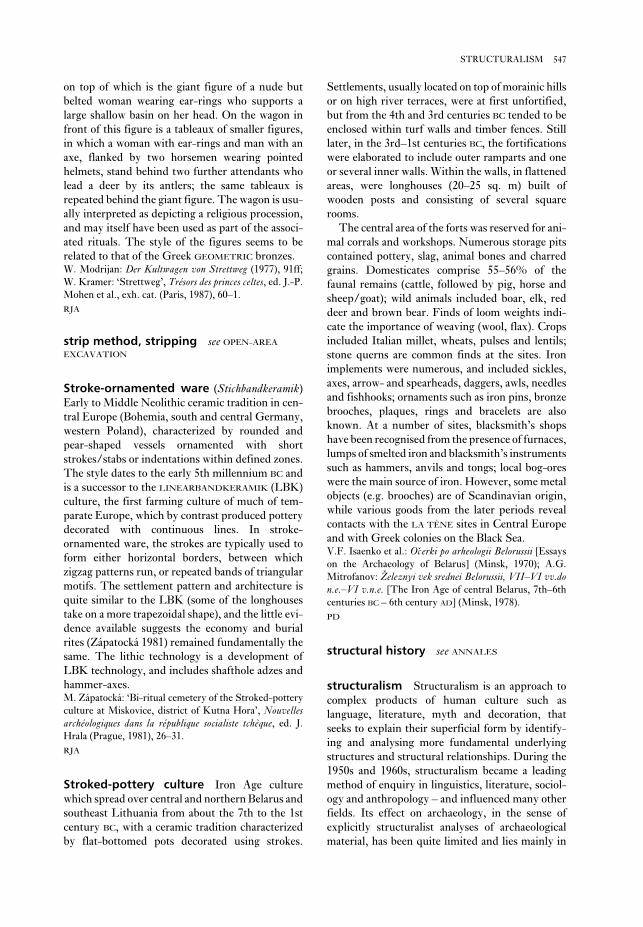
Settlements, usually located on top of morainic hills
or on high river terraces, were at first unfortified,
but from the 4th and 3rd centuries BC tended to be
enclosed within turf walls and timber fences. Still
later, in the 3rd–1st centuries BC, the fortifications
were elaborated to include outer ramparts and one
or several inner walls. Within the walls, in flattened
areas, were longhouses (20–25 sq. m) built of
wooden posts and consisting of several square
rooms.
The central area of the forts was reserved for ani-
mal corrals and workshops. Numerous storage pits
contained pottery, slag, animal bones and charred
grains. Domesticates comprise 55–56% of the
faunal remains (cattle, followed by pig, horse and
sheep/goat); wild animals included boar, elk, red
deer and brown bear. Finds of loom weights indi-
cate the importance of weaving (wool, flax). Crops
included Italian millet, wheats, pulses and lentils;
stone querns are common finds at the sites. Iron
implements were numerous, and included sickles,
axes, arrow- and spearheads, daggers, awls, needles
and fishhooks; ornaments such as iron pins, bronze
brooches, plaques, rings and bracelets are also
known. At a number of sites, blacksmith’s shops
have been recognised from the presence of furnaces,
lumps of smelted iron and blacksmith’s instruments
such as hammers, anvils and tongs; local bog-ores
were the main source of iron. However, some metal
objects (e.g. brooches) are of Scandinavian origin,
while various goods from the later periods reveal
contacts with the LA TÈNE sites in Central Europe
and with Greek colonies on the Black Sea.V.F. Isaenko et al.: Očerki po arheologii Belorussii [Essays
on the Archaeology of Belarus] (Minsk, 1970); A.G.
Mitrofanov: Železnyi vek srednei Belorussii, VII–VI vv.don.e.–VI v.n.e. [The Iron Age of central Belarus, 7th–6th
centuries BC – 6th century AD] (Minsk, 1978).
PD
structural history see ANNALES
structuralism Structuralism is an approach to
complex products of human culture such as
language, literature, myth and decoration, that
seeks to explain their superficial form by identify-
ing and analysing more fundamental underlying
structures and structural relationships. During the
1950s and 1960s, structuralism became a leading
method of enquiry in linguistics, literature, sociol-
ogy and anthropology – and influenced many other
fields. Its effect on archaeology, in the sense of
explicitly structuralist analyses of archaeological
material, has been quite limited and lies mainly in
on top of which is the giant figure of a nude but
belted woman wearing ear-rings who supports a
large shallow basin on her head. On the wagon in
front of this figure is a tableaux of smaller figures,
in which a woman with ear-rings and man with an
axe, flanked by two horsemen wearing pointed
helmets, stand behind two further attendants who
lead a deer by its antlers; the same tableaux is
repeated behind the giant figure. The wagon is usu-
ally interpreted as depicting a religious procession,
and may itself have been used as part of the associ-
ated rituals. The style of the figures seems to be
related to that of the Greek GEOMETRIC bronzes.W. Modrijan: Der Kultwagen von Strettweg (1977), 91ff;
W. Kramer: ‘Strettweg’, Trésors des princes celtes, ed. J.-P.
Mohen et al., exh. cat. (Paris, 1987), 60–1.
RJA
strip method, stripping see OPEN-AREA
EXCAVATION
Stroke-ornamented ware (Stichbandkeramik)
Early to Middle Neolithic ceramic tradition in cen-
tral Europe (Bohemia, south and central Germany,
western Poland), characterized by rounded and
pear-shaped vessels ornamented with short
strokes/stabs or indentations within defined zones.
The style dates to the early 5th millennium BC and
is a successor to the LINEARBANDKERAMIK (LBK)
culture, the first farming culture of much of tem-
parate Europe, which by contrast produced pottery
decorated with continuous lines. In stroke-
ornamented ware, the strokes are typically used to
form either horizontal borders, between which
zigzag patterns run, or repeated bands of triangular
motifs. The settlement pattern and architecture is
quite similar to the LBK (some of the longhouses
take on a more trapezoidal shape), and the little evi-
dence available suggests the economy and burial
rites (Zápatocká 1981) remained fundamentally the
same. The lithic technology is a development of
LBK technology, and includes shafthole adzes and
hammer-axes.M. Zápatocká: ‘Bi-ritual cemetery of the Stroked-pottery
culture at Miskovice, district of Kutna Hora’, Nouvellesarchéologiques dans la république socialiste tchèque, ed. J.
Hrala (Prague, 1981), 26–31.
RJA
Stroked-pottery culture Iron Age culture
which spread over central and northern Belarus and
southeast Lithuania from about the 7th to the 1st
century BC, with a ceramic tradition characterized
by flat-bottomed pots decorated using strokes.
547STRUCTURALISM
to another sentence, ‘You must think first’, the
relationship between the ‘I’ and the ‘You’ in both
sentences is paradigmatic, as is the relationship
between each of the other words (‘now’ and ‘first’
etc.). Using these and other concepts, all centred on
the belief that elements within language only gain
meaning through their relationship with other
elements, Saussure founded the modern conception
of language as a complex interdependent system.
Indeed, structuralism has some similarities to
SYSTEMS THEORY as an approach to understanding
complex cultural constructs.
Saussure’s approach was hugely elaborated in
succeeding decades, notably by Leonard Bloom-
field, who developed a range of techniques for
objectively analysing sentence structure. From the
late 1950s, this developed structuralist approach
was challenged by the work of Noam Chomsky who,
while working from Saussurian structuralist prin-
ciples, developed the idea of a ‘surface’ and a ‘deep’
grammatical structure. According to Chomsky,
whose approach is often labelled as the ‘trans-
formational grammar’ approach, language is
governed by generative grammar. At the heart of
Chomsky’s work is an attempt to discover the uni-
versal rules that govern the production of structure
in all human languages, and which must be related
to the fundamental nature of the human mind. The
investigation of universal laws of cognition within
the field of prehistory forms one strand of
COGNITIVE ARCHAEOLOGY.
The ideas developed in linguistics profoundly
influenced the way researchers in other fields
approached complex cultural products. For
archaeologists, one of the most influential conduits
was the work of the French anthropologist Claude
Lévi-Strauss, who took the fundamental idea of a
hidden structure beneath a cultural construct
dependent for its form on contrasts, and used this
approach to explore the ways that, for example,
myths, eating habits and etiquette, and kinship
structures are generated. In Lévi-Strauss’s work,
the idea that meaning is constructed through using
contrasting units – or ‘binary opposition’ – was
elaborated. For example, in Mythologiques he
described how myth is formed from, and acts as a
continuing expression of, sequences of fundamental
oppositions (such as death/creation, nature/
culture, maternal/paternal). Although the myth
narrative sometimes acts to explain (and justify)
particular social structures, the emphasis in
Mythologiques is on the universal structures of
meaning behind myth and – by extension – human
cognition. Even so, in relating structure to social
relations and to symbolic power, Lévi-Strauss
the field of prehistoric art, decoration, and analysis
of the design of monuments and settlements (see
below). In part, this may be because structuralism
evolved as a science of the spoken and written word:
neither of these rich sets of data is accessible in
prehistoric archaeology. However, the concepts,
language and assumptions of structuralist
approaches in linguistics and anthropology have
had a pervasive effect on the discipline, and
both structuralist and POST-STRUCTURALIST
approaches (the reaction against, and development
of, structuralist thought) have heavily influenced
CONTEXTUAL ARCHAEOLOGY and other recent
theoretical approaches to archaeology.
Structuralism – unlike, for example, MARXISM –
is really a label given to a number of similar
approaches rather than the name of a closely defined
theoretical or academic programme. Most authori-
ties agree, however, that the structuralist approach
originated in the work of the founder of modern lin-
guistics, Ferdinand de Saussure (1857–1913). In his
teachings (published posthumously as The course ingeneral linguistics), Saussure identified an under-
lying structure in language that can be summarized
as ‘a system of differences’. In Saussure’s structural
linguistics, the important analysis was no longer the
history of, and relationships between, individual
alphabets, or syllables, or words, or grammars.
Instead, he focused on how these ways of commu-
nicating gained meaning through the systems of
contrast embedded within them. In describing his
thoughts about language structure, Saussure him-
self often paired up key concepts. For example, he
talked about the ‘synchronic’ study of language (the
study of language at one moment in time) and
the less fundamental ‘diachronic’ study of change in
language through time. Another of Saussure’s dual
concepts identified the significant or signifier (i.e.
the thing that signifies, which in language may be a
particular sound) and the signifié or the signified
(the original concept in the mind of the speaker; for
further discussion see SIGN AND SYMBOL).
Together, the signifier and the signified comprise a
sign which – usually by convention alone, rather
than any essential link – relates to a referent or
object in the outside world. The study of the nature
and use of signs developed into a sub-discipline
from the late 1950s, known as semiotics.
Fundamental to Saussure’s idea of language as a
system are the syntagmatic and asociative (or para-digmatic) – concepts which describe the relationship
between words. For example, in the sentence ‘I will
dig now’, the relationship between ‘I’ ‘will’ ‘dig’ and
‘now’ in building up the meaning of the sentence is
syntagmatic. By contrast, if we relate this sentence
548 STRUCTURALISM

subjectivity, is unavoidable. However, it certainly
offers a more testable approach than analysis of dec-
oration relying on subjective evaluation of the
similarities of style or motif.
The main difficulty with this kind of carefully
conducted FORMAL ANALYSIS lies in connecting
the results to the questions that most prehistorians
actually want to ask. Most prehistorians want to
know how, and to what extent, any structural simi-
larities in pottery decoration in a given culture are
related to other aspects of cultural production and
self-conscious ethnic identity, and can thus be taken
as reliable material culture indicators of more
ephemeral human activities and relationships. Most
also want to know whether formal analyses can pro-
vide clues to ‘deeper’ social realities, of a kind
attempted prematurely by Leroi-Gourhan.
A well-trodden route to applying structuralist
analytical tools to archaeological analysis is to
identify a series of inter-linked binary oppositions
in a set of material culture and to use these to
‘explain’ some social dynamic within the culture
under examination. Hodder (1982) provides ethno-
graphic examples, Jameson (1987) an historical
material culture example, and Shanks and Tilley
(1987: 155–71) an archaeological example. This
kind of analysis can be revealing in terms of identi-
fying patterns within the material culture record,
but it is difficult to verify the links between
symbolic communications in different areas of
material culture, and even more difficult to relate
these securely to behavioural and social dynamics.
The challenge of establishing such sound links is in
some ways similar to establishing valid ETHNO-
GRAPHIC ANALOGIES. It is often dependent upon a
tenacious web of similarities across different facets
of culture that are not easily accessible to the archae-
ologist, and the process can quickly lead to circular
arguments. It may be better in many circumstances
to recognize that a structuralist hypothesis is simply
suggestive and interesting, or to use it to bolster or
elaborate evidence gained from other approaches.N. Chomsky: Syntactic structures (The Hague, 1957); C.
Lévi-Strauss: Mythologiques (Paris, 1964–72); A. Leroi-
Gourhan: Préhistoire de l’art occidental (Paris 1965); C.
Lévi-Strauss: Structural anthropology (London, 1968); F.
de Saussure: Course in general linguistics (London 1978); A.
Leroi-Gourhan: The dawn of European art (Cambridge,
1982); I. Hodder: Symbols in action (Cambridge, 1982);
——, ed.: Symbolic and structural archaeology (Cambridge,
1982); D. Washburn: Structure and cognition in art(Cambridge 1983); I. Hodder: ‘Burials, houses, women
and men in the European Neolithic’, Ideology, power andprehistory, ed. D. Miller and C. Tilley (Cambridge, 1984);
––––: ‘Structuralist archaeology’, Reading the past(Cambridge, 1987), 34–54; R. Jameson: ‘Purity and power
created a less formalistic, more subjective form of
structuralist analysis.
The most notable early attempt to use this new
strand in structuralist analysis to interpret pre-
historic material was the work of André
Leroi-Gourhan (e.g., 1965, 1982) whose approach
relates closely to Lévi-Strauss. Leroi-Gourhan
used structural concepts to examine and interpret
the spatial arrangement and use of symbols in the
CAVE ART of prehistoric Europe. The different
animal species were accorded specific roles in a
complex system of sexual symbolism, and the lo-
cation in the caves of the individual works and the
frequency of associations between the different
animals were used to form hypotheses about the
function of cave art and the nature of Palaeolithic
society. The tenuous arguments justifying this
complex symbolic system, and the difficulty of
treating the works in any one cave as a consistently
related and contemporary corpus of art, were
brushed over by Leroi-Gourhan; instead, he
offered detailed analyses of cave topography and
statistical treatments. Leroi-Gourhan’s work,
though immensely influential, was never entirely
accepted by prehistorians – especially outside
France.
Of later attempts, the work of Washburn (e.g.,
1983) stands out as a concerted attempt to use
structural analysis as a tool for interpreting archaeo-
logical material. Unlike Leroi-Gourhan’s work,
Washburn’s formal structural analysis of pottery
decoration remains quite close in approach to struc-
tural linguistics. That is, it tried to discover the
rules (of symmetry etc) that lay behind complex
pottery designs, rather than leaping from structure
to underlying social meaning and complex com-
munication. Washburn’s methodology involved
close analysis of the way decoration was structured
from the smallest assymetrical unit of design
upwards. This kind of analysis can to some extent
be tested: the rules it claims to identify governing
decorative structure can be compared to new
samples of pottery, and to pottery from unrelated
cultures, to see if they remain useful.
The approach also seems to offer a detailed and
objective way of describing and comparing decor-
ative traditions. If decorative traditions were closely
related to other aspects of culture, the structural
analysis of pottery decoration seemed also to offer
an objective way of measuring the cultural closeness
and ‘relatedness’ of different groups. The degree to
which this kind of analysis is truly ‘objective’ has
been questioned by Ian Hodder (1986: 39–40), who
argues that even in defining the decoration that is to
be the subject of analysis a level of interpretation, or
549STRUCTURALISM

river, in the valley of which were located several
Iron Age settlements and famous Bronze Age
cemeteries. The Iron Age sites (the ‘archaic
Dakhistan’) were excavated by V.M. Masson and
others in the 1940s and 1950s. The sites range in
age between 1500 BC and AD 700, and include
four-cornered citadels, ‘manors’ and separate
houses, as well as complicated irrigation works in
the presently desertified region of western
Turkmenistan.
Later, in the late 1960s to early 1990s, a group of
Bronze Age cemeteries and settlements were found
in the middle stretches of Sumbar, near the town of
Kara-Qala, and studied by I.N. Khlopin. Khlopin
believes that the cemeteries of Parkhai I, and
Sumbar I–III belong to the Late Bronze Age, and
are equivalent to the periods Namazga V–VI (see
NAMAZGA, roughly 2500–1800 BC). They consist of
catacomb graves with a horizontal or a vertical
entrance; the dead were buried in a contracted pos-
ture. The grave goods include a grey ware, bronze
arrowheads and spearheads, knives, awls, rings as
well as stone mace-heads in (presumed) elite graves.
The grey ware is similar to that known in northern
Iran (e.g., SIALK, TEPE), however Khlopin convinc-
ingly argues for the continuity of a local tradition
known as the ‘Sumbar culture’; the appearance of
‘grey ware’ is therefore simply a technological inno-
vation in pottery-making and does not imply a
cultural relationship.I.N. Khlopin: Jugo-zapadnaja Turkmenija v epohu pozdneibronzy (Leningrad, 1983).
PD
Sumer, Sumerian The word ‘Sumer’ is used in
early CUNEIFORM texts to describe the geographi-
cal region of southern Iraq, however the term is also
applied by archaeologists to the earliest civilization
in this region of Mesopotamia, the formative phase
of which was the UBAID period (c.5000–3800 BC).
An ethnic distinction is usually made between the
Semites in central Mesopotamia and the Sumerians
further to the south, although in fact the material
culture and social systems of these two groups are
virtually identical, the only real differences being
linguistic. Georges Roux therefore argues that
‘Stricto sensu, the appelation ‘Sumerians’ should be
taken as meaning ‘Sumerian-speaking people’ and
nothing else . . . This incidentally explains why all
efforts to define and to assess the relations between
Sumerians and Semites in other fields than philol-
ogy are doomed to failure.’ (Roux 1992: 81).
It seems likely that the Sumerian population
actually included both Sumerian and Semitic
at the Victorian dinner party’, The archaeology of con-textual meanings, ed. I. Hodder (Cambridge 1987), 55–66;
M. Shanks and C. Tilley: Re-Constructing archaeology(Cambridge, 1987); I. Hodder: Theory and practice inarchaeology (London 1992), 24–80.
RJA
stupa Stone-faced cylindrical Buddhist struc-
ture with a hemispherical dome enclosing earthen
and rubble fill and a relic casket. Stupas were con-
structed to enshrine the cremated remains of
Buddha and his disciples as well as Mahavira, the
founder of the JAIN faith, gradually coming to
symbolize the teachings of these two indigenous
Indian religious traditions. The earliest surviving
stupas date to the reign of the MAURYAN emperor
Asoka (273–232 BC). Worship involves the circum-
nambulation of the monument, and a paved path
typically encircles the structure.D. Mitra: Buddhist monuments (Calcutta, 1971), 21–30;
G.A. Michell: The Penguin guide to the monuments of India(Harmondsworth, 1989), 64–6.
CS
Suberde see ACERAMIC NEOLITHIC
Sugizawadai Large Early JOMON settlement in
Akita prefecture, Japan (c.5000–3500 BC). A central
plaza contained four large buildings, the largest of
which was over 220 sq. m in area – one of the
largest Jomon buildings yet discovered. The largest
building had six hearths aligned along the central
axis and had been rebuilt three times; 40 smaller
buildings and 100 storage pits were located around
the edge of the plaza. The function of these large
buildings remains contentious, possibly being com-
munity gathering places or workplaces for winter
tasks in the snowy region.Akita Prefectural Board of Education: Sugizawadai andTakei sites (Akita, 1981).
SK
Sui-chou-shih (Suizhoushi) see TSENG HOU YI
TOMB
Suizhoushi (Sui-chou-shih) see TSENG HOU YI
TOMB
Sultan, Tell es- see JERICHO
Sumbar River in the Kopet-Dag Mountains of
southern Turkmenistan, a tributary of the Atrek
550 STRUCTURALISM
the Uruk period to the end of the Early Dynastic
phase (c.3800–2010 BC). During the 3rd millen-
nium BC the great Sumerian cities, such as UR,
ERIDU, KISH and NIPPUR, flourished in the region
between the Tigris and Euphrates.
S.N. Kramer: The Sumerians (Chicago, 1963); T. Jones,
ed.: The Sumerian problem (New York, 1969); F.R. Kraus:
Sumerer und Akkader (Amsterdam, 1970); J. Oates:
Babylon, 2nd edn (London, 1986), 19–23; H. Crawford:
Sumer and the Sumerians (Cambridge, 1991); N. Postgate:
Early Mesopotamia: society and economy at the dawn ofhistory (London, 1992); G. Roux: Ancient Iraq, 3rd edn
(Harmondsworth, 1992), 80–4 [including discussion of
the so-called Sumerian Problem].
IS
linguistic/ethnic elements, although all may have
shared the same Sumerian material culture, thus
making them difficult to distinguish in archaeo-
logical terms – this quandary is usually described as
the ‘Sumerian problem’. As Harriet Crawford
(1991: 20) points out, ‘It is not possible to tell how
much of this culture should be attributed to the
Sumerian speakers and how much to those speak-
ing a Semitic language, but the question hardly
matters as it seems to have been the fusion of all the
elements in the population which produced the dis-
tinctive [Sumerian] civilization . . .’. It is clear,
however, that the term Sumerian can be comfort-
ably applied, in a general sense, to the culture that
dominated Mesopotamia for two millennia, from
551SUMER, SUMERIAN
Figure 51 Sumbar Grave goods from the Sumbar cemetery. Source: I.N. Khlopin: Jugo-zapadnaja Turkmenija vepohu pozdnei bronzy (Leningrad, 1983).

SADAAT and Kili Ghul Muhammad (see QUETTA).A. Stein: ‘An archaeological tour in Waziristan and
Northern Baluchistan’, MASI 37 (1929); W.A. Fairservis:
‘Archaeological surveys in the Zhob and Loralai District,
West Pakistan’, APAMNH 47 (1959), 277–448
CS
Susa (Shush) City in southwestern Iran
originating in the late 5th millennium BC; the
surrounding alluvial plains became known as
Susiana and the earliest phases of urbanization in
the region are expressed in terms of the stratigraphy
at Susa, consisting of three major post-UBAID
phases (Susa I–III or A–C) dating to the 4th mil-
lennium BC. Susa I–II was strongly influenced by
the contemporaneous URUK phase in Mesopotamia,
while Susa III was characterized by a much more
distinctively indigenous proto-Elamite culture.
By the 3rd millennium BC Susa became the
capital of ELAM. Although the Elamite rulers were
initially subject to the hegemony of the AKKADIAN
and UR III rulers, they eventually became a power in
their own right during the 2nd millennium BC, and
many plundered Mesopotamian objects (including
the Law Code of the Babylonian ruler Hammurabi)
have been excavated from the palace buildings at
Suva. The archaeological remains of Susa, first
excavated by William Loftus in 1851–3, comprise
four main areas, of which the earliest is the site of
the Elamite ‘acropolis’. The other three mounds are
(1) the palace of the Achaemenid ruler Darius,
incorporating an APADANA (palace reception hall)
and a columned hall, (2) the ‘royal city’, and (3) the
‘city of the artisans’ which consists mainly of post-
Achaemenid housing.A. Le Breton: ‘Susa, the early periods’, Iraq 19 (1957),
79–124; M.J. Stève and H. Gasche: L’acropole de Suse:nouvelles fouilles (Leiden and Paris, 1971); E. Carter: ‘The
Susa sequence 3000–2000 BC’, AJA 83 (1979), 451–4; F.
Vallat: Suse et l’Elam, études élamites (Paris, 1980); P.O.
Harpur, J. Aruz and F. Tallon, eds: The royal city of Susa(New York, 1992).
IS
Sutkagen Dor Small fortified settlement of the
INDUS CIVILIZATION located on sandstone ridges
near the Makran coast, western Pakistan. The
westernmost Harappan site in Pakistan, it was ex-
cavated by Auriel Stein in 1931 and George Dales
in 1962. The site was enclosed within a massive
stone and earth wall, with its main entrance flanked
by two towers. Dales identified three phases of
occupation and a bipartite spatial division of the site
into ‘citadel’ and ‘lower town’ areas. Material
remains from Sutkagen Dor are exclusively
Sunagawa Late Palaeolithic site in Saitama pre-
fecture, Japan. Two locations, each containing three
artefact units and one burned cobble cluster, were
discovered some 10 m apart. The site was one of the
first where extensive refitting of lithics was
achieved, the results suggesting occupation by at
least two small bands.T. Inada: ‘The Palaeolithic age’, Recent archaeological dis-coveries in Japan, ed. K. Tsuboi (Paris and Tokyo, 1987),
5–23.
SK
Sunghir Upper Palaeolithic open-air site situ-
ated on the upper terrace of the river Klyaz’ma,
several kilometres east of the town of Vladimir, in
central Russia. The site was discovered by
O.N. Bader in 1955 and investigated by him
between 1956 and 1975. The stone industry is
Upper Palaeolithic and includes Kostenki-style
shouldered knives and Szeletian points; uncali-
brated radiocarbon dates range between 26,000 and
20,000 years BP. Since 1964, several burials of
ANATOMICALLY MODERN HUMANS (AMH) have
been discovered. One of the graves contained an
AMH male skeleton, 55–65 years old, interred on
his back in an extended posture, with the head
directed to the northeast. The rich grave-goods
include two large spears (1.66 and 2.24 m) of
straightened mammoth task, spearheads, javelins,
and knives. There were also various ornaments:
3500 perforated beads of mammoth tusk; perforated
pendants of polar fox canines; perforated pendants
of schist; and bracelets of mammoth tusk.O.N. Bader: Sungir: Verhnepaleolitičeskaja stojanka[Sungir: an Upper Palaeolithic site], (Moscow, 1978).
PD
Su Nuraxi see BARUMINI
superstructure see MARXIST ARCHAEOLOGY
Sur Jangal Small prehistoric village of the 4th
and 3rd millennia BC, located in the Baghnao Valley
of northern Baluchistan, Pakistan. The remains of
mud-brick architecture and domesticated cattle
were found throughout the three phases of occu-
pation. Artefacts include painted ceramics, with a
variety of geometric and naturalistic designs,
including humped cattle motifs, as well as flint and
ground stone tools, clay bangles and large numbers
of female terracotta figurines. The material culture
at Sur Jangal shows similarities to several contem-
porary Baluchistan sites, such as Kechi Beg, DAMB
552 SUNAGAWA

R. Rimantiene: Šventoji I/II, 2 vols (Vilnius, 1979–1980).
PD
Swahili harbour towns Settlements of the
Swahili-speaking East African maritime civilization
of the 9th–19th centuries AD, centred on the coasts
of Tanzania and Kenya, and involved in trade with
the lands around the Indian Ocean. Swahili is a
Bantu language spoken on the coast and islands of
Tanzania and Kenya, as well as in some areas to the
south (Comores, Mozambique and northern
Madagascar) and north (the southern Somali coast).
Notable sites include Bur Gavo, GEDI, Kilwa,
Manda, Mombasa and SHANGA, as well as the
islands of ZANZIBAR and Pemba. There is no thor-
ough description of Bur Gavo, the northernmost of
the harbour towns, but Neville Chittick, who vis-
ited briefly in 1968, left valuable notes on, inter alia,
a walled enclosure, a curious domed building and
various tombs, some with pillars.
In the 9th and 10th centuries the focus of Swahili
commerce was with the Persian Gulf and the
Islamic heartlands of the Abbasid empire. Later,
however, the overseas contacts – not only com-
mercial but also cultural and Islamic – diversified,
Harappan, with no affinities to contemporary
SHAHI TUMP or KULLI COMPLEX traditions of the
Makran region (Besenval 1992: 27). Because of its
location, the site is often interpreted as a Harappan
port, the occupants of which were engaged in mari-
time trade, although direct evidence for such
activities (e.g. seals, sealings or trade goods) has not
been found (Ratnagar 1981: 48–51).G.F. Dales: ‘Harappan outposts in the Makran Coast’,
Antiquity 36 (1962), 86–92; S. Ratnagar: Encounters: thewesterly trade of the Harappa Civilization (New Delhi,
1981), 48–51; R. Besenval: ‘Recent archaeological surveys
in Pakistani Makran’, South Asian archaeology, 1989, ed.
C. Jarrige (Madison, 1992), 25–35.
CS
Sutton Hoo The cemetery of burial mounds at
Sutton Hoo (Suffolk) is presently the most system-
atically investigated funerary monument of the
MIGRATION PERIOD. An early 7th century boat-
burial with an extraordinarily rich array of grave
goods was excavated in 1939. In 1983–92, Martin
Carver led a new programme of investigations
including a rigorous evaluation of the previous
excavations and a modern field strategy, involving
the use of SAMPLES: the cemetery was sampled by
means of the excavation of two wide, intersecting
transects. The results revealed not only the charac-
ter of other burial mounds, but the existence of a
cemetery of ‘sand-men’, poorly preserved burials of
individuals associated with the mound graves. As a
result, Carver was able to trace the complex evolu-
tion of the 6th- to 8th-century burial ground of the
Wuffingas family.Martin Carver, ed.: The age of Sutton Hoo (Woodbridge,
1992).
RH
Šventoji Group of 42 Neolithic sites, situated in
the coastal peat-bog of Pajuris, in the mouth of the
Šventoji river in Lithuania – formerly a lagoon of
the Baltic Sea. The sites were discovered and ex-
cavated in the 1970s by R. Rimantiene. The earlier
sites, dated by radiocarbon to calendar years
3500–2600 BC, belong to the local variant of the later
phase of the NARVA tradition. The later sites belong
to the so-called ‘coastal tradition’ of the CORDED
WARE culture. The economy of the Narva-related
sites was based mostly on hunting, fishing and food-
collecting. The occupants of the ‘coastal tradition’
sites relied predominantly on seal hunting, and six
nets made of lime bast thread were discovered at
Site 2B. The bones of cattle and sheep/goat were
also found in limited numbers.
553SWAHILI HARBOUR TOWNS
R u f i j iR u f i j i
Bur GavoBur Gavo
SOMALIASOMALIA
ShangaShangaMandaManda
GediGedi
TTaannaa
SSaabbaakkiii
K E N Y AK E N Y A
PPaannggaanniii
RRuuffiiijjjiii
RRuuvvuummaa
KilwaKilwa
MombasaMombasa
ZanzibarZanzibar
Mtambwe MkuuMtambwe MkuuMtambwe Mkuu(Ras) Mkumbuu(Ras) Mkumbuu
PembaPemba
T A N Z A N I AT A N Z A N I A
MafiaMafia
Songo MnaraSongo Mnara
Unguja UkuuUnguja Ukuu
M O Z A M B I Q U EM O Z A M B I Q U E
NN
00 200 km200 km
R u f i j i
Bur Gavo
SOMALIA
ShangaManda
Gedi
Tana
Sabaki
K E N Y A
Pangani
Rufiji
Ruvuma
Kilwa
Mombasa
Zanzibar
Mtambwe Mkuu(Ras) Mkumbuu
Pemba
T A N Z A N I A
Mafia
Songo Mnara
Unguja Ukuu
M O Z A M B I Q U E
N
0 200 km
Map 29 Swahili harbour towns The locations of the
Swahili harbour towns.

century silver coins was discovered). Those on
Zanzibar included the early 9th-century site of
Unguja Ukuu (‘old’ or ‘great Zanzibar’), with
plentiful ‘SASANIAN-Islamic’ pottery. The 13th-
century remains on Tumbatu, a separate islet off the
north end of Zanzibar, have yielded a connection
with Yemen, perhaps foreshadowing the architec-
tural feats of Kilwa (to the south) in the early 14th
century AD.
Until the 15th century the larger Swahili harbour
towns of the coast and islands thrived on the sale of
African products, notably ivory and gold from
Zimbabwe, to the wider world. There is a good
chronological correspondence between Kilwa, the
most southerly of the Swahili sultanates, and
GREAT ZIMBABWE in the gold-producing zone,
extending eastwards to India and indirectly to
China, as well as northwards, via the Red Sea,
to Egypt and the Mediterranean. The wealth of the
early Swahili settlements is reflected in the stone
ruins of mosques and tombs as well as rich houses
and palaces. Most of the stone architecture belongs
to the 14th and 15th centuries, although the tra-
dition of stone mosques is much older. The earliest
mosques, dating back to about AD 800 at Shanga,
were of wood and earth construction with thatched
roofs, as were houses generally. On the islands of
Pemba and Zanzibar, there were several early
Swahili sites. Those on Pemba included Ras
Mkumbuu (probably the ‘Qanbalu’ documented in
9th- and 10th-century Arab writings) and Mtambe
Mkuu (where a hoard of locally minted 11th-
554 SWAHILI HARBOUR TOWNS
Nmag.
0 20 m
S O N G O
M N A R A
Figure 52 Swahili harbour towns Stone buildings of the 14th- and 15th-century Swahili harbour town of Songo
Mnara, part of the Kilwa group complex. The mosques can be identified by their mihrâb projections in the qibla wall
facing north to Mecca; the larger houses on the plan can be seen to contain interior courtyards; the small circles on the
plan represent wells. Source: J.E.G. Sutton: A thousand years of East Africa (BIEA, 1990).

(Oxford, 1974); H.N. Chittick: Manda: excavations at anisland port on the Kenya coast (Nairobi, 1984); M.C.
Horton, H. Brown and W.A. Oddy: ‘The Mtambwe
hoard’, Azania 21 (1986), 115–23; M.C. Horton: ‘Early
Muslim trading settlements on the East African coast: new
evidence from Shanga’, AJ 67 (1987), 290–323; J.E.G.
Sutton: A thousand years of East Africa (Nairobi, 1990),
57–88.
JS
Swartkrans Ancient fissure with breccias of
various ages, close to Krugersdorp, Transvaal,
South Africa. Four stratigraphic Members are
identified and dated on the basis of contained
fossils. Member 1, rich in Australopithecus robustusspecimens, is around 1.6–1.8 million years old and
contains bone ‘digging-tools’ in the upper part (seeAUSTRALOPITHECUS). Member 2 (>1.0 my,
<1.6 my) contains A. robustus and Homo (sp.indet.),
a few stone artefacts of ACHEULEAN aspect, bone
tools, and abundant mammal bones, many with cut-
marks and some showing signs of burning.C.K. Brain: The hunters or the hunted?: an introduction toAfrican cave taphonomy (Chicago, 1981); ––––: ‘New
information from the Swartkrans cave of relevance to
“Robust” australopithecines’, Evolutionary history of the“robust” australopithecines, ed. F.E. Grine (New York,
1988), 311–16.
RI
Swasey-phase pottery see CUELLO
swidden agriculture Method of farming in
which a swidden (strip of agricultural land) is
obtained by cutting down, drying and burning the
existing natural vegetation, thus clearing the area
for cultivation. The system therefore includes the
use of the ‘slash-and-burn’ technique (or Brand-wirtschaft), whereby the ash from the wild
vegetation can be employed as a fertilizer in the soil.
The swidden land, however, can be cultivated
successfully for only a few years, therefore farmers
using this method are obliged to move on periodi-
cally to exploit new areas of land. The swidden
system was used by many prehistoric groups, such
as the people of Preclassic Mesoamerica (seeLOWLAND MAYA) and some of the Neolithic inhabi-
tants of central and northern Europe (although see
LINEARBANDKERAMIK for a discussion of the pos-
sible limitations on the use of swidden agriculture
in prehistoric Europe).P. Bogucki: Forest farmers and stockherders (Cambridge,
1988).
IS
and there are indications of specific commercial
connections between them in the 14th century,
although culturally and architecturally the two sites
seem unrelated.
The site of Kilwa, situated on an island in a
sunken estuary of the southern Tanzanian coast,
was excavated in the 1960s by Neville Chittick
(1974). With its lowest levels dating to the early 9th
century AD – as at SHANGA and Manda in the north,
Mkumbu on Pemba and Unguja Ukuu on Zanzibar
– it rose to prominence in the 11th century when a
sultanate was established, copper coinage minted
and the first stone mosque built. The domed,
arched and barrel-vaulted extension to Kilwa’s
Great Mosque, as well as the magnificent palace and
trade emporium called Husuni Kubwa, date to that
period. There followed a severe slump during
which Husuni Kubwa was abandoned and much of
the Great Mosque collapsed. Early in the 15th
century the trade of gold and other items revived,
and Kilwa with it; it is to this period that most of the
stone domestic architecture of Kilwa town (and the
adjacent island of Songo Mnara) belongs.
Mombasa overtook Kilwa in the 15th century to
become the biggest such settlement on the East
African coast. Together with its fine harbour, in the
creek between Mombasa island and the mainland,
Mombasa’s central position on the coast gave it an
advantage, especially for the bulk commerce with
India. Because of the continued occupation and
growth of the town till the present, nothing is visible
of the pre-1500 period and little systematic archaeo-
logical investigation has been attempted. The most
impressive monument at Mombasa is Fort Jesus,
which was built in the 1590s by the Portuguese
(employing an Italian military architect) to com-
mand the harbour approach and to serve as their
headquarters on the Swahili coast.
Following Vasco da Gama’s voyage of 1498–9
and the Portuguese invasion of the Indian Ocean
from the south, the commerce and wealth of the
Swahili coast declined sharply (see PORTUGUESE
TRADING FEIRAS). After the ending of Portu-
guese control there was a revival in the late 18th
century, fuelled by renewed international demands,
for ivory and slaves especially. This is illustrated at
several sites by renewed stone buildings, which
included forts.J.S. Kirkman: Men and monuments on the East African coast(London, 1964); P.S. Garlake: The early Islamic architec-ture of the East African coast (Nairobi and London, 1966);
H.N. Chittick: ‘An archaeological reconnaissance of the
southern Somali coast’, Azania 4 (1969), 125–30; ––––:
Kilwa: an Islamic trading city on the East African coast(Nairobi, 1974); J.S. Kirkman: Fort Jesus, BIEA 4
555SWIDDEN AGRICULTURE

Secondly, and given this, how can archaeologists
define and recognise the conventional meaning of
individual symbols in material culture, without the
help of the written records or living witnesses avail-
able to ethnographers and historians? A central
problem here is the verification of any interpret-
ation of a symbolic meaning. Simply testing our
interpretation of symbols by seeking out further
instances in the material culture record inevitably
leads to charges of circularity and subjectivity.
Thirdly, and moving on from the problem of
interpreting individual symbols, archaeologists
have tried to understand the relationship between
different signs and symbols, to identify underlying
rules that govern the generation of symbolic and
decorative patterning. This line of enquiry can be
divided up into FORMAL ANALYSIS, where the
meaning (content) of signs and symbols tends to
take second place to their patterning, and struc-
turalist analysis (see STRUCTURALISM), where in
many analyses the meaning of symbols is both
important and directly related to their structuration
(e.g. Leroi-Gourhan’s structuralist analysis of the
symbolic meaning of CAVE ART).
Lastly, and perhaps most interestingly, there has
been an increasing understanding of the ways in
which symbols are actively manipulated by social
players. Here, Marxist archaeologists have investi-
gated how individuals use symbols as tools within a
wider cultural ideology or world view – the ‘social
production of reality’. Aside from Marxist analyses,
there has also been a strong tendency to stress the
active role of the individual and of subordinate
groups within society in manipulating and using
symbols to promote their social ambitions. In part,
these analyses (e.g. Hodder 1982a) have been used
to warn against simplistic functionalist or material-
ist interpretations of material culture in the
archaeological record. Symbols have come to be
seen as powerful ‘tools’ for individual and group
strategies as much as expressions of the
NORMATIVE beliefs (shared world-views) of whole
societies. While significantly complicating in-
terpretation, such studies also hint at the potential
richness of material culture studies in revealing the
true complexity of social groups and their symbolic
interactions.M. Douglas: Purity and danger (London, 1966); V.
Turner: The forest of symbols (London, 1967); ––––: Theritual process (London, 1969); M. Douglas: Natural sym-bols (London, 1970); D. Sperber: Rethinking symbolism(Cambridge, 1974); I. Hodder: Symbols in action: ethno-archaeological studies of material culture (Cambridge,
1982a); ––––, ed.: Symbolic and structural archaeology(Cambridge, 1982b); ––––: The present past (London,
symbol see SIGN
symbolic archaeology Study of the use and
importance of symbolism in material culture,
and how this can be recognized and recovered from
the archaeological record. Symbolic archaeology
forms one of the most fruitful parts of a general
movement in archaeology towards an ‘archaeology
of the mind’ – and towards a more sophisticated
understanding of how material culture was per-
ceived and manipulated in ancient societies. In part
a reaction against the more materialist and func-
tionalist aspects of PROCESSUAL ARCHAEOLOGY,
this general movement encompasses the work of Ian
Hodder’s CONTEXTUAL ARCHAEOLOGY, Colin
Renfrew’s COGNITIVE ARCHAEOLOGY (which he
describes as developing out of processual archae-
ology, rather than contradicting it), and
STRUCTURALISM, as well as an increasing volume
of diverse individual studies.
In this still-developing field, four key areas of
interest can be defined. Firstly, how do we define
the terms sign and symbol and relate them to their
social context? Ian Hodder (1987: 11–12) defines
the symbol as ‘an object or situation in which a
direct, primary or literal meaning also designates
another indirect, secondary and figurative meaning’
and argues that ‘symbols do not “reflect” but . . .
play an active part in forming and giving meaning
to social behaviour’. Most archaeologists in this area
have turned to the key works in social anthropology,
which in turn inherited many key concepts (see
SIGN AND SYMBOL) from linguistic analysis.
However, a key confusion in social anthropology
over the question of whether the signified and signi-
fier of a symbol are truly arbitrary seemed likely to
pose a particular problem when interpreting
material culture. The more arbitrary the link, the
more difficult the task of interpreting symbols in
the archaeological record. Hodder (1992: 207)
suggests that they are indeed arbitrary, but with an
important qualification: ‘Blood, for example, has
qualities which constrain its symbolic meaning but
a range of specific meanings (from danger and death
to the source of life) can be given . . . The ideologi-
cal implications of this duality are that the meanings
of objects, while imposed by convention, appear
based on necessity’. In other words, the particular
meaning of symbols arises out of social convention
(i.e. is arbitrary in the sense that the signified is not
linked to the signifier by any existential or rep-
resentational link), but symbols often gain power
and a sense of inevitability from innate references to
the wider world.
556 SYMBOL

ITES, ISRAEL, KEBARAN, NATUFIAN, PHILISTINES
and PHOENICIANS. (See map 30.)Y. Aharoni: The land of the Bible: a historical geography,
2nd edn (Philadelphia, 1979); K.M. Kenyon: Archaeologyin the Holy Land, 4th edn (London, 1979); M. Roaf:
Cultural atlas of Mesopotamia and the Ancient Near East(New York and Oxford, 1990).
systems theory Approach to understanding
complex phenomena by characterizing them as
bounded ‘systems’ within which distinguishable
interdependent elements (subsystems) or units
interact to form the whole. In archaeological analy-
sis, subsystems often include ‘economy’, ‘politics’,
‘kinship’ etc. The interactions are often character-
ized as information flows, set in motion by flows
from the outside environment. In essence, systems
theory attempts to facilitate the identification of
systems, subsystems and system elements, as well as
the nature and level of their information flows. It
has been self-consciously used in archaeological
explanation since the mid-1960s and the advent of
PROCESSUAL ARCHAEOLOGY, notably in the
writings of David Clarke (1968) and Kent Flannery
(1968).
While systems theory, in its widest sense, de-
veloped in the natural sciences and especially in
biology, the concepts and terms used to describe the
nature of natural systems were adopted by the social
sciences from an early date. The founder of modern
sociology, Emile Durkheim, used the analogy of
the bodily system to explain his essentially
FUNCTIONALIST views of how society was organ-
ized and remained in equilibrium. (Poets and
philosophers had employed the analogy in a less
systematic manner since the dawn of history.) In
later sociological writings, Herbert Spencer
(1820–1903), who believed that society must learn
to consciously control key social mechanisms, and
Vilfredo Pareto (1848–1923), an Italian mathemati-
cal economist who helped to develop equilibrium
theory (see below), developed and formalized the
concept of a social ‘system’. In the work of
Talcott Parsons (1902–79), sociological systems
theory was used to hugely elaborate a functionalist
view of social institutions. Parsons’ ‘structural-
functionalism’ was based on the premise that
systems functioned in various ways to achieve four
things: adaptation to the physical environment; goal
attainment; integration (i.e. social cohesion and
orderliness); and latency (i.e. system stability).
Parsons believed that four subsystems could be
identified in society that accorded with these aims:
the economic system, political system, community
1982c); A.C. Renfrew: Towards an archaeology of mind(Cambridge, 1982); I. Hodder: ‘The contextual analysis of
symbolic meanings’, The archaeology of contextual mean-ings, ed. I. Hodder (Cambridge, 1987), 1–10; C. Tilley,
ed.: Reading material culture (Oxford, 1990); I. Hodder:
Material practice, symbolism and ideology, in Theory andpractice in archaeology (London, 1992), 201–12; K.A.
Hays: ‘When is a symbol archaeologically meaningful?
Meaning, function and prehistoric visual arts’,
Archaeological theory: who sets the agenda?, ed. N. Yoffee
and A. Sherratt (Cambridge, 1993), 81–92.
RJA
Syria-Palestine Part of Western Asia bordering
the Mediterranean, situated between Anatolia
in the north, and the Arabian desert and Meso-
potamia to the south and east. It comprises two basic
topographical zones: a long coastal strip to the west,
and an area of uplands to the east, the latter broken
by a north–south geological fault incorporating the
Sea of Galilee, the Dead Sea and the Wadi Arabah.
For discussion of some of the ancient cultures and
peoples, see AMORITES, ARAMAEANS, CANAAN-
557SYSTEMS THEORY
Kebaran period 18,000 – 11,000 BC
Natufian period 11,000 – 9300 BC
Pre-pottery Neolithic period A 9300 – 7000 BC
Pre-pottery Neolithic period B 7000 – 5500 BC
Pottery Neolithic A 5500 – 4500 BC
Pottery Neolithic B 4500 – 3500 BC
Ghassul-Beersheba culture 4200 – 3500 BC
Proto-urban period 3500 – 3100 BC
Early Bronze Age I 3100 – 2800 BC
Early Bronze Age II 2800 – 2600 BC
Early Bronze Age III & IV 2600 – 2180 BC
Middle Bronze Age I & II 2180 – 1550 BC
Late Bronze Age I 1550 – 1400 BC
Late Bronze Age II 1400 – 1200 BC
Late Bronze Age III 1200 – 1150 BC
Iron Age I 1150 – 1000 BC
Saul 1030 – 1000 BC
David 1000 – 960 BC
Solomon 960 – 931 BC
Rehoboam (King of Judah) 931 – 913 BC
Jeroboam I (King of Israel) 931 – 910 BC
Iron Age II 1000 – 587 BC
Neo-Babylonian Empire 587 – 538 BC
Achaemenid Empire 538 – 331 BC
Alexander the Great 332 – 323 BC
Ptolemaic Empire 323 – 198 BC
Seleucid Empire 198 – 142 BC
Hasmonean Dynasty 142 – 63 BC
Roman Empire 63 BC – AD 395Herod the Great 40 – 4 BC
Pontius Pilate AD 27 – 30Herod Agrippa I AD 40 – 44
Table 18 Syria-Palestine Chronology of
Syria–Palestine.
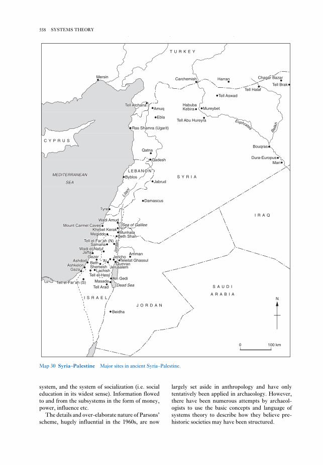
largely set aside in anthropology and have only
tentatively been applied in archaeology. However,
there have been numerous attempts by archaeol-
ogists to use the basic concepts and language of
systems theory to describe how they believe pre-
historic societies may have been structured.
system, and the system of socialization (i.e. social
education in its widest sense). Information flowed
to and from the subsystems in the form of money,
power, influence etc.
The details and over-elaborate nature of Parsons’
scheme, hugely influential in the 1960s, are now
558 SYSTEMS THEORY
T U R K E YT U R K E Y
CarchemishCarchemishMersinMersin
Tell AtchanaTell AtchanaAmuqAmuq
EblaEbla
MureybetMureybetHabubaHabubaKeriraKerira
Tell Abu HureyraTell Abu Hureyra EEuupphhrraatteess
BBeellliiikk
hh
BouqrasBouqras
Dura-EuropusDura-EuropusMariMari
S Y R I AS Y R I A
I R A QI R A Q
Ras Shamra (Ugarit)Ras Shamra (Ugarit)
QatnaQatna
QadeshQadesh
JabrudJabrudByblosByblos
L E B A N O NL E B A N O NL E B A N O N
TyreTyre
LLiiittaanniii
DamascusDamascus
Wadi AmudWadi AmudSea of GalileeSea of GalileeMount Carmel CavesMount Carmel Caves
Khirbet KerakKhirbet KerakMunhataMunhata
Beth ShanBeth ShanTell el-Far’ah (N)Tell el-Far’ah (N)Tell el-Far’ah (N)
JJoorrdd
aannSamariaSamaria
MegiddoMegiddo
JaffaJaffaWadi el-NatufWadi el-Natuf
JerichoJerichoGezerGezer
JerusalemJerusalemQumranQumran
Teleilat GhassulTeleilat Ghassul
AmmanAmman
BethBethShemeshShemesh
AshdodAshdodAshkelonAshkelon
GazaGaza
AiAi
LachishLachishTell el-HesyTell el-Hesy
MasadaMasadaAin GediAin Gedi
Tell AradTell Arad
I S R A E LI S R A E L
Dead SeaDead Sea
J O R D A NJ O R D A N
BeidhaBeidha
S A U D IS A U D I
A R A B I AA R A B I A
HarranHarran
Tell AswadTell Aswad
Tell HalafTell Halaf
Chagar BazarChagar Bazar
Tell BrakTell Brak
C Y P R U SC Y P R U S
MEDITERRANEANMEDITERRANEAN
SEASEA
Tell el-Far’ah (S)Tell el-Far’ah (S)
T U R K E Y
CarchemishMersin
Tell AtchanaAmuq
Ebla
MureybetHabubaKebira
Tell Abu Hureyra Euphrates
Belik
h
Bouqras
Dura-EuropusMari
S Y R I A
I R A Q
Ras Shamra (Ugarit)
Qatna
Qadesh
JabrudByblos
L E B A N O N
Tyre
Litani
Damascus
Wadi AmudSea of GalileeMount Carmel Caves
Khirbet KerakMunhata
Beth ShanTell el-Far’ah (N)
Jord
anSamaria
Megiddo
JaffaWadi el-Natuf
JerichoGezer
JerusalemQumran
Teleilat Ghassul
Amman
BethShemesh
AshdodAshkelon
Gaza
Ai
LachishTell el-Hesy
MasadaAin Gedi
Tell Arad
I S R A E L
Dead Sea
J O R D A N
Beidha
S A U D I
A R A B I A
Harran
Tell Aswad
Tell Halaf
Chagar Bazar
Tell Brak
C Y P R U S
MEDITERRANEAN
SEA
Tell el-Far’ah (S)
N
0 100 km
Map 30 Syria–Palestine Major sites in ancient Syria–Palestine.

that all systems tended toward either a ‘steady state’
of equilibrium with regard to the environment in
which they existed, or changed only according to an
‘orderly process’. This assumption, implicit or
explicit, is one of the principal weaknesses of the
approach. It underlines the ahistorical character of
many interpretations of social systems relying on
systems theory. However, it is only really through
the notion of equilibrium that systems theory
appears to have explanatory and predictive power
when applied to real-world situations. Without it,
systems theory becomes (and is now often recog-
nized as) a simplifying descriptive framework (see
Shanks and Tilley 1987: 31–6, 138–43).
In more developed discussions of systems
qualities, notions such as ‘hypercoherence’ can help
us to understand complex system behaviour that
would otherwise be difficult to grasp. Hyper-
coherence is simply the label given to a system that
is both closely integrated and very delicately bal-
anced: a crisis in one subsystem quickly leads to
massive change or disruption in the other subsys-
tems and the system as a whole. However, like other
concepts in systems theory, it is largely helpful as a
means of conceptualizing and making more plausi-ble a sequence of interactions between social
entities. Because interactions between social sub-
systems are not, and never will be, quantifiable,
systems theory cannot itself offer proof of any argu-
ment in the social sciences. See also WORLD
SYSTEMS THEORY.D.L. Clarke: Analytical archaeology (London, 1968); K.
Flannery: ‘Archaeological systems theory and early
Mesoamerica’, Anthropology and archaeology in theAmericas, ed. B. Meggers (Washington, D.C., 1968); J.E.
Doran: ‘Systems theory, computer simulations and
archaeology’, WA 1 (1970), 289–98; C. Renfrew: The emer-gence of civilization: the Cyclades and the Aegean in the thirdmillennium BC (London, 1972); F. Plog: ‘Systems theory
in archaeological research’, ARA 4 (1975), 207–24; C.
Renfrew: Approaches to social archaeology (Edinburgh,
1984); B.G. Trigger: A history of archaeological thought(Cambridge, 1989), 303–12; M. Shanks and C. Tilley:
Social theory and archaeology (Cambridge, 1987).
RJA
Szeletian Intermediate Middle to Upper
Palaeolithic industry of Moravia and western
Slovakia and northeast Hungary, named after the
Szeleta Cave in the Bükk Mountains of Hungary.
The Szeletian may have developed out of the
Middle Palaeolithic Central European Micoquian,
but it presents blades and core-preparation tech-
niques of a distinctly Upper Palaeolithic type. As
well as ‘Middle Palaeolithic’ side scrapers, the tools
Key concepts in systems theory. The core concepts are
information media and information flow: boundary
maintenance; feedback; and equilibrium. Infor-
mation media describe the form in which
information flows through a system (e.g. money
might be regarded as information within an
economic system). Information flow describes the
mechanisms of information storage, control and
output. Boundary maintenance describes the mech-
anisms within systems that define the elements that
comprise the system itself, and separate it off from
other systems and its wider environment. Within
social systems, for example, it is often claimed that
system boundary concern is manifested in concen-
trated symbolic and ritual activity.
Feedback, a concept borrowed from the physical
sciences, describes how the output of a system or
subsystem continually feeds back into the system to
control the level or character of subsequent output.
Positive feedback leads to a continual increase in
output, and thus to instability or change. For ex-
ample, in an agricultural system in which the
harvester gathers the most productive stands of
cereal to preserve for next year’s planting, each crop
will contain successively more wheat with that
beneficial characteristic – and this may happen
quite quickly because of the nature of the system (i.e.
grain is selected for planting). Colin Renfrew used
a form of positive feedback which he called the
‘multiplier effect’ to explain the emergence of
Aegean civilization: ‘changes or innovations occur-
ring in one field of human activity (in one subsystem
of a culture) sometimes act so as to favour changes
in other fields (in other subsystems). The multiplier
effect is said to operate when these induced changes
in one or more subsystems themselves act so as to
enhance the original changes in the first subsystem’
(Renfrew 1972; 37).
Negative feedback describes a subsystem
relationship which tends to dampen down the
effects of any change in system output and thus
promote system stability. In the agricultural system
described above, if harvesters had the habit of con-suming the most productive stands of cereal then
this might slow down the evolution of productive
agricultural systems – and associated changes in
other subsystems. Note that the harvesting actions
in this example are essentially the same – it is the
effect on the next cycle of the subsystem that de-
termines whether the feedback is positive or
negative, relatively strong or relatively weak.
In common speech, equilibrium is a term used to
describe a state of balance. One of the more
questionable (and tautological) assumptions of the
elaborated form of systems theory in sociology was
559SZELETIAN

the Szeletian is an acculturated version of the
AURIGNACIAN produced by NEANDERTHALS. The
Szeletian in Central Europe would therefore occupy
the same position as the CHÂTELPERRONIAN or
Lower PERIGORDIAN in Western Europe. This
theory assumes that the Neanderthals were replaced
by ANATOMICALLY MODERN HUMANS, a premise
not universally accepted.P. Allsworth-Jones: The Szeletian and the transition fromMiddle to Upper Palaeolithic in Central Europe (Oxford,
1986); J.K. Kozłowski: ‘The transition from the Middle to
the early Upper Palaeolithic in Central Europe and the
Balkans’, The early Upper Palaeolithic, eds. J.F. Hoffecker
and C.A. Wolf, BAR IS 437 (Oxford, 1988), 193–237; M.
Oliva: ‘The Szeletian in Czechoslovakia’, Antiquity 65
(1991), 318–25.
RJA
produced include end-scrapers and burins. The
most striking artefacts are the finely made bifacial
leaf-shaped points, which grew larger and more
elongated as the Szeletian progressed. In the past
these leaf points have led archaeologists to construe
some link with the much later SOLUTREAN indus-
tries, although this is now usually discounted.
Split-based bone points have also been found at
Szeleta Cave. At Szeleta Cave the ‘Early’ Szeletian
is dated to c.41,000 uncal BP and the ‘Developed’ to
c.32,000 uncal BP. These dates suggest that even the
‘Early’ Szeletian may be contemporaneous with
the early Aurignacian, a variant of which is dated to
39,700 ± 900 uncal BP at the other Hungarian site
of Istállóskö. This contemporaneity has led Philip
Allsworth-Jones and others to suggest that
560 SZELETIAN

Tabun see MOUNT CARMEL
Tadrart Acacus see AFRICA 1
Taforalt see AFRICA 1
Tagajo Garrison of the 8th and 9th centuries AD
in Miyagi prefecture, northern Japan, which was
one of several centres for frontier administration
mentioned in historical records in connection with
attempts by the central state to subdue groups such
as the Emishi. Excavations since 1961 have revealed
extensive earthworks and wooden slips bearing ink
inscriptions.Tohoku Historical Museum and the Miyagi Prefectural
Tagajo Research Institute: Tagajo to kodai Tohoku [Tagajo
and ancient Tohoku] (Sendai, 1985).
SK
T’ai-hsi-ts’un (Taixicun) Site of the SHANG
period (2000–1122 BC), near the village of T’ai-hsi-
ts’un, in the central Ho-pei province of China. It is
one of three large earth mounds in the area, which
was excavated in 1973–6; bringing to light the
remains of 14 houses, two wells, over 100 burials
and many pits. Building remnants include some
parts of the roofs which indicate the method of
gabling employed; the overall structures comprise
wooden posts and beams with wall fillings of
rammed earth, or sun-dried brick. Wooden frames
supported the well bottom, and, significantly, they
were found to have been laid out in the shape of the
character ching (‘well’).
Over two thousand artefacts were recovered,
including pottery, stone and bone implements,
ORACLE BONES (uninscribed), turtle shells,
LACQUER remnants, hemp fabric, gold foil, bronze
vessels, bronze knives and weapons. A bronze yüeh-
axe with an iron blade has become the basis of
controversy as to the antiquity of iron manufacture
in China. The iron in this axe, and two others like
it, is apparently of meteoritic origin; as it would
necessarily require smithing in its manufacture,
such a worked material would be more likely to have
been a cultural intrusion.Anon.: Kao-ch’eng T’ai-hsi Shang-tai yi-chih [The Shang
period remains at Kao-ch’eng, T’ai-hsi] (Peking, 1985).
NB
Taixicun see T’AI-HSI-TS’UN
Takamatsuzuka Late Kofun-period (AD
300–710) mounded tomb in Nara prefecture, Japan,
famous for its painted murals depicting the Chinese
directional symbols on the plastered walls of the
tomb. The stone chamber is in a small round
mound. Recent opinions suggest artistic influence
from the Chinese Tang dynasty (AD 618-907) on
this tomb of an aristocrat from the YAMATO state.C.M. Aikens and T. Higuchi: The prehistory of Japan(London, 1982), 284–5.
SK
Takht-i Sulaiman see PARTHIANS; SASANIANS
Talasea Series of obsidian sources deriving from
volcanoes on the north coast of West New Britain,
Papua New Guinea. Obsidian from Talasea has
been used continuously from 20,000 years ago, the
earliest examples deriving from New Ireland cave
sites such as BALOF CAVE. During the time of the
LAPITA CULTURAL COMPLEX, Talasea obsidian
was distributed widely, ending up in Sabah,
Malaysia to the west and Fiji to the east. See alsoOCEANIA 2.R. Torrence ‘What is Lapita about obsidian? A view from
the Talasea sources’, Poterie, Lapita et peuplement, ed. J.C.
Galipaud (Nouméa, 1992), 111–26; C. Gosden et al.: ‘The
Lapita sites of the Bismarck Archipelago’, Antiquity 63
(1989), 561–86.
CG
talayots (talaiots; ‘watchtowers’) Monu-
mental round or rectangular drystone tower-like
structures characteristic of the full Bronze Age – or
Talayotic Period – in the Mediterranean Balearic
T

founded by Psusennes I (c.1020 BC). In 1939–40 he
discovered the relatively undisturbed tombs of
some of the rulers of the 3rd Intermediate Period,
complete with much of the original funerary equip-
ment, a discovery which would perhaps have
brought Montet the same fame as Howard Carter
had it not coincided with the outbreak of the
Second World War.W.M.F. Petrie: Tanis, 2 vols (London, 1885–8); P.
Montet: La nécropole royale de Tanis, 2 vols (Paris,
1947–60); H. Stierlin and C. Ziegler: Tanis: trésorsdes pharaons (Paris, 1987); J. Yoyotte et al.: Gold of thepharaohs (Edinburgh, 1988); P. Brissaud: ‘Tanis: the
golden cemetery’, Royal cities of the biblical world, ed. J.
Goodnick Westenholz (Jerusalem, 1996), 113–70.
IS
T’ao-ssu (Taosi) Extensive site of the Neolithic
LUNG-SHAN culture (c.4000–2000 BC), near the
village of T’ao-ssu-ts’un, Hsiang-fen-hsien, Shan-
hsi, China. Still only partly excavated, it primarily
consists of a cemetery area that is estimated to cover
an area of 30,000 sq.m, containing several thousand
burials, about a thousand of which have been ex-
cavated. Calibrated radiocarbon dates range from
c.2875 to 1905 BC.Chang Kwang-chih: The archaeology of ancient China, 4th
edn (New Haven, 1986), 275–9; N. Barnard: ‘Thoughts on
the emergence of metallurgy in pre-Shang and Early
Shang China and a technical appraisal of relevant bronze
artifacts of the time’, BMM, Sendai, 19 (1993), 3–48.
NB
Taoudenni Basin The southeastern part of the
Taoudenni basin, within the Republic of Mali, has
been investigated by N. Petit-Maire and her
colleagues since 1980. This area, lying between 17°
and 24° N, presently forms part of the Sahara and
has an annual precipitation of 50–55 mm, but
the investigation has demonstrated that during the
early Holocene rainfall is likely to have reached
400–250 mm, and there were several freshwater
lakes, as well as an extensive Neolithic occupation of
this region. Dates obtained on molluscs suggest that
there were two main humid phases, a major one
from 9500 to 6000 BP and a minor one from 5000 to
4000 BP. After 3000 BP the region was deserted. The
early phase of occupation is dated to 6970 ± 130 BP
at Hassi el-Abiod and 6340 ± 130 BP at Erg Ine
Sakane. At both localities, large middens contained
an abundant fauna, with fish, crocodiles, turtles,
snakes, bovids, hippos and antelopes, as well as arte-
facts and human burials. The tools, apart from
geometric microliths, also include polished stone
axes, fish hooks and grinding equipment, taken to
islands (Majorca and Minorca). The absolute dates
of the talayot phenomenon are unclear, but may run
from c.1500 BC to c.800 BC or later. Talayots, which
occur singly and in groups, are often compared to
the NURAGHI of Sardinia, although they are smaller
and simpler in form and lack a sophisticated
corbelling technique. They may have acted as places
of refuge or as central strongpoints for local powers.G. Rossello-Bordoy: La cultura talayotica en Mallorca(Palma, 1979); R. Chapman and A. Grant: ‘The Talayotic
monuments of Mallorca, formation processes and -
function’, Oxford Journal of Archaeology 8 (1989), 55–72.
RJA
talud-tablero Mesoamerican style of temple-
pyramid construction associated with the site of
TEOTIHUACAN, in which each tier or terrace of the
substructure was composed of two parts: a sloping
apron (talud) topped by a flat, rectangular panel
(tablero).G. Kubler: ‘Iconographic aspects of architectural profiles
at Teotihuacán and in Mesoamerica’, The iconography ofMiddle American sculpture (New York, 1973), 24–39.
PRI
Tamaya Mellet see AFRICA 1.1
tambo Groups of storehouses and shelters
located at intervals along roads by the INCA.
Tam My see SA HUYNH
Tanis (anc. Djaðnet; San el-Hagar) Egyptian
town, temple and royal cemetery located in the Nile
delta about 130 km northeast of Cairo. It was
capital of Egypt for much of the 3rd Intermediate
Period (c.1070–712) and continued to flourish until
the early Roman period (c.30 BC). The preservation
of Tanis, a typical tell-site covering some 180 ha,
has been greatly assisted by its location in one of
Egypt’s poorest areas of agricultural land, which
has tended to protect it from the depredations of
farmers digging for fertilizer (the so-called
sabakhin), unlike other post-New Kingdom sites
such as SAIS and MENDES. Because of the large
number of Ramessid monuments at Tanis, both
Auguste Mariette and Flinders Petrie mistakenly
identified the site with Piramesse, the city said to
have been founded by Ramesses II in the Delta
(which is now known to have been located at
QANTIR and TELL EL-DABðA). From 1929 to 1952
Pierre Montet excavated the site, concentrating on
the precincts of the temple of Amun, which was
562 TALAYOTS (TALAIOTS; ‘WATCHTOWERS’)

chih: The archaeology of ancient China, 4th edn (New
Haven, 1986), 228–33.
NB
taphonomy Palaeontological term coined by
I.A. Efremov in 1940 to describe the study of the
transformation of organic remains into fossil
deposits as a result of spatial, temporal and biologi-
cal factors. The term has been used by
archaeologists since at least the early 1980s to
describe the transformation of bone (and sometimes
other material) in the archaeological record, i.e. the
organic aspects of SITE FORMATION PROCESSES.
The most useful applications of taphonomy include
the work of C.K. Brain (1981), studying faunal
remains associated with australopithecine hominids
at the South African site of SWARTKRANS, and the
ethnoarchaeological researches of Lewis Binford
(1981), distinguishing between patterns of faunal
remains created by dogs, wolves and humans at
various sites in North America.I.A. Efremov: ‘Taphonomy: a new branch of paleontol-
ogy’, Pan-American Geologist 74 (1940), 81–93; A.K.
Behrensmeyer and A.P. Hill: Fossils in the making: ver-tebrate taphonomy and paleoecology (Chicago, 1980); L.R.
Binford: Bones: ancient men and modern myths (New York,
1981); C.K. Brain: The hunters or the hunted? An introduc-tion to African cave taphonomy (Chicago, 1981); D.P.
Gifford: ‘Taphonomy and paleoecology: a critical review
of archaeology’s sister disciplines’, Advances in archaeo-logical method and theory 4, ed. M.B. Schiffer (New York,
1981), 365–438.
IS
Tarascans Late Postclassic state in the state of
Michoacán in western Mexico, with its capital at
Tzintzuntzan, on the shores of Lake Pátzcuaro.
Claiming CHICHIMEC ancestry, the Tarascans
maintained an uneasy frontier with the AZTECS to
the south and were known for their fine metalwork-
ing, especially in copper.D.D. Brand: ‘An historical sketch of geography and
anthropology in the Tarascan region, Part 1’, New MexicoAnthropologist 6 (1943) 37–108.
PRI
Tardenoisian Term applied to an ill-defined
group of Mesolithic assemblages, characterized
principally by the presence of asymmetrical
trapezes (pointe tardenoisienne) and long blades.
First identified at Fère-en-Tardois in southwest
France, the assemblages date from about 6000 BC
into the 5th millennium. Assemblages with Tarden-
oisian characteristics can be identified across
indicate the exploitation of wild grasses. There are
numerous bone harpoons (>100 at one site) similar
to those found at ADRAR BOUS and Shaheinab
(KHARTOUM NEOLITHIC), and pottery which at Erg
Ine Sakane includes wavy-line and dotted wavy-line
motifs. At Hassi el-Abiod 89 skeletons were recov-
ered from 16 sites. These according to O. Dutour
form a homogeneous ‘Cromagnoid’ population,
which in terms of metrical characteristics is very
close to the ‘Mechtoids’ from the North African
IBEROMAURUSIAN sites of Afalou and Taforalt. As
Petit-Maire says, this similarity ‘may be a result of
early Holocene trans-Saharan migrations or a com-
mon Aterian ancestry’. ATERIAN stone tools were
found in situ beneath thick deposits of sand and silt
at Sbeita northwest of Taoudenni, and stratigraphi-
cally they may correspond to palaeolake deposits
130 km away dated to 21,000 ± 300 BP.N. Petit-Maire et al.: ‘The Sahara in northern Mali: man
and his environment between 10,000 and 3500 years BP
(Preliminary results)’, AAR 1 (1983), 105–25; N. Petit-
Maire: ‘Palaeoclimates in the Sahara of Mali: a
multidisciplinary study’, Episodes 9/1 (1986), 7–16; ––––
and O. Dutour: ‘Holocene populations of the Western and
Southern Sahara: Mechtoids and paleoclimates’,
Prehistory of arid North Africa, ed. A.E. Close (Dallas,
1987), 259–85.
PA-J
Ta-p’en-k’eng (Dapenkeng) Neolithic site near
Taipei, which is one of the best-studied prehistoric
sites on the island of Taiwan (see Chang et al. 1969)
and is also the type-site for the Ta-p’en-k’eng
culture. This culture is characterized by cord-
marked pottery (the cord-marks demonstrating
the existence of highly sophisticated cordage
techniques), stone net-sinkers, shell-mounds,
woodworking implements such as stone adzes and
chisels (illustrating the possibility of boat building),
and bark-beaters (for the production of fibres for
rope-making). Some form of agriculture may have
been practised but the obvious means of subsistence
was hunting, fishing and collecting. The culture,
along with others related to it, is represented in sites
on the Chinese mainland, a few of which are located
directly opposite, in Fu-chien, but many have been
recognized in Kuang-tung and coastal Kuang-hsi.
Calibrated radiocarbon datings indicate a span of
5000–3000 BC, thus making it contemporary with
such cultures as Ma-chia-pang and HO-MU-TU to
the north, in Chiang-su and Che-chiang, TA-WEN-
K’OU in Shan-tung, and YANG-SHAO in the
Huang-ho River Basin.Chang Kwang-chih et al.: Fengpitou, Tapenkeng, and thePrehistory of Taiwan (New Haven, 1969); Chang Kwang-
563TARDENOISIAN

Tasmania see OCEANIA 1
Tassili-n-Ajjer see AFRICA 1
Tatetsuki Very large Late Yayoi (AD 100–300)
burial mound in Okayama prefecture, Japan which
has provided good evidence for the burial customs
of regional chiefs and insight into the extent of
indigenous Japanese origins of the keyhole-shaped
mounded tombs of the succeeding Kofun period
(see JAPAN 3–4).Y. Kondo, ed.: Tatetsuki mound of the Yayoi period(Okayama, 1992) [in Japanese with English summary].
SK
Europe from Iberia to Sweden (excluding Britain,
presumably because eustatic changes had recently
created the English Channel), centring on northern
France. Tardenoisian assemblages are generally
thought to post-date assemblages defined as
MAGLEMOSIAN and those defined as SAUVE-
TERRIAN; however, the relationship with the
Sauveterrian has been the subject of much debate
since the 1950s, as summarized by Peter Rowley-
Conwy (1986). There is some limited evidence that
hunters and gatherers using lithic industries of
Tardenoisian character existed at the same time as
early farming groups in northern France, that the
two economies occupied different landscape zones,
and that there was a (limited, except perhaps in
Brittany) degree of contact and cultural inter-
change.C. Barrière: Les civilizations Tardenoisiennes en EuropeOccidentale (Paris, 1956); R. Parent: ‘Le peuplement
préhistorique entre le Marne et l’Aisne’, Travaux del’institut d’art préhistorique de l’Université de Toulouse 13
(1971); S.K. Kozłowski, ed.: The Mesolithic in Europe(1973); P. Rowley-Conwy: ‘Between cavepainters and
crop planters: aspects of the temperate European
Mesolithic’, Hunters in transition, ed. M. Zvelebil
(Cambridge, 1986), 17–29.
RJA
el-Tarif see SAFF-TOMB
Tarkhan Religious and funerary site in the Nile
valley, about 60 km south of Cairo, excavated by
Flinders Petrie in 1912–13. The main components
of the site comprise a temple dating to the 9th–7th
centuries BC and a number of cemeteries ranging in
date from the late predynastic to the Roman period
(c.3200 BC–AD 395).W.M.F. Petrie et al.: Tarkhan and Memphis V (London,
1913); W.M.F. Petrie: Tarkhan II (London, 1914);
IS
Tǎrtǎria Romanian Neolithic site of the Vinča-
Tordos culture, famous for the discovery in a pit of
three clay tablets bearing signs that were once
claimed to be related to the pictographs used in the
JEMDET NASR period in Mesopotamia – an inter-
pretation that clashes with the accepted VINČA
chronology and is now discounted. The signs may
represent some simple form of notation, or religious
symbolism, but researchers no longer regard them
as ‘proto-writing’.
RJA
Tasian see BADARIAN
564 TARDENOISIAN
0 3 cm
Figure 53 Tǎrtǎria Inscribed clay tablets from
Tǎrtǎria, Transylvania, Romania. Source: A. Whittle:
Neolithic Europe: a survey (Cambridge, 1985), fig. 3.15.

Shan-tung and northern Chiang-su; clusters of
radiocarbon datings range from 5500 to 3500 BC.
The culture is more or less contemporary with
YANG-SHAO to the west in the Huang-ho River
Basin, Ma-chia-pang and HO-MU-TU to the south in
Chiang-su and Che-chiang, and TA-PEN-K’ENG in
the southern coastal region of Fu-chien, Kuang-
tung, Kuang-hsi and western Taiwan.
For the most part the Ta-wen-k’ou predates the
LUNG-SHAN culture. Agriculture was practised, as
suggested by millet grains found in several sites and
the presence of sickles of bone, tooth and shell. A
large variety of animal bones including the domes-
tic pig, cattle, deer, alligator, turtles, chickens, fish,
molluscs and snails bear witness to the diet and
hunting and fishing activities, as well as providing
an indication of the more humid and warmer
lacustrine environment of the time. Houses were
of the round semi-subterranean type, some
square, and with postholes, but only a few have been
found.Anon.: Ta-wen-k’ou (Peking, 1974); Chang Kwang-chih:
The archaeology of ancient China, 4th edn (New Haven,
1986), 156–69.
NB
Taxila Large urban site located near modern
Rawalpindi in northern Pakistan alongside a major
Taung Site of the discovery of the type specimen
of AUSTRALOPITHECUS AFRICANUS in 1924, close
to the town of Taung, N. Cape Province, South
Africa. The site consists of four superimposed
travertine aprons (with associated breccia and con-
glomerate deposits) banked against the Gaap
escarpment. The Taung skull and associated fossils
came from sediments filling a cavern system eroded
in the oldest (Thabaseek) travertine, probably con-
temporaneous with the next younger (Norlim)
travertine. Attempts to derive radiometric dates for
the Taung skull are considered inconclusive, and
estimates based on faunal remains vary between 2.3
and 1.8 million years.K.W. Butzer: ‘Palaeoecology of South African austra-
lopithecines: Taung revisited’, CA 15 (1974), 367–82;
P.V. Tobias, ed.: Hominid evolution: past, present and future(New York, 1985), 25–40, 189–200.
RI
Ta-wen-k’ou (Dawenkou) Neolithic culture
named after the type-site near T’ai-an, in the Shan-
tung region of China, which is sometimes referred
to as the Ch’ing-lien-kang culture (a red pottery
culture investigated in 1951 at the type-site of this
name, in Huai-an-hsien, in northern Chiang-su).
Over a hundred Ta-wen-k’ou culture sites are
known, mainly distributed in central and southern
565TAXILA
Figure 54 Ta-wen-k’ou Division of the Ta-wen-k’ou culture into three phases as reflected in the pottery styles.
Source: Anon.: Ta-wen-k’ou (Peking, 1974), fig. 91.

open-air sites provided evidence for the history of
domestication and the beginnings of sedentism in
Mesoamerica between c.7000 and 2300 BC. The
valley continued to be occupied during Classic and
Postclassic periods (c.AD 300–1521).D.S. Byers, ed.: The prehistory of the Tehuacán Valley, I:environment and subsistence (Andover, 1967).
PRI
Teishebaina see URARTU
Tekkalakota Neolithic site located in an area of
granitic hills in modern Karnataka, southern India.
The excavations of M.S. Nagaraja Rao in 1963–4
defined two chronological periods (Phase I,
1700–1600 BC and Phase II, 1600–1500 BC) and
revealed well-preserved foundations of circular
huts as well as large quantities of faunal remains,
including domestic cattle, sheep, deer and rodents.
The botanical remains indicate that horse gram
(Dolichos biflorus) was being cultivated.
Artefacts excavated at Tekkalakota include
hand- and wheel-made ceramics, beads, copper
implements and gold ear ornaments. Seven burials
were excavated: six from phase I and one from
Phase II. In Phase I partially disarticulated adult
skeletons were buried in shallow pits covered with
stones, while children were buried in ceramic urns.
The Phase II burial comprised the extended body
of an adult associated with BLACK AND RED WARE
and plain red ceramic vessels. Nearby rock-shelters
contain petroglyphs and wall paintings depicting
bulls, dogs, and humans, interpreted by Nagaraja
Rao and M.C. Malhotra (1965: 98) as dating to the
Neolithic period.M.S. Nagaraja Rao and M.C. Malhotra: The Stone Age hilldwellers of Tekkalakota (Pune, 1965); B.P. Sahu: Fromhunters to breeders (Delhi, 1988), 189–91, 225–6.
CS
tell Arabic term used to describe the distinctive
stratified mounds of archaeological deposits which
formed on the sites of early settlements, particularly
in Western Asia, southeastern Europe and North
Africa. Tell sites accumulate vertically because of
the repeated demolition and re-levelling of mud-
brick houses over the course of long periods of time.
Probably the earliest examples are to be found in the
Jordan valley, including the town of JERICHO,
where the Proto-Neolithic strata form a 10-metre
high mound. The word ‘tell’ can be traced back to
tilu, the AKKADIAN word for mound. The equiva-
lent words used to describe such town-mounds in
route between Central Asia and the Indian sub-
continent. First excavated by A. Cunningham in the
1860s, it consists of several mounds (Hathial, Bhir,
Sirkap and Sirsukh), not all of which were occupied
at the same time. The occupation levels, dated
primarily by numismatic evidence, stretch from the
ACHAEMENID period (c.516 BC) to the 3rd century
AD. Although Greek textual sources document the
arrival of Alexander the Great at Taxila in 326 BC,
definitive archaeological evidence of his brief occu-
pation has yet to be identified.
During the MAURYAN PERIOD (c.321–189 BC) the
city of Taxila was a major political centre, first under
the Mauryan empire and later under autonomous
rulers. Indo-Greek occupation of the city began in
the early 2nd century BC, and it was during this
period that the construction of the walled city of
Sirkap was initiated (but see Erdosy 1990 for a dif-
ferent perspective). The next occupants of Taxila
were the Sakas (SCYTHIANS) and PARTHIANS
(c.90 BC–AD 60; Erdosy 1990: 668). The mound of
Sirsukh is associated with subsequent Kushana
occupation of the city (c.AD 60–230), during which
many of the Buddhist monasteries were expanded
and GANDHARAN-style sculpture flourished.
Excavations have revealed dense architectural
remains, including Buddhist STUPAS and mon-
asteries, and a wide array of ceramic, copper and
iron goods, as well as sculptures and ornaments of
gold, silver and other precious materials.J. Marshall: Taxila, 3 vols (Cambridge, 1951); A.H. Dani:
The historic city of Taxila (Paris, 1986); G. Erdosy: ‘Taxila:
political history and urban structure’, South Asian archae-ology 1987, ed. M. Taddei (Naples, 1990), 657–75.
CS
Tayma see ARABIA, PRE-ISLAMIC
tazunu see AFRICA 5.3
technocomplex Term used to describe a group
of cultures which are characterized by assemblages
sharing a polythetic range. Each of the cultures in
the group has different specific types of the
same general family of artefacts, but they all share
a widely diffused and interlinked response to
common factors in environment, economy and
technology.D.L. Clarke: Analytical archaeology (London, 1968).
KM
Tehuacán Arid highland valley in Puebla,
south-central Mexico, where a series of caves and
566 TAXILA
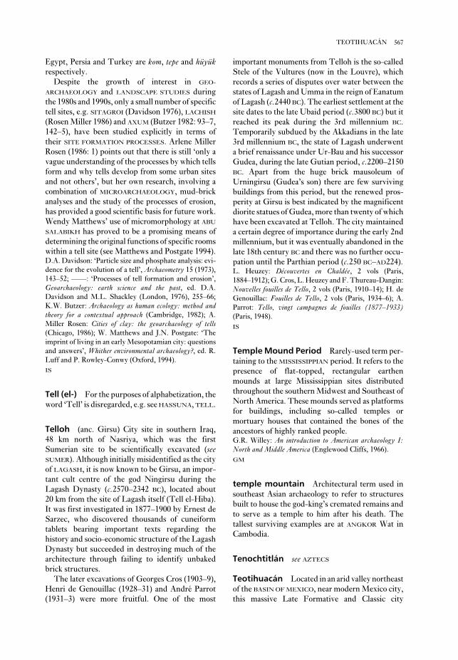
important monuments from Telloh is the so-called
Stele of the Vultures (now in the Louvre), which
records a series of disputes over water between the
states of Lagash and Umma in the reign of Eanatum
of Lagash (c.2440 BC). The earliest settlement at the
site dates to the late Ubaid period (c.3800 BC) but it
reached its peak during the 3rd millennium BC.
Temporarily subdued by the Akkadians in the late
3rd millennium BC, the state of Lagash underwent
a brief renaissance under Ur-Bau and his successor
Gudea, during the late Gutian period, c.2200–2150
BC. Apart from the huge brick mausoleum of
Urningirsu (Gudea’s son) there are few surviving
buildings from this period, but the renewed pros-
perity at Girsu is best indicated by the magnificent
diorite statues of Gudea, more than twenty of which
have been excavated at Telloh. The city maintained
a certain degree of importance during the early 2nd
millennium, but it was eventually abandoned in the
late 18th century BC and there was no further occu-
pation until the Parthian period (c.250 BC–AD224).L. Heuzey: Découvertes en Chaldée, 2 vols (Paris,
1884–1912); G. Cros, L. Heuzey and F. Thureau-Dangin:
Nouvelles fouilles de Tello, 2 vols (Paris, 1910–14); H. de
Genouillac: Fouilles de Tello, 2 vols (Paris, 1934–6); A.
Parrot: Tello, vingt campagnes de fouilles (1877–1933)(Paris, 1948).
IS
Temple Mound Period Rarely-used term per-
taining to the MISSISSIPPIAN period. It refers to the
presence of flat-topped, rectangular earthen
mounds at large Mississippian sites distributed
throughout the southern Midwest and Southeast of
North America. These mounds served as platforms
for buildings, including so-called temples or
mortuary houses that contained the bones of the
ancestors of highly ranked people.G.R. Willey: An introduction to American archaeology I:North and Middle America (Englewood Cliffs, 1966).
GM
temple mountain Architectural term used in
southeast Asian archaeology to refer to structures
built to house the god-king’s cremated remains and
to serve as a temple to him after his death. The
tallest surviving examples are at ANGKOR Wat in
Cambodia.
Tenochtitlán see AZTECS
Teotihuacán Located in an arid valley northeast
of the BASIN OF MEXICO, near modern Mexico city,
this massive Late Formative and Classic city
Egypt, Persia and Turkey are kom, tepe and hüyükrespectively.
Despite the growth of interest in GEO-
ARCHAEOLOGY and LANDSCAPE STUDIES during
the 1980s and 1990s, only a small number of specific
tell sites, e.g. SITAGROI (Davidson 1976), LACHISH
(Rosen Miller 1986) and AXUM (Butzer 1982: 93–7,
142–5), have been studied explicitly in terms of
their SITE FORMATION PROCESSES. Arlene Miller
Rosen (1986: 1) points out that there is still ‘only a
vague understanding of the processes by which tells
form and why tells develop from some urban sites
and not others’, but her own research, involving a
combination of MICROARCHAEOLOGY, mud-brick
analyses and the study of the processes of erosion,
has provided a good scientific basis for future work.
Wendy Matthews’ use of micromorphology at ABU
SALABIKH has proved to be a promising means of
determining the original functions of specific rooms
within a tell site (see Matthews and Postgate 1994).D.A. Davidson: ‘Particle size and phosphate analysis: evi-
dence for the evolution of a tell’, Archaeometry 15 (1973),
143–52; ––––: ‘Processes of tell formation and erosion’,
Geoarchaeology: earth science and the past, ed. D.A.
Davidson and M.L. Shackley (London, 1976), 255–66;
K.W. Butzer: Archaeology as human ecology: method andtheory for a contextual approach (Cambridge, 1982); A.
Miller Rosen: Cities of clay: the geoarchaeology of tells(Chicago, 1986); W. Matthews and J.N. Postgate: ‘The
imprint of living in an early Mesopotamian city: questions
and answers’, Whither environmental archaeology?, ed. R.
Luff and P. Rowley-Conwy (Oxford, 1994).
IS
Tell (el-) For the purposes of alphabetization, the
word ‘Tell’ is disregarded, e.g. see HASSUNA, TELL.
Telloh (anc. Girsu) City site in southern Iraq,
48 km north of Nasriya, which was the first
Sumerian site to be scientifically excavated (seeSUMER). Although initially misidentified as the city
of LAGASH, it is now known to be Girsu, an impor-
tant cult centre of the god Ningirsu during the
Lagash Dynasty (c.2570–2342 BC), located about
20 km from the site of Lagash itself (Tell el-Hiba).
It was first investigated in 1877–1900 by Ernest de
Sarzec, who discovered thousands of cuneiform
tablets bearing important texts regarding the
history and socio-economic structure of the Lagash
Dynasty but succeeded in destroying much of the
architecture through failing to identify unbaked
brick structures.
The later excavations of Georges Cros (1903–9),
Henri de Genouillac (1928–31) and André Parrot
(1931–3) were more fruitful. One of the most
567TEOTIHUACÁN

the Sun Temple is a huge square enclosure, the
Ciudadela, with a large temple on its east side;
across the avenue is another enormous enclosure
that might have served as a market. Recent work
around the Temple of Quetzalcoatl in the Ciudadela
(Cabrera et al. 1991) has shown that the structure
was built in a single phase of construction ac-
companied by the sacrifice and burial of perhaps
200 individuals. The temple-pyramids at
Teotihuacán were built in characteristic TALUD-
TABLERO style.
All around this civic-ceremonial core is a dense
arrangement of buildings, including perhaps as
many as 2000 multi-family apartment compounds.
Residents of these compounds may have been
linked by family (lineage) ties, and may have shared
occupational specialities, as particular compounds
seem to have concentrations of artefacts associated
with pottery making, for example, or wood-
working. Compounds associated with wealthier
families were decorated with beautiful, brightly-
coloured murals showing religious scenes.
There is abundant evidence for obsidian work-
ing at the Teotihuacán apartment compounds.
One of the explanations offered for the dramatic
size and influence of Teotihuacán throughout
Classic period Mesoamerica is that the city con-
trolled the exploitation and distribution of two or
more valued sources of obsidian for tool-making.
Other explanations focus on the many springs in
the otherwise dry Teotihuacán valley: these were
incorporated into irrigation systems, which
increased agricultural yields by permitting water to
be delivered to crops before the normal rainy
(planting) season and by allowing crops to mature
exerted a profound influence on the development of
many of the later cultures in Mesoamerica.
Teotihuacán covers an area of about 20 sq. km; its
total population has been estimated at about
125,000 people or more during its Classic peak
around AD 300–500. The principal centre of a pow-
erful highland state, Teotihuacán began its
dramatic growth in the Late Formative period, with
most major construction in the city completed
by c.AD 150. The city’s enormous size and the
difficulty of understanding the complex factors
leading to its rise and fall have posed enormous
challenges to archaeological research; these have
been exacerbated by modern occupation and dis-
turbance of the site. Two ambitious projects of
survey and settlement pattern analysis combined
mapping and surface collection of artefacts in an
investigation of the site’s history. One project was
directed toward the processes of urbanization and
growth of the city itself (Millon 1973) and the other
addressed Teotihuacán’s role in the larger basin
context (Sanders et al. 1979). More recent work has
explored the social and ideological factors under-
lying the site’s structure (Sugiyama 1993).
Teotihuacán exhibits a strikingly integrated site
plan laid out on a regular grid of streets. Major
civic-ceremonial architecture is arranged along a
broad avenue stretching some 2 km north-south,
known as the Street of the Dead. At the north end
is a large terraced pyramid known as the Temple of
the Moon; on the east side is another terraced pyra-
mid known as the Temple of the Sun. The Sun
temple sits above a natural cave in the bedrock,
believed to have been a sacred location that prob-
ably determined the temple’s siting. South of
568 TEOTIHUACÁN
Pyramid of the Moon Pyramid of the Sun Ciudadela
Temple of QuetzalcoatlStreet of the Dead
Figure 55 Teotihuacán Isometric view of the ceremonial structures lining the main north-south axis of
Teotihuacán, known as the Street of the Dead. Source: M.E. Miller: The art of ancient Mesoamerica (Thames and
Hudson, 1986), fig. 41.

characterized layers of volcanic glass particles
(tephra) as stratigraphic markers for correlating one
location with another: historical dating of the erup-
tion or other dating evidence (e.g. RADIOCARBON
DATING on associated peat layers) provides a ref-
erence chronology. The technique has been used in
northwestern Europe, the United States of America
and the Far East.
In northwestern Europe, for example, the tephra
layers are largely from Icelandic eruptions; in
Britain no other source has been identified. The
tephra are air-borne particles (typically 200 μm)
that are most heavily deposited by rainfall over high
ground; thus the incidence of tephra layers in
Scotland is high, but peters out further south in
Britain. The deposition of these layers is rapid and
their distribution is wide (up to 2000 km); each pro-
vides a synchronous marker over a potentially large
area (northern Britain, northern Germany, central
and southern Scandinavia for the Icelandic tephra).
Not all eruptions will necessarily be represented at
each locality, however, depending on the size of the
eruption and meteorological conditions (nearly 80
layers have been identified in Iceland for the
Holocene period compared to some 20 in Scotland
and about 12 in Northern Ireland).
It has been shown that tephra from volcanoes in
a relatively restricted locality have distinct petro-
logical and chemical characteristics, definable by
optical microscopy (e.g. refractive index and bi-
refringence) and analysis in the electron microprobe
respectively: many are characterized by analysis
alone. The study of tephra layers generally concen-
trates on those in peat bogs and lake sediment where
the record is more continuous than for other terres-
trial sediments. Their presence is identified by
X-radiography of columns or cores. The direct
association of these marker layers with pollen
sequences provides the opportunity to study en-
vironmental change on both a regional and broader
basis.
Apart from a small number of historically
recorded eruptions (e.g. Hekla 1 in AD 1104), the
dating of tephra layers has largely been by radio-
carbon dating of associated organic material:
high-precision radiocarbon dating and WIGGLE-
MATCHING have provided calendar dates to within
a decade or two. Large eruptions have an effect on
tree-ring size, but there is no direct means of corre-
lating a specific eruption with the particular episode
of reduced growth. The occurrence of tephra in ICE
CORES, however, has the potential to provide
another dating source. Research has been under-
taken in the 1990s to identify Icelandic tephra in the
Swedish VARVE sequence which would provide
before the first frosts in this relatively cold, high-
altitude region.
The language spoken by Teotihuacános is
unknown, although it may have been Totonacan.
Unlike other contemporaneous areas of ‘pre-
historic’ Mesoamerica, no written texts have been
found at Teotihuacán; the city’s art – known
primarily from murals – is ahistorical and lacks ref-
erence to dates and events. Similarly little is known
about Teotihuacán’s political organization: it is
uncertain whether the city and state were governed
by a divine king or secular leaders.
Teotihuacán engaged in widespread trade with
other areas of Mesoamerica, obsidian and CACAO
being two of the principal goods involved.
Teotihuacán influence is seen as far away as the
LOWLAND MAYA area in architectural styles, sculp-
tural motifs (e.g. representations of the rain-god
Tlaloc) and pottery vessels such as cylinder tripods.
Between AD 550 and 650 Teotihuacán began to
experience disruptions in its architectural and
population growth, as well as a retraction of its ties
to other areas of Mesoamerica. Toward the end of
this period archaeological investigations have
revealed signs of conflict at the city, including
destruction of temples and extensive confla-
grations. The reasons for these disruptions are
unclear, but Teotihuacán apparently underwent a
major ‘collapse’ or decline around AD 750. The
population of the city is estimated to have dropped
to approximately 30,000 persons. At about the same
time that Teotihuacán was experiencing difficul-
ties, sites around the periphery of the basin of
Mexico, such as Tula (see TOLTECS) and
CHOLULA, began to flourish. Teotihuacán was
never completely abandoned, however, and during
Late Postclassic times the city had a population of
approximately 80,000 persons; some AZTEC
legends claimed that Teotihuacán was the place of
creation of the sun and moon gods and the names
of its principal temples are those used by the
Aztecs.R. Millon: Urbanization at Teotihuacán, Mexico, I: TheTeotihuacán map (Austin, 1973); W.T. Sanders et al.: Thebasin of Mexico: ecological processes in the evolution of a civil-ization (New York, 1979); R. Cabrera et al.: ‘The templo
de Quetzalcoatl project at Teotihuacan’, AM 2 (1991),
77–92; S. Sugiyama: ‘Worldview materialized in
Teotihuacán, Mexico’, LAA 4 (1993), 103–29.
PRI
tepe see TELL
tephrochronology The use of chemically
569TEPHROCHRONOLOGY

Three adult human mandibles and one parietal
found together with the other remains (as well as a
number of isolated teeth, four of which are now
thought to have belonged to a child) were attributed
by Arambourg to Atlanthropus mauritanicus, but he
recognized their similarity to the hominids from
CHOUKOUTIEN, and they are now generally classi-
fied as HOMO ERECTUS. As such they still constitute
the earliest hominid remains known from North
Africa.C. Arambourg and R. Hoffstetter: Le gisement de Ternifine(Paris, 1963); M.H. Day: Guide to fossil man, 4th edn
(London, 1986); D. Geraads, J.J. Hublin, J.J. Jaeger, H.
Tong, S. Sen and P. Toubeau: ‘The Pleistocene hominid
site of Ternifine, Algeria: new results on the environment,
age, and human industries’, Quaternary Research 25
(1986), 380–6.
PA-J
‘terracotta army’ see CH’IN
terra preta South American form of ‘black
earth’ consisting of the dark fertile soils of anthropic
origin found along the Amazon and its tributaries.M.J. Eden, W. Bray, L. Herrera, and C. McEwan: ‘Terrapreta soils and their archaeological context in the Caquetá
Basin of Southeast Colombia’, AA 49/1 (1984), 125–40.
KB
Teshik-Tash Palaeolithic (MOUSTERIAN) cave
site in southern Uzbekistan, in the Baisuntau
Mountains, in the valley of Turgan-Darya.
Discovered in 1937 by A.P. Okladnikov, who
dates to the nearest year for those eruptions
represented.A.J. Dugmore: ‘Tephrochronology and UK archaeology’,
Archaeological sciences, ed. P. Budd (Oxford, 1991),
242–50.
SB
terminus ante quem (Latin: ‘end before
which’) Phrase used to describe a situation where it
can be assumed that a piece of archaeological evi-
dence dates to a period earlier than a certain date. In
terms of stratigraphy, it is possible to assign a
terminus ante quem when the deposit in question is
sealed by, or cut through by, one or more datable
features. If a building can be assigned a secure date,
e.g. AD 1300, then it can be assumed that any layers
through which its foundation trenches cut must
have a terminus ante quem of AD 1300. See alsoCROSS DATING.P. Barker: Techniques of archaeological excavation, 2nd edn
(London, 1982), 197–200.
IS
terminus post quem (Latin: ‘end after
which’) Phrase used to describe a situation where it
can be assumed that an archaeological feature or
deposit was formed on or after a certain date. Thus,
the presence of a coin of the emperor Augustus in
the lowest stratum of a Romano-British settlement
would suggest a terminus post quem of the 1st
century AD for the foundation of the town (i.e. the
deposit could not have been formed earlier than
that date but it could be later). See also CROSS
DATING.P. Barker: Techniques of archaeological excavation, 2nd end
(London, 1982), 197–200.
IS
Ternifine Pleistocene artesian lake site (now
known as Tighénif) 20 km east of Mascara, north-
western Algeria, discovered in 1872 when a sand pit
was opened by the side of a Muslim cemetery; the
floor of the sand pit was excavated to a depth of 7 m
beneath the water table by Camille Arambourg and
R. Hoffstetter in 1931 and 1954–6, and, after a con-
siderable lowering of the water table, again by
a Franco-Algerian team in 1981–3. Faunal remains
and ACHEULEAN artefacts were found at the base of
the sands and in a greyish clay layer with carbonate
nodules, above sterile varicoloured clay which
formed the bed of the lake. On faunal grounds (sup-
ported by PALAEOMAGNETIC measurements) the
site is considered to belong to the beginning of
the Middle Pleistocene, about 700,000 years ago.
570 TEPHROCHRONOLOGY
Figure 56 Teshik-Tash Reconstruction drawing of
the head of a Neanderthal, based on the skull found at
Teshik-Tash. Source: V.A. Ranov: DA 185 (1993).

chambers with niches. The tombs contained
multiple inhumations, and grave-goods including
pottery, paste beads and bronze weaponry.P. Orsi: ‘Thapsos, necropoli sicula con vasi e bronzi
miceni’, Monumenti Antichi vi (1895); G. Voza: ‘Thapsos,
primi resultati delle piu recenti ricerche’, Atti XIVRiunione Scientifica Istituto Italiana Preistoria e Protostoria(Florence, 1972), 175–205.
RJA
Thebes (anc. Waset; modern Luxor) Extensive
Egyptian site situated on both sides of the Nile,
about 500 km south of Cairo, consisting primarily
of temples and tombs dating from at least as early as
the 3rd millennium BC until the Roman period. For
the archaeological remains on the east bank see
KARNAK and LUXOR; for the west bank see DEIR EL-
BAHARI, DEIR EL-MEDINA, MALKATA, MEDINET
HABU, RAMESSEUM, SAFF-TOMB, VALLEY OF THE
KINGS and VALLEY OF THE QUEENS.H.E. Winlock: The rise and fall of the Middle Kingdom inThebes (New York, 1947); E. Riefstahl: Thebes in the timeof Amunhotep III (Norman, 1964); L. Manniche: City ofthe dead: Thebes in Egypt (London, 1987).
IS
theory and theory building At the most
fundamental level, abstract thinking about archae-
ology tries to make explicit the purposes of
archaeology and to relate these aims directly to an
efficient and defensible archaeological method-
ology. It may try to link these aims to the place, or
function, that archaeologists are deemed to hold
within society generally. It may try to analyse how
archaeologists select areas of inquiry, and identify
and prioritize research goals.
However, while all of this is ‘theoretical archae-
ology’ in the widest sense of the term, most
archaeologists have a much narrower conception
of archaeological theory. Despite some radical
thinking within the POST-PROCESSUAL movement,
in practice, most archaeological theorizing attempts
to accomplish one of two interrelated objectives:
1 To explain in a general sense how archaeologists
can move from a knowledge of the available data on
a subject – e.g. material culture from particular
sites, or distributions of sites within a region – to
making some useful statement about the past or past
behaviours. Archaeological theory is, in this sense,
an explicit discussion of the link between data and
different levels of interpretation or meaning.
2 To devise, apply or test a conceptual, social or
economic model (e.g., FORAGING THEORY) in
identified five archaeological levels, the faunal
record is dominated by Siberian ibex and also
includes red deer, wild horse, brown bear etc. The
lithic inventory includes discoid cores and typical
Mousterian points. The most remarkable discovery
was that of a NEANDERTHAL child, eight or nine
years of age, found beneath the deposits of the first
level. The skeleton was found in a shallow niche on
top of which horns of ibex had been set vertically to
form a regular circle, suggesting a deliberate burial.A.P. Okladnikov: ‘Paleolit i mezolit Srednei Azii’,
Srednjaja Azija v epohu kamnja i bronzy ed. V.M. Masson
(Moscow and Leningrad, 1966).
PD
Thac Lac culture see COASTAL NEOLITHIC
Thailand see ASIA 3
Thala Borivat see ZHENLA CULTURE
Thapsos Situated on the Magnisi peninsula
near Syracuse, this settlement of the later 2nd mil-
lennium BC is the type-site of the Sicilian Bronze
Age culture that existed in between the
CASTELLUCCIO and Pantalica cultural phases, and
offers unique evidence of an intrusive trading
depot. The original settlement consists of round,
oval and rectangular huts, with roofs supported by
internal posts. The elaborate grey pottery includes
distinctive pedestal vases – some supporting
shallow bowl forms – which may have been used as
part of eating or drinking rituals.
Soon after 1400 BC the earlier village gained a
series of buildings of a quite different style: rec-
tangular structures about 20 m long placed around
the four sides of a paved courtyard, with associated
paved streets. These unusual structures are usually
interpreted as warehouses or as part of a palace/
storage complex, and it is assumed that at this stage
Thapsos effectively became a small trading ‘port’. It
is not yet agreed whether the builders of the com-
plex were local or intrusive – there is little material
culture directly associated with the structure.
However, it can only be understood in terms of the
complex trading networks that developed in
the Mediterranean at this period, evidenced by the
Mycenaen and Cypriot ware found in the associated
tombs.
The 400 or so rock-cut tombs associated with this
settlement were excavated by Paolo Orsi in the
1890s and exhibit carved portals, often approached
via a ramp, beyond which are single and multiple
571THEORY AND THEORY BUILDING
archaeologists tend to classify different kinds of
statement into a sort of hierarchy of interest and
(more contentiously) reliability. For example, some
archaeological statements such as ‘All large pottery
vessels found at site X are decorated with a wave
design’ are simple generalizations that can be quite
easily proved or disproved (tested) by further
research or experiment. These ‘low-level’ theories
– essential to much archaeological description – are
usually just summaries of repeated associations
which suggest a strongly positive correlation
between two sets of data. The link between data and
statement is often straightforward – even if at a
philosophical level it is contentious to identify cor-
relation with causality. However, although such
statements are a building block of archaeology, they
rarely add much to our knowledge of the culture at
an explanatory level.
The link between data and other kinds of state-
ments is much more complex. For example, ‘All
pottery decorated with a wave design was used to
hold ritual water’ is much more difficult to prove or
disprove. As a statement, it may have been
prompted by the archaeologist making a simplistic
link between the motif and the area of the site
where the pottery was found, or by a statistically
significant link noted at a hundred other better-
understood sites. Either way, the difficulty in the
link between the data and the statement is that both
the validity and the usefulness of the statement no
longer reside in a simple description of correlations
between data sets, but depend upon a presumed
understanding of an element of human behaviour.
We might try to break the statement down into a
series of carefully worded definitions linked by logi-
cal rules, and test it in various ways. But this would
not offer us proof that the statement was true in any
general sense. Setting aside the problem of devising
convincing tests, and the problem of sampling,
those tests would only suggest that the statement
was true for as long as the rules about human be-
haviour, as stated in our argument, obtained. The
problem remains when examining any open system
– human behaviour is not the only indefinable
variable.
This hints at some of the problems encountered
in processual archaeology, and at one of the reasons
for the limited success of archaeologists in dis-
covering useful and widely accepted
MIDDLE-RANGE THEORY. This was the name the
New Archaeology of the 1960s and 1970s gave to a
concerted attempt to identify and test a body of
theories which consistently explained distinctive
characteristics of the archaeological record, what-
ever context they might be applied to. By
relation to a particular aspect of the archaeological
record.
Since many of the individual entries in this
dictionary discuss the latter, we will concentrate
here on the different ways archaeologists have dis-
covered of linking data to meaning. Often the
archaeologist gives meaning to primary evidence by
making some commonsensical analogy with the way
modern humans behave, or by using a clearly
argued historical or ETHNOGRAPHIC ANALOGY.
Alternatively, the archaeologist might make a
wholly imaginative leap or, at the other extreme,
attempt to construct a strictly logical argument.
Either way, the process by which the statement is
made and linked to the data, how it is verified or
assessed for plausibility (see also VERIFICATION andFALSIFICATION), and how it is related to existing
assumptions and theories about past cultures is of
interest to the theorist. Here we can add one further
quality of archaeological theorizing: it is the self-conscious statement and analysis of assumptions,
accepted principles, rules of procedure and
methodologies that have been devised to describe,
predict or explain the relationship between archaeo-
logical data and social phenomena. To be a theory,
rather than simply a way of doing things, an
approach to the data/meaning problem must be
explicit.Like other aspects of the discipline, archaeologi-
cal theory borrows heavily from social and natural
sciences. Archaeological theorists have repeatedly
turned to leading philosophies of science (e.g.
Popper 1934, 1963; Hempel 1965, 1966; Kuhn
1962), and in doing so they have also had to ask
whether the nature of archaeological data is differ-
ent to the nature of data in other areas of human
enquiry. Occasionally a philosopher of science has
returned the favour (Salmon, 1982). In the philos-
ophy of science, the principal approaches to theory
building are often divided into those that build
meaning up from looking at individual instances,
and those that formulate laws and then deduce
hypotheses from them that are testable in the
real world – although in practice few research
programmes are purely one or the other. These
two approaches are discussed in the entry on
INDUCTIVE AND DEDUCTIVE EXPLANATION.
Many of the arguments between those expounding
PROCESSUAL ARCHAEOLOGY and POST-
PROCESSUAL ARCHAEOLOGY, centre around the
relative truthfulness and usefulness – not quite the
same thing – of these different explanatory
approaches.
Explicitly or otherwise, and like other scientists,
572 THEORY AND THEORY BUILDING

tangle the web of interlocking influences’ in each
empirical manifestation.
A related approach to the ways in which theory is
actually constructed in archaeology has also been
outlined by Ian Hodder (1992: 213–40). This takes
as its inspiration a close analysis of what Hodder, as
an archaeologist, believes that archaeologists actu-
ally do when they approach an archaeological
problem. As an example, Hodder describes his
process of thought when investigating a particular
site, showing how the assumptions and hypotheses
he initially held went through a series of radical
revision and refinements as excavation progressed.
In this process, many of the ideas are not stated for-
mally or closely defined in a strictly logical or
‘scientific’ manner – as they would have been in a
more processual approach. Instead, they informed
the decisions made on where and how to excavate in
a sort of continuous dialectic. Hodder characterizes
this as a hermeneutic (interpretative or explanatory)
circle. According to this idea, rather than setting out
to construct theories with testable propositions to
arrive at some objective verified statement,
archaeologists should acknowledge that they build
most archaeological theories from a whole set of
earlier assumptions and theories, some carefully
considered and others half baked. The important
part of the process is not the theory building, or
even the theory testing in any formal sense, but con-
tinually setting the theory against the evidence in a
particular context. Even as the theory is readjusted,
the evidence grows and alters in character and com-
plexity, inviting a continual reworking and
re-presentation of the theory – a sort of truth-
seeking spiral. It is this continual reshifting of
knowledge that prevents theory from becoming
circular, even though it is to some extent both
generated by and tested against the archaeological
evidence.
An interesting feature of this argument is that its
description of the central motor of theory building –
the generation of ideas, their formulation into state-
ments, their setting against the evidence, their
repeated revision – is not dissimilar to the actions
prescribed in the New Archaeology of the 1960s and
1970s. The difference is that Hodder’s approach
focuses on a tightening oscillation around the
‘truth’, rather than a laborious but secure way of
validating single statements. And the concern shifts
from specifying the exact status and relationships of
the components of the theory or model (in an effort
to increase the universality of the theory and to tie
it securely to other explanatory efforts) to an on-
going pragmatic effort to find a ‘best fit’ model or
theory for a particular circumstance.
developing a platform of verified theories, often
linking human behaviour to archaeological evi-
dence, archaeologists would be able to make secure
inferences. This emphasis on testing hypotheses
against data gave theory building in processual
archaeology a strongly POSITIVIST flavour (see forexample, IWO ELERU). Michael Schiffer’s
BEHAVIORAL ARCHAEOLOGY also attempted to
build testable laws with regard to the dialogue
between human behaviour and the archaeological
record. His C-TRANSFORMS and N-TRANSFORMS
described and codified the cultural and natural
processes which formed the archaeological record
(Schiffer 1976). Gibbon (1989) provides a thorough
examination of the LOGICAL POSITIVIST assump-
tions underlying the New Archaeology and argues
that the movement failed to construct and verify a
useful body of theory.
Other theorists, from both CONTEXTUAL
ARCHAEOLOGY and the broad POST-PROCESSUAL
ARCHAEOLOGY, have attacked the processualist
approach for a number of reasons. They argue that
the kinds of theories that can be stated in such a way
as to make them verifiable tend to be extremely
simple, mechanistic theories. In other words, the
processual archaeologists are doomed only to
succeed with the trivial. The interesting questions
asked by archaeologists concern social phenomena
that cannot be isolated, and are often unique in any
particular manifestation. This means that essential
elements of the verification obtained by experimen-
tation in the natural sciences, notably the notion of
closed systems and repeatability, are absent. They
accuse processual archaeologists of dressing up
their arguments in scientific language, illustrations
and paraphernalia, which far from making argu-
ments explicit and challengable, act to cover up
archaeology’s unavoidable platform of assump-
tions, its obscure and broken sets of data.
Gibbon (1989: 144–80) also describes what he
terms the ‘realist’ approach to knowledge gathering,
formulated by various philosophers of science since
the demise of logical positivism. This approach is
much more self-conscious about the effect of pre-
conceptions on theory building, and better adapted
to dealing with complex open systems and hidden
causes. Logical positivism’s insistence on absolutes
– specifically the equivalence of causality and
correlation – meant that it could not offer useful
ways of analysing relationships between phenom-
ena in most of the circumstances scientists faced. By
contrast, ‘statements of laws in realist science make
a claim about the activity of a tendency’, so that
rather than attempting to formulate universal truths
or laws ‘the task of the applied scientist is to un-
573THEORY AND THEORY BUILDING

sciences, as it inevitably depends upon hypoth-
esized links and relationships that cannot be
observed in the real world. Marxism depends ulti-
mately upon a belief in the linking concept of
contradictions in the forces of production.
Although most high-level theories are less general
and less complex in application than Marxism, the
large and disparate body of economic and social the-
ory in archaeology includes older concepts such as
DIFFUSIONISM or HYDRAULIC DESPOTISM as well
as relative newcomers such as SYSTEMS THEORY
and WORLD SYSTEMS THEORY.
Whether a particular general theory is accepted
depends upon both plausibility (how well it seems
to accord with the available evidence) and recep-
tiveness (i.e. the social and academic environment
in which the theory is put forward). Because of this
dependence upon receptiveness, some archaeol-
ogists have argued that it is wrong to speak about
archaeological theory without a self-conscious
examination of how archaeology as a discipline, and
particular approaches within archaeology, relate to
wider concerns and beliefs within modern society.
This concern with the social practice of disciplines
such as archaeology, often termed praxis (Greek for
‘practice’), is characteristic of post-processual
archaeology. Just as David Clarke in 1973 described
the loss of innocence of the New Archaeology, as a
process whereby implicit thinking was replaced
by explicit theory building and testing, so post-
processual theorists came eventually to speak of the
‘innocence’ of thinkers such as Lewis Binford and
other processual archaeologists, whose attempts to
build bodies of tested theories of archaeology imply
a belief in a scientific archaeology free from the
wider influences of society. Post-processualists
argued that even if such theories can be shown to be
‘true’, in the sense that they have a consistent
relationship with the raw archaeological data, they
can never be formulated ‘objectively’. The selection
of the theory to be tested, its exact formulation,
the extent and the way in which it is applied to the
evidence, and above all the importance it is
accorded will all inevitably be informed by the
research PARADIGM and the wider intellectual and
social environment of the discipline. Perhaps the
classic example of the importance of praxis to theory
building in archaeology is GENDER ARCHAEOLOGY.
Gender archaeology not only confronts many
assumptions within archaeology, but also makes
clear that many fundamental questions about
human prehistory have simply never been posed:
historically, because of the male-centred intellec-
tual and social environment, they were not
considered important.
The rhetoric of the various camps of archaeologi-
cal theory suggests that their approaches to
truth-seeking in archaeology are different in
essence, whereas often differences seem to resolve
themselves into style and communication. This is
important because it suggests that practising
archaeologists may legitimately choose between
them on the basis of appropriateness and utility –
make ‘trade-offs’ – when theory-building in differ-
ent areas. In some areas, for example when
attempting to justify analogies or create law-like
generalizations, the usefulness of which can be
leveraged by other archaeologists, it may be con-
venient to practise the truth-seeking methods
and rhetoric of processual archaeology. In other
circumstances, archaeologists may not want to
invest time and effort in building (and expensively
and laboriously justifying) a single theory of dubi-
ous value, when the alternative is to throw twenty
specific but flimsy theories at a rich and evolving set
of data knowing that only the fittest will survive.
As implied above, a distinguishing feature of
middle-range theory in archaeology is that it not
only attempts to build an explicit verified link
between data and human action, but also attempts
to generalize this link. That is, it attempts to state a
defining rule or principle that will hold good
beyond the specific cultural or archaeological con-
text in which it was formulated. In this, it is similar
to other theory-building approaches such as the
attempt to build cross-cultural laws or use
ETHNOGRAPHIC ANALOGIES. The tension between
the formulation of theories about particular human
behaviour based on particular evidence, and the for-
mulation of generalizing theories about societies or
human behaviour at a wider level, is a strong feature
of the development of archaeological theory. In a
discipline dependent upon the tenuous link
between material culture and human behaviour,
and with inherently patchy sets of evidence, the
attraction of generalizing theories is undeniable.
Whether such theorizing is framed as a law, or a for-
mal or suggestive analogy, is perhaps simply
a question of efficiency and clarity (see alsoCOVERING LAW).
In the wider social sciences, ‘general’ or ‘social’
theory is the name given to the highest-level
theories that explain how regularities in human
societies are generated. MARXISM, for example,
offers a series of statements about human social
organization as an explanation for both regularities
seen in human societies over time and the behaviour
of key phenomena within every society of a certain
kind. This kind of general theory is extremely
difficult to prove or disprove within the social
574 THEORY AND THEORY BUILDING

destroyed Thera (and preserved its archaeological
remains) was also responsible for the destruction of
the Minoan civilization on Crete. However, while
most of the Cretan palaces were abandoned during
the pottery phase known as Late Minoan IB, the
evidence from Akrotiri suggests that the eruption
happened at least two or three generations earlier
during Late Minoan IA. Furthermore, the only
ashy layers found on excavation sites on Crete that
could have been caused by the volcano distinctly
predate the end of Minoan civilization. Vulcan-
ologists have also thrown doubt on the severity of
the disturbances likely to have been caused so far
away (Crete is about 110 km distant). The third
international conference on Thera (Hardy et al.
1990) therefore dismissed the connection between
the Theran eruption and the final wave of destruc-
tion on Crete. The eruption may have taken place
around 1520 BC, but more probably occurred about
a century earlier in 1620 BC.C. Doumas: Thera (London, 1983); L. Morgan: Theminiature wall-paintings of Thera (Cambridge, 1988); D.A.
Hardy et al.: Thera and the Aegean World III, 3 vols
(London, 1990); K.A. Wardle: ‘The palace civilizations of
Minoan Crete and Mycenaean Greece, 2000–1200 BC’,
The Oxford illustrated prehistory of Europe, ed. B. Cunliffe
(Oxford, 1994), 202–43.
RJA
thermal analysis Blanket term which en-
compasses a range of firing temperature
determination methods for ceramics. This includes
thermal shrinkage and thermal expansion methods
of re-firing, which examine the dimensional
changes of pottery during re-firing. In these, once
the original firing temperature is exceeded,
sintering and densification of the ceramic body are
resumed and shrinkage becomes marked. Other
methods of thermal analysis include SEM
(SCANNING ELECTRON MICROSCOPY) of sherds or
clays re-fired to different temperatures, DTA
(differential thermal analysis), which measures
temperature changes in experimentally heated
clays, and THERMOGRAVIMETRIC ANALYSIS.M.S. Tite: ‘Determination of the firing temperature of
ancient ceramics by measurement of thermal expansion: a
reassessment’, Archaeometry 11 (1969), 131–43; R.B.
Heimann: ‘Firing technologies and their possible assess-
ment by modern analytical methods’, Archaeologicalceramics, ed. J.S. Olin and A.D. Franklin (Washington,
D.C., 1982), 89–96.
PTN
thermal colour test Technique of ceramic
analysis based on the temperature-dependent
K. Popper: The logic of scientific discovery (London,
1934/1959); T.S. Kuhn: The structure of scientific revo-lutions (Chicago, 1962); K. Popper: Conjectures andrefutations (London, 1963/1972); C.G. Hempel: Aspects ofscientific explanation and other essays in the philosophy of -science (New York, 1965); ––––: Philosophy of naturalscience (Princeton, 1966); I. Lakatos and A. Musgrave, eds:
Criticism and the growth of knowledge (Cambridge, 1970);
P.J. Watson, S.A. LeBlanc and C.L. Redman: Explanationin archaeology: an explicitly scientific approach (New York
and London, 1971); D.L. Clarke: ‘Archaeology: the loss of
innocence’, Antiquity 47 (1973), 6–18; M.H. Salmon:
Philosophy and archaeology (New York, 1982); M.B.
Schiffer: Behavioural archaeology (New York, 1976); L.
Binford: In pursuit of the past (London 1983); G. Gibbon:
Explanation in archaeology (Oxford, 1989); B. Trigger: Ahistory of archaeological thought (Cambridge, 1989); I.
Hodder: Theory and practice in archaeology (London,
1992); K.R. Dark: Theoretical archaeology (London, 1995).
RJA
Thera (mod. Santorini) Island in the Cyclades
that was partly destroyed by a massive volcanic
explosion in the mid 2nd millennium BC, the ash
from which buried and uniquely preserved a major
Cycladic port of the Middle Bronze Age. The
ancient settlement, now often referred to as Akrotiri
after the nearby modern village, began to develop
during the Early Cycladic period, and by the
Middle Bronze Age had developed into a major
town. Theran material culture reflects its geo-
graphical position – the pottery retains a Cycladic
character (see CYCLADIC CULTURE), while wall-
paintings, architectural features and luxury craft
items reveal the influence of the MINOAN civiliza-
tion of Crete and the MYCENAEAN civilization of the
Greek mainland. (It is possible that the town
became prosperous as a nodal point in trade
between the two civilizations.) The houses, which
are often preserved up to their second storey, were
built of unworked stone and clay with timber and
ashlar reinforcements. There was no rigid town-
plan, and instead the houses line winding alleys and
irregularly shaped ‘squares’. Only a small part of the
town has been excavated, but it appears to have been
a rich quarter, with a number of houses containing
wall murals – the wall paintings of Akrotiri are
second only to those of KNOSSOS. The most
remarkable painting is the ‘Flotilla’ or ‘Ship
Procession’ scene: the ships sail across a sea full of
dolphins between two festive towns (one of which
may be Akrotiri itself) in what seems to be a nauti-
cal procession or ritual.
Dating the explosion. The ancient town was first
excavated in the 1960s by Spyridon Marinatos,
who believed that the volcanic explosion which
575THERMAL COLOUR TEST
companies the dehydroxylation of the clay, typically
between 500 and 700°C, and if this loss is exhibited
by a sample it indicates an original firing tem-
perature below 700°C, insufficient for complete
dehydration. Such low temperatures may either
result from the potter’s deliberate attempt to con-
serve fuel or from the fact that a higher temperature
would have achieved no benefit for the particular
type of vessel being produced. Coarse vessels to be
used in cooking, and therefore subject to thermal
stress, are often low fired. Problems from re-
hydration of fired pottery during burial may be
encountered however, and this, along with the loss
of organic material from some ceramic bodies, can
make the results of this technique difficult to in-
terpret with certainty.P.M. Rice: Pottery analysis: a sourcebook (Chicago, 1987),
388.
PTN
thermoluminescence (TL) dating Scientific
dating technique applicable to ceramics, burnt
stone, calcite (particularly stalagmites and flow
stones) and sediments. The decay of naturally
occurring uranium, thorium and potassium (40K)
produce alpha, beta and gamma radiation; because
of the long half-lives of these isotopes the radiation
flux is constant over the periods of interest (there is
also a small cosmic ray contribution). On passage
through matter, this radiation produces electrons
which can become ‘trapped’ at defects in the crys-
talline lattice of minerals in the sample (there is a net
deposition of energy in the crystal – the ‘radiation
dose’). If the sample is heated, the electrons are
released and some re-combine at so-called lumines-
cence centres with the emission of light i.e.
thermoluminescence. To a first approximation, this
TL (known as the ‘natural’ TL) is proportional
to the radiation dose-rate, the sample sensitivity to
radiation (i.e. TL per unit of radiation dose) and the
time elapsed since the ‘traps’ were last emptied.
In pottery, the elapsed time is the age of the
ceramic, as the act of firing to a temperature in
excess of about 400°C is sufficient to empty the
traps. For calcite, the zero-time point is the for-
mation of the crystal. For sediments, it is the
exposure to light (‘bleaching’) prior to deposition
and covering with other layers. Light bleaching of
the TL signal is not very efficient and there may be
a substantial, and unknown, residual signal
on deposition: OPTICALLY STIMULATED
LUMINESCENCE circumvents this problem. The
age equation is often expressed in terms of the ratio
of ‘archaeological dose’ (or palaeodose) relative to
colour changes of clays caused by their mineral con-
tent and impurities. Clay briquettes are fired at
intervals and their hue, value and chroma recorded,
using a MUNSELL COLOUR CHART, after each
successive firing. The results are then plotted; sim-
ilar clays should yield similar graphs. The clay
briquettes can then be compared with sherds which
have been similarly heated in stages, though here
change will occur only above the original firing
temperature. Where the latter stages of the graphs
for the clay briquettes correspond to those for the
sherds, a similar clay is indicated. The technique
can also be used to estimate ancient firing tempera-
tures, since if the clay can be ascertained then the
temperature at which the original sherd colour is
reached can be discovered from comparison with
the relevant clay briquette.B. Hulthén: ‘On thermal colour test’, NAR 9 (1976), 1–6.
PTN
thermal gradients see THERMAL STRESS
thermal prospection, thermal sensingMethod of AIRBORNE REMOTE-SENSING which
depends on slight temperature variations (com-
prising tenths of a degree centigrade) of deposits
overlying buried structures, the thermal properties
of which differ from the surrounding soil. Usually
undertaken from an aeroplane (although ground-
level measurements can also be made), this
technique has mainly been applied to large struc-
tures such as prehistoric enclosures.A. Clark: Seeing beneath the soil (London, 1990), 122.
IS
thermal stress The difference in temperature
between the surfaces and interior of, for example, a
ceramic vessel wall, which occur during firing, cool-
ing and use. For example, heating over a cooking
fire will lead to differences in temperature across the
profile of a vessel wall which will lead to stresses in
the material as the outer surface expands more
rapidly than the inside. Such stresses can eventually
break the vessel. Thermal gradients can be reduced
by producing thin walled vessels and vessels with a
non-angular profile.P.M. Rice: Pottery analysis: a sourcebook (Chicago, 1987),
363–5.
PTN
thermogravimetric analysis Means of deter-
mining the weight-loss in ceramics while re-heating
to 1000°C. A significant weight change ac-
576 THERMAL COLOUR TEST

achieved by averaging the TL dates for several
samples from the same context. TL dating can be
used for pottery samples ranging from a few
hundred years old to the earliest ceramics, and for
burnt flint the age range can be extended into the
Lower Palaeolithic period. Precise definition of
the age range is not possible, as it depends on the
specific sample (signal stability and how many traps
are available) and its radiation exposure (how
rapidly the traps fill).
It is possible to use TL for authenticity testing of
ceramics, despite not knowing their environmental
radiation history. A TL authenticity test is not very
accurate in the sense of determining the true age of
a particular object, but it is usually sufficient to
allow discrimination between modern and ancient
manufacture. A sample (50–100 mg) is drilled from
an inconspicuous area; because of the hardness of
porcelain it must be cored.M.J. Aitken: Thermoluminescence dating (London and
Florida, 1985); S.J. Fleming: Authenticity in art (London
and Bristol, 1985).
SB
thermoremnant magnetism seeARCHAEOMAGNETIC DATING
Thiessen polygons Branch of SPATIAL ANAL-
YSIS which divides a region into areas, each
associated with a site. It works by drawing a line at
right angles through the mid-point of the join of each
pair of sites. Each line is extended until it meets
another line. The effect is to surround each site by a
polygon, such that each point inside it is nearer to
that site than to any other. The technique can be used
to study settlement patterns, although the equation
of polygons with catchment areas (see SITE CATCH-
MENT ANALYSIS), for instance, is not automatic.I.R. Hodder and M. Hassall: ‘The non-random spacing of
Romano-British walled towns’, Man 6 (1971), 391–407;
I.R. Hodder and C.R. Orton: Spatial analysis in archae-ology (Cambridge, 1976), 59–60.
CO
thin sectioning Technique used by archaeol-
ogists as a means of examining the provenance of
stone or ceramic artefacts via their petrology. The
technique of preparation is essentially that
employed by geologists, and involves cutting and
consolidating a section from the artefact which is
then mounted on glass and ground to 0.03 mm. At
this thickness the minerals will exhibit character-
istic optical properties when viewed under the
polarizing microscope. These properties facilitate
‘effective radiation dose-rate’. The archaeological
dose is the amount of beta or gamma radiation
required to produce the signal equal to the natural
TL, while the ‘effective annual radiation dose-rate’
is all radiation contributions incorporating sensi-
tivity relative to beta or gamma radiation.
Sample collection requires care. Because of the
different ranges of the radiations involved, evalu-
ation of the radiation dose-rate is simplified if the
outer 2 mm of sample is removed. Sherds, for
example, therefore need to be more than about
8 mm thick to be accurately datable. The gamma ray
contribution is largely from the burial environment,
which may be inhomogeneous; in situ measurement
by the TL scientist is best. The radiation dose-rate
internal to the sample is inferred by laboratory
measurement of the uranium, thorium and potass-
ium contents: U and Th contents are measured
indirectly by counting alpha-particles emitted,
for example, and K2O by flame photometry, or
NEUTRON ACTIVATION ANALYSIS for all three.
The water content of the sample and soil is also
important as this attenuates the radiation dose.
Samples (sediment in particular) must not be
exposed to light during collection.
TL dating has a number of variants depending on
the grain type and size selected for measurement
(e.g. fine-grain polymineral, quartz inclusion, feldsparinclusion). The effective radiation dose-rate
received in each case varies largely because of the
differing internal radioactivities of the grains and
the short range of alpha particles (typically 25 μm).
Measurement of the TL signal produces a ‘glow
curve’ (TL versus temperature). The TL sensi-
tivity of the sample to both alpha and beta radiation
is measured by applying known radiation doses and
determining the TL induced at a given temperature
or over a temperature range; the growth of TL with
dose is also plotted, and correction is made for any
non-linearity. The traps used for dating must be
deep enough for electrons to remain trapped for
periods well in excess of the date of interest; such
traps produce TL at temperatures greater than or
about 300°C. Tests for trapped electron stability
include the ‘plateau test’ (comparison of the shape
of the natural TL signal with one induced by labo-
ratory radiation) and tests for ‘anomalous fading’
(rapid and usually short-term loss of TL signal,
which on kinetic grounds should be stable): feldspar
minerals in volcanic lava flows are particularly
prone to anomalous fading, but quartz is usually
immune.
The precision on a TL age is typically between
± 5 and ± 10% of the age (i.e. ± 100–200 years for
an object 2000 years old). This precision is usually
577THIN SECTIONING

sites are on islands in Bering Strait, and exhibit an
almost complete reliance on maritime resources.
However, the later sites demonstrate a reliance on
both maritime and terrestrial resources.
This kind of adaptation of the Thule tradition
developed around Bering Strait; it spread, primari-
ly through migration, to practically the entire Arctic
region by AD 1000. After the 13th century AD, there
seems to have been a climatic deterioration; this is
generally credited with causing the Thule to modi-
fy their way of life into that of the various Historic
INUIT groups. See also NETTILLING LAKE.L.R. Binford: ‘Willow smoke and dogs’ tails: hunter-
gatherer settlement systems and archaeological site
formation’, AA 45 (1980), 4–20; D. Damas, ed.: Handbookof North American Indians V: Arctic (Washington, D.C.,
1984); J.M. Savelle: Collectors and forages: subsistence-settlement system change in the Central Canadian Arctic, AD
1000–1960 (Oxford, 1987).
RP
Thunderbird PALEOINDIAN site in north-
western Virginia (USA) on the South Fork of the
Shenandoah River, where the presence of CLOVIS
fluted, later Paleoindian and Early Archaic projec-
tile points indicates that occupation of Thunderbird
started about 9000 BC and continued intermittently
during the Early Archaic period (c.7000 BC). The
Thunderbird Site is one of a series of sites (quarry,
reduction station, base camp, maintenance site and
hunting camps) comprising the so-called ‘Flint Run
Paleoindian complex’. Thunderbird is a base camp
consisting of more than 20 artefact concentrations
which have been interpreted as household activity
areas. An important activity was the refurbishing of
toolkits with new flaked stone tools manufactured
from jasper collected from a nearby quarry.W. Gardner: ‘The flint run Paleo-Indian complex and its
implications for eastern North American prehistory’,
Annals of the New York Academy of Sciences 288 (1977),
257–63; ––––: Lost arrowheads and broken pottery: traces ofIndians in the Shenandoah Valley (Front Royal, 1986).
RJE
Tiahuanaco (Tiwanaku) Site in the Bolivian
Altiplano that flourished between c.AD 300 and 700.
The cultural successor to PUCARA, Tiahuanaco
formed a large political unit which politically and
culturally dominated much of Bolivia, southern
highland Peru, and northern Chile. Tiahuanaco
itself was an urban centre with a ceremonial core
featuring several huge temples, a pyramid, and
many palace structures decorated with cut stone
lintels and adorned with large statues in a distinc-
tive style. The Tiahuanaco major deity (best known
the identification of the mineral. Thin sections can
also be used to investigate the technology of pottery
making, and to separate different ceramic fabrics
from one another according to their inclusions and
the size and shape of their grain. For ceramic
objects the technique provides information on
inclusions in the clay, not on the clay itself. In
addition to rock and ceramic specimens, soils can
also be examined in thin section, often under fluor-
escent light as well as with the conventional
polarizing microscope.D.R.C. Kempe and A.P. Harvey, eds: The petrology ofarchaeological artefacts (Oxford, 1983).
PTN
tholos (pl. tholoi) Form of tomb with beehive-
shaped chambers and domed roofs, built using a
fine CORBELLING technique. The classic tholoi are
those of the MYCENAEAN culture of Bronze Age
Greece (e.g., ORCHOMENOS). In their archetypal
form, these consist of the tholos itself (ie the circu-
lar, dome-roofed burial chamber), a dromos (an open
passageway leading to the tholos) and a stomion (a
narrow doorway covered with a massive lintel slab).
Mycenaean tholoi are usually sunk into a hill-slope
or level ground up to the level of the lintel slabs; the
dome may be covered with an earth mound.
Remarkable examples include the Treasury
of Atreus (c.1375) and the slightly later Tomb of
Clytaemnestra, both robbed out during ancient
times. By analogy, the term tholos is often applied
to any Mediterranean ancient tomb with a carefully
corbelled beehive-shaped chamber, for example the
megalithic example at ANTEQUERA in Spain. The
similarity of form between Neolithic tombs such as
this and the much later Mycenaean examples is no
longer taken to imply any cultural connection.
RJA
Three Age System see SERIATION
Thule tradition Arctic tradition which existed
from about AD 1 to 1600, and included the OLD
BERING SEA, Okvik, Punuk, Birnirk and Thule
cultures. It is characterized by a novel foraging
tactic, which involved the use of large skin boats and
drag floats in the hunting of large sea mammals in
open water. Another major Thule innovation was
the use of dog traction.
Thule communities sometimes spent the winters
in large communities of semi-subterranean houses,
subsisting on a stored surplus that was typically
obtained by hunting Bowhead whales. The earliest
578 THIN SECTIONING

massive mapping and excavation project carried out
by the University Museum of the University of
Pennsylvania from 1956 to 1967. Several years
of mapping at the start of the project revealed that
the site’s civic-ceremonial architecture covers an
area of some 16 sq. km and comprises more than
3000 constructions, including 3 acropolises, 5
SACBES, 9 reservoirs, a ballcourt (see BALLGAME), a
sweathouse and countless temple-pyramids, plazas,
complexes, residences and more than 200 stone
monuments, including stelae.
The beginnings of settlement in Tikal date to the
Middle Preclassic (Formative) period (c.600 BC),
with recovery of refuse deposits and a few simple
burials. Growth of ceremonial architecture at the
site was underway by the beginning of the Late
Preclassic. Recent excavations by Guatemalan
archaeologists have been directed toward the
Early Classic structures in the Mundo Perdido
complex and the connections between Tikal and
TEOTIHUACAN. Most of what is known about the
site comes from the massive and abundant struc-
tural remains dating to the Late Classic period,
including the elite residences of the Central and
South Acropolises and the spectacular royal burials
in the North Acropolis and under the largest
temple-pyramids at Tikal. Although scattered
Postclassic finds have been found, Tikal seems
to have been largely abandoned during the 9th-
century LOWLAND MAYA collapse.
Tikal’s centre had an estimated population of
60,000 people, but residential settlement spreads
over another 60 sq. km around the centre. This area
of rural settlement was investigated by means of
what was at the time an unusual survey and
sampling technique in the Maya lowlands: tran-
sects. Four long trails were cut through the forest,
extending out from the site centre to the cardinal
directions. Four kilometres north of the centre a low
wall and ditch – probably defensive – extended
between the swampy areas (bajos) bordering the site
on the east and west. The distribution of residential
structures around the site suggests a rural popula-
tion estimated at 30,000. The total population of the
Tikal state, including secondary centres within its
political orbit (such as Yaxhá and Naranjo), is esti-
mated at 425,000 (Culbert et al. 1990: 117). (Seefigure 57.)University of Pennsylvania: Tikal Reports, 22 vols
(Philadelphia, 1958–); W.A. Haviland: ‘Population and
social dynamics: the dynasties and social structure of
Tikal’, Expedition 27 (1985), 34–41; P.D. Harrison: ‘Tikal:
selected topics’, City States of the Maya, ed. E.P. Benson
(Denver, 1986) 45–71; T.P. Culbert, L.J. Kosakowsky,
R.E. Fry and W.A. Haviland; ‘The population of Tikal,
from reliefs on the monolithic ‘Gateway of the Sun’)
was represented as a male with a rayed headdress
and two staves, evidently derived from the Staff
God of CHAVÍN.
Investigations in the Bolivian altiplano, centred
on the site of Tiahuanaco and with its supporting
hinterland, have shown that an important aspect of
the economy of the ancient city, permitting the
growth of a large sedentary population, was an
immense (82,000+ ha) system of raised fields
surrounding Lake Titicaca. These fields were
formed by cutting deep canals in the low lying, often
waterlogged, soils along the lake, throwing up the
soils to form long low mounds which have improved
drainage and which are warmer than the surround-
ing dry lands as the water in the canals acts as a solar
sink, blanketing the fields in warmer air on freezing
nights. Canal sediments were used to fertilize the
fields, lessening soil alkalinity, which along with
freezing is a major agricultural problem in the
region. Pollen analysis has shown that these fields
were used to grow potatoes and quinoa, still major
crops among the indigenous Aymara and Quechua
speaking peoples of the altiplano. Modern ex-
periments, growing into full-scale projects
involving local peoples, have demonstrated that
greatly increased yields and even double cropping
are still possible if these canals and raised field
systems are used.I.Z. Garaycochea: ‘Agricultural experiments in raised
fields in the Lake Titicaca Basin, Peru: preliminary con-
siderations’, Pre-Hispanic agricultural fields in the Andeanregion, ed. William M. Denevan et al. (London, 1987),
385–402; C. Erickson: ‘Raised field agriculture in the Lake
Titicaca Basin: putting ancient agriculture back to work’,
Expedition 30/3 (1988), 8–16; A. Kolata and C. Ortloff:
‘Thermal analysis of Tiwanaku raised field systems in the
Lake Titicaca basin of Bolivia’, JAS 16 (1989), 233–63; J.
Albarracín Jordan: Asentamientos Prehispanicos del Valle deTiwanaku (La Paz, 1990); L.J. Arellano: ‘The new cultural
contexts of Tiahuanaco’, Huari administrative structure:prehistoric monumental architecture and state government,ed. W. Isbell and G.F. McEwan (Washington, D.C.,
1991), 259–80; A.L. Kolata: ‘The technology and organ-
ization of labor production in the Tiwanaku state’, LAA2/2 (1991), 99–125.
KB
Tien culture (Dian) see SHIH-CHAI-SHAN
Tighénif see TERNIFINE
Tikal The largest known Maya centre of the
Classic period (c.AD 300–900), located in north-
central Petén, Guatemala. Tikal was the site of a
579TIKAL

Cruz Islands in the Pacific. A study of the island by
Pat Kirch and Doug Yen (1982), based mainly on
archaeological data but complemented by anthro-
pological evidence, forms a classic example of
the principal focus of archaeological work in the
Pacific: the casual cycle linking landscape, society
and subsistence.
Guatemala’, Precolumbian population history in the Mayalowlands, ed. T.P. Culbert and D.S. Rice (Albuquerque,
1990) 103–21.
PRI
Tikopia Small island (4.6 sq. km) lying 200 km
north of Vanuatu and 200 km southeast of the Santa
580 TIKAL
8
10
1112
13
14
9
4
32 7 1
5
6
Figure 57 Tikal Map of the central part of the Mayan city of Tikal, Guatemala; (1–5) Temples I–V, (6) Temple of
Inscriptions, (7) Great Plaza, (8–14) Reservoirs. Source: M.D. Coe: The Maya, 2nd ed. (Thames and Hudson, 1980),
fig. 53.

Tikopia is formed mainly of a volcanic cone rising
some 360 m above the sea, with reefal growth to the
west in the lee of the volcano on which sands and
volcanic debris have accumulated. The island was
the subject of a long period of anthropological study
by Raymond Firth, who looked at the clan struc-
ture, agricultural practices and religious beliefs of
the Polynesian population (Firth 1936). In 1977 and
1978 Kirch and Yen undertook a joint study of the
systems of settlement, agriculture and society that
have evolved during the 3000-year occupation of
the island. The present day land-use is a complex
mixture of tree and root crops. Trees such as bread-
fruit, canarium (Pacific almond) and coconut are
planted both for food and for soil conservation
measures. The soil erosion has largely been caused
by the (now total) clearance of natural forest in order
to plant root crops such as taro and the introduced
manioc. Tree cropping, common throughout the
Pacific, is found in a particularly complex form in
Tikopia: the planting of small and large trees
together mirrors the upper- and under-storeys of
the natural rainforest.
Many islands of the Pacific have been cleared of
their natural vegetation, which has been replaced by
species introduced by people, giving rise to the
concept of ‘transported landscapes’. Not only have
people taken with them all the plant and animal
(chiefly pig, dog and chicken) species on which they
lived, but also bodies of knowledge on how to com-
bine these species in a manner that is productive and
appropriate for provisioning the social system. The
Tikopia evidence shows that people went further,
and transformed the physical structure of the land-
scape. When people arrived on Tikopia, roughly
3000 years ago, they found an island which looked
very different from that of today. The cone was in
its present form, but the lowlands to the west of the
island, on which much present day agriculture takes
place, were far smaller. The earliest colonists relied
heavily on marine resources (fish, turtle and shell-
fish) and land birds – some of which they wiped out
– while they established their agricultural systems.
(This heavy reliance on wild resources is typical of
the earliest phase of colonization across the Pacific.)
The earliest material culture assemblages, particu-
larly the pots, fit into the LAPITA CULTURAL
COMPLEX found throughout the western Pacific.
Around 2000 years ago the pottery changed to
that of the MANGAASI styles, also widespread
throughout the Pacific region. In this phase, the
agricultural system seems to have been well estab-
lished, as evidenced by plant remains and bones, but
there are also indications of soil erosion from the
slopes of the volcano, presumably due to forest
581TIKOPIA
Kiki phasec. 500 BC
Sinapupu phasec. AD 1000
Tuakamali phasec. AD 1600
Settlement areaHilly terrain (Volcanic)
Lowland (Calcareous)
Swamp
Reef
Figure 58 Tikopia Paleogeographic reconstruction of
the Tikopia environment at three points in time Source:
P. Kirch and D.E. Yen: Tikopia: The prehistory andecology of a Polynesian outlier (BMP, 1982), fig. 124.

the town of Bakhmut on the Severski Donets). The
barrows form small groups (numbering 5–10), usu-
ally along the edges of the plateaux.
More than 100 settlements belonging to the
Timber-grave culture are known in the Seveski
Donets catchment alone; they are usually situated
on dunes or on small hills along the river valley and
consist of semi-subterranean houses of square or
rectangular shape (e.g. 7 × 7 or 6 × 8 m) arranged
in one or two rows. The remains of fortifications
have been found in a few cases. The economy was
based on stock-breeding, agriculture and metal-
lurgy. The faunal remains consisted of the bones of
cattle, sheep/goat, pig and horse. Flint and bronze
sickles, pestles and quern stones are indicative of
agriculture. At the site of Usovo Ozero (near
Donetsk), G.A. Pashkevich (1991) has identified
the grains of einkorn and club wheats, six-row
barley, rye, oats and Italian millet. Metallurgy was
particularly developed in the area close to the
copper mines of the Donets Basin: near the villages
of Klonovoe, Pilipchatino, Kalinovka and
Pokrovskoe. These sites contained the remains
of workshops, furnaces, slag, ingots, fragments of
crucibles and clay moulds.
Many scholars, e.g. A.I. Terenozhkin (1976) and
B.N. Grakov (1977), identify the Timber-grave
culture with the historically-attested ‘Cimmerians’,
who were said to live north of the Caucasus and
the Black Sea in the period between 714 and
c.500 BC.S.S. Berezanskaya and N.N. Chernichenko: ‘Srúbnaja
kul’tura’ [The Timber-grave culture], ArheologiyaUkrainskoi SSR [The archaeology of the Ukrainian SSR],
ed. D. Ya. Telegin (Kiev, 1985), 462–72; B.N. Grakov:
Rannii železnyi vek [The early Iron Age] (Moscow, 1977);
A. Häusler: Die Gräber der älteren Ockergrabkulturzwischen Ural and Dnepr (Berlin, 1974); G.A. Pashkevich:
Paleoetnobotaničeski nohodki na territorii Ukrainy (neolit-bronza): Katalog [Palaeoethnobotanic finds in the
territory of the Ukraine (Neolithic – Bronze Age):
catalogue] (Kiev, 1991); A.I. Terenozhkin: Kimmeriicy[The Cimmerians] (Kiev, 1976).
PD
Timna Copper-mining site in the Wadi Arabah
(at the edge of the Sinai peninsula in southern
Israel, about 30 km north of Eilat), which has been
excavated by Beno Rothenberg since 1959. The
earliest mines (at site F2) possibly constitute the
earliest metallurgical workshop in the world, since
they have been dated to the 5th or 6th millennium
BC by associated pottery assigned to the ‘Qatifian’
Neolithic culture. Site F2, to the west of Mount
Timna, consists of a small area of slag lumps and
clearance. Soil from the slopes built up on the
lowland areas to the west and formed new areas of
cultivable land.
Between 2000 and 800 years ago there was a
marked switch from wild to cultivated foods, a more
intensive concentration on pigs, and the expansion
of settlement. During the final phase of Tikopia’s
prehistory, after 800 years ago, there was further
aggradation of the shoreline to the west and a much
larger build-up of soil on the western flats. Agri-
culture seems to have taken on its modern form,
with storage of breadfruit starch in pits. Pigs disap-
pear from the faunal record, which fits in with oral
historical evidence suggesting that the pig herd was
deliberately wiped out because of its destructive
effect on gardens. Monumental architectural forms,
such as MARAE, appear during this phase.
Kirch and Yen estimate that around one million
cubic tons of soil have been eroded from the volcano
and deposited on the lowlands, much of it in the last
1000 years. This has increased the area of land use-
ful for horticulture by about 40%. Thus Tikopia
today represents an ecology in which humans have
substantially introduced the communities of plants
and animals, and have also altered the physical relief
of the island.R. Firth: We, the Tikopia (London, 1936); P.V. Kirch and
D.E. Yen: Tikopia: The prehistory and ecology of aPolynesian outlier (Honolulu, 1982).
CG
Timargarha see GANDHARA GRAVE CULTURE
Timber-grave culture (Srúbnaya) Bronze Age
culture first identified by V.A. Gorodtsov (1900 to
1903) in the Seveski Donets area. Later, sites
belonging to this culture were studied by Russian
and Ukrainian scholars, including N.Ya. Merpert,
O.A. Krivtsova-Grakova, and A.I. Terenozhkin
and were identified in a vast area, stretching from
the Middle and Lower Volga in the east to the lower
Danube in the west and dated to c.1600–1200 BC.
The main characteristic of the culture is a rectangu-
lar timber burial chamber (or ‘srub’, in Russian),
1.8–2.2 m long, 1.2–1.4 m wide and 0.4–0.6 m high,
beneath a kurgan or mound. Stone cists were also
common. The dead were usually laid in a contracted
posture on their left side, the head facing east. The
grave-goods are usually restricted to one, rarely
two, ceramic vessels. The few richer graves that are
known contain bronze knives, and ornaments such
as rings, and wooden vessels with bronze inlays.
Animal bones are often found in the graves (e.g. six
bull skulls in kurgan no. 5 at Kamushevakha, near
582 TIKOPIA

Tiryns Mycenaean citadel and palace situated on
a low-lying hill in the Argolid, Greece. Tiryns
began as a palace in the Late Helladic IIIa period.
Subsequently, the ‘Middle Citadel’ area was forti-
fied with notably thick, strong walls, and a fortified
gate added. In the final phase of construction
the circuit walls were greatly extended to form the
Lower Citadel. In the 1960s, excavation revealed
two passages under the northwest section of the wall
leading to a spring – presumably fulfilling the same
function as the ‘secret cistern’ at Mycenae. Like that
at Mycenae, the palace structure at Tiryns contains
a large MEGARON with a central hearth, approached
from a court via two anterooms. Houses outside the
circuit walls included a large megaron-type struc-
ture with hearth. Like Mycenae, there are few
stratified deposits that can be reliably associated
with the main structures, so that the history of the
site is rather tentative. The citadel seems to have
ceased to be used after about 1200 BC.K. Muller: Die Architektur der Burg und des Palastes(Tiryns III) (Augsburg, 1930).
RJA
TL see THERMOLUMINESCENCE DATING
Togari-ishi and Yosukeone Pair of Middle
Jomon (c.3500–2000 BC) sites in Nagano prefecture,
Japan, which form part of the classic settlement
cluster located on the southwestern slopes of the
Yatsugadake volcanic massif. Togari-ishi was ex-
cavated between 1930 and 1942 by Miyasaka
Fusakazu. The remains of some 85 buildings have
been recovered from the site. At Yosukeone, 27
buildings were excavated between 1946 and
1952. Togari-ishi was the first site in Japan to be
interpreted and reconstructed as a primitive settle-
ment, and Yosukeone was the first primitive
settlement to be excavated on a broad scale.
Important in the history of Japanese archaeology,
these sites continue to be central to theories about
Jomon period community organization. In 1952
they were granted the status of sites of national
historical importance, and a number of recon-
structed Jomon houses and a museum have now
been built at the sites. The use of detailed ceramic,
artefactual and architectural typologies in the
attempted reconstruction of the occupational
history of the sites are typical of the methods used
in social and settlement archaeology in Japan.
Masayoshi Mizuno (1969) presented an analysis
of Yosukeone as part of his seminal work on the
nature of Jomon settlement. Mizuno suggested that
the social structure of the settlement of Yosukeone
nodules of copper ore, scattered in the vicinity of a
granite mortar with which the ore had been
crushed. The method of copper extraction is
described as ‘a rather primitive, unsophisticated
technology, which appears to be at a stage near the
threshold of iron ore flux utilization’ (Rothenberg
and Merkel 1995:5), but it is uncertain whether iron
ore was being added deliberately.
The Chalcolithic mining and metallurgical oper-
ations at the site were probably undertaken by the
local inhabitants of southern Palestine, although
the analysis of copper implements at the late Pre-
dynastic site of MAADI suggest that the Egyptians
were already using copper obtained from Timna.
By the Ramessid period (c.1307–1070 BC), the
Egyptians had become heavily involved in the
mining itself, and a chapel was constructed
for the Egyptian goddess Hathor, who was regarded
as a protectress of mining and quarrying areas. The
Timna mines were later reutilized by the
NABATAEANS, Romans and Arabs.B. Rothenberg: Timna: valley of the Biblical copper mines(London, 1972); ––––: The Egyptian mining temple atTimna I (London, 1988); ––––: The ancient metallurgy ofcopper (London, 1990); –––– and J. Merkel: ‘Late
Neolithic copper smelting in the Arabah’, Institute forArchaeo-Metallurgical Studies Newsletter 19 (1995), 1–7.
IS
Timnað see ARABIA, PRE-ISLAMIC
Tintagel Spectacular headland on the north
coast of Cornwall which was the subject of system-
atic excavations in 1933–4 by C.A. Ralegh Radford,
who identified a sub-Roman monastery with
Mediterranean trade connections. As a result, the
distinctive Late Roman ‘A’ wares (tableware) and
‘B’ ware amphorae became diagnostic type fossils
for identifying other sub-Roman/early christian
settlements in the Irish Sea zone. The function of
Tintagel itself has been the subject of much specu-
lation. Having been associated with the Arthurian
legend, it is not surprising that some scholars in-
terpret the monastic site as a secular elite settlement
engaged in long-distance trade. The site was later
occupied by a 13th century castle, built by Richard
of Cornwall, younger brother of King Henry III.C. Thomas: Tintagel (London, 1991).
RH
tipline Stratigraphic layer formed by the gradual
sliding of material (e.g. dumped refuse) down the
side of a feature (e.g. a pit or mound).
583TOGARI-ISHI AND YOSUKEONE

Developmental Periods (c.3000 BC–AD 500). Their
modelled ceramics, mainly found washing out of the
fill of house platforms (tolas), depict an exuberant
world of lovers, dancers, musicians, supernatural
felines, dragons and folkloric figures. They are also
noted for their use of gold and platinum, especially
in small tools.J.-F. Bouchard: Recherches archéologiques dans la region deTumaco, Colombie (Paris, 1984); F. Váldez: La Tolita:proyecto arqueológico (Quito, 1987).
KB
Toltecs Early Postclassic culture that flourished
in northcentral Mexico in AD 900–1200. The Toltec
capital of Tollan is believed to be the archaeological
site of Tula, located in Hidalgo, northwest of the
BASIN OF MEXICO. The remains at Tula include
several groups of civic-ceremonial architecture,
including a temple-pyramid with serpent columns
(Pyramid B), a COATEPANTLI (‘serpent-wall’), two
courts for the BALLGAME, a CHACMOOL sculpture
and numerous apartment-like multi-family resi-
dential structures. Architectural similarities with
CHICHÉN ITZÁ are noteworthy, but disputed
(Kubler 1961; Lincoln 1986).
Much of what is known about the history of the
Toltecs in Mesoamerica is filtered through later
AZTEC myths and histories, which they wrote and
rewrote to glorify their own accomplishments,
and many contradictions complicate the picture.
The Toltec heritage developed out of indigenous
central Mexican – and particularly TEOTIHUACAN
– elements, combined with those of the peoples
known as CHICHIMECS, who are thought to have
begun sporadic incursions into the basin sometime
around AD 700.
The early history of the Toltecs is murky at best;
the ending is recorded in more detail. According to
myth, a Chichimec leader conquered the town of
Culhuacan and married a local noblewoman. Their
child, Ce Acatl (calendar name ‘One Reed’, the year
of his birth) Topiltzin, became the priest-king
Topiltzin Quetzalcoatl in Tollan/Tula, where he
was head of the Quetzalcoatl cult. In these histories,
as variously told, the downfall of Tula came soon
after Topiltzin Quetzalcoatl lost a dispute with rival
god/cult Tezcatlipoca and/or dynastic leader
Huemac. Topiltzin Quetzalcoatl was forced to leave
the city in disgrace, probably in the early 12th
century and sometime later so did Huemac,
who subsequently killed himself. Topiltzin
Quetzalcoatl, however, journeyed to CHOLULA and
thence to the sea, vowing to return to his people at
some time in the future during a year One Reed.
could be reconstructed as two extended families of
two or three nuclear families each occupying a pit
house. This model has since become the norm
for reconstructing Jomon community structure.
Mizuno distinguished two phases of occupation
from the overlapping of pit houses and the presence
or absence of stones outlining the hearths. He
assumed that the hearth stones had been taken from
buildings of the first phase and re-used in those of
the second. He divided the buildings of the second
phase into two clusters, east and west, each of
which were occupied by an extended family. These
clusters were then divided into smaller groups of
two or three buildings, which represented smaller
family units. The whole settlement was taken to
represent one community.
Mizuno went on to suggest that various classes of
rituals were performed by different parts of the
community on the basis of the spatial distribution
of pottery figurines, stone bars and standing stone
altars. These included non-funerary ceremonies
performed in the central plaza (in which the whole
community participated) and funerary rituals
carried out both by the whole community and
within the extended families. Gender-specific ritu-
als associated with hunting, sexual potency, growth
and ancestors (involving standing stones and stone
bars) were male, while those associated with
motherhood and gathering involved the pottery fig-
urines and were female.
While Mizuno’s work continues to be influential,
he has been criticized for not taking into account
details of pottery typology, which threw into doubt
the contemporaneity of the buildings. Support for
his ideas concerning community structure was,
however, provided by the results of a Q-mode factor
analysis of buildings at Yosukeone performed by
Takeru Akazawa and Kazuro Hanihara in 1978.
The buildings fell into three clusters on the basis of
the analysis of 60 variables concerning the structure
of the buildings and associated artefacts. This study
received a mixed reception but remains one of the
few applications of explicit statistical methods to
Jomon archaeology.E. Miyasaka: Togari-ishi (Chino, 1957) [in Japanese]; M.
Mizuno: ‘Basic guidance towards settlement research for
the Jomon period’, Kodai Bunka 21/3–4 (1969), 1–21 [in
Japanese]; T. Akazawa and K. Hanihara: ‘A statistical
analysis of the Yosukeone site in Nagano prefecture’,
Kikan Jinruigaku 9/2 (1978), 76–100 [in Japanese].
SK
Tolita Series of estuarine-adapted local cultures
on the coasts of southern Colombia and northern
Ecuador, dating to the Formative and Regional
584 TOGARI-ISHI AND YOSUKEONE

in front of the tomb entrance. The first examples
may have been built late in the 3rd millennium BC,
and the tradition may have continued into the 1st
millennium BC.R. Whitehouse: ‘Megaliths of the Central Mediterranean’,
The megalithic monuments of Western Europe, ed. C.
Renfrew (London, 1981), 49–53; G. Lilliu: La civiltànuragica (Milan, 1982).
RJA
Tondidarou see AFRICA 2
Tonga On the boundary of Polynesia, Tonga was
first settled during the period of the LAPITA
CULTURAL COMPLEX, just over 3000 years ago.
There is widespread evidence for early settlement,
but this is much sparser after 2000 BP; after this
date, pottery was apparently no longer made. About
1000 years ago, the first stone-built monuments
appear, but the developments in the previous
thousand years are little known. Monumental archi-
tecture, connected with the rise of the Tongan
‘empire’, known from both archaeological and oral
historical evidence, dominates the last 500 years.
During this period Tongatapu became the centre of
a polity encompassing the more northerly Tongan
islands, and extensive trade relations developed
with Fiji and Samoa. ‘Langi’ tombs, rectangular
stone-faced mounds believed to be the burial places
of the Tui Tonga (the royal line in Tonga), are most
numerous around Tongatapu.
There is much speculation that in the mind of the
Aztec king Motecuhzoma (‘Montezuma’), this
anticipated return was linked with the arrival of the
Spaniard Hernán Cortés in 1519, a year that corre-
sponds to One Reed in the Aztec calendar (seeCALENDARS, MESOAMERICAN).
The Toltecs were fabled throughout later
Mesoamerica as the originators of civilization, as
mythic heroes, larger than life, as expert craftsmen
and skilled farmers. They seem to have assumed
control of mining and distribution of the valuable
OBSIDIAN mines previously dominated by
Teotihuacán. They participated in widespread
trading networks throughout Mesoamerica and into
the southwestern United States. They may have
been involved in the spread of metallurgy in
Mesoamerica. Contacts with the Maya are
suggested by the marked architectural similarities
between Tula and the northern LOWLAND MAYA
site of CHICHÉN ITZÁ. Yet there is little archaeologi-
cal or historical evidence to suggest that the Toltecs
maintained control of any vast territory that might
be described as an ‘empire’.
For the Aztecs, the Toltecs played a critical role
as a great ancestral civilization. In order to legiti-
mize their kings and establish their own noble
lineages, the Mexica – likewise of Chichimec an-
cestry – contrived to marry into the descendants of
Toltec nobility in the basin of Mexico. Indeed,
throughout Late Postclassic Mesoamerica – in-
cluding the highland Maya region – rulers
attempted to claim dynastic ties to the earlier
Toltecs in order to legitimize their claims to power.G. Kubler: ‘Chichén Itzá y Tula’, Estudios de cultura Maya1 (1961), 47–79; N. Davies: The Toltecs until the fall of Tula(Norman, 1977); R.A. Diehl: Tula, the Toltec capital ofancient Mexico (London, 1983); C.E. Lincoln: ‘The
chronology of Chichen Itza: a review of the literature’,
Late lowland Maya civilization, ed. J.A. Sabloff and E.W.
Andrews (Albuquerque, 1986), 141–96; D.M. Healen,
ed.: Tula of the Toltecs: excavations and survey (Iowa City,
1989).
PRI
tomba di giganti (‘giant’s grave’) Local
name for a type of megalithic collective tomb associ-
ated with the nuraghic civilization of Sardinia (seeNURAGHI). The tombs have a long, narrow chamber
(up to c.15 m long) made of megaliths and/or dry-
stone and covered with a mound. Access to the
chamber is usually through an arched opening in a
tall entrance slab carved with relief moulding; these
may be imitations of the entrances to earlier rock-
cut tombs on the island. Many examples have
approximately semi-circular or ‘horned’ forecourts
585TONGA
N
0 5 m
Figure 59 tomba di giganti Plan of tomba di giganti,
Li-Mizzani, Palau, Sardinia. Source: R. Joussaume:
Dolmens for the dead (London, 1987), fig. 53.

Balearic Islands, torre are often part of, or occur near
to, fortified settlement sites (known locally as
castelli). The material culture associated with torreis not well known, although graves thought to be
broadly contemporary have yielded assemblages
similar to Beaker assemblages (but without beakers)
found elsewhere in the Early Bronze Age
Mediterranean (see ‘BEAKER PHENOMENON’).J. Lewthwaite: ‘The Neolithic of Corsica’, Ancient France6000–2000 BC, ed. C. Scarre (Edinburgh, 1987), 168–71.
RJA
‘tortoise’ core see LEVALLOIS TECHNIQUE
Toteng see BAMBATA POTTERY
Toumbian see CAP MANUEL
Toutswemogala Large flat-topped hill near
Palapye in eastern Botswana, where excavations
have revealed ceramics from the third phase of the
Gokomere tradition (Gokomere-Zhizo-Toutswe;
c.AD 1000–1300). The thick deposit of vitrified
cattle dung, middens and village debris is covered
by a specific grass (Cenchrus ciliaris) which is
adapted to enriched soils. Denbow’s detailed aerial
and ground survey of similar sites shows that
Toutswemogala was the capital of a chiefdom con-
sisting of at least three hierarchical levels.
Large-scale excavations with an earth-moving
machine at a small site, corresponding to level one
in the hierarchy, uncovered an almost complete
example of the ‘CENTRAL CATTLE PATTERN’,
including males buried on their right-hand side in
the cattle byre and women buried on their left side
behind huts. Two other large hilltop capitals lay
100 km south and west. Other than a unique cache
of glass beads, trade imports were conspicuously
absent, and these political hierarchies arose through
the control of cattle wealth. Toutswemogala was
contemporaneous with K2 and MAPUNGUBWE, and
its hilltop location may have been defensive.J. Denbow: ‘Cenchrus ciliaris: an ecological indicator of
Iron Age middens using aerial photography in eastern
Botswana’, SAJS 76 (1979), 405–8; ––––: ‘The Toutswe
Tradition: a study in socio-economic change’, Settlementin Botswana, ed. R. Hitchcock and M. Smith
(Johannesburg, 1982), 73–86; ––––: ‘A new look at the
later prehistory of the Kalahari’, JAH 27 (1986), 3–29.
TH
Town Creek Short-lived centre of the Southern
Appalachian Mississippian tradition of the Pee Dee
J. Davidson: ‘Samoa and Tonga’, The prehistory ofPolynesia, ed. J. Jennings (Canberra, 1979), 82–109; P.V.
Kirch: The evolution of Polynesian chiefdoms (Cambridge,
1984), 215–42.
CG
Tongling see T’UNG-LING MINES
Tonglushan see T’UNG-LÜ-SHAN
Toprakkale see URARTU
Torihama Incipient and Early Jomon site in
Fukui prefecture, Japan where waterlogging has
preserved evidence of horticultural practices as well
as many bone and wooden artefacts such as dugout
canoes, paddles, bows, tool hafts, wooden bowls and
lacquer combs. Remains of gourds and beans from
5000 to 3000 BC suggest mid-Holocene extension of
control over plant foods in Western Japan well
before the adoption of rice agriculture (seeITAZUKE) and disturbance of the environment
encouraged new human-plant relationships. SITE
CATCHMENT ANALYSIS showed that the great
range of food resources available in the area was
being exploited.T. Akazawa: ‘Maritime adaptation of prehistoric hunter-
gatherer and their transition to agriculture in Japan’, SenriEthnological Studies 9 (1981), 213–60 [site catchment
analysis]; M. Nishida: ‘The emergence of food production
in neolithic Japan’, JAA 2 (1983), 305–22.
SK
Toro Late Yayoi (AD 100–300) village site in
Shizuoka prefecture, Japan, considered typical of a
wet rice-growing community since its excavation in
1948 by the Japanese Archaeologists’ Association.
Excavated pit houses and granaries with raised
floors have been reconstructed, along with paddy
fields that were found adjoining the habitation
area. Many wooden agricultural tools were also
preserved.Nihon Kokogaku Kyokai Kenkyukai: Toro, 2 vols (Tokyo,
1949–54) [in Japanese with English summaries]; C.M.
Aikens and T. Higuchi: The prehistory of Japan (London,
1982), 226–38; G.L. Barnes: ‘Toro’, Atlas of archaeology,
ed. K. Branigan (London, 1982), 198–201.
SK
torre Drystone circular towers of the Corsican
Bronze Age, probably built from the 3rd millen-
nium to mid-2nd millennium BC. Comparable to
the Sardinian NURAGHI and the talayots of the
586 TONGA

plant and animal (chiefly pig, dog and chicken)
species on which they lived, but also the knowledge
of how to combine these species so as to provision
their social systems. See TIKOPIA for extended ex-ample and discussion.
CG
TRB (Funnel Beaker culture) Prominent regional
material culture complex of the Early and Middle
Neolithic in Northern Europe and parts of Central
Europe, from the Czech republic through Poland
and Germany into south Scandinavia and Holland.
In the central and southern areas of this distribu-
tion, it succeeds the Early Neolithic LBK and
post-LBK cultures, while in south Scandinavia it
represents the first farming culture. The culture
dates from c.3500 to 3000 and so is roughly con-
temporary with the other key cultural complexes of
the Middle Neolithic in Europe, the Chassey
(France), Michelsberg (Rhineland) and the
Cortaillod (Switzerland). The TRB is characterised
by the Trichterrandbecher, a highly distinctive glob-
ular vessel with a long, funnel-like neck. There are
many local and chronological variants of the assem-
blages as a whole, but they tend to contain bowls,
amphorae-like vessels, and in some regions
pedestalled vessels; tools include ground-stone
axes, some with perforated holes for the shafts. The
TRB assemblage is closely associated with early
examples of megalithic and earthern graves in many
regions, notably the early KUJAVIAN BARROWS and
passage graves such as the HUNEBEDDEN.
In the later stages, copper artefacts begin to be
found among TRB assemblages, particularly in
the southeast region. The TRB was succeeded
by the more widely spread CORDED WARE complex
of the 3rd millennium BC in northern Europe and
by the Baden culture in southeast Europe. Many
researches now believe that the TRB is ancestral to
the Corded Ware complex, although the sequences
seem to overlap in part and the dating is unclear.A. Whittle: Neolithic Europe: a survey (Cambridge 1985),
204–6, 241; J.A. Bakker: The TRB West Group: studies inthe chronology and geography of the makers of Hunebeds andTiefstich pottery (Amsterdam, 1979); K. Randsborg:
‘Resource distribution and the function of copper tools in
early Neolithic Denmark’, The origins of metallurgy inAtlantic Europe, ed. M. Ryan (Dublin 1980), 303–18.
RJA
tree ring dating see DENDROCHRONOLOGY
trend surface analysis Branch of SPATIAL
ANALYSIS which represents the spatial behaviour
culture that dates to about AD 1300–1400, consist-
ing of a temple mound surrounded by a palisade.
Several nearby farmsteads may be outliers of this
ceremonial, political and social centre. The site is
thought to be affiliated with Muskhogean-speaking
Indians and represents the northernmost extension
of Mississippian peoples into North Carolina.M.A. Mathis and J.J. Crow: The prehistory of NorthCarolina: an archaeological symposium (Raleigh, 1983); J.
Coe: Town Creek Indian mound: a Native American legacy(Chapel Hill, 1995).
WB
trace elements Elements present in mineral
crystals in very low concentrations, less than 0.1%.
Trace elements are usually measured as parts per
million (ppm) or parts per billion (ppb). Where the
concentration is less than 1 ppm the term ‘ultra-
trace’ may be used. Trace elements, if accurately
measured, are often a key to the source of the
mineral or rock, and their analysis is therefore one
of the methods of certain provenance studies. Since
the elements are present in such small amounts,
they are obviously not deliberate additions to alloys,
pottery fabrics etc. – this makes them especially
valuable to the archaeologist. They can be detected
by many techniques including OPTICAL EMISSION
SPECTROMETRY and X-RAY FLUORESCENCE.P.M. Rice: Pottery analysis: a sourcebook (Chicago, 1987),
314, 325.
PTN
tradition Term used to describe a set of indus-
tries that are technologically or aesthetically similar
enough to imply an underlying cultural or histori-
cal connection. The term is often used to describe a
set of industries related across time, so that, in
effect, a tradition forms the ‘genealogy’ of any given
industry. The recognition of a group of traditions in
different technological areas (flint knapping, bone
carving) which occur together repeatedly may lead
to the identification of a CULTURE. Sometimes, the
term is used more loosely to describe a sequence of
related cultures, or cultural trait, over time.
RJA
Tra Kieu see CHAM
‘transported landscapes’ Term used in the
archaeology of Oceania to describe the way in which
the natural flora and fauna of many Pacific islands
has been substantially replaced by introduced
species. Migrants took with them not only all the
587TREND SURFACE ANALYSIS
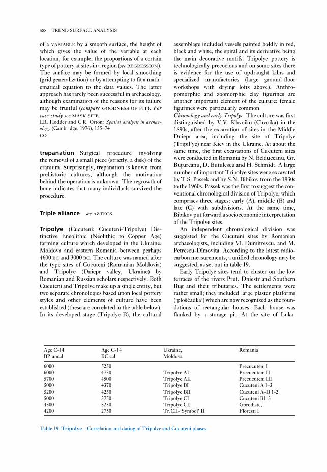
assemblage included vessels painted boldly in red,
black and white, the spiral and its derivative being
the main decorative motifs. Tripolye pottery is
technologically precocious and on some sites there
is evidence for the use of updraught kilns and
specialized manufactories (large ground-floor
workshops with drying lofts above). Anthro-
pomorphic and zoomorphic clay figurines are
another important element of the culture; female
figurines were particularly common.
Chronology and early Tripolye. The culture was first
distinguished by V.V. Khvoiko (Chvoika) in the
1890s, after the excavation of sites in the Middle
Dniepr area, including the site of Tripolye
(Tripil’ye) near Kiev in the Ukraine. At about the
same time, the first excavations of Cucuteni sites
were conducted in Romania by N. Belduceanu, Gr.
Buţureanu, D. Butulescu and H. Schmidt. A large
number of important Tripolye sites were excavated
by T.S. Passek and by S.N. Bibikov from the 1930s
to the 1960s. Passek was the first to suggest the con-
ventional chronological division of Tripolye, which
comprises three stages: early (A), middle (B) and
late (C) with subdivisions. At the same time,
Bibikov put forward a socioeconomic interpretation
of the Tripolye sites.
An independent chronological division was
suggested for the Cucuteni sites by Romanian
archaeologists, including Vl. Dumitrescu, and M.
Petrescu-Dîmovita. According to the latest radio-
carbon measurements, a unified chronology may be
suggested; as set out in table 19.
Early Tripolye sites tend to cluster on the low
terraces of the rivers Prut, Dniestr and Southern
Bug and their tributaries. The settlements were
rather small; they included large plaster platforms
(‘ploščadka’) which are now recognized as the foun-
dations of rectangular houses. Each house was
flanked by a storage pit. At the site of Luka-
of a VARIABLE by a smooth surface, the height of
which gives the value of the variable at each
location, for example, the proportions of a certain
type of pottery at sites in a region (see REGRESSION).
The surface may be formed by local smoothing
(grid generalization) or by attempting to fit a math-
ematical equation to the data values. The latter
approach has rarely been successful in archaeology,
although examination of the reasons for its failure
may be fruitful (compare GOODNESS-OF-FIT). Forcase-study see MASK SITE.I.R. Hodder and C.R. Orton: Spatial analysis in archae-ology (Cambridge, 1976), 155–74
CO
trepanation Surgical procedure involving
the removal of a small piece (strictly, a disk) of the
cranium. Surprisingly, trepanation is known from
prehistoric cultures, although the motivation
behind the operation is unknown. The regrowth of
bone indicates that many individuals survived the
procedure.
Triple alliance see AZTECS
Tripolye (Cucuteni; Cucuteni-Tripolye) Dis-
tinctive Eneolithic (Neolithic to Copper Age)
farming culture which developed in the Ukraine,
Moldova and eastern Romania between perhaps
4600 BC and 3000 BC. The culture was named after
the type sites of Cucuteni (Romanian Moldovia)
and Tripolye (Dniepr valley, Ukraine) by
Romanian and Russian scholars respectively. Both
Cucuteni and Tripolye make up a single entity, but
two separate chronologies based upon local pottery
styles and other elements of culture have been
established (these are correlated in the table below).
In its developed stage (Tripolye B), the cultural
588 TREND SURFACE ANALYSIS
Age C-14 Age C-14 Ukraine, Romania
BP uncal BC cal Moldova
6000 5250 Precucuteni I
6000 4750 Tripolye AI Precucuteni II
5700 4500 Tripolye AII Precucuteni III
5000 4370 Tripolye BI Cucuteni A 1-3
5200 4250 Tripolye BII Cucuteni A–B 1-2
5000 3750 Tripolye CI Cucuteni B1-3
4500 3250 Tripolye CII Gorodiste,
4200 2750 Tr.CII-‘Symbol’ II Floresti I
Table 19 Tripolye Correlation and dating of Tripolye and Cucuteni phases.

lower Danube valley and into Romanian Moldova.
Simultaneously, another Tipolye group, Brynzeny,
spread to the north, to eastern Volhynia, where the
Troyan variant emerged, and then the Sofievka
variant in the Middle Dniepr area.
The economy of Usatovo was largely dependent
on stock-breeding, especially of horse and sheep/
goat. Cattle-breeding was more important among
the groups that settled in the Middle Prut and
Dniestr area (the Brynzeny type). This type of
mixed agriculture was equally typical of Volhynia
and the Middle Dniepr region.
In the late Tripolye culture, metallurgy and
metalworking acquired the status of an independent
craft. E.N. Chernykh (1970) distinguishes two main
centres of metalworking in the Late Tripolye: the
Usatovo and Sofievka. Usatovo metallurgy used
ores that mostly came from the Carpathians and
from the Balkan peninsula; as for Sofievka, its metal
tools were manufactured mostly from the Caucasian
ores.
The settlements and cemeteries of Usatovo are
usually located on high terraces, on the edges of
watershed plateaux high above the Black Sea. The
most important sites, Usatovo and Majaki, lie on the
edge of a high cliff of the Dniestr liman (estuary),
west of Odessa. Two groups of kurgan barrows and
two cemeteries with flat graves were located near
the settlement of Usatovo; only the graves under the
kurgans contained rich inventories. The central
graves in kurgan cemetery I contained ornaments
made of Baltic amber and Near Eastern antimony,
numerous rings and beads of silver and copper,
arsenic-copper daggers, copper flat-axes and chisels
(Zbenovich 1976). All of this evidence suggests
marked social stratification in Late Tripolye
society. It seems clear that the common people
buried their dead in simple flat graves, while the
social elite were interred in impressive tombs with
exotic prestige goods.H. Schmidt: Cucuteni (Berlin, 1932); T.S. Passek:
Periodizacija tripol’skih poselenii [The periodization of the
Tripolye settlements] (Moscow, 1949); S.N. Bibikov:
Rannetripol’skoe poselenie Luka-Vrubleveckaja na Dnestre[The early Tripolye site of Luka Vrublevetskaya on the
Dniestr] (Moscow, 1953); M. Petrescu-Dîmovita:
Cucuteni (Bucharest, 1966); E.N. Chernykh: O drevneišihočagah metalloobrabotki jugo-zapada SSSR [On the most
ancient centres of metal-working in the southwest of the
USSR] KSIA 123 (1970), 23–31; T. Sulimirski:
Prehistoric Russia: an outline (London, 1970); V.G.
Zbenovich: Pozdnetripol’skie plemena Severnogo Pričerni-mor’ja [The Late Tripolye tribes of the North Pontic area]
(Kiev, 1976); S. Milisauskas: European prehistory (New
York, 1978), 133–41, 161–5; S. Marinescu-Bîlcu: TîpestiBAR IS 107 (Oxford, 1981); L. Ellis: The Cucuteni-
rublevetskaya, the houses were semi-subterranean
and formed a row (over 200 m) along the bank of the
Dniestr. A child was buried under the hearth of one
of the houses, while in an another house a bull’s
skull was found. The ceramics included bowls,
beakers, biconical and other vessels with covers;
anthropomorphic vessels also occurred, as did
female figurines made of clay to which grains of
wheat had been added. The lithic inventory
retained a Mesolithic character, and wild animals
made up 50% of the total faunal remains. However,
towards the end of the Early Tripolye stage, evi-
dence for metallurgy and metal-working begins to
emerge (e.g. the KARBUNA hoard).
Middle to Late Tripolye. In the Middle Tripolye, the
culture expanded east of the Dniestr, penetrating to
the valley of the Southern Bug and reaching the
Dniepr. The settlements are located either on
the floodplain or on the promontories of higher
terraces. In several cases, settlements occupy an
area of 10–40 ha. In the Middle Dniepr area, the
houses tend to form circles, and often number
30–40; the largest rectangular houses at
Kolomiiščina reach a size of 30 × 6–7 m.
West of Dniestr, two-storied dwellings appeared,
and furnaces began to be used for firing pottery;
painting the pottery before firing also became more
common. Female figurines were still the dominant
form of sculpture, but the number of male rep-
resentations increased. Copper-working became
more developed, and ornaments and at least two
types of celt were produced. Two large hoards con-
taining metal implements (axes and ornaments)
have been found in western Ukraine (Gorodnicy II
near Ivano-Frankovsk, and Ryngach near
Chernovitsi). Copper-silver alloys came into use by
the end of the Middle Tripolye.
The Middle Tripolye economy developed a pre-
dominantly agricultural character. Hulled wheats
(emmer, einkorn and spelt) and hulled barley were
the dominant crops; garden pea and vetch were the
most common pulses. The bones of domesticates –
cattle, sheep/goat and pig, in that order of impor-
tance – constituted more than 80% of the total
faunal remains.
During the Late Tripolye, there was a gradual
fragmentation, and a wider dispersal of the cultural
tradition. One of the local groups (the
Vykhvatiuntsy-type sites) gradually spread from
the Middle Dniestr to the south, to the steppe areas
of the northwestern Pontic Lowland. Later, this
group developed into the Usatovo variant of the
Late Tripolye. Subsequently, the Usatovo sites
spread over a vast area of the Prut-Dniestr-
Southern Bug interfluve, and further west into the
589TRIPOLYE

Anon.: Tseng-hou Yi mu, 2 vols (Peking, 1989); N.
Barnard: ‘The entry of cire-perdue investment casting, and
certain other metallurgical techniques (mainly metal-
working) into South China and their progress
northwards’, Ancient Chinese and Southeast Asian bronzecultures, ed. D.N. Bulbeck (Taipei, 1996), 1–94.
NB
Tsubai Otsukayama Large mounded tomb of
the Early Kofun period (AD 250–400) in Kyoto pre-
fecture, Japan, containing nearly 40 bronze mirrors
which were probably cast from the same mould. As
the same type of mirror has been discovered in
mounded tombs from north Kyushu to eastern
Honshu, the person interred here is thought to have
been at the centre of an elite prestige network, the
mirrors being a symbol of political alliance. See fig-
ure 25 (p. 316).C.M. Aikens and T. Higuchi: The prehistory of Japan(London, 1982), 255–63.
SK
Tsukumo Shell midden and cemetery in
Okayama prefecture, Japan, dating mainly to the
Late Jomon period (2500–1000 BC). It was dis-
covered in 1867, and over 170 bodies were
excavated between 1918 and 1924. Most of the
skeletons showed evidence of tooth mutilation,
patterns in which are interpreted as reflecting post-
marital residential patterns. The burials were both
flexed and extended, and many were adorned by
body ornaments.H. Harunari: ‘Rules of residence in the Jomon period,
based on the analysis of tooth extraction’, Windows on theJapanese past, ed. R. Pearson, K. Hutterer and G.L.
Barnes (Ann Arbor, 1986), 293–315.
SK
Tuc d’Audoubert see LE TUC D’AUDOUBERT
Tula see TOLTECS
tumbaga Alloy of gold, in which either silver or
copper may be added or occur as natural impurities.
Copper lowers the temperature at which the
material can be melted and easily cast. Artefacts of
tumbaga, such as bells and ornaments, were manu-
factured in Costa Rica and Panama (at sites such as
SITIO CONTE) and traded throughout the region,
including into Mesoamerica.W. Bray: ‘Maya metalwork and its external connections’,
Social process in Maya prehistory, ed. N. Hammond (New
York, 1977), 365–403; D. Hosler: ‘Ancient west Mexican
Tripolye culture: a study in technology and the origins of com-plex society. BAR IS 217 (Oxford, 1984).
PD
TRM see ARCHAEOMAGNETIC DATING
Troy see HISARLIK
Ts’ai Hou Luan tomb (Caihouluanmu) Tomb
of the Marquis (hou) of Ts’ai in China, probably
dating to the 5th century BC, which came to light
unexpectedly in May 1955, during the excavation of
earth inside the Western Gate of Shou-hsien, An-
hui, China. The workmen had unearthed some 30
bronze yung-chung-bells, ting-cauldrons, chien-
basins and other artefacts before the importance of
the site was realized by the municipal authorities,
and qualified personnel were able to take over. Thus
few of the original non-metal objects from the tomb
were recovered, and although the coffin and coffin-
chamber were apparently painted with lacquer
designs and gold leaf, only jade ornaments and a
sword survived to indicate the position of the
tomb’s occupant. Altogether, 486 bronze ritual
vessels and numerous other bronze artefacts were
unearthed. Three long inscriptions identify the
tomb occupant as the Marquis Luan of Ts’ai, an
ancient state which was engulfed by Ch’u in 447 BC.
The tomb was probably constructed in the Early
Chan-kuo period (c.450 BC).Anon.: Shou-hsien Ts’ai-hou-mu ch’u-t’u yi-wu [Relics
unearthed from the Marquise of Ts’ai tomb, Shou-hsien]
(Peking, 1956); Kuo Mo-jo: ‘Yu Shou-hsien Ts’ai-ch’i
lun-tao Ts’ai-mu ti nien-tai’ [On the date of the Ts’ai
tomb of Shou-hsien with reference to the inscribed
bronzes therein], KKHP 1 (1956), 1–5; N. Barnard: TheCh’u silk manuscript – translation and commentary(Canberra, 1973).
NB
Tseng Hou Yi tomb (Zenghouyimu) Un-
disturbed burial dating to the late 1st millennium BC
(c.433–400BC), which was excavated in 1978 at Lei-
ku-tun, near Sui-chou, in the northern part of the
Hu-pei province, China. Its total of 105 tonnes of
bronze artefacts is an unsurpassed illustration of the
immensity of bronze production in ancient China.
The outer sarcophagus of the main occupant of the
tomb contained no less than 6 tonnes of bronze. The
finds included a carillon of 75 chung-bells (some
consisting of up to 100 characters) bearing inscrip-
tions which have thrown extremely valuable light
on the musicological terms employed in the period.
590 TRIPOLYE

mining complex is almost exactly comparable, in
principle and construction, with those described
and depicted in Georgius Agricola’s De re metallica(AD 1556) and Lazarus Ercker’s Treatise on ores andassaying (AD 1574).Anon.: ‘Chiang-hsi Jui-ch’ang T’ung-ling Shang-Chou
ku’ang-ye yi-chih ti-yi-chi’i fa-chüeh chien-pao’ [Brief
report on the first season of excavation of the Shang and
Chou mining and smelting remains at T’ung-ling, Jui-
ch’ang, Chiang-hsi], CHWW 3 (1990), 1–12; Hua
Chüeh-ming, Liu Shih-chung, J. Head and N. Barnard:
‘The ancient mines of T’ung-ling, Jui-ch’ang, Chiang-hsi’
(in preparation).
NB
T’ung-lü-shan (Tonglushan; ‘copper verdigris
mountain’) Early mining complex covering an
area of 2 sq. km near Ta-yeh-hsien, in the Hu-pei
province of China. The workings date from the
WESTERN CHOU period to the Han dynasty
(c.1122–200 BC) and the scale of production was
immense, producing an accumulation of slag
totalling some 400,000 tonnes. The amount of
copper produced over the period of operation is
assessed to have been in excess of 80,000 tonnes, and
more than 50 smelting sites had been surveyed by
1980. Comparison with ancient Western mining
activities, such as the Laurion mines of c.600 BC,
suggests that the overall technical standards
attained at T’ung-lü-shan were certainly no less
advanced, and in many respects the illustrations and
descriptions in Agricola’s De re metallica (published
in 1556) can be seen to fit the T’ung-lü-shan re-
constructions of shaft and gallery structures,
including such features as the drainage troughs,
windlasses, and stone, wood and metal implements
employed (see Barnard 1989).D.B. Wagner: ‘Ancient Chinese copper smelting, sixth
century BC: recent excavations and simulation ex-
periments’, Journal of the Historical Metallurgy Society,London 20 (1986), 1–16; N. Barnard: ‘From ore to ingot –
mining, ore-processing, and smelting in ancient China’,
Proceedings of the Second international Conference onSinology, 1986 (Taipei, 1989), 141–205.
NB
tupu Long straight pins with a flattened or
decorative head used by Andean women to hold
their dresses and shoulder cloths together.
Turner Middle WOODLAND mound and earth-
works complex (c.200 BC–AD 400) located on the
banks of the Little Miami River in Hamilton
Country, Ohio (USA). The primary earthwork
metallurgy: South and Central American origins and west
Mexican transformations’, American Anthropologist 90
(1988), 832–55.
PRI
Tumulus complex (tumulus culture) Central
European complex of the Middle Bronze age,
defined by a custom of burial under round barrows
and dating to perhaps c.1800–1500 BC. It succeeds,
and seems to have developed from, the flat-grave
Unětice tradition (which itself is occasionally
associated with rich barrows, see UNĚTICE) of the
Early Bronze Age, and precedes the URNFIELD
CULTURE of the later Bronze Age. Centred on the
Czech Republic, Slovakia, Austria and southern
Germany, the period of the Tumulus complex is an
era of increasing trade and craftsmanship: amber
from the Baltic flowed south through the Tumulus
complex region, while bronze-working (e.g. cast-
ing) and decoration became more complex and gave
rise to numerous regional styles; bronze hoards also
become more numerous.
RJA
Tuna el-Gebel Egyptian religious and funerary
site which includes a rock-cut ‘boundary stele’ of
Akhenaten (see EL-AMARNA), an unusual free-
standing Greek-influenced tomb-chapel belonging
to a priest of Thoth, Petosiris, and his family
(c.320 BC), as well as a temple of Thoth and ex-
tensive catacombs of ibis and baboon mummies
dating mainly to the Persian, Ptolemaic and Roman
periods (c.525 BC–AD 395).G. Lefèbvre: Petosiris, 3 vols (Cairo, 1923–4); D. Kessler:
Die heiligen Tiere und der König (Wiesbaden, 1989).
IS
T’ung-ling mines (Tongling) Area on the east-
ern slopes of the T’ung-ling ‘Copper Ridge’,
JUI-CH’ANG-SHIH, in the Chinese province of
Chiang-hsi, where a mining complex of the Middle
Shang period (1650–1400 BC) was discovered in late
1988. The excavations have revealed mining struc-
tures and associated equipment of a standard
comparable with those at the T’UNG-LÜ-SHAN and
Kang-hsia-ts’un mines. It is now evident that
standards of mining practice in this area, in about
1500 BC or earlier, were comparatively advanced.
Moreover, the study of the T’ung-ling mines
should provide a better understanding of the prob-
able sources of copper for bronze production in the
vicinity of the Shang city-state of AN-YANG. The
591TURNER

tzompantli (Mayan: ‘skull-rack’) Meso-
american ceremonial structure of the Postclassic
period (c.AD 900–1521), usually comprising a low
platform near a temple. The heads of sacrificial
victims were displayed on a wooden rack on the
platform, either suspended or strung on horizontal
poles. Tzompantlis are found at sites in north-
western Mexico, at Tula and TENOCHTITLAN, and
at CHICHÉN ITZÁ, in the MAYA area.O.P. Salazar: ‘Eltzompantli de Chichén Itzá, Yucatan’,
Tlatoani 1 (1952), 5–6.
PRI
Tz’u-shan (Cishan) Neolithic culture dating to
the period of 6500–5000 BC, which was named
after its type-site located in Wu-an-hsien, in the
southern region of the Chinese province of Hu-pei.
Material of this type (typically including stone
grinders and rounded three-legged bowls) was first
excavated in 1976–7 and recognized as evidence of
a culture pre-dating the YANG-SHAO phase
(c.6000–4500 BC). Further Tz’u-shan-culture sites
have since been reported in central Ho-nan
province, including P’EI-LI-KANG, where the most
extensive excavations have been undertaken.Chang Kwang-chih: The archaeology of ancient China, 4th
edn (New Haven, 1986), 87–95.
NB
consists of an oval enclosure measuring 455 m long
and 290 m wide that is connected to a smaller
elevated circular earthwork by means of a graded
roadway. Within these earthworks are two smaller
earthen circles and fourteen mounds. Additional
mounds and earthworks are located outside.
Excavations conducted during the 19th and early
20th centuries recovered hundreds of artefacts
associated with the HOPEWELL cultural manifes-
tation including copper bracelets, beads, and cones,
clay figurines, mica cut into zoomorphic designs,
and Hopewell-series ceramics.C. Willoughby and E. Hooton: Turner group of earthworks,Hamilton County, Ohio (Cambridge, MA, 1922).
RJE
Tushka see ESNA; QADAN
Tushpa see URARTU
Tutankhamun see VALLEY OF THE KINGS
Tutub see KHAFAJEH
Tyre see PHOENICIANS
592 TURNER

Ubaid Type-site for the major Neolithic culture
originating in southern Mesopotamia (c.5000–3800
BC), which was first identified by Henry Hall and
Leonard Woolley in the 1920s. The most diagnos-
tic feature of the Ubaid period was the pottery,
often over-fired and usually decorated with brown
or black geometrical motifs, which were probably
related to Hajji Muhammed ware. The most exten-
sive Ubaid stratigraphic sequence was excavated at
ERIDU, where platform temples (antecedents of the
ZIGGURAT) have been found in strata dated to
Ubaid 4. Two shrines of the Ubaid period have also
been found near the ‘White Temple’ at URUK.
The excavations at Tell el-Awayli (Tell el-
‘Oueili) (Huot 1983) revealed eleven upper strata
dating to the four phases of the Ubaid period, as
well as nine lower levels containing very early
ceramic material (similar to SAMARRA ware) which
the excavators describe as pre- or earlier Ubaid (i.e.
‘Ubaid 0’). Ubaid domestic architecture has been
excavated at a number of sites, including Tell
Madhhur in the Hamrin Basin and TEPE GAWRA in
northern Mesopotamia. Although there are certain
differences between the Ubaid remains of northern
and southern Mesopotamia (particularly in terms of
burial customs), it is a relatively homogeneous
culture, and its widespread influence in the Near
East as a whole is indicated by the presence of
imported Ubaid ceramics at sites such as UGARIT in
the Levant and BAHRAIN in the Persian Gulf.H.R. Hall and C.L. Woolly: Al-ðUbaid (London, 1927);
T.E. Davidson and H. McKerrell: ‘The neutron acti-
vation analysis of Halaf and ðUbaid pottery from Tell
Arpachiyah and Tepe Gawra’, Iraq 42 (1980), 155–67; F.
Safar, M.A. Mustafa and S. Lloyd: Eridu (Baghdad, 1982);
J. Huot, ed.: Larsa et ðOueili: travaux de 1978–1981 (Paris,
1983); E.F. Henrickson and I. Thueson, eds: Upon thisfoundation: the Ubaid reconsidered (Copenhagen, 1989).
IS
Ugarit (Ras Shamra and Minet el-Beida) One of
the most important CANAANITE sites on the
Levantine coast during the Bronze Age, with traces
of previous settlements stretching back as early as
the ACERAMIC NEOLITHIC (c.8500–7000 BC). The
tell site at Ras Shamra has been excavated by French
archaeologists since 1928, revealing numerous large
ceremonial buildings, including one of the largest
surviving royal palaces in the Near East, at the west
end of the site, and temples of Baal and Dagan on
an acropolis at the eastern end. A number of exten-
sive archives of cuneiform tablets have been
discovered, including some written in the ‘Ugaritic’
script, which is the earliest known alphabetic
version of CUNEIFORM. The city of Ugarit appears
to have been destroyed in c.1200 BC, at the time
U
Figure 60 Ubaid Male and female baked clay figurines
of the Ubaid period (5th millennium BC) from Eridu and
Ur (drawn by Tessa Rickards). Source: J. Black and A.
Green: Gods, demons and symbols of ancient Mesopotamia:an illustrated dictionary (BMP, 1992), fig. 64.

parallel to the Aurignacian in Italy for much longer
than the Châtelperronian coexists with the
Aurignacian in France. Although there is, as yet,
only one hominid associated with such ‘indigenous’
assemblages, the NEANDERTHAL from St Césaire, it
appears that these three cultures represent a para-
llel development of Upper Palaeolithic blade
technology, perhaps in response to the appearance
of the Aurignacian. Identified in 1965 (di Cesnola,
1965–6), Uluzzian assemblages consist of lithics
diagnostic of the MOUSTERIAN (side-scrapers,
Mousterian points, flake technology) which gradu-
ally disappear in favour of Upper Palaeolithic
type artefacts appear (endscrapers, burins, blade
technology).P. di Cesnola: ‘Il paleolitico superiore arcaaico (facies
Uluzziana) della Grotta del Cavallo, Lecce’, Revista diScienze Preistoriche 20 and 21 (1965–6), 33–62, 3–59; C.
Farizy, ed: Paléolithique moyen récent et paléolithiquesupérieur ancien en europe (Nemours, 1990).
PG-B
Umm an-Nar Island in Abu Dhabi, near the
southeastern coast of the Arabian peninsula, which
was occupied during the 3rd millennium BC. The
site was at first identified with Magan, a foreign
toponym in texts from Mesopotamia, but this
term is now considered to refer to the entire Oman
peninsula in the 3rd millennium BC (although, con-
fusingly, it is later used to refer to Egypt in
neo-Assyrian texts). The area of Magan was an
important source of timber, stone and copper for
the Second LAGASH and UR III dynasties of Meso-
potamia. Two seasons of survey and excavation at
Umm an-Nar in 1959–60 revealed a cemetery con-
sisting of tumuli dated to c.2800–2400 BC, each
containing multiple burials (36 in one instance).
The surviving artefacts include Early Dynastic
pottery from southern Mesopotamia and it has been
suggested that Umm an-Nar may have been a
settlement through which the SUMERIANS’ copper
and chlorite trade-routes passed, en route from
quarrying and mining sites in the Arabian interior.
Since the site also includes artefacts from the INDUS
CIVILIZATION (Potts 1990: 150), it is likely that a
down-the-line form of trading was in operation in
the Persian Gulf. The excavations suggest that
Umm an-Nar was deserted by 2000 BC, when trade
probably transferred to BAHRAIN.K. Thorvildsen: ‘Gravrøser pä Umm en-Nar’ [Burial
cairns on Umm an-Nar], Kuml: Journal of theArchaeological Society of Jutland (1963), 190–219; D.T.
Potts: The Arabian Gulf in antiquity I (Oxford, 1990),
93–150.
IS
of the SEA PEOPLES, but the nearby harbour site of
Minet el-Beida continued to be occupied until at
least the Hellenistic period.C.F.A. Schaeffer et al.: Ugaritica I–VI (Paris, 1939–69);
C. Virolleaud and J. Nougayrol: Le palais royal d’Ugarit,II–VI (Paris, 1949–70); G. Saadé: Ougarit, métropoleCanaanéenne (Beirut, 1979); A. Curtis: Ugarit: RasShamra (Cambridge, 1985).
IS
Ugwuele-Uturu Stone workshop site near
Okigwe in southern Nigeria, excavated by F.N.
Anozie and his colleagues in 1977–8 and 1981. The
site comprised a dolerite ridge, the northern end of
which took the form of a virtual scree, a massive
accumulation of artefacts up to 6 m deep. The site
contained no pottery and no fragments of polished
stone tools were found. Among the artefacts,
according to Anozie, there were distinctive tri-
angular preforms or roughouts for bifacial tools, as
well as large numbers of flakes and some cores. He
classified the site as ACHEULEAN, since in his view
handaxes – most of them broken – constituted 80%
of the tools, plus cleavers, picks, sidescrapers and
other miscellaneous items. An alternative view
expressed is that the bifacial artefacts themselves
may be no more than preforms for ground stone
axes, the more successful examples of which were
removed for further working elsewhere.F.N. Anozie, V.E. Chikwendu and A.C. Umeji:
‘Discovery of a major prehistoric site at Ugwuele-Uturu,
Okigwe’, WAJA 8 (1978), 171–6; J.D. Clark: ‘The 9th
Panafrican Congress on prehistory and related studies,
Jos, Nigeria, 11–17th December 1983’, NA 23 (1983), 1–4;
P. Allsworth-Jones: ‘The earliest human settlement in
West Africa and the Sahara’, WAJA 17 (1987), 87–128.
PA-J
ultratrace see TRACE ELEMENTS
Ulu Burun see GELIDONYA
Uluzzian Early Upper Palaeolithic culture
found in southeast Italy which, like the
CHÂTELPERRONIAN identified in France, and the
SZELETIAN identified in eastern Europe, differs
markedly from the classic culture of the period,
the ubiquitous (and apparently intrusive)
AURIGNACIAN culture. Moreover, all three ‘in-
digenous’ assemblages are markedly different from
one another – while the Châtelperronian, for ex-
ample, is dominated by projectile points, the
Uluzzian is characterized by the manufacture of
crescent-shaped bladelets. The Uluzzian also runs
594 UGARIT

Unětice Bronze Age cemetery site near Prague
which lends its name to a wider cultural complex of
the Early Bronze Age in the Czech Republic, south-
west Poland and south Germany. Small, flat
inhumation cemeteries are characteristic, in con-
trast to the succeeding TUMULUS COMPLEX.
Grave-goods include pottery, flint arrowheads and
a limited range of metal objects such as pins, simple
torcs, spiral pendants, with daggers and more de-
veloped bracelets becoming more common as the
period goes on. There are also limited numbers of
barrow burials, with a few outstandingly large
and rich burial mounds, notably Helmsdorf and
Leubingen in Saxo-Thuringia, Germany. The
latter barrow (34 m in diameter and 8.5 high)
covered an elaborately constructed wooden mortu-
ary chamber containing two skeletons, one probably
of an older man, presumably a chieftain, the
other probably of an adolescent girl. Grave-goods
included wood-working implements, small
daggers, and gold ornaments (large pins, a spiral
bead, bracelet).I. Billig: Die Ausjetitzer Kultur in Sachsen (Dresden, 1958);
M. Gimbutas: Bronze Age cultures in Central and EasternEurope (The Hague, 1965), 245–75.
RJA
Upper Palaeolithic The final division of the
PALAEOLITHIC, dated in Europe to between about
40,000 BP and 10,000 BP, and preceding the
MESOLITHIC. The border between the Middle and
Upper Palaeolithic industries is usually defined by
the common use of blade, as opposed to flake,
technology. It should be noted, however, that, out-
side Europe, the presence of blade-orientated
assemblages stratified between Middle Palaeolithic
layers at sites such as KLASIES RIVER MOUTH in
Africa and Mount Carmel in the Near East slightly
complicates this definition.
Although the Upper Palaeolithic was originally
defined with reference to its stone typology, it
became closely associated with a series of changes
that are still generally assumed to be inter-
connected: the appearance of ANATOMICALLY
MODERN HUMANS; the introduction of all or part of
the AURIGNACIAN stone tool typology and a de-
veloped bone industry; the development of
specialized, co-operative hunting strategies; alter-
ations in settlement patterns, including the
construction of relatively permanent houses or huts
in some areas; the development of a multiplicity of
distinct ‘cultures’; a growing population; and, most
famously of all, the advent of CAVE ART.
Complicating this analysis is the fact that, in the
Umm Dabaghiyah Small settlement in-
terpreted as a trading post of the early or
proto-HASSUNA culture (i.e. early Pottery
Neolithic, 6th millennium BC), situated in the
southern Jazira desert of Iraq, some distance south
of the edge of the modern dry-farming region. The
site was excavated in 1971–3 by Diana Kirkbridge,
who identified it as a community of hunters rather
than farmers. The subsistence pattern combined
consumption of domesticated cereals (perhaps
imported from the north) alongside a dependence
on the meat of onager, wild asses and gazelles. Her
excavations not only uncovered houses which were
apparently entered via the roof, but also three blocks
of small structures where the skins of onagers and
gazelles may have been stored. One of the houses
was decorated with a red and white wall-painting
apparently depicting an onager hunt using a form of
‘hunting’ kite, a type of funnel-shaped trap used in
Middle Eastern deserts as late as the 20th century
AD. Kirkbridge therefore interprets the village as a
specialized trading community, and it has been
hypothesized that there may have been similar
settlements elsewhere in Neolithic Mesopotamia,
trading in materials such as salt or bitumen. Such
communities – essentially benefiting from the ac-
cumulation of surpluses in raw materials – would
have been early prototypes for the first cities in
Mesopotamia.Preliminary reports by D. Kirkbridge in Iraq 34–7
(1972–5); D. Kirkbridge: ‘Umm Dabaghiyah’, Fifty yearsof Mesopotamian discovery, ed. J. Curtis (London, 1982),
11–21.
IS
unconstrained clustering Technique of
intra-site SPATIAL ANALYSIS, developed by Robert
Whallon (see MASK SITE), following suggestions
that CLUSTER ANALYSIS could be useful in such
studies. It divides a site into zones or clusters in
which the proportions of different artefact types are
broadly consistent. It is claimed to avoid the need
for assumptions about the number and shape of
clusters, but suffers from a tendency to create
spurious clusters.R. Whallon: ‘Unconstrained clustering for the analysis of
spatial distributions in archaeology’, Intrasite spatialanalysis in archaeology, ed. H. Hietala (Cambridge, 1984),
242–77.
CO
underwater archaeology see MARITIME
ARCHAEOLOGY
595UPPER PALAEOLITHIC

Central Russian Plain (New York, 1985); D. Collins:
Palaeolithic Europe (Tiverton, 1986); C. Gamble: ThePalaeolithic settlement of Europe (Cambridge, 1986); P.
Bahn and J. Vertut: Images of the Ice Age (London, 1988);
J.F. Hoffecker and C.A. Wolf, eds: The Early UpperPalaeolithic, BAR IS 437 (Oxford, 1988); N. Barton et al.,
eds: The Late Glacial in North-West Europe: Human adap-tation and environmental change at the end of the Pleistocene(London, 1992); L.G. Strauss: Iberia before the Iberians:the Stone Age prehistory of Cantabrian Spain(Albuquerque, 1992); C. Gamble: Timewalkers: The pre-history of global colonisation (Stroud, 1993); H. Knecht et
al., eds: Before Lascaux: the complex record of the earlyUpper Palaeolithic (Boca Raton, 1993); C. Stringer and C.
Gamble: In search of the Neanderthals (London, 1993);
M.H. Nitecki and C.V. Nitecki: Origins of anatomicallymodern humans (New York, 1994); S. Mithen: The pre-history of the mind: a search for the origins of art, religion andscience (London, 1996).
RJA
Upper Volga Early Neolithic tradition rep-
resented at a number of sites in the Upper Volga
area of central Russia (Yaroslavl, Ivanovo, Tver
districts), which was identified and studied by D.A.
Krainov and N.A. Khotinsky in the 1970s. In some
areas it forms the predecessor to the PIT-AND-COMB
culture of the Middle Neolithic. The main feature
of the ‘Upper Volga’ complex is the ceramic
assemblage: wide-mouthed vessels with straight
walls, and with pointed or rounded bases. The orna-
mentation consists of strokes, stamp impressions
and incised lines which form horizontal and
diagonal lines, as well as simple geometric motifs
(triangles, rhombi and intersecting lines). The stone
inventory is of MESOLITHIC character: burins, end-
scrapers, arrowheads of post-Swiderian type, and
knives made from blades. Furthermore, all the
faunal remains at Upper Volga sites belong to wild
animals.
Many of the sites have been discovered within
peat bogs. The peat-bog of Ivanovskoye contained
the remains of eight camp-sites; one of the stratified
sites, Ivanovskoye 3, was located on an island in the
western part of a huge peat-bog. The ‘Upper Volga’
stratum at the latter site overlay Mesolithic deposits
and was itself overlain by deposits containing a late
Lyalovo assemblage (see PIT-AND-COMB). An
impressive series of radiocarbon dates suggests that
the Upper Volga stratum was deposited between
5500 and 4800 BC (calendar years). Four sites with
Upper Volga material of c.5200 BC were discovered
within the peat-bog of Yazykovo, below the stratum
bearing pit-and-comb pottery.D.A. Krainov and N.A. Khotinsky: ‘Verhnevolžskaja
arheologičeskaja kul’tura’ [The Upper Volga archaeologi-
Near East, anatomically modern populations seem
to have established themselves during what is tra-
ditionally known as the Middle Palaeolithic (the
Skhul burials were found in a Mousterian context,
see MOUNT CARMEL); they then developed a blade
technology during an ‘Initial Palaeolithic’, and
only at a relatively late stage adopted a strongly
Aurignacian (classic Upper Palaeolithic) tool
typology. To some, this suggests that key features
of the Upper Palaeolithic developed in the Near
East.
Further complicating the division between
the Upper and Middle Palaeolithic, the CHÂTEL-
PERRONIAN, SZELETIAN and related industries,
which many authorities now accept are some of the
first fully fledged ‘Upper Palaeolithic’ technologies
apparent in Europe, may have been produced by a
NEANDERTHAL population – possibly after contact
with modern humans. The debate has become
caught up in a wider controversy over whether
Neanderthal populations were part of the popu-
lation that evolved into modern humans, or formed
a separate line that simply died away.
Culture sequence. The Upper Palaeolithic in Europe
is often divided into two according to climatic
change. During the Early Upper Palaeolithic
(40,000–20,000 BP) the climate deteriorated, with
gathering speed, towards the period of maximum
continental glaciation (20,000–18,000 BP). Human
populations retreated south to areas such as
southern France. As the glaciation receded during
the second half of the Late Upper Palaeolithic
(20,000–10,000 BP) humans were able to recolonize
the continent.
This aside, the main divisions are based on tool
typology (i.e. industries), although these have
sometimes become associated with other changes,
such as styles of art; in the past, tool typologies have
often been treated implicitly in the literature as if
they were cultural classifications. To the extent that
the industries can be regarded as successive, they
appear in the following order and are described in
the following entries: the transitional or accultur-
ated industries of the CHÂTELPERRONIAN (Lower
Périgordian) of France, ULUZZIAN of Italy and
SZELETIAN of central Europe; the first fully Upper
Palaeolithic assemblages of the AURIGNACIAN;
the GRAVETTIAN (Upper Périgordian); the
SOLUTREAN; and the MAGDALENIAN. The
AZILIAN industries are usually regarded as tran-
sitional between the Upper Palaeolithic and the
MESOLITHIC proper.P. Ucko and A. Rosenfeld: Palaeolithic cave art (London,
1967); H. Laville et al.: Rockshelters of the Périgord (New
York, 1980); O. Soffer: The Upper Palaeolithic of the
596 UPPER PALAEOLITHIC

why their retainers were sacrificed en masse
(Moorey 1977; Pollock 1991).C.L. Woolley: Ur excavations: II The Royal Cemetery, 2
vols (London, 1934); A.L. Oppenheim: ‘The seafaring
merchants of Ur’, JAOS 74 (1954), 6–17; J. Oates: ‘Ur and
Eridu: the prehistory’, Iraq 22 (1960), 32–50; ––––, T.E.
David, D. Kamilli and H. Mckerrell: ‘Seafaring
merchants of Ur?’, Antiquity 51 (1977), 221–34; P.R.S.
Moorey: ‘What do we know about the people buried in the
Royal Cemetery?’, Expedition 20 (1977), 24–40; C.L.
Woolley and P.R.S. Moorey: Ur of the Chaldees: the finalaccount, 3rd edn (London, 1982); S. Pollock: ‘Of priest-
esses, princes and poor relations: the dead in the Royal
Cemetery of Ur’, CAJ 1 (1991), 171–89; M. Roaf and J.
Galbraith: ‘Pottery and p-values: “Seafaring merchants of
Ur” re-examined’, Antiquity 68 (1994), 770–82.
IS
uranium series dating (U-series) Family of
scientific dating techniques based on the decay
chains of uranium i.e. 238U and 235U, the latter
having an abundance of 0.72% of total natural
uranium. These isotopes each decay radioactively to
a daughter isotope which in turn decays, and via a
series of such decays, each chain ends with a stable
lead isotope. Disruption to the chains, resulting
from differences in the geochemistry of the differ-
ent elements involved, and useful differences in
half-lives of daughter products within each series,
form the basis of the U-series methods. The iso-
topes of relevance in the 238U chain are 234U and its
daughter 230Th, with half-lives of 248 thousand
years and 75.2 thousand years respectively. In the235U chain the only long-lived isotope in the chain is231Pa (half-life 34.3 thousand years). The key geo-
chemical difference between uranium and thorium
(Th) is that uranium forms water-soluble com-
pounds whereas thorium does not; geochemically,
protactinium (Pa) behaves like thorium and is
insoluble.
In archaeology, the two U-series methods used
are 230Th/230U and 231Pa/235U, the latter largely to
demonstrate concordance of dates for the time
period over which the two methods overlap. The
principles of the two methods are the same and are
therefore outlined for 230Th/234U. Their most re-
liable application is to the dating of calcitic
speleothems, in particular stalagtites and flow-
stones. Uranium from the ground water
precipitates with the calcite, but 230Th is missing
because of its insolubility. By the decay of 234U,
which has a considerably longer half-life than 230Th,230Th will grow back at a rate determined by its 75.2
thousand year HALF-LIFE. The form of the growth
with time is a saturating exponential: initially
cal culture], Sovetskaja arheologija 3 (1977), 42–68; ––––
et al.: ‘Stratigrafija i absoljutnaua hronologija stojanki
Ivanovskoe III’ [Stratigraphy and absolute chronology of
the Ivanovkoye 3 site], Sovetskaja arheologija 3 (1990),
25–31.
PD
Ur (Tell el-Muqayyar) Mesopotamian city cover-
ing an area of some 55 ha in southern Iraq, which
was first occupied in the Ubaid period
(c.5000–3800 BC) but flourished during the Early
Dynastic and Ur III periods (c.2900–2350 and
2150–2000 BC respectively). Ur was a commercial
port reliant on maritime trade with the Gulf
countries and the Indus region (although there has
been some considerable debate on this point, see
Oppenheim 1954; Oates et al. 1977; Roaf and
Galbraith 1994). It was therefore probably the
change in the course of the Euphrates that eventu-
ally precipitated its abandonment in the 4th
century BC. First identified by Pietro della Valle in
1625, the site was excavated from 1922 to 1934 by
Leonard Woolley, who initially claimed to have dis-
covered traces of the original Biblical Flood in one
sounding at the site, but this stratum is now gener-
ally considered to have been a purely local
phenomenon.
The Early Dynastic elite were buried along with
rich burial equipment (including gold and silver
jewellery, chariots and numerous bodies of re-
tainers) in 17 of the 1,850 burials in the so-called
‘Royal Cemetery’ (see below). As the dynastic seat
of power during the Ur III period the city was
essentially rebuilt, including the construction of a
ZIGGURAT (probably over the remains of an earlier
temple), temples of the moon-god Nanna and his
consort Ningal, a new palace, and the ‘mortuary
chapels’ of Shulgi and his successor Bur-Sin. The
design of these mortuary chapels apparently rep-
resents a return to the early Sumerian house-plan
temples such as the Square Temple at KHAFAJEH.
Although the city’s political and economic im-
portance diminished in the 1st and 2nd millennia
BC, the temples were still being restored and
embellished as late as the Neo-Babylonian period
(c.625–539 BC).
The ‘Royal Cemetery’, dug into refuse tips at the
edge of the citadel, appears to represent a good
cross-section of the population, unlike most other
cemeteries of the period (Woolley 1934). Debate has
centred primarily on the identification and social
ranking of the owners of the richest graves (only
three of whom have been named: Queen Puabi,
Akalamdug and Meskalamdug) and the question of
597URANIUM SERIES DATING

series dating’, Quaternary dating methods – a user’s guide,
ed. P.L. Smart and P.D. Fraces (Cambridge, 1991), 45–83.
SB
Urartu (Biblical Ararat) Anatolian kingdom
centred on Lake Van and covering a large area at the
junction of eastern Turkey, Iran, Armenia and
Azerbaijan. The Urartians dominated this region in
the 9th–7th centuries BC while the ASSYRIAN
empire (c.883–612 BC) was flourishing to the south.
The first historical references to the HURRIAN-
speaking tribes of Urartu appear in the Assyrian
annals of the mid-13th century BC, but it is not until
the early 9th century BC that they become clearly
recognizable as a political and archaeological entity.
Many Urartian sites include rock-inscriptions
written in the ‘Vannic’ script (a form of cuneiform
used to record the Urartian language), which was
first studied by F.E. Schultz in 1827 but was not
deciphered until the turn of the century.
Seven of the principal Urartian fortress-towns
have been excavated, including the main capital
Tushpa (near modern Van) and the sites of
Altintepe, Erebuni (Yerevan), Kefkalesi, Teishe-
baina (Karmir Blur), Rusaurutur (Bastam) and
Rusahinili (Toprakkale). The Toprakkale citadel,
which was excavated by Hormuzd Rassam in 1877
and 1879, was the first Urartian site to be scientifi-
cally investigated, but it was the exploration of the
rich site of Erebuni by Soviet archaeologists in 1938
that initiated the most productive phase in Urartian
archaeology.
Altintepe, located 20 km from Erzincan, includes
the best-preserved Urartian temple, dedicated to
the god Haldi, comprising a cella, or inner shrine
(originally painted and still containing a number of
ritual implements), set in a large courtyard
surrounded by wooden colonnades. In the south-
eastern section of the site a set of subterranean royal
tombs have been excavated, each containing one or
two bodies placed in wooden or stone sarcophagi
and accompanied by typical Urartian gold, silver
and bronze funerary equipment.
Apart from their distinctive ceramics, the
archaeological remains of the Urartians (including
the celebrated metalwork) have been traditionally
interpreted as provincial versions of Assyrian
material culture (Frankfort 1970: 194, n. 55). Seton
Lloyd, however, argues that the ambitious stone-
built, turreted fortresses and tower-like bastioned
temples suggests an Urartian society in radical con-
trast to the Mesopotamian civilizations, with their
mud-brick flat-roofed houses and platform temples
(Lloyd 1989: 99–100).
linear, then sublinear and ultimately reaching an
equilibrium level which determines the maximum
age limit of the technique (approximately 350,000
years for 230Th/234U; 150,000 years for 231Pa/235U).
The form of the growth of 230Th/234U also leads to
asymmetric error terms on the age. The minimum
age limit is typically 5000 years, depending on the
uranium concentration (but higher for 231Pa/235U
because of the low natural abundance of 235U). If the234U and 238U are not in equilibrium on crystalliza-
tion, a correction must be made.
Key assumptions in uranium series dating are (1)
that there is zero concentration of 230Th on crystal
formation and (2) that the system is closed (i.e. no
uranium or thorium migrates out of or into the cal-
cite after formation). In practice, detrital material
containing thorium can be incorporated in the cal-
cite. This can be detected by the presence of 232Th
(the half-life of which is 1.39 × 10¹⁰ years, i.e. very
long relative to the time scales of interest). If the230Th/232Th ratio is less than 20, the contamination
can be considered to have a negligible effect on the
age. The closed system assumption for calcite is
generally good, but for other archaeological
materials this is less often the case.
Application of U-series dating to bone and teeth
is based on the uptake of uranium from ground
water after death (living bone, for example, typically
contains 0.1 ppm of uranium whereas fossil bone
can contain up to 1000 ppm). As for calcite dating,
the assumption is that no 230Th is present initially.
The problem lies in whether the uranium remains
fixed and when it was taken up: immediately after
death (known as ‘early uptake’), gradually with time
(‘linear uptake’), or indeed more variably. Results
on bone have been mixed, but there is evidence to
suggest that tooth enamel may act as a closed system
and provide more reliable dates; the model for initial
uptake of the uranium is, however, still problematic.
Measurement of isotope ratios has until recently
been achieved mainly by alpha spectrometry:
counting the alpha particles of a particular energy
associated with the decay of a specific isotope. Mass
spectrometry, on the other hand, directly measures
the number of atoms of a given isotope present, or
a proportion of them. This is a more efficient tech-
nique, if considerably more costly, but it also allows
much smaller samples to be dated (typically milli-
grams rather than grams). In the case of 230Th/234U
dating it also widens the date range of the method,
taking it as low as 50 years and up to about 500,000
years. See also LEAD-210 DATING.H.P. Schwarcz: ‘Absolute age determination of archaeo-
logical sites by uranium series dating of travertines’,
Archaeometry 22 (1980), 3–24; P.L. Smart: ‘Uranium
598 URANIUM SERIES DATING

Uruk (Warka) Tell-site of the Biblical city of
Erech, located midway between Baghdad and Basra
in southern Iraq, which is the type-site of the Uruk
period (c.4000–3200 BC). The city of Uruk, known
to the Sumerians as Unu, was occupied from early
in the UBAID period (c.5000–3800 BC), when it was
perhaps initially two separate settlements (Kullaba
and Eanna), but it was in the mid-4th millennium
BC that it became the most important settlement in
SUMER and probably the first true city in the world.
The site, with virtually continuous stratigraphy
stretching from the 5th millennium BC to the 3rd
century AD, therefore provides crucial evidence for
the process of early state formation. There was also
a settlement of the SASANIAN period (AD 224–651)
located immediately outside the city walls. Surveys
have shown that urbanization in Mesopotamia
accelerated at the beginning of the Uruk period (see
Adams and Nissen 1972). At its height the city was
more than 400 hectares in area, and one of the city’s
earliest rulers appears to have been the historical
counterpart of Gilgamesh – hero of the Sumerian
epic – thus providing an unexpectedly strong link
between the archaeology and mythology of early
Mesopotamia.
The earliest excavations at Uruk were under-
taken by William Kennet Loftus in 1850–2,
revealing a Parthian cemetery of slipper-coffins,
part of a complex that later proved to be a Parthian
temple, as well as a section of Uruk-period wall
decorated with STIFTMOSAIK. In the heart of the
city were Kullaba and Eanna, the cult centres of the
gods Anu and Inanna (later Ishtar), where most of
the German excavations have taken place from 1924
until the present day (Heinrich 1941; Lenzen 1964;
Boehmer 1991). The precinct of Eanna included the
so-called Mosaic and Limestone temples, dating to
the Uruk period, as well as the White Temple,
dating to the late Uruk or early Jemdet Nasr period
(c.3200 BC) and perhaps showing an early stage in
the development of the ZIGGURAT. It was about a
thousand years later that one of the first known
ziggurats was constructed by Ur-Nammu in the
precinct of Kullaba. The city appears to have
retained some importance even in the Seleucid and
Parthian periods (c.305 BC – AD 244), when many of
the older temples were restored and a new sanctu-
ary was constructed for Gareus, a Parthian deity.
During the Uruk period – ‘arguably the most
innovative and important of any in the history of
Mesopotamia’ (Crawford 1991: 13) – most of the
salient features of Sumerian civilization emerged.
There were a large number of technological inno-
vations, including the introduction of the potter’s
wheel and the initial stages in the development of
C.A. Burney: ‘Urartian fortresses and towns in the Van
region’, AS 7 (1957), 37–53; T. Özgüç: Altin Tepe, archi-tectural monuments and wall paintings, 2 vols (Ankara,
1966–9); B. Piotrovski: The ancient civilization of Urartu(London, 1969); H. Frankfort: The art and architecture ofthe ancient Orient, 4th edn (Harmondsworth, 1970),
194–6; T.B. Forbes: Urartian architecture (Oxford, 1983);
S. Lloyd: Ancient Turkey: a traveller’s history of Anatolia(London, 1989), 94–109; R. Merhav, ed.: Urartu: a metal-working centre in the 1st millennium BCE (Jerusalem, 1991).
IS
Urewe see EARLY IRON AGE
urnfield culture (urnfield complex) Late
Bronze Age to early Iron Age complex of cemetery
sites, characterized by cremation burials in urns of
various kinds. The complex is focused in central
Europe, notably the Lusation or Lausitz culture of
East Germany and Poland, but extends westwards
into France and eastwards into the Ukraine, and
south to Italy and even Spain. Beginning towards
the end of the 14th century BC, the rite continued
into the Hallstatt A/B periods in the 8th century
BC. The urnfields are flat cemeteries – in contrast to
the earlier inhumation burials, often under barrows,
that are so characteristic of the Middle Bronze Age
in Central Europe (see TUMULUS COMPLEX). They
vary from a few tens of urns to substantial clusters
of hundreds or even thousands of burials (e.g. the
Kiertrz cemetery of southwest Poland), and
the sheer numbers are sometimes taken to indicate
a growth in population in central Europe in the later
Bronze Age. Grave-goods accompanying the urns
include bronze ornaments, tools and weapons; just
as the cremation rite itself suggests a broadly
homogeneous Late Bronze Age culture in the
region, so the items deposited are broadly similar in
the technological skills and main typologies. The
number of items varies considerably from grave to
grave in most cemeteries (and from region to
region); this is normally taken to indicate social
status differences, but at the same time it is difficult
to identify clear social hierarchies. BISKUPIN is one
of the most carefully excavated settlement sites
closely associated with the urnfield complex.
During the urnfield period, hillforts began to be
constructed, another feature that continues into the
Iron Age.
RJA
Uronarti see SEMNA
599URUK

al. 1974) began to analyse the use-wear traces on
stone tools. Some, such as Laurence Keeley (1980),
improved the accuracy of microwear analyses by
using an SEM (scanning electron microscope).
Most use-wear studies have involved experimental
work, since it would otherwise be difficult to know
precisely which activities might produce particular
types of wear on lithics. Thus Binneman and
Deacon (1986), for instance, created replica stone
adzes in order to prove that early woodworking was
practised at the Later Stone Age site of BOOMPLAAS
CAVE in South Africa.S. Nilsson: The primitive inhabitants of Scandinavia, 3rd
edn, trans. J. Lubbock (London, 1868); S.H. Warren: ‘On
the origin of “eolithic” flints by natural causes’, JRAI 35
(1905), 337–64; S.A. Semenov: Prehistoric technology(London, 1964); R. Tringham et al.: ‘Experimentation in
the formation of edge damage; a new approach to lithic
analysis’, JFA 1 (1974), 171–96; B. Hayden: Lithic use-wear analysis (New York, 1979); L.H. Keeley:
Experimental determination of stone tool uses: a microwearanalysis (Chicago, 1980); J. Binneman and H.J. Deacon:
‘Experimental determination of use wear on stone adzes
from Boomplaas Cave, South Africa’, JAS 13 (1986),
219–28.
IS
USSR see CENTRAL ASIA; CIS AND THE BALTIC
STATES
Usvyaty Group of sites dating from the Late
Palaeolithic, Mesolithic, Neolithic and Bronze
Ages, situated in and around lakes on the upper
stretches of the Western Dvina and Lovat rivers, in
the Pskov and Smolensk districts, in northwestern
Russia. The sites were discovered and excavated by
A.M. Miklyayev from the 1960s into the 1990s.
The earliest sites are Epipalaeolithic (tanged
points are present) and were discovered on the
dunes that developed on terraces in the Late Glacial
period (c.12,000–10,000 BP). Industry complexes of
a Mesolithic character, with blades and axes, were
found on the terraces at lower levels. A group of
Neolithic sites was found near Rudnya. The earliest
stratum at the site of Rudnya-Serteya contained
blades and axe-like tools, and fragments of coarse
conical vessels decorated with a combination of
horizontal, vertical and diagonal rows of triangular
impressions. The upper stratum of the same
site (c.5100–4900 BC) corresponds to the NARVA
tradition.
In about 3300–3100 BC, as lake levels rose during
the Early Sub-Boreal, pile-dwellings were con-
structed in the coastal areas of the Usvyaty and
Sennitsa lakes. A third village of pile-dwellings,
the CUNEIFORM script; in addition, the stamp-seal
was superseded by the CYLINDER SEAL (a small
stone cylinder bearing engraved designs), which is
one of the most diagnostic features of the Uruk and
JEMDET NASR periods. Towards the end of the
period, the influence of the Uruk civilization spread
northwards and eastwards, strongly affecting the
material culture of sites on the Mesopotamian
fringes, such as HABUBA KEBIRA in Syria and SUSA
in Iran.W.K. Loftus: Travels and researches in Chaldaea andSusiana (London 1857); Preliminary reports of German
excavations published as Uruk Vorläufiger Berichte since
1928; E. Heinrich: Topographie von Uruk (Leipzig, 1941);
H.J. Lenzen: ‘New discoveries in Warka, S. Iraq’,
Archaeology, 17 (1964), 122–31; R.McC. Adams and H.J.
Nissen: The Uruk countryside (Chicago, 1972); R.M.
Boehmer: ‘Uruk 1980–1990: a progress report’, Antiquity65 (1991), 465–78; H. Crawford: Sumer and the Sumerians(Cambridge, 1991), 13–14, 57–62 [discussion of the
material culture of the Uruk period]; G. Roux: AncientIraq, 3rd edn (Harmondsworth, 1992), 68–76.
IS
Urukug see SEALAND
Usatovo see TRIPOLYE
U-series see URANIUM SERIES DATING
use-wear traces (microwear traces) Term used
to refer to the pattern of wear on the surfaces and
edges of stone artefacts, the analysis of which was
pioneered by the early 19th-century Swedish
zoologist Sven Nilsson (1868). Nilsson studied the
use-wear traces on artefacts in order to gain a better
understanding of the functions of tools, thus
enabling him to deduce a cultural-evolutionist
sequence of prehistoric subsistence patterns. Little
further study of use-wear traces was undertaken
until the early 20th century, when a number of
different researchers (e.g. Warren 1905) began to
apply similar techniques of analysis to EOLITHS
(naturally formed fragments of flint) in order to
determine whether they were natural or artefactual
in origin.
In the late 1950s, the Soviet archaeologist S.A.
Semenov found that he was able to deduce the func-
tions of many stone and bone tools by means of a
combination of experimental use-wear studies and
the examination of the polishes and striations on
lithics through a binocular microscope. When his
work was translated into English (Semenov 1964), a
new generation of archaeologists (e.g. Tringham et
600 URUK

Rissman 1992: I, 489; II, 466). The ashy matrix that
makes up the Utnur ash mound is largely composed
of carbonized cow dung. Large quantities of cattle
bones were recovered in excavations, along with
hand-made ceramics, chipped stone blades and
cores, ground stone axes, handstones and grind-
stones.F.R. Allchin: Neolithic cattle keepers of the Deccan(Cambridge, 1963), 6–46, 143–52; G.L. Possehl and P.C.
Rissman: ‘The chronology of prehistoric India: from
earliest times to the Iron Age’, Chronologies in Old Worldarchaeology, ed. R.W. Ehrich, 2 vols (Chicago, 1992), I,
465–90; II, 447–74.
CS
Utqiagvik Site at Barrow, Alaska, where, at
some point between the 16th and 18th centuries AD,
pack ice was driven up onto the shore overnight and
overran a semi-subterranean log-house, crushing it
and killing its occupants (whose cultural affinities
are uncertain). During building construction in
1982, the house was uncovered and found to con-
tain the well-preserved bodies of two women and
three children. Some items were removed from
accessible parts of the house soon after the disaster;
but the house, its contents and the bodies of its
inhabitants provide a fascinating picture with which
to compare houses that have gone through more
typical processes of abandonment and re-use.E.S. Hall, Jr., and L. Fullerton, eds: The Utqiagvik ex-cavations (Barrow, 1990).
RP
Uvinza Collection of several sites in western
Tanzania in an area celebrated for its salt, obtained
from a series of springs (or ‘salt-wells’) whose
plentiful brine is boiled to produce exceptionally
pure salt. Before the 20th century the brine was
evaporated in earthenware pots over wood fires.
Oral accounts and 19th century travellers’ reports
describe Uvinza as a centre of seasonal industrial
activity and a market for the caravan trade. In 1967
John Sutton’s excavations in the vicinity of selected
brine-springs revealed layers documenting activity
back to the EARLY IRON AGE (mid-1st millennium
AD) below the plentiful 19th-century debris. The
earliest pottery at the site has affinities with the
well-known Urewe tradition of the Early Iron Age.
Uvinza’s archaeological sequence is thus among the
most valuable yet obtained through the East African
Iron Age to modern times.J.E.G. Sutton and A.D. Roberts: ‘Uvinza and its salt
industry’, Azania 3 (1968), 45–86.
JS
Naumovo, emerged around 2500 BC in the off-shore
area of Lake Zhizhitsa. All three settlements
belonged to the same cultural tradition: Usvyaty
(c.3300–2500 BC). The faunal assemblages from
these sites included elk, brown bear, wild bear and
fur-bearing animals (such as the otter and squirrel),
pike and perch. Judging from the age groups, elk
was hunted throughout the year. The tradition of
pile dwellings resumed after a break caused by a
change in the size of the lakes. The later settlements
belonged to the North Bielorussian tradition – the
local variant of the CORDED WARE culture
(c.2500–2100 BC). At this stage, domesticates
(sheep, goat, pig, cattle) appear among the
faunal remains, but represent less than 15% of the
assemblages.A.M. Miklyayev: ‘O svajnyh poselenijah III–II tys. do n.e.
v Pskovskoi i Smolenski oblastjah’ [On the pile-dwellings
of the 3rd–2nd millennia BC in the Pskov and Smolensk
districts], Drevnie pamjatniki kul’tury na territorii SSSR[The ancient cultural sites in the territory of USSR], ed.
B.B. Piotrovsky (Leningrad, 1977); P.M. Dolukhanov et
al.: ‘Rudnya-Serteya, a stratified dwelling-site in the
Upper Duna basin (a multidisciplinary research)’,
Fennoscandia archaeologica 6 (1989), 23–7.
PD
Utatlán Late Postclassic capital of the Quiché
Maya, in western highland Guatemala. Also known
as Gumarcaaj, Utatlán was established in the early
15th century AD and destroyed by the Spaniards in
1523. The site is defensively located on a plateau
surrounded by deep ravines. Architectural features
include a dense arrangement of temples set around
a plaza, colonnaded halls (possibly lineage palaces)
and at least one ballcourt (see BALLGAME). Utatlán
has been surveyed and excavated but the remains
are now poorly preserved and recorded.D.T. Wallace: ‘An intra-site locational analysis of Utatlán:
the structure of an urban site’, Archaeology and ethno-history of the central Quiché, ed. D.T. Wallace and R.M.
Carmack (Albany, 1977), 20–54; R.M. Carmack: TheQuiché Mayas of Utatlán (Norman, 1981); J.W. Fox: MayaPostclassic state formation (Cambridge, 1987), 158–75.
PRI
U Thong see DVARAVATI CULTURE
Utnur ASH-MOUND site of the 3rd millennium
BC, in Raichur Doab, southern India, which was
excavated by Raymond Allchin in 1957. Calibrated
radiocarbon dates from the site indicate that it was
in use between c.2700 and 2200 BC (Possehl and
601UVINZA

vacuum airlift see GELIDONYA
Valdivia Village site on the central coast of
Ecuador, dating to the Early Formative period
(c.3000–2000 BC). The complexity of the Valdivia
ceramics, despite being the earliest yet found in
Ecuador, led the excavators to propose an origin
in the JOMON culture of Japan, hypothesizing that
fisherman on rafts brought the art of ceramics to
Ecuador sometime in the later 4th millennium BC.
This hypothesis has not been accepted, as it can be
shown that Valdivia ceramics are not the oldest in
South America nor was it possible, given available
technology, wind, and current conditions for such a
diffusion to have taken place.E. Estrada and B.J. Meggers: ‘A complex of traits of prob-
able transpacific origin on the Coast of Ecuador’, AmericanAnthropologist 63/5 (1961), 913–39; G.F. McEwan and
D.B. Dickson: ‘Valdivia, Jomon fisherman, and the nature
of the North Pacific: some nautical problems with
Meggers, Evans, and Estrada’s (1965) transoceanic con-
tact hypothesis’, AA 43/3 (1978), 362–71; E. Salazar:
Entre mitos y fabulas: el Ecuador aborigen (Quito, 1995).
KB
Valley of the Kings (Biban el-Muluk)
Egyptian royal necropolis of the New Kingdom,
situated in the cliffs about 5 km to the west of
modern Luxor, which actually comprises two sep-
arate valleys. There are 62 tombs altogether, the
earliest probably being KV38, which has been
identified as that of Thutmose I (1504–1492 BC) and
the latest being KV18, which was built for Ramesses
XI (1100–1070 BC), although it is doubtful whether
he was ever buried there. Each of the tombs con-
sisted of a long succession of rock-cut corridors and
chambers, sloping downwards into the cliffs. Until
the time of Horemheb (1323–1295 BC), the main
corridor had a bent-axis and their decoration con-
sisted primarily of scenes of the Amduat (one of the
‘books of the netherworld’), whereas the Ramessid
tombs had relatively straight main corridors and
were decorated with a scenes from the Book of
Gates and other funerary texts. The most famous
tomb in the valley is that of Tutankhamun
(1333–1323 BC; KV62), which was discovered
almost intact by Howard Carter in 1922, thus pro-
viding some indication of the funerary equipment
which must have been plundered over the centuries
from the other tombs in the valley. The bodies of
virtually all of the New Kingdom pharaohs were
moved in the 21st–2nd Dynasties (1070–945 BC)
and placed in two caches, one in the tomb of
Amenhotep II (KV35) and the other in the family
tomb of Pinudjem II at Deir el-Bahari (DB320),
where they were discovered in 1871 and 1898
respectively.J. Romer: Valley of the Kings (London, 1981); E. Hornung:
Valley of the Kings (New York, 1990); C.N. Reeves: Valleyof the Kings: the decline of a royal necropolis (London,
1990); ––––, ed.: After Tutankhamun (London, 1991);
–––– and R.H. Wilkinson: The complete Valley of the Kings(London, 1996).
IS
Valley of the Queens (Biban el-Harim)
Egyptian necropolis of the royal wives and sons of
some of the pharaohs of the 19th–20th dynasties,
situated on the west bank at Thebes, about a
kilometre to the northwest of MEDINET HABU.
Although most of the 18th-dynasty rulers’ wives
were buried in the same tombs as their husbands in
the VALLEY OF THE KINGS, many of the 19th- and
20th-dynasty royal women and children were
buried in the Valley of the Queens, which includes
about 75 rock-cut tombs, the earliest inscribed tomb
being that of Satra, the wife of Ramesses I
(1307–1306 BC). The best-known tomb, however, is
that of Nefertari, the principal wife of Ramesses II
(1290–1224 BC), the painted decoration of which
was restored at great expense in the 1980s (seeMcDonald 1996).E. Schiaparelli: Esplorazione della ‘Valle delle Regine’(Turin, 1923); G. Thuasing and H. Goedicke: Nofretari:eine Dokumentation der Wandgemälde ihres Grab (Graz,
1971); J.H. McDonald: House of eternity: the tomb ofNefertari (London, 1996).
IS
V

and earrings, while other graves contained gold
‘sceptres’. The presence of the shells of SPON-
DYLUS gaederopus indicates trade of at least an
indirect kind with the Aegean region. Colin
Renfrew has argued that the richness of certain
graves at Varna indicates a chiefdom society, as
opposed to the more egalitarian models usually pro-
posed for early agricultural communities.I. Ivanov: Sukrovishtata na Varnenskija ChalkolitenNekropol [Treasures of the Varna necropolis; English
translation, colour plates] (Sofia, 1978); ––––: ‘Les fouilles
archéologiques de la nécropole chalcolithique à Varna
(1972–75)’, Studia Praehistorica, 1–2 (1978), 13–26; C.
Renfrew: ‘Varna and the social context of early metal-
lurgy’, Antiquity 52 (1978), 199–203; I. Ivanov: ‘Le
Chalcolithique en Bulgaria et dans la nécropole de Varna’,
Ancient Bulgaria, ed. A. Poulter (Nottingham, 1983),
154–63.
RJA
varves Layers in lake sediments usually caused
by the annual melt of glaciers. The sediment carried
by the melt waters is deposited on the lake bottom,
the coarser fractions settling first: the change in
texture from the end of one year to the start of the
next is therefore clearly visible in sections through
dried lake beds. The thickness of each layer depends
on the prevailing climatic conditions: warmer
weather causes more melting and more sediment
build-up. The resulting pattern of thick and thin
layers allows the CROSS-DATING of sections, pro-
vided that they were formed under the same climatic
conditions. Thus long sequences analogous to the
master chronologies of DENDROCHRONOLOGY can
be built up for a given region. Significant errors can
arise if discontinuous sequences are not recognized
or if mismatching occurs.
The best known varve chronology is that for
Scandinavia, particularly Sweden. Because the
glacial retreat was simple, and not complicated by
re-incursions, it has been possible to extend this
chronology back for a period of some 13,000 years;
it has been linked by layer-counting to the present.
The sequence is used to provide an absolute
chronology for pollen sections. Its use as the
absolute timescale for calibration in RADIOCARBON
DATING is problematic, since there are many
possible sources of the carbon within varves.
Research on identification of tephra within varves
could, however, provide an accurate timescale for
TEPHROCHRONOLOGY.
Non-glacial lake sediments may also show varves
as a result of seasonal variations in the deposition of
organic debris, combined with variation in sedi-
mentation rate.
valley temple see PYRAMID
Van, Lake see URARTU
Vannic texts see URARTU
variable In statistical analysis of archaeological
DATA, a variable is a characteristic shared by a set of
objects, whether a measurement, a count or an
assignment to a category. A variable takes a distinct
value on each object; collectively these values are
known as DATA. The term ‘attribute’ is sometimes
used for variable and ‘attribute state’ for value.
There is a hierarchy of different types of variables –
ratio, interval, ordinal and nominal. The lowest
type, nominal, are simply names or ‘labels’ which
can be applied to objects, e.g. colour or type. If there
is, in addition, a natural order to these categories,
e.g. a developmental sequence of types, the variable
is said to be ordinal. Interval variables differ in that
meaning can be assigned to the differences between
values as well as to the values themselves; a good
example is date (in years BC/AD). Ratio variables
possess the additional feature that ratios of two
values also have a meaning, e.g. 10 is twice 5 in a way
that AD 10 is not twice AD 5; good examples of ratio
variables are length and weight. Variables can also
be described as continuous (capable of taking any
value within a range) or discrete (taking only certain
values); continuous variables are either ratio or
interval, but discrete ones can belong to any of
the four types. The type of a variable determines the
statistical techniques which can be applied to it.J.E. Doran and F.R. Hodson: Mathematics and computersin archaeology (Edinburgh, 1975), 99–104; S. Shennan:
Quantifying archaeology (Edinburgh, 1988), 10–13; M.
Fletcher and G.R. Lock: Digging numbers (Oxford, 1991),
2–5.
CO
variance see STANDARD DEVIATION
Varna Cemetery near the Black Sea coast of
Bulgaria, dated to approximately 4600–4200 BC,
which has yielded a unique collection of early gold
artefacts. When excavated between 1972 and 1976
the inhumations and CENOTAPH burials were found
to contain GLUMELNIŢA pottery, stone and copper
tools and over 2000 hammered gold objects (largely
jewellery and simple animal silhouettes). Three
cenotaph burials yielded clay masks variously
adorned with gold diadems, discs, ‘mouth-plates’,
603VARVES

Cave (Tucson, 1950); ––––: The Hohokam (Tucson,
1976).
JJR
‘Venus’ figurines Name given to the female
figurines produced during the Upper Palaeolithic,
most being found in GRAVETTIAN and
MAGDALENIAN contexts. In contrast to CAVE ART,
they were produced across a wide area of the con-
tinent, including France, Germany, Italy, central
Europe, Russia and Siberia. They vary from 3 to
23 cm in height and were made from ivory, schist,
steatite and calcite. The corpulent, fat-bottomed
and full-breasted examples are often taken as typi-
cal, and the figurine discovered at the site of
Willendorf in Lower Austria in 1908, carved of
limestone, with wide hips and large breasts, has
become something of an archetype. The sculptor
provided no facial details, but the head, limbs,
plump stomach and pubic region are all carefully
delineated and the figurine was originally coloured
red. Dated very approximately to around 30,000 BC,
the figurine is often assumed to embody female
fertility. The baked clay examples from Dolní
Věstonice in Slovakia are also full-bodied, but in
fact Palaeolithic figurines include elegantly stylized
versions (LESPUGUE in France) and thin, graceful
figurines (Ostrava Petřkovice in Slovakia). The
figurines are often quite schematic – in some, only
the breasts and buttocks are discernible – although
a minority present facial details and even indicate
hairstyles (Brassempouy, France). Where there is
any detail, the bodies all appear to be nude except in
some Siberian examples, which seem to wear fur
coats. See also GRIMALDI, and figure 27 (p. 341).H. Delporte: L’image de la femme dans l’art préhistorique(Paris, 1979); ––––: Brassempouy (1980); P. Rice:
‘Prehistoric Venuses: symbols of motherhood or women-
hood?, JAR 37 (1981), 402–14; P. Bahn and J. Vertut:
Images of the Ice Age (Leicester, 1988); M.D. Gvozdover:
‘The typology of female figurines of the Kostenki
Palaeolithic culture’, Soviet Anthropology and Archaeology27 (1989), 32–94; H. Delporte: ‘Gravettian female fig-
urines: a regional survey’, Before Lascaux: The complexrecord of the early Upper Palaeolithic, ed. H. Knecht et al.
(Boca Raton, 1993), 243–57; N. Hamilton et al.: ‘Can we
interpret figurines?’, CAJ 6/2 (1996), 281–307.
RJA
verification Process of proving a theory or
hypothesis by testing it against the empirical evi-
dence (via observation or experiment) and
presenting these instances as supporting evidence
of the general truthfulness of the statement.
Philosophers of science differ in the degree to which
D.J. Schove and R.W. Fairbridge: ‘Swedish chronology
revisted’, Nature 304 (1983), 583; –––– and ––––: Ice-cores, varves and tree-rings (Rotterdam, 1984); I. Cato:
‘The definitive connection of the Swedish geochronolog-
ical time scale with the present, and the new date of the
zero year in Döviken, northern Sweden’, Boreas 14
(1985), 117–22; B. Strömberg: ‘Revision of the late
glacial Swedish varve chronology, Boreas 14 (1985),
101–5.
SB
vase supports Distinctive decorated pottery
objects found within CHASSÉEN assemblages of the
French middle Neolithic, and regarded as one of
the diagnostics of that culture (although they are
not evenly distributed within the Chasséen region).
The earliest examples seem to be from the Midi,
and there are concentrations in Languedoc and
Brittany. They are called ‘vase supports’ because
they typically consist of a shallow dished surface on
top of a hollow cylinder or squarish support – and
it was originally thought that they were used to
support the bases of jars. Their function continues
to be debated, but many authorities now believe
they were perfume burners (brûle-parfums). In the
Paris basin, vase supports tend to be found at high
camps such as the site of Chassey-le-Camp (the
Chasséen type-site), while in Brittany they are
associated with funerary and ceremonial sites. The
stone circle site of Er Lannic in Brittany yielded
one of the greatest concentrations (160 examples)
decorated in a distinctive style. This association,
and the fact that they are the only heavily deco-
rated items in the plain Chasséen ceramic
repertoire, supports a ritual, rather than domestic,
function.
RJA
vector format see GIS
Ventana Cave Rockshelter in southern Arizona
which was excavated in 1941–2 by Emil W. Haury
and Julian Hayden. The deeply stratified deposits
contained the terminal Pleistocene Ventana
Complex, which has been radiocarbon-dated to
11,300 BP, as well as a thick Archaic-period midden,
HOHOKAM occupation and historical Tohono
O’odham (Papago) material. The cave stratigraphy
at Ventana led Haury to argue that there was cul-
tural continuity between the Archaic COCHISE
culture and the Hohokam, a position he later
changed, in 1976, in favour of a movement of the
Hohokam people out of Mexico.E.W. Haury: The stratigraphy and archaeology of Ventana
604 VARVES

flourished from the very late 4th or early 3rd mil-
lennium BC until about 2000 BC. The VNSP culture
is characterized by fortified settlements and the
importation and production of ‘prestige’ goods. At
the type-site a sub-rectangular thick-walled en-
closure (externally c.30–40 m across), strengthened
with ten semi-circular bastions, contains limited
evidence of huts and pits; the structure is enclosed
by two further defensive walls. Like the site of LOS
MILLARES in Spain, Vila Nova de São Pedro has
produced evidence of imported goods, including
indications of directional trade in the form of ostrich
egg-shell and ivory from North Africa; other items
found at the site include BELL BEAKERS (from the
later 3rd millennium), clay and stone plaques decor-
ated with motifs such as rayed suns, various copper
daggers and other artefacts made from copper.H.N. Savory: ‘The cultural sequence at Vila Nova de São
Pedro’, Madrider Mitteilungen 13 (1972), 23–37.
RJA
Villanovan culture Defined largely by the con-
tents of the urnfields it produced, this early Italian
Iron Age culture of the first half of the 1st millen-
nium BC is recognized as a precursor of the Etruscan
civilization. The culture was identified in the mid-
19th century from a cemetery of urns with
cremations and inhumations dug up at Villanova,
near Bologna, and similar urnfields have since been
excavated from Bologna itself. The cemeteries are
from various periods and have been divided into
Villanovan I–IV. The urns are often simply placed
in the earth, with or without a covering slab, but
may also be contained within rough slab cists or,
rarely, within a larger clay vessel. Elaborately decor-
ated, the urns were often covered with a bowl or a
pottery version of a helmet. The grave goods
(including many items of beaten decorated bronze
such as helmets, and fibulae) reveal connections
with HALLSTATT Central Europe as well as other
regions of Italy. Villanovan urnfields are found both
north and south of the Apennines. The southern –
and probably earlier – distribution approximates to
the region of Etruria (Tuscany) and disappears
with the emergence of the early Etruscan culture in
the 8th century BC; the northern distribution
remains distinct until the 6th century BC.H. Hencken: Tarquinia, Villanovans and early Etruscans(Cambridge, MA, 1968); L.H. Barfield: Northern Italybefore Rome (London, 1971).
RJA
Villeneuve-Tolosane Large and complex
Middle Neolithic site in Haute-Garonne, France,
the hypothesis and observation are linked, the
extent to which a hypothesis is tested before being
accepted as verified, and in the question of whether
unverified statements may form a useful part of the
scientific process. In its most extreme and limiting
form, the POSITIVIST approach to truth-seeking
recognizes only verified theories, closely tied to
observations from the real world, as useful modes of
explanation (see LOGICAL POSITIVISM). Many
philosophers of science believe that FALSIFICATION
better describes the process of assessing claims of
‘truth’. Arguably, neither concept is directly ap-
plicable. In the case of archaeology as a social
science, where even the simplest statements are
definitionally complex and dependent upon other
untested (and untestable) premises. Instead,
archaeologists use a variety of strategies to increase
the plausibility and acceptability of the theories that
they put forward.
See also MIDDLE-RANGE THEORY, NEW ARCHAE-
OLOGY, THEORY AND THEORY BUILDING andINDUCTIVE AND DEDUCTIVE EXPLANATION.
RJA
vertical photographs see AERIAL
ARCHAEOLOGY
Victoria West Small town in the central Karoo,
Cape Province, South Africa, which gave its name
to two types of core (Victoria West I and II) associ-
ated with the manufacture of ACHEULEAN
handaxes. They are a type of prepared core and
generally restricted to areas of dolerite in South
Africa.C. van R. Lowe: ‘The evolution of the Levallois technique
in South Africa’, Man, 37 (1945), 49–59.
RI
Viet Khe see DONG SON CULTURE
Vietnam see ASIA 3
vihara Meeting hall within a Buddhist temple
area.
Viking see BIRKA; COPPERGATE
Vila Nova de São Pedro (VNSP culture)Fortified settlement site in the Tagus River valley
in central Portugal which has given its name to a
developed Copper Age culture in the region that
605VILLENEUVE-TOLOSANE

stages A–E is based largely on the typology of
pottery from Vinča–Belo Brdo; the chronological
significance of this scheme and the extent to which
it can be applied to other Vinča sites is only slowly
becoming clear. (For a selection of Vinča radio-
carbon dates and a map of principal sites, see
Srejovic 1988, 45–9 and discussion in Chapman
1981, p.18 ff). The earlier Vinča sequence, in which
copper is very rare, is often called the Vinča-Tordos
phase (c.5400–4800 BC), after the Transylvanian
site of Tordos; the later sequence, marked by taller
forms of pottery, heavy production of anthro-
pomorphic lids and four-legged vases, and the
substantial development of metallurgy, is called
the Vanča-Pločnik (c.4800–4500 BC), after the
settlement of Pločnik in Serbia – which yielded a
fine early hoard of 13 chisels or axes.
There have been attempts in the past to link the
Vinča to Troy 1, now set aside for chronological
reasons; the link with Mesopotamia (see TǍRTǍRIA)
is also now discounted, although some recent
researchers look to Anatolia for the genesis of
certain elements of the culture. Others, however,
have begun to stress the possibility of a local origin,
and even an evolution from the preceding Starčevo
culture.M. Vasic: Preistoriska Vinča I–IV, 4 vols (Belgrade, 1932,
1936); N. Tasic: Neolitska Plastika (Belgrade, 1973); V.
Dumitrescu: The Neolithic settlement at Rast, BAR IS 72
(Oxford, 1980) [site report on Vinča settlement; short dis-
cussion of Vinča chronology, p.107]; J.C. Chapman: TheVinča culture of south-east Europe: studies in chronology,economy and society, BAR IS 117, 2 vols (Oxford, 1981); D.
Srejovic, ed.: The Neolithic of Serbia: archaeologicalresearch 1948–88 (Belgrade, 1988).
RJA
visual display of data The visual display of
archaeological data is often recommended,
especially in EXPLORATORY DATA ANALYSIS, on
the grounds that ‘one picture is worth a thousand
words’. However, there is a danger, in that while the
human eye is probably better at seeing patterns in
graphics than in tables, it is also good at creating
patterns where none exist. Common techniques for
displaying the values of a single variable are bar and
pie charts, historgrams, and frequency polygons
and curves. For two variables, SCATTERGRAMS and
bivariate histograms can be used. There are pitfalls
in producing such displays; rules for avoiding them
are given by Tufte (1983). See also GIS.J.E. Doran and F.R. Hodson: Mathematics and computersin archaeology (Edinburgh, 1975), 115–34; E.R. Tufte: Thevisual display of quantitative information (Cheshire, CT,
1983); S. Shennan: Quantifying archaeology (Edinburgh,
associated with the CHASSÉEN complex. The site,
over 30 ha in area, is linked with a series of inter-
rupted ditches. Like the other major Chasséen
site in the region, SAINT-MICHEL-DU-TOUCH, the
site interior presents a rich array of Chasséen
material and pits, but the most important structures
are over 700–800 enigmatic cobbled areas. These
fall into two distinct classes: round areas (typically
2 m diameter) or narrow sub-rectangular areas
(typically 10 m × 2 m). They seem to have been
created by first digging a pit, then layering it with
wood and placing cobbles on top. The wood was
then fired, leaving a layer of charcoal (in the case of
the rectangular structures this is dense, with
unburnt chunks of wood), and a layer of burnt
cobbles perhaps 20 cm thick. The excavator,
Méroc, interpreted these as the bases of huts (or
fonds de cabanes). However, other possible functions
include food processing or cooking. The site also
has a well-pit, and a pit containing an estimated
50,000 snailshells.J. Clottes et al.: ‘Le village chasséen de Villeneuve-
Tolosane (Haute-Garonne), Fouilles 1978’, La Préhistoiredu Quercy dans la contexte de Midi-Pyrénées(Montauban–Cahors, 1979), 116–28; P. Bahn: ‘The
Neolithic of the French Pyrenees’, Ancient France6000–2000 ed. C. Scarre (Edinburgh, 1987), 116–28.
RJA
Vinča culture One of the principal Middle
Neolithic to Eneolithic cultures of eastern Europe
(east Yugoslavia, south Hungary, west Romania),
characterized by a rich ceramic tradition of dark
burnished, knobbed and fluted ware. The Vinča
culture offers some of the earliest evidence in
Europe of copper metallurgy. Vinča pottery is dis-
tinct from other major Neolithic pottery traditions
in southeast Europe in being unpainted. Vinča
potters also produced an abundance of striking
anthropomorphic and zoomorphic figurines and
vessel lids; literally thousands of these figures were
discovered at the type site of Vinča-Belo Brdo
itself, on the banks of the Danube near Belgrade,
Serbia. The tell comprised at least nine stratified
layers of Vinča material, lying over an earlier layer
of STARČEVO material (later layers included evi-
dence of Bronze Age BADEN and later Iron Age LA
TÈNE occupations). The excavations of the tell by
Miloje Vasic from 1908 remain central to any
understanding of Vinča culture, although the lack
of precise stratigraphic control has greatly compli-
cated the definition of the cultural phases (new
excavations by M. Garaşanin and D. Srejovic
began in 1978).
The common division of the Vinča material into
606 VILLENEUVE-TOLOSANE

Vorbasse Medieval site in central Jutland, the
excavations of which – like those of Feddersen
Wierde in West Germany (Haarnagel 1979) or
Wijster (van Es 1967) – aimed to expose the entire
settlement, using machinery. In this case an area of
260,000 m² was uncovered, showing how a village
founded in the 1st century BC passed through eight
stages before being deserted in the 11th century AD.
Of special interest is the process by which the 20
dwellings of the later Roman period were trans-
formed into fenced magnate farms with subsidiary
buildings in the Viking age. In the 11th century the
site of the village was transferred to the place that it
presently occupies.W.A. van Es: ‘Wijster: a native village beyond the imperial
frontier’, Palaeohistoria 11 (1967); W. Haarnagel: DieGrabung Feddersen Wierde: Methode, Hausbau, Siedlungs –und Wirtschaftsformen sowie Sozialstruktur (Wiesbaden,
1979); S. Hvass: ‘Rural settlements in Denmark in the first
millennium AD’, The birth of Europe, ed. K. Randsborg
(Rome, 1989), 91–9.
RH
Vučedol culture Central European culture of
c.3000 to 2200 BC, defined by the Croatian type-site
of Vučedol on the Danube. Vučedol tell settlements
typically contain tightly packed wood-lattice and
clay houses with large storage/refuse pits. Copper-
working is well-developed, and two-piece moulds
were used extensively for tools and axes (often
fan-shaped). The fine Vučedol pottery is heavily
decorated, typically with white encrusted geometric
patterns and motifs (sun, cross etc.) on a black
ground. One of the most famous Vučedol artefacts
is a decorated dove-shaped ritual vessel recovered
from Vučedol itself. Many small clay female
figurines were also produced, as well as certain
horn-shaped ‘altars’. While based on raising cattle
and growing cereal, the economy retained a strong
hunting and fishing component.R.R. Schmidt: Die Burg Vučedol (Zagreb, 1945); Vučedol:trece tisucljece p.n.e. [Vučedol: three thousand years BC]
(Zagreb, 1988) [exh. cat. with full English trans.].
RJA
Vumba Commoner settlement of the early
Khami period (c.AD1450–1830) near Francistown
in northeast Botswana. The settlement followed the
‘CENTRAL CATTLE PATTERN’, but Van Waarden
found a surprising number of grain-bin supports –
108 in all. Using k-means CLUSTER ANALYSIS, she
was able to distinguish subdivisions corresponding
to compounds of polygamous family units, such as
a senior man and his wives and children, and his
1988), 22–31, 45–6; M. Fletcher and G.R. Lock: Diggingnumbers (Oxford, 1991), 13–30.
CO
Vix Celtic princely tomb in the Seine Valley, just
below the contemporary hillfort of MONT LASSOIS
in eastern France. Dated to c.480 BC (Hallstatt D),
the massive cairn, originally c.42 m in diameter,
contained an inhumation with an extraordinary
series of imported and locally manufactured grave
goods. Among these were a giant (1.64 m high)
crater and Black Figure ware of Greek manufacture,
a gold ‘diadem’ decorated with winged horses,
bronze vessels and a dismantled four-wheeled
chariot. Vix is one of the richest of a group of graves
in eastern France, Switzerland and southern
Germany (e.g. Eberdingen-HOCHDORF), many of
which occur near fortified sites controlling trade
routes south to the Mediterranean or east to the
Alpine passes. Imported items such as those found
at Vix influenced CELTIC ART of the subsequent LA
TÈNE period.R. Joffroy: Vix et ses trésors (Paris, 1979); J.-P. Mohen et
al.: Trésors des Princes Celtes, exh. cat. (Paris, 1987).
RJA
VNSP culture see VILA NOVA DE SÃO PEDRO
Voloshski-Vassil’evka Group of Mesolithic
cemeteries on the bank of the River Dniepr south of
the town of Dniepropetrovsk (Ukraine). Voloshski
cemetery was excavated by O.V. Bodyanski and
V.N. Danilenko. In the western part (13 graves), the
dead were buried in a contracted posture on their
right sides, with their heads directed to the south.
The eastern part (6 graves) reveals no distinct
pattern; the dead were buried in a contracted pos-
ture on their backs, or stomachs, or in an extended
posture on their backs. The burial inventory con-
sisted of numerous flint implements, including
backed bladelets, end-scrapers, burins, points and
flakes. An arrowhead was found embedded in
the cervical vertebra of one skeleton. Many of the
graves in Vasil’evka-3 cemetery, excavated by
D.Ya. Telgin, also contained flint implements
(mostly arrowheads), and again arrowheads were
found in the bones of the dead – one in a rib and
another in a spine.V.N. Danilenko: ‘Vološskii epipalaeolithičeskii mogilnik’
[The Voloshkski epipalaeolithic cemetery], Sovetskajaetnografija 3 (1955), 56–61; D.Ya. Telegin: Mezolitichnipam’jatki Ukrainy [Mesolithic sites of the Ukraine] (Kiev,
1981).
PD
607VUMBA

200 m³. These dual subsistence spheres character-
ized Eastern Bantu speaking societies throughout
the Iron Age.C. Van Waarden: ‘The granaries of Vumba: structural
interpretation of a Khami period commoner site’, JAA 8
(1989), 131–57.
TH
brothers or sons with their families. Smaller sub-
divisions suggest that each adult owned their own
set of granaries. According to Van Waarden’s
reconstruction, the settlement faced west, and the
senior man lived at the back with junior households
to his left and right. Some 50 head of cattle and 40
small stock could have been kept in the two central
byres, while the grain-bins had a storage capacity of
608 VUMBA

Wadi Amud Valley near the Sea of Galilee in
Israel, where several cave sites of the MOUSTERIAN
and Emiran periods have been excavated. The
Upper Palaeolithic material from Emireh Cave pro-
vided the basis for the Emiran period, while Amud
Cave itself (the typesite for the Amudian, or pre-
Aurignacian, blade industry) contained several
NEANDERTHAL skeletons and the nearby Zuttiya
Cave included a fragment of a skull which perhaps
also derived from a Neanderthal.M. Suzuki and F. Takai: The Amud man and his cave(Tokyo, 1970).
IS
Wadi el-Hudi A cluster of Egyptian amethyst
quarrying and gold mining sites located 35 km
southeast of Aswan and dating from the early
Middle Kingdom (c.2100 BC) to the Roman period.
The surviving traces of the Middle Kingdom phase
of exploitation include a pair of amethyst quarries
associated with a hill-top settlement and an unusual
rectangular drystone fortress, as well as a large
number of rock-drawings and stelae bearing com-
memorative hieroglyphic inscriptions left behind
by the various quarrying expeditions.A. Fakhry: The inscriptions of the amethyst quarries at Wadiel-Hudi (Cairo, 1952); A.I. Sadek: Wadi el-Hudi: theamethyst mining inscriptions, 2 vols (Warminster, 1980–5);
I. Shaw and R. Jameson: ‘Amethyst mining in the Eastern
Desert: a preliminary survey at Wadi el-Hudi’, JEA 79
(1993), 81–97.
IS
Wadi Kubbaniya Group of Palaeolithic sites
near Aswan where many grindstones have been dis-
covered, suggesting that cereal cultivation was
taking place at a very early period in Egyptian pre-
history (c.18,000 BP). The subsistence pattern at
Wadi Kubbaniya appears to have combined plant
cultivation with hunting and gathering, judging
from the fact that the rest of the lithics are similar
to those employed at HALFAN and late EDFUAN
encampments of roughly the same period.
F. Wendorf et al.: Loaves and fishes: the prehistory of WadiKubbaniya (Dallas, 1980).
IS
Wadi el-Natuf see NATUFIAN
Wang-ch’eng-kang (Wangchenggang) The
first site in China at which the remains of a walled
city datable as early as the Middle–Late LUNG-
SHAN period (c.2500–1700 BC) were discovered.
The ruins in fact comprise two cities, one to the east
(which is the better preserved) and remnants of the
western wall of a second to the west. The name of
the site is the one that was given to the mound itself,
which was situated close to the village of Pa-fang-
ts’un, about 11 km from Teng-feng-hsien, in
western Ho-nan province.
The area is rich in archaeological remains, mainly
of the Ho-nan Lung-shan culture, which in places
is underlaid by a P’EL-LI-KANG horizon, while a
large YANG-SHAO site is also located in the vicinity.
Only parts of the western wall, and small parts of the
northern and southern walls have survived, owing
to changes of the river Wu-tu-ho. In most cases, the
existence of the walls is indicated simply by
the preservation of rammed earth foundation
ditches: the four walls of the city originally formed
a square which enclosed an area of approximately
10,000 sq. m, with sides of about 90 cm. The
rammed earth (hang-t’u) foundations of a large
building within the walled enclosure have been
assigned to Period II of the site and radiocarbon-
dated to c.2455 BC, while the strata relating to
Periods III and IV have yielded radiocarbon dates
of c.2280 and 1900 BC respectively. A bronze frag-
ment of part of a container found in an ash-pit of
Period IV level is presently the earliest example
of a bronze container reported to date in China.
Whether actual indications of foundry activities in
this pre-Shang Bronze Age site will come to light is
uncertain in view of the highly eroded nature of the
general site-area.Anon.: Teng-feng Wang-ch’eng-kang yu Yang-ch’eng[Wang-ch’eng-kang and Yank-ch’eng of Teng-feng]
W
obtained by plotting radiocarbon dates from the
earliest known cereal farming sites across a map of
Europe. This ‘rate spread’ analysis has since been
much refined (1973, 1984), but the basic finding,
that agriculture advanced at a rate of approximately
one kilometre per year (25 km per generation)
remains.
Ammerman and Cavalli-Sforza sought to explain
this discovery by stating that if early agriculture led
to a growth in population, and if this population
growth led to small-scale migratory activity on the
agricultural frontier, then it could be shown math-
ematically that a ‘wave of population expansion will
ensue and progress at a constant radial rate’ (1984:
61). In an ‘initial test’ Ammerman and Cavalli-
Sforza have compared their observed rate of spread
against this ‘wave of advance model’, with the all-
important variables of the model calculated
according to ethnographic data on likely rates of
population growth and types of migratory activity.
The results suggested that the model is a feasible
explanation for the observed data, but, as with so
many other archaeological models, the variables are
such that it is impossible to prove that it is theanswer.
The authors of the ‘wave of advance’ model do
not insist that it provides a universal explanation for
the spread of agriculture. As they admit, the
observed rate of spread is much patchier than
the model allows, particularly in the western
Mediterranean; the idea of a single mechanism of
spread simply does not fit all the regional archaeo-
logical evidence, as summarized in Whittle (1994).
Instead, the model seems most likely to be a useful
description of the spread of agriculture during
certain phases of the Linearbandkeramik expansion
in some areas of temperate Europe.A.J. Ammerman and L.L. Cavalli-Sforza, ‘A population
model for the diffusion of early farming in Europe’, Theexplanation of culture change (London, 1973), 343–57;
––––: The Neolithic transition and the genetics of populationin Europe (Princeton, 1984); A. Whittle: ‘The First
Farmers’, The Oxford illustrated prehistory of Europe, ed. B.
Cunliffe (Oxford, 1994), 136–66.
RJA
WDXRF see X-RAY FLUORESCENCE
SPECTROMETRY
were-jaguar Anthropomorphic creature de-
picted in the OLMEC art of Mesoamerica, which has
an infantile human face combined with animal
characteristics such as fangs and paws. The ani-
mal represented is usually thought to be a jaguar,
(Peking, 1992); N. Barnard: ‘Thoughts on the emergence
of metallurgy in pre-Shang and Early Shang China and a
technical appraisal of relevant bronze artefacts of the
time’, BMM, Sendai 19 (1993), 3–48.
NB
Wareham Down see OVERTON DOWN
Warka see URUK
Washshukanni see MITANNI
al-Wasit Islamic-period city in southeastern
Iraq which was founded in c.AD 702–5 by al-Hajjaj,
the Umayyads’ governor of the East (al-Mashriq),
to serve as the centre of administration for the entire
Islamic east. It is an extensive area of low mounds,
dominated by an ornate Seljuq-period gateway in
baked brick. It is unusual among the earliest Islamic
urban foundations in Iraq in that it is free of present
occupation, in contrast to AL-KUFA and al-Basra.
Excavations began in 1936 and parts of the mosque
were cleared, the first version of which proved to be
the original mosque of al-Hajjaj with two later
mosques built on top of it. These later mosques had
their qibla walls on a different orientation to that of
the first, so that they faced Mecca. The first mosque
at al-Wasit lacked a mihrâb (prayer niche), thus con-
firming the textual evidence that recessed mihrâbs
were not introduced until 707–9. The first mosque
was also excellent evidence that the qibla (direction
of Mecca) in early mosques was not calculated in the
same manner as in later mosques. Emphasis on the
mosque and the early period by the excavators over-
shadows the equally interesting issue of the
subsequent evolution of al-Wasit and its longevity
as a town down to the 13th century when Iraq was
devastated by the Mongols.F. Safar: Wâsit: the sixth season’s excavation (Cairo, 1945);
K.A.C. Creswell: Early Muslim architecture I/1 (Oxford,
1969), 132–8.
GK
wavelength dispersive X-ray fluorescence(WDXRF) see X-RAY FLUORESCENCE
SPECTROMETRY
wave of advance Theoretical model that
attempted to describe the spread of agriculture
across Europe. The model was first proposed by
Ammerman (an archaeologist) and Cavalli-Sforza
(a geneticist) in 1971, after they discovered that a
consistent ‘rate of spread’ measurement could be
610 WANG-CH’ENG-KANG

that stylistic links are anyway of little relevance in
explaining the genesis of the ‘Wessex culture’ is per-
haps more significant.S. Piggot, ‘The Early Bronze Age in Wessex’, PPS 4
(1938), 52–106; C. Renfrew: ‘Wessex without Mycenae’,
Annual of the British School at Athens 63 (1968), 277–85’
C. Burgess, The Age of Stonehenge (London, 1980); A.F.
Harding: The Mycenaeans and Europe (London, 1984).
RJA
Western Chou (Hsi-Chou; Xizhou) Name
applied to the first half of the Chinese Chou dynasty
comprising a dozen rulers. Originally Chou was
located in the present-day CHOU-YÜAN area, but in
1122 BC (according to the traditional literature) Wu
Wang of Chou subjugated the SHANG city-state and
established Chou’s hegemony over most of the then
‘civilized’ area (as contrasted to the ‘barbarian’
regions). The traditional literature also suggests
that the Western Chou administrative system oper-
ated from its inception very much along the lines of
Western feudalism, allowing the more or less
centrally situated Chou (the ROYAL DOMAIN) to
maintain an effective but often uneasy hold over
the rulers of the surrounding princely states (i.e. the
Chu-hou). The latter were required to undergo
formal investiture by the Chou kings upon their
hereditary assumption to the feudal title and associ-
ated territories: this was an elaborate ceremony,
regarding which many details are recorded among
scores of contemporary bronze inscriptions, mark-
ing the investitures along with details of the royal
commands issued to the Chou-hou.
There were continual incursions from ‘bar-
barian’ peoples, such as the Ti, Jung and YI, who
were scattered in the surrounding regions. Military
expeditions were frequently launched against these
‘tribes’ to whom reference is often found both in the
traditional literature and in the inscriptions on
bronze vessels. Traditionally, it is considered that
the shift of the Royal Domain to the east, near Lo-
yang, was due to the increasing severity of barbarian
attacks. The large number of storage-pit burials of
bronze vessels and other artefacts in the Fu-feng
and Ch’i-shan sites excavated in recent decades
would surely seem to confirm this.Ch’i Ssu-ho: ‘Chou-tai hsi-ming-li k’ao’ [Researches into
the investure ceremony of the Chou period], YCHP 23
(1947), 197–226; ––––: ‘A comparison between Chinese
and European feudal institutions’, YJSS 4 (1948), 1–13;
H.G. Creel: The origins of statecraft in China (Chicago,
1970); N. Barnard: ‘The Nieh Ling Yi’, JICS 9 (1978),
585–628; E.L. Shaughnessy: Sources of Western Zhouhistory: inscribed bronze vessels (Berkeley, 1991).
NB
although crocodilian creatures (e.g. caimans) and
toads have also been suggested.P.T. Furst: ‘The Olmec were-jaguar motif in the light of
ethnographic reality’, Dumbarton Oaks conference on theOlmec, ed. E.P. Benson (Washington, D.C., 1968),
143–78.
PRI
Wessex culture Bronze Age cultural complex
defined by a regional group of round barrow burials
in southern Britain, as described by Stuart Piggott
in his classic account of 1938. The ‘Wessex culture’
is characterized by a series of burials equipped with
finely made gold, jet and amber ornaments, copper
and bronze daggers, polished maceheads etc.
– though these rich burials form only a small minor-
ity of the whole set of barrows. Many of the richest
burials occur in Wiltshire, but ‘Wessex-type’ graves
are scattered over southern Britain (e.g. the gold
cup found at Rillaton, Cornwall, or the amber cup
from Hove, Sussex).
The Wessex burials are often divided into two
types. In the earlier and richer group, termed
Wessex I or the Bush Barrow group, burials tend to
be inhumations, with some cremations, and the
daggers are the Armorico-British style; in the later
Wessex II period cremation is predominant and the
daggers are of the Camerton-Snowhill type.
The ‘Wessex culture’ continues to fascinate pre-
historians for two major reasons. Firstly, it is the
most dramatic manifestation of the fundamental
change in burial rites that took place between the
late 3rd and early 2nd millennium BC, in which
the earlier, supposedly communal, burial tradition
of the Neolithic gave way to richly equipped in-
dividual burials – a development which is often
assumed to mirror a change in social organization.
Secondly, certain of the grave-goods suggest that
the Wessex elite maintained direct or indirect links
with other elite groups on the continent. There is
little doubt over the links with Brittany – demon-
strated by the use of minute gold pins to decorate
the pommels of daggers from KERNONEN, Brittany,
and BUSH BARROW, Wiltshire, for instance – and
perhaps Central Europe. However, there has been a
continuing controversy over whether such artefacts
as the ‘staff’ mounts found at Bush Barrow (paral-
leled by examples from the Shaft Graves of
MYCENAE) and the faience beads (or at least, their
technique of manufacture) prove a link with
the Mycenaean civilization of Greece; in one of the
more dramatic revisions prompted by radiocarbon
dating, Renfrew (1968) attempted to prove that
Wessex pre-dated Mycenae, although his argument
611WESTERN CHOU

Wharram Percy Deserted English medieval
village in the North Yorkshire Wolds with evidence
of continuous settlement from Roman times until
the 20th century. Excavations began in 1952 and
continued until 1990. The excavators, Maurice
Beresford and John Hurst, experimented with
open-area investigations of the earthworks as
opposed to trenches, setting a methodological
standard for the archaeology of medieval sites. The
reconstruction of the village topography, shifting
around within the narrow confines of the valley,
from Early Anglo-Saxon times, has made Wharram
the type-site for post-Roman village formation
in England, and a model for such approaches in
Europe.J.G. Hurst: Wharram, a study of settlement on the YorkshireWolds 1 (London, 1979); ––––: ‘The Wharram research
project: results to 1983’, Medieval Archaeology 28 (1984),
77–111.
RH
White Temple see URUK; ZIGGURAT
wiggle matching Technique based on high-
precision RADIOCARBON DATING of a set of
samples, the time intervals between which are
known (e.g. adjacent groups of 10–20 tree rings):
typically five dates are needed. The idea is to repli-
cate a part of the radiocarbon calibration curve
which can be fixed in calendar time by matching it
to the master calibration curve. Statistical tech-
niques are used to determine the best fit. If the
master curve is sufficiently detailed at the time in
question, the sample can be dated to within about
ten ‘calendar years’. Tree rings are ideal for wiggle
matching (but the relationship of the rings dated to
the bark and thus to the time of felling must be
known: see RADIOCARBON DATING and DENDRO-
CHRONOLOGY). The technique has also been used
on peat and lake sediments, where the deposition
rate can be estimated.G.W. Pearson: ‘Precise calendrical dating of known
growth period samples using a ‘curve fitting’ technique’,
Radiocarbon 28 (1986) 292–9.
SB
Willendorf see ‘VENUS’ FIGURINES
Wilton Somewhat outmoded term applied (from
the 1920s onwards) to Late Stone Age industries
with microlithic tendencies in the savanna regions
of eastern and southern Africa during the Holocene.
The name Wilton derives from the South African
West Kennet Early Neolithic drystone and
megalithic tomb of the SEVERN-COTSWOLD type
located near the later stone circle of AVEBURY in
Wiltshire, England. The trapezoidal earth and
chalk mound is over 100 m long, heaped up from
flanking ditches. The large gallery, giving access to
four transept chambers and a terminal chamber, is
entered through an unusually impressive concave
blocking facade. The tomb was used for collective
burial over many centuries: the skeletons found
within the tomb were largely disarticulated and had
been much rearranged, for example with longbones
stacked together and fingerbones placed in the
crevices of the walling. The fact that fewer skulls
were found in the tomb than is suggested by the
count of other types of bones led researchers to
speculate that they may have been removed as part
of ancestor rituals. The tomb was probably built
around 3300 BC in roughly the same period that the
causewayed camp of WINDMILL HILL was in use,
and finally backfilled with rubble after a last burial
some time after 2500 BC; the final deposits con-
tained BEAKER pottery.S. Piggot: The West Kennet Long Barrow: excavations1955–6 (London, 1962).
RJA
West Turkana Region to the west of Lake
Turkana (Rudolf) in northern Kenya where
important remains of early hominids have been dis-
covered. Although West Turkana has produced less
Stone Age fossils and artefacts than sites to the east
and north of the lake, such as KOOBI FORA and OMO,
an important example of the robust austra-
lopithecine (AUSTRALOPITHECUS boisei) was
discovered by Kamoya Kimeu, Alan Walker and
Richard Leakey. This hominid has been dated to
about 2.5 million years ago, i.e. rather earlier than
the ‘Zinjanthropus’ type-specimen from OLDUVAI
in Tanzania. The most spectacular find in the
region, however, is the most complete specimen of
HOMO ERECTUS yet discovered, dating to some 1.5
million years ago. The West Turkana example is
unusually revealing with regard to the body, limbs,
locomotion and manipulatory potential of Homoerectus, which was previously represented largely by
skulls in isolation. Pliocene and Miocene fossils are
also being recovered from the region, as at
RUSINGA.Y. Coppens et al., eds: Earliest man and environments in theLake Rudolf basin (Chicago, 1976); J. Reader: Missinglinks: the hunt for earliest man, 2nd edn (London, 1988).
JS
612 WEST KENNET

but this may be relatively late in the history of the
site. The two inner ditches contain some evidence
for the ceremonial disposal of food, and the site as a
whole yielded evidence for well over 1000 pottery
vessels. Some of the pottery came originally from
some distance away (Somerset and Cornwall), while
the stone used in tools found at the site originated
from an unusually wide range of sources (including
material from Cornwall, from GREAT LANGDALE in
Cumbria, and from Craig Lwyd in Wales). There is
some evidence that animal bones and pottery were
deliberately placed in the ditches, rather than being
discarded; the faunal remains are dominated by
domestic cattle bones, with sheep and some pig, but
also include a few wild animals. All this has led to
suggestions that the site acted as a ceremonial centre
for rituals, and perhaps as a node for exchange
systems across Neolithic Britain.I.F. Smith: Windmill Hill and Avebury – excavations byAlexander Keiller 1925–39 (Cambridge, 1965).
RJA
Wittfogel, Karl see HYDRAULIC DESPOTISM
Wonderwerk Cave Very large cave 40 km
south of Kuruman, northern Cape, South Africa,
which was the subject of several investigations from
1943 onwards. The cave contains a very full
sequence from ACHEULEAN of Middle Pleistocene
age to Late Holocene, including the historical
period. The large size of the cave (140 m deep, 17 m
wide, 3.7–7.0 m high), and an early history of dis-
turbance from guano digging have influenced the
placing of cuttings, such that there are horizontal
gaps in a demonstrably complex stratigraphy.
Fauna is well preserved throughout, and plant
remains variably so. There is compelling evidence
of controlled use of fire from the Middle
Pleistocene, and there are indications of LEVALLOIS
technique in the later Acheulean. Engraved stone
tablets occur from around 12,500 uncal BP.
Environmental evidence points to changes in
both temperature and rainfall within the past 12
millennia.K.W. Butzer: ‘Archaeology and Quaternary environment
in the interior of southern Africa’, Southern African pre-history and palaeoenvironments, ed. R.G. Klein
(Rotterdam, 1984), 1–64; P.B. Beaumont: ‘Wonderwerk
Cave’, Guide to archaeological sites in the northern Cape, ed.
P.B. Beaumont and D. Morris (Kimberley, 1990), 101–36.
RI
Woodland Term referring to both a time period
and a tradition in eastern North American pre-
typesite, the WILTON LARGE ROCK SHELTER. In
recent decades, following the appreciation of
greater regional and environmental diversity and
the application of more sophisticated archaeological
analyses (as well as the reaction against classification
based on particular tool-types or sets), the term has
lost much of its currency. Some of the late occur-
rences broadly labelled ‘Wilton’ in the East African
highlands may overlap in time with the beginnings
of pastoralism and even the use of iron, perhaps
representing a late continuation of ‘archaic’ hunter-
gatherer ways of living.J.D. Clark: The prehistory of Africa (London, 1970), ch 5; J.
Deacon: ‘Wilton – a re-assessment after fifty years’, SAAB27 (1972), 10–48.
JS
Wilton Large Rockshelter Stone Age site near
Alicedale in the eastern Cape, South Africa. This is
the type-site of the WILTON industry (see above),
which was adopted in 1929 to replace the term
‘pygmy culture’ (on account of small convex scrap-
ers and small backed pieces). In 1966–7, the site was
re-excavated by J. Deacon, who, following D.L.
Clarke’s ontogenetic model, identified Formative,
Climax, Post-Climax, and Death/Birth phases in
the succession, with higher frequencies of small
backed pieces (segments and backed blades) charac-
terizing the Climax phase. A ‘pre-Wilton’ industry
at the base of the succession is attributed to the
ALBANY INDUSTRY. Interestingly, while the indus-
try was named after this site (in the Albany District)
the industry actually received its definition at
Nelson Bay Cave, 300 km to the southeast.J. Deacon: ‘Wilton: an assessment after fifty years’, SAAB27 (1972), 10–48.
RI
Winchester see OLD MINSTER
Windmill Hill Neolithic site in Wiltshire,
southern England, situated close to the later henge
monument of AVEBURY. It is important as the
archetypal CAUSEWAYED ENCLOSURE, an enig-
matic class of monuments built in the early
Neolithic in Britain that consist of concentric
circuits of interrupted ditches. At Windmill Hill, a
substantial portion of the three concentric ditch
circuits and interior (covering 9.6 ha in total) have
been excavated. The outermost ditch is the largest
(up to 3 m deep originally), and seems to have been
in use longest – radiocarbon dating provides a
calendar date of the end of the 4th millennium BC,
613WOODLAND

environmental context but also by a wide network
of cultural groupings.
Many American prehistorians adopted the world
systems approach in the 1980s, but it has probably
been used to best effect in the case of sites or
cultures dating to the historical period (e.g. Paynter
1985, a study of the history of Connecticut Valley,
Massachusetts). Philip Kohl, making use of the
theory as a basis for the study of the process of state
formation in western Asia, stresses that world
systems in ancient times were not the same as those
that have prevailed in more recent times. Whereas
Wallerstein relies on economic factors, particularly
the movement of labour, in his definitions of
core or peripheral cultures, many prehistoric core-
periphery systems may have been based on other
factors such as religion or ideology. Another flaw
in the approach is that it emphasizes the units within
the system (i.e. the cores, peripheries etc.) but
cannot satisfactorily explain or clarify the relations
between them.I. Wallerstein: The modern world-system, 2 vols (New York,
1974–80); R.E. Blanton, S.A. Kowalewski, G. Feinman
and J. Appel: Ancient Mesoamerica: a comparison of changein three regions (Cambridge, 1981); R. Paynter: ‘Surplus
flow between frontiers and homelands’, Archaeology offrontiers and boundaries, ed. S.W. Green and S. Perlman
(Orlando, 1985), 125–37; P.L. Kohl: ‘The ancient
economy, transferable technologies, and the Bronze Age
world system: a view from the northwestern frontier of the
Ancient Near East’, Centre and periphery in the ancientworld, ed. M.J. Rowlands and M.T. Larsen (Cambridge,
1987), 13–24; M. Rowlands, M. Larsen and K.
Kristiansen, eds: Centre and periphery in the ancient world(Cambridge, 1987).
IS
Wu Ancient state in China, which flourished
during the first half of the 1st millennium BC; like
YÜEH, it was regarded by the MIDDLE STATES as
merely a barbarian region, although the rulers of
both states used the Chinese title for ‘king’. The site
of the capital of Wu is located near modern Su-
chou, Chiang-su. Despite the suggestion that Wu
was a barbaric region, inscribed bronzes from the
state of Ts’ai (excavated at Shou-hsien in 1995, seeTS’AI HOU LUAN TOMB) indicate that there was
intermarriage between the princely family of Ts’ai
and the royal family of Wu c.457 BC. This was some
15 years following the traditional records of the fall
of Wu and its subjection to Yüeh (472 BC). Yüeh
itself eventually succumbed to the kingdom of CH’U
in 334 BC. There is a growing amount of archaeo-
logical information that not only supplements the
paucity of data in the traditional literature con-
history. The Woodland period extends from c.1000
BC to AD 900, preceded by the Archaic and followed
by the Late Prehistoric; it is commonly subdivided
into Early (c.1000–200 BC), Middle (c.200 BC–AD
400) and Late (c.AD 400–900) subperiods, however
the dates assigned to these phases vary consider-
ably. The Woodland tradition includes a wide
variety of prehistoric cultures that share a number
of traits including the construction of burial
mounds, the production of ceramic vessels, and
the cultivation of native and tropical plants. In the
southeastern and midwestern United States,
the Woodland tradition is replaced by the
MISSISSIPPIAN tradition (c.AD 900–1600). In
the northeast, the Woodland tradition continues up
to the time of European contact.J. Griffin: ‘Eastern North American archaeology: a
summary’, Science 156 (1967), 175–91; J. Stoltman:
‘Temporal models in prehistory: an example from Eastern
North America’, Current Anthropology 19 (1978), 703–46.
RJE
world systems theory Theoretical approach
involving the FUNCTIONALIST study of spatial
systems across the entire world, with the aim of
understanding the ways in which different cultural
entities in the past and present were/are linked via
processes of interaction and exchange. It makes use
of subsidiary concepts such as ‘CORE-PERIPHERY
MODELS’, whereby dominant cultures at the core or
centre of regions are supplied with goods and
labour by more peripheral cultures (see Rowlands et
al. 1987).
The approach was first developed by Immanuel
Wallerstein in the early 1970s, as an attempt to
understand the origins and rise of capitalism. He
argued that world economies are intrinsically
ephemeral and unstable, but the capitalist system,
which has lasted for about half a millennium, is an
outstanding exception. Wallerstein’s ideas emerged
partly from the ideas of the Belgian economist Ernst
Mandel regarding the essentially boom-bust nature
of capitalist economies, partly from the ANNALES
SCHOOL (with its emphasis on the observation of
social change over long periods of time), and partly
from MARXISM (particularly the so-called ‘de-
pendence theory’, i.e. the two-way economic links
between first-, second- and third-world nations).
The great benefit of the world systems approach,
compared with other versions of SYSTEMS THEORY
is the fact that it avoids falling into the trap of treat-
ing a single culture or region as if it were an isolated
or closed system, emphasizing instead that all
cultures are affected not only by their immediate
614 WOODLAND

shape, wooden boats and bronze artefacts.N. Barnard: ‘A recently excavated inscribed bronze of
Western Chou date’, Monumenta Serica Nagoya 17 (1958),
12–46; Li Hsüeh-ch’in: Eastern Zhou and Qin civilizations,trans. Chang Kwang-chih (New Haven, 1985); N.
Barnard: ‘Bronze casting technology in the peripheral
“barbarian” regions’, BMM Sendai 12 (1987), 3–37.
NB
Wu-kuan-ts’un (Wuguancun) see AN-YANG
Wu-wei (Wuwei) see HUANG-NIANG-NIANG-
T’AI
cerning Wu and Yüeh (the two not being easily dis-
tinguishable) but also indicates the comparatively
advanced nature of the indigenous cultures.
The Wu walled city of Han, located near Yang-
chou and dating to the Ch’un-ch’iu period (771–481
BC), was excavated sporadically from 1956 to 1972,
revealing an almost square enclosure comprising
inner and outer hang-t’u walls with a moat between
the two and a further moat surrounding the outer
wall (the lengths of the outer moat and inner wall
being 6 km and 5 km respectively). Among the
various reported finds were GEOMETRIC POTTERY,
glazed pottery, stone plough-shares of rectangular
615WU-WEI

X Group see AMARA; BALLANA; BLEMMYES;
QASR IBRIM
Xia see HSIA
Xian see CH’IN
Xiaotun see AN-YANG
Xibeigang see AN-YANG
Xichuan, Xiasi see HSI-CH’UAN, HSIA-SSU
Xingan, Dayangzhou-xiang see HSIN-KAN,TA-YANG-CHOU-HSIANG
Xinyang see HSIN-YANG
Xiongnu see HSIUNG-NU
Xizhou (Hsi Chou) see WESTERN CHOU
X-ray diffraction analysis (XRD) Technique
for mineralogical or structural chemical analysis,
which identifies the crystalline compounds in a
material. It is also possible to estimate the approxi-
mate quantity of major components. Applications
include the identification of inorganic compounds
or minerals such as corrosion products on metals,
pigments and mineral phases of ceramics and slags.
The technique relies on the diffraction, or angular
reflectance, of monochromatic X-rays by the planes
of atoms in the lattice of crystalline materials. For a
given source of X-rays the reflectance angle is pro-
portional to the spacing of the lattice plane. In most
crystalline materials there are a number of planes
with different but consistent spacings which pro-
duce a characteristic diffraction pattern from which
the material may be identified.
In X-ray powder diffractometry, a small sample,
in the microgramme range, is mounted on a
support, such as a gelatine filament, in the centre of
a cylindrical camera and then exposed to a narrow
beam of X-rays. The diffraction pattern produced
is recorded on a strip of photographic film, inside
the camera, as a series of lines. The spacings of these
enable the components of the material to be
identified. This is the method usually used for
the identification of CORROSION PRODUCTS, pig-
ments, inlays, gemstones and CYLINDER SEALS
(Sax and Middleton 1992), since the sample
required is small.M. Bimson: ‘The examination of ceramics by X-ray
powder diffractionary’, Studies in Conservation 14 (1969),
83–9; M. Sax and A.P. Middleton: ‘A system of nomen-
clature for quartz and its application to the material of
cylinder seals’, Archaeometry 34 (1992), 11–20.
MC
X-ray fluorescence spectrometry (XRF)Widely used technique for elemental chemical
analysis utilizing the non-destructive phenomenon
of X-ray emission from material subjected to a
source of X-rays. The incident X-rays ionize atoms
in the material and, in the subsequent electron
rearrangement, energy is released as fluorescent
X-rays with specific energies characteristic of the
elements present. The X-ray emission is instan-
taneous and ceases when the source is removed:
there is no residual activity. The intensity of
emitted radiation is proportional to the quantity
of each element and the technique is both quali-
tative and quantitative. Standards need to be
measured under the same conditions for quanti-
tative analysis.
All elements undergo XRF, but those with very
low atomic numbers are difficult to detect and
hence the technique is not generally suitable for
organic materials but has been extensively applied
to metals, ceramics and glass etc. However, unless
equipped with a vacuum chamber enclosing the
X-ray source, specimen and detector, light
elements such as sodium and magnesium will not be
detectable. An important limitation of XRF is that
X

diffracting crystal and detector which scans
sequentially over an X-ray wavelength range to
measure individual element peaks. It is less suited
to in situ analysis, compared with EDXRF, because
of limitations governed by the geometry of the
crystal and specimen but it has been used in this
mode on coins for example. Samples are normally
required although the technique is more precise
than EDXRF and has better detection limits into
the trace element range. It has therefore been used
extensively for provenance studies on pottery and
lithics.E.T. Hall, F. Schweizer and P.A. Toller: ‘X-ray fluor-
escence analysis of museum objects, a new instrument’,
Archaeometry 15 (1973), 53–78; E.P. Bertin: Principles andpractice of X-ray spectrometric analysis (New York, 1975).
MC
X-ray powder diffractometry see X-RAY
DIFFRACTION ANALYSIS
XRF see X-RAY FLUORESCENCE SPECTROMETRY
it provides only a surface analysis, typically probing
not deeper than 100 μm (0.1 mm). The different
methods of detecting and analysing the fluorescent
X-rays have led to the development of two types of
instrument: the EDXRF and the WDXRF.
The energy dispersive X-ray fluorescence(EDXRF) instrument uses a spectrometer with a
solid state detector which registers the complete
spectrum of fluorescent X-rays simultaneously.
Particularly suited to rapid non-destructive in situqualitative and quantitative analysis of complete
artefacts or small areas on them and normally con-
sidered a technique for major and minor rather than
trace element analysis. Since XRF is a surface
method, and as artefact surfaces are rarely
representative of the bulk, for in situ analysis the
surface must be abraded to obtain accurate quanti-
tative results unless the surface itself is of interest,
as in the case of platings, EDXRF is the most com-
monly applied XRF technique to archaeological
material.
The wavelength dispersive X-ray fluorescence(WDXRF) technique uses a spectrometer with a
617XRF

Yahudiya Tell el- (anc. Naytahut, Leontopolis)
Egyptian town-site in the eastern Delta, dating
from at least as early as the Middle Kingdom until
the Roman period (c.2000 BC–AD 200). It has given
its name to a particular type of juglet found not only
in Egypt but also in Cyprus, Syria-Palestine and
Nubia (see Kaplan 1980). The site is dominated by
a rectangular enclosure of uncertain date (probably
late Middle Kingdom) and unknown function,
which was first excavated by Edouard Naville and
Flinders Petrie, and perhaps has some connection
with the HYKSOS occupation. Among the other
remains at Tell el-Yahudiya are a temple built by
Ramesses III (c.1198–1166 BC) and a small settle-
ment established by Onias, an exiled Jewish priest,
which flourished between the early 2nd century BC
and the late 1st century AD.H.E. Naville: The Mound of the Jew and the city of Onias(London, 1890); G.R.H. Wright: ‘Tell el-Yahudiya and
the glacis’, Zeitschrift des Deutschen Palästina-Vereins 84
(1968), 1–17; M.K. Kaplan: The origin and distribution ofTell-el-Yahudijah-ware (Gothenburg, 1980).
IS
Yamato Ancient name for the Nara prefecture in
Japan, where the first Japanese state developed and
which, in the 4th–8th centuries AD, was the centre
of Japanese art and politics. The ruler of the Yamato
court had, by the 5th century AD, established some
degree of hegemony over a loose confederation of
chiefdoms through a combination of warfare, dip-
lomacy and marriage alliance.G.L. Barnes: Protohistoric Yamato: archaeology of the firstJapanese state (Ann Arbor, 1988).
SK
Yan Alternative (older) name for Peking.
Yang-shao (Yangshao) Term applied to several
of the earliest Neolithic cultures in China
(c.6000–4500 BC). The type-site, in the middle
Huang-ho region, was discovered in the 1920s by
peasants of the village of that name, near Mien-ch’i-
hsien in the province of Ho-nan, and was first inves-
tigated by J.G. Andersson shortly afterwards. The
villages of this prehistoric culture, among which the
site of Pan-p’o is the best known, were located on
the banks of rivers. Agriculture was the main source
of subsistence, based on the cultivation of millet of
various types supplemented by the hunting of such
animals as deer, horse, bear, turtle and rhinoceros.
Domesticated animals included dogs and pigs.
Kilns of somewhat rudimentary structure, utilitar-
ian and painted pottery of distinctive design, some
with incised markings (which may be embryonic
Chinese characters), spinning whorls, basketry, and
a considerable variety of stone and bone imple-
ments, characterize the general culture.
Numerous Neolithic sites, datable on the basis of
calibrated radiocarbon assessments falling within
the time span of 6000–3000 BC, have been excavated
in recent decades. At the beginning of this period,
the Yang-shao coexisted with several other distinct
cultures, including TA-WEN-K’OU, Ma-Chia-
Pang, HO-MU-TU, TA-P’EN-K’ENG, and Ta-Hsi, and
varying degrees of influences spread from one cul-
tural area to another during the period between
4000 and 3000 BC (see Chang 1986).Chang Kwang-chih: The archaeology of ancient China, 4th
edn (New Haven, 1986), 107–56 and passim.
NB
Yarim Tepe Neolithic site of the HASSUNA
culture (c.5800–5500 BC), consisting of several
small mounds located 7 km southwest of Tell Afar
in the Jebel Sinjar region of Iraq. Mound I at Yarim
Tepe, about 100 m in diameter, is made up of 13
building strata. Since 1969 it has been excavated by
archaeologists from the former Soviet republics; in
the earliest levels there are the remains of both
circular and rectangular houses built of pisé or of
crude unmoulded blocks of mud. There are also sets
of parallel low walls which may have served as the
foundations for drying racks (‘granaries’), a
common feature of Neolithic societies as far as
JEITUN in Turkmenistan. The evidence of sub-
sistence at Yarim Tepe includes einkorn, emmer
Y

location in Tokyo where Yayoi pottery was first dis-
covered. See JAPAN 3.
Yazilikaya (1) see HITTITES; (2) see PHRYGIANS
Yeha Urban and cultic site of the pre-Axumite
and Axumite periods (c.500 BC–AD 100 and c.AD
100–1000 respectively), located some 50 km north-
east of AXUM in the Ethiopian highlands. It was
excavated by Francis Anfray between 1960 and
1973. The pre-Axumite material – including
temples, inhumations and settlement remains –
shows evidence of strong South Arabian cultural
influence. The principal surviving pre-Axumite
monument is a rectangular stone-built temple dated
to about the 5th century BC by the South Arabian
inscriptions on a pair of stelae. Jospeh Michels
undertook a stratified random sampling survey in a
wheat, bread wheat, club wheat, barley, lentils, peas
and flax, and the domesticated animals included
cattle, sheep, goat, pig and dog (although wild
species of sheep and goats as well as deer, gazelle
and leopards were evidently still being exploited).
The dead appear to have been buried in cemeteries
outside the settlement, since few bodies have been
found either at Yarim Tepe or Tell Hassuna itself.N.Y. Merpert and R.M. Munchaev: ‘The earliest levels at
Yarim Tepe I and Yarim Tepe II in northern Iraq’, Iraq49 (1987), 1–36; N. Yoffee and J.J. Clark, eds: Early stagesin the evolution of Mesopotamian civilization: Soviet ex-cavations in northern Iraq (Tucson, 1993).
IS
Yayo see AFRICA 1
Yayoi period (300 BC–AD 300) Japanese proto-
historic period following the JOMON, named after a
619YEHA
Figure 61 Yayoi Yayoi period bronze bell-shaped dotaku from Sakuragaoka, Hyogo prefecture, Japan. Source: M.
Komoto and S. Yamasaki: Yayoi Jidai no Chisiki (Tokyo: Tokyo Bijustsu Kokogaku Shirizu, 1984), fig. 28-1.

ing unusual grave-goods, including beads and a
bronze sword, were discovered in the top of a large
burial mound dating to the early 1st century BC.
This is the largest and also one of the oldest burial
mounds of the Yayoi period, and is probably the
resting place of an powerful family or group. Over
two thousand ordinary jar burials have been dis-
covered in cemeteries near the settlement which
consisted of pit houses, watchtowers and storage
facilities.M. Hudson and G.L. Barnes: ‘Yoshinogari – a Yayoi
settlement in northern Kyushu’, Monumenta Nipponica46/2 (1991), 211–35.
SK
Yosukeone see TOGARI-ISHI AND YOSUKEONE
Yüeh (Yue) Ancient name given to the various
‘barbarian’ peoples inhabiting the eastern coast and
southern areas of China in the 1st millennium BC.
The name Pai-Yüeh was applied to the Yueh along
the eastern coast (Nan-Yüeh being used to describe
those in southern China). Yüeh is also the name of
the state in the Pai-Yüeh region, where the rulers
used the Chinese title for ‘king’. Both Yüeh and the
neighbouring state of WU are best known for their
intricately manufactured swords, often inscribed
with ‘bird-script’ characters and inlaid with gold. In
recent years many of these swords bearing inscrip-
tions with the names of kings such as Kou-chien
(496–465 BC) and Lu-ying (464–459 BC) have been
unearthed.Li Hsueh-ch’in: Eastern Zhou and Qin civilizations, trans.
Chang Kwang-chih (New Haven, 1985).
NB
Yümüktepe see MERSIN
500 sq. km area of the Axum-Yeha region, revealing
new evidence for Axumite settlement patterns
(Michels 1979; see AXUM and SAMPLING
STRATEGIES).F. Anfray: ‘Les fouilles de Yeha (mai-juin 1973)’, Travauxde la Recherche Coopérative sur le Programme 230 4 (1973),
35–8; J.W. Michels: ‘Axumite archaeology: an introduc-
tory essay’, Aksum, ed. Y.M. Kobishchanov (Philadelphia,
1979), 1–34; H. de Contenson: ‘Pre-Aksumite culture’,
General History of Africa II, ed. G. Mokhtar (London,
Berkeley and Paris, 1981), 341–61.
IS
Yerevan see URARTU
Yi General name given during Shang and Chou
times (2000–771 BC) to the ‘barbarian’ peoples
inhabiting regions in China outside the territory of
the MIDDLE STATES.
Yin see AN-YANG; CHINA 2
Yin-hsü (Yinxu) see AN-YANG
Yorgan Tepe see NUZI
York see COPPERGATE
Yoshinogari Large double-moated village site
of the Yayoi period (300 BC–AD 300) in Saga pre-
fecture, Japan. Broad-area excavation since 1986 for
the first time exposed a settlement with clear evi-
dence for the social complexity suggested in
contemporary Chinese texts describing Yayoi
polities such as Yamatai, with which this site has
been mistakenly identified. Five jar burials contain-
620 YEHA

Zaachila see ZAPOTECS
Zabid The first Islamic-period site to have been
excavated in Yemen. Situated on the Red Sea coast,
it provides good stratigraphy and chronology
for local ceramics, thus providing a framework for
much future work in Yemen. The excavations were
initiated with the avowed intention of examining
‘the dynamics of an Islamic city and its hinterland’.
The programme of research also included the
recording of the town’s mosques; this was a particu-
larly valuable contribution as it is now very much
more difficult to enter them.
Later seasons’ work included consideration of the
significance of pipes and whether they indicated
the use of hashish or the arrival of tobacco directly
from the Portuguese via the Indian Ocean in the
16th century AD instead of via Europe in the 17th
century. Other issues relate to the discovery of iron
cannonballs and the question of whether they were
manufactured in Yemen or abroad. In effect, the
problems of (1) the date of introduction of tobacco
and (2) the use of artillery ammunition as a dating
tool are both part of the pre-modern area of archae-
ology to which later Islamic sites are connected, in
much the same way as late European sites. These
areas are significant and require further research,
following on the questions raised at Zabid. The
Zabid project has been distinguished by the degree
to which petrographic analysis of pottery has been
undertaken in post-excavation study, marking the
future direction of ceramic studies and giving
points of reference for other research in the area.E.J. Keall: ‘Zabîd and its hinterland: 1982 report’, PSAS13 (1983), 53–69; ––––: ‘The dynamics of Zabîd and its
hinterland: the survey of a town on the Tihâmah plain of
North Yemen’, WA 14/3 (1983), 378–92; ––––: ‘A pre-
liminary report on the architecture of Zabîd’, PSAS 14
(1984), 51–65; J.R. Hallett, E.J. Keall, V. Vitali and
R.G.V. Hancock: ‘Chemical analysis of Yemeni archaeo-
logical ceramics and the Egyptian enigma’, Journal ofRadio-nuclear Analytical Chemistry Articles 110/1 (1987),
293–302; J.R. Hallett, M. Thompson, E.J. Keall and
R.B. Mason: ‘Archaeometry of medieval Islamic glazed
ceramics from Yemen’, Canadian Journal of Chemistry 66
(1988) 266–72; R.B. Mason and E.J. Keall: ‘Provenance of
local ceramic industry and the characterisation of imports:
petrography of pottery from medieval Yemen’, Antiquity62 (1988), 452–63; E.J. Keall: ‘A few facts about Zabîd’,
PSAS 16 (1989), 61–9; R.B. Mason, J.R. Hallett and E.J.
Keall: ‘Provenance of Islamic pottery from Yemen: INAA
and petrographic analysis’, 25th InternationalArchaeometry Symposium, Proceedings (Athens, 1989),
543–50; E.J. Keall: ‘Drastic changes in 16th century
Zabîd’, PSAS 21 (1991), 79–96; ––––: ‘Smokers’ pipes
and the fine pottery tradition of Hays’, PSAS 22 (1992),
29–46.
GK
Zagros Mountainous range in northeastern Iraq
and northwestern Iran, roughly corresponding to
the area now occupied by the Kurds. The sites
in the Zagros range, a forested area intersected by
four tributaries of the River Tigris, include
SHANIDAR (a Middle Palaeolithic rock-shelter con-
taining MOUSTERIAN artefacts and the remains of
nine NEANDERTHAL skeletons) as well as several
settlements of the EPIPALAEOLITHIC and Proto-
Neolithic periods (c.18000–8500 BC) where some of
the earliest evidence for agriculture in the Near East
has been excavated (e.g. Karim Shahir and ZAWI
CHEMI SHANIDAR). In later times the foothills of the
Zagros formed the northern sector of the heartland
of ASSYRIA (c.1800–612 BC).J. Braidwood and B. Howe: Prehistoric investigations inIraqi Kurdistan (Chicago, 1960); D. Oates: Studies in theancient history of northern Iraq (London, 1986); P.E.L.
Smith: Palaeolithic archaeology in Iran (Philadelphia,
1986); D. Olszewski and H. Dibble, eds: The Palaeolithicprehistory of the Zagros-Taurus (Philadelphia, 1993).
IS
Zanzibar see SWAHILI HARBOUR TOWNS
Zapotecs One of two major cultural and linguis-
tic groups in Oaxaca, Mesoamerica (along with the
sometimes-rivals, sometimes-allies MIXTECS), the
Zapotecs are associated with the site of their capital
at Monte Albán during the Late Classic period.
Z

Epipalaeolithic deposits at Zawi Chemi, immedi-
ately underlying Iron Age strata, are about 1–2
metres deep, with refuse pits cut into ‘natural’ at the
base. The remains of circular stone huts have sur-
vived, as well as huge quantities of animal bones,
which have been used to demonstrate a gradual shift
in subsistence from the hunting of red deer to the
domestication of sheep. In the more recent levels
there is also some evidence of artefacts used in the
preparation of plant food (e.g. querns and sickle-
hafts).J. Mellaart: The Neolithic of the Near East (London, 1975),
70–3; R.L. Solecki: An early village site at Zawi ChemiShanidar (Malibu, 1980).
IS
Zawiyat Umm el-Rakham see MERSA
MATRUH
Zendjirli see ZINJIRLI
Zenghouyimu see TSENG HOU YI TOMB
Zhenla culture Polity in Southeast Asia between
AD 550 and 800. It is known from Chinese sources
to have succeeded the polity of FUNAN, but the
meaning of the Chinese references is not clear, and
the location of Zhenla is therefore debatable. Most
agree that it was centred in Cambodia between the
junction of the Mekong and the Bassac to the south,
and the Dangraek range to the north. The archaeo-
logical sites identified with the Zhenla culture
include Isanapura and Thala Borivat.
Isanapura, situated in the tributary valley of the
Stung Sen, covers an area of 400 ha enclosed by
double walls, outside which is a reservoir. Three
walled precincts have been traced, each containing
single-chamber brick temples which are dedicated
to the worship of Siva and decorated with motifs of
Indian origin. Associated inscriptions describe the
military success of Isanavarman and record that he
founded the temples. The site of Thala Borivat,
near Stung Treng on the Mekong River (where the
San and Srepok rivers give access from the Mekong
valley to the territory of the CHAMS) incorporates
several sanctuaries with impressive lintels stylisti-
cally slightly earlier than those from Isanapura.M.H. Parmentier: ‘L’art Khmer primitif, 2 vols (Paris,
1927); P. Levy: ‘Thala Borivat ou Stung Treng: sites de la
capitale due souverein Khmer Bhavavarman 1 er’, JA 257
(1970), 113–29; C. Jacques: ‘“Funan” “Zhenla”. the re-
ality concealed by these Chinese views of Indochina’,
Early South East Asia, ed. R.B. Smith and W. Watson
(Oxford, 1979), 371–9; W.J. van Liere: ‘Traditional water
Zapotec royal families intermarried with Mixtec
royalty as well as into distant Mexica dynasties
after becoming a tributary state of the AZTECS. As
known archaeologically from Monte Albán,
Zapotec culture is most distinctively characterized
by elaborate ceramic funerary urns with sculptured
deity figures on the front, painted murals, stone
sculpture and limited hieroglyphic texts.
Monte Albán, perched on a high ridge over-
looking a confluence of rivers, was occupied from at
least 500 BC to AD 1500, with its peak in c.AD
500–750. It was the focus of an intensive mapping
and surface collection project carried out to obtain
information on the foundation and collapse of the
city, and about the characteristics of the social
groups occupying it. Investigators (e.g. Blanton
1978) believe that it served throughout its history as
a regional capital, and as the hub of a military con-
federacy uniting several centres in the Oaxaca
valley. The low-relief Formative period carvings
found on stone slabs at Monte Albán, and known as
the Danzantes, are believed to represent prisoners
or sacrificial victims.
By Postclassic times, the focus of Zapotec power
and royal residence is believed to have been the
small site of Zaachila to the south, while the larger
site of Mitla (near Monte Albán) may have been a
religious capital. Known particularly for its mosaic
‘fret’ or ‘greca’ designs on building facades, Mitla
consists of several stone plazas and a defended
fortress-like mesa (flat-topped hill).I. Bernal: ‘Architecture in Oaxaca after the end of Monte
Alban’, Handbook of Middle American Indians III/2, ed.
G.R. Willey (Austin, 1965), 837–43; J.W. Whitecotton:
The Zapotecs: princes, priests and peasants (Norman, 1977);
R.E. Blanton: Monte Albán: settlement patterns at theancient Zapotec capital (New York, 1978); J.F. Scott: TheDanzantes of Monte Albán, 2 parts, Studies in Pre-
Columbian art and archaeology 19 (Washington, D.C.,
1978); K.V. Flannery and J. Marcus, eds: The cloud people:divergent evolution of the Zapotec and Mixtec civilizations(New York, 1983).
PR
Zaskal’naya see AK-KAYA
Zawi Chemi Shanidar Open-air EPIPALAEO-
LITHIC site in the ZAGROS region of northern Iraq,
close to SHANIDAR Cave. It was excavated at the
same time as the latter by Ralph and Ruth Solecki
in the 1970s, and it has been suggested that Zawi
Chemi may represent the summer encampment of
the same group who were probably spending their
winters at Shanidar Cave, where a number of
human burials have also been found. The
622 ZAPOTECS

BABYLON, which is traditionally equated with the
Biblical ‘Tower of Babel’, but ironically this is
the worst preserved. There are remains of ziggurats
at 16 sites in Mesopotamia, ranging in date from the
Ur III period to the Assyrian empire (c.2112–612
BC). Examples of similar stepped temples have also
been found at sites outside Mesopotamia, such as
CHOGA ZANBIL in Iran and ALTINTEPE in
Turkmenia, but these may well have been indepen-
dent developments, bearing only a superficial
resemblance to the Mesopotamian ziggurats.H. Lenzen: Die Entwicklung der Zikkurat (Leipzig, 1941);
T.A. Busink: ‘L’origine et l’évolution de la ziggurat
Babylonienne’, Jaarbericht Ex Oriente Lux 21 (1970),
91–142; H. Frankfort: The art and architecture of the ancientOrient, 4th edn (Harmondsworth, 1970), 20–2, 138–40;
M. Roaf: Cultural atlas of Mesopotamia and the AncientNear East (New York and Oxford, 1990), 104–5 [distri-
bution map of ziggurats]; H. Crawford: Sumer and theSumerians (Cambridge, 1991), 71–6.
IS
Zimbabwe culture see GREAT ZIMBABWE
Zinchecra see AFRICA 1
Zinjanthropus see OLDUVAI
Zinjirli (Zendjirli; anc. Sam’al) Iron Age town-
site located in southeastern Turkey (near the border
with modern Syria), consisting of a hilltop citadel
incorporating a number of neo-HITTITE palace
buildings dating principally to the 8th century BC.
Excavated by a German expedition in 1881–91,
Zinjirli is the most complete surviving north Syrian
city of its period. The citadel, probably founded as
early as c.1500 BC, is surrounded by a 3.5 m thick
mud-brick double wall, 800 m in diameter and
incorporating a number of circular towers. It was
entered through an inner and outer gateway, the
latter protected by pairs of lions and bulls sculpted
in relief on the orthostats. The five main palaces
were built in the typical BIT-HILANI style, and one
of them was probably occupied in the 7th century
BC by an ASSYRIAN governor. Since the city appears
to have been largely populated by ARAMAEANS, the
art and architecture are essentially a synthesis
of Aramaean and neo-Hittite styles. A series of
Aramaic inscriptions found at the site have enabled
the dynasty of local rulers to be reconstructed.F. von Luschan: Ausgrabungen in Sendschirli, 5 vols
(Berlin, 1893–1943).
IS
management in the lower Mekong Basin’, WA 11/3
(1980), 265–80; P. Wheatley: Nagara and Commandery(Chicago, 1983), 119–63.
CH
Zhongguo (Chung-kuo) see MIDDLE
STATES
Zhongyuan see CHUNG-YÜAN
Zhou dynasty see EASTERN CHOU; WESTERN
CHOU
Zhou-kou-dian see CHOUKOUTIEN
Zhouyuan see CHOU-YÜAN
ziggurat (Akkadian ziqqurratu) Type of
Mesopotamian religious monument consisting of a
series of stepped mud-brick platforms, which,
according to the Greek historian Herodotus,
were surmounted by a shrine (although there is no
surviving archaeological evidence of this, since
most surviving ziggurats are severely eroded). The
ziggurat has its origins in the platform temples of
the UBAID culture (c.5000–3800 BC), which were
evidently designed to raise the shrine of the god
nearer to heaven (Busink 1970). The White Temple
at URUK, dating to the late Uruk period, c.3150 BC,
appears to be part of an early predecessor of the
ziggurat (Frankfort 1970: 20). Depictions on cylin-
der seals suggest that the earliest true ziggurats were
probably constructed in the Early Dynastic period
(c.2900–2350 BC). Although there are traces of
Early Dynastic large stepped temples at Kish,
Nippur and UR (Crawford 1991: 74), the first def-
inite surviving ziggurat is the Temple of Sin built
by Ur-Nammu at Ur in c.2100 BC, which consists
of three platforms of unbaked brick (cased with
outer layers of baked brick), the lowest stage cover-
ing an area of almost 3000 sq. m and reaching a
height of 11 m at its centre. The uppermost stages
and shrine were, however, eroded away.
The typical early ziggurat – found mainly in
southern Mesopotamia – had a rectangular base,
and built against one of its sides were three ascend-
ing staircases forming a T-shape. A later type,
found at more northerly sites such as KHORSABAD,
NIMRUD and Tell Rimah (the latter located in the
Afar Sinjar plain) was directly attached to the rear
of a larger temple complex. Perhaps the most
famous ziggurat is the temple of Etemenanki at
623ZINJIRLI

made of bone was found. The largest group of
graves, in the southeastern section of the cemetery,
belong to the Middle and Late Neolithic and con-
tained hunting and fishing equipment such as
spear- and arrowheads, with some items deliber-
ately broken, as well as flint scrapers, bone
harpoons, chisels and awls. Ornaments included
amber beads, pendants and discs. Ceramics
included PIT-AND-COMB, NARVA and Piestina
styles and, in the Late Neolithic, various styles of
CORDED WARE pottery.F. Zagorskis: Zvejnieku Akmens Laikmeta Kapulauks(Riga, 1987).
PD
Zulla see ADULIS
Zvejnieki Extensive prehistoric cemetery lo-
cated on a morainic hill in northern Latvia, 110 km
northeast of the city of Riga. The earliest burials are
late Mesolithic and contained bone spears with
short blades, symmetrical barbs and long shafts,
leaf-shaped spearheads, bone daggers, stone knives,
scrapers, blades and pendants made of perforated
animal teeth. In the Early Neolithic graves, the
deceased were buried with spear- and arrowheads,
while pendants made of animal teeth were the most
common ornaments. In one grave, a female figurine
624 ZULLA