A Cross-Cultural Cosmographic Interpretation of Some Korean Geomancy Maps
13
85 A Cross-Cultural Cosmographic Interpretation of Some Korean Geomancy Maps DAVID J NEMETH Department of Geograph3) and Planning, The Universit3) of Toledo, Toledo, Ohio Eye,thing that grows has hmzts, everything changes but zs restrained - Yang (ca A D 880) Space prohzbzts so much and peÿmzts so httle - Stevens (1974, 222) Introduction HIS paper combines cartography and cultural ge- ography while focusing on an ahernatave vision of the world,' one embodied in some old Korean geomancy maps that are both grounded an and inseparable from the underlying Neo-Confucian cosmology of their makers ÿ A cosmographic interpretauon of geomancy maps is useful since at helps increase cross-cultural un- derstanding by promoting a wader discussion of Neo- Confucian and geomantic theories, practices, and map ar- tifacts. These topics are still uncommon an Western schol- arly discourse, yet Western cultural geographers and car- tographers may have basic interests related to those of traditional Chinese and Korean geomancers.3 Efforts at building cross-Pacific intellectual bridges between cultural geographers and cartographers are long overdue, and such bridges may help resolve some complex issues in contem- porary community design in the world. Cosmographic Interpretation and Neo-Confucian Ideology Cosmologies and cosmographaes deal with various cultural philosophies and descraptions of the universe as an orderly system. Insofar as maps can be interpreted as culture- specafic models of the unaverse, their cosmographic Inter- pretataon can reveal different cultural perspecuves and provade insights into other aspects of the culture under study. Korean geomancy maps reveal the universe as per- ceived by members of an occupauonal class of scholarly surveyors - geomancers - who have long operated within the context of agrarian Chinese cavilizauon, serving ats elites at least since before the founding of the Han dynasty (2o6 B C ), and whose professional esotenc skills had be- come popularized and widespread in both Chinese and Korean societies dominated by Neo-Confucian civilazauon between the twelfth and nineteenth centunes A D Though much diminished in influence dunng the twentieth cen- tury, traditional geomantic practices are sull widespread, notably in South Korea, but they are also evident m China, Taiwan, Hong Kong, and wherever Neo-Confuclan cul- ture persists There are sagns of resurgence in some areas of East Asia (notably China) and some trans-Paclflc spreading of geomanuc pracuces For example, many East Asian immigrants in the Unated States and Canada have also brought their geomanuc beliefs. Through geomantic practices, Neo-Confuclan adeology has actively promoted its 'correlauve' (as compared to a 'causative') cosmology, wherein everything an nature is as- sumed to onent itself within an encompassing but im- personal force field without having to be Instructed to do so and without the application of mechanical compulsion. Thas onentatlon also apphes to humans, of course, who, from the perspective of Neo-Confucaan organic natural- lsm, also have inherent tendencies to move toward certain places. Neo-Confucaans believe that the resulting dynamic equillbnum attained attrabutes of perfection and beauty when and where humans entered anto productive relataon- ships wath nature. Neo-Confucaan correlative cosmology holds that inaual conditions (the where and when of human entry) determine subsequent producuve or destruc- tive outcomes (Bennett a978) Geomantlc surveys and the maps that result from these efforts represent Neo- Confucian soluuons to the problem of choosing the 'cor- rect' taming and placement of human beginnings in a prepotent and productive natural system without disturb- lng its dynamic equilibrium GEOMANCY A concise working definition that invites a useful elab- orauon on Chinese and Korean geomancy as: "the art of adapting the residences of the laving and the dead so as to co-operate with the local currents of the cosmic breath" (Chatley 1917, 175) 4 Correct siting coincident with human producuvaty can be termed 'propitious' sating in the spirit of cooperation with the universe, whereas an incorrect sit- ang threatens to disturb the dynamic equilibrium, inviting masfortune to the Inhabitants of the sate and their descend- ants. Geomancy solves the problem of choosing "one's point of reference so that it coincides with the point of
Transcript of A Cross-Cultural Cosmographic Interpretation of Some Korean Geomancy Maps
85
A Cross-Cultural Cosmographic Interpretation of Some Korean
Geomancy Maps
DAVID J NEMETHDepartment of Geograph3) and Planning, The Universit3) of Toledo, Toledo, Ohio
Eye,thing that grows has hmzts,everything changes but zs restrained
- Yang (ca A D 880)
Space prohzbzts so much and peÿmzts so httle
- Stevens (1974, 222)
Introduction
HIS paper combines cartography and cultural ge-ography while focusing on an ahernatave visionof the world,' one embodied in some old Korean
geomancy maps that are both grounded an and inseparablefrom the underlying Neo-Confucian cosmology of their
makers ÿ A cosmographic interpretauon of geomancymaps is useful since at helps increase cross-cultural un-derstanding by promoting a wader discussion of Neo-Confucian and geomantic theories, practices, and map ar-tifacts. These topics are still uncommon an Western schol-
arly discourse, yet Western cultural geographers and car-tographers may have basic interests related to those oftraditional Chinese and Korean geomancers.3 Efforts atbuilding cross-Pacific intellectual bridges between cultural
geographers and cartographers are long overdue, and suchbridges may help resolve some complex issues in contem-porary community design in the world.
Cosmographic Interpretation and Neo-Confucian
IdeologyCosmologies and cosmographaes deal with various culturalphilosophies and descraptions of the universe as an orderlysystem. Insofar as maps can be interpreted as culture-specafic models of the unaverse, their cosmographic Inter-pretataon can reveal different cultural perspecuves andprovade insights into other aspects of the culture understudy. Korean geomancy maps reveal the universe as per-ceived by members of an occupauonal class of scholarlysurveyors - geomancers - who have long operated withinthe context of agrarian Chinese cavilizauon, serving atselites at least since before the founding of the Han dynasty(2o6 B C ), and whose professional esotenc skills had be-come popularized and widespread in both Chinese andKorean societies dominated by Neo-Confucian civilazauonbetween the twelfth and nineteenth centunes A D Though
much diminished in influence dunng the twentieth cen-tury, traditional geomantic practices are sull widespread,notably in South Korea, but they are also evident m China,Taiwan, Hong Kong, and wherever Neo-Confuclan cul-ture persists There are sagns of resurgence in some areasof East Asia (notably China) and some trans-Paclflcspreading of geomanuc pracuces For example, many EastAsian immigrants in the Unated States and Canada havealso brought their geomanuc beliefs.
Through geomantic practices, Neo-Confuclan adeologyhas actively promoted its 'correlauve' (as compared to a'causative') cosmology, wherein everything an nature is as-sumed to onent itself within an encompassing but im-personal force field without having to be Instructed to do
so and without the application of mechanical compulsion.Thas onentatlon also apphes to humans, of course, who,from the perspective of Neo-Confucaan organic natural-lsm, also have inherent tendencies to move toward certainplaces. Neo-Confucaans believe that the resulting dynamicequillbnum attained attrabutes of perfection and beautywhen and where humans entered anto productive relataon-ships wath nature. Neo-Confucaan correlative cosmologyholds that inaual conditions (the where and when ofhuman entry) determine subsequent producuve or destruc-tive outcomes (Bennett a978) Geomantlc surveys and themaps that result from these efforts represent Neo-Confucian soluuons to the problem of choosing the 'cor-rect' taming and placement of human beginnings in a
prepotent and productive natural system without disturb-lng its dynamic equilibrium
GEOMANCYA concise working definition that invites a useful elab-orauon on Chinese and Korean geomancy as: "the art ofadapting the residences of the laving and the dead so asto co-operate with the local currents of the cosmic breath"
(Chatley 1917, 175) 4 Correct siting coincident with humanproducuvaty can be termed 'propitious' sating in the spiritof cooperation with the universe, whereas an incorrect sit-ang threatens to disturb the dynamic equilibrium, invitingmasfortune to the Inhabitants of the sate and their descend-ants. Geomancy solves the problem of choosing "one'spoint of reference so that it coincides with the point of
86 DAVID J NEMETH
tuner wh=te tÿger
outer white
r ÿ °:aiÿmiÿrdt raÿ°n
entrance slope
r cave
azure dragon
dragon
inner water dlschar!
peace
outer water discharge
facmgmountaln
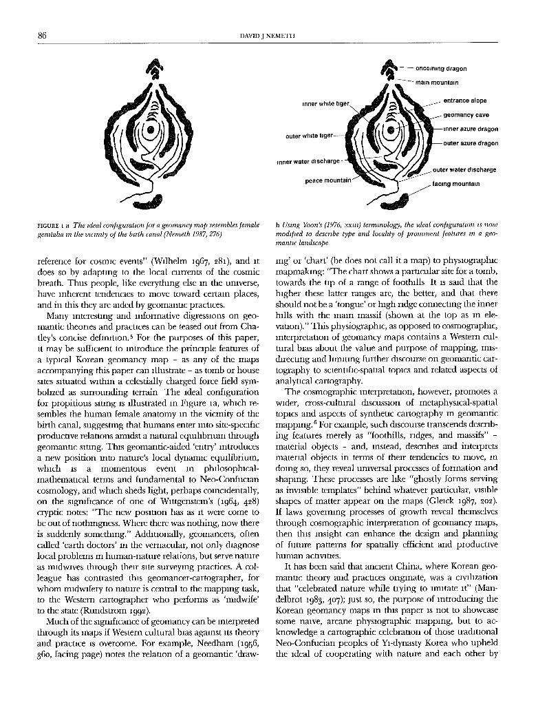
FIGURE I a The ,deal conf,guratmn for a geornancy map resembles femalegemtaha zn the vtc*n*ty of the b,rth canal (Nemeth 1987, 276)
b Using Yoon's (1976, xx,t0 termmology, the ,deal conf, gurat,on *s nowmodtf, ed to descr, be type and locahty of prominent features ,n a geo-rnant,c landscape
reference for cosmic events" (Wilhelm 1967, 28I), and itdoes so by adapting to the local currents of the cosmicbreath. Thus people, like everything else in the umverse,have inherent tendencies to move toward certaan places,
and in this they are aided by geomantlc pracuces.Many anterestang and informative digressaons on geo-
mantic theories and practices can be teased out from Cha-tley's concise defimtaon.5 For the purposes of this paper,at may be sufflcaent to introduce the principle features ofa typacal Korean geomancy map - as any of the mapsaccompanying this paper can allustrate - as tomb or housesites satuated within a celestially charged force field sym-bolized as surrounding terrain The ideal configurationfor propitious sating as illustrated in Fagure 1a, whach re-sembles the human female anatomy an the vicinity of thebirth canal, suggesting that humans enter into site-specificproductive relataons amidst a natural equahbraum throughgeomantlc satang. Thas geomantic-aided 'entry' antroducesa new position into nature's local dynamic equilibrium,whach as a momentous event an phalosophlcal-mathematical terms and fundamental to Neo-Confucaan
cosmology, and which sheds light, perhaps coincldentally,on the sagnaficance of one of Wattgensteln's (i964, 428)cryptic notes: "The new posatlon has as it were come tobe out of nothingness. Where there was nothing, now thereis suddenly somethang." Additionally, geomancers, oftencalled 'earth doctors' in the vernacular, not only diagnoselocal problems an human-nature relations, but serve natureas madwwes through thear site surveying practices. A col-league has contrasted thas geomancer-cartographer, forwhom mldwafery to nature is central to the mapping task,to the Western cartographer who performs as 'midwife'
to the state (Rundstrom 1992).Much of the significance of geomancy can be interpreted
through its maps if Western cultural baas agaanst its theoryand pracuce as overcome. For example, Needham (1956,36o, facing page) notes the relation of a geomantic 'draw-
lng' or 'chart' (he does not call it a map) to physiographicmapmakmng: "The chart shows a parucular site for a tomb,towards the tap of a range of foothills It is said that thehagher these latter ranges are, the better, and that thereshould not be a 'tongue' or high ridge connecting the innerhills with the main massif (shown at the top as an ele-vauon)." This physiographac, as opposed to cosmographac,Interpretation of geomancy maps contains a Western cul-tural bias about the value and purpose of mapping, mls-directang and hmatlng further discourse on geomantic car-tography to scientific-spatial topics and related aspects of
analytical cartography.The cosmographic interpretation, however, promotes a
wader, cross-cultural discussaon of metaphysical-spatialtopics and aspects of synthetic cartography in geomanticmapping. 6 For example, such discourse transcends descrab-ing features merely as "foothills, ridges, and massifs" -
material objects - and, instead, desmbes and interpretsmaterial objects in terms of their tendencies to move, indoing so, they reveal universal processes of formation andshaping. These processes are lake "ghostly forms servingas invisible templates" behind whatever particular, visible
shapes of matter appear on the maps (Glelck 1987, 202).If laws governing processes of growth reveal themselvesthrough cosmographic interpretation of geomancy maps,then this insight can enhance the design and planningof future patterns for spatially efficient and productivehuman activities.
It has been said that ancient China, where Korean geo-mantac theory and practices onglnate, was a civilizationthat "celebrated nature while trying to imitate at" (Man-
delbrot 1983, 4o7); just so, the purpose of introducing theKorean geomancy maps an this paper as not to showcasesome nmve, arcane physaographic mapping, but to ac-knowledge a cartographic celebration of those tradlUonalNeo-Confucian peoples of Yl-dynasty Korea who upheldthe 1deal of cooperating with nature and each other by
AN INTI' RPRETATION OF SOME KOREAN GFOMANCY MAPÿ, 87
onenting themselves for productive purposes wathan a nat-ural force field without dlsruptang the natural eqmhb-rlum. 7 This becomes more obvious by focusing on sometypical maps.
Three Geomancy Maps
Three Korean geomancy maps (Figures 2a, 3, and 4) areintroduced here Each of these maps was copied from aprivately owned unpublished manuscript atlas, "YongjuSallokdo" ("Maps of Propitious Mountains on the Blessed
Isle," n.d ; see Nemeth 1987, 125-29), that celebrates pro-pltaous sates on Cheju Island, Republic of Korea (hereafter'South Korea'), an asolated, seven-hundred-square-male vol-
cano located in the northern reaches of the East ChinaSea. The atlas contains ninety-three 'landscapes' and 131'caves' or sites.
Many Cheju 1slanders have copaes of variants of the same
maps, sometimes bound into atlases, often, they regardthem as family hearlooms. Legend has it that these maps
were oraginally drawn either by Ho Chong-dan (fl h D111 a), a Chinese scholar-official sent on a masslon to ChejuIsland, or more likely by Ho's alleged chscaple, T'ak Ok-chong (n.d), whose name appears on a few maps (Nemeth1987, 86-87). Many of the marginal notations translatedan the figure captions are subsequent comments added byother geomancers, s
These maps are models of the universe, embodying atheory about the origin of the unaverse (a cosmogeny). Thistheory is called 'The Great Ultimate,' and involves relatedideas about natural law governing the post-creation or-ganizaUon of productive ecological relauonshlps. For ex-ample, maps can reveal the outcome of human efforts toconform to nature's principles of self-organlzauon in phys-
ical space (Table 1). Conforming to these principles en-ables humans on Cheju Island to take an active part increating and maintaining productave ecosystems. Mapsymbolism reveals a prevailing concept among trachtlonalKoreans: ethical saung as necessary for productive humanacuvltles. Ethical siting was, of course, the [unction and
responsibility of geomancy in East Asia.One can still go to South Korea and observe a geo-
mancer drawing panoramic views of surface features whilestanding on a propitious site he (trachuonal geomancersare exclusively male) has surveyed. These old Cheju Islandmaps were drawn an the same way. There are no legendson the typical geomancy map, nor any lnchcators of scaleand direction. However, there are marginal notes evalu-ating and even praising a site's usefulness Sites are termed'caves' in the geomantlc manuals, and their surrounchngsare described as holistic, organic 'shapes' or 'landscapes.'
Each site corresponds to the posiuon of the pole star anthe heavens and functions as an analogous organlzauonalcenter, having a self-same purpose (or 'ethic'), that is, "The
[site] is usually represented on the geomancy map by asingle circle or a carcle-withln-a-ctrcle. This symbolism isalso found on many manuscript star-maps drawn by Ko-
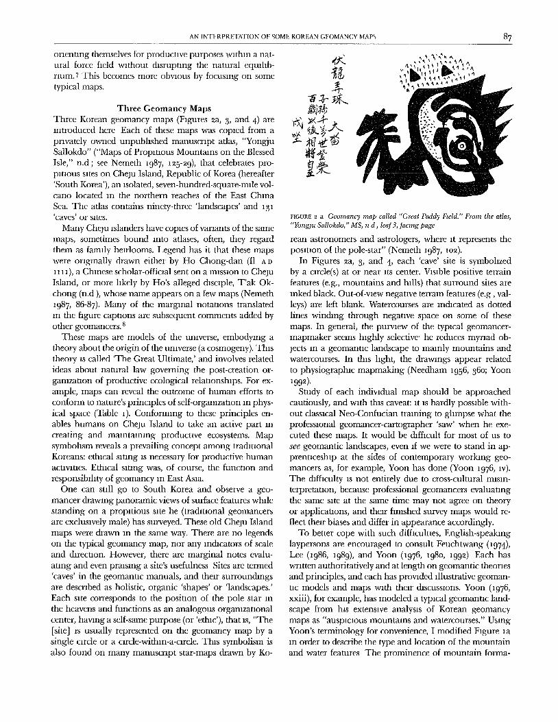
FIGURE 2 a Geomancy map called "Great Paddy Fteld." From the atlas,"Yonglu Sallokdo/' MS, n d, leaf 3, Jacmg page
rean astronomers and astrologers, where it represents theposition of the pole-star" (Nemeth 1987, io2).
In Figures 2a, 3, and 4, each 'cave' site is symbohzedby a circle(s) at or near its center. Vasable positive terrainfeatures (e.g., mountains and hills) that surround sites areInked black. Out-of-view negatave terrain features (e.g, val-leys) are left blank. Watercourses are lnchcated as dotted
lines winding through negative space on some of thesemaps. In general, the purvmw of the typacal geomancer-mapmaker seems highly selective' he reduces myriad ob-jects an a geomantac landscape to mainly mountains andwatercourses. In this laght, the drawangs appear related
to physiographic mapmaking (Needham i956, 36o; YoonI992).
Study of each individual map should be approachedcautiously, and wath thas caveat: at as hardly possible with-out classacal Net-Confucian training to glampse what theprofessional geomancer-cartographer 'saw' when he exe-cuted these maps. It would be dlffacuh for most of us tosee geomantic landscapes, even a[ we were to stand in ap-prenticeship at the sides of contemporary working geo-
mancers as, for example, Yoon has done (Yoon i976, iv).The difficulty as not entirely due to cross-cultural masan-terpretatlon, because professional geomancers evaluatingthe same sate at the same time may not agree on theoryor applicauons, and their finished survey maps would re-flect their biases and differ in appearance accordingly.
To better cope with such difficulties, English-speakinglaypersons are encouraged to consult Feuchtwang (i974),Lee 0986, 1989), and Yoon (1976, i98o, i992) Each haswritten authoritatively and at length on geomantic theoriesand principles, and each has provaded illustrative geoman-
uc models and maps with their chscussions. Yoon (1976,xxiii), for example, has modeled a typical geomanuc land-scape from his extensive analysis of Korean geomancymaps as "auspicious mountains and watercourses." UsingYoon's terminology for convenience, I modified Figure iaan order to describe the type and location of the mountainand water features The prominence of mountain forma-
88 DAVID J NEMETH
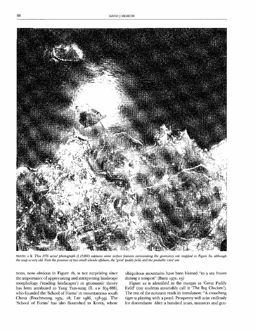
fIGURE 2 b Thzs 1976 aerial photograph (1 15,000) captures some surface features surrounding the geomancy s2te mapped m F, gure 2a, althoughthe map zs very old Note the posztmn of two small ÿslands offshore, the 'great' paddy [wld, and the probable 'cave' szte
tlons, now obvious in Figure lb, is not surprising sincethe importance of appreciaung and interpreung landscapemorphology ('reading landscapes') in geomantic theoryhas been attributed to Yang Yun-sung (ft. A n 874-888),who founded the 'School of Forms' In mountainous south
China (Feuchtwang 1974, 18; Lee 1986, 158-59). The'School of Forms' has also flourished in Korea, whose
ubiquitous mountains have been hkened "to a sea frozenduring a tempest" (Bartz 1972, a3)
Figure 2a IS identified in the margin as 'Great PaddyField' (my students invariably call it 'The Big Chicken').The rest of the notation reads in translataon: "A crouching
tiger IS playing with a pearl. Prosperity will arise endlesslyfor descendants After a hundi'ed years, ministers and gen-
AN INTERPRETATION OF SOME KOREAN GEOMANCY MAPS 89
Islands
Y
TombsRe
_+
Great Paddy
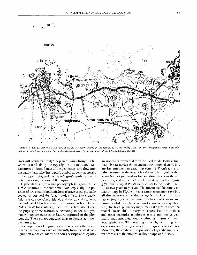
FIGURE 2 C The geornancy stte and &stant tslands are eastly located m the wcmity oJ "Great Paddy Fwld" on any topographw sheet Thzs 1974map ÿs turned upside-down here for comparatwe purposes The tslands at the top are actually south of the stte
erals will accrue naturally " A pattern symbolazmg coastalwaters is used along the top edge of the map, and wa-tercourses on both flanks of the geomancy cave flow intothe paddy field. The 'fare' agent's symbol appears as terrainan the upper right, and the 'water' agent's symbol appearsas terrain along the lower left margin.
Figure 2b is a 1976 aerial photograph (1 15,ooo) of thesurface features at the same site Note especially the po-sataon of two small islands offshore relative to the probablegeomancy sate and the 'great' paddy field. Sance paddyfields are rare on Cheju Island, and the offacaal name ofthe paddy-field landscape an this location has been 'GreatPaddy Field' for centuraes, there can be httle doubt thatthe physiographic features outstanding in the old geo-mancy map are those same features captured an the pho-
tograph. The 1974 topographic map an Fagure ÿc showsthe same area.
A comparison of Figures la and 2a reveals the extent
to whach a map may vary sagnificantly from the adeal con-figurataon modeled. Many of Yoon's descriptive categories
are not easaly transferred from the 1deal model to the actualmap. We recognize the geomancy cave immediately, butare less confident an assagnlng some of Yoon's terms toother features on the map Also, the map has symbols thatYoon has not prepared us for: standing waters an the ad-
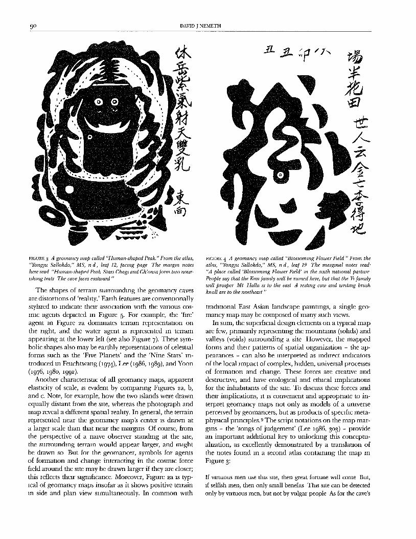
jacent sea, and an the paddy fields. In ats symmetry, Fagure3 ('Human-shaped Peak') seems closer to the model - butat has two geomancy caves! The fragmented-looking geo-
mancy map in Figure 4 has a single geomancy cave butall else seems surreal to the average North Ameracan map
reader (my students discovered the heads of Caesars andbuzzards while searchang an vain for watercourse symbol-
sm) In short, geomancy maps may vary greatly from themodel. To be able to recognize Yoon's features in theseand other examples requires extensive training at geo-mancy map anterpretation, including famlllanty with eso-term symbolism. Thas tralnang comes by acquaring vastexpenence an drawang a variety o[ maps at selected sates.Moreover, the credible anterpretauon of specific maps de-mands vaslts to the sites where these maps were drawn.
9° DAVID J NEMETH
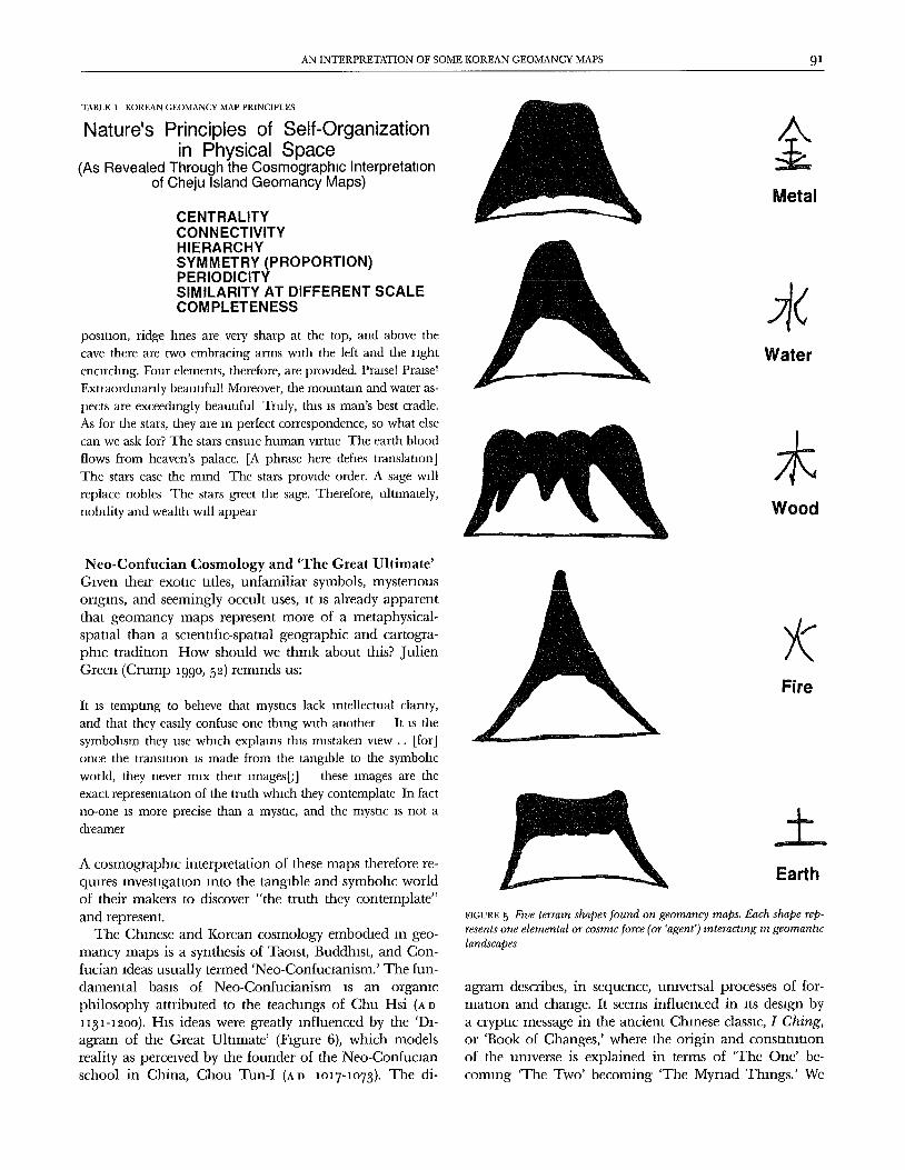
2t.
The shapes of terrain surrounding the geomancy cavesare distortions of 'reality.' Earth features are conventionallystyhzed to lnchcate their association with the various cos-mlc agents depicted in Figure 5. For example, the 'fire'agent in Figure 2a dominates terrain representanon onthe nght, and the water agent is represented in terrainappearing at the lower left (see also Figure 7). These sym-bolic shapes also may be earthly representations of celestialforms such as the 'Five Planets' and the 'Nine Stars' In-
troduced in Feuchtwang (1974), Lee (1986, 1989), and Yoon(1976, 198o, 1992).
Another characteristic of all geomancy maps, apparentelasticity of scale, is evident by companng Figures 2a, b,and c. Note, for example, how the two islands were drawnequally distant from the site, whereas the photograph andmap reveal a chfferent spatial reality. In general, the terrainrepresented near the geomancy map's center is drawn at
a larger scale than that near the margins Of course, fromthe perspective of a naive observer stanchng at the site,the surrounchng terrain would appear larger, and mightbe drawn so But for the geomancer, symbols for agentsof formation and change interacting in the cosmic forcefield around the site may be drawn larger if they are closer;this reflects their significance. Moreover, Figure 2a is typ-ical of geomancy maps insofar as it shows positive terrainin side and plan view simultaneously. In common with
FIGURE 3 d geomancy map called "'Ituman-shaped Peak." From the atlas,"Yonglu Sallokdo," MS, n d, lea] 12, Jacmg page The margin noteshere read "Human-shaped Peak Stars Chagz and Ch'onsa Jorm two nour-ishing teats The cave faces eastward"
FIGURE 4 A geomancy map called "Blossoming Flower Fwld " From theatlas, "Yonglu Sallokdo," MS, n d, leaf 19 The marginal notes read'"A place called 'Blossoming Flower Fwld' m the stxth natzonal pasturePeople say that the Kam Jamzly wdl be ruined here, but that the Ya ]amdywdl prosper Mt HaUa zs to the east A resting cow and wrmng brushknoll are to the northeast"
trachtlonal East Asian landscape palnungs, a single geo-mancy map may be composed of many such views.
In sum, the superficial design elements on a typical mapare few, primarily representing the mountains (solids) andvalleys (voids) surrounding a site However, the mappedforms and their patterns of spatial organization - the ap-pearances - can also be interpreted as indirect indicators
of the local impact of complex, hidden, universal processesof formauon and change. These forces are creauve anddestrucuve, and have ecological and ethical lmphcatlonsfor the inhabitants of the site. To chscuss these forces and
their implications, It as convenient and appropriate to in-terpret geomancy maps not only as models of a umverseperceived by geomancers, but as products of specific meta-physical pnnclples. 9 The script notations on the map mar-gins - the 'songs of judgement' (Lee i986, 3o3) - providean important addrtional key to unlocking this conceptu-ahzation, as excellently demonstrated by a translation ofthe notes found an a second atlas containing the map In
Figure 3:
If virtuous men use this site, then great fortune will come But,
1[ selfish men, then only small benefits This site can be detectedonly by virtuous men, but not by vulgar people As for the cave's
AN INTERPRETATION OF SOME KOREAN GEOMANCY MAPS 91
TABLE 1 KOREAN GEOMANCY MAP PRINCIPLES
Nature's Principles of Self-Organizationin Physical Space
(As Revealed Through the Cosmographlc Interpretationof Cheju Island Geomancy Maps)
CENTRALITYCONNECTIVITYHIERARCHYSYMMETRY (PROPORTION)PERIODICITYSIMILARITY AT DIFFERENT SCALECOMPLETENESS
Metal
posmon, ridge lines are very sharp at the top, and above thecave there are two embracing arms with the left and the rightencircling. Four elements, therefore, are provided. Prmsel PraaseT
Exuaorthnarlly beauuful! Moreover, the mountain and water as-
pects are exceechngly beauuful Truly, this is man's best cradle.As for the stars, they are an perfect correspondence, so what else
can we ask for? The stars ensule human virtue The earth bloodflows from heaven's palace. [A phrase here defies translauon]The stars ease the mind The stars provide order. A sage willreplace nobles The stars greet the sage. Therefore, ulumately,nobility and wealth will appear
Water
±Wood
Net-Confucian Cosmology and 'The Great Ultimate'
Given their exotic titles, unfamiliar symbols, mysteriousorigins, and seemingly occult uses, it as already apparentthat geomancy maps represent more of a metaphysical-spatial than a scientific-spatial geographic and cartogra-phic tradiuon How should we think about this? JulienGreen (Crump 199o, 52) reminds us:
FireIt is tempung to befieve that mysucs lack intellectual clarity,and that they easzly confuse one thmg with another It IS thesymbohsm they use which explains this mistaken view .. [for]once the transluon is made from the tangible to the symbohc
world, they never mix their Images[;] these images are theexact representauon of the truth which they contemplate In factno-one as more precise than a mysuc, and the mystic as not a
dreamer
A cosmographlc interpretation of these maps therefore re-quLres lnvestlgaUon into the tangible and symbohc worldof their makers to discover "the truth they contemplate"
and represent.The Chinese and Korean cosmology embodied m geo-
mancy maps is a synthesis of Taolst, Buddhist, and Con-fucian ideas usually termed 'Net-Confucianism.' The fun-damental basis of Net-Confucianism is an organic
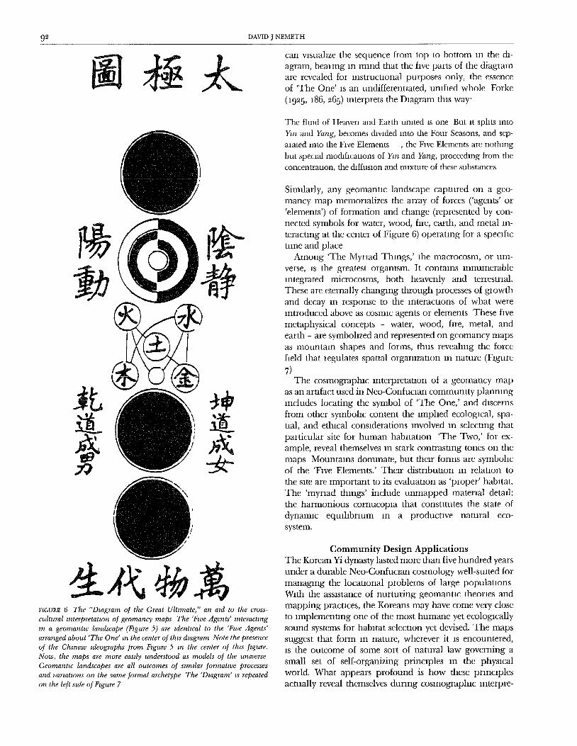
philosophy attributed to the teachings of Chu Hsi (A D1131-I2OO), His ideas were greatly influenced by the 'D]-agram of the Great Ultimate' (Figure 6), which modelsreality as perceived by the founder of the Neo-Confucmnschool in China, Chou Tun-I (AD lO17-1o73). The di-
Earth
FIGURE 5 FtrJe terrain shapes .found on geomancy maps. Each shape rep-resents one elemental or cosmw .force (or 'agent') interacting ,n geomantw
landscapes
agram describes, in sequence, universal processes of for-mauon and change. It seems influenced in its design bya crypuc message in the ancient Chinese classic, I Ching,or 'Book of Changes,' where the origin and consutuuonof the umverse is explained in terms of 'The One' be-coming 'The Two' becoming 'The Myriad Things.' We
92 DAVID J NEMETH
can Vlsuahze the sequence from top to bottom in the di-agram, beanng in mind that the five parts of the diagramare revealed for instructional purposes only, the essenceof 'The One' is an undifferentiated, unified whole Forke
(1925, 186, 265) interprets the Diagram this way'
The fired of Heaven and Earth umted is one But it sphts xntoYm and Yang, becomes thvlded into the Four Seasons, and sep-
mated mto the Five Elements , the Fwe Elements are nothing
but special modlficauons of Ym and Yang, proceethng from theconcentrauon, the chffuslon and mixture of these substances
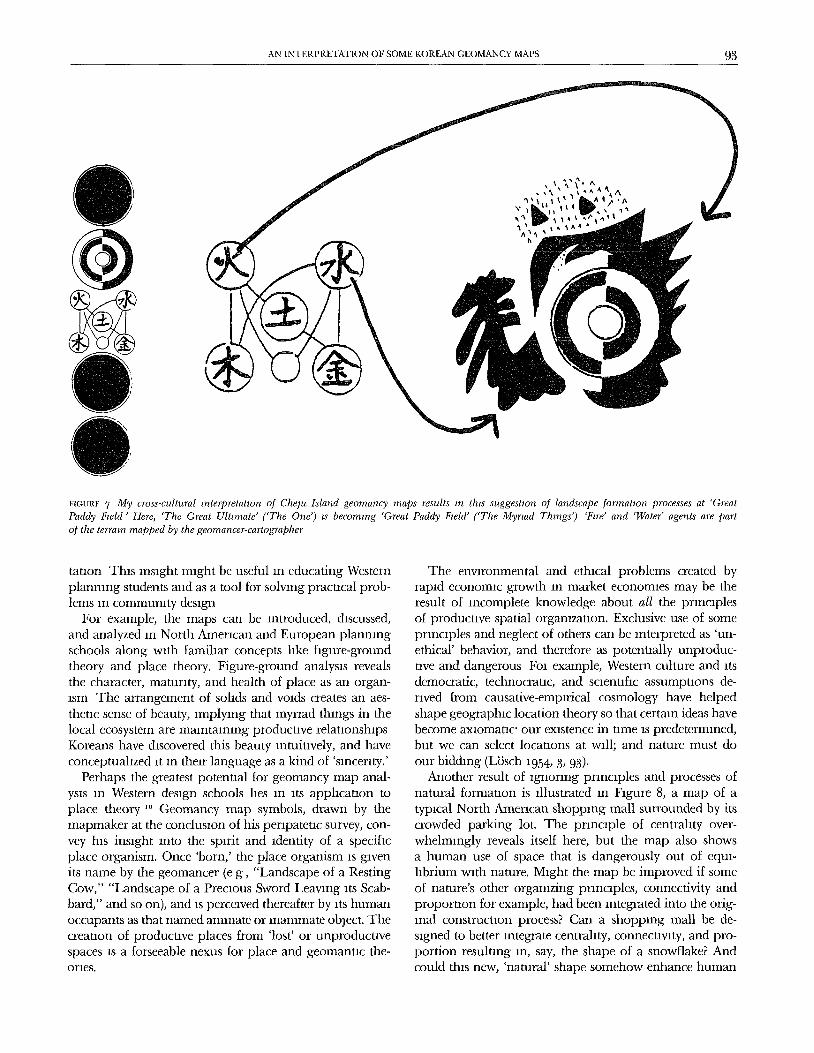
Similarly, any geomantlc landscape captured on a geo-mancy map memorializes the array of forces ('agents' or'elements') of formation and change (represented by con-nected symbols for water, wood, fire, earth, and metal in-teracting at the center of Figure 6) operating for a specafictame and place
Among 'The Myriad Things,' the macrocosm, or uni-
verse, is the greatest orgamsm. It contains innumerableintegrated microcosms, both heavenly and terrestrial.These are eternally changing through processes of gaowthand decay in response to the interactions of what wereintroduced above as cosmic agents or elements These five
metaphysical concepts - water, wood, fire, metal, andearth - are symbolized and represented on geomancy mapsas mountain shapes and forms, thus revealing the forcefield that iegulates spatial organization an nature (Figure
7)The cosmographlc lnterpretanon of a geomancy map
as an arufact used in Neo-Confuclan commumty planningincludes locating the symbol of 'The One,' and discerns
from other symbohc content the implied ecological, spa-tial, and ethical considerations revolved in selecting thatparticular site for human habitation 'The Two,' for ex-ample, reveal themselves in stark contrasting tones on themaps Mountains dominate, but their forms are symbolicof the 'Five Elements.' Their distribution in relation to
the site are important to its evaluauon as 'proper' habitat.The 'myriad things' include unmapped material detail:the harmonious cornucopm that consututes the state ofdynamic equlhbrium in a productive natural eco-
system.
FIGURE 6 The "Dmgram of the Great Ultimate," an aÿd to the cross-cultural mterpretaOon of geomancy maps The 'Frye Agents' mteraetmgm a geomantw landscape (Fzgure 5) are tdentwal to the 'Fwe Agents'arranged about 'The One' m the center of thts &agram Note the presenceoJ the Chinese zdeographs from Fzgure 5 m the center of thzs figure.Now, the maps are more eastly understood as models of the umverseGeomanttc landscapes are all outcomes of szmllar formatwe processes
and varzattons on the same formal archetype The 'Dzagram' zs repeated
on the left szde of Ftgure 7
Community Design ApplicationsThe Korean Yi dynasty lasted more than five hundred yearsunder a durable Neo-Confuclan cosmology well-suited for
managing the locatlonal problems of large populauonsWith the assistance of nurturing geomantlc theories and
mapping practices, the Koreans may have come very closeto implementing one of the most humane yet ecologicallysound systems for habitat selection yet devised. The mapssuggest that form in nature, wherever it as encountered,is the outcome of some sort of natural law governing a
small set of self-organizing principles an the physicalworld. What appears profound is how these principlesactually reveal themselves dunng cosmographlc lnterpre-
AN INTERPRETATION OF SOME KOREAN GEOMANCY MAPS 93
Fm.RF 7 My cross-cultural rnterpretatzon of Chelu Island geornancy maps results m this suggestzon of landscape formation processes at 'GreatPaddy Fwld" Here, "The Great Ultzrnate' ('The One') ts becoming 'Great Paddy Fwld' ('The Myrzad Things') "Fzre" and 'Water" agents are partof the terrain mapped by the geornancer-cartographer
tatlon This insight might be useful in educating Western
planning students and as a tool for solving practical prob-lems in community design
For example, the maps can be introduced, discussed,and analyzed in North American and European planningschools along with famihar concepts like figure-groundtheory and place theory. Figure-ground analysis revealsthe character, maturity, and health of place as an organ-lsm The arrangement of solids and voids creates an aes-
thetic sense of beauty, implying that myriad things in thelocal ecosystem are mamtaamng productive relauonshIpsKoreans have chscovered this beauty intuitively, and haveconceptuahzed it m their language as a kind of 'smcenty.'
Perhaps the greatest potential for geomancy map anal-ysis m Western design schools hes in ItS applIcauon toplace theory ,o Geomancy map symbols, drawn by themapmaker at the conclusion of his perlpateuc survey, con-vey his insight into the spirit and identity of a specificplace organism. Once 'born,' the place organism is givenits name by the geomancer (e g, "Landscape of a RestingCow," "Landscape of a Precious Sword Leaving its Scab-bard," and so on), and is perceived thereafter by its humanoccupants as that named animate or inanimate object. Thecreation of productive places from 'lost' or unproducuvespaces is a forseeable nexus for place and geomanuc the-ories.
The envaronmental and ethical problems created byrapid economic growth in market economies may be theresult of incomplete knowledge about all the pnncIplesof productive spatial orgamzatlon. Exclusive use of someprinciples and neglect of others can be interpreted as 'un-ethical' behavior, and therefore as potenually unproduc-tive and dangerous Fol example, Western culture and itsdemocratic, technocratic, and scientific assumptions de-rived from causative-empirical cosmology have helped
shape geographic location theory so that certain ideas havebecome axiomatic' our existence in tame is predetermined,but we can select locations at will; and nature must do
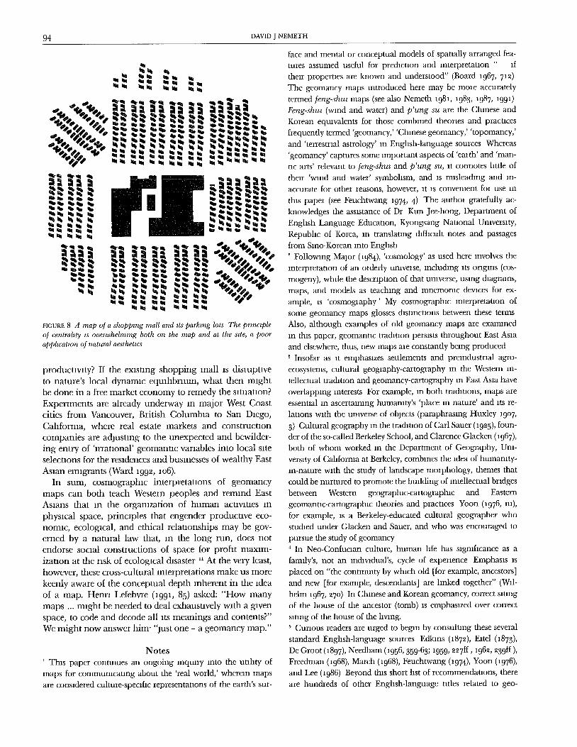
our bidchng (LiJsch i954, 3, 93).Another result of ignoring pnnclples and processes of
natural formation is illustrated in Figure 8, a map of atypical North Amerman shopping mall surrounded by itscrowded parking lot. The principle of centrahty over-whelmlngly reveals itself here, but the map also showsa human use of space that is dangerously out of equl-hbrium with nature. Might the map be improved if someof nature's other organizing pnnclples, connectivity andproportion for example, had been integrated into the orig-inal construcnon process? Can a shopping mall be de-signed to better integrate centrality, connecuvlty, and pro-portion resulting in, say, the shape of a snowflake? Andcould this new, 'natural' shape somehow enhance human
94 DAVID J NEMETH
riÿuRE 8 A map of a shopping mall and tts parking lots The principleof centrahty ts overwhelming both on the map and at the stte, a poorapphcatton o! natural aesthetws
producuvity? If the existing shopping mall as disruptiveto nature's local dynamic equilibrium, what then mightbe done in a free market economy to remedy the ntuataon?
Experiments are already underway in major West Coastcities from Vancouver, British Columbaa to San Daego,
California, where real estate markets and constructioncompanies are adjustang to the unexpected and bewilder-ing entry of 'irrational' geomantIc variables into local siteselections for the residences and businesses of wealthy East
Asian emigrants (Ward a99ÿ, ao6).In sum, cosmographIc interpretataons of geomancy
maps can both teach Western peoples and remand EastAsians that In the organization of human activities in
physical space, principles that engender producuve eco-nomic, ecological, and ethical relationships may be gov-erned by a natural law that, an the long run, does notendorse socaal constructions of space for profit maxim-izauon at the risk of ecological disaster " At the very least,however, these cross-cultural interpretations make us morekeenly aware of the conceptual depth inherent in the ideaof a map. Henn Lefebvre (a99a, 85) asked: "How manymaps ... might be needed to deal exhaustavely wÿth a givenspace, to code and decode all Its meanings and contents?"We might now answer him' "just one - a geomancy map."
Notes' This paper continues an ongoing inquiry into the utility ofmaps for communicating about the 'real world,' wherein maps
are considered culture-specific representattons of the earth's sur-
face and mental or conceptual models of spatially arranged fea-tures assumed useful for prediction and interpretation " If
their properties are known and understood" (Board 1967, 7ÿ ÿ)The geomancy maps introduced here may be mole accurately
termed feng-shuz maps (see also Nemeth a98], 1983, 1987, a99l)Feng-shu, (wind and water) and p'ung su are the Chinese andKorean equivalents for those combined theories and pracuces
frequently termed 'geomancy,' 'Chinese geomancy,' 'topomancy,'
and 'tenestnal astrology' in Enghsh-language sources Whereas
'geomancy' captures some important aspects of 'ealth' and 'man-
tic arts' relevant to feng-shuz and p'ung su, it connotes htde of
their 'wind and water' symbolism, and is misleading and m-
accurate for other reasons, however, it is convenaent for use in
this papel (see Feuchtwang 1974, 4) The authoÿ gratefully ac-knowledges the assistance of Dr Iÿam Jee-hong, Department ofEnglish Language Educauon, Kyongsang Nauonal Umversaty,Republac of Korea, in translaung difficult notes and passagesfrom Slno-Korean into English
Following Major (1984), 'cosmology' as used here involves theinterpretation of an orderly unavease, mcluchng its origins (cos-
mogeny), while the description of that universe, using diagrams,
maps, and models as teaching and mnemonic devices for ex-
ample, is 'cosmogaaphy' My cosmographlc interpretation of
some geomancy maps glosses distinctions between these terms
Also, although examples of old geomancy maps are examined
in this paper, geomanuc tradition persists throughout East Asiaand elsewhere, thus, new maps are constantly being produced
Insofar as it emphasizes settlements and premdustraal agro-
ecosystems, cultural geography-cartography in the Western in-
tellectual tradition and geomancy-cartography an East Asia haveoverlappang interests For example, in both traditions, maps are
essential in ascertaining humanity's 'place in nature' and its re-
lations with the unaverse of objects (paraphrasang Huxley 19o7,
3) Cultural geography in the trachuon of Carl Sauer (19z5), foun-der of the so-called Berkeley School, and Clarence Glacken (1967),both of whom worked in the Department of Geography, Uni-versity of California at Berkeley, combines the idea of humanity-an-nature with the study of landscape morphology, themes thatcould be nurtured to promote the building of intellectual bridges
between Western geographxc-cartographlc and Easterngeomantÿc-cartographac theories and practices Yoon 0976, m),for example, is a Berkeley-educated cultural geographer whostudied under Glacken and Sauer, and who was encouraged to
pursue the study of geomancy4 In Neo-Confuclan culture, human life has sagnlficance as a
family's, not an individual's, cycle of expenence Emphasis is
placed on "the continuity by which old [for example, ancestors]and new [for example, descendants] are linked together" (Wil-helm 1967, ÿ7o) In Chinese and Korean geomancy, correct saungof the house of the ancestor (tomb) is emphasized over correct
slung of the house of the laving.Cunous readers are urged to began by consulting these several
standard Enghsh-language sources Edkms (1879), Eatel (1873),
De Groot 0897), Needham 0956, 359-63; 1959, zz7ff, 196ÿ, ÿ39ff ),Freedman (1968), March (1968), Feuchtwang (1974), Yoon (1976),and Lee 0986) Beyond this short list of recommendauons, thereare hundreds of other Enghsh-language utles related to geo-
AN INTERPRETATION OF SOME KOREAN GEOMANCY MAPS 95
mancy that valy in quality I thank levlewers of this article fOl
recommending adthnonal works by Graham (1961), Lal (1974),Skinner (1982), Lip (1989), Groves (1991), Smith (1991), and We1(1992) Incautious subject searches undel 'geomancy' may leadresearchers to the European and African manuc arts, traditions
only remotely related to Chinese and Korean geomancy Con-
sultlng 'feng-shul' (various spellings) should reduce the problemA masterwolk on Korean geomancy by the contemporary ge-
ogqapher Chol Chang-Jo (1984) awaits tlanslatton into EnghshNumerous other foreign-language wolks are cited by Feucht-
wang, Yoon, and Lee
6 The concept of 'syntheuc caitography' is intioduced hele asapposite to a hohstic and complex unlvelse revealed throughthe cross-cultural cosmographlc interpletauon of geomantlc
maps A thstlnction could be drawn between synthetic cartog-raphy and 'analytical cartogaaphy,' insofar as the latter is weddedto logical-positivism in the West and, by excluding any discourse
about metaphysical realities, tends to be pamcular (not hohstlc)and comphcated (not complex) in its world view.7 This is not to say that Neo-ConfucIan peoples dad not disrupt
the natural equihbnum in East Asia penothcally For example,Tuan (1972) has cited such disruptions However, Neo-Confucianideology, and the theories and practices of geomancy within thatsystem, does serve to minimize disharmonious relationships
(Choi 1992)8 I have explored and experienced the sites indicated on geo-
mancy maps accompanying this arucle. Some were more difficult
to find than others hi 198I, I visited two of these sites in thecompany of a professional geomancer, Mr Pak Dong-hwan, who
offered his own lnterpretanons These maps were selected mainlybecause they Illustrate strikingly the idea that what we see isguided by what we expect to see Thus, they draw attenuon tothe problem of cultural relativism in map interpretauon At firstglance, undergraduate and graduate students in geographyclasses invariably describe the maps as 'cartoons' and 'Rorschach
tests,' and are surprised to thscover that they are maps of places
that can be located on aerial photographs and topographic mapsheets, and that they may be useful in community design andplanning9 With increased understanding and tolerance of metaphysical-
spaual trathuons in mapmaking, prior mistakes in map inter-
pretation become more obvious For example, RaIsz (1948, 14)asserted that the medieval 'T-O' maps, with Jerusalem at the
center of a world disc, were made by craftsmen who made no
serious attempt to show the world as It actually was Woodward
(1985, 5io-21) countered that these craftsmen were precise In rep-
resenting their world
'0 Geomancy maps also can be considered art forms representing
concepts related to numerology (Nemeth I991) They are a formof mimmal art based on the apphcauon of mathemaucal prin-ciples that effecuvely exclude obscunng irrelevancies in order toreveal the operauon of nature's fundamental laws. Amidst thedynamic equihbnum of natural systems are dynamic human ac-
uviues the innermost workings of which can be expressed in
numerical terms Surprisingly, the maps also model the samereality illustrated in computer-controlled 'fractal art' (Mandelbrot
1983) Cartographers Lam and Quattrochi (1992), for example,
adchess problems of map scale and resolution in ways similar
to Korean geomanceis They use the fiactal concept to help pre-thct how landscape patteIns and distributions change througha hierarchy of scales Since some of the most useful hactals for
describing natural geometries involve chance rather than design,scholars might gain insight into landscape patterns by studyingthe geomantic principle of similarity at thfferent scales" The conceit that space is socially, not naturally, constructed
seems uncontested now in the discourse of the 'new' cultural
geography in North America In The Production of Space, awoIk often cited by cultural geographers, Henri Lefebvre (i991,7o, 83) algued that "nature creates and does not pIoduce," and"the moie a space partakes of nature, the less It enters into the
social relations of production " However well reasoned, these
opinions are anthropocentric and cultme-relaove The geomancy
maps have their own internal logic They offer evidence thatdevelopment in nature includes human development and obeyslaws of space that are also laws of nature
ReferencesBARTZ, e M 1972 South Korea Oxford Clarendon.BENNE'IW, S J 1978 Patterns of Sky and Earth A Chinese Science
of Applied Cosmology Chinese Scwnce 3 1-26
BOARD, C i967 Maps as Models In Models m Geography, editedby R.J Chorley and P Haggett, 671-725 London. Methuen
CHATLEY, H i917 Feng-Shui In Encyclopaedm Stoma, edited by
S Couhng, 175 Shanghai. Kelly and WalshCHOt, C-J 1984 Korean Geomantw Thought. Seoul Mmumsa.
fin Sino-Korean]
i992 To Preserve the Environment, Use Geomantic
Thought Korean Daÿly News, i September, p 17 fin Korean]CRUMP, T 199o The Anthropology of Numbers. Cambridge
Cambridge University Press
DE GROOT, JJM i897 Feng Shui. In The Rehgzous System ofChina, 935-io56 Vol. 3 Leiden Bnll
EDKINS, J 1872. On the Chinese Geomancy Known as Feng-shui
The Wind and Water Supersuuon of the Chinese The Chinese
Recorder and Mtssmnary Journal. March, pp 274-77, April,pp. 291-98, May, pp 316-71.
EITEL, E J i873 Feng-Shuz, or the Rudzments of Natural Sczencem China. Hong Kong Lane, Crawford
FEUCHTWANG, S D R 1974 An Anthropologwal Analysts oJ Chz-nese Geomancy Laos' Vithagna.
FORKE, A 1925 The World Conceptzon oJ the Chinese London.ProbsthaIn
FREEDMAN, M I968 Geomancy Proceedings of the Royal An-thropologwal Instztute of Great Brztam and Ireland, pp 5-15
GLACVdÿN, CJ 1967 Traces on the Rhodmn Shore: Nature andCulture m Western Thought from Ancwnt Tzmes to the EndoJ the Etghteenth Century Berkeley: University of CaliforniaPress
GLEICK, J I987 Chaos: Making a New Scwnce. New York VikingPenguin
GRAHAM, D C i961 Folk Rehgzon m Southwest China Wash-Ington, D.C. Smlthsonian.
GROVES, D I99i. Feng-Shuz and Western Budding CeremomesSingapore' Graham Brash
96 DAVID J NEMETH
HUXLEY, TH 1907, Man's Place zn Nature. Ann Arbor Unlversaty
of Michigan Pless [onglnally published In i863]LAI, D 1974 A Feng Shin Model as a Locatlonal Index Annals
of the Assoctatzon of Amertcan Geographers 64/4 5o6-i3LAM, NS-N, and DA QUATFROCHI 199Z. On the Issues of Scale,
Resolution and Flactal Analysis m the Mapping Sciences ThePÿofesstonal Geogÿapheÿ 44/1 88-98
LEE, S -H 1986 "Feng-shul Its Context and Meaning" Ph D.chss,
Cornell Umvelsaty
1989 Siting and General Organization of TlachuonalKoaean Settlements In Dwelhngs, Settlements and Tradtttons,edited by J -P Bomdaer and N Alsayyad, 295-317 New YorkUnivelsity Press of America
LEFEÿVRE, H i991 The ProducOon of Space, translated by DNmholson-Smath Oxford Basil Blackwell
LIP, E I989 Feng Shin for Business Singapore Times Intema-uonal
LOSCH, A 1954 The Economÿes of Locatzon New Haven: YaleUnlvelsity Press
MAJOR, J S 1984 The Fwe Phases, Magm Squales, and SchematicCoslnogaaphy In Explorattons zn Early Chinese Cosmology,echted by H J Rosemont, 133-6o Chlco, CA. Scholars
MANDELBROT, B 1983 The Fractal Geometry of Nature. San Fran-cisco. W H Freeman
MARCH, AL i968. An Appreciation of Chinese GeomancyJournal of Aszan Studws 27/2 253-67
NEEDHAM, J 1956 Sewnce and Cwzhsatzon m China Vol. 2 Cam-bridge Cambridge Umversxty Press.
-- 1959 Scwnce and Cwthsatmn m China Vol 3 Cam-bridge Cambridge University Press
-- i962 Scwnce and Cwzhsatÿon m China Vol 4, Part1 Cambridge Cambridge Umversxty Press
NEMETH, D 1981 Bnght Yard Maps fi'om Cheju IslandLandscape 25/2 2o-1
-- 1983 Graven Images and Cosmic Landscape on ChejuIsland Korean Culture 4/i 4-19.
1987 The Archztecture of Ideology. Neo-Confuczan Im-printing on Chelu Island, Korea Vol 26 Umversaty of Cal-ifornia Pubhcauons m Geography. Berkeley Umverslty of Cal-fforma Press
-- 1991 Feng-shuÿ as Terresmal Astrology m TradztÿonalChina and Korea In The Power of Place. Sacred Ground mNatural and Human Enwronments, echted by J A Swan, 2i5-34 Wheaton, IL: Quest Books
R_4Isz, E 1948 General Cartography 2nd echuon. New YolkMcGraw-Hill
RUNDSTROM, R 1992. Personal communIcauon, 2 September.
SAUER, C 1925 The Morphology of Landscape. Unwerszty ofCahforma Pubhcattons m Geography 2/2. 19-54.
SFdNNER, S i982. The Lwmg Earth Manual of Feng-Shuv ChineseGeomancy London Routledge and Kegan Paul.
SMITH, R J 1991 Fortune-tellers and Philosophers' Dzwnatmn znTradÿtzonal Chinese Socwty Boulder, co Westvlew.
STEVENS, PS 1974. Patterns m Nature Boston Lattle, BrownTUAN, Y-F 1972 Discrepancies Between Environmental Atutude
and Behavior Examples from Europe and China In Man,
Space and Enwronment, edited by P W Enghsh and R C May-field, 68-8i New York Oxfold
WARD, A I992 Vancouver - Good Luck City Natmnal Geogm-
phw Magazine 181/4 (Apnl). 94-121WE1, F 1992. Village Fengshul Punclples In Chinese Landscapes
The Vzllage As Place, echted by R G Knapp, 35-45 HonoluluUmverslty of Hawau Press.
WILHELM. R, trans. 1967 I Chmg [Book of Changes] 3rd echtlon(Rendeled into Enghsh by C F Baynes.) Pnnceton PrincetonUniversity Press
WITTGENSTEIN. L 1964 Selecuons flora Remarks on the Foun-dation of Mathemaucs In Philosophy of Mathematws. SelectedReadings, echted by P Benacerraf and H. Putnam, 421-86 En-
glewood Chffs, NJ Prenuce Hall
WOODWARD, D 1985. Reality, Syinbohsm, Tame, and Space mMedaeval World Maps. Annals of the Assoctatton of Amerwan
Geographers 75/4 51o-2iYANG Y-S 88o(ÿ) Han Lung Chmg [Classic of the Moving
Dlagon] fin Sino-Korean]YOON, H-K 1976 Geomantw Relatmns Between Culture and Na-
ture m Korea Talpel Orient Cultural Service-- 198o. The Image of Nature in Geomancy. GeoJournal
4/4 34I-48-- 1992 The Expression of Landforms in Chinese Geo-
mantlc Maps Cartographw Journal 29/1 12-15
Abstract This paper provides a cosmographlc mterpretataonfor examples of some old Korean geomancy maps from ChejuIsland While it would be easy to dismiss geomancy maps froman outsider's cultural perspectave as inscrutable, occult, Oriental
oddaues, or as examples of nawe deplcuons of 'reahty,' a cos-
mographac interpretation yaelds something more profound. Themaps ale presented as evidence of the idea that natural law gov-
erns the principles of self-orgamzatlon m physical space' cen-
trafity, connectivity, hierarchy, symmetry (propomon), penochc-
aty, simalanty at chfferent scales, and completeness. The
mapmaker is the mechum through which nature has revealed,in map symbofism, its 'hidden knowledge' One lmphcauon ofcosmographlc lnterpretauon is the Idea that sustainable humanproducuvlty can only be attained by obeying laws of space thatare also laws of nature East Asmn cultural perspecuves, as re-
vealed in maps, also have comrnumty design appllcauons, and
might help inform the search being conducted by Western scl-enusts and scholars for a grand umfied theory of ecologmal sys-tems
Rÿsumÿ Cet amde offre une lnterprÿtauon cosmographlqued'exemples d'anclennes cartes corÿennes de gÿomancle de File
de Cheju Alors qu'll seralt facxle d'ÿcarter les cartes de gÿomancleen les quahfiant, selon la perspecuve culturelle d'un ÿtranger,d'lmpfindtrables, d'occultes, d'ÿtrangetÿs orlentales ou d'exemples
de reprÿsentauon naive de la rÿalltÿ, une mterpr&auon cosmo-
graphxque lalsse filtrer une substance plus profonde On yprdsente les cartes comme une 6vldence de l'idÿe que la lol na-
turelle gouverne les prlnclpes de l'auto-organlsatlon dans l'espace
physique' centrahsme, connecuvltÿ, hiÿrarchm, symÿtne et pro-
AN INTERPRETATION OF SOME KOREAN GEOMANCY MAPS 97
portion, p&todxcltd, slmdantd h chffdrentes dchelles et dtat com-
plet Le cattographe est le mdchum par lequel la nature a lÿvdld,dans le symbohsme de la carte, son savolr cachÿ L'mterprdtatlon
cosmogmphlque tmphque, entre autres, l'idde qu'on ne peut at-
telnch-e une ploductwlt6 humame soutenue qu'en obÿissant aux
lois de l'espace, qua sont aussl des lots de la nature Les pers-
pecuves cuhutelles d'Asle de l'est, telles que rdvÿldes sur les cartes,
ont ausst des applications dans la concepuon de communautÿs
et peuvent contnbuer h la rechelche mende par les sclenuflquesOccldentaux sur la grande thdrle umfi& des dcosyst{mes
DAVID J NEMETH IS Assistant Professor of Geography m the Departmentof Geography and Planning, Umverslty of Toledo, Toledo, Ohm USA436o6-339o He is a cultural geographer with research interests m EastAsian geomancy, cartography, and commumty design His chssertauon,
The drchttecture of Ideology Neo-Confucmn lmprmtmg on Chelu Is-land, Korea was published by Umverslty of Cahfornm Press m 1987