A. Approval of Minutes - 1. April 13, 2021 Regular Meeting 2 ...
230
In compliance with the Americans with Disabilities Act, if you need special assistance to participate in this meeting, please contact the Community Development office at 541-488-5305 (TTY phone is 1-800-735-2900). Notification 48 hours prior to the meeting will enable the City to make reasonable arrangements to ensure accessibility to the meeting (28 CFR 35.102-35.104 ADA Title 1). ASHLAND PLANNING COMMISSION REGULAR MEETING May 11, 2021 AGENDA I. CALL TO ORDER: 7:00 PM II. ANNOUNCEMENTS III. PUBLIC FORUM IV. CONSENT AGENDA A. Approval of Minutes 1. April 13, 2021 Regular Meeting 2. April 27, 2021 Special Meeting V. PUBLIC FORUM VI. CONT’D TYPE II PUBLIC HEARINGS A. PLANNING ACTION: PA-T1-2021-00141 SUBJECT PROPERTY: 599 East Main Street APPLICANT/OWNER: Rogue Planning & Development Services, LLC for Livni Family Trust (Gil Livni, Trustee) DESCRIPTION: A request for Site Design Review approval to modify the existing building at 599 East Main Street including converting the former church to use as office/assembly space and adding a new entry. The application also includes requests for a Conditional Use Permit as it involves the alteration of an existing non-conforming development where no off-street parking is available, and Street Tree Removal Permits to remove and replace two Callery Pear street trees (10.2-inch & 12.7-inch DBH) in the park row planting strip along East Main Street. COMPREHENSIVE PLAN DESIGNATION: Commercial; ZONING: C-1; MAP: 39 1E 09AC; TAX LOT #: 7600 VII. UNFINISHED BUSINESS A. Approval of Findings for PA-T1-2021-00141, 599 East Main Street. VIII. LEGISLATIVE PUBLIC HEARINGS A. PLANNING ACTION: PA-L-2021-00010 APPLICANT: City of Ashland DESCRIPTION: A public hearing on a legislative amendment to the Ashland Municipal Code Title 18 Land Use to update the allowances and standards for duplexes and accessory residential units as required by House Bill 2001 from the 80 th Oregon Legislative Assembly, 2019 Regular Legislative Session. The proposed amendment includes a series of changes to the following chapters of the Ashland Land Use Ordinance including 18.1.4, 18.2.2, 18.2.3, 18.2.5, 18.3.4, 18.3.5, 18.3.9, 18.3.10, 18.3.12. 18.4.2, 18.4.3, 18.5.2, 18.5.7 and 18.6.1. IX. ADJOURNMENT
-
Upload
khangminh22 -
Category
Documents
-
view
2 -
download
0
Transcript of A. Approval of Minutes - 1. April 13, 2021 Regular Meeting 2 ...

In compliance with the Americans with Disabilities Act, if you need special assistance to participate in this meeting, please contact the Community Development office at 541-488-5305 (TTY phone is 1-800-735-2900). Notification 48 hours prior to the meeting will enable the City to make reasonable arrangements to ensure accessibility to the meeting (28 CFR 35.102-35.104 ADA Title 1).
ASHLAND PLANNING COMMISSION REGULAR MEETING
May 11, 2021 AGENDA
I. CALL TO ORDER: 7:00 PM II. ANNOUNCEMENTS III. PUBLIC FORUM
IV. CONSENT AGENDA
A. Approval of Minutes 1. April 13, 2021 Regular Meeting 2. April 27, 2021 Special Meeting
V. PUBLIC FORUM VI. CONT’D TYPE II PUBLIC HEARINGS
A. PLANNING ACTION: PA-T1-2021-00141 SUBJECT PROPERTY: 599 East Main Street APPLICANT/OWNER: Rogue Planning & Development Services, LLC for Livni Family Trust (Gil Livni, Trustee) DESCRIPTION: A request for Site Design Review approval to modify the existing building at 599 East Main Street including converting the former church to use as office/assembly space and adding a new entry. The application also includes requests for a Conditional Use Permit as it involves the alteration of an existing non-conforming development where no off-street parking is available, and Street Tree Removal Permits to remove and replace two Callery Pear street trees (10.2-inch & 12.7-inch DBH) in the park row planting strip along East Main Street. COMPREHENSIVE PLAN DESIGNATION: Commercial; ZONING: C-1; MAP: 39 1E 09AC; TAX LOT #: 7600
VII. UNFINISHED BUSINESS
A. Approval of Findings for PA-T1-2021-00141, 599 East Main Street. VIII. LEGISLATIVE PUBLIC HEARINGS
A. PLANNING ACTION: PA-L-2021-00010 APPLICANT: City of Ashland DESCRIPTION: A public hearing on a legislative amendment to the Ashland Municipal Code Title 18 Land Use to update the allowances and standards for duplexes and accessory residential units as required by House Bill 2001 from the 80th Oregon Legislative Assembly, 2019 Regular Legislative Session. The proposed amendment includes a series of changes to the following chapters of the Ashland Land Use Ordinance including 18.1.4, 18.2.2, 18.2.3, 18.2.5, 18.3.4, 18.3.5, 18.3.9, 18.3.10, 18.3.12. 18.4.2, 18.4.3, 18.5.2, 18.5.7 and 18.6.1.
IX. ADJOURNMENT

Ashland Planning Commission
April 13, 2021 Page 1 of 6
ASHLAND PLANNING COMMISSION REGULAR MEETING
MINUTES - Draft April 13, 2021
I. CALL TO ORDER: Chair Haywood Norton called the meeting to order at 7:00 p.m.
Commissioners Present: Staff Present: Michael Dawkins Alan Harper Haywood Norton Kerry KenCairn Roger Pearce Lynn Thompson Lisa Verner
Bill Molnar, Community Development Director Derek Severson, Senior Planner Dana Smith, Executive Assistant
Absent Members: Council Liaison: Paula Hyatt
II. ANNOUNCEMENTS Chair Norton announced the continued public hearing for PA-T2-2020-00028 for Walker Elementary School would not be heard at this meeting. Community Development Director Bill Molnar issued the following announcements:
• The Ashland School District submitted a request to extend the 120-day rule 90 days to the Parks and Recreation Department regarding Walker Elementary School. Staff anticipated the Planning Commission would hear the item in May or June.
• LUBA recently heard arguments in the appeal of the annexation for 1511 Hwy 99, PA-T3-2019-00001 and would render a decision April 30, 2021. It could come back to the City to address a few items.
• The regular meeting in May would have a public hearing on the draft duplex code amendments. The Commission would make a recommendation to City Council.
• The City provided the Columbia Care project on Ashland Street $300,000 of housing trust funds for land acquisition. They were also eligible for $475,000 of fee waivers for the affordable housing.
• Staff received a building permit for the Clear Creek project. III. CONSENT AGENDA
A. Approval of Minutes 1. March 9, 2021 Regular Meeting. 2. March 23, 2021 Special Meeting
Commissioner Pearce/Harper m/s to approve the minutes of March 9, 2021. Voice Vote: all AYES. Motion passed.

Ashland Planning Commission
April 13, 2021 Page 2 of 6
The Commission pulled the minutes of the meeting on March 23, 2021 to discuss the wording on page 3, under Discussion after the first motion. There was concern the wording was not clear in the minutes and not included in the findings. Mr. Severson explained Condition 8 required the owner to notify the City if changes to eight parking spaces occurred. It was reviewed and approved 15 years before and not a new circumstance. They discussed having a binding easement for continued use even though it might not be under common ownership. After further discussion, the minutes were left as written. Commissioner Pearce/Dawkins m/s to approve the minutes of March 23, 2021. Commissioner Harper abstained. He was absent from the meeting. Voice Vote: all AYES. Motion passed. IV. UNFINISHED BUSINESS
A. Approval of Findings for PA-T2-2020-00025, Tax Lot #600 on the newly constructed Independent Way
Ex Parte Contact The Commission declared no ex parte contact on the matter. Commissioner Harper abstained. He was not present for the meeting. Commissioner Verner suggested amending Condition 8 to clarify what action the Planning Department would take if they were notified that parking would change. Mr. Severson explained they would review and discuss with the applicant what uses were currently in place. There could be component spaces in the building that had transitioned to other uses. Staff would review and assess whether there was adequate parking. If the applicant was not in compliance with the parking standards, they could address it with other parking on the site or by adjusting uses. Commissioner Verner suggested adding “Applicant shall provide notice to the Planning Department and the Planning Department shall assess whether there continued to be adequate parking on the properties”. The Commission agreed. Mr. Severson read the code for 18.4.3.080(a)(1) prompting the Commission to change the wording to “…conditions apply with 18.4.3.080(a)(1)” or possibly using “Such right to use the offsite parking must be evidenced by a deed, lease, easement, or similar written instrument establishing such use, for the duration of the use,” from 18.4.3.080(a)(1). Commissioner Pearce/Thompson m/s to approve the Findings for PA-T2-2020-00025 as amended in Section 8 adding “Applicant shall provide notice to the Planning Department and the Planning Department shall assess whether there continued to be adequate parking on the properties,” and “Such right to use the offsite parking must be evidenced by a deed, lease, easement, or similar written instrument establishing such use, for the duration of the use,” from 18.4.3.080(a)(1). Commissioner Harper abstained from the vote. He was absent from the meeting. Voice Vote: all AYES. Motion passed. V. PUBLIC FORUM - None Chair Norton explained the continued public hearing for PA-T2-2020-00028 for Walker Elementary School would not be heard at this meeting. It would be heard at a future meeting not yet determined. VI. TYPE II PUBLIC HEARINGS
A. PLANNING ACTION: PA-T1-2021-00141 SUBJECT PROPERTY: 599 East Main Street APPLICANT/OWNER: Rogue Planning & Development Services, LLC for Livni Family Trust (Gil Livni, Trustee) DESCRIPTION: A request for Site Design Review approval to modify the existing building at 599 East Main Street including converting the former church to use as office/assembly space and

Ashland Planning Commission
April 13, 2021 Page 3 of 6
adding a new entry. The application also includes requests for a Conditional Use Permit as it involves the alteration of an existing nonconforming development where no off-street parking is available, and Street Tree Removal Permits to remove and replace two Callery Pear street trees (10.2-inch & 12.7-inch DBH) in the park row planting strip along East Main Street. COMPREHENSIVE PLAN DESIGNATION: Commercial; ZONING: C-1; MAP: 39 1E 09AC; TAX LOT #: 7600
Chair Norton read aloud the rules for electronic public hearings. Ex Parte Contact Commissioner Dawkins declared no ex parte contact but lived across the street from the site. Commissioner Pearce, Thompson, Verner, and Norton had no ex parte contact but had visited the site. Commissioner KenCairn declared no ex parte contact but drove past the site often. Commissioner Harper had no ex parte contact and no site visit. Staff Report Senior Planner Derek Severson provided a presentation (see attached):
• The application requests: Site Design Review, Conditional Use Permit, Street Tree Removal Permit
• Vicinity Map
• Site & Proposal
• Impact Area
• Site Plan from PA #93-123 (Added Fellowship Hall)
• Site Plan from PA #93-123 (Added Fellowship Hall)
• Existing Entry at the Corner of East Main & Fifth Streets
• Looking down East Main Street from Corner
• Rear of the Sanctuary Building (Demo to create courtyard) without courtyard
• Rear of the Sanctuary Building (Demo to create courtyard) with courtyard
• Existing rear courtyard area
• Existing Parking behind 48 Fifth St (Fellowship Hall)
• Site Plan
• Floor Plans
• Elevation Drawings
• Wall Section/Exterior Wall
• Color Renderings
• Parking Information in Packets (From 2013)
• Historic Commission April 2021 Recommendations
• Tree Commission March 2021 Recommendations
• Site Design Review
• Nonconforming Situations (Purpose & Applicability)
• Nonconforming Development – Parking
• Nonconforming Developments (AMC 18.1.4.040)
• Conditional Use Permit
• Alteration of a Nonconforming Development?
• Site Plan from PA #93-123 (Adding Fellowship Hall)
• Staff Recommendation
Staff supported the re-use of the property but thought parking and trip generation lacked enough detail. It did not prove there would be no adverse material impact to the neighborhood than the target retail use. Staff could not support the application as was presented. The Commission discussed the timeline and continuing the public hearing. Questions of Staff Commissioner Pearce asked what the code specified regarding the occupancy limit. Mr. Severson responded the submittal indicated 126 people and would require 31 parking spaces. Commissioner Pearce inquired on the use and whether it had changed. Mr. Severson confirmed it had not changed. The application specified there would be events only associated with office use. There were statements in the application that would preserve any permitted use in the C-1 zone for potential entertainment, but the parameters were not clear. Commissioner Pearce thought the applicant should have applied for office use and not assembly use. Commissioner Harper wanted clarification on what they were being asked to compare regarding altering nonconforming

Ashland Planning Commission
April 13, 2021 Page 4 of 6
use and measuring the negative impacts. Was it an increase in the nonconformity impacts or total impacts compared to full development of the site? Mr. Severson read the code for Nonconforming Developments, AMC 18.1.4.040(B). The Commission would compare the proposed use to the target retail use in terms of architectural compatibility, generation of noise, light, and odor. With this application, it came down to parking and trip generation in comparison to the target use. In AMC 18.4.4.010 Nonconforming Situations Purpose & Applicability, it stated when considering non-conformities, they are not necessarily a negative influence on a neighborhood just on that basis. Additionally, they could consider the benefits of continuing a non-conformity by weighing it against the impact to a neighborhood. Commissioner Harper commented there could be a variety of community impacts with an assembly venue that do not necessarily occur with a church that may need to be evaluated. Mr. Severson thought it was also comparing office and assembly use with the conditional use permit target retail use for the zone. Commissioner Thompson clarified there was argument in the materials about comparing the use they were proposing to for the site. Was that comparison relevant under the code section? Mr. Severson thought to an extent, it could be. The CUP for the church predated current regulations. It was an established church and a CUP in that zone and not the target use. Staff had discussed whether the CUP was predicated on the fact that it is exempt and if it was repair and maintenance where it did not enlarge or alter in any way that brought the nonconforming site less in conformity with this ordinance. It would require making the determination that the impacts of the final proposal were less impactful or equal to the prior church use. Or, it could be viewed as beyond maintenance and repair when the only parking available on the campus separated the properties and made a wholesale change in view. He read AMC Nonconforming Developments 18.1.4.040(A) Exempt Alterations. Commissioner Pearce thought whether it was an alteration was settled. If it was repair or maintenance, it was an exempt alteration. All other alterations would require a CUP. In terms of the CUP criteria he did not think the church was particularly relevant. In 18.5.4.050 the impact looked at was whether the conditional use would have no greater adverse material effect on the livability of impact area when compared to the development of the subject property with the target use. Commissioner Harper added they could add conditions that mitigated the impacts. The Commission thought the impacts of the church were irrelevant. Mr. Molnar explained staff had concluded it did not meet the definition for an exempt alteration. It was an alteration, a CUP, and required comparison with the target use. Where it got murky was the comparison in staff’s opinion would be more straightforward if it was just general office space. Adding assembly space made it difficult to complete that comparison required between the target use. However, it was not just an office space. Commissioner Norton addressed the additional information on traffic and parking they had received. The uses the applicant stated for the purposes of the parking study did not match the application. Commissioner Harper asked about dividing the property. It was two separate lots and not a partition. Mr. Severson confirmed they were separate lots until the church purchased the rear parcel for the fellowship hall in 1993 or 1994. Applicant’s Presentation Amy Gunter/Rogue Planning and Development Services/Medford, Or/ Gil Livni/Magnolia Fine Homes LLC/Ashland/Ms. Gunter clarified weddings and social events were already occurring at the church and not what they were proposing to have happen within the conference and event space of 1,892 square feet (sq. ft.) associated with the office use. She provided a presentation (see attached):
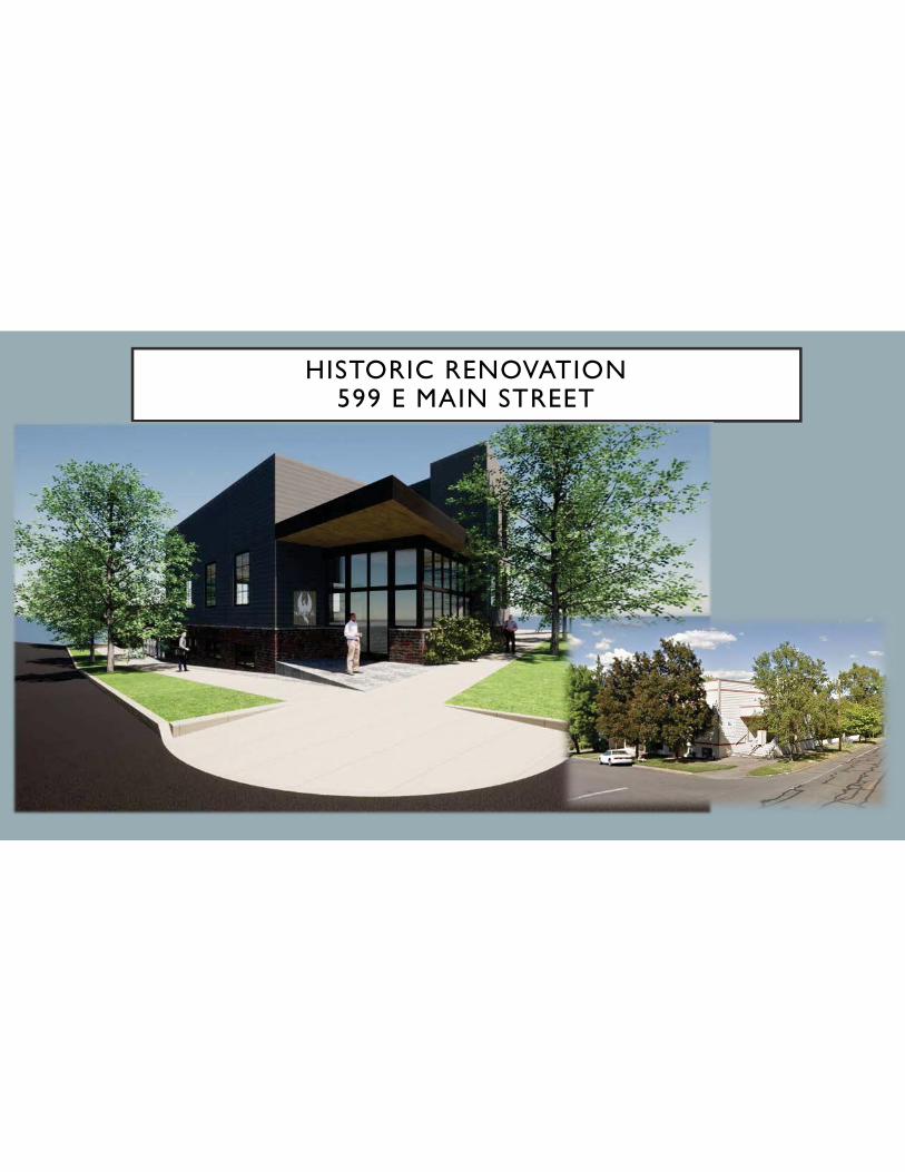
• Historic Renovation 599 E Main Street
• Aerial Photographs
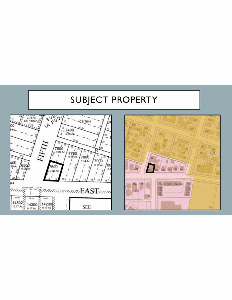
• Subject Property
• Site Plan
• Existing Structure
• Rendering

Ashland Planning Commission
April 13, 2021 Page 5 of 6
• North Elevation E Main Street
• East Elevation
• South Elevation
• Conclusion The occupancy numbers for the 1,892 sq. ft. sanctuary area was 270, 126 if seated. They were not trying to achieve those occupancy ratings. When comparing the proposed use to the envisioned use of a 1,740 sq. ft. retail space, half of the square footage of the floor area on the property, they believed it could be shown that the impacts were substantially less. Impacts in commercial zones like hours of operation were typically longer than an office type of use. The noise associated with a commercial retail business was a higher number of trips. It was similar throughout the week and increased on the weekend. There should not be greater impacts on the livability of the impact area due to less traffic generation, hours of operation and number of people accessing and leaving the site would be less. Of the areas within the impact area, eight were commercially zoned properties even though they were residential uses. They were not comparing their application to the church but could not ignore that it was a church for 110 years. If they compared a commercial use allowed in the zone, as a permitted use, it could be found as less of an impact. For the office, people may bike or walk instead of drive. The site had a walk score of 91 and 84 for bicycling. The use in the zone was retail but should also compare to the economic element of the Comprehensive Plan and the adaptive reuse of the property supported by Chapter VII. The Economy and supported by the goals. Policy 5 under Goal 7 also applied. The property could not be used for any permitted or special use due to the existing construction of the historic building. This proposal met the criteria. It would have less of an impact on the livability of the area as an office instead of a retail establishment or a church. Mr. Livni clarified assembly or events applied to the people using the office only. A game programming company was interested in renting the space. Once every six to twelve months, they would host a gaming event. Those would be the only events occurring in the space. He provided additional history on the properties. The second property needed the parking. That was why they were doing it separately. The game programming company would bring a lot of business and other industries to Ashland. Questions of the Applicant Commissioner Pearce commented the building use was proposed for office space and questioned why they were proposing it for assembly use. If it was an office use only, they could still do events as an accessory to office use. Mr. Livni wanted to ensure the gaming company would not be prohibited from hosting gaming events. Commissioner Pearce noted assembly use was entertainment use and could be rented for a variety of events. Ms. Gunter explained they indicated both uses due to the limitations in the land use ordinance descriptions and business code. The building code had different occupancy ratings as the type of use changed so did the number of bodies. Commissioner Harper supported staff wanting a continuance. He asked Ms. Gunter for clarification that as a church, it may have been under parked by 20 spaces and as an office, it would remain under twenty spaces indicating no new negative impact. Parking targeted on Sundays was dramatically different to office use being under parked all day every day. Ms. Gunter explained it was misnomer that churches impacted parking one day a week. For instance, weddings did not happen on Sunday. This church had several events occurring throughout the week from feeding the homeless, running support groups as well as a school. Commissioner Harper asked if those activities were reflected in the traffic study. Ms. Gunter replied no, the traffic memo was in response to staff denial based on not comparing it to a permitted use in the zone. The memo still showed the proposed use was less impactful than the permitted use in the zone. Commissioner Pearce read from the Sandow memo that the parking analysis indicated larger meeting gatherings

Ashland Planning Commission
April 13, 2021 Page 6 of 6
typically occurred only a few times a year. Mr. Livni had indicated it would be weekly. Commissioner Pearce thought the traffic analysis underestimated the number of gatherings and uses of the larger space. Ms. Gunter clarified is was 1,900 sq. ft. space within a larger building. Commissioner Pearce noted it was 40% of the building. Mr. Livni further clarified the gaming events would take place a few times a year, not weekly. Commissioner Pearce was comfortable with it if it was always associated with office use. Ms. Gunter suggested a condition of approval that reigned in the ability and the use of that space. Mr. Livni was comfortable adding language that specified events would be associated to the office only. Commissioner Norton asked for confirmation that the events were for testing games only and not tournaments. That the events would be held for research and development with no admission charged to play the games. Mr. Livni confirmed the events were for testing games, not tournaments and would be online. Commissioner Thompson addressed the need for 9 on-street parking spaces to support the office use in excess of the five for the target use. The other lot could be developed commercially. She questioned the impact of granting a CUP without any on-site parking and how on-street parking constrained the rest of the neighborhood. Mr. Livni explained it was currently being used as a shelter but could continue as a church. He did not think he should be penalized for owning both lots. There would never be parking for the front building. Ms. Gunter added the code allowed a reduction in parking up to 50% when preserving a historic building through a Type 1 variance. That would apply to the other properties seeking redevelopment. It could not apply to this property because there was no parking. The other sites were often larger than this property. Most of them have alley access in addition to on-street parking. The lot in the application was the only one without an alley. Public Testimony - None Applicant’s Rebuttal - None Deliberation and Decision Commissioner Harper/Verner m/s to continue the public hearing for PA-T1-2021-00141 to the next regular meeting on May 11, 2021, 2021. DISCUSSION: Commissioner Harper asked the applicant to comment on the staff suggestion to extend the statutory period for 30 days. Ms. Gunter understood there was adequate time but no time for an appeal. She preferred to wait on the extension. It was not necessary at this moment. Commissioner Pearce thought there would be time for potential appeal. Chair Norton agreed. Mr. Severson explained the extension would put it at the deadline. Commissioner Harper wanted to review the traffic study and staff analysis. Commissioner Verner agreed. Chair Norton wanted time so the applicant could submit what they propose to do along with parking data prior to the next meeting. Commissioner Verner added it would be useful for the applicant to draft language about a condition using the gathering space for the existing tenant and provide a certain number of events per year. Commissioner Thompson suggested the applicant clarify whether it was an office use or assembly sue. Ms. Gunter would request a 30-day extension if it helped with the analysis. Staff and the Commission discussed continuing the meeting to the next regular meeting on May 11, 2021. Commissioner Harper amended the motion to continue the matter to next the regular session and leave the record open. Roll Call Vote on amended motion: Commissioner Pearce, KenCairn, Norton, Thompson, Harper, Verner, and Dawkins, YES. Motion passed. VIII. ADJOURNMENT Meeting adjourned at 8:54 p.m. Submitted by, Dana Smith, Executive Assistant


599 East Main Street
Planning Commission Hearing
April 13, 2021

599 East Main StreetRequest
The application requests:
Site Design Review approval to modify the existing building at 599 East Main Street, including adding a new corner entry.
Conditional Use Permit approval for the alteration of an existing non-conforming development where no off-street parking is available. Alterations proposed involve separating two properties making up the church campus and changing the use from a church to office and assembly space.
Street Tree Removal Permit approval to remove and replace two Callery Pear street trees (10.2-inch & 12.7-inch DBH) in the park row planting strip along East Main Street.

599 East Main StreetVicinity Map
48 Fifth St.
T.L. #7500
Fellowship Hall
599 E. Main St.
T.L. #7600
Sanctuary

599 East Main StreetSite & Proposal
The subject property is 3,484 square feet in area and is located at the northeast corner
of East Main and Fifth Streets, within the C-1 ‘Commercial’ zoning district and the
Ashland Railroad Addition Historic District, Detail Site Review and Wildfire Lands overlay
zones. The existing 4,628 square foot building previously contained the sanctuary and
church offices for the Christian Life Fellowship Foursquare Church.
The church campus included two tax lots: the subject Tax Lot #7600 at 599 East Main
Street fronting on East Main Street and containing the sanctuary with no off-street
parking, and Tax Lot #7500 behind it at 48 Fifth Street containing the fellowship hall,
which was added in 1993-94, along with three to four* off-street parking spaces. The
campus is considered a ‘non-conforming development’ because it lacks the full amount
of required off-street parking to serve the church use, which was established before
there were parking requirements.
The current application looks at Tax Lot #7600 with the sanctuary building independently
of Tax Lot #7500, and seeks to remodel the building and add a new corner entry to
convert it to a modern office building which could also be used by office tenants to host
trade shows, conferences and meetings.

599 East Main StreetImpact Area

599 East Main StreetSite Plan from PA #93-123 (Added Fellowship Hall)
48 Fifth St.
Fellowship Hall
(Non-Historic, Non-Contributing)
599 E. Main St.
Church Sanctuary
(Historic, Non-Contributing)
FIFTH ST
E. M
AIN
ST.
AL
LE
Y
N

599 East Main StreetSite Plan from PA #93-123 (Added Fellowship Hall)
48 Fifth St.
Fellowship Hall
599 E. Main St.
Church Sanctuary
FIFTH ST
E. M
AIN
ST.
AL
LE
Y
N

599 East Main StreetExisting Entry at the Corner of East Main & Fifth Streets

599 East Main StreetLooking down East Main Street from Corner

599 East Main StreetLooking down Fifth Street from corner

599 East Main StreetRear of the Sanctuary Building (Demo to create courtyard)

599 East Main StreetRear of the Sanctuary Building (Demo to create courtyard)

599 East Main StreetExisting rear courtyard area

599 East Main StreetExisting Parking behind 48 Fifth St (Fellowship Hall)

Site Plan
3
599 E. Main St.
Tax Lot #7600
Subject Property
48 F
ifth
St.
Tax L
ot #7500
(not
a p
art)

Floor Plans
Second Floor
First FloorBasement
3
Roof Top
1,892 s.f. Office &
Assembly Space
(former Chapel)
756 s.f.
Office/Storage
1,980 s.f. Office Space
(former classrooms & offices)

Elevation Drawings
Side Elevation (facing neighbors)Side Elevation (facing Fifth Street)
Front Elevation (facing East Main Street)
3
Rear Elevation (facing courtyard)

Elevation Drawings
Side Elevation (facing neighbors)Side Elevation (facing Fifth Street)
Front Elevation (facing East Main Street)
3
Rear Elevation (facing courtyard)
New Entry
AdditionDemo Prior Addition,
Replace Stairs,
Create Add’l Courtyard

Wall Section at Entry
3

Wall Section/Exterior Wall
3

Color Renderings
Rear Courtyard (from Fifth Street)
Renderings from Corner
4
Rendering from East Main Street

599 East Main StreetParking Information in Packets (From 2013)
Even in periods of
peak demand in the
downtown, the
subject property
and surrounding
area seem to be
just distant enough
that on-street
parking remained
available.

599 East Main StreetHistoric Commission April 2021 Recommendations
The Historic Commission commended the applicant on the design and effort to remodel and repurpose a historic
structure that has been significantly modified over time. The Commission expressed their appreciation for the
added stucco element on the east side of the building to add definition to the “tower” element as discussed at the
March 3, 2021 Historic Commission meeting. The Historic Commission recommends the following items be
addressed as conditions of approval:
For the base of the building, the Historic Commission recommended one of following three options:
O Provide detail showing “veneer brick cladding” shown on the revised elevations SD-4.1, SD-4.2 and
SD-4.3 will fit properly around the window and door openings. The “brick cap course” needs to be
more substantial and a heavier weight than shown in the submittals. Extend the brick base around the
back corner of the building on the Fifth Street side (NW corner) for at least a column width. o Rather than extending veneer brick cladding on the Fifth Street side of the building, use it to accent the
front entry and end brick at the north side of the main entrance facing the intersection of E. Main and
5th St. Brick should be on east side of tower as shown in the revised elevation SD-4.1. The “brick cap
course” needs to be more substantial and a heavier weight than shown in the submittals. o Retain stucco as the base material rather than adding the veneer brick cladding.
Replace all windows with True Divided Light Clad Windows shown on revised elevations including the east side of the building (SD- 4.1) unless prohibited by building code (e.g. due to proximity to property line).
Replace all siding as shown on revised elevations (Hardie® lap siding with 7” exposure) including the east
side of the building (SD- 4.1) unless prohibited by building code (e.g. proximity to property line).

599 East Main StreetTree Commission March 2021 Recommendations
Street Tree Removal Permits are ministerial permits subject to review under section 13.06.030 rather than the
Land Use Ordinance, and typically don’t come to the Planning Commission. They are included here to
consolidate application proposals as allowed in the code.
The application proposes to remove two Callery Pear street trees in the planting strip along East Main Street. The
application explains that the trees have been in place for more than 30 years and haven’t shown substantial
growth, and describes pears as a poor landscape choice in a valley with a commercial pear industry where poorly
maintained pear trees could be a vector for pests or disease. The Tree Commission recommended approval of
the request if the removals were mitigated with new irrigated trees at least two-inch caliper at planting and
selected to achieve a large stature at maturity. Tree Commissioners specifically recommended “Autumn Blaze” or
“Red Flame” maples as good mitigation choices.

599 East Main StreetSite Design Review
The application involves a new addition in the C-1 zone in the form of the proposed new entryoriented to the corner, and as such requires Site Design Review approval as detailed in AMC18.5.2.020.A.1. . The building and site improvements are existing, and as such the requested SiteDesign Review is limited to consideration of the proposed changes (exterior treatment, changesto the rear of the building to create additional courtyard space and add new stairs, and theaddition of a new corner entry element) as they relate to the applicable criteria and standardsincluding the Building Placement, Orientation & Design Standards for Non-ResidentialDevelopment and the Historic District Development Standards.
The Historic Commission was appreciative of the applicant’s efforts and supportive of therequest, subject to three recommendations, and staff believe that the changes proposedsignificantly improve the building’s orientation and relationship to the street.

599 East Main StreetNon-Conforming Situations (Purpose & Applicability)
AMC 18.1.4.010
Chapter 18.1.4 contains standards and procedures for the continuation of uses,
structures, developments and lots that are lawfully established but do not comply with
current ordinance standards (“nonconforming situations”). The chapter is intended to
protect public health, safety, and general welfare, while allowing reasonable use of
private property. Nonconforming situations are not necessarily considered a
negative influence on a neighborhood; rather the benefits of continuing a
nonconformity should be weighed against impacts to the neighborhood. The
chapter contains four sections as follows:
A. Nonconforming uses (e.g., commercial use in a residential zone) are subject
to section 18.1.4.020; [Church use in C-1 is a CUP.]
B. Nonconforming structures* (e.g., structure does not meet setback standards)
are subject to section 18.1.4.030; [Solar access - not changing; Orientation.]
C. Nonconforming developments* (e.g., site does not meet landscaping
standards) are subject to section 18.1.4.040; [Landscaping, Parking]
D. Nonconforming lots (e.g., lot smaller than minimum area standard) are
subject to section 18.1.4.050. [No minimum lot size in C-1.]
599 East Main StreetNon-Conforming Development - Parking
Staff Parking Calculation Based on Photos & Applicant’s Narrative16 rows X 7 chairs = 112 seats/4 seats per parking space = 28 off-street spacesCircle of chairs appears to have 27 seats/4 seats per parking space = 7 off-street spacesThis would equate to 35 off-street parking spaces.Three to four spaces are available on campus, off of the alley behind the old Fellowship Hall, but this lot is not being treated as part of the current request.
Applicant: 56-61
spaces based on
church use

599 East Main StreetNon-Conforming Developments (AMC 18.1.4.040)
A. Exempt Alterations. Repair and maintenance of a nonconforming development(e.g., paved area, parking area, landscaping) are allowed subject to approval of requiredbuilding permits if the development is not enlarged or altered in a way that brings thenonconforming site less in conformity with this ordinance.
B. Planning Approval Required. A nonconforming development may be enlarged oraltered subject to approval of a Conditional Use Permit under chapter 18.5.4 andapproval of required building permits, except that a planning action is not required forexempt alterations described in subsection 18.1.4.040.A, above, and for non-residentialdevelopment subject to subsection 18.4.2.040.B.6 (i.e. where non-conformities relativeto design standards are proportionally address through Site Design Review.)

599 East Main StreetConditional Use Permit
The enlargement or alteration of a non-conforming development requires a Conditional
Use Permit which considers the negative impacts of the proposal on the surrounding
neighborhood in comparison to the “target use” of the property intended by its zoning.
Within the Commercial zone and Detail Site Review overlay, the ”target use” of the
property is 1,742 square feet of retail space. In considering a Conditional Use Permit
request here, the Planning Commission needs to consider the generation of traffic and
effects on surrounding streets for a 4,628 square foot building with office space and the
ability to host trade shows, conferences and meetings on a property with no off-street
parking in comparison with the target 1,742 square foot retail use which would include
five required off-street parking spaces on the property.
* * *
AMC 18.5.4.050.A.3 “That the conditional use will have no greater adverse materialeffect on the livability of the impact area when compared to the development of thesubject lot with the target use of the zone, pursuant with subsection 18.5.4.050.A.5,below. When evaluating the effect of the proposed use on the impact area, the followingfactors of livability of the impact area shall be considered in relation to the target use ofthe zone… b. Generation of traffic and effects on surrounding streets. Increases inpedestrian, bicycle, and mass transit use are considered beneficial regardless ofcapacity of facilities.

599 East Main StreetAlteration of a Non-Conforming Development?
Is a Conditional Use Permit (CUP) Necessary Here?
• Required if non-conforming development is “altered or enlarged”.• “Altered” or “Enlarged” are not specifically defined relative to this section.• Alterations here are:
o Separating the two lots that previously made up the church campus – one of which contained the 3-4 off-streetparking spaces available. (NOTE: The applicant asserts two lots were historically separate to begin with, and whencombined, parking was not required for the Fellowship Hall although it was installed and has been in place andavailable since 1994 (i.e. almost 30 years).)
o Changing the use from the previous church use to the proposed office/assembly space.• Here the combination of two changes – separating the two lots to remove what little parking was installed on church
campus from consideration, and changing the use – seemed to staff to constitute alteration of the non-conforming development.
For staff, we were unable to make a definitive determination of whether the proposed alteration rendered the development lessconforming with parking requirements because:
1) The application lacks sufficient detail about the parameters of the proposed assembly use (frequency, duration, number ofattendees, etc.), and
2) The application lacks sufficient analysis of the traffic and parking generation of the proposed uses, and absent that analysis staffdid not feel the burden of proof was clearly satisfied to say the proposal did not require a CUP. Similarly, staff could notadequately assess the adverse material impacts of the proposal without more detailed information and analysis.
With more detailed information and analysis, it may well be possible to determine that the proposal does not intensify the non-conformity and thus does not require a conditional use permit, or that while a CUP is needed, the adverse material impacts wouldnot exceed those expected with the target retail use.

599 East Main StreetSite Plan from PA #93-123 (Adding Fellowship Hall)
48 Fifth St.
Fellowship Hall
599 E. Main St.
Church Sanctuary
FIFTH ST
E. M
AIN
ST.
AL
LE
Y
N

599 East Main StreetStaff Recommendation
The application’s approach is essentially that the proposal is not an intensification but a
decrease in occupancy as any future assembly use will be limited by building code
occupancy allowances to a lesser parking demand than the peak demand for church
assembly uses, and speaks to the Conditional Use Permit criteria on that basis.
For staff, the change in use combined with separating the two church properties that
have been part of the campus together since 1994 - and specifically removing the 3-4
parking spaces provided on campus in the years since - represented an alteration, and
for staff the issue of whether the non-conformity is increased through that alteration is
more nuanced and needs to consider the separation of the two properties and loss of
the few existing parking spaces, the actual parking demand for the prior church use, and
whether the peak parking and trip generation of the combined office and assembly uses
will have more impact than the church use and whether they compare favorably to the
target retail use to merit Conditional Use Permit approval.

599 East Main StreetStaff Recommendation (cont’d)
Staff recognizes that allowing the modification of non-conforming developments is vitallyimportant in maintaining viable options for the adaptive re-use of properties that developedprior to current standards like the property here – particularly in the historic districts – and wefurther believe that the exterior modifications proposed represent substantial improvements tothe existing building. We’re strongly supportive of finding an option for re-use of this propertythat is beneficial to the applicant, the surrounding historic district and the broader community.
Ultimately however, staff did not believe there was sufficient detail provided with regard toparking and trip generation to meet the burden of proof in determining whether the proposalamounts to an intensification, and if so, to demonstrate that there would be no greater adversematerial impact to the surrounding neighborhood than the target retail use, and as such staffcannot support the application with the level of detail currently presented.

599 East Main Street
Planning Commission Hearing
April 13, 2021


599 East Main StreetHistoric Survey Document for the Church
HISTORIC RENOVATION599 E MAIN STREET


SUBJECT PROPERTY

SITE PLAN

EXISTING STRUCTURE


NORTH ELEVATION E MAIN STREET

EAST ELEVATION
WEST ELEVATION

SOUTH ELEVATION

CONCLUSION
The Conditional Use Permit is to allow for the expansion of an existing, non-conforming structure on acommercially zoned property that has no parking. The use of the structure was a religious institution, that usepredated the zoning code of the city thus there isn’t a ‘conditional use permit’ approval of the church use of theproperty as require per today’s land development ordinance.
The property has been occupied with a large area, numerous occupancy potential, site filling, church structurefor nearly 100 years. There has never been parking associated with the large area church structure that allowedfor hundreds of occupants.
When comparing the proposed uses to the “envisioned use” as a retail type establishment with less than halfof the floor area, it has been demonstrated in the findings and with the technical memo provided by theTraffic Engineer that the proposed use will generate similar daily trips but less weekend trips and will nothave a greater impact on livability of the impact area.

IMPACT AREA

Ashland Planning Commission
April 27, 2021 Page 1 of 2
ASHLAND PLANNING COMMISSION SPECIAL MEETING
MINUTES - Draft April 27, 2021
I. CALL TO ORDER: Chair Haywood Norton called the meeting to order at 7:00 p.m.
Commissioners Present: Staff Present: Michael Dawkins Haywood Norton Roger Pearce Lynn Thompson Lisa Verner
Bill Molnar, Community Development Director Maria Harris, Planning Manager Dana Smith, Executive Assistant
Absent Members: Council Liaison: Alan Harper Kerry KenCairn
Paula Hyatt
II. ANNOUNCEMENTS Community Development Director Bill Molnar announced the Commission would hear a continued public hearing on 599 East Main Street and a public hearing on the duplex code amendments at their meeting on May 11, 2021. The Housing Capacity Analysis and duplex code amendments would go before City Council at their Study Session on May 17, 2021. At the Planning Commission’s Study Session in June, staff would bring preliminary information on the possibility of increasing housing on employment lands.
III. PUBLIC FORUM - None
IV. DISCUSSION ITEMS
A. Code Amendment Options for State of Oregon Middle Housing (Duplex) Requirements Planning Manager Maria Harris provided a presentation (see attached):
• Two Items
• Opticos Design, Daniel Parolek
• Legislative Timeline
• State Middle Housing Requirements
• Outcomes of Draft Amendments possibly add info on screen
• Definitions of Dwelling Types
• ARU Code Changes
• Duplex Code Changes
• Cope Options
• Items for Next Draft
• Next Steps
• Comments
• Legislative Amendment Commissioner Pearce asked what the land use code issues were converting existing houses to duplexes. Ms. Harris explained there was nothing in the code that would prohibit converting existing structures to duplexes.

Ashland Planning Commission
April 27, 2021 Page 2 of 2
Commissioner Thompson asked why the Historic Overlay requirements were not added to the ARU use. They were applicable to single family dwellings and duplexes. Ms. Harris clarified the maximum permitted floor area in the historic district requirement would apply to a single-family dwelling, ARU, or a duplex in terms of size limitations for floor area. The Historic District design standards did not apply outright to a single-family home and therefore would not apply to duplexes. Commissioner Thompson noted Table 18.2.2.030 Uses Allowed by Zone on page 5 of 73 in the draft code. The language was applicable to single-family dwellings and duplexes that related to the Historic District Overlay but did not include ARU use. Ms. Harris would include ARU use and make it clear. Commissioner Pearce thought the parking management strategies that apply to single-family dwellings should also apply to duplexes. Ms. Harris agreed. They wanted a conservative approach rather than allowing on-street parking credits. Chair Norton thought a main concern was the parking requirement. They could address potential issues with lot coverage once there were a few projects completed. Commissioner Verner/Pearce m/s to direct staff to initiate the Type III planning application for an ordinance amending Chapters 18.2.2, 18.2.3, 18.2.5, 18.3.4, 18.3.5, 18.3.9, 18.3.12, 18.4.2, 18.4.3, 18.5.2, 18.5.7, and 18.6.1 of the Ashland Land Use Ordinance to amend the allowances and requirements for duplexes as required by House Bill 2001 from the 80th Oregon Legislative Assembly, 2019 Regular Legislative Session. DISCUSSION: Commissioner Pearce read the title into the record. Voice Vote: ALL AYES. Motion passed. V. OTHER BUSINESS – None VI. ADJOURNMENT Meeting adjourned at 7:33 p.m. Submitted by, Dana Smith, Executive Assistant

•Latest draft of duplex code amendments (discussion)
•Initiate a legislative amendment (action)
Two Items
4/27/2021 PC Study Session

Opticos Design, Daniel Parolek• Middle because these housing types sit in the middle of the spectrum between detached single‐family homes and mid‐rise and high‐rise apartment buildings.
Middle Housing
4/27/2021 PC Study Sessio

•House Bill 2001 Middle Housing• effective August 8, 2019•OAR Chapter 660 Division 46 • effective August 7, 2020•Ashland required to amend local code • by June 30, 2021 or the model code is used
Legislative Timeline
4/27/2021 PC Study Session

1. Have to allow duplexes on residentially zoned lots that allow development of detached single‐family dwellings
2. Approval process and standards used for duplexes must not be more restrictive than those applied to detached single‐family dwellings
3. Jurisdictions cannot require off‐street parking and owner‐occupancy requirements for accessory dwelling units (ADUs)
State Middle Housing Requirements
4/27/2021 PC Study Session

Accessory Residential Unit (ARU)• Must meet existing size limitations• No on‐site parking spaces required• Permitted with approval of building permit
Duplex• Two units on a lot, in attached or detached structures• Two on‐site parking spaces required• On‐street parking credits not permitted• Permitted with approval of building permit
Outcomes of Draft Amendments
4/27/2021 PC Study Session

• Number of units determines type of dwellingSingle‐family dwelling – 1 dwelling on 1 lotARU – 2 dwellings on 1 lot w/2nd dwelling meeting size requirementsDuplex – 2 dwellings on 1 lotMultifamily dwelling – 3 or more dwellings on 1 lot
Definitions of Dwelling Types
4/27/2021 PC Study Session

Accessory Residential Unit (ARU)• ARU definition differentiated from duplex by size requirements
• No on‐site parking spaces required• Approval process is building permit
ARU Code Changes
4/27/2021 PC Study Session

Duplex• Allowed in all residential zones • Define as two units on one lot in any configuration including either in attached or detached structures
• Two on‐site parking spaces required On‐street parking credits not permitted
• Approval process is building permit
Duplex Code Changes
4/27/2021 PC Study Session

•Approval Process for ARUs and DuplexesState rules don’t clearly address process for ARUDriven by how duplex is defined•On‐street parking credits for duplex
Code Options
4/27/2021 PC Study Session

• Building Separation in Multi‐Family Zones½ height of tallest buildingMaximum 12’•Duplex conversions•Nonconforming structures
Items for Next Draft
4/27/2021 PC Study Session

May 5, 2021 Historic CommissionMay 11, 2021 Planning Commission Public Hearing May 17, 2021 City Council Study SessionJune 1, 2021 City Council Public HearingJune 15, 2021 City Council 2nd Reading
Next Steps
4/27/2021 PC Study Session

•Development Roundtable•Housing and Human Services Commission•Written comment
Comments
4/27/2021 PC Study Session

• Initiate a planning application for a legislative amendmentTo amend Ashland Land Use Ordinance to update the allowances and development standards for duplexes and accessory residential units as required by House Bill 2001 form the 2019 Regular Sessio of the Oregon Legislative Assembly
Legislative Amendment
4/27/2021 PC Study Session


TYPE II
PUBLIC HEARING
CONTINUED
_________________________________
PA-T1-2021-00141
599 East Main

OVER
G:\comm-dev\planning\Planning Actions\PAs by Street\E\East Main\EMain_599\EMain_599_PA-T1-2021-00141\Noticing Folder\EMain_599_PA-T1-2021-00141_NOC_Re-Notice_revised 4.5.21.docx
Planning Department, 51 Winburn Way, Ashland, Oregon 97520 541-488-5305 Fax: 541-552-2050 www.ashland.or.us TTY: 1-800-735-2900
NOTICE OF PUBLIC HEARING
PLANNING ACTION: PA-T1-2021-00141 SUBJECT PROPERTY: 599 East Main Street APPLICANT/OWNER: Rogue Planning & Development Services, LLC for Livni Family Trust (Gil Livni, Trustee) DESCRIPTION: A request for Site Design Review approval to modify the existing building at 599 East Main Street including converting the former church to use as office/assembly space and adding a new entry. The application also includes requests for a Conditional Use Permit as it involves the alteration of an existing non-conforming development where no off-street parking is available, and Street Tree Removal Permits to remove and replace two Callery Pear street trees (10.2-inch & 12.7-inch DBH) in the park row planting strip along East Main Street. COMPREHENSIVE PLAN DESIGNATION: Commercial; ZONING: C-1; MAP: 39 1E 09AC; TAX LOT #: 7600 NOTE: The Ashland Historic Commission will review this Planning Action at an electronic public hearing on Wednesday, April 7, 2021 at 6:00
PM. See page 2 of this notice for information about participating in the electronic public hearing.
ELECTRONIC ASHLAND PLANNING COMMISSION MEETING: Tuesday April 13, 2021 at 7:00 PM
Historic Commission Meeting Notice is hereby given that the Historic Commission will hold an electronic public hearing on the above described planning action on the meeting date and time shown on Page 1. If you would like to watch and listen to the Historic Commission meeting virtually, but not participate in any discussion, you can use the Zoom link posted on the City of Ashland calendar website https://www.ashland.or.us/calendar.asp . Anyone wishing to submit written comments can do so by sending an e-mail to [email protected] with the subject line “Advisory Commission Hearing Testimony” by 10:00 a.m. on Monday, April 5, 2021

G:\comm-dev\planning\Planning Actions\PAs by Street\E\East Main\EMain_599\EMain_599_PA-T1-2021-00141\Noticing Folder\EMain_599_PA-T1-2021-00141_NOC_Re-Notice_revised 4.5.21.docx
If the applicant wishes to provide a rebuttal to the testimony, they can submit the rebuttal via e-mail to [email protected] with the subject line “Advisory Commission Hearing Testimony” by 10:00 a.m. on Tuesday, April 6, 2021. Written testimony received by these deadlines will be available for Historic and Tree Commissioners to review before the hearing and will be included in the meeting minutes. Oral testimony will be taken during the electronic public hearing. If you wish to provide oral testimony during the electronic meeting, send an email to [email protected] by 10:00 a.m. on Monday, April 5, 2021. In order to provide testimony at the public hearing, please provide the following information: 1) make the subject line of the email “Advisory Commission Testimony Request”, 2) include your name, 3) specify the date and commission meeting you wish to testify at, 4) specify the agenda item you wish to speak to, 5) specify if you will be participating by computer or telephone, and 6) the name you will use if participating by computer or the telephone number you will use if participating by telephone. In compliance with the American with Disabilities Act, if you need special assistance to participate in this meeting, please contact the City Administrator’s office at 541-488-6002 (TTY phone number 1-800-735-2900). Notification 72 hours prior to the meeting will enable the City to make reasonable arrangements to ensure accessibility to the meeting. (28 CFR 35.102.-35.104 ADA Title I).
SITE DESIGN AND USE STANDARDS (AMC 18.5.2.050) The following criteria shall be used to approve or deny an application:
Notice is hereby given that the Ashland Planning Commission will hold an electronic public hearing on the above described planning action on the meeting date and time shown above. You can watch the meeting on local channel 9, on Charter Communications channels 180 & 181, or you can stream the meeting via the internet by going to rvtv.sou.edu and selecting ‘RVTV Prime.’ The ordinance criteria applicable to this planning action are attached to this notice. Oregon law states that failure to raise an objection concerning this application, or failure to provide sufficient specificity to afford the decision makers an opportunity to respond to the issue, precludes your right of appeal to the Land Use Board of Appeals (LUBA) on that issue. Failure to specify which ordinance criterion the objection is based on also precludes your right of appeal to LUBA on that criterion. Failure of the applicant to raise constitutional or other issues relating to proposed conditions of approval with sufficient specificity to allow this Commission to respond to the issue precludes an action for damages in circuit court. Because of the COVID-19 pandemic, application materials are provided online and written comments will be accepted by email. Alternative arrangements for reviewing the application or submitting comments can be made by contacting (541) 488-5305 or [email protected]. A copy of the application, including all documents, evidence and applicable criteria relied upon by the applicant, and a copy of the staff report will be available on-line at www.ashland.or.us/PCpackets seven days prior to the hearing. Copies of application materials will be provided at reasonable cost, if requested. Under extenuating circumstances, application materials may be requested to be reviewed in-person at the Ashland Community Development & Engineering Services Building, 51 Winburn Way, via a pre-arranged appointment by calling (541) 488-5305 or emailing [email protected]. Anyone wishing to submit comments can do so by sending an e-mail to [email protected] with the subject line “April 13 PC Hearing Testimony” by 10:00 a.m. on Monday, April 12, 2021. If the applicant wishes to provide a rebuttal to the testimony, they can submit the rebuttal via e-mail to [email protected] with the subject line “April 13 PC Hearing Testimony” by 10:00 a.m. on Tuesday, April 13, 2021. Written testimony received by these deadlines will be available for Planning Commissioners to review before the hearing and will be included in the meeting minutes. Oral testimony will be taken during the electronic public hearing. If you wish to provide oral testimony during the electronic meeting, send an email to [email protected] by 10:00 a.m. on Tuesday, April 13, 2021. In order to provide testimony at the public hearing, please provide the following information: 1) make the subject line of the email “April 13 Speaker Request”, 2) include your name, 3) the agenda item on which you wish to speak on, 4) specify if you will be participating by computer or telephone, and 5) the name you will use if participating by computer or the telephone number you will use if participating by telephone. In compliance with the American with Disabilities Act, if you need special assistance to participate in this meeting, please contact the City Administrator’s office at 541-488-6002 (TTY phone number 1-800-735-2900). Notification 72 hours prior to the meeting will enable the City to make reasonable arrangements to ensure accessibility to the meeting. (28 CFR 35.102.-35.104 ADA Title I). If you have questions or comments concerning this request, please feel free to contact Derek Severson at 541-488-5305 or [email protected]

G:\comm-dev\planning\Planning Actions\PAs by Street\E\East Main\EMain_599\EMain_599_PA-T1-2021-00141\Noticing Folder\EMain_599_PA-T1-2021-00141_NOC_Re-Notice_revised 4.5.21.docx
A. Underlying Zone: The proposal complies with all of the applicable provisions of the underlying zone (part 18.2), including but not limited to: building and
yard setbacks, lot area and dimensions, density and floor area, lot coverage, building height, building orientation, architecture, and other applicable standards.
B. Overlay Zones: The proposal complies with applicable overlay zone requirements (part 18.3). C. Site Development and Design Standards: The proposal complies with the applicable Site Development and Design Standards of part 18.4, except as
provided by subsection E, below. D. City Facilities: The proposal complies with the applicable standards in section 18.4.6 Public Facilities and that adequate capacity of City facilities for water,
sewer, electricity, urban storm drainage, paved access to and throughout the property and adequate transportation can and will be provided to the subject property.
E. Exception to the Site Development and Design Standards: The approval authority may approve exceptions to the Site Development and Design Standards of part 18.4 if the circumstances in either subsection 1 or 2, below, are found to exist.
1. There is a demonstrable difficulty meeting the specific requirements of the Site Development and Design Standards due to a unique or unusual aspect
of an existing structure or the proposed use of a site; and approval of the exception will not substantially negatively impact adjacent properties; and approval of the exception is consistent with the stated purpose of the Site Development and Design; and the exception requested is the minimum which would alleviate the difficulty.; or
2. There is no demonstrable difficulty in meeting the specific requirements, but granting the exception will result in a design that equally or better achieves the stated purpose of the Site Development and Design Standards.
CONDITIONAL USE PERMITS (AMC 18.5.4.050.A) A Conditional Use Permit shall be granted if the approval authority finds that the application meets all of the following criteria, or can be made to conform through the imposition of conditions. 1. That the use would be in conformance with all standards within the zoning district in which the use is proposed to be located, and in conformance with
relevant Comprehensive plan policies that are not implemented by any City, State, or Federal law or program. 2. That adequate capacity of City facilities for water, sewer, electricity, urban storm drainage, paved access to and throughout the development, and adequate
transportation can and will be provided to the subject property. 3. That the conditional use will have no greater adverse material effect on the livability of the impact area when compared to the development of the subject
lot with the target use of the zone, pursuant with subsection 18.5.4.050.A.5, below. When evaluating the effect of the proposed use on the impact area, the following factors of livability of the impact area shall be considered in relation to the target use of the zone.
a. Similarity in scale, bulk, and coverage. b. Generation of traffic and effects on surrounding streets. Increases in pedestrian, bicycle, and mass transit use are considered beneficial regardless of
capacity of facilities. c. Architectural compatibility with the impact area. d. Air quality, including the generation of dust, odors, or other environmental pollutants. e. Generation of noise, light, and glare. f. The development of adjacent properties as envisioned in the Comprehensive Plan. g. Other factors found to be relevant by the approval authority for review of the proposed use.
4. A conditional use permit shall not allow a use that is prohibited or one that is not permitted pursuant to this ordinance. 5. For the purposes of reviewing conditional use permit applications for conformity with the approval criteria of this subsection, the target uses of each zone
are as follows…
d. C-1. The general retail commercial uses listed in chapter 18.2.2 Base Zones and Allowed Uses, developed at an intensity of 0.35 floor to area ratio, complying with all ordinance requirements; and within the Detailed Site Review overlay, at an intensity of 0.50 floor to area ratio, complying with all ordinance requirements.
PERMISSION TO PLANT OR REMOVE STREET TREES (AMC 13.16.030) The City encourages the planting of appropriate trees. No trees shall be planted in or removed from any public planting strip or other public property in the City until a permit has been issued by the City Administrator or a duly authorized representative. Applicants for a removal permit may be required to replace the tree or trees being removed with a tree or trees of comparable value. If the tree is determined to be dead or dying, then the replacement need be no larger than the minimum described in this chapter. The replacement tree(s) shall be of a size specified in the permit and no smaller than eight feet in height or one inch in caliper 12 inches above root crown and shall be an appropriate species selected from and planted according to the Recommended Street Tree List.

Department of Community Development Tel: 541-488-5305
51 Winburn Way Fax: 541-552-2050
Ashland, Oregon 97520 TTY: 800-735-2900
www.ashland.or.us
Memo
DATE: May 11, 2021
TO: Planning Commission
FROM: Derek Severson, Senior Planner
RE: PA-T1-2021-00141
599 East Main Street
Request & Background On April 13, 2021 the Planning Commission opened the public hearing to consider a request for Site
Design Review approval to modify the existing building at 599 East Main Street by allowing a change in
use from the previous church to a proposed office/assembly use with renovations to include adding a
new entry. The application also included requests for a Conditional Use Permit to alter the existing non-
conforming development where no off-street parking is available, and for Street Tree Removal Permits to
remove and replace two Callery Pear street trees along East Main Street. New materials were presented
by the applicant shortly before the hearing begain in the form of a Technical Memo prepared by Sandow
Engineering to address trip generation and parking issues that were raised in the staff report, and the
Commission ultimately continued the hearing to the next regular meeting on May 11, 2021 to allow a
more thorough review and analysis of the new Technical Memo provided.
Additional Information Provided Since the April meeting, the applicant has also provided a 30-day extension of the timeline and additional
written findings incorporating reference to the April 13th Technical Memo.
Written comments were also received from Thaddeus Randall whose mother resides in the notice area at
41 Fifth Street, across Fifth Street from the Fellowship Hall.
Staff Analysis & Recommendation Technical Memo
Trip Generation As illustrated in the table below, the Technical Memo concludes that based on the ITE Trip Generation
Manuals, 10th Edition, the proposed office use has less of a trip generation impact to the neighborhood
than either the previous church or the target retail use of the zone.
USE PM PEAK HOUR TRIPS SATURDAY PEAK HOUR TRIPS SUNDAY PEAK HOUR TRIPS
Previous Church 7 99 271
Proposed Office 11 2 1
Target Retail 27 25 37

Department of Community Development Tel: 541-488-5305
51 Winburn Way Fax: 541-552-2050
Ashland, Oregon 97520 TTY: 800-735-2900
www.ashland.or.us
The Technical Memo further notes that with regard to the proposed assembly use, occasional gatherings
would be associated with the office tenant. These would be accessory to and part of the regular operations
of the office tenant, and would only occur a few times a year. The Technical Memo explains that the
target retail use could similarly see occasional gatherings in the form of sales, product launches, holiday
parties, etc. and as such these gatherings accessory to the primary use would be negligible in comparing
the proposed office and target retail uses.
Parking The Technical Memo provided further looks at the likely distribution of parking demand based on the ITE
Parking Generation Manual, 6th Edition, explaining that there is ample on-street parking available within
a comfortable walk of the site. The memo explains that peak demand for the previous church use was
between 9:00 a.m. and 1:00 p.m. on weekends, whereas the proposed office use would typically generate
parking demand between 7:00 a.m. and 7:00 p.m. on weekdays with the peak demand between 11:00 a.m.
and 12:00 noon and again between 4:00 p.m. and 5:00 p.m. There would be little or no parking demand
on weekends for the proposed office use. The target retail use would have parking demand every day,
with a peak between 12:00 noon and 1:00 p.m. The Technical Memo suggests that because the
surrounding uses are largely residential, their periods of peak demand are from 7:00 p.m. to 7:00 a.m. on
weekdays but they also generate consistently high demand on weekends. The memo concludes that the
peak parking demand periods for both the proposed office use and the surrounding residential uses are
effectively offset so as not to be in conflict (i.e. office parking demand is highest when surrounding
residential demand is lowest) whereas the peak retail parking demand overlaps the peak residential
parking demand meaning that the proposed use would be less impactful to the surrounding area in terms
of parking demand than would either the target retail use, or the prior church use.
In staff’s assessment, the Technical Memo supports a finding that in terms of parking and trip generation,
the proposed office use can be found to generate fewer peak hour trips than the target retail use of the
property and to generate peak parking demands which are materially offset from the surrounding
residential neighborhood so that, while the office use is proposed to rely entirely on on-street parking, it
would do so at times when on-street demand from residential uses in the neighborhood is at its lowest and
thus limit the adverse impacts to the surrounding neighborhood.
Applicant’s Findings
The applicant has provided additional written findings which incorporate the conclusions of the Technical
Memo.
Neighbor’s Comments
Thaddeus Randall provided written comments for his 86-year old mother, who lives across Fifth Street
from the subject property. He suggests that the proposal will have a direct impact on his mother and her
home, and expresses concern with the amount of traffic and increase in noise that could be created by the
proposed use, including on-street parking impacts and construction noise. He also questions if the City
will be allowing the property to become commercially zoned. Staff have explained to Mr. Randall that
the property is already zoned C-1, and that the Commission’s review is looking specifically at the proposed
office use in light of the potential parking and traffic impacts, as well as other adverse material impacts to
the neighborhood. Staff have also conveyed the allowances for noise associated with construction or
repair of buildings contained in AMC 9.08.170.D.6, which allow construction noise in the city to occur
between 7:00 a.m. and 7:00 p.m. on weekdays, and between 8:00 a.m. and 6:00 p.m. on weekends and
holidays.

Department of Community Development Tel: 541-488-5305
51 Winburn Way Fax: 541-552-2050
Ashland, Oregon 97520 TTY: 800-735-2900
www.ashland.or.us
Staff Recommendation As initially proposed, the application sought approval to allow the 4,630 square foot building to be used
as office space, with 1,900 square feet of that space to also retain the ability to be used as assembly space
for “conferences, trade shows and meetings.” Consideration of the proposed office space was generally
straightforward, with one off-street parking space required for each 500 square feet of office space the
4,630 square foot building requires ten off-street parking spaces. The issue of assembly use was less clear.
While “public assembly” is listed with a parking ratio of one off-street parking space per four seats, there
is no specific parking ratio for a trade show or conference venue, and neither of these uses is listed as
permitted in the C-1 zone. The initial application materials were unclear and at times contradictory,
describing the assembly use as simply accessory to the office use, but suggesting that the property owner
was also seeking to retain the full range of uses permitted within the C-1 zone such as “entertainment”
without providing clear details of the number and frequency of assembly events or the number of potential
attendees. Staff’s initial lack of support was based on there being insufficient detail to clearly and fully
assess the adverse material impacts of the proposal in getting to a finding that the application satisfied the
Conditional Use Permit criteria.
The Technical Memo and subsequent comments by the applicant during the hearing however make clear
that the proposed assembly use is to be accessory to the office use and associated with the office tenant
rather than separate stand-alone functions, and that any sort of larger office-associated events would occur
no more than once a quarter. With the Technical Memo’s clarification that the proposed use is limited to
office and those accessory components that can reasonably be expected with office use, and the clear and
detailed comparison of the parking and trip generation impacts of the proposed office use versus the target
retail use of the property, staff believes that a finding can be made that the proposal satisfies the applicable
criteria for a Conditional Use Permit and merits approval. Staff believes that the proposal is a reasonable
adaptive reuse of the building; that the renovations represent significant improvements to the site and the
building, which sits at a prominent entry point to the historic neighborhood; that the office use is clearly
less impactful than the previous church; and that the Planning Commission could reasonably find that the
proposed office use generates fewer peak hour trips than the target retail use of the property, and generates
peak parking demands which are materially offset from the surrounding residential neighborhood so that,
while the office use relies on on-street parking, it would do so at times when on-street demand from
residential uses in the neighborhood is at its lowest and as such would have less adverse effect on the
impact area, whereas the target retail use would at times have periods of peak parking demand and trip
generation that were in conflict with the periods of peak demand for the neighborhood.
Staff believes that the Commission may however wish to consider the proposed separation of the former
Sanctuary and Fellowship Hall buildings in terms of parking. The church campus has been a non-
conforming development with only three parking spaces in place off of the alley since the early 1990’s,
and in staff’s view the Commission could require that the applicant, who owns the two contiguous parcels,
provide a shared parking agreement so that these spaces continue to be available to serve the parking
demand for both properties. Whether or not the Commission decides to require such a shared parking
agreement, the parking spaces were originally shown in the 1993 Site Review application to be accessed
diagonally off of the alley to allow for a functional back-up movement and were subsequently required to
include a handicapped accessible space with appropriate signage and accessible route as part of the
building permit approval. The spaces are noted in the applicant’s current site plan as being perpendicular
to the alley, and given limited back-up space and the lack of striping, staff have observed multiple
occasions where the spaces function on site as a single parallel space. The required accessible space has
not been installed. A condition is therefore recommended to require that the spaces be better delineated

Department of Community Development Tel: 541-488-5305
51 Winburn Way Fax: 541-552-2050
Ashland, Oregon 97520 TTY: 800-735-2900
www.ashland.or.us
to correspond to the approved diagonal configuration illustrated in PA-1993-00123, and that the accessible
parking space with signage and accessible route required in the subsequent 1994 building permit be
provided if required under current building codes.

PA-T1-2021-00141
May 11, 2021
Page 1
DRAFT - BEFORE THE PLANNING COMMISSION – DRAFT
May 11, 2021
IN THE MATTER OF PLANNING ACTION #PA-T1-2021-00141, A REQUEST FOR )
SITE DESIGN REVIEW APPROVAL TO MODIFY THE EXISTING BUILDING AT )
599 EAST MAIN STREET INCLUDING CONVERTING THE FORMER CHURCH TO )
A MODERN OFFICE BUILDING AND ADDING A NEW ENTRY . THE APPLI- )
CATION ALSO INCLUDES REQUESTS FOR A CONDITIONAL USE PERMIT AS IT )
INVOLVES THE ALTERATION OF AN EXISTING, NON-CONFORMING DEVELOP-) DRAFT
MENT WHERE NO OFF-STREET PARKING IS AVAILABLE, AND STREET TREE ) FINDINGS,
REMOVAL PERMITS TO REMOVE AND REPLACE TWO CALLERY PEAR STREET) CONCLUSIONS,
TREES (10.2-INCH AND 12.7-INCH DIAMETER AT BREAT HEIGHT) IN THE PARK ) & ORDERS
ROW PLANTING STRIP ALONG EAST MAIN STREET. )
)
APPLICANT/OWNERS: Rogue Planning & Development Services, LLC/ )
Livni Family Trust (Gil Livni, trustee) )
)
--------------------------------------------------------------------------------------------------------------
RECITALS:
1) Tax lot #7600 of Map 39 1E 09AC is located at 599 East Main Street and is zoned C-1
(Commercial). The property is also within the Ashland Railroad Addition Historic District, the Detail Site
Review and the Wildfire Lands overlay zones.
2) The applicant is requesting Site Design Review approval to modify the existing building
at 599 East Main Street including converting the former church to use as office space and adding a
new entry. The application also includes requests for a Conditional Use Permit as it involves the
alteration of an existing non-conforming development where no off-street parking is available, and
Street Tree Removal Permits to remove and replace two Callery Pear street trees (10.2-inch & 12.7-inch
DBH) in the park row planting strip along East Main Street. The proposal is outlined in plans on file at
the Department of Community Development.
3) The approval criteria for Site Design Review approval are detailed in AMC 18.5.2.050 as
follows:
A. Underlying Zone: The proposal complies with all of the applicable provisions of the underlying
zone (part 18.2), including but not limited to: building and yard setbacks, lot area and dimensions, density and floor area, lot coverage, building height, building orientation, architecture, and other applicable standards.
B. Overlay Zones: The proposal complies with applicable overlay zone requirements (part 18.3). C. Site Development and Design Standards: The proposal complies with the applicable Site
Development and Design Standards of part 18.4, except as provided by subsection E, below. D. City Facilities: The proposal complies with the applicable standards in section 18.4.6 Public
Facilities and that adequate capacity of City facilities for water, sewer, electricity, urban storm

PA-T1-2021-00141
May 11, 2021
Page 2
drainage, paved access to and throughout the property and adequate transportation can and will be provided to the subject property.
E. Exception to the Site Development and Design Standards. The approval authority may approve exceptions to the Site Development and Design Standards of part 18.4 if the circumstances in either subsection 1 or 2, below, are found to exist.
1. There is a demonstrable difficulty meeting the specific requirements of the Site
Development and Design Standards due to a unique or unusual aspect of an existing structure or the proposed use of a site; and approval of the exception will not substantially negatively impact adjacent properties; and approval of the exception is consistent with the stated purpose of the Site Development and Design; and the exception requested is the minimum which would alleviate the difficulty.; or
2. There is no demonstrable difficulty in meeting the specific requirements, but granting the exception will result in a design that equally or better achieves the stated purpose of the Site Development and Design Standards.
4) The approval criteria for a Conditional Use Permit are detailed in AMC 18.5.4.050.A as follows:
1. That the use would be in conformance with all standards within the zoning district in which the use is proposed to be located, and in conformance with relevant Comprehensive plan policies that are not implemented by any City, State, or Federal law or program.
2. That adequate capacity of City facilities for water, sewer, electricity, urban storm drainage, paved access to and throughout the development, and adequate transportation can and will be provided to the subject property.
3. That the conditional use will have no greater adverse material effect on the livability of the impact area when compared to the development of the subject lot
with the target use of the zone, pursuant with subsection 18.5.4.050.A.5, below.
When evaluating the effect of the proposed use on the impact area, the following factors of livability of the impact area shall be considered in relation to the target use of the zone.
a. Similarity in scale, bulk, and coverage.
b. Generation of traffic and effects on surrounding streets. Increases in pedestrian, bicycle, and mass transit use are considered beneficial regardless of capacity of facilities.
c. Architectural compatibility with the impact area.
d. Air quality, including the generation of dust, odors, or other environmental pollutants.

PA-T1-2021-00141
May 11, 2021
Page 3
e. Generation of noise, light, and glare.
f. The development of adjacent properties as envisioned in the Comprehensive Plan.
g. Other factors found to be relevant by the approval authority for review of the proposed use.
4. A conditional use permit shall not allow a use that is prohibited or one that is not permitted pursuant to this ordinance.
5. For the purposes of reviewing conditional use permit applications for conformity with the approval criteria of this subsection, the target uses of each zone are as follows.
d. C-1. The general retail commercial uses listed in chapter 18.2.2 Base Zones and Allowed Uses, developed at an intensity of 0.35 floor to area ratio, complying with all ordinance requirements; and within the Detailed Site Review overlay, at an intensity of 0.50 floor to area ratio, complying with all ordinance requirements.
5) Non-conforming developments are discussed in the Ashland Municipal Code in AMC
18.1.4.040 as follows:
A. Exempt Alterations. Repair and maintenance of a nonconforming development (e.g., paved area, parking area, landscaping) are allowed subject to approval of required building permits if the development is not enlarged or altered in a way that brings the nonconforming site less in conformity with this ordinance. See also, section 18.3.11.050 related to nonconforming uses in Water Resource Protection zones.
B. Planning Approval Required. A nonconforming development may be enlarged or altered subject to approval of a Conditional Use Permit under chapter 18.5.4 and approval of required building permits, except that a planning action is not required for exempt alterations described in subsection 18.1.4.040.A, above, and for non-residential development subject to subsection 18.4.2.040.B.6.
C. Roadway Access. The owner of a nonconforming driveway approach or access to a public street or highway, upon receiving land use or development approval, may be required as a condition of approval to bring the nonconforming access into conformance with the standards of the approval authority.
D. Destruction. A legal nonconforming development that is damaged by means beyond the owner’s control, such as fire, flood, earthquake, or similar catastrophe, to an extent of 50 percent or more of its replacement cost, may be

PA-T1-2021-00141
May 11, 2021
Page 4
restored or reconstructed within the original three-dimensional building envelope (i.e., relative to coverage, height, setbacks, and other dimensions of the developed area) provided the nonconformity shall not increase.
6) The permission to plant or remove street trees within public right-of-way is considered a
ministerial action, and is discussed in AMC 13.06.030 as follows:
The City encourages the planting of appropriate trees. No trees shall be planted in or removed from any public planting strip or other public property in the City until a permit has been issued by the City Administrator or a duly authorized representative. Applicants for a removal permit may be required to replace the tree or trees being removed with a tree or trees of comparable value.
If the tree is determined to be dead or dying, then the replacement need be no larger than the minimum described in this chapter. The replacement tree(s) shall be of a size specified in the permit and no smaller than eight feet in height or one inch in caliper 12 inches above root crown and shall be an appropriate species selected from and planted according to the Recommended Street Tree List.
7) On April 15, 2020 Governor Kate Brown issued Executive Order #20-16 “Keep Government
Working: Ordering Necessary Measures to Ensure Safe Public Meetings and Continued Operations by
Local Government During Coronavirus (COVID-19) Outbreak.” The Governor’s Order required that
public bodies hold public meetings by telephone, video, or through some other electronic or virtual
means, whenever possible; that the public body make available a method by which the public can listen
to or virtually attend the public meeting or hearing at the time it occurs; that the public body does not
have to provide a physical space for the public to attend the meeting or hearing; that requirements that
oral public testimony be taken during hearings be suspended, and that public bodies instead provide a
means for submitting written testimony by e-mail or other electronic methods that the public body can
consider in a timely manner. The subsequently adopted House Bill #4212 further authorized governing
bodies in Oregon to conduct all public meetings using telephone or video conferencing technology or
through other electronic or virtual means.
8) The Planning Commission, following proper public notice, held an electronic public hearing on
April 13, 2021. In keeping with Executive Order #20-16 and subsequent House Bill #4212, this meeting
was broadcast live on local television channel 9 and on Charter Communications channels 180 & 181,
and was live-streamed over the internet on RVTV Prime at http://www.rvtv.sou.edu. A copy of the
application, including all documents, evidence and applicable criteria relied upon by the applicant, and
a copy of the staff report were made available on-line seven days prior to the hearing. Those wishing to
provide written testimony were able to submit it via e-mail in advance of the hearing, as detailed the
mailed and posted notices, and all written testimony received by the established deadlines was made
available for Commissioners to review before the hearing and was included in the meeting minutes. In
addition, those wishing to participate during the hearing could arrange to provide oral testimony by
making arrangements to do so in advance of the meeting.

PA-T1-2021-00141
May 11, 2021
Page 5
Prior to the closing of the public hearing on April 13, the Planning Commission continued the hearing to
their next regular meeting on May 11, 2021 at 7:00 p.m. to allow for further review and analysis of a
Technical Memo from Sandow Engineering which was submitted into the record by the applicant shortly
before the hearing began.
The Planning Commission reconvened the electronic public hearing on May 11, 2021 at which time written
testimony submitted in advance of the hearing was considered and new oral testimony was presented.
Following the closing of the public hearing and the record, the Planning Commission considered the
materials received and testimony presented and approved the project, subject to a number of conditions
pertaining to the appropriate development of the site.
Now, therefore, the Planning Commission of the City of Ashland finds, concludes and recommends as
follows:
SECTION 1. EXHIBITS
For the purposes of reference to these Findings, the attached index of exhibits, data, and testimony
will be used:
Staff Exhibits lettered with an "S"
Proponent's Exhibits, lettered with a "P"
Opponent's Exhibits, lettered with an "O"
Hearing Minutes, Notices, Miscellaneous Exhibits lettered with an "M"
SECTION 2. FINDINGS & CONCLUSIONS
2.1 The Planning Commission finds that it has received all information necessary to make a decision
based on the application materials, staff report, public testimony and exhibits received.
2.2 The Planning Commission finds that the proposal for Site Design Review, Conditional Use Permit
and Street Tree Removal Permit approvals meets all applicable criteria for Site Design Review described
in AMC 18.5.2.050, for a Conditional Use Permit described in AMC 18.5.4.050.A., and for a Street Tree
Removal Permit described in AMC 13.06.030.
2.3 The Planning Commission concludes that the proposal satisfies all applicable criteria for Site
Design Review approval.
The Planning Commission finds that the application involves a new addition in the C-1 zone, and as
such requires Site Design Review approval as required in AMC 18.5.2.020.A.1. The Planning
Commission further finds that because the building and site improvements are already in place, the
requested Site Design Review is largely limited to consideration of the proposed changes as they relate

PA-T1-2021-00141
May 11, 2021
Page 6
to the applicable criteria and standards. The changes proposed include the addition of a new entry at the
corner, changes to the exterior treatment of the existing building, and the removal and replacement of
the rear stairs and creation of a new rear entry and courtyard space, as well as a proposed interior remodel
and change of use.
The first approval criterion for Site Design Review approval addresses the requirements of the
underlying zone, requiring that, “The proposal complies with all of the applicable provisions of the
underlying zone (part 18.2), including but not limited to: building and yard setbacks, lot area and
dimensions, density and floor area, lot coverage, building height, building orientation, architecture, and
other applicable standards.” The Planning Commission finds that the building and yard setbacks, lot
area and dimensions, density and floor area, lot coverage and building height are existing conditions
which are not changing with the current proposal. The Planning Commission further finds that the
exterior modifications proposed will change the building’s orientation, as the new corner addition with
an atrium and storefront entry creates a stronger orientation the corner as sought in the Building
Placement, Orientation and Design Standards.
The second approval criterion deals with overlay zones, and requires that, “The proposal complies with
applicable overlay zone requirements (part 18.3).” The Planning Commission finds that the property
is located within the Detail Site Review, Ashland Railroad Addition Historic District, and Wildfire
Lands overlay zones.
The Detail Site Review overlay requires that the application address the Detail Site Review Standards
in AMC 18.4.2.040.C. Buildings are required to have a minimum floor area ratio of at least 0.50. In
this instance, the subject property is 3,484 square feet in area and a floor area of at least 1,742 square
feet is required. The Planning Commission finds that the existing building’s 4,630 square feet, which
represents a floor area ratio of approximately 1.32, more than satisfies the minimum floor area ratio
requirement. The Commission further finds that more than 20 percent of the wall area facing the street
is provided in windows and doorways, that there are no blank walls, and that there are substantial
changes in relief on the surface of the existing building. The proposal here improves relief and
fenestration, and adds a new roof extension to provide pedestrian coverage from the rain and sun at the
entry.
Where proposed buildings are greater than 10,000 square feet in gross floor area or contain more than
100 feet of building frontage, the Additional Standards for Large Scale Projects in AMC 18.4.2.040.D
must also be addressed. The Planning Commission finds that in this instance, the existing building is
less than 10,000 square feet in gross floor area and does not have frontages of more than 100 feet, and
as such is not subject to the Additional Standards for Large Scale Projects.
The Historic District Development Standards and Historic Commission review are discussed under part
18.4 below.
The Planning Commission further finds that the subject property is located within the Wildfire Lands
overlay zone, and as such a Fire Prevention and Control Plan addressing the General Fuel Modification
Area requirements in AMC 18.3.10.100.A.2 must be provided for the review of the Fire Marshal prior

PA-T1-2021-00141
May 11, 2021
Page 7
to bringing combustible materials onto the property, and any new landscaping proposed will need to
comply with these standards and shall not include plants listed on the ‘Prohibited Flammable Plant List’
per Resolution #2018-028. A condition to this effect has been included below.
Based on the foregoing, the Planning Commission finds that this first criterion is satisfied.
The third criterion addresses the Site Development and Design Standards, requiring that “The proposal
complies with the applicable Site Development and Design Standards of part 18.4, except as provided
by subsection E, below.”
The Building Placement, Orientation and Design Standards for Non-Residential Development seek
buildings with their primary orientation to the street, and where located at a corner this orientation is to
be to the corner or the higher order street and should include a public entrance to the street with access
from the public sidewalk. The Planning Commission finds that the proposed new entry addition
establishes a much stronger orientation to the corner as envisioned in the standards. In addition, the
standards require the planting of street trees according to city standards along street frontages, and here
the Commission finds that the applicant has proposed to remove trees which are not thriving in the
location and to plant better selected specimens in their place.
The Detail Site Review overlay requires that the application address the Detail Site Review Standards
in AMC 18.4.2.040.C. Buildings are required to have a minimum floor area ratio of at least 0.50. In
this instance, the subject property is 3,484 square feet in area and a floor area of at least 1,742 square
feet is required. The Planning Commission finds that the existing building’s 4,630 square feet, which
represents a floor area ratio of approximately 1.32, more than satisfies the minimum floor area ratio
requirement. The Commission further finds that more than 20 percent of the wall area facing the street
is provided in windows and doorways, that there are no blank walls, and that there are substantial
changes in relief on the surface of the existing building. The Commission finds that the proposal here
improves relief and fenestration, and adds a new roof extension to provide pedestrian coverage from the
rain and sun at the entry.
Where proposed buildings are greater than 10,000 square feet in gross floor area or contain more than
100 feet of building frontage, the Additional Standards for Large Scale Projects in AMC 18.4.2.040.D
must also be addressed. The Planning Commission finds that in this instance, the existing building is
less than 10,000 square feet in gross floor area and does not have frontages of more than 100 feet, and
as such is not subject to the Additional Standards for Large Scale Projects.
In its review of the proposal for compliance with the Historic District Development Standards of AMC
18.4.2.050, the Ashland Historic Commission had three specific recommendations. The Historic
District Development Standards speak to a building’s sense of base or platform in AMC 18.4.2.050.B.8,
noting that, “A clearly defined base, or platform characteristic of historic buildings in the immediate
vicinity (is recommended, and) walls that appear to rise straight out of the ground without a distinct
platform or base at the ground level (are to be avoided).” With regard to the base or platform standards,
the Historic Commission recommended that one of the following design options be pursued:

PA-T1-2021-00141
May 11, 2021
Page 8
Provide detail demonstrating that the “veneer brick cladding” shown on the revised elevations
SD-4.1, SD-4.2 and SD-4.3 will fit properly around the window and door openings. The “brick
cap course” needs to be more substantial and a heavier weight than shown on the application
submittals. Extend the brick base around the back corner of the building on the Fifth Street side
(i.e. the northwest corner) for at least a column width.
Rather than extending the “veneer brick cladding” on the Fifth Street side of the building, use it
to accent the front entry and end the brick at the north side of the main entrance facing the
intersection of East Main and Fifth Streets. Brick should be used on the east side of the tower
as shown in the revised elevation SD-4.1. The “brick cap course” needs to be more substantial
and a heavier weight than shown on the application submittals.
Retain stucco as the base material rather than adding the “veneer brick cladding.
With regard to rehabilitations of historic buildings and additions, the standards in AMC 18.4.2.050.C.2.g
explain that, “Replacement windows in historic buildings shall match the original windows. Windows
in new additions shall be compatible in proportion, shape and size, but not replicate original windows
in the historic building.” The Historic Commission recommended that all windows be replaced with
true divided light clad windows as shown on the applicant’s revised elevations, including on the east
side of the building (SD-4.1) unless modifications to this elevation are prohibited by building code due
to the proximity to the property line.
With regard to siding, the standards for rehabilitations and additions include that, “Replacement finishes
on exterior walls of historic buildings shall match the original finish. Exterior finishes on new additions
to historic buildings shall be compatible with, but not replicate, the finish of the historic building
(18.4.2.050.C.2.c.)”; “Diagonal and vertical siding shall be avoided on new additions or on historic
buildings except in those instances where it was used as the original siding (C.2.d.)”; and “Imitative
materials including but not limited to asphalt siding, wood textured aluminum siding, and artificial stone
shall be avoided (C.2.f.).” The Historic Commission recommended that all siding be replaced as shown
on revised elevations using Hardie® lap siding with a seven-inch exposure, including the east side of
the building (SD-4.1) unless modifications to this elevation are prohibited by building code due to the
proximity to the property line.
In considering the proposal, the Historic Commission expressed their appreciation that the applicant had
added a stucco element on the east side of the building to add definition to the “tower” element as was
initially discussed with the Commission, and commended the applicant both for the proposed design
and for the efforts being made to remodel and repurpose a historic structure that has been significantly
modified over time. The recommendations of the Historic Commission have been incorporated as
requirements in the conditions of approval attached hereto.
Based on the foregoing, the Planning Commission concludes that the proposal complies with the
applicable Site Development and Design Standards for part 18.4.
The fourth approval criterion addresses city facilities, specifically requiring that, “The proposal
complies with the applicable standards in section 18.4.6 Public Facilities and that adequate capacity of
City facilities for water, sewer, electricity, urban storm drainage, paved access to and throughout the

PA-T1-2021-00141
May 11, 2021
Page 9
property and adequate transportation can and will be provided to the subject property.” Water, sanitary
sewer, electric and stormwater facilities are in place from the Fifth Street right-of-way and presently
serve the building, and both East Main Street and Fifth Streets are public streets which are improved
with paving, curb, gutter, sidewalk, storm drain, and park row planting strips in place, with street trees
in place or to be replaced in conjunction with the current proposal. The Planning Commission finds that
there are public facilities in place to serve the existing building, and that no changes to the property are
proposed which would further impact public facilities. The Commission concludes that this criterion
has been satisfied.
The final criterion for Site Design Review approval addresses “Exception to the Site Development and
Design Standards.” The application has requested no exceptions, and as such this criterion does not
apply.
As detailed above, the Planning Commission concludes that the proposal satisfactorily addresses the
requirements for Site Design Review approval.
2.5 The Planning Commission finds that the existing development of the property is considered a
non-conforming development as detailed in AMC 18.1.4.010.C. The existing buildings on the subject
Tax Lot #7600 and the adjacent Tax Lot #7500, which is not part of the current request, have previously
been used as a church which held weekly services with seating for up to 244 churchgoers. The required
off-street parking ratio for a religious institution is one off-street parking space per four seats, and as
such 244 seats would require 61 off-street parking spaces. There are no off-street parking spaces
available on the subject Tax Lot #7600. AMC 18.1.4.040.A provides that repair and maintenance of
non-conforming developments where the development is not altered in a way that brings the
development less into conformity with standards is exempt from land use review, but that the
enlargement or alteration of a non-conforming development is subject to Conditional Use Permit
approval. The Planning Commission finds that the non-conforming development is being altered here
beyond repair and maintenance both by the change in use from the previous church to the proposed
office, and by separating the two contiguous tax lots which together have made up the church campus
since 1993 and instead seeking to consider the future use of each tax lot separately. As such, the request
is subject to Conditional Use Permit approval. The Planning Commission finds that the proposal
satisfies the applicable criteria specific to a Conditional Use Permit.
The first criterion for approval of a Conditional Use Permit is, “That the use would be in conformance
with all standards within the zoning district in which the use is proposed to be located, and in
conformance with relevant Comprehensive plan policies that are not implemented by any City, State, or
Federal law or program.” The proposed office use is an outright permitted use within the C-1 district
as detailed in AMC Table 18.2.2.030.E “Uses Allowed by Zone.” The Planning Commission finds that
the proposed change of use is in keeping with the standards of the district but is more in line with
employment generation sought within the zone, supports preserving a historic building, conserves
energy and materials versus demolishing the existing structure to reconstruct a smaller building with
off-street parking on site, and is in keeping with the goals and policies of the Economic Element of the
Comprehensive Plan in terms of seeking to “ensure the local economy increases its health and
diversifies the number, type and size of businesses consistent with the local social needs, public service
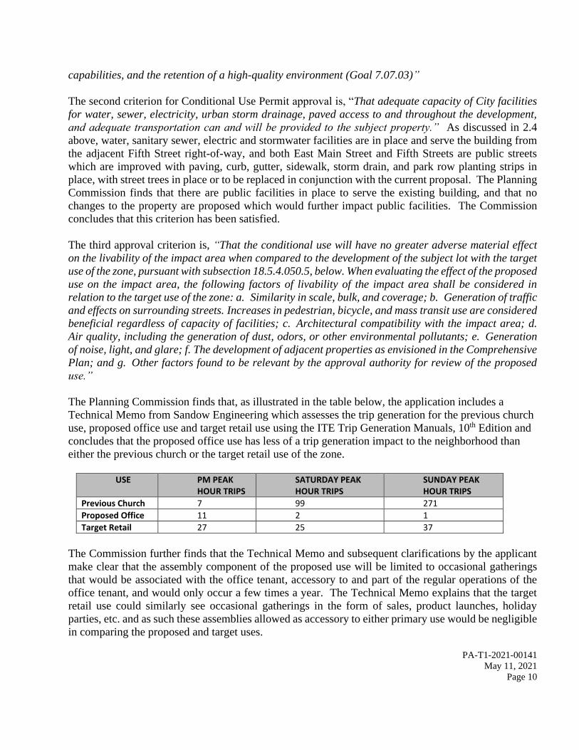
PA-T1-2021-00141
May 11, 2021
Page 10
capabilities, and the retention of a high-quality environment (Goal 7.07.03)”
The second criterion for Conditional Use Permit approval is, “That adequate capacity of City facilities
for water, sewer, electricity, urban storm drainage, paved access to and throughout the development,
and adequate transportation can and will be provided to the subject property.” As discussed in 2.4
above, water, sanitary sewer, electric and stormwater facilities are in place and serve the building from
the adjacent Fifth Street right-of-way, and both East Main Street and Fifth Streets are public streets
which are improved with paving, curb, gutter, sidewalk, storm drain, and park row planting strips in
place, with street trees in place or to be replaced in conjunction with the current proposal. The Planning
Commission finds that there are public facilities in place to serve the existing building, and that no
changes to the property are proposed which would further impact public facilities. The Commission
concludes that this criterion has been satisfied.
The third approval criterion is, “That the conditional use will have no greater adverse material effect
on the livability of the impact area when compared to the development of the subject lot with the target
use of the zone, pursuant with subsection 18.5.4.050.5, below. When evaluating the effect of the proposed
use on the impact area, the following factors of livability of the impact area shall be considered in
relation to the target use of the zone: a. Similarity in scale, bulk, and coverage; b. Generation of traffic
and effects on surrounding streets. Increases in pedestrian, bicycle, and mass transit use are considered
beneficial regardless of capacity of facilities; c. Architectural compatibility with the impact area; d.
Air quality, including the generation of dust, odors, or other environmental pollutants; e. Generation
of noise, light, and glare; f. The development of adjacent properties as envisioned in the Comprehensive
Plan; and g. Other factors found to be relevant by the approval authority for review of the proposed
use.”
The Planning Commission finds that, as illustrated in the table below, the application includes a
Technical Memo from Sandow Engineering which assesses the trip generation for the previous church
use, proposed office use and target retail use using the ITE Trip Generation Manuals, 10th Edition and
concludes that the proposed office use has less of a trip generation impact to the neighborhood than
either the previous church or the target retail use of the zone.
USE PM PEAK
HOUR TRIPS SATURDAY PEAK HOUR TRIPS
SUNDAY PEAK HOUR TRIPS
Previous Church 7 99 271
Proposed Office 11 2 1
Target Retail 27 25 37
The Commission further finds that the Technical Memo and subsequent clarifications by the applicant
make clear that the assembly component of the proposed use will be limited to occasional gatherings
that would be associated with the office tenant, accessory to and part of the regular operations of the
office tenant, and would only occur a few times a year. The Technical Memo explains that the target
retail use could similarly see occasional gatherings in the form of sales, product launches, holiday
parties, etc. and as such these assemblies allowed as accessory to either primary use would be negligible
in comparing the proposed and target uses.

PA-T1-2021-00141
May 11, 2021
Page 11
The Planning Commission finds that Sandow’s Technical Memo further looks at the likely distribution
of parking demand based on the ITE Parking Generation Manual, 6th Edition. Sandow explains that
there is ample on-street parking available within a comfortable walk of the site, and goes on to detail
that the peak parking demand for the previous church use was between 9:00 a.m. and 1:00 p.m. on
weekends, whereas the proposed office use would typically generate parking demand between 7:00 a.m.
and 7:00 p.m. on weekdays with the peak demand between 11:00 a.m. and 12:00 noon and again between
4:00 p.m. and 5:00 p.m. There would be little or no parking demand on weekends for the proposed
office use. The target retail use would have parking demand every day, with a peak between 12:00 noon
and 1:00 p.m. The Technical Memo goes on to note that because the surrounding uses are largely
residential, their periods of peak demand are from 7:00 p.m. to 7:00 a.m. on weekdays but they also
generate a consistently high demand on weekends. The memo concludes that the peak parking demand
periods for the proposed office use and the surrounding residential uses are effectively offset so as not
to be in conflict (i.e. office parking demand is highest when surrounding residential demand is lowest)
whereas the peak retail parking demand overlaps the peak residential parking demand meaning that the
proposed office use would be less impactful to the surrounding area in terms of parking demand than
would either the target retail use, or the prior church use.
The Planning Commission finds that in terms of parking and trip generation, the proposed office use
will generate fewer peak hour trips than the target retail use of the property and its peak parking demand
periods are materially offset from the surrounding residential neighborhood so that, while the office use
for this nonconforming development relies on on-street parking, it would do so largely when on-street
demand from residential uses in the neighborhood is at its lowest and would thus limit the adverse
impacts in the impact area.
The Planning Commission further finds that the church campus, consisting of the sanctuary building
along East Main Street and the Fellowship Hall behind in along Fifth Street, has long been a non-
conforming development in terms of off-street parking and that only three off-street parking spaces have
been available on the campus, accessed from the alley, since the early 1990’s. The Commission finds
that the two contiguous properties, which are both under the applicant’s ownership, remain connected
through this non-conformity and that the limited available parking under the applicant’s control needs
to be remain available to off-set the parking demand of both properties in order to limit, to the extent
possible, the impacts to the surrounding neighborhood. A condition has been included below to require
that the applicant provide a shared parking agreement for recording which insures that these parking
spaces will remain available to serve the demand of both buildings.
The Commission further finds that while these three parking spaces were shown in PA-1993-00123 to
be accessed diagonally off of the alley to allow for a functional back-up movement and were
subsequently required to include a handicapped accessible space with appropriate signage and accessible
route as part of the building permit approval, the accessible space was not provided and the spaces are
not clearly marked to ensure their functionality. The spaces are noted in the applicant’s current site plan
as being perpendicular to the alley, but in observation on site the three spaces seem to be used instead
as a single parallel space which is likely in response to the lack of striping and inadequate back-up area.
The Planning Commission finds that for these spaces to function properly, they need to be clearly
delineated on site as diagonal to the alley and a condition is therefore included to require that the spaces

PA-T1-2021-00141
May 11, 2021
Page 12
be better delineated to correspond to the diagonal configuration illustrated in PA-1993-00123, and that
the accessible parking space with signage and accessible route required in the subsequent 1994 building
permit be provided if required under current building codes.
The Planning Commission finds that in terms of architectural compatibility with the impact area, the
building has been a fixture in the neighborhood for decades, and the current request which includes new
exterior treatments and a new entry addition to establish a much better relationship with the pedestrian
streetscape, is supported by the Ashland Historic Commission and represents a substantial improvement
that will benefit the immediate neighborhood and surrounding historic district. The Historic
Commission commended the applicant for the design and for the effort to remodel and repurpose a
historic building that had seen significant modifications over time.
The Planning Commission notes that one neighbor had expressed concern with noise, and specifically
with construction noise. The Commission finds that the proposed office use is likely to have no more
impact in terms of noise, light, glare or air quality than would have been generated by the previous
church or target retail uses, and if anything would be less impactful. The Commission further finds that
construction noise is governed by AMC 9.08.170.D.6, which allow construction noise in the city to
occur between 7:00 a.m. and 7:00 p.m. on weekdays, and between 8:00 a.m. and 6:00 p.m. on weekends
and holidays, and that the current proposal – or any work which might be done on the subject property
without the need for land use approval – would be limited to the same parameters.
The fourth approval criterion is that, “A conditional use permit shall not allow a use that is prohibited
or one that is not permitted pursuant to this ordinance.” The Planning Commission finds that the
proposed office use is an outright permitted use within the C-1 district as detailed in AMC Table
18.2.2.030.E “Uses Allowed by Zone.”
The final criterion notes that, “For the purposes of reviewing conditional use permit applications for
conformity with the approval criteria of this subsection, the target uses of each zone are as follows….
d. C-1. The general retail commercial uses listed in chapter 18.2.2 Base Zones and Allowed Uses,
developed at an intensity of 0.35 floor to area ratio, complying with all ordinance requirements; and
within the Detailed Site Review overlay, at an intensity of 0.50 floor to area ratio, complying with all
ordinance requirements.” The Planning Commission finds that the subject property is located with the
C-1 zoning district and the Detailed Site Review overlay, and as such the target use of the property for
the purpose of reviewing the conditional use permit application is general retail commercial use
developed at an intensity of 0.50 floor to area ratio which equates to 1,742 square feet of retail space
for the 3,484 square foot lot. The Commission further finds that 1,742 square feet of retail space would
require five off-street parking spaces (1,742 sq. ft./1 parking space per 350 sq. ft. = 4.977 parking
spaces).
2.6 The Planning Commission finds that the application proposes to remove and replace two Callery
Pear (Pyrus calleryana) street trees in the park row planting strip along East Main Street. The
Commission further finds that Street Tree Removal Permits are generally a ministerial action as they are
not considered to require the exercise of substantial discretion and are regulated through AMC Section
13.06 rather than the Land Use Ordinance. The Street Tree Removal Permit request is included here as

PA-T1-2021-00141
May 11, 2021
Page 13
AMC 18.5.1.030.B “Consolidated Review Procedures” allows the applicant to apply for all permits for
a project proposal at one time. The Planning Commission finds that the Ashland Tree Commission has
reviewed the request and noted that while the tree removals were not requested based on the trees being
hazardous, dead or in immediate danger of collapse, the trees here have been in place for more than 30
years and have not shown substantial growth over that time. In addition, Callery Pears are described by
the applicant as a poor landscape choice in a valley that has a commercial pear-growing industry where
poorly maintained trees could become a vector for pests or disease. As such, the Tree Commissioners
supported the request provided that the removals were mitigated within 12 months with two-inch caliper
specimens that would achieve a large stature at maturity, such as “Autumn Blaze” (Acer x freemanii
vars) or “Red Flame” (Acer rubrum ‘flame’) maples, and that irrigation be provided for the mitigation
trees. The Planning Commission concludes that the Street Tree Removal Permit request here merits
approval, and has incorporated the recommendations of the Tree Commission into a condition of this
approval.
SECTION 3. DECISION
3.1 Based on the record of the Public Hearing on this matter, the Planning Commission concludes that
the proposal for Site Design Review and Conditional Use Permit approval to modify the existing non-
conforming development at 599 East Main Street by converting the former church sanctuary building to
a modern office building is supported by evidence contained within the whole record.
The Planning Commission finds that the proposal represents a reasonable adaptive reuse of the building;
that the renovations represent a significant improvement to the site and the building, which sits at a
prominent entry point to the historic neighborhood; that the proposed office use will be less impactful
than the previous church; that the office use will generate fewer peak hour trips than the target retail use
of the property; and that the office use will generate peak parking demands which are materially offset
from the surrounding residential neighborhood so that, while the office use relies on on-street parking,
it will do so at times when on-street demand from residential uses in the neighborhood is at its lowest to
lessen the adverse effect on the impact area.
The Planning Commission concludes that the proposal merits approval with the conditions detailed
below. Therefore, based on our overall conclusions, and upon the proposal being subject to each of the
following conditions, we approve Planning Action #PA-T1-2021-00141. Further, if any one or more of the
conditions below are found to be invalid, for any reason whatsoever, then Planning Action #PA-T1-2021-
00141 is denied. The following are the conditions and they are attached to the approval:
1. All proposals of the applicant shall be conditions of approval unless otherwise modified herein,
including but not limited to that any assembly use shall be accessory to the office use and that
larger office-associated events shall occur no more than once per quarter.
2. The plans submitted for the building permit shall be in substantial conformance with those
approved as part of this application. If the plans submitted for the building permit are not in
substantial conformance with those approved as part of this application, an application to modify

PA-T1-2021-00141
May 11, 2021
Page 14
this Site Design Review approval shall be submitted and approved prior to issuance of a building
permit.
3. Any new addresses shall be assigned by City of Ashland Engineering Department.
4. Permits shall be obtained from the Ashland Public Works Department prior to any work in the
public right of way.
5. The windows on the ground floor shall not be tinted so as to prevent views from into the interior
of the building
6. The front entrance at the corner of East Main and Fifth Streets shall remain functional and open
to the public during all business hours.
7. No signage or fencing is approved with this application. Sign and fence permits shall be obtained
prior to installation of any new signage or fencing. All signage shall meet the requirements of
Chapter 18.4.7, and all fencing shall meet the requirements of Chapter 18.4.4.060.
8. The Ashland Tree Commission’s recommendations shall be conditions of approval for the Street
Tree Removal Permit request, including that the two pear tree removals shall be mitigated with
two-inch caliper replacement trees selected to achieve a large stature at maturity, such as
“Autumn Blaze” (Acer x freemanii vars) or “Red Flame” (Acer rubrum ‘flame’) maples, and that
irrigation be provided for the mitigation trees.
9. That the Conditional Use Permit approval is limited to the office use described. Any change in
use which alters parking or trip generation beyond that described herein, or otherwise changes
the way the non-conforming development relates to applicable standards, shall be required to
obtain Conditional Use Permit approval as a new application.
10. The parking spaces off of the alley behind the Fellowship Hall shall be clearly delineated on site
as diagonal spaces with striping, pavers, landscaping and/or signage, as originally approved in
PA-1993-00123, to provide a functional back-up space which incorporates the alley width. In
addition, the accessible parking space with signage and accessible route which was required with
approval of the 1994 building permit to construct the Fellowship Hall shall be provided if
required under current building codes.
11. The applicant shall provide an agreement for recording which provides for the shared use of
these diagonal spaces off of the alley by the uses on both properties.
12. That the building permit submittal shall include:
a. Identification of all easements, including but not limited to any public and private utility
easements.
b. Final electric service, utility and civil engineering plans including grading, erosion
control and drainage. The utility plan shall include the location of connections to all
public facilities including the locations of water lines and meter sizes, fire hydrants,
sanitary sewer mains and services, manholes and clean-outs, and storm drainage pipes
and catch basins, along with any backflow prevention measures required by the Water
Department. Any required private or public utility easements shall be delineated on the
civil plans. All civil infrastructure shall be installed by the applicants, inspected and
approved prior to final inspection/occupancy approval.
c. The final electric design and distribution plan shall include load calculations and
locations of all primary and secondary services including transformers, cabinets and all
other necessary equipment with the Final Plan application. This plan must be reviewed
and approved by the Electric Department prior to the signature of the final survey plat.

PA-T1-2021-00141
May 11, 2021
Page 15
Transformers and cabinets shall be located in areas least visible from streets and outside
of vision clearance areas, while considering the access needs of the Electric Department.
d. That storm water from all new impervious surfaces and runoff associated with peak
rainfalls must be collected on site and channeled to the City storm water collection system
(i.e., curb gutter at public street, public storm pipe or public drainage way) or through an
approved alternative in accordance with Ashland Building Division policy BD-PP-0029.
On-site collection systems shall be detailed on the building permit submittals. The storm
drainage plan shall detail the location and final engineering for all storm drainage
improvements associated with the project, and shall be submitted for review and approval
by the Departments of Public Works, Planning and Building Divisions. The storm
drainage plan shall demonstrate that post-development peak flows are less than or equal
to the pre-development peak flow for the site as a whole, and that storm water quality
mitigation has been addressed through the final design.
e. Final site lighting details including the fixture type, placement and any measures
necessary to avoid directly illuminating adjacent properties (down-directed placement,
shrouding, etc.).
f. The requirements of the Ashland Fire Department relating to approved addressing;
commercial fire apparatus access; a firefighter access pathway; fire flow; hydrant
installation, distance, spacing and clearance; fire work area; applicable fire sprinkler
requirements; fire department connection; key box; extinguishers; limitations on
obstructions to fire access; and wildfire hazard area requirements shall be satisfactorily
addressed in the permit submittals.
g. A Fire Prevention and Control Plan addressing the General Fuel Modification Area
requirements in AMC 18.3.10.100.A.2 shall be provided prior to bringing combustible
materials onto the property, and any new landscaping proposed shall comply with these
standards and shall not include plants listed on the ‘Prohibited Flammable Plant List’
adopted with Resolution #2018-028.
h. A Tree Protection Plan consistent with the standards described in AMC 18.4.5 addressing
protection of the existing street trees along Fifth Street shall be submitted for review and
approval by the Staff Advisor prior to the issuance of a building permit. The plan shall
identify the location and placement of fencing around the drip lines of the street trees to
be retained. Tree protection fencing shall be installed according to the approved plan,
inspected and approved prior to any site work including demolition, staging or storage of
materials.
i. The building permit submittals shall verify that the bicycle parking, spacing and coverage
requirements are met in accordance with 18.4.3.070.I. Inverted U-racks shall be used for
the bicycle parking, and all bicycle parking shall be installed in accordance with design
and rack standards in 18.4.3.070.I and J, inspected and approved by the Staff Advisor
prior to the issuance of the certificate of occupancy.
j. Exterior building materials and paint colors shall be compatible with the surrounding
area and consistent with those illustrated in the application, and sample exterior building
colors shall be provided with the building permit submittals for review and approval of
the Staff Advisor. Very bright or neon paint colors shall not be used in accordance AMC
18.4.2.040.C.4.b.

PA-T1-2021-00141
May 11, 2021
Page 16
k. That the building permit submittals shall incorporate the recommendations of the
Ashland Historic Commission, including that:
i. For the base of the building, one of the following three options:
Provide detail demonstrating that the “veneer brick cladding” shown
on the revised elevations SD-4.1, SD-4.2 and SD-4.3 will fit properly
around the window and door openings. The “brick cap course” needs
to be more substantial and a heavier weight than shown on the
application submittals. Extend the brick base around the back corner
of the building on the Fifth Street side (i.e. the northwest corner) for
at least a column width.
Rather than extending the “veneer brick cladding” on the Fifth Street
side of the building, use it to accent the front entry and end the brick
at the north side of the main entrance facing the intersection of East
Main and Fifth Streets. Brick should be used on the east side of the
tower as shown in the revised elevation SD-4.1. The “brick cap
course” needs to be more substantial and a heavier weight than shown
on the application submittals.
Retain stucco as the base material rather than adding the “veneer brick
cladding.
ii. Replace all windows with True Divided Light Clad Windows shown on revised
elevations including the east side of the building (SD-4.1) unless prohibited by
building code (e.g. due to proximity to property line).
iii. Replace all siding as shown on revised elevations (i.e. Hardie® lap siding with
seven-inch exposure) including the east side of the building (SD-4.1) unless
prohibited by building code (e.g. due to proximity to property line).
13. That prior to the final inspection approval or issuance of a certificate of occupancy:
a. Utility installations and the planting of two irrigated street trees to replace the removed
pear trees along the East Main Street frontage shall be completed, inspected and approved
by the Staff Advisor.
b. Trash and recycling facilities and associated screening shall be installed in accordance
with the “Recycling and Refuse Disposal Areas” requirements of AMC 18.4.040 prior to
the issuance of a certificate of occupancy or final inspection approvals. An opportunity
to recycle site of equal or greater size than the solid waste receptacle shall be provided.
c. That all exterior lighting shall be directed on the property and shall not directly illuminate
adjacent proprieties.
d. That the bicycle parking facilities shall be installed according to the approved plan,
inspected and approved by the Staff Advisor. The approved bicycle parking plan
includes three inverted U-racks at the rear of the building.

PA-T1-2021-00141
May 11, 2021
Page 17
May 11, 2021
Haywood Norton, Chair Date
Planning Commission Approval

Magnolia Fine Homes
599 EAST MAIN STREET Additional findings addressing Conditional Use Permit for the use

Page 1 of 8
April 26, 2021 ADDITIONAL FINDINGS
Site Design Review and Conditional Use Permit Review For Exterior Modifications to a
Non-Contributing Historic Structure
Property Owner: Livni Family Trust 453 Tucker Street Ashland, OR 97520 Applicant: Rogue Planning & Development Services, LLC Amy Gunter 1314-B Center Dr., PMB 457 Medford, OR 97501 Architect: Ron Grimes Architecture 14 N Central Ave. Suite 106 Medford, OR 97501 Subject Property Property Address: 599 East Main Street Map & Tax Lot: 39 1E 09AC; Tax lot 7600 Comprehensive Plan Designation: Commercial Zoning: C-1 Adjacent Zones: C-1, R-2
Railroad Historic District Request: Request for Site Design Review to modify the exterior of the historic, non-contributing structure at the northeast corner of East Main Street and Fifth Street ton convert it to a modern office building. A new entry addition to the East Main and Fifth Street façade of the structure is proposed. This new entry is to provide an atrium-like lobby area for the modernized former church structure. The primary focus of the proposal are the substantial alterations the exterior of the structure to remove an unsightly and poorly constructed addition and materials, and construct a commercial building scale and design appropriate, pedestrian oriented entry area. Additionally, there are substantial interior changes and structural modifications to the building are necessary. The proposed interior improvements to fire, life, and safety with the installation of a fire suppression system, improvements to the restrooms

Page 2 of 8
to provide accessibility and function, and through the installation of energy efficiency upgrades to the HVAC and electrical systems. The existing site development site does not currently comply with several applicable site development standards including parking requirements. The addition of the pedestrian-oriented entry area is considered an expansion of a site that does not comply with the standards; thus, the construction also necessitates a Conditional Use Permit. The use of the site as general office and assembly is the same intensity or less occupancy than the church's occupancy rating thus not triggering a variance to parking as none exists and the proposal does not alter this. The use of commercial property as a commercial use in the zone will not have a greater adverse effect on the livability of the immediate impact area which is primarily commercially zoned. The proposal is to modify the area of the building through the removal of a portion of the building at the rear and to provide a pedestrian entrance lobby area on the East Main and Fifth Street frontage. The property has no parking and the modification to the non-conforming site necessitates a conditional use permit. The target use of the zone for the site is a 1,742 square foot retail establishment. A retail structure of 1,742 would require 4.9 or five (5) parking spaces (1,742/350 = 4.97). According to the recent transportation memo from Sandow Engineering, a retail establishment also generates an estimated 27 PM Peak Hour trips and 25 Saturday Peak Hour trips. The proposed office generates 11 PM Peak Hour trips and 2 (two) Saturday Peak Hour trips. Sunday Peak hour trips are estimated at 37 for the permitted use and 1 (one) for the office use. The impact area is 200-feet from the property boundaries, there are eight residential properties and 13 commercially zoned properties. This document serves as clarification and additional findings of fact addressing the criteria from the Ashland Municipal Code for the Conditional Use Permit request is found on the following pages.
Figure 1: Zoning Map
Figure 2: Impact Area

Page 3 of 8
Criteria from the Ashland Land Use Ordinance ADDITIONAL FINDINGS ADDRESSING CONDITIONAL USE PERMIT APPROVAL CRITERIA
The subject property at 599 E Main Street is noted as a church since at least the 1911 Sanborn Fire Insurance Map publication. The 4,628 square foot, two-story structure includes a daylight basement. The structure has been in the same location and generally the same shape, orientation, scale, and massing since the earliest maps and photos. There is limited information in the public record of what the church exterior looked like before the 1970s. The existing site development occurred before the creation of the land use ordinance. The non-conforming development is not increasing with the proposal, site development standards such as orientation and bicycle parking will be provided thus increasing conformity. On-site parking has never been provided in conjunction with the development of the site and the proposed use of the structure as an office suite with assembly space will not provide parking. This is not an increase in the non-conforming situation of the site. The structure is considered a historic, non-contributing structure according to the Historic Resources Assessment of the Railroad Historic District. Exterior modifications to Historic Contributing Structures require Site Design Review. No expansions, enlargements, or changes of use are proposed with the application. The proposal seeks to rehabilitate the structure and to modify the front façade by installing a new commercial store style entry with double front doors at the grade of the public sidewalk. New horizontal, lap siding, and new windows are also proposed to be added. The Fifth Street façade will remain generally as is with new siding and replacing the smooth cement finish with a red brick façade treatment. The existing windows on the east and west elevations are proposed to be retained. These windows are large, with sandwiched divided light. New windows to match the size, shape, and style of the existing main floor window styles are proposed on the East Main facing 'tower' element where the interior stairwell up to the second floor will be reconstructed. The upper floor window openings are proposed to remain with new windows to replace the ones on the East side. The 3,484 square foot property is commercially zoned and is nearly covered by the existing structure, which is non-conforming development. The C-1 zoned does not have setbacks required excepting for landscape area, parking, buffering, or building code requirements. The existing 4,682 square foot structure is at or near the property lines. The proposed addition to the entry area in the southeast portion of the structure extends to the property lines. The overhangs of the covered entry extend to the property lines. The entry door is slightly recessed to provide adequate area for ramping. The new entry area substantially increases orientation to the public street. There is a portion of the structure that was added at some point that is poorly connected on the north side of the structure. This addition is reached via the stairs in the courtyard between the two properties or from within the structure. The addition is at the second story on the Fifth Street side due to the grade change of the property. Placing the structure's post adjacent to the sidewalk and the floor above forehead height. The removal of this 221 square foot structure and the 55 square feet of stair and landing area will

Page 4 of 8
not have substantial alterations on the structure's orientation to the street and is diminimis is the amount of parking required for that portion of the building. The removal of the addition improves the orientation of this side of the structure to Fifth Street and removes a poorly design and poorly constructed, non-historic addition. A new metal stair and landing will be provided to provide egress from the second story. The property is in the detail site review zone and developments are subject to a Floor Area Ratio standard of .5. The property exceeds, the required FAR of 1,742 square feet, with more than 4,600 square feet of building on the 3,484 square foot parcel. The site covers more than 85 percent of the site with impervious surfaces. The proposal removes an area of structure but does not reduce or increase the existing impervious areas. The existing use of 599 E Main Street as a church sanctuary, including administrative offices, a pre-school, community meeting space, event space, and community gathering space, in the main sanctuary building required more than 61 parking spaces. This number of parking spaces was determined based on photos of the interior of the space, the uses of the space according to the previous owners and based on the square footage of the structure. There is no area or access for parking and the circumstances necessitating the conditional use permit are not able to be remedied through the installation of parking or creation of an off-site parking agreement as there are no available parking lots within 200-feet that have excess parking to provide for parking for an office use. 1. That the use would be in conformance with all standards within the zoning district in which the use is proposed to be located, and in conformance with relevant Comprehensive plan policies that are not implemented by any City, State, or Federal law or program. Finding: The proposal is to modify the structure to convert it from a religious institution to an office use. The use conforms to the zoning district. The site does not conform as noted herein. The use conforms to the relevant comprehensive plan policies and the change of use brings the use closer to employment ratios sought in the zone. Additionally, the change of use preserves a historic structure and converses energy by not demolishing the structure to construct a smaller structure with a parking area. The adaptive reuse of the property is further supported by the Comprehensive Plan Chapter Seven, The Economic Element, of Ashland’s Comprehensive Plan provides for Policies and Goals of the City regarding strong economic support through all decision making.
Goal (7.07.03) To ensure that the local economy increases in its health, and diversifies in the number, type, and size of businesses consistent with the local social needs, public service capabilities, and the retention of a high-quality environment.

Page 5 of 8
Policy #5 - The City shall encourage economic development of the local resources and enhance employment opportunities for existing residents. The City’s policy is that economic development shall always have as its primary purpose the enhancement of the community's economic health. 2. That adequate capacity of City facilities for water, sewer, electricity, urban storm drainage, paved access to and throughout the development, and adequate transportation can and will be provided to the subject property. Finding: There are adequate public facilities that service the property. The water meter is present on Fifth Street. The Sanitary sewer is in Fifth Street. A stormwater sewer line is present in Fifth Street. No changes to the property that would impact the public facilities are proposed. Both East Main Street and Fifth Streets are public streets improved with curb, gutter, sidewalk, storm drain, landscape park row, and street trees. One Callery Pear in the East Main Street park row is proposed for removal. A street tree removal permit has been requested. 3. That the conditional use will have no greater adverse material effect on the livability of the impact area when compared to the development of the subject lot with the target use of the zone, pursuant with subsection 18.5.4.050.A.5, below. When evaluating the effect of the proposed use on the impact area, the following factors of livability of the impact area shall be considered in relation to the target use of the zone. Finding: The use of commercial property as a commercial use in the zone will not have a greater adverse effect on the livability of the immediate impact area which is primarily commercially zoned. The target use of the zone for the site is a 1,742 square foot retail building. A retail structure of 1,742 would require five off-street parking spaces. The proposal is to retain the existing structure and convert to a less intensive use than the existing religious institution or the target use of the site for the purposes of comparison of the impacts of the conditional use permit. The majority of the adjacent properties within the impact area are Commercially zoned, of the 21 properties, 13 are commercially zoned. The adjacent uses appear to have adequate parking for the use on the site. The properties in the impact area abutting East Main, all have access to the alley except the subject property. The uses include visitor accommodations, restaurant, grocery, office uses and residential use of commercial zoned structures.

Page 6 of 8
The entire structure is proposed as office use, and would require 9.24 or 10 parking spaces. There is 54-feet of frontage on Fifth Street that provides two on-street parking credits. In no case can the required number of parking spaces for any use, not even a residential use could be on the property without the granting of the conditional use permit to continue the non-conforming development of the commercially zoned site.
a. Similarity in scale, bulk, and coverage. Finding: The proposal is to modernize and update an existing, architecturally lacking, historic structure. The building is a non-contributing in the historic resources inventory and the lot is non-conforming development. The proposed entry way addition is small comparison to the area of the structure but will greatly improve the orientation to the public street and add a clearly commercial element to a commercial structure. The proposed additional is appropriate to the scale and mass of the structure. The proposal does not increase the bulk, or coverage of the site.
b. Generation of traffic and effects on surrounding streets. Increases in pedestrian, bicycle, and
mass transit use are considered beneficial regardless of capacity of facilities. Finding: An analysis of parking a traffic was provided by Sandow Engineering. The proposed change of use from religious organization that had the potential to generate more than 375 vehicle trips a week, primarily on weekends to an office use that generates approximately 14 PM Peak hour trips including Saturday and Sundays, is a substantial reduction in traffic. When compared to the target use as a retail use, there is a sustained higher amount of traffic with 69 PM Peak hour and weekend trips. The hours of the retail use are also substantially longer duration than office hours. The target use has a much greater amount of traffic, sustained for a longer period of time during the day than the proposed office use. Peak demand as office occurs during daytime hours, 7:00 AM to 7:00 PM where as the adjacent residential uses peak demand is from 7:00 PM to 7:00 AM. The impact hours are off-set from each other. It can be found the change of use to office and the transportation impacts from the use would have less of an impact on the surrounding streets than the use of the property as a 1,742 square foot ‘target use’. The proposal includes the installation of bicycle parking facilities. There is a bike lane on East Main Street. A shower has been considered to be included in the restrooms. The provisions of bicycle parking and amenities to encourage bicycle ridership are considered beneficial. The

Page 7 of 8
proposed pedestrian entrance enhancements provide an engaging façade oriented to the pedestrian sidewalk. The property has a high Walkscore rating and is considered very walkable.
c. Architectural compatibility with the impact area. Finding: The proposed exterior additions are architecturally compatible with the historic interest area. The majority of the nearby properties are occupied by residential style, commercially zoned structures and the subject property is the only commercial type in the impact area. The recommendations of the Ashland Historic Commission have been incorporated into the design and consideration of the recommendation to use stucco vs. the proposed brick and to change all siding and windows when accessible.
d. Air quality, including the generation of dust, odors, or other environmental pollutants.
Finding: The proposed modification to the structure and the continued use of the property for commercial activities, will not generate additional air quality issues, dust, odors or other environmental pollutants.
e. Generation of noise, light, and glare.
Finding: The proposed renovations to the structure allow for the conversion of the structure to general office space. The proposed use will not generate noise, light, or glare beyond what is expected in a commercially designated zone. The target use of the site as a retail establishment would have the propensity to generate more noise from delivery vehicles and customer coming and going. The hours of operation with the target use are often longer than a typical office use and occur on the weekends increasing the amount of artificial light during morning and evening hours.
f. The development of adjacent properties as envisioned in the Comprehensive Plan.
Finding: The proposed addition of a pedestrian-oriented entrance on the commercial building and removal of a portion of the poorly constructed structure and substantial upgrades to the commercial building will not prevent adjacent commercial properties from developing as envisioned in the comprehensive plan. The adjacent property in common ownership that in the past utilized in common with the church use on the subject property, does have a non-conforming, gravel surface parking area. This parking area is necessary for the structure at 48 Fifth Street to be used to its anticipated occupancy as office, the parking area cannot be dedicated to 599 E Main Street or the use of 48 Fifth Street as envisioned in the comprehensive plan is eliminated.

Page 8 of 8
g. Other factors found to be relevant by the approval authority for review of the proposed use.
Finding: The property owner and applicant have evaluated the adjacent uses and the parking associated with the adjacent uses to determine if there is parking to lease within 200-feet of the subject property. The use of the property as a commercial use as envisioned in the comprehensive plan is impossible without a conditional use permit to not require parking with the change of use from a more intense use (religious institution) to office. The trip generation impacts and parking impacts from an office use as demonstrated in the transportation memo is also a less intense than the higher intensity target use in the zone. The use proposed is the best outcome for the non-conforming property to be redeveloped. Office use is one of the least intensive transportation generators and the proximity to the bus route on Siskiyou, bike lanes on East Main and on Siskiyou Boulevard, and the walkability of the Railroad historic district and the Siskiyou Boulevard/East Main corridor all present low barriers to employee and customers reducing their vehicular use.
4. A conditional use permit shall not allow a use that is prohibited or one that is not permitted pursuant to this ordinance. Finding: Office use is a permitted use in the zone. 5. For the purposes of reviewing conditional use permit applications for conformity with the approval criteria of this subsection, the target uses of each zone are as follows. d. C-1. The general retail commercial uses listed in chapter 18.2.2 Base Zones and Allowed Uses, developed at an intensity of 0.35 floor to area ratio, complying with all ordinance requirements; and within the Detailed Site Review overlay, at an intensity of 0.50 floor to area ratio, complying with all ordinance requirements. Finding: The floor area of the property if developed as new, retail commercial use requires a 1,742 square feet to comply with FAR. A retail building of 1,742 would require five parking spaces and generates approximately 69 vehicle trips in the PM Peak hour and weekend Peak hour.

IN THE MATTER OF PLANNING ACTION PA-T1-2021-00141, A request for Site Design Review approval to modify the existing building at 599 East Main Street including converting the former church to use as office/assembly space and adding a new entry. The application also includes requests for a Conditional Use Permit as it involves the alteration of an existing non-conforming development where no off-street parking is available, and Street Tree Removal Permits to remove and replace two Callery Pear street trees (10.2-inch & 12.7-inch DBH) in the park row planting strip along East Main Street.
) REQUEST FOR AN EXTENSION OF THE TIME LIMIT ORS 227.178(1)
) ) ) ) )
APPLICANTS: Rogue Planning and Development Services Applicants request a _30-_ day extension to the time limit set forth in ORS 227.178(1). _______________________________ _________________ Applicant Date [Note: ORS 227.178(5) provides that the “120-day period set in (ORS 227.178(1)) may be extended for a specified period of time at the written request of the applicant. The total of all extensions may not exceed 245 days.”]
4/19/2021


FINDINGS
_________________________________
PA-T1-2021-00141
599 East Main

PA-T1-2021-00141
May 11, 2021
Page 1
BEFORE THE PLANNING COMMISSION
May 11, 2021
IN THE MATTER OF PLANNING ACTION #PA-T1-2021-00141, A REQUEST FOR )
SITE DESIGN REVIEW APPROVAL TO MODIFY THE EXISTING BUILDING AT )
599 EAST MAIN STREET INCLUDING CONVERTING THE FORMER CHURCH TO )
A MODERN OFFICE BUILDING AND ADDING A NEW ENTRY . THE APPLI- )
CATION ALSO INCLUDES REQUESTS FOR A CONDITIONAL USE PERMIT AS IT )
INVOLVES THE ALTERATION OF AN EXISTING, NON-CONFORMING DEVELOP-)
MENT WHERE NO OFF-STREET PARKING IS AVAILABLE, AND STREET TREE ) FINDINGS,
REMOVAL PERMITS TO REMOVE AND REPLACE TWO CALLERY PEAR STREET) CONCLUSIONS,
TREES (10.2-INCH AND 12.7-INCH DIAMETER AT BREAT HEIGHT) IN THE PARK ) & ORDERS
ROW PLANTING STRIP ALONG EAST MAIN STREET. )
)
APPLICANT/OWNERS: Rogue Planning & Development Services, LLC/ )
Livni Family Trust (Gil Livni, trustee) )
)
--------------------------------------------------------------------------------------------------------------
RECITALS:
1) Tax lot #7600 of Map 39 1E 09AC is located at 599 East Main Street and is zoned C-1
(Commercial). The property is also within the Ashland Railroad Addition Historic District, the Detail Site
Review and the Wildfire Lands overlay zones.
2) The applicant is requesting Site Design Review approval to modify the existing building
at 599 East Main Street including converting the former church to use as office space and adding a
new entry. The application also includes requests for a Conditional Use Permit as it involves the
alteration of an existing non-conforming development where no off-street parking is available, and
Street Tree Removal Permits to remove and replace two Callery Pear street trees (10.2-inch & 12.7-inch
DBH) in the park row planting strip along East Main Street. The proposal is outlined in plans on file at
the Department of Community Development.
3) The approval criteria for Site Design Review approval are detailed in AMC 18.5.2.050 as
follows:
A. Underlying Zone: The proposal complies with all of the applicable provisions of the underlying
zone (part 18.2), including but not limited to: building and yard setbacks, lot area and dimensions, density and floor area, lot coverage, building height, building orientation, architecture, and other applicable standards.
B. Overlay Zones: The proposal complies with applicable overlay zone requirements (part 18.3). C. Site Development and Design Standards: The proposal complies with the applicable Site
Development and Design Standards of part 18.4, except as provided by subsection E, below. D. City Facilities: The proposal complies with the applicable standards in section 18.4.6 Public
Facilities and that adequate capacity of City facilities for water, sewer, electricity, urban storm

PA-T1-2021-00141
May 11, 2021
Page 2
drainage, paved access to and throughout the property and adequate transportation can and will be provided to the subject property.
E. Exception to the Site Development and Design Standards. The approval authority may approve exceptions to the Site Development and Design Standards of part 18.4 if the circumstances in either subsection 1 or 2, below, are found to exist.
1. There is a demonstrable difficulty meeting the specific requirements of the Site
Development and Design Standards due to a unique or unusual aspect of an existing structure or the proposed use of a site; and approval of the exception will not substantially negatively impact adjacent properties; and approval of the exception is consistent with the stated purpose of the Site Development and Design; and the exception requested is the minimum which would alleviate the difficulty.; or
2. There is no demonstrable difficulty in meeting the specific requirements, but granting the exception will result in a design that equally or better achieves the stated purpose of the Site Development and Design Standards.
4) The approval criteria for a Conditional Use Permit are detailed in AMC 18.5.4.050.A as follows:
1. That the use would be in conformance with all standards within the zoning district in which the use is proposed to be located, and in conformance with relevant Comprehensive plan policies that are not implemented by any City, State, or Federal law or program.
2. That adequate capacity of City facilities for water, sewer, electricity, urban storm drainage, paved access to and throughout the development, and adequate transportation can and will be provided to the subject property.
3. That the conditional use will have no greater adverse material effect on the livability of the impact area when compared to the development of the subject lot
with the target use of the zone, pursuant with subsection 18.5.4.050.A.5, below.
When evaluating the effect of the proposed use on the impact area, the following factors of livability of the impact area shall be considered in relation to the target use of the zone.
a. Similarity in scale, bulk, and coverage.
b. Generation of traffic and effects on surrounding streets. Increases in pedestrian, bicycle, and mass transit use are considered beneficial regardless of capacity of facilities.
c. Architectural compatibility with the impact area.
d. Air quality, including the generation of dust, odors, or other environmental pollutants.

PA-T1-2021-00141
May 11, 2021
Page 3
e. Generation of noise, light, and glare.
f. The development of adjacent properties as envisioned in the Comprehensive Plan.
g. Other factors found to be relevant by the approval authority for review of the proposed use.
4. A conditional use permit shall not allow a use that is prohibited or one that is not permitted pursuant to this ordinance.
5. For the purposes of reviewing conditional use permit applications for conformity with the approval criteria of this subsection, the target uses of each zone are as follows.
d. C-1. The general retail commercial uses listed in chapter 18.2.2 Base Zones and Allowed Uses, developed at an intensity of 0.35 floor to area ratio, complying with all ordinance requirements; and within the Detailed Site Review overlay, at an intensity of 0.50 floor to area ratio, complying with all ordinance requirements.
5) Non-conforming developments are discussed in the Ashland Municipal Code in AMC
18.1.4.040 as follows:
A. Exempt Alterations. Repair and maintenance of a nonconforming development (e.g., paved area, parking area, landscaping) are allowed subject to approval of required building permits if the development is not enlarged or altered in a way that brings the nonconforming site less in conformity with this ordinance. See also, section 18.3.11.050 related to nonconforming uses in Water Resource Protection zones.
B. Planning Approval Required. A nonconforming development may be enlarged or altered subject to approval of a Conditional Use Permit under chapter 18.5.4 and approval of required building permits, except that a planning action is not required for exempt alterations described in subsection 18.1.4.040.A, above, and for non-residential development subject to subsection 18.4.2.040.B.6.
C. Roadway Access. The owner of a nonconforming driveway approach or access to a public street or highway, upon receiving land use or development approval, may be required as a condition of approval to bring the nonconforming access into conformance with the standards of the approval authority.
D. Destruction. A legal nonconforming development that is damaged by means beyond the owner’s control, such as fire, flood, earthquake, or similar catastrophe, to an extent of 50 percent or more of its replacement cost, may be

PA-T1-2021-00141
May 11, 2021
Page 4
restored or reconstructed within the original three-dimensional building envelope (i.e., relative to coverage, height, setbacks, and other dimensions of the developed area) provided the nonconformity shall not increase.
6) The permission to plant or remove street trees within public right-of-way is considered a
ministerial action, and is discussed in AMC 13.06.030 as follows:
The City encourages the planting of appropriate trees. No trees shall be planted in or removed from any public planting strip or other public property in the City until a permit has been issued by the City Administrator or a duly authorized representative. Applicants for a removal permit may be required to replace the tree or trees being removed with a tree or trees of comparable value.
If the tree is determined to be dead or dying, then the replacement need be no larger than the minimum described in this chapter. The replacement tree(s) shall be of a size specified in the permit and no smaller than eight feet in height or one inch in caliper 12 inches above root crown and shall be an appropriate species selected from and planted according to the Recommended Street Tree List.
7) On April 15, 2020 Governor Kate Brown issued Executive Order #20-16 “Keep Government
Working: Ordering Necessary Measures to Ensure Safe Public Meetings and Continued Operations by
Local Government During Coronavirus (COVID-19) Outbreak.” The Governor’s Order required that
public bodies hold public meetings by telephone, video, or through some other electronic or virtual
means, whenever possible; that the public body make available a method by which the public can listen
to or virtually attend the public meeting or hearing at the time it occurs; that the public body does not
have to provide a physical space for the public to attend the meeting or hearing; that requirements that
oral public testimony be taken during hearings be suspended, and that public bodies instead provide a
means for submitting written testimony by e-mail or other electronic methods that the public body can
consider in a timely manner. The subsequently adopted House Bill #4212 further authorized governing
bodies in Oregon to conduct all public meetings using telephone or video conferencing technology or
through other electronic or virtual means.
8) The Planning Commission, following proper public notice, held an electronic public hearing on
April 13, 2021. In keeping with Executive Order #20-16 and subsequent House Bill #4212, this meeting
was broadcast live on local television channel 9 and on Charter Communications channels 180 & 181,
and was live-streamed over the internet on RVTV Prime at http://www.rvtv.sou.edu. A copy of the
application, including all documents, evidence and applicable criteria relied upon by the applicant, and
a copy of the staff report were made available on-line seven days prior to the hearing. Those wishing to
provide written testimony were able to submit it via e-mail in advance of the hearing, as detailed the
mailed and posted notices, and all written testimony received by the established deadlines was made
available for Commissioners to review before the hearing and was included in the meeting minutes. In
addition, those wishing to participate during the hearing could arrange to provide oral testimony by
making arrangements to do so in advance of the meeting.
PA-T1-2021-00141
May 11, 2021
Page 5
Prior to the closing of the public hearing on April 13, the Planning Commission continued the hearing to
their next regular meeting on May 11, 2021 at 7:00 p.m. to allow for further review and analysis of a
Technical Memo from Sandow Engineering which was submitted into the record by the applicant shortly
before the hearing began.
The Planning Commission reconvened the electronic public hearing on May 11, 2021 at which time written
testimony submitted in advance of the hearing was considered and new oral testimony was presented.
Following the closing of the public hearing and the record, the Planning Commission considered the
materials received and testimony presented and approved the project, subject to a number of conditions
pertaining to the appropriate development of the site.
Now, therefore, the Planning Commission of the City of Ashland finds, concludes and recommends as
follows:
SECTION 1. EXHIBITS
For the purposes of reference to these Findings, the attached index of exhibits, data, and testimony
will be used:
Staff Exhibits lettered with an "S"
Proponent's Exhibits, lettered with a "P"
Opponent's Exhibits, lettered with an "O"
Hearing Minutes, Notices, Miscellaneous Exhibits lettered with an "M"
SECTION 2. FINDINGS & CONCLUSIONS
2.1 The Planning Commission finds that it has received all information necessary to make a decision
based on the application materials, staff report, public testimony and exhibits received.
2.2 The Planning Commission finds that the proposal for Site Design Review, Conditional Use Permit
and Street Tree Removal Permit approvals meets all applicable criteria for Site Design Review described
in AMC 18.5.2.050, for a Conditional Use Permit described in AMC 18.5.4.050.A., and for a Street Tree
Removal Permit described in AMC 13.06.030.
2.3 The Planning Commission concludes that the proposal satisfies all applicable criteria for Site
Design Review approval.
The Planning Commission finds that the application involves a new addition in the C-1 zone, and as
such requires Site Design Review approval as required in AMC 18.5.2.020.A.1. The Planning
Commission further finds that because the building and site improvements are already in place, the
requested Site Design Review is largely limited to consideration of the proposed changes as they relate

PA-T1-2021-00141
May 11, 2021
Page 6
to the applicable criteria and standards. The changes proposed include the addition of a new entry at the
corner, changes to the exterior treatment of the existing building, and the removal and replacement of
the rear stairs and creation of a new rear entry and courtyard space, as well as a proposed interior remodel
and change of use.
The first approval criterion for Site Design Review approval addresses the requirements of the
underlying zone, requiring that, “The proposal complies with all of the applicable provisions of the
underlying zone (part 18.2), including but not limited to: building and yard setbacks, lot area and
dimensions, density and floor area, lot coverage, building height, building orientation, architecture, and
other applicable standards.” The Planning Commission finds that the building and yard setbacks, lot
area and dimensions, density and floor area, lot coverage and building height are existing conditions
which are not changing with the current proposal. The Planning Commission further finds that the
exterior modifications proposed will change the building’s orientation, as the new corner addition with
an atrium and storefront entry creates a stronger orientation the corner as sought in the Building
Placement, Orientation and Design Standards.
The second approval criterion deals with overlay zones, and requires that, “The proposal complies with
applicable overlay zone requirements (part 18.3).” The Planning Commission finds that the property
is located within the Detail Site Review, Ashland Railroad Addition Historic District, and Wildfire
Lands overlay zones.
The Detail Site Review overlay requires that the application address the Detail Site Review Standards
in AMC 18.4.2.040.C. Buildings are required to have a minimum floor area ratio of at least 0.50. In
this instance, the subject property is 3,484 square feet in area and a floor area of at least 1,742 square
feet is required. The Planning Commission finds that the existing building’s 4,630 square feet, which
represents a floor area ratio of approximately 1.32, more than satisfies the minimum floor area ratio
requirement. The Commission further finds that more than 20 percent of the wall area facing the street
is provided in windows and doorways, that there are no blank walls, and that there are substantial
changes in relief on the surface of the existing building. The proposal here improves relief and
fenestration, and adds a new roof extension to provide pedestrian coverage from the rain and sun at the
entry.
Where proposed buildings are greater than 10,000 square feet in gross floor area or contain more than
100 feet of building frontage, the Additional Standards for Large Scale Projects in AMC 18.4.2.040.D
must also be addressed. The Planning Commission finds that in this instance, the existing building is
less than 10,000 square feet in gross floor area and does not have frontages of more than 100 feet, and
as such is not subject to the Additional Standards for Large Scale Projects.
The Historic District Development Standards and Historic Commission review are discussed under part
18.4 below.
The Planning Commission further finds that the subject property is located within the Wildfire Lands
overlay zone, and as such a Fire Prevention and Control Plan addressing the General Fuel Modification
Area requirements in AMC 18.3.10.100.A.2 must be provided for the review of the Fire Marshal prior

PA-T1-2021-00141
May 11, 2021
Page 7
to bringing combustible materials onto the property, and any new landscaping proposed will need to
comply with these standards and shall not include plants listed on the ‘Prohibited Flammable Plant List’
per Resolution #2018-028. A condition to this effect has been included below.
Based on the foregoing, the Planning Commission finds that this first criterion is satisfied.
The third criterion addresses the Site Development and Design Standards, requiring that “The proposal
complies with the applicable Site Development and Design Standards of part 18.4, except as provided
by subsection E, below.”
The Building Placement, Orientation and Design Standards for Non-Residential Development seek
buildings with their primary orientation to the street, and where located at a corner this orientation is to
be to the corner or the higher order street and should include a public entrance to the street with access
from the public sidewalk. The Planning Commission finds that the proposed new entry addition
establishes a much stronger orientation to the corner as envisioned in the standards. In addition, the
standards require the planting of street trees according to city standards along street frontages, and here
the Commission finds that the applicant has proposed to remove trees which are not thriving in the
location and to plant better selected specimens in their place.
The Detail Site Review overlay requires that the application address the Detail Site Review Standards
in AMC 18.4.2.040.C. Buildings are required to have a minimum floor area ratio of at least 0.50. In
this instance, the subject property is 3,484 square feet in area and a floor area of at least 1,742 square
feet is required. The Planning Commission finds that the existing building’s 4,630 square feet, which
represents a floor area ratio of approximately 1.32, more than satisfies the minimum floor area ratio
requirement. The Commission further finds that more than 20 percent of the wall area facing the street
is provided in windows and doorways, that there are no blank walls, and that there are substantial
changes in relief on the surface of the existing building. The Commission finds that the proposal here
improves relief and fenestration, and adds a new roof extension to provide pedestrian coverage from the
rain and sun at the entry.
Where proposed buildings are greater than 10,000 square feet in gross floor area or contain more than
100 feet of building frontage, the Additional Standards for Large Scale Projects in AMC 18.4.2.040.D
must also be addressed. The Planning Commission finds that in this instance, the existing building is
less than 10,000 square feet in gross floor area and does not have frontages of more than 100 feet, and
as such is not subject to the Additional Standards for Large Scale Projects.
In its review of the proposal for compliance with the Historic District Development Standards of AMC
18.4.2.050, the Ashland Historic Commission had three specific recommendations. The Historic
District Development Standards speak to a building’s sense of base or platform in AMC 18.4.2.050.B.8,
noting that, “A clearly defined base, or platform characteristic of historic buildings in the immediate
vicinity (is recommended, and) walls that appear to rise straight out of the ground without a distinct
platform or base at the ground level (are to be avoided).” With regard to the base or platform standards,
the Historic Commission recommended that one of the following design options be pursued:

PA-T1-2021-00141
May 11, 2021
Page 8
Provide detail demonstrating that the “veneer brick cladding” shown on the revised elevations
SD-4.1, SD-4.2 and SD-4.3 will fit properly around the window and door openings. The “brick
cap course” needs to be more substantial and a heavier weight than shown on the application
submittals. Extend the brick base around the back corner of the building on the Fifth Street side
(i.e. the northwest corner) for at least a column width.
Rather than extending the “veneer brick cladding” on the Fifth Street side of the building, use it
to accent the front entry and end the brick at the north side of the main entrance facing the
intersection of East Main and Fifth Streets. Brick should be used on the east side of the tower
as shown in the revised elevation SD-4.1. The “brick cap course” needs to be more substantial
and a heavier weight than shown on the application submittals.
Retain stucco as the base material rather than adding the “veneer brick cladding.
With regard to rehabilitations of historic buildings and additions, the standards in AMC 18.4.2.050.C.2.g
explain that, “Replacement windows in historic buildings shall match the original windows. Windows
in new additions shall be compatible in proportion, shape and size, but not replicate original windows
in the historic building.” The Historic Commission recommended that all windows be replaced with
true divided light clad windows as shown on the applicant’s revised elevations, including on the east
side of the building (SD-4.1) unless modifications to this elevation are prohibited by building code due
to the proximity to the property line.
With regard to siding, the standards for rehabilitations and additions include that, “Replacement finishes
on exterior walls of historic buildings shall match the original finish. Exterior finishes on new additions
to historic buildings shall be compatible with, but not replicate, the finish of the historic building
(18.4.2.050.C.2.c.)”; “Diagonal and vertical siding shall be avoided on new additions or on historic
buildings except in those instances where it was used as the original siding (C.2.d.)”; and “Imitative
materials including but not limited to asphalt siding, wood textured aluminum siding, and artificial stone
shall be avoided (C.2.f.).” The Historic Commission recommended that all siding be replaced as shown
on revised elevations using Hardie® lap siding with a seven-inch exposure, including the east side of
the building (SD-4.1) unless modifications to this elevation are prohibited by building code due to the
proximity to the property line.
In considering the proposal, the Historic Commission expressed their appreciation that the applicant had
added a stucco element on the east side of the building to add definition to the “tower” element as was
initially discussed with the Commission, and commended the applicant both for the proposed design
and for the efforts being made to remodel and repurpose a historic structure that has been significantly
modified over time. The recommendations of the Historic Commission have been incorporated as
requirements in the conditions of approval attached hereto.
Based on the foregoing, the Planning Commission concludes that the proposal complies with the
applicable Site Development and Design Standards for part 18.4.
The fourth approval criterion addresses city facilities, specifically requiring that, “The proposal
complies with the applicable standards in section 18.4.6 Public Facilities and that adequate capacity of
City facilities for water, sewer, electricity, urban storm drainage, paved access to and throughout the

PA-T1-2021-00141
May 11, 2021
Page 9
property and adequate transportation can and will be provided to the subject property.” Water, sanitary
sewer, electric and stormwater facilities are in place from the Fifth Street right-of-way and presently
serve the building, and both East Main Street and Fifth Streets are public streets which are improved
with paving, curb, gutter, sidewalk, storm drain, and park row planting strips in place, with street trees
in place or to be replaced in conjunction with the current proposal. The Planning Commission finds that
there are public facilities in place to serve the existing building, and that no changes to the property are
proposed which would further impact public facilities. The Commission concludes that this criterion
has been satisfied.
The final criterion for Site Design Review approval addresses “Exception to the Site Development and
Design Standards.” The application has requested no exceptions, and as such this criterion does not
apply.
As detailed above, the Planning Commission concludes that the proposal satisfactorily addresses the
requirements for Site Design Review approval.
2.5 The Planning Commission finds that the existing development of the property is considered a
non-conforming development as detailed in AMC 18.1.4.010.C. The existing buildings on the subject
Tax Lot #7600 and the adjacent Tax Lot #7500, which is not part of the current request, have previously
been used as a church which held weekly services with seating for up to 244 churchgoers. The required
off-street parking ratio for a religious institution is one off-street parking space per four seats, and as
such 244 seats would require 61 off-street parking spaces. There are no off-street parking spaces
available on the subject Tax Lot #7600. AMC 18.1.4.040.A provides that repair and maintenance of
non-conforming developments where the development is not altered in a way that brings the
development less into conformity with standards is exempt from land use review, but that the
enlargement or alteration of a non-conforming development is subject to Conditional Use Permit
approval. The Planning Commission finds that the non-conforming development is being altered here
beyond repair and maintenance both by the change in use from the previous church to the proposed
office, and by separating the two contiguous tax lots which together have made up the church campus
since 1993 and instead seeking to consider the future use of each tax lot separately. As such, the request
is subject to Conditional Use Permit approval. The Planning Commission finds that the proposal
satisfies the applicable criteria specific to a Conditional Use Permit.
The first criterion for approval of a Conditional Use Permit is, “That the use would be in conformance
with all standards within the zoning district in which the use is proposed to be located, and in
conformance with relevant Comprehensive plan policies that are not implemented by any City, State, or
Federal law or program.” The proposed office use is an outright permitted use within the C-1 district
as detailed in AMC Table 18.2.2.030.E “Uses Allowed by Zone.” The Planning Commission finds that
the proposed change of use is in keeping with the standards of the district but is more in line with
employment generation sought within the zone, supports preserving a historic building, conserves
energy and materials versus demolishing the existing structure to reconstruct a smaller building with
off-street parking on site, and is in keeping with the goals and policies of the Economic Element of the
Comprehensive Plan in terms of seeking to “ensure the local economy increases its health and
diversifies the number, type and size of businesses consistent with the local social needs, public service

PA-T1-2021-00141
May 11, 2021
Page 10
capabilities, and the retention of a high-quality environment (Goal 7.07.03)”
The second criterion for Conditional Use Permit approval is, “That adequate capacity of City facilities
for water, sewer, electricity, urban storm drainage, paved access to and throughout the development,
and adequate transportation can and will be provided to the subject property.” As discussed in 2.4
above, water, sanitary sewer, electric and stormwater facilities are in place and serve the building from
the adjacent Fifth Street right-of-way, and both East Main Street and Fifth Streets are public streets
which are improved with paving, curb, gutter, sidewalk, storm drain, and park row planting strips in
place, with street trees in place or to be replaced in conjunction with the current proposal. The Planning
Commission finds that there are public facilities in place to serve the existing building, and that no
changes to the property are proposed which would further impact public facilities. The Commission
concludes that this criterion has been satisfied.
The third approval criterion is, “That the conditional use will have no greater adverse material effect
on the livability of the impact area when compared to the development of the subject lot with the target
use of the zone, pursuant with subsection 18.5.4.050.5, below. When evaluating the effect of the proposed
use on the impact area, the following factors of livability of the impact area shall be considered in
relation to the target use of the zone: a. Similarity in scale, bulk, and coverage; b. Generation of traffic
and effects on surrounding streets. Increases in pedestrian, bicycle, and mass transit use are considered
beneficial regardless of capacity of facilities; c. Architectural compatibility with the impact area; d.
Air quality, including the generation of dust, odors, or other environmental pollutants; e. Generation
of noise, light, and glare; f. The development of adjacent properties as envisioned in the Comprehensive
Plan; and g. Other factors found to be relevant by the approval authority for review of the proposed
use.”
The Planning Commission finds that, as illustrated in the table below, the application includes a
Technical Memo from Sandow Engineering which assesses the trip generation for the previous church
use, proposed office use and target retail use using the ITE Trip Generation Manuals, 10th Edition and
concludes that the proposed office use has less of a trip generation impact to the neighborhood than
either the previous church or the target retail use of the zone.
USE PM PEAK
HOUR TRIPS SATURDAY PEAK HOUR TRIPS
SUNDAY PEAK HOUR TRIPS
Previous Church 7 99 271
Proposed Office 11 2 1
Target Retail 27 25 37
The Commission further finds that the Technical Memo and subsequent clarifications by the applicant
make clear that the assembly component of the proposed use will be limited to occasional gatherings
that would be associated with the office tenant, accessory to and part of the regular operations of the
office tenant, and would only occur a few times a year. The Technical Memo explains that the target
retail use could similarly see occasional gatherings in the form of sales, product launches, holiday
parties, etc. and as such these assemblies allowed as accessory to either primary use would be negligible
in comparing the proposed and target uses.
PA-T1-2021-00141
May 11, 2021
Page 11
The Planning Commission finds that Sandow’s Technical Memo further looks at the likely distribution
of parking demand based on the ITE Parking Generation Manual, 6th Edition. Sandow explains that
there is ample on-street parking available within a comfortable walk of the site, and goes on to detail
that the peak parking demand for the previous church use was between 9:00 a.m. and 1:00 p.m. on
weekends, whereas the proposed office use would typically generate parking demand between 7:00 a.m.
and 7:00 p.m. on weekdays with the peak demand between 11:00 a.m. and 12:00 noon and again between
4:00 p.m. and 5:00 p.m. There would be little or no parking demand on weekends for the proposed
office use. The target retail use would have parking demand every day, with a peak between 12:00 noon
and 1:00 p.m. The Technical Memo goes on to note that because the surrounding uses are largely
residential, their periods of peak demand are from 7:00 p.m. to 7:00 a.m. on weekdays but they also
generate a consistently high demand on weekends. The memo concludes that the peak parking demand
periods for the proposed office use and the surrounding residential uses are effectively offset so as not
to be in conflict (i.e. office parking demand is highest when surrounding residential demand is lowest)
whereas the peak retail parking demand overlaps the peak residential parking demand meaning that the
proposed office use would be less impactful to the surrounding area in terms of parking demand than
would either the target retail use, or the prior church use.
The Planning Commission finds that in terms of parking and trip generation, the proposed office use
will generate fewer peak hour trips than the target retail use of the property and its peak parking demand
periods are materially offset from the surrounding residential neighborhood so that, while the office use
for this nonconforming development relies on on-street parking, it would do so largely when on-street
demand from residential uses in the neighborhood is at its lowest and would thus limit the adverse
impacts in the impact area.
The Planning Commission further finds that the church campus, consisting of the sanctuary building
along East Main Street and the Fellowship Hall behind in along Fifth Street, has long been a non-
conforming development in terms of off-street parking and that only three off-street parking spaces have
been available on the campus, accessed from the alley, since the early 1990’s. The Commission finds
that the two contiguous properties, which are both under the applicant’s ownership, remain connected
through this non-conformity and that the limited available parking under the applicant’s control needs
to be remain available to off-set the parking demand of both properties in order to limit, to the extent
possible, the impacts to the surrounding neighborhood. A condition has been included below to require
that the applicant provide a shared parking agreement for recording which insures that these parking
spaces will remain available to serve the demand of both buildings.
The Commission further finds that while these three parking spaces were shown in PA-1993-00123 to
be accessed diagonally off of the alley to allow for a functional back-up movement and were
subsequently required to include a handicapped accessible space with appropriate signage and accessible
route as part of the building permit approval, the accessible space was not provided and the spaces are
not clearly marked to ensure their functionality. The spaces are noted in the applicant’s current site plan
as being perpendicular to the alley, but in observation on site the three spaces seem to be used instead
as a single parallel space which is likely in response to the lack of striping and inadequate back-up area.
The Planning Commission finds that for these spaces to function properly, they need to be clearly
delineated on site as diagonal to the alley and a condition is therefore included to require that the spaces

PA-T1-2021-00141
May 11, 2021
Page 12
be better delineated to correspond to the diagonal configuration illustrated in PA-1993-00123, and that
the accessible parking space with signage and accessible route required in the subsequent 1994 building
permit be provided if required under current building codes.
The Planning Commission finds that in terms of architectural compatibility with the impact area, the
building has been a fixture in the neighborhood for decades, and the current request which includes new
exterior treatments and a new entry addition to establish a much better relationship with the pedestrian
streetscape, is supported by the Ashland Historic Commission and represents a substantial improvement
that will benefit the immediate neighborhood and surrounding historic district. The Historic
Commission commended the applicant for the design and for the effort to remodel and repurpose a
historic building that had seen significant modifications over time.
The Planning Commission notes that one neighbor had expressed concern with noise, and specifically
with construction noise. The Commission finds that the proposed office use is likely to have no more
impact in terms of noise, light, glare or air quality than would have been generated by the previous
church or target retail uses, and if anything would be less impactful. The Commission further finds that
construction noise is governed by AMC 9.08.170.D.6, which allow construction noise in the city to
occur between 7:00 a.m. and 7:00 p.m. on weekdays, and between 8:00 a.m. and 6:00 p.m. on weekends
and holidays, and that the current proposal – or any work which might be done on the subject property
without the need for land use approval – would be limited to the same parameters.
The fourth approval criterion is that, “A conditional use permit shall not allow a use that is prohibited
or one that is not permitted pursuant to this ordinance.” The Planning Commission finds that the
proposed office use is an outright permitted use within the C-1 district as detailed in AMC Table
18.2.2.030.E “Uses Allowed by Zone.”
The final criterion notes that, “For the purposes of reviewing conditional use permit applications for
conformity with the approval criteria of this subsection, the target uses of each zone are as follows….
d. C-1. The general retail commercial uses listed in chapter 18.2.2 Base Zones and Allowed Uses,
developed at an intensity of 0.35 floor to area ratio, complying with all ordinance requirements; and
within the Detailed Site Review overlay, at an intensity of 0.50 floor to area ratio, complying with all
ordinance requirements.” The Planning Commission finds that the subject property is located with the
C-1 zoning district and the Detailed Site Review overlay, and as such the target use of the property for
the purpose of reviewing the conditional use permit application is general retail commercial use
developed at an intensity of 0.50 floor to area ratio which equates to 1,742 square feet of retail space
for the 3,484 square foot lot. The Commission further finds that 1,742 square feet of retail space would
require five off-street parking spaces (1,742 sq. ft./1 parking space per 350 sq. ft. = 4.977 parking
spaces).
2.6 The Planning Commission finds that the application proposes to remove and replace two Callery
Pear (Pyrus calleryana) street trees in the park row planting strip along East Main Street. The
Commission further finds that Street Tree Removal Permits are generally a ministerial action as they are
not considered to require the exercise of substantial discretion and are regulated through AMC Section
13.06 rather than the Land Use Ordinance. The Street Tree Removal Permit request is included here as

PA-T1-2021-00141
May 11, 2021
Page 13
AMC 18.5.1.030.B “Consolidated Review Procedures” allows the applicant to apply for all permits for
a project proposal at one time. The Planning Commission finds that the Ashland Tree Commission has
reviewed the request and noted that while the tree removals were not requested based on the trees being
hazardous, dead or in immediate danger of collapse, the trees here have been in place for more than 30
years and have not shown substantial growth over that time. In addition, Callery Pears are described by
the applicant as a poor landscape choice in a valley that has a commercial pear-growing industry where
poorly maintained trees could become a vector for pests or disease. As such, the Tree Commissioners
supported the request provided that the removals were mitigated within 12 months with two-inch caliper
specimens that would achieve a large stature at maturity, such as “Autumn Blaze” (Acer x freemanii
vars) or “Red Flame” (Acer rubrum ‘flame’) maples, and that irrigation be provided for the mitigation
trees. The Planning Commission concludes that the Street Tree Removal Permit request here merits
approval, and has incorporated the recommendations of the Tree Commission into a condition of this
approval.
SECTION 3. DECISION
3.1 Based on the record of the Public Hearing on this matter, the Planning Commission concludes that
the proposal for Site Design Review and Conditional Use Permit approval to modify the existing non-
conforming development at 599 East Main Street by converting the former church sanctuary building to
a modern office building is supported by evidence contained within the whole record.
The Planning Commission finds that the proposal represents a reasonable adaptive reuse of the building;
that the renovations represent a significant improvement to the site and the building, which sits at a
prominent entry point to the historic neighborhood; that the proposed office use will be less impactful
than the previous church; that the office use will generate fewer peak hour trips than the target retail use
of the property; and that the office use will generate peak parking demands which are materially offset
from the surrounding residential neighborhood so that, while the office use relies on on-street parking,
it will do so at times when on-street demand from residential uses in the neighborhood is at its lowest to
lessen the adverse effect on the impact area.
The Planning Commission concludes that the proposal merits approval with the conditions detailed
below. Therefore, based on our overall conclusions, and upon the proposal being subject to each of the
following conditions, we approve Planning Action #PA-T1-2021-00141. Further, if any one or more of the
conditions below are found to be invalid, for any reason whatsoever, then Planning Action #PA-T1-2021-
00141 is denied. The following are the conditions and they are attached to the approval:
1. All proposals of the applicant shall be conditions of approval unless otherwise modified herein,
including but not limited to that any assembly use shall be accessory to the office use and that
larger office-associated events shall occur no more than once per quarter.
2. The plans submitted for the building permit shall be in substantial conformance with those
approved as part of this application. If the plans submitted for the building permit are not in
substantial conformance with those approved as part of this application, an application to modify

PA-T1-2021-00141
May 11, 2021
Page 14
this Site Design Review approval shall be submitted and approved prior to issuance of a building
permit.
3. Any new addresses shall be assigned by City of Ashland Engineering Department.
4. Permits shall be obtained from the Ashland Public Works Department prior to any work in the
public right of way.
5. The windows on the ground floor shall not be tinted so as to prevent views from into the interior
of the building
6. The front entrance at the corner of East Main and Fifth Streets shall remain functional and open
to the public during all business hours.
7. No signage or fencing is approved with this application. Sign and fence permits shall be obtained
prior to installation of any new signage or fencing. All signage shall meet the requirements of
Chapter 18.4.7, and all fencing shall meet the requirements of Chapter 18.4.4.060.
8. The Ashland Tree Commission’s recommendations shall be conditions of approval for the Street
Tree Removal Permit request, including that the two pear tree removals shall be mitigated with
two-inch caliper replacement trees selected to achieve a large stature at maturity, such as
“Autumn Blaze” (Acer x freemanii vars) or “Red Flame” (Acer rubrum ‘flame’) maples, and that
irrigation be provided for the mitigation trees.
9. That the Conditional Use Permit approval is limited to the office use described. Any change in
use which alters parking or trip generation beyond that described herein, or otherwise changes
the way the non-conforming development relates to applicable standards, shall be required to
obtain Conditional Use Permit approval as a new application.
10. The parking spaces off of the alley behind the Fellowship Hall shall be clearly delineated on site
as diagonal spaces with striping, pavers, landscaping and/or signage, as originally approved in
PA-1993-00123, to provide a functional back-up space which incorporates the alley width. In
addition, the accessible parking space with signage and accessible route which was required with
approval of the 1994 building permit to construct the Fellowship Hall shall be provided if
required under current building codes.
11. The applicant shall provide an agreement for recording which provides for the shared use of
these diagonal spaces off of the alley by the uses on both properties.
12. That the building permit submittal shall include:
a. Identification of all easements, including but not limited to any public and private utility
easements.
b. Final electric service, utility and civil engineering plans including grading, erosion
control and drainage. The utility plan shall include the location of connections to all
public facilities including the locations of water lines and meter sizes, fire hydrants,
sanitary sewer mains and services, manholes and clean-outs, and storm drainage pipes
and catch basins, along with any backflow prevention measures required by the Water
Department. Any required private or public utility easements shall be delineated on the
civil plans. All civil infrastructure shall be installed by the applicants, inspected and
approved prior to final inspection/occupancy approval.
c. The final electric design and distribution plan shall include load calculations and
locations of all primary and secondary services including transformers, cabinets and all
other necessary equipment with the Final Plan application. This plan must be reviewed
and approved by the Electric Department prior to the signature of the final survey plat.

PA-T1-2021-00141
May 11, 2021
Page 15
Transformers and cabinets shall be located in areas least visible from streets and outside
of vision clearance areas, while considering the access needs of the Electric Department.
d. That storm water from all new impervious surfaces and runoff associated with peak
rainfalls must be collected on site and channeled to the City storm water collection system
(i.e., curb gutter at public street, public storm pipe or public drainage way) or through an
approved alternative in accordance with Ashland Building Division policy BD-PP-0029.
On-site collection systems shall be detailed on the building permit submittals. The storm
drainage plan shall detail the location and final engineering for all storm drainage
improvements associated with the project, and shall be submitted for review and approval
by the Departments of Public Works, Planning and Building Divisions. The storm
drainage plan shall demonstrate that post-development peak flows are less than or equal
to the pre-development peak flow for the site as a whole, and that storm water quality
mitigation has been addressed through the final design.
e. Final site lighting details including the fixture type, placement and any measures
necessary to avoid directly illuminating adjacent properties (down-directed placement,
shrouding, etc.).
f. The requirements of the Ashland Fire Department relating to approved addressing;
commercial fire apparatus access; a firefighter access pathway; fire flow; hydrant
installation, distance, spacing and clearance; fire work area; applicable fire sprinkler
requirements; fire department connection; key box; extinguishers; limitations on
obstructions to fire access; and wildfire hazard area requirements shall be satisfactorily
addressed in the permit submittals.
g. A Fire Prevention and Control Plan addressing the General Fuel Modification Area
requirements in AMC 18.3.10.100.A.2 shall be provided prior to bringing combustible
materials onto the property, and any new landscaping proposed shall comply with these
standards and shall not include plants listed on the ‘Prohibited Flammable Plant List’
adopted with Resolution #2018-028.
h. A Tree Protection Plan consistent with the standards described in AMC 18.4.5 addressing
protection of the existing street trees along Fifth Street shall be submitted for review and
approval by the Staff Advisor prior to the issuance of a building permit. The plan shall
identify the location and placement of fencing around the drip lines of the street trees to
be retained. Tree protection fencing shall be installed according to the approved plan,
inspected and approved prior to any site work including demolition, staging or storage of
materials.
i. The building permit submittals shall verify that the bicycle parking, spacing and coverage
requirements are met in accordance with 18.4.3.070.I. Inverted U-racks shall be used for
the bicycle parking, and all bicycle parking shall be installed in accordance with design
and rack standards in 18.4.3.070.I and J, inspected and approved by the Staff Advisor
prior to the issuance of the certificate of occupancy.
j. Exterior building materials and paint colors shall be compatible with the surrounding
area and consistent with those illustrated in the application, and sample exterior building
colors shall be provided with the building permit submittals for review and approval of
the Staff Advisor. Very bright or neon paint colors shall not be used in accordance AMC
18.4.2.040.C.4.b.

PA-T1-2021-00141
May 11, 2021
Page 16
k. That the building permit submittals shall incorporate the recommendations of the
Ashland Historic Commission, including that:
i. For the base of the building, one of the following three options:
Provide detail demonstrating that the “veneer brick cladding” shown
on the revised elevations SD-4.1, SD-4.2 and SD-4.3 will fit properly
around the window and door openings. The “brick cap course” needs
to be more substantial and a heavier weight than shown on the
application submittals. Extend the brick base around the back corner
of the building on the Fifth Street side (i.e. the northwest corner) for
at least a column width.
Rather than extending the “veneer brick cladding” on the Fifth Street
side of the building, use it to accent the front entry and end the brick
at the north side of the main entrance facing the intersection of East
Main and Fifth Streets. Brick should be used on the east side of the
tower as shown in the revised elevation SD-4.1. The “brick cap
course” needs to be more substantial and a heavier weight than shown
on the application submittals.
Retain stucco as the base material rather than adding the “veneer brick
cladding.
ii. Replace all windows with True Divided Light Clad Windows shown on revised
elevations including the east side of the building (SD-4.1) unless prohibited by
building code (e.g. due to proximity to property line).
iii. Replace all siding as shown on revised elevations (i.e. Hardie® lap siding with
seven-inch exposure) including the east side of the building (SD-4.1) unless
prohibited by building code (e.g. due to proximity to property line).
13. That prior to the final inspection approval or issuance of a certificate of occupancy:
a. Utility installations and the planting of two irrigated street trees to replace the removed
pear trees along the East Main Street frontage shall be completed, inspected and approved
by the Staff Advisor.
b. Trash and recycling facilities and associated screening shall be installed in accordance
with the “Recycling and Refuse Disposal Areas” requirements of AMC 18.4.040 prior to
the issuance of a certificate of occupancy or final inspection approvals. An opportunity
to recycle site of equal or greater size than the solid waste receptacle shall be provided.
c. That all exterior lighting shall be directed on the property and shall not directly illuminate
adjacent proprieties.
d. That the bicycle parking facilities shall be installed according to the approved plan,
inspected and approved by the Staff Advisor. The approved bicycle parking plan
includes three inverted U-racks at the rear of the building.

PA-T1-2021-00141
May 11, 2021
Page 17
May 11, 2021
Haywood Norton, Chair Date
Planning Commission Approval

TYPE III
PUBLIC HEARING
_________________________________
PA-L-2021-00010
DUPLEX & ARU
CODE AMENDMENTS

Planning Action PA-L-2021-00010 Ashland Planning Division – Staff Report Applicant: City of Ashland Page 1 of 8
ASHLAND PLANNING DIVISION
STAFF REPORT
May 11, 2021
PLANNING ACTION: PA-L-2021-00010
APPLICANT: City of Ashland
ORDINANCE REFERENCES: AMC 18.1.4 Nonconforming Situations AMC 18.2.2 Base Zones and Allowed Uses
AMC 18.2.3 Special Use Standards AMC 18.2.5 Standards for Residential Zones AMC 18.3.4 Normal Neighborhood District AMC 18.3.5 North Mountain Neighborhood District
AMC 18.3.9 Performance Standards Option and PSO Overlay
AMC 18.3.10 Physical and Environmental Constraints Overlay
AMC 18.3.12 Pedestrian Places Overlay AMC 18.4.2 Building Placement, Orientation, and Design AMC 18.4.3 Parking, Access and Circulation AMC 18.5.2 Site Design Review AMC 18.5.7 Tree Removal Permits AMC 18.6.1 Definitions
REQUEST: The proposal includes a series of amendments to the Ashland Municipal Code (AMC) Title 18 Land Use to update the allowances and standards for duplexes and accessory residential units (ARUs) as required by House Bill (HB) 2001 from the 80th Oregon Legislative Assembly, 2019 Regular Legislative Session. The draft code amendments are attached and the past meeting and reference materials are available on the project web page at www.ashland.or.us/duplexcode. In the 2019 legislative session, the Oregon State Legislature passed HB 2001 which requires “medium” cities such as Ashland to amend local zoning codes to allow duplexes on residentially zoned lots that allow the development of detached single-family homes. A medium city is defined as with a population between 10,000 and 25,000 and outside the Portland Metro boundary. The 2020 population estimate for Ashland from Portland State University is 21,105. HB 2001 also includes a provision that prohibits jurisdictions from requiring off-street parking and owner-occupancy requirements for ARUs. ORS 197.312(5) requires cities with populations over 2,500 to allow the development of at least one ARU for each detached single-family

Planning Action PA-L-2021-00010 Ashland Planning Division – Staff Report Applicant: City of Ashland Page 2 of 8
dwelling in areas that are zoned for detached single-family dwellings “subject to reasonable local regulations relating to siting and design.” I. Ordinance Amendments
A. Summary of Proposed Code Amendments
The proposal includes a series of amendments to the Ashland Municipal Code (AMC) Title 18 Land Use to update the allowances and standards for the development of duplexes and ARUs. New state legislation, in the form of HB 2001, requires Ashland to update the local land use code to meet new state laws and rules pertaining to duplexes and ARUs by June 30, 2021. The proposed amendments are included in the attached ordinance. The items with staff comments or highlights are the changes that have been made to the draft since the April 27, 2021 Planning Commission study session. The primary changes to the land use code for duplexes are that duplexes are permitted in all of the residential zones including the single-family zones, are required to have two on-site parking spaces, and the approval process requires a building permit prior to construction or conversion of an existing structure. The primary changes are required by the new state laws and rules referenced above. The current code allows duplexes on corner lots within the single-family zones as part of a subdivision developed under the Performance Standards Option, and within the multifamily zones as a multifamily development through the Site Design Review process. Planning approvals are required for both a subdivision and multifamily development. In addition, the current code calculates the required parking for a duplex based on the requirements for a multifamily dwelling, which are based on the number of bedrooms in a unit. Generally, any duplex with units larger than 1-bedroom units would require four or more on-site parking spaces under the current code requirements. The primary changes to the land use code for ARUs are that ARUs do not require on-site parking spaces and the approval process requires a building permit prior to construction or conversion of an existing structure. The current code requires a planning approval, Site Design Review, for attached ARUs that are over 500 square feet in size, detached ARUs, and ARUs located in the historic district that include exterior building modifications. ARUs that are attached to a single-family dwelling and less than 500 square feet in size simply require a building permit. Currently, ARUs under 800 square feet in size require one on-site parking space and ARUs 800 square feet and larger require two on-site parking spaces. If the code amendments are adopted as proposed, there will be two options for the development of two dwelling units located on one lot. One option is an ARU along with a single-family dwelling. The ARU is required to meet the existing size limits and does not

Planning Action PA-L-2021-00010 Ashland Planning Division – Staff Report Applicant: City of Ashland Page 3 of 8
have to provide on-site parking for the ARU. The approval process for constructing an ARU is a building permit. The second option is a duplex with two dwellings, either in attached or detached structures, located on one lot. Duplexes do not have size limits and are required to provide two on-site automobile parking spaces. The approval process for constructing a duplex is a building permit. In either option, whether a lot includes a single-family dwelling, a single-family dwelling and an ARU, or a duplex, the development must meet the dimensional requirements of the zone such as lot coverage, setbacks and building height.
The changes included in the draft code amendments are described below. Minor wording edits and corrections are not included. • Section 2: AMC 18.1.4.030 Nonconforming Structures (page 4 of 91) – Allows
conversion of existing detached single-family residences into a duplex. Required by new state rules and language is suggested in state model code.
• Section 3: AMC 18.2.2.030 Allowed Uses (pages 6 and 7 of 91) – Duplexes become permitted with special use standards in 18.2.3.110 in all of the residential zones. As a result, a second unit is permitted on any residentially zoned lot where a detached single-family residence is allowed, as required by state law. The process for constructing a duplex or converting an existing structure to a duplex is by obtaining a building permit.
• Section 4: AMC 18.2.2.040 Accessory Residential Unit (page 14 of 91) – ARUs are no longer required to obtain a separate planning application and approval, and instead can be constructed by obtaining a building permit. This change in the ARU approval process is staff’s recommendation so that there is the same process for any development that allows two units on one lot.
• Section 5: AMC 18.2.3.090 Cottage Housing (pages 16 and 17 of 91) – Allows duplexes as part of cottage housing developments if existing density requirements are met.
• Section 6: AMC 18.2.3.110 Duplex (pages 20 and 21 of 91) – The duplex standards are revised to address the requirements in state law and administrative rules.
• Section 7: AMC 18.2.5.030.A Standards for Urban Residential Zones (page 23 of 91) – Exempts ARUs and duplexes from building separation requirements in the multifamily zones because detached single-family residences and related accessory structures are exempted from this requirement.
• Section 8: AMC 18.2.5.060 Yard Exceptions (page 26 of 91) – Allows one detached duplex unit meeting the existing requirements to use the reduced side and yard setbacks that are now in place for accessory buildings and ARUs.
• Section 9: AMC 18.2.5.070 Maximum Permitted Floor Area in the Historic District (page 27 of 91) – Allows one detached duplex unit to be exempted from the maximum permitted floor area cap, as is currently permitted for detached accessory buildings and ARUs.
• Section 10: AMC 18.2.5.080 Residential Density Calculation in the R-2 and R-3 Zones (pages 28 and 29 of 91) – Exempts duplexes from density and minimum lot

Planning Action PA-L-2021-00010 Ashland Planning Division – Staff Report Applicant: City of Ashland Page 4 of 8
area requirements as required by new state law. Adjust densities and minimum lot areas to begin at three or more units per lot.
• Section 11: AMC 18.2.5.090 Standards for Single-Family Dwellings (page 30 of 91) – Requires duplexes to have the same design features as single-fmaily dwellings.
• Section 12: AMC 18.3.4.040 Use Regulations (page 33 of 91) – Allows duplexes in the NN-1-5 zone in the Normal Neighborhood District.
• Section 14: AMC 18.3.5.050 Uses Allowed in the North Mountain Neighborhood Zones (pages 37 and 38 of 91) – Allows duplexes in the residential zones in the North Mountain Neighborhood District.
• Section 15: AMC 18.3.5.060 Dimensional Requirements (page 39 of 91) – Exempts duplexes from the density requirements in the North Mountain Neighborhood District.
• Section 16: AMC 18.3.5.100 Site Development and Design Standards (pages 45 and 46 of 91) – Deletes discretionary standards for ARUs in the North Mountain Neighborhood District.
• Section 17: AMC 18.3.9.050 Performance Standards for Residential Developments (pages 46 and 47 of 91) - Exempts duplexes from density and minimum lot area requirements as required by new state law. Repeats language from cottage housing standards that allows duplexes as part of cottage housing developments if existing density requirements are met.
• Section 18: AMC 18.3.10.090 Development Standards for Hillside Lands (page 49 of 91) – Allows the development of an ARU or duplex on existing lots with slopes 35 and greater.
• Section 19: AMC 18.3.12.060 Pedestrian Place Overlay (page 62 of 91) - Exempts ARUs and duplexes from the Pedestrian Places Overlay requirements along with the existing exemption for single-family dwellings and associated accessory structures.
• Section 20: AMC 18.4.2.030 Residential Development (pages 64 and 6 of 91) – Deletes existing language regarding applicable building design standards for ARUs.
• Section 21: AMC 18.4.3.040 Parking Ratios (pages 66 and 67 of 91) – The parking requirements are amended to delete the required on-site parking for ARUs and to add a parking requirement of two spaces for a duplexes. Duplexes in multifamily developments or mixed use developments are subject to the existing multifamily paring requirements. State law prohibits local jurisdictions from requiring the installation of parking spaces on a property that adds an ARU, and specifies that the maximum that can be required for a duplex is two parking spaces per lot.
• Section 22: Parking Management Strategies (page 69 of 91) – Language added that prohibits duplexes from using parking management strategies, including but not limited to on-street parking credits, along with the existing language that doesn’t allow detached single-family dwellings to use parking management strategies.
• Section 23: Vehicle Area Design (pages 72 – 81 of 91) – Requires duplex parking to be located on the same parcel, as is required for single-family dwellings. Allows the same driveway width of a minimum of nine feet for duplexes as is permitted for single-family dwellings. Exempts driveways for duplexes for paving requirements as is allowed for single-family dwellings.
• Section 24: Pedestrian Access and Circulation (page 81 of 91) – Exempts duplexes from pedestrian access and circulations requirements as is allowed for single-family dwellings.

Planning Action PA-L-2021-00010 Ashland Planning Division – Staff Report Applicant: City of Ashland Page 5 of 8
• Section 25: Applicability (page 85 of 91) – Changes the requirements to obtain a planning approval for Site Design Review from two to three units in residential zones. In accordance with the new state law and rules, the same approval process has to be used for duplexes as is used for detached single-family dwellings. In Ashland, single-family dwellings are outright permitted in most cases with a building permit. Mixed-use development is separated out and requires Site Design Review for one or more residential units as part of a commercial development in the C-1 or E-1 zones.
• Section 26: Applicability and Review Procedure (pages 86 and 87 of 91) – Exempts ARUs and duplexes from the tree removal permit requirements, as is currently allowed for detached single-family dwellings.
• Section 27: AMC 18.6.1.030 Definitions (page 71 of 73) – Under the types of dwellings, the definition of a duplex is revised to two units on one lot in any configuration, in either attached or detached structures. The definition of ARU is differentiated from duplex by reference to the size limitations. The definition of clustered residential units is moved from the Normal Neighborhood District chapter to the definitions. A definition is added for a cottage in cottage housing development. The definition of multifamily dwelling is revised to clarify that a duplex that is part of a larger development of three units or greater, is considered a multifamily dwelling.
B. Discussion
There are three new sections that were added to the ordinance since the April 27, 2021 Planning Commission study session including Section 2 on Nonconforming Structures (page 3), Section 7 on Standards for Urban Residential Zones (page 21), and Section 18 on Development Standards for Hillside Lands (page 48).
• Nonconforming Structures The new state rules [OAR 660-046-0105(1)] require “A medium City must allow for the development of a Duplex, including those Duplexes created through conversion of an existing detached single-family dwelling on each Lot or Parcel zoned for residential use that allows for the development of detached single-family dwellings.” For nonconforming situations, the state rules [OAR 660-046-0130] state that conversion of an existing detached single-family dwelling to a duplex is allowed “provided that the conversion does not increase conformance with applicable clear and objective standards in the Medium City’s development code, unless increasing nonconformance is otherwise allowed by the Medium City.” The state model code includes suggested language for conversion of a nonconforming detached single-family residence and this language is added to the existing code section 18.1.4.030 on nonconforming structures (see page 4 of 91).
• Standards for Urban Residential Zones The code includes a building separation requirement in the multifamily zones, R-2 and R-3, of ½ the height of the tallest building and a minimum of 12 feet (see page 23 of 91). However, currently this does not apply to detached single-family dwellings and accessory structures. Since state law requires the same treatment for detached single-family dwellings and duplexes, ARUs and

Planning Action PA-L-2021-00010 Ashland Planning Division – Staff Report Applicant: City of Ashland Page 6 of 8
duplexes area added to the list of exemptions from the building separation requirement in footnote 8.
• Development Standards for Hillside Lands The code allows development of “one unit” on existing parcels without buildable area less than or equal to 35 percent slope (see page 49 of 91). The new state rules allow cities to limit density in documented natural hazard areas [OAR 660-046-0010(3)(c)], and as a result, staff initially didn’t suggest amendments to this section. However, after further review, it appears the new state rules apply to new development in natural hazard areas, and that conversion of existing detached single-family residences remains a requirement even if an area is a natural hazard area. As a result, staff has included language for the Planning Commissions discussion that would allow existing lots over 35 percent slopes to develop an ARU or duplex.
The proposed definition of a duplex in the draft code amendments is from the State of Oregon Model Code for Medium Cities and is “two units on one lot in any configuration including either in attached or detached structures.” Cities have the option under state law of defining a duplex as two attached dwelling units on one lot, or as two units on a lot in any configuration (i.e., attached and detached structures). If Ashland were to use the narrower definition of a duplex, which is two attached units on one lot, the code in the current form would require a planning application (i.e., Site Design Review) and approval for a detached second unit. However, by state law, the City cannot require a separate planning application and approval process for a “duplex” but instead must allow the construction of a duplex by obtaining a building permit alone – because this is the comparable process for a detached single-family home in Ashland.
The result of limiting the definition of a duplex to two attached units would be that two attached units on one lot would in most cases be allowed by obtaining a building permit. In contrast, two detached units on one lot would require first a planning application and approval, and then if the project was approved, a building permit for construction of the second detached unit.
Staff believes the flexibility to define a duplex as two units on one lot in any configuration (i.e., attached or detached structures) has several advantages that are described below. As a result, staff recommends using the more flexible definition of a duplex.
• Creates equity in the approval process by having one process, timeline and permit costs that address all permits for two units on a lot whether there is one building or two buildings on the property. A planning application and approval adds time and application costs for the property owner. In addition, the required public noticing process for a planning application and the possibility of a public hearing request by a neighbor will deter some property owners from pursuing detached units. A planning application process can also create neighborhood expectations that don’t align with state requirements for clear and objective standards for needed housing.
• Provides more design flexibility to tailor the unit configuration to best suit an individual property. Common design issues are tree preservation, creating or

Planning Action PA-L-2021-00010 Ashland Planning Division – Staff Report Applicant: City of Ashland Page 7 of 8
preserving yard space, and physical constraints such as steep slopes and riparian areas. If a planning approval process is retained for detached units but not for attached units, it may create a disincentive and discourage a better design using a detached structure. Different processes may also result in unusual attached designs to avoid the added planning process and additional fees.
• Removes barriers to housing production of rental units and therefore, addresses adopted housing policy and housing needs analysis to address low vacancy rates, variety of housing types and housing costs.
• Enhances customer service and efficiency in administration of the land use code. One approval process for two units on one lot whether there is one building or two buildings will require less staff time than having to explain two different processes, timelines and related fees.
Staff is recommending that ARUs also do not require a separate planning application for the same reasons described above. Currently, ARUs that are under 500 square feet in size and are attached to the single-family residence are permitted with a building permit. However, ARUs over 500 square feet in size, ARUs located in a detached structure or ARUs in the historic districts are required to obtain a planning approval for Site Design Review before moving to the building permit stage of the project.
C. Project Background
In the 2019 legislative session, the Oregon State Legislature passed HB 2001 which requires “medium” cities such as Ashland to amend local zoning codes to allow duplexes on residentially zoned lots that allow the development of detached single-family homes. HB 2001 also includes a provision that prohibits jurisdictions from requiring off-street parking and owner-occupancy requirements for ARUs. HB 2001 became effective on August 8, 2019. A year later, the Land Conservation and Development Commission (LCDC) adopted Chapter 660 Division 46 Middle Housing in Medium and Large Cities. The administrative rules became effective on August 7, 2020 and outline requirements for medium cities for the land use review process and development standards for duplexes. HB 2001 says that cities may regulate the siting and design of duplexes as long as the regulations do not, individually or cumulatively, deter the development of duplexes through unreasonable cost and delay. The administrative rules clarify that siting and design standards that create unreasonable cost and delay include any standards applied to duplex development that are more restrictive than those applicable to detached single-family dwellings in the same zone. In Ashland, detached single-family homes are a permitted use and in most cases simply require a building permit. The exceptions are planning approvals required for exceeding the maximum permitted house size (MPFA) in the historic districts, exceptions for the solar setback, variances to dimensional, parking and access requirements, tree removal permits, and permits for construction in natural hazard and resource areas such as hillside lands (25 percent slope and greater), floodplains, riparian areas and wetlands.

Planning Action PA-L-2021-00010 Ashland Planning Division – Staff Report Applicant: City of Ashland Page 8 of 8
The Planning Commission discussed the proposed code amendments at four electronic public meetings including October 13, 2020, December 22, 2021, February 23, 2021 and April 27, 2021. The Planning Commission initiated the legislative amendment to amend the open space standards at the April 27, 2021 meeting. In addition to the Planning Commission meetings, an electronic development roundtable meeting was held on April 21, 2021 to provide information and obtain comments on the proposed code amendments. Thirty-five development professionals including planners, design professionals, contractors and developers were invited. Staff previously sent meeting and code updates to the same group for the above mentioned Planning Commission meetings. Finally, staff presented the code amendments to the Housing and Human Services Commission (HHSC) on April 22, 2021. The HHSC voted to support the recommendations for duplex and ARU code changes and options presented by the Planning Department. At the time of writing, staff was scheduled to present the code amendment to the Historic Commission on May 5, 2021.
II. Procedural
18.5.9.020 Applicability and Review Procedure
Applications for Plan Amendments and Zone Changes are as follows:
B. Type III. It may be necessary from time to time to make legislative amendments in order to
conform with the Comprehensive Plan or to meet other changes in circumstances or
conditions. The Type III procedure applies to the creation, revision, or large-scale
implementation of public policy requiring City Council approval and enactment of an
ordinance; this includes adoption of regulations, zone changes for large areas, zone
changes requiring comprehensive plan amendment, comprehensive plan map or text
amendment, annexations (see chapter 18.5.8 for annexation information), and urban growth
boundary amendments. The following planning actions shall be subject to the Type III
procedure.
1. Zone changes or amendments to the Zoning Map or other official maps, except where
minor amendments or corrections may be processed through the Type II procedure
pursuant to subsection 18.5.9.020.A, above.
2. Comprehensive Plan changes, including text and map changes or changes to other
official maps.
3. Land Use Ordinance amendments.
4. Urban Growth Boundary amendments.
III. Conclusions and Recommendations
Staff recommends the Planning Commission recommend approval of the proposed amendments to the City Council as presented or with modifications in order to meet the state deadline of adoption of the required duplex and ARU provisions by June 30, 2021. The proposed amendments are scheduled for a public hearing and first reading at the City Council on June 1 and for second reading on June 15.

ORDINANCE NO. # Page 1 of 91
1
2
3
4
5
6
7
8
9
10
11
12
13
14
15
16
17
18
19
20
21
22
23
24
25
26
27
28
29
30
ORDINANCE NO.
AN ORDINANCE AMENDING CHAPTERS 18.1.4, 18.2.2, 18.2.3, 18.2.5, 18.3.4, 18.3.5, 18.3.9, 18.3.10, 18.3.12, 18.4.2, 18.4.3, 18.5.2, 18.5.7, AND 18.6.1 OF THE ASHLAND LAND USE ORDINANCE TO AMEND THE ALLOWANCES AND DEVELOPMENT STANDARDS FOR DUPLEXES AND ACCESSORY RESIDENTIAL UNITS AS REQUIRED BY HOUSE BILL 2001 FROM THE 80th OREGON LEGISLATIVE ASSEMBLY, 2019 REGULAR LEGISLATIVE SESSION
WHEREAS, Article 2. Section 1 of the Ashland City Charter provides:
Powers of the City The City shall have all powers which the constitutions, statutes, and common
law of the United States and of this State expressly or impliedly grant or allow municipalities, as
fully as though this Charter specifically enumerated each of those powers, as well as all powers
not inconsistent with the foregoing; and, in addition thereto, shall possess all powers hereinafter
specifically granted. All the authority thereof shall have perpetual succession.
WHEREAS, the above referenced grant of power has been interpreted as affording all
legislative powers home rule constitutional provisions reserved to Oregon Cities. City of
Beaverton v. International Ass’n of Firefighters, Local 1660, Beaverton Shop 20 Or. App. 293;
531 P 2d 730, 734 (1975); and
WHEREAS, House Bill (HB) 2001 “relating to housing; creating new provisions; amending
ORS197.296, 197.303, 197.312 and 455.610 and section 1, chapter 47, Oregon Laws 2018; and
declaring an emergency” was passed at the 80th Oregon Legislative Assembly, 2019 Regular
Session, and became effective on August 8, 2019. HB 2001 requires “medium” cities to amend
local land use codes to allow duplexes on residentially zoned lots that allow the development of
detached single-family homes. A medium city is defined as with a population of between 10,000
and 25,000, and the 2020 population estimate for Ashland from Portland State University is
21,105. HB 2001 allows cities to regulate the siting and design of duplexes as long as the
Annotated to show deletions and additions to the Ashland Municipal Code sections being modified. Deletions are bold lined through, and additions are bold underlined.

ORDINANCE NO. # Page 2 of 91
1
2
3
4
5
6
7
8
9
10
11
12
13
14
15
16
17
18
19
20
21
22
23
24
25
26
27
28
29
30
regulations do not, individually or cumulatively, deter the development of duplexes through
unreasonable cost and delay.
WHEREAS, the Land Conservation and Development Commission (LCDC) adopted Chapter
660 Division 46 Middle Housing in Medium and Large Cities in July 2020 and the
administrative rules because effective on August 7, 2020. The administrative rules provide
standards for medium cities for the implementation of the middle housing requirements of HB
2001. The administrative rules clarify that siting and design standards that create unreasonable
cost and delay include any standards applied to duplex development that are more restrictive than
those that are applied to detached single-family dwellings in the same zone.
WHEREAS, the City of Ashland Planning Commission considered the above-referenced
recommended amendments to the Ashland Land Use Ordinance at a duly advertised public
hearings on May 11, 2021, and following deliberations, recommended approval of the
amendments by a vote of (#-#); and
WHEREAS, the City Council of the City of Ashland conducted a duly advertised public hearing
on the above-referenced amendments on June 1, 2021; and
WHEREAS, the City Council of the City of Ashland, following the close of the public hearing
and record, deliberated and conducted first and second readings approving adoption of the
Ordinance in accordance with Article 10 of the Ashland City Charter; and
WHEREAS, the City Council of the City of Ashland has determined that in order to meet the
requirements of state law and protect and benefit the health, safety and welfare of existing and
future residents of the City, it is necessary to amend the Ashland Land Use Ordinance in the
manner proposed, that an adequate factual base exists for the amendments, the amendments are
consistent with the Ashland Comprehensive Plan and that such amendments are fully supported
by the record of this proceeding.

ORDINANCE NO. # Page 3 of 91
1
2
3
4
5
6
7
8
9
10
11
12
13
14
15
16
17
18
19
20
21
22
23
24
25
26
27
28
29
30
THE PEOPLE OF THE CITY OF ASHLAND DO ORDAIN AS FOLLOWS:
SECTION 1. Ashland Municipal Code Title 18 Land Use is hereby amended as follows.
SECTION 2. Section 18.1.4.030 [Nonconforming Structures – Nonconforming Situations] of the Ashland Land Use Ordinance is hereby amended to read as follows:
18.1.4.030 Nonconforming Structures
Section 18.1.4.030 regulates nonconforming structures, except for nonconforming structures in
Water Resource Protection zones subject to subsection 18.3.11.050.A.3. Nonconforming
structures exist on the effective date of adoption or amendment of this ordinance, but could not
be built under the terms of the ordinance today; for example, the structure(s) does not comply
with current requirements for height and setbacks. If the structure or development was lawful
when constructed, it may remain on site so long as it remains otherwise lawful and complies
with the following regulations. A. Exempt Alterations. A nonconforming structure may be altered as follows, subject to
approval of required building permits.
1. Additions and alterations are permitted if the improvement, evaluated separately from
the existing structure, conforms to this ordinance.
2. Restoration, rehabilitation, repair, and maintenance of a nonconforming structure (e.g.,
roof repair, upgrading electrical systems, and similar work) are permitted where all of the
following standards are met:
a. The structure is not changed in size or shape (i.e., three-dimensional building
envelope must not change including but not limited to building footprint, mass,
volume, roof shape, and height).
b. Not more than 40 percent of any exterior building wall and not more than 50
percent of the building floor area is permanently removed; where a larger
alteration is proposed, approval of a Conditional Use Permit is required.
c. Where temporary or permanent removal of a building wall or floor area is
proposed, the owner shall submit with a building permit application a construction
management plan that documents existing building conditions, proposed
methods of construction, and proposed building plans.
3. Reconstruction of garages and sheds if the use is not changed and the structure is not
changed in size or shape (i.e., three-dimensional building envelope does not change
including but not limited to building footprint, mass, volume, roof shape, and height).
4. Destruction. A legal nonconforming structure that is damaged by means beyond the
owner’s control, such as fire, flood, earthquake, or similar catastrophe, to an extent of 50
percent or more of its replacement cost, may be restored or reconstructed within the
original three-dimensional building envelope (i.e., relative to coverage, height, setbacks,

ORDINANCE NO. # Page 4 of 91
1
2
3
4
5
6
7
8
9
10
11
12
13
14
15
16
17
18
19
20
21
22
23
24
25
26
27
28
29
30
and other dimensions of the developed area) provided the nonconformity shall not
increase. Any residential structure in a zone where residential uses are allowed that is
damaged beyond 50 percent of its replacement cost by such catastrophe may be
reconstructed at the original density, provided a building permit application for the
reconstruction is submitted within two years of the catastrophe.
5. Conversion of an existing detached single-family dwelling to a duplex is
permitted, provided the conversion does not increase the nonconforming
characteristics of the structure with applicable clear and objective standards (e.g.,
dimensional standards).
B. Planning Approval Required. A nonconforming structure may be altered (i.e.,
reconstructed, enlarged, or modified) subject to approval of a Conditional Use Permit under
chapter 18.5.4 and approval of required building permits, except that a planning action is not
required for exempt alterations described in subsection 18.1.4.030.A, above. A
nonconforming structure may be rebuilt pursuant to this subsection, provided in a historic
district the applicant must demonstrate that restoration is not practicable.
SECTION 3. Section 18.2.2.030 [Allowed Uses – Base Zones and Allowed Uses] of the Ashland Land Use Ordinance is hereby amended to read as follows: 18.2.2.030 Allowed Uses
A. Uses Allowed in Base Zones. Allowed uses include those that are permitted, permitted
subject to special use standards, and allowed subject to approval of a conditional use
permit. Where Table 18.2.2.030 does not list a specific use and chapter 18.6 does not
define the use or include it as an example of an allowed use, the City may find that use is
allowed, or is not allowed, following the procedures of section 18.1.5.040.
B. Permitted Uses and Uses Permitted Subject to Special Use Standards. Uses listed as
“Permitted (P)” are allowed. Uses listed as “Permitted Subject to Special Use Standards (S)”
are allowed, provided they conform to chapter 18.2.3 Special Use Standards. All uses are
subject to the development standards of zone in which they are located, any applicable
overlay zone(s), and the review procedures of part 18.5. See section 18.5.1.020.
C. Conditional Uses. Uses listed as “Conditional Use Permit Required (CU)” are allowed
subject to the requirements of chapter 18.5.4.
D. Prohibited Uses. Uses not listed in Table 18.2.2.030 and not found to be similar to an
allowed use following the procedures of section 18.1.5.040 are prohibited. Prohibited uses
are subject to the violations, complaints, and penalties sections in 18-1.6.080, 18-1.6.090,
and 18-1.6.100.
E. Uses Regulated by Overlay Zones. Notwithstanding the provisions of chapter 18.2.2,
additional land use standards or use restrictions apply within overlay zones. An overlay zone
may also provide for exceptions to some standards of the underlying zone. For uses allowed
in special districts CM, HC, NM, NN and SOU, and for regulations applying to the City’s
overlays zones, refer to part 18.3.
F. Accessory Uses. Uses identified as “Permitted (P)” are permitted as primary uses and as
Commented [mh1]: Allowing conversion of existing detached single-family dwellings, including conversions of nonconforming structures, is required by OAR 660-046-0130. Suggested language is from the state’s model code.

ORDINANCE NO. # Page 5 of 91
1
2
3
4
5
6
7
8
9
10
11
12
13
14
15
16
17
18
19
20
21
22
23
24
25
26
27
28
29
30
accessory uses. For information on other uses that are customarily allowed as accessory,
please refer to the description of the land use categories in part 18.6 Definitions.
G. Mixed-Use. Uses allowed in a zone individually are also allowed in combination with one
another, in the same structure or on the same site, provided all applicable development
standards and building code requirements are met.
H. Temporary Uses. Temporary uses require a Conditional Use Permit under chapter 18.5.4;
except as follows:
1. Short-Term Events. The Staff Advisor may approve through Ministerial review short-term
temporary uses occurring once in a calendar year and lasting not more than 72 hours
including set up and take down. Activities such as races, parades, and festivals that
occur on public property (e.g., street right-of-way, parks, sidewalks, or other public
grounds) require a Special Event Permit pursuant to AMC 13.03.
2. Garage Sales. Garage sales shall have a duration of not more than two days and shall
not occur more than twice within any 365-day period. Such activity shall not be
accompanied by any off-premises advertisement. For the purpose of this ordinance,
garage sales meeting the requirements of this subsection shall not be considered a
commercial activity.
3. Temporary Buildings. Temporary occupancy of a manufactured housing unit or similar
structure may be permitted for a period not to exceed 90 calendar days upon the
granting of a permit by the Building Official. Such occupancy may only be allowed in
conjunction with construction on the site. Said permit shall not be renewable within a six-
month period beginning at the first date of issuance, except with approval of the Staff
Advisor.
I. Disclaimer. Property owners are responsible for verifying whether a proposed use or
development meets the applicable standards of this ordinance.

ORDINANCE NO. # Page 6 of 91
1
2
3
4
5
6
7
8
9
10
11
12
13
14
15
16
17
18
19
20
21
22
23
24
25
26
Table 18.2.2.030 – Uses Allowed by Zone
R-1 R-1-3.5
R-2 R-3 RR WR C-1 & C-1-D E-1 M-1 Special Use Standards
A. Agricultural Uses1
Agriculture, except Keeping of Bees, Livestock and Micro-Livestock, Homegrown Marijuana Cultivation, and Marijuana Production
P P P P P P N N N Animal sales, feed yards, keeping of swine, commercial compost, or similar uses not allowed
Keeping of Bees S S S S S S N N N Sec. 18.2.3.160
Keeping of Livestock S N N N S S N N N
Keeping of Micro-Livestock S S S S S S N N N
Marijuana Cultivation, Homegrown S S S S S S S S S
Sec. 18.2.3.190 See General Industrial, Marijuana Production
B. Residential Uses
Single-Family Single-family Dwelling P P P P P P S S N
See Single-FamilySingle-family standards in Sec. 18.2.5.090 Sec. 18.2.3.130 for dwellings in C-1 zone and E-1 zone Dwellings and additions in Historic District Overlay, see Sec. 18.2.3.120 and 18.2.5.070
Accessory Residential Unit P or
S
P or
S S S
P or
S
N S
N N N
Sec. 18.2.3.040 and Sec. 18.5.2.020.C.2 Dwellings and additions in Historic District Overlay, see Sec. 18.2.3.120 and 18.2.5.070
Cottage Housing S N N N N N N N N Sec. 18.2.3.090 Cottage Housing
Duplex Dwelling S PS PS PS NS NS S S N
Sec. 18.2.3.110 Duplex Dwelling and Sec. 18.5.2.020.C.2 Sec. 18.2.3.130 for dwellings in C-1
1 KEY: P = Permitted Use; S = Permitted with Special Use Standards; CU = Conditional Use Permit Required; N = Not Allowed.
Commented [mh2]: Added per comment at 4/27/2021 Planning Commission study session.

ORDINANCE NO. # Page 7 of 91
1
2
3
4
5
6
7
8
9
10
11
12
13
14
15
16
17
18
19
20
21
22
23
24
25
26
Table 18.2.2.030 – Uses Allowed by Zone
R-1 R-1-3.5
R-2 R-3 RR WR C-1 & C-1-D E-1 M-1 Special Use Standards
zone and E-1 zone Dwellings and additions in Historic District Overlay, see Sec. 18.2.3.120 and 18.2.5.070
Manufactured Home on Individual Lot S S S S N N N N N Sec. 18.2.3.170 and not allowed in Historic District Overlay
B. Residential Uses2 (continued)
Manufactured Housing Development N S CU+
S N N N N N N Sec. 18.2.3.180
Multifamily Dwelling N P P P N N S S N
Sec. 18.2.3.130 for C-1 zone and E-1 zone Dwellings in Transit Triangle (TT)
overlay, see chapter 18.3.14
Dwellings and additions in Historic District Overlay, see Sec. 18.2.3.120 and 18.2.5.070
Rental Dwelling Unit Conversion to For-Purchase Housing
N N S S N N N N N Sec. 18.2.3.200
Home Occupation S S S S S S S S N Sec. 18.2.3.150
C. Group Living
Nursing Homes, Convalescent Homes CU CU CU CU CU CU N N N See chapter 18.3.3 Health Care Services
Residential Care Home P P P P P P N N N Subject to State licensing requirements
Residential Care Facility CU P P P CU CU N N N Subject to State licensing requirements
Room and Boarding Facility N P P P N N N N N
D. Public and Institutional Uses
Airport See chapter 18.3.7 Airport Overlay
2 KEY: P = Permitted Use; S = Permitted with Special Use Standards; CU = Conditional Use Permit Required; N = Not Allowed.

ORDINANCE NO. # Page 8 of 91
1
2
3
4
5
6
7
8
9
10
11
12
13
14
15
16
17
18
19
20
21
22
23
24
25
26
Table 18.2.2.030 – Uses Allowed by Zone
R-1 R-1-3.5
R-2 R-3 RR WR C-1 & C-1-D E-1 M-1 Special Use Standards
Cemetery, Mausoleum, Columbarium N N N N CU N N N N
Child Care Facility CU CU CU CU CU CU P P P
Family Child Care Home exempt from planning application procedure pursuant to ORS 329A.440, see part 18.6 for definition Subject to State licensing requirements
D. Public and Institutional Uses (continued)3
Club Lodge, Fraternal Organization CU CU CU CU CU CU P CU CU Electrical Substation N N N N N N CU CU P
Hospitals CU CU CU CU CU N N N N See chapter 18.3.3 Health Care Services
Governmental Offices and Emergency Services (e.g., Police, Fire); excluding Outdoor Storage
CU CU N N CU CU P P P
Mortuary, Crematorium N N N N CU N P P P
Park, Open Space, and Recreational Facility, including playgrounds, trails, nature preserves, athletic fields, courts, swim pools, and similar uses
P P P P P P N N N
Public Parking Facility N N N N N N P N N
Recycling Depot N N N N N N N P P Not allowed within 200 ft of a residential zone
Religious Institution, Houses of Worship CU CU CU CU CU CU CU CU CU
School, Private (Kindergarten and up) CU CU CU CU CU CU N N N
School, Public (Kindergarten and up) P P P P P CU N N N
School, Private College/Trade/Technical School
N N N N N N N CU P
3 KEY: P = Permitted Use; S = Permitted with Special Use Standards; CU = Conditional Use Permit Required; N = Not Allowed.

ORDINANCE NO. # Page 9 of 91
1
2
3
4
5
6
7
8
9
10
11
12
13
14
15
16
17
18
19
20
21
22
23
24
25
26
Table 18.2.2.030 – Uses Allowed by Zone
R-1 R-1-3.5
R-2 R-3 RR WR C-1 & C-1-D E-1 M-1 Special Use Standards
Utility and Service Building, Yard and Structure, Public and Quasi-Public, excluding electrical substations
CU CU N N CU CU P P P
Includes public service building, yard, and structures such as public works yards Yards not allowed in the RR, WR, and C-1 zone
Wireless Communication Facility CU CU CU CU CU CU P or CU
P or CU
P or CU
Sec.18.4.10
E. Commercial Uses
Amusement/Entertainment, includes theater, concert hall, bowling alley, miniature golf, arcade; excluding drive-up uses
N N N N N N P CU P
Automotive and Truck Repair, or Service; includes fueling station, car wash, tire sales and repair/replacement, painting, and other repair for automobiles, motorcycles, aircraft, boats, RVs, trucks, etc.
N N N N N N S or CU
S or CU
P
Sec. 18.2.3.050
In C-1 zone, fuel sales and service is a permitted use provided within the Freeway Overlay, see chapter 18.3.8; conditional use in locations outside of Freeway Overlay
In E-1 zone, auto and truck repair is a permitted use if 200 feet or more from residential zones; fuel sales and service requires CU permit
Automotive Sales and Rental includes motorcycles, boats, RVs, and trucks
N N N N N N CU CU P Not allowed within Historic District Overlay
Accessory Travelers’ Accommodation (See also Travelers’ Accommodation)
N N CU+
S CU+
S N N N N N Sec. 18.2.3.220
Bakery, except as classified as Food Processing
N N N N N N P P P
Commercial Laundry, Cleaning, and Dyeing Establishment
N N N N N N S S P Sec. 18.2.3.080
Commercial Recreation, includes country club, golf course, swimming club, and tennis club; excluding intensive uses such as driving range, race track, or amusement park
CU CU N N CU CU N N N

ORDINANCE NO. # Page 10 of 91
1
2
3
4
5
6
7
8
9
10
11
12
13
14
15
16
17
18
19
20
21
22
23
24
25
26
Table 18.2.2.030 – Uses Allowed by Zone
R-1 R-1-3.5
R-2 R-3 RR WR C-1 & C-1-D E-1 M-1 Special Use Standards
E. Commercial Uses (continued)4
Commercial Retail Sales and Services, except Outdoor Sales and Services
N N CU+
S N N N P S S
In R-2 zone, uses limited to personal and professional services, except see Sec. 18.2.3.210 for retail uses allowed in Railroad Historic District
In E-1 zone, Retail limited to 20,000 sq ft of gross leasable floor space per lot.
In M-1 zone, uses limited to serving persons working in zone
See Marijuana Retail Sales
Drive-Up Use N N N N N N S N Per Sec. 18.2.3.100, Drive-Up uses are limited to area east of Ashland St at intersection of Ashland St/Siskiyou Blvd
Hostel N N CU CU N N CU* N N
*In C-1 zone, requires annual Type I review for at least the first three years, after which time the Planning Commission may approve a permanent facility through the Type II procedure
Hotel/Motel N N N N N N CU CU P
Kennel (See also Veterinary Clinic) N N N N N N S S CU No animals kept outside within 200 feet of a residential zone
Limited Retail Uses in Railroad Historic District
N CU CU CU N N N N N Sec. 18.2.2.210 for Retail Uses Allowed in Railroad Historic District
Lumber Yard and Similar Sales of Building or Contracting Supplies, or Heavy Equipment
N N N N N N N CU P
Marijuana Retail Sales, includes sale of medical and recreational marijuana
N N N N N N S or CU
S or CU
N Per Sec. 18.2.3.190, marijuana retail sales are limited to the C-1 and E-1 zones and located on a boulevard or
4 KEY: P = Permitted Use; S = Permitted with Special Use Standards; CU = Conditional Use Permit Required; N = Not Allowed.

ORDINANCE NO. # Page 11 of 91
1
2
3
4
5
6
7
8
9
10
11
12
13
14
15
16
17
18
19
20
21
22
23
24
25
26
Table 18.2.2.030 – Uses Allowed by Zone
R-1 R-1-3.5
R-2 R-3 RR WR C-1 & C-1-D E-1 M-1 Special Use Standards
200 feet or more from any residential zone, see Sec 18.2.3.190.
Nightclub, Bar N N N N N N S CU P Not allowed within the Historic District Overlay unless located in C-1-D
E. Commercial Uses (continued)5
Office N N CU CU N N P P P
Outdoor Storage of Commodities or Equipment associated with an allowed use
N N N N N N CU CU P
Plant Nursery, Wholesale, except Marijuana Production
N N CU CU N N N N N
Self-Service Storage, Commercial (Mini-Warehouse)
N N N N N N N CU P
Traveler’s Accommodation (See also Accessory Travelers’ Accommodation)
N N CU+
S CU+
S N N N N N Sec. 18.2.3.220
Veterinary Clinic N N N N N N P P P
F. Industrial and Employment Uses
Cabinet, Carpentry, and Machine Shop, and related Sales, Services, and Repairs
N N N N N N N S or CU
P In the E-1 zone, uses within 200 feet of a residential zone require CU permit
Commercial Excavation and Removal of Sand, Gravel, Stone, Loam, Dirty or Other Earth Products
N N N N CU+
S N N N N Sec. 18.2.3.070
Concrete or Asphalt Batch Plant N N N N N N N N CU
Dwelling for a caretaker or watchman N N N N N N N CU CU
Food Products Manufacture/Processing/Preserving, including canning, bottling, freezing, drying, and similar processing and preserving.
N N N N N N S S P
In the C-1 zone, manufacture or assembly of items sold is a permitted use, provided such manufacturing or assembly occupies 600 square feet or less, and is contiguous to the permitted retail outlet In the E-1 zone, See Sec. 18.2.3.140
5 KEY: P = Permitted Use; S = Permitted with Special Use Standards; CU = Conditional Use Permit Required; N = Not Allowed.

ORDINANCE NO. # Page 12 of 91
1
2
3
4
5
6
7
8
9
10
11
12
13
14
15
16
17
18
19
20
21
22
23
24
25
26
Table 18.2.2.030 – Uses Allowed by Zone
R-1 R-1-3.5
R-2 R-3 RR WR C-1 & C-1-D E-1 M-1 Special Use Standards
F. Industrial and Employment Uses (continued) 6
Manufacture, General, includes Marijuana Laboratory, Processing, and Production
N N N N N N N P or
S P or
S
In E-1 and M-1 zones, marijuana laboratory, processing, and production are subject to the special use standards in Sec. 18.2.3.190 See Marijuana Cultivation, Homegrown
Manufacture, Light; excluding saw, planning or lumber mills, or molding plants.
N N N N N N S P P
Requires assembly, fabricating, or packaging of products from previously prepared materials such as cloth, plastic, paper, cotton, or wood In the C-1 zone, manufacture or assembly of items sold in a permitted use, provided such manufacturing or assembly occupies 600 square feet or less, and is contiguous to the permitted retail outlet
Outdoor Storage of Commodities or Equipment associated with an allowed use
N N N N N N CU CU P
Television and Radio Broadcasting Studio N N N N N N N P P
Wholesale Storage and Distribution, includes Marijuana Wholesale
N N N N N N N S S
Deliveries and shipments limited to 7AM-9PM within 200 feet of a residential zone In E-1 and M-1 zones, marijuana wholesale is subject to the special use standards in Sec. 18.2.3.190
6 KEY: P = Permitted Use; S = Permitted with Special Use Standards; CU = Conditional Use Permit Required; N = Not Allowed.

ORDINANCE NO. # Page 13 of 91
1
2
3
4
5
6
7
8
9
10
11
12
13
14
15
16
17
18
19
20
21
22
23
24
25
26
Table 18.2.2.030 – Uses Allowed by Zone
R-1 R-1-3.5
R-2 R-3 RR WR C-1 & C-1-D E-1 M-1 Special Use Standards
Wrecking, Demolition, and Junk Yards N N N N N N N N CU
G. Other Uses
Temporary Tree Sales N N N N N N P N N Allowed from November 1 to January 1
Temporary Use CU, except uses lasting less than 72 hours are subject to Ministerial review, per Sec. 18.2.2.030.H

ORDINANCE NO. # Page 14 of 91
1
2
3
4
5
6
7
8
9
10
11
12
13
14
15
16
17
18
19
20
21
22
23
24
25
26
27
28
29
30
SECTION 4. Section 18.2.3.040 [Accessory Residential Unit – Special Use Standards] of the Ashland Land Use Ordinance is hereby amended as follows: 18.2.3.040 Accessory Residential Unit
Accessory residential units are subject to Site Design Review under chapter 18.5.2,
except as exempted in subsection 18.2.3.040.A, below are permitted outright with an
approved building permit provided the accessory residential unit meets all of the
following requirements.
A. The accessory residential unit is located in a residential zone including the R-1,
R-1-3.5, RR, WR, R-2, R-3, NN, and NM zones.
B. One accessory residential unit is allowed per lot, and the maximum number of
dwellings shall not exceed two per lot.
C. Accessory residential units are not subject to the maximum density or minimum
lot area requirements of the zone.
D. Accessory residential units shall be included for the purposes of meeting
minimum density calculation requirements for the R-2 and R-3 zones in
18.2.5.080.C and for residential annexations in 18.5.8.050.F.
E. Off-street parking spaces are not required for accessory residential units as
specified in the parking ratio requirements in section 18.4.3.040.
F. The proposal shall conform to the applicable dimensional standards in chapter
18.2.5 Standards for Residential Zones including but not limited to lot coverage,
setbacks, and building height.
G. Size Requirements
1. Single-Family Zones. In the R-1, R-1-3.5, RR, WR, and NN zones, the
maximum gross habitable floor area (GHFA) of the accessory residential unit
shall not exceed 50 percent of the GHFA of the single-family dwelling located
on the same lot, and shall not exceed 1,000 square feet GHFA.
2. Multiple Family Zones. In the R-2 and R-3 zones, the maximum gross
habitable floor area (GHFA) of the accessory residential structure shall not
exceed 50 percent of the GHFA of the single-family dwelling located on the
same lot, and shall not exceed 500 square feet GHFA.
3. NM Zones. In the North Mountain Neighborhood NM zones, the maximum
gross habitable floor area (GHFA) of the accessory residential unit must not
exceed 750 square feet GHFA and that second story accessory residential
units constructed above a detached accessory building must not exceed 500
square feet GHFA.
A. Exemptions. Accessory residential units are permitted outright with an approved
building permit, and are allowed without a Site Design Review under chapter
18.5.2 provided that the accessory residential unit meets all of the following
requirements.

ORDINANCE NO. # Page 15 of 91
1
2
3
4
5
6
7
8
9
10
11
12
13
14
15
16
17
18
19
20
21
22
23
24
25
26
27
28
29
30
1. The accessory residential unit is located in the R-1, R-1-3.5, RR, NN and NM
zones. Accessory residential units in the R-2 and R-3 zones require Site
Design Review under chapter 18.5.2 and are not permitted outright under this
subsection.
2. The accessory residential unit meets all of the requirements of the applicable
zone in subsections 18.2.3.040.B, C, E and F, below, except as otherwise
exempted in subsection 18.2.3.040.A.
3. The size of the accessory residential unit is less than 500 square feet of
gross habitable floor area (GHFA).
4. The accessory residential unit is attached to the primary residence or within
an existing primary residence. Accessory residential units located in the
Historic District overlay and including exterior building changes that require
a building permit, and accessory residential units located in detached
structures (i.e., not attached to the primary residence) require Site Design
Review under chapter 18.5.2 and are not permitted outright under this
subsection.
5 The property must have two off-street parking spaces, except that parking
spaces, turn-arounds, and driveways are exempt from the requirements in
subsections 1 and 2 of 18.4.3.080.D and paving requirements in subsection
18.4.3.080.E.1.
6. Additional off-street parking is not required for the accessory residential unit
if on-street parking is permitted within 200 feet of the property. Alternatively,
one off-street parking space may be provided on the property in
conformance with the off-street parking provisions for accessory residential
units in section 18.4.3.080.
B. R-1 Zone. Accessory residential units in the R-1 zone shall meet the following
requirements.
1. One accessory residential unit is allowed per lot, and the maximum number
of dwelling units shall not exceed two per lot.
2. Accessory residential units are not subject to the density or minimum lot
area requirements of the zone.
3. The maximum gross habitable floor area (GHFA) of the accessory residential
unit shall not exceed 50 percent of the GHFA of the primary residence on the
lot, and shall not exceed 1,000 square feet GHFA.
4. The proposal shall conform to the overall maximum lot coverage and setback
requirements of the underlying zone.
5. Additional parking shall be provided in conformance with the off-street
parking provisions for single-family dwellings in section 18.4.3.080, except
that parking spaces, turn-arounds, and driveways are exempt from the
requirements in subsections 1 and 2 of 18.4.3.080.D and paving requirements
in subsection 18.4.3.080.E.1.

ORDINANCE NO. # Page 16 of 91
1
2
3
4
5
6
7
8
9
10
11
12
13
14
15
16
17
18
19
20
21
22
23
24
25
26
27
28
29
30
C. RR Zone. In addition to the standards in subsection 18.2.3.040.B, accessory
residential units in the RR zone shall meet the following requirements.
1. No on-street parking credits shall be allowed for accessory residential units.
2. If located in the Wildfire zone, the accessory residential unit shall have a
residential sprinkler system installed.
D. R-2 and R-3 Zones. Accessory residential units in the R-2 and R-3 zones shall
meet the standards in subsection 18.2.3.040.B, except that the maximum gross
habitable floor area (GHFA) of the accessory residential structure shall not
exceed 50 percent of the GHFA of the primary residence on the lot, and shall not
exceed 500 square feet GHFA.
E. NN Zones. Accessory residential units in the Normal Neighborhood District
under chapter 18.3.4 shall meet the standards in subsection 18.2.3.040.B.
F. NM Zones. Accessory residential units in the North Mountain Neighborhood NM
zones under chapter 18.3.5 shall meet the standards in subsection 18.2.3.040.B,
except that the maximum gross habitable floor area (GHFA) of the accessory
residential unit must not exceed 750 square feet GHFA and that second story
accessory residential units constructed above a detached accessory building
must not exceed 500 square feet GHFA.
SECTION 5. Section 18.2.3.090 [Cottage Housing – Special Use Standards] of the Ashland Land Use Ordinance is hereby amended to read as follows: 18.2.3.090 Cottage Housing
A. Purpose and Intent. The purpose and intent of this chapter is to encourage innovative
site planning and variety in housing while ensuring compatibility with established
neighborhoods, and to provide opportunities for ownership of small detached single-
family dwellings for a population diverse in age, income, and household size. Where
cottage housing developments are allowed, they are subject to Site Design Review
under chapter 18.5.2, and shall meet all of the following requirements.
B. Exceptions and Variances. Requests to depart from the requirements of this chapter
are subject to the approval criteria under section 18.5.2.050.E Exception to the Site
Development and Design Standards.
C. Development Standards. Cottage housing developments shall meet all of the
following requirements.
1. Cottage Housing Development Density. Cottage Housing Density the
permitted number of units and minimum lot areas shall be as follows.
a. Density Calculation. The maximum permitted number of dwellings and
minimum lot areas for cottage housing developments allowed under this
section is provided in Table 18.2.3.090.C.1.a. Cottage housing
developments are not eligible for density bonuses pursuant to subsection
18.3.9.050.B.

ORDINANCE NO. # Page 17 of 91
1
2
3
4
5
6
7
8
9
10
11
12
13
14
15
16
17
18
19
20
21
22
23
24
25
26
27
28
29
30
Table 18.2.3.090.C.1.a Cottage Housing Development Density
Zones Maximum Cottage Density
Minimum number of
cottages per cottage housing
development
Maximum number of
cottages per cottage housing
development
Minimum lot size (accommodates
minimum number of cottages)
Maximum Floor Area
Ratio (FAR)
R-1-5, NN-1-5
NM-R-1-5
1 cottage dwelling unit per
2,500 square feet of lot area
3 12 7,500 sq.ft. 0.35
R-1-7.5 NM-R-1-7.5
1 cottage dwelling unit per
3,750 square feet of lot area
3 12 11,250 sq.ft. 0.35
b. Duplexes. Duplexes are permitted in a cottage housing development if the
total number of dwellings in the development is at or below the maximum
cottage housing development density in subsection 18.2.3.090.C.1.a,
above.
2. Building and Site Design.
a. Maximum Floor Area Ratio. The combined gross floor area of all cottages and
garages shall not exceed a 0.35 floor area ratio (FAR). Structures such as
parking carports, green houses, and common accessory structures are
exempt from the maximum floor area calculation.
b. Maximum Floor Area. The maximum gross habitable floor area for 75 percent
or more of the cottages, within developments of four units or greater, shall be
800 square feet or less per unit. At least two of the cottages within three-unit
cottage housing developments shall have a gross habitable floor area of 800
square feet or less. The gross habitable floor area for any individual cottage
unit shall not exceed 1000 square feet.
c. Height. Building height of all structures shall not exceed 18 feet. The ridge of a
pitched roof may extend up to 25 feet above grade.
d. Lot Coverage. Lot coverage shall meet the requirements of the underlying zone outlined in Table 18.2.5.030.A.
e. Building Separation. A cottage development may include two-unit attached, as
well as detached, cottages. With the exception of attached units, a minimum
separation of six feet measured from the nearest point of the exterior walls is
required between cottage housing units. Accessory buildings (e.g., carport,
garage, shed, multipurpose room) shall comply with building code requirements
for separation from non-residential structures.
f. Fences. Notwithstanding the provisions of section 18.4.4.060, fence height is
limited to four feet on interior areas adjacent to common open space except as
allowed for deer fencing in subsection 18.4.4.060.B.6. Fences in the front and

ORDINANCE NO. # Page 18 of 91
1
2
3
4
5
6
7
8
9
10
11
12
13
14
15
16
17
18
19
20
21
22
23
24
25
26
27
28
29
30
side yards abutting a public street, and on the perimeter of the development
shall meet the fence standards of section 18.4.4.060.
3. Access, Circulation, and Off-Street Parking Requirements. Notwithstanding the
provisions of chapter 18.3.9 Performance Standards Option and 18.4 Site
Development and Site Design Standards, cottage housing developments are
subject to the following requirements:
a. Public Street Dedications. Except for those street connections identified on the
Street Dedication Map, the Commission may reduce or waive the requirement
to dedicate and construct a public street as required in 18.4.6.040 upon finding
that the cottage housing development meets connectivity and block length
standards by providing public access for pedestrians and bicyclists with an
alley, shared street, or multi-use path connecting the public street to adjoining
properties.
b. Driveways and parking areas. Driveway and parking areas shall meet the
vehicle area design standards of section 18.4.3.
i. Parking shall meet the minimum parking ratios per 18.4.3.040.
ii. Parking shall be consolidated to minimize the number of parking areas, and
shall be located on the cottage housing development property.
iii. Off-street parking can be located within an accessory structure such as a
multi-auto carport or garage, but such multi-auto structures shall not be
attached to individual cottages. Single-car garages and carports may be
attached to individual cottages. Uncovered parking is also permitted
provided that off street parking is screened in accordance with the
applicable landscape and screening standards of chapter 18.4.4.
4. Common Open Space. Common open space shall meet all of the following
standards.
a. A minimum of 20 percent of the total lot area is required as common open
space.
b. Common open space(s) shall have no dimension that is less than 20 feet
unless otherwise granted an exception by the hearing authority. Connections
between separated common open spaces, not meeting this dimensional
requirement, shall not contribute toward meeting the minimum common open
space area.
c. Shall consist of a central space, or series of interconnected spaces.
d. Physically constrained areas such as wetlands or steep slopes cannot be
counted towards the common open space requirement.
e. At least 50 percent of the cottage units shall abut a common open space.
f. The common open space shall be distinguished from the private open spaces
with a walkway, fencing, landscaping, berm, or similar method to provide a
visual boundary around the perimeter of the common area.

ORDINANCE NO. # Page 19 of 91
1
2
3
4
5
6
7
8
9
10
11
12
13
14
15
16
17
18
19
20
21
22
23
24
25
26
27
28
29
30
g. Parking areas and driveways do not qualify as common open space.
Figure 18.2.3.090 Cottage Housing Conceptual Site Plans
5. Private Open Space. Each residential unit in a cottage housing development shall
have a private open space. Private open space shall be separate from the common
open space to create a sense of separate ownership.
a. Each cottage unit shall be provided with a minimum of 200 square feet of
usable private open space. Private open space may include gardening areas,
patios, or porches.
b. No dimension of the private open space shall be less than 8 feet.
6. Common Buildings, Existing Nonconforming Structures and Accessory Residential
Units.
a. Common Buildings. Up to 25 percent of the required common open space, but
no greater than 1,500 square feet, may be utilized as a community building for
the sole use of the cottage housing residents. Common buildings shall not be

ORDINANCE NO. # Page 20 of 91
1
2
3
4
5
6
7
8
9
10
11
12
13
14
15
16
17
18
19
20
21
22
23
24
25
26
27
28
29
30
attached to cottages.
b. Carports and garage structures. Consolidated carports or garage structures,
provided per 18.2.3.090.C.3.b, are not subject to the area limitations for
common buildings.
c. Nonconforming Dwelling Units. An existing single-family residential structure
built prior to December 21, 2017 (Ord. 3147), which may be nonconforming
with respect to the standards of this chapter, shall be permitted to remain.
Existing nonconforming dwelling units shall be included in the maximum
permitted cottage density. 1,000 square feet of the habitable floor area of such
nonconforming dwellings shall be included in the maximum floor area permitted
per 18.2.3.090C.2.a. Existing garages, other existing non-habitable floor area,
and the nonconforming dwelling’s habitable floor area in excess of 1,000
square feet shall not be included in the maximum floor area ratio.
d. Accessory Residential Units. New accessory residential units (ARUs) are not
permitted in cottage housing developments, except that an existing ARU that is
accessory to an existing nonconforming single-family structuredwelling may
be counted as a cottage unit if the property is developed subject to the
provisions of this chapter.
7. Storm Water and Low-Impact Development.
a. Developments shall include open space and landscaped features as a
component of the project’s storm water low impact development techniques
including natural filtration and on-site infiltration of storm water.
b. Low impact development techniques for storm water management shall be
used wherever possible. Such techniques may include the use of porous solid
surfaces in parking areas and walkways, directing roof drains and parking lot
runoff to landscape beds, green or living roofs, and rain barrels.
c. Cottages shall be located to maximize the infiltration of storm water run-off. In
this zone, cottages shall be grouped and parking areas shall be located to
preserve as much contiguous, permanently undeveloped open space and
native vegetation as reasonably possible when considering all standards in this
chapter.
8. Restrictions.
a. The size of a cottage dwelling may not be increased beyond the maximum floor
area in subsection 18.2.3.090.C.2.a. A deed restriction shall be placed on the
property notifying future property owners of the size restriction.
SECTION 6. Section 18.2.3.110 [Duplex Dwelling Standards – Special Use Standards] of the Ashland Land Use Ordinance is hereby amended to read as follows:
18.2.3.110 Duplex Dwelling Standards

ORDINANCE NO. # Page 21 of 91
1
2
3
4
5
6
7
8
9
10
11
12
13
14
15
16
17
18
19
20
21
22
23
24
25
26
27
28
29
30
Duplex dwellings are allowed on corner lots within the R-1 zones in developments
using the Performance Standards Option under chapter 18.3.9.
Duplexes are permitted outright with an approved building permit provided the
duplex meets all of the following requirements.
A. The duplex is located in a residential zone including the R-1, R-1-3.5, RR, WR, R-
2, R-3, NN, and NM zones.
B. One duplex is allowed per lot and the maximum number of dwellings shall not
exceed two per lot.
C. Duplexes are not subject to the maximum density or minimum lot area
requirements of the zone, except that duplexes in a cottage housing
development shall meet the density requirements of subsection 18.2.3.090.C.
D. Duplexes shall be included for the purposes of meeting minimum density
calculation requirements for the R-2 and R-3 zones in 18.2.5.080.C and for
residential annexations in 18.5.8.050.F.
E. The proposal shall conform to the applicable dimensional standards in chapter
18.2.5 Standards for Residential Zones including but not limited to lot coverage,
setbacks, and building height, except that nonconforming structures meeting
the requirements of section 18.1.4.030 Nonconforming Structures may be
converted to a duplex.
F. The property shall have two off-street parking spaces in conformance with the
parking ratio requirements in section 18.4.3.040. Parking spaces shall meet the
vehicle area design requirements of section 18.4.3.080, except that parking
spaces, turn-arounds, and driveways are exempt from the requirements in
subsections 1 and 2 of 18.4.3.080.D and paving requirements in subsection
18.4.3.080.E.1.
SECTION 7. Section 18.2.5.030 [Standards for Urban Residential Zones – Standards for Residential Zones] of the Ashland Land Use Ordinance is hereby amended to read as follows: 18.2.5.030 Unified Standards for Residential Zones
A. Standards for Urban Residential Zones. Table 18.2.5.030.A contains standards for
the R-1, R-1-3.5, R-2, and R-3 zones. Standards for the RR and WR zones are
contained in subsections 18.2.5.030.B and 18.2.5.030.C.
Commented [mh3]: Cross-reference to 18.1.4.030.A.5 on page 4 - allowing conversion of existing detached single-family dwellings, including conversions of nonconforming structures, is required by OAR 660-046-0130.

ORDINANCE NO. # Page 22 of 91
1
2
3
4
5
6
7
8
9
10
11
12
13
14
15
16
17
18
19
20
21
22
23
24
25
26
27
28
29
30
Table 18.2.5.030.A – Standards for Urban Residential Zones1 (Except as modified under chapter 18.5.5 Variances or chapter 18.3.9 Performance Standards Option.)
Standard R-1
R-2 R-3 R-1-10 R-1-7.5 R-1-5 R-1-3.5
Residential Density (dwelling units/acre)
- Minimum
- Maximum
See also Sec. 18.2.5.080, for R-2 and R-3 zones
NA
Per Min. Lot Area
NA
Per Min. Lot Area
NA
Per Min. Lot Area
NA
Per Min. Lot Area
See density standards in Sec. 18.2.5.080
Lot Area – Minimum (square feet)
- Lot
10,000 sf
7,500 sf
5,000 sf, 6,000 sf for corner lots
5,000 sf1
See density standards in Sec. 18.2.5.080
1Exception providing for minimum lot area of 3,500 sf in R-1-3.5 zone applies only where the lot contains an existing single-family dwelling that meets setback, density, and lot coverage standards; variances under this section are subject to Type I procedure.
Lot Width – Minimum (feet) 75 ft2 65 ft2 50 ft2 50 ft2 50 ft 50 ft
2Width shall not exceed depth
Lot Depth (feet)
- Minimum
- Maximum3 3Does not apply to Partitions
80 ft
150 ft
80 ft
150 ft
80 ft
150 ft
80 ft
250% of width
80 ft
250% of width
80 ft
250% of width
Standard Yards – Minimum4 (feet)
- Front – Standard, except:
15 ft 15 ft 15 ft 15 ft 15 ft 15 ft
- Front – Unenclosed Porch5
8 ft 8 ft 8 ft 8 ft 8 ft 8 ft
- Front – Garage Opening
20 ft 20 ft 20 ft 20 ft 20 ft 20 ft
- Side – Standard 6 ft 6 ft 6 ft 6 ft 6 ft 6 ft
- Side – Corner Lot Adjacent to Street
10 ft 10 ft 10 ft 10 ft 10 ft 10 ft
- Rear – Single-Story Building
10 ft 10 ft 10 ft 10 ft 10 ft 10 ft

ORDINANCE NO. # Page 23 of 91
1
2
3
4
5
6
7
8
9
10
11
12
13
14
15
16
17
18
19
20
21
22
23
24
25
26
27
28
29
30
Table 18.2.5.030.A – Standards for Urban Residential Zones1 (Except as modified under chapter 18.5.5 Variances or chapter 18.3.9 Performance Standards Option.)
Standard R-1
R-2 R-3 R-1-10 R-1-7.5 R-1-5 R-1-3.5
- Rear – Multi-Story Building
10 ft per Bldg Story,
5 ft per Half Story
10 ft per Bldg Story, 5 ft per Half Story
10 ft per Bldg Story, 5 ft per Half Story
10 ft per Bldg Story, 5 feet per Half Story
10 ft per Bldg Story, 5 feet per Half Story
10 ft per Bldg Story, 5 feet per Half Story
4See sections 18.2.4.050 and 18.2.5.060 for yard exceptions, and 18.2.5.040 for accessory structure setback exceptions; additional setbacks may be required to avoid easement encroachments, and to comply with Solar Access requirements in chapter 18.4.8. 5 For setback, or the width of any existing public utility easement, whichever is greater; an unenclosed porch must be no less than 6 feet in depth and 8 feet in width, see section 18.6.1.030 for definition of porch; in the Historic District Overlay unenclosed porch provisions do not apply, and the minimum front yard is 20 ft. 6Does not apply to a side yard adjacent to an alley.
Building Separation, On Same Site – Minimum
NA7 NA7 NA7 NA7 ½ the height of the tallest building, where building height is measured at the two closest exterior walls; maximum separation required is 12 ft8
(see Figure 18.3.9.070.B)
7Except as required under chapter 18.3.9 Performance Standards Option. 8Except as required by building code; accessory structures, accessory residential units, and duplexes are exempt from this requirement and subject to applicable building code requirements.
Building Height – Maximum9 (feet)
35 ft or 2 ½ stories, whichever is less, except structures within Historic District Overlay shall not exceed 30 ft
35 ft or 2 ½ stories, except up to 50 ft with CU permit approval
9See figure in the definition of “height of building” in section 18.6.1.030.
Lot Coverage – Maximum10
(% of lot area) 40% 45% 50% 55% 65% 75%
10A total area up to 200 sf or 5% of the permitted lot coverage, whichever is less, may be developed in an approved, porous solid surface that allows storm water infiltration, and is exempt from the lot coverage maximum; the porous solid surface exemption does not apply to driveways and parking areas. 11Within Cottage Housing Developments up to 10% of the permitted lot coverage may be developed in an approved, porous solid surface that allows storm water infiltration, and is exempt from the lot coverage maximum.
Landscape Area – Minimum (% of developed lot area) 60% 55% 50% 45% 35% 25%
Commented [mh4]: Building separation is not applicable to detached single-family dwellings and associated accessory structures, and therefore cannot be applied to duplexes.
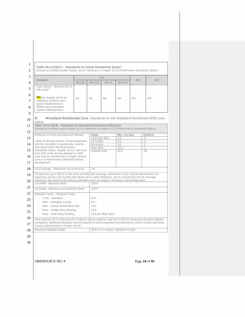
ORDINANCE NO. # Page 24 of 91
1
2
3
4
5
6
7
8
9
10
11
12
13
14
15
16
17
18
19
20
21
22
23
24
25
26
27
28
29
30
Table 18.2.5.030.A – Standards for Urban Residential Zones1 (Except as modified under chapter 18.5.5 Variances or chapter 18.3.9 Performance Standards Option.)
Standard R-1
R-2 R-3 R-1-10 R-1-7.5 R-1-5 R-1-3.5
Open Space - Minimum (% of site area)11
1211See chapter 18.3.9 for additional common open space requirements in Performance Standard Options developments.
NA NA NA NA 8% 8%
B. Woodland Residential Zone. Standards for the Woodland Residential (WR) zone follow: Table 18.2.5.030.B – Standards for Woodland Residential (WR) Zone (Except as modified under chapter 18.5.5 Variances or chapter 18.3.9 Performance Standards Option.)
Minimum Lot Area and Maximum Density Limits on density transfer. All developments, with the exception of partitioning, must be developed under the Performance Standards Option, chapter 18.3.9. Not more than 25% of the density allowed in a WR zone may be transferred to a higher density zone in a Performance Standard Options development.
Slope Min. Lot Size DU/Acre
Less than 40% 2.0 .5
40 to 50% 2.5 .4
50 to 60% 5.0 .2
Over 60% 10.0 .1
Outside UGB 20.0 .05
Lot Coverage – Maximum1 (% of lot area) 7%
1A total area up to 200 sf or 5% of the permitted lot coverage, whichever is less, may be developed in an approved, porous solid surface that allows storm water infiltration, and is exempt from the lot coverage maximum; the porous solid surface exemption does not apply to driveways and parking areas.
Lot Width - Minimum (feet) 100 ft
Lot Depth - Minimum and Maximum (feet) 150 ft
Standard Yards – Minimum2 (feet)
- Front – Standard
- Side – Standard, except:
- Side – Corner-Street/Alley Side
- Rear – Single-Story Building
- Rear – Multi-Story Building
20 ft
6 ft
10 ft
10 ft
10 ft per Bldg Story
2See sections 18.2.4.050 and 18.2.5.060 for yard exceptions, and 18.2.5.040 for accessory structure setback exceptions; additional setbacks may be required to avoid easement encroachments, and to comply with Solar Access requirements in chapter 18.4.8.
Maximum Building Height 35 ft or 2 ½ stories, whichever is less.

ORDINANCE NO. # Page 25 of 91
1
2
3
4
5
6
7
8
9
10
11
12
13
14
15
16
17
18
19
20
21
22
23
24
25
26
27
28
29
30
C. Rural Residential Zone. Standards for the Rural Residential (RR) zone follow: Table 18.2.5.030.C – Standards for Rural Residential (RR) Zone (Except as modified under chapter 18.5.5 and Variances or chapter 18.3.9 Performance Standards Option.)
Minimum Lot Area and Maximum Density1 See also 18.2.5.080 Residential Density.
Zone Min. Lot Size*
RR-.5 0.5 acre
RR-1 1 acre
RR-2.5 2.5 acres 1The minimum lot size depends on the topographic nature, service availability, surrounding land uses, and other relevant characteristics of the area.
Lot Coverage – Maximum (% of lot area)2 Lot Type Lot Coverage
RR-.5 20%
RR-1 12%
RR-2.5 7% 2A total area up to 200 sf or 5% of the permitted lot coverage, whichever is less, may be developed in an approved, porous solid surface that allows storm water infiltration, and is exempt from the lot coverage maximum; the porous solid surface exemption does not apply to driveways and parking areas.
Lot Width - Minimum (feet) 100 ft
Lot Depth - Minimum and Maximum (feet) 150 ft and not more than 300% of width
Standard Yards – Minimum3 (feet)
- Front – Standard
- Side – Standard, except:
- Side – Corner-Street/Alley Side
- Rear – Single-Story Building
- Rear – Multi-Story Building
20 ft
6 ft
10 ft
10 ft
10 ft per Bldg Story
3See sections 18.2.4.050 and 18.2.5.060 for yard exceptions, and 18.2.5.040 for accessory structure setback exceptions; additional setbacks may be required to avoid easement encroachments, and to comply with Solar Access requirements in chapter 18.4.8.
Maximum Building Height 35 ft or 2 ½ stories, whichever is less; except the height of agricultural structures is not limited, when the structure is placed 50 feet or more from all property lines.
SECTION 8. Section 18.2.5.060 [Yard Exceptions – Standards for Residential Zones] of the Ashland Land Use Ordinance is hereby amended to read as follows:
18.2.5.060 Yard Exceptions
A. Front Yard Exceptions.
1. If there are dwellings or accessory buildings on both abutting lots (even if
separated by an alley or private way) with front or side yards abutting a public
street with less than the required setback for the district, the front yard for the lot
need not exceed the average yard of the abutting structures.
2. If there is a dwelling or accessory building on one abutting lot with a front yard of
less than the required depth for the district, the front yard need not exceed the
average yard of the depth of the abutting lot and the required front yard depth.
3. The front yard may be reduced to ten feet on hillside lots where the terrain has an
average steepness equal to or exceeding a one foot rise or fall in four feet of

ORDINANCE NO. # Page 26 of 91
1
2
3
4
5
6
7
8
9
10
11
12
13
14
15
16
17
18
19
20
21
22
23
24
25
26
27
28
29
30
horizontal distance within the entire required yard; vertical rise or fall is measured
from the natural ground level at the property.
B. Side and Rear Yard Exceptions for Accessory Buildings, and Accessory
Residential Units, and Duplexes. The side and rear yards for accessory
buildings, accessory residential units, and duplexes may be reduced as
described below provided the structure meets all of the following requirements.
1. Structure.
a. The structure is not attached to any other buildings or dwellings, and is
not more and 15 feet in height.
b. If the structure is located on a lot that is not adjacent to an alley, the
structure is located more than 50 feet from any street.
c. The side and rear yard exceptions in this section may be applied to a
single detached duplex unit but shall not be applied to both duplex units
located on one lot, whether the two units are attached or detached.
d. The reduced side or rear yard provision does not apply to the primary
structure.
e. Automobile parking located in accessory buildings (e.g., garages and
carports) shall meet the dimensional requirements, including but not
limited to automobile back-up maneuvering dimensions, in subsection
18.4.3.080.B.
12. Yards Abutting an Alley. For accessory buildings and, accessory residential
units that are not attached to any other buildings and not more and 15 feet in
height, tThe side yard abutting an alley may be reduced to three feet and the rear
yard abutting an alley may be reduced to four feet, except that automobile
parking located in an accessory building (e.g., garages and carports) shall
meet the required back-up maneuvering dimensions in subsection
18.4.3.080.B. The reduced side or rear yard provision does not apply to the
primary structure.
23. Other Side and Rear Yards. For accessory buildings that are not attached to
any other building, are not more than 15 feet in height, and are erected more
than 50 feet from any street, tThe side or rear yard may be reduced to three feet,
except when said yard is abutting an alley as provided in subsection
18.2.5.060.B.12, above.
SECTION 9. Section 18.2.5.070 [Maximum Permitted Residential Floor Area in Historic District – Standards for Residential Zones] of the Ashland Land Use Ordinance is hereby amended to read as follows:
18.2.5.070 Maximum Permitted Residential Floor Area in Historic District
A. Purpose. Section 18.2.5.070 regulates floor area of dwellings to promote compatible
building volume and scale in the Historic District.
Commented [mh5]: Cross reference to required back-up dimension for parking in garages or carports suggested in comment submitted for 4/27/2021 Planning Commission study session.
Commented [mh6]: Same as e. above.

ORDINANCE NO. # Page 27 of 91
1
2
3
4
5
6
7
8
9
10
11
12
13
14
15
16
17
18
19
20
21
22
23
24
25
26
27
28
29
30
B. Applicability. Within residential zones located in the Historic District Overlay, new
structures and additions shall conform to the maximum permitted floor area standards
of this section, except as provided by 18.2.5.070.C.
C. Increases in Allowable MPFA. A Conditional Use Permit under chapter 18.5.4 is
required to exceed the MPFA standards of subsections 18.2.5.070.F and
18.2.5.070.G, below. In addition to the approval criteria for a Conditional Use Permit,
the criteria for Historic District Design Standards approval must be met. In no case
shall the permitted floor area exceed 25 percent of the MPFA.
D. Maximum Permitted Floor Area. For purposes of this section, maximum permitted
floor area (MPFA) means the gross floor area of the primarya dwelling, including but
not limited to potential living spaces within the structure with at least seven feet of
head room and attached garages, except as provided by subsection 18.2.5.070.E,
below.
E. Exceptions. Basements, detached garages, detached accessory structures, and
detached accessory residential units, and detached duplex dwelling units are not
counted in the gross floor area for the MPFA calculation if separated from the primary
dwellingsingle-family dwelling or primary structure by six feet or more. Similarly,
unenclosed breezeways, and similar open structures connecting an exempt detached
structure to the primary dwellingsingle-family dwelling or primary structure are
not counted in the MPFA calculation. The exception in this section may be applied
to a single detached duplex unit but shall not be applied to both duplex units
located on one lot, whether the two units are attached or detached.
F. Calculation and Standards. Except as modified by subsection 18.2.5.070.G for
multiple dwellings on a lot and residential subdivisions proposed under the
performance standards option, the following formula shall be used to calculate the
MPFA for single familysingle-family dwellings, provided however, that regardless of
lot size, the MPFA shall not exceed 3,249 square feet:
Lot area x Adj. Factor [from Table 18.2.5.070(E)] = Adjusted lot area x 0.38 FAR = MPFA
Table 18.2.5.070.E: Adjustment Factor Table
Lot Area
Adj. Factor
Lot Area
Adj. Factor
Lot Area
Adj. Factor
Lot Area
Adj. Factor
0 – 2500 1.20 6501 - 7000 0.88 11001 – 11500 0.66 15501 - 16000 0.55
2501 – 3000 1.16 7001 - 7500 0.85 11501 – 12000 0.64 16001 - 16500 0.54
3001 – 3500 1.12 7501 - 8000 0.82 12001 – 12500 0.62 16501 - 17000 0.53
3501 – 4000 1.08 8001 - 8500 0.79 12501 – 13000 0.61 17001 - 17500 0.52
4001 – 4500 1.04 8501 - 9000 0.77 13001 – 13500 0.60 17501 - 18000 0.51
4501 – 5000 1.00 9001 - 9500 0.75 13501 – 14000 0.59 18001 - 18500 0.50
5001 – 5500 0.97 9501 - 10000 0.73 14001 – 14500 0.58 18501 - 19000 0.49
5501 – 6000 0.94 10001 - 10500 0.71 14501 – 15000 0.57 19001 - 19500 0.48
6001 – 6500 0.91 10501 - 11000 0.68 15001 – 15500 0.56 19500 and greater
0.47
G. Multiple Dwellings and Residential Performance Standards Option. Where
multiple dwellings are proposed on a single lot, or where a residential subdivision is

ORDINANCE NO. # Page 28 of 91
1
2
3
4
5
6
7
8
9
10
11
12
13
14
15
16
17
18
19
20
21
22
23
24
25
26
27
28
29
30
proposed under the Performance Standards Option of chapter 18.3.9, the MPFA shall
be determined using the following formula:
Lot area x Adj. Factor [from Table 18.2.5.070(E)] = Adjusted lot area x Graduated FAR
[from Table 18.2.5.070(F)] = MPFA
Table 18.2.5.070.F: Graduated FAR Table
# units FAR # units FAR # units FAR
1 .38 5 .46 9 .54
2 .40 6 .48 10 .56
3 .42 7 .50 11 .58
4 .44 8 .52 >11 .60
SECTION 10. Section 18.2.5.080 [Residential Density Calculations in R-2 and R-3 Zones – Standards for Residential Zones] of the Ashland Land Use Ordinance is hereby amended to read as follows:
18.2.5.080 Residential Density Calculation in R-2 and R-3 Zones
A. Density Standard. Except density gained through bonus points under section
18.2.5.080 or chapter 18.3.9 Performance Standards Option and PSO Overlay,
development density in the R-2 and R-3 zones shall not exceed the densities
established by this section.
B. Density Calculation.
1. Except as specified in the minimum lot area dimensions below, the density in R-2
an R-3 zones shall be computed by dividing the total number of dwelling units by
the acreage of the project, including land dedicated to the public, and subject to the
exceptions below.
2. Units less than 500 square feet of gross habitable area shall count as 0.75 units for
the purposes of density calculations.
3. Accessory residential units and duplexes are not required to meet the density or
minimum lot area requirements of this section. See section 18.2.3.040 for
accessory residential unit standards and section 18.2.3.110 for duplex
standards.
C. Minimum Density.
1. The minimum density shall be 80 percent of the calculated base density.
2. Exceptions to minimum density standards. The following lots are totally or partially
exempt from minimum density standards.
a. Lots less than 10,000 sq. ft. in existence prior to the effective date of this
ordinance.
b. Lots located within any Historic District designated within the Ashland Municipal
Code.
c. Lots with existing or proposed conditional uses may be exempt for that portion

ORDINANCE NO. # Page 29 of 91
1
2
3
4
5
6
7
8
9
10
11
12
13
14
15
16
17
18
19
20
21
22
23
24
25
26
27
28
29
30
of the property that is subject to the conditional use for calculations of the
minimum base density standard.
d. Where a lot is occupied by a single-family residence prior to January 9, 2005
(Ord. 2914), the single-family residence may be enlarged or reconstructed
without being subject to the minimum base density standard.
e. In the event that a fire or natural hazard destroys a single-family residence,
such residence may be replaced without being subject to the minimum base
density standard.
f. Where floodplains, streams, land drainages, wetlands, and/or steep slopes
exist upon the lot an exception to minimum density requirements may be
obtained to better meet the standards of chapter 18.3.10 Physical and
Environmental Constraints Overlay.
g. A lot that is nonconforming in minimum density may not move further out of
conformance with the minimum density standard. However, units may be
added to the lot which bring the lot closer to conformance without coming all
the way into conformance provided it is demonstrated that the minimum density
will not be precluded.
D. Base Densities and Minimum Lot Dimensions.
1. R-2 Zone. Base density for the R-2 zone shall meet the following standards:
a. Minimum lot area for one or two dwellingsunit shall be 5,000 square feet,
except as allowed in section 18.2.3.040 for accessory residential units and
section 18.2.3.110 for duplexes.
b. Minimum lot area for two units shall be 7,000 square feet.
cb. Minimum lot area for three unitsdwellings shall be 9,000 square feet, except
that the residential density bonus in subsection 18.2.5.080.F, below, may be
used to increase density of lots greater than 8,000 square feet up to three
unitsdwellings.
dc. For more than three unitsdwellings, the base density shall be 13.5 dwelling
units per acre. The permitted base density shall be increased by the
percentage gained through the residential density bonus is subsection
18.2.5.080.F.
2. R-3 Zone. Base density for the R-3 zone shall meet the following standards:
a. Minimum lot area for one or two unitdwellings shall be 5,000 square feet,
except as allowed in section 18.2.3.040 for accessory residential units and
section 18.2.3.110 for duplexes.
b. Minimum lot area for two units shall be 6,500 square feet.
c. Minimum lot area for three units shall be 8,000 square feet.
d. For three or more than three unitsdwellings, the base density shall be 20
dwelling units per acre. The permitted base density shall be increased by the
percentage gained through the residential density bonus is subsection

ORDINANCE NO. # Page 30 of 91
1
2
3
4
5
6
7
8
9
10
11
12
13
14
15
16
17
18
19
20
21
22
23
24
25
26
27
28
29
30
18.2.5.080.F, below.
E. Exceptions. An accessory residential unit is not required to meet density or
minimum lot area requirements per section 18.2.3.040110.
FE. Residential Density Bonus.
1. Density Bonus Points Authorized. Except as allowed under chapter 18.3.9
Performance Standards Option and PSO Overlay, the permitted base density shall
be increased only pursuant to this section.
2. Maximum Density Bonus Points. The total maximum bonus permitted shall be 60
percent.
3. Density Bonus Point Criteria. The following bonuses shall be awarded:
a. Conservation Housing. The maximum bonus for conservation housing is 15
percent. One hundred percent of the homes or residential units approved for
development, after density bonus point calculations, shall meet the minimum
requirements for certification as an Earth Advantage home, as approved by the
Conservation Division under the City’ s Earth Advantage program as adopted
by resolution 2006-6.
b. Common Open Space. The maximum bonus for provision of common open
space is ten percent. A one percent bonus shall be awarded for each one
percent of the total project area in common open space in excess of any
common or private open space required by section 18.4.4.070 and this
ordinance. The common open space shall meet the standards in section
18.4.4.070.
c. Affordable Housing. The maximum bonus for affordable housing is 35 percent.
Developments shall receive a density bonus of two units for each affordable
housing unit provided. Affordable housing bonus shall be for residential units
that are guaranteed affordable in accord with the standards of section
18.2.5.050.
SECTION 11. Section 18.2.5.090 [Standards for Single-Family Dwellings – Standards for Residential Zones] of the Ashland Land Use Ordinance is hereby amended to read as follows:
18.2.5.090 Standards for Single-Family Dwellings and Duplexes
A. The following standards apply to new single-family dwellings and duplexes
constructed in the R-1, R-1-3.5, R-2, and R-3 zones; the standards do not apply to
dwellings in the WR or RR zones.
B. Single-family dwellings and duplexes subject to this section shall utilize at least two of
the following design features to provide visual relief along the front of the residence:
1. Dormers
2. Gables

ORDINANCE NO. # Page 31 of 91
1
2
3
4
5
6
7
8
9
10
11
12
13
14
15
16
17
18
19
20
21
22
23
24
25
26
27
28
29
30
3. Recessed entries
4. Covered porch entries
5. Cupolas
6. Pillars or posts
7. Bay window (min. 12" projection)
8. Eaves (min. 6" projection)
9. Off-sets in building face or roof (min. 16")
SECTION 12. Section 18.3.4.040 [Use Regulations – Normal Neighborhood District] of the Ashland Land Use Ordinance is hereby amended to read as follows: 18.3.4.040 Use Regulations
A. Plan Overlay Zones. There are four Land Use Designation Overlays zones within the
Normal Neighborhood Plan are intended to accommodate a variety of housing
opportunities, preserve natural areas and provide open space.
1. Plan NN-1-5 zone. The use regulations and development standards are intended
to create, maintain and promote single dwelling a single-family dwelling
neighborhood character. A variety of housing types are allowed, in addition to the
detached single dwelling. Development standards that are largely the same as
those for single dwellings ensure that the overall image and character of the single
dwellingsingle-family dwelling neighborhood is maintained.
2. Plan NN-1-3.5 zone. The use regulations and development standards are
intended to create, maintain and promote single dwelling single-family dwelling
neighborhood character. A variety of housing types are allowed including multiple
compact attached and/or detached dwellings. Dwellings may be grouped around
common open space promoting a scale and character compatible with single-
family homes. Development standards that are largely the same as those for
single dwellingssingle-family dwellings ensure that the overall image and
character of the single dwellingsingle-family dwelling neighborhood is
maintained.
3. Plan NN-1-3.5-C zone. The use regulations and development standards are
intended to provide housing opportunities for individual households through
development of multiple compact attached and/or detached dwellings with the
added allowance for neighborhood-serving commercial mixed-uses so that many
of the activities of daily living can occur within the Normal Neighborhood. The
public streets within the vicinity of the NN-1-3.5-C overlay are to provide sufficient
on-street parking to accommodate ground floor neighborhood business uses.
4. Plan NN-2 zone. The use regulations and development standards are intended to
create and maintain a range of housing choices, including multi-familymultifamily
housing within the context of the residential character of the Normal Neighborhood
Plan.

ORDINANCE NO. # Page 32 of 91
1
2
3
4
5
6
7
8
9
10
11
12
13
14
15
16
17
18
19
20
21
22
23
24
25
26
27
28
29
30
B. Normal Neighborhood Plan Residential Building Types. The development
standards for the Normal Neighborhood Plan will preserve neighborhood
character by incorporating four distinct land use overlay areas with different
concentrations of varying housing types.
1. Single Dwelling Residential Unit. A Single Dwelling Residential Unit is a
detached residential building that contains a single dwelling with self-
contained living facilities on one lot. It is separated from adjacent dwellings
by private open space in the form of side yards and backyards, and set back
from the public street or common green by a front yard. Auto parking is
generally on the same lot in a garage, carport, or uncovered area. The garage
may be detached or attached to the dwelling structure.
2. Accessory Residential Unit. An Accessory Residential Unit is a secondary
dwelling unit on a lot, either attached to the single-family dwelling or in a
detached building located on the same lot with a single-family dwelling, and
having an independent means of entry.
32. Double Dwelling Residential Unit (Duplex). A Double Dwelling Residential
Unit is a residential building that contains two dwellings located on a single
lot, each with self-contained living facilities. Double Dwelling Residential
UnitsDuplexes must share a common wall or a common floor/ ceiling and are
similar to a Single Dwelling Unit in appearance, height, massing, and lot
placement.
4. Attached Residential Unit (Townhome, Row house). An Attached Residential
Unit is single dwelling located on an individual lot which is attached along
one or both sidewalls to an adjacent dwelling unit. The dwelling unit may be
set back from the public street or common green by a front yard.
5. Clustered Residential Units - Pedestrian-Oriented. Pedestrian-Oriented
Clustered Residential Units are multiple dwellings grouped around common
open space that promote a scale and character compatible with single-family
homes. Units are typically arranged around a central common green under
communal ownership. Auto parking is generally grouped in a shared surface
area or areas.
6. Multiple Dwelling Residential Unit. Multiple Dwelling Residential Units are
multiple dwellings that occupy a single building or multiple buildings on a
single lot. Dwellings may take the form of condominiums or apartments.
Auto parking is generally provided in a shared parking area or structured
parking facility.
7. Cottage Housing. Cottage Housing Units are small dwellings in
developments approved in accordance with the standards in 18.2.3.090.
CB. Allowed Uses.
1. Uses Allowed in Normal Neighborhood District. Allowed uses include those that are
permitted, permitted subject to special use standards, and allowed subject to a
conditional use permit. Where Table 18.3.4.040 does not list a specific use and

ORDINANCE NO. # Page 33 of 91
1
2
3
4
5
6
7
8
9
10
11
12
13
14
15
16
17
18
19
20
21
22
23
24
25
26
27
28
29
30
part 18.6 does not define the use or include it as an example of an allowed use,
the City may find that use is allowed, or is not allowed, following the procedures of
section 18.1.5.040 Similar Uses. All uses are subject to the development
standards of zone in which they are located, any applicable overlay zone(s), and
the review procedures of part 18.5. See section 18.5.1.020 Determination of
Review Procedure.
a. Permitted Uses. Uses listed as “Permitted (P)” are allowed.
b. Permitted Subject to Special Use Standards. Uses listed as “Permitted Subject
to Special Use Standards (S)” are allowed, provided they conform to chapter
18.2.3 Special Use Standards.
c. Conditional Uses. Uses listed as “Conditional Use Permit Required (C)” are
allowed subject to the requirements of chapter 18.5.4 Conditional Use Permits.
d. Prohibited Uses. Uses not listed in Table 18.3.4.040, and not found to be
similar to an allowed use following the procedures of section 18.1.5.040
Similar Uses, are prohibited.
2. Uses Regulated by Overlay Zones. Notwithstanding the provisions of chapter
18.2.2 Base Zones, additional land use standards or use restrictions apply within
overlay zones. An overlay zone may also provide for exceptions to some standards
of the underlying zone.
3. Mixed-Use. Uses allowed in a zone individually are also allowed in combination
with one another, in the same structure or on the same site, provided all applicable
development standards and building code requirements are met. Table 18.3.4.040 Normal Neighborhood District
Uses Allowed by Zone10
Normal Neighborhood District Zones11
NN-1-5 NN-1-3.5 NN-1-3.5-C NN-2
A. Residential Uses
Single Dwelling Residential Unit
(Single-Family Dwelling)Single-family
Dwelling
P P N N
Accessory Residential Unit, see Sec. 18.2.3.040 P or S P or S P or S N
Double Dwelling Residential Unit
(Duplex Dwelling)Duplex NP P P P
Cottage Housing P N N N
Clustered Residential Units N P P P
Attached Residential Unit N P P P
Multiple Dwelling Residential Unit
(Multi family Dwelling)Multifamily Dwelling N P P P
Manufactured Home on Individual Lot P P P P
Manufactured Housing Development N P P P
B. Neighborhood Business and Service Uses
Home Occupation P P P P

ORDINANCE NO. # Page 34 of 91
1
2
3
4
5
6
7
8
9
10
11
12
13
14
15
16
17
18
19
20
21
22
23
24
25
26
27
28
29
30
Table 18.3.4.040 Normal Neighborhood District
Uses Allowed by Zone10
Normal Neighborhood District Zones11
Retail Sales and Services, with each building
limited to 3,500 square feet of gross floor area N N P N
Professional and Medical Offices, with each
building limited to 3,500 square feet of gross floor
area
N N P N
Light manufacturing or assembly of items
occupying six hundred (600) square feet or less,
and contiguous to the permitted retail use.
N N P N
Restaurants N N P N
Day Care Center N N P N
Assisted Living Facilities N C C C
C. Residential Uses
Religious Institutions and Houses of
Worship C C C C
Public Buildings P P P P
Community Gardens P P P P
Open space and Recreational Facilities P P P P
P = Permitted Use; S = Permitted with Special Use Standards; C = Conditional Use
Permit Required; N = Not Allowed.
SECTION 13. Section 18.3.4.050 [Dimensional Regulations – Normal Neighborhood District] of the Ashland Land Use Ordinance is hereby amended to read as follows:
18.3.4.050 Dimensional Regulations
A. The lot and building dimensions shall conform to the standards in Table
18.3.4.050 below.
Table 18.3.4.050 Dimensional Standards NN-1-5 NN-1-3.5
NN-1-3.5C
NN-2
Base density, dwelling units per acre 4.5 7.2 13.5
Minimum Lot Area1, square feet
(applies to lots created by partitions only) 5,000 3500 3000
Minimum Lot Depth1, feet
(applies to lots created by partitions only) 80 80 80
Minimum Lot Width1, feet
(applies to lots created by partitions only) 50 35 25
Setbacks and yards (feet)

ORDINANCE NO. # Page 35 of 91
1
2
3
4
5
6
7
8
9
10
11
12
13
14
15
16
17
18
19
20
21
22
23
24
25
26
27
28
29
30
Table 18.3.4.050 Dimensional Standards NN-1-5 NN-1-3.5
NN-1-3.5C
NN-2
Minimum Front Yard abutting a street 15 15 15
Minimum Front Yard to a garage facing a
public street, feet 20 20 20
Minimum Front Yard to unenclosed front
porch, feet 82 82 82
Minimum Side Yard 6
6
0 3
6
0 3
Minimum Side Yard abutting a public street 10 10 10
Minimum Rear Yard 10 ft per Bldg Story, 5 feet per Half Story
Solar Access
Setback and yard requirements shall
conform to the Solar Access standards of
chapter 18.4.8
Maximum Building Height, feet / stories 35 / 2.5 35 / 2.5 35 / 2.5
Maximum Lot Coverage, percentage of lot 50% 55% 65%
Minimum Required Landscaping, percentage of
lot 50% 45% 35%
Parking See section 18.4.3.080 Vehicle Area
Design Requirements
Minimum Outdoor Recreation Space,
f l
na na 8% 1 Minimum Lot Area, Depth, and Width requirements do not apply in performance standards
subdivisions. 2 Minimum Front Yard to an unenclosed front porch (Feet), or the width of any existing public utility
easement, whichever is greater; an unenclosed porch must be no less than 6 feet in depth and 8 feet
in width, see section 18.6.1.030 for definition of porch. 3 Minimum Side Yard for Attached Residential Units (Feet)
B. Density Standards. Development density in the Normal Neighborhood shall not
exceed the densities established by Table 18.3.4.050, except where granted a density
bonus under chapter 18.3.9. Performance Standards Options and consistent with the
following requirements.:
1. General Density Provisions.
a. The density in NN-1-5, NN-1-3.5, NN-1-3.5-C, and NN-2 zones is to be
computed by dividing the total number of dwelling units by the acreage of the
project, including land dedicated to the public.
b. Conservation Areas including wetlands, floodplain corridor lands, and water
resource protection zones may be excluded from the acreage of the project for
the purposes of calculating minimum density for residential annexations as
described in section 18.5.8.050.F.
c. Units less than 500 square feet of gross habitable area shall count as 0.75

ORDINANCE NO. # Page 36 of 91
1
2
3
4
5
6
7
8
9
10
11
12
13
14
15
16
17
18
19
20
21
22
23
24
25
26
27
28
29
30
units for the purposes of density calculations.
d. Accessory residential units consistent with standards described in
section 18.2.3.040 are not required to meet density or minimum lot area
requirements.
e. Accessory residential units shall be included for the purposes of meeting
minimum density calculation requirements for residential annexations as
described in 18.5.8.050.F.
2. Residential Density Bonuses.
a. The maximum residential density bonuses permitted shall be as described in
section 18.2.5.080.F.
b. Cottage Housing. [Reserved]
SECTION 14. Section 18.3.5.050 [Uses Allowed in North Mountain Neighborhood Zones – North Mountain Neighborhood] of the Ashland Land Use Ordinance is hereby amended to read as follows: 18.3.5.050 Allowed Uses
A. Uses Allowed in North Mountain Neighborhood Zones. Allowed uses include those
that are permitted, permitted subject to special use standards, and allowed subject to a
conditional use permit. Where Table 18.3.5.050 does not list a specific use and part
18.6 does not define the use or include it as an example of an allowed use, the City
may find that use is allowed, or is not allowed, following the procedures of section
18.1.5.040 Similar Uses. All uses are subject to the development standards of zone in
which they are located, any applicable overlay zone(s), and the review procedures of
part 18.5. See section 18.5.1.020 Determination of Review Procedure.
1. Permitted Uses. Uses listed as “Permitted (P)” are allowed.
2. Permitted Subject to Special Use Standards. Uses listed as “Permitted Subject to
Special Use Standards (S)” are allowed, provided they conform to subsection
18.3.5.050.D and chapter 18.2.3 Special Use Standards.
3. Conditional Uses. Uses listed as “Conditional Use Permit Required (C)” are
allowed subject to the requirements of chapter 18.5.4 Conditional Use Permits.
4. Prohibited Uses. Uses not listed in Table 18.3.5.050, and not found to be similar to
an allowed use following the procedures of section 18.1.5.040 Similar Uses, are
prohibited.
B. Uses Regulated by Overlay Zones. Notwithstanding the provisions of chapter 18.2.2
Base Zones, additional land use standards or use restrictions apply within overlay
zones. An overlay zone may also provide for exceptions to some standards of the
underlying zone.
C. Mixed-Use. Uses allowed in a zone individually are also allowed in combination with
one another, in the same structure or on the same site, provided all applicable
development standards and building code requirements are met.

ORDINANCE NO. # Page 37 of 91
1
2
3
4
5
6
7
8
9
10
11
12
13
14
15
16
17
18
19
20
21
22
23
24
25
26
27
28
29
30
Table 18.3.5.050 – North Mountain Neighborhood Uses Allowed by
Zone2
North Mountain Neighborhood Zones3
NM-R-1-7.5
NM-R-1-5
NM-MF
NM-C NM-Civic
A. Residential
Residential Uses, subject to density requirements in Table 18.3.5.060
P P P P N
Accessory Residential Units, see Sec. 18.2.3.040
P or S P or S P or
S PS N
Cottage Housing S S N N N
Duplexes see Sec, 18.2.3.110
S S S S N
Home Occupations P P P P N
Agricultural Uses, except Keeping of Livestock
P P P P S
Keeping of Micro-Livestock and Bees
S S S N S
Keeping of Livestock N N N N N
Marijuana Cultivation, Homegrown
S S S S N
B. Public and Institutional Uses
Community Services N S N S P
Parks and Open Spaces P P P P P
Public Parking Lots N N N CU N
Religious Institution, Houses of Worship
N N N S N
Utility and Service Building, Public and Quasi-Public, excluding outdoor storage and electrical substations
N N N S N
C. Commercial
Neighborhood Clinics N N N S N
Neighborhood Oriented Retail Sales, Services, and Restaurants
N N N S N
Offices, Professional N N N S N
Temporary uses N N N CU N
D. Industrial
Manufacturing, Light N N N S N
2 Key: P = Permitted Uses; S = Permitted with Special Use Standards; CU = Conditional Use Permit Required; N = Not Allowed. 3 Zones: NC = Neighborhood Commercial; MU = Mixed Use; OE = Office Employment; CI = Compatible Industrial; OS = Open Space.

ORDINANCE NO. # Page 38 of 91
1
2
3
4
5
6
7
8
9
10
11
12
13
14
15
16
17
18
19
20
21
22
23
24
25
26
27
28
29
30
D. Special Use Standards. The uses listed as “Permitted with Special Use Standards
(S)” in Table 18.3.5.050, above, are allowed provided they conform to the
requirements of this section and the requirements of chapter 18.5.2 Site Design
Review.
1. Accessory Residential Units. Subject to the standards in section 18.2.3.040.
2. Agricultural Uses. In the NM-Civic zone, agriculture may include community garden
space.
3. Keeping of Micro-Livestock and Bees. Subject to the standards in section
18.2.3.160.
4. Marijuana Cultivation, Homegrown. Subject to the standards in subsection
18.2.3.190.A.
5. Community Services.
a. In the NM-R-1-5 zone, each building may be up to a maximum of 2,500 square
feet of gross floor area.
b. In the NM-C zone, each building may be up to a maximum of 3,500 square feet
of gross floor area.
6. Manufacturing, Light.
a. The light manufacturing use shall occupy 600 square feet or less.
b. The light manufacturing use shall be contiguous to the permitted retail outlet
that operates in conjunction with and sells the manufactured items produced by
the light manufacturing use.
7. Neighborhood Clinics. Each building may be up to a maximum of 3,500 square feet
of gross floor area.
8. Neighborhood Oriented Retail Sales, Services, and Restaurants. Each building
may be up to a maximum of 3,500 square feet of gross floor area.
9. Offices, Professional. Each building may be up to a maximum of 3,500 square feet
of gross floor area.
10. Religious Institution, Houses of Worship. The same use cannot be located on a
contiguous property, and there must be no more than two such uses in a given
zone.
11. Utility and Service Building, Public and Quasi-Public. Each building may be up to a
maximum of 3,500 square feet of gross floor area.
12. Cottage Housing. Subject to the standards in section 18.2.3.090.
13. Duplexes. Subject to the standards in section 18.2.3.110.

ORDINANCE NO. # Page 39 of 91
1
2
3
4
5
6
7
8
9
10
11
12
13
14
15
16
17
18
19
20
21
22
23
24
25
26
27
28
29
30
SECTION 15. Section 18.3.5.060 [Dimensional Standards – North Mountain Neighborhood] of the Ashland Land Use Ordinance is hereby amended to read as follows:
18.3.5.060 Dimensional Standards Table 18.3.5.060 contains lot and development standards, including density, minimum
dimensions, area, coverage, structure height and other provisions that control the
intensity, scale, and location of development for the NM-R-1-7.5, NM-R-1-5, NM-MF, and
NM-C.
Table 18.3.5.060 North Mountain Neighborhood Dimensional Standards
North Mountain Neighborhood Zones1
NM-R-1-7.5 NM-R-1-5 NM-MF NM-C
Residential Density (dwelling units/acre)1 3.6 du/ac 5 du/ac 12 du/ac 20 du/ac
1Density is computed by dividing the total number of dwelling units by the acreage of the project, including land dedicated to the public. Fractional portions of the answer shall not apply towards the total density, except that units less than 500 square feet gross habitable floor area shall count as .75 units in the NM-MF and NM-C zones. Accessory residential units and duplexes are not subject to the density requirements of the zone in the NM-R-1-7.5 and NM-R-1-5 zones, see sections 18.2.3.040 and 18.2.3.110.
Standard Yards – Minimum (feet)
Front – Standard 10 ft minimum/
25 ft maximum
10 ft minimum/ 25 ft maximum
10 ft minimum/
25 ft maximum
No minimum
yard require-ments,
except as required
for parking,
landscaping and
building design
requirement in
chapters 18.4.2, 18.4.3,
and 18.4.4.
Front – Unenclosed Porch 5 ft 5 ft 5 ft
Front – - Garage2 15 ft from building
face / 20 ft from
sidewalk
15 ft from building face / 20 ft from sidewalk
15 ft from building
face / 20 ft from
sidewalk
Side – Standard3 5 ft per building
story
5 ft per building
story
5 ft per building
story
Side – Adjacent to Street 10 ft 10 ft 10 ft
Side – Single-Story, Detached Garage and Accessory Buildings4
3 ft 3 ft 3 ft
Rear – Standard 10 ft per building
story
10 ft per building
story
10 ft per building
story
Rear – Upper Floor Dormer Space 15 ft 15 ft 15 ft
Rear - Single-Story, Detached Garage and Accessory Buildings Adjacent to Alley
4 ft 4 ft 4 ft
Rear – Two-Story Accessory Buildings Adjacent to Alley
4 ft 4 ft 4 ft
2No greater than 50 percent of the total lineal building façade facing the street can consist of garage, carport, or other covered parking space. 3No additional side yard is required for half-stories and upper floor dormer space. 4No side yard is required for accessory buildings sharing a common wall.
Solar Access Solar access setback required pursuant to chapter 18.4.8 Solar Access.
No solar access
1 Zones: NC = Neighborhood Commercial; MU = Mixed Use; OE = Office Employment; CI = Compatible Industrial; OS
= Open Space.

ORDINANCE NO. # Page 40 of 91
1
2
3
4
5
6
7
8
9
10
11
12
13
14
15
16
17
18
19
20
21
22
23
24
25
26
27
28
29
30
Table 18.3.5.060 North Mountain Neighborhood Dimensional Standards
North Mountain Neighborhood Zones1
NM-R-1-7.5 NM-R-1-5 NM-MF NM-C
setback required.
Lot Coverage – Maximum (% of lot area) 45% 50% 75% 80% 1 Zones: NC = Neighborhood Commercial; MU = Mixed Use; OE = Office Employment; CI = Compatible Industrial; OS
= Open Space. SECTION 16. Section 18.3.5.100 [Site Development and Design Standards – North Mountain Neighborhood] of the Ashland Land Use Ordinance is hereby amended to read as follows:
18.3.5.100 Site Development and Design Standards A. Housing. The following design standards apply to residential developments. While the
standards are specific, the intent is not to limit innovative design, but rather provide a
framework for clear direction and minimum standards.
1. Architectural Design. The street-facing elevations of residential buildings shall be
broken with reveals, recesses, trim elements, and other architectural features to
avoid the appearance of a blank wall as illustrated in Figure 18.3.5.100.A.1. In
addition, at least two of the following design features must be provided along the
front of each residence.
a. Dormers
b. Gables
c. Recessed entries
d. Covered porch entries
e. Cupolas
f. Pillars or Posts
g. Bay window (min. 12-inch projection)
h. Eaves (min. six-inch projection)
i. Off-sets in building face or roof (min. 16 inches)
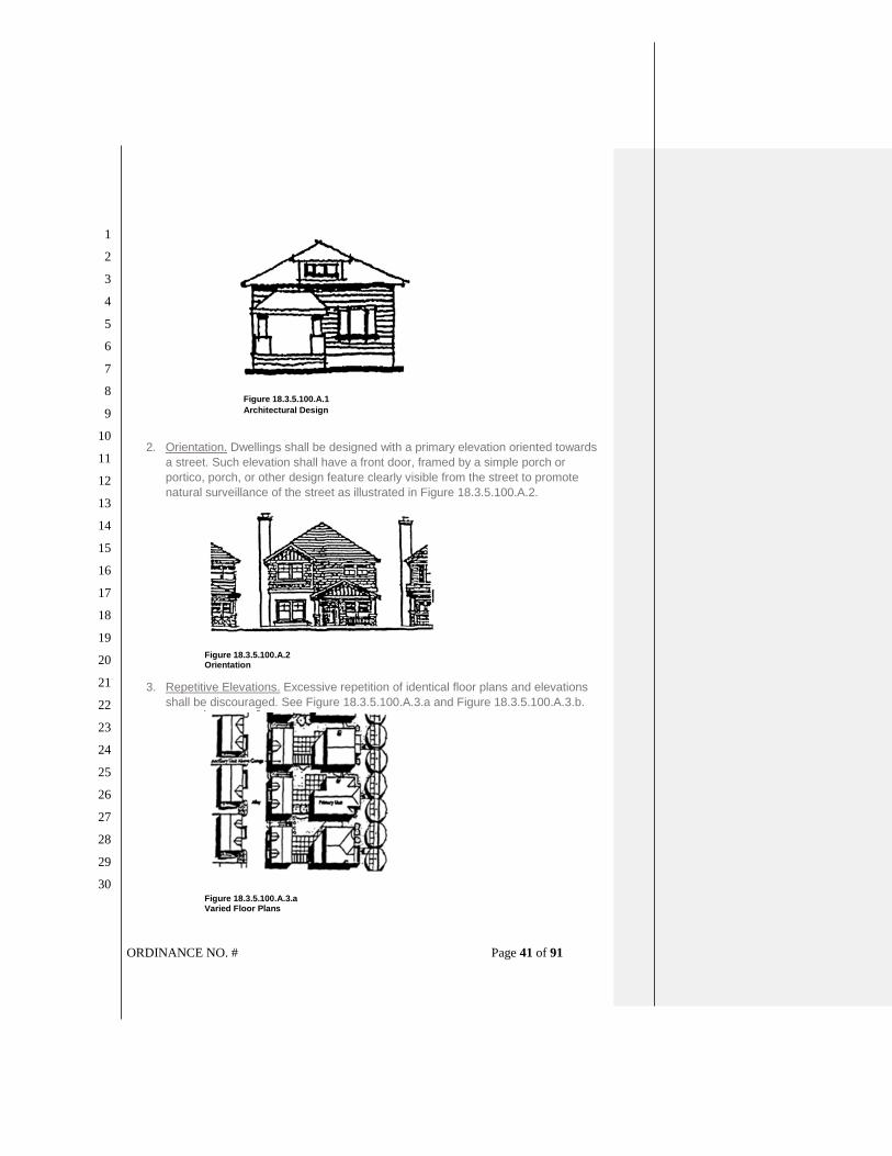
ORDINANCE NO. # Page 41 of 91
1
2
3
4
5
6
7
8
9
10
11
12
13
14
15
16
17
18
19
20
21
22
23
24
25
26
27
28
29
30
Figure 18.3.5.100.A.1
Architectural Design
2. Orientation. Dwellings shall be designed with a primary elevation oriented towards
a street. Such elevation shall have a front door, framed by a simple porch or
portico, porch, or other design feature clearly visible from the street to promote
natural surveillance of the street as illustrated in Figure 18.3.5.100.A.2.
Figure 18.3.5.100.A.2 Orientation
3. Repetitive Elevations. Excessive repetition of identical floor plans and elevations
shall be discouraged. See Figure 18.3.5.100.A.3.a and Figure 18.3.5.100.A.3.b.
Figure 18.3.5.100.A.3.a Varied Floor Plans

ORDINANCE NO. # Page 42 of 91
1
2
3
4
5
6
7
8
9
10
11
12
13
14
15
16
17
18
19
20
21
22
23
24
25
26
27
28
29
30
Figure 18.3.5.100.A.3.b Varied Elevations
4. Supplemental Setback Requirements for Garages and Accessory Structures. In
addition to the setback requirements of sections 18.3.5.060, the following garage
and accessory structure setbacks are required, in order to promote an attractive
streetscape where garages and accessory structures are visually subordinate to
primary dwellings single-family dwellings or primary structures.
a. Where no alleys are present, garages shall be located a minimum of 15 feet
behind the primary façade and a minimum of 20 feet from the sidewalk. See
Figure 18.3.5.100.A.4.a.
Figure 18.3.5.100.A.4.a Garage Setbacks/No Alley
b. Garages and accessory structures adjacent to an internal property line (i.e.,
neighbor’s residence) shall maintain a minimum first floor side yard setback of
four feet and a second floor setback of six feet, excluding dormers. See Figure
18.3.5.100.A.4.b.

ORDINANCE NO. # Page 43 of 91
1
2
3
4
5
6
7
8
9
10
11
12
13
14
15
16
17
18
19
20
21
22
23
24
25
26
27
28
29
30
Figure 18.3.5.100.A.4.b Garage Setbacks/No Alley
c. No side yard setback is required where garages adjoin along a common
property line.
d. Garage or accessory structures, including accessory residential units, fronting
and or accessed from the alley shall have a minimum rear yard setback of four
feet. See Figure 18.3.5.100.A.4.d.
Figure 18.3.5.100.A.4.d Garage Setbacks/Alley
e. The maximum allowed width of a garage opening is 22 feet. Expansion of the
garage’s depth is allowed should be considered for additional storage needs.
f. Common wall garages (i.e., adjacent garage openings), and dwellings with
more than one garage openings, where the total width of adjacent garage
openings exceeds 22 feet, shall have at least one garage opening recessed
behind the other(s) by not less than three feet.
5. Terracing. Grading for new homes and accessory structures shall be minimized
and building designs shall respond to the natural grade, to the extent practicable,
pursuant to the following standards.
a. Terracing should be incorporated into the design of each lot’s development, as
illustrated in Figure 18.3.5.100.A.5.a. Terraces help ease transition between
the public and private space.

ORDINANCE NO. # Page 44 of 91
1
2
3
4
5
6
7
8
9
10
11
12
13
14
15
16
17
18
19
20
21
22
23
24
25
26
27
28
29
30
Figure 18.3.5.100.A.5.a Terraces
b. In determining whether grading is minimized and building designs are
practicable, this standard shall not be interpreted so as to preclude permitted
housing at planned densities.
6. Porches. Where practicable, porches shall be incorporated into building designs
within the North Mountain Neighborhood, in order to promote a sense of place,
socialization, and natural surveillance of the street, as illustrated in Figure
18.3.5.100.A.6.a. Porches shall be a minimum of six feet in depth and eight feet in
width, as illustrated in Figure 18.3.5.100.A.6.b - deep enough to allow a person to
stand while the door is opening and large enough to allow at least one person to sit
facing the street. Porches with dimensions less than six feet in depth and eight feet
in width are often used as storage areas for bike, barbecues, etc., and do not
realistically function as outdoor rooms.
Figure 18.3.5.100.A.6.a Street with Front Porches
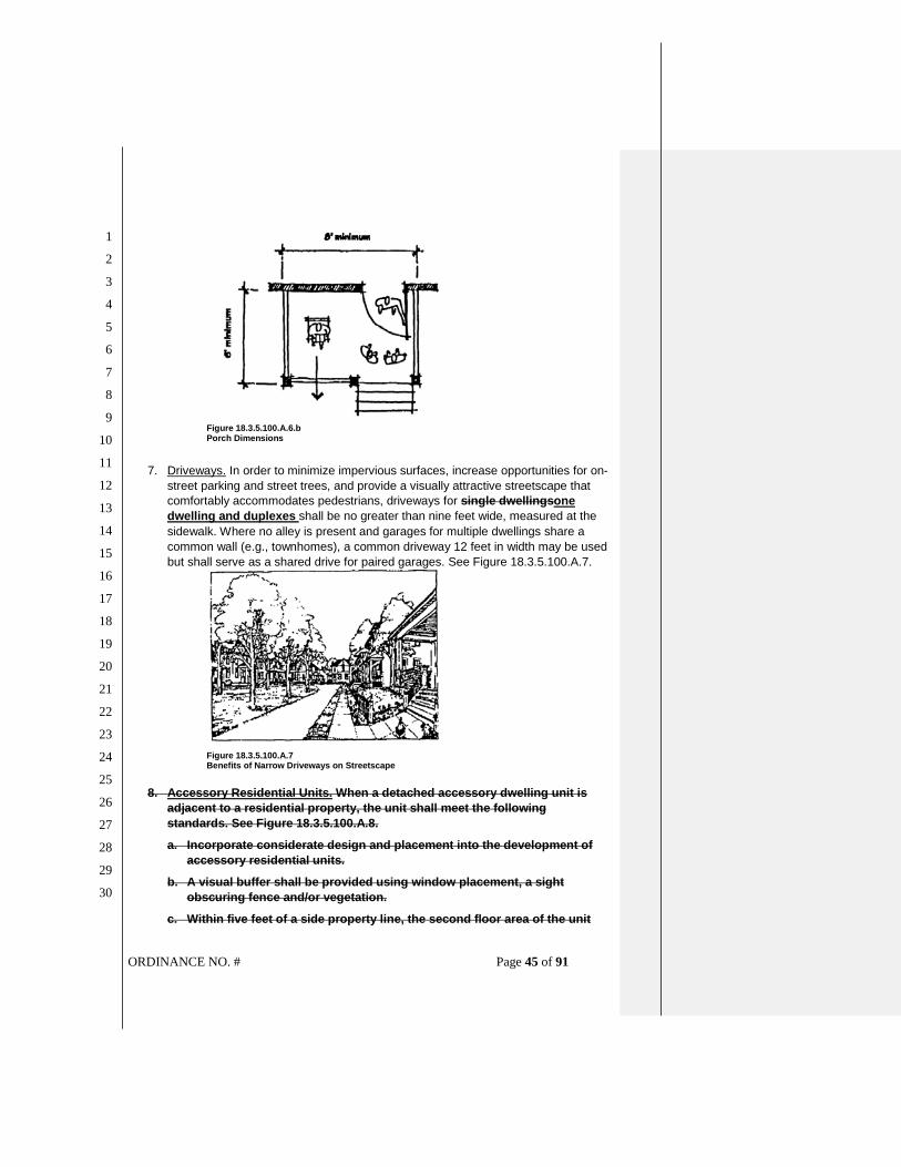
ORDINANCE NO. # Page 45 of 91
1
2
3
4
5
6
7
8
9
10
11
12
13
14
15
16
17
18
19
20
21
22
23
24
25
26
27
28
29
30
Figure 18.3.5.100.A.6.b
Porch Dimensions
7. Driveways. In order to minimize impervious surfaces, increase opportunities for on-
street parking and street trees, and provide a visually attractive streetscape that
comfortably accommodates pedestrians, driveways for single dwellingsone
dwelling and duplexes shall be no greater than nine feet wide, measured at the
sidewalk. Where no alley is present and garages for multiple dwellings share a
common wall (e.g., townhomes), a common driveway 12 feet in width may be used
but shall serve as a shared drive for paired garages. See Figure 18.3.5.100.A.7.
Figure 18.3.5.100.A.7 Benefits of Narrow Driveways on Streetscape
8. Accessory Residential Units. When a detached accessory dwelling unit is
adjacent to a residential property, the unit shall meet the following
standards. See Figure 18.3.5.100.A.8.
a. Incorporate considerate design and placement into the development of
accessory residential units.
b. A visual buffer shall be provided using window placement, a sight
obscuring fence and/or vegetation.
c. Within five feet of a side property line, the second floor area of the unit

ORDINANCE NO. # Page 46 of 91
1
2
3
4
5
6
7
8
9
10
11
12
13
14
15
16
17
18
19
20
21
22
23
24
25
26
27
28
29
30
shall be staggered and step-back an additional five feet or contain other
detailing, in order to break up the mass of the building. With the addition
of a dormer, this standard can be met without the step-back or reduced
floor area.
Figure 18.3.5.100.A.8 Accessory Residential Units Along Alley (delete graphic above)
SECTION 17. Section 18.3.9.050 [Performance Standards for Residential Developments – Performance Standards Option and PSO Overlay] of the Ashland Land Use Ordinance is hereby amended to read as follows:
18.3.9.050 Performance Standards for Residential Developments A. Base Densities. The density of the development shall not exceed the density
established by this section. The density shall be computed by dividing the total number
of dwelling units by the acreage of the project, including land dedicated to the public.
Fractional portions of the final answer, after bonus point calculations, shall not apply
towards the total density. Accessory residential units and duplexes are not required
to meet the density requirements of this chapter in accordance with sections
18.2.3.040 and 18.2.3.110.
1. The base density, for purposes of determining density bonuses allowed under this
section, for developments other than cottage housing, is as provided in Table
18.3.9.050.
Table 18.3.9.050.A.1 Base Densities for Determining Allowable
Density Bonus with Performance Standards Option
Zone Allowable Density (dwelling units per acre)
WR-2 0.30 du/acre
WR-2.5 0.24 du/acre
WR-5 0.12 du/acre
WR-10 0.06 du/acre
WR-20 0.03 du/acre
RR-1 0.60 du/acre

ORDINANCE NO. # Page 47 of 91
1
2
3
4
5
6
7
8
9
10
11
12
13
14
15
16
17
18
19
20
21
22
23
24
25
26
27
28
29
30
Table 18.3.9.050.A.1 Base Densities for Determining Allowable
Density Bonus with Performance Standards Option
RR-.5 1.2 du/acre
R-1-10 2.40 du/acre
R-1-7.5 3.60 du/acre
R-1-5 4.50 du/acre
R-1-3.5 7.2 du/acre
R-2 13.5 du/acre
R-3 20 du/acre
2. Cottage Housing Development Density. The base density for cottage housing
developments, for purposes of determining density bonuses, allowed under
this section is as provided in Table 18.3.9.050.A.2. Cottage housing
developments are not eligible for density bonuses pursuant to subsection
18.3.9.050.B.
a. Density Calculation. The maximum permitted number of dwellings and
minimum lot areas for cottage housing developments allowed under this
section is provided in Table 18.3.9.050.A.2.a. Cottage housing
developments are not eligible for density bonuses pursuant to subsection
18.3.9.050.B.
Table 18.3.9.050.A.2.a Base Densities for Determining Allowable Density Bonus with Performance Standards Option
Zones Maximum Cottage Density
Minimum number of
cottages per cottage housing
development
Maximum number of
cottages per cottage housing
development
Minimum lot size (accommodates
minimum number of cottages)
Maximum Floor Area Ratio (FAR)
R-1-5, NN-1-5 NM-R-5
1 cottage dwelling unit per
2,500 square feet of lot area
3 12 7,500 sq.ft. 0.35
R-1-7.5 NM-R-1-7.5
1 cottage dwelling unit per
3,750 square feet of lot area
3 12 11,250 sq.ft. 0.35
b. Duplexes. Duplexes are permitted in a cottage housing development if the
total number of dwellings in the development is at or below the maximum
cottage housing development density in subsection 18.3.9.050.A.2.a,
above.
3. Common Open Space Required. All developments subject to this section with a
base density of ten units or greater shall be required to provide common open
space pursuant to section 18.4.4.070.
B. Density Bonus Point Calculations. The permitted base density shall be increased by
the percentage gained through density bonus points. In no case shall the density
exceed that allowed under the Comprehensive Plan. The maximum density bonus

ORDINANCE NO. # Page 48 of 91
1
2
3
4
5
6
7
8
9
10
11
12
13
14
15
16
17
18
19
20
21
22
23
24
25
26
27
28
29
30
permitted shall be 60 percent (base density x 1.6), pursuant to the following criteria.
1. Conservation Housing. A maximum 15 percent bonus is allowed. One-hundred
percent of the homes or residential units approved for development, after bonus
point calculations, shall meet the minimum requirements for certification as a Earth
Advantage home, as approved by the Ashland Conservation Division under the
City’ s Earth Advantage program as adopted by resolution 2006-06.
2. Common Open Space. A maximum ten percent bonus is allowed, pursuant to the
following.
a. Purpose. Common open spaces may be provided in the form of natural areas,
wetlands, playgrounds, active or passive recreational areas, and similar areas
in common ownership. However, for the purposes of awarding density bonus
points, the Planning Commission shall consider whether or not the common
open space is a significant amenity to project residents, and whether project
residents will use or enjoy the common open space on a day-to-day basis.
b. Standard. Developments with fewer than ten units that provide more than two
percent of the project area for common open space, or for developments of ten
units or greater that provide more than five percent common open space, a one
percent bonus shall be awarded for each one percent of the total project area
in common open space in excess of any common open space required by
section 18.4.4.070 and this ordinance. The common open space shall meet
the standards in section 18.4.4.070.
3. Affordable Housing. A maximum bonus of 35 percent is allowed. Developments
shall receive a density bonus of two units for each affordable housing unit
provided. Affordable housing bonus shall be for residential units that are
guaranteed affordable in accordance with the standards of section 18.2.5.050
Affordable Housing Standards.
SECTION 18. Section 18.3.10.090 [Development Standards for Hillside Lands – Physical and Environmental Constraints Overlay] of the Ashland Land Use Ordinance is hereby amended to read as follows:
18.3.10.090 Development Standards for Hillside Lands It is the purpose of the Development Standards for Hillside Lands to provide
supplementary development regulations to underlying zones to ensure that development
occurs in such a manner as to protect the natural and topographic character and identity of
these areas, environmental resources, the aesthetic qualities and restorative value of
lands, and the public health, safety, and general welfare by insuring that development
does not create soil erosion, sedimentation of lower slopes, slide damage, flooding
problems, and severe cutting or scarring. It is the intent of these development standards
to encourage a sensitive form of development and to allow for a reasonable use that
complements the natural and visual character of the City.
A. General Requirements. The following general requirements shall apply in Hillside

ORDINANCE NO. # Page 49 of 91
1
2
3
4
5
6
7
8
9
10
11
12
13
14
15
16
17
18
19
20
21
22
23
24
25
26
27
28
29
30
Lands.
1. Buildable Area. All development shall occur on lands defined as having buildable
area. Slopes greater than 35 percent shall be considered unbuildable except as
allowed below. Exceptions may be granted to this requirement only as provided in
subsection 18.3.10.090.H.
a. Existing parcels without adequate buildable area less than or equal to 35
percent shall be considered buildable for one unitsingle-family dwelling and
an accessory residential unit or a duplex in accordance with the
standards in sections 18.2.3.040 and 18.2.3.110.
b. Existing parcels without adequate buildable area less than or equal to 35
percent cannot be subdivided or partitioned.
2. Building Envelope. All newly created lots either by subdivision or partition shall
contain a building envelope with a slope of 35 percent or less.
3. New Streets and Driveways. New streets, flag drives, and driveways shall be
constructed on lands of less than or equal to 35 percent slope with the following
exceptions.
a. The street is indicated on the Street Dedication map.
b. The portion of the street, flag drive, or driveway on land greater than 35 percent
slope does not exceed a length of 100 feet.
4. Geotechnical Studies. For all applications on Hillside Lands involving subdivisions
or partitions, the following additional information is required: A geotechnical study
prepared by a geotechnical expert indicating that the site is stable for the proposed
use and development. The study shall include the following information.
a. Index map.
b. Project description to include location, topography, drainage, vegetation,
discussion of previous work and discussion of field exploration methods.
c. Site geology, based on a surficial survey, to include site geologic maps,
description of bedrock and surficial materials, including artificial fill, locations of
any faults, folds, etc., and structural data including bedding, jointing and shear
zones, soil depth, and soil structure.
d. Discussion of any off-site geologic conditions that may pose a potential hazard
to the site, or that may be affected by on-site development.
e. Suitability of site for proposed development from a geologic standpoint.
f. Specific recommendations for cut and fill slope stability, seepage and drainage
control, or other design criteria to mitigate geologic hazards.
g. If deemed necessary by the engineer or geologist to establish whether an area
to be affected by the proposed development is stable, additional studies and
supportive data shall include cross-sections showing subsurface structure,
graphic logs with subsurface exploration, results of laboratory test and
references.
Commented [mh7]: While one section of the new state rules (OAR 660-046-010) allow cities to limit duplex development in documented natural hazard areas such as floodpains and hillsides, another section requires that cities allow conversions of existing detached single-family to duplexes (OAR 660-046-0105). Since conversions of existing detached single-family residences must be allowed under the new state rules, a house could be built and then later could be converted to a duplex. As a result, staff recommends allowing the development of an ARU or duplex on existing parcels with slopes over 35%.

ORDINANCE NO. # Page 50 of 91
1
2
3
4
5
6
7
8
9
10
11
12
13
14
15
16
17
18
19
20
21
22
23
24
25
26
27
28
29
30
h. Signature and registration number of the engineer and/or geologist.
i. Additional information or analyses as necessary to evaluate the site.
j. Inspection schedule for the project as required in 18.3.10.090.B.9.
k. Location of all irrigation canals and major irrigation pipelines.
B. Hillside Grading and Erosion Control. All development on lands classified as
Hillside shall provide plans conforming to the following items.
1. All grading, retaining wall design, drainage, and erosion control plans for
development on Hillside Lands shall be designed by a geotechnical expert. All
cuts, grading or fills shall conform to the International Building Code and be
consistent with the provisions of this ordinance. Erosion control measures on the
development site shall be required to minimize the solids in runoff from disturbed
areas.
2. Timing of Improvements. For development other than single family homes on
individual lots, all grading, drainage improvements, or other land disturbances shall
only occur from May 1 to October 31. Excavation shall not occur during the
remaining wet months of the year. Erosion control measures shall be installed and
functional by October 31. Up to 30 day modifications to the October 31 date, and
45 day modification to the May 1 date may be made by the Planning Director,
based upon weather conditions and in consultation with the project geotechnical
expert. The modification of dates shall be the minimum necessary, based upon
evidence provided by the applicant, to accomplish the necessary project goals.
3. Retention in natural state. On all projects on Hillside Lands involving partitions and
subdivisions, and existing lots with an area greater than one-half acre, an area
equal to 25 percent of the total project area, plus the percentage figure of the
average slope of the total project area, shall be retained in a natural state. Lands to
be retained in a natural state shall be protected from damage through the use of
temporary construction fencing or the functional equivalent. For example, on a
25,000 square feet lot with an average slope of 29 percent, 25%+29%=54% of the
total lot area shall be retained in a natural state. The retention in a natural state of
areas greater than the minimum percentage required here is encouraged.
4. Grading - Cuts. On all cut slopes on areas classified as Hillside Lands, the
following standards shall apply.
a. Cut slope angles shall be determined in relationship to the type of materials of
which they are composed. Where the soil permits, limit the total area exposed
to precipitation and erosion. Steep cut slopes shall be retained with stacked
rock, retaining walls, or functional equivalent to control erosion and provide
slope stability when necessary. Where cut slopes are required to be laid back
(1:1 or less steep), the slope shall be protected with erosion control getting or
structural equivalent installed per manufacturers specifications, and
revegetated.
b. Exposed cut slopes, such as those for streets, driveway accesses, or yard
areas, greater than seven feet in height shall be terraced. Cut faces on a

ORDINANCE NO. # Page 51 of 91
1
2
3
4
5
6
7
8
9
10
11
12
13
14
15
16
17
18
19
20
21
22
23
24
25
26
27
28
29
30
terraced section shall not exceed a maximum height of five feet. Terrace widths
shall be a minimum of three feet to allow for the introduction of vegetation for
erosion control. Total cut slopes shall not exceed a maximum vertical height of
15 feet. The top of cut slopes not utilizing structural retaining walls shall be
located a minimum setback of one-half the height of the cut slope from the
nearest property line. See Figure 18.3.10.090.B.4.b.
Figure 18.3.10.090.B.4.b Cut and Fill Slopes
c. Cut slopes for structure foundations which reduce the effective visual bulk,
such as split pad or stepped footings, shall be exempted from the height
limitations of this section. See Figure 18.3.10.090.B.c.
Figure 18.3.10.090.B.4.c Stepped Foundations
d. Revegetation of cut slope terraces shall include the provision of a planting plan,
introduction of top soil where necessary, and the use of irrigation if necessary.
The vegetation used for these areas shall be native, or species similar in
resource value to native plants, which will survive, help reduce the visual
impact of the cut slope, and assist in providing long term slope stabilization.

ORDINANCE NO. # Page 52 of 91
1
2
3
4
5
6
7
8
9
10
11
12
13
14
15
16
17
18
19
20
21
22
23
24
25
26
27
28
29
30
Trees, bush-type plantings, and cascading vine-type plantings may be
appropriate.
5. Grading - Fill. On all fill slopes on lands classified as Hillside Lands, the following
standards shall apply.
a. Fill slopes shall not exceed a total vertical height of 20 feet. The toe of the fill
slope area not utilizing structural retaining shall be a minimum of six feet from
the nearest property line.
b. Fill slopes shall be protected with an erosion control netting, blanket or
functional equivalent. Netting or blankets shall only be used in conjunction with
an organic mulch such as straw or wood fiber. The blanket must be applied so
that it is in complete contact with the soil so that erosion does not occur
beneath it. Erosion netting or blankets shall be securely anchored to the slope
in accordance with manufacturer's recommendations.
c. Whenever possible, utilities shall not be located or installed on or in fill slopes.
When determined that it necessary to install utilities on fill slopes, all plans shall
be designed by a geotechnical expert.
d. Revegetation of fill slopes shall utilize native vegetation or vegetation similar in
resource value and which will survive and stabilize the surface. Irrigation may
be provided to ensure growth if necessary. Evidence shall be required
indicating long-term viability of the proposed vegetation for the purposes of
erosion control on disturbed areas.
6. Revegetation Requirements. Where required by this chapter, all required
revegetation of cut and fill slopes shall be installed prior to the issuance of a
certificate of occupancy, signature of a required survey plat, or other time as
determined by the hearing authority. Vegetation shall be installed in such a manner
as to be substantially established within one year of installation.
7. Maintenance, Security, and Penalties for Erosion Control Measures.
a. Maintenance. All measures installed for the purposes of long-term erosion
control, including but not limited to vegetative cover, rock walls, and
landscaping, shall be maintained in perpetuity on all areas which have been
disturbed, including public rights-of-way. The applicant shall provide evidence
indicating the mechanisms in place to ensure maintenance of measures.
b. Security. Except for individual lots existing prior to January 1, 1998, after an
Erosion Control Plan is approved by the hearing authority and prior to
construction, the applicant shall provide a performance bond or other financial
guarantees in the amount of 120 percent of the value of the erosion control
measures necessary to stabilize the site. Any financial guarantee instrument
proposed, other than a performance bond, shall be approved by the City
Attorney. The financial guarantee instrument shall be in effect for a period of at
least one year, and shall be released when the Community Development
Director and Public Works Director determine, jointly, that the site has been
stabilized. All or a portion of the security retained by the City may be withheld

ORDINANCE NO. # Page 53 of 91
1
2
3
4
5
6
7
8
9
10
11
12
13
14
15
16
17
18
19
20
21
22
23
24
25
26
27
28
29
30
for a period up to five years beyond the one year maintenance period if it has
been determined by the City that the site has not been sufficiently stabilized
against erosion.
8. Site Grading. The grading of a site on Hillside Lands shall be reviewed considering
the following factors.
a. No terracing shall be allowed except for the purposes of developing a level
building pad and for providing vehicular access to the pad.
b. Avoid hazardous or unstable portions of the site.
c. Avoid hazardous or unstable portions of the site.
d. Building pads should be of minimum size to accommodate the structure and a
reasonable amount of yard space. Pads for tennis courts, swimming pools and
large lawns are discouraged. As much of the remaining lot area as possible
should be kept in the natural state of the original slope.
9. Inspections and Final Report. Prior to the acceptance of a subdivision by the City,
signature of the final survey plat on partitions, or issuance of a certificate of
occupancy for individual structures, the project geotechnical expert shall provide a
final report indicating that the approved grading, drainage, and erosion control
measures were installed as per the approved plans, and that all scheduled
inspections, as per 18.3.10.090.A.4.j were conducted by the project geotechnical
expert periodically throughout the project.
C. Surface and Groundwater Drainage. All development on Hillside Lands shall
conform to the following standards.
1. All facilities for the collection of stormwater runoff shall be constructed on the site
and according to the following requirements:
a. Stormwater facilities shall include storm drain systems associated with street
construction, facilities for accommodating drainage from driveways, parking
areas and other impervious surfaces, and roof drainage systems.
b. Stormwater facilities, when part of the overall site improvements, shall be, to
the greatest extent feasible, the first improvements constructed on the
development site.
c. Stormwater facilities shall be designed to divert surface water away from cut
faces or sloping surfaces of a fill.
d. Existing natural drainage systems shall be utilized, as much as possible, in
their natural state, recognizing the erosion potential from increased storm
drainage.
e. Flow-retarding devices, such as detention ponds and recharge berms, shall be
used where practical to minimize increases in runoff volume and peak flow rate
due to development. Each facility shall consider the needs for an emergency
overflow system to safely carry any overflow water to an acceptable disposal
point.

ORDINANCE NO. # Page 54 of 91
1
2
3
4
5
6
7
8
9
10
11
12
13
14
15
16
17
18
19
20
21
22
23
24
25
26
27
28
29
30
f. Stormwater facilities shall be designed, constructed and maintained in a
manner that will avoid erosion on-site and to adjacent and downstream
properties.
g. Alternate stormwater systems, such as dry well systems, detention ponds, and
leach fields, shall be designed by a registered engineer or geotechnical expert
and approved by the Public Works Department or Building Official.
D. Tree Conservation, Protection and Removal. All development on Hillside Lands
shall conform to the following requirements.
1. Inventory of Existing Trees. A tree survey at the same scale as the project site plan
shall be prepared, which locates all trees greater than six inches diameter at breast
height (DBH) identified by DBH, species, approximate extent of tree canopy. In
addition, for areas proposed to be disturbed, existing tree base elevations shall be
provided. Dead or diseased trees shall be identified. Groups of trees in close
proximity (i.e., those within five feet of each other) may be designated as a clump
of trees, with the predominant species, estimated number and average diameter
indicated. All tree surveys shall have an accuracy of plus or minus two feet. The
name, signature, and address of the site surveyor responsible for the accuracy of
the survey shall be provided on the tree survey. Portions of the lot or project area
not to be disturbed by development need not be included in the inventory.
2. Evaluation of Suitability for Conservation. All trees indicated on the inventory of
existing trees shall also be identified as to their suitability for conservation. When
required by the hearing authority, the evaluation shall be conducted by a landscape
professional. The following factors shall be included in this determination.
a. Tree Health. Healthy trees can better withstand the rigors of development than
non-vigorous trees.
b. Tree Structure. Trees with severe decay or substantial defects are more likely
to result in damage to people and property.
c. Species. Species vary in their ability to tolerate impacts and damage to their
environment.
d. Longevity. Potential longevity.
e. Variety. A variety of native tree species and ages.
f. Size. Large trees provide a greater protection for erosion and shade than
smaller trees.
3. Tree Conservation in Project Design. Significant conifer trees having a trunk 18
caliper inches or larger in diameter at breast height (DBH), and broadleaf trees
having a trunk 12 caliper inches or larger in diameter at breast height (DBH), shall
be protected and incorporated into the project design whenever possible.
a. Streets, driveways, buildings, utilities, parking areas, and other site disturbances
shall be located such that the maximum number of existing trees on the site are
preserved, while recognizing and following the standards for fuel reduction if the
development is located in Wildfire Lands. See Figure 18.3.10.090.D.3.a.

ORDINANCE NO. # Page 55 of 91
1
2
3
4
5
6
7
8
9
10
11
12
13
14
15
16
17
18
19
20
21
22
23
24
25
26
27
28
29
30
Figure 18.3.10.090.D.3.a Site Planning for Tree Preservation
b. Building envelopes shall be located and sized to preserve the maximum
number of trees on site while recognizing and following the standards for fuel
reduction if the development is located in Wildfire Lands.
c. Layout of the project site utility and grading plan shall avoid disturbance of tree
protection areas.
4. Tree Protection. On all properties where trees are required to be preserved during
the course of development, the developer shall follow the following tree protection
standards.
a. All trees designated for conservation shall be clearly marked on the project site.
Prior to the start of any clearing, stripping, stockpiling, trenching, grading,
compaction, paving or change in ground elevation, the applicant shall install
tree protection fencing in accordance with 18.4.5.030.C Prior to any
construction activity, the shall be inspected pursuant to section 18.4.5.030.D.
b. Construction site activities, including but not limited to parking, material
storage, soil compaction, and concrete washout, shall be arranged so as to
prevent disturbances within tree protection areas.
c. No grading, stripping, compaction, or significant change in ground elevation
shall be permitted within the drip line of trees designated for conservation
unless indicated on the grading plans, as approved by the City, and landscape
professional. If grading or construction is approved within the drip-line, a
landscape professional may be required to be present during grading
operations, and shall have authority to require protective measures to protect
the roots.
d. Changes in soil hydrology and site drainage within tree protection areas shall
be minimized. Excessive site run-off shall be directed to appropriate storm
drain facilities and away from trees designated for conservation.
e. Should encroachment into a tree protection area occur which causes
irreparable damage, as determined by a landscape professional, to trees, the
project plan shall be revised to compensate for the loss. Under no
circumstances shall the developer be relieved of responsibility for compliance
with the provisions of this chapter.

ORDINANCE NO. # Page 56 of 91
1
2
3
4
5
6
7
8
9
10
11
12
13
14
15
16
17
18
19
20
21
22
23
24
25
26
27
28
29
30
5. Tree Removal. Development shall be designed to preserve the maximum number
of trees on a site. The development shall follow the standards for fuel reduction if
the development is located in Wildfire Lands. When justified by findings of fact, the
hearing authority may approve the removal of trees for one or more of the following
conditions.
a. The tree is located within the building envelope.
b. The tree is located within a proposed street, driveway, or parking area.
c. The tree is located within a water, sewer, or other public utility easement.
d. The tree is determined by a landscape professional to be dead or diseased, or
it constitutes an unacceptable hazard to life or property when evaluated by the
standards in 18.3.10.090.D.2.
e. The tree is located within or adjacent to areas of cuts or fills that are deemed
threatening to the life of the tree, as determined by a landscape professional.
f. The tree is identified for removal as part of an approved fire prevention and
control plan per section 18.3.10.100.A, or with the exception of significant trees
the tree removal is recommended by the Fire Code Official, and approved by
the Staff Advisor, as part of a comprehensive fuels reduction strategy to
implement a General Fuel Modification Area consistent with 18.3.10.100 B.
6. Tree Replacement. Trees approved for removal, with the exception of trees
removed because they were determined to be diseased, dead, a hazard, or to
comply with General Fuel Modification Area requirements, shall be replaced in
compliance with the following standards.
a. Replacement trees shall be indicated on a tree replanting plan. The replanting
plan shall include all locations for replacement trees, and shall also indicate
tree planting details.
b. Replacement trees shall be planted such that the trees will in time result in
canopy equal to or greater than the tree canopy present prior to development
of the property. See Figure 18.3.10.090.D.6.b. The canopy shall be designed to
mitigate of the impact of paved and developed areas, reduce surface erosion,
and increase slope stability. Replacement tree locations shall consider impact
on the wildfire prevention and control plan. The hearing authority shall have the
discretion to adjust the proposed replacement tree canopy based upon site-
specific evidence and testimony.

ORDINANCE NO. # Page 57 of 91
1
2
3
4
5
6
7
8
9
10
11
12
13
14
15
16
17
18
19
20
21
22
23
24
25
26
27
28
29
30
Figure 18.3.10.090.D.6.b Tree Planting Guideline
c. Maintenance of replacement trees shall be the responsibility of the property
owner. Required replacement trees shall be continuously maintained in a
healthy manner. Trees that die within the first five years after initial planting
must be replaced in kind, after which a new five-year replacement period shall
begin. Replanting must occur within 30 days of notification unless otherwise
noted.
7. Enforcement.
a. All tree removal shall be done in accord with the approved tree removal and
replacement plan. No trees designated for conservation shall be removed
without prior approval of the City.
b. Should the developer or developer's agent remove or destroy any tree that has
been designated for conservation, the developer may be fined up to three times
the current appraised value of the replacement trees and cost of replacement
or up to three times the current market value, as established by a professional
arborist, whichever is greater.
c. Should the developer or developer's agent damage any tree that has been
designated for protection and conservation, the developer shall be penalized
$50.00 per scar. If necessary, a professional arborist's report, prepared at the
developer's expense, may be required to determine the extent of the damage.
Should the damage result in loss of appraised value greater than determined
above, the higher of the two values shall be used.
E. Building Location and Design Standards. All buildings and buildable areas
proposed for Hillside Lands shall be designed and constructed in compliance with the
following standards.
1. Building Envelopes. All newly created lots, either by subdivision or partition, shall

ORDINANCE NO. # Page 58 of 91
1
2
3
4
5
6
7
8
9
10
11
12
13
14
15
16
17
18
19
20
21
22
23
24
25
26
27
28
29
30
contain building envelopes conforming to the following standards.
a. The building envelope shall contain a buildable area with a slope of 35 percent
or less. See Figure 18.3.10.090.E.1.a.
Figure 18.3.10.090.E.1.a Buildable Area
b. Building envelopes and lot design shall address the retention of a percentage
of the lot in a natural state as required in 18.3.10.090.B.3.
c. Building envelopes shall be designed and located to maximize tree
conservation as required in 18.3.10.090.D.3 while recognizing and following the
standards for fuel reduction if the development is located in Wildfire Lands.
d. It is recommended that building envelope locations should be located to avoid
ridgeline exposures, and designed such that the roofline of a building within the
envelope does not project above the ridgeline as illustrated in Figure
18.3.10.090.E.1.d.
Figure 18.3.10.090.E.1.d.
2. Building Design. To reduce hillside disturbance through the use of slope
responsive design techniques, buildings on Hillside Lands, excepting those lands

ORDINANCE NO. # Page 59 of 91
1
2
3
4
5
6
7
8
9
10
11
12
13
14
15
16
17
18
19
20
21
22
23
24
25
26
27
28
29
30
within the designated Historic District, shall incorporate the following into the
building design and indicate features on required building permits.
a. The height of all structures shall be measured vertically from the natural grade
to the uppermost point of the roof edge or peak, wall, parapet, mansard, or
other feature perpendicular to that grade. Maximum hillside building height
shall be 35 feet. See Figure 18.3.10.090.E.2.a.i and Figure 18.3.10.090.E.2.a.ii.
Figure 18.3.10.090.E.2.a.i Hillside Building Height/Permitted
Figure 18.3.10.090.E.2.a.ii Hillside Building Height/Not Permitted
b. Cut buildings into hillsides to reduce effective visual bulk.
i. Split pad or stepped footings shall be incorporated into building design to
allow the structure to more closely follow the slope.
ii. Reduce building mass by utilizing below grade rooms cut into the natural

ORDINANCE NO. # Page 60 of 91
1
2
3
4
5
6
7
8
9
10
11
12
13
14
15
16
17
18
19
20
21
22
23
24
25
26
27
28
29
30
slope.
c. A building step back shall be required on all downhill building walls greater than
20 feet in height, as measured above natural grade. Step-backs shall be a
minimum of six feet. Decks projecting out from the building wall and hillside
shall not be considered a building step-back. No vertical walls on the downhill
elevations of new buildings shall exceed a maximum height of 20 feet above
natural grade. See Figure 18.3.10.090.E.2.c.
Figure 18.3.10.090.E.2.c Downhill Building Step Back
d. Continuous horizontal building planes shall not exceed a maximum length of 36
feet. Planes longer than 36 feet shall include a minimum offset of six feet. See
Figure 18.3.10.090.E.2.d.

ORDINANCE NO. # Page 61 of 91
1
2
3
4
5
6
7
8
9
10
11
12
13
14
15
16
17
18
19
20
21
22
23
24
25
26
27
28
29
30
Figure 18.3.10.090.E.2.d Horizontal Offsets
e. It is recommended that roof forms and roof lines for new structures be broken
into a series of smaller building components to reflect the irregular forms of the
surrounding hillside. Long, linear unbroken roof lines are discouraged. Large
gable ends on downhill elevations should be avoided, however smaller gables
may be permitted. See Figure 18.3.10.090.E.2.c.
f. It is recommended that roofs of lower floor levels be used to provide deck or
outdoor space for upper floor levels. The use of overhanging decks with vertical
supports in excess of 12 feet on downhill elevations should be avoided.
g. It is recommended that color selection for new structures be coordinated with
the predominant colors of the surrounding landscape to minimize contrast
between the structure and the natural environment.
F. All structures on Hillside Lands shall have foundations designed by an engineer or
architect with demonstrable geotechnical design experience. A designer, as defined,
shall not complete working drawings without having foundations designed by an
engineer.
G. All newly created lots or lots modified by a lot line adjustment must include building
envelopes containing a buildable area less than 35 percent slope of sufficient size to
accommodate the uses permitted in the underlying zone, unless the division or lot line
adjustment is to provide open space or for conservation purposes.
H. Exception to the Development Standards for Hillside Lands. An exception under
this section is not subject to the variance requirements of chapter 18.5.5 Variances. An

ORDINANCE NO. # Page 62 of 91
1
2
3
4
5
6
7
8
9
10
11
12
13
14
15
16
17
18
19
20
21
22
23
24
25
26
27
28
29
30
application for an exception is subject to the Type I procedure in section 18.5.1.050
and may be granted with respect to the development standards for Hillside Lands if the
proposal meets all of the following criteria.
1. There is demonstrable difficulty in meeting the specific requirements of this chapter
due to a unique or unusual aspect of the site or proposed use of the site.
2. The exception will result in equal or greater protection of the resources protected
under this chapter.
3. The exception is the minimum necessary to alleviate the difficulty.
4. The exception is consistent with the stated Purpose and Intent of chapter 18.3.10
Physical and Environmental Constraints Overlay chapter and section 18.3.10.090
Development Standards for Hillside Lands.
SECTION 19. Section 18.3.12.060 [Pedestrian Place Overlay – Site Development and Design Overlays] of the Ashland Land Use Ordinance is hereby amended to read as follows:
18.3.12.060 Pedestrian Place Overlay
A. Purpose. The Pedestrian Place overlay is intended to direct and encourage
development of small walkable nodes that provide concentrations of gathering places,
housing, businesses, and pedestrian amenities situated and designed in a way to
encourage walking, bicycling, and transit use.
B. Applicability
1. This section applies to properties designated as Pedestrian Places overlay on the
Site Design Zones map.
2. Review Procedure. The Pedestrian Place overlay requirements apply to proposed
development located in the Pedestrian Place overlay that requires a planning
application approval, and involves development of new structures or additions
other than single-family dwellings, accessory residential units, duplexes, and
other associated accessory structures and uses. The provisions of the Pedestrian
Place overlay supplement those of the applicable base zoning district and other
applicable ordinance requirements.
3. Mixed-Use Buildings in Residential Zones. Mixed-use buildings located in an
underlying residential zone require Site Design Review approval in accordance
with chapter 18.5.2, and are subject to the standards subsection 18.4.2.040.B
Basic Site Review Standards rather than section 18.4.2.030 Residential
Development. Mixed-use buildings are subject to all other applicable provisions of
part 18.4 Site Development and Design Standards.
4. The Pedestrian Places overlay and development standards do not apply to
properties electing to develop under the Transit Triangle (TT) overlay option. See
chapter 18.3.14 Transit Triangle Overlay.

ORDINANCE NO. # Page 63 of 91
1
2
3
4
5
6
7
8
9
10
11
12
13
14
15
16
17
18
19
20
21
22
23
24
25
26
27
28
29
30
C. Pedestrian Place Concept Plans. The Pedestrian Place Concept plans (i.e., site
plan, development summary, and building illustrations) are for the purpose of providing
an example of development that conforms to the standards, and do not constitute
independent approval criteria. Concept plans are attached to the end of this chapter.
D. Development Standards. The following standards shall apply to development in the
Pedestrian Places overlay in addition to all applicable provisions of this ordinance.
1. Building Setbacks. The solar access setback in chapter 18.4.8 Solar Access
applies only to those lots abutting a residential zone to the north.
2. Plazas and Landscaping Ratio. Outdoor seating areas, plazas, and other useable
paved surfaces may be applied toward meeting the landscaping area requirements
in chapter 18.4.4 Landscaping, Lighting, and Screening, but shall not constitute
more than 50 percent of the required area.
E. Development in Residential Zone. The following standards apply to development
located in the Pedestrian Places overlay and a residential zone, in addition to all
applicable provisions of this ordinance.
1. Special Permitted Uses. In addition to the permitted uses in the underlying
residential zone, the following uses and their accessory uses are permitted subject
to the requirements of this section.
a. Professional, financial, business and medical offices, and personal service
establishments.
b. Stores, shops, and offices supplying commodities or performing services.
c. Restaurants.
2. Development Standards and Limitations.
a. The maximum gross floor area occupied by a special permitted use shall be
2,500 square feet.
b. Special permitted uses shall be allowed in a building or in a group of buildings
including a mixture of businesses and housing. At least 50 percent of the total
gross floor area of a building, or of where there is more than one building on a
site, 50 percent of the total lot area including accessory uses such as parking,
landscaping and public space, shall be designated for residential uses.
c. The development shall meet the minimum housing density requirements of the
underlying zone.
d. Mixed-use buildings shall be setback not more than five feet from a public
sidewalk unless the area is used for pedestrian activities such as plazas or
outside eating areas, or for a required public utility easement.
e. Mixed-use developments shall have a minimum Floor Area Ratio (FAR) of .50.
Plazas and pedestrian areas shall count as floor area for the purposes of
meeting the minimum FAR. Projects including existing buildings or vacant
parcels of a half an acre or greater in size shall achieve the required minimum

ORDINANCE NO. # Page 64 of 91
1
2
3
4
5
6
7
8
9
10
11
12
13
14
15
16
17
18
19
20
21
22
23
24
25
26
27
28
29
30
FAR or provide a shadow plan (see graphic) that demonstrates how
development may be intensified over time to meet the required minimum FAR.
SECTION 20. Section 18.4.2.030 [Residential Development – Building Placement, Orientation, and Design] of the Ashland Land Use Ordinance is hereby amended to read as follows:
18.4.2.030 Residential Development A. Purpose and Intent. For new multi-familymultifamily residential developments,
careful design considerations must be made to assure that the development is
compatible with the surrounding neighborhood. For example, the use of earth tone
colors and wood siding will blend a development into an area rather than causing
contrast through the use of overwhelming colors and concrete block walls.
1. Crime Prevention and Defensible Space.
a. Parking Layout. Parking for residents should be located so that distances to
dwellings are minimized. However, avoid designs where parking areas are
immediately abutting dwelling units because there is little or no transition from
public to private areas. Parking areas should be easily visible from adjacent
areas and windows.
b. Orientation of Windows. Windows should be located so that vulnerable areas
can be easily surveyed by residents.
c. Service and Laundry Areas. Service and laundry areas should be located so
that they can be easily observed by others. Windows and lighting should be
incorporated to assure surveillance opportunities. Mail boxes should not be
located in dark alcoves out of sight. Barriers to police surveillance such as tall
shrubs and fences should be avoided.
d. Hardware. Reliance solely upon security hardware in lieu of other alternatives
is discouraged.
e. Lighting. Site development should utilize lighting prudently. More lighting does
not necessarily mean better security. Lighting should be oriented so that areas
vulnerable to crime are accented.
f. Landscaping. Plant materials such as high shrubs should be placed so that
surveillance of semi-public and semi-private areas is not blocked. Thorny
shrubs will discourage crime activity. Low shrubs and canopy trees will allow
surveillance, hence, reduce the potential for crime.
B. Applicability. Except as otherwise required by an overlay zone or plan district, the
following standards apply to residential development pursuant to section 18.5.2.020.
See conceptual site plan of multi-familymultifamily development in Figure
18.4.2.030.
1. Accessory Residential Units. Unless exempted from Site Design Review in
18.2.3.040.A, only the following standards in Chapter 18.4.2 apply to

ORDINANCE NO. # Page 65 of 91
1
2
3
4
5
6
7
8
9
10
11
12
13
14
15
16
17
18
19
20
21
22
23
24
25
26
27
28
29
30
accessory residential units: building orientation requirements in
18.4.2.030.C, garage requirements in 18.4.2.030.D, and building materials in
18.4.2.030.E. If an accessory residential unit is located in the Historic District
overlay, the standards in 18.4.2.050 also apply. See the Special Use
Standards for accessory residential units in section 18.2.3.040.
C. Building Orientation. Residential buildings that are subject to the provisions of this
chapter shall conform to all of the following standards. See also, solar orientation
standards in section 18.4.8.050.
1. Building Orientation to Street. Dwelling units shall have their primary orientation
toward a street. Where residential buildings are located within 20 feet of a street,
they shall have a primary entrance opening toward the street and connected to the
right-of-way via an approved walkway.
2. Limitation on Parking Between Primary Entrance and Street. Automobile circulation
or off-street parking is not allowed between the building and the street. Parking
areas shall be located behind buildings, or on one or both sides.
3. Build-to Line. Where a new building is proposed in a zone that requires a build-to
line or maximum front setback yard, except as otherwise required for clear vision at
intersections, the building shall comply with the build-to line standard.
D. Garages. The following standards apply to garages, carports, canopies, and other
permanent and temporary structures used for parking or storing vehicles, including
those parking and vehicle storage structures accessory to detached single-family
dwellings. The standards are intended to balance residents’ desire for a convenient,
safe, and private vehicle access to their homes with the public interest in maintaining
safe and aesthetically pleasing streetscapes. The standards therefore promote
pedestrian safety and visibility of public ways, while addressing aesthetic concerns
associated with street-facing garages. For the purpose of this subsection, a garage
opening is considered to be facing a street where the opening is parallel to or within 45
degrees of the street right-of-way line.
1. Alleys and Shared Drives. Where a lot abuts a rear or side alley, or a shared
driveway, including flag drives, the garage or carport opening(s) for that dwelling
shall orient to the alley or shared drive, as applicable, and not a street.
2. Setback for Garage Opening Facing Street. The minimum setback for a garage (or
carport) opening facing a street is 20 feet. This provision does not apply to alleys.
E. Building Materials. Building materials and paint colors should be compatible with the
surrounding area. Very bright primary or neon-type paint colors, which attract attention
to the building or use, are unacceptable.
F. Streetscape. One street tree chosen from the street tree list shall be placed for each
30 feet of frontage for that portion of the development fronting the street pursuant to
subsection 18.4.4.030.E.
G. Landscaping and Recycle/Refuse Disposal Areas. Landscaping and recycle/refuse
disposal areas shall be provided pursuant to chapter 18.4.4.

ORDINANCE NO. # Page 66 of 91
1
2
3
4
5
6
7
8
9
10
11
12
13
14
15
16
17
18
19
20
21
22
23
24
25
26
27
28
29
30
H. Open Space. Common and/or private open space are required to be provided
pursuant to section 18.4.4.070.
Figure 18.4.2.030
Multi-FamilyMultifamily Conceptual Site Design
SECTION 21. Section 18.4.3.040 [Parking Ratios – Parking, Access, and Circulation] of the Ashland Land Use Ordinance is hereby amended to read as follows:
18.4.3.040 Parking Ratios
Except as provided by section 18.4.3.030, the standard ratios required for automobile
parking are as follows. Fractional spaces shall be rounded up to the next whole
number. See also, accessible parking space requirements in section 18.4.3.050.

ORDINANCE NO. # Page 67 of 91
1
2
3
4
5
6
7
8
9
10
11
12
13
14
15
16
17
18
19
20
21
22
23
24
25
26
27
28
29
30
Table 18.4.3.040 – Automobile Parking Spaces by Use
Use Categories
Minimum Number of Parking Spaces per Land Use
(Based on Gross Floor Area; fractionsfractional spaces are rounded up to next whole number.)
Residential Categories See definition of dwelling types in section 18.6.1.030.
Single-family Dwelling
2 spaces for detached dwelling units and the following for
attached dwelling units.
a. Studio units or 1-bedroom units less than 500 sq. ft. -- 1
space/unit.
b. 1-bedroom units 500 sq. ft. or larger -- 1.50 spaces/unit.
c. 2-bedroom units --1.75 spaces/unit.
d. 3-bedroom or greater units -- 2.00 spaces/unit.
Accessory Residential Units
a. Units less than 800 sq. ft.– 1 space/unit, except. as
exempted in subsection 18.2.3.040.A.
b. Units greater than 800 sq. ft. and up to 1,000 sq. ft. –
2.00 spaces/unit.
No additional parking spaces required. See definition of
accessory residential unit in section 18.6.1.030.
Duplex
a. 2 spaces per duplex meeting the standards in section
18.2.3.110. See definition of duplex in section
18.6.1.030.
b. Use multifamily dwelling parking ratio for duplex not
meeting the standards of section 18.2.3.110. See
definition of duplex in section 18.6.1.030.
Multi-familyMultifamily Dwellings
a. Studio units or 1-bedroom units less than 500 sq. ft. -- 1
space/unit.
b. 1-bedroom units 500 sq. ft. or larger -- 1.50 spaces/unit.
c. 2-bedroom units -- 1.75 spaces/unit.
d. 3-bedroom or greater units -- 2.00 spaces/unit.
e. Retirement complexes for seniors 55-years or greater --
One space per unit.
f. Transit Triangle (TT) overlay option developments, see
chapter 18.3.14.
Cottage Housing
a. Units less than 800 sq. ft. -- 1 space/unit.
b. Units greater than 800 sq. ft. and less than 1000 sq. ft. --
1.5 spaces/unit.
c. Units greater than 1000 sq. ft. -- 2.00 spaces/unit.
d. Retirement complexes for seniors 55-years or greater --
One space per unit.
Commented [mh8]: To distinguish between required parking for duplex in residential zones under new state law provision and duplexes that are part of a larger multifamily development in the R-2 and R-3 zones or mixed-use development in the C-1 and E-1 zones.
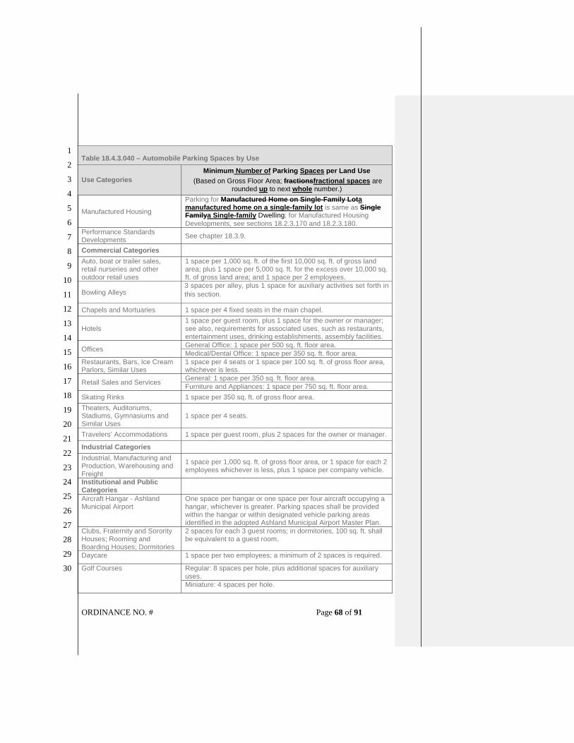
ORDINANCE NO. # Page 68 of 91
1
2
3
4
5
6
7
8
9
10
11
12
13
14
15
16
17
18
19
20
21
22
23
24
25
26
27
28
29
30
Table 18.4.3.040 – Automobile Parking Spaces by Use
Use Categories
Minimum Number of Parking Spaces per Land Use
(Based on Gross Floor Area; fractionsfractional spaces are rounded up to next whole number.)
Manufactured Housing
Parking for Manufactured Home on Single-Family Lota manufactured home on a single-family lot is same as Single Familya Single-family Dwelling; for Manufactured Housing
Developments, see sections 18.2.3.170 and 18.2.3.180.
Performance Standards Developments
See chapter 18.3.9.
Commercial Categories
Auto, boat or trailer sales, retail nurseries and other outdoor retail uses
1 space per 1,000 sq. ft. of the first 10,000 sq. ft. of gross land area; plus 1 space per 5,000 sq. ft. for the excess over 10,000 sq. ft. of gross land area; and 1 space per 2 employees.
Bowling Alleys 3 spaces per alley, plus 1 space for auxiliary activities set forth in
this section.
Chapels and Mortuaries 1 space per 4 fixed seats in the main chapel.
Hotels 1 space per guest room, plus 1 space for the owner or manager; see also, requirements for associated uses, such as restaurants, entertainment uses, drinking establishments, assembly facilities.
Offices General Office: 1 space per 500 sq. ft. floor area.
Medical/Dental Office: 1 space per 350 sq. ft. floor area.
Restaurants, Bars, Ice Cream Parlors, Similar Uses
1 space per 4 seats or 1 space per 100 sq. ft. of gross floor area, whichever is less.
Retail Sales and Services General: 1 space per 350 sq. ft. floor area.
Furniture and Appliances: 1 space per 750 sq. ft. floor area.
Skating Rinks 1 space per 350 sq. ft. of gross floor area.
Theaters, Auditoriums, Stadiums, Gymnasiums and Similar Uses
1 space per 4 seats.
Travelers’ Accommodations 1 space per guest room, plus 2 spaces for the owner or manager.
Industrial Categories
Industrial, Manufacturing and Production, Warehousing and Freight
1 space per 1,000 sq. ft. of gross floor area, or 1 space for each 2 employees whichever is less, plus 1 space per company vehicle.
Institutional and Public Categories
Aircraft Hangar - Ashland Municipal Airport
One space per hangar or one space per four aircraft occupying a hangar, whichever is greater. Parking spaces shall be provided within the hangar or within designated vehicle parking areas identified in the adopted Ashland Municipal Airport Master Plan.
Clubs, Fraternity and Sorority Houses; Rooming and Boarding Houses; Dormitories
2 spaces for each 3 guest rooms; in dormitories, 100 sq. ft. shall be equivalent to a guest room.
Daycare 1 space per two employees; a minimum of 2 spaces is required.
Golf Courses Regular: 8 spaces per hole, plus additional spaces for auxiliary uses.
Miniature: 4 spaces per hole.

ORDINANCE NO. # Page 69 of 91
1
2
3
4
5
6
7
8
9
10
11
12
13
14
15
16
17
18
19
20
21
22
23
24
25
26
27
28
29
30
Table 18.4.3.040 – Automobile Parking Spaces by Use
Use Categories
Minimum Number of Parking Spaces per Land Use
(Based on Gross Floor Area; fractionsfractional spaces are rounded up to next whole number.)
Hospital 2 space per patient bed.
Nursing and Convalescent Homes
1 space per 3 patient beds.
Public Assembly 1 space per 4 seats
Religious Institutions and Houses of Worship
1 space per 4 seats.
Rest Homes, Homes for the Aged, or Assisted Living
1 space per 2 patient beds or 1 space per apartment unit.
Schools Elementary and Junior High: 1.5 spaces per classroom, or 1 space per 75 sq. ft. of public assembly area, whichever is greater
High Schools: 1.5 spaces per classroom, plus 1 space per 10 students the school is designed to accommodate; or the requirements for public assembly area, whichever is greater
Colleges, Universities and Trade Schools: 1.5 spaces per classroom, plus 1 space per five students the school is designed to accommodate, plus requirements for on-campus student housing.
Other Categories
Temporary Uses
Parking standards for temporary uses are the same as for primary uses, except that the City decision-making body may reduce or waive certain development and designs standards for temporary uses.
SECTION 22. Section 18.4.3.060 [Parking Management Strategies – Vehicle Area Design] of the Ashland Land Use Ordinance is hereby amended to read as follows:
18.4.3.060 Parking Management Strategies
Except for detached single-family dwellings and duplexes, the off-street parking spaces
may be reduced through the application of the following credits. The total maximum
reduction in off-street parking spaces is 50 percent, except as allowed for Off-Site Shared
Parking credits in subsection 18.4.3.060.E, below. The approval authority shall have the
discretion to adjust the proposed off-street parking reduction based upon site specific
evidence and testimony, and may require a parking analysis prepared by a qualified
professional. See 18.4.3.030.A.3 for parking analysis requirements.
A. On-Street Parking Credit. Credit for on-street parking spaces may reduce the
required off-street parking spaces up to 50 percent, as follows.
1. Credit. One off-street parking space credit for one on-street parking space meeting
the standards of subsections 2-4, below. See Figure 18.4.3.060.A.1.

ORDINANCE NO. # Page 70 of 91
1
2
3
4
5
6
7
8
9
10
11
12
13
14
15
16
17
18
19
20
21
22
23
24
25
26
27
28
29
30
Figure 18.4.3.060.A.1 On-Street Parking Credit
2. Dimensions. On-street parking shall follow the established configuration of existing
on-street parking, except that 45-degree diagonal parking may be allowed with the
approval of the Public Works Director, taking into account traffic flows and street
design, with the parking spaces designed in accord with the standards on file with
the Public Works Department.
a. Parallel parking, each 22 feet of uninterrupted curb.
b. 45-degree diagonal, each 12 feet of uninterrupted curb.
3. Location.
a. Curb space must be contiguous to the lot containing the use that requires the
parking.
b. Parking spaces may not be counted that are within 20 feet measured along the
curb of any corner or intersection of an alley or street, nor any other parking
configuration that violates any law or standard of the City or State.
c. Parking spaces located on arterials and collectors may only receive credit if the
arterial or collector is greater in width than the minimums established by the
street standards in section 18.4.6.040.
d. Parking spaces may not be counted that are within 200 feet of a C-1-D or SOU
zone.
e. Parking spaces may not be counted that are required as on-street parking in

ORDINANCE NO. # Page 71 of 91
1
2
3
4
5
6
7
8
9
10
11
12
13
14
15
16
17
18
19
20
21
22
23
24
25
26
27
28
29
30
accordance with section 18.3.9.060 in a development under the Performance
Standards Option.
4. Availability. On-street parking spaces credited for a specific use shall not be used
exclusively by that use, but shall be available for general public use at all times. No
signage or actions limiting general public use of on-street spaces shall be
permitted.
B. Alternative Vehicle Parking. Alternative vehicle parking facilities may reduce the
required off-street parking spaces up to 25 percent, as follows.
1. Motorcycle or scooter parking. One off-street parking space credit for four
motorcycle or scooter parking spaces.
2. Bicycle parking. One off-street parking space credit for five additional, non-required
bicycle parking spaces.
3. Microcar parking. One off-street parking space credit for two microcar parking
spaces. Microcar spaces shall be designed so that one full size automobile can
use two microcar spaces, and the microcar spaces shall not be limited in use by
hours or type of vehicle through signage or other legal instrument.
C. Mixed Uses. In the event that several users occupy a single structure or parcel of
land, the total requirements for off-street automobile parking shall be the sum of the
requirements for the several uses computed separately unless it can be shown that the
peak parking demands are offset, in which case the mixed-use credit may reduce the
off-street parking requirement by a percentage equal to the reduced parking demand.
A mixed-use parking credit may reduce the required off-street parking spaces up to 50
percent.
D. Joint Use of Facilities. Required parking facilities of two or more uses, structures, or
parcels of land may be satisfied by the same parking facilities used jointly, to the
extent that it can be shown by the owners or operators that the need for the facilities
does not materially overlap (e.g., uses primarily of a daytime vs. nighttime nature) and
provided that such right of joint use is evidenced by a deed, lease, contract, or similar
written instrument establishing such joint use. Jointly-used parking facilities may
reduce the required off-street parking spaces up to 50 percent.
E. Off-Site Shared Parking. One off-street parking space credit for every one parking
space constructed in designated off-site shared parking areas, or through payment of
in-lieu-of-parking fees for a common parking. Off-site shared parking facilities may
reduce the required off-street parking spaces up to 100 percent.
F. TDM Plan Credit. Through implementation of an individual Transportation Demand
Management (TDM) plan that demonstrates a reduction of long-term parking demand
by a percentage equal to the credit requested. A TDM plan may reduce the required
off-street parking spaces up to 50 percent.
G. Transit Facilities Credit. Sites where at least 20 spaces are required and where at
least one lot line abuts a street with transit service may substitute transit-supportive
plazas as follows. A Transit Facilities Credit may reduce the required off-street parking
spaces up to 50 percent.

ORDINANCE NO. # Page 72 of 91
1
2
3
4
5
6
7
8
9
10
11
12
13
14
15
16
17
18
19
20
21
22
23
24
25
26
27
28
29
30
1. Pedestrian and transit supportive plazas may be substituted for up to ten percent of
the required parking spaces on-site.
2. A street with transit service shall have a minimum of 30-minute peak period transit
service frequency.
3. Existing parking areas may be converted to take advantage of these provisions.
4. The plaza must be adjacent to and visible from the transit street. If there is a bus
stop along the site’s frontage, the plaza must be adjacent to the bus stop.
5. The plaza must be at least 300 square feet in area and be shaped so that a ten-
foot by ten-foot (10 feet X 10 feet) square will fit entirely in the plaza.
6. The plaza must include all of the following elements.
a. A plaza that is open to the public. The owner must record a public access
easement that allows public access to the plaza.
b. A bench or other sitting area with at least five linear feet of seating.
c. A shelter or other weather protection. The shelter must cover at least 20 square
feet and the plaza must be landscaped. This landscaping is in addition to any
other landscaping or screening required for parking areas by this ordinance.
SECTION 23. Section 18.4.3.080 [Parking Ratios – Vehicle Area Design] of the Ashland Land Use Ordinance is hereby amended to read as follows:
18.4.3.080 Vehicle Area Design
A. Parking Location
1. Except for single-family dwellings and two-family dwellingsduplexes, required
automobile parking facilities may be located on another parcel of land, provided
said parcel is within 200 feet of the use it is intended to serve. The distance from
the parking lot to the use shall be measured in walking distance from the nearest
parking space to an access to the building housing the use, along a sidewalk or
other pedestrian path separated from street traffic. Such right to use the off-site
parking must be evidenced by a deed, lease, easement, or similar written
instrument establishing such use, for the duration of the use.
2. Except as allowed in the subsection below, automobile parking shall not be located
in a required front and side yard setback area abutting a public street, except
alleys.
3. In all residential zones, off-street parking in a front yard for all vehicles, including
trailers and recreational vehicles is limited to a contiguous area no more than 25
percent of the area of the front yard, or a contiguous area 25 feet wide and the
depth of the front yard, whichever is greater. Since parking in violation of this
section is occasional in nature, and is incidental to the primary use of the site, no
vested rights are deemed to exist and violations of this section are not subject to
the protection of the nonconforming use sections of this ordinance.

ORDINANCE NO. # Page 73 of 91
1
2
3
4
5
6
7
8
9
10
11
12
13
14
15
16
17
18
19
20
21
22
23
24
25
26
27
28
29
30
B. Parking Area Design. Required parking areas shall be designed in accordance with
the following standards and dimensions as illustrated in 18.4.3.080.B. See also,
accessible parking space requirements in section 18.4.3.050 and parking lot and
screening standards in subsection 18.4.4.030.F.
1. Parking spaces shall be a minimum of 9 feet by 18 feet.
2. Up to 50 percent of the total automobile parking spaces in a parking lot may be
designated for compact cars. Minimum dimensions for compact spaces shall be 8
feet by 16 feet. Such spaces shall be signed or the space painted with the words
"Compact Car Only."
3. Parking spaces shall have a back-up maneuvering space not less than 22 feet,
except where parking is angled, and which does not necessitate moving of other
vehicles.
Figure 18.4.3.080.B
Parking Area Dimensions

ORDINANCE NO. # Page 74 of 91
1
2
3
4
5
6
7
8
9
10
11
12
13
14
15
16
17
18
19
20
21
22
23
24
25
26
27
28
29
30
4. Parking lots with 50 or more parking spaces, and parking lots where pedestrians
must traverse more than 150 feet of parking area, as measured as an average
width or depth, shall be divided into separate areas by one or more of the following
means: a building or group of buildings; plazas landscape areas with walkways at
least five feet in width; streets; or driveways with street-like features as illustrated in
Figure 18.4.3.080.B.4 Street-like features, for the purpose of this section, means a
raised sidewalk of at least five feet in width, with six-inch curb, accessible curb
ramps, street trees in planters or tree wells and pedestrian-oriented lighting (i.e.,
not exceeding 14 feet typical height).
Insert Figure 18.4.3.080.B.4
Dividing Parking Lots into Separate Areas
5. Parking areas shall be designed to minimize the adverse environmental and
microclimatic impacts of surface parking through design and material selection as
illustrated in Figure 18.4.3.080.B.5. Parking areas of more than seven parking
spaces shall meet the following standards.

ORDINANCE NO. # Page 75 of 91
1
2
3
4
5
6
7
8
9
10
11
12
13
14
15
16
17
18
19
20
21
22
23
24
25
26
27
28
29
30
a. Use at one or more of the following strategies for the surface parking area, or
put 50 percent of parking underground. For parking lots with 50 or more
spaces, the approval authority may approve a combination of strategies.
i Use light colored paving materials with a high solar reflectance (Solar
Reflective Index (SRI) of at least 29) to reduce heat absorption for a
minimum of 50 percent of the parking area surface.
ii. Provide porous solid surfacing or an open grid pavement system that is at
least 50 percent pervious for a minimum of 50 percent of the parking area
surface.
iii. Provide at least 50 percent shade from tree canopy over the parking area
surface within five years of project occupancy.
iv. Provide at least 50 percent shade from solar energy generating carports,
canopies or trellis structures over the parking area surface.
b. Design parking lots and other hard surface areas in a way that captures and
treats runoff with landscaped medians and swales.
Figure 18.4.3.080.B.5
Parking Design to Reduce Environmental Impacts
C. Vehicular Access and Circulation. The intent of this subsection is to manage access
to land uses and on-site circulation and maintain transportation system safety and
operations. For transportation improvement requirements, refer to chapter 18.4.6

ORDINANCE NO. # Page 76 of 91
1
2
3
4
5
6
7
8
9
10
11
12
13
14
15
16
17
18
19
20
21
22
23
24
25
26
27
28
29
30
Public Facilities.
1. Applicability. This section applies to all public streets within the City and to all
properties that abut these streets. The standards apply when developments are
subject to a planning action (e.g., Site Design Review, Conditional Use Permit,
Land Partition, Performance Standards Subdivision).
2. Site Circulation. New development shall be required to provide a circulation system
that accommodates expected traffic on the site. All on-site circulation systems shall
incorporate street-like features as described in 18.4.3.080.B.4. Pedestrian
connections on the site, including connections through large sites, and connections
between sites and adjacent sidewalks must conform to the provisions of section
18.4.3.090.
3. Intersection and Driveway Separation. The distance from a street intersection to a
driveway, or from a driveway to another driveway shall meet the minimum spacing
requirements for the street’s classification in the Ashland Transportation System
Plan (TSP) as illustrated in Figures 18.4.3.080.C.3.a and Figure 18.4.3.080.C.3.b.
Figure 18.4.3.080.C.3.a
Driveway Separation for Boulevards, Avenues, and Collectors

ORDINANCE NO. # Page 77 of 91
1
2
3
4
5
6
7
8
9
10
11
12
13
14
15
16
17
18
19
20
21
22
23
24
25
26
27
28
29
30
Figure 18.4.3.080.C.3.b Driveway Separation for Neighborhoods Streets
a. In no case shall driveways be closer than 24 feet as measured from the bottom
of the existing or proposed apron wings of the driveway approach.
b. Partitions and subdivisions of property located in an R-2, R-3, C-1, E-1, CM, or
M-1 zone shall meet the controlled access standards set forth below. If
applicable, cross access easements shall be required so that access to all
properties created by the land division can be made from one or more points.
c. Street and driveway access points in an R-2, R-3, C-1, E-1, CM, or M-1 zone
shall be limited to the following.
i. Distance between driveways.
on boulevard streets: 100 feet
on collector streets: 75 feet
on neighborhood streets: 24 feet for 2 units or fewer per lot,
50 feet for three or more units per lot

ORDINANCE NO. # Page 78 of 91
1
2
3
4
5
6
7
8
9
10
11
12
13
14
15
16
17
18
19
20
21
22
23
24
25
26
27
28
29
30
ii. Distance from intersections.
on boulevard streets: 100 feet
on collector streets: 50 feet
on neighborhood streets: 35 feet
d. Access Requirements for Multi-familyMultifamily Developments. All multi-
familymultifamily developments which will have automobile trip generation in
excess of 250 vehicle trips per day shall provide at least two driveway access
points to the development. Trip generation shall be determined by the methods
established by the Institute of Transportation Engineers.
4. Shared Use of Driveways and Curb Cuts.
a. Plans submitted for developments subject to a planning action shall indicate
how driveway intersections with streets have been minimized through the use
of shared driveways and all necessary access easements. Where necessary
from traffic safety and access management purposes, the City may require joint
access and/or shared driveways in the following situations.
i. For shared parking areas.
ii. For adjacent developments, where access onto an arterial is limited.
iii For multi-familymultifamily developments, and developments on multiple
lots.
b. Developments subject to a planning action shall remove all curb cuts and
driveway approaches not shown to be necessary for existing improvements or
the proposed development. Curb cuts and approaches shall be replaced with
standard curb, gutter, sidewalk, and planter/furnishings strip as appropriate.
c. If the site is served by a shared access or alley, access for motor vehicles must
be from the shared access or alley and not from the street frontage.
5. Alley Access. Where a property has alley access, vehicle access shall be taken
from the alley and driveway approaches and curb cuts onto adjacent streets are
not permitted.
D. Driveways and Turn-Around Design. Driveways and turn-arounds providing access
to parking areas shall conform to the following provisions.
1. A driveway for a single-family dwelling or a duplex shall be minimum of nine feet
in width, and a shared driveway serving two units shall be a minimum of 12
feet in width, except that driveways over 50 feet in length or serveserving a flag
lot shall meet the width and design requirements of section 18.5.3.060. Accessory
residential units are exempt from the requirements of this subsection.
2. Parking areas of seven or fewer spaces shall be served by a driveway 12 feet in
width, except for those driveways subject to subsection 18.4.3.080.D.1,
above. Accessory residential units are exempt from the requirements of this
subsection.

ORDINANCE NO. # Page 79 of 91
1
2
3
4
5
6
7
8
9
10
11
12
13
14
15
16
17
18
19
20
21
22
23
24
25
26
27
28
29
30
3. Parking areas of more than seven parking spaces shall be served by a driveway 20
feet in width and constructed to: facilitate the flow of traffic on or off the site, with
due regard to pedestrian and vehicle safety; be clearly and permanently marked
and defined; and provide adequate aisles or turn-around areas so that all vehicles
may enter the street in a forward manner.
4. The width of driveways and curb cuts in the parkrow and sidewalk area shall be
minimized.
5. For single-family lots and multi-familymultifamily developments, the number of
driveway approaches and curb cuts shall not exceed one approach/curb cut per
street frontage. For large multi-familymultifamily developments and other uses,
the number of approaches and curb cuts shall be minimized where feasible to
address traffic safety or operations concerns.
6. Vertical Clearances. Driveways, aisles, turn-around areas and ramps shall have a
minimum vertical clearance of 13.5 feet for their entire length and width. Parking
structures are exempt from this requirement.
7. Vision Clearance. No obstructions may be placed in the vision clearance area
except as set forth in section 18.2.4.040.
8. Grades for new driveways in all zones shall not exceed 20 percent for any portion
of the driveway. If required by the City, the developer or owner shall provide
certification of driveway grade by a licensed land surveyor.
9. All driveways shall be installed pursuant to City standards prior to issuance of a
certificate of occupancy for new construction.
10. Driveways for lots created or modified through a land division or property line
adjustment, including those for flag lots, shall conform to the requirements of
chapter 18.5.3 Land Divisions and Property Line Adjustments.
E. Parking and Access Construction. The development and maintenance as provided
below, shall apply in all cases, except single-family dwellings, and accessory
residential units, and duplexes.
1. Paving. All required parking areas, aisles, turn-arounds, and driveways shall be
paved with concrete, asphaltic, porous solid surface, or comparable surfacing,
constructed to standards on file in the office of the City Engineer.
2. Drainage. All required parking areas, aisles, and turn-arounds shall have
provisions made for the on-site collection of drainage waters to eliminate sheet flow
of such waters onto sidewalks, public rights-of-way, and abutting private property.
3. Driveway Approaches. Approaches shall be paved with concrete surfacing
constructed to standards on file in the office of the City Engineer.
4. Marking. Parking lots of more than seven spaces shall have all spaces
permanently and clearly marked.
5. Wheel stops. Wheel stops shall be a minimum of four inches in height and width
and six feet in length. They shall be firmly attached to the ground and so
constructed as to withstand normal wear. Wheel stops shall be provided where

ORDINANCE NO. # Page 80 of 91
1
2
3
4
5
6
7
8
9
10
11
12
13
14
15
16
17
18
19
20
21
22
23
24
25
26
27
28
29
30
appropriate for all spaces abutting property lines, buildings, landscaping, and no
vehicle shall overhang a public right-of-way.
6. Walls and Hedges
a. Where a parking facility is adjacent to a street, a decorative masonry wall, or
fire resistant broadleaf evergreen site-obscuring hedge screen between 30 and
42 inches in height and a minimum of 12 inches in width shall be established
parallel to and not nearer than two feet from the right-of-way line, pursuant to
the following requirements.
i. The area between the wall or hedge and street line shall be landscaped.
ii. Screen planting shall be of such size and number to provide the required
screening within 12 months of installation.
iii. All vegetation shall be adequately maintained by a permanent irrigation
system, and said wall or hedge shall be maintained in good condition.
iv. Notwithstanding the above standards, the required wall or screening shall
be designed to allow access to the site and sidewalk by pedestrians and
shall meet the vision clearance area requirements in section 18.2.4.040,
and shall not obstruct fire apparatus access, fire hydrants, or other fire
appliances.
b. In all zones, except single-family zones, where a parking facility or driveway is
adjacent to a residential or agricultural zone, school yard, or like institution, a
sight-obscuring fence, wall, or fire resistant broadleaf evergreen site-obscuring
hedge shall be provided, pursuant to the following requirements.
i. The fence, wall or hedge shall be placed on the property line and shall be
between five feet and six feet in height as measured from the high grade
side of the property line, except that the height shall be reduced to 30
inches within a required setback area and within ten feet of a street
property line.
ii. Screen plantings shall be of such size and number to provide the required
screening within 12 months of installation.
iii. Adequate provisions shall be made to protect walls, fences, or plant
materials from being damaged by vehicles using said parking area.
iv. Notwithstanding the above standards, the required wall or screening shall
be designed to meet the vision clearance area requirements in section
18.2.4.040.
v. The fence, wall, or hedge shall be maintained in good condition.
7. Landscaping. In all zones, all parking facilities shall include landscaping to cover
not less than seven percent of the area devoted to outdoor parking facilities,
including the landscaping required in subsection 18.4.3.080.E.6, above. Said
landscaping shall be uniformly distributed throughout the parking area, and
provided with irrigation facilities and protective curbs or raised wood headers. It
may consist of trees, plus shrubs, ground cover, or related material. A minimum of

ORDINANCE NO. # Page 81 of 91
1
2
3
4
5
6
7
8
9
10
11
12
13
14
15
16
17
18
19
20
21
22
23
24
25
26
27
28
29
30
one tree per seven parking spaces is required. Single-family dwellings and
accessory residential units are exempt from the requirements of this
subsection.
8. Lighting. Lighting of parking areas within 100 feet of property in residential zones
shall be directed into or on the site and away from property lines such that the light
element shall not be directly visible from abutting residential property. Lighting shall
comply with section 18.4.4.050.
SECTION 24. Section 18.4.3.090 [Pedestrian Access and Circulation – Vehicle Area Design] of the Ashland Land Use Ordinance is hereby amended to read as follows:
18.4.3.090 Pedestrian Access and Circulation A. Purpose. The purpose of section 18.4.3.090 is to provide for safe, direct, and
convenient pedestrian access and circulation.
B. Standards. Development subject to this chapter, except single-family dwellings on
individual lots, accessory residential units, duplexes, and associated accessory
structures, shall conform to the following standards for pedestrian access and
circulation.
1. Continuous Walkway System. Extend the walkway system throughout the
development site and connect to all future phases of development, and to existing
or planned off-site adjacent sidewalks, trails, parks, and common open space
areas to the greatest extent practicable. The developer may also be required to
connect or stub walkway(s) to adjacent streets and to private property for this
purpose.
2. Safe, Direct, and Convenient. Provide safe, reasonably direct, and convenient
walkway connections between primary building entrances and all adjacent streets.
For the purposes of this section, the following definitions apply.
a. “Reasonably direct” means a route that does not deviate unnecessarily from a
straight line or a route that does not involve a significant amount of out-of-
direction travel for likely users.
b. “Safe and convenient” means reasonably free from hazards and provides a
reasonably direct means of walking between destinations.
c. "Primary entrance" for a non-residential building means the main public
entrance to the building. In the case where no public entrance exists, street
connections shall be provided to the main employee entrance.
d. "Primary entrance" for a residential building is the front door (i.e., facing the
street). For multifamily buildings and mixed-use buildings where not all dwelling
units have an individual exterior entrance, the “primary entrance” may be a
lobby, courtyard, or breezeway serving as a common entrance for more than
one dwelling.
3. Connections within Development. Walkways within developments shall provide

ORDINANCE NO. # Page 82 of 91
1
2
3
4
5
6
7
8
9
10
11
12
13
14
15
16
17
18
19
20
21
22
23
24
25
26
27
28
29
30
connections meeting all of the following requirements as illustrated in Figures
18.4.3.090.B.3.a and 18.4.3.090.B.3.b
a. Connect all building entrances to one another to the extent practicable.
b. Connect on-site parking areas, common and public open spaces, and common
areas, and connect off-site adjacent uses to the site to the extent practicable.
Topographic or existing development constraints may be cause for not making
certain walkway connections.
c. Install a protected raised walkway through parking areas of 50 or more spaces,
and where pedestrians must traverse more than 150 feet of parking area, as
measured as an average width or depth.
Figure18.4.3.090.B.3.a
Pedestrian Access and Circulation
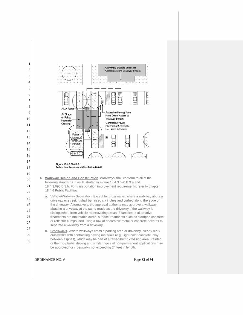
ORDINANCE NO. # Page 83 of 91
1
2
3
4
5
6
7
8
9
10
11
12
13
14
15
16
17
18
19
20
21
22
23
24
25
26
27
28
29
30
Figure 18.4.3.090.B.3.b
Pedestrian Access and Circulation Detail
4. Walkway Design and Construction. Walkways shall conform to all of the
following standards in as illustrated in Figure 18.4.3.090.B.3.a and
18.4.3.090.B.3.b. For transportation improvement requirements, refer to chapter
18.4.6 Public Facilities.
a. Vehicle/Walkway Separation. Except for crosswalks, where a walkway abuts a
driveway or street, it shall be raised six inches and curbed along the edge of
the driveway. Alternatively, the approval authority may approve a walkway
abutting a driveway at the same grade as the driveway if the walkway is
distinguished from vehicle-maneuvering areas. Examples of alternative
treatments are mountable curbs, surface treatments such as stamped concrete
or reflector bumps, and using a row of decorative metal or concrete bollards to
separate a walkway from a driveway.
b. Crosswalks. Where walkways cross a parking area or driveway, clearly mark
crosswalks with contrasting paving materials (e.g., light-color concrete inlay
between asphalt), which may be part of a raised/hump crossing area. Painted
or thermo-plastic striping and similar types of non-permanent applications may
be approved for crosswalks not exceeding 24 feet in length.

ORDINANCE NO. # Page 84 of 91
1
2
3
4
5
6
7
8
9
10
11
12
13
14
15
16
17
18
19
20
21
22
23
24
25
26
27
28
29
30
c. Walkway Surface and Width. Walkway surfaces shall be concrete, asphalt,
brick/masonry pavers, or other durable surface, and at least five feet wide.
Multi-use paths (i.e., for bicycles and pedestrians) shall be concrete or asphalt,
and at least ten feet wide, in accordance with the section 18.4.6.040 Street
Design Standards.
d. Accessible routes. Walkways shall comply with applicable Americans with
Disabilities Act (ADA) and State of Oregon requirements. The ends of all raised
walkways, where the walkway intersects a driveway or street, shall provide
ramps that are ADA accessible, and walkways shall provide direct routes to
primary building entrances.
e. Lighting. Lighting shall comply with section 18.4.4.050.
SECTION 25. Section 18.5.2.020 [Applicability – Site Design Review] of the Ashland Land Use Ordinance is hereby amended to read as follows:
18.5.2.020 Applicability Site Design Review is required for the following types of project proposals.
A. Commercial, Industrial, Non-Residential, and Mixed Uses. Site Design Review
applies to the following types of non-residential uses and project proposals, including
proposals for commercial, industrial, and mixed-use projects, pursuant to section
18.5.2.030 Review Procedures.
1. New structures, additions, or expansions in C-1, E-1, HC, CM, and M-1 zones.
2. New non-residential structures or additions in any zone, including public buildings,
schools, churches, and similar public and quasi-public uses in residential zones.
3. Mixed-use buildings and developments containing commercial and residential uses
in a residential zoning district within the Pedestrian Place Overlay.
4. Any exterior change, including installation of Public Art, to a structure which is
listed on the National Register of Historic Places or to a contributing property within
an Historic District on the National Register of Historic Places that requires a
building permit.
5. Expansion of impervious surface area in excess of ten percent of the area of the
site, or 1,000 square feet, whichever is less.
6. Expansion of any parking lot, relocation of parking spaces on a site, or any other
change that alters or affects circulation onto an adjacent property or public right-of-
way.
7. Any change of occupancy from a less intense to a more intensive occupancy, as
defined in the building code, or an change in use that requires a greater number of
parking spaces.
8. Any change in use of a lot from one general use category to another general use
category, e.g., from residential to commercial, as defined in the zoning regulations

ORDINANCE NO. # Page 85 of 91
1
2
3
4
5
6
7
8
9
10
11
12
13
14
15
16
17
18
19
20
21
22
23
24
25
26
27
28
29
30
of this ordinance.
9. Installation of mechanical equipment not fully enclosed in a structure and not
otherwise exempt from site design review per section 18.5.2.020.C.
10. Installation of wireless communication facilities in accordance with section 18.4.10.
B. Residential Uses. Site Design Review applies to the following types of residential
uses and project proposals, pursuant to section 18.5.2.030 Review Procedures.
1. TwoThree or more dwelling units on one lot in any zoning district a residential
zone, including the addition of an accessory residential unit, unless exempt
from Site Design Review per subsection 18.2.3.040.Aand one or more
dwelling units on a lot in any other non-residential zone.
2. Construction of attached (common wall) single-family dwellings (e.g., townhomes,
condominiums, rowhouses) in any zoning district.
3. Any exterior change, including installation of Public Art, to a structure individually
listed on the National Register of Historic Places that requires a building permit.
4. Any change to off-street parking or landscaping in a residential development where
such parking or landscaping is provided in common area (e.g., shared parking) and
is approved pursuant to chapter 18.3.9 Performance Standards Option.
5. Any change in use that requires a greater number of parking spaces.
6. Installation of mechanical equipment not fully enclosed in a structure and not
otherwise exempt from Site Design Review per subsection 18.5.2.020.C.
7. Installation of wireless communication facilities (e.g., accessory to a residential
use), in accordance with section 18.4.10.
C. Exempt From Site Design Review. The following types of uses and projects are
exempt from Site Design Review.
1. Detached single-family dwellings and associated accessory structures and uses.
2. Accessory residential units meeting the requirements of subsection 18.2.3.040.A
and duplexes meeting the requirements of subsection 18.2.3.110.
3. Land divisions and property line adjustments, which are subject to review under
chapter 18.5.3.
4. The following mechanical equipment.
a. Private, non-commercial radio and television antennas not exceeding a height
of 70 feet above grade or 30 feet above an existing structure, whichever height
is greater, and provided no part of such antenna shall be within the setback
yards required by this ordinance. A building permit shall be required for any
antenna mast or tower over 50 feet above grade or 30 feet above an existing
structure when the same is constructed on the roof of the structure.
b. Not more than three parabolic disc antennas, each under one meter in
diameter, on any one lot or dwelling unit.
Commented [mh9]: Mixed-use development including residential units in the C-1 and E-1 zones requires Site Design Review.

ORDINANCE NO. # Page 86 of 91
1
2
3
4
5
6
7
8
9
10
11
12
13
14
15
16
17
18
19
20
21
22
23
24
25
26
27
28
29
30
c. Roof-mounted solar collection devices in all zones, with the exception of E-1
and C-1 zoned properties located within designated historic districts. The
devices shall comply with solar setback standards described in chapter 18.4.8
and the height standards of the respective zoning district.
d. Roof-mounted solar collection devices on E-1 and C-1 zoned properties
located within designated historic districts if the footprint of the structure is not
increased, the plane of the system is parallel to the slope of the roof and does
not extend above the peak height of the roof or existing parapets, or is
otherwise not visible from a public right-of-way. The devices shall comply with
solar setback standards described in chapter 18.4.8 and height requirements of
the respective zoning district.
e. Installation of mechanical equipment other than those exempted in
18.5.2.020.C.3, subsections a – d, above, and which is not visible from a public
right-of-way, except alleys, or adjacent residentially zoned property and
consistent with other provisions of this ordinance, including solar access in
chapter 18.4.8, and noise and setback requirements of subsection
18.2.4.020.B. See also, screening standards for mechanical equipment in
subsection 18.4.4.030.G.4.
f. Routine maintenance and replacement of existing mechanical equipment in all
zones.
SECTION 26. Section 18.5.7.020 [Applicability and Review Procedure – Tree Removal Permits] of the Ashland Land Use Ordinance is hereby amended to read as follows:
18.5.7.020 Applicability and Review Procedure All tree removal and topping activities shall be carried out in accordance with the
requirements of this chapter and as applicable, the provisions of part 18.3 Special Districts
and Overlay Zones, and chapter 18.4.4 Landscaping, Lighting, and Screening.
If tree removal is part of another planning action involving development activities, the tree
removal application, if timely filed, shall be processed concurrently with the other planning
action. Applications for Tree Removal Permits are reviewed as follows.
A. Ministerial Action. The following Tree Removal Permits are subject to the Ministerial
procedure in section 18.5.1.040.
1. Emergency Tree Removal Permit.
B. Type I Reviews. The following Tree Removal Permits are subject to the Type I review
in section 18.5.1.050. This section applies to removal of trees that are a hazard or are
not a hazard.
1. Removal of trees greater than six-inches DBH on private lands zoned C-l, E-l, M-l,
CM, or HC.
2. Removal of trees greater than six-inches DBH on lots zoned R-2, R-3, and R-1-3.5
that are not occupied solely by a detached single familysingle-family detached

ORDINANCE NO. # Page 87 of 91
1
2
3
4
5
6
7
8
9
10
11
12
13
14
15
16
17
18
19
20
21
22
23
24
25
26
27
28
29
30
dwelling and associated accessory structures including an accessory
residential unit, or by a duplex.
3. Removal of significant trees, as defined in part 18.6, on vacant property zoned for
residential purposes including but not limited to R-1, RR, WR, and NM zones.
4. Removal of significant trees as defined in part 18.6, on lands zoned SOU, on lands
under the control of the Ashland School District, or on lands under the control of the
City.
5. Tree Topping Permit.
C. Exempt From Tree Removal Permit. The following activities are exempt from the
requirement for a tree removal permit in 18.5.7.020.A, subsections A. and B, above.
1. Those activities associated with the establishment or alteration of any park under
the Ashland Parks and Recreation Commission. However, the Parks and
Recreation Department shall provide an annual plan in January to the Tree
Commission outlining proposed tree removal and topping activities, and reporting
on tree removal and topping activities that were carried out in the previous year.
2. Removal of trees in single familysingle-family residential zones on lots occupied
only by a detached single-family single family detached dwelling and
associated accessory structures including an accessory residential unit, or by a
duplex, where the property is less than twice the minimum lot size or otherwise
ineligible to be partitioned or subdivided, except as otherwise regulated by
chapters 18.3.10 Physical and Environmental Constraints and 18.3.11 Water
Resource Protection Zones.
3. Removal of trees in multi-familymultifamily residential and health care zones on
lots occupied only by a detached single-family single family detached dwelling
and associated accessory structures including an accessory residential unit, or
by a duplex, where the property cannot be further developed with additional
dwelling units other than an accessory residential unit or a duplex, except as
otherwise regulated by chapters 18.3.10 Physical and Environmental Constraints
and 18.3.11 Water Resource Protection Zones.
4. Removal of trees less than six-inches DBH in any zone, excluding those trees
located within the public right of way or required as conditions of approval with
landscape improvements for planning actions.
5. Removal of trees less than 18 caliper inches in diameter at breast height (DBH)
on any public school lands, Southern Oregon University, and other public land,
excluding Heritage trees.
6. Removal of trees within the Wildfire Lands area of the City, as defined on adopted
maps, for the purposes of wildfire fuel management, consistent with the fuel
modification area standards in 18.3.10.100, and in accord with the requirements of
chapters 18.3.10 Physical and Environmental Constraints and 18.3.11 Water
Resource Protection Zones.
7. Removal of dead trees.
ORDINANCE NO. # Page 88 of 91
1
2
3
4
5
6
7
8
9
10
11
12
13
14
15
16
17
18
19
20
21
22
23
24
25
26
27
28
29
30
8. Those activities associated with tree trimming for safety reasons, as mandated by
the Oregon Public Utilities Commission, by the City's Electric and
Telecommunication Utility. However, the Utility shall provide an annual plan to the
Tree Commission outlining tree trimming activities and reporting on tree trimming
activities that were carried out in the previous year. Tree trimming shall be done, at
a minimum, by a Journeyman Tree Trimmer, as defined by the Utility, and will be
done in conformance and to comply with OPUC regulations.
9. Removal of street trees within the public right-of-way subject to street tree removal
permits in AMC 13.16.
10. Those activities associated with tree trimming or removal at the Airport, within the
Airport (A) overlay zone for safety reasons, as mandated by the Federal Aviation
Administration. The Public Works Department shall provide an annual report to the
Tree Commission outlining tree trimming activities and reporting on tree trimming
activities that were carried out in the previous year.
D. Other Requirements.
1. Flood Plain, Hillsides, and Wildfire. Tree removal in the Physical and
Environmental Constraints Overlay (i.e., areas identified as Flood Plain Corridor
Land, Hillside Lands, Wildfire Lands and Severe Constraint Lands) must also
comply with the provisions of chapter 18.3.10 Physical and Environmental
Constrains Overlay.
2. Water Resources. Tree removal in regulated riparian areas and wetlands must also
comply with the provisions of chapter 18.3.11 Water Resources Protection Zones.
SECTION 27. Section 18.6.1.030 [Definitions – Definitions] of the Ashland Land Use Ordinance is hereby amended to read as follows:
18.6.1.030 Definitions
The following definitions are organized alphabetically.
Basement. That portion of a building with a floor-to-ceiling height of not less than six-and-
a-half6½ feet, where the perimeter walls do not exceed 12 feet above finished grade
at any point, and where 50 percent or more of its perimeter walls are less than six feet
above natural grade.
Dwelling. A structure conforming to the definition of a dwelling under applicable building
codes and providing complete, independent living facilities for one family, including
permanent provisions for living, sleeping, eating, cooking, and sanitation. Buildings
with more than one set of cooking facilities are considered to contain multiple dwelling
units or accessory dwelling units, as applicable, unless the additional cooking
facilities are clearly accessory to the primary use, such as an outdoor grill or wet bar.
For the purposes of this ordinance, the following types of dwelling units are defined as

ORDINANCE NO. # Page 89 of 91
1
2
3
4
5
6
7
8
9
10
11
12
13
14
15
16
17
18
19
20
21
22
23
24
25
26
27
28
29
30
follows.:
- Accessory Residential Unit. A secondary dwelling unit on a lot where the
primary usestructure is a single-family dwelling, and the secondary dwelling
meets the size requirements and standards in section 18.2.4.040. The
accessory residential unit can be either attached to a single-family dwelling,
within a portion of an existing single-family dwelling (i.e. conversion of gross floor
area within the primary residence), or located in a detached building located on
the same lot, and having an independent means of access (i.e., door).
- Duplex Dwelling. A structure that contains two dwelling units located on one
lot. The units must share a common wall or common floor/ceiling.Two
dwellings on one lot in any configuration including either in attached or
detached structures. Two attached dwellings in a stand-alone structure that
is included in a multifamily development of three or more units shall be
considered multifamily dwellings and shall not be considered a duplex.
- Clustered Residential Units (Normal Neighborhood District). Multiple
dwellings grouped around common open space that promote a scale and
character compatible with single-family dwellings. Units are typically
arranged around a central common green under communal ownership.
Automobile parking is generally grouped in a shared area or areas.
- Cottage. A single-family dwelling up to 1,000 square feet in size, located in a
cottage housing development, and developed in accordance with section
18.2.3.090.
- Manufactured Home. A structure constructed for movement on the public
highways that has sleeping, cooking, and plumbing facilities, that is intended for
human occupancy, that is being used for residential purposes, and that was
constructed in accordance with federal manufactured housing construction and
safety standards and regulations in effect at the time of construction.
- Mobile Home. A structure constructed for movement on the public highways that
has sleeping, cooking, and plumbing facilities, that is intended for human
occupancy, that is being used for residential purposes, and that was constructed
between January 1, 1962, and June 15, 1976, and met the construction
requirements of Oregon mobile home law in effect at the time of construction.
- Multifamily Dwelling. A dwelling in a structure or grouping of structures
containing two or more dwelling units located on one lot. Three or more
dwellings on one lot in any configuration including either in attached or
detached structures. Two attached dwellings included in a mutltifamily
development of three or more units shall not be considered a duplex.
- Senior Housing. Housing designated and/or managed for persons over a
specified age. Specific age restrictions vary, and uses may include assisted living
facilities, retirement homes, convalescent or nursing homes, and similar uses not
otherwise classified as Residential Homes or Residential Facilities.
- Single-FamilySingle-family Dwelling. A detached or attached structure

ORDINANCE NO. # Page 90 of 91
1
2
3
4
5
6
7
8
9
10
11
12
13
14
15
16
17
18
19
20
21
22
23
24
25
26
27
28
29
30
containing one dwelling unit located on its ownone lot.
Floor Area. The area of an enclosed floor measured from the exterior faces of exterior
walls or from the center line of walls separating two buildings.
- Gross Floor Area. The sum of the gross horizontal areas of all enclosed floors
measured from the exterior faces of exterior walls or from the center line of walls
separating two buildings, but excluding basements, attic space providing structural
head room of less than six-and-a-half6½ feet, and unenclosed steps, porches,
terraces and balconies. Individual sections of this ordinance may exempt additional
spaces from gross floor area.
- Gross Habitable Floor Area. The sum of the gross horizontal areas of all
enclosed floors with at least seven feet of headroom in a dwelling unit measured
from the exterior faces of exterior walls or from the center line of walls separating
two buildings, excluding uninhabitable spaces accessed solely by an exterior door.
- Maximum Permitted Floor Area (MPFA). The gross floor area of the primary a
dwelling, including but not limited to potential living spaces within the structure with
at least seven feet of head room and attached garages. Basements, detached
garages, detached accessory structures, and detached accessory residential
units are not counted in the gross floor area for the MPFA calculation if
separated from the by six feet or more. Similarly, unenclosed breezeways,
and similar open structures connecting an exempt detached structure to the
primary dwelling not counted in the MPFA calculation.See section
18.25.070.E for exceptions to MPFA.
SECTION 28. Codification. In preparing this ordinance for publication and distribution,
the City Recorder shall not alter the sense, meaning, effect, or substance of the ordinance,
but within such limitations, may:
(a) Renumber sections and parts of sections of the ordinance;
(b) Rearrange sections;
(c) Change reference numbers to agree with renumbered chapters, sections or other
parts;
(d) Delete references to repealed sections;
(e) Substitute the proper subsection, section, or chapter numbers;
(f) Change capitalization and spelling for the purpose of uniformity;
(g) Add headings for purposes of grouping like sections together for ease of reference;
and
(h) Correct manifest clerical, grammatical, or typographical errors.

ORDINANCE NO. # Page 91 of 91
1
2
3
4
5
6
7
8
9
10
11
12
13
14
15
16
17
18
19
20
21
22
23
24
25
26
27
28
29
30
SECTION 29. Severability. Each section of this ordinance, and any part thereof, is
severable, and if any part of this ordinance is held invalid by a court of competent
jurisdiction, the remainder of this ordinance shall remain in full force and effect.
The foregoing ordinance was first read by title only in accordance with Article X, Section
2(C) of the City Charter on the _____day of ____________, 2021, and duly PASSED and
ADOPTED this ____ day of _____________, 2021.
_______________________________ Melissa Huhtala, City Recorder SIGNED and APPROVED this day of ____________, 2021.
________________________ Julie Akins, Mayor
Reviewed as to form: ______________________________ David H. Lohman, City Attorney