Feasibility of a 100 MW Installed Capacity Wind Farm ... - MDPI
Upload
khangminh22Category
view
0download
0
Aberarder Wind Farm Environmental Statement
RES
6. Ornithology Introduction
6.1 This chapter describes and evaluates the current ornithological interest of the proposed wind farm at Aberarder (also referred to as the Proposal) and its surrounds, and provides an assessment of the predicted residual effects of the proposed development. The specific objectives of the ornithological assessment were to:
• undertake breeding bird surveys of the Aberarder Wind Farm and its surrounds, to determine the numbers of birds present, and approximate breeding locations;
• undertake wintering bird studies to determine the birds that may be affected by the proposed development at that time of year;
• undertake vantage point observations to quantify the rates of bird movement across the proposed wind farm site and its surrounds;
• collate relevant additional information on the area’s ornithological interests; and • evaluate the ornithological importance of the study area, assess the likely effects of the
Proposal on the study area’s ornithology and recommend mitigation measures if necessary.
• This assessment has been undertaken by Dr Steve Percival of Ecology Consulting. The vantage point surveys were all undertaken by Bob Swann, and the breeding bird and winter walkover surveys by Mike Coleman, John Poyner and Matthew Sullivan of EnviroCentre. A full description of the Proposal is given in Chapter 2: Proposed Development.
6.2 The site is located about 24 km south of Inverness, in the Highland Region. Baseline surveys followed the guidance on bird surveys for wind farm assessments produced by Scottish Natural Heritage (SNH) (Whitfield et al. 2010) that was current at the time of the surveys. The ornithological study area was chosen to include areas within the potential zone of ornithological influence of the proposed wind farm. This included all the land that was being considered for locating wind turbines, plus a 500m buffer around this. These distances were chosen to follow SNH guidance (Whitfield et al. 2010). The main habitat across the survey area is predominantly open moorland. The site lies within the ‘Central Highlands’ SNH Natural Heritage Zone (NHZ 10).
Planning
6.3 The following documents have been taken into account in this assessment:
• Scottish Planning Policy (2014). This sets out all of the Scottish Government’s Planning Policy of particular relevance to this assessment. It replaces National Planning Policy Guidance 14: Natural Heritage which describes how policies for conservation and enhancement of flora and fauna should be reflected in land use planning;
• The Town and Country Planning (Environmental Impact Assessment) (Scotland) Regulations 2011;
• Council Directive 92/43/EEC on the Conservation of natural habitats and of wild fauna and flora (the ‘Habitats Directive’);
• EU Council Directive 79/409/EEC and 2009/147/EC on the Conservation of wild birds (the ‘Birds Directive’);
• The Conservation (Natural Habitats, &c.) Amendment (Scotland) Regulations 2004 (as amended), which translates the Birds and Habitats Directives into Scottish Law;
• ‘Managing Natura 2000 Sites’ (European Communities 2000), which gives guidance on the implementation of the Birds and Habitats Directives;
• The Wildlife and Countryside Act 1981, as amended; • The UK Biodiversity Action Plan; and • The Scottish Biodiversity Action Plan.
Scope of Assessment
6.4 The following key issues were identified at the scoping stage for consideration in the assessment:
• direct loss of bird habitat through construction; • indirect habitat loss through disturbance of birds during construction and operation; • mortality of birds through collision with turbine blades; • potential effects on the national and Natural Heritage Zone (NHZ) populations of golden
eagle both as an individual scheme and also in combination with the other developments in the area;
• cumulative effects of wind farm operational disturbance and collision mortality, particularly on golden eagle; and
• potential effects on the Loch Ruthven Special Protection Area (SPA) and Loch Ashie SPA breeding Slavonian Grebe populations.
6.5 No ornithological issues have been scoped out from this assessment.
6.6 SNH did not raise any issues relating to the survey methodology during scoping. All of the survey work was designed to follow the SNH guidance current at the time of the surveys (Whitfield et al. 2010) but also follows the more recent version of that guidance (SNH 2014).
Assessment Methodology
Baseline Characterisation
Study Area
6.7 The study area for the baseline ornithological surveys comprised the proposed wind farm (Figure1.1) plus a 500 m buffer, following SNH guidance (Whitfield et al. 2010).
Volume 2: Environmental Statement Chapter 6: Ornithology
6 - 1

RES Aberarder Wind Farm Environmental Statement
Desk Study / Field Survey
6.8 A desk study was undertaken to provide information on the ornithological interest of the study area and its surrounds, including the locations of any relevant statutory protected sites. A search was made for statutory protected nature conservation sites within 5 km of the proposed wind farm site, and for Special Protection Areas within 20 km. The following sources of information were used for the desk study exercise:
• Scottish Natural Heritage (SNH) internet site (www.snh.gov.uk) – statutory designated site boundaries, including Sites of Special Scientific Interest (SSSI) and SSSI citation details;
• Joint Nature Conservation Committee internet site [www.jncc.gov.uk] – European protected site boundaries and designations;
• National Biodiversity Network (NBN) website (www.nbn.org.uk) - records of species in the vicinity of the study area;
• Wetland Bird Survey annual reports (Austin et al. 2014); • Scottish Ornithologists’ Club; • information and baseline data collected for the adjacent Dunmaglass wind farm
application; and • consultation with SNH and RSPB.
Sensitivity Criteria, Magnitude of Effect and Significance Criteria
6.9 This assessment has been carried out with reference to the assessment methodologies produced by Scottish Natural Heritage (2006) for the wider countryside, Institute for Ecological and Environmental Management (2006) and Percival (2007). The assessment first identifies the sensitivity (conservation importance, as defined in Table 6.1) of the receptors present in the study area, then determines the magnitude of the possible effect on those receptors (as described in Table 6.2).
6.10 The conservation importance of the bird populations in the study area was assessed by reference to Table 6.1 and by using the standard 1% criterion method (Austin et al. 2014); >1% national population = nationally important, >1% international population = internationally important. National and International wintering waterfowl baseline populations have been taken from the most recently published population figures from the national Wetland Birds Survey (Austin et al. 2014). The national baseline populations were taken from Musgrove et al. (2013) and Forrester et al. (2007). For all of the assessment the region was taken as the SNH Natural Heritage Zone in which the Proposal is located (NHZ 10). Regional populations were taken from Wood (2012) where available. A further category of ‘local importance’ was used for species that did not reach regional importance but were still of some ecological value. This included all species on the red or amber lists of the RSPB et al.’s (Eaton et al. 2009) ‘Birds of Conservation Concern’ that did not reach national or regional importance at the site.
Table 6.1: Sensitivity (conservation importance) of bird species
Sensitivity Definitions
Very High Cited interest of SPAs, SACs and SSSIs. Cited means mentioned in the citation text for those protected sites as a species for which the site is designated (SPAs/SACs) or notified (SSSIs).
High Other species that contribute to the integrity of an SPA or SSSI.
A local population of more than 1% of the national population of a species.
Any ecologically sensitive species, e.g. large birds of prey or rare birds (<300 breeding pairs in the UK).
EU Birds Directive Annex 1, EU Habitats Directive priority habitat/species and/or Wildlife and Countryside Act (W&C Act) Schedule 1 species (if not covered above). Other specially protected species.
Medium Regionally important population of a species, either because of population size or distributional context.
UK BAP priority species (if not covered above).
Low Any other species of conservation interest, e.g. species listed on the Birds of Conservation Concern not covered above.
Nil Green-listed species (Eaton et al. 2009) of favourable conservation status.
Table 6.2: Definition of terms relating to the magnitude of ornithological impacts
Magnitude Definition
Very High Total loss or very major alteration to key elements/ features of the baseline conditions such that post development character/ composition/ attributes will be fundamentally changed and may be lost from the site altogether.
Guide: >80% of population/habitat lost
High Major alteration to key elements/ features of the baseline (pre-development) conditions such that post development character/composition/attributes will be fundamentally changed.
Guide: 20-80% of population/habitat lost
Medium Loss or alteration to one or more key elements/features of the baseline conditions such that post development character/ composition/ attributes of baseline will be partially changed.
Guide: 5-20% of population/habitat lost
Low Minor shift away from baseline conditions. Change arising from the loss/ alteration will be discernible but underlying character/ composition/ attributes of baseline condition will be similar to pre-development circumstances/patterns.
Guide: 1-5% of population/habitat lost
Negligible Very slight change from baseline condition. Change barely distinguishable, approximating to the “no change” situation.
Guide: <1% of population/habitat lost
6.11 The combined assessment of the magnitude of an impact and the sensitivity of the receptor has been used to determine whether or not an adverse impact is significant. These two criteria have been cross-tabulated to assess the overall significance of that impact (Table
6 - 2
Volume 2: Environmental Statement Chapter 6: Ornithology

Aberarder Wind Farm Environmental Statement
RES
6.3). This gives a guide as to the determination of significance, though a final assessment should still be subject to professional judgment.
Table 6.3: Matrix of magnitude of impact and sensitivity used to test the significance of impacts. The significance category of each combination is shown in each cell. Shaded cells indicate potentially significant impacts in terms of the EIA Regulations.
Mag
nitu
de
Sensitivity
Very high High Medium Low
Very high Very high Very high High Medium
High Very high Very high Medium Low
Medium Very high High Low Very low
Low Medium Low Low Very low
Negligible Low Very low Very low Very low
6.12 The interpretation of these significance categories is as follows, though it should be noted that these categories provide a guide to professional judgment that needs to be applied in interpreting the results of the assessment:
• very low and low are not normally of concern, though normal design care should be exercised to minimise adverse impacts;
• very high and high represent adverse impacts on bird populations which are regarded as significant for the purposes of EIA; and
• medium represents a potentially significant adverse impact, though for which it is likely that mitigation will reduce it below the significance threshold.
6.13 The SNH (2006) wider countryside assessment guidance defines the key significance test as follows: “An impact should be judged as of concern where it would adversely affect the favourable conservation status of a species, or stop a recovering species from reaching favourable conservation status, at international or national level or regionally.” It notes that the key baseline population against which the assessment should be made for breeding birds is the SNH NHZ population (Natural Heritage Zone 10, Central Highlands, in this case).
Baseline Conditions
General Breeding Bird Survey Methods
6.14 Breeding bird surveys were undertaken in 2011 and 2012 following the standard upland Brown and Shepherd (1993) survey methodology (following SNH guidance; Whitfield et al. 2010) but three survey visits rather than the standard two were conducted (as per SNH guidance, Whitfield et al. 2010). These comprised walkover surveys, mapping all of the birds encountered (to 1:10,000 scale), and recording their behaviour and location using the
standard Common Birds Census notation (Gilbert et al. 1998). The survey area for this work included the Site plus a 500 m buffer (as recommended in current SNH guidance, Whitfield et al. 2010). All key species (as per SNH guidance, Whitfield et al. 2010) were recorded. The search effort per unit area was also standardised, to make further surveys more repeatable: a target was set at 100 minutes survey on each visit per square kilometre. Three survey visits were made each year, on the following dates: 14/26 April, 16/17 May and 6/30 June 2011 (plus a final follow-up visit on 28 July 2011), and 4/10 May, 5/6 June and 5/6 July 2012.
6.15 The surveys were carried out avoiding strong winds, heavy rain, fog and low cloud. Birds were located by walking, listening and scanning by eye and with binoculars.
6.16 The survey data were used to obtain population estimates for all of the bird species breeding on the site. Maps were produced of the breeding pairs recorded during each visit and these were combined to produce an estimate of the overall breeding population for each species. Pairs were considered separate from each other if greater than 1 km (waterfowl and raptors), 500 m (gamebirds) or 200 m (all other species) apart, with this distance reflecting the relative distance that birds might move between survey visits. A record in potentially suitable breeding habitat on a single visit was usually considered sufficient to indicate a potential breeding attempt.
Species-specific Breeding Surveys
6.17 Additional wider area breeding surveys for key species were not deemed necessary given the lack of records of such species breeding in this area from the desk study, the vantage point surveys and the Brown and Shepherd surveys.
Wintering Bird Survey Methods
6.18 A programme of non-breeding bird walkover surveys was undertaken during November 2012 through to March 2013, mapping all key species encountered. This comprised three surveys of the site and its surrounds (including the site plus a 500m buffer), carried out on 21/23 November 2012, 14 January/25 February 2013 and 20/29 March 2013. The March surveys were affected by snow and ice limiting access and some areas had to be surveyed by viewing at distance.
Vantage Point Surveys Methods
6.19 Vantage point surveys were undertaken by Bob Swann over two full years (April 2011 – March 2013). Two vantage points were used, at (1) Carn Greghar (NH65811 20037) and (2) Collie Mhor (NH63727 21041), with a total of 164 hours of surveys from each VP over the two years. The two vantage points gave good coverage of all of the potential collision risk zone (with considerable overlap of visibility) – see Appendix 6.1.
6.20 The vantage point survey methodology followed the standard SNH-recommended survey method (Madders, in Whitfield et al. 2010). All the target species (see above) were mapped and the flight height of each flock recorded. The activity during each flight (e.g. flying to
Volume 2: Environmental Statement Chapter 6: Ornithology
6 - 3
RES Aberarder Wind Farm Environmental Statement
roost, foraging) was also recorded. Particular attention was paid to any observations of birds at rotor height crossing the proposed wind farm site that would be at risk of collision. Observations were carried out at each point throughout the survey period, with the timing of these observations made to cover dawn/dusk roost flights as well as general daytime movements. Vantage point survey observations and data for key target species are provided in Appendix 6.2.
Information Gaps
6.21 No significant information gaps have been identified. Inevitably with any ecological survey it cannot be guaranteed to detect all target species/individuals and surveys cannot be fully representative of all conditions (e.g. severely reduced visibility). However in this case it was concluded that the baseline surveys provide a robust data set on which to carry out the assessment. None of the limitations are considered likely to have materially affected the conclusions of this assessment.
Desk Study Results
6.22 There are five statutory designated nature conservation sites in the search area around the proposed wind farm site (5 km for nationally important Sites of Special Scientific Interest (SSSI), 20 km for European Protected Special Protection Areas (SPA)). The distance given is the minimum distance between the proposed wind turbines and the designated area.
• Loch Ruthven SPA – 6.5 km north – designated for its breeding Slavonian grebe population;
• Loch Ashie SPA – 13 km north - designated for its breeding and non-breeding populations of Slavonian grebe;
• Kinveachy Forest SPA – 16 km east - designated for its breeding populations of Scottish crossbill and capercaillie;
• North Inverness Lochs SPA – 18 km NW - designated for its breeding Slavonian grebe population; and
• Loch Knockie and nearby lochs SPA – 19 km SW – designated for its breeding Slavonian grebe population.
6.23 SNH has advised in its scoping response that an assessment should be carried out in relation to possible effects on the Loch Ruthven and Loch Ashie SPAs. A separate report to inform that Habitats Regulations Assessment has been produced and forms Appendix 6.4 of this ES.
6.24 There are no SSSIs (or any other statutory protected site) within 5 km of the proposed wind turbines.
6.25 The baseline surveys for the adjacent Dunmaglass wind farm found three breeding high sensitivity species; merlin, golden plover and dunlin, though the merlin were nesting on lower ground away from the wind farm (>2km). The Dunmaglass survey area was also used by a range of important bird species that did not breed there, particularly golden eagle. Almost all of the eagles observed were immature birds (with just a single sighting of an adult). Potential for a significant cumulative impact with the proposed Corriegarth wind
farm was identified, and a Nature Conservation Management Plan is being implemented to avoid any net adverse effect on the NHZ eagle population.
Breeding Bird Survey Results
6.26 The survey area held a typical range of upland breeding birds. Three species showed evidence of breeding (golden plover, red grouse and meadow pipit). Golden plover had a scattered distribution over the survey area, with four pairs breeding in both 2011 and 2012. The distribution of their records are shown in Figure 6.1. Red grouse were found widely over the survey area, with about 20 breeding pairs. Meadow pipit were abundant over the whole survey area but were not quantitatively surveyed.
6.27 Merlin were also seen during the breeding bird surveys and given the habitat could breed in the survey area, though it is more likely that their actual nest site was on lower ground outside the survey area. Up to two breeding pairs had been located in surveys for the adjacent Dunmaglass wind farm, on the lower ground away from the wind turbine locations.
6.28 Several other species were seen during the breeding bird surveys but did not show any evidence of breeding within the survey area. These included golden eagle, buzzard, honey buzzard (a single sighting in May 2011), red kite (two sightings in June 2012), kestrel, common gull and raven.
Wintering Bird Survey Results
6.29 Only four species were recorded during the wintering bird surveys; golden eagle, red grouse, raven and snow bunting.
6.30 Red grouse were seen on all survey visits, with flocks of up to 5 in November, 8 in January and March, and four in February.
6.31 Snow buntings were heard flying overhead in November 2012 (a single), and 6 were seen in unfrozen vegetation along the Cromallt Beag in January 2013.
6.32 Raven was only recorded in January 2013, with an individual bird and a pair of birds observed in the centre of the survey area.
6.33 Golden Eagle were seen in January and March, with both records being of a single sub-adult bird.
Vantage Point Survey Results: Breeding Season
6.34 The rates of bird flight movement observed across the study area during the breeding season vantage point observations are summarised in Table 6.4. This gives the mean over-flying rate per hour over the study period from each vantage point (“VP”) and the total number of birds recorded over-flying. Table 6.4 also gives the percentage of flights of each species that were recorded at rotor height.
6 - 4
Volume 2: Environmental Statement Chapter 6: Ornithology

Aberarder Wind Farm Environmental Statement
RES
Table 6.4. Bird flight rates recorded over the survey area during April–August 2011 and 2012 vantage point surveys. N = 30 hours total observation from each of the two vantage points in each year (with visibility of all of the collision risk zone from both VPs).
Species Flight rate (no/hr):
VP1 - 2011
VP1 - 2012
VP2 - 2011
VP2 - 2012
% flights at rotor height
Total no sightings
Mallard 0 0.07 0 0 100% 2 Red Grouse 0.03 0 0 0 0% 1 Red Kite 0 0.20 0.17 0.90 89% 38 Hen Harrier 0.07 0 0.03 0.03 33% 4 Buzzard 0 0.03 0.07 0.17 93% 8 Golden Eagle 0.10 0.27 0.20 0.23 71% 24 Osprey 0 0 0 0.03 100% 1 Kestrel 0.10 0 0.23 0.10 77% 13 Merlin 0 0.03 0 0 33% 1 Peregrine 0.03 0 0 0 71% 1 Golden Plover 0 0 0.03 0 0% 1 Common Gull 0.03 0.10 0 0 100% 4 Lesser Black-backed Gull 0 0 0.03 0 0% 1 Raven 1.13 0.03 3.90 0.33 72% 162
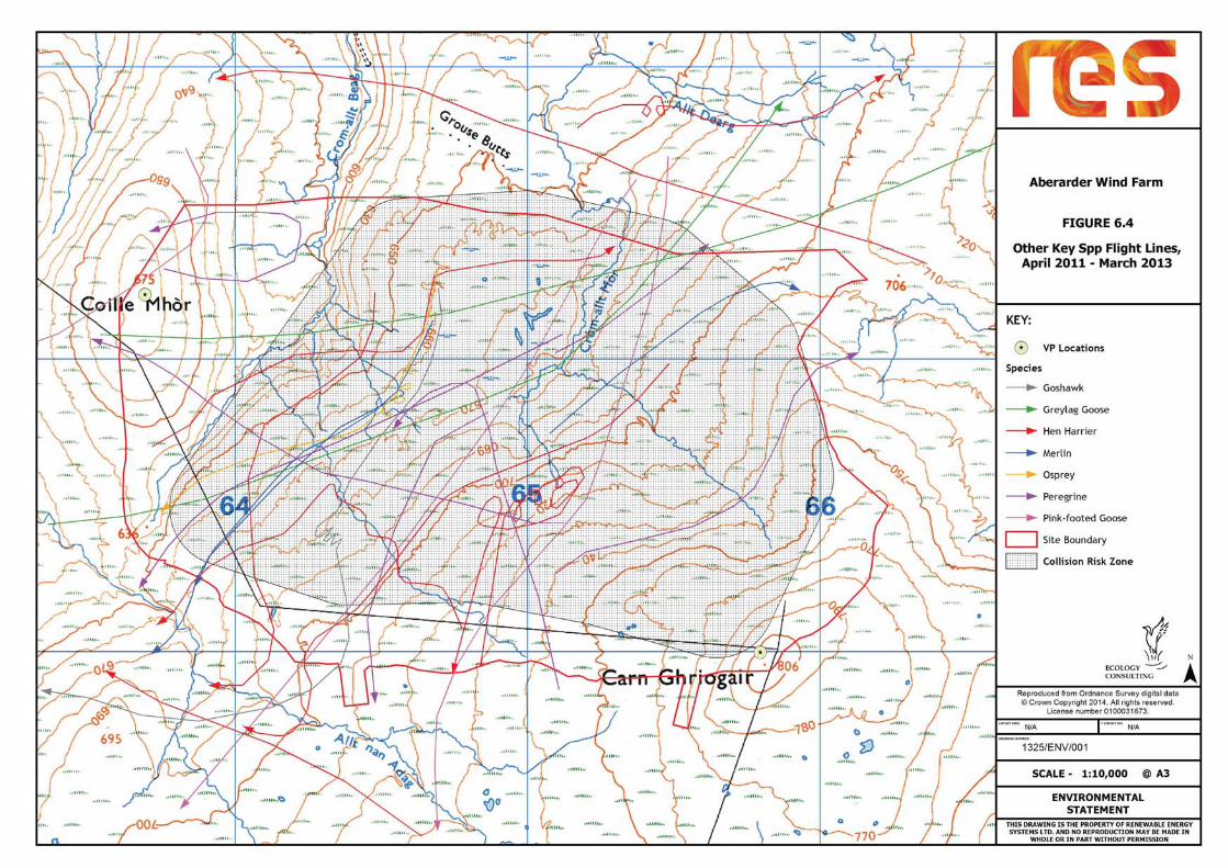
6.35 The flight lines obtained on the scarce raptors and other key species from the vantage point surveys are summarised in Figures 6.2 (golden eagle), Figure 6.3 (red kite) and Figure 6.4 (other key species). The raw data are included in Appendix 6.2.
Vantage Point Survey Results: Autumn/Winter
6.36 The rates of bird flight movement observed across the study area during the autumn/winter vantage point observations are summarised in Table 6.5. This gives the mean over-flying rate per hour over the study period from each vantage point (“VP”) and the total number of birds recorded over-flying. Table 6.5 also gives the percentage of flights of each species that were recorded at rotor height.
Table 6.5. Bird flight rates recorded over the survey area during September-March 2011-12 and 2012–13 vantage point surveys.
Species Flight rate (no/hr): % flights at rotor height
Total no sightings
VP1 – 2011-2
VP1 – 2012-13
VP2 – 2011-12
VP2 – 2012-13
Pink-footed Goose 0.26 0.00 2.38 1.43 100% 171 Greylag Goose 0.76 0.00 0.62 0.00 100% 58 Red Grouse 0.00 0.00 0.71 0.00 0% 30 Red Kite 0.02 0.19 0.12 0.33 89% 28 Hen Harrier 0.00 0.02 0.07 0.02 33% 5 Goshawk 0.00 0.02 0.00 0.00 100% 1
Species Flight rate (no/hr): % flights at rotor height
Total no sightings
VP1 – 2011-2
VP1 – 2012-13
VP2 – 2011-12
VP2 – 2012-13
Buzzard 0.05 0.12 0.19 0.17 93% 22 Golden Eagle 0.07 0.10 0.02 0.07 71% 11 Merlin 0.02 0.00 0.02 0.00 33% 2 Peregrine 0.02 0.05 0.02 0.05 71% 6 Ringed Plover 0.00 0.00 0.00 0.02 100% 1 Raven 0.90 0.50 0.50 0.67 72% 108
6.37 The flight lines obtained on the scarce raptors and other key species from the vantage point surveys are summarised in Figures 6.2 (golden eagle), Figure 6.3 (red kite) and Figure 6.4 (other key species). The raw data are included in Appendix 6.2.
Conservation Importance of Breeding Bird Populations
6.38 The conservation importance of the bird populations breeding in the study area during 2011 and 2012 is summarised in Table 6.6. This Table includes all the key species noted during the surveys.
Table 6.6. Conservation evaluation of the bird populations recorded in the Aberarder survey area, during the 2012 and 2013 breeding seasons.
Species Peak no. of breeding
pairs; ( ) = wider area
>1% regional popul-ation
EU Birds Directive Annex 1
W and C Act Sch 1
Red/ Amber
List
BAP priority species
Sensitivity
UK
Scot
.
Breeding species Red Grouse 20 A Medium Golden Plover 4 A High Meadow Pipit + A Low
Other species (non-breeding) Mallard A Low Red Kite A High Hen Harrier R High Buzzard Nil Golden Eagle A High Honey Buzzard A High Osprey A High Kestrel A Low Merlin A High Peregrine A High Common Gull A Low Lesser Black-backed Gull A Low Raven Nil + - Meadow pipit breeding but population not quantified.
Volume 2: Environmental Statement Chapter 6: Ornithology
6 - 5

RES Aberarder Wind Farm Environmental Statement
6.39 The breeding bird community included one high sensitivity species, golden plover, which is listed on Annex 1 of the EU Birds Directive. One breeding species was classed as medium sensitivity, red grouse. This was classed as medium sensitivity because of its listing as UK Biodiversity Action Plan [BAP] priority species. The third breeding species, meadow pipit, was classed as low sensitivity, through its listing on RSPB et al.’s (Eaton et al. 2009) amber list of birds of conservation concern.
6.40 Other species seen during breeding season but not evidence of breeding within the survey area are also evaluated in Table 6.6. These included seven high sensitivity species (red kite, hen harrier, honey-buzzard, goshawk, golden eagle, merlin and peregrine; all are EU Birds Directive Annex 1 and/or Wildlife and Countryside Act Schedule 1 species) and four low sensitivity species (mallard, kestrel, common gull and lesser black-backed gull; all these are RSPB et al.’s (Eaton et al. 2009) amber listed species of conservation concern).
Conservation Importance of Autumn/Wintering Bird Populations
6.41 The conservation importance of the bird populations recorded in the survey area during the autumn/winter baseline surveys is summarised in Table 6.7. This Table includes all the key species noted during the surveys.
Table 6.7. Conservation evaluation of the bird populations recorded in the Aberarder survey area outside the breeding season (September – March 2011-12 and 2012-13).
Species Peak count
>1% region-al popul-
ation
EU Birds Directive Annex 1
W and C Act Sch 1
Red/ Amber
List
BAP priority species
Sensitivity U
K
Scot
.
Pink-footed Goose 100 A Low Greylag Goose 32 A Low Red Grouse 30 A Medium Red Kite 2 A High Hen Harrier 1 R High Goshawk 1 High Buzzard 1 Nil Golden Eagle 2 A High Merlin 1 A High Peregrine 1 High Ringed Plover 1 A Low Raven 13 Nil Snow Bunting 6 A High
6.42 Seven high sensitivity species were recorded during the autumn/winter surveys; red kite, hen harrier, goshawk, golden eagle, merlin, peregrine and snow bunting. All are EU Birds Directive Annex 1 and/or Wildlife and Countryside Act Schedule 1 species.
6.43 One further species, red grouse, was classed as medium sensitivity (UK BAP priority species - and three low sensitivity species were seen (pink-footed and greylag goose, and ringed plover).
Potential Impacts
Structure of the Impact Assessment
6.44 Direct and indirect environmental effects of the wind farm’s construction, operational and decommissioning phases, based on the project description in Chapter 2, are evaluated for each aspect of the ornithological studies in the following paragraphs. Mitigation for identified negative effects is presented below.
6.45 The assessment also takes into account and applies the tests given in SNH’s guidance on the assessment of effects of wind farms in the wider countryside (SNH 2006; “Assessing Significance of Impacts from Onshore Windfarms on Birds Outwith Designated Areas”, July 2006). In that document SNH lists a range of key ‘species potentially at risk of impact’, of which the following were recorded during the Aberarder baseline surveys: pink-footed goose greylag goose, honey-buzzard, goshawk, hen harrier, golden eagle, merlin, peregrine and golden plover. The potential effects of the proposed wind farm on all of these have been specifically considered and assessed below.
Effects on birds
6.46 The main potential effects of wind farms on birds are considered to be direct loss of breeding or feeding habitat, potential collision risk and indirect loss of habitat from disturbance (either temporary during construction or permanent from operating turbines) (Percival 2005, Drewitt and Langston 2006). Each of these is considered in turn in the following sections.
Direct effects (1): loss of habitat
6.47 This would be an effect of low/negligible magnitude, with only a very small area taken up by the turbine bases and access tracks (approximately 2.03 % of application area). Use of existing tracks and the careful selection of routes for the access tracks and turbine locations, alongside use of proven construction techniques would ensure that such effects on birds would be of low/negligible magnitude (even in a local context), and would not be significant. In addition the Applicant has committed to the production of a Construction Method Statement to the satisfaction of SNH and other relevant stakeholders, before construction commences, and would follow Windfarm Good Construction Guidance, Scottish Renewables et al (2010).
Direct effects (2): collision risk
6.48 There have been a number of wind farms that have caused bird mortalities through collision but their characteristics are very different to those at the proposed Aberarder site. Most notably, at Altamont Pass in California and Tarifa in southern Spain, large numbers of
6 - 6
Volume 2: Environmental Statement Chapter 6: Ornithology

Aberarder Wind Farm Environmental Statement
RES
raptors have been killed (Orloff and Flannery 1992, Janss 1998, Thelander et al. 2003) through collision with wind turbines. Such problems have occurred where large numbers of sensitive species occur in close proximity to very large numbers (hundreds/thousands) of turbines, and usually also where the wind farm area provides a particularly attractive feeding resource. In wind farm sites in the UK, with similar bird densities to Aberarder, collision rates have generally been very low and are not considered to be significant (Meek et al. 1993, Tyler 1995, Dulas 1995, EAS 1997, Bioscan 2001, Percival et al. 2008, Percival et al. 2009).
Indirect effects: disturbance
6.49 Disturbance could potentially affect a rather greater area than direct habitat loss. The maximum distance that wind turbines have been shown to affect breeding birds is 800m (Percival 2005; Pearce-Higgins et al. 2009), though most reliable studies have not reported effects further than 600m from turbines (Drewitt and Langston 2006) and displacement is usually partial rather than complete (i.e. a reduction in use not complete exclusion). Displacement has generally been more widely reported and over a greater distance outside the breeding season.
Construction phase disturbance
6.50 Disturbance is likely to be highest during construction owing to the activities being carried out. Pearce-Higgins et al. (2012) found that red grouse, snipe and curlew densities all declined on wind farms during construction, whilst densities of skylark and stonechat increased, though other species such as golden plover were not significantly affected. Construction also involves the presence of work personnel on site which itself can be an important source of potential disturbance. Even at this time displacement from a zone around the wind turbines is likely to be only partial. Pearce-Higgins et al. (2012) for example reported decreases in curlew density during construction of 40% and snipe by 53%. A worst-case approach has been adopted in this assessment for the construction disturbance assessment, that all breeding birds within 500 m of the wind turbines could potentially be at risk of displacement, and a slightly wider zone (600 m) for wintering birds (Percival 2005; Drewitt and Langston 2006). For key target species assessment consideration has also been given to the disturbance distances given in Ruddock and Whitfield (2007).
Operational phase disturbance
6.51 Experience from existing UK wind farms has shown that many species are tolerant of the presence of operational wind turbines and not unduly disturbed by them. Some short-term displacement during wind farm operation of species such as curlew may occur following construction but populations have subsequently re-established themselves (Bullen Consultants 2002). Most species that have been studied have not been significantly affected (Meek et al. 1993, Phillips 1994, Dulas 1995, Thomas 1999, Gill 2004, Percival 2005, Percival et al. 2008, Devereux et al. 2009). A recent RSPB study has reported partial displacement of breeding upland birds around wind turbines up to 800 m (Pearce-Higgins et al. 2009,
2012). This scale and pattern of displacement is similar to that reported for breeding waders in general by Hotker et al (2004), with most studies reporting only small scale (0-200 m) displacement distances and a smaller number over a greater distance. For the purposes of this assessment it has been assumed that all breeding birds within 300 m of the wind turbines could be at risk of disturbance during operation, with consideration also given to the breeding populations within a 500m buffer as well, and a 600m buffer outside the breeding season.
6.52 A further potential operational disturbance effect could be disruption to important flight lines (barrier effect). Birds may see the wind farm and change their route to fly around (rather than through) it. This would reduce the risk of collision but could possibly have other effects, for example potentially making important feeding areas less attractive (by acting as a barrier to the birds reaching them) and (if diversions were of a sufficient scale) resulting in increased energy consumption.
6.53 The distance needed to divert around the Proposal would be relatively small and would not be expected to act as a major barrier to movements, and no important regularly-used flight routes across the site have been identified. Accordingly, the ecological consequences of any such changes in flight lines would be of negligible magnitude and not significant.
Ornithological Impact Assessment Results
Collision Risk Modelling
6.54 The flight activity of the key target species observed within the collision risk zone (the wind farm plus a 200 m buffer, Whitfield et al. 2010) during the vantage point surveys is summarised in Appendix 6.3. Data are presented separately for each of the baseline years and for each of the two VPs. The data from both VPs was combined in the collision modelling as each gave a complete view over all of the collision risk zone.
6.55 In order to further inform the determination of the likelihood of potential adverse effects occurring, collision modelling has been carried out for all the key target species recorded over-flying the collision risk zone and at rotor height during the VP surveys (pink-footed goose, greylag goose, red kite, hen harrier, goshawk, golden eagle, osprey, merlin and peregrine). The direct flight model was used for the two goose species, and the non-direct flight model for the other species.
6.56 The magnitude of the additional collision mortality has been assessed against the baseline population. Following SNH (2006) guidance this has been taken as the Natural Heritage Zone population estimate for most species (as given in Wood 2012, or estimated from Forrester et al. 2007 and Holling et al. 2013); golden eagle 12 pairs, hen harrier 15 - 20 pairs and peregrine 9 pairs. For red kite and osprey, baseline populations from the wider North Scotland (55 pairs) and NHZ 5, 7, 10, 11 and 21 populations (81 pairs) respectively, as recommended by SNH (Wood 2012).
Volume 2: Environmental Statement Chapter 6: Ornithology
6 - 7

RES Aberarder Wind Farm Environmental Statement
6.57 Bird flight activity within the collision zone at rotor height is given in Appendix 6.3, together
with details of the collision risk calculations.
6.58 Table 6.8 summarises the collision risk analysis for each of these species. Table 6.8 gives the number of collisions predicted per year based on the precautionary SNH avoidance rate of 99% for golden eagle and hen harrier, 99.8% for geese and 98% for all of the other species (from the collision risk model), averaged across the two baseline survey years (the individual seasonal results are given in Appendix 6.3), and an assessment of the magnitude of these effects. None were predicted to be any more than a negligible magnitude effect.
Table 6.8. Collision risk modelling predictions for the proposed Aberarder Wind Farm.
Species Precautionary predicted number of collisions per year (SNH avoidance rate)
Magnitude
Breeding Non-breeding Total
Pink-footed goose 0 0.025 0.025 Negligible
Greylag goose 0 0.052 0.052 Negligible
Golden Eagle 0.092 0.022 0.114 Low
Goshawk 0.000 0.006 0.006 Negligible
Hen Harrier 0.000 0.004 0.004 Negligible
Red Kite 0.655 0.219 0.874 Low
Merlin 0.000 0.002 0.002 Negligible
Osprey 0.038 0 0.038 Negligible
Peregrine 0.005 0.006 0.011 Negligible
Assessment of SNH Key Species Potentially at Risk
6.59 Only one of the SNH (2006) ‘species potentially at risk of impact’ was found breeding within the potential disturbance zone around the wind farm, golden plover (4 pairs). Though a study by Pearce-Higgins et al. published in 2009 suggested that this species may be vulnerable to disturbance within 200 m of wind turbines, subsequent work, including by Pearce-Higgins et al. (2012), Douglas et al (2011) and Fielding and Howarth (2013a) did not find any significant displacement of this species. As a result any disturbance effect at Aberarder is unlikely to occur, though even if it did would only affect up to four breeding pairs which would not be significant in terms of the NHZ population.
6.60 Collision risk to golden plover would be negligible (no flights at all were seen through the collision risk zone at rotor height) and not significant.
6.61 Golden eagle: this species was seen regularly over the Site during the vantage point surveys through the year, with a total of 35 sightings. Of these the large majority (81% of birds that could be aged) were immatures, with only six confirmed sightings of adult eagles). As for the baseline surveys for the adjacent Dunmaglass wind farm, there was no evidence that the Site lies within an active eagle territory but rather is used primarily by young pre-breeding birds.
6.62 Collision risk modelling indicated that the collision risk to golden eagle would be of low magnitude (0.11 collisions per year), which would not be significant when assessed against the NHZ population (particularly as this risk would be primarily to sub-adult immature birds). There is potential for birds to be displaced from a zone around the wind farm (as has been observed at the Beinn an Tuirc wind farm, Walker et al. 2005, and at Edinbane, Fielding and Howarth 2013b), resulting in a potential loss of foraging habitat. Any such displacement would be a negligible magnitude effect in the context of the range of the birds using the Site and not significant. Notwithstanding this conclusion, a Nature Conservation Management Plan will include specific measures to benefit this. This will add further certainty to the conclusion that that there would not be any significant effects on this species, i.e. that any effects on this species do not adversely affect its conservation status within the NHZ.
6.63 Osprey: the Site does not hold any breeding or foraging habitat for this species (so would not be at any risk of disturbance), but it was seen occasionally flying through the collision risk zone. The collision risk would be negligible in the context of the NHZ population (only 0.04 collisions per year). There would clearly be no threat to the regional or national population of this species, so no significant adverse effect, following the SNH (2006) guidance, would occur.
6.64 Hen harrier: there was no evidence of this species breeding within or in the vicinity of the Site. The very low overall flight activity in the survey area indicated that this area was not important for this species at any time of year and therefore any disturbance risk would be negligible and not significant. Overall collision risk would be negligible in the context of the NHZ population (only 0.004 collisions per year). The information available on collision risk to hen harriers at existing wind farms is not yet comprehensive but that which has been published suggests that they are not particularly vulnerable to collision and that they will forage and even nest in proximity to wind turbines in some circumstances (Thelander et al. 2003, Steele 2005, Madders and Whitfield 2006). Very few harrier collisions have been reported and harrier collision rates are considerably lower than that recorded for raptors in general (Hotker et al. 2004; Illner 2011), though there have been two recent hen harrier collisions documented at the Griffin Wind Farm in Perthshire1.
6.65 Peregrine: this species was only seen very infrequently over-flying the study area during the baseline surveys. With such a low level of flight activity collision risk would be negligible and would not be significant (see Table 6.8; the collision risk was only 0.01 birds per year).
1 http://www.rspb.org.uk/news/336895-harrier-deaths-renew-calls-for-continued-windfarm-monitoring
6 - 8
Volume 2: Environmental Statement Chapter 6: Ornithology

Aberarder Wind Farm Environmental Statement
RES
The potential impact zone of the wind farm does not hold any suitable nest sites for this species, so the wind farm would not pose any disturbance risk to this species at the nest. There may be a small loss of foraging habitat if the birds were displaced from the vicinity of the turbines, but flight observations indicated that the wind farm area did not form an important part of their foraging range, so any disturbance effects would be unlikely and would be negligible magnitude and not significant. Additionally, no significant disturbance effects have been reported for this species at existing wind farms, making the likelihood of any such effects at Aberarder even lower. At Bryn Tytli, a pair bred successfully only 250 m from the nearest turbine in the year following construction of the wind farm, and were regularly recorded hunting in and around the wind farm (Phillips 1994). Green (1994 and 1995) carried out a study of raptor activity (including peregrine) at the Bryn Tytli Wind Farm in winter, and found no significant disturbance effect on this species, both during the construction and operational phases.
6.66 Pink-footed goose and greylag goose: both of these species were only seen over-flying the site and all were only recorded in very small numbers in their population context. Collision risk to both would be clearly negligible and not significant. The risk to pink-footed goose would be only 0.03 birds per year, and for greylag goose only 0.05. There would clearly be no threat to the regional or national population of either species, so no significant adverse effect, following the SNH (2006) guidance, would occur.
6.67 Honey-buzzard: with only a single record of a transient bird over the Site on 17/5/11 during the walkover survey, any effect on this species would be of negligible magnitude and not significant.
6.68 Merlin: this species was only seen very infrequently over-flying the study area during the baseline surveys. With such a low level of flight activity collision risk would be negligible and would not be significant (see Table 6.8; the collision risk was only 0.002 birds per year). Any effect on this species would be of negligible magnitude and not significant. The very low overall flight activity in the survey area indicated that this area was not important for this species at any time of year and therefore any disturbance risk would be negligible and not significant.
Assessment of Effects on Other High Sensitivity Species
6.69 One additional high sensitivity species was recorded in the study area during the 2011-13 surveys, snow bunting. This species was recorded twice during the winter walkover surveys (peak 6). However as a passerine species it is unlikely to be affected by the Proposal (SNH 2006 and 2013). Any effect on this species would be of negligible magnitude and not significant.
Assessment of Effects on Other Medium Sensitivity Species
6.70 One other medium sensitivity species was recorded breeding in the survey area; red grouse. It is a priority species under the UK BAP. About 20 pairs of red grouse were recorded
breeding within the survey area. No flights were recorded through the collision zone at rotor height. Collision with the turbine towers could be possible (grouse have been reported colliding with towers at existing wind farms, e.g. red grouse at Novar, Bioscan 2001) but this would still be a negligible magnitude effect that would not be significant. With regard to disturbance, a recent study by Pearce-Higgins et al. (2009, 2012) did not report any reduction in red grouse density in proximity to wind turbines apart from during the construction phase, suggesting that this is not a species that is susceptible to anything more than a short-term disturbance effect during construction. Disturbance at Aberarder would therefore be expected to be of negligible magnitude and not significant in the context of the NHZ population.
Assessment of Effects on Other Low Sensitivity Species
6.71 One additional low sensitivity was recorded breeding within the survey area (meadow pipit) and four more were recorded over-flying (mallard, common gull, lesser black-backed gull and ringed plover). All four of these additional low sensitivity species seen overflying were only recorded in very low numbers, so any effects on them would be of negligible magnitude and not significant. Meadow pipits are unlikely to be adversely affected by the wind farm at all given the results of Pearce-Higgins et al. (2012) – any effects on them would be of negligible magnitude and not significant.
Assessment of Effects on Protected Sites
6.72 Loch Ruthven SPA: this site lies 6.5 km north from the nearest proposed wind turbine and is designated for its breeding Slavonian grebe population. The Loch Ashie SPA (13 km north from the Proposal) is designated for its breeding and non-breeding populations of Slavonian grebe. SNH has advised in its scoping response that an assessment should be carried out in relation to possible effects on these SPAs, so a separate report to inform that Habitats Regulations Assessment has been produced and forms Appendix 6.4 of this ES. That assessment concluded that the Proposal would not have any effect on that species or on either of these SPAs, so a Likely Significant Effect under the Habitats Regulations can be ruled out. The same conclusion was also reached with regard to the North Inverness Lochs SPA (18 km NW from the Proposal) and for the Loch Knockie and Nearby Lochs SPA (19 km SW). Both have also been designated for their breeding Slavonian grebe populations.
6.73 Kinveachy Forest SPA – this site’s qualifying features comprise Scottish crossbill and capercaillie. However as the SPA is located 16.1 km from the nearest proposed wind turbine it is not considered that there would be any likely significant effect on that SPA.
6.74 No significant effects would be likely to occur on the ornithological interest features of any other statutory protected sites.
Effects of the Decommissioning Phase
6.75 The ornithological effects that are likely to occur during decommissioning will be similar to those during construction, though given the reduced time required, and the presence of
Volume 2: Environmental Statement Chapter 6: Ornithology
6 - 9

RES Aberarder Wind Farm Environmental Statement
existing infrastructure, they would be of a lower magnitude. Significant effects are not likely but precautionary mitigation measures will be implemented to ensure this, as detailed below.
Mitigation
6.76 The Proposal is not likely to result in any significant ornithological effects, mostly as a result of the primary mitigation measures that were incorporated into the design process discussed above, including a reduction in the number of turbines and the size of those turbines. However, the best practice measures described below would be followed throughout all of the proposed works.
Mitigation of the Construction Phase
6.77 The Applicant has committed to the production of a Construction Method Statement to the satisfaction of SNH and other relevant stakeholders, before construction commences, and would follow Windfarm Good Construction Guidance, Scottish Renewables et al (2010).
6.78 Designated working areas, storage areas and access routes would be identified at the commencement of the construction phase. The proposed works will be phased so that access tracks are constructed early in the construction programme. Vehicular access would be restricted to designated routes throughout construction and operation as far as possible, thereby minimising potential disturbance of birds.
6.79 Though no species specially protected under Schedule 1 of the Wildlife and Countryside Act from disturbance during breeding was found breeding within the survey area, species such as merlin could breed there in the future. It will be essential to ensure that no Schedule 1 species are disturbed during the breeding season, particularly during the construction phase of the wind farm. Further surveys for these and any other Schedule 1 species will therefore be undertaken immediately prior to construction if construction were planned for the bird breeding season (March-August). If any were found then potentially disturbing activities would be suspended for the breeding season within an appropriate zone (dependent on the location of the birds and the species involved, to be agreed with SNH and the Council, and following Ruddock and Whitfield 2007).
6.80 As all nesting birds are protected it will be necessary to implement measures to deter birds from nesting in those areas that will be affected by the proposed works. For this reason it is proposed to remove the vegetation within the footprint for the Proposal, i.e. turbine foundations, access tracks etc., outside of the bird breeding period. Consequently vegetation removal will take place during the period September to February inclusive, which will minimise the risk of an offence being committed.
6.81 Where a disturbance impact on nesting birds is possible, site ground-works (i.e. laying of site tracks, laying out of the temporary construction compound and excavation of the turbine foundations and footings for the substation and meteorological mast) will be undertaken outside of the March to August breeding period where possible. Where works
affecting habitats which could be used by nesting birds between March and August are unavoidable, they will only be carried out following an on-site check for nesting birds by an experienced ecologist. If this indicates that no nesting birds are likely to be harmed by the works, then the works will proceed. If nesting birds are found to be present, work will not take place in that area until the adult birds and young have left the nest. A protection zone will be clearly marked around the nest site to prevent accidental disturbance or damage.
6.82 It is proposed to clearly mark the extent of the working area to minimise the risk of machinery encroaching onto adjacent habitat. It is important to protect habitats adjacent to the working area, since they might be used by nesting birds.
Mitigation of the Operational Phase
6.83 In order to mitigate any potential impact upon golden eagle, the Applicant/wind farm operator will contribute annually to a regional golden eagle management plan throughout the operational life of the proposed wind farm. The details of this will be agreed with SNH prior to the commencement of construction.
6.84 In addition, as part of the Nature Conservation Management Plan any sheep or deer carcasses would be promptly removed from the wind farm site to ensure that carrion-feeding birds including eagles are not attracted into the wind farm (and hence reduces collision risk).
Mitigation of the Decommissioning Phase
6.85 In order to ensure that none of the decommissioning effects on the site’s ornithological interest are significant, the same mitigation measures will be implemented as for the construction phase of the Proposal.
Residual Effects
6.86 Following mitigation, the residual ornithological effects of the Proposal will be a non-significant loss of a small amount of upland moorland habitat to turbine bases and tracks, and a non-significant risk of disturbance and collision. The Proposal has been designed so that higher value bird habitat loss has been avoided and that any impacts will be on habitats currently of low/negligible value to birds.
6.87 Using evidence from existing wind farms it is considered unlikely that this will have any long term impact on the integrity of the study area’s ornithological features or the conservation status of the species found here.
Cumulative Effects
6.88 The other wind farm schemes within NHZ10 that were considered in the cumulative ornithological assessment are listed in Table 6.9, which gives the status of each site, the area it occupies, the number of turbines and its distance from the nearest Aberarder wind turbine.
6 - 10
Volume 2: Environmental Statement Chapter 6: Ornithology

Aberarder Wind Farm Environmental Statement
RES
Table 6.9. Wind farms within SNH NHZ 10 (source: SNH Sitelink, Renewable UK web sites and Highland and Moray council planning web sites).
Site Status Footprint area
(km2) Number of turbines
Distance from Aberarder (km)
Aberarder Current Application 3.4 12 -
Farr Operational 7.9 40 9.5
Paul's Hill Operational 20.0 28 48
Rothes (Cairn Uish) Operational 4.2 22 58
Rothes II Operational - 18 60
Berry Burn Construction 18.1 29 46
Corriegarth Construction 6.1 23 8.6
Dunmaglass Construction 33.9 33 0.7
Moy Consented 12.6 20 19
Stronelairg Consented 35.9 67 17
Tom nan Clach Consented 12.8 17 23
Allt Duine Application 15.7 31 13
Cairn Duhie Application 6.7 20 38
Hill of Glaschyle Application - 12 46
Glen Kylachy (Farr extension) Application 8.2 20 8.9
Cumulative Impact Assessment on Golden Eagles
6.89 The only species for which the Aberarder wind farm might contribute to a significant cumulative ornithological effect is collision risk to golden eagle, so the cumulative assessment in this chapter has focussed on this species. As per SNH guidance all of the wind farms within NHZ10 have been considered, The predicted collision risks for each, applying the SNH-recommended 99% avoidance rate, are as follows:
• Aberarder – 0.11 collisions per year • Dunmaglass – 0.29 collisions per year; • Corriegarth – 0.28 collisions per year; • Allt Duine – 0.02 collisions per year; • Tom nan Clach – 0.04 collisions per year; • Glen Kyllachy (Farr extension) – 0.04 collisions per year;
• Stronelairg – 0.16 collisions per year (worst case prediction).
6.90 The Farr wind farm site had a very low level of use by golden eagle, with only 2 records reported in ES. As assessed in that ES this would result in negligible collision risk, which would not be significant. With such a low level of eagle activity it would not make any significant contribution to a cumulative effect in the NHZ.
6.91 Moy, Pauls’ Hill, Cairn Uish, Rothes II, Cairn Duhie, Hill of Glaschyle and Berry Burn wind farm sites have no eagle issues (zero predicted collision risk), so they have not been included in this cumulative assessment.
6.92 This would give an overall cumulative collision risk for all these sites of 0.94 collisions per year.
6.93 In considering the significance of this risk at the NHZ population level, it is important to note that the large majority of sightings of eagles at all these wind farms were of immature birds, so the additional mortality would therefore be less likely to impact on the NHZ population than if more adults were at risk.
6.94 Consideration also needs to be given to the fact that there is likely to be some displacement of eagles from operational wind farm sites, reducing collision risk further. Results from existing wind farms in Scotland would suggest that there is likely to be a substantial reduction in flight activity from within operational wind farms (as occurred, for example, at the Beinn an Tuirc Wind Farm, Walker et al. 2005 and at Edinbane, Field and Howarth 2013). Problems with eagles colliding with wind turbines have occurred where birds have been attracted into the wind farm, for example when the food resource is higher than the surrounding land, as at Altamont in California (Thelander et al. 2003) or where the wind farm is located within an important breeding area, as at Smøla in Norway (Statkraft 2006). None of the proposed/existing wind farms in NHZ10 detailed above are important feeding or breeding areas for eagles. As a result the cumulative collision risk to eagles of all these schemes in combination is predicted to be of low magnitude and not significant.
6.95 In order to ensure that eagles are not attracted into the Aberarder wind farm to feed, a programme of regular deer and sheep carcass removal will be implemented as a precautionary measure. Similar schemes are proposed for several of the other proposed wind farms where eagles have been recorded, including the adjacent Dunmaglass site.
6.96 In order to further ensure that the proposed Aberarder wind farm will not result in any net adverse effect on eagles, the Nature Conservation Management Plan (NCMP) will include measures to benefit this species. This will provide the resources to enhance golden eagle conservation in the whole of NHZ10, including positive action to promote golden eagle breeding.
Volume 2: Environmental Statement Chapter 6: Ornithology
6 - 11

RES Aberarder Wind Farm Environmental Statement
Monitoring
6.97 The proposed bird monitoring programme proposed here has been designed to focus on the key target species (the high sensitivity EU Birds Directive Annex 1 and Wildlife and Countryside Act Schedule 1 species breeding/regularly using the site; golden eagle, red kite and golden plover) that could be affected by the Development and on providing information to fine-tune the NCMP into the operational phase.
6.98 The surveys carried out to date will provide a baseline for a post-construction monitoring programme. This work will continue during construction (to inform the need for any mitigation measures required at that stage) and when the wind farm has been commissioned, to inform the habitat management plan and to determine the effects that the wind farm has on the local bird populations of particular importance (though this will need to be analysed and interpreted in combination with the proposed mitigation measures). The following will be undertaken for the bird monitoring programme:
• Brown and Shepherd surveys for breeding golden plover, following the same survey methodologies as used for the baseline surveys reported in this ES;
• Year-round vantage point surveys will be carried out following the same methodology as the baseline studies to quantify rates of bird movement through the wind farm, for six hours per month from each of two VPs.
6.99 The surveys would be undertaken annually during construction and for the first three years after commissioning, then at 5, 10 and 15 years.
6.100 Given the very low predicted collision risk it is not considered that it would be useful to undertake a collision monitoring programme, unless the vantage point surveys indicated much higher than expected numbers of key (very high/high sensitivity) bird species flying in proximity to the turbine locations.
Summary
6.101 The assessment of the potential effects of the proposed wind farm on the features of ornithological interest are summarised in Table 6.10.
6.102 Overall, there are not likely to be any significant impacts on ornithology as a result of the Proposal assuming that the mitigation measures referred to in this chapter are adopted. In addition, no effects would result in any breach of the Habitats Regulations.
Table 6.10: Summary of Residual Effects
Project Phase
Summary of effect
Value Nature of effect Mitigation Measure
Residual significance
Positive/
negative
Permanent/ temporary
Reversible/ irreversible
Con-struction
Habitat loss: construction of turbine bases and access tracks
Low/ negligible
Negative Temporary Reversible Avoidance of more sensitive habitats in design process
Not significant
Disturbance to Schedule 1/ Annex 1 breeding species
High Negative Temporary Reversible Pre-construction survey checks; if present avoid disturbing activity in proximity with species-specific buffer zone implemented.
Not significant
Disturbance to other breeding species
Up to medium
Negative Temporary Reversible Pre-construction survey and active nests avoided.
Not significant
Disturbance to wintering birds
Up to high
Negative Temporary Reversible Not significant
Operation Mortality through bird collision with wind turbines
Up to high
Negative Temporary Reversible NCMP to benefit golden eagle population
Not significant
Displacement of birds from zone around wind turbines
Up to high
Negative Temporary Reversible NCMP to benefit golden eagle population
Not significant
De-commission-ing
Disturbance to Schedule 1/ Annex 1 breeding species
High Negative Temporary Reversible Check again pre-decommissioning; if present avoid disturbing activity in proximity.
Not significant
Disturbance to other breeding species
Up to medium
Negative Temporary Reversible No decommissioning works during breeding season.
Not significant
Disturbance to wintering birds
Up to high
Negative Temporary Reversible Not significant
Restoration works
Low/ negligible
Positive Permanent Reversible Not significant
6 - 12
Volume 2: Environmental Statement Chapter 6: Ornithology

Aberarder Wind Farm Environmental Statement
RES
References
Alerstam, T., Rosén, M., Bäckman, J., Ericson, P. and Hellgren, O. (2007) Flight speeds among bird species: allometric and phylogenetic effects. PLoS biology, 5.
Austin, G. E., W. J. Read, N. A. Calbrade, H. J. Mellan, A. J. Musgrove, W. Skellorn, R. D. Hearn, D. A. Stroud, S. R. Wotton, and C. A. Holt. 2014. Waterbirds in the UK 2011/12: The Wetland Bird Survey. BTO/RSPB/JNCC, Thetford.
Band, W, Madders, M, and Whitfield, D.P. 2007. Developing field and analytical methods to assess avian collision risk at wind farms. In: Janss, G, de Lucas, M and Ferrer, M (eds.) Birds and Wind Farms. Quercus, Madrid.
Band, W. 2001. Estimating collision risks of birds with wind turbines. SNH Research Advisory Note.
Bioscan (UK) Ltd. 2001. Novar Windfarm Ltd Ornithological Monitoring Studies - Breeding bird and birdstrike monitoring 2001 results and 5-year review. Report to National Wind Power Ltd.
Brown, A. F. and K. B. Shepherd. 1993. A method for censusing upland breeding waders. Bird Study 40:189-195.
Bullen Consultants. 2002. Ovenden Moor Ornithological Monitoring - breeding bird survey 2002. Report to Powergen Renewables Ltd.
Devereux, C.L., Denny, M.J.H and Whittingham, M.J. 2008. Minimal effects of wind turbines on the distribution of wintering farmland birds. Journal of Applied Ecology 45: 1689–1694.
Douglas, D. J. T., P. E. Bellamy, and J. W. Pearce Higgins. 2011. Changes in the abundance and distribution of upland breeding birds at an operational wind farm. Bird Study 58:37-43.
Douse, A. 2013. Avoidance Rates for Wintering Species of Geese in Scotland at Onshore Wind Farms. SNH Guidance, May 2013.
Drewitt, A. L. and R. H. W. Langston. 2006. Assessing the impacts of wind farms on birds. Ibis 148:29-42.
Dulas Ltd. 1995. The Mynydd y Cemmaes windfarm impact study Volume IID - Ecological Impact: Final Report. ETSU Report.
Eaton, M.A., Brown, A.F., Noble, D.G., Musgrove, A., Hearn, R.D., Aebischer, N., Gibbons, D.W., Evans A. and Gregory, R.D. 2009. Birds of Conservation Concern 3: the population status of birds in the United Kingdom, Channel Islands and Isle of Man. British Birds 102: 296-341.
Ecological Advisory Service. 1997. Ovenden Moor Ornithological Monitoring: Report on breeding bird survey 1997. Report:16pp.
Fielding, A., and P. Haworth. 2013a. Farr windfarm: A review of displacement disturbance on golden plover arising from operational turbines 2005-2013. Haworth Conservation.
Fielding, A., and P. Haworth. 2013. Edinbane Windfarm: Ornithological Monitoring A review of the spatial use of the area by birds of prey. Haworth Conservation.
Forrester, R. W., I. J. Andrews, C. J. McInerny, R. D. Murray, R. Y. McGowan, B. Zonfrillo, M. W. Betts, D. C. Jardine, and D. S. Grundy. 2007. The Birds of Scotland. The Scottish Ornithologists' Club, Aberlady.
Gilbert, G., D. W. Gibbons, and J. Evans. 1998. Bird Monitoring Methods: a manual of techniques for key UK species. RSPB /BTO/WWT/JNCC/ITE/The Seabird Group.
Gill, J.P. 2004. Changes in Populations of Wading Birds Breeding at Dun Law Wind Farm 1999-2003. Report to Scottish Power plc, Renewable Energy Systems Ltd. & CRE Energy Ltd.
Green, M. (1994) Effects of windfarm construction on the winter bird community of the Bryn Tytli uplands: 1993/94. A report to National Wind Power., 40 pp.
Green, M. (1995) Effects of Windfarm operation on the winter bird community of the Bryn Tytli Uplands: 1994/95. A report to National Windpower., 58 pp.
Holling, M. and the Rare Breeding Birds Panel. (2013). Rare breeding birds in the United Kingdom in (2011). British Birds 106, 496-554.
Hotker, H., K. M. Thomsen, and H. Koster. 2004. Impacts on biodiversity of exploitation of renewable energy sources. W.621, NABU BirdLife Germany.
Illner, H. 2011. Comments on the report “Wind Energy Developments and Natura 2000”, edited by the European Commission in October 2010.
Janss, G. 1998. Bird behavior in and near a wind farm at Tarifa, Spain: management considerations. NWCC National Avian - Wind Power Planning Meeting III: 110-114.
Madders, M. and D. P. Whitfield. 2006. Upland raptors and the assessment of wind farm impacts. Ibis 148:43-56.
Meek, E. R., J. B. Ribbands, W. B. Christer, P. R. Davy, and I. Higginson. 1993. The effects of aero-generators on moorland bird populations in the Orkney Islands, Scotland. Bird Study 40:140-143.
Musgrove, A., Aebischer, N., Eaton, M., Hearn, R., Newson, S., Noble, D., Parsons, M., Risely, K. and Stroud, D. (2013) Population estimates of birds in Great Britain and the United Kingdom. British Birds, 106, 64-100.
Orloff, S., and A. Flannery. 1992. Wind turbine effects on Avian activity, habitat use, and mortality in Altamont Pass and Solano County Wind Resource Areas 1989-1991. Biosystems Analysis Inc. California Energy Commission:160 pp.
Pearce-Higgins, J. W., L. Stephen, A. Douse, and R. H. W. Langston. (2012). Greater impacts of wind farms on bird populations during construction than subsequent operation: results of a multi-site and multi-species analysis. Journal of Applied Ecology 49:386-394.
Pearce-Higgins, J.W., Stephen, L., Langston, R.H.W, Bainbridge, I.P. and Bullman, R. 2009. The distribution of breeding birds around upland wind farms. Journal of Applied Ecology.
Percival, S. M. 2005. Birds and wind farms: what are the real issues? British Birds 98:194-204.
Percival, S. M. 2007. Predicting the effects of wind farms on birds in the UK: the development of an objective assessment methodology.in M. de Lucas, Janss, G.F.E. and Ferrer, M., editor. Birds and Wind Farms: risk assessment and mitigation. Quercus, Madrid.
Percival, S. M., B. Band, and T. Leeming. 1999. Assessing the ornithological effects of wind farms - developing a standard methodology. Pages 161-166 in British Wind Energy Association; Wind energy 1999. Bury St. Edmunds, Cambridge.
Percival, S. M., T. Percival, M. Hoit, and K. Langdon. (2009). Red House Wind Farm, Lincolnshire: Post-construction breeding bird, marsh harrier surveys and collision monitoring 2008. Report to Fenlands Windfarms Ltd.
Percival, S.M., Percival, T., Hoit, M., Langdon, K. and Lowe, T. 2008. Blood Hill Wind Farm, Norfolk: Post-construction wintering bird surveys 2006-07 and 2007-08. Ecology Consulting report to Renewable Energy Systems UK and Ireland Ltd.
Volume 2: Environmental Statement Chapter 6: Ornithology
6 - 13

RES Aberarder Wind Farm Environmental Statement
Phillips, J. F. 1994. The effects of a windfarm on the Upland breeding bird communities of Bryn Titli, Mid-Wales: 1993-94. RSPB Report to National Windpower.
Robinson, R.A. 2005. BirdFacts: profiles of birds occurring in Britain & Ireland (v1.1, Jan 2006). BTO Research Report 407, BTO, Thetford (http://www.bto.org/birdfacts).
Ruddock, M. and D. P. Whitfield. 2007. A Review of Disturbance Distances in Selected Bird Species. A report from Natural Research (Projects) Ltd to Scottish Natural Heritage.
SNH 2006. Assessing Significance of Impacts from Onshore Windfarms on Birds Outwith Designated Areas. SNH Guidance.
Steele, D. 2005. Ornithological Assessment for the proposed Hunter's Hill wind farm, Co. Tyrone.
Thelander, C. G., K. S. Smallwood, and L. Rugge. 2003. Bird risk behaviors and fatalities at the Altamont Pass Wind Resource Area: Period of performance: March 1998-December 2000. National Renewable Energy Laboratory Report:92pp.
Thomas, R. 1999. Renewable Energy and Environmental Impacts in the UK; Birds and Wind Turbines. University College London, London.
Tyler, S. J. 1995. Bird strike study at Bryn Titli windfarm, Rhayader. RSPB Report to National Wind Power.:2pp.
Urquhart, B. 2010. Use of Avoidance Rates in the SNH Wind Farm Collision Risk Model. SNH Guidance Note.
Walker, D., M. McGrady, M. McCluskie, M. Madders, and D. R. A. McLeod. 2005. Resident Golden Eagles ranging behaviour before and after construction of a windfarm in Argyll. Scottish Birds 25:24-40.
Whitfield, D. P., A. H. Fielding, D. R. A. McLeod, P. F. Haworth, and J. Watson. 2006. A conservation framework for the golden eagle in Scotland: refining condition targets and assessment of constraint influences. Biological Conservation 130:465-480.
Whitfield, P., Bullman, R. and Band, W. 2005 (revised 2010). Survey methods for use in assessing the impacts of onshore windfarms upland bird communities. SNH Guidance, 50pp.
Wood, D. (2012) Regional Population Estimates of Selected Scottish Breeding Birds. SNH Guidance Note.
6 - 14
Volume 2: Environmental Statement Chapter 6: Ornithology


Aberarder Wind Farm Environmental Statement
RES
7. Terrestrial Ecology Introduction
7.1 This chapter of the ES has been completed by MacArthur Green. It evaluates the likely potential effects of the proposed wind farm as described in Chapter 02: Proposed Development on the ecological resources present within the Site. Effects on birds are addressed separately in Chapter 06: Ornithology.
7.2 In order to determine the potential ecological impacts of the proposed wind farm, this chapter describes:
• the current ecological condition of the Site and the immediate surrounding area; • identifies the potential for ecological impacts and the potential for mitigation of these
impacts; and • assesses the residual impacts remaining after mitigation has been implemented.
7.3 This chapter considers impacts arising during the construction, operation and decommissioning phases of the proposed wind farm. The methodology adopted in undertaking this assessment is also described.
7.4 The chapter is supported by the following Technical Appendices:
• Technical Appendix 7.1 Phase 1 Habitat Survey Report; • Technical Appendix 7.2 National Vegetation Classification Survey Report; • Technical Appendix 7.3 Protected Species Survey Report; • Technical Appendix 7.4 Bat Survey Report; • Technical Appendix 7.5 Draft Species Protection Plan; • Technical Appendix 7.6 Outline Nature Conservation Management Plan; and • Confidential Ecology Report.
7.5 Figures 7.1 to 7.8 are referenced in the text where relevant.
Planning
7.6 The following policies directly relating to ecology are considered as part of the assessment (other relevant planning policies are detailed in the Planning Statement.).
UK Post-2010 Biodiversity Framework (2012)
7.7 The Framework (JNCC and Defra, 2012) aims to set a broad enabling structure for action across the UK between 2011 and 2020 for conservation of biodiversity. It supersedes the UK Biodiversity Action Plan (UK BAP) which was in response to the Convention on Biological Diversity (CBD) signed in 1992. The Convention called for the development and enforcement of national strategies and associated action plans to identify, conserve and
protect existing biological diversity, and to enhance it wherever possible. Action plans and species information provided in the UK BAP can still be used.
Scottish Biodiversity Strategy: It’s in Your Hands (2004) / 2020 Challenge for Scotland’s Biodiversity (2013)
7.8 This Scottish Biodiversity Strategy sets out how the Scottish Government will conserve biodiversity for the health, enjoyment and wellbeing of the people of Scotland now and in the future. This has been supplemented by ‘2020 Challenge for Scotland’s Biodiversity’ in response to the UK Post-2010 Biodiversity Framework.
Highland Biodiversity Action Plan 2010-2013
7.9 This document details the habitats and species deemed as important at a regional level and receiving dedicated plans for their conservation as a result. The Plan also implements conservation required under the UK Post-2010 Biodiversity Framework and UK BAP where relevant.
Inverness and Nairn Local Biodiversity Action Plan 2004
7.10 This document details the habitats and species deemed as important at a local level and receiving dedicated plans for their conservation as a result.
Consultation
7.11 Table 7.1 summarises the consultation responses received with regard to ecology and provides information on where and how they have been addressed in the assessment, where relevant.
7.12 In addition, Table 7.1 details the consultation in relation to requests for ecological data to the following organisations:
• The Highland Council; • Highland Biological Records Centre (HBRG); • Amphibian and Reptile Group (ARG); • Botanical Society of Britain and Ireland (BSBI); • Bat Conservation Trust (BCT); • North Highland Bat Group; • Scottish Badgers; and • SNH.
Volume 2: Environmental Statement Chapter 07: Terrestrial Ecology
7 - 1

RES
Aberarder Wind Farm Environmental Statement
Table 7.1: Consultation
Consultee Issue Where/How this is Addressed
Scottish Natural Heritage (SNH) Scoping Response 18/03/2014
Loch Ruthven Special Area of Conservation (SAC) to be assessed for direct and indirect impacts on the qualifying features.
Loch Ruthven SAC is over 5 km from the Site. It is designated for otter and a clear water loch. Given the distance from the Site to the SAC and the lack of hydrological connectivity, this designated site has been scoped out of the assessment (refer to Baseline Conditions section).
SNH Scoping Response 18/03/2014 The Highland Council Scoping Response 28/03/14
Bat, otter and wildcat are European Protected Species that could be present on Site. Surveys for these species should be conducted and assessed as part of the EIA, including any mitigation as required.
Surveys for these species have been carried out. Results of these surveys are detailed in the Baseline Conditions section (and Technical Appendices 7.3: Protected Species Survey Report, and 7.4: Bat Survey Report) and are assessed in subsequent sections.
SNH Scoping Response 18/03/2014 The Highland Council Scoping Response 28/03/14
Impacts to deer using the Site should be assessed and a Deer Management Plan should be included which takes into account cumulative impacts from Dunmaglass and Farr wind farms.
The Site falls within the area managed by Monadhliath Deer Management Group (MDMG). Over the past 3 seasons no more than 2 animals per season have been culled from within the MDMG area for Aberarder Estate (due to there being very few deer holding on that area). The impact of Site activity is therefore likely to be very minimal. The cumulative impact of Dunmaglass and Farr wind farms is likely also to be small. During the construction phase some additional movement between Estates may occur but not sufficient to warrant any major changes in management policy. The Aberarder Estate will be guided by the future MDMG Plan which is presently being discussed by the entire Group (including SNH involvement). The MDMG Plan comments briefly on cumulative impact suggesting that it is not of great concern. Extrapolated out to the Aberarder Estate it would be safe to conclude that the wind farm will have minimal impact on deer movements. A Deer Management Plan is therefore not considered necessary for this Development.
Consultee Issue Where/How this is Addressed
SNH Scoping Response 18/03/2014 The Highland Council Scoping Response 28/03/14 Scottish Environment Protection Agency (SEPA) Scoping Response 04/03/2014
A National Vegetation Survey (NVC) should cover the development site plus appropriate buffers and include Annex 1, Biodiversity Action Plan (BAP) Priority Habitats and Ground Water Dependent Ecosystems (GWDTEs).
Phase 1 Habitat and NVC surveys have been carried out. Results of these surveys are detailed in Technical Appendices 7.1: Phase 1 Habitat Survey and 7.2: NVC Survey report. They are summarised in the Baseline Conditions section below and assessed in subsequent sections. GWDTE’s are also mapped (Figure 7.3) and discussed in the sections below.
SEPA Scoping Response 04/03/2014
Appropriate buffers from GWDTEs and infrastructure (including tracks) should be considered. Where avoidance of the recommended buffers is not possible, the justification and associated impacts must be addressed, including details of any mitigation, as necessary.
Avoidance of key features is detailed in Chapter 03: Design Evolution and Alternatives. Where the avoidance buffers are not possible resulting potential impacts are assessed in the Likely Significant Effects, Mitigation and Residual Effects sections.
The Highland Council Scoping Response 28/03/14
All nature conservation sites within the vicinity of the proposed development need to be considered and appropriate measures detailed in the ES to reduce/avoid impacts to these sites.
Nature conservation sites are highlighted in the Baseline Conditions, Designated Sites section below and assessed in subsequent sections.
The ES needs to address how the proposed development may impact fish and other aquatic interests.
Fish and aquatic species are considered in the Baseline Conditions section below and assessed in subsequent sections.
The Highland Council Response to data request 14/01/2014
No relevant ecological records are held. N/A
HBRG Response to data request 21/02/2014
Data received. Results for specific species are detailed in the Baseline Conditions section in this chapter.
ARG Response to data request 20/02/2014
No information held for grid square NH62. N/A
BSBI Response to data request 28/02/2014
Data received. No European protected species were included in the species list provided.
1 - 2
Volume 2: Environmental Statement Chapter 07: Terrestrial Ecology

Aberarder Wind Farm Environmental Statement
RES
Consultee Issue Where/How this is Addressed
BCT Response to data request 13/01/2014
Advised to consult the local records centre and the North Highland Bat Group.
The HBRG and the North Highland Bat Group were consulted as part of the data search (detailed in this table).
North Highland Bat Group Response to data request 13/01/2014
Advised that all their records are on the NBN Gateway.
A search was of the NBN Gateway was conducted. Results are detailed in the Baseline Conditions section of this chapter.
Scottish Badgers Response to data request
No response received to date. N/A
SNH Response to data request 13/01/2014
Advised that all their records are on the NBN Gateway.
A search was of the NBN Gateway was conducted. Results are detailed in the Baseline Conditions section of this chapter.
Assessment Methodology
Baseline Characterisation
Survey Area
7.13 The area within which the surveys were undertaken varies between survey methods (e.g. the National Vegetation Classification (NVC) Survey extends outwith the Site by a distance of 250 m). Details of the extent of each survey are described in the relevant sections in the Baseline Conditions section of this chapter and associated Technical Appendices.
7.14 Ecology baseline surveys were conducted within the Site (plus relevant buffer) and in a larger area to the north of the Site, referred to in the Technical Appendices as the ‘Access Area’ for the NVC, protected species and bat surveys.
7.15 The Access Area no longer constitutes part of the proposed wind farm; therefore the Access Area is not included in this assessment.
Desk Study
7.16 A desk study was undertaken to collate available ecological information in relation to the Site. This comprised a thorough search of available online datasets as provided by SNHi Sitelink and the National Biodiversity Network (NBN) Gateway. The desk study searched for designated sites and ecological records within 5 km of the Site boundary; the results are summarised in the ‘Baseline Conditions’ section of this chapter and are illustrated within Figure 7.1 (designated sites within 20 km are considered in Chapter 06: Ornithology). Given the geographical range of species identified in this chapter (e.g. maximum 2 km for otter) and given that Chapter 08: Geology, Hydrology and Hydrogeology predicts no hydrological
impacts to designated sites over 5 km downstream of the Site, only designated sites within 5 km are considered in this chapter.
Field Surveys
7.17 The following field surveys were undertaken to establish the baseline ecological conditions in the Site (plus appropriate buffers), and were undertaken in line with standard methodologies and guidance (areas covered in brackets):
• Extended Phase 1 habitat survey (across the Site); • National Vegetation Classification (NVC) survey (across the Site plus a 250 m buffer and
Access Area); • badger survey (across and immediately outwith the Site and Access Area where suitable
habitat exists – surveyor discretion); • bat habitat assessment and activity survey (targeted survey across the Site and Access
Area; tree roost assessment survey across the Site and Access Area); • otter survey (across the Site and Access Area); and • water vole survey (across the Site and Access Area).
7.18 Field surveys were undertaken during 2012 and 2013. The full suite of survey methods, species specific legislation and results are provided within Technical Appendices 7.1 – 7.4.
7.19 The guidance documents consulted to inform the above surveys are as follows:
• IEEM Guidelines for ecological impact assessment in the UK (2006); • Joint Nature Conservation Committee (2010) Handbook for phase 1 habitat survey – a
technique for environmental audit. JNCC; • Hundt, L. (2012) Bat Surveys: Good Practice Guidelines, 2nd Edition, Bat Conservation
Trust; • Natural England (2014) Natural England Technical Information Note TIN 051. Bats and
Onshore Wind turbines – Interim Guidance, 3rd Edition; • Reynolds, P. and Harris, M. (2005) Inverness Badger Survey 2003. Scottish Natural
Heritage, Commissioned Report No. 096 (ROAME No. F02LE01); • Rose, F. (2006) A Wild Flower Key, for the British Isles and North West Europe. Warne,
London; • Sargent, G. and Morris, P. (2003) How to Find and Identify Mammals. The Mammal
Society, London; • Scottish Renewables, SNH, SEPA, FC (Scotland), Historic Scotland (2013, 2nd Edition)
Good Practice During Windfarm Construction; • Stace, C. (2010) New Flora of the British Isles (3rd Edition), Cambridge University Press;
and • Strachan, R., Moorhouse, T. and Gelling, M. (2011) The Water Vole Conservation
Handbook. Third Edition, Wildlife Conservation Research Unit, Department of Zoology, University of Oxford.
Volume 2: Environmental Statement Chapter 07: Terrestrial Ecology
7 - 3

RES
Aberarder Wind Farm Environmental Statement
Method of Assessment
7.20 The assessment method follows the process set out in The Town and Country Planning (Environmental Impact Assessment) (Scotland) Regulations 2011 (referred to as the ‘EIA Regulations’)and guidance on the implementation of the EU Birds and Habitats Directive.
7.21 Further guidance used during the assessment process is as follows:
• Joint Nature Conservation Committee (2013) Guidelines for selection of biological SSSIs; • IEEM (2006) Guidelines for ecological impact assessment in the UK; • Scottish Executive (1999) Policy Advice Note 1/2013 - Environmental Impact Assessment; • Scottish Executive (2011) Planning Circular 3; • Scottish Environment Protection Agency (SEPA) (2014) Guidance Note 4 - Planning
Guidance on On-shore Windfarm Developments; • Scottish Natural Heritage, Scottish Environmental Protection Agency, Scottish
Government and The James Hutton Institute (2011) Guidance: Development on Peatlands: Site Surveys;
• Scottish Natural Heritage (2012) Assessing the cumulative impact of onshore wind energy developments;
• Scottish Government (2001) Calculating Potential Carbon Losses & Savings from Wind Farms on Scottish Peatlands. Windfarms and Carbon savings on peatlands. Technical Note – Version 2.0.1;
• Scottish Government (2001) European Protected Species, Development Sites and the Planning Systems: Interim guidance for local authorities on licensing arrangements;
• Scottish Natural Heritage (08 August 2013) Planning for Development: What to consider and include in Deer Management Plans for development sites;
• Scottish Forestry Strategy (SFS) (2006); • SNH (2012) Assessing the Cumulative Impact of Onshore Wind Energy Developments,
March 2012; and • Scottish Natural Heritage (2013) Planning for Development: What to consider and
include in Habitat Management Plans.
7.22 The evaluation for wider countryside interests (i.e. all those receptors unrelated to any Natura 2000 sites) involves the following process:
• identification of the potential effects of the proposed wind farm; • consideration of the likelihood of occurrence of potential effects where appropriate; • defining the Nature Conservation Value of the ecological receptors present; • establishing the receptor’s Conservation Status where appropriate; and • establishing the Magnitude of the likely effect (both spatial and temporal).
7.23 Based on the above information, a professional judgement as to whether or not the identified effect is Significant with respect to the EIA Regulations will be made as follows;
• if a potential effect is determined to be significant, measures to mitigate or compensate the effect are suggested where required;
• opportunities for enhancement are considered; and
• residual effects after mitigation, compensation or enhancement are considered.
Sensitivity Criteria
Determining Nature Conservation Value
7.24 Nature conservation value is defined on the basis of the geographic scale given in Table 7.2 (which follows the guidance as detailed within IEEM, 2006). Attributing a value to a receptor is generally straightforward in the case of designated sites, as the designations themselves are normally indicative of a value level. For example, a Special Area of Conservation (SAC) designated under the Habitats Directive is implicitly of European (International) importance. In the case of species, assigning value is less straightforward as ‘it is necessary to consider its distribution and status, including a consideration of trends based on available historical records’. This means that even though a species may be protected through legislation at a national or international level, the relative value of the population on Site may be quite different (e.g. the Site population may consist of a single transitory animal, which within the context of a thriving local/regional/national population of a species, is clearly of local or regional value rather than national or international).
7.25 Where possible, the valuation of habitat/populations within this assessment will make use of any relevant published evaluation criteria (e.g. Joint Nature Conservation Committee on selection of biological SSSIs).
7.26 Those ecological receptors affected at the Site and deemed to be of local, regional, national and international importance are termed 'Valued Ecological Receptors’(VERs).
7.27 Where relevant, information regarding the particular receptor’s conservation status shall also be considered in order to fully define its value. This will enable an appreciation of current population or habitat trends to be incorporated into the assessment.
Table 7.2: Approach to Valuing Ecological Receptors
Value of Receptor Description
International
An internationally designated site (e.g. SAC), Site meeting criteria for international designations or qualifying species of an SAC where there is connectivity.
Species present in internationally important numbers (>1% of biogeographic populations).
National
A nationally designated site (SSSI, or a National Nature Reserve (NNR)), or sites meeting the criteria for national designation or qualifying species where there is connectivity.
Species present in nationally important numbers (>1% UK population).
Large areas of priority habitat listed on Annex I of the EC Habitats Directive and smaller areas of such habitat that are essential to maintain the viability of that ecological resource.
1 - 4
Volume 2: Environmental Statement Chapter 07: Terrestrial Ecology

Aberarder Wind Farm Environmental Statement
RES
Value of Receptor Description
Regional (Natural Heritage Zone or Local Authority Area)
Species present in regionally important numbers (>1% of Natural Heritage Zone population).
Areas of habitat falling below criteria for selection as a SSSI (e.g. areas of semi-natural ancient woodland larger than 0.25 ha).
Local
Local Nature Reserves (LNR).
Areas of semi-natural ancient woodland smaller than 0.25 ha.
Areas of habitat or species considered to appreciably enrich the ecological resource within the local context, e.g. species-rich flushes or hedgerows.
Negligible Usually widespread and common habitats and species. Receptors falling below local value are not normally considered in detail in the assessment process.
7.28 The following sections further define the methods used to evaluate magnitude of likely effects and Sensitivity.
Magnitude of Effect
7.29 Effect magnitude refers to changes in the extent and integrity of an ecological receptor. The only definition of ecological ‘integrity’ is found within circular 6/1995 (2000) which states that ‘The integrity of a site is the coherence of its ecological structure and function, across its whole area, which enables it to sustain the habitat, complex of habitats and/or the levels of populations of the species for which it was classified’. Although this definition is used specifically regarding European level designated sites (SACs and SPAs), it is applied to wider countryside habitats and species for the purposes of this assessment.
7.30 Determining the magnitude of any likely effects requires an understanding of how the ecological receptors are likely to respond to the proposed wind farm. This change can occur during construction, operation or after the decommissioning of the proposed wind farm.
7.31 Effects can be adverse, neutral or beneficial.
7.32 Effects are judged in terms of magnitude in space and time. There are five levels of spatial effects and five levels of temporal effects as described in Tables 7.3 and 7.4.
Table 7.3 Definition of Spatial Effect Magnitude upon the VERs
Spatial Magnitude Definition
Very High Would cause the loss of the majority of a receptor (>80%), or would be sufficient to damage a receptor sufficient to immediately affect its viability.
High
Would have a major effect on the receptor, sufficient to result in short-term losses and impacts upon its long-term viability. For example, more than 20% habitat loss or damage.
Spatial Magnitude Definition
Moderate
Would have an effect the receptor in the short and medium-term, but should not alter its long-term viability. For example, between 10 - 20% habitat loss or damage.
Low
Would have a minor effect upon the receptor, either of sufficiently small-scale or of short duration to cause no long-term harm. For example, less than 10% habitat loss or damage.
Negligible Minimal change on a very small scale; effects not dissimilar to those expected within a ‘do nothing’ scenario.
Table 7.4 Definition of Temporal Effect Magnitude upon the VERs
Temporal Magnitude Definition
Permanent
Effects continuing indefinitely beyond the span of one human generation (taken as 26+ years), except where there is likely to be substantial improvement after this period in which case the category Long Term may be more appropriate.
Long term Between 15 years up to (and including) 25 years.
Medium term Between 5 years up to (but not including) 15 years.
Short term Up to (but not including) 5 years.
Negligible No effect.
Significance Criteria
7.33 The significance of potential effects is determined by integrating the assessments of Sensitivity (Nature Conservation Value and Conservation Status) and magnitude in a reasoned way.
7.34 Table 7.5 details the significance criteria that have been used in assessing the effects of the proposed wind farm.
Table 7.5 Significance Criteria
Spatial Level Definition
Major Significant effect, as the effect is likely to result in a long term significant adverse effect on the integrity of the receptor.
Moderate Significant effect, as the effect is likely to result in a medium term or partially significant adverse effect on the integrity of the receptor.
Minor
The effect is likely to adversely affect the receptor at an insignificant level by virtue of its limited duration and/or extent, but there will probably be no effect on its integrity. This is not a significant effect.
Negligible No material effect. This is not a significant effect.
Volume 2: Environmental Statement Chapter 07: Terrestrial Ecology
7 - 5

RES
Aberarder Wind Farm Environmental Statement
7.35 Using these definitions, it must be decided whether there will be any effects which will be
sufficient to adversely affect the Valued Ecological Receptor to the extent that its Conservation Status deteriorates above and beyond that which would be expected should baseline conditions remain (i.e. the ‘do nothing’ scenario).
Cumulative Assessment
7.36 Cumulative effects are not possible to evaluate through the study of one development in isolation, but require the assessment of effects when considered in combination with other projects or activities. The context in which these effects are considered is heavily dependent on the ecology of the receptor assessed. For example, for water voles it may be appropriate to consider effects specific to individual catchments, should the distance between neighbouring catchments be sufficient to assume no movement of animals between them. Therefore an assessment of cumulative impacts will be made for each receptor, appropriate to its ecology.
Limitations
7.37 Limitations exist with regard to the knowledge base on how some species, and the populations to which they belong, react to effects. A precautionary approach is taken in these circumstances, and as such it is considered that these limitations do not affect the robustness of this assessment.
7.38 During the protected species surveys the flow conditions of the watercourses were quite high due to rainfall a few days before the surveys (refer to Technical Appendix 7.3: Protected Species Survey Report). It is possible that the higher water levels may have washed away some older signs of protected species therefore a precautionary approach is taken in this regard. The surveys were carried out in the optimal time of the year for all species.
7.39 There were no other limitations experienced with regards weather conditions during and preceding surveying, with all survey work undertaken during appropriate conditions and seasons.
7.40 It should be noted that the layout of the turbines, and hence tracks and cables, would be subject to 50 m micrositing. The assessment of impacts presented within this chapter has been based upon the layout defined in Chapter 02: Proposed Development. Any micrositing changes would respect the exclusion zones defined within this chapter such that no infrastructure would be moved to the extent that impacts would be any greater than those reported in this chapter.
Project Assumptions
7.41 Connection between the substation and the electrical grid will form part of a separate planning application, as required.
7.42 The connection of the proposed wind farm to the electricity network will be assessed as part of the work on a separate application which would be submitted by the local electricity distribution company.
7.43 Implementation of appropriate pollution prevention measures will occur across the proposed wind farm as standard (see Chapter 02: Proposed Development).
7.44 A Species Protection Plan (Technical Appendix 7.5) will be implemented during construction and decommissioning of the proposed wind farm.
Baseline Conditions
Current Baseline
Designated Sites
7.45 No designated sites are within the Site. There are areas of Ancient Woodland within 5 km of the Site. There are no other ecological (non-avian) designated sites within 5 km of the Site.
Site Description
7.46 The Site comprises typical upland habitats, with a peat-based substrate vegetated with blanket bog dominating with small patches of heath and marshy grassland. Topographically the Site reaches elevations of 675 m on Coille Mhor and 805 m on Carn Ghriogair in the north-east and south-west of the Site, respectively. There are several minor watercourses that drain the Site that flow to the north into Cròm-allt Mòr and Crom-allt Beag. These two watercourses flow into Allt Mòr to the north, which eventually turns into River Nairn downstream.
7.47 The Site is managed for red grouse and there is evidence of localised peat cutting and muirburn. During the course of the surveys there were a number of tracks under construction across the Site and surrounding land (not associated with the proposed wind farm).
Field Surveys
7.48 Details regarding field survey methodologies and results are included within Technical Appendices 7.1 – 7.4. The following section summarises the baseline conditions as identified during these surveys.
Habitat Description – Phase 1 and NVC Habitat Surveys
7.49 A Phase 1 habitat survey was undertaken during 2011 by EnviroCentre (refer to Technical Appendix 7.1) and identified the following habitat types (in order of abundance):
• blanket bog; • marshy grassland; • dry dwarf shrub heath; • dry heath/acid grassland; • acid grassland; and
1 - 6
Volume 2: Environmental Statement Chapter 07: Terrestrial Ecology

Aberarder Wind Farm Environmental Statement
RES
• dystrophic standing water.
7.50 NVC surveys were completed in September 2013. Surveys followed standard Joint Nature Conservation Committee (JNCC) methods (JNCC, 2010) (as detailed within Technical Appendix 7.2) and Table 7.6 shows the communities that were recorded on the Site (also refer to Figure 7.2). It should be noted that NVC community representation across the Site is often within the context of a mosaic habitat and that, although the following habitats were recorded, this does not necessarily translate to dominance within a particular stand.
7.51 These results were then referenced against SEPA guidance (2014) to aid identification of those habitats which may be classified, depending on the hydrological setting, as being groundwater dependent (Ground Water Dependent Terrestrial Ecosystems – GWDTE) (refer to Figure 7.3). Table 7.6 highlights those communities listed in the SEPA guidance (2014).
Table 7.6: NVC Communities Recorded within the Site (plus 250 m buffer)1
Community Type Community Name and Title Groundwater Dependency
Annex 1 Habitat
Mires, Bog Pools and Flushes
M2 Sphagnum cuspidatum/fallax bog pool community No
Yes – Depressions on peat substrates
M3 Eriophorum angustifolium bog pool community No No
M6 Carex echinata-Sphagnum fallax/denticulatum mire High No
M19 Calluna vulgaris – Eriophorum vaginatum blanket mire No Yes – Blanket
bog
M20 Eriophorum vaginatum blanket and raised mire No Yes – Blanket
bog
Wet Heath M15 Trichophorum germanicum – Erica tetralix wet heath Moderate
Yes – North Atlantic wet heath
Dry Heath H10 Calluna vulgaris – Erica cinerea
heath No Yes – European dry heath
H12 Calluna vulgaris – Vaccinium myrtillus heath No Yes– European
dry heath
Alpine and boreal dry heath H13 Calluna vulgaris – Cladonia
arbuscula heath No Yes – Alpine and boreal dry heath
Grassland U2 Deschampsia flexuosa grassland No No
U5 Nardus stricta - Galium saxatile grassland No No
1 Table 7.6 only includes those NVC communities found within the Site plus 250 m buffer. Other NVC communities listed in Technical Appendix 7.2: NVC Survey Report are associated with the Access Area and are therefore not associated with the proposed wind farm.
Community Type Community Name and Title Groundwater Dependency
Annex 1 Habitat
Springs M38 Cratoneuron commutatum – Carex nigra spring High
Yes – Petrifying springs with Tufa formation
7.52 Further to paragraph 7.51, only those communities where a GWDTE was considered to be a dominant/important factor in that community’s hydrological structure and function is an assessment of effects upon it within a GWDTE context considered (see Chapter 08: Hydrology, Geology and Hydrogeology for full GWDTE assessment). Subsequently, those incidental GWDTEs within a wider non-GWDTE community/mosaic are not considered any further in this regard.
7.53 In addition to the communities list in Table 7.7, a European protected species listed on Annex II of the Habitats Directive (92/43/EEC) was recorded. Further details are provided in a Confidential Ecology Report.
7.54 The Phase 1 habitat descriptions are detailed and illustrated in Technical Appendix 7.1. NVC habitat descriptions are illustrated on Figure 7.2 and described within Technical Appendix 7.2. Table 7.7 details the habitat extents across the Site and the estimated relative losses associated with the infrastructure.
Table 7.7: Extent of NVC Communities within the Site and Estimated Loss of Habitat (by area and percentage of habitat type)2
Community Type Community Name and Title Area (ha) Infrastructure Area (ha)
Mires, Bog Pools and Flushes M2 Sphagnum cuspidatum/fallax bog
pool community 0.19 -
M3 Eriophorum angustifolium bog pool community
0.03 -
M6 Carex echinata-Sphagnum fallax/denticulatum mire
4.51 -
M19 Calluna vulgaris – Eriophorum vaginatum blanket mire
325.50 13.98 (4.29 %)
M20 Eriophorum vaginatum blanket and raised mire
0.81 -
Wet Heath M15 Trichophorum germanicum – Erica tetralix wet heath
10.14 -
Dry Heath H10 Calluna vulgaris – Erica cinerea heath
0.69 -
2 Discrepancy between these figures and the landtake areas quoted in Chapter 02: Project Description is caused by linear features, such as tracks, watercourses etc. not being included in the habitat calculations. Only infrastructure within the Site (as outlined in red in Figure 7.2) is included in the calculations.
Volume 2: Environmental Statement Chapter 07: Terrestrial Ecology
7 - 7

RES
Aberarder Wind Farm Environmental Statement
Community Type Community Name and Title Area (ha) Infrastructure
Area (ha)
H12 Calluna vulgaris – Vaccinium myrtillus heath
2.74 -
Alpine and boreal dry heath H13 Calluna vulgaris – Cladonia
arbuscula heath 4.11 0.67 (16.28 %)
Grassland U2 Deschampsia flexuosa grassland 0.74 -
U5 Nardus stricta - Galium saxatile grassland
8.44 0.02 (0.23 %)
Springs M38 Cratoneuron commutatum – Carex nigra spring
0.05 -
Total Area (Ha2 358.013 14.67
7.55 It should be noted that following the completion of the NVC surveys in 2013, the Aberarder Estate have constructed a series of tracks and associated borrow pits on the Site not associated with this proposed wind farm. One of the borrow pits has been incorporated into the habitat area calculations to allow for a more accurate representation of the baseline assessment. It has not been possible to accurately map the track areas and so they have not been included in the habitat calculations. Therefore, the actual habitat areas detailed in Table 7.7 will be a slight over estimation.
Invasive Non-native Species
7.56 No invasive non-native species were recorded in the Site plus a 250 m buffer.
Protected Species Surveys
Otter
7.57 Full details pertaining to the legal status of otter (Lutra lutra) are included within Technical Appendix 7.3.
7.58 Standard field survey methods were employed and detailed within Technical Appendix 7.3.
7.59 No historic records of otter presence within the vicinity of the Site were obtained during a search of online data sets. Otter are listed as a priority species in the Highland Biodiversity Action Plan (HBAP) 2010-2013.
7.60 No signs of otter were observed within the Site. The Crom-allt Beag, which flows from the north-western area of the Site may offer some suitable habitat for otter, however, many of the tributaries are likely to be unsuitable for foraging and feeding due to their small size and peaty substrate. The Site is considered unsuitable for holt creation due to its high elevation and exposed nature.
7.61 Otter are known to use the Allt Mor (a tributary of River Nairn) approximately 1.4 km north of the Site.
3 Includes existing borrow pit (0.06 ha).
Water Vole
7.62 Full details pertaining to the legal status of water voles (Arvicola amphibius) is included within Technical Appendix 7.3.
7.63 Standard field survey methods were employed and detailed within Technical Appendix 7.3.
7.64 The Highland Biological Records Centre provided details of water vole records, the most recent of which was recorded in 2002 over 5 km to the north of the Site near Loch Ruthven. Water vole are listed as a priority species in the HBAP and although they have their own action plan, this is focused further north in the Highlands in Caithness (the Caithness Water Vole Project).
7.65 Within the Site evidence of water vole was recorded in the form of burrows, runs and a feeding station along the upper reaches of the Crom-allt Beag within the north-west of the Site (refer to Figure 7.4).
7.66 There is more suitable habitat for this species to the north of the Site, with the tributaries of River Nairn providing more suitable foraging and commuting habitat. The relatively slow water flow rates and bankside vegetation of rushes and grasses offer more suitable cover and food sources.
Badger
7.67 Full details pertaining to the legal status of badger (Meles meles) are included within Technical Appendix 7.3.
7.68 Standard field survey methods were employed and detailed within Technical Appendix 7.3.
7.69 No records of badger presence within the vicinity of the Site were obtained during a search of online data sets and Scottish Badgers do not hold any records for this area.
7.70 There were no signs of badger found on the Site. The majority of the Site is considered to be unsuitable habitat for this species. The peat substrate is unsuitable for building setts and there is a lack of woodland for shelter and foraging.
Bats
7.71 Full details pertaining to the legal status of bats are included within Technical Appendix 7.4. Bat survey locations are detailed in Figures 7.5 and 7.6.
7.72 A search of online data sets showed the following species present between 8 km and 10 km of the Site: Common pipistrelle (pipistrellus pipistrellus), soprano pipistrelle (pipistrellus pygmaeus), pipistrelle species, Daubenton’s (Myotis daubentonii) and brown long-eared (Plecotus auritus).
7.73 A total of three bat species were recorded during surveying as follows:
• Common pipistrelle; • Soprano pipistrelle; and • Myotis sp.
1 - 8
Volume 2: Environmental Statement Chapter 07: Terrestrial Ecology

Aberarder Wind Farm Environmental Statement
RES
7.74 There are no potential tree roosts within the Site.
7.75 The results of the baseline surveys illustrated the bats’ fidelity to watercourse and gully features on Site (refer to Figure 7.8). Bat activity within the Site was extremely low, with only 1 bat pass being recorded at 700 m elevation during the spatial (transect) surveys. The remaining activity was recorded during the temporal survey (static anabats) at locations 3 and 4 (Figure 7.6). Anabats placed at locations 1 and 2 (elevation of 710 m and 800 m respectively) did not record any bats. Location 3 (elevation 660 m) only recorded 5 common pipistrelles during the July surveys (0.03 bat passes per hour (bpph)). Location 4 (elevation 600 m) recorded activity in the July and September surveys only, with common pipistrelles accounting for the majority of the passes (0.78 bpph), and soprano pipistrelles and myotis sp. Being recorded in very low numbers (0.002 bpph and 0.001 bpph, respectively).
7.76 Common and soprano pipistrelle bats are seen to be medium collision risk species but are low risk species at the population level due to their distribution and abundance with their UK. Myotis sp. are considered to be of low risk of collision.
7.77 The results of the surveys show that bats commute and forage along the burns on the Site at very low levels when the weather is optimal (e.g. low winds, warmer temperatures).
Additional Fauna
7.78 Due consideration was given to the potential for the Site to support additional protected species, as discussed in Technical Appendix 7.3;
7.79 Reptiles: Slow worm (Anguis fragilis) and viviparous (common) lizard (Zootoca vivipara) were the only historical reptile species records on the NBN Gateway in the 10 km2 grid (NH62) (both from 1992). The Amphibian and Reptile Conservation group do not hold any records for the NH62 grid square. No reptiles or evidence of reptiles were observed during the surveys. The Site is of low suitability for reptiles given its high altitude and lack of features for basking and hibernacula; however, the lack of signs for reptiles does not confirm their absence.
7.80 Red squirrel (Sciurus vulgaris): There is no suitable habitat within the Site for this species due to the lack of woodland areas and high elevation. Red squirrels are listed as a priority species in the HBAP. The Highland Biological Recording Centre provided two records from 2005 located over 10 km to the north of the Site. No other records of red squirrel presence within the vicinity of the Site were obtained during a search of online data sets. No evidence of red squirrel was observed during the surveys.
7.81 Pine marten (Martes martes): The majority of the Site is not considered suitable habitat for this species given the lack of rock piles, scrub and forested areas. The only record found of pine marten was from the Highland Biological Records Centre from 2001 on the eastern edge of Loch Ruthven over 5 km north of the Site. No other records of pine marten presence within the vicinity of the Site were obtained during a search of online data sets. No evidence of pine marten was observed during the surveys.
7.82 Wildcat (Felis silvestris grampia): The majority of the Site is not considered suitable habitat for this species given the lack of shelter availability, such as cairns and woodland. The Highland Biological Records Centre provided two wildcat records for the NH62 grid square, the most recent of which was recorded between 1940 and 1970. No other records of wildcat presence within the vicinity of the Site were obtained during a search of online data sets. No evidence of wildcat was observed during the surveys.
7.83 Great crested newts (Titurus cristatus): There are no suitable waterbodies on Site for this species.
7.84 Terrestrial invertebrates: Habitats of particular importance to this group, e.g. dead wood piles, wild flower assemblages, were not found on Site.
7.85 Fish and aquatic invertebrates: The watercourses on Site were considered unsuitable to support protected fish (salmoinds) or aquatic invertebrates due to their low flows, peaty substrates, high variability in water levels, and impassable waterfalls downstream of the sub-catchment at Eas na Caillich.
Future Baseline
7.86 The Site is comprised of habitats indicative of ongoing anthropogenic influence, albeit at relatively low levels. In the absence of a wind farm at the Site it is likely that the existing habitats would prevail but at varying levels, reflecting the effects of current management across the Site. This is likely to be most applicable to the bog and heath habitats which will be the most affected by changes to site hydrology (an ongoing effect of the drainage, burning and peat cutting on the Site). In light of this, it is possible to conclude that the relative ecological interest of the Site will gradually decline over time under the current management.
Likely Significant Effects
7.87 This assessment concentrates on the effects of construction, operation and decommissioning of the proposed wind farm upon those ecological receptors identified during survey work.
7.88 In terms of impacts upon receptors, the following will be assessed:
• Designated areas – effects here include direct (i.e. derived from land-take) and indirect (i.e. changes caused by effects to supporting systems such as groundwater);
• Terrestrial habitats – effects here include direct (i.e. derived from land-take) and indirect (i.e. changes caused by effects to supporting systems such as groundwater);
• Aquatic habitats – effects here are limited to changes in water conditions through potential pollution effects; and
• Protected species – effects here include direct (i.e. loss of individuals from the population; loss of key habitat; displacement from key habitat; barrier effects preventing movement to/from key habitats; and general disturbance) and indirect (i.e.
Volume 2: Environmental Statement Chapter 07: Terrestrial Ecology
7 - 9

RES
Aberarder Wind Farm Environmental Statement
loss/changes of/to food resources; population fragmentation; degradation of key habitat e.g. as a result of pollution).
7.89 This section provides an assessment of the likely effects of the proposed wind farm on the VERs. For each VER, the potential effect is assessed for the construction, operation and decommissioning phases of the proposed wind farm.
Species / Habitats Scoped Out of this Assessment
7.90 Following the design mitigation described in Chapter 03: Design Evolution and Alternatives, and those measures described in the ‘Project Assumptions’ section above (including implementation of appropriate pollution prevention measures and a Species Protection Plan (SPP)), the following habitats and species are not considered to be impacted by the proposed wind farm and are therefore not considered further in this assessment.
Ancient Woodland
7.91 No areas of Ancient Woodland will be directly affected by the proposed wind farm. The closest Ancient Woodland lies approximately 2.1 km to the west of the Site (refer to Figure 7.1). Due to the distance between the infrastructure and the woodland, and the topography of the area it is considered that the Ancient Woodland will not be impacted by the proposed wind farm and therefore is not considered further in this assessment.
Petrifying Springs with Tufa Formation (M38)
7.92 The closest infrastructure lies approximately 140 m from this community. M38 is classed as highly groundwater dependent according to SEPA guidelines (2014); however, the location of this community sits in a separate drainage catchment to where the closest turbine is located (Turbine 6). As the community is situated along an existing watercourse any resulting draw-down of groundwater from the turbine foundations are not expected to impact this area.
7.93 Given its location and the pollution prevention measures that will be in place to protect the watercourse adjacent to this habitat, it is considered that the proposed wind farm will not directly or indirectly impact this habitat and so it is not considered further in this assessment.
Annex II Plant Species
7.94 There will be no direct or indirect impact to this species (refer to Confidential Ecology Report). Given the pollution prevention measures and its inclusion in the Species Protection Plan (SPP) (Technical Appendix 7.5) it is considered that the proposed wind farm will not adversely impact this species and so it is not considered further in this assessment. Refer to the Confidential Annex for further information on this species.
Depressions on Peat Substrates (M2)
7.95 There are 2 distinct area of this habitat recorded in the Site plus a 250 m buffer. One area is located within the 250 m buffer to the north-east of the Site. There is no direct impact to this habitat and it is sited uphill of any infrastructure so there will not be any indirect
effects from draw-down (i.e. drying out) as it is not groundwater dependent. The second area is located in the south-west corner of the Site. There is no direct impact to this this habitat and it is sited approximately 200 m away from any infrastructure. This habitat is not a groundwater dependent habitat. As the proposed wind farm will not directly or indirectly impact either area, this habitat is not considered further in this assessment.
Wet Heath (M15) and Blanket Bog (M20)
7.96 Wet heath and the blanket bog associated with the M20 community within the Site is restricted to patches along the Crom allt Beag in the west (M19 blanket bog is considered in the Assessment section below). There is no direct impact to these habitats. M20 is not ground water dependent and M15 is categorised as moderately groundwater dependent. As the habitats are associated with the watercourse it is likely they are fed by the surface water draining into the watercourse; therefore no indirect impacts (e.g. from draw-down of ground water) are expected. Pollution prevention measures will be in place to protect the watercourses on Site. These habitats are therefore scoped out of this assessment.
European Dry Heath (H10 and H12), Grassland (U2)
7.97 Dry heath habitat is restricted to patches along the Crom allt Beag burn in the west of the Site. Grassland habitat is restricted to a small patch in the central south of the Site. There are no direct impacts to these habitats, they are not groundwater dependent and will not be indirectly impacted. These habitats are therefore not considered further in this assessment.
Otter
7.98 There were no signs of otter present in the Site. The Site is considered sub-optimal for otter due to its exposed nature, lack of shelter and food resource. Otter are included in the SPP to reduce disturbance should they use the Site. It is considered that otter will not be impacted by the proposed wind farm and are therefore not considered further in this assessment.
Badger, Pine Marten, Wildcat, Red Squirrel, GCN
7.99 Given the lack of evidence and suitable habitat on the Site for all these species, and the unlikelihood that they would use the Site for commuting, these species are not considered further in this assessment.
Reptiles and Terrestrial Invertebrates
7.100 There were no sightings of reptiles and no features of interest for reptiles or terrestrial invertebrates observed on the Site. Given the mobile and reactive nature of these species, should they be present it the area, disturbance to these species is considered to be negligible and they are therefore not considered further in this assessment.
Fish and Aquatic Invertebrates
7.101 The watercourses on the Site consist of shallow and narrow peat lined burns that are not suitable for salmonid fish or freshwater pearl mussels (FWPM). Downstream of the Site the
1 - 10
Volume 2: Environmental Statement Chapter 07: Terrestrial Ecology

Aberarder Wind Farm Environmental Statement
RES
watercourses become rockier with high variability in water levels and highly mobile substrates, also not suitable for salmonid fish or FWPM. A waterfall exists at Eas na Caillich (grid ref. NH 63262 23777) which are considered to be impassable to migratory fish. Downstream of this area becomes the River Nairn, approximately 3 km north-west from the Site. With the pollution prevention measures in place and given the distance from the Site to areas where suitable habitat may exist for fish and FWPM, should a pollution event occur on Site, it is unlikely that it will propagate downstream to areas where these species may inhabit. These species are therefore not considered further in this assessment.
Bats (Construction)
7.102 There are no roosts within the Site. Bat activity on Site is very low. As the Site is of very low value to bats for foraging opportunities, it is considered that the loss of habitat on the Site would not reduce foraging opportunities and impact on bat activity. Therefore disturbance to bats during the construction phase is considered to be negligible and is scoped out of this assessment.
7.103 Impacts to bats during the operation phase of the proposed wind farm is considered below.
VERs Considered in the Assessment
7.104 A summary of the remaining habitats and species identified as VERs at the Site and their conservation value is given in Table 7.8, together with the justification for this qualification.
7.105 Only those receptors confirmed within the Site and considered to be ‘Valued’ (i.e. VERs) are detailed below (i.e. species such as pine marten and badger which were confirmed as being absent from the Site are not considered any further). Those receptors considered to be of negligible Nature Conservation Value are not considered any further (i.e. U5 grassland).
Table 7.8 Nature Conservation Value of Confirmed Valued Ecological Receptors within the Site
Valued Ecological Receptor (VER)
Nature Conservation Value
Relevant Legislation/ Guidance and Justification
Blanket bog Regional
The blanket bog across the Site is associated with the Annex I Priority Habitat (NVC communities M19) within the Habitats Directive and it is listed as a priority habitat on the Highland Biodiversity Action Plan 2010-2013 (HBAP). Despite the presence of Sphagnum, this habitat is quite degraded through grazing and drainage pressures and peat erosion. This habitat however accounts for the majority of the habitat on the Site; therefore, a nature conservation value of Regional is assigned to this receptor.
Alpine and boreal dry heath Local
The NVC community H13 is limited in the Site to the south-east corner where it forms 2 distinct homogenous patches. This habitat is found on high altitude, exposed locations, with the Scottish Highlands accounting for the majority of these sites in Europe. Given its relatively low abundance on Site and the extent across the Highlands, a conservation value of Local is assigned to this receptor.
Water vole Local
Water vole burrows are protected under Schedule 5 of the Wildlife and Countryside Act 1981 (as amended). Water voles are listed as priority species on the UK BAP and listed in the HBAP. Water voles are threatened in the UK due to habitat decline and mink predation. However, due to the small numbers found on Site their nature conservation value within the Site is considered to be Local.
Bats Local
All bat species are listed on Annex IV of the EC Habitats Directive, and fully protected through The Conservation (Natural Habitats, &c.) Regulations 1994 (as amended). Bat species are listed on the HBAP. No roosts were identified, and bat activity as a whole was very low. As such, their nature conservation value within the Site is considered to be Local.
Volume 2: Environmental Statement Chapter 07: Terrestrial Ecology
7 - 11

RES
Aberarder Wind Farm Environmental Statement
Construction Effects
Blanket Bog (M19)
7.106 Blanket bog vegetation is the most abundant habitat type across the Site. There is wide-spread evidence of grazing, historical cutting, drainage and erosion. This has resulted in the creation of widespread haggs and erosion gullies most of which have stabilised and re-vegetated although areas of on-going erosion are apparent in distinct areas. Despite this erosion, a high and frequent cover of Sphagnum remains persistent.
7.107 Effects upon M19 blanket bog habitat during construction will be direct (through habitat loss) and indirect (through drying effects upon neighbouring bog habitats). The total amount of direct habitat loss will be 13.98 ha, which represents 4.29% of the overall habitat extent across the Site. In addition, and for the purposes of this assessment, this figure has been increased to allow for indirect losses as a result of the zone of drainage around infrastructure (it is acknowledged that full habitat loss within this buffer is not guaranteed, but is assumed to enable an assessment of the ‘worst-case’ in this regard). In order to quantify this and when considering the assumptions from the carbon calculator (see Technical Appendix 8.6) that a drainage zone of 20 m will occur around drainage features, the overall loss is considered to be 49.95 ha (15.34% of the overall habitat).
7.108 The total blanket mire coverage across Scotland is estimated to be 1,060,000 ha (Maddock, 2008): the proportion of this habitat that will be directly and indirectly lost due to the proposed wind farm is 0.00471 % of the Scottish resource.
7.109 When considering potential impacts upon this receptor, and accounting for its general degraded nature, and relative abundance of blanket mire across Scotland an effect magnitude of Moderate spatial and Long Term temporal is assigned.
7.110 The blanket bog within the Site has a nature conservation value of Regional; the overall effect significance is therefore considered to be Moderate and Significant under the terms of the EIA Regulations.
Alpine and Boreal Dry Heath (H13)
7.111 Alpine and boreal dry heath habitat (NVC community H13) is confined to 2 distinct homogenous patches around Carn Ghriogair in the south-east of the Site. The smaller of these areas is on the edge of a borrow pit which has been created and used by the Aberarder Estate for their own construction activities (not associated with this proposed wind farm). The larger area on the summit of Carn Ghriogair is not directly impacted by any infrastructure.
7.112 Effects upon alpine and boreal dry heath during construction will be direct (through habitat loss for borrow pit use). The total amount of direct habitat loss will be 0.67 ha, which represents 16.28 % of the overall habitat extent within the Site.
7.113 As the area of this habitat that will be directly impacted is already on the edge of an existing borrow pit, the proposed wind farm will use and expand on the same area for a
borrow pit to keep further habitat disturbance to a minimum. The second larger distinct patch of this habitat is not directly impacted and is located up gradient of any infrastructure. The overall effect on this receptor is therefore considered to be of Minor spatial and Long Term temporal magnitude. This habitat is considered to be of Local nature conservation value; this will result in a Minor and Not Significant effect under the terms of the EIA Regulations.
Water Vole
7.114 Water vole burrows exist in the Site. There is potential for this species to be disturbed and/or displaced during construction. Water voles are known to tolerate high levels of disturbance (Strachan et al. 2011) and the features have been avoided through design mitigation (detailed in Chapter 03: Design Evolution and Alternatives). Water voles are also included in the SPP (refer to Project Assumptions and Technical Appendix 7.5), therefore disturbance to this species is considered to be of an impact magnitude of Low spatially and Short Term temporally.
7.115 There is also potential for pollution incidents to destroy or damage their habitat and/or have a negative effect on their food source. Given the pollution prevention measures that will be in place, loss or damage to water vole habitat is considered to be of an impact magnitude of Low spatially and Short Term temporally.
7.116 The overall effect on this receptor is considered to be of Low spatial and Short Term temporal magnitude. Water vole are considered to be of Local nature conservation value; this will result in a Minor and Not Significant effect under the terms of the EIA Regulations.
Operational Effects
Blanket Bog
7.117 Effects on this habitat from drying impacts in relation to the infrastructure have been considered in the Construction section above. This habitat will not be further impacted during operation; therefore it is not considered further in this Section.
Alpine and Boreal Dry Heath
7.118 There are no direct or indirect impacts to this habitat during operation.
Water Vole
7.119 There is a risk that water vole will be disturbed from operational noise of the turbines and from maintenance activities. Water voles are known to tolerate high levels of disturbance (Strachan et al. 2011). Maintenance activities will be minimal at the Site and away from recorded water vole activity. The impact magnitude of disturbance is therefore considered to be Negligible both spatially and temporally.
7.120 The potential for pollution incidents to occur during routine maintenance which could destroy or damage water vole habitat is considered to be Negligible due to the low frequency of maintenance activities, implementation of pollution prevention measures,
1 - 12
Volume 2: Environmental Statement Chapter 07: Terrestrial Ecology

Aberarder Wind Farm Environmental Statement
RES
distance of the closest watercourse crossing location (approximately 900 m upstream) and distance to the closest infrastructure (over 250 m away). This species is therefore not considered further in this assessment in relation to operational activities.
Bats
7.121 During the operation phase, a risk exists with regard to the potential collision risk upon bat species, together with the risk that animals are affected by barotrauma when flying in proximity of the turbines. For the purposes of this assessment, the potential impacts from barotrauma are assumed to be the same as for collision risk. This is due to the lack of published empirical evidence in causes of bat fatalities around wind farms and the difficulties in determining whether bat fatalities are due to strikes (collisions) with the turbine blades or barotrauma.
7.122 Common and soprano pipistrelle bats are assessed by Natural England (2014) guidance to be of medium risk in terms of collision although they are of low risk in terms of any threat to national populations. These pipistrelle species regularly fly at low heights, typically less than 25 m and, assuming that their behaviour is not modified by the presence of turbines, then the collision risk of common and soprano pipistrelle bats is considered to be medium. Avoidance mitigation to site turbines away from key commuting areas (following Natural England guidance, 2014) is described in Chapter 03: Design Evolution and Alternatives. Considering the low levels of activity across the Site, impacts to these two species are considered to be Negligible, which results in an overall Negligible and Not Significant effect under the terms of the EIA Regulations.
7.123 Myotis sp. bats are assessed by Natural England guidance to be of low risk in terms of collision and threat to national populations. When considering the low levels of activity across the Site, the effect magnitude on this species is considered to be Negligible, which results in an overall Negligible and Not Significant effect under the terms of the EIA Regulations.
Decommissioning Effects
7.124 It is considered that the effects during the decommissioning phase will be the same type as those identified during the construction phase but of lower magnitude on account of the shorter duration of the decommissioning phase.
Mitigation
7.125 In light of the potential effects as detailed above, a number of mitigation measures are proposed in order to minimise these effects, to be implemented at various stages of the proposed wind farm. An iterative design process allowed the incorporation of various ecological constraints in order that impacts can be prevented/minimised from the outset; these are described in Chapter 03: Design Evolution and Alternatives.
Measures Prior to Construction and Decommissioning
7.126 Arrangements for pre-construction ecological and baseline water quality monitoring will be conducted 6 months prior to the commencement of construction and will be set out in a Construction and Decommissioning Method Statement (CDMS) which will be agreed with relevant statutory consultees prior to the commencement of construction. The CDMS will require to be approved by the planning authority in consultation with SEPA.
Mitigation During Construction
7.127 Pollution prevention mitigation measures and arrangements for ecological and water quality monitoring during construction shall also be set out in the CDMS (outline measures are set out in TA2.1). These measures shall be designed in order that the watercourses on Site (and those into which the Site discharges) are protected against pollution. These aspects of the CDMS should be monitored by a suitably qualified Ecological Clerk of Works (ECoW).
7.128 The ECoW would also be required to advise and supervise, where appropriate, and would have the power to stop works at any stage should it be deemed necessary.
Disturbance Reduction / Mammal Protection
7.129 Good practice measures would be implemented throughout the construction and decommission phases in order to minimise the risks associated with a construction/decommission site on all wild animals in line with SNH guidance, including the following measures:
• the Species Protection Plan (SPP) will be agreed with the Local Authority, in consultation with SNH, and agreed prior to construction commencement (refer to Technical Appendix 7.5 for the draft Species Protection Plan);
• provision of an ‘exit route’ where covering is not practical; • night time working will be minimised to reduce disturbance to nocturnal and diurnal
fauna. Where this is not possible, directional lighting away from features (including mammal paths and watercourses) will be used to minimise light disturbance; and
• a speed limit of 15 mph for all vehicles on Site will help to reduce disturbance and mortality to protected species.
7.130 Watercourse crossings will be designed to allow the passage of small mammals in the Site.
7.131 Water vole burrows (as detailed on Figure 7.4) within the Site will be protected by a 10 m protection zone, demarcated using coloured tape, or something of similar visible marking prior to commencement of works.
7.132 The NVC community in which the Annex II plant species occurs will be protected by a 50 m protection zone, demarcated using coloured tape, or something of similar visible marking prior to commencement of works (as detailed in the SPP).
Volume 2: Environmental Statement Chapter 07: Terrestrial Ecology
7 - 13

RES
Aberarder Wind Farm Environmental Statement
Mitigation and Enhancement During Operation
7.133 An Ecological Management Plan will form part of the CDMS and will contain provisions, such as habitat management undertakings, that relate to the operational period and it will remain a live document for the lifetime of the proposed wind farm. This will be finalised in detail at the pre-construction stage.
7.134 Measures to restore areas of blanket bog are proposed; refer to Technical Appendix 7.6 Outline Nature Conservation Management Plan (ONCMP). The aim of this will be to promote and restore blanket bog across the Site.
7.135 The measures included within the Outline NCMP have been agreed with the landowner and shall be implemented post-construction.
7.136 Borrow pits will be reinstated upon completion of the construction phase. Further details will be provided in the CDMS.
Mitigation During Decommissioning
7.137 Mitigation measures proposed for the construction phase of the proposed wind farm will also be implemented for the decommission phase. These measures will be agreed with the planning authority as part of the CDMS approval process.
Residual Effects
7.138 This section provides an assessment of the residual effects of the proposed wind farm on the Valued Ecological Receptors. For each of these, the residual effect is assessed for each of the construction, operation and decommissioning phases.
Residual Construction and Decommissioning Impacts
Blanket Bog
7.139 When considering potential impacts upon this receptor, the relative abundance of the habitat within the wider area, and the habitat management to restore this habitat as part of the ONCMP, an effect magnitude of Low spatial and Medium Term temporal is assigned.
7.140 The blanket bog within the Site has a nature conservation value of Regional; the overall residual effect significance is therefore considered to be Minor and Not Significant under the terms of the EIA Regulations.
Alpine and Boreal Dry Heath
7.141 When considering direct impacts upon this receptor and the restoration of borrow pits post-construction (as mentioned in the Mitigation section above), an effect magnitude of Low spatial and Medium Term temporal is assigned.
7.142 The dry heath within the Site has a nature conservation value of Local; the overall effect significance is therefore considered to be Negligible and Not Significant under the terms of the EIA Regulations.
Water Vole and Bats
7.143 There are no residual impacts relating to construction and decommissioning activities for water vole or bats.
Residual Operational Impacts
7.144 There are no residual impacts to the species or habitats discussed in this Chapter relating to the operational phase of the proposed wind farm. The habitat management that is proposed as a mitigation measure for the construction impacts to blanket bog will aim to enhance the remaining habitat throughout the operational phase of the proposed wind farm.
Cumulative Effects
7.145 A number of other wind farms are present within the wider area (both in planning, under construction and operational); however, it is not considered likely that any significant cumulative effects will arise (in line with SNH, 2012). This is due to the negligible/minor scale and nature of the predicted effects for the proposed wind farm, the application of appropriate mitigation measures, and small geographical range of the species discussed in this Chapter.
Summary
7.146 Table 7.9 below provides a summary of the residual effects of the proposed wind farm development on VERs.
Table 7.9: Summary of Residual Effects on VERs
Likely Significant Effect Mitigation Means of Implementation Residual Effect
Construction
Loss of blanket bog habitat
Blanket bog restoration across the Site
Technical Appendix 8.6: Outline Nature Conservation Management Plan
Minor and Not Significant
Loss of alpine and boreal dry heath
Restoration of borrow pits CDMS Negligible and Not Significant
Disturbance to water vole Disturbance reduction measures (as listed above); inclusion of a Species Protection Plan; pollution prevention measures.
SPP (technical Appendix 7.5)
CDMS
Negligible and Not Significant
1 - 14
Volume 2: Environmental Statement Chapter 07: Terrestrial Ecology

Aberarder Wind Farm Environmental Statement
RES
Likely Significant Effect Mitigation Means of Implementation Residual Effect
Operation
N/A N/A N/A N/A
Decommission
Same effects as construction phase
7.147 Ecological receptors identified in the Site were considered to be of Regional, Local or negligible nature conservation value. No International or National receptors were identified. With the implementation of the mitigation and enhancement measures as described, it is considered that all effects will be reduced to either Minor or Negligible and will be therefore be Not Significant under the terms of the EIA Regulations.
References
7.148 Edgar, P., Foster, J. and Baker, J. (2010) Reptile Habitat Management Handbook. Amphibian and Reptile Conservation, Bournemouth.
7.149 Gareth, J. and Collins, J. (2009) Differences in bat activity in relation to bat detector height: implications for bat surveys at proposed windfarm sites. Acta Chiropterologica.
7.150 Godfrey, J.D. (2006) Site Condition Monitoring of Atlantic Salmon cSACs. Contract Report for Scottish Natural Heritage. SFCC, Pitlochry.
7.151 Gurnell, J., Lurz, P. McDonald, R. & Pepper, H. (2009) Practical Techniques for Surveying and Monitoring Squirrels. Forestry Commission Practice Note, October 2009.
7.152 Harris S., Morris, P., Wray, S. and Yalden, D. (1995) A review of British mammals: population estimates and conservation status of British mammals other than cetaceans. JNCC, Peterborough.
7.153 Hill, D., Fasham, M., Tucker, G., Shewry, M & Shaw, P. (2005) Handbook of Biodiversity Methods – Survey, Evaluation and Monitoring. Cambridge University Press.
7.154 Hundt L (2012) Bat Surveys: Good Practice Guidelines, 2nd edition, Bat Conservation Trust.
7.155 IEEM (2006) Guidelines for ecological impact assessment in the UK.
7.156 JNCC (2010) Handbook for Phase 1 habitat survey - a technique for environmental audit, ISBN 0 86139 636 7.
7.157 JNCC (2013) Guidelines for the Selection of Biological SSSI’s.
7.158 JNCC and Defra (on behalf of the Four Countries’ Biodiversity Group) (2012) UK Post-2010 Biodiversity Framework. July 2012. Available from http://jncc.defra.gov.uk/page-6189.
7.159 Maddock, A. (2008) UK Biodiversity Action Plan Priority Habitat Descriptions: Blanket Bog. UK Biodiversity Action Plan: Priority Habitat Descriptions. BRIG (ed. A. Maddock).
7.160 McRitchie, P and Laughton, R. (2001) R. Lossie Juvenile Survey 2000. Spey Research Report No 02/01.
7.161 Natural England (2014) Natural England Technical Information Note TIN 051. Bats and Onshore Wind Turbines – Interim Guidance. Third Edition.
7.162 Scottish Renewables, SNH, SEPA, FCS, Historic Scotland (2013) Good Practice During Windfarm Construction, version 2.
7.163 Scottish Renewables, SNH, SEPA, FCS (2011) Developments on Peatland: Guidance on the Assessment of Peat Volumes, Resue of Excavated Peat and the Minimisation of Waste, Version 1, December 2011.
7.164 SEPA (2014) Guidance Note 4 - Planning Guidance on On-shore Windfarm Developments.
7.165 SERAD (2001) European Protected Species, Development Sites and the Planning System: Interim guidance for local authorities on licensing arrangements, October 2001.
7.166 Shiel, C. B., Shiel, R.E, Fairley, J.S (1999) Seasonal Changes in the Foraging Behaviour of Leisler's bats (Nyctalus leisleri) in Ireland as revealed by radio-telemetry. Journal of Zoology 249(3): 347-358.
7.167 SNH (2008) Otters and Development online publication, http://www.snh.org.uk/publications/online/wildlife/otters/default.asp
7.168 SNH (2012) Assessing the Cumulative Impact of Onshore Wind Energy Developments, March 2012.
7.169 Scottish Natural Heritage (2013) Planning for Development: What to consider and include in Deer Management Plans for development sites.
7.170 Scottish Natural Heritage (2013) Planning for Development: What to consider and include in Habitat Management Plans.
7.171 Strachan, R. (2007) National survey of otter Lutra lutra distribution in Scotland 2003–04. Scottish Natural Heritage Commissioned Report No. 211 (ROAME No. F03AC309).
7.172 Strachan, R., Moorhouse, T. and Gelling, M. (2011) The Water Vole Conservation Handbook. Third Edition, Wildlife Conservation Research Unit, Department of Zoology, University of Oxford.
Abbreviations
ARG Amphibian and Reptile Group
BCT Bat Conservation Trust
bpph Bat passes per hour
Volume 2: Environmental Statement Chapter 07: Terrestrial Ecology
7 - 15

RES
Aberarder Wind Farm Environmental Statement
BSBI Botanical Society of Britain and Ireland
CAR Controlled Activities Regulations
CBD Convention on Biological Diversity
CDMS Construction and Decommission Method Statement
ECOW Ecological Clerk of Works
EIA Environmental Impact Assessment
FCS Forestry Commission Scotland
FWPM Freshwater Pearl Mussel
GCN Great Crested Newt
GWDTE Ground Water Dependent Terrestrial Ecosystem
HBAP Highland Biodiversity Action Plan
HBRC Highland Biological Records Centre
IEEM Institute of Ecology and Environmental Management
JNCC Joint Nature Conservation Committee
km Kilometres
LNR Local Nature Reserve
mph Miles per hour
NCMP Nature Conservation Management Plan
NVC National Vegetation Classification
NBN National Biodiversity Framework
NNR National Nature Reserve
PAN Planning Advice Note
SAC Special Area of Conservation
SEPA Scottish Environment Protection Agency
SINS Site of Interest to Natural Science
SNH Scottish Natural Heritage
SPP Species Protection Plan
SSSI Site of Special Scientific Interest
UK BAP United Kingdom Biodiversity Action Plan
VER Valued ecological Receptors
WFD Water Framework Directive
1 - 16
Volume 2: Environmental Statement Chapter 07: Terrestrial Ecology

THIS DRAWING IS THE PROPERTY OF RENEWABLE ENERGYSYSTEMS LTD. AND NO REPRODUCTION MAY BE MADE IN
WHOLE OR IN PART WITHOUT PERMISSION
DRAWING NUMBER
LAYOUT DWG T-LAYOUT NO.
5 km
Aberarder Wind Farm
FIGURE 7.1:
Designated Siteswithin 5 km
E_ES_Fig7.1_DS_ABRPSCOabe02702835D1001-03
TERRESTRIAL ECOLOGY
1:50,000SCALE - @
¯Reproduced from Ordnance Survey digital data© Crown Copyright 2014. All rights reserved.
License number 0100031673.
A3
Wind Turbine LocationSite5 km Distance BandAncient Woodland
0 1 20.5km
1:250,000

THIS DRAWING IS THE PROPERTY OF RENEWABLE ENERGYSYSTEMS LTD. AND NO REPRODUCTION MAY BE MADE IN
WHOLE OR IN PART WITHOUT PERMISSION
DRAWING NUMBER
LAYOUT DWG T-LAYOUT NO.
MG6
BG
U4
W11
MG6
MG6
W23
W23
U20
BG
M23b
U4
U4
M15/W23
U4BG
U20
M23b
M15
U4
U4M15/W23
M15/W23
H10
Aberarder Wind Farm
FIGURE 7.2:(Map 1 of 5)
NVC Survey Results 2013/2014
E_ES_Fig7.2_NVC_ABRPSCOabe02702835D1001-03
1:5,000SCALE - @
¯Reproduced from Ordnance Survey digital data© Crown Copyright 2014. All rights reserved.
License number 0100031673.
A3
Wind Turbine LocationInfrastructureSiteAccess AreaNVC Survey BoundaryNVC Habitats
0 100 20050Metres
TERRESTRIAL ECOLOGY
Map 5
Map 1
Map 2
Map 4
Map 3
1:125,000
NB: Borrow pits displayed on figure are the borrow pits used within the habitat calculations only.

THIS DRAWING IS THE PROPERTY OF RENEWABLE ENERGYSYSTEMS LTD. AND NO REPRODUCTION MAY BE MADE IN
WHOLE OR IN PART WITHOUT PERMISSION
DRAWING NUMBER
LAYOUT DWG T-LAYOUT NO.
U5
U5
H10
H12
M6
U4
M15
W23
MG6
H12
M15
W23
M15
BG
U4
M19
M19
M23b
M15
M15/W23
U4BG
M19
H12
H16
H12
M23bM23b
M23bU5
U4
U4
U4
H10
M15/W23
H12
M15/W23
H16
M23b
M23b
M23b
M19
M23b
M6c
M23b
H16
Aberarder Wind Farm
FIGURE 7.2:(Map 2 of 5)
NVC Survey Results 2013/2014
E_ES_Fig7.2_NVC_ABRPSCOabe02702835D1001-03
1:5,000SCALE - @
¯Reproduced from Ordnance Survey digital data© Crown Copyright 2014. All rights reserved.
License number 0100031673.
A3
Wind Turbine LocationInfrastructureSiteAccess AreaNVC Survey BoundaryNVC Habitats
0 100 20050Metres
TERRESTRIAL ECOLOGY
Map 5
Map 1
Map 2
Map 4
Map 3
1:125,000
NB: Borrow pits displayed on figure are the borrow pits used within the habitat calculations only.

THIS DRAWING IS THE PROPERTY OF RENEWABLE ENERGYSYSTEMS LTD. AND NO REPRODUCTION MAY BE MADE IN
WHOLE OR IN PART WITHOUT PERMISSION
DRAWING NUMBER
LAYOUT DWG T-LAYOUT NO.
M19
M15c
M15c
M19
M15d
H16
U5
M19
M19/H16
H16
DG
H10
M19
M19/H16
M23b
U4/H16
U5
H16/U4
U5
M19
DG
H16/U4
H16
M23b
H16/U4
H10U5
M23b
M23b
M19
M19
H12
M20
H16/U4
M19
M23bH16/U4
H16
M23
M23b
M20
M19
M20
M20
M23
U4/H16
U4/H16
BG
M23b
M23b
M23b
M23b
U4/H16
U5
U5
H16Aberarder Wind Farm
FIGURE 7.2:(Map 3 of 5)
NVC Survey Results 2013/2014
E_ES_Fig7.2_NVC_ABRPSCOabe02702835D1001-03
1:5,000SCALE - @
¯Reproduced from Ordnance Survey digital data© Crown Copyright 2014. All rights reserved.
License number 0100031673.
A3
Wind Turbine LocationInfrastructureSiteAccess AreaNVC Survey BoundaryNVC Habitats
0 100 20050Metres
TERRESTRIAL ECOLOGY
Map 5
Map 1
Map 2
Map 4
Map 3
1:125,000
NB: Borrow pits displayed on figure are the borrow pits used within the habitat calculations only.

THIS DRAWING IS THE PROPERTY OF RENEWABLE ENERGYSYSTEMS LTD. AND NO REPRODUCTION MAY BE MADE IN
WHOLE OR IN PART WITHOUT PERMISSION
DRAWING NUMBER
LAYOUT DWG T-LAYOUT NO.
M19
M19
M6
M15c
M19
U5
H12
M15
M15d
M15
U2b
U2b
U5
H12
H12
H12
U5
U5
U2bM6c
H12
H10
H12
M6c
H12
U5
M6
DGM20
U5
M3
M20
M3
Aberarder Wind Farm
FIGURE 7.2:(Map 4 of 5)
NVC Survey Results 2013/2014
E_ES_Fig7.2_NVC_ABRPSCOabe02702835D1001-03
1:5,000SCALE - @
¯Reproduced from Ordnance Survey digital data© Crown Copyright 2014. All rights reserved.
License number 0100031673.
A3
Wind Turbine LocationInfrastructureSiteAccess AreaNVC Survey BoundaryNVC Habitats
0 100 20050Metres
TERRESTRIAL ECOLOGY
Map 5
Map 1
Map 2
Map 4
Map 3
1:125,000
NB: Borrow pits displayed on figure are the borrow pits used within the habitat calculations only.

THIS DRAWING IS THE PROPERTY OF RENEWABLE ENERGYSYSTEMS LTD. AND NO REPRODUCTION MAY BE MADE IN
WHOLE OR IN PART WITHOUT PERMISSION
DRAWING NUMBER
LAYOUT DWG T-LAYOUT NO.
M19
M19
M19
M19
M19
H13
U5
M6
M19
M19
M19
U5
H12
M15
M15
M15M6
U2b
M15
M15
U5
M15d
M15
M6
U2b
U5
H13
U2b
U5
M20H12
U5
M15H10
M6
H12H12H12
U5
U5
U5
M19
U5H12
U5
H12M15
U5
U5
U5
U5
U2b
M2
M6c
H12
H10
H12
M6c
M2
H12
M20
U5
M6
M6
U5
M38
M19/M6
M6
H12
M3M3
Aberarder Wind Farm
NVC Survey Results 2013/2014
PSCOabe02702835D1001-03
1:10,000SCALE - @
¯Reproduced from Ordnance Survey digital data© Crown Copyright 2014. All rights reserved.
License number 0100031673.
A3
Wind Turbine LocationInfrastructureSiteAccess AreaNVC Survey BoundaryNVC Habitats
0 200 400100Metres
FIGURE 7.2:(Map 5 of 5)
E_ES_Fig7.2_NVC_ABR
TERRESTRIAL ECOLOGY
Map 5
Map 1
Map 2
Map 4
Map 3
1:125,000
NB: Borrow pits displayed on figure are the borrow pits used within the habitat calculations only.

THIS DRAWING IS THE PROPERTY OF RENEWABLE ENERGYSYSTEMS LTD. AND NO REPRODUCTION MAY BE MADE IN
WHOLE OR IN PART WITHOUT PERMISSION
DRAWING NUMBER
LAYOUT DWG T-LAYOUT NO.
M23b
M15/W23
M23b
M15
M15/W23M15/W23
M23b
Aberarder Wind FarmFIGURE 7.3:(Map 1 of 5)
Ground Water DependentTerrestrial Ecosystems
(GWDTE) Results 2013\2014
E_ES_Fig7.3_GWDTE_ABRPSCOabe02702835D1001-03
1:5,000SCALE - @
¯Reproduced from Ordnance Survey digital data© Crown Copyright 2014. All rights reserved.
License number 0100031673.
A3
Wind Turbine LocationInfrastructureSiteAccess AreaNVC Survey BoundaryHighly GWDTEModerately GWDTE
0 100 20050Metres
Map 5
Map 1
Map 2
Map 4
Map 3
1:125,000
TERRESTRIAL ECOLOGY
NB: Borrow pits displayed on figure are the borrow pits used within the habitat calculations only.

THIS DRAWING IS THE PROPERTY OF RENEWABLE ENERGYSYSTEMS LTD. AND NO REPRODUCTION MAY BE MADE IN
WHOLE OR IN PART WITHOUT PERMISSION
DRAWING NUMBER
LAYOUT DWG T-LAYOUT NO.
M6
M15
M15
M15
M23b
M15
M15/W23
M23bM23b
M23b
M15/W23M15/W23
M23b
M23b
M23bM23b
M6c
M23b
Aberarder Wind FarmFIGURE 7.3:(Map 2 of 5)
Ground Water DependentTerrestrial Ecosystems
(GWDTE) Results 2013\2014
E_ES_Fig7.3_GWDTE_ABRPSCOabe02702835D1001-03
1:5,000SCALE - @
¯Reproduced from Ordnance Survey digital data© Crown Copyright 2014. All rights reserved.
License number 0100031673.
A3
Wind Turbine LocationInfrastructureSiteAccess AreaNVC Survey BoundaryHighly GWDTEModerately GWDTE
0 100 20050Metres
Map 5
Map 1
Map 2
Map 4
Map 3
1:125,000
TERRESTRIAL ECOLOGY
NB: Borrow pits displayed on figure are the borrow pits used within the habitat calculations only.

THIS DRAWING IS THE PROPERTY OF RENEWABLE ENERGYSYSTEMS LTD. AND NO REPRODUCTION MAY BE MADE IN
WHOLE OR IN PART WITHOUT PERMISSION
DRAWING NUMBER
LAYOUT DWG T-LAYOUT NO.
M15c
M15c
M15d
M23bM23b
M23b
M23b
M23b
M23
M23b
M23M23b
M23b
M23b
M23b
Aberarder Wind FarmFIGURE 7.3:(Map 3 of 5)
Ground Water DependentTerrestrial Ecosystems
(GWDTE) Results 2013\2014
E_ES_Fig7.3_GWDTE_ABRPSCOabe02702835D1001-03
1:5,000SCALE - @
¯Reproduced from Ordnance Survey digital data© Crown Copyright 2014. All rights reserved.
License number 0100031673.
A3
Wind Turbine LocationInfrastructureSiteAccess AreaNVC Survey BoundaryHighly GWDTEModerately GWDTE
0 100 20050Metres
Map 5
Map 1
Map 2
Map 4
Map 3
1:125,000
TERRESTRIAL ECOLOGY
NB: Borrow pits displayed on figure are the borrow pits used within the habitat calculations only.

THIS DRAWING IS THE PROPERTY OF RENEWABLE ENERGYSYSTEMS LTD. AND NO REPRODUCTION MAY BE MADE IN
WHOLE OR IN PART WITHOUT PERMISSION
DRAWING NUMBER
LAYOUT DWG T-LAYOUT NO.
M6
M15c
M6
M15
M15d
M15
M6cM6c
M6
Aberarder Wind FarmFIGURE 7.3:(Map 4 of 5)
Ground Water DependentTerrestrial Ecosystems
(GWDTE) Results 2013\2014
E_ES_Fig7.3_GWDTE_ABRPSCOabe02702835D1001-03
1:5,000SCALE - @
¯Reproduced from Ordnance Survey digital data© Crown Copyright 2014. All rights reserved.
License number 0100031673.
A3
Wind Turbine LocationInfrastructureSiteAccess AreaNVC Survey BoundaryHighly GWDTEModerately GWDTE
0 100 20050Metres
Map 5
Map 1
Map 2
Map 4
Map 3
1:125,000
TERRESTRIAL ECOLOGY
NB: Borrow pits displayed on figure are the borrow pits used within the habitat calculations only.

THIS DRAWING IS THE PROPERTY OF RENEWABLE ENERGYSYSTEMS LTD. AND NO REPRODUCTION MAY BE MADE IN
WHOLE OR IN PART WITHOUT PERMISSION
DRAWING NUMBER
LAYOUT DWG T-LAYOUT NO.
M6
M15
M15
M15
M6
M15
M15
M15d
M15
M6
M15M6
M15
M6c
M26
M6c
M6
M6M38
M6
Aberarder Wind Farm
Ground Water DependentTerrestrial Ecosystems
(GWDTE) Results 2013\2014
PSCOabe02702835D1001-03
1:10,000SCALE - @
¯Reproduced from Ordnance Survey digital data© Crown Copyright 2014. All rights reserved.
License number 0100031673.
A3
Wind Turbine LocationInfrastructureSiteAccess AreaNVC Survey BoundaryHighly GWDTEModerately GWDTE
0 200 400100Metres
E_ES_Fig7.3_GWDTE_ABR
FIGURE 7.3:(Map 5 of 5)
Map 5
Map 1
Map 2
Map 4
Map 3
TERRESTRIAL ECOLOGY
1:125,000
NB: Borrow pits displayed on figure are the borrow pits used within the habitat calculations only.

THIS DRAWING IS THE PROPERTY OF RENEWABLE ENERGYSYSTEMS LTD. AND NO REPRODUCTION MAY BE MADE IN
WHOLE OR IN PART WITHOUT PERMISSION
DRAWING NUMBER
LAYOUT DWG T-LAYOUT NO.
Aberarder Wind Farm
FIGURE 7.4:
Protected Species SurveyResults 2013
E_ES_Fig7.4_PS_ABRPSCOabe02702835D1001-03
1:24,000SCALE - @
¯Reproduced from Ordnance Survey digital data© Crown Copyright 2014. All rights reserved.
License number 0100031673.
A3
Wind Turbine LocationInfrastructureSiteAccessOtter, FootprintsOtter, SpraintSquirrel, Feeding signsWater Vole, BurrowWater Vole, Feeding station
0 0.5 10.25km
TERRESTRIAL ECOLOGY
NB: Borrow pits displayed on figure are the borrow pits used within the habitat calculations only.

THIS DRAWING IS THE PROPERTY OF RENEWABLE ENERGYSYSTEMS LTD. AND NO REPRODUCTION MAY BE MADE IN
WHOLE OR IN PART WITHOUT PERMISSION
DRAWING NUMBER
LAYOUT DWG T-LAYOUT NO.
##
##
####
##
9
8
76
54
3
2
1
31
3029
28
2726
25242322
21
20
1918
171615
141312
1110
Anabat 5
Anabat 4
Anabat 3
Anabat 2
Anabat 1
Aberarder Wind Farm
FIGURE 7.5:
Bat Survey LocationsMay 2013
E_ES_Fig7.5_BatSurveyLocations_May2013_ABR
PSCOabe02702835D1001-03
1:23,000SCALE - @
¯Reproduced from Ordnance Survey digital data© Crown Copyright 2014. All rights reserved.
License number 0100031673.
A3
Wind Turbine LocationInfrastructureSiteAccess AreaDriven Transect 1 (1-31)Point Count Location
## Anabat LocationBearings
0 0.5 10.25km
Anabat X Y BearingAnabat 1 265804 820002 310Anabat 2 264921 820495 310Anabat 3 264548 821020 220Anabat 4 264323 821202 310Anabat 5 264120 823065 355
TERRESTRIAL ECOLOGY
NB: Borrow pits displayed on figure are the borrow pits used within the habitat calculations only.

THIS DRAWING IS THE PROPERTY OF RENEWABLE ENERGYSYSTEMS LTD. AND NO REPRODUCTION MAY BE MADE IN
WHOLE OR IN PART WITHOUT PERMISSION
DRAWING NUMBER
LAYOUT DWG T-LAYOUT NO.
##
####
##
##
Anabat 5
Anabat 4
Anabat 3
Anabat 2
Anabat 1
9
87
6
5
4
3
2
1
2120
19
18
17
16
15
14
1312
1110
Aberarder Wind Farm
FIGURE 7.6:
Bat Survey LocationsJuly-October 2013
PSCOabe02702835D1001-03
1:23,000SCALE - @
¯Reproduced from Ordnance Survey digital data© Crown Copyright 2014. All rights reserved.
License number 0100031673.
A3
Wind Turbine LocationInfrastructureSiteAccess AreaTransect 1 (1-21)Point Count Locations
## Anabat LocationBearings
0 0.5 10.25km
Anabat X Y BearingAnabat 1 265804 820002 310Anabat 2 264921 820495 310Anabat 3 264548 821020 220Anabat 4 264323 821202 310Anabat 5 264152 822796 355
TERRESTRIAL ECOLOGY
E_ES_Fig7.6_BatSurveyLocations_July2013_ABR
NB: Borrow pits displayed on figure are the borrow pits used within the habitat calculations only.

THIS DRAWING IS THE PROPERTY OF RENEWABLE ENERGYSYSTEMS LTD. AND NO REPRODUCTION MAY BE MADE IN
WHOLE OR IN PART WITHOUT PERMISSION
DRAWING NUMBER
LAYOUT DWG T-LAYOUT NO.
65
43
2
1
Aberarder Wind Farm
FIGURE 7.7:
Bat Survey Target Notes
E_ES_Fig7.7_BatSurvey_TargetNotes_ABR
PSCOabe02702835D1001-03
1:2,000SCALE - @
¯Reproduced from Ordnance Survey digital data© Crown Copyright 2014. All rights reserved.
License number 0100031673.
A3
SiteAccess area
Target Note
0 5025Metres
TERRESTRIAL ECOLOGY
!
!!!!!

THIS DRAWING IS THE PROPERTY OF RENEWABLE ENERGYSYSTEMS LTD. AND NO REPRODUCTION MAY BE MADE IN
WHOLE OR IN PART WITHOUT PERMISSION
DRAWING NUMBER
LAYOUT DWG T-LAYOUT NO.
Anabat 5
Anabat 4
Anabat 3
Anabat 2
Anabat 1
9
87
6
5
4
3
2
1
2120
19
18
17
16
15
14
1312
1110
4 passes
0.82 bpph*
0.78 bpph*
0.03 bpph*
1 pass
1 pass
Aberarder Wind Farm
FIGURE 7.8:
Bat Survey ResultsSpatial and Temporal Activity
PSCOabe02702835D1001-03
1:23,000SCALE - @
¯Reproduced from Ordnance Survey digital data© Crown Copyright 2014. All rights reserved.
License number 0100031673.
A3
Wind Turbine LocationInfrastructureSiteAccess Area50m Buffer BoundaryTransect 1 (1-21)Point Count Locations
## Anabat LocationTemporal Activity Bat Passes PerHourSpatial Activity at Point CountSpatial Activity Between Points
0 0.5 10.25km
*bat passes per hour
TERRESTRIAL ECOLOGY
E_ES_Fig7.8_BatSurvey_Spatial-Temporal
NB: Borrow pits displayed on figure are the borrow pits used within the habitat calculations only.

Aberarder Wind Farm Environmental Statement
RES
8. Geology, Hydrology and Hydrogeology Introduction
8.1 This chapter assesses the potential geological, hydrogeological and hydrological effects of the proposed wind farm associated with the construction, operation and decommissioning phases. This chapter has been prepared by Mott MacDonald.
8.2 The assessment provides baseline information, identifies potential effects, mitigation and monitoring measures and assesses the residual effects of the proposal as described in Chapter 2: Proposed Development.
8.3 A Peat Stability Risk Assessment (PSRA) has been prepared to assess the risk of potential peat instability within the proposed wind farm, and evaluate the potential effects upon peat stability during construction and operation. This chapter will describe peat depths recorded across the Site in relation to the PSRA along with the findings of the PSRA. The full PSRA is provided in Appendix 8.1 and a Draft Peat Management Plan (PMP) is provided as Appendix 8.2.
8.4 This chapter should be read in conjunction with Chapter 2: Proposed Development, Chapter 3: Design Evolution and Alternatives and Chapter 7: Terrestrial Ecology. Potential effects on Groundwater Dependent Terrestrial Ecosystems (GWDTEs) and effects on the ecological status of receptors as a result of changes to hydrology are covered in Chapter 7: Terrestrial Ecology.
Planning
8.5 The following international, national and regional legislation and policies are applicable to this assessment. In addition, this chapter draws upon the experience gained during the EIA process for a number of other wind farm developments. All relevant planning policy is assessed in the Aberarder Wind Farm Planning Statement.
International Legislation and Policy
8.6 SEPA best practice guidance documents and National Regulations relevant to this assessment are:
• SEPA, Good Practice Guide: River Crossings, Second Edition, November 2010; • SEPA, Land Use Planning System SEPA Guidance Note 4, May 2014; • SEPA, Regulatory Position Statement – Culverting of Watercourses Version 1.2,
December 2006; • SEPA, Technical Flood Risk Guidance for Stakeholders, v.8, February 2014; • SEPA, The river basin management plan for the Scotland river basin district 2009-2015,
Strategic Environmental Assessment statement, December 2009; • SEPA, Regulatory Position Statement – Developments on Peat, 2010;
• SEPA’s Pollution Prevention Guidelines (PPG 1,2,4,5,6,8,21); • Scottish Government, Peat Landslide Hazard and Risk Assessments: Best Practice Guide
for Proposed Electricity Generation Developments, 2006; • Scottish Government, Flood Risk Management (Scotland) Act 2009; • Scottish Renewables/SEPA, Developments on Peatland: Guidance on the assessment of
peat volumes, reuse of excavated peat and the minimisation of waste, 2012; • Scottish Renewables/SNH/SEPA/Forestry Commission Scotland, Good practice during
wind farm construction, Version 1, October 2013; • Forestry Commission, Forest and Water Guidelines, 2011; • Groundwater Directive 2006/118/EC; • Water Framework Directive 2000/60/EC; • Water Environment and Water Service Act (Scotland) 2003; • Water Environment (Controlled Activities) (Scotland) Regulations 2011; • Water Environment (Oil Storage) (Scotland) Regulations 2006; • Water (Scotland) Act 1980 and amendments; and • The Private Water Supplies (Scotland) Regulations 2006.
Regional and Local Policy
8.7 Regional and local policy is presented within the Aberarder Wind Farm Planning Statement. Applicable local policy documents for this area are the Highland Council, Renewable Energy Strategy and Highland Wide Local Development Plan (HwLDP). The Renewable Energy Strategy provides guidance for developers progressing renewable energy projects. It highlights international and national policy that the council would expect the development to have been designed in accordance with including local River Basin Management Plans (RBMP), the Water Framework Directive (WFD) and Scottish Planning Policy (SPP). The HwLDP is an overarching document for undertaking Environmental Impact Assessments for new renewable energy schemes. In the context of onshore wind farms, developments are expected not to significantly alter natural processes for instance soil erosion, and the document identifies all stakeholders within the Highlands that should be consulted. It provides a tool for the undertaking an EIA to submission of the Environmental Statement which is specific to the local area.
Scope of Assessment
Potential Effects
8.8 Possible hydrological, hydrogeological and geological effects from the construction, operation and decommissioning of wind farms are related to:
• groundwater and surface water quality - oil/fuel/chemical pollution (from for instance, accidental spillage or incorrect transport or storage during concrete preparation and refuelling procedures, or from leaching of concrete from turbine bases
Volume 2: Environmental Statement Chapter 8: Geology, Hydrology and Hydrogeology
8 - 1

RES
Aberarder Wind Farm Environmental Statement
and installations) could affect water quality and indirectly effect ecological receptors and also on human activities such as water abstracted for drinking supply;
• erosion and sediment loading - unmanaged erosion/sediment deposition and suspended solids generated from ground disturbance could be mobilised by surface run-off or cause modification to stream channel morphology, with resulting damage to habitats. Sediment could also affect water abstracted for drinking supply;
• natural drainage patterns/runoff volumes and rates - alteration of existing drainage could disturb surface and subsurface water flows to either water dependent habitats or to water supply abstraction points, unless properly managed. Tracks and other hardstanding areas could provide new pathways and affect the response of the catchment to rainfall. Inappropriate water crossings could result in blockages and flooding, with the potential to exacerbate erosion. Storage of peat in inappropriate locations, in combination with susceptible landforms and geology, could result in alteration of water flows and an increase in peat slide risk in hazard prone areas, causing potential sedimentation in sensitive watercourses;
• linkage between groundwater and surface water – alterations in linkages and flow pathways between groundwater (identified by the presence of GWDTEs) and surface water during construction, operation and decommissioning; and
• potential cumulative effects during construction, operation and decommissioning.
8.9 The key findings of the PSRA which assesses peat stability prior to, during and post construction are reported in this chapter and the full PSRA is provided in Appendix 8.1.
Consultation
8.10 The scope of the study has been determined through a combination of professional judgement, reference to relevant guidance documents and consultation with stakeholders. The issues raised through consultation are detailed in Table 8.1, along with the action taken to address these issues.
Table 8.1: Consultation Responses
Consultee Scoping/Other Consultation
Issue Raised Response/Action Taken
The Highland Council
Formal Scoping
Consultation
The ES must provide a description of the aspects of the environment that are likely to be significantly affected by the proposed wind farm with their principle concerns relating to:
• soil;
• peat; and
• water and any required water abstractions.
They advised that SEPA should be consulted at an early stage if CAR licenses are required. They also noted that SEPA has a policy against unnecessary culverting of watercourses.
Issues identified in the Scoping Response will be covered across this assessment. A table of watercourse crossings will be included in Appendix 8.5.
Consultation will be undertaken with SEPA.
Consultee Scoping/Other Consultation
Issue Raised Response/Action Taken
The ES should identify all water crossing and include a table of watercourse crossings or channelising with detailed justification for each element and design to minimise effects.
SNH Formal Scoping
Consultation
SNH raised a number of concerns both with the Aberarder wind farm on its own and in combination with the Dunmaglass and Farr wind farms proposal.
SNH stated that the proposed wind farm is not located within any national or regional landscape designations.
Cumulative effects assessment with Dunmaglass wind farm has been undertaken. Farr wind farm is outwith the hydrological study area.
SEPA Formal Scoping
Consultation
SEPA would welcome the opportunity to comment on the draft ES.
SEPA noted:
effects to drainage, pollution, waste management and wetlands including peatlands should be considered;
that SEPA require details of the public or private source that would be used if water abstraction is proposed;
that a 100 m buffer for road, tracks and trenches from a GWDTE and a 25m buffer for borrow pits or foundations from a GWDTE should be applied. If infrastructure cannot be located outwith these buffers then the potential effects on them will need further assessment;
that engineering activities such as culverting and bridges should be avoided where possible;
that a flood risk assessment should be submitted if the engineering works are to lead to an increase in flood risk to people or property; and
that regulatory requirements and good practice advice can be found at: www.sepa.org.uk/planning.aspx
Key aspects identified in the Scoping Response will be covered across this assessment.
The referred to documents have been consulted where applicable.
Scottish Water Formal Scoping
Consultation
Noted that there are no public sewers in the vicinity of the proposed wind farm. There are no public water mains in the vicinity the Site.
None required.
Issues Scoped Out
8.11 On the basis of the desk based and survey work undertaken, policy, guidance and standards, the professional judgement of the EIA team and experience from other relevant projects, the following have been ‘scoped out’:
8 - 2
Volume 2: Environmental Statement Chapter 8: Geology, Hydrology and Hydrogeology

Aberarder Wind Farm Environmental Statement
RES
• potential effects upon geology during construction, operation and decommissioning; a review of SNHi Natural Spaces GIS dataset and geological maps indicates no geological SSSI or other related designations such as physiographical features are known to be present within the Site. Furthermore, the nature of the activities during construction, operation and decommissioning of the proposed wind farm would be unlikely to alter the geology of the site. Potential cumulative effects on geology have also been scoped out on this basis. Information on the geology of the Site is presented in the ‘Baseline Characterisation’ section of this Chapter for context;
• increased flood risk caused by blockages to flow in watercourses during construction, operation and decommissioning of the proposed wind farm. Any crossings (culverts or bridges) will be subject to maintenance requirements under the Controlled Activities Regulations (CAR) and the proposed wind farm’s design ensures no critical infrastructure, aside from the water crossings are located near watercourses;
• effects to hydrology/hydrogeology/geology as a result of potential localised public road alterations as these are not considered likely to result in significant effects on receptors considered within this chapter; and
• effects as a result of the Habitat Management Plan (HMP), required as part of planning process, as it is not predicted that this will result in significant effects on hydrological or hydrogeological receptors. The prescriptions contained within the HMP are predicted to have no negative impacts upon hydrology and as such are not considered any further as part of this assessment.
Assessment Methodology
8.12 This section outlines the assessment methodology used within this chapter. The Baseline Characterisation section presents the existing environment with regard to hydrology, hydrogeology and peat and outlines the methodology used for the definition of the potential effects, mitigation measures and final residual effects. Finally, the significance of the effect is defined using the criteria presented within the Significance Criteria section.
8.13 The assessments of both the construction, operation and decommissioning phases, unless stated otherwise, have been structured around the consideration of the following potential effects on receptors:
• pollution risk: potential effects on surface water and groundwater quality; public and private water supplies;
• erosion and sedimentation: potential effects on surface water and groundwater quality; public and private water supplies and peat instability;
• fluvial flood risk: potential effects on flood risk both to the proposed wind farm and off-Site effects during the operational phase only;
• infrastructure and man-made drainage: potential effects on surface and sub-surface drainage patterns (including those which directly feed GWDTEs across the Site);
• peat landslide: potential effects of construction and operational phases of the proposed wind farm on peat slide risk rating;
• water abstraction: effects on surface water and/or groundwater as a result of abstraction for construction, operation and decommissioning of the proposed wind farm; and
• cumulative effects: potential effects of the proposed wind farm in combination with those from other developments within the hydrological study area.
8.14 The contamination of surface water and groundwater caused by leakage and spills of chemicals from vehicle use and construction, operational and decommissioning activities has the potential to lead to a pollution event. Deterioration of the quality of either surface water or groundwater may cause a potential effect on the status of the receiving water bodies and any public or private water supplies. The effects are assessed, using professional judgement, in terms of the frequency and duration of activities that have the potential to cause pollution together with the nature of the potential flow pathways linking the source of pollution to a receptor(s). The length of the flow pathway (from source to receptor) is a key factor in determining the risk of contamination with particular attention given to the potential occurrence of direct pollution to water bodies.
8.15 The potential for erosion and sedimentation mainly occurs during the construction phase of the proposed wind farm. Potential causes include the mobilisation of sediment during storm events from exposed ground, borrow pit excavations and stockpiled materials entering the watercourses. Increase in sedimentation can cause blockages in watercourses as well as a deterioration of water quality. The effects are assessed in the same way as for contamination events. The potential for an activity to cause erosion or sedimentation is based on factors such as the type of land cover and the nature of the activity. The assessment is based on experience from other relevant projects, professional judgement and relevant guidance.
8.16 Any potential increase to flood risk is assessed using the Flood Estimation Handbook (FEH)1 techniques and professional judgement. Scottish Environment Protection Agency (SEPA) and Scottish Government guidance on the design of water crossings are referred to as appropriate.
8.17 Water abstraction may be required during the construction phase of the proposed wind farm. This may affect the quantitative status of water bodies (either surface water or groundwater). The effect is assessed primarily on the proposed quantities of water required for abstraction as well as the duration of abstraction and management of abstracted water.
8.18 The PSRA report ascertains the baseline ground conditions and investigates and assesses potential peat instability within the Site. The PSRA report also evaluates the potential effects of the proposed wind farm upon peat stability during construction and operation. The PSRA report is included as Appendix 8.1.
1Flood Estimation Handbook (FEH) CD-ROM Version 3 Volume 2: Environmental Statement Chapter 8: Geology, Hydrology and Hydrogeology
8 - 3

RES
Aberarder Wind Farm Environmental Statement
8.19 GWDTEs provide a visual guide to identifying groundwater conditions by demonstrating
where groundwater is likely to occur close to the surface, in the absence of intrusive field investigation. Consequently, they aid the assessment of potential sub-surface flow paths in the surrounding area. However, while GWDTEs play a role in the interpretation of groundwater movement, the ecosystems themselves may be subject to protection due to their ecological value. Given their various roles, effects on GWDTEs should be considered in both hydrology and Chapter 7: Terrestrial Ecology. This chapter assessment is focused on the potential effect of the proposed wind farm upon the quality and quantity of groundwater supporting GWDTEs due to potential effects on sub-surface drainage patterns. The assessment identifies the end users of the Site’s groundwater resource (i.e. habitats or private water supplies), determines potential effects associated with the proposed wind farm, (i.e. how the installation of impermeable infrastructure could divert groundwater from GWDTEs), and identifies the magnitude of these potential effects. The assessment of the significance of effects on GWDTEs as ecological receptors is covered in Chapter 7: Terrestrial Ecology.
Baseline Characterisation
8.20 Hydrological and geological baseline characterisation of the study area has been undertaken through both a desk based assessment and site walkover. The desk based assessment uses a number of data sources to gather relevant information on the hydrology, hydrogeology, geology and peat. The data sources consulted are presented below. This information is supplement by data collected during a site walkover and phased peat probing surveys.
Hydrological Study Area
8.21 The hydrological study area referred to within this assessment, and shown in Figure 8.1, defines the extent to which a potential effect on a hydrological and hydrogeological receptor may be detectable. As such the hydrological study area is defined by the boundaries of the receptors’ catchments and is referred to as the hydrological study area. Figure 8.1 shows each of the receptors catchments, the catchments have been labelled 1-4 both within the below text and on the figure.
8.22 Surface water within the majority of the Site will drain to Crom-allt Beag (2) or Cròm-allt Mòr (3) both tributaries of the River Nairn (1), which flows broadly northeast towards the sea at Nairn. Crom-allt Beag drains the western side of the Site and Cròm-allt Mòr the eastern side.
8.23 Allt nan Adag (4), a tributary of the River Farigaig, drains a small section at the southwest of the Site. The River Farigaig drains into Loch Ness at Inverfarigaig.
8.24 Caochan Meadhonach drains a very small eastern section of the Site however as no infrastructure is located within this catchment no hydrological effects are envisaged within this catchment and therefore it has not been included as part of the hydrological study area.
8.25 The hydrological study area is defined by the catchments of the River Nairn up to where it passes under the B851 near Aberarder House and Allt nan Adag up to its confluence with Allt Glac an Tùir. The study area for the consideration of the geology, peat and peat landslide hazard assessment is defined by the Site.
8.26 The study area for potential cumulative effects uses the hydrological study area, beyond this distance any effect is considered to be so diminished as to be undetectable and therefore not significant.
Desk Study / Field Survey
Data Sources
8.27 In undertaking the assessments the following data sources have been consulted:
• Ordnance Survey (OS) 1:50 000/1:25 000 scale mapping of the hydrological study area; • LiDAR 1 m resolution Digital Terrain Model (DTM); • Aerial Photography; • BGS GeoIndex Onshore; • BGS Geology of Britain viewer; • BGS’s UK Hydrogeology viewer; • BGS’s Groundwater Vulnerability (Scotland) map; • SEPA River Basin Management Plan;
• SEPA information on licensed abstractions and discharges and any existing Flood Risk Assessments or historical flooding events;
• SEPA online flood maps; • Scottish Natural Heritage (SNHi) website on designations; • The Highland Council information on Private Water Supplies (PWS); • Scottish Water information on local assets and discharges; • Flood Estimation Handbook (FEH) CD-ROM Version 3; and • Met Office’s Regional Mapped Climate Averages.
8.28 In addition, this chapter draws upon the experience gained during the EIA process by various organisations for a number of wind farm developments and detailed design and site supervision of the construction of existing wind farms.
Hydrology Site Visit
8.29 A site walkover was undertaken on 26/09/2013, the weather was cool and dry, preceding the site walkover and there had been a little rainfall a few days prior. A nearby SEPA gauge at Balnafoich on the Nairn suggested that the river levels were low (approximately half the long-term average level).
8.30 During the site visit it was noted that the peat coverage varied in depth across the Site and was quite hagged, with the surface water runoff tending to be concentrated within low points between the hags. There was some flowing water within the hags during the site visit. The peat was relatively dry during the site walkover, with small pools and boggy
8 - 4
Volume 2: Environmental Statement Chapter 8: Geology, Hydrology and Hydrogeology

Aberarder Wind Farm Environmental Statement
RES
patches evident in discrete locations. A large number of peat pipes were identified where they had collapsed or opened as a result of erosion. Completely bare peat areas were identified in the northwest of the Site in the low points. Ongoing rates of erosion appear to be significant in these area indicated by recent deposition of eroded peat in low points.
8.31 During the site visit it was noted that the channels within the Site are poorly defined. Observation of the River Nairn near the existing estate track indicated that the channel along this section had varied morphology, with some gorge sections and some step-pool/riffles sections. There is significant sediment input in the upper section of the channel, observed to be as a result of slope failures and the river cutting into sediment.
8.32 At the time of the site visit Aberarder Estate were in the process of constructing some new tracks across the Site.
Site Reconnaissance and Peat Probing
8.33 Site reconnaissance surveys with peat depth probing were undertaken between September 2013 and April 2014. The purpose of this survey work was to confirm desk study findings and provide information on the nature of peat depth and hydrological conditions. The results of peat probing are provided with in the PSRA in Appendix 8.1 and a summary of conditions encountered are summarised in the Geology section below.
Sensitivity Criteria
8.34 The sensitivity of each receptor to each effect has been assessed using a combination of professional judgement and predefined criteria (defined in Table 8.2), categorised as being high, moderate, low or not sensitive. The categories are outlined in Table 8.2; receptors only need to meet one of the defined criteria to be categorised at the associated level of sensitivity.
Table 8.2: Sensitivity of Receptor
Sensitivity Definition
High SEPA Water Framework Directive Water Body Classification: High-Good or is close to the boundary of a classification: Moderate to Good or Good to High.
Receptor is of high ecological importance or National or International value (e.g. Site of Special Scientific Interest (SSSI), Special Area of Conservation (SAC), habitat for protected species) which may be dependent upon the hydrology of the Site.
Infrastructure2 within a receptor’s catchment is located within the 0.5% Annual Exceedance Probability (AEP) flood extent (medium likelihood on SEPA Flood Map3).
Receptor is used for public and/or private water supply (including Drinking Water Protected Areas).
Groundwater vulnerability is classified as high.
2 Infrastructure refers to buildings and major and minor transport links. Judgment may have to be made on the type and frequency of use of the infrastructure. 3 SEPA (2014): Flood Maps: Available from: http://map.sepa.org.uk/floodmap/map.htm (accessed on 15/07/2014).
Sensitivity Definition If a Groundwater Dependent Terrestrial Ecosystem is present and identified
within Chapter 7: Terrestrial Ecology, as being of High sensitivity. Soil type and associated land use is highly sensitive (e.g. peatland).
Moderate SEPA Water Framework Directive Water Body Classification: Moderate or is close to the boundary of a classification: Low to Moderate.
Infrastructure2 within a receptor’s catchment is located within the 0.1% AEP flood extent (low likelihood on SEPA Flood Map2).
Moderate classification of groundwater aquifer vulnerability. Soil type and associated land use moderately sensitive (e.g. arable, commercial
forestry).
Low SEPA Water Framework Directive Water Body Classification: Poor or Bad. Infrastructure2 within a receptor’s catchment is located within an area which is
located in close proximity to a 0.1% AEP or 0.5% AEP flood extent (unless topography indicates that changes in flood extent are unlikely).
Receptor not used for water supplies (public or private). Soil type and associated land use not sensitive to change in hydrological regime
and associated land use (e.g. intensive grazing of sheep and cattle).
Not Sensitive Receptor lies outside the sphere of influence of the Site.
8.35 In accordance with the Water Framework Directive (WFD), SEPA has classified the status of watercourses and water bodies across Scotland as High, Good, Moderate, Poor or Bad according to the current pressures on the system. One of the key aims of the WFD is to ensure that there is no deterioration of the current status, and where possible, target objectives have been agreed to improve the current status of the watercourse or water body over the course of a six year River Basin Management Plan (RBMP) cycle. An assessment of the sensitivity of the water environment must consider the potential effect of identified activities on both the current and target status.
8.36 Based on the SEPA2 description of different likelihoods of flooding a medium likelihood of flooding event is “a flood event which is likely to occur on average once in every two hundred years (1:200) or a 0.5% chance of happening in any one year.”
8.37 Based on the SEPA2 description of a low likelihood of flooding event is “a flood event which is likely to occur on average once in every thousand hundred years (1:1000) or a 0.1% chance of happening in any one year.”
8.38 High sensitivity soil types are those where hydrology is key to their functioning. Peat soils are an example of a sensitive soil type in this instance as peat is composed of a significant proportion of water4 (typically greater than 70%). The sensitivity of such soils can be further assessed by ecological knowledge as well as on-Site flow path knowledge. Peat is considered to be present where peat depths are greater than 0.5 m5.
4 Rydin, H. and Jeglum, J. (2006): The Biology of Peatlands. Oxford University Press 5 SNH: The main soil types in Scotland available from: http://www.snh.gov.uk/about-scotlands-nature/rocks-soils-and-landforms/scotlands-soils/soil-types/ (Accessed on 22/05/2014).
Volume 2: Environmental Statement Chapter 8: Geology, Hydrology and Hydrogeology
8 - 5

RES
Aberarder Wind Farm Environmental Statement
Magnitude of Effect
8.39 The magnitude of a potential effect will depend upon whether it will cause a fundamental, material, or detectable change. The criteria for assessing the magnitude of potential effects are categorised as being major, medium, low or negligible and are set out in Table 8.3.
8.40 ‘Fundamental’ changes are those that change the intrinsic characteristics of the receptor (e.g. the ability of a receptor to support existing habitats, to provide an amenity resource, to be used as a reliable water supply). Material changes are those that significantly alter the function of a receptor, but do not completely alter its intrinsic characteristics. ‘Detectable’ changes are those that can be measured or observed but which will not alter the intrinsic characteristics of a receptor.
8.41 Potential effects may be permanent or temporary and may have an adverse or positive effect on the environment. These effects are highlighted throughout this chapter where appropriate.
8.42 In addition, the following factors are discussed in the text if they influence the magnitude of an event:
• probability; • duration; and • proximity of receptor to the proposed wind farm infrastructure.
Table 8.3: Criteria for Assessing Magnitude of Effect
Magnitude Definition
Major Total loss of, or alteration to, baseline receptors such that post development characteristics or quality would be fundamentally or irreversible changed.
Medium Loss of, or alteration to, baseline receptors such that post development characteristics or quality would be partially changed.
Low
Small changes to the baseline receptors which are detectable, but the underlying characteristics or quality of the baseline situation would be similar to pre-development conditions
Negligible
A very slight change from the baseline conditions, which is barely distinguishable, and approximates to the ‘no-change’ situation. These changes are close to or below the limit of detection.
8.43 The assessment of the effect on flood risk is only necessary for those catchments where the proposed wind farm will affect baseline land cover and drainage. The magnitude of a potential effect on flood risk has been classified based on the percentage change in peak runoff from baseline.
8.44 The change in peak runoff has been assessed in terms of the mean annual flow and for the 0.5% AEP event. Peak runoff has been estimated using the FEH rainfall runoff methodology within the ISIS6 software. This method calculates peak flow using the FEH catchment descriptors within a rainfall runoff model.
8.45 The criteria for assessing the magnitude of a potential flood risk effect are classified as being major, medium, low or negligible and are set out in Table 8.4.
Table 8.4: Criteria for Percentage Change in Peak Flow
Magnitude Definition
Major >10% change from baseline
Medium 6-10% change from baseline
Low Between 1-5% change from baseline
Negligible Less than 1% change from baseline
Significance Criteria
8.46 As set out in Table 8.5 the significance of an effect is defined by the sensitivity of the receptor and the magnitude of the effect. This table provides a guide to assist in decision making. However it should not be considered to be a substitute for professional judgment and interpretation. In some cases, the magnitude of effects or sensitivity cannot be quantified with certainty and professional judgement remains the most effective method for identifying the predicted significance of an effect. Where this is necessary, it is highlighted within the text. Potential effects of ‘major’ or ‘moderate’ significance are considered to be ‘significant’ in the context of the EIA Regulations.
Table 8.5: Significance Criteria
Magnitude of effect Sensitivity
High Moderate Low Not Sensitive
Major Major Major Moderate Negligible
Medium Moderate Moderate Minor Negligible
Low Minor Minor Negligible Negligible
Negligible Negligible Negligible Negligible Negligible
8.47 Receptors that are not sensitive cannot be affected by any magnitude of event and so are not assessed.
6 CH2M Hill and others (2013): ISIS Version 3.7.0.233 Mode 2.
8 - 6
Volume 2: Environmental Statement Chapter 8: Geology, Hydrology and Hydrogeology

Aberarder Wind Farm Environmental Statement
RES
Baseline Conditions
Landscape and topography
8.48 The Site predominantly comprises of peat of varying depths; the peat is quite hagged with the majority of the surface drainage concentrating in the low points between the hags.
8.49 The topography of the Site undulates between topographic highs of Coille Mhor, 675 m above Ordnance Datum (AOD) in the west and Carn Ghriogair, 806 m AOD in the southeast and the topographic lows of the watercourses of Crom-allt Beag, Cròm-allt Mòr and their tributaries. The topographic low of the Site is located in the northwestern corner of the Site near Crom-allt Beag with an elevation of approximately 600 m AOD.
8.50 There is very little built development within the Site. No existing tracks or buildings are marked on OS mapping within the Site boundary, although there are some existing tracks marked on OS mapping located approximately 450 m north of the Site which lead to the B851. It has been noted during site visits that the Aberarder Estate has constructed a number of tracks across the Site.
Rainfall Summary
8.51 The annual average rainfall for the hydrological study area has been estimated as 1200 mm, with a range of 1222 mm - 1317 mm using the FEH7. The Met Office’s Regional Mapped Climate Average indicated that the hydrological study area is located within two bands of average value annual rainfall of 500 mm - 1200 mm and 1200 mm - 1700 mm; this is in agreement with the annual average rainfall estimated using FEH methodology.
Geology
Solid Geology
8.52 A review of the available 1:50,000 geological data from the BGS GeoIndex website indicates that bedrock beneath the site predominantly comprises semipelites (metamorphosed mustone rocks) of the Ruthven Semipelite Formation, with some areas in the west of the Site underlain by psammites (metamorphosed sandstone) of the Glen Doe Psammite Formation. Dykes of the North Britain Siluro Devonian Calc-Alkaline Dyke Suite comprising microdiorite are present to the south and west of the site.
8.53 There are two faults which transect the site, trending in a Southwest-Northeast direction.
Superficial Geology
8.54 Superficial mapping is limited, however, BGS GeoIndex 1:50,000 maps indicate the site is predominantly underlain by peat of varying thickness, this has been confirmed during site reconnaissance surveys. Glacial deposits comprising diamicton (poorly sorted terrigenous
7 Flood Estimation Handbook (FEH) CD-ROM Version 3
sediments), sand and gravel are anticipated in some areas underlying the peat. Small pockets of alluvium are mapped around minor watercourses.
Peat
8.55 Peat was encountered across the Site during the site reconnaissance surveys, varying in thickness; this is shown on Figure A.2 in the PSRA, provided as Appendix 8.1. From the information obtained during the survey work, it was identified that peat deposits were predominantly <2 m thickness, on relatively low to moderately sloping terrain. Peat greater than 2 m thickness was observed within generally flat areas.
Hydrogeology
8.56 SEPA define two groundwater bodies within the RBMP, located under the hydrological study area. The Findhorn bedrock and localised sand and gravel aquifer underlies the majority of the Site with a small section in the southwest being underlain by Loch Ness bedrock and localised sand and gravel aquifer.
8.57 The Findhorn bedrock and localised sand and gravel aquifers has been classified under the Groundwater Directive as having an overall status of ‘Good’, with a ‘Good’ classification for quality and quantity in 2008. The 2027 objective is to remain as ‘Good’ overall status. It is designated as a drinking water protection zone and Moray/Aberdeenshire/Banff/Buchan Nitrate Vulnerable Zone.
8.58 The Loch Ness bedrock and localised sand and gravel aquifer has been classified under the Groundwater Directive as having an overall status of ‘Good’, with a ‘Good’ classification for quality and quantity in 2008. The 2027 objective is to remain as ‘Good’ overall status. It is designated as a drinking water protection zone.
8.59 The UK Hydrogeology viewer indicates that the underlying aquifer is the Grampian Group which is a low productivity aquifer. There are small amounts of groundwater near surface weathered zones and in secondary fractures.
8.60 Due to the low productivity of the underlying bedrock it has been assumed that majority of the subsurface flow of water infiltrating over the Site will be within the surface weathered zone of the bedrock and within the peat. The predominant flow direction of this subsurface water is assumed to be primarily controlled by surface topography/bedrock topography. Peat pipes identified during the site walk over provide secondary flow pathways that may alter in direction from the primary flow pathways. Specific discharges within these peat pipes when active can be considerably greater than the average specific discharge for the overall peat body.
Groundwater Dependent Terrestrial Ecosystems
8.61 McArthur Green Ltd provided the location of moderate and high dependency GWDTEs across the Site, the location of which can be seen in Figure 8.2. GWDTEs are identified based on the UKTAG list of National Vegetation Classification (NVC) communities and associated
Volume 2: Environmental Statement Chapter 8: Geology, Hydrology and Hydrogeology
8 - 7
RES
Aberarder Wind Farm Environmental Statement
groundwater dependency scores. There are three distinctive areas where GWDTEs are located within the Site; the most extensive area is located in close proximity to Crom-allt Beag. High and moderate dependent GWDTEs are located adjacent to Crom-allt Beag, in places the GWDTEs extend around 200 m east from this watercourse and along some of its tributaries.
8.62 Close to the southwest corner is a small area of moderate GWDTE located adjacent to a small lochan. The third area of GWDTE is classified as high and is recognised as an Annex 1 Habitat8. It is a small area located adjacent to Cròm-allt Mòr.
Hydrology
8.63 Two surface water catchments have been identified within the Site; the River Nairn (1) and Allt nan Adag (4). The catchment area of the River Nairn upstream of the B851 and the catchment area of Allt nan Adag up to its confluence with Allt Glac an Tùir make up the hydrological study area.
8.64 There are two sub-catchments of the River Nairn located within the Site; the Crom-allt Beag (2) and Cròm-allt Mòr (3). These sub-catchments, the River Nairn and Allt nan Adag catchment boundaries are shown on Figure 8.1.
8.65 The approximate catchment boundaries have been interpreted from the FEH9 and checked against OS mapping contours, the areas of each catchment/sub-catchment are presented in Table 8.6.
Table 8.6: Catchment/Sub-catchments within Hydrological Study Area
Catchment Area within Hydrological Study Area (km2) Percentage of Total Hydrological Study Area (%)10
River Nairn (1) 14.05 47.2
Crom-allt Beag (2) 3.33 (Sub-catchment of the River Nairn; catchment area contained within the River Nairn catchment area)
11.2
Cròm-allt Mòr (3) 4.01 (Sub-catchment of the River Nairn; catchment area contained within the River Nairn catchment area)
13.5
Allt nan Adag (4) 15.73 52.8
8.66 There are no large water bodies within the Site. There are nine small lochans based on OS mapping within the Site. These range in size from around 100 m2 to 1400 m2.
8 Council Directive 92/43/EEC of May 1992 on the conservation of natural habitats and of wild fauna and flora. 9 Flood Estimation Handbook (FEH) CD-ROM Version 3 10 Total greater than 100% as Crom-allt Beag and Cròm-allt Mòr are sub-catchments of the River Nairn.
River Nairn (1)
8.67 Two main tributaries of the River Nairn drain the majority of the Site, they flow in a northerly direction across the Site. The River Nairn travels in an approximate northeast direction until the sea at Nairn. The River Nairn is a large catchment and as such only the upper catchment where it crosses the B851 has been included in the hydrological study area.
8.68 SEPA provided a hydromorphology file note for the River Nairn. It reported that the River Nairn is a dynamic river with two major morphological issues around Aberarder. The main hydromorphological issues reported by SEPA are an unusually high input of sediment from the upper catchment and historic river engineering.
Crom-allt Beag (2)
8.69 Crom-allt Beag is a tributary of the River Nairn and drains the western side of the Site. Crom-allt Beag predominantly drains in a northerly direction and has a number of smaller tributaries which flow into this watercourse from across the Site. There are four small lochans within the section of this catchment which fall within the Site.
Cròm-allt Mòr (3)
8.70 Cròm-allt Mòr is a tributary of the River Nairn and drains the eastern side of the Site. It is similar in character to Crom-allt Beag, and drains in a predominantly northerly direction before joining with Crom-allt Beag just north of the Site. There are five small lochans within the section of this catchment which fall within the Site.
Allt nan Adag (4)
8.71 Allt nan Adag drains a small south westerly section of the Site, and is a tributary of the Allt Cailidh which itself is a tributary of the River Farigaig. This water body has the associated protected area of River Ness – Freshwater Fish.
Water Quality
8.72 SEPA hold water body classification information as required under the WFD for the main watercourses and water bodies. The classification (which is defined in the RBMP for the River Nairn and Allt Caillidh Burn together with the current and future target classifications status for these water bodies is given below in Table 8.7:
Table 8.7: Table of WFD Classification Status (Current and Target Objectives)
Water Body Current Status Reason for Current Status
Target Objective
River Nairn (River Nairn – River Farnack confluence to source)
Moderate overall status in 2008 with an overall ecological status of Moderate and overall chemical status of Pass.
Pressure from abstraction as a result of water collection purification and distribution. These pressures are all outwith/downstream of
Good by 2021.
8 - 8
Volume 2: Environmental Statement Chapter 8: Geology, Hydrology and Hydrogeology

Aberarder Wind Farm Environmental Statement
RES
Water Body Current Status Reason for Current Status
Target Objective
the hydrological study area.
Crom-allt Beag
Designated as part of the River Nairn with Moderate overall status in 2008 with an overall ecological status of Moderate and overall chemical status of Pass.
Pressure from abstraction as a result of water collection purification and distribution (designated as part of the River Nairn). These pressures are all outwith/downstream of the hydrological study area.
Good by 2011(designated as part of the River Nairn).
Cròm-allt Mòr
Not Classified by SEPA, assumed to be the same as the downstream water body the River Nairn.
Based on River Nairn status and hence reasoning. These pressures are all outwith/downstream of the hydrological study area.
Assumed to be the same as the downstream watercourse, the River Nairn.
Allt nan Adag
Designated as part of Allt Caillidh with an overall status in 2008 of Allt Caillidh of Poor with an overall ecological status of Poor and overall chemical status of Pass.
Pressure from morphological alterations as a result of the construction of minor road bridges. These pressures are outwith the Site but it cannot be confirmed if it is outwith the hydrological study area.
Good by 2015.
Water Supplies
8.73 SEPA note that the Site falls within a drinking water protected area for both groundwater and surface water under the Urban Waste Water Treatment Directive (UWWTD). This is considered when determining the sensitivity of each receptor.
8.74 Scottish Water does not have any assets within the Site boundary. The Site falls within a Drinking Water Protected Area (DWPA) catchment for Loch Ness. Allt nan Adag drains a small section of the Site and flows into the River Farigaig which ultimately discharges into Loch Ness.
8.75 The Highland Council reported that Loch Duntelchaig to the northwest of the Site is the main drinking water supply for the Inverness area. However, it is outside of the hydrological study area and is not fed by any watercourses which drain the Site; therefore it is considered that the proposed wind farm will not affect this supply.
8.76 The Highland Council have provided information on registered Private Water Supplies (PWS) within the hydrological study area. The location is shown in Figure 8.1 and information on each provided in Table 8.8 and Appendix 8.3. There is one PWS source located within the hydrological study area which is reported to provide water for five properties.
8.77 Table 8.8: Private Water Supplies within the hydrological study area
Reference Location Type of source Grid Reference11
Usage Distance of source from nearest infrastructure (km)
1 (Source) PWS Aberarder Estate
Not provided by HC -likely to be watercourse
262184 824603
FA1 PWS Commercial <100 m2
Steading/Deer Larder
Aberarder House Gate Lodge Mains of Aberarder Old Lodge
Approximately 4 km
Surface Water Abstractions/Discharges
8.78 SEPA reported that there are no licensed surface water and groundwater abstractions, discharges and impoundments within the study area.
Flooding
8.79 The Highland Council flood team reported that they do not hold any records of flood events within the hydrological study area.
8.80 A review of SEPA online Flood Maps indicate, a high likelihood (1 in 10 year return period event) of flooding along the River Nairn and its tributaries of Allt Mòr and Cròm-allt Beag. The extent is generally narrow and does not extend over any existing buildings or tracks.
8.81 More extensive areas along the River Nairn have a medium likelihood of flooding (1 in 200 year return period event). Out of bank flow floods a strip of land between the River Nairn and Aberarder House before draining into Fèith Dhubh and re-joining the River Nairn. This also extends over a building close to the Mains of Aberarder and tracks leading to Aberarder and sections of the B851.
8.82 The Flood Map indicated a high, medium and also low (1 in 1000 year return period event) likelihood of flooding on a thin strip of Allt nan Adag, this does not extend across any infrastructure (as previously defined) within the hydrological study area. It does however extend across a small section of track, where the track is mapped as crossing the watercourse. All flood extents should be considered indicative based upon the methodology used to produce the maps.
11 Source location provide by the Highland Council the precise location of the source has not been confirmed. Volume 2: Environmental Statement Chapter 8: Geology, Hydrology and Hydrogeology
8 - 9

RES
Aberarder Wind Farm Environmental Statement
8.83 SEPA Flood Map indicates that there are a few isolated small areas of surface water flooding
across the Site, predominantly located close to the watercourses. The SEPA Flood Map does not take into account localised ground conditions and is based on ground surface topography.
Peat Slide Risk
8.84 A baseline qualitative risk assessment (QRA) was undertaken to determine the baseline peat stability conditions in areas of proposed infrastructure. The QRA approach is based on a system where factors and influence are multiplied together to generate Risk Rating Scores and corresponding qualitative relative risks. Each probe within the QRA assessment area, i.e. within the Site boundary, was assessed to determine the baseline risks from peat landslide hazards. The results of the assessment categorise the baseline risk rating of the proposed wind farm to be very low to medium. This is discussed in full within the PSRA in Appendix 8.1.
Designated Sites
8.85 The SNHi interactive map does not show any designated sites within the hydrological study area.
Sensitivity of Receptors
8.86 The sensitivity of the receptors has been assessed in relation to pollution, erosion and sedimentation event, groundwater-surface water interactions and fluvial flood risk effect. The sensitivity of each receptor are summarised in Table 8.9.
Table 8.9: Sensitivity of Receptors
Receptor Receptor Sensitivities Overall Sensitivity
Effects Assessed
River Nairn
WFD status of Moderate; soil type is peat; and a PWS source is located within
this catchment.
High
Pollution, erosion and sedimentation, drainage and groundwater-surface water interactions.
Crom-allt Beag
A large number of GWDTEs are located adjacent to this watercourse and there is an area of GWDTE associated with a lochan within this catchment;
soil type is peat; and watercourse designated as
part of the River Nairn and of Moderate WFD status.
High
Pollution, erosion and sedimentation, drainage and groundwater-surface water interactions.
Cròm-allt Mòr
a Highly Dependent GWDTE is located adjacent to this watercourse which is recognised as an Annex 1 Habitat;
High
Pollution, erosion and sedimentation, drainage and groundwater-surface water interactions.
Receptor Receptor Sensitivities Overall Sensitivity
Effects Assessed
soil type is peat; and the downstream watercourse
has a WFD status of Moderate.
Allt nan Adag
soil type is peat; and the watercourse has been
classified under the Allt Caillidh with a WFD status of Poor.
High
Pollution, erosion and sedimentation, drainage and groundwater-surface water interactions.
Groundwater Highly and moderately
dependent GWDTEs are located within the hydrological study area.
High Pollution, drainage and groundwater-surface water interactions.
Private Water Supplies
There is one private water supply source location within the hydrological study area.
High Pollution, erosion and sedimentation.
8.87 As is shown Table 8.9 all receptors lie on peat, which is a highly sensitive soil. Consequently each of the receptors is classified as High sensitivity in line with the methodology set out.
8.88 The sensitivity of the hydrological and hydrogeological receptors has been assessed in relation to flood risk from an increase in impermeable area. The sensitivity is summarised in Table 8.10.
Table 8.10: Sensitivity of Receptors to a Fluvial Flood Event
Receptors Receptor Sensitivity Overall Sensitivity
Effect Assessed
River Nairn
There is a medium likelihood of flooding which extends over a building close to the Mains of Aberarder, Aberarder House, tracks leading to Aberarder and sections of the B851 within this catchment.
High
Potential increase in peak runoff from an increase in impermeable areas.
This may reduce the ability for the water bodies to attenuate flow, thereby increasing the flood risk to adjacent or downstream infrastructure.
Crom-allt Beag
SEPA flood map does not show a risk of flooding to any infrastructure within this sub-catchment however there is a risk of flooding in the downstream River Nairn catchment.
Low
Potential increase in peak runoff from an increase in impermeable areas. This may reduce the ability for the water bodies to attenuate flow, thereby increasing the flood risk to adjacent or downstream infrastructure. There is no infrastructure located adjacent to this watercourse. Any potential increase in flood risk will be sensitive for the River Nairn.
Cròm-allt Mòr SEPA flood map does not show a risk of flooding to infrastructure within this sub-catchment however there is a risk of flooding in the downstream
Low
Potential increase in peak runoff from an increase in impermeable areas. This may reduce the ability for the water bodies to attenuate flow,
8 - 10
Volume 2: Environmental Statement Chapter 8: Geology, Hydrology and Hydrogeology
Aberarder Wind Farm Environmental Statement
RES
River Nairn catchment. thereby increasing the flood risk to adjacent or downstream infrastructure. There is no infrastructure located adjacent to this watercourse. Any potential increase in flood risk will be sensitive for the River Nairn.
Allt nan Adag SEPA flood map does not show a risk of flooding to infrastructure within this catchment.
Low
Potential increase in peak runoff from an increase in impermeable areas. This may reduce the ability for the water bodies to attenuate flow, thereby increasing the flood risk to adjacent or downstream infrastructure.
Groundwater
SEPA Flood Map does not show any areas within the hydrological study area which are at risk of groundwater flooding.
Low Not applicable.
The ‘Do Nothing’ Scenario
8.89 In the absence of the proposed wind farm, the hydrology of the Site would naturally vary on a seasonal and yearly basis. The driver behind this is the natural variability of the climate, which has consequential effects upon hydrology. However, over longer time-scales, subtle shifts in climate (i.e. climate change) and land-use have the potential to permanently alter hydrological regimes. Information on future changes to hydrology is not site-specific, and is obtained from current research findings.
8.90 Dunmaglass Wind Farm is being constructed to the south of the Site and is located within part of the hydrological study area, the Allt nan Adag catchment. Enabling work for Dunmaglass Wind Farm started in April 2013, therefore in the absence of the proposed Aberarder wind farm Dunmaglass Wind Farm will continue to be constructed. The Dunmaglass Wind Farm ES, Volume II of III, Section 7 Hydrological Assessment states that, with best practice and any required mitigation as presented within the Dunmaglass Wind Farm ES in place, Dunmaglass Wind Farm will not have a significant effect on the hydrological environment.
Likely Significant Effects
Design Considerations
8.91 The assessment of potential effects is based upon the description of the proposed wind farm outlined in Chapter 2: Proposed Development and is assessed for construction, operational, decommission and cumulative effects of the proposed wind farm on the receptors.
Hydrological Consideration
8.92 Application of a minimum distance for the location of infrastructure from watercourses is the principal means by which surface hydrology can be protected (and therefore any dependent ecology or water supplies). During the development design process 50 m buffers were applied to all watercourses, to minimise the risk of potential effects due to changes in runoff, sedimentation or water quality. This is a precautionary value which is considered appropriate for watercourse protection in wet, upland terrain. This buffer distance is in excess of the 10 m buffer distance required by PPG5 (guidance developed by SEPA and the Environment Agency) and is considered appropriate given the soils and known flow paths within the site. Chapter 3: Design Evolution and Alternatives, details how potential hydrological impacts were mitigated through design and appropriate buffers have been integrated into the final infrastructure design of the proposed wind farm.
8.93 In addition, the design sought to minimise the number of new watercourse crossings required through review and design of a number of layout iterations. The final layout shown in Figure 2.1 requires 3 water crossings. Further information on these is provided in Appendix 8.5 and these crossings can be located on Figure 8.2.
8.94 All components of the proposed wind farm have been kept outwith the SEPA medium likelihood fluvial flood outline12.
Peat Considerations
8.95 The design has sought where possible to avoid areas of deep peat across the Site. The design evolution of the site and the mitigation by design undertaken is detailed in Chapter 3: Design Evolution and Alternatives.
Standard Mitigation
8.96 There are a number of regulatory requirements concerning pollution prevention, working near watercourses, erosion and sedimentation measures, abstraction and engineering in the water environment. These form a basic starting point, but it is considered that the standard mitigation measures as set out below, go beyond what is currently required by regulation.
8.97 In addition to the information considered in designing the layout, standard mitigation measures will be adhered to during the construction, operation and decommissioning of the proposed wind farm. Standard mitigation measures will be applied in relation to pollution risk, sediment management and management of surface runoff rates and volumes. These are provided as the Table of Standard Mitigation (ToSM), within TA2.1 and will be agreed with relevant Statutory Consultees prior to the commencement of construction. These are not considered to be mitigation measures, rather they form an integral part of the design and construction process. Relevant ’standard mitigation’ measures are stated below and the assessment assumes these are implemented. Any further specific mitigation required to
12 SEPA (2014) Flood Maps, available at: http://map.sepa.org.uk/floodmap/map.htm (accessed on 15/07/2014) Volume 2: Environmental Statement Chapter 8: Geology, Hydrology and Hydrogeology
8 - 11

RES
Aberarder Wind Farm Environmental Statement
reduce the significance of a potential effect is identified in the ‘Table of Mitigation’ section of this chapter.
8.98 Standard construction mitigation is detailed in TA2.1.
Construction Effects
8.99 Construction activities as set out in Chapter 2: Proposed Development have the potential to affect hydrological receptors and these are assessed below.
Predicted Effects
Pollution Risk
8.100 During the construction phase, there is the potential for a pollution event to affect surface water bodies impacting on their water quality. This would have a negative effect on the receptor.
8.101 Pollution may occur from excavated and stockpiled materials during Site preparation and excavation of borrow pits. Contamination of surface water runoff from machinery, leakage and spills of chemicals from vehicle use and the construction of hardstanding also have the potential to affect surface water bodies. Potential pollutants include sediment, oil, fuels and cement. The risk of a pollution incident occurring will be managed using the measures outlined above and in the ToSM and in the final CDMS.
8.102 Potential effects to the source of the identified private water supply in Table 8.8 have been assessed. There is only one PWS source located within the hydrological study area, which is located approximately 4 km from any infrastructure and within a small sub-catchment of the River Nairn. This small sub-catchment is not hydrologically connected to the Site and therefore it is considered that the magnitude of a pollution event within the Site will be negligible to this receptor. The potential effect of a negligible magnitude event on this high sensitivity receptor is of negligible significance and so no mitigation is required.
8.103 Crom-allt Beag catchment will contain five turbines, approximately 3.3 km of track, two borrow pit search areas and a met mast located outwith the 50 m buffer and one water crossing and associated track which impinges on the 50 m buffer. The magnitude of a pollution event within this catchment and on the downstream River Nairn is considered low rather than none, due to the slightly enhanced risk of a pollution event within the buffer zones at the proposed water crossing over the Crom-allt Beag.
8.104 Cròm-allt Mòr catchment will contain seven turbines, approximately 2.8 km of track and two borrow pit search areas located outwith the 50 m watercourse buffer and two water crossing and associated track which impinges on the 50 m buffer. The magnitude of a pollution event within this catchment and on the River Nairn is considered low, due to the slightly enhanced risk of a pollution event within the buffer zones at the proposed water crossings.
8.105 The likelihood of a pollution incident affecting Allt nan Adag catchment is low as approximately 220 m of track is located within this catchment. This track is located outwith the defined buffers. The low likelihood of an event and distance to the watercourse means
the resulting magnitude of a pollution event within this catchment is considered to be negligible.
8.106 The Findhorn bedrock and localised sand and gravel aquifers underlies the majority of the Site along with the Loch Ness bedrock and localised sand and gravel aquifer both of which are large groundwater bodies extending beyond the study area. Potential pollution events occurring during the construction of the turbines or any hardstanding will be of low magnitude. Should pollutants reach the groundwater the scale of the effect will be low in relation to the overall groundwater body. The potential effect of a low magnitude pollution event on groundwater, which is of high sensitivity, will be of minor significance.
8.107 The potential effect of a low magnitude event on those hydrological receptors of high sensitivity will be of minor significance. This includes Crom-allt Beag and Cròm-allt Mòr and therefore the River Nairn. The potential effect of a negligible magnitude event on those hydrological receptors of high sensitivity is of negligible significance; this includes Allt nan Adag. The potential effect of a low magnitude pollution event on groundwater, which is of high sensitivity, will be of minor significance.
Sedimentation and Erosion
8.108 During the construction phase, there is potential for erosion and sedimentation. Erosion and sedimentation may occur during site preparation which includes borrow pit excavation, construction of tracks and turbines. Sediment may be transported in surface water runoff or be washed into watercourses from stockpiled material leading to a reduction in the capacity or blockage of the channel. The likelihood of this occurring will be reduced through ensuring all stockpiled materials are located at least 50 m away from watercourses and through the application of best practice measures.
8.109 The magnitude of potential erosion or sedimentation events within the Crom allt Beag catchment is assessed as being low following adherence to the measures contained within the ToSM, this included adherence with PPGs and the measures provided within paragraph Error! Reference source not found.. There is one key location where sediments may enter the watercourse which is at the proposed water crossing. With good practice measures, the duration of a low magnitude event could vary from short to longer term and the likelihood of occurrence will be low. The magnitude of an event within the Crom-allt Beag catchment and on the downstream River Nairn is low, due to the slightly enhanced risk of an erosion or sedimentation event within the buffer zones at the proposed water crossing.
8.110 The magnitude of potential erosion or sedimentation event within the Cròm-allt Mòr is low following adherence to good practice measures. There are three key locations where sediment may enter the watercourse; the two water crossings and the borrow pit search area which is located around 70 m upstream of the watercourse. This would only be the case if a borrow pit was constructed at this location. The potential magnitude of an effect would dependent on the size and location of the potential borrow pit within this area. With good practice measures, the duration of a low magnitude event could vary from short to longer term and the likelihood of occurrence will be low. The magnitude of an event at Cròm-allt
8 - 12
Volume 2: Environmental Statement Chapter 8: Geology, Hydrology and Hydrogeology
Aberarder Wind Farm Environmental Statement
RES
Mòr and downstream River Nairn is low, due to the slightly enhanced risk of an erosion or sedimentation event within the buffer zones at the proposed water crossings and due to the location upslope of one of the borrow pit search areas.
8.111 The magnitude of a potential erosion or sedimentation event in the Allt nan Adag catchment is low as there is only a small amount of infrastructure proposed within this catchment, all of which is located outwith the defined buffers. The low likelihood of an event and distance to the watercourse means the resulting magnitude of sedimentation or erosion event within this catchment is considered to be negligible, following adherence to good practice measures.
8.112 The significance of a low magnitude event on the high sensitivity receptors Crom-allt Beag, Cròm-allt Mòr and the River Nairn is minor.
8.113 The significance of a negligible magnitude event on the high sensitivity receptors Allt nan Adag will be of negligible significance.
8.114 It has been noted by SEPA that there is a considerable amount of erosion, sedimentation and deposition that has taken place along the River Nairn. It is considered unlikely that the processes that cause these events along the River Nairn will be significantly affected by the construction of the proposed wind farm, due to the location of the infrastructure outwith the 50 m watercourse buffer and within the upper catchment of the River Nairn. Therefore it is predicted that there will be no impact on the River Nairn.
Fluvial Flood Risk
8.115 Construction of hardstanding including the construction compound, tracks, crane hardstandings and turbine bases will create more impermeable surface areas. This will lead to a relatively small increase in the total impermeable surface area of the Site, potentially causing small increases in runoff rates and volumes within Crom-allt Beag, Cròm-allt Mòr, River Nairn and Allt nan Adag catchments. The sensitivity of these receptors to flood risk differs to that for pollution, sedimentation and erosion, infrastructure and man-made drainage and water abstraction with the sensitivities presented in Table 8.10.
8.116 The permanent effect of the increase in impermeable surface area is assessed during the operational phase to avoid any double counting of effects. The construction phase includes the effects of temporary increases in impermeable area and temporary drainage diversions during the construction phase.
8.117 The assessment of significance of an increase in runoff during the construction phase is based on an assessment of where SEPA’s Flood Maps show attenuation of water during a medium likelihood event.
8.118 The likelihood of a flood event occurring is inherent in the assessment, being based on a medium likelihood flood event. While it is common to interpret this event as the peak flow equalled or exceeded on average once every 200 years it can also be interpreted as the event that occurs with a probability of 0.5% in any year.
8.119 The proposed access tracks cross three watercourses; a tributary of Crom-allt Beag, a tributary of Cròm-allt Mòr and Cròm-allt Mòr. Details of the proposed water crossing locations are shown in Appendix 8.5. The greatest risk of localised flooding will be at these crossing locations where any blockage will reduce the ability of the channel to convey water leading to short duration, localised flooding.
8.120 The drainage design will ensure management of any increase in runoff volumes for a 1 in 200 year return period event at the detailed design stage. During the construction phase, the good practice measures will be in place to prevent materials entering watercourses and to ensure that man-made drains and blockages do not lead to bank erosion and localised flooding.
8.121 Adherence with good practice measures including appropriate drainage design and compliance with the final CDMS will limit potential effects to being local and short duration and so of negligible magnitude.
8.122 The potential effect of a short term increase in runoff of negligible magnitude on a receptor of low sensitivity is of negligible significance. This includes: Crom-allt Beag, Cròm-allt Mòr and Allt nan Adag. The potential effect of a negligible magnitude event on the River Nairn which has a high sensitivity is of negligible significance.
8.123 The magnitude of the increase in impermeable area is not sufficient to have a measurable effect on groundwater levels, therefore, groundwater flood risk is not considered further in this assessment.
Infrastructure and Man-made Drainage
8.124 During the construction period, drainage will be required to ensure construction areas are workable and not saturated. In particular, drainage, some of which will be temporary, will be required around turbine working areas, the construction compound and borrow pits to manage surface flows. Excavation of turbine foundations may require temporary de-watering for the period of the foundation build. These drainage activities may lead to temporary changes in the water table surrounding these construction activities (where de-watering is required below the level of the natural water-table).
8.125 Depending on the porosity of the hardstanding, there is potential for drying out of areas historically supplied by sub-surface and groundwater flows, redirecting the water to other areas within the catchment.
8.126 As construction of proposed infrastructure is required through areas of 250 m buffers associated with GWDTEs, there is potential to disrupt the natural sub-surface and groundwater flow paths which may feed the GWDTEs in these locations. SEPA recommends the use of a 250 m buffer for turbines and borrow pits to insure that there will be no impact to the GWDTEs, however this buffer has the potential to be reduced based on site specific knowledge. This is based on the assumption that groundwater at the Site will flow on top of the bedrock close to the surface and flow is defined by the topography.
Volume 2: Environmental Statement Chapter 8: Geology, Hydrology and Hydrogeology
8 - 13

RES
Aberarder Wind Farm Environmental Statement
8.127 A detailed assessment of each of these three GWDTE areas is provided in Appendix 8.4; no
significant impacts have been identified.
8.128 The magnitude of a potential effect on the overall groundwater body is considered negligible during the construction phase, due to the temporary nature of any change in water table levels and due to the principal source of water within the surrounding catchment being from direct rainfall. Any temporary change to water table levels as a result of dewatering operations only required during construction would be reversed following the termination of this process.
8.129 The magnitude of potential alterations in drainage in Crom-allt Beag catchment is low based on the assessment carried out in Appendix 8.4. This is due to the size of the catchment feeding the GWDTEs and the location of the turbines, being as such that they have been assessed not to significantly affect the quantity and quality of the water feeding the GWDTEs, however there may be some localised changes in flow pathways. Any potential ecological effects will be assessed within Chapter 7: Terrestrial Ecology.
8.130 The magnitude of potential alterations in drainage in Cròm-allt Mòr catchment is low based on the assessment carried out in Appendix 8.4. One turbine is located within the 250 m buffer, however its location is not anticipated to interrupt the flow pathways feeding the Annex 1 habitat, and therefore it is not anticipated that there will be any significant changes to water quality or quantity feeding the GWDTEs. Any potential ecological effect to the GWDTEs will be assessed within Chapter 7: Terrestrial Ecology.
8.131 The magnitude of potential alterations in drainage in River Nairn (excluding the sub-catchments of Crom-allt Beag and Cròm-allt Mòr) and Allt nan Adag is considered negligible as there is no infrastructure located within 250 m of GWDTEs within these catchments.
8.132 The significance of a negligible magnitude effect on the overall groundwater bodies of high sensitivity is negligible. This significance of a low magnitude effect on the high sensitivity receptors of Crom-allt Beag and Cròm-allt Mòr is minor. The significance of a negligible magnitude effect on a high sensitivity receptor of Allt nan Adag and River Nairn is negligible.
Water Abstraction
8.133 During the construction of the proposed wind farm, water will be required for the batching plant and dust suppression. The required water will be abstracted from boreholes. The volume of water and mitigation required will be regulated through CAR authorisation, and will adhere to best practice and therefore the magnitude of an effect on groundwater-surface water receptors is considered negligible.
Peat Landslide Hazard
8.134 Due to the presence of medium risk locations identified during the baseline assessment, a further quantitative risk assessment was carried out to determine the potential effect of construction activities on the level of risk. A full slope stability analysis was carried out using the infinite slope stability model to assess ‘cut’ track scenarios (unloaded) and ‘floating’ tracks (loaded). This indicated that the risk of instability at medium locations
could be reduced to low, providing suitable construction methodologies are established, notably no floating sections on sloping ground greater than 100. The results of the analysis are provided in the PSRA in Appendix 8.1.
8.135 The PSRA details a non-exhaustive list of controls that should be considered for incorporation into the development of construction methodologies for the works in all areas of peat during detailed design stage. Detailed design and construction practices will need to take into account the particular ground conditions and the specific works at each location throughout the construction period.
8.136 A Geotechnical Risk Register will be compiled prior to construction and will identify risks relating to peat instability, as this will be beneficial to both the Developer and the Contractor in identifying potential risks that may be involved during construction. A preliminary Geotechnical Risk Register is provided within the PSRA in Appendix 8.1.
Operational Effects
8.137 During the operational phase of the proposed wind farm, it is anticipated that routine maintenance will be required across the Site. To undertake the maintenance, operational machinery will occasionally visit the Site. No further construction activities will be carried out during the operational phase and chemical storage units will be removed.
8.138 Should any maintenance be required on-Site during the operational life of the project which would involve construction type activities; mitigation measures will be adhered to along with the measures in the CDMS to avoid potential effects.
Predicted Effects
Pollution Risk
8.139 The possibility of a pollution event occurring during operation is very unlikely. There will be a limited number of vehicles required on-Site for routine maintenance and the Applicant’s operational presence. Storage of fuels/oils on-Site will be limited and could include hydraulic oil required in turbine gearboxes (bunded to prevent fluid escaping) and diesel required for generators.
8.140 Based upon this, the magnitude of a pollution event during the operational phase of the proposed wind farm will be low. Therefore, the significance of a pollution event during the operational phase of the proposed wind farm is predicted to be negligible for all receptors.
Sedimentation and Erosion
8.141 During the operation of the proposed wind farm, it is not anticipated that there will be any excavation or stockpiled material, reducing the potential for erosion and sedimentation effects.
8.142 Immediately post-construction, newly excavated drains and track dressings may be prone to erosion as any vegetation will not have matured. Appropriate design of the drainage system, incorporating sediment traps, will reduce the potential for the increased delivery of
8 - 14
Volume 2: Environmental Statement Chapter 8: Geology, Hydrology and Hydrogeology

Aberarder Wind Farm Environmental Statement
RES
sediment to natural watercourses. Potential effects from sedimentation or erosion during the operational phase are considered to come from linear features on steeper slopes, where velocities in drainage channels are higher. The location of the tracks within Crom-allt Beag, Cròm-allt Mòr and Allt nan Adag catchment are such that they are not located on steep slopes therefore reducing this risk of erosion from this processes.
8.143 Should any non-routine maintenance be required at the sections of track crossing wet areas (defined visually on-Site by a contractor or operational personnel) there would be potential for erosion and sedimentation effects to occur due to the existence of disturbed material. Should this type of activity be required, then the good practice measures as detailed for the construction phase would be required on a case by case basis. Extensive work at water crossings/adjacent to the water environment may require approval from SEPA under the CAR Regulations13 (depending upon the nature of the activity).
8.144 The magnitude of a potential erosion and sedimentation event occurring within the Crom-allt Beag, Cròm-allt Mòr, River Nairn and Allt nan Adag catchment will be low, as no additional excavation or construction work should be undertaken during the operation of the proposed wind farm and it is during this activity when likelihood of these events occurring is at their greatest. There is however some risk of erosion as stated in paragraph 8.142 as vegetation matures on disturbed ground. Therefore, the potential effect on these high sensitivity receptors is of minor significance.
8.145 It has been noted by SEPA that there is a considerable amount of erosion, sedimentation and deposition has taken place along the River Nairn. It is considered unlikely that the processes that cause these events along the River Nairn will be significantly affected by the operation of the proposed wind farm, as the infrastructure is located outwith the watercourse buffer with the exception of the watercourse crossings and is all located within the upper catchment of the River Nairn. Therefore there will be no impact on the River Nairn.
Fluvial Flood Risk
8.146 The risk of an effect on fluvial flood risk arises as a result of a potential restriction of flow at a permanent water crossing following intense rainfall. It will also arise from a potential increase in surface water runoff as a result of increased impermeable areas.
8.147 The Site is essentially rural with minimal infrastructure existing with the exception of estate tracks. Following the installation of the proposed wind farm, it has been estimated that there will be an increase in impermeable surfaces of 0.065 km2 which represents a small percentage of the overall Site area.
8.148 The proposed impermeable surface areas at the Site result from approximately 6.3 km of access tracks, 12 turbines and their associated hardstanding areas, a meteorological mast, a substation and control building. This in total provides an impermeable area of 0.065 km2
13 SEPA (2010): Engineering in the water environment: Good practice guide. River Crossings.
based on the dimensions of the infrastructure provided in Chapter 2: Proposed Development and GIS infrastructure layout.
8.149 As infrastructure of the proposed wind farm is located within the catchment Allt nan Adag and the two sub-catchments of the River Nairn; Crom-allt Beag and Cròm-allt Mòr, runoff may be effected in each of these catchments.
8.150 The FEH rainfall runoff methodology within ISIS14 has been used to provide an indicative quantitative assessment of the potential increase in runoff from the Site. The peak flood flow at the Site for a medium likelihood (0.5% AEP) flood event was estimated using the Unit Hydrograph method based on the catchment descriptors obtained from the FEH15. The difference between the peak runoff with the current urban extent (0%) and the proposed impermeable area provides an indication of the significance of the change in runoff.
8.151 The aim of the analysis was to assess the likely effect of the proposed wind farm and not to determine the absolute flood risk at the Site. As such, the analysis has been based purely on catchment descriptors and only a percentage increase is reported here. The calculation was completed to estimate a peak flow for two scenarios; baseline and post construction.
8.152 The hydrology of the catchment is characterised by a set of descriptors defined from the FEH CD ROM. The characteristics are taken at the downstream point of the catchment where the watercourse crosses the hydrological study area boundary. This location captures all Site runoff and provides a measure of the effect to the downstream catchment.
8.153 The percentage increase in impermeable area, as associated with the proposed wind farm, has been calculated for the River Nairn and Allt nan Adag as 0.46% and 0.007% respectively. The percentage increase in urban area for Allt nan Adag catchment is so small that it will have no noticeable effect on peak flows. The percentage change has not been analysed for Crom-allt Beag or Cròm-allt Mòr as they are sub-catchments of the River Nairn and both have no public roads or buildings located within their catchments. The point of analysis for the River Nairn is the edge of the hydrological study area. SEPA’s Flood Map shows areas of medium likelihood of flooding which extends across buildings and the B851 in close proximity to this location.
8.154 The percentage increase in peak flow for a medium likelihood flood event is 1.43% for River Nairn. The results are summarised in Table 8.11. The magnitude for the River Nairn catchment is low, however it must be noted that the approach is precautionary. It does not take into account the dispersed nature of the infrastructure and assumes that all hardstanding areas are 100% impervious which is not the case in reality. The potential effect on this high sensitivity receptor is of minor significance.
8.155 The magnitude in Allt nan Adag catchment is considered too small to be detectable and is therefore negligible. This is due to the small change in impermeable area which is too small
14 CH2M Hill and others (2013): ISIS Version 3.7.0.233 Mode 2 15 Flood Estimation Handbook (FEH) CD-ROM Version 3
Volume 2: Environmental Statement Chapter 8: Geology, Hydrology and Hydrogeology
8 - 15

RES
Aberarder Wind Farm Environmental Statement
to be used within the FEH rainfall runoff method. Therefore, the potential effect on this low sensitivity catchment is negligible.
Table 8.11: Changes in peak flow from pre to post construction for the River Nairn catchment
Sub-catchment Hardstanding area (km2) Point of Analysis % change from baseline
River Nairn 0.064 262600 825550 1.43%
Infrastructure and Man-made Drainage
8.156 During the operational phase, drainage will be required to service access tracks and hardstanding which will remain in place throughout the operation of the proposed wind farm. This could potentially alter groundwater levels, recharge and flow pathways. The dispersed nature of the new drainage combined with adherence to good practice means that the magnitude of the predicted effects of an alteration to drainage on groundwater levels and recharge is considered negligible. The magnitude is considered negligible due to the unlikelihood that changes will be detectable through monitoring of the regional groundwater body.
8.157 The operation of the proposed wind farm requires limited groundwork relative to the construction and decommissioning phases. For access purposes, tracks and associated drainage will be required to be maintained in situ. In addition, cabling and crane hardstanding will also remain in situ. The alteration of land cover has the potential to alter runoff characteristics. Altering drainage and local water budgets may have effects upon peat hydrology.
8.158 Access tracks and associated drainage may lead to the lowering of the water table, by either removing water through drainage or reducing the downslope sub-surface movement of water through the use of impermeable infrastructure. This may result in ponding of water on upslope areas of track and drying of peat on areas downslope of a track. The application of SUDs as detailed in the ToSM will act to help convey water below tracks and should act to help minimise impacts.
8.159 Current research indicates that access tracks can have local effects upon hydrology16. Therefore there is potential for effects around sections of track running parallel to slopes, where the interruption of a down-slope movement of sub-surface water is possible.
8.160 On this basis, the magnitude of an effect on peat hydrology within Crom-allt Beag catchment is medium, due to approximately 1 km of track being located in such a way that it would likely interrupt localised flow pathways, and have an effect upon peat hydrology.
8.161 The magnitude of an effect on peat hydrology within Cròm-allt Mòr catchment is medium, due to approximately 1.2 km of track being located in such a way that it would likely interrupt localised flow pathways, and have an effect upon peat hydrology.
8.162 No additional tracks outwith those within the sub-catchments Crom-allt Beag and Cròm-allt Mòr are located within the River Nairn catchment therefore the magnitude of an effect on
16 Natural England (2013): The impacts of tracks on the integrity and hydrological function of blanket peat (NEERoo2)
peat hydrology is considered negligible for the River Nairn’s catchment. The effect is considered negligible so as to not double count the effect.
8.163 Within Allt nan Adag catchment 200 m of track is located in a way which would likely interrupt localised flow pathways and have an effect upon peat hydrology. Therefore it has been assessed that the magnitude of an effect on peat hydrology within Allt nan Adag catchment is low.
8.164 It is not anticipated that the proposed wind farm will have a considerable hydrological effect on the GWDTEs located across the Site during the operation of the wind farm. The potential ecological effect has been assessed in Chapter 7: Terrestrial Ecology. The majority of the GWDTEs are located over 250 m from the nearest infrastructure with the exception of those listed in Appendix 8.4. Appendix 8.4 describes the flow paths feeding each of these GWDTEs.
8.165 Due to the location of the GWTDEs, which are Annex 1 Habitat, within Cròm-allt Mòr it is considered unlikely that there will be any noticeable hydrological effects on the GWDTEs. This is because it is unlikely that the flow paths feeding the GWDTEs will be blocked by the proposed operational infrastructure, therefore it is unlikely that there will be a change to the quantity and quality of water feeding the GWDTEs.
8.166 At two locations within Crom-allt Beag’s catchment GWDTEs are located within 250 m of proposed wind farm infrastructure. The likely flow pathways feeding these GWDTEs are described in Appendix 8.4. As described in Appendix 8.4 the proposed infrastructure is located within a small section of the catchments feeding these two areas of GWDTEs. During the operation of the proposed wind farm it is expected that any disturbance to local groundwater levels will return to pre-construction levels. There may be some changes in localised flows (velocities and direction) around the turbine but it is not anticipated that the turbine will stop groundwater from upslope of the turbine from feeding the peat downslope of the turbine.
8.167 The GWDTEs located within the Crom-allt Beag’s catchment do not rely on water which has a distinctive chemical makeup (they do not require water which has an alkaline signature) any localised differences in flow direction and velocities should not have an effect on the GWDTEs as long as the quantity of water reaching the GWDTE remains the same. On this basis the magnitude of a potential effect within Crom-allt Beag’s, Cròm-allt Mòr, River Nairn and Allt nan Adag is considered negligible.
8.168 Based on the above assessment for GWDTEs and peat hydrology the magnitude of an effect is considered negligible for the River Nairn catchment and low for Allt nan Adag. The significance of these effects on the River Nairn and Allt nan Adag receptors which have a high sensitivity is negligible and minor respectively.
8.169 Based on the above assessment for GWDTEs and peat hydrology the magnitude of an effect is considered medium for the Crom-allt Beag’s and Cròm-allt Mòr’s catchments due to the location of the track across potential flow pathways. The significance of this on the high sensitivity receptors of Crom-allt Beag and Cròm-allt Mòr is moderate.
8 - 16
Volume 2: Environmental Statement Chapter 8: Geology, Hydrology and Hydrogeology
Aberarder Wind Farm Environmental Statement
RES
Water Abstraction
8.170 During the operation of the proposed wind farm some water may be required for activities such as dust suppression, fire water and vehicle washing. The volume of water required is likely to be low and therefore the magnitude of an effect is considered negligible. Should the anticipated abstraction volume increase, then authorisation will be required from SEPA under CAR17. The potential effect on the high sensitivity receptors of Crom-allt Beag, Cròm-allt Mòr, River Nairn and Allt nan Adag is of negligible significance.
Peat Landslide Hazard
8.171 The presence of turbine bases, crane hardstandings, access tracks, a met mast and restored borrow pits at the Site are likely to affect drainage conditions. Preferential drainage of surface runoff may occur along the tracks, affecting the subsurface hydrological regime, creating increased surface erosion which will lead to the risk of instability. However, if suitable drainage measures are constructed and maintained then the general risk of ground instability will remain low.
Decommissioning Effects
8.172 This section assesses the likely decommissioning effects for two scenarios, the most probable scenario and the worst case scenario. An assessment will be undertaken for each scenario.
Most probable scenario
8.173 The most probable scenario is considered to be the removal of any buildings, substations, transformers, met mast and turbines and the partial removal of turbine foundations. It is assumed for this scenario that tracks, watercourse crossings and cables will remain in situ.
8.174 The decommissioning activities associated with the above are assumed to be the following based on SNH Research and guidance on restoration and decommissioning of onshore wind farms18:
• turbines: dismantled using cranes on existing crane pad; • met mast: dismantled using cranes on existing crane pad; • turbine base: the top layer of the concrete turbine base will be removed off-site and
backfilled to ground level. It is assumed that excavations will be filled using peat. It is assumed that the acquisition of peat used will not have a detrimental effect elsewhere on-Site;
• transformers: removed; • buildings: demolish buildings; concrete slab removed; ground reinstated; and • substation: removal of switchgear/cabling.
17 SEPA (2013): Regulatory Method (WAT-RM-01) Regulation of Abstractions and Impoundments. 18 SNH Commissioned Report No. 591(2013): Research and guidance on restoration and decommissioning of onshore wind farms.
8.175 The below assessment of decommissioning effects for the most probable scenario is based on the description of the most probable scenario and associated activities described above.
Pollution Risk
8.176 During the decommissioning phase, there is the potential for pollution events to impact surface water bodies affecting their water quality and this is likely to be similar to that experienced during the construction phase. As identified within the assessment of construction phase effects the PWS located within the hydrological study area is not hydrologically connect to the Site due to its location within a small sub-catchment of the River Nairn. Therefore the PWS is not at risk during the decommissioning phase.
8.177 Pollution may occur from the excavation of the turbines and associated top layer of hardstanding; from leakage or spills from the turbines during their removal and from leakage and spills of chemicals from vehicle use. The risk of a pollution incident occurring will be managed using good practice measures.
8.178 The magnitude of a pollution event within Crom-allt Beag, Cròm-allt Mòr, River Nairn and Allt nan Adag catchment and the underlying groundwater bodies is considered to be the same as for the construction phase.
8.179 The significance of a low magnitude event on the high sensitivity receptors of Crom-allt Beag, Cròm-allt Mòr, River Nairn and the underlying groundwater body is minor. The potential effect of a negligible magnitude event for Allt nan Adag with has a high sensitivity is of negligible significance.
Sedimentation and Erosion
8.180 During the decommissioning phase sedimentation and erosion effects are unlikely to be greater than that during the construction phase. The key sources of erosion may occur during the removal of the turbines and hardstanding and the backfilling of the turbine area with peat. Sediment may be transported in surface runoff or washed into watercourses from stockpiled material leading to a potential reduction in the capacity or blocking of the channel. As previously stated the majority of the decommissioning activities will be undertaken outwith the 50 m water course buffer. The risk of sedimentation and erosion will be managed using good practice measures.
8.181 The magnitude of a pollution event within Crom-allt Beag, Cròm-allt Mòr, River Nairn and Allt nan Adag catchment is considered to be the same as for the construction phase.
8.182 The significance of a low magnitude event on the high sensitivity receptors of Crom-allt Beag, Cròm-allt Mòr, River Nairn is minor. The potential effect of a negligible magnitude event for Allt nan Adag with has a high sensitivity is of negligible significance.
Fluvial Flood Risk
8.183 The decommissioning fluvial flood risk is not considered to be greater than during the operational phase. The greatest sensitivity of fluvial flood risk effects occurs during the
Volume 2: Environmental Statement Chapter 8: Geology, Hydrology and Hydrogeology
8 - 17

RES
Aberarder Wind Farm Environmental Statement
operational stage. For this scenario the full removal of all hardstanding across the Site will not occur with all tracks remaining in situ, therefore it is considered that the fluvial flood risk will not change considerably from that assessed for the operational phase.
8.184 Therefore the significance of effect is considered negligible for Allt nan Adag and minor for River Nairn. The individual sub-catchments of the River Nairn located within the Site were not assessed individually as no key infrastructure is located within these catchments.
Infrastructure and Man-made Drainage
8.185 During the decommissioning phase, drainage will remain along the tracks and any remaining hardstanding. The excavation of the top layer of turbine hardstanding may cause some temporary local changes in the water table. All decommissioning excavation activities will be outwith the 50 m watercourse buffer and the 250 m GWDTE buffer, with the exception of three locations. The assessment at the three locations is considered to be the same as in Appendix 8.4.
8.186 As the tracks are not removed for this scenario it is not anticipated that there will be any changes from the operational conditions along the tracks. Therefore it has been assessed that the magnitude of effect will be the same as that residual effect for the operational phase.
8.187 The significance of a low magnitude event on the high sensitivity receptors of Crom-allt Beag, Cròm-allt Mòr, and Allt nan Adag is minor. The significance of a negligible magnitude effect on the high sensitivity receptors of Allt nan Adag of the River Nairn is negligible.
Water Abstraction
8.188 During the decommissioning of the proposed wind farm, water may be required for dust suppression. The volume of water and mitigation required will be regulated through the CAR Regulations and therefore the magnitude of an effect on groundwater-surface water interactions is considered negligible. The potential effect on the high sensitivity receptors of Crom-allt Beag, Cròm-allt Mòr, River Nairn and Allt nan Adag is of negligible significance.
Worst Case Scenario
8.189 The worst case scenario is considered to be the full removal of all infrastructure associated with the proposed wind farm.
8.190 The decommissioning activities associated with the total removal of all infrastructure is assumed to include those actives listed in paragraph 8.174 for the best case scenario with the additional activities provided below the is based on SNH Research and guidance on restoration and decommissioning of onshore wind farms19:
• transformers: concrete base removed from site; • crane pad: hardstanding excavated and backfilled with peat. It assumed that the
acquisition of the peat used will not have a detrimental effect elsewhere on-Site;
19 SNH Commissioned Report No. 591(2013): Research and guidance on restoration and decommissioning of onshore wind farms.
• tracks: removed and backfilled with peat. It assumed that the acquisition of the peat used will not have a detrimental effect elsewhere on site;
• substation: removal of hardstanding; and • cable: removal of cables.
8.191 The below assessment of decommissioning effects for the worst case scenario is based on the description of the worst case scenario and associated activities described above.
Pollution
8.192 During the decommissioning phase, there is the potential for pollution events to affect surface water bodies impacting on their water quality. As identified within the assessment of construction phase effects the PWS located within the hydrological study area is not hydrological connect to the Site due to its location within a small sub-catchment of the River Nairn. Therefore the PWS is not at risk during the decommissioning phase.
8.193 Pollution may occur from the excavation of all of the proposed wind farm infrastructure; from leakage or spills from the turbines during their removal and from leakage and spills of chemicals from vehicle used during the decommissioning phase. The risk of a pollution incident occurring will be managed using good practice measures.
8.194 The magnitude of a pollution event within Crom-allt Beag, Cròm-allt Mòr, River Nairn and Allt nan Adag catchment and the underlying groundwater bodies is considered to be the same as for the construction phase. Effects on the Crom-allt Beag, Cròm-allt Mòr and River Nairn assessed as being of low magnitude and effects on the Allt nan Adag assessed as being of negligible magnitude.
8.195 The significance of a low magnitude event on the high sensitivity receptors of Crom-allt Beag, Cròm-allt Mòr, River Nairn and the underlying groundwater body is minor. The potential effect of a negligible magnitude event for Allt nan Adag with has a high sensitivity is of negligible significance.
Sedimentation and Erosion
8.196 During the decommissioning phase, the key areas where there is a potential for erosion and sedimentation is across areas which have been excavated such as during the removal of the tracks, hardstanding and turbine foundations. There is also a risk for erosion on newly exposed land which was occupied by hardstanding and track during the operation of the wind farm. The area of land which was previously occupied by hardstanding and tracks will be covered to ground level with peat, however it will take time for vegetation to mature and during this time there will be a higher than average risk of erosion for these areas.
8.197 The majority of the infrastructure is located outside of the 50 m water course buffer. The 50 m is only impinged at the three water crossings. It is at these locations where there is the highest risk for sediments to be transported into the watercourses. During the removal of the water crossing there is also an increased risk of erosion and sedimentation due to the close proximity to the watercourse. Good practice will be followed during the decommissioning phase.
8 - 18
Volume 2: Environmental Statement Chapter 8: Geology, Hydrology and Hydrogeology

Aberarder Wind Farm Environmental Statement
RES
8.198 It is anticipated that the magnitude of sedimentation and erosion events will be greater during the decommissioning phase than during the operational and construction phase as the excavation activities will lead to areas of poorly vegetated peat with a greater risk of erosion.
8.199 The magnitude of potential erosion and sedimentation events within Crom-allt Beag catchment is assessed as being medium. With the key areas for erosion to occur along newly excavated hard standing and tracks areas. Sediment generation is likely to occur along the newly excavated hard standing and track area, as well as during the excavation and removal activities themselves. There is one watercourse crossing within this catchment which will need to be removed and there is a short and medium term risk of sedimentation and erosion during the decommissioning activities. The raised risk of erosion will remain until vegetation on disturbed areas of peat has matured.
8.200 The magnitude of potential erosion and sedimentation events within Cròm-allt Mòr’s catchment is assessed as being medium. This is due to the increased risk of erosion along newly excavated hardstanding and track areas. Sediment generation is likely to occur along the newly excavated hardstanding and track area, as well as during the excavation and removal activities themselves. Good practice measures such as sediment traps and sediment lagoons will need to be implemented to help control the movement of the generated sediment and prevent it from entering the watercourses. There are two watercourse crossings within this catchment which will need to be removed. There is a short and medium term risk of sedimentation and erosion during the decommissioning activates at these points. The raised risk of erosion will remain until vegetation on disturbed areas of peat has matured.
8.201 The magnitude of an erosion and pollution event within the River Nairn catchment is considered medium due to the medium classification for its sub-catchments of Crom-allt Beag and Cròm-allt Mòr. There is no additional risk within the River Nairn catchment, other than stated for these two sub-catchments as it is not anticipated that additional decommissioning activities outwith these two sub-catchments will be undertaken.
8.202 The magnitude of an erosion and pollution event with Allt nan Adag catchment is considered low due to small amount of infrastructure located within this catchment that will need removing, which consists of 220 m of track. Therefore there is only a small area of this catchment which is at increased risk of erosion during and after the track is excavated.
8.203 The significance of a medium magnitude event on the high sensitivity receptors of Crom-allt Beag, Cròm-allt Mòr and River Nairn is moderate. The significance of a low magnitude on the high sensitivity receptor of Allt nan Adag is minor.
Fluvial Flood Risk
8.204 During the decommissioning phase the amount of impermeable area within each catchment will reduce as the hardstanding and tracks are removed. The area which the tracks and hardstanding occupied during the operational phase may not immediately return to that of
pre-construction levels due to changes in coverage of the peat and vegetation cover which could reduce the infiltration rate of the peat in those areas. Additionally the reduction in vegetation cover may cause an initial reduction in interception rates which could cause localised increases in surface runoff.
8.205 Within the operational phase assessment the magnitude was assessed as low for the River Nairn and negligible for Allt nan Adag. The two sub-catchments of the River Nairn; Crom-allt Beag and Cròm-allt Mòr where not assessed separately from the River Nairn. It is not expected that the removal of the infrastructure will increase the fluvial flood risk from these levels. Therefore under the precautionary principle the magnitude assessed for the receptors under the operational phase has been carried forward into the decommissioning phase.
8.206 The significance of a low magnitude event for the high sensitivity receptor of the River Nairn is minor. The significance of a negligible magnitude event for the low sensitivity receptor of Allt nan Adag is negligible.
Infrastructure and Man-made Drainage
8.207 During the decommissioning phase, it is considered that the magnitude of an effect will not be greater than that during the construction phase. The magnitude of potential event on drainage within Crom-allt Beag, Cròm-allt Mòr, River Nairn and Allt nan Adag catchment and the underlying groundwater bodies is considered to be the same as for the construction phase.
8.208 The significance of a low magnitude event for the high sensitivity receptors of Crom-allt Beag and Cròm-allt Mòr is minor. The significance of a negligible magnitude event for the high sensitivity receptors of River Nairn, Allt nan Adag and the groundwater body is negligible.
Water Abstraction
8.209 During the decommissioning of the proposed wind farm, water may be required for uses such as dust suppression and vehicle washing. The volume of water and mitigation required will be regulated through the CAR Regulations and therefore the magnitude of an effect on groundwater-surface water interactions is considered negligible. The potential effect on the high sensitivity receptors of Crom-allt Beag, Cròm-allt Mòr, River Nairn and Allt nan Adag is of negligible significance.
Mitigation
8.210 Following the assessment, a requirement for mitigation within the Crom-allt Beag and Cròm-allt Mòr catchments has been identified to prevent infrastructure and man-made drainage effects during the operational effects only, immediately adjacent to certain sections of access track.
Volume 2: Environmental Statement Chapter 8: Geology, Hydrology and Hydrogeology
8 - 19

RES
Aberarder Wind Farm Environmental Statement
8.211 The proposed mitigation will involve ensuring the movement of water through linear
infrastructure features such as tracks. The detail of this will be decided either prior to, or during construction in consultation with the detailed design team and ECoW. Measures will include increasing the frequency of cross-drains (as part of the SuDS design) to allow the sub-surface movement of water from the upslope side of a track to the downslope slide. This will help disperse the outflows downslope of the track and reduce ponding upslope of the track.
8.212 Following the assessment, a requirement for mitigation within the Crom-allt Beag and Cròm-allt Mòr catchment has been identified to prevent decommissioning under the worst case scenario creating sedimentation and erosion effects along newly exposed peat within these catchments. Those measures applied within these two sub-catchments of the River Nairn should in turn reduce the magnitude of an effect within the River Nairn’s catchment.
8.213 The proposed mitigation is to use geotextile to protect poorly vegetated peat until vegetation becomes established and is proposed within Crom-allt Beag and Cròm-allt Mòr. This should help to stabilise the peat and reduce the amount of erosion during decommissioning.
Residual Effects
8.214 Following the implementation of the above mitigation, the residual magnitude of an effect upon drainage and shallow groundwater stores and flow paths within Crom-allt Beag and Cròm-allt Mòr catchments during the operation of the proposed wind farm is considered low. The significance of a low magnitude effect on these high sensitivity receptors is minor.
8.215 Following the implementation of the above mitigation, the residual magnitude of an effect upon sedimentation and erosion within Crom-allt Beag, Cròm-allt Mòr and River Nairn catchments during the worst case decommissioning phase is considered low. The significance of a low magnitude effect on these high sensitivity receptors is minor.
Cumulative Effects
8.216 Cumulative effects are considered the result of more than one development occurring within a common hydrological catchment. The study area for cumulative effects is that of the hydrological study area as beyond this point effects are likely to be so diminished as to not be detectable by current monitoring methods.
8.217 Dunmaglass Wind Farm is located south of the Site. Of the hydrological catchments which make up the hydrological study area, Dunmaglass Wind Farm is located within Allt nan Adag. Therefore the assessment of cumulative effects is only relevant for this hydrological catchment.
Predicted Cumulative Effects
8.218 Cumulative effects may occur during the construction, operation or decommissioning of the developments. The enabling works for Dunmaglass Wind Farm began in August 2013 with the main construction work expected to follow the completion of the enabling works.
8.219 Following the implementation of good practice measures, the cumulative effects of pollution risk, sedimentation and erosion and fluvial flood risk from the construction of these two developments will unlikely be greater than the sum of the individual effects of the two developments. The proposed Aberarder wind farm only has a short section of track located within Allt nan Adag catchment with the predicted residual effects within this catchment being assessed as negligible. Therefore the level of cumulative effects within this catchment is unlikely to be significantly greater than of Dunmaglass Wind Farm itself.
8.220 The operational cumulative effects will unlikely be greater than the sum of the individual effects of the two developments. The predicted residual effects within Allt nan Adag catchment for the proposed Aberarder wind farm has been assessed as negligible. It is therefore unlikely that the cumulative effects will be greater than of Dunmaglass Wind farm. Additionally it is unlikely that the construction of both wind farms will be undertaken at the same time as enabling works have already begun for Dunmaglass Wind Farm.
8.221 Following the implementation of good practice measures, the cumulative effects of pollution risk, sedimentation and erosion and fluvial flood risk from the decommissioning of these two wind farms is unlikely to be greater than that of either wind farm. It is also unlikely that both of these wind farms will undergo decommissioning at the same time. Assessing the worst case scenario of both wind farms being decommissioned at the same it is considered unlikely that the effect will be greater than for the decommissioning of Dunmaglass Wind Farm as the predicted residual decommissioning effects within Allt nan Adag catchment have been assessed as negligible and minor.
Proposed mitigation
8.222 No requirement for the mitigation of cumulative effects has been identified.
Residual Cumulative Effects
8.223 There are no significant residual cumulative effects.
Summary
8.224 Table 8.12 below summarises the predicted effects of the wind farm on Hydrology, Hydrogeology and Peat.
Table 8.12: Summary of Residual Effects
Likely Significant Effect Mitigation Means of Implementation Residual Effect
Moderate significance during operational phase Infrastructure and man-
Increase frequency of cross-drains for tracks which are located
The location cross-drains for the tracks will be identified during the
Minor
8 - 20
Volume 2: Environmental Statement Chapter 8: Geology, Hydrology and Hydrogeology
Aberarder Wind Farm Environmental Statement
RES
Likely Significant Effect Mitigation Means of Implementation Residual Effect made drainage for Crom-allt Beag
perpendicular to the flow direction to help disperse outflows.
detailed drained design, by the contractor on site and through the ECoW. It will be implemented on site by the contractor.
Moderate significance during operational phase Infrastructure and man-made drainage for Cròm-allt Mòr
Increase frequency of cross-drains for tracks which are located perpendicular to the flow direction
The location cross-drains for the tracks will be identified during the detailed drained design, by the contractor on site and through the ECoW. It will be implemented on site by the contractor.
Minor
Moderate significance during worst case decommissioning for Crom-allt Beag
Use of geotextile along newly exposed/poorly vegetated peat.
During the design process for the decommissioning phase, the location and requirements for the geotextile will be determined. This will then be implemented on site by the contractor.
Minor
Moderate significance during worst case decommissioning for Cròm-allt Mòr
Use of geotextiles along newly exposed/poorly vegetated peat.
During the design process for the decommissioning phase, the location and requirements for the geotextile will be determined. This will then be implemented on site by the contractor.
Minor
Moderate significance during worst case decommissioning for River Nairn
Use of geotextile along newly exposed/poorly vegetated peat within the subcatchments for Crom-allt Beag and Cròm-allt Mòr
During the design process for the decommissioning phase, the location and requirements for the geotextile will be determined. This will then be implemented on site by the contractor.
Minor
Volume 2: Environmental Statement Chapter 8: Geology, Hydrology and Hydrogeology
8 - 21
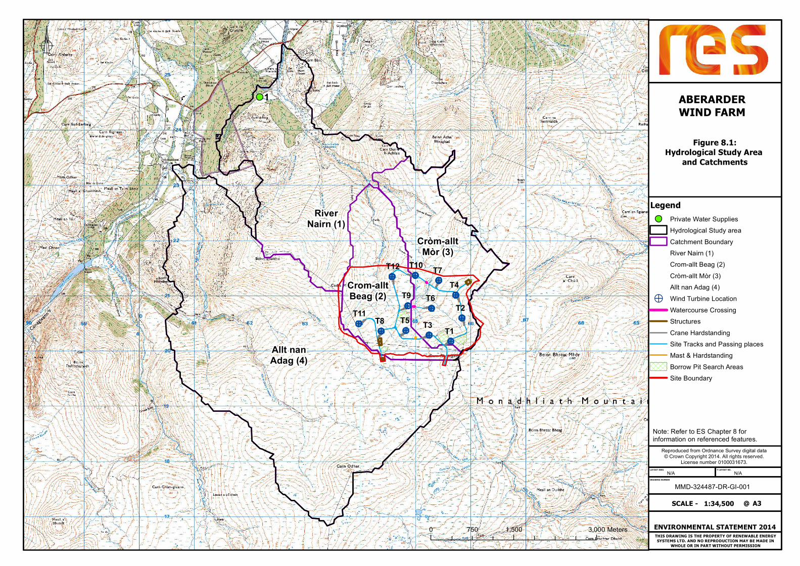
THIS DRAWING IS THE PROPERTY OF RENEWABLE ENERGYSYSTEMS LTD. AND NO REPRODUCTION MAY BE MADE IN
WHOLE OR IN PART WITHOUT PERMISSION
DRAWING NUMBER
LAYOUT DWG T-LAYOUT NO.
RiverNairn (1)
Cròm-alltMòr (3)
Crom-alltBeag (2)
Allt nanAdag (4)
1
T12 T10
T4
T2
T1T3
T6T9
T5T8T11
T7
ABERARDERWIND FARM
Figure 8.1:Hydrological Study Area
and Catchments
MMD-324487-DR-GI-001N/AN/A
ENVIRONMENTAL STATEMENT 2014
1:34,500SCALE - @
Reproduced from Ordnance Survey digital data© Crown Copyright 2014. All rights reserved.
License number 0100031673.
A3
LegendPrivate Water SuppliesHydrological Study areaCatchment BoundaryRiver Nairn (1)Crom-allt Beag (2)Cròm-allt Mòr (3)Allt nan Adag (4)
> Wind Turbine LocationWatercourse CrossingStructuresCrane HardstandingSite Tracks and Passing placesMast & HardstandingBorrow Pit Search AreasSite Boundary
0 1,500 3,000750 Meters
Note: Refer to ES Chapter 8 for information on referenced features.

THIS DRAWING IS THE PROPERTY OF RENEWABLE ENERGYSYSTEMS LTD. AND NO REPRODUCTION MAY BE MADE IN
WHOLE OR IN PART WITHOUT PERMISSION
DRAWING NUMBER
LAYOUT DWG T-LAYOUT NO.
T12 T10
T4
T2
T1
T3
T6T9
T5T8
T11
T7
Allt Nan Adag
Crom Allt Beag Crom Allt MhorABERARDERWIND FARM
Figure 8.2:Hydrological Constraints
MMD-324487-DR-GI-001N/AN/A
ENVIRONMENTAL STATEMENT 2014
1:8,000SCALE - @
Reproduced from Ordnance Survey digital data© Crown Copyright 2014. All rights reserved.
License number 0100031673.
A3
Legend> Wind Turbine Location
Watercourse CrossingStructuresCrane HardstandingSite Tracks and Passing placesMast & HardstandingBorrow Pit Search AreasCatchment BoundaryWatercoursesLochans50m Lochan Buffer50m Watercourse Buffer
GWDTEsHighModerate100m GWDTE Buffer250m GWDTE BufferSite Boundary
0 470 940235 Meters
Note: Refer to ES Chapter 8 for information on referenced features.

Aberarder Wind Farm Environmental Statement
RES
9. Transport and Traffic Introduction
9.1 This chapter considers the transport impacts resulting from the construction, operation and decommissioning of the proposed Aberarder Wind Farm (the proposed wind farm) as described in Chapter 2: Proposed Development. During the lifecycle of a wind farm the construction phase is associated with the highest levels of traffic therefore this report focuses on this element. The specific objectives of the chapter are to:
• describe the transport and traffic baseline; • describe the assessment methodology and significance criteria used in completing the
impact assessment; • describe the potential effects, including direct, indirect and cumulative effects; • describe the mitigation measures proposed to address likely significant effects; and
• assess the residual effects remaining following the implementation of mitigation.
9.2 There is no published guidance on the assessment of traffic impacts associated with temporary construction activities. Reference is, therefore, made to long term operational impact guidelines produced by the Institute of Environmental Assessment (IEA) in 1993.
9.3 Figures 9.1 – 9.2 are referenced in the text where relevant.
Planning
9.4 Relevant planning policies and documents in relation to transport and traffic for new developments are discussed below.
Scottish Planning Policy
9.5 Scottish Planning Policy (SPP) is a statement of the Scottish Government's policy on nationally important land use planning matters and the latest version was published in June 2014.
9.6 In respect to transportation, Section 290 of the policy indicates that “Development proposals that have the potential to affect the performance or safety of the strategic transport network need to be fully assessed to determine their impact. Where existing infrastructure has the capacity to accommodate a development without adverse impacts on safety or unacceptable impacts on operational performance, further investment in the network is not likely to be required. Where such investment is required, the cost of the mitigation measures required to ensure the continued safe and effective operation of the network will have to be met by the developer.”
9.7 Specifically in relation to wind farms SPP states in Section 169 that the impacts on road traffic and the impact on the trunk road should be considered. This has been undertaken within this Chapter.
Planning Advice Note 75 – Planning for Transport
9.8 SPP is supported by the document Planning Advice Note 75 (PAN 75) – Planning for Transport produced by the Scottish Government in August 2005.
9.9 PAN 75 states that “the early involvement of interested parties will positively inform transport planning by building consensus and minimising potential future areas of objection”.
9.10 Engagement with The Highland Council (the Council), Transport Scotland (TS) and other statutory bodies has been undertaken at an early stage by RES through a scoping exercise during 2013/2014. Cognisance will be taken of issues raised by the interested parties, through the scoping exercise, within this ES.
Highland Wide Local Development Plan
9.11 The Council in April of 2012 published the Highland Wide Local Development Plan (HwLDP) to guide development and investment. Section 5 of the Plan sets out the Council’s vision which includes:
• ensuring that development of renewable energy resources are managed effectively with clear guidance on where renewable energy developments should and should not be located;
• ensuring that the special quality of the natural, built and cultural environment in Highland is protected and enhanced;
• taking a lead in reducing the amount of greenhouse gases released into the air, adapted to the effects of climate change and limited the amount of non-renewable resources development uses; and
• providing opportunities which encourage economic development and create new employment across the area focusing on many key sectors including energy.
9.12 Within the HwLDP, Policy 36 states that “renewable energy development proposals will be assessed against the Renewable Energy Policies, the non statutory Highland Renewable Energy Strategy and where appropriate, Onshore Wind Energy: Supplementary Guidance.”
9.13 In relation to travel Policy 57 states that the “Development proposals that involve travel generation must include sufficient information with the application to enable the Council to consider any likely on- and off- site transport implications of the development.”
9.14 And Policy 67 states that the Council will have regard to “proposals able to demonstrate significant benefits including by making effective use of existing and proposed infrastructure or facilities.” The proposed wind farm will utilise the existing site access and access tracks for a neighbouring wind farm.
Volume 2: Environmental Statement Chapter 9: Transport and Traffic
9 - 1

RES
Aberarder Wind Farm Environmental Statement
9.15 Finally, the HwLDP notes that “the Highland area has great potential for renewable energy
production and to contribute towards meeting ambitious targets set internationally, nationally and regionally. This is recognised in the Highland Renewable Energy Strategy (2006) and can bring benefits in terms of tackling climate change, increasing energy security and contributing to the local and regional economies of the Highlands.”
Local Development Plan
9.16 In the Inverness Local Development Plan (LDP) (As Continued in Force - April 2012) specific policy allocations in respect to individual settlements are set out.
9.17 Section 14.2 of the LDP relates to settlements located adjacent to the B851 (south of the A9(T)) and notes that the “B851 is narrow and poorly aligned in places. Consideration needs to be given to segregated pedestrian/cycle routes and measures for restricting traffic speeds.” It also states that “consideration should be given to introducing further traffic calming measures between Inverarnie and Broomhill”.
9.18 The LDP describes Inverarnie has having 28 houses, a shop, a sports field, a community hall and a nearby wildlife reserve; Farr is described as having 9 houses, a primary school and a park; and Broomhill/Croftcroy is described as having 23 houses.
9.19 The LDP identifies land in and near Inverarnie as suitable for up to 6 houses; land in Farr as suitable for 6 houses; and land in Broomhill/Croftcroy as suitable for 2 houses.
Highland Renewable Energy Strategy
9.20 The Highland Renewable Energy Strategy was published by the Council in May 2006. Within the table in Section 4.3, the policy states that “new access roads should be kept to a minimum where possible. The provision of site access can be a major secondary impact, by opening up the area to a host of users and associated habitat disturbance, together with the risk of attracting further development. If new access required it should be routed out of sight of popular view points, away from watercourses and sensitive habitats and designed to reflect the contour gradient.” The access to the proposed wind farm will utilise an existing access point and access tracks for a neighbouring wind farm. Additional access tracks are only to be provided to serve the new turbines and the associated infrastructure.
Scope of Assessment
9.21 The site is located on a remote stretch of moorland between the hills of Coille Mhor and Carn Ghriogair; approximately 26km south of Inverness and is positioned immediately to the north of the consented Dunmaglass Wind Farm; which is currently in the construction phase and scheduled to become operational by 2016. Vehicular access to the proposed wind farm will make use of existing tracks from the adjacent Dunmaglass Wind Farm development which joins the B851 to the east of the River Farigaig and 1.7km to the south west of the hamlet of Aberarder.
9.22 The most notable settlement is Inverarnie, located 14.1 km to the north of the site access, comprised of 28 homes, a shop, sports facilities and a community hall. The hamlet of Farr, 12.5 km to the north of the site access, contains a 36 roll primary school that has a frontage on to the B851, as well as 9 homes and a community hall. Further holiday accommodation along the B851 is located at Riverside Cottages and Dalvour; 10.1 km and 13.5 km from the site access point respectively. The hamlet of Croachy, 5.6 km to the north of the site access comprises of approximately 18 homes and a church which have a frontage onto the B851.
Table 9.1 shows a summary of aforementioned receptors.
Table 9.1: Relevant receptors adjacent to the B851
Name Description Address Proximity*
Inverarnie Village Village with 28 homes, shop, sports facilities and community hall
B851 14.1 km
Dalvour Holiday Cottages
5 self-catered holiday cottages with category 1 unassisted wheelchair access award.
Dalvourn Farm, Farr, Inverness, IV2 6XJ 13.5 km
Farr Community Hall
Village hall with football pitch, badminton court, sports hall and stage.
Tordarroch, Unclassified Road, IV2 6XF 13.1 km
Farr Primary School 36 enrolled pupil with frontage access to B851
Farr Primary, Farr, B851, IV2 6XJ 12.9 km
Farr 9 homes with frontage access on to B851 B851 12.5 km
Riverside Cottages 3 self-catered holiday cottages Farr, B851, IV2 6XB 10.1 km
Croachy 18 homes and church with frontage access on to the B851
B851 5.6 km
Notes: * the distances displayed in the proximity column are measured from the site access point on the B851.
9.23 The B851 is also used to access an RSPB reserve at Loch Ruthven; vehicles would turn off at Croachy onto an unnamed road and continue approximately 1.6 km to the reserve.
Assessment Methodology
Baseline Characterisation
Study Area
9.24 This section identifies the road network that construction personnel and construction materials are likely to take to the site.
9 - 2
Volume 2: Environmental Statement Chapter 9: Transport and Traffic

Aberarder Wind Farm Environmental Statement
RES
9.25 The proposed Development will make use of the existing site access for Dunmaglass Wind Farm which is located on the B851 to the east of the River Farigaig.
9.26 Given the scarcity of substantial settlements within the vicinity of the site, it is likely that many if not most of construction personnel will access the site from the A9(T). For those travelling south along the A9(T) and turning right at the junction with the B851 there is an extended right filter lane on the A9(T). For those travelling north along the A9(T) and turning left at the junction with the B851 there is a deceleration lane. The route would then consist of driving 18 km along the B851 towards the site access track.
9.27 It is possible that some construction personnel may stay in local bed and breakfast accommodation during the week in which case the traffic impact on the road network would be reduced.
9.28 There are 40 mph speed limits at both the settlements of Farr and Inverarnie as well as part time speed limits of 20 mph during school term days around Farr Primary School.
9.29 On site borrow pits and an on-site concrete batching plant will be utilised to minimise the impact on the road network.
9.30 A desktop exercise was undertaken to identify quarries where raw materials for the concrete batching plant may be sourced. This exercise revealed that all potential access routes for HGVs would emanate from the junction of the B851 and A9(T) to the northeast of the site. The quarry at Mid Lairg’s run by A. Ross and Sons which produces aggregate is a particularly likely supplier, given its close (18 km) proximity from the site access point.
9.31 Table 9.2 shows a summary of potential aggregate and concrete (raw material) suppliers, including their address and the route required to access the proposed wind farm site.
Table 9.2: Table detailing appropriate aggregate and concrete raw material suppliers within appropriate vicinity of site
Company Name Address Proximity Route Concrete Aggregates
A Ross & Sons
Mid Lairgs Quarry, Daviot, IV2 6XN
18.2 km
Travel south from Junction with A9, along B851 Yes Yes
Breedon Aggregates Ltd
Beauly Quarry, Balblair, Beauly, Highland, IV4 7BG
48.7 km
Travel East along A862 and A82 towards Inverness before joining A9. Leave A9 at junction with B851 before travelling South 18km.
Yes Yes
Breedon Aggregates Ltd
Meadowside Quarry, Kingussie, PH21 1NL 74.4 km
Travel North along B9152 before joining A9; leaving at B851 junction before travelling South
Yes Yes
Breedon Aggregates Ltd
Inverness Concrete Plant, Longman Industrial Estate,
31.4 km Leave Inverness via Stadium Road before joining A9; leaving to join
Yes No
Company Name Address Proximity Route Concrete Aggregates
Inverness, IV1 1SU B851 and travelling south.
Hope Construction Materials
7/9 Longman Drive, Longman Industrial Estate, Inverness, IV1 1SN
30.7 km
Leave Inverness via Henderson Road and A82 before joining A9; leaving to join B851 and travelling south.
Yes No
9.32 The Port of Inverness has been identified as the location for onshore deliveries of the blades, tower sections and nacelles required for turbines. As such, the delivery route would be from Stadium Road to the A9(T) via Longman Roundabout and continuing to the site via the A9(T) and the B851. The port has recently undergone improvements to allow for the delivery and storage of heavy loads associated with wind turbine construction and incorporates a site entrance point junction that is designed to cater for blades up to a maximum of 50 metres in length1.
9.33 The nearby developments of Dunmaglass and Corriegarth and the associated improvements to the B851 has ensured that road access to the site will be sufficient to accommodate the abnormal loads; as the proposed turbines will be of a similar or smaller size to those being installed at Dunmaglass. Improvements on the B851 included:2
• Littlemill Bridge Replacement: B851 was repositioned to incorporate a new two way bridge to replace previous bridge;
• Inverarnie Bends: Widening of B851 for 400 metres near Tombreck to create a two way carriageway;
• South Croachy: Widening of B851 from single to two way carriageway between Blarachar Bridge and Aberarder;
• North Croachy: Lengthening of two way carriageway of over 1 kilometre and associated improvements to white lining and verges;
• Sockich’s Bends: Off-line improvement to the B851 by-passing Sockich bends between Inverarnie and Farr (not yet completed);
• Wind Farm Site Entrance: Improvements in visibility at junction to improve safety; and • Passing Places: Incorporation of 26 new passing places along extent of B851 to A9(T).
9.34 The route of the abnormal loads is shown in Figure 9.1.
9.35 The study network which is to be assessed as part of this ES, considering Section 9.26 through Section 9.36 above, will be:
• A9(T) from Longman Roundabout to the junction with the B851; • A9(T) from Tomatin to the junction with the B851 (there are no quarries that AECOM are
aware of to the south of the A9(T)/B851 junction that are close enough to the proposed wind farm site to make them likely candidates for use during construction, nor are there
1 http://portofinverness.co.uk/activities/renewables 2 http://www.strathnairn.org.uk/news.asp?intent=viewstory&newsid=56394
Volume 2: Environmental Statement Chapter 9: Transport and Traffic
9 - 3

RES
Aberarder Wind Farm Environmental Statement
any large settlements close enough to draw significant numbers of construction workers. Nevertheless this stretch of the A9(T) will be assessed to ensure a robust assessment); and
• B851 from the junction with the A9(T) to the site access located to the east of the River Farigaig (there are no quarries nor significant trip generators south of this extent within a reasonable proximity).
9.36 The extent of the study network is shown in Figure 9.2.
Desk Study
9.37 Baseline Annual Average Daily Flows (AADF) have been extracted from the Department for Transport’s (DfT) annual traffic count database for relevant points on the A9(T) study network. The data was recorded in 2013.
9.38 An automated traffic counter was installed within the vicinity of the site access point on the B851. The counts commissioned by RES, were undertaken during 5 weekdays in April 2012. An average of the flows over the 5 days was calculated to give an Average Daily Flow (ADF).
Baseline Conditions
9.39 Table 9.3 displays the baseline traffic flows.
Table 9.3: Table showing baseline traffic flow data
Count Point Road
AADF 2013 (from DfT)
Bicycle Motorcycle Car Bus LGV HGV Total Vehicles
10808 A9 2 32 5824 46 940 1308 8152 10809 A9 0 86 8554 138 1794 1036 11608 20726 A9 0 82 7567 136 1409 1139 10333 20727 A9 1 46 5716 76 1118 1112 8069 40821 A9 0 67 5484 83 993 991 7618 74275 A9 0 345 23182 344 3908 1668 29447 80012 A9 20 445 28877 218 5729 1990 37279 80013 A9 36 157 20878 267 4394 1383 27115 80014 A9 3 122 17012 212 3776 1296 22421
ADF 2012 (from Automated Traffic Counter) 5 day average Near Site Entrance B851 0 2 70 1 75 20 169
9.40 Using low growth factors, baseline figures were factored up to the present year and the results are shown in Table 9.4.
Table 9.4: Table showing baseline traffic flow data factored up for 2014
Count Point Road
AADF 2014 NRTF Low Growth
2013-2014 - 1.011
Bicycle Motorcycle Car Bus LGV HGV Total Vehicles
10808 A9 2 32 5888 47 950 1322 8242 10809 A9 0 87 8648 140 1814 1047 11736 20726 A9 0 83 7650 137 1424 1152 10447 20727 A9 1 47 5779 77 1130 1124 8158 40821 A9 0 68 5544 84 1004 1002 7702 74275 A9 0 349 23437 348 3951 1686 29771 80012 A9 20 450 29195 220 5792 2012 37689 80013 A9 36 159 21108 270 4442 1398 27413 80014 A9 3 123 17199 214 3818 1310 22668
ADF 2014 NRTF Low Growth 2012-2014 - 1.023 Near Site Entrance B851 0 2 71 1 77 21 172
9.41 The flows in Table 9.4 were factored up using low growth rates for the expected year of opening in 2019 and the results are shown in Table 9.5.
Table 9.5: Table showing baseline traffic flow data factored up for 2019
Count Point Road
AADF & ADF 2019 NRTF Low Growth
2015-2019 - 1.036
Bicycle Motorcycle Car Bus LGV HGV Total Vehicles
10808 A9 2 33 6034 48 974 1355 8445 10809 A9 0 89 8862 143 1859 1073 12026 20726 A9 0 85 7839 141 1460 1180 10705 20727 A9 1 48 5922 79 1158 1152 8359 40821 A9 0 69 5681 86 1029 1027 7892 74275 A9 0 357 24017 356 4049 1728 30507 80012 A9 21 461 29917 226 5935 2062 38621 80013 A9 37 163 21630 277 4552 1433 28091 80014 A9 3 126 17624 220 3912 1343 23228
Near Site Entrance B851 0 2 74 1 80 21 179
9.42 Appendix 9.1 contains a summary of the estimated construction traffic flows and is broken down for each element of construction per month and vehicle type.
9.43 Appendix 9.1 indicates that for months 1 and 2 of the 18 month construction programme, an average of 123 (two way) daily movements will be added to the road network. Of these, an average of 40 daily movements is associated with HGV movements, which equates to 20 HGVs arriving on site and 20 HGVs leaving site.
9.44 The traffic flows for the remaining months (months 3 through 18) are substantially lower; approximately 25% lower when considering all vehicles and 75% lower when considering
9 - 4
Volume 2: Environmental Statement Chapter 9: Transport and Traffic

Aberarder Wind Farm Environmental Statement
RES
HGVs. It has been estimated that, for the remaining months (months 3 through 18), a daily average flow of 93 movements will be added to the road network. Of these, a daily average of 10 movements is associated with HGV movements, which equates to 5 HGVs arriving on site and 5 HGVs leaving site. As detailed on Chapter 2: Proposed Development, it is anticipated that all concrete required for construction will be batched on site, using a temporary batching plant. The batching plant will alleviate traffic peaks during turbine foundations construction, which are typical during wind farm construction.
9.45 Table 9.6 displays the baseline traffic flows for all vehicles (from Table 9.5), the daily average flows for months 1 and 2, and the remaining months’ daily average flows. Table 9.7 is a similar table but relates to HGVs only. The percentage increase due to construction traffic is also displayed with Tables 9.6 and 9.7.
Table 9.6 2019 base line flows plus forecasted flows for all vehicles
Count Point Road
AADF 2019
Baseline
Months 1 and 2 Daily
Average Flow (All vehicles)
Baseline + Months 1
and 2 Daily Average
Flow
% increase
Remaining Months Daily
Average Flow (All vehicles)
Baseline + Remaining
Months Daily
Average Flow
% increase
10808 A9 8445 123 8568 1.5% 93 8538 1.1%
10809 A9 12026 123 12149 1.0% 93 12119 0.8%
20726 A9 10705 123 10828 1.1% 93 10798 0.9%
20727 A9 8359 123 8482 1.5% 93 8452 1.1%
40821 A9 7892 123 8015 1.6% 93 7985 1.2%
74275 A9 30507 123 30630 0.4% 93 30600 0.3%
80012 A9 38621 123 38744 0.3% 93 38714 0.2%
80013 A9 28091 123 28214 0.4% 93 28184 0.3%
80014 A9 23228 123 23351 0.5% 93 23321 0.4%
Near Site Entrance* B851 179 123 302 68.8% 93 272 52.0%
* The figures relating to this count point are Average Daily Flows (week day average).
Table 9.7 Baseline plus forecasted flows for HGVs only
Count Point Road
AADF 2019
Baseline (HGVs Only)
Months 1
and 2 Daily Average
Flow (HGVs Only)
Baseline + Months 1
and 2 Daily Average
Flow
% increase
Remaining Months Daily
Average Flow (HGVs Only)
Baseline + Remaining
Months Daily
Average Flow
% increase
10808 A9 1355 40 1395 3.0% 10 1365 0.7%
10809 A9 1073 40 1113 3.7% 10 1083 0.9%
20726 A9 1180 40 1220 3.4% 10 1190 0.8%
20727 A9 1152 40 1192 3.5% 10 1162 0.9%
40821 A9 1027 40 1067 3.9% 10 1037 1.0%
74275 A9 1728 40 1768 2.3% 10 1738 0.6%
80012 A9 2062 40 2102 1.9% 10 2072 0.5%
80013 A9 1433 40 1473 2.8% 10 1443 0.7%
80014 A9 1343 40 1383 3.0% 10 1353 0.7%
Near Site Entrance* B851 21 40 61 186.8% 10 31 46.7%
* The figures relating to this count point are Average Daily Flows (week day average).
Sensitivity Criteria
9.46 The IEA Guidelines for the Environmental Assessment of Road Traffic suggests the following screening criteria (percentage changes in traffic) may be used for establishing the need for an assessment of potential significance, for example:
• Rule 1 include highway links where traffic flows will increase by more than 30% (or the number of heavy goods vehicles will increase by more than 30%); and
• Rule 2 include any other specifically sensitive areas where traffic flows have increased by 10% or more
9.47 The IEA Guidelines acknowledge that day-to-day variations of traffic on a road can frequently be at least + or – 10% and, at a basic level, it should therefore be assumed that projected changes in traffic of less than 10% create no discernible environmental impact. Absolute changes (number of vehicles) are equally relevant since percentages alone could be misleading.
9.48 The Guidelines distinguish between the significance of operational and capacity criteria for highways with that which is more relevant to assessing environmental impact. The IEA advises that a 30% change in traffic flows represents a reasonable threshold for including a highway link in an assessment of potential significance.
Magnitude of Effect
9.49 In terms of magnitude of impact, the IEA guidelines point to changes in traffic in excess of 30%, 60% and 90% as being representative of “slight”, “moderate” and “substantial” impacts respectively. The table below reflects the IEA guidance and has been used to quantify the magnitude of impact of the proposed wind farm traffic.
Volume 2: Environmental Statement Chapter 9: Transport and Traffic
9 - 5

RES
Aberarder Wind Farm Environmental Statement
Table 9.8: Magnitude of Traffic Impact
Magnitude Impact
Substantial Considerable deterioration/improvement in local conditions or circumstances
(+90% increase in traffic)
Moderate Readily apparent change in conditions or circumstances
(60 – 90% increase in traffic)
Slight Perceptible change in conditions or circumstances
(30 – 60% increase in traffic)
Negligible Very small change in conditions or circumstances
(10 – 30% increase in traffic); and
No Impact No discernible change in conditions
– 10% increase in traffic).
9.50 As indicated previously, the screening criteria relate to the operational impacts of development only. Application of these Guidelines to temporary construction traffic is considered a robust and conservative approach.
9.51 The predicted increase in traffic flows in Tables 9.6 and 9.7 when compared with the criteria in Table 9.8 would suggest the magnitude of the impact on the B851 is substantial. It should be borne in mind however that the low baseline traffic flows on the B851 to a degree ‘skew’ the high percentage increases. This is considered further below. Considering the criteria in Table 9.8 and the traffic flows in Tables 9.6 and 9.7, there is no discernable impact on the A9(T).
9.52 Receptors are locations or land uses categorized by their degree of sensitivity (or Environmental Value) with guidance provided in the Design Manual for Roads and Bridges (DMRB), Volume 11, Section 2 (Part 5, HA 205/08).
Table 9.9: Sensitivity of Receptors
Sensitivity Receptor Description
Very High Nationally or internationally important site with special sensitivity to increases in road traffic.
High Regionally important site with special sensitivity to increases in road traffic.
Medium Residential (with frontage onto road under consideration), educational, healthcare, leisure, public open space or town centre/local centre land use.
Low Employment or out of town retail land use, such as retail park.
9.53 The B851 sensitive receptors are considered to have sensitivity levels corresponding to medium.
Significance Criteria
9.54 The assessment of the significance of the effect of traffic changes along these routes should have regard to both the magnitude of the proposed wind farm related traffic (change) and the receptor’s environmental value (sensitivity). The level of significance can be determined from the following matrix in Table 9.10 and professional judgement (this again is based upon the guidance given in the DMRB). Dependent upon the sensitivity of the receptor, significance levels of “Moderate” and above are regarded as requiring further consideration.
Table 9.10: Assessment of Significance
Magnitude of Impact (Degree of Change)
Negligible Slight Moderate Substantial
Rece
ptor
Sen
siti
vity
Very High Slight Moderate
or Large
Large or
Very Large Very Large
High Slight Slight
or Moderate
Moderate or
Large
Large or
Very Large
Medium Neutral
or Slight
Slight Moderate Moderate
or Large
Low Neutral
or Slight
Neutral or
Slight Slight
Slight or
Moderate
9.55 In accordance with IEA Guidelines, total construction traffic flow (from Table 9.6) has no impact on the A9(T) and is not discernible. The same conclusion applies to HGV traffic on the A9(T).
9.56 In relation to the significance values of moderate and above for the B851:
• For total construction traffic flow (a daily average of 123 vehicles) moderate significance occurs in months 1 and 2. However, for the remaining months, total construction traffic flow has slight significance with a daily average of 93 vehicles;
• For HGV traffic, moderate or large significance is indicated for months 1 and 2 of the 18 month construction period in relation to the percentage increase in HGV traffic. However, this occurs due to the base level of HGV traffic being low (21 HGVs per day) and the addition of 40 HGV movements per day for the first two months subsequently creates a high percentage increase. The addition of 40 HGV movements per day during months 1 and 2 equates to 20 HGV movements each way per day i.e. 2 HGV movements each way per hour (assuming a 10 hour delivery period). However, the remaining months have a daily average of 10 HGV movements with slight significance; and
• the impact is temporary in nature. The use of the IEA Guidelines to a temporary operation is a robust test.
9 - 6
Volume 2: Environmental Statement Chapter 9: Transport and Traffic

Aberarder Wind Farm Environmental Statement
RES
Likely Effects and their Significance
Construction Effects
9.57 The B851 will be considered further since significance values of moderate and above were encountered.
9.58 The potential effects listed in the IEA Guidelines for the Environmental Assessment of Road Traffic are listed below:
• traffic noise and vibration; • visual impact; • severance (for motorists or pedestrians); • increased journey times for non-construction traffic; • pedestrian delay, intimidation, loss of amenity; • road accidents and safety; • hazardous loads (not considered as no hazardous substances will be transported to the
site); • air pollution; • dust and dirt; • ecological impact (this is considered in chapter x of the es); and • heritage and conservation areas (this is considered in Chapter 5 of the ES).
9.59 According to the IEA Guidelines both the magnitude and significance of each effect is to be considered. The magnitude is defined as the ‘level of change’ and whether or not the effect is significant or not will largely depend on the number of people affected. With regards to significance the guidelines state that: “for many effects there are no simple rules or formulae which define the thresholds of significance and there is, therefore, a need for interpretation and judgement on the part of the assessor, backed-up by data or quantified information wherever possible. Such judgements will include the assessment of the numbers of people experiencing a change in environmental impact as well as the assessment of the damage to various natural resources.”
9.60 In the absence of established significance criteria for traffic and transport impacts, professional judgement has been used to assess whether the impacts on traffic and transport are considered to be significant.
9.61 Each potential effect has been assigned a magnitude level of either: negligible, low, moderate or high. How many people are affected, by and large, determines whether the effect is considered significant or not significant.
Traffic Noise and Vibration
9.62 The construction phase has the potential to increase noise and vibration for residential properties as a result of HGV traffic travelling to and from site. This potential negative
effect is temporary and would only affect those living in proximity to the B851; predominantly focused within the hamlets of Inverarnie, Farr and Croachy.
9.63 The IEA Guidelines suggest that a doubling in traffic flow will produce a 3 decibel change in noise level which is considered the minimal perceptible change in disturbance. A doubling of flows may occur on the B851 therefore there will be an impact associated with noise. This effect will be temporary and last the duration of the construction programme.
9.64 The number of properties that will be affected is low as there are few properties that are in proximity to the B851; in Farr there are approximately 9 houses in addition to the Primary School, a similar number in Inverarnie and approximately18 houses in Croachy.
9.65 Properties adjacent to the B851 may notice an increase in effects due to vibration although the road is currently used by HGV traffic.
9.66 The levels of HGV traffic associated with the worst case scenario equated to approximately 2 HGV movements each way per hour therefore the magnitude of the effect of noise and vibration is considered to be low. The number of residential properties in proximity to the B851 is low and the construction phase is temporary therefore this effect is considered not significant.
Visual Impact of Construction Traffic
9.67 Visual impact is unlikely to be impacted in any significant manner. Much of the B851 is bounded on both sides by fields or forests. The road network that high sided vehicles will utilise is currently used by HGV traffic. In addition, there is not thought to be any vantage points, such as hillsides, for which the increase in HGV traffic as a result of the proposed wind farm will be adversely affected to any great degree.
9.68 The magnitude of this effect is considered negligible. A low number of people, if any, will be affected and on a temporary basis so this effect is considered not significant.
Severance
9.69 According to the IEA guidelines severance is “the perceived division that can occur within a community when it becomes separated by a major traffic artery…..severance could equally be applied to residents, motorists or pedestrians”.
9.70 An increase in construction traffic can make it more difficult for pedestrians to cross a road or for traffic to enter a carriageway. For there to be a perceived division a significant increase in traffic is required.
9.71 The levels of HGV traffic associated with the worst case scenario equated to approximately 2 HGV movements each way per hour therefore the magnitude of the effect of severance is considered to be low. In light of their sparse population, it is not expected that a large number of people will be affected by severance in the settlements of Inverarnie, Farr and Croachy. It is considered that the demand for crossing the B851 will be low, even within settlements, and this is especially true of the settlements at Farr and Inverarnie with
Volume 2: Environmental Statement Chapter 9: Transport and Traffic
9 - 7

RES
Aberarder Wind Farm Environmental Statement
development mainly located to the west of the B851. This effect is considered not significant.
Increased Journey Times for Non Construction Traffic
9.72 HGVs by their very nature travel slower than the average vehicle and can delay other road users by increasing their journey time. It is not uncommon for a ‘convoy’ effect to occur when suitable overtaking opportunities for vehicles are few and far between. Increased journey times can lead to driver frustration. If HGVs do cause a ‘convoy’ effect then this can cause delays for vehicles wishing to join the carriageway that the HGV is travelling on. HGVs with an abnormal load (such as a wind turbine blade) also have the potential to cause delays.
9.73 The road improvements on the B851 associated with the Dunmaglass Wind Farm development has incorporated an additional 26 passing places and the twin-tracking of the road at North and South Croachy, Inverarnie Bends and at the Littlemill Bridge.
9.74 The levels of HGV traffic associated with the worst case scenario equated to approximately 2 HGV movements each way per hour therefore the magnitude of the effect of HGVs on increased journey times is considered to be low. Furthermore, the majority of existing journeys on the B851 are considered to be associated with the settlements of Inverarnie, Farr and Croachy which are approximately 4.2km, 5.6km and 12.9km respectively from the junction with the A9(T). The magnitude of any delay caused by HGV traffic for the shorter two of the three journeys would not be high. The journey to and from Croachy would take 16 minutes to complete assuming an average speed of 50 kph (31 mph). Even if the average speed for this journey were to drop to 40 kph (25 mph), for instance, this would add only 4 minutes to the journey. This does not suggest however that HGV traffic will be travelling at an average of 40 kph on the B851. The magnitude of the effect of HGV traffic on driver delay is low.
9.75 From the low number of vehicles using the B851, as demonstrated from the flows in Table 9.5, it can be concluded that this effect is considered not significant.
Pedestrian delay, intimidation, loss of amenity
9.76 An increase in construction traffic can make it more difficult for pedestrians to cross a road. Pedestrians can also experience intimidation and the degree to which this is true is affected by the volumes of traffic, the proportion of HGV traffic and its proximity to pedestrians.
9.77 Pedestrian delay was considered in Section 9.73 and the magnitude found to be low. The potential routes that construction traffic will take on the B851 are for the most part through rural areas where there is no existing pedestrian infrastructure. The B851 has limited pedestrian infrastructure adjacent to it in the settlements of Inverarnie and Farr. A new footpath has been constructed at Croachy South. These footpaths will be unaffected by the proposed wind farm therefore there will not be a loss of amenity for pedestrians.
9.78 The increase in HGV traffic will increase the experience of intimidation for any pedestrians walking along the B851, especially as there is no pedestrian infrastructure segregating the two modes of transport. The magnitude of this effect is considered to be moderate.
9.79 Since the number of pedestrians walking along the B851 is likely to be very low this effect is considered not significant.
Road Accidents and Safety
9.80 Road accidents are attributable to a variety of local factors but an increase in traffic on any particular route theoretically has the potential to increase the frequency of accidents.
9.81 Accident information provided by the council for the B851 between 2008 and 2012 revealed that there were 3 serious, 1 slight and 16 damage only accidents. Considering the serious accidents, 2 out of the 3 involved 1 vehicle therefore it can be deduced that the cause of these was not related to traffic volume (i.e. an increase in traffic volume would not affect this type of accident).
9.82 Improvements made to the B851 will have a reducing effect on the accident rate.
9.83 An area where there is a slightly higher risk of an incident is at the site entrance where construction traffic enters or exits the B851.
9.84 Considering the low rate of accidents on the road at present (1 serious and 1 slight between 2008 and 2012 that could be affected by traffic volume) and the fact that the worst case scenario will produce just 2 HGV movements each way per hour, the increase in the rate of accidents will be low. The magnitude of this effect is therefore considered low.
9.85 The significance is determined by the number of people that will be affected and this too is low, therefore this effect is considered not significant.
Air Pollution
9.86 Air pollution tends only to be a problem in heavily congested areas. The IEA guidelines reference the Department of Transport’s threshold for problematic air quality once an 8 hour average concentration of 9 parts per million (ppm) or a 1 hour peak concentration of 35ppm, in relation to carbon monoxide, occurs at least once a year. The traffic flows required to produce this level of carbon monoxide are well in excess of those that will be experienced on the road network in question (the IEA guidelines reference an example whereby a flow of 1000 vehicles per hour, with an average speed of 40kph, would be estimated to give a one-hour concentration of 2.4ppm at 10m from the centre of the road).
9.87 The magnitude of this effect is considered to be negligible and this effect is considered not significant.
Dust and Dirt
9.88 HGVs travelling on the site itself will potentially disturb the surface of the access tracks producing dust. There are no residential areas in close proximity that would be adversely affected.
9 - 8
Volume 2: Environmental Statement Chapter 9: Transport and Traffic

Aberarder Wind Farm Environmental Statement
RES
9.89 HGVs travelling to the site, if not properly covered, can produce dust from the loads they are carrying.
9.90 HGVs leaving the site and entering onto the local road network will potentially deposit mud and earth onto the carriageway over a localised area.
9.91 The magnitude of this effect is considered to be moderate. Since a low number of people will be affected this is considered not significant.
Operational Effects
9.92 The operational phase of the wind farm requires minimal vehicle trips to the site. Trips would include the use of a 4x4 vehicle and the number of vehicles visiting the site will typically be in the region of up to two vehicles per day. It can be concluded that the potential increase in traffic resulting from the operational phase is negligible when compared with the construction phase.
Decommissioning Effects
9.93 Decommissioning would be of shorter duration than construction and would involve fewer vehicles attending site.
9.94 The typical operational lifespan for an onshore wind farm is in the region of 25 years at which point the proposed turbines would either be refurbished, replaced, or decommissioned. Refurbishment or replacement of the turbines would require a further planning application, which would require an accompanying environmental assessment, therefore the only scenario considered here is decommissioning. Decommissioning will be undertaken in accordance with the guidance set out in SNH Report No. 591 “Research and guidance on restoration and decommissioning of onshore wind farms”. A Restoration and Decommissioning Plan would be prepared which sets out the approach to reinstatement of affected land and removal of development infrastructure. This is expected to involve the removal of all above ground infrastructure:
• Turbines will be dismantled and removed from site; • Top 1m of the turbine foundations will be broken up, removed and re-graded to allow
land to be utilised for other purposes; • Control building and substation will be dismantled and removed; and • Access tracks and cabling will be left in-situ as it is considered more environmentally
impacting to remove them.
9.95 An assessment of the traffic impacts of the decommissioning phase has not been undertaken because there is no reliable way for estimating the baseline traffic flows 25 years from now. However the impact of traffic on the road network would be less than that estimated for the construction phase.
Mitigation
9.96 A ‘Transport Management Plan’ (TMP) will be developed in consultation with the Council, Transport Scotland and Police Scotland following award of consent.
9.97 The framework for the TMP is as follows:
• The proposed route for construction traffic including abnormal loads; • The necessary agreements and timing restrictions for construction traffic; • Details of proposed Condition Survey on access routes; • Proposals for maintenance of these routes during construction; • Proposals for monitoring and agreeing maintenance costs; • Escort arrangements for abnormal loads; • Route signing; • Details of advanced notification to the general public, warning of turbine component
transport movements; • Details of informative road signage warning other users of forthcoming turbine
component transport and construction traffic movements; • Arrangements for regular road maintenance and cleaning, e.g. road sweeping in the
vicinity of the site access point as necessary, wheel cleaning / dirt control arrangements;
• Contractor speed limits; and, • Community and emergency services liaison details.
9.98 The hours for which construction can take place and therefore the hours for which construction traffic will be travelling to and from the site will be agreed with relevant parties before construction commences. The TMP for the neighbouring Dunmaglass Wind Farm had the following working hours, and a similar arrangement for Aberarder Wind Farm is considered appropriate:
• Monday to Saturday 06.00 to 20.00; and there shall be no Sunday workings without the prior written approval of the Planning Authority.
9.99 In proximity of the site, access signs will be present warning vehicles of an increased risk of construction traffic in accordance with the proposals within the agreed TMP.
9.100 Wheel cleaning facilities will be present on site to prevent the depositing of dirt onto the local road network. Arrangements for road sweeping will be in place as required. Loads that may produce excessive dust during transport will be covered.
Residual Effects
9.101 There will be no residual effects.
Volume 2: Environmental Statement Chapter 9: Transport and Traffic
9 - 9

RES
Aberarder Wind Farm Environmental Statement
Cumulative Effects
9.102 Through consultation with the Council the following wind farms were highlighted as potentially using the B851 for construction purposes.
9.103 Dunmaglass Wind Farm – (planning reference: 05/00217/S36IN) – This wind farm is currently under construction and is to be completed prior to construction beginning for the Aberarder Wind Farm therefore it has been discounted as a candidate site for inclusion in a cumulative assessment.
9.104 Corriegarth Wind Farm – (planning reference: 13/02456/S36) – The planning application for this wind farm was submitted on the 27th of June 2013 and is currently pending a decision. The Traffic and Transport chapter of the Environmental Statement for Corriegarth Wind Farm identifies the route for construction traffic as coming from Fort Augustus and utilising the A82 and B862. Therefore Corriegarth Wind Farm has been discounted as a candidate for inclusion in a cumulative assessment
9.105 Stronelairg Wind Farm – (planning reference: 12/02560/S36) – According to the Access, Traffic and Transport chapter of the Environmental Statement for Stronelairg Wind Farm the road network that will be utilised during the construction phase will include the A82, A87, A887 and the B862. The B851 will not be utilised by construction traffic therefore it has been discounted as a candidate site for inclusion in a cumulative assessment.
9.106 Dell Wind Farm – (planning reference: 14/02879/FUL) – The planning application was submitted on the 22nd of July 2014. The Traffic and Transportation chapter of the ES for Dell Wind Farm identifies the B851 as a potential route for construction traffic. For this reason it has been included as a candidate site for inclusion in a cumulative assessment.
9.107 Within the ES for Dell Wind Farm the worst case daily construction traffic flows are identified as 18 HGVs and 36 LGVs equating to a total of 54 vehicles.
9.108 Table 9.11 shows, for the B851, the worst case daily construction flows from the Dell Wind Farm added to the baseline traffic flows and the construction flows for Aberarder Wind Farm for all construction vehicles. The worst case scenario from Dell Wind Farm has been applied separately to months 1 and 2 and the remaining months for the Aberarder Wind Farm draft construction programme.
9.109 Table 9.12 is a similar table relating to HGV traffic only.
Table 9.11: Cumulative Assessment for All Vehicles
Count Point Road
AADF 2019 Baseline
(All Vehicles)
Scenarios
Near Site Entrance* B851 179
(A) Aberarder
Months 1 and 2 Daily
Average Flow (All vehicles)
(B) Dell Wind
Farm Worst case (All vehicles)
Baseline + (A) + (B)
% increase
123 54 356 98.9%
(C) Aberarder Remaining
Months Daily Average Flow (All vehicles)
(D) Dell Wind
Farm Worst case (All vehicles)
Baseline + (C) + (D)
% increase
93 54 326 82.1%
Table 9.12: Cumulative Assessment for HGVs Only
Count Point Road AADF 2019
Baseline (HGVs Only)
Scenarios
Near Site Entrance* B851 21
(E) Aberarder
Months 1 and 2 Daily
Average Flow (HGVs Only)
(F) Dell Wind
Farm Worst case (HGVs
Only)
Baseline + (E) + (F)
% increase
40 18 79 276.2%
(G) Aberarder Remaining
Months Daily Average Flow (HGVs Only)
(H) Dell Wind
Farm Worst case (HGVs
Only)
Baseline + (G) + (H)
% increase
10 18 49 133.3%
9 - 10
Volume 2: Environmental Statement Chapter 9: Transport and Traffic

Aberarder Wind Farm Environmental Statement
RES
9.110 Applying the criteria from Table 9.8 to Tables 9.11 and 9.12 demonstrates that the cumulative effect would be determined as having a substantial magnitude during months 1 and 2 in terms of all vehicles, and for the remaining months in terms of the HGV traffic. The cumulative effect would have a moderate magnitude for the remaining months in terms of all vehicles.
9.111 The sensitivity from Table 9.9 remains at medium.
9.112 The assessment of significance for the cumulative effect from Table 9.10 shows that there would be moderate or large significance for months 1 and 2 in relation to all vehicles and HGV traffic and for the remaining months in relation to HGV traffic. The assessment of significance for the remaining months in relation to all traffic is moderate.
9.113 The likelihood of 100% of construction traffic for the Dell Wind Farm using the B851 is highly unlikely. The proximity of Dell Wind Farm to the A82(T) would make accessing this proposed site from the west a more attractive option. There are fewer settlements between the A82(T) and the proposed site when compared with the road network between the A9(T) and the proposed site which also makes access from the west more attractive.
9.114 The likelihood of both wind farms being constructed at the same time is also thought to be unlikely.
Summary
9.115 The traffic impact of the Aberarder Wind Farm has been assessed. During the lifecycle of a wind farm the temporary construction period is associated with the highest traffic flows and so this assessment has focused on this area.
9.116 The route that abnormal loads will travel does not differ from that used for the adjacent Dunmaglass Wind Farm. The dimensions of the abnormal loads are expected to be the same as or less than those related to the neighbouring Dunmaglass Wind Farm. Improvement works have been carried out on the B851 to ensure suitability for the delivery of turbine components for the Dunmaglass Wind Farm.
9.117 The IEA Guidelines for the Environmental Assessment of Road Traffic have been followed during the assessment process. The study network included the A9(T) and the B851 and baseline traffic flows were sourced for these roads. The average daily traffic flows associated with construction were determined and added to the baseline.
9.118 The construction traffic flows have no impact on the A9(T) and are not discernible. The same conclusion applies to HGV traffic on the A9(T).
9.119 Total construction traffic results in moderate significance for months 1 and 2, and slight significance for the remaining months. HGV construction traffic results in moderate or large significance for months 1 and 2, and slight significance for the remaining months.
9.120 Considering the absolute numbers, the average daily total of vehicles associated with the construction period is low (62 each way during months 1 and 2 and 47 each way in the remaining months). The average daily number of HGVs associated with the construction period is low (20 each way during months 1 and 2 and 10 each way in the remaining months).
9.121 The B851 was considered further for the potential effects as listed in the IEA Guidelines. None of the effects were considered to be significant.
9.122 Nevertheless, mitigation is proposed in the form of a Transport Management Plan to be implemented during the temporary construction phase.
9.123 The cumulative effect of the construction phase of Dell Wind Farm occurring at the same time of Aberarder Wind Farm has been considered.
9.124 There are no residual effects.
9.125 This Chapter has demonstrated that the traffic impact is satisfactory when considering absolute flow numbers involved.
Volume 2: Environmental Statement Chapter 9: Transport and Traffic
9 - 11


Aberarder Wind Farm Environmental Statement
RES
10. Noise Introduction
10.1 This report contains an assessment of the acoustic impact of the proposed Aberarder Wind Farm. The report assesses wind farm operational noise and construction noise upon the most acoustically sensitive residential properties.
Statement of Authority
10.2 This assessment has been undertaken by RES, with at least one in-house Member of the Institute of Acoustics involved in its production. RES has undertaken acoustic impact assessments in every single one of its UK wind farm development applications since 2000. RES have also carried out noise assessments and reported to several local planning authorities on wind energy projects including taking measurements on newly constructed wind farms to ensure compliance with planning conditions.
10.3 Additionally, RES have been project co-ordinators for several Joule1 projects, leading European research into wind turbine noise, were involved in producing the guideline ‘The Assessment and Rating of Noise from Wind Farms’2 for the DTI in 1996, acted as peer reviewer for the ‘Good Practice Guide to the Application of ETSU-R-97 for the Assessment and Rating of Wind Turbine Noise’3, and contributed to the RenewableUK work on Amplitude Modulation4. Publications include:
• ‘An Investigation of Blade Swish from Wind Turbines’, P Dunbabin, Proceedings of the 1996 International Congress on Noise Control Engineering (Internoise ‘96), 30 July – 2 August 1996, Book 1, pp 463 – 469;
• ‘An Automated System for Wind Turbine Tonal Assessment’, R Ruffle, Proceedings of the 1996 International Congress on Noise Control Engineering (Internoise ‘96), 30 July – 2 August 1996, Book 6, pp 2997 – 3002;
• ‘Wind Turbine Measurements for Noise Source Identification’, ETSU W/13/003914/00.REP, 1999, Dr P Dunbabin, RES et al;
• ‘A Critical Appraisal of Wind Farm Noise Propagation’, ETSU W/13/00385/REP, 2000 Dr J Bass, RES;
• ‘Aerodynamic Noise Reduction for Variable Speed Turbines’, ETSU/W/45/00504/REP, 2000, Dr P Dunbabin, RES;
1 DGXII European Commission funded projects in the field of Research and Technological Development in non-nuclear energy 2 ‘The Assessment and Rating of Noise from Wind Farms’, The Working Group on Noise from Wind Turbines, ETSU Report for the DTI, ETSU-R-97 3 ‘A Good Practice Guide to the Application of ETSU-R-97 for the Assessment and Rating of Wind Turbine Noise’, Institute of Acoustics, May 2013 4 ‘Wind Turbine Amplitude Modulation: Research to Improve Understanding as to its Cause and Effects’, RenewableUK, 2013
• ‘Fundamental research in amplitude modulation - a project by RenewableUK’, Fourth International Meeting on Wind Turbine Noise, Rome, April 2011;
• ‘Investigation of the ‘Den Brook’ Amplitude Modulation methodology for wind turbine noise’, J Bass, Acoustics Bulletin Vol 36 No 6 November/December 2011; and
• ‘How does noise influence the design of a Wind Farm?’, M Cassidy, Fifth International Conference on Wind Turbine Noise, Denver, 2013.
10.4 Additional information, including suggested planning conditions are provided in the Appendices.
Wind Turbine Noise
10.5 Noise levels from turbines are generally low and, under most operating conditions, it is likely that turbine noise would be completely masked by wind generated background noise such as the sound of wind blowing through trees and around buildings.
10.6 As described by Scottish Government Planning Advice for Onshore Wind Turbines5: “Technically, there are two quite distinct types of noise sources within a wind turbine - the mechanical noise produced by the gearbox, generator and other parts of the drive train; and the aerodynamic noise produced by the passage of the blades through the air. There has been significant reduction in the mechanical noise generated by wind turbines through improved turbine design”.
Construction Noise
10.7 The sources of construction noise, which are temporary, will vary both in location and duration as the different elements of the wind farm are constructed and will arise primarily through the operation of large items of plant.
10.8 Noise will also arise due to the temporary increase in construction traffic near the site. This level also depends on the different elements of the wind farm being constructed.
Scope of Assessment
10.9 Noise can have an effect on the environment and on the quality of life enjoyed by individuals and communities. The effect of noise, both in the construction and operational phase, is therefore a material consideration in the determination of planning applications.
Operational Noise
10.10 The main focus of the acoustic impact assessment of operational noise from the wind farm presented here is based on the two most relevant types of noise emission for modern wind turbines: broadband and tonal noise, both of which are types of ‘audible noise’. Implicitly incorporated within this assessment is the normal character of the noise associated with
5 Onshore wind turbines’, The Scottish Government, 2013, www.scotland.gov.uk Volume 2: Environmental Statement Chapter 10: Noise
10 - 1

RES
Aberarder Wind Farm Environmental Statement
wind turbines (commonly referred to as ‘swish’) and consideration of a range of noise frequencies, including low frequencies.
10.11 Low frequency content of the noise from wind farms shall be considered through the use of octave band specific noise emission and propagation modelling, however it is considered that specific and targeted assessment on low frequency content of noise emissions from the proposed wind farm is unjustified. Details for scoping out low frequency noise from the acoustic assessment, as well as infrasound, sleep disturbance, vibration, amplitude modulation and wind turbine syndrome can be found in the Technical Appendix 10.1.
Construction Noise
10.12 The acoustic impact assessment of construction noise from the wind farm presented here is based on RES’s experience of constructing wind farms and calculated for the operation of the primary large items of construction equipment. Additionally, consideration is given to the increased noise levels due to increased traffic flows during the construction phase to and from the site.
10.13 Whilst noise will also arise during decommissioning of the wind farm (through turbine deconstruction and breaking of the exposed part of the concrete bases) this is not discussed separately as noise levels resulting from it are expected to be lower than those from the construction activity.
Legislative Framework & Guidance
Operational Noise
10.14 Within Scotland, noise is defined within the planning context by ‘Planning Advice Note 1/2011: Planning and Noise’6. This Planning Advice Note provides advice on the role of the planning system in helping to prevent and limit the adverse effects of noise. It supersedes Circular 10/1999 Planning and Noise and PAN 56 Planning and Noise. The Planning Advice Note 1/2011 states that:
“Good acoustical design and siting of turbines is essential to minimise the potential to generate noise.”
10.15 Planning Advice Note 1/2011 refers to the use of the Department of Trade and Industry’s ‘The Assessment and Rating of Noise from Wind Farms’ (ETSU-R-97), noting that further guidance is provided in the web based planning advice on renewable technologies for onshore wind turbines5. In relation to noise from wind farms the web-based renewables advice states:
“The Report, ‘The Assessment and Rating of Noise from Wind Farms’ describes a framework for the measurement of wind farm noise, which should be followed by applicants and consultees, and used by planning authorities to assess and rate noise from wind energy developments, until such time as an update is available.”
6 ‘Planning Advice Note 1/2011: Planning and Noise’, Scottish Government policy, March 2011
10.16 It is therefore considered that the use of ETSU-R-97, as criteria for assessment of wind farm noise, fulfils the requirements of Planning Advice Note 1/2011.
10.17 The methodology described in ETSU-R-97 was developed by a working group comprised of a cross section of interested persons including, amongst others, environmental health officers, wind farm operators and independent acoustic experts.
10.18 The guidance makes it clear from the outset that any noise restrictions placed on a wind farm must balance the environmental impact of the wind farm against the national and global benefits that arise through the development of renewable energy resources. The principle of balancing development needs against protection of amenity may be considered common to any type of noise control guidance.
10.19 The basic aim of ETSU-R-97, in arriving at the recommendations contained within the report, is the intention to provide:
“Indicative noise levels thought to offer a reasonable degree of protection to wind farm neighbours, without placing unreasonable restrictions on wind farm development or adding unduly to the costs and administrative burdens on wind farm developers or local authorities.”
10.20 ETSU-R-97 provides a robust basis for assessing the noise impact of a wind farm and has been applied at the vast majority of wind farms currently operating in the UK and is proposed as adequate for use in this assessment. Based on the advice of planning policy, as outlined above, a wind farm which can operate within the noise limits which have been derived according to ETSU-R-97 is considered to be acceptable. This approach is consistent with relevant planning policy and has been agreed with The Highland Council Environmental Health Officer.
10.21 An article published in the Institute of Acoustics Bulletin (IoA Bulletin) Vol. 34 No. 2, March/April 20097, recommends a methodology for addressing issues not made explicit by, or outside the scope of, ETSU-R-97, such as in relation to wind shear or noise propagation modelling. Whilst this article does not represent formal legislation or guidance it was authored by a group of independent acousticians experienced in wind farm noise issues who have undertaken work on behalf of wind farm developers, local planning authorities and third parties and as such is a good indicator of best practice techniques. The assessment presented herein adopts the recommendations made within this article.
10.22 A Good Practice Guide (IoA GPG) to the application of ETSU-R-97 for the assessment and rating of wind turbine noise5, issued by the Institute of Acoustics in May 2013 and endorsed by the Department of Energy and Climate Change (DECC), Northern Ireland Executive, Scottish Executive and the Welsh Assembly Government, provides guidance on all aspects of the use of ETSU-R-97 and reaffirms the recommendations of the Acoustics Bulletin article with regard to propagation modelling and wind shear. The assessment presented herein adopts the recommendations of the Good Practice Guide.
7 ‘Prediction and Assessment of Wind Turbine Noise’, Bowdler et al, Acoustics Bulletin Vol 34 No 2 March/April 2009
10 - 2
Volume 2: Environmental Statement Chapter 10: Noise

Aberarder Wind Farm Environmental Statement
RES
Construction Noise
10.23 In the web based Scottish Government technical advice on construction noise assessment in ‘Appendix 1: Legislative Background, Technical Standards and Codes of Practice’8 it is stated that:
“However, under Environmental Impact Assessments and for planning purposes i.e. not in regard to the Control of Pollution Act 1974, the 2009 version of BS 5228 is applicable.”
10.24 Given that BS 5228-1:2009 ‘Code of practice for noise and vibration control on construction and open sites - Part 1: Noise’9 is identified as being suitable for the purpose of giving guidance on appropriate methods for minimising noise from construction activities, it is adopted herein.
10.25 The legislation Control of Pollution Act 1974 provides information on the need for ensuring that the best practicable means are employed to minimise noise10.
Consultation
10.26 Details of the consultation undertaken are outlined in Table 10.1.
Table 10.1 - Acoustic Assessment Consultation
Consultee Date of Consultation Nature and Purpose of Consultation The Highland Council 13/02/2014 Report “Aberarder Scoping Report” (RES ref. 02835-
000494) sent to Highland Council in order to requesting scoping opinion
The Highland Council 28/03/2014 Scoping opinion received and outlined the requirement to assess noise with the acknowledgement that the nearest properties are some distance from the proposed wind farm. Also there was a request to consider the cumulative impact with the adjacent (RES ref. 02835-001146).
The Highland Council 09/08/2013 Report “Planned Acoustic Assessment of the Proposed Aberarder Wind Farm” (RES ref. 02835 000500 01) sent to Area Environmental Health Manager, Highland Council detailing proposed assessment methodology and suggesting that background noise measurements would not be required due to the large separation distances between the turbines and nearby properties.
The Highland Council 13/08/2013 Response from Highland Council Environmental Health Officer (EHO) confirming that an assessment according to the recommendations of ETSU-R-97 and the IoA
8 ‘Appendix 1: Legislative Background, Technical Standards and Codes of Practice’, Scottish Government, 2011, www.scotland.gov.uk 9 ‘Code of Practice for Noise and vibration control on construction and open sites - Part 1: Noise’, British Standards Institution, BS 5228-1:2009 10 ‘Control of Pollution Act’, Control of Pollution Act, published by Her Majesty’s Stationary Office, 1974
Consultee Date of Consultation Nature and Purpose of Consultation Good Practice Guide is appropriate. The EHO also confirmed that if it can be demonstrated that predicted noise levels fall below 35dB(A) at all nearby properties then background noise measurements would not normally be required. (RES ref. 02835-000650).
The Highland Council 13/08/2013 Replied to queries from the EHO that there were no planning conditions relating to noise attached to the Dunmaglass Wind Farm. Approximate separation distances were also provided and clarity sought on whether a background noise survey would be required (RES ref. 02835-000651)
The Highland Council 14/08/2013 Response from the EHO agreeing that a background noise survey was not necessary. (RES ref. 02835-000652)
Public 13/05/2014 Public Exhibition held at Stratherrick Hall.
Public 14/05/2014 Public Exhibition held at Farr Community Hall
Public 15/05/2014 Public Exhibition held at Strathdearn Hall, Tomatin.
Assessment Methodology
Operational Noise
10.27 To ensure adequate assessment of the potential impacts of the operational noise from the proposed wind farm the following steps have been taken, in accordance with relevant guidance detailed above:
• the noise levels incident at the nearest residential properties due to the combined operation of all the wind turbines, for the proposed wind farm, using a sound propagation model, are estimated giving due regard to: the locations of the wind turbines; the locations of the nearest, or most noise sensitive residential properties; the intervening terrain; and the likely noise emission characteristics of the wind turbines;
• with due regard to relevant guidance or regulations the acoustic assessment criteria is derived; and
• the evaluation of the acoustic impact is undertaken by comparing the predicted noise levels with the assessment criteria.
Modelling Noise Propagation
10.28 Whilst there are several sound propagation models available, the ISO 9613 Part 2 model has been used11, this being identified as most appropriate for use in such rural sites12. The
11 ‘Acoustics - Attenuation of Sound During Propagation Outdoors, Part 2: General Method of Calculation’, International Organisation for Standardisation, ISO 9613-2:1996
Volume 2: Environmental Statement Chapter 10: Noise
10 - 3

RES
Aberarder Wind Farm Environmental Statement
specific interpretation of the ISO 9613 Part 2 propagation methodology recommended in the aforementioned IoA Bulletin and the subsequent IoA GPG has been employed.
10.29 To make noise predictions it is assumed that:
• the turbines are identical; • the turbines radiate noise at the power specified in this report; • each turbine can be modelled as a point source at hub-height; and • each residential property is assigned a reference height to simulate the presence of an
observer.
10.30 The sound propagation model takes account of attenuation due to geometric spreading and atmospheric absorption. The assumed temperature and relative humidity are 10 ˚C and 70 % respectively, as recommended in the IoA Bulletin and IoA GPG. Ground effects are also taken into account by the propagation model with a ground factor of 0.5 and a receiver height of 4 m used as recommended in the IoA Bulletin and IoA GPG.
10.31 The barrier attenuations predicted by ISO 9613 Part 2 have been shown to be significantly greater than those measured in practice under downwind conditions39. Therefore, barrier attenuation according to the ISO 9613 Part 2 method has been discounted. In lieu of this, where there is no direct line of sight between the residential property in question and any part of the wind turbine, 2 dB attenuation has been assumed as recommended in the IoA Bulletin and the IoA GPG.
10.32 Additionally, verification studies have also shown that ISO 9613 Part 2 tends to slightly underestimate noise levels at nearby dwellings in certain exceptional cases, notably in a valley type environment where the ground drops off between source and receiver. In these instances an addition of 3 dB(A) has been applied to the resulting overall A weighting noise level as recommended by the IoA GPG.
10.33 To generate the ground cross sections between each turbine and each dwelling necessary for reliable propagation modelling, ground contours at 5 m intervals for the area of interest have been generated from 50 m grid resolution digital terrain data.
10.34 The predicted noise levels are calculated as LAeq noise levels and changed to the LA90 descriptor (to allow comparisons to be made) by subtraction of 2 dB, as specified by ETSU-R-97.
10.35 It has been shown by measurement based verification studies that the ISO 9613 Part 2 model tends to slightly overestimate noise levels at nearby dwellings39. Examples of additional conservatism modelled are:
• downwind propagation is modelled in all directions. In reality, noise propagation biases towards downwind locations, therefore predicted values are overestimated for upwind and crosswind of the proposed wind turbines;
12 ‘A Critical Appraisal of Wind Farm Noise Propagation’, ETSU Report W/13/00385/REP, 2000
• although, in reality, the ground is predominantly porous (acoustically absorptive) it has been modelled as ‘mixed’, i.e. a combination of hard and porous, corresponding to a ground absorption coefficient of 0.5 as recommended by the IoA Bulletin and IoA GPG;
• receiver heights are modelled at 4 m above local ground level, which equates roughly to first floor window level, as recommended by the IoA Bulletin and IoA GPG. This results in a predicted noise level anything up to 2 dB(A) higher than at the typical human ear height of 1.2 m - 1.8 m;
• trees and other non-terrain shielding effects have not been considered; and • an additional allowance for measurement uncertainty has been added to the warranted
sound power levels for the presented turbine.
Significance Criteria
10.36 Noise is measured in decibels (dB) which is a measure of the sound pressure level, i.e. the magnitude of the pressure variations in the air. Measurements of environmental noise are usually made in dB(A) which includes a correction for the sensitivity of the human ear.
10.37 In accordance with the recommendations of ETSU-R-97, the acceptance of the proposed wind farm is established by comparing the noise levels produced by the combined operation of the wind turbines with appropriate noise limits at nearby residential properties.
10.38 Whilst ETSU-R-97 presents a comprehensive and detailed assessment methodology for wind farm noise, it also states a simplified methodology:
“if the noise is limited to an LA90,10min of 35dB(A) up to wind speeds of 10 m/s at 10 m height, then these conditions alone would offer sufficient protection of amenity, and background noise surveys would be unnecessary”.
10.39 In the detailed methodology, ETSU-R-97 states that different limits should be applied during quiet waking and night-time hours. The quiet waking hour’s limits are intended to preserve outdoor amenity, while the night-time limits are intended to prevent sleep disturbance. The general principle is that the noise limits should be based on existing background noise levels, except for very low background noise levels, in which case a fixed limit may be applied. The suggested limits are given below, where LB is the background LA90,10min and is a function of wind speed. During quiet waking hours and at low background noise levels, a permissible noise level of 35–40 dB(A) should be used. The exact value is dependent upon a number of factors: the number of nearby dwellings, the effect of the noise limits on energy produced, and the duration and level of exposure.
Table 10.2 - Permissible Noise Level Criteria
Time of Day Permissible Noise Level Quiet waking hours • 35-40 dB(A) for LB less than 30-35 dB(A)
• LB + 5 dB, for LB greater than 30-35 dB(A)
Night-time hours • 43 dB(A) for LB less than 38 dB(A)
• LB + 5 dB, for LB greater than 38 dB(A)
10 - 4
Volume 2: Environmental Statement Chapter 10: Noise
Aberarder Wind Farm Environmental Statement
RES
10.40 Note that a higher noise level is permissible during night-time hours than during quiet waking hours, as it is assumed that residents would be indoors. The night-time criterion is derived from sleep disturbance criterion referred to in ETSU-R-97, with an allowance of 10 dB for attenuation through an open window.
10.41 The wind speeds at which the acoustic impact are considered are less than or equal to 12 m/s at a height of 10 m and are likely to be the acoustically critical wind speeds. Above these wind speeds, as stated in ETSU-R-97, reliable measurements of background and turbine noise are difficult to make. However, if a wind farm meets the noise criteria at wind speeds lower than that presented, it is highly unlikely that it will cause any greater loss of amenity at higher wind speeds due to increasing background noise levels masking wind farm generated noise.
10.42 It is important to note that, since reactions to noise are subjective, it is not possible to guarantee that a given development will not result in any adverse comment with regard to noise as the response to any given noise will vary from person to person. Consequently, standards and guidance that relate to environmental noise are typically presented in terms of criteria that would be expected to be considered acceptable by the majority of the population.
Method for Construction Noise Assessment
10.43 To ensure adequate assessment of the potential impacts of the construction noise from the proposed wind farm the following steps have been taken:
• baseline noise criteria are established from the appropriate guidance BS 5228 1:2009; • noise predictions are made at the most critically sensitive residential properties due to
on-site construction activities. These are calculated using the BS 5228-1:2009 standard; • predictions are made at the same residential properties due to construction traffic and
are calculated using the BS 5228-1:2009 standard; • the combined effect of on-site construction activities with construction traffic is
compared with the target level specified by BS 5228-1:2009; • an assessment is presented for vibration due to blasting taking place on site. Whenever
blasting is carried out, energy is transmitted from the blast site in the form of airborne pressure waves, and these pressure waves comprise energy over a wide range of frequencies. Air overpressure can excite secondary vibrations in buildings and it is usually this effect which gives rise to complaint, however there is no known evidence of structural damage to structures from excessive air overpressure levels from quarry blasting (BSI, 2009b); and
• although monitoring of air overpressure can be undertaken, due to the uncertainties with meteorological conditions, it is not possible to predict the location of the maximum air overpressure. Pressure variations in the atmosphere due to windy conditions can mask the blast generated air overpressure levels. For these reasons it is not accepted
practice to set specific limits for air overpressure. In order to control air overpressure the best practical approach is to take measures to minimise its generation at source.
10.44 Whilst noise will also arise during decommissioning of the wind farm, this is not discussed separately as noise levels resulting from it would be lower than those from the construction activity since this would likely only involve removing turbines and applying topsoil covering to concrete bases.
Baseline Conditions
Operational Noise
10.45 The proposed Aberarder Wind Farm is located approximately 24 km south of Inverness on the northern edge of the Monadhliath Mountains with the A9 approximately 15 km east the site. The surrounding area is rural in nature and principally used for sporting interests as well as sheep grazing in the summer. The general noise character is typical of a rural environment with noise from farm machinery, sheep, birds, and the occasional overhead aircraft.
10.46 The general principle of ETSU-R-97 is that noise limits should be based on existing background noise levels (reflecting the variation in background noise with wind speed) except for very low background noise levels, in which case a fixed limit is applied.
10.47 ETSU-R-97 goes on to state that a simplified noise condition may be suitable:
“if the noise is limited to an LA90,10min of 35dB(A) up to wind speeds of 10 m/s at 10m height, then these conditions alone would offer sufficient protection of amenity, and background noise surveys would be unnecessary”
Potential Impacts
Potential Operational Impacts
Modelling Noise Propagation
10.48 The locations of the proposed Aberarder Wind Farm turbines are provided in Table 10.3 and all considered turbines are shown in Figure 10.1.
Volume 2: Environmental Statement Chapter 10: Noise
10 - 5

RES
Aberarder Wind Farm Environmental Statement
Table 10.3 - Location of Proposed Turbines
Turbine OSGB Co-ordinates
Elevation (m) X (m) Y (m)
T1 265646 820181 767 T2 265846 820602 733 T3 265253 820292 741 T4 265734 821018 711 T5 264831 820375 710 T6 265296 820777 691 T7 265427 821284 681 T8 264384 820364 684 T9 264866 820820 671 T10 265000 821374 662 T11 263977 820498 657 T12 264581 821351 650
10.49 The locations of the nearest residential properties to the turbines have been determined by inspection of relevant maps and through site visits. More residential properties may have been identified but have not been considered critical to this acoustic assessment or may be adequately represented by another residential property. The locations considered are listed in Table 10.4 and are also shown in Figure 10.1. Elevations, given in metres above mean sea level, have been determined from digital terrain data. Properties identified as non-residential are not considered further. A planning search has been undertaken using Planning Service (NI) Epic website to identify any residential properties that are proposed or have been granted consent. These have been included within the assessment.
10.50 The distances from each residential property to the nearest turbine are given in Table 10.4. It can be seen that the minimum house–to–turbine separation to the Aberarder Wind Farm is 4,384 m.
Table 10.4 - Location of Residential Properties and Distances to Nearest Proposed Turbine
House Name House ID OSGB Co-ordinates Elevation
(m) Distance
(m) Nearest turbine X (m) Y (m)
Keepers Cottage H2 256919 819486 270 7130 T11
Aberarder Farm H5 262310 825101 254 4384 T12
Ach Na Craoibhe H8 266090 826386 285 5129 T10
The Bothy H30 260439 823312 265 4521 T11
Glenbeg Farm H32 263810 825895 242 4609 T12
The Folly H34 259085 821759 318 5052 T11
Dunmaglass Mains H36 260938 823865 263 4426 T12
5-6 Croachy Village H55 265029 827627 227 6253 T10
Lodge Cottage, Coignafearn H72 268057 815352 449 5397 T1
Under Keeper's Cottage H74 270828 817830 395 5690 T1
10.51 Although not finalised, the candidate turbine type for the proposed Aberarder Wind Farm is the Siemens SWT 3.0-101 turbine. This report uses the acoustic data from an independent acoustic consultant’s report for this turbine for all analysis13. The manufacturer has identified these values as warranted and comparison with the results of an independent test report suggests that some margin has already been incorporated. However, should the levels be tested it may be that the level of uncertainty in the test measurement would also need to be accounted for. Accordingly, as a conservative measure within the assessment presented here, a further 1 dB has been added to the warranted turbine noise levels to allow for this given that a typical uncertainty of 0.9 dB can be expected according to IEC 61400-11 Details assumed in this analysis are as follows:
• a hub height of 79.5 m; • a rotor diameter of 101 m; and • sound power levels, LWA, for standardised 10 m height wind speeds (v10) as shown in
Table 10.5; octave band sound power level data as shown in Table 10.6.
13 ‘SWT-3.0-101, Hub Height 79.5 m Acoustic Emission’, Siemens Wind Power A/S, 2010
10 - 6
Volume 2: Environmental Statement Chapter 10: Noise
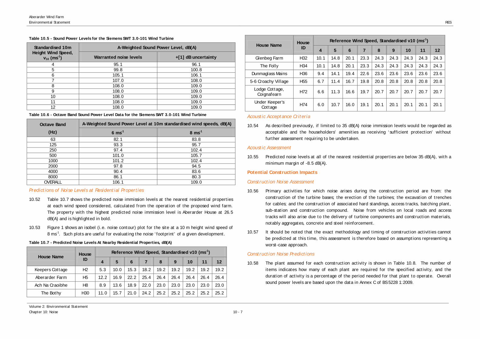
Aberarder Wind Farm Environmental Statement
RES
Table 10.5 - Sound Power Levels for the Siemens SWT 3.0-101 Wind Turbine
Standardised 10m Height Wind Speed,
v10 (ms-1)
A-Weighted Sound Power Level, dB(A)
Warranted noise levels +[1] dB uncertainty
4 95.1 96.1 5 99.8 100.8 6 105.1 106.1 7 107.0 108.0 8 108.0 109.0 9 108.0 109.0 10 108.0 109.0 11 108.0 109.0 12 108.0 109.0
Table 10.6 - Octave Band Sound Power Level Data for the Siemens SWT 3.0-101 Wind Turbine
Octave Band
(Hz)
A-Weighted Sound Power Level at 10m standardised wind speeds, dB(A)
6 ms-1 8 ms-1 63 82.1 83.8 125 93.3 95.7 250 97.4 102.4 500 101.0 105.7 1000 101.2 102.4 2000 97.8 94.5 4000 90.4 83.6 8000 86.1 80.3
OVERALL 106.1 109.0
Predictions of Noise Levels at Residential Properties
10.52 Table 10.7 shows the predicted noise immission levels at the nearest residential properties at each wind speed considered, calculated from the operation of the proposed wind farm. The property with the highest predicted noise immission level is Aberarder House at 26.5 dB(A) and is highlighted in bold.
10.53 Figure 1 shows an isobel (i.e. noise contour) plot for the site at a 10 m height wind speed of 8 ms-1. Such plots are useful for evaluating the noise ‘footprint’ of a given development.
Table 10.7 - Predicted Noise Levels At Nearby Residential Properties, dB(A)
House Name House ID
Reference Wind Speed, Standardised v10 (ms-1)
4 5 6 7 8 9 10 11 12
Keepers Cottage H2 5.3 10.0 15.3 18.2 19.2 19.2 19.2 19.2 19.2
Aberarder Farm H5 12.2 16.9 22.2 25.4 26.4 26.4 26.4 26.4 26.4
Ach Na Craoibhe H8 8.9 13.6 18.9 22.0 23.0 23.0 23.0 23.0 23.0
The Bothy H30 11.0 15.7 21.0 24.2 25.2 25.2 25.2 25.2 25.2
House Name House ID
Reference Wind Speed, Standardised v10 (ms-1)
4 5 6 7 8 9 10 11 12
Glenbeg Farm H32 10.1 14.8 20.1 23.3 24.3 24.3 24.3 24.3 24.3
The Folly H34 10.1 14.8 20.1 23.3 24.3 24.3 24.3 24.3 24.3
Dunmaglass Mains H36 9.4 14.1 19.4 22.6 23.6 23.6 23.6 23.6 23.6
5-6 Croachy Village H55 6.7 11.4 16.7 19.8 20.8 20.8 20.8 20.8 20.8
Lodge Cottage, Coignafearn H72 6.6 11.3 16.6 19.7 20.7 20.7 20.7 20.7 20.7
Under Keeper's Cottage H74 6.0 10.7 16.0 19.1 20.1 20.1 20.1 20.1 20.1
Acoustic Acceptance Criteria
10.54 As described previously, if limited to 35 dB(A) noise immission levels would be regarded as acceptable and the householders’ amenities as receiving ‘sufficient protection’ without further assessment requiring to be undertaken.
Acoustic Assessment
10.55 Predicted noise levels at all of the nearest residential properties are below 35 dB(A), with a minimum margin of -8.5 dB(A).
Potential Construction Impacts
Construction Noise Assessment
10.56 Primary activities for which noise arises during the construction period are from: the construction of the turbine bases; the erection of the turbines; the excavation of trenches for cables; and the construction of associated hard standings, access tracks, batching plant, sub-station and construction compound. Noise from vehicles on local roads and access tracks will also arise due to the delivery of turbine components and construction materials, notably aggregates, concrete and steel reinforcement.
10.57 It should be noted that the exact methodology and timing of construction activities cannot be predicted at this time, this assessment is therefore based on assumptions representing a worst-case approach.
Construction Noise Predictions
10.58 The plant assumed for each construction activity is shown in Table 10.8. The number of items indicates how many of each plant are required for the specified activity, and the duration of activity is a percentage of the period needed for that plant to operate. Overall sound power levels are based upon the data in Annex C of BS 5228 1:2009.
Volume 2: Environmental Statement Chapter 10: Noise
10 - 7

RES
Aberarder Wind Farm Environmental Statement
Table 10.8 - Construction Phases and Sound Power Levels
Activities Plant Sound Power (LWA)
No. Items Activity Duration
(%)
Effective Sound Power (LWA)
Construct temporary site
compounds
Tracked excavator 113 1 67
115 Dump truck 113 1 67 Tipper lorry 107 1 67
Vibratory roller 102 1 67 Lorry 108 1 33
Construct site tracks
Tracked excavator 113 2 67
119 Dump truck 113 3 67 Tipper lorry 107 3 67
Dozer 109 1 67 Vibratory roller 102 1 67
Construct Sub-Station
Tracked excavator 113 1 67
118
Concrete mixer truck 108 1 67 Telescopic Handler 99 1 67
Piling Rig 117 1 67 Poker vibrator 117 2 67 Tipper lorry 107 1 67
Mobile telescopic crane 110 1 67
Construct crane hardstandings
Tracked excavator 113 2 67
118 Dump truck 113 3 67 Tipper lorry 107 1 67
Vibratory roller 102 1 67 Telescopic Handler 99 1 67
Construct turbine foundations
Tracked excavator 113 2 67
121
Dump truck 113 2 67 Concrete mixer truck 108 3 67
Mobile telescopic crane 110 1 67 Concrete pump 106 1 67
Water pump 93 1 67 Hand-held pneumatic
breaker 111 1 67
Compressor 103 1 67 Piling Rig 117 1 67
Poker vibrator 106 2 67 Vibratory roller 102 1 67
Hand held pneumatic breaker 93 1 67
Excavate and lay site cables
Tracked excavator 113 1 67
114 Tractor with hydraulic
winch (towing equipment) 108 1 67
Tractor (towing trailer) 107 1 67 Vibratory plate 108 1 67
Erect turbines
Mobile telescopic crane 110 3 67
118 Lorry 108 9 67 Diesel generator 102 2 67
Torque guns 111 1 67
Activities Plant Sound Power (LWA)
No. Items Activity Duration
(%)
Effective Sound Power (LWA)
Lay cable to substations
Saws 114 1 67
117
Dump truck 113 1 67 Tipper lorry 107 1 67
Vibratory plate 108 1 67 Tractor & cable drum
trailer 108 1 67
Lorry 108 1 67
Borrow Pits
Excavator mounted rock breaker 102 1 67
117 Dump truck 113 3 67 Tracked excavator 113 1 67
Construct Batching Plant
Tracked excavator 113 1 67
116
Dump truck 113 1 67 Tipper lorry 107 1 67
Vibratory roller 102 1 67 Lorry 108 1 67
Mobile telescopic crane 110 1 67 Operational
Batching Plant Water pump/siltbuster 93 1 67 93
10.59 Predictions of construction noise levels have been carried out using the methods prescribed in Annex F of BS 5228-1:200914 with adoption of the worst case scenario where all major construction activities take place at the nearest possible location to each assessed residential property. The locations of the construction activities are taken from the infrastructure drawing. The results of these predictions, made at six representative critical residential properties to the proposed wind farm, are shown in Table 10.9.
10.60 In all cases average noise levels over the construction period will be lower as the worst case is presented for when the activities are closest to the residential property.
14 A 50% mixed ground attenuation has been used throughout to conservatively account for the arable nature of ground conditions at Aberarder Wind farm
10 - 8
Volume 2: Environmental Statement Chapter 10: Noise

Aberarder Wind Farm Environmental Statement
RES
Table 10.9 - Construction Noise Predictions
Activity
Predicted Sound Pressure Level (dB LAeq)
Ach Na Craoibhe
H8
Glenbeg Farm
H32
The Folly
H34
Dunmaglass Mains
H36
5-6 Croachy Village
H55
Under Keeper's Cottage
H74 Construct temporary
site compound 24.8 25.9 26.3 27.2 23.3 24.3
Construct site access track 31.0 31.5 31.3 32.5 29.2 30.0
Construct Sub-Station 30.3 30.3 27.4 29.3 28.0 28.8 Construct nearest
crane hard-standings 30.3 30.8 29.0 30.3 28.3 29.3
Construct nearest turbine foundations 35.1 35.6 33.8 35.1 33.1 34.2
Excavate and lay nearest site cables 26.0 26.5 24.6 25.9 23.9 25.0
Erect nearest turbine 30.3 30.8 29.0 30.3 28.3 29.4 Lay cable to substations 28.5 29.0 27.2 28.5 26.5 27.5
Borrow Pits 27.7 28.7 28.2 29.3 26.0 28.3 Construct Batching
Plant 25.9 27.1 27.4 28.3 24.5 25.3
Operational Batching Plant 1.1 2.2 2.6 3.5 0 0.4
10.61 Blasting is expected to take place in borrow pits. Assuming a charge weight of 1000 kg distances within 225 m would be estimated to have a ppv level of greater than 10mm/s therefore, given no residential properties are within this distance of the nearest borrow pit, there is not likely to be any adverse effects from blasting.
Construction Traffic
10.62 Due to the provision of construction material and wind farm components, vehicle movements either into or away from the site shall increase levels of traffic flow on public roads in the area. Traffic regularly accessing the site is shown in Chapter 9: Transport and Traffic and is assumed to be characterised by the sound power levels of Dump Trucks, Lorries and Concrete Mixers as a worst case. It is estimated that a maximum worst case total of 153 vehicle movements per day would be required during the most intense period of construction activity during construction of site tracks, sub-station, crane hardstandings, turbine foundations, cable laying, borrow pit and operation of the batching plant.
10.63 Construction traffic noise has been quantified using the method described in BS 5228:2009 Part 1. Using the distances from residential properties to the centre of the relevant carriageway where site traffic will be, the noise levels predicted are presented in Table 10.10. According to the assumptions made the maximum sound pressure level due to traffic
flows during the most intensive period of activity will be 63.9 dB LAeq. The properties where this occurs is adjacent to the proposed delivery route and, as such, corresponds to the worst case.
Table 10.10 - Traffic Noise Predictions
Activity
Predicted Sound Pressure Level (dB LAeq)
Ach Na Craoibhe
H8
Glenbeg Farm
H32
The Folly
H34
Dunmaglass Mains
H36
5-6 Croachy Village
H55
Under Keeper's Cottage
H74 Dump truck 34.6 45.1 36.9 44.7 61.7 34.1
Lorries 29.9 40.5 32.3 40.1 57.0 29.5 Concrete mixer truck 29.9 40.5 32.3 40.1 57.0 29.5
Total 36.8 47.4 39.2 47.0 63.9 36.4
General Construction Noise in Conjunction with Traffic Noise
10.64 Worst case construction noise levels may arise when the following simultaneous activities occur: construction of nearest access tracks; construction of substation; construction of nearest crane hard-standings; and construction of nearest turbine foundations, laying cabling to substation and borrow pit and batching plant operations. Therefore cumulative predictions of these construction activities and the additional noise contribution from construction traffic have been calculated and are shown in Table 10.11.
10.65 It should be noted that the predictions exclude the screening effects of local topography therefore actual levels of noise experienced at nearby residential properties could be lower.
Table 10.11 - Predicted Noise Due to Combined Traffic Noise and Turbine Construction
Activity
Predicted Sound Pressure Level (dB LAeq)
Ach Na Craoibhe
H8
Glenbeg Farm
H32
The Folly
H34
Dunmaglass Mains
H36
5-6 Croachy Village
H55
Under Keeper's Cottage
H74 Construction Plant
Noise 40.5 41.0 39.4 40.7 38.5 39.6
Traffic Noise 36.8 47.4 39.2 47.0 63.9 36.4 Combined Noise 42.1 48.3 42.3 47.9 63.9 41.3
Assessment of Construction Noise
10.66 In accordance with the ABC method of Annex E of BS 5228-1:2009, due to the relatively low levels of ambient noise at the proposed Aberarder Wind Farm site a Category A assessment of the ABC method is used for acceptable limits. This category sets minimum LAeq criteria of: 65 dB(A) during weekdays (0700-1900) and Saturdays (0700-1300); below 55 dB(A) at evenings and weekends; and below 45 dB(A) for night-time (2300-0700).
Volume 2: Environmental Statement Chapter 10: Noise
10 - 9

RES
Aberarder Wind Farm Environmental Statement
10.67 Table 10.11 shows that predicted noise levels from the combined effect of increased traffic
flows and activities associated with peak construction of the wind farm are below the 65 dB(A) daytime target level specified by BS 5228-1:2009 at 6 of the 6 assessed residential properties. Peak construction noise levels are predicted to exceed the 55 dB(A) target level for evenings and weekends at one of the assessed properties, and an assessment against the night-time target level indicates three properties exceed 45 dB(A). The predictions made represent the worst case combination of most intensive traffic activity with simultaneous construction activity at the nearest possible location to each residential property.
Mitigation
Operational Noise
10.68 One of the key turbine layout design constraint considerations was the minimisation of potential noise impacts at the nearest residential receptors. As such the turbine layout was initially designed to ensure that there is an adequate separation distance between any of the proposed turbines and the nearest residential property.
10.69 Due to consideration in the design of the wind farm, no mitigation measures are required for the operation of the proposed turbines as the proposed development complies with noise criteria.
10.70 It is worth noting that the operation of many modern turbines may be altered by changing the pitch of the wind turbine blades resulting in a trade-off between power production and noise reduction. Therefore in the unlikely event that noise levels at nearby residential properties need readdressed once they become operational, there is potentially a mechanism for enacting this.
10.71 Before procurement of a turbine, RES standard practice would be to seek to obtain a warranty from the manufacturer that the turbines will not incur a tonal penalty at the nearest residential properties, based upon the ETSU-R-97 guideline definition.
10.72 If planning permission is granted for the proposed wind farm, the decision notice would likely contain noise conditions which would provide a degree of protection to nearby residents in the unlikely event that noise from the wind farm gives rise to complaint.
10.73 Technical Appendix 10.2 contain a set of conditions that RES considers appropriate. Any final conditions attached to the proposal, if accepted, would be according to the discretion of the Local Planning Authority.
Construction Noise
10.74 For all activities, measures will be taken to reduce noise levels with due regard to practicality and cost as per the concept of ‘best practicable means’ as defined in Section 72 of the Control of Pollution Act 1974.
10.75 BS 5228-1:2009 states that the ‘attitude of the contractor’ is important in minimising the likelihood of complaints and therefore consultation with the local authority and Community
Liaison Group should occur along with letter drops to inform residents of intended activity. Non-acoustic factors, which influence the overall level of complaints such as mud on roads and dust generation, will also be controlled.
10.76 Furthermore, the following noise mitigation options will be implemented where appropriate:
• consideration will be given to noise emissions when selecting plant and equipment to be used on site;
• all equipment should be maintained in good working order and fitted with the appropriate silencers, mufflers or acoustic covers where applicable;
• stationary noise sources will be sited as far away as reasonably possible from residential properties and where necessary and appropriate, acoustic barriers will be used to screen them; and
• the movement of vehicles to and from the site will be controlled and employees will be instructed to ensure compliance with the noise control measures adopted.
10.77 Site operations will be limited to 0600-2000 Monday to Saturday except during turbine erection and commissioning or during periods of emergency work. Should it be considered necessary to reduce noise levels from the conservative predicted levels to adhere to the 55 dB(A) target level for weekdays 1900-2000 and Saturdays 1300-2000, or mornings from 0600-0700 to adhere to the 45 dB(A) target level, the following mitigation measures would be considered:
• reduce construction traffic as appropriate.
Residual Effects
Operational
10.78 The acoustic assessment concludes that predicted noise levels at the nearest residential properties do not exceed either night time or quiet day time limits under all considered conditions. This should not be interpreted to mean that wind farm operational noise will be inaudible (or masked by background noise) under all conditions, but that the levels of noise are acceptable in accordance with relevant legislation and guidance.
Construction
10.79 Predicted noise from worst case combination of increased traffic and site construction noise will not exceed relevant criteria and therefore no significant impacts are expected. Properties in Inverarnie and Farr may also be impacted by this temporary increase, these properties are covered in the analysis of the worst case at H55 in the analysis and will benefit in the same way from any mitigation applied on construction traffic.
10 - 10
Volume 2: Environmental Statement Chapter 10: Noise

Aberarder Wind Farm Environmental Statement
RES
Cumulative Effects
Cumulative Operational Noise Assessment
10.80 An assessment of the cumulative acoustic impact of the proposed Aberarder Wind Farm comprising 12 wind turbines in conjunction with the consented Dunmaglass Wind Farm comprising 33 wind turbines has been undertaken in accordance with the guidance on wind farm noise assessment; ETSU R 97 and the IoA GPG. ETSU R 97 states:
“It is clearly unreasonable to suggest that, because a wind farm has been constructed in the vicinity in the past which resulted in increased noise levels at some properties, the residents of those properties are now able to tolerate higher noise levels still. The existing wind farm should not be considered as part of the prevailing background noise.”
10.81 The locations of the 12 proposed turbines at Aberarder Wind Farm and the 33 consented turbines at Dunmaglass Wind Farm are shown in Figure 10.2.
10.82 The nearest residential properties to the turbines considered in this assessment are those detailed in Table 10.4. Considering the proposed Aberarder Wind Farm and the consented Dunmaglass Wind Farm the distances from each house to the nearest turbine are given in Table 10.12.
Table 10.12 - Distances from Residential Properties to Nearest Cumulative Turbine
House Name House ID Distance (m) Nearest Turbine
Keepers Cottage H2 5427 D3
Aberarder Farm H5 4384 T12
Ach Na Craoibhe H8 5129 T10
The Bothy H30 3662 D21
Glenbeg Farm H32 4609 T12
The Folly H34 3838 D14
Dunmaglass Mains H36 3837 D21
5-6 Croachy Village H55 6253 T10 Lodge Cottage,
Coignafearn H72 4561 D33
Under Keeper's Cottage H74 5447 D33 Turbines prefixed “T” are the proposed Aberarder turbines
Turbines prefixed “D” are the consented Dunmaglass turbines
Cumulative Assessment Methodology
10.83 ETSU-R-97 recommends that the derived noise limits applicable at nearby residential properties shall relate to the cumulative effects of noise from all wind turbines that may affect a particular location.
10.84 The methodology is therefore to:
• predict noise immission levels at the nearest residential properties due to the proposed Aberarder Wind Farm and the consented Dunmaglass Wind Farm;
• complete a cumulative noise assessment by combining predicted noise levels due to the cumulative wind farms; and
• compare these cumulative predictions to the ETSU R 97 derived noise limits.
10.85 The methodology outlined above is in accordance with the appropriate guidance on cumulative wind farm noise assessment as described in ETSU-R-97 and the IoA GPG.
Predictions of Noise Levels at Residential Properties
10.86 The turbine that is understood to be employed at Dunmaglass Wind Farm is the General Electric (GE) 2.85-103 turbine. Warranted acoustic data for this turbine is taken from the manufacturer’s general specification from this machine and an uncertainty of 2 dB has been included15. It should be noted there are no planning conditions relating to noise associated with Dunmaglass Wind Farm.
10.87 Details assumed in this analysis are as follows:
• a hub height of 85 m; • a rotor diameter of 103 m; • assumed sound power levels, LWA, for standardised 10 m height wind speeds (v10) as
shown in Table 10.13; and • and Octave band data sound power level data as shown in Table 10.14.
Table 10.13 - Sound Power Levels for the General Electric (GE) 2.85-103 Wind Turbine
Standardised 10m Height Wind Speed, v10 (ms-1) Assumed A-Weighted Sound Power Level (dB(A) re 1 pW)
4 96.6 5 96.6 6 101.7 7 105.0 8 105.0 9 105.0 10 105.0 11 105.0 12 105.0
15 Technical Documentation Wind Turbine Generator Systems 2.75-103 - 50 Hz and 60 Hz”, Document ID: 3.4_2.75-103_xxHz_SCD_allComp_NO_IECxxxxxx.ENxxx.01a.docx, 2012
Volume 2: Environmental Statement Chapter 10: Noise
10 - 11

RES
Aberarder Wind Farm Environmental Statement
Table 10.14 - Octave Band Sound Power Level Data for the General Electric (GE) 2.85-103 Wind Turbine
Octave Band
(Hz)
A-Weighted Sound Power Level at 10m standardised wind speeds, dB(A)
5 ms-1 6 ms-1 7 ms-1 8 ms-1 9 ms-1 10 ms-1 63 84.3 89.7 93.4 94.1 94.2 94.3 125 88.8 94.1 97.7 98.1 98.2 98.3 250 90.8 96.7 99.8 98.8 98.8 98.9 500 92.5 97.4 100.4 99.5 98.6 98.2 1000 92.4 97.8 101.2 101.7 101.5 101.3 2000 89.8 94.8 98.2 99.4 100.0 100.3 4000 84.0 87.9 90.3 90.6 93.1 92.1 8000 67.8 72.1 74.6 74.3 74.7 76.3
OVERALL 98.6 103.7 106.9 107.0 107.0 107.0
10.88 Table 10.15 shows noise levels at 82 of the 82 nearest residential properties are below 35 dB(A) level, indicating that the noise immission levels would be regarded as acceptable and the residents amenity as receiving ‘sufficient protection’ without further assessment requiring to be undertaken.
Table 10.15 - Predicted Cumulative Noise Levels At Nearby Residential Properties, dB(A)
House Name House ID Reference Wind Speed, Standardised v10 (ms-1)
4 5 6 7 8 9 10 11 12 Keepers Cottage H2 18.6 19.0 24.3 27.7 27.9 27.9 27.9 27.9 27.9 Aberarder Farm H5 19.6 20.9 26.1 29.5 29.9 29.9 29.9 29.9 29.9 Ach Na Craoibhe H8 16.6 17.9 23.1 26.5 27.0 27.0 27.0 27.0 27.0
The Bothy H30 22.1 22.7 27.9 31.3 31.5 31.4 31.5 31.5 31.5 Glenbeg Farm H32 17.8 19.0 24.2 27.7 28.1 28.1 28.1 28.1 28.1
The Folly H34 22.8 23.3 28.4 31.9 32.0 31.9 32.0 32.0 32.0 Dunmaglass Mains H36 21.4 21.9 27.1 30.5 30.6 30.6 30.6 30.6 30.6
5-6 Croachy Village H55 14.9 16.0 21.3 24.7 25.1 25.2 25.2 25.2 25.2
Lodge Cottage, Coignafearn H72 18.4 18.9 24.1 27.6 27.7 27.7 27.8 27.8 27.8
Under Keeper's Cottage H74 16.2 17.0 22.2 25.6 25.9 25.9 26.0 26.0 26.0
10.89 Figure 10.2 shows a cumulative noise contour plot for the proposed Aberarder Wind Farm and consented Dunmaglass Wind Farm calculated using the ISO 9613 Part 2 propagation model. The plot is provided to illustrate the cumulative noise ‘footprint’ and should be considered indicative only.
Cumulative Construction Noise Assessment
10.90 Any noise for the construction of the Dunmaglass wind farm is not likely to be ongoing at the same time as the construction of the Aberarder Wind Farm. However if this is the case, and due to the location of the Dunmaglass Wind Farm, then the site activities for both will be far enough away from the nearest residential properties to not have any additional cumulative impact.
Summary
10.91 Operational noise levels were predicted using a noise propagation model, the proposed wind farm layout, terrain data and assumed turbine emission data. The predicted noise levels are within derived appropriate noise limits at all considered wind speeds. The proposed wind farm therefore complies with the relevant guidance on wind farm noise and the impact on the amenity of all nearby residential properties would be regarded as acceptable.
10.92 A construction noise assessment has been carried out in accordance with BS 5228 1:2009 “Noise control on construction and open sites Part 1 - Noise”, and with due regard to mitigation outlined, indicates that predicted noise levels likely to be experienced at representative critical residential properties are below relevant construction noise criteria.
10.93 A cumulative operational noise assessment was completed for the potential impact of Aberarder Wind Farm alongside the consented Dunmaglass Wind Farm. The predicted noise levels are within derived appropriate noise limits at all considered wind speeds. Therefore the noise impact on the amenity of all nearby residential properties due to the cumulative impact of the proposed Aberarder Wind Farm and the consented Dunmaglass Wind Farm would be regarded as acceptable.
10.94 Table 10.16 summarises the potential impact of the proposed Aberarder Wind Farm along with the mitigation proposed where required and the residual impact.
Table 10.16 - Summary of Potential Impacts of the Proposed Wind Farm, Mitigation and Residual Impacts
Potential Significant Impact Mitigation Proposed Means of
Implementation Outcome/
Residual Impact Operational
Potential for significant impact due to
operational noise at nearby residential
properties
Not required due to absence of identified
significant impact Not applicable No significant impacts
identified
Construction Potential for significant
impact due to construction noise at
nearby residential properties
Not required due to absence of identified
significant impact Not applicable No significant impacts
identified
10 - 12
Volume 2: Environmental Statement Chapter 10: Noise
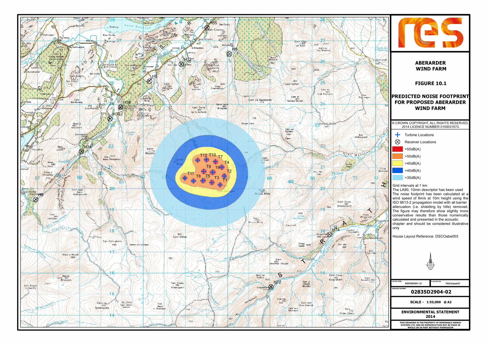
?
?
?
?
?
?
?
?
?
?
E
EE
E
E
E
E
E
E
E
E
ET9
T8
T7
T6T5
T4
T3T2
T1
T12
T11
T10
H8
H5
H2
H74
H72
H55
H36
H34
H32
H30
FIGURE 10.1
PREDICTED NOISE FOOTPRINTFOR PROPOSED ABERARDER
WIND FARM
02835D2904-02PSCOabe02702835D0001-12
ENVIRONMENTAL STATEMENT2014
1:55,000SCALE - @ A3
© CROWN COPYRIGHT, ALL RIGHTS RESERVED. 2014 LICENCE NUMBER 0100031673.
ABERARDER WIND FARM
THIS DRAWING IS THE PROPERTY OF RENEWABLE ENERGYSYSTEMS LTD. AND NO REPRODUCTION MAY BE MADE IN
WHOLE OR IN PART WITHOUT PERMISSION
LAYOUT DWG T-LAYOUT NO.
DRAWING NUMBER
E Turbine Locations? Receiver Locations
>55dB(A)>50dB(A)>45dB(A)>40dB(A)>35dB(A)
Grid intervals at 1 kmThe LA90, 10min descriptor has been usedThe noise footprint has been calculated at awind speed of 8m/s at 10m height using theISO 9613-2 propagation model with all barrierattenuation (i.e. shielding by hills) removed.The figure may therefore show slightly moreconservative results than those numericallycalculated and presented in the acousticchapter and should be considered illustrativeonlyHouse Layout Reference: DSCOabe003

E
EE
E
E
E
E
E
E
E
E
ET9
T8
T7
T6T5
T4
T3T2
T1
T12
T11
T10
D9D9D8D8
D7D7
D6D6D5D5
D4D4D3D3
D35D35D34D34
D33D33D32D32D31D31
D30D30D29D29
D28D28D27D27D26D26D25D25
D24D24D23D23D22D22
D21D21
D20D20D19D19D18D18D17D17D16D16D15D15
D14D14
D13D13D12D12D11D11D10D10
H8
H5
H2
H74
H72
H55
H36
H34
H32
H30
FIGURE 10.2PREDICTED CUMULATIVE NOISE
FOOTPRINT FOR PROPOSEDABERARDER AND NEARBY
WINDFARMS
02835D2905-02PSCOabe02702835D0001-12
ENVIRONMENTAL STATEMENT2014
1:55,000SCALE - @ A3
© CROWN COPYRIGHT, ALL RIGHTS RESERVED. 2014 LICENCE NUMBER 0100031673.
ABERARDER WIND FARM
THIS DRAWING IS THE PROPERTY OF RENEWABLE ENERGYSYSTEMS LTD. AND NO REPRODUCTION MAY BE MADE IN
WHOLE OR IN PART WITHOUT PERMISSION
LAYOUT DWG T-LAYOUT NO.
DRAWING NUMBER
E Aberarder Turbine LocationsE Dunmaglass Turbine Locations? Receiver Locations
>55dB(A)>50dB(A)>45dB(A)>40dB(A)>35dB(A)
Grid intervals at 1 kmThe LA90, 10min descriptor has been usedThe noise footprint has been calculated at awind speed of 8m/s at 10m height using theISO 9613-2 propagation model with all barrierattenuation (i.e. shielding by hills) removed.The figure may therefore show slightly moreconservative results than those numericallycalculated and presented in the acousticchapter and should be considered illustrativeonlyHouse Layout Reference: DSCOabe003
Copyright © 2022 FDOKUMEN