46293-005: Greater Mekong Subregion Tourism Infrastructure ...
118
GMS Tourism Infrastructure for Inclusive Growth Project (RRP VIE 46293-005) Initial Environmental Examination January 2014 Socialist Republic of Viet Nam: Greater Mekong Subregion Tourism Infrastructure for Inclusive Growth Project Dien Bien, Ha Tinh, Kien Giang, Lao Cai, and Tay Ninh Provinces Prepared by the Ministry of Culture, Sports and Tourism, Socialist Republic of Viet Nam, for the Asian Development Bank
-
Upload
khangminh22 -
Category
Documents
-
view
3 -
download
0
Transcript of 46293-005: Greater Mekong Subregion Tourism Infrastructure ...
GMS Tourism Infrastructure for Inclusive Growth Project (RRP VIE 46293-005)
Initial Environmental Examination January 2014
Socialist Republic of Viet Nam: Greater Mekong Subregion Tourism Infrastructure for Inclusive Growth Project
Dien Bien, Ha Tinh, Kien Giang, Lao Cai, and Tay Ninh Provinces
Prepared by the Ministry of Culture, Sports and Tourism, Socialist Republic of Viet Nam, for the Asian Development Bank
2
ABBREVIATIONS
ADB - Asian Development Bank ABR - anaerobic baffled reactor
AP - affected people BOD - Biological Oxygen Demand COD - Chemical Oxygen Demand
DARD - Department of Agriculture and Rural Development DONRE - Department of Natural Resources and Environment
DOT - Department of Transport DSCT - Department of Sport Culture and Tourism
EIA - Environmental Impact Assessment EMP - Environment Management Plan EMC Environmental Protection Commitment GMS - Greater Mekong Subregion
IEE - Initial Environment Examination IUCN - International Union for Conservation of Nature
KGBR - Kien Giang Biosphere Reserve MARD - Ministry of Agriculture and Rural Development MCST - Ministry of Culture, Sports and Tourism
MONRE - Ministry of Natural Resources and Environment MPI - Ministry of Planning and Investment NPA - National Protected Area
NTFP - Non-Timber Forest Product ODA - Official Development Assistance PCU - Project Coordinating Unit PIU - Project Implementation Unit
PPC - Provincial Peoples Committee REA - Rapid Environment Assessment SPS - ADB Safeguard Policy Statement 2009 TSS - Total Suspended Solids UXO - Unexploded Ordnance
WEIGHTS AND MEASURES
km kilometre kg kilogram ha hectare masl meters above sea level
mm millimeter
NOTES
In this report, "$" refers to US dollars unless otherwise stated.
This initial environmental examination is a document of the borrower. The views expressed herein do not necessarily represent those of ADB's Board of Directors, Management, or staff, and may be preliminary in nature
3
TABLE OF CONTENTS
EXECUTIVE SUMMARY 7
A. Project Summary 7 B. Potential Impacts 8 C. Conclusions 9
I. INTRODUCTION 10
A. Background to the IEE 10 B. Assessment Context 12
1. Impact Footprints 13 C. Structure of the Report 13
II. POLICY, LEGAL, AND ADMINISTRATIVE FRAMEWORK 13
A. Viet Nam Regulatory Framework for Environmental Assessment 13 B. Applicable Laws, Policy, Environmental Standards, and Guidelines 14
International Environmental Management Conventions 15 C. Forest Management in Viet Nam 16 D. ADB Safeguard Policy 16
1. Consistency between the Government’s Environmental Assessment Requirements and the SPS 2009 17
E. Environmental Management of Subprojects in Viet Nam 17
III. DESCRIPTION OF VIET NAM SUBPROJECTS 17
A. Ha Tinh Province 18 1. Nguyen Du Tourism Zone Environmental Improvement 18 2. Huong Tich Environmental Improvement 20
B. Kien Giang Province 24 1. Da Dung Cave Access Improvement 25 2. Phu Tu Environmental Improvement 26
C. Tay Ninh Province 28 1. Ba Den Mountain Environmental Improvement 29
D. Lao Cai Province 33 1. Lao Cai Cultural Exchange and Tourist Information Centre 33 2. Ta Phin - Ban Khoang Access Road Improvement 34
E. Dien Bien Province 35 1. Muong Phang Access Road Improvement 36 2. Dien Bien Phu Cultural Exchange and Tourist Information Center 38
IV. DESCRIPTION OF AFFECTED ENVIRONMENTS 40
A. Ha Tinh Province 40 1. Physical Resources 40 2. Ecological Resources 42 3. Site features of subprojects in Ha Tinh 45 4. Other development in the subproject areas 48
B. Kien Giang Province 48 1. Climate 48 2. Topography 48 3. Soils 49 4. Land Use 50 5. Surface Water Resources 51
4
6. Status of Biodiversity in Kien Giang 51 7. Features of Subprojects Sites 55 8. Other Development in Subproject Areas 58
C. Tay Ninh Province 59 1. Climate 59 2. Air Quality and Noise 59 3. Topography and Soils 59 4. Hydrology 60 5. Forests 60 6. Biodiversity 62 7. Features of Ba Den Mountain 62 8. Groundwater Quality 63 9. Other Development in the Subproject Area 63
D. Lao Cao Province 64 1. Climate 64 2. Overview of Topography and Geomorphology 64 3. Hydrology 64 4. Land and Soil Resources 64 5. Biodiversity 65 6. Features of Subproject Area 65 7. Other Development in Subproject Areas 67
E. Dien Bien Province 67 1. Climate 67 2. Topography 67 3. Hydrology 68 4. Land Use 68 5. Biodiversity 68 6. Features of Subproject Areas 69 7. Other Development in Subproject Areas 72
F. Comparative Environmental Sensitivity of Subproject Areas 72
V. PUBLIC CONSULTATION 73
A. Identification of Stakeholders 73 B. Discussion Guide 74 C. Summary of Public Consultation 75
VI. POTENTIAL ENVIRONMENTAL IMPACTS AND MITIGATIONS 87
A. Subproject Benefits 88 1. Nguyen Du Tourism Zone Environmental Improvements 88 2. Huong Tich Environmental Improvements 88 3. Da Dung Cave Access Improvements 88 4. Phu Tu Environmental Improvements: 88 5. Ba Den Mountain Environmental Improvements 88 6. Lao Cai Cultural Exchange and Tourist Information Center 89 7. Ta Phin-Ban Khoang Access Road Improvement 89 8. Muong Phang Access Road Improvement 89 9. Dien Bien Phu Cultural Exchange and Tourist Information Centre 89
B. Subproject Impacts and Mitigations 89 1. Pre-construction Phase 89 2. Construction Phase 90 3. Operation Phase 95 4. IUCN Protected Area Status 100 5. Induced and Cumulative Impacts 100
5
6. Climate Change 101
VII. ANALYSIS OF ALTERNATIVES 101
VIII. INFORMATION DISCLOSURE AND PUBLIC GRIEVANCE MECHANISM 102
IX. ENVIRONMENTAL MANAGEMENT PLANS 104
X. CONCLUSIONS AND RECOMMENDATION 104
XI. REFERENCES CITED 106
APPENDIX A: SUBPROJECT SELECTION CRITERIA 107
APPENDIX B: PARTICIPANTS AND VENUES OF PUBLIC CONSULTATIONS 108
APPENDIX C: DSCT VIEWS ON SUBPROJECT IN KIEN GIANG BIOSPHERE RESERVE 118
Table 1: Infrastructure Subprojects in Viet Nam 12 Table 2: Activities of Nguyen Du Tourism Zone Environmental Improvement 19 Table 3: Environmental Improvements of Huong Tich National Tourism Site 21 Table 4: Da Dung Cave Access Improvement 25 Table 5: Environmental Improvements to Phu Tu National Tourist Site 27 Table 6: Environmental Improvement to Ba Den Mountain 30 Table 7: Example Site Selection Criteria for WWTP and Solid Waste Transfer Station 32 Table 8: Lao Cai Cultural Exchange and Tourism Information Center 34 Table 9: Ta Phin - Ban Khoang Access Road Improvements 35 Table 10: Access and Facilities Improvements at Muong Phang Tourist Site 37 Table 11: Dien Bien Phu Cultural Exchange and Tourist Information Center 39 Table 12: Land Use in Kien Giang, 2005 – 2009 50 Table 13: Climate Data, Tay Ninh Province 59 Table 14: Summary of Sensitive Features of Subproject Areas 73 Table 15: Guiding Questions and Information Requests for Stakeholder Consultations 74 Table 16: Example of Environmental Issues to Guide Stakeholder Discussions 75 Table 17: Summary of Stakeholder Views, Ha Tinh Subprojects 75 Table 18: Summary of Stakeholder Views, Kien Giang Subprojects 78 Table 19: Summary of Stakeholder Views, Tay Ninh Subprojects 80 Table 20: Summary of Stakeholder Views, Lao Cai Subprojects 83 Table 21: Summary of Stakeholder Views, Dien Bien 85 Table 22: Subprojects by Province 87
Figure 1: Project Provinces in Viet Nam 11 Figure 2: Access Road Cross Sections 18 Figure 3: Subproject Locations in Ha Tinh Province 19 Figure 4: Plan of Nguyen Du Tourism Zone Environmental Improvement 20 Figure 5: Map of Environmental Improvements of Huong Tich National Tourism Site 22 Figure 6: Plan View of Wastewater Treatment System for Huong Tich Pagoda 23 Figure 7: Subproject Locations in Kien Giang Province 24 Figure 8. Plan View, Da Dung Cave Access Improvement 26 Figure 9: Plan View, Phu Tu Environmental Improvement 28 Figure 10: Subproject Location in Tay Ninh Province 29 Figure 11: Subprojects Locations in Lao Cai Province 33
6
Figure 12: Plan View, Lao Cai Cultural Exchange and Tourism Information Center 34 Figure 13: Location of Ta Phin - Ban Khoang Access Road 35 Figure 14: Subproject Locations in Dien Bien Province 36 Figure 15: Location of Muong Phang National Tourist Site and Access Road 38 Figure 16: Plan View, Dien Bien Phu Cultural Exchange and Tourist Information Center 39 Figure 17: Forest Types in Ha Tinh Province 43 Figure 18: Site of Future Memorial Square adjacent to Nguyen Du Museum. 45 Figure 19: Access Road and Lake, Huong Tich National Tourist Site 46 Figure 20: Access Road near Cable Car to Huong Tich Pagoda. 47 Figure 21: Subproject Locations in the Kien Giang Biosphere Reserve 53 Figure 22: Phu Tu Subproject Area within Hon Chong Nature Reserve 54 Figure 23: Phu Tu National Tourist Site Subproject Area 56 Figure 24: Existing State of Development at Phu Tu National Tourist Site 56 Figure 25: Da Dung Cave Entrance and Surrounding Environs 58 Figure 26: Water Quality Monitoring Stations in Tay Ninh Province 61 Figure 27: Ba Den Mountain and Surrounding Environs 63 Figure 28: Example Road Sections to Ta Phin and Ban Khoang 66 Figure 29: Front and Rear View of Public Bus Station in Lao Cai 66 Figure 30: Vegetation in Muong Phang National Tourism Site 69 Figure 31: Road to Muong Phang National Tourist Site 71 Figure 32: Path and Area for Car Park at Vo Nguyen Giap Historic Site 71 Figure 33: Bonsai Nursery at De Castries Bunker 72
7
EXECUTIVE SUMMARY
Dien Bien, Ha Tinh, Kien Giang, Lao Cai, and Tay Ninh are the five provinces included in the GMS Tourism Infrastructure for Inclusive Growth Project in Viet Nam (the project).1 The provincial subprojects are comprised of small infrastructure and environmental improvement investments that have the inclusive goal of increasing and improving tourism and associated socioeconomic development at select locations. The development of tourism to enhance pro-poor employment is consistent with the GMS Strategic Framework 2012–2022, GMS Tourism Sector Strategy 2005–2015, and the current poverty reduction strategies of the project’s participating countries. The initial environmental examination (IEE) presented herein addresses the subprojects of all five project provinces in Viet Nam. The IEEs of the provincial subprojects in Cambodia and the Lao PDR have been prepared separately. A. Project Summary
The project in Viet Nam is ADB safeguards Category B at the feasibility design phase, and includes the following subproject activities of Outputs 1 and 2 of the project. Outputs and 3 and 4 support capacity building and project management, and are not addressed by the IEE.
Output 1: Last Mile Tourism Access Infrastructure Improved Province
Da Dung Cave Access Improvement Kien Giang
Lao Cai Cultural Exchange and Tourist Information Center Lao Cai
Ta Phin-Ban Khoang Access Road Improvement Lao Cai
Muong Phang Access Road Improvement Dien Bien
Dien Bien Phu Cultural Exchange and Tourist Information Center Dien Bien
Output 2: Environmental Services in Cross Border Tourism Centers Improved
Phu Tu Environmental Improvement Kien Giang
Ba Den Mountain Environmental Improvement Tay Ninh
Nguyen Du Tourism Zone Environmental Improvement Ha Tinh
Huong Tich Environmental Improvement Ha Tinh
Output 1, Last Mile Tourism Access Improvements, consists of an array of small infrastructure improvements that will improve access to tourist sites, with objective of increasing the number of tourists that visit each site. Examples of subproject activities include upgraded access roads, parking lots, improved walkways and paths, construction of new and improved tourist information centers and vendor kiosks, rest areas for tourists, public toilets, and information boards and signage.
1 Cambodia and the Lao PDR also participate in the regional project.
8
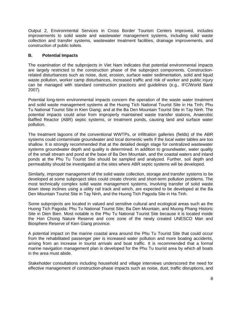
Output 2, Environmental Services in Cross Border Tourism Centers Improved, includes improvements to solid waste and wastewater management systems, including solid waste collection and transfer systems, wastewater treatment facilities, drainage improvements, and construction of public toilets. B. Potential Impacts
The examination of the subprojects in Viet Nam indicates that potential environmental impacts are largely restricted to the construction phase of the subproject components. Construction-related disturbances such as noise, dust, erosion, surface water sedimentation, solid and liquid waste pollution, worker camp disturbances, increased traffic and risk of worker and public injury can be managed with standard construction practices and guidelines (e.g., IFC/World Bank 2007). Potential long-term environmental impacts concern the operation of the waste water treatment and solid waste management systems at the Huong Tich National Tourist Site in Ha Tinh; Phu Tu National Tourist Site in Kien Giang; and at the Ba Den Mountain Tourist Site in Tay Ninh. The potential impacts could arise from improperly maintained waste transfer stations, Anaerobic Baffled Reactor (ABR) septic systems, or treatment ponds, causing land and surface water pollution. The treatment lagoons of the conventional WWTPs, or infiltration galleries (fields) of the ABR systems could contaminate groundwater and local domestic wells if the local water tables are too shallow. It is strongly recommended that at the detailed design stage for centralized wastewater systems groundwater depth and quality is determined. In addition to groundwater, water quality of the small stream and pond at the base of Ba Den Mountain, and the coastal waters and inland ponds at the Phu Tu Tourist Site should be sampled and analyzed. Further, soil depth and permeability should be investigated at the sites where ABR septic systems will be developed. Similarly, improper management of the solid waste collection, storage and transfer systems to be developed at some subproject sites could create chronic and short-term pollution problems. The most technically complex solid waste management systems, involving transfer of solid waste down steep inclines using a utility rail track and winch, are expected to be developed at the Ba Den Mountain Tourist Site in Tay Ninh, and the Huong Tich Pagoda Site in Ha Tinh. Some subprojects are located in valued and sensitive cultural and ecological areas such as the Huong Tich Pagoda; Phu Tu National Tourist Site; Ba Den Mountain, and Muong Phang Historic Site in Dien Bien. Most notable is the Phu Tu National Tourist Site because it is located inside the Hon Chong Nature Reserve and core zone of the newly created UNESCO Man and Biosphere Reserve of Kien Giang province. A potential impact on the marine coastal area around the Phu Tu Tourist Site that could occur from the rehabilitated passenger pier is increased water pollution and more boating accidents, arising from an increase in tourist arrivals and boat traffic. It is recommended that a formal marine navigation management plan is developed for the Phu Tu tourist area by which all boats in the area must abide. Stakeholder consultations including household and village interviews underscored the need for effective management of construction-phase impacts such as noise, dust, traffic disruptions, and
9
worker and public safety. Follow-up meetings with the consulted stakeholders to address any construction-related issues are required at the detailed design and construction stages. Available data and information indicate that critical wildlife habitat and rare or endangered species are absent at all immediate subproject sites of the five provinces. However, a re-review of local sensitive ecological and cultural resources should occur at the detailed design stage. Similarly, a re-review of the existence and sensitivity of valued marine resources at the Phu Tu National Tourist Site should occur to clarify potential impacts of the detailed designs. Potential induced direct impacts of increased tourism in the subproject areas involve creation of pollution from solid and domestic waste produced outside the catchment areas of the improved solid and wastewater collection and treatment systems of the subprojects. An increase in the number of tourists that visit a subproject area normally results in greater consumption of goods and resources which can put greater strain on key tourist amenities such as the cleanliness of local environment and community. An increase in the number of tourists in subproject area could lead to social issues stemming from the interaction of local and foreign cultures.
A potential induced, indirect impact of tourism development which will be very difficult to prevent and separate from the subproject activities of is independent commercial and urban development that occurs to serve and benefit the increase in tourism activities created by the project. Increased tourism could easily become the seed for much greater and non-sustainable growth in both tourism and urban development in the subproject areas. Indirect, induced tourism and socioeconomic growth is usually broader geographically and more difficult to manage with respect to impacts on environmental resources because of the different parties and interests involved.
C. Conclusions
The IEE concludes that the description of the feasibility design of the project combined with available information on the affected environment is sufficient to identify the scope of potential environmental impacts of the project. Providing that significant changes do not occur to the design of one or more of the subproject components, and that the supplementary sensitive receptor data, and final design information identified above is provided, that a further detailed environmental impact assessment (EIA) of the project is not required. The separate EMPs developed for the provincial subprojects provide impact mitigation plans, environmental monitoring plans, and specify the institutional responsibilities and capacity needs for the environmental management of the subprojects. The EMPs will need to be reviewed and updated at the detailed design phase to ensure that they fully address the potential impacts of the final subproject designs.
10
I. INTRODUCTION
A. Background to the IEE
1. The Greater Mekong Sub Region (GMS) Tourism Infrastructure for Inclusive Growth Project (the project) is a multisector tourism development project that includes Viet Nam, Cambodia, and the Lao PDR. The project is comprised of transport-related and environmental infrastructure investment subprojects in twelve provinces of the three participating countries. The subprojects of the provinces Ha Tinh, Kien Giang, Tay Ninh, Lao Cai, and Dien Bien of Viet Nam are the focus of the IEE presented herein. The IEEs for the Lao PDR and Cambodia are found under separate cover. 2. The objective of the project is to accelerate inclusive tourism growth in the targeted areas of the GMS. Inclusive growth is defined by local social and economic growth from tourism development that is environmentally sustainable. The development of tourism to enhance pro-poor employment is consistent with the GMS Strategic Framework 2012–2022, GMS Tourism Sector Strategy 2005–2015, and the current poverty reduction strategies of the participating countries. The GMS Tourism Sector Assessment, Strategy, and Roadmap indicate that ADB’s assistance to the tourism sector will focus on:
1) Improving last-mile tourism access infrastructure and environmental services in secondary destinations;
2) Capacity building for public officials and local communities; and
3) Promoting multicountry tour circuits. 3. The project is included in the participating countries ADB Country Partnership Strategies which emphasize the need to improve rural transport infrastructure, expand municipal infrastructure and services, and promote small and medium-sized enterprises to boost the poor’s access to economic opportunities. The project has four outputs as follows: Output 1: Last Mile Tourism Access Infrastructure Improved which includes new and
upgraded roads, passenger piers, and new and improved tourism support facilities;
Output 2: Environmental Services in Cross Border Tourism Centers Improved which includes improved wastewater and solid waste management systems;
Output 3: Institutional Capacity to Promote Inclusive Tourism Growth Strengthened; and
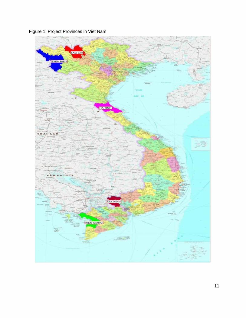
Output 4: Effective Project Implementation and Knowledge Management. 4. Output 1 and Output 2 are derived from the infrastructure investments, whereas Outputs 3 and 4 comprise “softer” tourism development initiatives such as tourism planning and management, development of public-private partnerships, micro- and small-enterprise promotion, and counterpart capacity development and training in tourism. The location of the five participating provinces is shown in Figure 1. The focus of the IEE provided herein is the infrastructure subprojects in Table 1.
11
Figure 1: Project Provinces in Viet Nam
12
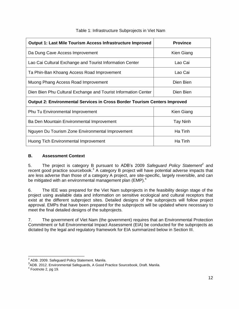
Table 1: Infrastructure Subprojects in Viet Nam
Output 1: Last Mile Tourism Access Infrastructure Improved Province
Da Dung Cave Access Improvement Kien Giang
Lao Cai Cultural Exchange and Tourist Information Center Lao Cai
Ta Phin-Ban Khoang Access Road Improvement Lao Cai
Muong Phang Access Road Improvement Dien Bien
Dien Bien Phu Cultural Exchange and Tourist Information Center Dien Bien
Output 2: Environmental Services in Cross Border Tourism Centers Improved
Phu Tu Environmental Improvement Kien Giang
Ba Den Mountain Environmental Improvement Tay Ninh
Nguyen Du Tourism Zone Environmental Improvement Ha Tinh
Huong Tich Environmental Improvement Ha Tinh
B. Assessment Context
5. The project is category B pursuant to ADB’s 2009 Safeguard Policy Statement2 and recent good practice sourcebook.3 A category B project will have potential adverse impacts that are less adverse than those of a category A project, are site-specific, largely reversible, and can be mitigated with an environmental management plan (EMP).4 6. The IEE was prepared for the Viet Nam subprojects in the feasibility design stage of the project using available data and information on sensitive ecological and cultural receptors that exist at the different subproject sites. Detailed designs of the subprojects will follow project approval. EMPs that have been prepared for the subprojects will be updated where necessary to meet the final detailed designs of the subprojects. 7. The government of Viet Nam (the government) requires that an Environmental Protection Commitment or full Environmental Impact Assessment (EIA) be conducted for the subprojects as dictated by the legal and regulatory framework for EIA summarized below in Section III.
2 ADB. 2009. Safeguard Policy Statement. Manila.
3ADB. 2012. Environmental Safeguards, A Good Practice Sourcebook, Draft. Manila.
4 Footnote 2, pg 19.

13
1. Impact Footprints
8. The subproject activities in the five provinces of Viet Nam are located in existing tourist areas, situated in valuable ecological and cultural environments. Thus, the tourist impact footprints at the sites already exist and the project is not creating new impact footprints in any subproject area. However, due to the eco-cultural value of the subproject sites, the project will need to carefully ensure that the upgrades to the tourist facilities do not create unnecessary negative new impacts. C. Structure of the Report
9. The IEE is structured by province in order to minimize redundancy of background information. The report structure is consistent with and supports the individual subproject environmental management plans (EMPs) that have been prepared based on the results of the IEE.
II. POLICY, LEGAL, AND ADMINISTRATIVE FRAMEWORK
10. The subprojects in Viet Nam will be implemented according to the directives set down for use of Official Development Assistance (ODA) by Government Decree No. 131/2006/ND-CP which was promulgated on 9 November 2006, and in accordance with the administrative provisions for the project. A. Viet Nam Regulatory Framework for Environmental Assessment
11. The Viet Nam Law on Environmental Protection (LEP 2005) prescribes the requirements for environmental assessment for international and domestic project interventions that affect the natural and social environments. Government Decree 29/2011/ND-CP on strategic environmental assessment (SEA), environmental impact assessment (EIA), and environmental protection commitment (EPC) in conjunction with Circular 26/2011/TT-BTNMT on stipulation of specific articles of Decree 29 both elaborate the environmental assessment requirements specified by the LEP (2005). Decree 29 and Circular 26 are implemented in conjunction with Decree 80/2006/ND-CP, and Decree 21/2008/ND-CP. 12. The updated screening criteria of Decree 29 distinguish projects that require an EIA from projects requiring the simpler EPC. The difference between the two processes reflects the level of assessment, and final review and appraisal that is required. Decree 29 specifies a maximum period of 15 days for the government-equivalent of public consultation on a project, followed by a maximum of 45 days for the review of competed EIA by MONRE or DONRE. 13. At the time of IEE preparation, Decree 29 requires mostly EPCs to be prepared for the different subprojects. However, EIAs will likely be required for the wastewater and solid waste treatment systems of the Ba Den mountain subproject in Tay Ninh province, and the Tourist and Culture Information Center in Lao Cai. This IEE exceeds the Government’s requirements for an EIA.
14
B. Applicable Laws, Policy, Environmental Standards, and Guidelines
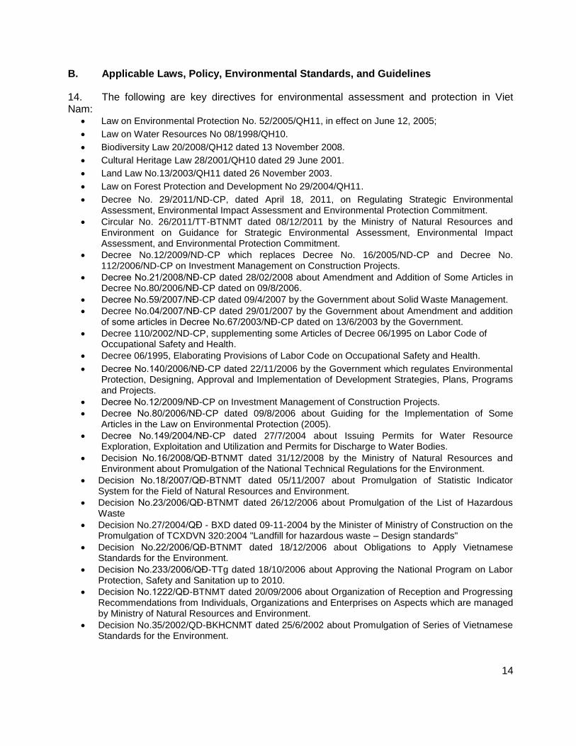
14. The following are key directives for environmental assessment and protection in Viet Nam:
Law on Environmental Protection No. 52/2005/QH11, in effect on June 12, 2005;
Law on Water Resources No 08/1998/QH10.
Biodiversity Law 20/2008/QH12 dated 13 November 2008.
Cultural Heritage Law 28/2001/QH10 dated 29 June 2001.
Land Law No.13/2003/QH11 dated 26 November 2003.
Law on Forest Protection and Development No 29/2004/QH11.
Decree No. 29/2011/ND-CP, dated April 18, 2011, on Regulating Strategic Environmental Assessment, Environmental Impact Assessment and Environmental Protection Commitment.
Circular No. 26/2011/TT-BTNMT dated 08/12/2011 by the Ministry of Natural Resources and Environment on Guidance for Strategic Environmental Assessment, Environmental Impact Assessment, and Environmental Protection Commitment.
Decree No.12/2009/ND-CP which replaces Decree No. 16/2005/ND-CP and Decree No. 112/2006/ND-CP on Investment Management on Construction Projects.
Decree No.21/2008/NĐ-CP dated 28/02/2008 about Amendment and Addition of Some Articles in Decree No.80/2006/NĐ-CP dated on 09/8/2006.
Decree No.59/2007/NĐ-CP dated 09/4/2007 by the Government about Solid Waste Management.
Decree No.04/2007/NĐ-CP dated 29/01/2007 by the Government about Amendment and addition of some articles in Decree No.67/2003/NĐ-CP dated on 13/6/2003 by the Government.
Decree 110/2002/ND-CP, supplementing some Articles of Decree 06/1995 on Labor Code of Occupational Safety and Health.
Decree 06/1995, Elaborating Provisions of Labor Code on Occupational Safety and Health.
Decree No.140/2006/NĐ-CP dated 22/11/2006 by the Government which regulates Environmental Protection, Designing, Approval and Implementation of Development Strategies, Plans, Programs and Projects.
Decree No.12/2009/NĐ-CP on Investment Management of Construction Projects.
Decree No.80/2006/NĐ-CP dated 09/8/2006 about Guiding for the Implementation of Some Articles in the Law on Environmental Protection (2005).
Decree No.149/2004/NĐ-CP dated 27/7/2004 about Issuing Permits for Water Resource Exploration, Exploitation and Utilization and Permits for Discharge to Water Bodies.
Decision No.16/2008/QĐ-BTNMT dated 31/12/2008 by the Ministry of Natural Resources and Environment about Promulgation of the National Technical Regulations for the Environment.
Decision No.18/2007/QĐ-BTNMT dated 05/11/2007 about Promulgation of Statistic Indicator System for the Field of Natural Resources and Environment.
Decision No.23/2006/QĐ-BTNMT dated 26/12/2006 about Promulgation of the List of Hazardous Waste
Decision No.27/2004/QĐ - BXD dated 09-11-2004 by the Minister of Ministry of Construction on the Promulgation of TCXDVN 320:2004 "Landfill for hazardous waste – Design standards"
Decision No.22/2006/QĐ-BTNMT dated 18/12/2006 about Obligations to Apply Vietnamese Standards for the Environment.
Decision No.233/2006/QĐ-TTg dated 18/10/2006 about Approving the National Program on Labor Protection, Safety and Sanitation up to 2010.
Decision No.1222/QĐ-BTNMT dated 20/09/2006 about Organization of Reception and Progressing Recommendations from Individuals, Organizations and Enterprises on Aspects which are managed by Ministry of Natural Resources and Environment.
Decision No.35/2002/QD-BKHCNMT dated 25/6/2002 about Promulgation of Series of Vietnamese Standards for the Environment.
15
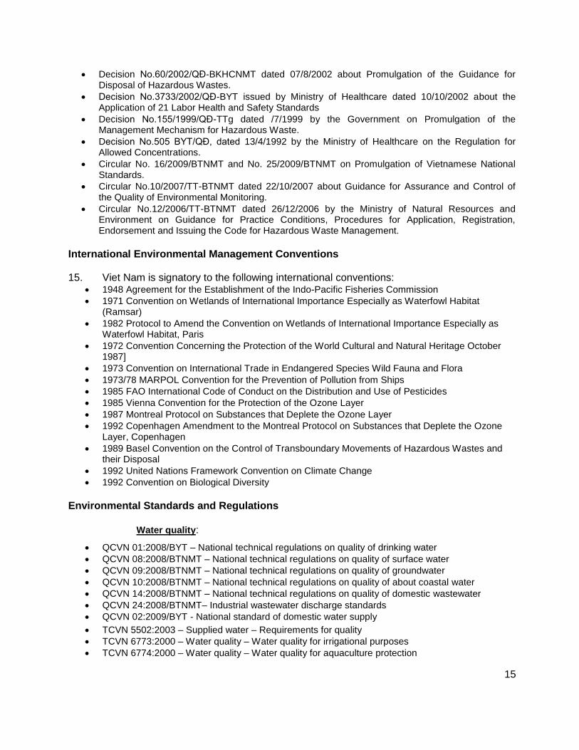
Decision No.60/2002/QĐ-BKHCNMT dated 07/8/2002 about Promulgation of the Guidance for Disposal of Hazardous Wastes.
Decision No.3733/2002/QĐ-BYT issued by Ministry of Healthcare dated 10/10/2002 about the Application of 21 Labor Health and Safety Standards
Decision No.155/1999/QĐ-TTg dated /7/1999 by the Government on Promulgation of the Management Mechanism for Hazardous Waste.
Decision No.505 BYT/QĐ, dated 13/4/1992 by the Ministry of Healthcare on the Regulation for Allowed Concentrations.
Circular No. 16/2009/BTNMT and No. 25/2009/BTNMT on Promulgation of Vietnamese National Standards.
Circular No.10/2007/TT-BTNMT dated 22/10/2007 about Guidance for Assurance and Control of the Quality of Environmental Monitoring.
Circular No.12/2006/TT-BTNMT dated 26/12/2006 by the Ministry of Natural Resources and Environment on Guidance for Practice Conditions, Procedures for Application, Registration, Endorsement and Issuing the Code for Hazardous Waste Management.
International Environmental Management Conventions
15. Viet Nam is signatory to the following international conventions: 1948 Agreement for the Establishment of the Indo-Pacific Fisheries Commission
1971 Convention on Wetlands of International Importance Especially as Waterfowl Habitat (Ramsar)
1982 Protocol to Amend the Convention on Wetlands of International Importance Especially as Waterfowl Habitat, Paris
1972 Convention Concerning the Protection of the World Cultural and Natural Heritage October 1987]
1973 Convention on International Trade in Endangered Species Wild Fauna and Flora
1973/78 MARPOL Convention for the Prevention of Pollution from Ships
1985 FAO International Code of Conduct on the Distribution and Use of Pesticides
1985 Vienna Convention for the Protection of the Ozone Layer
1987 Montreal Protocol on Substances that Deplete the Ozone Layer
1992 Copenhagen Amendment to the Montreal Protocol on Substances that Deplete the Ozone Layer, Copenhagen
1989 Basel Convention on the Control of Transboundary Movements of Hazardous Wastes and their Disposal
1992 United Nations Framework Convention on Climate Change
1992 Convention on Biological Diversity
Environmental Standards and Regulations Water quality:
QCVN 01:2008/BYT – National technical regulations on quality of drinking water
QCVN 08:2008/BTNMT – National technical regulations on quality of surface water
QCVN 09:2008/BTNMT – National technical regulations on quality of groundwater
QCVN 10:2008/BTNMT – National technical regulations on quality of about coastal water
QCVN 14:2008/BTNMT – National technical regulations on quality of domestic wastewater
QCVN 24:2008/BTNMT– Industrial wastewater discharge standards
QCVN 02:2009/BYT - National standard of domestic water supply
TCVN 5502:2003 – Supplied water – Requirements for quality
TCVN 6773:2000 – Water quality – Water quality for irrigational purposes
TCVN 6774:2000 – Water quality – Water quality for aquaculture protection
16
TCVN 7222:2002 – Water quality for concentrated domestic WWTP
TCVN / QCVN - Standard methods for analyzing environmental quality Air Quality:
QCVN 05:2008 – Standards for ambient air quality
QCVN 06:2008 – Maximum allowable concentration of hazardous substances in the ambient air
TCVN 6438:2001 – Maximum permitted emission limits of exhausted gases from vehicles
Solid Waste Management:
TCVN 6696:2009 – Solid waste – Sanitary landfill. General requirements for environmental protection.
QCVN 07:2009– National technical regulations for classification of hazardous wastes
QCVN 25:2009 – National technical regulations for wastewater of solid waste sites
QCVN 15:2008/BTNMT: - National regulation on allowable pesticide residues in soil
QCVN 03:2008/BTNMT: - National regulation heavy metals concentrations in soil
Vibration and Noise:
QCVN 26:2010/BTNMT: national technical standard for noise
TCVN 6962: 2001 Allowable vibration level for public and residential areas TCVN 6962:2001: - Allowable vibration and shock from construction activities
International Guidelines
World Bank Group, 2007. Environmental Health and Safety Guidelines, Wash. DC.
AWWA Standard Methods for Measurement & Analysis Environmental Quality
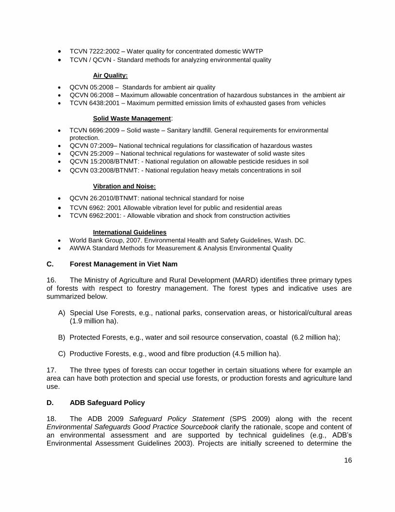
C. Forest Management in Viet Nam
16. The Ministry of Agriculture and Rural Development (MARD) identifies three primary types of forests with respect to forestry management. The forest types and indicative uses are summarized below.
A) Special Use Forests, e.g., national parks, conservation areas, or historical/cultural areas (1.9 million ha).
B) Protected Forests, e.g., water and soil resource conservation, coastal (6.2 million ha);
C) Productive Forests, e.g., wood and fibre production (4.5 million ha). 17. The three types of forests can occur together in certain situations where for example an area can have both protection and special use forests, or production forests and agriculture land use. D. ADB Safeguard Policy
18. The ADB 2009 Safeguard Policy Statement (SPS 2009) along with the recent Environmental Safeguards Good Practice Sourcebook clarify the rationale, scope and content of an environmental assessment and are supported by technical guidelines (e.g., ADB’s Environmental Assessment Guidelines 2003). Projects are initially screened to determine the
17
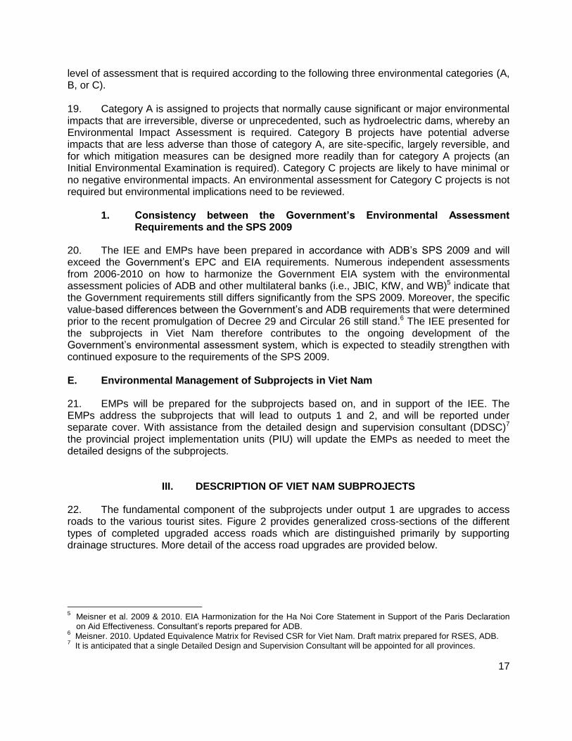
level of assessment that is required according to the following three environmental categories (A, B, or C). 19. Category A is assigned to projects that normally cause significant or major environmental impacts that are irreversible, diverse or unprecedented, such as hydroelectric dams, whereby an Environmental Impact Assessment is required. Category B projects have potential adverse impacts that are less adverse than those of category A, are site-specific, largely reversible, and for which mitigation measures can be designed more readily than for category A projects (an Initial Environmental Examination is required). Category C projects are likely to have minimal or no negative environmental impacts. An environmental assessment for Category C projects is not required but environmental implications need to be reviewed.
1. Consistency between the Government’s Environmental Assessment Requirements and the SPS 2009
20. The IEE and EMPs have been prepared in accordance with ADB’s SPS 2009 and will exceed the Government’s EPC and EIA requirements. Numerous independent assessments from 2006-2010 on how to harmonize the Government EIA system with the environmental assessment policies of ADB and other multilateral banks (i.e., JBIC, KfW, and WB)5 indicate that the Government requirements still differs significantly from the SPS 2009. Moreover, the specific value-based differences between the Government’s and ADB requirements that were determined prior to the recent promulgation of Decree 29 and Circular 26 still stand.6 The IEE presented for the subprojects in Viet Nam therefore contributes to the ongoing development of the Government’s environmental assessment system, which is expected to steadily strengthen with continued exposure to the requirements of the SPS 2009. E. Environmental Management of Subprojects in Viet Nam
21. EMPs will be prepared for the subprojects based on, and in support of the IEE. The EMPs address the subprojects that will lead to outputs 1 and 2, and will be reported under separate cover. With assistance from the detailed design and supervision consultant (DDSC)7 the provincial project implementation units (PIU) will update the EMPs as needed to meet the detailed designs of the subprojects.
III. DESCRIPTION OF VIET NAM SUBPROJECTS
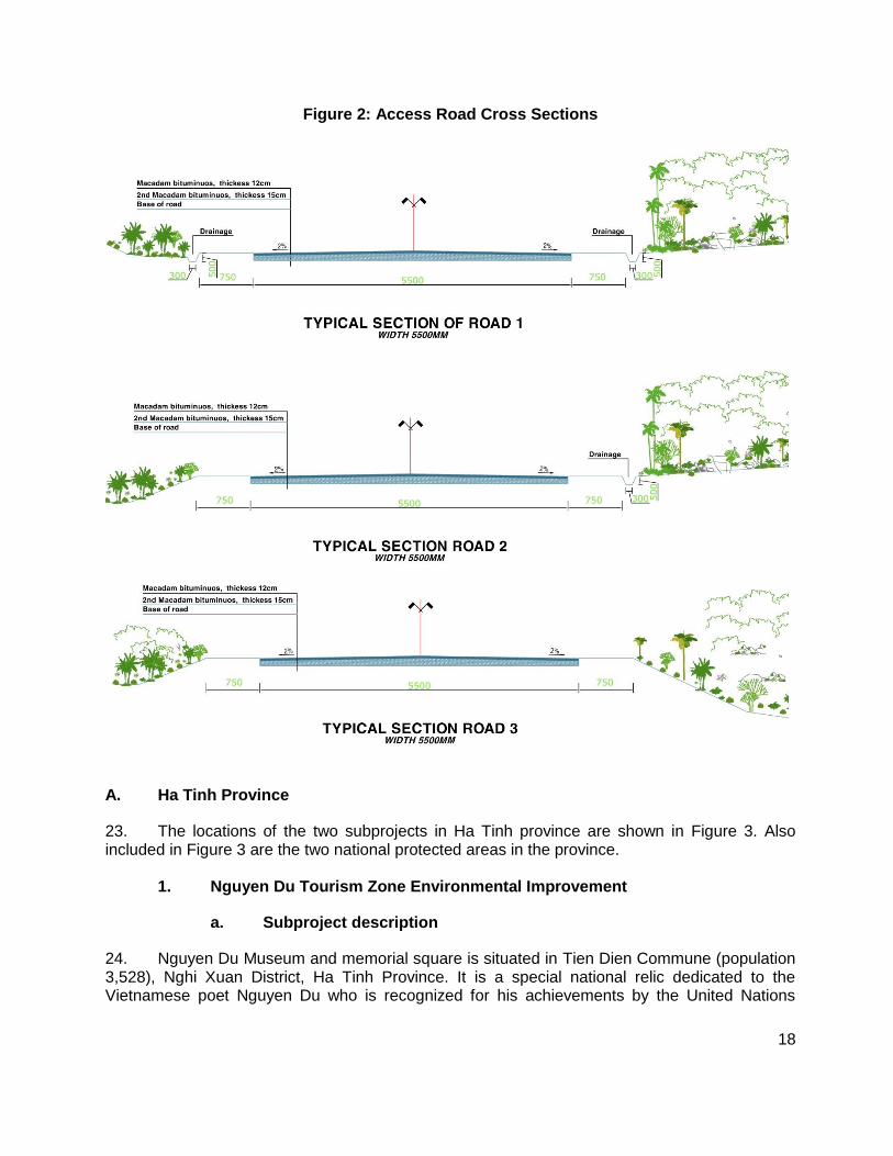
22. The fundamental component of the subprojects under output 1 are upgrades to access roads to the various tourist sites. Figure 2 provides generalized cross-sections of the different types of completed upgraded access roads which are distinguished primarily by supporting drainage structures. More detail of the access road upgrades are provided below.
5 Meisner et al. 2009 & 2010. EIA Harmonization for the Ha Noi Core Statement in Support of the Paris Declaration
on Aid Effectiveness. Consultant’s reports prepared for ADB. 6 Meisner. 2010. Updated Equivalence Matrix for Revised CSR for Viet Nam. Draft matrix prepared for RSES, ADB.
7 It is anticipated that a single Detailed Design and Supervision Consultant will be appointed for all provinces.
18
Figure 2: Access Road Cross Sections
A. Ha Tinh Province
23. The locations of the two subprojects in Ha Tinh province are shown in Figure 3. Also included in Figure 3 are the two national protected areas in the province.
1. Nguyen Du Tourism Zone Environmental Improvement
a. Subproject description
24. Nguyen Du Museum and memorial square is situated in Tien Dien Commune (population 3,528), Nghi Xuan District, Ha Tinh Province. It is a special national relic dedicated to the Vietnamese poet Nguyen Du who is recognized for his achievements by the United Nations

19
Educational, Scientific and Cultural Organization (UNESCO) as a Man of Culture. Between 2010 and 2012 annual visitors to the museum doubled to 170,000 and are forecast to surpass 450,000 in 2015. To accommodate the rising attendance and better present the heritage values of the site a master plan has been prepared. Specific activities of the subproject support of the master plan and are summarized in Table 2. The plan of the memorial square is shown in Figure 4.
Figure 3: Subproject Locations in Ha Tinh Province
Table 2: Activities of Nguyen Du Tourism Zone Environmental Improvement
Activity General Specifications
Construction of a memorial square8 together with
access paths and landscaping With access paths
landscaping
Car park 2,000 m2
Upgrade existing open irrigation drainage canal and water retention area
open irrigation canal currently forms northern boundary of site for memorial square
Introduction of a solid waste management system with rubbish bins
rubbish bins
8 Monuments erected in the square will not form part of the subproject but will be specially commissioned by the Museum Authorities.

20
Activity General Specifications
Installation of public toilets blocks with ABR septic tank(s)
Upgrade electricity supply and public lighting
Construction of two open-sided public rest pavilions and vendor kiosks
500 m2
Installation of directional signage and information boards to present the life and work of Nguyen Du.
durable external and internal signs
Figure 4: Plan of Nguyen Du Tourism Zone Environmental Improvement
2. Huong Tich Environmental Improvement
a. Subproject description
25. Huong Tich Pagoda is a national tourism site on top of a forested hill in Thien Loc Commune (population 7,735), Can Loc District, about 20 km north of Ha Tinh City. In 2012, 240,000 tourists visited the pagoda, more than double the number recorded in 2011, despite generally poor access and lack of facilities. During festivals and public holidays the site can receive up to 30,000 visitors per day, with official forecasts predicting 658,000 visitors in 2015. Lacking water supply, sanitation and solid waste management services, rapid tourism growth is contributing to worsening environmental conditions that threaten the safety of visitors and local residents.
21
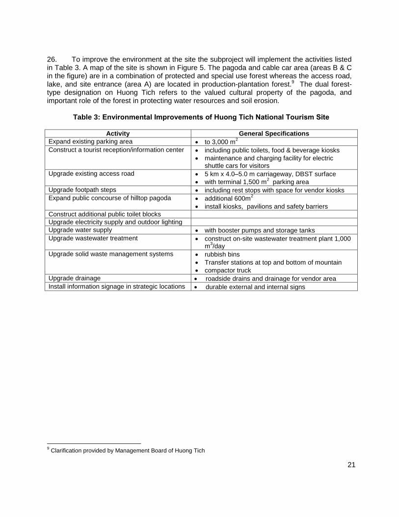
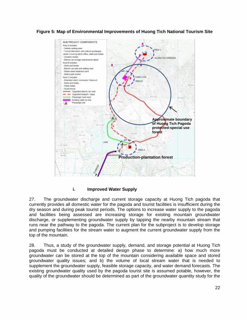
26. To improve the environment at the site the subproject will implement the activities listed in Table 3. A map of the site is shown in Figure 5. The pagoda and cable car area (areas B & C in the figure) are in a combination of protected and special use forest whereas the access road, lake, and site entrance (area A) are located in production-plantation forest.9 The dual forest-type designation on Huong Tich refers to the valued cultural property of the pagoda, and important role of the forest in protecting water resources and soil erosion.
Table 3: Environmental Improvements of Huong Tich National Tourism Site
Activity General Specifications
Expand existing parking area to 3,000 m2
Construct a tourist reception/information center including public toilets, food & beverage kiosks
maintenance and charging facility for electric shuttle cars for visitors
Upgrade existing access road 5 km x 4.0–5.0 m carriageway, DBST surface
with terminal 1,500 m2 parking area
Upgrade footpath steps including rest stops with space for vendor kiosks
Expand public concourse of hilltop pagoda additional 600m2
install kiosks, pavilions and safety barriers
Construct additional public toilet blocks
Upgrade electricity supply and outdoor lighting
Upgrade water supply with booster pumps and storage tanks
Upgrade wastewater treatment construct on-site wastewater treatment plant 1,000 m
3/day
Upgrade solid waste management systems rubbish bins
Transfer stations at top and bottom of mountain
compactor truck
Upgrade drainage roadside drains and drainage for vendor area
Install information signage in strategic locations durable external and internal signs
9 Clarification provided by Management Board of Huong Tich
22
Figure 5: Map of Environmental Improvements of Huong Tich National Tourism Site
i. Improved Water Supply
27. The groundwater discharge and current storage capacity at Huong Tich pagoda that currently provides all domestic water for the pagoda and tourist facilities is insufficient during the dry season and during peak tourist periods. The options to increase water supply to the pagoda and facilities being assessed are increasing storage for existing mountain groundwater discharge, or supplementing groundwater supply by tapping the nearby mountain stream that runs near the pathway to the pagoda. The current plan for the subproject is to develop storage and pumping facilities for the stream water to augment the current groundwater supply from the top of the mountain. 28. Thus, a study of the groundwater supply, demand, and storage potential at Huong Tich pagoda must be conducted at detailed design phase to determine: a) how much more groundwater can be stored at the top of the mountain considering available space and stored groundwater quality issues; and b) the volume of local stream water that is needed to supplement the groundwater supply, feasible storage capacity, and water demand forecasts. The existing groundwater quality used by the pagoda tourist site is assumed potable, however, the quality of the groundwater should be determined as part of the groundwater quantity study for the
Approximate boundary of Huong Tich Pagoda protected-special use
forest
Production-plantation forest

23
subproject. Moreover, if sufficient space at the top of the mountain is available for the required groundwater storage then a simple chlorination treatment plant will need to be added to the storage system in order to keep the stored groundwater fresh and potable for use. If stream water is needed a treatment facility also will be required to remove turbidity caused by rainfall events. 29. Stream and groundwater gauges at source, and a rain gauge should be installed at the top of the mountain and left operating for 2-3 years as part of the groundwater study. The relationship among groundwater flow, stream water flow, and rainfall will provide valuable information for managing the future sufficiency of the mountain water resources.
ii. Wastewater Treatment
30. The Forestry department confirmed there is abundant isolated area for the wastewater treatment plant (WWTP) in the plantation forest below Huong Tich. The WWTP for the Huong Tich pagoda tourist area will consist of a serial lagoon system (Figure 6). Each lagoon is approximately 40m X 30m X 2.5m for an estimated total treatment capacity of 1,000m3 at peak periods based on peak tourist visits to the pagoda asserted by the Huong Tich Management Board. The final required treatment capacity will need to consider the difference between peak and low tourist season waste production including the habits of the visitors with respect to water consumption and toilet usage.
Figure 6: Plan View of Wastewater Treatment System for Huong Tich Pagoda
31. A two day pond retention time has been factored with contingencies such as use of aerators and enzyme additives if plant capacity is approached. The single greatest design issue for the WWTP is accommodating the reputed huge difference between the peak period, and rest-
24
of-year tourist visits and resultant range in wastewater production. Thus, a more in depth assessment of actual variable demand and length of peak production periods must be conducted during the detailed design phase to ensure the WTTP is designed appropriately. The treated effluent from the WTTP will meet Government standards for effluent quality.10 The plan is to discharge the effluent into contoured ditches in the plantation forest area as nutrient irrigation. Sludge removed periodically from ponds would also be distributed in the plantation.
iii. Solid Waste Management
32. Solid waste will be conveyed down the mountain from Huong Tich pagoda by hand and by using the existing cable car during off hours. Small concrete transfer stations will be constructed at the top and bottom of the mountain to store the waste. The bottom transfer station will be located beside the WWTP in a selected isolated area of the forest. B. Kien Giang Province
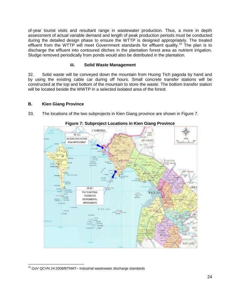
33. The locations of the two subprojects in Kien Giang province are shown in Figure 7.
Figure 7: Subproject Locations in Kien Giang Province
10
GoV QCVN 24:2008/BTNMT– Industrial wastewater discharge standards
25
1. Da Dung Cave Access Improvement
a. Subproject description
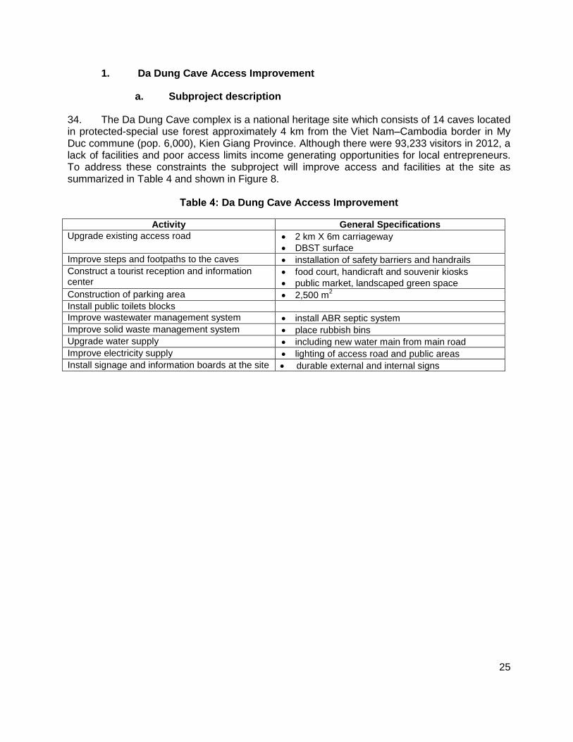
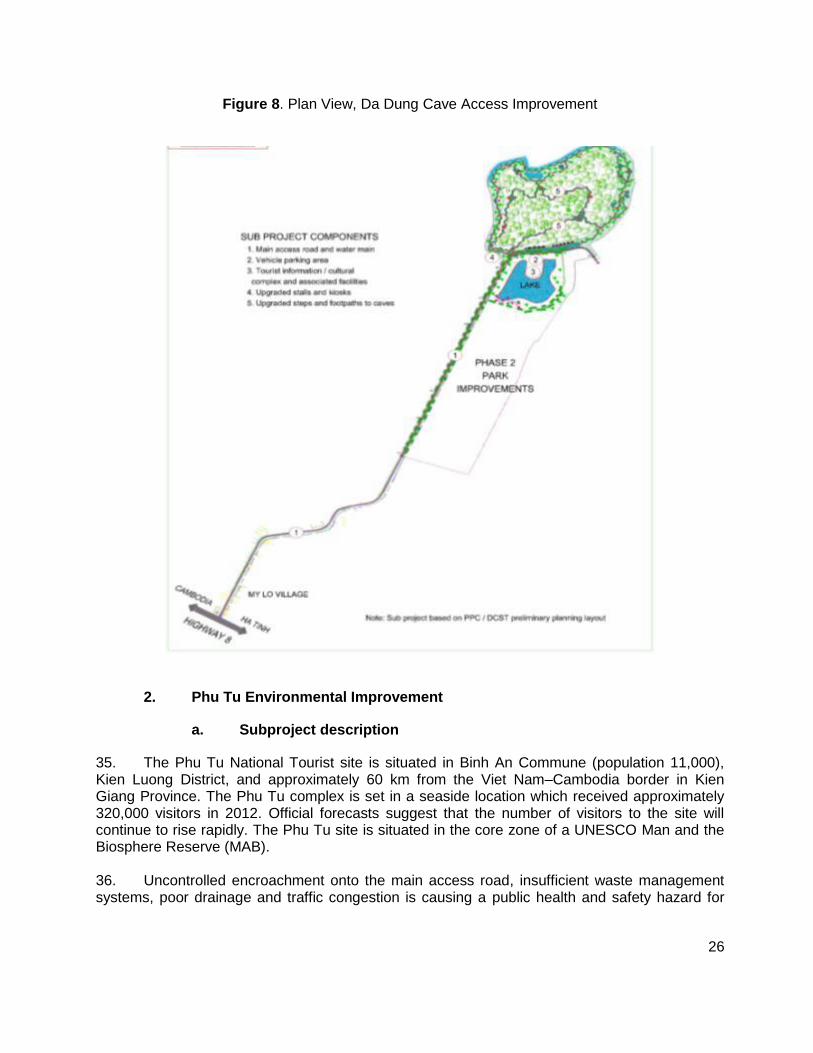
34. The Da Dung Cave complex is a national heritage site which consists of 14 caves located in protected-special use forest approximately 4 km from the Viet Nam–Cambodia border in My Duc commune (pop. 6,000), Kien Giang Province. Although there were 93,233 visitors in 2012, a lack of facilities and poor access limits income generating opportunities for local entrepreneurs. To address these constraints the subproject will improve access and facilities at the site as summarized in Table 4 and shown in Figure 8.
Table 4: Da Dung Cave Access Improvement
Activity General Specifications
Upgrade existing access road 2 km X 6m carriageway
DBST surface
Improve steps and footpaths to the caves installation of safety barriers and handrails
Construct a tourist reception and information center
food court, handicraft and souvenir kiosks
public market, landscaped green space
Construction of parking area 2,500 m2
Install public toilets blocks
Improve wastewater management system install ABR septic system
Improve solid waste management system place rubbish bins
Upgrade water supply including new water main from main road
Improve electricity supply lighting of access road and public areas
Install signage and information boards at the site durable external and internal signs
26
Figure 8. Plan View, Da Dung Cave Access Improvement
2. Phu Tu Environmental Improvement
a. Subproject description
35. The Phu Tu National Tourist site is situated in Binh An Commune (population 11,000), Kien Luong District, and approximately 60 km from the Viet Nam–Cambodia border in Kien Giang Province. The Phu Tu complex is set in a seaside location which received approximately 320,000 visitors in 2012. Official forecasts suggest that the number of visitors to the site will continue to rise rapidly. The Phu Tu site is situated in the core zone of a UNESCO Man and the Biosphere Reserve (MAB). 36. Uncontrolled encroachment onto the main access road, insufficient waste management systems, poor drainage and traffic congestion is causing a public health and safety hazard for
27
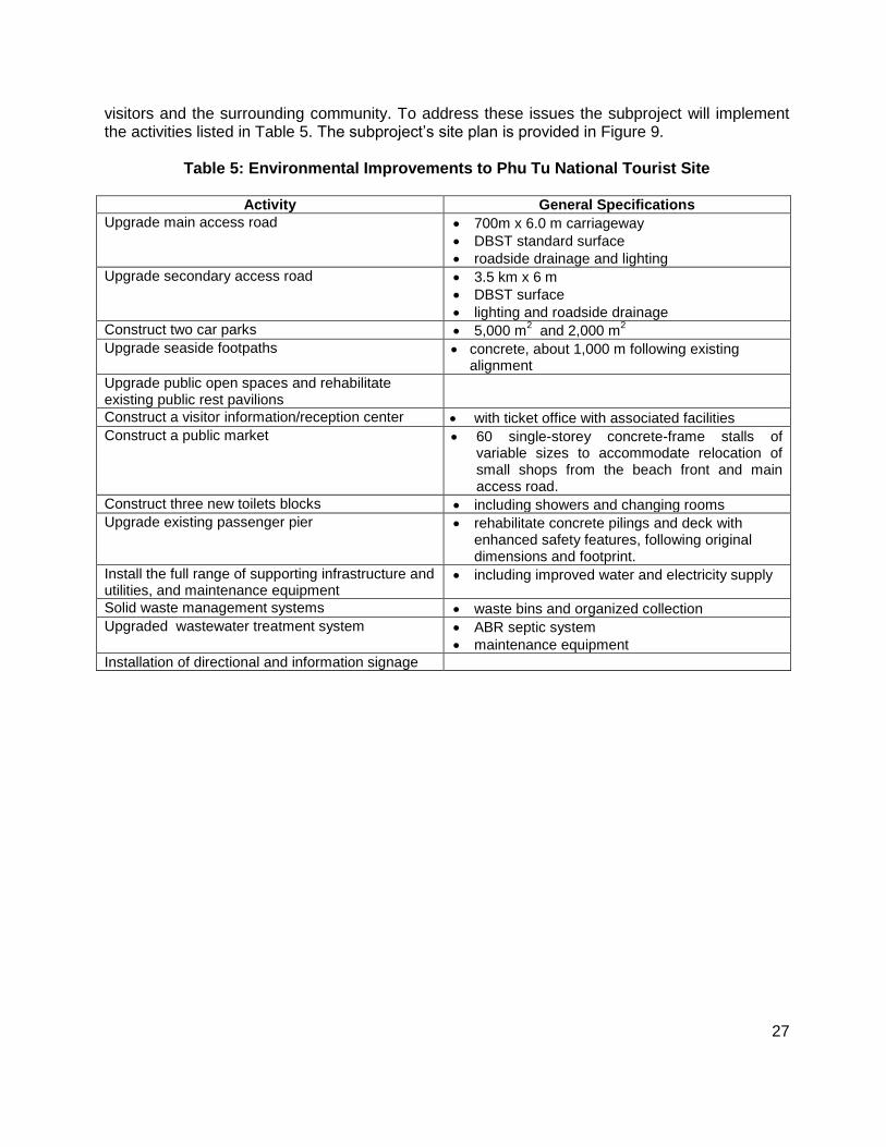
visitors and the surrounding community. To address these issues the subproject will implement the activities listed in Table 5. The subproject’s site plan is provided in Figure 9.
Table 5: Environmental Improvements to Phu Tu National Tourist Site
Activity General Specifications
Upgrade main access road
700m x 6.0 m carriageway
DBST standard surface
roadside drainage and lighting
Upgrade secondary access road 3.5 km x 6 m
DBST surface
lighting and roadside drainage
Construct two car parks 5,000 m2 and 2,000 m
2
Upgrade seaside footpaths concrete, about 1,000 m following existing alignment
Upgrade public open spaces and rehabilitate existing public rest pavilions
Construct a visitor information/reception center with ticket office with associated facilities
Construct a public market 60 single-storey concrete-frame stalls of variable sizes to accommodate relocation of small shops from the beach front and main access road.
Construct three new toilets blocks including showers and changing rooms
Upgrade existing passenger pier rehabilitate concrete pilings and deck with enhanced safety features, following original dimensions and footprint.
Install the full range of supporting infrastructure and utilities, and maintenance equipment
including improved water and electricity supply
Solid waste management systems waste bins and organized collection
Upgraded wastewater treatment system ABR septic system
maintenance equipment
Installation of directional and information signage

28
Figure 9: Plan View, Phu Tu Environmental Improvement
C. Tay Ninh Province
37. The location of the single subproject in Tay Ninh province is shown in Figure 10. The subproject activities are listed in Table 6.

29
Figure 10: Subproject Location in Tay Ninh Province
Note: Lo Go Xa Mat National Protected Area shown in green.
1. Ba Den Mountain Environmental Improvement
a. Subproject description
38. Ba Den Mountain Park is a pilgrimage site located 11 km north-east of Tay Ninh City in Duong Minh Chau District, 52 km from the Viet Nam–Cambodia border. In 2012, the park received 2.4 million tourists with more than half coming during the Tet holiday period when

30
arrivals reach 140,000 per day. Ba Den Mountain is in special use/protected forest due to the pagoda and local claim that rare and endangered species are present in the area.11
Table 6: Environmental Improvement to Ba Den Mountain
Activity General Specifications
Expand the public concourse surrounding main religious buildings
addition of 3,000m2
Upgrade footpaths install safety barriers
install rest shelters and adjacent kiosks
Install additional toilets throughout the site linked to wastewater treatment component
Construct small tourist information center 500 m2 with toilets and retail space
Upgrade electricity supply & outdoor lighting,
Upgrade water supply including booster pumps and storage tanks
Upgrade drainage along the roadside, footpaths and concourse
Upgrade wastewater treatment removal from mountain via pipeline following service track (see solid waste)
construction of an on-site wastewater treatment plant with 1,500 m
3/day capacity
Upgrade solid waste management construction of a service track to remove rubbish from the mountain
New solid waste transfer station with 200 m access road
new compactor trucks and refuse bins
Install directional and information signage
39. The steadily increasing tourist arrivals are overwhelming existing public facilities and environmental services resulting in degraded sanitary conditions and a public health and safety hazard for visitors and the 2,888 people living and working in the park’s vicinity. To address these issues the subproject will undertake the activities listed in Table 6.
i. Improved Water Supply
40. The groundwater discharge and storage capacity at the top of Ba Den Mountain that currently provides domestic water for the pagoda and tourist facilities is insufficient during the dry
11
The Director of the Management Board of the Lo Go Xa Mat National Park northwest of Ba Den Mountain claims Ba Den Mountain supports rare and endangered wildlife, however no scientific taxonomic studies have been undertaken to substantiate this, nor were the species described.
31
season and during peak tourist periods. However, the present 3 litre/sec groundwater discharge12 from the top of the mountain could be sufficient providing that sufficient storage capacity was provided at the top of the mountain. 41. The options to increase water supply to the pagoda and facilities being assessed are to (i) increase storage for existing mountain groundwater discharge, or (ii) supplement groundwater supply with pumped municipal water from Tay Ninh town; this option would involve pumping and storage facilities for municipal water at the base of the mountain to augment the current groundwater supply. The costs for improving water supply to the pagoda and tourist facilities will be significantly less without the need for pumping facilities. 42. Thus, a study of the groundwater supply, demand, and storage potential at the top of the mountain must be conducted at detailed design phase to determine: a) how much more groundwater can be stored at the top of the mountain considering available space and stored groundwater quality issues; and b) how much municipal water is needed to supplement the groundwater supply and mountain storage given feasible storage capacity and demand forecasts. 43. The existing groundwater quality from the top of the mountain is assumed potable, however, the quality of the groundwater should be determined as part of the groundwater quantity study for the subproject. Moreover, if sufficient space at the top of the mountain is available for groundwater storage then a simple chlorination treatment plant will need to be added to the storage system in order to keep stored groundwater fresh and potable. 44. A groundwater discharge gauge at source along with a rain gauge should be installed at the top of the mountain and left operating for 2-3 years as part of the groundwater study. The relationship between groundwater flow and rainfall will provide valuable information for managing the sustainability of the mountain groundwater supply in the future.
ii. Wastewater Treatment
45. The wastewater treatment plant (WWTP) that will be constructed at the base of Ba Den Mountain used the same technology planned for the Huong Tich Pagoda (Figure 6). The estimated required capacity of the treatment system for Ba Den is 1,500m3 at peak periods based on peak tourist visitation to Ba Den, as reported/forecast by Ba Den Mountain Management staff. The final required treatment capacity will also need to consider the difference between peak and low season waste production including the habits of the visitors with respect to water consumption and toilet usage. 46. A similar two day pond retention time has been factored into the design with contingencies such as use of aerators and enzyme additives if plant capacity is approached. As with Huong Tich pagoda, the single greatest design issue is the reported huge difference between the peak period and typical daily wastewater production. Thus, a more in depth look at actual variable demand and length of peak production periods must be re-examined during the detailed design phase to ensure the WTTP is designed appropriately.
12
Groundwater discharge provided by Ba Den Mountain Management, and confirmed by national engineer.
32
47. The treated effluent from the WTTP is expected to be discharged into the existing stream at the base of the mountain. For most of the year the effluent quality will comply with the Vietnamese wastewater standards.13. However, effluent quality during peak periods is uncertain and will need to be monitored closely due to the uncertain wastewater production that will occur during peak tourist periods. Hence, preliminary design recommendations incorporate the need for built-in contingent aerators and/or treatment additives in the wastewater stream. The water quality, seasonal discharge, and downstream uses of the stream, will need to be clarified during the detailed design of the facility (refer Ba Den EMP).
iii. Solid Waste Transfer Station
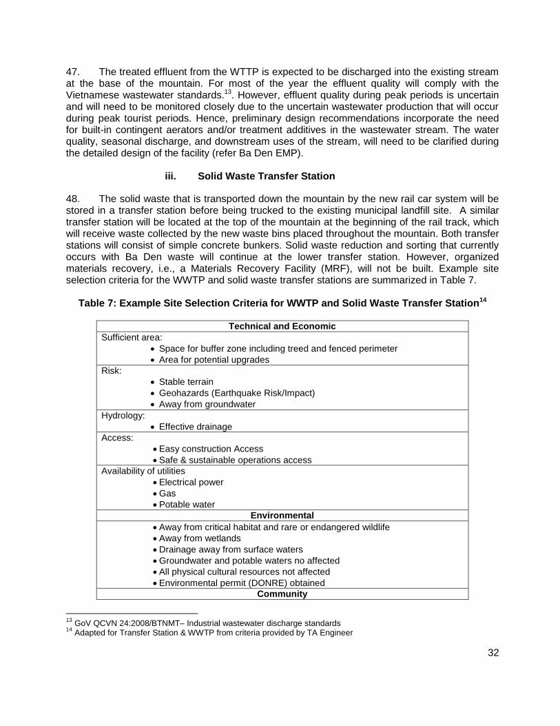
48. The solid waste that is transported down the mountain by the new rail car system will be stored in a transfer station before being trucked to the existing municipal landfill site. A similar transfer station will be located at the top of the mountain at the beginning of the rail track, which will receive waste collected by the new waste bins placed throughout the mountain. Both transfer stations will consist of simple concrete bunkers. Solid waste reduction and sorting that currently occurs with Ba Den waste will continue at the lower transfer station. However, organized materials recovery, i.e., a Materials Recovery Facility (MRF), will not be built. Example site selection criteria for the WWTP and solid waste transfer stations are summarized in Table 7.
Table 7: Example Site Selection Criteria for WWTP and Solid Waste Transfer Station14
Technical and Economic
Sufficient area:
Space for buffer zone including treed and fenced perimeter
Area for potential upgrades
Risk:
Stable terrain
Geohazards (Earthquake Risk/Impact)
Away from groundwater
Hydrology:
Effective drainage
Access:
Easy construction Access
Safe & sustainable operations access
Availability of utilities
Electrical power
Gas
Potable water
Environmental
Away from critical habitat and rare or endangered wildlife
Away from wetlands
Drainage away from surface waters
Groundwater and potable waters no affected
All physical cultural resources not affected
Environmental permit (DONRE) obtained
Community
13
GoV QCVN 24:2008/BTNMT– Industrial wastewater discharge standards 14
Adapted for Transfer Station & WWTP from criteria provided by TA Engineer
33
Compatibility with Adjacent Land Use
Compatibility with host neighborhood
Land use zoning permitted
Zero to minimal displacement of housing and businesses
No air quality issues
No negative visual aesthetics or odor issues
Safe construction & operations vehicle movement and access
Public benefits beyond wastewater treatment & solid waste management
Opportunities for local employment
D. Lao Cai Province
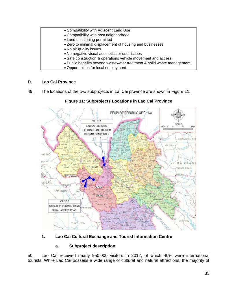
49. The locations of the two subprojects in Lai Cai province are shown in Figure 11.
Figure 11: Subprojects Locations in Lao Cai Province
1. Lao Cai Cultural Exchange and Tourist Information Centre
a. Subproject description
50. Lao Cai received nearly 950,000 visitors in 2012, of which 40% were international tourists. While Lao Cai possess a wide range of cultural and natural attractions, the majority of

34
tourism activity is centered on Sa Pa and Bac Ha districts due to limited market awareness about other provincial destinations and a lack of conveniently accessible transportation and tour services for independent travelers. To address these constraints, the subproject will construct a tourism services center providing space for information displays, tourist transportation and tour services, and local vendors (Table 8). Figure 12 shows the plan view of new center.
Table 8: Lao Cai Cultural Exchange and Tourism Information Center
Activity General Specifications
Construct cultural exchange and tourism information center
3,000 m2
including exhibition and cultural performance areas
high quality audio-visual equipment
supporting infrastructure and utilities
3,200 m2 parking area
well-lit public open spaces with vendor kiosks (food, beverages, handicrafts, souvenirs)
information kiosk installed at railway station
Figure 12: Plan View, Lao Cai Cultural Exchange and Tourism Information Center
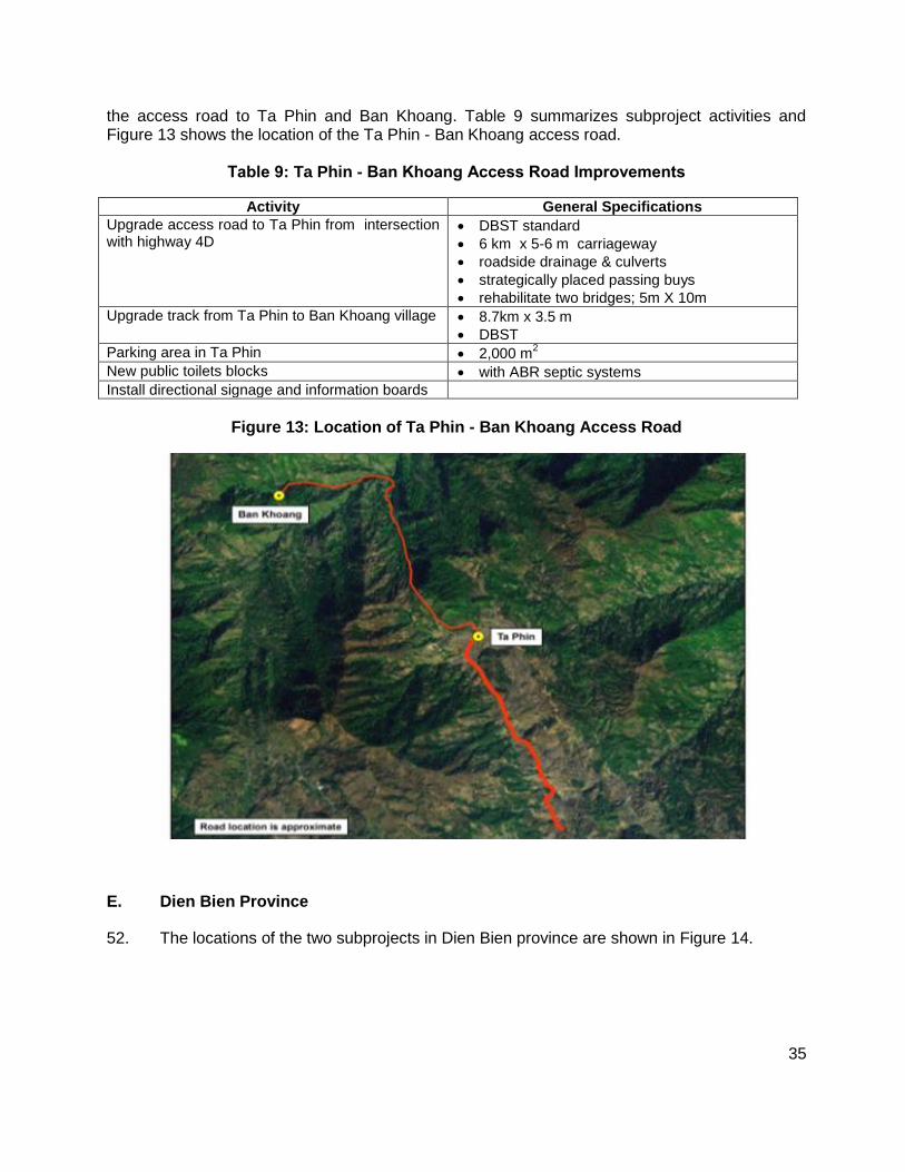
2. Ta Phin - Ban Khoang Access Road Improvement
a. Subproject description
51. The predominantly ethnic Dao and Hmong settlements of Ta Phin and Ban Khoang in Lao Cai Province possess interesting attractions such as an old monastery, caves, and rich cultural traditions. However, despite these assets the communities received only 7,500 visitors in 2012 due to poor access. In comparison, tourist arrivals in the nearby town of Sapa were 610,000 in 2012. To help spread the benefits of tourism more widely, the subproject will upgrade
35
the access road to Ta Phin and Ban Khoang. Table 9 summarizes subproject activities and Figure 13 shows the location of the Ta Phin - Ban Khoang access road.
Table 9: Ta Phin - Ban Khoang Access Road Improvements
Activity General Specifications
Upgrade access road to Ta Phin from intersection with highway 4D
DBST standard
6 km x 5-6 m carriageway
roadside drainage & culverts
strategically placed passing buys
rehabilitate two bridges; 5m X 10m
Upgrade track from Ta Phin to Ban Khoang village 8.7km x 3.5 m
DBST
Parking area in Ta Phin 2,000 m2
New public toilets blocks with ABR septic systems
Install directional signage and information boards
Figure 13: Location of Ta Phin - Ban Khoang Access Road
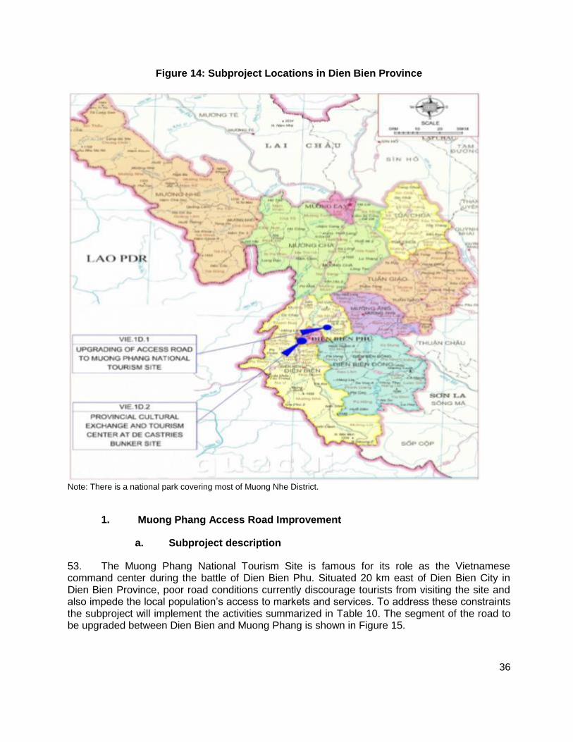
E. Dien Bien Province
52. The locations of the two subprojects in Dien Bien province are shown in Figure 14.
36
Figure 14: Subproject Locations in Dien Bien Province
Note: There is a national park covering most of Muong Nhe District.
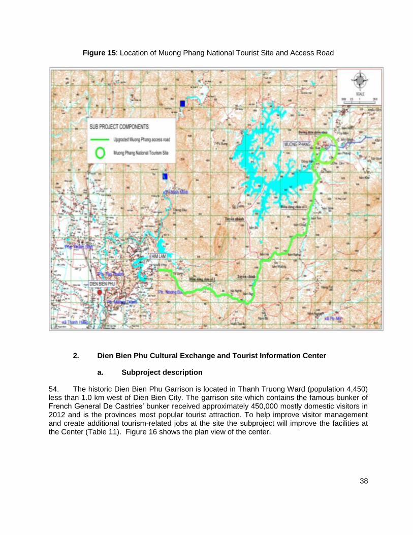
1. Muong Phang Access Road Improvement
a. Subproject description
53. The Muong Phang National Tourism Site is famous for its role as the Vietnamese command center during the battle of Dien Bien Phu. Situated 20 km east of Dien Bien City in Dien Bien Province, poor road conditions currently discourage tourists from visiting the site and also impede the local population’s access to markets and services. To address these constraints the subproject will implement the activities summarized in Table 10. The segment of the road to be upgraded between Dien Bien and Muong Phang is shown in Figure 15.

37
Table 10: Access and Facilities Improvements at Muong Phang Tourist Site
Activity General Specifications
Upgrade the Him Lam–Muong Phang access road,
19km x 5.5 m carriageway
DBST surface
roadside drainage, culverts, and embankment stabilization
rehabilitate two small bridges
roadside lighting in villages and rest stops
Construct two rest stops
parking: 2 x 1,000 m2
viewing platforms
vendor kiosks
public toilets
Install roadside lighting in villages and at rest stops
Muong Phang Tourist Site
Enlarge parking area at reception Muong Phang reception center
additional 2,000 m2
Construct tourist rest pavilions
Construct small market with vendor kiosks
Install public toilets blocks for men and women, linked to ABR septic system
Install rubbish bins, and landscaped public space
Upgrade existing footpaths and lighting within Muong Phang historical site
Upgrade water supply to tourist reception area
Upgrade electricity supply to tourist reception area
Upgrade wastewater management systems at tourist reception area
with ABR septic system
Upgrade solid waste management systems at tourist reception area
linked to existing city-wide service
Install directional and information signage
38
Figure 15: Location of Muong Phang National Tourist Site and Access Road
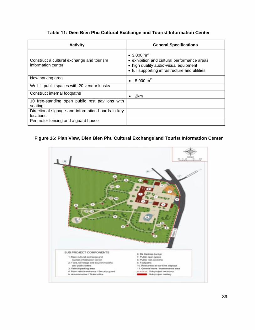
2. Dien Bien Phu Cultural Exchange and Tourist Information Center
a. Subproject description
54. The historic Dien Bien Phu Garrison is located in Thanh Truong Ward (population 4,450) less than 1.0 km west of Dien Bien City. The garrison site which contains the famous bunker of French General De Castries’ bunker received approximately 450,000 mostly domestic visitors in 2012 and is the provinces most popular tourist attraction. To help improve visitor management and create additional tourism-related jobs at the site the subproject will improve the facilities at the Center (Table 11). Figure 16 shows the plan view of the center.
39
Table 11: Dien Bien Phu Cultural Exchange and Tourist Information Center
Activity General Specifications
Construct a cultural exchange and tourism information center
3,000 m2
exhibition and cultural performance areas
high quality audio-visual equipment
full supporting infrastructure and utilities
New parking area 5,000 m
2
Well-lit public spaces with 20 vendor kiosks
Construct internal footpaths 2km
10 free-standing open public rest pavilions with seating
Directional signage and information boards in key locations
Perimeter fencing and a guard house
Figure 16: Plan View, Dien Bien Phu Cultural Exchange and Tourist Information Center
40
IV. DESCRIPTION OF AFFECTED ENVIRONMENTS
55. Given the IEE covers multiple infrastructure and environmental improvement activities for each of the nine subprojects across the five provinces, the description of the affected environments provided herein focuses primarily on site-specific environmental features that could possibly be affected by the subprojects, or the environmental features that could possibly influence the successful implementation and operation of the completed subprojects. Additional environmental baseline information for the subprojects is provided where required for assessment context. 56. The environmental baseline information was obtained primarily from provincial State of the Environment Reports prepared by the provincial DONREs and supplemented from the literature where available. The description of affected environments focuses on natural features and land use. The potentially affected social, economic, and demographic features of the subprojects is provided in detail in the project’s Resettlement Plans and Indigenous Peoples Together, the data and information obtained for the affected environments of the nine subprojects was sufficient to obtain a good understanding of the potential environmental impacts of the different subprojects. A. Ha Tinh Province
57. Ha Tinh province is situated in the north-central coastal region at 17°53‘50-18°45‘40 north, 105°05‘50–106°30‘20 east with a total area of 6,026 km2. Ha Tinh is bordered by Nghe An province to the north, Quang Binh to the south, and the Lao PDR to the west. To the east Ha Tinh has 137 km of seacoast.15 58. The province has 12 sub-provincial administrative units including the city of Ha Tinh, Hong Linh Town, and districts of Huong Son, Duc Tho, Vu Quang, Nghi Xuan, Can Loc, Huong Khe, Thach Ha, Cam Xuyen, Ky Anh, Loc Ha (founded 2007). In 2010 the province recorded 262 communes, 12 towns and 15 wards.
1. Physical Resources
a. Climate
59. Ha Tinh experiences a tropical monsoon climate with characteristic heavy weather events of rain storms, flooding, and dry, hot southwest winds. The province is environmentally vulnerable due to recurring natural disasters and the long term threat of climate change. Between November and March, Ha Tinh experiences a colder season with temperature approaching the freezing point though rarely reaching below 8oC. By April the weather gradually
warms up to June and July with the most extreme temperatures reaching over 40℃. Average annual temperature is varied, averaging 23.5–24.5℃ in the plains and 14–15℃ in the mountains. The sunny season only lasts from April to September with an average of 1,350 to 1,700 sunny hours per year. Average wind speed in the province is 1.5–2.5 m/s. The rainy season extends from September to December producing an average of 2,300 to 3,000 mm of rainfall.
15
Ha Tinh, 2012. SEDP to 2050.
41
b. Topography
60. The natural area of Ha Tinh can be divided into 4 zones based on topographical
conditions, geomorphology, soil characteristics, climate, rivers and streams, divided into the Plains, Midlands, and Mountainous. The total coastal area is about 41,000 ha extending from Nghi Xuan district to Ky Anh district, with mostly acidic and salty soils. 61. The Plains delta area of about 55.000 ha, includes the districts along Highway 1A from Hong Linh town to Ky Anh and part of Duc Tho town. The Plains have the typical characteristics of Vietnam‘s north central plains, which slope gradually from west to east, are narrow, and more fertile soils than other regions, well suited to rice cultivation. 62. The Midlands comprises about 30,000 ha set at an average elevation of 10m to 50m above sea level. These foothills have areas of land, suitable for rice production and are also suitable for fruit trees, industrial crops, and for development of cattle farming.
63. The Mountainous region has the largest area of approximately 475,000 ha which is concentrated in the districts of Huong Son, Huong Khe, Vu Quang district and the west of Ky Anh. This area has mountainous terrain, forests, streams, and slopes. Vegetation is mostly natural forest and replanted forest. Special conservation areas of Vu Quang National Park and Ke Go have a high percentage of forest cover and many rare fauna and flora.
c. Soils and Land Use 64. The majority of the province is characterized by nutrient poor soil. Ha Tinh‘s land is predominantly used for forestry and agriculture. The larger districts in Ha Tinh such as Huong Khe, Huong Son, Ky Anh, Vu Quang and Cam Xuyen primarily utilize their land for forestry purposes (between 54% and 77% in 2007–2010) whereas the remaining smaller districts use land for agriculture (between 34% and 51% in 2007–2010) and industry. Of the 121,374 ha of land used for agricultural purposes, 53.6% is used to grow paddy with the rest devoted to a mix of food, industrial and fruit crops.16 65. Ha Tinh’s 66.8% of mountainous land requires irrigation infrastructure to enable further development. Moreover, Ha Tinh‘s mountainous soil is relatively thin and has a high share of yellow ferralitic soil with high acidity. This negatively affects cultivation potential in the province and limits the variety of agricultural purposes that it can be used for. Land in coastal areas is a mix of salt rich and sandy soils. As a result, approximately two thirds of Ha Tinh‘s soil is classified as fair or poor quality, and a fifth of all land is unsuitable for cultivation.
d. Water Resources
i. Rivers
66. Ha Tinh has numerous river basins providing the province with an estimated 11–13 billion m3 of annual surface water. The 13 main rivers of the province extend an estimated 400 km to form four major river basins including the:
16
Ha Tinh DONRE. State of the Environment Report 2007–2010.
42
La River basin comprised of Ngan Sau and Ngan Pho rivers with a basin area of 3,221 km2 ;
Cua Sot basin comprised of Nghen Rao Cai rivers with a basin area of 1,349 km2;
Cau Khau basin comprised of Tri, Ken and Quen rivers with a basin area of 510 km2 ; and
Cua Nhuong basin comprised of Gia Hoi and Rac rivers with a basin area of 356 km2. 67. Ha Tinh‘s coastline is 137km in length, making it one of the longest in Vietnam, and extends outward to sea to cover 18,400 km2. It is suitable for making salt, fishing, and aquaculture. The sea is rich in marine life and many fishing vessels come here from other provinces, with the average annual catch in Ha Tinh at about 23,000 tons. Ha Tinh is therefore suitable for development of large scale aquaculture especially for shrimp and squid and has potential to develop deep sea fishing. Further, Ha Tinh also has two beaches (Thien Cam and Xuan Thanh) suitable for tourism.
ii. Lakes
68. The major lakes are Ke Go, Rac and Cua Tho Trai Tieu lakes. Aside from the existing 345 reservoirs with a total capacity of 762.6 million m3, the province continues to build new reservoirs and engage in multi-purpose irrigation projects.
e. Aquaculture
69. Ha Tinh has 5,178 ha under cultivation for freshwater aquaculture and 2,572 ha for marine aquaculture. The four river basins create brackish water areas and submerge nearly 6,000 ha of beach and land. Because of their salinity they are suitable for aquaculture development, such as shrimp, crab, fish, mollusc and seaweed farming.
2. Ecological Resources
a. Forests
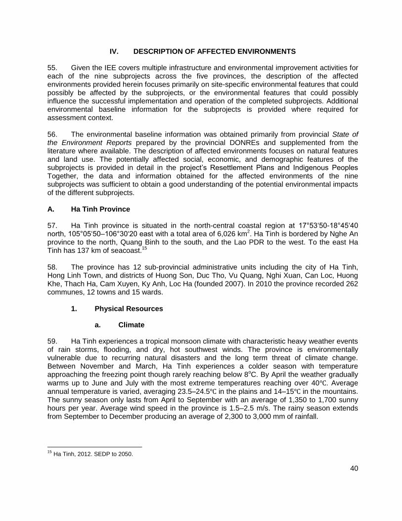
70. About 53% of Ha Tinh province is covered by forest including both natural and planted forests with 74% of all communes in the province containing forested areas. The 351,147 ha of forestry resources in Ha Tinh is divided into 12 types including mangroves (Figure 17). The range of forest management types are grouped into three main classifications of Special Use, Protected, and Production as defined in Section III .
i. Special use forests
71. Special use forests are concentrated in areas such as Vu Quang National Park and Ke Go Nature Reserve, and culturally important areas such as the Huong Tich pagoda. These forests house diverse protected flora and fauna as well as play a key role in environmental protection and flood management. With respect to the development of the two subprojects in Ha Tinh the protected forests will be avoided. There are approximately 265 species of timber species including the some endangered species. Approximately 69 species of plants exist.
43
Figure 17: Forest Types in Ha Tinh Province
ii. Protected forests
72. The primary role of these forests is for maintaining surface water resources, erosion and slope protection, and flood management.
iii. Productive forests
73. The tree plantation including the resin harvesting activities17 along the access road to below the cable car at Huong Tich is an example of production forest. Other products of
17
Management Board of Huong Tich Pagoda, 2013
44
production forests include rattan and bamboo of many types. Oil, resin, and latex are also extracted.
b. Biodiversity and protected areas
74. Ha Tinh supports one of the richest biodiversity areas in Viet Nam.18 The areas of particular ecological value are the Ke Go Nature Reserve and Vu Quang National Park (Figure 3). These are the two most important biodiversity conservation areas of Ha Tinh with a rich diversity of flora and fauna. These protected areas support an array of animal and plant species some of which are rare or endangered. Examples of notable endemic animals are tiger, elephant, bear, spotted deer, and white-tailed pheasant.
75. Vu Quang NPA supports an estimated 307 plant species of which 10 are rare.19 Ke Go Nature Reserve is dominated with coniferous trees of high economic value such as green Lim (Erythrophleum fordii), Sen (Madhuca pasquieri), and gold center (Manglietia fordiana). About 567 plant species and 364 animal species exist here.
76. Subproject areas are well north east of the Vo Quang NPA and Ke Go Nature Reserve. There are no known rare or endangered wildlife in the subproject areas of Nguyen Du and Huong Tich Pagoda.
c. Agriculture
i. Crops
77. Annual crops are primarily rice, ground nut, maize, sweet potato, cassava, and sesame. The major perennial crops are tea, and rubber. Fruit diversity and abundance is high with oranges, grapefruit, lemons, banana, litchi, and mango. Two specialty fruits are Phuc Trach pomelo and Cam Huong Son Bu. Ha Tinh has programs for the conservation of rare plant varieties through conservation, restoration, and development activities.
ii. Livestock
78. The potential for livestock development in Ha Tinh is large. Livestock rearing is focused on cattle, pigs, poultry, goats, deer, and buffalo. Currently there are 96,000 head of buffalo, 385,000 pigs, and an estimate 5,200,000 chickens. The number of deer is estimated at 26,000. Currently, the province is implementing a livestock development policy to increase the value of livestock production in agriculture.
iii. Fisheries
79. The 137 km coastline includes many estuaries and supports about 18,000 km2 of fishing grounds. The nearshore and offshore fisheries are supported by an estimated 267 fish species, including 20 species of shrimp, krill, shellfish and squid. Annual reserves of shrimp are estimated at 500-600 tons, and squid at 3,000-3,500 tons.
18
Ha Tinh DONRE, 2013. 19
IUCN Red List for Viet Nam
45
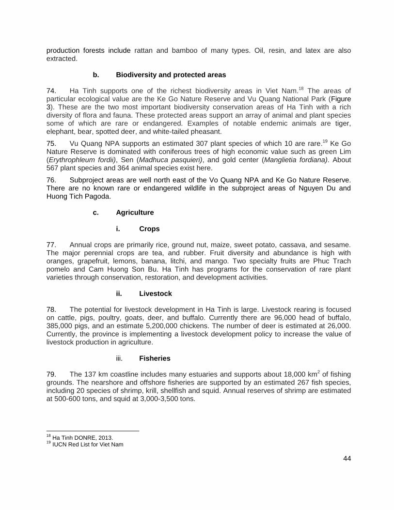
3. Site features of subprojects in Ha Tinh
a. Memorial Square at Nguyen Du Museum 80. The Nguyen Du Museum and adjacent site for the memorial square is located in a per-urban environment close to the marine coast (Figure 4). The memorial square is bounded by a highway to the west, a small dirt road and the museum to the north, and small dirt roads to the south and east. The local area supports houses and homestead agriculture/gardens, and small commercial enterprises. The site for the memorial square is currently a lowland area which is used by local landowners for agriculture (Figure 18). On the northern boundary of the site is an unstructured irrigation canal which returns irrigation water to the river located west of the highway. 81. Figure 18 shows photos of the site selected for the memorial square, directly south of the Nguyen Du Museum. Note the lowland area is used for agriculture with the unstructured irrigation canal forming the northern boundary. There are no rare or endangered wildlife species, or critical habitat on or near the site of the memorial square.
Figure 18: Site of Future Memorial Square adjacent to Nguyen Du Museum.
b. Huong Tich National Tourism Site
82. The Huong Tich National Tourism site is located in two types of forested areas away from any urban area (Figure 5). The 5 km access road and lower footpath to the base of the cable car to the pagoda are situated in a coniferous plantation forest, whereas the pagoda, cable car, and upper footpath are located in a designated protected forest for the pagoda and its environs.20 The access road does not cross any streams, whereas, the upper footpath to the pagoda crosses a stream that originates from the adjacent mountain. No drainage canals exist in the area. Figure 19 and 20 show example sections of the access road, a view of the lake beside the pagoda’s management board office, and the base of the cable car below the pagoda.
20
Management Board, Huong Tich National Tourist Site
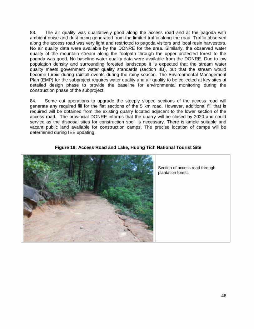
46
83. The air quality was qualitatively good along the access road and at the pagoda with ambient noise and dust being generated from the limited traffic along the road. Traffic observed along the access road was very light and restricted to pagoda visitors and local resin harvesters. No air quality data were available by the DONRE for the area. Similarly, the observed water quality of the mountain stream along the footpath through the upper protected forest to the pagoda was good. No baseline water quality data were available from the DONRE. Due to low population density and surrounding forested landscape it is expected that the stream water quality meets government water quality standards (section IIB), but that the stream would become turbid during rainfall events during the rainy season. The Environmental Management Plan (EMP) for the subproject requires water quality and air quality to be collected at key sites at detailed design phase to provide the baseline for environmental monitoring during the construction phase of the subproject. 84. Some cut operations to upgrade the steeply sloped sections of the access road will generate any required fill for the flat sections of the 5 km road. However, additional fill that is required will be obtained from the existing quarry located adjacent to the lower section of the access road. The provincial DONRE informs that the quarry will be closed by 2020 and could service as the disposal sites for construction spoil is necessary. There is ample suitable and vacant public land available for construction camps. The precise location of camps will be determined during IEE updating.
Figure 19: Access Road and Lake, Huong Tich National Tourist Site
Section of access road through plantation forest.

47
View of lake from pagoda, situated beside Huong Tich Management
Board office.
Figure 20 shows the access road and the site where the electric car park will be constructed. There are no known rare or endangered wildlife, or critical habitat in the plantation forest leading from the gate and lake at the management board office to the base of the cable car to the pagoda.21 The mixed coniferous plantation is used for resin/sap harvesting. Information on existing rare or endangered wildlife or critical habitat in the protected area of the pagoda was not available. Nonetheless, the proposed upgrades to the footpaths and tourist facilities at the site will not widen any impact footprints.
Figure 20: Access Road near Cable Car to Huong Tich Pagoda.
Lower cable car house at base of protected forest with the end of access road in foreground
21
Ha Tinh DONRE, 2013
48
View from lower cable car house down to location of electric car park, and end of access road
c. Groundwater quality
85. The quality of the groundwater currently being used for all domestic purposes at Huong Tich pagoda and tourist facilities is being assessed and will be recorded in the updated IEE to be prepared during the detailed design stage.
4. Other development in the subproject areas
86. The Nguyen Du Museum is located in a peri-urban environment just west of a coastal beach resort area. The light industry and residential areas surrounding the museum will continue to expand following no known regional plan for the area. The coastal beach area will continue to develop for tourism. B. Kien Giang Province
1. Climate
87. Being a delta province Kien Giang experiences a full natural tropical monsoon climate with the year divided into the two distinct seasons: rainy from May to November and dry from May to April. Average annual temperature is 27.4C. Average annual rainfall is 2,714.2 mm, with the rainy season accounting for 91% of the total. Total average evaporation is 1,298 mm with the highest levels occurring during the dry season. Mean relative humidity in the dry season is 78-81% while in rainy season it is 77-87 %. The highest humidity occurs in May. The province experiences a total of 2,358 sunny hours per year. During the rainy season the average number of sunny hours is 1,188 hours while 1,170 hours are logged in dry season. May and February bring the most and least hours of sunshine, respectively.
2. Topography
88. The terrain of Kien Giang is diverse consisting of a long coastline with many islands, mountains and rivers. Natural areas occupy approximately 634,613 ha which is spread across 573,075 ha of the mainland and 61,538 ha of islands. The land is relatively flat rising from the
49
northeast with an average height of 0.8 to 1.2 meters above sea level (masl). To the southwest average altitude is 0.2 to 0.4 masl. Kien Giang province is divided into the 4 topographic regions described below.
a. Long Xuyen Quadrangle
89. The Long Xuyen quadrangle is about 244,230 ha and includes Ha Tien town, Hon Dat-Kien Luong district, and part of Tan Hiep, Chau Thanh. The Long Xuyen quadrangle is bounded to the west and south by Cambodia and the Gulf of Thailand. The terrain slopes from northwest to southeast with a range of elevation of 0.2 to 1.2 masl. The west Rach Gia – Ha Tien corridor is the lowest area with an average elevation change from 0.2 to 0.7 masl. The coastal Rach Gia - Ha Tien reach consists of scattered low hills alongside National Highway 80.
b. The Hau River Region
90. The Hau region covers a natural area of about 144,900 ha including Giong Rieng, Quao, (a district of Tan Hiep) Chau Thanh and Rach Gia. The topography slopes gradually from northeast to southwest with an elevation change of between 0.2 to 0.8 masl. The highest point is east of Tan Hiep at approximately 0.7-0.9 masl whereas the lowest is between Cai Lon and Cai with an elevation of 0.2 to 0.4 masl.
c. U Minh Thuong
91. The natural area is about 181,829 ha, including An Bien district, An Minh, U Minh Thuong and Vinh Thuan. Gradually sloping terrain to the west with an elevation change from 0.1 to 1.1 masl, the highest point is near the center of U Minh Thuong National Park. This region is demarcated by the Cai Lon River and Ca Mau provinces.
d. Islands
92. The island natural areas consist of about 63,174 ha which include Kien Hai District, Phu Quoc Island, and some islands in Kien Luong district. The topography is mainly low hills. Average elevation is 15-200 masl, with the highest and lowest points being 600 masl and 20 masl.
3. Soils
93. The main types of soils in the subproject areas are briefly summarized below.
a. Alluvium
94. Alluvium soils cover about 70,198 ha mainly in the Hau River area. This soil is highly beneficial to agriculture and support cultivation of wheat, short-term industrial crops, and fruit trees. Soil fertility levels are high and balanced. The soil requires little or no chemical fertilizers for good plant growth.
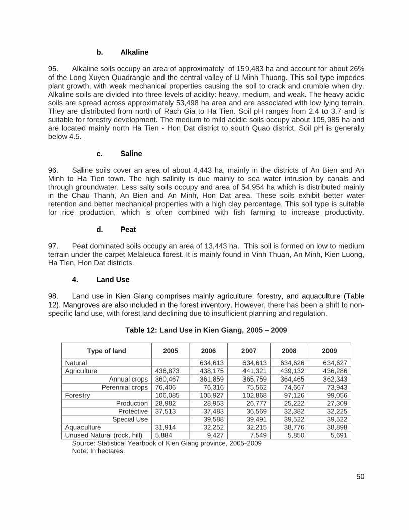
50
b. Alkaline
95. Alkaline soils occupy an area of approximately of 159,483 ha and account for about 26% of the Long Xuyen Quadrangle and the central valley of U Minh Thuong. This soil type impedes plant growth, with weak mechanical properties causing the soil to crack and crumble when dry. Alkaline soils are divided into three levels of acidity: heavy, medium, and weak. The heavy acidic soils are spread across approximately 53,498 ha area and are associated with low lying terrain. They are distributed from north of Rach Gia to Ha Tien. Soil pH ranges from 2.4 to 3.7 and is suitable for forestry development. The medium to mild acidic soils occupy about 105,985 ha and are located mainly north Ha Tien - Hon Dat district to south Quao district. Soil pH is generally below 4.5.
c. Saline
96. Saline soils cover an area of about 4,443 ha, mainly in the districts of An Bien and An Minh to Ha Tien town. The high salinity is due mainly to sea water intrusion by canals and through groundwater. Less salty soils occupy and area of 54,954 ha which is distributed mainly in the Chau Thanh, An Bien and An Minh, Hon Dat area. These soils exhibit better water retention and better mechanical properties with a high clay percentage. This soil type is suitable for rice production, which is often combined with fish farming to increase productivity.
d. Peat
97. Peat dominated soils occupy an area of 13,443 ha. This soil is formed on low to medium terrain under the carpet Melaleuca forest. It is mainly found in Vinh Thuan, An Minh, Kien Luong, Ha Tien, Hon Dat districts.
4. Land Use
98. Land use in Kien Giang comprises mainly agriculture, forestry, and aquaculture (Table 12). Mangroves are also included in the forest inventory. However, there has been a shift to non-specific land use, with forest land declining due to insufficient planning and regulation.
Table 12: Land Use in Kien Giang, 2005 – 2009
Type of land 2005 2006 2007 2008 2009
Natural 634,613 634,613 634,626 634,627
Agriculture 436,873 438,175 441,321 439,132 436,286
Annual crops 360,467 361,859 365,759 364,465 362,343
Perennial crops 76,406 76,316 75,562 74,667 73,943
Forestry 106,085 105,927 102,868 97,126 99,056
Production 28,982 28,953 26,777 25,222 27,309
Protective 37,513 37,483 36,569 32,382 32,225
Special Use 39,588 39,491 39,522 39,522
Aquaculture 31,914 32,252 32,215 38,776 38,898
Unused Natural (rock, hill) 5,884 9,427 7,549 5,850 5,691
Source: Statistical Yearbook of Kien Giang province, 2005-2009 Note: In hectares.

51
5. Surface Water Resources
99. Kien Giang has few major surface freshwater sources and suffers from freshwater constraints due to its proximity to the brackish Mekong Delta. Surface water is mainly derived from rainwater from the Hau river basin. Other major rivers include the Cai Lon, Cai, and Giang Thanh rivers. The Cai Lon river flows into the Hau River before it enters the Gulf of Rach Gia. The Thanh Giang river originates in Cambodia and flows into the Gulf of Thailand. In the rainy season the Grand River becomes an important waterway for the province, especially in the U Minh Thuong area. In addition to natural river systems, Kien Giang has a canal system. The system was developed to distribute freshwater and is located in the three ecological zones of Long Xuyen Triangle, West Hau river, and U Minh Thuong. However, as indicated above, despite the natural river systems and canals, fresh water in Kien Giang province is largely dependent on the Hau River basin and runoff from rainfall.
a. Surface Water Pollution
100. Rapid population growth in the province is putting significant pressure on the limited surface water resources. As water demand increases for large-scale uses such agriculture, industrial development and transportation, surface waters have become polluted. Human activity in urban areas generates major sources of pollution. Solid and domestic waste are dumped into rivers and canals untreated. Development along rivers and canals exacerbates the problem. Anaerobic decomposition of dumped organic compounds in urban areas seriously degrades water quality, creates bad odor, and increases the difficulty of treating water for safe human consumption.
6. Status of Biodiversity in Kien Giang
101. Kien Giang supports a rich diversity of wildlife which is situated at the terrestrial-freshwater-marine ecotones. The rich diversity of the province was recently recognized formally with the creation of a UNESCO Man and Biosphere Reserve, and now referred to as the Kien Giang Biosphere Reserve (KGBR). The KGBR is relevant to the project because the Phu Tu Environmental Improvements subproject is located in a core zone of the KGBR, while the Da Dung Cave Access Improvements subproject is located in the less sensitive transitional zone (Figure 21). The Kien Giang People Committee (PPC) chairs the management board of the KGBR which is comprised of different line departments including the DCST. The Director of the DCST has been assigned by the PPC to represent the KGBR in the development and implementation of the subprojects in Kien Giang province.
a. Kien Giang Biosphere Reserve
102. The KGBR is situated in the 5 districts of Phu Quoc, An Minh, Vinh Thuan, Kien Luong and Kien Hai, covering wetlands, coastal forests and islands. The elevation of the area ranges from 0.6 to 490 masl. The total area is 1,118,105 ha, of which 329,304 ha is mainland and 858,801 ha is in the sea. There are extensive studies and reports on the flora and fauna found in the KGBR. 103. KGBR is divided into 3 core and buffer management zones (Figure 21) defined by (i) Phu Quoc (304,933 ha) including Phu Quoc National Protected Area on northern Phu Quoc Island and adjacent forests in Ham Rong, Ganh Dau and Ham Ninh areas; (ii) U Minh Thuong
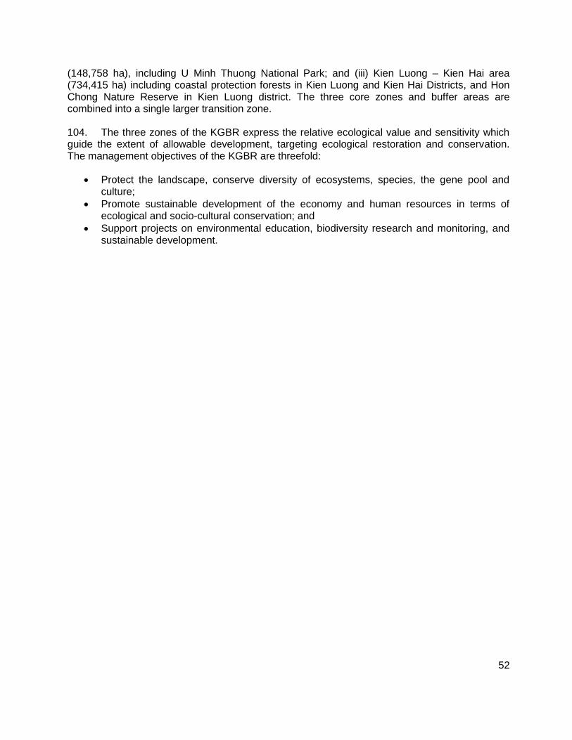
52
(148,758 ha), including U Minh Thuong National Park; and (iii) Kien Luong – Kien Hai area (734,415 ha) including coastal protection forests in Kien Luong and Kien Hai Districts, and Hon Chong Nature Reserve in Kien Luong district. The three core zones and buffer areas are combined into a single larger transition zone. 104. The three zones of the KGBR express the relative ecological value and sensitivity which guide the extent of allowable development, targeting ecological restoration and conservation. The management objectives of the KGBR are threefold:
Protect the landscape, conserve diversity of ecosystems, species, the gene pool and culture;
Promote sustainable development of the economy and human resources in terms of ecological and socio-cultural conservation; and
Support projects on environmental education, biodiversity research and monitoring, and sustainable development.
53
Figure 21: Subproject Locations in the Kien Giang Biosphere Reserve
Source: Technical Report on Biodiversity Survey of the KGBR, 2009.
b. Kien Luong–Kien Hai Districts & Hon Chong Nature Reserve
105. The key subproject area of the interest is Kien Luong and Kien Hai Districts including the Hon Chong Nature Reserve which forms a core zone of KGBR. Phu Tu Environmental Improvement subproject is located inside the Hon Chong Nature Reserve (Figure 22). This section presents an overview of the biodiversity of the area in which the Phu Tu Environmental Improvement and Da Dung Cave Access Improvement subprojects are located. Complete detailed documentation on the fauna and flora of the KGBR is reported elsewhere.22 106. About 30% of the Kien Luong–Kien Hai–Ha Tien area is comprised of hills and islands. The rest of the area is coastal protected forests and Melaleuca forests. This area not only contains high biodiversity but also plays important role in coastal protection and national security. Therefore, since 1992, the Department of Agriculture and Rural Development (DARD) of Kien Giang Province in collaboration with other organizations has conducted a number of surveys to inventory and establish protection forests and nature reserves.
22
KG-PPC 2012. UNESCO Man and Biosphere Reserve, Kien Giang.
Da Dung Cave Access Improvements
Phu Tu Environmental Improvements
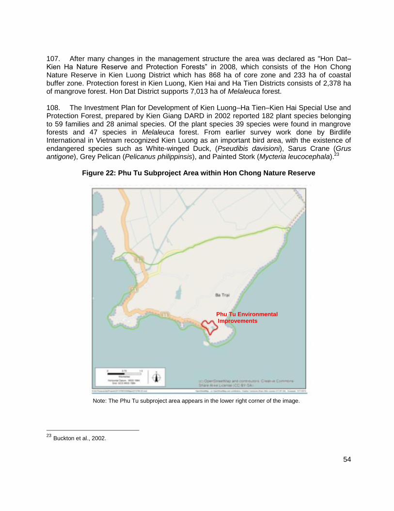
54
107. After many changes in the management structure the area was declared as "Hon Dat–Kien Ha Nature Reserve and Protection Forests” in 2008, which consists of the Hon Chong Nature Reserve in Kien Luong District which has 868 ha of core zone and 233 ha of coastal buffer zone. Protection forest in Kien Luong, Kien Hai and Ha Tien Districts consists of 2,378 ha of mangrove forest. Hon Dat District supports 7,013 ha of Melaleuca forest. 108. The Investment Plan for Development of Kien Luong–Ha Tien–Kien Hai Special Use and Protection Forest, prepared by Kien Giang DARD in 2002 reported 182 plant species belonging to 59 families and 28 animal species. Of the plant species 39 species were found in mangrove forests and 47 species in Melaleuca forest. From earlier survey work done by Birdlife International in Vietnam recognized Kien Luong as an important bird area, with the existence of endangered species such as White-winged Duck, (Pseudibis davisioni), Sarus Crane (Grus antigone), Grey Pelican (Pelicanus philippinsis), and Painted Stork (Mycteria leucocephala).23
Figure 22: Phu Tu Subproject Area within Hon Chong Nature Reserve
Note: The Phu Tu subproject area appears in the lower right corner of the image.
23 Buckton et al., 2002.
Phu Tu Environmental Improvements
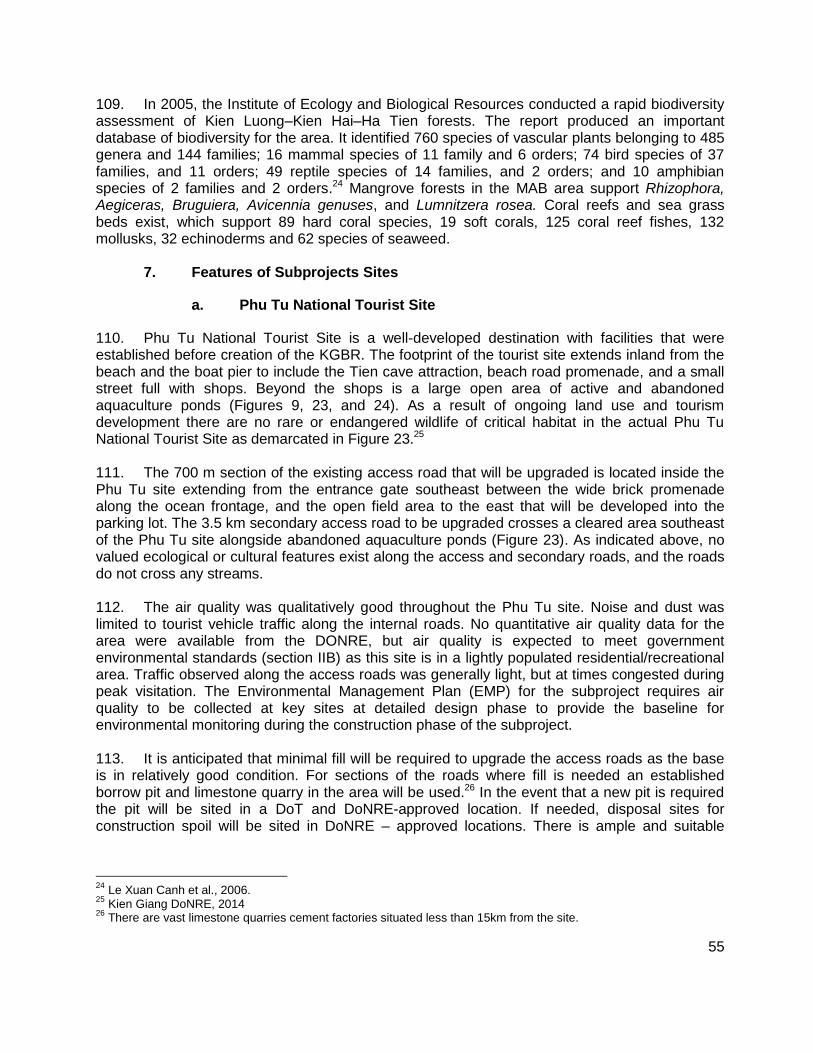
55
109. In 2005, the Institute of Ecology and Biological Resources conducted a rapid biodiversity assessment of Kien Luong–Kien Hai–Ha Tien forests. The report produced an important database of biodiversity for the area. It identified 760 species of vascular plants belonging to 485 genera and 144 families; 16 mammal species of 11 family and 6 orders; 74 bird species of 37 families, and 11 orders; 49 reptile species of 14 families, and 2 orders; and 10 amphibian species of 2 families and 2 orders.24 Mangrove forests in the MAB area support Rhizophora, Aegiceras, Bruguiera, Avicennia genuses, and Lumnitzera rosea. Coral reefs and sea grass beds exist, which support 89 hard coral species, 19 soft corals, 125 coral reef fishes, 132 mollusks, 32 echinoderms and 62 species of seaweed.
7. Features of Subprojects Sites
a. Phu Tu National Tourist Site
110. Phu Tu National Tourist Site is a well-developed destination with facilities that were established before creation of the KGBR. The footprint of the tourist site extends inland from the beach and the boat pier to include the Tien cave attraction, beach road promenade, and a small street full with shops. Beyond the shops is a large open area of active and abandoned aquaculture ponds (Figures 9, 23, and 24). As a result of ongoing land use and tourism development there are no rare or endangered wildlife of critical habitat in the actual Phu Tu National Tourist Site as demarcated in Figure 23.25 111. The 700 m section of the existing access road that will be upgraded is located inside the Phu Tu site extending from the entrance gate southeast between the wide brick promenade along the ocean frontage, and the open field area to the east that will be developed into the parking lot. The 3.5 km secondary access road to be upgraded crosses a cleared area southeast of the Phu Tu site alongside abandoned aquaculture ponds (Figure 23). As indicated above, no valued ecological or cultural features exist along the access and secondary roads, and the roads do not cross any streams. 112. The air quality was qualitatively good throughout the Phu Tu site. Noise and dust was limited to tourist vehicle traffic along the internal roads. No quantitative air quality data for the area were available from the DONRE, but air quality is expected to meet government environmental standards (section IIB) as this site is in a lightly populated residential/recreational area. Traffic observed along the access roads was generally light, but at times congested during peak visitation. The Environmental Management Plan (EMP) for the subproject requires air quality to be collected at key sites at detailed design phase to provide the baseline for environmental monitoring during the construction phase of the subproject. 113. It is anticipated that minimal fill will be required to upgrade the access roads as the base is in relatively good condition. For sections of the roads where fill is needed an established borrow pit and limestone quarry in the area will be used.26 In the event that a new pit is required the pit will be sited in a DoT and DoNRE-approved location. If needed, disposal sites for construction spoil will be sited in DoNRE – approved locations. There is ample and suitable
24
Le Xuan Canh et al., 2006. 25
Kien Giang DoNRE, 2014 26
There are vast limestone quarries cement factories situated less than 15km from the site.
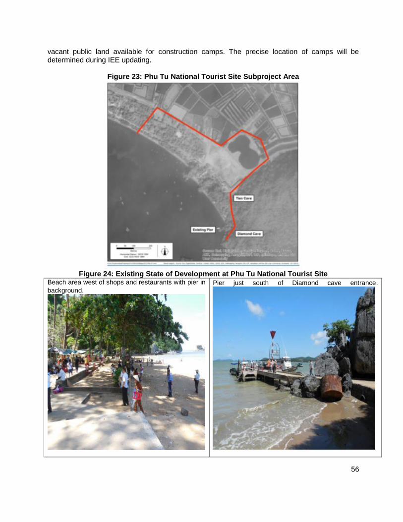
56
vacant public land available for construction camps. The precise location of camps will be determined during IEE updating.
Figure 23: Phu Tu National Tourist Site Subproject Area
Figure 24: Existing State of Development at Phu Tu National Tourist Site
Beach area west of shops and restaurants with pier in
background.
Pier just south of Diamond cave entrance.
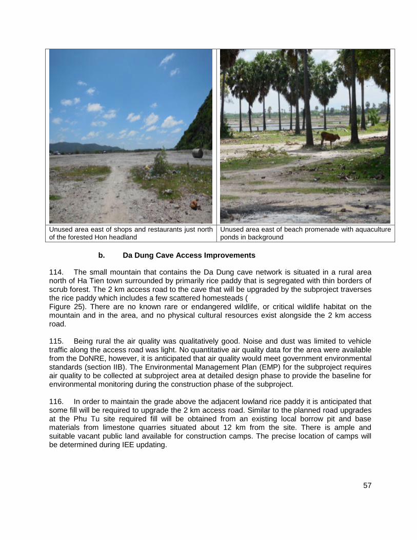
57
Unused area east of shops and restaurants just north of the forested Hon headland
Unused area east of beach promenade with aquaculture ponds in background
b. Da Dung Cave Access Improvements
114. The small mountain that contains the Da Dung cave network is situated in a rural area north of Ha Tien town surrounded by primarily rice paddy that is segregated with thin borders of scrub forest. The 2 km access road to the cave that will be upgraded by the subproject traverses the rice paddy which includes a few scattered homesteads ( Figure 25). There are no known rare or endangered wildlife, or critical wildlife habitat on the mountain and in the area, and no physical cultural resources exist alongside the 2 km access road. 115. Being rural the air quality was qualitatively good. Noise and dust was limited to vehicle traffic along the access road was light. No quantitative air quality data for the area were available from the DoNRE, however, it is anticipated that air quality would meet government environmental standards (section IIB). The Environmental Management Plan (EMP) for the subproject requires air quality to be collected at subproject area at detailed design phase to provide the baseline for environmental monitoring during the construction phase of the subproject. 116. In order to maintain the grade above the adjacent lowland rice paddy it is anticipated that some fill will be required to upgrade the 2 km access road. Similar to the planned road upgrades at the Phu Tu site required fill will be obtained from an existing local borrow pit and base materials from limestone quarries situated about 12 km from the site. There is ample and suitable vacant public land available for construction camps. The precise location of camps will be determined during IEE updating.

58
Figure 25: Da Dung Cave Entrance and Surrounding Environs
8. Other Development in Subproject Areas
117. Tourism development at the Phu Tu Tourist site is ongoing; however, no known industrial or urban-based development is planned, or is probable in the KGBR. The area around Da Dung cave tourist destination is rural. No known urban or industrial development is planned. The area is expected to experience ongoing development of tourism as it is located very close to an active international border checkpoint between Viet Nam and Cambodia.
59
C. Tay Ninh Province
118. Tay Ninh is a southeastern province that borders Cambodia in the west and northwest, the provinces of Binh Phuoc and Binh Duong in the east, and Ho Chi Minh City and Long An province in the south. The province has 9 administrative units including 1 town, 8 districts, and 95 communes.
1. Climate
119. Tay Ninh has a tropical monsoon climate (Table 13) that is dry, hot, and windy. The average annual air temperature is 26.5ºC. The rainy season extends from September to December which accounts for 75-80 percent of total annual rainfall. The prevailing wind directions are northeast during the dry season, and southwest during the rainy season.
Table 13: Climate Data, Tay Ninh Province
Indicators Annual Average
Temperature 26 - 27 oC
Sunny hours 2,700 - 2,800 hr
Rainfall 750 – 800 mm
Relative humidity 80-82 %
Evaporation 1,000 - 1,200 mm
Source: State of the Environment Report, Tay Ninh Province. 2010.
2. Air Quality and Noise
120. Data on air quality levels in Tay Ninh Province are not available. However, given rapid urban development in the towns and agricultural activity in windswept areas, it is assumed that dust levels in Tay Ninh exceed national standards for air quality. The only available data on noise levels in Tay Ninh are those in Moc Bai.
3. Topography and Soils
121. Tay Ninh is in the transition zone between the hills of the south central highlands and Mekong Delta. The ecotone is shaped by the continuum of moderate hills to the plains of the delta. Tay Ninh slopes gradually from the northeast to southwest which is classified into two specific areas. The northern hilly terrain with an average height ranging from 50 - 80 masl including the famous Ba Den Mountain just north of Tay Ninh town. Ba Den is the only mountain in the province at just under 1,000 m. Conversely, the southern terrain is characterized with elevations of about 3-5 m. 122. There are eight main soil types in Tay Ninh province. The soil groups are characterized as follows:
Grey soil of light mechanical composition and low humus content found in the Districts of Ben Cau, appropriate for short-term industrial trees;
60
Yellow red soil of light mechanical composition and is acidic about found in about 15,000 ha of land, appropriate to fruit trees, short-term industrial trees and livestock grass;
Yellow-red humus, found in Ninh Son District ,most of which is forest lands;
Gravelly eroded soil not appropriate for agriculture concentrated in areas with sloping terrain, low rainfall and low vegetation cover; and
Alluvial soil concentrated in river valleys making up only about 0.9 percent of the province.
4. Hydrology
123. Tay Ninh has two major rivers which are the Saigon River to the east and Vam Co Dong River to the west. The Vam Co Dong River which originates in southeast Cambodia flows through the districts of Tan Bien, Chau Thanh, Thanh Hoa, Ben Cau Dau, and Tra Bang in the northwest of the province. The river flows through 151 km of the province with a catchment area of 8,500 km2. The Saigon River is a tributary of the Dong Nai river system. The Saigon River flows approximately 256 km through the province and has a catchment of 5,560 km2. A dam is located on the Saigon River which has created the Dau Tieng irrigation reservoir with a capacity of 1.45 million m3 that is used to irrigate 175,000 ha. Dau Tieng reservoir is located just east of Ba Den Mountain.
a. Overview of Surface Water Pollution in Province
124. The three main sources of surface water pollution are untreated domestic waste, industrial effluents, and agriculture activities. The negative characteristics of domestic wastewater are the high content of organic matter, nutrients, solids and bacteria. Almost all domestic and industrial wastewater is discharged untreated directly into rivers and canals. Industrial wastewater originates from a diversity of sources, which produce wastewater that is high in organic compounds, heavy metals, sulfur, and bleach. Currently about 10,000 industrial facilities exist across numerous industrial parks. Major processing industries include processing of sugar cane, cassava, potato, rubber, and cashews. Agrochemicals from the farming industry are a major source of pollution. To increase crop yield, pesticides and fertilizers are used increasingly, which end up in surface waters. Additionally, the livestock rearing industry results in heavy organic loadings to surface waters. Tay Ninh DONRE maintains a network of monitoring stations in the province. However, no water or air quality monitoring stations exist near Ba Den Mountain (Figure 26).
5. Forests
125. The forests of Phuoc Vinh, Thanh Hoa, Ninh Dien, in Chau Thanh district, and Nhum Long Phuoc commune in Ben Cau district reportedly support significant biodiversity. However, these forests are managed for forest production and are under pressure for economic development. Recent surveys on Tay Ninh indicate forest resources support 694 plant species in 395 genera, including 158 species of medical valuable species.27 There are apparently 58 valuable and rare timber species in the province. The forests support 55 species of mushrooms in 40 different varieties. Endangered tree species include Cam lai (Dalbergia bariensis),
27
Tay Ninh DONRE, 2010.
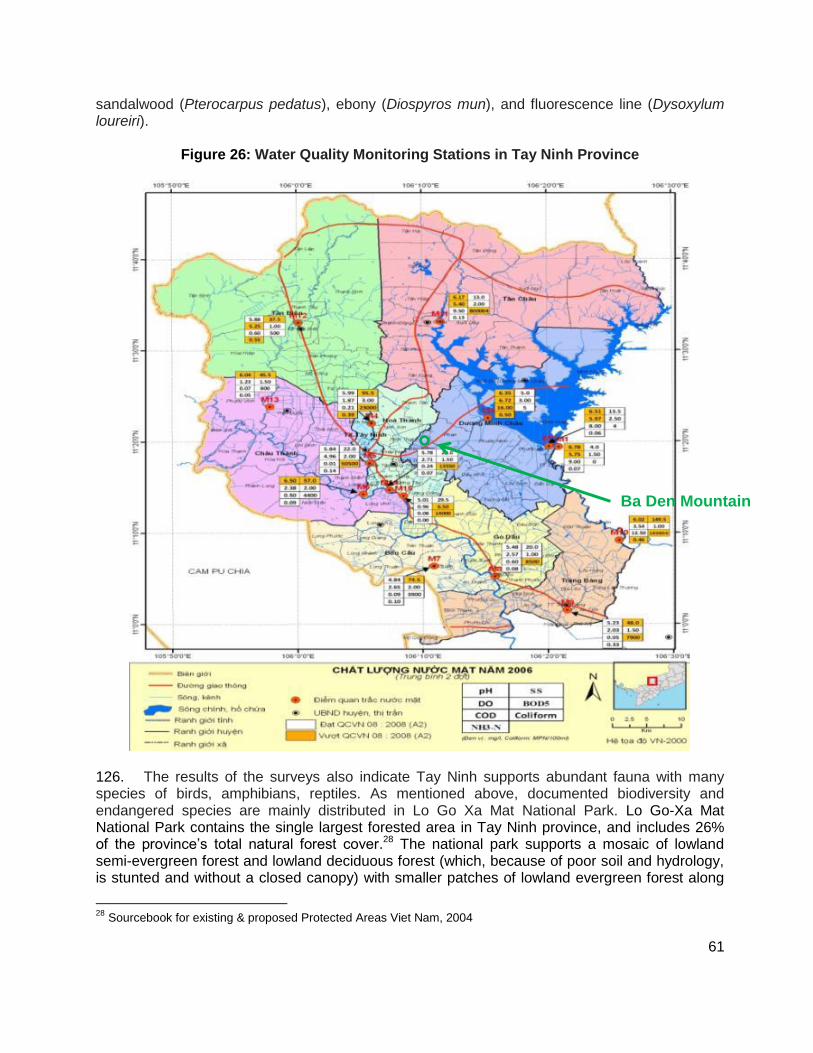
61
sandalwood (Pterocarpus pedatus), ebony (Diospyros mun), and fluorescence line (Dysoxylum loureiri).
Figure 26: Water Quality Monitoring Stations in Tay Ninh Province
126. The results of the surveys also indicate Tay Ninh supports abundant fauna with many species of birds, amphibians, reptiles. As mentioned above, documented biodiversity and endangered species are mainly distributed in Lo Go Xa Mat National Park. Lo Go-Xa Mat National Park contains the single largest forested area in Tay Ninh province, and includes 26% of the province’s total natural forest cover.28 The national park supports a mosaic of lowland semi-evergreen forest and lowland deciduous forest (which, because of poor soil and hydrology, is stunted and without a closed canopy) with smaller patches of lowland evergreen forest along
28
Sourcebook for existing & proposed Protected Areas Viet Nam, 2004
Ba Den Mountain

62
watercourses, and Melaleuca forest. Close to the international border with Cambodia, there are extensive patches of seasonally inundated grassland with large sedge beds.
6. Biodiversity
127. The documented biodiversity of the province is focused on Lo Go Mat Xa National Park which is located approximately 45 km northwest of Da Ben Mountain, and the catchment of the protection forests of Dau Tieng reservoir. The highest biodiversity recorded in the province is in these areas. 128. The dominant tree species at Lo Go-Xa Mat include Anisoptera costata, Dipterocarpus alatus, D. dyeri, Hopea odorata, Shorea roxburghii, Xylia xylocarpa, Afzelia xylocarpa, Sindora siamensis, Dialium cochinchinensis, Dalbergia sp., Pterocarpus macrocarpus, Lagerstroemia sp. and Shorea cochinchinensis. There are also some monospecific stands of deciduous dipterocarp species, such as Dipterocarpus costatus and D. intricatus. The forest at Lo Go-Xa Mat supports a number of globally threatened plant species, including Afzelia xylocarpa, Dipterocarpus alatus, Hopea odorata and Shorea roxburghii (Le Trong Trai and Tran Hieu Minh 2000). 129. A number of globally threatened or near-threatened primates have been recorded in Lo Go-Xa Mat: Pygmy Loris (Nycticebus pygmaeus), Northern Pig-tailed Macaque (Macaca leonine) and Long-tailed Macaque (M. fascicularis) have been confirmed to occur, while Silvered Leaf Monkey (Trachypithecus villosus) and Black-shanked Douc Langur (Pygathrix nigripes) have been reported by local people (Tordoff et al. 2002). The forested wetlands in the park support a number of large waterbird species, including Woolly-necked Stork (Ciconia episcopus), Lesser Adjutant (Leptoptilos javanicus) and Asian Openbill (Anastomus oscitans). The forest habitats at the site support the globally near-threatened Siamese Fireback (Lophura diardi), and two restricted-range species: Germain’s Peacock Pheasant (Polyplectron germaini) and Grey-faced Tit Babbler (Macronous kelleyi). In addition Lo Go-Xa Mat appears to be a stop-over area for Sarus Cranes (Grus antigone) migrating between the Mekong Delta of Vietnam and their breeding areas in Cambodia (Tordoff et al. 2002). Based upon its importance for globally threatened and restricted-range bird species, Lo Go-Xa Mat qualifies as an Important Bird Area.29
7. Features of Ba Den Mountain
130. Since 1997 Ba Den Mountain has been managed under the "Special Project of History of Mountain Forests, as approved by Decision No. 261/QD-UB. Management targets stability and development of forests, protection of forest ecosystems, and the preservation of cultural and natural landscapes. By 2006, Ba Den Mountain was managed under the "Forest Culture - History Nui Ba Den" area dictated by Decision No. 2268/QD-UBND/ 2010, with the objective of the conservation of forest biodiversity alongside harmonious development with human use and conservation of the mountain. This management objective formed the basis of ecotourism development on the mountain. 131. The forest of Ba Den Mountain is considered special use, in accordance with its status as Ba Den Ba Den Mountain Park and Pagoda Site. Contributing to the special area designation is the recently developed Nao Thien Lien Ecotourism Site located on the opposite side of the
29
Footnote 20.

63
mountain. While the forest of Ba Den Mountain is considered special, the Tay Ninh PPC, who manages the forest, is now attempting to utilize some areas for wood and fruit production. A forest protection management unit has been established. 132. Despite the existence of the nationally popular Ba Den Mountain Park, the presence of wildlife on the mountain is not well understood. The Tay Ninh DONRE does not have an inventory of the fauna and flora of the mountain, or information on the existence of rare or endangered species. However, subsequent email communications with Mr. Nguyen Dinh Xuan, who is the Director of the Management Board of Lo Go Mat Xa NPA suggested that there may be rare and endangered plants and animals on Ba Den Mountain, but they have not been researched well and are not documented. Interestingly, the species of monkey Macaca fascicularis, that greets visitors at the top of the mountain at the pagoda site is not rare, and in fact are living in-part off the food provided by tourists. There is a larger, rare monkey Macaca leonina that inhabits the mountain but which is rarely seen. Other rare animals that may inhabit the mountain include the wild cats, Viverricula indica and Hylopetes phayrei, and some species of birds and reptiles. The manager of Lo Go Mat Xa NPA feels Ba Den Mountain should be designated as a conservation area.
8. Groundwater Quality
133. The quality of the groundwater currently being used for all domestic purposes at Huong Tich pagoda and tourist facilities is being assessed and will be recorded in the updated IEE to be prepared during the detailed design stage.
9. Other Development in the Subproject Area
134. Ba Den Mountain is situated within a large agricultural area, which is expected to remain agriculturally based. On the mountain the only other development is the ecotourism facility on the north side of the mountain. The mountain is in special use forest so no industrial or urban is expected to occur.
Figure 27: Ba Den Mountain and Surrounding Environs
64
D. Lao Cao Province
1. Climate
134. Lao Cai province experiences the lowest temperatures of the country in the Sa Pa area, where it sometimes snows, with average annual temperature ranging from 14–16oC. In the low-lying districts along the Red river annual average temperatures are 22–24C. The lowest temperatures occur in December and January and the highest temperatures occur from June–August. 135. Annual rainfall is heavy with Lao Cai city experiencing an average of 1,673 mm, while Sa Pa receives an average of 2,794 mm. The rainy season from April to October accounts for over 80% of the annual rainfall. Hail usually occurs in the months February – April.
2. Overview of Topography and Geomorphology
136. Lao Cai is a mountainous northern border province of Viet Nam with area of 6,384 km2. The province is bounded by the People’s Republic of China to the north, Yen Bai province to the south, Lai Chau province to the west, and Ha Giang province in the east.30 137. Mountainous terrain dominates the province with the Red River basin forming the major geographic divide. The highest point is Mount Fansipan in the Hoang Lien Son mountain range at an elevation of 3,143 m. The lowest elevation in the province is the Bao Thang at 80 m. Overall the terrain is complex and steep with high altitude stratifications prone to cliff erosion, and rock slides. The narrow strip of land along the Red River represents the lowland area which is susceptible to flooding.
3. Hydrology
138. The Red River and its tributaries are Lao Cai’s main river system, flowing 110 km from the northwest to southeast, providing water and fertile alluvial soil for agricultural production and daily life. As it flows though Lao Cai, the river drops in elevation by about 300m, with a tributary network density between 0.3 and 0.5 km/km2. Flood discharges can reach 4,830 m3/s compared to flows as low as 70 m3/s in the dry season. This dense system of rivers in steep terrain creates advantages for the development of medium and small hydropower. By 2020 it is estimated that up to 110 hydropower developments could occur with a total capacity about 100 megawatts.
4. Land and Soil Resources
139. The complex topography of the province produces a diverse array of land and soil types. Land groups are divided into many soil types, including alluvial soils along the Red river, different complexes of clay, marsh soils, black soils, barren soils, and humus, found mainly in Sa Pa district. Land is a critical component of the economy given the dominance of sloping terrain. The total land area of 638,389 is classified as follows: (i) agricultural land, 397,270 ha; (ii) non-agricultural land, 32,826 ha; and (iii) unused land, 208,292 ha.
30
Lao Cai DONRE 2010.
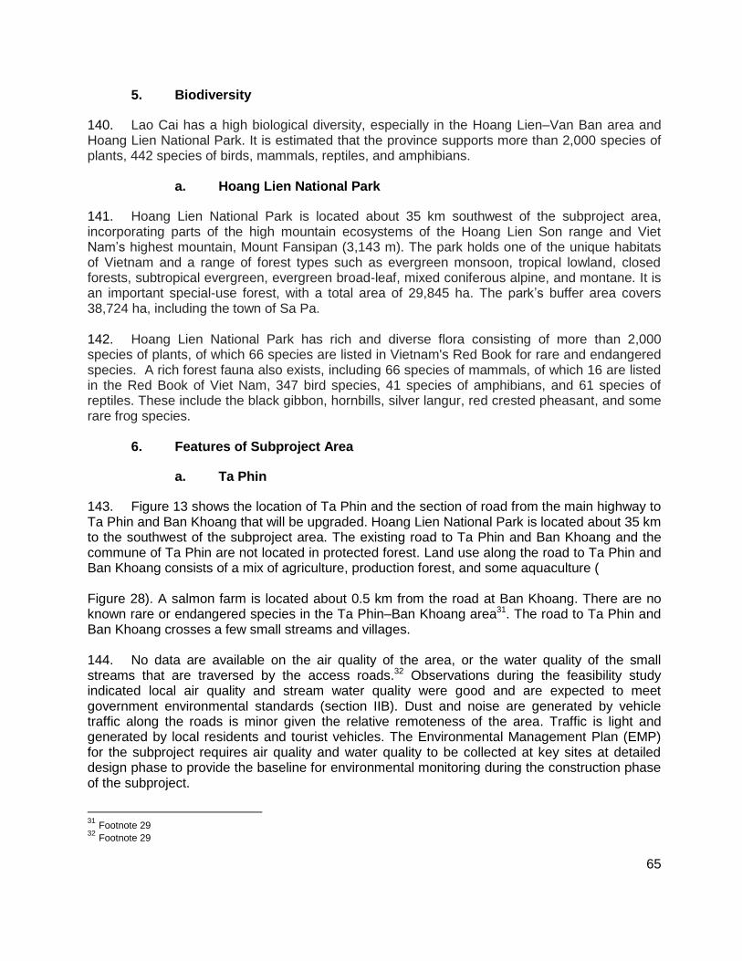
65
5. Biodiversity
140. Lao Cai has a high biological diversity, especially in the Hoang Lien–Van Ban area and Hoang Lien National Park. It is estimated that the province supports more than 2,000 species of plants, 442 species of birds, mammals, reptiles, and amphibians.
a. Hoang Lien National Park
141. Hoang Lien National Park is located about 35 km southwest of the subproject area, incorporating parts of the high mountain ecosystems of the Hoang Lien Son range and Viet Nam’s highest mountain, Mount Fansipan (3,143 m). The park holds one of the unique habitats of Vietnam and a range of forest types such as evergreen monsoon, tropical lowland, closed forests, subtropical evergreen, evergreen broad-leaf, mixed coniferous alpine, and montane. It is an important special-use forest, with a total area of 29,845 ha. The park’s buffer area covers 38,724 ha, including the town of Sa Pa. 142. Hoang Lien National Park has rich and diverse flora consisting of more than 2,000 species of plants, of which 66 species are listed in Vietnam's Red Book for rare and endangered species. A rich forest fauna also exists, including 66 species of mammals, of which 16 are listed in the Red Book of Viet Nam, 347 bird species, 41 species of amphibians, and 61 species of reptiles. These include the black gibbon, hornbills, silver langur, red crested pheasant, and some rare frog species.
6. Features of Subproject Area
a. Ta Phin
143. Figure 13 shows the location of Ta Phin and the section of road from the main highway to Ta Phin and Ban Khoang that will be upgraded. Hoang Lien National Park is located about 35 km to the southwest of the subproject area. The existing road to Ta Phin and Ban Khoang and the commune of Ta Phin are not located in protected forest. Land use along the road to Ta Phin and Ban Khoang consists of a mix of agriculture, production forest, and some aquaculture ( Figure 28). A salmon farm is located about 0.5 km from the road at Ban Khoang. There are no known rare or endangered species in the Ta Phin–Ban Khoang area31. The road to Ta Phin and Ban Khoang crosses a few small streams and villages. 144. No data are available on the air quality of the area, or the water quality of the small streams that are traversed by the access roads.32 Observations during the feasibility study indicated local air quality and stream water quality were good and are expected to meet government environmental standards (section IIB). Dust and noise are generated by vehicle traffic along the roads is minor given the relative remoteness of the area. Traffic is light and generated by local residents and tourist vehicles. The Environmental Management Plan (EMP) for the subproject requires air quality and water quality to be collected at key sites at detailed design phase to provide the baseline for environmental monitoring during the construction phase of the subproject.
31
Footnote 29 32
Footnote 29
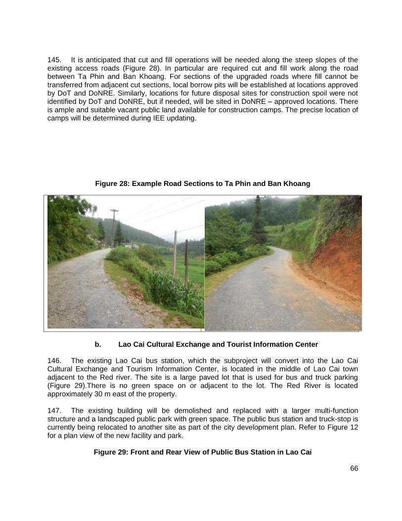
66
145. It is anticipated that cut and fill operations will be needed along the steep slopes of the existing access roads (Figure 28). In particular are required cut and fill work along the road between Ta Phin and Ban Khoang. For sections of the upgraded roads where fill cannot be transferred from adjacent cut sections, local borrow pits will be established at locations approved by DoT and DoNRE. Similarly, locations for future disposal sites for construction spoil were not identified by DoT and DoNRE, but if needed, will be sited in DoNRE – approved locations. There is ample and suitable vacant public land available for construction camps. The precise location of camps will be determined during IEE updating.
Figure 28: Example Road Sections to Ta Phin and Ban Khoang
b. Lao Cai Cultural Exchange and Tourist Information Center
146. The existing Lao Cai bus station, which the subproject will convert into the Lao Cai Cultural Exchange and Tourism Information Center, is located in the middle of Lao Cai town adjacent to the Red river. The site is a large paved lot that is used for bus and truck parking (Figure 29).There is no green space on or adjacent to the lot. The Red River is located approximately 30 m east of the property. 147. The existing building will be demolished and replaced with a larger multi-function structure and a landscaped public park with green space. The public bus station and truck-stop is currently being relocated to another site as part of the city development plan. Refer to Figure 12 for a plan view of the new facility and park.
Figure 29: Front and Rear View of Public Bus Station in Lao Cai
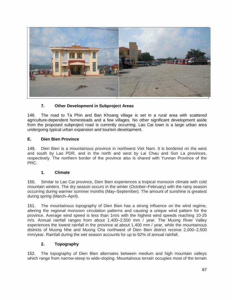
67
7. Other Development in Subproject Areas
148. The road to Ta Phin and Ban Khoang village is set in a rural area with scattered agriculture-dependent homesteads and a few villages. No other significant development aside from the proposed subproject road is currently occurring. Lao Cai town is a large urban area undergoing typical urban expansion and tourism development. E. Dien Bien Province
149. Dien Bien is a mountainous province in northwest Viet Nam. It is bordered on the west and south by Lao PDR, and in the north and west by Lai Chau and Son La provinces, respectively. The northern border of the province also is shared with Yunnan Province of the PRC.
1. Climate
150. Similar to Lao Cai province, Dien Bien experiences a tropical monsoon climate with cold mountain winters. The dry season occurs in the winter (October–February) with the rainy season occurring during warmer summer months (May–September). The amount of sunshine is greatest during spring (March–April). 151. The mountainous topography of Dien Bien has a strong influence on the wind regime, altering the regional monsoon circulation patterns and causing a unique wind pattern for the province. Average wind speed is less than 1m/s with the highest wind speeds reaching 10-25 m/s. Annual rainfall ranges from about 1,400–2,500 mm / year. The Muong River Valley experiences the lowest rainfall in the province at about 1,400 mm / year, while the mountainous districts of Muong Nhe and Muong Cha northwest of Dien Bien district receive 2,000–2,500 mm/year. Rainfall during the wet season accounts for up to 92% of annual rainfall.
2. Topography
152. The topography of Dien Bien alternates between medium and high mountain valleys which range from narrow-steep to wide-sloping. Mountainous terrain occupies most of the terrain
68
along a northwest-southeast axis. The distribution of mountains in the northwest forms the border between Viet Nam and Lao PDR. The mountains generally have an average height of 1,000 to 1,500 m. Karst limestone outcroppings also exist in the northern areas. In the northern region of Dien Bien district the mountains are eroded and steep, with slopes typically exceeding 25°. To the south of Dien Bien the mountains orient north-south with numerous peaks reaching 1,200m. The Dien Bien–Muong Thanh valley is wide and flat and about 500 masl.
3. Hydrology
153. The main rivers in Dien Bien are the Ma and Black. The rivers fall quickly and contain many rapids. Flows are unevenly distributed throughout the year with the rainy season accounting for about 60-80 % of the total volume. Total annual flow volume of Dien Bien’s river system is about 9,840 million m3 with the Black accounting for 56% and the Ma approximately 26%. The months of June through October account for about 75-80 % of the total annual flow. These rivers and their tributaries cut through steep terrain. Due to steep riverbanks there are frequent mudslides and flash floods in the basins.
4. Land Use 154. Land use in Dien Bien is stratified into three main types: (i) agricultural land; (ii) non-agricultural land; and (iii) unused land. Agricultural land in 2009 accounted for approximately 745,043 ha, apportioned to farmland, forestry, and aquaculture. Non-agricultural land defined by land for cemeteries and other cultural uses occupied approximately 22,033 ha. The large area of unused land comprises 189,214 ha of rock and steep mountain-faces that are mostly difficult to access.
a. Forest types
155. Three ecological forest types exist in the province, including (i) tropical monsoon; (ii) semi-tropical monsoon; and (iii) grasslands resulting from shifting cultivation and fire. The tropical monsoon forest is distributed in areas below 800 m on sloping areas of the mountain ranges. These forests are negatively affected by logging and shifting cultivation. Semi-tropical monsoon forests are distributed between elevations of 800 to 1,800 m and are found mostly in medium and high mountain areas. This forest type is largely intact and found on highly-sloped sides of the mountains in. 156. Grassland is found closest to residential areas where shifting cultivation is still the main agricultural practice. Many areas are now covered by tall grassland and bush, as they have been abandoned by local people, and are currently included within the Muong Nhe Nature Reserve boundaries. Areas close to the Lao border are mostly covered by grassland formed by annual forest fires.
5. Biodiversity
157. Biodiversity in Dien Bien is considered to be high due primarily to the mountainous terrain and low human population. The main focal area for biodiversity and rare and endangered species is the Muong Nhe Nature Reserve. The reserve is bounded by Muong Nhe district, found in the north-west of the province at the tri-border area of Vietnam, Lao PDR, and PRC (Figure 14). The reserve’s terrain is dominated by medium-high mountains and mostly covered by
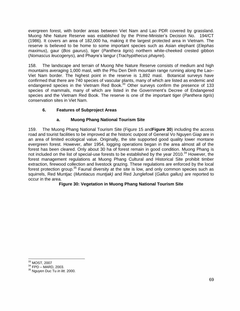
69
evergreen forest, with border areas between Viet Nam and Lao PDR covered by grassland. Muong Nhe Nature Reserve was established by the Prime-Minister’s Decision No. 194/CT (1986). It covers an area of 182,000 ha, making it the largest protected area in Vietnam. The reserve is believed to be home to some important species such as Asian elephant (Elephas maximus), gaur (Bos gaurus), tiger (Panthera tigris) northern white-cheeked crested gibbon (Nomascus leucogenys), and Phayre’s langur (Trachypithecus phayrei). 158. The landscape and terrain of Muong Nhe Nature Reserve consists of medium and high mountains averaging 1,000 masl, with the Phu Den Dinh mountain range running along the Lao–Viet Nam border. The highest point in the reserve is 1,892 masl. Botanical surveys have confirmed that there are 740 species of vascular plants, many of which are listed as endemic and endangered species in the Vietnam Red Book.33 Other surveys confirm the presence of 133 species of mammals, many of which are listed in the Government’s Decree of Endangered species and the Vietnam Red Book. The reserve is one of the important tiger (Panthera tigris) conservation sites in Viet Nam.
6. Features of Subproject Areas
a. Muong Phang National Tourism Site
159. The Muong Phang National Tourism Site (Figure 15 andFigure 30) including the access road and tourist facilities to be improved at the historic outpost of General Vo Nguyen Giap are in an area of limited ecological value. Originally, the site supported good quality lower montane evergreen forest. However, after 1954, logging operations began in the area almost all of the forest has been cleared. Only about 30 ha of forest remain in good condition. Muong Phang is not included on the list of special-use forests to be established by the year 2010.34 However, the forest management regulations at Muong Phang Cultural and Historical Site prohibit timber extraction, firewood collection and livestock grazing. These regulations are enforced by the local forest protection group.35 Faunal diversity at the site is low, and only common species such as squirrels, Red Muntjac (Muntiacus muntjak) and Red Junglefowl (Gallus gallus) are reported to occur in the area.
Figure 30: Vegetation in Muong Phang National Tourism Site
33
MOST, 2007 34
FPD – MARD, 2003. 35
Nguyen Duc Tu in litt. 2000.
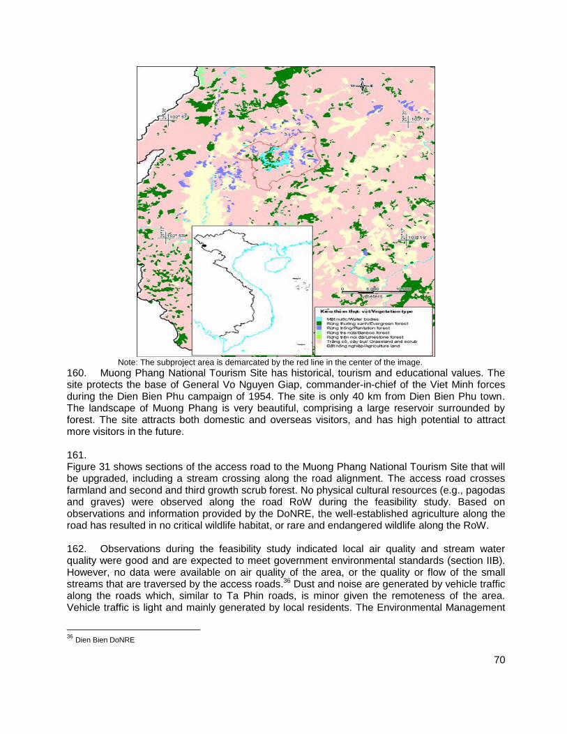
70
Note: The subproject area is demarcated by the red line in the center of the image.
160. Muong Phang National Tourism Site has historical, tourism and educational values. The site protects the base of General Vo Nguyen Giap, commander-in-chief of the Viet Minh forces during the Dien Bien Phu campaign of 1954. The site is only 40 km from Dien Bien Phu town. The landscape of Muong Phang is very beautiful, comprising a large reservoir surrounded by forest. The site attracts both domestic and overseas visitors, and has high potential to attract more visitors in the future. 161. Figure 31 shows sections of the access road to the Muong Phang National Tourism Site that will be upgraded, including a stream crossing along the road alignment. The access road crosses farmland and second and third growth scrub forest. No physical cultural resources (e.g., pagodas and graves) were observed along the road RoW during the feasibility study. Based on observations and information provided by the DoNRE, the well-established agriculture along the road has resulted in no critical wildlife habitat, or rare and endangered wildlife along the RoW. 162. Observations during the feasibility study indicated local air quality and stream water quality were good and are expected to meet government environmental standards (section IIB). However, no data were available on air quality of the area, or the quality or flow of the small streams that are traversed by the access roads.36 Dust and noise are generated by vehicle traffic along the roads which, similar to Ta Phin roads, is minor given the remoteness of the area. Vehicle traffic is light and mainly generated by local residents. The Environmental Management
36
Dien Bien DoNRE
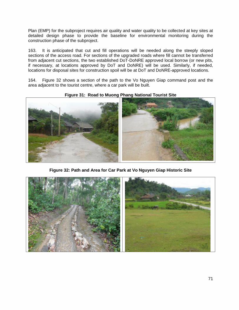
71
Plan (EMP) for the subproject requires air quality and water quality to be collected at key sites at detailed design phase to provide the baseline for environmental monitoring during the construction phase of the subproject. 163. It is anticipated that cut and fill operations will be needed along the steeply sloped sections of the access road. For sections of the upgraded roads where fill cannot be transferred from adjacent cut sections, the two established DoT-DoNRE approved local borrow (or new pits, if necessary, at locations approved by DoT and DoNRE) will be used. Similarly, if needed, locations for disposal sites for construction spoil will be at DoT and DoNRE-approved locations. 164. Figure 32 shows a section of the path to the Vo Nguyen Giap command post and the area adjacent to the tourist centre, where a car park will be built.
Figure 31: Road to Muong Phang National Tourist Site
Figure 32: Path and Area for Car Park at Vo Nguyen Giap Historic Site
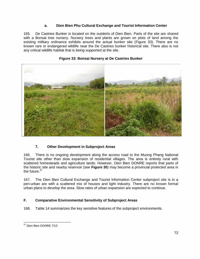
72
a. Dien Bien Phu Cultural Exchange and Tourist Information Center
165. De Castries Bunker is located on the outskirts of Dien Bien. Parts of the site are shared with a Bonsai tree nursery. Nursery trees and plants are grown on plots of land among the existing military ordinance exhibits around the actual bunker site (Figure 33). There are no known rare or endangered wildlife near the De Castries bunker historical site. There also is not any critical wildlife habitat that is being supported at the site.
Figure 33: Bonsai Nursery at De Castries Bunker
7. Other Development in Subproject Areas
166. There is no ongoing development along the access road to the Muong Phang National Tourist site other than slow expansion of residential villages. The area is entirely rural with scattered homesteads and agriculture lands. However, Dien Bien DONRE reports that parts of the historic site and nearby reservoir (see Figure 30) may become a provincial protected area in the future.37 167. The Dien Bien Cultural Exchange and Tourist Information Center subproject site is in a peri-urban are with a scattered mix of houses and light industry. There are no known formal urban plans to develop the area. Slow rates of urban expansion are expected to continue. F. Comparative Environmental Sensitivity of Subproject Areas
168. Table 14 summarizes the key sensitive features of the subproject environments.
37
Dien Bien DONRE 7/13
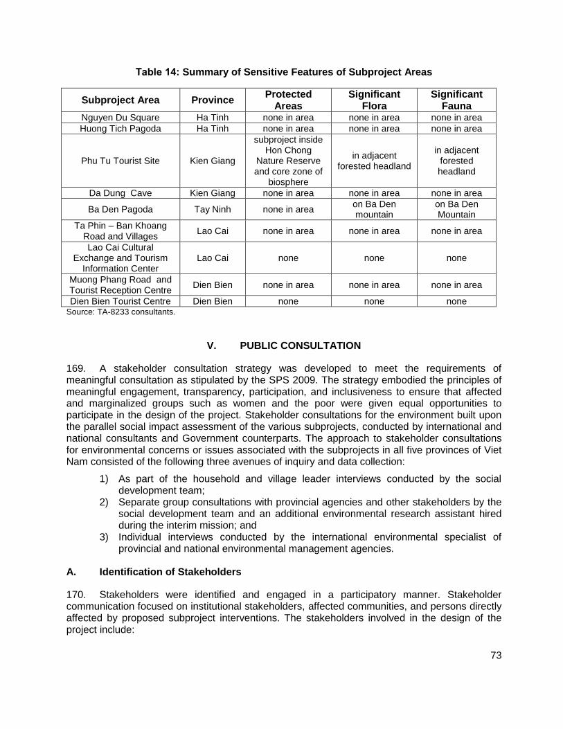
73
Table 14: Summary of Sensitive Features of Subproject Areas
Subproject Area Province Protected
Areas Significant
Flora Significant
Fauna Nguyen Du Square Ha Tinh none in area none in area none in area Huong Tich Pagoda Ha Tinh none in area none in area none in area
Phu Tu Tourist Site Kien Giang
subproject inside Hon Chong
Nature Reserve and core zone of
biosphere
in adjacent forested headland
in adjacent forested headland
Da Dung Cave Kien Giang none in area none in area none in area
Ba Den Pagoda Tay Ninh none in area on Ba Den mountain
on Ba Den Mountain
Ta Phin – Ban Khoang Road and Villages
Lao Cai none in area none in area none in area
Lao Cai Cultural Exchange and Tourism
Information Center Lao Cai none none none
Muong Phang Road and Tourist Reception Centre
Dien Bien none in area none in area none in area
Dien Bien Tourist Centre Dien Bien none none none Source: TA-8233 consultants.
V. PUBLIC CONSULTATION
169. A stakeholder consultation strategy was developed to meet the requirements of meaningful consultation as stipulated by the SPS 2009. The strategy embodied the principles of meaningful engagement, transparency, participation, and inclusiveness to ensure that affected and marginalized groups such as women and the poor were given equal opportunities to participate in the design of the project. Stakeholder consultations for the environment built upon the parallel social impact assessment of the various subprojects, conducted by international and national consultants and Government counterparts. The approach to stakeholder consultations for environmental concerns or issues associated with the subprojects in all five provinces of Viet Nam consisted of the following three avenues of inquiry and data collection:
1) As part of the household and village leader interviews conducted by the social development team;
2) Separate group consultations with provincial agencies and other stakeholders by the social development team and an additional environmental research assistant hired during the interim mission; and
3) Individual interviews conducted by the international environmental specialist of provincial and national environmental management agencies.
A. Identification of Stakeholders
170. Stakeholders were identified and engaged in a participatory manner. Stakeholder communication focused on institutional stakeholders, affected communities, and persons directly affected by proposed subproject interventions. The stakeholders involved in the design of the project include:
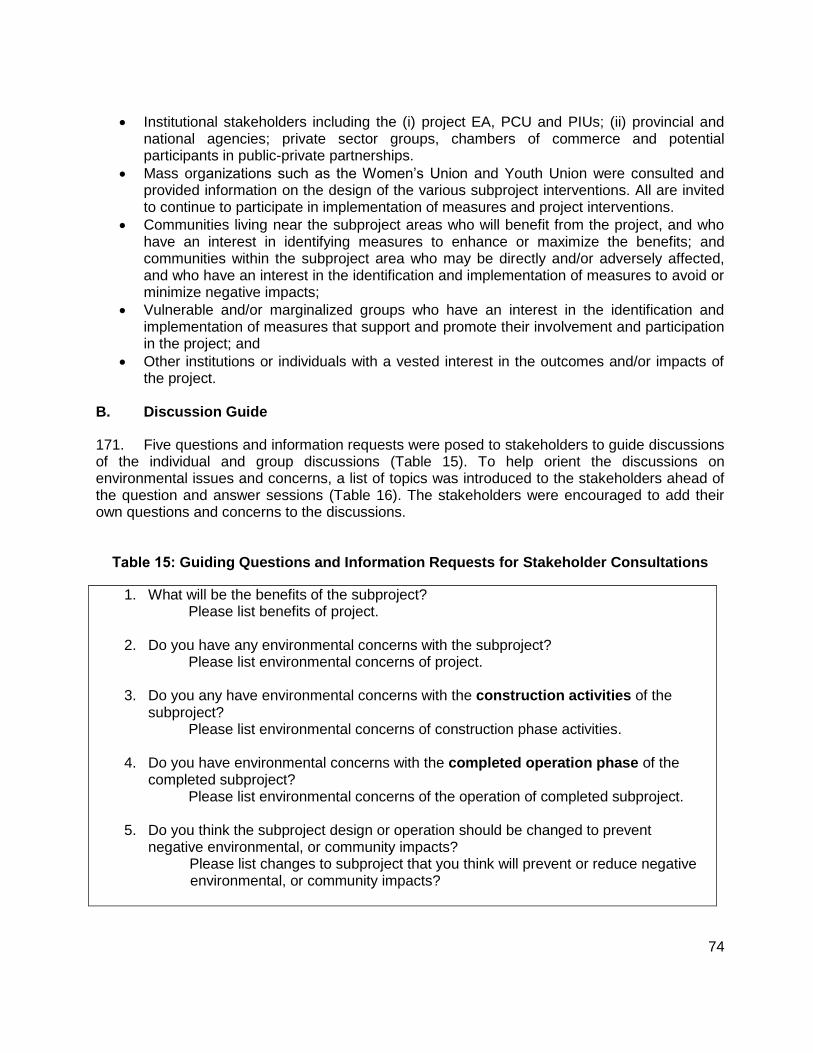
74
Institutional stakeholders including the (i) project EA, PCU and PIUs; (ii) provincial and national agencies; private sector groups, chambers of commerce and potential participants in public-private partnerships.
Mass organizations such as the Women’s Union and Youth Union were consulted and provided information on the design of the various subproject interventions. All are invited to continue to participate in implementation of measures and project interventions.
Communities living near the subproject areas who will benefit from the project, and who have an interest in identifying measures to enhance or maximize the benefits; and communities within the subproject area who may be directly and/or adversely affected, and who have an interest in the identification and implementation of measures to avoid or minimize negative impacts;
Vulnerable and/or marginalized groups who have an interest in the identification and implementation of measures that support and promote their involvement and participation in the project; and
Other institutions or individuals with a vested interest in the outcomes and/or impacts of the project.
B. Discussion Guide
171. Five questions and information requests were posed to stakeholders to guide discussions of the individual and group discussions (Table 15). To help orient the discussions on environmental issues and concerns, a list of topics was introduced to the stakeholders ahead of the question and answer sessions (Table 16). The stakeholders were encouraged to add their own questions and concerns to the discussions.
Table 15: Guiding Questions and Information Requests for Stakeholder Consultations
1. What will be the benefits of the subproject? Please list benefits of project.
2. Do you have any environmental concerns with the subproject? Please list environmental concerns of project.
3. Do you any have environmental concerns with the construction activities of the
subproject? Please list environmental concerns of construction phase activities.
4. Do you have environmental concerns with the completed operation phase of the completed subproject?
Please list environmental concerns of the operation of completed subproject.
5. Do you think the subproject design or operation should be changed to prevent negative environmental, or community impacts?
Please list changes to subproject that you think will prevent or reduce negative environmental, or community impacts?

75
Table 16: Example of Environmental Issues to Guide Stakeholder Discussions
drinking water quality & availability
surface water quality and quantity
groundwater quality & quantity
air quality
climate
land and soil quality
coastal zone, ocean, rivers, reservoirs,
mangroves, trees, other vegetation,
coastal and terrestrial resources e.g., sea grass beds, mangroves, forests, salt beds
terrestrial & aquatic animals, e.g., fish, birds, small mammals
ecological protected areas (e.g., national parks, wildlife sanctuaries),
land & coastal zone uses (e.g., agriculture, fisheries, forestry, navigation, aquaculture, commercial, other),
public safety,
public movement & access
physical cultural values (e.g., pagodas, cemeteries, monuments)
C. Summary of Public Consultation
172. The public and stakeholder consultations for environmental issues associated with the subprojects in the five provinces were held with the parallel social surveys and social impacts assessment of the subprojects. Appendix B summarizes the participants, venue, and dates of key consultations.
173. The stakeholder consultations showed overall positive support for the all subprojects in all provinces. Tables Table 17-21 summarize the comments and concerns of individual households and village heads; district and provincial governments; and private sector stakeholders. These are drawn from individual interviews, focus groups led by national discussion leaders, and interviews with provincial environment agencies that were conducted by the international environmental specialist. The summary reflects the original translated records of consultation and discussions. The tables also summarize how the environmental management plans (EMPs) for the five provinces will respond to the environmental issues and concerns that were raised by stakeholders. The follow-up stakeholder consultations that may be required during the detailed design phase will begin with a review of the issues and mitigations initially identified by the stakeholders.
Table 17: Summary of Stakeholder Views, Ha Tinh Subprojects
Benefits of: a) Nguyen Du Tourism Zone Environmental Improvement; b) Huong Tich Environmental Improvement
Improve the environment condition and landscape protection, contributing to sustainable development
Connect the tourist sites in Ha Tinh province; introduce birthplace, career and dedication of a great poet of Vietnam and the world;
Create employment opportunities even during construction and promote construction-related business activities such as sale of materials, food and beverage on construction site, from that, increase income of business people;
The main benefits can be seen upon complementation of subproject;
Create employment opportunities to local people through providing tourist services and increase local budget;
Develop infrastructure consistently to advertise image of the area and attract tourist coming to Pagoda site;
Contribute in completing a spiritual area for the visitors who want to study about and enjoy atmosphere of the Buda’s land, and the nature landscape for the visitors who
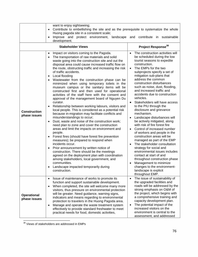
76
want to enjoy sightseeing;
Contribute to embellishing the site and as the prerequisite to systematize the whole Huong pagoda site in a consistent scale;
Improve and protect environment, landscape and contribute in sustainable development.
Stakeholder Views Project Response38
Construction phase issues
Impact on visitors coming to the Pagoda.
The transportation of raw materials and solid waste going into the construction site and out the disposal area could cause increased traffic flow on the route, obstructing traffic and increasing the risk of traffic accidents.
Local flooding
Wastewater from the construction phase can be minimized when using temporary toilets in the museum campus or the sanitary items will be constructed first and then used for operational activities of the staff here with the consent and approval of the management board of Nguyen Du curator.
Relationship between working labours, visitors and local people. This is considered as a potential risk because in-migration may facilitate conflicts and misunderstandings to occur;
Dust, waste and noise of the construction work; need plan to zone and cover the construction areas and limit the impacts on environment and people.
Forest fires (should have forest fire prevention measures); be prepared to respond when incidents occur.
Prior announcement by written notice of construction. There should be the meetings agreed on the deployment plan with coordination among stakeholders, local government, and communities.
Landscape impacted temporarily during construction.
The construction activities will be scheduled during the low tourist seasons to expedite construction.
The EMPs for the two subprojects specify a set of mitigation sub-plans that address the common construction disturbances such as noise, dust, flooding, and increased traffic and accidents due to construction vehicles.
Stakeholders will have access to the PIU through the disclosure and grievance mechanism.
Landscape disturbances will be actively mitigated, along with risk of fire forest fire
Control of increased number of workers and people in the construction areas will be managed as part of the EMP
The stakeholder consultation strategy for social and environmental issues includes contact at start of and throughout construction phase
Management to minimize changes to the environment-landscape is explicit throughout EMP.
Operational phase issues
Issue of maintenance of works to promote its
function and support sustainable development.
When completed, the site will welcome many more visitors, thus pressure on environmental protection will be greater. Need guidance, warning signs, indicators and means regarding to environmental protection to travelers in the Huong Pagoda area.
Manage and operate the waste treatment system effectively to provide standard freshwater to meet practical needs for food, domestic activities,
The issue of sustainability of the upgraded facilities and roads will be addressed by the strong emphasis on O&M of the project, which begins with a comprehensive training and capacity development plan.
The potential impact of the increased visitors on the environment is central to the assessment, and addressed
38
Views of stakeholders are addressed in EMPs
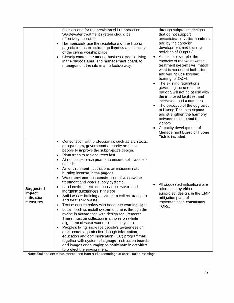
77
festivals and for the provision of fire protection; Wastewater treatment system should be effectively operated.
Harmoniously use the regulations of the Huong pagoda to ensure culture, politeness and sanctity of the divine worship place.
Closely coordinate among business, people living in the pagoda area, and management board, to management the site in an effective way.
through subproject designs that do not support unsustainable visitor numbers, and by the capacity development and training activities of Output 3.
A specific example: the capacity of the wastewater treatment systems will match what is needed at both sites, and will include focused training for O&M.
The existing regulations governing the use of the pagoda will not be at risk with the improved facilities, and increased tourist numbers.
The objective of the upgrades to Huong Tich is to expand and strengthen the harmony between the site and the visitors
Capacity development of Management Board of Huong Tich is included.
Suggested impact mitigation measures
Consultation with professionals such as architects, geographers, government authority and local people to improve the subproject’s design.
Plant trees to replace trees lost
At rest stops place guards to ensure solid waste is not left.
Air environment: restrictions on indiscriminate burning incense in the pagoda.
Water environment: construction of wastewater treatment and water supply systems.
Land environment: not burry toxic waste and inorganic substances in the soil.
Solid waste: building a system to collect, transport and treat solid waste.
Traffic: ensure safety with adequate warning signs.
Local flooding: install system of drains through the ravine in accordance with design requirements. There must be collection manholes on whole alignment of wastewater collection system.
People’s living: increase people’s awareness on environmental protection though information, education and communication (IEC) programmes together with system of signage, instruction boards and images encouraging to participate in activities to protect the environment.
All suggested mitigations are addressed by either subproject design, in the EMP mitigation plan, of implementation consultants TORs.
Note: Stakeholder views reproduced from audio recordings at consultation meetings.
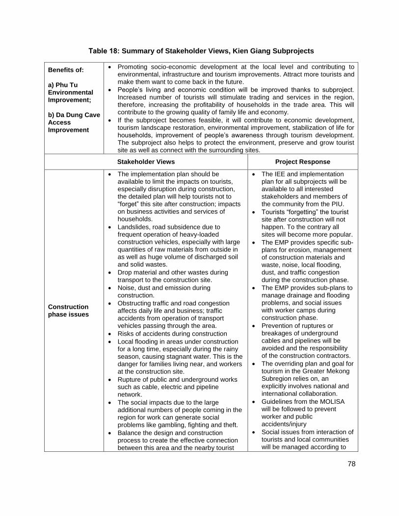
78
Table 18: Summary of Stakeholder Views, Kien Giang Subprojects
Benefits of: a) Phu Tu Environmental Improvement; b) Da Dung Cave Access Improvement
Promoting socio-economic development at the local level and contributing to environmental, infrastructure and tourism improvements. Attract more tourists and make them want to come back in the future.
People’s living and economic condition will be improved thanks to subproject. Increased number of tourists will stimulate trading and services in the region, therefore, increasing the profitability of households in the trade area. This will contribute to the growing quality of family life and economy.
If the subproject becomes feasible, it will contribute to economic development, tourism landscape restoration, environmental improvement, stabilization of life for households, improvement of people’s awareness through tourism development. The subproject also helps to protect the environment, preserve and grow tourist site as well as connect with the surrounding sites.
Stakeholder Views Project Response
Construction phase issues
The implementation plan should be available to limit the impacts on tourists, especially disruption during construction, the detailed plan will help tourists not to “forget” this site after construction; impacts on business activities and services of households.
Landslides, road subsidence due to frequent operation of heavy-loaded construction vehicles, especially with large quantities of raw materials from outside in as well as huge volume of discharged soil and solid wastes.
Drop material and other wastes during transport to the construction site.
Noise, dust and emission during construction.
Obstructing traffic and road congestion affects daily life and business; traffic accidents from operation of transport vehicles passing through the area.
Risks of accidents during construction
Local flooding in areas under construction for a long time, especially during the rainy season, causing stagnant water. This is the danger for families living near, and workers at the construction site.
Rupture of public and underground works such as cable, electric and pipeline network.
The social impacts due to the large additional numbers of people coming in the region for work can generate social problems like gambling, fighting and theft.
Balance the design and construction process to create the effective connection between this area and the nearby tourist
The IEE and implementation plan for all subprojects will be available to all interested stakeholders and members of the community from the PIU.
Tourists “forgetting” the tourist site after construction will not happen. To the contrary all sites will become more popular.
The EMP provides specific sub-plans for erosion, management of construction materials and waste, noise, local flooding, dust, and traffic congestion during the construction phase.
The EMP provides sub-plans to manage drainage and flooding problems, and social issues with worker camps during construction phase.
Prevention of ruptures or breakages of underground cables and pipelines will be avoided and the responsibility of the construction contractors.
The overriding plan and goal for tourism in the Greater Mekong Subregion relies on, an explicitly involves national and international collaboration.
Guidelines from the MOLISA will be followed to prevent worker and public accidents/injury
Social issues from interaction of tourists and local communities will be managed according to
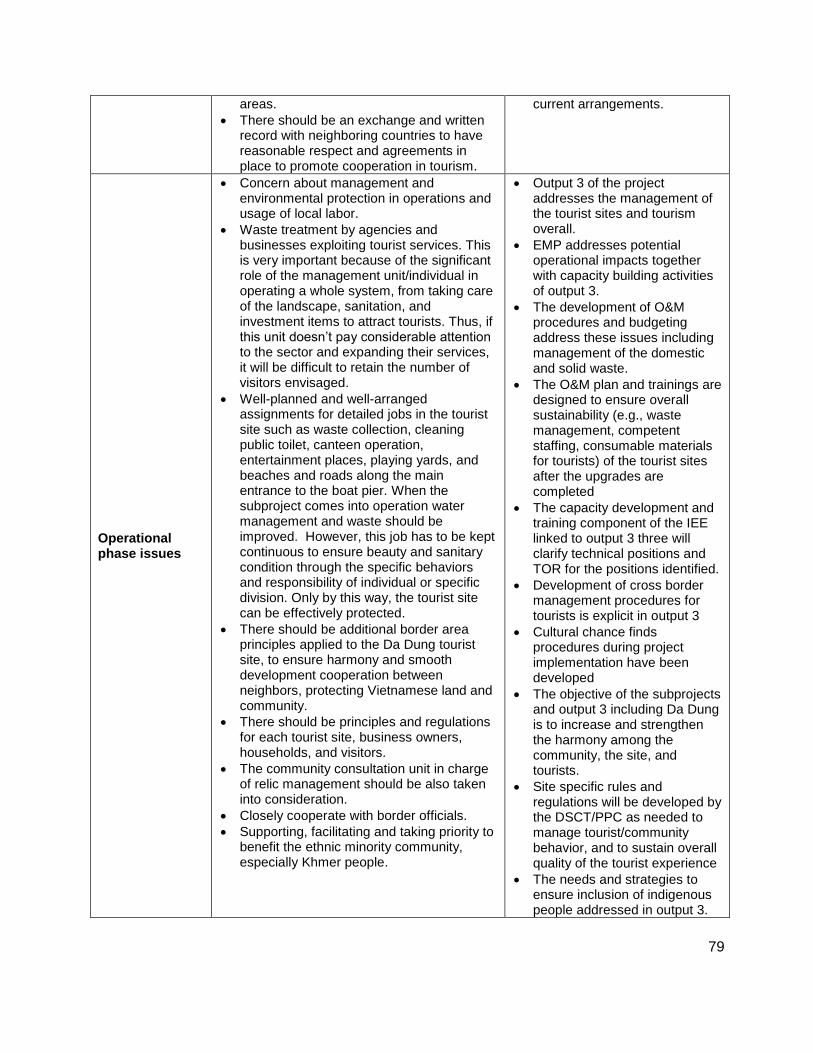
79
areas.
There should be an exchange and written record with neighboring countries to have reasonable respect and agreements in place to promote cooperation in tourism.
current arrangements.
Operational phase issues
Concern about management and environmental protection in operations and usage of local labor.
Waste treatment by agencies and businesses exploiting tourist services. This is very important because of the significant role of the management unit/individual in operating a whole system, from taking care of the landscape, sanitation, and investment items to attract tourists. Thus, if this unit doesn’t pay considerable attention to the sector and expanding their services, it will be difficult to retain the number of visitors envisaged.
Well-planned and well-arranged assignments for detailed jobs in the tourist site such as waste collection, cleaning public toilet, canteen operation, entertainment places, playing yards, and beaches and roads along the main entrance to the boat pier. When the subproject comes into operation water management and waste should be improved. However, this job has to be kept continuous to ensure beauty and sanitary condition through the specific behaviors and responsibility of individual or specific division. Only by this way, the tourist site can be effectively protected.
There should be additional border area principles applied to the Da Dung tourist site, to ensure harmony and smooth development cooperation between neighbors, protecting Vietnamese land and community.
There should be principles and regulations for each tourist site, business owners, households, and visitors.
The community consultation unit in charge of relic management should be also taken into consideration.
Closely cooperate with border officials.
Supporting, facilitating and taking priority to benefit the ethnic minority community, especially Khmer people.
Output 3 of the project addresses the management of the tourist sites and tourism overall.
EMP addresses potential operational impacts together with capacity building activities of output 3.
The development of O&M procedures and budgeting address these issues including management of the domestic and solid waste.
The O&M plan and trainings are designed to ensure overall sustainability (e.g., waste management, competent staffing, consumable materials for tourists) of the tourist sites after the upgrades are completed
The capacity development and training component of the IEE linked to output 3 three will clarify technical positions and TOR for the positions identified.
Development of cross border management procedures for tourists is explicit in output 3
Cultural chance finds procedures during project implementation have been developed
The objective of the subprojects and output 3 including Da Dung is to increase and strengthen the harmony among the community, the site, and tourists.
Site specific rules and regulations will be developed by the DSCT/PPC as needed to manage tourist/community behavior, and to sustain overall quality of the tourist experience
The needs and strategies to ensure inclusion of indigenous people addressed in output 3.
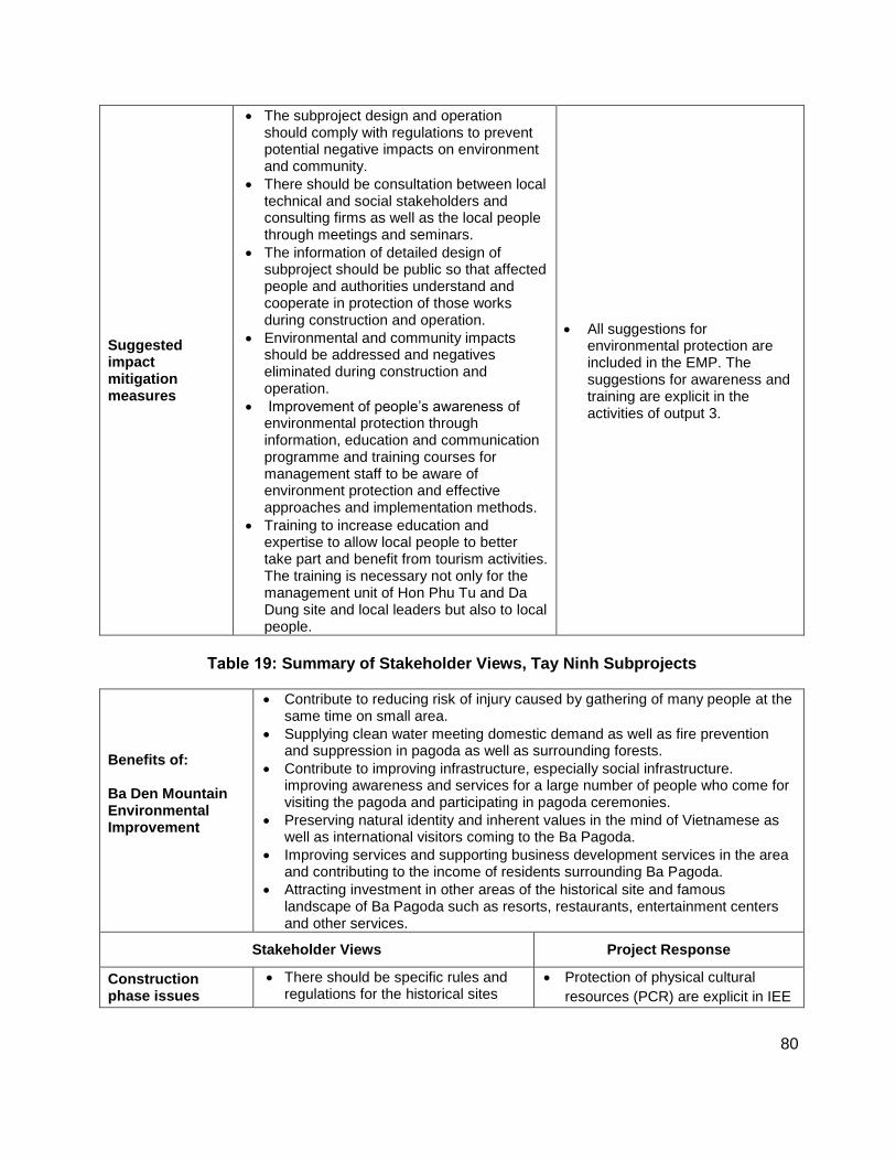
80
Suggested impact mitigation measures
The subproject design and operation should comply with regulations to prevent potential negative impacts on environment and community.
There should be consultation between local technical and social stakeholders and consulting firms as well as the local people through meetings and seminars.
The information of detailed design of subproject should be public so that affected people and authorities understand and cooperate in protection of those works during construction and operation.
Environmental and community impacts should be addressed and negatives eliminated during construction and operation.
Improvement of people’s awareness of environmental protection through information, education and communication programme and training courses for management staff to be aware of environment protection and effective approaches and implementation methods.
Training to increase education and expertise to allow local people to better take part and benefit from tourism activities. The training is necessary not only for the management unit of Hon Phu Tu and Da Dung site and local leaders but also to local people.
All suggestions for environmental protection are included in the EMP. The suggestions for awareness and training are explicit in the activities of output 3.
Table 19: Summary of Stakeholder Views, Tay Ninh Subprojects
Benefits of: Ba Den Mountain Environmental Improvement
Contribute to reducing risk of injury caused by gathering of many people at the same time on small area.
Supplying clean water meeting domestic demand as well as fire prevention and suppression in pagoda as well as surrounding forests.
Contribute to improving infrastructure, especially social infrastructure. improving awareness and services for a large number of people who come for visiting the pagoda and participating in pagoda ceremonies.
Preserving natural identity and inherent values in the mind of Vietnamese as well as international visitors coming to the Ba Pagoda.
Improving services and supporting business development services in the area and contributing to the income of residents surrounding Ba Pagoda.
Attracting investment in other areas of the historical site and famous landscape of Ba Pagoda such as resorts, restaurants, entertainment centers and other services.
Stakeholder Views Project Response
Construction phase issues
There should be specific rules and regulations for the historical sites
Protection of physical cultural
resources (PCR) are explicit in IEE
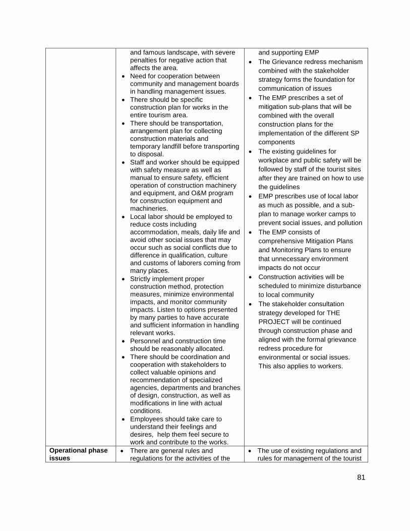
81
and famous landscape, with severe penalties for negative action that affects the area.
Need for cooperation between community and management boards in handling management issues.
There should be specific construction plan for works in the entire tourism area.
There should be transportation, arrangement plan for collecting construction materials and temporary landfill before transporting to disposal.
Staff and worker should be equipped with safety measure as well as manual to ensure safety, efficient operation of construction machinery and equipment, and O&M program for construction equipment and machineries.
Local labor should be employed to reduce costs including accommodation, meals, daily life and avoid other social issues that may occur such as social conflicts due to difference in qualification, culture and customs of laborers coming from many places.
Strictly implement proper construction method, protection measures, minimize environmental impacts, and monitor community impacts. Listen to options presented by many parties to have accurate and sufficient information in handling relevant works.
Personnel and construction time should be reasonably allocated.
There should be coordination and cooperation with stakeholders to collect valuable opinions and recommendation of specialized agencies, departments and branches of design, construction, as well as modifications in line with actual conditions.
Employees should take care to understand their feelings and desires, help them feel secure to work and contribute to the works.
and supporting EMP
The Grievance redress mechanism
combined with the stakeholder
strategy forms the foundation for
communication of issues
The EMP prescribes a set of
mitigation sub-plans that will be
combined with the overall
construction plans for the
implementation of the different SP
components
The existing guidelines for
workplace and public safety will be
followed by staff of the tourist sites
after they are trained on how to use
the guidelines
EMP prescribes use of local labor
as much as possible, and a sub-
plan to manage worker camps to
prevent social issues, and pollution
The EMP consists of
comprehensive Mitigation Plans
and Monitoring Plans to ensure
that unnecessary environment
impacts do not occur
Construction activities will be
scheduled to minimize disturbance
to local community
The stakeholder consultation
strategy developed for THE
PROJECT will be continued
through construction phase and
aligned with the formal grievance
redress procedure for
environmental or social issues.
This also applies to workers.
Operational phase issues
There are general rules and regulations for the activities of the
The use of existing regulations and rules for management of the tourist
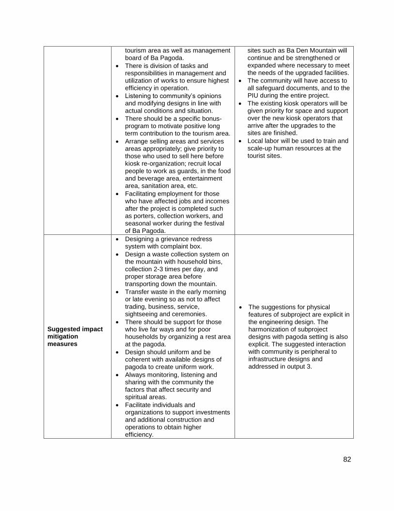
82
tourism area as well as management board of Ba Pagoda.
There is division of tasks and responsibilities in management and utilization of works to ensure highest efficiency in operation.
Listening to community’s opinions and modifying designs in line with actual conditions and situation.
There should be a specific bonus- program to motivate positive long term contribution to the tourism area.
Arrange selling areas and services areas appropriately; give priority to those who used to sell here before kiosk re-organization; recruit local people to work as guards, in the food and beverage area, entertainment area, sanitation area, etc.
Facilitating employment for those who have affected jobs and incomes after the project is completed such as porters, collection workers, and seasonal worker during the festival of Ba Pagoda.
sites such as Ba Den Mountain will continue and be strengthened or expanded where necessary to meet the needs of the upgraded facilities.
The community will have access to all safeguard documents, and to the PIU during the entire project.
The existing kiosk operators will be given priority for space and support over the new kiosk operators that arrive after the upgrades to the sites are finished.
Local labor will be used to train and scale-up human resources at the tourist sites.
Suggested impact mitigation measures
Designing a grievance redress system with complaint box.
Design a waste collection system on the mountain with household bins, collection 2-3 times per day, and proper storage area before transporting down the mountain.
Transfer waste in the early morning or late evening so as not to affect trading, business, service, sightseeing and ceremonies.
There should be support for those who live far ways and for poor households by organizing a rest area at the pagoda.
Design should uniform and be coherent with available designs of pagoda to create uniform work.
Always monitoring, listening and sharing with the community the factors that affect security and spiritual areas.
Facilitate individuals and organizations to support investments and additional construction and operations to obtain higher efficiency.
The suggestions for physical features of subproject are explicit in the engineering design. The harmonization of subproject designs with pagoda setting is also explicit. The suggested interaction with community is peripheral to infrastructure designs and addressed in output 3.

83
Table 20: Summary of Stakeholder Views, Lao Cai Subprojects
Benefits of: a) Ta Phin – Ban Khoang Access improvements; b) Lao Cai Cultural Exchange and Tourist Information Center
Facilitate favorable travelling conditions for local people. This is considered as the most and meaningful benefit to the local residents because the convenient road infrastructure will help them access markets and services more effectively.
Improved traffic and tourism infrastructure will facilitate conditions for exchanging goods and culture, contributing to socio-economic development. Create more jobs for local labor, thus increasing living quality.
Attract investment in tourism; strengthen promotion and propagation for preservation of the nation’s cultural identity; creating attractions for visitors.
Reduce the development gap between regions and areas, especially the gap in socio-economic development. Help ethnic minorities have chance to accessing better job opportunities.
Reduce response time for incidents, ensuring timely provision of information and equipment for rescue and support, especially in case of natural disasters.
Stakeholder Views Project Response
Construction phase issues
Environmental pollution such as emissions, dust, noise and vibration from the construction machines may exceed the allowable limits;
Waste (solid and liquid) generated from project workers, engineers and staff during construction period.
In-migration of labor may cause affect local public security and generate some social issues.
Need to facilitate individuals and households to provide food and beverage service or other necessary services.
Upgrading of road may lead to landslides.
The discharged gravels and soil from activities of excavation, ground leveling, or road expansion should be stored properly during construction and surplus removed after completion of works.
Traffic disruptions in the road section under construction will impact daily life, production activities of the people, and business operation of tourism agencies.
Natural disasters such as cyclone or storm s may impact the construction schedule, work quality, and worker safety.
Subsidence of road due to earth excavation may impact the construction quality/schedule and people living near the road.
Mitigation for construction-related disturbances and pollution addressed by mitigation sub-plans in EMP.
A sub-plan for managing migrant workers is included in EMP. Local workers will be sourced as much as possible
Civil works for roads will include slope stabilization and erosion control measures
Excavation and borrow pit spoil/fill will be managed according to sub-plan of construction phase of EMP
Construction traffic management will occur in EMP phase to minimize disruption of local traffic, and local business and community activity.
Land subsidence will be managed as part of the civil works based on initial soil and slope profiling.

84
Operational phase issues
Once the subproject is completed and comes into operation the volume of traffic will increase.
Vehicles may be overloaded and cause damage to the road surface and reduce effectiveness the works.
Increasing number of visitors taking rest at the rest stops may impact on public security and increase the volume of waste and emissions, affecting the environment and natural landscape.
The road may facilitate illegal logging impacting the social and cultural life ethnic minorities. This should be seriously noted with the Ban Khoang – Ta Phin section passing or locating nearby the regeneration forests or residential cardamom plantation areas.
Management and operation of sub-project’s items should be undertaken by the community to limit the negative impacts.
Need to monitor and prevent vices such as corruption or abuse of power to collect high fees or annoy travelers. This responsibility should be assigned to the local people to increase their awareness on protection and maintenance of the works.
Take attention to prevent forest fires because the fire of forest will cause serious damage to human life and assets.
The expected increase in traffic will be managed to prevent congestion and accidents by planned improved traffic control techniques including speed limits.
The increased pressure of the increased tourism on natural resources, security, and waste production is addressed in part by output 3 activities and the EMP. Output 3 activities will address many of the operational phase concerns raised.
The effect of upgraded roads to Ta Phin and Ban Khoang will be managed by DSCT and MARD, and supported by the capacity development and training activities of output 3.
Appropriate fire and forest prevention measures will continue according current practices, with response times shortened due to improved road access.
Suggested impact mitigation measures
Use of machinery and equipment able to minimize noise, toxic gas; reduce dust by spraying water.
Constructing embankments against the risk of landslide in accordance with requirements of design and construction safety.
Limit excavation in weak geological locations or locations at risk of subsidence and landslide. Surface of steep inclines should be paved with concrete; the road reserve should be solid and have secure corridors, and barriers to limit the influence of incidents or landslide.
Ensure timely project construction schedule as well as sufficient
All suggestions are incorporated into
the EMP and output 3
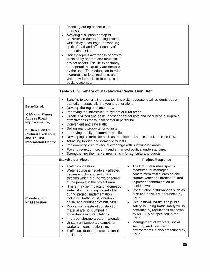
85
financing during construction process.
Avoiding disruption or stop of construction due to funding issues which may discourage the working spirit of staff and affect quality of materials at site.
Raise people’s awareness of how to sustainably operate and maintain project assets. The life expectancy and operational quality are decided by the user. Thus education to raise awareness of local residents and visitors will contribute to beneficial social outcomes.
Table 21: Summary of Stakeholder Views, Dien Bien
Benefits of: a) Muong Phang Access Road Improvements; b) Dien Bien Phu Cultural Exchange and Tourist Information Centre
Benefits to tourism, increase tourists visits, educate local residents about patriotism, especially the young generation.
Develop the regional economy.
Improving the infrastructure system of rural areas.
Create civilized and polite landscape for tourists and local people; improve attractiveness for tourism sector in particular.
Convenient and safe traffic.
Selling many products for tourists.
Improving quality of community’s life.
Developing historic site such as the historical success at Dien Bien Phu.
Attracting foreign and domestic tourists.
Implementing cultural-social exchange with surrounding areas.
Poverty reduction, security and enhanced political understanding.
Strengthening the market mechanism for agricultural products.
Stakeholder Views Project Response
Construction Phase Issues
Traffic congestion.
Water source is negatively affected because rocks and soil drift to streams which are the water source of the people in the project area.
There may be impacts on domestic water of surrounding households during project implementation including: traffic, dust, vibration, noise, and disruption of business.
Rocks, soil, waste of construction material are not dumped in accordance with regulations.
Improper storage area of materials.
Unsanitary temporary camps for workers in construction site.
Traffic accidents and occupational accidents.
The EMP prescribes specific measures for managing construction traffic, erosion and surface water sedimentation, and to prevent contamination of drinking water
Construction disturbances such as dust and noise are addressed by EMP
Occupational health and public safety including traffic safety will be governed by regulations set down by MOLISA as specified in the EMP.
Management of workers, social security, and work camp environments is also prescribed by EMP.
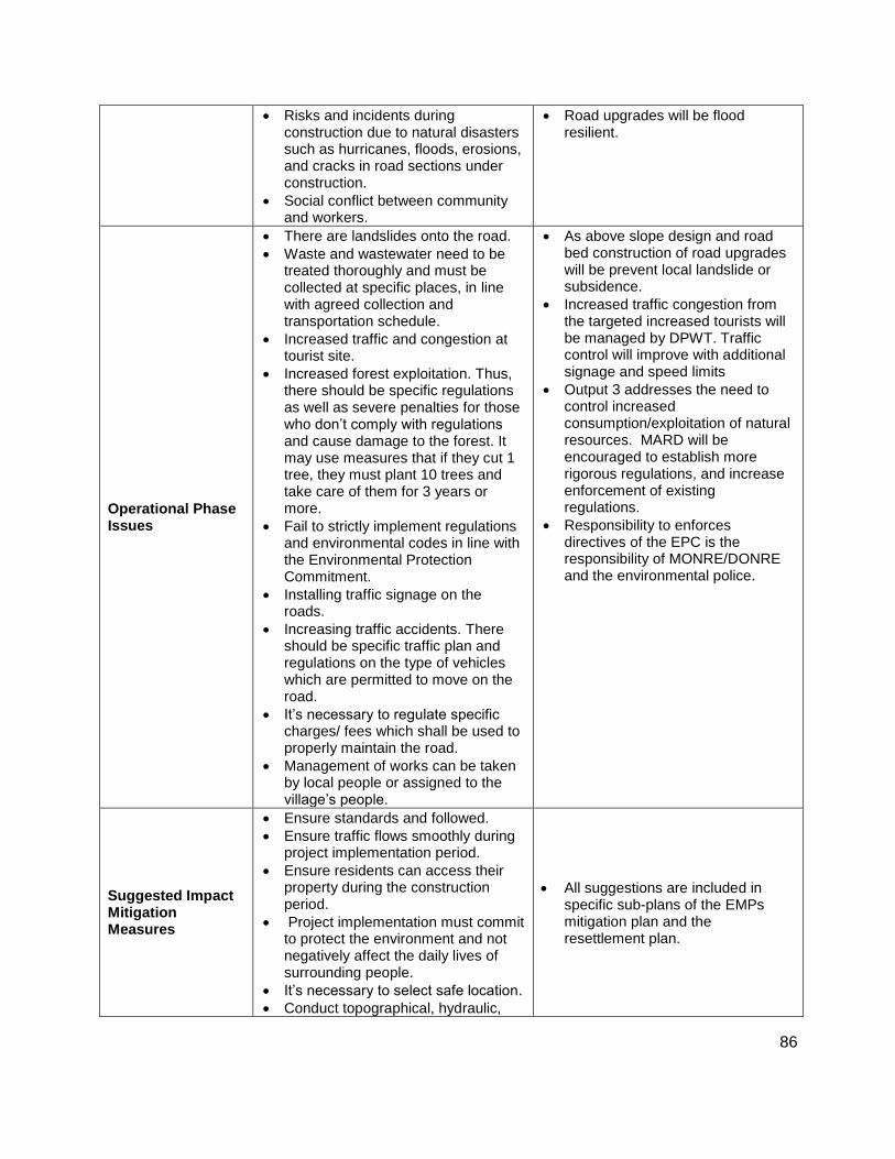
86
Risks and incidents during construction due to natural disasters such as hurricanes, floods, erosions, and cracks in road sections under construction.
Social conflict between community and workers.
Road upgrades will be flood resilient.
Operational Phase Issues
There are landslides onto the road.
Waste and wastewater need to be treated thoroughly and must be collected at specific places, in line with agreed collection and transportation schedule.
Increased traffic and congestion at tourist site.
Increased forest exploitation. Thus, there should be specific regulations as well as severe penalties for those who don’t comply with regulations and cause damage to the forest. It may use measures that if they cut 1 tree, they must plant 10 trees and take care of them for 3 years or more.
Fail to strictly implement regulations and environmental codes in line with the Environmental Protection Commitment.
Installing traffic signage on the roads.
Increasing traffic accidents. There should be specific traffic plan and regulations on the type of vehicles which are permitted to move on the road.
It’s necessary to regulate specific charges/ fees which shall be used to properly maintain the road.
Management of works can be taken by local people or assigned to the village’s people.
As above slope design and road bed construction of road upgrades will be prevent local landslide or subsidence.
Increased traffic congestion from the targeted increased tourists will be managed by DPWT. Traffic control will improve with additional signage and speed limits
Output 3 addresses the need to control increased consumption/exploitation of natural resources. MARD will be encouraged to establish more rigorous regulations, and increase enforcement of existing regulations.
Responsibility to enforces directives of the EPC is the responsibility of MONRE/DONRE and the environmental police.
Suggested Impact Mitigation Measures
Ensure standards and followed.
Ensure traffic flows smoothly during project implementation period.
Ensure residents can access their property during the construction period.
Project implementation must commit to protect the environment and not negatively affect the daily lives of surrounding people.
It’s necessary to select safe location.
Conduct topographical, hydraulic,
All suggestions are included in specific sub-plans of the EMPs mitigation plan and the resettlement plan.
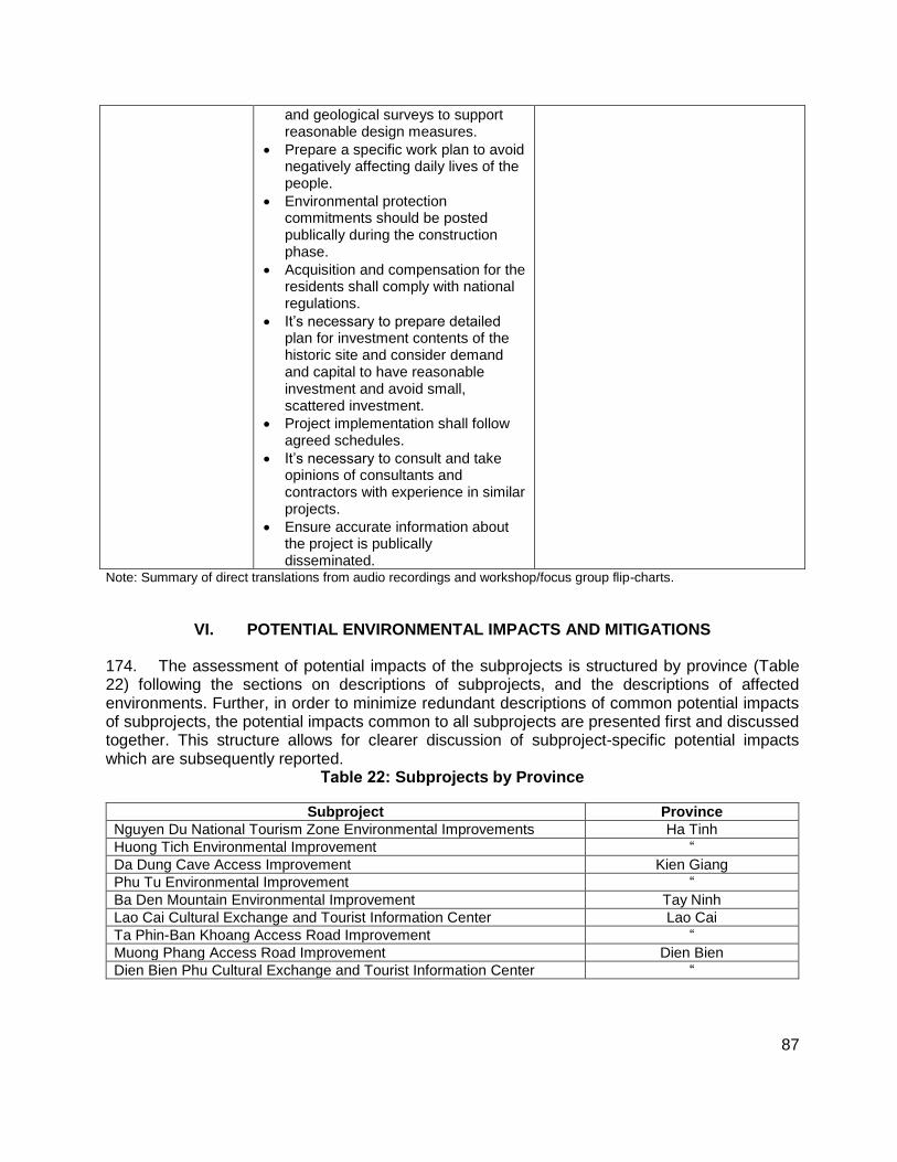
87
and geological surveys to support reasonable design measures.
Prepare a specific work plan to avoid negatively affecting daily lives of the people.
Environmental protection commitments should be posted publically during the construction phase.
Acquisition and compensation for the residents shall comply with national regulations.
It’s necessary to prepare detailed plan for investment contents of the historic site and consider demand and capital to have reasonable investment and avoid small, scattered investment.
Project implementation shall follow agreed schedules.
It’s necessary to consult and take opinions of consultants and contractors with experience in similar projects.
Ensure accurate information about the project is publically disseminated.
Note: Summary of direct translations from audio recordings and workshop/focus group flip-charts.
VI. POTENTIAL ENVIRONMENTAL IMPACTS AND MITIGATIONS
174. The assessment of potential impacts of the subprojects is structured by province (Table 22) following the sections on descriptions of subprojects, and the descriptions of affected environments. Further, in order to minimize redundant descriptions of common potential impacts of subprojects, the potential impacts common to all subprojects are presented first and discussed together. This structure allows for clearer discussion of subproject-specific potential impacts which are subsequently reported.
Table 22: Subprojects by Province
Subproject Province
Nguyen Du National Tourism Zone Environmental Improvements Ha Tinh
Huong Tich Environmental Improvement “
Da Dung Cave Access Improvement Kien Giang
Phu Tu Environmental Improvement “
Ba Den Mountain Environmental Improvement Tay Ninh
Lao Cai Cultural Exchange and Tourist Information Center Lao Cai
Ta Phin-Ban Khoang Access Road Improvement “
Muong Phang Access Road Improvement Dien Bien
Dien Bien Phu Cultural Exchange and Tourist Information Center “

88
A. Subproject Benefits
175. The benefits common to all nine subprojects in Viet Nam are improved access, facilities, and environmental conditions at the tourist sites leading to increased tourist visitation, and local and regional socioeconomic development. Subproject-specific benefits are summarized below.
1. Nguyen Du Tourism Zone Environmental Improvements
176. Improved drainage and water retention areas will reduce flooding. Improvements to the memorial square adjacent of the museum will expand public spaces and provide an open air gathering place for tourists that visit the museum area. Moreover, the square will provide space for special demonstrations, exhibitions on the life of Nguyen Du, and related themes, and opportunities for micro- and small-enterprises to sell to tourists.
2. Huong Tich Environmental Improvements
177. Improvement of walking paths and integrated kiosk rest-stops along the walking path from the lake to the pagoda area will provide much easier and enjoyable access to the pagoda area for those who choose to walk. The fleet of electric shuttle cars will enable persons of all ages and physical abilities to access and enjoy the historic site. The comfort and safety of visitors will be improved by upgrading garbage and wastewater collection and treatment. Collectively, environmental and access improvements will increase the overall tourist experience and create more opportunities for local socio-economic development.
3. Da Dung Cave Access Improvements
178. The improved access road, steps, and walkways to the multiple caves will enable more tourists to visit the caves, particularly those with limited physical abilities. Coupled with the new kiosks and sitting areas, improved access will create additional opportunities for local people to establish micro- and small-enterprises at the site. Improved road access will facilitate regular removal of trash.
4. Phu Tu Environmental Improvements:
179. The Phu Tu tourist site provides an unusual diversity of activities ranging from swimming and beach sports, ocean boat tours and day excursions, caving, picnicking, and shopping, all of which are situated in a UNESCO Man and the Biosphere Reserve. Environmental improvements provided by the subproject will protect the natural heritage values of the site, reduce public health and safety hazards through better waste and traffic management, and provide local vendors and tourists with clean, sanitary areas for shopping and food service.
5. Ba Den Mountain Environmental Improvements
180. Similar to the Huong Tich Pagoda in Ha Tinh, access to the pagoda area on top of Ba Den Mountain will become easier. Most notable is that the existing solid and domestic waste issues at the top of the mountain will be addressed allowing present and future visitors to more comfortably enjoy the enlarged terrace and public kiosk areas in front of the main pagoda buildings. Improved facilities with purpose built vendor kiosks will create more opportunities for local residents to expand micro- and small enterprises.

89
6. Lao Cai Cultural Exchange and Tourist Information Center
181. The new cultural exchange and tourist information center in Lao Cai town will provide more comprehensive information and guidance to visitors on different tourist attractions in the area. The facility will also provide space for local tourism service providers, vendor kiosks, and tourist transportation.
7. Ta Phin-Ban Khoang Access Road Improvement
182. Road improvements will enable a greater number of tourists to visit each site creating economic opportunities linked to tourism such as guiding, food and transportation services, and the sale of handicrafts. Approximately 7,538 people that live along the improved access road are expected to benefit from increased tourism and better access to markets and services.
8. Muong Phang Access Road Improvement
183. The improvements to the access road to Muong Phang will enable a greater number of tourists to visit the historic site, creating economic opportunities linked to tourism such as guiding, food and transportation services, and the sale of handicrafts. Approximately 8,822 people living in the vicinity of the improved access road are expected to benefit from increased tourism and better access to markets and services.
9. Dien Bien Phu Cultural Exchange and Tourist Information Centre
184. The new cultural exchange and tourist information center in Dien Bien town will provide accurate information on the historic landscape of Dien Bien Phu and surrounding area. It will provide a focal point for tourist information and services in the province, linked to the existing museum on the battle of Dien Bien Phu. Space will be allocated for retail shops and tourism-related services such as guides, transport, and food and beverage services. B. Subproject Impacts and Mitigations
185. The assessment of potential negative impacts of the subproject is structured by the three development phases: (i) pre-construction preparation; (ii) construction; and (iii) post-construction operation. This structure is carried forward and is also used to structure the eight environmental management plans (EMP) that have been prepared for the subprojects.
1. Pre-construction Phase
186. Negative impacts associated with the pre-construction phase concern land acquisition and resettlement. At the feasibility design stage the requirements for local resettlement and compensation are expected to vary amongst the subprojects in the five provinces. The details of the impacts and required management actions are addressed in the Resettlement Plans (RP) and entitlement matrices that have been prepared for each subproject with involuntary resettlement impacts, and found under separate cover. Involuntary resettlement impacts identified at the feasibility design stage are summarized below:
90
In Kien Giang province no resettlement is expected for the Da Dung cave access improvements. However temporary disruption to 51 local businesses is expected during the construction phase.
Plans to expand the terrace and upgrade walkways at the pagoda on Ba Den Mountain in
Tay Ninh province is expected to temporarily affect the 27 businesses during the construction phase.
In Dien Bien province upgrades to the access road to the Muong Phang tourist site will
require minor acquisition or residential and agricultural land from 137 households without physical displacement. The Bonsai nursery that currently leases the land surrounding the De Castries bunker site in Dien Bien town will continue to operate in the area.
Construction of the new memorial square at the Nguyen Du museum in Ha Tinh will
require acquisition of agriculture land used by 7 households. The upgrades to the Huong Tich pagoda site will temporarily affect 35 businesses during the construction phase.
In Lao Cai, the new tourist information center will require relocation of three businesses
operating at the bus depot. Upgrades to the Ta Phin Ban Khoang access road will require minor acquisition or residential and agricultural land from 110 households without physical displacement
a. Updating Environmental Management Plans
187. The subproject EMPs will need to be updated during the pre-construction detailed design stage to ensure they fully address the potential impacts of the final detailed designs of the subprojects. This will involve finalization of mitigation sub-plans to manage potential impact areas such erosion, sedimentation of surface waters, noise, dust and air quality, spoil disposal, traffic, and worker and public safety at the project sites. The impact mitigations for the pre-construction phase of the subprojects are detailed in the individual EMPs. 188. Key impact mitigation measures of the pre-construction phase are:
1) Initiation of the resettlement plan for the affected households and businesses; 2) Completion of detailed designs of the subprojects of each province; and
3) Updating and initiation the subproject EMPs.
2. Construction Phase
a. Common potential impacts of the subprojects
189. The potential environmental impacts of the subprojects in Viet Nam are associated primarily with the construction phase of the individual subprojects. Common impacts of construction will arise from civil works construction, which will consist of, for example; reduced and/or blocked public access; disrupted business and recreation; noise, dust and air pollution from NOx, SOx, and CO caused by increased truck traffic and heavy equipment use; soil and surface water pollution caused by equipment operation and maintenance; public and worker accidents and increased traffic accidents; land erosion and surface water sedimentation; drainage and flooding problems; solid waste and domestic pollution from worker camps; and
91
communicable diseases and community problems caused by migrant workers. The short-term construction-related impacts will occur at different levels of magnitude depending on the construction activity.
i. Common mitigation measures
190. Management measures to mitigate potential common impacts associated with the construction phase of the subprojects are shown below. The mitigation measures are detailed further in the subproject EMPs.
1) Care must be taken to ensure that sites for earthworks (e.g., excavations, trenches) that are suspected to have unexploded ordnance (UXO) are surveyed by the military prior to construction. If such ordnance is detected clearing work will need to be commissioned prior to undertaking civil works.
2) Open excavations should be fenced, and trenches covered where public walkways or vehicles must cross.
3) A chance find management plan must be in place for cultural artifacts and property.
4) Regular use of wetting agents should be employed at construction sites to minimize dust.
5) All construction vehicles and equipment should be maintained in proper working order, noise minimized, and not operated at night if possible.
6) Speed limits should be posted and adhered to by construction vehicles.
7) Where possible construction vehicles should use different roads or dedicated lanes of roads shared by the public.
8) Trees and other vegetation at all construction sites and along road corridors should be protected with minimal removal. No tree removal in special use forests.
9) Present and past land use should be reviewed to assess whether excavated soils are contaminated spoil. Contaminated spoil should be disposed at a nearby landfill or a location approved by DONRE.
10) Berms and/or silt curtains should be constructed around all excavation/trench sites and along all surface waters to prevent soil erosion and surface water sedimentation.
11) Local workers should be used as much as possible to prevent or minimize influx of migrant workers, and incidence of communicable disease and community unrest.
12) Worker camps must have adequate domestic waste collection facilities and sufficient pit latrines that are located away from public areas and surface waters.
13) Dedicated fuel storage areas must be established away from public areas and marked clearly.
14) To minimize the impact of construction on the public and workers, the specific guidelines for safety of the worker and public set down by the Ministry of Labor, Invalids and Social Assistance (MOLISA) must be followed. The IFC/World Bank Environment, Health, and Safety Guidelines (2007) that govern the safe and orderly operation of civil works should be added as supplementary guidance if needed.
15) Aggregates (e.g., sand, gravel, rock) that are transported by truck should be covered.
92
16) Prolonged use of temporary storage piles of sand, gravel and rock should be avoided, or
covered and wetted regularly to prevent dust and erosion.
17) Sand extraction in rivers for road embankment fill should be done at licensed areas only.
18) Storage of bulk fuel should be on covered concrete pads away from the public and worker camp. Fuel storage areas and tanks must be clearly marked, protected, and lighted. Contractors should be required to have an emergency plan to handle fuel and oil spillage.
b. Subproject-specific potential construction impacts and mitigations
191. All subprojects will create varying levels of construction disturbances that are summarized above. However, listed below are potential construction-related impacts specific to some subprojects, or potential impacts that need to be highlighted for mitigation.
i. Ha Tinh province
192. Nguyen Du Tourism Zone Environmental Improvement. The major infilling of the site needed to raise the grade of the completed memorial square could block or significantly impede the flow of the irrigation canal that separates the museum and road from the future memorial square. During construction a retaining wall needs to be installed to separate the canal from the infilling activity prior to works to reconfigure the canal. Construction waste or backfill must not be dumped into the canal. The canal will need to be channeled through a box culvert to allow easy movement to/from the museum and memorial square. The large quarry and aggregate storage yard on the same road as the Nguyen Du Museum approximately 10 km south towards Ha Tinh should be able to provide the required fill. 193. Huong Tich Environmental Improvement. The individual activities to improve the environmental condition and services on the mountain and pagoda area could negatively affect the plantation forest that begins at the bottom of the cable car. Key activities include the upgrades to the access road through the plantation forest, and construction of the parking lot. Extra care must be taken to prevent or minimize the removal of trees on the mountain and along the access road. Similarly, upgrades to the footpaths shall not involve removal of trees. 194. The excavation of the aerated ponds for the WWTP in the plantation forest at the base of the Huong Tich pagoda could penetrate the water table. An investigation needs to be conducted as part of the detailed design phase to determine the depth of the water table, groundwater quality, and type and permeability of the soil. The solid waste transfer station and WWTP will be located in an isolated area selected by the Forestry Division of DARD.
ii. Kien Giang province
195. Phu Tu Environmental Improvements. The planned improvements to the site are consistent with the principles and goals of development and management of tourism in the KGBR,39 and consistent with the construction activities of the site which have already been
39
KGBSR, 2012. Guidelines for Developing Tourism in Kien Giang Province, 42 pgs.
93
developed. The dedicated guidelines for tourist development inside the KGBR40 should be followed in consultation with the management board. Moreover, because the Phu Tu site is located inside a core zone of the KGBR and inside the Hon Chong Nature Reserve the dialogue with the management board of the KGBR (developed during project preparation) between the DSCT and PPC should continue during project implementation. Formal clarification on the rationale and allowance of the subproject activities to be conducted in the protected zones is provided in Appendix C. 196. The appended correspondence between the PPTA consultants and the management board of the KGBR lays the groundwork for the immediate development of a working relationship between the detailed design consultant and the management board of the KGBR and Kieng Giang PIU to work together on preventing or minimizing negative impacts of subproject. KGBR guidelines will form the initial common terms of reference for the detailed design consultant and the PIU, together with the implementation of EMP. 197. An example early collaboration that should occur among the KGBR, PIU, and the tourism vendors/restaurant operators is identification of the optimal and feasible construction schedule for the most disruptive subproject activities for tourism, and to commerce such as the access road improvements and construction of new public market. The EMP for Phu Tu identifies the need for a collaborative meeting among the three stakeholders during the pre-construction phase to identify construction schedule(s) for subproject. 198. Notwithstanding the endorsement of the management board of the KGBR, with the subproject being inside the Hon Chong Nature Reserve and core zone of the KGBR, there are potential impacts on the sensitive ecosystems of the area. In particular is the large forested headland immediately to the south of the site in which the caves are located, which may support critical habitat for rare or endangered species. Thus, it is critical that no subproject activity occurs in or at the boundary of the forested headland to the south of the Phu Tu site. This mitigation measure should be easy to implement because all subproject activities (Table 5) are located north of the forested area in an area already developed for tourism. Similarly, no activities are planned to occur inside the Tien or Diamond caves both of which are located inside the forested headland. 199. The civil works associated with renovation of the passenger pier could cause extensive siltation to the shoreline which would degrade water quality and degrade aquatic habitat and local uses of the beach area. Construction waste could also be dumped into the inshore area. Care should be taken with the construction of temporary berms, or placement of in-situ silt curtains to isolate construction areas as much as possible to protect the shoreline. Solid and liquid waste must not be dumped into ocean, rather be collected on land for proper disposal. 200. Construction of the car park and the upgrades to the access road should occur during the dry season to minimize erosion and sedimentation of local surface waters. Construction vehicle traffic should stay within the existing road alignments on site as much as possible to prevent unnecessary lateral erosion where possible. Temporary berms or plastic fencing should be placed along access road and perimeter of car park to prevent erosion. Similar erosion barriers should be installed to protect shrimp ponds in the area.
40
Footnote 38.
94
201. All new borrow pits that need to be created to supply the estimated 15,575 m3 of fill required for the road upgrades at Phu Tu should not be developed within the Hon Chong nature reserve (Figure 22), and should be approved by DONRE. Similarly, all disposal of construction waste should occur in DONRE-approved landfill sites outside the nature reserve. 202. Da Dung Cave Access Improvements. Improvements to the footpaths through and around the network of caves of the mountain could permanently disrupt the bat population and other cave fauna that inhabit the cave. A cave specialist should be consulted to work with the detailed design consultants to ensure that the planned access improvements in and around the caves do not permanently negatively affect cave wildlife habitat, as well as the cave geology.
iii. Tay Ninh province
203. Ba Den Mountain Environmental Improvements. The civil works for the construction of the railed service track from the base to the top of the mountain, and the extension of the public concourse at the top of the mountain adjacent to the pagoda will require some tree removal, possibly damage trees, and could cause soil erosion in the protected mountain forest. 204. Excavation of the wastewater ponds for the WWTP at the base of the mountain could penetrate the water table, and ultimately contaminate local groundwater and domestic wells. An investigation needs to be conducted as part of the detailed design phase to determine the depth of the water table, groundwater quality, and type and permeability of the soil. The excavation and construction of the wastewater ponds could also degrade the water quality of the nearby stream. Extra care needs to be taken during construction to prevent or minimize these construction impacts. Specific mitigations for these impacts are expressed in a mitigation sub-plan in the EMP for the subproject. 205. The location selected for the WWTP and solid waste transfer station will need to be away from tourist and public facilities. See EMP for siting criteria.
iv. Lao Cai province
206. Ta Phin-Ban Khoang Access Road Improvement. Agricultural land will be acquired along the access road to Ta Phin and Ban Khoang. Care must be taken during the detailed design to minimize the losses. In addition to agricultural land extra care must be taken to survey if present, and avoid all physical cultural resources along the sections of road (track). This section of access road is the most remote access road of all the Viet Nam subprojects. Thus, careful attention is required to identify, and avoid cultural resources and relics that are likely not well-known, and not easy to see along the RoW.
v. Dien Bien province
207. Access Road to Muong Phang National Tourism Site. Agricultural land will be acquired along the access road to Ta Phin and Ban Khoang. Care must be taken during the detailed design to minimize the losses. Similar to the access roads in Ta Phin subproject care must be taken to avoid all cultural resources along the RoW of the access road to Muong Phang.
vi. All Subprojects
95
208. Protected Areas, Rare and Endangered Species, and Cultural Property and Values. The Phu Tu Environmental Improvement subproject is the only one situated in a protected area. Similarly, Phu Tu Environmental Improvement is the only subproject located near an area where rare or endangered wildlife may occur. However, as indicated above the adjacent forested area of the Hon Chong Nature Reserve should not be affected by the construction activities of the Phu Tu Environmental Improvements subproject. Further, subproject activities are consistent with the management principles and guidelines of the KGBR. 209. Because the final location of facilities and components of all subprojects will only be determined at the detailed design phase, the potential exists for valued ecological and cultural resources to be negatively affected should subproject locations be altered significantly. Thus, as part of the detailed design stage when subproject siting and designs are finalized, and as part of updating the EMPs to meet the detailed designs, a review of the proximity and sensitivity of all valued eco-cultural resources of the subproject areas in relation to finalized infrastructure developments should be undertaken. Moreover, final siting and designs of all subprojects need to be reviewed in view of the subproject section criteria to ensure subproject selection criteria are still met.
3. Operation Phase
210. The operation phase is defined beginning from the time when construction of the subproject is complete, and when the improved infrastructures and environmental facilities are in operation. Potential impacts of the operation phase are presented below.
i. Ha Tinh province
Huong Tich National Tourism Site Environmental Improvements. 211. Contamination of environment and community impact. The upgraded wastewater treatment system will collect and transport by pipe the wastewater from Huong Tich pagoda area for storage and treatment through a series aerated ponds at the base of the mountain. At low tourist periods the treated effluent will be discharged to agriculture areas. It is estimated the new WWTPs drying beds will generate about 40 tons of dry sludge per year. This can be assimilated into the surrounding public tree plantations or carted to Ha Tinh’s landfill41 into which solid waste generated on the mountain and pagoda grounds will also be disposed.42 Availability of land is not an issue here as the site management authorities have given assurances to set aside at least 5 hectares of public land within the plantation area for development of the facilities. The final selection of the site will be based on surveys undertaken during the detailed design. 212. A risk of operation of the upgraded facilities is contamination of existing human and ecological environments. This could occur if the effluent is not treated to specification, or the receiving environment cannot safely assimilate the effluent, thereby creating a pollution problem. Similarly, contamination of land or surface water from spills or uncontrolled discharge of untreated and treated wastewater could occur due to pipeline or equipment failure. The design of the upgraded wastewater system will treat the wastewater to published effluent standards of the
41
Nearest landfill identified is used by Ha Tinh town, about 15 km from the site. 42
It is estimated each tourist that visits Huong Tich will generate an average of 0.2 kg of garbage.

96
Government. However, the sensitivity of the receiving environment to the effluent, and the landfill to the waste sludge, needs to be reviewed during the detailed design phase. 213. Aesthetics and public safety. Another potential risk is the operation of the upgraded wastewater system and pipeline causing negative aesthetic impacts on the tourist area. Potential impacts of the operation of the wastewater pipeline and treatment lagoons concern the following:
1. Change to Huong Tich area landscape arising from possible odor, noise, and altered visual aesthetics;
2. Increased traffic in the tourist reception area due to waste treatment operations; 3. Contamination of land and groundwater from improperly discharged sludge; 4. Contamination of land or surface water from spills, or uncontrolled discharge of untreated
and treated wastewater, arising from pipeline or equipment failure; 5. Increased incidence of vector carried disease arising from the treatment ponds; and 6. Risk of tourist injury from exposure to the treatment pond operations.
214. Upgraded solid waste management. Identified aesthetic and public safety issues related to the transport of solid waste away from the Huong Tich pagoda area to a transfer station at the base of the mountain for subsequent transfer the local landfill43 could:
1) Create problems of odor and negative visual aesthetics from the transfer station; and 2) Increased the risk of traffic accidents from trucks transferring solid waste.
215. As part of the O&M component of the subproject, the pagoda management board, site workers, and DCST staff should receive training to ensure they are able to properly use and maintain the wastewater treatment and solid waste management system. A sufficient budget for O&M must be allocated by the management board each year. Mitigations for potential impacts of the wastewater and solid waste management systems
216. Wastewater Treatment System. The potential impacts listed above will be addressed directly by the detailed engineering design specifications, which will determine the most suitable site for the facilities and procedures to operate and maintain the wastewater treatment system and pipeline. The composite impact mitigation for the wastewater system consists of:
a) Sustained, safe collection and transport wastewater to the aerated ponds; b) Consistent treatment of wastewater to effluent quality design specifications; c) Ability of environment at base of mountain to assimilate the treated effluent year-
round; d) Ability of operations to dispose safely treatment sludge; and e) Ability of wastewater system not to impinge on the aesthetics of tourist area.
217. Additional mitigations for the potential impacts of the operation of the lagoons and pipeline are provided below. All mitigation measures are detailed in the EMP.
43
As indicated above at landfill used by Ha Tinh town
97
a) A fenced, treed perimeter berm will be built around lagoons to isolate the facility from the tourist area, reduce noise and odor, and prevent negative aesthetics of the lagoons;
b) Enforced well marked speed limits will be posted on roads used by staff working at the pagoda and WWTP vehicles will be kept in good working order;
a) Design ensures treatment lagoons do not contaminate groundwater and land, monitored by regular groundwater testing;
b) A regular effluent and sludge quality testing protocol; c) All equipment and processes are kept maintained in good working order with back-up
equipment and processes in place in critical areas; d) Engineering and management systems are in place to prevent and address
emergency spill and discharge situations; and e) All staff are properly trained with regular refresher courses;
218. Solid Waste Management System. Examples of key mitigations for potential community impacts are as follows:
c) Locate transfer station away from public areas; d) Install a tall perimeter fence and trees around the entire transfer area; e) Install sufficient signage along the perimeter warning the public to stay away from
transfer station; f) Post a fulltime guard at transfer station; g) Move waste out of transfer station regularly and hose the area regularly to prevent
habitat creation for disease vectors and vermin; h) All loaded solid waste trucks departing transfer station must be covered; and i) Garbage trucks must strictly follow speed limits in the tourist reception area.
ii. Kien Giang province
Phu Tu National Tourist Site Improvements 219. Similar to the Huong Tich Pagoda Site, upgraded wastewater collection and treatment facilities could create a point source of pollution if the systems are not managed and maintained carefully according to specification. The subproject will utilize a series of strategically placed underground ABR septic tanks to treat the wastewater, which given the forecast tourist volumes are expected to generate about 45 tons of sludge per year, to be carted off in a vacuum tanker and deposited in the Rach Gia or Ha Tien landfill, together with solid waste generated at the site. Training and capacity building for O&M must be provided together with sufficient budget to properly operate and maintain the ABRs.
220. Critical aquatic habitat and water quality. Operations of the renovated passenger pier will increase tourist boat movements to/from Phu Tu. The adjacent eastern shoreline supports mangrove forests and the offshore area supports sea grass habitat. The increased boat traffic could damage or destroy the nearby sea grass beds and mangrove forests. Increased boat activity could also negatively affect nearshore water quality from the associated increase in the discharge/spills of oil, gasoline, and solid waste from the passenger boats. The risks of spills associated with the current practice of transporting gasoline by motorbike to the boats moored at the pier will increase.
98
221. Boat and vehicle traffic safety. The increased boat traffic Phu Tu pier and vehicle traffic along the upgraded access road to the tourist site increases the risk of traffic accidents. Disturbance from noise and dust along the access road will also increase. The risk to workers and the public from injury arising from improperly transporting fuel by motorbike to the pier will also increase.
222. Boat Management and Navigation Plan. A comprehensive boat traffic management plan for the upgraded pier should be prepared by an expert committee of line agencies such as DONRE, DOT, DCST, and agencies responsible for marine navigation and regulations. The plan should provide a schedule for boat traffic to/from the pier and should specify the maximum boat size (i.e., draft and length that can use the pier). The management plan should also prescribe enforced speed limits and buoyed navigation lanes near the pier. 223. Illegal Wildlife Selling. Given Phu Tu is in a core zone of the KGBR, and in the Hon Chong nature reserve, extra care needs to be taken to ensure illegal wildlife sales do not occur with increased tourism pursuant CITES.44 Prevention of illegal wildlife harvesting and sales can be effected through comprehensive public awareness programs. The creation of such programs provides the opportunity to integrate the mitigation measures of output 2 with the public awareness programming planned for output 3.
Da Dung Cave Access Improvements 224. The increase in traffic along the upgraded access road could create traffic congestion issues, and increase the frequency of traffic accidents and injuries. The EMP prescribes mitigation measure for these potential impacts.
iii. Tay Ninh province
Ba Den Mountain National Tourism Site Improvements 225. Contamination of environment and community impact. The upgraded wastewater treatment system will collect and transport wastewater by pipe down Ba Den Mountain for storage and treatment in a lagoon WWTP on a 5 hectare plot to be developed at the base of the mountain. At low tourist periods the treated effluent will be discharged to the adjacent agriculture areas, comprising teak and rubber plantations. Given the forecast tourist volumes, it is expected the facility’s sludge drying beds will generate 135 tons of dry sludge per year, which can be assimilated into the surrounding tree plantations or carted to Tay Ninh’s municipal landfill, where the estimated 1,000 tons of garbage produced annually is disposed.45 226. A risk of operation of the upgraded facilities is contamination of existing human and ecological environments. This could occur if the effluent is not treated to specification, or the receiving environment cannot safely assimilate the effluent, thereby creating a pollution problem. The design upgraded wastewater system will treat the wastewater the published Government standards. However, the sensitivity of the proposed receiving environment to the actual effluent, and the landfill to the waste sludge, need to be reviewed during the detailed design phase.
44
(1973) Convention on International Trade in Endangered Species Wild Fauna and Flora 45
Nearest landfill identified used by Tay Ninh about 20 km from the site.
99
227. Aesthetics and Public Safety. Another potential risk is the operation of the upgraded wastewater system and pipeline causing negative aesthetic impacts on the tourist area. Potential impacts of the operation of the wastewater treatment lagoons and pipeline are summarized below:
1. Change to Ba Den area landscape arising from possible odor, noise, and altered visual aesthetics;
2. Increased traffic in the tourist reception area due to waste collection and treatment operations;
3. Contamination of land and groundwater from improperly discharged sludge; 4. Contamination of land or surface water from spills, or uncontrolled discharge of untreated
and treated wastewater, arising from pipeline or equipment failure; 5. Increased incidence of vector carried disease arising from the treatment ponds; and 6. Risk of tourist injury from exposure to the treatment pond operations.
228. Upgraded solid waste management. Identified aesthetic and public safety issues related to the transport of solid waste away from Ba Den Mountain to a transfer station at the base of the mountain for subsequent transfer to the local landfill could:
1) Create problems of odor and negative visual aesthetics from the transfer station; and 2) Increased the risk of traffic accidents from trucks transferring solid waste.
229. As part of the O&M component of the subproject, the Ba Den Mountain management board, site workers, and DCST staff should receive training to ensure they are able to properly use and maintain the wastewater treatment and solid waste management system. A sufficient budget for O&M must be allocated by the management board each year. Mitigations for potential impacts of the wastewater and solid waste management systems
230. The composite impact mitigations for the wastewater system are the same as the mitigations described above for the wastewater system for the Huong Tich Environmental Improvement subproject. They are described in detail in the EMP.
iv. Lao Cai province
231. Potential operational impacts focus on injuries arising from road accidents that may result from the increase in traffic between Sa Pa, Ta Phin and Ban Khoang. Enforced speed limits and installation of road signage and guard-rails should be implemented.
v. Dien Bien province
232. Potential operational impacts focus on injuries arising from road accidents that may result from the increase in traffic between Dien Bien Town and Muang Pang. Enforced speed limits and installation of road signage and guard-rails should be implemented.
100
4. IUCN Protected Area Status
233. The subprojects in Viet Nam are situated near/within national protected areas defined as national parks or reserves, biosphere reserves or historic cultural sites as summarized in section IV. Of particular note are the Phu Tu Tourist Site and the Ban Den Mountain Pagoda Site. These subprojects meet the criteria of the Protected Areas V and VI of the International Union of Conservation of Nature (IUCN). The blended definition of PA status V-VI protected area is as follows: 234. “Protected areas that conserve ecosystems and habitats, together with associated cultural values and traditional natural resource management systems, where the interaction of people and nature over time has produced an area of distinct character with significant ecological, biological, cultural and scenic values, where safeguarding the integrity of this interaction is vital to protecting and sustaining the area and its associated nature conservation and other values. The areas are generally large, with most of the area in a natural condition, where a proportion is under sustainable natural resource management and where low-level non-industrial use of natural resources compatible with nature conservation is seen as one of the main aims of the area”. 46 235. Phu Tu and Ba Den are highly valued tourist and cultural pilgrimage sites. The proposed environmental improvements at the sites are consistent with protected area status V and VI guidelines of the IUCN because subproject activities:
Do not damage or interfere with the highly valued cultural and ecosystem features of the sites;
Strengthen and develop the existing infrastructure that will improve the interaction of the people with the features of the sites;
The improved integration of community with the ecosystem and cultural values will strengthen the already distinct people-environment character of the sites;
The environmental improvements of subprojects improves the quality of the ecosystem-cultural experience of the community while also improving the quality of the site environments;
The project capacity building activities under Output 3 (not included in IEE) enhance people’s understanding of the importance of ecosystem protection and sustainable tourism.
5. Induced and Cumulative Impacts
236. General mechanisms of the potential induced or cumulative impacts are introduced below, covering all subprojects in the five provinces. A potential directly induced impact of increased tourism in the subproject areas is creation of increased pollution from solid and domestic waste outside the target areas. More tourists to the subproject areas can result in greater consumption of goods and resources which can put greater strain on key amenities such as the cleanliness of the local environment and community. An increase in the number of tourists in subproject area could lead to social issues stemming from the interaction of local and foreign cultures.
46
http://www.iucn.org/about/work/programmes/gpap_home/gpap_quality/gpap_pacategories/gpap_category5/
101
237. Another potential induced impact of tourism development which is very difficult to prevent and separate from the subproject activities is independent commercial and urban development that develops to serve and benefit the increase in tourism activity induced by the project. Increased tourism development at all subproject areas could become the catalyst for much greater and non-sustainable growth in both tourism and urban development in the subproject areas. Indirect induced socioeconomic growth is usually broader geographically and more difficult to manage with respect to impacts on environmental resources because of the different parties and interests involved.
6. Climate Change
238. The designs of the infrastructure and environmental improvement technologies at feasibility stage are climate change resilient. Climate change is defined here as the GCM-projected changes to the frequency and severity of rainfall events, local runoff and flooding events, and sea level rise. The access road upgrades all include lateral drainage to channel runoff and prevent erosion. All structural facilities such as public toilets, buildings, and open public areas such as the Nguyen Du memorial square and extended concourse on Ba Den mountain will be at elevations immune from flooding and runoff.
239. Consideration of climate change includes measures to reduce the contribution of the project to greenhouse gas production. Effort needs to be taken to reduce the carbon footprint of the project by ensuring for example that speed limits along upgraded roads are enforced, and passenger and cargo boats that use the pier are maintained in good working order. All lighting installed at the subprojects should use light bulbs that are energy efficient. The use of low-carbon forms of transportation to move tourists around tourist sites included in the project should be promoted.
VII. ANALYSIS OF ALTERNATIVES
240. The analysis of subproject alternatives in the five provinces focused primarily on subproject scope modifications within the envelope of subproject budgets and exclusion of subprojects that would require environment category A classification. Subprojects that were considered by excluded due either to environmental or economic reasons were the proposed Ba Ly Port west of Ha Tien in Kien Giang province and bridge at Thien Cam beach in Ha Tinh province. The port was dropped due to destruction of mangroves and sea grass beds that would occur. The bridge was dropped because it was not economically viable and would negatively impact a culturally important area. 241. The no-project alternative would result in an increase in pollution at the sites as a result of inadequate solid and wastewater management, which threatens both human health and aesthetic values of the sites. Without the project tourists and local residents would continue to face safety and public health hazards due to insufficient transportation infrastructure, lack of sanitary facilities, and lack facilities to provide accurate tourist information.

102
VIII. INFORMATION DISCLOSURE AND PUBLIC GRIEVANCE MECHANISM
242. As indicated above in the summary of stakeholder consultations, the subproject components were introduced to affected stakeholders as part of the joint social-environment surveys. Verbal and visual presentations of the subprojects were provided to all stakeholders. 243. The formal disclosure of information in the local language to affected persons and stakeholders that occurred during the development of the IEE is meant to form the beginning of continued information disclosure and stakeholder involvement as the project is implemented. At a minimum the executive summary of the IEE should be translated into the local language and distributed to all affected persons. As part of the stakeholder communication strategy developed for the IEE, regular information exchange meetings with stakeholders is required throughout implementation of the subprojects. 244. The IEE should be available on the provincial DSCT website, at DSCT offices, district offices, and at subproject sites. Similarly, all project reporting with specific reference to stakeholder consultation minutes, environmental monitoring, and reports on EMP implementation released by the EA/PCU should be available at the same offices and web sites. The IEE will also be available on the ADB web site. After implementation of subprojects begins, all environmental and EMP reporting submitted by the EA/PCU will also be available on the ADB web site. 245. A well-defined grievance redress and resolution mechanism will be established to address grievances and complaints of affected persons (AP) regarding environmental issues, land acquisition, resettlement and compensation, to be carried out in a timely and satisfactory manner. All APs will be made fully aware of their rights, and the detailed procedures for filing grievances, and the appeal process. This shall be published and disseminated through an effective public information campaign. The grievance redress mechanism and appeal procedures will also be explained in a project information booklet (PIB) that will be distributed to all APs. 246. APs are entitled to lodge complaints regarding any aspect of affected environments, land acquisition and resettlement requirements such as, noise, pollution, entitlements, rates, and payment and procedures for resettlement and income restoration programs. APs complaints can be made verbally or in written form. In the case of verbal complaints, the grievance committee will be responsible to make a written record during all meetings with the APs. 247. A Grievance Committee with members that have experience in addressing environmental and social issues will be organized in communes, led by local leaders designated for such tasks. The designated commune officials shall exercise all efforts to settle complaints and issues at the commune level through appropriate community consultation. All meetings shall be recorded by the grievance committee and copies shall be provided to APs. A copy of the minutes of meetings and actions undertaken shall be provided to the DSCT, PIU (PPC), and ADB upon request. 248. The procedures for grievance redress are set out below. The procedure described below should apply to both social and environmental issues and are consistent with the legal process for resolution of disputes in Viet Nam.
i) Stage 1: Complaints from APs for the first time shall be lodged verbally or in written form with the village head or commune leader. The complaints shall be discussed with the APs and the designated Head of Grievance Committee or members of the
103
committee. Because initial environmental issues will most likely be construction-related, the contractor and PIU need to be notified immediately. It will be the responsibility of the Head of Grievance Committee to resolve the issue within 15 days from the date the complaint is received. All meetings shall be recorded and copies of the minutes of meetings will be provided to APs.
ii) Stage 2: If no understanding or amicable solution can be reached or if no response is
received from the grievance committee within 15 days from filing the complaint, the APs can elevate the case to the District Grievance Committee. The District Grievance Committee is expected to respond within 15 days upon receiving the APs appeal.
iii) Stage 3: If the AP is not satisfied with the decision of the District Grievance
Committee, or in the absence of any response, the APs can appeal to the Provincial Grievance Committee (PGC). The PGC will review and issue a decision on the appeal within 30 days from the day the complaint is received.
iv) Stage 4: If the AP is still not satisfied with the decision of the PGC or in the absence
of any response within the stipulated time, the APs, as a last resort may submit his/her case to the provincial court. The court will address the appeal by written decision and submit copies to the respective entities which include the DSCT, DGC/PGC and the APs. If however, the AP is still not satisfied the court’s decision, the case may be elevated to the provincial court. If however, the decision of the provincial court is still unsatisfactory to the APs, the APs may bring the complaints to the Higher Court.
249. The PCU will be responsible for checking the procedures and resolutions of grievances and complaints. The monitoring unit of the PCU must have expertise and experience in social and environmental issues associated with infrastructure developments. The PCU may recommend further measures to be taken to redress unresolved grievances. The consultant environmental specialists will provide the necessary training to improve grievance procedures and develop capacity building programs for the grievance committee members when required. 250. In cases where APs do not have the writing skills or are unable to express their grievances verbally, they are encouraged to seek assistance from the recognized local groups, nongovernment organizations, family members, village heads or community chiefs to have their grievances recorded in writing, and to have access to documentation and survey or valuation of assets, to ensure that where disputes do occur, all the details have been recorded accurately enabling all parties to be treated fairly. Throughout the grievance redress process, the responsible committee will ensure that the concerned APs are provided with copies of complaints and decisions or resolutions reached. 251. If efforts to resolve disputes using the grievance procedures remain unresolved or unsatisfactory, APs have the right to directly discuss their concerns or problems with the ADB Southeast Asia Department through the ADB Viet Nam Resident Mission (VRM). If APs are still not satisfied with the responses of VRM, they can directly contact the ADB Office of the Special Projects Facilitator. 252. ADB’s accountability mechanism provides a forum where people adversely affected by ADB-assisted projects can voice and seek solutions to their problems and report alleged

104
noncompliance of ADB’s operational policies and procedures. It consists of two separate but complementary functions: problem solving and compliance review function. Complaints must be in writing and addressed to the Complaints Receiving Officer. More information can be found at: (http://www.adb.org/site/accountability-mechanism/main).
IX. ENVIRONMENTAL MANAGEMENT PLANS
253. The environmental management plans for the subprojects have been prepared, and are reported under separate covers.
X. CONCLUSIONS AND RECOMMENDATION
254. The examination of the subprojects in Viet Nam indicates that the potential environmental impacts are largely restricted to the construction phase of the subproject components. The construction-related disturbance can be mitigated. 255. However, some subprojects in the established tourist areas are also in either ecological or cultural protected areas such as the Huong Tich Pagoda in Ha Tien; the Phu Tu National Tourist Site in the KGBR of Kien Giang; Ba Den Mountain in Tay Ninh; and Muong Phang Cultural Site in Dien Bien. Most notable is the Phu Tu National Tourist Site in the KGB. 256. The Phu Tu Environmental Improvements subproject along with the other subprojects which are not located in National Parks and Nature Reserves, but which may support rare or endangered species (e.g., Ba Den Mountain) require careful safeguarding of construction impacts and well established post-construction O&M programming. Care also need to be taken in the siting and post-construction O&M programming for the wastewater treatment systems at Huong Tich, Ba Den Mountain, and Phu Tu. 257. The stakeholder consultations and household and village level interviews underscored the need for effective management of noise, dust, traffic disruptions, and safety during the construction phase of the project. This is addressed in the EMPs. Follow-up meetings with the consulted stakeholders to address any construction-related issues are required. 258. The civil works construction impacts of elevated dust, noise, traffic disruptions, erosion and sedimentation, and public and worker safety can be managed effectively with standard construction practices (e.g., IFC/World Bank 2007). However, in parallel with the preparation of the detailed designs a select re-review of the existence and sensitivity of valued ecological and cultural resources is needed to clarify potential impacts of the final detailed subproject designs. It is recommended that as part of the update of the EMPs at the detailed design stage, that supplementary data/information is reviewed. 259. The IEE concludes that the description of the feasibility design of the project, combined with available information on the affected environment, is sufficient to identify the scope of potential environmental impacts of the project. Providing that significant changes do not occur to the design of one or more of the project components, and that the supplementary sensitive receptor data, and final design information identified above is provided, that further detailed environmental impact assessment of the project is not required.
105
260. The separate EMPs developed for the provincial subprojects provide impacts mitigation plans, environmental monitoring plans, and specify the institutional responsibilities and capacity needs for effective environmental management of the subprojects. The IEE recommends that the EMPs be reviewed and updated at the detailed design phase to ensure that they address potential impacts of the final project designs.
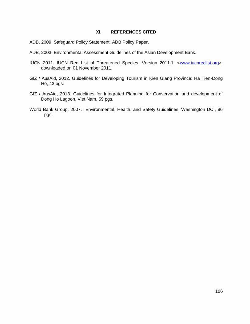
106
XI. REFERENCES CITED
ADB, 2009. Safeguard Policy Statement, ADB Policy Paper. ADB, 2003, Environmental Assessment Guidelines of the Asian Development Bank. IUCN 2011. IUCN Red List of Threatened Species. Version 2011.1. <www.iucnredlist.org>.
downloaded on 01 November 2011. GIZ / AusAid, 2012. Guidelines for Developing Tourism in Kien Giang Province: Ha Tien-Dong
Ho, 43 pgs. GIZ / AusAid, 2013. Guidelines for Integrated Planning for Conservation and development of
Dong Ho Lagoon, Viet Nam, 59 pgs. World Bank Group, 2007. Environmental, Health, and Safety Guidelines. Washington DC., 96 pgs.
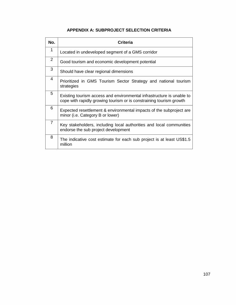
107
APPENDIX A: SUBPROJECT SELECTION CRITERIA
No. Criteria
1 Located in undeveloped segment of a GMS corridor
2 Good tourism and economic development potential
3 Should have clear regional dimensions
4 Prioritized in GMS Tourism Sector Strategy and national tourism strategies
5 Existing tourism access and environmental infrastructure is unable to cope with rapidly growing tourism or is constraining tourism growth
6 Expected resettlement & environmental impacts of the subproject are minor (i.e. Category B or lower)
7 Key stakeholders, including local authorities and local communities endorse the sub project development
8 The indicative cost estimate for each sub project is at least US$1.5 million

108
APPENDIX B: PARTICIPANTS AND VENUES OF PUBLIC CONSULTATIONS
Tay Ninh Province:
ENVIRONMENTAL PUBLIC CONSULTATION MINUTES
Project:
GMS Tourism Infrastructure for Inclusive Growth – Tay Ninh subproject
Time: 14h10, 9th August 2013
Venue: Meeting room of Tay Ninh provincial DCST
Participants:
1. Environmental protection agency (EPA) of Department of natural resource and environment of Tay Ninh province (DONRE)
2. Staff of Department of natural resource and environment of Tây Ninh town 3. Forest resource management unit – Department of Agriculture and Rural development
of Tay Ninh province 4. Staff of Department of Agriculture and Rural development of Tây Ninh town 5. Provincial DOT 6. Provincial DOC 7. Provincial DOH 8. Representatives of businesses owners at Ba Den mountain foot area 9. Representatives of Ba Den mountain management board 10. Representatives of pagoda management board on Ba Den mountain 11. Representatives of PC of Tay Ninh province 12. Representatives of PC of Tay Ninh town 13. Director of management board of Lo Go Xa Mat national park 14. Representatives of owners/operators of cable car on Ba Den pagoda 15. Representatives of owners/operators of entertainment on Ba Den mountain 16. Provincial DCST 17. Consultants 18. Others.
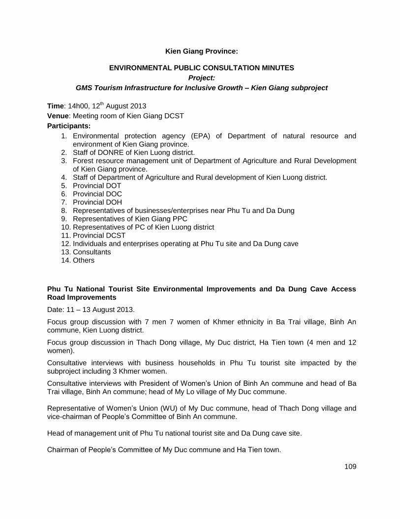
109
Kien Giang Province:
ENVIRONMENTAL PUBLIC CONSULTATION MINUTES
Project:
GMS Tourism Infrastructure for Inclusive Growth – Kien Giang subproject
Time: 14h00, 12th August 2013
Venue: Meeting room of Kien Giang DCST
Participants:
1. Environmental protection agency (EPA) of Department of natural resource and environment of Kien Giang province.
2. Staff of DONRE of Kien Luong district. 3. Forest resource management unit of Department of Agriculture and Rural Development
of Kien Giang province. 4. Staff of Department of Agriculture and Rural development of Kien Luong district. 5. Provincial DOT 6. Provincial DOC 7. Provincial DOH 8. Representatives of businesses/enterprises near Phu Tu and Da Dung 9. Representatives of Kien Giang PPC 10. Representatives of PC of Kien Luong district 11. Provincial DCST 12. Individuals and enterprises operating at Phu Tu site and Da Dung cave 13. Consultants 14. Others
Phu Tu National Tourist Site Environmental Improvements and Da Dung Cave Access Road Improvements
Date: 11 – 13 August 2013.
Focus group discussion with 7 men 7 women of Khmer ethnicity in Ba Trai village, Binh An commune, Kien Luong district.
Focus group discussion in Thach Dong village, My Duc district, Ha Tien town (4 men and 12 women).
Consultative interviews with business households in Phu Tu tourist site impacted by the subproject including 3 Khmer women.
Consultative interviews with President of Women’s Union of Binh An commune and head of Ba Trai village, Binh An commune; head of My Lo village of My Duc commune. Representative of Women’s Union (WU) of My Duc commune, head of Thach Dong village and vice-chairman of People’s Committee of Binh An commune. Head of management unit of Phu Tu national tourist site and Da Dung cave site. Chairman of People’s Committee of My Duc commune and Ha Tien town.
110
Summary of demographic and socio-economic characteristics
Binh An commune is a poor commune of Kien Luong district with an area of 3,993.55 ha. Land is suitable for the cultivation of vegetables; rice is difficult with one crop per year due to salinity and lack of irrigation. Most people are fishing and/or farming.
Binh An commune has a population of 11,088 people with 2,617 households, 992 out of which are ethnic monitory. Of the 992 ethnic minority households, there are 344 Hoa HHs, 645 Khmer HHs and 3 HHs from others ethnic minority.
Economic structure of the commune: Agriculture accounts for 10.0%, tourism for 40%; handicraft 15% and other areas account for 35%. The commune has 1 primary school, 1 secondary school and 1 healthcare station. 54.8% HHs are served with tap water (i.e. 1,433 HHs/total 2,617 HHs); 66% HHs (i.e. 1,726 HHs) have their own latrines with many types and quality; most are the simple latrines, the number of septic tanks is limited.
The Phu Tu national tourist site is located in area of Ba Trai village, Binh An commune. The village has been established since 1980s and has a land area of 199 ha. The village has stretching along the road for 6 km from the commune’s centre to Hon Trem tourist site. Although the road is downgraded it is useable in both dry and rainy season. Total population of the village is 2,924 with the equivalent of 669 households, of which the ethnic minorities account for 63.7%. Women represent 53% of the population of Ba Trai village and 52% of population of Binh An commune. There are 123 households (18.5%) are involved in trading and tourism services, of which 97 are kiosks owners and 26 offer accommodation and tourist transportation services. 90 out of 669 households depend on rice farming, 20 households on crops farming; 148 households on animal husbandry; 10 households on producing cake/sugar from Palmyra palm tree; 80 households have boats for sea fishing; 2.9% households are employed as builders.
Da Dung Access Road Improvements
My Duc commune: 1,430 HHs with 6,255 people; there are 3,170 people ethnic minority people, of which Khmer = 563 HHs with 2,814 people (52.9%); Kinh 40.9%; Hoa: 6.2%.
Agriculture accounts for 10% of economy, tourism 86% and handicrafts 4%.
52.9% of the population of My Duc commune is ethnic Khmer.
Thach Dong village: Population of 2,563 people, women represent 1,272 people, equivalent to 49.6%. 518 HHs (i.e. 84.2%) use tap water connected from Ha Tien town; 79.3% HHs have separate latrines.
Khmer people in Ba Trai village informed that in recent 15 years some important events happened. The first one is State’s land acquisition in 1997-1998 to which a group of HHs who have land acquired had objection reaction to the State because of too low compensation. The second one is that Hon Phu Tu was partially broken in 2007 and some people believe that that is the reason making this site less sacred and therefore number of visitors decreased.
The Khmer said that most of them and their children graduate primary school. The Khmer do not attach high importance to education because they prefer going to work to help their families. Moreover, some children graduating secondary or high school still cannot find job and finally stay home. In contrast, Hoa people pay more attention to their children’s education. They want their children graduate high school or university to leave village for better employee opportunities in the big cities like Binh Duong or Ho Chi Minh.
Binh An commune has 1 healthcare station located in the centre. People of Ba Trai village have to go 5km to access health services of the station. The village has only 1 primary school, the children at secondary and high school have to go more than 10km to school.
111
People of Ba Trai village using 3 main water resources: 30.6% HHs using wells; 30.4% of HHs use tap water, and 39% use combined tap water; 18.7% HHs use water from the streams and mountainous creeks; the remaining use various water resources. In Thach Dong village, the HHs located near road use tap water, the HHs near Da Dung cave area use well water because the mains has not reached them.
The main incomes of Ba Trai people is from agriculture, including rice farming (90 HHs) and cattle husbandry (148 HHs with number of cattle of 311), sea fishing (80 boats) and small trading at tourist site (97 HHs have stalls and 27 HHs offer accommodation and passenger transport services). By assessment of local people, economic status of the village in recent years seems to decline due to decreased number of visitors, influence of bad weather conditions and failed shrimp farming.
In view of both local authority and residents, the reason for change in number of visitors is that the tourist site has not invested and upgraded in many years. Domestic waste from tourism activities, food and beverage trading and lack of public toilets has seriously impacted area’s environment. The trading activities and stalls are disorderly and make a negative impression to the visitors. Phu Tu site has not any entertainment services rather than beach bathing. Before 2009, the sire was under management of Peoples Committee of the District, the annual number of arrivals reached 200,000-600,000 on average. After 2009, the administration management was assigned to Kien Giang Tourist JSC – then the number of arrivals reduced by more than 50%. The reason is lack of investment and poor site management.
The tourism environment has gradually downgraded with untreated waste. The beach is degraded by sediment and bears consequences from “Flood drainage for the western region” of Southwest provinces (digging channels to lead floodwater to the sea helping the western provinces of Dong Thap, An Giang and Kien Giang to avoid flooding).
Number of the poor in Ba Trai and Hon Phu Tu area - 9 HHs (accounting for 1.3%) with income under D400,000/person/ month, 01 near-poor HH with income of D410,000/ person/ month.
Number of poor HHs in Thach Dong: N/A
Almost all poor HHs are ethnic minority HHs. Reason for the poverty of these HHs are recorded as lack of production land. The poor HHs are mostly farming HHs but have no land for agricultural production because of being sold out to pay debt. Income of the whole HHs depends on man’s employment and woman’s peddling in the tourist site and therefore is unstable.
Lack of working capital
Long illness of family’s members
In Thach dong, some people are involved in gambling in border are with Cambodia which drives their families deep in poverty.
Limited education and knowledge background
Gender relationship
Generally, men are considered as the head of family and have right of making the most important family’s decisions.
The farming work in the fields such as plowing, sowing, spraying, harvesting is mostly undertaken by men. Men are also the main labor force in sea fishing. Women often support men’s work by weeding or selling the fishing products.
112
Women often do the housework and men are often employed as laborers. To the HHs trading in Da Dung and Hon Phu Tu tourist site, women are the main sellers and men support them.
Men (excepting the fishing men) often participate the meetings held by the village or commune authorities.
Through women’s participation in the community’s activities such as protecting environmental conditions, lending capital for household’s economic improvement, women’s position has been increased even though slow.
Women nowadays have better economic, social and cultural knowledge; living condition (healthcare, wearing, housing, transportation services and cultural demand) has been improved although household’s incomes seem to decline in 2012-2013 (according to opinions of the households); the birth rate reduces from 5 children/household to 2 or 3 children/household.
However, women’s participation in commune’s authorities and mass organizations in My Duc and Binh An commune is very low. The Women’s Union is obviously headed by women. Women often undertake tasks of accounting, cashier in People’s Committee at commune level. Leaders of commune and villages are men. Khmer women don’t really care about community activities because they are too busy with making ends meet. Awareness of residents and commune’s leaders on the proposed subprojects
Whilst leaders of both communes are clearly and sufficiently informed about the subproject (by the meetings hold by provincial DSCT and PC of Kien Luong district and Ha Tien town), just a few households knew about it before the consultations. On benefits and negative impacts in regard to gender approach
People and leaders of Binh An commune as well as My Duc commune think that the Phu Tu and Da Dung tourist site upgrading will benefit local socio-economic and tourism development, thanks to exploiting the tourism potential of localities attracting more visitors
Creating employee opportunities for local labor, promoting economic development.
Creating the provincial/district/commune tourism branch thanks to lots of visitors
Linking with other provincial tourist site in a tour of various destinations (the visitors can visit many destinations conveniently).
Women representatives of Khmer HHs in Da Dung site are very hesitate to express their opinions and need much encouragement. This is different from northern women – Khmer are still not familiar with community activity.
Khmer HHs in FGDs at two localities also said that the residential community, especially women may benefit from the increased demand on tourism services. Almost all Khmer women are street vendors selling Palmyra palm cake, sugar, fruit and others beverage, etc. in the tourist site, so the investment in this area will bring the positive impacts on their livelihoods.
Some jobs that are disappearing may have chance for development because women are willing to make the products for tourists, such as making cake from palm sugar, bamboo products, products from sea clams and snails.
If the trading in tourist site becomes convenient, the men leaving home can come back to support their women and stay local.
President of the WU of Binh An commune said that the subproject together with community activities will help people have higher awareness on sea environmental protection. The

113
women in general and Khmer women in particular will have opportunity to strengthen their understandings on gender issue and women’s rights.
Negative impacts
The Khmer women (in Phu Tu site) complain that they cannot have a kiosks in the tourist site although they are the local residents, because they are too poor to have enough money for buy/rent a kiosk there. They are selling as the street vendors and often annoyed by security team in the tourist site. They wish to have a place in the tourist site without charging such a high amount (approximately 2 million). They said that if this issue won’t be taken into consideration, the project investment becomes meaningless to them.
Some negative impacts mentioned by the people are that during construction at Phu Tu trading activities of HHs may temporarily stop due to construction. Crime may increase after construction.
The representatives of Binh An commune authority thinks that Hon Phu Tu site is located far from residential area and therefore won’t cause any impacts.
Others felt the subproject would impacts on the environment during construction such as dust, noise affecting trading activity of HHs in tourist site.
Women sellers in the tourist site also concern about environmental condition of “Hon Phu Tu” because in their view the environmental management of the agency in charge doesn’t work well. Waste is left on beach too much. Waste from seafood restaurants has not been treated causing odor in some places.
Concern about having no place/kiosk in the tourist site because of lack of money.
The people at risk of wrong use or waste compensation amount (from land acquisition payments) and no longer build house. Leaders of local authority and WU of Binh An commune and My Duc commune mention the following potential negative impacts of tourism development
Waste and wastewater increased
Increased Volume of tourist coaches leads to air pollution due to emission.
Conflicts among vendors due to competition
Prostitution problem.
The HHs in Thach Dong don’t take much interest in environmental issues at Da Dung site. In their view, construction and upgrading of some tourist site’s items are advantageous for both local people and visitors. Women will benefit more because they are the direct sellers in tourist site. Desire of community – Solutions proposed from public consultation and interviews with key persons.
The tourist site should be improved as soon as possible to soon come into operation (both two subprojects).
Should pay attention to check of work quality, O&M and management so that the work won’t downgrade like other works.
Pay attention to working safety and minimize impacts from dust and waste to the working environment of people.
Design entertainment areas to keep visitors stay longer. The existing services of the tourist site are quite poor and simple.
Should pay much attention to designing and construction of public toilet and waste treatment system.
114
Facilitate the poor, especially Khmer HHs, to obtain the selling place/kiosk in the tourist site. If not, the poor won’t benefit from upgrading and improvement of Phu Tu and Da Dung tourist site.
Construct a community-based tourism development fund and lend HHs with low interest rate (or even no interest) to help women start getting involved in trading after being trained.
Training to Khmer people, especially women, on the experiences/behaviors/attitudes they should have with the visitors.
Training/guiding production of community-based tourism products, new souvenirs.
Training on rising awareness on protecting environment and landscape to people and visitors.
Training on gender and role of women in community-based tourism development.
Provide affected HHs with appropriate compensation amount for the assets or land impacted (group of impacted HHs)
Training and guiding employee skills/livelihoods to people/women at request of the impacted persons.
Connect tap water for the poor.
Information disclosure to people about plan for construction and improvement for monitoring.
115
Ha Tinh Province:
ENVIRONMENTAL PUBLIC CONSULTATION MINUTES
Project:
GMS Tourism Infrastructure for Inclusive Growth – Ha Tinh subproject
Time: 7h30, 16th August 2013
Venue: Meeting room No.2 of Ha Tinh DCST
Participants:
1. Environmental protection agency (EPA) of Department of natural resource and environment of Ha Tinh province (DONRE)
2. Staff of Department of natural resource and environment of Can Loc district (Huong Tich pagoda) and Nghi Xuan (Nguyen Du)
3. Forest resource management unit – Department of Agriculture and Rural development of Ha Tinh province
4. Staff of Department of Agriculture and Rural development of Can Loc and Nghi Xuan district
5. Provincial DOT 6. Provincial DOC 7. Provincial DOH 8. Representatives of businesses owners in Nguyen Du cultural and tourist area 9. Representatives of residents in Nguyen Du cultural and tourist are. 10. Representatives of PC of Can Loc and Nghi Xuan district 11. Huong Tich pagoda management board 12. Representatives of cable car operators in Huong Tich site 13. Provincial DCST 14. Consultants 15. Others

116
Dien Bien
ENVIRONMENTAL PUBLIC CONSULTATION MINUTES
Project:
GMS Tourism Infrastructure for Inclusive Growth – Dien Bien subproject
Time: 08h00, 22nd August 2013
Venue: Meeting room No.2 of Dien Bien DCST (Residential block 4, Muong Thanh ward, Dien
Bien Phu city)
Participants:
1. Environmental protection agency (EPA) of Department of natural resource and environment of Dien Bien province (DONRE)
2. Staff of Department of natural resource and environment of Muong Phang 3. Forest resource management unit – Department of Agriculture and Rural development of
Dien Bien province 4. Staff of Department of Agriculture and Rural development of Mường Phăng 5. Provincial DOT 6. Provincial DOC 7. Provincial DOH 8. Representatives of businesses owners in Mường Phăng 9. Representatives of PC of Điện Biên 10. Representatives of PC of Mường Phăng district 11. Provincial DCST 12. Business people working near De Castries Bunker 13. Residential located near De Castries Bunker 14. Operator of Bonsai nursery at De Castries Bunker 15. Consultants 16. Others
117
Lao Cai Province:
ENVIRONMENTAL PUBLIC CONSULTATION MINUTES
Project:
GMS Tourism Infrastructure for Inclusive Growth – Lao Cai subproject
Time: 14h00, 25th August 2013
Venue: Meeting room of Lao Cai DCST
Participants:
15. Environmental protection agency (EPA) of Department of natural resource and environment of Lao Cai province.
16. Staff of Department of natural resource and environment of Sa Pa district. 17. Forest resource management unit – Department of Agriculture and Rural development of
Lao Cai province. 18. Staff of Department of Agriculture and Rural development of Sapa district. 19. Provincial DOT 20. Provincial DOC 21. Provincial DOH 22. Representatives of businesses/enterprises in Ta Phin village 23. Representatives of Lao Cai PPC 24. Representatives of PC of Sapa district 25. Provincial DCST 26. Business people near Lao Cai bus station 27. Individuals and enterprises operating coach services in parking are of Lao Cai bus
station 28. Consultants 29. Others
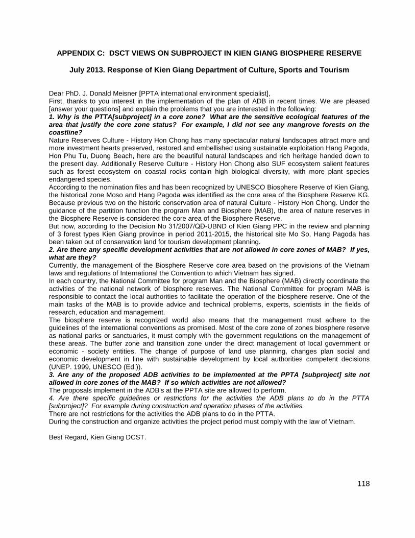
118
APPENDIX C: DSCT VIEWS ON SUBPROJECT IN KIEN GIANG BIOSPHERE RESERVE
July 2013. Response of Kien Giang Department of Culture, Sports and Tourism
Dear PhD. J. Donald Meisner [PPTA international environment specialist], First, thanks to you interest in the implementation of the plan of ADB in recent times. We are pleased [answer your questions] and explain the problems that you are interested in the following: 1. Why is the PTTA[subproject] in a core zone? What are the sensitive ecological features of the area that justify the core zone status? For example, I did not see any mangrove forests on the coastline? Nature Reserves Culture - History Hon Chong has many spectacular natural landscapes attract more and more investment hearts preserved, restored and embellished using sustainable exploitation Hang Pagoda, Hon Phu Tu, Duong Beach, here are the beautiful natural landscapes and rich heritage handed down to the present day. Additionally Reserve Culture - History Hon Chong also SUF ecosystem salient features such as forest ecosystem on coastal rocks contain high biological diversity, with more plant species endangered species. According to the nomination files and has been recognized by UNESCO Biosphere Reserve of Kien Giang, the historical zone Moso and Hang Pagoda was identified as the core area of the Biosphere Reserve KG. Because previous two on the historic conservation area of natural Culture - History Hon Chong. Under the guidance of the partition function the program Man and Biosphere (MAB), the area of nature reserves in the Biosphere Reserve is considered the core area of the Biosphere Reserve. But now, according to the Decision No 31/2007/QĐ-UBND of Kien Giang PPC in the review and planning of 3 forest types Kien Giang province in period 2011-2015, the historical site Mo So, Hang Pagoda has been taken out of conservation land for tourism development planning. 2. Are there any specific development activities that are not allowed in core zones of MAB? If yes, what are they? Currently, the management of the Biosphere Reserve core area based on the provisions of the Vietnam laws and regulations of International the Convention to which Vietnam has signed. In each country, the National Committee for program Man and the Biosphere (MAB) directly coordinate the activities of the national network of biosphere reserves. The National Committee for program MAB is responsible to contact the local authorities to facilitate the operation of the biosphere reserve. One of the main tasks of the MAB is to provide advice and technical problems, experts, scientists in the fields of research, education and management. The biosphere reserve is recognized world also means that the management must adhere to the guidelines of the international conventions as promised. Most of the core zone of zones biosphere reserve as national parks or sanctuaries, it must comply with the government regulations on the management of these areas. The buffer zone and transition zone under the direct management of local government or economic - society entities. The change of purpose of land use planning, changes plan social and economic development in line with sustainable development by local authorities competent decisions (UNEP. 1999, UNESCO (Ed.)). 3. Are any of the proposed ADB activities to be implemented at the PPTA [subproject] site not allowed in core zones of the MAB? If so which activities are not allowed? The proposals implement in the ADB's at the PPTA site are allowed to perform. 4. Are there specific guidelines or restrictions for the activities the ADB plans to do in the PTTA [subproject]? For example during construction and operation phases of the activities.
There are not restrictions for the activities the ADB plans to do in the PTTA. During the construction and organize activities the project period must comply with the law of Vietnam. Best Regard, Kien Giang DCST.