Combining scenario planning and business wargaming ... - Pure
Upload
khangminh22Category
view
0download
0
The Study on Infrastructure (Road Network) Development Plan for the Autonomous Region in Muslim Mindanao (ARMM)
4. REGIONAL DEVELOPMENT SCENARIO 4.1 Regional Development Direction
Taking into account the present economic performance, accumulation of facilities, land uses, potential of land among others, the overall Mindanao regional development concept is formulated as shown in the figure below.
4.2 Regional Development Objectives and Strategy
Based on the review of several existing national/regional plans and development issues, regional development goals and strategies were established as shown in the figure below.
Overall Mindanao Regional Development Concept
Regional Development Goals and Strategy
Issues of the Region Development Goals Development Strategies
Regional Economy Transport Infrastructure
Conflict Affected AreaAttainment of Peace and
OrderAdequate/Stable
Economic Growth
Improvement of Accessibility to Basic
Social Services
Poorest Region in the Philippines
Low Productivity
Less Investments for Developments
Untapped Potential Resources
Export of Raw Products
High Transportation Cost/ nsufficient
Freight Movements
Change Deteriorating Trends towards
Mindanao/National Level
Improvement to Mindanao/National Level
Improved Condition for Investment Motivation
Development of Potential Areas
Value-adding of Agriculture/Fishery
Products
Efficient Freight Movement by Transport Cost
Reduction
Developments in Agriculture and Fishery Sectors
Modernization and Shift to Multi-cropping
Promotion of Private Sector Investment
Promotion of Domestic/ Foreign
Investments
Upgrading of Agri-Business/ Industry
Development of Transport Infrastructure
Improvement of Communication Network
Improvement of Accessibility
Improvement of Inter-modal Transhipment,
Logistic System, Alternative Modes not only by Road-Oriented
Cas
ual
Inte
r-re
lati
on
ship
s B
etw
een
Eac
h O
ther
Executive Summary
5

The Study on Infrastructure (Road Network) Development Plan for the Autonomous Region in Muslim Mindanao (ARMM)
4.3 Future Socio‐economic Framework a.) Population The total populations of the Study Area are estimated to be 15.1million in 2015 (1.2 times of 2007), 16.9million in 2020 (1.34 times) and 18.7million in 2025 (1.49 times), respectively as shown in the table below.
Future Population 2007 2015 2020 2025
4,120,795 5,022,700 5,625,500 6,235,400
Basilan 408,520 501,400 539,900 598,400
Lanao del Sur 1,138,544 1,338,300 1,468,300 1,627,500
Maguindanao 710,829 946,200 1,098,500 1,217,600
Shariff Kabunsuan 562,886 699,900 778,500 862,900
Sulu 849,670 970,700 1,055,500 1,169,900
Tawi-Tawi 450,346 566,200 684,800 759,100
3,339,464 3,968,300 4,409,300 4,887,400
Bukidnon 1,190,284 1,430,400 1,623,000 1,799,000
Lanao del Norte 846,329 966,500 1,033,100 1,145,100
Misamis Oriental 1,302,851 1,571,400 1,753,200 1,943,300
5,125,877 6,143,800 6,844,900 7,587,000
North Cotabato 1,121,974 1,753,800 1,917,700 2,125,700
Sarangani 475,514 742,800 817,800 906,500
South Cotabato 1,296,796 2,107,700 2,411,300 2,672,700
Sultan Kudarat 675,644 1,055,600 1,166,600 1,293,100
Cotabato City 259,153 483,800 531,400 589,100
12,586,136 15,134,800 16,879,700 18,709,800
Region / Province
Study Area Total
ARMM
Region X (Study Area only)
Region XII
Executive Summary
6
Population growth rates in the past and projected are shown in table below.
Population Growth Rates
Actual Growth Rate (%) Study Team's Assumption Region
1980‐1990
1990‐1985
1995‐2000
2000‐2007
2007‐2015
2015‐2020
2020‐2025
ARMM 2.99 2.32 3.48 5.66 2.51 2.29 2.08
Region X 2.36 2.60 1.98 1.81 2.18 2.13 2.08
Region XII 3.37 3.48 2.65 2.46 2.29 2.19 2.08
Study Area Total
2.67 3.23 2.33 2.21 2.08
Philippines Total
2.35 2.48 2.15 2.15 2.08 (by NSC based on 2000 census)
b.) Gross Regional Domestic Product (GRDP) An assessment was carried out based on the assumption that all of the Study Area will be developed in the future in accordance with the proposed development scenarios. The results are summarized in the table below and also shown in the succeeding figures.
Projected GRDP By Region (PhP Million) Comparison Composition
2007 2015 2020 2025 2025/2007 in 2025 (%)
Agriculture 26,315 37,078 46,025 57,616 2.19 47.4
Industry 8,320 12,539 16,615 22,200 2.67 18.3
Service 21,248 28,684 34,471 41,780 1.97 34.4
Total 57,890 78,300 97,110 121,597 2.10 100.0
Agriculture 81,478 143,640 179,629 223,327 2.74 24.6
Industry 102,686 162,611 221,499 300,005 2.92 33.0
Service 126,021 201,208 277,966 385,449 3.06 42.4
Total 310,186 507,459 679,094 908,781 2.93 100.0
Agriculture 86,944 129,013 168,886 218,688 2.52 41.1
Industry 72,432 101,051 125,629 159,854 2.21 30.1
Service 60,945 90,697 116,495 153,136 2.51 28.8
Total 220,322 320,761 411,009 531,679 2.41 100.0
Region X
ARMM
Region XII
Projected GRDP (ARMM)
0
20,000
40,000
60,000
80,000
100,000
120,000
PhP Million
2007 2015 2020 2025
Service
Industry
Agriculture
Projected GRDP (Region X)
Projected GRDP (Region X)
0
100,000
200,000
300,000
400,000
500,000
600,000
700,000
800,000
900,000
PhP Million
2007 2015 2020 2025
Service
Industry
Agriculture
0
100,000
200,000
300,000
400,000
500,000
600,000
PhP Million
2007 2015 2020 2025
Service
Industry
Agriculture

The Study on Infrastructure (Road Network) Development Plan for the Autonomous Region in Muslim Mindanao (ARMM)
5. ARMM ROAD SECTOR OVERVIEW 5.1 Legal Framework a.) ARMM
The Autonomous Region in Muslim Mindanao (ARMM) was established by Republic Act (RA) No. 6734, dated 1 August 1989, also known as the Organic Act for ARMM. RA 6734 was amended by RA 9054, dated 31 March 2001, to strengthen and expand the Organic Act. Under RA 9054, the province of Basilan and the city of Marawi were added to ARMM. Presently, ARMM is composed of the five provinces of Basilan, Lanao del Sur, Maguindanao, Sulu, and Tawi‐Tawi, and the city of Marawi. b.) DWPH‐ARMM The powers and responsibilities of ARMM pertaining to infrastructure programs and projects within the ARMM territory may be gleaned from the provisions of RA 9054 (Organic Act) as well as other existing laws, including Executive Orders (EO) No. 426, dated 12 October 1990, EO 125, dated 16 September 2002, and EO 125‐A, dated 29 November 2002, of the President of the Philippines, and the Local Government Code (LGC). These powers and responsibilities are exercised by DPWH‐ARMM headed by the Department Secretary under the supervision of the Regional Governor. Pursuant to EO 426, DPWH‐ARMM is responsible for highways, flood control and water resource development systems, and other public works within ARMM and shall perform the following responsibilities: Undertake and evaluate the planning, design,
construction and works supervision for the infrastructure projects whose location and impact are confined within ARMM.
Undertake the maintenance of infrastructure facilities within ARMM and supervise the maintenance of such local roads and other infrastructure receiving financial assistance from the national government.
Ensure the implementation of laws, policies, programs, rules and regulations regarding infrastructure projects as well as all public and private physical structures within ARMM.
Provide technical assistance related to their functions to other agencies within ARMM, especially LGUs.
Coordinate with other National and Regional Government departments, agencies, institutions, and organizations, especially LGUs within ARMM in the planning and implementation of infrastructure projects.
Conduct continuing consultations with the local communities, take appropriate measures to make the infrastructure services of the Regional Government responsive to the needs of the general public and recommend such appropriate actions as may be necessary.
Perform such other related duties and responsibilities within ARMM as may be assigned or delegated by the Regional Governor or as may be provided by law.
5.2 Organizational Structure of DPWH‐ARMM DPWH‐ARMM is headed by a Regional Secretary and assisted by a lone Assistant Regional Secretary. The Bureau of Operations is the technical group in the Regional Office proper that is directly involved in infrastructure development. The Bureau of Services on the other hand provides the administrative and financial services in support of the regional operations.
DPWH‐ARMM Organizational Chart
REGIONAL
SECRETARY
ASSISTANT REGIONAL SECRETARY
BUREAU OF SERVICES
ADMINISTRATIVE DIVISION
FINANCIAL AND MANAGEMENT
DIVISION
SURVEY & DESIGN DIVISION
CONSTRUCTION DIVISION
REGIONAL SECRETARY
PLANNING & PROGRAMING DIVISION
REGIONAL SECRETARY
MAINTENANCE DIVISION
MATERIALS QUALITY CONTROL &
HYDROLOGY DIVISION
EQUIPMENT DIVISION
MAGUINDANAO III ENGINEERING DISTRICT
LANAO DEL SUR II ENGINEERING DISTRICT
MAGUINDANAO AREA EQUIPMENT SERVICES
SULU II ENGINEERING DISTRICT
LANAO DEL SUR I AREA EQUIPMENT SERVICES
LANAO DEL SUR II AREA EQUIPMENT
TAWI‐TAWI ENGINEERING DISTRICT
SULU AREA EQUIPMENT
MAGUINDANAO I ENGINEERING DISTRICT
LANAO DEL SUR I ENGINEERING DISTRICT
TAWI-TAWI AREA EQUIPMENT
SULU I ENGINEERING DISTRICT
BUREAU OF OPERATIONS
Executive Summary
7
The Study on Infrastructure (Road Network) Development Plan for the Autonomous Region in Muslim Mindanao (ARMM)
5.3 Budgetary Framework
a.) Main Sources of ARMM Funds The Regional Government has the power to create its own sources of revenues and to levy taxes, fees and charges, subject to the provisions of the Constitution and the Organic Act (RA 9054, Article IX, Section 1).
The sources of revenues of the Regional Government include, but are not limited to, the following (Article IX, Section 8): Taxes, except income taxes, imposed by the
Regional Government. Fees and charges imposed by the Regional
Government. Taxes, fees or charges for the registration of
motor vehicles and for the issuance of licenses and permits for driving, except tricycles which shall be registered with the city/municipality.
Shares and revenues generated from the operation of public utilities within the region.
Appropriations, shares in the internal revenue taxes, block grants, and other budgetary allocations, coming from the national government.
Block grants from economic agreements or conventions entered into or authorized by the Regional Assemble, donations, endowments, foreign assistance, and other forms of aid, subject to the pertinent provisions of the Constitution.
b.) National Government Funds for Infrastructure in ARMM
ARMM derives most of its funds for infrastructure programs and projects from the National Government – particularly from (i) the General Appropriations Act (GAA) which is authorized yearly by Congress and (ii) the Special Funds from the Motor Vehicle User’s Charge (MVUC) under RA 8794.
Table below summarizes the appropriations from 2006 to 2009, broken down into Personal Services (PS), Maintenance and Other Operating Expenses (MOOE), and Capital Outlays (CO). Also shown (in parentheses) are the appropriations for the infrastructure components of MOOE and CO.
Appropriations in the GAA ( 2006‐2009) In Php Million
Category 2006 2007 2008 2009 2009 Breakdown
2009/2008
PS 4,456.4 5,075.1 5,144.7 6,173.6 66.7% 20.0%MOOE 1,338.0 2,148.7 2,164.0 1,893.4 20.5% -12.5%MOOE for infra
(180.6) (210.2) (215.2) (221.7) (2.4%) (3.0%)
Capital Outlays (CO) 846.8 1,420.5 1,022.7 1,182.0 12.8% 15.6%
CO for infra (650.0) (650.0) (650.0) (1,000.0) (10.8%) (53.8%Total 6,691.2 8,644.3 8,331.5 9,249.0 100.0% 11.0%
c.) GAA Capital Outlays under the ARMM Budget Under the ARMM budget in the GAA, regular lump‐sum appropriations have been authorized yearly from 2006 to 2009 for “Infrastructure Projects for the Implementation of DPWH‐ARMM” in the amount of PhP 650.00 million. The budget for infrastructure however sharply increases from PhP 650.000 to Php 1,000.0 million in 2009.
d.) Capital Outlays under DPWH‐National Budge in GAA
Under its regular infrastructure program funded from the GAA, DPWH‐National has been providing funds for, and is directly implementing, the construction/improvement of national roads in ARMM. This involves mainly foreign‐assisted projects which are partly financed by loans from the Japan International Cooperation Agency (JICA), Kuwait Fund, and Saudi Fund, where the loan agreements specified that DPWH‐National would be the implementing agency. DPWH‐National has also provided funding for locally‐funded national road construction projects in ARMM, mostly through Congressional Allocations (CA) which also financed local roads, flood control, water supply, and other local projects identified by the Congressmen concerned.
e.) Maintenance Funds for Infrastructure in ARMM
The maintenance of national roads and other infrastructure in ARMM is funded from two sources: (i) ARMM budget in the GAA and (ii) DPWH‐National budget from the MVUC special funds.
f.) Maintenance Funds under ARMM Budget in GAA
Under the ARMM budget in the GAA, funds for the maintenance of roads and other infrastructure are provided under the item for Maintenance and Other Operating Expenses (MOOE) for the “implementation of infrastructure programs and projects (RDPWH).” These amounted to Php 180.6 million in 2006, which modestly increased to Php 221.7 million in 2009.
Annual Allocation for Maintenance of National Roads from GAA‐ARMM (2006‐2008)
District Allocation, Php EMK
Maguindanao 14,162,000 206.2
Shariff Kabunsuan 19,677,000 286.4
Lanao del Sur I 18,807,100 273.8
Lanao del Sur II 25,435,250 370.3
Marawi City 2,204,350 32.1
Sulu I 11,239,550 163.6
Sulu II 5,357,350 78.0
Tawi‐Tawi 13,699,000 199.4
Total, ARMM 110,581,600 1,609.8
Executive Summary
8

The Study on Infrastructure (Road Network) Development Plan for the Autonomous Region in Muslim Mindanao (ARMM)
Executive Summary
9
g.) Maintenance Funds under ARMM Budget from MVUC
DPWH‐National provides funds from the Motor Vehicle User’s Charge or MVUC (RA 8794) for the maintenance of national roads in ARMM as well as in the regular regions of DPWH‐National.
DPWH‐National Allotment of MVUC Funds for Maintenance of National Roads in ARMM (2006‐2008) Amount in Php 1,000
2006 2007 2008
Basilan 31,556 8,819 10,693
Sulu 42,659 17,960 28.784
Maguindanao I 17,581 23,275 6,977
Maguindanao II 1,887 6,535
Lanao del Sur I 27,924 16,937 17,405
Lanao del Sur II 2,634 7,951 18,700
Tawi‐Tawi 7,691 23,780 19,010
Marawi City 503 1,603 1,642
Total, ARMM 132,435 107,265 109,746
5.4 Road Project Implementation The general rule in implementing road and other infrastructure projects of ARMM is provided in Section 6 of the Regional Public Works Act (PWA) which prescribes that all projects funded from appropriations authorized in the PWA shall be implemented by either administration, public bidding, negotiated contract, or memorandum of agreement with local government unit, at the option of the project proponent, but the awards shall, in all cases, be made in a manner most advantageous to the government.
Hence, the mode of implementation varied depending upon the recommendations of the project proponents – viz., ARMM officials for Regional Impact Projects (RIPs), Provincial Governors with Municipal Mayors for Provincial Impact Projects (PIPs), and ARMM Assemblymen for District Impact Projects (DIPs). The implementation modes included the following:
a.) Regional Impact Projects by administration by the DPWH‐ARMM
Construction Division, which, in some cases contracted private firms to provide portions of the required equipment, materials, and labor; or
through MOAs with Provincial/Municipal Governments. In turn, these LGUs undertook the work by administration or by contract.
b.) Provincial Impact Projects PIPs were carried out mostly through MOAs with Provincial/Municipal Governments, which undertook the work by administration or by contract.
c.) District Impact Projects by contract supervised by the DPWH‐
ARMM Construction Division or DEO; by administration by the DPWH‐ARMM
Construction Division, which sometimes contracted private firms to provide portions of the required equipment, materials, and labor; or
through MOAs with Provincial/Municipal Governments, which undertook the work by administration or by contract.
5.5 Road Maintenance System a.) Road Maintenance Bodies in ARMM DPWH‐ARMM has full responsibility for the maintenance of national roads and bridges.
Road Classification and Responsible Organization
Road Maintenance
Classification
Responsible for
Road Maintenance
National Road DPWH‐ARMM
Provincial Road Provincial Government
City Road City Government
Municipal Road Municipal Government
Barangay Road City or Municipal Government
b.) Allocated Maintenance Budget The annual maintenance budget allocated to DEOs and AESOs is about 110 Million Pesos. The budget allocated to each of the eight (8) DEOs is about 10 Million Pesos to 25 Million Pesos depending on the National Road length.
c.) Annual Maintenance Work Program (AMWP) System
Generally, the draft Annual Maintenance Work Program (AMWP) is prepared by the DEO and AESO. The draft AMWP is integrated and reviewed by the Maintenance Division and Equipment Division in DPWH‐ARMM headquarter, and they are responsible for seeking approval from the Regional Secretary.
d.) Implementation System of Road and Bridge Maintenance
Lately, the execution of maintenance works is carried out only by Maintenance by Administration (MBA) system although in the early years of the department, Maintenance by Contractor (MBC) was also utilized. The District Engineering Office (DEO) and the Area Equipment Service Office (AESO) have full responsibility over the execution of maintenance on the National Roads.
e.) Manpower in Maintenance Organization The total number of DPWH‐ARMM staff is 605 of which 127 are working in Regional Office headquarters and 20 to 70 staffs are working in each of the eight (8) offices of DEO depending upon the National Road maintenance length

The Study on Infrastructure (Road Network) Development Plan for the Autonomous Region in Muslim Mindanao (ARMM)
Executive Summary
10
required. About 15 to 40 staffs are working in each of the five (5) offices of AESO.
The Maintenance Division (MD) and Equipment Division (ED) in DPWH‐ARMM headquarters are fully responsible of the road and bridge maintenance in good cooperation with DEO and AESO. The MD has seven (7) Engineers.
Number of Staff in DEOs and AESOs Staff at DEO Staff at AESO
1) Shariff Kabunsuan 41 ‐
2) Maguindanao 32 41
3) Lanao del Sur (I) 73 37
4) Lanao der Sur (II) 20 ‐
5) Sulu (I) 75 41
6) Sulu (II) 45 ‐
7) Tawi‐Tawi 59 14
8) Basilan ‐ ‐
f.) Condition of Equipment in Area Equipment Service Office (AESO)
Major equipments that can be operated for the execution of maintenance works are mainly (i) dump‐truck, (ii) bulldozer, (iii) vibrator, and (iv) concrete mixer. The workable equipments are very few. Major equipments are also waiting for repair for quite a long time. There is an extreme shortage in the number and type of equipments in each office of AESO. However, they cannot procure new maintenance equipments due to shortage of maintenance budget.
5.6 Database for Planning and Management a.) Planning Database The current database for national roads in DPWH‐ARMM is deemed inadequate for planning and management of roads which considerably hampered the quality of work done by the regional planning staff. The road inventory for national roads consists
mainly of Road Diagrams and Bridge Lists (RDBL) prepared by DEOs, following the old DPWH‐National format.
The RDBL, if properly prepared, would serve as a basic reference on the existing features and conditions of roads and bridges. It would be a useful, although not sufficient, input in preparing plans and programs for road improvement and maintenance.
RDBL data, however, are not always accurate or complete and complete input data are seldom provided in the RDBL. DPWH‐National
has already replaced the RDBL by the computerized Road and Bridge Information Application (RBIA) system.
Some data on the condition of national roads are provided by DEOs to the DPWH‐ARMM Maintenance Division, following the subjective ratings (good, fair, poor, bad) previously used by DPWH‐National. DPWH‐National has already replaced this method by the more objective and precise International Roughness Index (IRI) and Visual Road Condition (ROCOND) rating systems.
Reliable traffic data needed for planning are not available.
The planning database, as well as planning tools, of DPWH‐National has been modernized and is supported by information and communication technology (ICT) systems. The DPWH‐National database, however, has not included ARMM since the latter became autonomous.
b.) Maintenance Database The existing database for roads described above is essentially used by both planning and maintenance staff. The programming and management of maintenance works on national roads in ARMM is greatly hindered by the following weak characteristics of the database, particularly as they relate to maintenance. The existing road inventory data are old and
the data system which is largely provided by the RDBL is inadequate, as mentioned. Precise and up‐to‐date information on the actual conditions of the roads is wanting.
Reliable information on bridge elements (span, pier, abutment), attributes (e.g., for span ‐ deck, main members, secondary members, etc; for pier/abutment ‐ main structure, foundation, scour protection, etc.), and condition (degree of deterioration) is scarce.
There is no effective and regular system for inspecting roads and bridges, assessing conditions, identifying defects/damages and their degree of severity, and monitoring the changes in conditions over time. The data would be necessary in planning and costing appropriate repair, maintenance, or rehabilitation works.
Records of “as‐built” drawings of road, bridges and other structures are not systematically kept. Much less are these drawings updated to reflect the series of improvement and repair works done.

The Study on Infrastructure (Road Network) Development Plan for the Autonomous Region in Muslim Mindanao (ARMM)
6. ROAD DEVELOPMENT LEVEL OF ARMM 6.1 Road Length 6.2 Pavement Type The length of surveyed national roads under the ARMM is about 891 km of which 71% are in good/fair condition. National road density of ARMM is the lowest in the country and less than ½ of national average.
ARMM’s pavement ratio of 76.8% is slightly higher than the national average (71.5%), and the highest among Regions in Mindanao. Map showing pavement type of national roads in ARMM and in Regions X and XII is presented in the following page.
Note:
L : Road Length (km)
P : Population in 1,000
A : Land Area in sq. km
6.3 Pavement Condition
Paved national roads of ARMM have the following condition: 71.1% (good/fair), 22.3% (poor/bad) and 6.6% were not covered by the survey for security reasons.
National Road Length and Road Density of Each Region (2008)
Population in Land Area Road Length
Thousand (2007) (sq.km.) (km)
88,545 309,771 29,370 0.177
NCR 11,553 620 1,032 0.386
CAR 1,521 19,422 1,846 0.340
Region I 4,546 13,013 1,610 0.209
Region II 3,051 28,229 1,765 0.190
Region III 9,721 22,015 2,032 0.139
Region IV‐A 11,743 16,873 2,404 0.171
Region IV‐B 2,560 29,621 2,185 0.251
Region V 5,110 18,156 2,197 0.228
Region VI 6,844 20,794 2,880 0.241
Region VII 6,399 15,886 2,036 0.202
Region VIII 3,913 23,251 2,372 0.249
Region IX 3,230 17,047 1,218 0.164
Region X 3,952 20,496 1,682 0.187
Region XI 4,157 20,357 1,447 0.157
Region XII 3,829 22,513 1,304 0.140
Region XIII 2,293 21,478 1,358 0.194
ARMM (DPWH‐ARMM) 4,121 33,511 891 0.076
MIN‐
DANAO
Road DensityRegion
Philippines (DPWH‐National)
LUZON
VISAYAS
Pavement Ratio of National Road (2008)
Total Road Paved Unpaved
(km) Road (km) Road (km)
29,370 21,006 8,364 71.5%
NCR 1,032 1,032 0 100.0%
CAR 1,846 659 1,187 35.7%
Region I 1,610 1,449 161 90.0%
Region II 1,765 1,227 538 69.5%
Region III 2,032 1,771 261 87.2%
Region IV‐A 2,404 2,063 341 85.8%
Region IV‐B 2,185 1,008 1,177 46.1%
Region V 2,197 1,587 610 72.2%
Region VI 2,880 2,176 704 75.6%
Region VII 2,036 1,745 291 85.7%
Region VIII 2,372 1,929 443 81.3%
Region IX 1,218 836 382 68.6%
Region X 1,682 1,170 512 69.6%
Region XI 1,447 910 537 62.9%
Region XII 1,304 814 490 62.4%
Region XIII 1,358 629 729 46.3%
ARMM (DPWH‐ARMM) 891 684 207 76.8%
Region Pavement
Ratio
Philippines
LUZON
VISAYAS
MIN‐
DANAO
Executive Summary
11
The Study on Infrastructure (Road Network) Development Plan for the Autonomous Region in Muslim Mindanao (ARMM)
Pavement Type of National Roads
Road Condition Map
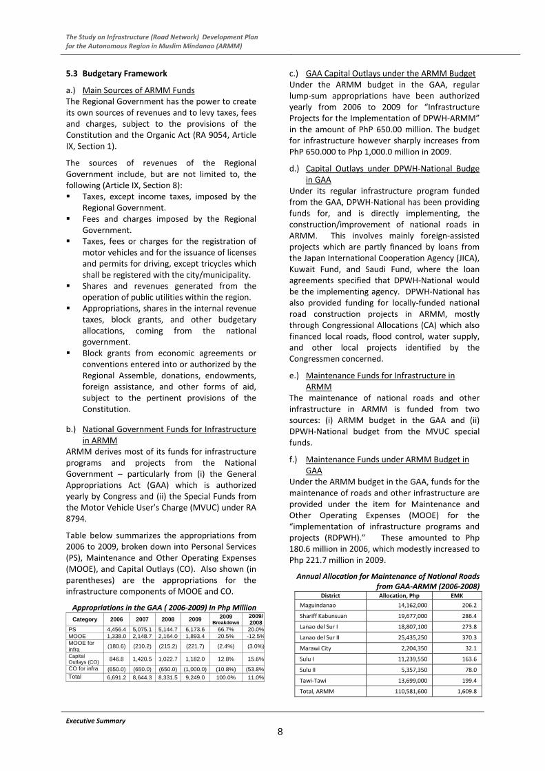
6.4 Number and Condition of Bridges in the ARMM
The total number of bridges along the national roads of the ARMM is 173. During the survey, some of the bridges were not visited due to security reasons which were marked as “unknown”. For the evaluation on the structural soundness of the bridges, the following were recorded: 4.6% (good), 64.7% (fair), 17.3% (poor), 8.7% (poor) and 4.6% (unknown). As mentioned, the survey covered some strategic provincial roads and 16 bridges were recorded. Most of the bridges are Bailey type (75%) indicating that they are just temporary bridge. Number of bridges to be replaced or rehabilitated is shown in the bottom table. The number of bridges judged to be “poor” in structural soundness and needs “major repair” is 24 bridges.
Bridges along National Roads Name of Province
Total No. of Bridge
RC PC STEEL BAILEYUN-
KNOWNTotal
Lanao - I 35 27 1 3 4 0 35Marawi 5 1 2 1 1 0 5Lanao - II 26 24 0 1 1 0 26
SK 23 15 1 4 3 0 23Mag - II 32 25 1 4 2 0 32Sub-total 121 92 5 13 11 0 121Basilan 20 7 3 4 6 0 20Sulu-I 24 11 0 5 2 6 24Sulu-II 4 4 0 0 0 0 4Tawi-Tawi 4 2 1 0 1 0 4Sub-total 52 24 4 9 9 6 52
Total 173 116 9 22 20 6 173 Ratio 67% 5% 13% 12% 3% 100%
MA
IN L
AN
DIS
LA
ND
Bridges along Provincial Roads
Name of Province
Total No. of Bridge
RC PC STEEL BAILEYUN-
KNOWNTotal
Lanao - I 0 0 0 0 0 0 0Marawi 0 0 0 0 0 0 0Lanao - II 0 0 0 0 0 0 0SK 16 4 0 0 12 0 16Mag - II 0 0 0 0 0 0 0Sub-total 16 4 0 0 12 0 16Basilan 0 0 0 0 0 0 0Sulu-I 0 0 0 0 0 0 0Sulu-II 0 0 0 0 0 0 0Tawi-Tawi 0 0 0 0 0 0 0Sub-total 0 0 0 0 0 0 0
Total 16 4 0 0 12 0 16Ratio 25% 0% 0% 75% 0% 100%
MA
IN L
AN
DIS
LAN
D
Bridges to be Replaced or Rehabilitated
Mailand Island Sub-total Mailand Island Sub-totalTemporary Bridge 13 9 22 22 0 12 34"Bad"Structural Soundness
12 3 15 0 0 0 15
1-Lane Bridge 1 1 2 1 0 1 3Load limit of 10 tons or less
7 1 8 0 0 0 8
Over flow at Girder Level
7 1 8 0 0 0 8
Number of bridges which have one of the above defects
35 14 49 12 0 12 61
Bridges Needed Major Repari
18 6 24 - - - 24
National Road Provincial RoadTotal
Reasons for Replacement
Executive Summary
12

The Study on Infrastructure (Road Network) Development Plan for the Autonomous Region in Muslim Mindanao (ARMM)
7. PRESENT AND FUTURE TRAFFIC DEMAND 7.1 Present Traffic Condition High traffic volume was observed to concentrates in neighboring areas of large cities such as Cagayan de Oro City, Iligan City, and General Santos City. The traffic volume ranges between 4,000 and 7,500 in each location. On the other hand, AADT counted at the locations in neighborhood of Cotabato City is almost 1,500.
Traffic Volume in the Study Area (AADT)
Executive Summary
13
7.2 Future Traffic Demand Traffic demand forecast attempts to quantify the amount of travel on a road network. Demand for transportation is estimated based on socio‐economic activities. Supply of transportation is represented by the characteristics of road network. Below are the cases estimated by simulation. Congestion in the figures is (vehicle capacity ratio) represented by red color. Existing Case assigns the existing OD matrix on the
existing highway network. Do‐Nothing Case assigns the future OD matrix on
the existing highway network. Master Plan Case assigns the future OD matrix on
the future highway network (Master Plan network). This can check whether the master plan network meets the future travel demand and whether the mobility benefits of road users are maintained in the future.
The impacts of road improvement through the Master Plan are: Total travel distance of ‘Master Plan Case’ indicates
22.0 million pcu*km while ‘Do Nothing Case’ is about 23.7 million (7% of wasteful detour travel may be improved).
Travel time will improve by 23% (330.6 thousand for ‘Master Plan Case’ and 429.6 thousand for ‘Do Nothing Case’).
Average travel speed indicates an improvement of about 20% (66 km/hr thousand for ‘Master Plan Case’ and 55.2 km/hr for ‘Do Nothing Case’).
Traffic Assignment Simulation “Existing Case”
LEGEND :
Traffic Flow( Mode: + 1 + 2 + 3 + 4 )
VCR<0.80VCR<1.00VCR<1.251.25<VCR
scale: 1mm =8000(pcu)
Traffic Assignment Simulation “Do‐Nothing Case” (2025)
LEGEND :
Traffic Flow( Mode: + 1 + 2 )
VCR<0.75VCR<1.00VCR<1.251.25<VCR
scale: 1mm =8000(pcu)
Traffic Assignment Simulation “Master Plan Case”(2025) LEGEND :
Traffic Flow( Mode: + 1 + 2 )
VCR<0.75VCR<1.00VCR<1.251.25<VCR
scale: 1mm =8000(pcu)

The Study on Infrastructure (Road Network) Development Plan for the Autonomous Region in Muslim Mindanao (ARMM)
8. ROAD MAITENANCE IMPROVEMENT PLAN8.1 Road Maintenance Problems and Issues Maintenance of National Roads in the ARMM has not been fully executed due to several problems and issues regarding implementation system.
a.) Road Maintenance Budget Problems and Issues
The total Annual Maintenance Budget allocated to ARMM is about PhP 220,357,000 while total National Road length to be maintained is about 951 km. Therefore, annual maintenance budget per km is about PhP 230,000/km. Results of the estimated maintenance cost were compared with the 2008 maintenance. Ideal road maintenance budget needs to be 2 or 3 times more than the 2008 budget.
Comparison of Budget and Maintenance Cost
Gravel Road
PCC in Fair
Condition
PCC in Bad
Condition
PCC in Very Bad Condition
Budget / Maintenance Cost (per Km/Year)
231,711 799,000 454,000 562,000 776,000
b/a - 3.4 2 2.4 3.3
(a) Budget in 2008
(GAA+MVUC)
(b) Estimated Maintenance Cost
b.) Road Maintenance Equipments Problems and Issues
There are only one or two Road Graders and Dump Trucks in each AESO and most of them are non‐operational. Based on the conditions of maintenance equipment, the problems and issues are as follows: There is an extreme shortage in the number of
operational maintenance equipments and spare parts.
An increase in the number of non‐operational maintenance equipments is expected when the existing budget conditions is continued.
Proper implementation of road maintenance is not conducted due to shortage in the number of operational maintenance equipments and spare parts.
Proper road maintenance may be carried out by providing additional maintenance equipments which may be rented from private companies.
c.) Manpower Problem and Issues The average age of DEO staff is observed to be 47 to 48 years old while AESO’s is about 46 to 47, quite higher compared with private companies. Basing from the data, about 35% of the total staff will be retired from service after 10 years. Consequently, about 50% will be retired in 20 years time, thus technology transfer on maintenance works to younger generation becomes important. Taking into account the above
conditions, the problems and issues of maintenance manpower are as follows: Staffs aged 40 years old and above occupy a
major proportion of the total number of DEO and AESO staff, which is about 77%.
Within 20 years, over 50% of total number of staffs will be retired.
Technology transfer on road maintenance method to younger generation is important in order to ensure proper maintenance.
d.) Road Maintenance Implementation Organization Problem and Issues
Sufficient road and bridge inspection survey and the preparation of database have not been conducted. Therefore, effective planning and programming, scheduling and design works for road maintenance implementation becomes difficult. Considering the above mentioned conditions, the problems and issues for maintenance organization structure are pointed out as follows: The numbers of staff and organizational
structure for road and bridge inventory survey are very weak. Therefore, there is no sufficient condition data.
The numbers of staff and organizational structure for the preparation of database activities are very weak. Therefore, there is no sufficient road condition data by database.
The number of staff and organizational structure for the preparation of planning and design are very weak. Therefore, it is very difficult to prepare the proper plan and program.
8.2 Road Maintenance Improvement Scenarios a) Planning Goal and Policy In the long run, sufficient road maintenance activities save overall road development cost as well as contribute to increase the economic benefits. Considering the importance of road maintenance works, the “Creation or Establishment of Sustainable Maintenance System” is identified as the planning policy and goal in this maintenance study.
b) Identification of Maintenance Implementation Scenario
The road maintenance improvement scenarios are identified based on the solution to the existing problems and issues as well as in consideration of the planning policy and goal of maintenance systems mentioned above.
The major problems and issues are summarized in the table as well as their corresponding solutions. Considering the existing maintenance problems
Executive Summary
14

The Study on Infrastructure (Road Network) Development Plan for the Autonomous Region in Muslim Mindanao (ARMM)
and issues, four (4) scenarios are identified as shown in the figure and in the table.
Executive Summary
15
Relationship between Maintenance Problems and Scenarios
Major Problems & Issues Solutions Scenario
Limited Budget
Proper prioritization of maintenance activities
No drastic increase expected
Selection of activity
Limited activities Prepare basic data
Budget
Bad pavement condition
Scenario 1
Imbalance of staff age Reformation of staff
No technology transfer Manpower
Weak technical capability
Scenario 2
Decreasing No. of equipment in operational condition
MBC system introduced
Decreasing No. of spare parts
Decrease of MBA
Limited Budget
Maintenance Equipment
No expect procurement
Scenario 3
Decreasing No. of equipment
Restructuring Organization
Decreasing No. of staffs Scenario 4
Maintenance Improvement Scenario
Scenario 1: Maintenance Activities under Limited Maintenance Budget Considering the socio‐economic conditions, existing road conditions, historical maintenance activities, and maintenance budgeting condition of ARMM, the following three (3) approaches for implementation of maintenance activities under the limited budget allocation are proposed.
Scenario 1 (Maintenance Activities under Limited Budget)
Approach 1: Within two (2) years, the road and bridge inspection works/ activities and the preparation of database activities on the road and bridge condition are reinforced as priority maintenance works. Approach 2: During the ten (10) year period, the routine maintenance activities are reinforced/ increased gradually as the main activities for road maintenance. Approach 3: During the ten (10) year period, the periodic maintenance activities are restrained/ decreased gradually, in accordance with the allocated maintenance budget and a decrease in the number of maintenance equipment operated.
Scenario 2: Reformation of Maintenance
Manpower The composition of age group of staff is unbalanced and considering the maintenance technology transfer aspects, maintenance activities, and maintenance budget allocation, the following reformation of maintenance manpower conditions are proposed (see Figure below for the general image).
SolutionsProblems and Issues
Establishment of
Sustainable Maintenance
Organization Scenario
Budgeting Scenario
Manpower Scenario
Implementation System Scenario
Planning Goal and Policy
Existing Road Maintenance Condition
(i) At present, the average age of staffs in EDO and AESO is estimated to be about 47 to 48 years old. The average age of staff will need to be decreased gradually.
(ii) By year 2015, the average age of DEO and AESO staffs is reformed to about the early 40’s age bracket.
(iii) By year 2020, the average age of DEO and AESO staffs is reformed to about the late 30’s age bracket.
Scenario 2 (Age Composition Percentage by Year)
0
5
10
15
20
25
30
35
40
45
<20 21-30 31-40 41-50 51-60 >60
2010 2015 2020
Working
Activity
100%
50%
Periodic Activities
2 4 6 8 10 Year
Inspection & Database
Routine Activities
The Study on Infrastructure (Road Network) Development Plan for the Autonomous Region in Muslim Mindanao (ARMM)
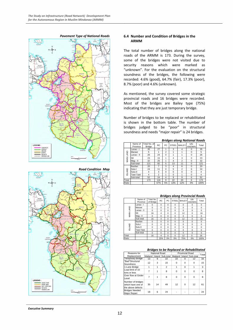
Scenario 3: Implementation System of Maintenance Activities
Executive Summary
16
Since there is very limited number of operational maintenance equipments in the AESOs, the number of operational maintenance equipments and spare parts is expected to gradually decrease. Taking into account the number of maintenance equipment and their conditions, the following four (4) reformations of maintenance implementation system are proposed (see Figure below for the general image).
Scenario 3 (Gradual Introduction of MBC)
Scenario 4 : Restructuring of Maintenance
Implementation Organization National road maintenance works for a total road length of 995 km has been implemented by a total of 345 staffs of seven (7) DEOs and 133 staffs of the four (4) AESOs. In the future, the total number of staffs needed for the whole implementation of maintenance works may be increased gradually. Considering above mentioned conditions, the following four (4) approaches for the restructuring of organization are proposed;
Approach 1: The total number of staff needed for the overall maintenance works in the future is kept at constant. Approach 2: The numbers of staff in DEO is to be increased gradually, according to the reinforcement of maintenance activities in the future. Approach 3: The numbers of staff in AESO is to be decreased gradually, in accordance with the decrease in the number of maintenance equipments and increase of MBC. Approach 4: The number of staff taken out from the AESO is to be transferred to the DEO, in accordance with the above mentioned approaches.
(i) The percentage share of MBA is to be decreased gradually.
(ii) The percentage share of MBC is to be increased gradually.
(iii) During the ten (10) year period, 50% of total maintenance activities are implemented by MBA and the remaining 50% by MBC system.
(iv) During the fifteen (15) year period, 30% of total maintenance activities are implemented by MBA system and the remaining 70% are MBC.
Scenario 4 (Restructuring Of Organization)
No. of
Staff No. of Total Maintenance Staff(Constant Trend)
No.of Equipment Operate
No. of Staff in EDO (Increasing Trend)
d No. of Staff in AESO
2 4 6 8 10 Year
(Decreasing Trend)
(Decreasing Trend)
8.3 Priority of Maintenance Activities Since the maintenance budget is far below the actual requirements and maintenance level proposed by the Study could not be achieved, DPWH shall select priority maintenance activities focusing on the following aspects:
Activity(%)
100% Implemented by MBA System
80%
60%
40%
20%
Implemented by MBC System0%
2 4 6 8 10 Year
Maintenance of paved carriageways shall be given top priority to protect past capital investment.
Road maintenance of roads serving higher traffic volume shall be given higher priority than those serving less traffic.
Maintenance of gravel/earth roads in very bad condition shall be given the lowest priority which is usually beyond economically maintainable condition. Instead, DPWH‐ARMM should plan the capital investment for such roads to fundamentally improve the condition.
Among routine maintenance works, cleaning of pipe‐culverts, box‐culverts and side ditches shall be given top priority, so that the pavement can be protected.
Frequency of shoulder maintenance, roadside features and traffic/guide signs can be reduced.

The Study on Infrastructure (Road Network) Development Plan for the Autonomous Region in Muslim Mindanao (ARMM)
Executive Summary
17
9. CAPACITY DEVELOPMENT PLAN 9.1 Assessment of Present Capacity and
Optimum Level of Capacity to be Attained and Assessment of Capacity Gap
This summarizes the preliminary analysis of (a) the present institutional capacity, including observed weaknesses and constraints, of DPWH‐ARMM in undertaking the different core and support processes involved in the development and
management of national/regional roads in the region, (b) the suggested optimum level of institutional capacity that DPWH‐ARMM needs to attain to perform those processes efficiently in the context of regional development objectives and plans, and (c) the resulting gap in capacity which should be bridged.
Present Capacity Optimum Capacity to be Attained Capacity Gap 1. Planning
Lack of focus on core programs – medium‐term projects not clearly related to each other and to regional dev. strategy; annual programs diffused to numerous local projects
Low priority on asset preservation – overshadowed by construction projects
Preoccupation with project pro‐grams of work – little attention to broader road network planning
Lack of systematic road network planning ‐ to produce long/ medium‐term and annual plans to meet development and preservation needs within budget constraints
Inadequate road project preparation (FS) and prioritization – objective technical and economic criteria wanting; most personnel lacking FS skills
Disconnect between plans/ programs and budgets – medium ‐term plans/programs not related to medium‐term expenditure framework; projects in medium‐term programs not reflected in annual budgets which have very few national/regional projects
Weak database – especially road inventory and conditions and traffic counts; database relies on Road Diagram and Bridge List (RDBL) which gives incomplete/ old/inaccurate/unverified data; road condition data based on subjective ratings
Focus on core programs and major final outputs – with strategic regional impact; first priority to asset preservation, then rehabilitation, improve‐ment, and new construction; atten‐tion to natl/ regl roads; local projects devolved to LGUs
Rational road planning system – process‐based and needs‐oriented at all stages (strategic analysis to annual programs); integrated planning of network devt and asset preservation; participation of key stake‐holders; adapting or linked with tested modern IT planning systems ‐ e.g., DPWH‐National HPM process, with RBIA, RTIA, PMS, HDM‐4, BMS, MYPS, RMMS, TARAS; operational at Regional Office (RO) proper and DEOs
Adequate project preparation (FS) – for candidate road projects identified thru the proposed planning system; operational at RO proper and DEOs
Harmonized plans/programs and budgets – with forward estimates for existing/approved programs, plus new projects from the planning process, within budget ceilings
Adequate computerized database ‐ incl road/bridge attributes and conditions, traffic, costs, etc; preferably linked to DPWH‐National database (RBIA, RTIA, BMS); DPWH‐ARMM able to do road and traffic surveys to generate info; database operational at RO proper and DEOs
Strong staff competency on above ‐ at RO proper and DEOs
Focus on core programs and major final outputs – with strategic regional impact
Rational road planning systems ‐ national/regional roads process‐based and needs‐oriented at all stages; integrated planning of network devt and asset preservation; participation of key stake‐holders; adapting or linking up with tested modern planning systems ‐ e.g., DPWH‐National HPM process and tools;
Enhanced project preparation (FS) – for candidate projects
Harmonized plans/programs and budgets – with forward estimates and new projects from the planning system, within ceilings
Adequate computerized database – incl. surveys; preferably linked to DPWH‐National database
Strong staff competency on above
2. Design
Limited staff and equipment – 10 personnel and 1 total station in Survey and Design Division vs hundreds of projects; limited soil investigations
Uncertain quality of survey data and design – inadequate survey data affects the quality of design; thus, the integrity and performance of the structures is compromised
Adequate design preparation and appraisal – in‐house surveys and designs and supervision of contracted surveys/designs; at Survey and Design Division and DEOs
Outsourcing of surveys and designs – esp. for larger/complex projects
Access to DPWH‐National design software – e.g., Civil3D and STAAD
Strong staff competency on above ‐ at RO proper and DEOs
Enhanced design preparation and appraisal
Outsourcing of surveys and designs
Access to DPWH‐National software
Strong staff competency on above
3. Construction
Unclear basis for selection of implementation mode – mainly based on proponent’s preference
Inadequate staff and equipment for const. by administration – most works actually
Construction by contract as general mode – works by admn only when bidding fails.
Adequate construction supervision on all projects – with min. defects, delays,
Construction by contract as general mode
Adequate construction supervision on all projects ‐ with min. defects, delays, overruns

The Study on Infrastructure (Road Network) Development Plan for the Autonomous Region in Muslim Mindanao (ARMM)
Executive Summary
18
contracted
Strained capacity for const. supervision – meager staff vs numerous projects; most staff lacking training; no operations manual
Insufficient monitoring – no independent validation
overruns; use of operating manuals; capacity at RO proper and DEOs. Local projects devolved to LGUs, and national roads devolved from DPWH‐National
Effective monitoring – with CSO partner; at RO proper and DEOs
Adequate staff competency on above ‐ at RO proper and DEOs
Effective monitoring –with CSO
Enhanced staff competency on above
4. Maintenance
Limited maintenance funding – programmed Php 220 million is 35% of needs.
Sub‐optimal allocation and use of funds – not based on needs assessment; use of old EMK and judgment on allocating lump sums to road sections
Insufficient database – old/ incomplete/inaccurate data; subjective condition ratings; unverified data
Inadequate inspection and work programs – no system and manual; most staff lack skills
Preponderance of maintenance by administration – meager in‐house equipment and staff for admn work; limited exposure and skills on MBC
No truck overloading controls – no weighbridges and load data
Sufficient and sustained funding level to cover maintenance needs ‐ as top budget priority, based on life‐cycle network analysis using rational planning systems
Efficient allocation and use of maintenance funds – based on needs, using RMMS, HDM‐4, BMS
Reliable database for maintenance ‐ incorporated in the overall database (item 1); DPWH‐ARMM DEOs, under supervision of Maint. Division, able to do road/bridge attributes and conditions surveys to provide info for the database
Effective inspection and work programs – using modern systems and manuals; operational at RO proper and DEOs
Maintenance by contract (MBC) as dominant mode – including LTPBMCs; proficiency in planning and supervising MBCs/LTPBMCs at RO proper and DEOs
Effective vehicle load controls – sufficient weighbridges and strict enforcement of load limits
Good quality of roads – on the entire network of national/regional roads
Adequate staff competency on above ‐ at RO proper and DEOs
Sufficient and sustained funding level to cover maintenance needs ‐ as top budget priority
Efficient allocation and use of maintenance funds – based on needs, using RMMS, HDM‐4, BMS
Reliable computerized database – incorporated in the overall database; DPWH‐ARMM capable of road/ bridge attributes and conditions surveys to provide info for the database
Enhanced inspection and work programs – using modern systems and manuals
MBC as dominant mode – incl LTPMC; capacity for planning and supervising MBCs incl LTPBMCs
Effective vehicle load controls – sufficient weighbridges and strict enforcement of load limits.
Good quality of roads – on the entire network of national/regional roads
Enhanced staff competency on above
5. Support Systems
Financial management: conventional budgeting and accounting systems; internal audit unit needs strengthening
Procurement ‐ Basic capacity per RA 9184; manually operated
Human resource management (HRM): low productivity at 2.7 km/worker; too centralized at 21%‐79% distribution of RO proper‐field personnel
Equipment management: only 71 units (36 operational) for 974 km
Financial management: use of eNGAS at RO proper and DEOs; internal audit units at RO proper and DEOs able to do systems and risk‐based audits
Procurement: continuous training at RO proper and DEOs; computerized contractors’ registry, eligibility check and cost estimation; posting bid docs at website; use of procure‐ment manual
HRM: Rationalization based on above core programs and realigned functions; 40% increase in km/ worker productivity; RO‐field personnel distribution at 10%‐90%
Equipment management: liquidation or phase‐out of equipment (with separation pay) since work is mostly to be done by MBC
Financial management: use of eNGAS; internal audit units able to do systems and risk‐based audits.
Procurement: continuous training; computerized contractors’ registry, eligibility check, and cost estimation; posting bid docs at website; use of procurement manual
HRM: Rationalization based on above core programs and realigned functions; increase in km/ worker productivity; reduction of RO‐field personnel distribution
Equipment management: liquidation or phase‐out of equipment (with separation pay) since work is mostly to be done by MBC
The Study on Infrastructure (Road Network) Development Plan for the Autonomous Region in Muslim Mindanao (ARMM)
Executive Summary
19
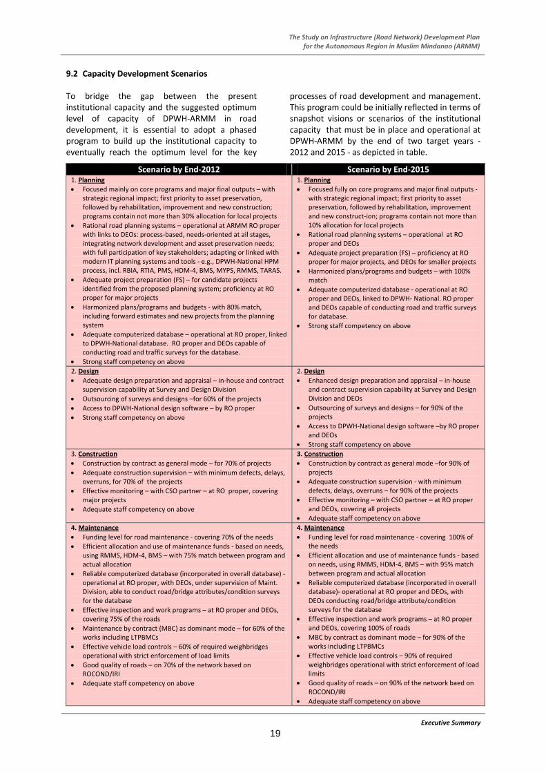
9.2 Capacity Development Scenarios To bridge the gap between the present institutional capacity and the suggested optimum level of capacity of DPWH‐ARMM in road development, it is essential to adopt a phased program to build up the institutional capacity to eventually reach the optimum level for the key
processes of road development and management. This program could be initially reflected in terms of snapshot visions or scenarios of the institutional capacity that must be in place and operational at DPWH‐ARMM by the end of two target years ‐ 2012 and 2015 ‐ as depicted in table.
Scenario by End‐2012 Scenario by End‐2015 1. Planning
Focused mainly on core programs and major final outputs – with strategic regional impact; first priority to asset preservation, followed by rehabilitation, improvement and new construction; programs contain not more than 30% allocation for local projects
Rational road planning systems – operational at ARMM RO proper with links to DEOs: process‐based, needs‐oriented at all stages, integrating network development and asset preservation needs; with full participation of key stakeholders; adapting or linked with modern IT planning systems and tools ‐ e.g., DPWH‐National HPM process, incl. RBIA, RTIA, PMS, HDM‐4, BMS, MYPS, RMMS, TARAS.
Adequate project preparation (FS) – for candidate projects identified from the proposed planning system; proficiency at RO proper for major projects
Harmonized plans/programs and budgets ‐ with 80% match, including forward estimates and new projects from the planning system
Adequate computerized database – operational at RO proper, linked to DPWH‐National database. RO proper and DEOs capable of conducting road and traffic surveys for the database.
Strong staff competency on above
1. Planning
Focused fully on core programs and major final outputs ‐ with strategic regional impact; first priority to asset preservation, followed by rehabilitation, improvement and new construct‐ion; programs contain not more than 10% allocation for local projects
Rational road planning systems – operational at RO proper and DEOs
Adequate project preparation (FS) – proficiency at RO proper for major projects, and DEOs for smaller projects
Harmonized plans/programs and budgets – with 100% match
Adequate computerized database ‐ operational at RO proper and DEOs, linked to DPWH‐ National. RO proper and DEOs capable of conducting road and traffic surveys for database.
Strong staff competency on above
2. Design
Adequate design preparation and appraisal – in‐house and contract supervision capability at Survey and Design Division
Outsourcing of surveys and designs –for 60% of the projects
Access to DPWH‐National design software – by RO proper
Strong staff competency on above
2. Design
Enhanced design preparation and appraisal – in‐house and contract supervision capability at Survey and Design Division and DEOs
Outsourcing of surveys and designs – for 90% of the projects
Access to DPWH‐National design software –by RO proper and DEOs
Strong staff competency on above
3. Construction
Construction by contract as general mode – for 70% of projects
Adequate construction supervision – with minimum defects, delays, overruns, for 70% of the projects
Effective monitoring – with CSO partner – at RO proper, covering major projects
Adequate staff competency on above
3. Construction
Construction by contract as general mode –for 90% of projects
Adequate construction supervision ‐ with minimum defects, delays, overruns – for 90% of the projects
Effective monitoring – with CSO partner – at RO proper and DEOs, covering all projects
Adequate staff competency on above
4. Maintenance
Funding level for road maintenance ‐ covering 70% of the needs
Efficient allocation and use of maintenance funds ‐ based on needs, using RMMS, HDM‐4, BMS – with 75% match between program and actual allocation
Reliable computerized database (incorporated in overall database) ‐ operational at RO proper, with DEOs, under supervision of Maint. Division, able to conduct road/bridge attributes/condition surveys for the database
Effective inspection and work programs – at RO proper and DEOs, covering 75% of the roads
Maintenance by contract (MBC) as dominant mode – for 60% of the works including LTPBMCs
Effective vehicle load controls – 60% of required weighbridges operational with strict enforcement of load limits
Good quality of roads – on 70% of the network based on ROCOND/IRI
Adequate staff competency on above
4. Maintenance
Funding level for road maintenance ‐ covering 100% of the needs
Efficient allocation and use of maintenance funds ‐ based on needs, using RMMS, HDM‐4, BMS – with 95% match between program and actual allocation
Reliable computerized database (incorporated in overall database)‐ operational at RO proper and DEOs, with DEOs conducting road/bridge attribute/condition surveys for the database
Effective inspection and work programs – at RO proper and DEOs, covering 100% of roads
MBC by contract as dominant mode – for 90% of the works including LTPBMCs
Effective vehicle load controls – 90% of required weighbridges operational with strict enforcement of load limits
Good quality of roads – on 90% of the network baed on ROCOND/IRI
Adequate staff competency on above

The Study on Infrastructure (Road Network) Development Plan for the Autonomous Region in Muslim Mindanao (ARMM)
Executive Summary
20
5. Support Systems
Financial management: eNGAS operational at RO proper; RO internal audit unit able to do systems and risk‐based audits
Procurement: 70% of BAC/TWG/Secretariat members trained; computerized contractors’ registry, eligibility check, and cost estimation system operational at RO proper; bid docs posted at website; procurement manual used
Human resource management (HRM): 60% implementation of rationalization plan based on core programs and realigned functions; 20% increase in km/ worker productivity; 15%‐85% distribution of RO‐field personnel
Equipment management: liquidation or phase‐out of 60% of equipment (with separation pay) since work is mostly by MBC
5. Support Systems
Financial management: eNGAS operational at RO proper and DEOs; RO and DEO internal audit units able to do systems and risk‐based audits
Procurement: 95% of BAC/TWG/Secretariat members trained; computerized contractors’ registry and eligibility check, and cost estimation system operational at RO proper and DEOs; bid docs posted at website; procurement manual fully used
HRM: 90% implementation of rationalization plan based on core programs and realigned functions; 40% increase in km/ worker productivity; 10%‐90% distribution of RO‐field personnel
Equipment management: liquidation or phase‐out of 90% of equipment (with separation pay) since work is mostly by MBC
9.3 Priority Areas for Institutional Capacity
Development DPWH‐ARMM reviewed the scenarios by the Study and identified and ranked ten priority areas for institutional development.
Area Rank
a.) Road Database (Road Bridge and Information Application or RBIA)
1
b.) Traffic Database (Road Traffic Information Application or RTIA)
2
c.) Bridge Management System (BMS) 3
d.) d. Multi‐Year Programming and Scheduling (MYPS)
4
e.) Pavement Management System/Highway Development and Management Version 4 (PMS/HDM‐4)
5
f.) Maintenance Planning and Programming
6
g.) Road Network Planning System (DPWH Highway Planning Manual)
7
h.) Computerized Road Design Systems 8
i.) Budgeting within Organizational Performance Indicator Framework (OPIF) and Medium‐Term Expenditure Framework (MTEF)
9 and 10
j.) Project Preparation: Feasibility Studies 9 and 10
9.4 Programming of Institutional Capacity
Development Based on these ten priority areas, the Institutional Capacity Development (ICD) Plan for DPWH‐ARMM will be implemented in three stages: Stage I or Short‐Term Program (2010‐2011):
This will cover the development and installation of an operational database for roads and road traffic – i.e., priority areas (a) and (b) above. This is because an accurate and reliable database is fundamental to effective road planning and management.
Stage II (2012‐2013): This will involve the adaptation and application of road planning
systems under priority areas (c) to (j), using the database installed in Stage I.
Stage III (2014‐2015): This will involve the enhancement of the database and planning systems established in Stages I and II.

The Study on Infrastructure (Road Network) Development Plan for the Autonomous Region in Muslim Mindanao (ARMM)
10. ROAD NETWORK DEVELOPMENT MASTER PLAN 10.1 Possible Investment Capital c.) Past Capital Investment Past capital investment for the road sector is shown below.
Executive Summary
21
05‐09 06‐09 06‐08
19,193 24,884 31,127 45,962 75,428
(100%) (100%) (100%) (100%) (100%)
829 701 569 1,879 4,622
(4.3%) (2.8%) (1.8%) (4.1%) (6.1%)
235 183 1,238 1,995 2,207
(1.2%) (0.7%) (4.0%) (4.3%) (2.9%)
328 568 1,653 1,179
(1.3%) (1.8%) (3.6%) (1.6%)
650 650 650
(100.0%) (100.0%) (100.0%)
(38%) (38%) (36%)
(29%) (32%) (22%)
(67%) (70%) (58%)
DPWH‐National
(Note‐1)
Average Annual Growth
Rate (%)2005 2006 2007 2008 2009
40.7% 44.7% 35.9%
Remarks
Basically for Foreign‐
assisted Projects within
ARMM
Region XII
Projects within ARMM (National
Road)
Region X
TOTAL
‐ ‐ ‐ 124%
53.7% 87.5%
Island
Provinces
‐ ‐ ‐ ‐
Allocation
to Road
Sector
246 249
‐ ‐ ‐
Total
Mainland
‐ ‐ ‐
‐ ‐ ‐‐ 246 237 232
‐2.9%‐
Total ‐
Total
435 375
‐
‐
63.7%
75.0% 129% 230%
Total
Local Road
National
Road
National
Road
Local Road
‐13.2%
‐ ‐ ‐ ‐7.3%
National
Road
Local Road
‐
‐
232
‐
Unit: Million Pesos
‐
‐
‐
‐
‐
‐
‐
‐
‐
‐
‐
‐
436 457 375
‐
‐Infrastructure
‐
‐ 0
Infrastructure
and Road
Budget from
GAA Allocation
to ARMM
Government
(Note‐2)
‐ ‐ ‐ 0%
‐
‐
‐
23 10 0
167 198 143
190 208 143
12 0
23 22 0
413
Past Investment for Road Sector
d.) Estimate of Possible Investment for the Study Area
Based on the past trend, capital investment was estimated on the following assumptions;
DPWH‐National DPWH‐National’s capital investment for the road
sector will increase by 5% to 10% per annum. Allocation of DPWH‐National’s road budget to
Region XII and ARMM through DPWH‐National ‐ Region X (5.1%) ‐ Region XII (4.5%) ‐ ARMM (1.5%)
DPWH‐ARMM Infrastructure budget will increase by 5% to 10% per
annum.
Adopting conservative assumptions, i.e. DPWH‐National’s budget will increase at 5% per annum, and ARMM’s infrastructure budget will increase at 5% per annum , possible investment for road sector on the Study Area are shown in the bottom table.
Allocation from infrastructure budget to a road sector will be as follows; ‐ Mainland Provinces (38%) ‐ Island Provinces (32%)
DPWH‐National a. Quite high growth rate for the road sector
investment was recorded from 2005 to 2009 at 40.7% per annum.
b. Allocation to Region X, Region XII and Road Project within ARMM ‐ Region X (1.8% ‐ 6.1% of National Road Budget) ‐ Region XII (0.7% ‐ 4.3% of National Road Budget)‐ ARMM (1.3% ‐ 3.6% of National Road Budget)
DPWH‐ARMM Allocation to infrastructure has been constant and
no increase was made from 2006 to 2008. Allocation to a road sector from infrastructure
budget is decreasing. Allocation of infrastructure budget to a road
sector of mainland provinces ranged from 36% to 38%.
Estimated Possible Investment for Road Sector (Unit: Million PhP)
2011‐2015 2016‐2020 2021‐2025
Region X 21,900 27,900 35,600
Region XII 19,700 25,200 32,100 DPWH‐National
Projects for ARMM 6,600 8,300 10,700
ARMM Government
Mainland Provinces 1,433 1,829 2,334
The Study on Infrastructure (Road Network) Development Plan for the Autonomous Region in Muslim Mindanao (ARMM)
Executive Summary
22
10.2 Road Network Development Scenario a.) Issues Road network development issues were identified as follows:
I S S U E S Road Density
Road Density is the lowest in the country, only ½ of the other areas of the Philippines.
Pavement Ratio Pavement ratio is slightly higher than the DPWH‐National’s level. However, there are still 207 km of national road remains un‐paved.
Road Condition of Paved Roads Paved road condition in ARMM is much better than those of DPWH‐National, but still 152 km of paved roads are in bad/very bad condition.
Missing Link There are 7 missing links, thus wide areas remain inaccessible, and people are forced to make a long detour. Hence, there are many areas with accessibility problems.
Road Maintenance
Road maintenance needs to be strengthened, but fund is limited.
b.) Strategies Road network development strategies in relation to visions were established as shown below;
V I S I O N Road Network for Universal development of
all areas which contributes to peace building Road Network for Agro‐fishery development
and Poverty Reduction Road Network for smooth mobility
S T R A T E G Y
Increase Road Density ‐ Improve Provincial Roads to National Road
Standards ‐ Construction of new roads, but selectively
Eliminate missing links Improvement of gravel/earth roads to paved
roads Rehabilitation of paved roads in bad/very bad
condition Preservation of existing road assets by
intensified road maintenance Improvement of Farm‐to‐Market roads
c.) Targets Road network development targets were established as shown below;
Present By 2015 By 2025
Road Density (including upgrading of Provincial Roads)
0.076 0.085 (+100 km)
0.095 (+120)
Pavement Ratio
76.8% 80% (+30 km)
95% (+130 km)
Road in Good/Fair Condition
71.1% 80% (+65 km)
95% (+130 km)
Number of Missing Link 7
5 (remove 2 missing links)
0 (remove 5 missing links)
Temporary Bridges/ Bridges Need Replacement
35 25 (10 bridge replacement)
0 (25 bridge replacement)

The Study on Infrastructure (Road Network) Development Plan for the Autonomous Region in Muslim Mindanao (ARMM)
10.3 Proposed Future Road Network a) Procedure to Develop Future Road Network Procedure to develop future road network is illustrated below.
Executive Summary
23
Primary Inter‐City Road Major road which connects Mega Urban Centers,
Primary Urban Centers, Secondary Urban Centers, and major ports and airports to each other.
Major road which functions as a logistic corridor in Mindanao Island.
Major road which provides access to Nautical Highway.
Regional Primary Road Major road which links Primary Inter‐city Road each
other. Important road within the Region to form regional
physical framework for even development.
Regional Secondary Road Major road which links Primary Inter‐city Roads and
Regional Primary Roads each other Functions as collector/distributor road.
b.) Primary Inter‐city Road Network in Mindanao
Urban centers are dependent on each other for their economic and social activities. Inter‐Regional Road Network should be planned to connect important urban centers. Urban centers were classified into 3 categories.
URBAN CENTERS CLASSIFICATION
Mega Urban Center
Population over 500,000 with base port and/or port
Primary Urban Center
Population between 200,000 and 500,000
Secondary Urban Center
Population between 100,000 and 200,000 and Provincial capital with population less than 100,000
c) Regional Primary and Secondary Roads Basic concepts to form Regional Primary and Secondary Road Network are as follows:
d) Proposed Road Network Proposed road network comprising of Primary Inter‐city Road, City Road, Regional Primary Road and Regional Secondary Road was formulated as shown in Figure 10.3‐1.
Inter‐city Road Network and Distribution of Urban Centers in Mindanao
To form flexible road networks around Cotabato City by linking three Primary Inter‐city Roads with each other.
To form an alternative route to connect Cotabato City with General Santos City.
To form major links to connect two Primary Inter‐city Roads with each other.
Development of Inter-Regional Network (whole Mindanao Primary Road Network) Primary Inter-City Road
Distribution of Major Urban Centers Distribution of Major
Ports/Airports Logistics Corridors
Development of Intra-Regional Road Network (covering ARMM, Region X and Region XII) Regional Primary Road Regional Secondary
Road
PROPOSED ROAD NETWORK
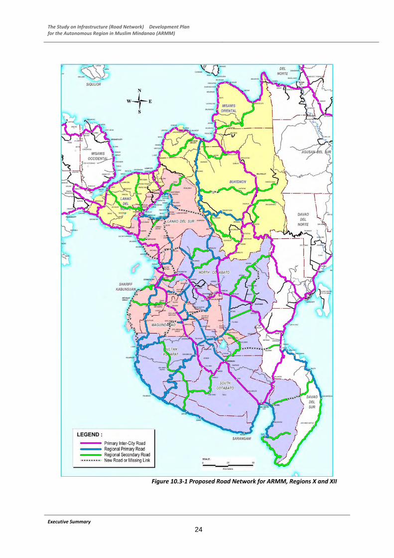
The Study on Infrastructure (Road Network) Development Plan for the Autonomous Region in Muslim Mindanao (ARMM)
Figure 10.3‐1 Proposed Road Network for ARMM, Regions X and XII
Executive Summary
24
The Study on Infrastructure (Road Network) Development Plan for the Autonomous Region in Muslim Mindanao (ARMM)
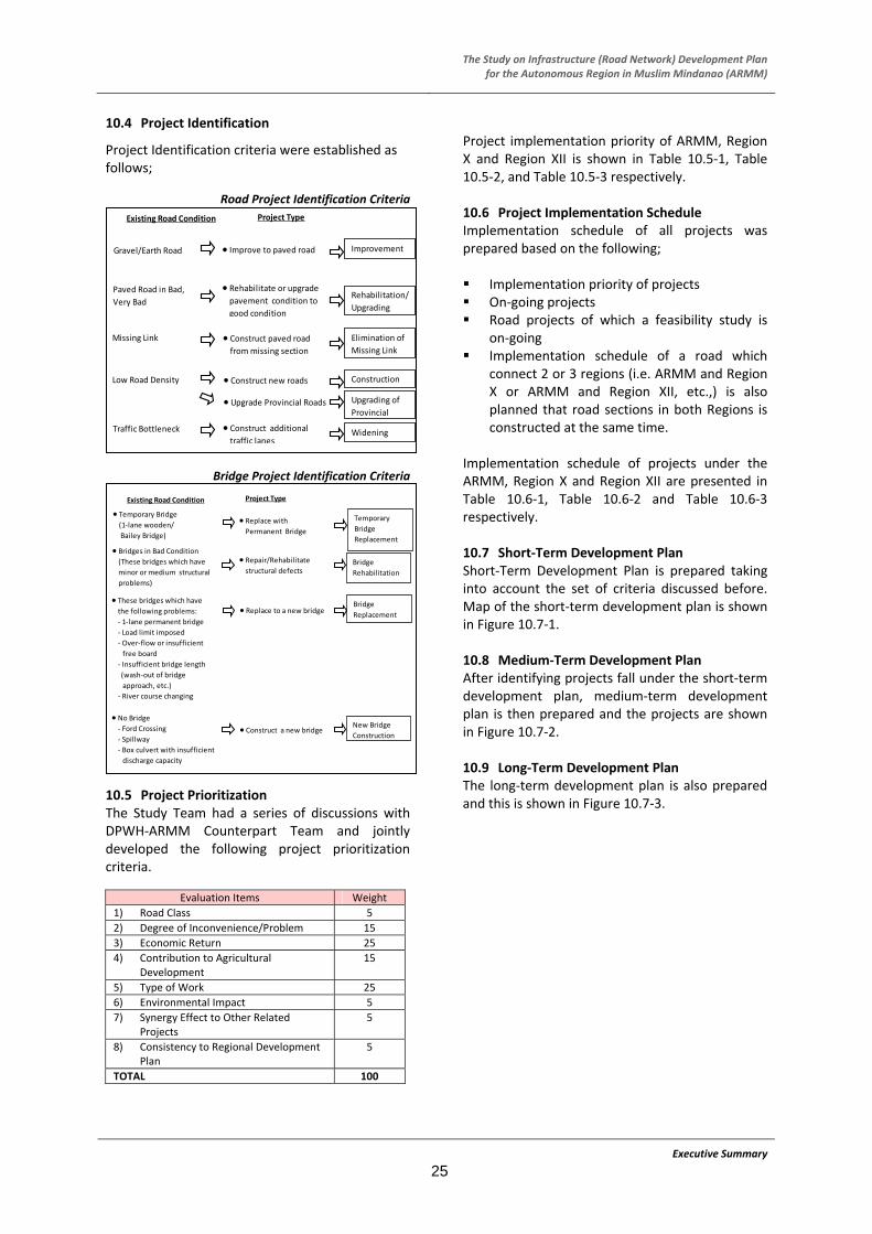
10.4 Project Identification
Project Identification criteria were established as follows;
Road Project Identification Criteria
Executive Summary
25
Bridge Project Identification Criteria
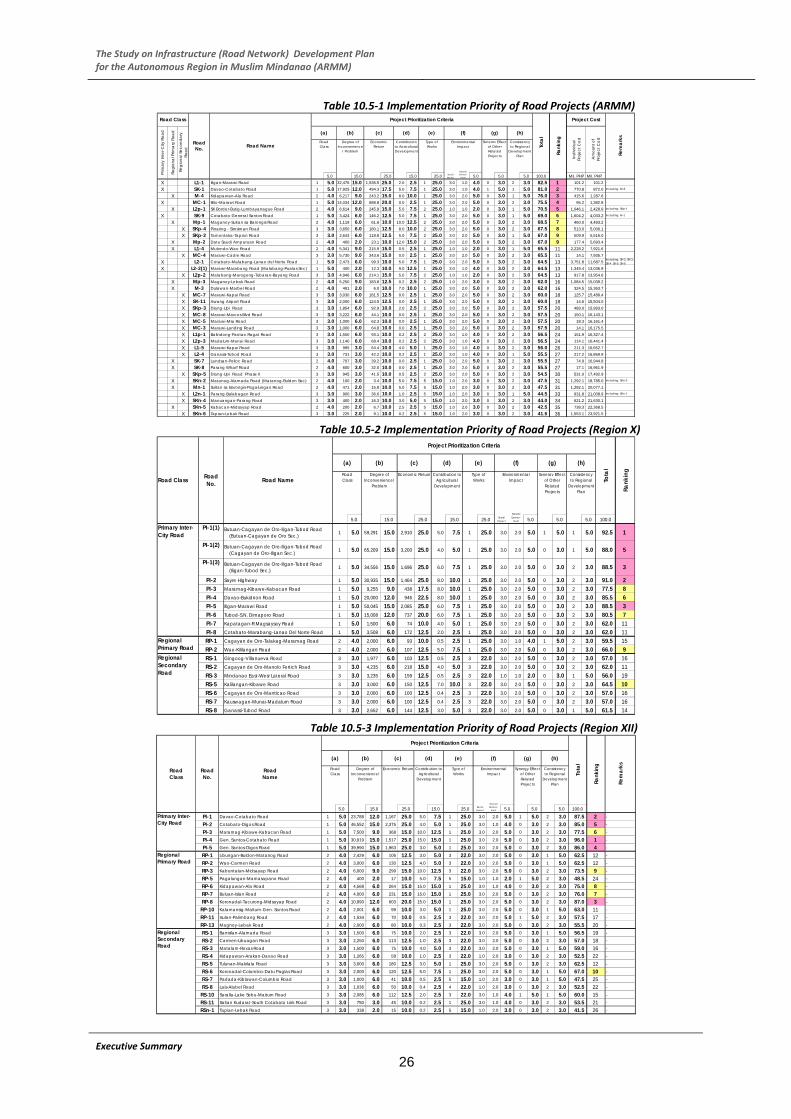
10.5 Project Prioritization The Study Team had a series of discussions with DPWH‐ARMM Counterpart Team and jointly developed the following project prioritization criteria.
Evaluation Items Weight
1) Road Class 5
2) Degree of Inconvenience/Problem 15
3) Economic Return 25
4) Contribution to Agricultural Development
15
5) Type of Work 25
6) Environmental Impact 5
7) Synergy Effect to Other Related Projects
5
8) Consistency to Regional Development Plan
5
TOTAL 100
Project implementation priority of ARMM, Region X and Region XII is shown in Table 10.5‐1, Table 10.5‐2, and Table 10.5‐3 respectively. 10.6 Project Implementation Schedule Existing Road Condition Project Type
Gravel/Earth Road
Paved Road in Bad,
Very Bad
Missing Link
Low Road Density
Traffic Bottleneck
● Improve to paved road Improvement
● Rehabilitate or upgrade pavement condition to
good condition
Rehabilitation/
Upgrading
● Construct paved road from missing section
● Construct new roads
● Upgrade Provincial Roads
● Construct additional traffic lanes
Elimination of
Missing Link
Construction
Upgrading of
Provincial
Widening
Implementation schedule of all projects was prepared based on the following; Implementation priority of projects On‐going projects Road projects of which a feasibility study is
on‐going Implementation schedule of a road which
connect 2 or 3 regions (i.e. ARMM and Region X or ARMM and Region XII, etc.,) is also planned that road sections in both Regions is constructed at the same time.
Implementation schedule of projects under the ARMM, Region X and Region XII are presented in Table 10.6‐1, Table 10.6‐2 and Table 10.6‐3 respectively.
Existing Road Condition Project Type
● Temporary Bridge
(1‐lane wooden/
Bailey Bridge)
● Bridges in Bad Condition (These bridges which have
minor or medium structural
problems)
● These bridges which have the following problems:
‐ 1‐lane permanent bridge
‐ Load limit imposed
‐ Over‐flow or insufficient
free board
‐ Insufficient bridge length
(wash‐out of bridge
approach, etc.)
‐ River course changing
● Replace with Permanent Bridge
Temporary
Bridge
Replacement
● Repair/Rehabilitate structural defects
Bridge
Rehabilitation
● Replace to a new bridge
● Construct a new bridge
Bridge
Replacement
New Bridge
Construction
● No Bridge ‐ Ford Crossing
‐ Spillway
‐ Box culvert with insufficient
discharge capacity
10.7 Short‐Term Development Plan Short‐Term Development Plan is prepared taking into account the set of criteria discussed before. Map of the short‐term development plan is shown in Figure 10.7‐1. 10.8 Medium‐Term Development Plan After identifying projects fall under the short‐term development plan, medium‐term development plan is then prepared and the projects are shown in Figure 10.7‐2. 10.9 Long‐Term Development Plan The long‐term development plan is also prepared and this is shown in Figure 10.7‐3.
The Study on Infrastructure (Road Network) Development Plan for the Autonomous Region in Muslim Mindanao (ARMM)
Table 10.5‐1 Implementation Priority of Road Projects (ARMM)
5.0 15.0 25.0 15.0 25.0 5.0 5.0 5.0 100.0 Mil. PHP Mil. PHPX L1-1 Iligan-Marawi Road 1 5.0 32,476 15.0 1,536.5 25.0 2.0 2.5 1 25.0 3.0 1.0 4.0 0 3.0 2 3.0 82.5 1 101.2 101.2 -
X SK-1 Davao-Cotabato Road 1 5.0 17,925 12.0 494.3 17.5 5.0 7.5 1 25.0 3.0 1.0 4.0 1 5.0 1 5.0 81.0 2 770.8 872.0 Including: M-5
X M-4 Kidapawan-Ala Road 2 4.0 6,217 9.0 243.2 15.0 8.0 10.0 1 25.0 3.0 2.0 5.0 0 3.0 1 5.0 76.0 3 415.6 1,287.6 -
X MC-1 Bito-Marawi Road 1 5.0 14,034 12.0 688.8 20.0 0.0 2.5 1 25.0 3.0 2.0 5.0 0 3.0 2 3.0 75.5 4 95.2 1,382.8 -
X L2p-1 SK Border-Butig-Lumbayanague Road 2 4.0 6,614 9.0 245.8 15.0 5.0 7.5 2 25.0 1.0 1.0 2.0 0 3.0 1 5.0 70.5 5 1,046.1 2,428.9 Including: SKp-1
X SK-9 Cotabato-General Santos Road 1 5.0 3,424 6.0 146.2 12.5 5.0 7.5 1 25.0 3.0 2.0 5.0 0 3.0 1 5.0 69.0 6 1,604.2 4,033.2 Including: M-1
X Mp-1 Maganoy-Sultan sa Barongis Road 2 4.0 1,119 6.0 61.6 10.0 10.0 12.5 2 25.0 3.0 2.0 5.0 0 3.0 2 3.0 68.5 7 460.0 4,493.2 -
X SKp-4 Pinaring - Simsiman Road 3 3.0 3,650 6.0 180.1 12.5 8.0 10.0 2 25.0 3.0 2.0 5.0 0 3.0 2 3.0 67.5 8 513.0 5,006.1 -
X SKp-2 Tamontaka-Tapian Road 3 3.0 2,643 6.0 118.8 12.5 5.0 7.5 2 25.0 3.0 2.0 5.0 0 3.0 1 5.0 67.0 9 509.9 5,516.0 -
X Mp-2 Datu Saudi Ampatuan Road 2 4.0 400 2.0 23.1 10.0 12.0 15.0 2 25.0 3.0 2.0 5.0 0 3.0 2 3.0 67.0 9 177.4 5,693.4 -
X L1-4 Mulondo-Wao Road 2 4.0 5,341 9.0 215.9 15.0 0.5 2.5 1 25.0 1.0 1.0 2.0 0 3.0 1 5.0 65.5 11 2,228.2 7,921.6 -
X MC-4 Marawi-Cadre Road 3 3.0 5,730 9.0 343.6 15.0 0.0 2.5 1 25.0 3.0 2.0 5.0 0 3.0 2 3.0 65.5 11 14.1 7,935.7 -
X L2-1 Cotabato-Malabang-Lanao del Norte Road 1 5.0 2,473 6.0 99.3 10.0 5.0 7.5 1 25.0 3.0 2.0 5.0 0 3.0 2 3.0 64.5 13 3,751.8 11,687.5Including: SK-2, SK-3, SK-4, SK-5, SK-6
X L2-2(1) Marawi-Marabang Road (Malabang-Pualas Sec) 1 5.0 400 2.0 12.3 10.0 9.0 12.5 1 25.0 3.0 1.0 4.0 0 3.0 2 3.0 64.5 13 1,349.4 13,036.9 -
X L2p-2 Malabang-Marogong-Tubaran-Bayang Road 3 3.0 4,946 6.0 214.1 15.0 5.0 7.5 2 25.0 1.0 1.0 2.0 0 3.0 2 3.0 64.5 13 917.8 13,954.6 -
X Mp-3 Maganoy-Lebak Road 2 4.0 5,250 9.0 183.8 12.5 0.2 2.5 2 25.0 1.0 2.0 3.0 0 3.0 2 3.0 62.0 16 1,084.5 15,039.2 -
X M-3 Dulawan-Marbel Road 2 4.0 491 2.0 6.0 10.0 7.0 10.0 1 25.0 3.0 2.0 5.0 0 3.0 2 3.0 62.0 16 324.5 15,363.7 -
X MC-7 Marawi-Kapai Road 3 3.0 3,030 6.0 181.5 12.5 0.0 2.5 1 25.0 3.0 2.0 5.0 0 3.0 2 3.0 60.0 18 125.7 15,489.4 -
X SK-11 Awang Airport Road 3 3.0 2,000 6.0 124.5 12.5 0.0 2.5 1 25.0 3.0 2.0 5.0 0 3.0 2 3.0 60.0 18 14.6 15,504.0 -
X SKp-3 Diang-Upi Road 3 3.0 1,854 6.0 92.9 10.0 2.0 2.5 2 25.0 3.0 2.0 5.0 0 3.0 2 3.0 57.5 20 489.0 15,993.0 -
X MC-8 Marawi-Marcos Blvd Road 3 3.0 3,222 6.0 44.1 10.0 0.0 2.5 1 25.0 3.0 2.0 5.0 0 3.0 2 3.0 57.5 20 150.1 16,143.1 -
X MC-5 Marawi-Msu Road 3 3.0 1,000 6.0 62.3 10.0 0.0 2.5 1 25.0 3.0 2.0 5.0 0 3.0 2 3.0 57.5 20 18.3 16,161.4 -
X MC-3 Marawi-Landing Road 3 3.0 1,000 6.0 64.8 10.0 0.0 2.5 1 25.0 3.0 2.0 5.0 0 3.0 2 3.0 57.5 20 14.1 16,175.5 -
X L1p-1 Balindong-Pantao Ragat Road 3 3.0 1,550 6.0 93.1 10.0 0.2 2.5 2 25.0 3.0 1.0 4.0 0 3.0 2 3.0 56.5 24 151.9 16,327.4 -
X L2p-3 Madalum-Munai Road 3 3.0 1,140 6.0 68.4 10.0 0.2 2.5 2 25.0 3.0 1.0 4.0 0 3.0 2 3.0 56.5 24 114.1 16,441.4 -
X L1-5 Marawi-Kapai Road 3 3.0 995 3.0 64.4 10.0 4.0 5.0 1 25.0 3.0 1.0 4.0 0 3.0 2 3.0 56.0 26 211.3 16,652.7 -
X L2-4 Ganassi-Tubod Road 3 3.0 731 3.0 42.2 10.0 0.2 2.5 1 25.0 3.0 1.0 4.0 0 3.0 1 5.0 55.5 27 217.2 16,869.9 -
X SK-7 Landsan-Polloc Road 2 4.0 707 3.0 39.2 10.0 0.0 2.5 1 25.0 3.0 2.0 5.0 0 3.0 2 3.0 55.5 27 74.9 16,944.8 -
X SK-8 Parang Wharf Road 2 4.0 600 3.0 32.0 10.0 0.0 2.5 1 25.0 3.0 2.0 5.0 0 3.0 2 3.0 55.5 27 17.1 16,961.9 -
X SKp-5 Diang-Upi Road Phase II 3 3.0 945 3.0 41.5 10.0 0.5 2.5 2 25.0 3.0 2.0 5.0 0 3.0 2 3.0 54.5 30 531.0 17,492.9 -
X SKn-2 Matanog-Alamada Road (Matanog-Buldon Sec) 2 4.0 100 2.0 3.4 10.0 5.0 7.5 5 15.0 1.0 2.0 3.0 0 3.0 2 3.0 47.5 31 1,292.1 18,785.0 Including: SKn-3
X Mn-1 Sultan sa Barongis-Pagalungan Road 2 4.0 471 2.0 15.8 10.0 5.0 7.5 5 15.0 1.0 2.0 3.0 0 3.0 2 3.0 47.5 31 1,292.1 20,077.1 -
X L2n-1 Parang-Balabagan Road 3 3.0 900 3.0 36.6 10.0 1.0 2.5 5 15.0 1.0 2.0 3.0 0 3.0 1 5.0 44.5 33 931.8 21,008.9 Including: SKn-1
X SKn-4 Manuangan-Parang Road 3 3.0 400 2.0 16.3 10.0 3.0 5.0 5 15.0 1.0 2.0 3.0 0 3.0 2 3.0 44.0 34 621.2 21,630.1 -
X SKn-5 Kabacan-Midsayap Road 2 4.0 200 2.0 6.7 10.0 2.5 2.5 5 15.0 1.0 2.0 3.0 0 3.0 2 3.0 42.5 35 738.3 22,368.5 -
X SKn-6 Tapian-Lebak Road 3 3.0 225 2.0 9.1 10.0 0.2 2.5 5 15.0 1.0 2.0 3.0 0 3.0 2 3.0 41.5 36 1,553.1 23,921.5 -
Road No. Road Name
Project Prioritization Criteria
Tota
l
Road Class
Prim
ary
Inte
r-City
Roa
d
Regi
ona
l Prim
ary
Roa
d
Regi
ona
l Sec
ond
ary
Roa
d
Rem
arks
(a)Type of Works
Environmental Impact
Synergy Effect of Other Related Projects
(b) (c) (d) (e)
Rank
ing
Road Class
Degree of Inconvenience
/ Problem
Economic Return
Contribution to Agricultural Development
Project Cost
Ind
ivid
ual
Proj
ect C
ost
Am
ount
of
Proj
ect C
ost
Consistency to Regional
Development Plan
(h)
Social Impact
Natural Environ-
ment
(f) (g)
Table 10.5‐2 Implementation Priority of Road Projects (Region X)
5.0 15.0 25.0 15.0 25.0 5.0 5.0 5.0 100.0 PI-1(1) Butuan-Cagayan de Oro-Iligan-Tubod Road
(Butuan-Cagayan de Oro Sec.) 1 5.0 59,291 15.0 2,910 25.0 5.0 7.5 1 25.0 3.0 2.0 5.0 1 5.0 1 5.0 92.5 1
PI-1(2) Butuan-Cagayan de Oro-Iligan-Tubod Road (Cagayan de Oro-Iligan Sec.) 1 5.0 65,209 15.0 3,200 25.0 4.0 5.0 1 25.0 3.0 2.0 5.0 0 3.0 1 5.0 88.0 5
PI-1(3) Butuan-Cagayan de Oro-Iligan-Tubod Road (Iligan-Tubod Sec.) 1 5.0 34,556 15.0 1,696 25.0 6.0 7.5 1 25.0 3.0 2.0 5.0 0 3.0 2 3.0 88.5 3
PI-2 Sayre Highway 1 5.0 30,935 15.0 1,464 25.0 8.0 10.0 1 25.0 3.0 2.0 5.0 0 3.0 2 3.0 91.0 2PI-3 Maramag-Kibawe-Kabacan Road 1 5.0 9,255 9.0 438 17.5 8.0 10.0 1 25.0 3.0 2.0 5.0 0 3.0 2 3.0 77.5 8PI-4 Davao-Bukidnon Road 1 5.0 20,000 12.0 946 22.5 8.0 10.0 1 25.0 3.0 2.0 5.0 0 3.0 2 3.0 85.5 6PI-5 Iligan-Marawi Road 1 5.0 50,045 15.0 2,085 25.0 6.0 7.5 1 25.0 3.0 2.0 5.0 0 3.0 2 3.0 88.5 3PI-6 Tubod-S.N. Dimaporo Road 1 5.0 15,008 12.0 737 20.0 6.0 7.5 1 25.0 3.0 2.0 5.0 0 3.0 2 3.0 80.5 7PI-7 Kapatagan-R.Magsaysay Road 1 5.0 1,500 6.0 74 10.0 4.0 5.0 1 25.0 3.0 2.0 5.0 0 3.0 2 3.0 62.0 11PI-8 Cotabato-Marabang-Lanao Del Norte Road 1 5.0 3,508 6.0 172 12.5 2.0 2.5 1 25.0 3.0 2.0 5.0 0 3.0 2 3.0 62.0 11RP-1 Cagayan de Oro-Talakag-Maramag Road 2 4.0 2,000 6.0 93 10.0 0.5 2.5 1 25.0 3.0 1.0 4.0 1 5.0 2 3.0 59.5 15RP-2 Wao-Kililangan Road 2 4.0 2,000 6.0 107 12.5 5.0 7.5 1 25.0 3.0 2.0 5.0 0 3.0 2 3.0 66.0 9RS-1 Gingoog-Villanueva Road 3 3.0 1,977 6.0 103 12.5 0.5 2.5 3 22.0 3.0 2.0 5.0 0 3.0 2 3.0 57.0 16RS-2 Cagayan de Oro-Manolo Fortich Road 3 3.0 4,235 6.0 218 15.0 4.0 5.0 3 22.0 3.0 2.0 5.0 0 3.0 2 3.0 62.0 11RS-3 Mindanao East-Wesr Lateral Road 3 3.0 3,235 6.0 159 12.5 0.5 2.5 3 22.0 1.0 1.0 2.0 0 3.0 1 5.0 56.0 19RS-5 Kalilangan-Kibawe Road 3 3.0 3,000 6.0 150 12.5 7.0 10.0 3 22.0 3.0 2.0 5.0 0 3.0 2 3.0 64.5 10RS-6 Cagayan de Oro-Manticao Road 3 3.0 2,000 6.0 100 12.5 0.4 2.5 3 22.0 3.0 2.0 5.0 0 3.0 2 3.0 57.0 16RS-7 Kauswagan-Munai-Madalum Road 3 3.0 2,000 6.0 100 12.5 0.4 2.5 3 22.0 3.0 2.0 5.0 0 3.0 2 3.0 57.0 16RS-8 Ganassi-Tubod Road 3 3.0 2,652 6.0 144 12.5 3.0 5.0 3 22.0 3.0 2.0 5.0 0 3.0 1 5.0 61.5 14
Contribution to Agricultural
Development
Type of Works
Natural Environ-
ment
Road ClassEnvironmental
ImpactRoad Class
Degree of Inconvenience/
Problem
Economic ReturnRoad No. Road Name
(a)
Primary Inter-City Road
Regional Secondary Road
Regional Primary Road
Project Prioritization Criteria
Tota
l
Rank
ing
(b) (c) (d) (e) (f) (g) (h)
Synergy Effect of Other Related Projects
Consistency to Regional
Development Plan
Social Impact
Table 10.5‐3 Implementation Priority of Road Projects (Region XII)
5.0 15.0 25.0 15.0 25.0 5.0 5.0 5.0 100.0
PI-1 Davao-Cotabato Road 1 5.0 23,788 12.0 1,167 25.0 5.0 7.5 1 25.0 3.0 2.0 5.0 1 5.0 2 3.0 87.5 2 -
PI-2 Cotabato-Digos Road 1 5.0 46,552 15.0 2,375 25.0 4.0 5.0 1 25.0 3.0 1.0 4.0 0 3.0 2 3.0 85.0 5 -
PI-3 Maramag-Kibawe-Kabacan Road 1 5.0 7,500 9.0 368 15.0 10.0 12.5 1 25.0 3.0 2.0 5.0 0 3.0 2 3.0 77.5 6 -
PI-4 Gen. Santos-Cotabato Road 1 5.0 30,919 15.0 1,517 25.0 15.0 15.0 1 25.0 3.0 2.0 5.0 0 3.0 2 3.0 96.0 1 -
PI-5 Gen. Santos-Digos Road 1 5.0 39,990 15.0 1,963 25.0 3.0 5.0 1 25.0 3.0 2.0 5.0 0 3.0 2 3.0 86.0 4 -
RP-1 Libungan-Buldon-Matanog Road 2 4.0 2,429 6.0 105 12.5 3.0 5.0 3 22.0 3.0 2.0 5.0 0 3.0 1 5.0 62.5 12 -
RP-2 Wao-Carmen Road 2 4.0 3,000 6.0 130 12.5 4.0 5.0 3 22.0 3.0 2.0 5.0 0 3.0 1 5.0 62.5 12 -
RP-3 Kabuntalan-Midsayap Road 2 4.0 6,000 9.0 299 15.0 10.0 12.5 3 22.0 3.0 2.0 5.0 0 3.0 2 3.0 73.5 9 -
RP-5 Pagalungan-Mamasapano Road 2 4.0 400 2.0 17 10.0 5.0 7.5 5 15.0 1.0 1.0 2.0 1 5.0 2 3.0 48.5 24 -
RP-6 Kidapawan-Ala Road 2 4.0 4,568 6.0 264 15.0 15.0 15.0 1 25.0 3.0 1.0 4.0 0 3.0 2 3.0 75.0 8 -
RP-7 Buluan-Islan Road 2 4.0 4,000 6.0 231 15.0 15.0 15.0 1 25.0 3.0 2.0 5.0 0 3.0 2 3.0 76.0 7 -
RP-8 Koronadal-Tacurong-Midsayap Road 2 4.0 10,890 12.0 603 20.0 15.0 15.0 1 25.0 3.0 2.0 5.0 0 3.0 2 3.0 87.0 3 -
RP-10 Kalamansig-Maitum-Gen. Santos Road 2 4.0 2,001 6.0 99 10.0 3.0 5.0 1 25.0 3.0 2.0 5.0 0 3.0 1 5.0 63.0 11 -
RP-11 Isulan-Palimbang Road 2 4.0 1,534 6.0 70 10.0 0.5 2.5 3 22.0 3.0 2.0 5.0 1 5.0 2 3.0 57.5 17 -
RP-13 Magnoy-Lebak Road 2 4.0 2,000 6.0 80 10.0 0.3 2.5 3 22.0 3.0 2.0 5.0 0 3.0 2 3.0 55.5 20 -
RS-1 Banisilan-Alamada Road 3 3.0 1,500 6.0 75 10.0 2.0 2.5 3 22.0 3.0 2.0 5.0 0 3.0 1 5.0 56.5 19 -
RS-2 Carmen-Libuagan Road 3 3.0 2,250 6.0 113 12.5 1.0 2.5 3 22.0 3.0 2.0 5.0 0 3.0 2 3.0 57.0 18 -
RS-3 Matalam-Roxas Road 3 3.0 1,500 6.0 75 10.0 4.0 5.0 3 22.0 3.0 2.0 5.0 0 3.0 1 5.0 59.0 16 -
RS-4 Kidapawan-Arakan-Davao Road 3 3.0 1,265 6.0 58 10.0 1.0 2.5 3 22.0 1.0 2.0 3.0 0 3.0 2 3.0 52.5 22 -
RS-5 Tulunan-Makilala Road 3 3.0 3,000 6.0 180 12.5 3.0 5.0 1 25.0 3.0 2.0 5.0 0 3.0 2 3.0 62.5 12 -
RS-6 Koronadal-Columbio-Datu Paglas Road 3 3.0 2,000 6.0 120 12.5 5.0 7.5 1 25.0 3.0 2.0 5.0 0 3.0 1 5.0 67.0 10 -
RS-7 Padada-Kiblawan-Columbio Road 3 3.0 1,000 6.0 41 10.0 0.5 2.5 5 15.0 1.0 2.0 3.0 0 3.0 1 5.0 47.5 25 -
RS-8 Lais-Alabel Road 3 3.0 1,036 6.0 50 10.0 0.4 2.5 4 22.0 1.0 2.0 3.0 0 3.0 2 3.0 52.5 22 -
RS-10 Saralla-Lake Sebu-Maitum Road 3 3.0 2,085 6.0 112 12.5 2.0 2.5 3 22.0 3.0 1.0 4.0 1 5.0 1 5.0 60.0 15 -
RS-11 Saltan Kudarat-South Cotabato Link Road 3 3.0 750 3.0 45 10.0 0.2 2.5 1 25.0 3.0 1.0 4.0 0 3.0 2 3.0 53.5 21 -
RSn-1 Tapian-Lebak Road 3 3.0 338 2.0 15 10.0 0.2 2.5 5 15.0 1.0 2.0 3.0 0 3.0 2 3.0 41.5 26 -
(f)
Social Impact
Natural Environ-
ment
(e)(d)
Road Class
Road No.
Road Name
Primary Inter-City Road
Regional Primary Road
Project Prioritization Criteria
Tota
l
Rank
ing
Rem
arks
(a) (b) (c) (g) (h)
Road Class
Degree of Inconvenience/
Problem
Economic Return Contribution to Agricultural
Development
Type of Works
Environmental Impact
Synergy Effect of Other Related Projects
Consistency to Regional
Development Plan
Regional Secondary Road
Executive Summary
26

The Study on Infrastructure (Road Network) Development Plan for the Autonomous Region in Muslim Mindanao (ARMM)
Table 10.6‐1 Implementation Schedule of Road Projects (ARMM)
10,700.013,034.0
C4
1,433.06,600.0
1,829.08,300.0
8,033.0 10,129.0
2,334.0
1
C1
C1
B3
B3
X
X
A1
A1
A5
x x x x xx x x x x xx x
1.8
1.1
11.0
8.0
0.8
0.7
ARMMDPWH-NationalTotal
3.6
0.8
6.6
Road Length
(km)
Road No. Road Name
Executive Summary
27
MC-2
4.2
14.3
9.0
35.0
X
X
X
X
X
X
X
X
X
X
X
X
X
X
X
X
X
X
X
X
Marawi-Marabang Road (Malabang-Pualas Sec)L2-2(1) X
MC-1 Bito-Marawi Road
SK-1 Davao-Cotabato Road
L1-1 Iligan-Marawi Road
SK-9 Marbel-Ala-Cotabato Road
L2-1 Cotabato-Malabang-Lanao del Norte Road
X
X
M-4 Kidapawan-Ala Road
L2p-1 SK Border-Butig-Lumbayanague Road
X
SK-7 Landsan-Polloc Road
X
X
X
X
X
X
X
X
SKn-5 Kabacan-Midsayap Road
Mn-1 Sultan sa Barongis-Pagalungan Road X
M-3 Dulawan-Marbel Road
SKn-2 Matanog-Alamada Road (Matanog-Buldon Sec)
SK-8 Parang Wharf Road X
X
X
Mp-1 Maganoy-Sultan sa Barongis Road
Mp-3 Maganoy-Lebak Road
Mp-2 Datu Saudi Ampatuan Road
L1-4 Mulondo-Wao Road
X
X
X
X
MC-7 Marawi-Kapai Road
MC-8 Marawi-Marcos Blvd Road
MC-4 Marawi-Cadre Road
L2p-2
L2-4 Ganassi-Tubod Road
L1-5 Marawi-Kapai Road
L2p-3 Madalum-Munai Road
Marawi-Landing Road
MC-5 Marawi-Msu Road
SKp-4 Limbo-Pinaring-Manuangan Road
SKp-2 Tamontaka-Tapian Road
Malabang-Marogong-Tubaran-Bayang Road
L2n-1 Parang-Balabagan Road X
X
SK-11 Awang Airport Road
SKp-5 Diang-Upi Road Phase II
SKp-3 Diang-Upi Road
L1p-1 Balindong-Pantao Ragat Road
MC-3
X
X
Estimated Possible Investment Amount
SKn-4 Manuangan-Parang Road
SKn-6 Tapian-Lebak Road
Ground Total (Million PHP)
Total Cost by Term (Million PHP)(Regional Secondary Road)
9.3Marawi-Marantao Road
Marawi-Bacung Road
L1-2
L2-2(2) Marawi-Marabang Road (Pualas-Balindong Sec)
Marawi-Masiu Road
SKn-7 Cotabato City East Diversion Road
SK-10 Awang-Upi-Lebak Road
M-2 Awang-Upi-Lebak Road
MC-6 Marawi-Pugaan Road
MC-9 Bito-Marawi-Agus Road
19.5
36.5
4.1
3.5
131.1
60.1
22.5
30.0
75.2
7.5
60.0
38.2
30.6
35.0
20.0
22.2
31.0
11.8
12.0
3.5
1.0
30.0
20.5
22.2
20.0
0.8
20.1
50.0
21.5
32.0
6.0
Note:
2011
A4
3 6 9 12 3 6 9 12 3 6 9 12 3 6 9 12 3 6 9 12 3 6 9 12 3 6 9 12 3 6 9 12 3 6 9 12 3 6 9 12 3 6 9 12 3 6 9 12 3 6 9 12 3 6 9 12 3 6 9
2017 2018 2019 20242013 2014 2015 2016 2025
Middle Term Long Term
2020 2021 2022 202312
2012
x x x x x x
B1 x x x x x x
B4 x x x x x x
B1 x x x x x x
x x x x x x
x x x x x x
A5
x x x x x x
A3 x x x x x x
x x x x x x
x x x x x x
x x x x x x
x x x x x x
x x x x x x
A5 x x x x x x
A5 x x x x x x
C2 x x x x x x
A5 x x x x x x
B2 x x x x x x
x x x x x x
C3 x x x x x x
B4 x x x x x x
B4 x x x x x x
B4 x x x x x x
B4 x x x x x x
B4 x x x x x x
B1 x x x x x x
x x x x x x
x x x x x x
C1 x x x x x x
x x x x x
x x x x x x
B2 x x x x x x
C4 x x x x x x
x x x x x
A3 x x x x x x
1 : F/S 32 : D/D : Tendering
On-going
On-going
On-going
Including M-5
Including SK-2, SK-3, SK-4, SK-5 and SK-6
Including M-1
On-going
On-going
On-going
Including SKp-1
On-going
Including SKn-3
On-going
On-going
F/S On-going
Including SKn-1
0.0
Project Cost
(Mil. PHP)
101.2
0.0
0.0
1,349.4
95.2
770.8
0.0
0.0
3,751.8
1,604.2
Total Cost by Term (Million PHP)(Primary Inter-City Road)
33.0
L2-3 Masiu-Ganassi Road
L1-3
0.0
0.0
2,228.2
0.0
1,046.1
14.1
0.0
460.0
1,292.1
738.3
324.5
Road Class
509.9
1,553.1
489.0
114.1
931.8
14.6
150.1
0.0
14.1
621.2
531.0
217.2
917.8
18.3
125.7
211.3
151.9
Prim
ary
Inte
r-City
Regi
onal
Pr
imar
y
Regi
onal
Se
cond
ary
513.0
1,084.5
74.9
17.1
415.6
177.4
1,292.1
: Construction
2009 20103 6 9 12 3 6 9 12
0.0 598.0 598.0
On-going
Remarks
43.4 86.9 2,297.9 2,428.3 91.2 182.3 4,372.9 4,646.4 0.0
x x x x x x
TotalTotal F/S D/D Const.Total F/S D/D Const.F/S D/D Const.
1,043.7 75.7 151.5 2,805.8 3,033.0 22.4 44.9 5,006.8 5,074.1F/S D/D Const. TotalF/S D/D Const. TotalTotal Cost by Term (Million PHP)
(Regional Primary Road)F/S D/D Const.
53.1 106.2 884.4Total
23,921.5403.8 807.7 22,710.0
8,599.6
F/S D/D Const. Total
Const. Total
5,333.3 210.7 421.4 9,356.6 9,988.6 65.0 130.0 8,404.6
Const. Total F/S D/DTotal F/S D/DF/S D/D Const.
128.1 256.3 4,948.8
D/D87.6 2,177.9 2,309.2
F/S31.6
D/D Const. Total42.6 85.1 2,799.8 2,927.5
F/SF/S D/D Const. Total43.8
Const. Total63.2 1,766.5 1,861.3
x
x
Project Cost of On-going Project is not Included
Implementing Schedule
C3
C3
B1
Short TermOn-going
A2
A2
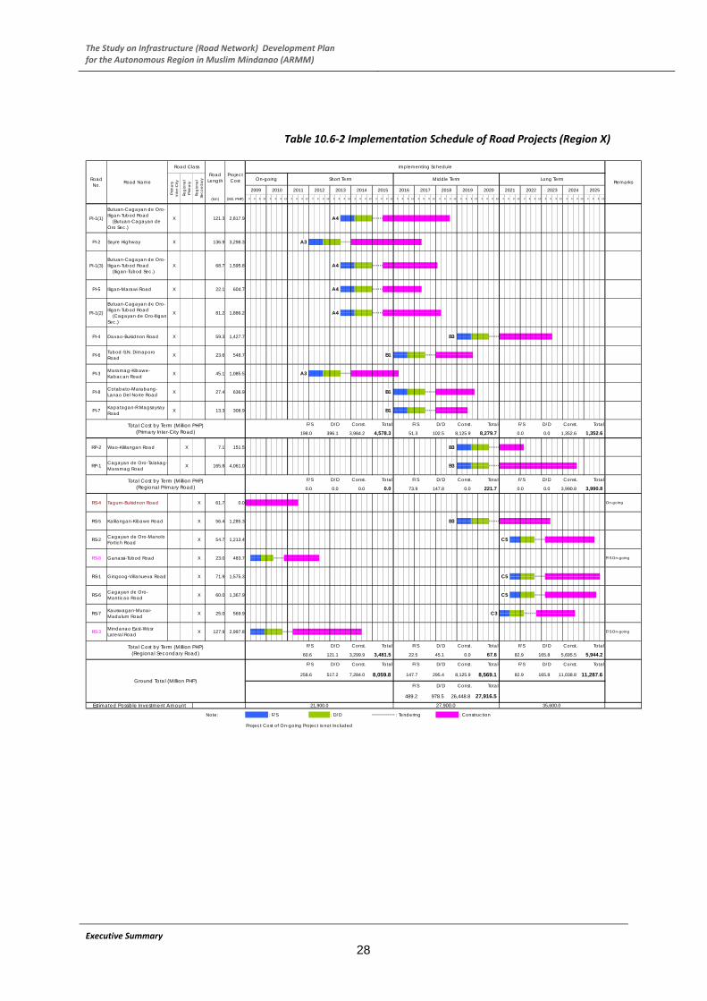
The Study on Infrastructure (Road Network) Development Plan for the Autonomous Region in Muslim Mindanao (ARMM)
Table 10.6‐2 Implementation Schedule of Road Projects (Region X)
Estimated Possible Investment Amount 21,900.0 27,900.0
12
C5
x x
35,600.0
x xx x x x x x x
3
61.7
25.0
54.7
56.4
X
X
X
X
X
96312
XPI-1(1)
Butuan-Cagayan de Oro-Iligan-Tubod Road (Butuan-Cagayan de Oro Sec.)
X
X
X
PI-3 Maramag-Kibawe-Kabacan Road
PI-1(2)
Butuan-Cagayan de Oro-Iligan-Tubod Road (Cagayan de Oro-Iligan Sec.)
PI-4 Davao-Bukidnon Road
PI-6 Tubod-S.N. Dimaporo Road
X
PI-5 Iligan-Marawi Road
PI-2 Sayre Highway
PI-1(3)Butuan-Cagayan de Oro-Iligan-Tubod Road (Iligan-Tubod Sec.)
22.1 X
81.2
PI-7 Kapatagan-R.Magsaysay Road 13.3 X
PI-8 Cotabato-Marabang-Lanao Del Norte Road 27.4 X
RP-1 Cagayan de Oro-Talakag-Maramag Road 165.8 X
RP-2 Wao-Kililangan Road 7.1 X
RS-1 Gingoog-Villanueva Road
RS-3 Mindanao East-Wesr Lateral Road 127.9 X
Executive Summary
28
RS-4 Tagum-Bukidnon Road
RS-2
RS-7 Kauswagan-Munai-Madalum Road
RS-5 Kalilangan-Kibawe Road
RS-6 Cagayan de Oro-Manticao Road
Cagayan de Oro-Manolo Fortich Road
60.0
71.9
X
X
RS-8 Ganassi-Tubod Road 23.0 X
Total Cost by Term (Million PHP)(Primary Inter-City Road)
912 3 66 9 12 3 6 93 6 6 9 12 3
121.3
39 12 3 6 9 12
x xx x x x
2022 2023 202412 3 69 6 9 12 3 6 9
xx x x xx
2020 20216 9 12 3
2014 2015 2016 2017 2018 201912 3 6 9 12 3
x x x xx x
x xx x x xA42,817.9
136.9
68.7
45.1
59.3
23.6
Prim
ary
Inte
r-City
Regi
onal
Pr
imar
y
Regi
onal
Se
cond
aryRoad
No. Road Name
Road ClassRoad
Length
Implementing Schedule
Remarks
F/S On-going
On-going
F/S On-going
Project Cost
3,298.3
1,595.8
604.7
1,886.2
1,427.7
1,085.5
151.5
548.7
308.9
636.9
1,367.9
4,061.0
569.9
483.7
Total Cost by Term (Million PHP)(Regional Primary Road)
1,575.3
1,213.4
0.0
1,285.3
X
2,997.8
Total Cost by Term (Million PHP)(Regional Secondary Road)
Note:
x x x x x x
B3 x x x x x x
x x x x x x
x x x x x x
x x x x x x
x x x x x x
B3 x x x x x x
x x x x x x
x x x x x x
C5 x x x x x x
x x x x x x
x x x x x x
C5 x x x x x x
C3 x x x x x x x
x x x x x x
F/S D/D Const. Total F/S D/D Const. Total F/S D/D Const. Total
198.0 396.1 3,984.2 4,578.3 51.3 102.5 8,125.9 8,279.7 0.0 0.0 1,352.6 1,352.6
F/S D/D Const. Total D/D Const. TotalF/S D/D Const. Total
0.0 0.0 0.0 0.0 73.9 147.8 0.0 221.7 0.0 0.0 3,990.8 3,990.8
F/S D/D Const. Total F/S D/D Const. Total F/S D/D Const. Total
60.6 121.1 3,299.9 3,481.5 22.5 45.1 0.0 67.6 82.9 165.8 5,695.5 5,944.2
Ground Total (Million PHP)
F/S D/D Const. Total F/S D/D Const. Total F/S D/D Const. Total
258.6 517.2 7,284.0 8,059.8 147.7 295.4 8,125.9 8,569.1 82.9 165.8 11,038.8 11,287.6
F/S D/D Const. Total
978.5 26,448.8 27,916.5489.2
Middle Term Long Term
2012 20132009 2010 2011
(km) (Mil. PHP) 3 6 9 12
20256 9 126 9 12 3 6 9 12 3 6 9 12 3
: Tendering 3 : Construction
Project Cost of On-going Project is not Included
1 : F/S 2 : D/D x x
A3
A4
A4
A4
B1
A3
B1
B1
B3
B3
F/S
On-going Short Term

The Study on Infrastructure (Road Network) Development Plan for the Autonomous Region in Muslim Mindanao (ARMM)
Table 10.6‐3 Implementation Schedule of Road Projects (Region XII)
32,100.0Estimated Possible Investment Amount 19,700.0 25,200.0
A5
C4
C4
C4
C4
A5
x
A5
x x x x xx x
X
X
X
X
X
X
X
X
PI-2
PI-1 Davao-Cotabato Road 55.4 X
PI-5
17.5
134.6
39.0
PI-3 Maramag-Kibawe-Kabacan Road
Gen. Santos-Cotabato RoadPI-4 X
48.6
X
X
58.0
221.7
35.0 923.0
Davao-Digos Road X
Wao-Carmen Road
Cotabato-Digos Road
48.4
Kabuntalan-Midsayap RoadRP-3 15.0 X
Executive Summary
29
RP-4 Midsayap-Datumang Road 13.1 X
RP-5 Pagalungan-Mamasapano Road 15.0 X
RP-6 XKidapawan-Ala Road
RP-7 Buluan-Islan Road 22.7 X
RP-8 Koronadal-Tacurong-Midsayap Road 36.5 X
51.2RP-9 Gen. Santos-Glan-Kalipagan Road X
X
RP-11 Isulan-Palimbang Road
RP-2
RP-10 Gen. Santos-Kiamba-Kalamansig Road
RP-1 Libungan-Buldon-Matanog Road
75.1 X
39.0RP-12 Cotabato-Upi-Kalamansig Road X
RP-13 Magnoy-Lebak Road 49.3 X
RS-1 Banisilan-Alamada Road 25.0 X
RS-2 Carmen-Libuagan Road 25.0 X
RS-3 X
Tulunan-Makilala Road 25.0
X
Matalam-Roxas Road 50.0
90.0
30.0
RS-7 Padada-Kiblawan-Columbio Road 25.0
75.4 Kidapawan-Arakan-Davao RoadRS-4
RS-5
54.3
RS-8 Lais-Alabel Road 32.6 X
RS-6 Koronadal-Columbio-Datu Paglas Road
20.0
RS-10 Saralla-Lake Sebu-Maitum Road 75.1
XSaltan Kudarat-South Cotabato Link RoadRS-11
RSn-1 Tapian-Lebak Road
On-going
F/S On-going
On-going
On-going
On-going
Road Name
Road ClassRoad
LengthPr
imar
y In
ter-C
ity
Regi
onal
Pr
imar
y
Regi
onal
Se
cond
ary
1,129.8
3,125.6
Project Cost
1,286.2
906.1
1,295.9
Road No.
0.0
x x x x x x
x x x x x x
A2 x x x x x x
A2 x x x x x x
A3 x x x x x x
6 9
x x x x x
0.0
0.0
751.5 x
953.2
1,889.9
461.5
5,096.9
343.5
1,404.2
Total Cost by Term (Million PHP)(Regional Primary Road)
447.5 x x x x x x
A5 x x x x x x
x x x x x x
x x x x x x
B1 x x x x x x
B3 x x x x x x
x x x x x x
B2 x x x x x x
C2 x x x x x x
B2 x x x x x x
B2 x x x x x x
B2 x x x x x x
x x x x x
452.4
RS-9 Gen. Santos-Glan-Kalipagan Road 0.0
570.3
475.3
1,599.2
1,139.9 x
569.9
569.9
1,711.0
1,966.8
807.9
776.5
579.5
C2 x x x x x x
x x x x x x
x x x x x x
B2 x x x x x x
x x x x x x
B2 x x x x x x
x x x x x x
Implementing Schedule
Remarks2013 2014 2015 2016 2017 2018
Middle Term Long Term
2011 2012 2019 2020 2021 2023 20242009 20106 9 12(km) (Mil. PHP) 3 3 6 9 12 3 6 9
202212 3 6 9 12 3
20253 6 9 12 3 6 3 6 96 9 12 3 12 3 6 9 12 3 6 9 12 3 6 9 12 3 36 9 12 3 36 9 12 3 12 6 9 12 9 12 12
Total Cost by Term (Million PHP)(Primary Inter-City Road)
F/S D/D Const. Total F/S D/D Const. Total F/S D/D Const. Total
0.0135.9 271.7 7,217.2 7,624.8 0.0 0.0 118.9 118.9 0.0 0.0 0.0
F/S D/D Const. Total F/S D/D Const. Total F/S D/D Const. Total
133.2 266.4 4,828.7 5,228.3 48.9 97.8 4,036.9 4,183.7 40.3 80.6 3,190.8 3,311.7
Total Cost by Term (Million PHP)(Regional Secondary Road)
F/S D/D Const. Total F/S D/D Const. Total F/S D/D Const. Total
7,160.70.0 0.0 0.0 0.0 111.6 223.3 3,270.7 3,605.6 72.5 145.0 6,943.2
Ground Total (Million PHP)
F/S D/D Const. Total F/S
F/S
542.4
D/D Const. Total F/S D/D Const. Total
10,472.4269.1 538.1 12,045.9 12,853.1 160.6 321.1 7,426.5 7,908.2 112.8 225.6 10,134.0
D/D Const. Total
1,084.9 29,606.4 31,233.7
Note: 1 : F/S 2 : Construction
Project Cost of On-going Project is not Included
: D/D : Tendering 3x xx x x
6 96 9 12
B3
C2
On-going Short Term
A2
A2

The Study on Infrastructure (Road Network) Development Plan for the Autonomous Region in Muslim Mindanao (ARMM)
Figure 10.7‐1 Proposed Short‐Term Projects (2011‐2015)
Executive Summary
30
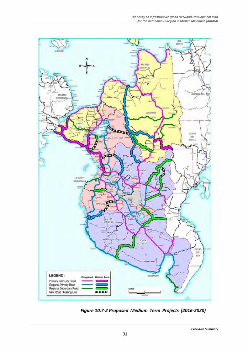
The Study on Infrastructure (Road Network) Development Plan for the Autonomous Region in Muslim Mindanao (ARMM)
Figure 10.7‐2 Proposed Medium Term Projects (2016‐2020)
Executive Summary
31

The Study on Infrastructure (Road Network) Development Plan for the Autonomous Region in Muslim Mindanao (ARMM)
Figure 10.7‐3 Proposed Long Term Projects (2021‐2025)
Executive Summary
32

The Study on Infrastructure (Road Network) Development Plan for the Autonomous Region in Muslim Mindanao (ARMM)
10.10 Evaluation of Master Plan a) Improvement of Traffic Condition Operating Cost (VOC), Saving in Travel Time Cost
(TTC), and Saving in Operation and Maintenance Expense.
When the Master Plan is realized which is composed of the short, medium and long‐term development plans, major improvement in traffic condition are:
Vehicle Operating Cost
A total VOC of the whole road network was calculated using VOC unit and estimated traffic volume. Then, the benefit of the projects in 2015, 2020, and 2025 was computed by the comparison of “with” case and “without” case.
Travel time improvement In 2025, travel time saved will be 32,600 hours per day.
Total capacity In 2025, traffic capacity of roads increased by 1.2 times.
Travel Time Saving
Average Travel Speed In 2025, average travel speed will be improved by 1.3 times
According to the 2008 DPWH data, the time value per work hour is 419 pesos on those in a passenger car and 105 pesos for other modes. Based on the roadside OD survey result, business trips account for 69.6%, commuting to work places and commuting back home 6.5%.
b) Environmental Assessment Proposed projects were grouped into six (6) types and scoping of each type of project is summarized in the table below.
Saving of Operating and Maintenance (O&M)
Expense Summary of Scoping Project No. Type of Project Overall
Rating ARMM Region X Region XII 1‐1 Improvement of
existing gravel road to paved road
No ROW acquisition
Outside protected area
B (Some Impact
Expected)
SK‐8, Mp‐3, L1p‐1, L2‐4, L2p‐3, SKp‐2, SKp‐3, SKp‐4, SKn‐4
(9 projects)
RP‐1, RP‐2, RS‐1, RS‐2, RS‐5, RS‐6, RS‐7, RS‐8
(8 projects)
RP‐2, RP‐3, RP‐7, RP‐8, RP‐10, RP‐11, RP‐13, RS‐1, RS‐2, RS‐3, RS‐5,
RS‐6, RSn‐1
(13 projects)
1‐2 Improvement of existing gravel road to paved road
No ROW acquisition
Inside protected area
B (Some Impact
Expected)
MP‐2, Mn‐1, L1‐5
(3 projects)
‐ ‐
2‐1 Rehabilitation of existing paved road
No ROW acquisition
Outside protected area
D (No Impact Expected)
L1‐1, MC‐1, L2‐1, SK‐9, SK‐1, SK‐7, M‐3, Mp‐1, MC‐3, MC4~MC8, SK11
(14 projects)
PI‐1 (1), (2), (3), PI‐2, PI‐3, PI‐4, PI‐5, PI‐6, PI‐7, PI‐
8
(10 projects)
PI‐1, PI‐2, PI‐3, PI‐4, PI‐5
(5 projects) 2‐2 Rehabilitation of
existing paved road
No ROW acquisition
Inside protected area
B (Some Impact
Expected)
L2‐2(1), M‐4
(2 projects)
‐ ‐
3‐1 Elimination of missing link or new road construction
Outside protected area
A (Serious Impact
Expected)
SKn‐2, SKn‐5, L2p‐2, L2n‐1, SKn‐6,
SKp‐5
(6 projects)
RS‐3
(1 project)
RP‐1, RS‐4, RS‐7, RS‐8, RS‐11
(5 projects)
3‐2 Elimination of missing link or new road construction
Inside protected area
A (Serious Impact
Expected)
L1‐4, L2p‐1
(2 projects)
‐
RP‐5, RP‐6, RP‐10
(3 projects)
The O&M expense of gravel or earth roads is higher by about 1.8 times compared with that of concrete pavement. The saving of the O&M expense in the Master Plan is calculated by the reduction amount in the annual O&M expense by paving gravel or earth roads. Evaluation Result (EIRR) The overall EIRR was estimated at 24%. According to NEDA’s criteria, the threshold value to judge the economic feasibility of a project is 15% in the Philippines. Thus, this Master Plan is concluded to be highly feasible from the economic point of view.
EIRR 24.2%
NPV (R=15%) 7,026.5
B/C (R=15%) 1.34
Rating: A : Serious impact is expected B : Some impact is expected C : Extent of impact is unknown D or No Mark : No impact is expected
c) Economic Evaluation The following items are considered as economic benefits in the Master Plan: Saving in Vehicle
Executive Summary
33
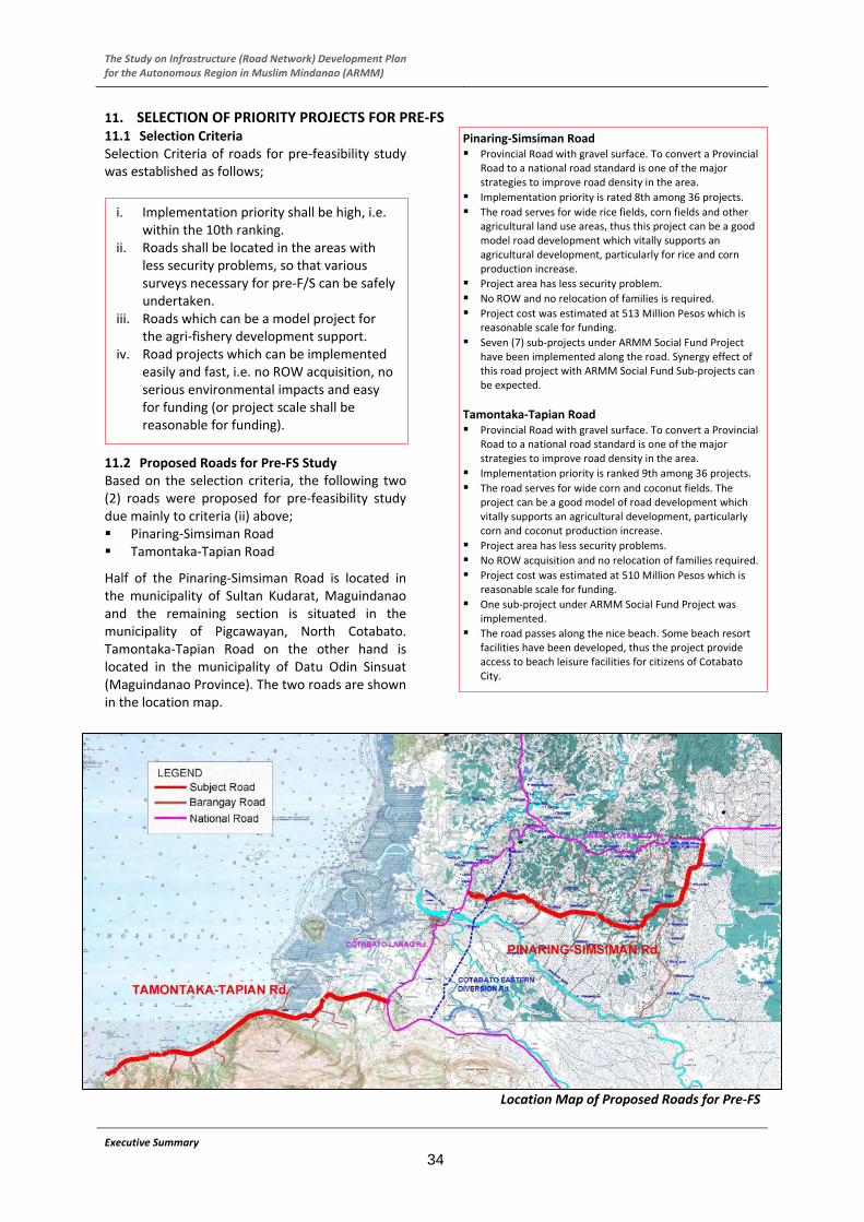
The Study on Infrastructure (Road Network) Development Plan for the Autonomous Region in Muslim Mindanao (ARMM)
11. SELECTION OF PRIORITY PROJECTS FOR PRE‐FS
Executive Summary
34
11.1 Selection Criteria Selection Criteria of roads for pre‐feasibility study was established as follows;
11.2 Proposed Roads for Pre‐FS Study Based on the selection criteria, the following two (2) roads were proposed for pre‐feasibility study due mainly to criteria (ii) above; Pinaring‐Simsiman Road Tamontaka‐Tapian Road
Half of the Pinaring‐Simsiman Road is located in the municipality of Sultan Kudarat, Maguindanao and the remaining section is situated in the municipality of Pigcawayan, North Cotabato. Tamontaka‐Tapian Road on the other hand is located in the municipality of Datu Odin Sinsuat (Maguindanao Province). The two roads are shown in the location map.
Pinaring‐Simsiman Road Provincial Road with gravel surface. To convert a Provincial
Road to a national road standard is one of the major strategies to improve road density in the area.
Implementation priority is rated 8th among 36 projects.
The road serves for wide rice fields, corn fields and other agricultural land use areas, thus this project can be a good model road development which vitally supports an agricultural development, particularly for rice and corn production increase.
Project area has less security problem.
No ROW and no relocation of families is required.
Project cost was estimated at 513 Million Pesos which is reasonable scale for funding.
Seven (7) sub‐projects under ARMM Social Fund Project have been implemented along the road. Synergy effect of this road project with ARMM Social Fund Sub‐projects can be expected.
Tamontaka‐Tapian Road Provincial Road with gravel surface. To convert a Provincial
Road to a national road standard is one of the major strategies to improve road density in the area.
Implementation priority is ranked 9th among 36 projects.
The road serves for wide corn and coconut fields. The project can be a good model of road development which vitally supports an agricultural development, particularly corn and coconut production increase.
Project area has less security problems.
No ROW acquisition and no relocation of families required.
Project cost was estimated at 510 Million Pesos which is reasonable scale for funding.
One sub‐project under ARMM Social Fund Project was implemented.
The road passes along the nice beach. Some beach resort facilities have been developed, thus the project provide access to beach leisure facilities for citizens of Cotabato City.
i. Implementation priority shall be high, i.e. within the 10th ranking.
ii. Roads shall be located in the areas with less security problems, so that various surveys necessary for pre‐F/S can be safely undertaken.
iii. Roads which can be a model project for the agri‐fishery development support.
iv. Road projects which can be implemented easily and fast, i.e. no ROW acquisition, no serious environmental impacts and easy for funding (or project scale shall be reasonable for funding).
Location Map of Proposed Roads for Pre‐FS

The Study on Infrastructure (Road Network) Development Planfor the Autonomous Region in Muslim Mindanao (ARMM)
12. PRE‐FS OF SELECTED PROJECTS 12.1 Objectives of the Projects The objectives of the two roads are the following:
Executive Summary
35
12.2 Design Policy Design policies adopted were as follows;
New road right‐of‐way acquisition shall be avoided as much as possible.
Existing road alignment, both horizontal and vertical alignments, shall be followed as much as possible to achieve above policy. Design standards shall be relaxed where required to achieve this policy.
Existing PCC pavement sections and bridges shall be utilized as much as possible when they are judged to perform their functions.
12.3 Outline of the Projects Shown in the following tables is basic information of the two roads.
Pinaring ‐ Simsiman Road Road length 20.1 km.
Already paved section by PCC pavement
1.7 km.
Section to be improved 18.4 km.
Number of bridges 5 bridges
Bridges to be maintained
4 bridges
Bridge to be replaced 1 bridge (Salam Bridge No. 1, L = 23 m)
Road condition Gravel section becomes frequently impassable after heavy rain
Barangay roads to be improved
13 Barangay Roads (L = 42 km.)
Tamontaka‐Tapian Road Road length 20.4 km
Already paved section by PCC pavement
4.4 km.
Section to be improved 16.0 km
Number of bridges 6 bridges
Bridges to be maintained
5 bridges
Bridge to be replaced 1 bridge (Salam Bridge No. 1, L = 25 m)
Road condition Gravel section becomes frequently impassable after heavy rain
Barangay roads to be improved
20 Barangay Roads (L = 24 km.)
Pinaring‐Simsiman Road To provide an all‐weather road to assure
transportation of people and agricultural in‐puts and out‐puts throughout a year for agricultural development.
To provide an easier access to basic social and health facilities which are mostly located in Cotabato City.
To provide an alternative route to Cotabato City – Davao City Road.
To achieve higher agricultural production, particularly palay and corn which will increase farmers’ income and eventually contribute to poverty reduction
Tamontaka‐Tapian Road To provide an all‐weather road to assure
transportation of people and agriculture and fishery inputs and outputs throughout the year for agri‐fishery development.
To provide an easier access to basic social and health facilities which are mostly located at Cotabato City.
To provide an easier access to beach resorts which are major recreation spots for residents of Cotabato City citizens.
Pinaring‐Simsiman Road
Tamontak‐Tapian Road
Bridge to be replaced along Pinaring‐Simsiman Road
Cornfield along Pinaring‐Simsiman Road

The Study on Infrastructure (Road Network) Development Plan for the Autonomous Region in Muslim Mindanao (ARMM)
12.4 Design Standard a.) Road
Based on DPWH’s Design Guidelines, Criteria and Standards, the geometric design standards were established as shown in the table.
Unit
Main Road with ADT400‐1000
at Rolling (at Mountainous)
Barangay Road with ADT 200 or
less at Rolling
(at Mountainous)
Design Speed kph 60 (40) 40 (30)
No. of Lanes Lane 2 1
Lane Width M 3.05x2 4.0
Shoulder Width m 1.0*1 1.0
Min. Radius m 120 (50)*2 55 (30) Horizontal Alignment Max. Super
elevation % 6 % ‐
Max. Gradient % 6% (8%)*3 8% (10%)
Sag m 1000 (450) 450 (250) Vertical Alignment Min.
Radius Crest m 1400 (450) 450 (250)
Min. Stopping Sight Distance
m 70 (40) 40 (40)
PCC % 1.5% ‐ Pavement Cross Fall
Gravel % ‐ 2.5%
Executive Summary
36
b.) Bridge Bridge design criteria adopted were as follows; DPWH Standard cross section of bridge shall be
applied. For Codes and Standards, the following will be
utilized: ‐ AASHTO Standard Specifications for Highway
Bridges, Sixteenth Edition, 1996. ‐ National Structural Code of the Philippines,
Volume II, Bridges, 2nd Edition, 1997. ‐ Specifications for Highway Bridges, Part IV,
2002, Japan Road Association. ‐ Seismic design shall be done in accordance
with the provisions of Division I‐A “Seismic Design” of the 1996 AASHTO Standard Specification for Highway Bridges and DPWH Department Order No. 75, Series of 1992, re: DPWH Advisory for Seismic Design of Bridges
12.5 Typical Cross‐section of Road A normal cross fall of 1.5% was used for the traveled way all throughout the PCC pavement and 3.0% shoulders. Superelevation was computed in accordance with the design guidelines used for this project. The angles of slopes are based on the stability requirements but the designer used a slope 1.5:1 for embankment and cut considering there was a
limited space. Typical cross‐sections are shown in the figures below.
Embankment Section
Cut and Embankment Section
12.6 Typical Cross‐section of Bridge DPWH Standard cross section of bridge shall be applied as shown below.
Cross Section of Two‐lane Bridge

The Study on Infrastructure (Road Network) Development Planfor the Autonomous Region in Muslim Mindanao (ARMM)
12.7 Project Cost Estimate a.) Construction Cost Estimated construction cost for Pinaring‐Simsiman Road and Tamontaka‐Tapia Road is around PhP 609 Million and PhP 522 Million respectively.
Estimated Construction Cost (Pinaring‐Simsiman Road) (Unit: Million PhP)
Unskilled Laborer
Part A Facilities for the Engineer 13.95 7.89 3.69 0.48 2.37
Part B Other General Requirement 13.95 7.89 3.69 0.48 2.37
Part C Earthworks 99.25 55.52 23.77 1.18 19.96
Part D Subbase and Base Course 20.14 10.74 6.27 0.06 3.13
Part E Surface Course 298.06 175.93 73.77 13.36 48.36
Part F Structures 16.08 7.60 6.00 0.58 2.48
Part G Drainage & Slope Protection Structure 31.48 13.18 13.13 0.81 5.17
Part H Miscellaneous 27.66 15.77 7.19 0.43 4.70
Part I Dayworks 9.30 5.26 2.46 0.32 1.58
Part J Provisional Sums 9.30 5.26 2.46 0.32 1.58
Part K Physical Contingencies 69.76 39.45 18.44 2.40 11.87
608.93 344.49 160.87 20.42 103.57Grand Total
ITEM/DESCRIPTION Total Foreign Local Taxes
Estimated Construction Cost (Tamontaka‐Tapian Road) (Unit: Million PhP)
Unskilled Laborer
Part A Facilities for the Engineer 11.98 6.73 3.25 0.41 2.00
Part B Other General Requirement 11.98 6.73 3.25 0.41 2.00
Part C Earthworks 64.65 36.06 16.43 0.73 12.16
Part D Subbase and Base Course 17.03 9.08 5.30 0.05 2.65
Part E Surface Course 255.83 150.77 63.56 11.30 41.50
Part F Structures 26.08 12.60 9.25 0.85 4.23
Part G Drainage & Slope Protection Structure 35.84 15.89 13.94 0.86 6.01
Part H Miscellaneous 23.25 13.25 6.05 0.36 3.95
Part I Dayworks 7.99 4.49 2.17 0.28 1.33
Part J Provisional Sums 7.99 4.49 2.17 0.28 1.33
Part K Physical Contingencies 59.91 33.66 16.27 2.07 9.98
522.53 293.75 141.64 17.60 87.14Grand Total
ITEM/DESCRIPTION Total Foreign Local Taxes
b.) Engineering Service Cost The cost for engineering services is estimated as shown in the table below based on the manning schedule proposed by the Study.
Engineering Services (Pinaring‐Simsiman Road)
Unskilled Laborer
Detailed Design 25.37 12.64 10.99 1.10 1.74
Tender Assistance 10.74 6.80 3.42 0.56 0.52
Construction Supervision 60.84 24.78 31.43 3.67 4.63
Grand Total 96.95 44.22 45.84 5.33 6.89
Local
(Unit: Million PHP)
DESCRIPTION Total Foreign Taxes
Engineering Services (Tamontaka‐Tapian Road)
Unskilled Laborer
Detailed Design 25.37 12.64 10.99 1.10 1.74
Tender Assistance 10.74 6.80 3.42 0.56 0.52
Construction Supervision 56.69 23.45 28.97 3.37 4.27
Grand Total 92.80 42.89 43.38 5.03 6.53
(Unit: Million PHP)
DESCRIPTION Total Foreign Local Taxes
12.8 Implementation Schedule The overall implementation schedule for Pinaring‐Simsiman Road is shown in the figure below while the Tamontaka‐Tapian Road’s implementation schedule is available in the succeeding page.
Implementation Schedule (Pinaring – Simsiman Road)
Preparation of the Tender Documents
Prequalification
Tendering
Tender Evaluation
Contracting
Mobilization
Construction Activities
1 Road Construction (Start - 1/4)
2 Road Construction (1/4 - 2/4)
3 Road Construction (2/4 - 3/4)
4 Road Construction (3/4 - End)
5 Drainage Work
6 Road Construction for Barangay Roads
7 Bridge Construction (Bridge No.1)
8 Slope Protection (Bridge No.2)
9 Slope Protection (Bridge No.3)
10 Slope Protection (Bridge No.4)
11 Traffic Facilities
Demobilization
2413 14 15 22211710 11 12 236 7 8 92 3 4 14 5 6 1
Designing
Evaluation & Approval on Tender Documents
8732 6
Fund Preparation Detailed Design Stage Tender Stage
411 510 12 1 2 3 4 7 39 510 2611 4 91
Const
ruct
ion S
tage
12
Distributing of Tender Documents
Supplemental Survey
4 76 8
Det
aile
dD
esig
n S
tage
Ten
der
Sta
ge
11 12 1
16
8
Construction Stage
2 3 4 5
Fund Preparation
Month 9
18
10
1 3 1 2 3
2012 2013Year
Stage
2010 2011
2
5
19 20
Executive Summary
37

The Study on Infrastructure (Road Network) Development Plan for the Autonomous Region in Muslim Mindanao (ARMM)
Implementation Schedule (Tamontaka‐Tapian Road)
Preparation of the Tender Documents
Prequalification
Tendering
Tender Evaluation
Contracting
Mobilization
Construction Activities
1 Road Construction (Start - 1/4)
2 Road Construction (1/4 - 2/4)
3 Road Construction (2/4 - 3/4)
4 Road Construction (3/4 - End)
5 Drainage Work
6 Road Construction for Barangay Roads
7 Bridge Construction (Bridge No.1)
8 Slope Protection (Bridge No.2)
9 Slope Protection (Bridge No.3)
10 Slope Protection (Bridge No.4)
11 Traffic Facilities
Demobilization
Const
ruct
ion S
tage
6
Distributing of Tender Documents
Supplemental Survey
1 1
Ten
der
Sta
ge
Designing
Evaluation & Approval on Tender Documents
14 20145 1918434 227 136 8 9 10 2113 2
Det
aile
dD
esig
n S
tage
2
Fund Preparation
2 11 12 155323
2012
6
16 17
911 3
Year 2010 2011
7 8 9 10Month 4 5 6 12 1 2 4 5 6 7 8 9 10 11 12 1 2 3 14 5 7 8
2013
2
StageFund Preparation Detailed Design Stage Tender Stage Construction Stage
10 11 12
12.9 Barangay Survey Results Three types of survey (Barangay Consultation Meeting, Household Interviews, Interview with Barangay Captains) were carried‐out to get a better understanding on the socio‐economic conditions of the people that are likely to be affected/benefit by/from the development of the two roads (28 barangays along Pinaring – Simsiman Road and 7 barangays along Tamontaka – Tapian Road). a.) Perception Survey (Consultation Meeting) Barangay Needs Barangays under the Pinaring‐Simsiman road have the following top priorities: 61% of the barangays chose road improvement as top priority needs, 18% selected drinking water system and others chose school building, dyke and others (e.g. livelihood projects). Barangays crossed by the Tamontaka – Tapian road on the other hand chose road improvement (86%) and livelihood projects (14%).
Road Improvem
ent61%School
Building7%
Drinking Water
System18%
y(Flood
control)7%
Others7%
Road Improvem
ent86%
Livelihood Projects
14%
Pinaring – Simsiman Tamontaka ‐ Tapian
Executive Summary
38
Impact of Poor Road Condition Barangay people who attended the consultation meeting were asked on the negative impact/difficulties caused by poor road condition. Answers most mentioned include: (i) delay in transporting their farm produce, (ii) high transportation cost, (iii) difficulty of students in attending their schools, (iv) low income due to the high transport cost, (v) difficulty in bring patient to hospital, and (vi) poor business opportunities Perceived Benefits from Road Improvement In terms of perceived benefits that could be derived from road improvement, the barangay people believed that improvement of their road would translate into increase in their income due to a decrease in transportation costs for farm produce. They also believed that it would open other business opportunities such as tourism (beach resorts) and car rentals (since there would be large group of people going to the beach resorts). Some also cited that road improvement would give easy access to NGOs which can provide various social services such as supply of farm inputs, clothing, foods and others. Social Acceptability of Road Improvement When asked if road improvement is acceptable, a very high 100% agreement of barangay people was obtained from both roads. It is important to note that the people, particularly the male population also requested that they be given a chance to participate during project implementation as hired laborers or any other type of job that would suit

The Study on Infrastructure (Road Network) Development Planfor the Autonomous Region in Muslim Mindanao (ARMM)
them. They also committed to help provide security to the equipments to be used as well as to personnel who will be assigned during the construction period.
b.) Socio‐economic Condition Demography The total population of barangays under the influence of the Pinaring – Simsiman road is about 61,000. This figure represents 34% of the population living in the municipalities of Sultan Kudarat and Pigcawayan. On the other hand, barangays covered by the Tamontaka – Tapian road is about 18,000 which represent 18% of the total population of Datu Odin Sinsuat Municipality.
Occupation The occupation of barangay people living the influence area of the two FS roads is shown in the figure below. Farming (43%) and working as barangay official (16%) have a share of more than half in the Pinaring – Simsiman road indicating that the area is suited for agricultural activities. Barangays closer to Liguasan Marsh have their livelihood relied mostly on fishing. For the barangay people living along the Tamontaka ‐ Tapian road, most people captured by the survey are housewives (24%), farmers (21%), fishermen (19%) and barangay officials (19%). Fishermen have a substantial share since these barangays are along a shoreline.
Occupation of Barangay People
0%
5%
10%
15%
20%
25%
30%
35%
40%
45%
Driv
er
Far
mer
Bar
anga
yO
ffici
al
Gov
ernm
ent
Em
ploy
ee
Ow
ned
Bus
ines
s
Bar
anga
yH
ealth
Sta
ff
Fis
herm
an
Hou
sew
ife
Tea
cher
Car
pent
er
Oth
ers
Pinaring-Simsiman
Tamontaka-Tapian
Executive Summary
39
Monthly Income According to the figure from the National Statistics Coordinating Board (NSCB), the average annual family income in the ARMM region in 2006 is 88,632 pesos which is equivalent to 7,386 pesos per month. This means that family income of most families living the FS roads is way below that average in the ARMM region as shown in the figure.
Source of Income Most of the families are earning their income from farming, fishing, driving and salary from their government positions such as barangay official.
Family Income
0%
5%
10%
15%
20%
25%
30%
35%
40%
45%
~3000 3001~5000 5001~7000 7001~9000 9001~12000 12001~15000 Above 15000
Monthly Income (Pesos)
Pinaring-Simsiman
Tamontaka-Tapian
Source of Income
0%
10%
20%
30%
40%
50%
60%
Salary Farming Fishing Driving Others
Source of Income
Pinaring-Simsiman
Tamontaka-Tapian
Family Expenditure Large number of families has monthly expenditure from the range of 3,000 pesos to 7,000 pesos. These expenditures are mostly spent for foods (56% for Pinaring – Simsiman and 61% for Tamontaka – Tapain) and followed by those spent for education, medicine, electricity and water, and farm inputs.
0%
5%
10%
15%
20%
25%
30%
35%
40%
45%
~300
0
3001
~500
0
5001
~700
0
7001
~900
0
9001
~120
00
1200
1~15
000
Abo
ve 1
5000
Monthly Expenditure (Pesos)
Pinaring-Simsiman
Tamontaka-Tapian
0%
10%
20%
30%
40%
50%
60%
70%F
ood
Edu
catio
n
Med
icar
e
Ele
ctric
ity &
Wat
er
Far
m In
puts
Oth
ers
Expenditure Breakdow n
Pinaring-Simsiman
Tamontaka-Tapian
Pinaring – Simsiman Tamontaka ‐ Tapian
c.) Agricultural Production Palay Production The national average of palay yield per hectare is 3.8 indicating that Pinaraing‐Simsiman has a higher yield (3.9). Rice paddy in Tamontaka – Tapian however has a lower yield which is just the same to the average of ARMM as reflected in the figure.
Palay Yield (Tonne/Hectare)
3.8 3.6
3.1
3.9
3.1
0.0
0.5
1.0
1.5
2.0
2.5
3.0
3.5
4.0
4.5
Phi
lippi
nes
Min
dana
o
AR
MM
Pin
arin
g -
Sim
sim
an
Tam
onta
ka-
Tap
ian
To
nn
e

The Study on Infrastructure (Road Network) Development Plan for the Autonomous Region in Muslim Mindanao (ARMM)
Corn Production Yield per hectare for both yellow corn and white corn is shown in the figures below. Corn fields along the Pinaring – Simsiman road have a higher yield than to those located in Tamontaka – Tapian road.
2.5 2.52.9 3.0
2.5
0.0
0.5
1.0
1.5
2.0
2.5
3.0
3.5
Phi
lippi
nes
Min
dana
o
AR
MM
Pin
arin
g -
Sim
sim
an
Tam
onta
ka-
Tap
ian
Yellow Corn
To
nn
e 1.7
2.6 2.7 2.7
2.2
0.0
0.5
1.0
1.5
2.0
2.5
3.0
Phi
lippi
nes
Min
dana
o
AR
MM
Pin
arin
g -
Sim
sim
an
Tam
onta
ka-
Tap
ian
White Corn
To
nn
e
Pinaring – Simsiman Tamontaka ‐ Tapian
Executive Summary
40
Transportation Cost of Agri‐fishery Produce The share of transportation cost on agricultural produce and fisheries of barangays along the Pinaring – Simsiman road is as follows: 7% for palay, 9% for corn, 5% for coconut, 3% for fish and 4% for coffee. Shifting to Tamontaka – Tapian road, the following figures are arrived: 5% for palay, 8% for corn, 5% for coconut, 3% for fish and 4% for coffee.
11.2 9.4
17.0
25.8
62.655.5
0.81 0.81 0.86 0.85 2.40 0.860.0
10.0
20.0
30.0
40.0
50.0
60.0
70.0
80.0
Pal
ay
Co
rn
Coc
onut
Man
go
Fis
h
Cof
fee
Pinaring - Simsiman
Pes
os
Selling price per kiloTrasport cost per kilo
13.59.3
15.7
28.3
82.5
0.64 0.75 0.86 0.98 1.090.0
10.0
20.0
30.0
40.0
50.0
60.0
70.0
80.0
Pal
ay
Cor
n
Coc
onut
Man
go
Fis
h
Tamontaka - Tapian
Pes
os
Selling price per kiloTrasport cost per kilo
Pinaring – Simsiman Tamontaka ‐ Tapian
12.10 Environmental Impacts a.) Pinaring – Simsiman Road
As mentioned, there is no road ROW accusation is expected but still, some disruptions on social activities and environment are expected. Predicted impacts and mitigation measures during pre‐construction and construction phases are summarized in the following tables. b.) Tamontaka – Tapian Road Predicted impacts and mitigation measures during pre‐construction and construction phases are summarized in the following tables.
Predicted Impacts and Measures during Pre‐
Construction and Construction Phase (Pinaring – Simsiman Road)
Predicted and Assessed Impacts
Rating Proposed Mitigating Measures
ROW Acquisition No Detailed design shall follow the design policy not to require ROW acquisition.
Involuntary Resettlement No Detailed design shall follow the design policy not to require involuntary resettlement.
Increase in noise level
B Schedule equipment move-in to blend with regular non-peak hour-daytime vehicular traffic; no night time movements
Provide barriers in work areas where use equipment with high noise power level is expected
Slope modification B Minimize land modification; follow established design consideration
Decreased public/ community access to or through the area
B Minimize obstruction to areas Provide alternative access in the event total road closure is
necessary Disruption of service utilities and infrastructures
B Coordinate with appropriate utility firms prior to project implementation
Ensure prompt and proper relocation of utility lines Demolition of structures
B Minor only; mainly fences and extensions. Proper notification of, and compensation to owners of affected structures
Construction wastes B Construction wastes such as unsuitable soils, demolished box culvert materials, etc., shall be dumped at the location specified by the Engineer
Noise due to pile driving B Pile driving shall be undertaken only during daytime.
Dust caused by construction work
B Prior to the start of the work activities, proper measures such as watering shall be undertaken to minimize dusting
Increased housing requirement for transient workers, and project management staff
B Provide temporary bunkhouse on site or rent houses in neighboring communities if housing requirements cannot be accommodated in the locality where the project is located
Traverse areas with historical significance
No Coordinate with Local Cultural and Historical Affairs Commission to ensure proper handling of archaeological finds, if any
Increased hazards due to construction activities
B Provide safety equipment and appropriate warning signs along the route
Provide alternative use of the construction yard/staging area once the project demobilizes
Clear construction debris, form works and equipment and remove all obstructions
Minimize construction clutter, manage construction debris properly and provide barriers to reduce eye sores
Screen laborers (particularly if they come from other localities other than the project area) to prevent possible spread of HIV / AIDS. This can be done by requiring applicants to submit blood tests (for HIV detection) prior to hiring.
Cutting trees B Cutting trees shall be minimized, and transplanted. If cutting trees is inevitable, new trees in double number shall be planted.
Rating: A: Serious Impact is expected B: Some impact is expected C: Extent of impact is unknown No: No impact is expected
Predicted Impacts and Mitigation Measures During
Operation Phase (Pinaring – Simsiman Road) Predicted and
Assessed Impacts Rating Proposed Mitigating Measures
Increase of traffic accident B Traffic regulatory signs, warning signs shall be properly maintained to be always visible. If necessary humps, to reduce vehicle speed, shall be installed.
Localized flooding B Side ditches and pipe / box culverts shall be always cleaned so as to properly function.
Travel cost increase B Paved carriageway shall be properly maintained so as to provide smooth travel.
Obstruction at bridge opening
B Obstruction at the bridge opening shall be always removed to assure smooth water flow at bridge sites.
Disorderly urbanization B Concerned LGUs shall strictly enforce the zoning ordinance along the road
Rating: A: Serious Impact is expected B: Some impact is expected C: Extent of impact is unknown No: No impact is expected

The Study on Infrastructure (Road Network) Development Planfor the Autonomous Region in Muslim Mindanao (ARMM)
Predicted Impacts and Measures during Pre‐Construction And Construction Phase (Tamontaka –
Tapain Road) Predicted and Assessed
Impacts Rating Proposed Mitigating Measures
ROW Acquisition No Detailed design shall follow the design policy not to require ROW acquisition.
Involuntary Resettlement No
Detailed design shall follow the design policy not to require involuntary resettlement.
Increase in noise level B Schedule equipment move-in to blend with regular non-peak hour-daytime vehicular traffic; no night time movements
Provide barriers in work areas where use equipment with high noise power level is expected
Slope modification B Minimize land modification; follow established design consideration
Decreased public/ community access to or through the area
B Minimize obstruction to areas Provide alternative access in the event total road closure is
necessary Disruption of service utilities and infrastructure
B Coordinate with appropriate utility firms prior to project implementation
Ensure prompt and proper relocation of utility lines Demolition of structures B Minor only; mainly fences and extensions. Proper notification
of, and compensation to owners of affected structures Construction wastes B Construction wastes such as unsuitable soils, demolished box
culvert materials, etc., shall be dumped at the location specified by the Engineer
Noise due to pile driving B Pile driving shall be undertaken only during day time. Dust caused by construction work
B Prior to the start of the work activities, proper measures such as watering shall be undertaken to minimize dusting
Increased housing requirement for transient workers, and project management staff
B Provide temporary bunkhouse on site or rent houses in neighboring communities if housing requirements cannot be accommodated in the locality where the project is located
Traverse areas with historical significance
No
Coordinate with Local Cultural and Historical Affairs Commission to ensure proper handling of archaeological finds, if any
Increased hazards due to construction activities
B Provide safety equipment and appropriate warning signs along the route
Provide alternative use of the construction yard/staging area once the project demobilizes
Clear construction debris, form works and equipment and remove all obstructions
Minimize construction clutter, manage construction debris properly and provide barriers to reduce eye sores
Screen laborers (particularly if they come from other localities other than the project area) to prevent possible spread of HIV / AIDS. This can be done by requiring applicants to submit blood tests (for HIV detection) prior to hiring.
Cutting trees B Cutting trees shall be minimized, and transplanted. If cutting trees is inevitable, new trees in double number shall be planted.
Executive Summary
41
Rating: A: Serious Impact is expected B: Some impact is expected C: Extent of impact is unknown No: No impact is expected
Predicted Impacts and Mitigation Measures during Operation Phase (Tamontaka – Tapian Road)
Predicted and Assessed Impacts
Rating Proposed Mitigating Measures
Increase of traffic accident B Traffic regulatory signs, warning signs shall be properly maintained to be always visible. If necessary humps, to reduce vehicle speed, shall be installed.
Localized flooding B Side ditches and pipe / box culverts shall be always cleaned so as to properly function.
Travel cost increase B Paved carriageway shall be properly maintained so as to provide smooth travel.
Obstruction at bridge opening
B Obstruction at the bridge opening shall be always removed to assure smooth water flow at bridge sites.
Disorderly urbanization B Concerned LGUs shall strictly enforce the zoning ordinance along the road, particularly beach resorts development shall be properly controlled.
Rating: A: Serious Impact is expected B: Some impact is expected C: Extent of impact is unknown No: No impact is expected
12.11 Economic Evaluation a.) Economic Benefit Calculation By improving the two roads, the motivation for production of farmer increases and productivity improves. Specifically, the following benefits are expected. The productivity of the roadside area on
Tamontaka ‐ Tapian Road is relatively low in Mindanao or ARMM area, and improvement in productivity by improvement of the road
can be expected. For example, supposing productivity improves even to the Mindanao average, 16% (Palay) and 18% (White Corn) of productivity increase will be expected.
According to the estimate of VOC, VOC of a rigid truck with 2‐axle decreases by about 65% by paving a road (travel speed rises from 20km/h to 50km/h, and VOC decreases in 56.0 Pesos/km to 19.45 Pesos/km).
The rate of the transportation cost occupied 7 to 9% of shipment cost; transportation cost will decrease by 5 to 6% by improvement of the two roads. This will increase farmer’s income and could help in reducing poverty in the area.
If road is improved, the product damage in transit will decrease, and it will lead to increase of commodity value.
The agricultural productivity of farmers can be expected to increase by about 40 to 60%. An increase of 40% means: 164 million pesos per annum along Pinaring‐Simsiman Road area and 156 million pesos per annum along Tamontaka‐Road.
b.) Cost‐Benefit Analysis
The results of cash flow analysis with costs and benefits per annum are shown in the table below. These results indicated that each road project is economically feasible enough to execute.
EIRR NPV (Mil. PhP)
(R=15%)
B/C (R=15%)
Pinaring – Simsiman Road
18.4 113.6 1.27
Tamontaka – Tapian Road
19.8 139.3 1.37
12.12 Conclusion It was concluded that two road projects are technically, environmentally and economically feasible. It is recommended that two road projects should be implemented at the earliest possible time.
The Study on Infrastructure (Road Network) Development Plan for the Autonomous Region in Muslim Mindanao (ARMM)
13. TECHNOLOGY TRANSFER a.) Major Areas of Technology Transfer In the course of the Study, various seminars/workshops were undertaken focusing on the following:
Executive Summary
42
JICA‐assisted “ARMM Human Capacity Development Project” has been conducted in parallel with this Study. The human capacity development project covers general procedures and methodology for each stage of the road project development cycle while this Study focused on the more concrete topics which were considered important and useful for road development planning, institutional improvement and maintenance improvement. b.) Seminars/Workshops Undertaken List of seminars/workshops undertaken in the course of the Study are shown in the table.
c.) Observations from the Seminars / Workshops
The following were observations obtained from the seminars/workshops; How to undertake Road/Bridge Inventory and
Condition Survey All participants were quite serious in learning something from the JICA Study Team.
Results of Road/Bridge Inventory and Condition Survey and how to utilize them
They actively joined to express their opinions/suggestions in consideration of DPWH‐ARMM conditions.
How to undertake traffic surveys
Present issues and how to improve institutional weaknesses
Present issues and how to improve road maintenance
Most participants came from DPWH‐ARMM
Headquarter and a few participants came from District Engineering Offices since seminars/workshops were held at DPWH‐ARMM Headquarter.
Environmental Impact Assessment (EIA) Systems
How to prepare Road Network Development Master Plan
It is believed that they have learned basic knowledge, such as how to undertake field surveys, how to identify projects, how to prioritize projects, what are the weaknesses of their institutional arrangements, what are the problems of road/bridge maintenance, etc. What is important from now on is that they will practice what they have learned from this Study. They should actively seek opportunities to practice what they have learned.
What they have learned under this Study is
rather limited to the planning aspects. Next step will be the actual implementation of the projects. This Study could not cover technology transfer for the project implementation. It is hoped that in the course of project implementation proposed by the Master Plan, they would seek opportunities to be involved in the project implementation with some guidance of international experts.
Date Topics Presenter Participants
Oct 15, 2008
Presentation of Inception Report Mr. M. Kiuchi Mr. T. Encarnacion
120
Nov 12,13, 2008
How to Accomplish Road/Bridge Inventory and Condition Survey Formats including dry‐runs
Mr. T. Tsuchida 17
Mar 11 2009
How to undertake traffic surveys and analysis
Dr. N. Sinarimbo 26
Mar 11 2009
EIA system of the Philippines and JICA
Ms. A. Herrera 26
Mar 13 2009
Institutional Weakness and Constraints
Mr. T. Encarnacion 25
May 6, 2009
Traffic Demand Forecast Methodology and Outcome
Mr. M. Ishiya 21
May 25, 2009
Proposed Institutional Improvement and Reinforcement
Mr. T. Encarnacion 36
May 26, 2009
Results of Road/Bridge Inventory and Condition Survey
Mr. A. Okazaki 30
May 26, 2009
How to undertake IEE Ms. A. Herrera 30
May 28, 2009
Road Maintenance Problems and How to Evaluate Priority of Maintenance Work
Mr. K. Tsuzuki 14
Jun 6, 2009
How to Prepare Road Network Master Plan
Mr. M. Kiuchi 20
Jun 17, 2009
Project Prioritization Criteria and Method
Mr. M. Kiuchi 20
Oct 28,29 2009
Joint Inspection on Pre‐F/S Roads (How to undertake road/bridge inspection)
Mr. M. Kiuchi Ms. A. Herrera
6

The Study on Infrastructure (Road Network) Development Planfor the Autonomous Region in Muslim Mindanao (ARMM)
Executive Summary
43
14. RECOMMENDATIONS a.) Peace Building Peace building is the most important issue in the Study Area. Without attainment of peace in the region, people will continue to suffer from unstable life, harsh economic conditions, poverty and further deterioration of infrastructure. The National Government, the ARMM Government and the MILF should make all efforts to reach peace agreement at the earliest possible time. On the part of a road sector, road network development should be planned that universal area development can be achieved to erase hostility among people. b.) Realization of the Master Plan The Master Plan was prepared. The next step is to plan how to realize the Master Plan. Proposed projects, institutional reinforcement, road maintenance improvement measures, etc., should be included in the forthcoming ARMM Medium‐term Regional Development Plan to show ARMM Government’s strong will to implement the Master Plan and steadily implement them. The following should also be undertaken: ARMM Government relies on its fund from
the National Government. Now it has technical basis such as road projects, institutional improvement measures, road maintenance improvement, etc., to request funds for those to the National Government. All kinds of efforts should be exercised to obtain more funds from the National Government.
In order to get more funds from the National Government, the DPWH‐ARMM should show good performance. Planned and budgeted projects should be completed as scheduled.
c.) Coordination with DPWH‐National Much closer coordination with DPWH‐National should be made and technical assistance from DPWH‐National should be sought, particularly on the following; Road/Bridge Database and HDM‐IV Analysis DPWH‐ARMM’s road/bridge database should be integrated with DPWH‐National, and HDM‐IV analysis which will be the basis of allocation of MVUC fund should be undertaken for roads within ARMM. Although DPWH‐National is, at present, rather reluctant to do so because of difficulty to examine data reliability owing to peace and order
situation of the region, DPWH‐ARMM should continue to discuss it with DPWH National. Foreign‐Assisted Projects within ARMM Foreign‐assisted projects within ARMM are implemented by DPWH‐National. Implementation arrangement should be discussed with DPWH‐National so that engineers of DPWH‐ARMM can be involved in the implementation of foreign‐assisted projects within ARMM. These projects will provide good opportunities for DPWH‐ARMM staff to be trained. Implementation of Road Projects which
Extends Beyond ARMM Boundary Many road projects proposed under the Master Plan extend beyond ARMM boundary and ends in Region X or Region XII. Implementation of such projects should not be planned by DPWH‐ARMM alone but with close coordination with DPWH‐National. d.) Farm‐to‐Market Road Improvement ARMM is the poorest region in the country and has the highest rate of poverty. The dominant industry in the Region is agro‐fishery thus road sector should support agro‐fishery development so as to increase farmers and fishermen’s income. Whenever a national or a provincial road improvement is planned, farm‐to‐market road improvement should also be included in the project. e.) Institutional Reinforcement Institutional weaknesses have been discussed in the course of the Study and roadmap for institutional reinforcement was proposed by the Master Plan. Priority areas for institutional capacity development identified were as follows:
Road database Traffic database Bridge management system Multi‐year programming and scheduling Pavement management system Maintenance planning and programming Road network planning system Computerized road design system Budgeting within organizational
performance indicator framework Project preparation: Feasibility Study
Since DPWH‐National has already developed the above systems, DPWH‐ARMM should coordinate with DPWH‐National for technical assistance.

The Study on Infrastructure (Road Network) Development Plan for the Autonomous Region in Muslim Mindanao (ARMM)
Executive Summary
44
f.) Road Maintenance Improvement The Study recommended the following;
Gradual shifting from Maintenance By Administration (MBA) to Maintenance By Contract (MBC) due to difficulty of renewal of equipment.
Much emphasis to be given to routine maintenance activities at least for next 10 years due to limited maintenance budget.
Gradual shifting of manpower from Area Equipment Service Offices (AESO) to District Engineering Offices (DEO) in line with shifting to MBC.
Road maintenance level and priority of maintenance activities to maximize usage of limited maintenance budget.
Above recommendations should be realized by the DPWH‐ARMM. g.) Implementation Of Pre‐F/S Road Projects Pre‐feasibility study of two (2) road projects was undertaken under this Study. DPWH‐ARMM should exert all efforts to realize these projects. All possible funding sources should be tapped for the realization of the projects. DPWH‐ARMM should also make them as good opportunities for
the on‐the‐job training to learn about project implementation. Concerned LGUs’ endorsements for the project should be secured and a certificate of non‐coverage (CNC) should be obtained from DENR. h.) Feasibility Study of Projects Proposed for
the Short‐Term Period Feasibility studies of projects proposed for the short‐term period (2011‐2015) should be undertaken at the earliest possible time since it is the first step to realize the Master Plan. i.) Environmental Impact Assessment Projects for eliminating missing links and new roads construction are expected to create serious environmental impacts. EIA for those types of projects should be carried out and possible mitigation measures should be planned and implemented. j.) Updating of Road/Bridge Database Road/bridge database covering road/bridge inventory and condition survey results should be updated annually.

The Study on Infrastructure (Road Network) Development Planfor the Autonomous Region in Muslim Mindanao (ARMM)
Executive Summary
45
ORGANIZATION OF THE STUDYJICA
Mr. Kenji Maekawa Director, Urban and Regional Development Division I Economic Infrastructure Department, JICA
Mr. Yoshiharu Yonezu* Urban and Regional Development Division I Economic Infrastructure Department, JICA
Mr. Yasuhisa Tominaga** Planning and Coordination Division, Economic Infrastructure Department, JICA Mr. Norio Matsuda Resident Representative, JICA Philippine Office
Ms. Harumi Kitabayashi Deputy Resident Representative, JICA Philippine Office Mr. Masafumi Nagaishi Senior Representative, JICA Philippine Office Mr. Takashi Komori Project Formulation Advisor, JICA Philippine Office
Steering Committee Members (SC)
Engr. Titingalangit C. Sumagayan** (SC Chairman) Regional Secretary, DPWH‐ARMM Engr. Razul K. Abpi* (SC Chairman) Regional Secretary, DPWH‐ARMM Engr. Guialoson A. Mamogkat (SC Co‐chairman) Director, DPWH‐ARMM
Mr. Diamadel E. Dumagay (SC Member) Executive Director, Regional Planning and Development Office
Engr. Danilo A. Ong (SC Member) Chief, Planning & Program Division, DPWH‐ARMM
Mr. Romeo N. Diocolano** (SC Member) Director, TMS‐ORG
Mr. Ramil L. Masukat* (SC Member) Director, TMS‐ORG
Engr. Melvin B. Navarro (SC Member) Director, Planning Service, DPWH ‐ National
Mr. Shinichi Kimura (SC Member) JICA Expert to ARMM
Counterpart Team
Engr. Titingalangit C. Sumagayan** Regional Secretary, DPWH‐ARMM
Engr. Razul K. Abpi* Regional Secretary, DPWH‐ARMM
Engr. Guialoson A. Mamogkat Director, DPWH‐ARMM
Engr. Danilo A. Ong Chief, Planning & Program Division, DPWH‐ARMM
Engr. Nazer P. Ebus OIC‐Chief, Maintenance Division, DPWH‐ARMM
Mr. Pendatun E. Nur Chief Administrative Officer, DPWH‐ARMM Engr. Sukarno A. Suleik Engineer II, Construction Division, DPWH‐ARMM
Engr. Mangondaya M. Madid Chief, Survey Division, DPWH‐ARMM
Engr. Yahiya A. Abdulkalim Engineer IV, Construction Division, DPWH‐ARMM
Mr. Abdulrahman Mokamad Legal Officer III, DPWH‐ARMM
Engr. Hector F. Celis Chief, Equipment Division, DPWH‐ARMM
Mr. Flaviano Tabile Financial Management Officer I, DPWH‐ARMM
Engr. Zainal N. Mlok, Jr. Engineer IV, DPWH‐ARMM
Engr. Emran B. Buisan Chief, Construction Division, DPWH‐ARMM
Mr. Sindab M. Mangoda Chief, Finance Division, DPWH‐ARMM
Embassy of Japan
Mr. Hirochika Namekawa** Second Secretary, Economic Division, Embassy of Japan
Mr. Shinpei Ishido* Second Secretary, Economic Division, Embassy of Japan
Study Team
Mr. Mitsuo Kiuchi Team Leader / Road Network Planner
Mr. Osamu Ohtsu Regional Development Planner
Mr. Koichi Tsuzuki Road Maintenance Specialist
Mr. Teodoro T. Encarnation Capacity Development (1) / Institutional Management Specialist
Dr. Takayuki Tsuchida Capacity Development Specialist (2)
Mr. Akio Okazaki Bridge Planner
Mr. Masayuki Ishiya Transport Planner
Dr. Nashreen G. Sinarimbo Traffic Survey / Logistics Planner / Barangay Survey
Mr. Aristeo A. Portugal Agricultural Development Specialist
Ms. Annabelle N. Herrera Environmental and Social Consideration Specialist
Mr. Makoto Mitsukura Natural Condition Specialist
Mr. Munetoshi Matsuo Facilities Design Engineer
Mr. Ryoichi Yamasaki Construction Planner/Cost Estimator
Mr. Toshiaki Horii Transport Economist
* Predecessor; ** Successor

Copyright © 2022 FDOKUMEN


![Multi-year simulations using a regional-climate model over the Iberian Peninsula: Current climate and doubled CO] scenario](https://static.fdokumen.com/doc/165x107/631eed287509c0131f0955fa/multi-year-simulations-using-a-regional-climate-model-over-the-iberian-peninsula.jpg)