386 Part 4. Settlement Analysis - Wakefield Council
770
386 Part 4. Settlement Analysis
-
Upload
khangminh22 -
Category
Documents
-
view
0 -
download
0
Transcript of 386 Part 4. Settlement Analysis - Wakefield Council

386
Part 4. Settlement Analysis

387
4.1 Zones: HLC Themes within West Yorkshire

388
4.1.1 Introduction to zoning
Figure 144. All HLC Types for West Leeds and Armley. A thematic map presenting all HLC Type assigned with random colours presents a
confusing picture

389
Figure 144 above is a map of West Leeds and Armley which display most, if not all, of the 109
HLC types. Each type has been assigned random colours. It presents a confusing picture.
The initial problem is the large number of HLC Types. There are not enough colours in the
GIS palette to represent them all clearly. The shades within the colours cannot be easily
separated by the eye. Although contiguous groups can be defined by picking out areas of the
same colour interpretation is difficult because of the lack of cohesion and definition.
Thematic mapping is a means of showing areas with connected values within particular
themes. These can be social, physical, political, cultural, economic, etc. The theme of interest
with regard to the HLC project data is the division of the historic landscape. Within the confines
of the HLC database fields, elements such as BroadType, HLC Type, period of origin, size of
area and Legibility can be combined in meaningful ways to produce a thematic map which is
relevant to particular interests, easier to interpret and thus be more meaningful.
The data can be utilised in such a way to answer specific enquiries. The nature of the
questions are many. An urban geographer might wish to analyse the growth of 20th century
suburbs. An industrial archaeologist may be interested in the distribution of 19th century textile
mills. A local authority planning officer might wish to identify areas of Victorian and Edwardian
suburbs with a good surviving landscape cohesion.
With the latter example, it would be necessary to have an understanding of what constitutes
a 19th century suburb and then a translation of that understanding in to terms which relate to
the HLC data. The first factor would be date. Records with a “PeriodStart” [see glossary] dating
from the early 1830s until the 1st World War might be included. We would also need to
distinguish between those features which are present in the current landscape and those
which are not. The “Legibility” field in the attribute tables would satisfy this. The population of
this field includes Invisible, Fragmentary, Partial, Significant and Certain. “Significant”
represents complete or almost complete landscape representation. “Partial” might indicate
character type with significant survival, though perhaps altered or reused, for example a 19th
century villa converted to a residential care home. “Certain” asserts that the record is correct
within the confines of available evidence. The next element might be concerned with what the
landscape character type actually is. A typical villa suburb contains a whole range of
associated features such a villa houses, semi-detached houses, higher status terraced rows,
parks, gardens and small institutes such as churches. The ability of the GIS software is to
select all the areas which contain the predefined factors and then combine and highlight them.
For the purposes of this report these areas are called zones. See Figure 145 below:

390
Figure 145. Thematic zone map of the Edgerton Area of Huddersfield depicting a zone of
villa suburbs (highlighted in blue)
Figure 146. Photograph of the Edgerton Area of Huddersfield. November 2015.

391
The latter half of Section 4 of the HLC report is concerned with defining the historic landscapes
of West Yorkshire’s Districts, creating a gazetteer of rural settlements and analysing the urban
core of the larger towns. This is aided with the help of pre-determined zones which were
designed to simplify the HLC data and provided an historic context which might be useful to
researchers and professionals, such as Planning and Conservation Offices. 21 basic zones of
historic landscape character were identified (a big reduction from the 109 HLC Types). These
were tailored to provide a basic subdivision of the historic landscape based on period of origin,
type (such as residential or industrial), historic context and to some degree social status. The
list of defined character zones is presented below.
Enclosed Land-Ancient (farmed land predating the surveyed enclosure commonly
found after the mid-18th and early 19th century)
Enclosed Land-Planned
Historic Parkland and Prestigious Houses
Settlement pre 1775
Complex Mixed Period Urban Cores
1775 to 1850 Industry and Industrial Settlement
1775 to 1918 Suburban development
1775 to 1918 Recreational or Ornamental Spaces
1775 to 1918 Civic Centres, Hospital Complexes, Prisons and Colleges/Universities
1850 to 1918 Workers' Housing and Associated Settlement
1850 to 1945 Industrial Works, Selected Communications and Warehouses
1775 to 1945 Extractive
1918 to 1990 Residential and Selected Urban Development
Post 1918 Recreational or Ornamental Spaces
Post 1918 Civic Centres, Hospital Complexes, Prisons and Colleges/Universities
Post 1945 Commercial and Industrial Zones
Post 1990 Residential and Selected Urban Development
Post 1945 Extractive
Undifferentiated Communications except depots, railway sidings and canal features
Derelict Land
Some of the zones are broad in their content as the goal was to reduce the number of zones
to a manageable level for clarity and accessibility. There is still the ability within each zone to
further subdivide on the basis of any given study or interest. For example, the “1918 to 1990
Residential and Selected Urban Development” zone could be re-themed to describe pre-war
and post-war housing or social and private housing (or both). The “Legibility” attribute was

392
used in making the section. These HLC Types with “Significant” of Partial” legibility were
included.
The finer definition of these zones is discussed in the Character zone descriptions section
below. The criteria used in constructing the zones can be found in the appendices section to
the rear of the report.

393
Character Zones descriptions
Unimproved Land
The zone comprises moorland, wetland, ancient or semi natural woodland and areas of ancient common land. It represents areas with largely
no improvement for agriculture. It is typically unenclosed, although Unimproved Land zones may be surrounded by dry stone walls or fences.
Moorland has a wild open character with blanket bog or heather moor. Large areas occur to the west of the county along the north-south Pennine
watershed and to the north of the area around Ilkley Moor.
Woodland is present throughout the county but has a stronger representation to the west of the county on the steep valley slopes. Wetlands are
a feature which are more common in eastern low lands and along the valley bottoms extending into the Pennine foothills.
Wetlands had a much greater prominence in the past. Unimproved Land has a poor agricultural grade limited to grazing or upland estate
management such as grouse moors, common grazing and domestic peat extraction. Woodland has been similarly managed in the past.
Areas to the edge of the Unimproved Land zone may have been utilised in the past and reverted to a ‘wild’ state through abandonment and
moorland or woodland regeneration. Moorland edges and woodland may contain derelict farms, relict agricultural landscapes and cloughs which
may include the sites of former industrial works and related water management features. As the land is relatively undisturbed, archaeological
and palaeoenvironmental features can be well preserved. Other features which can be encountered include quarries, reservoirs and other water
supply features. Although the land has a natural appearance, it is in fact altered. After the Ice Age West Yorkshire was much more wooded
than it is today. Tree clearances was largely a result of human intervention. Grazing and land management have kept areas of moorland free
from regeneration. There is a growing movement in the 21st century for the exploitation of upland areas as the location for windfarms.

394
Figure 147. Heath Common, 2016

395
Enclosed Land-Ancient
The zone comprises all kinds of enclosed agricultural land with ancient origins. Types include piecemeal enclosure, former open fields, strip
fields, valley floor meadows, agglomerated fields and a few horticultural HLC Types with a rural distribution such as nurseries. Other feature
included are ancient monuments and small scale quarries or mines. Farms and cottages have been included in the built environment zones.
A whole range of agricultural land grades can be represented. This is largely environmentally determined. The lower Magnesian limestone
geological band to the east of the county holds land with the best agricultural potential. This area has the best evidence of prehistoric fields and
medieval strip and open fields associated with post-Conquest village settlement and arable farming. As the land rises towards the Pennines to
the western and northern side of the county piecemeal enclosure and assarts becomes more common. Here are individual farms engaged in a
mixed agrarian economy, though largely pastoral in the Pennine hills. Useful distinctions could be made through further sub-analysis.
Many farms in this zone have a confirmed medieval date through place name evidence. Some estates may have had pre-Conquest origins.
There seems to be no continuity from the Romano-British or Prehistoric periods.
At the end of the medieval period the feudal village system collapsed and the former village open fields were enclosed. The medieval strip pattern
can be seen fossilised by later boundaries. Medieval open fields and Strip fields are more common as a previous type.
Fields in this zone tend to be small and irregular. Some fields like assarts and piecemeal enclosure can represent the ancient initial enclosure of
waste or the clearance of woodland. Dry stone walls form the boundaries in the west with hedges becoming more common to the east. Both
were systematically replaced by fences and hawthorn hedges from the 18th century. Another trend was for fields to be enlarged and boundaries
to be straightened from this time. This has resulted in the agglomeration of many farm estates in areas of ancient enclosed land.

396
Figure 148. Healey Road, Healey, view of ancient enclosed land. 2016

397
Enclosed Land-Planned
The zone comprises surveyed enclosure, drained wetland and plantations. Enclosure in this zone typically dates from the 18th century or later,
although rare examples exist from the 17th century. Planned enclosure is typically rectangular and grid-like in appearance as a result of the
division being made with a ruler on a map. Quarries and reservoirs can also be expected in this zone.
The zone frequently occurs at the edges of established farmland taking in agricultural land with a lower agricultural potential such as moorland.
Fields in upland areas are divided by dry stone walls and were utilised largely for pasture. The distribution of farms and field barns in this landscape
is also regular. Farms, where recorded, have been included in the built environment zones.
Moorland edge intakes were made at a time when rural populations were higher and demand for agricultural land was greater. The land was
poor, the climate hard and the farms were impoverished. From the late 18th century there was a population shift from the land into towns. Upland
farms were abandoned at this time. The moorland edges contain a relict landscape of abandoned fields and farms.
Zones of planned enclosure in lowlands can occur in areas of former commons and open fields of medieval villages. Where this is the case,
earlier field patterns can be preserved. Hedges are more common in these areas. Wetland was enclosure from around the same time as
moorland, a result of improved drainage techniques. Ditches commonly form the boundaries in the lower drained wetland areas. Former wetlands,
when drained and improved have a good potential for arable farming

398
Figure 149. Chevet Grange, Chevet Park, surveyed enclosure associated with grange farm. 2016

399
Historic Parkland and Prestigious
Houses
Like surveyed enclosure, historic parkland can represent large areas of planned landscape. The historic origins are sometimes much older than
surveyed enclosure. Deer parks are included in this zone dating back to the medieval period and possibly earlier. Most historic parks have a
post medieval date. The zone also comprises private parkland, estate woodland, estate villages, some lakes and elite residences. The distribution
is ubiquitous across the settled rural areas of West Yorkshire, though those to the east tend to be larger and more cohesive.
Deer parks acted as hunting preserves. Later historic parkland was generally associated with country estates and large houses. They were a
designed landscape providing an ornamental setting for an elite residence. These are typically of 17th to early 19th century date. Early examples
were the country estates for the landed gentry. Later country estates were founded by wealthy industrialists seeking to establish themselves as
a new elite.
Historic parkland generally has a clearly defined boundary with a circuitous boundary wall. Within is permanent pasture and sometimes arable
land. Plantation, water courses, lakes, tree-lined avenues and decorative buildings such as follies provided designed visual landscape aesthetics.
Closer to the house are formal gardens, kitchen gardens and estate buildings such as stables, farms and barns. Sometimes estates were situated
at the edges of villages. Some estates built village estates often in a unified architectural design.
The fashion for large estates declined at the end of the 19th century. Many were broken up and reverted to agricultural lands, some were donated
to councils to later form public parks and others became golf courses. Despite this several notable examples are preserved in West Yorkshire.

400
Figure 150. Lupset Hall, Wakefield, built in 1716. Park now a golf course. Hall lies empty. 2016

401
Settlement pre 1775
This zone was created to group all the built historic landscape areas with pre-1775 origins into one layer to enable easy identification.
1850 is a date of significance in development control archaeology as the first accurate OS 6” for West Yorkshire date from around this time. New
development effecting a building from before that date is a flag to Historic Environment Officers alerting them to potential historical interest. The
pre-1850 date criteria in the HLC zones was further subdivided with a 1775 to 1850 split to distinguish the zones of early industrial period
settlement (see 1775 to 1850 Industry and Industrial Settlement zone and Complex Mixed Period Urban Cores zone descriptions below). 1775
is also the date of the relatively accurate Thomas Jefferys 1” to the mile maps of West Yorkshire
This zone represents the built historic landscape from before the industrial period of the late 18th and 19th century. The highest historic potential
in this zone should be assumed. West Yorkshire has amongst the highest number of listed historic buildings in the country. Many of these fall
into this zone. Many more are not so well recorded and protected.
Included are all pre 1775 commercial broad types, nearly all pre 1775 industrial sites, all pre 1775 institutional types except pre-Christian
monuments, crofts and most residential types from before 1775.
The zone might include individual farms, vernacular cottages and smaller hall houses where they were of sufficient size to be recorded. Nucleated
rural and urban settlements also fall within this zone (any undifferentiated and complex early settlement was included in the Vernacular Cottage
HLC Type). This would include residential, industrial and commercial elements. Other landscape character types such as inns, corn mills, early
textile mills, warehouses, schools and churches were also included. In some instances a character area was well recorded or researched
providing a reliable date. In other cases the inclusion was conjectural based on the character areas presence on historic mapping or through an
understanding of historical architecture, placement and settlement form.

402
Figure 151. Shepherd’s Arms, Horbury, timber framed hall built in 1538. 2016

403
Complex Mixed Period Urban Cores
This zone was created to provide a cover-all category for complex historic urban cores. The time limitations of the HLC Project meant that
complex urban areas were sometimes not recorded in full. Dense urban cores visible on first edition mapping were generally assumed to be the
oldest part of any settlement. This provided the delimitation for many urban core HLC polygons. The Commercial Urban Core was used as the
defining HLC Type for this kind of mixed historic urban development. Large elements such as cinemas were often given their own HLC records.
This zone includes post 1775 commercial urban cores (as opposed to suburban cores) and several other small scale commercial HLC Types
such as markets. Public squares, small car parks, some small scale 20th and 21st century commercial areas were also included.
The assumption to be made with this zone is that Complex Mixed Period Urban Cores have good archaeological and historic potential. The
medieval origins of many of West Yorkshire’s urban cores has been confirmed through historic research or settlement analysis. Most cores were
firmly established by the Industrial Period.
A whole range of archaeological features may be encountered. These include medieval street layouts and urban enclosure plots (crofts), standing
medieval and early post medieval structures, concealed archaeological fabric and post medieval houses, workshops and warehouses. Many
towns were expanded or redeveloped during the industrial period. Yard developments of Georgian cottages and works shops still survive in some
towns. Many town contain fine examples of 18th and 19th century shops, hotels, offices, institutes, etc. Some 20th century urban core
redevelopment is of interest in its own right. Smaller settlements may hold evidence of more rural origin such as farms and barns along the high
street. Where redevelopment has not been wholesale, ancient buildings can sit alongside modern development. The historic landscape may be
historically complex above and below ground
The rural gazetteer and town core analysis presented in the latter sections of this report provides more detail relating to individual settlements.

404
Figure 152. Westgate, Wakefield, 2015

405
1775 to 1850 Industry and Industrial
Settlement
This zone was defined to reflect two things, settlement from before 1850 as an aid to development control and to identify settlement of a specific
date range from the early industrial period when industrialisation was beginning to transform the landscape between 1775 and 1850. Settlement
from before 1775 has a separate zone. As a result different Broad Types were combined in this zone which reflect the time period as opposed to
a particular function.
The zone includes lower status Residential Broad Types such as early back-to-back terraced houses and most Industrial Broad Types and several
lower status and small scale institutes such as schools. 1775 to 1850 warehouses, some commercial elements, early railway-sidings and canal
wharfs were also included. Suburban housing of this period are also treated as a separate zone.
It is the buildings of this period which give West Yorkshire its strong regional identity. The stone built weavers’ cottages with the long rows of
mullioned multi-light windows which cluster on the Pennine valley sides are an iconic feature of the landscape. The textile industry was
instrumental in the County’s regional development. This zone represents the end of domestic production and the small beginnings of
mechanisation when the mills and warehouses were local and more domestic in scale. Late weavers’ cottages and early factories are included.
The zone also marks the beginnings of industrial towns with terraced houses and commercial suburban cores. Industrial transportation was by
canal and early railway. Wharfs and railway sidings are included in this zone.
The condition of the character of this zone is generally good compared to other UK regions. A range of historic buildings in a strong regional
vernacular tradition can be expected.

406
Figure 153. Cheapside, Wakefield, late 18th to early 19th century warehouses and dwellings developed in former medieval burgage plots. 2016

407
1775 to 1918 Suburban Development
This zone has a broad time period between 1775 and 1918 but it covers settlement of a specific type. Namely Georgian, Victorian and Edwardian
suburbs. The zone reflects settlement with a higher social status. A further subdivision can be easily made in this zone to reflect different periods.
In addition to suburban housing types such as villas, semi-detached houses and churches were also included under the assumption that they
have more in common with historic middle-class settlement than workers’ housing.
Unfortunately a distinction between terraced rows and higher status town houses was not made by the HLC Project so they were occasionally
missed. The association between villa development and parks could also not be clearly defined from the records. Parks (private and public) of
this period were treated as separate zones. A visual association can be made however.
The 1775 to 1918 Suburban Development zone typically includes higher status houses set in large gardens or small private parks. These can
occur individually within the rural or urban landscape or as estates in urban conurbations. There was an historic tendency for conurbations to
form rings at the edges of larger towns and village. As the settlements expanded during the industrial period the suburbs were subsumed by
industrial zones and lower status residential development. The suburbs were pushed further afield. New suburbs were encourage by the
development of the tram and railway further from the edge of town. These in turn were subsumed by 20th century estate development.
Some villa estates survive fairly well as a contiguous group while others have been fragmented. Villas can stand in isolation amongst later
development, gardens may have been subject to infill development and villas houses may have been converted to new uses.

408
Figure 154. South Parade, Wakefield, high status early 19th century town houses. 2015

409
1775 to 1918 Recreational or
Ornamental Spaces
The zone represents designed public open spaces of the late Georgian, Victorian and Edwardian periods. Although they have a generally urban
distribution, they do not specifically fit in with other built urban zone classifications and have thus been treated as a separate zone.
The zone includes all pre 1918 public parks and sports grounds, including race courses. Cemeteries within this period have also been included.
Earlier cemeteries fall within the Settlement pre 1775 zone. Although cemeteries were treated as an Institutional HLC type, their open nature
and designed landscape aspect have park-like qualities. Commons and greens created after 1775 were also included in this category as by this
time the function of a common was generally changed from rural to recreational.
The inclusions in this zone range from the pleasure gardens and visitor attractions of the late 18th and early 19th century to large prestigious
Victorian and Edwardian parks with designed layouts, landscaping and ornamental features. Parks were popular in the 19th century for aesthetic
reasons and for perceived health benefits. Sports grounds from this period vary in scale from local bowling greens to large cricket grounds, golf
courses, race courses with purpose built stadiums, club houses and pavilions.
Some ornamental and recreation spaces may have originated as private parkland or large villa gardens (see Historic Parkland and Prestigious
Houses zone description above). As such, vestigial features relating to the earlier use may be preserved such as former drive and garden layouts,
walled gardens and estate buildings and even the houses (either standing or as archaeological remains).

410
Figure 155. Clarence Park, Wakefield, late 19th century public park. 2016

411
1775 to 1918 Civic Centres, Hospital
Complexes, Prisons and Universities
This zone is delimited by a 1775 to 1918 time range, the Institutional Broad Type and scale. Although the time range is quite large, distinctions
between different periods can be easily made with further analysis.
1.8 hectares was considered a minimum area for inclusion of institute records into this zone. As a general rule this works but there are a few
exceptions. Large scale institutes which had been subdivided or institutional zones composed of different elements might not be included.
Associations by proximity were not considered at this stage of writing. Institutes with areas smaller than 1.8 hectares were included in the various
urban zones.
This zone includes civic and municipal buildings, hospitals, almshouses, workhouses, colleges and universities.
It was during the 19th century that public institutes became significant landscape features as a result of national parliamentary acts implemented
by newly formed local authorities. Prior to this they were generally small scale and local. Hospitals and workhouse became larger in scale and
civic buildings more prestigious. Zones of government administrative buildings such as town halls and council chambers were built in towns
throughout West Yorkshire. These were grander still in administrative centres such as Wakefield. Colleges had a similar distribution covering
large areas and were often equally prestigious. Large scale hospitals and work houses were constructed in large estates out of town locations.
Some went on to become modern hospitals, others were abandoned.
The public buildings were prestigious and decorative often in high status Italianate or Baroque designs. As many are still in use, they are well
preserved and iconic elements of the modern townscape. Workhouses and hospitals did not survive so well, being abandoned or converted to
modern use.
412
Figure 156. Wakefield Town Hall, 2015

413
1850 to 1918 Workers' Housing and
Associated Settlement
Industrialisation brought a massive expansion of the urban areas of West Yorkshire from the mid-19th century and sometimes earlier. This zone
was created to delimitate the settlement associated with industrialisation from this period. The associations are working class as opposed to the
suburbs which are the subject of the 1775 to 1918 Suburban development zone described above.
Lower status houses such a terraces and back-to-backs are included in this zone. Features associated with the wider community are also
present. These comprise (all with an 1850 to 1918 date range) selected small scale institutes, commercial-suburban cores, a few later farms and
cottages, small scale power supply features such as gas holders and tram depots.
The large scale grid iron development of terraced houses with local corner shops, community churches and schools is the typical image of lower
status urban development from this period. This image is true. They occur around many of the larger Victorian conurbations. This type of
settlement can also occur on a smaller scale in villages and rural areas throughout West Yorkshire often in association with specific industrial or
extraction sites. Industry and extraction sites are the subject of separate zones, see below.
19th and early 20th century workers’ settlements survive quite well in West Yorkshire, partly as a result of providing affordable housing for
immigrants from the late 1950s onwards. In other regions such houses would have been lost through late 20th century redevelopment and the
populations displaced to the new housing estates. Many terraced housing developments in this county retained their community cohesion,
reusing facilities such as institutes and shops with a new cultural direction. Where they have suffered is through insensitive modernisation, such
as plastic doors and windows and flat roofed building extensions.

414
Figure 157. Healey Road, Healey, late 19th to early 20th century terraced houses. 2016

415
1850 to 1945 Industrial Works,
Selected Communications and
Warehouses
This zone represent the built industrial landscape of the latter half of the 19th century and early 20th century specifically relating to industry and
the storage and distribution of goods. The wider industrial settlement landscape and industry from before 1850 are the subjects of separate
zones (above). The zone includes (with an 1850 to 1945 date range) all industrial HLC types except small scale utilities and brick works, small
reservoirs, warehousing, railway sidings, canal wharfs and distribution centres. Offices with an industrial association could not be easily
distinguished from others types of offices and have been included in the other urban zones.
In HLC terms industrial works specifically mean textile mills, metal trades, engineering, paper and printing, food processing, chemical and several
other smaller scale industries. The textile and engineering industries made a great contribution to West Yorkshire’s Victorian and Edwardian
economy. It was a dominating landscape presence that also encouraged the growth of industrial towns and the redevelopment of urban cores
with commercial and civic buildings as a part of the wider industrial landscape. Alongside industry were zones of warehouses and commercial
chambers. Early industrial zones frequently formed a corridor along the valley bottoms influenced by the provision of water for powered and canal
based transport. The widespread mechanisation of industry from the early to mid-19th century freed industrial works valley bottoms. This resulted
in a shift in the location from the valleys to zones around towns. This shift was further encouraged by the introduction of the railways. Works
increased in scale from individual buildings to large scale multifunction combination work covering several hectares. Towns developed zones of
industrial specialisations.
There is good preservation of the county’s 19th and early 20th century industrial zones. Although abandonment and demolition of works from this
period has occurred, many more have been converted to modern use. Areas of traditional industry have frequently become the location of later
large scale industrial and commercial development.

416
Figure 158. Rutland Mill, Wakefield, built 1872-75. 2015

417
1775 to 1945 Extractive
This zone includes all large scale extractive HLC types. One hectare or above is taken as large scale. In HLC terms “Extraction” specifically
means quarries, deep shaft mines, open cast mines, clay pits, land fill sites and spoil heaps. This zone also includes brick and tile works because
of their associations with coal extraction sites. The many smaller scale quarries, gravel pits and coal pits which dotted West Yorkshire’s historic
rural landscape were considered too small to be represented by HLC records. These and all extraction HLC records with an area of below 1
hectare were included in the Enclosed Land-Ancient zones (above).
It was from the late 18th century that extraction became more organised and larger in scale. This zone describes larger scale collieries and
quarries of the industrial period.
The distribution is largely geologically determined. The Millstone Grit Group area of rocks to the west and north of the county which form the hills
of the Pennines provide sandstone and flags. Here the quarries can be landscape dominating features carving away entire hill tops. The survival
of quarries and associated features is good. The Pennine Coal Measures occupy the central part of the area and extend into the eastern low
lands.
There are hundreds of small coal pits and small ironstone extraction sites, in this area, some with medieval origins. Some collieries in West
Yorkshire became very large scale during the Industrial period. Landscapes were dominated by multiple pits, surface ancillary buildings, a network
of mineral railways and a no-mans-land of spoil tips. Clay was often extracted in conjunction with coal so there is sometimes an association with
collieries and brick/tile works. The valley bottoms were also the location for extensive aggregate extraction sites.
Large scale collieries now occur more frequently as a previous type. Some have regenerated as scrub or farmland, some were redeveloped,
and others have been landscaped as parks or nature reserves. The Magnesian Limestone Belt to the east of the county also provide quarries.
Quarries in this area tend to be smaller in scale and local.

418
Figure 159. Caphouse Pit National Coal Mining Museum, 2016

419
1918 to 1990 Residential and Selected
Urban Development
The date range of the 1918 to 1990 Residential and Selected Urban Development zone is very broad and encompasses varied housing types.
A new style of housing was introduced nationally from the Interwar period and that was the housing estate. Although the earlier forms detached
houses, semi-detached houses and terrace continued to be built during this time, the nature of housing had altered.
This zone is deigned to encompass all housing types from that period but with a view to subdividing the zone at a later stage to answer specific
questions such as phasing or status. Housing estates and flats can easily be distinguished from detached and semi-detached houses. There is
an HLC Attribute which separates private from social housing, this feature was unavailable at the time of writing.
Housing development of all kinds, from housing estates to small cul-de-sacs and occasionally individual houses are represented in this zone. It
also includes other types of urban development, all with a post 1918 date; such as allotments, commercial suburban cores, selected small scale
institutes (schools, nursing homes, etc.), small scale utility features and small bus depots.
Urban development in the 20th century typically occurred on a large scale in the urban conurbations often on farm land. The housing estate was
the archetypal form. The mass adoption of the motor car radically influenced the positioning and design of new housing enabling out of town
estates. Some housing occurred as ribbon development along arterial routes or specially constructed parks-ways. The 1920s and 30s had cul-
de-sacs of semi-detached houses designed to replicate idyllic English villages for returning First World War veterans and their families. Later
inter-war and post-war housing estates were larger in scale influenced by American ideals of the “neighbourhood unit”. These were estates self-
contained within encircling roads which contained shops, recreational facilities and institutes. These were designed to fulfil the needs of relocated
post-industrial period communities. Status too was formalised: Detached, semi-detached houses and bungalows for the middle classes. Terraced
rows, high and low-rise flats and retirement bungalows for the lower classes.

420
Councils became committed to building new housing or to provide partial contributions for private development. The Interwar and early post-war
represent boom times in housing development. A second boom occurred in the late 1960s and 1970s. The high-rise flat is a symbol of this latter
period. After this time, housing continued to be constructed but on a smaller more piecemeal scale with much more redevelopment of previously
developed sites. It often replaced earlier housing or industry. Despite some redevelopment of 20th century housing in recent times the zone’s
historic character remains strong.
Figure 160. Healey Road, Ossett, post-war private
housing development. 2016

421
Post 1918 Recreational or
Ornamental Spaces
Although parks and recreational spaces are an integral and largely planned aspect of the historic landscape, they do not fit easily into other built
historic landscape zones and have thus been categorised separately.
The zone includes public parks, playing fields, sports grounds, race courses, tourist attractions and golf courses. The area also includes
cemeteries which have been included in the HLC Broad type category. Because of their open and designed nature they have more in common
with parks. Commons and greens were considered as part of this zone. The historic use of commons related to rural economies. Today they
have a more informal recreation use. Leisure centres were included in zones relating to the built environment. Many 20th century housing
estates were designed with recreational spaces, from playgrounds to large open areas of playing fields. These have a suburban distribution.
Sometimes the playing fields associated with schools were included in this category. Larger playing fields with sports halls and multiple pitches
can also be found constructed on lower value land at the edges of towns. Public parks continued to be founded into the 20th century but these
tended to be less ornamental than their Victorian counterparts. Some modern public parks, particularly to the east of the county are large in scale
and are situated on reclaimed extraction sites.
Of special interest are the county’s golf courses, though not specifically in their own right. Often rural farming or country house estates were
purchased wholesale to create a golf course. Where this is the case there is a good chance for the preservation of houses, estate buildings and
field boundaries. The same can also be said for one or two of the county’s public parks.
The remaining inclusion in this zone are sports grounds and race courses. Some are small scale, such as bowling greens, others represent large
sites covering several hectares. They were often built with a specific sport in mind such as rugby, football and horse racing. Sports grounds may
contain architecture of historic interest and be of great community importance.

422
Figure 161. The Hepworth Gallery, Wakefield. 2016

423
Post 1918 Civic Centres, Hospital
Complexes, Prisons and
Collages/Universities
This zone was delimited on the basis of time and scale. Although the time range is quite large, distinctions between different periods can be
easily made with further analysis. It represents areas of large scale government institutes of 20th and 21st century date.
1.8 hectares was considered a minimum area for inclusion of institute records into this zone. As a general rule this works but there are a few
exceptions. Large scale institutes which had been subdivided or institutional zones composed of different elements might not be included.
Associations by proximity were not considered at this stage of writing. Institutes with areas smaller than 1.8 hectares are included in the various
urban zones.
The zone includes civic and municipal buildings, hospitals, large scale nursing homes, prisons, universities and colleges.
Large scale civic centres are a significant component of most of West Yorkshire’s urban cores often redeveloping earlier urban sites. Such
developments comprise town halls, government offices, and public service buildings such as job centres and housing offices. This category also
includes council depots.
University and colleges can also occupy urban areas, though some also have a suburban distribution. They can be large in scale covering more
than one site. Some campus sites may contain buildings from earlier periods.
Hospitals too can be large in scale and often retain evidence of Victorian foundations. Most occur with urban conurbations

424
West Yorkshire only has four prisons in the current landscape. Leeds prison retains much of its Victorian character. Wakefield Prison is largely
Victorian with significant 20th century modernisation. New Hall Prison and Wealstun Prison are 20th century and have a rural distribution.
Early 20th century large scale institutes tended to be modernist in design with some applied decoration. Later 20th century large scale institutes
had a designed functionality and were more utilitarian in appearance than their Victorian and Edwardian counterparts.
Figure 162. Wakefield College. 2015

425
Post 1945 Commercial and Industrial
Zones
This zone is a cover-all category encompassing all types of later 20th century large scale commercial and industrial development.
The zone, all with dates after 1945, includes most industrial types, business parks, large scale offices, distribution centres, warehouses, large
utility sites (such as power stations), retail parks, large scale entertainment sites, shopping centres, bus depots, railway sidings and airports.
Shopping centres have also been included in this zone when they are above 1.8 hectares in scale.
The zone represents large scale development which occurs predominantly at the edges of towns often in sites areas covering several hectares.
Some urban core redevelopment is also included. Typically, it is characterised as the industrial estate or business park in deliberated created
development zones. The positioning is determined by land value and access to trunk roads. Formal arrangements of large scale commercial
and industrial sheds with areas of hard standing for car parks or loading can be expected. The group includes workshops, commercial
warehouses, storage and distribution yards, offices, retail warehouses and sometimes cinemas and gymnasiums.
Some estates were planned while others occurred organically through the redevelopment of earlier sites. The association with former indusial
sites is usually clear. Development on such sites is more piecemeal with a mixture of reused historic industrial works alongside 20th century and
recent sheds of various scales. These too form zones around urban cores or occur as ribbons of industrial development along valley bottoms.
Such zones are of historical interest because they may preserve sites of historic interest. Early 20th century industry is becoming of historic interest
in its own right. Modern sheds tend to be low cost and prefabricated and are more notable for the damage they cause to historic environments
rather than their contribution.

426
Figure 163. Thornes Wharf, Wakefield, post-war industrial shed. 2015

427
Post 1990 Residential and Selected
Urban Development
Although post 1990 urban development is on a smaller scale than earlier 20th century development it still represents a significant contribution to
West Yorkshire’s historic landscape.
As well as the various housing types, the zone includes allotments, selected small scale institutes such as churches and schools and small bus
depots as part of the wider urban environment.
There was a change in the approach to housing development from the late 20th century. Councils were prevented from subsidising housing from
local taxes during the 1980s. Government agencies are still involved in building through non-profit making Housing Associations however. The
government also encourages new development through allowing financial and regulatory concessions to private developers.
Although some sites can be large scale developments in the urban conurbations, there is a tendency for new development of this period to be
small scale and piecemeal with individual houses or apartments and small cul-de-sacs. New Housing Association properties tend to fall within
this latter category. Estates of higher status detached and semi-detached houses are also being built. The city apartment development is a
recent contribution to the urban landscape allowing some of the previously commercial town and city centres to be repopulated.
New developments rather extend or redevelop existing sites so the distribution is largely urban or suburban. Frequently earlier sites, such as
brownfield industrial land is reused. Some occur as infill development and occasional earlier buildings such as mills and chapels are converted
to dwellings. As such, earlier historic character is preserved.

428
Figure 164. Park Avenue, Wakefield, post 1990 cul-de-sac development. 2016

429
Post 1945 Extractive
This zone includes all large scale extractive HLC types from the post-war period to present. One hectare or above is taken as large scale. In
HLC terms “Extraction” specifically means quarries, deep shaft mines, open cast mines, clay pits, land fill sites and spoil heaps. This zone also
includes brick and tile works because of their associations with coal extraction sites. The many smaller scale quarries, gravel pits and coal pits
which dot West Yorkshire’s rural landscape were considered too small to be represented by HLC records. These were included in the Enclosed
Land-Ancient zones (above).
There is a clear concentration of large scale post-war extraction sites with a low land or riverine distribution in the Pennine Coal Measure areas
to the centre and eastern half of the county. The open cast mines in the Allerton Bywater, Castleford, Crigglestone and Normanton area represent
huge open sites. Large open area extraction sites also occur further west along the Wharfe Valley as far as Otley and along the Calder Valley
around Brighouse. Pits and spoil heaps both feature in these areas. Coal and gravels were also extracted in the valley bottoms.
The coal mining industry is largely defunct in West Yorkshire. Many of these large scale post-war coal and gravel extraction sites occur only as
previous types, now existing as regenerated woodland, redeveloped or re-landscaped and flooded as country park. Without Partial or Significant
Legibility Attribute representation in the HLC record, they will not be systematically included in this zone.
The county also contains several large scale quarries in the Pennine hills to the west and in several lower elevation areas. Modern sandstone
quarrying tends to be on an industrial scale. While some are still active, many are disused but remain undeveloped, this still represent a dominant
extraction landscape feature.

430
Figure 165. Wellbeck Lane locality former open cast workings. 2016

431
Undifferentiated Communications
except depots, railway sidings and
canal features
Communications were not recorded in full by the HLC project, features such as ordinary stretches of railway or canal were generally ignored. As
such the HLC record is incomplete. This zone was created to provide a locational and textural context for other zones to be used in conjunction
with the roads and railways extracted from the 2013 OS Master Map layer in producing zone thematic mapping. There is scope for HLC
enhancement in this regard.
The zone includes canal ladder lock systems, railways,
trunk roads and motorways, viaducts/aqueducts and
transport interchanges. Road, rail and water transport
are also included.
Not all Communications HLC Type were include in this
zone. Railway sidings were combined with the industrial
zones and car parks with commercial or urban zones
depending on size.
Figure 166. Horbury Marshalling Yard. 2016

432
Derelict Land
The derelict land zone was created because the Derelict Land HLC type could not be easily fitted into any other zone. The origins and
distribution are multiple. It has both a rural and urban distribution. Semi-natural wood land with a post 1980 date was also included, indicating
regenerated scrub.
By its nature the zone implies previous development. These could be former dwellings or industrial sites such as villa houses or mills. By their
nature, below ground remains of archaeological interest may lie undisturbed in such areas. As such some derelict land is of special interest
with a good potential for the survival of standing or sub-surface archaeological remains. Within historic urban cores this is particularly important
as derelict areas provide keyhole access to previously concealed remains. A large amount of derelict land sites mark the position of former
extraction sites where the previous legibility was recorded as fragmentary or invisible.
Figure 167. Former villa, location not specified. 2015

433
Figure 168. Key to the Zones presented in illustrations in the Settlement Gazetteer descriptions and Complex Core analysis sections below

434
Part 4.2 Settlement gazetteer
Around 35 settlement study areas were produced for each of the five districts of West
Yorkshire. They generally represent the district’s largest settlements depicted on modern
mapping. A few settlement areas may have been chosen because of their historic or
archaeological interest, such as settlements with a well preserved ancient historic character.
This includes confirmed medieval village cores and settlements with a dispersed rural
distribution.
Most of the settlement descriptions are covered by the Settlement Gazetteer section (below)
which provides a brief overview of the development of the settlement’s historic character using
HLC derived information and other resources found close to hand, such as digital historic
mapping and literature held within WYAAS archives. Each settlement gazetteer description
does not represent the sum total knowledge of the settlement, rather a rapid assessment
which demonstrates the usefulness of HLC data. Thematic maps were produced using the
zone construction criteria described above which illustrate various historic phases surviving in
the current landscape. In some cases, new and original maps were created describing specific
features such as industrial sites, extraction sites or rural settlement distribution.
The district’s largest settlement are covered in the Complex Core Analysis section (below).
These settlement descriptions are more comprehensive. There is an illustrated description of
the historic development of the settlement, from the foundations of its historic core to recent
development, and also site specific descriptions drawn from a number of authoritative sources.
The Complex Core Analysis descriptions provides some available historic mapping and
thematic maps created directly using HLC broad and narrow types within specified date
ranges.
A list of the settlements description chosen for this district and their inclusion in the Complex
Core Analysis section or Settlement Gazetteer section is presented below.

435
Settlement Report type Section Page
Ackworth Settlement gazetteer description 4.2.1 436
Altofts Settlement gazetteer description 4.2.2 446
Alverthorpe and Flanshaw Settlement gazetteer description 4.2.3 455
Badsworth Settlement gazetteer description 4.2.4 466
Carleton Settlement gazetteer description 4.2.5 472
Castleford Complex core analysis 4.3.1 799
Crigglestone Settlement gazetteer description 4.2.6 481
Crofton Settlement gazetteer description 4.2.7 492
Darrington Settlement gazetteer description 4.2.8 503
East Hardwick Settlement gazetteer description 4.2.9 510
Featherstone Settlement gazetteer description 4.2.10 516
Ferrybridge Settlement gazetteer description 4.2.11 528
Fiztwilliam and Kinsley Settlement gazetteer description 4.2.12 540
Gawthorpe Settlement gazetteer description 4.2.13 550
Glass Houghton Settlement gazetteer description 4.2.14 562
Hemsworth Settlement gazetteer description 4.2.15 573
Horbury Settlement gazetteer description 4.2.16 583
Kirkthorpe Settlement gazetteer description 4.2.17 600
Knottingley Settlement gazetteer description 4.2.18 609
Lofthouse Gate and Outwood Settlement gazetteer description 4.2.19 622
Middlestown Settlement gazetteer description 4.2.20 633
Normanton Settlement gazetteer description 4.2.21 645
Osset Settlement gazetteer description 4.2.22 657
Pontefract Complex core analysis 4.3.2 882
Purston Jaglin Settlement gazetteer description 4.2.23 674
Ryhill and Havercroft Settlement gazetteer description 4.2.24 686
Sandal Magna Settlement gazetteer description 4.2.25 697
Sharlston Settlement gazetteer description 4.2.26 708
South Kirkby Settlement gazetteer description 4.2.27 719 Stanley and Stanley Lane Ends
Settlement gazetteer description 4.2.28 730
Upton Settlement gazetteer description 4.2.29 742
Wakefield Complex core analysis 4.3.3 1000
Walton Settlement gazetteer description 4.2.30 751
Warmfield Settlement gazetteer description 4.2.31 762
West Bretton Settlement gazetteer description 4.2.32 770
West Hardwick Settlement gazetteer description 4.2.33 778
Wrenthorpe Settlement gazetteer description 4.2.34 786
Table 108. Settlement Gazetteer Descriptions and Complex Core Analysis

436
4.2.1 Ackworth

437
Figure
169. Zone
study area
map of the
Ackworth
locality

438
Overview
The three principal settlements within the Township of Ackworth are High Ackworth, Low
Ackworth and Ackworth Moor Top. High Ackworth to the north is separated from Ackworth
Moor Top by around 1.75km (see Figure 169 above). Low Ackworth is located 800m to the
southeast of High Ackworth. Today Ackworth Moor Top is the largest of the three settlements
but this was not always the case. On mid-19th century mapping High Ackworth was the largest
and most complex settlement, followed by Low Ackworth. Ackworth Moor Top consisted of a
hamlet of houses and an inn on Wakefield Road and Bell Lane. It is likely that all three
settlements had early origins with High Ackworth being the most ancient. The change in status
between the three settlements began in the later Industrial Period and Interwar period with the
development of nearby collieries and local quarries leading to the construction of workers’
housing and later housing estates in the Ackworth Moor Top locality. This development
continued into the latter half of the 20th century transforming Ackworth Moor Top into a
commuter town and the largest of the three settlements. All three settlements occupy hillside
positions in a gentle rolling landscape. High Ackworth and Low Ackworth sit to the north of the
Went Beck which becomes the River Went around 3km to the east. Ackworth Moor Top sits
to the south of the beck. The valley system forms a horseshoe-shaped embayment to the east
below the low Hessle Hill Top. High Ackworth is located 11km to the southeast of the Wakefield
City core (40m AOD. OS ref 444033, 417940). The subsurface geology consists of Pennine
Middle Coal Measures.
Historic core
Ackworth was a developed settlement at the time of the Domesday Survey of 1086 with a
church, a priest and a mill (http://www.domesdaybook.co.uk/westriding1.html#ackworth.
Website accessed 2016). Although mid-19th century mapping depicts probable enclosed
medieval strip fields adjacent to all three settlements, it is likely that High Ackworth represents
the principal settlement for this is the location of St Cuthbert’s Church. The current church
contains a 15th century tower and several late medieval cross shafts. The Church of St
Cuthbert stands in the centre of High Ackworth. It is believed that there was a church here
from around 750 and is probably the church mentioned in the Domesday Survey. The
dedication to an early English Saint also supports this hypothesis. Ackworth is noted in the
porch of a church in Durham as being one of the places where the body of Saint Cuthbert was
taken by monks from Lindisfarne as they journeyed around the country from 875 to 882
(HLC_PK 43875). The original church is believed to have been replaced in the 14th century
with a stone church and tower (HLC_PK 43874). The village developed as a rural settlement
after Domesday. In the late 13th century the estate had two hundred and forty bondsmen and

439
a mill. The Chapel of Our Lady was founded in 1333. Records show that in the mid-14th
century agriculture was the only industry (see HLC_PK 43875). On The green to the south of
the church is stump of a late medieval cross (Images of England UID 342627). The location
of the medieval mill is not clear. Ackworth Corn Mill is named on 19th century mapping 1.7km
to the south of High Ackworth. This mill predates 1775 (HLC_PK 43709). A location nearer to
the village is also possible as Went Beck borders the croft plots to the west of High Ackworth.
High Ackworth is a village green settlement formed at the junction of Purston Lane, Pontefract
Road to the west and Long Lane running to the east (HLC_PK 43875). The church and manor
are positioned to the north of the green. The north-south route of Purston Lane leading to
Pontefract Road may have become developed as a post Norman high street as croft plots
respect this route. Further west of the high street are extensive open fields. They also occur
to the east of High Ackworth
Ackworth contains several Listed buildings. The most notable is Ackworth Old Hall which is
situated in a formerly detached position to the west of the village. The hall is a three storey
stone built gentry house of 17th century date (HLC_PK 43727). The current Manor House is
an early 19th century double fronted house on the northern side of the village green (Images
of England UID 342628). The village also contain two farms of 17th century origins and three
18th century “Squire” houses (Images of England UID 342611, 342609, 342616, 342615 and
342613). The latter suggest that High Ackworth developed as a suburb probably to Pontefract
in the latter half of the 18th century. To the immediate north of the village is Ackworth Park.
The park is first depicted on Warburton's 1720 map but is documented as early as 1307. The
hall associated with the park is known to have been bought by Sykes in 1763 and remodelled
in the late 1760s. It was demolished in the 1950s (HLC_PK 160).
Low Ackworth is situated 750m to the south of High Ackworth and is depicted as a linear
development running along the winding route of what is now known as Station Road in c.1850.
Settlement also clustered at the western end of Station Road around the junction of Barnsley
Road/Pontefract Road. The age of this settlement is unclear, although long narrow strips
respect Station Road at the south eastern end of the village which suggest croft plots and also
a linear high street development. The Listed buildings along High Street are all high status
houses of early 18th century date which also suggest that the Ackworth locality developed as
a Georgian and Regency suburb (Images of England UID 342602, 342634, 342631 and
342632). To the west of Barnsley Road is Ackworth School which is Grade I Listed (Images
of England UID 342619). It was founded as a foundling hospital between 1758 and 1773 and
has been a Quaker residential school since 1778. The school covers a 17 hectare site and
contains high status Georgian buildings (HLC_PK 22270).

440
Ackworth Moor Top in c.1850 consisted of a linear development of cottage with two inns along
the Weeland Trust Turnpike (probably dating between the mid-18th to mid-19th century). The
turnpike is now named Wakefield Road. Settlement also extended along the northward route
of Bell Lane which terminated on Wakefield Road. Wakefield Road contains one Listed
building which is a five-bay house dating to the late 18th century (Images of England UID
342635). Early settlement probably concentrated on Bell Lane. This area contains a Grade II
Listed 17th century farm house and a public house which is dated 1683 (a possible conversion
from a house (Images of England UID 342604 and 342605). The village open field system
extended as far as Bell Lane.
Figure
170. Zone
map of
the
Ackworth
localities’
historic
settlement
(not to
scale)

441
Industrial Period development
Ackworth developed as a suburb during the early Industrial Period and this is evident by the
high number of detached houses in both High Ackworth and Low Ackworth. The nearest town
is Pontefract 5km to the northeast (Wakefield is 11km to the northwest). Low Ackworth was
a Quaker settlement of some wealth with a high status school, meeting room and dedicated
burial ground (as described in mid-19th century mapping). The Quakers also established the
Flounders Institute at High Ackworth. Quakers were barred from University education, so it
became necessary for the Quakers to establish their own educational establishments.
Benjamin Flounder established the Institute by his will in 1845 (HLC_PK 22713). This became
the North Midlands Inebriate Reformatory by c.1909 and is now redeveloped as a post-war
housing estate.
Industry was local and supported a rural economy in the mid-19th century. High Ackworth had
a windmill (documented in the 15th century) and Ackworth Corn Mill was present on the Went
Beck near Ackworth Moor Top. Although described as a steam mill in c.1850. Another local
industry was small scale quarrying. Ackworth Moor Top also had a workhouse (HLC_PK
43515).
The settlement pattern of High Ackworth and Low Ackworth was largely established by the
mid-19th century. It was Ackworth Moor Top which saw the most development after this time.
The village gained a few terraced rows and also villas (e.g. HLC_PK 43485 and 43497). Bell
Lane saw the construction of terraced houses and Wakefield Road became more suburban in
character. It was on Wakefield Road that All Saints’ Church was built in the mid to late 19th
century (HLC_PK 43476).
Perhaps the reason for the lower status development in Ackworth Moor Top were the several
medium scale quarries which had appeared around the village by the end of the 19th century.
They were mostly present to the north of Wakefield Road to the east and west of the village.
One of the largest was to the west of Ackworth Moor Top at Bracken Hill (e.g. HLC_PK 43382).
The area now contains modern housing. Bracken Hill also developed a small zone of terraced
houses in the later Industrial Period.
A second industry was coal mining. The largest and earliest colliery in the Ackworth locality
was Nostell Colliery located 3.3km to the west of Ackworth Moor Top. Nostell Colliery was
established before 1854 (as depicted on mid-19th century OS mapping) and operated through
to 1987. Area now derelict and overgrown, with most colliery buildings (including workers
cottages) were demolished between 1986 and 1999 (HLC_PK 17969). The other large colliery
in this locality was the Hemsworth Colliery situated at Fitzwilliam 1.2km to the south west of
Bracken Hill. (HLC_PK 18401). Coal extraction began in 1877. By 1903 the pit had grown

442
and employed 1,651 workers. The pit head closed in 1967 after the merger with South Kirkby
Colliery. Kinsley Drift mine was opened on part of the site and produced coal until its closure
in the late 1980s. The area is now a country park. The village of Fitzwilliam originated as a
direct result of the colliery. Ackworth colliery opened 700m to the northwest of Ackworth
village between 1908 and 1919. The colliery continued in use into the late 20th century and is
now a housing estate (HLC_PK 437290). The impact on the village is not particularly
noticeable, at least in the early 20th century.
The construction of later Industrial Period settlement continued into the early 20th century in
Ackworth Moor Top with further terraces and a village school (e.g. HLC_PK 36868 and 36864).

443
Figure 171. Zone map of the Ackworth localities’ later Industrial Period development (not to
scale)
20th century and beyond
All three settlements gained housing development in the 20th century. High Ackworth
developed a small zone of private housing to the east of the village core in the post-war period
to late 20th century and Low Ackworth saw the construction of a few cul-de-sacs of Interwar
and post-war suburban houses to the south of Station Road (e.g. HLC_PK 43878, 43517, 188
and 186).
Ackworth Low Moor gained the most development. Early 20th century and post-war estates
may have been constructed for colliery workers. Interwar development occurs along

444
Wakefield Road and as small cul-de-sac or single street developments to the northeast and
southeast of the village core (e.g. HLC_PK 22718, 22729 and 43475). A mix of social and
private housing is represented. Most development from this time occurred on former
agricultural land.
The Bracken Hill Light Railway cut though the village from 1914. It ran from Brackenhill
Junction 1.3 km to the west of Ackworth Low Moor to Hemsworth Colliery and was
predominately a goods service. The railway closed in 1962 and is now partly developed as an
industrial estate and as a green-way (HLC_PK 22734 and 22761).
Post-war estates either further expanded the boundaries of Ackworth Moor Top or occurred
in the gaps between the Interwar estates. Although housing was constructed throughout
Ackworth Moor Top, the eastern end of the village saw the most development. Social housing
of 1960s and 70s date has a strong representation which is likely to have been provision for
colliery workers in the 20th century (e.g. HLC_PK 22720, 22724 and 22715).
Post 1990 housing is small to medium scale and often occurs as redevelopment of earlier
sites. For example, the Tarn Hows Walk estate was built on allotment gardens sometime after
1999 and Rosslyn Avenue was constructed in a former quarry site (HLC_PK 22714 and
36866).
High Ackworth retains much of its late18th to early 19th century villa suburb historic character
with a few short terraced rows and surviving vernacular cottages from. There are a few later
Industrial Period and 20th century dwellings and an early 20th century pub but these are
piecemeal in development and have a low impact on the historic character. The pattern did
not alter much between the mid-19th and late 19th century. The church was largely rebuilt at
this time and the village also gained a small school.
A similar situation is present in Low Ackworth. The Georgian architecture of the school and a
row of high status terraces are a dominating presence on Barnsley Road. Station Road
contains a mix of cottages, detached 18th and 19th century villas, a few later terraced rows and
a roughly equal number of piecemeal 20th century residential development. The later Industrial
Period and 20th century becomes more intrusive at the eastern end of Station Road.
Bell Lane in Ackworth Moor Top has the character of a later Industrial Period high street with
terraced rows, village hall and a school. Vernacular cottages have a small but contributing
presence. There are a few 20th century houses consisting mainly of individual houses and the
occasional estate entrance.

445
Figure 172. Zone map of the Ackworth localities’ 20th century to recent urban and industrial development
Rural hinterland
The former open fields associated with medieval Ackworth have undergone around 50%
agglomeration as a result of 19th and 20th century enlargement, although the strip form is still
clear in various places, particularly to the east and west of High Ackworth. The croft plots to
the immediate west of the High Ackworth village core demonstrate the best survival. Ackworth
Park is situated to the immediate north of High Ackworth and still survives.

446
4.2.2 Altofts

447
Figure 173.
Zone study
area map of
the Altofts
locality

448
Overview
Altofts probably originated as a village of medieval origins. The village became transformed in
the later Industrial Period as a result of local large scale coal mining. Altofts is now a detached
residential suburb of Castleford and Normanton with 20th century housing estate development.
It is connected to Castleford to the west by a large scale distribution centre and business parks
of late 20th to early 21st century date. Altofts occupies a low hill overlooking the River Calder
800m to the north. The valley is broad and the surrounding hills are low and rolling at this
point. The Calder flows in an easterly direction to join the River Aire 4.7km near Castleford.
The land rises to the south to the low hills around Sharlston. Altofts is located 4.8km to the
northeast of the Wakefield City core in the Township of Altofts (40m AOD. OS ref 437311,
423626). The subsurface geology consists of the Pennine Coal Measure Group of rocks.
Historic core
The historic core of Altofts, as depicted on mid-19th century mapping, was a linear
development running along the 1km northeast-south west route of Church Road (e.g. HLC_PK
20878). Settlement was low density with two concentrations: to the west at the junction of High
Green Road and to the centre in the locality of the Horse and Jockey Public House.
The settlement has the appearance of a post Conquest linear development although this might
not necessarily be the case. “Altoftes” was not named in the Domesday Survey of 1086 but
was recorded shortly after in 1090 and at various other times in the later medieval period
(Smith, A.H. 1961. Part II. p.119). There are hints on 19th century mapping of an enclosed
open field system extending both to the north and south of the village but this is conjectural.
“Manor House” is named to the western end of the village in c.1850 but was this lost by the
end of the 19th century (HLC_PK 20883). Altofts Hall was positioned 770m to the south of the
village. 19th century mapping indicates that this was a site of antiquity and also describes a
moat. The hall is first mentioned in 1256. It was demolished in 1963, but medieval or post
medieval earthworks and fishponds remain visible. A farm is now present on the site (HLC_PK
20884).
Situated 650m to the south of the village was the hamlet of Calverley Green which in c.1850
consisted of a few farms and cottages around the junction of Patience Lane and Drury Lane
(HLC_PK 20906). Nothing survives in this area with any early or vernacular appearance.
A rapid visual inspection of Church Road provides few clues. The houses are mainly 20th
century (a mix of early and late with some social housing) and the occasional later Industrial
Period row of terraces and the occasional church or chapel with a scattered occurrence (e.g.
the mid to late 19th century St Mary Magdalene's Church. HLC_PK 20842). The Horse and

449
Jockey Public House and the adjacent cottage may be the earliest developed and these
appear early Industrial Period. No listed buildings were identified.
Figure 174. Zone map of Altofts’ historic settlement (not to scale)
Industrial Period development
Altofts expanded in the 19th century as a result of the sinking of the West Riding and Silkstone
Colliery 1km to the west of the village and the much smaller Fox Colliery 700m to the north.
The West Riding Colliery was in operation between 1854 and 1966 (HLC_PK 19856). This
was a large scale colliery with dedicated railway sidings which connect the colliery to two
national railway lines (the London & North Eastern Railway and the London, Midland & Sottish
Railway) and a mineral railway to coal wharfs on the Aire and Calder Navigation Canal. 1.3km
further east were the equally extensive Whitwood Collieries (now Digger Land. HLC_PK
19905). The Fox Colliery was a much smaller mine which also had dedicated wharfs on the
Navigation Canal. The West Riding Colliery site became a distribution centre in the late 20th
century and the Fox Colliery site has become re-established as fields (HLC_PK 23610).
Large scale extraction continued to occur in the Altofts locality into the late 20th century with
large scale open cast coal extraction and spoil tipping. This tipping occurred in the Aire valley
900m to the north at Boat Bottom and coal extraction 1.5km in the Calder Valley around
Kirkthorpe to the east of Wakefield (HLC_PK 20066 and 21301). Altofts Railway Station was

450
located 800m to the south of the village on the Wakefield and Leeds Branch of the Midland
Railway andopened in 1840. The goods yard was built by the late 19th century. The railway
remains open, but the goods yard was gradually cleared during the 1970s and 1980s
(HLC_PK 20194).
Altofts’ settlement developed in a modest way due to the proximity of the collieries with
additional terraced houses which occurred particularly at the eastern end of Church Road but
also with larger grids iron developments at Calverley Green and adjacent to the West Riding
Colliery at Lower Altofts (e.g. HLC_PK 20885, 20907 and 19831). Church Road gained a few
new institutes such as St Mary’s Church, a cemetery and a meeting room. The Industrial
Period development of Altofts and Calverley Green continued into the early 20th century.

451
Figure 175.
Zone map of
Altofts’ later
Industrial
Period
development
(not to scale)

452
20th century and beyond
Altofts now contains a surrounding zone of 20th century housing development and this is small
to medium scale. Interwar development occurs predominantly to the south of the village in the
Calverley Green area as ribbon development along High Green Road and its continuation onto
Station Road or as individual cul-de-sacs leading from these streets (e.g. HLC_PK 20872,
20847 and 20902). Estates are composed of detached or semi-detached houses built on
previously undeveloped land. This area also contains a contemporary allotment garden
(HLC_PK 20848). Post-war development is present to the north and south of the village high
street in small to medium scale estates (e.g. HLC_PK 20840, 20866 and 20876). The estates
are generally composed of semidetached or detached houses built on previously undeveloped
land with examples dating from throughout the latter half of the 20th century. One of the
largest estates is Wharfedale Drive at the south eastern end of the village. This was built as a
private estate in the 1990s (HLC_PK 20834). In terms of housing development, Altofts remains
detached from the Castleford conurbation and Normanton.
The Altofts Brickworks and associated clay pit was established in around 1950 1km to the
south of the village (HLC_PK 20793). This is one of the few local extraction sites still in
operation. There is now a large zone of industry and commerce to the west of Altofts in the
Whitwood and Lower Altofts locality. This is centred round the Wakefield Europort on the
navigation canal which opened in 1996. The distribution centre has motorway, rail and canal
access (HLC_PK 19831). The site was built largely on a former enclosed common, but one
gridiron development of terraces was replaced. The zone continues eastward onto the
Whitwood Common area with further sheds and a sewage works (the sewage works were
established in the mid to late 19th century (HLC_PK 19847). Features include the late 1980s
Whitwood Freight Centre, the Whitwood Enterprise Park established in the 1990s and the
Pioneer Business Park dating to around 2000 (HLC_PK 10865, 19849, 19871 and 1976).

453
Figure 176. Zone map of Altofts’ 20th century to recent urban and industrial development

454
Rural hinterland
Altofts is still surrounded on almost all sides by open land, much still in agricultural use. The
land to the north and south of the village which had the appearance of enclosed strip fields in
the 19th century have now almost entirely been redeveloped, although external boundaries
and some of the internal plots have been preserved by current estate perimeters. Land to the
east and west of the village fields were respectively named Birkwood Common and Low
Common in c.1850. They had been enclosed by the mid-19th century with large regular
surveyed fields suggesting enclosure in the late 18th or 19th century. Low common is the site
of the Wakefield Europort. Birkwood Common is still in agricultural use with Birkwood Farm
built in the post-war period situated in the centre of the area (HLC_PK 22832). The land to
the north was a common named Altofts Ings and was composed of wetland in the Calder and
Aire valley. This land was subject to large scale extraction and spoil tipping in the latter half
of the 20th century.

455
4.2.3 Alverthorpe and Flanshaw

456
Figure 177.
Zone study
area map of
the
Alverthorpe
locality

457
Overview
Alverthorpe is a settlement of medieval origins at least in name. Mid-19th century mapping
depicts Alverthorpe as a detached village located around 2.3km to the northwest of the
Wakefield core. The village was showing the signs of industrialisation at this time with mills
and coal mining activity. These works attracted Industrial Period settlement. Alverthorpe
became a suburb of Wakefield from the Interwar period being joined both by continuous
development along Batley Road and through housing estate development in the rural
hinterland. Although the settlement is largely residential in character a zone of modern industry
has developed to the south of Alverthorpe. The settlement sits on a hill side position on the
northern side of the Alverthorpe Beck valley. The beck flows in a south easterly direction to
meet Ings Beck and then the River Calder to the south of Wakefield. The land rises to the
northwest to meet Brandy Carr, a low moor which had been enclosed by the mid-19th century.
Alverthorpe is situated in the Alverthorpe with Thornes Township (40m AOD. OS ref 431150,
421457). The subsurface geology consists of the Pennine Middle Coal Measure Group of
rocks.
Historic core
Alverthorpe depicted on mid-19th century mapping was a linear development along Batley
Road with a nucleation around the junction of Flanshaw Lane and Batley Road. There are no
easily identifiable building from before the late 18th to early 19th century. The settlement
probably originated as a hall and hamlet which later developed into a small town during the
early Industrial Period (HLC_PK 41237).
The earliest known place name evidence dates to 1199 and there are several other references
to Alverthorpe from the later medieval period (Smith, A.H. 1961 Part II. p.166). The settlement
of Flanshaw, 950m to the south of Alverthorpe, is mentioned in 1274 (Smith, A.H. 1961 Part
II. p.167). Both Alverthorpe and Flanshaw had named halls in the mid-19th century. Alverthorpe
Hall was the residence of the Maude family from the early 17th century. The hall was lost in
the 20th century and the site is now the Wakefield Flanshaw Junior and Infant School (HLC_PK
23073). Flanshaw Hall was a 16th century timber-framed hall, this too was replaced by a
school in the 20th century (HLC_PK 31493).
Both halls were detached and had no associated settlement beyond a few cottages.
Alverthorpe Hall, in c.1850, was situated 550m to the south east of the village core. It is
probably that there was an Alverthorpe Hall in ancient times. Often medieval halls were
situated in a prominent position within the village. This was not the case with Alverthorpe Hall
in c.1850. This raises two possibilities: that the hall represented an administrative centre with
settlement being dispersed in the wider rural hinterland or the hall was positioned within a

458
village or hamlet but this was subsequently lost or relocated. The former fields near the hall
more clearly resembled medieval strip field form in c.1850, those around the immediate
Alverthorpe village core were less distinct in form resembling piecemeal enclosure. The
picture is confusing however as the strip fields near the hall merged with the extensive open
field system associated with medieval Wakefield. A similar situation existed at Flanshaw Hall.
Park Mill was situated 1.2km to the west of Alverthorpe in an isolated position on Alverthorpe
Beck. The mill was a water-powered corn mill constructed shortly before 1610 and remained
in use until early 20th century (demolished by 1933). It is possible that the mill had a medieval
antecedent (HLC_PK 20250).
The character of Alverthorpe today is one of a small industrial town with surviving schools
chapels, terraced rows and a few commercial buildings such as public houses. The 20th
century has a strong presence with modern residential development.
Figure 178. Zone map of Alverthorpe’s historic settlement (not to scale)
Industrial Period development
The Alverthorpe Beck valley was the site of industrial development in the mid-19th century.
There were several mills producing woollens and worsted, but the mills also including a dye
works and Park Mill. The Alverthorpe locality was also the scene of extensive coal mining

459
centred around the Haigh Moor Colliery which extended across a large part of the Alverthorpe
valley to the north west of the village. The colliery in the 19th century consisted of several
separate pits connected by a networks mineral tramways which led eastwards along
Smithson’s Tram Way (now lost) to meet a coal wharf on the River Calder 3.5km away near
Wakefield Bridge to the south of the city. The colliery had associated features which included
coke ovens. Mining activity had ceased by the late 19th century. Figure 179 below provides a
plan of the coal pits and associated mineral railway.
The mills depicted on 19th century mapping is presented on a list below (the numbers refer to
Figure 179):
1. Park Mill. Corn. Pre 1610. Possibly ancient. Demolished now part of a farm complex.
HLC_PK 20250
2. Oakes Mill. Worsted. Later Flanshaw Mill (yarn). Partially extant. Now an engineering
works. HLC_PK 23074
3. Hebble Mill. Woollen. 1791. Later Bective Mill (worsted). Demolished. Now a business
park. HLC_PK 22116
4. Alverthorpe Dye Works. Pre c.1850. Possibly extant. No separate HLC record.
HLC_PK 41239
5. Alverthorpe Mills. Woollen. Post c.1850. Built in 1870-5 as an integrated woollen mill.
Partial survival (office block). Now a housing estate. HLC_PK 23066

460
Figure 179.
Distribution of
Alverthorpe’s colliery
and mill features as
depicted on 19th
century OS mapping.
Not to scale

461
The main impact of industrial development on Alverthorpe and Flanshaw was the construction
of Industrial Period settlement. The process probably began in the early Industrial Period and
continued into the early 20th century. The settlement pattern of Alverthorpe village was largely
set by the mid-19th century, with only a few rows of terraced houses added during the latter
half of the 19th century. It was during the 19th century that Batley Road developed as the town’s
core with a new school and chapel.
Flanshaw came into being as an industrial settlement during the late 19th century. Previously
the settlement was named Spout Fold and consisted of a mill, tavern and a few cottages along
Flanshaw Lane. By the late 19th century the village had expanded with yards of terraced
houses running perpendicular to Flanshaw Lane although this was relatively small scale
development. A second workers’ settlement formed 700m to the east of Alverthorpe. New
Scarborough was developed as a modest scale suburb of terraced houses. This was a
planned suburb of Wakefield with villa status houses fronting Batley Road leading to Balne
Lane and lower status houses to the rear.
Alverthorpe Railway Station was opened in the mid to late 19th century by the Great Northern
Railway on the Ossett Branch Line. The railway became disused in the post-war period and
the station site is now occupied by modern houses (no separate HLC record. Part of HLC_PK
23070). Two other notable features in the Alverthorpe Locality were St Paul’s Church and
Silcoates Hall. St. Paul’s Church was built 300m to the north of the village in a detached hilltop
location around 1823 to 25 (HLC_PK 21454). Silcoates Hall was built slightly further north
1820 as a non- Conformist school. It later became the Silcoates Grammar School (HLC_PK
21446).
Figure 180.
Silcoates
Grammar
School. 2016

462
Figure 181. Zone map of Alverthorpe’s later Industrial Period development (not to scale)
20th century and beyond
The suburbanisation process of Alverthorpe began in the Interwar period with a ribbon
development of semi-detached houses along Batley Road and a cul-de-sac of semi-detached
houses to the south of Batley Road (Rufford Street)(e.g. HLC_PK 31538 and 37550). The
urban peripheries were expanded westwards with the construction of the Silcoates Estate
which was 1930s development of social housing covering 6 hectares (HLC_PK 22100).
This process continued into the post-war period with the construction of large scale estates in
the area of former agricultural land between Alverthorpe and Flanshaw and New Scarborough.
The largest post-war estate was the Alverthorpe Housing Estate constructed between 1938
and 1948 to the north of New Scarborough. This was a 15 hectare development of social
housing constructed in the Geometric form (HLC_PK 18802). Contemporary with this was the
19 hectare Flanshaw Housing Estate built to the immediate east of Flanshaw. This could also
be considered social housing (HLC_PK 18803). This estate was at the northern extent of a
very large Interwar development in the Lupset locality.
Subsequent development was generally smaller expanding the Interwar and early post-war
social housing developments or expanding the urban peripheries around Silcoates (HLC_PK

463
18804 and 21512). Alverthorpe does contain four medium scale post 1990 housing
developments occurring to the north and west of the settlement. Billingham Road, Willow Road
and Highfield Drive represent development built between 1996 and 2002 on previously
undeveloped agricultural land (HLC_PK 23070, 23064 and 23065). Weavers’ Chase was built
around 2000 on the site of Alverthorpe Mill (HLC_PK 23066).
The area to the west of Flanshaw is now the location of large scale industrial zone known as
Silkwood Park. The business park covers over 40 hectares and was built between 2002 and
2009 on previously undeveloped agricultural land (HLC_PK 21734). To the east of this is the
Flanshaw Industrial Estate. The earliest industrial building is an abattoir constructed in the
late 1960s to early 1970s (HLC_PK 22098). The site expanded in the late 1970s to early 1980s
(HLC_PK 22099). Sirdar Spinning Ltd is located to the immediate east of Flanshaw. The firm
is one of Britain’s foremost worsted spinning mills for hand knitting wool. There has been a
mill on this site since 1791 (HLC_PK 22097).

464
Figure 182. Zone map of Alverthorpe’s 20th century to recent urban and industrial development (not to scale)

465
Rural hinterland
Alverthorpe was situated to the west of the extensive field systems associated with medieval
Wakefield, although some boundaries depicted in c.1850 hint of medieval strip fields
associated with Alverthorpe, Alverthorpe Hall and Flanshaw Hall. Otherwise, the fields around
Alverthorpe were more indicative of piecemeal enclosure. Wakefield’s open field system has
now been developed. The nearest undeveloped land is an open area of former fields in front
of Silcoates School 250m to the north of Alverthorpe. This is now entirely surrounded by
housing, and preservation may be due to associations with the school. Land becomes
agricultural 500m to the west of Alverthorpe with one or two surviving pre c.1850 farms. The
southern side of Alverthorpe Beck in this locality is the Low Laithes Golf Club which was
established in 1925 (HLC_PK 20238).
Beyond Silcoates is Brandy Carr Hill. This was an area of probable common which was
enclosed in the 18th or 19th century. The fields in this locality are large with regular boundaries
suggesting late surveyed enclosure. The land remains in agricultural use with around with
around 50% loss of internal boundaries due to 19th and 20th century agglomeration.

466
4.2.4 Badsworth

467
Figure
183. Zone
study area
map of the
Badsworth
locality

468
Overview
Badsworth is a village of medieval and perhaps Anglo-Saxon origins. It has a linear high street,
a medieval church and the site of an ancient manor house. Badsworth displays little evolution
in the later Industrial Period and no large scale industry. The impact of the 20th century has
been slight. There is low-impact piecemeal residential development within the village core
and a few cul-de-sacs of private housing. Badsworth remains a detached rural settlement
which retains its historic and village-like character. Badsworth occupies a gentle north-facing
hillside position amongst low rolling hills. The land drops to the north into a basin formed by
three becks: Barr’s Drain, Tan House Dike and Little Went which join the River Went. The
Went flows in an easterly direction from this point. The land rises to the south to the hills
around Upton and North Elmsall Common. Badsworth is located around 14km to the
southeast of Wakefield in the Township of Badsworth (50m AOD. OS ref 446334, 414962).
The subsurface geology consists of Pennine Upper Coal Measures.
Historic core
The Badsworth, as depicted in c.1850, had all the features typical of English medieval villages.
It had a linear high street running for around 450m along Main Street (although the settlement
is linear in form, Main Street takes a serpentine route) (HLC_PK 22989). Probable croft plots
extended to the west of Main Street and were bounded by Back Lane. St Mary’s Church is
situated at the northern end of Main Street. The church today mostly dates to the 15th century
although it does contains some earlier fabric. It is believed that there was originally a wooden
Anglo Saxon church in this location (HLC_PK 22996). In which case the church may have
formed the focus of the earliest settlement. A church is mentioned in the Domesday record for
Badsworth (www.domesdaybook.co.uk/westriding1.html. website accessed 20.07.2016).
In typical English village fashion, Badsworth Hall was located in grounds to the immediate
north of the church. In 1653 the forfeited Manor of Badsworth was purchased by Sir John
Bright (Sheriff of Yorkshire), after Parliament sequestered it from the Dolman family during the
Civil War. The hall became his principal residence (HLC_PK 22989). The hall was demolished
in 1951 and replaced by housing in the late 1970s to early 1980s

469
Badsworth most likely had an open field system. Mid-19th century OS mapping depicted these
most clearly to the south and west of the village. This evidence, together with the linear high
street with tofts and back lane suggest post-Conquest reorganisation.
Figure 184. Zone map of Badsworth’s historic settlement (not to scale)
Most of the Listed buildings within the village relate to the church and its associated features.
There are four Listed houses. The earliest is a 17th century farm house on Main Street (Images
of England UID 342636). The other buildings include a surviving 18th century stable block
associated with the 18th century phase of Badsworth Hall, the Old Rectory believed to date to
1731 and an 1826 school house (Images of England UID 342637, 342638 and 424024). There
may be other houses of interest in the village core such as the rubble coursed Stones Cottage
on Main Street (Google Street View 2016).

470
Industrial Period development
The only significant addition to Badsworth in the latter half of the 19th century was Badsworth
Grange, a villa set in a large garden to the south east of the historic core (HLC_PK 23000).
Piecemeal small scale development along Main Street is likely. A school was added to the
east of St Mary’s church. Back Lane gained a few detached houses, terraced rows and a
small Methodist chapel (part of HLC_PK 22994). Badsworth remained a high street with at
least four active farms and cottages with gardens and orchards.
No industry was noted apart from a smithy in the village and a quarry to the north of the village
(HLC_PK 44064).
20th century and beyond
The eastern side of the village gained piecemeal development post-war to late 20th century
with detached houses along Main Street (HLC_PK 44076). The north and western side gained
a small zone of houses. Ninevah Lane to the north of Badsworth extended the village
northwards with ribbon development of detached houses and a cul-de-sac named The Croft,
both of 1960s to 1970s date (HLC_PK 44057 and 44069). Part of the development
incorporated the site of the former quarry. The grounds to Badsworth Hall became
redeveloped with an estate of detached houses around the 1970s (HLC_PK 22989). The
former orchards to the west of Back Lane became developed with Manor Close, Chapel Lane
and Huntsman’s Way. These were cul-de-sac developments of detached houses built
respectively in the 1970s, 80s and 1990s (HLC_PK 22995, 44113 and 44111). The Badsworth
CE Junior and Infants School built near the church dates to around the 1960s or 70s (HC_PK
44070).
Post 1990 development is represent by a single estate. High Farm Meadow was built in the
mid to late 19th century and may incorporate earlier farm buildings converted as part of the
development (HLC_PK 44082).
Rural hinterland
Badsworth probably features croft plots and an associated open field system. The crofts
contained farms and orchard gardens in the mid-19th century. They are now wholly developed
with houses, both historic and modern. The fields to the west and south of Badsworth have
undergone significant agglomeration in the 20th century with over 60% loss of boundaries.
Only fields to the east of Beaconfield Road preserve boundaries with the strip field form.
Adjacent settlement consists of Thorpe Audlin 1.6km to the northeast, Upton 1.9km to the
south and Hemsworth 3.7km to the southwest. There are three Listed rural houses/farms

471
within 1.5km of Badsworth. Rogerthorpe Manor is located 750m to the northeast of Badsworth
and date is a high status house dating to 1610. The site also includes a 17th century barn
(HLC_PK 22239). There are three farms to the south west of Badsworth all dating to the 18th
century (HLC_PK 19750, 19749 and 19746).

472
4.2.5 Carleton

473
Figure 185.
Zone study
area map of
the Carleton
locality

474
Overview
Carleton originated as a small village probably of medieval origins situated at a halfway point
on Carleton Road between the much larger medieval settlements of Pontefract 2km to the
northwest and Darrington to the east. Although the settlement was small, it gave its name to
the Township of Carleton. Settlement remained rural until the 20th century. Mid 20th OS
mapping depicts a ribbon development of houses along Carleton Road meeting the parochial
hall at the north western end of the village. Carleton now sits on the outer peripheries of the
Pontefract urban conurbation but its position could still be considered rural. The village core
has been subject to redevelopment in the 19th, 20th century and post 1999. Carleton sits on
the lower slopes of Chequery, a low hill to the east. The land to the west is formed by a
horseshoe shaped drainage basin from which flows the Little Went beck in a south-easterly
direction. The land rises to the north to a low ridge upon which Pontefract sits. Carleton is
situated 21.5km to the southeast of the Wakefield City core (40m AOD. OS ref 446723,
420196). The village sits at a junction of three rock types: Pennine Middle Coal Measures to
the northwest, Pennine Upper Coal Measures to the southwest and Dolomitised Limestone to
the east.
Historic core
Carleton, as depicted in c.1850, was a small village consisting of a linear development running
for around 400m along the northwest/southeast route of Carleton Road. The area around St
Michael’s Church probably represents the earliest village core as it is on this 250m stretch that
settlement was most dense and croft plots of probable medieval origins were most evident
(HLC_PK 600). Croft plots were narrow strips of land running perpendicular to the high street.
Each strip was usually associated with an individual cottage or farm. The village form is typical
of a post-Conquest planned settlement. The name Carleton first appears in 1155-58 in an
historic charter (Smith, A.H. 1961. Part II. p. 71). Carleton most likely had an associated open
field system which was most evident to the north of the village in c.1850, but this merged with
the fields associated with Darrington and Pontefract which were much larger and more
significant settlements in the middle ages. Moor Lane extended westwards from the village
core which suggests that the land to the west was former moor. This area had been enclosed
by c.1850. Carleton Green was named 450m to the northeast of the village core (HLC_PK
616). The green was a triangular plot of land formed by the junction of Green Lane and
Carleton Road. The green survives to the present.

475
Carleton was subject to redevelopment in the both the 19th and 20th century, be it on a
piecemeal basis, and little remains of any vernacular character. The character today
represents a nucleation of settlement along a main road which contains a mix of Industrial
Period and modern suburbs. There does appear to be at least one active farm in the core
which does support the settlement’s rural origins. St Michael’s Church was built in 1848
(HLC_PK 587). It was described as a chapel of ease in c.1850 which suggests earlier origins.
Figure 186. Zone map of Carleton’s historic settlement (not to scale)
Industrial Period development
No large scale industrial development could be identified in Carleton. What was present was
small scale, serving local needs. Darrington Windmill is located 500m to the southeast of the
village. The windmill was built in 1820 (HLC_PK 580). If there was a medieval corn mill it would
have been most likely on the Little Went [Beck] to the south of the village. A brick works was
present 800m to the west of the village in c.1910. This was short lived, probably supplying
local early 20th century development requirements. The Swinton & Knottingley railway line
which opened in 1874 was present 1km to the west of Carleton but the nearest station was in
Pontefract.

476
Carleton developed as a suburb of Pontefract during the 19th century. The current church is
known to date from this time. The Parochial school hall was erected in 1886
(www.forebears.io/england/yorkshire/pontefract/carleton. 25/07/2016). The village contains
several early 19th century villa status houses which extended the village core to the east and
west. For example, West Haugh was first seen on mid-19th century OS mapping as a large
house with outbuildings and extensive gardens. The house survives but the grounds have
been redeveloped (HLC_PK 585). Suburban expansion continued into the latter half of the
19th century to the west of the village with several named villas occurring as a ribbon
development running for 1km on Carleton Road in the direction of Pontefract. One of the
largest late 19th century houses was Carleton Grange. The current house and stables (now a
community centre) on this site were built around 1872 by T.W. Tew, a prominent banker,
landowner and historian (HLC_PK 623). At the end of the 19th century Carleton was detached
from the Pontefract urban conurbation by around 600m.
Figure 187. Zone map of Carleton’s later Industrial Period development (not to scale)
20th century and beyond
By c.1910 the gap between Pontefract and Carleton was reduced 250m with the construction
of Carleton Terraces on the Pontefract side and two pairs of semi-detached houses towards
Carleton (e.g. HLC_PK 472). The suburban villa expansion in Carleton continued into the early
to mid-20th century. For example, Manasseh [House] was built at the eastern end of the village

477
in 1956 and was the former home of Pontefract architect John Poulson (HLC_PK 576). By
c.1950 the connection to Pontefract was complete with the construction of a ribbon
development of 1930s semi-detached houses on Carleton Road (HLC_PK 467 and 470).
Interwar development within the village core was small scale and piecemeal limited to one or
two individual houses and a short row of semi-detached houses at the eastern end of the
village (HLC_PK 594).
The greatest changes came in the latter half of the 20th century and after 1990. Moor Lane is
a development to the south of the village core in the area of the former croft plots consisting
of two small cul-de-sacs of detached houses built in the 1990s (HLC_PK 602). Hillcroft is a
cul-de-sac of detached houses to the north of the village core built around 2003, again on the
site of the village crofts. Holme Farm Way replaced late 20th century sheds (probably
agricultural) to the south of the village and Norwood and Tumbling Hill occurs to the east of
the village core as infill development to East Haugh and West Haugh villas (HLC_PK 585 and
600). Carleton Grange has now been converted to a community centre (HLC_PK 623).
At the north western end of the village are three schools and the outer edges of a zone of
post-war estates associated with Pontefract. The estate closest to the village is Fair View, it is
an eleven hectare development of semi-detached houses built in the 1970s on the edge of
Carleton Green (HLC_PK 616). Adjacent to this are Carleton Community High School, The
Rookeries Carleton Junior and Infants School and Green Lees School (HLC_PK 292, 294 and
620). The first two schools were built in the 1960s and the latter was built in the 1980s. Beyond
this is large scale inter and post-war development. One of the largest is the Chequerfield
Estate, a thirty five hectare council estate built before the Second World War across land that
had been enclosed from the town fields south of Pontefract. (HLC_PK 452).

478
Figure 188. Zone map of Carleton’s 20th century to recent urban and industrial development (not to scale)

479
Rural hinterland
Carleton had probable croft plots. This area has now been developed with post 1990 housing.
These were located at the western edge of a much larger open field system associated with
medieval Pontefract and Darrington village. This area is now known as Chequerfield. There
was a Civil War skirmish at Chequerfield in AD 1645 between cavalry forces which suggest
the lands was open at this time (WYHER PRN 6536). The fields have been subject to
extensive late 20th century agglomeration with over 80% loss of internal boundaries. Only
Street Furlong Lane preserves the sinuous shape of the original fields. Farms were non-
existent in this locality suggesting that agricultural buildings were located within the village
cores. The Pontefract town fields to the north of Carleton have been almost wholly developed
with 20th century housing.
It is likely that the agricultural land to the west of the village also contained strip fields.
Although the mapping is less distinct in this respect, the name Furlong Close present on mid-
19th century mapping provides clue. This area also contained a Moor Lane which probably led
to common land between the village settlements. The fields to the west of Carleton met with
those of East Hardwick 1.6km to the southwest. Rural settlement was also sparse in this
locality. 20th century agglomeration had occurred in this locality but to a lesser extent than to
the north of Carleton.
To the south west of Carleton were the extensive field systems associated with Darrington.
This is the area which best demonstrates the serpentine boundaries of former strips and
furlongs despite over 50% agglomeration.

480
Figure 189. Carleton and Darrington depicted on mid-19th century OS mapping showing associated enclosed medieval open field systems ©
and database right Crown Copyright and Landmark Information Group Ltd (All Rights Reserved 2016) Licence numbers 000394 and TP0024

481
4.2.6 Crigglestone

482
Figure 190.
Zone study
area map of
the
Crigglestone
locality

483
Overview
Crigglestone originated as a village of probable medieval origins which gave its name to the
Township of Crigglestone. Although Crigglestone remained rural into the industrial Period, the
rural hinterland was developing with coal mines and fire clay works and this development
continued into the 20th century. Crigglestone is now part of an outer urban conurbation of
Wakefield connected to nearby Kettlethorpe, Milnthorpe and Sandal by continuous urban
development. The village is situated on a low spur of a hill which is connected by a neck of
land to Low Moor and Woolley Moor to the west and south. The land drops to the north into
the broad Calder Valley. The valley to the west is formed by Dennington Beck and to the east
by Bushcliff Beck. Both flow northwards to join the Calder around 1.2km to the north of the
village. The hillside to the immediate southeast of Crigglestone is cut by the wooded Lawns
Dike valley which drops eastwards to meet Bushcliff Beck. Crigglestone is located 5km to the
southwest of the Wakefield City core (75m AOD. OS ref 431293, 416263). The subsurface
geology consists of the Pennine Coal Measure Group of rocks.
Historic core
“Crigestone” is mentioned in the Domesday Survey of 1086 (Smith, A.H. 1961. Part II. p.101).
Crigglestone depicted on mid c.19th century mapping was a linear development running for
around 600m on the northern side of High Street (HLC_PK 44151 and 44167). There are a
few indications that it was a medieval planned post-Conquest village. There were short croft
plots running perpendicular with the northern side of High Street which corresponded to
cottages which also only occurred to the north of the street. This was bounded by a back lane
(which was named Back Lane). There were fields to the north and south of the village which,
in c.1850, had the long sinuous appearance of enclosed medieval strip fields.
It is possible that Crigglestone had a medieval church and there is documentary evidence of
a manor house (www.rlorduk.freeuk.com/wakefield/crigglestone.html. Website accessed
November 2015. Website no longer appears active). The village today contains no Listed
buildings which support early origins. The farm at the western end of the village was named
the Manor House on late 19th century OS mapping. However, this appeared in plan to
resemble an 18th or early 19th century model farm. The house is now lost to modern housing
(HLC_PK 44244)

484
The current character of Crigglestone High Street contains a mix of vernacular
houses/cottages and 19th century terraces and other houses, with terraced houses
dominating. There are no Listed buildings and no obvious evidence of buildings before the
18th century. This area has been subject to modern residential and small to medium scale
industrial redevelopment, but the late 18th to early 19th century character remains strong
(Google Street View 2016).
Figure 191. Zone map of Crigglestone’s historic settlement (not to scale)

485
Figure 192. Distribution of collieries and railway networks in the Crigglestone locality as depicted on 19th and early 20th century OS mapping

486
Industrial Period development
The history of mining predates the mid-19th century. The Crigglestone Fire Clay Works was
depicted and named 400m to the south of the village on mid-19th century mapping. The works
were established by 1862 and disused by 1908. Adjacent to the works was the Crigglestone
Pit dating to 1854 and this was disused by 1864 (HLC_PK 44035). The works and pit were
connected by a short tramway. The works and part of the pit site are now occupied by a rugby
ground. A small colliery was also depicted 500m to the east of Crigglestone in c.1850. This
was also disused by the late 19th century (HLC_PK 31696). This area now contains housing.
A few other coal pits were identified in the Crigglestone locality on mid-19th century mapping.
By the late 19th century the works had become connected to the Barnsley Branch Line 500m
to the west and an area of spoil tipping 350m to the south by a network of mineral railways.
Crigglestone Colliery had appeared on mapping 170m to the south of the village by this time.
The first shaft of the Crigglestone Colliery was sunk between 1870 and 1973. Rapid expansion
took place and by 1896, 15 coke ovens had been erected. In 1907 a further 55 new coke
ovens were added. At their height the Crigglestone coke ovens produced 200,000 tons of
coke a year and the colliery employed 977 men underground and 357 surface workers. At the
time a by-products works ran in conjunction with the coke ovens producing gas, sulphate of
ammonia, tar, pitch, carbolic acid and firelighters. The coke ovens finally closed in 1959 and
were demolished. Crigglestone Colliery closed in 1968, with demolition taking place almost
immediately. The site is now occupied by an industrial estate (HLC_PK 18791). The
Crigglestone Main Colliery was located 1.2km to the south west of the village. Crigglestone
Main Colliery opened in 1896 and closed in 1927. This colliery was connected directly to the
Barnsley Branch Line with its own railway sidings. The site was then reused as a refuse tip in
the post-war period (HLC_PK 19961). Crigglestone Railway on the Lancashire and Yorkshire
Barnsley Branch Line opened around the mid-19th century and closed in the c.1960s. The line
is still active (HLC_PK 44116).
A large part of the development along Crigglestone High Street dates from the Industrial
Period and includes terraced rows, a few houses, public houses and a few institutes such as
chapels and schools. This was relatively small scale and piecemeal compared to other
Industrial Period villages and towns in Wakefield. A few small scale terraced development
occurred in association with specific industrial sites and one or two folds of workers’ houses
developed in the rural hinterland, such as Great Cliff 500m to the west of Crigglestone or at
Painthorpe adjacent to the Crigglestone Fire Clay Works (e.g. HLC_PK 44121, 44129 and
44029). Industrial Period development continued into the early 20th century (e.g. HLC_PK
44029).

487
Crigglestone Cemetery 300m to the east of the village dates from 1882 (HLC_PK 31674).

488
Figure 193. Zone map of Crigglestone’s Industrial Period development (not to scale)

489
20th century and beyond
Crigglestone is one of five 20th century suburbs in this locality and which includes Calder
Grove, Durkar, Kettlethorpe and Chapel Thorpe. Each area is distinct and yet they are all
connected through threads of 20th century urban development and together form a wider urban
conurbation of Wakefield in this area. Only Chapel Thorpe and Crigglestone can claim to have
ancient origins as villages. The others may have halls or folds at their core but did not become
villages until the Industrial Period.
The 20th century residential development around Crigglestone is small to medium scale and
the largest examples post-date the Second World War or are recent. The High Street contains
small scale and piecemeal development of mixed date (Interwar, post-war and post 1990).
There are two medium scale developments to the south of High Street. Fishponds Drive was
built in the c.1980s on the site of the 20th century expansion of Crigglestone Colliery (HLC_PK
18576). Wood Moor Drive was constructed at the south western end of High Street in the early
1990s on former enclosed agricultural lands (HLC_PK 22169). The southern side of High
Street also contains two medium scale industrial estates. The Crigglestone Industrial Estate
was established between 1968 and 1975 on the site of the Crigglestone Colliery (HLC_PK
18791). At the south eastern end of High Street is a large warehouse established between
1956 and 1965 on previously undeveloped agricultural land (HLC_PK 18578). East of the
warehouse is a large planned post-war estate in the Kettlethorpe locality connecting
Crigglestone to the wider Wakefield urban conurbation.
Julie Avenue is a 6 hectare estate which was built in the late 1980s to early 1990s located to
the immediate north of the village (HLC_PK 18789). To the immediate north of Julie Avenue
is a development of semi-detached and detached houses built around the 1970s to early
1980s (HLC_PK 18577 and 31706).
A significant addition from the early 1970s was the M1 motorway and it junction with the A636
Denby Dale Road which had the effect of creating a landscape barrier between the developing
suburbs of Crigglestone and Calder Grove (HLC_PK 18627).

490
Figure 194. Zone map of Crigglestone’s 20th century to recent urban and industrial development (not to scale)

491
Rural hinterland
Both Crigglestone and Chapelthorpe (1km to the south east) both appear to have had
associated open field systems. These were most clearly depicted on 19th century mapping to
the east of the villages in the direction of Sandal Magna where the strip fields were very
extensive and also very clearly depicted on historic OS mapping. The open field to the
immediate south of Crigglestone and to the east of Kettlethorpe have been lost through 20th
century redevelopment. There is still open land to the north of High Street leading westwards
to Standbridge Lane. This area has undergone 19th and 20th agglomeration, but the serpentine
boundary profiles is still present in places.
The land to the west of Crigglestone was irregular in form and probably represented assarts
or piecemeal enclosure of former common. The boundaries of this area were reorganised in
the 20th century and little remains of any early enclosure.
Rural settlement to the north and east of Crigglestone was relatively low density. The area to
the south contained a few more hamlets and rural houses. Several are Listed within 1.5km of
Crigglestone. Chapelthorpe village contains two houses of 16th century origins, Chapel Thorpe
Hall of 17th century date, an 18th century rectory and a chapel dating to 1771 (Images of
England UID 342323, 342322, 342321, 342312 and 342314). Hollingthorpe Farm is a squire’s
residence dating to 1725 located 1km to the south of Crigglestone (Images of England UID
342316). And 1km to the west of Crigglestone is Blacker Hall Farm which contains a barn and
malthouse dating to the 17th century as well as a farm house of c.1800 (Images of England
UID 342308, 342309, 342310 and 342311).

492
4.2.7 Crofton

493
Figure 195.
Zone study
area map of
the Crofton
locality

494
Overview
Crofton originated as a village of medieval, if not Anglo-Saxon, origins. It had a high street, a
two historic halls and an ancient church. Evidence of this early origin only partially survives as
Crofton was transformed into a mining village in the 19th and 20th century. Crofton occupies
an elevated position on the low rolling hills to the south west of Wakefield. The land rises
around 1.5km to the east to Windmill Hill and drops to the west into a broad valley basin into
which flow several becks from the surrounding hills. The land drains to the north to meet the
River Calder which meanders through a broad valley in a northwest direction at this point.
Crofton is located 5km to the southeast of the Wakefield City core in the Township of Crofton
(55m AOD. OS ref 437661, 418133). The subsurface geology consists of Pennine Coal
Measures which become Pennine Upper Coal Measures around 4km to the southeast of the
village.
Historic core
It can be confidently stated that Crofton had ancient origins. “Scroftune” is mentioned in the
Domesday Survey of 1086 and several other times in the later medieval period (Smith, A.H.
1961. Part II. p.113). All Saints Church is grade II* listed and has a tower dating to c.1300.
There are the remains of two Saxon crosses in the church ground which suggest there was a
church here in earlier times. There is a tradition that the church was moved from a site at the
bottom of the hill around 1430 by Richard Fleming, Bishop of Lincoln (HLC_PK 2588). The
church was located on the north eastern side of High Street. Crofton Old Hall was located
130m away from the church on the southern side of High Street. The current “Crofton Old Hall”
was built after 1872 replacing an earlier hall. The original hall was constructed in the 17th
century (HLC_PK 22567). A second hall, Manor House, was named on mid-19th century
mapping 830m away from Old Hall at the far eastern end of High Street. Little could be
ascertained regarding the date of the house, although mapping describes this as a site of
antiquity so 17th century or earlier origins are likely. The house formed part of a probable farm
complex on 19th century mapping. The hall was replaced by housing in the latter half of the
20th century (HLC_PK 43964).
A new Crofton Hall was built to the north of the village in c.1750. This was a high status house
built for Joshua Wilson and was situated within extensive parkland which included a large
fishpond. The estate was sold in 1935. In 1941 the Hall was taken over by the Army. After the
War the Hall was used as a school called Brown’s School and later a school owned and run
by Mr and Mrs F R Mitchell until July 1981 when the Hall was demolished and replaced by a
housing estate. Part of the park which includes the fish ponds survives as a public park
(HLC_PLK 22595 and 22568).

495
The village, as depicted on mid-19th century mapping, was a low density linear development
running along the northwest route of High Street from Manor House to the southeast to All
Saint’s Church at the north western end of the village. There is no single HLC record covering
the High Street due to subsequent redevelopment. Later 19th century mapping describes at
least three farms, a public house and a smithy. This was a self-contained rural village
settlement at this time. Aside from the features associated with the church, the village contains
three listed buildings. The Lord of the Manor Public House originated as a house around
c.1700. It contains a reused lintel which is inscribed with the date “1669” (Images of England
UID 342331). This house was named Manor Farm in the late 19th century. Manor House was
located to the immediate south. High Street contains two other ancient houses: the 17th century
Bedford Farm in a central southern position and a timber framed house which was encased
in stone in the 17th century located at 51-59 High Street (Images of England UID 342332 and
342330).

496
Figure 196. Zone map of Crofton’s historic settlement (not to scale)
Industrial Period development
There were several coal mines in this locality south of Wakefield. The two with the greatest
relevance to Crofton were Sharlston West Colliery 1.6km to the west of the village and Nostell
Colliery 2.3km to the east. Sharlston West operated between 1890 and 1979. At its peak it
employed over 1500 men who produced a daily output of 2200 tonnes. Following the colliery’s
closure in the late 20th century the site was restored as a nature reserve (HLC_PK 19830).
The Sharlston Colliery was situated next to another Industrial Period feature of interest: the
Barnsley branch of the Aire and Calder Navigation Canal. This 22.5km canal ran from the
Barnaby Basin on the Aire and Calder Canal to the east of Wakefield through to Barnsley.
Nostell Colliery opened in 1854 and operated through to 1987. The area is now derelict and
overgrown, and most colliery buildings including workers’ cottages were demolished between
1986 and 1999 (HLC_PK 17969). To the immediate south of the colliery was a quarry and
497
brickworks. Brick making had taken place on the site as far back as 1830. In 1899, the
Company was registered as Ibstock Collieries Ltd. Its principal activity was coal mining as well
as quarrying clay for the manufacture of bricks and pavers. The brick works remain in
operation (HLC_PK 17970).
Most of the collieries in this locality had associated railway sidings and were connect to a
railway network which crossed the countryside. Nostell Colliery was connected to the Great
Northern and Manchester, Sheffield and Lincolnshire Railway (later the London and North
East Railway). Nostell had its own station. This was one of the earliest railways in the Crofton
locality being present on mid-19th century mapping. Sharlston Colliery was connected to the
London and North East Railway and also the L N E R Crofton Branch Line. Several other
branch lines were added in the late 19th and early 20th century. The one most significant to
Crofton was the Dearne Valley Junction Railway which opened in 1902. The line had large
railway sidings located 350m to the south of the village (HLC_PK 20133). The Dearne Valley
Railway line closed in the 1950s. These railways formed large scale landscape dominating
features. Most of the railways are currently in use with the exception of the Dearne Valley
Railway and a few smaller branch lines. A plan of the railways and the two collieries mentioned
above is presented below (see Figure 197).
Crofton village gained a few terraced rows and village institutes during the latter half of the
19th century although the impact was small scale, piecemeal and confined to the High Street
locality (e.g. HLC_PK 43989 and 43991). Development escalated in the late 19th and early
20th century with the construction of a small to medium scale grid-iron development of terraced
houses around Slack Lane to north of the village and the establishment of New Crofton, a
larger grid iron development located 260m east of Manor House (HLC_PK 36883 and 36883).
This was a detached settlement of around six streets. The expansion of New Crofton
continued into the early 20th century with a doubling of the number of terraces and the
establishment of a Miners’ Welfare Sports Ground. New Crofton became derelict after the
closure of the mines in the 1980s and has since been redeveloped with a modern housing
estate. Crofton High Street gained additional rows of terraces and a few shops at this time
developing into a mining village main street.

498
Figure 197. Plan of Industrial Period transport features and collieries in the Crofton locality. Items depicted are at their fullest extent as
depicted on mid-20th century mapping

499
Figure 198. Zone map of Crofton’s later Industrial Period development (not to scale)
20th century and beyond
Mid-20th century OS mapping depicts Crofton in the early stages of 20th century urbanisation.
Terraced house construction continued into the early 20th century. The village had also gained
a few small scale developments of semi-detached houses by this time. Walton View is a cul-
de-sac of inter war semi-detached houses located on the central southern side of High Street.
(HLC_PK 22586). Oak Street had begun developing on the south eastern side of the village
in the New Crofton area (HLC_PK 22583). Oak Street continued to expand into the latter half
of the 20th century forming a medium scale zone of social housing which included allotment
gardens (e.g. HLC_PK 22583, 22611, 43964 and 22622). The Miners’ Welfare Club sports
ground also dates from around this time (HLC_PK 18254). The housing was most likely built
to accommodate mining families and so the social status was social rather than private
housing. A few smaller estates of post-war housing were built in streets and cul-de-sacs
leading off High Street (e.g. HLC_PK 43957).
The largest scale development occurred at the northern end of the village around the early.
1950s. The Windmill Hill Estate is a 20 hectare estate of social housing constructed on the
northern side of the village. (HLC_PK 22157). Shay Lane and Ashden Drive are similar scale
estates which expanded the village northwards at this time (e.g. HLC_PK 22566, 22565 and
22564). Crofton High School is an 11 hectare site to the south of the village built at around

500
the same time. The school reuses Crofton Old Hall (HLC_PK 22567). To the north of this is
the smaller scale but contemporary Shaw Lane Primary School (HLC_PK 22589). Crofton
Public Park was also established in the 1950s incorporating the private parkland associated
with Crofton Hall. Rather being a suburb of Wakefield, Crofton probably developed as a
settlement in its own right because of its proximity to two regionally significant coal mines.
There are two significant post 1990 estates, both in the New Crofton area. Manorfields Avenue
was built c.1998 on previously undeveloped land and Greenside Park replaced earlier terraced
houses in the late 1990s (HLC_PK 22158 and 22585).

501
Figure 199. Zone map of Crofton’s 20th century to recent urban and industrial development (not to scale)

502
Rural hinterland
It is likely that Crofton had an associated medieval open field system. These were depicted
on mid-19th century mapping most clearly on the eastern side of the village and these merged
with those of Sharlston and Foulby. It is likely they also occurred to the west of the village,
although this is less clearly depicted on mid-19th century mapping. Only a few serpentine
profiled field boundaries remain in the Crofton locality being lost either through 19th century
industrialisation processes, 20th century residential development or field agglomeration. Those
to the south of Sharlston survive on modern mapping with better legibility. The density of farms
in this locality was low in the 19th century. Two kilometres further east was the historic Nostell
Priory Gardens which probably originated as a medieval deer park (e.g. HLC_PK 17946).

503
4.2.8 Darrington

504
Figure 200.
Zone study
area map
of the
Darrington
locality

505
Overview
Darrington originated as a village in the medieval period, and continued in existence as a rural
village into the early 20th century exhibiting no large scale industry or settlement. The village
was transformed in the latter half of the 20th century when it developed a zone of housing
making Darrington a detached suburb of Pontefract. The high street was also transformed by
this time and is now dominated by late 20th century housing. The survival of earlier vernacular
and Industrial Period character is piecemeal. Darrington sits in a hillside position in a shallow
valley down which flows Dalton Brook. The brook follows a shallow valley and runs in a west
to east direction to meet Beck Drain leading to the broad Womersley Beck basin which drains
into the River Went valley system around 9.5km to the southeast of Darrington. The land rises
to the west to Mill Hill which is a wide ridge with a north-south alignment. The hill drops sharply
880m to the west of Darrington into the Little Went [Beck] valley system which also meets the
Went valley south of Darrington. The Went valley forms the southern extent of Mill Hill.
Pontefract sits at the northern end of this ridge of hill. Darrington is located 15km to the east
of the Wakefield City core and 3km to the southeast of Pontefract in the Township of
Darrington (35m AOD. OS ref 448442, 420058). The subsurface geology consists of
Dolomitised Limestone which becomes Permian Mudstones and Triassic Sandstone to the
east of the village.
Historic core
It is likely that Darrington was a village of at least local importance in the medieval period.
“Darnintone” was mentioned in the Domesday Survey of 1086 and many other times in the
later medieval period (Smith, A.H. 1961. Part II. p. 63). The Church of St Luke and All Saints
has a Norman tower with a 13th century aisle and chancel. It is thought that the church was
established in the Anglo Saxon period (HLC_PK 538). The village as depicted on mid-19th
century OS mapping was a linear development running for around 1.5km along the east-west
route of Estcourt Road which represents the village high street (HLC_PK 553). It is possible
that this represents the full extent of the village core, at least from the post-Conquest period
as probable croft plots respect this route for its entire length. Those to the north were bordered
by a back lane (also named Back Lane). The church occupied a central northern position and
350m to the southeast of the church was Darrington Hall. The hall possibly originated from at
least the 17th century but was replaced by a 19th century house (HLC_PK 9). To the immediate
north of Darrington Hall was Manor House, now replaced by modern housing. It cannot now
be dated but the name is suggestive of an early house (no separate HLC record). If there was
a Saxon settlement in Darrington it may have appeared as a nucleated cluster or village green
settlement in the locality of the church. The WYAAS HER database records a late 16th to early
506
17th century double aisled tithe barn to the immediate west of the church which points to the
manorial system and indicates the position of a lost manor house adjacent to the church
(WYHER PRN 9433).
Aside from features associated with the church, there are four Listed buildings in the Estcourt
Road locality and these comprise an 18th century dove cote, a late 18th century stable
associated with Darrington Hall, a late 18th century house on Estcourt Road and mid to late
19th century school (Images of England UID 342486, 342481, 342480 and 342487).
What is striking about Darrington is the extensive open strip field system which occurred both
to the north and south of the village. To the south, the fields stretched for 2.5km from the
village to the Went valley and to the north they merged with the equally large field system
associated with Pontefract. It is possible that these fields were actually associated with
Pontefract which was one of the largest and perhaps the most important medieval town in
West Yorkshire in the middle ages.

507
Figure 201. Zone map of Darrington’s historic settlement (not to scale)

508
Industrial Period development
The plan of Darrington was largely set by the mid-19th century and its form was one of a self-
contained rural village with ancient church and hall with an inn, farms and cottages along the
high street. A few houses in the village represented high status villas. These included the new
vicarage set in parkland to the north of Darrington and Darrington Hall which was rebuilt in the
19th century. These may have been suburban houses associated with Pontefract. A few of the
houses which survive along Estcourt Road are double fronted or ashlar fronted and have a
18th and 19th century appearance which suggests redevelopment and suburbanisation from
around that time (Google Street View 2016). There was little change in the plan of the village
from the mid-20th century into the early 20th century with the exception of perhaps a few rows
of cottages and a new school (Images of England UID 342487). There is remarkable similarity
between mid-19th and mid-20th century mapping. There was almost no field agglomeration in
the same time period and the enclosed strip fields survived into the mid-20th century with good
integrity.
Beyond a sewage works 400m to the east of the village and a few local quarries, no industry
could be identified in the immediate Darrington locality.
20th century and beyond
The transformation of Darrington came in the latter half of the 20th century. Estcourt Road is
now lined by rows of 20th century housing or the entrances to several small to medium scale
cul-de-sac developments of housing estates containing mostly detached private houses. The
development to the south of Estcourt Road are generally only one row deep or consist of a
single cul-de-sac (e.g. HLC_PK 553, 556 and 558). The dates range from the late 1960s into
the 1980s. The estate in the ground of Darrington Hall occurred in the 1980s (HLC_PK 9).
The northern side of Estcourt Road contains three or four larger estates, though these are
only medium scale. From west to east are the Southeron Croft Estate, the Park Avenue Estate,
Wentworth Park Rise and Valley Road development all dating to the late 1960s to 1970s
(HLC_P 543, 534 and 556). This area also contains the Darrington C of E Junior and Infants
School of 1980s date.
The survival of pre 20th century features along Estcourt Road is piecemeal with a disjointed
distribution and the locality is dominated by 20th century suburban residential development. A
few houses and cottages of 18th and 19th century appearance do survive, as do at least two
ranges of farm buildings, although these lie disused and in a semi-derelict condition. A third
active modern farm is present at the western end of the village (HLC_PK 548). The Spread
Eagle Inn in the centre of the village is a survival from an earlier phase and may warrant further

509
investigation (no separate HLC record part of HLC_PK 553). The piecemeal nature of
redevelopment and survival means that not all earlier dwellings received separate HLC
representation. Aside from public houses and the 1980s Premier Inn located at the eastern
end of the village there is no significant commercial element and the residential character is
dominant.
The Old Great North Road cut through the eastern half of the village. This was straightened
and turned in to the A1 trunk road in the early to mid-20th century. This is an elevated busy
dual carriageway which truncates the village.
Rural hinterland
Large scale medieval open fields extended both to the north and south of Darrington. Aside
from the zone of 20th century housing which surrounds the village core these remain
undeveloped. The field boundaries to the north in the Mill Hill locality have been almost entirely
lost due to post-war agglomeration. Only the sinuous profile of Street Furlong Lane hints at
the previous character. The field to the south demonstrate better survival but these have also
undergone post-war agglomeration. Historic farms are not present in this area. Around 1km to
the south east of Darrington was Stapleton Park but this falls outside the West Yorkshire
County boundary.

510
4.2.9 East Hardwick

511
Figure
202. Zone
study area
map of the
East
Hardwick
locality

512
Overview
East Hardwick originated as a small medieval village. Although small, the village gave its
name to the Township. The historic settlement can be described as a nucleation of farms and
cottages on a short high street. This is still the case, although the village was redeveloped
with suburban housing in the latter half of the 20th century. The setting remains firmly rural.
East Hardwick is located 13km to the east of Wakefield and around 3.5km to the south of
Pontefract (30m AOD. OS ref 446291, 418508). East Hardwick is located on the low rolling
hills to the south of Pontefract. It has a valley-side positon on the western side of the Little
Went valley which flows south at this point and then passes westwards through the narrow
and steep sided Brockdale Valley to eventually become the River Went around 7km to the
southeast. The Little Went valley forms a drainage basin to the north and then rises to the hill
ridge around Pontefract. The subsurface geology consists of Pennine Upper Coal Measures
which become Pennine Middle Coal Measures to the northwest and Dolomitised Limestone to
the northwest.
Historic core
“Herdewica” is first mentioned is 1120-22. The “East” prefix was added sometime before 1608.
(Smith, A.H. 1961. Part II. p. 72). The name probably meant “Herd Farm”, an indication that
part of the manor was devoted to livestock. Even in the mid-19th century the settlement was
small, consisting of farms and cottages lining a 400m east-west orientated length of Darrington
Road (HLC_PK 512). Mid-19th century mapping shows a village well and hall (Hardwick Hall)
at the western end and a pound and smithy at the eastern end. Hardwick Chapel was present
in a central southern position. It is likely that a large part of the buildings ranges in the village
core consisted of farms at this time.
The date of the Hardwick Hall is unclear. The current house appears modern (at least from
the front elevation) although the WYAAS HER states that the house was built in the mid-17th
century (WYHER PRN 9535). Surviving farm buildings have the appearance of 18th or 19th
century “model farm” ranges. The chapel described on c.1850 mapping has been demolished.
The WYHER HER records that the chapel was built in1664 and was a rare example of a chapel
built during the Commonwealth Period (WYHER PRN 1140). The current St Stephen’s Church
and vicarage to the north of the village dates to the mid to late 19th century (HLC_PK 515).
There are three Listed features in the village. One is the village pump dating to the 19th century
(Images of England UID 342493). Another is No.9 Darrington Road which is a town house of
late 18th century date (Images of England UID 342491). The earliest building is Grange Farm
house on the northern side of the village which originates in the 17th century (Images of

513
England UID 342492). Earthworks which may include tofts and hollows have been tentatively
identified in a paddock to the north of Darrington Road (WYHER PRN 4467).
Most of the farms in the East Hardwick Township were probably located on the village high
street. There are narrow croft plots running perpendicular to Darrington road which are
bounded by Back Lane. This is a feature associated with medieval high street villages. This
arrangement of farms in the village has continued to the present with three farms named on
current mapping, although some farm buildings now lie redundant and the croft plots have
been subject to infill development. Villages such as East Hardwick operated under the feudal
system, this was a communal farming system with shared resources where each individual
farm holding would have held strips of land in the surrounding rural hinterland. These were
grouped together form fields with a characteristic linear axis and sinuous form, a result of the
actions of ploughing. These can be identified on mid-19th century to the north and south of
the village. They merge with those associated with Darrington to the east.
Of interest to the immediate northwest of East Hardwick is Hundhill Hall which is known to
date to the late 18th to early 19th century but may contain building fabric from an earlier period
(HLC_PK 2828). The hall is set in an area of private parkland.
Figure 203. Zone map of East Hardwick’s historic settlement (not to scale)

514
Industrial Period development
East Hardwick remained rural into the late 19th century with no industry beyond those
facilitating the local economy. There was a blacksmith’s workshop in the village and a few
quarries in the surrounding country side. The Badsworth Hunt Kennel was located 1.3km to
the south of the village, which probably represents one of the larger local economic
contributions beyond agriculture (HLC_PK 19727). A few villages in the Pontefract locality
became Georgian and Victorian suburbs. Hundhill Hall and the 18th century house on
Darrington Road may be a sign of this process. Ackworth Railway Station of the Swinton &
Knottingley Joint [Railway] Line was located only 1km to the south west of the village which
may have encouraged development within the village. Essentially the village remained small
and rural and development from the Industrial Period was small scale and piecemeal limited
to short rows or pairs of cottages, farm improvements and the occasional house. Perhaps the
greatest addition was the construction of St Stephen’s Church and vicarage in the mid to late
19th century.
20th century and beyond
Three was little change to the village plan up to the mid-20th century with perhaps the
development of farms yards and an occasional house. The real changes to the village came
in the latter half of the 20th century. This involved piecemeal redevelopment and infill
development within the village core, both on Darrington Road and in plots to the rear of street
fronting properties. It could be said the 20th century houses now have an equal representation
with houses from earlier periods. The social attribute is private housing and most houses have
a 1960s and 70s appearance. The eastern end of the village was extended along Darrington
Road for around 300m with mixed period residential development (HLC_PK 510). A row of
around six pairs of semi-detached house may have originated as post-war social housing, the
rest occur as pairs or individual houses with a mixed inception date ranging from the c.1960s
to late 20th century.
Rural hinterland
East Hardwick was situated at the eastern end of a very extensive range of open fields
associated probably with the medieval village of Darrington and possibly Pontefract. The
boundary between the fields of Hardwick and those of Darrington may have been separated
by the Little Went Beck which also forms the Township boundary. The fields to the south of
East Hardwick are most clearly show as surviving strip form on mid-19th century mapping. This
area remains in agricultural use, although the fields have been subject to 20th century
agglomeration with over 50% loss of internal boundaries. The strip field form is still discernible
in places. The only historic settlement in this area was the hunt kennels and this probably

515
represents an 18th or early 19th century feature. The fields and lanes to the west of East
Hardwick were more irregular in nature possibly representing the post feudal enclosure of
common land. This area also demonstrates low density settlement. Field agglomeration has
also occurred in this area, though the land remains rural. Only Ackworth Grange 1km to the
southwest of East Hardwick was depicted on mid-19th century mapping. Ackworth Grange was
previously known as Briar Flatt (marked on the 1774 enclosure award map). The house dates
from the late 17th to early 18th century (HLC_PK 143). This house is unusual in having an
associated Roman Catholic chapel which was built by Augustus Pugin in 1842 (HLC_PK 140).
The chapel was demolished in 1966.

516
4.2.10 Featherstone

517
Figure 204. Zone
study area map of
the Featherstone
locality

518
Overview
Featherstone originated as a village with medieval origins. It had an ancient church and a
probably a manor house. The village remained essentially rural into the late 19th century. The
Featherstone colliery 600m south of the village core caused a shift in the location of the village
core at the end of the Industrial period and the establishment of the new town of South
Featherstone. Both the colliery and new town expanded during the early 20th century, while
the village remained rural with only a few new houses. The colliery is now closed and its site
is now restored to fields or has become and industrial estate. Featherstone has continued to
expand in the 20th century, initially with social housing provision for miners and later as a
suburb of Pontefract. Featherstone village is located in an elevated position on the rolling hills
3km to the west of Pontefract. South Featherstone is in a lower elevation. The land slopes
down to meet the broad Aire and Calder valley 4km to the north of the village and drops to the
south into the River Went valley system. Featherstone is located 9km to the east of the
Wakefield city core in the Township of Featherstone (60m AOD. OS ref 442270, 422042). The
subsurface geology consists of Pennine Middle Coal Measures which become a north-south
band of Dolomitised Limestone 4km to the east of the village.
Historic core
The village of Featherstone, as depicted on mid-19th century mapping, was positioned around
a triangular arrangement of lanes formed by Ackton Lane to the south with Willow Lane and
Church Lane forming the northern arms (e.g. HLC_PK 20691 and 20693). It is likely that the
east-west route of Ackton Lane formed the early village core as it is here that Old Hall and the
medieval church were located. There may also have been croft plots in this location. This
would make Featherstone a linear or high street development along Ackton Lane, a form
typical of post Conquest planned village settlement.
There is supportive evidence to suggest the medieval origins of Featherstone. “Fredestan” is
mentioned in the Domesday Survey of 1086 and at several other times in the later medieval
period (Smith, A.H. 1962. Part II. p. 86). Interesting, the name means “Four Stones” which
could refer to an ancient monument, now lost. The Church of All Saints’ is probably of late
medieval date (HLC_PK 20081). All the Listed buildings within the village core relate to the
church or associated monuments including a late medieval cross base (Images of England
UID 435861). A “Manor House” was depicted and named on mid-19th century mapping on the
central northern side of Ackton Lane. Although the dating evidence is uncertain it is said to
have been the home of the Hippon family, hereditary game keepers in Pontefract Park which
implies a manorial seat dating back to early Norman times. The house is now demolished
(WYHER PRN 7880). To the immediate east of the manor house is a later Featherstone Hall

519
which is a high status house dating to the late 19th century. At the eastern end of the village
near the junction of Featherstone Lane is Days Farm. The farm contains a stone house of the
late 17th century. Rendering over the masonry masks evidence relating to the structural
history of the house (WYHER PRN 9258).
It is likely that medieval Featherstone has an associated open field system and these were
depicted most clearly as a fairly extensive range to the north of the village on mid-19th century
mapping. They may have also extended a short distance to the south. The area to the south
of the village was named Featherstone Common in c.1850. It had been enclosed by this time.
Pontefract Park originated as a deer park which was enclosed shortly after the Norman
Conquest. It was first documented in 1220 (HLC_PK 405). Featherstone was located only
300m from the western edge of the park.
Figure 205. Map of Featherstone’s historic settlement. Showing known buildings of 17th
century or earlier date (not to scale)
Industrial Period development
The Featherstone depicted on mid-19th century mapping was a polyfocal settlement situated
around each of the junctions of the three lanes described above. To the north was the Sun
Inn and a school. The Manor Houses and church were located to the southwest and a
Wesleyan chapel was present to the southeast. The highest density settlement was located
in the southern half of the settlement.

520
In fields 100m to the north east was a single coal pit. Several other coal pits were present in
the rural hinterland particularly in the area of Pontefract Park to the east. These could be the
reason that Featherstone had a few early Industrial Period features such as chapels and
schools. Mapping also depicted a few short terraced rows which were probably of Industrial
Period date. Mining had been occurring since at least the 13th century and bell pits have been
identified from within the park (WYHER PRN 921).
Featherstone Main Colliery was established 750m to the south of the village on Featherstone
Common (HLC_PK 19815). The colliery has a history which dates from 1868 and which lasted
until 1948. Between 1868 and 1948 the colliery more than doubled in size with spoil tops
spreading westwards and also with sidings, brickworks and processing sheds to the south.
The colliery site became the scene of a large area of opencast mining in the late 20th century.
Acton Hall Colliery opened to the immediate south of Featherstone Main in 1877 (HLC_PK
20064). This closed in 1988. The sites of both collieries have since been reclaimed as fields
or are in use as industrial estates. Victoria Colliery was located 1km to the west of
Featherstone Main. Formerly named the Snydale Colliery, it opened in 1861 and closed in
1965. Colliery buildings remained until the late 1960s to early 1970s. The area has been
reclaimed as fields (HLC_PK 20097). An additional colliery was located 2km to the northwest
of Featherstone. This was the Don Pedro Colliery which was operational between 1878 and
1912. The colliery was located on the Snydale Branch Line which joined with the Pontefract
Line. The Don Pedro site has land has now reverted to woodland (HLC_PK 20003). Several
other collieries were located further afield. These included the Sharlston Colliery and the
Streethouse Colliery to the west of Featherstone.
All the collieries local to Featherstone had extensive sidings and were connected to the
Lancashire and Yorkshire Railway Wakefield, Pontefract & Goole Line. A plan of the collieries
and railway networks in the late Industrial Period is presented below (see Figure 206).

521
Figure 206. Reconstruction of collieries and connecting railway networks in the Featherstone locality as depicted on early 20th century OS
mapping

522
The impact of the local collieries on the Featherstone village in the latter half of the 19th century
was slight. A school and chapel were already present in c.1850. The village gained one or
two new rows of terraced houses by c.1894. Featherstone also gained a small cemetery which
was established in 1873 to the north of the village (HLC_PK 19684). By the beginning of the
20th century Church Lane and then Willow Lane became lined with terraced rows.
Industrial Period settlement development was occurring away from the village core. The
industrial village of South Featherstone appeared by the end of the 19th century in the vicinity
of Featherstone Main and Acton Hall Collieries. This area in the mid-19th century had a single
house named Mount Pleasant and the land was entirely in agricultural use. The enclosed
Featherstone Common formed the northern part of the area to the south adjoing the former
open fields associated with the village of Purston Jaglin. This was the next nearest village
2km to the south of Featherstone. The Lancashire and Yorkshire Railway had reached the
Featherstone locality by this time.
Settlement in South Featherstone at the end of the 19th century consisted of a few rows of
terraces in short streets running off Green Lane (HLC_PK 21187). Larger grid iron
developments of terraced houses extended southwards along Station Lane to meet the
outskirts of Purston Jaglin village. This was a fully self-contained and planned settlement with
chapels, schools and commercial buildings. South Featherstone even gained a church: St
Thomas’s built to the east of Station Lane in 1878 (HLC_PK 21175). Station Lane developed
as a commercial core with terraced rows of shops. The Lister Public Baths were built to the
west of Station Road in 1910 (HLC_PK 36599). Development continued into the early 20th
century on Featherstone Lane leading north from South Featherstone (e.g. HLC_PK 20498).
The Station Lane locality also continued to expand with houses. The Featherstone Rovers
RLFC Stadium was established to the east of Station Lane in 1904 (HLC_PK 20477).
Eventually Purston Jaglin would become subsumed by the expanding settlement of
Featherstone.

523
Figure 207. Zone map of Featherstone’s later Industrial Period development (not to scale)

524
20th century and beyond
Featherstone village now has a zone of 20th century urban development occurring both to the
east and west. To the east is St Andrew’s Drive which is a private estate built in the late 1980s
on previously undeveloped land (HLC_PK 20079). This area also contains the 1970s
Featherstone All Saints’ C of E Junior and Infant School and a small amount of Interwar semi-
detached housing along Park Lane (HLC_PK 20080 and 20694). To the west is Manor Drive,
which is an estate of semi-detached houses built in the 1950s and St Wilfred's Catholic High
School established in 1963 (HLC_PK 20082 and 19685). There is a small detached
settlement built in the locality of the now demolished Acton Hall located 800m to the west of
Featherstone which consists of post-war to recently constructed houses (e.g. HLC_PK 20088
and 20089). Acton will be briefly described in the Rural Hinterland section below.
Interwar development in South Featherstone is relatively small scale consisting of a few small
estates of social housing. Jardine Avenue was built in the Green Lane locality. Farm Road
was constructed to the east of Station Lane and St Thomas Road was built off Wakefield Road
near Purston Jaglin (HLC_PK 20701, 21171 and 21177). Settlement expanded in the post-
war period around South Featherstone in the Green Lane and Featherstone Lane area to the
north. It also occurred as small to medium scale developments to both sides of Station Lane
and as large scale estates west of Purston Jaglin. These estates continued to provide housing
for mining families into the latter half of the 20th century. For example, Alexander Crescent
was a social housing development built to the east of Featherstone Lane in the 1950s
(HLC_PK 20463). Sycamore Way and Mount Pleasant Street are an estate of council flats
and sheltered housing built in the 1970s to the south of Green Lane (HLC_PK 21166 and
21188). North Featherstone Junior and Infants School was built during the period 1971-82 on
an area of former surveyed enclosure to the east of Featherstone Lane (HLC_PK 18143)
The estates of Purston Jaglin will be described further in the Gazetteer Section relating to
Purston Jaglin.
There was a period of redevelopment after the closure of the mines in the late 20th century.
Kimberley Street was built during the period 2002-09 on the site of earlier terraced housing off
Green Lane (HLC_PK 20708). Westerman Close as built in around 2000 on the site of former
allotment gardens to the east of Station Lane (HLC_PK 21164). Chestnut Close was built
around 2000 to the east of Featherstone Lane replacing the former County Primary School
and North Featherstone County Secondary School (HLC_PK 20464).

525
Figure 208. Zone map of Featherstone and Purston Jaglin’s 20th century to recent urban and industrial development (not to scale)

526
Figure 209. Full extent of mining activity in the west Featherstone locality from the 19th century to present

527
Large scale mining continued in the Featherstone locality after the closure of the collieries with
areas of open extraction but most of these had ceased working by the end of the 20th century
(e.g. HLC_PK 19815 and 20095). There is now only one large scale mine in the Featherstone
area and this is located 2km to the west of South Featherstone at Sharlston (HLC_PK 20099).
Most of the former works have been restored to fields or have regenerated as woodland. An
illustration of the extent of former mining activity is present above in Figure 209.
The Acton Hall Colliery site was redeveloped in the late 20th century as the 25 hectare Green
Lane Industrial Park from the late 1980s (HLC_PK 20064 and 20697). To the south of this is
smaller industrial estate off Wakefield Road which was established in the late 1960s to early
1970s on the site of former colliery spoil tipping (HLC_PK 20096).
Rural hinterland
Probable strip fields were present to the north of the village. The ancient Pontefract Park was
present to the east and Featherstone Common was to the south. The strip fields have
undergone significant agglomeration and organisation in the 20th century and only the lanes
which cross the area retain any sense of historic boundaries.
The ancient enclosure boundary to Pontefract Park is still discernible on modern mapping.
The interior of the park was settled with farms by the 19th century. Part of the park had been
retained as an open area due to the establishment of the Pontefract Park Racecourse around
1801. The racecourse is still active and the park now contains a boating lake, golf course and
other public park features. (HLC_PK 17895). The Prince of Wales Colliery was present on the
eastern side of the park in the late 19th century. The site is undeveloped. There is residential
and industrial development associated with Pontefract encroaching upon the eastern side of
the park. The fields to the west have undergone significant 20th century agglomeration.
Featherstone Common had been the scene of large scale extraction since the 19th century
and little remains in this area of historic field boundaries.
There were few farms within 2km of Featherstone in the 19th century. The most significant
settlement was the hamlet of Ackton located 1km to the west of Featherstone. It could have
been considered a small village in its own right and may have had an associated field system.
Mapping of c.1850 depicts Acton as having a hall and a row of farms and cottages fronting
Action Road. The village is recorded in Domesday and Ackton Hall was built during the early
seventeenth century (HLC_PK 20688 and 20689).

528
4.2.11 Ferrybridge

529
Figure 210.
Zone study
area map of
the
Ferrybridge
locality

530
Overview
Ferrybridge has been an important crossing point on the River Aire from at least the 10th
century. There may have been a village here from this time, but certainly from the later
medieval period. Ferrybridge became an important coaching town during the post medieval
period (if not before) with several coaching inns. By the early Industrial Period, the Aire was
made navigable beyond Knottingley 1.7km to the east and moorings were established at
Ferrybridge. The town developed as an industrial town in its own right becoming noted for its
bottle works and potteries. A small zone of housing developed here in the Interwar period and
this expanded in the 20th century becoming a single urban area with Knottingley. The land to
the north of the town is now dominated by the Ferrybridge Power Station which has its origins
in 1927 expanding to its current size in the post-war period. The landscape around
Ferrybridge is also dominated by a large scale 19th century railway junction and Holmfield M62
Interchange of recent date. Ferrybridge sits in a low lying position on the southern banks of
the River Aire. The river flows in a meandering easterly direction as it passes from the low hills
at the eastern side the Wakefield district and enters the broad former wetlands of the Vale of
York, Aire and Ouse basin. The hills to the north and south of the Aire at Ferrybridge form a
narrow gap at this point and this is probably what influenced the positioning of the settlement
as an important crossing point on the river. The land rises to the hill upon which Pontefract
sits 3km to the south west. Wash Dike flows down the hill and passes through Ferrybridge to
meet the River Aire. The hills both to the north and south of Ferrybridge form a rolling north-
south escarpment with the low-laying Vale of York composed of Triassic sandstones to the
east with the Magnesian limestone belt composing the hills to the west. Ferrybridge is located
15km to the east of the Wakefield City core in the Township of Ferry Fryston (10m AOD. OS
ref 448402, 424400).
Historic core
“Ferie” is described in the Domesday Survey of 1086 and “Ponte Ferie” is mentioned in 1296
(Smith, A.H. 1961. Part II. p.66). There was originally a ferry (“ferja”) at this locality on the
Great North Road which probably predated the Conquest and this was replaced by a bridge.
It is known that the crossing of the river Aire at Ferrybridge dates back to the 10th century. A
bridge had been erected there in 1198. This was rebuilt at the end of the 14th century with a
toll house and a chantry chapel (http://www.knottingley.org/history/local_history.htm. Website
accessed 31.08.2015). The bridge at Ferrybridge was rebuilt in 1797 to allow for increasing
traffic and for barges to more easily pass beneath. Both the bridge and toll house of 1797
survive today and both are Listed. The historic bridge is no longer used for road traffic being
replaced by the Ferrybridge Bypass in the c.1970s.

531
The Ferrybridge depicted on mid-19th century mapping was located next to the River Aire at a
meeting of several highways and byways. Only one road exited Ferrybridge to the north of the
Aire and this crossed a marsh causeway to meet the village of Brotherton 1.4km to the north
where it split into two main routes which correspond today with the A162 and the A1246 (or
Great North Road). The Great North Road continues to the south of Ferrybridge as Doncaster
Road leading to the A1. Pontefract Road left the town to the west and Fishergate ran
eastwards.
The town formed a tight core around the meeting of Doncaster Road (becoming High Street
which as formerly named Town Street) and Fishergate (HLC_PK 21121). The two met in a
triangular arrangement which formed the town square (HLC_PK 21119). The Square was lined
with large buildings on late 19th century mapping which may have represented inns or town
houses. Ferrybridge contained several coaching inns. One of the most important was The
Angel. Settlement extended for an equal distance (around 200m) along Fishergate and Town
Street as a higher density settlement of street-fronting properties with croft plots to the rear,
some containing gardens and others had yard developments. A residential and commercial
mix with workshops is likely in this area. Several inns are described on late 19th century OS
mapping. The triangular area of land between Fishergate and Town Street also contained yard
developments. Settlement ended abruptly at the edges of the town with little in the way of low
density ribbon development extending beyond the settlement’s perimeters. Settlement did not
seem to extend beyond the river with the exception of an Industrial Period bottle works.
It can be suggested that both Fishergate and Town Street represent the course of the medieval
settlement. The croft plots appear most strongly on the eastern side of Fishergate. Whether
Ferrybridge represented a medieval village in the true (feudalistic) sense is debatable. The
land to the west of Ferrybridge contained an extensive and clearly depicted area of strip fields
with medieval origins. The associations of these were rather with Pontefract. They had
survived into the 19th century in a well preserved form. Ferrybridge sits at the outer edge of
this area of strip fields. Those fields closest to Ferrybridge may have been part of a local field
system. A few fields with the strip form seemed to respect Pontefract Road and Town Street,
so it seems possible that Ferrybridge was a medieval village rather than just a way-station.
There is no mention of a church within the town on 19th century mapping, only chapels and
Sunday schools. However, 750m to the north of Ferrybridge is the church of St Andrew’s which
occupied a detached position in a rural location. The church is believed to have had medieval
origins. The site, with graveyard is now derelict (HLC_PK 18534). The positioning of the
medieval church is not clear. It may have been built in a rural central location to serve many

532
settlements, the location may have had some local religious significance or there may have
been a now lost associated settlement.
Little remains today of the original busy coaching town. The Square is dominated by the
Ferrybridge Bypass flyover. The buildings in this locality are modern flats with one early 20th
century pub and a row of rendered smaller scale buildings with an Industrial Period character.
Buildings in the yards to the rear may be of archaeological interest. Fishergate is now entirely
modern, with flats and social housing to the west and light industrial sheds to the east. Town
Street is now named High Street. There is a short three-storey terraced row at the north
eastern end fronting the Square which may represent town houses or an inn. There is a low
waggon arch providing access to the rear, otherwise the street contains a post-war shop
parade with offices or accommodation above. Development then becomes social housing with
flats and then 20th century housing estates. There are a few surviving Industrial Period terraced
cottages and a small chapel further south on Doncaster Road. Pontefract Road leaving the
town is late Industrial Period to 20th century with a mix of terraced rows and semi-detached
houses with a few village institutes.
The construction of the bypass removed a large part of the western side of the town and
altered the original layout of lanes.

533
Figure 211. Zone map of Ferrybridge’s historic settlement (not to scale). Includes a section
of the OS 6” 1st Edition map of Ferrybridge © and database right Crown Copyright and
Landmark Information Group Ltd (All Rights Reserved 2016) Licence numbers 000394 and
TP0024
Industrial Period development
Up to 1700 the river Aire was only navigable as far as Knottingley, making it the main inland
port of the West Riding. In 1699 the Aire and Calder Navigation Act was passed, which was
the first navigation scheme passed by an Act of Parliament. Under this Act the Aire and Calder
Navigation opened the river upstream as far as Leeds and allowed for the passage of barges.
A new canal opened in 1826 which connected the newly opened port of Goole with the river
Aire at Ferrybridge. The lock at Ferrybridge was opened in July 1826. Bank Dole cut provided
a connection between the new canal and the old river route to Goole by means of the Bank
Dole Lock (www.knottingley.org/history/local_history.htm). These increased the importance of

534
Ferrybridge as an industrial town in the 19th century. A zone of industry developed along the
cut which had mooring posts running for around 700m along its length on late 19th century
mapping. A basin with locks and a crane was present at the northern end adjacent to The
Square (no separate HLC record. Part of HLC_PK 21119). This area also contained
warehouses and malt kilns (HLC_PK 21118).
Mid-19th century mapping depicted a small amount of industry with in the town which consisted
of limekilns and malt kilns, although small workshops may also have been present. The rural
hinterland contained a few quarries (limestone) and the occasion windmill (corn) (e.g. HLC_PK
19634).
Two large scale industrial works had been established outside the town core by this time. The
Yorkshire Bottle Works was a pre c.1850 works established on the northern banks of the River
Aire. This falls outside the West Yorkshire County boundary and has no HLC record. 500m to
the east of the town was the Ferrybridge Pottery. The works were established as Knottingley
Pottery in 1793 and closed in 2003. The site is now cleared and remains derelict (HLC_PK
20614). The industrial zone had extended northwards by the late 19th century with the
Australian Pottery Factory which was established in 1857 and closed in the 1920s and the
West Riding Pottery which was established in 1882, and closed in 1926 (HLC_PK 20615 and
20617). The potteries were situated on the Knottingley and Goole Canal cut and both had
canal moorings.
An iron foundry was established to the west of the town in the mid to late 19th century (HLC_PK
21120). Also to the west of Ferrybridge was the Ferrybridge Railway Station and associated
goods shed which opened in 1882 and closed in 1965. The station was on the Knottingley
Branch of the North East Railway which opened in 1851 (HLC_PK 19631). To the south of the
station is the Ferrybridge Railway Junction which was formed in 1851, when the Knottingley
Branch of the North East Railway joined the Wakefield to Goole branch of the Lancashire and
Yorkshire Railway. To the west, the Swinton and Knottingley Joint Line of the Midland and
North Eastern Railway opened in 1879 (HLC_PK 19632).
The town did grow as a settlement in the later Industrial Period but only in a modest way. The
pattern of development was largely set by the mid-19th century. The late 19th century saw the
introduction of only a few rows of terraces, perhaps a redevelopment of the core and the
construction of a few new small institutes such as chapels and schools. A few rows were also
built in association with specific industrial sites such as the Ferrybridge Potteries (e.g. HLC_PK
21052). The closest thing to a zone of Industrial Period housing occurred on Pontefract Road
to the west of the town with the construction of a few terraced rows, a school and Mission
room.

535
Figure 212. Distribution of industrial and communication features in the Ferrybridge locality as depicted on 19th century OS mapping

536
20th century and beyond
Two significant changes had occurred by the mid-20th century (OS mapping) in the Ferrybridge
locality: the beginning of the suburbanisation process with the introduction of housing estates
and the construction of the Ferrybridge A Power Station.
Mid-20th century OS mapping depicts a few small to medium scale Interwar housing estates
around Ferrybridge. In fields 500m to the west is the Houghton Avenue estate of semi-
detached houses which represents the largest Interwar development at 3 hectares (HLC_PK
19620). Two streets appear to the south of the town which appeared to be under construction
in c.1948. These comprised Broughton’s Yard with Interwar semi-detached houses and post-
war low rise flats and Pinder’s Garth which was built in the 1930s (HLC_PK 21125 and 20178).
Interwar housing also consisted as linear development along Ferrybridge Road (leading to
Fishergate) and Doncaster Road (e.g. HLC_PK 21194 and 21051). By this time settlement
was almost continuous eastwards with nearby Knottingley, though was piecemeal in
construction. This development subsumed the adjacent industrial hamlet of The Holes (e.g.
HLC_PK 21205, 19894 and 21054).
Housing development continued on a much larger scale in the post-war period. Housing
development to the west of Ferrybridge in the Houghton Avenue locality expanded with the
construction of Richmond Avenue in the 1950s and Arncliffe Drive in the late 1960s to 1970s
(HLC_PK 19097 and 19626). This area also includes Westcliffe Road, a post 1990
development which replaced an earlier social housing development of post-war date (HLC_PK
19622). The 20th century housing of Ferrybridge is now almost continuous with the Pontefract
suburbs to the west as a band of development along Pontefract Road and Knottingley Road
broken only by the late 20th century Holmfield Motorway Interchange (e.g. HLC_PK 18267,
19114 and 19135). The south eastern side of Ferrybridge contains a large housing and
industrial zone which form part of the outer urban conurbation of Knottingley. A few of the
estates, closest to Ferrybridge in the Pinder’s Garth locality represent a mix of small to medium
scale post-war social and private housing development (e.g. HLC_PK 19614, 21196). The
outer conurbation is formed by the Kershaw Lane estate which was built as a large scale social
housing development in the 1960s (e.g. HLC_PK 19563 and 19565).
The Ferrybridge Power Stations represent a significant landscape feature not only at
Ferrybridge, but they are also highly visible for miles around due to the scale and height of the
cooling towers. There were three power stations at Ferrybridge and these are named:
Ferrybridge A Power Station, Ferrybridge B Power Station and Ferrybridge C Power Station
(HLC_PK 18237, 18243 and 18236). The earliest, Station A, is located 350m to the north of
Ferrybridge. It began operating in 1927 and closed in 1976. Only the boiler room and turbine

537
hall survive and these are reused as offices and workshops. To the immediate north of this is
Station B. It began operating in 1957. It closed in 1992 and was subsequently demolished. A
gypsum plasterboard manufacturing factory was built on the site in 2009. Station C is the
largest power station. It began operating in 1966 and was the first 2000 MW power station in
Europe. The power station has two 198m high chimneys and eight 115m high cooling towers,
which are the largest of their kind in Europe. Station C is served by railway sidings, mineral
railways and wharfs with conveyors and gantries on the River Aire. The site of St Andrew’s
Church was subsumed by Ferrybridge C Power Station. The church is lost but the burial
ground is marked on modern mapping (HLC_PK 18534).
Ferrybridge now also contains its own industrial zone. The area of the former West Riding
Pottery adjacent to the town’s former canal basin and warehouses now forms the late 20th
century Ferrybridge Business Park. The site of the pottery was used as an engineering works
from the mid-20th century (HLC_PK 20617 and 21118). To the immediate west is the Pottery
Lane Oil Refinery built in the late 1960s to 1970s on the site of the Australia Pottery (HLC_PK
20615). The largest zone of industry in the Ferrybridge locality is around 1km to the southeast
of Ferrybridge. It originated in the mid-20th century with later additions. The Ardagh Glass
Works occupies the greatest part of this zone (around 20 hectares). The glass works were
established in 1956 on previously undeveloped agricultural land (HLC_PK 19556). Other
industrial sites in this zone are smaller in scale and are mixed in type (HLC_PK 19562). The
zone in bounded to the north by the Knottingley Railway Station which opened in 1848 on the
Askern Branch Line (HLC_PK 19568). This area also includes mid-20th century railway sidings
(HLC_PK 19359).
Communication routes have made a big impact on the historic landscape of Ferrybridge. 700m
to the south of Ferrybridge is the Ferrybridge Railway Junction formed in 1851 when the
Knottingley Branch of the North East Railway joined the Wakefield to Goole branch of the
Lancashire and Yorkshire Railway (HLC_PK 19632). The A162 cut through the centre of the
settlement in the c.1970s removing parts of the historic core and now represents a dominating
landscape feature. 800m further west is the A1 (M) which passes in a north-south route. The
M62 takes an east-west route at a similar distance from the town. The interchange of the M62
and A1 was constructed 1km to the west of the town and covers an area of 49 hectares and
was built in 2005 at the same time as the A1 (M). The construction of the interchange removed
and extensive area of prehistoric archaeological remains which included Iron Age/Romano-
British field systems and trackways in this area, along with Neolithic circular enclosures and
Bronze Age barrows (HLC_PK 18267).

538
Figure 213. Zone map of Ferrybridge’s 20th century urban and industrial development (not to
scale)
Rural hinterland
The land to the east and west of Ferrybridge is divided by the River Aire. To the west, the low
hills around Pontefract drop down to meet the river. This area, on mid-19th century mapping
contained an extensive and well preserved area of enclosed strips which probably represent
the open field system associated with Pontefract and also with Ferrybridge. Very little remains
of these historic boundary patterns, having been lost through late 20th century to recent urban
and communication route development. The few remaining green spaces have largely

539
undergone field boundary agglomeration. There is fragmentary preservation of the medieval
long serpentine boundary form in the Sowgate Lane area 1.6km to the southwest of
Ferrybridge. To the north of the open fields was Fryston Park associated with Water Fryston
Hall (HLC_PK 18253 and 18372). Both the hall and park were established in the 18th century
but may have replaced an earlier manorial estate. The hall is adjacent to the small village of
Water Fryston (HLC_PK 18373). Fryston-on-Aire is mentioned in 1289 (Smith, A.H. 1961. Part
II. p.66). The village also had a small open field system. The village, park and hall survive in
a semi-rural position, but the outer urban conurbation of Castleford now lies only 600m to the
west and the Park is crossed by the A1 (M). The area of open fields remains undeveloped but
the boundaries have been agglomerated. The curious site of St Andrew’s church lies 1.7km
to the south of the village and sits at the outer edge of the historic park. There may have been
an association.
As the Great North Road crossed the Aire to the immediate north of Ferrybridge it pass along
a causeway which crossed the Brotherton Marsh before rising to the low hills around
Brotherton Village. The village had associated fields systems and was surrounded by an area
of piecemeal enclosure. This area lies outside the West Yorkshire County boundary.

540
4.2.12 Fitzwilliam and Kinsley

541
Figure
214. Zone
study area
map of the
Fitzwilliam
and
Kinsley
locality

542
Overview
Fitzwilliam and the adjoining settlement of Kinsley are villages entirely of 20th century origins
which were established as a mining settlement associated with Hemsworth Colliery which was
located to the immediate east of the village. Previously the land was rural. A fold named
Hemsworth Lane Ends was located to the north and a farm named Kinsley was located to the
south. There was also a medieval moated site 800m to the southwest of Kinsley Farm.
Fitzwilliam became the larger settlement in the 19th century. Kinsley saw the greater amount
of development in the post-war period with a large zone of social housing to the west of the
settlement. Fitzwilliam and Kinsley are in a hill top position amongst a large area of rolling
hills to the south of the Calder Valley. The land drops off in all directions and the hillsides are
cut by several becks. To the immediate east is the Tan House Beck basin which leads to the
Went Valley drainage system to the southeast. To land drops to the west into the Haw Park
Beck valley system which drops to meet the River Calder around 5km to the northwest. The
upper part of the valley to the north of Ryhill is dominated by two large reservoirs which were
created in the late 18th century to feed the Barnsley Canal. The Barnsley Canal takes a north
south route through this locality. Fitzwilliam is located 10km to the southeast of the Wakefield
City core in the Township of Hemsworth (60m AOD. OS ref 441232, 415439). The subsurface
geology consists of Pennine Upper Coal Measures.
Historic core
The Kinsley depicted on mid-19th century mapping was a farm situated on Kinsley Common
beyond the open fields associated with the medieval village of Hemsworth. Hemsworth is
described in a separate Gazetteer description. Kinsley House is now lost. Kinsley was
described as a vill the Domesday Survey of 1086 (as cited in HLC_PK 36789). The house
named Kinsley on 19th century mapping may have represented the manor site though this is
speculation. The moated site to the southwest may have been a more likely candidate
(HLC_PK 43352). Fields in this locality have a sinuous appearance indicative of enclosed
medieval strip fields, which could indicate a lost hamlet, but they may also be a northern
extension of the fields associated with Hemsworth. Some of the settlement in the Kinsley
locality does have a confirmed medieval date. 800m to the south of Kinsley House is the
Kinsley Carr Farm moated site. This is a sub-rectangular moated site enclosing an area of
around 60m by 25m. Twenty one sherds of pottery that were discovered on site after an arm
of the moat was illegally dredged which have a speculative date range between the 14th and
17th centuries (HLC_PK 43352). The moat would have contained a hall of local importance.
Settlement in the Fitzwilliam locality (Fitzwilliam did not exist at this point) was a fold named
Hemsworth Lane Ends which was situated at the crossroads junction of Hemsworth Lane and

543
Garmil Head Lane (there is no single HLC record for this locality, e.g. HLC_PK 43379). Lane
Ends is now located at the northern outer edge of Fitzwilliam. The settlement contains one
Listed building, The Catch Penny Public House which originated as a late 18th century five bay
house (Images of England UID 424036).
Figure 215. OS 6” 1s edition map of the Fitzwilliam locality overlaid with selective HLC
character zones © and database right Crown Copyright and Landmark Information Group
Ltd (All Rights Reserved 2016) Licence numbers 000394 and TP0024
Industrial Period development
The Fitzwilliam and Hemsworth Colliery was located 700m north east of Hemsworth House.
The colliery began producing coal in 1877. By 1903 the pit had grown and employed 1,651
workers. The colliery was connected to the Great Northern & Manchester, Sheffield &
Lincolnshire Railway (Manchester & Grimsby Section) by a short branch line and sidings. The
pit head closed in 1967 after the merger with South Kirkby Colliery. Kinsley Drift mine was
opened on part of the site and produced coal until its closure in the late 1980s. The site now
forms the Fitzwilliam Country Park (HLC_PK 18401). The Hemsworth Colliery was one of
several large scale collieries in the south Wakefield district. Three closest to Fitzwilliam were

544
the Nostell Colliery to the north which opened in 1854 (depicted on the mid-19th century OS
map) and operated through to 1987 and the New Monckton No.3 Colliery which was an early
20th century colliery associated with the New Monkton Colliery located further south west
(HLC_PK 17969 and 42515). A plan of the collieries is presented below (see Figure 216).

545
Figure 216.
Distribution of
collieries and
railway
communication
features in the
Fitzwilliam
locality in the
later Industrial
Period

546
By the early 19th century a small to medium scale grid iron development of terraced houses
had appeared to the immediate east of Kinsley House (e.g. HLC_PK 43284). This settlement
included a gasworks and a small church suggesting it was a planned settlement (HLC_PK
43739 and 43264). Late Industrial Period (early 20th century) terraced houses were built in the
Fitzwilliam locality shortly after (e.g. HLC_PK 22320 and 22321). The two settlements
remained detached until the latter half of the 20th century. Fitzwilliam had a school, allotment
gardens, colliery baths and a sportsground at this time and Kinsley had two churches, a
Methodist chapel and a workingmen’s club. A small commercial core developed on Wakefield
Road around the junction of Fitzwilliam Street and Ford Street with a pub, club and a few
shops (HLC_PK 43304). Wakefield Road formed the main thoroughfare of both villages (e.g.
HLC_PK 22850, 22698, 43337 and 43264).
20th century and beyond
The provision of housing for mining families continued into the Interwar period. Terraced
houses continued to be built. A six hectare estate to the west of Wakefield Road in Fitzwilliam
was constructed between 1916 and 1932. The layout was more estate-like with front and back
gardens. Similar style houses were also constructed as ribbon development along Wakefield
Road and this area also included a short ribbon development of shops. These probably
represent an estate of Interwar social housing (HLC_PK 22320). A medium scale estate of
short terraced rows and semi-detached houses in a geometric arrangement was constructed
at the northern end of Fitzwilliam in the 1930s (HLC_PK 17831). The Fitzwilliam Primary
School was constructed to the immediate east of this estate also in the Interwar period
(HLC_PK 17832). This was also social housing. Similar estates of semi-detached houses of
the Interwar period were being constructed to the west of Kinsley. This development around
Tombridge Crescent consisted of semi-detached houses in a geometric arrangement
(HLC_PK 22852). This estate expanded to the north and south with the construction of the
Briar Bank and Vale Road estates in the late 1940s to early 1950s (HLC_PK 22318). The six
hectare Lynwood Crescent estate to the west of Fiztwilliam was also built in the post-war
period (HLC_PK 22319 and 22861).
From the late 1950s there seems to have been a break in development until after the closure
of the mine in the 1980s. Elm Crescent was built to the east of Kinsley in the 1990s on
previously undeveloped land. There has been some late 20th century clearance of terrace
housing in the Fitzwilliam area. The area remained derelict at the time of the HLC survey
(HLC_PK 22321). In Kinsley, terraces on Fitzwilliam Street were replaced by modern housing
in the 1970s to early 1980s (HLC_PK 43266)

547
The Hemsworth Colliery site is now a country park (HLC_PK 18401). The Fitzwilliam Country
Park Group formed in 2000 with the aim of developing and managing the site. To the
immediate south of the country park is the Hemsworth Turkey Farm. The farm is comprised
six turkey sheds spread out over a c.100ha area and was established between 1951 and 1955
(HLC_PK 18402). To the south of this is the Hemsworth Water Park established between 1982
and 91 (HLC_PK 22182). The park has two lakes; the largest lake is available for pedalo rides
and has a man-made sandy beach and the smallest lake is in a more secluded area to attract
wildlife.
Two other 20th century additions of note are the Kinsley Greyhound Stadium established to
the west of Wakefield Road in the post-war period and the Kinsley Industrial estate to the
immediate south which dates from the 1980s partly replacing terraced s housing (HLC_PK
36845 and 43292).

548
Figure 217. Zone map of the Kinsley and Fitzwilliam 20th century to recent urban and industrial development (not to scale)

549
Rural hinterland
The area around Kinsley was historically named Kinsley Common, as depicted on mid-19th
century mapping, although it is likely the common was enclosed piecemeal fashion in historic
times as the fields depicted in c.1850 area largely demonstrate the irregular form of piecemeal
enclosure. A few field along Wakefield Road had the serpentine form commonly associated
with medieval strip fields.
Mining, turkey farms, urbanisation and 20th century agglomeration have removed over 80% of
the historic boundaries to the east of Kinley and Fitzwilliam. The fields to the west are less
developed but have also undergone 20th century agglomeration with over 50% loss of internal
boundaries.
There are around six rural farms or houses within 1.5km of Fitzwilliam with pre c.1850 origins
(in all directions). Only one has a Listed feature: a barn at Horncastle Farm to the northwest
of Fitzwilliam which has a late 18th century date.

550
4.2.13 Gawthorpe

551
Figure 218.
Zone study
area map
of the
Gawthorpe
locality

552
Overview
Gawthorpe is a village potentially of medieval origins although there is nothing left standing in
the historic core today to suggest early origins. The settlement now seems entirely Industrial
Period with significant 20th century additions. By the mid-19th century Gawthorpe and the
nearby industrial hamlets of Chickenley Heath and Ossett Side Street were becoming
developed with textile mills. Both areas developed relatively small zones of Industrial Period
settlement. Gawthorpe and Ossett were connected by almost continuous ribbon development
along the main routes by the end of the 19th century. Gawthorpe had acquired one housing
estate of significant scale in the Interwar period. It is now part of a continuous zone of housing
with Ossett at the centre, also attached to Wakefield by threads of almost continuous urban
development.
Gawthorpe is situated in a hill top positon on spur of hill which projects south from the hills
around Howley Park and Tingley Moor. The moor had been enclosed by the 19th century.
Bushy Beck leading to Alverthorpe Beck forms the north eastern valley and the Calder valley
is present to the southwest. The two valleys meet 6.5km to the southeast in the Wakefield
locality. The hill on which Gawthorpe and Ossett sit is large and is cut by many becks.
Gawthorpe is located 6.2km to the northwest of the Wakefield City core in the Township of
Ossett (90m AOD. OS ref 427352, 422206). The subsurface geology consists of the Pennine
Middle Coal Measure Group of rocks.
Historic core
“Goukethorpe” (Cuckoo Farm) is first mentioned in historic records around 1274-1307 (Smith,
A.H. 1961. Part II. p.188). It can be confidently asserted that Gawthopre was a medieval
settlement but may have been little more than a hamlet or small village. Mid-19th century
mapping depicts Gawthopre as having a tight core running for around 200m along the
northeast-southwest route of Gawthopre High Street (HLC_PK 39422). The high street
widened at the western end to form a triangular green. This probably represents the earliest
settlement as probable croft plots and strips fields respect this particular length of the route.
There may have even been a back lane to the north of the village marked today by a public
footpath.
The Lords Savile and Cardigan owned the land surrounding Gawthorpe during the reign of
Elizabeth I. Much of Gawthorpe remained in the ownership of the Earl of Cardigan until very
recent times (www.ossett.net/gawthorpe.html. Website accessed 29.07.16).
There are few clues on mid-19th century mapping, beyond the village plan, to indicate medieval
origins. Settlement was low density on the southern side of High Street. The croft plots to the

553
north of High Street contained yard developments and possibly a farm range. It had the
appearance of a developing Industrial Period village, though one or two buildings with irregular
plans hint at earlier origins. A may pole was described on the village green, although it is
thought this is a Victorian tradition (www.ossett.net/gawthorpe.html. Website accessed
29.07.16).
Gawthorpe High Street today contains a mix of later Industrial Period terraces and house types
with a few commercial buildings mixed in equal proportions with 20th century residential
redevelopment. There are one or two smaller proportioned cottages which hint of earlier
origins. The Industrial Period Commercial character is strongest at the western end of High
Street.
Figure 219. Zone map of Gawthorpe’s historic settlement (not to scale). The pre 1775
settlement depicted on the figure in this case can be considered hypothetical
Industrial Period development
Industry was firmly established in the Gawthorpe locality in the mid-19th century. The two main
types of industry were coal mining and textile production.
It is confirmed that a coal mine was established at Gawthorpe as long ago as 1366 during the
reign of Edward III (www.ossett.net/gawthorpe.html. Website accessed 29.07.16). Three

554
collieries were named on mid-19th century mapping within 1km of the village: New Lodge
Colliery, Greaves Colliery and Street Side Colliery. Chickenley Heath Colliery was also present
to the south of Gawthorpe but this not named on OS mapping until the late 19th century. There
were many other collieries in the Ossett locality in the 19th century.
New Lodge Colliery (later named Gawthorpe Colliery) consisted of two pits. New Lodge
operated from the early 1850s until 1889. The pit closed as a result of problems which included
gas explosions (www.ossett.net/gawthorpe.html. Website accessed 29.07.16). 1.2km to the
southwest of Gawthorpe was Chickenley Heath Colliery (HLC_PK 7597). This colliery
expanded in the later 19th and 20th century to close in the 1960s. With the exception of
Chickenley Heath, the pits seen on mid-19th century mapping were lost by the end of the 19th
century but four new collieries were added: Shaw Cross Colliery, Savile Colliery, Pildacre
Colliery and Low Laithes Colliery. A list of the post c.1850 collieries is presented below (also
see Figure 220):
Shaw Cross. Located 1km to the northwest of Gawthorpe. In operation from 1876 to
1968. It was positioned on the G N R Chickenley Heath Branch Line. Now playing
fields. HLC_PK 7454
Savile Colliery. Located 1km to the west of Gawthorpe. In operation until 1968. It was
connected to the G N R Chickenley Heath Branch Line by a tramway. Site derelict.
HLC_PK 7738
Pildacre Colliery. 1km the south of Gawthorpe. Established in 1872 and disused by
1939. Became a waterworks and has now reverted to fields. HLC_PK 21748
Low Laithes Colliery. Located 750m to the east of Gawthopre. In operation from 1890
to 1927. Connected to the G N R Ossett Branch line by a mineral railway. Land now
derelict. HLC_PK 20255
No loom shops could be identified in Gawthorpe given the available evidence but there is a
tradition of domestic textile production in this area and such workshops have been identified
in and around Ossett. A few local industrial hamlets, such as Chickenley Heath and Ossett
Street Side may have also contained loom shops. Several tenter fields in the Gawthorpe
locality with no textile mill associations were identified on mid-19th century mapping suggesting
the presence of loom shops. The textile industry was firmly established by the mid-19th century
and three mills were named in the immediate Gawthorpe locality, although many more were
present to the south in Ossett and to the west in the Earlsheaton localities. Initially the mills
produced woollens and worsted but mungo processing became a local speciality by the late
19th century. A list of named mills identified on 19th century OS mapping with 1.5km of
Gawthorpe is presented below (also see Figure 220):

555
Owl Lane Mill. 1830. Worsted. Replaced by other industrial works in the 20th century.
HLC_PK 31783
Greaves Mill. Woollen. Pre c.1850. Now a trunk road roundabout. HLC_PK 39394
Foster’s Mill. Later Royds Mill (mungo). Woollen. Pre c.1850. Replaced by modern
industrial works. HLC_PK 39393
Greengate Mills. Mungo. Post c.1850. Extant but reused. HLC_PK 7614
Syke Ing Mill. Woollen. Pre c.1850. Fragmentary remains. Site derelict. HLC_PK
11262
Highfield Mill. Post 1850. Carpet and knitting worsted. Now modern housing. HLC_PK
36397
Pale Side Mill. Woollen. Post c.1850. Demolished. Now a late 20th century trading
estate. HLC_PK 31839
Perseverance Mill. Mungo. Post c.1850. At least partially extant though reused.
HLC_PK 39548

556
Figure 220. Industrial features and railway communications in the Gawthorpe locality as identified on 19th century OS mapping

557
It was probably due to the presence of collieries and mills that Gawthopre developed as an
industrial settlement. The village did not develop the large scale grid iron developments seen
in other Wakefield villages. The core was redeveloped with workers’ housing and shops with
the addition of short terraced houses and associated settlement features in other locations
(e.g. HLC_PK 39433 & 39422). Two industrial hamlets developed to the south of Gawthorpe:
Chickenley Heath and Ossett Street Side (e.g. HLC_PK 11427, 39470 and 39539). Although
ancient origins are possible for theses hamlets, they grew as Industrial Period hamlets
probably with domestic loom shops to start with and later with workers’ housing with chapels
and schools. A few developments also occurred in association with specific industrial sites.
Settlement largely occurred as ribbon developments along the country lanes of this locality.
By the end of the 19th century Gawthorpe was almost connected to the much large industrial
settlement of Ossett by threads of linear development.
Although the Industrial Period settlement in the Gawthopre locality was largely low status, a
few villas were constructed and these in some case represent mill owners’ houses. Gawthorpe
Hall 500m west of the village was one of the largest (HLC_PK 39451). The rural land between
Gawthorpe and Chickenley Heath developed as a small zone (e.g. HLC_PK 39418 and
39396).
Other notable 19th century features are the Chickenley Heath Railway Station on the Bradford,
Wakefield and Leeds Railway dating from around 1854 and the Earlsheaton Cemetery dating
to 1862 (HLC_PK 31781 and 7648).
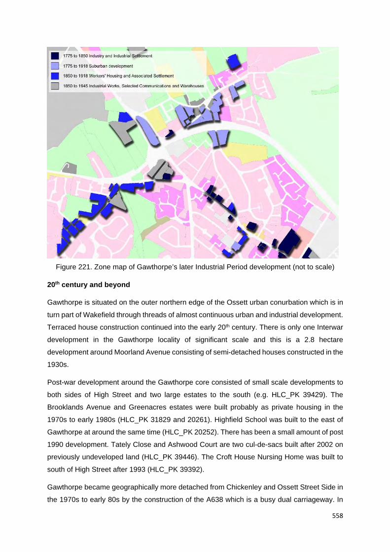
558
Figure 221. Zone map of Gawthorpe’s later Industrial Period development (not to scale)
20th century and beyond
Gawthorpe is situated on the outer northern edge of the Ossett urban conurbation which is in
turn part of Wakefield through threads of almost continuous urban and industrial development.
Terraced house construction continued into the early 20th century. There is only one Interwar
development in the Gawthorpe locality of significant scale and this is a 2.8 hectare
development around Moorland Avenue consisting of semi-detached houses constructed in the
1930s.
Post-war development around the Gawthorpe core consisted of small scale developments to
both sides of High Street and two large estates to the south (e.g. HLC_PK 39429). The
Brooklands Avenue and Greenacres estates were built probably as private housing in the
1970s to early 1980s (HLC_PK 31829 and 20261). Highfield School was built to the east of
Gawthorpe at around the same time (HLC_PK 20252). There has been a small amount of post
1990 development. Tately Close and Ashwood Court are two cul-de-sacs built after 2002 on
previously undeveloped land (HLC_PK 39446). The Croft House Nursing Home was built to
south of High Street after 1993 (HLC_PK 39392).
Gawthorpe became geographically more detached from Chickenley and Ossett Street Side in
the 1970s to early 80s by the construction of the A638 which is a busy dual carriageway. In

559
addition to forming a barrier, the construction removed terraces, villas, industrial sites and
parts of the Chickenley Heath and Ossett Street Side historic cores.
The estates to the south of the A638 are much larger in scale and represent planned social
and private development as part of the urban expansion of Ossett largely from the post-war
period.
A small industrial zone has developed to the west of Gawthorpe. The Moores bakery is located
on the site formerly occupied by the Owl Lane Mill and an additional works situated on the site
of Royds Mill (HLC_PK 31783 and 39393). The area around the Shaw Cross Colliery, to the
northwest of Gawthorpe, was subject to extensive spoil tipping in the post-war period and part
of the land remains derelict (HLC_PK 21731). The northern part of the area redeveloped in
1994 as a sports ground and stadium and is the home of Dewsbury RLFC (HLC_PK 7454).
Beyond this to the immediate north is the 24 hectare Shawcross Business Park (HLC_PK
7595).

560
Figure 222. Zone map of Gawthorpe’s later Industrial Period development

561
Rural hinterland
Only the land to the immediate south and partly to the west of Gawthorpe has been wholly
redeveloped. Elsewhere, outside the immediate urban zone is open farmland. The fields to
the north have been agglomerated but still partly exhibit the long narrow boundary form
exhibited on mid-19th century mapping. This is also the case to the west of Gawthorpe but only
in a small area as urban development and colliery spoil dumping now covers a large part of
the area.
The land to the west of Gawthorpe was historically named Old Park, a former deer park which
was enclosed in the 16th century and 17th century. It was one of the demesne parks of the
Earls Warenne and contained over 300 deer in the park in the mid-16th century. The boundary
fence is said to have been six miles in circuit. The origins of this area as a park is supported
by place name evidence. The park contained two “Lodges” and the present club house of the
Low Laithes Golf Course incorporates the remains of a 16th century structure (HLC_PK
20255). The land is still in agricultural use and many of the farms depicted in c.1850 survive,
although the boundaries have undergone significant 20th century reorganisation.

562
4.2.14 Glass Houghton

563
Figure
223. Zone
study area
map of the
Glass
Houghton
locality

564
Overview
Glass Houghton, formerly named “Houghton”, was a village probably of medieval origins. The
“Glass” prefix most likely came from the glass works which were present in the village from at
least the late 17th century. The village developed during the later Industrial Period into a small
mining settlement through the presence of several coal pits in the rural hinterland before the
mid-19th century and the large scale Glass Houghton Colliery from 1863. The area was also
locally important for limestone quarrying and sand extraction. Glass Houghton did not develop
the large scale Industrial Period settlement seen by other Wakefield towns, such as near-by
Castleford. By the mid-20th century, Glass Houghton became connected to Castleford by a
continuous residential development of both Industrial Period and Interwar housing. Glass
Houghton is now surrounded on three sides by urban development with modern industrial and
retail parks to the south. Glass Houghton is situated on the lower southwest slopes of the low
hill near Fryston Park. The land drops to the southwest into the Fryston beck and Carr Beck
valley system which descends to the northwest to meet the broad Aire and Calder Valley. The
landscape is low and rolling at this point. Glass Houghton is located 11km to the northeast of
the Wakefield City core (1.5km to the south of Castleford) in the Township of Glass Houghton
(35m AOD. OS ref 443771, 424587). The subsurface geology consists of Pennine Middle Coal
Measures becoming Dolomitised Limestone 1km to the east of the village.
Historic core
It is likely the Glass Houghton is a village of at least medieval origins. “Hoctun” is mentioned
in the Domesday Survey of 1086 and “Hoghton”, “Hoyton” or “Houghton” at several other times
in the later medieval period (Smith, A.H. 1961. Part II. Pg. 70). The “Glass” prefix appears
from 1793 and may have derived from the locally important glass works which were present
in the village. The site of a glass works was to the south of School Lane. It is believed that the
works was established here by at least 1696 and continued into the mid-1740s (WYHER PRN
7032).
The original village core (as depicted in c.1850) ran for around 490m along what is now known
as Front Street (HLC_PK 18110). The village could be described as a linear high street
development with a form probably dating from the post Conquest period. There were probable
croft plots on the northern side of Front Street and these were bounded by a back lane,
formerly named Back Lane now corresponding with School Lane today. The many surrounding
fields had boundaries in c.1850 which strongly suggest enclosed medieval strip fields,
although those to the north may have been associated with the much larger medieval
settlement of Castleford.

565
19th century mapping provides a few clues regarding early buildings. Manor House is named
at the south-eastern end of the village. There was at least one farm described on 19th century
mapping but more were likely. Manor House may have been the site of Holywell Manor which
was first mentioned in the fourteenth century and was owned by the Hospital of St Nicholas.
Possible medieval stone works has been identified in the location (HLC_PK 18109 and
WYHER PRN 4602). Although the date cannot be confirmed, as “Manor House” was also a
popular name conceit for Georgian and Victorian houses, the location of Manor House in the
village is typical when compared to other English medieval linear high-street village plans. The
name Holywell is probably derived from a holy well which was described as a site of antiquity
on 19th century mapping 700m east of the village in Holywell Wood (HLC_PK 17906). Holywell
was first mentioned as a place name in 1263 (WYHER PRN 1638). A Roman sarcophagi was
found here during quarrying in the 1960s. An “Old Corpse Road” leading in the direction of
Castleford to the west of the village suggests that the church was located elsewhere.
Beyond the plan, nothing remains above ground today with any ancient character. Front Street
is a busy through route. A later Industrial Period commercial core survives at the eastern end
on the northern side. The Manor House site is waste ground. The western end of Front Street
contains an Industrial Period pub, a few terraced houses and 20th century commercial
buildings. School Lane (formerly Back Lane) is largely 20th century and residential.
Of particular historic interest to Glass Houghton is the Pontefract Park Racecourse which was
established in around 1801 900m to the south of the village (HLC_PK 17891). The land was
formerly part of the Pontefract deer park, a park of Medieval origin enclosed from waste
sometime before 1220.
Figure 224. Zone map of Glass Houghton’s historic settlement (not to scale)

566
Industrial Period development
Mid-19th century mapping depicts the rural hinterland of Glass Houghton as containing many
coal pit, some were described as “old” in c.1850. The history of mining may date back to the
middle ages as Holywell wood contains probable bell pits of medieval to early post medieval
date (HLC_PK 17906). The pattern of mining changed by the end of the 19th century. The
many coal pits depicted in c.1850 were disused by c.1890 and replaced by one large coal
mine, the Glass Houghton Colliery. The mine was located 700m to the southwest of the village.
This was a large scale colliery and was connected to the Lancashire and Yorkshire Railway
Methley Branch Line with dedicated sidings. The colliery was in operation between 1863 and
1986. The area now forms part of the Marrtree Business Park (HLC_PK 17923). The Glass
Houghton Colliery was only one of many later Industrial Period coal mines in the Castleford
locality.
Mining was not the only industry in the Glass Houghton locality. Glass making was recorded
in the village from at least the late 17th century, although by the 19th century only the place-
name Glasshouse Hill hinted at this earlier trade. Several sand and clay pits were depicted in
the rural hinterland, particularly to the east, in the 19th century. On an area of former common
750m to the northeast of the village was the Glass Houghton Limestone Works. The quarries
were present by c.1850 and contained limekilns at this time. The site expanded during the
latter half of the 19th century (HLC_PK 18086). The industry at Glass Houghton was small
scale. Castleford was the local industrial centre with its large scale potteries, bottle works and
chemical works and access to the Aire and Calder Navigation Canal and this was an influence
on Industrial Period settlement in the Glass Houghton locality (e.g. HLC_PK 21223, 19797
and 20803).

567
Figure 225. Distribution of colliery or coal pit features and communication routes in the Glass Houghton locality as depicted on 19th century OS
mapping

568
Glass Houghton village in the mid-19th century was largely rural in character with probable
farms along the high street. There was a Methodist chapel which was thought to be built in
the 18th century glass works and a village school. A few cottages may have had mining
associations due to the proximity of several coal pits. The village enlarged only slightly during
the late 19th century and this development consisted of a few cottage rows, the occasional villa
and additional small village institutes such as a new school, mission rooms and a chapel (e.g.
HLC_PK 18101, 20390 and 18092).
The main changes in the Glass Houghton locality were occurring on the fringes of Castleford
as its industrial and villa suburbs expanded southwards. The nearest Castleford suburb at the
end of the 19th century was Round Hill located 900m to the northwest of Glass Houghton. This
was a mixed development with terraces and a small villa estate (e.g. HLC_PK 20411 and
18980). High Town was located 500m further northwest and was more industrial in character
with terraced house settlement, a brickworks and malt houses. Both appeared between the
mid and late 19th century. Queens Park was established 800m to the north of Glass Houghton
in 1887 (HLC_PK 18977). This was only the beginning of larger scale development which
was to appear in the later Industrial Period.
Development in the village core was small scale and piecemeal on the early 20th century OS
mapping. St Pauls Church was added during this time (HLC_PK 19807). Glass Houghton
Colliery had gained a modest sized grid-iron development of terraced houses. The Round Hill
locality of Castleford continued to develop with a large zone of terraced houses. The land
acquirement for building appears to have occurred on a plot-by-plot basis helping to preserve
the earlier enclosed strip-field boundary pattern (at least in part).
Glass Houghton still remained detached from Castleford at this point but only by the length of
a field. The situation had changed by the mid-20th century. Late Industrial Period terraces had
filled the gap (e.g. HLC_PK 19841). This was like to have been housing provision for mining
families. The group contained the “Miners’ Welfare Sports Ground” and a large part of the
development was set aside for allotment gardens (e.g. HLC_PK 19763 and 19920). Mid-20th
century mapping also depicted the beginnings of housing estate development.
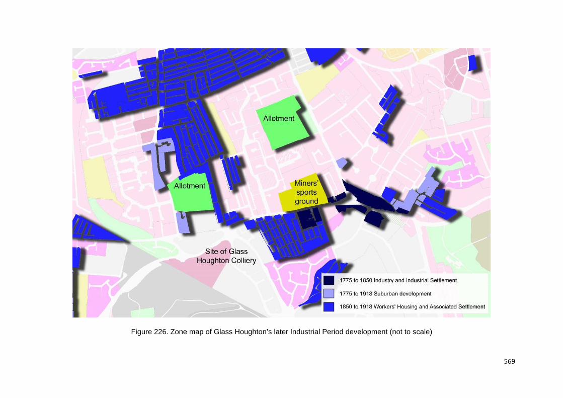
569
Figure 226. Zone map of Glass Houghton’s later Industrial Period development (not to scale)

570
20th century and beyond
There is now a large scale zone of Interwar housing to the northeast of Glass Houghton in the
Churchfield Lane area. Development consisted predominantly of semi-detached houses with
a few detached houses dating to the around the 1930s (e.g. HLC_PK 19806 and 17997). This
was part of a much larger scheme of development which dramatically pushed out the urban
peripheries of Castleford over 3km to the east. Queens Road, for example, was built as a
geometrically arranged estate of social housing development around the 1930s on previously
undeveloped agricultural land (HLC_PK 18943). The Castleford Airedale Junior and Infant
School was built at around the same time (HKC_PK 18580). Development continued on a
large scale into the post-war period. Development in other parts of Castleford was prevalent
though on a much smaller scale.
In the Round Hill area of Glass Houghton/Castleford, the allotment gardens associated with
the miners’ settlement were redeveloped in the c.1960s with a medium scale estate of social
housing in the Lisheen Avenue area (e.g. HLC_PK 19920).
Glass Houghton sat on the southern edge of this new zone and so avoided becoming
completely subsumed. While the Front Street of Glass Houghton still retains a strong
representation of Industrial Period character, School Street (formerly Back Lane) became
dominated by encroaching Interwar social housing.
Post 1990 housing in the Glass Houghton locality is represented by two medium scale estates
(apart from piecemeal small scale development). The 6 hectare estate around Redhill Heights
was built around the early 2000s on previously undeveloped land (e.g. HLC_PK 17996). The
7 hectare Keystone Avenue estate was built at around the same time on the site of features
associated with Glass Houghton Colliery (HLC_PK 18931).
There is now a large industrial zone which stretches between the village core as far as the
M62 motorway 1km to the south. The southern half of this area is dominated by derelict land
of around 75 hectares which represents spoil tipping from the Glass Houghton Colliery
(HLC_PK 17920 and 18134). To the north is the Junction 32 Outlet Village which opened
around 2000, partly on the site of the former Yorkshire Coking and Chemical Works
established at the beginning of the 20th century (HLC_PK 17908). This area also contains the
“Xscape” entertainment and leisure complex opened in 2005, the Aspen Way Retail Park and
the 1970s Carr Wood Industrial Estate (HLC_PK 17907, 17914 and 17918). The Glass
Houghton Colliery site was redeveloped in the 2000s as the Marrtree Business Park (HLC_PK
17923). Junction 32 of the M62 motorway which opened in 1974 is also a dominating presence
in the landscape south of Glass Houghton (HLC_PK 17888).

571
Figure 227. Zone map of Glass Houghton’s 20th century to recent urban and industrial development (not to scale)

572
Rural hinterland
It is likely that Glass Houghton had an associated open field system. These are clearly
depicted to the west, east and north of the village on mid-19th century mapping. The picture is
confused slightly because these might also be associated with the much larger settlement of
Castleford. Holywell Wood which covers a round hill to the east of the village may represent
ancient woodland. This wood was the site of an ancient holy well. The land to the south of the
village perhaps represented a continuation of the open fields and/or an area of common land.
Beyond this was the ancient deer park of Pontefract. Although the park had been enclosed as
agricultural land with part of the park in use as a race course, the ancient boundary dating to
before 1220 was still clearly visible on 19th century mapping. The density of farms in the rural
hinterland of Glass Houghton was very low in the 19th century suggesting the village contained
most of the agricultural buildings.
Almost all the land between the M62 motorway and Castleford has been developed with
housing or industry or has been affected by colliery spoil tipping. Holywell Wood survives and
is surrounded by an urban green space but most of the surrounding field boundaries have
been lost and only the lanes survive.
The ancient boundary to Pontefract Park can still be traced on modern mapping but it has
become obscured by modern features such as the M62 and also by 20th century field
agglomeration.

573
4.2.15 Hemsworth

574
Figure 228.
Zone study
area map of
the
Hemsworth
locality

575
Overview
Hemsworth originated as large village of medieval, if not earlier origins. Hemsworth developed
into a small town in the 19th century as a result of coal mining, the most significant local
industry. The Edwardian period saw a rapid growth in terraced houses and commercial
buildings. Larger estates were constructed in the Interwar and early post-war periods.
Although coal mining declined in the 1980s, Hemsworth remains a thriving suburban town.
The historic core retains many of its Industrial Period features. Hemsworth is situated in a hill
top position on the low rolling hills 12km to the southeast of the Wakefield City core in the
Township of Hemsworth (62m AOD. OS ref 442813, 413143). Hemsworth sits at the head of
a beck which is un-named on available mapping. The beck flows to the southeast to meet
Hall Beck which continues in a south easterly direction to meet a large east-west valley system
which passes through the South Elmsall locality. The land rise to the west to meet a rolling
wide ridge of hills with a north-south alignment. The subsurface geology consists of Pennine
Upper Coal Measures.
Historic core
‘Hamelesuurde’ is mentioned in the Domesday Survey of 1086 and at several other times in
the later medieval and post medieval period indicating there was a settlement here of at least
local significance (Smith., A.H. 1961 Part I. p. 264).
A clear historic settlement core can be discerned from mid-19th century OS mapping. The
village took the form of a nucleation at the eastern end of the settlement near St Helen’s
Church and around the junctions of Station Road, Barnsley Road, Cross Hill and Market Street
(HLC_PK 43136). These streets delimited a triangle of land with wide lanes which may have
held a market or green. Here the layout is organic and piecemeal in development suggesting
early origins. To the west ran a high-street with buildings fronting Barnsley Road, the character
more planned but still appears medieval in character. The eastern half of the village was
dominated by Hemsworth Hall with private parkland and the Hall Farm. This area held several
other higher status houses running southwards along Market Street. There are elements of
village plan and surrounding field boundary morphology which support there being a
settlement here in the Middle Ages. The church of St Helen contains 14th century building
fabric but may have replaced an earlier chapel (HLC_PK 43234). The church sits in a small
oval enclosure which is often indicative of pre-Norman origins. St. Helen is also a dedication
which also suggests early origins. There are two St. Helens; St Helen of Constantinople
(c/250-330) and Saint Helen of Caernarfon who founded churches in Wales in the 4th century.
There are probable village tofts on Barnsley road with a ‘Back Lane’ and the surrounding fields
demonstrate strip fields, a feature of medieval communal agriculture. Church Field, High Field

576
and [East] “Field” are all named to the north south and east. Church field suggests that the
church took a tithe from this area, possibly tithing the whole parish.
The Barnsley Road high street has what appear to be croft plots running to the north in a
perpendicular arrangement. These crofts had become developed by the 19th century with
yards containing probable cottages, sheds and workshops. Hemsworth at this time appeared
to be a well-developed rural village and farms within the core is a probability. Late 19th century
mapping shows a number of large houses and potential farms, a school, hotel, police station,
reading room and malthouse.
The character today still retains a number of historic buildings with double fronted town
houses, early stone-built cottages and small scale Victorian and Edwardian buildings,
including pubs and institutes, working men’s clubs and shops. The earlier character
concentrates particularly to the eastern end towards the church and along Market Street.
Barnsley Road still represents the high street and commercial core. As with most settlement,
there has been some redevelopment with modern shops. These are dispersed throughout.
The character becomes more piecemeal and domestic towards the west end of Barnsley Road
and at the southern end of Market Street.
The Hemsworth locality contains a number of Listed buildings. These include Hemsworth High
Hall originating to the 17th century (now a school), a 17th century cottage (possibly earlier), a
house dated to 1773, a late 18th century house and an early to mid-19th century house
(Images of England UID 424033, 424034, 424026 and 424025). Hemsworth Low Hall is
described on 19th century mapping to the south of the village (HLC_PK 43179). These
demonstrate a continued development as a rural settlement since at least the post medieval
period.

577
Figure 229. Zone map of Hemsworth’s historic settlement (not to scale)

578
Industrial Period development
The two Listed villas on Barnsley Road, one dating to 1873 and the other to the early to mid-
19th century suggests a suburbanisation processing was going on at this time. Hemsworth
also had a grammar school located to the south of the village dating to before c.1850 (HLC_PK
43226). Several other villa status houses can be identified around the village on 19th century
mapping. For example, the 19th century Holgate house was located to the immediate east of
the village core (HLC_PK 43226). The relatively high number of villas suggest that Hemsworth
was developing as a suburb from the end of the 18th century. In the absence of immediate
large scale industry, it might be suggested that the economic important of Hemsworth at that
time was as a market town with a rural economy. Dog kennels 1km to the south west of
Hemsworth suggests another form of local economy: that of the hall and hunt (HLC_PK
43795). The introduction of Hemsworth Railway Station on the Great Northern Railway in 1866
may have also contributed to Hemsworth’s later Industrial Period development (HLC_PK
43698).
With regards to industry in the early to mid-19th century, small quarries were present in the
rural hinterland and a steam corn mill was located 400m to the west of the village (HLC_PK
43134).
The situation had changed by the end of the 19th century and Hemsworth was developing
zones of terraced houses, both to the north of the village around Church Lane and Westfield
Road and to the south around Kirkby Road and Southmoor Road (e.g. HLC_PK 22663, 22672
and 22639). Although relatively small by the standards of other Wakefield towns, later
Industrial Period development pushed out the urban peripheries of Hemsworth and led to the
redevelopment of the village centre as a small Industrial Period commercial core, both in the
late 19th and early 20th century. Large scale industry was still absent in the village.
There were two large scale collieries with 3km of Hemsworth. The Fitzwilliam Hemsworth
Colliery was located 3km to the north of Hemsworth. The colliery began producing coal in
1877. By 1903 the pit had grown and employed 1,651 workers. The pit head closed in 1967
after the merger with South Kirkby Colliery. Kinsley Drift mine was opened on part of the site
and produced coal until its closure in the late 1980s. The area is now a country park (HLC_PK
18401). The colliery closest to Hemsworth was the South Kirkby Colliery which was located
2.2km to the southeast of the village. The colliery was in operation from 1878 through to 1988.
At first generally small-scale it did not reach its full extent until 1955, the majority of the area
being occupied by spoil tips, clay pits and reservoirs (HLC_PK 22206). There are several other
collieries in this part of the south Wakefield district, but only the Fitzwilliam and South Kirkby
Collieries fall within 3km of Hemsworth.

579
The Hemsworth Union Workhouse opened in 1869 and was located 500km to the south of the
village. It has since been demolished (HLC_PK 36838). The Holgate Hospital are alms houses
dated to 1859 and are located 1.5km to the west of Hemsworth (HLC_PK 19602). Hemsworth
Cemetery was established 400m north of the Hemsworth in 1896 (HC_PK 22658)
Figure 230. Zone map of Hemsworth’s later Industrial Period development (not to scale)
20th century and beyond
The construction of terraced houses continued into the early 20th century largely as expansion
of earlier terraced house development. Small grid iron developments were built to the north of
Hemsworth and also to the south on a slightly larger scale in the Little Hemsworth locality (e.g.
HLC_PK 43240 and 22639).
There were three notable Interwar housing estates built in the rural peripheries of Hemsworth.
The Green Hill Estate was built to the northwest of the village as 8.5 hectare estate of social
housing in the 1930s (HLC_PK 22187). To the north east of this was St Helen’s Avenue, a

580
large area of allotment gardens and the Hemsworth West End Primary School, all of early 20th
century date (HLC_PK 22670, 22657 and 22656). Hamel Rise is a cul-de-sac of semi-
detached houses built on the south western side of Hemsworth (HLC_PK 22216). Smaller
scale and piecemeal Interwar development also occurred as ribbon development along a few
of the lanes leading out of Hemsworth (e.g. HLC_PK 43233). One of the larger Interwar
developments is the Hemsworth Arts and Community College, formerly Hemsworth High Hall.
The hall was purchased by the West Riding County Council on 8th November 1921 and
opened as a grammar school, later to become the college (HLC_PK 22185)
There was a phase of social housing construction that left Hemsworth surrounded by large
scale housing estates to both the east and west with a smaller development to the north.
Those to the west comprised development around Moorfield Crescent, Rosehill Avenue and
Ashfield Road with around 28 hectares of semi-detached houses from the c.1950s (HLC_PK
22188, 22189 and 22666). This was a planned development which included small commercial
core and the Hemsworth St Helen's Church of England School (HLC_PK 22554). To the east
of Hemsworth is the Ringwood Way estate which is a 22 hectare social housing development
dating from the late 1960s to early 1970s (HLC_PK 19718). To the southeast of Hemsworth
was Dale View, an estate of social housing built in the 1960s (HLC_PK 22638). To the north
is Hollins Bank, a 7.3 hectare estate of social housing of late 1950s date (HLC_PK 22184).
Post 1990 housing generally occurs as redevelopment. There are three notable estates close
to town core, one in the urban peripheries and several small scale examples throughout. For
example, The Longworth Road development was built on the site of the Union Workhouse
after 2005 (HLC_PK 36792).
The commercial core has also seen post-war redevelopment. The largest development was
the Tesco Superstore with carpark constructed to the east of the core around 2008.
Development replaced a 1950s school (HLC_PK 36794 and 36832), The Cross Hill Bus
Station was built between 2002 and 2009 on previously undeveloped land (possibly former
orchard gardens) (HLC_PK 43250). The Cedars Business Centre and Children’s Centre is
located west of Hemsworth on Barnsley Road and was built after 2002 on the site of villas and
later industrial workshops (HLC_PK 43245).

581
Figure 231. Zone map of Hemsworth’s 20th century to recent urban and industrial
development (not to scale)
Rural hinterland
All the fields around Hemsworth have been subject to either development or extensive
agglomeration and little remains of historic field patterns beyond what is preserved by
surviving lanes. Former open fields to the north and south of Hemsworth have largely been
developed.
Hemsworth was surrounded by other medieval settlement all within 4km. South Hiendley was
present to the west, Brierly to the southwest, Kirkby to the southeast, Badsworth to the east
and Wragby to the north. Each had an associated open field system. These fields formed a
patchwork in the countryside. The land in between was probably waste or common in the
Middle Ages. The fields in these areas have a more irregular and piecemeal pattern. A few of
the farms in these areas have ancient origins. Vissitt Manor [as spelt on OS Master Map 2015]
1.4km to the west of Hemsworth dates to the 17th century or earlier (HLC_PK 19603). Hague

582
Hall Farm 1.6km to the south has 17th century origins HLC_PK 22210). Carr Farm 2km to the
northwest is 18th century but contains a moated hall site dating to the 14th century or earlier
(HLC_PK 43352).

583
4.2.16 Horbury

584
Figure
232. Zone
study area
map of the
Horbury
locality

585
Overview
Horbury originated as a village probably of Saxon origins, the occupation of the village
continued after the Norman Conquest. The village was of local economic importance with both
the woollen and coal mining industries during the middle-ages. The development of Horbury
continued into the Industrial Period with local domestic workshops and later mills which
occurred outside the village core, particularly to the south around Horbury Bridge. Both
Horbury Bridge and Castle Hill to the east also became important settlements due to railway
wagon works, iron works and large scale railway sidings. Horbury village developed as a
detached middle class suburb of Wakefield in the late 18th and 19th century. Later Industrial
Period Horbury became more working class with a zone medium scale developments of
terraced houses expanding the village core. Horbury now sits at the outer edge of the south
western urban conurbation of Wakefield connected by a thread of continuous development
along Horbury Road. This process began in the Interwar period. Horbury is now surrounded
by large zone of 20th century housing but beyond this setting remains semi-rural. Horbury is
situated on a hill top position on a projection of a hill which extends south-east from Giggle Hill
and the Ossett Crown Lands further to the north-west. The land drops steeply to the south into
the Calder Valley, through which the river takes a meandering course. To the north east is the
Whitley Spring Beck which flows to the south east to meet the River Calder to the south east
of Horbury. Horbury is located 5km to the south west of the Wakefield City core in the
Township of Horbury (75m AOD. OS ref 429485, 418364). The subsurface Geology consists
of Pennine Middle Coal Measures.
Historic core
The historic core of Horbury, as depicted on mid-19th century OS mapping, centres on
Northgate, Church Street, Queen Street, High Street, Twitch Hill and Tithe Barn Street
(HLC_PK 40361). This area represents the part of Horbury with the most organic street plan
and the highest density of recorded surviving historic buildings. The street pattern is organic
rather than planned. These streets probably represent the historic core of Horbury which may
have its origins from before the Norman Conquest. Settlement then extended eastwards for
around 600m along Cluntergate. This street resembles a post conquest medieval settlement
with a linear high-street plan with street fronting properties, rear croft plots and even a Back
Lane (as depicted in c.1850). ‘Orberie’ is mentioned in the Domesday Survey of 1086 and at
several other times throughout the medieval and post medieval period (Smith, A.H. 1961. Part
II. p.150). Its history may be earlier. The ‘bury’ element suggests a fortification, either
prehistoric or possibly Saxon. Castle Hill is named 800m to the southeast of Horbury on mid-
19th century mapping in this case it is thought the name refers to a 12th or 13th century moated

586
site (WYHER PRN 93). The Domesday Survey records a church here which implies an
existing settlement. This was replaced in 1106 by a new church (HLC_PK 40355). The
Norman Church was demolished in 1790 and replaced by the current Church of St Peter and
St Leonard. By the beginning of the 14th century time Horbury had a corn mill and a fulling mill
for woollen cloth working near Horbury ford 750m to the south, though the village population
was probably little more than one hundred at this time
(http://magazine.aroundtownpublications.co.uk/discover-the-history-of-horbury/487/. Site
accessed August 2016). Horbury Hall has been dated to 1474 which also supports the idea
of a village settlement during the medieval period. The town may also have had a tithe barn,
suggesting a manorial function. Strip fields, a feature associated with medieval towns and
villages, are readily identifiable in the historic field boundary patterns for miles around. Horbury
began to prosper during the Elizabethan and Jacobean period as more people gave up
subsistence work on the land for better wages as wool weavers or spinners. Others began
working in drift mines extracting coal from local shallow seams. The timber framed houses in
the village were gradually replaced or encased in stone.
The Listed buildings in this area provided a history of the town’s development from the late
medieval period to the Industrial Period. They comprise Horbury Hall dated to 1492, an
encased timber framed house of 16th century date, a house (now shop) dated to 1637, late
18th to early 19th century cottages and workshops, two late 18th century houses, a late 18th
century church, an early 19th century weaving shed and an early 19th century lockup (Images
of England UID 342497, 342503, 3 342512, 42511, 342508, 342515 and 342495). This range
of buildings demonstrates continued development from at least the 15th century. There is also
a Listed convent to the north of the village dating from 1862 (Images of England UID 342501
and 342502).
Buildings along Cluntergate are also Listed. They include a timber framed house dating to
1538 (now a pub), a cottage dating to 1739 a late 18th century villa and a late 18th century
church (Images of England UID 342498, 342509, 342499 and 342500). This area also
demonstrates late medieval occupation and Georgian and later Victorian suburbanisation.
The current character of the core of Horbury is modest in scale, predominantly commercial
and strongly Victorian with Georgian and earlier elements (although piecemeal modernization
is always inevitable). High Street is the principal shopping street, with Victorian shops and a
few modern replacements. To the rear of properties fronting High Street are fragments of late
18th to early 19th century yard development. Queen Street which continues onto Northgate is
similarly commercial, particularly towards the southern end but the scale and character is more
domestic as one travels northwards. Buildings here represent a Victorian and Georgian mix

587
with houses, shops and cottages. Horbury Hall is situated on Church Street and with the
church site may be the earliest part of the settlement. Church Street and Twitch Hill are
Georgian and domestic in character but also contains the weaving shed and a large hotel
named in c.1894. The northern part of Twitch Hill was cleared in the 20th century giving a
much more village green-like character, although it was more heavily urbanized in the 19th
century. Parts of the peripheries of the Horbury village core were demolished during the 20th
century to be replaced by houses, these areas probably contained later historic expansion of
the town such as Georgian yard developments. Despite this and later additions within the
town’s core, the townscape of Horbury retains much of its historic character from several
periods.
Figure 233. Fragment of
framing. Rear of 37 Queen
Street. Horbury. 2016.
Probably 16th century

588
Figure 234. Zone map of Horbury’s historic settlement (not to scale)

589
Figure 235. Early 18th century houses and early 19th century workshop (both Listed). Tithe
Barn Street. Horbury. 2016
Industrial Period development
As with other Yorkshire towns Horbury prospered from the industrial and transport revolution
of the 18th and 19th century. Later mills were constructed in the vicinity which enable the
growth of the town as a civic and commercial centre. There are several examples of Georgian
and Victorian expansion throughout the town. The town’s yard developments expanded the
town from this period with the construction of workshops and houses. There are also Georgian
houses. Horbury may have acted as a suburb to Wakefield as the urban core and conurbation
contained town houses and villas. This could be why Horbury village escaped industrialization
which effected other Wakefield towns such as Ossett. The core underwent a commercial
transformation during the latter part of the 19th century with retail and business premises. For
example, the Horbury Co-operative retail premises were built in 1877 (HLC_PK 40361).
No large mills could be identified within the village core on mid-19th century mapping, though
smaller un-named workshops were likely. The nearest named mill was Lidgate Mill (worsted)
to the west of the village (no separate HLC record part of HLC_PK 40532). Organised large
scale industry was occurring but outside the village core. The Calder Valley was the scene of
large scale Industrial Period development with several mill depicted along a 2.5km stretch of
the valley and these consisted largely of worsted and woollen mills. There was one fulling mill

590
which may have had ancient origins (HLC_PK 36318). A second mill with confirmed ancient
origins was Horbury Soke Mill which was a medieval fulling mill. The mill is now lost but the
area remains undeveloped (HLC_PK 44103). The valley was the natural choice for a textile
zone to develop. Not only was there a ready supply of water for power and processing, the
valley was also the route of the Calder and Hebble Navigation Canal of c.1769 and also the
mid-19th century Lancashire and Yorkshire Railway (Images of England UID 340701). The
scale and amount of mills increased during the latter half of the 19th century. It was also during
this time that three large engineering works were added, all in the Calder valley. A list of the
named industrial works identified on 19th century mapping is presented below (the numbers
make reference to Figure 236):
1. Old Mill and Horbury Bridge Mill. Pre c.1850. Old Mill was originally a fulling mill. New
Mill was a pre c.1850 woollen mill. Later Horbury Bridge Mills. Possibly demolished.
Now in mixed industrial use. HLC_PK 36318
2. Midland Oil Mill. Post c.1850. Formerly Navigation Canal offices. Wharfs survive. Mill
lost. Land derelict. HLC_PK 36337
3. Navigation Mill. Mungo. Post c.1850, though possibly earlier. Largely demolished. Now
in modern industrial use. HLC_PK 36336
4. Cock Hill Mill. Corn. Pre c.1720. Possibly ancient. Partial survival. Now a farm and
retail warehouse. HLC_PK 36508
5. Albion Mills. Woollen. Post c.1850. Extant and reused. Area in mixed commercial and
industrial use. Part of HLC_PK 20294
6. Victoria Mill. Worsted. Pre c.1850. Fragmentary survival possible. Area in mixed
commercial and industrial use. Part of HLC_PK 20294
7. Horbury Dye Works. Post c.1850. Survival possible. Area in mixed commercial and
industrial use. Part of HLC_PK 20294
8. Ford Mill. Mungo. Pre c.1850. Probably extant. Now a business park. Part of HLC_PK
20295
9. Albert mill. Worsted. Pre c.1850. Probably extant. Now a business park. Part of
HLC_PK 20295
10. Addingford Mills. Post c.1850. Extant and reused as furniture workshop. HLC_PK
44017
11. Dudfleet Mill. Woollen. Pre c.1795 origins. Later phases extant. HLC_PK 44100
12. Railway Wagon Works. Post c.1850. Partial survival. Now an engineering works. Part
of HLC_PK 31755
13. Horbury Soke Mill. Medieval fulling and soke mill, Very fragmentary survival. Area
remains undeveloped. HLC_PK 44103

591
14. Horbury Junction Iron Works. Post c.1850. Partial survival. Now an engineering works.
Part of HLC_PK 31755
15. Millfield mill. Woollen. Post c.1850. Demolished. Land derelict. HLC_PK 44104.
16. Yorkshire Wagon works. Post c.1850. Site massively expanded in the early 20th
century. Later phases extant and now in modern industrial use. HLC_PK 22780
17. Club House Mill. Worsted. Pre c.1850. Probably demolished? No separate HLC record.
Part of HLC_PK 40588
18. Lidgate mill. Worsted. Pre c.1850. Probably demolished? No separate HLC record.
Part of HLC_PK 40532
19. Peel Mill. Woollen spinning mill. Post c.1850 but replaced pre c.1850 mill. Horbury
Chemical works. Extant but converted. Now housing. HLC_PK 40585
20. Corn Mill. Pre c.1850. Possibly ancient. Disused by c.1894. Demolished by 1950. Are
in modern commercial use. HLC_PK 36501
Mills and engineering works were not the only significant industry in the Horbury locality.
Several large scale quarries were depicted on mid-19th century mapping and these were
located on the bank top to the south and west of Horbury above the Calder valley. The area
to the south of the Calder was the scene of extensive coal mining. The two mines closest to
Horbury were the Netherton Colliery 1.4km to the southwest of the village and Hartley Bank
Colliery 1km to the south which opened in 1872 and closed in 1968 (HLC_PK 36502 and
19968). Both had wharfs on the Calder and Hebble Navigation Canal. Hartley Bank was also
connected to the Lancashire and Yorkshire Railway by mineral railway. A third coal wharf was
present on the Navigation Canal to the immediate west of Horbury Bridge (HLC_PK 36500).
This was connected by mineral railway to Emroyd Colliery and several other sites in the
Emroyd Common locality 1.7km to the west. The Middlestown and Thornhill localities were
the scene of large scale extraction, most with mineral railway links to the wider communication
networks which ran along the Calder Valley.

592
Figure 236. Distribution of industrial and collieries features in the Horbury Bridge locality as depicted on mid-19th century mapping

593
Horbury Bridge is a hamlet located 1.2km to the southwest of Horbury village. This was
probably the historic fording point of the Calder from ancient times and may also have been
the location of the medieval corn and fulling mills (e.g. HLC_PK 36501 or 36508). The hamlets
in the 19th century consisted of an inn and a few cottages with a largely Industrial Period
character, though earlier settlement cannot be ruled out. The settlement gained additional
workers’ housing in the later Industrial Period. Of interest is the Old Cut on the River Calder
which is the remnant of an earlier scheme of river navigation dating from the mid-19th century.
Castle Hill to the southeast of Horbury also developed as an Industrial Period village in the
latter half of the 19th century. This was probably built in association with the large scale
waggon works and iron works which were present to the immediate east. The settlement had
several terraced rows, a hotel, school and church, St Mary’s (e.g. HLC_PK 40659 and 40691).
The Horbury Village core became developed with cottages and workshops during the early
Industrial Period. Horbury also contained several larger villas demonstrating that parts of
Horbury were developing as a suburb of Wakefield. One of the largest was Carr Lodge to the
north east of the village. This was a mansion set in private parkland which was constructed
between 1770 and 1775 (HLC_PK 21817). The development of villas continued into the latter
half of the 19th century both around the village core and in the rural hinterland. One of the
larger developments was in the Westfield area of Horbury. This area contained several
detached houses with large gardens and rows of higher status terraced houses (e.g. HLC_PK
40463, 40409 and 40525). Westfield was also the location of the House of Mercy Convent or
St. Peter's Convent which was built between 1862 and 71 (HLC_PK 40368). This was an
extensive and fairly high status site with associated school, chapel, lodges and cemetery. The
convent and some associated buildings are extant although the grounds have been subject to
infill development. Villa construction was occurring throughout the Horbury locality during the
Industrial Period.
The scale of working class housing increased towards the end of the Industrial Period. The
largest zone occurred to the west of Horbury, again in the Westfield locality (e.g. HLC_PK
22803). Here the houses formed a medium scale grid-iron development. Individual rows and
short streets of terraced houses from the 19th to early 20th century occurred throughout (e.g.
HLC_PK 40682). Along with terraced house construction came social institutes such as
schools and chapels (e.g. HLC_PK 40675, 40651 and 40537). It was also in the later Industrial
Period that the High Street became more developed as a commercial core with late 19th and
early 20th century purpose built shops and other commercial buildings.

594
Figure 237. Zone map of Horbury’s later Industrial Period development (not to scale)

595
Figure 238. Mixed period commercial and domestic development on Queens Street Horbury.
House with gable fronting he road may be of ancient origins. 2016
20th century and beyond
Horbury is now surrounded by a zone of 20th century housing forming part of the wider
conurbation of Wakefield connected by continuous development along Horbury Road and
Northfield Lane. This process began in the Interwar period. 1.7km to the east of Horbury is the
extensive Lupset Housing Estate (HLC_PK 18792). This estate of social housing covers over
130 hectares in a geometric arrangement and was built between 1923 and 1932. The Interwar
housing in Horbury is largely represented by a ribbon development of semi-detached houses
along Horbury Road which projects westwards from the Lupset estate. Development also
forms small to medium scale estates to the east of Horbury (e.g. HLC_PK 21893 and 21895).
These estates also represent social housing. Elsewhere the Interwar development of Horbury
is small scale and piecemeal consisting of individual streets and the occasional small cul-de-
sac (e.g. HLC_PK 40517).
Development continued into the post-war period expanding the town northwards and
eastwards and filling in the gaps between earlier developments to the south. The largest
estates were to the north. Hall Cliffe was a 12 hectare estate built in the late 1940s to early
1950s (HLC_PK 21803). This was extended eastwards by the Spring End Estate in the 1950s
and to the early 1960s (HLC_PK 22168 and 22167). Again, the status attribute was social

596
housing. Development to the south of Horbury has now filled in the gap between the town and
the railway. Estates in this area are much smaller probably due to land restriction created by
earlier piecemeal development. Development are generally less than 2 hectares (e.g. 40642,
40480 and 22801). Most date from the late 20th century with one or two exceptions. As the
land was developed piecemeal, a few of the linear plots depicted on mid-19th century mapping
are preserved by the current estate perimeters.
Industry continues to be a dominant presence along the Calder Valley in the Horbury Bridge
locality. The railway sidings to the west of Waggon Works at Horbury Bridge expanded
significantly in the Interwar and post-war period to produce an area of railway sidings which
covered over 46 hectares and was known as the Healey Mills Marshalling Yard. The sidings
originated in the 1920 on the railway line east southeast of Healey. In the 1960s the sidings
were re-designed for more efficient wagon load handling. Construction included cutting a new
channel over 1,000 yards long for the River Calder south of the original, levelling of the site
with over 1 million cubic yards of infill, the re-construction and extension of a road bridge at
the east end of the site near Horbury Bridge and the construction of three railway bridges over
the River Calder. The new yard was built as a hump shunting (gravity) yard capable of
handling 4,000 wagons a day. After the marshalling yard closed in 1987, the site was used for
storage of trains and locomotives. The yard finally closed in 2012 and the area now partly lies
derelict (HLC_PK 20285). To the west of the marshalling yard were the Millbank Sewage
Works which was an extensive site established in the Interwar period. The works went out of
use in the post-war period and the land now remains derelict with regenerated scrub (HLC_PK
20289). There is also a zone of industry to the east of Horbury Bridge in an area of land
occupied by the Albion Mills, Albert Mills and Addingford Mills of the 19th century. The estate
is now known as the Wakefield Commercial Park formed in the late 1970s to early 1980s. It
comprises a mixture of reused textile mills and late 20th century industrial sheds (HLC_PK
20294). The area also includes derelict land with regenerated scrub which marks the site of
the Horbury Fork Line Junction which formerly connected the main line to Hartley Bank Colliery
500m to the south (HLC_PK 44016 and 19968). Industry also continues to be a dominant
presence along the Calder Valley to the east of Horbury. The 19th century Dudfleet Mill
survives as an industrial works and adjacent to this is a large sewage works established in the
late 19th century (HLC_PK 44100 and 20222). To the east of this is the Horbury Junction
Industrial Estate (HLC_PK 31755). This is a large-scale industrial estate made up of buildings
belonging to former Horbury Wagon Works. The majority of buildings date to the 1930s
through to the 1970s, although some parts may date to the late 19th to early 20th century. The
Wagon Works and adjacent iron foundry were established in 1873. Also in this locality is an

597
area of early 20th century gravel extraction which survives as urban green spaces and ponds
(HLC_PK 19969).
A significant addition to the late 20th century landscape was the construction of Southfield Lane
to the south of the village which bypassed the village core.

598
Figure 239. Zone map of Horbury’s 20th century to recent urban and industrial development

599
Rural hinterland
Horbury had extensive open field systems. These were present as an east, west and south
fields. All exhibited the long, narrow and serpentine boundary morphology associated with
enclosed medieval strips. The fields to the south in the carr-lands adjacent to the River Calder
were more regular in form and may represent post medieval drainage ditches. Around half the
area of the east and south field area has been developed largely with houses extending from
the Horbury settlement core. Beyond this there is partial survival of fields depicted on 19th
century mapping with around 60% agglomeration. 20th century estate site perimeters do
partially preserve earlier boundary patterns, particularly to the south of the area. A similar
situation is present to the west of Horbury. The land to the north of Horbury may also have
held open fields. Beyond this was Low Common and Middle Common and then the open field
systems associated with Ossett. The rural hinterland contains two notable Listed buildings.
Sowood house 1.2km to the northwest of Horbury is dated 1689 and Jenkin House 700m west
of Horbury is an early 19th century villa (Images of England UID 342524 and 342505).
Figure 240. Shepherds Arms Public House. Cluntergate. Horbury. Timber framed hall of
1538

600
4.2.17 Kirkthorpe

601
Figure
241. Zone
study area
map of the
Kirkthorpe
locality

602
Overview
Kirkthorpe is a village of local historic importance due to the presence of Frieston's Hospital
Sagar’s Almshouse, a pair of alms houses founded in the late 16th century. Although the
village depicted on mid-19th century mapping only consisted of one lane less than 200m long
(Half Moon Lane), the village does have a medieval church suggesting that Kirkthorpe was
once larger or that this was the location of an church manor which served the surrounding
communities such as Warmfield and Heath. Half Moon Lane still retains a village-like historic
character, although the surrounding countryside has seen dramatic transformation mainly
through open cast mining and other extraction activities in the Calder Valley to the north of the
village but also through the construction of a detached medium scale Interwar housing estate
to east of the village. Otherwise, Kirkthorpe remains a small detached rural village. Kirkthorpe
is situated on the northeast-facing slopes of a partly detached low hill below Heath Common
1.2km to the south. The common remains open land to this day. The land drops almost
immediately to the north into the broad Calder Valley which flows around a wide bow to meet
the River Aire 8.3km to the northeast at Castleford. Kirkthorpe is located 3km to the east of
Wakefield in the Township of Warmfield cum Heath (40m AOD. OS ref 436098, 420875). The
subsurface geology consists of Pennine Middle Coal Measures.
Historic core
The name "Kirkthorpe" means "farmstead with a church". The name is first observed in historic
records in 1135-40. The larger settlement of Warmfield 1.2km to the east is recorded in the
Domesday Survey of 1086 and Heath, 1km to the southwest, in 1153-60 (Smith, A.H. 1961.
Part II. p.117). The Kirkthorpe name stresses the importance of the church in the formation of
this settlement. The village’s church, St Peter’s, contains a tower dating to the 14th century,
although the rest largely dates from the rebuild of 1875 (HLC_PK 44216). It is likely that the
church was a manorial holding and both the name of the village and the presences of a
“Church Field” to the east of the village support this. Church Field would probably have held
strip fields in the medieval period which would have provided tithes to support a church and
church manor which implies not only the presence of a vicarage manor-house but also a now
lost tithe barn. Surviving field boundaries in the Church Field locality do demonstrate the
serpentine form associated with enclosed medieval strips. The current vicarage dates to
c.1780 (HLC_PK 44219). The church may have been positioned to provide for a wider
dispersed community. Neither Heath to the west of Warmfield had a church which was
identifiable on 19th century OS mapping. Warmfield was a linear settlement of typical medieval
appearance which was mentioned in the Domesday Survey of 1086. Heath was different. It
consisted of a hall of 16th century date and a common side settlement of cottages (e.g.

603
HLC_PK 22144). Heath developed as a rural high status suburb of Wakefield in the 18th
century.
Kirkthorpe also contains two other notable features, both located on Half Moon Lane.
Frieston’s Hospital is a Grade II* listed alms house founded in c.1595. It is recorded that John
Frieston built the hospital “for the accommodation of seven poor men, fuel for the hospital to
be provided by the tenants of Frieston's lands in the surrounding area” (see HLC_PK 44222).
Sycamore Cottage is a mid-16th century timber-framed house which was encased in stone in
c.1690 (Images of England UID 342362). 19th century mapping also described Sagar’s Alms
House which, according to mapping, was founded in 1558. This building is now lost. 20th
century development has largely impacted on the northern side, with the addition of a Sunday
school by c.1909 and a few modern detached houses. This is a significant amount because
the village only consisted of a church and a few cottages in the first place. 20th century
development occurred away from the village core.
Figure 242. Zone map of Kirkthorpe’s historic settlement (not to scale)
Industrial Period development
Although no industry was identifiable in the Kirkthorpe locality, there was industrial period
development. 250m north of the village is an old lock on the Aire and Calder Navigation Canal
which originated in the 18th century. Canal construction bypassed an ox-bow loop of the Calder
to the north of the village and isolated a loop named “Half Moon” to the immediate west
creating an oxbow pond (e.g. HLC_PK 20015). The Barnsley Branch Canal on the Aire and
Calder Navigation Canal was completed in 1802 and left the Calder 1.4km to the west of
Kirkthorpe in the Heath locality. The Lancashire and Yorkshire Railway passed only 100m to

604
the north of the church in a southwest to northeast direction from around 1840. Wakefield
Kirkgate Station is located only 2km to the west of the village. Otherwise both Kirkthorpe,
Heath and the rural hinterland remained largely unaltered by late Industrial Period influences.
Industry was making an impact in the Warmfield locality however. 1.7km to the north of
Kirkthorpe was the St John’s Colliery (HLC_PK 20012). St John's Colliery opened in 1870
and closed in 1973. After this time the area became a large scale open cast site until 1996.
The area now lies derelict. St John’s Colliery at its height was connected to the railway network
by sidings and also had an associated brickyard. The colliery was also connected by mineral
arailway to a cut on the Aire and Calder Navigation 2km to the northwest
1.2km to the northwest of Kirkthorpe was the Park Hill colliery. Although closer to Kirkthorpe
than the S John’s Colliery it was geographically more distant due to the River Calder. Park Hill
Colliery opened in 1877 and closed in 1983 (HLC_PK 20013). Park Hill had dedicated sidings
to the immediate east of Wakefield Station and was also connected to a cut leading off the
Aire and Calder Navigation.
Industrial Period settlement concentrated mainly in the village of Woodhouse to the east of St
John’s Colliery. Kirkthorpe, Heath and Warmfield to a slightly lesser extent remained largely
unaffected. The same historical circumstances have also preserved Heath Common (HLC_PK
20106).

605
Figure 243. Distribution of collieries and transport features in the Kirkthorpe locality as depicted on late 19th century OS mapping (not to scale)

606
20th century and beyond
The old village core contains a few private detached houses of recent date and these
represent around half of the dwellings in the village. There is now a small to medium scale
detached zone of housing (around 8 hectares) 230m to the east of the village. (HLC_PK
22151, 22152 and 22153). This is predominantly social housing built in three phases from the
late Interwar to early post-war and in the 1970s to early 1980s. Kirkthorpe remains rural in its
setting.
The greatest impact of 20th century development occurred to the north of the River Calder.
This area was the scene of large scale open cast mining which originated in the post-war
period and which escalated in scale towards the end of the 20th century. It incorporated the
sites of Park Hill and St John’s Colliery and covered an area of land which was over 190
hectares. Both coal and aggregates were extracted. Mining occurred in the Calder Valley
lowlands and encompassed former wetland and agricultural land (e.g. HLC_PK 20014, 21301,
20013 and 20012). Two farms have been lost. Old Park Farm. 1.1km to the northwest of
Kirkthorpe now stands in isolation (HLC_PK 21310). The name Old Park and several other
settlements in this locality bear the name park which indicates its former status as a medieval
deer park. There may still be active coal workings to the north of the area. Most open cast
mines went out of use in the 1980s and either now lies derelict or has been reclaimed as the
Southern Washlands Nature Reserves (HLC_PK 20014).
Figure 244 below indicates extent of late 20th century extraction in the Old Park Farm locality.

607
Figure 244. Extent of late
20th century extraction in
the Old Park Farm
locality also showing
current historic character
zones. For the key see
the Zone study area map
of the Kirkthorpe locality
map above

608
Rural hinterland
There are hints on mid-19th century mapping of strip fields to the east of Kirkthorpe and the
name, Church Field, suggests ecclesiastical tithings. The land in 1950 was largely open and
crossed by paths, with only one or two furlongs being enclosed which suggests there was a
reversion to common land after the feudal period. These fields merged with the open fields
associated with Warmfield to the east. There may have been a common between Kirkthorpe
and Heath to the west as the fields here are larger and less sinuous in nature. Part of the area
was named The Park in c.1850. This was private parkland of Heath Hall established c.1709.
It is likely that heath was a village in the middle ages, although it is unusual in its form. The
strip fields and possible crofts area arranged in a perpendicular arrangement around the outer
edge of Heath Common. The common survives today and covers nearly 50 hectares (HLC_PK
20106). The settlement features on ancient hall of late 16th century date and several lesser
halls with dates ranging from the early post medieval period to the 18th century (e.g. LC_PK
22125). The area became a detached suburb of Wakefield suburb in the 18th century. Due to
some historical circumstance both heath, hall and historic parkland survive with good integrity.
This area also contains some of the better preserved field systems depicted on mid-19th
century mapping. Elsewhere the fields underwent extensive agglomeration in the 20th century.

609
4.2.18 Knottingley

610
Figure 245.
Zone study
area map of
the
Knottingley
locality

611
Overview
Knottingley originated probably as a village of medieval origins and was one which had some
importance in before the 18th century as West Yorkshire’s only inland port. The River Aire was
navigable up to this location prior to 1699. Its prominence as a port was reduced when the
Aire and Calder Navigation Act was passed in 1699 which opened the Aire up for boats as far
as Leeds. A new canal was authorised in 1820 which passed south of the town. Knottingley
demonstrated Industrial Period development on 19th century mapping, but this appeared to be
early Industrial Period in character with irregular planned rows of cottages and high density
yard developments both in the original town core and in the locality of the later canal around
Racca Green and Fernley Green. 19th century industry consisted of probable yard
developments with workshops, glass works, quarrying on a large scale, railway sidings, a tar
distillery and a brewery. Later Industrial Period residential expansion was piecemeal and small
scale. Like other West Yorkshire towns, there was a process of estate construction which
began in the Interwar period and which continued through the latter half of the 20th century to
present. Knottingley is now connected through continuous development to Ferrybridge around
1.8km to the west, which in turn is connected to Pontefract further west. Knottingley sits on
the lower eastern slopes of the low rolling hills in the eastern half of the Wakefield district. It
is positioned on the banks of the River Aire which takes a meandering route eastward as it
passes from the low hills and enters the broad former wetlands of the Vale of York, Aire and
Ouse basin. The valley is broad at this point and is an area of drained wetland which is subject
to flooding. The hills both to the north and south of Knottingley form a rolling north-south
escarpment with the low-laying Vale of York composed of Triassic sandstones to the east with
the Magnesian limestone belt forming the hills to the west. Ferrybridge is located 17km to the
east of the Wakefield City core in the Township of Knottingley (12m AOD. OS ref 449973,
424099).
Historic core
There are strong indication that Knottingley was of ancient origins. “Notingelai” was mentioned
in the Domesday Survey of 1086 and at several other times in the later medieval period (Smith,
A.H. 1961. Part I. p. 73). The named derives from the Old English “Cnotta” which could be a
surname but could also have the meaning “hillock”. Although the land around Knottingley is
relatively flat, the contours in this locality suggests Knottingley village sat on a low island with
the Aire to the north and a band of marshy lowland to the south. The construction of the
Knottingley and Goole Canal in the early 19th century cut though the low-lying area and turned
the rise upon which Knottingley sits into an actual island. The parish church of St Botolph sits

612
at the western end of the island in the most elevated position, but this is still only a few metres
higher than the level of the river.
The Church of St Botolph was built in 1750 but was said to have replaced a Norman chapel
(HLC_PK 21146). The Historic England Listed Building description describes the medieval
church as built by Henry de Lacy, lord of the manor around 1150 as a chapel of ease to all
Saints’ Church in Pontefract (Images of England UID 422264). The dedication is to St Botolph
who was an East Anglian Saint in the 7th century. It is said that the saint expelled “swamp
devils” in the marshland near his monastery in East Anglia, but in-fact may merely have
drained the marshlands (http://www.botolph.org.uk/who-was-st-botolph/. Website accessed
60/09/2016). The dedication of a church to an Anglo Saxon saint is often an indication of the
church’s pre Norman antiquity and this may be the case with St Botolph’s Church.
The church may have been at the heart of the medieval settlement of Knottingley. To the
immediate south of the church was the manor house. The house may been Elizabethan or
earlier (HLC_PK 21148. WYHER PRN 4583). It was lost by the mid-19th century to limestone
quarrying. The identity of the hall is preserved through place name evidence, with Manor Farm
and Manor Barn, located to the immediate north of the site (HLC_PK 21153). The curved route
of Aire Street continues south as Marsh End. This oval-shaped route may have marked the
ancient boundary of a small park associated with the hall, although this is entirely speculation.
The oval pattern seems to continue to the south of Knottingley as Weeland Road. To the west
of the hall site is Pear Tree Cottage which may have originated as a detached kitchen of the
former manor house. The building is 17th century or earlier (Part of HLC_PK 21153. Images
of England UID 422270). Manor Farm is also 17th century (WYHER UID 10559). Of potential
importance to medieval Knottingley is the site of King’s Mill which was located on the River
Aire 600m to the west of the village. The earliest documentary evidence for a water-powered
mill on the site dates from the 1160s. The site has thought to have been in continuous use as
a mill until the present day (HLC_PK 19893).
By applying a plan common to other English planned post Conquest villages, the church and
manor house frequently occur together at the end of the village high street. If this model can
be applied to Knottingley, then Aire Street may have formed the original village core. This is
not easily ascertained from the surviving buildings which now consist of mid to late 20th century
social housing. The only indication of a village-like character occurs at the western end in the
immediate locality of the church. Knottingley was a sprawling settlement in the mid-19th
century, but Aire Street and Chapel Street to the west had the densest settlement and most
resembled a village high street (e.g. HLC_PK 21150). Mid-19th century mapping depicts Aire
Street as a linear development running for around 500m along Aire Street from Marsh End to

613
the east to Chapel Lane to the west. Settlement occurred to the north and south of Aire Street
in the western half of the village but only on the southern side to the east. The area to the
north in this locality was named The Flatts in 1850. There were no buildings but it did contain
landing places for boats and ferry crossing points, and may have represented the original pre
18th century inland port and the later early 18th century Aire Navigation wharf. Where
development did occur on Aire Street, there are hints of former croft and toft plots and a back
land which corresponds with The Croft [Street] today. These were heavily developed in 1850
with yards of cottages and probably with small workshops and warehouses.
The pictures is confused by the presence of several other settlement cores. Aire Street
extended further eastwards along Marsh End with a linear development of cottages. Cow Lane
which ran south of the junction of Aire Street and Marsh End was also developed (HLC_PK
21214 and 21215). Late 19th century OS mapping describes a tithe barn of ancient origins to
the west of Cow Lane, which suggests the presence of a second hall in this area and possibly
a medieval core along Cow Lane (part of HLC_PK 21215). The area to the south of early 19th
century Knottingley and Goole Canal may have originated as village common land. There are
three settlements in this locality which carry the word “Green” as part of their name: Racca
Green, Low Green and Fernley Green (e.g. HLC_PK 21272, 21303 and 21306). The character
of the settlement here, as depicted on late 19th century mapping, appears to be Industrial
Period with rows and yard developments of cottages with a smithy, an inn, a malt kiln, canal
wharfs and a ship building yard.

614
Figure 246. Zone map of Knottingley’s historic settlement (not to scale)

615
Industrial Period development
Up to the early 18th century the river Aire was only navigable as far as Knottingley, making it
the main inland port of the West Riding. In 1699 the Aire and Calder Navigation Act was
passed, which was the first navigation scheme passed by an Act of Parliament. Under this Act
the Aire and Calder Navigation opened the river upstream as far as Leeds for the passage of
barges. A new canal opened in 1826 which connected the newly opened port of Goole with
the river Aire at Ferrybridge (http://www.knottingley.org/history/local_history.htm. Website
accessed 06.09.2016). This canal was connected to the Aire by the Dole Bank Cut.
Knottingley was probably an important settlement with regards to trade up to the point of the
opening of the Aire and Calder Navigation when it was superseded by Wakefield and Leeds.
Its position on two inland waterways meant that Knottingley remained active as a town into
the Industrial Period. 19th century OS mapping depicts several trades which either utilised the
waterways or facilitated the trade. Mid-19th century OS mapping depicts ship building yards
both on the River Aire and on the Knottingley and Goole Canal (e.g. HLC_PK 21154 and
19370). At least two rope walks were also present (e.g. HLC_PK 19882). Several lime staithes
and lime kilns were present on the Knottingley and Goole Canal at this time with an extensive
area of quarrying at the western side of Knottingley (e.g. HLC_PK 19859 and 21148). An even
larger quarry, Jackson’s Quarry was present 1.1km to the south of Knottingley (e.g. HLC_PK
19321). Limestone quarrying represented a significant industry in the 19th century.
Other recognisable mid-19th century industries in the Knottingley locality included flour and
bone mills on the Aire and the Mill Close Brewery (later named the Knottingley Brewery) to
the west of the town (e.g. HLC_PK 19893 and 19895). The Wakefield, Pontefract and Goole
Railway opened 650m to the south of Knottingley in 1847 (HLC_PK 19319). Knottingley had
a coal depot in the mid-19th century and railway sidings by c.1894.
The town is well known for its glass works. The Bagley Glasswork Bottle Works was
established in 1871. It was built on the site of a ship yard and associated staithes on the
Knottingley and Goole Canal. The original sheds were replaced by modern buildings in the
latter half of the 20th century (HLC_PK 19722). This was one of several glassworks and
potteries in the Knottingley and Ferrybridge locality. The Station Glass Works, for example,
was a small factory located near the railway station and was founded in the mid to late 19th
century (HLC_PK 19562). The Aire Tar Works were constructed around 1km to the east of
Knottingley in the mid to late 19th century. This was an extensive works consisting of many
small sheds and round tanks. The site is now occupied by the Knottingley Solvent Recycling
Company (HLC_PK 19230). There may be fragmentary survival of the original sheds.

616
Figure 247. Distribution of industrial and communication features in the Knottingley locality as depicted on mid-19th century OS mapping

617
19th century mapping depicts urban development in the Aire Street locality with a fold named
Pickhill Garth at the eastern end and also dispersed around Cow Lane, Racca Green, Low
Green and Fernley Green to the south. The pattern was largely set by the mid-19th century
with a high density of yard developments and individual rows of terraced houses. The overall
historic character was one of early Industrial Period lower status housing with the occasional
detached house, workshops, small institutes and commercial buildings. Aire Street may have
remained a commercial and urban core which probably became further developed in the
Industrial Period, although this has subsequently been lost by post-war housing. The cause
of growth may have been related to the town’s connection with navigable waterways. Aire
Street is situated adjacent to the Aire which was navigable from ancient times, the amount of
river traffic will have increased with the passing of the 1699 Aire and Calder Navigation Act.
The result was a growth of the town in the Aire Street locality. The introduction of the
Knottingley and Goole Canal in 1826 caused the Cow Lane and Racca Green area to become
more developed, although Cow Lane and possibly the green-side settlements may have also
been early cores. This may not have led to a change in focus of the town core at this time as
both the canal and river were active waterways at the end of the 19th century.
The development of workers’ housing between c.1850 and 1894 was piecemeal with individual
rows of terraced houses rather than the large scale grid-iron developments seen in other West
Yorkshire towns. There was no new focus or zone of workers’ housing development. There
was rather an expansion of existing early Industrial Period settlement (e.g. HLC_PK 21213).
Some redevelopment of earlier cores may also have occurred.
The closest thing to a new and planned late Industrial Period zone occurred in the Rope Walk
and Bank Lane area of Knottingley south of the Aire Street tofts. The streets here were laid
out in a grid by the mid-19th century rather than the organic arrangement of the Aire Street and
the greens. The planned character was more suburban than industrial. Mid-19th century
mapping depicts at least three chapels and a Sunday school alongside a few terraced cottages
e.g. HLC_PK 19860, 21219 and 21217). The suburban character became stronger during the
latter half of the 19th century with the construction of villas on Rope Walk, new chapels and
church and a town hall at the western end of the development fronting Weeland Road
(HLC_PK 19860, 21216 and 21218).

618
Figure 248. Zone map of Knottingley’s later Industrial Period development (not to scale)
20th century and beyond
Piecemeal development around Knottingley’s Industrial Period cores continued into the early
20th century with further industrial housing and also Interwar development with small scale or
individual housing developments and further small institutes. The Glass Bottle Works, for
example, gained a small grid iron development of terraced houses (HLC 19719). The Rope
Walk area, although predominantly domestic in character, is particularly mixed in its periods
of development. Weeland Road also displays a good mix of later Industrial Period and 20th
century housing with rows of late terraced houses, semi-detached houses and post-war
development (e.g. HLC_PK 21162 and 21161). A similar pattern can be found throughout.
Mid-20th century mapping depicts the beginnings of the large scale housing development
which was to occur to the south of Knottingley. The geographical restriction of the river Aire
and previous urban development meant that much of this occurred on previously undeveloped
land to the south of the Knottingley and Goole Canal. The largest Interwar estate was the West
Field Road development which consists of 8 hectares of semi-detached houses. Womersley
Road and Broomhill Avenue also gained a small development of semi-detached houses
(HLC_PK 19338). The smaller development of Springfield Avenue, to the north of Broomhill
Avenue was built at the same time (HLC_PK 19360).

619
Post-war development followed a similar pattern of small scale and piecemeal development
or redevelopment close to the town core and large scale estates in the rural hinterland. The
most dramatic impact was in the Aire Street and The Croft locality where the previous historic
core was demolished and replaced by an estate of social housing around the 1980s (e.g.
HLC_PK 21150). Only the street pattern and a few cottages at the western end in the Chapel
Lane locality preserve any sense of the previous historic character. Rope Walk preserves
the villas, a few cottages and institutes from the 19th and early 20th century but has been
subject to residential infill development and is now wholly developed (e.g. HLC_PK 19899 and
21219). Cow Lane and Marsh End contains a mix of 20th century to recent housing with a
strong representation of Industrial Period domestic buildings (e.g. HLC_PK 21213 and 21214).
Racca Green, Low Green and Fernley Green demonstrate similar historic character evolution.
Knottingley is now connected to Ferrybridge 1.8km to the west by a continuous zone of
residential and industrial development. The largest housing development is Windermere
Drive and Kershaw Lane located 1.5km to the southwest of Knottingley which are social
housing estates of 1960s date (HLC_PK 19402 and 19563). Closer to the town but still south
of the canal are Oakfield Crescent, Broomhill and Springfields which are medium scale estates
built in the mid-20th century to early post-war period (HLC_PK 19354, 19311 and 19361).
This area also contains Knottingley High School and Sports College which is a large school
with playing fields built in the 1970s (HLC_PK 19316).
Knottingley also contains large zones of 20th century to recent industry. The Glass Bottle
Works (also known as Bagley's Glassworks) was established in 1871 and branched into
decorative glass in the early 20th century. It appears to still be in use as an industrial site,
although survival of 19th century features appears fragmentary (HLC_PK 19722 and 19320).
There is a large industrial zone around 1km to the southwest of Knottingley which was founded
in the post-war period and continued to be developed in the 20th century. The largest
component of this zone is the Ardagh Glass Works which occupies a 20 hectare site and was
established around 1956 (HLC_PK 19956). This area also contains several smaller scale
works and estates, a large supermarket, a modern leisure centre, a depot and a railway depot
established in 1960s on a triangle of land between the Askern Branch of the Lancashire and
Yorkshire Railway (e.g. HLC_PK 19359, 19364, 21046, 19562 and 21206). A second large
zone occurs on the outer urban peripheries to the east of Knottingley. The zone includes a
mid-20th century chemical works, depots, warehousing and the Knottingley Solvent Recycling
Company built on the site of the 19th century Aire Tar Works (HLC_PK 19362, 19363 and
19230). To south of Knottingley, also on the edges of the town, is an 11hectare concrete
works located on the site of Jackson’s Quarry (HLC_PK 19247).

620
Figure 249. Zone map of Knottingley’s 20th century to recent industrial and residential development (not to scale)

621
Rural hinterland
Knottingley, as depicted on mid-19th century mapping, was boarded to the north by the River
Aire and to the east by low lying wet meadow named Knottingley West Ings. The ings of
Knottingley have only been partly developed with industrial works. Two ferries were described
on mid-19th century on the Aire at Knottingley but these led only to paths which crossed the
broad meadows to the north of the Aire. There are suggestions that Aire Street may have had
croft plots and a back lane. If this is the case, then village farms and an associated village
open field system would be likely. One farm was named within the settlement on 19th century
mapping, but this may have been a grange farm associated with the former manor to the west
of the village. The land becomes more elevated to the south and west of Knottingley. There
are hints of the long sinuous boundary patterns associated with medieval strip fields in this
locality, though these are not particularly clear. This area is now wholly developed with
housing, communication features and industry. There were also suggestions of strips to the
southeast of Knottingley in the Broomhill locality. These have been lost to 20th century field
agglomeration. The area to the immediate east is west pasture and is named South Moor on
modern mapping. The name Common Lane suggests it had a function as a village common.
The settlements of Racca Green and Fernley Green occur at the northwest end of this area.

622
4.2.19 Lofthouse Gate and Outwood

623
Figure 250.
Zone study
area map of
the Lofthouse
Gate and
Outwood
locality

624
Overview
Lofthouse Gate was depicted as a hamlet of houses in the mid-19th century. The only reference
to an Outwood settlement was Outwood House (villa) on Leeds Road and the c.1700 Outwood
Hall 450m to the southwest. The hall replaced an early hall which may have had a 17th century
date. Outwood came into being as a village in the later Industrial Period. Already by c.1850
there was low density linear development along Leeds Road with public houses and a chapel
at Newton Lane End. The reason for this settlement was the presence of many coal pits and
collieries in the rural hinterland. Outwood developed as a mining hamlet with rows of terraced
houses and associated features such as chapels and schools, although the settlement was
still relatively small. This process of development continued into the early 20th century.
Outwood became connected to Wakefield through continuous development along Leeds Road
during the early 20th century. The suburbanisation of Outwood began in the Interwar period
with the construction of housing estates in the grounds of Outwood Hall and in a few other
areas. Outwood and Lofthouse Gate is now a large suburb situated on the outer urban
conurbation of Wakefield. Outwood sits in hilltop position in an area of probably former
moorland which may have been enclosed at a late date. The land drops gradual to meet the
broad Calder Valley 2km to the east and to the west to meet Foster Ford Beck which becomes
Balne Beck as it flows to the south. The Beck meets the River Calder around 4km to the south
of Outwood. Outwood is situated 3.2km north of the Wakefield City core in the Township of
Stanley cum Wrenthorpe (80m AOD. OS ref 433048, 423999). The subsurface geology
consists of Pennine Middle Coal Measures.
Historic core
Outwood did not come into its own as a village until the later Industrial Period. Mapping of
c.1850 depicted settlement in this area consisting of a low density ribbon development along
Leeds Road with a nucleation at Newton Lane End to the south and Lofthouse Gate 1.3km
further northeast. Leeds Road is named the Leeds and Wakefield Trust Turnpike on mid-19th
century mapping and dates to 1757-58. It is not clear what part of the turnpike’s route through
Outwood is of 18th century date as the turnpike may have followed an earlier route. Its passage
through Lofthouse village probably follows the ancient high street.
Lofthouse Gate should not be confused with Lofthouse, a village of probable medieval origins
1.1km north of Lofthouse Gate.
The field boundaries in the Outwood locality in the mid-19th century are large with straight
which suggests that the land was enclosed at a late date. The Outwood Enclosure Act dates
to 1793. The name “Outwood” dates is first mentioned in 1305 and means “outlying wood”.

625
Prior to that date it was known as “Miclewood”. After the Norman Conquest the land was in
use as a hunting ground (see HLC_PK 22807).
Given the elevated position, moorland common was likely prior to enclosure. This does not
preclude ancient settlement. Outwood Hall was located 350m to the West of Newton Lane
End. Outwood Hall (or Woodside Lodge) was built c.1700 by the Armytage family of Kirklees.
The associated parkland is of 19th century date. The family had held a hall and estate since
the 17th century (HLC_PK 22087). “Manor House” is named 1km to the north of Outwood Hall,
although no information could be found regarding this house (no separate HLC record. Part of
HLC_PK 22807).

626
Figure 251. Zone map of the Lofthouse Gate and Outwood locality historic settlement (not to
scale)

627
Industrial Period development
The coal mining industry in the mid-19th century was in a relatively advanced state of
development with several coal pits and unnamed collieries in the Lofthouse Gate locality. It
may have had an historic precedence which dated back to the middle ages. Leeds Road
was developing as a low density linear development with cottages, a smithy and public
houses. Rows of miners’ cottages were also present in the rural hinterland in association with
individual pits. A few of the larger collieries were connected by tram road to other collieries
and wharfs on the River Calder or Aire and Calder Navigation Canal at Stanley Ferry and
Stanley Lane Ends.
Coal mining continued in the Outwood locality into the latter half of the 19th century. Many coal
shafts depicted in c.1850 went out of use and larger scale collieries were established. The
most notable within 1km of Outwood (many more were present further afield) were Lofthouse
Colliery and Victoria Colliery. Lofthouse Colliery located 800m west of Lofthouse Gate opened
in 1876 and closed in 1983 (HLC_PK 20135). The area remains derelict. The colliery was
connected to the GNR West Yorkshire Railway by dedicated sidings. Adjacent to Lofthouse
Gate was the contemporary West Yorkshire Alum Works and a brickworks (HLC_PK 20148).
The alum works site is now playing fields. The Victoria Colliery, incorporating the Newton Lane
Pit, originated before c.1850 but increased in scale during the late 19th century (HLC_PK
22815). The pit was in operation through to c.1896 and the area is now occupied by post-war
social housing. Other industry in the Lofthouse Gate locality includes detached brickworks, a
few quarries and a small textile mill (e.g., HLC_PK 41646, 22821 and 22822).
Settlement development largely consisted of terraced houses with associated features such
as school and churches. Outwood is first named as a village on OS mapping from the late 19th
century. It consisted of terraced rows, two villas, the St Mary Magdalen Church and a cemetery
(HLC_PK 36759, 36727 and 36732). The 19th century church suggests that it was to form a
central place. This was probably a planned settlement occupied by colliery workers. Newton
Lane End was similarly developed with terraces and chapels (e.g. HLC_PK 41497 and 41532).
Leeds Road today still retains a late Industrial period character with terraced rows and the
occasional institute or shop with Outwood representing a small urban core. There has been
some 20th century development occurring as piecemeal ribbon development or as entrances
to a few larger estates. Lofthouse Gate represents a mix of Industrial Period and 20th century
domestic development with the occasional commercial building.
Although Leeds Road represents a type of settlement core, there was much development
occurring on the lanes leading from Leeds Road and also as individual rows or small folds
found in association with specific industrial sites.

628
Figure 252. Zone map of the Lofthouse Gate and Outwood locality later Industrial Period
development (not to scale)

629
Figure 253. Colliery and railway distribution as depicted on 19th century OS mapping in the Outwood locality

630
20th century and beyond
The construction of Industrial Period houses and other types of buildings continued into the
early 20th century. By the mid-20th century Outwood was connected to Wakefield by
continuous development along Leeds Road. The first housing estates were also depicted mid-
20th century. One of the earliest estate developments was in the grounds to Outwood Hall.
This was social housing built in the 1930s and development continued into the early post-war
period. (HLC_PK 22070 and 22068). Parts of the historic parkland have been retained as a
post-war public park (HLC_PK 22072). Other small to medium scale Interwar developments
were also occurring to both sides of Leeds Road either as linear development or in side-streets
and cul-de-sacs (e.g. HLC_PK 31472, 41577 and 36750).
Post-war development continued to expand the urban peripheries along Leeds Road to the
north beyond Lofthouse Gate and both to the east and west of Leeds road with several larger
scale estates. The trend was post-war estates of social housing built on previously
undeveloped land (e.g. HLC_PK 20138, 22806 and 22816).
The land between Lofthouse Gate and the settlement of Stanley 1.3km to the east was filled
during in the late 20th century by the construction of a large private Broad Meadows estate
(HLC_PK 20137). Ridings Way was constructed to the west of Lofthouse Gate at around the
same time (HLC_PK 22807). The later estate replaced an Industrial Period brickworks.
Of economic importance to the Outwood locality is the Wakefield 41 Industrial and Business
Park located 750m to the west of Outwood (HLC_PK 20090). The estate is home to over 45
businesses currently including Coca-Cola Enterprise, Morrisons distribution, the Card Factory,
Planet Platforms and the Yorkshire Purchasing Organisation. Construction of the estate began
in the period 1975 to 1985, but most buildings date from after 1985. The estate was built on
previously undeveloped agricultural land.

631
Figure 254. Zone map of the Lofthouse Gate and Outwood locality 20th century to recent urban and industrial development

632
Rural hinterland
It is likely that most historic development in the Leeds Road Outwood locality, with the
exception of a few historic houses, was Industrial Period in origin. The fields boundaries
depicted on mid-19th century mapping appears to be surveyed enclosure, suggesting the area
was enclosed in the late 18th century and the Outwood Parliamentary Enclosure Act of 1793
supports this.
To the north of Outwood in c.1850 were the strip fields associated with Lofthouse village which
may have had pre Conquest origins. To the west were the open fields associated with
medieval Stanley. In other areas the surveyed enclosure was bordered by irregular fields
which suggest piecemeal enclosure of assarting of ancient origin.
Most of the area of surveyed enclosure is occupied by housing or the Wakefield 41 Industrial
Park. The nearest agricultural land is the area of piecemeal enclosure 500m to the east of
Outwood. This area has undergone over 50% agglomeration in the 20th century and is now a
golf course. Hatfeild Hall survives here. The hall was built between 1598 and 1608 for Gervase
Hatfeild and may have replaced an earlier hall (HLC_PK 20049). There is also open
agricultural land to the north of Lofthouse Gate which formerly contained the strip fields
associated with Lofthouse. This area has also seen agglomeration and reuse as a golf course.
The strip field boundary patterns demonstrate only fragmentary survival (e.g. HLC_PK 20144
and 21618).

633
4.2.20 Middlestown

634
Figure 255.
Zone study
area map of
the
Middlestown
locality

635
Overview
Middlestown originated as a village of medieval origins. It may have been engaged in domestic
textile production in the early Industrial Period later to develop into a mining town. Mining in
the Middlestown locality occurred mainly to the east of the village on Emroyd Common.
Middlestown now has a zone of 20th century housing which occurs in the greatest proportions
in the area to the west of the village merging with the nearby settlement of Overton.
Middlestown remains a detached suburb of Wakefield in a rural setting. The village sits in a
hillside position. The land rises to the southwest to Flockton Moor. The moor had been
enclosed by the mid-19th century. The land drops to the north east into the Calder Valley
which is steep sided at this point. The hillside on which Middlestown sits is cut by two beck
valleys in this locality: Smithy Brook to the north and Stony Cliff Beck to the south.
Middlestown is located 7.8km to the southwest of the Wakefield City core in the Township of
Sitlington (110m AOD. OS ref. 426719, 417216). The subsurface geology consists of Pennine
Middle Coal Measures which become Pennine Lower Coal Measures around 500m to the
west of the village
Historic core
It is likely that Middlestown originated as a village in medieval times. Formerly
“Middelshitelington” (Middle Shitlington), the name is first observed in historic records from
1322. “Midlestowne” appears as a name from 1556 (Smith, A.H. 1961. Part II. p. 206).
The village on mid-19th century OS mapping appears as a linear development along the north
south route of what is now Thornhill Road with a green at the southern end near the junction
of Cross Road (e.g. HLC_PK 44666 and 44627). The orientation of Middlestown changed
during the Industrial Period with the construction of the Wakefield and Austerlands Trust Turn
Pike of 1758-59 which cut thought the village in a northeast-southwest direction, now named
New Road. This route and the area around the junction with Thornhill Road developed as a
small commercial core in the later Industrial Period. It is likely that Middlestown had an
associated open field system and this can be identified on 19th century mapping as enclosed
fields with a linear and slightly serpentine profile to the north, east and south of the village.
The area to the north remained unenclosed as Emroyd Common. This area was to become of
great economic importance in the Industrial Period. It is possible that the garden plots to the
west of Thornhill Road originated as croft plots. Back Lane is named on late 19th century OS
mapping. A pre-industrial rural character is confirmed by the presence of at least one farm
within the village core, Longroyd Farm to the east of Thornhill Road.
The village only contains one Listed building and that is a row of five early 19th century terraced
cottages Images of (Images of England UID 342533).

636
The character of Thornhill Road today displays evidence of surviving farms with stone barns
and houses, particularly at the western end. The date of these buildings is unclear, but a pre
c.1850 inception date is likely in some cases. The middle Part of Thornhill Road is now largely
20th century and residential with the piecemeal construction of detached houses with the
occasional Industrial Period cottage or house. At character at the eastern end at the junction
with New Road has the appearance of an Industrial Period fold which further developed as a
commercial core in the later Industrial Period with a mix of terraces and commercial buildings.
The northern extension of the village along New Road is later Industrial Period and residential
in character with rows of Victorian and Edwardian terraces and the occasional village institute.
Little, if not nothing, remains of any early historic character along these routes.

637
Figure 256. Zone map of Middlestown’s historic settlement (not to scale)

638
Industrial Period development
The only village industry depicted on mid-19th century OS mapping was a windmill 150m to
the south of the village which was disused by 1893, a fact which may reflect the changing
economic status of the village (HLC_PK 37191). The name of the village pub, The Weaver’s
Inn indicates a former occupation. A small foundry was present on the eastern side of the
village by c.1894 (HLC_PK 44630). Mapping also depicted the 1787 Coxley Mill (woollen)
1km to the east of the village in the Stoney Cliff Beck valley and Cock Hill Corn Mill of the
Smithy Brook 1km to the northeast (HLC_PK 36902 and 36508).
Emroyd Common was to become a landscape of mineral extraction, comprising 18th century
iron mining bell pits overlain by later coal pits. Mid-19th century mapping describes several
coal pits on Emroyd Common to the northwest of the village and also terraces named Colliery
Row. The common also contained limekilns, as depicted on mid-19th century mapping, and
the presence of an iron furnace was possible (Heginbottom as cited in HLC_PK 20279). Most
of the coal pits on the common were disused by the late 19th century with mapping showing
individual shafts with discrete spoil tips. The common was to become the scene of open cast
mining in the 20th century, with operations ceasing around 1960. There was one large colliery,
Emroyd Colliery, at the northern end of the common and which was connected by mineral
railway to a wharf on the Calder and Hebble Navigation Canal 1.75km to the east but also to
three coal pits 1.23km to the west and to Lane End Coal Pit 3km to the south. It is unclear if
the industrial site on the northern edge of the common was extracting coal in the mid-19th
century, but by the late 19th century it was named Emroyd Colliery in c.1894 (HLC_PK 36533).
This colliery was disused by 1908 and the land now lies derelict. A second colliery in the
Middlestown locality was 1km to the north of the village. New Delight Colliery was present on
mid-19th century mapping and was disused by the end of the 19th century. This colliery was
also connected to the canal by a mineral railway and incline which is still visible as a cropmark
(HLC_PK 4125). There were several other collieries and coal pits in this part of the Wakefield
district.

639
The development of Middlestown as an industrial village probably began in the late 18th and
early 19th century, as the Listed cottages on New Road testify. Development within the village
core was piecemeal. A new zone of Industrial Period settlement was being constructed to the
west of Middlestown along New Road. The period between the mid and late-19th century saw
the construction of several short rows of terraced houses, a row of detached and semi-
detached houses and a new Church, St Luke’s (HLC_PK 44614, 44615 and 44599). Cross
Road to the south of the village also gained a few terraced houses and a Sunday school (e.g.
HLC_PK 44692 and 44695). The junction of New Road and Thornhill Road became more
developed as a small commercial core. Industrial Period development continued into the early
20th century but only on a small scale.
Figure 257. Zone map of Middlestown’s later Industrial Period development (not to scale)

640
Figure 258. Colliery and coal pit distribution and Industrial Period communication routes in the Middlestown and Thornhill locality as depicted on
19th century OS mapping

641
Figure 259. Disused coal wharf. Horbury Bridge. 2016
20th century and beyond
Middlestown now contains a large zone of housing largely to the south and west of the village.
Interwar development is present as individual houses or short rows throughout the village. The
largest development is the 2.5 hectare estate of social housing around Ramsey Road
(HLC_PK 22765). This area also includes a playing field and the Sitlington Middlestown Junior
and Infants’ School of contemporary date (HLC_PK 22767).
The area between Middlestown and the hamlet of Overton 800m to the west of the village
became filled with housing estates in the post-war period. The estates comprise several
medium scale developments of predominantly semi-detached houses built on previously
undeveloped land. A large part of the development is social housing from the c.1950s but also
includes housing from the later 20th century (e.g. HLC_PK 22768, 22764, 22766, 22769 and
37195). A ribbon development of private detached houses was also constructed on Sandy
Lane to the east of the village in the post-war period (HLC_PK 44635).
The villages has also seen a modest amount of post 1990 development the largest is the
Oakland Crest and Calderstone Court which was built in 1996 on former allotments (HLC_PK
44607).

642
Thornhill Road has seen a significant amount of redevelopment in the 20th century and more
recent times. For example, the Longwood Farm and Ashwood Heights cul-de-sac
development was built between 1996 and 2002 on the site of a farm and cottages (HLC_PK
44665). Thornhill Close also replaced vernacular cottage, this time in the 1960s (HLC_PK
44619). While the Victorian development is well preserved in the New Road area, the ancient
village core has been transformed with only partial survival of the earlier character.

643
Figure 260. Zone map of Middlestown’s 20th century to recent urban and industrial development (not to scale)

644
Rural hinterland
Emroyd Common has been partly enclosed. The eastern half survives as open access land
with plantation woodland (HLC_PK 20280). Only the western side of Middlestown shows large
scale development. Otherwise, the land around Middletown is still rural and in agricultural use
or survives as paddocks. The former strip fields can still be traced although the rural hinterland,
particularly to the east and south of the village has undergone over 50% agglomeration.

645
4.2.21 Normanton

646
Figure 261.
Zone study
area map
of the
Normanton
locality

647
Overview
Normanton could once have been considered a typical English medieval village. There was
an ancient church, a manor houses and even an old market cross. This historiC character only
partialY survives as the village was transformed in the 19th and 20th century as a mining town
and later as a suburb of Castleford. Normanton is now surrounded by a housing estates and
is attached to Castleford to the east by a large zone of late 20th century industry. Normanton
is positioned on the lower valley slopes on a relatively level area. The land rises to the east to
the low and rolling hills around Sharlston Common. The land to the north gently slopes down
into the Aire and Calder Valley to meet valley bottom ings and former wetlands. The River
Calder is 2.6km to the north of Normanton and takes a meandering course eastwards at this
point to meet the Aire 5km to the northeast. Normanton is located 5.8km to the northeast of
the Wakefield City core in the Township of Normanton (40m AOD. OS ref 438667, 422718).
The subsurface geology consists of the Pennine Middle Coal Measure group of rocks
Historic core
Normanton, as depicted on mid-19th century OS mapping, was a linear development running
for around 400m along the north-south route of High Street (HLC_PK 21271). The market
cross was in a small square to the north of the area. The cross may have medieval origins
(Images of England UID 437048). This market place is not to be confused with Market Street
to the northwest which is of late 19th century date. “Manor House” was named as a site of
antiquity on late 19th century mapping. This was located to the east of high Street in a central
position. The house dates from 1629 (Images of England UID 437049). The Church of all
Saints was present at the south western end of High Street. The church was established in
around AD 1300, but mostly dates from the fourteenth and fifteenth centuries. It was restored
during the nineteenth century (HLC_PK 20232). To the south of the Church is Hanson House
which originated as a timber-framed house of 16th century or earlier date (Images of England
UID 437052). This group of buildings also contains a granary or barn of similar date (Images
of England UID 437053). Given the proximity of the church, this seems a more likely location
for an ancient manor. The buildings described above represent the extent of Listed buildings
within the village.
It is likely that Normanton had ancient origins. “Normatune” is mentioned in the Domesday
Survey of 1086 and a few other times in the later medieval period (Smith, A.H. 1961. Part II.
p.121). The linear plan form suggest a period of post Conquest reorganisation and rebuild
transforming Normanton into a feudal village. A timber hall with large barn near the church is
a common pattern in other English villages of this period. If there was a Saxon settlement in
this locality the position can only be speculated. Often the church site demonstrates the

648
greatest longevity. Of interest is Haw Hill to the northeast of the village which was marked as
a site of antiquity on late 19th century mapping. Haw Hill is an ancient earthwork which takes
the form of a circular mound. It is unclear when these earthworks were established, but there
is a suggestion that they may form the remains of a Norman motte (HLC_PK 20580). The area
is now a park.
Mid-19th century mapping depicts large areas of enclosed medieval strip fields occurring to the
all sides of the village. The western side of the High Street may have contained croft plots and
there is a probable back lane, now named Church Lane. The extent of these fields suggest
that Normanton was a sizable manor. The land to the northwest and beyond the strip fields to
the north may have represented common or possibly an historic park. At least one farm was
present in the village core in the 19th century.
Figure 262. Zone map of Normanton’s historic settlement (not to scale)

649
Industrial Period development
The Wakefield and Leeds Branch of the Midland Railway opened in 1840 and Normanton had
its own railway station located 550m to the west of the village. A small brick yard developed
near the station and Wood House Mill was located 580m to the south west of the village. That
is the extent of industrial development which could be identified within 1.5km of Normanton
on mid-19th century mapping. The situation had changed dramatically by the late 19th century,
although industrial development took place outside the original village core.
Normanton Railway station had developed a large area of railway sidings with engine sheds
and shunting yards. Normanton Railway Station grew into a depot of national importance in
the mid-19th century being situated on two national trunk-railways. Traffic from Lancashire,
London, the Midlands, Leeds, Hull, York and all points north of York converged here. The
station was an interchange not only for goods but passengers (Joy. 1984. Volume VIII. p.110).
A Regional History of the Railways of Great Britain. Volume 8. p. 110). The decline occurred
in the later Industrial Period when new railways by-passed Normanton. The sidings at
Normanton facilitated several collieries which had appear in the Normanton locality in the mid
to late 19th century. A list of the larger collieries is presented below (also see Figure 263). All
the collieries were large scale and all had connections with railway networks and to wharfs on
the Calder and Hebble Canal. The canal was located 2.3km to the north of Normanton. The
only other large scale industry in the Normanton locality was the Whitwood Chemical Works
1.2km to the northeast of the village (see list below).
1. West Riding and Silkstone Colliery. In operation between 1854 and 1966. Now the rail
terminal of Wakefield Europort opened in 1996. HLC_PK 19855
2. Old Colliery. Established during the period 1854-94, and closed by 1908. Also site of
Pioneer TV and DVD recorder factory opened in 1991 and closed in 2009. HLC_PK
19679
3. Don Pedro Colliery. In operation between 1878 and 1912. Now regenerated woodland
and derelict land. HLC_PK 2003
4. Whitwood Chemical Works. Post c.1850. Site cleared in the 1970s. Now the
Normanton Industrial Estate. HLC_PK 19995
5. St John's Colliery. Opened in 1870 and closed in 1973. Became an open cast site from
1973 to1996. Area now derelict. HLC_PK 20112
6. Featherstone Main Colliery. In operation between 1868 and 1942. The area was
subject to opencast mining during the 1990s, and was then restored to agricultural use.
HLC_PK 19815

650
Although parts of the village High Street did become redeveloped with houses in the later
Industrial Period, the focus of the town had changed. A new town had developed which
centred on Market Street, High Street (which left the village core to the north and ran in an
westwards direction, formerly Altofts Lane) and the southern route of Wakefield Road.
Development also extended eastwards along Castleford Road. This area was largely
undeveloped in c.1850 except for two station hotels. By the end of the 19th century Market
Place and High Street (northern section) had developed as a commercial and civic core with
small scale Victorian and Edwardian commercial buildings and a few institutes including a
Congregational Church and a police station (HLC_PK 21199).
Zones of later Industrial Period terraced housing were built forming both in the Market Square
and High Street localities and also as ribbon development along Wakefield Road and
Castleford Road (e.g. HLC_PK 20573 and 21265). This development continued into the early
20th century to produce extensive developments of grid-iron terraced housing. The two largest
zones were to the south of High Street and as grid-iron developments off Castleford Road to
the east of Normanton (e.g. HLC_PK 20652 and 20586). Institutes such as chapels and
schools were an integral part of the developments (e.g. HLC_PK 2065, 212627 and 20651).
Normanton also gained a few villas on the edges of the Industrial Period settlement particularly
around the old village core.
The commercial core around Market Street still retains a later Industrial Period character
although this has been eroded by late 20th century piecemeal commercial and civic
redevelopment. There was a period of post-war redevelopment of the zone of earlier terraced
houses surrounding the commercial core. The large Edwardian zone of terraced housing to
the south of High Street demonstrates better survival. The original village core now contains
a mix of historic buildings, Industrial Period development including houses and institutes and
piecemeal development of 20th century suburban houses.

651
Figure 263.
Distribution of
collieries and
other industrial
features with
communication
routes in the
Normanton
locality as
depicted on
late 19th
century OS
mapping

652
Figure 264. Zone map of Normanton’s later Industrial Period development (not to scale)
20th century and beyond
Normanton is now surrounded by a large zone of 20th century housing. Terraced house
construction continued to the south of High Street (northern section) into the early 20th century.
This area also contains an Interwar development of semi-detached houses around Hanson
Avenue and The Freeston Academy which was established as a school in the 1930s (HLC_PK
20230 and 20174). A second development of Interwar housing occurred as ribbon
development along Ashgap Lane in the Haw Hill area to the north of the town (HLC_PK
20796). The Haw Hill site of antiquity was transformed into a park in the early 20th century
which also replaced a late 19th century chapel and small pox hospital (HLC_PK 205800).

653
Most of the post-war development occurs to the south of Normanton comprising two large
scale estates which covered around 53 hectares. Construction of the Gipsy Lane Estate and
Woodhouse Common Estate began in the late 1940s with most houses built by 1955. This
was social housing comprising semi-detached houses arranged geometrically. An integral part
of the estate were schools, shops and community centres (HLC_PK 20036 and 20037). The
terraced houses to the west of the Market Street commercial core were replaced in the 1970s
with a medium scale development of council flats (e.g. HLC_PK 20763). Fairway is a 22
hectare private estate which expanded the urban peripheries if Normanton to the east in the
1980s (HLC_PK 20154, 20155 and 20156). This area also contains East Grove which is a 5
hectare social housing development built in the 1970s (HLC_PK 20116). Bodmin Drive and
Redruth Drive is a development of private houses constructed to the north of Normanton in
the 1980s and early 1990s (HLC_PK 20126 and 20127).
Post 1990s development is represented by a large estate, Kingfisher Drive, to the southeast
of Normanton which currently sits at the outer edge of the 20th century housing zone (HLC_PK
20129, 20130 and 20157). The estate is a private development built around 2000 and which
covers 30 hectares. This was built on the site of the Normanton Golf Course which was
established in the 1920s. Elsewhere, post 1990 development is small scale and piecemeal
consisting largely of individual cul-de-sacs.
Normanton is now connected to Castleford to the east by a large zone of industry in an area
formerly known as Whitwood Common. The area was the location of The Whitwood Chemical
Works which also had a small associated settlement, the Don Pedro Colliery and Old Colliery
(all sites are included on the list of industrial features above). Much of the development in the
Whitwood Common area is now later 20th century to recent date replacing a few earlier
industrial features as well and also a small amount of industrial workers’ settlement. The
Normanton Industrial Estate forms the large part of the southern half of the zone and is a mix
of small to medium scale industrial/commercial units with a few larger scale sheds (e.g.
HLC_PK 19996, 20000, 20001). Much of the estate dates from the 1980s, although some
works were constructed in this area from the 1960s onwards (e.g. HLC_PK 19991). The M1
Motorway cuts though the site which sits around Junction 31. Development extends to the
north with a few additional estates and the large scale Wakefield Europort which opened in
1996 and to the east with further industrial estates and a few distribution centres (e.g. HLC_PK
19831 and 19816).

654
Figure 265. Zone map
of Normanton’s 20th
century to recent urban
and industrial
development (not to
scale)

655
Rural hinterland
Very little remains of the open field systems around Normanton due to 20th century residential
and industrial development. A few fragmentary remains occur around the near-by villages of
Old Snydale and Woodhouse to the southeast and south west. Rural settlement in the open
field areas was low density away from the village cores which implies most of the farms were
located in the villages.
The nearest open land is the Newland Park area around 1.5km to the northwest, although the
southern part of the area has been lost though 19th and 20th century mining and late 20th
century open cast extraction.
The St John's Colliery became an open cast extraction site from 1973 to1996. This lies at the
eastern edge of a large zone of open cast coal and aggregation extraction which covers the
Calder Valley floor for around 2km to the west of Normanton (e.g. HLC_PK 20011 and 20792).
Most of these former mine sites now lie derelict or have been reclaimed as a nature reserve.
One site to the north of the area in the Old Park locality may still be active either for mining or
as a landfill site (HLC_PK 21301 and 20011).

656
Figure 266. Former open cast coal or aggregate extraction sites in the Normanton locality. For the key see the Zone study area map. Not to
scale

657
4.2.22 Ossett

658
Figure
267. Zone
study area
map of the
Ossett
locality

659
Overview
Ossett originated as a large village of medieval origins and probably one of local importance.
The town developed in the early Industrial Period as a centre of textile manufactory and
distribution. This probably occurred at first in small works and weavers’ cottages within the
town but also in cottages in the rural hinterland. Coal mining was also of local importance at
this time. The textile industry expanded in the later Industrial Period with the advent of
mechanised industry and several large mills were built in the town and surrounding areas,
particularly in the Calder Valley to the south. Coal mining could be considered Ossett’s second
largest industry after textile production with several local collieries. The town core in the later
Industrial Period was redeveloped as a commercial and civic core and a small zone of
industrial settlement, which included terraces and a few villas, developed on the town’s edges.
A modest amount of residential development occurred in the Interwar period but the character
at this time remained largely industrial. The post-war period saw a boom in housing
construction with large estates being built to the west, south and east of the town and a zone
of industry to the north. Although Ossett remains detached from the Wakefield urban
conurbation it is joined to Dewsbury to the north by a band of development in the Chickenley
locality.
Ossett is located in a hilltop position on a spur of a hill which projects southeast from the high
hill at Bruntcliff Moor and Morley Upper Moor. The land drops to the south to the Calder valley.
The river meanders southeast and loops east towards Wakefield. The northern valley side is
cut by two main becks: Whitley Spring and Alverthorpe Beck. Both drain into the Calder to
the southeast of Ossett. The town is located 5.5km to the west of the Wakefield City core
(3.7km east of Dewsbury) in the Township of Ossett (105m AOD. OS ref 427829, 420413).
The subsurface geology consists of Pennine Middle Coal Measures.
Historic core
“Osleset” is mentioned in the Doomsday Survey of 1086 and at other times in the later
medieval period (Smith, A.H. 1961. Part II. p. 188). The settlement may predate the Conquest.
It is possible that the settlement originated as a camp or “set” associated with the Viking leader
Osla. A Christian priest named Paulinus, who was buried at Dewsbury, was said to have
preached here in 626. Ossett at the time of Domesday was a modest settlement of four
villagers (villeins) and three lesser status villages (bordars), giving a population of around 30
or 50 people using conventional multipliers. The 1379 Poll Tax return for Ossett lists 74
households (around 400 persons) engaged in coal mining, handloom weaving and farming
making Ossett a relatively large town at this time. Ossett received a licence from the
Archbishop of York in 1409 for services in a Holy Trinity Church. The present Holy Trinity

660
Church was built in the mid to late 19th century in a previously developed rural location to the
northwest of the town. The exact site of the original church is unknown but Old Church Street
adjacent to the market place provides a clue (now part of HLC_PK 39751 and 31841). A chapel
of ease was recorded on Market Place in 1725 which was rebuilt in 1806 as the Trinity Church.
Market Place also included a grammar school which was founded in 1735
(http://www.ossettcivictrust.co.uk/#/timeline/4578500964. Accessed August 2016).
The plan of Ossett as depicted on mid-19th century mapping was polyfocal. There was a
central linear high street, now corresponding with the northeast to southwest route of Bank
Street and it is probable that this represented the main street after the time of the Conquest
(HLC_PK 39751). There were long narrow plots running perpendicular to both sides of Bank
Street which represent town croft or burgage plots. The Bank Street ends of the plots probably
held street front properties, and to the rear were gardens and yards, although these were
developed by the mid-19th century. The plots were bounded by a back lane both to the north
and south. The back lanes correspond with Prospect Road and Ventor Way leading to Back
Lane today. Bank Street widened at its northern end into a triangular green or market square
which formerly held the church and grammar school but now contains Market Place and Ossett
Town Hall (HLC_PK 39774). Bank Street extended northwards onto Dale Street which, in
c.1850, contained a broken linear development of cottages and small mills.
A second focus of development was at the north eastern end of Market Street in the area
known as Town End and Towngate. This area was known as Little Town. The area contained
a partly developed circular green around which was a radial arrangement of toft and crofts.
This arrangement of lanes and development was lost in the late 20th century with the
redevelopment of this part of Ossett and the construction of Prospect Road.
The third focus of development wasto the southeast of Bank Street and development here
was linear along the northwest to southeast route of Queen Street. There may have been a
continuation of the medieval high street at the northern end. Queen Street led to Ossett Green
which was partly a linear development and partly a development of buildings around an
elongated triangle of former green common (probably). Ossett Green may have originally been
detached.
Ossett had an extensive medieval open field system which was present on all sides of the
town. This is depicted very clearly on mid-19th century OS mapping. In some cases individual
strips had survived into the 19th century. West Field is also named on mid-19th century
mapping which supports the idea of an open field system. Ossett Green may have originated
in the post medieval period as a common side settlement. The place name Middle Common
and Low Common both occur to the east of Ossett Green. The positioning of the names would

661
make Ossett Green the “High Common”. The historic field boundaries in this locality were
different, being larger and more regular in form.
Ossett was redeveloped in the Industrial Period and little evidence remains of any early
building fabric. A photograph of “Old Ossett” illustrates a timber framed house of late medieval
date within the town’s core which gives an indication of a well-developed and fairly high status
town in the late Middle Ages (location not identified. Image held in WYHER archives). Ossett
Hall is tentatively identified in a yard at the south western end of Bank Street. A photograph
of this building held in the HER archives depicts a rendered house with a single cross wing,
string course and possible lobby or through passage entry. A caption to the rear of the photo
suggest that this is a timber framed house dating to 1480 which was inspected by Peter
Thornborrow (former Senior Buildings Archaeologist, WYAAS) in 2004 who described it as
“the finest timber framed building still in existence in Ossett” (HLC_PK 39809. Also see
WYHER PRN 11428). There is an ambiguity in the HER regarding its position. Most of the
town’s Listed building or HER records features reflect growth during the Industrial Period. They
comprised primitive Methodist Chapel of 1863 date and the Town Hall of 1906-08 (Images of
England UID 342523 and 342522). WYAAS HER records 18th century cottages, the Holy
Trinity Church site, loom shops and 19th century warehouses (WYHER PRN 11447, 4645,
3632, 3633 and 3630).
Figure 268. House off Bank Street. Ossett. Possible timber framed hall. 2016

662
Figure
269. Zone
map of
Ossett’s
historic
settlement
(not to
scale)
Industrial Period development
What is striking about the map details of the Ossett town core on mid-19th century mapping is
the large amount of tenters present in the croft plots to both sides of Bank Street. Many more
were present in the rural hinterland. Although mills were present, the association of the tenters
was not particularly with the mills, but rather the yard developments of Ossett town and with

663
cottages and folds in the country side. This implies a thriving local domestic textile industry.
The survival of this early Industrial Period character is fragmentary due to late 19th and 20th
century redevelopment of the town core. The history of textile production in Ossett dates back
to the middle ages as the 1379 Poll Tax returns indicate with mining, handloom weaving and
farming being the chief occupations. Textile production continued into the post medieval
period into the early Industrial Period and the residents of Ossett were producing cloth in attic
workshops. A change came in the late 18th to early 19th century with the introduction of the
power loom and production moved from the home into special built factories. Ossett Mill
produced coarse uniform cloth to supply to the army during the Crimean War
(http://www.ossettcivictrust.co.uk/#/timeline/4578500964. accessed 30.08.2016). The town
became a centre of the rag recycling industry making mungo and shoddy. Several mills are
indicated on mapping in the Ossett locality, the larger examples occurred outside the town
core. The Calder Valley, particularly near Healey 1.4km to the southwest became a corridor
zone of development. Mapping also indicates a growth in associated settlement. The houses
of the town core were still small scale and piecemeal in construction though high density and
probably contained a mix of cottages, workshops, a few commercial buildings and small
warehouses. Associated settlement features such as chapels were also indicated on mid-19th
century mapping. A small zone of mills and warehouses developed around Ossett. The
Bradford Wakefield and Leeds Railway had reached Ossett by 1864 and the town had its own
station and sidings (HLC_PK 39849). The town had expanded by the late 19th century with
redevelopment in the town core, zones of terraced houses and villas, further mills through out
and also rag warehouses within the town core. A list of the large named mills depicted on
mapping in the Ossett locality is presented below (the numbers on the list are a key to Figure
270). This list does not account for the many smaller scale works and warehouses not named
on 19th century mapping.
Accounts of coal mining in Ossett date back as far as 1366 when a miner, Adam Adamson, is
reported to have died of a broken neck after falling down a pit. Mining was listed as a chief
occupation of Ossett in 1379 (http://www.ossettcivictrust.co.uk/#/timeline/4578500964.
accessed 30.08.2016). Several coal pits and a few small named collieries were present on
mid-19th century mapping. By the later 19th century the number of pits had become fewer but
the collieries were larger in scale. A few are indicated on late 19th century mapping. The larger
collieries are also presented on mapping and listed below.

664
Industrial works as depicted on 19th century mapping in the Ossett locality:
1. Syke Ing Mill. Woollen. Mid-19th century area also contained a pre c.1850 coal pit.
Demolished in the late 20th century. Land remains derelict. HLC_PK 11262
2. Chickenley Mills. Mungo. Pre-1850. Now post 1990 housing. HLC_PK 11257
3. Jilling Ing Mills. Woollen. Now post 1990 housing. HLC_PK 7683
4. Providence Mills. Woollen. Built 1820. Late 19th century additions. Modified but largely
extant. HLC_PK 7660
5. Greengates Mill. Mungo. Post-1850. Extant but reused. Now engineering works.
HLC_PK 7614
6. Highfield Mill. Carpet and worsted knitting. Demolished. Now post 1990 housing.
HLC_PK 36397
7. Perseverance Mill. Mungo. Post-1850. Appears extant. HLC_PK 39548
8. Pale Side Mill. Woollen. Post-1850. Demolished. Now a late 20th century trading estate.
HLC_PK 31839
9. Bottom Field Mill. Mungo. Possibly pre-1850. Demolished. Now a late 20th century
trading estate. Mungo. HLC_PK 39559
10. Whitely Spring Mill. Woollen. Pre-1815. Demolished. Now a c.1950s to early 1960s
engineering works. HLC_PK 21841
11. Brooks Mill. Woollen. Post-1850. Demolished. Now a late 20th century industrial estate.
HLC_PK 21863
12. Fireworks manufactory. Post-1850. Demolished. Now a mid to late 20th century trading
estate. HLC_PK 22468
13. Ings Mill. Cloth. Post-1850. Appears extant. HLC_PK 39719
14. Un-named rag warehouses. Post-1850. Probably demolished. Now a c.1970s school.
HLC_PK 39688
15. Printing Works. Post-1850. Demolished. Now post-war housing. HLC_PK 39693
16. Temperance Mill. Wool extracting and grinding. Post-1850. Site of a small pre-1850
corn mill. Fragmentary or partial survival possible. Mill expanded or replaced with new
works in the post-war period. Part of HLC_PK 39686
17. North Field Mills. Cloth and Mungo. Post 1850. Now post 1990 housing. Partial survival
possible. HLC_PK 39685
18. Perseverance Mill. Mungo and Shoddy. Post-1850. Now Ossett Bus Station. HLC_PK
39776
19. Un-named rag warehouses. Probably pre-1850. Demolished. Now part of Ossett’s
modern civic and commercial core. Part of HLC_PK 39777

665
20. Providence Mill. Rags. Post-1850. Demolished. Now part of Ossett’s modern civic and
commercial core. Part of HLC_PK 39777
21. Un-named rag warehouse and smithy. Warehouse probably post-1850. Possibly
extant. Part of HLC_PK 39795
22. Un-named rag warehouse and other works. Warehouse built 1864-5. Warehouse
extant. HLC_PK 39879
23. Un-named rag warehouse. Post-1850. Now Interwar housing. HLC_PK 39859
24. Un-named rag warehouse. Possible pre-1850 foundations. Partial survival possible,
otherwise land largely derelict. HLC_PK 39930
25. Westfield Mill. Woollen. Post-1850. Demolished. Now late 20th century housing.
HLC_PK 36434
26. Un-named rag warehouse. Post-1850. Possibly extant. HLC_PK 39830
27. Un-named rag warehouses. 1853-5. Extant. HLC_PK 39875
28. Pildacre Mill. Woollen. Pre-1850. Demolished in the c.1970s. Land remains derelict.
HLC_PK 41198
29. Spring Mill. Woollen. Post-1850. Demolished. Now a late 20th century golf course.
HLC_PK 21849
30. Storrs Mill. Woollen. Pre-1850. Originally named Storrs Hill Mill. Demolished. Now
post-1990 housing. HLC_PK 40014
31. Victoria Mill. Cloth finishing. 1851 date with largescale late 19th century expansion.
Later phases may be partially extant. Site now a carpet works. HLC_PK 31776
32. Ossett Gas Works. Post 1850. Site cleared after 1984. Land remains derelict. HLC_PK
36292
33. Calder Vale Mills. Mungo. Post-1850. Mill appears extant though re-used. HLC_PK
36290
34. Healey Old Mills. 1787 origins as a woollen mill and dye works. Demolished. Now a
food manufacturers. HLC_PK 20291
35. Healey New Mills. Woollen (scribbling and fulling). 1826-7. Appears extant though
reused. HLC_PK 36289
36. Healey Low Mills. Woollen (scribbling and fulling). 1815. Demolished. Now a post-war
railway siding. HLC_PK 20282
37. Manor Mill. Woollen. Post-1850. Demolished. Now 1970s housing. HLC_PK 39985
Collieries as depicted on 19th century mapping in the Ossett locality:
Bank Top Colliery. Post-1850. Out of use by c.1908. Now playing fields. HLC_PK 7655
Chickenley Heath Colliery. Pre-1850 origins with 19th and 20th century expansion.
Closed by the 1960s. Land now playing fields. HLC_PK 7597

666
Chickenley Wood Colliery. The colliery was in operation between 1876 and 1882.
Land remains derelict. HLC_PK 7380
Pildacre Colliery. Established in 1872. Site reused as Ossett Corporation Water Works
pumping station from 1930s. Land now derelict. HLC_PK stablished in 1872
Westfield Colliery. Post 1850. Now 20th century housing. No separate HLC record.
Part of HLC_PK 39846
Healey Lane Colliery. Mid to late 19th century. Site was redeveloped by the early 20th
century with works and/or warehousing and yard. Now mid to late 20th century housing.
HLC_PK 39961
Un-named colliery. Mid to late 19th century. Land undeveloped. No separate HLC
record. Part of HLC_PK 20272

667
Figure 270.
Distribution of
coal mining and
industrial features
in the Ossett
locality as
depicted on 19th
century OS
mapping

668
Ossett did not see the large scale grid-iron terraced house development seen in other West
Yorkshire towns. Ossett’s settlement in the later Industrial Period was piecemeal and small
scale. Development consisted of rows around the town core but also on the main roads and
in association with individual industrial sites (e.g. HLC_PK 39881, 39902, 39545 and 36312).
Ossett did develop a small zone of industrial housing. In some cases the earlier strip-field
enclosure pattern was respected by later Industrial Period development. Ossett also gained
a few villa status houses in the later Industrial Period. Again, the distribution was scattered
and development was piecemeal forming a loose zone around the edges of the Ossett urban
peripheries particularly to the south of the town (e.g. HLC_PK 39742 and 39938).
In addition to housing many institutes were built, some large and prestigious. The new Holy
Trinity Church was constructed in a developing zone of houses to the northwest of the town
in 1862-65 (HLC_PK 31841). Ossett Town Hall was built in 1906-08 (HLC_PK 39775). The
town gained many small institutes including schools, churches, chapels, mechanics’ institutes
and technical schools. The town core probably became more commercial at this time with
purpose built shops and chambers and this remains the dominant character of the town core
today along Bank Street and Market Place localities despite piecemeal 20th century
redevelopment (e.g. HLC_PK 39873).
Figure 271. Ossett Market Place with Town Hall to rear of shot. 2016

669
Figure 272. Zone map of Ossett’s later Industrial Period development (not to scale)
20th century and beyond
Residential development did occur in the Interwar period but this was also relatively small
scale, consisting of the occasional crescent, a few rows and individual houses. One of the
large areas of development occurred to the north of Ossett in the Woodbine Avenue and
Northfield Road locality where development consisted of terraced rows and semi-detached
houses (e.g. HLC_PK 39681). This area also gained a recreation ground and allotments
during this time (HLC_PK 36392 and 39636). Ingfield Avenue was an example to the east of
Ossett built around the mid-1930s (HC_PK 36349). Hillcrest Avenue was built to the north of
Ossett in the Gawthorpe locality (HLC_PK 21770). And to the west of Ossett, Kings Way was
a new road development which led to Gawthorpe to the north of Ossett and this became the
focus of new social housing development which began in the Interwar period and continued
into the post-war (e.g. HLC_PK 21773). The overall character of Ossett remained industrial.

670
Mills also continued to be built or expand. Ings Mill to the north of Ossett nearly doubled in
size during this period (HLC_PK 39719). The Moorcroft housing estate was built in the late
20th century on the site of an un-named Interwar mill (HLC_PK 39639).
Ossett is now surrounded by a large zone of post-war housing. It remains detached from
Wakefield but is connected to Dewsbury by a thread of development along Wakefield Road.
The Kings Way area developed into a medium to large scale estate in the post-war period.
The Millfield Estate expanded this development further west. Millfield was built on the site of
Westfield Mill in the 1980s (HLC_PK 36434). To the east of Kings Way is the Bridle Lane and
Swithenbank Avenue estate (HLC_PK 21767). This estate was a development of semi-
detached houses built in the early post-war period on farm land. One of the larger post-war
developments is to the east of Ossett in the Broadowler Lane locality. The housing in this area
consists of semi-detached houses with a few detached houses built in the 1950s to early
1960s on previously undeveloped land (e.g. HLC_PK 21848, 21850 and 21852). This zone
was expanded south in the 1970s and 80s with social housing developments of a similar scale.
Examples include the Fairfield Mount and Fairfield Road estates consisting of semi-detached
houses and short terraced rows also constructed on previously undeveloped agricultural land
(HLC_PK 40103 and 21855).
Post 1990 housing development is represented by a few small to medium scale estates.
Moorcroft and Constable Drive were built around 2002 on the site of 20th century industrial
works and allotments (HLC_PK 39672 and 39636). Trinity View is a cul-de-sac of detached
houses built between 1996 and 2002 on the site of Highfield Mill (HLC_PK 36397). Other
developments such as Holly Approach and Kingsmead to the north of Ossett were built on
previously undeveloped land (HLC_PK 21766 and 21779).
A significant late 20th century development to the north of Ossett was the construction of the
Junction of the M1 and A368 between 1972 and 1984. Longlands Trading Estate is also
located to the north of Ossett. The estate was constructed largely on undeveloped land in the
late 1950s to 1970s with later additions but also incorporates a few earlier industrial sites such
as Pale Side Mill (HLC_PK 31839). The mill was demolished in the c.1970s to be replaced
by warehousing.
Market Place and Bank Street has seen piecemeal commercial redevelopment in the 20th
century. Town End has seen the most development with a new bus station, a shopping
precinct, post office, car park and council flats (HLC_PK 39776, 39777 and 39869).
Redevelopment occurred in the 1960s and 70s but also in the late 20th century. This was once
an area of dense Industrial Period urban development. Earlier street patterns have been lost.

671
Figure 273. Zone map of
Ossett’s 20th century
development (not to scale)

672
Figure 274. Post-war commercial redevelopment of Towngate, Ossett. This development
entirely replaced the earlier settlement core. 2016
Rural hinterland
Mid-19th century mapping depicts Ossett as clearly being surrounded on all sides by an
extensive enclosed open field system of medieval strip fields. This whole area has been
redeveloped largely with housing in the 20th century but also some 19th and 20th century
industry. There is fragmentary preservation of these fields within the current site perimeters.
Industrial Period housing plots preserves these boundaries the best as housing was built
piecemeal on a plot by plot basis whereas larger scale housing estates tended to ignore former
internal field boundaries. A few cottages and former farms may survive subsumed by later
development.
The nearest agricultural land to the Ossett core is around 450m to the south on the slopes
above the River Calder. Here the fields are more in irregular form probably representing
piecemeal enclosure or assarts, although a few strips may have extended into this area. There
has been around 50% agglomeration since the 19th century. The amount of agglomeration
increases to the northwest of the area. The Calder Valley bottom contains a large scale
sewage works to the southwest of Ossett. The Dewsbury Waste Water Treatment Works was

673
established as the Mitchell Laithes Sewage Works in 1882 and expanded during the 20th
century (HLC_PK 20271).
To the north of Ossett beyond the town’s north fields was the Gawthorpe Park. This was one
of the demesne parks of the earls Warenne (see HLC_PK 20237). The park contained over
300 deer in the mid-16th. The presence of the park is indicated by place name evidence. This
area was named Old Park in c.1850. Pale Side Mill preserves the identity of the former park
boundary fence (HLC_PK 31839). A few farms in this area have “Lodge” in the name (e.g.
Red Lodge or Lodge Hill Farm, HLC_PK 11883 and 20257). This area also contains Haigh
Hall which is a timber framed house dating to the mid-16th century (HLC_PK 11869). The park
had been enclosed by the mid-19th century. The irregular fields to the north of the area, which
may represents the assarting of Dogloitch Wood, demonstrate the best survival of field
boundaries depicted on 19th century mapping. The fields to the south of this area have been
subject to over 20% agglomeration and reorganisation in the 20th century.

674
4.2.23 Purston Jaglin

675
Figure 275.
Zone study
area map
of the
Purston
Jaglin
locality

676
Overview
Purston Jaglin originated as a village of probable medieval origins. The village developed as
a mining village in the early Industrial Period due to the presence of coal pits and small local
collieries. Featherstone Main Colliery and the Ackton Hall Colliery around 1km to the
northwest of the village were established in the mid to late 19th century which led to the
development of a new industrial town in the South Featherstone locality. The Purston Jaglin
Pontefract Road area was transformed as part of this development with Industrial Period
housing, pubs and shops. Only the Ackworth Road area retains any sense of the village it
once was. Featherstone and Purton Jaglin are now joined together as a detached residential
and industrial suburb of Pontefract. Purston Jaglin sits on the south western slopes on the low
rolling hills around Pontefract. The land drops to the south west into the Went Valley system
which drains to the east. The village is located 9.7km to the east of the Wakefield City core in
the Township of Purston Jaglin (4km southwest of Pontefract. 47m AOD. OS ref 443005,
419912). The subsurface geology consists of Pennine Middle Coal Measures.
Historic core
“Prestone” is mentioned in the Domesday survey of 1086 and at several other times in the
later medieval period. The “Jackling” suffix was added some time before 1583 (Smith, A.H.
1961 Part II. p.87). The shape of the village core, as depicted on mid-19th century mapping,
was a right-angled triangle formed by three lanes (HLC_PK 36661. The hypoteneuse was
formed by Ackworth Road to the south, the base was Hall Street to the east and the adjacent
side by Pontefract Road. Pontefract Road was formed by the Weeland Branch of the Red
House Wakefield, Pontefract and Weeland Trust Turnpike. The turnpike probably dates to
1740-41. How much the turnpike followed an earlier route is difficult to assess with the
available resources. The route as it leaves the village to the east has a less straight and more
organic appearance suggesting that this may be earlier. The route to the west is straight and
appears planned. Pontefract road now forms a small residential and commercial core. This
may not have always been the case. Ackworth Road may be the site of a more ancient core
as there seem to be croft plots and strips which respect the alignment of the road. This was
also the most heavily developed street in the mid-19th century. Pontefract road only contained
a few properties in the 19th century and two of these were inns.

677
Figure 276. Zone map of Purston Jaglin’s historic settlement (key supplied in Zone study
area map above. Not to scale)
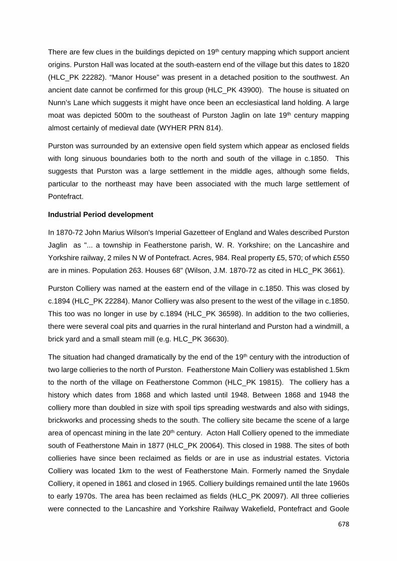
678
There are few clues in the buildings depicted on 19th century mapping which support ancient
origins. Purston Hall was located at the south-eastern end of the village but this dates to 1820
(HLC_PK 22282). “Manor House” was present in a detached position to the southwest. An
ancient date cannot be confirmed for this group (HLC_PK 43900). The house is situated on
Nunn’s Lane which suggests it might have once been an ecclesiastical land holding. A large
moat was depicted 500m to the southeast of Purston Jaglin on late 19th century mapping
almost certainly of medieval date (WYHER PRN 814).
Purston was surrounded by an extensive open field system which appear as enclosed fields
with long sinuous boundaries both to the north and south of the village in c.1850. This
suggests that Purston was a large settlement in the middle ages, although some fields,
particular to the northeast may have been associated with the much large settlement of
Pontefract.
Industrial Period development
In 1870-72 John Marius Wilson's Imperial Gazetteer of England and Wales described Purston
Jaglin as "... a township in Featherstone parish, W. R. Yorkshire; on the Lancashire and
Yorkshire railway, 2 miles N W of Pontefract. Acres, 984. Real property £5, 570; of which £550
are in mines. Population 263. Houses 68" (Wilson, J.M. 1870-72 as cited in HLC_PK 3661).
Purston Colliery was named at the eastern end of the village in c.1850. This was closed by
c.1894 (HLC_PK 22284). Manor Colliery was also present to the west of the village in c.1850.
This too was no longer in use by c.1894 (HLC_PK 36598). In addition to the two collieries,
there were several coal pits and quarries in the rural hinterland and Purston had a windmill, a
brick yard and a small steam mill (e.g. HLC_PK 36630).
The situation had changed dramatically by the end of the 19th century with the introduction of
two large collieries to the north of Purston. Featherstone Main Colliery was established 1.5km
to the north of the village on Featherstone Common (HLC_PK 19815). The colliery has a
history which dates from 1868 and which lasted until 1948. Between 1868 and 1948 the
colliery more than doubled in size with spoil tips spreading westwards and also with sidings,
brickworks and processing sheds to the south. The colliery site became the scene of a large
area of opencast mining in the late 20th century. Acton Hall Colliery opened to the immediate
south of Featherstone Main in 1877 (HLC_PK 20064). This closed in 1988. The sites of both
collieries have since been reclaimed as fields or are in use as industrial estates. Victoria
Colliery was located 1km to the west of Featherstone Main. Formerly named the Snydale
Colliery, it opened in 1861 and closed in 1965. Colliery buildings remained until the late 1960s
to early 1970s. The area has been reclaimed as fields (HLC_PK 20097). All three collieries
were connected to the Lancashire and Yorkshire Railway Wakefield, Pontefract and Goole

679
Line. These were two of many collieries in this part of the Wakefield district. Others includes
the Street House Colliery and New Sharlston both to the west of Purston (e.g. HLC_PK 20099,
20097 and 22842).

680
Figure 277. Colliery features depicted in the Purston Jaglin and Featherstone locality as depicted on 19th through to early 20th century OS
mapping

681
The industrial village of South Featherstone appeared around 500m to the northwest of
Purston Jaglin by the end of the 19th century. The industrial association was the Featherstone
Main and Acton Hall Collieries. This area in the mid-19th century had a single house named
Mount Pleasant and the land was entirely in agricultural use. The enclosed Featherstone
Common formed the northern part of the area and to the south were the former open fields
associated with Purston Jaglin.
Settlement in South Featherstone at the end of the 19th century consisted of a few rows of
terraces in short streets running off to Green Lane (HLC_PK 21187). Larger grid iron
developments of terraced houses extended southwards along Station Lane to meet outskirts
of Purston Jaglin village. This was a fully self-contained and planned settlement with chapels,
schools and commercial buildings. South Featherstone even gained a church: St Thomas’s
built to the east of Station Lane in 1878 (HLC_PK 21175). Station Lane developed as a
commercial core with terraced rows of shops. The Lister Public Baths were built to the west of
Station Road in 1910 (HLC_PK 36599). Development continued into the early 20th century on
Featherstone Lane leading north from South Featherstone (e.g. HLC_PK 20498). The Station
Lane locality also continued to expand with houses. The Featherstone Rovers RLFC Stadium
was established to the east of Station Lane in 1904 (HLC_PK 20477). Development as it
passes through the village on Pontefract Road contains a mixture of terraced houses and a
few shops of later Industrial Period date.

682
Figure 287. Zone map of Purston Jaglin’s later Industrial Period development (not to scale)
20th century and beyond
The Purston Jaglin locality now has a zone of 20th century urban development although this
occurred probably as a suburb of South Featherstone rather than Purston which was
becoming subsumed by this time. The area to the east of Station Lane became developed
with social housing in the Interwar period (e.g. HLC_PK 21171). Associated contemporary
features included allotment gardens and the Featherstone Technology College (HLC_PK
36588, 20475 and 22278).
Development continued on a slightly larger scale to the south of Pontefract Road with the
construction of further estates. One of the largest was the Priory Road estate constructed to
the west of the area in the 1950s and 60s as social housing (HLC_PK 22272 and 22273). The

683
estate was facilitated with a small commercial core and two schools. The Bedford Close estate
was also a social housing development built around the 1960s to the east of the area and
adjacent to this was the Nunn’s Lane development of 1980s houses (HLC_PK 22274 and
22281). There is only one post 1990 development of significant scale and that is Nunn’s Court
which is a 2 hectare private estate built in the mid to late 1990s on farm land to the south of
Featherstone (HLC_PK 36589).
The Interwar and post-war development generally consisted of social housing built on
previously undeveloped agricultural land. The later 20th century to post 1990 examples
represent private housing. This could reflect the changing status of the locality from mining
town to Pontefract suburb after the closure of the mines.
Of interest is the Purston Public Park which was originally private parkland associated with
Purston Hall. The grounds were converted into a public park in the period 1948 to 1951
(HLC_PK 22275).

684
Figure 279. Zone map of Purston Jaglin’s 20th century to recent urban and industrial development (not to scale)

685
Rural hinterland
The open field systems associated with Purston Jaglin were clearly defined on mid-19th
century mapping as groups of fields with long sinuous profiles. These occurred to the north,
east and south of the village and possibly to the southeast, though they were less clearly
defined in this locality. The open fields to the east merged with the much larger open field
system associated with medieval Pontefract. Other medieval settlement in the Purston Jaglin
locality included West Hardwick 2km to the southwest and High Ackworth a similar distance
to the southeast. The area to the northwest of Purston was named Featherstone Common in
the mid-19th century and the fields in this location were large with more regular borders which
suggests later surveyed enclosure.
The land between Purston and the Pontefract urban conurbation 2km to the northeast is only
partly developed. Evidence of the strip fields in this locality have been lost through a process
of extensive 20th century agglomeration. Similar situation has occurred on the West Hardwick
side of Purston though to a lesser degree with slightly better preservation of boundaries
depicted on 19th century mapping. Featherstone Common was the scene of Industrial period
coal mining and extensive opencast mining on the later 20th century. The area is now occupied
by an industrial estate, recovered farmland and derelict land.

686
4.2.24 Ryhill and Havercroft

687
Figure 280.
Zone study area
map of the
Ryhill and
Havercroft
locality

688
Overview
Ryhill and Havercroft originated as two detached villages with Ryhill to the north and
Havercroft 550m to the southeast. Both had origins in the medieval period or earlier. The
settlements underwent a modest transformation in the later Industrial Period with the
introduction of three local collieries within 1.2km of the village and a larger colliery, Monkton
Main Colliery 2.2km to the southwest. By the late 19th to early 20th century both villages were
connected by continuous development of Industrial Period housing along Mill Lane.
Development was small scale compared to other Wakefield industrial settlements. A few small
estates were built in the Interwar period and this development continued into the post-war
period so that now Ryhill and Havercroft are surrounded by a modest scaled zone of housing
estates. Ryhill and Havercroft are situated on a hill top position on low rolling hills. The land
drops generally to the north into the Haw Park Beck valley system which descend to meet the
Calder Valley 5.6km to the northwest. The upper part of the valley to the north of Ryhill is
dominated by two large reservoirs which were created in the late 18th century to feed the
Barnsley Canal. Ryhill is located around 7.6km to the southeast of the Wakefield City core in
the Township of Ryhill (90m AOD. OS ref 438489, 414435). Havercroft is situated in the
adjacent Township of Havercroft with Cold Hiendley (100m AOD. OS ref 438857, 413809).
The villages sits on the geological division between Pennine Coal Measures to the west and
Pennine Upper Coal Measures to the east.
Historic core
“Rihella” is mentioned in the Domesday Survey of 1086 and Havercroft is first mentioned in
1155-70 (Smith, A.H. 1961. Part I. pp. 216 and 269).
Both villages were separated by around 500m in c.1850 with Mill Lane forming the connecting
route. Ryhill, to the north, was a poly-focal settlement at this time with settlement running for
around 200m along the northeast-southwest route of what is now named Station Road (e.g.
HLC_PK 42466). Settlement also occurred as a linear development along the north-south
route of School Lane leading to Mill Lane in the direction of Havercroft to the south. Later 19th
century mapping more clearly depicts folds of cottages and one early Industrial Period yard
development of terraces off Station Road. The village's one Listed building is a farm house
dating to the mid to late 17th century. This occurs on Station Road to the west of the area
(HLC_PK 42443). A farm was also named on School Lane on late 19th century OS mapping.
Station Lane might be considered the earliest part of the village as the settlement here seems
the densest and the lane had an irregular, organic and wide appearance on 19th century
mapping. Narrow plots of land running perpendicular to Station Road were also a feature and
these may represent croft plots. A Back Lane is named in c.1850 and this partly follows the

689
“dog-leg” route of School Lane and Mill Lane to the south of the village. Station Road today
contains a mix of Industrial Period houses (early and late) and two pubs. Interwar housing has
a strong representation. The Listed farm is extant at the western end but the associated barn
and sheds lie derelict. School Lane contains a mix of cottages, Industrial Period houses and
20th century residential development. Mill Lane has a strongly late Industrial Period character
with houses, one or two chapels and a small commercial core.
Havercroft was a linear development which ran for around 300m along Brier Lane (HLC_PK
42544). Although no Listed buildings are present in the village, the plan form of some building
depicted on 19th century mapping suggest farms, the village had a pin fold and Havercroft
Manor was named at the north-western side of the village. The antiquity of the manor cannot
be confirmed. Havercroft may also have had croft plots. The village had a green at its northern
end. Havercroft Green was a long narrow common which stretches for around 800m to the
west of the village. The village end of the common attracted pre c.1850 settlement. Havercroft
Green survives as an open space and still retains a few cottages. Brier Lane contains a mix
of 20th century housing, with a strong representation of post-war development, some Industrial
Period terraces and a few surviving cottages with at least one farm, Havercroft Manor. The
building footprint of the Manor House appears extant from 19th century mapping and may be
of archaeological interest.
Both villages appear to have had enclosed open field systems. These are depicted most
clearly on mid-19th century mapping to the east of Ryhill covering a large distance. West Field
is also named at Ryhill. The fields associated with Havercroft are most clearly depicted closer
to the village core occurring to the east and west. Ridge and furrow was identified in fields to
the southwest of Havercroft (WYHER PRN 4207).

690
Figure 281. Zone map of Ryhill and Havercroft’s historic settlement (not to scale)
Industrial Period development
No large industry could be identified in association with Ryhill and Havercroft in the mid-19th
century beyond a few quarries in the rural hinterland and perhaps village industries.
A wood named Ryhill Pitts is named to the west of the Ryhill village. WYAAS archives suggests
that this area may contain the earthworks associated with bell pits (WYHER PRN 3826). This
hints at iron stone or coal extraction which may have taken place in the medieval or post
medieval period. No coal pits could be identified on mid-19th century mapping in the Ryhill and
Havercroft locality.

691
The situation had changed by the end of the 19th century with the introduction of three collieries
both around 1km to the west of the villages. Ryhill Main Colliery opened in 1874 and was sunk
by Henry Lodge, a former weaver from Skelmanthorpe. The colliery closed in 1923 after a
series of fatal accidents (HLC_PK 18042). Havercroft Main was sunk around 1868 (from the
date of a lease signed to work coal at Havercroft) (HLC_PK 18285). Hodroyd Colliery was
located to the immediate south of Havercroft Main and was also mid to late 19th century in
origin (HLC_PK 18284). These were small scale and short lived collieries. Both collieries were
connected by mineral tram way to the Barnsley Branch of the Aire and Calder Canal around
1.5km to the west. Hodroyd Colliery [a second colliery with the Hodroyd name] was sunk 700m
to the southeast of Havercroft by c.1908 (HLC_PK 42518). Hodroyd was enlarged during the
early 20th century to become the New Monckton No.3 Colliery.
The largest colliery in the Havercroft Township was the Monckton Main Colliery 2.3km to the
southwest of Havercroft (no HLC record as it falls outside the West Yorkshire County
boundary). This colliery was established by the end of the 19th century and was a large colliery
even by later Industrial Period standards. The colliery site contained on-site processing sheds
including coke ovens and a brick works and also two dedicated railway branch lines: the
Monkton Main Railway and the Monckton Main Colliery Branch Line, both with a large area of
railway sidings. These in-turn were connected to the Midland Rail and Hull, Barnsley and
West Riding Junction Railway. The colliery also had a dock on the Barnsley Canal
The Barnsley Branch Canal on the Aire and Calder Navigation Canal was completed in 1802
and left the Calder 6.8km to the north of Ryhill in the Heath locality. Of interest to the Ryhill
locality are the two large canal feeder reservoirs present in the valley to the north of the village:
Winterset Reservoir and Cold Hiendley Reservoir ((HLC_PK 17805 and 17808). A railway
station at Ryhill opened in 1882 on the Stairfoot and Nostell Branch Line (HLC_PK 36788).

692
Figure 282.
Colliery and
railway
distribution in the
Havercroft locality
as depicted on
19th and early 20th
century OS
mapping

693
Ryhill and Havercroft did not become heavily developed in the later Industrial Period with
workers’ houses and associated settlement. A few rows were built at the western side of the
village near the railway station and Mill Lane also gained a few rows by the late 19th century
(e.g. HLC_PK 42444 and 42446). It was at this time the two villages became connected. A
fold of terraces named New Brunswick was constructed around 300m to the northeast of Ryhill
and Ryhill also gained a church (HLC_PK 42432 and 42441). Development in the village cores
was small scale and piecemeal at this time. A few terraced houses and also small villas were
also built in the locality of the Monckton Main Colliery (no HLC record. Area falls in South
Yorkshire).
The scale of development increased in the late Industrial Period after 1900 with the Mill Lane
area gaining additional houses and also developing as a commercial core (e.g. HLC_PK
42490). Further workers’ housing development also occurred on Station Road. Ryhill
Cemetery and a school were also added to the east of Ryhill around this time (HLC_PK 42504
and 42479). Although development still remained fairly modest in scale, Ryhill and Havercroft
had jointly become an industrial village.
Figure 283. Zone map of Ryhill and Havercroft’s later Industrial Period development (not to
scale)

694
20th century and beyond
The provision of colliery workers’ housing continued into the early 20th century. Piecemeal
development continued in the Mill Lane and Station Road localities with further houses and
associated settlement features such as schools and social clubs (e.g. HLC_PK 42469). The
inter war period saw the construction of a few larger estates to both sides of Mill Lane and to
the south of Station Road. Mulberry Place was constructed to the east of Mill Lane in the
1930s (HLC_PK 22532). Church View was constructed to the north of this (HLC_PK 42439).
It is likely that these estates represented working class housing. The area also included the
Miners’ Welfare Recreation Ground, also of Interwar date (HLC_PK 22534). The Westfield
area of Ryhill contained two modest scaled developments: Westfields and Sunny Bank (e.g.
HLC_PK 22535 and 42447). This area also contained a large allotment garden, still surviving
(HLC_PK 22550).
A large zone of housing was beginning to develop 500m to the east of Havercroft off Cow
Lane, a process which began in the 1920s with the construction of the Crescent Road estate
of council houses (HLC_PK 18408). This was a planned settlement with a small commercial
core on Cow Lane (HLC_PK 42555). Cow Lane leading to Newstead Lane also contained
Hatfield Place which comprised two streets of social housing with a 1920s to 1930s date
(HLC_PK 36774).
Post-war and later 20th century development around the village cores was piecemeal and
small scale with individual houses or small cul-de-sacs (e.g. HLC_PK 42501). Larger scale
development was expanding the urban peripheries. One of the largest areas of development
was the Cow Lane area which continued the building phase begun in the Interwar period. Hill
Crest and Brooklands Crescent were estates of semi-detached houses built in the 1950s to
1960s to the south of Cow Lane (HLC_PK 18409 and 18410). The Madeley Road and
Highfield estates was built to the north of Cow Lane around the same time (HLC_PK 225330
and 36775).
Other post-war estates include the Nostell Lane development to the northeast of Ryhill and
Hooton Crescent with Charles Street to the south of Station Road. (HLC_PK 22538, 22535
and 42449). Havercroft village gained Henry Avenue and the Havercroft Junior Infant and
Nursery School at around the same time (HLC_PK 22545 and 42550).
The trend for 20th century housing was for social housing estates built on previously
undeveloped agricultural land.

695
There are four notable post 1990 developments (i.e. above 2 hectares) and these comprise
Hammerton Farm Avenue, Beachill Crescent and Willow Drive to the west of Havercroft and
Ryhill and Felkirk Drive to the east (HLC_PK 42454, 36773, 42543 and 42448).
Figure 284. Zone map of the Ryhill and Havercroft 20th century to recent urban development (not to scale)
Rural hinterland
It is likely that Ryhill and Havercroft had extensive medieval open field systems both to the
east and west of the villages. Part of this area was developed in the 20th century with housing
estates. Evidence can still be seen on modern mapping particularly in the fields to the east
where 20th century agglomeration has had the least effect.
Settlement density was low in these areas suggesting that farms were located in the village
cores. The notable exception is Hodroyd Hall around 1km to the south of Havercroft beyond
the open fields. The hall originated as a high status 17th century house (HLC_PK 22524).

696
400m to the west of this is the South Hiendley Parish Church which largely dates to the 13th
and 15th century but contains Norman fabric (HLC_PK 18351). The church is unusual in that
it occupies a detached position from South Hiendley which lies 850m to the east. The church
may have served several communities. South Hiendley is located 1.5km to the southeast of
Ryhill and Havercroft and may also have originated as a medieval village.

697
4.2.25 Sandal Magna

698
Figure 285.
Zone study
area map of
the Sandal
Magna
locality

699
Overview
Sandal Magna originated as a village probably of pre-medieval origins with an Anglo Saxon
Church. The settlement was of local if not regional importance due to the presences of Sandal
castle to the west of the village high street. The castle was the baronial seat of the lords of the
Manor of Wakefield and the scene of historic sieges. Sandal lay just beyond the urban
peripheries of Wakefield in the 19th century and probably developed as a suburb rather than
an industrial town during this time. The Industrial Period spread of Wakefield reached the
settlement by the beginning of the 20th century with encroaching terraced houses. What
followed for Sandal Magna village in the 20th century was a process of subsumption as the
urban peripheries spread southwards along both sides of Barnsley Road. Open spaces have
been retained in the locality of the castle. The original village core now only partly retains a
village like character, which has been eroded by the busy Barnsley Road and the impact of
20th century redevelopment. The village sits on a spur of land which projects northwest from
the low rolling hills to the south of Wakefield. The land drops to the north into the broad Calder
Valley. The river takes a meandering eastward route at this point. 2.5km to the north of Sandal
Magna on the northern banks of the Calder is the City of Wakefield. Sandal Magna is located
in the Township of Sandal Magna (40m AOD. OS ref 434294, 418200). The subsurface
geology consists of Pennine Lower Coal Measures.
Historic core
The historic core of Sandal Magna village as depicted on mid-19th century mapping was a
linear development which ran from around 300m along Barnsley Road in the St Helen’s
Church area (HLC_PK 42199). The settlement here was densest and this area today still
contains the most Listed buildings for this locality.
There are several points of historical evidence which support the early antiquity of this village.
Sandal is mentioned in the Domesday Survey of 1086 with several other references in the
later medieval periods (Smith, A.H. 1961. Part II. p.107). St Helen’s Church may have been
the location of one of two recorded Saxon churches in the Wakefield Manor (HLC_PK 21548).
The church was almost completely rebuilt in the first half of the 14th century. The surrounding
fields in the 19th century suggest medieval strip fields farming with an extensive range.
Enclosure boundaries closer to the village, on both sides of Barnsley Road, suggest croft plots
and Back Lane was named to the west. The picture is confused slightly by Barnsley Road
being named the Wakefield and Sheffield Trust Turnpike in c.1850. Although the turnpike
dates to 1757-58 it is probable it followed an earlier route through the village as both the church
and croft plots seem to respect this route. Barnsley Road also contains five Listed buildings of
17th century origin (see below). Some realignment or change of focus may have occurred after

700
construction of the road. Sandal was probably a rural settlement up to the 18th century when
it expanded as a suburb of Wakefield. The village seemed largely suburb in character on 19th
century mapping
The historic core contains many Listed buildings occurring as linear development along
Barnsley Road. Some are town houses and higher status terraces of 18th and early 19th
century date (e.g. Images of England UID 441431, 441420 and 441440)). A few houses date
from the 16th century such as Barleywood House, Nos 7 and 9 Woodcroft, Nos. 1, 3 and 5
Shaw Fold and an out building which originated as a house at No. 274 Barnsley Road (Images
of England UID 441438, 446006, 445070, 445071 and 441441). One of the 17th century
houses is described as a farm house. Sandal Hall was depicted and named at the junction of
Barnsley Road and Walton Lane at the southern end of the village in c.1850. 19th century
building footprints appear extant on current mapping. The hall has the appearance of a late
17th to early 18th century high status house with red brick walls and sandstone quoins. Actual
antiquity cannot be confirmed, although its positioning at the end of the village high street in
close proximity to the church is typical of this from of medieval village layout. The hall was
originally set in Sandal Park and was built of stone. The park was probably a post medieval
feature as it respects medieval strip field boundaries (HLC_PK 21546). The house was re-clad
in brick by Thomas Holdsworth when he bought the property in 1865. The hall allegedly dates
from the 17th century but may be much earlier. The house underwent substantial alterations in
the 20th century when it was converted to a Wakefield Corporation hostel and children’s home
(HLC_PK 21553 contains additional information regarding the ownership of the Sandal Hall
estate). It is now flats. (http://www.overtown.org.uk/Sandal/sandal-views.html. Accessed
11/08/2016). The hall does not appear as a Listed building.
Sandal Castle is a motte and bailey castle which was first mentioned c.1240 but probably
developed from a timber castle replaced in stone during the 13th century. The main earthworks
comprise a castle mound, a substantial motte and a crescent shaped inner bailey. Extensive
outworks exist to the southeast which represent a civil war defensive outwork. (HLC_PK
20184). Excavation of the interior carried out between 1964 and 1973 has revealed a number
of timber buildings including a square, timber-framed kitchen and an aisled hall of residence.
The original wooden tower on the motte was a stone shell keep with circular towers. The castle
was the Baronial seat of the lords of the Manor of Wakefield. It is famous as the location of
the Battle of Wakefield in 1460 during the War of the Roses where Richard Plantagenet and
his younger son Edmund were killed by the Lancastrians. It was also besieged during the
English Civil War (HLC_PK 20184). The castle was put into ruin following the siege of 1646.

701
Figure 286. Zone map of Sandal Magna’s historic settlement (not to scale)
Industrial Period development
With the exception of a brick kiln 270m to the north of the village, no incipient industry could
be identified on 19th century mapping in the Sandal Magna locality on mid-19th or late 19th
century OS mapping. The nearest industry was Thornes Woollen Mill and the Calder Dye
Works located 1.6km to the northwest on the farm bank of the River Calder (HLC_PK 20198
and 20186). A small colliery was also present 1.3km to the southwest. The Calder Valley was
becoming heavily industrialised 1.2km to the north of the village in the mid-19th century, but
Sandal at this time remained detached. The brick kiln had become a medium scale brick works
with yard and quarry pit by c.1894 but this remained the only industry near the village.
The historic character of Sandal Magna in the 19th century was one of a villa suburb with higher
status terraces and town houses on Barnsley Road and several larger villas and Industrial
Period halls, some set in large areas of private parkland, in the rural hinterland (e.g. HLC_PK
21530). Sandal was only a carriage ride away from Wakefield centre and in 1866 the Sandal
and Agbrigg Railway Station opened 370m to the north of village which further encouraged
the village’s suburban development (HLC_PK 42183). It is not clear when the suburbanisation
process began. There are a relatively large number of 17th century houses. The character was
certainly suburban by the late 18th century. The form of the village was largely set by the mid-
19th century with only the addition of a few villas by the end of the 19th century (e.g. HLC_PK

702
42194). The peak in development appears to have occurred around the turn of the 19th
century.
Sandal remained detached from Wakefield at the end of the 19th century, although the nearest
terraced housing development was occurring only 500m to the northeast of the village as the
low density rural suburb was becoming subsumed by industrial settlement. Threads of
development along the lanes to the north of Sandal had reached the village by c.1910. The
suburbanisation process continued into the 20th century with the construction of housing
estates in the Interwar period.
Figure 287. Zone map of Sandal Magna’s later Industrial Period development [up to 1910]
(not to scale)
20th century and beyond
There is one large housing estate in the Sandal Magna locality and this is the 20 hectare
Portobello Housing Estate built 800m to the northwest of the village in the 1920s to 30s. This

703
was social housing built in a geometric arrangement on previously undeveloped land
(HHLC_PK 18810). A smaller estate of semi-detached houses, Milthorpe Crescent, was built
in the Milnthorpe locality to the south of Sandal at around the same time (HLC_PK 21517).
Housing development was occurring as linear development along Barnsley Road but also
along the several side lanes. The Castle Road and Manygates Lane area to the east of Sandal
Castle developed as a zone of early 20th century semi-detached houses (e.g. HLC_PK 31668
and 42253). Development also occurred along Agbrigg Road to the north of Sandal and
Chevet Lane and Woodthorpe Lane to the south (e.g. HLC_PK 37139 and 31602). The social
status attribute for houses in these localities was predominantly private housing built on
previously undeveloped land, although private parkland was also becoming redeveloped by
this time.

704
Figure 288. Villas and private parkland recorded as a previous type in the Sandal Magna
locality (hashed areas on map). For the zone key see the zone study area map above

705
By the mid-20th century much of the urban development around Sandal Magna formed a
networks of houses occurring as ribbon development along the many lanes around the village
with the exception of the one large estate, Portobello Road. Post-war development generally
occurred as larger estates filling in the gaps although Barnsley Road seemed to still form a
core. The result is a long and narrow zone of development around 1km wide running in a south
westerly direction from the Wakefield urban core. Agricultural land is still present to either side.
The largest zone of development occurs on the eastern side of Barnsley Road. The two largest
estates are Stillwell Drive and Woodthorpe Park Drive which are private estates dating to the
1970s to early 1980s (e.g., HLC_PK 21516 and 31611). A large estate at the southern end
of this zone is the Pledwick development dating from the late 1960s to early 1970s (HLC_PK
18532 and 17776). This is also private housing. The Pledwick development occupies former
private parkland associated with the 17th century Woodthorpe Hall (HLC_PK 31590). Although
the internal boundaries of the park have been lost, the perimeter is preserved by modern
boundaries. The hall is also extant but is now partly subsumed by modern housing (HLC_PK
31590).
The private parkland associated with Kettlethorpe Hall 1.6km to the southwest of Sandal has
also been redeveloped with social housing and the Kettlethorpe High School of 1950s to 1960s
date (HLC_PK and 31591 and 31661). Part of the ornamental park which includes ponds
survives as a public park (HLC_PK 18506). Kettlethorpe Hall is a high status house dating to
1727 which is now in use as a residential care home (HLC_PK 31644). A third area of lost
private parkland is Castle Grove Park which occurred to the north of Sandal (HLC_PK 31578).
This is private parkland associated probably with Industrial Period villa development. Figure
288 above identifies the areas of private parkland in the Sandal Magna locality which has been
redeveloped.
Other notable development in the area to the south of Sandal is the Stand Bridge Retail Park
established on former agricultural land in the 1990s and the Wakefield Golf Club which was
established in 1910 (HLC_PK 18626 and 31589). The golf club incorporates former private
parkland associated with Woodthorpe Hall

706
Figure 289. Zone map of Sandal Magna’s 20th century to recent urban and industrial
development (not to scale)

707
Rural hinterland
Sandal Magna was surrounded by an extensive area of strip fields stretching in all directions.
Those to the north probably merged with fields associated with Wakefield. The area to the
north of Sandal was named Sandal Common in c.1850, although this had been enclosed by
the 19th century. The Woodthorpe Hall Park boundary to the south was also a notable feature
in the mid-19th century. There were several villas with private parks in the fields surrounding
Sandal. Lower status development largely occurred as low density linear development with
folds, such a Little Sandal to the north and Milnthorpe to the south, occurring around junctions
(HLC_PK 42190 and 42289). Milnthorpe contains a few Listed buildings and these include
houses of 17th century and early 18th century date (e.g. Images of England UID 445512,
444639 and 444640). Milnthorpe now stands in a semi-rural position on Barnsley Road.
20th century development occurs as a north-south band to the east and west of Barnsley
Road. The land to the north of Sandal is wholly developed as a southern extension of the
Wakefield urban core. The fields around the castle remain undeveloped, although these have
become agglomerated. The land beyond the development to the east of Barnsley Road is in
agricultural use but has undergone extensive 20th century agglomeration with only fragmentary
survival of strip field boundaries. This is also partly true to the west in the castle locality. This
area was affected in the late 20th century by 74 hectares of open cast mining which occurred
on the Calder valley floor. This area previously held valley floor meadows and an oxbow lake.
The area now forms the Pugneys County Park (HLC_PK 20179).

708
4.2.26 Sharlston

709
Figure
290. Zone
study area
map of the
Sharlston
locality

710
Overview
Sharlston originated as a village probably of medieval origins. It developed as a mining village
in the latter half of the 19th century due to the presence of local collieries, the nearest being
New Sharlston Colliery 1.5km to the north with further collieries at Street House to the north
east, Sharlston West Colliery to the west and Nostell Colliery to the south. Sharlston village
remained rural at this time and a new settlement of miners’ terraces developed at Sharlston
Common to the north. Sharlston Common gained a small housing estate by the mid-20th
century and this expanded to form a small zone of housing estates to the north of Sharlston
Common in the mid to late 20th century. Sharlston Green does contain 20th century
development but has managed to retain a village like appearance. Sharlston occupies a hill
top position on the low rolling hills to the south of Wakefield. It is located 6km to the southeast
of the Wakefield City core in the Township of Sharlston (70m AOD. OS ref 439183, 418837).
The subsurface geology consists of Pennine Middle Coal Measures which become Pennine
Upper Coal Measures to the south of the village.
Historic core
The village of Sharlston, as depicted on mid-19th century mapping, was a green-side
settlement running for around 330m on the north and south side of Sharlston Green (e.g.
HLC_PK 18448, 18447 and 18435). The Green widened at its eastern end on to Sharlston
Common which still remains un-enclosed (HLC_PK 17984).
It is likely that Sharlston originated as a medieval village. “Scharueston” was first recorded in
1173-93 and at several other times in the later medieval period (Smith, A.H. 1961. Part II.
p.114). Although the form could be classed as a village green settlement, settlement on the
southern side of the green is more linear in form with rear toft plots and a back lane which is
suggestive of a post Conquest planned settlement. There was a large area of enclosed strip
fields depicted on mid-19th century mapping occurring most clearly to the north, east and south
of the village. The fields to the south merged with those associated with the nearby villages of
Foulby and Crofton.
The village contains several Listed features. One is a farm house to the north of the green
with 17th century origins (Images of England UID 437093). The others are estate features
relating to Sharlston Hall. Sharlston Hall is a sprawling elite residence which developed from
the 15th century as a timber framed hall house with 16th and 17th century additions. The hall
has Grade II* Listed building status (HLC_PK 18432).

711
Modern OS mapping (2015 Master Map) still depict five farms scattered around Sharlston
Green. There has been some 20th century residential development but this is small scale and
piecemeal and Sharlston remains village-like.
Figure 291. Zone map of Sharlston’s historic settlement (not to scale)
Industrial Period development
The village had a smithy and Sharlston Windmill (corn) was depicted in fields to the south of
the hall (HLC_PK 17833). A reservoir was also depicted on the southern side of the common
in c.1850, though the association is unclear. Sharlston Common is a Scheduled Ancient
Monument (SAM 30962, WYHER PRN 3831). It was an area of common that was subject to
coal and ironstone extraction from the medieval period through to the 17th century which is
confirmed by documentary evidence (as cited in HLC_PK 17984). The monuments are clearly
visible and include bell pits and other earthworks associated with coal and ironstone mining.

712
Mid-19th century OS mapping depicts two coal pits at the eastern end of Sharlston village
which suggest small scale extraction continuing into the Industrial Period. The mining had
changed by the end of the 19th century with the small pits abandoned in favour of large scale
collieries.

713
Figure 292. Distribution of large collieries and railway features in the Sharlston locality as depicted on 19th and early 20th century OS mapping

714
There are four large scale collieries with 3km of Sharlston:
New Sharlston Colliery. 1.6km northwest of Sharlston. Sharlston Colliery opened in
1858 and closed in July 1993. This area is now an open cast quarry. HLC_PK 20099
Victoria Colliery. 1.7km northeast of Sharlston. Formerly the Snydale Colliery. Opened
in 1861 and closed in 1965. 1.7km northeast of Sharlston. Site reverted to fields.
HLC_PK 20097
Nostell Colliery. 1.9km south of Sharlston. Opened in 1854 and operated through to
1987. Land remains derelict. HLC_PK 17969
Sharlston West Colliery (also known as the Walton Colliery). 3.1km west of Sharlston.
Operated between 1890 and 1979. Area reclaimed as the Walton Colliery Nature Park.
HLC_PK 19830
There were large scale collieries all established in the mid to late 19th century, all with onsite
processing and all had direct access to national railway routes. New Sharlston Colliery and
Victoria Colliery probably had the most relevance to Sharlston.
A new village formed 500m to the north of Sharlston. Sharlston Common [Village] was first
named on late 19th century OS mapping and consisted of rows of terraced houses running
perpendicular to the east west route of Weeland Road (HLC_PK 22845). A few Industrial
Period Houses were also present on Grime Lane. The settlement also gained the Sharlston
Hotel (pub), the Church of St Luke and the Jubilee Recreation Ground (e.g. HLC_PK 43930
and 43945). Development continued on a small scale into the early 20th century with further
houses occurring as ribbon development along Weeland Road and Grime Lane. The
settlement also gained a large area of allotments to the north of the village. A few terraces
were also constructed closer to New Sharlston Colliery. The village was relatively small scale
compared to other Wakefield Industrial settlements. Old Sharlston appeared largely
unaffected.

715
Figure 293. Zone map of Sharlston’s later Industrial Period development (not to scale)
20th century and beyond
Two small estates were added in the early 20th century at the western end of the village,
comprising development around Northfield Road, Jubilee Road and Birkwood Avenue (e.g.
HLC_PK 22574 and 22573). Development began in the 1930s and was completed in the early
post-war period probably as social housing provision for mining families. Piecemeal ribbon
development also occurred on Weeland Road, particularly to the east of the village (e.g.
HLC_PK 440720). Sharlston Community School also originates from the Interwar period and
this is located on the northern side of the village (HLC_PK 22578).
The largest post-war development occurred to the north of Weeland Road: the Woodside
Estate was built in the 1950s and was also social housing built on previously undeveloped
land (HLC_PK 22575). Birkwood Avenue was a smaller estate of similar date built to the west
of Sharlston Common (HLC_PK 22573).

716
There have been two significant post-war developments: Beechfield Drive is a late 20th century
3 hectare development built to the north of Sharlston Green and The Heathers, of similar scale
and date, is to the south (HLC_PK 22627 and 18465). Both occur as new builds on former
agricultural land.

717
Figure 294.
Zone map of
Sharlston’s
20th century to
recent urban
and industrial
development

718
Rural hinterland
The land to the south of Sharlston still contain fields with the serpentine boundaries
characteristic of enclosed medieval strip fields. There has been agglomeration in this area but
to less than 50%. The land to the north of the village has been affected by the growth of
Sharlston Common, agglomeration and mining. Sharlston’s west fields (Dean Field) are still in
agricultural use and here the agglomeration stands at over 50% and the area is now crossed
by the A645 trunk road. Sharlston Common and a second, slightly smaller area of common
land named Sharlston Carr survive to the east of the village.
The density of farms in the fields around Sharlston was low probably because they were
contained within the village. Huntwick Grange is located 1km east of Sharlston and falls
outside the area of former strip fields. It is possible the Huntwick originated as a grange farm
associated with Nostell Priory in the early 14th century. The current house dates from the 17th
century (HLC_PK 17982).
Nostell Park is located only 800m south of Sharlston. The park originated as a deer park in
the 16th century which was created after the dissolution of Nostell Priory. The park was
landscaped in the early 18th century when Nostell Priory was rebuilt (HLC_PK 17940). Nostell
Priory is an impressive 18th-century country house built for the Winn family and which is set
above a lake in an area of extensive parkland (HLC_PK 17938). The present house and park
were created on the site of the Priory of the Augustinian Canons of St Oswald founded in the
year 1122 by King Henry I. This was founded on site of a previous community of hermits
dedicated to St. James. The priory was dissolved by the Crown in 1540 and survives as
fragments of standing fabric, below ground remains and a few earthwork features. It is possible
the parks preserves the boundaries of an even earlier pre-monastic medieval estate.

719
4.2.27 South Kirkby

720
Figure 295.
Zone study
area map of
the South
Kirkby
locality

721
Overview
South Kirkby, formerly named Kirkby, originated as a village of medieval origins and perhaps
was even earlier. South Kirkby expanded from the late half 19th century as a mining town due
to the presence of South Kirkby Colliery 1km to the north of the village. By the mid-19th century
South Kirkby had become connected to South Elmsall by a ribbon of continuous development
along Barnsley Road (formerly Lidgate). There are now large estates of residential
development to three sides of the village and an industrial estate to the southeast. South
Kirkby sits on a hilltop position on a spur of land which projects eastwards from Brierly
Common and south Kirkby Common. To the north is Haigh Hill Beck valley and to the south
Langthwaite Beck. Both meet around 2km to the east to the village to flow eastwards as “The
Beck” to become Hampole Dike. South Kirkby is located 15.5km to the southeast of the
Wakefield City core in the Township of South Kirkby (35m AOD. OS ref 445310, 411098). The
subsurface geology consists of Pennine Upper Coal Measures.
Historic core
“Cherchebi” is mentioned in the Domesday Survey of 1086 and several other times in the
medieval period. The “South” prefix appears in 1119-29 as “Sudkirkebi” (Smith, A.H. 1961.
Part II. p.40). The “kirk” element probably refers to a church which existed here at the time of
the survey. WYAAS records All Saints’ Church as the oldest standing building in the village:
“The nave (the central part where the worshippers sit) may date back to Anglo-Saxon times.
It’s the right size and the walls are thinner than those in the rest of the church. This might
account for the name of the village. The Vikings saw the church and called the place Kirkby
[Kirkby derives from the Norse word for church]. If there was an older Anglo-Saxon name for
the settlement it has been lost. A stone church would have been rare in the 8th and 9th
centuries” (WYHER PRN 970). The church is Listed as 13th or 14th century (HLC_PK 42612).
The village was at least of local importance from antiquity. In the Poll Tax Survey of 1379,
sixty-five entries are listed for South Kirkby suggesting a settlement of significant size. Entries
included tailors, weavers, a smith, wright, carpenter and thatcher (see HLC_PK 42734). The
economy was probably rural with an extensive strip field system surrounded the village
suggesting a developed medieval agrarian system. 19th century OS mapping described
several farms both in the village and as ribbon development to the west of the village on White
Apron Street suggesting the rural economy was still of importance into the latter half of the
19th century.
The location of the early settlement can be inferred from historic mapping. Settlement on mid-
19th century OS mapping concentrated along White Apron Street, Barnsley Road,
Stockingate, Bell Lane and Carr Lane (e.g. HLC_PK 42773 and 42734). It may have extended

722
as low density linear development further east and west along White Apron Street and
Barnsley Road (formerly Lidgate). The street pattern in the village core was organic rather
than linear with several wide road junctions. The lanes to the immediate west of the church
form a sub-oval enclosure which was filled with Rectory Farm and other buildings in the 19th
century. This could possibly represent a former village green, although this is speculation and
would suggest a pre-Conquest village green type settlement in the vicinity of the church rather
than a later planned high street. Settlement ran for around 350m eastwards along Lidgate
(Barnsley Road) which had a more linear plan. The plan is confused by the enclosure pattern
to the west of the church along White Apron Street. In c.1850 settlement along the lane was
low density. There was an area of land to the north enclosed by Northfield Lane to the north.
The lane survives running through modern housing estates. A few fields in this area resembled
croft plots which were bounded by Northfield Lane. It could be suggested that this area
represented a shrunken or relocated medieval village high street with Northfield Lane acting
as the back lane. Again, this is speculation (see map below. Figure 207).
The survival of historic buildings is fragmentary. The church is of confirmed early medieval
date. The other three Listed buildings are 700m west of the core along White Apron Street
and represent 18th century houses and sheds and a 17th century barn (Images of England
UID 425364, 425705 and 425706). WYAAS records a demolished gentry house to the
immediate west of the church (probably Rectory Farm) of possible 14th century date possibly
with an associated barn which would make this locality the site of the manor (possibly a rectory
manor). There is also an early 19th century house which conceals an older stone building. The
Rectory Farm “Tithe Barn” (as named on current OS mapping) contains earlier timbers (e.g.
WYHER PRN 12213, 12219, 12215). Today, the church remains the most prominent historic
feature but one or two early stone buildings also survive. The core appears more like an early
to mid-20th century dormer town with a few Edwardian terraces and shops. As a medieval
settlement of significance however, it is possible that early fabric remains hidden in later
buildings or below ground.

723
Figure 206. South Kirkby as depicted on mid-19th century OS mapping showing field boundary patterns to the west of the village. Enclosed strip
fields are also evident on this map. © and database right Crown Copyright and Landmark Information Group Ltd (All Rights Reserved 2016)
Licence numbers 000394 and TP0024

724
Figure 297. Zone map of South Kirkby’s historic settlement (not to scale)

725
Industrial Period development
The village demonstrated only slight development in the latter half of the 19th century with the
construction of a few rows of terraces and other housing types (small villas) particularly in the
White Apron Street area and probably some piecemeal development within the village core
(e.g. HLC_PK 42660). The only industry was local and small scale. Kirkby Windmill (corn) was
located 1.2km to the southwest of the village (site now a school. HLC_PK 23083). Moorthorpe
Railway Station arrived by May 1879. The station was situated on the Midland Railway and
North Eastern Railway Swinton and Knottingley Joint Railway (HLC_PK 42754). The real
change was occurring 1km to the northwest of the village, with the introduction of the South
Kirkby Colliery. The mine was in operation from 1878 through to 1988 (HLC_PK 22206). The
mine in the 19th century was relatively small scale. It was connected to the Great Northern &
Manchester, Sheffield & Lincolnshire Railway by dedicated railway sidings. The mine
continued into the 20th century as a drift mine expanding to its maximum size in the latter half
of the 20th century with extensive areas of spoil tipping. Associated settlement in the late 19th
century consisted of a few terraced rows in the locality of the colliery. These have largely been
lost through later colliery expansion.
The village began to redevelop in the late Industrial Period (after c.1895) as a small mining
town. A grid iron development to the north of White Apron Street was constructed at this time
(HLC_PK 42658). This was replaced by bungalows in the c.1960s to early 1970s. Elsewhere
the development was more piecemeal with individual rows occurring as ribbon development
on lanes leading from the village, particularly along Mill Lane to the west and Carr Lane to the
northeast (e.g. HLC_PK 427610). Mill Lane later acquired a larger grid iron development of
through terraced houses. A small industrial housing zone also developed to the east of the
village near Moorthorpe Railway Station which included terraced houses and later semi-
detached houses. Moorthorpe Cemetery which was laid out in 1907 also occurs in this area
(HLC_PK 22867). The South Kirkby County Primary School was established to the west of
the village at this time (HLC_PK 23140). The village core contains a few terraced rows,
institutes and commercial buildings including a picture theatre dated from this time. South
Kirkby and South Elmsall became connected along Barnsley Road during the late Industrial
Period with a continuous ribbon development of houses. The development merged with the
large grid iron terraces and early housing estates of the South Elmsall urban peripheries.

726
Figure 298. Zone map of South Kirkby’s later Industrial Period development (not to scale)

727
20th century and beyond
The provision of workers’ housing continued into the Interwar period on a greater scale with
the construction of housing estates in the South Kirkby locality. The largest was the Hilltop
Housing Estate 1km to the west of the village. This is an estate of social housing built in the
geometric arrangement on previously undeveloped land (HLC_PK 19618). The estate came
provided with a school, recreation ground and allotments (e.g. HLC_PK 22557 and 42582).
Smaller estates were built to the north and south of the village at around the same time and
these also represented social housing (HLCH_PK 22941). The Northfield Avenue
development has since been replaced by modern housing (HLC_PK 22941). The Park Estate
survives to the south (HLC_PK 19608).
South Kirkby and South Elmsall are now surrounded by a continuous zone of 20th century
industrial and residential development. Social housing development continued at South Kirkby
with the construction of further large estates. The estates of the Grove Lane area now
surrounds the Park Estate. It is a development of c.1950s and 1960s semi-detached houses
(e.g. HLC_PK 22555 and 19609). The Beacon View estates to the north of the village was
built in the late 1960s to 1970s on previously developed land. This estate contains a mix of
detached and semi-detached houses suggesting private development (HLC_PK 22945).
South Kirkby contains several other smaller scale housing developments from the latter half
of the 20th century.
The South Kirkby Recreation Ground was established between 1948 and 1951 to the north of
the village (HLC_PK 36796).
South Kirkby contains several post 1990 estates. These occur as small to medium scale
developments positioned intermittently in the housing zone on all sides of the village. One of
the largest is the Mayfields Way estate occurring to the south of the village (HLC_PK 23085).
This estate was built on previously undeveloped land. Late 20th century development also
occurs as infill development to the west of South Kirkby in the Hilltop Estate area on former
allotments and recreation grounds (e.g. HLC_PK 42582). To the north of the village are the
Hague Park Lane and Northfield Avenue estates which replaced allotment gardens and early
20th century terraced houses (HLC_PK 22941 and 22939). Ings Way and Ings Holt were built
in the Moorthorpe area to the northeast of the village in the 1980s to early 1990s on previously
undeveloped agricultural land (HLC_PK 22951 and 22949). This development occurred after
the closure of the South Kirkby coal mine.
The Langthwaite Business Park now dominates a large area to the southeast of South Kirkby.
The park which covers over 50 hectares was established in the late 1970s to early 1980s
expanding southwards in the later 1980s (HLC_PK 19596).

728
Figure 299. Zone map of South Kirkby’s 20th century to recent urban and industrial development (not to scale)

729
Rural hinterland.
South Kirkby in the mid-19th century was surrounded by an area of probable enclosed
medieval strip fields. This is evident on mapping through the presence of fields with long
sinuous profiles and though place name evidence, such as Upper and Lower North Field.
These merged with the more extensive medieval open fields associated with South Elmsall
1.7km to the east. The area beyond the open fields to the west and south west was named
Kirkby Common and Brierly Common. This was enclosed probably occurred around 1807 (see
HLC_PK 22941).
Most of the village open fields have been lost under housing or industrial estates or though
mining activities in the South Kirkby Colliery locality. The nearest agricultural land occurs 600m
to the south of the village and here there has been significant 20th century field agglomeration.
The later surveyed enclosure of Kirkby Common demonstrates better survival. There is
fragmentary survival of the strip field form preserved by the site perimeters of later Industrial
Period housing development in the Moorthorpe locality to the east of South Kirkby.
Most historic farms probably occurred in the village core or as linear development along the
network of lanes in the rural hinterland. Several farms can be identified in the village on 19th
century mapping. In other area the settlement was low density or absent. Both Stocking Gate
and White Apron Street within 800m of the village core contain surviving farms of 18th century
date with evidence of earlier buildings (HLC_PK 42633 and 42668). 1.5km to the northwest of
the village is Hague Hall (HLC_PK 22210). The hall, now lost, dated from the 17th century.
Broad Lane Farm 1.3km to the south of the village also dates from the 17th century (HLC_PK
19592).
Of special interest to this locality is the South Kirkby Fort (HLC_PK 19600. Scheduled Ancient
Monument 31532). South Kirkby Fort lies on South Kirkby Common. The enclosure is defined
by a bank and ditch. An excavation was undertaken in 1949 by officers of Wakefield Museum
and pupils of the local school. An excavation trench across the bank and ditch was opened
which produced finds including animal bone, charcoal, a timber fence and pottery. The pottery
is reported to have been late Iron Age (200BC or later).

730
4.2.28 Stanley

731
Figure
300. Zone
study area
map of the
Stanley
locality

732
Overview
Stanley is recorded in the Domesday Survey of 1086(Smith, A.H. 1961. Part II. p.159). In
1850, the settlement around Stanley consisted of a small village and detached hall of the same
name and Stanley Lane Ends located 1.2km to the north. The rural hinterland contained a few
large houses with private parkland which probably became developed as a detached suburb
of Wakefield in the 18th and 19th century if not earlier. Stanley village grew slightly in the late
19th century due to the presence of local coal mines, the River Calder which was formerly
navigable and the Aire and Calder Navigation Canal. Development consisted largely of a few
terraced houses and the village remained rural and park-like in its setting. The suburban
spread of Wakefield crept northwards along Aberford Road (A642) during the early 20th
century and had reached Stanley by c.1950. Stanley is now joined to the urban peripheries
but still only by a thread of development. The village is now surrounded by a zone of mid to
late 20th century housing. Stanley Lane Ends 1km north of Stanley was also developed as a
village in the 19th century and was a slightly larger settlement than Stanley at this time. The
antiquity of Stanley Lane Ends in relation to Stanley is unclear. The character is one of an
Industrial Period village. The settlement was in close proximity to the Victoria Haigh Moor
Colliery. Stanley Land Ends now forms part of the larger urban conurbation of Outwood and
Lofthouse Gate connected by a large zone of mid to late 20th century housing. The Stanley
village core is situated in a valley side position at a low elevation on the western side of the
Calder Valley. The hills are low and the valley is wide and the Calder flows northward and
then loops to the east at this point. The land to the east of Stanley was liable to flooding in
the 19th century and consisted of valley floor meadows. The land rises to the west to Newton
Hill and Snow Hill to drop again further west into the Balne Beck valley system. Stanley is
located 2.5km to the northeast of the Wakefield City core in the Township of Stanley cum
Wrenthorpe (25m AOD. OS ref 434510, 423057). The subsurface geology consists of Pennine
Middle Coal Measures.
Historic core
OS mapping in the mod 19th century depicted four settlements in the Stanley cum Wrenthorpe
Township with the Stanley name: Stanley Village occupying a central position, Stanley Hall
800m to the south, Stanley Ferry 900m to the east and Stanley Lane Ends 1.2km to the north.
Stanley was mentioned in the Domesday Survey of 1086 and at other times in the later
medieval period although whether this refers to a village, a hall or scattered settlement is
unclear (Smith, A.H. 1961. Part II. Pg. 159).
Stanley Hall was formerly named Midgley Hall and was founded sometime after 1327 by
William de Miggeley who was granted the manor lands by Edward III. It passed through a

733
number of families in the late medieval and post medieval period. In February 1759 most of
the old hall was burned down. Having been restored it was bought by cloth merchant Benjamin
Heywood in 1802. By 1862 the hall was being let to tenants until it was finally sold to the West
Riding Pauper Lunatic Asylum. Stanley Hall was then converted into a Mental Deficiency
Colony for “Imbecile Boys” (c.1901). There was a school and patients were encouraged to
take part in farming activities. In recent years the grade II Listed hall has become a hostel for
nurses at Pinderfields Hospital (HLC_PK 21588).
The village of Stanley (as named on c.1850 mapping) was a linear development of houses
which ran for around 300m along Aberford road (now the A642) before turning onto Ferry Lane
for around 200m (e.g. HLC_PK 42010). The antiquity of this settlement cannot be firmly
established with the available resources. Development in the 19th century appears to be
largely industrial in character. The current character appears to be a mix of 20th century and
Industrial Period with a few earlier cottages. There is nothing to suggest earlier origins,
although this cannot be ruled out. Fields to the south of Ferry Lane hint at medieval strips or
crofts. The land to the northwest was formerly a large private park associated with Hatfeild
Hall (now a golf course). Hatfeild Hall was built between 1598 and 1608 for Gervase Hatfeild.
This replaced an earlier hall named Woodhall. Woodhall was owned by Robert Fleming in the
14th century (HLC_PK 20046). Hatfeild Hall became the property of the West Riding Asylums
Board in 1920 and the Hall became a hospital for mentally handicapped women. The Hall
remained hospital property for the next 65 years until it was sold to a local wine bar owner in
1985. The Hall was destroyed by fire in the early hours of New Year’s Day, 1987. Only part of
the shell of the building was saved, but in recent years it has been partly restored by
Normanton Golf Club. The building is now used for private functions with a club house to the
rear of the building (HLC_PK 20046). The antiquity of the park is not clear, although its large
oval boundary hints at an early date. To the south of Stanley was Stanley Park. This was the
former parkland associated with Stanley Hall. It may have had an earlier incarnation as a deer
park prior to the 17th century (HLC_PK21505). To the immediate south of Stanley Park was
Clark Hall. This is a brick house built by Brian Bradford c.1542 on the stone foundations of
older house (HLC_PK 21504). The Stanley Township is unusual in having a concentration of
halls with confirmed medieval dates.
Another historic site of interest in the Stanley locality was the St. Swithin’s Chantry Chapel
and St Swithin’s Well. The chapel was founded by John, Earl Warrene in the late 13th century.
Personal name evidence suggests that there was also a small settlement at St Swithin’s.
(WYHER PRN 3445. No separate HLC record. Part of HLC_PK 21592). The chapel site, now
on the edge of a housing estate, was in a rural position 1km to the south of Stanley in c.1850.

734
The historic core of Stanley Lane Ends ran for around 200m at the western end of Lake Lock
Road with further development along Long Causeway (e.g. HLC_PK 41785). Again, the
antiquity of this settlement is in doubt. The settlement consisted of yard developments of
cottages and possible workshops with a few commercial buildings in the mid-19th century.
Terraces and other types of development, such as village institutes were added during the
mid to late 19th and into the early 20th century. The proximity of local collieries (see below)
may have been the economic motivation behind the settlement. Earlier origins cannot be
dismissed however. The current character represents a mix of commercial and domestic with
a later Industrial Period character with terraced houses, pubs and a few shops.
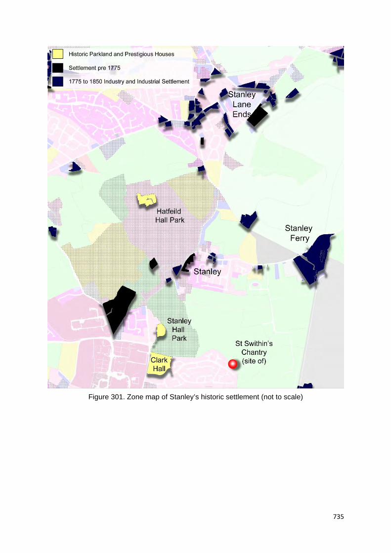
735
Figure 301. Zone map of Stanley’s historic settlement (not to scale)

736
Industrial Period development
The principal industry in the Stanley locality in the 19th century was coal mining. Although
historic extraction in this area was likely, it did not occur on a large scale until the 19th century.
Several collieries and coal pits were depicted around Stanley on mid-19th mapping. Victoria
Colliery was the most dominant. It was situated in a mid-point rural position between Stanley
and Stanley Lane Ends within former parkland belonging to Hatfeild Hall. The colliery
predated c.1850. It closed in 1879 after a disastrous explosion killed 21 men and boys
(HLC_PK 20055). Victoria Colliery was at the centre of a networks of tramways which
interconnected other collieries to wharfs and basins on the Calder and Hebble Navigation
Canal at Stanley Ferry. The Victoria Colliery became very large in scale and gave its name to
other coal pits in this locality. A list of collieries in the Stanley locality is presented below, also
see Figure 302 below which presents a location plan:
Victoria Colliery. Pre c.1850. Closed 1879 though still present as Victoria Pit No.1 and
No.2 on late 19th century mapping. Land reclaimed as Stanley Marsh Nature reserve.
HLC_PK 20055
Victoria Colliery Newton Lane Pit and No.6 pit (pumping). Pre c.1850. Closed c.1896.
No.6 pit may have closed later. Now a 1960s housing estate. HLC_PK 28815 and
41529
Victoria Colliery Stanley Ferry Pit. In operation from 1855 to 1880. Former colliery
buildings and machinery survived until the 1930s. Now playing fields. HLC_PK 36256
Victoria Haigh Moor Colliery. Post c.1850. Went out of use in the late 19th to very early
20th century. Now Interwar housing. HLC_PK 41991
Lofthouse Colliery. Lofthouse Colliery opened in 1876 and closed in 1983. Now playing
fields. HLC_PK 20148
In addition to large collieries, the Stanley area also contained several individual coals pits
marked on mid-19th century maps, although most were unnamed. Some of these were
connected to the tram-way networks and many were lost by the late 19th century. Most
collieries had on site processing facilities such as coke ovens and others had associated brick
works. The only other industry of any significance depicted on 19th century mapping appear
to have been sandstone quarry (e.g. Lee Moor Quarry northwest of Stanley Lane Ends.
HLC_PK 22821). There was an alum works and a large detached brick works at Lofthouse
2.km to the northwest. A small industrial zone developed around Stanley Ferry (Aire and
Calder Navigation New Cut: Lofthouse and Newland Basins. HLC_PK 41981). Two basins
were present: one serving the Victoria colliery and the other connected by tramway to St
John’s Colliery 2km to the southeast.

737
Figure 302. Colliery and transport route distribution in the Stanley locality as depicted on 19th century OS mapping

738
Stanley village in the 19th century was rural village surrounded by halls and private parkland.
A few halls were ancient. Others, such as Stanley Grange 700m to the southwest of Stanley,
were 18th or 19th century (HLC_PK 21591). It is likely that the Stanley locality functioned as a
high status suburb of Wakefield from at least the 18th century. The village was only 1.7km
away from Wakefield’s urban spread in c.1850. Stanley village in c.1850 consisted of a few
cottages, at least one farm, an inn and probable village institutes such as a chapel and school.
A few additonal terraces were built on Aberford Road (part of HLC_PK 42011). Industrial
period settlement remained small scale and piecemeal. Several rows of terraces were added
along Aberford Road’s northward route in the later Industrial Period (HLC_PK 41955). Short
terraced rows were also built in association with individual collieries and at Stanley Ferry.
It was Stanley Lane Ends which saw the greatest amount of development in the Industrial
Period but this was also relatively small scale. This development may have represented a shift
of the settlement core from Stanley to Stanley Lane Ends, althought the antiquity of either
settlement cannot be confirmed. Terraces were added within the village core along Long
Causeway and Lake Lock Road together with associated settlement features such as pubs
and chapels (e.g. HLC_PK 41785 and 41784). Late Industrial Period terraces occurred as a
small grid-iron development to the south of Lake Lock Road. Stanley Lane Ends has the
character of a planned industrial settlement. In addition to the develoment in the village core,
the eastern end of the village gained St Peter’s Church dating to 1821-24, a mid to late 19th
century cemetery, a school and cottage hospital (HLC_PK 22820, 41985 and 41836). To the
east of the church was the settlement of Lake Lock. The name, which indicates a connection
with the Calder Navigation, and its position on the Wakefield and Aberford Trust Turnpike of
1788-89 suggests 18th century foundations, though earlier settlement cannot be ruled out.
Lake Lodge to the immediate south of the church dates from the 17th century (HLC_PK 22824).
A few cottages and houses from this period survive. Lake Lock also became developed with
a few villas and late Industrial Period terraces (e.g. HLC_PK 23593).
Of special interest to the Stanley locality is the West Riding Lunatic Asylum situated 1.5km to
the south of the village on the outer edge of the 19th century Wakefield urban conurbation. The
hospital was established in 1818 as a pauper lunatic asylum (HLC_PK 21462). This asylum
was only the sixth to be built in England and was founded with the belief that “lunatics” should
be treated humanely and given occupations. The asylum demonstrated 19th and 20th century
additions and became the Stanley Royd Hospital and later the Pinderfields Hospital. Part of
the original asylum survives and has been converted to flats.

739
Figure 303. Zone map of Stanley’s later Industrial Period development (not to scale)

740
20th century and beyond
Interwar housing development in the Stanley locality remained relatively small scale with the
most significant development occurring along the main roads as short rows of terraces or
semi-detached houses such as those on Aberford Road at Stanley and Lime Pit Lane at
Stanley Lane Ends (HLC_PK 41953 and 41782). The development on Aberford Road is the
thread of housing which links Stanley to the Wakefield urban peripheries.
Stanley [village] gained a small zone of housing in the post-war period. The largest
development is the Riverdale Estate built in the late 1960s to early 1970s to the south of Ferry
Lane (HKC_PK 36250). St Swithin’s Grove was built to the immediate east at around the same
time (HLC_PK 41996). Other mid to late 20th century development in Stanley consists of
individual houses or small cul-de-sacs. Post c.1990 development is represented by Ash Grove
and Clark Hall Road also to the west of the Riverdale Estate (HLC_PK 36249 and 42003).
Stanley Lane Ends demonstrates the greatest amount of post-war housing development and
is now connected to Outwood 1.4km to the west by a large and continuous zone of housing.
Interwar housing is small scale and piecemeal and the largest development is the Stanley St
Peter's Primary School constructed between 1908 and 1921 (HLC_PK 22823).
The largest post-war housing development is the Gainsborough Way estate of semi-detached
houses to the west of Stanley Lane Ends which covers 14 hectares and was built sometime
between 1972 to the early 1980s. (HLC_PK 22804). Newland Avenue is a smaller estate to
the immediate south and dates from the 1960s and also consists of semi-detached houses
(HLC_PK 22805). Both estates were constructed on previously undeveloped agricultural land.
Semi-detached housing estates were also constructed to the east of Stanley Lane Ends.
Orchard Avenue and Ash Crescent represent post-war social house developments dating from
the late 1940s to 1950s (HLC_PK 21637 and 22817). Beaumont Street and Lake Lock Drive
expanded the housing zone westwards with cul-de-sacs of c.1960s semi-detached houses
(HLC_PK 22819 and 23600).
The Broad Meadows estate now forms the bridge of development between Stanley Lane Ends
and Outwood. This estate covers around 30 hectares and was constructed in the late 1980s
to 1990s (e.g. HLC_PK 20137, 36279, 20139 and 22827). This estate was constructed largely
on previously undeveloped agricultural land.

741
Figure 304. Zone map of Stanley’s 20th century to recent urban and industrial development (not to scale)

742
4.2.29 Upton

743
Figure
305. Zone
study area
map of the
Upton
locality

744
Overview
Upton originated as a village of probable medieval origins which remained rural and village-
like into the early 20th century. The transformation came in 1924 with the establishment of
Upton Colliery with an extensive associated features such as railway sidings, clay pits and
brickworks. From this point on, Upton became transformed into a mining village with large
estates of miners’ housing. The village core was also redeveloped at this time. The colliery
closed in 1964 but the village continued to develop with housing estates, though on a smaller
scale. The village occupies a valley side position on the low rolling hills to the south of the
Wakefield District. The land drops to the south into the Wrang Brook which flows to the
southeast to become Skell Brook. Upton is located around 16km to the southeast of the
Wakefield City core in the Township of Upton (55m AOD. OS ref 447450, 413210). The
subsurface geology consists of Pennine Upper Coal Measures which becomes Dolomitised
Limestone around 500m to the southeast of the village.
Historic core
“Uptun” was recorded in the Domesday Survey of 1086 and at other times in the later medieval
period (Smith, A.H. 1961. Part II. p.98). The village in c.1850 consisted of a linear development
running for around 400m predominantly on the northern side of Upton High Street (HLC_PK
43034). The development consisted of cottages. The plan form of some building ranges on
later 19th century mapping suggest the presence of at least three farms. No church is depicted
but a Wesleyan Methodist chapel was described at the eastern end of the village (HLC_PK
43100). Upton Hall was located in a large enclosure at the eastern end of the village. Its
positions is consistent with other medieval high street villages. The hall may have been of
significant antiquity, even as a pre-Conquest estate. WYAAS holds the following information:
‘Site of Upton Hall. Present on 1st ed. OS map, now demolished. Tentatively identified as the
site of the medieval palace of the Archbishops of York. 19th c. floors partially excavated by D.
Smith (of Upton). Substantial house possibly rebuilt or refurbished in the 17th century
(WYHER PRN 3838. HLC_PK 43055). The hall was demolished after 1956 and the area is
now regenerated scrub land.
Fields patterns depicted on mid-19th century mapping strongly suggest the presence of
enclosed strip fields which are particularly visible to the north of the village. There may have
also been croft plots on the northern side with a back lane marked on c.1850s OS mapping
as a footpath (now preserved as Beech Road and a path between housing).
Upton is located only 530m north of the village of North Elmsall. “Ernshala” was also named
in the Domesday Survey. The area around the village of North Elmsall has yielded an
unusually large number of high-status Anglo Saxon finds, with a supposedly pagan Saxon

745
burial near White Hart Farm within the village core (HLC_PK 43766). North Elmsall Old Hall
dates from the early 17th century but may be of earlier origins (HLC_PK 19761).
Upton High Street was extensively redeveloped in the early 20th century and little remains of
any overall vernacular character beyond the occasional cottage. The few surviving cottage
may be worthy of further investigation.
Figure 306. Zone map of Upton’s historic settlement (not to scale)
Industrial Period development
Upton remained relatively unaltered into the early 20th century. The Upton and North Elmsall
Station was built in 1891 and closed in 1967 (HLC_PK 43772). An old windmill was described
on late 19th century mapping at Upton Beacon 700m to the north of the village (HLC_PK
43112). Several small quarries were depicted in the rural hinterland. North Elmsall presented
a similar picture.
A big change occurred after 1924 with the opening of Upton Colliery. The colliery covered 37
hectares and included an extensive area of sidings connected to the Hull, Barnsley & West
Yorkshire Junction Railway and also brickworks (HLC_PK 19644). The workings extended
northwards with around 16 hectares of clay pits (HLC_PK 19638). The colliery became
disused in 1964 and the land is now occupied by a school, an industrial estate and playing
fields.

746
Figure 307. Upton Colliery as depicted on mid-20th century mapping. © and database right Crown Copyright and Landmark Information Group
Ltd (All Rights Reserved 2016) Licence numbers 000394 and TP0024

747
20th century and beyond
It was from the 1920s that Upton was transformed from a village into a small mining town.
The largest estate was the Smeaton Road/Walton Road development built to the immediate
east of the colliery (HLC_PK 19642). This is a 39 hectare estate built in a geometric
arrangement between 1932 and 1935 to provide workers’ housing (social housing). The estate
came facilitated with a small commercial core, a central green and allotment gardens (e.g.
HLC_PK 23148). Accommodation was predominantly short terraced rows or semi-detached
houses, though a few high status houses were present on the estate’s peripheries. There was
also a school, Harewood Lane First School, but this was replaced by a housing estate after
2002 (HLC_PK 23149). Although there has been a small amount of redevelopment, the estate
is still a well preserved representative of Interwar social housing.
Smaller scale Interwar development was occurring closer to the village core. First, Second
and Third Avenue is a 2.7 hectare development of semi-detached houses built to the north of
the village (HLC_PK 22972). New Lane Crescent is a similar scale development to the south
(HLC_PK 22984). It was at this time the village became redeveloped as a commercial core
with the piecemeal construction of small shops, a public house, village police station and small
Methodist church (e.g. HLC_PK 43026, 43027 and 43033).
Development continued into the post-war period with the construction of one large estate, a
few small to medium scale estates and piecemeal residential development. The largest estate
occurred to the west of the village: Sunny Avenue was built in the immediate post-war period
on previously undeveloped agricultural land and consists of semi-detached houses (HLC_PK
19716). Other examples of housing estates from before 1964 include the Hill Estate, Tower
Avenue, Pennine View and Grosvenor Avenue (HLC_PK 22974, 22970, 22976 and 43024).
These all occur to the north or south of High Street and all were built on previously
undeveloped land. Greenwood Avenue was built to the north of the colliery site in the late
1980s and this represents post colliery closure private housing (HLC_PK 19659).
There are two notable post 1990 estates and these comprise Thistle Drive built in the late
1990s to the southwest of the village and an estate on an unnamed street to the north
(HLC_PK 22973 and 22985). Upton Primary School was constructed between 1992 and 1999
on derelict land associated with Upton Colliery (HLC_PK 22983). Also of note in Upton is the
Steed Court Business Park which was created around 2010. The estate reuses earlier factory
buildings and a former Miners’ Welfare Hall (HLC_PK 22982). The colliery site now also
contains a playing field and park.
North Elmsall is still situated in a semi-rural position and still retains buildings and cottages. A
few private houses were added to the northern side of the village in the late 20th century and

748
recently. The Upton 20th century urban zone is only 400m to the north and the Dale Lane
Industrial Estate around the same distance to the south.

749
Figure 308. Zones of modern housing in the Upton locality (not to scale)

750
Rural hinterland
It is likely that Upton had associated strip fields and these are depicted most clearly on mid-
19th century mapping to the north of the village. There may have also been croft plots with a
back lane on the northern side of High Street. The open fields to the north of the village met
with Badsworth village around 2km to the northwest and with the fields associated with North
Elmsall to the south. Mining and 20th century housing has removed a large part of the villages’
open fields. There is partial survival beyond the estates to the north of the village but this area
has undergone 20th century field agglomeration.
The fields to the west of Upton were more piecemeal in character, although they have now
undergone extensive 20th century agglomeration. This area contains three Listed farms of 18th
or early 19th century date (HLC_PK 19750, 19749 and 19746).

751
4.2.30 Walton

752
Figure 309.
Zone study
area map
of the
Walton
locality

753
Overview
Walton was named in the Domesday Survey of 1086, although it is not clear if this refers to
the village of Walton or Walton Hall to the south which originated as a medieval moated site
and possibly a pre-Conquest manor. The Walton of the 19th century was a small village with
an 18th to early 19th century suburban character. Walton became situated both on the Midland
Railway and the Barnsley branch of the Aire and Calder Canal. Sharlston West Colliery was
present 1km to the northwest by the late 19th century but this did not become large scale until
the early 20th century. After this time Walton developed a small amount of workers’ housing
with associated features such as a village school. Estate construction began in a modest way
in the Interwar period and became larger in scale in the latter half of the 20th century. Walton
survives as a detached suburb of Wakefield surrounded by a modest zone of housing. The
setting is rural but the area has been affected by large scale mining. Walton is located around
4.4km to the southeast of the Wakefield City core in the Township of Walton (45m AOD. OS
ref 435372, 417177). The subsurface geology consists of Pennine Middle Coal Measures.
Historic core
“Waleton” is mentioned in the Domesday Survey of 1086 and at other times in the later
medieval period (Smith, A.H. 1961. Part II. p.112). It is possible that Walton originated as a
village of medieval origins. There are hints on the eastern side of the village of enclosed
medieval strips and “The Balk” occurs as place name evidence to the south of the village. The
village as depicted on 19th century mapping is a linear development running for 500m along
the east-west route of Shay Lane (HLC_PK 18379). The character seems more 18th or 19th
century suburban on 19th century mapping but there are hints of earlier settlement. The locality
contains two Listed buildings: Walton House is a hall of late 18th century date and the other is
a slightly lesser status house with attached cottages of mid-18th century date (Images of
England UID 342345 and 342346). The latter demonstrates internal stop chamfered spine
beams which may have belonged to an earlier timber framed building.
A sub-settlement, Lower Town was present 370m to the north of Shay Lane and this
settlement contained a building named Manor House (now demolished), although the antiquity
of this building cannot be confirmed (HLC_PK 42324. Manor house, now demolished, has no
separate listing. Part of HLC_PK 24053). Overtown (or Upper Town) was named as a
detached fold 650m to the south of Shaw Lane. Overtown contains three Listed buildings: two
are Yeomen’s houses of 17th century date and the third is an 18th century barn (Images of
England UID 342349, 342347 and 342348). At the time of the Dissolution, Sir Robert Waterton
of Walton Hall is known to have owned the three hamlets of Middle Walton, Nether Walton
and Overtown. Grange Farm and Rose Farm, both at Overtown, were built in the 17th century

754
(HLC_PK 17820. Rose Farm was named to the immediate south of Overtown Grange Farm
on late 19th century mapping).
Walton Hall is located 1.1km to the southeast of Walton village. The current Walton Hall is a
country house built in c.1768 by Thomas Waterton. The factual information regarding Walton
Hall is compiled in HLC_PK 18006. Within the grounds of the hall is the site of a medieval
moated manor house, constructed in the early 14th century. Documentary evidence suggests
this originated as a pre-Conquest manor. Historically, Walton formed part of the Honour of
Pontefract of which the Saxon thane Ashenhold was lord. Walton was owned by his son Ailric.
After the Conquest it was given to Ilbert de Lacy. Ilbert granted some of the land back to Ailric.
Walton Hall probably originated as a hunting park which may have been associated with the
original Saxon estate. Haw Park Woods and Hare Park to the south of Walton Park both owe
their origin to the word "hay", which means a hunting ground or paled park.
The hall passed through several families in the medieval period. In 1333, Thomas de Burgh
received a licence to fortify his mansion at Walton. It was enlarged and crenelated in 1435
becoming a building of considerable size which boasted an oak panelled hall of around 27
metres in length. The Water Gate at Walton Hall is the only part of the original building still
standing and is a Scheduled Ancient Monument (part of HLC_PK 17936). In 1767, Thomas
Waterton, demolished the original Walton Hall and caused the present large Georgian
mansion to be built in its place. The original moat was enlarged to form part of the lake.
In 1782 Charles Waterton was born at Walton Hall. He was a famous naturalist, taxidermist
and noted explorer. From 1820 Charles Waterton dedicated his life to observing and protecting
the local wildlife and created what is said to be the world's first nature reserve by building a
stone wall stretching over 3 miles around the Walton Hall Estate to keep poachers out and the
wildlife in.
Priory Square is named at the north western side of the village on Shaw Lane. There may also
have been a priory [or grange?] at Walton. The house at the northwest corner of Priory Square
may have been part of the original malt kiln belonging to the priory. The priory estate was once
owned by the Knights of St. John of Jerusalem (part of HLC_PK 18379). The Priory Square
locality contains the house with the early timbers mentioned above.

755
Figure 310. Zone map of Walton’s historic settlement (not to scale)
Industrial Period development
The Barnsley Branch of the Aire and Calder Canal had reached Walton by 1799. The canal
was originally owned by the Barnsley Canal Company but was taken over by the Aire and
Calder Canal Company in 1854. The canal was abandoned in 1953. The canal was intended
to transport coal and manufactured goods from Barnsley and agricultural lime from
Knottingley. Sandal and Walton railway station was opened in 1870 by the Midland Railway
on its line from Derby to Leeds Wellington Station (HLC_PK 42317). Walton in the mid to late
19th century retained a rural character. With cottages and a Methodist chapel on Shay Lane
with further cottages and Manor House [Farm] at Lower Town. There is evidence that Walton
had developed as a rural suburb in the 18th and 19th century due to the presence of villas
located around the village and larger halls with private parkland in the rural hinterland (e.g.
Thornhill House. HLC_PK 17813 or Sandal Grange HLC_PK 21530).
Apart from the occasional sandstone quarry and coal pit, industry appears absent on mid-19th
century OS mapping in the Walton locality. By the late 19th century a small industrial zone was
developing around 700m to the north of the village. Mapping depicts a saw mill and brick

756
works and also the Sharlston West Colliery (HLC_PK 21572 . 19830). The brickworks may
have been the site of an earlier coal pit. Sharlston West Colliery (later named Walton Colliery)
was small scale at this time consisting of a shaft and small range of sheds with a colliers’ row
of terraces to the north. By c.1910 the colliery had expanded rapidly with additional sheds
and railway sidings connecting the colliery to the G N and G C R Crofton Branch Line. The
brickworks had also expanded with larger clay pits and sidings. Sharlston West Colliery
operated between 1890 and 1979. At its peak it employed over 1,500 men who produced a
daily output of 2,200 tonnes. Following the colliery’s closure the site was restored as a nature
reserve. This involved covering the spoil heaps with subsoil. This work was completed by the
mid-1990s (HLC_PK 19830). The effects of the colliery in the village was slight. Lower Town
gained a few terraces and a linear development of terraced houses was built along
Oakenshaw Lane to the northwest of the village (e.g. HLC_PK 42309). The number of
cottages to the north of Sharlston West Colliery also increased. These were demolished in the
later 20th century due to colliery expansion (no separate HLC record. Part of HLC_PK 19830).
Figure 311. Extent of Sharlston West Colliery with rail and canal networks as depicted on
early 20th century mapping

757
Figure 312. Zone map of Walton’s later Industrial Period development (not to scale)

758
Figure 313. Barnsley Canal. Walton locality. 2013
20th century and beyond
Housing estate construction in Walton began in the Interwar period. Brooklands Road was a
3 hectare estate of semi-detached houses built to the west of the village in the 1920s or 30s
in a geometric arrangement (HLC_PK 17809). Semi-detached houses also occurred as linear
development along Oakenshaw Lane to the north of the village (HLC_PK 42312). The Interwar
period also saw the introduction of a playing field on Shaw Lane and a village hall on School
Lane (HLC_PK 24055).
Walton gained a few medium scale estates in the post-war period largely occurring at the
eastern and western ends of Shaw Lane. Elmwood Garth, Cherry Tree Road and Grove
Crescent to the east of Walton represent estates of detached and semi-detached houses of
post-war date (1950s and early 1960s)(HLC_PK 17826, 17811 and 18376). Beech Croft is of
a similar date located off School Lane (HLC_PK 42327). To the west of Walton is Thornhill
Drive and Woodfield Park which are c.1950s to c.1970s estates of semi-detached and
detached houses (HLC_PK 17813 and 17814). Manor Garth was built to the north of Low
Town in the 1950s and a linear development of piecemeal constructed detached houses
occurs on The Balk to the south of Walton (HLC_PK 24054 and 18386). Most estates with the
exception of Thornhill Drive and Woodfield Park were built on previously undeveloped

759
agricultural land. The latter two estates replaced a villa or occurred as villa garden infill
development.
Post 1990 development is represented by three cul-de-sac developments and the Walton
Primary School to the south of Shaw Lane (e.g. HLC_PK 17815, 17812, 18416 and 18378).
The school replaced a post-war school and the estates were built on previously undeveloped
agricultural land.
Other significant late 20th century development include the opening of Waterton Park Golf Club
in 1995 in the grounds of Walton Hall and the conversion of the Sharlston West Colliery site
into the Walton Colliery Nature Park which became designated as a nature reserve in 2008
(HLC_PK 18005 and 19830)
Walton today has a strong 20th century suburban character particularly on School Lane. Shay
Lane and Lower Walton still retains a few cottages, villas and terraced rows giving a more
rural village feel.

760
Figure 314. Zone map of Walton’s 20th century to recent urban and industrial development (not to scale)

761
Rural hinterland
Shay Lane may have represented a medieval village core. Mid-19th century OS mapping
depicted probable enclosed medieval strip fields occurring to the east of the village. The
northwest were the open fields associated with the village of Sandal Magna and the area of
the southwest was named Walton common. The common was probably enclosed at an early
period as it contains Overtown and Rose Farm, farms of 17th century date. Walton Hall Park,
which may have originated as a medieval deer park or even a Saxon estate, was present of
the southeast. The park may have been much more extensive than it is now, this is suggested
by place name evidence and boundaries depicted on mid-19th century mapping. Preservation
of the Walton strip fields is fragmentary, lost through 19th century field agglomeration, the
expansion of Sharlston West Colliery and the construction of 20th century housing. Walton
Common remains an open landscape with fields but this area underwent agglomeration in the
20th century.
Figure 315. Rose Farm. Walton. 17th century farm. 2016 (WYHLC Project)

762
4.2.31 Warmfield

763
Figure
316. Zone
study area
map of the
Warmfield
locality

764
Overview
Warmfield originated as a village with probable medieval origins which remained rural both in
character and setting into the 20th century. The village remains rural but has seen the
encroachment of the Normanton suburbs to the east and extensive open area extraction to
the north and south. The village stands in isolation from the surrounding rural hinterland cut
off by 19th century rail and 20th century road schemes. The village high street remains well
preserved with little 20th century intrusion. Warmfield sits in a hill top position on low rolling
hills to the east of Wakefield. The land drops to the north into the Calder Valley which is broad
at this point. The river meanders to the north and then east around a broad valley loop. The
land to the south is hilly and rolling. There is a small valley to the southwest which contains
Red Brook. The brook joins a larger valley system which descends northwards to join the
Calder. Warmfield is situated 4km to the east of the Wakefield City core in the Township of
Warmfield cum Heath (65m AOD. OS ref 437446, 420993). The subsurface geology consists
of Pennine Middle Coal Measures.
Historic core
“Warnesfeld” is mentioned in the Domesday Survey of 1086 and at other times in the later
medieval period (Smith, A.H. 1961. Part II. p.117). The village, as depicted on mid-19th century
mapping, could be considered a typical medieval linear or high street development. Settlement
ran for around 450m along Warmfield Lane (HLC_PK 44192). The medieval settlement
probably ran along the western side of the lane as it is here there are strong suggestions of
croft plots which are bounded by a back lane, now named Croft Head Lane. Strip fields were
on all sides of the village with a small common, Warmfield Green, at the south eastern end of
Warmfield Lane (HLC_PK 20109). The north end of the common also attracted a small amount
of settlement.
A church or manor could not be identified in the village, although Low Farm to the south of the
village is in a typical location. The farm is situated in an unusually large enclosure which falls
at the southern end of the crofts and in c.1850 (though mapping is a little vague however).
The parish church was probably St Peter’s Church located 1.2km to the west of Warmfield in
the smaller village of Kirkthorpe. The church dates to the 14th century and may have been the
parish centre for several villages in this locality (HLC_PK 44216).
19th century mapping depicts Warmfield with cottages and probable farms along the high
street. This area also held the Plough Inn. On the northern side of Warmfield Common were
several cottages, a few rows of early terraces, a village school and the Pineapple Inn.
Settlement also led north of the village with two farms along Goosehill Lane. The lane led a to

765
second smaller common named Goosehill Common 350m to the north of the core. This area
also had a fold of cottages. The village has two Listed buildings: an early 19th century
farmhouse and an early to mid-19th century gate lodge associated with Newland Hall to the
north (Images of England UID 342361 and 342359)
Of Interest to the Warmfield locality was Newland Hall with associated private parkland which
was situated 1.5km to the northwest of the village. The hall was built in around 1745 and
demolished in 1917 but ruined stables and farm buildings dating from the seventeenth to
nineteenth century, remain extant. The hall was built on the site of Newland Preceptory. The
preceptory was founded by the Knights Hospitallers in around 1180, and confiscated by the
Crown in 1540, when the site became a farm (HLC_PK 20864). The site is a scheduled
monument.
Figure 317. Zone map of Warmfield’s historic settlement (not to scale)

766
Industrial Period development
Figure 318. Zone map of Warmfield’s later Industrial Period development (not to scale)

767
The historic character of Warmfield was set largely by the 19th century. A few rows of cottages
date from the Industrial Period but this development is piecemeal. Warmfield still remains in
an isolated rural position. The Wakefield and Leeds Branch of the Midland Railway was
present only 250m to the east of the village by 1840. The railway truncated land to the north
of the village and created a geographical detachment from the historic Newland Hall and
associated historic park. The railway was served by largescale railway sidings at Normanton
1.9km to the north (HLC_PK 20196). The Industrial Period urban spread of Normanton was
encroached along Wakefield Road. By c.1894 the southern extremities of Normanton were
only c.700 away from the village (now modern housing. HLC_PK 43757).
The reason for the expansion of Normanton was due the presence of two large collieries: St
Johns Colliery 1.2km to the north of Warmfield and New Sharlston Colliery 1km to the
southeast (HLC_PK 20012 and 20099). New Sharlston Colliery opened in 1858 and closed in
July 1993. The colliery site was re-established as an open cast quarry after 2002. St John's
Colliery opened in 1870 and closed in 1973. After it closure the site was opencast mined. The
land is now derelict. Both collieries were large scale with on-site processing and both were
connected to national rail networks by dedicated sidings and mineral railways. St Johns
Colliery was also connected to the Aire & Calder Navigation Canal.
The areas of opencast mining in the Warmfield locality represent a significant landscape
element. One of the largest sites was in the Old Park area around 1.5km to the north.
Opencast mining began here between 1948 and 1951, with separate quarries to the north and
south of the polygon. The working area was enlarged between 1951 and 1956, and again to
1967. (HLC_PK 20011). Some open cast sites were reused as tips after their closure (e.g.
HLC_PK 20099). The extent of opencast mining operations together with 19th century
collieries and communication features is presented in Figure 319 below:.

768
Figure 319. Distribution of collieries with significant communication features in the Warmfield locality as depicted on 19th century (solid colour).
Also showing late 20th century and other extraction areas (hashed area)

769
20th century and beyond
There has been a small amount of 20th century development in Warmfield but this is very small
scale, piecemeal and limited to individual houses (e.g., HLC_PK 44199). The village of
Kirkthorpe also saw piecemeal development and also a small estate built as social housing in
the 1950s to early 1960s (Church Field. HLC_PK 22152). Normanton now has a large zone
of housing. The nearest estate to Warmfield lies only 700m to the east. This is the Gipsy Lane
Estate built as social housing in the early post-war period (HLC_PK 20036).
The late 20th century which has made the greatest impact of the landscape in the Warmfield
locality was the A655 bypass road scheme built between 1991 to 1996 (HLC_PK 20103).
Although the road partly follows an earlier lane it has had the effect of visually detaching the
green from the original village core and the double roundabout 300m to the west is a dominant
feature.
Little has changed since the 19th century both within the village core and in both common
areas. There has been some residential conversion of farms buildings but very little in the way
of new builds. The village retains a strong Industrial Period rural character with a strong
presence of earlier vernacular character.
Rural hinterland
The high street and croft arrangement in the village core as depicted on 19th century mapping
is well preserved. Farms are still active in the village core. There were fairly extensive areas
of enclosed strip fields depicted on mid-19th century mapping to all sides of the village. This
area is still in agricultural use but is now crossed by several 19th and 20th century
communication networks features (road and rail). There was extensive agglomeration in the
20th century and the characteristic serpentine boundaries of the former strips now
demonstrates only fragmentary preservation. The two village greens survive as depicted on
19th century mapping.
There were two parks north of the Warmfield open fields. Old Park is suggested by place name
evidence to the northwest and Newland Park to the northeast. It is possible that Old Park had
medieval origins as a one of the demesne parks of the earls Warenne (HLC_PK 21310). The
house named Old Park on 19th century mapping may have originated as a medieval lodge.
The park underwent extensive opencast mining in the 20th century. Newland Park
demonstrates better survival with only the southern part of the area affected by extraction.

770
4.2.32 West Bretton

771
Figure 320.
Zone study
area map of
the West
Bretton
locality

772
Overview
There are two historic built environment elements to Bretton: West Bretton village of possible
medieval origins and Bretton Hall with extensive area of landscaped park which was built in
early 18th century. The hall may have replaced an earlier high status house and deer park. It
was after the establishment of the Georgian hall and park that West Bretton developed as an
estate village. The village demonstrates several houses and farms with a high status
appearance which also suggests a process of suburbanisation in the 18th and early 19th
century. The historic character is relatively well preserved, but the village has seen some 20th
century development both with piecemeal construction of individual houses in the core and a
few cul-de-sacs forming a tight zone in the peripheries. The hall was converted to a college in
the post-war period and the park is now the Yorkshire Sculpture Park. The village occupies a
hill top position on the rolling hills in the southern part of the Wakefield district. The land drops
to the south into the River Dearne valley which flows in an easterly direction though Bretton
Park before turning south. There is a tributary valley system to the west of the village down
which flows the Bentley Beck into the Dearne. West Bretton is located around 8.5km to the
southwest of the Wakefield City core in the Township of West Bretton (140m AOD. OS ref
428725, 413575). The subsurface geology consists of Pennine Middle Coal Measures which
become Pennine Lower Coal Measures around 1.5km to the west of the village.
Historic core
“Bretone” was mentioned in the Domesday Survey of 1086. The “West” prefix was added by
c.1200 (Smith, A.H. 1961. Part II. p.99). It is likely that Bretton was a village of at least local
importance. Records of the 13th century describes a corn mill and in 1379 there was a smith
and the population was around 70 people (Wilkinson, J.F. 1989. p.7). Bretton [Corn] Mill was
located 1.7km to the southeast of the village which is a possible location of the medieval mill
(HLC_PK 17742).
It is likely that Bretton Hall was a manorial seat from at least the 13th century and possibly an
Anglo-Saxon holding from before the Conquest. The hall passed through a number of hands
in the medieval and early post medieval period. The current hall was built by Sir William
Wentworth after he inherited the estate in 1706 (the hall was built around c.1720) (HLC_PK
17702). The old hall was located somewhere within the park. The hall also had an associated
chapel-of–ease, St Bartholomew’s which was built in 1358. It is believed that the chapel site
was south of the current hall (Wilkinson, J.F. 1989. p.9). The park was transformed into its
current ornamental landscape form by Sir Thomas Wentworth in the latter half of the 18th
century (e.g. HLC_PK 17703). The date of the original park is unclear, although a medieval

773
date from at least the 13th century is likely. The may be several phases of park enlargement
with the historic deer park at its core.
The village of West Bretton formed the largest settlement in the West Bretton Township but
this may not have been the original medieval core. The settlement as depicted on mid-19th
century mapping was a nucleated settlement clustered around several lanes (HLC_PK
17755). Huddersfield Road seems to have formed the main thoroughfare, although this was
named the Barnsley and Grange Moor Trust Turnpike which dates to 1758-59. It is unclear
how much the turnpike followed an earlier route through the village. It could be that the turnpike
represents a re-alignment of the village core. Village settlement was also present on Sycamore
Lane, Bretton Lane and Park Lane. The presence of a medieval village in the West Bretton
locality is likely as there is evidence of strip fields under parts of the park (e.g. HLC_PK 17703).
A few fields depicted on mid-19th century mapping vaguely resemble the long serpentine form
associated with strips particularly to the east of the village. The fact that Bretton Hall has
always represented a high status house with a parkland could mean that early settlement was
relocated in the act of landscaping both in the 18th century and also in the middle ages. It might
be that Bretton Hall Park contains not only a lost hall but also the site of a lost village. The
original village site may have been located near the medieval chapel.
All the Listed buildings within the village all point to a rebuild in the 18th and early 19th century
with a mix of villas, estate cottages and farms (e.g. Images of England UID 342568, 342554,
342555, 342562 and 436752).

774
Figure 321. Zone map of West Bretton’s historic settlement (not to scale)
Industrial Period development
Iron stone and coal extraction has been occurring in the Bretton locality since the middle age
largely undertaken Byland Abbey at this time. A number of farms, particularly to the west of
Bretton bear the “Grange” place name element. Bentley Grange 2km to the west of the village
is one of the better documented examples. Bentley Grange was established by the monks of
Byland Abbey in 1198 (HLC_PK 4031). There is significant evidence of medieval and early
post medieval iron working in this area occurring as both above ground and below ground
archaeological remains. The land to the south of Bentley Grange contains a large area of
historic bell pits potentially with a medieval to 17th century date (HLC_PK 4002). To the north
of Bentley Grange is Furnace Wood which was probably the site of iron working (HLC_PK
17764). Place name evidence puts iron working activity within Bretton Park. Smithy Ridge is
named 800m to the east of the hall and the River Dearne as is leaves the ornamental parkland
contained not only a mill race associated with Bretton Mill but also the site of a blast furnace
(part of HLC_PK 17703).

775
After the Dissolution of the monasteries, Matthew Wentworth bought "all the myne, and delff
of ironstone" around Bentley Grange. Though the ironstone was exhausted by the mid-1600s,
smithies continued to operate fuelled by charcoal. The furnace at Bretton, probably at Smithy
Ridge, supplied pig iron to Colnebridge, Wortley Top Forge and Kirkstall in 1728. The furnace
at Bretton was taken over by the Cockshutts of Wortley and pig iron was produced there in
1806 but the site had closed by 1820. Coal mines in the Bretton locality remained small scale.
Several small mines were operated. Coal pits can be identified on mid-19th century OS
mapping to the immediate west of the Woolley Edge Service Station 1km to the east of the
village (HLC_PK 19933). The Jagger Brothers who owned Emley Colliery 2km west of the
village (HLC_PK 4015) also opened shafts on Malt Kiln Farm in the village core between 1856
and 1871 (no separate HLC record. Part of HLC_PK 17739) (Wilkinson, J.F. 1989. pp.18-22).
There were few larger scale collieries in the wider rural area around Bretton. Haigh Colliery
was located 2km to the southeast of West Bretton. Haigh Colliery opened in 1862 and closed
in 1968, although workings are still evident on later 1970s and early 1980s mapping. An incline
(with mineral tramway led from the colliery to a junction with Haigh Station (HLC_PK 37058).
1.8km south of Haigh Colliery was Woolley Colliery which was in operation from 1869 to 1987.
Part of the land is still derelict. The pit was one of the largest in West Yorkshire: in 1980, it
employed 1514 men underground and 428 on the surface. The land now partly lies derelict
and also contains a modern housing estate (HLC_PK 19938).

776
Figure 322. Location of historic extraction and iron working sites in the West Bretton locality

777
20th century and beyond
The historic character of West Bretton today has a strongly late 18th to early 19th century
suburban feel with several villas and other higher status houses. 20th century development
does occur as piecemeal development within the village core but the bulk of the housing is
confined to a small Interwar linear development of semi-detached houses on Bretton Lane
and three cul-de-sacs of detached and semi-detached houses of post-war date which form a
tight zone to the north and west of the village (e.g. HLC_PK 17736, 17737, 17752 and 17756).
One cul-de-sac is built on previously undeveloped land, the others replaced earlier villas or
occurred as infill development.
Bretton Hall became a college in 1949 and later became an affiliated college of the University
of Leeds. The college was closed in 2006 (HLC_PK 17702). The park became a public
recreation space as the Yorkshire Sculpture Park. The open-air gallery was the UK's first
sculpture park, and was established in around 1949 (HLC_PK 17715).
Rural hinterland
It is unclear if the current West Bretton has an ancient precedence or was moved to this
location after the creation of Bretton Hall Park. There are surviving ridge and furrow
earthworks surviving in the park and a few fields, particularly to the east of the village have
the characteristic strip field form. Generally in the West Bretton locality, the fields were small
and irregular and the land was heavily wooded in parts. Bretton Common was named on mid-
19th century OS mapping 1km to the west of the village but this was enclosed by c.1850.
The survival of field boundaries depicted on mid-19th century mapping is fair. There has been
around 50% agglomeration. The loss of historic woodland also stands at around 50%. Much
of the land around Bretton remains in agricultural use or is in use as a public park retaining
many historic parkland features. The greatest impact of the 20th century in this locality is the
M1 motorway which opened in 1968. The area also contains the Woolley Edge Services
which date from 1972 (HLC_PK 17743).

778
4.2.33 West Hardwick

779
Figure 323.
Zone study
area map of
the West
Hardwick
locality

780
Overview
West Hardwick is a village probably of medieval origins which may have had greater
significance in the past. It still remains an isolated rural village consisting of a short lane of
farms and the occasional detached house. The large scale 19th and 20th century coal mining
and other extraction activities which made big impacts on nearby settlements such as Crofton,
Featherstone, Ackworth and Purston Jaglin over 2km away. West Hardwick appears relatively
untouched by Industrial Period and modern development. The nearest modern urban
developments are the late 20th century housing estates of Purston Jaglin 1km to the northeast.
The village represents a small enclave of rural historic character. The village sits on a small
spur of land on the low rolling hills in the east Wakefield district. The spur is created by two
short becks, Hardwick Beck to the south and an un-named beck to the north. The two meet
650m to the east of the village and continues southeast as Went Beck. The land rises to the
northwest to the hill around Huntwick and Wragby. West Hardwick is located 8.5km to the
southwest of the Wakefield City core in the small Township of West Hardwick (the Township
has a 2km2 area)(40m AOD OS ref 441856, 418454). The village represents the only
settlement in this township (including farms). The subsurface geology consists of Pennine
Middle Coal Measures.
Historic core
“Harduic” in the Parish of Wragby was mentioned in the Domesday Survey of 1086 and at
several other times in the later medieval period. The “West” prefix occurs first in 1559 (Smith,
A.H. 1961. Part II. p.88). There is little information readily available regarding West Hardwick
but is it likely that the village was of medieval origins. Domesday records Hardwick as having
taxable value at 16 geld units. The population consisted of twenty villagers, fifteen small
holders and two priests. The estate value was six plough lands, three lord's plough teams and
seven men's plough teams (see HLC_PK 17953). This was a relatively large estate. The
presence of priests indicates a settlement of at least local importance.
The village as depicted on mid-19th century mapping was a simple linear development running
for around 350m along the northeast-southwest route of Hardwick Lane. The linear plan
suggest a post Conquest planned settlement rather than an earlier settlement which would
have a village green arrangement or more organic form. The lane opened out at the eastern
end onto what appears to have been a semi-enclosed common. This area was named
Hardwick Green in c.1850. There was a meeting of several lanes in the Hardwick Green area.
Long narrow plots of land running perpendicular to Hardwick Lane ran both to the north and
south. These may have represented medieval allotment strips or even croft plots as each plot
had a house at its lane-side head. No manor house or church is described on historic mapping,
781
but the large farm at the eastern end stood in isolation in a larger enclosure (now named
Nostell Low Farm). The building ranges were larger and more sprawling than other buildings
in the village and the position is consistent with a manor-farm. West Hardwick could be
described as a shrunken medieval village. Even from the 19th century there has been building
loss. WYAAS archives describe earthworks at the eastern end of the village which probably
represent empty toft and croft plots (WYHER PRN 3425).
The village was in an isolated position in c.1850 connected to adjacent settlements by winding
lanes rather than major route. The associated croft plots were clearly defined but represented
a tight area around the core. Strip fields were likely but not particularly evident on 19th century
mapping compared to those of Purston Jaglin village 1.8km to the northeast. Here the fields
formed a large and clearly defined area. The lack of clearly defined strips in the West Hardwick
Township could be an accident of post-medieval enclosure events rather than a lack of open
fields associated with the village. Ridge and furrow preserved as earthworks or more likely
crop marks can be anticipated.
There may have been an historic association with West Hardwick and Nostell Priory Park
possibly as an estate village. Nostell Low Farm is named at the eastern end of the village.
The historic house at Nostell Priory is located 1.4km to the southwest. The edge of the
associated historic parkland lies only 620m from the village. The current house at Nostell
Priory is an impressive early 18th century (c.1736) mansion built by the Winn Family (HLC_PK
17938). It is set in a large area of private parkland which was landscaped around the time the
house was constructed (HLC_PK 17940). The house was built on the site of the Priory of
Augustinian Canons of St Oswald which was founded in the early 12th century. This in turn
was founded on the site of an earlier hermitage dedicated to St James. The priory contained
a medieval chapel which may have served the local communities. The priory was dissolved
by the Crown 1540.
The 18th century park may have replaced a post medieval deer park created after the
Dissolution when the land was given to Dr Thomas Leigh. It can be speculated that the historic
precedence of the park and Nostell estate may be much older and was already established at
the time of the foundation of the priory in the 12th century. A large priory estate would have
had many agricultural and industrial interests in this locality including grange farms, village
tithings, mining and forging. Huntwick Grange Farm, surviving 1.3km to the northwest of the
village, is known to have been a priory grange from the 14th century (see HLC_PK 17982).
The 18th century estate of Nostell Priory may also have had interests in the village with estate
farms and keepers’ cottages. Gamekeeper’s Cottage is named on the current OS Master Map
(2015) although this may be a modern conceit.

782
None of the buildings in the village have Listed building status, none have any associated HER
records and Google Street view is not accessible along Hardwick Lane. Beyond plan analysis
on available OS mapping an assessment of the age of the buildings cannot be made. There
is a fair preservation of building footprints depicted on 19th century OS maps suggesting a
building continuity at least from the 19th century with few losses. There are also one or two
modern houses; early fabric is possible however. At least four farms are named on modern
mapping.

783
Figure 324. Zone map of West Hardwick’s historic settlement (not to scale)

784
Industrial Period development
Some farms in the village superficially resemble model farms of 18th or 19th century date. No
industry could be identified from 19th century mapping either in the village or the rural
hinterland. Beyond agricultural buildings, West Hardwick appears to be relatively untouched
by 19th or early 20th century industry. There were no works beyond unrecorded village
workshops, no large quarries, no mines and no workers’ housing beyond possible estate
cottages. It could be the status and presence of Nostell Priory which preserved the village and
surrounding countryside.
All the industry occurred outside the West Hardwick Township and this was on a large scale.
Several large mines were present but all further than 1.8km away from the village. One of the
largest and most pertinent to Nostell was Nostell Colliery. The mine lay 2km to the southwest
of the village on the edge of Nostell Park. The mine opened in 1854 and closed in 1987. The
area now lies derelict (HLC_PK 17969). Other large collieries were present around 1.8km to
the north at South Featherstone and Snydale (e.g. HLC_PK 20064 and 20097). It was the
result of large scale mining that colliery towns such as Crofton, Purston Jaglin, South
Featherstone and Sharlston Common developed. Figure 325 below describes the collieries in
the wider West Hardwick locality.

785
Figure 325. Zone map of West Hardwick’s later Industrial Period development (not to scale)
20th century and beyond
The village has undergone little 20th century modernisation. Some farms may have undergone
residential conversion, there are a few new agricultural sheds and two new bungalows are
present on New Road to the east of the village. As far as can be ascertained from available
mapping and web-based evidence, the village remains rural and village-like. The nearest
modern urban development of any scale are the housing estates of Purston Jaglin 1km to the
northeast but this has little impact on the immediate historic character.
The surrounding fields have seen significant 20th century agglomeration. The croft plots to the
north and south of Hardwick Lane demonstrate only fragmentary preservation.

786
4.2.34 Wrenthorpe

787
Figure 326.
Zone study
area map of
the
Wrenthorpe
locality
788
Overview
Wrenthorpe originated as a village of possible medieval origins. The village was of local
importance during the 16th and 17th century due to the thriving pottery industry in this locality.
Wrenthorpe was also named Potovens. The potteries were no longer present by the Industrial
Period but the village did contain a few new works at this time including a woollen mill and a
rope walk. Industrial Period residential development remained relatively small scale and
piecemeal forming occurring close to the village core. The village also attracted a small
amount of suburban development. The suburban spread of Wakefield had almost reached
Wrenthorpe by the mid-20th century but the village is now wholly connected through a
continuous zone of housing which occurs as ribbon development along Bradford Road but
joined to nearby Alverthorpe. Wrenthorpe sits in an outer conurbation position on the northern
edge of Wakefield. The village is located in a valley-side position on the northern banks of
Balne Beck. The beck flows 3.3km to the southeast to meet the River Calder. The land rises
to the north to the former moors of Spring Hill and to the west Quarry Hill and Brandy Carr Hill
which had been enclosed by the mid-19th century. Wrenthorpe is situated 2.6km to the
northwest of the Wakefield City core in the Township of Stanley cum Wrenthorpe (50m AOD.
OS ref 431451, 422520). The subsurface geology consists of Pennine Middle Coal Measures.
Historic core
Wrenthorpe was first mentioned in historic records as early as 1221 (Smith, A.H. 1961 Part II.
p.157). It is known that Wrenthorpe village was the site of a thriving local pottery industry and
the village contained many small potteries from at least the mid-15th century into the 18th
century (WYHER PRN 2059). The industry was so important that the village also carried the
named Potovens. The readily availability of clay, coal, water and wood led to the development
of this cottage industry which in its hey-day rivalled those in the Stoke area, with examples of
their products being found as far away as the Midlands. In addition to pottery vessels, potters
diversified into clay pipe making. To this day pieces of local pottery and clay pipes regular turn
up in gardens and on redevelopment sites both within the core and rural hinterland
(www.wrenthorpecommunity.org.uk/informationhistory.php). Accessed 23.08.2016).
A village core was identifiable on mid-19th century OS mapping. The village was unusual in
its arrangement. The main route through the village is represented by the north-south
Wrenthorpe Road (formerly Potovens Lane) on which settlement ran for around 220m. Side
lanes led off Potovens Lane like the branches of a tree which now correspond with School
Lane, Wrenthorpe Lane, Bunkers Hill and Towlerton Lane today. The lanes held a sprawling
and organic arrangement of yard developments which contained probable cottages,
workshops and small commercial buildings. Settlement also extended northwards as broken

789
ribbon development along Potovens Lane as far as Brag Lane End 600m to the northeast of
the village.
The village does not have the linear arrangement found in other some medieval settlement in
the Wakefield district. Rather it demonstrates an organic growth which can be found in
common-side settlements such as Adwalton and Drighlington in the Leeds district which
suggests it may mainly have been a post medieval development. The fan-like arrangement of
lanes and yards in the village may have originated as common trackways which later became
fossilised by built development, although this is conjecture. The fields in the Brandy Carr Hill
and Quarry Hill area to the immediate west of the village are large and have the straight
boundaries associated with surveyed enclosure of 18th or early 19th century date. It is likely
that this area represented moorland or even common woodland prior to that time. As a
common, it would have been an important area of resource for the pottery industry.
Wrenthorpe Hall was named 1km to the east of the village in c.1850. The hall dates to the 17th
century but may have had earlier origins, even provided the basis of the Wrenthorpe place
name (HLC_PK 21449). One possible meaning of the name “Wrenthorpe” could be “Wifrun’s
outlying farmsteads, or “Wifrun’s torp”.
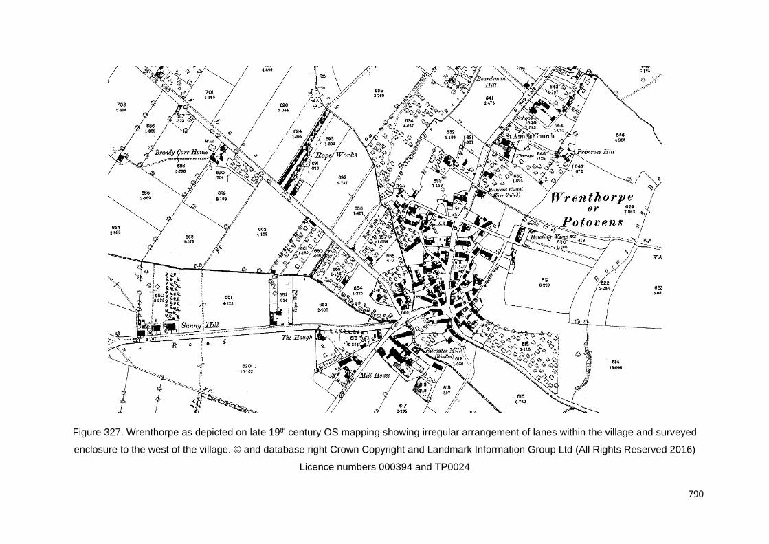
790
Figure 327. Wrenthorpe as depicted on late 19th century OS mapping showing irregular arrangement of lanes within the village and surveyed
enclosure to the west of the village. © and database right Crown Copyright and Landmark Information Group Ltd (All Rights Reserved 2016)
Licence numbers 000394 and TP0024

791
Figure 328. Zone map of Wrenthorpe’s historic settlement (not to scale)

792
Industrial Period development
The pottery industry remained in production until 1785 by which time the factory potteries of
Leeds and Rothwell rose to prominence. It was replaced by various small scale local industries
including coal mining, quarrying, rope making and textile manufactory. There are several
largescale quarries in the rural hinterland around Wrenthorpe. One of the largest is the disused
quarry on Brandy Carr Hill 800m to the northwest of the village. This quarry predated c.1850
(HLC_PK 41857).
Coal mining may have been occurring from the medeival period. Open cast mining in the late
1980s revealed several bell pits on the northern edge of the village
(www.wrenthorpecommunity.org.uk/informationhistory.php). Website accessed 23.08.2016).
This area may have formerly been common land. Mid-19th century mapping depicts several
coal pits in the Wrenthorpe locality. There were also two collieries of significant scale in the
19th century. Victoria Colliery was located 800m to the north of the village. This was a short
lived colliery which only appeared on late 19th century OS mapping and was already disused
by this time (HLC_PK 41375). The site now contains post-war housing. Wrenthorpe Colliery
appears to have been larger in scale and was located 1.3km to the southeast of the village.
The colliery operated from 1838 until 1927. This was an important local colliery. 1908 there
were 80 underground workers and 31 surface workers. Wrenthorpe colliery had a branch line
to the nearby main line from Leeds to London. Wrenthorpe colliery closed in 1927 at the same
time as New Low Laithes Colliery as a result of the General strike. The site now contains a
council depot and offices (HLC_PK 21679).
A rope works was located in fields 300m to the northwest of the village on late 19th century
mapping. Smaller rope walks were also present in other parts of the village. Calvert's Rope
Works was in operation between 1854 and 1892 and closed in 1962. Calvert's business
started in 1787 at other sites nearby. The site of the works is now a post 1990 housing estate
(HLC_PK 31455). The only other industry of significant scale in Wrenthorpe was Silcoates Mill
(woollen) which was in operation from the end of the 18th century until 1906. The site is now
playing fields (HLC_PK 40982).

793
Figure 329. Distribution of industry and communication features in the Wrenthorpe locality as
depicted on 19th century OS mapping
The character of Wrenthorpe on early 19th century mapping appears to be early industrial with
a sprawling arrangement of cottages and works shops in yard developments. It is known that
the owners of both the mill and rope works built cottages within the village. There may have
also been miners’ cottages in the village. Several short individual rows of cottages can be
identified on 19th century mapping both in the village and the rural hinterland (e.g. HLC_PK
40972). Wrenthorpe also gained a few villa status houses (e.g. HLC_PK 41416). Potovens
Lane formed a focal point of later development but it also occurred throughout the village. The
village also contains a number of small institutes from the Industrial Period. These include St
Anne’s Church dating to the mid to late 19th century (HLC_PK 41444). Adjacent to this was a
contemporary school (HLC_PK 41419). The village core probably underwent redevelopment
in the later industrial period with working class houses.
Of special interest to Wrenthorpe is Silcoates School located at mid-way point between the
village and nearby Alverthorpe village. The school site was originally Silcoates Hall dating to

794
c.1748. The first school was founded in 1820 by Congregationalists who bought the hall. Much
of the building was destroyed by fire in 1904 and was rebuilt (HLC_PK 21446).
Figure 330. Zone map of Wrenthorpe’s later Industrial Period development (not to scale)
20th century and beyond
Wrenthorpe Road today has a mixed character: part later Industrial Period workers’ housing
and part post-war suburb. Little remains with any vernacular character. The rear yard
developments also appear to have been redeveloped in the late 20th century. One or two
earlier cottages may stand in isolation subsumed by later housing.
Wrenthorpe now sits on the outer north western edge of the Wakefield urban conurbation.
Housing estates were built around Wrenthorpe in the Interwar period. In addition to some
piecemeal development, there are four notable, though still only medium, scale estates.

795
Coronation Street and Pacaholme Road to the west and south of the village were two estates
of semi-detached houses built in the 1930S in the geometric arrangement (HLC_PK 21441
and 22100). Single street developments of semi-detached houses of the same period also
occurred on Wrenthorpe Lane and Silcoates Lane to the west of the village with Ruskin
Avenue to the east (e.g. HLC_PK 22103 and 21436). The estates were generally built on
previously undeveloped land.
Post-war development filled in the gaps between the Interwar developments and occurred on
a larger scale forming a zone to the east and west of the village. The trend was for medium
scale development on previously undeveloped land. The two largest developmentS to the east
of the village were the Westways and Valley Drive estates built around the 1970s to early
1980s as mixed developments of semi-detached houses, short terraced rows and low-rise
flats (HLC_PK 21442). Lindale Mount, Sunny Hill and Queens Drive are estates of semi-
detached houses also built in the post-war period possibly as a continuation of the Interwar
development to the west of the village (HLC_PK 22105, 22106 and 22104). This zone also
contained some 1970s development such as Sunnyhill Croft (HLC_PK 31462). The estates
were accompanied by four new schools in the late 20th century: Wrenthorpe Primary School,
Pinderfields Hospital School, Jerry Clay Lane Junior and Infants’ School and Alverthorpe St
Paul's C of E Junior and Infants’ School (HLC_PK 41422, 41418, 31456 and 23069).
Post 1990 development is represented also by a few medium scale cul-de-sac developments
of detached and semi-detached houses. Thompson Drive, Cricketers’ Approach and
Woodside were built in the 1980s to early 1990s on previously undeveloped land to the
northwest of the village (HLC_PK 31436, 31437 and 31439). Thompson Drive formerly
contained a farm. to the west of Wrenthorpe are Sunny Hill Gardens, Silcoates Drive and
Harewood Drive (HLC_PK 41017, 22107 and 22101). Sunny Hill Gardens replaced earlier
villas, Silcoates Drive replaced playing fields and Harewood Drive was built on previously
undeveloped agricultural land.

796
Figure 331. Zone map of Wrenthorpe’s 20th century to recent urban development (not to
scale)
Rural hinterland
If Wrenthorpe had a medieval village high street and associated strip fields these are not
immediately apparent on historic OS mapping. The village in c.1850 rather had the
appearance of a common side settlement. The land to the immediate west, In the Jerry Clay
Lane area had fields boundaries which were long and straight, resembling surveyed enclosure
which suggests it was open land or common until the 18th or 19th century. The fields to the
east of the village were small and irregular in common with piecemeal enclosure or assarting.
The village centre now lies around 370m away from agricultural land to the west. This area
has seen some agglomeration of the surveyed enclosure but to less than 50%. There is a
large area of undeveloped LAND situated to the immediate east of Silcoates School which
contains relic field boundaries and is now crossed by semi-formal footpaths. The land is
entirely surrounded by houses but has managed to survive, by some accident, to the present,
undeveloped as urban green space.
Beyond the Jerry Clay Area further west the field boundaries are irregular suggesting
piecemeal enclosure. This area is historically known as Brandy Carr. There were two ancient
woods to the northwest of Wakefield, Brandy Carr and Outwood (see HLC_PK 20242). This

797
was common woodland connected to the Manor of Wakefield and was THE site of a wide
variety of agricultural and industrial practices, including foraging, quarrying, charcoal-burning,
ironstone mining, wood-working, and probably coal mining. Documentary sources indicate that
the wood was surrounded by a ditch and pale. The Brandy Carr area largely remains as
agricultural land though has seen some agglomeration (less than 50%) and is now crossed by
the M1 motorway.

798
4.3 Complex Urban Core Analysis

799
4.3.1 Castleford

800
Figure 332. Study
area zone map of
the Castleford
locality

801
Overview
Castleford is situated on the southern side of the River Aire, West Yorkshire, approximately
15km to the south-east of Leeds, and approximately 10km north-east of Wakefield. Castleford
was established as an urban district, in the administrative county of the West Riding of
Yorkshire in 1894, with an urban district council. Whitwood and Glass Houghton were added
to the district in the 1930s. The urban district was incorporated as a municipal borough in
1955. Following the Local Government Act 1972, the municipal borough was abolished on 1
April 1974, it then became an unparished area of the City of Wakefield, a metropolitan borough
in West Yorkshire. Castleford is now controlled by Wakefield Council. Three electoral wards
cover the town: Airedale and Ferry Fryston; Altofts and Whitwood; and Castleford Central and
Glass Houghton.
Castleford has a population of 40,210 (2011 census). Castleford has experienced population
growth since 2001 with current projections estimating continued population and household
growth within the wider Wakefield district. District population projections for 2008‐2033
estimate an additional 48,600 residents over 25 years (1,944 people per annum) with an
estimated 36,000 homes needed to meet this future demand, including within Castleford.
Castleford town centre is focused around the primary shopping area along Carlton Street
which is pedestrianised for most of its central length from Bridge Street car park in the east to
the cross roads at Bank Street and Station Road in the west. There is a covered shopping
centre, ‘Carlton Lanes’ and at the western end of this there is an indoor market which houses
approximately 70 stalls and is open Monday to Saturday. There is also an outdoor market on
Carlton Street which takes place four days a week. Immediately south of the town centre, and
running parallel with Carlton Street, is the railway with Castleford Station to the rear of the
main shopping area. The central bus station is situated off Albion Street at the western end of
the main shopping area.
Within the town centre there are a number of focal points including Henry Moor Square,
Castleford Bridge and All Saints’ Church as well a number of buildings of architectural merit.
Although there are some quality buildings in the town centre the urban grain is generally
fragmented due to site clearances that have taken place over time. The built form around the
edge of the town centre (along Aire Street and Bridge Street) in particular has been lost as it
has given way to a series of car parks to service the shops.

802
The Castleford area has a varied surface geology to the south bank of the River Aire,
comprising mixed sands with occasional embedded coal granules, overlying carboniferous
sandstones (Abramson et al. 1999, 1).
Prehistoric Period
Although the first settlement at Castleford was established by the Romans in the 1st century
AD, this was located within a landscape that had already been intensively exploited and settled
over the course of the previous millennia. The earliest evidence of activity from the Castleford
area comes from Ferry Fryston, Methley and Glass Houghton, where assemblages of flint
implements dating to the Mesolithic period have been discovered, which may represent the
site of temporary hunting camps.
The Neolithic period saw the gradual introduction of farming, as well as social and cultural
developments that lead to the construction of substantial ritual monuments within the
landscape. Evidence for settlement dating to the Neolithic is generally scarce, but sites at
Colton and Garforth, to the north of Castleford, have produced evidence for Neolithic
occupation. An important Neolithic ritual landscape has also been identified at Ferrybridge,
6km to the south-east of Castleford, at the centre of which lay a large circular henge
monument, comprising a bank and ditch. This became a focal point for ritual and funerary
activity into the Bronze Age, and continued to influence the settlement pattern in the immediate
area through the Iron Age (Roberts 2005).
By the Iron Age the Castleford area was densely farmed and settled, and the landscape
divided into an extensive pattern of fields between which ran trackways connecting individual
farmsteads. These farmsteads consist of one or more roundhouses, large circular buildings,
constructed of timber with a thatched roof, which would have provided accommodation, as
excavated at Methley and Whitwood (Roberts and Richardson 2002; Burgess and Roberts
2004). By the 1st century AD, Iron Age societies in Britain were divided into a number of tribes,
or tribal groupings. A large tribal grouping known as the Brigantes controlled much of what is
now northern England including the Castleford area.
Roman Period
In AD 43 the Romans invaded southern Britain, and the Brigantes became a Roman ally,
retaining their independence under their queen Cartimandua. In about 68 AD civil war between
factions within the Brigantes saw Cartimandua removed from power, and in 71 AD the Romans
moved north to occupy the Brigantian territory. A network of forts was established as the army

803
advanced, including a fort at Castleford, situated on a river crossing to control this strategic
point and allow supplies to be bought up river. Details for the Roman occupation at Castleford
are primarily taken from the three volume publication of the extensive archaeological
excavations of the 1970s and 1980s (Cool and Philo 1998; Abramson et al. 1999; Rush et al.
2000), unless otherwise stated.
The Roman forts
Figure 333. Plans of the Roman defences superimposed on a plan of modern Castleford
Excavations at Castleford have revealed the remains of two Roman forts dating to the late first
century AD, the earliest of which was in use from about AD 71 to AD 86. This first fort was
constructed on a terrace of ground on the southern side of a bend in the river Aire, which
provided a naturally defensive position from which a ford across the river could be controlled,
and traffic moving along the Roman road to its immediate west could be observed. This was
to become one of the main north-south routes through northern Britain during the Roman
period, and its line is followed by the modern A656 to the north and preserved through

804
Castleford by Welbeck Street and Beancroft Road. The fort may have initially functioned as a
seasonal campaign base during the AD 70s. Initially it may only have been fully occupied
during the winter months, and evidence from animal bone found within the fort suggests that
there was a spring cull of livestock prior to the unit moving out on campaign. Concentrations
of unwanted metal and leather off cuts found in a midden may also represent seasonal
cleaning of workshops. Some buildings within the first fort were also re-built a number of times
within a few years, also suggesting different distinct phases of occupation, perhaps by various
units with differing requirements. There is no definite evidence for which units were stationed
here, although evidence from stamped roof tiles suggests that the Fourth Cohort of Gauls may
have been present at some point.
Unfortunately, the defences of the first fort at Castleford have yet to be identified, making it
more difficult to determine the forts plan. Despite this, the remains of numerous buildings and
structures within the fort’s interior have been revealed, and a wide variety of objects and
material found within them provide extensive evidence for the activities which may have been
carried out within them.
A second fort at Castleford was constructed soon after the demolition of the first, in about AD
86. This new fort appears to have been on a different alignment to the first, and probably
covered a smaller area. Unlike the first fort, the alignment of the second fort’s defences has
been identified through archaeological excavation, which has shown that these formed a
rectangular circuit enclosing about 3.4 hectares (8.4 acres). This would have encompassed
land from Bradley Street in the east to Church Street in the west, and from Carlton Street in
the south to the northern side of the supermarket car park, to the south of Savile Road. The
fort would probably have had a gate in each of its sides, although evidence of only one has so
far been uncovered in Castleford, during excavations at the Wilson’s Yard site in 1981. There
is extensive evidence for the buildings which occupied the fort’s interior, the majority of which
would have been constructed primarily of timber, although in some cases resting on stone
foundations with tiled roofs. As in the first fort, the internal layout would have followed a
standard plan, at the centre of which was the headquarters building (principia), with the
commanding officers house (praetorium) next to it. The remains of two substantial granary
building have also been identified, measuring 8m wide by 25m long, as well as barrack blocks,
workshops and possible stables. The ground waterlogged ground conditions in the area has
meant that organic material including wood, leather and bone has survived in a well preserved
state in certain areas of the fort. To the north of the fort a defended annexe extended north
towards the river Aire, and included a bath-house and warehouses, and probably a wharf.

805
Figure 334. 1978 excavations of Castleford
Roman bath-house. Photograph © West
Yorkshire Historic Environment Record
The provision of bath houses was considered to be very important to the Roman military, apart
from their obvious role in cleanliness, they played an important role in exercise and providing
a place for off-duty soldiers to socialise. The bath houses were also frequently adopted by the
civil population for the same reasons, and are seen as a significant factor in the Romanisation
of the country. The bath-house at Castleford was initially used by the military but later, it was
also used by the civil population - the second fort was abandoned by the military in c.AD 100,
but archaeological evidence recovered during the excavation of the bath house, showed that
it continued to be used by the civil population of Castleford and passing military units until the
late-3rd or early-4th century AD. A variety of small finds were recovered from the bath house
including a gaming dice, bone counters for board games, a pair of epilation (hair removal)
forceps, and coins of various emperors, including Nero (54-68 AD), Vespasian (69-79 AD),
Trajan (98-117 AD), and Constantine (306-337 AD).
Extensive archaeological investigations of the Roman remains of Castleford were undertaken
by the West Yorkshire Archaeological Unit between 1974 and 1985. The location of the bath
house was first identified in a series of trial pits, prior to the demolition of a number of modern
buildings in 1978 and was subsequently investigated as a large, open-area rescue excavation.
Due to the quality of the archaeological survival, a decision was taken that the upstanding
features and floors should not be removed; consequently, information on the construction of

806
the bath house is incomplete and the pre bath house levels have not been revealed. The full
extent of the northern end of the bath house was not exposed during the excavation; however,
a sewer trench has since been cut in the surface of Aire Street, exposing the probable north-
west corner of the structure. On completion of the excavations in November 1978, the remains
were re-buried for protection. The remains of the building are preserved beneath a grassed
area at the junction of Church Street and Savile Road, and the plot has recently been given
Scheduled Ancient Monument status (Roman Bath House, Castleford – List Entry Number
1428421 Date Scheduled: 19th February 2016).
The Civilian Settlement (vicus)
Civilian occupation at Castleford began when a vicus, a civil settlement associated with a
Roman fort, was established in the AD 70s, soon after the construction of the first fort. The
vicus was probably focused to the south-west of the fort, along either side of the main north-
south road, although excavation has largely been limited to the western side of the road. As
the position of the fort’s defences are uncertain, it is also not always clear whether excavated
structures belong within the fort or are associated with civilian activity. The vicus would have
provided a range of commercial, industrial and recreational services to the garrison. Its
location on the river Aire and the main north-south road would also have provided possibilities
for wider trade and exchange, and it may also have acted as a staging post where
accommodation could be provided for travellers and horses could be rested. The vicus may
initially have been occupied by specialist craftsmen and traders, deliberately settled here by
the army. Indeed, the vicus appears to have been laid out to a deliberate plan, with rows of
narrow buildings constructed on regular sized plots to a standard layout, with their gable ends
fronting onto the main road. The remains of such buildings were discovered during excavation
to the north of Booth Street, with similar buildings identified to the south of Enterprise Way, to
the east of the proposed development site. These are likely to have combined both domestic
and industrial functions, acting as workshops for craftsmen or stores for traders. Between
Booth Street and Enterprise Way, there appears to have been an industrial area, comprising
workshops and stores, and a yard containing numerous hearths.
High quantities of military objects were also discovered here, including fragments of a helmet,
part of a belt buckle and scales from armour, suggesting that this area was being used to
repair, or re-smelt, metal and other items belonging to the garrison. Activity within the vicus
and the fort therefore appear to have been closely linked, which makes it difficult for
archaeologists to determine whether activity in some parts of the vicus was civilian or military,
or indeed, a combination of both.

807
The settlement appears to have been at its largest and most prosperous during the first half
of the second century, when substantial new timber and masonry buildings were constructed.
These included a mansio, or guest house, and a possible temple and/or market place. The
large quantities of high quality and luxury items discovered on archaeological excavations,
including imported tableware, glass, jewellery and finely produced sculpture, suggest that
during this period the settlement at Castleford became a highly Romanised and significant
centre. Objects manufactured in Roman Castleford included high quality enamelware items,
an example of which was a brooch found near Alford, Lincolnshire. This is decorated with two
panels of moulded letters surrounded by a background of blue enamel, and reads ‘Brooch
from Castleford’ - FIBULA EX REG LAGITIENSE (Tomlin and Hassall 2001, 396).
Later Roman period
During the 3rd century the character and the nature of activity within the settlement appears
to have changed, reflected in a marked reduction in finds of pottery, metalwork, coins and
other objects dateable to this period recovered from excavations. The buildings fronting onto
the western side of the main road were abandoned, with the substantial stone buildings appear
to have fallen into disrepair and disuse, with rubbish and debris accumulating on their floor
surfaces. At some point the walls of these buildings were demolished, and the stone removed
down to foundation level, presumably for re-use elsewhere. No new buildings were
constructed in their place, and this part of the settlement appears to have been permanently
abandoned for occupation.
At some time in the later 3rd century, civilian settlement appears to have been established in
the former fort area, and this was provided with a new defensive circuit. This comprised
parallel defensive ditches which ran north-south between Bradley Street and Bank Street, then
turned westwards cutting across the centre of the former second fort. By the late 4th century
evidence for occupation at Castleford becomes limited, and it is possible that the site was
largely abandoned by the early 5th century.
Post-Roman and Anglo-Saxon Periods
At the end of Roman rule this part of Yorkshire became part of the British kingdom of Elmet.
Elmet was one of a number of small independent kingdoms to emerge at the end of the Roman
period. Embracing the present West Riding of Yorkshire, the region, at the height of its powers,
is believed to have extended from the headwaters of the Humber, across to the Pennine
foothills in the west, with its southern border reaching to the banks of the River Sheaf (Sheaf
meaning boundary and from which Sheffield derives its name) and the River Don. High Melton-

808
in-Elmet lay just north of the River Don. The short lived British kingdom of Dunoting (Craven)
is believed to have formed the north-western boundary of Elmet.
Evidence of the one-time kingdom is relatively sparse, typical of Dark Age history, basically
deriving from interpretation of literary sources, place names and the limited archaeological
findings. The period was one of migration, settlement and the eventual colonisation by the
English speaking Anglo-Saxons of Germanic origin; one of the outcomes of which was the
renaming of the country to 'England - Land of the Angles'.
In the 6th century, the Anglo-Saxons occupying territory to the east of Elmet (the East Riding)
formed the kingdom of Deira, those to the north Bernicia, whilst the Angles of Mercia lay in the
south and Midlands. Elmet was then, for some time, at the forefront of British territory, forming
a bridgehead separating Angles of the Midlands from those occupying the Plain of York. It is
claimed that the westward expansion of the English was long delayed by the Britons of Elmet,
and it was not until the early part of the 7th century that the Angles were able to continue their
westward migration to settle in the valleys of the Aire and Wharfe. For a period Elmet was
sufficiently powerful to withstand Anglian pressure, whether from Deira, Bernicia or Mercia.
About AD 600, some 300 (or 363 - references quote both figures) nobles and warriors, and
foot soldiers drawn from numerous British regions, assembled at Edinburgh (the region of
Gododdin). This force attempted to recapture Catterick, and thereby prevent the merger of the
English kingdoms of Bernicia and Deira. The disastrous defeat of the British, who were
annihilated in the encounter, by the larger heathen force, is lamented in 'the Gododdin', an
elegy composed by the poet Aneirin. Thereafter, with its military power considerably
weakened, Elmet became isolated and more vulnerable; its fate virtually sealed when the
Angles of Deira and Bernicia united to form the powerful kingdom of Northumbria, which
extended its influence across the Pennines.
In Castleford, some occupation of limited continuing occupation is indicated by the discovery
of burials in the vicus area dating to the 5th or 6th centuries (Roberts, 2010). In the early 7th
century the Castleford area fell within the Anglo-Saxon Kingdom of Northumbria; being the
site of an important river crossing. However, the size and nature of any settlement is unclear.
The middle of the 10th century saw the final years of a power struggle between the Anglo-
Saxon kingdoms of what was soon to become England. By this time, Northumbria – essentially
the area between the Humber and the Firth of Forth – was the only one of the four kingdoms
not to have fallen under the control of the West Saxons, then led by King Eadred of Wessex;
instead, it was governed from York by rulers of Scandinavian origin.

809
The Castleford area does not feature in documentary sources until the mid-10th century, when
the Anglo-Saxon Chronicle records two events for the years 947 and 948. According to the
Anglo-Saxon Chronicle, in 947 Eadred came to Tanshelf, where Wulfstan, archbishop of York,
and all the councillors of the Northumbrians pledged themselves to the king. Very shortly
afterwards, they betrayed their oaths, and took the Norwegian Erik Bloodaxe as their king. In
948 Eadred ravaged Northumbria, and burnt down St Wilfrid's minster at Ripon. While Eadred
was on his way home, the army of York overtook him at Castleford and inflicted heavy losses.
This confrontation must have taken place somewhere on the north bank of the Aire, possibly
in the present-day Lock Lane area. This so enraged Eadred that he threatened to march back
into Northumbria and destroy it utterly, at which point the Northumbrians deserted Erik and
paid Eadred compensation.
The place-name Ceasterforda – ‘the fortress by the ford’ – contains none of the elements that
were so common in names from this period and which signified the presence of a settlement
or population: most likely all that stood in the vicinity of the river crossing were the remains of
Lagentium, which by that time would surely have disappeared, plundered for building
materials, if a post-Roman settlement of any consequence had either continued or had
subsequently developed prior to 948.
There is no archaeological evidence for Anglo-Saxon Castleford. It is assumed that the
settlement (and perhaps a fortification) continued to lie on the road leading to the ford
(Roberts, 2012). Such continuity is supported by the foundation of the church on the line of
the road in the 12th century, and it seems likely that the village will have had a very linear form
– with the church, churchyard and rectory complex occupying most of the western side of the
street, within an area defined by the earthworks of the last Roman defences, whilst the eastern
side being occupied by the villagers.
Medieval Period (11th to 16th century)
Reference to Castleford is conspicuous by its absence from the next written record of activity
in the area: the Domesday Book of 1086, which only identifies manors at (Glass) Houghton
(Hoctun), Wheldale (Queldale), Fryston (Friston) and Whitwood (Whitwode). This, however,
does not mean there was not a village in existence at this time, for Domesday is a taxation
assessment which records administrative areas – manors – rather than centres of population,
and in any one manor there was often more than one township or vill. Consequently there
could well have been a vill at Castleford, situated within one of these manors, most likely
Houghton, which later became known as the manor of Houghton-with-Castleford. In fact,
topographical and later historical evidence strongly suggests that this was the case.

810
Church of All Saints’ (HLC_PK 21234). Grade II Listed. The first mention of Castleford
Parish Church is in surviving sources between 1178 and 1184 when Henry II confirmed a grant
by Henry de Lacy to the hospital of St Lazarus in Jerusalem. However, the benefaction failed
to take place and the patronage remained with the de Lacy successors. Some 200 years later
it was restored by John of Gaunt, the Duke of Lancaster around 1370. Another restoration
took place between 1866 and 1868, the cost being met by public subscription and what was
to be the last Church Rate levied on the district. Thomas Davidson Bland was the principle
subscriber whilst the chancel restoration was paid for by his son-in-law and rector Reverend
Theophilus Barnes. On the 3rd. of June 1855, Reverend W.T.M. Sylvester was inducted as
Rector of Castleford where he remained until his death on the 9th of January, 1888. He played
an active part of the life of Castleford during this time, being Chairman of the Burial Board and
Glass Houghton School Board amongst others. A foundation stone of the new church was laid
on the 3rd of September 1866 and the rebuilding costs were £4500. After Reverend Sylvester
died a memorial fund was started and the proceeds were used for new bells. The surviving
Parish Registers date from 1653.
During the later medieval period there are references to a castle, corn mills and a ferry crossing
at Castleford, as well as the church, but the settlement probably remained small in size.
However, in many places any evidence for medieval settlement has been truncated by later,
often 19th-century, buildings (Roberts 2012).
Figure 335. Church
of All Saints,
Church Street,
Castleford
(HLC_PK 21234).
Grade II Listed.
Rebuilt in 1866-68.
© Copyright Betty
Longbottom and
licensed for reuse
under this Creative
Commons Licence.
http://www.geograph.org.uk/photo/2016946

811
Antiquarians of 16th to 18th centuries usually attributed all ancient remains in Castleford to
the Romans. John Leland and William Stukely were less certain though and thought some of
the earthworks and 'ancient enclosures' to the west and south of the church in particular, might
be later. They considered that these might have been associated with a castle or, as Leland
put, 'some Manor Place':
“… From Pontefract to Castelleford Village 2.Miles, most by enclosid Ground. One
shoid me there a Garth by the Chirch Yard, where many straung thingges of Fundations hath
be found: and he sayid that ther had beene a Castelle, but it was rather sum Manor Place …’
Parts of these areas were occupied by the Roman vicus, but only limited medieval activity has
been recorded through excavation.
The notion of lost earthworks representing a medieval castles or manor house is strengthened
by a documentary reference made between 1129-1140, which records a grant made to St
John's Priory by William Foliot (a local baron), of a carucate of land 'that lay before the castle
at Castleford'. This possibility of a castle site to south of the church is given support by some
18th century maps. A square feature called Castle Hill is marked just south of Castleford, on
the map of Yorkshire published in 1775 by Thomas Jefferys. It is in the area of Bean Croft
Field where Camden described frequent coin finds and Stukeley saw stone pavements and
foundations. Perhaps significantly, a copper alloy gilt brooch, of 10th-12th century date, and a
spindlewhorl, dating to between 1200-1485, have been found in this part of the town (Roberts
2012).
From c.1070 Ilbert de Lacy built a castle on the site of the royal manor of Tanshelf, from where
he controlled his new estates in what became the Honour of Pontefract. In c.1090 Robert de
Lacy founded the Priory of St John the Evangelist in Pontefract, which was granted extensive
lands in the Honour. The management of the Honour required good communications between
Pontefract and the administrative centres of Rothwell, Leeds, Kippax and Barwick. Although
there was a crossing on the River Aire at Ferrybridge, the old Roman road, crossing at the
Aire Castleford, was the quickest route to the western and northern parts of the Honour
(Roberts, 2012).
Landowners and administration
Until well into the 19th century and in all but a small number of long-established towns which
were run by their own corporations (Pontefract and Wakefield being local examples),
considerable power lay in the hands of the Church of England. This was especially so in

812
parishes such as Castleford, where the only centres of population were small villages of a few
hundred people – in this particular case the townships of Castleford itself and (Glass)
Houghton. Until government legislation began to change things from the early 1800s onwards,
the parish was, in effect, the local authority and was responsible for upkeep of roads and
bridges, maintaining law and order and dealing with poverty, as well as matters relating to the
church itself. Decisions on these affairs were made at so-called vestry meetings, in which only
the more prominent parishioners usually took part.
This was financed in two main ways. Firstly, there was the income from land which the church
owned, known as glebe land, and which it either cultivated itself or leased out to others.
Secondly, there was the ancient system of tithes, by which each villager was compelled to
hand over to the church a tenth of the produce of his or her landholding. As with the business
of tilling the village fields, each community had its own specific rules and customs on the
payment of tithes which had evolved over the centuries. For some of the land the description
gives clues as to its location, although most of it was scattered throughout the village fields in
small strips and enclosed plots. Although their location is impossible to define, nevertheless
many of them possessed evocative names typical of those applied to field divisions in
medieval times and which survived right to the end of Castleford as an agricultural community.
Settlement
Because the built-up area of Castleford did not expand very much until the second half of the
19th century, maps from immediately prior to that time show a village with a layout which had
changed little in hundreds of years. Among the most noticeable features are the long narrow
plots of land, known as crofts or tofts, running at right angles to the main street of the village
which, during the medieval period, were utilised as privately-cultivated smallholdings and
orchards behind a house facing on to the street. The majority of them run north-south, from
what is now Aire Street to a parallel ‘back lane’ – what became Carlton Street – though there
are also signs of similar plots running west-east from what is now Church Street. These latter
tofts are much shorter than the north-south plots, which suggests they were originally longer
but were cut across at their eastern ends by the north-south strips when these were laid out
at a later date. The streets were interconnected by ginnels and yards. Plot widths are often
narrow, reflecting medieval plots along the main streets. Vestiges of the former medieval
boundaries are fossilised within the current townscape – particularly plot boundaries along
Back Bank Street, Bank Street, Back Wesley Street and Wesley Street.

813
Figure 336. The 11th Century Village of Castleford is focused on the ford and lies within the
relict earthworks of the late Roman defences. A conjectured medieval earthwork castle is
situated to the south. By the 13th century, the village had expanded eastwards towards the
mills. This was followed by development of crofts to the south of Church Street (and Aire
Street) extending as far back to Back Lane (now Carlton Street)
This sequence of land division points to the earliest medieval settlement in Castleford being
focused on the old Roman road as it ran down to the ford, which seems a logical arrangement
if this road was still the main communication route at the time. However, at some point this
appears to have been superseded by the main street-back lane layout, an arrangement which
was very common across the Vale of York and East Riding of Yorkshire during the medieval
period, and is generally agreed by historians to represent a village which was carefully planned
and laid out by a local landowner, to bring together in one place the people needed to tend
the surrounding fields through co-operative effort. The position of the church at one end of the
grid pattern layout is also a characteristic planned village feature, added to which, until
sometime into the 19th century, Aire Street and its continuation round to Church Street were

814
known as High Road, while Carlton Street is named on several old maps and documents as
Back Lane.
When the planned village was laid out, it appears to have completely ignored the old Roman
road, cutting almost at random across its line and relegating it to the status of a minor track
leading into the village fields and no farther: in present-day terms following the line of Welbeck
Street, Beancroft Road and Barnes Road before petering out around the junction of Barnes
Road and Love Lane. The implication of this is that by the time the village was established,
the old Roman routeway had been superseded by roads reflecting new patterns of local
settlement and communications, leading to and from the administrative centre of Pontefract,
the markets there and at Wakefield, and the local Domesday settlements of Houghton,
Whitwood, Wheldale and Fryston – all converging on what was still an important river crossing.
Documentary records show that the method of crossing remained a ford at least into the
second half of the 12th century. Written evidence which might confirm this two-stage
development of the medieval village is contained in a deed of 1461, which refers to land in the
“old town” at Castleford, suggesting there was at that time still a differentiation between the
original focus of settlement around the church and Roman fort site, and a newer part of the
village based on the more recent main street-back lane layout.
If the evidence points to a late 11th century establishment of a planned village at Castleford,
what might have been the reason for doing so on that site? The most likely one arises from
the post-1066 division of territory which saw great tracts of land in Yorkshire allocated to the
de Lacy family, who established their baronial headquarters at Pontefract. The de Lacys would
have recognised the importance of the site for controlling access to and from Pontefract and
consequently would have wanted to establish a presence there, while the meadows of
Castleford Ings (the area between present-day Wheldon Road and the river) would have
provided much richer grazing land and winter livestock fodder than the higher ground and
thinner soil nearer Pontefract. To add to the location’s agricultural potential, 12th century
documents suggest that the river was an important source of fish, too, while it would not be
too long before the first of the mills, which have been a constant feature of the riverbank ever
since, was built.
Perhaps, too, the earlier settlement on the Roman road had fallen victim to the harrying of the
north, when William’s army swept across Yorkshire wreaking revenge for the defiance of the
old Northumbrian earls, who had killed his placeman Robert de Comines and captured the
stronghold of York: certainly, its position would have rendered it vulnerable. If so, then with its
strategic location, wealth of resources and the old community lying in ruins, Castleford

815
represented the ideal location to ‘start again’ with a planned medieval village. Whatever the
ultimate reason, this represented the beginning of almost 750 years’ unbroken settlement on
the site, leading directly to the Castleford of today.
Church Street East (leading to Aire Street) was probably not part of the very first village plan,
and may have been created in the 12th century to give access to the new mills at the weir.
The village core would have remained around the early 12th century church until the
establishment of a bridge to the east (in the vicinity of the present stone-built bridge. After
construction of the bridge, the focus of the village shifted eastwards; the medieval village
having adopted a Y-shape plan parallel to the river, between the church and the southern (or
Lower) mill (Roberts, 2012). It is possible that the 14th-century village did not extend further
than the southern mill – it is a distinct possibility that the village in the 14th century was
contained within an area defined by surviving earthworks of the late Roman defences.
Despite almost two centuries of relentless building, rebuilding and road widening, the basic
shape of its medieval layout can still be traced in the modern town. Church Street, Aire Street
and Bridge Street, albeit straightened in the 1970s, preserve the line of the old main street,
while Carlton Street precisely follows the course of the back lane. Likewise, streets such as
Bank Street, Sagar Street, Bradley Street and Wesley Street often follow the boundaries of
the former tofts, while late 19th century street plans show that the frontages of some of the
bigger buildings from that time still standing on the north side of Carlton Street are exactly the
width of the old plots on which they were built, providing a direct and visible link between the
village of the 11th century and the town of the 21st century.
Population and occupations
Castleford is not mentioned in the Domesday Book, but other historical documents refer to a
settlement called ‘Castreford’ (or ‘Castelforde’) in about 1130. From the Poll Tax of 1379, the
list of taxpayers for ‘Castelford’ suggests there were forty-two householders in Castleford
alone; some where a husband and wife were listed; others in which just one person was
named; several where adult children were living with their parents. The great majority paid
only the basic 4d tax and were probably among the humblest category of peasants, with few
possessions of any worth, who eked a subsistence standard of living from their strips of land
in the village fields, a few head of livestock and any surplus produce from their gardens. Seven
individuals or couples were assessed at 6d and just one couple, grocers John and Margaret
Otour, at the higher rate of 12d – although one Deonisius Ffyssh was listed as having a
servant, suggesting a degree of wealth, despite paying only 4d tax.

816
These higher-rate taxpayers were those who had a trade and were able to earn a living by
charging for their services. Their occupations were typical of those to be found in a small rural
community and included a small number of craftsmen serving the elementary needs of the
populace – two smiths and a wright (a general joiner rather than specifically a wheel builder)
– plus a salt dealer (salter) and a grocer (spicer). Castleford also possessed elements of a
rudimentary textile industry at this time, indicated by two weavers (websters) and a walker,
this latter title referring to someone who shrank and beat wet cloth as part of the fulling
process: there is known to have been a fulling mill on the river in 1372. The lengths of cloth
were then probably taken elsewhere, most likely via the markets at Wakefield or Pontefract,
for dyeing and finishing.
Those forty-two households equated to a population of 200-250 people at most when children
and elderly dependants are taken into account, although several factors need to be borne in
mind when considering this figure. For one thing, many more people are known to have
evaded the 1379 tax than they did its 1377 equivalent; for another, the poll taxes were levied
just thirty years after the Black Death had swept across the country reducing the population
by anything up to a half. This means the 1379 population of Castleford was, in reality, probably
more than 200 and, furthermore, that whatever the actual figure was, it was still substantially
less than it had been in the early years of the 14th century, before plague had added to the
losses already caused by a run of poor harvests in the second decade of the century. Taking
into account evasion, plague and starvation, it may be that Castleford’s population at its
medieval peak (c.1310) was up to twice the number implied in 1379 – and in common with
most of rural England, it would be many years before that level was reached again.
It should be noted that Castleford was then – and for at least another 500 years – one of two
separate villages within the parish of that name, with (Glass) Houghton being very much a
township of its own. The 1379 poll tax return lists fifty households in ‘Hogton’, again mainly
paying 4d, with the only listed occupations being two smiths, a wright, a webster and two
tailors: perhaps these latter made use of cloth produced down the hill in Castleford.
Houghton’s taxpayers were liable for a total of 17s 10d, whereas in Castleford the total was
two shillings less. By contrast, Pontefract, with its dozens of merchants, tailors, drapers,
ostlers, skinners, taverners, coopers and barbers, was liable for £14 8s 10d taxation.
The first references to coal mining in the district also date from the 13th and 14th centuries.
The earliest 13th century reference to coal mining (Carbone de Terro Fordiendo – literally
‘digging the carbon of the earth) relate to Pontefract and Featherstone. By the 14th century
mining was well established in most of the villages around Castleford, and in the 16th century

817
coal was being mined at Houghton. However, it was not until 1615 that there is definite
evidence for coal mining in Castleford itself century (Roberts, 2012). Many of the ‘old coal pits’
depicted on the Ordnance Survey 1st edition 6” map of 1852, particualrly surrounding Glass
Houghton, probably date to the 16th and 17th centuries.
Field systems
Figure 337. Field systems in Castleford (redrawn from Roberts, 2012)
Agricultural practice in medieval and pre-industrial Castleford followed that found in the
majority of lowland English communities, where the village fields were divided into arable for
growing crops, pasture for grazing livestock and meadow to provide winter fodder. Castleford’s
fields mostly lay to the south and east of the settlement: to the north, the river formed the
township limit; to the west, the boundary with Whitwood Mere (and Featherstone parish) lay
very close by – present-day Aketon Road follows its course, as does the footpath which
continues its line to the north across the railway footbridge behind Pauline Terrace and then
once ran through the former glass works site to emerge on Methley Road near the Shoulder
of Mutton. The eastern and southern boundary of the township ran from the River Aire at
Wheldale, south towards what is now Queen’s Park, then turned at an abrupt angle to head

818
in a generally south-westerly direction, crossing the present-day Pontefract Road near the
Magnet Hotel (where a boundary marker stone survives, half-hidden by a privet hedge), before
continuing on a more westerly course until it met the western boundary at Cutsyke.
Save for one intriguing 13th century reference mentioned later, no records have survived to
record directly how these fields were divided up between the villagers and worked in medieval
times – but in places where such documents do exist, they almost invariably show that
arrangements and practices seldom changed to any significant degree over the centuries.
This being so, it is safe to assume that Castleford’s fields of the 18th century (the earliest
period for which sufficiently detailed documents exist) and the rules and customs associated
with them at that time were much the same as had been in force since the village and its
surrounding agricultural landscape were established back in the late 11th century.
Castleford township covered 564 acres (c.228ha), of which around 500 (c.202ha) were
devoted to agriculture, the rest comprising orchards and gardens in and alongside the village
itself, plus small patches of marshland near the river. The majority – somewhere between two-
thirds and three-quarters – was given over to arable husbandry: this, in effect, being the land
required to grow sufficient food to allow the population to feed itself as well as meeting its
obligations to hand over a proportion to the church in the form of tithes. These were the classic
medieval strip fields with their long ploughed ridge-and-furrow strips, cultivated on the three-
field rotation system whereby in three successive years a field would first be sown with cereal
crops; then peas or beans; and finally left fallow for a year for the soil to regain fertility. Each
landholder was granted the same acreage of land, evenly distributed through the fields to
ensure everyone received equal proportions of more and less favourable soils to cultivate.
In the great majority of townships, this division and distribution of land was done on a purely
geographical basis. However, it may be that Castleford was one of a small number of villages
which used a system known as sun division, whereby land was shared out according to how
much, and at what time of day, it received sunlight: an agreement made in October 1226,
between landholders Walter and Cicely de Casterford and tenants Randle and Christian de
Casterford, referred to the half of the land “next the shade”. This method of land allocation
was also known by the Scandinavian name ‘solskifte’, which suggests it had been introduced
by the Danes who settled in Yorkshire in the 9th century.
Although a three-field crop rotation worked at its simplest if there were, indeed, three fields,
for many villages, especially in northern England, the arrangement was more complicated.
Castleford was a typical example of this more complex tendency and had five arable fields.
West Field (also known as Jane Ridge Field) covered the area from the western edge of the

819
village itself to the Castleford–Whitwood Mere boundary; Beancroft Field extended from the
‘back lane’ (now Carlton Street) on the southern edge of the village to the eastern half of the
Castleford - Glass Houghton township boundary; Roundhill Field lay further to the south of the
village up to the western half of the boundary with Houghton; Heald Field (the word heald
indicating a slope) was a smaller field in the south-eastern corner of the township, south of the
present Healdfield Road; and East Field was another small field adjoining the eastern edge of
the village bounded on its north by the River Aire and on its south by Heald Field, with the
present-day Eastfield Lane maintaining the line of the access road which cut across the middle
of this field. Other present-day roads which preserve links with the old village fields are
Beancroft Road – formerly Beancroft Field Lane, the track which led from the village into that
field – Roundhill Road, the line of which follows the northern boundary of Roundhill Field, and
Ridgefield Street, the western end of which looks as if it may coincide with the eastern edge
of Jane Ridge (or West) Field and suggests that land ownership at the time the 19th century
builder bought the plot still reflected centuries-old divisions.
The village pasture lay in the east of the township, beyond East Field Lane, and was bounded
to the north by Wheldale Lane (now Wheldon Road), to the south by Heald Field and to the
east by the Castleford–Water Fryston boundary. The meadow was in the north-eastern corner
of the township, between Wheldale Lane and the River Aire (effectively the area covered by
the former Hickson and Welch Chemical Works) in an area named Castleford Ings owing to
the frequency with which it flooded in wet conditions and in winter. The name and line of the
access road into the meadow is maintained by Green Lane, which runs north from Wheldon
Road just beyond the rugby ground.
Many documented medieval fieldnames, such as Les Longacres (1384), Half Acres (1592),
Red Hill (1579) and Houghton Carr (1589), cannot be identified, although le Mere (1413) is
probably Mire Field, and Halywelle (1263) could be High Field near Holywell Hill. One field
east of Castleford was called Broken Cros – possibly the site of a medieval cross marking the
boundary with Ferrybridge township (Roberts, 2012).

820
Figure 338. Extract from Paver’s 1812 ‘Plan of the Townships of Castleford and Houghton’
(West Yorkshire archives)
The fields were first mapped in 1752 by John Brierley, albeit rather schematically. Pavers’
1812 map provides a much better picture of likely medieval field arrangement, where
patchwork blocks of strips are shown. Some of these have a typical medieval reverse-S plan,
while plots to the south of Aire Street and to the west of Church Street are depicted as “crofts”
(dating to the 12th to 13th century). In 1812 the fields were essentially owned by just four
landowners, including the rector of Castleford (as Glebe land).
Fossilisation of fields systems in later character types
Longacre (see HLC_PK 18980). Medieval open or strip field system preserved in later
terraced housing. Unlike most terraces in Castleford and elsewhere, the row is far from
straight. The nearest half-dozen or so houses point slightly to the west, then the terrace curves
to the east, then towards the far end it curves back to the west again. On the Ordnance Survey
1st Edition 6” map of 1854, this area was still agricultural land comprising numerous small
fields or ‘closes’ of various shapes and sizes. These closes had been created by dividing up
and enclosing parcels of land from the medieval strip fields – in this case the former Roundhill
Field – and the houses of Longacre can be seen to have been built on the narrowest of three
side-by-side fields each with a distinctive double-curved shape (a reverse -‘S’). It appears that
a property developer or the builder bought this one field but it was too narrow to create a

821
straight row of houses plus front and back streets within its confines – so the line of the houses
had to follow the curvature of the field.
This reverse-S shape is a classic feature of medieval strip fields with their distinctive wide
ridges and furrows, which were created by the annual cultivation of the land by a one-man
horse or ox-drawn plough. As the plough approached each end of the field, the ploughman
would veer off to the left to give the animals more space to make the 180-degree turn before
heading back in the opposite direction, thus creating the reverse-S pattern of ridges and
furrows. These can still be seen in many fields which were converted from arable to pasture
at a time when open-field cultivation was still in force and which have not been ploughed since:
a couple of such fields survive within the Castleford boundaries at Methley Bridge Farm (see
HLC_PK 19908), between the Whitwood housing estate and the River Calder.
Figure 339. Longacre - fossilisation of earlier strip field boundaries in terraced housing dating
to the late 19th and early 20th century (© and database right Crown Copyright and
Landmark Information Group Ltd (All Rights Reserved 2016) Licence numbers 000394 and
TP0024)
Post-medieval Period to Industrial Revolution (c.1500 – c.1750)
Whilst the area of medieval Castleford expanded over the centuries, there was very little
population growth. The Hearth Tax Roll of 1666 reveals that there were still only forty-seven

822
households in Castleford, each having one hearth. The biggest house in Castleford at that
time was the rectory, which had six hearths (Roberts, 2012).
By the late 17th century Castleford was effectively two villages: one focused upon the church
and the mills; the other a ribbon development where the roads from Ferrybridge and Houghton
converged to cross the Aire (Roberts, 2012). Even by the late 18th century, the settlement at
Castleford was still little more than a small village of around six or seven hundred people
ranged along what are now Aire Street, Bridge Street and Church Street, plus a pottery in
Whitwood Mere and a few businesses alongside the canal, on what is now Lock Lane,
connected with water transport. It had a medieval parish church, half-a-dozen almshouses
(converted from a farmhouse) standing opposite, flour mills on both sides of the weir, the old
Ship Inn and the village lock-up by the bridge, and that was more-or-less the extent of what
was still essentially an agricultural community.
Castleford’s population increased steadily in the mid-18th to early 19th centuries as a range of
industries developed within the town – attracted to the region by its diverse and extensive
natural resources of coal, clay and sand. The growth of the town at this time was also facilitated
by the ability to transport both resources and goods along the Aire and Calder rivers (Taylor,
2003). One of the first industries to develop was the pottery works, with the first pottery opening
in 1724. Bricks, and coarse and fineware pottery were made by a number of potteries,
although Clokies and Hartleys survived into the 20th century. Glass manufacturing was also
an important Castleford industry that developed in the Glass Houghton region of Castleford
sometime in the late 1600s. The 17th century diarist Celia Fiennes, in her tour of West
Yorkshire in 1697, saw a glass house in Castleford, where she saw the flowing and annealing
of white glass:
“… all the Country is full of Coale and the pitts are so thick in the roade that it is
hazardous to travell for strangers” (sited in Morris, C. (ed). 1947. ‘The Journeys of
Celia Fiennes’, revised edition 1949. Cresset Press, London).
19th Century Expansion
In the middle of the 19th century, Castleford underwent a population explosion, as from near
and far people flocked to the one-time village, attracted by the prospect of work in its fast-
expanding bottle works and potteries. The population of 890 in the 1811 census (this being
the figure for the old township of Castleford, which did not include Whitwood Mere, Glass
Houghton or anywhere on the north bank of the River Aire) had jumped to 1,414 thirty years
later, reached 2,150 in 1851 and would total 3,876 by 1861. However, despite this sharp

823
population increase, the people were packed into very much the same ground area as had
been occupied a hundred years before.
Figure 340. 19th century population growth in Castleford Source: A Vison of Britain Through
Time
The rising population led to denser settlement and (for the labouring poor) increased
overcrowding, reflected in subdivision of houses, adaptation of non-domestic buildings,
development of cottage rows, and creation of cottage yards and courts at right angles to Aire
Street, Bridge Street and Church Street. Wade’s Yard, Powell’s Yard, Darling’s Yard, Phillip’s
Yard, Stead’s Yard, Johnson’s Yard and more were hidden behind the properties in which the
landlords might once have lived but which, by then, were more likely to be rented out to the
butchers, grocers, shoemakers and beer sellers whose numbers burgeoned as quickly as
those of their potential customers.
The first developments were of blind back houses built around the edges of yards, gardens
and small fields, their fronts facing each other across a small courtyard. As the adjacent
properties were similarly developed, the blind back houses became back-to-backs. Soon,
houses were deliberately built as back-to-backs, often by building clubs formed by groups of
workers. To increase the density many had additional dwellings for the poorest labourers in
the cellars. A single privy might serve an entire courtyard.
0
2000
4000
6000
8000
10000
12000
1801 1811 1821 1831 1841 1851 1881 1891 1901
19th Century Population Growth in Castleford

824
Figure 341. Plan of the Township of Castleford in 1850 (WYAS)
The houses themselves were cramped, often comprising no more than one living and one
sleeping room – at worst with only one room for both night and day use – and badly ventilated,
the majority with small windows on the side facing into a sunless yard but blank walls on the
other three sides, where the house abutted on to its neighbours on either side and behind.
Some had opening windows but in others there was no such facility: in either case it was
almost impossible to get a flow of air through the house. They had no water supply, no
drainage, no sanitation and nowhere to dispose of rubbish which could not be thrown on the
fire.
Outside, the conditions were even worse: some yards were paved but where they were not
the ground was merely a mixture of earth and ashes, and in all cases their drainage, if any,
was no more than a shallow gutter. Into this was thrown waste water which, if the land
happened to slope in the right direction, might run away to the street but, if not, was just as
likely to gather in a foul, stagnant pool in the lowest corner. Within the narrow confines of the
yards, often of necessity only a couple of feet from doors and windows, were crudely-built
wooden privies, shared by several families, and ashpits: low brick open-topped enclosures
into which were thrown not just ashes but food waste, floor sweepings and, indeed, any refuse
which was not burnt.

825
In a number of these yards, a shallow well or pump was sunk to supply drinking water – but in
too many cases the water was tainted. Some families collected rainwater in rooftop cisterns,
while many more relied upon water butts. As a last resort, especially in dry spells, there was
the river – but the clear stream of the early nineteenth century was increasingly polluted by
the waste products of the West Riding textile belt arriving via the River Calder, mingling with
pollutants produced by dozens of tanneries built alongside the Leeds tributaries of the Aire.
The river was also prone to flooding, which left foul water standing in cellars.
Out on the streets, the situation was little better. Road surfaces were the same mix of soil and
cinders as those of the yards, but often churned and rutted. There were no drains, simply
shallow trenches at each side of the road, their course frequently blocked by householders
infilling short sections to make causeways across to their premises, a practice especially
prevalent when wet weather left the gutters filled with filthy water. Behind the houses in the
yards on the west side of what became Bridge Street ran Willow Beck, but the tree-lined
stream of years gone by had become an open sewer where domestic waste was added to the
toxic liquid produced by a small coal gas works, which was set up on the south side of the
railway opposite the station (then located on what became Bridge Street) shortly after the line
had opened in 1840.
Such conditions were a breeding ground for ill-health and disease. Disease was endemic and
infant mortality ranked with that of the worst city slums, with 28% of all deaths in the town
between 1840 and 1849 being children under the age of one, a figure even worse than that
for Liverpool. However, few of the landowners and businessmen who might have had the
wherewithal to do anything about it considered the plight of the ‘labouring poor’ to be their
responsibility.
The inevitable consequence of this unpleasant state of affairs occurred in 1849, when cholera
broke out. The disease had struck Castleford before, in 1832, but this time, with hundreds
more houses and twice as many people packed more closely together, the consequences
were very much worse. The first cases were reported to the Board of Guardians by their
overseer for Castleford, John Wilton, in January and February, in response to which the board
posted notices on the doors of the parish church and the two Methodist chapels, urging anyone
“who had the slightest attack of Bowel Complaints” to report to the town surgeon, Dr. Adam
Jessop. Those who could afford to do so were expected to pay for whatever primitive treatment
Jessop could give, while in the case of the “necessitous poor” he was told to treat them for
free and submit his bill to the Guardians.

826
Shaken by their powerlessness to combat the root causes of cholera and more general ill-
health – and fearful of it striking again – the Board of Guardians sought outside help. In 1848,
Parliament had passed the Public Health Act, which gave existing town corporations powers
to raise rates for the improvement of water supplies, drainage and more general sanitation,
and allowed for the creation of Local Boards of Health to do the same in towns which otherwise
possessed little in the way of government institutions. This could either be done on the initiative
of the townspeople or, if the annual death rate was above 23 people per 1,000 population (in
Castleford it averaged 27 per 1,000 through the 1840s, with peaks of 34.5 in 1840 and a
terrible 40.6 in the cholera year of 1849), then a Local Board could be imposed upon a town.
The Public Health Act 1848 was the first serious attempt by Westminster to tackle the
problems of urban health which had been identified in several reports published in the 1840s.
During the second half of the century public health policy was hesitantly developed and
concentrated on cleaning up the environment in the expectation of bringing about a reduction
in deaths. At the same time, rising living standards and improved food supplies to the towns
brought about slight improvements in the dietary levels of the urban poor. A combination of
factors brought about a rapid decline in death-rates by the end of the 19th century, and a
further fall mainly attributable to changes in the pattern of infant mortality in the early period of
the 20th century.
On receiving advice from Whitehall, the Guardians called a meeting in January 1850 and
appointed “a committee of gentlemen” under the chairmanship of Theophilus Barnes to begin
the process of establishing a Local Board of Health for Castleford. The first necessary step
was to present a petition to Parliament, signed by at least one in ten of the township’s
ratepayers, requesting permission to set up a Board, for which the Guardians and
churchwardens charged with gathering signatures evidently found a receptive audience. The
petition, which is preserved in the Public Record Office, contains sixty-five names
encompassing the town’s chief industrialists, religious figures and landowners, including many
of the landlords whose names were lent to the squalid yards so many of the cholera victims
had perished.
By 1854, Castleford Local Board of Health was in its third year of jurisdiction over the town but
the inhabitants would have noticed little in the way of improvement in their surroundings. There
had been some attempt to tackle the most visible excesses through the enactment of local
byelaws relating to the cleaning of public streets and the regulation of butchers’ back-room
slaughterhouses, but the underlying ills of lack of drainage, dirty water supply and
overcrowding were no nearer being eliminated. It was only in the autumn of 1854 that work

827
started on the laying of sewers, the key to any serious attempt to clean up Castleford and
improve the health of its inhabitants. Main sewers were installed along Bridge Street, Carlton
Street, Church Street and Aire Street – still very much the only roads of any consequence in
the town – with a branch running along Wheldon Road to an underground collecting tank
(situated where the former Nestlé factory now stands) from where the sewage was pumped
into the River Aire. The people of Castleford would have to wait almost another seventeen
years before their unhealthy, erratic wells were, at last, supplemented by clean, running water.
Residential
As mentioned earlier, in the early to mid-19th century, much of Castleford’s workers housing
stock was supplied by landowners, private speculators and local industrialists. Housing
developments were located in very close proximity to places of employment – in the case of
Castleford, this was as near to the potteries and glasshouses as possible. Most of the houses
erected at the turn of the century were poorly constructed, back-to back and centered around
courts and alleys where dirt and rubbish accumulated. There was an absence of building land
on the perimeter of the existing town which raised the price of available land for development,
forcing speculative builders to reduce the quality of any development in order to make a profit.
Before 1848 there were no building regulations to stop the construction of substandard
houses. Both central and local government paid little attention to house building because this
problem was regarded as a matter for individuals.
In 1848, the Pontefract, Castleford and Knottingley Benefit Building Society was established
to allow working class people to save money to buy houses rather than rent from landlords.
The first houses built with its funds were ready for occupation in 1851. However, the main
factor governing a person's housing would be their economic situation, specifically how much
rent they could afford to pay and how much they were prepared to pay. Although it was
possible to buy houses through the building societies, for the majority of poorly paid workers,
this was not an option until well into the 20th century.
The two most important acts in shaping future housing policy nation-wide, were the Artisan's
and Labourer's Dwellings Act (Torrens) of 1868 and the Artisan's and Labourer's Improvement
Dwellings Act (Cross's) of 1875. The Torren's Act enabled local authorities to demolish small
groups of insanitary dwellings but made no provision for re-housing the displaced tenants. The
act had lost much of its effectiveness through Parliament but was another milestone in the
government's intervention in housing. The main objective was to give power to local authorities
for the demolition of individual houses. Under the act, the closure of unsuitable dwellings was
relatively easy, if somewhat slow. The Medical Officer would condemn those houses he felt

828
were uninhabitable and it was then for the Borough Engineer to inspect them and make a
recommendation for their demolition or repair to the Health Committee.
The Cross Act, after Richard Cross the Home Secretary, recognised that one of the
impediments to the effectual working of the 1868 Torren's Act had been the uselessness of
attacking slum areas in a piecemeal fashion and therefore allowed and encouraged slum
clearance on a larger scale, the purchase and demolition by the local authority of large areas
of 'unfit' property. However, it only paid lip-service to the notion of re-housing as a public
responsibility and conveyed the disapproval of government to such an idea. It was also a
permissive act, many of its clauses favouring the property owner's interest rather than that of
the tenant.
The population of Castleford tripled between 1851 and 1871, and tripled again in the
subsequent thirty years. The housing erected to cope with this explosion, although
architecturally undistinguished, can provide valuable information about how local people lived
with which to augment an understanding of how they worked. By 1890 local authorities could
build houses which were funded from rates (Housing of the Working Classes Act, 1890).
Through local authority control, the total number of houses in the town went from 4,231 in
1881, to 6,045 by 1901.1
Not all late 19th century workers housing was built by, or at the behest, of the local authority.
Private speculators, industrialist and industries (notably the mining industry) continued to build
housing; albeit often constrained by national building regulations effected through local
authority (Board) control. The Castleford Local Board of Health was particularly strict regarding
all new buildings, and demanded that plans for new-builds be submitted for their scrutiny and
approval. It meant that from that time on, all houses erected in Castleford had to be built to a
certain minimum standard. The Local Board were also required to ensure that there was
sufficient ventilation, within and around the houses; also that they were provided with a decent
water supply and adequate sewerage facilities. The planning records of the Castleford Local
Board, and the later Castleford Urban District Council, show that such powers were taken
seriously, and many original plans were rejected for breaches of the bye-laws on these
matters.
1 www.visionofbritain.org.uk/unit/10555164/cube/HOUSES

829
Residential Survival
Virtually all of Castleford’s late 18th to mid-19th century housing has been lost through later
19th and to mid-20th century redevelopment, slum clearance of the early 1900s through to the
late 1950s, and recent commercial developments of the 1950s to1970s. Of what survives,
much has been altered and adapted to commercial use.
No.78 Albion Street (within HLC_PK 21232) may be a rare survival of late 18th to early 19th
century cottage that is depicted on the Ordnance Survey 1st Edition 6” to the mile map of
1852. It is depicted as a smithy on the Ordnance Survey 1:500 Town Plan of Castleford (1890).
It has been much altered, and is currently a small shop. The surrounding dwellings and public
house were demolished in the 1980s, leaving the building in isolation.
Figure 342. Lion Yard, Aire Street, Castleford
©www.flickr.com/photos/camperman64/6570091691/in/album-72157628704122053/
Nos. 4, 14 and 22 Savile Road (within HLC_PK 21254) are three houses which are much
smaller than their late Victorian neighbours and set below the current road level. This suggests
that they are much older than the buildings around them, and may date to the mid-19th
century. A continuous row of cottages are depicted here on the Ordnance Survey 1:500 Town
Plan of Castleford (1890), the majority of which appear to have been demolished in the later
Victorian period.

830
Similarly, the vast majority of Castleford’s yard housing has been demolished, through slum
clearances of the late 19th and early 20th century. They were replaced by shops and pubs on
the road frontage, with commercial and small industrial premises behind, but many arched
yard entrances – ginnels in local dialect – were rebuilt in their previous positions to provide
access. Some of these remained until the late 1970s but were swept away when Aire Street
and Church Street were widened and straightened, leaving a ginnel into the former Lion Yard
as the only survivor (within HLC_PK 21298).
The West Yorkshire HLC did not record any extant plots of courtyard or back-to-back housing
in Castleford. In the town centre, the majority of housing had been cleared in the later 19th
century, while in other parts of the town it survived well into the 20th century. For instance, in
Whitwood Mere, courtyard and back-to-backs survived up until the mid-1950s before being
demolished and replaced with commercial warehousing and small-scale industry. However,
there is one survival of note on Marchant Street (within HLC_PK 21230, SE 42035 25820)
– a probable end of terrace "one up, one down" workers' cottage (perhaps comprising two
dwellings) which were thrown up by the hundred alongside the potteries and glassworks in
this part of the town in the middle of the 19th century. The building is depicted on the Ordnance
Survey 1:500 Town Plan of 1890, forming part of ‘Smithson Square’ on the later 1:2500 map
of 1950. The majority of buildings were demolished c.1952; perhaps this survived because it
had been converted to commercial use by then. People were attracted to the town to find
employment in the new mills and this period of urbanisation saw the population of the town
rise considerably. This increase necessitated the construction of workers’ housing, mostly in
the form of terraced and back-to-back dwellings, set on regular grid street patterns. They are
representative of a building style that dominated many 19th century towns. They are distinctive
to the region in that they are vernacular buildings constructed of local stone. The main period
of construction was 1864-1919, with the majority of the type constructed c.1890 to 1910. The
dominant housing type is generally standardised terraced property, although a distinct
hierarchy of building types can be discerned. This ranges from simple two–up-two-down
designs, through to large townhouses providing dedicated scullery kitchens, larders, entrance
hallways and bathrooms in addition to a small privately enclosed garden area. For the smaller
properties, it is common for there to be regular passageways between the houses, opening
on to communal yards that are shared between groups of the houses; this design has been
explained as a continuation of patterns established through the longer established tradition of
constructing domestic courts of back-to-back houses (Muthesius 1982).

831
Mid to late 19th century terraced housing can be found throughout the town, but the majority
is located away from the town centre, with distinct groupings to the west, southwest and
southeast of the commercial core. However, this distribution is more indicative of what terraced
housing survives through to the present day, rather than what was actually there – like much
of the former back-to-back housing stock, many terraced housing blocks were demolished
during slum clearance in the 1950s and 1960s, through to modern redevelopment.
Figure 343. Probable former mid-19th century workers’ cottage, Marchant Street, Castleford.
© www.flickr.com/photos/camperman64/6630109703/in/album-72157628704122053/
The earliest surviving example of mid to late terracing exists on Aire Street, dated to the
period 1869-79, but with earlier cottages incorporated (HLC_PK 21254). Terraced housing
dating to c.1860-80 can be found on Sagar Street and Carlton Street but much of this has
been converted into commercial use (see HLC_21246, PK 21250, 21251, and 21252) and
now forms the commercial core of Castleford. Later Victorian terraced housing can be found
to the east of Bridge Street and in the Maltkiln Lane area, possibly connected to the maltings
immediately north (HLC_PK 21243). Substantial block of 1870-80s terraced housing can be
found to the south of the railway line, centred on Robin Hood Street (HLC_PK 19048), and

832
either side of Middle Oxford Street (HLC_PK 19034 and 20428). Included in this group are
former terraced houses constructed along Beancroft Road that have been converted into
commercial use.
Nos. 3-11 King Street (HLC_PK 18933, WYHER PRN 9288). This terrace of houses were
built in c.1860/1870 and as they were located just near to the colliery they would have probably
housed mine workers. They are built of brick in a Flemish garden wall band (with every 6th
row of alternate headers and stretchers). There is a decorative band of yellow bricks at cill
level on the first floor, and at window lintel level on both ground and first floors. The roofs are
of thin grey slates and there are gutter brackets, each of two bricks. The sash windows have
two panes per sash; at the front they have stone cills and lintels, and are chamfered and at
the back they have brick vossouirs instead of stone lintels. The front doors have stone cills
and lintels and fanlights. The houses share a central stack; they have two living rooms and
two bedrooms, with three flues each. They measure (externally) c.4.5m width x c.8m deep.
They have rear yards with privies and coals. There is a straight-joint between them, suggesting
that No.3 was perhaps added to the terrace at a later date. The terrace is not depicted on the
Ordnance Survey 1:500 Town Plan of Castleford (1890) nor the later 1:2500 map of 1894.
Along Aketon Road is a linear development of over 80 houses dating to c.1870-80 (HLC_PK
20825). These lie adjacent to former malthouses (see HLC_PK 20935), although they could
have been built to serve any other the industries in the near vicinity (for instance the Hightown
Glass Works immediately north). Another distinct block of mid to later 19th century workers
terraced housing associated with industry (in this instance a pottery and glass works) is
located in Whitwood Mere, either side of Pottery Street (HLC_PK 21222). Much of the
housing here has been replaced by later housing blocks (dating to the period 1900 to 1920),
although the grain of the c.1870-80 housing can easily be defined.
The sinking of Wheldale Colliery in 1868 prompted the building of what was effectively a self-
contained community in streets to the north of Wheldon Lane between 1869 and 1878
(HLC_PK 20626), although many of the workers would have also been employed in the
nearby Higson and Welch Chemical Works (HLC_PK 20627). The community, comprising
blocks of terraced and back-to-back housing, was served by shops, public houses (the Early
Bath and The Wheldale), a school and two Nonconformist Chapels. The housing was
demolished between 1970 and 1983 during slum clearance of the area, with only the public
houses and two houses surviving. The plot has not been redeveloped and is currently derelict
land. Early 20th century housing to the south of Wheldon Road has survived (HLC_PK 20719
and 20717)

833
Towards the east of the town centre, on Queen Street (HLC_PK 20721), is a block of terraced
and semi-detached housing dating to the late 1880s to early 1890s (although much was been
replaced by later 1920s and 30s housing built on the same plot). The housing appears on the
Ordnance Survey 1:500 Town Plan of Castleford (1890), and must have had a direct
relationship with a former iron works at the end of the street (later to become Wheldale Mills,
or Bellamy’s Sweet Factory– see HLC_PK 20720 below). The northeast facing terraced block
at the end of Queen Street, and immediately outside the works’ entrance, has two plaques (in
the form of shields), which may shed light on the date of building and ownership.
There is good survival of late 19th and early 20th century grid-iron terraced housing centred
on Wilson Street (HLC_PK 21232). This housing block was sited (purposely?) in a parcel of
land to the west of the church, and immediately to the north of the many glass works that lined
Albion Street (namely, the Castleford Bottle Works, the York and North Midland Glass Works,
both Albion Glass Works sites, Ashton’s Glass Works and the Providence Pottery). The
houses are of similar build – being two-storey, through terraces, with rear gardens having
small outhouses (toilets and/or coal sheds). Many of the houses have plaques above the
entrance doorways (as possible datestones and/or place names - unfortunately
indecipherable). Although a direct link to the glass industry is unproven, it is likely that the
housing was established by the industries concerned.
Castleford town centre contains a number of large middle class detached, semi-detached and
terraced villa houses dating to the mid to late 19th century. Many of these were owned by local
businessmen and religious organisations. It appears that by the late 19th century, the
Castleford Wesleyans were a wealthy organisation, so much so that by the end of the 19th
century the whole area between the 1815 and 1859 chapels on the east side of Wesley Street
was covered by their property (within HLC_PK 21249 and 21251). Included in this group are
Lexmith Chambers (formerly Elms House – the home of Joshua Hornes mentioned above),
Wesley Villas, St Oswald’s House and Oak House (mentioned above). The 1841 Minister’s
House, on Sagar Street (within HLC_PK 21251) is depicted as Oak House on the Ordnance
Survey 1:500 Town Plan of Castleford (1890), and is now thought to be one of the oldest
buildings in Castleford town centre. It has been much altered and adapted to retail purposes
(second-hand shop).
The south side of Castleford, to either side of Beancroft Road, preserves a number of good,
relatively unaltered examples of ordinary 19th and 20th century housing, and is an area which
would almost certainly repay careful study.

834
Notable “lost” houses of Castleford include Redhill House, on the corner of Ferrybridge Road
and Healdfield Road (site – see HLC_PK 20917). It was built by Thomas Sykes, solicitor and
glass manufacturer in 1882. It was later the home of Sir John Austin, Baronet, M.P. for
Osgoldcross. Sir John sold the house in 1906 and during the First World War it was used to
house Belgian refugees. From 1918 the building was the headquarters of Castleford Urban
District Council and from 1955 was used as the Town Hall for the then new Castleford Borough
Council. The building was demolished in the early 1970s following the construction of the new
Civic Centre which opened in 1970.
Communications
For any study of the 19th and 20th centuries, Castleford would provide a good example of a
thriving small town with a wide mix of industries. In addition to this general interest, however,
Castleford was also a nationally significant focus for a small number of major industries – coal
mining, pottery production and, most notably, glass bottle manufacture. The reason for the
concentration of these industries in the area was probably two-fold. Most obvious is the
availability of raw materials in the area. Castleford stands in the middle of notable supplies of
clay, sand and coal. Less obvious, but probably of more importance when trying to explain the
concentration of production in Castleford rather than elsewhere in the immediate vicinity, is
the ready availability of access to a national transport system.
From the earliest times, Castleford provided a fording point across the River Aire. This ford
was eventually replaced by a bridge. The bridge at Castleford remains the only crossing of the
River Aire for five miles in either direction, and in the Post-Medieval and Industrial periods
provided an important link in the national north-south transport network. A seven-arched
wooden bridge of probable post-Medieval date is visible on a map of 1752. This bridge was
replaced by the present bridge constructed in stone in 1808 (see below).
At the beginning of the 18th century, Castleford gained access to a what was to become a
major east-west transport route. The Aire and Calder Navigation provided a link from the
Humber estuary first to Leeds in 1702 and then to Wakefield in 1703. Castleford’s position at
the confluence of the Rivers Aire and Calder placed the town where it could serve and be
served by either Wakefield or Leeds with equal ease, and put it at a crucial point on the route
between these cities and the coastal trade. The weir across the river posed initial problems,
but this was bypassed first by a small cut with lock to the north of the weir and eventually in
1826 by the ¾-mile-long New Cut. Canal transport had an outstanding advantage over road
travel, in that it enabled the cheap movement of bulky raw materials and the safe carriage of
fragile finished products over long distances – the latter feature proving of particular benefit to

835
the development of the pottery industry in the Castleford area. There is good survival of
remains of interest on the New Cut, although the locks themselves have been repeatedly
altered.
The Old Toll Office, Barnsdale Road (HLC_PK 14229, WYHER PRN 11744). At the west
end of the channel stands a lockhouse with toll offices of the 1830s/40s.
Castleford Cut (HLC_PK 20739, WYHER PRN 4947). At the centre of the cut, to the east of
the road bridge, can be seen a boatyard with wet dock which may retain evidence for earlier
canal facilities at this point. This section of canal was built as part of the improvements to the
Aire and Calder Navigation either in the 1780s or the 1820s designed, presumably, to cut off
the very sharp bend in the river at Castleford Ings. The Denholme Lock and the two flash locks
adjacent to the Island Cottages have been subject to 20th-century alteration, but the lock by
Castleford Lock Houses may retain original features.
Castleford Bridge (within HLC_PK 21240, 21241, and 21253. WYHER PRN 10966). Grade
II Listed Public road-bridge over River Calder. Dated on parapets; 1805, by Bernard Hartley,
and 1808 by Jesse Hartley. Constructed in sandstone ashlar in Classical style. The bridge is
identified as an important heritage asset by the Castleford and District Historical Society.
An additional strand in Castleford’s transport web was provided with the introduction of the
railway in 1840. Castleford first station, on Bridge Street, was built by the Yorkshire and North
Midland Railway (later the North Eastern Railway), and was one of the earliest to be built in
the county. This initial line, linking Normanton junction to York, was supplemented by links into
the Doncaster, Kippax and Garforth coal fields (by the NER and by the Lancashire and
Yorkshire Railway) in the 1850s and 1870s. Like the road system, the railway network is
particularly vulnerable to change and renewal, and the material remains of the line at
Castleford have been subject to substantial alteration over the course of the last 40 years.
The town’s first railway station on the York and North Midland Railway opened in 1840. It was
situated on land now occupied by maltings on Malt Kiln Lane (see HLC_PK 21242 below).
The earlier railway station was demolished by 1871. A replacement was built some 600m west
(site – see HLC_PK 21238, WYHER PRN 9807) in 1871. This building was demolished in the
late 1980s, and the site is now an unmanned halt. However, the relatively late signal box
visible where the line crosses Albion Street is a reminder that even the comparatively
mundane can be of interest. This form of signalling is now redundant, and some very early
signal boxes in the county are now under threat.

836
Industrial Buildings, Structures and Sites
The presence of a well-developed transport system must have been a strong influence in the
growth of pottery and glass manufacture in Castleford.
Pottery was produced in the area from the early 18th century, but a real explosion of production
began at the beginning of the 19th century. The sites of ten major potteries can be found within
a ½ mile radius of the town centre. The majority of sites produced coarse earthenware, pipe
and even bricks. The largest concentration of potteries was in the area to the southeast of
Whitwood Mere. Many of these had an apparently short life-span, with some being converted
into glass factories in the later 19th century. Sadly, only fragments of the industry remain,
although all of the known sites can be located with accuracy.
Figure 344. David Dunderdale's
Castleford Pottery (HLC_PK 21223)
established in 1790, through to Clokie
& Co which closed in 1961. The
remaining buildings date from the mid-
19th century, the piles of coal mark the
site of one of the cone ovens. Now
mixed commercial and industrial use
(including a coal depot). © Copyright
David Pickersgill and licensed for
reuse under this Creative Commons
Licence.
www.geograph.org.uk/photo/579509
Of these, perhaps the best known is the aptly named Castleford Pottery (HLC_PK 21223,
WYHER PRN 21223). The site’s kilns have long since been demolished, but a number of
outbuildings associated with production can still be seen. The Castleford Pottery was
established by David Dunderdale in 1790 in the premises of an existing pottery. Dunderdale
and similar manufacturers imported flint and fine clays into the area via the canal for the

837
fabrication of fine tablewares. These were initially produced for export to America and some
parts of Europe, with the market shifting to a domestic one after the Napoleonic War of the
early 1800s closed access to European markets. Pre-1821 pottery includes creamware,
felspathic stoneware, black basalt, dip-decorated earthenware. In 1821 this pottery was sold
as a number of smaller units which began to operate as individual potteries (Griffin. 2012.
p.176-178). These are known as the Mere Potteries 1, 2 and 3 (Lawrence. 1974. p.170-172).
Post-1821 the factory produced domestic white earthenware, which was often printed. Much
of the pottery produced here was in the same or similar style to the nearby Leeds pottery
(Lawrence. 1974. p.166-167). The complex closed as a pottery in 1961, with the site converted
into a ‘works’ (a depot and, presumably, some engineering). Buildings on site in the early
1960s are still partly extant on the most recent Ordnance Survey 1:10,000 map (1996), and
may contain remnants of earlier features. In 2005 trial trenches were dug on the site (WYHER
PRN 9849) which uncovered a number of buildings, together with their associated floor
surfaces, and numerous dump deposits, kiln furniture and pottery fragments were also found.
The site is currently in mixed industrial and commercial use (including a coal depot).
Albion Pottery (site – HLC_PK 21229, WYHER PRN 4443). Pottery established in 1867. In
production though to the late 1890s. Became the Albion Works by 1908 (activity unknown).
By 1933, part of the Black Flagg Works (furniture). The majority of buildings here appear to
date to the period 1894 to 1908, although parts of the earlier pottery may survive. Now mixed
industrial and commercial use (as part of the Raglan Industrial Estate).
Victoria Pottery (site – within HLC_PK 21222). Small pottery (and associated outbuildings)
depicted on the Ordnance Survey 1:2500 and 1:10560 maps of 1894. Probably established in
the period 1860-80. Gone by the Ordnance Survey 3rd Edition map of 1908. Area is now
terraced housing (built in 1903) and allotment gardens.
Britannia Flint Mills (site – see HLC_PK 21222). Probable flint grinding mill located towards
the extreme northwest of the HLC polygon, adjacent to the old course of the River Calder.
Established in the 1860s to 1880s. Depicted on the Ordnance Survey 2nd and 3rd Edition
maps of 1894 and 1908. Demolished by 1932 (Ordnance Survey 1:2500 map of 1932). The
site has remained undeveloped (derelict land).
Calder Potteries (site –see HLC_PK 21222, WYHER PRN 4447). Calder Potteries,
Whitwood Mere. Extant by 1857, disused c.1880. No known pieces or marks, although it is
likely that white earthenware was produced (Lawrence. 1974, p.176). The former pottery
buildings are depicted as the ‘Calder Chemical Works’ on the Ordnance Survey 2nd Edition

838
6” to the mile map of 1894, but apparently gone by the subsequent 3rd Edition map of 1908.
Now terraced housing - area redeveloped in the period 1908 to 1922 (probably c.1910-15).
Russell’s Pottery (site – see HLC_PK 21228, WYHER PRN 4440). Earliest potttery in the
Castleford area; probably in use from the 1720s for the production of brick and tile, with an
element of pottery production from the 1770s. Known to have produced coarseware,
principally stoneware. Confusingly depicted as Mere Pottery on the Ordnance Survey 1st
Edition 6” map of 1852, and as Castleford Pottery on the later 1890 Ordnance Survey 1:500
Town Plan of Castleford. Possibly associated with the nearby Victoria Clay Works which lay
immediately south (see HLC_PK 20804). The north-eastern part of the complex was
developed as terraced housing in the early 20th century. The area still marked as a pottery on
the 1: 2500 OS edition of the early 1950s. By the Ordnance Survey 1:2500 map of 1961, the
buildings had been converted into warehouses and industrial works. The buildings were
demolished in the 1980s, being replaced by modern industrial buildings.
Victoria Clay Works (site – see HLC_PK 20804, WYHER PRN 12144). The clay works were
established in 1862 by George Turner Taylor and Joshua Hartley on the south side of Methley
Road (Lawrence, 1974. p.181). The site included both a brickworks and a pottery and both
wares were transported by rail and canal directly from the site (Wilders, 2003. p.16) In 1899
the nearby Russell's Pottery (WYHER PRN 4440) was bought and incorporated into the
Victoria Clay works. Prior to this Russell's had been introducing new technology including oil
lamps and a second hand steam engine (Griffin, 2012. p.205). In the 1930s electrical lighting
was installed as well as gas fired ovens and a gas-fired enamelling kiln. The 1950s saw the
business begin to decline and the demand for decorative pottery could not be sufficiently met.
The site was refitted and modernised in 1960 but closed later that same year. The brick making
side of the business continued however with a new brick making plant installed in 1965/6. By
the late 60s however the local clay had run out and the cost of transportation was too high and
the firm closed entirely in 1969. The works produced Black earthenware, Stoneware,
firebricks, sanitary pipes (Lawrence, 1974. p.181), chimney tops, Terra Cotta, red bricks, pan
tiles, drain tiles, ridge tiles as well as red, blue and brown Staffordshire goods (Griffin, 2012.
p.204). In the 1950 some decorative ware was produced (Lawrence, 1974. p.181). The
processes, material and equipment that were used on the site are explored in detail by Wilders
(2003), for the bricks (p.27-38) and pots (p.39-109). Examples of wares and marks can be
found in both Griffin (2012. p.205-208) and Wilders (2003. p.99 -117). The site is not shown
on the 1854 1st edition Ordnance Survey 1st Edition 6" to 1 mile sheet 234. The Ordnance
Survey 2nd Edition 6" to 1 mile map (sheet 234 NW) shows the site on the 1894, 1908 and
1948 maps. The site is marked as "Black & Stone Ware Works" on all maps with the addition

839
of "Clay Works" in 1908 and "Victoria Clay Works" in 1948. The factory buildings, located to
the north of the polygon (adjacent to Russell’s Pottery), appear to have been converted into a
‘works’ by the mid-1970s, with the former clay extraction pits to the south left as derelict land.
As of 2013 the site was covered by a foundry and the warehouse of a distribution centre along
with its lorry yard (Google Earth, 2013).
Harling's Pottery, Whitwood Mere (site – see HLC_PK 21226 and 19966, WYHER PRN
4444). Established 1852, still in business 1943, appears as working pottery on OS 1:2500 map
of 1957. Wares: blackware and stoneware, subsequently earthenware. Buildings demolished
in the early 1980s. The site is occupied by a modern foundry to the south, and a later 1990s
industrial park (Methley Road Industrial Park). The former clay pits (HLC_PK 19966) located
immediately south became disused in the early 1950s, the site is mostly derelict land (part
occupied by a caravan storage park established c.2000).
Eleven Acres Pottery (site – see HLC_PK 20425, WYHER PRN 4445). Owned by John and
Robert Robinson, in operation between 1887 and 1898. In 1898 the Robinson Brothers
partnership was dissolved by mutual consent. Continued as John Robinson and Sons until
1915. Produced salt-glaze and Bristol ware. Area cleared by 1920, then redeveloped as
terraced housing.
Bateson’s Pottery (site – see HLC_PK 20803, WYHER PRN 4439). Established 1823, still
in production 1855. Converted into a glass bottle factory by the Ordnance Survey 1:500 Town
Plan of Castleford (1890).
Eagle Pottery (site – see HLC_PK 20820, WYHER PRN 5116). Built 1853 and worked by
Hugh Macdowall in the 1860s. By 1878 converted to a small bottle glass works, owned by
Hardy and Richard. By 1890, part of the Aire and Calder Bottle Works. Excavations in Welbeck
Street in the early 1970s unearthed wasters that may be related to the Eagle Pottery, including
printed and painted glazed and unglazed white earthenware. All buildings apparently
demolished by 1948, the area was left derelict until redevelopment in the 1990s. The site is
now occupied by Castleford Retail Park.
Garrett and Fletcher's Pottery (site- see HLC_PK 21243 WYHER PRN 4437). Area of
archaeological interest defined by position of pottery marked on 1st Edition 6" OS map 234
(surveyed 1846-8). By 1844 the site included two large kilns for making black and stonewares,
fire bricks, etc., with a separate warehouse and store rooms. Good beds of clay for bottles and
fire bricks were found on the premises. Site was still occupied in 1862. No known examples

840
of wares, but probably producing blackware, stoneware, firebricks. The site appears to have
been cleared by 1894, and redeveloped as terraced housing.
Providence Pottery (site – see HLC_PK 20803, WYHER 4442). Established by 1858.
Occupied by William Gill and Sons in 1880. Produced domestic white and printed
earthenware. In production until 1932 (the buildings are depicted as Providence Pottery on
the Ordnance Survey 1:2500 map of 1933). Became absorbed into the Albion Boiler Works in
the later 1950s. Now part of the Acorn Industrial Estate. Some early fabric may remain.
19th-century glass production initially grew up in the same vicinity as the potteries. It is a
peculiarity of the two industries that they are often intertwined, with glassworks growing up
adjacent to or within potteries. It is likely that the bottle-shaped pot kilns, or hovels, were
particularly suitable for conversion to glass cones. The earliest glass manufacture in the area
is documented in Glass Houghton, to the south of Castleford, from the late 17th century. The
site lay to south of School Lane, to the west of Glass Houghton village (HLC_PK 18110). It is
believed that the glassworks was established by at least 1696 and continued into the early
18th century. A 'Glass House' is illustrated, with a glass cone, on an 18th-century estate plan
(Brierly 1752). By the mid-18th century the coal supply for the glassworks failed, a visitor in
1750 noting that 'in the hill above the town there were formerly great coal works and a glass
house, but the coal failing, the glass manufacturer was discontinued'. By 1846-48, a Wesleyan
Methodist Chapel had been built upon the site. The field to the immediate west of the chapel
was known as Glass Garth as late as 1969 (Ordnance Survey 1:2500 map of 1969, Sheet
4324).
The first glassworks established in Castleford proper was founded in 1829 by a company
initially styled Jepson and Co. The first glass cone (in production by 1832) was christened
‘Who could have thought it’ by the firm, perhaps as a tribute to their own audacity at founding
a ‘modern’ glassworks in the town.
The industry grew very quickly – by the 1880s, there were 10 major glassworks in and around
Castleford town centre. The majority of glass-production sites were located near the railway
goods yard to the west of the station (SE 424 253) – in the late 19th century, almost 20
separate glass cones lay to either side of Albion Street. The most notable outlier was the
Ryebread Works, located to the west of the current site of the Hickson and Welch Chemical
Works (HLC_PK 20623). The concentration of works in the area around the railway – and the
names of some of the companies (Lumb and Co. were also known as the York and North
Midland; Ashton’s was also called the North Eastern Works) – amply illustrate the dependence
of the industry on rail transport.

841
The Castleford glassworks produced glass bottles almost exclusively, and almost 80% of the
workers employed nationally in the industry by the end of the 19th century worked in the town.
By 1834 the Aire and Calder Glass and Bottle Company employed 1000 men, and Castleford
became an important transport hub linking the river and road, and from 1840, the railway. This
also led to increased coal extraction and the expansion of the chemical industry, and the
town’s population increased to over 17,000 by 1901.
Production in 1890 (after the introduction of semi-automatic blowing methods) is said to have
been in the region of 200 million bottles annually, mainly for export. Castleford was also a
major centre in the unionization of the industry’s workforce. Bottle production declined over
the course of the 20th century, and ceased altogether with the closure of United Glass in the
early 1980s.
As with Castleford’s potteries, the sites of the glassworks are known with a high degree of
accuracy but little appears to remain above ground. Some sites along Albion Street contain
19th century buildings which may repay examination. Surviving sites in Ferrybridge may
provide useful parallels.
Aire and Calder Bottle Works (site – see HLC_PK 20623, WYHER PRN 6816). A firm,
styled Winterbottom & Jessop, purchased four acres of land at Ryebread Hill from Lord
Houghton in 1834 and erected the Ryebread Glass Works. Edgar Breffit acquired the business
in 1844 and renamed it Breffit’s Glass Works.2 Edgar Breffitt was the first chairman of the
Castleford Local Board of Health, the forerunner to the town council. After experiencing
difficulties for three years Breffitts closed in 1926. In its final form, the works had four furnaces
and three pot-shops. By 1868 E. Breffit & Co. had become the proprietors of the Aire and
Calder Glass Bottle Works (Toulouse 1971, p.79). Toulouse stated that “the official name of
the factory itself became the Aire and Calder Glass Bottle Works, thus fixing its position near
the junction of these two rivers and the Aire Canal, only a couple of miles northwest of
Castleford. In 1873, the firm advertised under both the Breffit and Aire & Calder names. By
1884, Edgar Breffit & Co. had become a limited liability company (Ltd. or Ld.). The plant was
operating five machines by 1907. Breffit became part of United Glass Bottle Mfg. Co., Ltd., on
March 31, 1913, although the firm retained its own identity until 1921 (Lunn 1981, p8; Turner
1938, p255; von Mechow 2015). Cannington, Shaw & Co., Nuttal & Co., Alfred Alexander &
Co., and Robert Candlish & Son, Ltd. combined in 1913 to form the United Glass Bottle
2 https://sha.org/bottle/pdffiles/EdgarBreffit&Co.pdf

842
Manufacturers, Ltd., and Breffit joined later that year.3 The glassworks closed in 1926, and a
Tarmacadam works was built on the site (The Borough of Castleford 2011). In around 1970
the adjacent Hickson and Welch Chemical Works expanded onto this site. This area became
derelict in 2005 following the closure and demolition of the chemical works (Wakefield Council
2013).
Black Flagg Glassworks (site – see HLC_PK 21229, WYHER PRN 4436). Originally called
the `Who Could Have Thought It'. First bottle manufactory in the Whitwood/Castleford area.
Established on the site of an old pewter works by Jepson and Co. in 1829; two cones in
operation by 1832. In operation as glassworks (primarily manufacturing small bottles) until
1924. Worked by Jepson and Co. from 1829 to c.1850, the Breffit family between c.1850 and
1890, and Peacock and Sons between 1890 and 1924. The site was abandoned after 1924,
and lay derelict for over 20 years. Eventually re-used in the early 1950s by a furniture
manufacturing company Depicted as the Black Flagg Works (Furniture) on the Ordnance
Survey 1:2500 map of 1950. Aerial images from Bing Maps in 2010 show that the site is now
overbuilt and used as industrial warehousing/forecourt.
York and North Midland Glass Works (site – see HLC_PK 20820 and 20805, WYHER PRN
5114). Established 1842 by Lumb and Simpson. The site of the first glass house was the
corner pieces of land at the entrance of what is now the railway goods yard. Later the works
was extended to the other side of the road where there were eventually five pot shops, but the
New Yard was sold off when Lumb split with Simpson in 1850. Of the original glasshouse
(HLC_PK 20820), the majority of buildings appear to have been demolished by 1948, with a
few former workshops and chimneys remaining. The area was left derelict until redevelopment
in the late 1980s. The site is now occupied by Castleford Retail Park. The later glass works,
to the north of Albion Road (HLC_PK 20805), appears to have been demolished sometime
between 1908 and 1933, being and replaced by a woollen mill. However, the mill is depicted
as ‘disused’ on the Ordnance Survey 1:2500 map of 1933. Now a large-scale clothing factory
(now Burberry’s – see below). Some original building fabric may survive.
Calder Glass Works (site – see HLC_PK 21222). The glassworks site is depicted on the
Ordnance Survey 1:500 Town Plan of Castleford (1890) and the later 1:2500 map of 1893,
comprising two pot houses and a group of ancillary buildings. Established probably c.1860-
80. These were demolished soon after as they do not appear on the subsequent map of 1908.
Terraced housing was built on the site in the period 1908 to 1922.
3 www.sha.org/bottle/pdffiles/EdgarBreffit&Co.pdf

843
Hightown Glassworks (site – see HLC_PK 20932, WYHER PRN 5113). The glassworks
were established c.1852 for the manufacture of glass bottles, part of a growing bottle glass
industry in Castleford. The original glasshouse operated for some twenty years, changing
hands a number of times until its abandonment and demolition, to be replaced by the Albion
Brickworks, sometime around 1874. By 1878 a Hoffman kiln had been built to fire bricks. The
brickworks continued to operate on the site until 1902 when Hightown was bought by John
Lumb and Co., who constructed as gas-fired regenerative glass furnace, marking the second
phase of glass making at the site which saw the introduction of first semi, and then fully,
automated production. By 1905 Lumb’s had become a limited company and was operating
under the name of John Lumb and Co. Ltd. Lumbs retained ownership until 1937 when the
company was bought up by the United Glass Bottles (UGB) UGB continued to manufacture
bottles at Hightown until the site’s final closure in 1985 (Gardner 2009). During November and
December 2006 MAP Archaeological Consultancy undertook an archaeological evaluation on
the site of the former Hightown Glassworks in Castleford in advance of a proposed housing
development. Glass production had ceased on the site in the 1980s but the remains of some
of the former glassworks’ buildings were still extant. The work consisted of the excavation of
four evaluation trenches. A large amount of product was recovered during the excavations
providing a fascinating insight into the tastes of the local population and markets abroad,
namely the USA during the period of prohibition. All buildings were demolished before 2008
and the site is now a modern housing development (Millers Croft).
Ashton’s Glasshouse (site – see HLC_PK, WYHER PRN 6749). Ashton's Glassworks (aka
North Eastern Works) was established around 1857 on Albion Street, Castleford by Joseph
Ashton. The original pair of four-pot houses replaced late 19th-century by large tank furnaces.
Albion Glass Works (site – see HLC_PK 20820 and 20821, WYHER PRN 5115). In the last
decades of the 19th century this was the site of one of two bottle works, owned by Sykes
Macvay & Co, both of which were named the Albion Glass Works (the other was on a site
further along Albion Street close by the railway crossing, currently the home of CBR
Engineering and previously part of the United Glass / John Lumb & Co plant). The Albion
Glass Works was founded by George Bradley, and sold to T.R. Sykes and W.W. Macvay in
1864. In 1875 the first tank furnace in Castleford was constructed. By this time the eastern
side of the site had also been laid out to provide terrace housing for workers along Wainwright
Yard and Wainwright Street. A second yard was added in 1879 including two four-pot and six
two-pot houses. In 1890 the world’s first bottle-moulding machine, patented by Ferrybridge
iron foundry owner H M Ashley and Josiah Arnall four years previously, went into production
at one of the Albion Glass Works sites, revolutionising the manufacture and use of bottles by

844
eliminating the manual blowing of glass and allowing a threaded neck to be created for use
with a screw top. The so-called ‘plank machine’ could produce bottles at ten times the rate of
a five-man team of glassblowers, meaning Castleford – and perhaps this site – led the world
in transforming bottle-making from manual operation to the industrial process it remains today.
An amalgamation with the Codd Co. in the 1880s gave them patent rights to manufacture the
‘Codd’ bottle. The works were sold to the Ashley Patent Bottle Co., who rebuilt some shops,
but went out of business in 1894, when all glass houses were demolished. Part of the site was
developed into Castleford Bus Station in the 1960s. The terraced houses continued to survive
on the bus station site until the second half of the 20th century, but its western half remained
largely open, as a series of yards to buildings fronting onto Albion Street to the north-west.
In 2013 Wessex Archaeology were commissioned by Metro to undertake a programme of
archaeological evaluation at Castleford Bus Station prior to its re-development. A desk-based
assessment, which had already been carried out by Archaeological Services WYAS in October
2012 identified that the development site was located within the known area of the Roman
vicus of Castleford (WYHER PRN 2240), and that from the 1850s to 1890s the site was
occupied by the Albion Glass Works and contemporary housing/workshops (WYHER PRN
5115). Historical mapping shows that the site remained largely undeveloped until the early
19th century, by which time as number of buildings, possibly houses, were constructed
towards the eastern end of the bus station area. The archaeological features identified related
to four phases of activity which pre-date the modern bus station. The earliest activity was
Romano-British in date and was associated with the Roman vicus; these features included
ditches, a possible beam slot or ditch, a pit and an animal burial. The second phase comprised
only of a boundary ditch matching the position and alignment of a mid-19th century boundary.
The third phase dates to the second half of the 19th century and comprised of structures and
deposits associated with the former Albion Glass Works and properties on the former
Wainwright Street, Wainwrights’ Yard and Albion Yard. The final phase dates to the mid-20th
century and consisted of alteration to properties fronting Wainwright’s Yard.
Albion Glass Works (site – see HLC_PK 20803). Glass works, comprising four pot houses
and associated buildings established sometime in the 1860s to 1870s by Sykes Macvay & Co.
Remained in production to the early 20th century. By 1914, the pot houses had been
demolished and a large-scale boiler works had been erected in their place (Albion Street Boiler
Works on the Ordnance Survey 1:2500 map of 1914). Some early fabric may survived. The
site is now used by CBR Engineering Ltd.

845
The other major industry in the Castleford area was coal mining. Despite the existence of a
number of large pits in the immediate vicinity – Glass Houghton, Fryston, Whitwood, Wheldale
and others – virtually no above-ground remains survive. There has been an unfortunate
tendency to preserve only the most attractive relics of the industry, such as the early 20th
century pithead buildings which survive at Ledston Luck (SE 4296 3083). Construction and
open casting in the area has, however, thrown up evidence for the belowground remains of
pre-19th century extraction. Again, Castleford was an ideal funnelling point for the transport of
coal off the coalfield into wider regional and national markets.
Wheldale Colliery (site – see HLC_PK 18969 and 20435). Wheldale Colliery was located
on Wheldon road. Sinking operations began in 1868, two shafts, both 13 ft. (c.4m) diameter
were sunk to the Beeston seam at a depth of 564 yards. Production started in 1870. One of
the main investors was a Dr Holt and for a number of years the colliery was known as the
‘Doctors Pit’. Coal was transported either by rail or by barge along the River Aire via Wheldon
Basin (established c.1870).
In 1899 the Wheldale Coal Company and Fryston Coal Company amalgamated. In 1919
Wheldale Coal Company amalgamated with Allerton Bywater collery to form Airedale
Collieries Ltd. Initial manpower was around 1000 men and boys and produced around 200,000
tonnes of coal a year. Wheldale had no coal washing plant. In the 1930s a mineral line was
laid from Wheldale to Fryston so that coal that required washing went to Fryston colliery.
In 1947 the Wheldale Colliery was nationalised. In 1949 major investment was undertaken.
Skips were installed in the downcast shaft. There were 2 skips, each with a capacity of 6
tonnes giving a capacity of 350 tonnes per hour. The Downcast shaft had an electric winder
which had two 475 H.P. motors. The upcast shaft was the men and materials shaft, this had
2 single deck cages. Each cage could hold two tubs. The winder had a 180 H.P. motor. The
colliery was completely electrified. When the colliery was modernised in 1949 conveyor belts
were installed, gate roads were 30 inch belts, trunk conveyors were 36 inch in width. The
Flockton seam had two bunkers; a pit bottom bunker of 250 tonnes capacity and an inbye
bunker of 200 tonnes. Dirt from repairs in the return gates was transported to the pit bottom in
tubs. Material supplies and man riding was carried out using diesel locomotives.
There was no coal preparation plant at the colliery. Coal smaller than 1 inch was sent to Glass
Houghton Coking Plant or to power stations. Coal above 1 inch was sent to Fryston Colliery
for treatment. Wheldale produced around 400,000 tonnes of coal a year from a manpower of
650 men. The coal was transported by locomotive to Fryston or by barge to Ferrybridge Power
Station.

846
Wheldale colliery closed in October 1987 after producing coal for 117 years. The colliery site
was then cleared after salvage operations were complete. The shafts were never filled. A
methane capture plant was built to convert the methane gas from the old workings into
electricity. This power station generates 10MW of power and provides electricity for about
8000 homes. On the main colliery site (HLC_PK 18969), nothing survives above ground of the
colliery workings. To the north, there is good survival of the former basin and the may be
fragmentary remains of the former narrow-gauge rail track. The site is now being regenerated
as part of the Castleford Growth Delivery Plan (the Aire River Growth Corridor).
Glass Houghton Colliery and Coke Works (site – see HLC_PK 17907, 17908, 17909,
17910, 17911, 17913, 17919, 17920, 17921, 17922, 17923, 18134, 18931, 18935, 18936,
18939, 19775, 19820 and 20798). Glass Houghton Colliery and Coke Works opened in the
late 1860s. In 1978, the Coke Works ceased operation and the Colliery was later closed in
1986. The buildings were demolished and the 336-acre site stood derelict for almost 10 years.
The site is divided into two areas by the Leeds-Goole rail line. The northern side (c.67ha) was
the site of the former colliery and coke works buildings - Glasshoughton Colliery in the west
and Glasshoughton Coking Works to the east together with some associated colliery spoil tips,
railway sidings and areas of undeveloped land. The southern side of the site (c.73ha) was
dominated by large black un-vegetated spoil heaps - during the active years of the colliery and
coke works, this area was used for the disposal of mine and cokeworks waste, resulting in the
formation of lagoons and tips up to 30 metres above natural ground level.
The site is in the process of being reclaimed and redeveloped – since 1996 over 121 hectares
have been reclaimed, and nearly 53 hectares developed with various uses (with the majority
to the north of the railway line). This includes housing developments (HLC_PK 20798 and
18931), retail blocks such as Junction 32 Outlet Village (see HLC_PK 17908), recreational
facilities (Xscape – see HLC_PK 17907), business parks (Marrtree Business Park and Blue
Ridge Park HLC_PK 17923) and educational facilities (Skills Xchange – see HLC_PK 18939).
The southern side is currently undergoing landscaping and development, including the
building of a large-scale pharmaceutical industry plant (HLC_PK 17909). Part of the area
appears to be replanted with trees (HLC_PK 18134).
The malting industry is a second aspect of grain processing which is well-represented in
Castleford. Malting is the process of producing malt from grain for brewing and baking. Barley
is first soaked sufficiently to soften the kernels, which are then spread on a malting floor to
allow them to germinate in controlled conditions, and finally kilned to kill the sprouting germ
but preserve the sugar content. This traditional method is referred to as floor malting.

847
The best surviving example of a floor maltings at Castleford is located on Maltkiln Lane
(HLC_PK 21242, WYHER PRN 6207). The site was established in the 1860s, and is still in
production.
Figure 345.
Maltings at
Maltkiln Lane,
Castleford
(HLC_PK
21242).
Photograph ©
WYHER
It is believed to be the only floor maltings still operating in the area. The building on the
southwest corner of Eastfield Lane and Maltkiln Lane is an intact malthouse and maltkiln of
the 1920s. Examples of smaller, less well-preserved malthouses survive at Hemsby Road
(HLC_PK 20935) and at Methley Road (HLC_PK 21224), the latter associated with the Mere
Brewery on the Ordnance Survey map of 1905.
Raglan Industrial Estate (HLC_PK 21224, WYHER PRN 5119). Former Mere Brewery. In
operation between 1866 and 1883. Although depicted as ‘in use’ on the Ordnance Survey
1:2500 map of 1894. Disused by the Ordnance Survey 1:2500 map of 1908. By the Ordnance
Survey 1:2500 map of 1932, the former brewery buildings to the west of the plot, including a
three-storey brewhouse, had become part of the Raglan Works (which made hearthrugs),
while the former malthouse to the east continued to be disused. Also by this time, a former
brewery owners’ house immediately south of the malthouse had been converted into a public
house (‘The Lord Raglan’ on the Ordnance Survey 1:2500 map of 1932).

848
Figure 346. Castleford Chrome Platers, part of the Raglan industrial Estate (HLC_PK
21224). The three-storey building was a rug mill for many years and before that was
probably part of the Mere Brewery during the 19th century. © David Pickersgill and licensed
for reuse under this Creative Commons Licence. http://www.geograph.org.uk/photo/579569
The Mere Brewery (disused), a malthouse, The Lord Raglan public house and the Raglan
Works are all depicted on the Ordnance Survey 1:10560 map of 1953. By the Ordnance
Survey 1:10560 map of 1968, all buildings appear to have been amalgamated, with extension
to the north, denoting a change of use. The complex is depicted simply as a ‘works’ on the
Ordnance Survey 1:10000 map of 1983. The majority of the former brewery buildings still
stand, forming part of the Raglan Industrial Estate.
Former maltings, Aketon Road (HLC_PK 20935, WYHER PRN 6210). Maltings complex on
corner of Aketon Road and Hemsby Road. Multi-period site, probably originating in the middle
of the 19th century, although not depicted on the Ordnance Survey 1st Edition 6” map of 1854.
Now in mixed commercial and industrial use.

849
The former Perseverance Brewery, Morrison Street (within HLC_PK 19809). Depicted as
an aerated water works on the Ordnance Survey 1:500 Town Plan of Castleford (1890)
Figure 347. Perseverance Brewery, Morrison Street, Castleford. Late 19th century brewery,
now depot and warehousing. © Google Earth (Google Streetview)
Established probably late 1870s to early 1880s. Later depicted as Perseverance Brewery, but
still producing aerated water (Ordnance Survey 1:2500 map of 1908). Went out of business in
the late 1940s / early 1950s. Apparently re-used in the mid-1950s as a depot (current use).
In addition to these more prominent industries, Castleford retains evidence for a number of
smaller industrial site types including engineering works, foundries, chemical works,
confectionery (sweets) and clothing factories. Although small, undistinguished, and apparently
insignificant, these sites are still of interest because of their potential to add to our
understanding of the form and development of industry in the Castleford area.
Hightown Industrial Estate (HLC_PK 20977). Established as Rhodes (or Hightown)
Foundry, on Rhodes Street. Postdates the Ordnance Survey 1st Edition 6” map (surveyed
1846-8). Superficially good example of small late 19th to early 20th century foundry, with little
apparent recent alteration. Probably typical of local foundries, once common, now rare. May
be last Castleford example. Now forms part of Hightown Industrial Estate.

850
Providence Iron Works, Bank Street (site - see HLC_PK21249). A small-scale iron works
is depicted at the northern end of Bank Street on the Ordnance Survey 1:500 Town Plan of
Castleford (1890). Established in 1856 by local engineer and iron-founder Joshua Horne (in
partnership with a Mr J. Brewerton). He had extensive business connections with the various
collieries in the district, and had an interest in the extension of Glass-bottle making machinery,
being actively associated with the business. The iron foundry also produced pumping engines
for Whitwood Sewerage Works (The Engineer, March 2 1883, p.160).4 Hornes resided in Elms
House, which he erected in the 1860s. He also established a drill hall adjoining the iron foundry
(see below). The foundry survived until the late 1990s, being demolished to make way for a
new employment exchange (Centurion House).
Bellamy’s Sweet Factory (HLC_PK 20720). In 1870 Joseph Bellamy started manufacturing
confectionery in Leeds, but in 1899 moved to Castleford. He converted the Mountain Nail
Works in Queen Street into a liquorice refinery and confectionery factory. In 1935 Joseph
Bellamy and Sons Ltd. became incorporated. The company became known for their mint
imperials, French almonds as well as chocolate covered liquorice allsorts. The business re-
located to Wheldale Mills and was run in turn by the Bellamy family until it was taken over by
John Mackintosh Ltd in early 1964. It was re-named Anglo Bellamy Ltd in 1976 when the
marketing, selling and administrative operations of Anglo Confectionery Ltd. and Bellamy and
Sons Ltd. merged into a single company. By 1970, the site was acquired by Rowntree
Mackintosh Ltd and a new factory next to the original site was opened by the Duchess of Kent.
Shortly afterwards the old works were demolished. The Nestlé group acquired Rowntree
Mackintosh in 1988, and continued sweet manufacturing here until December 2012. The site
was closed and has been cleared. The plot, along with the former Hickson and Welch chemical
plant site, is awaiting redevelopment as part of the Castleford Growth Delivery Plan – a long
term vision by Wakefield Council to regenerate the area.
Aire and Calder Chemical Works (site – see HLC_PK 19797). Chemical works established
in the 1870s by William Hunt and Sons, manufacturers of chemicals used in the pottery and
glass industries, including soda ash and crystals, sulphate of soda, sulphuric muriatic acid and
chloride of lime. By 1903, runs by Hunts Bros. Operated as a chemical works until the later
1960s. Depicted as simply a ‘works’ on later mapping (presumably chemical industry).
Demolished between 2002 and 2006. The area was left derelict until 2015 (now an ongoing
housing development).
4 http://www.gracesguide.co.uk/images/4/4a/Er18830302.pdf

851
Watermills, some dating from at least the twelfth century were established on both sides of
the River Aire in Castleford. In the Medieval period the mills were owned by the Crown.
Through the ages Monarchs began to sell off their mills to private entrepreneurs in a search
for new sources of income. The mills in Castleford were disposed of in 1615 and eventually
the current mill came into the hands of the Bland family of Kippax Park. In the 1700s the Aire
and Calder Navigation was cut and the Navigation Undertakers purchased the mills, leasing
them to tenants. In Sagar's 1752 map of Castleford the 'Old Mill' is shown on the north side of
the river standing by the side of a cutting which took water from upstream on the Aire and
deposited it back just above the bridge. Water to the wheel being controlled by means of a
lock in the cutting. In the 1770s a new mill and farm buildings, called the 'Castleford Old Mill',
were built by John Smeaton for a Mr. Crowther on the site of the 'Old Mill'.
Castleford Mills (site – see HLC_PK 20711, WYHER PRN 2869). The site of Castleford
Mills, a water-powered mill marked as a corn and oil mill on the Ordnance Survey 1st Edition
6” map. The mill stood on the northern side of the River Aire, in the township of Allerton
Bywater, and in the 19th century shared its weir with a mill in Castleford township on the
southern side of the river, now Queen’s Mill (HLC_PK 21274, WYHER PRN 2870). It should
be noted that this southern mill does not appear to be marked on the Jefferys’ map of 1775.
Castleford Mills was demolished before 1933, with only a small cottage remaining (this building
was later demolished in the 1980s). The area has been recently developed and is now
occupied by a modern housing scheme. The area of WYHER PRN 2869 also apparently
contains the sub-surface remains of a bypass channel and lock which may have formed early
features of the Aire and Calder Navigation. The canal is shown schematically on a map dated
1752 (by Richard Brierly), but is not illustrated on Jefferys' map of 1775. It appears to be a
short stretch of canal designed as a means of negotiating the weir and bypassing the mills. A
field visit revealed rectangular ashlar foundations and earthworks immediately to the
northwest of the weir which may constitute the site (if not the actual remains) of the earliest
mill phase.
Victorian sluice (within HLC_PK 21274, WYHER PRN 11280). Situated on the southern
side of the River Aire at Castleford Weir, owned by British Waterways. Designed to maintain
the water level in the Aire and Calder Navigation (which is achieved by use of the sluice gates
in conjunction with weir boards on the weir to trim this level). By about 1800 the Aire and
Calder Navigation Company had constructed canals, locks and presumably weirs, to permit
boats to reach Leeds from Knottingley. It is likely that a weir has existed at Castleford since
this time although the present structure appears to be of Victorian origin. In 2008, an
archaeological watching brief was conducted by Archaeological Services WYAS during

852
groundworks for the construction of a footbridge over the River Aire and a fish pass through
Castleford Weir. During the archaeological work it was established the whole present weir
structure was 19th century in origin (for further details regarding the work see the final report
- ASWYAS, 2008 - a copy of which is on file at West Yorkshire HER under Report No. 1784).
In 2011 the sluice was adapted, with the construction of a hydroelectric power installation,
including three Archimedean screw turbines and associated developments (Hunter, 2012).
Queen’s Mill (HLC_PK 21274, WYHER PRN 2870). Formerly Allinson’s Flour Mill. Unlisted.
Water-powered corn mill, in use up until 2010. Now a museum. During the 19th century the
mill shared a stone built weir with Castleford Mills (HLC_PK 20711, WYHER PRN 2869) on
the north side of the river. Both the weir and WYHER PRN 2869 appear to predate this
structure, which does not appear on the Jefferys’ map of 1775.
Figure 348. Queen’s Mill (formerly Allinson’s Mill), Castleford. © Copyright Steve Fareham
and licensed for reuse under this Creative Commons Licence.
http://www.geograph.org.uk/photo/929953
Building works were completed on the Queen’s Mill in 1888. The water wheel was a 20 foot
diameter piece of iron and timber Victorian engineering, large for its type and with high
efficiency features, it turned six mill stones using water from the River Aire. In 1921 the mill

853
was leased by the Allinson family to continue the work of noted tenant Dr. Thomas Allinson
whose name has been retained through the years and today the mill is still locally known as
‘Allinson’s Mill’. During the Second World War the milling operation was increased with the
addition of another fourteen sets of electrically driven mill wheels and an external silo which
could hold six hundred tons of wheat. It was this addition that gave the mill the distinction of
being the largest stoneground flour mill in the world. The mill remained under the ownership
of the Navigation Undertakers until 1948 when the surviving Queen's Mill was taken back into
public ownership, becoming part of the British Transport Commission under the Docks and
Waterways Executive. In 1962 it became vested in British Waterways, or as it is now know the
Canal and River Trust. From 1972 the mill was leased by Booker McConnell, then taken over
by Allied Mills from 1994. Finally the lease was taken by the American company ADM who
took the decision in 2010 to close the mill. Castleford Heritage Trust made an offer to purchase
the mill in 2012 from the Canal and River Trust and the contacts were signed on 19th April
2013.
This may also be the site of the well-documented medieval corn mill at Castleford, although
as noted there appears to be no continuity through the Industrial period. The building is
included on the Wakefield Local Interest Buildings list (1989), and is identified as an important
heritage asset by Castleford and District Historical Society, being put forward by them as a
local site nomination in 2011.
Gasworks, Wheldon Road (site – see HLC_PK 20627). The site of the town gas works which
was established in the 1860-70s. It is depicted on the Ordnance Survey 1:500 Town Plan of
Castleford (1890). The buildings survived until recently, the majority being demolished
sometime between 1996 and 2002. A small building, dated to between 1894 and 1908
(currently disused). The site has been landscaped into a small urban garden, forming the
entrance to the former Higson and Welch Chemical Works (see HLC_PK 20627 below).
Commercial Buildings
When considering the archaeology of 19th century Castleford, it is worth remembering that
not only the obviously industrial remains are of interest. Large numbers of 19th and early 20th
century shops, offices, and dwellings still occupy the centre of the town. Street patterns and
street names are also of potential interest, and are the kind of evidence that is often and easily
lost in the course of major redevelopment schemes, such as that which took place to the south
of Carlton Street in the early 1990s. Street names are also of interest for their historical
associations. Sagar Street, in the centre of the town, is named after an absentee landlord who

854
in 1752 commissioned a map of his holdings in Castleford. This forms the earliest surviving
mapping of the area.
Commercial premises are of interest for what they can tell us about building materials, trading
practices and general social organisation. The shops which flank the entrance to the United
Reform Church on Carlton Street (SE 4271 2569) are not original to the building (they were
added in the 1930s), but may be an interesting reflection of the need of a congregation to
boost revenue through the sale or lease of church property. It is also worth remembering that
these shops, and others like them along this predominantly mercantile street frontage, are
now 70 years old or more, and represent a type of commercial premises that are no longer
being built. The same is true of the Market Hall (HLC_PK 21248 and 21252), originally built
in 1878 and rebuilt in 1929 after a fire. The Market is now part-demolished and out of use
except as pedestrian space, but is of considerable interest as a representative of an outmoded
commercial pattern, and an important social focus of the Victorian and Edwardian town.
Figure 349. Entrance to the Market Hall and the Free Library, Castleford (both within
HLC_PK 21252). © Copyright Mark Stevenson and licensed for reuse under this Creative
Commons Licence. www.geograph.org.uk/photo/4965727
Castleford Market Hall (site – see HLC_PK 21248 and 21252). The Local Board of Health
decided in January 1876 that it needed to build a covered market in order to protect the people

855
of Castleford from unhygienic stalls that were in use prior to that date. Lord Houghton laid the
foundation stone on the 24th of March 1879 and he also performed the opening ceremony on
the 12th of July 1880. It consisted of an arcade of sixteen shops, galleries with thirty-one side
shops, extensive cellarage and eighty-nine stalls. The total cost was in excess of £11,000 and
many at the time claimed that it was too large for a town the size of Castleford. Although it
took a long time the shops were all finally let and in later years people were to complain that
it was too small. On December 31st 1927, Castleford Market Hall burst into flames and was
destroyed. With great speed the rebuilt Market Hall was opened in August 1929. In December
1934 the market was extended to include a Fish and Meat section consisting of eighteen shops
and six kiosks. The Market Hall was to finally close on the 24th of August 1991 and a new
one, on the site of the old Allerton and Castleford Co-operative, opened its doors on the 30th
of August the same year. A small part of the complex fronting onto Carton Street still stands,
although it is currently unoccupied (used as a walkway). The main complex behind appears
to have been demolished sometime between 1996 and 2002 – this area is now used as a car
park.
The Theatre Royal (site – see HLC_PK 21245). The town's first theatre was in Wilson Street
having been converted from a Salvation Army Barracks. The Royal, as it was grandly named,
first opened its doors in 1880. This was demolished in 1911 and replaced by a new purpose
built three-storey building consisting of front and back stalls, a dress circle and a gallery. It
could seat nine hundred and held twice-nightly shows until it closed in January 1955. In 1959
it reopened as the Las Vegas Continental and later the Costa Constantine night club until
being demolished in 1964. The plot is now occupied by a 1970s commercial retail premises.
The Queen’s Theatre (site – see HLC_PK 21250). The town's second theatre was built in
1899 initially as a concert hall but in 1904 it became the Hippodrome Music Hall. Three years
later it changed its name to the Queens Theatre. Live performances ceased in 1931 when it
became part of the Queens Cinema. It finally closed in 1959. In 1963 it opened as the first
self-service supermarket in the newly formed ASDA chain. It was finally demolished in 1990.
The plot is now a small car park behind the Picture House (former Queens Cinema - see
below).
'Trevelyan House' (within HLC_PK 21246, WYHER PRN 9775) is was a clubhouse built in
1890 at a cost of £2,500 for the Castleford Cocoa and Coffee Company Limited. It is built of
red brick with terracotta facings and contained a billiard room and a dining room capable of
seating 120 people (Kelly's Directory 1901). In the 20th century the lower storey frontage was
converted to shops. The building is listed within the Local Buildings List for Wakefield (2008).

856
The Conservative Club, Bradley Street (within HLC_PK 21249, WYHER PRN 9760).
Formerly St Oswald’s House. It was established in the late-19th century and is included on
the Wakefield Local Interest Buildings list (1989).
The Liberal Working Men's Club (within HLC_PK 21250, WYHER PRN 9776) on Greaves
Street is a Victorian building included on the Local Buildings List for Wakefield (2008).
HSBC Bank, No.1 Bank Street (within HLC_PK 21249, WYHER PRN 10968). A bank is
depicted here on the Ordnance Survey 1:10 map of 1890. Probably 1870s-80s. Castleford
Urban District Council’s Coat of Arms and Castleford Grammar School’s badge at the top of
the building. The stone carving is identified as an important heritage asset by the Castleford
and District Historical Society, and has been put forward by them as a local site nomination in
2011.
Barclays Bank, No.2 Bank Street (within HLC_PK 21249). Of similar style, build and date
to No.1 Bank Street opposite. Depicted as Granville House on the Ordnance Survey 1:500
Town Plan of Castleford (1890). Converted town house.
Redman's Old Shop, No. 15 Carlton Street (within HLC_PK 21246, WYHER PRN 9812)
was built during the Victorian Period and is included in the Local Buildings List (2008) for
Wakefield
Pubs are another building type often taken for granted but, in their more traditional forms, fast
becoming obsolete. Buildings with well-preserved Victorian interiors are of the most obvious
archaeological interest, but the location or external appearance of a pub or inn can reveal
much about the function which it served in the community. In the case of the Commercial Hotel
on High Street built in the late 19th century, its impressive façade and its location near the
railway and several of the larger glass manufactories indicate that it was probably intended to
serve commercial traffic brought into the town by the glassworks. Other pubs, nearer the town
centre, clearly played a more intimate, local role in the social and commercial life of 19th-
century Castleford.
The Eagle, Methley Road (within HLC_PK 21230). Public house established in 1853
(datestone). Much altered.
The Garden House Inn (within HLC_PK 21253). A public house is depicted here on the
Ordnance Survey 1st Edition 6” map of 1852 as the Glass Blowers Inn. The Garden House
Inn is probably a replacement for the earlier inn, and built on a separate plot. Probably dating

857
to the late 19th century (c.1880), it is first depicted on the Ordnance Survey 1:500 Town Plan
of Castleford (1890). Recently closed and boarded up.
The Lion Inn, Aire Street (within HLC_PK 21298, WYHER PRN 9756), is a Victorian public
house included on the Wakefield Local Interest Buildings list (1989).
The Ship Inn, Aire Street (within HLC_PK 21253, WYHER PRN 9755), is a Victorian public
house included on the Wakefield Local Interest Buildings list (1989). The pub is also regarded
as an important heritage asset by Castleford and District Historical Society and was put
forward by them as a local site nomination in 2011.
The Mexborough Arms (within HLC_PK 21249, WYHER PRN 9762) is a public house built
in the late-19th century included on the Wakefield Local Interest Buildings list (1989).
The North Eastern Hotel (within HLC_PK 21250, WYHER PRN 9778) was built during the
Victorian Period and is included in the Local Buildings List (2008) for Wakefield.
Charlotte Hotel, Hope Street (within HLC_PK 21250). Large late Victorian detached villa
house that was converted into a hotel by 1908.
The Pointer Inn, Marchant Street (within HLC_PK 21230). Public house depicted on the
Ordnance Survey 1:500 Town Plan of Castleford (1890). Probably 1870s-80s. Recently
converted into residential use (c.2000), but retains a number of commercial features.
Civic buildings
Former Mechanics’ Hall, Sagar Street (within HLC_PK 21251, WYHER PRN 9759). As
more schools became accessible to the middle and working classes, more people learnt to
read and this led to a growing demand for reading materials. One of the solutions was the
development of Subscription Newsrooms where people paid an annual fee and had access to
a variety of daily, national and regional newspapers. Such a newsroom began in Castleford in
1841. A later development was the formation of the Mechanics’ Institute Reading Room and
Library, which first met in a room on Ferrybridge Road in the 1850s but later moved into
purpose built premises in Sagar Street in 1858. Mechanics' Insitute, erected in Sagar Street
in 1859. Served as the town's first bank and library. It consisted of a large assembly room, a
classroom, and a billiard room and was used as council offices until 1918. A baby clinic
occupied it until the 1960s, and most recently it served as the Jehovah's Witness Hall (Wilders,
D. 1995, p35).

858
The Police Station and Magistrates Court, Jessop Street (within HLC_PK 21250, WYHER
PRN 9779). Castleford's first Police Station was built in Bradley Street in the 1840s, at a cost
of £500. The newly established force consisted of one Inspector, one Sergeant and six
Constables. The number of Constables had risen to 12 by 1893. As the population rose, the
earlier station was found to be inadequate, and a new police station was built in 1897 on land
belonging to a Dr Adam Jessop, the town's first magistrate. It was constructed of red brick with
window and door surrounds of gritstone, and the roof and gables finished in timber. The
composition is largely mock-Tudor gothic, similar to other institutional buildings of the period,
with mullioned windows, dormers and rusticated composite jambs. Both the Court House and
Police Station are (apparently) the oldest operational ones still remaining in England (pers
com. Joan Prewer, Castleford Heritage Group). The building is listed in the Local Buildings
List for Wakefield (2008) and is also regarded as an important heritage asset by Castleford
and District Historical Society.
Military Buildings
Site of former Drill Hall, Bank Street (site – see HLC_PK 21249). In April, 1872, Mr. Joshua
Horne, a Castleford engineer (see Providence Iron Works above), was commissioned as
lieutenant of the Leeds Engineer Volunteers, and in 1874 he was appointed to the command
of the Castleford Company. Towards the end of his term of office he had the honour of being
made major, and when he retired about 1894 he was the senior major in the Leeds Battalion.
In the earlier years of the Castleford Company there was no suitable place for drilling, and Mr.
Horne built the drill hall in Bank Street (c.1900), immediately south of his iron works. By the
late 1900s, the drill hall had been converted into a labour exchange. It was used as a labour
exchange (employment centre) until recently being converted into commercial premises.
Horne built and lived in Elms House on Bradley Street (see below)
Cemeteries and Burial Grounds
Castleford Cemetery (HLC_PK 18972, WYHER PRN 8689) was opened in 1857 as the
successor to the Castleford Parish Churchyard and was administered by the Castleford and
Glass Houghton Joint Burial Board. An original lodge was demolished sometime between
1857 and 1885, and was replaced by another in the 'Upper Cemetery'. Due to the expanding
population of Castleford in order to increase the capacity of the land, the board extended the
area of the cemetery across Healdfield Road. There are two chapels in the original area that
fell out of use during the 1970s and one has since been demolished. The cemetery is included
in the Local Buildings List (2008) for Wakefield. Graves include a memorial to five miners of
Wheldrake Colliery who died in a fire underground in 1891, and the grave of local miners’

859
leader Herbert Smith, president of the Yorkshire Mineworkers Union and the Miners
Federation of GB and the International Miners Federation, who died in 1938.
All Saints’ Burial Ground (HLC_PK 19975). Burial ground for nearby All Saints Church (see
HLC_PK 20933), to the rear of the rectory (see HLC_PK 19979). Probably established at the
same time as the church (the church was built in 1864 and dedicated on 2nd December the
same year).
Public Parks
Queen’s Park (HLC_PK 18977 and 18978, WYHER PRN 9862). During the 1840's the
playing field area as it is today was once farmers’ fields belonging to the Monkton Milnes family
of Fryston Hall. These fields when combined with nearby land is where the estate of Airedale
is today, and on this site was a whole series of bell pits, that were used for extracting
coal. Adjacent land at the base of the incline from the top fields belonged to the Bland family
of Old Kippax Park Hall. Both landowners began the process of creating a park for Castleford
in time for Queen Victoria's Golden Jubilee in (1887), but it actually took another 10 years and
Queen Victoria's Diamond Jubilee (1897) before an agreement was reached with the then
Castleford Borough Council and Victoria Park (Queens Park) was built.
In the early part of the 1900s the park gate house served as Castleford's very first library
rooms. This building unfortunately was demolished in the early 1930s to make way for the new
Castleford to Airedale link road (Ferrybridge Road). Many parks throughout Yorkshire and
beyond that were built in the Victorian era had impressive ironwork structures such as
bandstands and water features built on the whole by the McFarlane company in Scotland.
Unfortunately Queens Park only has the bandstand remaining (Queens Parks bandstand was
built in 1900). Another of the park’s historical buildings is the lower bowling green pavilion
building, built in 1910.
Religious Buildings
Wesleyan Chapel, Wesley Street (site – see HLC_PK 21298). The leading light in the
spread of Methodism from Pontefract into Castleford was one John Garlick, born in Pontefract
but who moved the three miles down the road at some time during the period in which these
missionary efforts were taking place. He was certainly resident in Castleford by no later than
1781, for on 1 January the following year, 1782, four residents of the village sent a letter to
the Church of England diocesan offices at York. It read: “We whose names are underwritten,
being Protestant Dissenters, intend to make the dwelling house of John Garlic [sic] near the

860
bridge in Castleford in the County of York for the public worship of Almighty God. John Prince,
George Moreland, Richard Backhouse, John Wood”. Garlick’s house remained the centre of
Methodism in the village for more than thirty years, hosting services and class meetings for
study and bible reading. In 1799 it was noted there were twenty-one members of classes led
by Garlick. How many people were attending services on Sundays at this point is not recorded,
but by the second decade of the 19th century the congregations had either outgrown Garlick’s
house or the point had been reached where the Castleford Wesleyans wanted somewhere of
their own to worship. They began raising funds, bought an orchard just to the south-west of
what became the junction of Aire Street and Sagar Street – in present day terms the site of
the car park at the bottom of Wesley Street behind the Lion public house – where on 30 August
1814 John Garlick laid the foundation stone for a chapel. It opened on 21 May 1815, when the
preacher was president of the Methodist Conference, Dr Robert Newton. It was a two-storey
stone building with the entrance facing toward Sagar Street, it cost £868 and was capable of
accommodating 268 worshippers. A day school was opened in the chapel in January 1848.
After 1859 this became the main purpose of the building, which was converted from the church
at a cost of £796, and continued as a Wesleyan-run school until it was transferred to the West
Riding County Council in 1906. At its peak in 1889 it had 406 pupils on the register, but it
struggled to compete with the better-funded schools opened by Castleford School Board. It
remained in use as school until at least the 1960s. It was demolished sometime before 1983.
The site is now a car park.
Providence Chapel, Powell Street (site – see HLC_PK 21237). The site of a former United
Methodist Chapel which opened in 1853. Demolished by 1964 – now the site of Trinity
Methodist Church (see HLC_PK 21237 below)
Carlton Street Wesleyan Chapel (site – see HLC_PK 21251). The foundation stone for this
church was laid in 1858. It was a replacement for a chapel in Wesley Street which had opened
in 1814 and was later converted into a day school. On December the 11th 1858 the Pontefract
Advertiser reported that the newly laid foundation stone had been dug up and that coins buried
beneath it had been stolen. Despite this it opened in 1861 and had cost £3000 to build. The
first recorded marriage being Job and Elizabeth Hardcastle. A new vestry and memorial organ
were added in 1924. Along with Bradley Street and Powell Street chapels, it was amalgamated
into the Trinity Methodist church in 1964. The building was sold for demolition in 1959 and is
now the site of the G.T. Smith's supermarket and the adjoining row of shops.
Carton Street Congregational Church (within HLC_PK 21249). Opened in 1863 the church
was enlarged to hold 750 worshippers in 1876 and an organ, built by Conacher of Huddersfield

861
was added at the same time. Several years later a day school, which was a smaller scale
version of the Salt schools at Saltaire was erected at a cost of £1000. Titus Salt himself having
attended this church during the time he lived at Methley Hall. The PSA (Pleasant Sunday
Afternoon) was in its infancy when the Castleford Brotherhood opened here in 1893. Locally
the PSA ran a social centre and helped the disadvantaged, being especially sympathetic to
striking miners in the early 1900s. Nationally the Brotherhood sent food and money to help
other Brotherhood groups especially those in France during World War One. In 1934 two
shops were built in front of the church and the main window, which had originally been a
circular rose coloured one, was changed to the present larger arched one which had been
original envisioned. It was renamed as the United Reform Church in October 1972.
All Saints’ Church, Lumley Street, Hightown (HLC_PK 20933). The Church of All Saints,
Hightown began life in 1862 with the publication of a small leaflet. The leaflet contained
reference to the Spiritual destitution of the Township of Whitwood, which induced the Dean
and Chapter of Christ Church, Oxford to give up the Great Tithes amounting to £240 per year;
this was then to be used to pay for two Priests to work in the Parish. The area was rapidly
expanding and industry growing, necessitating the need for more workers, this fact was not
lost on the Church of England and so began the appeal to raise money to erect a new church.
The Reverend Edward Maule Cole, the newly appointed incumbent of the Parish then went
about the task of raising funds for the erection of a new church building. The estimated cost
of the building was £1,500 and through the donation of land from The Earl of Mexborough,
and the kindness of Mrs Heywood and T D Bland the site for the church was acquired. By the
end of January 1864 over £1,200 had been raised. The Church was built in 1864 and
dedicated on 2nd December the same year.
St James the Great Mission Church, Methley Road (site – see HLC_PK 21225, SE 41883
25710). Former mission church that is depicted on the Ordnance Survey 1:500 Town Plan of
Castleford (1890). A small wooden church with corrugated iron roof, established probably in
the late 1870-80s, with seating for 130. It survived until c.1983, when it was demolished and
replaced by a light engineering works.
Bradley Street Chapel (site - within HLC_PK 21249). Former Primitive Methodist Chapel.
Depicted as Ebenezer Chapel, seating 850, on the Ordnance Survey 1:500 Town Plan of
Castleford (1890). The chapel was erected in 1863 at a cost of £1390 and had a new organ
installed in 1881. A Sunday School to the immediate north was erected in 1871 (datestone).
The chapel was rebuilt in 1908 after it had been gutted by fire. From 1957 the congregations
of Carlton Street and Powell Street chapels also worshipped here until they all transferred to

862
the Trinity Methodist church in 1964. The chapel was demolished sometime between 2009
and 2015). The former Sunday School still stands, but has been converted into commercial
use (offices and shop).
Christadelphian Hall, Hartley Street (HLC_PK 21221). Established as a Wesleyan
Methodist Church sometime between 1870 and 1890. Now in use by Castleford
Christadelphians.
Duke Street Wesleyan Chapel (site – see HLC_PK 20626). The sinking of Wheldale Colliery
in 1868 prompted the building of what was effectively a self-contained community in streets to
the north of Wheldon Lane between 1869 and 1878. The Wesleyans built a chapel on Duke
Street in 1882, at a cost of £700. It was demolished between 1970 and 1983 during slum
clearance of the area. The plot has not been redeveloped and is currently derelict land.
Primitive Methodist Chapel, Duke Street (site – see HLC_PK 20626). Chapel established
here in 1884. It was demolished between 1970 and 1983 during slum clearance of the area.
The plot has not been redeveloped and is currently derelict land.
United Free Methodist Chapel, Wellington Street (site – see HLC_PK 21257). Built in 1884
the chapel suffered a major blow in 1906 when bazaar materials caught fire causing a great
amount of damage. Converted into a Sunday School after 1906. By the early 1950s it was
used as a clothing factory (depicted as the ‘Clanmuir Factory’ on the Ordnance Survey 1:1250
map of 1952), then as a warehouse. Demolished by 1983. The site is now occupied by modern
commercial premises.
Church of St Joseph, Pontefract Road (HLC_PK 20979). Unlisted. A rather old fashioned
building for 1890, with a traditional aisled plan and little embellishment. The post-Vatican II
internal character is much enhanced by a good set of stained glass windows by Joseph
Nuttgens of 1972. Although worship took place in various local private houses, the first
Catholic chapel in the area was built by the Hon. Mrs Apollonia Bland at her house in Kippax
Park in 1829, served by Jesuits from Pontefract. It ceased to be used in 1849.
In 1871, a chapel-cum-school was opened in rented rooms in Castleford itself, until a new
school funded by Sir John Austin MP was built on the present site, opening in 1877. It had
folding screens to enable the hall to be used as a church and included living accommodation
for the first resident priest, Fr Gustave Thoron. Parts of that building still survive within the
primary school directly to the east of the church. Bishop Cornthwaite sent Friar John Hewison
to take charge of the new parish in 1880 and he raised funds for the present church to be built

863
in 1890-1 to the designs of Edward Goldie. The presbytery attached to the northeast of the
church was built in 1901. The church is actually reverse oriented, with the main altar at
geographic west. All references here will be to liturgical compass points. Edward Goldie (who
had taken over his father’s practice in 1887) designed a church to seat 500, with a five bay
aisled nave and chancel of red brick with stone dressings and slate roofs. A small timber frame
chapel, the Austin Chantry, is attached to the south aisle and the presbytery is reached
through the sacristy at the east end of the north aisle. The Chapel of Our Lady is at the east
end of the south aisle, connected to the chancel by two Caernarvon arches.5
Wesleyan Sunday School, Wesley Street (within HLC_PK 21251). Wesleyan Sunday
School which opened in 1892. In use until the 1950s. Now used as a commercial warehouse.
Whitwood Mere Methodist Church (within HLC_PK 21225). Opened on the 26th July 1899.
The church closed at the end of February 1963 due to a declining congregation. It was later
used as a car salesroom, now in use as a childrens’ play centre. The original building still
stands, but has been much altered at ground level.
Schools
In 1804 Reverend Theophilus Barnes, after whom Barnes Road is named, established
Castlefords first school. It consisted of two rooms and was built on land that had been
bequeathed to the poor of Castleford by Thomas Dawtrie as early as 1571. Although later
enlarged it was eventually demolished in 1885.
Whitwood Mere School (site – see HLC_PK 21230). Erected in 1863, it was extended in
1871 when it had accommodation for 247 pupils. Heating was by open coal fire. Demolished
between 1983 and 1996. Now commercial premises.
Welbeck Street School (site – see HLC_PK 21236). The foundation stone was laid in 1877
for what was originally a girls' school. A boys’ school was added in 1894. The original infants'
school part was demolished in 1974 and the boys’ school was removed a few years later. Now
the plot is used as a car park.
Church Street School (within HLC_PK 21235). Established sometime in the period 1854 to
1890 (probably c.1870-80) on the site of an earlier parish school. In use until sometime in the
1990s. Re-used - now commercial premises.
5 www.taking-stock.org.uk/Home/Dioceses/Diocese-of-Leeds/Castleford-St-Joseph

864
Castleford Half Acres Primary School (HLC_PK 20424). Girls school established in the
1870s-80s (site – within HLC_PK 21244), with a later boys’ school to the west sometime
between 1894 and 1908. The girls’ school was demolished after 1996 (now a modern housing
development), leaving the former boys’ school, now mixed primary school, which is still in use.
St Joseph’s Catholic Primary School (HLC_PK 20978). Established between 1854 and
1890 (probably late 1870s to 1880s). Still in use.
Wheldon Lane School (site – see HLC_PK 20718). Erected in 1877, the school was
enlarged in 1890 and 1894 to finally accommodate 1,083 children. The schools most famous
headmaster was Lorenzo Padgett who took up the position in 1883 and stayed for almost
twenty years. Demolished between 1996 and 2002. The site lay derelict until 2012. Now a
modern housing development.
Hightown Church of England School (HLC_PK 20826). The school, catering for seventy-
two boys and girls and twenty-two infants, opened on the 10th of March 1863, the wedding
day of King Edward VII and Queen Alexandra. On its jubilee in 1913, the school sent a
message to the then widowed Queen Alexandra who replied with a message of thanks. The
school was enlarged in 1877, 1899, 1903, and 1913, but closed in 1970. Used for a time by
Bretton Hall College, now used as a commercial premises (laboratory).
20th Century and Beyond
The landscape of Castleford has undergone major changes – as each industry closed most of
the industrial buildings have been demolished and new sites redeveloped. De-industrialization
in the later 20th century saw the redevelopment of the centre of the town, with the construction
of a large new supermarket development at its centre, as well as the existing bus station site.
This redevelopment also provided the opportunity for the major archaeological excavations in
the town in the 1970s and 1980s (see Abramson et al. 1999). New housing estates have
overlain the high-density terraced and back-to-back housing, changing not only the
streetscapes but also the focus of community interaction.
Post-war industrial change and deindustrialisation has had a significant impact on Castleford.
By 1961, the last of the potteries had closed, followed by the demoltion of most of the buildings
associated with this industry. The last glass works closed in 1983 with the loss of 600 jobs.
The 1984-5 miners’ strike saw 3,000 jobs lost in Castleford, with most mines closing shortly
after the strike, and others in the mid- 1990s.

865
As Laurajane Smith states: “With the closure of industries, many of the industrial buildings,
pits and the terraced and back-to-back housing that were supplied to mine and other workers,
were torn down and redeveloped – the slate, so to speak, was wiped clean.” (Smith and
Waterton, 2009).
However, in recent years Castleford has seen economic growth through its retail and
distribution centres, albeit the majority of these are located outside the historic town core.
Castleford contains a Junction 32 multi-store centre (HLC_PK 17908) and the Xscape
Leisure Complex (HLC_PK 17907), both in the Glass Houghton suburb at the south of the
town. Xscape is Europe’s largest indoor real snow slope. Castleford has also been the subject
of recent regeneration strategies – “The Castleford Project” is one such government-funded
initiative.
Residential
Population growth also led to a requirement for new forms of cheap housing, resulting in a
boom in the construction of terraced housing and a particular concentration on the construction
of the more space-efficient forms such as back-to-back and through-by-light terraces. For the
Castleford area, the housing requirement spurred the growth of brick manufacture for local
consumption. Brickyards were often to be found in association with local collieries, due to the
close contiguity of coal and suitable clay earths. A number of mechanised improvements to
the practice of brick manufacture were introduced in mid-century in the Castleford area. The
vast majority of Castleford housing stock, particularly that dating to the early 20th century, is
brick-built. It is the form of densely packed grid-iron terraced housing, is concentrated towards
the south of Castleford, beyond the railway line and leading up to Glass Houghton. Terraced
housing developments continued up to the late Interwar period, including the establishment of
a ‘model village’ on the outskirts of the town.

866
Figure 350. Residential areas of Castleford (by Period Start)

867
Through the Housing and Town Planning Act of 1909, local authorities were compelled to deal
with slums (by clearance) and encouraged to develop new estates following “garden city”
principles. Only one such development is found in Castleford, albeit an important one: the
‘model village’ of Whitwood.
An important group of early 20th century workers’ housing, associated civic and commercial
buildings can be found to the west of Castleford, at Whitwood Common (HLC_PK 19811).
These were designed by Charles Francis Annesley Voysey, a leading designer of the Arts and
Crafts movement. His work was unique, modest and memorable, and he was not simply an
architect who produced wonderful houses but a designer of furniture, domestic fittings and
ironmongery, of flamboyant wallpaper, fabrics and exquisite graphic items. His buildings,
based on unspecified vernacular traditions, were distinctive, simple, and elegant. Voysey
made only one attempt to build a village.
The Whitwood project for Henry Briggs Sons and Co. was built to provide accommodation for
employees of the nearby Briggs colliery. In architectural term, Voysey incorporated his typical
materiality and compositional devices into the design. Voysey designed a row of terraced
houses on each street of the corner site, and placed an institute, with its three-storey tower,
at the apex. In the event, only one terrace of nineteen houses on Whitwood Common Lane,
together with the Institute (now a public house) were built (in 1904). Voysey noted 1908, that
Whitwood Terrace (HLC_PK 19811). Grade II Listed Terrace of 19 dwellings. 1904, by C F
A. Voysey for Henry Briggs & Son. Roughcast render on brick, tiled roofs. Long rectangular
range of double-depth and double-fronted units. 1½ and 2 storeys, in Arts and Crafts style,
the facade rhythmically accented by emphatic gables of single 2-storey houses alternating
with short storey ranges composed of pairs (a-b-b-a: a-b-b-a). All houses have individual back
yards enclosed by brick walls (with back gates), incorporating in the rear wall a rectangular
privy/coal shed building to each pair, with a square emptying door in the rear wall of each
privy. 'The Company found it necessary to build the houses so cheaply that architectural
superintendance of the work was perforce left out of court'.

868
Figure 351. Whitwood Terrace, Whitwood Common (HLC_PK 19811). 1904, by C. F. A, Voysey for Henry Briggs & Son. Roughcast render on brick, tiled roofs. Built by a colliery
company to house colliery foremen. ©Images of England www.imagesofengland.org.uk/Details/Default.aspx?id=342472
The Rising Sun (HLC_PK 19811). Grade II Listed Miners’ Institute, now public house. 1905,
by C.F.A. Voysey for Henry Briggs or Son; altered. Roughcast render on brick, tiled roofs. L-
shaped plan.
Grade II Listed Hall (HLC_PK 19811). Built in memory of Henry Biggs in 1907. Built at the
back of the institute. Designed by C.F.A. Voysey. Roughcast render on brick, tiled roof. Small
rectangular 5-bay building in Arts and Crafts style, with simple battered buttresses.
However, the vast majority of early 20th century workers housing stock is utilitarian in nature
– rows of terraced housing, occupied by incoming labour working in the local industries. In the
period 1895 and 1908, the predominant employers in the regions were the glass factories and
collieries. Around 1900, it appears that there was spurt in house building to the south of the
London and North Eastern railway line, with the establishment of large-scale blocks of miners’
terraced housing - part built by the colliery proprietors, with construction standards vetted by
the local board.

869
Figure 352.
Terraced
housing dating
to c.1900-1905,
either side of
Smawthorne
Avenue,
Castleford
(HLC_PK
18981). ©
Copyright
Simon Dean
and licensed
for reuse under
this Creative
Commons Licence. www.geograph.org.uk/photo/1759988
The terracing is quite homogenous, being ‘basic’ two-storey through-terraced construction
with little or no embellishment. Each place (or block) had their own chapels or chapels, with
Methodism, Wesleyan and Primitive, being the earliest and strongest. There were also pubs,
schools, Co-operative shops, reading rooms, institutes and recreational facilities.
Beancroft Field (HLC_PK 18980 and 18981), Smawthorne (HLC_PK 19033), Half Acres
(HLC_PK 20425), Roundhill (HLC_PK 19774, and 19841) and Red Hill (HLC_PK 19809
and 20980), probably served the nearby Glass Houghton Collieries at Hole Hill (site – see
HLC_PK 17922, 17923 and 18935). Terraced housing built along Longacre (see HLC_PK
18980) closely matches the grain of the earlier field pattern (see above).
The Housing and Town Planning Act was subsequently replaced by the Housing and Town
Planning Act (Addison Act) of 1919. It resulted from the Tudor Walters Committee report of
1917 which dealt with the provision of decent housing after the First World War. The Addison
Act provided subsidies for local authorities with the aim of building 500,000 houses within 3
years (Homes fit for Heroes). Large-scale Interwar housing estates were located on the
outskirts of the town. One of the earliest developments – the c.9ha site Lumley Hill (HLC_PK
19978 and 19959) - dates to the mid to later 1920s, and was probably a result of the Addison
Act. Included in this group are geometric estates located southeast of the town centre – on
the south side of Smawthorne Lane (HLC_PK 19022), the colliery works housing in Glass

870
Houghton (HLC_PK 18932 and 18934), a c.9ha block on Sheepwalk Lane (HLC_PK
18568).
In the Housing Act of 1930, local authorities were compelled to complete slum clearance and
rehouse residents. There was also a special subsidy for construction of flats. This was followed
by the Housing Act 1935, where there was a government subsidy per person for slum
clearance, depending on the numbers rehoused. Interwar housing developments dating to the
period 1922 to 1933, are found to the west and southeast of the town centre, and include the
c.17ha development at Whitwood Mere (HLC_PK 18909), Red Hill (HLC_PK 20836, 20837
and 20838), Glasshouse Hill (18901, 19808, 20391 and 20407) and at Airedale (HLC_PK
17971, 17959, 18000, 18205, 18622, and 18944).
Figure 353. Housing estate
at Whitwood Mere
(HLC_PK 18909) and
Lumley Hill (HLC_PK
19978 and 19959),
Castleford, from the west,
July 1934. The housing
estate was established in
the mid to late 1920s. The
photograph also depicted
the Castleford Three Lane
Ends Primary School which
was built at the same time.
Between 1933 and 1939, infill and linear developments effectively closed the gap between
Castleford and Glass Houghton; at Red Hill (HLC_PK 19806 and 20389), along Red Hill
Avenue (HLC_PK 17997, 18031, 18943 and 20940), Glasshouse Hill (HLC_PK 18105 and
18114), and Holywell Wood (HLC_PK 17917 and 18043). There was also corresponding
infill development between Castleford and Cutsyke (HLC_PK 19752, 19753, 19759, 19821
and 20219).
Medium-scale post--war estates include developments to the south of the railway line, at Half
Acres (HLC_PK 20218, 20220, 20408 and 20410) and Round Hill (HLC_PK 19920). The
c.8ha social housing block at Half Acres (HLC_PK 20220), comprising semi-detached
houses set geometrically, was established by 1960, replacing earlier back-to-back housing
established in the later Victorian period.

871
Figure 354. The
residential area at Ferry
Fryston under
construction and
environs, Castleford,
June 1953. This image
was marked by
Aerofilms Ltd for photo
editing.
The majority of large-scale housing post-war estates are located to the west of Castleford town
centre, and include the c.24ha, late 1940s to early 1950s, Airedale Estate (HLC_PK 18945
and 20028), and the considerably larger-scale 1950s housing developments at Ferry Fryston
(HLC_PK 18234, 18363, 18366, 18546, 18548, 18582, 18608, 18609, 18610, 18618 and
18619). The Airedale Estate expanded to the north in the later 1960s to mid-1970s (full extent
was c.52ha), although some of this housing has recently been demolished and now lies
derelict (see HLC_PK 18957 and 29595).
Finally, an aspect of the local fabric which is often altogether forgotten when discussing the
Industrial Archaeology of an area is its housing. Where early to mid-20th century housing is
mentioned, it is usually discussed in terms of outstanding or unusual examples, such as the
Arts and Crafts colliery terrace in Whitwood or the modernist villa of the 1930s to be found at
the corner of Lower Oxford Street and Pontefract Road to the south of the town (see
Chantelaine below). Little work has been done on the housing of the middle class, a
substantial number of examples of which survive in the landscape. For Castleford, early 20th
century detached and semi-detached housing (as villas) is predominantly found outside of the
town, as a linear development either side of Ferrybridge Road (HLC_PK 20307). House
building here started in the early 1900s (some villas date to the period 1900 to 1908), but the

872
majority date to the mid to late 1930s. Another group of mid to late 1930s villa housing can be
found further east, on Sheepwalk Lane (HLC_PK 18615) and Hillcrest Avenue (HLC_PK
18617).
Chantelaine, Lower Oxford Street (within HLC_PK 19048), was built in the 1930s in the
'moderne' art-deco style and stands in contrast with the 1880s red brick terracing of the
neighbouring roads. It was constructed of concrete and painted white providing a distinctive
appearance. It is of three bays, with a central bowed projection of three storeys providing the
principal entrance at ground floor level. On the 1st floor a balcony projects from a tall doorway,
while in the 2nd floor, four large rectangular windows provide light into the storey. This central
area is flanked by two 2-storey projections each with a single large paned window in both
storeys. The building is included in the Local Buildings List (2008) for Wakefield, and is
regarded by Castleford and District Historical Society as an important heritage asset.
Industrial Building, Structures and Sites
Red Hill Brickworks (site – see HLC_PK 20035 and 20738). Founded in 1875 by Joshua
and Arthur Hartley, although the works are not depicted until the Ordnance Survey 1:2500
map of 1908. Together they owned Red Hill Brickworks, Healdfield Road Brickworks and the
Victoria Clay Works, Whitwood. They were responsible for all the bricks made in Castleford
marked “HARTLEY CASTLEFORD” and the Hartrox pottery. Arthur became an Alderman and
a Justice of the Peace. Brick production appears to have ceased by 1938. For some time the
brickworks buildings (HLC_PK 20738) lay disused before being converted into a small
industrial works. This building has recently been demolished and the plot is now derelict land.
The former clay pit to the south (HLC_PK 20035) was filled in and levelled in the 1970s, and
now forms a playing field.
Healdfield Brickworks (site – see HLC_PK 18971). Founded in 1875 by Joshua and Arthur
Hartley, although the works are not depicted until the Ordnance Survey 1:2500 map of 1908.
Together they owned Red Hill Brickworks, Healdfield Road Brickworks and the Victoria Clay
Works, Whitwood. Brick production appears to have ceased by 1960. The former works
buildings were demolished in the 1960s, and for some time the clay pits were used as a refuse
tip. Filled in and levelled in the 1990s. Now restored land.
Wheldale Sewage Works (HLC_PK 18968). Large-scale (c.13ha) sewage works established
in the early 20th century c.1900). The filter beds were established in the late 1920s or early
1930s, with additions and alterations in the mid to late 20th century. Still in use.

873
Figure 355. The Hickson and Welch
Chemical Works (HLC_PK 20627,
20622 and 20623), housing off Ings
Lane and the surrounding area,
Castleford, from the north-east,
September 1946. Also depicted are
terraced housing blocks established
on Duke Street, and dating to the
period 1870 to 1880 (HLC_PK
20626), which were demolished by
the 1970s. To the extreme left are
the former gas works at Castleford
Ings (HLC_PK 20627).
Hickson and Welch Chemical Works (site - HLC_PK 20627, 20622 and 20623). Ernest
Hickson had founded a company in 1893 to introduce sulphur black (a sulphur dye) to the
British cotton industry. In 1915 Hickson & Partners Ltd was founded, establishing a chemical
plant in the Castleford Ings area.. Hickson and Partners Limited were listed as important
suppliers of TNT and picric acid during the Great War. In the 1920s, they switched production
to nitrotoluenes for dyes and pigments. On 4 July 1930, just before noon, there was an
explosion on the site's nitration plant. It destroyed the factory, killing 13 people and injuring 32
people. It made 300 houses in the town uninhabitable. Ernest Hickson later died (natural
causes, 30 July 1930) and his earlier company was liquidated. Later became Hickson and
Welch in 1931, from the site that had been destroyed in 1930. From 1944 the company made
DDT, becoming the UK's largest manufacturer. It became a public company on 30 November
1951. The company became known as Hickson International from 1985. In August 2000
Hickson International plc was bought by Arch Chemicals. At the time Hickson employed over
1,300 people, had assets of £73 million, and a revenue of £208 million. Part of the site was
developed as a power station in 2002. The 163-acre (c.66ha) site was closed in 2005, and the
majority of buildings were demolished soon afterwards. Demolition of the final structure
occurred in 2011. The power station still remains.
Burberry Factory, Albion Street (HLC_PK 20805). The site of former York and North
Midland Bottle Works (see above), which was demolished in the early 20th century. In its
place, a woollen mill was established here in the period 1910-1920 (possibly c.1911). It is
depicted on the Ordnance Survey 1:2500 map of 1932 as ‘disused’. The building appears to
have been occupied by Town Tailors Ltd (the manufacturing arm of Weaver to Wearer Ltd) in

874
the later 1930s, and to the immediate west a new shed was built in 1937 (datestone). Together,
the buildings are known as ‘Coronation Mills’. The multiple bespoke tailors company was
established in the 1930s, and by 1942 manufactured at several factories in Leeds, Ellerby
Road Mills and Sunshine Mills, and in Castleford at the Coronation Mills, Albion Street. The
company continued manufacturing until well into the 1960s. The buildings were then taken
over by Burberry’s sometime in the 1980s and continue manufacturing here. However, the
company will be closing this site as part of plans to open a new manufacturing and weaving
facility in Leeds. Plans for Burberry’s new factory are still on the drawing board but it is
expected to open in late 2018 or 2019. Staff from the Castleford site will be transferred to the
new facility. Burberry said it plans to hand the Castleford site back to the community so it can
be used for regeneration.
Figure 356. Burberry
Factory, Albion
Street, Castleford.
Established here in
the 1980s. Re-use of
earlier clothing factory
established by Town
Tailors Ltd in 1937 ©
Copyright Ian Russell
and licensed for reuse
under this Creative
Commons Licence.
www.geograph.org.uk/photo/372654
Commercial Buildings
Nos. 12 to 20 Bank Street (within 21249). Unlisted. Early 20th century purpose-built
commercial buildings, including No.20 (‘Bankroyd’) which was built in 1905 (datestone).
The Picture House, (within HLC_PK 21250, WYHER PRN 10899). Cinema, opened in 1921
as and designed by Alderman Arthur Hartley. Built as a 'luxury cinema' the building has a white
stone exterior decorated with mosaic dancing figures. The cinema seated 1200 people and
also incorporated a cafe and ballroom. The interior included deep-pile carpets, gilt-edged
mirrors and 'special lighting' (Wilders, 1995: 59). The cinema closed in 1964 and is currently

875
in use as a bar. It had a 24 feet wide proscenium, and was equipped with a Western Electric
(WE) sound system. It was independently operated until 1962, when the Leeds based Star
Cinemas chain took over, and then converted it into a bingo club. Now a bar named the Picture
House – but the murals and stonework of the exterior are still well worth a visit.
Figure 357. The Picture
House (within HLC_PK
21250), with the Charlotte
Hotel on the left (also
within HLC_PK 21250).
Cinema opened in 1921,
currently a public house.
© David Pickersgill and
licensed for reuse under
this Creative Commons
Licence.
www.geograph.org.uk/photo/643904
Albion Cinema (within HLC_PK 21245). Cinema built in 1912. It opened on 2nd December
1912 with seating in stalls and circle. It was built by a local builder, Joseph Craven. It closed
in 1927 when the Albion Picture Palace (see below) opened a few doors down Albion Street.
The building is today used for a variety of small businesses.
The Albion Picture Palace (also within HLC_PK 21245) opened on 31st January 1927 and
became part of the Associated British Cinemas (ABC) circuit in June 1932. It was an early
disposal, going to Star Cinemas chain in 1957 who were responsible for tripling the cinema
becoming Studios 1-3, with screen 1 in the former circle with 350 seats, and screens 2 and 3
in the former stalls with 110 and 100 seats. It was taken over by the Cannon Cinemas chain
and renamed Cannon, but closed in April 1987. It was later converted to a nightclub. Now
disused and partially derelict.
New Star Cinema (site – see HLC_PK 21253). It opened on 15th August 1912, a conversion
of existing premises, possibly a warehouse and seated 700. It advertised “the largest, best,
brightest, steadiest and clearest” picture programme in the district. It closed in July 1923 for
refurbishment and the addition of a gallery and reopened on 4th February 1924 as the Majestic
Cinema. After closing in summer 1930 it reopened in October as the Astoria Cinema. After
another closure in summer 1931 it was acquired by Walter Eckhart, the first cinema of what
was to become the extensive south Leeds based Star Cinemas circuit, and renamed New Star

876
Cinema. In 1968 some £30,000 was spent on modernising the cinema. It closed on 8th June
1975. It was demolished sometime in the 1980s. In 2006 the site was a car park for the
appropriately named Star Fisheries next door. The site is now an open space leading to the
Millennium Footbridge over the River Aire.
The Glass Blower, Bank Street (within HLC_PK 21249), opened in 1998. A re-use of the
old Main Post Office premises which was established here in the 1920s. Despite the lack of
documentary evidence it is not unreasonable to suggest that building was designed by Charles
Wilkinson, the Office of Works architect responsible for the design of a number of post offices
and telephone exchanges in the North West of England.
The Carlton Lanes Shopping Centre (HLC_PK 21246) opened in 1991. Castleford Market
Hall is open Monday to Saturday with half day closing on Wednesday. It is home to more than
80 traders, including a food section which has a delicatessen, fresh fish, a butcher’s, a freezer
shop and four cafes. There is also specialist babywear, carpets, bespoke curtains, cosmetics,
jewellery and fancy dress. The Open Market is held on Monday, Thursday, Friday and
Saturday. One of the big draws is a baker who offers bread baked that day and always attracts
long queues. There are a variety of other stalls including jeans, unusual jewellery featuring
semi-precious stones and a good selection of clothing. There is a second hand market on
Thursdays.
Civic Buildings
Castleford Forum, Carlton Street (within HLC_PK 21252, WYHER PRN 9758). By 1902
plans were being made for a Free Library and newsroom open to all. The Mechanics’ Institute
(see above) was struggling and Lorenzo Padgett, the Secretary, wrote to the Urban District
Council offering the Institute as a gift towards the formation of a Free Library. Andrew Carnegie
also promised a donation of £2,500 towards the Free Library, provided certain conditions were
met. By 1903 the site in Carlton Street had been chosen next to the Municipal Offices on one
side and the Market Hall on the other. One hundred and twenty four people submitted plans
and the ones chosen were by Mr G H Vernon Cale. These were approved on 29th October
1903. Mr Carnegie began payments in September 1904 and eventually contributed £3,000
rather than the original £2,500 he had promised. At 3.00pm on 30th November 1905 the
Library was officially opened by Sir John Austin, Bart., MP. It originally consisted of 3
components: the Reading and Newsrooms for men and women, the Lending Library, made
up of adult Fiction and Non-Fiction books and a small collection suitable for children and the
Reference Library. Between 1928 and 1933, the building was altered in order to accommodate
the expanding needs of the Lending Library. Various doors, wall and fitments were altered.

877
The Library also started to supply books to the new Castleford, Normanton and District
Hospital and to the Maternity Home. In 2013 Major alterations, which resulted in the library
having to be moved to temporary premises on Sagar Street, were made. Disabled access was
significantly improved through the inclusion of a lift to all floors and the floor was levelled on
the first floor, thus removing the Librarian’s office and resulting in a larger area for Non Fiction
and Local History. A new larger Museum was created on the second floor. The new Library
and Museum, renamed Castleford Forum was opened on the 9th December 2013.
Castleford, Normanton and District Hospital (HLC_PK 19741). Cottage hospital of 1924-
26 by R.A. Easdale. It comprised a two-storey administration block with projecting end wings
and two single-storey rear Y-plan ward wings. An outpatients department and additions to the
nurses’ home were begun in 1938.
Victoria Court, Round Hill (HLC_PK 20411, WYHER 9851). Originally Castleford War
Memorial Maternity Home between 1928 and 1948. An eight-bed maternity home opened by
Princess Mary, Viscountess Lascelles, in 1929. Publicly financed largely by Local Miners
Welfare Committee. Became a municipal maternity hospital after 1948. Closed in 1974.
Involved the conversion and extension of a mid to late 19th century detached villa house
(Harbury House) for Maternity use. Now a nursing home and sheltered apartments.
Castleford Civic Centre (HLC_PK 20917). Castleford Civic Centre was opened in March
1970 by her Royal Highness, The Duchess of Kent as a community resource and as an
administration base for the Town Council. Built on the site of an earlier town hall (as re-use of
an earlier detached villa house – see Redhill House above).
Military Buildings
Former Drill Hall, Maltkiln Lane (within HLC_PK 21243). The present buildings date to the
late 1930s and early 1940s (with later 1960s additions), being used by ‘H’ Company of 5 King’s
Own Yorkshire Light Infantry. The 1930s buildings were established on the site of an earlier
drill hall, first depicted as such on the Ordnance Survey 1:2500 map of 1933. The earlier drill
hall, in-turn a re-use of a former detached villa house dating to the 1870-80s, was demolished
before establishment of the late 1930s hall. Currently used by the Air Training Corps.
Public Parks
Savile Park (HLC_PK 19791, 19790). Miners’ Welfare Park established in the early 20th
century (the cricket field before 1908, the bowling greens and tennis courts before 1922). The

878
cricket pavilion was built is rectangular in plan with flanking towers and seating gallery to the
front. The park is still in use. To the south were recreation grounds and football grounds (site
- HLC_PK 19792) which were overbuilt in the late 1940s (depicted as a miners’ hostel on the
Ordnance Survey 1:2500 map of 1950). This buildings were converted into an industrial depot
in the 1960s.
Religious Buildings
Church of St. John the Baptist, Lock Lane (site – see HLC_PK 21240). Opened on the
17th October 1905 it started life as a mission church to Kippax and Allerton Bywater but came
under the auspices of Castleford parish church in the 1920s. It was partly closed in the 1970s
when an interior wall was built and part of it sold to be used as Hartley's furniture warehouse.
Demolished by 1983, the site is now occupied by commercial premises (used car sales)
Temple Street Chapel (site – see HLC_PK 21244). Consecrated in 1913 it closed in 1979
when the surrounding houses were demolished. The Castleford division of the St. Johns
Ambulance Brigade then used it as their headquarters. Demolished between 1996 and 2002.
The site is now occupied by a modern housing development.
St Mary’s Church, Wheldon Lane (site – within HLC_PK 20626). Dedicated in December
1914 the church was situated opposite the Castleford rugby ground. In 1930 the church
acquired a wooden premises formally used at Ashton Road School which was transferred to
the site of the old St. Mary's church. The original church was taken from Wheldon Road and
erected on Burkhill, Airedale where it was used until the Holy Cross church was built in 1934.
The building was then used as a Catholic church until St. Edmunds was erected, and then as
a social hall until St. Edmunds new hall was built. The building was demolished before 1983.
The plot is now derelict land.
Smawthorne Lane United Methodist Chapel (within HLC_PK 18980). Built in 1902. Went
out of use in the 1960s. Now a small supermarket.
Smawthorne Lane / Pontefract Road Primitive Methodist Chapel (within HLC_PK
19048). Built in 1902. Still in use.
St Michael and All Angels’ Church, Smawthorne (HLC_PK 19921). The church of St
Michael and All Angels was built between 1908 and 1920, and is one of the churches which
constitute the Castleford Team Parish.

879
Castleford Spiritualist Church, Lower Oxford Street (within HLC_PK 19033). Opened
May 1912 by Tom Brookes, M.P. Service of rededication 2nd Jan 1993.
Primitive Wesleyan Church, Wheldon Lane (site – within HLC_PK 20626). Opened in
1926 this church closed in 1936. It was claimed the closure was brought about due to damage
it received from the Hickson and Welch (chemical factory) explosion of 1930. Demolished
before 1983, the site now lies derelict.
Smawthorne Apostolic Church, Beancroft Road (within HLC_PK 19035). Established
here in the mid-1940s, set amongst earlier terraced housing dating to c.1910. There has been
an Apostolic Church in Castleford since 1919. At first the church would meet together in homes
(cottage meetings) where they would pray together, study the bible and share breaking of
bread. Later they began to meet in a small hall at Briggs' Field in the Ashton Road area of
Castleford. Over the years the church would meet in rented halls in different parts of the town
before it became established in its present location on Beancroft Road in the 1940s.
Trinity Methodist Church, Powell Street (HLC_PK 21237). In 1964 the congregations of
Carlton Street, Powell Street and Bradley Street chapels amalgamated into the new Trinity
Methodist Church. This was built on the site of an earlier Methodist Church located on Powell
Street (see above).
Five Towns Christian Fellowship (within HLC_PK 20220). Established here in the early
1960s as part of a housing development.
Schools
Castleford Academy (HLC_PK 20034) began its life as Castleford Secondary School in
1906. Up until this point, children in Castleford had to go to Leeds for their secondary
education. Whilst the people of Castleford were waiting for the school on Healdfield Road to
be built, lessons occurred in a temporary wooden hut in the grounds of Wheldon Lane School.
The hut was made up of 3 classrooms, a store room and an office. The official foundation
stone for the building was laid on March 7th, 1908 by Sir Joseph Compton Rickett and
Professor Smithells and this stone can still be found on the old part of the building at the
Healdfield Road entrance with the name of Mr Tom Gill JP engraved on it. It had cost £14,000
to build and was originally supposed to have “Swimming Baths” and a “Fives” Court. However,
after much negotiation, they had to settle for a Gymnasium. The curriculum consisted of:
English Language and Literature, History, Geography, Mathematics, Science, Housewifery,
Handicrafts and PE. In 1970, the school ceased being a Grammar School. It joined with the

880
Boys’ and Girls’ Modern Schools of Castleford to become a Comprehensive School better
known as Castleford High School. Further changes occurred in 1989 as the school became a
Technology College in a partnership with Hickson and Welch, a local chemical company. In
2011, the school became Castleford Academy which made it independent from the LEA and
able to set its own curriculum. Castleford Academy currently has over 1,200 pupils, over 80
teaching staff and over 100 support staff. It is included in the Local Buildings List (2008) for
Wakefield. The school is also identified by Castleford and District Historical Society as an
important heritage asset. An annexe to the school, built in the 1940s, was recently demolished
(after 1991) and is now a small housing development (see HLC_PK 19769). The annexe
playing fields (HLC_PK 19766) are still used (by Castleford Academy and Glasshoughton
Infants School).
Castleford Park Junior Academy (HLC_PK 19768). Established between 1894 and 1908
(first depicted on the Ordnance Survey 1:2500 map of 1908). Originally two separate buildings;
the one fronting onto Leake Street survives, while the building to the rear of this was
demolished after 1996.
Three Lanes Ends Community primary School (HLC_PK 18907). School established in
the early 1920s as Whitwood Mere Secondary School, with the Infants’ School being built in
the 1940s (see below).
Three Lane Ends Business Centre (HLC_PK 18908). Grade II Listed. Formerly Whitwood
Mere Infants’ School, then Three Lane Ends First School. Built for the West Riding County
Council to designs by Oliver Hill in 1939-40. Oliver Hill is recognised for his versatility as an
architect, able to design in a range of styles, from Classical to Modern. In 1937, Hill began
work on two schools for the West Riding’s progressive education committee, which looked to
undertake improvements advised by the Board of Education’s Hadow reports (1923–33). Hill
designed Three Lane Ends Infants’ School at Whitwood Mere, on the outskirts of Castleford
(1937–40) and its counterpart, Methley Senior School at Rothwell (1937–39), though the
senior school remained unbuilt due to the outbreak of war. Hill’s modern schemes were a
reaction to what he described as the ‘pernicious’, industrialized landscape. Both schools use
forms inspired by transportation to spirit pupils away from the ‘grimy factories’ and ‘untidy
sheds’ to an environment of ‘cleanliness and cheerfulness’. Three Lane Ends School forms a
gentle arc towards the sun, with an assembly hall placed at right-angles to the building on the
north side. The curved form is replicated throughout the school; porthole windows, rounded
corners and a sweeping canopy with bands of windows, all evoke the upper decks of an ocean
liner. Methley School, meanwhile, is a more literal take on the transport metaphor intended to

881
look like a recently landed aircraft, showing Hill’s characteristic wit. The aeroplane plan – a
machine age interpretation of the Arts and Crafts butterfly plan – provides an efficient layout,
with the fuselage housing a gym and assembly hall, and wings of south-facing classrooms to
each side. Three Lane Ends Infants’ School was Grade II listed in 1980. Following its closure,
in 1996 it re-opened as Three Lane Ends Business Centre.
Castleford Wheldon Infants’ School and Nursery (HLC_PK 20723). Built in the mid to late
1940s. Still in use.
Glasshoughton Infants’ School (HLC_PK 19767) was established in the 1970s on former
allotment gardens.
Colleges
Castleford, Normanton and District, Mining and Technical Institute (site – see 19740).
Whitwood Mining and Technical School, also known as Whitwood Tech and latterly Wakefield
College Whitwood Campus, opened in the 1930s to train the young colliery and factory
apprentices of Castleford. It closed on 13th February 2009 to be replaced by the Skills
Xchange, a new building a short distance away. Demolished after 2009. The site if now a
modern housing development. The frontage of the college has survived (Harrison Court).
Recreational
Castleford Tigers RLFC (HLC_PK 20621). Castleford Tigers joined the Rugby League in
1926 having previously been a successful junior club. Wheldon Road Stadium first became
home to Castleford RLFC in 1927. The ground was originally home to Castleford Town
Football Club, with Castleford RLFC taking up home a year after their first season as a senior
rugby club (having played the first season as what is now Castleford Lock Lane). The stadium
has a capacity of 12,000, but back in 1935 had a record attendance of 25,449 for a third round
challenge Cup match against Hunslet. The stadium has been named the Mend-A-Hose Jungle
since 2014. The adjoining training ground (HLC_PK 20629) was established before 1983 on
land formerly allotment gardens.

882
4.3.2 Pontefract

883
Figure 358. Study area
zone map of the
Pontefract locality

884
Overview
Pontefract is located in the Wakefield district of West Yorkshire and lies approximately 12km
west of Wakefield, 5km and 19km south-east of Castleford and Leeds, respectively. Today,
the land is used for a mixture of domestic, retail, industrial, commercial, agricultural municipal
and leisure purposes. The town area contains two Scheduled Monuments, one Registered
Park and Garden, five conservation areas and 56 Listed Buildings.
The underlying geology is complex and varied. On the eastern side of the town centre, lies on
the Cadeby Formation, formerly known as Magnesian Limestone. A further area of the Cadeby
Formation occurs within the town, between Skinner Lane and to the south-west to Marl Pit Hill,
extending as far north as Halfpenny Lane and to the south beyond Mill Hill Lane. To the east,
west and north of this is a narrow band of Newstead Rock Sandstone, also known as
Pontefract Rock, upon which Pontefract Castle is constructed. A narrow band of alternating
Upper Pennine Coal Measures and Ackworth Sandstone runs eastwards from Marl Pit Hill. A
further band of Upper Pennine Coal Measures is recorded in the eastern part of the town,
running eastwards from the castle and surrounding it to the north and south, extending in a
narrow band along Bondgate to Stumpscross Lane in the east. A very narrow band of Yellow
Sands Formation Sandstone occurs to the east of this. The remaining part, to the north and
south of the town centre, comprises Middle Pennine Coal Measures.6
The soils are mostly unclassified. To the north of the town is a small area of soils of Stanway
association. To the south-west lies an area of Rivington 1, while to the south-east lies an area
of Aberford classification (Soil Survey of England and Wales 1983).
Topographically, the core of the town centred on Market Place and Cornmarket lies at a height
of approximately 65m Above Ordnance Datum (AOD). From here, the land rises gradually to
the west, reaching a height of around 85m AOD at Marl Pit Hill. To the east, the land falls away
gradually to 50m AOD towards the castle, which itself lies on a natural promontory. The land
immediately to the north and east and south of the castle falls away sharply to 30m AOD and
the land continues to gradually fall away towards the north and eastern ends of the study area.
The land also sharply falls away to the south of Southgate from 60m AOD to 40m AOD by
Friarwood Lane. From here, it gradually rises to the south to approximately 55m AOD. The
town is drained by the Wash Dike and South Watercourse, which meet to the south of
Bondgate in the eastern end of the town.
6 www.bgs.ac.uk/opengeoscience

885
Palaeolithic to Bronze Age Activity
Pontefract lies within a part of West Yorkshire rich in evidence of prehistoric activity.
Geological samples obtained during investigations in advance of the construction of the
Holmfield Interchange, immediately to the north-east of the study area, show that the area lay
on the margin of Lake Humber, which extended throughout the Vale of York until probably
sometime between 18,000 and 11,100 years ago (Gaunt et al 2005). Human activity in the
region probably began to increase following the retreat of Lake Humber, during the Palaeolithic
period. It is not until the Mesolithic period, however, that it is possible to see traces of
occupation around the study area in the form of flint scatters, such as that identified at Holywell
Wood, 0.6km to the north of Pontefract Park (NMR No. SE 42 SW 12; Wymer and Bonsall
1977) and at Ferry Fryston, approximately 1.5km to the north (NMR No. SE 42 NE 13; Wymer
and Bonsall 1977).
The most tangible evidence for early prehistoric human activity is the remains of monumental
structures and the most prominent archaeological feature in the surrounding landscape is the
Ferrybridge Henge (HLC_PK 18277, WYHER PRN 1304), located just 0.5km to the north-
east of the study area. Archaeological investigations undertaken by Archaeological Services
WYAS around the henge between November 2001 and October 2002 in advance of the
construction of the Holmfield Interchange (HLC_PK 18267) revealed that this feature formed
part of a wider ritual landscape spanning the Neolithic and Bronze Age which included barrows
and timber circles (Roberts 2005).
Cropmark evidence suggests that similar features were also established elsewhere in the
Pontefract area. A double (within HLC_PK 101, WYHER PRN 6751) and single ring ditch
(within HLC_PK 13, WYHER 988) have been identified from aerial photographs to the east
of the town, with the former apparently influencing the layout of later prehistoric or Roman
features in the immediate area. Also close to the town is a cropmark representing a large oval
enclosure (within HLC_PK 19109, WYHER PRN 6286) which is also considered to be
possibly of earlier prehistoric date given its form (see Roberts et al 2010).
Very few prehistoric finds have been recovered either in or around Pontefract. Stray finds of
worked flint have been reported from near King’s School (within HLC_PK 337, WYHER PRN
3550) and Orchard Head (within HLC_PK 18008, WYHER PRN 5720). An flint arrowhead is
reported as being found near the grounds of Pontefract Castle in the late 19th century
(HLC_PK 665, WYHER PRN 3551), whilst the more recent excavations of the 1980s produced
a number of Mesolithic flints (Roberts 1990, 1. WYHER PRN 2089).

886
Iron Age and Roman Activity
In contrast to the earlier prehistoric period, there is a greater understanding about the form
and development of settlement in the West Yorkshire region during the Iron Age and Romano-
British period. This is due mainly to the increased visibility of sites in the archaeological record
with the increased division of the landscape as it was gradually cleared and settled (e.g.
Burgess 2001). The results of the archaeological investigations at the Holmfield Interchange
(HLC_PK 18267) along with the analysis of the available cropmark data suggest the gradual
and piecemeal expansion of settlement throughout the Ferrybridge area by at least the Later
Iron Age, if not earlier (WYHER PRN 832 and 993). A network of fields were established linked
together by trackways, with smaller, integrated enclosures dispersed throughout. These
enclosures appear to have had a range of functions, including as the focus of settlement or
for stock control, and many are likely to have served differing purposes over time.
Similar cropmark features have been identified in the Parish of Pontefract; within HLC_PK
303 (WYHER PRN 947), HLC_PK 17895 (WYHER PRN 9196), HLC_PK 18258 (WYHER
PRN 977), HLC_PK 18267 (WYHER PRN 981), HLC_PK 19428 (WYHER PRN 976) and
HLC_PK 19432 (WYHER PRN 978, 981, 1288 and 1278).
Further cropmark sites can be found to east and southeast of the town, in: Ferry Fryston Parish
- within HLC_PK 101 (WYHER PRN 989, 990, 6752, 6753, 6754), HLC_PK 18253 (WYHER
PRN 981), HLC_PK 18920 (WYHER PRN 5778), HLC_PK 19115 (WYHER PRN 991, 992)
and HLC_PK 19426 (WYHER PRN 979 and 981); Carleton Parish - within HLC_PK 12
(WYHER 974); and Darrington Parish – within HLC_PK 13 (WYHER 988 and 988). To the
northwest of the town, there is a possible enclosure within Pontefract Park – within HLC_PK
17893 (WYHER PRN 919).
While confirmation of the form, layout, dating and phasing of such anomalies cannot be
confirmed without archaeological investigation, nevertheless it evident that Pontefract area
was occupied by the later Iron Age. Iron Age activity in the area is also suggested by a number
of stray finds, including a coin (WYHER PRN 10536).7
Archaeological excavations in advance of the A1(M) Ferrybridge to Hookmoor road scheme
in 2003 (within HLC_PK 18253, WYHER PRN 981) produced evidence for Iron Age
occupation (Brown et al 2007). The excavations at Site Q centred on SE 46630 24029, and
7 A gold Iron Age stater of the Corieltauvi is recorded in the Oxford University Celtic Coin index database as being found in the Pontefract area (Oxford University Celtic Coin index Ref. 20896).

887
examined a substantial part of an enclosure over an area of approximately 135 x 80m. The
north western side of the enclosure was defined by an extensive double ditched trackway
which can be traced as cropmarks for a distance of 800m. As many of the cropmarks appeared
to be running at right angles to this trackway it seems to have been an early element of the
landscape and the axial focus for a large number of surrounding fields and enclosures.
Repeated episodes of re-cutting of the trackway ditches indicated that it remained an important
boundary for a considerable period.
The most conclusive evidence for Iron Age activity in this area came from the south western
part of the site where a D-shaped enclosure formed an annexe to the south of the axial
trackway. Only the northern half of the enclosure was excavated but the cropmark evidence
suggests that in its entirety it measured 27m east to west and 37m north to south. The
cropmarks suggest a break in the circuit on the western side leading to a number of small
rectangular enclosures. Carbonised wheat grains from a primary fill from the ditch forming part
of the D shaped enclosure were dated to 360-50 cal BC (2140+/-35BP; SUERC-5124/GU-
12637) by radiocarbon assay, suggesting a Middle to late Iron Age date for the construction
of the ditch (Brown et al 2007, p.59-69).
At the end of the Iron Age, the Pontefract area lay within the territory of the Brigantes. The
Romans invaded the territory in AD 68 and by AD 72 had gained full control (Wilson 2003). In
c. AD 80 a fort and an attendant settlement (vicus) was established in Castleford, just beyond
the confluence of the Aire and the Calder, approximately 2km to the north of the study area.
The evidence from the Holmfield Interchange excavations points to the abandonment of the
Late Iron Age enclosures and the subsequent reorganisation of the field system in the early
2nd century AD and of the area representing an important part of the rural hinterland
surrounding the fort and settlement at Castleford (Roberts 2005b). The cropmark anomalies
around Pontefract may well represent the widespread occurrence of this. Roman Road 28b
which ran between Doncaster and Castleford, and would have represented an important
routeway and potentially a focus for settlement activity in the landscape. The position of this
road is disputed8,9 although the Ordnance Survey marks part of its route crossing through in
the western end of study area10.
8 Cropmarks of two parallel ditches running for approximately 100m in length have been identified from aerial photographs (Ref. DNR 1606/37), located between Halfpenny Lane and Wakefield Road at Marl Pit Hill. It is speculated in the WYHER record that this cropmark could represent the route of the Roman Road 28b, which ran on a broadly northwest to south-east alignment to the west of Pontefract. The Ordnance Survey, however, indicate its position approximately 200m to the west of here 9 An alternative route of the Roman Road 28b between Doncaster and Castleford which runs to the east of the castle was proposed by Eric Houlder in 1967. An excavation near the junction with Bondgate and Box Lane in the later 19th century is said to have discovered the remains of a Roman road (Holmes 1887, 433), while Houlder (1967) speculates that the modern road name ‘Street Furlong Lane’ reflects a Roman origin. At present there is no tangible evidence to substantiate this claim. 10 The route of the Roman Road 28b which ran from Doncaster through to Castleford and onwards towards Tadcaster is thought to pass to the west of Pontefract. The route is in part shown on the 1894 Ordnance Survey map.

888
Archaeological investigations have identified some evidence for settlement activity in the
Pontefract area during the Roman period:
In 1987, the archaeological excavations at Apple Tree Close (within HLC_PK 305 and 329,
WYHER PRN 948) revealed the corner of a rectilinear enclosure, part of a trackway, and the
whole of a secondary D-shaped enclosure (Turner 1987). Occupation began in the 2nd
century AD and ended in the early 4th century. Finds included beehive and rotary querns,
Samian pottery, amphorae, colour-coated wares, mortaria, and coarse wares. Also found were
the remains of nine hob-nail boots (metal studs) and a small penannular brooch.
An archaeological investigation was undertaken by Archaeological Services WYAS in the
north east end of the site of St. John’s Priory in 1987 (within HLC_PK 19931, WYHER PRN
3807). The investigation revealed the remains of three ditches containing grey ware which
pre-dates medieval burials revealed in this area (see below). They are presumed to be
Romano-British in date (Roberts 1987; Roberts and Burgess 1999).
An archaeological investigation undertaken by Archaeologcal Services WYAS on the site of
Simpson’s Malt (HLC_PK 20565, WYHER PRN 10606) in 2007. The work revealed the
remains of a Romano-British field system and a large boundary ditch. The field system is
possibly part of that recorded on the south side of Ferrybridge Road (see WYHER PRN 3807
above), associated with a significant quantity of pottery and animal bone (Weston and Roberts
2011).
An archaeological watching brief was undertaken by Archaeological Services WYAS on land
at 115 Pontefract Road in July, August and October 2005 (HLC_PK 19113, WYHER PRN
8222). Two ditches were identified during the investigations and it is possible they form part
of the same linear feature. While no datable finds were recovered from the ditch fills, the site
lies in an area rich in cropmarks of field systems and settlements that probably date to the
later prehistoric and Romano-British periods (Martin and Major 2006).
An archaeological watching brief was carried out by Archaeological Services WYAS during
groundworks associated with the construction of two blocks of apartments at 97 Pontefract
Road (HLC_PK 19113, WYHER PRN 9263). A single ditch feature was identified during the
watching brief towards the north-eastern corner of the site on a north-west to south-east
alignment. The ditch was 14m in length, with a maximum width of 1.8m and a maximum depth
of 0.62m. Its northern end had a flattened U-shaped profile, which became progressively
shallower to the south-east. It is thought that this ditch may be a continuation of the late Iron

889
Age/Roman cropmark enclosure system to the south-west, although it is not known for certain
due to the small size of the ditch that was exposed. Ten sherds of Romano-British pottery
were recovered during the excavation of the ditch, which appeared to have come from two
separate vessels. Six freshly shattered sherds were of a medium sandy grey ware fabric that
seemed to make up a jar with a simple base. The fabric and form of the vessel would suggest
a late 2nd to mid-3rd century date. The other four sherds were of a slightly finer grey ware
from what appeared to be a second vessel. The rim form of this vessel suggests a late 2nd to
mid-3rd century date, with a 3rd century date being most likely (Rose 2008).
During October 2012, an archaeological evaluation was undertaken by CFA Archaeology Ltd
on land off Cobbler’s Lane, Pontefract prior to the construction of a car park for the adjacent
Holy Family and St Michael’s Roman Catholic Primary School. An east-west orientated ditch
with regular sides and a slightly concave bottom was excavated in Trench 4, measuring 0.9m
wide and 0.38m deep. The ditch was excavated in its entirety and contained a single fill from
which only a single sherd of Roman grey ware (dating to between the 2nd and 4th centuries
AD) was recovered.
A now destroyed earthwork at Park Hill was thought by Boothroyd (1807) to be the remains of
a Roman Camp and a large assemblage of Roman pottery was recovered during the
excavations for the Pontefract Reservoir in 1874 (Baines 1967). Roman remains are also
reputed to have been found near the site of St Ive’s Well in the early 20th century (Padgett
1905). Padgett also refers to a stone coffin found in 1822 at Paper Mill Garth (WYHER PRN
1289), which was subsequently removed to Fryston Hall. It is tentatively taken to be a Roman
burial by Faull (1981). If so, it may relate directly to extensive area of cropmarks in the vicinity
(WYHER PRN 978 and 1290). Human remains accompanied by a Roman pot were recorded
around the Tanshelf Drive area before 1938 (Baines 1967). Roman activity in Pontefract is
also suggested by numerous recorded stray finds (WYHER)
Anglo-Saxon Activity
Although commonly listed as a new town (Beresford 1967, 525-26; Beresford and Finberg
1973, 191), the classification fails to reflect the dynamic transformation of pre-Conquest
settlement which gave rise to the town’s later medieval form. Although the topographical
development of the centre is problematic due to post-Conquest changes in place-name, the
settlement subsequently known as Pontefract appears to have been a pre-Conquest urban or
quasi-urban centre subsequently re-cast as, or displaced by, a castle borough.

890
Tanshelf
The first substantial activity around Pontefract occurred during the Anglo-Saxon period, when
the settlement in this area was known as Tateshall or Tanshelf. This name is suggested by
Holmes to have arisen from the marriage of King Edwin of Northumbria to Ethelburg, also
known as Tada, c.625, and the gifting of the manor around Pontefract as her dowry (1878, 6).
The first documentary reference to Tanshelf in contained in the Anglo-Saxon Chronicle for the
year 947:
“King Eadred came to Tanshelf and there Wulfstan and all the Northumbrian witan
pledged their loyalty to the king.” (Faull and Moorhouse 1981, vol 1 190).
This is supported by Symeon of Durham:
“949. Wulfstan, archbishop of York, and all the Northumbrian thegns pledged their
loyalty to Eadred, king of the English, in the villa which is called Tanshelf.” (Faull and
Moorhouse 1981, vol 1 190).
He also noted that:
“Tanshelf was the villa regia which is now called Pontefract in Latin and Kirkebi in
English.” (ibid.)
The importance of the settlement at Tanshelf may be seen in these references, demonstrating
its pre-eminence and patronage by royalty. It is the only place in West Yorkshire where there
is definite evidence for a royal vill in the late Anglo-Saxon period.
Equating Taddenscylf/Tateshalle, essentially synonymous with Kirkby, with Pontefract has
been problematic archaeologically. For, although there is undisputable evidence for an
extensive pre-Conquest cemetery, seemingly focussed around two churches on The Booths
(104) and on the castle site (94), there is no evidence for any contemporary settlement, either
in the excavated area of Kirkby (see below), or any other part of the town. Apart from the castle
promontory, where there is some small but definite evidence for Saxon settlement activity,
only the recent discovery of the Stamford –type ware kiln11 has endorsed the idea of a pre-
Conquest (non-ecclesiastical site) to the east of the castle. It is concluded that the pre-
11 A kiln found in the eastern part of the Simpson’s Malt site is especially remarkable because it had produced pottery that had previously only been associated with Stamford. On the basis of radiocarbon and archaeomagnetic dating, the Pontefract Stamford-type ware is thought to date to the early 11th century (Greenwood et al. 2010).

891
Conquest manor was an extensive area containing a number of dispersed settlements. These
would have had an administrative and religious foci at Kirkby, where the churches and hospital
lay adjacent to the castle promontory, which seems a likely candidate for the pre-Conquest
royal burh. The use of Tateshalle in Domesday might suggest that the old Saxon name was
used for the early evolving borough, before it was renamed 'Pontefract'.
The location of modern Tanshelf may be identified with the place that was granted a market
in 1256, effectively as an extension of the Westchep market area. It is conceivable that this
was one of the dispersed hamlets, near the site of the site of St Oswald's cross, that it is
supposed originally formed part of the larger manor of Tanshelf, but there is no archaeological
evidence to support such a theory. The plan of Tanshelf in the 18th century certainly gives the
impression of a small organic settlement focus, with nothing in common with the evidently
planned nature of the adjacent borough. There are no rectilinear burgage plots in Tanshelf
and only ten cottars are listed as living there in 1258 (Padgett 1905, 98-101). A reference to
the Tanshelf burgesses in 1361 might be explained by the 26 acres of Tanshelf (the former
manor rather than the settlement) given to Pontefract in exchange for the land Edmund de
Lacy gave to the Dominican friars, such that certain burgesses were later recorded as owning
land in Tanshelf, but detached from the borough of Pontefract.
Kirkby (site, see HLC_PK 672, 21013, 21014, 21015, 21016, 21017, 21018, and 21019)
The place-name Kirkby is a well-used Scandinavian descriptive term meaning literally 'church-
farm'. It was assumed by Smith (1961, 79) that its utilisation at Pontefract was as a later loan
word in reference to the foundation of the Priory, given that it is in this northeastern part of the
town that the name applies. However, Kirkby seems to have existed before the foundation of
St John's Priory (HLC_PK 19931 and 21020) and the name almost certainly has its origins
in the Viking period when it was probably applied to that part of the Tanshelf manor that already
had a significant ecclesiastical establishment (Morris 1989, 60-1; Fellows-Jensen 1972; 1985,
387-92). In Pontefract's case there are at least four potential pre-Conquest sites in this area
that would have justified the eponymous name: St Nicholas' Hospital, the predecessors to All
Saints Church and St Clement's Chapel in the castle and the church on The Booths. All but
the last are mentioned in the foundation charter of St Johns Priory in c.1090 as being in Kirkby,
in being granted to the monks, along with the West Mill (Dugdale 1846, 120; Holmes 1899, 8,
17, 20). With its churches, hospital, castle, monastery and mill Kirkby is an obvious candidate
for the early post-Conquest administrative centre of the Pontefract lordship, but whether it may
be equated with Domesday Tanshelf is a matter of some debate (Michelmore 1981, 476).

892
Kirkby is not mentioned in Domesday, but it is clear that it was the name applied to that place
within Tanshelf township that the churches, and indeed the cemetery, were focussed.
The name Kirkby co-existed with both 'Tanshelf' and 'Pontefract' throughout most of the
medieval period. In the 12th century Symeon of Durham equated Tanshelf with both Pontefract
with Kirkby (Hinde 1868, 77). However, it seems likely that Kirkby was just one of the more
important foci of a Tanshelf township with a more dispersed settlement. Richard Holmes once
suggested that Kirkby and Pontefract were one and the same and that the name change
occurred at the time of the foundation of the Cluniac priory (Holmes 1878, 10-11), but this
seems unlikely. Kirkby and Pontefract are identified as separate places as early as c.1080 in
the foundation grant to St Clement's chapel (Dugdale 1846, 128-9; Farrer 1916, EYC III, 1492;
Page 1913, 3666). Kirkby continued to be used as a distinct place-name in documents well
into the 15th century. In 1123-4 Hugh de Laval referred to his 'castle of Kirkby' (Dugdale 1846,
121; Farrer 1916 EYC III, 1486), whilst in 1278 Simon de Thorpe is described as the 'steward
of Kirkbye and Pontefract (HMC 1881, appendix; 269-276 and 270), demonstrating a
differentiation that was still present in the Bailiff's accounts of 1438-9 (PRO Dl 29/507/8231
m1).
Although initially an ecclesiastical foci, by the 13th century Kirkby had developed as a small
detached commercial suburb of the north-western borough with shop sites on The Booths,
and to the north of All Saints church, some of which were sacrificed for the extension of the
burial ground in 1218 (Holmes 1899, 36). The Court Rolls of 1367 also refer to a Friday market
being held in this part of the town, to the west of the cemetery and the chapel of St Nicholas'
Hospital (LCA MX/Manorial/Methley/ Roll 16, m2d), somewhere around the south end of Mill
Dam Lane, possibly on the triangular piece of land that existed between The Booths, Bitchill
(or Beech Hill) and St Nicholas' Hospital. Whether the name was just residual or there was an
active Friday market there in the 14th century is unknown. The extent of Kirkby is not defined
anywhere, but it is clear from a charter of c.1090 that land under Baghill, then granted by
William Foliot to the monks of St John's Priory, was considered to be within Kirkby (Holmes
1899, 114, 118).
Prior to the 1980s, the only extant archaeological evidence for Anglo-Saxon activity was an
8th century pinhead found on the site of St John’s Priory (Bailey 1971; WYHER PRN 2088)12
and an unlocated pagan burial accompanied by an iron ladle, found in a sandpit in 1885
12 8th century metal pin head found 1967 probably heirloom/residual?

893
(WYHER PRN 2324)13. Recent archaeological work, however, has included excavations in the
area of The Booths, to the northwest of All Saints Church, revealing a large Anglo-Saxon
cemetery and church (WYHER PRN 3800). The cemetery has been estimated to cover an
area of approximately 150m x 60m. Over 200 inhumation burials were excavated, all laid out
on an east-west orientation; most individuals were buried in coffins, as demonstrated by the
discovery of iron coffin fittings such as nails, locks and straps, and the presence of coffin stains
around many inhumations. Grave goods were very rare within this cemetery, consisting
principally of a pair of spatulate tweezers, a small pierced piece of sheet lead and a sestertius
of Emperor Domitian (AD 81-96) (WYHER PRN 2327). The cemetery was used intensively
over a long period of time, and later activity disturbed many early burials, which were
subsequently re-interred (Wilmott 1987, 342). Radiocarbon dating of a skeleton from the
earliest phase of burial revealed a date of AD 690 ± 90. Associated with the earliest phase of
cemetery activity were the possible remains of a timber church, which was later succeeded by
a single-cell stone church, constructed of herring-bone pitched rubble. A second, larger cell
was later added to the west end to form a church with a chancel and nave. Traces of sandstone
quoins were located to the west of the nave and it is possible that sandstone was used to
ornament the church throughout the interior (WYHER PRN 3800). A cemetery of this size
demonstrates the existence of a sizable settlement in the vicinity during the Anglo-Saxon
period.
Further, more ephemeral, evidence of Anglo-Saxon activity has been discovered
archaeologically. A series of linear ditches predating the cemetery of St John’s Priory on Box
Lane are possibly of Pre-Conquest origin (Archaeological Services WYAS 1999), as is a large
N-S ditch discovered on Back Northgate, which may have served as a field boundary (On Site
Archaeology 2003).
The settlement of Tanshelf is thought to have been located to the northwest of the current
town centre of Pontefract, corresponding approximately with the modern area of the town still
known by this name. The Anglo-Saxon name of Kirkby was utilised from c.1090-1440,
although there is some confusion as to whether this name refers to Tanshelf itself, or to a
distinct settlement based around the Church of All Saints, 0.5km to the east. The
contemporary use of both names may suggest the existence of close but geographically
distinct settlements, and it has been suggested that Pontefract developed as a separate
foundation between the two, ultimately uniting them (Faull and Moorhouse 1981, 477).
13 Human remains associated with an iron ladle and a stone artefact (possibly a bead or spindlewhorl) were found in a sand pit near Pontefract in 1885. The precise location of the discovery is not known. A suggested parallel for the ladle is seen in a 7th-century secondary burial in a barrow on Asklam Wold in the East Riding (Sheppard 1902; Faull 1981b, 190).

894
Leland records the Tanshelf area to have belonged to Richard Aschenald before the Conquest
(Chandler 1993, 528). Aschenald’s successors were largely disenfranchised after the Norman
Conquest; however, they continued to hold much reduced lands in the area thereafter (Clark
1884, 376).
The Town at Domesday and the Establishment of the Castle
Tanshelf (site, see HLC_PK 724, 779, 781, 807, and 808)
At the time of the compilation of the Domesday Book, around 1086, Tanshelf remained an
important settlement:
“There are sixteen carucates of land, without geld, where nine ploughs can be. The
king had this manor. Now Ilbert has four ploughs there, and sixty small burgesses, and
sixteen cottars and sixteen villeins, and eight bordars having eighteen ploughs. A
church is there and a priest, and one fishery and three mills rendering 42 s. and three
acres of meadow. Pasturable wood one league in length and half in breadth. T.R.E. it
was worth £20; now £15. Within this limit is contained the almshouse of the poor.”
(Page 1912, 248).
The pre-eminence of Tanshelf is apparent when considered against entries for other West
Yorkshire settlements; Tanshelf is the only settlement recorded with burgesses and cottars,
and holds the only fishery within the region. The location of this fishery cannot have been
within the bounds of Tanshelf, as the township is completely landlocked. It has been
suggested that it was located in Knottingley, on the River Aire, as Ilbert is recorded to have
granted a fishery there to St Clement’s Chapel in Pontefract between 1086 and 1093 (Faull
and Moorhouse 1981, 195). Pontefract is also unique within West Yorkshire in having three
mills at Domesday, as compared with the more usual one. It is likely that these were located
throughout the Tanshelf lands. It is probable that the watermill in Tanshelf granted to the St
Nicolas’ Hospital in 1090 was included in Domesday, along with demesne mills in Castleford
and Knottingley (Faull and Moorhouse 1981, 190). The Domesday entry demonstrates
Tanshelf to have been a highly urban settlement, functioning as an important commercial
centre within the region (Archaeological Services WYAS 2000, 2). The church referred to in
this text is recognised as All Saints Church, a suggestion supported by the excavation of the
Anglo-Saxon graveyard and church adjacent to the present site. The almshouse of the poor
has been identified with St Nicholas’ Hospital, a foundation which was highly influential in the
later development of religious foundations within the Pontefract area.
895
Monkhill (site, see HLC_PK 20565, 21010, and 21011)
The separate township of Monkhill lay at the junction of Mill Dam Lane and Ferrybridge Road,
and along the western boundary of St John's Priory precinct. It has its origins in a Papal Bull
of c.1190 (possibly earlier) which granted a series of privileges with significant implications.
All the monk's possessions and future acquisitions of land were to be untouchable, whilst their
4.5 acre home farm at Monkhill was to be free of tithe, so long as they cultivated it themselves
or at their own expense. This allowed the monks to establish their own manorial court at
Monkhill, with jurisdiction distinct from, and exempt from, that of the borough of Pontefract
which surrounded it. Another significant decree was that burial at Monkhill (presumably the
cemetery at Box Lane) was to be free and unopposed to anyone who desired it (Holmes 1878,
100-1; 1899, 86-88). There was probably some activity and exploitation of the land at Monkhill
from the late 11th century, when the priory was founded, but the earliest documentary
references are the late 12th century. In 1543, following the Dissolution, Monkhill was held by
the crown and is recorded as having 60 tenants (WYAS C1175).
Pontefract - the 11th to 12th Century Borough (defined by HLC_PK 679, 681, 825, 826, 828,
830, 840, 841, 846, 847, 848, 850, 852, 883, 898, and 902)
The name of Pontefract has inspired considerable speculation over its origins. This name is
first recorded in the early 12th century, and is used primarily in its Latin form, Pontefractus. It
is believed to have been adopted around the time of the foundation of St John’s Priory c.1090,
an argument supported by examination of the various historical forms of the name which may
be seen to have French and Latin origins (Smith 1961, 75). Prior to this date, the settlement
seems to have been known as Tateshall/Tanshelf or Kirkby. The contemporary existence of
multiple names for a single place is well known, and bears comparison with Whitby, which was
variously known as Streoneshalh, Prestebi and Witebi (Smith 1961, 76). The name Fractus
Pons is first recorded in 1124 by Vitalis, and in the 1194 charter of Roger de Lacy, the name
Ponte Fracto is used. There was considerable variation in the form and spelling of the name
throughout the medieval period, and from the early 13th century, the name became anglicised
as Ponfret (1200), Pontfreint (1306), Pountefreit (1406), Poyntfrayt (1500) and by 1536, during
the Pilgrimage of Grace, it is recorded as Pomfrett (Holmes 1878, 48).
The name Pontefract means ‘broken bridge’, and many attempts have been made to locate
the position of such a feature. Holmes (1878, 20) identifies this with Bubwith Bridge on the
road to Ferrybridge, crossing a small stream called the Wash Dike. Topographical evidence
suggests that this was formerly a larger watercourse than survives today, and Holmes

896
suggests that Bubwith Bridge would have been a more substantial structure in the Saxon and
Norman periods (ibid.). Doubt has been cast on this identification, however, as this bridge is
at some distance from Pontefract itself (Smith 1961, 76).
It would, however, be more persuasive if the ‘broken bridge’ in question could be related to
the town itself. If the castle formed the fulcrum of the two parts of the town in the 12th century,
it would be logical for the town to take its name from a bridge common to both. In this respect
it seems possible that the record of the pontium castelli de Pontefracto being repaired in 1194
(Stenton 1928, 13) could be a candidate. The castle bridges would have been crucial to easy
communication between the two commercial centres and there are several later references to
the castle bridges being repaired; in 1381, 1414-15 and 1544-45 (Lodge and Somerville 1937,
56-7). Other candidates are the site of ‘The Bridge’, that linked the 12th century borough with
the new market area, documented from the 14th century (see 63), and (less likely) the
causeway between St Nicholas’ and Monkhill , that was also known as ‘The Bridge’ in the 17th
century (Holmes 1887, 425).
The plan of the 12th century town, as defined by Northgate and Southgate, either side of
Micklegate, has been taken as being suggestive of a defended borough. Whilst there is no
definite evidence for a wall, as proposed by Beresford (Beresford 1967, 160), the apparent
wall at Finkle Street (Houlder 1975) being more consistent with a cellar, there is reason to
suppose that there might have been earthwork defences of some sort, as existed in many
other created boroughs of the period – Northgate and South Gate possibly representing
intervallum roads within the circuit, as well as back lanes to burgess plots. Certainly, if anything
of this nature had existed, it did not survive long, for there was nothing to be utilised defensively
by the Civil War (Barley 1975, 60). There are documentary references to ditches in the 12th
and 13th century, but these are more readily construed as references to the castle ditch at the
eastern end of Micklegate, reference often being made to the hopedic (upper dike), interpreted
by Holmes (1899, 97) as being the castle ditch adjoining the west gate of the castle.
Nevertheless, some circumstantial evidence may be drawn upon, not least the parallels for
earthwork defences at other similar towns of the period (see Barley 1975, 60; Beresford 1967,
504). Moreover, there is ‘The Bridge’ at the west end of Micklegate, named in post-medieval
administrative documents. The origin of the name is not clear but it may relate to a time when
the first medieval borough was defined by an earthwork ditch, and access to the market area
to the west was gained by a bridge at the end of Micklegate. Further evidence to the borough
defences may be inferred from a reference to the ‘town dike’ to the north of Walkergate in
1322 (Ellis 1893, 301).

897
Micklegate / Horsefair.14 The ‘great street' or magno vico is first documented in c.1190
(Holmes 1899, 143; Smith 1961b, 77). It formed the central spine of the early borough and ran
from the west gatehouse of the castle to 'The Bridge'. Later it was the most direct route
between the town's two commercial areas and their churches: Westchep and Kirkby. Originally
the houses of the 12th-century borough would all have fronted onto Micklegate, with their
burgage plots stretching back to Northgate and Southgate, as are clearly represented on the
1742 town plan. Such long plots are alluded to in c.1230, in a grant to the monks of St John
of a toft in Micklegate which 'stretches from the High Street through the midst towards the
south, even to the way which is called Southgate.’ (Holmes 1899, 141). That Micklegate was
originally intended as the principal commercial street of the borough is demonstrated by its
gradual widening towards its western end, clearly designed to accommodate a market. Almost
the entire length of Micklegate, west of Broad Lane, is now called Horsefair, a name that is
first documented in 1759, but which was originally applied only to the very western end of
Micklegate (Smith 1961b, 77; Jollage 1742), could reflect a much earlier medieval tradition.
Notable documentary references to Micklegate include a reference to Isaac the Jew living
there and a series of references to a toft owned by Adam de Fossa, near the upper dike
(hopedic) at the east end of Micklegate where it meets the castle ditch (Holmes 1899, 143-45;
1902, 671). Also at the eastern end of this street were situated the hospitals of St Mary the
Virgin and St Mary Magdalene, near the castle gate, whilst on the north side of the western
end of Micklegate was Sir Robert Knolles' Trinity Hospital. Later commercial development on
Micklegate was focussed towards the eastern end, near the new market area, which is
reflected particularly on the 1742 town plan. There have been remarkably few opportunities to
investigate the Micklegate frontage and the area of the late 11th/12th-century generally.
Limited excavations at 22-28 Micklegate in 1987 revealed 12th and 15th-century activity in an
area set back from the frontage, which had been destroyed by cellaring, whilst excavations off
Spink Lane in 2001 found the remains of a large stone house dating to between the 12th-14th
centuries.
Southgate is documented in 1155 defined the southern limit of the late 11th/12th-century
borough centred on Micklegate. As with Northgate this road was probably designed originally
to give access to the rear of the burgess plots running north from Micklegate, as well as
possibly acting as an intervallum road giving access to the supposed defences. Unlike
Northgate, however, Southgate did develop as a major thoroughfare in the medieval period,
eventually linking with Walkergate and Malfaygate to effectively create a southern bypass of
the castle, borough and market areas. As the westward continuation of the earlier street of
14 The Horse Fair was held on this street, but it was not until the 1852 town plan that this name is given to the majority of its length.

898
that name, the road that defined the southern extent of the southern burgess plots of Westchep
and was known as Malfaygate in the medieval period.
Northgate is first documented in c.1215 (Smith 1961b, 77) and is thought reflect the northern
defensive circuit of the early late 11th/12th-century borough. As such it is seen as being
created at the same time as Micklegate and Southgate. Northgate would have been designed
originally to give access to the rear of the burgess plots running north from Micklegate and
could also have acted as an intervallum road giving access to the supposed defences.
Although it never became a major thoroughfare in the medieval period it does seem to have
seen some development of marginal industries when the town was expanded to Back
Northgate. Evidence of this is not reflected in the documentary record, but is seen
archaeologically in the leather working site at Jubilee Place. This apart, very little
archaeological investigation has taken place in this part of the town. A watching brief in 2002
identified a number of potential medieval features and recovered 70 sherds of medieval pottery
(OSA 2003). Trial trenching at the former bus depot on the south side of Northgate in 2003
did identify potential medieval deposits, but these had been severely truncated by later
development (Dean and Roberts 2003).
'The Bridge' is shown on Jollage’s 1742 map as a short narrow thoroughfare linking
Micklegate with the new market area. It might be equated with the lost street-names of
Scallebrigg, recorded in 1368 (Fox 1927, 75) and le Brig, recorded in 1495 (Smith 1961b, 77).
According to Holmes (1887, 39) ‘The Bridge’ was a point of division between the three old
townships of Pontefract, Tanshelf and Westchep, and was still a division for ratal purposes in
the 19th century, districts being referred to as 'Above Bridge' and 'Below Bridge'. This later
importance probably echoes earlier medieval significance, which is why the Moot Hall, Hall of
Pleas and town prison were situated near ‘The Bridge’, in a narrow block of plots between
Baxtergate and Gillygate, to the south and Finkle Street. The origin of the name is not clear
but may relate to a time when the first medieval borough was defended by an earthwork ditch,
and access to the market area to the west was gained by a bridge at the end of Micklegate.
Very little evidence of medieval structures has survived in this part of the town. An investigation
of 1 Bridge Street revealed evidence of a 17th-century house (CBA Forum 1987, 38).
Spink Lane (within HLC_PK 665, 850, 852, and 904, WYHER PRN 7379 and 7579). The
street-name ‘Spink Lane’ does not seem to have been recorded for Pontefract in antiquity
(Smith 1961b, 76-8). The Middle English word spynk means ‘finch’. However, considering the
street’s topographical context, it is possible that it was derived from the Old English spenne,
in reference either to a bridge (to the castle) or lane that links two others, such as Micklegate

899
and Northgate (Smith 1962, 247-8). The street is annotated as ‘The Road to Ferrybridge’ on
the Birmingham siege map and its copies. Excavations on the western side of Spink Lane in
2001 revealed evidence for medieval activity from the late 11th century, although the main
period of occupation appears to have been the 12th-14th centuries when a large stone house,
measuring c.25m by 11m existed there. The evidence suggests that the site was levelled by
the 16th century and not reoccupied until the 18th century (FAS 2001; Roberts 2003).
Stony Hill (within HLC_PK 665 and 902). The name of this steep path does not appear to
have any recognisable medieval references, but it is called ‘Steaney Lane’ on the Fairfax
Crowder siege plan and its copies. It would have been important in medieval times in
completing the circuit around the castle, linking North Baileygate/Spink Lane with
Walkergate/South Baileygate.
Castle Garth (within HLC_PK 665). The thoroughfare that, with Castle Chain, linked the two
medieval commercial areas on Micklegate and The Booths. It passed through the outer bailey
of the castle, via the West Gate (Receiver’s Tower) and the East Gate and past the main
gatehouse of the castle. The street-name is not recorded in medieval times, but this important
link between the two centres is a good candidate for the lost street-name le castelane (Smith
1961b, 77).
The Booths (within HLC_PK 665, WYHER PRN 3801). The term les bothes, recorded in
1384, is not necessarily a site specific reference and could relate to any of the booths or stalls
in the various markets of medieval Pontefract; e.g. the butchers stalls or Flescheners Booths
recorded in c.1380, or the fleshbothes of 1384 and 1424. However, it is more likely that the
1519 reference to ‘the boothes’ does equate with the street-name of today (see Smith 1961b,
76-7; Fox 1827, 76). In the medieval period this street linked the east gate of the castle with
commercial area of Kirkby around All Saints Church and was, as its name suggests, lined with
houses with front stalls, or booths.
Pontefract Castle (HLC_PK 665 and 904)
Pontefract castle was founded by Ilbert de Lacy who was granted over 200 manors to form
the basis of the Honour of Pontefract in the decade following the Norman Conquest.

900
Figure 359. Aerial view of Pontefract Castle (HLC_PK 665) and the Church of All Saints
(HLC_PK 672). © English Heritage
The Domesday Book does not specifically mention a castle at Pontefract, but there is a
passing reference to Ilbert’s principal castle which Clark (1884, 376) felt might be equated with
Pontefract. The existence of a castle in Ilbert’s possession is further indicated by a
confirmation of Ilbert’s rights to the custom of castellary of his castle by William II in c.1088,
‘as he had it in the time of William I’ (Farrar 1916, 123). Although no location is specified in
either of these texts, it is highly likely that Ilbert’s castle was located at Pontefract, the principal
seat of his northern lands. This is supported by Ilbert’s recorded endowment of the Chapel of
St Clement’s within Pontefract Castle, which was confirmed by his descendant (Farrar 1916,
185). The architectural form of the chapel remains, coupled with the archaeological evidence,
would not be incompatible with an 11th century date, and it was common practice in many
post-Conquest castles to provide a chapel.
A likely construction date for the castle at Pontefract could be c.1070, after the Harrying of the
North, as part of the establishment of Norman rule throughout the region (Ellis 1877, 412;
Roberts 2002, 10). A number of castles in the region were established around this time
including the castles at York, Pickering and Richmond. The castle must have been well

901
established by 1100-2, as street names in the town of Pontefract, such as la Castelane,
reflected its presence (Smith 1961, 77).
The establishment of the castle and St John’s Priory must have had a considerable impact on
the settlement of Tanshelf. The castle would have been established close to the core of the
Anglo-Saxon settlement, if not overlying part of it. In the construction of the castles at Norwich,
York and Lincoln, a large number of existing houses were destroyed to accommodate the
castle baileys, and it is clear from the archaeological evidence that Pontefract Castle was
erected upon an existing cemetery. It is difficult to gauge the full impact of the castle, but it is
likely that there would have had to be some shift in part of the existing settlement. Although
the castle’s initial presence would have been highly disruptive, it would also have provided
some economic opportunities.
Pontefract in the 11th to 14th Century
The exact date of Ilbert’s de Lacy’s death is unknown; however, it is likely to have occurred
between 1088 and 1100. This date range is suggested from several sources: William II
confirmed the castellary of the castle to Ilbert between 1088 and 1095 (Farrar 1916, 123); his
son and successor, Robert, received a grant of the lands which his father held at the time of
his death c.1095-1100; c.1090-1100 Robert is known to have formally founded the Cluniac
Priory of St John in Pontefract, suggesting that he held the lordship by this time (Yorkshire
Archaeological Record Series 254; 17). Robert’s holding of the Honour of Pontefract, however,
was short-lived. Following a dispute with the king, Robert, with his family, was banished from
his English holdings c.1114, residing instead on his estates in France. Robert is believed to
have been dead by 1131, when his daughter Albreda was styled as ‘sister of Ilbert’ (Padgett
1905, 58).
The Honour of Pontefract passed by the female line through Robert de Lacy daughter, to her
grandson, Roger Fitz Eustace. Taking possession of the Honour in 1194 after a payment of
3000 marks, Roger adopted the de Lacy name. At Roger’s succession, most of the Honour
lands were still held as demesne, suggesting that they were located close to the castles of
Pontefract or Clitheroe. Pontefract benefited considerably under the lordship of Roger. In
1194, the earliest surviving charter to the burgesses of Pontefract was granted by Roger at a
cost of 300 marks:
“Know p’sent & to come the J, Roger de Lacy, Constable of Chester, haue giuen,
granted, & by this my P’sent Charter confirmed to my Burgesses of Pontefract their

902
heirs & successrs liberty & free Burghage & their tofts, to be holden of mw & my heires,
in fee & Jnheritance.... J have allso granted & confirmed to my said Burgesses & their
successrs, the liberties & free lawes which the Burgesses of the lord the King of
Grymesby doe vse & co.” (Holmes 1893, 47).
This charter also entitled the burgesses to hold their own court, to buy and sell land through
the praetor, make workshops, bring provisions and merchandise into Pontefract without duty,
and it exempted the burgesses and their heirs from tolls and duty throughout the whole territory
of Pontefract and Clitheroe castles (West Yorkshire Archive Service 1984, 7).
Following Roger’s death in 1211, he was succeeded by his son John. During this time, King
John utilised the revenue from Pontefract Castle to fund building works at Corfe Castle and
decided the nomination to churches within the Honour (AEW 1866, 11). John came of age in
1213 and paid 7000 marks for delivery of the Honour of Pontefract, and to discharge his
father’s debts to the Exchequer. John also worked to improve the town of Pontefract, gaining
a charter which exempted merchants and strangers entering Pontefract by water from
payment of tolls (Holmes 1878, 122).
John died in 1240, and was succeeded by his son Edmund. Edmund came of age in 1251,
and under his lordship many notable improvements for the town were secured. In 1257,
Edmund received a grant of a weekly market in Tanshelf and a three day summer fair around
Trinity Sunday (ibid.). The following year, the district of Westchep was granted the same
liberties and customs already held by the burgesses of Pontefract, effectively incorporating
the east and west parts of the town (ibid. 129). Edmund founded a Dominican Friary in
Pontefract in 1256 in memory of his tutor (Fox 1827, 298). The lands of Eastcrofts, formerly
held by St John’s Priory, were granted to the foundation. In compensation, the Cluniac monks
received a daily grant of dead wood from Pontefract Park (Padgett 1907, 73).
Edmund died in 1258 and his heart was buried in the Dominican Friary (Fletcher 1969, 29).
An inquisition taken a few weeks after his death records 240 tofts in Pontefract, each paying
12d annually. The markets were valued at £12, with seventy-eight booths paying 2d each and
sixty stalls paying 1d each (Padgett 1905, 80).
Edmund was succeeded by his son Henry, who was a minor at the time of his father’s death
and was raised in court. Coming of age in 1271, Henry de Lacy was knighted and granted the
governorship of Knaresborough (Fletcher 1969, 29). In 1273, he confirmed Roger’s charter of
1194, and also granted the Pontefract burgesses the right to have the stalls erected in the

903
market or on waste ground in return for rent (West Yorkshire Archive Service 1984, 8). In
1294, Henry secured a fair, beginning on Palm Sunday and continuing for the three days
following (Fletcher 1969, 30). In 1286, Henry founded a Leper Hospital at the very south of
the town, dedicated to St Michael. The hospital was under the patronage of St Nicholas’s
Hospital and is sometimes recorded as Foulsnape. This hospital later constituted the bede
house by the castle (Padgett 1907, 84). It was acquired by Pontefract Corporation; however,
the date of this is unknown. The hospital was rebuilt in 1671 and was later used as a
workhouse, prior to the erection of the union workhouse in 1863. The 17th century buildings
were demolished c.1883-4 (Tew and Holmes 1889, 16).
Henry had two sons and two daughters by his wife Margaret. The elder son fell to his death in
a well at Denbigh Castle, and the younger was killed by a fall from the battlements at
Pontefract Castle (Butler 1990, 7). In 1294, his daughter, Alice, was married to Henry of
Lancaster, third in line to the throne. Henry de Lacy died in London in 1311, ending the second
house of de Lacy. Although major building works to the castle are not documented in Henry’s
time, some minor repairs are recorded as expenses incurred by the constable in 1295-6.
These included repairs to the well windlass, locks replaced and repaired to the value of 5s.
2d. and bushes cut down in front of the castle at a cost of 2s. 8d. (PRO DL 291/1).
The Honour and Pontefract Castle passed to Thomas of Lancaster, a scion of the Royal
house. Thomas, Earl of Lancaster (1278–1322) was beheaded outside the castle walls six
days after his defeat at the Battle of Boroughbridge, a sentence placed on him by King Edward
II himself in the great hall. This resulted in the earl becoming a martyr with his tomb at
Pontefract Priory becoming a shrine. After Thomas of Lancaster’s death in 1322 the castle
passed to henry, Duke of Lancaster and subsequently to John of Gaunt, third son of Edward
III. John of Gaunt made the castle his personal residence, spending vast amounts of money
improving it - in 1374 Gaunt issued orders that the keep, or Great Tower, was to be heightened
using sandstone cut from the castle ditch, so beginning a process of rebuilding and
refortification in sandstone that continued throughout most of the first half of the 15th century,
as the castle was converted to meet the requirements of the Lancastrian kings (see Colvin et
al. 1975). It is possible that the outer bailey, west gate and barbican were given greater
prominence at this time, as the principal approach to the castle was transferred away from the
south, towards the expanding town.
Although no documentary evidence has thus far been identified, it is likely that the hall and its
lodgings - including the King’s, Queen’s and the rebuilt Constable Towers - were constructed
during Gaunt’s time. The developments of the domestic arrangements have been paralleled

904
with those at Kenilworth Castle, also undertaken by Gaunt at the end of the 14th century
(Roberts 2000, 406-8), the hall being reconstructed in c.1390 (Thompson 1977, 211-8).
Population in the 11th to 14th Century
The Domesday survey of 1086 lists about 100 people in Tateshalle, the majority burgesses,
which Skaife (1896, 106) estimated equated to a population of up to 500 people. The 1379
Poll Tax lists 909 tax payers (Greenstreet 1882) [Dyer (1991, 57) lists 1085], which possibly
equates to a population of 4-5000. Such a rapid increase could well be an underestimate as
it would not allow for the significant numbers of clergy and paupers in the town. Considering
the Poll Tax data relates to a period after the Black Death, it is likely that the 12th and 13th
century population of the town was considerably greater. On the basis of taxable wealth in
1334, Pontefract was 43rd in the country, although in 1379 the town was ranked the 34th
largest. The 1379 poll tax return reveals a complex social structure, with 608 men being
assessed into six payment categories, ranging from 6/8, paid by four residents, to 4d, paid by
197 residents (Padgett 1905, 99). From this evidence, the population of the town has been
estimated at 2000 (Fletcher 1969, 92).
Whilst medieval Pontefract owed its existence and importance to the powerful lords who
created a major castle and new borough there, as well as founding a number of ecclesiastical
establishments, the town developed as a commercial market town in its own right, facilitated
initially by a series of charters (see above). There are references to shops and market stalls
in the 13th century, but little or no detail about the nature of their trade. Wool and skins seems
to have been particularly important in the later 13th century, the greatest profits from tolls in
1258 and 1296 coming from wool and animals, the tolls for these items in 1258 being more
than the total of all the other tolls levied in the town (Padgett 1905, 98-101; PRO DL 29/1/1
1295-1296). Wool was even exported, eight Pontefract merchants being licensed to export
wool by sea in 1272-74, which they probably did via the port on the River Aire at Knottingley,
and on to Hull. In 1274 three Pontefract merchants were fined for despatching ships laden
with wool and other merchandise from Hull during a ban on exports (CPR 1266-72, 585; 1272-
81, 15, 20, 25). Wool was also being converted into cloth and William the weaver was
operating in the new market in c.1223 (Holmes 1899, 129), whilst a messuage belonging to
Robert White the weaver is recorded near the entrance of St Nicholas’ in 1240 (Holmes 1902,
565). Commercial success in the 13th century is perhaps reflected in the presence of a
goldsmith in 1271 (CPR 1262-1266, 585). Physicians are also recorded in the 12th and 13th
centuries (Farrer 1916, 252; CPR 1258-1266, 202).

905
Although recorded at a time when the medieval town had perhaps achieved its zenith, the
1379 Poll Tax returns provide a good insight into the commercial strengths of 14th-century
Pontefract. The onus on long-distance trade is reflected in the presence of six merchants and
five spicers, who were no doubt using the River Aire, and its tributary Thornstream, for ferrying
goods in and out of the town. The use of the river is for communication is reflected by the
presence of five ferry boatmen (souters) in the record. Its function as a market town and route
centre is reflected by the presence of eight taverners or hotel keepers and two stablemen
(ostlers). Everyday service providers are represented by ten smiths, a cutler, a baker, two
coopers, two barbers, two pardoners and a rope maker. The town apparently only had one
resident mason at this time, though it is likely that most buildings were of timber, reflected by
the presence of five carpenters. Wool and animal related industries remained significant, with
about 50% of the people listed in the 1379 Poll Tax being associated with both the processing
and production of cloth or animal skins for leather, Pontefract having the greatest
concentration of people engaged in such work in the West Riding. With regard to cloth
manufacture there were five walkers involved in fulling the cloth, four dyers, over 12 weavers,
11 tailors, a sizer (who stiffened cloth), and seven retailers; six drapers and a mercer dealing
in high quality expensive materials. Animal and animal skin processing is reflected by the
presence of five cattle dealers, five skinners, two butchers (fleschers), four tanners (barkers),
ten shoemakers and four saddlers (Padgett 1905, 79, 80-1, 98-101; Greenstreet 1882, 1-6).
Interestingly, there is no mention of a potter in 1379.Considering the potential for medieval
archaeology in the town, there are very few excavated sites where these trades and
professions have been identified. Excavations at North Baileygate15 and Jubilee Place16, have
identified medieval tanning sites of possible 14th century date on the margins of the town.
The town had clearly expanded considerably since the Norman Conquest and the
establishment of the castle. Some of the remodelling of the castle, by John of Gaunt in the
later 14th century, can be accounted for by the desire to give the castle greater prominence
to the townspeople. Dobson (1986) rated Pontefract as either the fifth or sixth largest 14th-
century town in Yorkshire (on a par with Doncaster) on the basis of its religious houses and
population based upon Lay Subsidy records. It was, however, in decline, a common feature
of many European towns of the later 14th century, which struggled to recover from the
15 A trial trench evaluation on the north side of the North Baileygate in 2000 identified deposits containing charcoal and well preserved organic material at about 1m below the modern ground surface. Pottery of 11th-14th century date was recovered, as well as part of a preserved leather shoe and leather off-cuts (McNaught 2000). Subsequent excavation of the site revealed large numbers of medieval pits whose content had been waterlogged, preserving wooden artefacts (including a bowl and a paddle), leather and a samples rich in plant and insect remains. It seems likely that this site formed part of the medieval shoemaker’s tenements in this area. 16 In 2001 it was archaeologically investigated prior to development and found to contain the remains of a 14th/15th century tawyer's and hornworker's yard. The archaeological evidence took the form of rows of circular and square clay-lined pits and a large kiln used for making lime. An archaeomagnetic date for the kiln provided a result in the range AD 1380-1414. The site was abandoned by the 16th century, and was subsequently cultivated for liquorice (Burgess 2001; 2002).

906
economic upheaval caused by the rapid decrease in population and available labour caused
by the major plague outbreaks.
Pontefract Park (site, comprising HLC_PK 393, 400, 401, 403, 405, 408, 409, 412, 717,
17887, 17888, 17890, 17891, 17892, 17893, 17894, 17897, 17898, 17900, 17901, 17902,
17903, 17904, 17929, 18003, 18004, 18024, 18142, 18143, 18144 and 18145 ).
The medieval deer park established by the de Lacy lords as an extensive ditched and
palisaded (paled) enclosure as a facility for both hunting and providing a range of resources.
It first appears in documents in the late 12th and early 13th centuries (Holmes 1899, 150 fn;
Smith 1961b, 83; Michelmore 1981, 475-77), but was almost certainly established earlier and
may have had pre-Conquest origins. The deer of the park were evidently numerous and were
used to stock other medieval deer parks. For example, in 1244 ten bucks were sent to the king
at York, whilst 30 does and 20 bucks were provided to stock the deer park at Knaresborough
in the same year (CLR 5, 526; CRO 28 Hen III). The park was also used for the rearing and
hunting of other animals and also for common grazing by the inhabitants of Pontefract and
Tanshelf, as well as for corralling and grazing horses during markets and fairs (e.g. 1240-42;
PRO E 372/88 m112d). The custom of unlimited pannage was, however held by prior of
Nostell priory. Livestock apart, wood and timber were one of the main resources provided by
the medieval deer park. Large quantities of both firewood and constructional timber were
supplied to the castle in particular (e.g. CMR 1326-7, 316) whilst in 1476 the trees of the parks
of both Pontefract and Ackworth parks were 'greatly felled and cut down' for castle repairs
(PRO DL 5/1 101-101v). Timber was also provided for other projects, including the repair of
the park pale itself in 1536, after much of it had been brought down during the rebellion known
as the 'Pilgrimage of Grace' (PRO DL 29/530/8442).
The Elizabethan survey of the park in 1588 (WYAS 1984; Padgett 1905, 139-140) records that
at that time it was held by indenture by George Lord Talbot, the purchaser of the priory site
and the builder of New Hall, who paid the crown £4 3s 4d annually. The park then covered an
area of 700 acres, an area that is probably coincident with what became the Pontefract Park
township. Although 100 acres was used for arable farming, the majority of the park area was
used for pasture and still contained 595 deer and 3,070 timber trees. The 1588 survey also
mentions three lodges or houses, two of which were in good repair and the third in a decayed
state. One of these might be equated with the earlier 'Great Lodge' that was under repair in
1498 (PRO DL 29/527/8405). The present Park Lodge Farm might reasonably be assumed to
occupy the site of one of these structures, whilst the field-names 'Lodge Close', 'Nether Lodge'
and 'Upper Lodge' allude to the others (PRO DL 31/1321). The park pale is also recorded in

907
the field-name 'Park Bank', but there are no obvious extant remains of this boundary. The park
was enclosed in the 1780s, but a large part of the south-western part had already been allotted
in the 13th and 14th centuries (Holmes 1899, 150 fn). The Enclosure of 1780 saw 300 acres,
that had been the north-eastern part of the park, created as a large detached portion of
Pontefract township. The enclosure of the park also led to the establishment of Pontefract
Racecourse (HLC_PK 17895), which opened in 1790 (see below).
Settlement in the 12th to 14th Century
A shift of the settlement to the west appears to have been underway by the beginning of the
12th century, centred around the area of West Cheap (Westchep) or Newmarket, the current
Market Place. It is from the mid-12th century that some of the street names for roads to the
west of the castle begin to emerge, with Southgate in 1155, Micklegate in c.1190 (called the
magno vico or ‘the great street’) and Northgate in 1215 (Smith 1961, 76-7). The area bounded
by Northgate, Southgate and the Beastfair, and centred around Micklegate and the Market
Place, forms a block running southwest from the castle. It is possible that this focus of the
‘new’ town of Pontefract had been a lordly initiative, enabling the lords to generate income
from the duty of provisions and merchandise being brought to the town in addition to rents.
The earliest surviving town charter, from 1194 (Holmes 1893, 47), would certainly suggest that
the lords had been able to collect such an income from the town, with the burgesses of
Pontefract having to pay a substantial fee for their removal. A town fair had already been
granted in c.1181. It is perhaps significant that the castle motte with its keep were located to
dominate the town, suggesting that a remodelled, and controlled, town was a development
planned when the castle was established.
Meaning the 'west market' (Smith 1961b, 84; Holmes 1899, xxx), Westchep was the
commercial area that developed to the west of the initial Norman borough as an extension to
its market area via 'The Bridge', the core of which being the area presently defined by Market
Place, Beastfair and Salter Row. This part of the town is first recorded by this name in Edmund
de Lacy's charter of between 1255-1258 when 'West-Chep juxta Tanshelf' was given the same
liberties and customs which the existing burgesses of Pontefract had. Effectively Edmund was
increasing the size of the borough by incorporating an urban area that must have been already
well developed by the middle of the 13th century (Holmes 1899, xxviixxx; Raine 1870, 169-
174; Padgett 1905, 80). The area was more generally referred to as the 'New Market', which
is well documented from around c.1200. The development of this area necessitated the
creation of a chapel of ease, in the form of St Giles' church, the new focus of population being
quite distant from the parish church of All Saints in Kirkby.

908
Figure 360. The
perceived
chronological
development of
medieval
Pontefract
overlaid on
modern
Ordnance
Survey mapping

909
New Market (Westchep) – Archaeological Visibility
Having developed from the 12th century onwards, the area displays over 800 years of
development. The town was particularly significant in the Middle Ages, when it was the fourth
largest town in Yorkshire, behind York, Hull and Beverley. Whilst most buildings date from the
mid-18th century onwards, many contain much earlier origins. The burgage plots substantially
remain in the town centre revealing the urban grain of the town from the 12th century onwards.
Whilst there has been some loss of the burgage plots and their historic boundary walls
(particularly west of Liquorice Way), the densely built up character of the medieval town
remains. Many yards leading off from main streets also remain, containing subservient
development to the main streets. The layout of the medieval town, and in particular the 'gates'
and surrounding streets of the castle largely remain.
Ropergate (within HLC_PK 766, WYHER PRN 3824). This street-name is first documented
in the 14th century (Smith 1961b, 77; PRO DL 29/507/8227), but only one rope maker is
recorded in the Poll Tax record of 1379 (Padgett 1905, 101), and the street may have gained
its name from an earlier pre-14th-century industry. Ropergate was the thoroughfare that gave
access to the market place from the south-west, effectively channelling the Wakefield traffic
off Penny Lane. A continuous sequence of burgage plots ran south from Ropergate onto
Malfaygate/BackLane (now Southgate), continuing the sequence of plots running back from
Market Place westwards. The street ran parallel to the burgage plots fronting onto Beastfair,
so there was only limited scope for development of any properties established on the north
side of the street. Virtually no archaeological work has been carried out in this area of the
town. In 1872 a stone-lined well was found in Ropergate, but there is no certainty that it was
of medieval date (Pontefract Advertiser 9/11/1872), and in 1989 a roughly coursed stone wall
behind Nos 39 and 41 Ropergate (within HLC_PK 766, WYHER PRN 3824) was identified
as a potential medieval remnant of the burgage plot boundary.

910
Figure 361. Paul Jollage’s town plan of Pontefract 1742 (WYAS)
Paul Jollage's map of 174217 depicts a continuous row of terraced buildings was established
on the south side of Ropergate, with Back Lane defining their southern boundary. By 1852,
Back Lane had been re-named Southgate and much larger properties had appeared on
Ropergate. Some burgage plots had been altered to accommodate landscaped gardens,
however, a number of narrow yards retained their original plots, and Smith Street (a terrace of
housing) stood at the rear of No. 37-41 Ropergate. At the back of Market Place, the burgage
plots are still visible and punctuated by a series of yards. This area was industrial with two
smithies visible on the early 20th century maps. The majority of buildings on Ropergate and
Ropergate End are late 18th century to mid-19th century, although the possibility of earlier
buildings behind the facades cannot be ruled out.
Bridge Street (‘The Bridge’), with Horsefair (formerly Micklegate), formed the principal route to
the castle. Gillygate is known to have been established c.1240, and Baxtergate (the Baker's
Gate) was established c.1421, although ‘the street of the bakers’ is recorded earlier in 1373-
4 (PRO DL 29/507/8227).
17 Paul Jollage town plan of 1742 – a remarkably accurate plan of Pontefract. No other work is known by the surveyor, Paul Jollage, who is assumed to have been a Huguenot associated with John Rocque. Engraved by John Pine

911
Figure 362. Pontefract Market Place (HLC_PK 772), St Giles’ Church (HLC_PK 771) and
preserved burgage plots. The best preserved burgage plots fall within HLC_PK 766, with
more degraded plots to the north in HLC_PK 824 and 822.
Gillygate (within HLC_PK 766) provided access at the south-western corner medieval
market area of Westchep for those approaching from the south or from the east by the lower
route of Baghill Lane, bypassing Micklegate and the early borough. The street effectively
circumscribed the outer edge of the supposed defences to the south of ‘The Bridge’. Gillygate
slopes downhill away from Market Place and creates key views up and down the street. It is
primarily a shopping street with shops being smaller than those on Market Place, and some
upper floors being residential. Due to its expansion in the early 20th century, the street is
relatively wide with a uniform building line. The exception to this is No. 14-28 which steps back
from the building line with a jettied first floor. There is a variety in the heights of buildings, but

912
continuity is created by buildings being taller at the top end towards Market Place. The street
is significantly overshadowed by Luke Williams House to the east.
Baxtergate (within HLC_PK 679, 681, 766 and 774), is marked on Jollage’s 1742 town map
as being the street that ran south from the ‘The Bridge’ and probably reflected the supposed
inside line of the former borough defences (the outer edge being reflected by Gillygate).
Baxtergate is narrower than Gillygate and contains the rear elevations of buildings on
Gillygate, parking areas and boundary walls. It narrows at its northern end, with the imposing
Victorian Town Hall being a key landmark at the top. There is a remnant of a stone boundary
wall at the southern end, which is possibly from the grounds of the former Micklegate House.
No. 30 is the only building that fronts Baxtergate. Bridge Street is an important open space at
the top of Horsefair and on the edge of the town's shopping area. Its buildings vary in date
and style and its most striking feature is the Victorian Town Hall. A two storey row of 19th
century buildings defines the northern side of the street and the modern Woolmarket
development stands to the east. Bridge Street presents an important view towards the castle
down Horsefair. Finkle Street is also on the edge of the town's shopping area and has a
pleasing curve extending to Stuart Road. It has an enclosed character with a uniform building
line and buildings against the pavement. When approaching from Stuart Road, there is an
important view of the Victorian Town Hall. Buildings on the street are 2 and 3 storeys in height
with some modern infill.
Finkle Street (within HLC_PK 681 and 824). 'Finkle' is an Old Norse word meaning elbow
or dog-leg (Smith 1961a, 299). Consequently, it is of no surprise that it is the name given to
the short, angled street between Northgate and the west end of Micklegate. The street-name
appears on Jollage’s 1742 town plan, but is not known from any medieval documents. In 1974,
at the junction of Finkle Street and Micklegate, development work revealed a large stone wall,
apparently set into a rock-cut ditch. There are no detailed excavation records and no dating
evidence was recovered, but it was considered that this was possibly part of a Norman wall
which formed the late 11th/12th-century defences (Houlder 1975, 8), which had been assumed
to have existed by Beresford (1967, 160). On reflection it thought more likely to have been a
post-medieval cellar wall.
Beastfair and Cornmarket (within HLC_PK 766 and 772). As the street-name suggests,
'Beastfair' has its origins in a livestock market and may be equated with the Neet Market
marked on the 1742 map from which we may link it to Le Nawtmerkette recorded in 1426
(Smith 1961b, 78). Beastfair, the north end of which is now part of Corn Market, defines the
western side of the triangular new market place of Westchep. Running west from this street

913
frontage are some of the best preserved medieval burgage plot boundaries in the town. The
houses on the western frontage of Beastfair were originally constructed parallel to the road,
but later medieval development saw buildings constructed in the plots to the rear at right
angled the street. One of the best preserved examples of this is preserved at Swales Yard (7-
9 Corn Market) in the form of what was the 'Counting House' public house (within HLC_PK
766, WYHER PRN 11639), which has been subjected to a comprehensive archaeological
investigation (Heslop n.d; see 55). Many of the buildings on Beastfair can be dated no earlier
than the 17th century, but will have replaced or encompassed earlier medieval structures.
Observations during the precinct refurbishments of 1998, at the south end of this street,
revealed some limited survival of medieval features (Stone and Roberts 1998). In January
2012, the remains of a wall, thought to represent a former medieval/post-medieval boundary
or burgage plot, were exposed in the back yard of No. 18 Cornmarket (WYHER PRN 11860)
by the property owner during initial development work related to the relaying of a new car park.
Figure 363. Cottages on Swales Yard, Pontefract. A Grade II Listed range of 3 or 4 cottages.
Probably 16th or 17th century, altered in the 18th and 19th century. Believed to be one of
Pontefract’s oldest buildings. The Counting House, last used as a pub, was closed early in
2012, amid concerns of its deteriorating condition. © Copyright Mike Kirby and licensed for
reuse under this Creative Commons Licence. www.geograph.org.uk/photo/4190230

914
Swales Yard (HLC_PK 766, WYHER PRN 7072). The buildings in Swales Yard (Nos. 3-9
Corn Market) offer a rare glimpse of how the later medieval town would have appeared, and
indeed what sort of remains might still be incorporated within some of the later buildings
surrounding the market place. This complex of structures was de-rendered, exposed and fully
recorded, internally and externally, by members of the Pontefract and District Archaeology
Society in the early 1990s (Heslop et al. n.d.). The investigation established that the earliest
building, a large house, about 22m in length, was constructed parallel to the Beastfair frontage
in the 15th century. Subsequently, three phases of jettied building were added to the rear of
the house, to create a wing (c. 28m by 7m) that ran longitudinally down the burgage plot to
the rear. The final extension, of 16th or early 17th century date, has a ground floor with stone
walls and an upper projecting floor of timber framed walls of lath and plaster. The rear
extensions are not thought to have been used for habitation, there being no evidence of
hearths, partitions or domestic fittings of any sort, and they were probably for commercial use.
Many of the burgesses living on Beastfair were merchants, probably with interests in the cloth
industry, and it is to this purpose that the Swales Yard building is thought to have been put.
Two trenches excavated to the north of this building, within Swales Yard, revealed a sequence
of deposits going back to the medieval period. A number of pits and some earlier boundary
walls were identified, but of greatest significance is possibly the presence of a large deposit of
metalworking debris, principally iron slag, which could indicate the earlier use of this plot as a
smithy. Pottery from the excavations was predominantly later medieval, 15th-century Humber
ware being prominent. The earliest pottery found dates to the 12th-14th centuries, but this was
residual material found within later deposits (Moorhouse n.d.).
The burgage plot frontage to the south of Swales Yard is occupied by The Malt Shovel Public
House (within HLC_PK 766, WYHER PRN 11710), a 19th-century public house
superimposed upon the site of an earlier 14th-century building, the stone cellar of which still
survives. The cellar has two vaulted bays and is notable for the bosses at the intersection of
the vaulting ribs, the most southerly of which is decorated with a stone face mask (Fletcher
1920). The cellars of Nos. 8-10 and 12 Beastfair also have possible medieval stone cellars
with vaulted ceilings (Pontefract Heritage Group 1995). It is not known whether the Malt Shovel
site was an inn in the medieval period, but the Star Yard at the south end of Beastfair probably
reflects the site of the Star Inn, which was certainly in existence in 1634 and probably
represents the site of any earlier medieval inn (Holmes 1994). Trial trenching to the rear of the
Malt Shovel revealed no surviving medieval deposits. The present building is Listed Grade II*.
Jollage's map of 1742 shows Neet Market lined with buildings on either side. Buildings stood
at the bottom of Cornmarket where the war memorial now stands, but had been demolished

915
by 1852. The burgage plots to the west of Beastfair and Cornmarket, extending to Newgate
are clearly visible in 1742 and these remained up until the 1970's. Likewise, there are burgage
plots extending as far as today's Headlands Lane, to the north east of Cornmarket, although
these had begun to be eroded by the 1930's.
The Jollage 1742 map shows Front Street (within HLC_PK 769, 779, 780, 801 and 807) was
established by this date but was not yet named. Buildings lined the north and south of the
road, some on the south side being situated on a small island of land between today's Front
Street and Back Street. Front Street terminated at an open space named Tanshelf Well to the
North West, while at the southern end a large building stood on the site of the current Court
House. This was possibly the house of Nathaniel Johnson, a 17th century historian.
St Joseph's Roman Catholic Church (HLC_PK 784) on Back Street was built in 1806, and
the Court House was built in 1807 by architect Charles Watson. By 1852, Front Street had
been named Tanshelf Street and the two large houses of No. 24 and 40 had been built.
Tanshelf Hospital stood between the two of them and was demolished in the mid-20th century.
Two buildings on the north side are shown as malt houses and another is named Pontefract
Liquorice Refectory. By the early 20th century, Stuart Street had been built, which was to be
later superseded by Stuart Road to the south. The houses on the island on Front Street were
demolished in phases between 1933 and 1964. Finally, the construction of Jubilee way in the
1970's cleared more buildings at the Front Street/Jubilee Way junction and divorced the
Catholic Church from the town centre.
Market Place and Market Cross (within HLC_PK 772, WYHER PRN 2419) were established
when Micklegate (later Horsefair) became too small to contain the town's expanding market.
The market square, developed by 1200 was a vast open space running from Bridge Street to
Ropergate. St Giles' Church and St Oswalds Cross (later replaced by the buttercross in 1734)
stood in the middle and gradually streets of permanent shops replaced market stalls and filled
in the open space. Although just one element of Westchep (the new west market in the 13th
century), Market Place is the main street of the commercial part of the town, forming the
southern part of the triangular market area around St Giles' church. As well as being the widest
street, it is perhaps no coincidence that it forms an axis between the site of Osgold Cross and
the Moot Hall, two of the most important assembly places in the town. The earliest references
to the 'new market' are from c.1200 (Holmes 1899, 195, 196; Smith 1961b, 78), although the
terms used, Novo Mercato and novo foro, are probably in reference to the new Westchep as
a whole. The name 'New Market' remained in use until the 18th century, the street named on
the 1742 town plan being directly equated with today's Market Place. The market place is,

916
however, first recorded in 1528 and is also named ('Markett Place') on the Birmingham Civil
War siege plan, and it seems likely that the names were interchangeable for a time. All the
properties fronting onto the market place possessed extensive burgage plots. The best
examples are on Market Place itself, where the plots run south to Southgate/Back Lane, and
on Beastfair and Cornmarket, where they run westwards to New Gate. The plots that ran
northwards from what is now Salter Row seem to have been less intensively developed,
possibly because they backed on to the park and did not, therefore, have rear access.
At the western end of Market Place was the site of St Oswald's Cross, which is thought to
have marked the site of Anglo-Saxon Wapentake of Osgoldcross in the 10th/11th century and
perhaps one reason why the medieval market was focussed where it was. In 1572, a conduit
was established to bring water to the Market Place from a spring (Organ Well) in Penny Lane
(Fox 1827). None of the houses in Market Place have elements earlier than the 16th century,
but many are remodelled buildings that had previously had jettied frontages. Nos. 24, 26, 37-
39 and the Elephant Hotel have possible medieval stonework in their cellars, 24 having some
evidence for a half timber frame (Pontefract Heritage Group 1995; FAS 2004). Nos. 33-35
represent two late 16th to early 17th-century houses with timber framing and a central
passage, whilst Nos. 29-31 contained the remains of an early 16th-century building, but which
was demolished in 1967 (Brears 1968). A number of the older structures have been subject
to more recent formal recording requirements prior to alteration (e.g. EDAS 2008/9; 2010).
Opportunities for excavation in this area have been few and a small number of largely negative
watching briefs have been carried out (e.g. Stone and Roberts 1998; On-Site Archaeology
2001).
St Giles' Church (HLC_PK 771, WYHER PRN 965) dates from c.1100 and was originally a
small chapel called St Mary de Foro. The church gained in importance as the town spread
westwards, and became the main church of Pontefract after the Civil War and the partial
destruction of All Saints' Church. The name of St Giles comes from St Giles' Market which
stood immediately outside the church. The chapel originally had a broach spire but this was
replaced in April 1707 by a square tower, built for £100 by Sir John Bland, Mayor of Pontefract.
This tower was later replaced itself with the present tower in 1779.
The Buttercross (within HLC_PK 772, WYHER PRN 2419) was built in 1734 in pursuance
of the will of Solomon Dupier, a member of the Spanish Garrison of Gibraltar. He was allegedly
instrumental in the successful attack on Gibraltar in 1704 when Anglo-Dutch forces seized the
rock from the Spanish. The Buttercross was originally constructed with a flat roof and
balustrade. This was then replaced by the present roof in 1763. Jollage's map of 1742 shows

917
the Buttercross and adjacent town pump. Water flowed from a spring in Wakefield Road via a
lead conduit to tanks under Market Place (which are still there). Originally the building had a
flat roof and a. stone balustrade, replaced by the present pitched roof in 1763. It is a Grade II*
Listed Building.
By 1742, Market Place (then named New Market) was enclosed by buildings to the north and
south. Burgage plots extended as far as Southgate (then named Back Lane) and the area to
the north comprised Shoemarket, Salter Row, Pudden Middens and Ratten Row. The Town
Hall stood at the east end of Market Place. Market Place has mostly retained its form since,
albeit with redevelopment of individual buildings. As the existing buildings testify, there was
considerable investment in the mid to late 18th century with the construction of the Red Lion
Hotel and many other town houses, many of which are listed. The Market Hall was built in
1859-60 to provide cover for butchers who formerly used stalls in the streets.
Shoemarket (within HLC_PK 772). The earliest references to this street, which ran parallel
to Beastfair, to the west of St Giles' Church, are in the early 18th century (e.g. Smith 1961b,
78, Jollage 1742), but it is possible that it has its origins in the medieval period. Shoemakers
are recorded in Kirkby in the early 13th century, and the presence of 42 cobbler's booths in
1258 suggests a well-established presence in the market place (Holmes 1899, 1, 138; Padgett
1905, 80). Only ten shoemakers are listed in the town in the 1379 Poll Tax records
(Greenstreet 1882, 1-6). The name is derived from 'seldes' or small shops of cobblers. These
small shops developed as infill of the originally open Market Place. Jollage's map of 1742
show the street was enclosed on its west side and streets or alleys lead to the east. A block
of buildings appears immediately to the north of the church, which in 1852 is named the King's
Arms Inn. Other public houses are shown in the 1852 Town Plan including The Boy and Barrel
(flanking the top of Shoemarket and later named the White Hart), the Carriers Arms and the
Cross Keys. The King's Arms building was demolished between 1967 and 1971, together with
the former Carrier's Arms and Cross Keys public houses on the north east side of Shoemarket.
The library building, built in 1975 and designed by Booth, Hancock and Johnson now stands
on this site.
Salter Row (within HLC_PK 772, 822 and 824). The 'street of the salt-makers or salt
merchants' is first documented in 1368 (Smith 1961b, 77). Today Salter Row defines the north
side of what was the medieval market area, but it is debateable whether this was always so.
Doubt is cast by certain 18th-century maps which show this street as being variously called
Ratten or Rotten Row. On Richard Frank's plan of 1759 this street is called 'Sheep Market',
which is in fact a lost medieval street- name recorded in 1424 (Smith 1961b, 78, Lumb 1924,

918
269). Jollage's plan is alone in marking the position of Salter Row, but it is shown occupying
the position of the present Church Lane. It is conceivable that there was confusion between
the historic names of certain streets in the market area, and the activities prevailing at the time
that the maps were made which has resulted in name changes and displacement. Between
Ratten Row and Salter Row on Jollage’s plan was Pudden Middens, which is not documented
until 1650 (Smith 1961b, 83) and occupies what is now either Middle Row or Church Lane.
What is apparent is that this was originally a small lane servicing the rears of the shops facing
onto Salter Row and Market Place. Pudden Middens probably gained its name through the
habitual dumping market waste. The name Ratten Row has recently been revived and given
to the passageway between No. 17 Salter Row and No. 2 Woolmarket.
The name Woolmarket (within HLC_PK 772) was adopted in the 19th century, and was
called Hemp Cross on the 1742 map. According to some historians Hemp Cross was a
reference to public hangings, but is more likely to have marked the site of the weighbridge for
hemp or wool.
Medieval Mills
Hamelin’s Mill (site, within HLC_PK 19432). This watermill, which is probably named after
the Domesday tenant of Knottingley, was given to the monks of St John's Priory by William de
Fryston in c.1160. The mill was situated on Fryston Beck at the point where the townships of
Fryston and Ferrybridge meet. There were still traces of it to be seen in the early 20th century
(Holmes 1899, 108, 212; 1902, 318).
West Mill (site, within HLC_PK 21033, WYHER PRN 2845). This watermill is thought to have
been one of the three mills mentioned in the Domesday description of 1086 and is probably
of pre-Conquest origin. It originally belonged to St Nicholas’ Hospital and is referred to as the
‘west mill of Kirkby’ in some early documents. In 1122 Hugh de Laval granted it to St John’s
priory and thus it has often been referred to as the Monk’s or Monastic Mill (Holmes 1899, 4,
22; Farrer 1916, 181-2). The mill was driven by the Wash Dike which was dammed at the
bridge on Mill Dam Lane, the mill being on the east side of the road and the millpond to the
west. The mill and millpond are depicted pictorially on both the Serlby Hall and Birmingham
siege maps. Later cartographic sources suggest the presence of a mill at this location in the
19th century, although it was apparently burnt out in 1830 (Bellamy 1965), whilst the pond was
gradually in-filled throughout 20th century. Today nothing of the mill or pond is visible above
ground and the land is occupied by industrial units.

919
Bondgate or East Mill (site, within HLC_PK 21012, WYHER PRN 4302). This mill is first
mentioned in 1155, when it was given to the monks of St John's Priory (Farrer 1916, 191;
Holmes 1899, 27, 105), but it is thought to have been one of the three mills referred to in the
Domesday account of 1086. The mill site, portrayed on a number of 19th-century maps
(Boothroyd 1807; Fox 1827; 1854; Holmes 1889b), took advantage of the combined flows of
the two town watercourses, just west of their confluence near the southern end of Box Lane.
Although the mill is not shown on Frank's map of 1759, the watercourse is annotated as
'Bondgate Mill Race'.
Fulling Mill (site, within HLC_PK 493). The earliest reference to a fulling mill (used to cleanse
and thicken cloth) is in c.1210 when Albert the fuller held a toft, granted by the monks of St
John's Priory, in an area below Baghill (Holmes 1899, 102), presumably on the watercourse
just south of Walkergate. The long-term existence of this mill is alluded to in references to the
south dam under or below Baghill in 1383 and 1473 (PRO DL 29/507/8228; WYHER), and
reinforced by the proximity to Walkergate itself (walker = fuller), and references to a
'tenetergard' and 'tenterland' (places where the cloth was hung out to dry), in 1322 and 1425
(Ellis 1893, 301-3; Lumb 1924).
Medieval Hospitals and Almshouses
Knolles’ Hospital or Trinity College (site, within HLC_PK 826, WYHER PRN 4616). Trinity
College was established in 1383 by Sir Robert Knolles, who acquired a large plot of land (a
messuage) on the north side of Micklegate (Holmes 1893, 52). In 1385 there are records of a
chaplain, two clerks and their servents, as well as 13 paupers residing there (PRO C
143/403/14). Trinity was seemingly the most important, and the best endowed medieval
hospital in the town, Knolles granting all his London possessions to the establishment in 1397
(PRO C 143/427/38). In 1402 the master of Trinity was ordered to seize tithes that were the
subject of a dispute between St John’s Priory and St Clement’s chapel (DL 42/15 f.127v. 1400-
1402). By the time of the dissolution, after which it was refounded (1563), there were seven
clergy residing at the college, and total endowments were over £200, half of which came from
London property rents (Page 1907, 324). The form and lay-out of the medieval college is
unknown. It is suspected of originally containing a church (dedicated to the Holy Trinity and
the Virgin Mary), a hall, ancillary buildings and a gatehouse. Nathaniel Johnson described the
hospital as comprising a chapel, converted from the hall, uniform houses and a wooden
gatehouse by 1660. It is alleged that the chapel was used for town worship in 1649, whilst
work was being carried out on St Giles’, following the Civil War ruination of All Saints. In 1827
it certainly possessed walls and a timber gatehouse, but whether this reflected its medieval
920
form is uncertain. The site is portrayed on both the Selby Hall siege plan and Jollage’s 1742
town plan, each indicating a complex of substantial buildings, although no wall or gatehouse
is indicated and none of the buildings is presented overtly as a church or chapel. Another
portrayal of Trinity College might be represented on the c.1560 illustration of the castle,
whereby a tower, usually assumed to be that of St Giles’ church, seems to be within a complex
of buildings to the north of Micklegate (PRO MR16). The building is depicted on the Ordnance
Survey 1:500 Town Plan of Pontefract (1852), as having a central block containing twenty
small ‘cells’ and a courtyard to the east (‘The Trinities’ on the 1852 mapping), with main
buildings to the north (fronting onto North Gate) and to the south (onto Horsefair). The site
was substantially rebuilt in 1898, whereafter it was answerable to the Charity Commission,
and eventually subject to some limited excavations in 1958, when the bus station was created.
There are no details of the findings, but it is recorded that building foundations, two cess pits
and some human remains were encountered (PDAS 1960-1; 1962; Dugdale 1846; Boothroyd
1807).
St. Nicholas’ Hospital (site, within HLC_PK 21022 and 21014), was established in the 11th
century and occupied the corner between of North Bailey Gate and Mill Dam Lane (formerly
known as Bond Gate Wash). Jollage’s map of 1742 shows the then hospital precinct fronting
onto Mill Dam Lane, being about 18m wide and extending eastwards for about 48m, without
any frontage on North Baileygate. The exact extent of the original precinct is not known.
It is generally assumed (e.g. Farrer 1916, EYC 3, 1431; Holmes 1893, 53; Padgett 1905, 219)
that the hospital of St Nicholas and its endowment can be equated with the tenth part of the
manor (two hides) in elemosina pauperum (alms for the poor) recorded in the Domesday
account of 1086. The hospital was used to house the Cluniac monks sent from La Charité sur
Loire before the foundation of the priory of St John in c.1090, thus it is known to pre-date St
John’s, into whose custody of the hospital was given following its foundation (Holmes 1899,
1, 4, 17).
It would appear that from an early date St Nicholas’ Hospital had shared the ownership of the
church of St Mary de Foro, the endowment of which went to found Nostell in the period 1108-
1114. In 1266 the hospital was obliged to sustain two singing chaplains and 13 bretheren and
provide 40 loaves weekly to the scholars of Pontefract school, as well as a goose each to four
of them on the 29 September. The year 1283 saw Henry de Lacy grant the chapels of St
Nicholas and St Helen (within the hospital precinct) to St John’s Priory (PRO DL 41/133). In
1294 a payment of 60s was agreed in lieu of a foodrender of 12 hoops of wheat, 24 of oats
and 13s 4d in money, detailed in the priory confirmation charter of 1159 (Holmes 1899, 27).

921
In 1357 liveries were granted by Henry of Lancaster to two serving brothers in St Nicholas’
Hospital on condition that the master provide a chaplain four days a week for their chapel of
St Helen and three at the leper hospital at St Michael’s at Foulsnape.
In 1438 St Nicholas’ was given, to Nostell Priory, perhaps as a result of earlier associations,
but the grant seems to have been the cause of a dispute. In 1455 the prior of St John
Pontefract and Nostell went to arbitration over the right, title and possession of the hospital of
St Nicholas. Subsequently, in 1456, the hospital and all its lands, tenements, rents and
services, with some reservations, released by St John's to Nostell. St John’s retained a rent
of 60s from land belonging to Spital Hardwick, forming part of the hospital; messuages, mills,
lands and tenements at Monkhill, north of the hospital as far as the watermill; and the tithes of
Spital Hardwick (WYAS C1175; Tew 1889, 29ff).
The 17th century saw the hospital burnt in the Civil War sieges. Subsequently Nathaniel
Johnston commented that 'this hosptiall by its ruins appears to be as antient a structure as
any in Pontefract' the stones of its construction courses lying 'not fflat, but placid lieing in
herringbone fashion'. Thomas Sayle left £100 towards the rebuilding and refurbishment of the
hospital. When Sayle died in 1673 the hospital is described as comprising two houses, one
each for males and females (Holmes 1881). Interestingly the Serlby Hall siege map clearly
shows the site containing two separate buildings seemingly aligned eastwest, but these
buildings must relate to the original hospital, as the rebuilt hospital buildings were situated on
the Mill Dam Lane frontage (e.g. see Fox's 1854 plan). The hospital was demolished in 1889,
when it was replaced by charity housing. The precinct was curtailed to the east by the 19th
century due to the creation a detached burial ground. In more recent times the western
frontage was occupied by the cottages of 6-10 Mill Dam Lane and the Hope and Anchor public
house (the site of the earlier Halfpenny House), which remained into the mid-1970s. No formal
archaeological investigations have been carried out on this site, but during the demolition of
some houses in 1973 an inscribed stone was found that read (in three stacked lines) SPIT LE
[?]D). Archaeological investigations carried out between North Baileygate and Mill Dam Lane
in 2000 seem to have excluded what is understood to have been the later hospital precinct
(McNaught 2000).
Frank’s Hospital (site, within HLC_PK 898, WYHER PRN 4591). Originally possibly known
as the Hospital of St Mary Magdalene. The leper hospital of St Michael's, founded by Henry
de Lacy in the 12th century, is thought to have eventually become Frank's Hospital, which was
located at the east end of Micklegate (Boothroyd 1807, 382-3; Fox 1827, 296; Holmes 1878,
134, 217). St. Michael's leper hospital was situated at Foulsnape on the south-eastern border

922
of the township. The decline in leprosy in the later medieval period probably removed the need
for St Michael's, which seems not to have existed by 1509, and the surviving members are
thought to have established a hospital in the town dedicated to St Mary Magdalene (Holmes
1899, 124). The association of this conjectured new hospital and that founded by Matthew
Frank in 1654 is by no means certain and is essentially circumstantial. It is recorded that there
was the remains of a mutilated stone carving to the rear of Frank's Hospital in the later 19th
century, thought to have been an effigy of a man at prayer. This has been interpreted as the
medieval founder's effigy, brought from St Michael's (Holmes 1878, 134). The building was
demolished 1963-5; there is now a commercial garage on the site.
St Michael’s Hospital (site, in the vicinity of HLC_PK 104, WYHER PRN 4592). This leper
hospital was founded in the later 12th century by monks of the order of St Lazarus and
dedicated to St Michael. Like other leper hospitals established at this time, to cope with leprosy
and other diseases introduced by returning crusaders, St Michael's was founded on the edge
of the township, away from the centre of population. In this case the location is thought to have
been on the south-eastern township boundary, at Spittle Gap, in a place called Foulsnape,
meaning foul or boggy ground (Smith 1961b, 78; Holmes 1889a; 1899, 123-4). Consequently,
the hospital is often referred to as 'Foulsnape' in old records (Michelmore 1981, 476-77).
The actual date of foundation is unknown and it is conceivable that the hospital was founded
by Henry de Lacy (c.1141-1177), as has been supposed by Padgett (1905, 84-5), the earliest
reference to the leper hospital being in a charter of c.1175, (Holmes 1899, 150). There are
more numerous and notable references from the early 13th century, when it was granted tithes
by St John's Priory in 1235 and mentioned in the Pope's Taxation of 1291. The hospital still
existed in 1464, when it was under the patronage of St Nicholas' Hospital, which was obliged
to provide a chaplain to celebrate there three days a week. Precisely when the hospital fell out
of use is unknown. It was not mentioned in a significant bequest of 1509 and certainly does
not feature in the suppression papers of Henry VIII, and on balance probably did not exist
much beyond the end of the 15th century, particualrly as the order of the Lazarites collapsed
with the decline in leprosy. It may have been re-founded as Hospital of St Mary Magdalene in
the town (Holmes 1889b, 42; 1899, 154; Padgett 1905, 84-5). No vestiges of church or hospital
of St Michael's have been found to date. Its presumed location is supported by a number of
'spitel' field-names, in an area that has seen regular ploughing for many years, yet no up-cast
material has been reported. The site might have been located on the frontage where there are
now houses and a farmyard behind (Moorhouse 1981, 649). Recent air photography has
revealed the existence of a cropmark enclosure in this area, but it thought to be of earlier date.

923
The Bedehouse (site, within HLC_PK 902, WYHER PRN 4590). Originally known as the
Hospital of St Mary the Virgin. In 1314 William le Tabourer granted a licence for the creation
of a hospital dedicated to the Virgin Mary, housing a chaplain and eight poor people (Page
1907, 324). The exact location of this hospital is unknown but is generally associated with
what became known as 'The Bedehouse', established in the 17th century, which stood on the
south side of Micklegate near the castle gate: formerly referred to as 'the poor man's house at
the gate of the rich man's castle’ (Holmes 1899, 145). The Bedehouse was rebuilt in 1672 and
demolished in 1889. Part of the site is now occupied by almshouses built in 1988 (Boothroyd
1807; Holmes 1882, 103). Limited excavations in the general vicinity of this hospital, at 22-28
Micklegate in 1987, revealed 12th and 15th-century activity.
Medieval Ecclesiastical Sites
The pre-Conquest foundations of St Nicholas’ Hospital, what became St Clement’s in the
castle, the church and cemetery on The Booths, and notwithstanding any pre-Conquest
phases of All Saints, provide a compelling possibility of a Saxon minster at Taddenscylf, a
possibility that is not diminished by the development of the place-name Kirkby for this area
(see above). St Clement’s, All Saints and St Nicholas’ are all mentioned in the foundation
charter of St John’s Priory, founded c.1090, with only the church on The Booths (and its
cemetery) failing to develop in the post-Conquest period, probably due to the foundation of
the castle and the creation of its earthwork defences.
Of all the medieval ecclesiastical sites that existed in Pontefract, including several hospitals,
only the remains of All Saints church are still extant, the medieval church of St Giles’ having
been replaced by 18th and 19th-century rebuilds.
St Clement’s Chapel (within HLC_PK 665, WYHER PRN 2089 and 2327) The earliest
references to St. Clement’s Chapel (in the castle) are in relation to it being given to St John’s
Priory on the latter’s foundation in c.1090 (Holmes 1893, 53; 1898, 147-57; 1899). There is
little detailed documentary evidence for the chapel itself until 1374, when John of Gaunt
instructed repairs to be carried out (Armitage-Smith 1911, 21). Further repair work, principally
to the ceiling, is recorded in the first half of the 15th century. In the castle survey of 1564 the
chapel is reported to have been in good repair, apart from the fact that its windows had no
glass in them and the roof lead had been removed PRO DL 5/13; DL 29/527/8424; DL 44/114.
By 1581 the chapel had been rebuilt against the southwestern curtain wall on the orders of
Elizabeth I (PRO DL 44/309). In the 1980s the sites of the chapels were excavated to reveal
that the chapel had originally been a two-cell sandstone structure consisting of a nave and
924
chancel. A number of architectural and stratigraphical features of the sandstone phase
suggest that this had in fact been an Anglo-Saxon church that had been retained as the castle
chapel and modified by the addition of an apse in the 12th century (Roberts 2002, 71-99). The
cemetery in this part of the castle site is also pre-Conquest and has been broadly radiocarbon
dated to between the 7th-10th centuries (Roberts 2002, 74).
All Saints Church (HLC_PK 672, WYHER PRN 963 and 8226). This now ruinous medieval
church in the Kirkby part of the town was is existence by c.1090, when it was granted to the
monks in foundation charter of St John’s Priory (Holmes 1899, 1). The church was severely
damaged during the sieges of the castle in the English Civil War and has been much rebuilt
since then, mainly in the 19th and 20th centuries. The remaining medieval fabric is mainly of
14th century date. The early 14th-century church seems to have comprised a remodelled 13th-
century chancel, a nave, north and south aisles and arcades, north and south transepts and
a tower at the crossing. The addition of a South (Lady) Chapel and an octagonal lantern on
the tower was made in the later 14th century, when it seems likely that the church walls were
heightened and a clerestory added. The church is particularly notable for its double helix stair
case, one of only two known examples in Britain, the other being at Tamworth. Although
essentially reflecting a 14th century edifice, the ruins do contain evidence of late 12th or 13th
century work in the chancel and in the west wall of the nave (Whitehead 1979; Ryder 1988;
1993; Dennison and Richardson 2004). Amateur excavations in the South Chapel in the late
1950s/early 1960s are not well documented. More recent investigations, consisting of four trial
trenches in the north arcade and north and south aisles and four test pits were carried out in
2006. These have found evidence for a robust east-west wall foundation below the 14th-
century west wall, which has been interpreted as part of an earlier west tower, which it has
been speculated could be of pre-Conquest date. Several burials were located, two intercutting
burials having been overlain by the possible tower foundation, one of which has been identified
as a possible charcoal burial of possible pre-Conquest date (FAS 2006). The remains of the
church are Listed Grade II*.
St Giles’ Church (HLC_PK 771, WYHER PRN 965). St Giles’ church is thought to have been
established as a chapel-of-ease to All Saints and to have operated as the parish church after
All Saints was damaged in the Civil War sieges. The church was situated in the new market
suburb of Westchep, and is thought to have acquired its dedication from the fair held on St
Giles' Day, first granted in 1181 (Beech n.d. 8). Dedications to St Giles were favoured by the
Normans and often indicated a dependent chapel rather than a parish church. There is a
degree of uncertainty about the date of the earliest church at this location as it has been
equated with the church of St Mary de Foro (St Mary in the market place), on the basis that

925
the market place alluded to in this name was that of Westchep. The earliest references to St
Mary de Foro occur in the early 12th century, considerably earlier than the first references to
the new market in c.1200 and Gillygate (the road leading to St Giles') in c.1240 (Smith 1961b,
76) and it is debateable whether the two dedications can be associated with churches at the
same location. The earliest known documentary reference specifically to the chapel of St
Giles', is for 1356 when the north aisle was added to the existing church (PRO DL
29/507/8226). The only visible medieval fabric is the northern arcade with five quatrefoil pillars
dating to c.1300 and the present church is largely the consequence of a comprehensive
rebuilding in the 18th century and further renovations in 1868. There are no records from the
18th century, but from the 1868 work there is a record of the foundations of an 'ancient tower'
and the south wall of an older smaller church being uncovered. The walls are recorded as
being 2 ft. 10 ins. thick (0.85m), which is consistent with an early medieval date. The 19th-
century work in the chantry chapel of St Mary, used as chancel since the 16th century and
retained in the 18th-century rebuilding, was rebuilt from its foundations. Several of the
removed fixtures, including a 13th-century lancet priest's door, were taken to the Hermitage in
around 1800. The earliest chapel is thought to have comprised a nave and chancel, to which
a north aisle was added in 1356. Whether the tower was an original feature in unknown. The
old church tower is shown on all of the siege plans, where it has a tall steeple surmounting a
square tower. The tower shown on the c.1560 drawing of the town to the west of the castle
(PRO MR16) has generally been assumed to be that of St Giles'. However, is portrayed slightly
differently having a much smaller spire within a square embattled tower, with a different
window arrangement. It is possible, and the line of sight and location would support this, that
the tower on the 16th-century drawing is actually that of the Trinity College chapel. The church
has been substantially remodelled in the 18th and 19th centuries (see Whitehead and
Peppiate 1979; Ryder 1988; Beech n.d.; Figs 31 and 32). The church Grade II* Listed.
St Helen’s Chapel (site, within HLC_PK 21022). The earliest references to this chapel date
from the 1240s and indicate that the chapel was the home of an anchoress, which it remained
until dissolved in about 1540. Payments for repairing the building and for the anchoress’
annuity appear regularly in the accounts of the honour, but most commonly in the 15th and
16th centuries. In 1283 Henry de Lacy granted the chapels of St Nicholas and St Helen to St
John’s Priory, which in 1295-96 were paid by the lords of Pontefract for lights in them
(Leadman 1882, 355). Nevertheless in 1357 the chapel was said to belong to the hospital of
St Nicholas, probably due to the close relationship the hospital had with the priory. A chantry
in the chapel for the soul of Duke Henry (d.1361) is recorded in 1423. In 1464-65 the ‘anchorite
within the chapel of St Helen by the castle’ is named as Alis Ripas, and in 1540-1 there is an
annuity of 60s awarded to the anchoress who occupied of the chapel at the time of its

926
dissolution, which actually occurred in 1541-2 (PRO DL 29/530/8446-7). The chapel may not
have been totally demolished after the dissolution. Richard Holmes’ map of 1889, which
purports to show St Nicholas’ Hospital and St Helen’s, places the chapel on the site of a
detached eastwest building represented on the 1742 Jollage map. This may have been
speculation, but there is some further evidence to suggest the chapel continued to exist, in a
state of dereliction, into the later 16th century at least. It has always been supposed that the
ecclesiastical building represented to the east of the on the c.1560 drawing (PRO MR16) is a
schematic representation of All Saints Church. However, the medieval remains of All Saints
church bear little resemblance to the structural and architectural elements depicted on the
c.1560 church, even assuming a degree of artistic licence; the single-cell structure, plain
square tower, three-light windows with hood moulds, splayed stepped buttresses at the
corners and the lack of a south aisle or porch being among the most obvious un-All Saints
characteristics. Suspicion is further raised by the fact that the main building seems have lost
part of its roof and the surrounding wall has been broken down in parts. In fact the drawing
looks more like a portrayal of two adjacent buildings within a walled precinct; one semi-derelict
in the foreground, and a church tower beyond. It may be that this evidence, together with what
are more faithful lines of sight with respect to the castle and the priory beyond, is in fact the
remains of St Nicholas’ hospital and St Helen’s chapel, some twenty years after the
dissolution.
St Thomas’ Chapel (site, within HLC_PK 20990, WYHER PRN 4614). This chapel was
established on the site of the execution of Thomas of Lancaster after his rebellion against
Edward II and subsequent capture at the battle of Boroughbridge in 1322. The site of the
execution became known as St Thomas' Hill which has also been equated with the execution
site known as Thieves' Gallows, which was close to Ralph's or Stump Cross, to the north-east
of the town. The decapitated body of Thomas was buried at the right hand side of the high
altar within St John's Priory (Holmes 1878, 152; 1902, 502-3, 561; Padgett 1905, 89-90). The
execution of the popular earl was deeply deplored, many viewing Thomas as a peoples'
martyr, and pilgrims flocked to his tomb, whilst large crowds gathered at his execution site,
claiming that miracles had taken place. Such was the size of the assemblies that the king
restricted access to the sites, closing the priory for a time and posting a large body of troops
to guard the execution site (Padgett 1905, 89-90; Holmes 1878, 153). Over a period of 15
months from December 1322 to March 1324 between 26 and 98 soldiers, mainly archers with
a lesser numbers of men at arms, guarded the hill (PRO E 358/16 m7 1322-1324). Commands
were issued by Edward II in both 1322 and 1323 forbidding public veneration of the dead earl
(Holmes 1893, 55), but this seems to have had little effect on the growth of the cult of 'St
Thomas'. Indeed, after the death of Edward II and the succession of Edward III in 1327 there

927
was an agreement between the burgesses of Pontefract and the monks of St John's Priory to
maintain a chapel to his memory and a church at his burial place in the priory (CPR 1327-
30,124). A chapel was constructed on the execution site, works being in progress by 1333
(CPR 1330-34, 415), the chapel being completed by at least 1343 (Holmes 1893, 55). The
chapel was situated within a walled enclosure and apparently had considerable grandeur,
containing a tomb commemorating Thomas (Holmes 1873, 100). The chapel had its own
chaplain and was maintained by gifts and bequests. In 1361 Humphrey de Bohun's will
required 40s of silver to be offered at Thomas' tomb, whilst the same period saw the chapel
being supported by grants of land with the help of John of Gaunt (Holmes 1878, 154; 1893,
56). Support was also provided by a religious guild dedicated to St Thomas of Lancaster that
was in existence in the town in 1401 (Cook 1924, 205). The chapel on the hill seems to have
continued to exist until the Dissolution, at which time it would typically have had its lead roof
removed. It was obviously in a ruinous state by 1557 when its decayed remains were
cannibalised for repair work in the castle (Holmes 1887, 349). After the chapel had been
destroyed a windmill was erected on the site (WYHER PRN 11619), on a mound composed
of building rubble, which tradition maintains was from the chapel. Ploughing of the area in
1843 resulted in the discovery of a font and a number of fragments of ecclesiastical sculpture,
including gargoyles and figures described as having grotesque heads (Padgett 1905, 91-2).
Further fragments of medieval carved stone, principally part of the roof vaulting, were
recovered as a result of small-scale excavations in 1960-61 shortly before the mill was
destroyed (PDAS 1960-61, 8), whilst occasional finds of medieval architectural stonework
continue to be unearthed in the area, most recently in the 1980s. Seven human skeletons
found in the vicinity of the chapel site in 1962 are thought to date to the Civil War (Bellamy
1963).
St John’s Priory (HLC_PK 19931, WYHER PRN 2088 and 2404). Scheduled Monument
SAM 1005787. St John’s Priory was one of the earliest post-Conquest monasteries in England
and the only one of the Cluniac order in the north of England. The priory was founded in 1090
by Robert de Lacy in his lordship of Kirkby for a group of monks of La Charité sur Loire, whose
prior, Wilencus, had sent them at Robert’s request. Whilst the priory was being constructed
these monks lived in the Hospital of St Nicholas, which formed part of the eventual endowment
(Bellamy 1965, xiii, xiv). The foundation charter relates to seven acres of land, which is
approximately the size of the present scheduled site, bounded by Ferrybridge Road, Box Lane
and the course of the Wash Dike, which seems to have formed the southern boundary.
Between 1221-1232 an additional plot of land was granted to the monks by John de Lacy
'..between the garden of the monks and the aquaduct which flows through the garden of the
mill..', which was occupied by shoemakers (Bellamy 1965, xv; Holmes 1899, 22, 92; see

928
100).The location of the garden is uncertain, but the land concerned is probably within that
area between the present priory site and Mill Dam Lane, to the north of the site of the watermill.
As well as custody of St Nicholas’ hospital the priory’s endowments included the churches of
All Saints in Pontefract, Ledsham, Kippax, Darrington and Silkstone, the chapel of St
Clement’s in the castle, the quarry of Brackenhill, as well as the west mill of Kirkby and a gift
of a carucate (nominally 20 acres) of land in Kirkby from William Foliot, thought to be the
principal vassal of the Honour (Holmes 1899, 1, 17; Farrer 1916, 140).
The site was the subject of excavations by a team led by C.V. Bellamy from the late 1950s to
the late 1970s. The excavations carried out up to 1963 revealed that the earliest 11th and 12th
century buildings were constructed in Magnesian Limestone, probably from a quarry at
Brackenhill (also known as ‘West Royd’ and later ‘Monk Royd’ – see 43), about 1.5 miles from
the site, with a mixture of limestone and sandstone apparently from a number of sources being
used in later work (Bellamy 1965, xiv, 101-3). The early buildings were partly destroyed in a
feud between Henry de Lacy and Gilbert de Gaunt, between c.1141-51, the repairs probably
being completed by 1159, when the priory was re-consecrated (Bellamy 1965, xv). The
excavations further established that the east end of the priory church had seen three main
phases in its development: the foundation phase of c.1090-1125; a second phase of the later
12th century that saw an extension that might be equated with the rebuilding after the feud;
whilst a third phase, completed by the mid-14th century, seems to have involved a reduction
and remodelling of the east end that may have been partly prompted by the upheaval following
the execution of Thomas of Lancaster. Almost 150 graves and 60 stone coffins were recorded
by 1963 alone, with many more burials being represented by residual and fragmented skeletal
remains (Bellamy 1965, 128). As well as Thomas of Lancaster, in 1322, a number of other
important people are documented as being interred within the priory church. One notable
interment in the church was that wrapped in a lead shroud that had been soldered along the
seams, which had originally been contained within a wooden coffin (1965, 64).
The original lay-out of the priory allowed for two cloisters to the south of the church, either side
of a dorter range. The lesser cloister, to the east, was largely obliterated by an extensive
remodelling of the east range in the 13th century, which saw the construction of a new and
unusual decahegonal chapter house (Bellamy 1965, 90). Excavation works carried out after
1963 remain largely unreported, but the archive reveals exploratory trenches were carried out
to establish the extent of the building ranges being encountered. Of particular note is the
evidence for a bell founding pit, found to the north of the nave in 1973, and the earlier free-
standing kitchen found in 1976 (FAS 2004, 62). The excavations concentrate mainly upon the
claustral ranges, leaving the extremities of the site largely un-investigated. However, in 1998

929
a geophysical (resistance) survey was carried out over the whole priory site, revealing
elements of the church and claustral range and placing them in a wider precinct context
(Whittingham 1998).
The priory was finally surrendered to the crown in 1539, after which the land and buildings
were let to Peter Mewtas on a 14 year lease. After Mewtas’ death the land to George Lord
Talbot (later to become the 6th Earl of Shrewsbury) in 1553, who used the stone from the
priory buildings to construct New Hall. The ruins of the priory are portrayed on the drawing of
c.1560 (PRO MR16). The site became known as ‘the Grange Field’ due to the fact that the
chancel of the church was retained as a grange for tithes and was a prominent landmark
during the Civil War sieges in the 17th century. It is featured upon a number of the later siege
maps. Some of the maps show the siege works cutting through the site and, although
Bellamy’s excavations and report concentrated on the medieval finds, a number of Civil War
artefacts were also recovered and many suspected Civil War burials have been found in the
vicinity.
The Dominican Friary (site, within HLC_PK 854, 856, 857, 859, 872 and 880, WYHER PRN
8229). The Dominican Friary (St Richard’s) was founded in c.1256 by Edmund de Lacy, who
gave the new house six acres called ‘East Crofts’, compensating the borough of Pontefract by
giving the burgesses 26 acres of Tanshelf in return. The location of this land not certain, but it
has been speculated that it relates to the area around Beastfair and Cornmarket (Holmes
1899, 30; 1902, xxix). A full history of the friary was produced by Richard Holmes (1891).
During the 14th century the friary had had between 25-36 inmates, but this had reduced to
eight by the time of the dissolution in 1538. The dissolution account itemises the various
buildings of the friary and records a central church with a garden to the north, a brewhouse,
kitchen, pantry and guest chamber. The precinct is also known to have been fenced around
with a gate to the west (Holmes 1891, 42-48, 51, 54-56; Goldthorpe 1936, 404). A brief
historical summary of the friary has recently been produced by Deidre O’Sullivan (University
of Leicester) as part of a wider project. For many years the site of the friary was in doubt,
although it was always known to be have been somewhere in the vicinity of the present Valley
Gardens due to place- and street names of ‘Friar Wood’ and ‘Friar Wood Lane’. On his map
of 1854, George Fox placed the 'Site of the Benedictine Priory' (sic) close to the site of the
hermitage, in accordance with the 14th and 15th century documents he had transcribed
alluding to the hermitage’s boundary with the ‘mansion of the friar preachers’. Due to a number
of transcription errors in Fox’s work, Richard Holmes concluded that the site of the friary was
at the eastern end of Southgate, where it was subsequently indicated on Ordnance Survey
mapping from the late 19th century. However, despite his apparent errors, Fox’s location was

930
correct: the site now being known to lie partly within the eastern margins of the Valley Gardens,
but mainly within the curtilage of the former site of Pontefract General Infirmary. Suspicions
must have been raised when a large number of human bones were unearthed during the
construction of the Infirmary’s Edward VII wing in c.1924. These would have been at the
northern end of the site and may be associated with the medieval cemetery of the friary,
although it is conceivable that they would have been equated with the post-medieval cemetery
known to have occupied this site for a period. That this was indeed the site of the friary was
first confirmed by excavations in 1963, when the Pontefract and District Archaeology Society
excavated a series of trenches (Wilson 1963; 1964). This work identified a number of medieval
wall foundations and drains as well as post-medieval human remains relating to the post-
dissolution use of the site as a cemetery. A further 11 human burials (and that of a horse) were
encountered by chance during works in 1977 (Pontefract and Castleford Express 4th and 11th
August 1977; Battye n.d.), but more comprehensive investigation was carried out as a rescue
excavation during the construction of a new Accident and Emergency wing in 1989. The 1989
work identified the plans of some large stone structures, some of which had been trenched in
1963, stone drains, a lead water pipe and conduit and several post-dissolution human graves.
The western margin of the site revealed deep stratigraphic deposits, representing several
phases of medieval activity which clearly extended into the Valley Gardens (Roberts 2009;
see also 65). Most recently excavations by the Pontefract and District Archaeology Society,
over the summer of 2011, have identified part of a medieval building (perhaps the friary
church), and part of the medieval cemetery at the northern end of the site, following the
demolition of the infirmary buildings. Recent reviews of the archaeological evidence, prior to
the 2011 excavations, have been produced by Roberts (2004; 2009) and Roberts and
Grassam (2011).
The Hermitage and Oratory (HLC_PK 859, WYHER PRN 2737). A hermitage and oratory
(chapel) were created in the 14th and 15th centuries as rock-cut caves in the south facing
sandstone cliff south of Southgate, then known as Malfaygate. The Grade I Listed site is
preserved beneath the old Dispensary of the former Pontefract General Infirmary and is
accessed from its basement. The first hermitage was established in 1368 by Adam de
Laythorpe and his son Robert. Ownership of the hermitage then devolved through the female
line of the de Laythorpes until 1430 when it was given to Nostell Priory. It has generally been
considered that the hermitage cave, formed in the 14th century, and consisting of a living room
leading to a rock-cut spiral stair that descended to a subterranean spring, was the earliest cell,
to which the oratory was later added. The adjacent oratory is considered not to have been
created until the hermitage fell into the possession of Nostell Priory. It comprised a chamber
with an altar, a fireplace with a rock-cut chimney, a stone bed and a bench. Ryder (1992),

931
however, believes that it might be more reasonable to suppose that the oratory represents the
original hermitage, and that the present ‘hermitage’ represents a later medieval extension.
The documents and deeds relating to the medieval hermitage and the parcel of land
immediately to the west of the hermitage were initially transcribed by George Fox (1827) and
these were reassesses and published on the occasion of the laying of the foundation stone
for the New Dispensary in 1880 (Tew 1881). The history of the rediscovery of the hermitage
and oratory dates back to the early 18th century when the hermitage and its old walled garden
attracted antiquarian interest, Thoresby and Gent both having visited the site and written
descriptive accounts. When Southgate was widened in the early 19th century, access to the
hermitage was facilitated via an ante chamber beneath the new road. It was not until drainage
works in 1854, however, that the oratory was discovered, when the digging broke through its
roof. For a time access into the oratory was provided through a trapdoor in the pavement, until
an entrance was opened from the adjacent garden. This was provided through a 13thcentury
doorway taken from St Giles’ church in 1870, when the hermitage was furnished with a number
of medieval architectural fragments taken from that church (Ryder 1992). The construction of
the dispensary in 1880 obliterated the old walled garden that had been associated with the
rock-cut caves and access was maintained via the Dispensary basement. Due to instability
part of the hermitage below the road was in-filled with rubble shortly after 1880, and brick lining
walls inserted in the passage to the well stair. A massive brick supporting pier probably dates
from the same period, whilst other remedial works took place in the early 20th century when
open rifts were in-filled with cement. The instability of the subterranean rooms has been an
ongoing concern, particularly due to vibration and traffic and construction work, whilst flooding
due to the rising water table has been a more recent additional issue.
Medieval School
When Ilbert II de Lacy founded St Clement’s in 1139 he included a list of endowments that
included the scholis de Kirkebi et Pontefracto’. In 1267 scholars of the school received 40
loaves from St Nicholas’ every fortnight, an arrangement that was still in place in 1437. After
the Dissolution a grammar school was re-founded on Northgate by Edward VI in 1549 (King
Edward’s Grammar School). After 1550 the cost of the school was transferred to the Mayor
and chief burgesses, but only a Duchy of Lancaster endowment from 1588 enabled the school
to continue (Page 1907, 134-5; Fletcher 1920, 122).

932
Pontefract Castle in the 15th Century
John of Gaunt’s heir and successor was his eldest son by his first marriage, Henry of
Bolingbroke. During his father’s lifetime, Bolingbroke held parts of the Lancaster inheritance
and was Lord Earl of Derby and Duke of Hereford. His relationship with the king, however,
quickly soured when, following a dispute with Thomas Mowbray, both were banished -
Mowbray for life and Bolingbroke for ten years (Somerville 1953, 69). Following John of
Gaunt’s death in 1399, Richard revoked letters patent previously granted to Henry and
extended his banishment. His inheritance was divided amongst Richard’s supporters, with
Pontefract going to the Duke of Aumale. Following Richard’s departure for Ireland in order to
put down a rebellion, Bolingbroke returned to England. With the support of the Earls of
Northumberland and Westmorland and an army of 40,000 men, he retook the castles of
Pickering, Knaresborough and Pontefract (Batty 1852, 6). When the king returned to England
he was deposed by Bolingbroke, who was now recognised as King Henry IV by Parliament.
Richard II was held captive, being moved between the Tower of London, Leeds Castle,
Pickering Castle, Knaresborough Castle and finally to Pontefract Castle, where he died in
1400 (Fletcher 1969, 68). The nature of Richard’s death remains unclear, and it is unknown
whether he perished from self-inflicted starvation or deliberate neglect. Following his death,
Richard’s body was displayed at Westminster, thus preventing any possible rebellions in his
name.
During his reign, Pontefract Castle was frequently occupied by Henry IV whilst he stamped
out insurrections in the north (Holmes 1878, 183). The castle was subsequently employed as
a prison, in particular for King James of Scotland, who was captured off the Yorkshire coast
en route to France in 1405 (ibid.). He was held prisoner for the following fourteen years and
was only freed upon the payment of a 40,000 mark ransom. Other political prisoners included
Archbishop Scrope, who was tried and sentenced at Pontefract for his involvement in a
conspiracy to overthrow the king (Batty 1852, 7); Duke Charles of Orleans, who was held at
Pontefract from 1417-1430 after his capture at the Battle of Agincourt; and large numbers of
Scottish prisoners held at the castle in 1432. Henry IV created a Duchy Court of the House of
Lancaster at Pontefract, ensuring that the holding remained a Lancastrian possession rather
than becoming another royal estate (Padgett 1906, 108). The importance of Pontefract during
the 15th century is demonstrated by the number of improvements undertaken during this time.
The Swillington Tower was completed by 1405, whilst the construction of the Constable’s
lodging was finished in 1412. In 1414, eight masons, eight carpenters and many labourers are
recorded to have been working at the castle, apparently on the great kitchen. A further

933
campaign of work appears to have been underway by the late 1430s, stretching into the early
1460s.
Following the death of Henry IV, Pontefract declined in use as a royal residence and was
utilised increasingly as a prison; however, the Wars of The Roses caused the importance of
Pontefract to rise again, as the stronghold was utilised by both Lancastrian and Yorkist forces.
After the Battle of Wakefield in 1460, many Yorkist prisoners were held at the castle, including
the Earl of Salisbury, Sir Ralph Stanley, Sir Richard Limbricke, John Harrow and Capt Hanson,
the mayor of Hull (Batty 1852, 8). Pontefract Castle remained an important holding point for
political prisoners and in 1483, Richard Duke of Gloucester (later Richard III) used it for the
imprisonment of supporters of Edward V.
The 15th and 16th Century Town
Whereas the importance of the castle as a royal residence was in relative decline, the
importance of the town continued to grow. In July 1484, Richard III granted Pontefract a
charter of incorporation, creating it a free borough. This charter enabled the burgess of
Pontefract to elect a mayor from within their numbers who then had the powers of coroner and
justice of the peace. Other powers included having the return of writs, collecting rents and
payments due to the king, holding sessions, having gallows and a gaol and making rules for
the good of the borough. The charter also confirmed the liberties and fairs held by Pontefract,
and exempted the residents from tolls throughout England (West Yorkshire Archive Service
1984, 8). John Hille was appointed as the first mayor of the town. Four years later, this charter
was confirmed by Henry VII. However, by the time of the Lay Subsidy of 1524-5, Pontefract
was not in the top 50 towns in England (Dyer 1991, 51, 57-9).
New Hall (site, within HLC_PK 19523, 19522 and 21058, WYHER PRN 2064). Following
the Dissolution of St John's Priory in 1539 the site was eventually sold to George Lord Talbot
(later the 6th Earl of Shrewsbury) in 1553. Talbot systematically dismantled the remains of the
monastic buildings, using the medieval stonework to construct a large gentrified house, with
gatehouse, stables and ancillary buildings, on the north side of Ferrybridge Road, a short
distance to the north-east of the priory site. The site was called New Hall and has many historic
associations in the post-medieval period, not least in featuring as a defended outpost and
bastion in the Civil War sieges of the castle - it was held by both parliamentarian and royalist
forces during the war. The house was in the possession of the Pierrepont family by the early
17th century until it was purchased by the widow of William Pierrpont and bequeathed to her
nephew, Sir D’Arcy Dawes in the early 18th century Walker 1998, 22; Tew 1892, 143). Dawes’

934
only child married Edwin Lascelles of Harewood in 1746. The Harewood’s never occupied the
house and it subsequently fell into ruin (Houlder and Stubbs 1963, 9; Fox 1827, 354). The
house eventually came into the ownership of the Co-operative Society and was demolished
between 1963 and 1965 (Battye 1976).
In medieval terms the site of New Hall is important in having preserved a large cache of the
dressed and decorated medieval stonework from the medieval priory, beyond that recorded
from that left in situ on the priory site itself. The extent to which the priory stone had been used
almost exclusively in the construction of New Hall was only fully realised when the house was
demolished in the 1960s (Bellamy 1965, xxiii). Further material was recorded and recovered
when the site of the hall was excavated in advance of housing development in 1996
(Richardson 2010). This revealed the footprint of the building, remains of the back court and
outbuildings, including a bakehouse, brewhouse and washhouse. The excavation also
revelaed many pieces of medieval moulded and decorative stone work had been reversed so
that the carved elements were within the core of the wall. The fabric of the house had even
incorporated a mutilated Norman cross-slab grave cover.
The Castle in the 16th Century
Following Henry VIII’s Act of Parliament dissolving the monasteries in 1536, the Pilgrimage of
Grace posed an attempt to force the king to reverse his decision. The Pilgrimage of Grace
rebellion was an uprising in Yorkshire which was sparked off initially by trouble in Lincolnshire.
This trouble, in turn, was caused by discontent over the dissolution of Louth Abbey, the
government commissions in the area and rumours that these commissions would confiscate
jewels and plate from churches and impose new taxes.
On October 13th 1536, the Constable of Pontefract Castle, Lord Darcy, reported to Henry VIII
that the East Riding, West Riding, North Riding and “all the commons of Yorshire” were “up”
in rebellion. On the 20th October, Darcy surrendered Pontefract Castle to the pilgrims, later
claiming that the castle was poorly equipped to deal with such an emergency (Colvin et al
1975, 287). The castle’s inhabitants – which included the likes of Lord Darcy, Sir William
Gascoigne, Sir Robert Constable, Edmund Lee, Archbishop of York, and Thomas Magnus,
Archdeacon of the East Riding – then swore the rebel oath.
At an assembly held in the hall of Pontefract Castle, the Lancaster Herald was refused
permission to read the king’s proclamation and was dismissed. A series of resolutions, known
as the articles of Pontefract, were then drawn up, demanding the reestablishment of the

935
monastic system (Fletcher 1969, 103). 30,000 pilgrims marched on Doncaster, taking the
articles to the Duke of Norfolk. Over the following year, however, the rebellion was subdued
and Aske was one of many executed on Tower Hill in 1537 (Kenrick 1864, 75).
Following the easy capitulation of the castle during the Pilgrimage of Grace, a survey was
ordered to assess the state of the defences and need for repairs of the castle buildings. In
January 1538, Pontefract Castle was surveyed for the king by Sir Henry Saville, Sir George
Lawson and Robert Chaloner. This survey found the castle in a rather poor state of repair,
requiring £100 to be spent on mason’s work. The walls of the Dongon Tower or keep were
recorded to be ‘sore rent’, requiring two dowers of stone for repairs. The leads of the ‘Artelere’
Tower were so decayed that water was penetrating into the third-floor chambers, whilst three
baulks of timber within this tower were documented as being rotten. The survey also examined
the munitions held at the castle which included a quantity of bows and arrows and five iron
guns.
Unlike his predecessors, Henry VIII spent some time at Pontefract Castle, staying there on his
progress in August 1541. Only a year later, Henry’s fifth wife, Katherine Howard, was charged
with treason for alleged misconduct with Dereham and Culpepper, committed during her stay
at Pontefract. The role of military prison also continued for the castle, with the imprisonment
of Scots after the battle of Solway Moss in 1542.
A survey was carried out in 1564, which found that Pontefract Castle was ‘nedfull to be
amended and repaired in severall places’ (PRO DL 44/114). At this time, only the porter and
occasionally the Earl of Shrewsbury were resident within the castle. Despite its condition of
disrepair, Pontefract remained an imposing and impressive structure. Despite the requests for
the upkeep of the castle, a survey carried out in 1581 found Pontefract to be in a state of ruin
and decay, incurring considerable costs in repairs. Elizabeth I is known to have carried out
works on the castle towards the close of her reign (Holmes 1878, 200), possibly in response
to the findings of this survey. As part of this scheme of works, the Chapel of St Clement was
rebuilt in a different location.
16th Century Hospitals and Almshouses
The Old Ward’s Hospital (site, within HLC_PK 766) was located on the north-east side of
Front Street. It was established in the early 16th century. It is depicted as Tanshelf Hospital
on the Ordnance Survey 1:1056 Town Plan of 1851, and as Tanshelf Hospital (Almshouses)
on the later 1:500 town Plan of 1891. It accommodated up to three poor people, although six

936
cells are depicted on the early mapping. It remained here until it moved to Love Lane in 1932.
The site now forms part of the Dunhill’s / HARIBO Works (Roberts ed. 1988). A possible early
survival - the present building occupies the same plot, orientation and dimensions as the
building depicted on the early mapping. However, the use of English Garden Bond brickwork
suggests a late 18th century build, akin to other buildings in the immediate vicinity. Even if it
has a 17th century core, it has been much altered and adapted.
The Civil War Sieges
From the start of the Civil War, Pontefract Castle was recognised by the Royalists to be
strategically important for its position between the Parliamentarian forces in Hull and the West
Riding. Following a successful battle against General Fairfax in York, the Earl of Newcastle
made Pontefract his headquarters in 1642, and was able to dispatch troops from there to
secure Newark for the Crown in the same year (Roberts 2002, 413). From an early stage in
the war, Pontefract was an important Royalist rallying point, returning signal fires to York
during the siege in 1642 (Fox 1987, 30) and holding c.240 parliamentarians as prisoners within
the castle in June 1643 after their capture at Howley Hall, Wakefield (Fox 1987, 6). In May
1643, there had been a description of the rooms which the castle contained prepared on behalf
of the queen.
Newcastle was forced to withdraw from Pontefract Castle for a time in 1643, enabling General
Fairfax to take the town, levying fines on town inhabitants, and plundering and burning local
property (Roberts 2002, 414). Newcastle, however, regained his position and Fairfax was
forced to withdraw before collecting the fines. Pontefract was one of several Royalist garrisons
within Yorkshire, including Sandal, Scarborough, Sheffield, Skipton and Castle Bolton (ibid.).
Despite the strength of their position, the Royalists suffered a considerable defeat at the Battle
of Marston Moor in 1644, losing control of the north. Pontefract Castle came to be recognised
as a refuge for Royalist officers after this battle (Holmes 1878, 223).
Pontefract Castle was besieged three times in 1644-45, 1645 and 1648-49, although the first
and second sieges were only separated by a brief relief afforded by Sir Marmaduke Langdale’s
cavalry attack (see 153). In each siege the royalists held the castle for the King, the
parliamentarian forces only being in possession between 1645 and 1648. The Civil War
archaeology within the castle is detailed elsewhere (Roberts 2002) and only summarised here,
which is mainly concerned with the potential Civil War archaeology within the town, namely
the siege works. A more detailed account of the town and its population during the Civil War
years is provided by Quinn (1992). The sieges are documented by a number of first and

937
second hand accounts that have been used by a number of historians and antiquarians to
reconstruct the events (see particularly Longstaffe 1861; Holmes 1887; Fox 1987).
Both the second and third sieges saw the castle encircled by siege lines with forts and
redoubts at regular intervals, seemingly situated at points advantageous for artillery
bombardment, attacks on the castle, or for controlling traffic on the roads in and out of
Pontefract. Although documented in the contemporary siege diary of Nathan Drake, a member
of the royalist garrison in 1645 (Longstaffe 1861)18, there is no extant evidence for the siege
works today. For their approximate locations we are reliant on siege maps, of which several
versions are known.
Several versions of siege works plans survive, documenting the lines of circumvallation during
the final siege. Two of these maps have been widely recognised to form the basis for several
of the later versions. The Serlby Hall, Bawtry Siege Plan (also known as The Galway Siege
Plan) was formerly owned by Lord Viscount Galway, a descendant of Colonel Philip Monkton,
and was published by Holmes in 1887; the original appears to be currently missing. The plan
is titled ‘Pontefract Castle Besieged A.D. 1645' and apparently shows the siege works of that
year (see Figure 364). Holmes (1887, 413) suggested that the style of the drawing indicated
that it dated to before c.1700. There is minimal annotation on the plan, although a numbering
system is used in connection with the forts; the numbering is not sequential - three forts are
numbered 24, for example, and the East Gate fort is numbered 150. It is possible that these
annotations reflect the number of troops stationed within each fort. The forts are shown in
logical locations: East Gate fort is shown on the corner of South Gate and Box Lane; a Horn
Work is shown controlling Bagg Hill Lane; Pinfold Guard controlling the central section of
South Gate; the Main Guard straddling Mickle Gate, while Colonel Dean’s Fort controls the
approach along Monkhill Lane. The Fairfax Crowder plan (see Figure 365) was held by a
Birmingham firm of solicitors in the 1930s, and was formerly the property of the Fairfax family.
It has since been lost, but a good photostat was made in the 1938 and is now held at
Birmingham City Archives as MS 1537. A study of the annotations and place names of this
plan has suggested this to be the earlier and more reliable of the two (pers. comm. R. Van
Riel) and shows the siege works of c.1648. The plan suffers from the same distortion of the
town as the Serlby Hall, Bawtry Siege Plan, suggesting either a common viewpoint or a
common source. However, several of the forts are shown in significantly different locations.
18 A ditch connecting the east gate of the castle and All Saints church was excavated by the royalist defenders of the castle during the siege of 1645. The creation of the ditch is recorded in the diary of Nathan Drake (Longstaffe 1861) which explains that it was designed to give cover to men garrisoning the church travelling to and from the castle, as well as for foraging parties. The broad ditch ran behind the buildings fronting onto the south side of The Booths and was partly excavated in 1986, revealing a low stone parapet along the southern edge and wheel-ruts in the bottom of the ditch (Wilmott 1987; Roberts and Wilmott 1988; Roberts 1990; 2002).

938
Figure 364. Serlby Hall siege plan dated 1645 (WYAS)
Figure 365. Fairfax Crowder siege plan (Birmingham Reference Library MS 1537)
Civil War Archaeology
Visible remains of the Civil War siege works are scant, but the location of some of the principal
forts can be inferred from the local topography, historic maps and the siege plans. Further, the
identification of the siege lines has been greatly aided by recent archaeological work and an

939
accompanying review of previous work. Despite several excavations, watching briefs and
geophysical investigation in the surrounding area, no trace had been found of linear trenches
between the redoubt and castle, as shown on the siege maps. Excavation and geophysical
investigation on the former site of New Hall has failed to reveal any trace of the substantial
redoubt shown by the siege maps around this building.
Some of the siege forts will have been destroyed by 19th and 20th-century developments in
the town. Like the Baghill fort, the siege works to the northwest of the castle probably were
probably severely impacted upon by the construction of the railway lines in the 19th century.
Air reconnaissance has identified a large angled enclosure on Baghill (Houlder pers comm.)
which could represent part of Lambert’s fort, a different siege work, or even an enclosure of a
different period. Some human burials, and horse burials, thought to be of Civil War date have
been found at Box Lane (Fowler 1874) and on the site of the former Pontefract General
Infirmary (Roberts 2009), whilst artefacts of the period are naturally found throughout the town.
Also common are the more conflict related items, such as musket shot (e.g. at the former
Arriva bus depot off Northgate), which is unsurprising given the intensity and duration of the
fighting that took place in Pontefract.
However, the trench recorded by Drake as having been constructed between the castle’s East
Gate and All Saints has been revealed recently through excavation (ASWYAS 1999).
Furthermore, an evaluation undertaken in the Northgate area uncovered the remains of a
siege ditch, accompanied by several examples of lead shot (FAS 2004). This most recent
discovery has demonstrated that the nature of the ground conditions would make such ditches
very difficult to identify using geophysics, and that the fill of the ditch closely resembles its
makeup, due to the short space of time in which the defences were in operation, thus making
such features difficult to identify even through excavation. As a result of this most recent find,
it is suggested that a more reliable means of recognising the position of the siege works may
be found in an examination of the street layout and landscape in the area surrounding the
castle (Figure 367). It is possible that, through targeted investigation of areas with a high
probability of siege remains prior to redevelopment, further traces of these defences may be
uncovered.
Civil War features
1. Castle. Full details of the Civil War archaeology is provided elsewhere (Roberts 2002). The
only archaeological features that might be assigned to the first siege (1644-5) are three
countermines, found in the Elizabethan Chapel, Constable Tower and Brewhouse. These

940
vertical shafts were dug as listening posts to try and locate and then intercept parliamentarian
mines. Nathan Drake’s diary records ’11 or 12’ of these shafts being dug at different points
around the castle perimeter (Longstaffe 1861, 14). After the royalist lost control of All Saints
church during the second siege in 1645, not only were they deprived of their outpost, but also
their burial ground. As a consequence, burials were then formally allowed to take place in the
castle (although it is possible the practice had started earlier). The only excavated evidence
for this is in the form of several human burials within the walls of the Elizabethan chapel. The
third siege of 1648-49 is physically commemorated by the graffito created by captured
parliamentarians imprisoned within the cellars of the castle. Otherwise we are left with the
deposits and in-filling of features with broken equipment and domestic detritus, particularly the
listening shafts, and the garderobe and basement of the Constable tower. The kitchen area
for this period seems to have been adapted for small-scale metalworking, probably for the
manufacture of ammunition and the repair of weapons. The main consequence of the third
siege was the eventual systematic demolition of the castle, which started in 1649 (by Act of
Parliament), and continued for many years afterwards, although official accounts only exist for
the work carried out in 1649 (Holmes 1887; Roberts 2002).
Figure 366. Reconstruction of
the line of Civil War siege
defences, showing conjectured
siege forts and ditches based
on known maps and
archaeological evidence

941
2. Civil War ditch. A ditch connecting the east gate of the castle and All Saints church was
excavated by the royalist defenders of the castle during the siege of 1645. The creation of the
ditch is recorded in the diary of Nathan Drake (Longstaffe 1861) which explains that it was
designed to give cover to men garrisoning the church travelling to and from the castle, as well
as for foraging parties. The broad ditch ran behind the buildings fronting onto the south side
of The Booths and was partly excavated in 1986, revealing a low stone parapet along the
southern edge and wheel-ruts in the bottom of the ditch (Wilmott 1987; Roberts and Wilmott
1988; Roberts 1990; 2002).
3. All Saints Church. During the second siege of 1645 the royalist garrison used All Saints
church as an offensive outpost against the surrounding parliamentarian army and as an
conduit for foraging parties. The royalists were able to sustain this arrangement by constantly
refreshing the garrison at the church and bringing in food raided from the surrounding area.
This was facilitated by a trench dug along the south side of The Booths, between the church
and the east gate of the castle. By June 1645 the parliamentarian siege lines had encroached
close to the church, which was under heavy artillery fire from batteries on Monkhill and Baghill.
Once abandoned the church came under artillery fire from the castle, which prompted the
digging of trenches in the churchyard by the parliamentarian soldiers, resulting in considerable
disturbance to the burials there (Longstaffe 1861, 55-66). During the third siege the church
was used by parliamentarian forces covering and attacking the east gate of the castle, the
church no longer functioning as the parish church, such was its ruinous state following the
bombardments of the second siege.
4. Tanalian Guard. A detached Civil War siege work behind the siege lines to the north of the
castle. In plan and situation it is similar to the ‘Horse Guard’ to the south, although it is
portrayed as being much smaller. The origin of the name is unknown. The site was probably
within the former precinct of St John’s Priory. Although the archaeological excavations within
the priory precinct have not reported the discovery of any siege works, the resistance survey
results (Whittingham 1998) do reveal anomalies consistent with a linear siege trench and a
large rectangular area that would appear to be in the right place for the Tanalian Guard.
5. East Guard. A detached Civil War siege work behind the siege lines to the north-east of
the castle and immediately east of All Saints Church. It is portrayed as having an L-shaped
plan and was probably positioned to control access to Knottingley along Bondgate. Its location
has not been confirmed archaeologically – it was located either on the north or south side of
Bondgate. If it was on the north side, it would be close or actually under a current petrol station;
if on the southern side, the site has been occupied, in part, by a cycle of light industrial

942
buildings, while the remainder has remained open ground, suggesting substantial
archaeological evidence may remain. Either location for the fort is possible - both would have
effectively controlled the approach to Pontefract from the northeast, while covering the royalist-
held All Saints Church.
6. Bagg Hill Guard. A Civil War siege fort to the east of the castle. Portrayed as a square
redoubt, the Bagg Hill Guard was adjacent to Bagg Hill Lane, allowing it to control one of the
approaches to the castle and the lesser gates through the outer bailey. It was possibly located
within a plot of land bounded by the railway to the northwest, Bagg Hill Lane to the northeast
and the modern Cromwell Terrace to the south. This section of land has remained largely
open, while a sunken lane, running adjacent to the railway lane, may fossilise the route of the
siege line.
7. Major General Lambert’s Fort Royal. A key Civil War siege fort, overlooking the castle
from the top of Baghill to the south-west of the castle. It appears to have been a classic sconce
with four corner projections. Its location has not been confirmed archaeologically. Much of
Baghill has been developed as a housing estate, while the northwest face has been quarried
for the construction of a railway line. However, between these two developments there is a
substantial area of open ground which has never been built upon, and which overlooks the
castle. There are several earthworks in this area, particularly close to the southwest corner of
Cromwell Terrace, which might represent the remains of Major General Lambert’s Fort Royal.
Judging from the siege plans, this fort may have been the largest of all the siege forts, and
may have left the greatest evidence for its former presence. Parts of it may be revealed by
infra-red air photography (Houlder 1972; 1992).
8. Horse Guard. A Civil War siege work on the lower western slope of Baghill to the south of
the castle. Portrayed as a rectangular detached enclosure, behind the siege lines, it does not
appear to have had a strategic function was possibly a cavalry post or corral. Its location has
not been confirmed archaeologically.
9. Horn Work. A Civil War siege fort to the south of the castle. Portrayed as a square redoubt
with a double projecting horn work. It probably provided further control of Bagg Hill Lane. The
Horn Work must have been located close to Baghill Railway station to the southeast of the
railway line. This area remains open and archaeological remains of these elements are likely
to survive. Its location has not been confirmed archaeologically.

943
10. Pinfold Guard. Portrayed as a sub-rectangular redoubt on the south side of Southgate,
to the south of the castle. Pinfold Guard, so named after a pinfold located at the southern end
of Gillygate and Baxtergate, controlled either the approach to the castle along Southgate, or
the former Bagg Hill Lane (the route since largely lost with the construction of Baghill Railway
station and the railway. Depending on its precise location, it is possible that substantial
archaeological remains survive.
11. Main Guard. A key Civil War siege fort to the south-west of the castle. This large
rectangular fort appears to have been situated on, or just north of, Micklegate and was clearly
designed to control movement along that main thoroughfare. Its location has not been
confirmed archaeologically. Its location was probably just to the east of Trinity Hospital.
12. School House Guard Civil War siege fort to the west of the castle. Portrayed as a sub-
rectangular redoubt close to the School on Northgate, although its exact location is difficult to
ascertain and there is no physical archaeological evidence for it. It probably lay between
Northgate and Back Northgate and controlled traffic along these thoroughfares.
13. Fairfax Royal Horn Work. A Civil War siege fort to the west of the castle. Portrayed as a
large star fort with five projecting horn works, which lay somewhere to the north of Back
Northgate in Paradise Close, possibly controlling access to Pontefract Park. Its location has
not been confirmed archaeologically.
14. North Horn Work. A Civil War siege fort to the north-west of the castle. Portrayed as a
square redoubt with a double projecting horn work (similar to 149), in the vicinity of Paradise
Close. Its location has not been confirmed archaeologically.
15. Colonel Bright’s Fort. A Civil War siege fort to the north-west of the castle. Portrayed as
an irregular flanked redoubt within Abbot Closes. Its location has not been confirmed
archaeologically and it has probably been destroyed by railway construction.
16. Lt General Cromwell’s Fort. A Civil War siege fort, overlooking the castle from the fields
to the north-west. Portrayed as a star fort with four projecting horn works. Its location has not
been confirmed archaeologically and it has probably been destroyed by railway construction.
17. Colonel Dean’s Fort. A key Civil War siege fort situated on Monk Hill to the north of the
castle. It is portrayed as a polygonal redoubt with an outward projecting horn work. The Monk
Hill position was particularly significant in that it overlooked All Saints church and was able to

944
effectively bring its batteries to bear against the Royalist outpost there. It was probably
positioned to control traffic on the road to Airedale and Castleford, and to some degree
Ferrybridge. Its location has not been confirmed archaeologically.
18. New Hall. During the second siege of 1645 the parliamentarian forces occupied New Hall.
A Scots contingent was based there from April 1645. During the third siege of 1648-9 New
Hall was initially garrisoned by the royalist forces, who had to abandon it to the
parliamentarians from November 1648 when the siege tightened. On abandoning the hall the
royalists tried unsuccessfully to set fire to it. The Fairfax Crowder siege plan in Birmingham
City Archives (MS 1537), and its various copies, all show New Hall surrounded by siege works,
whereas the Serlby Hall plan does not. One of the objectives of the archaeological excavations
carried out in 1996 (Richardson 2010) was to investigate the existence of the siege works
portrayed on most of the plans. The absence of any such evidence lends greater credibility to
the Serlby Hall plan. It was clear that the circuit of the garden wall around New Hall matched
the plan of parts of the siege works attributed to New Hall, but many of the projecting works
appear fanciful. The excavations within the hall and its ancillary complex produced nothing
that might be attributed to the Civil War occupation.
Demolition of the Castle
Throughout the three sieges of Pontefract Castle, the townsfolk had suffered considerably,
enduring loss of livestock and crops, damage to property and loss of income. Properties within
the lines of circumvallation were particularly affected, with the greatest damage being
concentrated in the areas of Monkhill, Mill Dam Lane, North Baileygate, Spink Lane, and in
the area around All Saints Church. Over £40,000 worth of damage was said to have resulted
in the borough, with 200 houses ruined and large numbers of the local population moving
away (Fletcher 1969.111).
At a meeting of the townsfolk held on March 1649, a petition was made ‘To the supreame
authority of England, the Co’mons assembled in Parliament’ for the demolition of the castle in
order ‘That so true cause of o’ former miseries and futures fears being removed’ (Padgett
1905, 166; Holmes 1878, 236). Included in this petition was the proposal that the timber and
lead recovered from the castle to a value of £1000 would be used for the repair of All Saints
and the house of the minister.
Following an order from Wakefield Quarter Sessions, demolition of the castle began on April
9th 1649. Detailed accounts survive from this work, revealing labour costs and the resale of

945
materials from the castle. Lead, timber, iron and glass was sold from the castle raising a total
of £1779 17s 04d. From this total, the costs of demolition (£777 4s 6d) were subtracted, leaving
£1000 for the Corporation and £2 12s 10d payable to the Commonwealth. St Giles Church
was repaired and a new vicarage constructed with the revenue. All Saints Church, however,
does not seem to have received any money towards its repair (Fletcher 1969, 113).
The area of greatest destruction, within the siege lines, included the oldest part of the medieval
town and there is no doubt many of the buildings that were destroyed were of medieval date.
The Civil War saw the destruction of the castle, the parish church of All Saints and St Nicholas’
Hospital, which, following the dissolution of the priory a century earlier, left no focal point upon
within the eastern part of the town around which to rebuild. The commercial centre had
essentially already shifted to the market place in western end of the town in the medieval
period and the events of the Civil War compounded this. It is particularly apparent from Paul
Jollage’s town plan of 1742 just how much open space there was around the castle almost a
century after the sieges, compared to the more built up burgess plots of the market area
around St Giles’ church.
Early Modern Period (1650 to 1799)
Administration
In the post-Civil War period, Pontefract was highly Puritanical, causing tensions and disputes
within the town. Several Aldermen refused to sign the 1661 Corporation Act which required
them to swear an oath and take the sacrament, resulting in their removal from office. A non-
conformist chapel was set up by a former Alderman, under the protection of Leonard Wade
(Fletcher 1969, 114). The town received confirmation of its earlier charters and privileges from
both Charles II and James II, in 1677 and 1685 respectively. Charles II also granted two new
fairs or markets to the town, whilst both grants extended royal powers in determining the
selection and dismissal of aldermen and the mayor (West Yorkshire Archive Service 1984,
11). The 1662 hearth tax return records 235 houses in Pontefract, suggesting a population of
c.1100 (Fletcher 1969, 114), almost half the estimated numbers of the later 14th century.
In 1692-3, the town was valued at £278 10s with the suburb of Tanshelf additionally valued at
£73 15s 6d (Fletcher 1969, 117). In his description of the town written c.1680, Nathaniel
Johnson recorded that the town was pleasantly situated and enjoyed a clean and healthy
atmosphere. His comments also suggest something of an economic decline, following the
removal of the cloth market to Wakefield and the deterioration of the malting trade. He stated

946
that, prior to the demolition of the castle and other religious buildings, the town ‘was ffit ffor the
residence of a Prince’ (WYHER General file).
In the aftermath of the Civil War, the administration of the town affairs continued to be
administered by the corporation, composed of a mayor, aldermen and councillors. Election to
the corporation was originally restricted to those who were resident in the town, although after
1698 admittance was extended to non-resident landowners (Holmes 1887). The corporation
was responsible for maintaining and improving the town infrastructure, such as lighting,
drainage, water supply and town planning, and later policing, education and transport.
Until the early 19th century, the corporation jurisdiction comprised the borough and township
of Pontefract. Following Parliamentary Reform in 1832, The New Boundary Act was passed
and the boundaries of the borough were increased and comprised the old borough and
township, the Pontefract Park district, the Castle precincts and the townships of Tanshelf,
Monkhill, Knottingley, Ferrybridge and Carleton (Pigot’s Directory 1834).
It is not clear where the town’s administration was undertaken in the later 17th and early 18th
century, but it maybe that the Moot Hall, said to have been destroyed during the Civil War
sieges (Holmes 1887, 42), was rebuilt. It was later undertaken from the ‘Old’ Town Hall,
completed in 1785, which is thought to occupy the same site as the Moot Hall. It was here that
the Quarter Sessions and court cases were held until the Court House was built in Cornmarket
in 1807. An extension to the Town Hall was built in 1882 which included an assembly room
on the upper floor for use for dances and concerts. The Town Hall continued to provide the
base for administration for Pontefract until Government reorganisation in 1974.
As in the medieval period, responsibility for caring for the poor disadvantaged fell to the
conscience of the wealthier members of the society who founded hospitals or almshouses
during the 17th and 18th centuries. These were funded by endowments of land, property or
investments to ensure of their upkeep and by 1770 a total of 72 of the poor were being
supported this way. The 19th century saw the widespread introduction of the workhouse as
an attempt to address the problem of the ever rising numbers of poor. The problem of
accommodating the poor worsened by the late 19th century due to the dwindling income for
the existing hospitals and in 1881-84 responsibility for all of them was placed with the Charity
Commission. Under the Commission, some hospitals were demolished and replaced with
housing, such as St Nicholas’ Hospital and The Bedehouse, while others were, such as
Perfect’s Hospital and Frank’s Hospital were rebuilt. A further phase of establishing
almshouses occurred in the 20th century with the foundation of Robson’s Almhouse in 1913
and Nellie Ryder’s, and the rebuilding of Ward’s and Thwaites’.

947
Settlement in the 17th to 18th Century
Following the Civil War sieges, much of Pontefract lay in ruins. The castle, which had formed
the focus of the sieges, was largely destroyed and cannibalised - the castle was utilised as a
source of building material, with considerable amounts of masonry being removed for reuse
elsewhere in the town. The only building which escaped demolition was the Main Guard,
located to the west of the Gatehouse. In the post-Civil War period this became the Debtor’s
Prison and, in 1673, held French prisoners of war. The interior of the castle was used for
grazing livestock and was cultivated as market gardens. Liquorice began to be grown in the
castle from this time, and was to become one of the major industries of the town. By 1720, the
Dunhill family had been leased lands within the castle for the production of liquorice by the
Pontefract Corporation. Tom’s sketch of 1740 shows liquorice growing within the keep with a
small bothy to the left. It is also visible on Samuel Buck’s sketch of Pontefract drawn c.1720
(WYHER General file). The cellar of this building survives today within the northwest lobe of
the keep. This illustration is also valuable in showing a considerable amount of masonry
surviving in the keep and particularly along its northern edge. Numerous copies of this
illustration were made throughout the late 18th and 19th centuries. A number of documents
held in the Public Records Office record the leasing of parts of the castle to Fawkes and
Richardson by the Duchy of Lancaster in 1754 (DL 41/896-849), who also appear to have also
been cultivators of liquorice. The general appearance of the castle in this period can be
gauged from illustrations by the Bucks and Marsden in 1776.
Pontefract Park had remained an open stray from the medieval period, being used as
pastureland by the burgesses of Pontefract and Tanshelf. In 1780, an act for the enclosure of
the park was passed, taking 1300 acres, 325 of which were allocated for the use of Pontefract
and Tanshelf townships (Faull and Moorhouse 1981, 477). By this act, the king was
dispossessed of all titles, rent-charges on coals and other sources of profit, whilst the park
trustees were debarred from removing coal or other minerals from the land (Tew 1892, 2).
Jollage’s Plan of 1742 shows the area around the castle still mostly comprised open land at
this time. The western end of the town, around the Market Place, historically known as The
New Market, saw very gradual development and expansion from the later 17th century
onwards as it became the main focus for settlement. Ranges of domestic dwellings were built
along Ropergate, Cornmarket, Beastfair and Market Place, most of which are now used for
commercial or retail purposes. Some of the buildings in this area are purpose built commercial
premises, particularly public houses.

948
Behind the main streets emerged a number of yard developments which provided housing for
the lower and poorer members of the population, including Lemon Alley and Belks Court. The
cartographic evidence shows that between 1742 to 1854, the town saw the gradual infilling of
open spaces within the defined outline of the settlement, namely those areas defined by Back
Lane/Southgate to the south, Newgate to the west and Back Northgate to the north as far east
as the castle precinct. Much of the land, however, remained as open space and it maybe that
either demand for housing was comparatively low at this time, or that the land was deemed to
be more valuable for its agricultural potential.
A large number of buildings and facades in Pontefract are Late Georgian including St Giles
Church. Late Georgian architecture is characterised by its proportion and balance; simple
mathematical ratios were used to determine the height of a window in relation to its width or
the shape of a room as a double cube. "Regular" was a term of approval, implying symmetry
and adherence to classical rules: the lack of symmetry, where Georgian additions were added
to earlier structures, was deeply felt as a flaw. Regularity of house fronts along a street was a
desirable feature of Georgian town planning. Georgian designs usually lay within the Classical
orders of architecture and employed a decorative vocabulary derived from ancient Rome or
Greece. The most common building materials used are brick or stone. Commonly used colours
were red, tan, or white.
17th and 18th Century Commercial Development
The Green Dragon Public House (within HLC_PK 766), located on the north side of Corn
Market, was built in the late 18th century. It is Grade II Listed.
The Red Lion Hotel (within HLC_PK 772, WYHER PRN 6898) was remodelled in 1776 by
Robert Adam for Sir Rowland Winn of Nostell Priory. It is Grade II* Listed.
The Horse Vaults Public House (within HLC_PK 681) is located on Horse Fair and is mid-
18th century in date. It is Grade II Listed.
17th and 18th Century Hospitals and Almshouses
Old Thwaites’ Hospital (site, within HLC_PK 802). Situated on Newgate. It was founded in
1620 to house four poor women. The hospital moved to Hartley Park Avenue in 1949 and for
a time the buildings were used as a mineral water factory (Ordnance Survey 1:2500 map of
1950). It was finally demolished in the 1960’s. A garage now occupies the site.

949
The Bedehouse Almshouse (site, HLC_PK 902). Established prior to the mid-17th century
(rebuilt in 1672) to provide accommodation for 16 poor women. Depicted as a Pontefract
Workhouse and Vagrant Office on the Ordnance Survey 1:1056 Town Plan of Pontefract
(1851). It had been demolished by 1889. In 1988 a new almshouse was built here for up to
three couples (Roberts ed. 1988).
Old Cowper’s Hospital (within HLC_PK 766). Situated in Cornmarket. It was founded in
1668 to house 4 poor women. It was moved to The Butts in 1765. It is now next to the Malt
Shovel Public House in Cornmarket and known as the Malt Shovel Cottages (converted into
commercial use in the mid-19th to early 20th century).
New Cowper’s Hospital (within HLC_PK 845). Founded in 1688 to house four poor women.
In 1765 it was moved from Cornmarket to The Butts. In 1888 it was enlarged by adding an
upstairs floor and rented out by the charities fund. The building still stands, with the 1888 upper
floor addition commemorated by a large datestone.
Perfect’s Hospital (within HLC_PK 902). Perfects’ Hospital was founded in 1767 for
occupation of three couples. It became redundant in 1958 and was subsequently converted
into offices (Roberts 1988).
Watkinson’s Hospital (site, HLC_PK 838). Situated in Northgate. It was founded in 1765
and completed in 1778 to house nine poor people. In the 1970’s it was demolished and is now
a Car Park for Mamma Mia’s Restaurant. The perimeter wall survives.
17th Century Religious Sites
Quaker Meeting House and Burial Ground (site, HLC_PK 882). The Quaker burial ground
was established here in 1664, with the Friends Meeting House built later, in 1697. The Meeting
House was demolished in 1848, but the burial ground survives (inactive).
17th and 18th Century Residential Development.
Nos. 3 to 9 Cornmarket (within HLC_PK 766) were originally built as houses probably in the
17th century but have since been converted for commercial use. They are Grade II Listed.
During the conversion of Nos. 7 to 9 into offices in 1990 a close-studded wall and a staircase
were exposed, along with the gable of a timber-framed house and two timber windows
(correspondence from P. Thornborrow to R. Hook, E. Ryder, 9.4.90).

950
No. 17 Cornmarket (within HLC_PK 766) was built in the mid-18th-century as a house and
later converted into a shop. It is Grade II Listed.
Nos. 11 to 15 Corn Market (within HLC_PK 766) were built in around the 17th century as
two houses. They have since been converted into offices and shops. They are Grade II Listed.
Nos. 27-29 Cornmarket (within HLC_PK 766) is an older building that has been refronted in
the late 19th century. The building retains its Victorian sash windows and features fluted
keystones above the window openings.
Nos. 2 and 2A Ropergate (within HLC_PK 766) is a late 18th to early 19th-century house
which has since been converted into two shops. They are Grade II Listed
Nos. 4 and 6 Ropergate (within HLC_PK 766) are late 18th-century houses now partly
converted into shops. They are Grade II Listed.
Nos 12 and 14 Ropergate (within HLC_PK 766). Unlisted. The buildings were inspected by
Elizabeth Chamberlin of WYAAS in February 2008 and are thought to be late 18th to early
19th-century townhouses. A linked building to the north-east corner of the site could possibly
pre-date the main building.
Nos. 37 to 41 Ropergate (within HLC_PK 766) date to the late 18th century and have been
altered in the mid-19th century. They originally formed three houses but now are occupied by
two shops and offices. They are Grade II Listed.
Ropergate House (within HLC_PK 766) was built between the late 18th and early 19th
centuries and was later converted into offices. It is Grade II Listed.
No. 45 Ropergate (within HLC_PK 766) was built as a house probably in the early 18th
century. It has since been converted into shops and offices. It is Grade II Listed.
No. 49 Ropergate (within HLC_PK 766) is a late 18th to early 19th-century house which has
been subsequently converted into offices. It is Grade II Listed.
No. 1 Beastfair (within HLC_PK 766) dates to the late 18th to early 19th century and was
used first as a house before being converted into a shop. It is Grade II Listed.

951
No. 6 Beastfair (within HLC_PK 772) dates to the mid to late 18th century. It was originally
built as a house but has since been converted for retail use. It is Grade II Listed.
No. 7 Beastfair (within HLC_PK 766, WYHER PRN 10073) is late 18th-century house which
has been altered in the late 19th and 20th centuries. It is now as a shop and in the 1980s the
first and second floors were converted for use for residential accommodation. The building is
included in the Local Buildings List for Wakefield (WMDC 2008) and is Grade II Listed.
No. 12 Beastfair (within HLC_PK 772) has one of the most decorative facades on the east
side of Beastfair with a partly obscured stone shop front and bow window on first floor. Unlisted
Nos. 14 and 16 Beastfair (within HLC_PK 772). Unlisted. Late 18th to early 19th century.
Relatively plain, but retaining original windows and detailing.
Nos. 22 and 24 Beastfair are two late 18th to early 19th-century houses now used as
commercial premises. The shop premises on the corner of Corn Market and Shoe Market is
also included for group value. They are Grade II Listed.
Nos. 18 and 20 Beastfair date to the mid-18th-century and have been converted for
commercial use. They are Grade II Listed.
No. 3-7 Finkle Street (within HLC_PK 824) is of late 18th century origin and has stone
quoins, segmental pediments above the windows and decorated tympanums. However, the
shop front detracts from the building.
No. 1 Market Place (within HLC_PK 766) was built in the late 18th century and initially used
as a house. It is now a shop and offices. It is Grade II Listed.
No. 3 Market Place (within HLC_PK 766) is a late 18th-century house now used as a bank.
It is Grade II listed.
Nos. 4 and 6 Market Place (within HLC_PK 772) is a late 18th century house now converted
into shops and offices. It is Grade II listed. An inspection of No. 6 Market Place was undertaken
by WYAAS in 1996 in advance of proposals to develop the property. This property appears to
date to 1760-80 with an outhouse of possible 17th century date to the rear (correspondence
from B. Yarwood to E. Webster 13.5.96).

952
Nos. 5 and 7 Market Place (within HLC_PK 766) was built in the 1760s and was occupied
by the Reverend Thomas Heron. The building has been used as a bank since 1801, originally
by Leatham, Tew and Company and then by Barclays in 1907. It is Grade II* Listed.
No. 8 Market Place (within HLC_PK 772) probably dates to the late 18th century. It was built
as a house but has subsequently be converted to be a public house. It is Grade II Listed.
No. 10 Market Place (within HLC_PK 772) is an 18th-century house now partly converted
into a shop. It is Grade II listed.
No.11 Market (within HLC_PK 766) dates to the mid-18th century and was originally used
as a house, although it has since been converted into a shop and offices. It is Grade II Listed.
No. 13 Market Place (within HLC_PK 766) was built in the late 18th to early 19th century. It
was originally used as a house, although it is now used as a shop, hairdressers and a club. It
is Grade II Listed.
Nos. 15 to 21 Market Place (within HLC_PK 766) are a terrace of four early to mid-18th
century houses now used as a public house, restaurant and shops. They are Grade II Listed.
No. 23 Market Place (within HLC_PK 766) was built in the early to mid-18th century as a
house and has since been converted into a shop. It is Grade II listed.
Nos. 24 and 24A Market Place (within HLC_PK 772). In October 2004, a historic buildings
appraisal was undertaken of No. 24 Market Place by Field Archaeology Specialists Ltd (FAS).
At the time of the survey only part of the building, one of the ground floor and cellar unit, was
occupied and used for retail. The remaining ground floor, cellar and all first and second floor
units were empty. The survey identified masonry and substantial sections of timber-framing
within part of the property, dated to the 16th century. The building was substantially remodelled
in the 18th century and was used as town house. The ground floor was converted into a shop
in the 19th century and then in the late 19th century the entire building was converted for use
a public house until the 1970s when the property was sub-divided for retail use. The buildings
are Grade II listed (Mellor 2004).
Nos. 25 and 27 Market Place (within HLC_PK 766) were probably built in the early 18th
century although they have been altered throughout the 19th and 20th centuries. They were
originally used as domestic buildings but have since been converted into shops. They are

953
Grade II listed. In September 2008 a programme of building recording was undertaken by Ed
Dennison Archaeological Services (EDAS) on a range of outbuildings located to the rear of
Nos 25-27 Market Place, Pontefract. The outbuildings were within the curtilage of the Grade
II listed Nos 25-27 Market Place and comprised a range of four two-storey buildings. This part
of Pontefract was occupied possibly as early as the early 12th century and by the mid-17th
century it formed one of a series of yards running between Market Place and Southgate. The
yard boundaries are thought to have fossilised the property divisions established in the
medieval period. The survey identified evidence for structural remains dating from the later
17th to early 20th centuries, with the majority dating to the 19th century and were used for a
mixture of domestic, commercial and industrial uses, including animal slaughtering and
butchery (Richardson and Dennison 2010).
Nos. 33 and 35 Market Place (within HLC_PK 766) are probably late 16th to 17th century in
date. They possibly originally formed either two or three houses or possibly an inn, although
both are now shops. They are Grade II Listed.
Nos. 3 to 7 Wool Market (within HLC_PK 824) are late 18th century in date. They were
originally two houses but are now used commercial and retail purposes. They are Grade II
Listed. An archaeological watching brief undertaken by On-Site Archaeology between the
June and August 2001 recorded a series of brick walls representing the outlines of cellars.
Pottery from nearby deposits dates to the 19th to 20th centuries (On-Site Archaeology 2001).
Nos. 2 and 4 Gillygate (within HLC_PK 774) are late 17th to early 19th century in date. They
are Grade II Listed.
The former solicitors office on Baxtergate (within HLC_PK 766) was built in the 17th
century and refronted in the late 19th century. It is Grade II Listed.
Micklegate House (site, within HLC_PK 681) was built in the early 18th century, possibly to
the designs of John Carr or John Watson. It consisted of five bays and three storeys, with
single-storey three bay wings added later. This town house also had the rare benefit of having
gardens. The house was built in an ‘L’-shaped plan probably in the 1730s. Later in the 18th
century a low wing was added to east side of the front block. Further additions were made in
the later 19th century (Anon, 1960. Linstrum, 1978. Waterson and Meadows, 1998). It was
demolished between 1968 and 1977, with the plot now occupied by a modern commercial
development (offices and shops).

954
Castle Lodge (site, within HLC_PK 850) located on the west side of Spink Lane, was a mid
to late 18th-century villa. It is Grade II Listed. Apparently demolished between 1996 and 2002,
the site is now occupied by Crossthwaite Court, a low-rise flat development.
Castle House (within HLC_PK 904). Unlisted. Probably late 18th century. Whilst being in
very poor condition, the adjacent warehouse envelopes Castle House, which can be seen on
the 1852 town plan. Castle House was once an impressive house with large gardens.
Nos 2 to 6 Castle Chain (within HLC_PK 665) comprise of two 17th-century houses which
have been converted into a single dwelling along with a later cottage. They are Grade II Listed.
The 19th Century
The town continued to spread throughout the 19th century, with urban development expanding
beyond the historic core of the town after 1850 (Beresford 1967, 525). This expansion was
fuelled by the continuing growth of the liquorice industry, the growth of coal mining in the
surrounding area and the establishment of a military barracks within the town (WYHER
General file). Pontefract is also notable as the first town to use the secret ballot, which was
employed in a by-election in 1872 (WYHER General file).
By 1894 development had begun to extend outwards from this core, including to the west with
building projects such as The Mount. There was also increased occupation around the castle
by this time, although it is notable that many of the buildings here appear to be associated
with industrial activity, which suggests these activities were being pushed out to the margins
of the settlement, a pattern seen in many towns at this time.
The arrival of the railway had a significant impact on the morphology of the town. The earliest
route was completed in 1848 and lay to the north of the town, with a station at Monkhill. A
second station was later opened at Tanshelf to the west. The second railway line, which lay
to the south of the town, was completed in the 1870s with a station at Baghill. Goods and
passengers arriving at these stations were then transported by wagon or omnibus into the
town centre (Cookson and Chapman 2003).
Population
The population had increased to approximately 6000 by 1801, to 10,600 by 1851 and to
19,700 by 1901 (Page 1974, 536). The main factor in the rise of the population of Pontefract
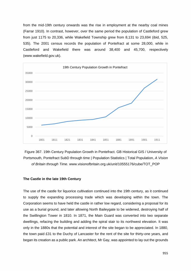
955
from the mid-19th century onwards was the rise in employment at the nearby coal mines
(Farrar 1910). In contrast, however, over the same period the population of Castleford grew
from just 1175 to 20,336, while Wakefield Township grew from 8,131 to 23,694 (ibid, 525,
535). The 2001 census records the population of Pontefract at some 28,000, while in
Castleford and Wakefield there was around 38,400 and 45,700, respectively
(www.wakefield.gov.uk).
Figure 367. 19th Century Population Growth in Pontefract. GB Historical GIS / University of
Portsmouth, Pontefract SubD through time | Population Statistics | Total Population, A Vision
of Britain through Time. www.visionofbritain.org.uk/unit/10555176/cube/TOT_POP
The Castle in the late 19th Century
The use of the castle for liquorice cultivation continued into the 19th century, as it continued
to supply the expanding processing trade which was developing within the town. The
Corporation seems to have held the castle in rather low regard, considering a proposal for its
use as a burial ground, and later allowing North Baileygate to be widened, destroying half of
the Swillington Tower in 1810. In 1871, the Main Guard was converted into two separate
dwellings, refacing the building and adding the spiral stair to its northwest elevation. It was
only in the 1880s that the potential and interest of the site began to be appreciated. In 1880,
the town paid £31 to the Duchy of Lancaster for the rent of the site for thirty-one years, and
began its creation as a public park. An architect, Mr Gay, was appointed to lay out the grounds
0
5000
10000
15000
20000
25000
30000
35000
1801 1811 1821 1831 1841 1851 1881 1891 1901 1911
19th Century Population Growth in Pontefract

956
at an estimated cost of £1000. Over the following three years, considerable landscaping and
tree planting was undertaken within the castle. The cost more than doubled, making it difficult
for the trustees to find capital to complete the works (Roberts 2002, 447). As part of these
works, excavations were carried out within the castle by Richard Holmes, a local antiquary
and publisher. These excavations investigated St Clement’s Chapel, the Elizabethan Chapel,
bakehouse and brewhouse, great hall, kitchen and Treasurer’s Tower. The findings of this
work were published in the Pontefract Advertiser and Yorkshire Archaeological Journal.
A design for a new entrance lodge was proposed by the architects Messrs Pyke and Mitchell
of Pontefract and approved in July 1881. Most of the building was intended as accommodation
for the ‘Porter’ or custodian, but the current shop and serving areas were intended as a ‘Ladies
Waiting Room’ and lavatory. The ‘Refreshment Room’ was added shortly after the Porter’s
Lodge had been constructed and was certainly in use by 1889. The grounds were opened to
the public in 1883 by the Duke of Albany and when completed, were something of an open air
museum. Historic fabric from all over the town was deposited at the castle, including material
from St John’s Priory and a Roman sarcophagus formerly located at Fryston Hall. A small
museum was added to the north of the Porter’s Lodge and was opened on 29 April 1892. The
museum initially contained the Edwin Foster Collection and other historical items from the
local region, but the site was already being used for display of various items including two
Crimean War guns which were positioned just inside the castle’s main gate from 1882.
The completed park is shown in considerable detail in the 1889 Ordnance Survey map. The
castle structures are named and walkways are shown laid across the site, including a raised
walkway over the bakehouse. The recreational facilities annotated include a bandstand
adjacent to the King’s Seat and several benches throughout the castle. The extent of tree
planting is apparent, with only the centre of the inner barbican and keep being left as open
spaces. Paths are shown weaving across the northwest face of the castle and into the moat.
Adjacent to the park gates, the lodge building and refreshment room are shown. A series of
photographs and postcards held at Pontefract Museum provide further insight into the layout
and treatment of the park. Ornamental planting schemes were laid out throughout the castle,
the kitchens holding a rose garden, and the Elizabethan Chapel a cruciform flowerbed. A
deliberately rustic character is apparent in the treatment of fences and structures such as the
bandstand and refreshment room. The castle buildings were presented with information
plaques shaped as heraldic shields. The foundations of the keep were exposed, and a viewing
point created by knocking a window through the fabric of the southwest lobe. A folly was
created on the site of the Constable Tower, reusing stonework from the castle and priory sites.
The Victorian works on the Castle represented a deliberate modification of the site in line with

957
contemporary conceptions of the past and its role in modern society. Less than five percent of
the site was altered, with much landscaping occurring through the introduction of further
overburden.
19th century Industrial Development
Pontefract remained a comparatively small, although important, market town throughout the
early post-medieval period. The land surrounding the town remained predominately in
agricultural use throughout the post-medieval period, and while some goods were sent directly
to markets in Leeds and Wakefield (Baines Directory 1822), a significant proportion was
brought to Pontefract.
Not all products were intended for the market, some being brought in for processes, such as
tanning, the location of which industries recorded in the street name, such as Tanner Row,
which runs between Bondgate and North Baileygate near All Saints Church. Baines’ directory
of 1822 also includes shoe makers, braziers and tin makers, stone masons, hat
manufacturers, textile merchants, leather workers, grocers and corn and flour dealers.
Tanneries
The Tanshelf Tan Yard (site, HLC_PK 780) is depicted on the Ordnance Survey 1:1056
Town Plan of Pontefract (1851) as a series of tanning pits on the east side of Front Street.
The site is occupied by buildings by 1891 (Ordnance Survey 1:500 Town Plan of 1891). All
buildings appear to have been demolished by 1908, being replaced by the Alexandra Theatre,
later Cinema, by 1933 (Ordnance Survey 1:2500 map of 1933). In turn, this building was
demolished by 1950. The plot is now occupied by commercial premises (club).
Fellmongery (site, within HLC_PK 674 and 21018, WYHER PRN 6528). Site of a medium-
scale fellmongery, where animal hides were processed for leather making. The fellmongery
was owned by the Co-operative Wholesale Society (C.W.S) from 1909 to 1966, the industrial
buildings were demolished in the 1980s. The area now forms part of South Baileygate Retail
Park.
Site of former Tallow Refinery, Bailey Close (site, see HLC_PK 21013). A modern housing
development was built during the period 2002-2008, on the site of a former Tallow Refinery.
The refinery was established during the second half of the 19th century, on the site of a

958
liquorice plantation and earlier vernacular housing, and was demolished during the early
1980s.
Extractive Industries
The rural hinterland was also exploited for its mineral resources throughout the post-medieval
and the Ordnance Survey maps show the location of quarries extracting sand, sandstone and
gravel. The Monkhill area was known for clay extraction and a range of brick works were
established here during the 19th century. Clay marls were also extracted from the Marl Pit
area, to the west of the town for use as a fertiliser.
Coal mining in particular will have benefitted from the improved transport links with the opening
of the railway as demonstrated by the route of Methley branch line running adjacent to the
Prince of Wales Colliery. Coal mining was undertaken in the Pontefract Park area from at least
1736 and by mid-20th century the industry represented the largest employer in Pontefract,
providing work for around 4500 people (Anon 1949).
Collieries
The Prince of Wales Colliery (site, see HLC_PK 17889, 17890 and 17903, WYHER PRN
7587) was established in 1869 by John Rhodes. It was purchased by the Glass Houghton
Colliery in 1928. The site was surveyed in 1994 by the Royal Commission on the Historic
Monuments of England (RCHME 1994). Since this date a number of the buildings appear to
have been demolished. To the north of the main colliery site, is an area of colliery waste that
has recently been landscaped (HLC_PK 17889 and 17903). To the southeast of the main
colliery site, a plot of late 19th to early 20th century mine workers’ terraced housing (Prince of
Wales Terrace – centred on NGR 445480 422574) had been demolished by the late 1970s.
Extant remnants of buildings considered by the survey, however, included the colliery office,
pithead baths, canteen and medical centre and a lamp cabin. The pithead baths were
constructed in 1933 by the Miners Welfare Fund at a cost of £18,000. The single storey
building is constructed of ferro-concrete with a wall facing of brick. The baths consist of three
parallel ranges on a south west to north east alignment. The central range contains the
showers. The outer ranges containing locker rooms and have gabled roofs (with a covering of
corrugated asbestos). The 'clean' lockers are situated in the southeast range and the pit
lockers are within the northwest range (RCHME 1994, p. 2). A canteen was added in the late

959
1930s and later extended and re-fronted in the 1960s and 1980s. A medical centre was added
in the 1950s, blocking the original clean entrance to the baths (RCHME 1994, 2).
The colliery office, constructed in 1915, was a two-storey brick building and is eight bays in
length and three bays wide. The building has a gabled roof with welsh slate pitches (RCHME,
1994, p. 1). The lamp cabin was built in the mid-1930s, by the new owners, the Glass
Houghton Collieries Ltd. It is a single-storey brick built structure, and has a gabled roof covered
by asbestos. The building has entrances on either side in order to give access from the north
east to the pit head area. That to the south east is adjacent to the pithead baths (RCHME,
1994, p. 4). An engineer's office was added in the 1980s in the form of a single storey brick
building range added to the north west side of the building (RCHME, 1994, p. 4). Other
structures considered by the RCHME survey which do not appear to be currently extant
include the Beeston Shaft Heapstead (constructed in the 1920s) and the winding engine house
of the Beeston Shaft (1910s or 1920s) (RCHME 1994, pp. 5 and 6).
Since 2006, there has been wholesale clearance of the site resulting in the loss of all buildings
and colliery fabric. The area was left as derelict land, with only ground-level foundations
surviving (Google Earth 2009). The plot is currently being redeveloped as a modern housing
scheme (Prince’s Park) which has not been characterised by the West Yorkshire HLC.
Utilities Industries
Pontefract Gas Works (site HLC_PK 21006, WYHER PRN 10109). The Pontefract
Gasworks were established by 1851 (depicted on the Ordnance Survey Town Plan of 1851),
with expansion by 1891 (Ordnance Survey 1:500 Town Plan of 1891). The earliest gas
company in Pontefract was the Pontefract Coal Gas Light Co established in 1832 as a co-
partnership company. This continued to operate until in 1872 the Pontefract, Tanshelf, and
Carleton Gaslight and Coke Co Ltd was formed by Memorandum of Association. In 1873 the
company obtained statutory powers and was reincorporated as the Pontefract Gas Co. The
works were on land known as the Quarry in Pontefract, not far from the Town Hall. This later
became New Lane or Back Northgate. In 1907 the company went into liquidation and
Pontefract Corp. purchased the undertaking. It remained in local authority control until it vested
in the Wakefield group of the NEGB in 1949.Between 2005 and 2010 the gas works were
redeveloped as a residential area, with all former gas works buildings apparently demolished.
Manufacturing, such as textile working, never became as well established here as it did
elsewhere in West Yorkshire. This may have been due in part to the limited transport links

960
here compared to other towns. Its distance from major waterways, such as the Aire or Calder,
meant it missed out on boost to industrial growth brought about by the canal building schemes
in the later 18th century. The building of the railway in the mid-19th century would have
provided some stimulus for growth in industry in the town, as can be seen from the
cartographic evidence which shows an increase in development around the around the railway
lines to the north and the south of the town.
Textile Mills
Tanshelf Mill (Flax and Cotton Mill site, within HLC_PK 795) was built on the south side of
Tanshelf drive by the mid-19th century. Demolished before 1984. The site is now occupied by
a garage and works.
Pomfret Mill (site, within HLC_PK 29559). Pomfret Mill was established on the south side of
Ferrybridge Road by 1894 (as a Brush and Mat Mill). By 1930 the mill had become part of the
larger Monkhill confectionary works.
Liquorice
The Post-medieval town of Pontefract was famous for its liquorice production. The liquorice
plant was probably first imported to Britain during the medieval period, probably by and was
originally used as a medicinal product for the treatment of ulcers, arthritis and respiratory
conditions. It is known to have been grown in Pontefract by the 16th century. The first example
of liquorice being made as a sweet in Britain is in 1678, while the Pontefract Cake is credited
as being established in 1760 by George Dunhill. By the 18th century, Pontefract was one the
three main producers of liquorice along with Worksop and London, although production
ceased in the others in 1775 and 1853 respectively (Hudson and Van Riel undated).
In 1750, a total of 47 liquorice growers are recorded in Pontefract, occupying 71 plots.
Production was undertaken by families on a cottage industry scale, perhaps to provide a
supplemental income, until the first factories were introduced in the later 18th century. In 1790
just four producers are recorded, although this had risen to seventeen by 1900. By the early
20th century, production had increased substantially and the town was now producing some
400 tons of liquorice a week. The growing of liquorice had, however, declined by this time as
land was given over for housing and for more regular forms of agriculture and the factories
began importing cheaper liquorice from abroad. In 1920 just four growers remained in the
town, exploiting the land in the Valley Gardens, on the present hospital site, and in the

961
Cobblers Lane estate area, although the liquorice from here was not processed in the town,
but exported for medicinal use (Hudson and Van Riel undated). The confectionary industry
declined sharply in Pontefract post-World War II, due in part to the rationing of sweets, which
continued until 1954, but also with the rise in the popularity of chocolate. By 1955, just five
firms remained, although despite its decline it was still the main form of employment in the
town after coal mining. Today, there are just two companies operating in Pontefract (Hudson
and Van Riel undated).
18th and 19th Century Liquorice Companies in Pontefract
J .H. Addingley and Sons. The business was founded in 1860 by Mr Charles Tinker and Co,
and taken over by J. H. Addingley and Sons in 1872. The company operated from Baghill
Refinery (HLC_PK 883). The ground floor of the three storey building consisted of offices, a
warehouse, packing room as well as mechanics’ and joinery shops for repairing the plant, and
an engine house. The first and second floors were occupied by plant machinery driven by a
steam-engine and a ‘Griffin’ gas engine. Malthouses are depicted either side of the refinery
building on the Ordnance Survey 1:500 Town Plan of Ponterfract (1893). To the south are two
cottages that may have served as supervisors’ accommodation. The company closed in 1937.
The site was then used as malthouses, a bakery and a 1930s warehouse as a tea store
(occupied by Ringtons Ltd). The 1860s factory complex is largely intact – the refinery building
is used as a depot, the malthouse buildings to the south are currently unoccupied, the
malthouse to the north as a pet supply store and the 1930s tea store as a warehouse. The
original 1930s sign for Ringtons Ltd is visible on the west facing elevation of the warehouse
(Harrop Well Lane).
Dunhills. By 1720 and probably earlier, the Dunhill family rented the land in Pontefract Castle
for growing liquorice. They stored harvested liquorice roots in the castle cellars, which had
previously been used for storing weapons, gunpowder and prisoners. Dunhills’ later packaging
claims that they had been making liquorice confectionery since 1760. George Dunhill, who
became a chemist, is reputed to have added sugar to the medicinal recipes to make the first
liquorice sweet. He was only seven years old at the time. By 1779 George Dunhill, the reputed
inventor of Pontefract Cakes, owned a house, malthouse and garden in Broad Lane (within
HLC_PK 883). Broad Lane House and the malthouse are depicted on the Ordnance Survey
1:1056 Town Plan of Pontefract (1851). The house and former malthouse survived until the
1970s, when they were demolished as part of Broad Lane widening.

962
Figure 368. The HARIBO Factory (formerly Dunhill’s), Pontefract. On the left, No. 26
appears to date to the late 18th century and may have formed part of the original Pomfret
Liquorice Refinery which lay immediately behind. To the right is No. 24 Front Street, which is
a Grade II Listed house, now offices, which dates to the late 18th century.
George Dunhill also had a liquorice garth (plot) behind this property, and at least one nearby
called Roper Garth. He carried on his liquorice business until his death in 1824 when it was
taken over by his son Francis. Ann Dunhill, Francis’ widow, ran the company after her husband
died. In 1872 the company played a part in national politics. In this year; Parliament passed
the Secret Ballot Act and Pontefract had the first by-election held under the new system. Wax
seals on surviving ballot boxes show that instead of the stamp of the borough, Dunhills’
Pontefract cake stamp was used. The business was taken over in 1883 by Mr F Craven,
although the Dunhills name was kept. Under Craven’s direction the company traded in
liquorice root distributed amongst wholesale and retail chemists across the UK.
The firm became a limited company in 1919. It moved to a former laundry (and earlier liquorice
works – see below) on Front Street soon afterwards, and gradually expanded to take over one
building after another, resulting in a modern factory on the site (HLC_PK 807 and part of
HLC_PK 766). Dunhills Ltd bought out competitors Sampson and Gundill in the 1920s. The
company expanded trade, exporting liquorice world-wide including to the United States,
Canada, British Guiana, various African countries, the Persian Gulf States and Asia. In the

963
late 1940s to mid-1950s, the factory was extended to the front along Front Street (removing
earlier residential and commercial premises), and to the rear (occupying the site of earlier
industrial buildings). In 1964 Dunhills Ltd acquired another competitor, Robison and
Wordsworth Ltd. In 1972 the German company HARIBO acquired a major stake in Dunhills
and in 1994 gained the remaining shares and started to promote the HARIBO brand in the
UK.
Ewbanks - Thomas Firth set up Pontefract’s second liquorice factory based in Elephant Yard,
in 1810 (behind the present Elephant Hotel, which dates to 1766 - within HLC_PK 766). The
founder was eventually succeeded by Mr David Longstaffe, who later sold to Mr Robert
Ewbank and Mr W. R. Horsfall. Between 1810 and 1885 the company was known as ‘Firth
Confectioners’. The partnership of Horsfall and Ewbank continued until September 1892 when
Mr Ewbank became the sole owner. Under Mr Ewbank’s direction the company grew and
expanded into the larger Eagle Liquorice Works (site, within HLC_PK 869), Friarwood in
1887. At that time the factory consisted of a large one storied building surrounded by extensive
orchards, with a detached villa house (Grove House - possibly a factory supervisors’ or
owners’ house) to the immediate south. The company employed 60 workers and had a large
home and export trade. In 1913 the business was purchased by a group and formed as a
private limited company trading as Ewbanks Ltd. Improvements and extensions continued
between 1918 and 1933 and the orchards gradually disappeared. On 8 August 1942 the
factory was badly burned when hit by German incendiaries. The pan, gum and liquorice rooms
were all damaged, and the factory was put out of action. During this time other Pontefract
sweet manufacturers produced some Ewbanks sweets. Some Ewbanks workers made
parachutes. A gum department was officially opened on February 6 1948. In January 1961
the business merged with the toffee manufacturers Arthur Holland of Southport (which later
merged into the larger group J.A. and P. Holland Limited). The company closed July 30 1965,
after which the factory buildings were converted into engineering use. The complex was
demolished in the 1970s, and the plot lay derelict until redevelopment in the mid-1980s. The
site is now part of Pontefract General Infirmary. Grove House still stands, although converted
into commercial use.
Hillabys - Entrepreneur John Hillaby established the Lion Liquorice Works in 1850, in an
area called Marl Pits, Tanshelf (site, within HLC_PK 781). The company grew their own
liquorice and by 1893 were the biggest producer in the world. The liquorice works was a four
storey brick building with steam powered machinery and extended as trade grew. John Hillaby
oversaw all aspects of the business including commissioning new machinery. Their leading
product was Hillabys’ Improved Pontefract Cakes. For the 1925 film Goldrush, Hillabys

964
provided a liquorice boot eaten by Charlie Chaplin. In 1943 the company were taken over by
rival producers Joseph Bellamy and Sons Ltd of nearby Castleford. In 1946 the factory on
Back Street was destroyed by fire. The premises were rebuilt, but eventually closed as a
liquorice factory in 1963 when Joseph Bellamy and Sons Ltd amalgamated into the
Mackintosh Group. The buildings were used as an engineering works until demolition in the
late 1980s. The site is now occupied by an ASDA supermarket.
Robinson and Wordsworth (site, within HLC_PK 769). In 1877, Robinson and Wordsworth
set up a factory in Pontefract called Victoria Works refining their own juice. Robinson and
Wordsworth continued in same hands until 1886 when the death of Mr Robinson left Mr J.N.
Wordsworth sole proprietor. The company expanded with a new wing in 1890 which doubled
the size of the works. By 1893 the works operated on three floors. The ground floor comprised
of the boiling house, warehouse, store rooms and packing rooms. The first and second floors
included the machine rooms and making rooms. In the same year the curator of Kew Museum
visited Robinson and Wordsworth to research the cultivation of liquorice and published an
article in The Leisure Hour. The firm also had a display in the Royal Botanic Gardens, Kew.
After the death of Mr J. N. Wordsworth the business was sold to W. H. Lorriman who set up a
new factory off Ferrybridge Road. In 1925 it became a limited company. During the Second
World War the factory was diverted to aero-engine renovation. Liquorice rivals Dunhills Ltd
acquired the company in 1964. The buildings was converted into a textile mill (clothing) in the
1960s through to the later 1970s. The building was demolished in the period 2003 to 2006.
Challoner House (Jobcentre Plus) was built in its place.
Sampson and Gundill. The company set up the Tower Liquorice Refinery on Northgate
(site – within HLC_PK 820) in 1889 as a wholesale only business. The large two storey brick
building included several departments. The machine room, rolling room, cutting and stamping
rooms were located on the ground floor. The firm’s offices were on the ground floor too. The
upper floors included the warehouse and packing rooms. In 1893 the refinery employed a
workforce of 60 and had a successful network selling to wholesale grocers, confectioners, and
export merchants. In the 1900s one of the Gundill brothers went to Belgium to set up a liquorice
refining company, but withdrew during the First and Second World Wars. Like many
manufacturers the firm was part of a larger family business estate. The Gundill portfolio
included firms of solicitors, builders, gasworks and Pontefract racecourse. Dunhills Ltd
acquired the company in 1923. From the 1920s, the buildings appear to have been used as
warehousing. It was demolished, along with other industrial and commercial buildings, during
road improvements in the late 1990s.

965
W.R. Wilkinson and Co. W.R. Wilkinson opened his Pontefract liquorice business in 1884.
The original factory was based in a malt kiln in Southgate. When these premises became too
small, a new three storey factory was built in Skinner Lane, and called Britannia Works
(HLC_PK 19926). W.R. Wilkinson employed 50 workers and made ‘Perfected Pomfret Cake’.
In 1894 Walter Marshall, originally from Somerset, and William Haddock, who later became
Pontefract’s town clerk, bought out W. R. Wilkinson. Marshall had begun his career in
Wilkinson’s as a junior clerk. From 1901, under Walter Marshall’s sole ownership the business
continued to expand, with another refinery founded on Southgate (see below). The factory
buildings on Skinner Lane were expanded in the period 1894 to 1908, virtually all of which are
still standing. Around the same time, to the rear of the factory, a row of terraced workers
housing ‘Denwell Terrace’ was built (possibly company owned). In 1924 it became a private
limited company.
The company moved again, to a former brush factory in Monkhill (HLC_PK 20559) which
was rebuilt in 1925 as a ‘garden factory’ with tennis courts, allotments and workers housing
(HLC_PK 21012, 21019 and 21021). The original Skinners Lane site appears to have been
taken over by another liquorice manufacturer; it is depicted as the Britannia Liquorice Refinery
on the Ordnance Survey 1:2500 map of 1938. By 1950, however, the building is simply
depicted as a works, suggesting a change of use. The buildings, the majority of which date to
the early 20th century, are now mixed commercial and industrial use.
At the Monkhill Works, the company carried on sweet-making at a low level throughout the
Second World War, but the factory was also used to machine tank parts. During the 1940s the
company created a trade mark referred to as the ‘company seal’. In 1961 the company merged
with the Sheffield based Bassett Group, their biggest rivals. Five years later the last
commercial crop of liquorice was harvested. In 1985 it became Anglo Bellamy Wilkinson. In
1990 Trebor Bassett became the sugar confectionery division of Cadbury Schwepps. In 1999
the York and Pontefract factories combined to form Monkhill Confectionery. They employed
400 workers and produced about 13 thousand tonnes of sweets each year, including dolly
mixtures, coconut mushrooms and bubble gum as well as liquorice. In 2007 Tangerine
Confectionery acquired Monkhill Confectionery.
Tower Liquorice Refinery, Southgate (HLC_PK 883). A liquorice refinery is first depicted
here on the Ordnance Survey 1:2500 map of 1908, with an extension to the northeast by 1933.
The block is depicted as the Tower Liquorice Works on the Ordnance Survey 1:2500 map of
1938. The owners are unknown, but presumably it was linked to the Tower Works on
Northgate (see W.R. Wilkinson and Co. above – HLC_PK 19926). By the early 1950s,

966
converted into a clothing factory (Tower Works on the Ordnance Survey 1:2500 map of 1950).
The original late 19th century factory, and the early 20th century addition, still stand (largely
unaltered). Currently used by a company specialising in textiles for pets, home and hospitals.
Liquorice Refinery, Bondgate (site, within HLC_PK 21015). A refinery (unknown
proprietor) established on the north side of Bondgate, near the junction with South Baileygate,
possibly by 1894, is not labelled until 1908. It was demolished before 1938. The site is now
occupied by Olde Church Tavern and Grange Lea.
Pomfret Liquorice Refinery, Front Street (site, within HLC_PK 807 and part of 766). The
Pomfret Liquorice Refinery is first depicted on the Ordnance Survey 1:500 Town Plan of
Pontefract (1891), although buildings occupying the same plot are depicted on the earlier
1:1056 Town Plan of 1851. The building survived until the late 1940s, when there was
wholesale redevelopment of the site to form part of the Dunhills factory (see above – HLC_PK
807). A late 18th century house on Front Street (No. 26), now part of the HARIBO factory, may
have formed part of the original factory building, and may help date the foundation of the
refinery. Buildings either side include a Grade II Listed former house which also form part of
the HARIBO factory complex (within HLC_PK 766): No 24 Front Street (within HLC_PK
766). Grade II Listed House, now offices. Late 18th century with 20th century alterations.
Painted and pebbledashed, with some stone dressings and Welsh slate roof. It stands three
storeys, and has 5 bays with a central hall-entry plan. Ashlar plinth.
Nos 1 to 3 North Ives (within HLC_PK 840). Terraced housing depicted on mapping from
c.1908 onwards, yet shown as a liquorice works on the Ordnance Survey 1:500 Town Plan of
1891. Constructed in the 1870-80s.
Nos. 146 to 160 Southgate (within HLC_PK 885). A group of terraced houses and
outbuildings that are depicted as Castle Moat Liquorice Refinery on the Ordnance Survey
1:10560 Town Plan of 1891. Castle Moat Liquorice Refinery was established by R. Austerberry
and Co. in 1888 (Chrystal, 2013)19. By the later Ordnance Survey 1:2500 map of 1908, no
longer a liquorice refinery. The industrial buildings of this plot appear to have been demolished
by 1952, leaving behind terraced housing of the late 19th century. Some fabric of the former
liquorice works may survive.
19 Chrystal, P. (2013) Confectionery in Yorkshire Through Time. Electronic Edition. Amerbley Books

967
Malthouses
Malting also represented an important part of the local economy during the 19th century with
eleven maltsters listed in Baines’ directory of 1822. In 1844 is it recorded that some 5000
quarters of corn were being imported into Pontefract from as far as Goole via the Aire and
Calder Navigation as far as Knottingley before being finishing the journey by cart (Goodchild
nd).
A number of former malthouses (some presumably associated with the liquorice industry)
survive within the town centre. Some of the surviving industrial premises on Northgate (No.'s
52 to 64 – within HLC_PK 841, WYHER PRN 6206) have been re-fronted (some with
attractive Victorian fronts), but all stand closely against the pavement and appear on the 1851
Town Plan.
Nos. 52 to 64 Northgate (within HLC_PK 841, WYHER PRN 6206). A programme of building
recording was undertaken in 2015 by Archaeological Services WYAS at 56 Northgate,
Pontefract in order to fulfil the conditions of a planning application in advance of its
development. Sketch plans of each floor level were made and a comprehensive photographic
record was made of the interior and exterior of the building. The building lies on the south side
of Northgate within the historic township of Pontefract. Northgate is first recorded in 1215 and
may be an expansion of the original borough (Roberts and Whittick 2013, p78). If this
interpretation is correct 56 Northgate would lie to the rear of a medieval burgage plot.
Jollages's map of 1742 shows a single building, fronting onto Northgate with a large open yard
to the rear. The O.S. map 1852 shows a linear building attached to the south elevation. This
addition is not shown on the 1870 building but it has been replaced by a smaller building by
1878.
The gable end has been raised and the raised wall height, the room above the passage to 56
Northgate, was previously interpreted as a malt kiln. However this survey shows it to be a
purpose built dovecote, original to the building. The interior walls housed rows of nest boxes
with an internal tray and ledge for each box, all constructed from hand-made brick.
The front elevation, onto Northgate, is constructed of handmade brick in an English Garden
wall bond. To the right the wall is painted and rendered, and has 20th century window and
door insertions. The rear elevation, also constructed of handmade brick in an English Garden
wall bond, opens onto a large open area with some demolished buildings and boundary walls
form an enclosing yard. There is a cart entrance with four timbers, the central two of which

968
rest on brick corbels. The beans support joists with laths and a lime ash floor to the dovecote
above. The south-west corner has a trap door linking the passage to the dovecote.
The replacement of the majority of the first floor, excluding the lime ash floor to the dovecote,
has removed evidence of the remainder of the first floor; it offers little evidence of a malt house.
The ground floor was devoted to the storage and transport of crops with double loading doors
to the front and loading bays to the ground floor. Ventilation was provided by breathers (now
blocked) and cambered arched windows. The cambered arches and hand-made brick
together with the use of machine sawn timbers in the king-post truss all suggest a late 18th to
19th century date for the building.
Another malthouse depicted on the 1851 Town Plan is located on Back Northgate (within
HLC_PK 843, NGR 445730 422245), which is now used as an industrial depot. They are an
important survival of this area from the early 19th century and possibly earlier.
Former Malthouse, Castle Mews (within HLC_PK 21008). Single-storey brick-built
malthouse first depicted on the Ordnance Survey 1:500 Town Plan of Pontefract (1891). By
the early 1950s, used as a warehouse (current use). Now forms part of a modern housing
development (Castle Mews low-rise flats).
Castle Keep and Castle View (HLC_PK 904). Originally built as a malt kiln, it was adapted
into its current form in the late nineteenth century. The maltkiln depicted on the Ordnance
Survey 1:1056 Town Plan of 1851, had been removed by 1891, with the malthouse being
adapted into dwellings. Castle Keep and No. 2 and 3 Castle View are unusual in having flat
roofs with castellated parapets. Castle Keep has a distinctive, rusticated stone elevation
fronting North Baileygate. The rest of the terrace has a decorative brick cornice and door and
window surrounds. Some fabric of the early 19th century malthouse may remain.
Former malthouses, Walkergate (HLC_PK 893). A pair of malthouses depicted here on the
Ordnance Survey 1:1056 Town Plan of 1851, possible associated with adjacent Baghill House
(HLC_PK 894). The present buildings, possibly date to the early to mid-19th century, although
they are much altered. They now form part of a mixed commercial and industrial complex (as
warehousing).
Former malthouse, Baghill Lane (site, within HLC_PK 21016). Former malthouse that is
depicted on the Ordnance Survey 1:1056 Town Plan of 1851. Demolished between 1950 and
1960. Replaced by an engineering works

969
Former malthouse, Baghill Lane (within HLC_PK 21016). A two-storey malthouse was
established on the east side of Baghill Lane by 1908. The site is now occupied by a commercial
company.
Former malthouses at Baileygate Court and The Maltings, Northgate (HLC_PK 845,
WYHER PRN 6205). Site of former malthouses and maltkiln depicted on the Ordnance Survey
1:1056 Town Plan of 1851. Two of the mamlthouses were demolished between 1968 and
1975, making way for The Maltings housing development. A three storey malthouse survived
until the late 1990s (WYHER PRN 6205), until being demolished and replaced by sheltered
housing (flats).
Former malthouse at Castle Grove, Northgate (HLC_PK 848). To the south of Northgate
was another three storey malthouse which was built in the 1870-80s. It survived until the mid-
2000s, until being demolished to make way for modern flats.
Former malthouse and maltkiln at Spink House (HLC_PK 852). Site of former malthouses
and maltkiln depicted on the Ordnance Survey 1:1056 Town Plan of 1851. Demolished
between 1996 and 2002. The site is now modern low-rise flats.
The commercial premises on Horsefair (HLC_PK 681), comprising a 1970s Post Office
(sorting office) and a 1990s supermarket, were established on the site of former malthouses
and a liquorice refinery that are depicted on the Ordnance Survey 1:1056 Town Plan of
Pontefract (1851). The Horsefair Liquorice Refinery was demolished in the 1950s, while the
malthouses were demolished in the 1990s.
Site of former malthouses, The Old Castle Works (site, within HLC_PK 21011). Malthouses
depicted on the Ordnance Survey 1:1056 Town Plan of 1851. Probably late 18th to early 19th
century, they were in use up until the late 1930s. Became part of a mineral water works in the
1950s. Demolished in the 1970s/80s.
Site of former malthouse, Baileygate Mews (site, within HLC_PK 20998). Large-scale
malthouse and associated courtyard housing built before 1894. Demolished between 1977
and 1984. The site is now a new housing development called Baileygate Mews.
Site of former malthouse (within HLC_PK 21020). A malthouse was established on the corner
of Ferrybridge Road and Box Lane in the early 1870s. It was disused by the 1980s.
Demolished by 1990, the site is now occupied by detached housing.

970
Simpson’s Malt (site, see HLC_PK 20565). Large malthouse and granary established
sometime in the late 1930s to mid-1940s. The malthouse was built on the site of, and part re-
using, earlier detached villa houses called Monkhill House (first depicted on the Ordnance
Survey 1:1056 Town Plan of 1851) and Earlsmount (built in the period 1854 to 1891). Monkhill
House, probably dating to the late 18th to early 19th century, had been demolished by 1950.
Earlsmount survived until the early 1980s. The former malthouse, silos and granary were
demolished c.2008. The site was excavated by Archaeological Services WYAS in 2008, which
revealed the remains of an early medieval pottery kiln (see above). The site lay derelict until
2015, it site is currently being developed (new housing scheme).
Breweries
The Old Castle Brewery (site, within HLC_PK 21018). Owned by W.Pickersgill & Co. Ltd.
Founded 1907. Sold with 14 tied houses to Bentleys of Woodlesford in 1932. Ceased breweing
after 1938. The brewery occupied a site on South Baileygate that then became part of the
C.W.S. Fellmongery (see above). Demolished in the 1980s. The plot has been redeveloped
and is now part of South Baileygate Retail Park.
Windmills
Dandy Mill (HLC_PK 20547, WYHER PRN 10114) dates to 1819. It was built for the Boreas
Union Mill Company. It is Grade II Listed. It has been converted into residential use.
Communications
The first section of the Wakefield, Pontefract and Goole railway line in Pontefract were opened
in 1848 by the Lancashire and Yorkshire Railway company, with a station at Monkhill
(HLC_PK 20567). Tanshelf station (site, within HLC_PK 778) was opened in 1871 on the
Wakefield, Pontefract and Goole railway line established in 1848. It provided easy access to
the nearby racecourse and the Prince of Wales Coal Mine. Most of the original station has
been demolished. Baghill Station (HLC_PK 881) was opened in 1879 and lies on the Swinton
to Knottingley line, built by the Midlands and North Eastern Railway Companies.
Recreation
The Pontefract Park Act of 1780 divided the park into three parts, one which remained in use
as common land. Horse and cattle were allowed to be grazed on it between May and October,

971
with sheep occupying it for the remainder of the year. It became a independent township in
1818, although it became part of the borough of Pontefract following the New Boundary Act of
1832 (Pigot’s Directory 1834).
Pontefract Racecourse (HLC_PK 17895). Horse racing was first recorded here in 1725,
although this is thought to have stopped by 1769 (Whitehead 1977, 12). The first racecourse
was opened in 1790 and a grandstand built in 1802. Races were held annually until they were
abandoned in the 1840s and the original grandstand was dismantled. The races were soon
re-established and a new grandstand built, which was expanded in the early 19th century. The
racecourse was used as an airfield during World War I, however during World War II, it was
one of only two courses in the country that remained open, the other being Stockton (Cunliff
1987).
19th Century Commercial Development
The 19th century saw consolidation of the commercial core of Pontefract, with many pre-
existing late 17th though to late 18th residential buildings in Market Place, Beastfair,
Cornmarket, Ropergate, Front Street, Baxtergate, Bridge Street, Horsefair and Micklegate
being converted into shops, often with accommodation above and to the rear (as yard
development). Many of these buildings survive, albeit much altered and adapted. There were
numerous demolitions, insertions and rebuilds, leading to a mix of building types and
construction.
Mid to late 20th century commercial developments have been inserted between or replaced
earlier buildings, often unsympathetically, with little respect for the historic grain of the area.
In the case of Salter Row and Horsefair, there has been wholesale removal of historic buildings
- in Horsefair, the removal of a series of traditional town houses/shops, and their replacement
with the Horsefair (Poulson) Flats (see HLC_PK 679 below) and a series of office blocks in
the 1960’s/70’s has changed the appearance of the area dramatically. These changes
removed many historical buildings and saw them replaced with new buildings which do not sit
comfortably within the town’s historic layout. In many cases new building heights, materials
and scale are inappropriate in relation to existing historic plots and buildings. Redevelopment
of the Salter Row area in the 1990s, removed a number of fine commercial buildings, including
the Flying Horse Public House (WYHER PRN 7457).
Of the surviving 19th century buildings, most in this area are two storeys in height. The mid-
19th century shops on Bridge Street have painted and rendered brickwork, slate roofs and 6

972
over 6 and 8 over 8 sash windows providing continuity in the street scene. Finkle Street
contains red brick and painted and rendered buildings with Georgian and Victorian sash
windows, together with modern buildings.
The Malt Shovel Public House (within HLC_PK 766, WYHER PRN 11710). The Malt Shovel
Public house was built in the late 19th century re-using the cellar of the 14th century building
which formerly occupied the site. It is Grade II* listed.
Market Hall (within HLC_PK 772). The frontage of the Market Hall dates to 1859-60 and is
based on designs by Joseph Wilson. The original 1860 building was opened by Lord
Palmerston. Constructed in dressed ashlar front, with brick to rear, 20th century part-glazed
metal roof. Three-storey height, with three bays with wider taller central bay. The main hall
building was built in the 1960s. It is Grade II listed.
Hope and Anchor Public House (within HLC_PK 21022). Erected on part of the site of the
Hospital of St Nicholas (see above), the current building appears to have been built in c.1889,
replacing an earlier Public House of the same name. The building is of two gabled wings
flanking a central entrance bay facing onto North Bailey Gate. It is brick built with slate roofs
and is of two storeys and an attic.
The Tap and Barrel Public House, Front Street (within HLC_PK 766). The Tap and Barrel
pub, on the corner of Front Street and Liquorice Way has an Arts and Crafts style frontage,
dating from the late 19th century, with overhanging eaves and mullioned windows. It has the
same footprint as the former Greyhound Inn, which the Old Stables (Pomfret Gallery) originally
served, and so may contain the earlier building.
The Old Stables, Liquorice Way (within HLC_PK 766). Depicted on the Ordnance Survey
1:1056 Town Plan of Pontefract (1851). Stable block to the former Greyhound Inn on Front
Street (now occupied by the later 19th century Tap and Barrel Inn (see above). Probably late
18th to early 19th century, possibly earlier. This building and the Counting House, are unusual
in the town, in being vernacular buildings constructed of stone. Now the Pomfret Gallery.
No. 9 Market Place (within HLC_PK 766) was originally a house and dates to the early 19th
century. It is now used as shop and offices. It is Grade II Listed.
No. 15 Wool Market (within HLC_PK 772) dates to the mid-19th century. It is Grade II Listed.

973
No. 26 Market Place (within HLC_PK 772, WYHER PRN 10079) is a late 19th-century four-
storey building constructed of brick, timberwork and with a tiled roof. It is an imposing landmark
building, with gabled dormers and turrets. It is included in the Local Buildings List for Wakefield
(WMDC 2008). Unlisted
Nos. 37 and 39 Market Place (within HLC_PK 766, WYHER PRN 10080) was built in 1894
as an ‘emporium’. The street frontage is Grade II Listed. The rear of the buildings is included
in the Local Buildings List for Wakefield (WMDC 2008).
The White Hart, Shoe Market (within HLC_PK 822, WYHER PRN 10078) was built in the
late-19th century and is included in the Local Buildings List (2008) for Wakefield.
The Blackmoor Head, Cornmarket (within HLC_PK 766, WYHER PRN 10068) is a public
house built in the late-19th century in the mock-Tudor style and was constructed of brick,
timber and tile, and has a slate roof. The building is included in the Local Buildings List (2008)
for Wakefield.
Nos 3 and 5 Bridge Street (within HLC_PK 824) are a pair of shops with living
accommodation in the upper storey and are probably of mid-19th century date. They are
Grade II listed.
No. 3 Beastfair (within HLC_PK 766, WYHER PRN 10072) is a shop built in the late-19th
century. It is included in the Local Buildings List (2008) for Wakefield.
No. 4 Beastfair (within HLC_PK 772, WYHER PRN 10071) was built in the late-19th century
and is included in the Local Buildings List (2008) for Wakefield.
The Beastfair Vaults Public House (within HLC_PK 772, WYHER PRN 10070) was built in
the late-19th century in the mock-Tudor style, though contain motifs and features that are
wholly influenced by the 18th century such as the Venetian window. It was constructed of brick
with some timber detailing, while the roof was slated. The building is included in the Local
Buildings List (2008) for Wakefield.
No. 9 Beastfair (within HLC_PK 766) is a handsome, brick and stone late 19th to early 20th
century building with decorative quoins and window surrounds.

974
No. 13 Beastfair (within HLC_PK 766, WYHER PRN 10074) is a shop built in the late-19th
century. It has a modern ground floor shop front, while the 1st storey has a central 7-light bow
window. It is included included in the Local Buildings List (2008) for Wakefield.
No. 17 Beastfair (within HLC_PK 766, WYHER PRN 10075) is a shop built in the 19th
century. The building comprises 4 bays with 12-pane sash windows on the 1st floor. The
ground floor contains a mid-20th century shop front. The building is included in the Local
Buildings List (2008) for Wakefield.
No. 19 Beastfair (within HLC_PK 766, WYHER PRN 10076) is a shop built in the late-19th
century. It is included in the Local Buildings List (2008) for Wakefield.
No. 21 Beastfair (within HLC_PK 766, WYHER PRN 10077) is a shop built in the 19th
century. It was constructed of red brick and has a modern shop frontage on the ground floor
and windows on the 1st. These are made up of hung-sash central windows with thinner lights
either side. The composition is reminiscent of the Venetian window layout. Both windows have
large stone lintels and projecting sills. The shop is included in the Local Buildings List (2008)
for Wakefield.
Nos. 3 to 13 Gillygate (within HLC_PK 766) date to the late 19th to early 20th century. They
are striking on account of their height and decoration, with pedimented dormers, rusticated
brickwork and stone pilasters. The former Pineapple Inn (No. 12) also has a pedimented gable
and decorated pilasters. It is faced with grey faience and an elaborate cartouche.
No. 11 Ropergate (within HLC_PK 766). The bank at no. 11 Ropergate, Pontefract, was built
in the late-19th century in the High Victorian Gothic. It comprises three storeys with the ground
floor shop front contained with a chamfered pointed arch. The building is included in the Local
Buildings List (2008) for Wakefield.
The Queen’s Hotel (HLC_PK 778). The Queen’s Hotel, located on Pontefract Park Road,
was built between 1898 and 1901 for Pickersgill’s Brewery of Pontefract. It was built to provide
accommodation for those attending meetings at Pontefract Racecourse. It is Grade II listed.
Recently converted in apartments

975
Figure 369. Queen’s
Hotel, Pontefract.
Grade II Listed
Civic development in the 19th century
Pontefract Town Hall as it stands today consists of two separate buildings, one 18th century
the other 19th century, linked together by a staircase on the side of the Victorian building.
Fronting the Market Place is the Old Town Hall listed Grade II*, a stone building of 1785 built
to the designs of local architect Bernard Hartley. This T-shaped building has a large first-floor
hall raised above an open basement with an arcade of three arches. Set behind the hall is a
smaller top-lit oval meeting room. To the rear of the open arcade, and under the Oval Room,
are former police holding cells, dating from the time when the building was used for the Quarter
Sessions and by the local magistrates as a Court Room.
At right angles to the Old Town Hall, facing Bridge Street, is the new Town Hall built as local
authority offices in 1882 to the designs of the Leeds firm of architects Perkin and Bulmer, the
winners of an architectural competition for the new building. Economy saw the modification of
their design by the loss of a proposed clock tower, and the building being built in brick, instead
of stone, with stone dressings. While providing accommodation for the Council and its officers
on the ground floor the upper floor was entirely occupied by the galleried Assembly Room,
designed for musical concerts and dances. It was accessed by a wide stone staircase built on
the side of the building, above which it had been proposed to build the clock tower. This links
at the first floor to a transverse corridor to the Oval Room and the Court Room in the Old Town
Hall. In the 1920s an extension was added on to the south (rear) of the Assembly Rooms and
the stage was rebuilt with a proscenium arch, curtains, and a deeply raked stage. New
dressing rooms and toilets were also provided together with a fire-protected stair. Underneath

976
these first floor rooms was created a Mayor’s Parlour and other local authority offices.
Following local government reorganization in 1974 local government administration was
moved out of the building and the town, and during 1976 the building was altered to suit the
needs of the Registrars. The former Mayor’s Parlour is now used as a Marriage Room for civil
weddings.
The Court Room had ceased being used by for the Quarter Sessions following the construction
of the Sessions House on Corn Market in the 1820s, but continued to be used by the
magistrates throughout the 19th century. The Oval Room, is thought to have been designed
as a council chamber, and was also used as a rotation office where the magistrates arranged
their sittings. It was refurbished as a bar in the 1980s to serve the two halls that are now used
as public function rooms.
The Old Town Hall plays a pivotal role in separating the town into two halves; dividing the
Market Place from Horsefair, positioned on the edge of the ward boundary. The 18th century
Town Hall closes off Market Place, an ancient street called earlier the New Market and The
Shambles. The street tapers from the broad Market Square that opens in front of St Giles’
Church, to its eastern end and is dramatically closed off by the Old Town Hall with its fine
stone ashlar-faced façade. This is the finest street in the town with a fascinating mix of
buildings, including jettied timber-framed buildings and the many Georgian facades intermixed
with later Victorian buildings dominated by the tall entrance to the Market Hall of 1859 that
rises above the adjacent buildings. The essential character of the street is Georgian, and is
more reminiscent of Beverly than any other town in West Yorkshire. There can be few places
in the country that can boast a smart town house built to the designs of Robert Adam on one
side of the street, with another by James Paine on the opposite side. In the Georgian period
it was paved with stone setts, but these were covered with tarmacadum in the 20th century.
Recent street improvements have led to the restoration of the street back to stone setts, the
road level with the flanking matching pavement to unify the street that is now pedestrianised.
The Old Town Hall then is central to the town’s conservation programme, and historically
represents the aspirations of this small provincial town to provide a fine Assembly Room, cum
multi-purpose room, in the Georgian period, built in the year following the introduction of mail-
coaches that formed an essential link with the outside world and London.
The partly open arcade of arches in the Old Town Hall permits interpenetrating views through
to Bridge Street and Horsefair. Here the Victorian Assembly Rooms fronting Bridge Street is
built in brick with stone facings that reflects the different character of the town along Horsefair

977
to Micklegate that leads directly to the dramatic ruins of Pontefract Castle which the Victorian
city fathers turned into a public park for the amenity of the town’s citizens.
The Court House (within HLC_PK 808) was built in 1807 to the designs of Charles Watson.
The interior was completely remodelled in the 1960s and part of it is now occupied by offices.
It is Grade II listed.
19th Century Hospitals and Almshouses
Pontefract Almshouses (within HLC_PK 902, WYHER PRN 10108). The Pontefract
Almshouses, Micklegate, are three 19th century-buildings. They are included in the Local
Buildings List for Wakefield (WMDC 2008).
Northgate Lodge Hospital, located on Back Northgate, was built in 1864 and was originally
a workhouse (see below). It was also known as Headlands Hospital. It is Grade II listed.
Chequerfield Hospital (site, see HLC_PK 494). A playground associated with the adjacent
council built housing estate is found on the site of an infectious diseases hospital that was in
place by 1906 mapping. At this time the site was isolated from the town. Administrative
records for Pontefract Joint Isolation Hospital run from 1895-1948 (Wellcome Trust). In the
1950s the hospital is marked as disused, but records show it was back in use from around
1952 to 1970 as an annex of Pontefract General Infirmary as a Convalescent Hospital (NRA
ref: GB/NNAF/C56895). Demolished before 1985
19th Century Workhouses
Pontefract had a workhouse on Micklegate (see HLC_PK 902). After the adjacent Bead (or
Bede) House Hospital closed in 1811, this was incorporated into the workhouse. The
continued existence of several Gilbert Unions in the West Riding prevented the Poor Law
Commissioners to unionise the area, and Pontefract continued operating its own town
workhouse on Micklegate. The Pontefract Poor Law Union officially came into being on the
15th February 1862.
The Pontefract Union Workhouse (HLC_PK 831 and 19925) was erected in 1862-4 at the
north of Pontefract on a site bounded by Skinner Lane and Back Northgate. The building was
constructed of brick with a three-storey main building, an adjoining hospital and an isolated
fever hospital towards the eastern boundary. Other buildings were added by 1908, including

978
a large infirmary to the northwest of the main block, and a separate block for women and
children to the east. From 1904, to protect them from disadvantage in later life, the birth
certificates for those born in the workhouse gave its address as 1 Paradise Gardens, Tanshelf,
Pontefract. In 1930, the workhouse came under the control of the West Riding County Council.
The site became part of the Osgoldcross Guardians' Area and was renamed Headlands Public
Assistance Institution, providing care mainly for the elderly. Electricity was installed in 1935.
In 1938, it is recorded that the building was used for gas-mask training. In 1948, the institution
became part of the National Health Service as Northgate Lodge Hospital, still providing
geriatric care. The northern part of the site became the Headlands Hospital. Northgate Lodge
closed in 1971 and some of the buildings were converted to offices for local social services.
After the closure of Headlands Hospital, the whole site was redeveloped as housing. The main
workhouse building still survives and has been converted to flats (it is Grade II Listed).
Pontefract Dispensary and General Infirmary (HLC_PK 857 and 859). Pontefract
Dispensary was founded in 1812 in Session House Yard, later moving to baxtergate before its
final site on Southgate when the purpose-built Dispensary was built in 1880. It was built over
the site of the Hermitage and Oratory – the Hermitage Gardens were owned by Dr. William
Wright, surgeon to the Dispensary, and following his death in 1877 the land was left as a
legacy for the building of a new dispensary. The building of the Dispensary, additions and
extensions and it maintenance were funded by donations and legacies from the local
community until it became part of the NHS in 1948.
In c.1906, the building was extended to the west with the addition of an operating theatre and
a female ward (West Yorks. Archive Ref. WMT/PO/452). The original mortuary building was
added to the south-west of this, set back from Southgate, sometime after 1923 (West Yorks.
Archive Ref. WMT/PO/981). Around the same time, a laundry block was added which ran on
a north-west to south-east orientation and was located to the rear of the Dispensary, close the
north-east boundary of the site (West Yorks. Archive ref. WMT/PO/980). In 1925 an extension
aligned southwards, away from Southgate was opened, called the King Edward VII Memorial
wing (West Yorks. Archive Ref. WMT/PO/708).
The site continued to expand through the 20th century, with final additions in 1991. At its peak
as a general hospital in the 1990s, the PDG contained more than 450 beds, but subsequently
hospital services were gradually moved to Wakefield, culminating in the closure in 2011. The
hospital site has been substantially redeveloped recently on land immediately to the east and
south of the original site (as Pontefract Hospital – HLC_PK 872), although the Dispensary
building has been retained (currently disused).

979
19th Century Military Sites
The former military depot of the Pontefract Corps of the West Yorkshire Rifle Volunteers
(HLC_PK 818). Gateway and lodges built c.1859. Constructed of ashlar sandstone with Welsh
slate roofs. The Gatehouse is two storeys and has a central gateway flanked by projecting
turrets, with attached lodges, all canted around corner site. The gateway formed the entrance
to the Military Depot of the Pontefract Corps of the West Yorkshire Rifle Volunteers, until re-
use in 1890 as part of King’s School and then as Pontefract Secondary Girls School. The
Secondary School closed in 1978 and was demolished. However, the former gatehouse to the
barracks survived and is a Grade Ii Listed Building. It was converted into offices in the later
1990s.
Figure 370.
Former Military
Barracks, then
King’s School
entrance gates,
on Skinner Lane.
Now offices.
Grade II Listed.
© Copyright Bill
Henderson and
licensed for
reuse under this
Creative
Commons
Licence.
www.geograph.org.uk/photo/254351
Pontefract Barracks (HLC_PK 362, 367, 369, 370 and 385; WYHER PRN 11666 and
11667) was built in 1878 to house the 51st and 65th Foot, who later became the King’s Own
Yorkshire Light Infantry and the Yorkshire and Lancaster Regiments. The 51st Foot was
formed by the Marquess of Rockingham in 1755, and in 1851, prior to the construction of the
barracks on Wakefield Road, the regiment was housed near Pontefract cemetery (Farrar
1986). The buildings were in a block of four double barracks. A plan from 1937 states that
each of the main rooms housed 26 men. The site was used as a regimental barracks until the
late 1960s. In 1971, Pontefract Barracks was decommissioned and many of the buildings on

980
the site were demolished (Swann 2008). The Keep, which housed the armoury, guard house
and store, was converted into the Barracks Public House and then it subsequently became
the Pontefract Barracks Business Centre (Swann 2008). It is Grade II Listed. An
archaeological building recording exercise was undertaken of the remaining buildings in the
Pontefract Barracks site by Archaeological Services WYAS in 2008. The buildings surveyed
included a two-storey barrack block (Arabia), a truncated barrack block (Minden) and bath
house with attached boiler house. To the south on Queen’s Square (HLC_PK 370) are four
blocks of late 1940s housing, built as army accommodation.
19th Century Religious Buildings
Church of St Joseph and attached presbytery (HLC_PK 784). The Roman Catholic Church
of St Joseph and its presbytery were built in 1806. It is Grade II* listed.
Ebenezer Chapel (Congregational Independent), Finkle Street (within HLC_PK 824).
Unlisted. The Congregational Church on Finkle Street was erected in 1840 on the site of an
earlier chapel built 1801. It was known as the Independent Chapel in 1852. It is a key landmark
building with voussoir arches to its Victorian sash windows, and a detailed entrance way on
Stuart Road.
Primitive Methodist Church, Micklegate (site, within HLC_PK 847). Established here in
1870. Burnt down in 1965. Replaced by new church building (current Micklegate Methodist
Church).
Primitive Methodist Chapel, The Booths (site, within HLC_PK 665, NGR 446145 422353).
Erected 1823. A Primitive Methodist Chapel is depicted here on the Ordnance Survey 1:1056
Town Plan of 1851, but apparently converted into back-to-back housing by the Ordnance
Survey 1:500 Town Plan of 1891. Demolished by 1950. Now public greenspace.
Wesleyan Methodist Chapel, Horsefair (site, within HLC_PK 679). Erected 1826, enlarged
1850. Built on the site of an earlier church opened by John Wesley in 1772. It was demolished
in 1962. The plot is now part of the Horsefair Flats development.
Wesleyan Methodist Chapel, Newgate (site, within HLC_PK 766). Methodist Chapel first
depicted on the Ordnance Survey 1:500 Town Plan of 1891. Established probably late 1860s-
80s. Demolished between 1968 and 1977 by the Jubilee Road scheme.

981
19th Century Cemeteries and Burial Grounds
Pontefract Cemetery is located on Skinner Lane and was opened in 1859. It is included in
the Local Buildings List for Wakefield (WMDC 2008). It contains two listed buildings, including
a Grade II Listed Mortuary Chapel built around 1860.
Grave Yard, North Bailey Gate (HLC_PK 21014). Located adjacent to the junction of Tanner
Row and North Bailey Gate, the grave yard appears to have been established in 1804 and
consecrated in 1809 (Tew 1892, 159), but had fallen out of use by 1889. It retains its original
enclosure wall which would have been formerly surmounted by iron railings. An additional
entrance to the grave yard has been inserted along the southwestern side of the enclosure
wall, but the original entrance remains directly opposite Tanner Row. A large number of ledger
stones remain, ranging in date from the early to mid-19th century, laid primarily in regular
rows. Against the north wall are the remains of a series of family enclosures, which include
some prominent Pontefract families, including the Dunhill’s of liquorice fame. The grave yard
has a canopy of mature trees which, despites a location adjacent to a busy road, provides a
sense of seclusion and tranquillity.
Burial ground to north of Church Hall, Finkle Street (within HLC_PK 824, NGR 445620
422065). Former burial ground for the Ebenezer Chapel on Finkle Street (see above).
Established by 1840, although could date to earlier (1801?). Disused by 1891. Much eroded
by later 20th century development, although grave slabs and tombs survive.
19th Century Schools
All Saints School, Southgate (within HLC_PK 665). Established by 1851 (depicted on the
Ordnance Survey 1:1056 Town Plan of Pontefract). Late 18th or early 19th century, with later
Victorian additions to rear. Served as a school until the late 1990s. Converted into offices (to
front) and private residence (to rear).
British School, Gillygate (site, within HLC_PK 766). Re-use of former theatre built in 1788
(the New Theatre). By 1837 the theatre had been converted into a school (mentioned in
Baines’ Directory of 1837). Converted into a cinema in 1916 Playhouse Cinema. It closed in
1965 and was demolished soon afterwards. Now c.1970s commercial premises.
The three schools on Northgate all date from the end of the 19th century and the start of the
twentieth.

982
Former Pontefract Secondary Girls’ School, Back Northgate (HLC_PK 835). Originally a
boys’ secondary school, then girls’ school from 1968. It closed in 1978. The stone building
which has been engulfed by the later brick school (c.1920-33) appears on the 1852 Town Plan
as the Boys’ National School (this building dates to the early 19th century, possibly earlier).
The building has been converted into a restaurant.
Inglebrook School (HLC_PK 825). Established in 1963 – a re-use of former school buildings
belonging to St Giles Church of England Junior (Mixed) and Infants School. The Infants School
building, fronting onto Northgate, was built before 1891, with the Junior School to the rear a
later 19th or early 20th century addition (by 1908). Inglebrook School closed in 2016; both
buildings are now commercial premises (Lloyds Pharmacy).
Residential development in the 19th Century
There are very few pre-19th century dwellings within the historic core of Pontefract. Much of
Pontefracts’ late 17th though to late 18th century housing, predominantly town houses, were
converted into commercial use in the early to mid-20th century - these buildings can no-longer
be classed as residential as they now form part of the Pontefract commercial core.
Furthermore, of the many yard developments of the late 18th to mid-19th century, only a few
survive as having a residential character. Post World War II redevelopment has largely
removed all traces of this house type. Today the yards largely remain to the north east of
Liquorice Way, but there are only limited survivals of this development to the south east. Elm
Terrace on Swales Yard (HLC_PK 758) and Crown and Anchor Yard (within HLC_PK
769) remain with a limited amount of housing left, but the historic grain of the area generally
survives.
Lemon Alley (site, within HLC_PK 766) located off Beastfair, was built before 1795 and was
described as being the narrowest and most unsavoury of its kind until it was demolished in
1934 (Whitehead 1977, 13).
Belk’s Court (within HLC_PK 766). Belks Court, located off Cornmarket, was built before
1822 to accommodate the expanding population in the town at this time (Whitehead 1977).
An attractive, red brick terrace, which although having modern windows retains its integrity as
the fenestration is consistent across the whole terrace. The setting is also considerably
enhanced by the cobbled paving that survives here.

983
Wholesale redevelopment from the 1950s onwards has had a negative impact on the town.
For instance, in Horsefair and Micklegate, the once tightly knit, small scale and enclosed
development along this historic street has been replaced by medium and high rise
development in open parkland settings. The quality of the architecture here is also basic, and
it is difficult to imagine that this was once a principal medieval street leading to the castle.
Later 20th century rredevelopment elsewhere in the town has often failed to recognise the
historic significance, or grain, of the area. This includes the open traffic junction at the top of
Northgate and Skinner Lane, which is dominated by traffic signals.
A number of late 18th to early 19th century vernacular cottages, houses and farms can be
found on the town periphery.
Kings Croft Farmhouse, now hotel (within HLC_PK 888). Grade II Listed. Probably early
19th century farmhouse, converted into a hotel in the later 20th century. Ashlar sandstone,
Welsh slate roof. Double-depth plan, two storeys and loft.
Farleigh Farm, Wakefield Road (within HLC_PK 888, WYHER PRN 11709). Unlisted. The
site of Marl Pit Hill Farm was probably annexed in the late 18th century from the surrounding
fields to create a quarry for the extraction of clay or marl, which was used as an agricultural
fertiliser. The farm was established here by mid-19th century and was substantially re-
organised in the Victorian period when it became a ‘Model Farm’ (named Farleigh). Model
farms came about in the agricultural revolution of the 18th to 19th centuries which saw a rise
in agricultural machinery and new techniques resulting in the farm being more industrialised.
The purpose of the model farm was to create a design which allowed all necessary buildings
stores to be easily and readily accessible (Scurfield 2007).
Nos. 20 - 24 Bondgate (within HLC_PK 21019). A group of three vernacular cottages
depicted on the Ordnance Survey 1:1056 Town Plan of 1851. Possibly late 18th century,
although more likely early 19th century. They have recently been converted into commercial
premises.
Toll Box House, No. 36 Bondgate (within HLC_PK 21019, WYHER PRN 10107). Former
toll house that was built during the early Victorian period and is built of stone with a slate roof.
The front elevation facing Bondgate is of 3 bays. In each is a basket-arched cart-entry that
has since been filled with a window. The first bay cart-entry has been altered with the basket
arch having been replaced by a timber lintel. The central cart-entry has been filled with a
double door. Above, on the first floor are small square windows with projecting sills. A single

984
gable stack is positioned on the left-hand return, while the right-hand return has been
truncated possibly when the neighbouring house was built adjacent. The house is included in
the Local Buildings List (2008) for Wakefield.
Vernacular Cottages, Carleton Road (HLC_PK 630). Unlisted. A group of late 18th to early
19th century cottages, including one depicted as ‘The Manor House’ on the Ordnance Survey
1st Edition 6” to the mile map of 1854. Later 19th and early 20th century additions. The 1800
enclosure map of Carleton shows that there were buildings along the road side at this date,
however it is uncertain if this part of the settlement has medieval origins. This seems unlikely
since Jefferys' map of 1775 does not seem to show settlement in this area.
Abbot Close, Back Northgate (within HLC_PK 831, NGR 445766 422286). Detached two-
storey cottage that is depicted on the Ordnance Survey 1:1056 Town Plan of 1851, and pre-
dates the foundation of the nearby Pontefract Union Workshouse. Probably early 19th century,
possibly earlier.
Baghill House (HLC_PK 894). A large detached villa house that is depicted on the Ordnance
Survey 1:1056 Town Plan of 1851. Possibly late 18th to early 19th century. Much altered in
the later 19th century – what looks to be a total rebuild, including two large bay windows. Used
as council offices by the early 1950s, and more recently by South West Yorkshire NHS. The
original stone-built garden (perimeter) wall still exists.
Park View, Halfpenny Lane (HLC_PK 427). Large detached villa house that is depicted on
the Ordnance Survey 1st Edition 6” to the mile map of 1854. Probably late 18th to early 19th
century. Much altered and enlarged. The building was converted into the Miners Welfare
Institute in the early-1930s, with the former private gardens becoming recreational grounds
(including tennis courts and bowling greens). The building now forms part of the Thorneycroft
Centre (South West Yorkshire NHS), although the building is still used by the Coal Industry
Welfare Organisation.
Mill Hill Cottage (within HLC_PK 737). A large semi-detached villa house and outbuildings
(now separate dwellings) which is depicted on the Ordnance Survey 1:1056 Town Plan of
1851. Early 19th century, possibly earlier. The former gardens were given over to semi-
detached housing in the 1970s.
Dandy Mill Farm (HLC_PK 20547, WYHER PRN 10114). Dandy Mill Farm dates to the first
half of the 19th century (possibly c.1818). The farm complex consists of stables, a long barn,

985
farmhouse and a Grade II listed windmill arranged on a loose courtyard plan. It is included in
the Local Buildings List for Wakefield (WMDC 2008).
In the late 19th century the town expanded with the growth of liquorice sweetmaking, the
coming of coal and the stationing of two army regiments in permanent barracks. Between
1871 and 1931 the population of Pontefract tripled as a result of these developments, together
with growth in sand quarrying, cast-iron making, malting and skinyards.
As a consequence, there was a surge in house building (in the form of workers’ late 19th and
early 20th century terraced housing) which occurred throughout the town, but particularly to
the southwest; along Love Lane (HLC_PK 445 and 790), Tanshelf Drive (HLC_PK 794),
Wakefield Road (HLC_PK 450, 748 and 846) and Halfpenny Lane (HLC_PK 441 and 710).
There was corresponding developments within the town itself, along Horsefair, Northgate
and Back Northgate (HLC_PK 840 and 904), and on the town outskirts along Friarwood
Lane (HLC_PK 754, 868, 871 and 874) and along Bondgate (HLC_PK 21019). There is a
substantial amount of brick terraced housing on Northgate and Back Northgate dating from
the end of the 19th century. Whilst being of modest design, many retain decorative window
surrounds and their scale relates to the historic setting in which they sit, in stark contrast with
the modern buildings on Horsefair.
The late 19th and early 20th century also saw the development of middle class suburbs,
notably to the southwest of the town centre. Developments, in the form of detached and semi-
detached villas, and good quality terraced blocks, can be found in Friarwood and Button Park,
and in The Mount (both of which are now Conservation Areas).
The Friarwood and Button Park (HLC_PK 487, 742, 748 and 856) area is a mainly late 19th
century residential development ranging from well detailed terraced housing to large detached
villas. Many houses have bay windows, showing the greater affluence of this area, as opposed
to other areas of the town. Spring Bank retains a rather grand rear driveway with stone
gateposts at its entrance. Whilst these may pre-date the terrace, their orientation suggests
they were built specifically for it. This suggests this area accommodated the skilled working
classes, and lower middle classes.
Despite some modern residential infill development, most buildings within the conservation
area contribute to the special character and appearance of the conservation area. Friarwood
House is one of the oldest buildings within the conservation area, dating from the 1840's. It is
in a secluded setting away from the main roads, and remains relatively unaltered with

986
mullioned windows, a hipped roof and stone quoin detailing. No. 23 Mill Hill Road also appears
to be one of the earliest residences here, appearing on the 1852 Town Plan, and remains
relatively unaltered.
No. 29 Mill Hill Road is a distinctive gothic revival house, now an office, with a hipped roof,
Tudor arched windows and blue brick banding. It has a modern extension which whilst being
very large, does at least allow appreciation of the historic building due to its contrasting design.
Claremont, on Button Park is one of the most impressive buildings, having originally had its
own service buildings, and expansive garden. Fine stone steps still remain in the terraced
garden here. It is somewhat hidden from public view when trees are in leaf, but this adds to
its private, secluded character. There are many other buildings which may make a positive
contribution to the area. Whilst individually many are of modest design, as a group they
contribute to an architecturally and historically important part of the town.
The Mount (HLC_PK 799 and 800). The buildings on The Mount are unusual in the suburban
development of the town, where a number of fairly large building plots were created for better
quality middle-class housing. They are surrounded on three sides by late 19th and early 20th
century terraced housing. The Mount’s long gardens and boundary walls give it an exclusive
character, clearly differentiated from the surrounding area. This has led to a diverse mix of
styles and dates, with contrasts and variety between the scale, size and siting on the plot of
the predominantly Victorian and Edwardian houses, and with a variety of different coloured
brick, and rendered facades with stone dressings. A particular feature is the many fine trees
on the street and within the private gardens, many of which appear to have been developed
as orchards during the Victorian period. This has given a pleasant leafy aspect to the street
that once appears to have been gated at its junction with Newgate, where fine dressed
sandstone gateposts survive.
The area appears to have been developed during the second half of the 19th century, in an
area of open ground called Copler’s Hill, though by 1849 (Ordnance Survey 1st Edition 6” to
the mile) there were a number of square enclosures fronting Newgate. By the date of the 1:500
Town Plan of 1891, The Mount (which has this name by this date) is divided up into building
plots with 12 on the north side of the road that runs south-east to north-west, and 11 on the
south side. By this date 5 houses were built on the north side, and 4 on the south side leaving
a number of vacant plots that were not built on until the early 20th century. Also by this date,
St Joseph’s Roman Catholic School was also present. By 1906, more terraced and semi-
detached properties were present on the street. By 1930, the street was fully developed and
since that date modern, infill development has occurred at 1a and 2a The Mount.

987
While the properties on the south side form an even frontage close to the road, providing long
gardens to the rear, the earliest buildings on the north side were set back from the road with
long gardens to their fronts with the later ones fronting the road. There are also a mix of large
detached houses and a few semi-detached properties where the building plot has been
subdivided. The fact that the street is a cul-de-sac has helped to preserve its peaceful
character.
Much of the earliest development in the area has high architectural pretensions, resulting in
imposing, and largely symmetrically fronted houses with landscape grounds. The survival of
rear service buildings, particularly on the north side of The Mount and on Newgate show the
social status of these buildings with associated stables, coach houses and stores. Later
developments are less architecturally interesting, being more standard examples of their
period. No buildings in this area are Listed Buildings. However, a number have strong local
value and almost all within the plot contribute to the architectural and historic character and
appearance of The Mount area.
Mid to late 19th century detached and semi-detached villa houses can also be found along
Camp Mount (HLC_PK 715 and 724), including Nos. 6 and 8 - a pair Grade II Listed villas.
Rendered and painted artificial stone with painted stucco dressings, Welsh slate roof. 2
storeys with cellars and attics: H-shaped plan.
Large-scale detached villa and terraced villa housing dating to the late 19th and early 20th
century can be found to the south of the town, either side of Hardwick Road. An area called
Carleton Park (HLC_PK 356, 474, 731 and 732) which appears to be a continuance of the
villa development in Friarwood mentioned above. One of the houses, Carleton Close, was
built c.1890 and is now Pontefract Masonic Hall

988
Figutre 371. The Ordnance Survey 1:2500 Map of Pontefract, 1908 © and database right Crown Copyright and Landmark Information Group
Ltd (All Rights Reserved 2016) Licence numbers 000394 and TP0024

989
The 20th Century
The 1908 Ordnance Survey map reveals the ongoing spread of development of the town,
particularly to the north and west of the earlier settlement core. The railway lines appear to
define the limits for the denser areas of settlement, in particular around the site of Tanshelf
Station. Development in the eastern part of the town, around the castle, seems to have been
much slower. A report entitled ‘Public Health in Pontefract’ produced in 1910 revealed that
much of the accommodation in Pontefract was substandard, particularly in the yard areas,
although there was no real sense of the town being overcrowded. Some efforts being made
at this time to improve the situation by remodelling or demolishing housing in these areas. A
fair number of good working class houses had been built in the Friar’s Wood district, Eagle
Cottages and the cottages in Southend Terrace and Friar’s Wood Terrace (Farrar 1910).
Recreation
Friarwood Valley Gardens (HLC_PK 854 and 860). Grade II Listed Registered Park and
Garden. Friarwood Valley Gardens was established as a part in the mid-20th century. It
encompasses part of the site of St Richard’s Friary. After the Dissolution the site was used as
a cemetery until the 18th century, when an orchard was planted. At the end of the 19th century
the land was laid out as private gardens and orchards and access was gained to the houses
to the north of Southgate via a subway. In the 1930s road-development schemes for
Southgate were undertaken and in 1939 a reference to access to the site is made in Minutes
of the Parks and Allotments Committee of 24 April. It was 'resolved that the Borough Engineer
be authorised to communicate with the County Council with a view to consent being obtained
for the provision of gateways to the boundary wall now being erected in connection with the
Southgate widening, so as to provide access in connection with the proposal for the
development of the land in Friarwood Valley.'
Little activity on the site is recorded throughout the war years. In September 1947 a draft layout
of Friarwood Valley for pleasure-ground purposes was prepared by the Borough Engineer.
Development work was undertaken by the Parks and Cemeteries Superintendent, Mr R W
Grubb. In 1949, and subject to minor modifications regarding access, the scheme for
developing 'Friarwood Valley as an open space' was approved by the Parks and Allotments
Committee (Minutes, 19 October 1949).
In his report, Mr Grubb points out that every advantage has been taken of the situation of the
land, and the type and depth of soil will allow the cultivation of almost every sort of plant, tree

990
and shrub. The layout provides for many different kinds of garden, with terraces, rockeries, a
winding stream interspersed with lily pools, and lawns running down to the water's edge
(Pontefract and Castleford Express, 4 November 1949).
Work started on site in 1950 and a tree planting by the Mayor, on 16 March 1950,
commemorated the occasion. The tree, a flowering cherry (Cerasus hisakura), still stands
(2000) at the entrance to the formal gardens in the park's north-west corner. An inscribed
stone tablet containing a note of the planting ceremony is set into the Southgate retaining wall
at the Mill Hill entrance. In the same month Mr McCloy presented a set of stone steps and
gate pillars from Byram Park. These were integrated into a low stone retaining wall to the south
of the formal gardens and flower beds. Early stages of development were concentrated in the
western portions of the site and the Planning Authority only gave approval to development in
the eastern portion subject to the retention of the productive fruit trees which remained on the
site. This decision reflected the development proposals: 'As Mr Grubb observes, the valley in
its present state, has a natural wooded nature, and fruit trees make a fine display at blossom-
time. Every effort will be made to preserve this beauty, and to add to it by flowering cherries,
almonds, pyrus, and so on. (Pontefract and Castleford Express, 4 November 1949).
In spite of this, part of the orchard was removed in 1952 to accommodate the construction of
the Friarwood Lane entrance in 1953. The fruit trees that remained continued to flourish and
measures were taken to distribute the fruit. By 1955, concern over the continuing fruit
production was noted in the Parks and Allotments Committee and it was agreed that 'the
present policy of gradually replacing the remaining fruit trees be continued' (Committee
Minutes, 26 October 1955). Development work continued throughout the years 1950-4. An
open-air theatre in the woodland gardens, a bowling green and pavilion, a rose garden and
an aviary were among the features added to the gardens in this period (Parks and Allotments
Committee Minutes). Other developments were more remedial in nature. One of the most
distinctive features of the 1949 design proposals was the 'winding stream' which was to be
made from the existing culvert. The culvert was fed from run-off water collected in two holding
tanks built into the bank on the western boundary of the gardens. By 1955, concern was being
voiced about the quality of the water in the stream and the Borough Engineer was required to
investigate ways of preventing or minimising pollution in the stream, and consequently the
culvert was reinstated. In the period since 1955 the gardens have continued to undergo minor
alterations and revisions: the outdoor theatre stage has been removed and the planting today
(2000) is no longer as rich as originally suggested. Nevertheless, the fundamental layout and
design as described in the 1949 proposal remains intact and visible. The park remains (2000)
in public ownership.

991
The Castle in the 20th Century
The Victorian establishment of a park on the site of Pontefract Castle in the 1880s was a
legacy which lasted throughout much of the 20th century, providing valuable recreational
space within the town. Much of the inner bailey of the castle site was Scheduled as an Ancient
Monument in July 1964, but the area was expanded in February 1973 to include much of the
castle ditch, Swillington and Queen’s Towers and the outer bailey. As part of the Schedule,
much of the Victorian park furniture was removed.
20th Century Commercial Sites
The Crescent Cinema (within HLC_PK 766) occupies a commanding site on the corner of
Ropergate and Jubilee Street, and was designed by local architects Garside and Pennington.
The Crescent Cinema opened on 2nd November 1926 and within the complex was the 1,190
seat cinema which had a fully equipped stage with associated dressing rooms, a cafe and a
substantial dance hall. The original projection box was located at the rear of the stall, under
the circle. At some time (date unknown) the interior was given an Art Deco style makeover.
It was taken over by the Leeds based Star Cinemas chain in 1944, (as was the Alexandra
Cinema in town) and as the popularity of cinemas waned the Alexandra Cinema was the
property turned over to bingo in 1961 with films continuing at the Crescent Cinema. However
when the Alexandra Cinema was sold off for redevelopment in 1971 Star sub-divided the
Crescent Cinema forming a bingo hall in the former stalls and a new 412 cinema in the balcony
that, like many of their cinemas, was renamed Studio 1. A new projection box was built in the
roof void, and projection to the screen was via a mirror system.
Further changes in ownership to the Cannon Group took place, bingo was superseded by
snooker and the Cannon Cinema closed in 1993. It has not been used since although the
snooker continues and a school of dance occupies the former ballroom. In September 2015 a
campaign was launched to gain support to re-open the 412-seat cinema in the former circle
area.
Alexandra Cinema (site, within HLC_PK 780). Sited on the corner of Front Street and
Tanshelf. The Alexandra Theatre was opened on 7th July 1908. It was designed by
architectural firm Garside & Pennington. Although built as a live theatre, it was soon screening
films on the ‘Alexiscope’. It was equipped with a RCA sound system around 1929. The
Alexandra Cinema was taken over by the Leeds based Star Cinemas chain in 1940. It was

992
closed as a cinema in 1960, and was converted into a Star Bingo Club. It was closed in 1970,
and was demolished in a road widening scheme.
Playhouse Cinerma, Gillygate (site, within HLC_PK 766). The New Theatre was built and
opened in 1788. It was soon taken over by Tate Wilkinson. Around 1837 it was sold and was
converted into a Wesleyan school (see British School above). In 1916 it was opened as the
Playhouse Cinema, and was the second cinema in the town. It had 853 seats in stalls and
circle. It closed in 1965 and was demolished shortly afterwards.
Post Office, Ropergate (within HLC_PK 766, WYHER PRN 10082). Unlisted. The Post
Office on Ropergate is included in the Local Buildings List for Wakefield (WMDC 2008).
Egyptian inspired Art Nouveau design by Garside and Pennington, who also designed the
museum building.
Nos. 17 to 29 Gillygate (within HLC_PK 766). A row of early 20th century shops with
accommodation above.
Nos. 18 and 20 Market Place (within HLC_PK 772). Contrasts with the surrounding
architecture as one of the few, relatively unaltered, 1930s buildings in the town.
Civic Development in the 20th Century
The Pontefract Museum (within HLC_PK 822) was built in 1904 to the designs of Garside
and Pennington, and was originally known as the Carnegie Public Library. It is Grade II listed.
The Government Office (within HLC_PK 801, WYHER PRN 10131), located on Newgate,
was built in 1934. It is included in the Local Buildings List for Wakefield (WMDC 2008).
Pontefract Library (within HLC_PK 822). Built in 1975 and designed by Booth, Hancock and
Johnson.
20th Century Industrial Development
Old Castle Works (HLC_PK 21011). An office furniture factory, established during the period
1908-33. Much of the early 20th century fabric has been removed and replaced with 1980-90s
warehousing buildings.

993
Site of the Remploy Factory (within HLC_PK 889). Mixed commercial and industrial
development built in the late 20th century on the site of the Remploy Furniture and Woodwork
Factory. The Remploy Factory is first depicted on the 4th Edition Ordnance Survey 1:10560
map of 1948. Some parts of the earlier factory remain, including the former office building.
Site of former Box Works, King Street (HLC_PK 712). The site of a former box works and
saw mill established in the early to mid-1930s on the site of an apparently short-live skating
rink. The original box works building (depicted on the Ordnance Survey 1:2500 map of 1938)
appears to have been demolished by the early 1950s by a much larger, L-shaped building
which survives to the present day. Now light engineering use as part of the Royal Business
Park. Some parts of the 1930s building may survive.
20th Century Utilities
Park Hill Reservoir (HLC_PK 405, WYHER PRN 6739) was built in 1929 to supply the public
with water. It is a covered reservoir with a circular reinforced concrete water tower.
20th Century Hospitals and Almshouses
The Infectious Diseases Hospital (site, see HLC_PK 494) located on the south-east side
of Chequerfield Lane was opened in 1901. It originally held 24 beds although it had expanded
to hold 36 by 1945. After the creation of the National Health Service in 1948 it became part of
the Pontefract General Infirmary. The hospital was demolished before 1977, and the site is
now a playground.
Baghill Almshouse (within HLC_PK 677). The Baghill Almshouse, located on the east side
of Baghill Lane, was established in 1902 (Roberts 1988).
Robson’s Almshouses (HLC_PK 902, WYHER PRN 10106). Robson’s Almshouses occupy
Nos 1 to 4 Southgate and were established in 1913 (Roberts 1988). They are additions to an
earlier late 19th century almshouse block (see above), which are in turn established on the
site of Bedehouse Almshouses (see above). They form 3 properties built of brick with a tiled
roof to 1 storey. The whole is classical in appearance with a central gabled section of 3 bays
flanked on either side by 2 bay projections. The central section, which projects towards the
road, comprises a central doorway with a massive stone lintel. Either side are 2-pane hung-
sash windows with large lintels cut at 45 degrees and projecting stone sills. This window
configuration is repeated in each bay of the two flanking projections. A stone string course is

994
placed below eaves level. They are included in the Local Buildings List for Wakefield (WMDC
2008).
New Ward’s Hospital (HLC_PK (within HLC_PK 443). The New Ward’s Hospital was built
in Love Lane in 1932, replacing the Old Wards Hospital located in Front Street (Roberts ed.
1988).
New Thwaite’s Hostel (within HLC_PK 443). The New Thwaite’s Hostel was established in
1949, replacing the earlier building located on Newgate. It accommodated up to four couples
or single people (Roberts ed. 1988).
The Nellie Ryder Hostel (HLC_PK 427) was founded in 1968 and is located on Ryder Close,
off Halfpenny Lane. It was built to accommodate up to eight couples/singles (Roberts
ed.1988). Established on the site of earlier bowling greens established in the 1930s.
20th Century Military Sites
Site of World War I Airfield (site within HLC_PK 17895, WYHER PRN 5928). During World
War I Pontefract Racecourse was used as an airfield by the RFC/RAF. In the summer of 1916
it was utilised by 33 Squadron after which it was used by 76 Squadron. The site was returned
to its original use by 1919 (Halpenny 1990, 155).
Military Training Trenches (site within HLC_PK 20470, WYHER PRN). A series of military
practice trenches and a pit are visible as earthworks on aerial photographs near to the former
Pontefract Barracks (Van Den Toorn 2004).
20th Century Religious Buildings
Central Methodist Church, Newgate (HLC_PK 805). Built in 1952. The worship area which
has been updated recently, seats 170 - 200. Constructed on the site of earlier courtyard
dwellings (forming Leng’s Yard) which appear on the Ordnance Survey 1:500 Town Plan of
Pontefract (1891). The courtyard housing appears to have been a conversion of an earlier
detached dwelling which probably dated to the late 18th to early 19th century (Ordnance
Survey Town Plan of Pontefract 1851).
Holy Family Roman Catholic Church (HLC_PK 454). The Holy Family Roman Catholic
Church was built in 1964, based on the designs of Derek Walker, the Chief Architect and

995
Planner for Milton Keynes from 1970 to 1974 and later the Head of Architecture at the Royal
College of Art. It was built to serve the new Chequerfield estate. It is Grade II listed.
Micklegate Methodist Church (HLC_PK 847). Micklegate Methodist Church dates from the
mid to late 1960s, and whilst not reflecting the historic building line, is a largely unaltered and
distinctive piece of architecture. Remnants of an earlier building also survive on this site,
possibly the earlier chapel that once stood here in the 19th century.
20th Century Schools
The King’s School is reputed to be the second oldest school in Yorkshire, having been in
existence since at least the reign of William the Conqueror (see above for pre-20th century
location and development). The School moved to its present site in 1932 (HLC_PK 354 and
355), and the Main Block presently housing the English, Modern Languages and Performing
Arts Departments surrounding an attractively laid out quadrangle, dates from that time. A
conservatory overlooking the quadrangle which acts as a reception lounge has also been
added. Extensions were added in the late 1950′s (Poulson Block-housing Mathematics and
ICT) and the late 1970′s (Design Block and Humanities Block).
From September 1998 further accommodation was provided with a large new Assembly Hall
and in September 2000 a new Science Wing was completed. In addition, the original Great
Hall was converted to the Learning Resource Centre, at the heart of the school. These
together with a Sports Hall, Gymnasium and extensive playing fields, a refurbished Drama
Studio and a Music Suite (with adjacent practice rooms) provide specialist accommodation for
the full range of work to be found in an 11-16 comprehensive school.
Further improvements have been made with the refurbishment of the Dining Hall and the
addition of a Deli Bar, a new Medical Room, the conversion of the Library into a Learning
Resource Centre (incorporating the latest technology) and the creation of a number of
additional staff work spaces. Recent additions in 2013 include a Foundation Learning Centre,
new classrooms and Training and Conference facilities.
Pontefract Love Lane Infants and Junior School (site, HLC_PK 730). Established in 1913.
Two separate buildings (Junior block to north, with Infants block to south). Demolished in the
late 1990s. The site is now occupied by a modern housing development.

996
Willow Park Junior School (site, see HLC_PK 633). Girls’ Secondary School built in 1929,
opening in 1930. Demolished in 2012. Much of the site is now playing fields, although the
original schoolmasters’ house on Harewood Avenue still stands. To the east, away from the
original school plot, a new primary school has been built (De Lacy primary School, established
between 2008 and 2015).
Carleton Park Junior and Infants School (HLC_PK 311). School established by 1970.
Larks Hill Junior and Infant School (HLC_PK 337). School established by 1974.
Halfpenny Lane Junior, Infant and Nursery School (HLC_PK 421). Established between
1988 and 1993 on the site of former recreation grounds (playing fields)
Pontefract St Giles Church of England Voluntary Aided Junior and Infant School
(HLC_PK 19925). Established in the period 1996 to 2002 on the site of former Headlands
Hospital (former Pontefract Union Workhouse – see HLC_PK 831).
20th Century Residential Development
By the 1930s, residential development had extended westwards between Park Lane and
Wakefield Road as far as the Pontefract Barracks site (HLC_PK 401, 436, 438, 439, 443,
444, 717 and 719), to the south of Wakefield Road (HLC_PK 449), to the south of the town
along Ackworth Road (HLC_PK 321, 323, 333 and 733), and to the southwest between
Swanhill Lane and Carleton Road (HLC_PK 461, 467, 470 and 471).
By the mid-20th century, residential development had also expanded to the southeast with the
creation of the Chequerfield Estate (HLC_PK 452 and 459), and the Eastbourne,
Harewood Park and Willow Park Estates (HLC_PK 493), while there was further gradual
infilling on land between Halfpenny Lane and Wakefield Road. The Monkhill area, to the north
of the railway line also began to be developed from the late 1930s onwards, with the
emergence of New Town (HLC_PK 19526, 19527 and 20992, 20994 and 20997), Orchard
Head (HLC_PK 19447, 20508 and 20990) and Lady Balk (HLC_PK 19525 and 19528)
areas.

997
Figure 372.
Residential
Development in
Pontefract (by
Period Start)

998
By the 1950s, there had been substantial clearance of building in the town centre, particularly
between Horsefair and Northgate, largely a result of bomb damage during the Second World
War. Horsefair was comprehensively redeveloped in the late 1950s and 60s with offices and
an estate of high rise flats by the architect John Poulson (Horsefair Flats - HLC_PK 679).
Horsefair Flats (HLC_PK 679). A group high- and low-rise flats designed and built by the
Pontefract based architect J.G.L. Poulson in the mid-1950s through to the mid-1970s. Pulson’s
company was commissioned to study the redevelopment of Pontefract town centre, in
particular the Horsefair and Salter Row areas, a development that was already broadly
approved by the Ministry and West Riding County Council. Poulson’s design was for a mixed
development that included high-rise tower blocks, smaller low-rise blocks and maisonettes,
offices and shops.
Figure 373. Luke
Williams House,
Horsefair Flats.
© www.towerblock.org/wp-content/uploads/2010/02/y-54.jpg
Luke Williams House is an eleven-storey slab block built as an addition to a public housing
development along Horse Fair. The block contains 84 one, two and three-bedroom dwellings.
The consulting architect was J. Poulson. Construction was approved by committee in 1962.
Violet Pritchard House are a group of three six-storey slab blocks and an eight-storey slab
block. The eight-storey block contains 30 two-bedroom dwellings and the six-storey blocks
contain 72 dwellings. Construction of the eight-storey block is of concrete frame with brick infill
panels. The development was approved by committee in 1956 and commenced the following
year.

999
The largest phase of expansion occurred in the period 1950 to 1969, concentrated towards
the south of the town between Mill Hill Road, Ackworth Road, and Hardwick Road
(HLC_PK 298, 299, 313, 315, 316, 318, 334, 335, 358, 360, 473, 475, 476, 734 and 743).
Mid to late 1960s infill housing has also been built at Greenhill Avenue (HLC_PK 468 and
469).
The town continued to expand throughout the 1970s and 1980s, particularly between Mill Hill
Lane and Ackworth Road to the south of the town (HLC_PK 300, 325, 327 and 387). There
has been corresponding infill development to the southwest, either side of the railway line
(HLC_PK 478, 635, 642 and 643). Large-scale social housing estate development occurred
to the north of Baghill Lane, with the majority of houses dating to between 1969 and 1977
(HLC_PK 499, 500, 501 and 502). As part of the development, a group of schools were built
to the east of Cobbler’s Lane, at Dunhill’s Hill (HLC_PK 503).
More recently, extensive housing development to the north-east of the town in the 1990s saw
the envelopment of the site of New Hall (HLC_PK 19519, 19520, 19521, 19522, 20509,
20518, 20553 and 20554).

1000
4.3.3 Wakefield

1001
Figure 374.
Study area
zone map of the
Wakefield
locality

1002
Overview
Wakefield lies approximately 15km south of Leeds and 20km east of Huddersfield. The land
is currently used for a mixture of domestic, retail, industrial, commercial, municipal and leisure
purposes.
The southeastern corner of the study area is occupied by river Calder which flows northwards
before turning through an arc and continuing in a southeasterly direction. The land along the
base of the river valley lies at a height of approximately 24m AOD. From here, the land rises
gradually to the north and east to a height of 60m AOD. The western end of the study area is
30m AOD.
The geology consists in the main of Pennine Middle Coal Measures, overlaid along the base
of the Calder valley and along the courses of Ings Beck and Balne Becks by alluvial deposits
composed of sands, gravels, clays and silts. There are also discreet pockets of Woolley Edge
Rock Sandstone throughout the area.20 Due to the urban nature of the area, the overlying soils
within the study areas are unclassified (Soil Survey of England and Wales 1983).
Prehistoric and Roman
The evidence for human activity during the prehistoric and Roman periods in Wakefield is very
limited. Examples of isolated prehistoric finds, including flint tools, have been recovered from
various locations throughout the Calder Valley and demonstrate some form of human activity
in the region at this time (Keighley 1981). Three flint tools and a beehive quern have been
recorded as being found in the Wakefield area, although details of all these finds are scant.
Roman coins have also been reported as being found in the Wakefield area, including a coin
hoard found during the construction of Westgate Station in 186721. A copper alloy escutcheon,
probably from a Roman vessel, was found by a metal detectorist in 200722. A Roman road is
also thought to run through Wakefield, running from Heath Common towards Ossett via
20 www.bgs.ac.uk/opengeoscience/ 21 A Roman coin hoard is reported as being found in 1867 during the construction of the Railway Goods station at Westgate. It is said that the workmen gave the coins away. No further information about this find is known (Walker 1966, 24). WYHER PRN 1917 22 A copper alloy escutcheon, probably from a Roman vessel. The mount is large and heavy. It consists of a flat, sub-triangular plate with an extension from one side which is a slightly waisted rectangular shape with a rounded end. The escutcheon is so substantial it must have come from a sizeable vessel, or maybe it is from a piece of furniture (PAS Ref. SWYOR-449543). WHER PRN 9375

1003
Westgate Common (Walker 1966)23. The limited evidence for prehistoric and Roman activity
does not allow for any firm conclusions to be made about the nature of human activity in
Wakefield throughout these periods.
Anglo-Saxon
There is very little archaeological evidence for human activity in Wakefield during the post-
Roman and Anglo-Saxon periods, although potential evidence for settlement activity at this
time is provided by the place name Pen Close, located in the north-west of the study area near
Newton Bar24. A paucity of archaeological evidence for occupation is in-keeping with that seen
throughout West Yorkshire, although documentary sources reveal that by the late 5th century
much of West and South Yorkshire formed the kingdom of Elmet. Elmet was conquered by
the kingdom of Northumbria in the early 7th century and it held control until the 9th century
when the area fell under Danish control. By the 10th century, it was held by earls appointed
by the King of Wessex (Faull 1981).
By the later Anglo-Saxon period, Wakefield lay within the large royal manor, also known as
Wakefield. The settlement of Wakefield probably represented the administrative centre of this
extensive manor and it may be that a market was already being held here before the 11th
century (Michelmore 1981, 548). The place-name Wakefield may derive from the old English
word wacu, meaning a watch or a wake, referring to an annual festival. This may relate to the
later tradition of Wakefield holding the regular cycle of mystery plays (Smith 1961, 163-4).
Smith (1961, 163-4) further notes that Wakefield is ideally situated to allow it to provide a
readily accessible location for an assembly for representatives from the five surrounding
Warpentakes of Osgoldcross, Staincross, Agbrigg, Morley and Skyrack.
Wakefield Cathedral, formerly known as the Church of All Saints, also provides evidence for
pre-Conquest activity. During excavations undertaken in 1974, a 12th-century wall was
exposed which had cut through earlier burials, including one interred with a 9th-century ring
(Swann and Roberts 2002). Further evidence for pre-Conquest origins for this church is
provided by a fragment of a cross found being used as a doorstep nearby (Page 1974, 131).
23 The course of a Roman Road is described by Walker (1966, 24-5) as running from Heath Common, to the south-west study area, in a broadly northern direction towards Wakefield, crossing the Calder to the west of the medieval bridge. From here, it is reported as cutting across Westgate Common and continuing westwards to Ossett. 24 The place name 'Pen Close' is thought to derive from the Old English word 'Penno', meaning hill, and may therefore represent a rare survival of a pre-Anglo-Saxon name. While it should not be taken as evidence for the presence of a pre-Anglo-Saxon settlement on this site, it does suggest some form of occupation in the area here at this time (Faull 1981, 185). WYHER PRN 2366

1004
Medieval (11th to 16th century)
The Domesday Book entry for Wakefield in 1086 is the first written record of the settlement:
In Wachefeld with nine berewicks, Sandala, Sorebi, Werla, Feslei, Miclei,
Wadesuurde, Crubetonestun, Langfelt and Stansfelt there are sixty carucates, and
three oxgangs and the third part of an oxgang of land to be taxed: thirty ploughs may
till these lands. The manor was in the desmene of King Edward. There are now in the
King’s hand four villanes, and three priests, and two churches, and seven sokemen,
and sixteen bordars. They together have seven ploughs. Wood pasture six miles long
and four miles broad. The whole is six miles long and six miles broad. Value in the time
of King Edward sixty pounds, at present fifteen pounds. (Faull and Stinson, 1986)
The medieval settlement lay along the west to east and north to south roads known as
Westgate, Warrengate, Kirkgate and Northgate. There is evidence for the establishment of
some form of settlement here before the 11th century and with the first grant of borough status
in the late 12th century, parcels of land along the main roads were divided up into burgage
plots. The granting of borough status also provided the burgage plot holders with the
opportunity to administer some of their own affairs separately from the manor, although the
two remained closely linked.
Landowners and Administration
In the early 11th century, the manor of Wakefield was held by King Edward and following the
Norman Conquest it was held by King William. In c.1090, William conveyed the royal manor
to the second Earl Warenne and Surrey, who also held Conisborough, who in turn granted
Wakefield church, amongst others, to Lewes Priory. The third Earl of Warenne and Surrey
died in 1148 leaving no male heir, and thus this estates and titles passed to his daughter’s
husband Hamelin, son of Geoffrey Plantagenet. It was during Hamelin’s time that Wakefield
obtained its town charter, c.1190, which provided some of the population with the opportunity
to hold their properties and burgage plots in exchange for an initial payment, followed by an
annual payment. For a lump sum payment of 140 shillings to the Lord of the Manor and an
annual rent of 6d a plot (called a toft) of one acre was granted. 200 people bought these rights,
they were known as burgesses and their plots were known as burgage plots. The burgage
holders were also provided with their own borough court, separate from the manor court, and
were thus allowed to administer some of their own affairs (Walker 1966; Goodchild 1991). For
some unknown reason, however, the borough court was abandoned in the late 16th century.

1005
The manor remained within the Warrene family until the mid-14th century, after the last earl
died without heirs. Following this, the manor passed to Edward III and then in 1362 it was
granted to Edmund of Langely, the king’s fifth son who later obtained the title the Duke of York
(Walker 1966; Goodchild 1991). The manor remained in the family until the 1460 when the
then Duke of York died in the battle of Wakefield, whereupon the estate became crown
property. In the mid-16th century, it passed to the Duchy of Lancaster (Walker 1966).
Settlement
Wakefield probably has its roots in the pre-Conquest period, and the focus for the earlier
settlement was possibly around the church, located on Westgate. Remains associated with
settlement activity dating from the 11th century were recorded during an excavation near
Westgate Station, approximately 400m to the west of the church (McNicol 2009) which
suggest that occupation either had spread quite far along Westgate by this time or that there
was a number of discrete clusters of buildings along its length.
Following the first borough charter, c.1190, which granted individuals the right to hold burgage
plots, a second charter was granted in 1307, which further extended the rights of the burgage
holders. The location of these burgage plots was not systematic, as seen in Leeds, and
occurred throughout the settlement, sometimes attached to pre-existing tofts and crofts. The
plots were also subdivided up to a ¼ in size and it was possible for a burgage to be up two
plots in size. Thus the medieval settlement was irregular in layout, with plots of varying size
and status intermingled amongst each other (Goodchild 1991). While the burgage plots are
still apparent on the 1851 Ordnance Survey map, few traces of them now remain, the main
survivors being on the north side of Westgate. A series of bars or gates across these streets
were situated at Westgate (near the Opera House); Northgate (near the Grammar School);
Kirkgate (William Street); and Warrengate (junction of what was Pincheon Street). At 8pm
each night, the curfew bell was sounded, all trading ceased, and watchmen or waits were
posted at each gate to keep the peace.
The routeway Westgate is first documented in 1297 and represents the main route into the
medieval settlement from the west (Smith 1961, 165). Walker (1966, 126) states that Westgate
Bar was located near the theatre. It is assumed here that the theatre is the Opera House,
opened in 1894. In November and December 2006, an archaeological evaluation was
undertaken by Birmingham Archaeology on land on the north side of Westgate and to the
west of Drury Lane (HLC_PK 21356, WYHER PRN 9874). A further area to the north of this,
to the west of Cliff Lane and to the east of the railway line was also evaluated. A total of seven

1006
trial trenches were opened. The earliest remains encountered were to the rear of Drury Lane
Library and comprised of four-clay lined pits, sandstone wall foundations, floor surfaces and a
well of medieval date, possibly as early as the 11th century. The evaluation also demonstrated
the presence of probable medieval remains further along Westgate, to the west of the railway,
along with possible remains of early post-medieval property boundaries. The northern-most
area produced evidence associated within the railway development (Krawiec and Edgeworth
2006). Part of the evaluation area was later investigated further with an open-area excavation.
In November 2008, an open-area excavation was undertaken in order to further investigate
the medieval remains (WYHER PRN 9875). This established that the site was first occupied
from at least the 11th century onwards, sometime before the documentary evidence records
settlement on Westgate (in the late 13th century). The earliest remains are in the form of pits
and post-holes, clearly grouped and aligned at right angles to Westgate. The division of the
land along Westgate into burgage plots occurred in or after the 13th century, and the
excavation revealed the remains of three separate plots denoted by walls. Within each
burgage plot were the remains of pits and post-holes, although structural remains were absent
due to the later disturbance. The evidence shows that mixture of domestic and industrial
activity was being undertaken within each of the plots, possibly including activity associated
with textile manufacturing. The plots were continuously occupied into the late medieval and
post-medieval periods. From the 18th century, commercial buildings, including a school, were
established along the Westgate frontage, many of which seem to have incorporated the earlier
buildings (McNicol 2009).
Kirkgate was recorded as 'Kergate' in 1275. The prefix 'Kirke' was first recorded in the 14th
century. It is thought, therefore, that the road name was originally derived from 'kjarr gata',
meaning the road to the marsh. The corruption to 'Kirkgate' probably occurred due to the close
location of the parish church, on Westgate (Smith 1961, 164). Walker (1966, 126) states that
Kirkgate Bar was located near William Street. It was one of four bars located on the main
approaches to Wakefield and marked the limits of the medieval settlement. The remains of a
15th-century timber-framed building to the rear of No. 88 Kirkgate in Chadwick's Yard were
recorded during a rapid excavation in 1967 prior to the redevelopment of the area. The
investigations also found that the 15th-century house had been constructed over the in-filled
remains of a well which contained 13th and 14th-century pottery (Bartlett 1974). Work
undertaken during the construction of a new shopping precinct on Kirkgate in the late 1960s
exposed the remains of earlier street levels along the front of Nos 92 and 94 Kirkgate and the
Criterion Public House associated with 15th and 16th-century pottery. Trenches for drainage
pipes dug on the opposite side of the road revealed no evidence for street levels, suggesting
that the road was narrower in the medieval period (Bartlett 1974).

1007
The routeway known as Northgate was first documented in 1210-25 and provided the main
route into the settlement from the north (Smith 1961, 165). Northgate Bar is thought to have
been located immediately to the north of the site of Haselden Hall and represented the
northern limits of the medieval settlement (Walker 1966, 125). Its location is confirmed by the
field name 'Bar Close', located immediately north-west of Haselden Hall, shown on Dickinson's
Plan of 1728 (Keith 1998). In 1968, No. 77 Northgate was surveyed by the Wakefield
Archaeological Research Group. It was a timber-framed structure, presumably of later
medieval date (Bartlett 1976). Laburnum Road was formerly known as 'Back Lane' and is
believed to have formed the back lane for Northgate in the medieval period (Keith 1998).
The origins of the name of the route of 'Warrengate' are not clear. It is first recorded in 1314
as 'Wrennegate' and as 'Wrengate' in 1461. There is no evidence it is related to the nearby
settlement of 'Wrenthorpe', instead it may derive from the 'road leading to the warren', which
corresponds with the location of the Old Park. An alternative suggestion is that the name
derives from the Earls of Warren (Smith 1961, 165). The town bar on Warrengate lay opposite
Warren House and marked the eastern extent of the medieval settlement of Wakefield (Walker
1966, 126). Further east lay the site of the Park Gate, which is labelled on Walker’s Plan of
1823, and marks the entrance to the 'Old Park'.
No market charter has ever been recorded for Wakefield and it is thus supposed that it
acquired its market rights prior to the Norman Conquest. A Charter to hold a Fair on the eve,
feast and morrow of All Saints was granted by King John in 1204. The right to hold another
annual Fair, on the eve, feast and morrow of St. John the Baptist, was granted in 1258 by
Henry III.
The Market Place (HLC_PK 21399) was situated to the west of the parish church and the
Market Cross – in the vicinity of the Bull Ring. Stalls and booths were clustered around the
area, eventually becoming houses, and forming the narrow lanes of Little Westgate, Bread
Street, Silver Street and Butcher Row. The Shambles, the market area used for selling meat,
ran between Cross Square and the Bull Ring. The site originally comprised open air stalls until
low brick buildings were built in the 1790s. They stood until the 1890s when they were
demolished (Walker 1966, 127).
The Bull Ring (HLC_PK 21415) was established in the medieval period as the place where
cattle and sheep were herded on market days and fairs (Walker 1966, 128). The Bull Ring has
seen several phases of redevelopment from the 1960s onwards with the widening of Northgate

1008
The Shambles, the market area used for selling meat, ran between Cross Square and the
Bull Ring (an area now occupied by the Central Buildings – see HLC_PK 21277). The site
originally comprised open air stalls until low brick buildings were built in the 1790s. They stood
until the 1890s when they were demolished (Walker 1966, 127).
The name Goody Bower was recorded in 1409 as 'le Godeybowr'. The first element of the
word is probably a surname and refers to a residence (Smith 1961, 167). A road labelled as
Goody Bower is shown on the 1823 plan running northwards from the parish church towards
Pinders Fields. The area was later redeveloped as part of the Borough Market.
The manorial bake-house lay nearby, in Bread Street. Bread Street was first recorded in the
mid-14th century as 'le Breydbothes'. The name derives from the Old English for 'bread' and
'booth' and refers to a presence of a bakehouse here (Smith 1961, 164).
Many inns were established to cater for visitors and merchants to the fairs and markets. The
earliest such tavern in the town was the Cock and Swan Inn in Westgate, existing in 1393.
The administration and jurisdiction of Wakefield was enforced by the Manor Court, the
Burgess’ Court, and the Rectory Manor Court. The Manor Court (Moot Hall) was situated
opposite the south side of the parish church, near the junction with Kirkgate (Goodchild 1991,
31). It was built by 1338 and was located to the south of the churchyard. It was rebuilt in the
early 16th century and further repairs were undertaken in 1566. It remained in use until 1913,
after which it was demolished (Walker 1966, 71). The Wakefield Manor Court Rolls, which
exist from 1274-1925, give immense detail about people, places and events in and around
Wakefield.
The manorial prison is thought to have been located between Marygate and Silver Street (in
the vicinity of HLC_PK 21280), close to a road formerly known as 'Prison Layne'. The prison
is first documented in 1383 when John Sadeler surrendered a cottage with a vaulted cellar to
the lord of the manor. The remains of a large segmental-headed stone doorway was seen
under the then ground surface during works undertaken by the corporation in 1901 (Walker
1966, 128).
Wakefield became notable as a centre for the woollen and tanning trades, and cattle dealing.
Silver Street marks the site of the medieval leather market, known originally as Leather Booths
(Walker 1966, 128). When Cheapside nearby was opened up at the beginning of the 19th
century the raw wool trade moved there and the street still has a long range of woolstaplers’
warehouses.

1009
The manorial corn and fulling mills were both located to the south of the main area of
settlement, alongside the river Calder next to Wakefield Bridge.
Surrounding the settlement would have been the open fields, including the ‘Burghmantoftes’.
The area now occupied by South Parade (HLC_PK 44524, 44525, 44526) was known in
1309 as the ‘burghmantoftes’, allotments of land granted too and farmed by the burgess
holders from the town. The area was later known as ‘Burneytops’, and in 1751 eight acres of
land were purchased by William Charnock, local cloth merchant. Following his death, the land
was developed by his children in the 1790s opening up of White Bear Yard (now Queen Street)
to provide access to Westgate, and a yard area to meet with Kirkgate (now part of George
Street) (WMDC 2006). The houses in South Parade date to the 19th century.
To the north of the settlement lay an area known in 1709 as Pinderfield, in 1793 as Pindar
Cross and Middle Field, and in 1822 as Pinder's Field. The name survives in Pinderfields Road
and Pinderfield General Hospital. This area has often been connected with the famous Pinder
of Wakefield – a ballad of c.1650 (Child 124). However, according to A.H. Smith, there was a
pinfold at the end of Westgate, and it was this that the "Jolly Pindar" would have used for
impounding stray cattle, pigs etc.
The land to the west of Wakefield comprised part of the medieval manorial park which covered
a large area of land, controlling around two miles of the river Calder. It contained areas of
woodland and grazing, two lodges, several farms, fish ponds and deer leaps. It also contained
a smaller emparked area within the main park. Documents record that iron smelting and
charcoal burning was undertaken within the park (Adams 1992).
Old Park (site, comprising HLC_PK.20011, 20013, 20014, 20016, 20017, 20018, 20019,
20020, 20021, 20022, 20024, 20025, 20152, 20153, 20166, 21302, 21308, 21309, 21310,
21311, 36207 and 44237). Demesne Park of the earls Warenne. Contained two lodge
complexes (tentatively identified with Park Lodge – WYHER PRN 4679 - and Old Park at SE
3545 2187), a fish pond, and detached barns for the storage of winter feed. New Park (SE
3583 2188) and Welbeck (SE 359 217), both now destroyed, may represent medieval farms
within the area of the park. Old Park contained a small inner park, the function (and exact
location?) of which is unknown. It also encompassed enclosed gardens, and enclosed fields
within the park boundaries. Iron ore was smelted within the park. Although the park boundary
can be easily traced at the west, south and east sides on the Ordnance Survey 1st Edition 6”
map of 1854, identification of the north boundary is tentative. The Old Park is now largely built
over or damaged by mining activity, canalisation, diversion of the River Aire and housing

1010
development, although the area of Park Lodge still appears to be open ground and may
contain remains of archaeological interest.
The remains of a motte and bailey castle, known as Lowe Hill, lie to the south of the town, now
in Clarence Park. Despite being covered by dense vegetation, the outline of these earthworks
remains clear on the ground. To the north and east of the castle are the earthwork remains of
ridge and furrow.
Evidence for medieval occupation from the 12th century onwards has been identified during
excavations along Westgate, Northgate and Kirkgate. Several examples of medieval timber-
framed buildings located along these medieval streets are still extant, although much altered,
whilst others are known to have stood into the 20th century, such as the Six Chimneys.
By 1200, urban expansion had extended to the west of Westgate Bar, continuing with the
establishment of burgage plots. Back Lane, to the north of Westgate, formed the northern limit
of these plots and demarks the present conservation area boundary. Long, narrow burgage
plots were established along the length of the principal street. These were mostly owned by
craftsmen and traders and comprised long, narrow plots of land, situated behind a commercial
property on the street front. A back lane ran along the rear of the plots, with common land
beyond. Many of the boundaries to these plots are fossilised within modern land divisions.
Furthermore, the survival of sandstone walls, originally defining the burgage plot boundaries,
has been confirmed by archaeological evidence. Standing examples survive to the rear of
Unity House, Smyth Street, to the west of the Unitarian Chapel and on the eastern boundary
of Scott's Yard.
Medieval trade in Westgate was focussed within workshops and yards to the back of the
burgage plots. The major sector of employment in this area was the cloth trade, and in
particular cloth finishing and worsted spinning. There is also evidence for dyers and tanners
operating in the area. The resulting prosperity of Westgate in the late medieval period is
illustrated by its stock of timber-framed buildings, of which fragments still survive (for example
No. 115 Westgate and Nos. 6-8 Silver Street).
Population and Occupations
The population of Wakefield during the medieval period is difficult to estimate given the nature
of the documentary evidence available. Walker (1966, 43) estimates the population in the 11th
century at around 135, while by the time of the 1377 Poll Tax this had risen to around 480

1011
(Goodchild 1991). This rose further to around 2,000 by the close of the 16th century (Walker
1966, 409).
The main outcome of the granting of borough status was to allow existing occupants, and to
attract incomers, to develop trades and allow the settlement to develop as the primary market
in the area. The list of 1379 Poll Tax lists the range of professions people were engaged in by
the 14th century, including fulling, weaving, smithing and tanning. The Poll Tax also includes
cattle dealers, a silver smith, a gold smith, two hotel-keepers and two butchers (Walker 1966,
125).
Field Patterns
Earthwork Ridge and Furrow, Thorne’s Park (HLC_PK 20210). An area of extant ridge and
furrow, centred on NGR 432540 419770, was seen on Google Earth (aerial photograph). The
presence of these earthworks was verified by field visits to the park by the WYHLC Project.
Figure 375. Aerial
view showing
extant ridge and
furrow earthworks
to the north of
Lowe Hill Castle
in Thornes Park
and Clarence
Park. © Google
Earth, 2011
Earthwork Ridge and Furrow, Clarence Park (HLC_PK 20214). An area of extant ridge and
furrow to the north and east of Lowe Hill castle, centred on NGR 432670 419830, was seen
on Google Earth (aerial photograph). The presence of these earthworks was verified by field
visits to the park by the WYHLC Project.

1012
Figure 376. Ridge
and Furrow
Earthworks,
Clarence Park
(WYHLC Project)
Earthwork Ridge and Furrow, City of Wakefield Golf Course (HLC_PK 18805). Well-
preserved ridge and furrow earthworks fossilised within the former private parkland to Lupset
hall (established 1715 – see HLC_PK 18809 below), and later golf course (established 1936).
The majority of earthworks are orientated north to south. Also preserved are former field
boundaries (presumably medieval) and later parkland features visible as parch marks and low-
lying earthworks.
Figure 377. Ridge
and furrow
earthworks,
former field
boundaries and
parkland features
preserved in the
City of Wakefield
Golf Course
(formerly Lupset
Park). © Google
Earth, 2011

1013
Military Sites
Lowe Hill Motte and Bailey Castle (HLC_PK 20215, WYHER PRN 2084). The remains of
Lowe Hill motte and bailey castle lie in Thornes Park (formerly Clarence Park – see
HLC_PK 20219, 20210, 20211, 20212, 20213, 20214, 20217 and 20216 below),
approximately 1.2km to the south-west of the city centre. Lowe Hill castle is a well-
preserved example of a motte and bailey castle the remains of whose timber phases,
unusually, have not been disturbed by later rebuilding in stone. The site is designated as
a Scheduled Monument (SAM No. 1010054).
The monument includes the motte and two baileys. An apparent third bailey, situated
on the north-east side, does not at present form part of the scheduling as current
thought is that it is a platform built to accommodate a Victorian bandstand, the
foundations of which can still be seen, not a bailey. The motte, on which would have
been built a timber keep, stands c.9m high, has a base diameter of c.25m and is
surrounded by an infilled ditch visible as a shallow depression c.5m wide. A scarp on
the west and north sides of the motte continues eastward to create the north side of
the inner bailey which is a roughly square enclosure measuring c.40m across. Low
banks, c.1m high and 3m wide, follow the edge of the scarp and would have formerly
been the site of a timber palisade. The smaller outer bailey lies at a slightly lower level
to the north-east and is also enclosed by a scarp and bank. Like the inner bailey, the
level area inside would have been the site of ancillary and garrison buildings and would
have contained corralling for horses. The remains of these structures will survive well
and extensively throughout the monument as disturbance to the site has been limited
to a small scale excavation carried out in 1953, when a hearth and small quantities of
metalwork and twelfth century pottery were found.
The early history of the site is unclear as little documentary evidence survives. One theory,
based on the date of the pottery found so far, is that it was an adulterine castle constructed by
the third Earl Warenne during the war of 1138-49 between Stephen and Mathilda. Licence to
build fortifications could be granted only by the king and an adulterine castle was one built
without his authority during times of civil strife. On the opposite side of the River Calder,
approximately one mile to the south-east, is Sandal Castle, first mentioned in c.1240. Although
the exact relationship between the two is not yet known, it is likely, since both are mentioned
in a royal edict of 1324, that together they controlled movement along the river. Leland, writing
in the 16th century, records that the castle was destroyed by a 'violence of wind', possibly in
1330.

1014
Religious Sites
Wakefield Cathedral (HLC_PK 21275, WYHER PRN 1135), formerly the parish Church of
All Saints, likely had its origins in the pre-Conquest period and is probably one of two
churches identified in the Domesday Survey. Archaeological investigations revealed a number
of burials underneath a 12th-century wall and associated with a ring of 9th-century design
(Swann and Roberts 2002). It is also thought that a pre-Conquest cross was formerly located
here. By the 12th century, the church is believed to have been on a cruciform plan, with a
central tower. The north and south aisles were enlarged in the mid-12th century and c.1220,
respectively. The tower collapsed in around 1315 and a new tower was built at the west end
soon after. The entire west end was rebuilt in the early 15th century, including the construction
of the spire. The church was restored between 1858 and 1874 by Sir George Gilbert Scott,
and in 1898-1905, following its elevation to Cathedral status, the eastern end was extended
and a crypt established (Pevsner 1959, 520; Swann and Roberts 2002). A number of
archaeological investigations have been undertaken within the cathedral.
In 1974, the former West Yorkshire Metropolitan County Rescue Unit excavated two areas at
the east end of the nave where the central aisle floor was undergoing repairs. During the
excavations, foundations of what was believed to be the south wall of the 12th-century nave
was exposed. The foundations were seen to cut through a number of burials, which suggests
a pre-Conquest date for them. A ring was also recovered and dated to the 9th century. The
remainder of the burials identified dated from the 17th through to the 19th centuries (Swann
and Roberts 2002). In 1980, Archaeological Services WYAS excavated three small trenches
in advance of the building of the Treacy Hall, to the north-west of the Cathedral. Burial remains
were identified in all three trenches, including two stone-capped vaults (Swann and Roberts
2002). In 1995, Archaeological Services WYAS undertook a watching brief during excavations
in the south aisle as part of investigations into subsidence. A single inhumation contained
within a coffin was encountered, along with numerous disarticulated remains and a further
section of the 12th-century nave (Swann and Roberts 2002). In 2010, Archaeological Services
WYAS undertook an archaeological evaluation in the nave prior to proposals to lower the
current floor level. Eleven trial trenches were opened, all of which contained disturbed and
reinterred human bones. Nine of the trenches contained in-situ burials, including one placed
in a lead-lined coffin located in a brickbuilt vault. The remains of possible wall foundations
constructed of roughly hewn sandstone blocks were also identified and were interpreted as
further remains of the earlier church structure as identified during the earlier investigations
(Weston 2010).

1015
Wakefield Bridge was built in the early to mid-14th century, replacing an earlier bridge here.
The Chantry Chapel of St Mary was incorporated into the eastern wall of the bridge, and
represents the only surviving example of the four chapels built on the roads leading into
Wakefield. The bridge has been renovated and widened on several occasions since the 14th
century, mostly in the 18th and 19th century.
Figure 378. Wakefield Bridge and the Chantry Chapel of St Mary
The Chantry Chapel of St Mary (HLC_PK 44463, WYHER PRN 2095), located on and
integrated into the east side of Wakefield Bridge, was established in the mid-14th century. It
has been restored on several occasions, and in 1842, the original frontage was removed and
was re-erected to form part of a boat house in the Honourable George Chapple Norton's estate
at Kettlethorpe (Linstrum 1978, 171-2). Three-bays, resting on high, blank undercroft with
foundation in the water. Ashlar with parapet of ogee blank arcading (19th century restoration).
Grade I Listed. Associated with Wakefield Bridge of the same date (Scheduled Monument
WY51 and Grade I Listed Building).
The Chantry Chapel of St Mary Magdalene (site, within HLC_PK 44769, WYHER PRN
1173) was established near Ings Beck on Westgate in the late 14th century. The chapel was

1016
a small timber-framed building with a stone roof, and was extant by 1388 as there are records
of William Woderove, Vicar of Wakefield, acquiring a licence to hold services for one year in
the Chapel of St Mary Magdalene. In the early 17th century, the chapel was in the possession
of the Saviles of Hasleden Hall. It was later owned by the Maudes of Alverthorpe and
Wakefield who used it as a wool shop. It was demolished in the mid-18th century by Daniel
Maude to make way for a new dwelling (Walker 1929). This dwelling now form the core of the
Wagon Public House.
The Chantry Chapel of St John the Baptist (site, within HLC_PK 21678, WYHER PRN
1174) was founded towards the end of the 13th century. The chapel stood on the east side of
Northgate, about 300 yards north of the bar which was the entrance to the town, and which
stood close to Haselden Hall (see HLC_PK 45061 and 45068, WYHER PRN 4608). Little is
known of the original form or size of this chapel, but in the year 1315 it became necessary to
enlarge the building. This enlargement was undertaken on an extensive scale in order to
accommodate worshippers from the parish church which was in the process of being rebuilt.
The enlarged chapel was built with walls of stone and a slate roof and became known as St
Johns Kyrke or Church; a cemetery was attached to the chapel and thus, after its enlargement,
it obtained the status of a Chapel of Ease. In the 16th century the chapel came into the
possession of Henry Savile of Lupset, and ultimately was passed to George Savile when it
was converted into a dwelling house. The structure was demolished at an unknown date and
was replaced by brick built barn, known as the White Barn, in 1637. The barn was still standing
in 1830 when the ground was purchased by the Governors of the Wakefield Proprietary School
but was soon demolished and replaced by a new entrance lodge. The site is now occupied by
buildings associated with Queen Elizabeth Grammar School.
Site of the Chantry Chapel of St Swithin (site within HLC_PK 20016). Site of St. Swithin's
Chantry Chapel. Founded by John, Earl Warrene; first documentary references are two late
13th century deeds. Personal name evidence suggests that there was a small settlement at
St Swithins also. Used as private house after its dissolution as a chantry. Grant permitting its
demolition was issued in 1571. The site was excavated prior to 1934 by Mr. Haldane. Building
plan of the chapel is in Walker's 1934 publication, p.193. Walker writes of the site: 'The chapel
was a substantial building of dressed stone, 45 feet in length and 21 in breadth, roofed with
stone shingles, as determined by Mr. Haldane when he excavated the site some years ago'
(Walker 1934, 193). Walker also writes, 'Richard Hill and William James, gent., obtained a
grant from Queen Elizabeth on 8th March, 1571, of the Chapel of St. Swithin in Stanley, that
they might pull it down and sell the materials' (Walker 1934, 195). The site has been built over
(part of the Eastmoor Estate).

1017
Communications
Wakefield Bridge (within HLC_PK 36176, 36189, 44433 and 44434, WYHER PRN 2095),
also known as Chantry Bridge due to the presence of the Chantry Chapel (HLC_PK 44463),
was built in the early to mid-14th century as a replacement for an earlier bridge here. The
bridge was widened in 1758 and again in 1797 and then resurfaced in 1871. In 1933, a new
road bridge located to the west of the bridge was opened which now forms the main route
over the river Calder. In 2009, ASWYAS undertook a watching brief during re-surfacing works
along the bridge (Swann 2009). It is Grade I Listed and also designated as a Scheduled
Monument (LEN No. 1005794).
Public and Municipal Sites
Possible site of Market Cross (site, within HLC_PK 21277, WYHER PRN 2441). Site of
medieval cross in Wakefield. No details of this cross or of its fate are available in the WYHER,
but it is mentioned in a document of 1484 now in Sheffield City Archives. In 1707 another
market cross was built on this site (see below)
The Manor House or Moot House (site within HLC_PK 21279) was built by 1338 and was
located to the south of the churchyard. It was rebuilt in the early 16th century and further
repairs were undertaken in 1566. It remained in use until 1913, after which it was demolished
(Walker 1966, 71). The records of the courts were held in the Rolls Office, which was located
immediately south of the Moot House. This building appears to have been demolished around
1913, although a building of the same imprint is depicted on the Ordnance Survey 1:2500 map
of 1938.
Industrial
Wakefield Soke Mill (site, see HLC_PK 44433). Corn mills in Wakefield are recorded in the
early 13th century when the lords of the manor granted a yearly rent charge to St Michael's
priory in Stamford. Records show that the mill was rebuilt in 1329. By 1628, the soke right was
held by the Saviles until it was purchased by Sir Lionel Pilkington in 1753 who then extended
the mill with the addition of a grinding wheel powered by a water wheel. Soke rights were
abolished in 1862 and in 1868 the Pilkington family sold the mills to Booth, Rishworth and
Reynolds. Just two months after this the mills were destroyed in a fire and later rebuilt. The
Reynold Company remained at the mill until it was abandoned in 1931 when the new
Wakefield Bridge was built (Goodchild 1991).

1018
Site of Medieval fulling mill (site, see HLC_PK 44536). Documentary sources record a
fulling mill in Wakefield in 1277, while sources reveal that in 1339 the lord of manor provided
timber to Robert Knyght for the construction of a new mill on the river bank. There are
continued references to a fulling mill, along with two corn mills, in Wakefield throughout the
15th century. These include a reference to 'ye craw mills', located on the south side of
Wakefield Bridge, which comprised a fulling mill and house. In 1661, a lease was granted for
the 'Upper' fulling mill. The mill was rebuilt in the early 19th century to form the present 'Upper
Mills', also known as 'Old Bridge Mill' (B133; Goodchild 1991; Swann 2008).
In 2006, the discovery of the remains of a tannery at the Art House (HLC_PK 21361) revealed
the first archaeologically excavated proof of medieval industry within the City. Archaeological
Research and Consultancy at the University of Sheffield (ARCUS), discovered evidence of
ten circular pits, at least four of which contained the remains of wooden barrels sunk into the
clay sub-soil. During the process of making leather, several barrels of chemicals, including
human urine, were used to prepare skins and hide.
Residential and Domestic
Haseldene Hall (site, see HLC_PK 45061 and 45068, WYHER PRN 4608) was built in the
14th century in the form of four ranges surrounding an open, inner courtyard. It was remodelled
in the 16th century. In 1851, the east and west wings were demolished and the remainder of
the building clad in brick. The building then comprised two separate buildings, orientated at
right angles from Northgate. In 1956, the southern wing was demolished in a road-widening
scheme. The north wing remained extant until 1967 when this, too, was demolished to make
way for the junction of Marsh Way and Northgate. A survey and partial excavation was
undertaken in 1967 by the Wakefield Archaeological Research Group (Bartlett 1971; 1974).
The site is now occupied by the Charlie Brown garage.
Site of the Six Chimneys (within HLC_PK 44841, WYHER PRN 4563). A building known as
the ‘Six Chimneys’ was built on east side of Kirkgate in 1566 as a 'gentlemen's residence'. It
was three-storey high and six bays in length. It remained as a single dwelling until 1709, after
which it was divided into four tenements. Half of the building was destroyed in 1808 with the
construction of Legh Street, and the remainder was used for retail until it collapsed in 1941.
The site of the building was excavated by the Wakefield Archaeological Research Group in
1968. This exposed a sequence of 'earth floors' beneath the 16th-century remains, including
the remains of two small clay hearths, dating back to the 13th century (Bartlett 1974). The site

1019
has been built over and is now part of a road scheme established in the 1970s (Kirkgate and
Marsh Way roundabout).
Site of John Bunny’s House (site within HLC_PK 44443, WYHER PRN 4651). In 1553,
John Bunny built a timber-framed house on Kirkgate by Wilds Yard. It comprised three-ranges,
arranged in a 'u'-shape. It was partially demolished in 1959. Prior to the demolition of the
remainder of the building in the late 1960s, Wakefield Archaeological Research Group rapidly
recorded the remaining building (Bartlett 1972). An archaeological investigation was also
undertaken under the rear section of John Bunny's house by Leeds University in 1967 during
the demolition of the building. The excavation revealed the remains of a structure built in the
early 13th century. A wall relating to a later, possibly 14th-century building, was also identified.
There than appears to have been hiatus in activity here until the construction of John Bunny's
house in the later 16th century (Barlett 1972). The site is now occupied by commercial
warehousing.
Nos. 73, 73A and 73B Northgate, along with Nos. 3 and 4 Strafford Square (site, see
HLC_PK 21430, WYHER PRN 4652), comprised an 'H'-shaped hall, dating to c. 1500, and
altered/extended in the 17th and 18th centuries. The buildings were rapidly recorded prior to
their demolition in the early 1970s by B. Donaghey and John Saunders (Thorp 1974, 149;
Donaghey 1973).
Site of Alverthorpe Hall (site, see HLC_PK 23073, WYHER PRN 7884). Alverthorpe Hall
was the residence of the Maudes from the early 17th century and was rebuilt for Daniel Maude
c.1700. It consisted of seven bays with quoined corners and a parapet, and a segmental
headed porch with stone pilasters above. In 1764 the house was sold where it passed through
a number of hands, eventually being bought by Wakefield solicitor Benjamin Clarkson
(Waterson and Meadows, 1998: 49). Former private parkland appears to have been lost
before 1851 (Ordnance Survey 1:1056 Town Plan of Wakefield, 1851), appearing to have
been converted to agricultural use before housing development in the 1950s (see 37549). The
boundary of the former parkland was visible right up until the construction of the estate. The
house appears to have been demolished by 1951 – the site is now occupied by Flanshaw
Junior and Infant School (see below)
Surviving Residential and Domestic Buildings
A number of buildings with medieval antecedence lie within town centre area. All have their
origins as timber-framed buildings, which have been remodelled and extended in the post-

1020
medieval and modern periods. Four are located on Westgate. The remaining two lie off
Northgate. Another building, the Old Vicarage off Zetland Street, is reputed to be of Medieval
origins.
The Old Vicarage, Zetland Street (HLC_PK 45027). Unlisted. Commercial premises
established in the late 20th century. Re-use of earlier club (Conservative Club on the
Ordnance Survey 1:2500 map of 1955) established in the period 1894 to 1908. In turn, a re-
use of earlier vicarage (detached house). Late 18th to early 19th century, with probable earlier
fabric. Now the home to an eclectic mixture of shops, the timber-framed Old Vicarage dates
back to 1349. It has a fine example of an exterior, protruding chimney stack. Associated with
nearby Rectory (Manor Rectory of Wakefield - see HLC_PK 45026 and 45035).
Figure 379. The Old
Vicarage, Zetland
Street, Wakefield
Nos. 143 and 145 Westgate (within HLC_PK 44774) are three storeys in height and date to
the late 16th century. It is Grade II Listed
No. 162 Westgate (within HLC_PK 21379) is an early to mid-18th-century two-storey building
constructed around a 16th-century core. Two-storeys with two windows. Stuccoed front. High
pitched slated roof with gable pink of older rear wing shining above ridge. It is Grade II Listed.
No. 166 Westgate (within HLC_PK 21379) was built in the early to mid-16th century and
altered into a shop in the later 19th century. Two-storeys with two windows. Steeply pitched
swept slated roof with ridge and end stacks. Painted brick. 19th century sash windows under
segmental arches. Yard entrance at left. It is Grade II Listed.

1021
Figure 380. No.
166 Westgate,
Wakefield
Nos. 53 and 55 Northgate (within HLC_PK 21425) comprise a timber-framed building
constructed in the late 15th century with later alterations (Plate 35). No. 53 is thought to pre-
date No. 55, and the former also contained an example of Elizabethan plaster ceiling, dated
to 1596. They now comprise two shops with accommodation above. The buildings are Grade
II* Listed
Figure 381. Gill’s
Yard, Northgate,
Wakefield
No. 57 Northgate and Nos. 2 to 14 Gill's Yard (within HLC_PK 21425). No. 57 Northgate
is 16th-century timber-framed building. The buildings in Gill's Yard are later in date, possibly
18th century, although the north wall may be medieval in date. In the later 18th century, the

1022
Gill's Yard buildings were occupied by Wright and Elwick as a 'glass and cabinet warehouse'.
The company was known for its high quality goods and supplied the nobility and gentry
throughout the county (Thornborrow 1990). The buildings are Grade II Listed.
Away from the City centre, there are a number of large detached houses dating to the late
16th to early 17th century, including Stanley Hall (HLC_PK 21588) and Clarke Hall (HLC_PK
21504).
Stanley Hall (HLC_PK 21588). Sometime after 1327 William de Miggeley was granted manor
lands near Wakefield. The manor mentioned was that of New Hall, Midgley on the
southwestern side of Wakefield and Stanley Hall (formerly Midgley Hall). Stanley Hall passed
on to the Chaloners of Guisborough. The last in the Chaloner line married into the wealthy
Savile family who were influential throughout West Yorkshire. George Savile sold the hall to
Thomas Pilkington of Snapethorpe in 1603. When the Pilkingtons moved to Chevet Park near
Newmillerdam in the 1750s, it was let to Sir William Dudley. In February 1759, most of the old
hall was burned down. Having been restored it was bought by cloth merchant Benjamin
Heywood in 1802 and was then auctioned in 1853. The Grade II Listed House, built c.1804
(see below) is a nurses’ hostel.
Clarke Hall (HLC_PK 21504). Grade II* Listed Late 17th century house (although earlier fabric
survives). Symmetrical two storey, five-bay building with central porch projection and small
projecting side wings, with canted corners, under low pitched gables. Soft red brick with
sandstone quoins and dressings, including urn finials to porch bay, high plinth. Formal 17th
century style garden laid out to south of house. Small modern extensions to east.
Clarke Hall was the subject of a programme of documentary research and excavations by P.
Brears in 1978 with the purpose of establishing if the building was entirely rebuilt in the 17th
century. Brears records the earliest occupants of a house in this vicinity as the Stanley family
who lived here from the late 13th century. This was probably an open hall house at this time.
The report provides a detailed history of the owners of Clarke Hall up to the 20th century. A
series of excavations were carried to establish the house's development. The only areas
available for excavation were inside the dining room, inside the south wing, the area to the
immediate south of the hall and in the garden where the moat was presumed to lie. The
excavations in the various areas revealed much in the way of archaeological evidence
including foundation walls, decorative plaster rubble and the remains of timber stud walling.
An historic moat could not be identified. From the available evidence Brears was able to
reconstruct the phasing of the house: Phase 1. 16th century: Half-timber framed structure of

1023
the 16th century. This was probably a central hall west of the current hall on a slightly different
alignment. A parlour wing extended to the west possibly balanced by a kitchen wing to the
east. The parlour was remodelled in the mid-16th century when a fine plaster ceiling and
timber floor was inserted. A king-post and stud walling timbers were identified in surviving
building fabric. Phase 2. 1670s: The early building was demolished and the present kitchen
and hall were built. The haphazard arrangement of bricks and the use of oak studs suggests
the builders were more used to constructing timber framed houses. Phase 3. Late 1670s. The
old parlour was demolished and was replaced by a dining wing, thus achieving a symmetrical
facade. Phase 4. Late 17th century: An extension was added to the south by removing the
south-east bay and replacing it with a large parlour.
Figure 382. Clarke Hall, Wakefield (WYHLC Project)
Ownership passed through several families including Clarke, who gave their name to it (1677-
1750) and was finally leased to tenants. Purchased by a tenant in 1913 who removed some
of the late and disfiguring work ... and cleared out part of the moat. The only other reference
to a moat is reference to excavation by P. Brears in 1972 which showed the moats to have
been dug in 19th century (Le Patourel 1973, type 'unclassified'). The hall was purchased by
the West Riding County Council Education Department in 1971 to provide an educational
museum facility. Between 1971 and 1975 the hall was restored to the condition of a
gentleman's house of 1680 but with modern facilities such as heating, lighting and security

1024
systems. The hall was then maintained as a museum and teaching resource. In August 2012
Wakefield Council issued a statement on future of Clarke Hall Museum that stated the
museum was to be put up for sale after a tendering exercise failed to find a suitable
organisation to run it. It is now a private residence.
The 17th and 18th centuries
The 17th and 18th centuries saw the continued gradual increase in both the population and
settlement of Wakefield, although development remained within the medieval core of the town
and did not extend much beyond this until the end of 18th century following the enclosure of
the surrounding fields and ings. The textile industry emerged as the prominent part of the local
economy with Wakefield representing an important centre for the trade of both raw materials
and finished pieces. The trade was dominated by a small number of merchant families.
Defoe in 1725 described it as "a clean, large, well-built town, very populous and very rich". It
developed a sophisticated social life in the 18th century and rivalled Leeds as a centre for
polite leisure and entertainment. As the county town it attracted the local gentry who came in
also for the races, assemblies, coffee houses, pleasure gardens, theatre and concerts, to
consult with their lawyers and to purchase luxuries.
Wakefield was in the Georgian period the predominant wholesale market for wool, cattle and
corn in the West Riding but it was the cloth merchants who were the commercial and social
elite of the town. Most of them owned small estates within a few miles of Wakefield and also
kept up fine houses in Westgate, the largest of the three main streets that radiated from All
Saints’ Church. Westgate was the wealthiest residential quarter of Wakefield. The mansions
of the merchants lined the street; in the yards were their business premises and cheap cottage
property.
Landowners and Administration
In the early 17th century, the Manor of Wakefield was still Crown property and the Lord of the
Manor was the Duchy of Lancaster. In 1629, Charles I sold the manor to Henry Rich, Earl of
Holland who just one year later conveyed it to the trustees of Sir Gervase Clifton. The manor
came into the possession of Sir Christopher Clapham in 1660 and remained in his family until
1770 when it was passed to the Duke of Leeds (Walker 1966).

1025
The Saviles were a prominent family in Wakefield throughout this period, with Sir John Savile
holding the office of Steward of the Manor of Wakefield, as well as High Steward of the Honour
of Pontefract. The family also acquired the Rectory Manor, held previously by Lewes Priory
along with the soke rights for the manorial mills. The Rectory manor was subsequently
purchased jointly by Richard Witton and John Smith in the late 17th century, whose
descendants maintained the estate until the 19th century (Goodchild 1991).
Settlement
The earliest available plans which show the whole of Wakefield date from the mid- to late 18th
century (Figures 384 and 385) and show the settlement confined within the limits of the
medieval town bars. The settlement continued to grow throughout this period within the
confines of the town limits as existing plots were subdivided and yard areas were developed
running off from the main routeways (for example Gill’s Yard - within HLC_PK 21425). The
properties were used for a mixture of domestic, commercial and industrial activity, as seen
during archaeological excavations in Westgate excavations, and in an evaluation on
Northgate.
The focus of the market continued to be to the west of the square, and by the late 18th century,
the open air stalls were being increasingly replaced by permanent buildings, including
Butcher’s Row in the Shambles and the piece hall, known as Tammy Hall. The Market Cross
was installed in 1707, with the upper floor occupied by the Commissioner of the Streets, the
Constables and the Overseers of the Town. In 1765, the cattle market moved to a new site in
the Ings, occupying newly enclosed land. Small parcels of land around Wakefield had begun
to be enclosed from the later medieval period onwards, although the main period of enclosure
began in the 1790s (Walker 1966, 481). Following this, new areas of housing were developed,
such as St John’s Square.
Work began on the Aire and Calder Navigation in 1699 in to order to improve water transport
connections. The work involved improving stretches of existing waterways and where
necessary cutting new canals. The ‘Old Cut’, labelled on some old maps as ‘Mill Goit’, was
opened in 1704 and provided a route around the north end of the weir. It was replaced in 1761
by the Fall Ings Cut which provided a route to the south of Wakefield Bridge. The later 18th
century also saw an increase in industrial development along the waterfront, including the
opening of the warehouses and coal staithes.

1026
Figure 383. Dickinson’s
Plan of Wakefield, 1754
(WYAS)
Figure 384. Pape’s Plan of
Wakefield, 1771 (WYAS)

1027
Population and Occupation
The population in 1672 was recorded at around 2,000, rising to 8,000 by the end of the 18th
century. The main factor for the rise in population was the increased opportunities for
employment, primarily in the textile industry. Textile production began in the medieval period,
with a fulling mill recorded in the 13th century, and by the 17th century, a significant number
of families both in and around Wakefield were employed in cloth manufacturing and trade.
Textile working was, in the main, undertaken within the home throughout the 17th and 18th
centuries, although some small mills were known (Walker 1966). In the early 17th century,
kerseys and wool were the main forms of textile produced and traded in Wakefield, and the
town became renowned for cloth finishing. The market, which sold both raw materials and
finished products, became one of the principal textile trading centres in the region (Walker
1966).
The 18th century was the most prosperous period for the textile industry in Wakefield. The first
Cloth Hall was opened in 1710, a year before the one in Leeds opened, although it had largely
fallen out of use by the 1760s. The location of this cloth hall is unknown (Walker 1966, 398).
In 1778, a second piece hall, known as ‘Tammy Hall’ was opened in King Street. The name
‘tammy’ is derived from the use of the market for the sale of tammies, a thin worsted material
for which Wakefield became particularly renowned in the 18th century. The town was also well
known for its high quality broadcloths, particularly those produced by the Milnes, who along
with the Heywoods and Naylors were the dominant merchants in Wakefield (Walker 1966).
Westgate became a popular residential district for the mercantile classes, with townhouses
erected for a number of prosperous wool chapmen. This gentrification continued throughout
the 18th century, when notable wool manufacturers built large townhouses on the street
frontage. One such house survives at Number 122 Westgate, constructed in 1752 by leading
cloth merchant and leading political Whig, Pemberton Milnes. In 1780 Milnes also built the
Orangery on Drury Lane, now Listed Grade II*, as a detached garden and green house. The
Orangery was subsequently converted to use as a zoological gardens and burial ground.
The market in Wakefield continued to represent an important part of the local economy
throughout this period, with meat, fish, vegetables and leather, amongst other items, being
brought in for sale. The opening of the Aire and Calder Navigation led to an increase in corn
being imported into the town and by the end of the 18th century, Wakefield ‘was the greatest
corn market in the north of England’ (Walker 1966, 520). Other industries began to flourish in

1028
the area too, with brickmaking being undertaken in the East Moor area, to the north-east of
the town, while coal extraction was also on the increase (Walker 1966).
While the street frontage developed, small-scale craftbased industry continued in workshops
and yards to the rear, reflecting a close association between the owners and their workers.
The prosperity of the wool trade continued with the establishment of woolstapler's warehouses
along Thompson's Yard and Cheapside, following the medieval burgage plot. Small factories
were established close in the Upper Westgate area in the early to mid-19th century. Despite
these industrial developments, the area suffered social and financial decline during the 19th
and 20th centuries as small trades faced growing competition with large-scale industrialised
activity in Yorkshire. The woollen trade in particular suffered from competition with the large
textile mills of Halifax and Bradford.
Religious Buildings
The expanding population and the increase in the non-conformist movements in the 17th
century led to a number of new churches being established in Wakefield. Two dating from this
period have been identified in the study area. The Westgate Unitarian Chapel was built in
1752, while the Church of St John the Baptist was built in 1791-5, providing the focus for the
subsequent St John’s Square housing development completed in the early 19th century.
Westgate Chapel (HLC_PK 21358). Grade II* Listed. The chapel was built in brick between
1750 and 1752, replacing an older one at Westgate End. Originally a place of worship for
Protestant Dissenters in the 18th century, the chapel is now Unitarian. The present pulpit came
from the older chapel. New pews in the 1880s replaced the old box pews. The chapel has a
fine organ by the Wakefield based Francis Booth which has recently been restored and
repaired. Many noted Wakefield residents are associated with the chapel including Daniel
Gaskell, the first Member of Parliament for the new Wakefield Parliamentary Borough in 1832,
who was also one of the Trustees of the chapel.
The Church of St John the Baptist (HLC_PK 21705, WYHER PRN 1172). Grade II* Listed.
The church was built in 1791-5 by Charles Watson. It was altered in 1885 and extended in
1905. The foundation stone of the first new post-Reformation Anglican church in Wakefield
was laid in November 1791 and the church was consecrated in 1795. Built with stone from
Newmillerdam, subscriptions covered part of the cost, plus the sale of pews and burial vaults.
The tower was rebuilt in 1880 having been struck by lightning. During a Victorian restoration,

1029
galleries were removed, and doorways and windows were blocked. The original apse was
replaced with a rectangular chancel in the 20th century.
Wesleyan Chapel, Thornhill Street (site – see HLC_PK 45155). The present Friends’
Meeting House dates to the late 1960s to early 1970s. Replaced an earlier building established
in 1772: "When the Wesleyans removed to their new chapel in 1805, the one they had used
in Thornhill Street since John Wesley laid the foundation stone on August 30th 1772, was sold
to the Friends for £500, who proceeded to take out the pews and galleries and adapt the
building for their requirements.” (Walker, 1966).
A Presbyterian Meeting House (site, see HLC_PK 41126, WYHER PRN 7589) was opened
in Westgate End in 1697 and remained in use until 1751 (Walker 1966, 353). The building is
now demolished and its materials were used to build and fit the new Unitarian chapel on
Westgate (HLC_PK 21358) - a stone, with an inscription commemorating the foundation of
the original chapel in 1697 and its subsequent removal to the present building in 1752, is
located in the burial ground of the chapel. The 1697 meeting house was said to be 60' in length
by 50' in breadth (Walker 1972: 353). The meeting house was probably associated with a
nearby Unitarian Burial Ground (see below). The burial ground was built over in the 1970s,
with the plot occupied by a large industrial building. The industrial complex was demolished
between 2009 and 2015. The site is now derelict land.
Cemeteries and Burial Grounds
Westgate Unitarian Chapel Burial Ground (HLC_PK 21373). The Non-Conformist
movement grew in response to the 1688 Toleration Act. This was reflected in Westgate by the
Westgate Chapel, which was founded and built in 1752 by the Presbyterian, latterly the
Unitarian Society, which was formed by Joseph Kirby in 1672 (Stell 1994, 327). The chapel
reused panelling, the pulpit and bell from a demolished chapel of 1697 located at Alverthorpe
Beck, Westgate End (Walker 1972, 353). The 1752 building had a burial vault underneath floor
level, the first burial being that of John Milnes in 1752. A parsonage of 1804 occupied the
street facing front of the plot, but this was demolished in the mid-20th century (Goodchild 1998,
68). An associated burial ground was to the south, and also in the grounds of The Orangery
(see HLC_PK 21359). The chapel was renovated in 1882; the side galleries were removed,
the windows extended to the ceiling; the front gallery rearranged, a pitch pine ceiling installed,
new stalls built and a vestry constructed on the north side. In 1906, the graveyard was restored
by subscription - the level of the ground was raised, the headstones tidied, a new wall, railing
and gate was provided, and an inscription placed on the north wall (Walker 1972, 68). By the

1030
1850s the narrow churchyard plot to the south was nearly full, and an order was issued in
1856 that no further burials should take place (ibid). Despite this, Bass (1952, 13) records that
burials continued in the Westgate Chapel burial ground 'in old graves', the last burial occurring
in 1920.
The Vicars Croft Burial Ground (site – see HLC_PK 45029 and 45030) is depicted on the
Ordnance Survey 1:500 Town Plan of Wakefield (1891) as disused. Burials are first recorded
here in 1741. Ceased being used as a burial ground in the 1880s, after a mass burial of
approximately 150 victims of cholera were buried here. It remained disused burial ground until
the early to mid-1950s. After 1955, the plot was redeveloped though road widening of The
Springs, and construction of commercial premises.
The site of the Unitarian Burial Ground (site, see HLC_PK 41126) is shown on Walker’s
Plan of Wakefield (1823) on the corner of Westgate and Alverthorpe Road. It is depicted on
the Ordnance Survey 1:1056 Town Plan of 1851 on an architect’s plan dated 2nd January
1900, but although the plot is shown on the Ordnance Survey maps it is not labelled as a burial
ground until 1966. The site may have been cleared c.1970 because the RCHME state that
monuments from Westgate End were moved to the Westgate Unitarian Chapel c.1970. It is
not known whether the burials were cleared or just the monuments. The burial ground was
built over in the 1970s, with the plot occupied by a large industrial building. The industrial
complex was demolished between 2009 and 2015. The site is now derelict land.
Hospitals and Almshouses
The site of Cotton Horne Almshouses (site, within HLC_PK 44794, NGR 433380 420700)
is shown on the Ordnance Survey 1:1056 Town Plan of 1851, located on the west side of
Almshouse Lane, immediately behind the Rolls Office. Almshouses were first built here in c
1646 for ten poor women of Wakefield by Cotton Horne. In 1669, a further five almshouses
were built to accommodate ten poor men. In 1793, new almshouses were built on the site of
the older foundations. The buildings stood until 1900 (Walker 1966, 569). The site was then
occupied by a Salvation Army hall, until this too was demolished in the early 1980s. The site
is now part of the Ridings Shopping Centre, opened in 1983. A plaque from the 1793 rebuild
is now incorporated into the early 20th century almshouses built on Horne Street (see HLC_PK
21715 below).

1031
Communications
The Packhorse Bridge (within HLC_PK 36176) is a narrow bridge built probably in the 18th
century. Narrow bridge of large coursed squared stone. Three elliptical arches with architraves
and impost blocks. Plain parapet. River no longer flows beneath. It is Grade II Listed.
Wakefield Bridge was widened twice in the 18th century, once in 1758, and again in 1797
(Speak and Forrester 1972, 7) indicating the importance of the route into the town. At around
the time of this latter widening, on an order made at the Pontefract Quarter Sessions, the
Chantry Chapel was leased from the Trustees of Wakefield Poor to the West Riding
Magistrates, who were to be responsible for its repair. They were already responsible for the
bridge, and since the chapel was deemed to be essential to its structural stability, it made
sense that they should be under the same management (Walker 1967, 245).
Mill Goit / Aire and Calder Navigation ‘old cut’ (within HLC_PK 36175). A watercourse is
labelled as 'Mill Goit' on the 1823 plan of Wakefield. It runs parallel to the north of side of the
river Calder from the site of the Soke Mills in an easterly direction. The Ordnance Survey 1:500
map of 1891 map refers to it as the 'Aire and Calder Navigation (old cut)'.
Lock joining Aire and Calder Navigation Old Cut with River Calder (within HLC_PK
36173, WYHER PRN 4946). Formerly listed as Wakefield Old Lock. Grade II Listed. Early 18th
century, following Acts 10 and 11 of William III, 1699. Small basin above lock has brick walls
with granitic coping. Below upper gates a narrow lock of coursed squared stone with slightly
rounded coping. Two pairs of lock gates now disused.
Fall Ings Cut (within HLC_PK 36080, 36081, 36187, 36205, 44359, 44362, 44364, 44367
and 44396), was opened in 1761 to allow boats to access the river to the west of the weir
(Goodchild 1985, Gomersall 2003).
Locks, basin and docks at Fall Ings Lock on Calder and Hebble Navigation (HLC_PK
36205). Grade II Listed. Circa 1780 following Act 9 George III 1769. Surveyor to the works
John Smeaton. Fairly large elliptical basin and narrow western channel to 3 small docks. Lock
to east. Walls of coursed equated stone with large flat copings. Some patching of brickwork in
the lock and outer walls. Lock gates and machinery complete and functioning.
Wakefield Flood Lock (HLC_PK 44359). Former canal warehousing, locks and wharf, part
re-used as commercial office space (since 2007). Forms part of Fall Ings Cut, which was
opened in 1761 to allow boats to access the river to the west of the weir (Goodchild 1985,

1032
Gomersall 2003). The earliest industrial activity in the area, including a Grade II* Listed former
canal warehouse: two warehouses, c.1790, converted to a single warehouse 1816. Built for
the Calder and Hebble Navigation Co. Coursed rubble stone with ashlar dressings and stone
slate roofs. 4 storeys and attic. The lock itself is unlisted.
Smithson's Railway Tram Road and Coal Staiths (within HLC_PK 40875). The route of
Smithson's Colliery 'Tram Road' and the site of 'Smithson's Coal Staithe' is shown on the 1823
plan. The tramway was developed by Robert Smithson c.1795 in order to transport coal from
his colliery near Alverthorpe to the river. The railway and staithe were in use until the mid-
1860s (Goodchild 1985; Dodds 2004). Smithson's Tram Road was established in 1798, linking
Robert Smithson's New Park Colliery with the Calder and Hebble Navigation at Thornes
Wharfe. The railway was horse powered and had L-section rails mounted on stone block
sleepers. Robert Smithson died in 1800, and it is said that his early death was partly as a
result of the bitter business rivalry with William Fenton, which continued after his death. For a
few years, Smithson's collieries and tramway were run by a consortium of trustees headed by
Smithson's well-to-do cousin William Smithson (1750-1830) of Ledston Hall and later Heath;
his own brother Joshua Smithson and his brother-in-law Thomas Preston of Halifax. In 1818,
Robert Smithson's farm and malt business (valued then at £8,906) was bequeathed to his son,
also Robert. A three-quarter share in Smithson's collieries and tramway (and the debts due to
them) was passed to Smithson's youngest son Joshua Smithson (1791-1867) who continued
with the coal business under difficult circumstances until he failed financially in 1850. The
tramway and staiths appears to have been removed sometime between 1851 and 1891
(possibly c.1860-70). However, a small parcel of land near Thornes Park (HLC_PK 37588)
may contain archaeological evidence of the former tram road.
Public and Municipal Buildings
Market Cross (site, within HLC_PK 21277, NGR 433188 420838). In 1707, a market cross
was built in Cross Square, possibly as a replacement for an earlier, medieval one. It is depicted
on the Ordnance Survey 1:1056 Town Plan of Wakefield (1851). It is described as having eight
Doric columns supporting a lead-covered dome and a square, four-pedimented tower with its
own dome and lantern. The tower was accessed by a spiral staircase and housed the
Commissioner of the Streets, the Constables and the Overseers of the Town. It was
demolished in 1866 (Linstrum 1978, 313-4)
The Old Town Hall (HLC_PK 21401) is Grade II Listed (includes No 16 King Street). Built
c.1798. Two storeys and basement, seven bays, tall proportions, Stucco. Low pitched swept

1033
roof of Welsh slate with stuccoed end chimneys. 1st floor round arched openings (the centre
one larger) with cill and impost bands. Ground floor near-flat arches. All windows sashes with
glazing bars; radial heads on 1st floor. 3 stone steps to 4-Panel door, with tall, oblong fanlight,
altered doorcase with flat surround and cornice. TOWN HALL incised on blocking course. On
left side of door are wrought iron area railings with spike standards and urn finials.
The building in the corner of Crown Court was erected around 1798 as new assembly rooms,
the original assembly rooms being a part of the White Hart in Kirkgate. It was variously known
as the New Assembly Rooms or the Music Hall. Wakefield’s first newspaper, The Wakefield
Star, which was founded in 1803 was published from here. Between 1845 and 1858 the
Wakefield Church Institution used a part of the building for its library, lectures and evening
classes. In June 1858 the building was gutted by fire. It was this burnt-out shell that Wakefield’s
councillors decided to lease as a Town Hall in 1861, paying the owner, John Bayldon, a
substantial sum to rebuild it to the Corporation’s needs. The Church Institution meanwhile built
a Gothic Institute in Marygate. Eventually the Council recognised the need for a purpose-built
and impressive Town Hall. This was opened in nearby Wood Street in 1877 (HLC_PK 21394).
Now used as offices.
Site of West Riding Register Office (site, within HLC_PK 21279). The West Riding
magistrates were one of the first authorities in the country to provide for the registration of
deeds and especially those relating to the transfer of property. It opened in 1704. The vast
bound volumes, assembled by date, were transferred to the new premises in Newstead Road
in 1932. The building appears to have survived until redevelopment in the late 1950s.
Prisons
HMP Wakefield (HLC_PK 21156, 21157, 21158, 21159, 37466, 37476, 37477, 37512,
37513, 37517 and 43935). Wakefield Prison was originally built as a house of correction in
1594. Most of the current prison buildings date from the Victorian times. The current prison
was designated a ‘dispersal' prison in 1966 (the longest of the remaining original group). In
2001, it was announced that a new Supermax security unit was to be built at Wakefield Prison.
The unit was to be built to house the most dangerous inmates within the British prisons system,
and was the first such unit of its kind to be built in the United Kingdom. Wakefield Prison holds
approximately 600 of Britain's most dangerous men (mainly sex offenders and prisoners
serving life sentences for violent crimes). Accommodation at the prison comprises single
occupancy cells with integral sanitation. Other facilities include a prison shop, gym, and multi-
faith chaplaincy.

1034
Wakefield House of Correction was made possible by an endowment of £20 in 1595 from the
will of barrister, George Savile. His father, also George, lived in Haselden Hall in Northgate
and the Savile family had been founding benefactors of Queen Elizabeth Grammar School.
Little is known about the original building which was probably in Back Lane close to Westgate
(possibly in the area of polygon 21157). Additional building was carried out in 1611 with further
minor repairs (usually after escapes) during the next 150 years. The prisoners were kept in
leg irons and generally conditions were primitive and filthy with men and women sharing
facilities. The staff were not paid a salary but made money by selling the prisoners work and
receiving a 'release' fee when the inmate's sentence finished. Some wages were paid after
1638 but the payment of fees by prisoners was not abolished until 1773.
Following an escape in 1764 a full enquiry was set up with the intention of building a new
House of Correction. In 1766 the Surveyor to the West Riding, John Carr was put in charge of
the building project which cost £2770. Carr was an architect of renown and also designed St
Peter’s Church at Horbury. The prison was an H-plan block of two or three storeys. There was
probably a separate block to the south which contained the governor's accommodation and a
committee room. In 1800 further buildings were added, including a special reception building
where prisoners could be washed, given a change of clothing and seen by the surgeon. Plans
from the 1810s show a large chapel block attached to the north side of the early prison. In
1823 a Governor's house, a treadmill, a further 193 cells plus some other buildings were
erected at the cost of £40,000 (the area covered by polygon HLC_PK 21157). By 1835 the
number of staff had grown so much that they could no longer all live within the prison. Staff
could now live outside but had to 'dine' inside.
In 1847 a completely new and larger prison (with 732 new cells) was opened. It had taken 4
years to build and was one of the largest and best equipped in the world. The main gate and
reception buildings now faced and opened onto Love Lane. Each cell had a hammock, a small
round table, a 3 legged stool and a gas light. The inmates were bathed (in warm water) every
two weeks, given some education and worked at their respective trades where possible. The
prison population planned for was:- 412 convicts, 320 long sentence prisoners, 60 boys (in
their own block), 250 short sentence prisoners, 50 debtors and 106 women.
The new prison was built to the north of the early prison and only a small stone building,
formerly part of the stable/coach house, beside the current workshop 13 and part of an old
perimeter wall survive. The old house of correction appears to have been demolished between
1916 and 1932, replaced by terraced housing (see 21158). Within the prison bounds, the site
of the old house of correction is now occupied by workshops, constructed c.1932.

1035
The new prison was built between 1843 and 1847 to the designs of Bernard Hartley, the West
Riding surveyor. Convicts were held in B- and C- Wings. A- and D- Wings accommodated
long-term prisoners. F-Wing was a boys' penitentiary. G-Wing was a receiving block for new
prisoners. HMP Wakefield remained a local prison until 1945, when it became a training
prison. In 1975 it became a dispersal prison for high risk, long-term inmates. The prison is built
of brick and has a radial plan with four wings. The original gatehouse was situated on Love
Lane opposite the central block of the prison. The modern gatehouse lies at the south end of
Love Lane. The original gatehouse was flanked by the chaplain's house and the governor's
house. The gatehouse was replaced in 1973. The original was demolished in 1982. In 1875
A- and D-Wings were heightened by one storey. The chapel is a polygonal building at the
south end of A-Wing. It was damaged by fire in 1979 and rededicated in 1992. In 1993 G-
Wing was demolished.
NB. Mapping for the period 1908 to 1948 appears blank for security reasons - the actual date
of demolition of the old house of correction could not be determined from the available
mapping. The presence of terraced housing on the Ordnance Survey 1:2500 map of 1916 to
1932, on the site of the house of correction, suggests a demolition date prior to 1932 (see
HLC_PK 21158). In turn, the housing was demolished in the period 1972 to 1984 and replaced
by new prison buildings.
Educational
The Old Grammar School, Northgate (HLC_PK 44984). Grade II* Listed Former school,
now art gallery (c.1984). 1598 with late 19th and early 20th century additions. It continued to
be used as a grammar school until 1855 when the new building was completed on Northgate.
It was then used as a Cathedral school until 1940. It was then used by the Wakefield Museum
Services. Early part of one tall storey, six bays. five-light stone-mullioned and double-
transomed windows except in south bay where a shorter window has a draped escutcheon
carved belay with names of members of the Saville family. Tooled, Squared, coursed
sandstone with some rebuilding to lower walls. Inscriptions badly worn. Interior shows a fine
king-post roof with stout principals, king-posts braced to ridge-piece and 2 levels of through-
purlins. Later north extension in similar style. South cross-wing dated 1895 has moulded Tudor
arch, with leafy spandrels and label moulding to doorway. Historical interest as the original
Queen Elizabeth Grammar School (now in Northgate).
Site of Greencoat School (within HLC_PK 21357, NGR 432867 420728). Founded in 1703,
the Greencoat School was an amalgamation of two earlier foundations; the Storie Petty School

1036
and the Charity School. It is depicted on the Ordnance Survey 1:1056 Town Plan of 1851. It
closed in 1875. The building survived (use could not be determined from the available
mapping) until the mid-1970s. The site is now occupied by Emerald House, built by 2011.
Industrial
Until the beginning of the 18th century, the majority of the West Riding was landlocked, and
all traffic into Wakefield would have come by road. The region’s road system was subject to
considerable improvement during the 18th century - the footbridge/packhorse bridge at the
south end of the Medieval bridge probably dates from the early part of this period. At the same
time the road system also began to be supplemented by a growing network of navigable
waterways.
1699 saw the commencement of the Aire and Calder Navigation, by means of which the
natural course of the Calder from Wakefield to the Humber was improved and augmented by
short stretches of canal which bypassed unnavigable stretches of the river. For the first time,
Wakefield became easily accessible to water traffic from the east coast, a facility which had a
substantial effect on the commercial character of the town. Until 1761, when the new cut via
Fall Ing brought vessels above Wakefield weir, the head of navigation was the basin at
Navigation Yard close to Chantry Bridge. Here office buildings for the great Aire and Calder
Navigation were established by the mid-18th century and here, for a time, this wealthy concern
had its headquarters.
The waterfront area in Wakefield began to be utilised in the 1790s onwards in response to
increased traffic using the Calder, along with the increased availability of land following
enclosure. During the 18th century the maximum loading that vessels could carry through the
comparatively shallow reaches to Wakefield was 25 tonnes but successive improvements,
with scourings of the river and enlargement of the locks, brought cargoes of 150 tonnes by the
middle years of the 19th century and eventually loads of 500 tonnes became possible
(Goodchild, 1985).
Just two warehouses built in the 18th century survive, while many others have been lost due
to subsequent development.
Site of Low Mill, Aire and Calder Navigation ‘Old Cut’ (within HLC_PK 36173). Low Mill
(Corn) is first depicted on the Ordnance Survey 1:1056 Town Plan of Wakefield, dated 1851.
Its position astride the Aire and Calder Navigation ‘Old Cut’ suggests an early date of

1037
construction (c.1699 or soon after). It survived until the early 1950s. Cottages associated with
the mill were demolished before 1975. The plot has been derelict since.
Figure 385.
Calder and
Hebble
Navigation
Warehouse
(Grade II*
Listed) and the
Stone
Warehouse to
the immediate
north (Grade II
Listed)
Calder and Hebble Navigation Warehouses (within HLC_PK 44359) on river Calder
opposite Thornes Lane Grade II* Listed. Two four-storey warehouses were built by the Calder
and Hebble Navigation Company opposite Thornes Lane Wharf in the 1790s. They were
converted into a single warehouse in 1816. A building recording and assessment was
undertaken by Scott Wilson in 2005. This established that this was an early example of a
navigation warehouse and retains many of its 18th and 19th-century features, although the
layout of the building has been affected by 20th-century amendments. The building has
recently been refurbished as offices.
An archaeological watching brief was undertaken by ASWYAS on land to the west of Bridge
Street in 2007. The work was undertaken as part of the Wakefield Waterfront development
scheme. The site was formerly occupied by two (Nos. 1 and 2) of the four warehouses built
by the Calder and Hebble Navigation Company in later 18th century. One of the warehouses
(No. 3), located to the north of the site, is still extant and is a Grade II* listed building. Most of
the footprints of both warehouses were exposed and recorded during the watching brief.
Warehouse No. 1 was constructed abutting the Fall Ings Cut and the Goad insurance plan
(undated) shows it was a two-storey structure used for storing grain and flour, along with other
'general' items. Warehouse No. 2 lay to the west of Warehouse No. 1, alongside the River
Calder. This too was a two-storey structure used for storing grain, wool and general items.

1038
The foundations to Warehouse No. 2 were seen to cut through earlier deposits, perhaps
associated with the construction of the Fall Ings Cut in the mid-18th century (Walsh 2007).
Site of Hallilay Brass and Iron Foundry, Copperas Works and Indigo Manufactory (site,
see HLC_PK 37563). Hallilay’s Brass and Iron Foundry, Copperas Works and Indigo
Manufactory is shown on the 1823 plan of Wakefield, situated alongside Ings Beck to the south
of Westgate. Established by John Hallilay in the early 18th century (Wakefield Journal and
West Riding Herald 29, August 1851, p.4, col.1). John Hallilay also built Chald House (site,
see HLC_PK 37562). On later mapping it is labelled as Chald Mills. A row of terraced cottages,
located to the south, known as Hallilay's Cottages probably housed the workers (site, see
HLC_PK 37564). Chald Mills is labelled as disused by the 1890s, although by c. 1910 a mill
of the same name is in use to the south, on the former Copperas Works. The area has since
been redeveloped as a large-scale bakery. Some early industrial remains could survive.
Site of Clarkson's Woollen and Yarn Mill (site, see HLC_PK 41280) is depicted on Walker’s
1823 plan of Wakefield, and in detail on the Ordnance Survey 1:1056 Town Plan of Wakefield
(1851). Probably late 18th to early 19th century. By the 1890s, Clarkson’s Mill had been
replaced by Westgate Common Mill and the surrounding area had become heavily
industrialised, with expansion into adjacent areas (along with other industries – see HLC_PK
41080, 41275 and 41285). The mill survived into the late 20th century until demolition
sometime before 2002. The site is now a modern housing development.
Site of Westgate Common Foundry (site, see HLC_PK 31497 and 31519). An ‘Old foundry’
is depicted here on Walker’s map of 1823. The L-shaped building was probably built in the
late 18th to early 19th century, although its depiction as ‘Old’ on the 1823 map suggests some
antiquity (i.e. a date well before the start of the 19th century). By 1843, the building had been
taken over by Bradley & Craven Ltd - a manufacturing company specializing in brickmaking
(see below).
The site of the Deacon Harrison Waggon and Van Warehouse (site, within HLC_PK
44503) is shown on the 1823 plan on the south of Westgate, near Westgate Bridge. The
Ordnance Survey 1:1056 Town Plan of 1851 shows the site divided into a series of separate
structures, with development of Providence Mills immediately east. Probably late 18th century
establishment. Apparently absorbed by Providence Mills in the later 19th century. The former
textile mill, and all other industrial buildings in the area, were demolished between 1996 and
2002 as part of the Westgate Retail and Leisure Park development.

1039
Site of former Belle Isle Dye Works (HLC_PK 36172 and 36221). The Belle Isle Dye Works
is depicted on the Ordnance Survey 1:1056 Town Plan of Wakefield (1851). Probably mid to
late 18th century (c.1740). The Dyeworks is said to have operated from at least 1740 until the
1890s and was one of the largest dyeworks in the West Riding (Goodchild 1985, 16).The dye
works is first mentioned in a list of deeds from 1803, with later documents; Belle Isle Dye
Works agreement as to water supply 1871; Belle Isle Dye Works conveyance 1871; Belle Isle
Dye Works agreement as to steam power 1874. The dye works appears to have been built at
the same time as Belle Field House – a large detached villa house dating to the mid to late
18th century (see HLC_PK 36217). From 1904, buildings were used as a tramway depot
before being demolished by 1919 and replaced by a larger, purpose-built tramway depot (see
below).
The site of Wood’s Dye Houses (site, see HLC_PK 44420). Dye houses are depicted here
on Walker’s map of 1823. Established probably in the late 18th century. Re-used by the mid-
19th century as a corn and flour mill (Thornes Lane Mill – see below). Demolished by 1972.
The site of Burrell’s Dye Houses (site, see HLC_PK 40872, WYHER PRN 6211). Dye
houses are depicted here on Walker’s map of 1823. Established probably in the late 18th
century. Re-used (adapted or rebuilt?) by the mid-19th century as malthouses. Possible
survival, although heavily modified as part of the Thornes Industrial Estate.
Site of Fall Ings Foundry (HLC_PK 43953). The Fall Ings Foundry (Iron) is depicted on the
OS 1:500 Town Plan of 1851. Established in 1792. Possibly disused by 1894, certainly by
1908. Fell into gradual dereliction. Majority of buildings survived until the 1950s. Derelict from
c.1955 (buildings shown here on mapping from this period through to 2009, but disused by
1955).
Bective Mills / Hebble Mill (HLC_PK 22116 and 22097). There has been a mill on what
became Bective Lane since 1791 originally called Hebble Mill. The Harrap family first became
involved with it in 1837 when Mark Harrap took it over and then in 1889 it became the property
of Tom and Henry Harrap (no relation to Mark Harrap). The business of Tom and Henry Harrap
(Messrs Harrap Bros.) dates back to 1880 and was originally commenced at Ossett. Hebble
Mill, by 1891 known as Bective Mill, was destroyed by fire in January 1905, and was totally
rebuilt on the same site around 1907, with extensions to the west and south. Further
extensions were made in 1912, while from 1920 onwards the company had more than doubled
its plant and was exceptionally well equipped on the most approved modern lines. By 1934
the company was being run by Tom’s son Fred and he decided that the future of the business

1040
should be dedicated to spinning hand knitting yarns and selling them directly to independent
retailers. Consequently he needed a strong brand name and chose Sirdar, meaning leader,
after Lord Kitchener’s appointment as Sirdar of the Egyptian Army. This was the start of a
passion to create inspiring yarns in great colours and to design hand knits that were both
enjoyable to knit and stylish to wear. The first Sirdar yarns and leaflets were launched at that
time and since then the brand has gone from strength to strength. The firm is now known as
Sirdar PLC and has grown until it now covers most of the land between Bective Lane and
Flanshaw Lane, most of the extensions occurring between 1948 and 1955, and again between
1972 and 1984. Now operating as Sirdar Spinning Ltd, the mill is one of Britain’s foremost
worsted spinning mills for hand knitting wool.25
Fenton's coal staithe (site, within HLC_PK 40872), was located adjacent to Thornes Lane,
was originally constructed c. 1798. It had gone out of use by the mid-19th century (Goodchild
2002; Dodds 2004). The site was occupied by malthouses by the late 19th century.
Commercial and Retail
Tammy Hall (HLC_PK 21292), originally known as ‘Piece Hall’ was built on King Street in
1778 as an indoor market for the sale of textiles, particularly tammies, a thin worsted material
for which Wakefield became particularly renowned. The use of the hall for trade was very
restricted however, including a condition that restricted those who had not completed a seven-
year apprenticeship from trading from the hall and within a ten mile radius of it. This resulted
in traders favouring other market areas, such as Bradford. The early 19th century also saw
disruption in the cloth trade to the Continent and as a result the use of Tammy Hall rapidly
diminished. In 1820, it was sold to Messers Marriott who converted it into a factory for worsted
manufacturing. In 1865, the building was rented by the Wakefield Industrial and Fine Art
Exhibition, before being used again as a factory until 1876, after which it was purchased by
the Corporation and converted into a police office and fire station (Walker 1966, 400-1). The
cartographic evidence shows that the building had been much altered throughout the later
19th century. It is now the Magistrates Court (see below).
Site of former Fair Ground / Cattle Market (HLC_PK 44781, 44783 and 44784). A fair
ground, later known as the cattle market, was situated on land between Denby Dale Road and
George Street. It was established in 1765 on newly enclosed land in the Ings and markets
were held fortnightly until 1849, after which they held every Wednesday. By the 20th century
25 www.sirdar.co.uk/ourcompany

1041
it had increased to two markets a week. The market was expanded in 1827 with the purchase
of two acres of land to the west, and continued to grow in size to meet the demands the
numbers of livestock taken here (HLC_PK 44530). It was bought by the Corporation in 1938
(Walker 1966, 500-1). The market closed in 1963 (Johnstone 1993, 12) and the site is now
occupied by modern retail units.
Nos. 67 and 69 Westgate (HLC_PK 21295). Grade II Listed. Wakefield’s first purpose-built
bank, designed for the banking firm of Ingram and Kennet, was erected in the 1790s. It was
later taken over by the Wakefield and Barnsley Union Bank (established in 1832) and here
from 1841, when his father became the manager, lived John Bacchus Dykes. Dykes was later
ordained and became one of the most prolific composers of hymn tunes, many of which are
still very well known today. Now a restaurant on the ground floor with offices above.
Three public houses dating to the 18th century have been identified in the City Centre area.
The Barclay's Bank and Black Bull Tavern buildings (within HLC_PK 21296), located on
the south side of Westgate, comprise a large, four-storey structure built in 1772. It is Grade II
Listed
The Black Rock Public House (within HLC_PK 21277) was built on the south side of Cross
Square in the late 18th century. It is Grade II Listed.
The Original Alfred Moody's Public House (within HLC_PK 21277) was built on the north
side of Westgate in the 18th century. It is Grade II Listed.
Residential and Domestic
Elite Houses
Stanley Grange (HLC_PK 21591). Unlisted. Large detached villa house constructed c.1750.
The exact age of the Grange remains a mystery but is thought to be at least 250 years old.
There is an entry relating to the Grange in an old manuscript which was written by Rev. Barrett,
who was a local Vicar which dates the building to at least the 1750s. In the document Rev.
Barrett refers to a Dr Garlick, who bought the Grange from the Hatfeild family, changing its
name to Garlick Hall. Dr Garlick was Vicar of Kirkthorpe. During the 18th Century, the property
was bought by a Mr Glover, of London for £1,700. He was a sugar refiner who came to Stanley
“For the fine country air and healthy position.” Somewhere around this time the properties

1042
name was again changed to Stoke House (as depicted on the Ordnance Survey 1st Edition
1:10560 map of 1854). Mr Glover had the Grange enlarged and had the gardens and grounds
laid out as they are today. Mr Glover was also responsible for the construction of Stanley
Vicarage and the endowment of Outwood Church and its vicarage.
At some point the Grange reverted back to its original name and during the early 20th Century
was owned by Sir Charles McGrath, former clerk to the West Riding County Council. The
house was sold by auction in the early 1950s having suffered as most grand houses had
during the early 20th Century, many years of neglect. The Property was bought by the Harlow
family who made extensive alterations to the building. The third storey was demolished as was
the large wing that was on the left of the house. The reasoning for this was probably to make
the house more manageable and easier to maintain, the wealth that had built these kinds of
houses had all but disappeared after the Victorian era. The current owner of Stanley Grange
bought the property in 2003, and has spent years painstakingly restoring it in the hope it will
be preserved for future generations. The house has a brick ha ha and ditch along the front
elevation and an original mounting block which still survives in the grounds. There is also a
coach house to the rear of the grange which had first floor accommodation. In the grounds are
many species of trees.
Lupset Hall (HLC_PK 18809). Grade II* Listed former house. Now part of City of Wakefield
Golf Course (from 1936 – see below). Built for Richard Witton. Dated 1716 on keystone of
doorway. 2 storeys, 7 windows arranged 2:3:2 small, bright red brick in Flemish bond. Ashlar
dressings include plinth, quoins, lst floor band, frieze, cornice and blocking course. Hipped
roof, now slated. Central section set back with stone centre bay having carved escutcheon
over lst floor window and a small, pedimented raised attic, with round window, above. Stone
architraves and cills to sash windows with glazing bars, some replaced. 6-panel double door,
with tall fanlight, in architrave. Shallow prostyle Ionic porch, (of early 20th century appearance,
although columns may be original) has open pediment with monogram in medallion. Rear
elevation similar except for porch. Plain, 5-bay right return. Left return concealed by modern
additions. Interior; cantilevered staircase in square well has cut string, curved and ramped
handrail, twist column bottom newel and attractive fluted and turned balusters with gadrooned
collars above the fluting. Arcaded landing screen. Door and window woodwork intact but
plasterwork and one chimneypiece suggest the early-mid 19th century. Panelling and a
bolection moulded chimney-piece in hall appear original. It was purchased for the Gaskell
family in 1806 and remained in their ownership until 1927 when it was sold to the corporation
of Wakefield for £6,370.

1043
In 1936 the park land surrounding Lupset Hall (HLC_PK 18805, 18807 and 18808) was
converted into a municipal golf course and the hall itself became the club house. The new golf
pavilion was named after the first member of the Gaskell family to own Lupset Hall; Daniel
Gaskell. Fossilised in the parkland, and the later golf course, is a series of ridge and furrow
earthworks (see above).
Site of Westgate End House, Kemp's Bridge (HLC_PK 41278), is listed as being built
between the mid-17th century and early 18th century and extended in the late 18th century.
The house is recorded in documents dating to the 1603 when it was sold by John Stables to
Francis Robinson (Taylor 1979). An internal inspection noted that the central hall range
comprised a formerly timber-framed building dating to the 16th century or earlier, which has
been remodelled and extended in later periods (Chamberlin 2011). It was Grade II Listed. It
was demolished after 2013 after a period of dereliction. The site is now derelict land, although
new housing has appeared towards the northwest of the plot.
Site of Chald’s House (HLC_PK 37561 and 37562). The site of a detached villa house called
Chald House, which was built in the early 18th century by John Hallilay (owner of Chald Dye
Works immediately east - see HLC_PK 37563). The former private gardens to the house were
lost by 1912 with the construction of Lowefield First School. The house was demolished by
1951. The site is now occupied by annexe buildings to Lowefield Primary School.
Site of Milne’s Place (within HLC_PK 21351). Currently a modern hotel and retail block
constructed after 2006. Erected on the site of a large commercial garage, established between
1972 and 1984, but demolished by 2006. In turn, the garages were established on derelict
land - the site of an earlier detached town house established in the mid-18th century. From
the 17th century wealthy merchants built townhouses in Lower Westgate (Edmonson and
Franklin, 2005). A large three-storey house was built here by John Milnes Snr, a wool
merchant, in 1750. This was apparently enlarged by his son, John Milnes Jnr, from 1791
(Goodchild, 1976). A brick wall in the east of the site may relate to this structure. The house
included a lodge, carriage drive and stables, and is clearly depicted on the Ordnance Survey
1:1056 Town Plan of Wakefield (1851). In 1844 the house passed to a Mr Kendell of Lupsett
Cottage, who demolished the ballroom and divided the house. Much of the remainder of the
house was demolished with the construction of the railway bridge and embankment in the east
of the site in 1857. The house and outbuildings appears to have been demolished sometime
before 1962, although immediately west is a small shop that may incorporate fabric dating to
the 18th century (see HLC_PK 21352).

1044
In July and August 2006 an archaeological evaluation was undertaken on the site in advance
of a proposed hotel and retail development. The evaluation consisted of five trenches,
covering an area of 120m². The excavation uncovered the remains of walls, surfaces and
probable flue structures associated with brick buildings (including a possible
greenhouse/vinery structure) of 18th- and 19th-century date. While the construction from the
18th century onwards had truncated natural clay deposits over most of the site, areas located
to both the centre and north-east of the development site featured undisturbed natural clay
and revealed evidence for the survival of post-medieval (c.1500 – 1750) topsoil and cut
features; their fills contained medieval and post-medieval artefacts including pottery and clay
pipe. The evaluation also uncovered bricks manufactured in the mid-16th to late 17th century,
along with pottery dating to the 13th to 17th century. It is possible that a range of late medieval
to early post-medieval buildings stood here prior to the construction of Milne's house in the
mid-18th century. These buildings, fronting onto Westgate, probably had long, narrow yards
perpendicular to the main street, containing former housing, industrial buildings, workshops
and warehousing behind. The housing plot respects former burgage plots established
probably in the 13th to 14th century.
The site of Warrengate House (HLC_PK 44814). Medical centre built between 1996 and
2002 on earlier car park. The car park was established between 1955 and 1962 on the site of
earlier detached villa house. Warren House is depicted on the Ordnance Survey 1:1056 Town
Plan of 1851. Probably late 18th century (c.1770-90), established on former strip fields.
Site of Belle Field House (HLC_PK 36217). Belle Field House (or Bellfield House on the
Ordnance Survey 1:1056 Town Plan of 1851) appears to have been established in the mid to
late 18th century, and used as a mill owners’ residence by the mid-19th century (associated
with Belle Isle Dye Works - see HLC_PK 36172 and 36221). For a while, the house was used
as offices of the Yorkshire (West Riding) Electric Tramways, until demolition in 1919.
Wakefield retains a number of 17th and 18th-century buildings within the core of the town.
Most are located either on Northgate and Westgate and comprise mostly of large, private
houses occupied by merchants. Most are now in commercial use and have been subdivided
to form smaller units.
Nos. 2 and 4 Albion Court (within HLC_PK 21296) are located to the south of Westgate,
east of the White Horse Hotel. It was built as a house in the 17th century and later converted
into cottages. It was later used as the John Fletcher's Printing Works (Thornborrow 1993).
Unlisted.

1045
Nos. 6 and 8 Silver Street (within HLC_PK 21284) comprise an early 17th-century three-
storey timber framed building, with later alterations. It is Grade II Listed.
No. 22 Silver Street (within HLC_PK 21283) is a probable mid-18th-century town house
(Thornborrow 1988). Unlisted.
No. 23 Cross Square (within HLC_PK 21277) represents two phases of building, the earliest
part dating to the late 18th century and standing four storeys high. A five-storey extension was
added in the early 19th century.
No. 30 Westgate (within HLC_PK 21277) is a four-storey building dating to the 18th century.
It is Grade II Listed.
Nos. 17 and 17A Bread Street (within HLC_PK 21277) were built in the 18th century and
extended in the early 19th century. They are Grade II Listed
Nos. 21 and 23 Bread Street and No. 32 Westgate (within HLC_PK 21277) comprise a
three-storey building dating to 1769. It is Grade II Listed.
No. 26 Bread Street (within HLC_PK 21277) is a three-storey, late 18th-century building. It
is Grade II Listed
Nos. 9 and 11 Bull Ring (within HLC_PK 21277) were built as a large, three-storey house
in the early to mid-18th century. It has since been converted into two shops.
No. 38 Westgate (within HLC_PK 21277) is a three-storey early-18th-century building. Main
west front of three-storeys, four close set windows, the returns canted outwards. Constructed
in soft red brick with stone quoins. Ground floor shops added in the late 19th century. Grade
II Listed.
York House (HLC_PK 21289), located on the east side of Drury Lane, is a substantial square
shaped house, 2 ½ storeys high, built in the late 18th century for James Banks, the founder
of the first Wakefield Theatre. Grade II* Listed
Nos. 101 and 103 Westgate (within HLC_PK 21349) is listed as a two-storey building of
early to mid-18th century date. No. 103 was surveyed by the RCHME in 1995 which identified

1046
the remains of a timber-framed building of probable mid-16th century date incorporated into
the 18th-century build (Menuge 1995).
No. 105 Westgate (within HLC_PK 21349) is three-storey house of early 19th century date,
although the rear elevations suggest 18th-century origins.
Pemberton House (HLC_PK 21354) is large, three-storey, mid-18th-century house.
Pemberton House was built about 1752 for Pemberton Milnes. The Milnes family were
successful cloth and wine merchants and various branches of the family owned houses on
Westgate. Pemberton Milnes became a magistrate and a Deputy Lieutenant of Yorkshire; he
was a Whig and a Dissenter, supporting the Westgate Chapel where he would eventually be
buried in the vaults. Between 1842 and 1864 the house was owned by another prominent
Wakefield resident, Henry Clarkson, the author of "Memories of Merrie Wakefield", published
in 1887. Pemberton House was taken by compulsory order for the West Riding and Grimsby
Railway Company, and was owned by the railway for many years. The house was also used
by a local weekly newspaper, "The Wakefield and West Riding Herald", from about 1872 to
1910, and used later as the Labour Exchange.
The former Orangery (HLC_PK 21359) of the home of Pemberton Milnes was built in the
1780s. It was later opened as horticultural and zoological gardens, then as a Sunday school
for Westgate Chapel, and part of the grounds were used as a graveyard. At various times it
was let on weekdays as a school, the last being the Collegiate School from the 1930s to 1957.
It is now as an art gallery, offices, and conference centre. Grade II* Listed.
No. 136 Westgate (within HLC_PK 21379) is a large, three-storey, late 18th-century house.
It is Grade II Listed
Nos. 138 to 148 Westgate (within HLC_PK 21379) originally comprised two, three-storey
houses which have since been sub-divided into six units. They were built in the late 18th or
early 19th century. Grade II Listed
Nos. 147 and 149 Westgate (within HLC_PK 44774) are a pair of three-storey houses dating
to the late 18th to early 19th century. Grade II Listed
No. 153 Westgate (within HLC_PK 44774) is a three-storey late 18th-century house. It was
surveyed by the RCHME in 1979 (Giles 1979a). Grade II Listed

1047
Austin House (within HLC_PK 21379), located on the north side of Westgate, is a large,
three-storey house built in the late 18th century. It is Grade II* Listed
No. 159 Westgate (within HLC_PK 44774) is a three-storey building constructed in the 18th
century and formerly the residence of the prominent clothier, Jeremiah Naylor. It is Grade II
Listed
No. 164 Westgate (within HLC_PK 21379) is a three-storey house built in the early to mid-
18th century and altered in the early to mid-19th century. It is Grade II Listed
Grove Hall Cottage (HLC_PK 37399) is an 18th or early 19th-century two-storey cottage and
is located on the east side of College Grove Road. It is Grade II Listed. The forecourt wall and
railings established in the late 18th to early 19th century are separately Listed Grade II.
Nos. 2 to 10 Northgate (within HLC_PK 21334) comprise a row of three-storey buildings
constructed in four phases between the late 18th and mid-19th century.
Nos. 11 and 13 Kirkgate (within HLC_PK 21276) comprise a five-storey house built in the
late 18th to early 19th century and later converted into two properties.
Nos. 19 and 21 Kirkgate (within HLC_PK 21276) comprise a large two-storey house built in
the late 18th century and later divided into two properties, now used for retail.
No. 95 Northgate (within HLC_PK 21432) is a large, two-storey building dating to the late
18th century to early 19th century date. It is Grade II Listed
No. 4 Grove Road and No. 7A Charlotte Street (site, within HLC_PK 44443) comprised an
early to mid-18th century, two storey house with 19th-century extensions. It was Grade II*
Listed. The site is now occupied by a large early 1980s warehouse. Large Georgian house
called Grove House depicted here on the Ordnance Survey 1:1056 Town Plan of Wakefield.
Two storey, three-window house at wide proportions, with an added right bay. Red brick in
English bond, Hipped, stone flagged roof of moderate pitch with two brick ridge stacks.
No. 2 Grove Road (site, within HLC_PK 44443) was a Grade II Listed large, two-storey
house built in the late 18th to early 19th century. The site is now occupied by a large early
1980s warehouse.

1048
Nos. 8, 10 and 12 Barstow Square and Nos. 11 to 15 King Street (within HLC_PK 21389)
comprise a large, three-storey building dating to the late 18th century.
The Lloyds Bank building (within HLC_PK 21283) is a three-storey structure dating to the
late 18th century. It is now a public house. Grade II Listed.
There is a single late 18th century survival in the waterfront area of Wakefield:
Nos. 27 and 28 Tootal Street. An archaeological building recording was undertaken by
ASWYAS at Nos. 27 and 28 Tootal Street in 2010. No. 27 is a two-storey dwelling of late 18th-
century date and was built during the increasing industrialisation of the water front area. An
adjoining industrial unit was constructed in the early 19th century, although the survey was
unable to identify to what purpose this building was used. The building was again extended
with the addition of a further industrial unit in the 19th century, which was later remodelled and
converted into a separate domestic dwelling (No. 28). Both buildings were converted back into
non-domestic usage in the mid-20th century (Swann 2010b).
To the north of the city centre is St John’s Square (HLC_PK 21706 and 21707), which was
built as a ‘new town’ development in the 1790s. John Lee, a Wakefield lawyer and developer,
was instrumental in masterminding the building of the square and its church, and he lived at
No.2, the best house in the square, which faces south and has a substantial garden.
It is an elegant square, designed around the churchyard of St. John the Baptist, a large open
space with the central open churchyard dominated by the classical church of grey ashlar stone
standing in the centre of its northeast end. The square is surrounded on two sides by three-
storey late Georgian terraced town houses, which continue along the north side of St John’s
North. The south side is the latter is of a different character, with large detached 19th century
villas. The St John’s area is clearly affluent and is primarily residential in character, although
most of the house son St John’s North have been given over to office use. All the buildings
fronting the west and north sides of St John’s Square (including Nos. 2-9 (west) and Nos. 11-
23 (north)) are Listed Grade II.
Nos. 2 to 9 St John’s Square (HLC_PK 21707) is a substantial late 18th to early 19th century
terrace of three-storey houses with basements. The terrace is of symmetrical composition with
the central five bays slightly projecting beneath a pediment, a feature which is echoed at a
smaller scale on the south return elevation. It is built of red brick with cut stone basements,
moulded stone cornice, pediment coping and sill bands, and has sash windows with glazing

1049
bars. Nos. 5 and 9 have pedimented classical doorcases, No. 7 an early 20th century
Jacobean doorcase and No. 6 a shallow prostyle pedimented porch.
The similar late 18th to early 19th century terrace on the north side, Nos. 11 to 23 St John’s
Square (HLC_PK 21706) also has a slightly projecting five-bay centre beneath a pediment.
Constructed in red brick, with stone dressings including cornice and pediment coping, ground
floor band, window architraves in centre section and cornices to those ground floor. Sash
windows, about half retaining glazing bars, have gauged flat brick arches and stone cills.
Varied doorcases, some classical, some simple architraves, some late 19th or early 20th
century additions and some without any door case. No 14 and Rochford Home have later bay
windows, square and canted. Wrought iron hand and arm railings. No 22 has good
contemporary rear extensions.
The dominating feature of the south side of the square is a red brick boundary wall that
encloses part of the Wakefield Girls’ High School campus, formerly a large detached Victorian
villas now in use by the school (see below). The east side of the square is formed by
Wentworth Street, off which St John’s opens. The entrance to the latter is flanked by No 24 St
John’s North and By No 4 Wentworth Street (Beech House). The adjoining No. 2 Wentworth
Street is a three-bay late 19th century villa with stone-dressed eaves and windows.
St John’s North (HLC_PK 21720), built just before St John’s Square between 1791 and 1796,
runs northeast from the east side of the square on a direct line from the eastern end of the
church. The house at the eastern end, and seven other houses were erected by a building
society, "The Union Society" led by John Puckrin, a local builder. Like St John's Square, they
were all constructed with a uniform design for the frontage by John Thompson, an eminent
architect. The north side is of very similar character to the square itself comprising a
substantial three-storey terrace (Nos. 2-24 are Listed at Grade II*). Constructed in red brick
with stone dressings. Projecting 5-bay pedimented centre. Modillion cornices to eaves and
pediment, ground floor cill band, triple keystones to windows in centrepiece. Gauged flat brick
arches and stone cills to sash windows, mostly with glazing bars. Two or three stone steps to
6-panel doors. Doorcases vary: the commonest is a shallow and wide Roman Doric
pedimented prostyle porch; some of these are enriched, some hold two doors. Nos. 16 and
20 have engaged columns and entablature below wide fanlight. No 2 has a tall prostyle porch
and an added first floor oriel. Right return has two 2-storey bays flanking centre bay. Left return
similar but with 1st floor Venetian window. No. 2 at the east end has a large oriel window at
the first floor level, added in the 1860s or 70s. The majority have converted into offices in the

1050
mid to late 20th century. The south side of St John’s North is markedly different to the north,
with large detached villas built between 1851 and 1894.
The 19th century
The 19th century saw Wakefield rise to dominance as a centre for administration, first with its
Royal Charter of Incorporation in 1848, then with its attainment of city status in 1888, followed
by it becoming the centre for the newly formed West Riding County Council in 1889 (Johnstone
1993). It also continued to be an important market place, particularly for corn, assisted by its
expanding road and rail networks and the well-established water transport system. Despite
this, the settlement itself grew at a slower rate compared to its neighbours, such as Leeds and
Bradford, perhaps due in part to its lagging behind other towns in regards to textile trade.
During the opening decades of the 19th century the rates of population increase and industrial
growth were considerably lower than those in Leeds or the worsted towns further west. The
implications for the character of the town were significant. In 1834 Edward Parsons, a county
historian, observed:
"There is more general diffusion of comfort than in most other places in the district and
both the appearance of the town and the manners of its inhabitants are indubitably
superior to those of the places which are exclusively peopled by clothiers" (cited in
Daniels, 1980, p.98)
Wakefield's reputation was that of a genteel backwater which had somehow been cut off from
the rest of industrial society. Local reaction to this was divided. Some were thankful that
Wakefield had been spared the baser social and sensual aspects of neighbouring industrial
towns, while others complained that it lacked the entrepreneurial spirit of these places.
Wakefield was not seen as a weavers’ town, but rather a trading centre for both raw materials
and finished cloths. Undyed and unfinished goods were sent to Wakefield before being
dispatched to London or the continent. A Cloth Hall, specialising in white cloths, was built as
early as 1710. Initially prosperous, it lost out to fierce competition from Leeds. Similarly, the
Tammy Hall, established in 1778, flourished for a short time before falling foul of competition,
this time from trade moving from Wakefield to Halifax and Bradford.

1051
The failure of Wakefield to expand commercially was blamed by 19th century commentators
on its dominance by a local and inert aristocracy. Local commentators agreed that a rich and
powerful mercantile class had conspired to prevent industrial development within the city.
The main ‘merchant princes’ were the families of Milnes, Heywood and Naylor, who built large
houses in Westgate. It wasn’t until the 1820s that the situation changed, as many Wakefield
merchants were forced out of business because of intense competition from manufacturers
based in other textile towns in the region and the collapse of the European market. The Naylor
family, formerly leading merchants in the region, typify of the failure of Wakefield merchants
to adapt to the changing economic situation and new opportunities; refusing to manufacture,
hesitating to enter the American market and clinging to out-of-date trading practices. The
Naylors were declared bankrupt in 1825.
Landowners and administration
At the end of the 18th century, the Manor of Wakefield was held by the Duke of Leeds. It
remained in the family into the 19th century, eventually passing by marriage to the Foxs of
Bramham Park. It later passed to the Earl of Yarborough, whose family continued to hold it
into the 20th century (Walker 1966). Ownership of the Rectory House estate was complicated
due to its early part ownership by Richard Witton and John Smith, but the majority of it was
held by the Ramsden family of Byram and William Fenton (Goodchild 1991, 128). In 1852, the
remaining Rectory House estate was sold, with most of it being purchased by the Borough
Market Company (Walker 1966). In 1854, the soke rights, long a source of dispute in Wakefield
were finally abolished, giving the inhabitants the freedom to both mill their corn wherever they
chose and to use flour obtained from outside the manor (Goodchild 1991).
In 1848, Wakefield was granted a Royal Charter of Incorporation, which entitled it to be self-
governing. Later that year, the town elected its first mayor, along with eight aldermen and 24
councillors, who were responsible for much of the day-to-day running of the town (Goodchild
1991; Walker 1966). One exception to this was the maintenance of the streets and sanitation
facilities until the Public Health Act was passed in 1853, after which the Street Commissioners,
who met on the upper floor at the Market Cross, was disbanded (Walker 1966). Construction
of the Town Hall and police station, built in order to house the administration, began in 1877.
Following the granting of city status in 1888, and Wakefield becoming the principal town for
the West Riding County Council the following year, the County Council built new offices in
Wood Street in 1894 and 1898.

1052
Figure 386. Walker’s Plan of
Wakefield, 1823 (WYAS)

1053
Settlement
The settlement of Wakefield continued to grow steadily in the 17th and 18th centuries,
although much of the development was confined within the limits of the medieval town. The
land surrounding this had remained mostly in agricultural use until the enclosure act was
passed in the 1790s. Following this, land was made available which allowed the town to
expand, and new roads were laid out, such as Denby Dale Road. The area to the south of
Westgate, in the Thornes and Ings, and along the water front saw an increase in industrial
buildings, while to the north, around St John’s Square, saw the development of middle to upper
class housing.
The ongoing prosperity of Wakefield as a centre for trade resulted in new developments in the
town. The Borough Market was built in the 1850s, replacing the open market around the
Market Cross. The Market Cross was demolished in 1866 and during the 1890s the buildings
in the Shambles were also pulled down. The Cattle Market, located to the south of the town,
continued to expand. A corn exchange was built in 1819 in Westgate, later replaced by a larger
one on the south side of Westgate in 1837. Tammy Hall continued to be used as a cloth hall
into the early 19th century, although its use declined and by 1820 it had been sold and
converted into a factory for worsted manufacturing.
The first railway line established in Wakefield was the Manchester to Leeds line in the early
1840s, with the station at Kirkgate. A second line from Doncaster to Leeds, running through
Westgate, began in the 1850s (Walker 1966).
Population and occupations
The population of the Wakefield township grew from 8,131 in 1801 to 16,989 in 1851 to 22,909
in 1891 (Page 1974, 525). In contrast, the population in 1891 in Huddersfield was 46,098,
while in Bradford it was 72,675 and 177,523 in Leeds (Page 1974). While the population of
Wakefield failed to grow at the same rate as those in the other main urban centres in West
Yorkshire, it nonetheless remained an important centre for trade. The corn market was a
particularly important to the town and it attracted both buyers and sellers from all over the
region.
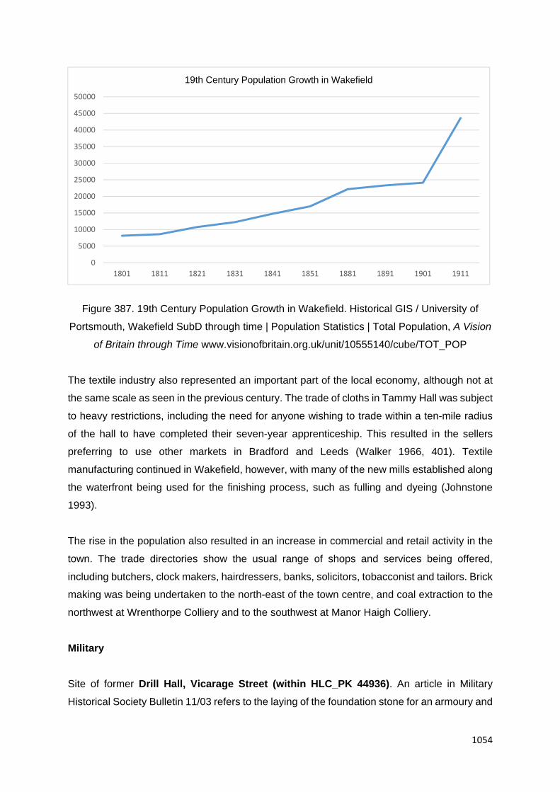
1054
Figure 387. 19th Century Population Growth in Wakefield. Historical GIS / University of
Portsmouth, Wakefield SubD through time | Population Statistics | Total Population, A Vision
of Britain through Time www.visionofbritain.org.uk/unit/10555140/cube/TOT_POP
The textile industry also represented an important part of the local economy, although not at
the same scale as seen in the previous century. The trade of cloths in Tammy Hall was subject
to heavy restrictions, including the need for anyone wishing to trade within a ten-mile radius
of the hall to have completed their seven-year apprenticeship. This resulted in the sellers
preferring to use other markets in Bradford and Leeds (Walker 1966, 401). Textile
manufacturing continued in Wakefield, however, with many of the new mills established along
the waterfront being used for the finishing process, such as fulling and dyeing (Johnstone
1993).
The rise in the population also resulted in an increase in commercial and retail activity in the
town. The trade directories show the usual range of shops and services being offered,
including butchers, clock makers, hairdressers, banks, solicitors, tobacconist and tailors. Brick
making was being undertaken to the north-east of the town centre, and coal extraction to the
northwest at Wrenthorpe Colliery and to the southwest at Manor Haigh Colliery.
Military
Site of former Drill Hall, Vicarage Street (within HLC_PK 44936). An article in Military
Historical Society Bulletin 11/03 refers to the laying of the foundation stone for an armoury and
0
5000
10000
15000
20000
25000
30000
35000
40000
45000
50000
1801 1811 1821 1831 1841 1851 1881 1891 1901 1911
19th Century Population Growth in Wakefield

1055
drill hall for the Wakefield (5th West York) Volunteers on 17th April 1865. The drill hall was
occupied by 'B' Squadron Yorkshire Dragoons, HQ for A, B 4 King's Own Yorkshire Light
Infantry, and HQ, A Section Yorkshire Mounted Brigade Field Ambulance Royal Army Medical
Corps. The buildings were demolished prior to the development of Trinity Walk Shopping
Centre (c.2008).
Territorial Army Centre, George Street (HLC_PK 45132 and 45135). Currently housing 299
Parachute Squadron Royal Engineers (V), 23 Engineer Regiment (Air Assault), E Company
Yorkshire (N&W) Army Cadet Force and 127 (Wakefield) Squadron Air Training Corps.
Established as a drill hall c.1881 and used by 1st Volunteer Battalion, The King's Own
Yorkshire Light Infantry (Ordnance Survey 1:500 Town Plan of Wakefield, 1891). “The head-
quarters of the 4th Territorial Force Battalion of the King’s Own Yorkshire Light Infantry in Bank
Street, is a spacious building containing drill hall, armoury, recreation and orderly rooms, and
officers’ quarters, with an adjacent drill ground” (Kelly 1912). The Wakefield detachment in
1912 numbered 320 men (Kelly 1912).26
Religious Buildings
The increase in both the population and popularity of non-conformists movements continued
into the 19th century, resulting in the establishment of a number of new religious buildings in
the town. In some cases, existing churches were rebuilt to house their increased congregation.
Many of those identified in the study area are still in use as religious buildings, but some have
been converted to other uses. Wakefield Cathedral, formerly known as All Saints’ Church, was
restored between 1858 and 1874 by Sir George Gilbert Scott, and again in 1898-1905,
following its elevation to Cathedral status.
Westgate Wesleyan Methodist Church (HLC_PK, WYHER PRN 8057). Grade II Listed. It
is located on the corner of Westgate End and Lawefield Lane, and was built in 1827. Red brick
with painted stone dressing. 2 storeys and basement. 5 bay front with narrow flanking bays
and broad, shallow bowed centrepiece, the pediment gable moves out with bow.
St Austin's Roman Catholic Church (HLC_PK 37297). Grade II Listed. The church, on
Wentworth Terrace, has strong associations with Charles Waterton of Walton Hall, who was
among its first benefactors. Built in 1827 by William Puckrin, it was originally a plain structure
26 www.drillhalls.org/Counties/Yorkshire/TownWakefield.htm

1056
but was extended and altered in 1852, and later in 1878-9. The most noticeable feature from
the later alteration is the domed Lady Chapel.
The Church of St James (HLC_PK 21713) was built on the east side of Denby Dale Road in
1829-31. It is Grade II Listed. Designed by Atkinson and Sharpe. Classical church of coursed,
squared stone with frieze and eaves cornice. Small later 19th century east addition. The
Parochial Hall to the south was added between 1908 and 1932 (not characterised separately).
Former United Methodist Chapel (HLC_PK 45122). Grade II Listed. Mid-late 19th century
former United Methodist Chapel Re-used as Post Office by 1951, now night club and bar (after
1996). Large, classical building with 5-bay end to road. Red brick with ashlar quoins and
dressings.
New Life Christian Centre (HLC_PK 44782). Formerly the Glad Tidings Hall. Grade II Listed.
Built 1842-3. Former Baptist Chapel. Red brick with stone dressings. 2½ storeys and tall
basement, 3 window end to road. The site of former courtyard housing dating to the mid to
late 18th to early 19th century. This area was established in the Medieval period, representing
expansion of the City in the 13th century. An area of probable crofts to the rear of settlement
along Westgate.
Zion United Reformed Church (HLC_PK 45196). Grade II Listed Non-Conformist Church,
converted into offices in period 2002 to 2009. The foundation stone was laid on 20th July 1843.
Built by 1844 dated in rear entrance bay below plaque giving date 1782 of predecessor.
William Shaw was responsible for the design, and was one of the major benefactors with Caleb
Crowther, M.D. On the opposite side of George Street, are the Caleb Crowther almshouses,
the shells of which were built in 1838-39 for poor nonconformists, but were not fitted up until
1862-63. Under the provisions of the Trust, the Trustees were not to be Roman Catholic, nor
solicitors, and to agree in writing that they did not intend to be a Tory or a member of the
Church of England. Caleb Crowther's grave is behind the almshouses, although the
gravestone has been moved. Established on yards set out in the Medieval period (as crofts
and burgage plots).
Church of St Andrew (HLC_PK 44820). Grade II Listed Parish church of 1846 built by
George Gilbert Scott (1811-78). Scott was the most successful church architect of his day,
although he was also awarded important secular commissions such as the Albert Memorial
and Midland Grand Hotel at St Pancras, both in London. St Andrew represents an early work
where his preference for the architecture of the late 13th century is apparent, and where he

1057
has applied his ideas to a church of relatively modest scale. The interior was significantly
altered in the 1970s to the designs of Richard Shepley.
St Michael's Church and Sunday school (HLC_PK 41324). Unlisted Gothic style, medium
scale, mid to late 19th century (c.1875) church. Replaced a public house and terraced housing
predating 1851.
Former Ebenezer Primitive Methodist Chapel, Market Street (HLC_PK 45125). Unlisted.
Wakefield Primitive Methodist chapel was opened in 1838 and was rebuilt in 1880. It held 200
people but closed in the 1960s. After closure, it became a health club. Now disused and
derelict (2014).
Former Wakefield Grove Road Methodist New Connexion Church (HLC_PK 45177).
Unlisted. Built in 1866, disused by 1978. Converted into apartments in the 1980s. The former
garden space of earlier Georgian townhouses and courtyard housing. Large Georgian house
called Grove House depicted here on the Ordnance Survey 1:1056 Town Plan of Wakefield
(see 44443).
Church of St Faith (site, HLC_PK 21502, WYHER PRN 11632). Grade II Listed Hospital
church. Opened 6th October 1861. Possibly by Sir George Gilbert Scott. Coursed squared
stone with ashlar dressings. Welsh slate roof. The church is said to have been built from copies
of plans for the Church of St. James, Doncaster, designed by G.G.Scott and Lord
Grimethorpe. In February 2014 Ed Dennison Archaeological Services (EDAS) undertook a
programme of building recording at St Faith's Church as part of a condition of Listed Building
Consent for the demolition of the fire-damaged church - the church was the subject of a serious
arson attack in June 2012 which caused severe damage including the collapse of the roof
across the whole building, and the loss of the pews, organ, timber panelling, stained and
painted glass, and leaded glazing. As a result, come parts of the church were left in a
dangerous condition, particularly in the high east and west gable walls, and were subsequently
demolished prior to recording. At the time of the EDAS survey the remaining standing parts
were in a very poor structural condition, with no safe access to the interior apart from that
which could be viewed from immediately inside the south porch. In September 2014 EDAS
undertook a structural watching brief at St Faith's Church to record the basement of the church
following the demolition of the rest of the structure. The basement was divided into two parallel
ranges reflecting the arrangement of the church's ground floor. The watching brief confirmed
that the boiler room was placed beneath the north-west corner of the building, at the west end
of the north range and that it had both internal and external access. It could be supplied with

1058
coal from outside. Some of the barrel vaulted spaces observed during the watching brief may
have been used for the storage of coal. No evidence was found to indicate that the cellar had
been used for mortuary purposes. The site is now occupied by new housing (terraced housing
block) constructed between October 2015 and June 2016. Only the perimeter wall survives.
Site of former Primitive Methodist Chapel, Quebec Street (site, within HLC_PK 44778). A
Primitive Methodist Chapel is depicted on Quebec Street on Walker’s Plan of 1823. The
beginnings of Primitive Methodism in the city are somewhat obscure. The Rev. William
Taylor of the Sheffield Circuit is stated to have preached in one of its streets on September
1st, 1820, but there is no record of the immediate formation of a Society. Subsequently,
however, Wakefield was missioned by the Barnsley Circuit and formed into a Branch, and
before 1822, it had become a separate circuit. The first meeting-place was an upper room in
Quebec Street, off Westgate. A chapel was built here in 1823, costing £1000 to build. It was
a brick building, approximately 14 yards square and was fitted internally with pews and a
gallery to seat 1000 people. However, by 1836 the Society was experiencing financial difficulty
and gave up on the Quebec Street Chapel, and it fell into the hands of the mortgager. A
square-shaped building is depicted fronting onto Quebec Street on the Ordnance Survey
1:1056 Town Plan of Wakefield, 1851 (NGR 432790 420530), but it is not depicted as a chapel.
The building appears to have been demolished before 1891 and replaced by terraced housing.
Site of Holy Trinity Church (site, see HLC_PK 45158). Holy Trinity Church was built in 1838-
9, and demolished before 1972. Now commercial premises (shops and warehouse) which was
built between 1972 and 1984.
Site of Salem Chapel, George Street (within HLC_PK 44797, NGR 433490 420640). A
Chapel was built in George Street and opened for worship in 1801 (often referred to as
Rayson’s Chapel)27. There was an accompanying grave yard to the front and west of the
chapel, with a later Sunday School located some 8m west. In January 1935 Salem Chapel
was closed, the building and school were sold to the Wakefield Corporation for £100028. It
became a ‘Civic restaurant’ (as depicted on the Ordnance Survey 1:2500 map of 1950). It was
demolished by 1955. The site is now occupied by Greenwood House - an eleven-storey tower
block built as public housing. The block contains 87 one and two-bedroom flats. Construction
is of concrete frame with brick infill panels. The development was approved by committee in
1962.
27 www.wakefieldfhs.org.uk/Independents.htm 28 www.wakefieldfhs.org.uk/Independents.htm

1059
Site of West Parade Wesleyan Methodist Church (HLC_PK 45186). Site of former West
Parade Wesleyan Methodist Church. Built in 1803, demolished by 1966. Former cemetery still
exists (see HLC_PK 45187). Modern offices (White Rose House) established between 1972
and 1984.
Site of Christ Church, Church Street (within HLC_PK 40879). Site of a church and small
school from the mid to late 19th century. Demolished in the mid to late 1960s. Now part of
Thornes Industrial Estate.
Site of former Bethel Chapel, United Free Methodist (within HLC_PK 40871). First depicted
on the Ordnance Survey 1:500 Town Plan of 1891. Probably c.1870-80, went out of use in the
late 1940s to early 1950s. Demolished in the 1960s. An associated Sunday School to the north
was also demolished by this time. The plot is now occupied by Thornes Industrial Estate.
Site of Belle Vue Oxford Street Wesleyan Church (within HLC_PK 42287). Established in
1870, closed in 1970. The building was demolished after closing and the plot is now occupied
by terraced housing dating to the 1970s.
Site of Brunswick United Methodist Chapel (HLC_PK 44891). Brunswick United Methodist
Chapel was built in 1876. Established on a small plot of undeveloped land (greenspace) set
amongst terraced housing dating to the early to mid-19th century (c.1820-30). Demolished
before 1998. The site is now occupied by modern terraced housing.
Site of St Mary’s Church, Charles Street (HLC_PK 44346). A church, vicarage and the
school were built here in 1876. The church and vicarage were demolished in the 1960s, with
the school building surviving until the late 1970s. The site is now occupied by St Mary’s
Primary School which was built in the 1970s.
Site of former Congregational Chapel, John Street (HLC_PK 44917). The site of a
Congregational Chapel built in the late 19th century (c.1875) and demolished by 1972. Set
amongst former courtyard housing, small-scale commercial premises, industries and civil
buildings. A series of yards (including courtyard housing) radiating away from Kirkgate,
established in the 16th to 18th century.
Site of St Catherine’s Church, Belle Vue (HLC_PK 42277). Church built c.1880. Depicted
on the Ordnance Survey 1:500 Town Plan of 1891 as having seats for 300 people. Demolished
in the 1980s and replaced by a modern church of the same name.

1060
Site of Belle Vue Doncaster Road Primitive Methodist Church (within HLC_PK 42262).
Established in 1888, closed in 1971. A Sunday School to the rear of the same date. After
closure, the buildings were demolished and the site is now occupied by 1970s low-rise flats.
Cemeteries and Burial Grounds
West Parade Burial Ground (HLC_PK 45187). Former burial ground to West Parade
Wesleyan Methodist Church (see HLC_PK 45186). Built in 1803, demolished by 1966. The
burial ground ceased to be used in the 1960s. The plot has been landscaped, with the former
tombstones used as pathways. Now greenspace.
Wakefield Borough Cemetery (HLC_PK 21581 and 21582). Borough Cemetery opened in
1859. By far the largest of the Cemeteries in the area both in geographical size and by the
numbers of interments. The site was a private estate with Belle Vue House occupying the site
of the chapels, which have now been demolished following an arson attack in 1991. The house
originally belonged to the Naylor family (John Naylor, owner of Cropper's Mill) who were mill
owners of Wakefield but was purchased in 1856 by Sir J. Pilkington who two years later
demolished the house and presented the land to the corporation for use as a cemetery. The
sheer size of the establishment demonstrates the demand placed on burial grounds and
indicates the problems which would have been created had the Cemetery not been opened.
The memorials within the Cemetery illustrate the wide social and monetary divides which were
evident in the Victorian era. Belle Vue House is depicted on the Ordnance Survey 1:1056
Town Plan of Wakefield (1851) and probably dated to the late 18th to early 19th century. The
cemetery and the earlier house (and its substantial gardens), was established on former strip
fields, the boundaries of which are visibile in the current landscape.
Hospitals and Almshouses
Caleb Crowther Almshouses (HLC_PK 45154). Grade II Listed. The shells of which were
built in 1838-39 for poor nonconformists, but were not fitted up until 1862-63. Built in coursed
worked stone with steeply pitched, graduated green slate roofs and tall cylindrical pots on the
multiple chimney stacks. Dr Crowther was a general practitioner and consultant to the pauper
lunatic asylum, and the almshouses were originally intended to house twelve Nonconformist
almsmen in six units. Under the provisions of the Trust, the Trustees were not to be Roman
Catholic, nor solicitors, and to agree in writing that they did not intend to be a Tory or a member
of the Church of England. Caleb Crowther's grave is behind the almshouses, although the
gravestone has been moved. In c.1990 the units were adapted into single accommodation for

1061
four individuals, with alterations to the internal layout and to the entrances and windows at the
rear.
Almshouses, Westfield Road (HLC_PK 44883). These Almshouses were built in 1887 by
G.E. Smith within the grounds of earlier West Yorkshire Propriety School (see HLC_PK
21678). A marble plaque on the north facing elevation reads "Homes For The Poor. Erected
and Endowed by G.E. Smith. A.D.1887", with carved sandstone plinth which reads "The stone
below the plaque reads:- Arnold S Nicholson VSA Architect. J.S. Flowers & Brothers, Builders"
Figure 388. Holmfield
Avenue Almshouses ©
Copyright Betty
Longbottom and licensed
for reuse under this
Creative Commons
Licence.
www.geograph.org.uk/photo/1218784
Almshouses, Holmfield Avenue (HLC_PK 40786). A group of four stone-built, single storey
almshouses built in 1887. There is a datestone “Erected by Major Barker, 1887”. Currently
administered by Wakefield Grammar School Foundation. Once part of a larger group of
almshouses, with a separate block to the immediate southwest. These were demolished and
replaced by a late 20th century terraced row.
Former Stanley Royd Hospital (HLC_PK 21462, 21463, 21464, 21465, 21466, 21467, 21479
and 21520). Established as the West Riding Pauper Lunatic Asylum (HLC_PK 21462,
21463, 21464 and 21465). This asylum was only the sixth to be built in England, and was part
of the contemporary development of belief that lunatics should be treated humanely and
attempts made to cure them. Although built plainly and utilitarianly, the asylum represented
the most advanced thought on the design of such buildings, and it provides an important link
between the first attempts at classification in an asylum's plans. Another important feature was

1062
the octagon towers, within which rose spiral stairs, which gave onto fenestrated embrasures
overlooking wards, corridors and exercise yards so that patients and staff could be kept under
close, but discreet, observation. The plan was advanced in providing many single rooms for
the patients. The utilitarianism is shown in the use of the cupola for housing a cylinder from
which exhaust air from the building escaped. The asylum was necessary to care for the
treatment and care of the insane poor, work began on it in 1816. The main builders were John
Robson, John Billinton and William Pockrin - all from Wakefield. When completed the hospital
was first occupied by the 23rd of November 1818. The eventual cost of the building work was
£23,000 being £7,000 more than the contracted price. The total cost was shown in the records
as £36,448. 4s. 9¼d.
The asylum stood in an area of 25 acres. For privacy the grounds were surrounded by
plantation in either Wakefield or Stanley to be quiet, peaceful and secluded. It was a much
needed hospital for in the early part of the 19th century very little was available by way of
treatment for mental illness. Before the opening of this asylum, sufferers were incarcerated in
prisons, workhouses or in their own homes at none of which treatment was available except
for purging, bleeding or mechanical restraint. The new county asylum was administered by
the magistrates at quarter sessions from 1818 until responsibility was transferred to the County
Council, through its Asylums Committee, in 1889.
Extension to the north between 1854 and 1891 (Ordnance Survey 1:500 Town Plan of 1891).
The complex was again expanded between 1894 and 1905 (Ordnance Survey 1:10560 maps
of 1894 and 1905) - a separate building complex later to become Pinderfields Hospital (see
HLC_PK 21466). From 1912 the County Council shared the task with the county boroughs,
forming the Asylums (later Mental Hospitals) Board. Depicted as the West Riding Mental
Hospital on the OS 1:2500 map of 1933-39. After 1948 the re-named Stanley Royd Hospital,
came under the control of the local health authority. The site split into two separate hospitals
by 1954, with the Stanley Royd Hospital to the south and Pinderfields Hospital to the north.
Further expansion of the hospital by 1984.
The Stanley Royd Hospital closed in 1995. Left derelict until recently redeveloped into multiple
residency accommodation (low-rise flats) after 2002. Former western wing demolished
between 1991 and 2002 (see HLC_PK 21463). Recent wholesale demolition of former hospital
buildings during redevelopment to the immediate north - development of Pinderfields Hospital
in the period 2002 to 2009 (see 21466, 21467)
1063
Pauper lunatic asylum hospital (Grade II Listed) was recently converted into low-rise flats.
Constructed in 1818 with wings added 1828 and 1833, by Watson and Pritchett of York for the
West Riding County Council; later 19th and 20th century alterations and additions. White brick
in Flemish bond with stone dressings and Welsh slate roof. Laid out on an "H"-plan with short
wings projecting from the cross-piece which were later extended. Each of the wings terminates
in a pavilion and at the two crossing points are octagon-towers from which the wards and
exercise yards could be observed. 3 storeys with 4-storey octagons and pavilions to ends of
added wings. Also converted is a Grade II Theatre – built originally as a hospital dining hall,
later recreation hall and then theatre. Constructed in 1859, extended to provide full working
stage in 1893, probably to the designs of Bernard Hartley, the County Surveyor. Grey brick
with slate roof. Nine-bay hall with one (blind) bay addition for stage, on to whose end gable
the datestone of 1859 has been reinserted.
Clayton Hospital (HLC_PK 37294 and 37295). Unlisted. Clayton Hospital is named after
Thomas Clayton, a mayor of Wakefield and was founded in 1854. It was an amalgamation of
Wakefield General Dispensary, founded in 1787, and the Wakefield House of Recovery,
founded in 1826. Wakefield General Dispensary was for out-patients and the Wakefield House
of Recovery was for poor in-patients suffering from infectious diseases. In 1852 the Wakefield
Union Workhouse was completed and its hospital wards accommodated pauper invalids and
fever cases, so that the House of Recovery was closed in 1854. In 1863 Mayor Clayton
financed an expansion and the institution was re-named 'The Clayton Hospital and Wakefield
General Dispensary'. The site moved from Dispensary Yard to the present site in 1876 and
the new building was opened in 1879 (HLC_PK 37294). By 1948 the name was changed to
Clayton Hospital and it had a capacity of 200 beds. Extended to north (new build) between
1914 and 1932 (possibly by 1922 - see HLC_PK 37295). The hospital closed in 2012 and now
lies disused.
Site of former Isolation Hospital, Park Hill (site within HLC_PK 44925, 44926 and 44927).
The site of a hospital is shown on the Ordnance Survey 1:500 Town Plan of Wakefield (1891)
to the south of Park Lodge Lane, to the west of what is now known as Park Hill Lane.
Established 187429. The Ordnance Survey 1:2500 map of 1907 describes it as the 'infectious
diseases' hospital and later as the 'isolation hospital'. It had been demolished by the mid-
1950s. The site has been redeveloped, with the plot occupied by a mosque, and ambulance
station and playing fields.
29 www.wakefieldhistoricalsoc.org.uk/PDFs/Timeline%20of%20Wakefield%201930-1940.pdf

1064
Communications
Denby Dale Road was established in 1825 following the enclosure of the Ings (Walker 1966,
500). Ings Road was established in 1831 (Walker 1966, 500) and its route represents the
boundary of the settlement area with the Wakefield Ings, an area of meadow. The Ings and
the remainder of the common lands were enclosed in 1805. The bridge over Ings Beck on
Denby Dale Road is early 19th century in date.
Office of Hebburn Conveyor Co, Navigation Yard (within HLC_PK 36178). Grade II Listed.
Early 19th century classical one-storey building of aslar with hipped slate root. 5-bays; two
sash windows with glazing bars at either side of entrance with Tuscan columns in antis and
pediment. Left side now obscured by projecting modern concrete addition. Adjoining buildings
(Nos. 1 and 2) Navigation yard appear to date to the same period, or slightly later. Once part
of a larger complex of canal wharf buildings which have fragmentary survival. By 1922, part of
the Rosa Works (engineering). Now part of the Trinity Business Centre.
The Bridge over Ings Beck (within HLC_PK 44492) on Denby Dale Road is early 19th
century in date. Low bridge parapet of coursed squared atone with wide, rounded coping,
railings missing. In centre a milestone dated 1825, signed J.L. Tyldesley, surveyor, giving
distances to Buckton, Stalybridge, Manchester and two other places now illegible. Over the
water a handsome segmental arch with cut voussoirs and keystone supporting band at former
road level.
Kirkgate Station (HLC_PK 36181). Grade II Listed Railway Station (Entrance) built in 1854.
Long, near-symmetrical composition in classical style. Ashlar. Centrepiece is a raised,
pedimented holy, with clock on lot floor, flanked by tall, one-storey, 4-bay wings with
entablatures, the outer bays emphasized by modillions to cornice and tall parapets. Lower 3-
window intermediate sections lead to outer 2-storey, three window end pavilions with small
outer sections beyond. Classical window treatment with segmental pediments in centrepiece
and outer bays of central section. Central entrance up four stone steps. Off-centre later canopy
on cast iron brackets. Established at the junction of the Lancashire and Yorkshire Railway
Wakefield to Leeds Line (c.1840) and the southbound Lancashire and Yorkshire Railway
Wakefield, Pontefract and Goole Line of c.1845. The original Kirkgate station opened by the
Manchester and Leeds Railway in 1840 was the only station in Wakefield until Westgate was
opened in 1867. The station building dates from 1854. Some demolition work took place in
1972, removing buildings on the island platform and the roof with its original ironwork canopy
which covered the whole station. A wall remains as evidence of these buildings. After this,

1065
Kirkgate was listed in 1979. In January 2008 the former goods warehouse was demolished to
make way for a depot for Network Rail (HLC_PK 36182).
Westgate Station (HLC_PK 21356) was constructed in May 1867, established on a railway
line dating to 1846. It was built by the Great Northern Railway and the Lancashire and
Yorkshire Railway in an Italianate style, similar to the LYR station at Bradford and attributed
to Eli Milnes on that basis (Sheeran 1994, 22). The central booking hall was of ashlar with an
attic storey and pediment. There were adjacent east and west pavilion ranges and a clock
tower, which extended 30m above street level. The platforms featured zig-zag canopies above
the frame (a GNR feature) and an ornate cast-iron frame. The accompanying station complex,
constructed in the late 1860s and 1870s extended into the land north of Westgate. It included
sidings, cattle pens, cranes and a turntable. A goods depot opened in 1868 and was owned
by the Wakefield, Goole and Pontefract Railway. The station was demolished in 1967 (Ellis
1991, 104) and only fragments of it remain in the platform building fronting Parliament Street
and Station wall - a short section of 19th century brick wall survives along the southern
boundary of the present station. The wall has historic interest due to its association with the
earlier station building and retains an interesting architectural detail in its stone doorway. A
new station building was constructed in the late 1960s to early 1970s. To construct Westgate
Station, a large area of former burgage plots were demolished between Parliament Street and
Scott's Yard (south of the Unitarian Chapel). The only structures to survive were Pemberton
House (see HLC_PK 21354) and The Unitarian Chapel (see HLC_PK 21358).
Public and Municipal Buildings
Following the granting of a Royal Charter of Incorporation in 1848, a new building was required
to house the mayor, aldermen and councillors who were now responsible for the running of
the settlement. The Town Hall, located in Wood Street, was eventually completed in 1880.
The Magistrates Court was completed around the same time. The County Hall, used to house
the administration for the West Riding County Council, was built in 1894-98.
Nos. 10 to 14 and 14a King Street (HLC_PK 21398). Unlisted. Buildings here depicted on
the Ordnance Survey 1:1056 Town Plan of Wakefield (1851) - 14a King Street is a Police
Office to north, Nos. 12 and 14 as a Fire Engine House and No. 10 as a 'Vagrant Office'. By
the Ordnance Survey 1:500 Town Plan of 1891, no-longer depicted a such - both the police
and fire brigade had moved to new offices by 1876.The Wakefield Borough Police came into
being in September 1848 after the Borough Council were tasked with forming a 'constabulary
force' for the newly formed borough. The first police station was located in King Street and still

1066
stands today - the building immediately to the south was a Fire Engine House - the building
originally being the 'Police and Vagrant Office' in 1829. The building consisted of two cells and
a short time afterwards, a female detention was built on the first floor.
Magistrates Court (HLC_PK 21392). Grade II Listed. Grade II Listed Magistrates Court.
Including No 26 King Street. Later 19th century restoration of a late18th century building which
stretches back to Gill Street then returns southwards with extensions to King Street. Main front
of 2-storeys, 7 windows. Ashlar with banded ground floor, 1st floor cill string; top entablature
with bracketed cornice and blocking course. Sash windows have moulded lintels on 1st floor
and architraves below, both under console bracketed cornices. Pattern of chains in ground
floor friezes. Ornamental doorway has keystone with mask: a bearded police officer of stern
yet benign aspect wearing a traditional helmet.
Established on the site of, and in part re-using, late 18th century building - Tammy Hall (Stuff
Mill) as depicted on the Ordnance Survey 1:1056 Town Plan of Wakefield, 1851. Tammy Hall,
a large building erected for the sale of a special locally produced worsted cloth in the 1770s.
After various other users in the mid-19th century, the building was purchased by the
Corporation in 1876 and some half of it was demolished and the site added to that available,
for the building of the new Town Hall which was then again in prospect; the remainder was
altered and refaced to provide a Borough Police Station and Fire Station and there still remain
fine carvings of a policeman’s helmeted head at one (the County Hall) end and of firemen at
work at the other. Tammy Hall was established on the site of earlier burgage plots and
associated housing dating to the medieval period, and later post medieval commercial and
industrial premises (as workshops) and housing along long, narrow yards. The arrangement
of buildings and tenements to the rear respects the earlier burgage plots.
The Crown Court House (HLC_PK 21393). Grade II* Listed. Located on the site southwest
side of Wood Street, the building was erected in 1810, constructed in the Neo-Greek style with
extensions of 1849-50. Two-storeys, sandstone ashlar with banded rustication to all walls.
Tetrastyle. Doric pedimented portico with eight side steps to stylobate. Central door flanked
by sash windows with glazing bars. Plain parapets to one-storey side wings. Set back two-
storey left section has three pairs of windows and an entablature and blocking course
continuous with return of main block. Established probably on the site of earlier burgage plots
and associated housing dating to the medieval period, and later post medieval commercial
and industrial premises (as workshops) and housing along long, narrow yards. The
arrangement of buildings and tenements to the rear respects the earlier burgage plots.

1067
Town Hall Chambers (HLC_PK 21387). Civic building constructed 1863. Forms the historic
core of Upper Westgate, Wakefield. Grade II Listed Classical building of 1863. 2-storeys and
sunk basement, main 5-bay front to Cliff Parade, rebated angle and three bays to King Street.
Ashlar with plinth, 1st floor band, top entablature and blocking course. Sash windows in raised
flat frames with ovolo reveal moulding, three steps to six-panel door with oblong fanlight in
doorcase of engaged Tuscan columns and entablature.
Town Hall (HLC_PK 21394). Grade I Listed Town Hall. 1877-80 by T.E. Collcutt. Inverted U-
shaped range embracing a large public room behind (possibly once intended as the Council
Chamber but now the Magistrates Court). Imposing building in a freely-interpreted north
European Gothic style with Jacobean decorative touches. Very steeply pitched Welsh slate
roofs having ornamental shaped and pedimented gable ends and tall, many-shafted
chimneys. Constructed in ashlar in narrow, irregular courses. Collcutt also designed the
interior of which much survives including some furniture. The Court Room, the Mayor's
Parlour, the Council Chamber and' (especially) the Members' Lounge contain rich relief
decorations, carved fireplaces and very good woodwork. In 1865 the Town Hall site carried
an ambitious (but temporary and wooden) Crystal Palace style building which housed the
Wakefield Industrial and Fine Art Exhibition. The profits of the Exhibition led to the
establishment of the present Wakefield Technical College.
Figure 389.
Wakefield Town
Hall (WYHLC
Project)
The Town Hall was built on the site of a late 18th century building - Tammy Hall (see above)
as depicted on the Ordnance Survey 1:1056 Town Plan of Wakefield, 1851. Tammy Hall, a

1068
large building erected for the sale of a special locally produced worsted cloth in the 1770s.
After various other users in the mid nineteenth century, the building was purchased by the
Corporation in 1876 and some half of it was demolished and the site added to that available,
for the building of the new Town Hall which was then again in prospect; the remainder was
altered and refaced to provide a Borough Police Station and Fire Station.
County Hall (HLC_PK 21408). Grade I Listed. County Hall (civic building) constructed in
1894-98 on the site of earlier detached villa house - Rishworth House. Rishworth House
constructed c.1800 by Thomas Rishworth. Thomas was appointed the first clerk at the bank
of "Ingram, Kennett Dawson and Ingram" which opened in Wakefield in 1794. In November
1802 he formed his own bank in partnership with Townend of York. Shortly after surviving a
run on its resources in January 1812, the bank amalgamated with that of Wentworth and
Chaloner of York, and became "Wentworth, Chaloner and Rishworth". Thomas and his family
lived in Birthwaite Hall, near Darton, and were apparently pillars of the Wakefield community.
He built Rishworth house in Bond Street, Wakefield, for his son Thomas, who was also a
partner in the bank.
The first meeting of the West Riding County Council was held in February 1889 in Wakefield
Town Hall, at the invitation of the Borough Council, but obviously a permanent home was
needed without undue delay. In November of the same year, the General Purposes Committee
reported on the accommodation required and the question of location. The choice lay between
Leeds and Wakefield, and on the whole the case for selecting Wakefield was the stronger.
The County Council already owned Rishworth House, in Bond Street, which the Magistrates
had purchased in 1878 and converted to provide a residence for the Deputy Clerk, Committee
Rooms and offices. Making additions to Rishworth House, it was estimated, would cost
£16,500. Demolishing the building and replacing it with purpose-built County Offices was
expected to cost twice as much. However, erecting a building in Leeds would entail
expenditure of some £48,500. There was little to choose between the rival towns for
accessibility. Of the 90 electoral divisions, 34 were more accessible by rail to Leeds; 38 to
Wakefield; and 18 of equal accessibility. Since the County Council’s administration was
already located in Wakefield, a move to Leeds "would necessarily be attended with a
considerable amount of trouble and expense".
The issue was deferred on the grounds of cost, but growing congestion in staff working
conditions forced the matter to be reconsidered in 1892 and the Council decided to remain in
Wakefield. The Council agreed to hold an open architectural competition, its first prize being
£200. In the instructions to competitors it was indicated that "the style of architecture will be

1069
left to the competitors but the Queen Anne or Renaissance School of Architecture appears
suited to an old town like Wakefield".
The winning design under the pseudonym "Diadem" was submitted by the architects James
Gibson and Samuel Russell of Grays Inn Square, London. Some minor modifications were
made including a decision to install electricity rather than gas (Although no public supply was
then available, it was probably known that Wakefield Corporation was intending to set up
generation as they did in 1896). Messrs. Young and Brown of London were appointed Quantity
Surveyors in January 1894 and in July a tender was accepted from Messrs. Armitage and
Hodgson of Camp Road, Leeds. It is interesting to note that the contract contained a fair wages
clause, modelled on that used by Staffordshire as well as a ban on subcontracting to
employees in sweated trades.
The County Hall is Grade I Listed. Built in 1894-98 by Gibson and Russell, with additions of
1912 and 1915. It is a large, imposing building of an Art Nouveau character with Italian qualities
to the decorations. Materials and workmanship of highest quality. Exterior of Grindleford stone
ashlar richly carved with designs both heraldic and symbolic by W. Birnie Rhind of Edinburgh
who also made the interior sculpture. There is much sculpture in the Council Chamber and in
the ante-room a large polychrome relief plaster frieze of scenes from the Wars of the Roses,
by C. Fehr of London. Many inlaid marble floors and much hardwood panelling throughout
(Listed Building Description).
Wakefield Coroner's Office (HLC_PK 21427). Grade II Listed former detached villa house.
Substantial late 18th century or early 19th century house of 3-storeys, five windows. Red brick
with stone dressings including plinth band, ground floor cill band, top frieze and cornice with
diagonal dentils concealing very low pitched hipped Welsh slate roof. On returns paired
brackets to eaves gutters. Finely gauged flat brick arches and stone cills to replaced sash
windows. Central early 20th century neo-classical stone doorcase. Depicted as Egremont
House on the Ordnance Survey 1:500 Town Plan of Wakefield, 1891. The Georgian mansion
on Northgate was built in 1811 for John Egremont and his wife, Hannah (Goodchild 1980). Mr
Egremont came from a family of freehold farmers and small squires who lived at Reedness
Hall near Goole. In 1773, he married 24-year-old Hannah Crowther, who was the only child
and heiress of Thomas Crowther, a wealthy wool stapler who lived in Westgate and owned
his own warehouse and the Woolpack Inn. The mansion was built after Hannah inherited her
father's fortune in 1810. They had three children together and the eldest, named after his
father, became a barrister and lived at Hatfeild Hall for a while. Their second son, Edward,
became a vicar of Wroxeter and Shropshire. Emily, the couple's daughter, married Tottenham

1070
Lee, son of John Lee, a Wakefield lawyer and mastermind behind the development of the St
John's area. Egremont House was let to the Rev E.H. Brooksbank when Mr Egremont died in
1840. He was the son-in-law of Benjamin Heywood, of Stanley Hall. It was then let to John
Meynell, a local barrister. In 1848 the house was sold to solicitor Henry Brown, who later
became the city's first mayor. When he died in 1869, the building was sold again. It was bought
by the West Riding Council in 1951 (Goodchild 1980). At first it functioned as both a register
and coroner’s office, but is now used solely coroner's office. Single-storey building to rear
added in the mid-1950s.
Masons’ Hall, Zetland Street (HLC_PK 45026) first depicted on the Ordnance Survey 1:500
Town Plan of Wakefield (1891). Probably c.1880. Constructed on the site of earlier detached
house depicted as The Rectory in Gothic script on the Ordnance Survey 1:1056 Town Plan of
Wakefield (1851). An ancient building (repaired and extended in 1769). Probable late Medieval
or early Post medieval building. Probable earlier Medieval origins, built as the Rectory Manor
of Wakefield, associated with nearby Catherdral Church of All Saints’ (Wakefield Cathedral -
see 21275).
Workhouses
Site of former Wakefield Workhouse, George Street (site within HLC_PK 45191 and
45192). Wakefield had several early poorhouses. The first, combined with a House of
Correction, was built in 1689. Another at Horbury was in operation by 1747. By 1834,
Wakefield had a parish workhouse on George (or Georges) Street at the top of Thornhill
Street, opposite Crowther's Almshouses (demolished by 1908). The site is occupied by a
former printing works built between 1894 and 1908, now commercial offices (Monarch House
– see below).
Site of former Wakefield Union Workhouse (site within HLC_PK 20021). In 1851, a new
union workhouse was erected at the south side of Park Lodge Lane. It was intended to
accommodate 300 inmates at an estimated cost of £4,000. The new building was designed
by JE Oates who was also the architect of workhouses at Blackburn and Sunderland. The new
Wakefield workhouse had a range of entrance buildings at the north containing the Master's
offices, board room and committee rooms, and casual wards to each side. A central archway
led through to the main T-shaped block which housed male inmates at the west and females
at the east. The dining hall and kitchens were located in the rear wing. The original infirmary
stood at the south of the workhouse and was enlarged in 1881. In 1894, the British Medical
Journal set up a "commission" to investigate conditions in provincial workhouses and their

1071
infirmaries. Following a visit to Wakefield, the commission's report found conditions to be
generally of a good standard. The main concern was with the size of the nursing staff — two
nurses (one in the main block and one a separate isolation block) provided the care for over
90 patients, spread across sixteen wards in each of which a pauper wardsman or woman
acted as a nursing assistant. At night, a single trained nurse was on duty for the whole
institution. The commission recommended that the nursing staff be at least doubled. A large
new pavilion-plan infirmary was erected to the south of the workhouse in 1896-8. It was
designed by local architect William Watson. The new infirmary provided 150 beds and cost
£20,000. It had the most up-to-date facilities of its time including filtered, washed and
humidified air, electric lighting, and its own telephone system. A new porter's lodge and
receiving wards were added at the entrance to the site in 1904. From 1904, to protect them
from disadvantage in later life, the birth certificates for those born in the workhouse gave its
address just as 90 Park Lodge Lane, Wakefield. During the First World War, the infirmary
provided 100 beds for military patients. In 1930, the site came under the control of the West
Riding County Council. The workhouse later became known as Stanley View and provided
accommodation mainly for the elderly, but also temporary homes for homeless families and
battered wives. The infirmary part was developed as Wakefield County Hospital, becoming
part of the National Health Service in 1948. After 1968, it too catered mainly for elderly
patients. All the workhouse buildings have now been demolished and the site is occupied by
a modern housing estate, constructed between 1990 and 1995.
Site of former Industrial Home and House of Refuge (HLC_PK 44859). The idea for
establishing a House of Refuge at Wakefield, for females discharged from prison, is said to
have originated with a Mrs Hamer. On April 3rd, 1848, the proposal was unanimously
endorsed by a meeting of county magistrates in Pontefract. The institution was opened on July
10th of that year in premises at St John's, Wakefield. In October 18, 1856, part of the House
of Refuge site was turned over for use as a Reformatory as an alternative to prison for girls
sentenced by the courts to detention. Up to 23 girls could be accommodated. The institution
then became known as the West Riding Refuge and Reformatory for Girls. In the late 1850s,
plans were made to establish a new Reformatory in purpose-built premises at Doncaster - the
Doncaster institution formally came into operation on September 6th, 1861. In 1865, it was
decided that Doncaster could handle all the reformatory cases from the West Riding and that
the Wakefield facility would cease operation. Its closure took place the following year and the
Refuge reverted to its original function but now being known as the West Riding Industrial
Home for Discharged Female Prisoners. Plans were put in hand to extend and improve the
premises but fund-raising was so successful that it was decided to erect a completely new
building on a site immediately adjacent to the old one.

1072
The new premises were officially opened on April 3rd, 1872, with the inmates being transferred
from the old Home a few weeks later. The building cost about £3,400 (not including £300 for
the ornamental work outside which was paid for by Colonel Akroyd, M.P., chairman of the
committee). The construction was carried out by Mr. Green, of Wakefield, from designs by
William Swinden Barber of Halifax. The oblong building had a frontage of 163 feet and a depth
of 39 feet, and was mostly three stories in height. The ground floor included the wash-house,
drying room, laundries, etc.. The first floor included 'offices' of various kinds, and the second
floor, with the exception of the chapel, was devoted to dormitories. The chapel, 18 feet wide,
extended the whole width of the north end of the building. It included a stained glass window
by Hardman, of Birmingham, on the theme of 'Faith, Hope, and Charity'. The Home took
females discharged from Wakefield Prison without charge, while those from other gaols were
required to pay from 4s. 6d. to 6s. a week, or a single payment of £5. The permissible age for
admission was from 15 to 40 years. Certificates of health were required, and 'immoral persons'
were ineligible for entry.
At the end of 1921, the institution — now known as the St John's Industrial Home — was
closed, with more than a thousand women having been admitted since 1866. The premises
were then transferred to the Wakefield Diocesan Council for Rescue and Preventive Work.
Under its new management, the St John's Training Home provided accommodation for up to
30 'girls needing disciplinary training', aged from 14 to 17 at their date of admission. The girls
were trained for domestic service and found situations.
In 1937, the Home became an Approved School then in 1973 was redesignated as a
Community Home with Education (CHE) under the control of the West Riding County Council.
The School closed in 1982 and left vacant. The building was demolished between 1991 and
1996, and the site is now occupied by low-rise apartments (St John’s Mews).
Educational
The Old Cathedral Grammar School was first established in the late 16th century, although
the buildings here date to 1855 (see above). The Queen Elizabeth Grammar School was
established in 1854, re-using an earlier Propriety School Building of 1833-4. It was formerly
known as the Grammar School for Boys’. Wakefield Girls’ High School was founded in 1878.
Queen Elizabeth Grammar School and Wakefield Girls' High School have made a rich
contribution to the lives of many boys and girls from West and South Yorkshire.

1073
Queen Elizabeth Grammar School (HLC_PK 21675, 21677, 45094, 45097 and 45098) is
distinct from most other schools in Yorkshire in that it was founded by Royal Charter of Queen
Elizabeth I in 1591 at the request of leading citizens in Wakefield, some of whom formed the
first governing body. In 1854 QEGS moved to its present site in Northgate, Wakefield, into
premises formerly occupied by the West Riding Proprietary School (constructed 1833). The
West Riding Preparatory School is a Grade II Listed Building constructed in 1833-4, designed
by Richard Lane of Manchester. Constructed in ashlar in a mock Tudor style. It stands two-
storeys, with centre and end blocks, the former with central gable flanked by battlemented
octagonal towers. Tudor arched window and door below. Narrow flanking bays have tall
lancets. End sections have raised parapets with blank shields and large, 2-tier mullioned and
transomed windows. One-storey, four-bay intervening sections have large 2-light windows
with Tudor heads. All windows have fancy leaded glazing. The School Governors Offices for
Queen Elizabeth Grammar School is a re-use of a former detached villa house (Green House
on the Ordnance Survey 1:1056 Town Plan of 1851), converted c.1910. It is a Grade II Listed
Building, dating to the early 19th century. Three-bay villa with a sympathetic modern south
extension. Soft red brick, low pitched hipped slate roof with eaves cornice of moulded stone.
Gauged flat brick arches and stone cills to sash windows with glazing bars. 4-panel door in
doorcase of engaged columns, entablature and blocking course, up three steps. Stone plinth.
There is also a separately Grade II Listed War Memorial within the school grounds.
Wakefield Girls' High School (HLC_PK 21682, 21697 and 21708). Changing opinions were
prevalent during the 19th century and a movement for the social and educational emancipation
of women gathered pace. The QEGS Governors agreed to pursue this and in 1878 Wakefield
Girls' High School opened with 59 pupils located in Wentworth House, its current location. A
re-use of former detached villa house. Wentworth House is a Grade II Listed substantial
merchant's house of 1802-5. Three-storeys and blank basement, with seven windows. Three
central bays project slightly. Red brick with stone basement, 1st floor cill band, modillion eaves
cornice. Gauged flat brick arches and stone cills to altered windows, mainly sashes though
one or two are modern casements. Wide flight of five stone steps to door with plain fanlight in
architrave with impost blocks, the whole in prostyle Roman Doric porch with segmental
pediment. House built for John Pemberton Heywood, barrister and son of a local cloth
merchant.
Extensions to the school in the 1940s through to 1970s includes the re-use of former detached
villa houses established c.1875. Includes Grade II Listed Nos. 5 to 13 Wentworth Street and
No.1 St John's Square. Three pairs of houses, third quarter of c.19th century. Each house 3-
storeys, one window on road front but with a 3-bay return. Bright red brick with stone frieze

1074
and cornice and window dressings. Welsh slate hipped roofs of fairly low pitch. Sash windows.
Ground floor heavy canted bays and Ionic doorcases on returns. The villa houses, in turn,
established on the site of an earlier buildings with a substantial ornamental garden, depicted
on the Ordnance Survey 1:1056 Town Plan of Wakefield (1851). The whole of the area
southwards to Wentworth Terrace consisted of garden plots of varying size, with no indication
from the map on who owned them or which properties they were associated. Land on the
south side of the square (St John's Square) was also occupied by gardens, beyond which was
an area of long buildings, including one apparently with a large glass dome, may have been a
nursery or botanical garden and may explain the presence of all the garden land. The
buildings, probably built in the early 19th century (akin to Wentworth House - see HLC_PK
21697), appears to have been used as a church between 1891 through to 1972, before being
absorbed into the school grounds.
Additions to the school also include an area to the west of Margaret Street (HLC_PK 21708).
This part of the school not built until c.1951 - formerly the large gardens to No.2 St John's
Square (St John's House) which was constructed between 1791 to 1795 (see HLC_PK
21707).
City Limits Urban Studies Centre (HLC_PK 45159). Grade II Listed. Former Methodist
Primary School, now educational resource centre. 1846. Inscribed and dated plaque in
pediment over slightly projecting central bay. L-storey, three wide bays. Coursed ashlar, raised
quoins, plinths, cornice and parapet.
Former City Museum (HLC_PK 21395). Grade II* former Music Saloon, Subscription Library
and Dispensary, Mechanics’ Institute, then Museum, now part of Wakefield College. Built in
1820-21. Constructed in sandstone ashlar. Two tall storeys, five bays. Plinth, rusticated
ground floor to 1st floor band on which rest paired Ionic angle pilasters and half-columns
dividing bays. These support entablature below hipped roof of graduated Welsh slate. Sash
windows with glazing bars (mostly replaced) those on 1st floor in narrow architraves with
cornices and apron panels. Incised letters in frieze; MECHANICS' INSTITUTION. Modern
central doorway. Returns have three grouped windows on each floor, framed in Ionic orders.
Rear elevation to Tammy Hall Street is stuccoed in Regency style. 2-storeys and basement
with a low mezzanine having blank window panels. Windows arranged 3:3:3, central ones in
round bow. Sash windows with glazing bars, (curved on plan in bows) mostly replaced.
Initially a Music Saloon, public rooms, subscription library, savings bank and public Dispensary
(in the 1820s and early 1830s, Wakefield’s public Dispensary occupied a part of the basement.

1075
Access for patients was gained by the outside stone steps on the south side of the building.
The cellar provided residential accommodation for the apothecary and for two house
servants). In September 1832, public baths were established in the cellar taking the place of
the Wakefield Dispensary and, no doubt, designed to replace the lost income from the
Dispensary’s rent. Amongst the promoters was again Vicar Samuel Sharp. Whilst the baths
very possibly had a recreational element – families could attend together for 10s 6d - they
were provided primarily for hygienic or medicinal purposes. They included a vapour, or steam,
bath, a warm bath, a plunge bath and a shower. After the opening of Wakefield’s magnificent
Corn Exchange in Westgate in 1838, the Music Saloon lost popularity. Events like balls and
bazaars, and even professional operas, took place instead in the much grander Corn
Exchange upperfloor assembly room. Wakefield’s Mechanics’ Institution, formed in 1841, met
during its first year in the Assembly Rooms in Crown Court, holding its evening classes in a
number of other rooms in the town. From June 1842, however, it leased the Music Saloon and
its Ante-Room with powers to sub-let. In 1855 the building was put up for sale. Wakefield had
as yet no Town Hall and the Council considered buying it. The Church Institution was also
interested in the opportunity. However, it was sold to the, already resident, Mechanics’
Institution. The Music Saloon itself remained available for hire for public events. The building
was renamed the Institute of Literature and Science in 1910. By the 1930s the Mechanics’
Institute / Institute of Literature and Science, was failing. It was dissolved on 1st October 1935.
In 1935 the committee of the Institute offered the building to the local authority and it was
formally conveyed to Wakefield Corporation in December 1936. It was not until 1955 that
Wakefield Corporation decided to move its Museum into a part of the Public Buildings, still
leaving the Music Saloon for lettings. Later the Music Saloon, too, was taken over for museum
displays. Ceased being a museum in 2012. Now rented by Wakefield College as a performing
arts centre (since 2013).
Pinders Primary School (HLC_PK 37371). Pinders Primary School came into existence in
September 1992, previously being Eastmoor First School. Wakefield Eastmoor First School
built in 1876 on former strip fields. The school website mentions that the present school was
built in 1911, but analysis of the Ordnance Survey 1:500 Town Plan of 1891 shows the same
building, with extensions to southeast in the 1950s. Pinders Primary School is the only school
opened as a result of the Education Act 1870 which remains open today (Taylor, 2008).
Sandal Magna First School (HLC_PK 42177). Established in 1890. The school had
expanded to become a medium to large scale school by c.1914. Demolished around 2009.
Replaced by new school buildings now called Sandal Magna Community Academy.

1076
Former St Michael’s Infant School (within HLC_PK 37623). No. 12 Grange Street is a
former school - St Michael's Infants School established 1876, closed in 1969. The building
was used as a warehouse for some time, before recently being converted into a mosque (see
below).
Site of former Lancasterian School (HLC_PK 37488). School established in 1812, closed in
1901. Depicted as Newstead Road Special Subjects Centre on the Ordnance Survey 1:2500
map of 1950. Demolished by 1966. The site is now occupied by Wakefield College buildings.
Site of Bell National School (HLC_PK 37444). The Bell National School was opened in 1813.
The building here was the former Boys’ School. It closed in 1868 when the boys moved to
Zetland Street. It became part of Wakefield College of Art in 1868. This earliest part of the
college was demolished between 1972 and 1984, and replaced by new college buildings.
Site of Thornes Gaskell’s School (site, see HLC_PK 40757). Thornes School (Female) is
depicted on the Ordnance Survey 1:1056 Town Plan of 1851. The school was established in
the 1840s, and closed in 1970. It was demolished by 1985. The site is part derelict land,
although to the immediate north were blocks of late 1930s social housing (White House
Bungalows – see below).
Site of St Michael’s School, Horbury Road (within HLC_PK 41322). The Boys’ school was
founded in 1851 (first depicted on the Ordnance Survey 1:500 Town Plan of 1891). The Girls’
School was established in 1866 and the Infants in 1876. In 1951 both schools moved to
Flanshaw. The school building was demolished before 1950. The site is occupied by 1950s
detached housing.
Site of St John’s First School (HLC_PK 44864). In operation between 1861 and 1968. Re-
use of earlier terraced housing established in the early 19th century. The school was
demolished after closure, the site is occupied by low-rise apartments established between
1972 and 1984.
Site of St Catherine’s School (HLC_PK 42282). St Catherine's School (Boys and Girls)
established in 1870. Closed in 1959. Site redeveloped in the c.1970s, possibly with
associations with the Theatre Club present in the area to the immediate south (now a bowling
alley).

1077
Site of former St Austin's Roman Catholic Infants, Junior and Mixed School (within
HLC_PK 44932). The school was established in 1873. Demolished between 1966 and 1972.
Now the site of Phoenix Court (commercial offices built between 1996 and 2002). St Austin’s
School relocated to its present site (HLC_PK 37369) in the early 1970s.
Site of former Westgate School (HLC_PK 44777). School established in 1871. Closed in
1939. The school buildings were converted into a clothing factory (Piccadilly Works on the
Ordnance Survey 1:2500 map of 1952). Demolished between 1962 and 1972. The site is now
occupied by commercial warhousing.
Site of former St James’s School, Thornes (within HLC_PK 40832). H-Shaped plan, built
c.1861. Closed in 1960. Demolished by 1969. Now part of an industrial estate.
Site of Ings School (within HLC_PK 44500). Ings Road School was built in 1897. Closed in
1971. For some time used as a training centre. Demolished before 2002. It was demolished
sometime between 1996 and 2002 as part of the Westgate Retail and Leisure Park
development. However, the Boys and Girls entrance stones have been included in the road
systems.
Wakefield College has three main sites in the Wakefield district: Wakefield City Campus,
Thornes Park Campus (see below), and a satellite campus in Castleford. The Wakefield City
Campus (HLC_PK 21722, 37444, 37467, 34768 and 37488), is located at Margaret Street in
the city centre and houses the Sixth Form Centre for students studying for AS and A Levels.
This campus offers also courses such as ICT and Computing, Office Skills, Hospitality and
Catering, Travel and Tourism, Health Studies, Childcare, Animal Care and Languages. The
Wakefield City Centre recently underwent major re-development works, including the
completion of a new building designed to house the College's sixth-form, higher education
provision and new Library. The Hospitality, Catering and Animal Care facilities are housed in
a separate building on Sandy Walk (HLC_PK 21722) established c.1972 within the gardens
of former large detached villa house called “The Cliff” (see HLC_PK 21709). "The Cliff" as
depicted on the Ordnance Survey 1:500 Town Plan of Wakefield (1891).
The College is the largest college in the District and has an impressive track record, having
provided education and training in Wakefield and its surrounding area since 1868. Established
as Wakefield College of Art in 1868, in part re-using former Bell National School which is
depicted on the Ordnance Survey 1:1056 Town Plan of Wakefield (1851). The Bell National
School was opened in 1813. New buildings added between 1894 and 1908, and again

1078
between 1908 and 1914. Further expansion between 1948 and 1955. In the 1950s, it was
known as the Wakefield Technical College on Burton Street, becoming the Wakefield
Technical and Arts College in the early 1960s. This earliest part of the college was demolished
between 1972 and 1984, and replaced. The college expanded again in the mid-1960s,
acquiring (and demolishing) former early 19th century terraced housing (St John's Terrace -
see HLC_PK 37467) and a former Lancasterian School (see HLC_PK 37488). It became
Wakefield College of Technology and Arts in 1973. In 1974, it became administered by the
City of Wakefield. Between 1974 and 1984, it acquired The Elms, a former villa house (at that
time a dentists) immediately north (see HLC_PK 37468). The building was extended and
modified between 1984 and 1991, but was eventually demolished between 2009 and 2011,
being replaced by a purpose built campus building. The college recently acquired the former
Mechanics’ Institute, which houses Performing Arts students and Mechanics’ Theatre.
Industrial
Following a period of commercial and industrial stagnation, a small number of Wakefield’s
inhabitants became involved in the woollen and worsted trade during the 19th century, some
with much success, and several large worsted mills and dye houses were established in the
town. By 1832 there were a total of ten woollen and five worsted mills in the parish of
Wakefield. The mills were, in the main, located along the river Calder and along the becks to
the south and west of the town. Upper Mill occupies the probable medieval fulling mill. Most
the surviving buildings are now warehouses.
The partial failure of Wakefield’s textile industry was tempered by the development of other
economic activities, including rope manufacture, wire making, brewing and malting, boat
building, agricultural implements and machine manufacture, iron founding, soap and chemical
industries and brickworks, giving the town a diverse economy (Taylor, 2008). On the outskirts
of the town, coal had been dug since the 15th century and 300 men were employed in the
town's coal pits in 1831 (Penny Cyclopaedia, 1843). During the 19th century more mines were
sunk so that there were 46 small mines in Wakefield and the surrounding area by 1869
(Galloway, 1971). The National Coal Board eventually became Wakefield's largest employer
with Manor Colliery on Cross Lane and Park Hill colliery at Eastmoor surviving until 1982
The chief basis for the town’s prosperity, however, was its extensive markets and trade in
corn, malt and wool. The Aire and Calder and Calder and Hebble Navigations and the Barnsley
Canal were instrumental in the development of Wakefield as an important market for grain and
more was sold here than at any other market in the north. Large warehouses were built on the

1079
river banks to store grain from Norfolk, Cambridgeshire and Lincolnshire to supply the fast-
growing population in the West Riding of Yorkshire. Great quantities of barley were grown in
the neighbourhood and in 1885 more malt was made in Wakefield "than in any district of equal
extent in the kingdom" (Taylor, 2008).
Site of Marriott’s Mill (site, see HLC_PK 41126). Marriott’s Mill (Worsted Yarns) is first
depicted here on the Ordnance Survey 1:1056 Town Plan of 1851. A building is shown here
on Walker’s plan of 1823, but not depicted as a mill. The mill probably dated to the 1830s-40s,
being built on the site of an earlier Unitarian Burial ground (see above). By 1894, the mill is
depicted as Westgate New Mills, as part of Westgate Common Mills complex. It was disused
by 1932. By 1950 it is shown as Terry Mills. Demolished before 1984 and replaced by large-
scale industrial shed. This building in turn was demolished recently, and the site now lies
derelict.
Site of Ings Road Iron Works (site within HLC_PK 44487). Now part of the Ings Industrial
Estate - commercial warehousing built between 1991 and 1996. Built on the site of earlier
mixed commercial and industrial works buildings (including an engineering works) established
in the later 1930s. In turn, the engineering works re-used and expanded on earlier iron works.
The Ings Road Iron Works is depicted on the Ordnance Survey 1:500 Town Plan of Wakefield
(1891). Built probably in the 1860-70s. Established in an area depicted as The Ings on the
Walker map.
Site of former Portland Works (within HLC_PK 44493). The Portland Works is first depicted
on the Ordnance Survey 1:500 Town Plan of Wakefield (1891). Built probably in the 1860-70s.
Demolished by the early 1950s. Established in an area depicted as The Ings on the Walker
map. Now part of the Ings Road Trading Estate.
Site of Mark Lane Corn Mill (HLC_PK 44418). Site of former corn mill established in the early
19th century (Ordnance Survey 1:1056 Town Plan of Wakefield, 1851). Depicted as Mark
Lane Corn Mill on the OS 1:500 Town Plan of 1891. Demolished by 1965. Now part of Thornes
Industrial Estate.
Site of former malthouses, New Brunswick Street (HLC_PK 44415). Industrial estate
(engineering) building constructed between 1987 and 1991 the site of former malthouses
established in the early 19th century (Ordnance Survey 1:1056 Town Plan of Wakefield, 1851).

1080
Site of Alverthorpe Mills (site, see HLC_PK 23065). Built in 1870-5 as an integrated woollen
mill. A rare example of single storey layout with the sequence of the processes arranged
logically within a main shed around a central power source. Detached sheds provided a boiler
house, dyehouse and some finishing rooms. The offices were situated on the main road
frontage. The engine house was designed for a horizontal engine, but the original was
replaced in 1912, possibly due to the expansion of the sheds. There was a rope drive from the
engine to pullry wheels on a central spine. Demolished between 1996 and 1999. Mill office
(single storey, high status and 19th century) survive to the south of the area on Flanshaw
Lane. Demolished before 2002. The site is now occupied by a modern housing development.
Flanshaw Mills / Oakes Mill (HLC_PK 23074). Flanshaw Mills, formerly known as Oakes
Mill. Established in the early 19th century as a steam powered scribbling and fulling mill.
Fragments of the first mill still survive. The main building on the site are later warehouses and
sheds (dating to c.1870 to 1890). Associated buildings include workers housing, a chapel and
the manufacturer's house. In operation until the early 1930s, disused on the Ordnance Survey
1:2500 map of 1938 through to the Ordnance Survey 1:10560 map of 1948. Depicted as
Moorhouses Mill (Engineering) on the Ordnance Survey 1:1250 map of 1951, indicating a
change of use between 1948 and 1951. Engineering use through to modern mapping. The
industrial complex expanded to the west between 1973 and 1984 (see 23075), with resultant
loss of former mill ponds.
Balne Mill (HLC_PK 31546). Mill complex constructed in the 1880s on the site of earlier mill
complex of the same name. Balne Mill (Woollen Yarn), a boiler house and gasometer are
depicted here on the Ordnance Survey 1:1056 Town Plan of Wakefield (1851). Documentary
evidence suggests the mill was built in the late 1830s to early 1840s (Bankrupts notice for
P.T.B. Hembrough and Co., Worsted Manufacturer, of Balne Mills. 10th March 1843). The
building appears to have been altered and enlarged in the later 19th century, with subsequent
enlargement in the early 20th century. Balne Mills were owned by Harold Holdsworth &
Company Ltd after 1930. In the 1970s the mills were the premises of a cash and carry before
they were bought by Saville Cabinet Makers in 1979, they later became Greenwood & Wood.
Greenwood & Wood soon established themselves market leaders in the woodworking
industry. Their work focused on banks and building societies. The company survived
administration in 1997, with the mills largely extended to accommodate all departments of the
company. The company finally closed in 2009, leaving the former mill complex disused.
Site of St John’s Mill (site, see HLC_PK 37273). St John's Mill (Woollen Yarn) is depicted
on the Ordnance Survey 1st Edition mapping. Documentary evidence for existence in 1837 -

1081
dissolving of partnership between T. Lee and S. Lee, worsted spinners.30 Probably early 19th
century, possibly earlier. Depicted as a mill on the Ordnance Survey 1:2500 map of 1894, but
replaced by grid-iron terraced housing by 1908.
Site of Victoria Works (HLC_PK 41359). Area undeveloped in 1851, probably enclosed
medieval strip fields. The Victoria Flock Mill extended into the area in c.1894. Mill largely
demolished in the Interwar period leaving a shed. Site redeveloped between 1956 and 1972
probably with a small scale works. This in turn was recently demolished leaving a single shed
and a few standing walls, possibly in advance of redevelopment?
Site of Providence Soap Works (site, see HLC_PK 41285). A soap works and tannery was
present by c.1894. The Westgate Common Mills (worsted, founded as Clarkson's Mill before
1851) expanded into the area during the Interwar period.
Site of Soho Works (site, see HLC_PK 41112 and 41114). First depicted on the Ordnance
Survey 1:500 Town Plan of Wakefield (1891). Leadworks established in the 1860s-70s by
Henry Guest, later the Yorkshire Crucible Co. and Loco Black Lead Co., then finally Morgan
Bros. in 1888. By 1895, production of ‘Blacklead’ by J.C. Waterhouse. Enlargement of the
complex by 1938 (HLC_PK 41112). Demolished before 2000. The site is now occupied by a
modern housing development.
Site of Victoria Foundry (site, see HLC_PK 41275). Site of a medium-scale iron and brass
foundry that is first depicted on the Ordnance Survey 1:500 Town Plan of 1891. Probably
c.1870-80s. By the mid to late 1930s it had been renamed as Victoria Mills – at this time the
building was used as a cocoa nut mat and matting factory. Works persisted into the late 20th
century until demolition by 2002. The site is now occupied by low-rise flats.
Site of Thornes Mill (HLC_PK 20198). Steam powered worsted mill, probably established in
1837-8. The first buildings were a shed with corner engine house, with the later addition
warehouses, a second shed and other buildings. Apparently used mainly for yarn spinning
despite the adoption of the single storey layout normally associated with weaving. Part of the
site has been demolished. Expanded to the north between 1854 and 1893 (see HLC_PK
20199). Now part of Headway Business Park - commercial buildings established on the site
of, and part re-using, the former textile mill buildings between 1996 and 2002.
30 The Champion and Weekley Herald, October 9, 1837. p.704

1082
Site of site Thornes Wire Mills and Calder Soap Works (HLC_PK 20186). Thornes Wire
Mill is first depicted on the Ordnance Survey 1:2500 map of 1951 through to the Ordnance
Survey 1:10000 map of 1985. Probable re-use of earlier textile mill - depicted as West Riding
Mills on the Ordnance Survey 1:10560 map of 1908 through to the Ordnance Survey 1:10560
map of 1948. Before 1908, depicted as Calder Soap Works on the Ordnance Survey 1:2500
map of 1893. Hodgson & Simpson first started production in Walton near Wakefield in the 19th
century. After a legal battle with Charles Waterton of Walton Hall, the company moved from
Walton's Soap House Yard to Calder Island. There, they continued to manufacture soap until
1906. In White's Directory, 1853, Hodgson & Simpson are shown as soap boilers at Thornes.
Transcript of the entry of "professions and trades" for ALVERTHORPE (including Thornes) in
White's Directory of 1887: Hodgson & Simpson, soap mfrs. Calder Soap Works. According to
The National Gazetteer of Great Britain and Ireland 1868, artificial manures were also
manufactured. Hodgson & Simpson's Calder Soap Works continued in production until 1906
and expanded into Liverpool and London. "Perhaps its greatest claim to fame was the gold
medal won by the firm at the Great Paris Exhibtion of 1878." (A History of Walton by Peter
Wright). After the soap works closed it became a rope works. In the end an emerging giant,
Lever Brothers, acquired the company, along with other acquisitions. Later on, Lever Brothers
merged with Margarine Unie of the Netherlands to form Unilever.
Site of Calder Dye Works (within HLC_PK 20186). Calder Dye Works on the Ordnance
Survey 1st Edition 1:10560 map of 1854. Possibly built c.1837-8 opposite, and probably
associated with, Thornes Mills (see HLC_PK 20198). Built over by Calder Soap Works and
later Thornton Wire Works.
Former malthouse, Thornes Lane (HLC_PK 40882, WYHER PRN 6209). A late 19th-century
brick-built malthouse is located on Thornes Lane (Gomersall 1995a). A malthouse was
decpited and named here in c.1894. Appears extant but reused. Over seven bays long. Brick
built and gabled. Front elevation fronting Thornes Lane is three storeys tall to gable apex and
five bays wide with central flat fronted loading bay with taking-in door to each floor.
Stone warehouse to north of Calder and Hebble Navigation Warehouse (within HLC_PK
44383). Grade II Listed. An early 19th-century warehouse is located off the west side of Bridge
Street. Baines' Directory of 1822 records it as being occupied by J. Tootal, a Corn Factor. It
was converted to a corn mill, known as the Phoenix Mill, in the mid-19th century and then into
a hosiery mill in 1876.

1083
Former City Corn Mills, Tootal Street (within HLC_PK 44383). Large four storey brick-built
warehouse fronting onto the River Calder. Depicted as the City Corn Mills on the Ordnance
Survey 1:500 Town Plan of 1891. A building of the same dimensions and plan depicted on the
earlier Ordnance Survey 1:1056 Town plan of 1851 and Walker’s plan of 1823 (as Tootal’s
Warehouse). Possibly the same building, dating to the early 19th century.
Portobello Mills (HLC_PK 40838). The site of Portobello Mills is shown on the Ordnance
Survey 1:1056 map of 1851 on the west side of the river Calder and was originally used for
worsted production. The building footprints was established as a factory between 1966 and
1975 but may reuse earlier structures. The site is still in industrial use.
Hirst's Mill (within HLC_PK 40875). Unlisted. Llocated on the east side of Thornes Lane
adjacent to the river Calder, is a mid-19th-century three storey building. Advertising lettering
on the east facing elevation reads 'JOHN HIRST & CO CORN, CAKE & BARLEY
MERCHANTS'. It represents a rare survival of a waterfront building on Thornes Wharf (Swann
2001).
Site of Bridge End Boat Yard (site, within HLC_PK 44356) had been established in the
1820s and Baines' Directory of 1822 lists it as being occupied by John Collinson, a sloop and
boat builder. It was later occupied by a William Craven (it is depicted as Craven’s Boat Yard
on the Ordnance Survey 1:1056 Town Plan of 1851). It originally had a dry dock which was
back filled in the 1960s (Dodds 2004). The site has now been developed as part of the
Hepworth Art Gallery. A sail-making yard associated with Craven's boat yard is believed to
have been located on the north side of Tootal Street (John Goodchild pers. comm.; Dodds
2004). The site has since been redeveloped as part of the Hepworth Art Gallery.
Site of Stennard Works (site, within HLC_PK 36189). The Stennard Works specialised in
diamond coal cutters (heavy engineering) by 1932. Before 1908, the Stennard Works
manufactured agricultural equipment, having been set up by Charles Clay in the late 1850s.
Clay exhibited a patent horse-power cultivator and horse hoe at the 1862 London Exhibition.
Also an exhibitor at the 1859 Smithfield Show. Expansion of the site and wholesale rebuild
between 1908 and 1932 (possibly by 1922). In turn, these buildings have been demolished
and replaced by modern mixed industrial and commercial units, established after 1996 (as
part of Kirkgate Business Centre).
Site of former malthouses, Barnsley Road (HLC_PK 44360). The site of former small-scale
industrial warehousing established in the 1970s (activity unknown). Before 1970, the site of

1084
former malthouses established in the early 19th century (Ordnance Survey 1:1056 Town Plan
of Wakefield, 1851). One large malthouse demolished by 1955, the remaining smaller one
remained until 1970. Now derelict land.
Upper Mill (now part of the Hepworth Art Gallery, HLC_PK 44356). Grade II Listed.
Located off Bridge Street, the mill dates to the early 19th century, replacing an earlier mill
here. There are references to a fulling mill, along with two corn mills, in Wakefield throughout
the 15th century. These include a reference to 'ye craw mills', located on the south side of
Wakefield Bridge, which comprised a fulling mill and house. In 1661, a lease was granted for
the 'Upper' fulling mill. The mill was rebuilt in the early 19th century to form the 'Upper Mills',
also known as 'Old Bridge Mill' (Goodchild 1991; Swann 2008). An archaeological building
recording and structural watching brief was undertaken by ASWYAS in 2008, prior to the
conversion of the mill as part of the construction of the Hepworth Gallery. The investigations
found that the building had retained many original features, including line shafting, grain
hoppers and a wooden water wheel. The location of a second and possible third waterwheel
was identified during the watching brief (Swann 2008). An archaeological evaluation and
watching brief was undertaken by ASWYAS in 2006 on the site of the Hepworth Gallery within
the former Rutland Industrial Estate. The site is at Wakefield Waterfront, close to the site of a
medieval fulling mill. The site is known to have contained a tailrace and building associated
with the neighbouring Upper Mills, along with a boatyard, dry dock and a channel linking the
dock to the Calder, all assumed to be 19th century in date. The watching brief was undertaken
during the excavation of test pits and test trenches. This was followed by a trial trench
evaluation, targeted on the tailrace, the dry dock and the connecting channel. All the
anticipated features were exposed during the investigations. The tailrace was seen to be
backfilled with modern material, while the dry dock and channel contained material dating to
the 1960s. A small quantity of medieval pottery was recovered from near the site of Upper Mill
(Walsh and Bolchover 2007). An archaeological photographic building recording was
undertaken of two sheds at Upper Mills by AWYAS in 2007 in advance of their demolition as
part of the Hepworth Art Gallery development. The larger shed is thought to have been built
as a granary, while the smaller was probably a stable. Both were dated to the late 19th to early
20th century (Swann 2007b).
Rutland Mill (HLC_PK 44358). Grade II Listed. Located on Rutland Street, was built as an
integrated worsted spinning mill in 1872-5 for Isaac Briggs, replacing an oil mill established
here in the early 19th century. The Wakefield Oil Mills were established on the east side of the
river Calder in the early 19th century. The earliest known occupant was Swallow, Laycock and

1085
Co., Seed Crushers and Oil Merchants. By the 1860s, it was occupied by William Lake Junior,
Seed and Bone Merchant (Dodds 2004).
Castle Bank Mills (HLC_PK 36077). Currently carpet manufacturers - W.E. Rawson Ltd.
Used by G. and J. Stubley Ltd in the late 1860s. Stubley's were woollen manufacturers at
Calder Mills and Castle Bank Mills in Portobello Road. Much of the present complex dates to
the late 1940s to early 1960s, although some parts date to the 1910s to 1930s. During the
Second World War, part of the complex used by the Home Office Supply and Transport Repair
Depot (Ordnance Survey 1:2500 map of 1951).
Site of former City Saw Mills (HLC_PK 36080). The former City Saw Mills are depicted on
the Ordnance Survey 1:500 Town Plan of Wakefield (1891) between Doncaster Road and Fall
Ings Cut. The site was still extant in the 1950s, although by the 1960s the site had been
redeveloped. A group of buildings depicted on the 1891 map survive (but with much alteration)
through to the late 1990s. The present timber yard carries on the nature of industry in the area,
but can now regarded as a commercial business.
Cheapside and Barstow Square (HLC_PK 21290, 21386, 21390, 21391, 21393, 21400,
21409, 21410 and 21410). An area of mixed industrial and commercial buildings
(warehousing) established in the late 18th to mid-19th century. Some with later alterations and
additions. Cheapside was laid out in 1802, and was gradually occupied by woolstaplers and
their warehouses. Wool was brought from throughout Great Britain and Europe to Wakefield
to be sorted and resold. Many of the warehouses have survived almost intact, and the top-
floor hoists for the woolsacks can still be seen. Forms the historic core of Upper Westgate,
Wakefield. Majority converted into commercial premises (since the 1950s through to the
1980s). Some demolition and clearance prior to mid to later 20th century offices insertions
(including Pioneer House). Forms the historic core of Upper Westgate, Wakefield. Majority
converted into commercial premises (since the 1950s through to the 1980s). Woolpack's Yard
and The Old Grain Store provide evidence for past activities - as an area of grain storage and
textile warehouses. Established on the site of earlier burgage plots and associated housing
dating to the medieval period, and later post medieval commercial and industrial premises (as
workshops) and housing along long, narrow yards. The arrangement of buildings and
tenements to the rear respects the earlier burgage plots. Includes a single Listed Building, and
a number of buildings of local interest:
Nos. 5-9 Cheapside (within HLC_PK 21391). Unlisted. A comprehensive group of buildings
to the west of Cheapside. The terrace links to the locally listed structures at 11 to 17 Cheapside

1086
and contributes further to their group value. The buildings represent early 19th century
warehouses, reflecting the traditional industrial function of the rear yards and their association
with the textile trade. Numbers 5 to 9 have been sensitively converted to modern uses and
retain historic features such as loading doors and sash windows.
Figure 390.
Cheapside,
Wakefield. This
photograph
shows the
sinuous nature of
the present-day
street. The
sinuous nature
was established
in the 13th
century as
burgage plots.
No.19 Cheapside (within HLC_PK 21391). Grade II Listed. Early 19th century warehouse,
4-storeys, 7 bays. Red brick with low pitched stone flagged roots. Slightly cambered arches to
openings, some sash windows with glazing bars, some boarded shutters. Central stack of
loading doors above double entrance doors.
No. 18 King Street (HLC_PK 21400). Commercial premises, formerly warehousing,
constructed in the early 19th century. Large four-storey warehouse on King Street was built
for Joseph Jackson about 1811. Here he took Titus Salt as his apprentice to learn the wool
trade, later to become the builder of Salts Mill and Saltaire. Converted possibly c.1970.
Site of Westgate Common Foundry (HLC_PK 31497, 31519 and 41127). Former premises
of Bradley and Craven Ltd, re-using an earlier foundry building depicted on Walker’s map of
1823 (see above). The company was founded in 1843 by two young engineers, William
Craven and Richard Bradley to manufacture what was then revolutionary machinery for
automating clay brick production. Their 1853 patented ‘Stiff-Plastic Brickmaking Machine’, in
combination with the Hoffman continuous kiln was responsible for changes in the industry
which eventually saw it shift from a hand craft to a mechanized production line. Their machines
were manufactured at the Westgate Common Foundry in Wakefield and were sold throughout

1087
the United Kingdom as well as many overseas markets such as Australia, South Africa and
Germany. The company also made steam engines, colliery winding gear and exhibited in the
1862 London International Exhibition. The site had expanded by the late 19th century, with
the construction of engineering buildings and sheds to the east and north. Further expansion
occurred in the early 20th century. The pre-1823 building survived until the later 1950s, before
being replaced by a large engineering shed. In 1972 Bradley & Craven, amalgamated with a
rival Leeds company, Thomas C. Fawcett, forming Craven Fawcett Limited. However the
name continued in use with a new private limited company of the same name incorporated on
1 October 1998 and dissolved on 30 July 2002. The majority of buildings were demolished
just before 2002, although an early 20th century warehouse at the junction of Stafford Terrace
and Alverthorpe Road survives (HLC_PK 41127). The site is now occupied by a modern
housing development and commercial warehouses.
Site of Clark’s Coach Manufactory (HLC_PK 21423). Modern commercial premises (Citrine
House) built between 1972 and 1984. Established on derelict land depicted on the Ordnance
Survey 1:10000 map of 1972 - the site of demolished former ambulance depot depicted on
the Ordnance Survey 1:1250 map of 1951, demolished sometime before 172. The ambulance
depot was a re-use of former industrial buildings depicted on the Ordnance Survey 1:500 Town
Plan of Wakefield as a carriage works, and as Clark's Coach Manufactory on the earlier 1:1056
Town Plan of 1851. Possibly established in the early to mid-19th century (buildings of an
industrial nature depicted here on the Walker map of 1823).
Site of Albion Mills (Site, see HLC_PK 41294). The site of a former textile mill on Alverthorpe
Road. Albion Mills (Cotton Warp) is first depicted here on the Ordnance Survey 1:500 Town
Plan of 1891. In existence before 1887 (White’s Directory 1887). The mill continued in
production until demolition in 1998. The site is now occupied by a modern housing
development.
Site of Phoenix Iron Works (site, within HLC_PK 36171). Phoenix Iron Works established
by 1861 by Edward Green (E. Green and Son). Manufacturers of fuel economisers for steam
boilers, boiler feed pumps and small horizontal steam engines, air heaters. Employees 1,000
(Whitaker's Red Book, 1914). Part rebuilt in 1913 as engineering works. Wholesale rebuild in
the 1960-70s, and again after 1996 (now part of Greens Industrial Park).
Site of former Steel Boat Works (site, within HLC_PK 36170). Constructed on the site of a
steel boat works depicted on the Ordnance Survey 1:2500 map of 1922. Probably part of the

1088
Phoenix Works (engineering) which was expanded here c.1913. Wholesale rebuild in the
1960-70s, and again after 1996 (now part of Greens Industrial Park).
Site of Calder Vale Glass Works (within HLC_PK 36169). Calder Vale Glass Works,
established by Kilner and Sons of Wakefield (sometime between 1847 and 1857). The glass
works operated through until c.1955, when demolished and the area incorporated into the
Phoenix Works site. Now part of the Green Industrial Park complex.
Site of Calder Vale Boiler Works (HLC_PK 36168 and 36203). Calder Vale Boiler Works,
which was established by Spurr, Inman and Co. in the early 1860s. Makers of locomotive,
agricultural and stationary boilers. Acquired by E. Green and Son in 1960, becoming part of
the Phoenix Works (engineering) established by 1861 by Edward Green (E. Green and Son).
Now large-scale industrial complex (as part of Green Industrial Park), the majority of which
appears to be engineering based with some mixed industrial, civil and commercial premises.
Established after 1996, re-using earlier 1970s industrial buildings (engineering).
Site of former Dyson Brothers and Brotherton Chemical Works (within HLC_PK 36167).
Former chemical works established by Edward Brotherton (as part of Dyson Brothers and
Brotherton) in 1878. Manufacturer of ammonium sulphate. The firm was not technically
innovative, aiming rather to exploit the large supplies of ammoniacal liquor produced in the
coal-gas industry. It was served by an extensive transportation network, which moved the
ammoniacal liquor from gasworks in the surrounding towns to Wakefield, where it was
processed on a large scale. By 1881 Dyson Brothers and Brotherton became Brotherton and
Co. The firm developed other opportunities for the sale of ammonia, supplying the textile
industry and becoming associated with the Cassel Cyanide Co. Today the Company still
operates in Wakefield from the original Calder Vale Road site as Esseco UK Ltd and is a major
supplier of chemicals to both the domestic and international markets (see HLC_PK 36166).
Now large-scale industrial complex (as part of Green Industrial Park), the majority of which
appears to be engineering based with some mixed industrial, civil and commercial premises.
Established after 1996, re-using earlier 1970s industrial buildings (engineering).
Esseco UK Ltd (HLC_PK 36166). Chemical works established by Edward Brotherton (as part
of Dyson Brothers and Brotherton) in 1878, although this area not developed until c.1900 (site
of an apparently short-lived cement works on the Ordnance Survey 1:2500 map of 1891). Most
of the complex dates to the 1970s, but parts are earlier, with some from the 1950s and
fragmentory evidence from the early 1900s.

1089
Site of Providence Mills (site, within HLC_PK 44503). Providence Mill was established in
the 1830s-40s (appears on the Ordnance Survey 1:1056 Town Plan of 1851). Operated by
George Lee and Sons. Much enlarged between 1854 and 1891 (probably c.1870-80), with
further later 19th and early 20th century alterations and additions. Demolished before 2002 in
advance of the Westgate Retail and Leisure Park development.
Site of Phoenix Foundry (site, see HLC_PK 44502 and 44501). The Phoenix Foundry (Iron
and Brass) appears on the Ordnance Survey 1:1056 Town Plan of 1851, but not on Walker's
map of 1823. Probably c.1830-40. By 1908, called the Ings Road Works, with expansion
westward (see HLC_PK 44501). Re-used as a printing works by 1932, later absorbed into the
Providence Mills (textile) complex which was founded immediately west (see HLC_PK 44503).
Demolished before 2002 in advance of the Westgate Retail and Leisure Park development.
Site of former Rope Works (site, see HLC_PK 37581, 37582). A Rope Works (Steel Wire) is
depicted on the Ordnance Survey 1:500 Town Plan of Wakefield (1891). Established by
George Cradock and Co. The firm originated in Darlington but in 1853 moved to Wakefield
sometime in the mid-1850s where it began to make wire rope as well as rope from fibre. In
1879, John Lang, the patentee of Lang's Lay rope, became works manager on leaving R.S.
Newall and Co. Fibre rope production was discontinued in 1881. Expansion of the complex
westwards in the period 1894 to 1908 (c.1900) which appears relatively short-lived (between
1900 and 1950. See HLC_PK 37566 and 37605). The firm became part of British Ropes in
1924. Steel wire rope production continued through the mid-1940s, and well into the 1980s-
90s. The works building was demolished between 1996 and 2002. The area is now a modern
retail park (Cathedral Retail Park)
Site of Sheet Lead Manufactory (site, within HLC_PK 44940). The site of a sheet lead
manufactory is shown on the 1823 plan to the north of the churchyard in Northgate. Buildings
which could correspond to this site are visible on the 1854 25 inch series Ordnance Survey
map, although by the 1890s the buildings had been cleared, possibly to make way for the
Borough Market.
Site of Westgate Mills (site, within HLC_PK 41078). Site of a former worsted and woollen
yarn mill which is depicted as ‘Marriotts Factory’ on Walker’s map of 1823. Possibly late 18th
century, although more likely to be early 19th century. By the Ordnance Survey 1@1056 Town
Plan of Wakefield (1851) it is depicted as Westgate Mills. It was demolished by c.1900, being
replaced by grid-iron terraced housing.

1090
Site of Thornes Lane Corn Mill (HLC_PK 44420). Depicted as Thornes Lane Corn Mill on
the Ordnance Survey 1:500 Town Plan of 1891. Possible re-use of late 18th century dye house
- the building is depicted as Woods Dye Houses on Walkers plan of 1823 (see above).
Demolished by 1972. The site is now part of Chantry Bridge Industrial Estate.
Site of Eagle Brewery, Harrison Street (site, within HLC_PK 45153). Brewery established
by Beverley Brothers, founded 1861, with 173 tied houses. Taken over by Watney Mann's
Wilsons operation in March 1967, closed 1968. After the closure of the brewery, the Wines
and Spirits Distribution Plant was kept going until 1971. Much of the site is now occupied by a
new health centre (Trinity Centre – see below), and Fernandes' Old Malt House was once
Beverleys' malt house.
Site of Victoria Brewery (HLC_PK 45134 and 44790). Established in 1830 on the site of
probable vernacular cottages, courtyard housing and small-scale industry dating to the mid to
late 18th century. Carter & Sons Victoria Brewery, Fairground Rd, Wakefield. Founded 1830
merged with Kirk, Matthews & Co of Leeds in 1889 to form Leeds & Wakefield Breweries Ltd
with 67 tied houses. In the 1880s, owned by Mark Carter who owned the Cattle Market Hotel
on George Street, open as a pub 1887-1930, now known as Ploughland House.
Site of Old Bridge Brewery (HLC_PK 44364). Currently modern low-rise flats built between
2002 and 2008 (called Chantry Waters) on derelict land. Derelict between 1987 and 1991.
The site of former government training centre (in 1985), which in turn was a re-use of earlier
engineering works built in the late 1930s. The engineering works was constructed on the site
of an earlier brewery (Old Bridge Brewery) which is depicted on the Ordnance Survey 1:500
Town Plan of Wakefield (1891). A much smaller malt kiln and cottage is shown on the
Ordnance Survey 1:1056 Town Plan of 1851. The site of N.L. Fernandes & Co. Old Bridge
Brewery, Doncaster Rd, Wakefield. The original Luis Fernandes Brewery. Founded in 1850.
Sold with its 42 pubs to John Smiths in 1919. Fernandes' Bridge on Doncaster Road derives
its name from the brewery of the Fernandes Brothers. Sometimes the spelling is Fernandez.
Disused by 1932 (Ordnance Survey 1:2500 map of 1932).
Former malthouses, Smyth Street (HLC_PK 44789). A group of malthouses established in
the 1850s to 1870s. In use as malthouses through to the mid to late 1950s, when converted
into warehouses. An area of gardens and small-scale buildings to the rear of properties on
Westgate Ordnance Survey 1:1056 Town Plan of Wakefield, 1851 (see 21350 and 21349).

1091
Former Express Printing Works (HLC_PK 45200 and 45201). Former printing works
(currently disused). First depicted on the Ordnance Survey 1:500 Town Plan of Wakefield
(1891). Probably built in the 1870-80s. Inserted amongst earlier courtyard housing which was
demolished in the 1950s. Courtyard housing on yards set out in the Medieval period (as crofts
and burgage plots). Gradually enlarged as the expense of the earlier housing – the current
building is largely 1940s-50s construction, although part of the earlier Victorian works may
survive.
Site of Wakefield Gas Works (HLC_PK 44826, 44822 and 44823). The gas works were
established under an Act passed in 1822 and enlarged by an Act of 1846 (Kelly's Directory,
1881). Demolished by 2011. The area is now occupied by Trinity Walk Shopping Centre. There
was an eastwards extension to the gas works in the period 1914 to 1932, with the construction
of a large gas holder (HLC_PK 44822). The structure was removed between 1996 and 2002,
but the groundworks still remain. To the south of this is a gas holder station established
between 1948 and 1951 (HLC_PK 44823), which is currently active.
Site of Ings Foundry (within HLC_PK 44436 and 44446). Ings Foundry established before
1848 (proprietors in 1848 were Blackburn and Teal). By 1859 William Teall owned the factory.
The large-scale metal working industry replaced and re-used earlier smaller-scale mixed
industries (Ings Dye Works, Malt Kilns, Kirkgate Corn and Flour Mill, Ings Foundry and Rhodes
Machine Manufactory) and courtyard housing dating to probably the late 18th to early 19th
century. The foundry building survived until the late 1990s. The site is now a car park
established between 2002 and 2009.
Site of Grove Iron Works (within HLC_PK 44436 and 44446). The site is now occupied by
a commercial warehouse built between 1991 and 1997. Derelict between 1987 and 1991.
Wholesale clearance and redevelopment of former industrial buildings established in the 19th
century (area depicted as the Grove Iron Works and Ings Foundry on the Ordnance Survey
1:500 Town Plan of Wakefield, 1891). The Grove Works probably early to mid-19th century,
possibly earlier. The large-scale metal working industry replaced and re-used earlier smaller-
scale mixed industries (Ings Dye Works, Malt Kilns, Kirkgate Corn and Flour Mill, Ings Foundry
and Rhodes Machine Manufactory) and courtyard housing dating to probably the late 18th to
early 19th century.
Site of Primrose Hill Mill / Columbia Mills (HLC_PK 44907). A textile mill and malthouse are
depicted here on the Ordnance Survey 1:1056 Town Plan of 1851. Primrose Hill Mill (Worsted)
probably early to mid-19th century. By the Ordnance Survey 1:500 Town Plan of 1891, it is

1092
much enlarged and depicted as Columbia Mills. Apparently demolished by 1908 and replaced
by terraced housing. The malthouse survived until the mid-1950s. All buildings were cleared
by 1961, with the site being developed as a working mens’ club. This building was recently
demolished and the plot is now a temporary car park.
Site of Vicarage Street Iron Foundry (within HLC_PK 44935). The Vicarage Street Iron
Foundry was established here between 1854 and 1891. Disused and ruinous by 1955,
demolished soon afterwards. The site was then occupied by a multi-storey car park until 2010.
Now part of the Trinity Walk Shopping Centre development.
Site of Albion Works (HLC_PK 44938). Engineering works depicted as the Albion Works on
the Ordnance Survey 1:500 Town Plan of Wakefield (1891). Probably c.1860-70, established
on former strip fields (no visibility). Re-used in the 1950s as a clothing factory. Demolished
prior to 2011. Now part of the Trinity Walk Shopping Centre development.
Site of Alverthorpe Sewage Works (site, see HLC_PK 31539). Sewage works depicted on
the Ordnance Survey 1:500 Town Plan of Wakefield (1891) but disused by 1908. Possibly
c.1870-80. Plot now occupied by social housing dating to the late 1960s.
Brickworks
Site of Rishworths Brick Yard (site, within HLC_PK 37395 and 37406) is shown on the
1823 plan to the east of Saville Street (now College Grove Road). Brick kilns and drying shed
are depicted on the Ordnance Survey 1:1056 Town Plan of Wakefield (1851). These had been
replaced by terraced housing by 1891
Site of Firths Brick Yard (vicinity of HLC_PK 44840, 44895 and 44830) is shown on the
1823 plan of Wakefield, located to the south of what is now Lower York Street. The site was
occupied with buildings by 1854.
Site of former brickworks, Mill Chase Road (site, HLC_PK 41080 and 41094). Site of mid
to late 19th century brick works (short lived; not present in 1851 and disused by c.1894). Area
included a reservoir (industrial) which may have started as an extraction pit. The northern plot
was replaced by terraced housing (c.1900) while the southern plot remained derelict land until
redevelopment as a new housing scheme in the late 1990s.
Site of former brickworks, Queen Elizabeth Road (site, within HLC_PK 37351). Brick
Works depicted on the Ordnance Survey 1:1056 Town Plan of Wakefield (1851). A group of

1093
buildings including a brick kilns, drying shed, clay grinder and pug mill, with clay pits to the
south and east. Became disused between 1851 and 1891. The plot was not developed until
c.2002. Now the site of a nursing home.
Site of Wind Hill Brickworks (site, within HLC_PK 21503 and 21522). Wind Hill Brickworks
first depicted on the Ordnance Survey 1:500 Town Plan of Wakefield (1891) and was in
operation until c.1950. Established probably in the 1860s to 1870s, akin to nearby Mount Clay
Brick Works (see HLC_PK 37362). Depicted as disused on the Ordnance Survey 1:1250 map
of 1951. The former brickworks buildings, including a group of large kilns, were left derelict
until demolition by 1972. Now low-rise flats and maisonettes as part of the Eastmoor Estate.
Site of Mount Clay Brickworks (HLC_PK 37362 and 37353). Mount Clay Brick Works was
in operation before 1872 and disused by 1914. A notice from the London Gazette on 3rd
December, 1872, mentions the passing of the brickworks from a partnership between William
Kay and John Dunn into single ownership by John Dunn. Possible kilns and clay pits depicted
on the 1851 Ordnance Survey Town Plan of Wakefield. The site was left derelict until the later
1970s. Now low-rise flats and playing fields as part of the Eastmoor Estate.
Collieries
Site of Wrenthorpe Colliery (HLC_PK 21692, 21679 and 42143). Wrenthorpe Colliery was
first opened in 1838 and was closed in 1900 after the death of the owner Mr. W.T. Marriot of
Sandal Grange, Wakefield. Before then and as late as 1885, the colliery was in the ownership
of D. Micklethwaite and Company. In 1896 the manager was Mr. T.W. Embleton and the
under-manager was Mr. W. Wood. There were 103 underground workers and 35 surface
workers. In 1905, the colliery was bought by the Low Laithes Colliery Co. Ltd, who were
operating their pit at Gawthorpe. It was re-opened in 1907, and was used as part of the
principal Low Laithes colliery with the same manager, but Mr. D.A. West was the under-
manager at Wrenthorpe. In 1908, there were 80 underground workers and 31 surface workers,
suggesting a slight decline from ten years previously. Wrenthorpe colliery had a branch line to
the nearby main Leeds-London railway to transport coal to distribution centres and larger
customers. Wrenthorpe colliery closed in 1927 at the same time as New Low Laithes Colliery
as a result of the strike (Johnstone 1993, 108).
Site of Roundwood Colliery and Brickworks (site, see HLC_PK 21792). Roundwood
Colliery and Roundwood Brickworks are both clearly depicted on the Ordnance Survey 1:2500
map of 1891, and indistinctly on the earlier Ordnance Survey 1st Edition 1:10560 map of 1854.

1094
The colliery and brickworks were established in 1853, with the brickworks becoming disued
by 1933, and the colliery working until 1966. Disused colliery buildings are depicted on the OS
1:10000 map of 1972. No traces of the colliery or brickworks remain as the site has been
redeveloped as an industrial estate (Roundwood Industrial Estate) after 1984.
Site of Manor Colliery (site, see HLC_PK 31521 and 31525). Manor Colliery first appears
on the Ordnance Survey 1:500 Town Plan of Wakefield (1891). Probably c.1880
establishment. Apparently short-lived - this part appears to have become disused by 1908.
Colliery workings and fabric persisted until redevelopment in the early 1970s. Now a large-
scale used car sales room and forecourt established between 1996 and 2002, and modern
housing after 2003.
Site of Manor Haigh Colliery (HLC_PK 18799). Opened c.1854, operating through to c.1981
under different names. Depicted as Manor Colliery on the Ordnance Survey 10000 map of
1984. Before 1950, depicted as Manor Haigh Moor Colliery from the Ordnance Survey
1:10560 map of 1908 through to the Ordnance Survey 1:10560 map of 1948. Depicted as
Wesgate Common Colliery on the Ordnance Survey 1st Edition 1:10560 map of 1854. The
site is now occupied by a modern housing development as part of the Lupset Estate.
Site of Whinney Moor Colliery (site, see HLC_PK 40884 and 40885). Small-scale colliery
established in the mid to late 19th century. In use until the mid to late 1920s. Redeveloped as
a hotel, tennis courts and bowling greens by 1930.
Site of Park Hill Colliery (site, see HLC_PK 20013). Park Hill Colliery opened in 1877 and
closed in 1983. Parkhill Colliery was established on former piecemeal enclosure fields.
Reclamation of the site began in 1985 by Wakefield Council. Now agricultural land. The tracks
through this area are the original routes through the colliery buildings.
Commercial and Retail
Site of Corn Exchange (in the vicinity of HLC_PK 21281). The Corn Exchange was built by
Mr Rishworth, junior partner in the bank of Wentworth, Chaloner and Rishworth in 1819,
replacing an old house and shop. It provided a covered site for the corn market. It was replaced
in 1837 by a larger Corn Exchange, located on the south side of Westgate (Walker 1966, 521).
Site of former Corn Exchange, Exchange House (HLC_PK 21297). A larger Corn Exchange
was built on the south side of Westgate in 1837, replacing the earlier one to the north. The
Wakefield Corn Exchange and Public Buildings was designed by W.L. Moffat of Doncaster.

1095
Opened in 1837, enlarged in 1864 and demolished in the early 1960s. The Assembly Rooms
on the first floor of the handsome building were in frequent use in the Victorian period for
concerts, bazaars and all manner of public meetings. In the early twentieth century the
Exchange floor became a roller-skating rink and the Assembly Rooms were converted in 1910
into the Grand Electric Cinema (Walker 1966, 521-2). It was demolished by 1969. The current
building opened in the 1960s as a branch of the C&A clothing store (called Exchange House).
Site of the Borough Market (site within HLC_PK 44940). The Wakefield Borough Market
Company was incorporated in 1847 and in 1853 a market hall was built to the east of Brook
Street. The market was purchased by the corporation in 1902 (Walker 1966, 522). The building
has since been demolished to make way for the Trinity Walk development.
No. 3 Teall Street/32 Westmorland Street (within HLC_PK 21334, NGR 433370 420665),
formerly the Borough Market Hotel, makes a striking impression at the end of the terrace,
where it curves around into Teall Street and faces down The Springs. Of three storeys and
dating from the mid to late 19th century, it has unhorned sashes with glazing bars, a stone
moulded eaves cornice and bracketed sills to the round arched first floor windows. Unlisted.
Included on the list of Buildings of Local Interest.
Figure 391. The Spings
area of Wakefield. In
the photograph can be
seen The Cathedral
Church of All Saints
(HLC_PK 21275), 18th
and 19th century shops
(HLC_PK 21276), and
the former Borough
Market Hotel (within
HLC_PK 21334).
The increase in the population provided a stimulus for the rise in commercial and retail
enterprises in the 19th century, including banking, insurance, and retail outlets such as grocers
and tailors. Many of these occupied houses built originally for residential purposes, but as new
housing was built on the outskirts of the town centre, these buildings became available for
commercial and retail purposes.

1096
Former Halifax Building Society, Nos. 57 and 59 Westgate (within HLC_PK 21296).
Grade II Listed. This magnificent building was designed by H F Lockwood in 1877-8 for the
Wakefield and Barnsley Union Bank which moved here from its more modest premises just
lower down Westgate. The bank later merged with Barclay’s and the building became home
to the ill-fated Wakefield Building Society. In the 1970s the shock discovery was made that
the present and previous general managers had, over many years, embezzled a fortune. The
Society merged immediately with the Halifax Building Society. The building is now a nightclub
and bar.
National Westminster Bank (within HLC_PK 21283). Grade II Listed. Later 19th century
commercial building of three-storeys, and four bays. Constructed in ashlar. Heavy top
entablature, with modillion cornice and parapet, has architrave continuous with architrave of
2nd floor windows. The ground floor has been renewed in modern grey granite.
No. 1 Tammy Hall Street (HLC_PK 21396). Grade II Listed. Mid-19th century building in
Italian palazzo style; 3-storeys, three by four bays. Stone with stucco coating, rusticated on
ground floor, with rustications forming window voussoirs and keystones. Fairly low pitched
hipped roof of stone slates. Sash windows with glazing bars (margin lights also on ground
floor) round arched on 1st floor with impost string. Ground and 1st floor bands, sunk panels
below windows. Continuous 2nd floor architrave, lowered between windows.
No. 7 Tammy Hall Street (HLC_PK 21396). Grade II Listed Early 19th century with alterations.
Two-storeys and sunk basement. Three 3 bays. Red brick. Ground floor stuccoed with incised
lines up to impost string of round arched openings in stone architraves. All windows are sashes
with glazing bars and have stone cills. Moulded wood eaves cornice. Low pitched hipped slate
roof. Two stone steps to 6-panel door whose cornice head is continuous with the impost string
and whose fanlight matches the radial window heads. Irregular north return has original
windows and shutters.
The rise in population also meant an increase in public houses, inns and places for
entertainment. Just three dating to the 19th century have been identified in the City Centre
area, including the Opera House, listed as the Luck Seven Bingo Hall.
Nos. 111 and 113 Westgate (within HLC_PK 21350). Grade II Listed. Early 19th century
building of 3-storeys, five bays. Opening in centre to Holt's Yard. Very low pitched hipped
slated roof with stone modillioned eaves cornice. Red brick with finely gauged arches and
stone cills to sash windows with glazing bars. Later windows on 2nd floor. 2-storey round-

1097
arched recess holds centre windows. Late 19th century shop fronts. The present Elephant and
Castle Public House, built in the early 20th century, replaced an earlier public house of the
same name (on the Ordnance Survey 1:1056 Town Plan of 1851). Probably early 19th century
public house and commercial buildings, with long, narrow yards perpendicular to the main
street, containing former housing, industrial buildings, workshops and warehousing behind
(following Holt's Yard). Buildings within the yards have been either converted to commercial
use or left derelict. Respects former burgage plots established probably in the 13th to 14th
century.
Nos. 134 to 168 Kirkgate (HLC_PK 44841). Retail premises established in the mid-19th to
early 20th century. Some purpose built premises, with re-use (conversion) of earlier late 18th
and early 19th century dwellings. Traditional building materials here are red brick, sometimes
painted or rendered, with stone-flagged roofs. A series of yards (including courtyard housing)
radiating away from Kirkgate, established in the 16th to 18th century. The yards are set on
earlier burgage plots established in the Medieval period.
Nos. 188 to 192 Kirkgate and Nos. 2 to 16 Charlotte Street (HLC_PK 44842). Mixed
commercial and small-scale industrial premises established in the mid-19th to early 20th
century. Some purpose built premises, with re-use (conversion) of earlier late 18th and early
19th century dwellings. Traditional building materials here are red brick, sometimes painted or
rendered, with stone-flagged roofs. A series of yards (including courtyard housing) radiating
away from Kirkgate, established in the 16th to 18th century. The yards are set on earlier
burgage plots established in the Medieval period.
Nos. 212 and 214 Kirkgate (HLC_PK 44440). Commercial premises dating to 1903
(datestone) and earlier Georgian shop to south. Fragmentory survival of former shops and
courtyard housing (set on yards). Established in the early to mid-19th century, with a probable
medieval origin.
Inns of Court (HLC_PK 21397). Unlisted. Public house established in the late 18th century
or early 19th century, with later alterations and additions.
The Jolly Sailor Inn (HLC_PK 40873) is designated as a building of local interest (Wakefield
Planning Department). It is shown as part of a larger building on the 1823 plan of Wakefield
(Dodds 2004). Unlisted.

1098
The Talbot and Falcon, Northgate (HLC_PK 45011). Unlisted. Late Victorian public house
established on the site of an earlier public house of the same name (shown on the Ordnance
Survey 1:1056 Town Plan of Wakefield, 1851). Once formed part of a commercial block
fronting onto Northgate, with rows of yards containing workshops and housing behind (all gone
apart from this building).
No. 97 Westgate (within HLC_PK 21349). Grade II Listed. A mid-19th century structure
situated at the west end of Westgate. The building retains its historic features and architectural
detailing, including sculpted keystones. The building makes a positive contribution to the
adjacent listed buildings and has recently been sensitively restored. Depicted as the Cooper's
Arms on the Ordnance Survey 1:1056 Town Plan of 1851, and as The Great Northern Hotel
on the later OS 1:500 Town Plan of 1891.
No. 19 Yate's Wine Lodge and No. 29, Coral/Reflections Bar (within HLC_PK 21278).
Historic maps show a public house on the site of the former and The Saw Inn on the site of
the latter since at least 1851. There has certainly been a 'Wine Lodge' here since the 1850s
and No. 29 is probably a 1950s re-facing of an earlier building.
The Wakefield Arms (HLC_PK 44903). Grade II Listed Public house built c.1830, with 20th
century alterations and additions. Red brick with Portland cement render. Artificial slate roof,
2 brick stacks and a rendered gable stack. 3 Storey. This is the only surviving example of a
building covered with Joseph Aspdin's patent Portland cement. Currently disused and
somewhat derelict. Established on the site of earlier courtyard house and/or vernacular
cottages. A series of yards radiating away from Kirkgate, established in the 16th to 18th
century. The yards are set on earlier burgage plots established in the Medieval period.
The Harewood Arms (HLC_PK 44804). Public house established in the mid-19th to early
20th century. Re-use (conversion) of earlier late 18th and early 19th century town housing
(with former malthouses to rear). Traditional building materials here are red brick, sometimes
painted or rendered, with stone-flagged roofs. A series of yards (including courtyard housing)
radiating away from Kirkgate, established in the 16th to 18th century.
The Graziers Hotel (HLC_PK 45128) is depicted on the Ordnance Survey 1:1056 Town Plan
of Wakefield (1851) and was probably established in the late 18th to early 19th century on
former burgage plots. The inns or hotels were associated with the nearby Cattle Market,
established in 1765 (see 44781 and 44783).

1099
Former public house, No. 39 Saville Road (HLC_PK 44894). Former public house, now
shop. Built as part of an housing development comprising back-to-back, terraced and
detached housing dating to the early to mid-19th century (c.1820-40), with later 19th century
infill (now demolished - see HLC_PK 44835).
The College (HLC_PK 45088). Depicted as the College Hotel on the Ordnance Survey 1:500
Town Plan of Wakefield (1891). Built probably c.1840-50. A building of the same shape and
dimensions depicted here on the Ordnance Survey 1:1056 Town Plan of Wakefield (1851).
The Grey Horse (HLC_PK 44901). Public house c.1830, with 20th century alterations and
additions. Established on the site of earlier courtyard house and/or vernacular cottages. A
series of yards radiating away from Kirkgate, established in the 16th to 18th century. The yards
are set on earlier burgage plots established in the Medieval period.
The former Fleece Inn (within HLC_PK 45038). Commercial premises established in the late
19th century (shown on the Ordnance Survey 1:500 Town Plan of Wakefield, 1891) as part of
a commercial block fronting onto Brook Street. The public house and shops fronting onto the
street probably c.1870-80. Buildings behind the row are shown on the earlier Ordnance Survey
1:1056 Town Plan of 1851 - a group of courtyard buildings (residential) and small workshops.
The Admiral Duncan, Thornes Road (HLC_PK 40831). Probably established as a small
public house in the early 19th century and was formerly part of a longer row of terraces, some
of which may be incorporated into the present building range. A yard development to the rear
with possible workshops has also been lost.
Recreational
Thornes Park (HLC_PK 20219, 20210, 20211, 20212, 20213, 20214, 20215, 20216 and
20217). The area known as Thornes Park comprises three separate areas of parkland,
Thornes, Clarence Park and Holmfield Park. Together, they are designated as a single Park
and Garden (LEN No. 1403469).
Thornes Park is a Grade II Listed Park and Garden. It is a good example of an urban
municipal park of the late 19th and early 20th century, where the layout survives almost
intact. It has added interest in the incorporation of a late 18th century landscape
possibly designed by John Carr, as well as a Scheduled medieval motte and bailey
castle earthwork. James Milnes, a Wakefield cloth merchant, bought land at Thornes

1100
in 1778 and in the subsequent year work began on Thornes House. The house was
designed by John Carr and built in 1779-81, and stood on a ridge with views to north
and south. It seems probable that emparkment took place alongside the construction
of the house, encompassing the area subsequently known as Thornes Park and
covering over 100 acres. The areas to the east, which would later form the core of the
current park area, were then farmland.
The former landscape of the Thornes Estate (HLC_PK 20210) survives in part in the
western half of the current park, though the principal house has been lost (1951).
Surviving features include a sinuous fishpond, formed from the Gill Syke beck, at the
southern end of the park, the Gardener's House and the double walled gardens
towards the south-west (HLC_PK 20209). The driveway through the park from south to
north-west also dates from the late 18th century, with its lodge at the southern end.
Parts of the estate wall survive to the north and south-west. Some elements of the
planting scheme from the 18th century are visible, including tree belts around the edges
of the estate and woodland to the west, south and east of the site of Thornes House
defining and surrounding open spaces and sheltering the house and gardens from the
home farm area.
The Thornes House estate included a stable block, a lake with island, constructed and
fed from the Gill Syke Beck, home farm, hothouse, entrance lodges and tree planting
to provide vistas. According to information supplied with the application, it was
described in the 1790s as "backed by a pretty declining lawn, bordering on each side
with the greatest variety of flowering shrubs perhaps ever collected in one spot. A fine
view extends into the country from a bow window, executed in the modern taste by Mr
Carr of York; and the greenhouses and other buildings combine to make this one of the
completest town-houses in this county". In 1920 the Wakefield Corporation acquired
the entire Thornes estate, with 92 acres added to the public park in 1924, and the
house itself with 20 acres becoming a grammar school.
Clarence Park (HLC_PK 20214 and 20215). The area of Clarence Park remained in
agricultural use until 1890. In that year, the owner of the Thornes estate, C.G. Milnes
Gaskell, offered land including Lowe Hill, site of a motte and bailey castle, to form a
public park. Initially in the hands of trustees, the project was formally inaugurated by
the Duke of Clarence in 1891 and the park opened in 1893. The designer is unknown,
but the Duke of Clarence is said to have planted the first tree, a white chestnut. Early
landscaping included the erection of a bandstand on Lowe Hill and the creation of a

1101
duckpond in the moat. A formal walkway lined with 108 chestnut trees, Chestnut Walk,
was laid out across the park, echoing a similar path through the Thornes estate, and
lodges were built at opposing ends with formal iron gates at the southern end. A
fountain (listed Grade II) dedicated to Joseph Barker was erected in Clarence Park
near the entrance to Holmfield.
Holmfield Park (HLC_PK 20216 and 20217). The Holme Field estate was established
in 1807 by Thomas Foljambe, a Wakefield lawyer and speculator. The house was built
in 1833 and the estate built up gradually. House and estate were bought in 1864 by
Joseph Barker, worsted manufacturer, who enlarged the house in the 1870s, adding
stable block, entrance lodge and boundary wall, and created gardens and parkland. In
1919 Wakefield Corporation acquired the 14 acre Holme Field estate from its then
owner, Alderman W.H. Kingswell, and it was incorporated into the public park. The
house became a museum upstairs and tea-room downstairs. It is now a public house
and restaurant, is an unlisted building and is not included within the Grade II Listed
Park.
The combined Park: The inclusion of the Thornes estate gave the Park its current
outline and subsequent developments extended across the three elements. By 1932,
the Ordnance Survey 1:2500 map shows a crown bowling green at the southern end of
Holmfield park and another in the south-east corner of Thornes, with tennis courts and
a putting green also at the southern end of Thornes. Lavatories had been built at the
edge of Holmfield, and the Lowe Hill bandstand was replaced in 1926 by a building
near the eastern edge of Clarence Park. A meteorological station at the northern end
of Clarence Park was later moved to the nursery gardens at Thornes. Further
landscaping included the formation of a formal rose garden in the former kitchen garden
of Thornes, to the west of the house, in 1934.
In 1951 the school housed in Thornes House burnt down and the original house was
destroyed apart from part of a wall and some balustrade. The school was housed
temporarily in Holme Field, and new buildings constructed on the site, now part of
Wakefield College (HLC_PK 20211). A main T-shaped block of three and four storeys
in red brick, glass and steel is surrounded by lower buildings including a single storey
H-shaped block to the north in red brick. Some fragments of walling from the gardens
around the original house remain to the south-west of the college buildings.
1102
Later changes have included the sale of Holme Field House in the 1990s, now a private
hotel and restaurant, the Holmfield Arms. The lodge and gates at the southern end of
Chestnut Walk have gone. A children's play area, Sports Centre with running track
(HLC_PK 20212), miniature railway and a skate park, have all been added at the
northern end of Thornes.
The park contains a number of Listed Buildings and structures, inclusing two drinking
fountains, both listed at Grade II, and a Grade II Listed bandstand (WYHER PRN 8052),
which was built at the base of Lowe Hill in 1926 (replacing an earlier bandstand located at the
top of Lowe Hill built in 1893).
There are two main vehicular approaches to the park, both relating in origin to the 18th
century landscape and predating the public park: The north entrance is flanked by 18th
century low square piers with later stone caps. To either side are taller walls with cornices
blocking courses, pilasters and recessed panels in stone architraves; lower sections curve out
to the pavement edge and to the east there is a continuation for a short straight section. To
the west, this wall descends in height to ground level at the pavement edge. The entrance is
listed at Grade II. To the south from Thornes Road a short drive leads past a lodge
building on the right (east) to a car park to the left (west). The single storey lodge
(unlisted), dating probably to the late 18th century, is constructed of coursed dressed
sandstone with a deeply overhanging hipped grey slate roof.
Open space to the centre north of the park, east of the main drive, is laid out as sports
pitches, and the north-west quadrant is occupied by a large sports stadium and running
track with a skate park and children's play area to the east and a miniature railway
track running through woodland to the north-east. The north-east corner of the park is
a slightly sunken area functioning as an arena for outdoor events, with terraced stone
seating on its south-west side. To the south of this, and ranged along the eastern and
southern sides of the park, are the bandstand with its hardstanding, two crown bowling
greens, a putting green, a mini-golf course and six tennis courts. These facilities are
situated off a path running parallel to the road with borders of perennial and annual
planting schemes, shrubs and privet hedges. Wooden bench seating is provided at
intervals. The mini-golf course has scattered trees, mainly smaller varieties, throughout
its extent which runs from the main drive in the west to the boundary of the Holmfield
Arms in the east, and north towards Lowe Hill. At the northern extent of Clarence Park
is a small red brick lodge, erected between 1893 and 1907 as part of the landscaping

1103
of the new Park. It has one and a half storeys with a steeply pitched roof and a gable
facing into the park. The building is boarded up and unused.
The south-west quadrant of the park is occupied by nursery gardens (HLC_PK 20209),
not open to the public, and the former walled gardens of Thornes House, bounded by
high red brick walls with stone copings. The northern walled garden is filled with modern
greenhouses, while the southern is laid out as a Rose Garden with a fountain feature
at the centre. A row of modern greenhouses occupies most of the south facing wall at
the north end, but traces of former buildings and heating systems are visible on this
wall. The gates to the Rose Garden on its southern side are modern wrought iron. To
the south, in front of Gardener's House, are formal flower beds with annual planting.
The 'Gardener's House' also probably dates to the late 18th century. It is situated
towards the south-west corner of the park, adjacent to the former kitchen gardens of
Thornes House and is said to have been the home farm house. It is constructed of red
brick with a grey slate hipped roof and stacks at each side (one rebuilt) and one to the
rear. A high brick wall runs north from the house to form the west side of the rose
garden and enclosed greenhouse area (former walled gardens).
Wakefield Trinity Wildcats (HLC_PK 36067). Rugby League Football Ground, home
of Wakefield Trinity Wildcats. In 1873 a group of young men from the local Holy Trinity
Church formed the Wakefield Trinity club. Early matches were played at Heath
Common (1873), Manor Field (1875–76) and Elm Street (1877) before the club moved
to Belle Vue in 1879. One of the initial forces in the game, Trinity won the Yorkshire
Cup four times in nine years and was one of the initial 22 clubs to form the Northern
Union after the acrimonious split from the Rugby Football Union in 1895.
Residential and Domestic
The economic changes of the mid to later 19th century lead to a population surge, which was
mostly made up of people of working class status who were likely housed in the yards, which
ran off the main streets, such as Kirkgate and Westgate. The old yards in the centre of town
became crammed with slum housing. The Eastmoor, Primrose Hill and Belle Vue areas were
also developed to house the working-classes. Little has been recorded about the lower status
housing in Wakefield, although in many 19th century urban centres, it comprised dense
clusters of back-to-back terraced housing or small cottages, either running down narrow
streets or clustered in court yards (Caffyn 1986).

1104
A range of buildings originally constructed for domestic use in the 19th century has been
identified within the City Centre area. Of these, many have since been converted into
commercial or retail use, such as those along Westgate, Northgate and Kirkgate. Many of
these buildings were probably originally built by merchants or middle class members of
society. The lower status housing in the yards or court areas have been cleared.
For high-status dwellings (predominantly detached, semi-detached and terraced villas), there
was continued development of the St John’s area, and the establishment of middle-class
suburbs to the north (Cathedral Close, Sandy Walk and Margaret Street), northeast
(Wentworth Terrace, St John’s Grove and along College Grove Road) and south (George
Street and South Parade) of the City Centre. Many of the inner city dwellings have been
converted into commercial or civic use or sub-divided into apartments.
Barstow Square is named after the Barstow family who purchased the Green Dragon Inn in
1708, the square is typical of the infilling and rebuilding that happened elsewhere in the town
from the early 18th century onwards. Includes Nos. 11-13 Barstow Square (HLC_PK 21390).
Unlisted. A continuation of the locally listed 17-29 Barstow Square. The buildings are of
contemporary date and architecturally similar to the remainder of the terrace, thus contributing
to their group value. The terrace dates to the early 19th century and retains its Georgian
detailing with hung sash windows and pedimented doorcases.
Thompson’s Yard (HLC_PK 21386). Formerly residential buildings established in the early
19th century, with later conversion to commercial offices. Forms the historic core of Upper
Westgate, Wakefield. All now converted into commercial premises (certainly since the 1970s).
Includes Nos. 22-32 Thompson's Yard - a comprehensive terrace of early Victorian
townhouses located at the north end of Thompson's Yard and incorporating Numbers 5 to 7
Cliff Parade. Although the buildings have lost much of their historic context due to the
establishment of a car park on Cheapside, the terrace remains a comprehensive group of
historic buildings which retain a significant amount of historic features. The terrace has
recently been sensitively converted to office use.
Nos. 6-14 Cheapside (within HLC_PK 21293). Unlisted. These structures date to the early
19th century and retain much of their historic appearance. The buildings respect the historic
layout of the area and provide a uniform and cohesive streetscape to Cheapside, although
there have been some unsympathetic extensions to Thompson's Yard.

1105
Nos. 21 to 27 Cheapside and No 36 Drury lane (HLC_PK 21411). Commercial offices
converted from former terraced housing built in the mid to late 19th century. Formed a
contiguous group with warehousing and residential properties along Cheapside and Carter
Street (see HLC_PK 21391 and 21410).
The Priory (HLC_PK 21412). Public house established in the mid to late 19th century
(depicted as the Midland Hotel on the Ordnance Survey 1:500 Town Plan of Wakefield, 1891).
Re-use of earlier terraced house depicted on the Ordnance Survey 1:1056 Town Plan of
Wakefield (1851). Formed a contiguous group with warehousing and residential properties
along Cheapside and Carter Street (see HLC_PK 21391 and 21410).
No. 15A Wentworth Street (within HLC_PK 21706). Grade II Listed. Two-storey, three-
window red brick house of early-mid 19th century. Hipped roof of stone slates
Westgate End (HLC_PK 37627). Currently a row of shops, public houses and small
businesses. Some purpose built commercial premises of late 18th to early 19th century date,
but the majority are early to mid-20th century conversion of earlier terraced housing, with mid
to later 20th century demolitions, rebuilds and inserts. The plots of the shops set out in the
later 18th to early 19th century, representing the westward expansion of the City of Wakefield.
Includes Nos. 51 and 53 Westgate End which are a pair of Grade II Listed c.1800 two-storey
houses. Red brick with a stone slate roof and 2 brick gable stacks. 2 storey and basement.
Figure 392.
Bread
Street,
Wakefield.

1106
No. 19 Bread Street (within HLC_PK 21277) is a three-storey building dating to the early
19th century. Grade II Listed
Nos. 14 to 22 Westgate (within HLC_PK 21277) are a row of three-storey, early 19th-century
buildings. Grade II Listed
Nos. 24 to 28 Westgate (within HLC_PK 21277) are a row of mid-19th-century, three-storey,
terraced buildings. Grade II Listed.
Nos. 4 and 6 Westmoreland Street (within HLC_PK 21334). Grade II Listed. They occupy
a single three-storey house built in the early 19th century and later divided into two properties.
Early 20th century public house front (The Raven Public House), the stallrisers and fascia now
covered in boarding, but engraved windows and doors remain and fancy top glazing bars.
Small shop at right has modern 1st floor casement.
No. 8 Westmorland Street (within HLC_PK 21334) is an early 19th-century three-storey
house. Grade II Listed.
No. 17 Kirkgate (within HLC_PK 21276) is a two-storey building dating to the mid-19th
century. Grade II Listed.
Nos. 60 and 62 Westgate (within HLC_PK 21283). Grade II Listed. They were built in the
early to mid-19th century and comprise a three-storey building. Modern shops below. Finely
gauged elliptical arch over Thompson's Yard at left. No 60 together with Nos. 2 and 4
Thompson's Yard is of special interest as the birthplace of the novelist, George Gissing.
No. 65 Westgate (within HLC_PK 21295) is a three-storey, three bay Regency house which
has an added set back left bay with blank window panels above segment-arched entrance to
White Horse Yard. It is Grade II Listed. Converted into a public house in the early to mid-20th
century.
Nos. 72 and 74 Westgate (within HLC_PK 21283). Grade II Listed. Two early-mid 19th
century houses with alterations. Each three-storeys, two windows; the western projects
slightly. Low pitched stone flagged roofs, with stone modillioned eaves cornices with thin
triglyph friezes. Red brick. Altered in the early 20th century into a bank (Yorkshire County
Savings Bank). Simple early 20th century neo-classical stone office fronts.

1107
Nos. 87 to 93 Northgate (within HLC_PK 21432). Grade II Listed Early 19th century terrace
each 5-storeys and sunk basement, two windows (except No 93, 3-windows). Red brick. Low
pitched roof of stone slates. No 89 has three small pedimented dormers. Moulded wood eaves
cornice, Tall brick ridge stacks. Sash windows with glazing bars (some replaced), stone cills
and soldier arches. 6-panel doors with reeded head and arcaded oblong fanlight in wood
doorcases of reeded architrave, patterned frieze, narrow bracketed cornice and pedinent. No
93 has ground floor windows altered and pediment removed. Late 18th or early 19th century
terraced and detached villa housing (town housing) established on former possible burgage
plots. Former gardens truncated by development of West Yorkshire Constabulary
Headquarters in the 1930s (see HLC_PK 21433). Converted into offices c.1950s.
No. 95 Northgate (within HLC_PK 21432). Grade II Listed. Substantial late 18th or early 19th
century house of 2-storeys, 3 wide bays with central attic in wide pediment; also a 2-storey, 2-
window south wing. Red brick. Low pitched roofs of stone slates. Main house has rebated
angles and a wide round-arched central recess breaking cornice. Stone cill bands on both
floors and stone plinths. Finely gauged flat brick arches to sash windows with glazing bars.
Finely gauged elliptical carriage arch to Shillitoe Yard, in left bay of wing, holds double doors,
each of 6-panels. Main house has canted bays with classical treatment flanking a 6-panel door
with oblong fanlight in wood architrave. Frieze with garlands, console bracketed cornice and
pediment over. Late 18th or early 19th century terraced and detached villa housing (town
housing) established on former possible burgage plots. Former gardens truncated by
development of West Yorkshire Constabulary Headquarters in the 1930s (see HLC_PK
21433). Converted into offices c.1950s.
Nos. 97 and 99 Northgate (within HLC_PK 21432). Grade II Listed. Early 19th century. 2-
storeys, three and four windows (blank window and small door beneath in 2nd bay). Red brick
with stone slated roof of moderate pitch. Eight-pane sash windows under soldier arches. 6-
panel doors in wood architraves, with patterned friezes and console bracketed cornices broken
back in centre; pediments over. Late 18th or early 19th century terraced and detached villa
housing (town housing) established on former possible burgage plots. Former gardens
truncated by development of West Yorkshire Constabulary Headquarters in the 1930s (see
HLC_PK 21433). Converted into offices c.1950s.
Nos. 103 to 107 Northgate (HLC_PK 45086). Unlisted. Terraced town house depicted on the
Ordnance Survey 1:1056 Town Plan of Wakefield (1851). Probably early to mid-19th century,
established possibly on the site of earlier vernacular cottages.

1108
No.8 Rishworth Street (HLC_PK 37498). Grade II Listed House. Built c.1840. Red-brown
brick in irregular Flemish garden wall bond, Welsh slate roof. 2 storeys, 3 bays. Late 20th
century conversion to offices and commercial premises, although some retain a residential
status.
No. 20 Rishworth Street and No. 2 Laburnum Road (HLC_PK 37498). Grade II Listed. Two
houses built c.1840. Red-brown brick in irregular Flemish garden wall bond, Welsh slate roof.
2 storeys, 3 x 3 bays.
Nos. 4 to 12 Rishworth Street (HLC_PK 37475). Unlisted. Terraced housing dating to the
mid to later 19th century (c.1850-70).
Nos. 10 to 18 Bond Street (HLC_PK 37472). Grade II Listed. Terraced housing depicted on
the Ordnance Survey 1:1056 Town Plan of Wakefield (1851). Converted into offices in the mid
to late 20th century. Grade II Listed Row of six, three-storey houses constructed c.1800, minor
19th and 20th century alterations. Red brick, some rendered and colourwashed. Slate roofs,
3 ridge stacks, a truncated stack and a small gable stack. 3 storey. 12 bays.
Nos. 20 to 34 Bond Street (HLC_PK 37471). Unlisted. Three storey terraced town housing
depicted on the Ordnance Survey 1:500 Town Plan of Wakefield (1891). A few have been
converted into offices and multiple accommodation in the mid to later 20th century. Probably
c.1870-80. Established on former greenspace established during housing development of the
area in the early 19th century.
Nos. 36 to 44 Bond Street (HLC_PK 37470). Unlisted. Terraced town housing depicted on
the Ordnance Survey 1:1056 Town Plan of Wakefield (1851). Probably early to mid-19th
century in origin, possibly earlier. Some retain residential status, although other now offices.
Nos. 2 to 8 Kastrop Rauxel Square (HLC_PK 37499). Grade II Listed. Formerly Bond
Terrace, now renamed for German twin town. Grade II Listed Early-mid 19th century terrace
of four houses, thoroughly restored. Each 3-storeys, 2 windows. Red brick with fairly low
pitched slated roof. Conversion to offices in the mid to later 20th century.
Bank House (HLC_PK 21407). Grade II Listed former detached villa house, converted into
offices probably in the mid-20th century. Constructed in 1833. A Neo-Greek villa of very good
proportions. Two-storeys, three windows.

1109
Cliff Terrace (HLC_PK 21406). Unlisted. Small block of terraced town housing, comprising
four dwellings that are depicted on the Ordnance Survey 1:1056 Town Plan of Wakefield
(1851) and probably date to the first quarter of the 19th century. Possibly c.1833 akin to
adjacent Bank House (see 21407). One of the few buildings retaining a residential status within
the City centre.
Nos. 1 and 3 Marygate (within HLC_PK 21277). Grade II Listed. Early 19th century houses.
Three-storeys, three windows. Red brick with low pitched, hipped roof of stone flags.
Segmental arches and stone cills to sash windows with glazing bars on 2nd floor, modern
casements below.
Haselden House (HLC_PK 45062). Unlisted. Detached housing established c.1830
(converted into commercial premises in the mid-20th century). Once part of a longer row of
premises, the majority of which were demolished in the early 1960s (see HLC_PK 45062).
Currently disused and boarded-up.
No. 37 Saville Street (HLC_PK 45088). Terraced housing established c.1830 (converted into
commercial premises in the mid-20th century). Once part of a longer row of premises, the
majority of which were demolished in the early 1960s (see HLC_PK 45062).
College Grove Road Suburb
A linear development following the course of College Grove Road. The majority of houses
date to the late 19th century (c.1870-80), although some 1860s-70s examples are present. A
mix of detached and semi-detached villas, with some fine terraced blocks. Some later infill, in
the form of early 20th century detached villas and lower-status terracing.
College Grove (HLC_PK 37408). Unlisted. Early 19th century vernacular cottages depicted
on the Ordnance Survey 1:1056 Town Plan of Wakefield (1851). Not on Walker’s plan of 1823.
Probably c.1840, possibly slightly earlier.
Westfield House and Westfield Lodge (HLC_PK 37300). Grade II Listed early-mid 19th
century villa of two-storeys, five windows and an added, set back right bay. Red brick with low
pitched hipped slate roof. Former garden plot (as shown on the Ordnance Survey 1st Edition
map of 1854) lost to late 19th century terraced and detached housing (see HLC_PK 37313
and 37314).

1110
Grove Hall (HLC_PK 37399). Unlisted. Later 19th century detached villa house, now offices
(for GMB Union, probably since the mid to late 1950s). An addition to earlier late 18th or early
19th century cottage. Grade II Listed Grove Cottage - cottage of 2 storeys, 2 windows on road
front with a short rear wing containing entrance. Red brick. Low pitched, hipped slate roof with
end chimneys. Slightly gauged brick arches and stone cills to dash windows with glazing bars.
2 similar windows (8 panes to a sash) in rear wing and a 6-panel door under oblong fanlight
with radial pattern. Former garden plot to Grove House lost to mid-20th century housing (see
HLC_PK 37400 and 37401).
Bede House (HLC_PK 37422). Unlisted. Bede House was built as a family home between
1815 and 1826 (as Croft House). A Church of England Home for Waifs and Strays was opened
here in 1892 and received Royal visits in 1893 and 1937. In 1967 the home was closed and
is now a private dwelling (multiple occupancy). The former garden plot to the house (see
HLC_PK 37403) was converted into a car park and housing for the West Yorkshire
Constabulary Training School (see HLC_PK 21675).
St John’s Grove (HLC_PK 44882). Unlisted. Semi-detached villa house built between 1860
and 1870 on former strip fields (fragmentory visibility).
Westfield Terrace (HLC_PK 37402). A mix of terraced, detached and semi-detached villa
housing built between 1854 and 1891 (probably c.1870-80) on the site of earlier private
gardens. St John's Gardens depicted on the Ordnance Survey 1:1050 Town Plan of Wakefield
(1851), established probably in the late 18th to early 19th century. Some later 20th century
infill (not characterised separately).
Hatfield Villa (HLC_PK 44836). Detached and terraced villa housing dating to the early to
mid-19th century (c.1820-30). Includes Grade II Listed Hatfeild Villa. Early 19th century two--
storey, three-window villa. Coursed tooled squared stone. Low pitched stone flagged roof with
two rebuilt end chimneys and an original one behind.
Stanley Hall (HLC_PK 21588, 21589 and 21590). Grade II Listed Former gentleman's
residence, now nurses' home. Constructed 1804-7 for Benjamin Heywood. Altered. Walls
rendered. Slate roof. Two storeys. Symmetrical 5-bay entrance front with central round-arched
doorway in small Tuscan pedimented portico. 12-pane sashes. Ground-floor sill band,
moulded eaves cornice and blocking course. Addition to left not of special interest.
Symmetrical 9-bay garden front, the centre 3 bays forming a bow. 12-pane sashes as before,
central window on 1st-floor blocked. Built on the site of an earlier hall with some antiquity (see

1111
Stanley Hall above). Built by cloth merchant Benjamin Heywood in 1804-7, then auctioned in
1853. It was bought by Thomas Shaw who had made his money as a successful railway
contractor during the 1830s and 1840s. By 1862 the hall was being let to tenants until it was
finally sold to the West Riding Pauper Lunatic Asylum (HLC_PK 21462). Stanley Hall was then
converted into a Mental Deficiency Colony for “Imbecile Boys” (c.1901). In recent years the
Grade II Listed building became a hostel for nurses at Pinderfields Hospital (HLC_PK 21466).
In 1944 the Hall was let to the Ministry of Health to accommodate nurses that were needed at
Pinderfields Hospital that was during the war an emergency hospital. Since then the Hall has
remained a hostel for nurses. The outbuildings and former gardens to the front have been
demolished and redeveloped as terraced housing (nurses houses) in the period 1972 to 1984
(see HLC_PK 21589). Further truncation of former gardens and outbuildings in 1990 to
construct Wakefield Hospice (see HLC_PK 21590). Former private parkland (Stanley Park -
see HLC_PK 21505) ploughed and turned to agriculture between 1948 and 1951.
Currently the West Yorkshire Police Training School (HLC_PK 21675 and 21690),
established here c.1947. Re-use of a former detached villa house - Bishopgarth, constructed
in 1891. Depicted as St John's Grove New Colliery on the Ordnance Survey 1:1056 Town
Plan of Wakefield (1851). The site’s oldest building (Bishops Palace – ‘B’ block) was designed
by a London architect, William White and the foundation stone was laid on the 24th October,
1891, by Mrs Boyd Carpenter, wife of the Bishop of Ripon. The building is a three-storey many-
gabled Victorian red-brick mansion constructed in the Norman-Gothic architectural style. The
external appearance of the building has mellowed with time, now covered with ivy and
surrounded on two sides by blossom trees and grassed areas. However, inside the entrance
hall the ornate lantern skylight has long disappeared, but the building, with its confusing
arrangement of stairs and landings, remains a testament to Victorian 'Gothic' architecture. The
building still contains much of the original gallery of polished wood, mitred doors and windows
together with the stained glass by Kemp of London. Eventually, after overcoming local
objections, Bishop How took up residence at Easter 1893, but its future was far from settled.
During the miners' strike of 1893, the house, which was used as a food distribution point, was
besieged by a mob who forced their way into the building demanding food. An article written
at the time suggested that the genuine miners present were well behaved but it was 'the idlers
from the slums of Wakefield' who took advantage of the situation to pose as miners. On 26th
June, 1895, the building was struck by lightning and suffered extensive damage. Bishop How's
successor, George Rodney Eden, who came to Wakefield in 1897, vacated Bishopgarth for a
time during the First World War The house, which was never favoured by the authorities as a
Bishop's residence, perhaps had an early warning of its future in 1926, when it was rented to
the local authority on a seven year lease for the sum of £250 per year. This was despite the

1112
return to Bishopgarth by Bishop James Buchanan Seaton. In 1938, the forty-seven year old
house again came under criticism by the new Bishop Campbell Richard Hone, who made it
plain that he considered Bishopgarth, in the 20th Century, quite unsuitable on the grounds
that, 'the house is uneconomically and unnecessarily planned and that the premises are
expensive to maintain'. The Bishop then recommended its sale and in 1940 the house and
grounds were purchased by the local authority for £6,275.
Duncan House, Thornes (HLC_PK 40823). Area developed in 1851 with Duncan House
which is probably extant, although the setting has greatly changed and the gardens have been
lost. Houses is villa style with a four-bay front which formerly overlooked gardens off the street.
A short terraced row has been lost.
Cathedral Close and Sandy Walk detached villas
Newstead House (HLC_PK 37469). Modern dental clinic established between 1972 and
1978, re-using former detached villa house (Newstead House). The conversion occurred after
1978, with an accompanying road alignment of Newstead Road. Newstead House was built
in 1871 (datestone on northeast facing elevation) within the garden plot of earlier (demolished)
villa house called The Ems (now Wakefield College - see HLC_PK 34788).
Hatfield House, Nos. 1 and 2 Cathedral Close (HLC_PK 21710). Unlisted. Large detached
villa house constructed between 1854 and 1891 (probably c.1875) on an earlier orchard or
garden plot. A pleasant-faced villa with projecting bay windows. Margaret Street and
Wentworth Terrace consisted of garden plots of varying size, with no indication from the 1851
map on who owned them or which properties they were associated. Depicted as The
Cathedral Vicarage on the Ordnance Survey 1:1250 map of 1951. Nos. 3 and 4 to rear are
later insertions (after 1991) and have not been characterised separately.
Margaret Street Clinic (HLC_PK 21709). Margaret Street Clinic (formerly listed as Dental
Clinic). Re-use (c.1972) of former large detached villa house - "The Cliff" as depicted on the
Ordnance Survey 1:500 Town Plan of Wakefield (1891). Used as a Child Welfare Centre in
the 1930s through to the late 1960s. Grade II Listed. 1822-23 2-storey, five-bay villa with four-
bay returns, Tall proportions, Red brick with angle pilasters. Stone plinth, 1stt floor band,
cornice and blocking course. Gauged flat brick arches, stone cills (and apron panels on 1st
floor) to sash windows with glazing bars. Three steps to prostyle porch with square outer piers,
Ionic inner columns, and pediment. Inside a graceful wrought iron staircase. Former gardens
to rear truncated by development in the late 1960s to early 1970s (see 21722) - now part of
Wakefield College.

1113
Cliff Hill House and the front block at No. 3 Sandy Walk (HLC_PK 37453). County Council
Offices from c.1955. Re-use of earlier Grade II Listed villa house. Italianate villa of the 3rd
quarter of 19th century (although depicted on the Ordnance Survey 1:1056 Town Plan of
Wakefield, 1851 and the Ordnance Survey 1st Edition map of 1854). 2-storeys, three wide
bays. Fairly low pitched hipped slate roof with deep bracketed eaves soffit and 4 red brick
stacks. Red brick with stone dressings including high plinth. George Bennington, draper, live
there until 1850. Edward Simpson a soap manufacturer also lived here. Mackie family also
lived here and later as tenants the Gissing family moved their prep school.
Carlton House (HLC_PK 37454). Built as St John's Vicarage c.1830-40. Retained this name
until renamed Sunny Lawns in the 1920s. Commercial offices established after 1970. Former
Child Memorial Home for the Blind (as Sunny Lawns). Miss Elizabeth Child, cousin to Mr
Samuel Canning Child purchased the property c.1923. Re-use of earlier Grade II Listed villa
house. Grade II Listed Villa of c.1870 (although depicted on the OS 1:1056 Town Plan of
Wakefield, 1851 and the Ordnance Survey 1st Edition map of 1854). 2-storeys, three windows
(and added set back left bay). Narrow central bay well set back. Red brick with ashlar
dressings including frieze and cornice to both storeys, arcaded balconies to 1st floor windows
and central porch in antis with square columns.
Cliffield House (HLC_PK 37455). Grade II Listed. Low-rise flats from c.2003. Re-use of
earlier council offices (as Cliff Field House) established between 1951 and 1955. Re-use of
earlier early-mid 19th century villa. 2-storey 5 window villa fairly square in plan. Red brick with
stone plinth becoming a full storey high on south west side for hill slope. Hipped slated roof
with moulded stone cornice in front, box gutters on returns. The former gardens (St
Christopher’s Walk - HLC_PK 37456) to the house and an attached cottage were lost to
office development in the 1950s, and subsequent housing scheme in the early 2000s, with
fragmentory survival of former retaining wall (see HLC_PK 37456).
Site of Cliff Villa (HLC_PK 37461). Modern housing development (as low-rise flats)
constructed between 1996 and 2001 on the site of former detached villa house. Cliff Villa is
depicted on the Ordnance Survey 1:1056 Town Plan of Wakefield (1851) and probably dated
to the early 19th century.
Cliff Field Cottages, Nos. 4 and 6 Newstead Road (HLC_PK 21723). Unlisted. Commercial
offices established in the mid-20th century. Re-use of earlier early-mid 19th century semi-
detached villa depicted as Cliff Field Cottages on the Ordnance Survey 1:1056 Town Plan of
Wakefield (1851). Large building of three storeys plus basement. Neoclassical design with
1114
glazing bar sashes, constructed in red brick and rusticated stone basement with a hipped slate
roof. No. 4 is marred by a late 20th century extension.
Wentworth House (HLC_PK 21697). Grade II Listed. Now part of Wakefield Girls High
School (since 1875). Re-use of former detached villa house. Wentworth House: Grade II Listed
substantial merchant's house of 1802-5. 3-storeys and blank basement, seven windows.
Three central bays project slightly. Red brick with stone basement, 1st floor cill band, modillion
eaves cornice. Gauged flat brick arches and stone cills to altered windows, mainly sashes
though one or two are modern casements. Wide flight of five stone steps to door with plain
fanlight in architrave with impost blocks, the whole in prostyle Roman Doric porch with
segmental pediment. House built for John Pemberton Heywood, barrister and son of a local
cloth merchant.
Elm Villas, St John’s Villas, Sotterley House and The Willows (HLC_PK 21682). A group
of detached and semi-detached villas now forming part of Wakefield Girls High School. Re-
use of former detached villa houses established c.1875. Includes Grade II Listed Nos. 5 to 13
Wentworth Street and No.1 St John's Square. Three pairs of houses, third quarter of 19th
century. Each house 3-storeys, one window on road front but with a 3-bay return. Bright red
brick with stone frieze and cornice and window dressings. Welsh slate hipped roofs of fairly
low pitch. Sash windows. Ground floor heavy canted bays and Ionic doorcases on returns.
Ash Villa, Beech House, Red-ville, Fern Bank and Firth House, St John’s North (HLC_PK
44854). Unlisted. Group of detached villa housing built between 1860 and 1870. Converted
into apartments in the later 20th century. Established on what appears to be private gardens
associated with St John's North (see HLC_PK 21720).
Green House, No. 158 Northgate (HLC_PK 21677). Part of Queen Elizabeth Grammar
School from c.1910. Re-use of Grade II Listed early 19th century 3-bay villa with a sympathetic
modern south extension. Soft red brick, low pitched hipped slate roof with eaves cornice of
moulded stone. Gauged flat brick arches and stone cills to sash windows with glazing bars. 4-
panel door in doorcase of engaged columns, entablature and blocking course, up three steps.
Stone plinth.
St John’s House, Northgate (HLC_PK 37290). Grade II Listed early 19th century villa. 2-
storeys, three windows plus added set back left bay and blank, one-store y right bay. Soft red
brick; low pitched hipped slate roof with eaves cornice of moulded stone. Gauged flat arched
and stone cills to sash windows with glazing bars. 5-panel door with radial fanlight in architrave

1115
with impost blocks. Doorcase of engaged columns with fluted necking and pedimented
entablature with fluted frieze.
Belgravia Towers, Northgate (HLC_PK 44853). Semi-detached villa house (now
apartments) depicted as Belgravia Towers on the Ordnance Survey 1:500 Town Plan of
Wakefield. Italianate design, built in the period 1860--70.
Wentworth Terrace
A suburban development dating to the early 19th century with later 19th century additions.
The area in general was subject to a relatively gradual evolution from its late 18th and early
19th century origins as a leafy, affluent ‘suburb’ characterised by large villas and gardens to
what it is today. The short street contains large civic and institutional buildings, including part
of Wakefield Girls’ High School. A Listed school building lends dignity to the street frontage,
as does the attractive former City Art Gallery facing it. Cardigan Terrace to the south is a
private no-though road, a small Edwardian development of large detached houses.
Former City Art Gallery (HLC_PK 37334). Unlisted. The building dates back to 1883 and was
the Wakefield Cathedral vicarage from 1909-1933. It became the city’s art gallery in 1934. The
gallery closed in 2009, before the city’s art collection was moved to new tourist attraction The
Hepworth Wakefield. Currently vacant.
Former Wakefield School of Nursing (HLC_PK 37305). Grade II Listed Mid-19th century
villa of 2-storeys, 3-windows. Ashlar with 1st floor band and plinth. Fairly low pitched hipped
slate roof with deep eaves soffit. Used as a school of nursing (from c.1979) through to c.2012,
associated with neighbouring Clayton Hospital (see 37294 and 37295). Now converted back
to residential.
Nos. 5-17 Wentworth Terrace (HLC_PK 37333). Unlisted. Mid to later 19th century (probably
c.1860-70) terraced villa housing. The terrace houses (some of three bays) are simple but
attractive, many with stone detailing and painted stone architraves around recessed doorways
with fanlights. Nos. 5 and 7 are two, three-bay houses of importance to the overall character
of this attractive street. Most have been converted into office use, although a few retain their
residential status.
Nos.113-115 Northgate (HLC_PK 37332). Semi-detached villa housing depicted on the
Ordnance Survey 1851 Town Plan of Wakefield. A pair of early 19th century houses set at an

1116
angle to the street within a large garden bordered by trees, hedges and iron railings. They
both have a central door with classical doorcase. Mellow red-brick with hipped slate roofs,
glazing bar sashes with gauged brick arches, and slightly projecting central bays containing
front entrances. Currently disused, boarded-up and becoming derelict.
The Old Coach House (HLC_PK 37304). Grade II Listed Pair of town houses. c.1800, with
addition c.1900. Red brick with painted stone dressings and slate roof. 3 stacks. 3 storey, 4
bays. Ground floor has projecting addition c.1900, with central doorway with part glazed door
with fan- light, in segmental headed opening with keystone, flanked by Doric pilasters.
Residential use.
Nos. 8-14 Wentworth Terrace (HLC_PK 45084). Unlisted. Semi-detached villa houses built
c.1860.
Blenheim Road Suburb
A suburban development to the north of the City Centre. Road development in the form of a
large loop (Oxford Street, Richmond Street and Blenheim Road) and housing construction
started here in the late Victorian period (as depicted on the Ordnance Survey 1:500 Town Plan
of Wakefield, 1891). Further development by 1908, but the majority of housing developed
between 1908 and 1922. Some later 1930s through to 1950s infill. The Victorian villa suburb
was established on the site of earlier orchards as depicted on the Ordnance Survey 1:1056
Town Plan of Wakefield, 1851. The orchards, all removed by 1908, were established possibly
in the early 19th century on former strip fields (no visibility). The development includes several
large detached and semi-detached villas of note, including:
Northfield House, Nos. 6 and 8 Blenheim Road (HLC_PK 37288). Unlisted. Semi-detached
villa house of c.1880-90.
No. 18 Blenheim Road (HLC_PK 37287). Unlisted. Detached villa house of c.1880-90.
No. 28 Blenheim Road (HLC_PK 37286). Unlisted. Large, late 19th century detached villa
house. From 1919, used as the Wakefield Maternity Hospital, before being replaced by
Manygates Maternity Hospital in the 1930s.
St John’s Grove (HLC_PK 37313, 37314, 37318, 37319, 37320, 37321, 37322, 37323,
37324, 37325, 37326, 37327, 37328, 37329, 37330, 37331 and 37343). A group of late 19th

1117
century detached and semi-detached villa housing, shown on the Ordnance Survey 1:2500
map of 1893. Probably dating to the late 1880s to early 1890s. A regular grid-like pattern of
houses - probably a planned development to the north of Eastmoor Road and to the west of
Long Causeway, and having possible associations with the West Riding Lunatic Asylum.
George Street and South Parade
No. 62 George Street (HLC_PK 44790). Grade II Listed Early-mid 19th century house of 3-
storeys and basement, four windows, large proportions. Red brick with stone dressings. Used
as a public house in the early 1930s (Ordnance Survey 1:2500 map of 1932). The site of
former brewery (Victoria Brewery) on the OS 1:1056 Town Plan of Wakefield (1851).
Established in 1830 on the site of probable vernacular cottages, courtyard housing and small-
scale industry dating to the mid to late 18th century. Carter & Sons Victoria Brewery,
Fairground Rd, Wakefield. Founded 1830 merged with Kirk, Matthews & Co of Leeds in 1889
to form Leeds & Wakefield Breweries Ltd with 67 tied houses. In the 1880s it was owned by
Mark Carter, who also owned the Cattle Market Hotel on George Street, open as a pub 1887-
1930, and now known as Ploughland House.
No. 11 Market Street (HLC_PK 45123). Grade II Listed Townhouse, now school office. Built
1823, enlarged c.1870. Probably built for Jonathan Bartrop, a wool-stapler and merchant,
Constable of Wakefield, 1822-3. Red brick, partly rendered, with shallow-pitched hipped roofs
with 3 brick chimney stacks. Rendered plinth. 2 storey. This former townhouse was purchased
by the Wakefield Grammar School Foundation in c.1840. Now private nursery.
South Parade (HLC_PK 44524). Terraced row (townhouses) built in the early 19th century,
with large gardens to rear (some parts lost to recent housing developments - see HLC_PK
44525 and 44526). Includes Grade II Listed Nos.1 to 4. Early-mid 19th century terrace of 3-
storeys and basement, three bays (except No 1, five bays). Red brick with wide, stone ground
floor band, stone moulded and dentilled eaves cornice, fairly low pitched slated roof. Also
Grade II Listed Nos. 5, 5A, 6 to 12 (consecutive), and No.14A. (Includes Nos. 37A, 39A and
41A George Street). Early-mid 19th century terrace of 3-storeys and basement. Most houses
have three bays, but Nos 5, 6 and 10 have five. Several builds, in different kinds of red brick.
Fairly low pitched slated roofs. Some office conversion in the mid to late 20th century.
Nos. 3-6 West Parade (HLC_PK 45188). Commercial offices established after 1984. Re-use
of former terraced row (townhouses) built in the early 19th century, with large gardens to rear.

1118
Similar date and construction to townhouses opposite (see HLC_PK 44524), although not
listed.
No. 2 Trinity Church Gate (HLC_PK 45156). Grade II Early-mid 19th century villa, now
offices. Two-storeys, three windows in main block, set back side bays. Red brick with stone
plinth and 1st floor band. Low pitched hipped slated roof, paired brackets to eaves. Probable
earlier vernacular cottages, small-scale industry and small-scale commercial premises.
Probably late 16th to early 17th century, established on yards set out in the Medieval period
(as crofts and burgage plots).
Thornes Parsonage (HLC_PK 41370). Mixed residential development. Thornes Parsonage,
a villa and garden, was built in 1840 (datestone). The house is extant but the garden has been
subject to residential infill development in the 1960s or 70s and recently.
No. 47 Field Lane, Thornes (HLC_PK 40813). Detached house with large garden (double
fronted, symmetrical front, single-pile, gabled, stone built). House probably predates 1851.
Includes a plantation or orchard which extended into field to immediate east.
Figure 393. South Parade, Wakefield

1119
No. 27 Thornes Road (HLC_PK 40759). Area developed in 1851 with two villa style houses
and a cottage. The villa dates to 1839 (datestone on front entrance), although it was probably
rebuilt in the mid to late 19th century. Situated on the edge of the historic Thornes Common.
Site of Portobello House (site, within HLC_PK 43958). A large detached villa house and
gardens constructed c.1825. During the building of this house, a number of artefacts, including
a sword, were recovered that may be connected with the Battle of Wakefield (1460). The
house was demolished sometime before 1965.
Late 19th and early 20th Century Workers Housing
Wakefield was a relatively small market town up until the mid-19th century when textile
manufacture, trading in corn and malt, collieries and other industries attracted large numbers
of people into the town. This influx of population necessitated a substantial expansion over a
short period of time and led to the development of large areas of terraced workers housing to
the south of the town centre, with the new streets mainly set out in a regular grid iron pattern.
Many of the early terraces were very small properties within short rows or built around a small
courtyard and often included back-to-back houses. It was often not until the late 19th century,
when concerns for housing standards were raised, that properties where built to higher
standards. Few of the earliest phases of terraced housing survive within Wakefield, as they
were demolished in various phases of slum clearance in the 20th century.
The majority of slum-cleared pre-1854 courtyard housing is concentrated to the south of
Westgate, in an area now occupied by Wakefield Bus Station and Trinity Walk Shopping
Centre, and to the northeast at Eastmoor. There has been a corresponding loss of courtyard
and terraced housing along Kirkgate and in the Primrose Hill areas of Wakefield. Terraced
housing of similar (pre-1854) date has been cleared from numerous sites throughout the city,
including blocks in the northwest (the sites of the West Yorkshire Constabulary Headquarters
and, more recently, Merchantgate), along Horbury Road, and to the south in Thornes.
Most of the housing was built in regular grid patterns from the late 19th century into the 1930s.
There is generally much similarity of building style within the rows of terraces, but there is a
certain amount of localised variation. Many terraces feature a modern rear extension, normally
housing a kitchen and bathroom, but some of the larger houses lining the main thoroughfares
through Wakefield were built on a grander scale, with a two storey off-shot built as part of the
original house.

1120
Surviving terraced housing dates to the later 19th to early 20th century, dated to between 1879
and 1919. The largest single build date appears to be housing dating to between 1899 and
1909, followed closely by developments between 1909 and 1919. The majority is concentrated
outside of the city centre as large blocks in Primrose Hill, Jacob’s Well, St James’s Park, Belle
Vue and Agbrigg, with the largest concentration (by polygon area) concentrated in the Belle
Vue, Agbrigg and Portobello areas of Wakefield. There is also good survival of this house type
as ribbon developments along major arterial roads, such as along Westgate End, Leeds Road,
Bradford Road and Stanley Road.

1121
Figure 394. Distribution of past and present back-to-back/courtyard and terraced housing in Wakefield. Surviving terraced housing is depicted
in black. Demolished (slum-cleared) areas of courtyard housing dating to pre-1854 is in blue, and pre-1894 courtyard housing in purple.
Cleared plots of pre-1854 terraced housing are shown in pink, while pre-1894 cleared terraced blocks are in green. No pre-1854 courtyard
housing survives within the City of Wakefield.

1122
Figure 395.
Surviving
terraced
workers’
housing in
Wakefield (by
Period Start)

1123
The 20th century
Wakefield gained city status, and the role as the principle settlement of West Riding County
Council, in the later 19th century and in 1915 it was constituted as a county borough (Walker
1966). It remained a county borough until the local government reorganisation of 1974, when
Wakefield became a Metropolitan District. It formed part of the larger West Yorkshire
Metropolitan District (WYMD) along with Bradford, Calderdale, Leeds and Kirklees. With the
creation of the WYMD, many of the affairs previously administered by the corporation were
now controlled by the national government.
The population and settlement continued to grow steadily throughout the 20th century. The
2001 census recorded a population of 55,000 in the township of Wakefield, the boundaries of
which had been extended to the include surrounding townships, such as Stanley-cum-
Wrenthorpe and Thornes.
Industrial development continued within the town, primarily in the Ings area and along the
waterfront during the early 20th century, although the decline in textile manufacturing, along
with other forms of industry, by the later 20th century has resulted in the abandonment of
these. The Ings Road area, including the site of the cattle market, has since been redeveloped
to include large retail units. The glass and textile industries closed in the 1970s and 1980s,
and coal faced competition from alternative sources and demand decreased. The coal mines
around Wakefield were amongst the first in Yorkshire to close under the government of
Margaret Thatcher.
The areas of lower status, slum dwellings built the 18th and 19th centuries were demolished
in the 1930s. The residents from these areas were re-housed in new estates, such as
Eastmoor, Portobello and Flanshaw.
Religious Buildings
Former Sunday School, Stanley Road (HLC_PK 42042). Former Sunday school built
between 1908 and 1914. Brick built with stone trim. Small to medium scale. Reused as a floor
laminate warehouse.
Church Institute, now parish centre and hall, St John’s Avenue (HLC_PK 44865). Built
between 1894 and 1908. Established in the former garden plot of earlier late 18th to early 19th
century house (see 44861)

1124
Friends’ Meeting House, Thornhill Street (HLC_PK 45155). The present Friends’ Meeting
House dates to the late 1960s to early 1970s. Replaced an earlier building established in 1772:
"When the Wesleyans removed to their new chapel in 1805, the one they had used in Thornhill
Street since John Wesley laid the foundation stone on August 30th 1772, was sold to the
Friends for £500, who proceeded to take out the pews and galleries and adapt the building for
their requirements. Twenty years later they were able to purchase a plot of the adjoining land,
comprising 500 years, at 10s 6d for the use as a burial ground". (Walker, 1966). The burial
ground to the rear survives, although tombstones have been removed. Probable earlier
vernacular cottages, small-scale industry and small-scale commercial premises. Probably late
16th to early 17th century, established on yards set out in the Medieval period (as crofts and
burgage plots).
Sandal Methodist Church and Sunday School (HLC_PK 42176). Established 1906. Brick
with ashlar trim. Gothic. Late 20th century extensions. Still in use.
Wesley Hall Methodist Chapel, Horbury Road (HLC_PK 41367) was built very much in the
style of a cinema. It opened in 1936 to serve the Lupset and Thornes area. Replaced by a
larger church built c.2002 (West Wakefield Methodist Church)
Spiritualist Church, Peterson Road (HLC_PK 44020). Small spiritualist church built
between 1934 and 1938, set on a small plot of undeveloped land amongst earlier terraced
housing depicted on the Ordnance Survey 1:2500 map of 1908.
St George’s Church (HLC_PK 31560) was built with the Lupset Estate in 1936. The church
family at St. George’s have continued to work with and serve the community of Lupset and
West Wakefield for almost 80 years. An integral part of the Lupset Housing Estate
development (see HLC_PK 18792).
Baptist Church, Belle Isle (HLC_PK 44410). Land was purchased at Belle Isle for the
erection of a new chapel, the stone laying ceremony for which took place on June 10th 1939.
In addition to a chapel the new buildings will provide a school and classrooms to be
constructed of brickwork with flat roofs at a cost of £4,300.
First Church of Christ Scientists (within HLC_PK 21682). Modern church building dating
to the late 1960s or early 1970s. Established on the site of, and part re-using outbuildings to,
a large late 19th century detached villa house (demolished). St John’s Villa probably dated to
the 1860s-70s, set amongst villas of the same date forming a suburban development to the

1125
north of the City Centre. The villa was used by the Christian Science Church in the early 1950s.
It was demolished in the late 1960s, but the former outbuildings (probably stables and coach
house) survive.
Salvation Army Hall (HLC_PK 45035) was built between 1984 and 1991 on the site of earlier
school. The Cathedral Junior and Infants School first depicted on the Ordnance Survey 1:500
Town Plan of Wakefield (1891). Probably c.1880. Constructed on the site of earlier detached
house depicted as The Rectory in Gothic script on the Ordnance Survey 1:1056 Town Plan of
Wakefield (1851). An ancient building (repaired and extended in 1769). Probable late Medieval
or early Post medieval building. Probable earlier Medieval origins, built as the Rectory Manor
of Wakefield, associated with nearby Cathedral Church of All Saints (Wakefield Cathedral -
see HLC_PK 21275).
St Catherine’s Church, Belle Vue (HLC_PK 42277). Church in modern style, symmetrical
'L' shaped plan. Late 20th century after 1985 (c.1990). Replaced a mid to late 19th century
church of the same name (small to medium scale, linear plan).
Trinity Methodist Church (HLC_PK 37354). Methodist church built between 1996 and 2002
on derelict land. Derelict land between 1972 and 1980 - the site of earlier commercial premises
fronting onto Stanley Road, with courtyard housing arranged on long, narrow yards
perpendicular to the road. The building are depicted on the Ordnance Survey 1:1056 Town
Plan of Wakefield (1851) and probably dated to the late 18th to early 19th century.
Mosque, Park Lodge Lane (HLC_PK 44925). Mosque built between 1996 and 2002 on
earlier playing fields. Playing fields established c.1963. The site of former furniture works
(Ordnance Survey 1:2500 map of 1951) which was a re-use of earlier hospital buildings. An
isolation hospital (Infectious Diseases Hospital) is first depicted here on the Ordnance Survey
1:500 Town Plan of Wakefield (1891). However, it is likely that the hospital dated to 1851,
being a building associated with Wakefield Workhouse located to the east (see HLC_PK
20021).
Wakefield Central Mosque (HLC_PK 44351). Mosque built between 1996 and 2002.
Established on derelict land (slum clearance). An area of back-to-backs and courtyard
housing, with some small-scale industry and small-scale civil buildings (school and chapels)
established in early 19th century expansion of Wakefield, following the course of Kirkgate.

1126
Jamia Masjid Mosque, Grange Street (within HLC_PK 37623). Mosque established after
1996. Reuse and rebuild of former school - St Michael's Infants School established 1876,
closed in 1969.
Cemeteries and Burial Grounds
Wakefield City Cemetery (HLC_PK 36061) development in the period 1966 to 1969. Earlier
allotment gardens established between 1922 and 1932 on former strip fields.
Hospitals and Almshouses
Almshouses, Horne Street (HLC_PK 21715). Brick-built terraced row built here sometime
between 1894 and 1908 (c.1900). The building incorporates a plaque that was originally on
the Cotton Horne Almshouses (mentioned above). Administered by Wakefield Grammar
School Foundation. The Foundation manages 20 almshouses (as flats), located close to
Wakefield City Centre. These properties are located within walking distance of Wakefield City
Centre on Holmfield Avenue (see HLC_PK 40786 above) and Horne Street, both just off
Denby Dale Road. An almshouse is available to anyone aged 55+ years who is either a
past/present resident of Wakefield, or has a family connection with the city.
Figure 396.
Almshouses, Horne
Street, Wakefield
Site of Wakefield Municipal Hospital, Snapethorpe (HLC_PK 18793). Opened on 29 June
1934 by Sir E. Hilton-Young, Minister of Health. This replaced the old (1874) isolation hospital
on Park Lodge Lane, and was for those suffering from notifiable diseases. It had separate

1127
pavilions to accommodate cases of tuberculosis, diphtheria, etc. It was provided through the
generosity of J.B. Sykes and had 103 beds. The hospital site and buildings were later vested
in the Secretary of State under the National Health Service Act 1946, free of any trust. The
transfer of services at the hospital to elsewhere in the Health Service occurred over a period
of years, culminating in its temporary closure in April 1984, and permanent closure in 1987. It
was demolished by 1990, being replaced by a modern housing development.
Site of Wakefield Maternity Hospital (HLC_PK 37286). Detached villa house of the 1880s,
forming part of a suburban development to the north of Wakefield. Road development in the
form of a large loop (Oxford Street, Richmond Street and Blenheim Road) and housing
construction started here in the late Victorian period (as depicted on the Ordnance Survey
1:500 Town Plan of Wakefield, 1891). From 1919, used as the Wakefield Maternity Hospital,
before being replaced by Manygates Maternity Hospital in the 1930s. Depicted as a Maternity
Home on the 1948 mapping, but not by the Ordnance Survey 1:2500 map of 1955. Returned
to domestic use in the early 1950s? By this time, a maisonette (possibly nurses home) had
been built within the grounds.
Site of Manygates Maternity Hospital (42165, 42167 and 42168). Manygates Maternity
Hospital opened on 9th November 1935. This was a local authority hospital and replaced the
original Wakefield Maternity Hospital which had been on Blenheim Road and had opened in
1919. Closed in 1992. Area developed in the mid to late 19th century with Manygates House,
a large detached villa set in grounds.
Site of Stanley Royd Farm (HLC_PK 31487). Former purpose built farm - established
between 1938 and 1948 as a ‘Mental Hospital Farm’, associated with nearby West Riding
Mental Hospital (Ordnance Survey 4th Edition 1:10560 map of 1948). A large purpose farm
complex was built, providing patients with gainful employment. By 1958, the farm is depicted
as Stanley Royd Farm, suggesting it was no longer in use as a hospital farm. The complex
was demolished prior to the building of Hatfield View, a modern housing development.
Fieldhead Hospital (HLC_PK 20044). Psychiatric and learning disabilities hospital opened
on 11th July 1972. There is accommodation for 480 patients including an infirmary unit,
admission and assessment units for both children and adults, out-patient department, a
school, workshops, social centre and accommodation for pre-discharge patients. The
buildings are designed in load bearing brickwork with timber roofs and timber windows. They

1128
are single storey with the exception of the staff cafeteria and locker rooms which are sited
underneath the offices and out-patients accommodation.31
Brantwood Hall (HLC_PK 37318). Care home established in the late 1980s on the site of
earlier, late 19th century detached villa housing. New-build, low-rise flats (between 1996 and
2002) on the site of detached villa house called Beech Villa (no visibility), and re-use (rebuild)
of former detached villa house called Mount Ville. Both Mount Ville and Beech Villa are shown
on the Ordnance Survey 1:2500 map of 1893, probably dating to the late 1880s to early 1890s.
Communications
Site of former Wakefield Bus Station (HLC_PK 44837 and 44838). The Bus Station was
formally opened on 30 September, 1952. It was rebuilt on an adjacent plot in 2001 (HLC_PK
44837 and 44982).
Belle Isle Bus Depot (HLC_PK 36217, 36221 and 36172). In 1904 Yorkshire (West Riding)
Electric Tramways began operating tram services in Wakefield. At first a re-use of former dye
works buildings (Belle Isle Dye Works) and a large detached villa house (Belle Field House).
By 1919, the site had been enlarged with the construction of a tram depot on the site of the
former dye works. By 1938, the villa house had been demolished and was replaced by a
purpose built bus depot.
Derelict land, Belle Vue (HLC_PK 20173). Derelict sometime between 1985 and 1993. The
site of former railway sidings and large engine shed, which was established between 1894
and 1908. The sidings formed part of the Lancashire and Yorkshire Wakefield, Pontefract and
Goole Line.
Public and Municipal Buildings
Wakefield Library (HLC_PK 21362, WYHER PRN 11778). Grade II Listed Library.
Constructed in the Neo-Baroque style. Ashlar with slate roofs. Plinth and moulded eaves. The
library was built on an area of earlier residential and industrial buildings that were probably
established in the mid to late 18th century. Built with the assistance of funds provided by the
Carnegie Foundation – in 1904 Andrew Carnegie agreed to donate £8,000 to build a new
public library in Wakefield. On 15th February 1905, the foundation stone for the new building
was laid by the mayor of Wakefield, Mr Alderman Childe, whose efforts at obtaining the money
31 www.meanwoodpark.co.uk/insight/fieldhead-hospital-wakefield/

1129
made it possible. The library opened early 1906. On 2nd June 1906, Andrew Carnegie made
a brief visit to Wakefield to open the new library, which consisted of a news room, magazine
room, lending library and reference library. A collection of books relating to Wakefield was
presented to the library by a Mr Charles Skidmore. On opening the lending library had about
2,000 books in stock. The first city librarian was Mr George H. Wood, who remained in post
for 32 years. A new extension to the lending library was opened in 1935, along with a store
and workroom in the basement. By 1950 the annual book issue was over 400,000. There were
13 members of staff, including a caretaker and a cleaner. Towards the end to the 60s the
reading room was closed and made into an exhibition room. In 1974 the Library Headquarters
were transferred to a building in Balne Lane, and Drury Lane became the Wakefield Area
Library. The main reference and local history collections were now housed at Balne Lane,
while Drury Lane. In the mid-1980s, the junior library became the Add-Lib gallery, a room to
be rented out to local groups, and to house exhibitions. The junior library was moved into the
main library. In 2011 a new location for the library was found in the new Wakefield One Civic
Office building. 2010/11 saw good progress in integrating the central library into the office
building designs in partnership with other Council departments. The new 1800 square metre
library space was opened in October 201232.
Former Police Station, Wood Street (HLC_PK 45113). Constructed between 1908 and 1914
(re-used as chapel in 2015). Replacing earlier mixed commercial (the Royal Hotel), small-
scale industrial (the Paragon Iron Works), and residential buildings probably established in the
late 18th to early 19th century. Forms the historic core of Wakefield, within the Wood Street
Conservation Area.
West Yorkshire Constabulary Headquarters (HLC_PK 21433). The West Riding
Constabulary was established in 1856, following a meeting on 21st October, 1856, when the
Police Committee met to appoint a Chief Constable for the West Riding Constabulary, which
would comprise of 21 Police Districts, coinciding with the Petty Sessional Divisions. Colonel
Cobbe, of a Dublin family, was duly selected and his appointment confirmed by the Home
Secretary on 30th November 1856. The Police Authority recommended £60 entreated on the
West Riding for general police purposes for the half-year and that a further sum of £14, 000
(being the rate of £30 per man for 464 men) should be levied upon each Police District,
proportionately, for the expenses of clothing and salary for the half--year. Temporary
headquarters were set up at 1 Bond Street, Wakefield. After a transfer to Cliffe House during
that first summer, the Headquarters returned again to the Bond Street area in November,
32 www.wakefield.gov.uk/Documents/libraries/free-public-carnegie-library-drury-lane.pdf

1130
1914, to the present site in Laburnum Road. The Yorkshire Post reported 'the buildings not
only include offices for clerical staff and chief officers but a drill hall, gymnasium, residences
for several head officers, quarters for a large number of recruits, workshop and an admirably
equipped printing and photographic department.'
Chamber of Commerce (HLC_PK 21382) was established as Employment Exchange. It was
built in the early to mid-1930s on the site of earlier vernacular cottages and commercial
buildings.
The West Riding Registry of Deeds (HLC_PK 21711). The West Riding magistrates were
one of the first authorities in the country to provide for the registration of deeds and especially
those relating to the transfer of property. It opened in 1704. The vast bound volumes,
assembled by date, were transferred to the new premises in Newstead Road in 1932. The
building now also houses the Wakefield and West Riding collections of the West Yorkshire
Archive Service, the West Yorkshire Archaeological Advisory Service and the West Yorkshire
Ecology Service. The Registry building was constructed within the grounds of earlier detached
villa house (demolished prior to construction of the Registry of Deeds building). The earlier
villa house, depicted as "The Gables" on the Ordnance Survey 1:500 Town Plan of Wakefield
(1891) was in turn built on an earlier orchard or garden plot - the whole of the area southwards
from St John's Square, Margaret Street and Wentworth Terrace consisted of garden plots of
varying size, with no indication from the 1851 map on who owned them or which properties
they were associated. The Gables probably constructed c.1875, demolished c.1931.
Former City Art Gallery (HLC_PK 37334). The building dates back to 1883 and was the
Wakefield Cathedral vicarage from 1909-1933. It became the city’s art gallery in 1934. The
gallery closed in 2009, before the city’s art collection was moved to new tourist attraction The
Hepworth Wakefield.
Currently the West Yorkshire Police Training School (HLC_PK 21675 and 21690),
established here c.1947. Re-use of a former detached villa house - Bishopgarth, constructed
in 1891. Depicted as St John's Grove New Colliery on the Ordnance Survey 1:1056 Town
Plan of Wakefield (1851). After the Second World War, the police training establishment
moved to Bishopgarth, from Force Headquarters on Laburnum Road. The training school
rapidly expanded the range of courses for police officers, male and female, of any rank or in
any branch of the service. A theatre block with classrooms was added in 1952 (‘A’ Block) and
later in 1969, a hostel, sports hall and cadet hostel. As West Yorkshire no longer employ
cadets, the cadet hostel now houses the Learning Resource Centre and Police National Legal

1131
Database (PNLD). The Hostel block housing the main Reception Desk, was refurbished during
the early 2000s. Part of the site was retained by the local authority and in 1950 the West Riding
County Council architect Hubert Bennett KT (1909 – 2000) designed a building to be used as
Council offices. This facility was passed to the control of the Police Authority in the 1990s and
became a home to Foundation, Management and IT training, as well as Scientific Support
Dept. (‘D’ Block). Includes a Grade II Listed Police Box.
Wakefield Council Offices (HLC_PK 37473). Council office building constructed in 1962
(Blue Plaque commemorating the workplace of Sir Alec Clegg. Chief Education Officer of the
West Riding County Council, 1945-1974. He was a major advocate for comprehensive schools
and stressed the central role of art, music, drama and physical education in developing the
rounded human being. Saw Bretton Hall established as a place for training teachers in Art,
Music and Drama, and Lady Mabel College, Wentworth Woodhouse, for the training of PE
teachers. His positions included being chairman of the Yorkshire Television advisory
committee. He was knighted in 1965). The offices were established on the site of earlier
detached villa house and gardens. Depicted as Hardiflats on the Ordnance Survey 1:500 Town
Plan of Wakefield (1891) and the earlier Ordnance Survey 1:1056 Town Plan of 1851.
Probably late 18th to early 19th century construction on the site of former strip fields
(fragmentory visibility).
Site of former miners rescue centre (site within HLC_PK 44490) established in the 1920s-
30s (re-used in the early 1970s as a depot). Established in an area depicted as The Ings on
the Walker map. Now part of the Ings Road Trading Estate - commercial warehousing built
between 1991 and 1996.
Site of former Yorkshire Electricity Board Offices (site, within HLC_PK 44492) established
in the 1920s-30s. Earlier playing fields (tennis courts and cricket pitch with pavilion) created
in the 1870s-80s. Established in the 1920s-30s (re-used in the early 1970s as a depot).
Established in an area depicted as The Ings on the Walker map. Now part of the Ings Road
Trading Estate - commercial warehousing built between 1991 and 1996
Chantry House (HLC_PK 44844). Mid to late 1970s or early 1980s government offices
(currently disused) constructed on cleared ground. Depicted as derelict (cleared) land on the
Ordnance Survey 1:10000 map of 1972, prior to redevelopment of the area and a new road
scheme established (Marsh Way). The site of earlier commercial premises which were
established in the mid to late 19th century - a re-use and conversion of former courtyard
housing, small-scale commercial premises, industries and civil buildings. A series of yards

1132
(including courtyard housing) radiating away from Kirkgate, established in the 16th to 18th
century. The yards are set on earlier burgage plots established in the Medieval period.
Site of Crown House (HLC_PK 44845). Mid to late 1970s or early 1980s offices (demolished
in 2015). Constructed on cleared ground. Depicted as derelict (cleared) land on the Ordnance
Survey 1:10000 map of 1972, prior to redevelopment of the area and a new road scheme
established (Marsh Way).
Wakefield Fire Station, Primrose Hill (HLC_PK 44347). The fire station was built in 1963
and borders with South Yorkshire Fire and Rescue Service. Wakefield Fire Station area covers
35 square miles incorporating a diverse community of over 91,951 people. The area consists
of a variety of industrial, commercial, residential and rural locations together with the 39,549
dwellings within the station area. The makeup of the station area provides a wide range of
different incidents for the staff to deal with using a pumping appliance, a brand new Combined
Aerial and Rescue Pump (CARP), and a specialised flood rescue vehicle. Built on the site of
earlier allotment gardens. The allotments were established in the early 1930s on former strip
fields.
Primrose Hill Ambulance Station (HLC_PK 44348). Ambulance station built c.1963, around
the same time as adjacent fire station (see HLC_PK 44347). Built on the site of earlier
allotment gardens. The allotments were established in the early 1930s on former strip fields.
Educational
Former Belle Vue Infants School, Elm Tree Street (HLC_PK 42274). Opened in 1907 (not
depicted on the Ordnance Survey mapping of 1908). In 1956 it became as special school.
Closed after 1996. Now Belle Vue Business Centre.
Lawefield Primary School (HLC_PK 37561 and 37562). School constructed in 1912.
Annexe buildings to the school constructed between 1951 and 1955, with additions by 1962.
Built on the site of former detached villa house called Chald House, which was built in the mid-
late 18th or early 19th century by John Hallilay (owner of Chald Dye Works immediately east
- see HLC_PK 37563). The house was demolished by 1951.
Manygates Education Centre (HLC_PK 42186). Manygates School opened in 1928,
principally to serve the Portobello Housing Estate. Later additions. Geometric plan.

1133
Snapethorpe School, Lupset (HLC_PK 18794). Snapethorpe School opened in 1931 to
cater for children on the new Lupset estate.
The English Martyrs’ Roman Catholic Primary School (within HLC_PK 18792) opened in
1933, again to cater for children in the Lupset, and Flanshaw area.
Wakefield College has three main campuses in the Wakefield district: the Wakefield City
campus (see above), a satellite campus in Castleford, and the Thornes Park Campus
(HLC_PK 20211). Thornes Park offers courses such as Performing Arts and Music, Art,
Design, Media and Communications, Business and Management, Sport and Public Services.
Thornes House was a fine Georgian mansion built in 1779-1782 for the James Milnes family
by Horbury architect James Carr. It was arguably the most imposing 18th century building in
the city. In 1919 the estate was put up for sale and bought by the Corporation for £18,500.
The plans were to use 20 acres and the House for a school and use the remaining 92 acres
to build an estate of 750 council houses. The Corporation badly needed the houses and it also
needed the work for the considerable numbers of local unemployed. The Housing
Commission, however, would not approve the project so it eventually opened as a park on 2
August 1924. The houses were built at Lupset later. Work was found for some of the
unemployed who were used to make the paddling pool, tennis courts and pathway at the
Horbury Road end of the park.
Meanwhile, the school was founded in 1921 as separate boys’ and girls’ secondary schools
which made use of Wakefield Technical College for the first year. The schools then moved to
the Thornes House site in 1922. In 1941 the two schools were united under one headmaster
and in 1944 the school became a Grammar School under the new Education Act. Most of the
original house was destroyed by a fire in 1951 - the present new buildings were soon
constructed and came into use in 1956. Later changes resulted in the school becoming,
first, bi-lateral (grammar and technical) and then fully comprehensive in 1972 changing its
name to Thornes House High School. It lost its sixth form in 1981 to a Sixth Form College. In
1992 it was proposed to merge it with the Cathedral Middle School to form a Church High
School on the Thornes Road site of the former.
The Thornes House site then became part of the Wakefield College which includes the
Wakefield Arts Centre. The Wakefield Athletic Centre is built on what used to be the football
field and school sports ground.

1134
The 1950s and 60s saw a number of new schools, and the relocation in new premises of
others, to meet the growing population on the council estates and the shift away from urban
living: Flanshaw St Michael's Junior School (HLC_PK 31493) opened in Flanshaw Lane in
1951, Broadway Infants School / Waterton First School 1951-2, Heath View Primary School
(HLC_PK 20019) in 1952, Kettlethorpe Junior and Infants School 1954 (HLC_PK 17780).
Flanshaw Junior and Infants School on Flanshaw Road (HLC_PK 23073) was established
in 1951 on the site of Alverthorpe Hall (see above).
Heath View Infants School (HLC_PK 20019 and 37363). Established in 1952, with an
annexe at Greenhill (HLC_PK 37363).
Wakefield St John's Junior and Infant School (HLC_PK 37276). School built between 1966
and 1972 on the site of earlier allotment gardens.
Wakefield St Austin's Roman Catholic Junior and Infant Schools (HLC_PK 37349 and
37369). Schools built between 1970 and 1972 on derelict land. Derelict between 1956 and
1971 - the site of earlier courtyard housing. The housing is depicted on the Ordnance Survey
1:1250 map of 1891, and probably dated to the early 1880s (possibly c.1876, same date as
Wakefield Eastmoor First School - see HLC_PK 37371).
Wakefield St Mary’s Primary School (HLC_PK 44346 and 44345). Primary school
established here between 1972 and 1984 (c.1977). This building is a replacement for an earlier
school of the same name, founded as a church school associated with St Mary's Church. The
church, a vicarage and the school were built in 1876. The church and vicarage were
demolished in the 1960s, with the school building surviving until the late 1970s. The school
also occupies land immediately east (HLC_PK 44345) – the site of former back-to-backs and
courtyard housing, with some small-scale industry and small-scale civil buildings (school and
chapels) established in early 19th century expansion of Wakefield.
Wakefield Methodist (VC) Junior, Infants and Nursery School (HLC_PK 40782). Medium
scale school originating between 1975 and 1985 with later extension/modification.
Greenhill Primary School (HLC_PK 37363). Modern school building constructed 1982,
alongside earlier Heath View County Infants School (Annexe) established here in 1952 on
derelict land. Derelict between 1908 and 1914. The site of former Mount Clay Brick Works,
which was in operation some time before 1872 (possibly c.1860) and disused by 1914

1135
Industrial
Monarch House, George Street (HLC_PK 45192). Commercial offices established after
2001. Re-use of former printing works built between 1894 and 1908.
Figure 397. Westgate (Clark’s) Brewery,
Wakefield
Westgate Brewery (HLC_PK 21381 and 21380). A brewery founded by Henry Boon Clark in
1906 and traded as H.B Clark and Company Limited until 1913 when became H.B Clark and
Company (Successors) Limited. The brewery closed in 1960, and throughout the 1960s and
1970s was used as a drinks distribution centre. In 1980 construction started on a new
brewhouse and brewing restarted in 1982. The tower brewery was opened in 1918, is
constructed of brick, and is situated behind 18th century houses on Westgate.
Site of former Wakefield Corporation Electricity Works, Calder Vale Road (HLC_PK
21302, WYHER PRN 21302). Supply commenced 1897 (depicted as the "Electric Light Works
- Wakefield Corporation" on the Ordnance Survey 1:2500 map of 1908). Station modernised
1922. Known as Wakefield ‘A’ Power Station. Demolished by 1995, site now a sewage works.
Possibly fragment of one wall remaining.

1136
Wakefield ‘B’ Power Station (site, HLC_PK 20171, WYHER PRN 6156). In July 1952, work
started on a new Electricity generating Station (Power Station) in Heath. The Wakefield ‘B’
Power Station was opened in October 1957, costing £13m. It ceased generating power in
1991, and the site was cleared by 1993. Currently derelict land. A small 1950s electricity sub-
station still stands to the immediate east (HLC_PK 22148).
Site of former Wakefield Corporation Power Station (site, see HLC_PK 36221). Built to
supply electric tramways. In operation by 1904. Presumably next to Belle Isle tramway depot
on Barnsley Road. Nothing identifiable as power station by 1985. Tramway depot site currently
a bus garage.
Wakefield Sewage Works (HLC_PK 20023). Large-scale sewage works and water treatment
plant, established by Wakefield Corporation between 1894 and 1908 (first depicted on the
Ordnance Survey 1:2500 map of 1908)
The Grove Works (HLC_PK 36150). Large-scale engineering works built in 1921.
Established by J. Rhodes and Sons. Joseph Rhodes, aged 20, built his first machine in a small
workshop in Wakefield in 1824. By 1862 produced steam hammers. In 1899, Joseph Rhodes
and Sons became a limited Company and registered the Colossus of Rhodes as its trade
mark. The company was registered on 12 August, to take over the business of manufacturers
of presses, dies and machinery for working tins and other sheet metals, of a private company
of the same name. 1919 Power presses, guillotine shears and sheet metal working machinery.
The Company expanded into its present 8-acre site at Belle Vue, Wakefield in 1921. The new
factory provided an ideal platform for the Company’s continued growth. Post-World War II.
Exports increased sharply after the Second World War, particularly to Europe and the USA.
In the early 1950s. The export drive was further assisted by Rhodes invention of the world’s
first hydraulic shear and press brake, which received patent protection in 1943. The factory
was expanded around this time. A series of innovative products rapidly followed the
introduction of the hydraulic shear, amongst which the stagger feed press, for the production
of such tin plate as canister lids and shoe polish tins, and the impact extrusion press used in
the forming of battery casings and toothpaste tubes, proved particularly successful. By the
mid-1950s, the Company had a product range of 1000 types of machines for the sheet metal
working industry. The British Machine Tool Engineering Magazine for March 1954 claiming
such a range to be “the largest variety made by any firm in the world”. In 1961 Joseph Rhodes
were acquired by Lindustries. In 2001 the company was re-launched as Group Rhodes, to
encompass the much wider offering to market. The four main divisions within the group cover

1137
specialities in metal-forming, material handling, technical fabrications, clay working machinery
and special purpose machinery.
Brickworks and Collieries
Site of Westgate Colliery and Brickworks (site, see HLC_PK 31490 and 31491). The site
of former Westgate Brickworks, which started in operation sometime between 1894 and 1908
(as a mixed brickworks and colliery), and as a brickworks of George Crook & Sons (Westgate
Brick Co.) from the 1920s through to the early 1970s. The former clay pits were used as landfill
from the 1970s through to the early 1990s, then filled in and levelled. Now the site of a large
supermarket and recreation ground.
Commercial and Retail
The city centre continued to develop as a commercial and retail centre in the 20th century.
The Central Buildings was opened in 1904 to provide space for both shops and offices, and
four years later Unity House, located on Westgate, opened with space for shops and offices,
and a large assembly hall. The Elephant and Castle and the White Horse Hotel were both built
in the early 20th century on the south side of Westgate.
The 1950s saw a redevelopment and expansion within the City Centre, especially in terms of
the redevelopment of the Bull Ring, Upper Kirkgate, and the bottom part of Northgate. A new
range of shops was constructed on the corners of Savile Street. Inevitably this period of
redevelopment also saw the further loss of old buildings, like the York Hotel and the George
Hotel. The Bus Station (now replaced) was among the first new developments, formally
opened on 30 September, 1952.
The Kirkgate and Northgate areas underwent extensive programmes of redevelopment from
the mid-20th century onwards with the widening of roads and the demolition of buildings to
make way for new developments, such as shopping centres (in particular the Ridings
Shopping Centre – see HLC_PK 44794). The city centre has seen a further stage of largescale
redevelopment in the early 21st century with the building of the Trinity Walk shopping centre
and the Merchantgate development schemes.
On 18 May 1975, the first pedestrianisation scheme opened in Wakefield with Upper Kirkgate,
Cross Square and Bread Street, and parts of Southgate and Teall Street closed to vehicles,

1138
and Westmoreland Street reserved for buses.33 In August of 1992, major re-landscaping of
the Cathedral precinct was formally opened.
Unity House (HLC_PK 21294, WYHER PRN 11790), located on the south side of Westgate,
was built as shops, offices and meeting hall. Constructed in red brick with terracotta dressings,
and slate roofs. It is Grade II Listed. Unity House was originally purpose-built to serve as
premises for the Wakefield Industrial Co-Operative Society. Despite the listing description
stating that the building was built in 1908, it is thought that the Society was formed in 1867
when officers serving at Wakefield Prison decided to form a co-operative society with the aim
of being able to purchase food at wholesale rates. The purchase of a property in Bank Street
was made soon afterwards. In c.1876, new premises were built on the Bank Street site,
designed by architects W & D Thornton. The building has at least four main phases of
development – one of which can be dated to 1876 and another to 1901 (when the Westgate
range was attached to the 1870s structure). To the south of the 1870s range are two further
attached ranges, and it is possible that these were part of the original premises, purchased in
1867 (Taylor, 1976:100). The store was taken over in the 1960s by the Barnsley British Co-
operative Society and was purchased by Wakefield District council in the early 1970s. Parts
of the store were converted in the latter part of the 20th century for use as nightclubs; at least
two such ventures have been and gone leaving ‘Buzz’ nightclub occupying most of the
basement and parts of the ground and first floors. Now fully restored and renovated Unity
House provides an enterprise centre with studio/workspace, meeting rooms, conference suite
and bar, café and two performance halls for live music and comedy.
Central House (within HLC_PK 21277, WYHER PRN 11023). Unlisted. Early-20th century
commercial premises, built c.1904. Designed by architect Percy Robinson. Built as shops and
offices. Triangular in plan and constructed with a steel frame and faced in off-white terracotta,
with grey slate roofs and a leaded dome. Designed in the Baroque Revival style with swags,
console brackets and plaques in terracotta, combined with mullioned and transomed cantred
bays, turrets and domes. Similar in style to No.4 and 7 Duncan Street in Leeds, which are
Grade II Listed and are also designed by Percy Robinson (List Entry Nos. 1375354 and
1375355). Central Buildings was inspected by English Heritage in August 2011 as it was
proposed for designation. During their inspection they noted however, that the ground floor
exteriors have been altered to accommodate modern shop fronts. The dormer windows on the
top floor have also been altered, both in their glazing and architraves. Internally there have
also been alterations, with both partitions inserted and walls removed. It is likely that the
33 www.wakefieldhistoricalsoc.org.uk/PDFs/Timeline%20of%20Wakefield%201970-1980.pdf

1139
interiors were never ornate, and only the rear staircase has any pretensions to style. The stair
is an attractive features and copes well with the difficult shape of the stairwell. The inspection
established that although of local importance, the building does not meet the necessary criteria
for national listing (English Heritage 2011).
Former bank, Corn Market (HLC_PK 21281). Unlisted. Art Deco bank constructed in the late
1930s on the site of the old Corn Exchange. Sandstone ashlar, single storey with attics. Now
a nightclub and bar.
The Elephant and Castle, Westgate (within HLC_PK 21350). Grade II Listed. The Elephant
and Castle public house. Early 20th century public house in a fanciful style. Red brick with
pedimented dressings and slated roof. 2-storeys, three windows. Segmental pedimented
gables over outer bays, and a small central one above the blocking course of an entablature
with symbols in frieze. Title in raised gold lettering on terra-cotta scrolls over each bay. Various
windows, mostly with segmental pediments. Round central ground floor opening flanked by
wide 4-centred arches. Glazed brown tiles with pilasters, spandrels and frieze ornamented in
gold and green. Replaced earlier public house with the same name as depicted on the
Ordnance Survey 1:1056 Town Plan of Wakefield (1851).
The White Horse Hotel (within HLC_PK 21296) is a three-storey building and was built on
the south side of Westgate in the early 20th century. It is Grade II Listed
Nos. 1 to 43 Westgate (HLC_PK 21278). The south side Westgate is lined with buildings
dating primarily from the 1960s through to the 1970s. Two earlier buildings survive; No. 19
Yate's Wine Lodge and No. 29, Coral/Reflections Bar; the historic maps show a public house
on the site of the former and The Saw Inn on the site of the latter since at least 1851. There
has certainly been a 'Wine Lodge' here since the 1850s and No. 29 is probably a 1950s re-
facing of an earlier building. However, the modern shop premises tend to respect the earlier
street and building pattern - although the shop frontages spread horizontally along the street,
the shop interiors are rather long, narrow and tightly packed, in some cases respecting
individual burgage plots (and later yards) set out in the medieval period.
Nos. 2 to 56 Kirkgate (HLC_PK 21279). Kirkgate is a long and wide main shopping street
which runs east-west along and beyond the south side of the cathedral. It was widened in
1955 but historic photographs show it to have been a relatively wide street before this.
Widening of the street led to the demolition of many 18th and 19th century buildings on its
south side and their replacement with large 1950s-60s buildings. The north side remains

1140
relatively unaffected, with a range of 18th and 19th century buildings still standing (see
HLC_PK 21276).
Nos. 43 to 71 Kirkgate (HLC_PK 44801). Mid 1950s shopping parade constructed on the
site of earlier commercial premises. The individual buildings in the shopping parade closely
matches the grain and pattern of the earlier commercial area (in terms of plot size and
orientation). The earlier commercial premises were established in the mid to late 19th century
- a re-use and conversion of former courtyard housing, small-scale commercial premises,
industries and civil buildings. A series of yards (including courtyard housing) radiating away
from Kirkgate, established in the 16th to 18th century. The yards are set on earlier burgage
plots established in the Medieval period.
Nos. 105 to 121 Kirkgate (HLC_PK 44805). Mid to late 1970s or early 1980s shopping
parade and warehousing constructed on cleared ground.
Former Picture House, Westgate (HLC_PK 21291). Unlisted. Picture House built for Sidney
Tolfree as a cinema by Albert Winstanley in 1913, it had an orchestra pit, stage and a trap.
The following year dressing rooms were added, and it was in use for live entertainment.
Auditorium, two-tier of simple design, the balcony slips extending two-thirds down the sides.
Curved ceiling with circular ventilation grille. Rounded proscenium, with large deep squared
quasi-boxes to ceiling level, with rounded fenestration and ornamental banding. The exterior
is easily recognisable today, making a handsome presence on Westgate, with its close
neighbour the Opera House. Two-storey stone façe of five bays, the central entrance
surmounted by a terra-cotta leaded window and pediment with ornamental stone garland. The
outer bays, narrow but similar in design, house exits. The upper storey has three narrow
windows either side; two shops with arched entrances are incorporated at street level. The
name PICTURE HOUSE appears between the levels. Acquired by Classic, it was run as a full-
time cinema before being sold, probably when Cannon acquired ABC. It was then used as a
skateboard centre, and later a club. Today only the balcony and original ceiling remain, though
these are concealed. The interior is stripped of all other features and the present stage for live
acts is situated at the side of the former auditorium. The façade has been restored. Currently
a liscenced premises (nightclub).34
Former Palace Theatre (HLC_PK 42281). The Trinity Picture House, Belle View was built for
local entrepreneur Stephen Askew to the design of P.L. Treu and opened on 7th November
34 www.cinematreasures.org/theaters/3788

1141
1914. Its original name reflected the proximity to Wakefield Trinity’s Rugby League ground. It
was nicknamed ‘The Spit’ or ‘The Spit and Whistle’ because of notices displayed either side
of the screen prohibiting spitting and whistling. It closed as the Palace Cinema on 6th
September 1960. After a period as a bingo hall it became a joinery workshop. In 2004 it was
acquires by a printing company, who call their premises ‘Cinema House’.35
Former Coliseum Cinema (within HLC_PK 42057) opened in November 1920. It was
converted to sound in early-1930, showing its first sound film, “The Broadway Melody” on 21st
April 1930. In 1933 the cinema was acquired by Walter Eckart’s Star Cinemas group.
Following a £2,000 transformation it re-opened as the Star Cinema on 4th December 1933. In
1945 Star sold the cinema to Park Row Cinemas Ltd. for £2,000. Its name was changed to
the Rex Cinema. The Rex closed on 7 February 1959. It became a ballroom, the Rex
Rendezvous, before moving over to bingo. By December 1998 it had become the Rex Snooker
and Pool Club. By 2012 it had become the Vegas Sports Bar, and the façade has been
covered with metal cladding.
Former ABC Cinema, Kirkgate (HLC_PK 44802). An Art Deco building that was designed
for Associated British Cinemas by in-house architect William R. Glen and opened as the Regal
Cinema on 9 December 1935. Not as large as some later ABC houses the Regal
accommodated 1,594 but had a full stage 26 feet (7.9 m) deep behind the 43 feet (13 m) wide
proscenium. The interior was rather plainer than many of Glen's cinemas with concealed
lighting under the balcony and at the rear of the ceiling and pendant fittings casting light
upwards towards the front of the cinema. It was renamed ABC in 1962. In 1976 it was divided
into three screens with Screen 1 seating 532 in the balcony using the original screen and
projection suite and Screen 2 (236 seats) and Screen 3 (170 seats) in the rear stalls area. In
this form it reopened on 11 November 1976. In 1986 ABC's cinemas were sold to The Cannon
Group. In December 1996 Cineworld opened a multiplex in Wakefield and in 1997 the ABC
closed. It has been empty and for sale since.36
Site of former Gaumont Cinema, Kirkgate (site, within HLC_PK 44805). The Empire
Theatre opened as a variety theatre in December 1909, and was designed by noted theatre
architect Frank Matcham. The foundation stone had been laid on 8th October 1909 by well-
known music hall star Vesta Tilley. Films were part of the programme from the beginning. The
Kinematograph Year Book (KYB) for 1914 lists the owners as Sherwood & Co, and the
capacity as 1,500 seats. New Century acquired the cinema on 25th July 1921 and it was re-
35 www.cinematreasures.org/theaters/48013 36 www.cinematreasures.org/theaters/3787

1142
named Empire Super Cinema, reopening with “Kismet”. Ownership passed to Gaumont British
Picture Corporation (GBPC) Ltd. in March 1928 and it became the Empire Cinema. In the KYB
1931, the owners are GBPC Ltd. and the cinema is not equipped for sound. In KYB 1942 the
Empire Theatre has British Acoustic sound, is still owned/operated by GBPC Ltd. and has 977
seats. The information is the same in KYB 1947. The Empire Cinema was re-named Gaumont
on 22nd May 1950. The KYB 1954 has the owners/operators as Circuits Management
Association Ltd. (formed from the merging of GBPC and Odeon under the Rank Organization).
The Gaumont closed on 30th July 1960 and was demolished. Retail development stands on
the site.37
Site of Savoy Cinema (within HLC_PK 18792, NGR 431570 419640). The 1,100-seat Savoy
Cinema was opened prior in 1936. It was the last cinema to be built in Wakefield until the late
1990s. It had a 30 feet wide proscenium and was equipped with a British Thomson Houston
(BTH) sound system. It was independently operated by Savoy Picture House (Huddersfield)
Ltd, based in Leeds. By 1963 it was listed with 500 seats, and had a café and dance hall
attached. The proscenium was now 36 feet wide to accommodate CinemaScope. Operated
since 1948 by District Cinemas Ltd. of Leeds. It had closed by 1966.38 For a while it was used
as a club until demolition prior to 2002. The site is now occupied by Lupset Health Centre.
Former Jockey Public House, Northgate (HLC_PK 21426, WYHER PRN 10615). Unlisted.
Former public house (The Jockey), now restaurant (since c.2010). Purpose-built public house,
built 1938 for Leeds & Wakefield Brewery Company. Building was assessed by WYAAS in
October 2010. The public house dates from the 1930s and retains the original leaded and
decorative windows to the ground floor, as well as the mosaic panel above the entrance. A
subsequent search of Wakefield Archives revealed the original plans for the public house and
flat above were available (the plans can be found under WMT/WA 9608). The plans were
produced by J.P. Firth (A.R.I.B.A) in January 1938 and were submitted to Wakefield
Corporation 17/06/1938 on behalf of Leeds & Wakefield Brewery Co. The plans were
approved 11/07/1938. The block plan illustrates that the site was already occupied by an
earlier building – the Horse and Jockey Inn, and that the intention was to demolish this building
and erect a new, larger, pub of the same/similar name. The plans show extensive cellars –
beer cellar, bottle store, hoist up to the servery above, spirits and a coke and boiler house.
The ground floor consisted of an entrance lobby, out sales, vaults, smoke room, servery, large
music room, lounge, hall, kitchen and attached larder, scullery and coals. The first floor ‘house’
provided four bedrooms, sitting room, store, bathroom and separate WC. The proposed
37 www.cinematreasures.org/theaters/44037 38 www.cinematreasures.org/theaters/47770

1143
section drawing shows the cellar floor seven-feet below street level and the pitched roof over
the main part of the pub of king-post construction. The walls of the pub are of brick construction
11” and 14” brick outer walls, cement concrete and wood-framed floors and a pitched roof
covered with green Westmorland slates, with three-quarter” rock asphalt to the flat roofs to the
rear of the building. The elevation drawing also shows the original decorative scheme – the
mosaic panel above the entrance and Melbourne Ales written above the door. The previous
house and Jockey Inn had a covered access to Shaw Yard to the rear of the pub, however,
Shaw Yard no longer exists. The survival of the Melbourne brewery trademark mosaic and the
Melbourne design and image on the ground floor windows is of interest (Chamberlin, 2010).
Trend House and The Head Post Office (HLC_PK 21421).Commercial buildings
constructed between 1951 and 1955. Established on a former, rather short-lived car park
depicted on the Ordnance Survey 1:1250 map of 1951. Derelict land on the Ordnance Survey
1:10560 map of 1948 - the site of demolished former commercial, industrial and residential
buildings arranged on yards perpendicular to the main street. Formerly mixed commercial,
small-scale industrial, and residential buildings probably established in the late 18th to early
19th century. The commercial buildings fronted onto Northgate, with rows of yards containing
workshops and housing behind.
Commercial premises, Northgate (HLC_PK 21416 and 21417). Commercial premises built
in the early to mid-1950s, replacing earlier commercial yards along Northgate.
Westmorland House (HLC_PK 45032). 1960s commercial block, comprising offices set
above ground level shops. Built on the site of earlier open air market (as part of the Borough
Market, which was built in 1865). The site of earlier commercial premises, courtyard housing
and small-scale industry established by the mid-18th century.
Site of Market Hall (within HLC_PK 44940). A large covered and open-air market was
opened in 1964 after demolition of the Victorian market hall on the same site (subsequently
demolished in 2008 for the Trinity Walk development).
Commercial premises, Bull Ring (HLC_PK 21414). Commercial buildings constructed
between 1972 and 1984. Replacing earlier mixed commercial, small-scale industrial, and
residential buildings probably established in the late 18th to early 19th century. The
commercial buildings fronted onto The Bull Ring and Northgate, with rows of yards containing
workshops and housing behind. Industrial buildings include the West Riding Soda
Manufactory and The Cardigan Works (Patent Safety Lamps) as depicted on the Ordnance

1144
Survey 1:500 Town Plan of Wakefield (1891). Also depicted is the Strafford Arms Hotel, which
was demolished between 1969 and 1972. A modern public house now uses the name.
Wakefield Head Post Office (HLC_PK 44783). Head Post Office building constructed
between 1972 and 1984. Established on the site of short-lived car park, established c.1963.
Formerly Wakefield Cattle Market (see above).
The Ridings Shopping Centre (HLC_PK 44794). Opening on the 17th October 1983, The
Ridings was revolutionary, boasting the first Food Court in the UK and the first glass wall
climber lift. More than 4,000 people walked through the doors on the Sunday before the official
opening, even though it was before Sunday trading hours were introduced. Taking four years
to complete, The Ridings was built with a unique design so that shoppers could enter and exit
from the street on all levels. In 2008 £2.5 million was spent refurbishing the centre, this
involved new entrances for Cathedral Walk, Almshouse and Kirkgate, new lifts with glass and
natural light was used to enhance the centre. Today, The Ridings houses more than 85 stores
and a selection of cafes and eateries with over 1,000 car parking spaces. The shopping centre
was established on the site of earlier commercial buildings established in the 1950s. An area
of slum clearance in the 1930s to 1940s. Courtyard housing, small-scale industry, small-scale
civil buildings and small-scale commercial shops depicted on the Ordnance Survey 1:1056
Town Plan of Wakefield (1851). Probably late 18th to early 19th century, established on yards
set out in the Medieval period (as crofts and burgage plots).
Recreational
Site of former Public Swimming Baths, Sun Lane (HLC_PK 44809). Building on the public
swimming baths started in 1936. Designed by city architect Percy Morris, and opened by the
then Mayor Roland White in 1938. The baths closed in June 2006 and were demolished by
2009. It was built on former courtyard housing established in the mid to late 19th century
(including re-use and conversion of former courtyard housing, small-scale commercial
premises, industries and civil buildings). The site is now occupied by the Sun Lane Leisure
Centre which was built by 2012.
Site of Wakefield Greyhound Stadium (HLC_PK 21684). Wakefield Greyhound Stadium
was established between 1948 and 1951 (first depicted on the Ordnance Survey 1:1250 map
of 1951). Depicted as a short-lived cricket ground on the Ordnance Survey 1:10560 map of
1908, but apparently gone by 1932. A small triangle of land created by a railway junction

1145
established before 1851 (Ordnance Survey 1:1056 Town Plan of Wakefield, 1851). The
stadium ceased operating by 1984. Now Trinity Business Park.
The City of Wakefield Golf Course, Lupset Hall (HLC_PK 18805, 18806 and 18809). Grade
II* Listed former house, with former parkland (see above). Now City of Wakefield Golf Club
(club house - from 1936). Built for Richard Witton. Dated 1716 on keystone of doorway. Home
of the Gaskell family from 1806 and remained in their ownership until 1927 when it was sold
to the corporation of Wakefield for £6,370. In 1936 the park land surrounding Lupset was
converted into a municipal golf course and the hall itself became the club house Hall (HLC_PK
18809 – see above). Fossilised within the former parkland and later golf course, is a series of
ridge and furrow earthworks.
Coronation Gardens (HLC_PK 37474) were opened on 30th August 1953 to mark the
coronation of Elizabeth II.
Residential and Domestic
It has been said that Wakefield Council ‘set about the task’ of building council houses only in
1918. (‘Portobello: Wakefield’s First Major Council Housing Estate’, Aspects of Wakefield 2,
1999, p67). But that is not the case. Wakefield actually embarked on its first schemes to
provide housing for the working class in 1913 (Taylor, 2003). The confusion may arise
because the Council’s Housing and Town Planning Committee was not set up until December
1918 (it first met on 24 January 1919) and no houses were actually built before then, but plans
to build council houses were formulated before that by the Sanitary Committee.
In January 1913 the Sanitary Committee asked a small group of its members to consult with
the Medical Officer and report back as to what additional accommodation was required for the
housing of the working classes. It focused on the Westgate area where some of the worst
slums, with serious overcrowding, were to be found in the yards running off the main street.
The ‘Westgate sub-committee’ found that there was a need for more housing and
recommended that the Council take action under Part III of the 1890 Housing Act. The City
Surveyor was asked to prepare plans for 30 dwellings which could be let at 3s.6d a week. The
Sanitary Committee acquired a number of sites, along Rufford Street in Flanshaw and Elm
Tree Street in Belle Vue, but the outbreak of the First World War curtailed development.
Plans were revived for housing on Elm Tree Street (HLC_PK 36070) in 1919, and building
commenced in February 1920. 64 houses were built in small blocks, the majority having three

1146
bedrooms, but a percentage only have two bedrooms. The development included the building
of a school (HLC_PK 42274) and recreation facilities (HLC_PK 36152). The Corporation’s first
house tenants moved in later in the same year. Around the same time the Rufford Street
(HLC_PK 31538) scheme was under way.
Perhaps a key feature of both the 1920s and 1930s was the building of the great corporation
housing estates and the gradual clearance of some of the slum dwellings crowding Wakefield
yards and elsewhere. In 1934 there was a compulsory purchase order which led to the
demolition of streets and yards off Providence Street, and Library Yard Northgate. There are
nine ex-council estates in Wakefield which the council started to build after the First World
War, the oldest is Portobello (HLC_PK 18810), the largest is Lupset (HLC_PK 18792, 18801
and 31571) and the rest are Flanshaw (HLC_PK 18803, 18804, 21512, 31494, 31511 and
37549), Darnley (HLC_PK 21511), Plumpton (HLC_PK 41086), Peacock (HLC_PK 18802),
Eastmoor (HLC_PK 20017, 21299 and 45226), Woolgreaves (HLC_PK 18531 and 18530)
and Kettlethorpe (HLC_PK17774, 17775 and 31661).
Work began on the Portobello Estate in 1921, while building on the Lupset Estate started in
1924. Work began on the Eastmoor and Darnley Estates in 1930. Post Second World War
development includes the Flanshaw and Peacock Estates (c.1948) the Kettlethorpe Estate
(1951) and additions to the Eastmoor Estate (HLC_PK 20016). The 1950s and 60s also saw
the development of high-rise flats within the area, particularly to the western side of Kirkgate.
The Lupset Estate (HLC_PK 18792, 18801 and 31571). The Lupset Estate was developed
from 1924 by Wakefield Corporation. Almost the whole of the Lupset area was taken into the
boundary of Wakefield borough in October 1921 under the City of Wakefield Extension Order.
The estate was at the time the largest local government schemes in Europe. In 1937 Lupset
had four shopping areas, three modern churches, three public houses, a maternity and child
welfare centre, a hospital and a school. It housed a sixth of the population of Wakefield (Taylor,
2015).

1147
Figure 398. Residential Character of Wakefield (by Period Start). Large-scale housing estates are numbered: 1. Portobello, 2. Lupset, 3.
Flanshaw, 4. Peacock, 5. Eastmoor

1148
Figure 399.
1920s
Corporation
housing on
Elm Tree
Street

1149
Site of Thornhill Street Bungalows (HLC_PK 44506). The site of earlier Thornhill Street
Bungalows - early social housing as terraced bungalows with no personal space, set in a
courtyard arrangement. Built in the period 1934 to 1938 on derelict land. Demolished before
2014 (the plot is now low-rise flats).
Gill Syke Bungalows (HLC_PK 20221). Social housing, comprising semi-detached
bungalows arranged geometrically, constructed between 1933 and 1938.
Figure 400. New
housing estates at
Lupset, Wakefield,
from the south,
June 1930
http://www.britainfromabove.org.uk/image/epw032686
Site of White House Bungalows, Thornes Road (HLC_PK 40757). The site of former pre-
fabricated bungalows built c.1946. Terraced rows, one in a 'U' configuration enclosing shared
garden. Established by local government as an emergency short-term housing programme.
Demolished between 2011 and 2015. The site is now occupied by modern semi-detached
housing.
Firth House (HLC_PK 44792). Social housing as low-rise flats built between 1948 and 1951
on derelict land. Slum clearance of Wakefield yards in the late 1930s to late 1940s.
Wheater House (HLC_PK 44791). Social housing as low-rise flats built between 1951 and
1955 on derelict land. Slum clearance of Wakefield yards in the late 1930s to late 1940s.

1150
Carr House (HLC_PK 44793). Wakefield’s first tower-block of flats, was opened in 1961. An
eleven-storey tower block built as public housing. The block contains 66 one and two-bedroom
flats. Construction is of concrete frame with brick infill panels. The development was approved
by committee in 1959. Constructed c.1960 on derelict land. Slum clearance of Wakefield yards
in the late 1930s to late 1940s.
Primrose House (HLC_PK 44900). An eleven-storey tower block built as public housing. The
block contains 87 one and two-bedroom flats. Construction is of concrete frame with brick infill
panels. The development was approved by committee in 1961. The site of earlier commercial
premises which were established in the mid to late 19th century - a re-use and conversion of
former courtyard housing, small-scale commercial premises, industries and civil buildings. A
series of yards (including courtyard housing) radiating away from Kirkgate, established in the
16th to 18th century. The yards are set on earlier burgage plots established in the Medieval
period.
Greenwood House (HLC_PK 44797). An eleven-storey tower block built as public housing.
The block contains 87 one and two-bedroom flats. Construction is of concrete frame with brick
infill panels. The development was approved by committee in 1962. The site of earlier
courtyard housing, small-scale industry, small-scale commercial premises and civil buildings
depicted on the Ordnance Survey 1:1056 Town Plan of Wakefield (1851). Probably late 18th
to early 19th century, established on yards set out in the Medieval period (as crofts and
burgage plots).
Tudor House, Warren House, Trinity House and Manor House (HLC_PK 44796).
Shopping centre and four blocks of high rise flats. Four twelve-storey H-plan tower blocks built
as public housing as part of the central area development of lower Kirkgate. The blocks rise
out of other low-rise development. Each block contains 44 one and two-bedroom flats,
providing 176 dwellings in total. The consulting architects for the development were R. Seifort
& Partners. Construction is of concrete frame with brick infill panels. The blocks were approved
by committee in 1964. Established on derelict land - clearance in the late 1950s to early 1960s
of former commercial and residential dwellings along Kirkgate.

1151
Figure 401.
High-rise
flats (Tudor
House,
Warren
House,
Trinity
House and
Manor
House) on
Kirkgate,
Wakefield
St Michael’s House (HLC_PK 41311). A thirteen-storey tower block built as public housing.
The block contains 103 one and two-bedroom flats. Construction is of concrete frame with
brick infill panels. The development was approved by committee in 1964.
Gill Sike House (HLC_PK 40897). An eleven-storey tower block built as public housing. The
block contains 87 one and two-bedroom flats. Construction is of concrete frame with brick infill
panels. The development was approved by committee in 1965.
Low-rise flats, St Michael’s Close (HLC_PK 41312). A group of seven low-rise flats built
between 1954 and 1972 (probably c.1964).
Low-rise flats, Charles Street (HLC_PK 44333, 44340 and 44352). Social housing in the
form of low-rise flats built in the early 1960s. Established on derelict land (slum clearance). An
area of back-to-backs and courtyard housing, with some small-scale industry and small-scale
civil buildings (school and chapels) established in early 19th century expansion of Wakefield,
following the course of Kirkgate. The social housing retains the grain and orientation of the
former back-to-backs and courtyard housing, established on the site of earlier strip fields which
has partial visibility in the current landscape.

1152
21st Century Development
The economy of Wakefield declined in the last quarter of the 20th century as the coal mines
and traditional manufacturing industries closed, contributing to high rates of unemployment.
In terms of deprivation, Wakefield, as a whole, is ranked 54th out of 354 Local Authority
Districts (1 being the worst). Employment grew by 12% between 1998 and 2003 as the
economy recovered and enjoyed growth as the economic base of the district was diversified.
Growth has been supported by inward investment from European and United Kingdom
government funding which has impacted on the regeneration of the area. Manufacturing
remains an important employment sector although the decline is projected to continue whilst
distribution and the service industries are now among the main employers.
Regeneration projects in Wakefield included the Trinity Walk retail development to the north
east of the city centre, including department stores, a supermarket and shop units. Work
began in autumn 2007 but was halted in 2009, restarted in 2010 and opened in 2011. The
central square at the Bull Ring has been redesigned with a water feature and the Ridings
Shopping Centre refurbished. Wakefield Westgate Station goods yard and land on Westgate
and Balne Lane have been developed to create retail, residential and commercial space
including new offices, a multi-storey carpark serving the station, and a hotel. Developments
by the river and canal, the "Wakefield Waterfront", include the refurbishment of the Grade II
listed Navigation Warehouse and office, retail, restaurant and cafe units. The development
includes the art gallery, The Hepworth Wakefield named in honour of local sculptor, Barbara
Hepworth which opened in May 2011. The gallery has ten internal spaces, exhibiting many
examples of Hepworth's work. The gallery added about £10 million to the local economy by
attracting 500,000 visitors in its first year. Flats and offices were built at Chantry Waters, on
an island between the river and canal.
Wakefield Bus Station (HLC_PK 44837 and 44982). The 1950s bus station (see above) was
rebuilt in 2001 with a main passenger concourse and 24 bus stands. The site of the earlier
bus station is now occupied by Wakefield Market Hall.
Wakefield Market Hall (HLC_PK 44838). Wakefield Market Hall opened in 2008 on derelict
land. Derelict between 1996 and 2002. The site of former bus station built in the later 1940s
to early 1950s. The site of earlier commercial premises which were established in the mid to
late 19th century - a re-use and conversion of former courtyard housing, small-scale
commercial premises, industries and civil buildings. A series of yards (including courtyard
housing) radiating away from Northgate, established in the 16th to 18th century.

1153
Wakefield Civil Justice Centre (HLC_PK 21357), and a new road layout, was built between
2009 and 2011 on the site of former car park. The car park in turn, was established between
the late 1960s and early 1970s through the demolition of former burgage plots dating to the
early post medieval and early modern period. The demolition coincided with construction of
the new Westgate Railway Station in the 1970s (see 21356).
Trinity Centre (HLC_PK 45153 and 45167). Medical centre and associated car park
established between 1996 and 2002. The site of former works buildings (HLC_PK 45153) and
derelict land (HLC_PK 45167). For HLC_PK 45152, the industrial activity could not be
determined from the available mapping, but likely to be engineering or manufacturing. A re-
use of former brewery buildings - the Eagle Brewery (see above). For HLC_PK 45167,
construction occurred on derelict between 1966 and 1972. Demolition of former school (Trinity
School established c.1870) depicted on the Ordnance Survey 1:500 Town Plan of Wakefield
(1891).
Health Centre, King Street (HLC_PK 21388). Modern health centre constructed between
2003 and 2008 on the site of former terraced housing. Formerly commercial buildings
established in the late 19th century. An excavation was carried out by Archaeological Services
WYAS in July 2006 at 29-49 King Street, Wakefield in advance of development. Six trenches
were excavated mechanically. Archaeological finds or features were excavated by hand and
recorded. The trenches revealed a series of 19th century remains, including walls, cellarage
and a drain. No medieval finds or features were encountered.
The Art House (HLC_PK 21361). Art gallery built in the period 2002 and 2009. Built on cleared
plot of land (public square and car parking) established in the early 1980s. An area of earlier
industrial and residential (courtyard housing) buildings that were probably established in the
mid to late 18th century. Archaeological evaluation undertaken by ARCUS from August 2006
to January 2007 on land at Drury Lane, Wakefield in advance of the construction of the ‘Art
House’ building (SE 3289 2075). Six trenches were excavated; the southern area of the site
revealed the earliest archaeological features: clay-lined pits, some of which had the remains
of wooden barrels in them. The uses of the pits are likely to be related to industrial processes
such as dyeing of fulling cloth. The chronology of individual pits was elusive as they were
dated from backfilled deposits, but they pre-date the 1550s. Along the north-east of the site
the remains of red brick buildings, probably from the late-17th and 18th centuries were found.
From cartographic and documentary evidence it is known that houses were standing when
the land was sold in 1741.There were a few discrete deposits within the structures and most
of the finds came from the make-up layers and the backfill of construction cuts. Below two of

1154
the walls in the northern part of the site were a pair of stone walls; these appeared to pre-date
the brick walls and probably survived from an earlier structure. In the central and southern part
of the site were thick layer of garden deposits that included a mix of pottery sherds which
dated from the 16th to 19th centuries. These were from the formal gardens that belonged to
the dwelling houses on the site and to Mansion House (a large Georgian townhouse, now
located across the road from the site) and are known to have existed in the early-19th century.
Merchant Gate comprises of a new 6.9 hectare development linking the station to the city
centre and delivering 700,000 sq ft of mixed-use development including offices, a hotel, retail/
leisure and 350 new homes. Phase 1 of development work was opened on 10 September
2010 by Sir Michael Lyons, Chairman of the English Cities Fund. The development comprises
of a public square surrounded by 3 new office and apartment buildings (HLC_PK 37452), a
1,500 multi-storey car park (HLC_PK 37446) and a new section of the Emerald Ring, the City's
inner ring road. Phase 2 Work commenced in August 2010 on the new council offices, which
was completed in December 2011. The building (Wakefield One - HLC_PK 45099, 45100
and 45101) caters for over 1,000 staff and hosts the new city library and museum. Built on the
site of former open-air car park and offices established between 1956 and 1962 (HLC_PK
45099), industrial/railway depot yards and buildings (HLC_PK 45100) and site of former West
Riding County Stores (originally West Riding Constabulary Stores which were established in
the 1880s, rebuilt between 1922 and 1933, and demolished by 2009). The site of earlier
terraced and detached housing constructed c.1800 that were demolished between 1956 and
1962. Wholesale redevelopment of the area in the period 2002 to 2009 with the loss of Cliffe
Lane (and buildings fronting onto this road), development of a new road scheme in the area
(Mulberry Way) and the new council offices. In Phase 3, £8.1m was secured to build a new
Westgate rail station on Mulberry Way, next to the new multi storey car park. The new mainline
station opened on 22 December 2013 (HLC_PK 37449)
Trinity Walk Shopping Centre (HLC_PK 44826, 44935, 44936, 44939, 44940, 44946,
44985, 44999, 45000, 45001 45004, 45005, 45009). Trinity Walk is a partially enclosed
shopping centre with over 40 stores and 1000 car parking spaces, with access from
Wakefield’s inner city ring road (A61) and the main bus station. Opened on 6 May 2011,
Wakefield Council describe it as "the most important City Centre development for more than
20 years". Demolition works included Indoor and Outdoor Markets, former industrial buildings,
a former Transco Office and Warehouse, and a Multi-Storey Car Park with bridge deck
spanning an existing dual-carriageway.

1155
Figure 402. The Hepworth Wakefield © www.hepworthwakefield.org
The Hepworth Wakefield (HLC_PK 44356). Modern art gallery built in 2011. In 2003
Wakefield Council launched a RIBA international competition to find an architect to design a
new art gallery for Wakefield. The competition led to the selection of David Chipperfield as
architect. With over 1,600 square metres of light-filled gallery spaces, The Hepworth Wakefield
is the largest purpose-built exhibition space outside London. Established on the site of former
depot (1960s) - a re-use of earlier boat yard, corn mill (extant) and dry dock (filled in in the
1950s). The extant corn mill is Grade II Listed, dating to c.1800. The boat yard is depicted on
the Ordnance Survey 1:1056 Town Plan of Wakefield (1851) and was probably established in
the later 18th to early 19th century alongside the cornmill. To the immediate south is a small
public park and playground associated with gallery (HLC_PK 44357). The site of former
engineering works and small-scale textile mill (as part of the Rutland Mills complex - see
HLC_PK 44358). The industrial nature of the area established in the later 1940s and early
1950s, replacing earlier back-to-back housing and courtyard housing, depicted as Hamshaw
Place and Calder Row on the Ordnance Survey 1:1056 Town Plan of Wakefield (1851). The
housing probably c.1800.