3-4 - Pecos County Appraisal District
104
-
Upload
khangminh22 -
Category
Documents
-
view
0 -
download
0
Transcript of 3-4 - Pecos County Appraisal District

ACCT # Acct. Name 2021 20202020 Total
Compensation % Change 101 Chief Appraiser 90,000.00$ 90,000.00$ 0%
Medical/Vision Insurance $16,500.00Retirement $4,896.00Longevity Pay $4,500.00Total Compensation 115,896.00$
103 Deputy Chief Appraiser 63,000.00$ 63,000.00$ 0%Medical/Vision Insurance $16,500.00Retirement $3,427.20Longevity Pay $1,890.00Total Compensation 84,817.20$
103 Senior Appraiser 45,000.00$ 45,000.00$ 0%Medical/Vision Insurance $16,500.00Retirement $2,448.00Longevity Pay $450.00Total Compensation 64,398.00$
103 Appraiser 2 38,000.00$ 35,000.00$ 9%Medical/Vision Insurance $16,500.00Retirement $2,067.20Longevity Pay $0.00Total Compensation 56,567.20$
103 Appraiser 2 38,000.00$ 35,000.00$ 9%Medical/Vision Insurance $16,500.00Retirement $2,067.20Longevity Pay $0.00Total Compensation 56,567.20$
106 Data Entry- Part Time -$ -$ Medical/Vision Insurance $0.00Retirement $0.00Total Compensation -$
113 Group Ins. 82,500.00$ 77,500.00$ 6%117 Unemployment 4,000.00$ 4,000.00$ 0%118 Medicare Tax 3,973.00$ 3,886.00$ 2%119 Retirement 14,605.00$ 14,580.00$ 0%120 Longevity Pay $6,840.00 $6,840.00 0%
Acct. 100 total: 385,918.00$ 374,806.00$ 3%
200 Contract Services202 Alarm System 300.00$ 300.00$ 0%203 Audit Service 7,200.00$ 6,700.00$ 7%204 Professional/Legal Services 30,000.00$ 40,000.00$ -25%205 Custodial Service 2,700.00$ 2,700.00$ 0%207 Appraisal Services 187,500.00$ 187,000.00$ 0%208 PCAD Website/GIS 28,795.00$ 28,411.56$ 1%209 Data Processing Lease 49,995.00$ 50,975.00$ -2%211 Copier Leasing 2,000.00$ 2,200.00$ -9%212 Mailing Machine/Equip. 5,500.00$ 6,200.00$ -11%213 ISP 2,600.00$ 2,400.00$ 8%215 Telephone 5,500.00$ 5,500.00$ 0%217 Office Rent 6,000.00$ 6,000.00$ 0%218 MAP Consultant -$ 8,000.00$ -100%
Acct. 200 total: $328,090.00 $346,386.56 -5%
Pecos County Appraisal District2021 BudgetPROPOSED
3-4
PECOSCAD050
Highlight

300 Materials & Supplies301 General Supplies 9,000.00$ 8,000.00$ 13%303 Printing/envelopes/cards 5,000.00$ 5,000.00$ 0%305 Postage & Freight 10,000.00$ 10,000.00$ 0%
Acct. 300 total: $24,000.00 $23,000.00 4%
400 Other Expenses401 Director Exp. 1,500.00$ 1,500.00$ 0%403 In-Dist. Staff Exp. 6,000.00$ 7,000.00$ -14%407 Out of Dist Staff 24,000.00$ 19,000.00$ 26%409 Schools, Seminars, Wrkshp,Conf. 7,000.00$ 5,000.00$ 40%415 Bonds, Notary & Surety 300.00$ 300.00$ 0%417 Registration Dues 3,000.00$ 2,500.00$ 20%419 Publication 1,200.00$ 1,200.00$ 0%422 Insurance & Officials Liab. 2,500.00$ 2,500.00$ 0%
Acct. 400 total: $45,500.00 $39,000.00 17%
500 Capital Outlay501 Office Equipment -$ -$ #DIV/0!503 Office Furniture -$ -$ #DIV/0!
Acct. 500 Total: $0.00 $0.00 #DIV/0!
ARB Budget 6,500.00$ 6,500.00$
Total Budget: 790,008.00$ 789,692.56$ 0.0%

ACCT # Acct. Name 2021 2020 % Change
601 ARB Salaries $3,000.00 $3,000.00 0%
602 ARB Expense $1,500.00 $1,500.00 0%603 ARB Training $2,000.00 $2,000.00 0%
TOTAL ARB BUDGET $6,500.00 $6,500.00 0%
ARB Budget2021

Pecos County Appraisal District
2021-2022 Reappraisal Plan
Approved by Board of Directors
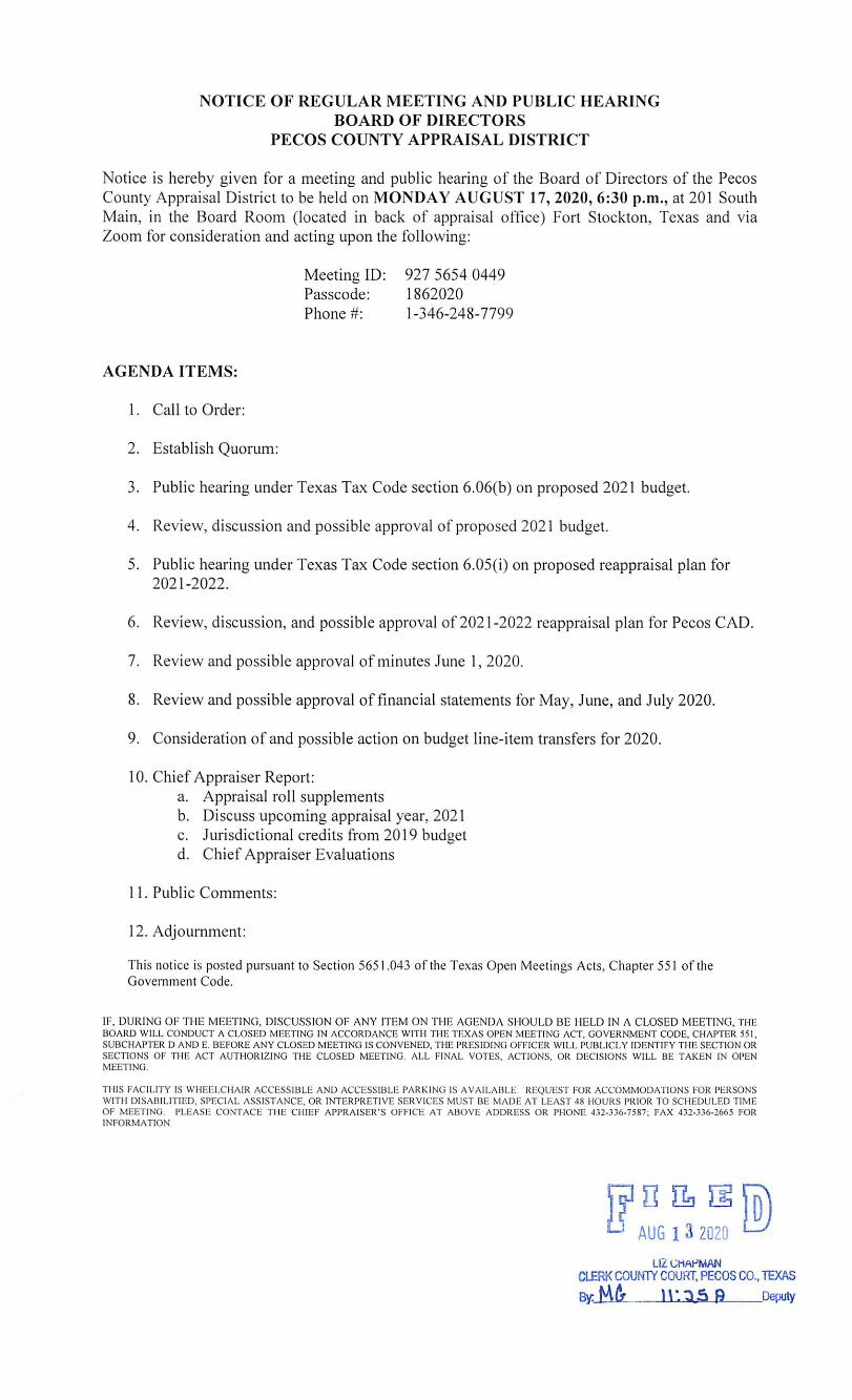
August 17, 2020
5-6
PECOSCAD050
Highlight

Plan for Periodic Reappraisal
Texas Property Tax Code Sec. 25.18. Periodic Reappraisals.
(a) Each appraisal office shall implement a plan for periodic reappraisal of property approved by the board of directors under Section 6.05(i).
(b) The plan shall provide for the following reappraisal activities all real and personal property in the district at least once every three years:
(1)identifying properties to be appraised through physical inspection or by other reliable means of identification, including deeds or other legal documentation, aerial photographs, land-based photographs, surveys, maps, and property sketches;
The Pecos County Appraisal District (PCAD) receives listings of all deeds filed with the Pecos County Clerk’s office. Deeds are read and abstracted by clerical staff in the deed department of PCAD. Information is recorded in the computer assisted mass appraisal system (CAMA) software including grantor, grantee, date of recording, volume and page. Property identification numbers are assigned to each parcel of property. Business personal property is located by canvassing the county street by street, using data sources such as yellow pages, sales tax permit holder lists and other business listing publications to ensure that all property owners are located. All businesses are mailed a rendition about January 1 of each year. Owners are required by law to list all their business personal property. Failure to render results in an automatic 10% penalty and a possible 50% penalty if a false rendition is filed. Lists of commercial vehicles are also purchased annually and these vehicles are tied to appropriate business accounts. Renditions are also required of utility companies, railroads and pipelines. Oil and gas wells are discovered using Texas Railroad Commission records. Production records are processed by a contracted appraisal firms. Ownership is determined by records known as division orders. PCAD utilizes a highly developed geographic information system (GIS) that show ownership lines for all real estate. Aerial photography is interfaced with the GIS for an additional layer of vital information.
(2) Identifying and updating relevant characteristics of each property in the appraisal records;
All real estate is physically reviewed at least once every three years and business personal property is reviewed annually. All real property in the Fort Stockton ISD will be reappraised in 2020 and all real property in the Iraan/Sheffield ISD will be reappraised in 2021. Real property in the Buena Vista ISD is scheduled to be reappraised in 2022. See Exhibit A of this plan for the proposed 2021 and 2022 work schedules. A category breakdown of properties to be appraised

each year of the plan is also included. A map highlighting the proposed work areas for each year of the 2021-2022 reappraisal plan is also included. Appraisers drive the county and gather data about each home, commercial business or vacant tract. The appraisers walk from property to property measuring the structures and noting the condition of the property and noting any changes to the property since the last physical inspection. Pictures are taken to capture the property’s current quality and condition. The appraiser notes the date of the physical inspection on the field card and that information along with any property changes is entered in the CAMA system. The pictures are stored in the CAMA system and used to assist the appraiser in making decisions in the office. Other data stored in the CAMA system includes an exterior sketch of the improvement which allows for the calculation of square footage for the building and its components such as, garages, porches, patios, and other structures not attached to the main improvement. Other property characteristics maintained in the CAMA systems are components found within the building such as bathrooms, fireplaces, air conditioning, roof type, wall heights and exterior finish. New property is discovered using septic tank permits, utility hook up permits and driving the county. Rural acreage is inspected to verify existing agricultural and wildlife management use. New applications for agricultural and wildlife management use are inspected annually. Business personal property is physically inspected annually. The quality and density of inventories are determined as of January 1 and the age and condition of furniture, fixtures, machinery and other equipment is noted. If the appraiser’s observation differs from that of the rendition filed by the business owner, additional information is requested from the business owner and sometimes a value that differs from the rendered value may be assigned. PCAD contracts with an appraisal firm that specializes in the appraisal of oil and gas properties, utilities, railroads and pipelines. Specialized software is used to determine well production, decline and economically recoverable reserves. The reserves are appraised discounting for the time it will take to recover them from the earth. Utility companies, railroad and pipelines are appraised using the income approach, where the net income is capitalized and allocating the resulting value to the various taxing entities in the county. See Exhibit A for proposed work schedules for each appraisal year, a map of the areas designated for reappraisal each year and the estimated number of parcels to be reappraised by property category.
(3) Defining market areas in the district;
Market sales are used define market areas and improvement and land schedules are developed accordingly. Because of the scarcity and reliability of market sales in Pecos County, PCAD has designated Buena Vista ISD, Fort Stockton ISD and Iraan-Sheffield ISD as market areas for purposes of statistical analysis and appraisal schedule maintenance. Ratio studies are performed on property types within each market to test appraisal performance and perform appraisal maintenance on cost schedules and tables.

Market areas are also developed for land. Adjustments are determined based on location, size, topography and other characteristics recognized by market sales.
(4) identifying property characteristics that affect property value in each market area, including:
(A) the location and market area of property;
(B) physical attributes of property, such as size, age, and condition;
(C) legal and economic attributes; and
(D) easements, covenants, leases, reservations, contracts, declarations, special assessments, ordinances, or legal restrictions;
Each parcel of property has detailed information recorded in the CAMA system. Land attributes consist of legal description, dimensions, zoning, size, utilities, road access and any other special, unique or legal characteristics are noted and used for developing schedules and defining market areas. Each improvement record consists of a current sketch with measurements, a photograph of the improvement and individual property characteristics such as class, construction quality, year of construction, roof covering and style, exterior finish, number of bathrooms, fireplaces, heating and air conditioning, pools, out buildings and other attributes specific to the improvement.
(5) developing an appraisal model that reflects the relationship among the property characteristics affecting value in each market area and determines the contribution of individual property characteristics;
PCAD’s computer assisted mass appraisal (CAMA) system utilizes an appraisal model that reflects the relationship among the property characteristics affecting value in each market area and determines the contribution of individual property characteristics. The model uses the cost approach to value to estimate the original cost of each building component. Market sales are studied for improvement contributions in each market area and adjustments to cost schedules are applied to each improvement via depreciation and market adjustment factors. Similar models are used when appraising apartments, commercial and industrial properties, but market sales and income data are key components of the valuation process for these properties.
(6) applying the conclusions reflected in the model to the characteristics of the properties being appraised; and
PCAD uses conclusions reflected in appraisal model results to construct and maintain property classification guides identifying minimum property characteristics typical for each property class. By utilizing sales data for each neighborhood and market area, conclusions

concerning age, quality, condition, construction components, depreciation and other variables are tested against the model’s results.
(7) reviewing the appraisal results to determine value.
PCAD tests the results of its appraisal model values (appraisals) against market data (sales) to determine the accuracy and level of appraisal, as well as to monitor the integrity of the appraisal model (CAMA). Ratio study results are used to maintain and update appraisal schedules to achieve market value appraisals. Sales ratios are performed for each property category within each ISD to determine if values assigned by the model fall within a 95% - 105% confidence interval level. The Six Steps in the Appraisal Process include:
1. Definition of the problem • Identify the property to be appraised • Specify the property rights to be appraised • Define the purpose and function of the appraisal • Specify the date of the appraisal • Define the type of value
2. Planning
• Identifying data to be collected • Decide which selections of value approaches to use • Resources needed
3. Data Collection
• General Information such as national trends, regional and local trends, and neighborhood trends
• Specific information of the property including legal rights, And restrictions of use of the property
4. Application of the data and approaches to value • Same or similar methods for same or similar properties
5. Reconciliation of value -for single property appraisals
6. Final values – allowance for all known factors affecting value are
applied to properties All properties are valued at current market value. Valuation date, with the exception of allowed September 1st inventory values for certain properties, is January 1st each year. (Section 23.01, Texas Property Tax Code)
All data is gathered and analyzed in accordance with the district’s procedures for identification, collection and listing for new and existing properties. Pecos CAD, in compliance with Section 23.0101, Texas Property Tax Code, considers all approaches to value for the appraisal of all properties within the district. We then select the one approach to value that is the most meaningful and reliable indicator of market value for a specific property class in our Computer Assisted Mass Appraisal (CAMA) system. Single property appraisals typically make use of one or more value approaches reconciled into a single value conclusion. IDENTIFICATION, COLLECTIONS AND LISTINGS OF NEW PROPERTY The district realizes that a good mapping system is essential for the proper location, identification, and inventory of all parcels within a jurisdiction. The district’s computerized geographic information system (GIS) provides for good foundation to show boundaries of parcels and parcel location as well as parcel identifier. Parcel identification is further made by legal description and by street address. A unique identifier is assigned to each parcel. Real property land and real property improvements are identified and then listed in the district’s records by several different means:
• Physical Inspections – The district is on an annual reappraisal cycle with property inspections being conducted on an annual basis.
• Deed Transactions – Provide information needed to discovery (size, shape, location).
• Land Based Photography – Property photos from our databases are utilized for
identifying improvements.
• Surveys – use is made of plats as well as single parcel surveys to identify land and improvements.
• Permits – For properties inside city limits, the district receives from the City of Fort
Stockton Planning & Zoning department a copy of all issued permits. These are entered into the field appraiser’s property records for further inspection.
• Media – Publications and news coverage of property additions or changes are noted and provided to the field appraiser in the area where the property is located.
• Sales Data – Multiple Listings Service (MLS) and other sales information is analyzed and
utilized by the district in its records for new property or additions to existing properties.

DATA IDENTIFICATION and COLLECTION – REAL PROPERTY The type of property will determine the extent of the information gathered. General data to be gathered will include physical, economic, governmental and social factors that can affect value (neighborhood characteristics, trends & factors influencing values). Comparative data will consist of sales, cost income information. Specific data is needed will consist of site and improvement data. STEPS: Field
1. Before leaving the office for field inspections, the appraiser will gather information that will be worked on that day.
2. Direct observation of properties from all aspects (drive alleys, unimproved roads). Note
class of improvements, condition, and functional utility of the properties in the neighborhood. Note land classes, change in use or any factor affecting the site including highest and best use.
3. Work all permits on properties to assist appraiser with additions and changes.
4. On new construction attempt to gather physical measurements. For incomplete structures, determine percent complete on January 1st per percentage of completion guidelines in “Improvement” tab in the Beyond Appraisal Computer Assisted Mass Appraisal (CAMA) system. Classify according to Pecos CAD’s improvement guides. Note all relevant physical features and note in worksheet.
5. DO NOT go through closed gates or cross “POSTED” signs onto any property without
owner or property manager’s permission.
6. Never enter an occupied residence alone. If owner requests that the interior be observed; set up an appointment time with another district appraiser or supervisor to inspect.
7. If confronted in the Field-explain who you are and your actions. Have your badge on and
your magnetic signs on vehicle visible while in the field. Offer your business and TDLR card and be polite and professional.
STEPS: OFFICE COST MODELS
1. Appraiser to gather cost information, income and expense data and sales data on new or existing improvements or properties by interview or through questionnaires. Market trends from MLS or other economic sources indicating trends and forces impacting value must be analyzed.

2. For cost models-appraiser to sketch, label and class all improvements based on district schedules. Estimate accrued depreciation (physical deterioration, internal and external obsolescence).
3. Apply land table schedules to land and adjust for any relevant factors (size, location, and
utility, etc.)
4. Apply any needed adjustments for site improvements not included in class defining features.
INCOME MODELS
1. Appraiser to gather income/expenses and operating data from property owner/manager for income producing real properties (hotel/motels, multi-family apartments, office buildings, real store where applicable) by direct interview or written questionnaires. Comparison with historical data and competing similar properties are made by the appraiser. Category comparison with uniform account categories are to be conducted when data is available.
2. Gross income estimates are to be made in the Pritchard & Abbott PC CAMA system
income value models along with vacancy and collection losses. All expenses are to be analyzed for allowance to arrive at net operating income.
3. Direct capitalization rates for various classes of properties will be utilized based on the
rates adopted by the district annually for specific classes of property.
4. Income value will then be allocated to land and improvements based on first, the carried value of land from the cost model for the property, with the remainder allocated to the improvements.
SALES MODELS
Pecos County Appraisal District’s primary goal is to appraise property by estimating market value of each property within its jurisdiction. Pecos CAD conducts a series of ratio studies on properties of different categories, locations, and similarities. Pecos CAD analyzes market data to determine the price that the property being appraised would probably bring in the marketplace on the date of appraisal. Sales data is needed for the valuation process and for sales ratio studies. Studies help determine several key factors, used to adjust assessed values on properties to the common level.
These factors include:
• Measurements and evaluation of the level and uniformity of mass appraisal models
• Internal quality assurance and identification of appraisal priorities

• Determination of time trends
• Adjustment of appraised values between reappraisals
Pecos CAD adheres to IAAO’s Standard for Sales Verification. Property tax is to be fair and provide adequate revenue for local government; mass appraisal must produce accurate appraisals and equitable assessments. The primary tool used to measure mass appraisal performance is the ratio study. A ratio study compares appraised values to market values. Market value is the most probable price in cash that a property would bring in a competitive and open market, assuming that the buyer and seller are acting knowledgeably, sufficient time is allowed for the sale and price is not affected by special influences. A ratio study usually has six parts:
(1) Delineation of objectives
The objectives of the study determine its scope, content, depth, and flexibility.
(2) Collection and Preparation of data The precision and reliability of any ratio study depend on the quantity and quality of the sales and independent appraisals available. Sales data must be collected, screened, and edited, and sales prices adjusted as necessary for financing, personal property, and time of sale.
(3) Matching of appraisal and sales data
The basic physical characteristics of each property used in the ratio study must be the same when appraised for tax purposes and when sold or appraised by the review agency. For sales this implies two essential steps
1) One should ensure that the legal descriptions match 2) Once the legal descriptions match, one must ensure that the rights
transferred, the permitted use, and the physical characteristics are the same at time of assessment and time of sale.
(4) Stratification Divides all the properties in a jurisdiction that fall within the scope of the study in two or more subpopulations. Provides a more complete and detailed picture of the extent and nature of appraisal performance and can enhance sample representatives ness.
(5) Statistical analysis Ratio data can be arrayed, tabulated, and graphed, and various measures of appraisal level and uniformity can be calculated. Assessment officials may also need to develop confidence intervals or test hypotheses about appraisal performance in order to determine compliance with legal or administrative standards. Such analyses are especially important for equalization decisions.

(6) Evaluation and use of results Properly designed and executed ratio study provides valuable information about the quality of mass appraisal work. Areas with good results should need less time and attention, which can then be redirected to areas with poor results. These areas can be targeted for reappraisal or other corrective action.
However, ratio studies have limitations. Perfection is not possible in mass appraisal, nor can ratio studies provide perfect information about appraisal performance. Insufficient sales or overrepresentation of one locale with an active market can distort results. In general, the reliability of a ratio study increases with the number and representative ness of the sales or independent appraisals used in the study. In addition, reliability requires that unsold parcels be appraised in the same manner as sold parcels.
Sources of Sales
Primary sources of sales data in Pecos County include real estate transfer documents, sales verification questionnaires to buyers, and third party sources such as realtors, fee appraisers and lending institutions. Pecos CAD accesses a multiple listing service through a third party source. Pecos CAD sends a Sales Questionnaire Survey to the buyer and seller of a property. Once the sales data is collected, it is then verified and adjusted as necessary for model calibration and ratio study purposes. Sales are verified to determine whether they reflect the market value of the real property transferred. Sales data is collected, edited and adjusted to obtain valid indicators of market value. Sales data is verified by contacting a party to the sale (buyer, seller, or other knowledgeable party) when there is a question or an answer is unclear on a sales questionnaire completed prior to the recordation.
Sales Verification
• Sale prices reflect only the market value of the real property transferred and not the value
of personal property, financing, or leases. • Sales occurred during the time frame being tested or modeled. • Sales are excluded only when they fail to meet the requirements of an open market, arms
– length transaction, as defined by Texas Property Tax Code Section 1.04(7). All sales meeting the definition of market value should be included as valid transactions unless one of the following two conditions exists: • Data for the sale are incomplete, unverifiable, or suspect. • The sale fails to pass one or more specific tests of acceptability.

Pecos CAD staff understands the following types of sales are often found to be invalid and can be excluded. • Sales involving government agencies • Sales involving financial institutions as buyer or seller • Sales involving charitable, religious, or educational institutions • Sales between relatives • Sales settling an estate • Forced sales resulting from a judicial order • Sales of doubtful title Once sales are analyzed and verified then adjustments can be made. Adjustments Sales are adjusted to represent only the value of the real property as of the assessment date prior to model calibration and ratio studies. Adjustments should be made for the following: • Buyer’s closing costs • Assumed long-term leases • Delinquent taxes • Financing • Gift programs • Personal property • Real estate commissions • Repair allowances • Special assessments • Time Real property tax is based on the market value of real property alone as a specific date. This value may not be the same as investment value and does not include the value of personal property or financing arrangements. If adjustments for more than one purpose are to be made, they should be made in the following order: 1. Adjustments that convert the price to a better representation of the market value as of the
date of sale (these include adjustments for financing, assumed long-term leases, and special assessments).
2. Adjustments that develop or isolate the price paid for taxable real property (these include adjustments for personal property received by the buyer, property taken in trade by the seller, the combination of partial interest sales, delinquent real estate taxes, and incomplete or unbuilt common property).
3. Adjustments for differences in market value levels between the date of sale and the date of analysis (time trends).
Time Adjusting

Pecos CAD recognizes the importance of adjusting sales for time in active markets and regularly analyzes sales to determine the appropriateness of time adjustments. Historically, the volume and types of sales occurring in Pecos County have not warranted time adjustments. Time Adjustment Techniques: • Tracking sales-to-appraisal ratios over time • Including date of sale as a variable in regression or feedback models • Analyzing re-sales • Comparing per-unit values over time, such as a subdivision or condominium complex • Isolating the effect of the time through paired sales analysis. Changes in price levels should be monitored and time adjustments made by geographic area and type of property, because different segments of the market tend to change in value at different rates. Time adjustments should be applied prior to any statistical analysis; however atypical sales should be removed for the time-trend application. These atypical sales should, however, be included during the outlier trimming process, which occurs during the statistical phase of the ratio study program.
DATA IDENTIFICAION AND COLLECTION – Personal Property Personal property is discovered, identified and listed in the district records by various means and in accordance with IAAO “Standard on Valuation of Personal Property.” The owners and users of personal properties within the district are determined by use of phone directories, business licenses, assumed name-DBA filings, sales tax lists, correspondence audits, field inspections, vehicle registrations and from other data self-declarations, renditions) made available to the district. STEPS: FIELD 1. Appraisers will make at least one attempt at an “on-site” inspection of every business within
their geographic area each year. The date of the visit will be logged in any information received from the property owner will be reviewed and entered in the worksheet. Any other relevant data will be entered in district records.
2. Visits to businesses will be made during normal business hours or at a mutually agreed upon
time. 3. Be prepared to deal with a variety of circumstances. Keep in mind, more time is generally
required to work a personal property account than for many real property accounts. 4. Introduce yourself and explain the reason for your visit. Present yourself in a businesslike
manner, always display your badge and offer your business card.

5. If the owner/manager is not present, attempt to speak with someone with knowledge of the business. Make comments in the “Notes” about title/position of person interviewed.
6. Confirm correct business name, ownership and mailing address. 7. Ask for permission to tour the facility in order to determine what assets are to be assessed
and to make note of when making a value estimate of income producing business personal property. Prior year records are most beneficial to existing accounts.
8. Obtain owner names and addresses of any leased or consigned goods or equipment. 9. Get an inventory and asset list if the business is willing to provide one. If not, leave a blank
CPA FORM 50-144 BUSINESS PERSONAL PROPERTY RENDITION. 10. If a quality/density schedule is available for the particular business type, make note of
amount and quality of assets and inventories and the square feet of space utilized by the business goods.
11. Make comments in the “Notes” concerning quality/density or specific asset items (vehicles
and other items). 12. Remember, many businesses are unwilling to provide any information at all. If that occurs,
be courteous, politely leave the premises, and make notes DO NOT Allow the situation to become confrontational.
STEPS: OFFICE
1. District appraisers will enter into the Inventory Detail in Pritchard & Abbott PC CAMA System all asset items including inventories at cost. These will be both rendered and worksheet values.
2. Vehicle registrations of commercial accounts will be entered into district records and
valued per subscription services guides and/or from NADA Blue Book guides.
3. Special Inventories for Vehicle Inventory Tax (VIT) will be accounted for based on monthly inventory statements along with annual declarations filed by the business owner. Field inspections along with dealer lists from the state will be utilized to identify new business accounts.
4. Permits filed for businesses along with DBA filings will be reviewed and listed by the
appraiser for any businesses within their area.
5. Aircraft registrations will be reviewed and new commercial use account set up and valued per The Aircraft Blue Book.

6. New utility property such as pipelines is typically picked up from pipeline renditions from operators, published announcements, and from regulatory filings. Pecos CAD’s (Thos. Y. Pickett & Co.) pipeline depreciation schedule is applied to existing and new constructed lines.
7. New producing oil & gas wells are set up in district records from both Railroad
commission (RRC) report subscriptions, new production reports from Historical Production Data Inc. (HPDI) subscriptions and from GASearch Oil and Gas pricing research of new well completions, workovers and applications for new and existing wells in Pecos County.
8. Personal property items on process plant facilities are included in industrial real estate
records. Industrial real property renditions are worked and comparisons made to other reported data such as pollution control reports. The appraiser will compare detail from all sources along with historical property records.
APPRAISAL PROCEDURES-REAL PROPERTY IMPROVEMENTS RESIDENTIAL (Single Family Residence) District real property appraisers perform physical inspections of all real properties in the field on an annual basis. Physical observations are matched against the property sketch and other attributes on file in the existing database property records. Required changes are made by the appraiser for; classification of improvements, conditions, size measurements, all observed and noted physical features as well as any known internal or external factors. For inside city properties, permits of records are analyzed and compared with observed data. Reconciliations are made of any differing data. Physical measurements are performed by the appraiser and compared with any additional floor plans, builder sketches, surveys, blueprints or other data for any significant discrepancies. Measuring is performed with an electronic measuring devise, tape or measuring wheel. Data noted in the parcels worksheet. If during field work or by other means, it is discovered that improvements were not picked up in a prior year and should have been; that omitted property will be subject to supplement or prior year appraisal rolls. The district’s mass appraisal models (schedules) are generally referred to in district records as cost models. However, of the six recognized methodologies commonly used in tax appraisal for CAMA models, the district uses what is called a Hybrid Cost Model. Benchmark replacement costs are adjusted with local comparable sales data to develop what are called cost models for various classes. Most districts in the state use these hybrids in place of pure cost driven improvement models. Residential properties are valued in mass based on class models. Location modifiers are applied if warranted. Cost schedules are compared to known local actual builder costs. Marshall and Swift cost tables are also used in schedule development, modified for our local market. Depreciation tables are further checked against actual sales to measure loss due to age and condition. Functional obsolescence is noted for a property when a determination can be made

and a measurable loss amount can be reasonably made. Any external or location obsolescence that can be determined and reasonably measured is made as an adjustment to a specific property or group of properties. All values by class and location are analyzed and reconciled by ratio study prior to final value generation. All cost schedules are fully computerized in the district’s CAMA system. Multi-family residential properties are valued for the most part on the Income Approach to Value. Actual and market rental/expense data is obtained by the appraiser and applied to properties using our CAMA Income Appraisal system software. Small units for which market data is not reasonably available are valued based on multi-family improvements class cost models. Any additions or upgrades are noted by the field appraiser on the parcels worksheet. RESIDENTIAL REAL ESTATE INVENTORY In compliance with Section 23.12, Texas Property Tax Code, Pecos CAD has adopted procedures for the identification and valuation of residential real estate property which has never been occupied as a residence and is held for sale in the ordinary course of a trade or business, provided that the residential property remains unoccupied and is not leased or rented and produces no income. This is as of the appraisal date of January 1st each year and can include both land and improvements. Pecos CAD has established procedures for the equitable and uniform appraisal of inventory for taxation. The “Builder’s Method” or “Development Method” as it is commonly called; is the procedure used by the district to value the current worth of residential real inventory. It is the actual cost outlay by the developer as of January 1st for qualified properties, to include land, land improvements both on and to the site. Mark up for entrepreneurial profit is not included. The district makes available CPA Form 50-143 Rendition of Real Property Inventory to Residential Developers for Inventory reporting for the current appraisal year each January 1st. Itemized statements of costs incurred to date are analyzed for land-site work and allocated to all parcels within the area addition. Any improvement costs accrued to date are applied to the identifiable parcel where it is physically located. All residential real estate inventory renditions are “confidential” and are kept in file. The district’s procedures that are used for the valuation of these real estate property inventories are listed below. In order for residential real property to qualify as inventory, it must meet all of the following criteria:
1. All lots/tracts are under the same ownership, and they are contiguous or located in the same subdivision or development.
2. The properties are held for sale (as business inventory) in the ordinary course of
business.
3. They are subject to zoning restrictions limiting them to residential use. If not subject to zoning, they are subject to enforceable deed restrictions limiting them to residential use, or their highest and best use is residential.

4. The properties have never been occupied for residential purposes, they remain
unoccupied, and they are not presently leased/rented or producing income. When all of the above criteria are met, both land and improvements will be classified Texas Comptroller’s Property Tax Assistance Division (PTAD) Category O: Residential Inventory and each property will be appraised as a unit. The market value of real estate inventory will be based on the total developmental cost. Developmental costs include, but are not limited to:
1. Purchase price of land 2. Fees/permits (legal, engineering, contractor, administrative, architectural,
platting) 3. Site preparation (clearing, fill dirt, leveling, drainage control, landscaping) 4. Utilities (water, sewer, gas, electric) 5. Streets (grading, paving, curbs, gutters, sidewalk, streetlights) 6. Amenities (fencing, security gates and controls, signage) 7. Marketing and sales costs.
Once all developmental costs are calculated, that figure will be divided by the total square footage or acreage to determine the per-square-foot or per acre value. The market value of the real estate inventory will then be set based on those results. RESIDENTIAL MUTI-FAMILY (APARTMENTS) An apartment is considered to be a building containing 2 or more living units, each unit being designed for occupancy by one family. As with the appraisal of all other types of property, the appraiser must become familiar with the factors which influence the value of multi-family properties and give careful consideration to the major value influences in the development of market value estimates, in accordance with Standard Rule 6-1, Uniform Standards of Professional Appraisal Practice (USPAP). Pecos CAD has established a policy for apartment valuation that reflects what potential buyers, sellers and investors as well as lending institutions would use in measuring property potential, risk, and prudent value. All three approaches to value – cost, market, income may be used in appraising multi-family properties. The Market Approach to Value is considered to be a most accurate indicator of value; however, the inability of district staff to determine terms of sale and sale conditions for enough sales to rely on this approach, requires that an alternate approaches be considered and relied on. Cost models are performed for all apartment projects. The Cost Approach with depreciation and obsolescence properly estimated and with land value reasonably valued, provides a meaningful and reliable indicator of value. The actual marketplace for multi-family properties, however are valued on the Income Approach by actual market participants. Pecos CAD likewise utilizes income models for the Valuation of apartment projects with enough size and income potential to warrant income modeling.

Pecos County has approximately 70 properties classified as apartments in its records. Of these 70 or so properties, the district utilizes a cost model to value the improvements and a land table to value the land based on size and location. Since apartment projects are considered to be investment use property, the Income Approach is typically considered to be a more reliable and meaningful indictor of current market value for multi-family residential properties. It is also the method that other districts and marketplace participants use for valuing these types of properties. The district performs an income value appraisal on about half of the (larger projects) apartment projects in the district. In compliance with Section 23.01 (b), Texas Property Tax Code the district uses the same income value models on the same or similar properties. Under Section 23.012, Texas Property Tax Code, the district:
1. Analyzes comparable rental data to estimate gross income potential.
2. Analyzes comparable operation expenses for the property.
3. Analyzes comparable data to estimate for the property.
4. Bases future rents or income potential and expenses on reasonably clear evidence.
5. Develops income and expense statements and cash-flow projections; considering historical information and trends, current supply and demand factors affecting those trends, and anticipated events from competition or other similar properties under construction.
Of all income properties, apartments are considered to be the least difficult models to develop. This is because actual (contract rent) and/or market rent information, along with typical operation expenses faced by prudent management are general available to the appraisers in the district. This income data must be correlated with the property characteristic data for per unit comparisons on apartments. Pecos CAD uses actual rent roll data as well as actual operation expense data received from local apartment project managers each year. These figures are utilized in the district’s income models with adjustments for non-allowed charges if applicable, (interest, debt service, income tax, and depreciation). Ad valorem property taxes are an allowed expense of the property, but are accounted for in the districts value models as an additive to the base capitalization rate (loaded cap rate). Actual data from each project is used, if the reported data is considered to be market. Individual characteristics and factors affecting each property are considered and allowances are made for them. The district maintains a sales database spreadsheet of apartment sales within the district. Operating income and expense data is developed for these sales and an actual capitalization rate is determined for all of these sales. These actual market derived cap rates along with published cap rates from the “Korpacz Real Estate Investors Survey,” the Appraisal Institute’s “Valuation Insight and Perspectives,” and the “Padzing National Apartment Market Data” reports provide

the district with a market derived capitalization rate range and a market supported base cap rate for use in the district’s income valuation models. Procedural Steps/Income Valuation-Multi-Family Residential
1. Contact apartment complex manager for rent roll by unit and vacancy & collection (V & C) loss data
2. Collect actual expense detail by expense category for the most recent 12-month period
3. Input rent roll data and # of units into proforma excel spreadsheet screen to determine
Potential Gross Income (PGI)
4. Apply V & C factor and add secondary income to determine Effective Gross Income (EGI)
5. Input all allowed operating expense to determine Net Operating Income (NOI)
6. Input the loaded capitalization rate from the 2012
7. Allocate from the final value to land, the amount carried from Cost Approach land tables.
FARM AND RANCH IMPROVEMENTS Improvements associated with land reported as PTAD Category D: Ag Land properties are classed by the district as PTAD Category E: Farm Ranch Improvements. These improvements include all houses, barns, sheds, silos, garages and other real property improvements associated with farming or ranching. When land is separated from a larger tract for residential purposes, it along with the improvements on it is included in Category D property. The number of acres include as homestead for exemption purposes does not change the classification of these types of properties. The improvement values of all the ranch improvements are classified as Category E property. The land under the barns, silos, sheds, and other agricultural outbuildings is classified as Category D property (This does not include the land under residential use carved from a larger tract, which is Category E property). The value of land not receiving productivity appraisal and used for residential purposes is include as Category E property. The district uses cost models to value all farm and ranch improvements. Classification of the structure is based on primarily the design and secondarily on the current use of the structure. This is in compliance with IAAO “Standards on Building Classes” and from the district’s Real Property Improvement Schedules” (models). Condition, desirability, and usefulness (CDU) ratings are made by field appraisers based on observed condition, age, and utility of the improvements. Theses physical characteristics are input into our improvement models and any

other factors warranted for a specific property is made as an adjustment to the calculated improvement value. CPA Rendition Form 50-141 Residential Real Property Inventory Rendition can be used by a property owner to render real estate items including farm and ranch improvements. The district will then have strict notice requirements concerning the rendition. In compliance with Section 23.011, Texas Property Tax Code the district shall:
1. Use cost data obtained from generally accepted sources.
2. Make any appropriate adjustment for physical, functional, or economic obsolescence.
3. Make available to the public on request cost data developed and used by the chief appraiser as applied to all properties within a property category.
4. Clearly state the reason for any variation between generally accepted cost data and
locally produced cost data if data vary by more than 10 percent.
5. Make available to property owners on request all applicable market data that demonstrate the difference between the replacement cost of the improvements to the property and the depreciated value of the improvements.
COMMERCIAL Commercial properties are typically valued by the district based on cost models by improvement class. However all three approaches to value are considered and then a selection is made to the most reliable and meaningful method. Hotels/Motels are valued on the Income Approach, due to market data being readily available. The district makes extensive attempts to secure market data concerning income/expense figures, vacancy & collection factors, cap rates and rental rates for various classes of commercial properties. Subscription publications are utilized for national or regional market data applicable to and adjusted for our local market. These publications include, but are not limited to the “Korpacz Real Estate Investor Survey” (Price Waterhouse cooers), “Valuation Insights and Perspectives” (Appraisal Institute), “Hotel Industry Trends” (International valuation Services), The Real Estate Center at Texas A&M. Local actual market data is also secured by mail-out questionnaires and by direct communication with property owners, managers and agents. Sales are analyzed to determine actual market cap rates, when current profit and loss information at sale date is known. All automated CAMA values are reviewed and reconciled by appraisal operations management. OFFICE BUILDINGS/SHOPPING CENTERS/BANKS

The district has developed mass appraisal models for all commercial real property classes of structures. A cost model is used for all real property improvements based on replacement Cost New (RCN) as per “Marshall and Swift Cost Guides” and local actual current construction cost data. These cost schedules are developed on unit pricing of dollars per foot with size interval breaks related to economies from larger surface areas resulting in lower unit costs as size increases. Pecos CAD’s Real Property Improvement Schedules” are further market adjusted based on sales and result in what are called a Hybrid Cost-Specified Market Approach models or what is frequently referred as Market-Adjusted Cost Hybrid models. These model types are the most common in use by appraisal districts throughout the state as opposed to “pure” cost models based solely on replacement or reproduction cost. Office buildings, shopping centers and banks in addition to other commercial buildings, as investment use properties are considered to be complex properties for mass appraisal assignments and are often valued under an Income Approach technique. Because investors in the marketplace are more concerned with income generation from a real property investment than they are in a property’s current replacement costs, income values are generally used for property valuation as opposed to replacement cost numbers. However, reliable and reasonably available data from our current market concerning actual rental income and operating expenses for these types of properties generally prevents reliable use of income models and since the cost approach models provide a more reliable indicator of value, the district utilizes these cost approach models to value these property types. Restaurants and retail stores are also valued by the district by application of cost models that are developed and adjusted in the same manner of stated for offices, strip centers and banks. Depreciated improvement replacement costs with additional site value additives and land value additions are market supported and provide a meaningful and credible property value estimate for these real property classes. The district considers all approaches to value for these property classes as required by Section 23.0101, Texas Property Tax Code and keeps all market data that is made available to our office in file and in accordance with USPAP work file recordkeeping requirements under that section of the Ethics Rule. HOTELS/MOTELS The lodging and hospitality industry is a major player in many districts within the state in commercial real property holdings and ownership. Typical industry classifications for hotels/motels are a 3, 4, or 5-Class type description. Luxury, Standard and Economy are sometimes used to describe quality services types of hotels/motels; In Pecos County our district uses a 5-Class description for hotels/motels based on levels of services offered and amenities provided at a particular facility. This common breakdown of type/description for these properties is typical for assessing offices throughout the nation as well as in Texas. CLASS 1 Hotels are Full Service High End Luxury facilities with restaurants/bars, valet services and offer amenities such as shopping, work out rooms, shuttle services, conference centers, etc.

CLASS II Hotels are Full Service facilities with limited dining available, vending machines versus snack shops, limited conference areas, self-serve baggage handling, etc. CLASS III Hotels are Standard motels without dining or bar area on site. Some are extended stay facilities with the most basic of amenities provided are included in the class. CLASS IV Hotels are limited services facilities without additional secondary income generating amenities provided for guests. Economy of stay is the motivation for users of these facilities. Only basic services are provided by the property staff to guests. CLASS V Hotels are the most economical of the lodging properties. No services are provided. All self-serve with only the most basic of service in room. The motivation of occupants for this class of facility selection is low lodging rates. Sometimes rates are by the week and/or for less than a full night. These facilities are at the lowest end of the lodging rate scale. No secondary income sources of revenue are booked for this class level. In compliance with Standard Rule 6-1, USPAP and as well under Section 23.0101, Texas Property Tax Code, Pecos CAD considers all approaches to value for estimating market value for these types of real estate. Since hotels/motels are investment use property types and because the marketplace is primarily concerned with current and future income streams attributable to lodging performance, Pecos CAD utilizes the Income Approach as the most meaningful and reliable value indictor and that approach which produces the most credible results for these types of properties. Because market data is readily available from both property managers as well as from state regulatory filings, most districts, including ours, use the Direct Capitalization method under the Income Approach for the hotel/motels in Pecos County. PROCEDURE STEPS FOR VALUATION:
1. Field appraiser to classify property according to Level (I thru V) based on historical determination and/or according to the district’s Parameters worksheet for hotels/motels and which is updated annually by the district.
2. Obtain room revenues from “Texas Hotel Performance Factbook” by Source Strategies,
Inc. for the full period prior year actual results. Annualize new partial year properties and review Comptroller of Public Accounts Lodging Receipts for City by Quarter from website for prior year. Note any differences in taxable and non-taxable lodging receipts.
3. Allow for typical operating expenses (% ratio) for properties based on the district’s annual
parameters for hotels/motels and include any secondary income based on parameters schedule.
4. Develop Net Operating Income (NOI) and divide by the district’s annual hotel/motel
capitalization rate structure. Pecos CAD allows for ad valorem tax assessments as an

additive to the base capitalization rate, as opposed to a direct expense in value determination.
5. Allocation to the land component from the overall value estimate is to be the same as the
amount carried on district records for a specific property and carried in the land schedule value under that property. The remainder of the income value estimate is allocated to improvements and in compliance with the form and content reporting requirements under Section 25.02, Texas Property Tax Code.
6. The income method of appraisal for this property class type is also in compliance with
requirements as listed in Section 23.012, Texas Property Tax Code. See Websites: CPA (Lodging Receipts Quarterly by City) INTANGIBLE VALUE/COMMERCIAL PROPERTY Intangible is defined in Section 1.04, Texas Property Tax Code as personal property that has value but cannot be seen, felt, weighted, or measured. Texas, like most states recognizes the existence of intangible wealth, but does not permit the assessment of intangible value in the property tax base. The only exceptions would be the provisions under Sections 23.15 and 3.16, Texas Property Tax Code. When valuing certain kinds of commercial real properties under the Income Approach, such as hotel/motels or multi-family housing projects, the district is faced with the rather complicated task of isolating and identifying any value attributable to business enterprise value (BEV) as well as any value component that can be attributed to the tangible personal property that is necessary component of the property’s income generation. Likewise, proper identification and recognition of Business Value is often required in the verification of sales of income producing commercial real estate. Isolating and then reasonably measuring this value component is vital to accurate appraisal and assessments. Generally, if the Cost Approach provides a most reasonable estimate of current market value for a real property, any excess beyond that can often be attributable to the personal property in place and/or to the business enterprise value. Pecos CAD researches all commercial property sales as well as income valued real properties to determine the existence, if any, and the reasonably identifiable worth of any intangible value. Business enterprise value is defined in The Dictionary of Real Estate Appraisal, 4 Edition, the Appraisal Institute, as the value contribution of intangible assets to a going concern continuing business. The district also is bound by Section 23.24, Texas Property Tax Code that further requires that personal property as a component to a real property’s income producing ability, be included with the value generated by the income method and not additionally or separately valued and assessed. SEE WEBSITE: Appraisal Institute

APPRAISAL PROCEDURES – INDUSTRIAL PROPERTIES Please see Thos.Y.Pickett Reappraisal Plan Exhibit B APPRAISAL PROCEDURES - LAND GENERAL Physical land existence and land ownership is 3-dimentional. It consists of the surface, the subsurface and the air space above it. For surface land valuation and records description, fee simple estate ownership is generally followed. Pecos CAD’s land appraisal system, in compliance with IAAO’s Property Appraisal and Assessment Administration, is comprised of five basic components:
• Cadastral (tax) maps or geographic information system (GIS) • Land characteristics data • Sales and market data • Appraisal methods and procedure steps • Knowledgeable staff and adequate resources, i.e. computers, software.
COLLECTION and ANALYSIS of MARKET DATA District real property appraisers perform physical inspections of land parcels on an annual basis. Uniformity of carried values is analyzed by the appraisal staff. Size differences are considered and other modifications warranted for a specific parcel are considered when selection of a land table code is assigned. Warranted land modifiers are determined by the appraiser and applied to the land parcel account. Sales of area land parcels from the sales database are analyzed by the appraiser and notations made for later review when mass appraisal models for land tables are developed and /or adjusted. Residential use land parcels are grouped and valued according to neighborhoods, based on actual sales in the area and/or by using abstraction or allocation methods in fully developed areas. Land-to-property ratios are calculated and analyzed and compared with similar competing neighborhoods of less than fully developed tracts. Residential inventory applications and the information they contain aid in these determinations. The development method of value is used for qualified residential inventories. Commercial land is also valued based on actual sales of competing properties by neighborhood. Relevant factors considered in the comparative analysis include size, use, frontage, corner influences, environmental factors or any other factors considered to be adverse to the marketability or salability of a land parcel.

LAND CHARACTERISTICS The district uses value per square-foot and/or value-per-acre for all commercial as well as residential land accounts. Depth adjustments for most city lots or small land parcels, especially commercial parcels are based on the commonly accepted 10/20/30/40 Rule as noted in the IAAO’s Property Appraisal and Assessment Administration. The district typically uses a more simplified 70/30 two-land card file system, whereas the front half of the parcel is valued at 70% and the back half of the land parcel is valued at 30% of the whole. Warranted differences for a parcel can and do alter this otherwise typically followed rule by the district. If corner influence is determined to be neutral for a land parcel, no adjustment to value is made. If positive or negative corner influence can be reasonably determined, an adjustment is made for it on the account. Shape adjustments are made if it can be reasonably determined how the parcel is impacted as a result of shape. The district’s Computer Assisted Mass Appraisal (CAMA) system and GIS is used extensively in land table value development and in adjusting model value both for appraisal level and appraisal equity. Land adjustments recognize the characteristics of individual parcels concerning shape, size and location. Size adjustments are most common based on the fact that typically a larger parcel will sell for less per unit than a smaller, yet equal parcel. This “economy of scale” or “cheaper by the dozen” concept translates over into the site value marketplace as well as it applies to other segments of production and commerce. Pecos CAD’s land tables are not set up on the front-feet values unit basis. Square foot and per acre units are utilized. Excess lot sizes are adjusted to a base lot size by percentage factors derived from actual sales comparison data on a unit basis. This curved fit can then be applied to oversize and/or lots. Shape differences for pie-shaped cul-de-sac lots versus rectangular shaped lots are carefully reviewed with actual similar location sales. If sales data indicates an adjustment for the irregular shaped lots warranted, then a percentage adjustment is applied to those affected parcels. Corner influence is typically of most concern to commercial real properties. It can be positive or negative neutral to land value. Commercial enterprises can typically benefit from higher visibility and accessibility found on corner locations. For residential lots, a street corner can be a detriment to value in certain high traffic areas and it can be a plus in other areas due to appeal and use. Pecos CAD staff must address the difficulty involved in determining to proper amount to adjust for corner influence. Reasonably estimating the distance from the corner to apply an adjustment must be practical, whether for the actual lot distance or so many feet. Typically a percentage plus or minus is made to the area of the corner lots (one in each direction). All market data available, both current and historical is analyzed by staff and utilized in the district’s land tables. In the district’s land models numerous other adjustments can also be made, if warranted for environmental, contamination, flood zones, golf courses, traffic, development, landscape, pipelines, rails, utilities, water towers, well sites, pits, access, drainage, elevation and others. A reasoned and practical analysis of data is involved with the application of these adjustments.

All land in the district, whether improved or vacant is valued from land tables (models) with any offset adjustments that are warranted. On improved parcels, the improvements may be valued from a cost table which is most typical or for certain income producing properties by the income method. On all improved properties where an income value is determined and considered a more reliable indicator of value, the calculated value of land from the land schedule is allocated to the land value first, and then the remainder of the income value for the overall property is allocated to the improvements. LAND SALES DATABASE SOURCES Land sales, like improved property sales, are collected throughout the year and entered into the district’s historical sales databases. Data stored includes sale date, names, address and relationships, if any, of any of the parties to the sale. Deed references, sale type and other conditions of the sale (financing, partial interest, concessions, etc.) are noted. VERIFICATION Land sales are screened (edited) to adjust for any non-typical seller concession/buyer incentives or non-arm’s length transactions. Cash equivalency is sought on all sales, whether adjustments are warranted or not. Verification of sales data may be conducted with both parties to a transfer from sales surveys or questionnaires. Direct confirmations may also be conducted. Multiple Listing Services (MLS) data entered into our sales databases is screened and confirmation follow-ups are made with one or more of the interested parties when warranted. Additional data is gathered from land sales when available, such as any ground lease rental data as well as additional site work costs or appurtenance cost. ADJUSTMENTS TO SALES PRICE District land tables include the necessary physical attributes and factors and characteristics that impact land values. Units of comparison are expressed in prices per unit based on how the land is sold in the market, either on a price per-square-foot or a price per-acre is the common unit in our district. Front-foot pricing is available, but not used by our district. These (models) are reviewed and adjusted on a recurring basis based on sale data from the marketplace. When sales numbers are insufficient, other methods of land valuation are utilized. Such methods include residuals such as land abstraction, allocation or land-to-property ratio analysis. Direct comparison to similar sites outside a subject’s area sales are also utilized at times in value determination. Location differences are carefully analyzed because location is the primary determinant of land value. Land use patterns and value influence centers are carefully analyzed by staff in building and adjusting the district’s land tables.

TRENDING Market adjustment factors are used and applied to current schedules per-unit pricing of land table classes for a particular neighborhood (market area) on an annual basis. Ratio studies performed on vacant land sales for select market areas are analyzed for under/over appraisal. Trend factors derived from ratios of actual prices versus carried value are calculated and applied to land values for a market area. Table changes are made, if warranted for carried neighborhood and values. Improved properties are likewise measured for trended changes from actual sales and any warranted adjustments are applied to the improvements and land classes based on established land-to-building or land-to-property ratios. Market adjustment factors derived from a method of maintaining current value estimates in specific market areas (neighborhoods) in addition to direct sales comparison. RATIO STUDIES Pecos CAD utilizes the Excel and Pritchard and Abbott PC CAMA system to provide ratio studies within market areas and among property classes. According to IAAO’s Property Appraisal and Assessment Administration, a ratio study provides the relationship between appraised value and market value. If a ratio study shows the appraised value to not reflect market, then an adjustment to the district’s land schedules (uniform land tables) is warranted. Frequent ratio studies and appraisal maintenance that follow it, enable the district to keep land values at the market. District research of land sales used in its ration studies helps to verify that they meet the market value definition in Section 1.04, Texas Property Tax Code. Indicators of market value are sales as well as “expert” appraisals. Inconsistent land sales amounts requires the appraiser to research the details of sales to identify all pertinent characteristics to establish market areas and to identify those common factors that influence value. This profiling of land characteristics as well as highest and best use determinations are sought as are economic influences that are encountered. Uniformity of values is further determined by use of GIS parcel unit pricing within an area. Integration of these detailed maps in GIS helps to identify boundaries of neighborhoods and the property factors influencing land value. APPRAISAL OF AGRICULTURAL LAND GENERAL NEW APPLICATIONS Subchapter D, Section 23.51, Texas Property Tax Code established the requirements for qualifying open-space agricultural land for agricultural appraisal. Property owners may qualify for this agricultural appraisal if the land meets the following criteria:
• The land must be devoted principally to agricultural use. Agricultural use includes producing crops, livestock, bee keeping poultry, fish, or cover crops. It can include leaving the land idle for a government program or for normal crop rotation. Land used for raising certain exotic animals (including exotic birds) to produce human food or other

items or commercial value qualifies. Cutting wood for use in fences or structures on structures on adjacent agricultural land also qualifies.
• Using land for wildlife management is an agricultural use, if such land was previously
qualified open-space land and is actively used for wildlife management. Wildlife management land must be used at least three of seven specific ways to propagate a breeding population of wild animals for human use.
• Agricultural land must be devoted to production at a level of intensity that is common in
the local area.
• The land must have been devoted to agricultural or timber production for at least five of the past seven years. However, land within the city limits must have been devoted continuously for the preceding five years, unless the land did not receive substantially equal city services as other properties in the city (Section 23.56, Texas Property Tax Code.
Web Link: PTAD Form 50-129 Application for 1-d-1 (Open Space) Agricultural Use Appraisal TIMELINES To qualify for agricultural use appraisal a property owner must submit a completed application (1-d-1) to the Pecos CAD no later than April 30th of the current appraisal year. For good cause, the chief appraiser may extend the deadline for an additional 60 days. Approval of current year applications can still be granted up until the date that Pecos County Appraisal Review Board (ARB) approves the current year appraisal records, subject to a late filing penalty of 10% of the difference between the amount of tax imposed on the property under the special appraisal and the amount of tax that would have been imposed if the property were taxed at market value. After filing, the district performs an on-site inspection of the property to verify allowed use and approves the application as it is submitted, postpones the approval grant unit additional information is received or denies the application as it is submitted and notifies the property owner of such action. If an application is denied, the district must notify the owner within 5-days after the denial by certified mail of its decision along with notification of the property owner’s right to protest with the ARB. Publication requirements for special appraisal are made annually by the district. RENEWAL APPLICATIONS Once an application (1-d-1) has been approved for an appraisal year, the land is eligible in subsequent years without a new application to be filed, unless there is an ownership change or eligibility changes for the land. However, the chief appraiser may require a new application to confirm continued eligible use of the land. Pecos CAD conducts a 7-year audit on all 1-d-1 agricultural appraisals. A renewal application is sent to the property owner along with written notice of the required filing of the application.

DATA COLLECTION Income and expense information for agricultural use lands in the area is requested by the district at meetings of the Pecos County Agricultural Advisory Board (Ag Board). This Ag Board advises the chief appraiser of the district on major issues concerning valuation and use of land that may be designated for agricultural use or that may be open space agricultural within the district. This includes wildlife management use. Specific issues include net-to-land, degree of intensity standards for the area and providing data on share or cash leases in the County or from comparable areas. The Ag Board helps the chief appraiser in developing owner-operator budgets and in completing the annual “Texas Farm and Ranch Survey.” Cash lease income from agricultural uses and compatible secondary recreational uses such hunting leases is gathered and analyzed along with actual current expenses for maintaining agricultural operation in the area. The district maintains a historical folder of lease and expense documents and adds to it on a continuing basis. This information is confidential and not available for public inspection. Any 1-d application and information contained is also confidential. APPRAISAL PROCEDURES The Manual for the Appraisal Agricultural Land is a State Property Tax Board (SPTB) administrative rule that has been approved by a committee of the governor, attorney general, comptroller, agriculture commissioner, and commissioner of the General Land Office. This manual sets out appraisal procedures and eligibility requirements for 1-d and 1-d-1 appraisal. The methods described in the manual are mandatory, and appraisal districts are required to follow them. Pecos CAD Ag Board members are familiar with the manual and its requirements. One of the primary duties of the chief appraiser is to develop land classes typical within the area. Pecos CAD has developed these classes based on land use. Soil content is also determined for the land classes. The Ag Board helps the district with identifying land classes and establishing sub-classes of land. Setting degree of intensity standards is also performed by the district along with advice from the Ag Board. These tests measure whether land is being farmed or ranched to the extent typical for the area. Setting these standards of use requires the district to gather considerable data about typical agricultural operations within the district. This includes collecting data on agricultural products, production steps of the product, expenditures by the farmer or rancher for labor and equipment, time and resources. Determining net-to-land values requires the chief appraiser to determine the productive value of a property as opposed to its current market value. To determine the net-to-land of each land class, the district analyzes and develops rents due to a property owner from cash or share leases on a per-acre basis. This includes primary and compatible secondary source rent. Allowed expenses are deducted from the per-unit price income to arrive at a net-to-land average for each class of land in the district. These annual net-to-land rents are capitalized into value by use of a spreadsheet listing a 5-year history of incomes and expenses for the land class divided by a

capitalization rate. This rate is the greatest of ten percent or 2.5 percent plus the interest rate specified on the previous December 31st by the Farm Credit Bank of Texas. Pecos CAD maintains the required net-to-land calculation report in file. The method that Pecos CAD uses for net-to-land determination is the “Five Yearly Leases” method. The net-to-land for each of the previous five years is calculated, and then averaged. Using separate calculations for each year is the preferred method due to changes in leasing practices and government programs. ROLLBACK If land that received an agricultural use appraisal changes to a non-agricultural use, then the owner who changes the use will owe a rollback tax. The rollback tax will be due for each of the previous five years. The rollback tax is the difference between the taxes that were paid on the land’s agricultural use value and the taxes that would have been paid based on the market value of the land in those previous years. In addition, the property owner who changes the use will pay a seven percent interest for each year from the date that the taxes would have been due. The fifth year back, for instance, could include as much as 35 percent interest due on the rollback tax bill, depending upon the date the use of the land changed. If the district determines that a change of use has occurred for agricultural use land, a letter is mailed out to the property owner notifying them of action by the district and that the Ag Appraisal will be removed from the land for the current year and subject to a rollback tax. An explanation of the removal is stated along with the procedure for protesting with the ARB. WILDLIFE MANAGEMENT Land used for wildlife management must first meet all the legal requirements of land that is qualified for agricultural appraisal. The Pecos CAD utilizes the Comptroller’s Manual for the Appraisal of Agricultural Land which discusses these agricultural use requirements. The district also follows the “Guidelines for Qualification of Agricultural Land in Wildlife Management Use” publication from the Comptroller and the rules from the Texas Parks and Wildlife Department concerning qualification rules and wildlife management use practices. Section 23.51, Texas Property Tax Code defines wildlife management as “actively using land that at the time the wildlife management began was appraised as qualified open-space land under this subchapter in at least three of the following ways to propagate a sustaining breeding, migrating, or wintering population of indigenous wild animals for human use, including food, medicine, or recreation:
• habitat control
• erosion control
• predator control
• providing supplemental supplies of water

• providing supplemental supplies of food
• providing shelters and
• making census counts to determine population. Pecos CAD procedures for wildlife management use appraisal follow the same procedures as mentioned for other agricultural use properties. The application process involves submitting the CPA Form 50-129 (Open Space) Agricultural Use Application as is used for other agricultural use properties. The owner must submit a written “Wildlife and Habitat Management Plan” and provide information on the property’s history, current use, landowner goals and list the activities designed to integrate wildlife and habitat improvement. Pecos County Appraisal District Wildlife Management Guidelines state the additional filing and qualification requirements. Web Link: Texas Parks & Wildlife “Comprehensive Wildlife Management Planning Guidelines” Web Link: “Guidelines for Qualification of Agricultural Land in Wildlife Management Use” TIMBERLAND Pecos County Appraisal District does not have any timberland within the district and no procedures are warranted nor in file for timber appraisal for our district. APPRAISAL PROCEDURES – PERSONAL PROPERTY COMMERCIAL/INDUSTRIAL PERSONAL PROPERTY Pecos CAD has developed models (schedules) for the mass appraisal assignments dealing with income producing business personal property. Regardless of use by commercial businesses or industrial facilities, the district uses a percent good table to value the various Business Personal Property (BPP) classes of personal property. This includes Machinery and Equipment (M&E), Furniture and Fixtures (F&F) and Vehicles. All inventory items are valued at cost, if the figure represents market. Inventory adjustments can be made if the necessary data to support a change is provided to the district and the request is determined to be warranted. Special Inventories are valued under Sections 23.121, 23.124, 23.1241, and 23.127, Texas Property Tax Code. Original acquisition cost and year of acquisition is determined for each property class or items and the district’s BPP depreciation table is applied to produce a current carried market value estimate. Allowances for further adjustment can be made, if additional data supporting a request is

provided to the district by the property owner. Such a case could be actual mileage figures on vehicles or photos or other evidence of substandard condition or hard use. Most information concerning BPP is gathered from renditions provided from business owners as required by Section 22.01, Texas Property Tax Code. District field appraisers also visit with business owners on an annual basis and inspect and discuss inventory items (sales merchandise and consumable supplies) as well as fixed assets in place as of January 1st each year. Renditions are left with business owners or managers and are mailed out to business owners in January each year. Leasing companies with taxable assets in Pecos County are also sent letters notifying them of the requirements to render assets located in the district on January 1st of each year. Leased vehicles subject to primarily personal use vehicles should be noted in accordance with Section 11.43, Texas Property Tax Code. A file maintained by the leasing company with completed CPA Form 50-285 Lessee’s Affidavit of Primarily Non Income Producing Vehicle Use is retained and is to be made available to the district on request. For business rendition fillings for a vehicle that is used for both business and personal use, Section 11.43, Texas Property Tax Code allows for a one vehicle exemption upon filing of CPA Form 50-759 Application for Exemption For Vehicle Used to Produce Income and Personal Non-Income Producing Activates with the district. A qualified vehicle under this property tax exemption does not require re-application annually for the listed vehicle once the exemption is granted. Taxing jurisdictions within Pecos County do not assess “personal use only” vehicles. The district makes every reasonable effort to determine personal use only from business use for vehicles registered in the district. The district will subscribe yearly to a publication and list titled “Commercial Vehicle Registrations” by Info Nation, Inc. This list provides descriptive data and current values for registrations recorded in the county for vehicles and trailers. Other reported and rendered vehicles are entered into district records as required. Pollution Control exempt personal property is processed and entered in district records based on the application filings and submissions covered under Section 11.31 Texas Property Tax Code and as stated in the district’s procedures for granting pollution control exemptions. Freeport Inventory items are also processed and entered into district exemption records based on filing and approval of CPA Form 50-113 Application for Exemption of Goods Exported from Texas (“Freeport Exemption”). The district, in compliance with Standard Rule 6-3 (b), USPAP recognizes that there are distinct levels of trade for personal property items (mainly inventory goods) and any data comparisons by the district concerning quality/density or Standard Industry Classification (SIC) codes between or amongst firms take into account the differences in measurable marketplaces. APPRAISAL PROCEDURES – PIPELINES Please see Thos. Y. Pickett Plan. Exhibit B

MOBILE HOMES Manufactures housing properties can be listed on district records both as real estate and as personal property, depending on the title, attachment and legal filing declaration of record. Called manufactured housing, mobile homes are residential structures, single or multi-sectional units, eight feet or greater in width and at least thirty-two feet in length. They are typically moved on site, hooked up to utilities and set up on a permanent or at least a semi-permanent basis. These structures are generally described in terms of width and length and are priced accordingly. In calculating square footage, the hitch length is not included. Although “Marshall and Swift Cost Guides” lists six (6) quality levels of these mobile homes (low, fair, average, good, very good, and excellent), Pecos CAD utilizes four (4) class levels of models for valuation of these structures (economy, standards, custom and luxury). These four classes replicate the six classes under Marshall and Swift models. The higher class mobile homes are similar in design and appearance to modular manufactured houses and, to an extent, site-built residential structures found in tract developments. These Housing and Urban Development (HUD) Code factory manufactured houses with equal bathrooms, interior finished and exterior siding can be the equivalent from our custom quality class in cost to the costs of a fair to average quality site-built house. Pecos CAD has developed models made up of the Unit-in-Place method of replacement cost. These cost models are further adjusted based on sales data from local market on a recurring basis resulting in what is called a “Hybrid Cost Model” or “Sales Adjusted Cost-Hybrid Model”. The district uses a mobile home depreciation table specifically for mobile homes to reflect loss of utility as measured in our local market to provide a reliable and meaningful value estimate for all mobile homes within the district each January 1st. Pecos CAD has developed and utilizes the “Manufacture/Brand/Type Identification List” for field appraisers to rely on the classification of quality into the improvement schedule of the district’s Computer Assisted Mass Appraisal (CAMA) system. Direct observation and physical inspection of mobile homes by field appraisers further verifies the quality of our data collection and gathering system and results in reasonable, defendable value estimates that equals current market value and can be statistically tested for levels of accuracy and uniformity. Mobile homes attached to land and property recorded as such are valued with the same district improvement models and the land is assigned a value from the districts tables based on location and either on a square foot bases or on a per acre price basis. The district subscribes to and utilizes the NADA Manufactured Housing Cost Guide as a tool for developing and adjusting cost models and also for value defense. Special inventory listings on vehicle inventory statements provide the district with sales data as support approach for estimated values carried on district records for mobile home properties each appraisal year. SPECIAL INVENTORY Pecos CAD performs all functions concerning Special Inventories for Vehicle Inventory Tax (VIT). The Pecos County Tax Office collects and escrows monthly payments from dealers for the four major special inventory types: motor vehicles, vessel and outboard motors, heavy

equipment and manufactured housing. Section 23.121, 23.124, 23.1241, and 23.127, Texas Property Tax Code is the required sections that the district follows in valuation of these special personal property inventories each year. This valuation process is considered to be a “Jurisdictional Exception” to USPAP as related to market value and the definition of market value as listed in Section 1.04, Texas Property Tax Code. AIRCRAFT Commercial aircraft with situs in Pecos County is appraised and listed on district records each January 1st. In compliance with Section 21.05, Texas Property Tax Code allocation of fair market value is determined based on the departure and ration procedures as stated in that section for all commercial aircraft. Business aircraft with situs in Pecos County is also appraised and listed on district records each January 1st. in compliance with Section 21.055, Texas Property Tax Code allocation of the total fair market value of an aircraft used in Texas is based on its departures in state as a percentage of the overall departures for the business aircraft within the year in or out of Texas. Valuation estimates of these aircraft are made based on Aircraft Renditions CPA Form 50-159 Aircraft Rendition of Taxable Property) submitted by the aircraft owner as well as on listed values from The Aircraft Bluebook Price Digest published annually by Penton Media, Inc. and subscribed to yearly by the district. Aircraft make, model, age, engine and service are considered and applied for each aircraft. Aircraft renditions and request letters are mailed out each year to registered aircraft owners as listed in Federal Aviation Administration (FAA) records for Pecos County. Carried prior year owners and aircraft with situs in Pecos County for non-registered county owners are also sent aircraft renditions. Ownership and situs is initially determined each year based on FAA registrations as listed both by tail number and again by owner from a subscription services used by the district. “Oklahoma Data Services” is the current provider of these records for the district. Non-Business aircraft is not assessed by the taxing jurisdictions within Pecos County. The district makes all reasonable attempts to identify and isolate personal use only aircraft from all business aircraft located with the county. Determinations are made based on business name formation, aircraft use and owner statements and affidavits.

EXHIBIT A
PECOS CAD 2021 REAPPRAISAL WORK TIMELINE August thru September Work 1st-2nd quarter permits Work Rechecks (revisits) Discover new subdivisions Reappraisal efforts (real property inspections) for Iraan Sheffield ISD Data Entry October thru December 3rd Quarter building permits. Continue reappraisal efforts for Iraan Sheffield ISD Review and analyze cost tables and compare new construction cost from all residential properties Quality control Review problem areas (discovered from conference hearings and current sales reports.) Data Entry Run sales valuation reports/ Analysis January thru March Begin personal property inspections for all jurisdictions. Drive out new construction areas. Work 4th Quarter buildng permits Work Rechecks Complete reappraisal efforts for Iraan Sheffield ISD by March 31 Data Entry Quality control Perform Sales Analysis/ Market shifts Test results of market adjustments with sales ratios Analyze preliminary and final values Audit Final Values April-July Data Entry Prepare final sales reports and maps for protest season. Informal/Formal procedures
PECOS CAD 2022 REAPPRAISAL WORK TIMELINE August thru September Work 1st-2nd quarter permits Work Rechecks (revisits) Discover new subdivisions Reappraisal efforts (real property inspections) for Buena Vista ISD Data Entry October thru December 3rd Quarter building permits. Continue reappraisal efforts for Buena Vista ISD Review and analyze cost tables and compare new construction cost from all residential properties Quality control Review problem areas (discovered from conference hearings and current sales reports.) Data Entry Run sales valuation reports/ Analysis

January thru March Begin personal property inspections for all jurisdictions. Drive out new construction areas. Work 4th Quarter buildng permits Work Rechecks Complete reappraisal efforts for Buena Vista ISD Data Entry Quality control Perform Sales Analysis/ Market shifts Test results of market adjustments with sales ratios Analyze preliminary and final values Audit Final Values April-July Data Entry Prepare final sales reports and maps for protest season. Informal/Formal procedures

2021 Iraan/Sheffield: All Real and Personal Property Reappraised

2022 Buena Vista ISD: All Real and Personal Property Reappraised
Pecos CAD 2021-2022 Reappraisal Plan
Estimated Parcel Counts by ISD 2021 2022
Category Iraan/Sheffield Buena Vista
A Real: Residential Single-Family 609 138
B Real: Residential Multi-Family 2 0
C Real: Platted Vacant Lots/Tracts 194 392
D Real: Acreage (land only) 2,407 2,114
E Real: Farm and Ranch Improvement 2,206 3,390
F Real: Commercial and Industrial 107 24
G Real: Oil, Gas and Other Minerals 24,878 16,607
J Real and Intangible Personal Utilities 214 448
L Tangible Personal Business 213 135
M Tangible Personal Other 122 41
O Real Inventory 0 0
S Special Inventory 0 0
X Exempt 2,197 2,035
Totals 33,149 25,324

Exhibit B

Pecos County Appraisal District
Oil and Gas Reserves 2021-22 Appraisal Procedures and Reappraisal Plan
August 13, 2020
by
Thomas Y. Pickett & Company, Inc.
5-6
PECOSCAD050
Highlight

Thomas Y. Pickett & Co., Inc. Oil and Gas Reserves Page 1
APPRAISAL PROCEDURES & REAPPRAISAL PLAN
OIL AND GAS RESERVES
Executive Summary Thomas Y. Pickett & Co., Inc. (“Thomas Y. Pickett” or “Pickett”) annually reappraises all
producing mineral leases within the CAD’s boundaries using a Discounted Cash Flow (“DCF”) methodology;
Thomas Y. Pickett uses the Comptroller’s Manual for Discounting Oil and Gas Income pursuant to Tax Code Section 23.175;
Thomas Y. Pickett determines oil and gas prices in accordance with Tax Code Section 23.175;
Thomas Y. Pickett’s written procedures for identifying new properties are included herein.
Overview
Oil and gas reserves consists of interests in subsurface mineral rights. Thomas Y. Pickett & Co. is contracted to reappraise this type of property annually for the appraisal district. The completed appraisals are all retrospective in nature. The purpose of the appraisals is to estimate market value as of January 1 in accordance with the definition of market value established in the Texas Property Tax Code (Sec. 1.04). “Market value” means the price at which a property would transfer for cash or its equivalent under prevailing market conditions if:
A. exposed for sale in the open market with a reasonable time for the seller to find a purchaser;
B. both the seller and the purchaser know of all the uses and purposes to which the property is adapted and for which it is capable of being used and of the enforceable restrictions on its use; and
C. both the seller and purchaser seek to maximize their gains and neither is in a position to take advantage of the exigencies of the other.
The appraisal results will be used as the tax base upon which a property tax will be levied. Each mineral interest is listed on the appraisal roll separately from other interests in the mineral in place in conformance with the Texas Property tax Code Sec. 25.12. A listing of the oil and gas properties appraised by Pickett for the appraisal district shall be made available at the appraisal

Thomas Y. Pickett & Co., Inc. Oil and Gas Reserves Page 2
district office. Subsurface mineral rights are not susceptible to physical inspection. This condition creates the need to invoke the Departure Provision as required by the Standards Rule 6-7 (f) comment of the Uniform Standards of Professional Practice. However, the inability to physically examine the property does not affect the appraisal process or the quality of the results. The appraisal district is aware of this limiting condition and agrees that it is appropriate.
Documents relevant to an understanding of these appraisals include the confidential rendition, if any, filed with the appraisal district by the owner or agent of the property; the Texas Comptroller’s Manual for Discounting Oil and Gas Income; other reports described in the Texas Property Tax Code; and other confidential data supplied by the owner or agent; the General Appraisal Manual adopted by the Texas Comptroller of Public Accounts; Property Assessment Valuation published by the International Association of Assessing Officers and adopted by the Texas Comptroller of Public Accounts and the Texas Property Tax Code.
Pickett’s oil and gas appraisal staff includes licensed engineers as well as experienced appraisers who are knowledgeable in all three approaches to value. Oil and gas appraisal staff stays abreast of current trends affecting oil and gas properties through review of published materials, attendance at conferences, course work and continuing education. All oil and gas appraisers are registered with the Texas Department of Licensing and Regulation, (formerly, the Texas Board of Tax Professional Examiners).
Assumptions and Limiting Conditions
All appraisals are subject to the following assumptions and limiting conditions:
1. Title to the property is assumed to be good and marketable and the legal description correct.
2. No responsibility for legal matters is assumed. All existing liens, mortgages or other encumbrances have been disregarded and the property is appraised as though free and clear, under responsible ownership and competent management.
3. The appraisers developing these appraisals are not required to give testimony or attendance in court by reason of the appraisals, unless directed by, employed by, and provided legal counsel by the Appraisal District.
4. The appraisers do not inspect every property every year. 5. All sketches on the appraisal documents are intended to be visual aids and should not be
construed as surveys or engineering reports unless otherwise specified.

Thomas Y. Pickett & Co., Inc. Oil and Gas Reserves Page 3
6. All information in the appraisal documents have been obtained by members of Thomas Y. Pickett’s staff or by other reliable sources.
7. The appraisals were prepared exclusively for ad valorem tax purposes.
Property Discover and Data Collection Process
Mineral properties are identified and appraised based on their Railroad Commission Identification Number (RRCID). Upon completion of a new well, a Completion Report must be submitted to the Railroad Commission (RRC). The RRC then issues a RRCID. Production from that property is reported by RRCID. Periodically, wells are completed and start producing prior to being issued a RRCID. The production from these wells still must be reported to the RRC and are usually reported by Drilling Permit Number (DP). Since mineral properties are appraised using a Discounted Cash Flow analysis, production data is required to do the analysis. The RRC is the primary source of that data.
Procedure:
1. At the beginning of the year, the RRC database is searched for new wells that started producing prior to January 1 of the appraisal year. These wells are identified by RRCID or Drilling Permit (DP) number and added to the mineral appraisal database for the county. A well is considered to have value as of January 1 if it has reported production prior to that date, has filed a completion report showing completion prior to that date, or was perforated into a producing formation which showed the presence of oil or gas prior to January 1.
2. Completion reports and plats are retrieved from the RRC to identify the location of the producing wells. These locations are cross-referenced with jurisdictional maps to establish situs.
3. Division of Interest (DOI) statements are requested from the operator of the well to establish working and royalty interests.
4. Additional reviews of the RRC database are done periodically during the year to identify any wells that may have been added to the RRC database after the first of the year, but

Thomas Y. Pickett & Co., Inc. Oil and Gas Reserves Page 4
were completed prior to January 1 of the appraisal year. New producing wells identified after the appraisal period are supplemented, going back up to five years.
Other appraisal data on the subject properties are collected from required regulatory reports from the Texas Railroad Commission and the Texas Comptroller of Public Accounts and by the property owner. Submitted data may be on a rendition form or in other modes that require confidentiality. Subject property data are verified through previously existing records and through published reports. Additional data are obtained and verified through published sources, regulatory reports and through analysis of comparable properties, if any. Due to the unique nature of many oil and gas properties there is no standard data collection form or manual.
Valuation Approach and Analysis
The three generally accepted approaches used in determining the Market Value of assets are the cost, income, and market approaches. The following is a brief description of the three general approaches to value. Cost Approach The cost approach considers the replacement cost of an asset as an indicator of value. The cost approach is based on the assumption that a prudent investor would pay no more for an asset than the amount for which he could replace or recreate the asset. The cost approach is sometimes performed by estimating the replacement cost of an asset functionally similar to the subject. Often, historical cost data can be used to indicate the current cost of reproduction or replacement. Adjustments are made for physical deterioration and the functional and economic obsolescence of the appraised asset. Income Approach The income approach measures the present worth of anticipated future net cash flows generated by the subject assets. The net cash flows are forecast for an appropriate period, or capitalized in the case of a single period model, and then discounted to present value using an appropriate discount rate. Market Approach The market approach is performed by observing the price at assets comparable to the subject asset are bought and sold. Adjustments are made to the data to account for capacity differences and other relevant differences between the subject asset and the comparable assets. Depending on the facts and circumstances of a particular appraisal, applying the three approaches independently of one another can yield conclusions that are substantially different.

Thomas Y. Pickett & Co., Inc. Oil and Gas Reserves Page 5
As the appraisal is performed, the strengths of the individual approaches are considered and the influence of each approach in the appraisal process is weighed according to its likely accuracy. All oil and gas interest values are arrived at through an appraisal of the whole property. Each fractional interest is then assigned a value on the basis of its relative share of expenses, income and the value of the operating equipment. Multiple producing zones in the same well may be treated as separate properties. Oil and gas properties are principally appraised through the income approach to value. Specifically, the discounted cash flow (DCF) technique is used almost exclusively. The almost exclusive reliance on income approach methods, adjusted for risk and market conditions, is typical of the oil and gas industry in dealings between buyers and sellers as well as in single-property appraisals. A mineral property’s intrinsic value is derived from its ability to generate income by producing oil and/or gas reserves. Income approach calibration involves the selection of the cost of capital or discount rate appropriate to the type of property being appraised as well as adjusting the projected revenue stream to reflect the individual characteristics of the subject property. The DCF model is also calibrated through the use of lease operating expenses that reflect the individual characteristics of the subject property.
A jurisdictional exception to the DCF model, as this process is described in the Statement on Appraisal Standards No. 2 of the Uniform Standards of Professional Appraisal Practice, must be taken. Section 23.175 (a) of the Texas Property Code specifies that the price of oil and gas used for the first year of the DCF analysis must be the monthly average price of the oil and gas received from the interest for the preceding year multiplied by a market condition factor as promulgated by the Texas Comptroller’s office. Furthermore, the prices used for succeeding years are based upon escalation factors also stipulated by the Texas Comptroller’s office.
Highest and best use analysis of the oil and gas reserves is based on the likelihood of the continued use of the reserves in their current use. An appraiser’s identification of a property’s highest and best use is always a statement of opinion, never a statement of fact.
Review and Testing
Review of appraisals is performed through a comparison of income indicators and compliance with Section 23.175 of the Texas Property Tax Code. A review of property values with respect to year-to-year changes and with respect to industry-accepted income indicators is conducted

Thomas Y. Pickett & Co., Inc. Oil and Gas Reserves Page 6
annually. The periodic reassignment of properties among appraisers or the review of appraisals by an experienced appraiser also contributes to the review process. Appraisal-to-sales ratios are the preferred method for measuring performance, however sales are very infrequent and often the sales conditions are not made public for the sales that do occur. Furthermore, market transactions normally occur for multiple sites and include real and personal property, tangible and intangible, making analysis difficult and subjective. Performance is also measured through comparison with valid single-property appraisals submitted for staff review. Finally, Pickett’s mineral appraisal methods and procedures are subject to review by the Property Tax Assistance Division of the Texas Comptroller’s office. The Comptroller’s review, as well as comparisons with single-property appraisals, indicates the validity of the models and the calibration techniques employed.

Thomas Y. Pickett & Co., Inc. Oil and Gas Reserves Page 7

Pecos County Appraisal District
Industrial Property 2021-22 Appraisal Procedures and Reappraisal Plan
August 13, 2020
by
Thomas Y. Pickett & Company, Inc.

Thomas Y. Pickett & Co., Inc. Industrial Property Page 1
SUMMARY REVALUATION PROGRAM REPORT
INDUSTRIAL PROPERTY
Overview
Industrial property consists of processing facilities and related personal property. Thomas Y. Pickett & Co., Inc. (“Thomas Y. Pickett” or “Pickett”) is contracted to reappraise this type of property annually for the appraisal district. The completed appraisals are all retrospective in nature. The purpose of the appraisals is to estimate market value as of January 1 in accordance with the definition of market value established in the Texas Property Tax Code (Sec. 1.04). “Market value” means the price at which a property would transfer for cash or its equivalent under prevailing market conditions if:
A. exposed for sale in the open market with a reasonable time for the seller to find a purchaser;
B. both the seller and the purchaser know of all the uses and purposes to which the property is adapted and for which it is capable of being used and of the enforceable restrictions on its use; and
C. both the seller and purchaser seek to maximize their gains and neither is in a position to take advantage of the exigencies of the other.
The effective date of the appraisals is January 1 of the year for which this report is submitted unless the property owner or agent has applied for and been granted September 1 inventory valuation as allowed by Section 23.12(f) of the Texas Property Tax Code.
The appraisal results will be used as the tax base upon which a property tax will be levied. The properties are appraised in fee simple in conformance with the Texas Property Tax Code Sec. 25.06. This is a jurisdictional exception to the Standards Rule 6-5 (c) Comment of the Uniform Standards of Professional Appraisal Practice. A listing of the industrial properties appraised by Pickett for the appraisal district is available at the appraisal district office. Industrial properties are re-appraised annually. Properties are inspected annually where necessary and at least bi-annually.

Thomas Y. Pickett & Co., Inc. Industrial Property Page 2
Documents relevant to an understanding of these appraisals include the confidential rendition, if any, filed with the appraisal district by the owner or agent of the property; other reports described in the Texas Property Tax Code; asset lists and other confidential data supplied by the owner or agent; the General Appraisal Manual adopted by the Texas Comptroller of Public Accounts; Property Assessment Valuation published by the International Association of Assessing Officers and adopted by the Texas Comptroller of Public Accounts; and Engineering Valuation and Depreciation by Marston, Winfrey and Hempstead; and the Texas Property Tax Code.
Pickett’s industrial appraisal staff includes licensed engineers as well as experienced appraisers who are knowledgeable in all three approaches to value. Industrial appraisal staff stays abreast of current trends affecting industrial properties through review of published materials, attendance at conferences, course work and continuing education. All industrial appraisers are registered with the Texas Board of Tax Professional Examiners.
Assumptions and Limiting Conditions
All appraisals are subject to the following assumptions and limiting conditions:
1. Title to the property is assumed to be good and marketable and the legal description correct.
2. No responsibility for legal matters is assumed. All existing liens, mortgages or other encumbrances have been disregarded and the property is appraised as though free and clear, under responsible ownership and competent management.
3. The appraisers developing these appraisals are not required to give testimony or attendance in court by reason of the appraisals, unless directed by, employed by, and provided legal counsel by the Appraisal District.
4. The appraisers do not necessarily inspect every property every year. 5. All sketches on the appraisal documents are intended to be visual aids and should not be
construed as surveys or engineering reports unless otherwise specified. 6. All information in the appraisal documents have been obtained by members of Thomas
Y. Pickett’s staff or by other reliable sources. 7. The appraisals were prepared exclusively for ad valorem tax purposes. 8. The appraisers have inspected as far as possible, by observation, the improvements being
appraised; however, it is not possible to personally observe conditions beneath the soil or hidden structural components within the improvements. Therefore, no representations are made as to these matters unless specifically considered in an individual appraisal.

Thomas Y. Pickett & Co., Inc. Industrial Property Page 3
Discovery Process and Procedures
Data is collected as part of the inspection process and through later submissions by the property owner. Submitted data may be on a rendition form or in other modes that require confidentiality. Subject property data is verified through previously existing records and through published reports. Additional data are obtained and verified through published sources, regulatory reports and through analysis of comparable properties, if any. Due to the unique nature of many industrial properties there is no standard data collection form or manual.
Valuation Approach and Analysis
The three generally accepted approaches used in determining the Market Value of assets are the cost, income, and market approaches. The following is a brief description of the three general approaches to value. Cost Approach The cost approach considers the replacement cost of an asset as an indicator of value. The cost approach is based on the assumption that a prudent investor would pay no more for an asset than the amount for which he could replace or recreate the asset. The cost approach is sometimes performed by estimating the replacement cost of an asset functionally similar to the subject. Often, historical cost data can be used to indicate the current cost of reproduction or replacement. Adjustments are made for physical deterioration and the functional and economic obsolescence of the appraised asset. Income Approach The income approach measures the present worth of anticipated future net cash flows generated by the subject assets. The net cash flows are forecast for an appropriate period, or capitalized in the case of a single period model, and then discounted to present value using an appropriate discount rate. Market Approach The market approach is performed by observing the price at assets comparable to the subject asset are bought and sold. Adjustments are made to the data to account for capacity differences and other relevant differences between the subject asset and the comparable assets. Depending on the facts and circumstances of a particular appraisal, applying the three approaches independently of one another can yield conclusions that are substantially different. As the appraisal is performed, the strengths of the individual approaches are considered and the influence of each approach in the appraisal process is weighed according to its likely accuracy.

Thomas Y. Pickett & Co., Inc. Industrial Property Page 4
Industrial properties are generally appraised using replacement/reproduction cost new less depreciation models. Replacement costs are estimated from published sources, other publicly available information and comparable properties. Reproduction costs are based on actual investment in the subject or comparable properties adjusted for typical changes in cost over time. Depreciation is calculated on the age/life method using typical economic lives and depreciation rates based on published sources, market evidence and the experience of knowledgeable appraisers. Adjustments for functional and economic obsolescence may be made if utilization and income data for the subject property justify such. Income Approach models (direct capitalization and discounted cash flow) are also used when economic and/or subject property income information is available. Capitalization and discount rates are based on published capital costs for the industry of the subject property. A market data model based on typical selling prices per unit of capacity is also used when appropriate market sales information is available.
Because cost information is the most readily available type of data, the cost approach model is almost always considered and used. If sufficient data is available, either or both of the other two models are considered and may be used. The market data and income approach models must be reduced by the value of the land in order to arrive at a value of improvements and personal property.
Model calibration in the cost approach involves the selection of the appropriate service life for each type or class of property. Further calibration can occur through the use of utilization or through-put data provided by the owner or agent. Income approach calibration involves the selection of the cost of capital or discount rate appropriate to the type of property being appraised as well as adjusting the projected income stream to reflect the individual characteristics of the subject property. Model calibration in the market data approach involves adjusting sales prices of comparable properties to reflect the individual characteristics of the subject property.
In reconciling multiple model results for a property, the appraiser considers the model results that best address the individual characteristics of the subject property while maintaining equalization among like properties. Final results for each property may be found on the appraisal district’s appraisal roll.
Land valuation for industrial properties is the responsibility of appraisal district staff as is the highest and best use analysis of the site. Sites are analyzed for highest and best use as though they were vacant. Highest and best use analysis of the improvements is based on the likelihood of the continued use of the improvements in their current and/or intended use. An appraiser’s identification of a property’s highest and best use is always a statement of opinion, never a statement of fact.

Thomas Y. Pickett & Co., Inc. Industrial Property Page 5
Review and Testing
Field review of appraisals is performed through the regular inspection of subject properties. The periodic reassignment of properties among appraisers or the review of appraisals by an experienced appraiser also contributes to the review process. A statistical review of property value changes is also conducted.
Appraisal-to-sales ratios are the preferred method for measuring performance, however sales are very infrequent. Furthermore, market transactions normally occur for multiple sites and include both real and personal property, tangible and intangible, making analysis difficult and subjective. Performance is also measured through comparison with valid single-property appraisals submitted for staff review. Finally, Pickett’s industrial appraisal methods and procedures are subject to review by the Property Tax Assistance Division of the Texas Comptroller’s office. The Comptroller’s review, as well as comparisons with single-property appraisals, indicates the validity of the models and the calibration techniques employed.

Pecos County Appraisal District
Utilities Property 2021-22 Appraisal Procedures and Reappraisal Plan
August 13, 2020
by
Thomas Y. Pickett & Company, Inc.

Thomas Y. Pickett & Co., Inc. Utilities, Railroad, & Pipeline Properties Page 1
APPRAISAL PROCEDURES AND REAPPRAISAL PLAN
UTILITY, RAILROAD AND PIPELINE PROPERTIES
Overview
Utility, railroad, and pipeline properties consists of operating property, excluding land, owned by utility, railroad and pipeline companies and related personal property and improvements. Thomas Y. Pickett & Co., Inc. (“Thomas Y. Pickett” or “Pickett”) is contracted to reappraise this type of property annually for the appraisal district. The completed appraisals are all retrospective in nature. The purpose of the appraisals is to estimate market value as of January 1 in accordance with the definition of market value established in the Texas Property Tax Code (Sec. 1.04). “Market value” means the price at which a property would transfer for cash or its equivalent under prevailing market conditions if:
A. exposed for sale in the open market with a reasonable time for the seller to find a purchaser;
B. both the seller and the purchaser know of all the uses and purposes to which the property is adapted and for which it is capable of being used and of the enforceable restrictions on its use; and
C. both the seller and purchaser seek to maximize their gains and neither is in a position to take advantage of the exigencies of the other.
The effective date of the appraisals is January 1 of the year for which this report is submitted.
The appraisal results will be used as the tax base upon which a property tax will be levied. The properties are appraised in fee simple in conformance with the Texas Property Tax Code Sec. 25.06. This is a jurisdictional exception to the Standards Rule 6-5 (c) Comment of the Uniform Standards of Professional Appraisal Practice 2004. A listing of the utility, railroad and pipeline properties appraised by Pickett for the appraisal district is available at the appraisal district office. All properties are reappraised annually. Such utility, railroad and pipeline properties that are susceptible to inspection (e.g. compressor stations, pump stations, buildings and power plants) are normally re-inspected at least every three years.
Thomas Y. Pickett & Co., Inc. Utilities, Railroad, & Pipeline Properties Page 2
Pickett’s utility, railroad and pipeline appraisal staff includes licensed engineers as well as experienced appraisers who are knowledgeable in all three approaches to value. The appraisal staff stays abreast of current trends affecting utility, railroad and pipeline properties through review of published materials, attendance at conferences, course work and continuing education. All appraisers are registered with the Texas Board of Tax Professional Examiners.
Assumptions and Limiting Conditions
All appraisals are subject to the following assumptions and limiting conditions:
1. Title to the property is assumed to be good and marketable and the legal description correct.
2. No responsibility for legal matters is assumed. All existing liens, mortgages or other encumbrances have been disregarded and the property is appraised as though free and clear, under responsible ownership and competent management.
3. The appraisers developing these appraisals are not required to give testimony or attendance in court by reason of the appraisals, unless directed by, employed by, and provided legal counsel by the Appraisal District.
4. The appraisers do not necessarily inspect every property every year. 5. All sketches on the appraisal documents are intended to be visual aids and should not be
construed as surveys or engineering reports unless otherwise specified. 6. All information in the appraisal documents have been obtained by members of Thomas
Y. Pickett’s staff or by other reliable sources. 7. The appraisals were prepared exclusively for ad valorem tax purposes. 8. The appraisers have inspected as far as possible, by observation, the improvements being
appraised; however, it is not possible to personally observe conditions beneath the soil or hidden structural components within the improvements. Therefore, no representations are made as to these matters unless specifically considered in an individual appraisal.
Discovery Procedures and Data Collection
Data is collected as part of the inspection process and through later submissions by the property owner. Submitted data may be on a rendition form or in other modes that require confidentiality. Subject property data is verified through previously existing records and through published reports. Additional data are obtained and verified through published sources, regulatory reports and through analysis of comparable properties. Due to the varied nature of utility, railroad and pipeline properties there is no standard data collection form or manual.

Thomas Y. Pickett & Co., Inc. Utilities, Railroad, & Pipeline Properties Page 3
Valuation Approach and Analysis
The three generally accepted approaches used in determining the Market Value of assets are the cost, income, and market approaches. The following is a brief description of the three general approaches to value. Cost Approach The cost approach considers the replacement cost of an asset as an indicator of value. The cost approach is based on the assumption that a prudent investor would pay no more for an asset than the amount for which he could replace or recreate the asset. The cost approach is sometimes performed by estimating the replacement cost of an asset functionally similar to the subject. Often, historical cost data can be used to indicate the current cost of reproduction or replacement. Adjustments are made for physical deterioration and the functional and economic obsolescence of the appraised asset. Income Approach The income approach measures the present worth of anticipated future net cash flows generated by the subject assets. The net cash flows are forecast for an appropriate period, or capitalized in the case of a single period model, and then discounted to present value using an appropriate discount rate. Market Approach The market approach is performed by observing the price at assets comparable to the subject asset are bought and sold. Adjustments are made to the data to account for capacity differences and other relevant differences between the subject asset and the comparable assets. Depending on the facts and circumstances of a particular appraisal, applying the three approaches independently of one another can yield conclusions that are substantially different. As the appraisal is performed, the strengths of the individual approaches are considered and the influence of each approach in the appraisal process is weighed according to its likely accuracy. For all pipelines a value is calculated using a Replacement Cost New Less Depreciation (RCNLD) model. This involves first calculating the cost of building a new pipeline of equal utility using current prices. The Replacement Cost New (RCN) is a function of location, length, diameter and composition. Depreciation is then subtracted from RCN to produce the final value estimate. Depreciation is defined as the loss of value resulting from any cause. The three common forms of depreciation are physical, functional and economic. Physical depreciation is accounted for on the basis of the age of the subject pipeline. Functional and economic obsolescence (depreciation) can be estimated through the use of survivor curves or other normative techniques. Specific calculations to estimate abnormal functional and/or economic obsolescence can be made on the basis of the typical utilization of the subject pipeline.

Thomas Y. Pickett & Co., Inc. Utilities, Railroad, & Pipeline Properties Page 4
After deductions from RCN have been made for all three forms of depreciation, the remainder is the RCNLD or cost approach model indicator of value.
In addition to the RCNLD indicator, a unit value model may also be used for those pipelines for which appropriate income statements and balance sheets are also available. Generally, this model is used for those pipelines that by regulation are considered to be common carriers. The unit value model must be calculated for the entire pipeline system.
The unit value model typically involves an income approach to value and a rate base cost approach. The income approach is based on a projection of expected future typical net operating income (NOI). The projected NOI is discounted to a present worth using a current cost of capital that is both typical of the industry and reflective of the risks inherent in the subject property. The unit value model cost approach is typically an estimation of the current rate base of the subject pipeline (total investment less book depreciation allowed under the current form of regulation). An additional calculation is made to detect and estimate economic obsolescence. Any economic obsolescence is deducted from the rate base cost less book depreciation to achieve a final cost indicator. The unit value model may also include a stock and debt approach in lieu of a market data approach. The stock and debt approach involves finding the total value of the owner’s liabilities (equity and debt) and assuming that they are equal to the value of the assets. The two (or three, if the stock and debt approach is included) unit value indicators are then reconciled into a final unit appraisal model indicator of value. The unit value must then be reconciled with the RCNLD model indicator of value for the entire pipeline system being appraised. The final correlated value of the system can then be allocated among the various components of the system to determine the tax roll value for each pipeline segment.
Utility and railroad properties are appraised in a manner similar to pipeline except the RCNLD model is not used. For all three types of property (utility, railroad and pipeline) the appraiser must first form an opinion of highest and best use. If the highest and best use of the operating property is the current use under current regulation, the unit value model is considered highly appropriate. If the highest and best use is something different, then the RCNLD model may be more appropriate.
Compressor stations, pump stations, improvements and related facilities are appraised using a replacement cost new less depreciation model.

Thomas Y. Pickett & Co., Inc. Utilities, Railroad, & Pipeline Properties Page 5
Model calibration in the RCNLD model involves the selection of the appropriate service life for each type or class of property. Further calibration can occur through the use of utilization or through-put data provided by the owner or agent. Model calibration in the unit value cost approach involves the selection of the appropriate items to include in the rate base calculation and selection of the best measure of obsolescence, if any. Income approach calibration involves the selection of the cost of capital or discount rate appropriate to the type of property being appraised as well as adjusting the projected income stream to reflect the individual characteristics of the subject property. Model calibration in the stock and debt approach involves allocating sales prices of debt and equity to reflect the contribution to value of the operating property of the subject property.
In reconciling multiple model results for a property, the appraiser considers the model results that best address the individual characteristics of the subject property while maintaining equalization among like properties. Final results for each property may be found on the appraisal district’s appraisal roll.
Land valuation for utility and pipeline properties is the responsibility of appraisal district staff as is the highest and best use analysis of the site. Sites are analyzed for highest and best use as though they were vacant. Highest and best use analysis of the improvements is based on the likelihood of the continued use of the improvements in their current and/or intended use. Railroad corridor land is included in the appraisal of the operating property. The highest and best use of railroad corridor land is presumed to be as operating property. An appraiser’s identification of a property’s highest and best use is always a statement of opinion, never a statement of fact.
The rate-base cost approach, stock and debt approach and income approach models must be reduced by the value of the land in order to arrive at a value of improvements, personal property and other operating property.
Review and Testing
Field review of appraisals is performed through the regular inspection of subject properties. The periodic reassignment of properties among appraisers or the review of appraisals by an

Thomas Y. Pickett & Co., Inc. Utilities, Railroad, & Pipeline Properties Page 6
experienced appraiser also contributes to the review process. A statistical review of property value changes is also conducted.
Appraisal-to-sales ratios are the preferred method for measuring performance, however sales are very infrequent. Furthermore, market transactions normally occur for multiple sites and include both real and personal property, tangible and intangible, making analysis difficult and subjective. Performance is also measured through comparison with valid single-property appraisals submitted for staff review. Appraisal results are tested annually by the Property Tax Assistance Division of the Texas Comptroller’s office. The Comptroller’s review, as well as comparisons with single-property appraisals, indicates the validity of the models and the calibration techniques employed.


Appendix B
Industrial Utility Accounts
Thomas Y. Pickett & Company, Inc.

(ATR) MCGRATH RENTCORP 3B RATTLESNAKE REFINING ABANI ENERGY SERVICES ACE SAND & GRAVEL ADVANTAGE LEASING CORPORATION ADVANTAGE PIPELINE LLC AEP TEXAS INC AERION RENTAL SERVICES LLC AIR PRODUCTS & CHEMICALS INC ALAMO 6 LLC ALLTEL COMMUNICATIONS, LLC ALON USA LP ALTUS MIDSTREAM GATHERING LP ALTUS MIDSTREAM PIPELINE LP ALTUS MIDSTREAM PROCESSING LP AMBER LLC AMERICAN TOWER CORP AMID SILVER DOLLAR PIPELINE LLC APACHE CORP APPLIED US ENERGY, INC ARCHROCK SERVICES LP ARES MANAGEMENT LLC- SHERBINO II WIND FARM AT&T MOBILITY LLC
ATC PONDEROSA B-II LLC TX
ATMOS ENERGY/MID-TEX DIV WAHA
ATMOS ENERGY/MID-TEX PIPELINE
ATMOS ENGY/MID-TX DIV
AUTOMOTIVE RENTALS INC
B & C TEXAS LEASING INC
BACHMAN SERVICES, INC
BANC OF AMER LSG & CAPITAL LLC
BARILLA SOLAR LLC
BARRERA CONTRACTORS
BASIC ENERGY
BC OPERATING
BELDING GAS CO INC
BIG BEND TELEPHONE CO
BIG LAKE GAS PLANT
BJ MAINTENANCE SERVICE
BLACK DIAMOND OILFIELD
BLUESTONE NATURAL RES II LLC
BOLD PRODUCTION SERVICES LLC
BRAZOS MIDSTREAM OPERATING LLC
BRIDGESTONE AMERICA TIRE OPER
BRIDGESTONE/FIRESTONE INC
BUCKTHORN WESTEX
BUTTE TRANSMISSION INC
CACTUS DRILLING COMPANY
CATERPILLAR FINANCIAL SER CORP
CDM RESOURCE MANAGEMENT LLC
CENTENNIAL RESOURCE PRODUCTION, LLC
CENTURYLINK COMMUNICATIONS LLC
CHADCO GAS COMPANY
CHAPARRAL LOCATION SERVICES LLC
CHEVRON USA
CHILDS CORP
CHOLLA PIPELINE
CIMARRON ENERGY
CINCO OILFIELD SERVICES
CIT GROUP/EQUIPMENT FINANCING, INC
CLAYTON KENNEDY
CMC BUSINESS SYSTEMS INC
COMANCHE TRAIL PIPELINE LLC
CONCHO BLUFF LLC
COYANOSA WATER SYSTEMS
CRESTWOOD PERMIAN BASIN TRANSPORTATION & MARKETING LLC
CUDD PUMPING SERVICES INC
CUERVO INC
D & L WELL SERVICE INC
DCP GUADALUPE PIPELINE
DCP OPERATING COMPANY LP
DEAN FOODS COMPANY DBA: DEAN TRANSPORTATION
DEERE CREDIT INC
DELAWARE CROSSING OPERATING LLC
DESERT SKY WIND FARM
DEW POINT MIDSTREAM
DIAMOND G OILFIELD
DIAMOND T SERVICES
DIAMONDBACK E&P LLC
DIAMONDBACK ENERGY
DIRECTV LLC
DISH NETWORK LLC
DISHNET SATELLITE BROADBAND
DNOW LP
DOMINION NATURAL RESOURCES
DONLEN TRUST

E C SOURCE SERVICES LLC
EAST PECOS SOLAR LLC
ECHO CANYON PIPELINE LLC
ECOSERV LLC
EL PASO NATURAL GAS CO
ELECTRIC TRANSMISSION TX LLC
ELECTRIFY AMERICA LLC
ELEMENT FLEET CORPORATION
ENERGY EQUITY
ENERGY TRANSFER FUEL LP
ENSTOR WAHA STORAGE & TRANSPORTATION LP
ENTERPRISE GC LLC
ENTERPRISE TEXAS PIPELINE LLC
EPIC CRUDE PIPELINE LP
EPIC MIDSTREAM HOLDINGS, LP
EPIC Y-GRADE PIPELINE, LP
ETC CRUDE
ETC INTRASTATE PROCUREMENT
ETC TEXAS PIPELINE LTD
ETC TEXAS PROCESSING LTD
FARM CREDIT LEASING SERV CORP
FIBERLIGHT LLC
FIRST SOLAR ELECTRIC LLC
FLAMINGO PERMIAN OIL & GAS LLC
FLEX FLEET RENTAL LLC
FOUR C OIL & GAS CORP
FPL ENERGY PECOS WIND I&II LP
FT. STOCKTON PIT
GARRISON CONTR INC
GCC RIO GRANDE, INC
GELCO FLEET TRUST
GENERAL ELECTRIC INTERNATIONAL, INC
GIRVIN WATER STATION
GLOBAL TEL LINK CORP
GOODNIGHT MIDSTREAM
GORDY OIL CO
GRAND PRIX PIPELINE LLC
GTP INFRASTRUCTURE I, LLC
GTP STRUCTURES I LLC
GULF COAST EXPRESS
HALCON OPERATING
HALLIBURTON ENERGY SERVICES
HEARTLAND EQUIPMENT
HELMERICH & PAYNE
HILL COUNTRY TEL COOP INC

HOUSE RAY JR
HYG FINANCIAL SERVICES INC
ICA ENERGY OPERATING
IMPAC EXPLORATION SERVICES INC
IMPERIAL WATER STATION
INDEPENDENCE CONTRACT DRILLING
INDIAN MESA WIND FARM LLC
INDUSTRIAL COMMUNICATIONS INC
INGRAM CO RENTALS
IRAAN BRINE WATER SERVICES LLC
ISKANDIA ENERGY PRODUCTION
J&W SERVICES & EQUIPMENT COMPANY
J6 ENERGY SERVICES LLC
JONES BROS DIRT & PAVING CONTR
JP SPECIALTY WELDING SUPPLY
KEY ENERGY SERVICES
KINDER MORGAN CO2 COMPANY-CRC
KINDER MORGAN CRUDE OIL P/L LP
KINDER MORGAN PRODUCTION CO LP
KINDER MORGAN TREATING LP
KIRBY SMITH MACHINERY INC
KIRWITSHAW FRESH WATER
KODIAK GAS SERVICES
L J PETROLEUM SERVICES LLC
L3HARRIS TECHNOLOGIES, INC- BASE
L3HARRIS TECHNOLOGIES, INC-ADSB
LA GRANGE ACQUISTION LP
LA GRAPPE LLC
LAMAR ADVERTISING OF MIDLAND
LANSING TRADE GROUP LLC
LCRA TRANSMISSION SRV CORP
LEASING ASSOCIATES SVC INC
LEO & SONS INC
LONE STAR NGL PIPELINE LP
LUNDERBY TRUCKING, LLC
M & J TRUCKING
M & W HOT OIL INC
MAALT LP
MANDUJANO BROTHERS FRESH WATER
MAXIM CRANE WORKS LP
MCCOMB JOHNIE S III
MCDONNOLD OPERATING INC
MCI COMMUNICATION SERVICES INC
MCI METRO ACCESS TRANMISSION SERVICES CORP.
MEDALLION DELAWARE EXPRESS LLC
MENDEL ROAD WATER STATION
MESA VINEYARDS LP
MESQUITE SWD INC
MIDWAY SOLAR LLC
MLC OPERATING LP
MOLDER TOM
MONGOOSE ENERGY LLC
MOSAIC EXPLORATION OPERATING LLC
MOSER ENGINE SERVICE, INC.
NABORS LUX FINANCE 2
NATURAL GAS COMPRESSION SYS
NAVITAS CREDIT CORP
NELEH GAS SYSTEM
NEXTIER COMPLETION SOLUTIONS INC
NGL WATER SOLUTIONS PERMIAN LLC
NORTHERN NATURAL GAS COMPANY
NUTRIEN AG SOLUTIONS, INC
OASIS PIPELINE CO TEXAS LP
OCCIDENTAL WTX OVERTHRUST ABTD
OCCIDENTAL WTX OVERTHRUST CO2
OCCIDENTAL WTX OVERTHRUST E&P
OCCIDENTAL WTX OVERTHRUST E&P
OCCIDENTAL WTX OVERTHRUST MS1
OCCIDENTAL WTX OVERTHRUST MS2
OCCIDENTAL WTX OVERTHRUST MS3
OCCIDENTAL WTX OVRTHRST BSWEET
OCCIDENTAL WTX OVRTHRST E&PCO2
OCCIDENTAL WTX OVRTHRST E&PCO2
OCCIDENTAL WTX OVRTHRST INACTV
OCCIDENTAL WTX OVRTHRST MS ABT
OCCIDENTAL WTX OVRTHRST NBSOUR
OCCIDENTAL WTX OVRTHRUST BSOUR
OCCIDENTAL WTX OVRTHRUST COABT
OCCIDENTAL WTX OVRTHST CO2 ABT
OCCIDENTAL WTX OVRTHST MS ABT2
OCCIDENTAL WTX OVRTHST NBSWEET
OLSEN ENERGY INCORPORATED
ONCOR ELECTRIC DELIVERY CO
ONEOK WESTEX TRANSMISSION INC
OPM WELL SERVICING & DRILLING LLC
ORYX SOUTHERN DELAWARE OIL
OSBORN HEIRS COMPANY LTD
OXY USA INC - OP RESOURCES
OXY USA INC-PERMIAN CO2 SOURCE
P & R PIPELINE

P O & G OPERATING
PAC-VAN, INC
PAPA SMURF FRESH WATER
PARSLEY ENERGY
PASON SYSTEMS USA CORP
PATHFINDER INSPECTIONS & FIELD SEERVICES LLC
PEARL SOLAR LLC
PECOS CARBON DIOXIDE P/L CO
PECOS COUNTY MINING
PECOS SS LLC
PERFORMANCE CHEMICAL COMPANY
PERISCOPE RESOURCES LLC
PERMIAN BASIN MATERIALS #312
PERMIAN BASIN MATERIALS #321
PERMIAN BASIN MATERIALS #330
PERMIAN BASIN MATERIALS #428
PERMIAN BASIN MATERIALS #429
PERMIAN HIGHWAY PIPELINE
PETERSON D L TRUST
PETRO WASTE ENVIRONMENTAL LP
PETRO-HUNT LLC
PIKES PEAK ENERGY
PILOT WATER SOLUTIONS
PINNACLE PROPANE LLC
PLAINS MARKETING LP
PLAINS MARKETING LP
PLAINS MARKETING LP
PLAINS PIPELINE LP
PLAINS PIPELINE LP
Pruitt Production Services, INC
PV RENTALS LLC
QUADIENT LEASING USA, INC
RDS ENTERPRISE LLC
RE ROSEROCK LLC
RED BALL OXYGEN CO
RED BLUFF EXPRESS
REFINERY SPECIALTIES INC
RESTREAM SOLUTIONS INC
RIG POWER INC
RIMROCK PRODUCTION INC
RIO GRANDE ELEC COOP
ROADRUNNER GAS TRANSMISSION
ROCKWATER ENERGY SOLUTIONS
ROSEHILL OPERATING COMPANY
RRIG WATER SOLUTIONS LLC

SABINAL ENERGY LLC
SAHARA OPERATING CO
SALT CREEK MIDSTREAM LLC
SANDRIDGE MIDSTREAM INC
SATELLITE SHELTER INC
SAUL RODRIGUEZ WELDING&TRUCKING
SBA STEEL LLC
SBA STRUCTURES INC
SBBCA HOLDINGS
SCADA SYSTEMS LLC
SEABOARD INTERNATIONAL INC
SECO PUMP
SENDERO DRILLING
SHALLOW PRODUCTION OPERATING
SHEFFIELD RENTALS INC/MC
SHEFFIELD TOWING SERVICE LLC
SHELL EXPLORATION & PRODUCTION
SHERBINO I WINDFARM, LLC
SJ ENVIRONMENTAL CORPORATION
SKYWAY TOWER LLC
SMARTSKY NETWORKS LLC
SOUTH TEXAS ELECTRIC CO-OP
SOUTHWEST TEXAS ELEC COOP INC
SOUTHWESTERN BELL TELEPHONE CO
SPARTAN ENERGY PARTNERS LP
SPRABERRY PRODUCTION SERVICES
SPRINT SPECTRUM LP
STONEBRIAR COMMERCIAL FINANCE LLC
SUTER FARM FRESH WATER
TARGA DELAWARE LLC
TARGA MIDSTREAM
TARGET OILFIELD SERV OF TX LLC
TARPON TOWERS II LLC
TCF EQUIPMENT FINANCE
TDS BROADBAND SERVICE LLC
TEXAS SPECIALTY SAND LLC
TEXAS-NEW MEXICO POWER CO
THUNDERHEAD WEED WASH
TITAN LANSING TRANSLOADING LLC
TITAN TOWERS LP
T-MOBILE WEST CORPORATION
TRACE OPERATING COMPANY
TRANS PECOS PIPELINE LLC
TRANS-PECOS NATURAL GAS CO LLC
TRANSWESTERN PIPELINE

UNION PACIFIC RR COMPANY
UNISITE INC TX
URBAN OIL & GAS
US ECOLOGY KARNES COUNTY DISPOSAL, LLC
USA COMPRESSION PARTNERS LLC
VALOR TELECOMMUNICATIONS OF TEXAS, LP
VAQUERO OPERATING
VAQUERO PERMIAN GATHERING LLC
VELOCITY WATER SOLUTION
VFS LEASING CO
WALSH & WATTS INC
WAPITI FRESHWATER
WATERBRIDGE TX OPERATING LLC
WATERFLEET LLC
WEST TEXAS DISPOSAL CORP
WEST TEXAS GAS INC
WEST TEXAS LPG LLP
WHEELS LT
WHITCO
WHITEWATER MIDSTREAM, LLC
WILLIAMS SCOTSMAN INC
WILSON SYSTEMS INC
WPX ENERGY INC
XTO ENERGY INC

PECOS COUNTY APPRAISAL DISTRICT
MINUTES
June 1, 2020
CALL TO ORDER: Meeting was called to order by Chairman Joe Shuster at 7:10 p.m.
OATH OF OFFICE: Oath of Office was administered to De Ann Crawford, Mile Ureta, by
Chief Appraiser Sam Calderon prior to meeting and in presence of notary.
ESTABLISH QUORUM: Present were: Joe Shuster, Margaret Holmes, Santiago Cantu, Darren Hodges, Tory Cox, Tom Ezell, Santa Acosta, Mike Ureta & Raul Espino.
Absent were: Billy Espino, De Ann Crawford
Others in attendance were, Chief Appraiser Sam Calderon, Melba Salmon, Mayra Caballero, Alyssen Alfaro and Berenice Montejano, Coe Perry, Stephen Campbell
MINUTES: Margaret Holmes made a motion to approve the minutes for February 13, 2020 seconded by Santiago Cantu. Motion carried.
7
PECOSCAD050
Highlight

FINANCIAL STATEMENTS: Santa Acosta made a motion to approve the
financial statements of February, March & April 2020 as presented, seconded by Tory Cox. Motion carried.
LINE ITEM TRANSFER:
Margaret Holmes made a motion to approve resolution to transfer from Time Open Account #16-0616-9 to Regular Account #02-0355-3 the amount of $7,500.00 for account #203 Audit Service, seconded by Mike Ureta. Motion carried.
PRESENTATION BY DISTRICT Financial Audits were presented AUDITOR REGARDING 2018 & separately. 2019 FINANCIAL AUDIT: Raul Espino made a motion to approve only 2018 financial audit as presented, seconded by Santa Acosta. Motion carried. Raul Espino made a motion again to approve 2019 financial audit as presented, seconded by Santa Acosta. Motion carried. WAIVING PENALTY & INTEREST FOR LATE JURISDICTIONAL PAYMENT TO PECOS CAD BUDGET: Santa Acosta made a motion to waive
Penalty & Interest for late payment by Pecos County to the Pecos County Appraisal District as presented, seconded by Tory Cox.
Motion carried.

CHIEF APPRAISER REPORT: Sam gave Chief Appraiser report on:
(a) Updated Estimated Values Outlook for 2020 Real Estate
(b) Budget & Chief Evaluation timeline (c) Supplements to Appraisal Roll
PUBLIC COMMENTS: NONE ADJOURN: Santa Acosta made a motion to adjourn
the meeting at 8:17 p.m. seconded by Tory Cox. Motion carried.

8
PECOSCAD050
Highlight


2:00 PM 08/10/20 Cash Basis
Pecos County Appraisal District Monthly Budget Report
January through May 2020
Page 1 of 2
TOTAL
May Jan - May 20 Budget Balance % of Budget
Income 0.00
Expense
100 Payroll Expenses
101 Chief Appraiser 7,500.00 37,500.00 90,000.00 -52,500.00 41.67%
103 Appraiser Alyssen R Alfaro 2,750.00 13,666.67 35,000.00 -21,333.33 39.05%
103 Appraiser Berenice Montejan 2,750.00 13,666.67 35,000.00 -21,333.33 39.05%
103 Deputy Chief Appraiser 5,250.00 26,250.00 63,000.00 -36,750.00 41.67%
103 Senior Appraiser 3,750.00 18,750.00 45,000.00 -26,250.00 41.67%
113 Group Insurance 6,458.35 32,291.75 77,500.00 -45,208.25 41.67%
117 Unemployment 0.00 1,623.33 4,000.00 -2,376.67 40.58%
118 Medicare Tax 319.02 1,592.60 3,886.00 -2,293.40 40.98%
119 Retirement 1,196.84 5,975.12 14,580.00 -8,604.88 40.98%
120 Longevity Pay 0.00 0.00 5,940.00 -5,940.00 0.00%
Total 100 Payroll Expenses 29,974.21 151,316.14 373,906.00 -222,589.86 40.47%
200 Contract Services
202 Alarm Service 25.00 75.00 300.00 -225.00 25.00%
203 Audit Service 0.00 9,250.00 6,700.00 2,550.00 138.06%
204 Professional/Legal Services 205.00 9,107.43 40,000.00 -30,892.57 22.77%
205 Custodial Service 225.00 1,125.00 2,700.00 -1,575.00 41.67%
207 Appraisal Service 23,375.00 116,875.00 187,000.00 -70,125.00 62.50%
208 PCAD Website/Mapping 0.00 28,651.56 28,411.56 240.00 100.84%
209 Data Processing Lease 0.00 24,997.50 50,975.00 -25,977.50 49.04%
211 Copier Lease 141.31 731.35 2,200.00 -1,468.65 33.24%
212 Mailing Machine/Equip. 0.00 2,355.90 6,200.00 -3,844.10 38.00%
213 ISP 198.60 999.00 2,400.00 -1,401.00 41.63%
215 Telephone 328.09 1,705.63 5,500.00 -3,794.37 31.01%
217 Office Rent 500.00 2,500.00 6,000.00 -3,500.00 41.67%
218 MAP Consultant 0.00 5,000.00 8,000.00 -3,000.00 62.50%
Total 200 Contract Services 24,998.00 203,373.37 346,386.56 -143,013.19 58.71%
300 Materials & Supplies
301 General Supplies 0.00 3,115.11 8,000.00 -4,884.89 38.94%
303 Printing/envelopes/cards 0.00 0.00 5,000.00 -5,000.00 0.00%
305 Postage & Freight 0.00 3,000.00 10,000.00 -7,000.00 30.00%
Total 300 Materials & Supplies 0.00 6,115.11 23,000.00 -16,884.89 26.59%
400 Other Expenses
401 Director Exp. 0.00 271.60 1,500.00 -1,228.40 18.11%
403 In-Dist Staff Exp. 48.45 662.00 7,000.00 -6,338.00 9.46%
407 Out of Dist Staff 0.00 6,733.10 19,000.00 -12,266.90 35.44%
409 School Seminars Wrkshp Conf 855.00 2,305.00 5,000.00 -2,695.00 46.10%
415 Bonds, Notary & Surety 0.00 0.00 300.00 -300.00 0.00%
417 Registration Dues 0.00 90.00 2,500.00 -2,410.00 3.60%
419 Publication 0.00 449.00 1,200.00 -751.00 37.42%
422 Insurance & Officials Liab. 369.96 847.96 2,500.00 -1,652.04 33.92%
Total 400 Other Expenses 1,273.41 11,358.66 39,000.00 -27,641.34 29.12%

2:00 PM 08/10/20 Cash Basis
Pecos County Appraisal District Monthly Budget Report
January through May 2020
Page 2 of 2
TOTAL
May Jan - May 20 Budget Balance % of Budget
600 ARB Expense
601 ARB Salaries 0.00 0.00 3,000.00 -3,000.00 0.00%
602 ARB Expense 0.00 0.00 1,500.00 -1,500.00 0.00%
603 ARB Training 0.00 250.00 2,000.00 -1,750.00 12.50%
Total 600 ARB Expense 0.00 250.00 6,500.00 -6,250.00 3.85%
Total Expense 56,245.62 372,413.28 788,792.56 -416,379.28 47.21%Net Income -56,245.62 -372,413.28 -788,792.56 416,379.28 47.21%

8
PECOSCAD050
Highlight


1:48 PM 08/10/20 Cash Basis
Pecos County Appraisal District Monthly Budget Report
January through June 2020
Page 1 of 2
TOTAL
June Jan - Jun 20 Budget Balance % of Budget
Income 0.00
Expense
100 Payroll Expenses
101 Chief Appraiser 7,500.00 45,000.00 90,000.00 -45,000.00 50.00%
103 Appraiser Alyssen R Alfaro 2,750.00 16,416.67 35,000.00 -18,583.33 46.90%
103 Appraiser Berenice Montejan 2,750.00 16,416.67 35,000.00 -18,583.33 46.90%
103 Deputy Chief Appraiser 5,250.00 31,500.00 63,000.00 -31,500.00 50.00%
103 Senior Appraiser 3,750.00 22,500.00 45,000.00 -22,500.00 50.00%
113 Group Insurance 6,458.35 38,750.10 77,500.00 -38,749.90 50.00%
117 Unemployment 0.00 1,623.33 4,000.00 -2,376.67 40.58%
118 Medicare Tax 318.98 1,911.58 3,886.00 -1,974.42 49.19%
119 Retirement 1,196.84 7,171.96 14,580.00 -7,408.04 49.19%
120 Longevity Pay 0.00 0.00 5,940.00 -5,940.00 0.00%
Total 100 Payroll Expenses 29,974.17 181,290.31 373,906.00 -192,615.69 48.49%
200 Contract Services
202 Alarm Service 25.00 100.00 300.00 -200.00 33.33%
203 Audit Service 6,950.00 16,200.00 14,200.00 2,000.00 114.08%
204 Professional/Legal Services 714.34 9,821.77 40,000.00 -30,178.23 24.55%
205 Custodial Service 225.00 1,350.00 2,700.00 -1,350.00 50.00%
207 Appraisal Service 23,375.00 140,250.00 187,000.00 -46,750.00 75.00%
208 PCAD Website/Mapping -360.00 28,291.56 28,411.56 -120.00 99.58%
209 Data Processing Lease 0.00 24,997.50 50,975.00 -25,977.50 49.04%
211 Copier Lease 426.70 1,158.05 2,200.00 -1,041.95 52.64%
212 Mailing Machine/Equip. 0.00 2,355.90 6,200.00 -3,844.10 38.00%
213 ISP 198.60 1,197.60 2,400.00 -1,202.40 49.90%
215 Telephone 343.45 2,049.08 5,500.00 -3,450.92 37.26%
217 Office Rent 500.00 3,000.00 6,000.00 -3,000.00 50.00%
218 MAP Consultant 0.00 5,000.00 8,000.00 -3,000.00 62.50%
Total 200 Contract Services 32,398.09 235,771.46 353,886.56 -118,115.10 66.62%
300 Materials & Supplies
301 General Supplies 1,011.00 4,126.11 8,000.00 -3,873.89 51.58%
303 Printing/envelopes/cards 4,121.43 4,121.43 5,000.00 -878.57 82.43%
305 Postage & Freight 722.15 3,722.15 10,000.00 -6,277.85 37.22%
Total 300 Materials & Supplies 5,854.58 11,969.69 23,000.00 -11,030.31 52.04%
400 Other Expenses
401 Director Exp. 0.00 271.60 1,500.00 -1,228.40 18.11%
403 In-Dist Staff Exp. 104.65 766.65 7,000.00 -6,233.35 10.95%
407 Out of Dist Staff 0.00 6,733.10 19,000.00 -12,266.90 35.44%
409 School Seminars Wrkshp Conf 0.00 2,305.00 5,000.00 -2,695.00 46.10%
415 Bonds, Notary & Surety 0.00 0.00 300.00 -300.00 0.00%
417 Registration Dues 0.00 90.00 2,500.00 -2,410.00 3.60%
419 Publication 0.00 449.00 1,200.00 -751.00 37.42%
422 Insurance & Officials Liab. 0.00 847.96 2,500.00 -1,652.04 33.92%
Total 400 Other Expenses 104.65 11,463.31 39,000.00 -27,536.69 29.39%

1:48 PM 08/10/20 Cash Basis
Pecos County Appraisal District Monthly Budget Report
January through June 2020
Page 2 of 2
TOTAL
June Jan - Jun 20 Budget Balance % of Budget
600 ARB Expense
601 ARB Salaries 200.00 200.00 3,000.00 -2,800.00 6.67%
602 ARB Expense 96.88 96.88 1,500.00 -1,403.12 6.46%
603 ARB Training 250.00 500.00 2,000.00 -1,500.00 25.00%
Total 600 ARB Expense 546.88 796.88 6,500.00 -5,703.12 12.26%
Total Expense 68,878.37 441,291.65 796,292.56 -355,000.91 55.42%Net Income -68,878.37 -441,291.65 -796,292.56 355,000.91 55.42%

8
PECOSCAD050
Highlight


1:07 PM 08/10/20 Cash Basis
Pecos County Appraisal District Monthly Budget Report
January through July 2020
Page 1 of 2
TOTAL
July Jan - Jul 20 Budget Balance % of Budget
Income 0.00
Expense
100 Payroll Expenses
101 Chief Appraiser 7,500.00 52,500.00 90,000.00 -37,500.00 58.33%
103 Appraiser Alyssen R Alfaro 2,750.00 19,166.67 35,000.00 -15,833.33 54.76%
103 Appraiser Berenice Montejan 2,750.00 19,166.67 35,000.00 -15,833.33 54.76%
103 Deputy Chief Appraiser 5,250.00 36,750.00 63,000.00 -26,250.00 58.33%
103 Senior Appraiser 3,750.00 26,250.00 45,000.00 -18,750.00 58.33%
113 Group Insurance 6,458.35 45,208.45 77,500.00 -32,291.55 58.33%
117 Unemployment 26.67 1,650.00 4,000.00 -2,350.00 41.25%
118 Medicare Tax 319.02 2,230.60 3,886.00 -1,655.40 57.40%
119 Retirement 1,196.84 8,368.80 14,580.00 -6,211.20 57.40%
120 Longevity Pay 0.00 0.00 5,940.00 -5,940.00 0.00%
Total 100 Payroll Expenses 30,000.88 211,291.19 373,906.00 -162,614.81 56.51%
200 Contract Services
202 Alarm Service 25.00 125.00 300.00 -175.00 41.67%
203 Audit Service 0.00 16,200.00 14,200.00 2,000.00 114.08%
204 Professional/Legal Services 1,600.00 11,421.77 40,000.00 -28,578.23 28.55%
205 Custodial Service 225.00 1,575.00 2,700.00 -1,125.00 58.33%
207 Appraisal Service 23,375.00 163,625.00 187,000.00 -23,375.00 87.50%
208 PCAD Website/Mapping 0.00 28,291.56 28,411.56 -120.00 99.58%
209 Data Processing Lease 12,498.75 37,496.25 50,975.00 -13,478.75 73.56%
211 Copier Lease 112.40 1,270.45 2,200.00 -929.55 57.75%
212 Mailing Machine/Equip. 1,177.95 3,533.85 6,200.00 -2,666.15 57.00%
213 ISP 198.60 1,396.20 2,400.00 -1,003.80 58.18%
215 Telephone 328.45 2,377.53 5,500.00 -3,122.47 43.23%
217 Office Rent 500.00 3,500.00 6,000.00 -2,500.00 58.33%
218 MAP Consultant 1,250.00 6,250.00 8,000.00 -1,750.00 78.13%
Total 200 Contract Services 41,291.15 277,062.61 353,886.56 -76,823.95 78.29%
300 Materials & Supplies
301 General Supplies 157.68 4,283.79 8,000.00 -3,716.21 53.55%
303 Printing/envelopes/cards 0.00 4,121.43 5,000.00 -878.57 82.43%
305 Postage & Freight 0.00 3,722.15 10,000.00 -6,277.85 37.22%
Total 300 Materials & Supplies 157.68 12,127.37 23,000.00 -10,872.63 52.73%
400 Other Expenses
401 Director Exp. 0.00 271.60 1,500.00 -1,228.40 18.11%
403 In-Dist Staff Exp. 0.00 766.65 7,000.00 -6,233.35 10.95%
407 Out of Dist Staff 0.00 6,733.10 19,000.00 -12,266.90 35.44%
409 School Seminars Wrkshp Conf 820.00 3,125.00 5,000.00 -1,875.00 62.50%
415 Bonds, Notary & Surety 0.00 0.00 300.00 -300.00 0.00%
417 Registration Dues 0.00 90.00 2,500.00 -2,410.00 3.60%
419 Publication 0.00 449.00 1,200.00 -751.00 37.42%
422 Insurance & Officials Liab. 0.00 847.96 2,500.00 -1,652.04 33.92%
Total 400 Other Expenses 820.00 12,283.31 39,000.00 -26,716.69 31.50%

1:07 PM 08/10/20 Cash Basis
Pecos County Appraisal District Monthly Budget Report
January through July 2020
Page 2 of 2
TOTAL
July Jan - Jul 20 Budget Balance % of Budget
600 ARB Expense
601 ARB Salaries 850.00 1,050.00 3,000.00 -1,950.00 35.00%
602 ARB Expense 848.54 945.42 1,500.00 -554.58 63.03%
603 ARB Training 0.00 500.00 2,000.00 -1,500.00 25.00%
Total 600 ARB Expense 1,698.54 2,495.42 6,500.00 -4,004.58 38.39%
Total Expense 73,968.25 515,259.90 796,292.56 -281,032.66 64.71%Net Income -73,968.25 -515,259.90 -796,292.56 281,032.66 64.71%

LINE ITEM TRANSFER
FOR 2020 BUDGET
August 17, 2020
FROM ACCOUNT: TO ACCOUNT AMOUNT
20-204 Professional/Legal Services 20-203 Audit Service $ 2,000.00 20-103 Senior Appraiser 20-120 Longevity Pay $ 450.00
TOTAL: $ 2,450.00
9
PECOSCAD050
Highlight

Refund 2020 4th Qtr
Jurisdiction 2018 Value 2018 Tax Rate Chapter 313 Levy 2018 Est. Total Levy% of total
Levy Refund Amt.Quarterly
Amt.
Pecos County 2,843,260,074.00$ 0.7930 22,547,052.39$ 0.34350 3,474.20$ 868.55$
City of Fort Stockton 322,730,860.00$ 0.4533 1,462,938.99$ 0.02229 225.42$ 56.35$
Buena Vista ISD 354,602,264.00$ 1.0400 104,000.00$ 3,791,863.55$ 0.05777 584.28$ 146.07$
Fort Stockton ISD 1,482,609,320.00$ 1.2354 2,254,499.39$ 20,570,654.93$ 0.31339 3,169.66$ 792.42$
Iraan/Sheffield ISD 849,183,440.00$ 1.1700 981,970.00$ 10,917,416.25$ 0.16633 1,682.23$ 420.56$
Iraan General Hosp. Dist. 873,835,680.00$ 0.5262 4,598,123.35$ 0.07005 708.51$ 177.13$
MPGW 3,084,688,154.00$ 0.0249 768,087.35$ 0.01170 118.35$ 29.59$
Midland College 3,022,346,254.00$ 0.0325 982,262.53$ 0.01496 151.35$ 37.84$
Total Value: 12,833,256,046.00$ Total Levy: 65,638,399.33$ 100.00% 10,114.00$ 2,528.50$
Refund Amt: 10,114.00$ Total: 10,114.00$
Jurisdiction Allocation-2019 Budget
10-c
PECOSCAD050
Highlight