Human Adaptation in Central, South, and Lower Pecos Texas
188
University of Nebraska - Lincoln DigitalCommons@University of Nebraska - Lincoln Karl Reinhard Papers/Publications Natural Resources, School of 1989 From the Gulf to the Rio Grande: Human Adaptation in Central, South, and Lower Pecos Texas omas Hester Stephen L. Black D. Gentry Steele Ben W. Olive Anne A. Fox See next page for additional authors Follow this and additional works at: hp://digitalcommons.unl.edu/natresreinhard Part of the Archaeological Anthropology Commons , Ecology and Evolutionary Biology Commons , Environmental Public Health Commons , Other Public Health Commons , and the Parasitology Commons is Article is brought to you for free and open access by the Natural Resources, School of at DigitalCommons@University of Nebraska - Lincoln. It has been accepted for inclusion in Karl Reinhard Papers/Publications by an authorized administrator of DigitalCommons@University of Nebraska - Lincoln. Hester, omas; Black, Stephen L.; Steele, D. Gentry; Olive, Ben W.; Fox, Anne A.; Reinhard, Karl; and Bement, Leland C., "From the Gulf to the Rio Grande: Human Adaptation in Central, South, and Lower Pecos Texas" (1989). Karl Reinhard Papers/Publications. 59. hp://digitalcommons.unl.edu/natresreinhard/59
-
Upload
khangminh22 -
Category
Documents
-
view
0 -
download
0
Transcript of Human Adaptation in Central, South, and Lower Pecos Texas

University of Nebraska - LincolnDigitalCommons@University of Nebraska - Lincoln
Karl Reinhard Papers/Publications Natural Resources, School of
1989
From the Gulf to the Rio Grande: HumanAdaptation in Central, South, and Lower PecosTexasThomas Hester
Stephen L. Black
D. Gentry Steele
Ben W. Olive
Anne A. Fox
See next page for additional authors
Follow this and additional works at: http://digitalcommons.unl.edu/natresreinhard
Part of the Archaeological Anthropology Commons, Ecology and Evolutionary BiologyCommons, Environmental Public Health Commons, Other Public Health Commons, and theParasitology Commons
This Article is brought to you for free and open access by the Natural Resources, School of at DigitalCommons@University of Nebraska - Lincoln. Ithas been accepted for inclusion in Karl Reinhard Papers/Publications by an authorized administrator of DigitalCommons@University of Nebraska -Lincoln.
Hester, Thomas; Black, Stephen L.; Steele, D. Gentry; Olive, Ben W.; Fox, Anne A.; Reinhard, Karl; and Bement, Leland C., "From theGulf to the Rio Grande: Human Adaptation in Central, South, and Lower Pecos Texas" (1989). Karl Reinhard Papers/Publications. 59.http://digitalcommons.unl.edu/natresreinhard/59

AuthorsThomas Hester, Stephen L. Black, D. Gentry Steele, Ben W. Olive, Anne A. Fox, Karl Reinhard, and Leland C.Bement
This article is available at DigitalCommons@University of Nebraska - Lincoln: http://digitalcommons.unl.edu/natresreinhard/59

From the Gulf to the Rio Grande: Human Adaptation in Central, South, and Lower Pecos Texas
by Thomas R. Hester, Stephen L. Black, D. Gentry Steele, Ben W. Olive, Anne A. Fox, Karl J. Reinhard, and Leland C. Bement
, , I :-;.C ,---.-; j f-
j----fi /'--- ·J~·-'·-·r
, ,--._(._. i
... ....,.
JshY
Prepared by the Center for Archaeological Research at the University of Texas at San Antonio, Texas A & M University, and the Arkansas Archeological Survey
Final Report Submitted to the U.S. Army Corps of Engineers, Southwestern Division. Study Unit 3 of the Southwestern Division Archeological Overview
Contract DACW63-84-C-0149
1989

Offset Printing by the Arkansas Department of Corrections, Wrightsville.
ii

Abstract
The South Texas area, Region 3 of the Southwestern Division, U.S. Army Corps of Engineers, is synthesized from archeological and bioarcheological perspectives. Three distinct geographic units within Region 3 are treated in detail: Central Texas Plateau Prairie, South Texas Plains, and Lower Pecos Canyonlands. More than 11,000 years of human adaptation are chronicled for this area, stretching from the Gulf of Mexico to the Rio Grande along the border with northeastern Mexico. Particular attention is devoted to a consideration of the region's prehistoric record; significant problems and data gaps are outlined. For the first time, a compilation has been done of the bioarcheological resources of this region, providing analysis and initial interpretation of the human osteological remains of its early inhabitants. The Historic era has also been summarized, particularly the Native American populations and the record of the AngloEuropean immigrants who replaced them. To help characterize the prehistoric human utilization of the region, a series of adaptation types were developed and can be tested by future research.
iii


CHAPTERS
1 2 3 4 5 6 7 8 9 10 11
Contents
Introduction, by Thomas R. Hester ............................................................................................................. 1 Environmental Setting, by Stephen L. Black ............................................................................................. .5 Central Texas Plateau Prairie, by Stephen L. Black ...............................................................................• 17 South Texas Plains, by Stephen L. Black ................................................................................................. 39 Lower Pecos Canyonlands, by Leland C. Bement ...............•................................................................... 63 Historic Native American Populations, by Thomas R. Hester .............................................................. 77 Historic Anglo-European Exploration and Colonization, by Anne A . Fox ........................................ 85 Bioarcheology of the Reg:on 3 Study Area, by D. Gentry Steele and Ben W. Olive ........................... 93 An Archeological Synthesis, by Thomas R. Hester ............................................................................... 115 Bioarcheological Synthesis, by Karl J. Reinhard, Ben W. Olive, and D. Gentry Steele .................... 129 The Interaction of Archeology and Bioarcheology: Some Observations,
by Thomas R. Hester and D. Gentry Steele .•.............................•.................................................. 141
References Cited ...................................................................................................•.................................................................. 143
Appendix 1: Sites, National Register Properties, and State Landmarks ..................•...................................................••... 179
v

FIGURES
1 2 3 4 5 6 7 8 9 10 11 12 13 14 15 16 17 18 19 20 21 22 23 24 25 26 27 28 29 30 31 32 33 34 35 36 37 38 39 40 41 42 43 44 4S 46 47 48
Region 3 boundaries with subregions indicated ......................................................................................... 2 The Central Texas archeological area ......................................................................................................... 2 Initial chronological framework proposed for the Lower Pecos Canyonlands ..................................... .4 Boundaries of Region 3 within the state of Texas .......................•.....•....................................................... .5 Physiography of Region 3 ....................................... ; ...................................................................................... 6 Geographic regions of Texas ............................................................................................................. _ ......... 7 Surface geology within Region 3 .................................................................................................................. 9 Vegetation areas within Region 3 ......................................................................................................•....•.. 10 Mazjor river basin in Region 3 ................................................................................................................... 11 The biotic provinces of Texas as dermed by Blair 1950 •..•....•.....••...•••...••.......................•....•......•..•..••.••.. 11 Selected Region 3 archeologica1/paleontologicallocalities yielding paleoenvironmental data ......... 13 Archeological sites in the Central Texas Plateau-Prairie ....................................................................... 18 Generalized chronology for Central Texas ............................................................................................... 23 Proposed cultural chronology for Central Texas ...........................•......................................................... 24 .Paleo-Indian projectile points from Central Texas and other Region 3 areas ..................................... 16 'Early Archaic artifacts from Central Texas .............................................................................................. 27 Middle and Late Archaic artifacts from Central Texas .......................................................................... 29 Late Archaic, Terminal Archaic, and Late Prehistoric artifacts from Central Texas ........................ 31 Five biogeographical areas of the South Texas Plains ..........•.................................................................. 40 Selected archeological sites in the South Texas Coastal Plain .............................................................. .45 Typical South Texas dart point types ........................................................................................................ .50 South Texas arrow points ................................•.....•...........................................................................•.•...•.. .53 Selected Late Prehistoric sites in South Texas and adjacent areas ...................................................... .54 Chipped stone tools from South Texas ..................................................................................................... .J5
-Ground stone artifacts from South Texas ................................................................................................ .56 The Lower Pecos area ................................................................................................................................ 64 Projectile points of the Lower Pecos area ................................................................................................ 70 Painted pebbles from the Lower Pecos area .....................................•...................................................... 71 The route of Alvar Nunez Cabeza de Vaca through South Texas ......................................................... 78 Locations of major groups noted in the text, mideighteenth century ..............................................••.... 78 Location of historic Native American tribes ca 1832 ............................................................................... 78 Locations and rivers noted in the text ....................................................................................................... 79 The San Antonio missions ........................................................................................................................... 85 Selected sites and locales of the Historic Anglo-European era in Region 3 ........................................ 86 Locations of the 1554 Spanish shipwrecks, South Texas Coast ....•......................................................... 92 Adaptive areas of Region 3 ................................................................................................................ ~.~ ...... 96 Temporal trends in number of publications pertaining to Region 3 ..................................................... 98 Number of sites excavated with burials in west -central and south-coastal Texas .............................. 104 Temporal trends in the number of sites with multiple vs. single interments ....................................... 105 Temporal trends in the number of sites compared with number of pUblications .............................. 105 Number of sites with burials per county .................................................................................................. 107 Numbers of burials per county ................................................................................................................. 107 Number of cemeteries per county ............................................................................................................ 111 Number of rockshelters per county ......................................................................................................... 111 Survivorship rates of the Coastal Strip, South Coastal and Central Plains, and Lower Pecos ........ 134 Mortality rates for the Coastal Strip, South Coastal and Central Plains, and Lower Pecos ............. l34 Mortality rates of Texas compared to Hopewell and Weiss ................................................................. 135 Survivorship rates of Texas compared to Hopewell and Weiss ........................................................... 135
vii

TABLES
1 2 3 4 5 6 7 8 9
10 11 12 13 14 15 16 17 18 19 20 21 22 23 24 25 26
Cronological framework for the Lower Pecos ......................................................................................... 69 Adaptive areas of Region 3 ............................................................•..........•.............................................•... 93 Adaptive areas of Region 3 for SWD Study Area ............................•...•..................................•............... 95 Distribution of sample by culture area ..............•.............•.......••.........•...............................................•.... 100 Average number of burials/county/site .....••.............•...........•......•.........•..............................................•.•. 103 Average number of burials/site/drainage ................................................................................................ 106 Distribution of site types with burials ...................................................................................................... 108 Site types .••......••••••..•...•....••••.........•••..•............••...••...••.•••...••.....•..•.•........•..•.••.................•......•....•.....•..•..... 110 Burial positions by county ..............•.................•........•••.•...............•.......••................................•.....•........... 112 Burial positions by drainage ..........................•............................•............................................................. 112 Temporal affiliations of single component sites ....•...........................•.•.................................................. 113 Selected projects in Central Texas ........•.......................................................•.......................................... 115 Selected projects in South Texas .............................................. ; ............................................................... 116 Selected projects in the Lower Pecos ...................................................................................................•.. 117 Adaptation types ....••.......•••........................•............................................................................................•.. 127 Distribution of age/sex by site ............................•...................................................................................... 130 Sex ratios for population in Area 3 .......................................................................................................... 133 Summary of age/distributions for adaptive regions ...................•........................................................... 133 Sites used in adaptive analysis of Area 3 populations ........................................................................... 136 Skeletal mortality schedule of Region 3 samples ................................................................................... 137 Metabolic disease expressed numerically and as percentages ............................................................. 137 Degenerative disease expressed numerically and as percentages ...•.................................................•.. 138 Infectious disease expressed numerically and as percentages ......•...................•................................... 138 Dental disease expressed numerically and as percentages ................................................................... 138 Accidental and aggressive trauma expressed numerically and as percentages .................................. 138 Comparison of prehistoric Coastal Plain data with Historic Coastal Plain data ............................... 139
viii

Acknowledgments
The archeological synthesis presented in this volume has resulted from the hard work of a number of individuals over the past four years. Stephen L. Black undertook much of the research and put together four major chapters. Kelly Scott coordinated the compilation of the annotated bibliography published in another volume of this series. Mary Lou Ellis of the Center for Archaeological Research at the University of Texas at San Antonio provided continuity for much of the project, especially during the time that the Principal Investigator left that institution to take a post at the University of Texas at Austin. Mrs. Ellis typed and processed most of the archeology chrpters, kept track of budgetary matters (with the aid of Mary Lehr), and, toward the end of the project took on the task of compiling the cmprehensive bibliography. Ann Fox and Leland Bement wrote chapters on short notice, and Kathryn Reese and Ann Kerr helped with word processing in the flnal push. Many others helped with other parts of the proejct; some will be unintentionally left out, but the following are noted: David Turner (early research on Chapter 6), Paul Maslyk (for help on underwater resources), Bruce Ellis (for aid with some of the drafting), and Jack D. Eaton (Acting Director, Center for Archaeological Research). The encouragement of, and the patience shown by, Dr. W. Fredrick Limp and his staff at the Arkansas Archeological Survey is deeply appreciated. Such gratitude is also extended to Larry Banks, archeologist for the Southwestern Division, Corp of Engineers (Dallas). Fred and Larry, we hope, this is close to what you wanted.
ix

INTRODUCTION
Thomas R. Hester
The preparation of this volume results from a contract between the Center for Archaeological Research, The University of Texas at San Antonio (UTSA), Texas A&M University, and the Arkansas Archeological Survey (AAS). The AAS had been awarded a major contract by the Southwestern Division of the U. S. Army Corps of Engineers (hereafter SWD), headquartered in Dallas, to prepare overviews of all regions within the division. Region 3, South Texas, was the area to be covered by the present overview.
The stated objective for this overview project was the need for general synthesis of the archeology and bioarcheology of the vast Southwestern Division, a synthesis to be prepared so that it could be used by, among others, managers working for the Corps of Engineers. Thus, it was not to be an exhaustive, or even intensive, overview, but rather one that took a broader pcrspective and that communicated the information in a form less technical than found in most archeological reports. This concept was emphasized at meetings in Fayetteville and Dallas, involving AAS, Corps of Engineers, and regional specialists. An additional goal of the overview was to assemble an annotated research bibliography, prepared on forms designed by the AAS and which were used to transfer the bibliographic data onto a computer. Approximately 750 bibliographic entries were suggested for each region. While the Region 3 synthesis provided this approximate number, many more could have been submitted given time and funds. However, we are fortunate that within Region 3, some recent syntheses have been written. Hester's (1980a) Digging in South Texas Prehistory covered part of the area (see also Hester 1981, 1986). In the lower Pecos sector of Region 3, we have Shafer's (1986) Ancient Texans: Rock Art and Lifeways Along the Lower Pecos, and for the central Texas area, Prewitt (1981a, 1983) has summarized the chronological framework (see also Black and McGraw 1985; and Creel 1986 [Creel's work synthesizes the poorly known west-central Texas region]).
Goals of the Overview
With the collaboration of three archeologists who have actively worked in the South Texas area, Stephen L. Black, Anne A. Fox, and Leland Bement, the primary objective of the archeological overview was to summarize what we have perceived as the important facets of the region's archeological record. We have drawn together critical data on chronology, sites, artifact styles, and the like and have also addressed research problems within the subregions (e.g., settlement and subsistence; site significance). We have structured the presentation of our synthesis as follows: environmental setting (past
Chapter 1
and present environments in Region 3); archeological syntheses for the three subregions (central Texas; south Texas; lower Pecos); a review of the historic Native American peoples of the Region 3 area; and the archeology and history of Anglo-European exploration and colonization. We have also been concerned with the defInition of prehistoric and historic human adaptation types in Region 3, and this is reviewed later in this chapter and in the archeological overview in Chapter 9.
A bioarcheological synthesis was carried out simultaneously, with D. Gentry Steele as the principal investigator for Region 3. These studies were done under a different contract between AAS and Texas A&M University. As planned in the initial meetings on the SWD overview project, the results of the bioarcheological studies have been incorporated into the present volume. The main contribution is Chapter 8, Bioarcheology of Region 3, but with additional materials found in a bioarcheological synthesis in Chapter 10 and a series of views developed by Hester and Steele that stem from the joint archeological and bioarcheological syntheses (Chapter 11).
Geographical and Archeological Areas Within Region 3
To the SWD, Region 3 is known as South Texas. But, in geographical expanse and in terms of archeological defInition, it encompasses a much broader area than is traditionally thought of as south Texas (cf. Hester 1980a). The treatment of the archeology of Region 3 in this volume has been structured so as to deal with the archeological record in three distinctive subregions: southern Texas, central Texas, and the lower Pecos. Not only are these three areas archeologically distinct, but they also vary environmentally. For example, southern Texas is often described as the south Texas coastal plains, extending from the Rio Grande east to the coast and south of the Balcones Escarpment (Figure 1). Central Texas is best known today as the "hill country," a limestone area cut by numerous rivers and streams and extending over the Edwards Plateau and westward into a subarea archeologists term west-central Texas (Shafer 1971; Creel 1986). The lower Pecos region lies in southwestern Texas, north of the present city of Del Rio and is noted today for Amistad Reservoir, which impounds the waters of the area's three major rivers, the Rio Grande, Pecos, and Devils. It is a rugged country with deep canyons and desert vegetation on the uplands.
While each of these subregions is described in detail in Chapters 3-5, it seems appropriate here to add a few

2 Hester
Figure 1. Region 3, Southwestern Division, U.s. Army Corps of Engineers, with three archeological subregions indicated.
A: South Texas Coastal Plain, B: Central Texas Plateau-Prairies, C: Lower Pecos Canyonlands
comments to enable the reader to see how we distinguish among these areas archeologically and geographically.
Central Texas Plateau-Prairies
Prewitt (1981a:71) has defined the central Texas archeological area as follows:
This region encompasses the eastern half of the Edwards Plateau, the Llano Uplift, most of the Lampasas Cut Plains, the Comanche Plateau, the southern end of the Grand Prairie, and the Blackland Prairies bordering the Balcones Escarpment from near Waco to near Uvalde.
Prewitt's map of this region is shown in Figure 2. We would differ with Prewitt slightly on his boundaries for the archeological extent of central Texas in a few cases. For example, we would not extend it southward to the Floresville area (Figure 2); indeed, recent archeological work in that very locale (Labadie 1988) has indicated greater affiliation with the archeology of the southern coastal plains. Furthermore, we would suggest that it also be -expanded westward beyond
Paint Rock (Figure 2) to encompass what is usually termed west-central Texas (Shafer 1971; Creel 1986).
Certainly, the core of the central Texas archeological area is the Edwards Plateau, drained by several major rivers- the Colorado, San Gabrie~ Concho, liano, Pedernales, Blanco, Medina, Sabin~ and t?e headwaters of the Frio and Nueces. These perennial streams and the springs that fed them provided a constant water source for the prehistoric aboriginal inhabitants. Further, the riparian forests of oak, walnut, and native pecan provided a seasonally rich nut aop harvest. The streamside habitats were also ideal for hunting of deer and small game who were attracteJ to these enVironments. Thus, there are remarkable concentrations of sites along the streams of central Texas. Frequent flooding often covered the campsites with thick mantles of silt, aeating stratified deposits which have provided a well documented chronological sequence for the region (cf. Sorrow et al. 1967 for an example of data obtained from stratified sites in what
CENTRAL TEXAS ARCHEOLOGICAL REGION
LOCA TION MAP
tZl C,nl,o' leu, arc ...... ofco' R ....
o 100 200 400 ..::;;)
o 40 80 160 t;;;;! t
",lIu
P"A'/61/$H'
Figure 2. The Central Texas archeological area as defined by Prewitt (1981:Figure 1)

Introduction 3
now is Stillhouse Hollow Reservoir on the San Gabriel River).
The ancient peoples of central Texas heavily exploited the abundant chert (flint) resources of their area and made a myriad of stone tools. The projectile point styles that they fashioned over an U,OOO-year span are notable for their shifts in form through time. Through careful stratigraphic excavation and radiocarbon dating of materials associated with these point styles, changes in the regional chronology can be clearly identified. This makes the projectile points particularly valuable to archeologists as time markers (Suhm et al. 1954; Turner and Hester 1985; see Johnson et al. 1962 for one of the first such point sequences, as derived from excavations before the inundation of Canyon Reservoir on the Guadalupe River). However, archeologists in central Texas have been criticized for putting too much emphasis on chronology-building and paying too little attention to prehistoric lifew'lYS - settlement and subsistence patterns, the processes of culture change, and behavioral patterns within campsites.
South Texas Plains
This area includes the area from the Rio Grande westward to the south Texas coast on the Gulf of Mexico. Today, it is called the brush country because of the vast mesquite forests that cover much of the terrain. Hester (1980a:31) has included northeastern Mexico as part of his definition of this area, as similar archeological patterns appear to extend south of the Rio Grande, which was obviously not a political boundary of any sort in ancient times:
The southern Texas-northeastern Mexico archeological area encompasses a region whose northern edge is along and just south of the Edwards Plateau and extending south into adjacent portions of northeast Mexico. The south Texas sector, consisting of 22.5 million acres, is crossed by several major rivers - the Rio Grande, the Nueces, the Frio, the San Antonio, and the Guadalupe. This is often referred to as the "Rio Grande Plain" or the "South Texas Plains."
Southern Texas is further distinguished environmentally by lying wholly within the Tamaulipan Biotic Province as defined by Blair (1950). The thorny brush that dominates the terrain today has been present in southern Texas from at least 5000 B.C. (Hall et al.1986), as ascertained from wood charcoal identification at sites in the Choke Canyon Reservoir on the Frio River. However, early explorers of the eighteenth and nineteenth centuries have made clear that much of the region was a savanna-grassland in early historic times (Inglis 1964; Weniger 1984). The mesquite may have been fairly well confmed to the stream floodplains and spread out onto the uplands in historic times with the introduction of domestic ~heep, goat,. and cattle herds; fencing of the range; overgrazmg; and a number of other factors. The nature of the south !exas environment through time remains a major research ISSue for future archeologists.
As in central Texas, most sites are confined to the stream valleys, with large sites resulting from the repeated reuse of a
preferred locale by generations of hunting and gathering peoples. However, they tended to occupy the sites in a horizontally more dispersed fashion than in central Texas (elsewhere these are referred to as occupation zones; Hester 1981). Thus, stratified sites are very rare, and large scale open area excavations have to be used at south Texas sites for adequate data recovery. To complicate the issue for archeologists, there does not seem to have been comparable shifts in point styles in southern Texas, as we have seen for the central Texas region. Indeed, triangular and subtriangular UDStemmed points dominate the archeological sites and thus far, little success has been achieved in terms of an areawide chronology (Hall et al. 1986).
We do know that much of the environment has dramatically changed within the Historic era. Not only have the vegetation patterns changed, but so have the distribution of animal resources. Buffalo and antelope (pronghorn) are known from prehistoric sites, with the last of the antelopes being killed about 1903. Bear and wolf are also found in the precontact sites. Peccary Gavelina) came into the region sometime after AD. 1300, and the armadillo, an easily caught meat source, did not move into the area until the mid-1800s. These sorts of changes further challenge the archeologist when efforts are made to reconstruct the lifeways of prehistoric south Texas.
The Lower Pecos Canyonlands
This is the smallest of the three archeological subregions in Region 3 but is the one with the most archeological potential. Much of the potential has been lost to the waters of Amistad Reserv.:>ir, which covered many sites; to looting and vandalism; and to inadequate research designs by archeologists investigating the sites. The deep canyons cut by the Rio Grande, Pecos, and Devils rivers are characterized by solution cavities which were used as rockshelters by the prehistoric peoples. Because of the dry climate in the lower Pecos, and the protection provided by the overhanging ceiling. the archeological deposits are often marked by extremely good preservation of normally perishable artifacts - such as baskets, sandals, nets, cordage, artifacts of hide, and the refuse from food preparation. The area is alsc noted for its polychrome rock art, rock paintings on limestone walls of some of the rockshelters, going back several thousand years (Shafer 1986a; Turpin 1982). Indeed, the rock art is so distinctive that the archeological area of the lower Pecos can literally be traced by the distribution of this art. A detailed review of the environment of the lower Pecos is found in Shafer (1986a).
Though most archeological attention has focused on the dryrockshelters of the lower Pecos, there are many open sites, including deeply stratified campsites, like Devils Mouth (Johnson 1964) at the confluences of the Devils River and the Rio Grande. The chipped stone artifacts of the lower Pecos include projectile points that, like their central Texas coULterparts, changed in style through time (Figure 3; the sequence from the Devils Mouth site). This, combined with the excellent organic materials in the rockshelter suitable for radiocarbon dating, has provided a detailed chronological sequence

4 Heater
SITES ESTIMATE TIME PJLiUlI DATES POINT TYPES PERIODS TYPES
-~." -
~ooo .. o.
~ I DEVILSI'OtlTH
CENTIPEDE 41VVT LATE
-0-I'IGUEIIOA
i
~ I
+. t . r~'P., • ~oo ... e. .. ". I~
I IIOHTI:I.I. I
i I U -« DEVILS IIOUTH 2.000D.Co i ,t :x: CENTIPEDE U 41VV1
~ MIDDLE a:::
« S liLA : :
3.000 I.e. ~ LAHOrlT
~ '.~~ ~~1
: ~ 4.000 I.e. _DALe EARLY DEVILS MOUTH
I .
'A~ ." ~
IMLY lAIIalD
I 50000 I. •.
i
• ~. z « 0
DIVILS MOUTH '.000 LC. LATE ~ ,
0 ILl ..J « - a.
I
Figure 3. Initial chronological framework proposed for the Lower Pecos Canyonlands (From Johnson 1964)
for the lower Pecos (most recently summarized in Shafer 1986a). The dry cave deposits provide not only the opportunity to study everyday life in the lower Pecos, they also yield vital information on environmental change. For example, at Baker Cave on the Devils River drainage (Chadderdon 1983; Hester 1983), one can note moist conditions around 7000 B.C., with a subsequent drying of the environment and the appearance of typical desert plants (sotol and lecheguilla) after 6OOOB.C.
However, lower Pecos archeology has a long way to go in terms of living up to its potential (see Shafer 1986b). The salvage archeology prior to Lake Amistad did not usually
provide the kinds of insights into ancient life that the well preserved rockshelter remains can yield. We still know little about annual or seasonal movements, diet, use of space within the confmes of the rockshelters, and many other behavioral aspects of ancient lifeways that can be discerned through careful excavation planning and tedious postexcavation analysis. Meanwhile, the artifact looters continue to dig away at many of these sites. One encouraging note is the presence since 1987 of a park archeologist at Amistad. Enforcement of federal antiquities laws has stepped up, and cooperative agreements with landowners adjoining the lake have cut down on the "motorboat looters" of Lake Amistad.

ENVIRONMENTAL SETTING
Stephen L. Black
Region 3 of the SWD encompasses an area with many significant environmental contrasts. For over 10,000 years, human cultures have adapted with varying degrees of success to this land of contrasts. At the western extreme of the region, one finds a rugged, arid landscape sparsely covered by thorny plants, but at the southeastern margin of the region one encounters the densely vegetated level terrain of the humid coastal plains. Between these extremes lie many landforms with unique combinations of natural resources. The environmental variation offered by past and present conditions in Region 3 is the subject of this chapter.
This information is particularly relevant to any consideration of human adaptation patterns as environmental conditions play a critical limiting role in adaptation type and occupational intensity. Much of the area might be viewed as marginal to many forms of human adaptation, given the
Chapter 2
climatic variation that will be discussed. The distribution of key natural resources such as water, plants, and animals has always determined to a large degree the location, nature, and intensity of human occupation. Today's archeological sites were yesterday's homesites, camps, and work areas. Environmental conditions are also important factors in determining the preservation potential of archeological materials and sites. For example, in the dry caves of the Lower Pecos area virtually anything left behind by man has a good chance of being preserved, whereas in deep south Texas the perennial wet and dry cycles usually destroy all but the most durable artifacts such as those of stone.
The Region 3 study area consists of the central and southern third of the state of Texas, an area of roughly 246,000 km2
• The study area is an oddly shaped expanse (Figure 4) measuring some 660 km east-west by 725 km north-south. Interestingly,
Figure 4. Boundaries of Region 3 within the state of Texas

6 8la.ck
many of the interrelated factors affecting the environment of the region form gradients that consistently trend from the west/northwest to the south/southeast across the study area. Among these gradients are rainfall rates, evaporation rates, mean annual temperature, elevation above sea level, topographic relief, vegetational density, and soil depth. In general, the extreme western portion of the study area has low rainfall, high evaporation, shallow soils, rugged and elevated topography, and sparse vegetation. In contrast, the southeastern extreme of the study area has higher rainfall, lower evaporation, deeper soils, low and level topography, and dense vegetation. These and other parallel environmental gradients have drastically influenced human adaptation patterns across the region in the prehistoric past as well as today.
Although Region 3 shares some environmental characteristics with the American Southwest, the Great Plains, and with the southeastern United States, many of the strongest environmental afftnities link thv region with northeastern Mexico. It is unfortunate that northeastern Mexico remains a poorly known ecological zone in many respects. Nonetheless, while the Rio Grande is marginally effective as a modem
. ~
. ., '" ..
..
political boundary, it has never presented a serious environmental barrier to movements of animals or humans.
PHYSIOGRAPHY
The study area is physiographically bisected by the Balcones Escarpment which forms an arc that swings sou~ward from Waco to San Antonio and then westward to Del Rlo. To the north and west of the Balcones Escarpment is the Edwards Plateau, and to the south and east lies the wide Gulf Coastal Plain. These two major physiographic regions (F"~e 5) can be subdivided into a number of smaller areas Wlth distinctive topographic and biotic associations.
Region 3 contains all or portions of nine of the ~2 ~ajor natural regions as defined by Johnson (1931) and swplifi~d by Arbingast et al. (1973) which make up Texas as shd'w m Figure 6. The northern sector of Region 3 includes the southern portions of the Lower Plains, the Cross Twbers, ~d the Grand Prairie, as well as the entirety of the Llano Basm (Figure 6). Paralleling the north-south section of the Balcones Escarpment is a narrow band of black clay known as the
Figure 5. Physiography of Region 3 (Adapted from Raiz 1957)

Environmental Setting 7
I = Gulf Coast Plain 2 • South Texas Plain J : Pine Woods Region 4 " Post Oak Belt 5 = Blackland Prairie 6 = Grand Prairie 7 • Cross Timbers 6" Llano Basin 9 = High Plains
10 " Lower Plains II = Edwards Plateau 12 = Mountain and Basin Region
County) and Granite Mountain near Marble Falls in Burnet County. Pink granites are particularly common and were a favored source for grinding implements in the prehistoric aboriginal cultures of the region. Other rocks include gneiss, schist, and mica. A prominent feature on the Llano Uplift landscape is Packsaddle Mountain (Llano County) composed of Cambrian sandstone overlying metamorphic and igneous Pre-Cambrian rocks. The Packsaddle schists are often seen in the archeological record, where they were used by prehistoric peoples in manufacturing gorgets, pendants, and other ornaments.
Figure 6. Geographic regions orTexas (Adapted rrom Arbingast et al.1973)
In the western section of Region 3 lies a subdivision of the Edwards Plateau that Johnson (1931:144) termed the Stockton Plateau. In the vicinity of the junction of the Pecos and Devils rivers and the Rio Grande, the uplifted and inclined limestone strata are severely eroded and deeply dissected by the narrow stream courses that are bounded by steep cliff faces in many places. This portion of the region we
Blackland Prairie. Further to the east is a second band known as the Post Oak Belt. Between the Post Oak Belt and the coast is the Gulf Coastal Plain proper, while the southern extreme of the state is known as the South Texas or Rio Grande Plain. These geographic subregions have important biotic associations and other environmental characteristics as will be discussed.
From a continental perspective, Region 3 is a relatively flat area that can be characterized as a broad open expanse that lacks mountainous terrain. From a regional perspective, the southern and eastern edges of the Edwards Plateau are deeply eroded and dissected, particularly along the abrupt fault line of the Balcones Escarpment. Much of the eastern and southern Edwards Plateau is noticeably rugged, hence the common nickname, the "hill country." Even so, there are no physiographic features in Region 3 that act as effective barriers to pedestrian traffic except for the streams and rivers when occasionally swollen by flood waters.
A distinctive geologic feature of the central section of Region 3 is an area variously called the Llano Uplift, the Llano-Burnet Uplift, or the Central Mineral Region (Sheldon 1979; Sellards et al. 1932). Located in Gillespie, Burnet, Blanco, Lanno, Mason, and San Saba counties (Figur~ 7), this is an area of exposed billion-year-old Pre-Cambrian rocks. There are extensive outcrops of granite, such as the Enchanted Rock batholith near Fredricksburg (Gillespie
have termed the Lower Pecos Canyonlands in recognition of its unique
physiography and archeological resources. Most of the best known sites in the area are located in dry rockshelters and shallow erosional cavities along the cliff faces overlooking the rivers.
The southern and southeastern sections of Region 3 occur within the broad Gulf Coastal Plain. This physiographic region has been divided into a number of smaller areas based on differences in soil type (deep black clay to deep sand to shallow loam) and moisture characteristics which have resulted in very significant differences in dominant vegetation. For example, the well watered black clay prairies along the eastern edge of the Balcones Escarpment and along the coast in the southeastern comer of the study area have a tall grass prairie climax vegetation. Further to the south ~ the Brooks County vicinity, the deep sand country sometImes known as the Wild Horse Desert (Doughty 1983:7) has virtually no surface water and is covered in sparse short grasses, thorny brush, and cacti.
The coastal margin of the study area is fringed by salt marsh flats along the shallow bays that lie between the mainland and the barrier islands. Most of the middle and lower Texas coast is protected by a narrow band of barrier islands (such as Padre Island) that were formed by alluvial sedim~nts derived from rivers such as the Rio Grande. The archeologtcal sites in coastal margin of the study area provide evidence of intensive prehistoric use of (and, at times, perhaps adaptations to) to gulf and bay resources.

8
GEOLOGIC ACES
~o,..u"'''1II''Y ~
~!OUM l=..:..:.!..:.!
D_Htic.T' .... 1:':100.' ::,;.~J '.,rNAII fWJ '''''"VI .... " 10 Mi$Ii.lippiin
Black
N
I 130 km
Figure 7. Surface geology within Region 3 (Adapted from Geologic Map of Texas 1933)
CLIMATE
Texas is famous for its variable weather and has been described as "a land of climatic disparity" (Bomar 1983:vii). Hurricanes, dust storms, tornados, flash floods, droughts, heat spells, and "blue northers" are common occurrences across the study area. Most of Region 3 lies within a transitional climatic zone. The western edge has a predictably arid climate with annual rainfall averages 38 em or less. The eastern edge has a predictably subhumid climate with annual rainfall averages above 90 cm. Between these predictable climatic zones lies a wide area of Texas in which the annual rainfall is predictably unpredictable. This zone is the transitional zone between the arid western and the humid eastern United States. In the transitional zone the climate in any given
year may more closely resemble either of the adjacent zones (Friedman 1957).
The regional climate is controlled by various interrelated factors such as wind direction, atmospheric moisture, and temperature to name only a few of most directly observable dimensions. The Gulf of Mexico profoundly influences the climate of the region by supplying most of the warm weather moisture that the region receives. Most of the year the prevailing wind direction in the region is from the gulf (south to southeast). This maritime influence brings warm moist air over much of the region. This influence is altered by the cOf'ler drier continental air masses that enter the region either from the north (ultimately from the Arctic) or the west (ultimately from the Pacific). Much of the rain that falls in the region happens when warm moist gulf air from the southeast collides with cool dry air from the north and creates thunderstorms.

Environmental Setting 9
The winter weather is dominated by cold polar air that sweeps rapidly across the region, unimpeded by mountains.
The average annual rainfall across Region 3 ranges from less than 35.5 em at the Trans-Pecos western boundary to more than 107 cm in the ]C)wer Brazos valley near the coast at the southeastern boundary. Most of the area has an annual rainfall between 51 em and 90 em. As has been discussed, there is .considerable year-to- year variation in the amount of annual rainfall. A second consideration is the timing of the rainfall. With the exception of the southeastern portion of the region, the entire area characteristically recieves higher rainfall in late spring and early fall (May and September) with three dry peaks occurring in March, July, and November (Carr 1967).
The effectiveness of the rainfall is dampered by the relatively high evapotranspiration (moisture lost through evaporation and plant transpiration) rates which range from around 102 em per year in the western portion of the study area to greater than 137 em per year in the lower Rio Grande Valley. In most years, evaporation rates exceed rainfall rates all across the study area except the southeast sector. Another limiting factor is the nature of the rainfall in the region. A sizable portion of the annual rainfall across much of the region occurs in brief intense showers in late spring and early fall (Friedman 1957:53). These intensive showers characteristically have high rapid runoff. In fact, the Balcones Escarpment area of south- central Texas is one of the most flood prone areas of the world. The famous Thrall Storm of September 8-10, 1921 set a U.S. record for the greatest high intensity rainfall (unofficially, 91.4 em within 18 hours) that has still not been brok!n (Bomar 1983:69).
The study area is one of relatively moderate temperatures with the annu'll average temperature ranging from around 18° C in the north-central portion of the region to around 24°C in the southern tip. In general terms, the region has moderate to mild winters which are characteristically dry. Winters in the western and northern portions of the study area are noticably cooler and longer than those in the southern portion. The growing season is quite long across most of the region ranging from 215 frost-free days in the central pution of the Edwards Plateau to more than 320 days in the lower Rio Grande Valley.
In terms of climatic phenomena that would have seriously affected prehistoric adaptation patterns, perhaps the most ~portant is the occurrence of droughts (extended periods WIth below average rainfall). Both short term (several months) and long term droughts (a year or more) are common weather patterns in the study area. Widespread drought conditions are usually created when stable high pressure cells form over the Coastal Bend region (Corpus Christi area) of the study area (Carr 1967). These high pressure cells may dominate the weather for months at a time by effectively blocking moist air from entering the region.
. Predicting the occurrence of droughts has proven very difficult. Friedman (1957) conducted a study of rainfall data (191 ... 1955) across Texas in an attempt to predict long drought periods in south and soutwestern Texas. One of his
most interesting observations concerned the year-to-year variability of climate. He graphically demonstrated that localities within the transitional climatic zone (roughly the middle two-thirds of the state when viewed east to west) had a wide range of yearly variation in rainfall. For example, while the Big Bend area always has a arid or semiarid climate and far east Texas always has a moist subhumid or humid climate, the climate of the San Antonio area ranges from arid to humid. Based on statistical studies of the rainfall data, Friedman (1957:162) concluded that "it is unlikely that the climate of south and southwest Texas is subject to regularly recurring cycles of wet and dry spells."
NATURAL RESOURCES
Rocks and Soils
The characteristics of the surface geology of the study area are readily available by reference to the various sheets of the Geological Atlas of Texas published by the Bureau of Economic Geology (University of Texas at Austin). In general, as one moves from the Texas coast to the Llano Basin one frrst encounters a broad band of Quaternary (geologically recent) unsolidified sediments followed by progressively older (and more solidified) rock formations until one reaches the ancient Precambrian granite, schist, and gneiss that is only exposed within region in the Llano Basin. The rocks found over most of the region are sedimentary, including limestone, siltstone, and chert. The distribution of chert and other siliceous materials is particularly important as chert is the major lithic resource used by the prehistoric Indians to make stone tools (Turner and Hester 1985). Chert is abundant in the Edwards Platem and is often of extremely high quality (and was traded in antiquity over hundreds of kilometers). Chert does not occur except in major river bed deposits or hilltop lag deposits over much of the coastal plain, especially within 80 km or so of the coast. Limestone and sandstone are the other major rock types that were consistently used by the prehistoric Indians. Limestone was primarily used for hearth or baking stones and is found over most of the region except the Quaternary deposits along the immediate coast. Sandstone and granite were used for ground stone tools such as milling stones and is found in various parts of the region.
The soils in the region are quite variable. Soils over most of the Edwards Plateau are dark loamy, stoney mollisols (grassland soils with a dark organic-rich topsoil) that are alluvial in origin and form over calcareous sedimentary rocks. Typically these are relatively deep in the alluvial valleys and thin in the uplands. The deep dark colored waxy clays of the Blackland Prairie and portions of the Gulf Coastal Plain are vertisols (clay-rich soils that shrink and crack in dry periods) that are calcareous in origin. The alfisols (soils with a ironrich surface layer over clay) found over most of the South Texas :>Iain and the remaining areas of the Gulf Coastal Plain have a relatively thin sandy loam layer overlying thick impermeable clays. These broad soil categories mask the variability that has been mapped in considerable detail by the hundreds of readily available county soil maps done by the Soil

10 Black
Conservation Service. Before historic land modifications (overgrazing, erosion, and mineral depletion), most of the soils in the region were quite fertile and sustained an abundant variety of plants (Figures 7 and 8).
Hydrology
Water is the most important natural resource in terms of limiting human adaptation. As mentioned, much more rain falls in the eastern portion of the study area than the western portion. Paradoxically, major springs are significantly more common in the western portion of Region 3 on the Edwards Plateau and along the Balcones Escarpment. The reasons for this have to do with the distribution of freshwater aquifers and the nature of the rugged limestone topography of the Edwards Plateau (Brune 1975, 1982).
The availability of surface water has worsened over much of the region during the current century. This is particularly true of south Texas. Since the first deep wells were drilled in the 1890s, thousands of wells have tapped the aquifers across the region to provide water for livestock. Water table levels have in some cases such as Dimmit County dropped hundreds of meters (Mason 1960). The deep-well pumping combined with the silting up of many streams due to overgrazing and
1 = Mesquite-Chaparral Savanna
2 = Juniper-Oak-Mesquite Savanna
3 = Coastal Prairie
4 = Oak-Hickory Forest
5 = Oak Savanna
6 = Blackland Prairie
7 = Mesquite Savanna
8 = Desert Shrub Savanna
subsequent erosion has dried up many small springs and -creeks in south Texas (Brune 1982).
Interestingly, while historic land use patterns have stopped the flow of hundreds of springs that once flowed across southern Texas, most of the major Edwards Plateau springs are still active (Brune 1982). This again reflects the nature of the Edwards Limestone aquifers. The Edwards Plateau and the Balcones Escarpment have vast areas of faulted and fragmented limestone formations that allow the recharge of the aquifers and power the springs that dot the countrysi~e. Many beautiful spring-fed rivers such as the MedIna, the Guadalupe, and the San Marcos flow from the Edwards Plateau across the coastal plain and empty into the gulf. Stream flow across Region 3 is predominately from the northwest to the southeast. Stream courses are particularly common in the southern portion of the Edwards Plateau, along the Balcones Escarpment, and in across the Gulf Coastal Plain (Figure 9).
All of the streams and rivers that drain the region ultimately flow into the Gulf of Mexico. The study area includes all or portions of nine drainage basins. The Low~r Peco~ Canyonlands area lies on the edge of the Pecos RIver dramage and includes all of the Devils River drainage. Both of these rivers flow into the Rio Grande. The present-day Rio Grande
Figure 8. Vegetation areas within Region 3 (Adapted from Tharp 1944)

Environmental Setting 11
RIO GRM/OE
Figure 9. Major river basins in Region 3
drainage basin is a long and narrow strip within the study area. Much of the flow of the river is contributed by streams and rivers that flow across northern Mexico, most notably the (Mexican) Concho River. Most of the region south of the Balcones Escarpment is drained by the Nueces River basin. Three narrow river basins (the San Antonio, the Guadalupe, and the Lavaca rivers) drain the coastal plain north and east of Nueces River basin. The northern Edwards Plateau and a strip across the coastal, plains is drained by the Colorado River. Finally, a small strip along the northeast boundary of the study area is drained by the Brazos River.
These patterns of s~face water availability are reflected by the distribution of prehistoric archeological sites. As a rule of thumb, areas with readily available surface water (such as Bexar County in south-central Texas) have more abundant and more widely distributed archeological sites. In contrast,
areas that lack surface water sources (such as Brooks County in the Wild Horse Desert in deep south Texas) have relatively few sites that tend to be concentrated in the few places water is available. There are numerous exceptions to this rule, but there is a very high degree of correlation between water sources and archeological resources.
Biotic Resources
Given the environmental diversity already mentioned, it is not surprising that Region 3 is also characterized by plant and animal life diversity. Texas has been divided into six biotic provinces (Dice 1943; modified by Blair 1950). The study area includes portions of five of these. The Chihuahuan and Kansan biotic provinces are marginal to the west and north limits of the study area and need not be discussed in detail. The

12 Black
Chihuahuan province includes the arid Trans-Pecos and much of northern Mexico, while the Kansan province includes the mixed and short grass plains of the southern Great Plains. Most important to the study area are the Balconian, Tamaulipan, and Texan provinces (Figure 10).
I I
NAVAHONIAN I
\ ---\ \ '\ (\
I /
/ ,---,--...,
KANSAN
/ I
Figure 10. The biotic provinces of Texas as defined by Blair 1950 (from Hester 1980a:Figure 2.2)
The Texan province is the broad ecotone between the forested regions of east Texas and the grasslands of west and north Texas (Blair 1950:1(0). This includes most of the Blackland Prairie and Post Oak Belt in the region as well as the eastern portion of the Gulf Coastal Plain in Region 3. Originally, the Blackland Prairie supported a tall grass prairie (Gould 19(9). The Post Oak Belt is a band of sandy soil that supports an oak and hickory forest. This forest band separates the BIackland Prairie from the other tall grass prairies on the Gulf Coastal Plain. Upland regions of this area were originally dominated by various tall grass species such as little bluest em, while the alluvial valleys supported dense gallery forests of deciduous hardwoods including many nut trees such as hickory, walnut, pecan, and oak. Given the mix of grass and forest vegetation, it is unsurprising that the animal life includes species adapted to both.
The Tamaulipan province includes southern Texas from the east-west portion of the Balcones Escarpment south and northeastern Mexico east of the eastern Sierra Madre. The Tamaulipan biotic province is composed of a blend of plants and animals typical of neotropical Mexico, the humid southeastern United States, and the semiarid southern Plains. Today, this is a vast semiarid to subhumid brushland dominated by thorny brush. As will be discussed, there is considerable evidence that the area sustained much more gras!> prior to historic landscape modifications. Today, the thorny brush species such as mesquite and various acacias give the interior landscape a harsh character, although mesquite in particular is a critical biotic component with its ability to fIx nitrogen (Gilbert n.d.). Coastal marshes occur
along the margins of the wide shallow coastal bays protected by the barrier islands. Many of the tropical mammals and birds characteristic of the Tamaulipan province reach their northernmost distribution in the southern tip of Texas.
The Balcones province is the fmal and perhaps mm:~ important biotic province in Region 3 and includes most of the Edwards Plateau. This zone has a unique combination of plants and animals that, like the Tamaulipan province, are more typical of the adjacent zones. Blair (1950:112) termed the diversity of vertebrate species as a "hodge-podge." This includes species common in humid East Texas, arid TransPecos Texas, and in the semiarid grasslands of the Llano Estacado. Originally, the uplands of the Edwards Plateau sustained short grasses and the alluvial valleys had deciduous forests. Animal life was abundant and included species such bear, bison, wolf, and antelope which are not present today. In modem times, much of the Edwards Plateau is dominated by juniper ( cedar) and mesquite.
Beyond the major biotic provinces mentioned above, the distribution of plants and animals has been studied by specialists who have divided the region up into smaller units such as vegetational areas (Gould 1969). These areas largely coincide with Johnson's natural areas (1931) and probably offer more interpretive value than the biotic provinces (Figure 8). There is a growing and already substantial body of ecological literature available on many aspects of the regional plants and animals (cf. Riskind and Blacklock n.d.; Lehmann 1984; Diamond et al. 1987).
PALEOENVIRONMENT
The paleoenvironmental (prehistoric) conditions of the study area are poorly known, yet they are critiCal for an adequate understanding of prehistoric adaptation patterns. Paleoenvironmental conditions are reconstructed by the analysis and synthesis of palynological (pollen), paleontological (animal bone), geomorphological (primarily sediments), botanical (plant materials in addition to pollen), and archeological data. Although materials in each of these categories have been collected in the study area, the present state of knowledge concerning the paleoenvironments of the region leaves much to be desired. The main reasons for this situation are the generally poor preservation conditions for many of the above listed data categories across most of the region and the relative dearth of paleoenvironmental studies (in comparison, for example, with those done in the Southwest).
Shortcomings notwithstanding, Texas is a critically important region for paleoenvironmental studies due to its transitional location with respect to the major ecological zones of the deciduous forests of the southeastern United States, the arid grasslands of south Texas and northern Mexico, the arid vegetation of the American Southwest, and the semiarid grasslands of the Great Plains (Bryant and Holloway 1985). The paleoenvironmental record of the region should (and apparently does) reflect major prehistoric plant migrations

Environmental Setting 13
that reflect changing climatic conditions. As should be ap- Lorrain 1968) may document the role of man in at least some parent, major environmental changes would have had a ofthe major herbivore extinctions (Figure 11). profound effect on prehistoric adaptation patterns. The current geologic epoch, the Holocene, is somewhat
Two areas of Region 3 have a relatively adequate database ' arbitrarily said to begin around 10,000 B,P. The changes that for environmental reconstruction, the lower Pecos and east- have occurred in the regional environment during the central Texas. Much of the region, including most of the Holocene are currently being debated. This debate is impor-Edwards Plateau and all the area south of the Balcones tant because the contrasting views have significantly different Escarpment, has not produced adequate data for an accurate implications for those studying prehistory. Bryant and Shafer paleoenvironmental reconstruction. The available data have (1977) and Bryant and Holloway (1985) have suggested that been recently synthesized by Bryant and Holloway (1985). the Holocene record shows a gradual trend toward warmer Herein, only the interpretations for the late glacial (14,000 to and drier conditions and that the modem vegetation com-10,000 B.P.) and the postglacial (10,000 B.P. to the present) munities were established by 2500 to 1500 B,P. Gunn (1979, periods will be emphasized as there is no reliable evidence 1986) and Gunn et ale (1982) suggest that the climate of south that humans occupied the region during the last full glacial and central Texas has fluctuated between dryer and wetter period. conditions throughout the Holocene.
Bryant and Holloway (1985:50) suggest that the study area The Holocene pollen data from the lower Pecos area and during the Wisconsin glacial period (22,500-14,000) was "con- east-central Texas are interpreted by Bryant and Holloway siderably cooler and more humid than today" and covered by (1985) to represent the gradual loss of aboreal species (trees). grasslands, woodlands, and parklands including species of In the lower Pecos area, pinyon and juniper apparently gave pines and spruce that today are present in much cooler en- way to more xeric species such as grasses and cacti. Plant vironments. Faunal records of the period from south-central remains from archeological contexts at dry cave sites such as Texas contain extinct species such the long nosed peccary and Hinds Cave and Baker Cave apparently reflect this shift to the mastodon which are thought to indicate cool, humid more xeric species between 8500 and 6000 B,P. Bryant and forests (Graham 1976). [HOllOWay (1985:57) argue that the combined botanical
After 14,000 B.P., the region gradually lost woodland and evidence (pollen, p~ant remains, ~nd co~ro!ites [human parkland vegetation as scrub grassland replaced pinyon- feces]) and faunal eVldence present a C<?n~cmg argument juniper woodland in southwest Texas and grassland and oak that around 6,000 years ago local abongmal groups were savanna replaced deciduous woodlands in rentral Texas. Bryant and Holloway (1985) suggest that these changes mark a "slow climatic deterioration" as conditions became drier and/or warmer. The environmental data that document these changes during the late glacial (14,000 to 10,000 B.P.) are very poor for southwest Texas (the Lower Pecos Canyonlands) and almost nonexistent for south Texas. The bog deposits from east-central Texas have produced much better data that clearly reflect the loss of the remaining boreal conifers (spruce and pine) and the deciduous forests at the expense of grasslands.
Perhaps the best indication of widespread environmental change in the region during the late glacial to postglacial transition (ca 10,000 B.P.) is the faunal record (Graham 1976; Lundelius 1967, 1974). Paleontological localities such as Freisenhahn Cave (Graham 1976) in south-central Texas, site 41 VV 162A in Val Verde County (Collins 1976), and Berger Bluff (41 GO 30) in Goliad County (Kenneth M. Brown, personal communication) document both the extinction of major Pleistocene fauna such as mammoth and mastodon and the local extinction of many species that are today found only in cooler and wetter environments far to the north and east of !he region. The loss of tnese animals from the region IS. thought to primarily result from the changes in climate and vegetation, although bison kill sites such as Bonfire Shelter in the Lower Pecos (Dibble and Figure 11. Selected arcbeological and paleontological localities
In Region 3 that have yielded paleoenvironmental data

14 Black
forced to adjust to vegetational and climatic conditions that were becoming increasingly more xeric and drier." Despite the argument for a continuation of the general drying trend during the last 6,000 years, Bryant and Holloway infer a short return to more mesic conditions around 2500 B.P. from the puilen record and note flood frequency data (Patton and Dibble 1982) that suggest a more mesic interval between 3000 and 2000 B.P. These anomolies are apparently not viewed as significant fluctuations in climate by Bryant and Holloway.
The pollen record from the bogs in east-central Texas offers perhaps the best studied record of regional vegetation changes during the Holocene (Bryant and Holloway 1985). Once again a gradual trend to drier conditions is interpreted from the change through time from aboreal pollen abundance to grass and oak pollen abundance. Recent pollen data suggest that "the establishment of the present oak-savanna vegetation may not have occurred until around 1,500 years ago" after which "a prolonged period of drier, and perhaps warmer, climatic conditions· occurred in central Texas (Bryant and Holloway 1985:62-63).
In south and south-central Texas, Holocene pollen is apparently not preserved. This fact has limited efforts at climatic reconstruction to other lines of evidence. Gunn has consistently attempted to relate the regional climatic history to the continental and global record (Gunn 1979,1986; Gunn et al. 1982). Factors such as volcanicity can effect the regional climate by causing global temperatures to decline during periods of increased volcanic activity (dust in upper atmosphere deflects solar radiation). Other such factors include sun spot activity and precession (distance between the earth and the sun). Gunn et al. (1982) suggested that the Holocene climate of south and central Texas has significantly fluctuated due to these global influences because the area lies in the transition between the humid and arid regions of the continent. Thus, slight changes in hemispheric temperature combined with changes in volcanic activity cause the regional climate to fluctuate between more humid and more arid.
This approach has been recently criticized by Bryant and Holloway (1985:61) who point to the lack of reliable paleoenvironmental data from south Texas and suggest that the fluctuating model should be revised (presumably to their gradual drying trend modell). Curiously, Bryant and Holloway cite macrobotanical data (charred wood charcoal; Holloway 1986) and faunal data (Steele 1986a) from archeological sites in the Choke Canyon Reservoir (Hall et al. 1986) as evidence that refutes the Gunn et al. 1982 fluctuating model. This is puzzling because neither the macrobotanical nor the faunal data have the chronological control and environmental sensitivity to test the fluctuating model (Black 1986:260; Steele 1986a:220).
In summary, there are basically two models for the Holocene environment in the region: the gradualist versus the fluctuating models. It is possible that these seemingly contrasting models can be reconciled by a consideration of the data on which they are based (K. M. Brown, personal com-
munication). The gradualist model offered by Bryant and Shafer (1977) and Bryant and Holloway (1985) is based on pollen data which may genuinely show evidence of an overall shift from more mesic vegetation at the onset of the Holocene to the more xeric vegetation present today. However, this gradual trend may be produced by the averaging effect of pollen sampling (samples are characteristically dated to thousand year periods instead of fmer time intervals). This process may effectively mask the shorter term fluctuations suggested by the global climatic data. Thus, within an overall trend to more xeric vegetation across the region during the last 10,000 years, there may have been significant shorter term (several hundred years) climatic fluctuations between wetter and drier conditions. Further examination of this problem is critical for interpreting prehistoric adaptive changes.
Finally, we should briefly consider changes in sea level along the Texas gulf coast and how this may have affected human adaptations in that part of the Region 3 area. Although the data are imprecise, it is clear that late Pleistocene sea levels were considerably lower than today. Some geologists, notably LeBlanc and Hodgson (1959), believe that the sea level was about 137 m lower in the last glacial epoch, with the ancient shoreline SO- 225 km east of the present coastal margin. This would have obvious implications for Paleo-Indian settlement studies along the coast, in that some of the early sites would likely be offshore. In a recent paper, Colquhohn and Brooks (1986) have presented the results of sea level studies in the southeastern United States. They see three major patterns since the end of the Pleistocene (Colquhohn and Brooks 1986:289): (1) rapid rise in sea level from before 10,000 years (radiocarbon years; uncalibrated) to about 6,000 years ago; (2) slow, general sea level rise since 6,000 years ago; and (3) minor, > 1.5 m oscillations every 300-500 years, in addition to the general post-6000 B.P. trend. They tie these patterns into the global climatic cycle (Colquhohn and Brooks 1986:289). Recently, possible evidence of a mid-Holocene sea level "highstand" some 1.5 m above the modern sea level was recognized in Copano Bay (Paine 1987; see also Morton and Paine 1984). Further discussion of changing sea levels and Texas coastal archeology can be found in Hester (1980b) and Aten (1983).
HISTORIC ENVIRONMENTAL ALTERATIONS
Since the arrival of the first non-native Americans-the Spanish in the sixteenth century- the environment of Region 3 has been significantly altered by historic land use patterns. In fact, the modern environment of many localities in the study area bears little resemblance to the environment of only a century ago. The modern landscape of Texas is a cultural landscape that has been modified by an unprecedented degree from the original landscape during the last several hundred years. So much so that it is often difficult today to determine how the original landscape looked - a fact that renders the subject somewhat controversial. Among the undeniable land use patterns that have altered the environment

Environmental Setting 15
are: the overgrazing by domestic stock (cattle, sheep, and goats), the clearing of much of the original vegetation, the plowing of much of the region, the fencing of most of the land, the elimination of many of the original large mammals, the lowering of the water table by deep-well pumping, the alteration of stream flow by ~hannelization and damming, the introduction of non-native plants and animals, the cessation of grassland fires, and the alteration of much of the landscape by the construction of buildings, highways, and other concrete surfaces.
All of these environmental alterations have affected the distribution of plants and animals. Although it has beenrecognized for decades that historic biotic resources were signicantly altered from the original resources, the magnitude of the alterations has only recently been appreciated. Two recent studies have synthesized historic descriptions of the original natural resources as they were encountered by the early explorers and settlers (Doughty 1983; Weniger 1984). Both accounts emphasize that the environment encountered by the early travelers in Texas was far different from that of today. Where today one fmds dense thorny brush land that is fenced off and overgrazed by domestic stock, the early travelers (pre-1850) found luxurious grasses and free roaming herbivores such as deer, bison, and pronghorn. Today, deer are still common, although they compete with cattle and exotic game species. The bison, pronghorn, bear, and wolves that were once common in many areas of the region were systematically hunted and eliminated during the mid to late 1800s (or early 1900s in the case of pronghorn) by settlers who considered the abundaD.ce of wildlife as God's gift to be exploited (Doughty 1983). Lehmann (1984) has recently pointed out that historical accounts also clearly document severe drought cycles in the region; thus accounts describing luxurious grasses lJrobably represent wet cycle visits, not year around conditions.
The reasons for and the nature of apparent increase in brushy species density and decrease in grass species density in south and central Texas has been discussed and debated for decades. Some have argued that thorny brush has invaded a pristine grassland aided by overgrazing, bovine digestive tract seed-dispers'11, and the cessation of natural range fires (cf. Bogush 1952). Others seem to agree that these factors have caused a marked increase in the density of thorny brush but contend that the brush was already present (cf. Johnson 1963; Inglis 1964). With the exception of Weniger (1984), all writers on the subject point to the cessation of range fires as the principal factor that led to the increase in brush density.
The role that fire played in maintaining the grassland in southern Texas has long been discussed (Cook 1908; Johnson 1963). Sauer (1950) and Wells (1970) have noted that the tall grass of the Great Plains is an unstable plant community in the absence of regular fires. Recently, range scientists from Texas A&M University have begun recommending prescribed range'burning as the most cost-effective means of con1trolling brush and increasing the grass species density
(White 198Oa, 198Ob; Welch 1982). It has been argued that fue played an important role in controlling brush in the Rio Grande Plains of south Texas (Scifres 1980), in the Edwards Plateau (Smeins 1980), and in adjacent areas of central Texas (Smeins 1982). The consensus is that, prior to the fencing of the open ranges in the mid to late 18oos, natural and man made fires were a regular occurrence in the region. These fires are believed to have kept the brush species in check by maintaining open grassland areas. Brush mottes (isolated stands) and forests were not damaged by these fires except to the extent that they were prevented from spreading. With the cessation of regular grassland fires, the brush species spread unchecked and grew to dominate the landscape. This process was facilitated by the stock raising practice of overgrazing which led to considerable erosion of the once fertile top soil and further limited the ability of grass species to proliferate.
Weniger (1984) has recently contended that grassland fires were not natural fires but were started by man and that this pattern did not begin until the historic white settlers introduced the technique. This argument is effectively refuted by the detailed account of the earliest historic traveler in Texas, Cabeza de Vaca. In 1533-1534, Cabeza de Vaca lived with a group of Indians called the Mariame along the Texas coast in the vicinity of the lower Guadalupe River (Campbell and Campbell 1981:13-22). Cabeza de Vaca specifically described the intentional burning of large areas of coastal prairie grasslands by the Mariame in order to force deer into the smaller unburned areas. Thus, there is little doubt that fires, whether set by man or not, were a factor in maintaining the grasslands in the study region at the onset of the historic era.
In some accounts of the increase in brush species during the recent historic era (cf. Bogush 1952), one might get the impression that prior to the introduction of cattle and the cessation of fires that southern Texas was a pristine grassland. Historic descriptions of prairie and grass prairie are often interpreted as describing endless grassy plains. Weniger (1984) has corrected this interpretation by noting that the term prairie was consistently used by early settlers to refer to rolling terrain covered by grasses and brush. Weniger's historic accounts clearly indicate that Region 3 in the eighteenth and early nineteenth centuries had large expanses of prairiegrasslands interspersed with mottes and galeria (stream side) forests of the same woody species common in the region today-mesquite, oaks, acacias, and various cacti. Much of Region 3 is classifIed as a mixed grass prairie (Risser et al. 1981). This term specifIcally refers to the mix of grass species (short and mid grasses more common than tall grasses and of various brush and tree species. Due to the transitional nature of the climate, this mix may mean mid-tall grasses are abundant following a wet cycle; however, drought cycles result in a thin cover of short grasses (Lehmann 1984). It is also clear tha~ virtually all of the streams in the region were bounded by dense galeria forests of hardwood trees including many

16 Black
species with .edible fruits or nuts such as pecans, hickory, walnuts, pe~sunmon, and oaks. Like the grasslands, many of these galena forests have been altered during the recent historic era to the extent that today it is difficult to appreciate the potential resources that would have been available to prehistoric residents of the region.
The recognition of the extreme degree of historic alteration of the environment of Region 3 has an important implication for those studying prehistoric adaptations - the modem environment and only partially be relied on for reconstructing prehistoric conditions. Without a careful consideration of early historic accounts for a specific area coupled with paleoenvironmental data, the modem environment cannot be used as the basis for reconstructing prehistoric exploitation patterns.
ENVIRONMENTAL SUMMARY
This section has reviewed so,ne of the major characteristics of the environmental setting of Region 3. It has been emphasized that the study area is one of considerable environmental variation in which many gradients can be observed that consistently trend from the north or northwest to the south or
southwest. The sum total of these gradients is such that the extreme western portion of the study area has a fundamentally different environment from the extreme southeastern portion. Therefore, the human adaptations to these extremes can be expected to have been (and remain to a large extent today) fundamentally different. In addition to these extremes, the environmental variation offered by various other subareas of the region is such that significant differences in prehistoric adatatation patterns are to be expected. That additional variation was encountered by prehistoric peoples during the last 11,000 years is also apparent from the paleoenvironmental data that have been gathered.
It has been shown that the study area cannot be characterized as having a predominant environment or climate. Instead, it has been emphasized that the environmental setting of Region 3 is transitional in many respects. Local variation in rainfall, soils, vegetation, and related factors must be considered before the prehistoric adaptation patterns in a specific area can be understood. It has also been suggested that the data currently do not exist for most areas of the study area that are adequate for detailed paleoenvironmental reconstructions. Thus, plans for future archeological investigations should always consider the potential for recovering environmental data.

Chapter 3
CENTRAL TEXAS PLATEAU PRAIRIE
Stephen L. Black
The area of Region 3 discussed here is usually referred to as the central Texas archeological area and is one of the better known regions of the state. More sites have been recorded, tested, and excavated in central Texas than any other part of the state. Yet despite this apparent wealth of data, much of the prehistory of the region remains either totally unknown or largely conjectural This section will attempt to summarize what is known about central Texas prehistory.
BRIEF HISTORY OF INVESTIGATIONS
Central Texas archeology was first summarized by J. E. Pearce (1919, 1932), who described the "kitchen" middens which he had excavated at various sites around Austin and to the west as far as Paint Rock in Concho County. Pearce (1932) defmed three levels-upper, middle, and lower of a midden culture, based on repeatedly observed stratigraphic differences in the kinds of projectile points he recovered from these central Texas burned rock middens.
In the 194Os, J. Charles Kelley excavated a number of central Texas sites and put forth some new ideas concerning the regional prehistory. Using data from WPA excavations on a deep terrace site along the Colorado River near Austin, Kelley and Campbell (1942) suggested that burned rock middens represented accumulations of hearthstones. Kelley (1947a,b) defmed the Edwards Plateau aspect and the Central Texas aspect. The Edwards Plateau aspect was the Midwestern Taxonomic System's (McKern 1935) label for the Archaic remains of central Texas (pearce's lower and middle midden cultures). Kelley (1947a,b, 1948) also defined three foci of the Edwards Plateau aspect (Clear Fork, Round Rock, and UValde) which he thought had spatial and temporal significance. The Central Texas aspect was the rubric applied to the later prehistoric remains containing arrow points in Central Texas (Pearce's upper midden culture).
Suhm et al. (1954) later summarized central Texas archeology using two of the cultural units (Edwards Plateau aspect and Central Texas aspect) proposed earlier by Kelley but dropping Kelley's three foci which they found to have temporal and spatial overlap. Suhm et al. also made a major contribution by setting forth detailed deftnitions of dozens of projectile point types found in central Texas. This typology, although updated by more recent work (Turner and Hester 1985), relJlains useful today.
In 1960, Dee Ann Suhm published what remains the most t?orough synthesis of central Texas archeology. Suhm's discusSIOn of the early years of central Texas archeology provides a USeful guide to the evolution of classiftcation schemes. In terms
of cultural divisions, Suhm continued to use the Edwards Plateau and Central Texas aspects adding the Austin and Toyah foci divisions to the latter. Suhm also described the range of site types found in central Texas, provided an annotated list of important excavated sites, and discussed research problems facing central Texas archeologists. In subsequent decades, archeologists have conducted investigations at hundred of sites that were unknown in 1960. What more can we now say about central Texas prehistory?
Since 1960 most of the archeology that has been done in central Texas has been funded by salvage and, later, contract archeology. Federal, state, and local governments as well as private concerns have sponsored archeological research as the result of federal and state legislation requiring that the potential impact of construction projects on cultural resources be evaluated and lessened Early projects were mostly concerned with reservoirs such as the work at Canyon Reservoir (Johnson et al. 1967). More recently, highway construction (Luke 1980), lignite mining (Betancourt 1977), and real estate development (Howard and Freeman 1984) have created archeological research. These projects are much too numerous to discuss from an historical perspective. Important research results will be mentioned in subsequent sections.
Certainly the largest survey project in central Texas has been at Fort Hood, under the general direction of Frederick L. Briuer. This military installation covers 880 km2 in Bell and Coryell counties. Beginning in the 1970s and 1980s, the Fort Hood Archeological Society and several university and private archeological contracting agencies have carried out systematic surveys within the boundaries of the base. Hundreds of prehistoric and historic sites have been documented Settlement pattern objectives have guided the sampling strategies, though there has also been work carried out to meet immediate problems on Fort Hood lands, inc;luding site vandalism and the impacts caused by military training on various parts of the installation. Briuer and Thomas (1986) have issued a volume of fteld procedures for survey work at Fort Hood, including D. Carlson et al. (1983), Roemer et al. (1985), Carlson and Briuer (1986), and D. Carlson et al. (1986). An annotated bibliography of volumes issued under the Research Report series for Fort Hood can be found in Briuer and Thomas (1986).
The biggest improvement since 1960 is perhaps in the chronological framework that can be used to order the sitescomponents and artifacts that remain from 10,WO years of adaptation. We now have a better idea of the dates of most archeological remains. In particular, we now recognize changes in artifact types through time that allow us to view the Archaic as a succession of phases or periods. The meaning of

18 Black
these changes in terms of cultural process or cultural adaptation remains poorly understood although progress is being made in those directions. There is a more complete knowledge of the range of artifact forms (morphology and typology) as well as how the artifacts were made (technology) and, to a lesser extent, how they were used (function). We also have a much better idea about the range of site types present in the region and the distribution of these types in space and time.
Excavations in the past several decades have given us a better idea of the internal structure of central Texas archeological sites. We are developing a better understanding of the types of features found in sites and about the distribution of these features within a given site. The use of power machinery at a number of central Texas sites has permitted a better examination of site stratigraphy and material distributions.
Today there are better subsistence data, especially concerning animal bones (faunal material). Knowledge about plant food remains is improving although this facet of central
1. Canyon Reservoir 2. Hitzfelder Cave (41 BX26) 3. Panther Springs (41 B>(228) 4. Camp Bullis (41BX36) 5. Kincaid Rockshelter (41 W2) 6. La Jita (41UV21) 7. 41BX1 (Olmos Dam) 8. Timmeron Rockshelter (41 HY95) 9. Spencer Site (Enchanted Rock; 41LL76) 10. Lehmann Rockshelter (41GL1) 11. Cummins Creek Project 12. Bull Creek (41TV1) 13. Levi Rockshelter (41TV49) 14. Walsh (41WM1) 15. Cherry Tree Shelter (41TV933) 16. Rob Roy (41TV41) 17. North Fork Reservoir 18. Paint Rock (41SS17) 19. Loeve-Fox (41WM23O) 20. Zapotec (41HYl60) 21. Wilson·Leonard (41WM235) 22. Granger Reservoir 23. Rowe Valley (41WM437) 24. Belton Reservoir 25. Stillhouse Hollow Reservoir 26. Slab (41 LL78) 27. South Concho River area 28. Finis Frost (41 SS2O) 29. Gypsum Bluff (41CK76) 30. Walker No. 2 (41CK137) 31. Shoppa (41BP91) 32. Fort Hood area
Texas subsistence will probably always be poorly understood, given the poor preservation conditions.
What follows is a topical summary of central Texas archeology. This summary is intended to provide the reader ~th an overview of the subject, no' with a detailed understandmg.
CENTRAL TEXAS SITES
The prehistoric archeological sites in central Texas have been described or classified in several different ways. For example, some have used simple descriptive categories such as open sites, rockshelter sites, and pictograph sites. Others have used functional types such as habitation or camp sites, burial sites, and quarry sites. Still others have used descriptive or functional terms that may be specific to a local area or special situation such as small lithic scatters, cobble procurement areas, and crevice burials. Here, we discuss the major site and site feature types using a combination of functional and descriptive categories (Figure 12).
Figure U. Archeological sites in the Central Texas Plateau-Prairie

Central Texas Plateau Prairie 19
Site and Site Feature Types
Open Sites Most prehistoric sites in central Texas are open (un
protected) sites situated on alluvial terraces adjacent to streams or rivers. A typical open site in central Texas contains cultural refuse such as chert chipping debris, broken chert to~ls, fragmented burned rock, land snails, fragmented arumal bone (uncommon), and charred plant remains (rare) that clearly indicate the site served as an open occupation site. Such sites are also termed habitation sites, campsites, and terrace sites. At mos~ such sites one finds distinctive stone tools known to date from different periods or phases indicating that the site saw repeated (and most probably intermittent) occupation over hundreds or thousands of years.
Open Occupation Sites Open occupation sites are sometimes found in upland
areas such as hill tops, hill slopes, or bluff tops that lack alluvial (water borne) sediments. In fact, most open sites in central Texas are not well stratified. That is to say they are not characterized as having multiple layers of occupation that are clearly separated. This is a major problem in interpreting most sites specifically because they represent repeated occupations over long periods of time that cannot be clearly separated. Occasionally, open sites have been found in the active floodplain of major rivers that are deeply stratified such as the Rob Roy site on the Colorado River in Travis County (Jackson 1939). There are also occasional open sites that were only occupied for a brief interval of time (single component sites) such as the Shep site in Kerr County (Luke 1980). Both the single component sites and the deeply stratified sites are potentially far more important than most open sites precisely because their uncommon characteristics lend them much more interpretative value to archeologists.
Burned Rock Midden Sites
~e burned rock midden is an interesting phenomenon that IS common in, and characteristic of, central Texas archeology. A burned rock midden is simply a large pile of fire-cracked and discolored limestone. Usually these features are found in terrace or upland settings and have other cultural ~ebris within and around them indicating an open occupation SIte. Burned rock middens range in size from a few meters across to a hectare in extent. Burned rock middens are com~on}yfol;'D.d in clusters offrom two to over a dozen (the Walsh SIte m Williamson County has 52 middens; Weir 19768:34).
Weir (1976a) has defined four types of burned rock middens that occur in central Texas. The most common configuration (Type 1) is dome-shaped and from 45 em to 2 mor more in. maximum thickness. Type 2 middens have a central deprCSSlOn surrounded by a raised ring of burned rock and are found mostly in west- central Texas. These may partially overlal? with Type 3 middens, which also have a ring configur~on and a central pit but are peripheral to central Texas ~ mostly to the west in the Trans-Pecos (west Texas) :d ~ adjacent areas of northern Mexico and southern New
eXlCO (Greer 1967). Weir's Type 4 midden is a single layer
of rock, which probably represents an incipient midden or limited activity area.
Burned rock middens have long been one of the major focal points for central Texas archeology. Literally thousands of Type 1 and 2 burned rock middens occur in r:ntral Texas and over 100 have been partially excavated; yet, in many ways these features remain as enigmatic as ever. From some perspectives, the speculative insights made over 50 years ago (Pearce 1919, 1932; Wilson 1930) remain as valid as more recent interpretations of burned rock middens. Since the 193Os, dozens of burned rock middens have been excavated and many explanations have been offered to explain midden formation. Three recent burned rock midden studies (Peter 1982; Creel 1986; and Black and McGraw 1985) have summarized the various theories that have been advanced to explain these phenomena and have offered additional data on their distribution, composition, and function.
Creel's (1986) distnbutional study of burned rock middens in west-central Texas demonstrated rather convincingly that these features are strongly correlated with oak savanna. Similar studies have not been done for other areas of central Texas. However, investigations in the San Gabriel River Valley in Williamson County (Peter 1982) found that burned rock middens were much more common up on the Edwards Plateau (North Fork Reservoir) than further downstream in the Blackland Prairie (Granger Reservoir). Whether this difference can be attnbuted to the distribution of oaks or of limestone outcrops, both of which were more common at North Fork, is not known.
Both Creel (1986) and Black and McGrl'.w (1985) argue that the processes that resulted in burned rock midden accumulation reflect the processing of acorns by stone boiling and other cooking methods. In addition, they think that midden accumulations represent patterned refuse disposal (the dump hypothesis of Sorrow 1969 and Hester 1970a, 1971a). Peter (1982) on the other hand, despite having the best data demonstrating the presence of charred acorns in burned rock midden deposits, thinks that plant processing is overemphasized as the primary explanation of midden accumulation. Peter argues that his San Gabriel River Valley data support the intersecting hearth hypothesis (Kelley and Campbell 1942) and that the burned rock middens he examined were formed by the gradual accumulation of discarded hearth or "griddle" stones used to cook a variety of animal and plant foods.
Thus, while progress has been made in understanding burned rock middens since 1960, many problems remain to be solved. The three recent studies cited above call attention to the fact that the standard approaches to excavating burned rock ~ddens (b~cally either mining the midden for large collections of artifacts [Peter 1982;15] or scattering test pits within and around the middens) are not producing the data necessary to understand the phenomena. New directions for studying burned rock middens have been initiated in the past 10 years. Work at burned rock mid4en sites in the North Fork Reservoir (Hays 1982; Peter 1982) has produced associated botanical remains. Creel's work (1978, 1986) represents the

~L-________________________________________ 2B~la~c~k __________________________________________ __
first concerted effort to study the spatial distribution of burned rock middens. Black and McGraw's study (1985) produced quantified data on the chemical and physical composition of burned rock middens.
Lithic (Nonhabitation) Sites
In addition to open occupation sites, there are many open sites in central Texas that have only debris from stone chipping activities. These lithic sites are most frequently found in upland areas and are variously termed quarry sites (Suhm 1960), chipping stations (Shafer 1967), lithic workshops (Hester et al. 1975), upland lithic scatters (Howard and Freeman 1984), light lithic scatters (Nightengale and Jackson 1983), or cobble procurement camps (Skelton and Freeman 1979). Other than a brief mention of quarry sites, Suhm (1960:72) did not discuss lithic sites. This reflects the earlier emphasis on the larger, more conspicuous open occupation sites, particularly those with burned rock middens.
In the past 15 years, numerous surveys have been conducted in many parts of central Texas as part of cultural resource management archeology. These surveys have shown that lithic sites are actually the most common site category in many areas. These sites are assumed to represent speciaIized chert (flint) chipping activities of limited duration, in the case of lithic scatters (isolated accumulations of lithic debris), or lithic processing localities, in the case of more concentrated lithic debris found in association with chert resource exposures. Interpreting these sites is difficult for two major reasons. First, they are usually found in upland areas on stable or erosional surfaces; hence any perishable materials that may have been originally associated are long since destroyed. Second, these sites rarely have chronologically sensitive materials associated with them and they cannot be dated. Given these factors, open lithic sites, although common in central Texas, will likely remain poorly understood.
Rockshe/ters, Caves, and Sinkholes
Archeological materials are commonly found in the many protected rockshelters that occur in the rocky Edwards Plateau area of central Texas. Rockshelter sites do not occur in the prairies east and south of the Balcones Escarpment. Rockshelters (and occasionally caves and sinkholes) provide somewhat better preservation conditions than open sites. For this reason, they have been long sought by archeologists and others seeking prehistoric remains. Most shelters in central Texas have relatively small floor areas and could have only provided a living space for small gr~ups of people. Nonetheless, many shelters with cultural remains have the full range of occupational debris found in the better preserved open occupation sites (stone, bone, shell, and charcoal).
Occasional shelters have produced perishable remains rarely found in central Texas, such as the wooden arrow foreshafts, fiber cordag(" and basketry found in Brawley Cave in Bosque County (Olds 1965). Unfortunately, most fmds of this nature, like the Brawley Cave materials, come from uncontrolled excavations. In fact, most of the larger more obvious shelters and caves have long since been disturbed by
artifact collectors and treasure seekers. Today, one can still locate small rockshelters in rugged, remote areas which have been overlooked by looters. The potential of this type of site to yield useful information has recently been demonstrated by the excavation of the Cherry Tree Shelter in Travis County (Kotter 1985).
Special Sites and Site Features
Unusual site types or features that are occasionally found in central Texas include isolated burials, cemeteries, rock art sites, caches, and kill sites. Common site features include hearths, pits, activity areas, and baked clay concentrations. These site types or features occur both in open settings and in rockshelters in association with other cultural materials or as isolated occurrences.
Isolated Burials and Cemeteries: Human burials are found in isolated circumstances and in cemeteries (see Chapters 8 and 9). Most known cemetery sites in central Texas are poorly documented and have been partially or wholly destroyed by looters. The Austin phase (ca A.D. 700 to 1200) cemetery excavated at the open occupation Loeve-Fox site in Williamson County (Prewitt 1974b, 1982) is one of the few carefully studied cemeteries in central Texas. Prewitt's search for comparative cemetery data revealed a surprisingly large number of burial sites (Prewitt 1974: Figure 13 and Table 4). The sinkholes in the limestone plateau country of central Texas were apparently also used as cemeteries (Weir 1976a). Unfortunately, the human remains recovered in sinkholes such as those from Hitzfelder Cave in Bexar County (Givens 1968a,b; Collins 1970) tend to be disarticulated and poorly preserved. Isolated burials are more common than cemeteries and have been found scattered in open occupation sites (unnamed terrace site; Jackson 1939) and in r')ckshelters (Lehmann Shelter; Kelley 1947a) and, rarely, in burned rock middens (Weir 1979).
Caches: Caches, or hidden clusters of artifacts, are occasionally found in central Texas; some are associated with larger sites and others are found in isolated circumstances. Most of the reported caches in central Texas consist of stone tools or tool blanks. Examples include the Gibson blade cache in Coke County (Tunnell 1978), the Lindner cache of Guadalupe tools in Medina County (Brown 1985), and the lithic cache including an Angostura point in Fayette County (Nightengale et aI. 1985). Weir (1976a) reported several caches of mussel shells from Archaic sites in central Texas; caches at the Loeve-Fox site appear to represent shell tools rather than food refuse (Prewitt 1974b).
Rock Art Sites:Another special site category are those with rock art, usually pictographs (painted images), but occasionally petroglyphs (pecked or incised images). Rock art sites are most common in the western, more arid portion of central Texas perhaps because of the better preservation and larger number of rockshelters. Examples include the Paint Rock site in Concho County (Kirkland and Newcomb 1967) and the Lehmann rockshelter in Gillespie County (Kelley 1947).

Central Texas Plateau Prairie 21
Kin Sites: Kill sites, or locations where large mammals have been killed, have only been found in the western margin of central Texas (Weir 1976a). Paleo-Indian kill sites are common in the Llano Estacado area and further to the north in the Great Plains. The documented kill sites peripheral to central Texas such as the Beidleman Ranch site in Stonewall County (Suhm 1961) and Bonftre Shelter in the Lower Pecos (Dibble and Lorrain 1968) all involve bison (B. antiquus or B. bison). Given the widespread occurrence of bison bones in central Texas during several periods during the Holocene (Dillehay 1974), kill sites may eventually be recognized in central Texas.
Intrasite Features
Hearths: Perhaps the most common feature found in central Texas occupation sites are hearths. Hearths are circular concentrations of burned rock that are often associated with charcoal, ash, and discolored soil. These are interpreted as campfrres or rock ovens used for cooking plant andlor animal foods. Varlation in hearth size, rock composition, conftguration, and associated material can be attributed to varying preservation conditions, varying resource availability, and to functional differences. Weir (1976a) deftned ftve types of hearths found in Archaic sites in central Texas. Bement (1984) deftned ftve types of hearths from a single site with 25 hearths. The most common hearth types are basin-shaped hearths lined with limestone cobbles and flat hearths in which the rocks rest on a level surface. Sites such as the Loeve-Fox site (Prewitt 1974b, 1982) and the Shoppa site (Bement 1984) have features that range from intact hearths to dispersed rock concentrations that apparently represent dismantled campfrres or rock ovens.
Pits: Other feature types are less commonly found. Pits are not commonly recognized at central Texas sites perhaps because of the disturbed nature of many site deposits and the typically homogeneous soils. Pits have been identifted in alluvial terrace deposits at the Loeve-Fox site (Prewitt 1974b) where ash pits were found that are thought to represent rockless hearths. At the Panther Springs Creek site (Black and McGraw 1985) a deep pit deftned at the base of a burned rock midden was interpreted as a pit oven. A clear cut example of a pit oven with multiple use episodes was excavated at the Walker No.2 site in Coke County (Shafer 1971).
Baked Clay Concentrations: At the Loeve-Fox and Panther Springs Creek sites another uncommon feature was found, baked clay concentrations. In both cases, baked clay Was found in irregular masses in association with charcoal and ash. These features were interpreted as burned tree stumps. Radiocarbon assays tie the features to components recognized at both sites and suggests deftnite cultural association.
Activity Areas: Artifact concentrations are often found in central Texas sites where the excavators open up large horizontal areas and carefully record artifact provenience. To ~ate, comparatively little attention has been directed toward lDterpreting such patterning in central Texas sites. Even in case~ where artifact clustering is readily discernible from published illustrations (cf. Luke 1980: Figure 37 and Hays
1982: Figure 8.2-7) little interpretative signiftcance has been accorded these features. A few notable exceptions to the general lack of attention to the spatial patterning of artifacts can be cited. Shafer (1971) identifted several speciftc task locations at the Gypsum Bluff site in Coke County. Skelton (1977) defmed numerous specialized activity areas at open occupation sites in Fayette County. Prewitt (1982) used the distribution of features and artifacts to suggest the complete campsite layout for the Twin Sisters phase at Loeve-Fox. Kotter (1985) inferred activity areas and domiciles on the basis of artifact densities in a small rockshelter in Travis County.
Structures: Recently, open area excavations at several central Texas Sites may have brought to light a feature type that has long eluded archeologists in the region: the remains of aboriginal structures. At the Zatopec site in Hays County, 14 apparent posthole stains were identifted that formed a semicircular pattern (Garber 1987). Garber notes that these stains were visible due to the unusual "reddish brown silty clay" matrix (the stains were dark gray like the matrix of many central Texas sites). These postholes are thought to represent a large structure measuring some 6 by 8 m. Within the partially excavated structures were two pits although it is not clear whether these were associated The apparent structure was associated with Terminal Archaic artifacts (ca 300 B.C to AD. 7(0).
At the Slab site in Llano County, seven structural features were identifted (Patterson 1987). Each consisted of a central hearth surrounded by a vaguely circular pattern of unburned limestone rocks (some in several distinct piles). The circular patterns averaged 2.65 m in diameter and were loosely associated with mixture of Late Archaic to Late Prehistoric; hence dating is uncertain. Patterson interprets these as probable dwelling structures representing the remains of brush huts (stones around edge may have held brush uprights in place) each with a central hearth. Patterson (1987:91-104) reviews structural evidence from ethnohistoric and archeological accounts in central Texas as well as adjacent regions. She notes that other structure features were recently found at a Burnet County site by Daymond Crawford.
The possible structures at both the Zatopec and Slab sites are less than totally convincing for several reasons. At the Zatopec site, the preliminary report published to date lacks important data such as cross-sections of the apparent postholes. Also, the large projected size of the partially excavated feature does not accord well with ethnohistoric accounts of structures such as those summarized by Patterson. At the Slab site, apparent structures seem to be the correct size and confJgUTation; however, the excavation controls did not allow for precise artifact plotting. Hence the contextual data (artifact patterning) that might support a structural interpretation are not available. Also, the structural patterning as presented in the report illustrations is somewhat vague (although several circular patterns are distinct). Despite these reservations, we suspect that the features at both sites are indeed structural remains; future excavations should actively seek to more carefully document evidence of similar structures.

22 Black
THE CHRONOLOGICAL FRAMEWORK FOR CENTRAL TEXAS
The chronological ordering of archeological remains has usually been the major concern of central Texas archeology. A thorough review of the development of the current chronological frameworks would require many pages; however, a separate discussion is warranted here since chronological concerns in south Texas and adjacent areas often utilize the central Texas data base. The reader is referred to Suhm (1960), Weir (1976a, 1976b), and Prewitt (1981a, 1985) for more complete discussions. What follows is a very brief review of chronological developments over the last 25 years.
As mentioned earlier, in 1960 when Suhm summa..ized central Texas archeology, the cultural prehistory was described in three major subdivisions: the Paleo-Indian stage, the Edwards Plateau aspect, and the Central Texas aspect. The latter two terms were introduced by J. Charles Kelley (1947a, 1947b) who applied the Midwestern Taxonomic System (McKern 1939) to central Texas materials. Kelley's attempts to divide the Edwards Plateau aspect into smaller units (foci) were not viewed as successful.
In the 1960s archeologists were able to define chronological subdivisions of central Texas prehistory that had long been partially perceived. Jelks' (1962) recognition that the Central Texas aspect could be divided into two cultural units, the Austin and Toyah foci, has been borne out by dozens of subsequent excavations. One of the basic defining differences is that the arrow points found in the Austin focus contexts have expanding stems (such as ScaIlorn) while those from Toyah focus contexts have contracting stems (Perdiz). J elks' separation of these two cultural units remains valid today, although the term Central Texas aspect has been dropped in favor of Late Prehistoric or Neo-Archaic. The Austin and Toyah foci are now usually termed phases (Shafer 1977).
The Edwards Plateau aspect was subdivided by Johnson et at. (1962) into four successive time periods termed the Early, Middle, Late, and Transitional time periods of the Archaic stage. These cultural units are still recognized today although they are often renamed and sometimes subdivided. The succession of projectile point styles that Johnson et al. recognized paved the way toward further chronological refmements (Figure 13).
In the mid to late 1960s and early 1970s it was recognized that the Early Archaic (Johnson et al.1962) had been preceded by the use of earlier barbed and stemmed dart points. Shafer (1963) found Gower dart points in earlier contexts than the Travis and Nolan points of the Early Archaic. Sorrow et al. (1%7) found stratigraphic evidence for three local phases of the Archaic in the Stillhouse Hollow Reservoir that were earlier than the Early Archaic. Local Phases I and II contained both lanceolate point styles usually assor:iated with the Paleo-Indian stage and barbed dart points that resembled Archaic styles. The Stillhouse Hollow materials were paralleled by similarly dated materials in the adjacent Lower Pecos region (Johnson 1964; Sorrow 1968a). Thus in both the central Texas and Lower Pecos regions it was recognized that between the Paleo-Indian stage
as traditionally conceived and the Early Archaic period of Johnson et aI. (1962) was a transitional time interval. This transitional period was termed the pre-Archaic by Sollberger and Hester (1972). The term pre-Archaic has not been adopted in subsequent work (Weir 1976a; Black 1980; McKinney 1981a; Prewitt 1981a) largely because it has become increasingly clear that most materials found in pre-Archaic contexts represent fully Archaic adaptations.
Thus by the mid-1970s, the Archaic was viewed by most researchers in terms of five successive cultural constructs: the pre-Archaic, the Early Archaic, the Middle Archaic, the Late Archaic, and the Transitional Archaic. Frank Weir (1976a,b) noted the terminological difficulties and proposed that these periods be termed phases which he named San Geronimo (pre-Archaic), Clear Fork (Early Archaic), Round Rock (Middle Archaic), San Marcos (Late Archaic), and Twin Sisters (Transitional Archaic). Weir's scheme, although not without its problems, reflects the minimal number of chronological divisions now recognized within the central Texas Archaic.
In 1981, Prewitt proposed that Weir's five phases be further divided into two phases each and that an additional phase be added to encompass certain materials that had previously been considered late Paleo-Indian. Thus Prewitt defmed 11 phases within what he considers to be the Archaic stage of central Texas prehistory (Figure 14). It is important to point out that the additional phases proposed by Prewitt, unlike those proposed by Weir, represent cultural constructs that have not been previously recognized as discrete entities. In 1985, Prewitt published a compilation of radiocarbon data from central Texas and adjusted the dates of his 11 proposed phases.
Three recent considerations of central Texas cultural constructs have pointed out a number of problems in the phase concept employed by Prewitt (1981a). Peter et aI. (1982b) used data from the San Gabriel River Valley reservoirs to evaluate the phase concept. Three main points emerge from their discussion: (1) central Texas is not an homogeneous culture area; (2) the existing radiocarbon data for central Texas is not adequate to demonstrate the "temporal specificity of changing projectile point styles" (Peter et aI. 1982b:21-5) proposed by Prewitt; and (3) changes in projectile point styles cannot be considered a reliable basis for defining and recognizing central Texas phases given the nature of most central Texas artifact assemblages. The San Gabriel data demonstrates considerable variability in cultural assemblages between sites of comparable age located on the Edwards Plateau (North Fork) and those on the Blackland Prairie (Granger). This variability within a relatively small area lying entirely within central Texas as defined by Prewitt (1981a) suggests that regional syntheses (and attempted regional phases) must account or allow for interregional variability (Figure 14).
Black and McGraw (1985) raised many of the same issues when they attempted to apply the proposed central Texas phase concept to a small drainage in south-central Texas. They argued that central Texas is environmentally too diverse to expect homogeneous cultural developments as implied by regional

Central Texas Plateau Prairie 23
81u'" S"",h K,le
BluM S .. II_ K)'le
W •• d.rllch S .. lt. Willi .... C.III~.
Obl.t. W ..... rlle .. Col"".
W •• d.rllch Cr •••• '
W ••••• llc .. C,..,.,
& ~ P.rdiz ClifflOft , 4
. i i ;
(roYAH FOCUS.
(AUSTIN FOCUS)
TRANSITIONAL
LATE
MIDDLE
EARLY
c 0
.~ u E .q
0
0 .. Z
u
c o :0 .5
o o .. '0 Q.
FIgure 13. Generalized chronology for Central Texas based on excavations in the Canyon Reservoir area (From Johnson et al. 1962:Figure 45)
phases (Black and McGraw 1985:319-321). "If the central Texas ~a (the Edwards Plateau and associated margins) is con~dered as a subarea or a region subdivided, then the perspective of phase-building must necessarily change" (1985:321). Black and McGraw also point out that the proposed regional phases for the Early Archaic (as defined by Story 1985) are called to question by studies such as McKinney (198la) that clearly demonstrate that Early Archaic artifact distnbutions and adaptation patterns extend far beyond the boundaries of central Tex..s. For these reasons and others, Black and McGraw (1985) chose to define local periods rather than use regional phases as a chronological framework for their study.
The .most insightful and articulate critique of the use of phases In central Texas archeolOgy is the very recent article
entitled "A Plague of Phases" by Leroy Johnson (1987). Johnson argues that phases should be sociocultural units ideally representing a single tribe or society instead of historical time periods representing many different peoples over an extended period of time. Proper phase definitions require, as a preliminary step, reported excavations of several components containing primary associations (i.e., no mixing and short term depositions). Thus, Johnson believes that Prewitt (and Weir) has failed to properly use the phase concept. Weir's phases are merely named periods (as we have noted above). According to Johnson, five of Prewitt's 13 phases (Figure 14) fulfIll minimal requirements for defining a preliminary phase (Toyah, Austin, Driftwood, Twin Sisters, and Round Rock) while

£iL-______________________________________ ~B~la~c~k~ ____________________________________ ----
Stage
Historic
Summary of Key Index Markers Central Texas Chronology
Phase Key Index Markers·
~~~~. ~v"- Cerarrucs {) ~o. u-Q-~ 0. Vi i~4,on!.'f3n Toyah . c~'l> , ~ ~
N eo- 1---------h~~~6=.d~i:·~..I:;..J..Dwi. u.:to!!!n~,.~: ... ~: irfiifF6a'l'l-c-e ---~-[jo. .. :~~ Ce neteries
Archaic n wu".
Austin Grdon =--0 .. B~~ce Ce::ries I----.J.------+----. Hare Biface
Driftwood Maho~t u' . ~ -/\San .. ·ift~ .. ET.othn-~ {j ~ Twin Sisters U . BifaceV _ ~
I---------+-~-I
- - -+----I----=-Ma~rs~hal1 . ~ FI\ -= ~ R ::k
Uvalde 0 I-Sa_n_M_ar_c_o_s+ ___ c.. I '~V~~idden~
J Burned Rock Archaic Round Rock Pedernaies Middens
Marshall Ford
B\!In~_ftock .. Middens .. {J~
-----------------~
Clear Fork
--~-----~~-~~
PaleoIndian
,
Oakalla
Jarrell
San Geronimo
Circleville
~ --A Roc!.ourn.!'l-'._.. .;" Middens
Burned Rock
Figure 14. Proposed cultural chronology for Central Texas (After Prewitt 1981a)
the remaining eight phases are badly flawed and should be discarded. Prewitt's flawed phases lack primary associations and are conjectural entities that are not supported by the cited radiocarbon dates (Prewitt 1985). Johnson's criticisms of Prewitt's radiocarbon data are particularly damaging: "Whatever the cause of the poor correspondence of the phase assays and the phase diagnostics, it
dearly exists and places in doubt the temporal details of Prewitt's entire central Texas chronology" (Johnson 1986:12).
Thus the cultural chronology of central Texas prehistory remains a much disputed topic. The overall trends in projectile point style changes through time as reflected by Prewitt's (1981a, 1985) chronology are generally accepted although

Central Texas Plateau Prairie 25
many of the specifics are disputed as well as the validity of constructing regional phases. It is becoming apparent that a single refined regional chronology is not viable given interregional variation. It is apparent that well controlled data (radiocarbon assayed isolated components) must be obtained from all subareas of central Texas, particularly those that are still poorly known, before a refined regional chronology can be accurately constructed.
CULTURAL-HISTORIC SYNTHESIS
This section presents a synthesis of current interpretations of central Texas prehistory. A generalized outline is followed that reflects the widely accepted cultural-historical framework rather than the recently proposed refined regional chronology (prewitt 1981a, 1985). The various chronological divisions (herein termed intervals) are variously termed stages, periods, and phases in the literature. The differences between these terms, as they are used, are slight although there are conceptual differences in the classification schemes in which they were originally proposed. Stage, period, or phase, these are the chronological divisions as currently accepted. Alternative terminology and proposed subdivisions are indicated (Ftgures 13 and 14).
Paleo-Indian (CQ 9200-6000B.C.j Figure 15)
As far as we can tell, central Texas has been more-or-Iess continuously occupied since the fIrst nomadic peoples entered the area some 11,000 years ago. The earliest central Texans were probably small bands of nomadic hunters who were at.tracted to the big game (large, now-extinct herbivores such as mammoth and bison) and the well watered landscape. These early central Texans, known as the Paleo-Indians, left behind the same sorts of artifacts found at sites hundreds of kilometers away along margins of the Great Plains. The PaleoIndian occupations in central Texas can be divided into two groups which are often called early and late. The early PaleoIndian materials such as Clovis, Folsom, and Plainview can be dated by comparison to Plains sites to between 9200 and 8000 B.C. These should theoretically represent at least two separate intervt'Is such as the Clovis and Folsom occupations at Blackwater Draw (J. Hester 1972).
Alexander (1963, 1983) has claimed that the Levi site near Austin has Clovis and pre-Clovis deposits. Unfortunately the sit~ is marred by stratigraphic problems (the site deposits eVidence several major erosional events) and conflicting radiocarbon dates. For example the Clovis occupation has radiocarbon assays ranging between 10,000 B.p.and 13,750 B.P. based on mussel shells, hackberry seeds, and bone collagen (Alexander 1983:138). Given these problems (of stratigraphy and chronology) the excavator's claims for the exploitation of un.USual extinct faunal such as· tapir and dire wolf and the eJastence of a pre-Clovis occupation in central Texas mus~ be regarded as suspect. .
Plain~~pite the finding of quite a few Clovis, Folsom, and VI~w projectile points known to date between 9000 and
8000 B.C., we have yet to find any intact well preserved early
sites in central Texas that could tell us a great deal about the earliest occupants (Collins et al. [1988] have recently~reported an apparent Clovis component at the Kincaid Rockshelter). Instead, we have found many scattered projectile points and a few sites with relatively concentrated remains but with poor preservation or stratigraphic mixing problems such as the Levi site and the Kincaid Rockshelter (Sellards 1952; Hester et al. 1985). Several recently excavated sites such as 41 BX 52 and the Wtlson-Leonard site in Williamson County appear to be exceptions to this statement but are as yet unpublished.
Between 7000 B.C. and 5000 B.C., the lanceolate projectile points of the Paleo-Indian period gave way to the stemmed and barbed dart points of the long lived Archaic period. The transition between the Paleo-Indian and Archaic stages has long been a conceptual stumbling block in Texas archeology (McKinney 1981). The most recently dated lanceolate projectile points, Golondrina, Angostura, Scottsbluff, and Meserve have sometimes been found along with stemmed and barbed points. The association of lanceolate projectile points and stemmed and barbed dart points has been variously termed the pre-Archaic (Sollberger and Hester 1972), the San Geronimo phase (Weir 1976a), and the Circleville phase (prewitt 1981, 1985). However, few components of this era have been excavated (or published) and detailed defInition remains to be done.
Terminological problems aside, it is apparent that during the first thousand years of this transitional interval (roughly 7000 to 6000 B.C.) lanceolate projectile points were more common than stemmed dart points. This late Paleo-Indian period is probably fully Archaic in terms of basic lifeways as has been noted for years (d. Johnson 1964,1967). In central Texas, components dated to this interval have been isolated only in a few circumstances such as the Loeve site (Eddy 1973; Prewitt 1982). At the Loeve site three types of hearths were exposed in the Circleville component which had associated radiocarbon dates that ranged from 7700 B.C. to less than 5000 B.C. The mussel shells, deer bones, and grinding stones recovered from the Loeve site represents the only reliable subsistence data dating to this period from central Texas. Prewitt (1981a:77) has suggested that the Circleville phase represents "a regional expression of a widespread adaptation which occurred following the disappearance of Paleoindian lifeways." As yet, no study has been published that demonstrates spatial distnbution patterns suggesting that the Circleville phase is a regional phenomenon.
Early Archaic (ea 6000-3000B.C.j Figure 16).
Following McKinney (1981a) and Story (1985), the Early Archaic is considered herein to span the period from roughly 6000 B.C. to 3000 B.C. The early part of this long span falls within the transitional period discussed above. Thus the materials included within the Early Archaic have been termed pre-Archaic (Sollberger and Hester 1972) and the San Geronimo phase (Weir 1976a). Prewitt (1981a) has recently divided Weir's San Geronimo phase into the San Geronimo phase and the Jarrell phases and added a third Early Archaic phase, the Oakalla. Although it is generally recognized that

26 Black
o I
mm
•
•
50 I
Figure IS. Paleo-Indian projectile points from Central Texas and other parts of Region 3. Left to right (top): Clovis, Folsom, Plainview;
(bottom): Golondrina fragment and complete, Angostura. Dots indicate the extent of lateral edge smoothing.
Drawings by Kathy Roemer (From Tumer and Hester 1985)

Central Texas Plateau Prairie
L
o (
mm Figure 16. Early Archaic artifacts from Central Texas.
50 I
Left to Right (top): Early Triangular, Martindale, Uvalde, Gower; (middle): Bell, Nolan, Bulverde; (bottom): unifacial Clear Fork tool, Guadalupe tool.
Drawings by Kathy Roemer (From Turner and Hester 1985)
27

28 Black
the Early Archaic period can be divided into early and late intervals (McKinney 1981a:113), the three phase division has not been independently substantiated (cf. Black and McGraw 1985).
Leaving aside chronology and terminology, some interesting ideas concerning the Early Archaic have been put forth by Weir (1976a), McKinney (1981a), and Story (1985). Artifact forms common in the Early Archaic have extremely broad distribution patterns that go far beyond the boundaries of central Texas (cf. Sollberger and Hester 1972). Weir (1976a:121-122) hypothesized that Early Archaic population density in central Texas was low and that the population was organized in small, highly mobile bands. Weir also suggested that the "large technological inventory" of unspecialized tool forms suggested a diffuse economy "exploiting a wide variety of resources." Story (1985:35), who reviewed Early Archaic distributional patterns over the entire Western Gulf Coastal Plain, suggested that the broad artifact distributions perhaps reflected "high group mobility, frequent changes in group composition and a lack of well defined territories."
McKinney's (1981a) distributional data for Early Archaic materials showed an apparent concentration of sites along the Balcones Escarpinent. McKinney (1981a:114) and Story (1985:34) both mention the possibility that this concentration might reflect the greater availability of water along an abrupt physiographic feature during an arid climatic interval. The existence of the hypothesized arid climatic interval, the Altithermal (cf. Nance 1972), remains controversial and has not yet been supported by pollen data from east-central Texas (Bryant and Holloway 1985).
MiddleArchaic (ca 3000-1000 B.C.; Figure 17)
Again following Story (1985) the Middle Archaic is estimated to date between 3000 and 1000 B.C. This period encompasses the Early and Middle Archaic of Johnson et al. (1962) and the Clear Fork and Round Rock phases of Weir (1976a). Prewitt (1981a) has divided Weir's Middle Archaic phases into four phases: Clear Fork, Marshall Ford, Round Rock, and San Marcos. This is confusing because Prewitt has redefmed Weir's San Marcos phase which has been traditionally considered Late Archaic. Additional confusion can be avoided by warning the reader that the Clear Fork phase has no relationship to the Clear Fork tool forms discussed earlier.
The Middle Archaic, as used herein, can be subdivided into early (Clear Fork) and late (Round Rock) intervals. The Clear Fork components are marked by Nolan and Travis projectile points. The Round Rock components are marked by the ubiquitous Pedernales point along with the Langtry (a Lower Pecos type that is common in the southern and western portions of central Texas) and Marshall types. Bulverde points are problematic as they apparently were in use throughout the Middle Archaic (Weir 1976a; Black and McGraw 1985:116). Prewitt (1981a) has ignored these data and placed Bulverde points in the Marshall phase which has no other diagnostics.
It was during the Middle Archaic that burned rock midden accumulation began in central Texas. These sites are very widespread in central Texas and most burned rock middens that have been excavated in central Texas have produced materials diagnostic of the Middle Archaic as defmed above. However, their function and what they reflect in terms of the Middle Archaic lifeway are still debated after 70 years of study.
Weir (1976a:125) hypothesized that the Clear Fork interval (early Middle Archaic) represents a "specialized adaptation to harvesting the fall mast crop-acorns" in response to the establishment of the modern vegetation pattern, specifically, the oak savanna. Weir also inferred an increased population density based on large numbers of known sites. Noting the large number of projectile points and deer bones found within dome-shaped burned rock middens (Type 1), Weir (1976a:125) suggested that "nut collection [acorns] and deer hunting go hand in hand." Weir's ideas have been partially supported by data from sites such as the Panther Springs Creek site where the Clear Fork interval component (local period 6) evidenced charred nuts (walnuts and acorns), deer hunting, and an inferred popUlation increase (Black and McGraw 1985:278). While Weir's stimulating hypotheses have not yet been wholly supported by adequate archeological data, they are testable ideas.
Weir sees the late Middle Archaic (Round Rock) interval as a coalescence of the Archaic in central Texas that corresponds with Joseph Caldwell's (1958) concept of the primary forest efficiency in the eastern U oited States (Weir 1976a:128). The trends begun during the Clear Fork interval (burned rock IDiddens, acorns and deer, and population increase) are suggested by Weir to reach a peak during the Round Rock. Weir also points to yucca, fish, and mussels as supplementary resources that helped to support the inferred all time high prehistoric population densities.
Prewitt (1985:216) has recently suggested that Weir's perception of a Middle Archaic population density peak in central Texas is "subjectively (and unconsciously) distorted." Prewitt used his proposed (and untested) refined chronology and "component occurrence" data to construct an alternative model of population density. Prewitt's model (1985:217) suggests that the maximum population density in central Texas did not occur until his Driftwood phase (Terminal Archaic). This is an interesting model; however, it may be more distorted than Weir's unquantified model for several critical reasons. FIrst, it relies on the accuracy of the proposed refined chronology, which is not only untested but is contradicted by data from various areas of central Texas such as south-central Texas (Black and McGraw 1985) and even in Williamson County, the source of much of Prewitt's original data (Peter et al. 1982b). Secondly, Prewitt estimates population density based on "component occurrences" meaning the number of sites with one or more "key index markers" (projectile points) of each of his phases. This means that a site with one Pedernales point is weighted the same as a site with several hundred Pedernales points despite the obvious relative population implications.

Central Texas Plateau Prairie
a 1
mm
50 I· I
Figure 17. Middle and Late Archaic artifacts from Central Texas. Left to right (top): Pedemales, Marshall, Kinney; (center): Montell;
(bottom): Castroville, butted knife (biface), comer-tang biface. Drawings by Kathy Roemer (From Turner and Hester 1985)
29

30 Black
Finally, Prewitt's population densities are calculated based on the estimated time span of each phase. Prewitt "judiciously screened" central Texas data and selected 147 suitable assays to date his phases. It is of.critical concern to note that many of the assays were interpreted by the original excavators as applicable to components that were not equivalent to Prewitt's phases. To cite a single example, Prewitt (1985:207) assigns assay TX 692 (1850.± 180) from the La Jita site (Hester 1971a) to his Uvalde phase; however, the Uvalde phase has Castroville and Montell points as key markers while the original excavator associated the assay with Frio points and specifically noted that Castroville points occurred in the level below the assay level. The meager nature of the radiocarbon assay base for central Texas and the questionable application of assays to undefined components certainly does not inspire confidence in narrowly dated cultural constructs. The short lived Driftwood phase, which is marked by the Mohamet point, is judged to prove the maximum population density of any central Texas phase despite the fact that this cultural . construct does not appear to have existed in west-central Texas as Prewitt (1981a:82) himself has noted for southcentral Texas (Black and McGraw 1985:284-285).
Late to TerminalArchaic (ca 1000B.C.-A.D. 800; Figures 17 and 18)
The Late to Terminal Archaic as herein defmed can again be divided into subdivisions, the San Marcos and the Twin Sisters phases (Weir 1976a), which correspond to the Late and Terminal Archaic periods dt:fined at Canyon Reservoir (Johnson et al.I962). Prewitt has defmed three Late Archaic phases, Uvalde, Twin Sisters, and Driftwood. The Driftwood phase is a short lived interval (250 years) that appears to be mainly a phenomenon found in the northeast central Texas area (Williamson County and vicinity). The San Marcos and Twin Sisters constructs as defmed by Weir (1976a) have been documented over a wide area of central Texas as recognized by the broad triangular dart point types (Montell, Castroville, and Marcos) of the former and the smaller expanding stem dart points of the latter (Ensor, Frio, Dar~ and Fairland).
Weir (1976a:134) suggests that the San Marcos (Late Archaic) economy was less specialized than the Middle Archaic (burned rock midden) economy and that population density decreased. As evidence of this, Weir points to smaller numbers of sites, especially burned rock midden sites during the Late Archaic. He hypothesized that these changes resulted from either the inability of the social system to accommodate the Round Rock population peak or that influence from the Plains (concurrent with a return to central Texas of the bison herds; Dillehay 1974) "brought about a mobility and diffuse economic interest among the local groups which were inimical to continued population growth" (Weir 1976a:134). Perhaps the best evidence for bison hunting and the movement of Plains groups to the south comes from BonfIre Shelter (Dibble and Lorrain 1968) in the adjacent Lower Pecos region,
where a Late Archaic (Montell, Castroville, and Lange points) bison kill episode dates to between 700-800 B.c.
In the southern and eastern portions of central Texas (south and east of the Balcones Escarpment) and across a broad area of the coastal plain in south and southeast Texas, a number of Late Archaic cemetery sites such as the Ernest Witte site (Hall 1981), the Loma Sandia site (Johnson 19n), and the Orchard site (41 BX 1; Lukowski 1987) have been found. These have been interpreted as reflections of territories and subsistence schedules (Story 1985:49). Hall (1981) has suggested that distributions of certain grave goods (comer-tang knives, boatstones, and marine shell ornaments) may reflect participation by central Texas peoples in an exchange (import-export) system operated across a broad area of the eastern United States. Central Texas also appears to have been the primary manufacturing area of corner-tanged bifaces that were apparently exc.hanged over an enormous area across most of the Great Plains and western Midwest (Hall 1981: Figure 55). Identification of the lithic materials might be important in testing these hypotheses by examining materials from other areas in comparison to the Edwards types. Hall (personal communication) believes that the exchange of such valued goods was linked to group coalescence in restricted river basin areas with concentrated nut resources (pecans). He also believes that similar cemeteries will be found in areas of central Texas where native pecan groves are concentrated.
The interpretations concerning the Twin Sisters (Terminal Archaic) interval are somewhat conflicting. Weir (1976a:136) suggests that Twin Sisters sites are concentrated in certain localized areas (the Williamson County area being one obvious example) and is uncertain whether this reflects reduced population density, changes in settlement pattern, or a shortetime interval (ca AD. 300-800). Weir also suggests that burned rock midden accumulation had ceased, that bison were absent from the area, and that there was a return to small highly mobilized groups of nonspecialized hunters and gatherers. Several of these generalizations are contradicted by other research. Skelton (19n:I26) found evidence of increased occupation intensity, greater use of local resources, and a greater diversity of lithic tools at Terminal Archaic sites ll.. Fayette County in east-central Texas. Data from the Panther Springs Creek site (Black and McGraw 1985) and several sites in the North Fork Reservoir (Peter et al. 1982a:18-20) suggest that burned rock midden accumulation may have continued at some sites during the Twin Sisters interval. The San Gabriel River Valley data also suggests that there was an overall increase in occupational intensity and floral resource exploitation in the Granger Lake area (Blackland Prairie) and a corresponding decrease in the North Fork area (Edwards Plateau) that may reflect a settlement shift. As previously mentioned, Prewitt (1985) has presented data suggesting that the maximum population peak was reached in the Driftwood' phase, an apparently localized Terminal Archaic phen~mena. Even if Prewitt's Driftwood phase data are suspect, his data

o
Central Texas Plateau Prairie
mm
50 I
Figure 18. Late Archaic, Terminal Archaic, and Late Prehistoric artifacts from Central Texas. Left to right (top): Marcos, Ensor, Fairland, Frio; (bottom): Edwards, Sabinal, Scallom, Perdiz, beveled biface.
Drawings by Kathy Roemer (From Tumer and Hester 1985)
31

32 Black
do point out an apparent increase in the number of sites during the Terminal Archaic.
Late Prehistoric (caA.D. 800-1600; Figure 18)
Roughly 1,200 years ago, central Texas peoples adopted the bow and arrow. Sometime thereafter plainware ceramics were also i.ntroduced into central Texas, probably from agricultural groups to the east or northeast. There are possible indications of major population movements, changes in settlement pattern, and perhaps lower population densities during the Late Prehistoric era.
The Late Prehistoric (or Neo-American [Suhm et al. 1954] or Neo- Archaic [prewitt 1981a)) has been divided into two intervals, the Austin (focus, phase or horizon), and the Toyah (Jelks 1962). The Austin interval is dated roughly to AD. 800-1300 and is marked by expanding stem arrow points (Sca1lorn) while the Toyah Interval dates after AD. 1300 and is marked by contracting stem arrow points (Perdiz) and bone-tempered pottery. The Late Prehistoric chronology is remarkable in that virtually all researchers agree on the reality of these two intervals.
In a very interesting study of chronological overlap, Prewitt (1985) used radiocarbon data (which is better for the Late Prehistoric period than earlier periods of central Texas prehistory) to suggest that both the Austin and Toyah phases began in north Texas and spread south through central Texas over several hundred year periods. Black (1986) observed that these patterns continued into south Texas and that this kind of "sloped" spread, over a broad area during a relatively brief interval of time, is precisely what Willey and Phillips (1958) defmeo as a horizon.
Most researchers interpret the Austin interval data as evideLcing population decline, settlement pattern change, and technological change. Both Shafer (19n) and Skinner (1981) suggest declining populations and a shift from open to protected (rockshelters) sites. Shafer (1977) suggested that the increased use of rockshelters during the Austin interval was possibly due to drying conditions. Prewitt (1974b) has suggested that despite the obvious technological shift to the bow and arrow and the increased usage of rockshelter sites, the overall adaptation remained similar to previous Archaic patterns (thus Neo- Archaic). As evidence of this, he points to continuity in "structural style (basin-shaped hearths), interment style (flexed) and basic artifact inventory" between the Archaic and Late Prehistoric (Prewitt 1974b:1(0).
Prewitt (1974b, 1982) excavated a cemetery at the LoeveFox site that has interesting implications for the Austin interval. The apparent continued use of a small area of the site as a cemetery over a 4OO-year period suggested to Prewitt that a single social group may be represented by the burials. The Loeve-Fox cemetery had a circular configuration with flexed primary burials in the central area surrounded by a ring of cremated burials. Prewitt (1982:173) hypothesized that this may reflect the differential treatment of group members with the primary burials being those who died in the immediate area and the cremated burials being those who died when the group was living away from the site. Several of the interments
showed signs of increased intergroup conflict (embedded arrow points) during the Austin interval. The occurrence of marine shell ornaments in the Loeve-Fox cemetery suggested to Prewitt (1982:181) the possible existence of a widespread trade network such as that postulated by Hall (1981) for the Late Archaic.
The Toyah interval has long been recognized as representing relatively rapid changes in technology (reintroduction of blade technology and the introduction of ceramic technology), subsistence (bison and possibly limited agriculture), and artifact inventory (beveled knives, small end scrapers, Perdiz points, and ceramics; cf. Jelks 1962; Shafer 1m). Shafer (1971) hypothesized that these changes represented the movement of !)Copies who were following bison herds from the southern Plains south and east into central Texas. The beginning of the Toyah, ca AD. 1300, coincides with the start of Dillehay's (1974) Bison Presence Period m. The technological assemblage characteristic of Toyah sites has been interpreted as related to an economy focused on bison hunting (Shafer 1m). Toyah sites such as the Fmis Frost site in San Saba County (Green and Hester 1973) have been suggested to represent seasonal bison hunting encampments. Most Toyah sites with faunal materials do indeed have bison bones. It is interesting to note that at the Panther Springs site in south-central Texas deer were more common than bison in the Toyah component (Black and McGraw 1985:186-188). In deep south Texas at the Toyah horizon Hinojosa site, an hypothesized bison hunting camp, deer were found to have been a much more important resource than bison upon excavation and careful faunal analysis (Black 1986). The point is that although bison bones are present at most Toyah sites and are conspicuous due to their large size, detailed studies may show that deer continued to be the most significant faunal resource.
Another interesting facet of the Toyah assemblages in central Texas is the evidence suggesting interaction with Caddoan groups in northeast and east Texas. Ceramic evidence suggesting this interaction has been found at a number of central Texas sites. For example, at the Spencer site near Enchanted Rock, ceramics were recovered that are stylistically similar to Titus and Frankston foci designs (Potter in Assad and Potter 1979:119). The corncobs occasionally found at Toyah sites such as the Timmeron Rockshelter in Hays County (Harris 1985) also indicate interaction with agricultural groups. Although Shafer (1977) has suggested that such fmds in northern central Texas may indicate maize horticulture was practiced by Toyah groups, this remains to be demonstrated. More likely, as Prewitt (1981a:84) suggested, the ceramics and com cobs may indicate an extensive trade network linking central Texas peoples with Caddoan groups such as the Wichita. More evidence to support this hypothesis has recently been recovered from the Rowe Valley site in Williamson County (Prewitt 1983, 1984).
Historic (ca A.D. 1600-1870)
The most radical changes in the cultural history of central Texas came during the !¥storie era. The Spanish introduced

Central Texas Plateau Prairie 33
the horse hito North America in the sixteenth century. Nomadic raiding groups - first the Apaches (late seventeenth century) and later the Comanches (mideighteenth century)adopted the horse and rapidly changed the face of aboriginal central Texas. These nomadic raiding groups entered central Texas from the plains and mountain areas to the north and west and within 150 years had forced most of the native peoples to flee. Some of the central Texas peoples moved south; a few entered the Spanish missions at San Antonio and other Spanish settlements. Others moved eastward andjoined various agricultural peoples such as the Wichita. Most groups were shnply destroyed by the combined effects of the nomadic raiders and the foreign dise~ introduced by the Europeans. Today, the only Native American group who have claimed central Texas ancestry are the Tonkawa. The Tonkawa, who now number about 280,live in northern Oklahoma where they were forcefully moved in 1869 (Herndon 1986).
Unfortunately, there has been little archeological evidence to link the historic groups with the latest prehistoric assemblage, the Toyah. Slight progress has been made on this question since Jelks (1962:98-99) reviewed the problem. He pointed out that there is little evidence linking either the Jumano (Kelley 1947a) or the Tonkawa (Suhm 1960) to the Toyah. Historic Indian materials such as glass trade beads, gunflints, and gun parts have been found at several central Texas sites such as the Oblate site in Canyon Reservoir (Johnson et al.1962). Thus far, frods such as this have not shed much light on prehistoriclhistoric linkages.
SPECIAL NOTES ON SETTLEMENT PATTERNS AND SUBSISTENCE
Before the early 197~, the focus of central Texas archeology was almost exclusively on individual sites. Within the last 15 yeats, archeologists working in central Texas have begun to be concerned with the distribution of archeological sites (prehistoric settlement) across the landscape. This concern with settlement pattern follows a trend in American archeology that was begun by Gordon Willey's work in Peru and Belize in the 1940s and 1950s (Chang 1972; Willey and Sabloff 1980). The first discussilln of settlement pattern in central Texas was Skinner's (1971) work at the De Cordova Bend Reservoir in Hood County (outside Region 3 but within central Texas as usually defined). Skinner divided the sites he found into three classes (alluvial terrace sites, tributary stream sites, and limestone bluff sites) and suggested that each site class represented a different set of activities. Since 1971, settlement pattern models have been defined in other areas of central Texas such as the San Gabriel River Valley (Eddy 1973, 1974; Prewitt 1976; Patterson and Shafer 1980; Hays 1982), Cummins Creek in Fayette County (Nightengale and Jackson 1983; Nightengale et al. 1985), Camp Bullis in Bexar County (Gerstle et at. 1978), Bull Creek in Travis County (Howard and Freeman 1984), and, as noted earlier, at Fort Hood (cf. Briuer and Thomas 1986:63-67).
Settlement pattern studies in central Texas face two major problems. FlI'st and perhaps most critical is the fact that most
sites cannot be dated to specific time intervals. Any settlement pattern study must deal with contemporary sites or the models cannot reflect cultural reality. For this reason, most existing settlement pattern models are very general and offer comparatively little interpretive value. Howard and Freeman's (1984) model attempts to deal with this probkm but the suggested changes through time still cover many generations (hundreds or thousands of years). The fact that only a minority of central Texas sites can be precisely dated will probably limit the ultimate usefulness of settlement pattern studies in central Texas for the foreseeable future. The second major problem is that virtually all settlement pattern models have been constructed for comparatively small geographical areas. Also, as Gerstle et a1. (1978:204) point 0111, the small geographic areas for which the various models have been constructed usually deal with floodplain basins and not with the full range of landscape features. The hunting and gathering groups that have occupied central Texas throughout its prehistory probably ranged much more widely than small drainage basins. The point is that for settlement pattern models to have much meaning they will have the consider the full range of settlement area occupied by a given group at anyone time. We are pessimistic about being able to obtain the data necessary to construct and test such models.
Data concerning the specifics of the hunting and gathering economy of the prehistoric central Texas peoples have been collected with greater intensity and concern in recent decades. The principal forms of evidence of prehistoric subsistence regimes are the remains of the plants and animals they ate (usually charred plant fragments and bone fragments). Unfortunately, the preservation conditions are such that most central Texas sites simply do not contain preserved plant or animal remains. Indirect evidence can be inferred from the types of stone implements that are found, from wear patterns on stone tools, and from food processing features such as hearths and burned rock middens.
Fragmented animal bones are the most frequently recovered direct evidence of subsistence in central Texas sites. Unfortunately, as House (1978) pointed out, most of the reported archeological sites .with faunal material in the Balconian biotic province (including most of the central Texas area as herein defined) lack an analysis of the remains. More recently, detailed analyses have been conducted at several central Texas sites including Henderson's (1978) work at 41 BX 36, Yates' (1982) work in Williamson County, and Hulbert's (1985) study of the Panther Springs Creek site. These studies show that a relatively wide range of species are present at sites with good faunal preservation including large mammals (deer and bison), medium mammals (coyote/dog, raccoon, and possum), small mammals (rabbits and squirrels), rodents (rats and mice), fish (catfish, drum and gar), birds (turhy and ducks), and reptiles (snakes and turtles). Of these, white-tail deer (Odoco~/eus virginianus) is the most CODlDJ.on species at almost all studied sites. This may be partially due to the differential preservation of various types of bones and partially due to the greater likelihood of recovery of the deer-size bone. While these factors may indicate that

34 Black
the contribution of smaller species may be underestimated, it seems unlikely that the primary importance of the white-tail deer as a major subsistence resource will be altered by further studies.
Charred plant remains are occasionally preserw'd in central Texas. Even where preserved, these remains can primarily be recovered through the use of special recovery techniques such as flotation. Only within the last 15 years has concern with recovered plant materials been expressed in central Texas archeology. Standard procedures now used by most archeologists in the region involve the collection of soil matrix samples from features such as hearths and pits. In addition, constant volume samples {cOnsistent soil samples} are often collected from designated units or profiles. Soil samples from both sources have been processed by fine screening and/or flotation to recover charred plant remains, microfauna, and other materials not found using traditional methods.
To date, a few reports have been published on charred plant remains recovered by flotation in central Texas {Bond 1978; Crane 1982; Lannie 1985}. The most successful application of soil sampling and flotation m~thodology in central Texas archeology was done by the North Texas State University project in the San Gabriel River Valley {Hays 1982}. Constant volume samples were taken from each excavation unit level and feature at each excavated site. Flotation of these materials resulted in the identification of charred plant materials {seeds or nuts} from nine sites {Crane 1982}. The results are particularly interesting because four of the sites were located in the Granger Reservoir {Blackland Prairie} and five were located in the North Fork Reservoir (Edwards Plateau). Crane found that charred acorns {oak} were the most commonly recovered material from the North Fork sites although charred cactus seeds, walnuts, pecans, and juniper berries were also identified. By contrast, the Granger Reservoir sites had fewer acorns and a much wider range of plants including charred grass seeds, sunflower seeds, and pokeberry seeds. These differences appear to reflect differences in habitat and subsistence.
Efforts to recover subsistence data from central Texas sites need to be greatly increased. The recovered data will be of little use until they are effectively analyzed and reported. These efforts will require a far greater amount of time and energy than is currently being budgeted.
CURRENT MAJOR PROBLEMS IN CENTRAL TEXAS ARCHEOLOGY
It may be useful to discuss some of the major problems which face archeologists working in central Texas. Those we have chosen reflect our own experiences, interests, and opinions. Others may offer additional problems and disagree with some of the stances we have taken. However, we believe these are among the major problems which must be addressed by archeologists working in the region.
1. Central Texas as an Archeological Region Central Texas is a reasonably well dermed archeological
region. Unfortunately, many researchers, either by implication or intention, have treated central Texas, the archeological region, as a cultural unit with a relatively uniform cultural history. We believe that only on a superficial level has central Texas had an homogeneous cultural history. When a closer look is taken at any specific locality or smaller subregion within central Texas, one finds considerable variation that is not explained or accounted for by regional outlines, chronologies. and histories. It is worth taking a closer look at what is meant by the term archeological region.
Willey and Phillips {1958:19} point out
that an archaeological region is usually determined by the vagaries of archaeological history.... Rightly or wrongly, such a region comes to be thought of as having problems of its own that set it apart from other regions. Regional terms ... through constant reiteration ... become fixed in the literature and achieve a kind of independent existence.
Willey and Phillips go on to note that "archaeological regions are likely to coincide with minor physiographic subdivisions." They also discuss the problem of relating archeological regions to the social aspect of culture:
Generally speaking, it [the archeological region] is a geographical space in which, at a given time, a high degree of cultural homogeneity may be expected but not countp.d on. (Willey and Phillips 1958:20}
It is apparent that the concept of an archeological region, as applied, varies considerably and that central Texas is perhaps more an archeological region by historical accident rather than by careful consideration. Central Texas certainly does not coincide with a minor physiographic subdivision. In our view the "high degree of cultural homogeneity" is too often "counted on." By conceptually treating central Texas as a cultural unit, we are masking real cultural variability that our data suggest but our framework will not allow. Furthermore, through constant reiteration, regional terms such as proposed chronological phases are in danger of becoming fixed in the literature. We think that such terms have already achieved an independent existence that inhibits the testing of their validity.
Solving the problems created by considering central Texas a cultural unit will not be easy. We favor emphasizing smaller areas such as biogeographical areas {Blackland Prairie}, geographic areas {south-central Texas}, or even restricted drainage areas (Upper Salado Watershed). We certainly de not have the data to suggest that these smaller areas ar( particularly more valid as individual culture units than centra Texas is as a whole. However, we woald rather see too man} such subdivisions rather than too few because it is conceptually easier to go from the specific to the general rather than the reverse. For example, the local phases defined at Stillhouse

Central Texas Plateau Prairie 35
Hollow (Sorrow et al. 1967) have proven useful as a comparative tool to other researchers precisely because the authors avoided imposing their scheme on a wider area for which they did not have data. We would also like to see phases dermed more on the basis of spatial distribution rather the temporal distribution. Regional phases (Weir 1976a), as they have been thus far been used, are little more than periodizations, despite the discussion of additional dimensions (Prewitt 1981a). In our view, a valid, rermed regional chronology can only be constructed after we explain much of the variation within the region we are trying to synthesize.
2. Significant Archeological Sites
The determination of the significance of cultural resources is the major concern of most of the contract archeology being done in central Texas today. Only if a site is found to be potentially or actually significant is it recommended for investigation beyond merely recording its presence. Significance is determined by using various state and federal guidelines in conjunction with regional and local expertise (supplied by the archeologists involved and the Texas Historical Commission or Texas Antiquities Committee). In the past 15 years, hundred of sites in central Texas have been judged significant or potentially significant. These sites have been recommended either for avoidance or further research. Millions of dollars of federal, state, local, and private funds have been spent on intensive survey, controlled surface collection, testing, and excavation of significant sites in central Texas that could not be avoided.
It is our view that many, if not most, of these significant archeological sites, upon expenditure of research funds, have proven insignificant because they have subsequently added little or nothing to our existing knowledge of central Texas archeology. In some cases this is attributable to an inadequate analysis rather than the site potential. However, there is no question that many of the sites that have been investigated should have been ruled out, based on what is already known about the site characteristics from the hundreds of previous investigations of central Texas sites. This is perhaps a radical view; however, it is one based on considerable first hand experience and on reviewing much of the published data that has been generated by contract archeology in central Texas. Our purpose is not to focus on how much effort may have been wasted, but rather to suggest that it is time that significance in central Texas archeology be reevaluated. Obviously, this is not a simple matter and such considerations must take into account the compliance responsibilities of federal and state agencies.
First, let us briefly review some of the basic generalizations that can be made concerning central Texas prehistory. These are based on the information learned from literally hundreds of site investigations. Millions of artifacts and associated ecofacts have been recovered from central Texas sites that are available for further analyses. As far as we can determine, central Texas was populated for over 11,000 years by hunting and gathering peoples who habitually revisited the same places (sites) and did the same general sorts of things (col-
lected and processed plants and animals). This hunting and gathering tradition was conservative by nature (i.e., changed slowly) and successful in the sense that considerable continuity is evidenced in the archeological record. The preservation conditions of the archeological remains in central Texas vary considerably from generally very poor to rarely quite good. The depositional environment of most central Texas sites is such that occupational events are only very rarely preserved as isolated deposits.
We believe that the general cultural-historical framework has already been worked out adequately for most of the purposes that such frameworks serve. The enormous gaps that remain in our understanding of central Texas prehistory have more to do with the specifics of culture process. How a certain group adapted to a particular territory at a certain time is the level of process that we would ideally like to investigate. To even approach this level of specificity we are going to have to focus on investigating the tiny minority of central Texas sites which have true potential of providing specific data. By specific data we mean data that represents a narrow time interval (ideally a single occupational event) that can be isolated from other such events. Furthermore, if we ever hope to learn the specifics of the general hunting and gathering tradition we have to concentrate on sites that have preserved subsistence data.
Thus, most potentially significant research questions (other than those that can be answered by the existing data base) can only be addressed by further work at sites with that rare combination of good preservation and intact isolated components. By isolated components, we mean site deposits that represent occupation episodes attributable to a very narrow time interval (ideally a single event and minimally a single cultural construct such as a period or phase) and are horizontally and vertically discrete from other components. In our view, the only sites in central Texas that are potentially significant are those that either have good to excellent preservation conditions or that have discrete components. The only site locations where good preservation conditions have been commonly found are protected sites such as rockshelters or open sites in alluvial settings that were quickly covered by clay-r ~ch sediments. Sites with discrete components, although occasionally recorded in upland settings (as single component sites or multicomponent sites with sealed components beneath burned rock middens), are most commonly found in deep alluvial settings where culturally sterile sediments have separated occupational events. We recognize that there are some exceptions; however, we firmly believe that the vast majority of sites that do not fit the above criteria actually have little or no potential for contributing to our knowledge of central Texas prehistory.
3. Sampling Sites
The sampling of archeological remains from both an it.tersite and an intrasite perspective is one of the major inadequacies of excavation programs in central Texas archeology. On an intrasite sampling level, the problem is that most site excavations sample only a tiny percentage (usually far less

36 Black
than 10%) of the site deposits. The combined result is that we now know a little about many sites but we do not know much about almost any site. It is suggested that research efforts would be more productive if sampling strategies were altered to reflect an awareness of these problems.
The problem with intrasite sampling is related to our discussion of significance. By failing to recognize that most sites in central Texas have little or no research potential, our sampling strategies on multisite projects typically involve expending more or less equal amounts of effort on a larger number of sites especially in the testing phase of a long term project. Only in the final stage of a project are the truly significant sites singled out for major excavation and even then this effl)rt is spread too thin. A case in point is the San Gabriel River Valley Reservoir Project. One of the most significant sites that has yet been found in central Texas, the Loeve-Fox site, was recugnized as such in the early 1970s (Prewitt 1974b). Yet, only a relatively small aptount of the total research effort was subsequently expended at the Loeve-Fox site. Instead, hundreds of manhours were spent testing and excavating sites with far less research potential (Hays 1982). This research tragedy stems from the prevailing philosophy that we can learn more by studying more sites. We suggest that a more productive philosophy is that we can learn more by studying fewer sites more carefully.
Buried sites can only be studied more carefully by obtaining larger samples. In the last 15 years it has been recognized that in central Texas as elsewhere in the world, buried sites with intact deposits reveal more from horizontal excavations than vertical excavations. Today the standard excavation procedure (if such can be said to exist) involves preliminary vertical testing (small test units) and/or machine trenching followed by the excavation of one or more block areas (usually at least 4 x 4 m and sometimes much larger). This is a step in the right direction. However, we are going to have to excavate much larger horizontal areas before we can "see" behavioral patterning on the level of small band camp layout. This has only been approached at a few sites in central Texas, the Loeve-Fox site being the best published example (Prewitt 1974b, 1982). The Loeve-Fox site excavations, despite the exposure of horizontal areas that measured as much as 8 x 16 m, was judged by the excavator to be inadequate to demonstrate the validity of the hypothesized camp layout.
A final additional sampling problem concerns deeply buried sites or site components. It is our opinion that most survey and reconnaissance projects fail to adequately search for deeply buried sites. This failure results in a sampling bias against early site deposits. This problem only occurs in stream and river valleys where substantial Holocene sediments exist; however most of the major drainages in central Texas contain sediments that potentially contain deeply buried cultural material. Even though this fact is well known, a recent intensive survey along the Colorado River failed to employ the machine testing necessary to locate deeply buried sites (Keller and Campbell 1984). This is not an isolated example, as few major projects have systematically used machinery (backhoes, augers,
bulldozers, and/or drag lines) to search for deeply buried deposits. A recent project in northeast Texas demonstrated the potential for this approach in locating buried deposits (Pertulla et aI.1986). A similar approach in the San Gabriel River Valley would have no douht yielded many more deeply buried sites and perhaps provided the intact PaleoIndian deposits that were not sampled. Instead, deeply buried deposits were only located inadvertently during construction activities when it was too late for a proper excavation. Future projects should utilize the services of a geomorphologist and should consider backhoe trenching and other deep testing procedures as part of the research design.
4. Recovering Subsistence Data
As briefly discussed earlier, subsistence data have not been commonly recovered from central Texas sites. This is largely due to preservation conditions. However, even at sites with some preservation of subsistence remains, relatively little data on prehistoric subsistence patter.ns have been obtained. We suggest this is because the recovery of subsistence remains has not been made a research priority. It should be recognized that the recovery of such remains is critical in order to answer many of basic research questions. It should also be recognized that the recovery and analysis of such remains will require expenditures of time and energy far beyond that traditionally allotted. These efforts can only be justified when applied to sites with relatively good preservation and with discrete components. Recovered subsistence remains from mixed deposits will only provide data on a generalized level.
As mentioned, there are two aspects of improving our knowledge of subsistence patterns, recovery, and analysis. In recent decades improved recovt",ry techniques such as fme screening and flotation have been developed that enhance the recovery subsistence data. The application of these techniques to central Texas sites has only been sporadically attempted and even then on a very small scale. The preliminary data such as Crane's (1982) flotation data from Williamson County suggest that even in relatively well preserved central Texas sites, recovery rates are low. The implication is that large scale efforts will be require. j to recover adequate data for more sophisticated analyses. The second aspect of subsistence is analysis. To date, most analyses have been restricted to identification and description. This is mostly due to limited analytical resources (funding and meager recovery). The recovery oflarger samples and the allotment of more research funding would permit the more sophisticated analyses to be undertaken that could defme prehistoric subsistence patterns.
5. The Comparative Approach
Many archeological reports of work in central Texas read as if the research were conducted in a void. Other than superficial references to regional chronologies and typologies, many contract reports reflect little awareness of the regional literature not to mention a broader anthropological perspective. It is our contention that researchers have an obligation to interpret and relate their findings beyond the

Central Texas Plateau Prairie 37
project level and that cultural materials are better interpreted when viewed in series of increasingly wider perspectives. Critical comparisons of localized results to subregional research questions, regional research problems, and proposed chronological-historical models would enhance the research contributions of almost all research projects.
6. The Dissemination of Research Results
It is a scientific truism that unreported research is worthless. Unreported archeological research is less than worthless because most primary archeological research involves the destruction of archeological data (through excavation and collection).
Most archeologists wnuld agree with these strong words although exceptions for work in progress would obviously have to be made. Beyond that, archeologists clearly have an ethical obligation to disseminate the results of completed research. The problem is that much of the completed research that has been done in central Texas is not widely available, even to those in the profession. The reality of this problem was underscored during our review of the central Texas a.rcheological literature for this overview. We encountered numerous references to published (or semipublished) literature that we could not gain access to except through the Texas Historical Commission or the Texas Archeological Research Laboratory in Austin. Even these central repositories could not provide some of the material.
The problem of inacc.essible research data has long been recognized. The Council of Texas Archeologists and the Texas Historical Commission began microfilm archives of reported archeological work in 1m (Simons 1980, 1983). Unfortunately, funding has not been availabl~ to cOI?P!ete and continue this project (but see the recently ISSued bIbliography of federal archeology prepared by the Texas Historical Commission).
This problem could be largely eliminated if the state ~d federal agencies which sponsor and regulate most ar~eolo~cal projects would simply require that all work be published m a specific number of copies and disseminated Copies should be made available to all institutions and organizations involved in Texas archeology and on a more limited basis to interested professional and avocational archeologists. The research results of large multivolume projects could be most effectively disseminated if a summary and interpretation volume was widely distributed for each project. Recently, an enormous research project involving hundreds of thousands of federal dollars, the San Gabriel Reservoir District Project, was carried out by the Institute of Applied Sciences at North Texas State University for the Corps of Engineers. As we understand it, only 50 copies were distributed of the four-volume fmal report (Hays 1982). Few archeologists in Texas have access to this set of volumes. Thus, some very significant research will remain practically un.enown to subsequent researchers due to the inaccessibility of the reports.
RESEARCH TOPICS IN CENTRAL TEXAS ARCHEOLOGY
As we have indicated, we believe that primary research efforts in central Texas will be most productive if thf!y are geographically or temporally focused on small are.as or narrow time intervals. It follows that research questIons seem most appropriately framed on a more specific level than the regional cultural-historical framework will allow. Nonetheless a number of research topics can be listed, simply as exa:n.ples that could be pursued on ~ more specific le~el across most of the region. Research destgnS should consIder both locally and regionally appropriate problems. The topics listed below are merely a sample of the potential topics which could and should be targeted by future research. Each of the bel?w interrelated research topics are phrased as one or more mtentionally generalized (!uestions.
1. Paleo-Indian Adaptation(s) .
Does the Paleo-Indian stage or period in central Texas represent a big game hunting adaptation as tradition~lly presented or did the first inhabitants have a broader huntmg and gathering (Archaic) economy as has been suggested (Johnson 1967; Bryant and Shafer 1m)?
2. Environmental Relationships
Environmental conditions are generally assumed to be critical factors in human adaptation patterns in central Texas as elsewhere in the world. In fact, hypothesized climatic changes are frequently evoked as major casual explana~ons for culture change in central Texas prehistory (cf. Werr 1976a; Gunn and Weir 1976; Gunn and Mahula 1977; Skinner 1981). Can these generalized cultural and climatic models be demonstrated by convincingly specific archeological and environmental/climatic data?
3. Social Organization
Social organization is one topic which has been seldom addressed with Central Texas data, the nature of the data being an obvious limiting factor. Another limiting factor is the meager ethnohistorical data on the historical cen~ral Texas Indians that seems to be applicable to the prehistoric situation (cf. Campbell 1972). If regional ethnohistorical data is insufficient to construct models of social organization that could be tested by prehistoric data, can we apply ethnohistorica1 data from adjacent regions or ethnographic data from other areas of the world? Can the cemetery data from sites such as Loeve-Fox (Prewitt 1974b, 1982) and the Olmos Dam (41 BX 1) site (Lukowski 1987) and behavioral patterning data from sites such as Loeve-Fox be used to evaluate models of social organization?
4. Burned Rock Middens
This is a continuing research topic in central Texas. Dozens of questions remain. How and why are burned rock middens formed? Are burned rock middens associated in

38 Black
time and space with the spread of the oak savanna as Creel (1978, 1986) suggests? Do they represent acorn processing refuse or more generalized cooking refuse? What cooking process(es) contributed to midden formation: rock ovens, roasting griddles, and/or stone boiling? If burned rock middens primarily represent fall nut processing what are the implications for social organization, territoriality, and seasonal group movement? Why did burned rock midden accumulation cease at least a thousand years before the historic era?
5. Subsistence
What plants and animals did the Indians of central Texas eat? Which plants and animals were most important? How did subsistence patterns vary across space and time? Were deer and acorns the most important resources during the long Archaic stage in central Texas (cf. Weir 1976a)? How did fluctuations of bison populations (cf. Dillehay 1974) affect human adaptation patterns?
6. Technology
Technological changes such as projectile point morphology (lanceolate to expanding stem to broad triangular dart points) and tool kit composition (Gunn and Weir 1976) have been interpreted as representing adaptive shifts. Can these links be demonstrated by subsistence data? Why are Pedernales points so widespread and apparently correlated with the maximum expansion of burned rock middens (cf. Weir 1976a)? Does the widespread technological change from dart to arrow weapon systems represent such an adaptive shift?
CONCLUDING REMARKS
In our overview of th~ central Texas archeological record, we have pointed out a number of instances of significant gaps in both the quality of the data and the inadequacies of current interpretations. There are obviously many complex archeological problems to be addressed, yet the nature of scientific archeological inquiry requires a rather slow and deliberate process in regard to such problems. We fear that, within decades or perhaps sooner, many of the Region 3 sites that can yield problem-oriented data are going to be gone. Site looting is progressing at an especially alarming rate in central Texas. At some of the major reservoir projects motorboat looters can gain access to once forbidden sites; thus, such projects not only have a negative impact on the sites that are inundated but they sometimes also contribute to the destruction of sites that remain adjacent to the reservoirs. The Corps and other appropriate regulatory authorities must take action to prevent these depredations on public lands.
Perhaps even more disturbing in terms of the looting problem is the rise in commercially oriented relic collecting. Rather than being the result of hobbyists, uninformed collectors, vandals, and the like, looting is now becoming big business. One major artifact dealer boasted, in August 1986, of having sold 20,000 artifacts from commercially dug sites in Bandera County. While reprehensible to archeologists and others concerned with our state's heritage, there is nothing illegal about these activities unless they occur on public lands (e.g., we have heard of looters being apprehended on Fort Hood; a research design to help control vandalism at that base can be found in Carlson and Briuer 1986). The archeological community must do a better job of informing ranchers, farmers, and other landowners in Region 3 as to the destruction caused by such commercial looting and hope that they will deny access to their properties.

SOUTH TEXAS PLAINS
Stephen L. Black
In contrast to central Texas, the south Texas archeological region (Hester 1980a) is one of the least known regions of the state. Only in recent decades have archeological investigations begun in south Texas on a significant scale. Thus, in comparison with central Texas and the lower Pecos, much of the prehistory of south Texas remains either totally unknown or largely conjectural. This section summarizes south Texas archeology and what is presently known of the prehistory.
As we have noted, cultural regions vary greatly in size depending on perspective and purpose. Thus, while south Texas is often considered an archeological region in the sense of Willey and Phillips (1958), the Rio Grande was even more questionable as a prehistoric cultural boundary than it is today; from a distant perspective, south Texas and northeastern Mexico form a single prehistoric cultural region (Jelks 1978; Hester 1981). As perspectives narrow, the archeology of the south Texas subarea of Region 3 is better understood in terms of smaller biogeographical areas.
The major contrast in prehistoric adaptation patterns in south Texas is the maritime vs. savanna (littoral vs. inland) distinction (Hester 1981). The Native Americans along the coast had access to a range of resources that was only partially overlapped by that available to the inland groups. Despite ethnohistoric evidence that certain groups, such as the Mariames, alternated seasonally between coastal and inland territories (Campbell and Campbell 1981), most accounts clearly distinguish between coastal and inland groups. There was interaction among these groups including considerable movement; high mobility is a defining characteristic of prehistoric adaptation in south Texas.
1 Rio Grande Plain
2 Rio Grande Delta
Chapter 4
the river between the lower Pecos (Val Verde County) and the Rio Grande Delta (Cameron and Hidalgo counties). In other contexts, the term has also been applied to much of south Texas including the Nueces River drainage, as this area formed a single drainage basin in the Pleistocene (Carter 1931:87-88). The ecology of the Rio Grande Plain is dominated by the plant and animal associations of the river and the deep terraces along the river. This subarea has an arid subtropical climate. Reliable surface water sources are rare away from the Rio Grande. Ethnohistoric accounts suggest that many Native American groups frequented this area, ranging from the sierras of Nuevo Leon and Tamaulipas across the Rio Grande to the Nueces River and beyond (Campbell 1979; Salinas 1986). Archeological work along the middle Rio Grande in south Texas has been very sporadic and the area remains very poorly known (Nunley
Figure 19 shows five biogeographical areas of south Texas which may have some significance for cultural adaptation: the Rio Grande Plain, the Rio Grande Delta, the Nueces-Guadalupe Plain, the Sand Sheet, and the Coastal Bend. These will be briefly characterized.
3 Nueces-Guadalupe Plain
4 Sand Sheet
The Rio Grande Plain encompasses a Darrow band paralleling and draining into the Rio Grande. Herein, we use the term Rio Grande Plain to refer to the immediate drainage area on the north and east side of
!.. Coastal Bend
Figure 19. Five biogeographical areas of the South Texas Plains

40 Black
1975, 1976; Kotter 1980; Hester and Eaton 1983· McGraw , 1983).
The lower Rio Grande or Rio Grande Delta is a lowlying area built of flood deposits (and windblown sand) that is geologically very young (Brown et al. 1980). The delta area has a semiarid tropical climate with extremely hot (but humid due to the gulf winds) summers and extremely mild winters. The dynamic nature of the deltaic environment presented a difficult setting for prehistoric adaptation (Mallouf et al. 19n:4-26) and probably explains why some of the area seems not to have been occupied until perhaps 3,000 years ago (Hall et al. 1987:28). The archeological remains noted in the Rio Grande Delta are very distinctive from those in other areas of south Texas.
The largest subarea of south Texas is the NuecesGuadalupe Plain. This area actually includes several other drainages such as the Lavaca and the southwest portion of the Colorado River drainage. Southeastward flowing rivers dissect this subarea into alternating narrow bands of riparian (stream side) vegetation and broad areas of grass and thorny bush savanna Hester (1981) has termed these contrasts as high and low density resource areas respectively. As one moves from northwest to southeast across the Nueces-Guadalupe Plain the subtropical climate changes from arid to semiarid to subhumid as one approaches the gulf. This subarea is the best known archeological area of south Texas with the exception of the Coastal Bend.
. In contrast, the south Texas Sand Sheet, a small area in deep south Texas that lacks streams and has no permanent surface water, remains almost archeologically unknown (McGraw 1984). This semiarid subtropical area is covered by a thin sheet of recent (Holocene) windblown sand that abuts the coast in Kenedy Couuty. Uncleared areas are today choked with thorny xeric brush; however, an abundance of "stirrup high" grasses in the area allowed Richard King to found the King Ranch in the 1850s (McGraw 1984:8, citing Thompson 1975). Surface water is available during the rare wet periods in the shallow erosional features resembling playa lakes that dot the Sand Sheet landscape, although many of these are saline.
For our purposes, the Coastal Bend subarea covers the coastal area between the ':olorado River and Baffin Bay. In this subarea, flat coastal plains and prairies border protected bays and tidal flats and an extensive system of barrier islands. The climate is subtropical with semiarid conditions prevailing to the southwest and subhumid conditions to the northeast. The Coastal Bend is ecologically diverse, having littoral and estuary resources as well as extensive coastal grasslands (see Carlson et al. 1982:6-10). Ethnohistorical accounts and archeological remains clearly document the exploitation of these resources by the aboriginal inhabitants of the Coastal Bend Freshwater is found in the streams and rivers which drain the Nueces-Guadalupe Plain and form extensive estuary bays near the coast and in ponds which form between sand and clay dunes during wetter conditions. The archeology of the Coastal Bend has been explored by avocational and professional researchers for some 60 years.
In the following pages we present a general synthesis of south Texas prehistory fully realizing that the specific adaptations in the area are probably better studied in terms of biogeographical subarCias such as those outlined above. Most archeological investigations focus on even smaller subareas where highly localized biogeographical (or environmental) zones are appropriate. For example, Mallouf et al. (1977) identified seven environmental zones in the Hidalgo and Willacy counties area of the Rio Grande Delta. Subsequent investigations have used these zones to predict and interpret archeological remains (Hall et al.1987).
BRIEF HISTORY OF INVESTIGATIONS
The history of archeological investigations into south Texas prehistory has been previously summarized in by researchers interested in various subareas and time frames. The most encompassing recent review was done by Carol Graves (Hall et al. 1982:7-23). Additional summaries of the regional literature include: an excellent review from the perspective of far south Texas (Mallouf et al. 1m); a broad historical review of south Texas archeology (Usrey 1980); two recent reviews of the Late Prehistoric period literature (Highley 1986; and Black 1986); and two reviews of the Coastal Bend literature (Carlson et al. 1982; Shafer and Bond 1985). This section draws heavily on these previous reviews and is an expanded version of an earlier review (Black n.d.). Recent developments are discussed in more detail than early developments as these best reflect current thinking on south Texas prehistory. Following Mallouf et al. (1977), the history of archeological investigations in south Texas is divided into three periods: before 1950, 1950-1970, and after 1970. These periods trace the growing interest in south Texas archeology from casual or cursory (before 1950) to sustained (after 1970).
The earliest archeological investigations in south Texas were carried out along the coast by avocational archeologists. Between 1908 and 1940, a civil engineer, A.E. Anderson, systematically recorded sites in the Rio Grande Delta and in northern Tamaulipas (Mallouf et al. 1977:57-59). Anderson amassed a huge collection of artifacts picked up on the surface on almost 400 sites in Texas and Mexico. Anderson's collection (and accompanying notes) are housed at the Texas Archeological Research Laboratory (T ARL) in Austin and continue to serve as an important data base. Anderson (1932:29) himself published only a brief note describing his artifact collection and stating that "apparently only one culture complex existed within the Rio Grande delta."
Further north along the coast, George Martin and Wendall Potter recorded 126 sites in the Aransas Bay vicinity in the late 1920s (Martin and Potter n.d.). They also amassed large artifact collections that are partially preserved in various institutions including the Witte Museum in San Antonio, TARL in Austin, an~ the Smithsonian Institution in Washington. Martin published several short papers in the early issues of Bulletin of the Texas Archeological and Paleontological Society describing: the constantly eroding condition of Coastal Bend sites (1929), cemetery sites on Oso Creek (1930a), and coastal pottery

South Texas Plains 41
(l930b, 1931). Potter also published an article on coastal pottery (1930).
E. B. Sayles, an archeologist employed by Harold Gladwin's Gila Pueblo Foundation in Arizona, published the first broad synthesis of the archeological remains of south Texas in 1935. Sayles was interested in the origins of Southwestern peoples and pottery (which he did not find in Texas). He visited sites and collectors in many areas of the state; in south Texas Sayles used Anderson's collection to defme the Brownsville phase and Martin and Potter's materials to define the Rockport phase. Sayles used linguistic categories to distinguish between the Tamaulipecan (including the Brownsville phase), the Coahuiltecan Branch (including the Rockport phase), and apparently the Karankawan (including the Oso phase near Corpus Christi). Under the heading, "Coahuiltecan Branch, Gulf Region," Sayles mentioned "extensive campsites of large hearths along SJl1.aIl streams" inland from Brownsville and contrasted these with sites along the immediate coast (Brownsville and Rockport phases; Sayles 1935:41 and 102-103). While these archeological characterizations were superficial, Sayles' concepts were refmed by later researchers and are still used today.
In 1947, a preliminary report by Richard S. MacNeish was published on an archeological survey of extensive areas of coastal and inland Tamaulipas and a small area of Texas adjacent to the Rio Grande. This work built on earlier work by Anderson and Sayles. Pertinent to south Texas, MacNeish (1947:2-3) described three cultural complexes: Abasolo, Repelo, and Brownsville. The Brownsville complex, distinguished by its distinctive shell artifacts, was primarily based on Anderson's collections and was thought by MacNeish to date no earlier than A.D. 1000. The Abasolo and Repelo complexes were thought to be generally earlier deposits (Abasolo apparently overlapped with Brownsville) related to inland materials (such as Sayles' Coahuiltecan phase and Pecos River sites) characterized by projectile points (mostly dart points). Today we term the distinction between Brownsville and Abasolo-Repelo materials as Late Prehistoric and Archaic, respectively.
The frrst published accounts of extensive archeological excavations in south Texas were Sellards' (19<:0) work at Buckner Ranch and Campbell's (1947) report on the 19305 WPA excavations at the Johnson site. Buckner Ranch (also called the Berclair Terrace site) was a paleontological study that reported the apparent association of Paleo-Indian and stemmed projectile points with extinct Pleistocene fauna. This important site was largely ignored by subsequent researchers who questioned the stratigraphy; however, as Hester (1980a:142-146) notes, Buckner Ranch probably represents a favored campsite repeatedly reoccupied by early and late Paleo-Indian peoples. Campbell (1947) used the Johnson site materials from the Coastal Bend area to defme the Aransas focus, an Archaic culture predating the Rockport phase defined by Sayles.
Several early studies relevant to south Texas reported the distribution of specific artifact forms. Examples include Patterson's (1936) study of comer-tang knives, Poteet's (1938)
study of beveled knives, and Jackson's (1940) study of tubular pipes. All of these studies relied on surface-collected materials.
A final early report that deserves mention is the salvage investigation at the Ayala site in Hidalgo County (Campbell and Frizzell 1949). There, sewage ditch diggers encountered Brownsville complex burials that were dug into an earlier midden that Campbell and Frizzell attnbuted to the Monte aspect, a little known archeological culture briefly defined by J. Charles Kelley (1947a). The Monte aspect represented what we now refer to as Archaic materials; thus the Ayala site confirmed the presence of MacNeish's earlier cultures (Abasolo-Repelo). The Ayala site report is also the first of many salvage archeology projects in the region.
In the 19SOs, interest in the archeology of south Texas grew as the regional population increased and sponsored archeology began. The first professional archeological three- phase mitigation program (survey, testing, and excavation) to be conducted in south Texas was the University of Texas in the Falcon Reservoir ·area. The Falcon work was a River Basin Survey project sponsored by the federal government (National Park Service and Smithsonian Institution). The Falcon project included the recording of 51 sites (Krieger and Hughes 1950), the excavation of three sites (two Spanish Colonial houses and a prehistoric site; Hartle and Stephenson 1951), and the testing of 18 sites (Cason 1952). Jelks summarized these results (1952) and the ftnal season of excavation at additional prehistoric sites (1953); however, the completed final report (Krieger n.d.) was never published (see Mallouf et al. 1977:64-66).
An Introductory Handbook o/TexasArche%gy (Suhm et aI. 1954) provided a badly needed terminology of artifact types, temporal units, and cultural ct>mplexes. Dozens of artifact types including projectile points, knives, and pottery were illustrated and defined in the Handbook (and in a later version, Suhm and Jelks 1962). Four broad sequential chronological stages were defined: Paleo-American, Archaic, NeoAmerican, and Historic. Texas was also divided into culturalgeographical units; south Texas fell mostly into the southwest (inland south Texas) and the Coastal divisions. Although refined and modified, much of the Handbook terminology remains in use today.
For southwest Texas, no sites of the Neo-American stage were recognized because ceramics were not thought to have been present until the Spanish Colonial period (Suhm et al. 1954: 142). The Paleo-American stage in southwest Texas was known only from surface finds and hinted at by localities in Zapata and Starr counties where mammoth bones were possibly associated with artifacts. Suhm et al. did define the Falcon and Mier foci of the Archaic stage based on the work at Falcon Reservoir. These two foci were seen as similar hunting and gathering cultures. The Falcon focus was thought to date between 5000 D.C. to A.D. 500 or 1000 and was recognized by a variety of stone tools inc1udllig large triangular and rounded base projectile points (Tortugas, Abasolo, and Refugio). The Mier focus had smaller dart points (Matamoros and Catan) and arrow points (Starr, Fresno, and Perdiz) and was believe to date between the Falcon focus and the Historic stage.

42 Black
For the Coastal division, Suhm et al. noted surface finds of Paleo-American artifacts but recognized no definite sites. The only Archaic stage materials along the coast was the Aransas focus in the Coastal Bend area (Campbell 1947). Two NeoAmerican stage foci were recognized for coastal south Texas, the Rockport focus (central coast), and the Brownsville focus (Rio Grande Delta). Suhm et al. updated the original definitions of these cultural foci by Sayles and MacNeisb.
In 1958, MacNeish published a more detailed account of his investigations in Tamaulipas. Mallouf et al. (1m:70-74) have summarized the portions of MacNeish's work that are relevant to the southern tip of Texas. Of particular interest here, MacNeish investigated 48 of Anderson's sites in far northern Tamaulipas. His excavations at even the best of Anderson's sites produced very low recovery rates and little indication of stratilled deposits, leading MacNeish (1958:174) to conclude that "all materials at all sites wer~ deposited by a single brief occupation by a single group."
In the Coastal Bend, T.N. campbell continued reporting the WP A excavations of the early 1940s at the Kent-Crane site (1952) and the Live Oak Point site (1958a). The Kent-Crane site had mostly Aransas focus materials, while the Live Oak Point site was mostly Rockport focus. Additional Rockport focus materials were reported from surface collected sites on the barrier islands of the Laguna Madre (Campbell 1956). Campbell (1958b) later summarized central and southern coastal archeology in a comprehensive review. In the 196Os, important publications regarding coastal archeology include discussions of Rockport pottery (Campbell 1962; Fitzpatrick et al. 1964), a description of surface collections from sites on the northern shore of Corpus Christi Bay (Corbin 1963), excavations at the Ingleside Cove and Anaqua sites (Story 1968), and a survey of sites in the Batrm and Grullo Bay area (Hester 1969a). The reader should see Carlson et al. (1982:14-18) for a more detailed summary of Coastal Bend archeology in the 1950s and 196Os.
Salvage work at prehistoric cemetery sites in the Rio Grande Delta was reported in a three-part article (Hester et al.1969). The first two parts of the article described Ruecking's return to the Ayala site in 1952 and more recent work at the Floyd Morris site. Both cemeteries were attributed to the Brownsville complex. The last part of the article provided a comparative discussion of burial practices that suggested cemeteries were more common along the coast while single interment sites were more prevalent in inland south Texas. Additional salvage work with Brownsville complex burials was reported by Hester and Rodgers (1971).
In inland south Texas, as Graves notes (Hall et al. 1982:10-12), most work published in the 1960s describes surface collections made by avocational archeologists. Two important slllveys were done; Nunley and Hester (1966) reported on work in Dimmit County and Wakefield (1968) reported on a preliminary survey of the Choke Canyon Reservoir area in McMullen and Live Oak counties. Significant examples of the surface collection descriptions include Hester (1968b) and Hester and Hill (1969), who noted the occurrence of Leon Plain pottery in south Texas
as well as intrusive wares from the Southwest; Hester (1968a,c), who described Paleo-Indian projectile points from Dimmit, Atascosa, Frio, and McMullen counties; and Hester, White, and White (1969), who analyzed surface collections from sites in LaSalle County and compared artifact dIStributions in northern and southern southwest Texas.
Since 1970 the interest in southern Texas archeology (particularly in the Nueces-Guadalupe Plain) has increased exponentially. Much of this interest can be linked to two related developments in 1974: the creation of the Center for Archaeological Research (CAR) at the University of Texas at San Antonio (UTSA) and the formation of the Southern Texas Archaeological Association (STAA). The CAR, under the direction of Thomas R. Hester, provided guidance and training for student and professional archeologists. The ST AA provided a regional focus for archeological interest through sponsoring regular meetings, field projects, and a journal. These organizations fostered a close link between professional and avocational archeologists in south Texas that resulted in a manifold increase in the amount of publications dealing with south Texas archeology after 1973.
Highlights of the work during the 1970s include Hester's work with T.C. Hill on the cultural remains from southwest Texas, UTSA's work on the Chaparrosa Ranch, the Choke Canyon Reservoir project, and work by Texas A&M University (T AMU) on the San Miguel project. These will be briefly reviewed; however, the reader should be aware that dozens of other articles, reports, and studies were done in the 1970s as reflected by Graves' review (Hall et al. 1982:12-22), articles in La nara (the journal of the STAA), and by the various publication series of the CAR at UTSA.
Hill and Hester continued their collaboration on materials recovered from various sites in southwest Texas during early and mid-1970s. They published an initial study of prehistoric ceramics from south Texas (Hester and Hill 1971); reported on Archaic and Late Prehistoric occupation sites in Zavala County (Hester and Hill 1973; Hill and Hester 1971, 1973); and synthesized the late prehistory of south Texas (Hester and Hill 1975).
In 1970, Hester formulated research plans for work on the Chaparrosa Ranch which is located in western Zavala County (see Hester 1978b). The survey and testing program began in 1970 and was continued during two UTSA archeological field schools (another first for south Texas) in 1974 and 1975 (Hester 1978b). The most significant publication resulting from the Chaparrosa Ranch work is a report on the Late Prehistoric Mariposa site (Montgomery 1978).
Since the mid-1970s many areas of south Texas have been archeologicallyexplored as the result of both contract archeology and avocational interest. Contract archeology has stemmed from reservoir projects such as Choke Canyon (aaD et al. 1982), Cuero I (Fox et al. 1974), and Coleto Creek (Fox and Hester 1976a; Fox et al. 1979; Fox 1979; Brown 1983); lignite mining projects such as Texas A&M University's work in McMullen and Atascosa counties (Shafer and Baxter 1974, 1975; Usrey et al.1978; Usrey 1980); uranium mining such as

South Texa. Plain. 43
UTSA's work on the Conquista project (Smith 1978; McGraw 1979a,b; and Roemer 1981); and flood control projects such as the Texas Archeological Survey's work at Three Rivers (Mallouf 1975; Prewitt and Scott 1m; Dibble 1979; and Pliska 1980).
Most of the published work of avocational archeologists in south Texas has been reported in the journal La Tierra during the past 12 years. Many short articles have appeared that document the presence of various types of artifacts in southern Texas sites. Some examples include: a report on an artifact collection from McMullen County (Hemion 1980); reports on Paleo-Indian projectile points from Atascosa County (McReynolds et at. 1979, 1980); and a description of marine shell ornaments from San Patricio County (Johnson 1979). Other articles have discussed lithic resources in the Coastal Bend (Chandler 1984), a burial in Kames County (Mitchell et at. 1984), and the correlation between grain sorghum discoloration and archeological sites (Vela 1982).
The sustained interest in south Texas prehistory since 1970 has paved the way for a series of regional summaries, overviews, and interpretive models, most of which were authored by Hester. Among these are Hester's paper entitled "Hunters and Gatherers of the Rio Grande Plain and the Lower Coast of Texas" (1976); the Gallery and Bower model presented by Nunley and Hester (1975); a paper entitled "A Chronological Overview of Prehistoric Southern and South-Central Texas" (Hester 1975a); a book, Digging into South Taos Prehistory (Hester 1980a); and an article entitled "Tradition and Diversity among the Prehistoric Hunters and Gatherers of Southern Texas" (Hester 1981). The concepts Hester used in his earliest synthesis (1976) have often been revised and sometimes discarded in his later works as Mallouf et al. (tm:81) note. These changes reflect the growth of archeology in the region; new information often requires conceptual reworking to more accurately model the past
The creation of the Choke Canyon Reservoir by the United States Bureau of Reclamation provided funding for the most massive archeological project yet undertaken in south Texas, the Nueces River project (the Choke Canyon Dam is actually on the Frio River, a tributary of the Nueces). The project area covered some 12,140 ha in western Live Oak and eastern McMullen counties. Efforts to mitigate the impact of the reservoir on archeological sites involved a number of different research groups over 15 years. During this time over 400 prehistoric and historic sites were recorded. Many of these were carefully mapped, surface collected, and tested and a few of the more important sites were partially excavated.
As has been mentioned, initial survey work in the reservoir area was conducted in the mid-l96Os (WakefIeld 1968). In the 1970s, additional work was undertaken in the Choke Canyon Reservoir area by several different groups. Between 1968 and 1974, members of the Coastal Bend Archaeological Society recorded some 40 sites in the area (Hall et al. 1982:10). Archeologists from the Texas Historical Commission intensively surveyed 10,925 ha of the area in 1974 and 1976 (Lynn et at 1977).
In 1m, the ursA Center began a sustained program thai has been reported in 12 volumes published between 1981 and 1986. The Nueces River project was conducted in two phases. Phase I was a cooperative effort involving archeologists from UTSA, TAMU, and Texa~ Tech University that focused primarily on additional survey and evaluation. Phase II involved only UTSA and focused on intensive testing and excavation of prehistoric and historic sites to mitigate the impact of the reservoir. This recent comprehensive program has been recently reviewed in some detail (Black n.d).
In contrast to the interior of south Texas, the archeology of the Coastal Bend has been somewhat hampered by the lack of institutional support since 1970. Sustained interest in the area is mostly due to the efforts of avocational archeologists, especially Edward Mokry, Jr. of Corpus Christi. Mokry hosted three recent meetings (palavers) of avocational and professional archeologists interested in Coastal Bend archeology (Mokry and Mitchell 1984, 1985, n.d.). Bob Mallouf, the Texas State Archeologist, and the Texas Historical Commission staff are using information generated by the palavers to create one of the first regional management and research plans following the Texas Heritage Conservation Plan (T. Brown et al. 1982). A related result is the recently issued archeological bibliography of the southern coastal corridor (Bailey 1987). The Coastal Bend Archeological Society (CBAS) has been intermittently active in the area and has recently begun a report series,OccasionalPapersojthe eMS (CBAS 1985, 1986). The Corpus Christi Museum has begun sponsoring some archeological work in the vicinity. Other work has been done in the area by various institutions and fIrms from other areas of the state and various inte! ested individuals.
The focus of professional archeological work in the Coastal Bend area since 1970 ~.s been on small survey and limited testing projects. Examples of surveys include flood control surveys along near-coastal inland creeks (Patterson and Ford 1974; Holliday and Grombacher 1974), pipeline and transmission line surveys (Dillehay 1973; Hall et al.I974; Dillehayet at 1975; Hester, ed.I979), surveys connected with dredging and harbor expansion projects (Dibble 1.972; Highley et al. 19n; Prewitt 1984), and surveys connected with the oil industry (Kelly and Hester 1978; I'rikryI1981). On the eastern edge of Region 3 in and around Matagorda Bay, a somewhat more extensive survey located 94 prehistoric and historic sites (Fritz 1972, 1975). Limited testing projects have been undertaken at several sites facing developmental impact by sewage treatment plants (Black 1978; Carlson et at 1982) or channel dredging (Prewitt et at 1987).
The largest archeological project conducted in the Coastal Bend area was the three-phase mitigation program conducted at Palmetto Bend Reservoir (Lake Texana) on the Navidad and Lavaca rivers. Survey work began with a minor reconnaissance (WakefIeld 1968). followed by a more comprehensive effort (Mallouf et at 1973). A mitigation program was begun with a sophisticated research design that attempted to incorporate ethnographic and environmental data as a basis for modeling prehistoric settlement (McGuff 1978). Unfortunately, the analyses of the subsequent work including more

44 Black
survey and testing (McGoff and Fawcett 1978) and extensive excavation (T AS Research Staff 1981) were not completed . ~vocational archeologists have conducted survey work and
limited and/or salvage excavations at many Coastal Bend sites since 1970. Unfortunately, the results of many of these projects have not been. published. Among the available examples are cemetery salvage projects such as the Palm Harbor site (Mokry n.d).limited excavation projects at Nueces County sites (Ricklis and Gunter 1985; Ricklis 1986), and site surveys (Kindler 1985, 1986). Avocational archeologists have also written articles describing Coastal Bend artifacts (Mokry 1980; Janota 1980; Gunter 1985) and joined with professionals to report archeological sites (Steele and Mokry 1985).
In the Rio Grande O~lta, most reported archeological projects since 1970 have been surveys. Two surveys in Cameron County (Prewitt 1974a; Hall and Grombacher 1974) revisited sites recorded by Anderson and recorded additional sites. Prewitt defmed five site types based on topographic setting. Floodwater channelization projects in Willacy and Hidalgo counties have resulted in a series of surveys and limited testing programs. These efforts were began by the THC with the "predictivp: assessment" of Mallouf et at. (1977). A burial encountered at the Unland site during this survey was later reported (Mallouf and Zavaleta 1979). Subsequent work by Prewitt and Associates has followed.the THC lead (Day et al. 1981; Day 1981; Mercado-Alhnger 1983; and Hall et al. 1987).
A synthetic model of Coastal Bend prehistory (Corbin 1974) suggested that the generalized Archaic and Late Prehistoric cultural complexes (Aransas and Rockport foci) could be refined by the seriation of projectile points from known components. Corbin also suggested that considerable geographic diversity was hidden by the broadly defined foci (which he renamed complexes). Unfortunately, Corbin's ideas have not been followed up; no new cultural units have been proposed for the area.
SOUTH TEXAS SITES
The prehistoric archeological sites in south Texas have been described or classified in several different ways. For example, some have used simple descriptive categories such as open sites, prehistoric sires, and historic sites. Others have used functional types such as occupation sites or campsites, cemeteries, and chipping stations. Still others have used landform terms such as upland sites, fossil floodplain sites, and clay dune sites that seem most useful in archeological survey literature focusing on a small area (for example, see Lynn et al. 1917). Here, we discuss the major site and site feature types using a combination of functional and descriptive categories. In Figure 20 are selected sites and localitied noted in the teXt.
Op1n Sites
Most pre-historic sites in south Texas are open (unprotected) sites situated on recent (Holocene) alluvial terraces adjacent to streams or rivers and in broad upland areas that
are often remnants of ancient (Pleistocene) alluvial terraces. A typical open site in south Texas contains cultural refuse such as chert debitage, broken chert tools, fragmented burned rock (and sometimes baked clay), broken and whole shells (freshwater mussels, land snails, and marine shells), fragmented animal bone (uncommon), and charred plant remains (rare) that clearly indicate the site served as an open occupation site. Such sites are also termed habitation sites, campsites, and terrace sites. Although chronological indicators (distinctive artifact types) are less common than in central Texas, we know that many sites saw repeated (and most probably intermittent) occupation over hundreds or thousands of years.
South Texas sites, particularly· those dating to the Late Prehistoric era, seem to more commonly represent shorter occupation periods than central Texas sites. We attribute this to three interrelated factors: (1) high group mobility; (2) the dynamic nature of geomorphological changes in south Texas such as severe erosion, stream channel shifting, and rising sea level; and (3) the dynamic fluctuations in localized food resources brought on by geomorphological changes and climatic phenomenon such as severe localized drought and cycles of increased rainfall. Two good examples of open occupation sites occupied for relatively short periods due to the above processes are the Skillet Mountain #4 site (41 MC 222), an early Late Prehistoric site located on a natural levee in the floodplain of the Frio River (Hall et at. 1986:203-226), and the Hinojosa site (41 JW 8), a Toyah horizon site located on the bank of an ephemeral stream (Black 1986).
Unfortunately, well stratified sites are much less cominon in south Texas than in central Texas. This apparently reflects different settlement practices than those of central Texas as well as different depositional patterns. Some stratified sites have been found in various se~ in particular the deep alluvial valleys of major rivers such as the Frio and the Guadalupe rivers. A good example of an open occupation site in a deep alluvial terrace setting is 41 LK 31/32, a site on the Frio River floodplain (n..:>w covered by Choke Canyon Reservoir). This site had deeply stratified Early, Middle, and Late Archaic deposits dating back to ca 3400 B.C. (Scott and Fox 1982).
The broad upland areas in many parts of sobm Texas contain many open sites that are intrinsically difficult to interpret due to poor preservation and laek of stratification. A good example of an excavated open occupation site in an upland setting is 41 LK 67, a site that was neither well preserved nor well stratified (K. Brown et al. 1982). Nonetheless, the site investigations proved rewarding because two components (one Late Archaic and one Late Prehistoric) could be partially separated on a horizontal basis. Most upland sites in south Texas have very shallow deposits. In fact, many are completely deflated (all covering soil has been eroded or may never have existed). Perishable materials such as bone, plant remains, and charcoal are only very rarely preserved in upland sites. Further, many open upland sites have so few chronologically sensitive artifacts that we may never be able to determine even approximately when they were created. One major reason for this lack of distinctive artifact types is that south Texas sites have

South Texas Plains 45
1. Oso Creek 2. Kent Crane (41AS3) 3. Johnson (41AS1) 4. Uve Oak Point (41AS2) 5. Ingleside Cove (41 SP43) 6. Anaqua (41JK7) 7. Bakers Port area 8. Swan Lake (41AS16) 9. McKenzie (41 NV221) 10. 41NU110 (Petronila Creek) 11. Grullo and Baffin Bays 12. La Paloma (41KN17) 13. Buckner Ranch (Berclair Terrace) locality 14. Coleto Creek Reservoir 15. Lake Texana (Palmetto Bend Reservoir) 16. Palm Harbor (41ASSO) 17. Ayala (41HG1) 18. Roy<! Morris (41CF2) 19. Unland (41CF111) 20. Berger Bluff (41 GD30) 21. Johnston (41VT15) 22. 41VT17 23. Hinojosa (41JW8) *24. 41 MC222 25. 41LK106 *26. 41LK201 *27. 41 LK31/32 *28. 41LK67 29. Starr County area 30. Loma Sandia (41 LK28) 31. Miles (41 MCl50) 32. Qulline (41 LS3) 33. Falcon Reservoir 34. 41WB56 35. Mariposa (41ZV83: Chaparrosa Ranch) 36. Tortugas Creek (41ZVl55) 37. Hidalgo-Willacy Drainage Project area 38. Cuero I Reservoir
"'in the Choke Canyon reservoir
70 km ~
Figure 20. Archeological sites in the South Texas Coastal Plain. Selected sites, noted in the text, are shown here. The approximate extents of the Brownsville complex (A), Aransas complex (B) and Rockport complex (C) are also indicated.
been systematically stripped of artifacts by several generations of surface collectors (Hall et al. 1982:475). This is a particular problem in south Texas because widespread erosion and land clearance practices have laid bare most upland sites.
Burned Rock Middens
The burned rock middens so common in central Texas become increasingly rare as one moves south from the Balcones Escarpment. Those found in south-central Texas (roughly Uvalde to Bexar counties) are clearly part of a central Texas phenomenon. dowever, there are a few apparent burned rock middens in south Texas proper. Two sites in McMullen County have large heaps of fire-cracked sandstone that appear to be analogous to the limestone burned rock middens of central Texas (Hall et al. 1982:247-248). Interest-
ingIy, a large stand oflive oak trees is present in the immediate vicinity site of at least one of these sites. Ifburned rock middens represent acorn processing by stone boiling and/or rock ovens, few suitable south Texas localities contain the concentration of oaks, limestone or sandstone, and surface water necessary for such an adaptation.
Shell Midden Sites
Many open occupations sites along the coast contain dense refuse concentrations of marine and brackish water shells known as shell middens. Shell middens, like burned rock middens, can be regarded as both a site and feature type, as many sites contain distinct shell middens within a larger site area while other sites are entirely shell midden deposits. In addition to shellfish remains (predominately oysters, clams,

46 Black
and/or whelks), shell middens often contain refuse such as lithic (chert) debris, shell artifacts, animal and ftsh bones, land snails, burned rock, baked clay, and pottery fragments that clearly attest to the occupational nature of the deposit.
Shell middens are found in different topographic contexts along the coast. A good example of a shell midden in a brackish water setting is 41 NU 157, a Rangia shell midden site overlooking the Nueces River (Highley et al. 1977). Most shell midden sites such as the Johnson site (Campbell 1947) and the Ingleside Cove site (Story 1968) are found along the margins of the estuary bays. Shell midden sites apparently do not occur on the barrier islands, although shell ftsh remains are common (Campbell 1956; Scurlock et al.I974). Shell middens appear to be more numerous in the productive Coastal Bend area with its many protected bays and freshwater inlets than further south (below Nueces Bay).
Clay Dune Sites
Between Nueces Bay and the Rio Grande Delta, where the Sand Sheet meets the coast, many open occupation sites occur on clay dunes, a localized topographic feature formed by the compaction of windblown clay or loess (Hester 1980a:63). Clay dune sites have a similar range of cultural material as do shell midden sites; however, the deposits are typically widely scattered and severely eroded (Prewitt 1974a; Mallouf et al. 1977). Few clay dune sites have been extensively excavated, although recent work by Herman Smith (1986) in Kleberg County provides excavation data for several sites previously recorded by Hester (1969a).
Lithic Sites
In addition to open occupation sites, there are many open sites in south Texas that have only lithic debris. These lithic sites are most frequently found in upland areas where they are often the most common site type. The lithic sites with more extensive remains are variously termed lithic workshops (Hester 1980a), lithic resource procurement sites (Robinson 1980), gravel deposit sites (Fox et al. 1974), and quarryworkshop sites (Hester et al.I975), while those lithic sites with sparse remains are variously termed chipping stations (Hester 1978b), light lithic scatters (McGraw 1979a), and lithic workshops (Hester et al. 1975). These sites are assumed to represent specialized activities of limited duration in the case of lithic scatters (isolated accumulations of lithic debris) or lithic processing localities in the case of more concentrated lithic debris found in association with lithic resource exposures. Interpreting these sites in south Texas is difficult for same reasons we have discussed for analogous sites in central Texas: poor preservation and lack of chronologically sensitive materials. Thus, the many open lithic sites in south Texas will also likely remain poorly understood.
Rockshelter Sites
Rockshelter sites are not common in most areas of south Texas for the simple fact that there are relatively few surface exposures of the bedrock ( especially limestone) in which rock overhangs form. Most of those present in south Texas are found just south of the Edwards Plateau in Uvalde, Kinney,
Medina, and Bexar counties (south-central Texas; Highleyet al. 1978). There are a few sandstone overhangs along the middle stretches of the Rio Grande and the Nueces River (Hester 1980a:86). None of these have been excavated.
Special Sites and Site Features
Unusual site types or features that are occasionally found in south Texas include: isolated burials, cemeteries, rock art sites, caches, and structures. Common site features include hearths, pits, bone clusters, shell clusters, and activity areas. These site types or features occur at inland and coastal sites in association with other cultural materials or as isolated occurrences.
Heman Burials and Cemeteries: Human burials have been found in isolated circumstances and in cemeteries in south Texas (see Hester 1980a:69-82). Prehistoric cemeteries in south Texas have been been better documented than in central Texas and are apparently more common, particularly in the vicinity of Nueces Bay and Oso Creek and the Rio Grande Deka. Unfortunately, many cemeteries have been partially or wholly destroyed by looters, untrained excavators, and/or urban development as shown by the recent experience at the Palm Harbor site near Rockport (Mokry n.d; Comuzzie et al. 1986). The best documented example of a inland cemetery is the Loma Sandia site (Taylor and Highley n.d.). There, a late Middle Archaic cemetery dating to approximately 750 B.C. contained 110-180 burials. Isolated burials have been found in open occupation sites (McGraw 1984).
Artifact Caches: Artifact caches, usually of lithic artifacts, are occasionally found in south Texas; some are found in association with larger sites and others are found in isolated circumstances. Brown (1985) recently documented three caches of Guadalupe tools from Medina, Bexar, and Atascosa counties. Brown's analysis demonstrated that all of the Guadalupe tools were use worn. Other caches such as one containing four bifaces found in Dimmit County (Hester and Brown 1985) are preforms that may represent unfinished tool blanks brought in from central Texas. Caches have also been found at burial and cemetery sites where they appear to represent grave goods. For example, at a site in Karnes County ,?ver 50 stone ;utifacts including bifacial preforms, cornertanged knives, projectile points, abrading stones, and a gorget (oval ground stone with central hole) were found in apparent association with a burial (Mitchell et al. 1984). Numerous caches were found at the Loma Sandia site in Live Oak County including those associated with a large cemetery as well as others such as a cache ofbifaces and lanceolate points (Taylor and Highley n.d). The caches in the cemetery (most were probably grave goods) included large triangular bifaces, projectile points, marine shell pendants, bone awls and rasps, stone pipes, and flint flake rattles.
Rock Art: Rock art sites are very rare in south Texas for the simple reason that few suitable protected rock surfaces are available. As Hester (l980a:86) notes, the one documented rock art site (41WB56) is a sandstone overhang overlooking the Rio Grande that has polychrome pictographs (see also Hester 1986a). Other overhangs with pictographs and

South rex •• Plain. 47
petroglyphs are known to exist along the Nueces River in Uvalde and Zavala counties (Ray Smith, personal communication).
Hearths: The most common feature found in south Texas occupation sites are hearths; analogous features are discussed in IDOre detail in Chapter 3. Most hearths in south Texas sites are little more than clusters of burned rock such as those found at 41 LK 106 (Creel et al.1979); the ashes and charcoal from the original campfire have long since disappeared. Better preserved hearth features yield charcoal and ashes as well as animal bones and even dtarred seeds as shown at the Hinojosa Site (Black 1986). At site 41 LK 31/32, two tightly packed clusters of burned chert cobbles and charcoal are thought to represent some sort of special purpose cooking fire as they are very different from other hearths at Choke Canyon (Scott and Fox 1982: 46). At nearby 41 LK 67, block area excavations and controlled heavy machinery saapes revealed the presence of 63 hearths made of tuffaceous sedimentary rock (K. Brown et aI. 1982:13-18). These were of two types, rock mass (tightly clustered) and ring (loosely clustered with a bare area in the center). The quantity of these features shows a repeated pattern of site usage.
Sites along the coast often lack access to rock material suitable for hearth stones; hence many hearths were constructed out of alternative materials such as mounded or packed clay and shell. Baked clay lumps or nodules are one of the most common items in coastal site deposits. The function of these lumps has been the subjed: of considerable speculation (Corbin 1963; Hester 1971b,c; Black 1978; Smith 1982). Although many explanations of the baked clay lumps have been advanced including surrogate hearthstones and boiling stones . (Hester 1971b), the consensus seems to be that most clay lumps form accidentally as the result of the construction of campfires directly on clay surfaces (Corbin 1963). Corbin's hypothesis has been partially confirmed by recent experimental work (Huebner 1986). However, given the occurrence of baked clay lumps in many locations along the coast that lack definite prehistoric remains, it seems likely that any hot fire, such as burning brush piles (a common land clearing practice), on clay soils will produce similar objeas (Black 1978). In any case, hearths along the coast are archeological1y recognized by circular to oval stains of burned earth (Story 1968:11) or clusters o(baked clay lumps (Black 1978:29).
Pits: Although uncommon, pits have been recognized at a number of prehistoric south Texas sites. At the Ingleside Cove site, four aboriginal pits were recognized; however, their function was not apparent (Story 1968:12). Pits containing ash, charcoal, burned animal bone, and various other indications ofbuming were found at several Choke Canyon sites (Hall et aI. 1982; Hall et at. 1986) and at the Miles site in McMullen County (Hester et al. 1974). The best illustrated example is
~ Feature #2 at 41 LK 201, which is believed to be a specialized cooking pit (Highley 1986:26-33). At thc Hinojosa site, small charcoal and ash filled pits were found in direct association with hearth features (Black 1986). Thus, most reported pits appear to be associated with cooking features. Archeologists
should look for storage pits such as those reported ethnohistoricaUy (Weddle 1968:60).
BoDe Clusters: Bone cluster features have been Ieported from several inland south Texas sites. At the Hinojosa site, five discrete bone clusters were interpreted as bone refuse dumps where the remains of bone processing (animal butchering and/or bone marrow removal) were intentionally buried (Black 1986:189-197). At site 41 MC 222, a more scattered cluster of bison bone (dubbed a bone bed) appears to represent a bison butchering episode that was buried by natural sediment accumulation (Hall ct at. 1982:245). A bone bed feature was also recorded at 41 ZV 155 (Hill and Hester 1973).
Shell Clusters: Conce.ltrations of shells or shell clusters are site features that vary considerably in size and species composition; they appear to be similar to bone features in that they represent the remains of discardedfood refuse. At inland sites, clustcrs of freshwater mussel shell are common as are clusters of land snail shells. Site 41 LK 31/32 had both mussel shell clusters and Robdotus land snail clusters (Scott and Fox 1982:see FJgUfe 8). At coastal sites, shell clusters are such an integral part of the site deposits that they are often not recorded as a distinct feature. For example, at the Ingleside Cove site, the clusters ofRqngja clams, oyster shells, and conch shells evident in the report illustrations were not formally recorded as features (Story 1968). When a shell clusters is partially exposed by a small excavation unit or by an erosional feature such as a bluff edge, it often appears as a "lens" (Carlson et at. 1982:38; Ricklis 1986:39). At the Bakers Port site on Live Oak Penhtsula, backhoe trenches exposed the presence of 24 shell clusters ranging from oyster shell concentrations several meters in diameter to conch shell clusters only 25 em in diameter (prewitt 1984:50-53). These were interpreted as sheurlSh consumption localities representing many distinct episodes of site usage. Some larger shell clusters at coastal sites have also been interpreted as the floors of temporary shelters as discussed below.
Structures: Ethnohistoric sources suggest that the prehistoric peoples of south Texas erected small temporary shelters (huts) made from brush and/or animal hides when camped in open sites during periods of inclcment weather. Although no unquestionable evidence has yet been found of these shelters in south Texas, remains of possible structures have been found at several Coastal Bend sites. In the late 192Os, Martin and Potter (ad.) observed circular shell deposits around the edges of and between shell middcns that they referred to as teepee sites. In 1947, T.N. Campbell described similar features that he found outside the large shell midden at the Johnson site noting that "they seem to be round or oval and have a diameter of abbut 1.5 m (which] .. .supports Martin's theory of their origin" (Campbell 1947:62). To our knowlcdge, the careful excavatioos that would be necessary to confIrm that these features are weed structural floors have not yet been done. More recently, a series of stains were recognized at two sites in Nueces County that apparently represent structural postholes (Ricklis 1986;
" Ricklis and Gunter 1985). Similar indications have not yet been .' - ~Ccognized sites in the other subareas of south Texas.

48 Black
Activity Areas: At a few sites in south Texas where large excavation areas have been opened, artifact patterning has been revealed what appears to represent activity areas, or areas where behavioral patterning seems obvious. Hearths, bone clusters, and shell clusters could all be considered activity areas in the sense that they represent specific acnvities. Other artifact patterns suggest less obvious or multiple activities. At the Hinojosa site, two areas were designated as living surfaces based on the occurrence of concentrated artifacts on a common surface within a restricted area (Black 1986:210-218). One of these living surfaces, Feature 11, included a hearth, a bone cluster, several clusters of Rabdotus snails, and various artifacts suggc~ting many individual activities. This type of patterning is only apparent when relatively large areas are carefully excavated (see also Highley 1986). Even with large excavation blocks and careful controls, it is very difficult to confidently interpret artifact patterning as has been noted at the Mariposa site (Montgomery 1978:111-128), site 41 LK 67 (K. Brown et al 1982:18-29), and the Hinojosa site (Black 1986:219-235).
CULTURAL-HISTORICAL SYNTHESIS
This section presents a synthesis of current interpretations on each of the major cultural intervals now recognized in south Texas prehistory. The generalized outline is comparable to that presented for central Texas, although the specifics are often different. The outline is a further refinement of the working chronology developed by Hall et al (1986). Given the cultural diversity that the Spanish documented (albeit poorly) for the historic Native American groups in the region, it is clear that these gross categories represent only the barest sketch of south Texas prehistory.
Our outline is based partially on the relatively small amount of excavation data now available and partially on comparisons with adjacent archeological regions (central and lower Pecos Texas). In 1954, when Suhm et al ftrst summarized the prehistory of south Texas, no one knew whether such comparisons were valid. Since then it has become clear that the artifact forms (especially projectile points) common to most of Region 3 are broadly contemporaneous. Certain arti"llct assemblages are suspected to date later in south Texas than in central Texas (Corbin 1974). However, these time lag discrepancies are of minor consequence here, given the broad nature of the current chronology.
As we have noted, many subareas of south Texas remain poorly known; archeological investigations have been unevenly distributed Even with this bias in mind, it appears that some subareas saw little or no aboriginal occupation during certain time intervals. For example, the Rio Grande Delta may not have seen signiftcant occupation until 1000 B.C. (Hall et al 1987:28). It should also be remembered that a significant portion of the late Pleistocene coastal plains was submerged by the Holocene sea level rise. Thus the extent of early coastal occupation remains unknown.
Below are topical summaries of ftve major prehistoric intervals:
Paleo-Indian (9200 B. C. to 6000 B. C.)
The estimated time span for this period in south Texas is based on extrapolation with well dated materials in central Texas, the lower Pecos, and the southern Plains. Recent radiocarbon dates from the Berger Bluff site in Goliad County may provide evidence for occupation several hundred years before 9200 B.C. (Brown 1987). Clovis, Folsom, Plainview, Golondrina, Scottsbluff, and Angostura points (in approximate chronological order, oldest to most recent) are found throughout the area (Ftgure 13). Also distinctive are ftnely flaked end scrapers made on blades and bifacial Clear Fork tools.
Sites with Paleo-Indian materials are generally uncommon. Very few, if any, Paleo-Indian sites are known fron. the Rio Grande Delta or Sand Sheet subareas. Surface ftnds are relatively common in the Nueces-Guadalupe and Rio Grande Plains. Scattered and isolated ftnds have been also made in the Coastal Bend subarea (Hester 1980b; Mokry and Mitchell 1985:4-5). With the possible exception of 41 NU 110, a site on Petronilla Creek in San Patricio County (Patterson and Ford 1974:12), none of the coastal zone fmds represent extensive Paleo-Indian occupations. Most inland sites occur on high terrace or upland locations; this pattern is probably a reflection of the geomorphological history of the region. The only two excavated Paleo-Indian sites in south Texas, Buckner Ranch (Sellards 1940) and the Berger Bluff site (Brown 1987), are both deeply buried alluvial terrace sites. Unfortunately, the Buckner Ranch excavations were done before the advent of radiocarbon dating and the archeological materials have never been fully analyzed. The early Paleo-Indian component at the Berger Bluff site has provided radiocarbon and environmental data, but no diagnostic artifact forms were found in association with the dated deposits. A number of other buried Paleo-Indian sites such as the Johnston site (Birmingham and Hester 1976) are known in the Victoria County vicinity and await excavation.
It is usually assumed that large herbivores including extinct Pleistocene species such as the mammoth and bison were the preferred prey (hence the common term Big Game Hunters). This assumption is being questioned in many areas of North America, although it does seem likely that the initial groups in the region were seeking large herd animals. The scanty paleoenvironmental data for the region suggests that approximately modem conditions may have been reached early in the Holocene. The Golondrina complex deftned at Baker Cave in the lower Pecos region (Hester 1983) provides deftnite evidence of a late Paleo-Indian adaptation to a xeric landscape. The incredible diversity of ftsh, snakes, rodents, and such found at Baker Cave at ca 7000 B.C. may give a more accurate picture of Paleo-Indian subsistence practices. Golondrina points are widely distributed in south Texas. The early PaleoIndian deposits at Berger Bluff may suggest that the initial occupation of south Texas wru. a similarly broad adaptation.
It can be suggested that the more than 3,200-year Paleo-Indian period in south Texas represents the initial adaptation to the region. Very low population density, small band sizes, and extremely large territorial ranges can be inferred. Little more

South Texas Plains 49
can be said until such time as well preserved Paleo-Indian sites in the region are found and carefully excavated and analyzed A distinction can be drawn between the early Paleo-Indian (fluted lanceolate points) and the late Paleo-Indian (nonfluted lanceolate points). The Paleo-Indian materials in south Texas have been discussed in some detail in two papers by Hester (1977a, 1980b).
The transition between the Paleo-Indian and Archaic periods is very poorly understood in south Texas as elsewhere in the state (McKinney 1981a; Story 1985). In terms of lifestyle, the transition from an emphasis on big game hunting to a more generalized hunting and gathering adaptation almost certainly occurred sometime during the Late Paleo-Indian period. The technological shift from lanceolate Paleo-Indian projectile points to stemmed Archaic dart points probably began in the Late Paleo-Indian period as suggested by Buckner Ranch and by excavations in adjacent regions (cf. Devils Mouth site, Johnson 1964; Wilson-Leonard site, Young n.d). By roughly 6000 B.c. Ianceolate points were no longer in use.
Early Archaic (ca 6000 B.C. to 2500 B.C.; see Figure 16)
The dating of the Early Archaic is based on extrapolation with other regions and on a few radiocarbon assays from sites in the Choke Canyon area and the Coastal Bend. Artifacts distinctive of this period include Bell, Andice, Early Triangular, and Early Expanding Stem (Bandy, Martindale, Uvalde, and related forms) dart points as well as as large thin triangular bifaces with concave bases and Guadalupe and unifacial Clear Fork distally beveled tools (FtgUfe 16).
Much like Paleo-Indian sites, Early Archaic sites and materials are generally uncommon. Early Archaic sites are not known from the Rio Grande Delta and Sand Sheet subareas but they do occur in all other subareas. Most reported sites occur on high terrace or upland locations; however, several deeply buried alluvial sites at Choke Canyon had Early Archaic components (Scott and Fox 1982). Several Early Archaic sites have been identified in the Coastal Bend area including: 41 VT 17 (Fox and Hester 1976a), the McKenzie site (Ricklis 1986), and the Swan Lake site (Prewitt et al. 1987). Radiocarbon assays and the presence of Bell points suggests that these sites date toward the later part of the period, ca 3000 B.C.
Little data have thus far been collected on Early Archaic subsistence. The freshwater mussels, land snails, turtle bones, and freshwater drum bones recovered from 41 LK 31/32 (Scott and Fox 1982) are the oldest (ca 3400 B.C.) subsistence data yet recovered from an Archaic site in south Texas. At the McKenzie site an Early Archaic Ranga f1exuosa midden appears to be the earliest shell midden known in south Texas (Ricklis 1986).
Little evidence of changes in population density and social organization from the Paleo-Indian period has been documented in the region. This lack of evidence may be more a factor of sampling bias rather than cultural reality. Nonetheless, the available data suggest continued very low population density, small band sizes, and extremely large territorial ranges. As Story (1985) has observed, these generalizations are probably valid over a very large region of the Western Gulf
Coastal Plain. The Early Archaic artifacts found in south Texas are essentially the same as those found across a very broad region (McKinney 1981a). This probably reflects low population density and large territorial ranges. Both McKinney and Story note the possibility that drought conditions may have etfected adaptation patterns as reflected by an apparent higher site density along the Balcones Escarpment, where water sources would presumably have been more reliable than in much of south Texas. This hypothesis needs to be tested with archeological and environmental data.
MiddleArchaic (ca 2500 B.C. to 400 B.C.; Figure 21)
The Middle Archaic can be loosely dated by comparison with the central and lower Pecos regions, especially crossdating of projectile point types, including Pedernales, Langtry, Kinney, and Bulverde. There are a few radiocarbon assays from the Choke Canyon Reservoir and from the Lema Sandia site. For example, stemmed points such as the Lange and Morhiss point types occur in Middle Archaic contexts after 1000 B.C. based on the dating of the Loma Sandia cemetery (Taylor and Highley n.d.). Tortugas points, medium sized triangular bifaces with beveled edges, date to this same period at the Loma Sandia site. Unfortunately, some typological problems are created by the long lived occurrence of triangular bifaces in south Texas. Medium to small sized distally beveled tools are also common in the Middle Archaic in south Texas; recent progress in distinguishing these from earlier Qear Fork tools and later beveled tool forms is encouraging (Hall et al. 1986; Taylor and Highley n.d.). Ground stone artifacts such as tubular stone pipes, grinding slabs, and manos are common in Middle Archaic contexts, although the latter do not seem to have much diagnostic potential as they are also found in later contexts. In the Coastal Bend area the earliest Aransas complex materials including Matamoros, Palmillas, Morhiss, and Bulverde points as well as incised bone, conch columela gouges, and conch adzes (Campbell 1958b; Corbin 1974, 1976) would appear to be Middle Archaic in date (after 2000 B.C.?).
Middle Archaic sites seem to be more common than earlier sites in many areas of south Texas; however, due to the problem of dating triangular forms this statement is difficult to justify. Indeed, the scarcity of stemmed Middle Archaic points at Karnes County sites led Kelly and Highley (1979) to suggest that Middle Archaic sites were rare. Work at Choke Canyon and Loma Sandia suggests that this scarcity may be more a matter of definition than reality. Sites with Middle Archaic components occur in a much broader range of topographic settings than earlier period sites. Thus, Middle Archaic sites were found in upland, alluvial, and tributary settings inland and along the estuary bays in the Coastal Bend Scattered fmds of Middle Archaic point types (e.g. Bulverde, Tortugas) evidence the apparent initial occupation in the Rio Grande Delta and the Sand Sheet subareas.
Hall (in Hall et al. 1986) has suggested that the Middle Archaic marks a shift to a reliance on plant resources. He notes that a similar shift has been posited for central Texas and points out the presence of massive burned rock accumulations in the Choke Canyon area that may be related to the burned rock middens of central Texas. Acorns and mesquite beans are seen

50 Black
o I
mm Figure 21. Typical South Texas dart point types.
50
Left to right (top): Abasolo, Carrizo, Catan; (middle): Desmuke, Lerma, Matamoros; (bottom): PalmUlas, Refugio, Tortugas.
Drawings by Kathy Roemer (From Turner and Hester 1985)

South Texas Plains 51
as the most likely major plant resources, although there is as yet little data to support this idea. The "well-made roastinglbaking hearths" from Middle (and Late) Archaic Contexts at Choke Canyon are seen as additional evidence that intensive plant processing was an important component of the subsistence regime. Other resources such as land snails, freshwater mussels, deer, and other mammals were also exploited during the Middle Archaic. Continued adaptation to the littoral resources, particularly those of the estuary bays, is seen by the relatively numerous early Aransas complex (Middle Archaic) sites (Campbell 1958b; Corbin 1976).
Based on the Choke Canyon and Loma Sandia data as well as the Coastal Bend data, the Middle Archaic can be viewed as a period of population growth in the region. The development of specific strategies to exploit plant resources may have played a key role in this process. Likewise, the establishment of the modem sea level by 2500 B.C. (Prewitt et al. 1987) stabilized the productive estuary bay systems in the Coastal Bend and led to the development of littoral (maritime) adaptation strategies. The fact that certain Middle Archaic dart point forms have strong connections to central Texas (pedernales and Bulverde), Lower Pecos (Langtry), and the central coastal plains (Morhiss) suggests continued broad interaction spheres. This interaction appears to be less of a reflection of broad territories, as inferred for earlier periods, as it is a reflection of higher population densities and cultural contact. The existence of inland (Loma Sandia) and coastal plain (Morhiss site) Archaic cemeteries during the first millennium B.C. provides additiOLal support for increased population densities and more restricted territories by the end of the Middle Archaic period.
Late Archaic (ca 400 B.C. to A.D. BOO; Figure 21)
We have a few radiocarbon assays for the Late Archaic from several sites in the Choke Canyon Reservoir and other sites in the region. In the Coastal Bend the Archaic may last until AD. 1200, based on the Ingleside Cove site radiocarbon dates (Story 1968).
Small, comer- or side-notched dart points are diagnostic of the period and include the Ensor, Frio, Marcos, Fairland, and Ellis dart points. Small distally beveled tools, such as Nueces scrapers, are also Late Archaic artifacts. Comer-tang bifaces (knives and perforators) are rare but present in apparent Late Archaic contexts such as the Haiduk site burial reported by Mitchell et al. (1984). In the Coastal Bend, the later Aransas complex materials include Ensor, Fairland, Dar~ Catan, and possibly Matamoros dart points (Corbin 1974).
Late Archaic sites are very common in most areas of south Texas. At Choke Canyon, Late Archaic point types were found in virtually all topographic localities. In the Coastal Bend, later Aransas complex shell midden sites, such as the Johnson site and the upper component at Kent-Crane (Campbell 1952, 1947), are common. The earliest cemeteries along the immediate coastline apparently date to the Late Archaic, as suggested by Ensor points in association with burials at the Johnson site (Hester and Corbin 1975).
More subsistence data are available for the Late Archaic than earlier periods. The Coastal Bend Late Archaic sites document exploitation of a wide range of shellfISh, fISh, and small mammals. Most remains suggest a focus on marine resources, particularly those of the estuary bays. The inland data, particularly those collected from Choke Canyon, suggest a broad economy that focused on plant resources but included the exploitation of a variety of small animals such as rodents and rabbits as well. Thus the economy was more collectorgatherer than hunter-gatherer in nature. Steele's (1986a) interesting comparison of Middle and Late Archaic to Late Prehistoric faunal samples at 41 LK 201 (Highley 1986) suggests that Late Archaic peoples were exploiting a narrower range of animal species (mostly smaller mammals and rodents) than Late Prehistoric peoples. The exploitation of these smaller species seems in line with Hall's (Hall et al. 1986) plant resource specialization model. The carefully constructed hearth features found in Middle Archaic contexts at Choke Canyon are even more common in Late Archaic contexts. These are thought to be specialized plant roastinglbaking features.
There can be little doubt that the aboriginal population density was higher during the Late Archaic than during previous periods. This statement can be supported by the obvious increase in site density (especially considering the relatively short span of the period). This seems to be a continuation, or perhaps, an amplification of the inferred population growth during the Middle Archaic. Late Archaic cemeteries have been reported from the margins of south Texas such as to the north (41 BX 1; Lukowski 1987), east (Allens Creek; Hall 1981), and along the coast. If the population density was even higher during the Late Archaic than the Middle Archaic, one would also predict the existence of territorially focused cemeteries in inland south Texas. That regIOnal groups participated at least marginally in the extensive Late Archaic exchange systems (Hall 1981) is suggested by the occurrence of marine shell pendants at 41 BX 1 and comer-tang bifaces at scattered sites in the area
Late Prehistoric (A.D. BOO-A.D. 1600; Figures 22 and 23)
Between AD. 800 and AD.l2OO, the serier of small, expanding stem Late Archaic dart points are replaced by still smaller expanding stem Late Prehistoric arrow points across most of south Texas as well as adjacent regions. The transition from the Late Archaic to the Late Prehistoric seems to have been relatively rapid. The impetus for such a shift is not well understood, although presumably the bow and arrow were technologically advantageous. Whether this technological shift was at first accompanied by shifts in the adaptation patterns is a matter of interpretation and debate. The Late Prehistoric is the best known prehistoric time interval in the region; remains are distinctive, numerous, and better preserved than earlier Archaic materials. Both temporal and geographic distinctions have been recognized within the Late Prehistoric in south Texas.
We can place the time span for this period at A.D. 800 to 1600 based on on relatively numerous radiocarbon assays from sites in the region. The Late Prehistoric in most of south Texas

52 Black
can be divided into two time periods (or phases) which Black (1986) has termed the Austin and Toyah horizons based on comparisons with central Texas (cf. Jelks 1962). The Austin horizon date .• between roughly AD. 800 and A.D. 1350 while the Toyah horizon dates after AD. 1350. Radiocarbon assays suggest a short lived protohistoric interval in the brief span between the initial Spanish contact in AD. 1528 (Cabeza De Vaca) and total domination of the region by the mideighteenth century (Hester and Hill 1973, 1975).
Along the coast the picture is more complex. The Late Prehistoric in the Coastal Bend begins around AD. 1200 with the Rockport complex (Campbell 1958b; Corbin 1974) which extends geographically from Matagorda Bay to Baffin Bay. Bulbar stemmed arrow points and various historic materials date from the period of Spanish contact (Corbin 1974). In the Rio Grand" Delta, the Late Prehistoric development is known as the Brownsville complex and is thought to date after AD. 1200 (MacNeish 1958; Prewitt 1974a). Certain Brownsville complex artifacts such as bottle glass triangular arrow points (mostly Cameron) indicate that the groups in the area survived well into the historic era (as is also known from ethnohistoric accounts; Salinas 1986). .
In general, arrow points and pottery are the diagnostics hallmarks of Late Prehistoric sites in the region. Expanding stem arrow points (Edwards and Scallorn) have recently been shown to be earlier than contracting stem arrow points (Perdiz) in the Choke Canyon area (Hall et al. 1986). On the basis of arrowpo:nt seriation, Corbin (1974) suggested thatScallorn, Fresno (triaIJgular), and Padre ( ovate) points date earlier than Perdiz and Bulbar Stemmed in the Coastal Bend area. A similar succession is not clear in other areas of south Texas such as the Dimmit and Zavala counties area (Hester and Hill 1973; 1975) and the Rio Grande Delta.
Bone-tempered pottery has recently been dated earlier than A.D. 1000 at several Choke Canyon sites and has been found in association with expanding stem arrow point forms (Hall et al. 1986). In the Coastal Bend, the Rockport complex is defmed primarily by the presence of Rockport pottery, a thin sandy paste ware that often has asphaltum (decoration and edge mending) and incised decorations. The first appearance of Rockport pottery is at sites such as the Ingleside Cove site where it occurs with expanding stem arrow points (Corbin 1974:45). Paste studies of pottery from coastal sites (Story 1968; Mokry and Black n.d.) have shown that bone temper was also added to sandy paste shenis. Studies of pottery from inland sites (Hall et al. 1982; Hall et al. 1986; Black 1986) have shown that many bone-tempered sherds have sandy pastes and that asphaltum decoration and/or edge mending are not uncommon. Thus the inland and coastal pottery traditions appear to be interrelated and less distinct than once thought.
The Brownsville complex is known for its sophisticated shell working industry containing various shell tools (scrapers, gouges, projectile pouts, etc.) and ornaments (beads, pendants, gorgets, etc.). No stemmed arrow points are known for the area; triangular stone arrow points (Matamoros, Fresno, Starr, and Cameron) are common. Ceramics are uncommon in the delta area; however, Huastecan pottery has been found
in Brownsville complex burial contexts (Mason 1935) and sherds of Rockport pottery have been found (Prewitt 1974a).
Other distinctive Late Prehistoric artifact types include beveled knives and small end scrapers which occur most commonly with Perdiz arrow points (Black 1986). Ceramic figurines and smoking pipes have also been found in Late Prehistoric sites as well as marine and mussel shell ornaments (Highley 1986) although the shell artifacts also occur in Archaic contexts. The bird bone beads that have been recovered at several Late Prehistoric sites may also be good period markers (Black 1986:102).
Late Prehistoric sites are very common in south Texas. This may be partially a factor of high visibility (distinctive artifacts and little time for burial by natural processes). Even considering these factors, Late Prehistoric sites suggest fairly high population densities. Unfortunately, the ethnohistoric data are not good enough to estimate population densities. As Campbell (1983:350) has noted, wildly varying population estimates have been made for the region including very low and extremely high density figures. Little hard evidence supports either extreme. Inland site locations tend to be primarily confmed to water-proximate localities; upland sites are less common. This pattern may partially reflect the fact that not much time has elapsed in the region for the streamside sites to have been buried or destroyed by geomorphological processes. However, it does seem obvious that most Late Prehistoric occupation sites were located within less than 50 m of a reliable water source. In the Coastal Bend, Late Prehistoric sites occur along the bays, on the barrier islands, and along the brackish water streams and rivers above the bays. In the Rio Grande Delta considerable data has been gathered on site location (Prewitt 1974a; Mallouf et al.1977; Hall et al.1987). These data suggest that the availability of fresh water if. the primary factor in site locality as sites are most common adjacent to resacas (abandoned stream channels) and aeolian depressions as well as along the main channel of the Rio Grande.
Due to the relatively good preservation at many Late Prehistoric sites in the region, the best prehistoric subsistence data for the region have been gathered at inland Late Prehistoric' sites. These data show a definite emphasis on faunal exploitation. At virtually all Late Prehistoric sites where faunal data have been analyzed, an extraordinarily wide range of species have been documented. For example, Steele (1986b) noted the presence of 45 taxa at the Hinojosa site. The Late Prehistoric components at Choke Canyon sites such as 41 LK 201,41 MC 222, and 41 MC 296 also had extremely diverse faunal assemblages (Steele 1986a; Steele and Hunter 1986). Hester and Hill (1975) noted similar diversity at Late Prehistoric sites to the west of Choke Canyon in the Dimmit and Zavala counties area. Considerable diversity has also been noted from surface collections from sites along Oso Creek near the coast (Steele and Mokry 1985); however, these sites have both Archaic and Late Prehistoric components.
In addition to a pattern of faunal diversity, it has long been noted that bison were an important component of the Late Prehistoric economy as well as other artiodactyls such as deer and pronghorn (antelope). Recent careful studies of faunal

South Texas Plains
o mm
Figure 22. South Texas arrow points. Left to right (Top): Cameron, Bulbar Stemmed, Fresno, Guerrero (historic);
(Middle): Lozenge, McGloin, Padre, Perdiz;.(Bottom): Scallorn, Starr, Zavala. Drawings by Kathy Roemer (From Turner and Hester 1985)
50 I
53

54 Black
1 Hinojosa (JW8) 2 Berclair (G04)
341 LK 201, LK 67
4 41 MC 55, MC 222, MC 296
5 Mariposa ('Z)J 83
6 Tortuga Fiat ('Z)J 155) and 41 OM 70
7 Loyola Beach (KL 13)
8 Oso Creek sites
9415P68
1041 ME 19
11 Rainey (BN 33)
12 Panther Springs (&X 228)
13 Oblate (CM 1
14 Wheatley (BC 11/)
15 Rowe Valley IY'/M 437)
16 Kyle (HI 1)
17 Finis Frost (55 20)
.. ,-
Figure 23. Selected Late Prehistoric sites in South Texas and adjacent areas (From Black 1986:Figure 34)
remains at 41 JW 8 and 41 LK 201 by Steele (1986a,b) have shown that deer was the most common artiodactyl species at these sites. Black (1986) has presented data that strengthens the long held conviction of many researchers (Hester and Parker 1970) that the Toyah horizon assemblage of Perdiz arrow points, small end scrapers, and beveled knives represents a speciaiized tool kit used to exploit major faunal species. In addition, the bone cluster features found at 41 JW 8 are thought to represent faunal processing refuse discard piles (Black 1986).
Subsistence data from Late Prehistoric sites in the Coastal Bend and Rio Grande Delta also exhibit considerable faunal diversity including a variety of marine and brackish water species. Few detailed analyses of well dated Late Prehistoric faunal assemblages have been published from these two sub-
regions. The shellfish from the Ingleside Cove site indicated three distinct habitats were exploited: the near shore margins of open bays, the deeper bay inlets or channels from the open gulf, and low salinity estuary oyster reefs (Story 1968:36). The Oso Creek collections evidenced relatively numerous fISh remains (particularly black drum and spotted seatrout), as well as terrestrial mammals (deer, bison, rabbits, etc.), birds, amphIbians, and reptiles.
The Late Prehistoric period is clearly a time of significant cultural changes in the region. The most obvious changes in technology, site locations, and tool kits are patterns that extend far beyond south Texas. For this reason, Black (1986) has chosen to emphasize the broad connections by using the terms Austin and Toyah horizons following Jelks' (1962) original definitions of the Austin and Toyah foci of the Central Texas

o I
mm
~
, .. :~,-, .
0' .':
50 I
South Texas Plains 55
Figure 24. Chipped stone tools from South Texas. Left to right (Top): Clear Fork tool (uniface), Guadalupe tool (biface); (Middle): Nueces tool (biface/uniface); (Bottom): two examples of Olmos tools (bifacial), beveled blface (cross section)
Drawings by Kathy Roemer (From Turner and Hester 1985)

56 Black
1t, actual size
L
Tubular
Figure 25. Ground stone artifacts from South Texas. Left to right: (Top): abrading stone (Zavala Couty), half of tubular stone pipe (KJeberg County); (Bottom): double faceted sandstone metate 1/4 actual size (Choke Canyon Reservoir area)
Drawings by Kathy Roemer (From Turner and Hester 1985)

South Texas Plains 57
aspect. The McKern classification terminology is no longer used in the region; however, the cultural assemblages originally defined at the Kyle site in north-central Texas are similar in many important characteristics to the expanding stem and contracting stem arrow point assemblages in south Texas. Prewitt (1983) has recently used radiocarbon data from across Texas to suggest that both the Austin and Toyah phases began earliest in north Texas and spread in a southerly direction over roughly 200 year intervals. Certain discrepancies in the Late Prehistoric radiocarbon assay data from south Texas are pointed out by Black (1986). Nonetheless, two facts seem clear. Firstly, during the Late Prehistoric period, widespread cultural similarities as observable in the archeological record are found over a vast region stretching from north-central and westcentral Texas to deep south Texas. Secondly, this pattern seems to have emerged to the north or northwest in the southern Plains area and spread south.
Two alternative hypotheses could account for these horizontal phenomenon: population movement or cultural diffusion. In the first case, peoples originating in the southern plains may have moved into the area, assimilating or displacing native groups. This possibility certainly has parallels during the historic era. The problem in proving or disproving this idea is that we have yet to clearly identify the specific area and culture that began this hypothesized movement thus it is difficult to demonstrate site components obviously representing occupations by outside or non-native peoples (i.e., site unit intrusions). Recognizing site unit intrusions is also complicated by the lack of clearly stratified early Late Prehistoric sites in the region.
In the second case, that of cultural diffusion, one has to offer a viable explanation of why such changes would have spread relatively uniformly across the entire horizon region in a relatively short time interval. The most common reason offered is that the new lithic technology and tool kit was adapted to exploiting bison which are thought to have become much more common in the entire region after AD. 1200 (Dillehay 1974). While some evidence can be interpreted to support this idea, how can rapid cultural diffusion be distinguished from population spread? Both would result in rapid changes in artifact assemblages. The problem remains, although Black (1986) has noted that the absence of central Texas lithic materials in south Texas Late Prehistoric site assemblages and the presence of a few artifact forms long present in the region (for example, triangular biface forms and distally beveled tools) argues against a rapid population replacement. A north-south connection that may be of some relevance is the occurrence of obsidian in several Late Prehistoric sites in south and central Texas that comes from the Malad source in southeastern Idaho (Hester 1986b).
In the Coastal Bend the Late Prehistoric seems to have begun somewhat later based on the Ingleside Cove dates, however, this remains to be confirmed. Certainly there are indications that the inland Austin-Toyah patterns are reflected in the Rockport complex. As mentioned, Corbin (1974) used arrow point seriation to suggest that three succeeding assemblages occur (Scallorn Fresno-Perdiz-Bulbar Stemmed
and historic materials). Many more excavations are needed of Late Prehistoric sites along the coast before this sequence can be confirmed.
Connecting the Late Prehistoric archeological cultures of south Texas with docnmented ethnohistoric groups has proven extremely difficult. The problems include the generally sparse nature of the the ethnohistoric records, the absence of distinctive preserved material evidence of known groups, and the precise dating of archeological sites. For example, although the historic Karankawa have been partially linked with the Rockport complex (Campbell 1958b), this linkage is very problematic (Corbin 1974:49-52). In essence, even though we are confident that some Rockport materials were left by Karankawan groups we can neither say precisely which materials nor precisely which groups. Similarly, even though we know that certain Native American groups were housed at certain Spanish missions, we have not been able to confidently identify the distinctive aboriginal remains for any specific group. This situation may not be resolvable given the inherent limitations in the archeological and ethnohistorical records.
CURRENT MAJOR PROBLEMS
Of the six major problems faclngarcheologists that we discussed in in the central Texas section only the first, Central Texas as an Archeological Region, is not relevant to south Texas. Here we briefly reiterate the other five problems as they relate to south Texas and offer several additional problems. Those we have chosen reflect our own experiences, interests, and opinions. Others may offer additional problems and disagree with some of the stances we have taken. However, \w. believe these are among the major problems must be addressed by archeologists working in the region. Most of these issues have also been discussed in Volome 10 of the Choke Canyon Series (Hall et al. 1986).
1. Chronology
While Willey and Sabloff (1980) date the concern with chronology in American archeology to the early twentieth century, this concern lingers on today in south Texas. The lack of a refined chronology continues to be a major obstacle to interpreting the past. We have discussed the reasons that the chronological framework is so vague: (1) poor preservation of organic material; (2) scarcity of
. -buried sites, particularly of well stratified buried sites; (3) dearth of excavated sites; (4) predominance of seemingly heterogeneous unstemmed lithic forms; and (5) systematic surface mining of all potentially diagnostic lithics by collectors. In view of these factors, refinement of the current chronology will only be possible through careful excavation and analysis of the relatively few sites containing buried, reasonably well preserved, discrete components. Not surprisingly, these rare sites are precisely those we think are the most significant in south Texas. Obtaining chronological information will continue to be a major goal of prehistoric excavation projects in south Texas for many years.
Chronological information can be best derived from radiocarbon assays of culturally related materials in direct

58 Black
association with distinctive artifact assemblages. Until recently, radiocarbon dating required 10 or more grams of charcoal and considerably more of other materials. Now, the accelerated radiocarbon dating techniques (AMS) allow the dating of only a few grams of organic material. Such small quantities are much more common in south Texas archeological deposits; however, the added expense of AMS dating must be factored into planning for major archeological projects. As has been noted elsewhere (Hall et at. 1986:590-591), we need systematic programs of radiocarbon dating. Sporadic dates from questionable contexts (usually limited site tests) will not improve chronology. We need multiple assay sampling from discrete contexts and well defmed components such as that carried out at several Choke Canyon sites and at the Hinojosa site.
Several other approaches to chronology offer promise. Soil humate (organic matter) samples have been used in the Rio Grande Delta to estimate occupation dates (Hall et al. 1987). Unfortunately, the humate fraction of any soil may represent older organic material, thus the assay could predate the cultural deposit by an unknown factor. The validity of this approach needs to be demonstrated by paired samples of soil humates and cultural mate$ls. Even so, it may be necessary to "calibrate" any given soil sample in order to determine the relationship between the soil humate age and the age of the associated cultural depositions. Thermoluminesence dating has been att~mpted with various cultural materials in south Texas inclulling burned rock and baked clay (K. M. Brown, personal communication; Prewitt et al.l987; D.R. Lewis, personal communication). Thus far, the results have not been successful; however, the technique may yet prove useful
As mentioned, recent excavation work has begun to sort out the temporal relationships among the ubiquitous unstemmed biface forms. For example, alternately beveled triangular bifaces from the Loma Sandia site were found to be almost exclusively associated with the Middle Archaic period (Taylor and Highley n.d). Furthermore, these formed a continuum in size from larger specimens typically labeled Tortugas to smaller specimens usually called Matamoros. Highley argues that size among these triangular bifaces is nothing more than a measure of the extent of resharpening. If these results are confirmed from other excavations, we may have a very good chronological indicator for the Middle Archaic. Similar progress has been made with the smaller distally beveled bifaces (also Middle Archaic) at the Loma Sandia site and at Choke Canyon (Hall et al. 1986:399-400). Well controlled excavations should continue to pin down these seemingly difficult to date lithic tool forms. Previous widely held opinions regarding the lack of change through time in such tool forms may prove erroneous.
2. Subsistence Understanding the specifics of the hunting and gather
ing economy of the prehistoric south Texas peoples should be another major goal of south Texas archeology. Direct subsistence data (animal bones and plant remains) are not preserved at many south Texas sites. Fortunately, at a few sites, preservation conditions have permitted the recovery
of such data. Since 1970, archeologists have begun emphasizing the recovery of data that allow specialists such as zooarcheologists (those who study animal bones from archeological contexts) and paleobotanists (those who study ancient plant remains) to begin to explore prt'bistoric subsistence regimes.
The bones of animals (and other vertebrates) preserve far better than most plant remains and have been recovered and studied from a number of south Texas sites. In the 19705, lists of faunal remains from south Texas sites began to appear (Hester and Hill 1975; Hester 1977b). These identification lists demonstrated that aboriginals of south Texas exploited an impressive variety of mammals, birds, fish, and reptiles. Recently, zooarcheologists from TAMU have done more detailed analyses of faunal assemblages from south Texas sites (Steele 1986a,b; Steele and Hunter 1986). These analyses provide information on dietary patterns, seasonality, and environmental reconstruction. Improved faunal studies require the commitment of enhanced recovery methods such as fine screening (OeMarcay and Steele 1986) and increased analytical budgets. Future excavation projects in the region should incorporate significant faunal study in the initial research design. The potential return warrants the commitment of time and funds as the Hinojosa site analyses demonstrate (Black 1986; Steele 1986b).
Studies of gastropods (snails), freshwater mussels,and various marine shell species from south Texas sites also provide data on subsistence, seasonality, and environmental reconstruction. A recent study of gastropods recovered from the Swan Lake site (Neck 1987) identified the habitat characteristics of the site environs. Studies of freshwater mussels have revealed aboriginal collecting patterns in the Choke Canyon area (Murray 1982) and d~monstrated the former existence of a springfed stream at the Hinojosa site (Murray 1986). Studies of marine shell assemblages from coastal sites have demonstrated the aboriginal exploitation of a variety of marine habitats (Story 1968; Howard 1984; Lisk 1987). Occupational seasonality has been determined by examining the annual growth rings of the brackish water clam, Rangia cuneata (Aten 1981). In the Coastal Bend area, Rangia seasonality studies have done un samples from Matagorda Bay (Dillehay 1975) and Palmetto Bend Reservoir (Skelton 1978).
Invertebrate studies provide important complementary subsistence and environmental data and should be a standard aspect of archeological excavations in the region. Such studies have two potential advantages over other faunal studies: (1) they are more widely applicable as shell preserves more often than bone and (2) most such studies are less expensive than animal bone analyses because the potential species are generally fewer in number and easier to identify (a single shell vs. hundreds of individual bones from a single animal).
Aboriginal plant remains are even more scarce in south Texas sites than in central Texas due to extremely poor preservation conditions. This is particularly unfortunate because ethnohistoric and archeological data from south Texas suggest that plant collecting provided the bulk of the prehistoric diet

South Texas Plains 59
(Hall et at 1986:411). As noted in the central Texas section, the recovery of preserved (charred) subsistence plant remains requires the use of special recovery methods such as flotation. Such methods have only been applied to .soil samples from a very few sites in south Texas. The potential for water separation techniques (flotation) was indicated by successful recovery of charred seeds at the Hinojosa site (Jones 1986; Black 1986). The recovery of botanical samples that will allow significant subsistence inferences to be made will require a large commitment of resources (collecting, processing, and analyzing samples). Such a commitment is only worthwhile at sites with good preservation and well dated contexts.
Efforts to recover subsistence data from south Texas sites need to be greatly increased. The recovered data will be oflittle use until they are effectively analyzed and reported. These efforts will require a far greater amount of time and energy that is currently being budgeted. However, such studies can provide the crucial data that allow us to reconstruct the hunting and gathering economies of aboriginal south Texas.
3. Environmental Reconstruction
One of the keys to understanding aboriginal adaptation patterns in south Texas, as elsewhere, lies in accurately modeling (reconstructing) past environments. The dynamic nature of geomorphological changes and climatic phenomena in south Texas reflects the transitional location of the subregion as discussed in Chapter 2. We can not assume that present conditions at anyone locality accurately reflect past conditions at that same spot Therefore, we can not understand past aboriginal adaptations unless we understand past environments.
The reconstruction of past environments is accomplished by combining evidence from many interrelated ftelds including: zooarcheology, paleontology, paleobotany, palynology, geomorphology, climatology, and history. All of these fields have some potential relevance for south Texas archeology. The contribution of zooarcheology and some aspects of paleobotany were discussed above. The importance of climatological and historical studies has already been shown in Chapter 2.
A contribution related to zooarcheology is paleontology, the study of fossil remains. In south Texas, studies of fossilized bone deposits dating to the late Pleistocene provide us with a picture of the environment at the time humans first entered the area. Examples include Buckner Ranch in Bee County (Sellards 1940), the La Paloma Mammoth site in Kenedy County (Suhm 1980), the Ingleside fauna from San Patricio (Lundelius 1972), and a recent study of giant Pleistocene tortoises in Willacy County (Westgate 1987). Paleontological studies have also provided crucial environmental data related to the archeological deposits at the Berger Bluff site in Goliad County (Brown 1987).
Paleobotany is important because many plants are sensitive to environmental and climatic change. Relevant paleobotanical studies include those of microbotanical remains such as seeds, pollen, and phytoliths as well as macrobotanical remains such as charred wood. Studies of charred wood samplC?s from
archeological sites at Choke Canyon (Dering 1982; Holloway 1986) have been used to reconstruct environmental conditions, although many of the identified tree species may not be climati· cally sensitive (Black 1986:260). As mentioned in Chapter 2, pollen is very poorly preserved in south Texas. Phytoliths, or opaIized plant crystals, are much more durable and may one day offer considerable environmental insights. Unfortunately, efforts to date are incomplete (Robinson 1979, 1982, 1986). The recovery of charred seeds, as has been discussed, has received little attention. The potential contribution of paleobotany is limited by the preservation conditions in south Texas and the lack of concerted effort. In future work, increasing the latter may overcome the former.
Geomorphology, the study of landforms and how they change, is another fteld that is critical for understanding past environments and the depositional history of archeological sites. South Texas has had an active recent past in terms of landform change. Several recent examples of geomorphological studies in conjunction with archeology illustrate the magnitude of these changes. At Choke Canyon, the floodplain of the Frio River evidenced at least four major phases of alluviaI terrace building and downcutting (Bunker 1982). The extent of these major episodes and the approxim,ate dating of these provided an explanation of why Paleo-Indian materials were not found in the river basin - potential locations are either deeply buried or they have long since eroded away (Hall et at 1986:394). In the Coastal Bend area at the Swan Lake site, archeological and geomorphological data suggested the existence of a mid· Holocene sea level "highstand" (paine 1987; Prewitt et a1.1987). This hypothetical period of higher sea level (roughly one and a
. half meters above modem sea level), if demonstrated by future
. studies, may help explain the location of certain Archaic sites and apparent gaps in the cultural occupation of area sites.
Reconstructing the paleoenvironments of south Texas should be an integral part of archeological investigations in the region. This will require archeologists to work in close coordination with experts from the fields mentioned above. Although in many cases preservation conditions limit the applicable approaches, a geomorphologist could provide useful insights in almost all archeological situations, especially those involving subsurface testing. Major land modiftcation programs such as reservoir projects often employ geologists, geomorphologists, and botanists for studies unconnected to archeology. Coordination of these studies with archeologial investigations might prove cost-effective and informative.
4. Paleo-Indian and Early Archaic Gap
With a very few exceptions, we lack excavated material from well dated contexts in south Texas prior to about 3500 B.C. Although we have some dates and excavated samples from the Early Archaic sites dating between 3500 and 2500 B.C., this interval is poorly known relative to later intervals. As a consequence, our interpretations concerning PaleoIndian and Early Archaic adaptation patterns are largely conjectural. We need to target the sites containing intact early components for intensive research wherever we ftnd them in south Texas. Intensive research at these sites may

60 Black
begin to answer the many questions which have been posed regarding the first 6000 years of south Texas prehistory. Among these questions are: Can the earliest inhabitants be categorized as big game hunters? When did a broadly based hunting and gathering adaptation begin? What are the specifics of the Paleo-Indian and Early Archaic adaptation patterns? Did extinct Pleistocene fauna survive longer in south Texas? What was the nature of the Pleistocene to Holocene climatic and environmental changes in south Texas? Were population densities always low before 2500 B.C.?
5. Lithic Technology and Function
Lithic artifacts of chert and related materials are the best preserved and most numerous category of prehistoric remains in south Texas (except along the coast). Therefore, lithic analyses offer the most widely accessible and widely applicable approaches to understanding south Texas prehistory. Typological studies describe and compare the form of certain classes oflithic artifacts and often provide chronological information. Studies of lithic technology and tool function provide other types of information.
Technological studies focus on how the artifacts were made. Although most lithic analyses incorporate a limited degree of technological analysis (sorting debris from tools and the like), only a few studies have been done to date that outline the specifics of.lithic technology. Daniel Fox has prepared several graphic illustrations of technological models that show the steps involved in making, using, and discarding lithic tools (Mallouf et al. 1973:Figure 28; Fox et at. 1974:Figure 8; Lynn et al. 1977:Figure 40). These models have considerable implications for interpreting the distribution oflithic artifacts; however, they need to be refined and tested by distributional and functional analyses. Other examples of technological studies from south Texas include observations on the Olmos biface manufacture and resharpening cycle (Shafer and Hester 1971), general observations on chipped stone tool industries in south Texas (Hester 1975b), and a study of blade industries in south Texas (Hester anq Shafer 1975).
Microscopic wear pattern studies of certain stone tool types from south Texas have provided information on tool function. Wear pattern studies take advantage of the fact that stone tool edges are damaged (worn) in patterns that are characteristic of the type of material the tool was used on. Ideally these studies involve the comparison of prehistoric tools of uncertain function with recently made artifacts (by modem Ointknappers) that have been experimentally used on known materials. Thus far, although there have been many preliminary wear pattern studies, none have been carried out with enough experimental rigor to positively identify prehistoric tool functions. Examples of preliminary. efforts to date include the above cited study of Olmos biface~ (wood working tools?), a srudy of Clear Fork tools (wood working tools?; Hester et al. 1973), and several studies of beveled knives (butchering tools?; K. Brown et al. 1982; Black 1986). Much more work remains to be done on tool function (see Figures 24 and 25).
6. Significant Archeological Sites in South Texas In the central Texas section we reviewed the problem of
determining site significance. Most of that discussion is also pertinent here and will not be repeated. Certain qualifications are necessary. We know less about the archeology of south Texas: far fewer sites have been excavated; the chronology is poorly known; and many areas of the region have seen little or no work at all. For these reasons, we have a somewhat more moderate view of significance in south Texas archeology.
Let us briefly review some of the basic generalizations that can be made concerning south Texas prehistory and compare these with those made for central Texas. As far as we can determine, south Texas was also populated for over 11,000 years by hunting and gathering peoples who did the same general sorts of things (collected and processed plants and animals). However, aboriginal life in south Texas appears to have been even more mobile. Many subareas of south Texas must be regarded as extremely marginal for preindustrial human occupation. For example, the Sand Sheet subarea lacks permanent surface water and may only have been occupied by small, extremely mobile groups in the most favorable of circumstances (following unusually wet periods). South Texas sites, as a general rule, represent localities that were revisited over shorter periods than most central Texas sites. This reflects both the extreme mobility and the geomorphologically active settings of many sites. Certainly many south Texas sites have artifact evidence of repeated occupations, however, not to the extent that mos~ central Texas sites do. Limited occupation span sites or site areas are relatively more common in south Texas.
Like central Texas, the hunting and gathering tradition was conservative by nature (i.e., changed slowly) and successful in the sense that considerable continuity is evidenced in the archeological record. The preservation conditions of the archeologicalremains in south Texas are generally extremely poor and only very rarely good. The geomorphological environment of south Texas is somewhat more active than in many parts of central Texas. This has both positive and negative implications. On the negative side, many upland areas of south Texas are extremely eroded. Cultural materials in this area are either deflated to a common surface or completely eroded away. Such exposure renders many sites very vulnerable to surface collecting. On the positive side, the soils eroded from the upland areas end up in the drainage basins or in aeolian deposits such as the sand sheet dunes. Thus the potential for buried sites is extremely" good in some areas. These areas (especially drainage basins) are the most archeologically productive and sensitive areas in south Texas. All landscape developments in these areas should be preceded by intensive survey and testing programs employing mechanical means for deep testing.
Given these considerations, what sorts of prehistoric sites are significant in south Texas? We are convinced that the rare sites with good preservation and intact cultural components should be given the highest research priorities in south Texas as in central Texas. However, in some areas of south Texas such sites may not exist. In areas such as the Sand Sheet that are extremely poorly known, sites with only

South Tnas Plains 81
marginal preservation and stratigraphic integrity may be significant. In other areas, sites with intact cultural components that lack good preservation conditions are still be of some significance since we have so few analyses of single or isolated components.
Given the problem of erosion and surface collecting, intensive surface investigation projects are not widely applicable in south Texas. There are a few exceptional locations were such attempts may be profitable. For example, there are still a few remote areas that have seen comparatively little surface collecting. There are also circumstances where recent erosion or land clearing has exposed interesting patterns that remain more or less intact. F"mally there are certain classes of cultural materials such as burned rock clusters (hearths) that may remain in situ; unfortunately, unless these can be dated, such patterning will be extremely difficult to interpret. Thus, only in extraordinary circumstances are intensive surface investigations likely to result in meaningful data.
A final consideration of significance concerns the age of the archeological resource. Simply put, we know considerably more about the archeology of the last few thousand years (since roughly 2000 B.C.) than we do about the preceding 7,OCYJ or more years. As mentioned, this bias apparently reflects prehistoric population density as well as geomorphology. Older sites were fewer to begin with and they have had more time to be destroyed. Thus the older prehistoric sites in south Texas are significant because they are so poorly known. A well preserved older site with (an) intact component(s} is an extremely significant site that should be investigated carefully and/or preserved at all costs.
7. Sampling South Texas Sites
Our view of the sampliogof archeological remains from both an intersite and an intrasite perspective in south Texas is very similar to that expressed for central Texas. There has been less wasted effort in south Texas, but this is only because so few excavation programs have bec;:n carried out The only recent major excavation program in south Texas involving a large number of sites is the Choke Canyon project. Based on the IS-year experience of this project, Hall et at (1986:408- 411) made esrentially the same three major recommendations concerning site sampling that we have made in the central Texas section: (I) make extensive use of the relatively less costly heavy machine testing (vs. hand-dug test pits) to locate and evaluate sites; (2) concentrate excavation efforts on the relatively small numbers of sites with high research potential (good preservation and intact components); and (3) at these few selected sites, excavate a far larger sample than has previously been done in the region.
8. The Comparative Approach in South Texas
Archeological reports of work in south Texas are just (1.5
lacking as those of central Texas in reflecting an awareness of comparative literature. This is particularly pertinant considering the mobile nature of aborigina1life in south Texas. The peoples who left behind archeological materials may well have ranged far beyond the boundaries of south Texas. Yet few
reports make use of the literature from all of south Texas, much less the adjacent regions, or anthropological titerature in general. Potentially relevant ethnographic and ethnoarcheological studies of hunting- gathering groups have been done in many parts of the world (cf. Hall 1985). Archeologists attempting to interpreting the remains of south Texas hunting and gathering groups need to make greater use of these published materials.
9. The Dissemination of South Texas Research Results
In south Texas there has been a good record of publishing the results of archeological investigations due to the active professional institutions and archeological societies. Nevertheless, some key research remains unpublished or pseudopublished. Thus, our comments regarding this subject in the central Texas section are pertinent here.
RESEARCH TOPICS
Here we briefly discuss a few of the more apparent research gaps and topics for each of the five subareas we have dermed for south Texas. Many research questions may be more appropriately framed in even more localized areas. The gaps we list include only the more obvious biases; many others will be apparent to those working in each subarea The topics listed below are merely a sample of the potential topics which could and should be targeted by future research.
Nueces-Guadalupe Plain
Some counties in the largest subarea of south Texas, such as Live Oak County, have seen substantial recent investigations; others such as LaSalle County have seen little or none. Thus, some gaps can be filled by focusing research on unstudied or understudied sections of the subarea. Many other research topics and gaps pertinent to this subarea have been identified by the Choke Canyon project (Hall et al.1986). For example, we have almost no data on what we suspect was the greatest subsistence component - plant foods. We can acquire such data by using sophisticated recovery methods, chemical studies, and paleobotanical studies (especially of phytoliths). Other specific problems and recommendations pertinent to the Nueces- Guadalupe Plain have been made elsewhere in this section as the result of our own familiarity with this region. We should also mention that the prehistory of that portion of Nueces-Guadalupe Plain lying to the north and east of the Frio River seems to be more closely linked to central Texas than we have previously realized. How can we account for this similarity? Did a long term cultural boundary exist that separated the northeast and southwest sections of the N uecesGuadalupe Plain?
Rio Grande Plain
This area remains very poorly known although surface materials and limited excavations to date indicate a complete chronological sequence. The lack of work in this area is unfortunate because the deep terrace deposits along the Rio Grande are ideal for the preservation of well stratified cultural

62 Black
deposits. Much more work needs to be done in this subarea. Ideally we would like to see a program of extremely deep machine testing to allow archeological and geomorphological evaluation, followed by extensive excavations. We also need to pay particular attention to archeological remains from the across the river in Coahuila and Nuevo Leon. Fmally, this subarea apparently has the most extensive ethnohistoric record due to the proximity to the early Spanish settlements in northeastern Mexico (Campbell 1979).
Rio Grande Delta
Ironically, the area that saw the first systematic archeological investigation in south Texas, Anderson's surface survey, remains one of the most poorly known subareas. While there has been a considerable amount of recent survey and testing (e.g., Mercado-Allinger 1983) in this subarea, Hall et at (1987:28) have observed that:
the focus of ar:cheological research on the Rio Grande Delta [has been] largely drawn away from the coastal margin and modem valley of the Rio Grande where, due to the availability of a dependable water supply and/or food resources, prehistoric sites evidenci.ng more intensive and long term occupations are predicted to occur .... These locations are also expected to yield the stratified deposits of cultural debris so badly needed for clarification of the regional cultural-chronological sequence.
The best described archeological phenomenon in the delta, the Brownsville complex, is still poorly understood. For example, although manj cemeteries have been encountered, few have been adequately documented. Tile fascinating shell industry and the nature of the Huastecan connection need to be carefully studied. Future investigatious should also seek to explain why little or no occupation dating prior to 1000 IlC has been found in the delta.
Coastal Bend
Despite the fact that the Coastal Bend area has seen many decades of archeological investigations, particularly site surveys, many aspects of the local prehistory remain poorly known. The recent series of .coastal BeudPalavers (Mokry and Mitchell 1984, 1985, 1986) have identified literally dozens of research gaps and questions (termed study units by the THe) pertinent to this subarea. These range from the nature of Paleo-Indian occupation to questions about subsistence patterns and shell working techniques. Some study units (for
example, those concerning chronology) require extensive, well controlled excavations of a variety of site types. Others (for example, pottery distributions) can be analyzed using existing collections. Most research questions can only be adequately addressed after a rermed chronology is worked out for the Coastal Bend. The major excavations which should result from urban development in the Corpus Christi area and other landscape modification plans should provide much chronological data. The research designs for these projects should address many of the identified study units and should call for large excavation areas, state-of-the-art recovery and excavation methods, and thorough analyses.
CONCLUDING REMARKS
Archeological sites are being disturbed and destroyed at an alarming rate in south Texas by many forces including urban development, farming and ranching. surface collecting. pot hunting. drainage improvement, and natural erosion (Hester 1980a). The situation is particularly critical in certain areas. For example, many of the Coastal Bend sites are facing extreme erosion by natural forces (wind and waves) initiated and amplified by human disturbances (land cuts, automobile traffic, building. etc.). A recent study of the Corpus Christi Bay vicinity documented the extreme extent of shoreline changes since the 1830s (Morton and Paine 1984). Thousands of sites in the Coastal Bend have already been destroyed. Many of the remaining sites along the coawI margin face imminent destruction. A similar degree of site destruction is also obvious in the Rio Grande Delta where land clearing and leveling practices have severely altered the cultural resource base in only a few decades (Mallouf et al. 1977).
We must make a greater effort at site conservation in south Texas. In areas with ongoing severe site destruction such as along the coast, salvage efforts needed to be greatly expanded. In other inland areas, archeologists need to work with land owners to protect archeological sites. Due to the massive nature of the problem, these conservation efforts need to be concentrated on the most important sites.
On the positive side, we have noted that some of the most important inland sites in south Texas are those deeply buried sites in the drainage basins. These sites, although occasionally disturbed (usually the disturbance episode, such as a gravel pit excavation that brings them to light), are protected by their concealment These types of sites should be available along many drainages for the foreseeable future.

LOWER PECOS CANYONLANDS
Leland C. Bement
The lower Pecos canyonlands are part of the archeological region known as the lower Pecos River region and can be defined as that area about the confluences of the Pecos and Devils rivers with the Rio Grande (Figure 26). Exact areal extent of this region relies on boundaries based on geological, climatological, physiographical, and anthropological criteria. Segregation of the lower Pecos River region from the greater mountainous area to the west, the Edwards Plateau north and east, and the mesquite savannah of south Texas is based upon the semi-arid environmental conditions and, to a large extent,
Chapter 5
on the polychrome pictograph styles for which the region i~ best known (see Chapter 1).
BRIEF HISTORY OF INVESTIGATIONS
Archeological investigations of the lower Pecos area have varied in their perspectives over the last 80 years. Up through the third decade of this century, the dry caves were excavated predominantly bymusetmi-sponsored expeditions whose goals were to recover display quality collections. The extremely good
Figure 26. The Lower Pecos area. (From Shafer 1975)

64 Bement
preservation afforded by the dry rockshelters provided a wide array of artifacts including baskets, mats, mummylike corpses, and wood and bone speCimens not usually recovered in most regions of the United States.
Key institutions involved in this early stage of lower Pecos investigations included the Smithsonian Institution, the Witte Museum of San Antonio, and the University of Texas at Austin. Sites excavated at that time included Fate Bell Shelter in Seminole Canyon (Pearce and Jackson 1933; Thomas 1933), the five Shumla Caves near the hamlet of Shumla (Martin 1933), Goat and Moorehead caves along the Pecos River (Setzler 1934), Horseshoe Cave on Cow Creek (Woolsey n.d.), Murrah Cave on the Pecos River (Holden 1937), and Eagle Cave in Mile_Canyon near Langtry (Davenport 1938). Also at that time, Ferrest Kirkland, a technical artist, and his wife took on the self-appointed task of copying the rock art of Texas, including maay of the most spectacular sites in the lower Pecos region (Kirkland 1937, 1938, 1939; Kirkland and Newcomb 1967). Rock art in the area was also compiled inA. T. Jackson's (1938) Picture-Writing of Texas Indians.
At the close of that early era of exploration, Kelley et 81 (1940) provided a trait list for the Pecos River focus-one of nine foci for the Trans-Pecos area. Fate Bell Shelter (41 W 74) was used as the type site and the excavated materials from that site, Murrah Cave, Moorehead Cave, and Goat Cave from the lower Pecos are~ provided data on the cultural material (Kelley et 811940:27).
With the ()nset of World War II, the number of investigations diminished. In the late 194Os, Herbert Taylor, one of Kelley's students, conducted surveys and limited excavations along the United States border and into northern Mexico (H. Taylor 1948, 194980 1949b).
The next phase of investigations in the lower Pecos area came as a result of the Water Treaty of 1944 between Mexico and the United States. The treaty proposed the construction of a number of water retention reservoirs along the Rio Grande for the purposes of controlling flood waters and providing irrigation water for the agricultural areas further downstream. The Diablo Dam and Reservoir was one of these projects formulated by the International Boundary and Water Commission. The Diablo Dam, later renamed Amistad, was to be placed on the Rio Grande approximately 2 km downstream from the Devils River confluence. The reservoir behind this dam would extend nearly 120 km up the Rio Grande and 32 and 48 km up the Pecos and Devils rivers respectively. Inundation thus threatened many significant archeological sites including major pictograph sites along these canyon systems. The National Park Service, Department of the Interior, was placed in charge of the cultural resources to be affected by this dam and established the Archeological Salvage Program Field Office in Apstin, Texas (Graham and Davis 1958). The Archeological Salvage Program, later the Texas Archeological Salvage Project, was placed under the control ofE. B. Jelks at The University of Texas, Austin. The inventorying of archeological sites to be effected by the reservoir commenced in January of 1958 (Jelks 1958). This initial survey was conducted using aerial reconnaisance to locate obvious sites. Additional
sites were found and recorded while moving to and from sites viewed from the air (Jelks 1958:9). In addition, a float trip down the Rio Grande located sites along the river.
The renewed interest in the sites of this area prompted the reevaluation of materials recovered from excavations of the 1930s. Of particular note was the analysis of artifacts from Eagle Cave, the five Shumla caves, and Jacal Cave conducted by Mardith Schuetz (1956, 1%1, 1%3).
As a result of the 1958 survey, 188 archeological sites, including 49 pictograph sites, were recorded (Graham and Davis 1958). A five-year program was outlined to test and excavate many of the sites recorded. Archeological investigation of sites in and adjacent to the reservoir continued into the late 19605. Rockshelter excavations were by far the most numerous (Epstein 1960, 1%3; Alexander 1970; Dibble 1965; Nunley et 81 1965; Prewitt 1966), followed by terrace sites (Johnson 1964; Dibble 1967) and additional surveys were performed along all three river drainages and on the Mexican side of the reservoir (W. Taylor 1958; W. Taylor and Rull%1; Parsons 1962).
As more and more pictograph sites became known, special projects concerned with recording and analyzing this special resource were conducted (Graham and Davis 1958; Parsons 1962; Gebhard 1%5; Grieder 1965).
The Amistad Reservoir era produced the bulk of information about the lower Pecos River area to date (e.g., Dibble and Prewitt 1967; Collins 1%9). The inventory of material goods reflected the various aspects of prehistoric life, stratified deposits allowed the construction of chronologies with diagnostic projectile point and C-14assays, and the pictograph sites provided a glimpse of the socio-religious mindset of prehistoric man (cf. Shafer 1986a).
Since the reservoir salvage years, excavation of sites outside the floodpool level, the survey of adjacent areas, and the further analysis of compiled data have continued to add to our knowledge of lower Pecos prehistory. The vast body of information gathered during the reservoir work provided many avenues for research by students and professionals alike. Several theses and dissertations were generated using the excavated mat~rials (Marmaduke 1978; Collins 1974). Regional studies following a chronological framework were made possible and new research projects were initiated to fill in gaps identified during the reservoir salvage period.
The survey of areas adjacent to the reservoir were intended to define spatial distributions of site types and features (Prewitt and Dibble 1981; Marmaduke and Whitsett 1974; Brown et a1. 1976). The University of Texas at San Antonio conducted excavations in 1976 at Baker Cave on the Devils River (Chadderdon 1983; Hester 19~), and Texas A&M University conducted a multiseason excavation of Hinds Cave on the Pecos River (Shafer and pryant 1977). Both studies have provided research for several Masters and Ph.D. studies. Subsequent work at Baker Cave by the University of Texas at San Antonio and the Witte Museum, in 1984 and 1985, is under analysis by Kenneth M. Brown (Hester 1986d; Brown 1984).

Lower Pecos Canyonlands 65
Perhaps the single most important excavation to produce chronologically intact subsistence data was that ofTexasA&M University (Shafer and Bryant 1977) at Hinds Cave. Additionally, a latrine area provided samples for coprolite studies while other areas contained the well preserved remains of plant micro and macro fossils as well as faunal materials (WilliamsDean 1978; Dering 1979; Lord 1984). The superb preservation afforded this rockshelter allowed the recovery of basketry, matting, and other perishable industry items dating back to approximately 5000 years B.P. (Andrews and Adovasio 1980). The lithic assemblages common in most shelters of the region were also present.
In 1979-1986, the state of Texas was given, and later expanded its acquiSition of, land along Seminole and Presa Canyons to create a state historical park. Included in the park area was Fate Bell Shelter and other pictograph sites. The Texas Parks and Wildlife Department contracted with The University of Texas at Austin to conduct a cultural resource inventory of the state land Survey of the 849 ha park resulted in the location and recording of 38 new sites and the reevaluation of 32 previously known sites (Turpin 1982). The site inventory included a variety of site types. Correlation of site type and landform provided a start at settlement pattern studies. New site types identified included circular stone alignments (tipi rings), oblong burial cairns, and signal fITe hearths (Turpin 1982, 1984a). A single burial cairo was excavated as part of this project.
A sinkhole recorded during this survey was later tested and found to contain the remains of at least 21 individuals in a rock pile under the vertical shaft entrance (Bement 1985). A detailed investigation by a multidisciplinary team under the sponsorship of the Texas Parks and Wtldlife Department revealed the burial population was over 5,000 years old and allowed the reconstruction of past environments from the late Pleistocene to modem times through studies of geomorphology, paleontology, and radiocarbon dating (Turpin 1985a).
Another major excavation conducted by the University of Texas at Austin was the 1983-1984 investigation of the lower level .. of BonflTe Shelter - the southernmost example of a bison jump in the New World (Dibble and Lorrain 1968). The recent investigations concentrated on the Paleo-Indian age levels and below, identifying possible human utilization of the shelter in the 12,500 to 10,000 year D.P. range (Bement 1986).
Other problem-oriented studies conducted at this time included the excavation of a tipi ring/historic pictograph site complex at Live Oak Hole (Turpin and Bement 1988) and the extensive survey of plots along the three rivers for additional rock art sites to serve as a baseline for settlement pattern studies (Turpin et al. n.d.). An archeological survey in the vicinity of Hinds Cave investigated the distribution of economic plant sources in the development of a subsistence model for upland areas (Saunders 1986).
The last decade has seen increased attention paid to rock art sites. Several masters theses have recently been completed (e.g., Mock 1987) and numerous papers describing the identification, components, and distribution of rock art types have been published in both scholarly and public journals (Turpin
1984b, 1986a,b,c,d, 1987a, 1988). The Witte Museum has developed a permanent lower Pecos exhibit utilizing the materials recovered during the 1930s and at Baker Cave. In addition, the Witte has sponsored a book, with excellent color plates of rock art panels, that is a synthesis of the works of numerous researchers in the lower Pecos region (Shafer 1986a).
SITE TYPES
In the lower canyon areas of the Pecos and Devils rivers and along that portion of the Rio Grande, the rivers and their tributaries are deeply entrenched into the limestone bedrock. Here, the canyon walls are precipitous, particularly at the outside curve of a meander. These vertical faces often contain overhangs where stream flow has eroded the base of the cliff or solution cavities formed along faults where water percolation has carved voids which, when cut by stream erosion, forms the rockshelters common in this area. The overhangs and cavities provided shelter for the inhabitants of this area throughout prehistory and into the historic era (Turpin 1987b).
Rockshelters
The rockshelter was one of th;Trr"st site types defined in the area and, as mentioned previously, received the bulk of archeological attention (e.g., Pearce and Jackson 1933; Martin 1933). In addition to providing shelter, this site type also provided the surfaces on which many of the pictographs were executed.
With inside measurements ranging from 4 m long by 2 m wide by 1.5 m high at 41 W 141 to over 160 m long by 40 m wide and 4 m high at Fate Bell, the rockshelters provided protected living space for groups ranging in size from family units to multifamily aggregates. Debris piles or talus cones accumulated in front of many shelters, a telltale sign of human occupancy. The talus cones represent the discard of spent tools and hearth stones over the successive use of a shelter through time.
The rockshelters have produced the bulk of the information of subsistence and material culture of the lower Pecos inhabitants. Accumulation of deposits within these shelters varied from the slow deposition of mostly living debris such as that in Hinds Cave (Shafer and Bryant 1977) to the rapid buildup of flood deposits atop cultural layers as occurred at Arenosa Shelter (Dibble 1967). Dry shelters, or those no longer tapped into the aquifer system where seepage dampens the deposits, provide excellent preservation of usually perishable items such as baskets, mats, wood and bone implements, skeletal remains, and coprolites.
Hinds Cave, a dry rockshelter along a tributary to the Pecos River, has produced the most detailed information on prehistoric subsistence practices in the region (Shafer 1976). Rockshelters also allow the reconstruction of intrasite patterning as seen with the separate latrine areas identified in both Hinds Cave and 41 W 75 in Seminole Canyon. Further segregation of living area is evidenced by the recovery of cane partitions and enclosures at Shumla Caves (Martin 1933). The

66 Bement
delineation of activity areas has also been accomplished at Baker Cave, Zopilote Cave, and Fate Bell Shelter where large burned rock accumulations identify cooking loci (Nunley et al. 1%5; Pearce and Jackson 1933; Hester 1986d).
Terrace Sites
In addition to the utilization of protected locales such as rockshelters for habitation sites, prehistoric groups also occupied the terraces along the major rivers and their tnbutaries. Deep stratified terrace sites such as Devils Mouth (Johnson 1964) provided one of the most complete histories of prehistoric utilization of the area. Unlike the dry caves, the terrace sites have poor preservation, often yielding mostly stone tools and other lithic artifacts. The cultural deposits in terrace sites are often buried by culturally sterile flood deposits which serve to seal an occupational event. Such stratigraphic integrity is often difficult to identify in the dry rockshelters, thus the two site types complement each other.
Lithic Procurement/Quarry Sites
Three general localities of siliceous lithic material sources have been identified in the lower Pecos region. Included are the river gravels along the channels of the three major rivers, the late Pliocene or early Pleistocene age gravels on upland areas, and the tabular to nodular outcroppings of chert beds in the limestone bedrock. The extensive utilization of actual localities of these resources have been identified for the upland gravel deposi.ts and eroded cobble benches. No intensive use locality has been demonstrated for the canyon bottom gravels although they were definitely utilized by aboriginal groups as indicated by the presence of large tested cobbles in many of the rockshelter sites (Alexander 1970; Dibble 1%7). Examples of lithic procurement sites for the other two resources can be found in the Seminole Canyon State Historical Park (Turpin 1982). One upland gravel deposit stretches for 250 m by 100 m and is littered with the debitage and cores from primary reduction sequences with occasional recovery of finished or near finished tool forms. Nearly equivalent in size to this gravel site is an eroded cobble bench that stretches at a constant contour for 1 km. Con:ained at this site are the broken cobbles- many still cemented in limestone - cores, debitage, and failed tool forms of lithic reduction activities. At site 41 VV 538 on the Devils River there is an example of exposed chert seams in a small rockshelter that show clear evidence of quarrying activity (T. R. Hester, personal communication).
The various sources of cherts and, to a lesser extent, quartzite, provide distinctive traits including cortex, banding. or colors indicative of the source area. In many instances the size of the cobble in a cultural context can indicate if the specimen was obtained from a gravel deposit along the river bottom or from the upland gravels. The river bottom cobbles are larger. The beautifully colored and often banded yellow, brown, and dark blue cherts eroded from the limestone bedrock.
Stone Alignments
During the 1970s and 1980s, surveys that incorporated the canyon rims and upland zones began identifying new site types
composed of limestone block alignments (Dibble 1978; Turpin 1982; Turpin 1984a; Turpin et al. n.d.). These alignments included oblong stacks of limestone blocks, paired stones placed in a circle, a continuous circle of stones, and a circle of stones with a large slab in, or sliding into, the center.
The oblong cairns such as those at 41 VV 364 (Turpin 1982) are composed of various sizes of limestone blocks forming a cairn approximately 2 m long by 0.75 to 1 m wide and 05 m high. At this site, five cairns were placed on a limestone bedrock bench and oriented perpendicular to the canyon rim. One cairn was subsequently excavated and contained a concentration of arrow points and one dart point under the cairn. Phosphate analysis of the fill on which the cairn was placed revealed concentrations suggestive of the decomposition of a human body (Turpin 1982). Thus, this cairn, and others by association and form, are considered to be burials of Late Archaic to Late Prehistoric age.
Circular alignments consisting of paired limestone cobbles have also been identified in the lower Pecos area. The first and largest grouping of this site type is 41 VV 446 (Infiemo; Dibble 1978). Here, 40 rings were identified on the flat interfluve between West and Presa canyons, adjacent to Seminole Canyon State Historical Park (Turpin 1982). The paired stones are interpreted as pole supports for circular structures similar to tipis or wickiups.
A variation on this theme was identified at Live Oak Hole where a continuous pile of stones - two stones wide - were identified on the sloping nose of a creek meander (Turpin and Bement 1988). The interior of this ring was excavated but only a small concentration of burned rock was found within the circle-perhaps a fireplace within the structure. The association of plain brownware ceramics, arrow points, end scrapers of the Dorso form (Bement and Turpin 1987), and the poSSlble association of a Plains style pictograph at Live Oak Hole, places this site type in the Late Prehistoric to early Historic periods.
Often, oblong cairns accompany circular alignments but these cairns may simply be partial rings dismantled for use in subsequent structures or as additions to circular wickiups as illustrated in Turpin and Bement (1988).
Circular alignments of limestone blocks with a large limestone slab placed near the center or resting on the rim have been found on the rims of deeply incised canyons (Turpin 1982, 1985b). Such sites and features have been interpreted as signal fue localities used in prehistoric communication systems. The often badly burned nature of these features, as well as their location on vantage points allowing long distance views along canyon systems, would tend to support such an interpre.tation. At least one pictograph seems to display the use of S1noke and fue as a signaling system (Turpin 1985b). • Hearth Fields/Ring Middens/Large Burned Rock Middens
Certain site types have been identified on the basis of accumulation of burned and fractured limestone cobbles as the primary culturally altered material. Morphological dissimilarities and locations within a drainage form the basis of typological discrimination. The hearth field site type is

Lower Pecos Canyonlands 67
composed of pavements of burned rock covering a circular area varying from 1 to 2 m in diameter, occupying the flat to gently sloping upland plain on the canyon interfluves. The hearths usually occur in groups, some as many as 45 as at 41 W 402, and are often found between the base of a Buda limestone hill and the canyon rim. The Buda limestone provided the cobble source for the hearth which indirectly aids in site location, since the fossiliferous Buda changes from a dull gray brown to orange-red with the application of heat.
Selectivity for Buda over the basal, less fossiliferous, Salmon Peak limestone is suggested in the areas where BudalSalmon Peak co-occur. However, hearth fields are present in areas where Buda limestone is absent such as site 41 W 376.
Another cooking/heating site type is the ring or crescent midden (Greer 1967). This site type is characterized by the curvilinear shaped feature resulting from the accumulation of burned rock with a vacant or pitlike depression in the center (see the photograph in Shafer 1986a:79). The central depression is interpreted as the earth oven where plant or meat resources were baked, covered by heated rocks and earth. Continued or successive uses of the oven area caused the crescent or ringlike accumulation oflarge quantities of burned and shattered limestone cobbles.
These features occur in isolated contexts on sloping toeslopes of meander interiors, along limestone benches at the head of hanging tributaries (incision points along a drainage), on or adjacent to upland benches overlooking canyons or drainages, and as site features inside large rockshelters such as Fate Bell (Pearce and Jackson 1933).
The function of this site or feature type is suggested by ethn ohistoric accounts where the bulbs or hearts of sotol plants were roasted in the ovens (cf. Shafer 1986a:80).
Large burned rock middens occur on the terraces along the major waterways as at site 41 W 539 along the Devils River (Stock 1983). Mounds of burned rock, often 3 m high and 15 m in diameter, mark favored camp areas and processing localities. Burned rock middens are sometimes found in upland locales. On the Baker Ranch, site 41 VV 959 is approximately 8 m in diameter and 1.1 m in height (T. R. Hester, personal communication). Some large middens may result from.the continued reuse of what probably began as a ring or crescent-shaped midden.
Kill Sites
A single bison jump site has been identified in the lower Pecos region. BonfIre Shelter is a large rockshelter at the base of an 26 m high cliff in the east wall of Mile Canyon, a tributary to the Rio Grande. Large boulders in the front of the shelter served to deflect falling bison into the shelter where their dead and dying forms were systematically butchered (Dibble and Lorrain 1968). This site was used as a bison jump during Paleo-Indian times and again in the Late Archaic. During Paleo-Indian times, Bison antiquus herds, averaging 40 head,
were driven over the cliff during three separate episodes for an estimated accumulation of 120 bison. Nearly 8000 years later, Late Archaic hunters stampeded three herds for a combined total of 800 Bison bison. Bonfire Shelter is the southernmost and oldest bison jump site in the New World. The mass kill of animals and organized processing practices within the shelter (Bement 1986) provide important insights to the organizational levels attained by lower Pecos peoples during certain periods in prehistory. Bonfire Shelter also contains the remains of probable late Pleistocene megafauna kills, including horse, camel, mammoth, and buffalo, dating to at least 12,000 years ago (Dibble and Lorrain 1968; Bement 1986). Similar remains have been found at Cueva Quebrada (Collins 1976; Lundelius 1984).
Burial Sites
The dry rockshelter deposits sometimes contain desiccated burials of individuals who died during habitation of the shelter or a nearby site. These isolated interments of individuals of every age and sex formed the predominant burial practice known for the region until the investigation of Seminole Sink.. 41 W 620, in 1984 (Turpin et al.1986; Turpin 1985a; Stew~ 1935; Maslowski 1978; Martin 1933). The sinkhole deposits of 41 W 620 contained the remains of at least 21 individuals from the Early Archaic occupation of the Seminole Canyon drainage (Bement 1985). Although several caves and rockshelters have produced numerous interments, e.g., Moorehead Cave (Maslowski 1978), Seminole Sink produced the first cemeterylike burial population in the region. Since its investigation, other vertical shaft sinkholes with human remains have been identified.
The study of the skeletal and desiccated viscera have provided significant results concerning the diet and health of the prehistoric popUlation. Such studies often help to substantiate results reached through the analysis of subsistence remains found in the dry rockshelter deposits (Lord 1984; Dering 1979).
Rock Art
The lower Pecos region is perhaps most noted for its wide array of rock art including both pictographs and petroglyphs (Kirkland and Newcomb 1967; Shafer 1977). To date, five styles of pictographs have been defined ranging through the monumental, abstract Pecos River style, the representational Red Monochrome, the animated Red Linear, the Bold Line Geometric, and finally the Historic rock art panels depicting the interaction with Euramerican cultures. Excellent color photographs of lower Pecos rock art, by Jim Zintgraff, are found in Shafer (1986a).
The Pecos River style contains abstract representations of humanoid figures painted in red, black, yellow, white, and green mineral pigments obtained from nearby manganese and hematite sources (Turpin 1982). Motifs such as those in Panther Cave are drawn nearly Iifesize and are accompanied by

68 Bement
various large animal figures including a red feline for which the shelter is named. A humanoid form in Fate Bell Shelter is over 3 m tall, beginning some 35 m above the present surface of the shelter.
Often accompanying these polychrome figures are deer, panthers, fish, and other zoomorphs and accoutrements including antler headdresses, animal skins, or plant parts (e.g., what is assumed to be a prickly pear pad object is often seen dangling frOID the outstretched arms of an abstract shaman figure). Certain implements such as atlatls and darts are often found just beyond the reach of outstretched arms. Small shamanistic figures, often inverted, accompany the larger figures.
Other panels contain depictions that defy interpretation or identification of their basic components. These panels often contain squares or crenulations with undulating lines. Due to the depiction of the atlatl and dart, the Pecos River style is assigned to the broad Archaic period (Kirkland and Newcomb 1967; Turpin 1982). Through studies of superposition, it can be established that the Pecos River style is the earliest style of pictographs in. the lower Pecos region (Gebhard 1960). As yet, no exact dating of the pictograph has been possible, but it is generally belkved that the Pecos River style dates to the Middle Archaic San Felipe phase-3,200 to 3,900 years ago (Turpin and Bement 1985).
From a chronological perspective, the next pictograph style is the Red Linear. In contrast to the Pecos River style, the Red Linear style consists of miniature stick fJgUI'es in animated costumes. As the name implies, these figures are usually executed in red, although a few instances of black figures have been recorded.
Red Linear scenes almost always depict group activities ranging from, a deer roundup scene at 41 VV 612 to the possible "orgy" scene at the Red Linear type site, 41 VV 201 (Turpin 1984b). Sex and status are often depicted by the presence of a phallus or circle in the pubic region for the former and headdresses for the latter. Another common scene is a simple procession of four to six individuals with a person wearing a headdress in the lead.
Unlike the representation of the people, the animals, principally the deer, and possible bison, are often drawn full bodied. Hunting appears to be one of the major themes of Red Linear panels, and as such, provide an illustration of the hunting techniques employed in this endeavor. At 41 VV 612, on the Devils River, a deer roundup is depicted. Stick men, armed with clubs or spears, are positioned as if they are chasing or driving a deer into a netlike barrier (Turpin 1984b:187). In another panel at 41 VV 162A, a herd of bisonlike animals are being driven to a crack in the wall- possibly depicting a bison jump area.
Dating of the Red Linear style remains a subject for debate. Turpin (1984b:191-193) attributes this style to the Late Archaic, based on its superposition on the earlier Pecos River style, probable buffalo hunting scenes, and lack of definite bow and arrow depictions.
A third pictograph style, the Red Monochrome, has been defined based on full bodied, naturalistic depictions of human figures and animals (Gebhard 1960:10). The human figures face frontally in portraitlike position, while the animals, including deer, rabbits, catfish, dogs, and turkeys, are shown in profile (Turpin 1986b; Kirkland and Newcomb 1967:81). As the name implies, predominant pigments are hues of red and orange. A few fJgUI'es have been reported by Gebhard (1960:48) and Graham and Davis (1958:80) to be painted in black but the dark coloring may be the result of weathering of red pigments-a process identified by pigment analysis (Zolensky 1982:282).
This pictograph style is securely dated to the Late Prehistoric time period due to the unmistakable depiction of the bow and arrow (Kirkland and Newcomb 1967:84). Arrows protruding from human forms indicate that warfare occurred during this time. The appearance of such a fully developed art style suggests the intrusion of an outside group. The relative scarcit) of sites with this style may indicate that the intrusive group inhabited the area for only a short time.
A fourth prehistoric pictograph style has been recently defined by Turpin (1986a). Labeled the Bold Line Geometric style, these pictographs consist of geometric designs and sun bursts executed in hues of red and yellow. The most common motif consists of multiple parallel zigzag lines. Although geometric designs are also present in other rock art styles in the region, the exclusive use of this design motif at some sites, and the lack of exactness in execution, led to the definition of this style. No definite age assignment has been made although the presumption is that this style is of Late Prehistoric age.
The Historic era pictographs found on the walls of shelters and canyon areas have neither been divided into specific styles, nor are they consistent enough to warrant a common style designation. However, three themes are common in these pictographs. The first includes depictions of missions, crosses, robed figures, men on horseback, and cattle. A second theme depicts a certain hostility towards the Spanish, possibly reflecting a disillusionment with increased Native American-Spanish interaction. As Anglo-American settlers moved into Texas and Plains groups began raiding southward, the pictograph scenes changed again. This third theme replaces the Spanish with American soldiers as the target of hostilities and utilized Plains Native American styles of picture writing (Turpin 1988:283).
As pictograph surveys continue, the descriptions of these various prehistoric and historic styles will be expande<1. and refined. With the exception of the Red Monochrome and Historic pictographs, no firm dating of the panels has been accomplished. As modem land use practices continue and public access increases, the most recent ·parietal art" -grafitti - is aiding in the destruction of this cultural handiwork.
In addition to pictographs, several petroglyphs sites ha~ been identified. Petroglyphs, motifs carved in the limestone, are found on flat limestone benches as at Lewis Canyon along the Pecos River (Kirkland and Newcomb 1967:98), or on boulders in shelters such as those in Fate Bell Shelter and 41 VV 39 (Grieder 1965). Most of the petroglyphs consist of recurved lines, although some anthropomorphic and zoomor-

Lower Pecos Canyonlands 69
phic representations have been identified. No age assignment has been possible on any of the petroglyphs.
MATERIAL CULTURE
The lower Pecos area, with its dry rockshelter deposits, has produced the most widely varied classes of cultural artifacts and debris of any region of the state. The extensive preservation of otherwise perishable materials has led in part to the segregation of this area from central and south Texas regions which are known by the recovery of predominantly lithic artifacts. The following brief itemization of lower Pecos cultural material is presented to illustrate the richness of the cultural inventory from which the lifeways of the local inhabitants has been reconstructed.
Through excavations of the many dry caves in the region, archeologists have recovered the material items, refuse and residues representing almost all aspects of everyday life. For ease of description, the material culture is grouped according to the material of construction -lithic, processed plant, hides, wood, bone, antler, shell, and ceramic.
Lithic Artifacts
Locally available cherts and limestones were utilized by the prehistoric inhabitants for the fashioning of tools. The virtual indestructability of stone tools place them as the most numerous artifact material type represented in all collections from the region. Within the lithic artifacts, the debitage from tool manufacture is most numerous.
Projectile points, fashioned from chert and quartzite, functioned in game procurement and group defense for prehistoric man and now as chronological markers for archeologists. In this vein, some 30 types (see Turner and Hester 1985) including lance, dart points, and arrow points have been defmed for the region. Lance or dart points of Paleo-Indian age, include
Clovis, Folsom, Plainview, Golondrina, and Angostura (Table 1). Dart points, attached· to foreshafts and short spears and thrown with the aid of an atlatl, are the main projectile point class of the broad Archaic period. Corner-notched types, including Gower, Baker, Bandy, Uvalde, Pandale, Langtry, Val Verde, Montell, Castroville, Marshall, Shumla, and Marcos, are replaced by side-notched types including Frio and Ensor during the Late Archaic. Arrow point types including Scallorn, Perdiz, Toyah (Figure 27), and Livermore, mark the sbiftfrom the atlatl and dart to the bow and arrow in Late Prehistoric times.
Lithic tools used in processing include bifacially flaked comer- tang, ovate, two- and four-beveled, and triangular knives. Butted bifaces, a specialized knife, were fashioned from a chert cobble in fist axlike manner (Johnson 1964; Sorrow 1968a,b; Turner and Hester 1985). Scraping tasks were performed using unifacially flaked side and end scrapers, including the Dorso style (Bement and Turpin 1987) and the less formal trimmed flakes. Drills, gravers, choppers, and gouges complete the primary classes of chipped stone tools in the area. Ground stone tools include manos and metates for processing plant foodstuffs, grooved limestone cobbles for shaft straightening (Turner and Hester 1985:246; Hester 1988), and hammerstones.
Processed Plant Artifacts
Processed plant artifacts include those basketry specimens made by twining, plaiting, weaving, and coiling (Andrews and Adovasio 1980). Such otherwise perishable artifact classes in the dry cave deposits of the area include sandals, mats, bags, nets, twine, cane blinds (partitions), and various tied sotolleaf bundles.
The long, slender, yuccalike leaf of the sotol, lechuguilla, and other desert succulents provided readily available fibers for weaving and twine making activities. Various grades of mats ranging from coarse, full leaf weaves to very fme delicate and
TABLE 1
Chronological Framework for the Lower Pecoa
A.D./B.C. ~ Periods1 Intervals2 Periods3 Period/Phase 4 Index Markers
1600 1600 Historic Historic VIII Historic/lnfierno metal points;brownware 1000 1000 Late Prehistoric Comstock VII Recha Perdiz; Toyah; Uvermore
Transitional Archaic VI Blue Hills Frio; Ensor; Figueroa; Paisano 0 2000 Late Archaic Devils V Randers Shumla, Castroville, Montell
1000 3000 San Felipe Langtry; Val Verde 2000 4000 Middle Archaic Pandale IV Eagle Nest Pandale 3000 5000 III 4000 6000 Early Archaic Baker Viejo Baker; Bandy; Gower; Early
Barbed (Bell); Early Triangular II
6000 8000 Late Paleo-Indian Angostura 7000 9000 Golondrina Oriente 8000 10000 Early Paleo-Indian Plainview/Folsom Bonfire Plainview; Folsom 9000 11000 Clovis Clovis
10000 12000 Aurora
1 Hester; 2 Shafer; 3 Story; 4Turpin/Dibble

70 Bement
o mm
50 I
Figure 27. Projectile points of the Lower Pecos area.
L..
Left to right (Top): Baker, Bandy, Conejo; (Middle): Figueroa (two specimens), Langtry, Pandale; (Bottom): Val Verde, Shumla (two specimens), Toyah.
Drawings by Kathy Roemer (From Turner and Hester 1985)

Lower Pecos Canyonlands 71
designed weaves have been recovered (Martin 1933; Pearce and Jackson 1933; Banks and Rutenberg 1982) as well as baskets for storage and transport of plant stuff's and water. Pouches were also made by slicing a prickly pear pad laterally, then sewing the edges back together. Such pouches may be the fringed motifs that commonly adorn the shaman figures of the Pecos River style pictographs.
Hide Artifacts
Artifacts made from the hides of rabbit, deer, and bison have been uncovered in the dry cave deposits. These hides were used to make pouches, bags, clothing, and blankets. The most common hide clothing article was made by cutting rabbit skins into long narrow strips and then twisting these strips with twine so that rabbit fur was on both sides of the rabbit skin robe. Such robes are common in the desiccated bundle burials of the region (Banks and Rutenberg 1982; Turpin et al. 1986). Human hair ropes have also been recovered with such burials.
Wood Artifacts
Artifacts made of wood and flower stalks are common (Schuetz 1956, 1961, 1963; Banks and Rutenberg 1982). Straight limbs less than 1 m long and up to 3 em in diameter were pointed at one end and used as digging sticks. Curved sticks fashioned like boomerangs with grooves running the length of the artifact were likely used as clubs to kill rabbits and may have served as fending sticks. AtIatIs were fashioned from straight to slightly curved pieces of carved wood with a hook at one end. The spear shaft or "dart" was positioned on the hook. Arrow shafts have likewise been recovered, but to date, no definite bows have been identified. Other items made of wood include cradle boards, snare components, stakes, and mortars and pestles (Collins and Hester 1968; Prewitt 1981b). Wood also served as handles for knives and scrapers and as fire drills in the production of fire (Shafer 1986a).
Figure 28. Painted pebbles from the Lower Pecos area (From Mock 1987:Figures 26-28)

72 Bement
Bone and Antler Artifacts
Bone splinters from the lower limbs of deer and bison were sharpen~d for use as awls, needles, and weaving aids. A hollowed deer bone shaft with a chunk of manganese in the end was found in the Shumla Caves and probably served as a stylis for painting pebbles or pictographs. Sharpened bone and antler tines served as hooks in some atlatls, and dulled pieces of each were utilized as billet or soft hammer percussors in flint knapping. Articles of personal adornment were also made of bone, including beads and pendants.
Shell Artifacts
Shell was utilized in household as well as personal adornment items. In the household, fresh water mussel shells served ~s spoons and scoops. Mussel shell was also cut and polished mto beads and pendants and Rabdotus land snails also served as beads. Occasionally, trade items such as marine shell beads and pendants are also recovered.
Ceramic And Clay Artifacts
Plain brown or tan ceramic sherds, often bone or caliche tempered, have been recovered from a few sites in the lower Pecos (Turpin 1982; Dibble 1978; McClurkan 1968). Fired ceramics are introduced late in the cultural sequence; however,.burned clay impressions of baskets and a number of clay figunnes have been recovered from Archaic shelter deposits (Shafer 1975, 1986a).
Miscellaneous Artifacts
Artifact classes that do not readily fit into the general material type categories but are fairly common in the cave deposits of the lower Pecos region include scratched hematite pebbles used as pigment and cakes of ground hematite stored for pictograph paintings. Painted pebbles, smooth waterworn limestone pebbles with painted designs, are also common in t?e dry caves (Figure 28) but their function is purely speculative (Mock 1987). Rodent jaw scarifiers, cactus needles with pigment (tattoo needles), and curved cactus needle fishhooks have also been recovered.
CULTURE-HISTORICAL SYNTHESIS
A common goal of many past and present studies in lower Pecos prehistory has been to develop a chronological framework from which to examine the apparent changes in both the cultural and noncultural systems. Prior to the developme?t and, perhaps more importantly, widespread usage, of the radiocarbon datmg technique, chronologies relied on the vertical positioning of materials to provide a relative time frame. Initial application of stratigraphy to the materials recovered during the 1930s excavations ofShumla Caves, Eagle Cave, and others failed to identify discrete levels amenable to multistaged chronological development. Early attempts by Sayles (1935) and Kelley et al. (1940) at chronology building ended with the definition of the Pecos River focus, using the Midwestern Taxonomic System. Although later foci were identified in areas to the west and east of the lower Pecos area, no correlations
could be made from the existing collections in this area. The excavations during the Amistad Reservoir era from 1959-1968 provided much of the data from which recent chronologies have been built. The excavations of Damp and Centipede caves (Epstein 1960, 1963) and the Devils Mouth site (Johnson 1961, 1964) provided the most detailed projectile point sequences based on relative vertical positioning to be constructed without C-14 correlations. In these systems, prehistory was subdivided into two culture types-Paleo-Indian and Archaic-of which the Archaic was further subdivided into Early, Middle, and Late time periods (Johnson 1964:96). Calendrical associations for each period were approximated on the basis of the few radiocarbon dates available from nearby regions of Texas.
Immediately following the publication of the Devils Mouth site (Johnson 1964), radiocarbon dates from deposits excavated from Centipede Cave (Epstein 19(3), Bonfire Shelter (Dibble 1965), Coontail Spin (Nunley et al. 1965), and Eagle Cave (Ross 19(5) were employed as a supportive structure for an eight-period chronology proposed by Story (Story and Bryant 1966:8-13). In this chronology, Roman numerals were used to identify temporal divisions based on radiocarbondated strata with particular point type associations.
Two years later, with the excavation of Arenosa Shelter came the longest sequence of stratigraphically discrete, radiocarbon- dated, cultural episodes to emerge from a single site in the reservoir area (Dibble 19(7). The Arenosa sequence, combined with the Paleo-Indian dates from Bonfire Shelter (Dibble 1967, 1970; Dibble and Lorrain 1968; Turpin 1986e), formed the basis for chronology building in this and other areas of Texas. Definition of Dibble's H-part chronology in lower Pecos prehistory was not formally expanded upon until 1985 when other aspects of prehistoric life including perishable technologies, subsistence, and mortuary practices were added to the point type and C-14 sequence (Turpin and Bement 1985:6-11; see also Shafer 1986a for a proposed sequence, with temporal units termed intervals, for a broad view of the sequence oflifeways) (Figure 28). The Dibble chronology, outlined below, describes subsistence and technological changes from the end of the Pleistocene to aboriginal annihilation 100 years ago.
Aurora-pre-12,OOO years ago
Evidence for possible human habitation in the region during this period is limited to the burned and fractured megafauna remains from Bonfire Shelter (Dibble 1970; Dibble and Lorrain 1968; Bement 1986) and Cueva Quebrada (41 W 162A; Collins 1976; Lundelius 1984). Radiocarbon assays from charcoal recovered at both sites provide the age estimates for this period. Unfortunately, no formal lithic tools have been recovered in these oldest deposits.
Bonfire (Paleo-Indian)-12,OOO-9,800years ago
The Bonfire phase is represented only at Bonfire Shelter where Bison antiquus and Equus sp. remains were recovered from deposits containing Folsom and Plainview projectile points (Dibble and Lorrain 1968; Bement 1986). Charcoal collected from these deposits rendered radiocarbon assays in

Lower Pecos Canyonlands 73
the vicinity of 10,000 years ago. The deposits were formed by the mass kill technique of the buffalo jump whereby an estimated 120 animals fell to their death off the canyon rim above the shelter. The animals were then butchered within the shelter but a habitation locus for these hunters has not yet been identified.
Oriente- 9,800-9,000 years ago
This period is viewed as a transition phase between PaleoIndian and Archaic lifeways. Projectile point types including Angostura and Golondrinahave been recovered from deposits in Baker cave (Word and Douglas 1970; Chadderdon 1983; Hester 1983). During this period, most of the plants and animals exploited during all subsequent phases are well established in the area and subsistence practices began to follow the trends of the following Archaic periods. The data from Baker Cave indicates that sotol and lechuguilla were not part of the landscape until ca. 6000 B.C. (Hester 1983).
Viejo- 9,000 to 6,000 years ago
The Viejo phase begins the Archaic period in lower Pecos prehistory. The full array of cultural remains recovered from rockshelter deposits begin during the Viejo. Hinds Cave and Baker Cave are among the main sites for this period. In the Hinds Cave deposits, researchers have recovered basketry, sandals, painted pebbles, plant macrofossils, coprolites, grasslined pits, refuse dumps, and an array of projectile point types (Shafer and Bryant 1977; Andrews and Adovasio 1980; Parsons 1965; Stock 1983). Diagnostic projectile point types include Early Barbed, Baker, Bandy, Gower, and Early Triangular (Hester 1983). The utilization of Seminole Sink as a cemetery occurred at this time based on the recovery of an Early Corner Notched dart point (Bement 1985).
Eagle Nest - 6, 000 to 3,900 years ago
The Eagle Nest period marks the beginning of the Middle Archaic. Pandale dart points are characteristic of this period and substantial quantities of these points have been recovered from numerous rockshelters in the region (Dibble 1967). Coprolite studies of specimens from Hinds Cave indicate the inhabitants relied on the xeric flora and fauna in the region (Williams-Dean 1978).
San Felipe-3,900-3,200years ago
The San Felipe period consists of the last 700 years of the Middle Archaic and is represented by projectile points of the Langtry, Val Verde, Arledge, and Almagre types. The majority of cultural deposits investigated in the area date to this period and it is perhaps the period when the Pecos River style pictographs flourished. Subsistence practices mirror that of the Eagle Nest period showing a high reliance on desert succulents such as sotol, lechuguilla, and prickly pear.
Cibola-3,200-2,400 years ago
The name of this period translates as "buffalo" and is significant in the regional history as that time period when the buffalo jumps of Bison bison occurred at Bonfire Shelter (Dib-
ble and Lorrain 1968). An estimated 800 animals were killed using this technique at this one site. The lack of other sites of this type may be due to preservation problems, as there are numerous cliffs along the river suitable for jumps, but few have shelters to preserve the remains of the kill. Projectile point types for this period include Montell, Castroville, and Marshall dart points. It has been postulated that the Red Linear pictograph style dates to this period based on the possible depiction of a bison drive executed in this style at 41 VV 162A (Turpin 1984b). The Cibola period marks the beginning of the Late Archaic.
Flanders-2,400-1,750 years ago
This period is marked by the retreat of bison from the lower Pecos and subsequent reemphasis on xeric flora and fauna Subsistence practices mirror those of pre-Cibola Middle Archaic periods. Projectile point types include Marcos and Shumla dart points.
Blue Hills-1, 750-1,000 years ago
The Blue Hills is the fmal period of the Late Archaic. The trend toward increased aridity appears to have caused an intensification in the exploitation of xeric plant types and a heavier reliance on riverine resources. Such sites as Arenosa Shelter, Parida Cave, and Conejo Shelter show a marked increase in the number of fish remains (Dibble n.d.; Alexander 1970, 1974). Dart points indicative of this time period include Ensor and Frio types. Several desiccated human bundle burials have been recovered from dry caves in the region and the preserved viscera from one contained the remains of grasshopper, fish, bird, and grass foodstuffs (Turpin 1985a; Turpin et al.1986).
Flecha-1,000-450 years ago
The Aecha phase is characterized by numerous shifts in technologies and settlement patterns. The most obvious shift is the introduction of the bow and arrow. Red Monochrome pictographs probably date to this period as evidenced by the depiction of bows and arrows. Some temporal variations in artifact- types occur during this phase but these changes are not well documented. The diagnostic projectile points include the ScaUom and Perdiz arrow points followed later in time by Livermore and Toyah arrow points. Cairn burials indicate that mortuary practices had shifted from cave burials to upland settin~.
Infiemo- 450-250 years ago
This protohistoric phase is defmed by a distinct artifact assemblage and structural type. Small stemmed arrow points, steeply beveled end scrapers defined as the Dorso type (Bement and Turpin 1987), two- and four-beveled knives, and plain brownware and bone-tempered ceramics (McClurkan 1968) are diagnostic of this phase. In addition, settlements have shifted to the upland flats at the head of drainages and circular stone alignments similar to "tipi rings" indicate a new structural form. This phase likely marks the intrusion of Plains-like groups into the lower Pecos area.

74 Bement
Historic Aboriginal - 250-100 years ago
This, the final phase of aboriginal habitation of the lower Pecos is represented by artifacts of European origin and pictograph depictions of missions, horsemen, livestock, and European-clad anthropomorphs. Ethnographic accounts by travelers, explorers, settlers, and military expeditions provide the most complete record of Native American lifeways during this time. Metal arrow points and historic caches such as those from Fielder Canyon (Kirkland 1942) are archeological evidence of this era.
Other Chronological Data
Chronologies other than those based on projectile point morphologies have also been constructed for the lower Pecos area. The excellent preservation afforded by the dry caves in the region provide artifacts of basketry and matting whose forms have changed through time. Using the perishable industry items from Hinds Cave, Andrews and Adovasio (1980) have defined a chronology based on sandal form and basket technology. Other aspects of lower Pecos lifeways that have observable variation through time include the pictographs and painted pebbles. Using the various tenets of art history and superposition or overpainting of pictographs, researchers have proposed pictograph chronologies. Newcomb, using the splendid water color reproductions of Kirkland, divided the Pecos River style into four periods (Kirkland and Newcomb 1967) as did Gebhard (1965), and later periods are defined on the basis of style and the depiction in the art of later tool types. For example, the Red Monochrome style postdates the Pecos River style and Red Linear styles because these art forms depict bows and arrows which arrive late in the artifactual chronology and are not depicted in the Pecos River style where figures hold the atlatl and dart of Archaic age. In a similar vein, the occurrence of horse mounted riders, missions, and figures in European or military garb date some pictographs to the Historic period (Gebhard 1965; Kirkland and Newcomb 1967; Turpin 1982).
A chronology based on the change in characters on painted pebbles has been presented by Parsons (1986; see also Mock 1987; Parsons 1987).
Chronologies have also been devised from noncultural materials. An eight -part climatic chronology consisting of five stages and three intervals was constructed by Bryant (1969) from pollen counts correlated to faunal and radiocarbon data. Other climatic chronologies have been defmed on the basis of the flood sequence at Arenosa Shelter (patton and Dibble 1982) and geomorphologic evidence in Seminole and Presa canyons (Kochel 1980, 1982).
SPECIAL NOTES ON SUBSISTENCE AND SETTLEMENT
The recovery of floral, faunal, and coprolite remains from the dry caves of the area has enabled the reconstruction of the diet of lower Pecos groups during the past 8,000 to 9,000 years.
The study of coprolites from Hinds Cave (Williams-Dean 1978), Conejo Shelter (Bryant 1969, 1974), and Parida Cave (Riskind 1970) indicate that subsistence was based primarily on the gathering of plants, principally Opuntia and desert succulents such as sotol and lechuguilla, supplemented by animal protein from deer, rabbits, birds, fish, and lizards (Lord 1984).
Although variations in the contribution of each of these foodstuffs changed through time, their inclusion in the diet remained relatively unchanged through 8,000 years of habitation. Some of the important variations in subsistence include the shift from lechuguilla to sotol between 4000 and 2SOO B.C. and the concomittant increase in the utilization of rabbit and fish during this same time period (Lord 1984). While the shift from lechuguilla to sotol may be related to climatic changes, the increased utilization of fish appears to be related to technological improvements, particularly the introduction of fishing nets, weirs, and fISh poisons (Andrews and Adovasio 1980; Dering 1979).
A short term shift occurred about 500 B.C. and consisted of the exploitation of bisOn! A brief mesic interlude in the otherwise trend to more xeric conditions allowed the expansion of grassland and bison herds from the Southern Plains. The utilization of this new protein source is evidenced by the bison jump site of Bonfire Shelter (Dibble and Lorrain 1968). With the return of more xeric conditions, the subsistence patterns were once again dominated by desert succulents and deer, rabbit, and fISh species.
Although the preservation within the dry cave deposits has allowed the in-depth reconstruction of the subsistence base of these hunter-gatherers, the reconstruction of exploitive scheduling and settlement patterns remains a key research problem.
In 1964 Walter W. Taylor proposed a settlement pattern system termed tethered nomadism for that portion of the lower Pecos region extending into northern Coahuila, Mexico. This subsistenCe/settlement pattern hypothesizes:
small bands of people ... who ... lived largely in the open and occupy only a selected few sheltered sites that are conveniently located with respect to water and a collecting area on the monte. The bands are isolated and markedly conservative, having few culturally productive contacts with other groups, particularly with those form (sic) outside and immediate area. They exist by exploiting rather large tracts of land, but their nomadism is limited by the restrictions of a socially sanctioned preemption of small, finite, and often scattered supplies of water (Taylor 1964:201).
Such an hypothesis is both logical and highly testable given the restricted amounts of water in the area between the Rio Grande and Burros Mountains. However, in areas along the major rivers - Pecos, Devils, and Rio Grande - such a dependence on scattered water would become meaningless. A nomadic lifestyle would be less important as a greater variety of subsistence resources would be available along the river

Lower Pecos Canyonlands 75
systems. Evidence for a less mobile settlement system is suggested in the cultural deposits of the large dry caves, such as Hinds Cave where no primary season of occupancy can be determined, but rather extended periods of occupancy covering several seasons is proposed (Williams-Dean 1978; Shafer 1977). This is not to say that movement within an exploitation sphere was limited, but rather that the entrenched river systems provided sufficient variations in subsistence resources to support a semi-sedentary settlement pattern. Movement from site to site could be related to resource depletion, death occurrences (Turpin 1985a), or vermin infestations, rather than seasonal variation in foodstuff availability. Also, movement might simply be to another site in the same immediate canyon or nearby canyon offering a similar site setting (Dymond 1976).
Aggregation of smal~ probably related groups, at a specific time of the year or temporal cycle, has been proposed to account for an impetus and function of the monumental Pecos River style rock art (Shafer 1977; Turpin 1985a).
AVENUES FOR FUTURE RESEARCH The culture history of the lower Pecos area is characterized
by hunter-gatherers following a general Archaic lifestyle for over 9,000 years. These groups subsisted primarily on cacti and other desert succulents, their diets supplemented by deer, rabbit, fish, and lizards. This persistence of the subsistence base and exploitive technology throughout prehistory has often been extended to characterize the lower Pecos cultures as a whole. The pervasive view of the lower Pecos cultures as conservative, even static, in the face of stark evidence of change in technologies, artifact types, rock art styles, and mortuary practices has been termed the paradox of the lower Pecos (Dymond 1976) and remains one of the major conceptual stumbling blocks in developing cultural theory for the area today. Six years after the paradox was brought to the attention of researchers (Dymond 1976), the concept of the "apparent cultural stability that existed in the area for about 8,000 years" was still found in the literature (Stock 1983:193).
The difficult task of dispelling the paradox lies in segregating the subsistence base from the socio-cultural realm. The fact that the same plant communities existing in the region almost 8,000 years ago are still in the area today provided a stable subsistence base throughout prehistory regardless of the exploitive technology applied by human groups. A stark example of this is seen in the Late Prehistoric period when groups with a southern Plains-like tool kit of small, stemmed arrow points, two- and four-beveled knives, end scrapers, plainware ceramics, and tipilike structures entered the lower Pecos. Use-wear analysis of the end scrapers shows these implements, developed for use in preparing hides, were adapted for use in the preparation of the plant resources - principally yucca, sotol, and lechuguilla - of the lower Pecos area (Bement and Turpin 1987). The technological continuity represented in the form of the end scraper persisted although the function changed to processing the locally available foodstuffs. Hence, the conservative or stable effect of the subsistence base acted to Cover the technological form of the intrusive culture. The
inconsistencies arising from the static subsistence practices yet dynamic cultural systems produce numerous viable research avenues for future research.
Even though chronology building and lithic typological studies have been major goals of archeological investigations in this region, refmement of definitions and delineations of cultural episodes remain a necessary component of future research. Key artifact collections including those from the excavations of Arenosa Shelter and Hinds Cave are yet to be quantified and published even though these collections form the basis of two of the proposed chronologies in the area.
The separation of the area around the confluences of the Pecos and Devils rivers with the Rio Grande from other archeological regions has been based primarily on the recovery of perishable industry items, the monumental Pecos River style rock art, and projectile point styles from Archaic contexts. The geographical limits of the lower Pecos traits have not been defined by quantitative means. The question of how far south into northern Mexico this cultural pattern extends or, how far up the Pecos River these traits occur are yet to be answered. The temporal aspect must be considered since the cultural boundaries may have changed through time. These questions are ultimately tied to settlement pattern and intraregional variation studies where areal bounds are necessary.
The pictograpl1s and petroglyphs in the lower Pecos are attaining national and international recognition through the dissemination of books and articles such as Shafer (1986a) and the hosting of the International Rock Art Congress and ARARA meetings in San Antonio in May 1989. Principal topics for these meetings and future rock art studies in the area include the documentation of the various panels, isolation of agents of deterioration, and the defmition of the areal extent of the various styles as part of settlement pattern and social systems studies. The establishment of programs to educate the public about the importance and splendor of these cultural resources is vital to stopping vandalism at rock art sites.
As already discussed in the comments on subsistence, the dry rockshelter deposits have preserved coprolites, plant micro and macro fossils, animal remains, and pollen. In addition, the desiccated, mummylike burials of the area often contain the viscera, with the dried remains of the last meals of the individual. Through the study of each of these samples, researchers have compiled dietary and nutritional information on the inhabitants of the area during various time periods. However, this work has not been completed for all time periods and, in many cases, has only been accomplished through the analysis of very limited sample sizes, usually one source (e.g. the viscera of a single mummylike burial; Turpin et al. 1986). Coprolite studies have been conducted at three sites, providing a slightly larger sample and temporal diversity (Bryant 1969, 1974; Riskind 1970; Williams-Dean 1978).
Research has not begun on the various tissues and hair samples available from the desiccated burials. The identification of the ratios of stable carbon isotopes which can be used to identify the types of plants ingested by the individual has only been recently explored on eight of the 21 individuals recovered from Seminole Sink (Turpin 1985). The most comprehensive

76 Bement
studies have been conducted on the skeletal remains where growth and nutrition data can be gleaned from teeth and bone structure studies (see Marks et al. 1985).
These various avenues for future research are not hampered by the lack of suitable samples. Fifty years of excavation in the dry caves have recovered numerous samples now stored at various institutions across the country. The sparsity of studies on diet and nutrition can be attnbuted to the orientation of investigations in the past and the lack of emphasis placed on these research goals. Subsequently, no theoretical or methodological base has been proposed to organize research on diet and nutrition.
THE FUTURE OF THE LOWER PECOS
With the passage of time, any studies not utilizing extant samples will be confounded by the lack of intact or adequate
sites to be investigated. The lower Pecos region on both sides of the border has suffered greatly at the hands of relic hunters, inadvertent destruction by campers, hunters, and fishermen, and changing land-use practices, not to mention the inundation of hundreds of sites by Amistad Reservoir. Education of the public about the cultural resources in the area has become a major goal of state, federal, and local agencies as a means to curb the destruction of these resources. Key agencies include the National Park Service, Texas Parks and Wildlife, and the Witte Museum. The lack of economically important resources such as gas and oil has reduced the archeological investigations in the area to only those that can be funded through grants or sustained by short term visitation of researchers and students. In either case, the research in the lower Pecos area will need to be targeted at weI! defined research problems, and it is through these thoughtful avenues that an understanding of the prehistoric cultures in this area will be obtained.

Chapter 6
HISTORIC NATIVE AMERICAN POPULATIONS
Thomas R. Hester
The Historic Native American peoples of the Region 3 area are very poorly known. They were hunters and gatherers, descendants of an U,OOO-year old tradition. Most were immediately affected by the Spanish mission system of the eighteenth century, and many died due to introduced European diseases (Ewers 1973). By the early nineteenth century, the native peoples of the area were either culturally or biologically extinct (though some were clearly assimilated into the Spanish communities around the mission ranches), and a few had been displaced into what is now northern Mexico. They did not survive long enough to be studied by anthropologists. Instead, we catch glimpses of their way of life in the historic documents left by the Spanish expeditions, missionaries, and the earliest Anglo-European explorers and settlers. Indeed, the only view we have of the region's Native Americans in their original state is derived from the writings of Alvar Nunez Cabeza de Vaca, based on his travels (Figure 29) among the coastal and interior Native Americans in this area between 1528-1537 (a recent, and important, review of the studies of Cabeza de Vaca's account has been published by Chipman 1987).
The foremost scholar of the ethnohistoric record of the southern Texas region is Thomas N. Campbell, author of numerous studies, including several cited later in this chapter. An excellent summary of the major Native American groups of the region is found in W. W. Newcomb's (1961) classic work, The Indians of Texas. Another study by Elizabeth A. H. John (1975) has chronicled European-Native American interactions of this area. Other broad surveys include the work of Weddle (1968), Skeels (1972), Winfrey et al. (1971), Hester (1980a), and Shafer (1986a). Certain parts of the present chapter are based in part on Hester's synthesis. A further aid to the interested reader is Michael Tate's (1986) annotated bibliography of the Texas Native Americans.
Although earlier in this volume we have treated the archeology of Region 3 in three parts - south Texas, central Texas, and the lower Pecos - it is not possible to do this in regard to the Historic Native American populations. It is quite clear from a number of studies (especially Campbell 1979; Campbell and Campbell 1981) that the Native Americans of this area not only ranged over territories that sometimes included two (or perhaps all three) of the subregions, but that in the Historic era they had been largely displaced from the original territories by the combined effects of the Spanish frontier moving up from the south and the intrusion of the outside Native American peoples coming down from the west and north. It is important that the reader understand from the outset that the native peoples of the greater southern Texas did not include, as the public so often believes, either the
Apache or the Comanche. These were intruding groups who moved into the region early in the Historic period, as detailed below. We also know from recent collaborative research by T. N. Campbell and W. W. Newcomb, Jr., that the Native Americans known as the Tonkawa, and long thought by historians, anthropologists, and archeologists, to be a native group, were themselves seventeenth and eighteenth century migrants into Texas (T. N. Campbell, personal communication).
In the following portions oftbis chapter, the major Historic Native American groups will be reviewed and pertinent literature cited. Special note will be made of data relevant to the three subregions. The uninitiated reader will want to see Figure 30 for the locations of the major groups and refer to Figures 31 and 32 for other information reported in the text.
Figure 29. The route of Alvar Nunez Cabeza de Vaca through South Texas. (From Campbell and Campbell
1981; see also Krieger 1961)

78 Hester
20 ml. '--' 32 km
Figure 31. Location or historic Native American tribes ca 1832 (After Mooney 1898)
Figure 30. Locations or major groups noted in the text, mideighteenth century
20 mI. I---' 32 kill

Historic Native Americans 79
reviewed the existing data and can identify about 55 local Native American groups which were "probable" Coahuilteco speakers.
Further research by Campbell (cf. Campbell and Campbell 1981, 1985) makes clear how little is known about specific groups; for the most, we simply have a recorded Spanish name, an occasional bit of information about their location, and rare fragments of data about their lifestyles. Most previous studies, such as Newcomb (1961) and Ruecking (1955a; see also Ruecking 1953a,b, 1955b), have provided generaIized statements about the Coahuiltecan of the south Texas-northeastern Mexico area. While these summaries likely depict the usual way of life of the hunters and gatherers, the information was often drawn from widely scattered Spanish sources - related to a variety of Native American groups from different parts of south and central Texas (and even the lower Pecos) and into northeastern Mexico. This obscures the differences that existed among the Native American groups (cf. Nunley 1971). This situation can be partly remedied by studies such as those conducted by Campbell and in the recent synthesis of the Native Americans of the lower Rio Grande Valley of Texas authored by Martin Salinas (1986).
As noted earlier, the best information on
Figure 32 • Locations and rivers noted in the text the native groups is provided in the chronicles of Cabeza de Vaca, survivor of a Spanish shipwreck on the coast of Texas in
NATIVE AMERICAN GROUPS
Coahuiltecan
Coahuilteco is the label fIrst used in the nineteenth century to refer to a language attributed to numerous hunting and gathering groups in southern Texas and northeastern Mexico (see Swanton 1940; Campbell 1983:343). There were dozens or even hundreds of these small independent groups or bands of Native Americans who shared similar lifeways. The Spanish were interested in "civilizing" these peoples and thus recorded little detail about their daily life or material culture.
More recently, research by T. N. Campbell (1975, 1977, 1979,1983) and Ives Goddard (1979) has demonstrated that some of the individual groups can be distinguished, their approximate territories dermed, and that other languages besides Coahuilteco were present in the region. Goddard (1979) notes seven major linguistic groups: Coahuilteco, Karankawa, Comecrudo, Cotoname, Solano, Tonkawa, and Aranama. There may have been othcrs, but the information is too limited to define these. Campbell (1983:349) has
November 1528 (see Krieger n.d.; Covey 1984; Campbell and Campbell 1981; and
Chipman 1987). Though he traveled among many Native American groups in south Texas and northern Mexico, only a few of these groups can be clearly identified. However, Cabeza de Vaca's specific route through the region has been debated for many decades (see Figure 29; Chipman 1987).
Thus, the following paragraphs represent a generalized summary about the Coahuiltecans and is likely applicable to other early Historic hunter-gatherer groups that lived in Region 3.
The Coahuiltecans lived in small groups, each with a distinctive name, and with territories (often shared with other groups) used for hunting, plant food gathering, and fIshing. They were semi-nomadic, moving across the landscape, sometimes overlapping into territories of other Coahuiltecans (and non-Coahuiltecans?), and camping at preferred locales for a few weeks at a time. We know very little about the actual nature of their territories. For example, the Mariame had two separate areas, about 130 km apart, while the Payaya had a "summer range" of about 48 km (Campbell 1983:349-351).

80 Hester
Since the local groups were often found in widely separated locations in the seventeenth and eighteenth centuries (which may have been an indication of the cultural disruption they were undergoing rather than territorial limits), more detailed territorial or population estimates are difficult. For example, some Coahuiltecan groups seem to have average about 45 persons in size (cf. Weddle 1968:82, 83, 85), and the estimates of much higher populations may be based on Spanish reports of Coahuiltecan rancherias - villages comprised of several Coahuiltecan (and other) groups drawn together as a result of the disruption of their lifeways. Probably there were fewer than 100 members of a Coahuiltecan group most of the year, though larger numbers are likely to have congregated in seasonal harvests of wild plant foods.
The Coahuiltecans hunted a wide range of animals, including bison, white-tail deer, antelope, peccary Gavelina), rats, mice, rabbits, and other small mammals. Snakes and lizards, turtles, terrapins, and other reptiles were also part of the diet. Land snails are known to have been collected and eaten by the Mariame. Fishing was also practiced by most groups. It is probable that the bulk of Coahuiltecan diet was b~d on plant food gathering, as is the case among most hunters and gatherers worldwide. The riparian zones along the south Texas streams provided an abundance of seasonally available plant foods, especially mesquite beans, acorns, hackberry and persimmon fruits, and the nuts of the pecan. Roots and leaves of the agave, grass seeds, gourds, and the flowers of various plants were also harvested. Some of these plants may have also been used for their medicinal value, while others, such as the mountain laurel and peyote, had narcotic properties (Troike 1962; Campbell 1958c).
Of particular importance were the plants available in large quantities on a seasonal basis. Prickly pear fruits (or tunas) would ripen in the summer, and acorns and pecans could be gathered in the fall. As a result, many groups would congregate in those areas where these resources could be found in abundance. Seasonal movements were also keyed to the availability of certain a~mals, especially bison that came into south Texas during the tall and winter.
Social and political. organization appears to have been minimal. The family wa~ the basic social unit; there were no tribes or chiefs except for those leaders that might be chosen for certain activities. Little clothing was worn; capes and blankets were sewn of deer and rabbit skins. Coahuiltecan houses were round, brush-and-hide (or mat) covered huts (Campbell 1983:351). Marriage practices included both polygamy and monogamy, and special rituals marked such occasions as marriage, birth, puberty, and death (see Ruecking 1955a). Female infanticide is recorded among the Mariame (Campbell 1983:351). Ritual cannibalism may have been carried out among some groups.
The material culture of the Coahuiltecans is poorly described in the ethnohistoric record. The bow and arrow was present, as were curved wood sticks perhaps used as rabbithunting clubs. Nets were important for hunting and fishing, as well as for carrying. Baskets or woven textiles were used as
containers and for food storage, with mats woven for use as beds and to cover house frames. Food was usually processed on stone metates (grinding slabs) or with the use of wooden mortars and pestles (Collins and Hester 1968; Brown 1988). Other kinds of containers or vessels reportedly were gourds, human skull caps, and hollowed-out prickly pear leaves. Archeological evidence (e.g., Hester and Hill 1970) clearly demonstrates that pottery was being made in the region prior to the Historic era, but apparently some of the Coahuiltecan groups did not use pottery until the Spanish introduced it.
We can get away from such generalized observations in only a few cases. Perhaps the best documented Coahuiltecan group is the Payaya, who lived southwest of San Antonio. Campbell (1975:17- 19) was about to put together only 26 pages on this group, and the following is excerpted from his description of Payaya life:
The documents which record observations of Payaya settlements during the period 1688-1717 reveal disappointingly little descriptive detail on the aboriginal Payaya culture. Such information as is available will be summarized here and amplified by inferences made from other data considered to be pertinent.
The Payaya were unquestionably a hunting and gathering people who lived only in temporary settlements. Some of their encampments were unshared, but others were shared with individuals and families from one or more other distinctively named groups. Reports of unshared encampments need to be cross- checked for reliability whenever possible, for a single report of an unshared encampment is not as convincing as several such reports, and each case is strengthened when there is agreement between the reports of two observers of the same encampment on the same occasion.
We know nothing specific about the length of time any Payaya encampment was occupied before being abandoned, or its popUlation size, or the internal space allocations when Payaya and non-Payaya shared the camp. Nor do we have any satisfactory information on housing, such as house types and form, construction materials, and number of families or individuals commonly associated with a single housing unit. The records do indicate that Payaya encampments were near a water supply (springs and streams) and also near wood supply (natural open spaces in a wooded area). Use of nuts from pecan trees evidently drew encampments to certain stream valleys in autumn. when nuts were harvestable. Salinas Varona (1693) recorded three Payaya settlements which were simultaneouslyoccupied in early July and which seem to have been irregularly distributed along his travel route for a distance of less than 40 km, thus providing at least some impression of settlement density in summer. Another source refers to a Payaya encampment close enough to a Pampopa encampment for exchange of visits.

Historic Native Americans 81
Although the earlier documents never actually mention the Payaya hunting specific animals, they frequently refer to the abundance of game in the area, especially bison, and in precisely the same localities where Payaya settlements were encountered between 1690 and 1709. For example, in 1691 Mazanet repeatedly recorded bison seen along the route of the Teran expedition. On June 11, after crossing Hondo Creek above its junction with the Frio River and reaching the headwater tributaries of San Miguel Creek, he wrote that "on this day there were a great number of buffaloes and deer." The next day, June 12, in the general vicinity of the Medina River he reported "a beautiful prairie where there were great numbers of buffaloes and deer." Then on June 13, shortly before arriving at the Payaya encampment on the San Antonio River: "On this day there were so many buffaloes that the horses stampeded and forty ran away." Mazanet continued to refer to the frequency of the same game along the route northeast of San Antonio. This circumstantial evidence makes it difficult to avoid the conclusion that the Payaya must have made use of bison for food and artifacts when the animals were available. Later sources ... indicate or imply bison hunting by Payaya in the grasslands between the Colorado and Brazos rivers northeast of San Antonio, and the processing of bison hides is also mentioned.
The only Payaya food-gathering activity specified in the documents is collecting nuts from pecan trees. This was recorded by Espinosa in 1709 in connection with his observation of a Payaya encampment on the Medina River. He referred to the abundance of pecan trees along the river and stated that the nuts provided a common foodstuff for all the Indians who at times encamped along its course. Later in the same document ... Espinosa described the resources of the entire region traversed (Rio Grande to Colorado River) and presented informative details on the pecan and its uses. As at least one-half of his route lay within the maximum known as Payaya territorial range, it can be safely inferred that what he says applies to the Payaya. Espinosa's brief, generalized statement is an important on the probable role of the pecan in the subsistence patterns of various patterns indigenous groups in southern Texas.
According to Espinosa, the Indians of the area gathered pecans in great quantities. Some of the nuts were shelled and eaten shortly after being collected, but large amounts were also stored, evidently unshelled, in underground pits of unspecified sizes. Espinosa says that pecans were used for food the greater part of each year and also that some were consumed the following year. This may reflect the well known fact that pecan trees in a given locality, because of variations in spring frost timing, do not have uniform yields every year. The implication is that the Indians may have been aware of this and stored more nuts in years of heavier yield, anticipating a possible lighter yield the next
year. These Indians were said to be skilled in removal of the nut shells without breaking the paired nut meats. If such nut meats were not eaten at once, they were not stored, but temporarily contained in two different ways. The meats were placed in small skin bags or pouches or, less commonly, perforated and then threaded on long pieces of string. Although Espinosa does not so indicate, these methods of containing small amounts of a rich, concentrated food are very compatible with travel.
Karankawa
The Karankawa are surely the most maligned Texas Native American group. They have been a subject of uninformed newspaper articles and the topic of poorly titled books (cf. Kilman 1959). The public is usually told, through the popular media, that the Karankawa were cannibals and that they were giants - and it seems clear that they were neither (Krieger 1956). More recently, a linguist has published data which he (Landar 1968) thinks is a link between the Karankawa and the Caribs (see also Harrigan [1985J for a popular article that perpetuates this claim). However, no supporting archeological data or further linguistic analyses have been offered in support of this speculation.
The Karankawa (Newcomb 1983) were composed of a series of Native American groups who lived along the coast south of the Galveston Bay area to the vicinity of Corpus Christi Bay. According to T. N. Campbell (personal communication), the boundary between the Karankawa and neighboring Coahuiltecan groups was likely in the zone between the San Antonio and Nueces rivers.
Krieger (1956) provides a review of the Karankawa subsistence regime. They hunted on the coastal prairies, killing bison, antelope (or pronghorn), deer, bear, and smaller mammals. The maritime resources provided by the Gulf of Mexico and in the estuaries or bays of the Texas coast were of special importance. Fish, oysters, ducks, turtles, and shellfish were obtained from these areas. Narrow dugout canoes were used in these hunting, fishing, and gathering activities. Alligators were also hunted for food, as well as for oils that were applied to the body to repel mosquitoes. As part of their subsistence rounds, some Karankawa groups apparently moved between the mainland and offshore islands on a seasonal basis.
Little is known about actual Karankawa material culture. They probably used marine shells as tools and as sources of raw materials, a pattern followed on the Texas coast since Archaic times (Hester 1980a). Gatschet (1891:59) recounts Mrs. Oliver's description of Karankawa pottery-described as globular pots, "ornamented in black paint" (this is apparent-1y Rockport ware, as defined by Suhm et al. [1954J, although it is not yet clear that all Rockport pottery is attributable to the Karankawa). The bow and arrow was the principal weapon, with the bow described as very long and powerful. Arrows were tipped with flint points, and in Historic times with points chipped from bottle glass.
It is likely that their social organization was similar to that of the Coahuiltecans. They lived in small groups or bands, perhaps of 30-40 people. A smoke-signal system was used to

82 Hester
bring groups together for war or ceremonies-such as the mitote dance (see Newcomb 1%1).
Alvar Nunez Cabeza de Vaca and his companions from the ill- fated Narvaez expedition found themselves among the Karankawa when shipwrecked on a Texas coastal island in 1528. The Karankawa were reportedly friendly at that time, but this attitude became more warlike after later contacts with the Spanish, French, and early nineteenth century Americans. In regard to cannibalism, it was apparently the Karankawa who were shocked by the sight of the starving Spaniards of tb.e Narvaez expedition eating the dead of their own party (Krieger 1956:51). Although not recorded by Cabeza de Vaca, cannibalism among the Karankawa was undoubtedly present but was ritual or magical (or done as revenge) in its purpose. Berlandier (1%9:77), writing in 1830, notes "Vengence cannot be appeased save by actual cannibalism, a practice in which these peoples (the Karankawa) do not generally engage. This is why, in their summons ~o war of revenge against the enemy, they say 'Let us go forth and eat this nation:"
As to the question of Karankawa physical stature, we can refer to Beranger's 1720 account of the Karankawa he visited ar present-day Aransas Pass (Carroll 1983:21). Beranger measured several of these people and stated "some of them [are] six feet two inches tall. They are usually five and a half feet [tall]." Gatschet (1891:56) reports witnesses who described Karankawa males as very tall, though his best informant, Mrs. Oliver, reported that "they measured about five feet and ten inches."
The Karankawa apparently engaged in trade with Coahuiltecan groups inland. Cabeza de Vaca served as a trader, exchanging coastal items ("pieces of sea shell, conchs used for cutting, sea beads") for inland goods ("skins, ochre, cement and flint for arrowheads, tassels of deer hair"; Schaedel 1949:131). Since the central and southern coastal strip is devoid of lithic resources, cherts would have to be obtained a number of kilometers into the interior. In the interior of south Texas, marine shells and ornaments are sometimes found (Hester 1970b).
Newcomb (1%1:78) has succinctly summarized the dis-torted image of the Karankawa:
Some of the atrocities attributed to these Indians are undoubtedly rationalizations growing out of the inhuman, unfair treatment the Spaniards and Texans accorded them. It is much easier to slaughter men and appropriate their land if you can convince yourself that they are despicable, inferior, barely human creatures.
A similar view of the Karankawa myth can be found in Krieger (1956).
Other Hunting and Gathering Groups
As noted above, research by Goddard (1979) suggests that at least four other languages, perhaps representing other hunting and gathering groups, are known from the south
Texas region. These are: Comecrudo, Cotoname, Solano, and Aranama. Most, like the Comecrudo, were probably much like the Coahuilteco in terms of their cultural patterns. The Comecrudo lived largely, if not entirely, outside present-day south Texas in northern Tamaulipas (1600s-early 1700s), and by the mideighteenth century they were near Reynosa. Some anthropologists have placed the Cotoname among Coahuiltecan groups, but Goddard (1979) asserts that they were linguistically distinct. Ethnohistoric records indicate that they lived on both sides of the border in the Camargo-Rio Grande City area. Interestingly, some Cotoname were still identifiable in southern Hidalgo County as late as 1886, when ethnologist A. S. Gatschet was able to obtain some of their vocabulary (Goddard 1979).
The Solano language is linked to a group (or groups) who were at Mission San Francisco de Solano in 1703-1708. It is possible that the Terocodame group spoke this language that was thought by others to be Coahuiltecan (Campbell 1979; Campbell and Campbell 1985).
Native Americans who spoke the Aranama language were found along the south Texas coastal plain, in the vicinity of the lower Guadalupe and San Antonio rivers. They have also been classified in the past as Coahuilteco-speakers. The Aranama were important in the missions at Goliad, Victoria, and Refugio (cf. Martin 1936) and some apparently survived until the early 184Os.
While it is unclear that these four linguistic groups noted by Goddard (1979) represent hunter-gatherers distinct from the Coahuilteco and the Karankawa, it is likely that the south Texas plains subregion was more diverse linguistically and culturally than once thought. Certainly, the term Coahuiltecan cannot be used as broadly as it has been in the past.
INTRUSIVE GROUPS
Tonkawa The Tonkawa lived in central Texas and on the fringes of
south Texas. In the early Historic period, the Spanish recorded identifiable Tonkawa groups ranging into south Texas to hunt bison; other Tonkawa were recorded in central and south Texas missions. It was thus assumed by these early explorers and missionaries, and by later historians and anthropologists, that the Tonkawa were native. However, research by T. N. Campbell (personal communication) and W. W. Newcomb indicates that the Tonkawa did not move south of the Red River into Texas, until the early to middle seventeenth century. Thus, presumed links between the archeological Toyah phase (or hoJjzon) in central and south Texas and the Tonkawa ethnic group (cf. Jones 1969) are very tenuous at best. After spreading into central and upper south Texas in the eighteenth century, the Tonkawa persisted in . central Texas into the 1850s. In 1846, a group of Tonkawa rode, into Corpus Christi during the time the U.S. Army of Occupation was preparing to invade Mexico (Payne 1970:336).

Historic Native Americans 83
The Tonkawa have sometimes been described as having a Plains Native American lifeway. This makes more sense in the light of Campbell's and Newcomb's recent research (see also Campbell's 1983:9-10). Though they were largely hunters and gatherers, they apparently sometimes placed more emphasis on bison-hunting. Details on the Tonkawa lifeway can be found in Sjoberg (1953a) and Jones (1969). The Tonkawa, too, have been accused of cannibalism and a detailed account is found in Smithwick (1900:245). Revenge seems here to have been the motive for cannibalism activity.
The remnants of the Tonkawa were moved into Oklahoma Territory in 1859. As of 1964, it was reported that 91 Tonkawa were left, with four of those full blooded (Kelley 1971:164). Herndon (1986) reports that 280 persons now constitute the Tonkawa tribe and that they are seeking legal remedies to compensate for the loss of their "aboriginal lands in Central Texas." These include "the birthplace of the Tonkawa" near the confluence of the San Gabriel and Brazos rivers and an "ancient burial ground" that is now an Army ftring range (this is apparently in the area of site 41BX36 on Camp Bullis in Bexar County; Gerstle et al. [1978] studied the site and no burials were found in limited excavations). It will be interesting to see how these latter-day tribal beliefs can be reconciled with new historic evidence which places the Tonkawa in Texas as an intrusive group no earlier than the ftrst part of the seventeenth century.
Lipan Apache
In the 1600s-1700s, the Lipan Apache moved into Texas from their homeland in eastern Colorado and northeastern New Mexico, and their presence in the Region 3 area is clearly documented in the eighteenth century (Sjoberg 1953b). A nomadic people, they were linked to some degree to the Plains lifeway of bison- hunting; additionally, before they acquired the horse, they practiced limited agriculture, growing maize, squash, beans, and tobacco (Sjoberg 1953b). After they began their move southward, pushed along by the Comanche from the north, agriculture was no longer important in their subsistence regime. The emphasis in their way of life shifted to raiding, and it is likely that they were disrupting the culture of the Coahuiltecans as much as the Spanish mission system which had moved up from the south. Lipan Apache raids are documented in the San Antonio area in the 1740s and they were clearly the dominant Native American group in south Texas and the lower Pecos by 1775.
Lipan Apache subsistence in Texas involved the hunting of bison along the lower Nueces and Guadalupe rivers. Deer were also hunted, along with antelope, peccary, bear, wild cattle, and other smaller game. They are particularly known for the exploitation of sotol and related Agaves , digging up the bulb and baking it in earth ovens (Dennis 1925). Like the Native Americans of the region, they also collected prickly pear fruit, mesquite beans, and pecans. If a Lipan group remained at a locale for a few weeks or months, crops of maize would be planted.
In the lower Pecos, there are mid to late eighteenth century accounts of Apache hunting bison. Some were undoubtedly Lipan, but it is reported that Mescalero Apache also ventured into the area on bison hunts (Turpin 1987c).
Lipan Apache clothing was largely of dressed animal skins. They often traded deer and bison pelts in such far-flung areas as Saltillo, Coahuila, and Victoria on the south Texas coastal plain. It is not known if they made pottery, but the manufacture and waterprooftng of baskets with pitch is recorded (Sjoberg 1953b). The bow and arrow was the principal weapon, with arrows tipped with steel points. They also carried spears, shields, and guns, the latter obtained through trade or raiding. Warfare was clearly an important part of Lipan Apache life, due mainly to the continuing conflicts between them and the Comanches. The Lipan also raided Spanish communities as far south as the lower Rio Grande Valley (Vigness 1955:17). There is also documentation on peaceful contacts with Anglo-European settlers in the early nineteenth century. Trade was usually the reason for such contacts, and this was apparently the motive for a group of Lipan to visit the Army of Occupation at Corpus Christi in December 1846 (Payne 1970:336). However, their raids in south and lower Pecos Texas continued well into the 1880s (cf. Turpin 1984c).
No one has yet been able to recognize any distinctive archeological remains of the Lipan Apache. Their campsites of the eighteenth and nineteenth centuries cannot, at present, be identifted. We do have likely Lipan materials at Mission San Lorenzo de la Santa Cruz in Real County, built between 1762-1771 to protect the Lipan from the Comanche (Tunnell and Newcomb 1969; see also the ethnohistoric review of Lipan Apache data by Newcomb in that volume).
Comanche
The Comanche are the subject of several book-length treatments (e.g., Wallace and Hoebel 1952; Fehrenbach 1974), as well as useful summaries written by Newcomb (1961), Myres (1971), Ruiz (1972), and Berlandier (1969). Newcomb (1961:155) notes, "to many Texans, the word Comanche is synonymous with Indian." The public often links archeological specimens from prehistoric sites to Comanche battles or other activities attributed to the tribe. In reality, however, the Comanche are fairly late intrusive peoples who came into Texas after the beginning of the Historic period. Originally hunters and gatherers of Shoshonean stock in the northwestern Plains, they acquired horses and in the early 1700s moved onto the Plains. By the middle of the eighteenth century, they had become militaristic horse-nomads who controlled most of the southern Plains. As they expanded, they pushed the Lipan Apache into central and south Texas. Never really a unified tribe, the Comanche were comprised of about a dozen bands, with the Penateka Comanche being the largest and most active in the Texas area.
The Comanche invasion of Texas in the eighteenth and nineteenth centuries has been documented by Faulk (1969). In addition to harassing the Lipan Apache, they raided Spanish settlements on the lower Rio Grande in the early

84 Hester
nineteenth century. Some towns, such Palafox (Kelly 1979) on the Rio Grande in Webb County, were abandoned between 1816-1826 because of the continuing Comanche menace. Vigness (1955) also notes that Comanche bands struck as far south as Matamoros. Accounts from southwest Texas attest to Comanche raids in the late 1860s-1870s. A raid near Carrizo Springs in 1866 resulted in the wounding of a person with a steel-tipped arrow (see Hester 1984).
Because of the highly mobile lifeway of the Comanche groups, it has been impossible to identify their archeological traces, including rock art (Turpin 1984). Occasional metal arrows points possibly attributable to the Comanche have been documented in the three subregions (Hester 1980a; A. J. Taylor, personal communication, is presently conducting a statewide survey of such artifacts); however, these could have been used by the Lipan or other Historic intrusive groups that ranged through the area in Historic times. In west Texas and the Texas Panhandle, isolated burials, usually placed in small niches or caves in canyon walls. have been linked to the Comanche (Newcomb 1955; Word and Fox 1975). Such burials are not yet known from the Region 3 area. There are specific locales where important events took place that involved the Comanche, particularly the 1840 Battle of Plum Creek, near Luling (Brown 1933). Though there have been claims that the battle site has been found, no convincing archeological linkage has been demonstrated. Comanche raiding trails have been documented for the Trans-Pecos area and some apparently crossed the Edwards Plateau of central Texas in the eighteenth century (Campbell and Field 1968:129). One historic trail, the Pinta Trail in south central Texas, was also used by the Comanche (Nixon 1982).
Other Intrusive Groups
There were other Plains or Southwestern Native American groups present in the Region 3 area in the eighteenth and nineteenth centuries, although they did not have the impact of the Lipan Apache or the Comanche. These included the Kiowa, Kiowa-Apache, and the Mescalero Apache. Cherokee, Delaware, Caddo, Seminole, and other displaced Native Americans from the Southeast also passed through the area at various times. A group of Pawnee paid a peaceful visit to San Antonio in 1795 (Troike 1964). Although archeological sites linked to any of these groups cannot be clearly identified,
it is possible that some Historic lower Pecos rock art (Turpin 1988), such as at the site of Meyers Springs (Kirkland and Newcomb 1967:120) may have been done by the Plains Native Americans. Similarly, at the site of Paint Rock in San Saba County, some pictographs may be linked to Historic Southeastern Native Americans who reportedly camped nearby on journeys into Mexico (Kirkland and Newcomb 1967:156); however, they also suggest that the Lipan Apache were likely the major artists at this site.
Worth a special note are the Kickapoo, a tribe whose homeland was once the Great Lakes area in Wisconsin. In the early nineteenth century, they were forced southward, and many of them came to what is now Texas. By the 1840s, some Kickapoo, along with Seminole and former slaves associated with the Seminole, were living near Eagle Pass. In 1850, they entered into an agreement with the Mexican government to help protect north Mexican settlers from Comanche and Lipan Apache raids, in return for lands near present-day Muzquiz, Coahuila. Muzquiz soon became the main base of the Kickapoo, continuing up to the present.
The Mexican Kickapoo were often accused of raids in various parts of Texas (Herring 1986:268). The period of hostility culminated in 1873 with a raid by Col. Ranald MacKenzie and the U.S. Fourth Cavalry from Ft. Clark (at present-day Brackettville) on a Kickapoo village near Remolina, Coahuila. In 1883, a Kickapoo reservation was established in Indian Territory (now Oklahoma) and several hundred Kickapoo eventually settled there, although maintaining contact with the larger population at Muzquiz. In past decades the Kickapoo have worked as migrant farm laborers, moving from Mexico into Texas, often living in huts beneath the international bridge at Eagle Pass (cf. Ripps 1983). In 1985, federal law (HR 4496) helped establish a 50 ha settlement for the Kickapoo near Eagle Pass for the "Texas Band of Kickapoo Indians." They were offered United States citizenship, as well as dispensation from immigration laws in their work-related travels from Mexico to Texas.
Many of the Kickapoo still retain their ancient traditions. They are the subject of books by LaTorre and LaTorre (1976), Gibson (1963), and Ritzenhaler and Peterson (1970). Goggin (1951) and Pope and Pope (1978) have also produced useful summaries of Kickapoo culture.

Chapter 7
HISTORIC ANGLO-EUROPEAN EXPLORATION AND COLONIZATION
Anne A. Fox
Anglo-European exploration of Texas began with the journey of Alvarez de Piiieda along the Texas coast in 1519. His instructions were to explore the Gulf Coast from Florida to Vera Cruz. Based on Piiieda's favorable reports, Governor Garay of Jamaica tried unsuccessfully to found settlements near the mouth of the Rio Grande (Steen 1948:2). Alvar Nunez Cabeza de Vaca, one of the few survivors of a Spanish attempt to explore the coast in 1528, managed to make his way to Mexico after crossing the southern part of Texas (Campbell 1988:12). Exploration in the Panhandle area was carried out by Francisco Vasquez de Coronado in 1540. Lured by tales of gold and silver, Coronado crossed the Texas plains to Palo Duro Canyon and beyond, before returning to Mexico in disappointment.
Later expeditions concentrated on west Texas, as the line of settlement in northern Mexico moved steadily closer to Texas. The settlement of New Mexico broUght traders and trappers into Texas, who added to the general knowledge about that area. However, no real attempts were made to settle in Texas until the late seventeenth century. Soon after the Spaniards established themselves on the upper Rio Grande in the EI Paso area, the news that La Salle had started a small settlement somewhere on the Texas coast startled them into action in that direction. Various expeditions to fmd the La Salle colony and eradicate it led Spanish soldiers to explore much of the coastal area. Encouraged by these fears, the Franciscans urged the establishment of missions and a presidio in east Texas as a buffer against further French incursion.
THE SPANISH/MEXICAN PERIOD (ca 1716 to 1821)
After an unsuccessful attempt at establishing missions in east Texas in the late seventeenth century, the Spanish decided that a three-pronged approach including mission, presidio, and civilian settlement would be the best way to establish a Spanish presence on the Texas frontier. Therefore, the eighteenth century settlements within Region 3 at San Antonio and Goliad included elements of all three groups. First attempts at founding missions on the coast and in the central Texas area that included only mission, or mission and presidio, were abandoned within a short period as untenable (Gilmore 1967, 1969, 1973).
The Mission The term "mission" refers to the entire administrative,
fmandal, and economic machinery dedicated to the purpose of the mission. The Spanish used this system to project a functional economic base into a wilderness frontier.
The purpose of the mission of direct interest to this study was to establish control over Native American groups. Almaraz (1979:5-6) identifies a four-step process for attaining this goal. The first step was the establishment of a misi6n for gentiles (natives presumed to have no formal religion). The next step was reducci6n or the gathering and confmement of a Native American group in a specific area. The third step was conversion, which was the process of Christian religious
MISSION SAN Jost: JO
0, "000 == . ""''''
THE: MISSIONS
OF SAN ANTONIO
rMISSION SAN JUAN ,. CAPISTRANO
Figure 33. The San Antonio missions (From Campbell and Campbell 1985)

86
1 San Antonio
2 Rancho de las Cabras
3 Goliad (La Bahia, Missions Rosario, Espiritu Santo
4 Victoria
5 Yarbrough Bend
6 Laredo
7 Palo Alto and Resaca de la Palma
8 Fort Lipantitlan
9 Steiner-Schob
10 Biegel Settlement
11 Sutherland Plantation
12 Falcon Reservoir
13 Palafox
14 San Saba
15 San xavier Mission area
16 Texana
17 Fort Mcintosh
18 Fort Inge
19 Fort Martin Scott
20 Fort McKavett
21 LBJ State Park
22 Austin
23 Anderson's Mill
24 McKinney's Mill
25 Landmark Inn
26 Valenzuela Ranch
Fox
Figure 34. Selected sites and locales of the Historic Anglo-European era in Region 3
instruction. This phase of the process also included instruction in the technology and economy of farming and ranching. The Spanish sought to convert the Native Americans with the idea of making them obedient and taxable subjects of the crown. Since the Spanish viewed Christianity as an entire lifeway, the Spanish lifeway was taught. Theoretically, once an individual underwent conversion and baptism, he or she was a full status citizen of the crown with the appropriate duties and rights. The final step in the mission process was the legal change of the mission community from a temporary administrative arm of the church and state into a fully recognized and staffed parish of the local church and a part of the administrative structure of the state. The Native American inhabitants on becoming gente de ras6n (literally, persons of reason) became citizens.
Structures within the mission compound included a church and sacristy, a con vento, shops for spinners, weavers, tailors, carpenters, blacksmiths, and other necessary trades, and a granary. The Native American quarters were domestic units for individual families. Miscellaneous structures provided storage for tools and equipment. Outside the compound were lime kilns, grist mills, and other extractive industrial units, as well as extensive irrigated fields for growing the crops that sustained the mission popUlation. Water for the various mission operations and for household use was provided by a system of irrigation ditches or acequias.
Archeological investigations of missions in south Texas have concentrated primarily on those located along the San Antonio River at San Antonio (Figure 33) and at Goliad. Excavations have been conducted at Mission San Antonio

Anglo-European Exploration 87
de Valero (popularly known as The Alamo) by Greer (1967), Fox et al. (1976), and Eaton (1980); at Mission Concepci6n by Scurlock (Scurlock and Fox 1977), Ivey and Fox (see Ivey n.d.b.), and Fox (1988); and at Mission San Jose by Clark (1976, 1978; Fox (1970), and Hafernik and Fox (1984). Mission San Juan Capistrano has been extensively excavated by Schuetz (1968, 1969). Relatively little archeology has been done at Mission Espada, the southernmost of the San Antonio chain of missions (Fox 1981). One brief investigation has been reported by Fox and Hester (1976b; see Figure 33).
Excavations at other missions within Region 3 have been conducted by Gilmore (1974a,b) at Mission Rosario near Goliad and at the location of the San Xavier Missions (1969) in Milam County. An unsuccessful search for Mission Santa Cruz de San Saba in Menard County was conducted by Gilmore (1967).
In an area somewhat removed from the mission was the mission ranch where herds of cattle, sheep, and goats were tended. Cattle and goats were brought regularly to the mission for slaughter, then rationed to the Native American inhabitants. The sheep were used primarily as a source of wool for the looms of the mission. The ranch headquarters consisted of a walled enclosure inside of which were dwellings for the Native Americans who tended the stock, a well or cistern, and various sheds and corrals needed for livestock management. One room inside the compound was generally designated as a chapel for use when the Franciscan in charge of the mission visited the ranch. These ranches were isolated from the settlement and of necessity were fortified against raids of hostile Native Americans.
The only mission ranch that has currently been investigated archeologically is Rancho de Las Cabras in Wilson County, the ranch of Mission Espada. The Center for Archaeological Research of The University of Texas at San Antonio has conducted extensive testing at this site (Iveyand Fox 1981; Ivey 1983; Jones and Fox 1983; and Taylor and Fox 1985).
171e Presidio
Presidial structures, built around a central square, included a home for the commanding officer, a church, barracks, a guard house, storage areas, and a powder magazine. Provision for caring for the horses were also located within or close to the central square. In Texas, not all presidios were fortified compounds built according to traditional military rules of the eighteenth century, although they may have been originally planned to be so. The Presidio de Bexar was soon a part of the town of San Antonio and was not fortified. However, the Presidio de la Bahia at Goliad and the Presidio San Luis de las AmarilIas in Menard County were walled fortresses throughout their existence.
Although the main function of the presidio was to guard the missions and the frontier from attack by hostile Native Americans and invasion by the French and English, the soldiers had other duties as well. Parties were sent out with some regularity to hunt down and recover livestock stolen by Native
Americans and to punish raiding groups. Since it was not safe to travel the Camino Real between the Rio Grande and east Texas without a military escort, soldiers were regularly away on such duties. In addition, one or two soldiers were stationed at each mission to aid the Franciscan fathers in training and disciplining the Native Americans.
Archeological investigations at presidial sites in Region 3 have been few, and the results are largely unpublished. Extensive work at Presidio de la Bahia by Roland Beard before its reconstruction has not been published. A minor excavation by Fox (1977) found a section of the front wall of the Casa del Capitan at the Presidio de Bexar. A restudy has been done of the site of Presidio San Luis at Menard by Ivey (1981).
Civil Settlement
At San Antonio, a conscious effort was made to create a civil settlement by bringing in a group of people from the Canary Islands in 1731. These settlers combined with adventurous frontiersmen from across the Rio Grande and the families of the military to form a town in direct association with the presidio.
Spanish towns were planned around a central plaza, with areas specified for the church and government houses. In Texas towns of the eighteenth century, homes of settlers tended to cluster closely around, and under the protection of, the presidio due to the threat of raids by hostile Native Americans, who were known to carry off the entire horse herd of a town in one night and to murder any civilian who got in the way. Spanish buildings were generally constructed of upright poles plastered with mud, of adobe bricks, or of stone, with pitched roofs of thatch or crude shingles, or flat roofs of beams and clay. Settlements along the Rio Grande and in the brush country of south Texas were generally fortified for defense against Native Americans and bandits. An acequia system provided water for the community.
Few archeological investigations have been done at homesites that date to the Spanish period. At Goliad, excavations in the 1970s at the birthplace of General Ignacio Zaragosa have unfortunately not been reported. In San Antonio, Fox et al. (1978) worked at the Dolores Aldrete House, and Ivey (1978) at the Gresser House in the settlement of La Villita. While these houses were built just after the Spanish period, Spanish building techniques were used. Warren (n.d.) has conducted testing at the site of an eighteenth century stone house on the original Laredo town square. The small settlement of Palafox on the Rio Grande north of Laredo has been located (Kelly 1979), but no archeology has been done there. A published study by George (1975) ofthe architecture of the Falc6n Reservoir on the Rio Grande below Laredo includes homes of the eighteenth and early nineteenth centuries. Although archeological investigations were done before the construction of that reservoir, the results were not published. The field notes and artifacts are on file at the Texas Archeological Research Laboratory in Austin.
Both military and civilian families soon acquired large livestock ranches in the river valleys of south Texas. Some of these rivaled the mission ranches in size and in the number of

88
animals they contained. Although the general location of these ranches is known, little has been done to fmd the sites of the ranch headquarters. McGraw and Hindes (1987) have investigated one such ranch headquarters on the Medina River near San Antonio.
EARLY ANGLO-EUROPEAN SETTLEMENT (ca 1822 to 1845)
After Mexico gained its independence from Spain in 1821, one of the fIrst concerns of the new government was to populate the Texas area. Various colonization laws passed in 1824 and 1825 provided that land agents, or empresarios, might be granted a territory within which to settle immigrants who would become Mexican citizens (Oberste 1973:2-3). In compensation, the empresario would receive a personal grant of approximately 9,300 ha (23,000 acres) for each 100 families brought in.
Anglo-Americans
The Austin and DeWitt colonies, centered on the Brazos and Colorado River valleys, were settled primarily by people from the United States. This eastern edge of the south Texas plain and coastal zone had been bypassed by the Spanish during the eighteenth century. Independent Mexico had little interest in this area except in co-opting and regulating the growing Anglo-European economy. The early Anglo colonial adaptation to this landscape was that of large scale farming on the pattern of the Old South slave plantation. By the 183Os, about 25,000 colonists and their slaves were settled in the Austin and DeWitt colonies (Meinig 1969:31).
The major difference between the Anglo-European farming efforts and the earlier Spanish mission farming was that the Anglo-Europeans sought to establish an extensive cash crop exporting economy into the frontier. Cotton cultivation was in place along the lower Brazos as early as 1821 (Webb 1952:420). This commodity was a major export throughout the nineteenth century. Other cash export crops were corn, sugar cane (usually exported in the form of processed sugar), and some tobacco. The primarily agriculture-based economy suffered a cash shortage throughout the life of the Republic, yet was able to fund the Revolution and the Republic. Nearly 10% of the funding came from the large cotton exporting company of McKinney and Williams (Webb 1952:758-759).
Plantation sites generally included a main house for the owner, one for the overseer, cabins for slave housing, and a family cemetery. Also to be expected are various sites of activities such as brick making and sugar processing.
The eastern boundary of Region 3 runs through the center of much of the Austin colony, thus eliminating from consideration here a number of important plantation sites. Archeological investigation of an early Austin colony site within the region (Freeman and Fawcett 1980) was done at the Sutherland plantation in Jackson County. In connection with this project, an important study of nineteenth century architecture in the region was done by Crosby (1977).
Fox
Irish Settlers In the vicinity of the lower Nueces River valley, Irish
settlers brought by McMullen, McGloin, Power, and Hewetson soon founded the towns of San Patricio and Refugio and spread out into the surrounding area (Oberste 1973). Mexican settlers brought in by Martin DeLeon settled the valley of the lower Guadalupe River and founded the town of Victoria. Small scale farming and ranching were the adaptation of these people to their new lands.
Spanish/Mexican Settlers Large areas on the north bank of the Rio Grande in south
Texas had been granted to early Spanish ranchers in the eighteenth century. Spanish/Mexican ranching continued to be strong in this area through the fIrst half of the nineteenth century.
German Settlers Financed and encouraged by a company set up in Germany
for this purpose, a steady stream of German immigrants began entering Texas through coastal ports in the 184Os. Although they were ostensibly heading for settlement on specifIc lands along the Balcones Escarpment in Coma!, Kendall, and Gillespie counties, many stopped and settled along the road in Victoria, DeWitt, and Gonzales counties. There was also a small settlement of Germans and other Europeans near the road inland from the Galveston/Houston area in Fayette County. These people were accustomed to small scale, diversifIed farming and continued this practice when they settled in Texas.
A number of archeological excavations have been carried out in early farmsteads of German and other European settlers. Tunnell and Jensen (1969) excavated several small cabins and homes on the LBJ State Park in Blanco County, Fox and Livingston (1979) have investigated a German farmstead on Coleto Creek in Victoria County, and Carter and Ragsdale (1976) have reported on work at the Biegel settlement near LaGrange in Fayette County.
Spanish/Mexican Control The Mexican government established forts at Anahuac,
Velasco, Lipantitlan, and Tenochtitlan in the early nineteenth century to keep watch on the growing colonies and to enforce the customs laws. Of these, Velasco and Lipantitlan are within the study region. Archeological investigations have been done at both sites (Fox et al. 1981; Ing 1976).
Otherwise, there was little Mexican presence along the eastern edge of the south Texas plains and coastal zone at this time. Aside from sporadic military raids in the 184Os, there was little or no Mexican presence in the central Texas plateau. In the disputed zone between the Nueces and the Rio Grande, however, Mexican influence was still strong during this time and did not abate until after Texas statehood and the Mexican War in 1845.

Anglo-European Exploration 89
The Republic Period
During the Texas Republic period (1836 to 1846), the Anglo- European and American settlers expanded north into the central Texas plateau and westward into the former Mexican range lands of the south Texas plains and coastal zone. This geographic expansion marked a period of significant change in the economic adaptations in the now Anglo-American frontier. Large scale cattle ranching rapidly became one of the major bases of the economy. By the 1850s, Texas was exporting cattle on a large scale (Webb 1952:312-314).
During this same period, large scale agriCUlture continued to be the base of the economic and technological adaptations along the Brazos and Colorado rivers. Also, during the Republic, the Mexican range lands in the south Texas plains and coastal zone became a center of "export" ranching. The upper Texas plateau was also open range land. The lower central Texas plateau, commonly referred to as the hill country, was best suited to small scale mixed herding and farming, often by German immigrants.
Military Sites and Battlefields
The Spanish presidios at San Antonio and Goliad continued to function as forts throughout the eighteenth century and into the early nineteenth century and were the scenes of a number of battles having to do with the move toward Texan independence. Battlefields connected with this movement have, for the most part, been located, but no excavations or systematic surveys have been done. Mission San Antonio de Valero at San Antonio was converted into a fort in the early nineteenth century and served as the site of the Battle of The Alamo. Excavations within and around the site have revealed fortification trenches and other details of the battle (Fox et al. 1976; Fox and Ivey n.d.; Labadie 1986). The location of the Battle of Medina (1813) has been tentatively located by Schwarz (1985) but not further investigated. Sites related to battles of the Mexican War are located in the lower Rio Grande valley in Cameron County. The Palo Alto Battlefield (May 8, 1846) has been investigated (Bond 1979) and a mass grave, related to the Battle of Resaca de la Palma (May 9, 1846) and disturbed as a result of real estate development, was recorded and studied (Collins et a1. n.d.; Hester 1978b).
DEVELOPMENT AND INDUSTRIALIZATION
Period of Development (ca 1846 to 1865) Settlement slowly advanced westward during this time,
despite hostile Native Americans, bad or nonexistent roads, and problems in obtaining the basic necessities of life. Hardy pioneers from the early settlements moved into territories hitherto controlled by the Native Americans, either through treaties with local Native American groups or depending upon the protection of a row of frontier forts established by the U.S. Army during this period. These people built simple One- or two-room log cabins or stone houses and practiced diversified farming and/or ranching.
At this same time, east Texas settlers began to move into the region around the Nueces River which had recently become a part of the United States. As Spanish speaking settlers retreated to Mexico in response to a wave of anti-Mexican sentiment resulting from the brutalities of the revolution and the Mexican War, AnglO-Americans took over their lands, legally and by other means, and began small scale ranching operations.
These people brought with them from east Texas their affinity for hog raising as well as their own particular customs in respect to cattle raising (Jordan 1981). The brush country of south Texas was overrun with wild cattle that provided the basis for what would rapidly become an extensive cattle industry in this area.
Anglo-Americans from the South and Midwest settled farms at this time in the upper Trinity River region. Cattle raisers from the east Texas and Louisiana areas moved their operations into central Texas and began to supply beef to the settlers and frontier forts.
Frontier Forts
When Texas was annexed to the United States, the U. S. Army assumed responsibility for defending the frontier. A line of forts was established from north-central Texas to the Rio Grande and from the mouth of that river to EI Paso, in order to protect settlers from raids by hostile Native American and Mexican bandits. As the frontier rapidly expanded westward, a second line of forts was built in the 1850s in response.
These forts were not so much fortifications as military settlements and were not fortified. They were generally systematically arranged around a parade ground and contained a headquarters building, officers' quarters, barracks, quartermasters' stores, a hospital, a bakehouse, a blacksmith shop, and other related service buildings. Materials used depended upon what was available in the local area. Stone was preferred for the headquarters and officers' quarters, but pickets or rough, sawn lumber were often used for the others.
Of the forts included within Region 3, a number have had archeological investigations. Fort Martin Scott, owned by the town of Fredericksburg, has had an initial survey and testing (Labadie 1987). Fort Inge, owned by Uvalde County, was tested by Nelson (1981). Fort McKavett, owned and administered by the Texas Parks and Wildlife Department, has had several seasons of archeological excavations (Black and Ing 1980). Fort McIntosh is located on the campus of Laredo Junior College. Excavations there have been conducted by Ivey et al. (1977).
Towns and Settlements
Midnineteenth century towns grew up at major road intersections and river crossings. Since roads were often merely tracks through the countryside and rivers must be crossed by fords or ferries, travel was uncomfortable and slow. Most imported goods were brought inland by two-wheeled Mexican carts and freight wagons from coastal ports. The freighting business was an important part of the distribution system of

90
the time, and San Antonio was a frontier entrepot for the entire central Texas region.
Archeological investigations have been carried out at midnineteenth century settlements or sections of larger towns: Jackson (1977) at Texana in Jackson County; Clark (1985) at Riverdale in Goliad County; Folan et al. (1986) and Clark and Juarez (1986) at Laredo. Fox (1986) has excavated small homes in the Yarbrough Bend settlement on the Frio River in Live Oak and McMullen counties.
Early Industries
The distance from major industrial centers and difficulties of obtaining basic supplies led to development of local, small scale industries. A good fall on the major rivers and their tributaries encouraged the construction of mills and other water-powered operations. The desire of German settlers for stone buildings led to the establishment of quarries and lime burning operations in the hill country. A band of good clay that stretched in a line from Bastrop to Atascosa counties encouraged the establishment of potteries and brick kilns in that region. Salt extraction, long an industry in the lower Rio Grande valley, continued to be pursued. Sugar refining was done at some of the early plantations.
Of these sites, the grist mills seem to have been the ones most likely to have archeological study. Work has been done at Anderson's Mill (Durrenberger 1965) and McKinney's Mill (McEachern and Ralph 1981) in Travis County, at the mill at the Landmark Inn (Parsons and Burnet 1984) at Castroville in Medina County, and at Guenther's Upper Mill (Fox et al. 1987) in San Antonio.
In downtown San Antonio, the sites of the Menger Soap Works (Ivey n.d.a) and an early ice factory (Fox and Ivey 1979; Fox and Ivey n.d.) have been excavated.
The Civil War
One major effect of the Civil War on the region was the forced retreat of the line of the frontier due to the sudden absence of men to defend it. Families either moved back to east Texas or "forted up" for safety. The defense of the frontier area was left to the local militia and the Texas Rangers. The war's impact on the state destroyed the slave-based, labor intensive plantation farming economy. Small parcel farming for export was continued as freed men and immigrant Europeans sought property on the divided- up parcels of plantation lands. Large scale ranching, however, continued throughout the war.
INDUSTRIALIZATION (1865 to present)
The arrival ofthe railroads after the Civil War was a most important event in the development of the area. The rails reached San Antonio by the late 1870s and south Texas about 1900, bringing with them immediate changes in the way of transportation of supplies and people, and changes, as a result, in the way people lived. Heavy, bulky items such as lumber and brick were suddenly available for construction of buildings at economical prices. Soon afterward, the mail
Fox
order catalog brought every farm into direct contact with the world market for the ftrst time.
At the same time, increasing efficiency and productivity made standardization the rule and soon households in Texas were eating from the same chinaware and drinking from the same glassware as those in the rest of the United States. The housewife could keep up with the latest fashions of the East Coast or the Middle West by ordering from the catalog.
Overnight, towns became cities as their population grew rapidly. Multistoried buildings began to appear on city streets, and for the first time the shopkeeper moved away from living over his shop, first into a small home within walking distance from the center of town, then as public transportation appeared, into a home farther from the downtown.
These developments are currently being studied as part of an archeological project done by the Center for Archaeological Research at The University of Texas at San Antonio in several blocks of downtown San Antonio. Individual postCivil War homes have also been studied in Austin (Roberson 1974), San Antonio (Ivey 1978; Clark 1974), and Laredo (Clark and Juarez 1986; Folan et al. 1986).
When the men returned from the battleftelds of the Civil War, they found their farms in ruins, perhaps lost to them through chicanery, and their stock scattered. The wild cattle in the brush country of south Texas had been multiplying throughout the war, however, and soon they were becoming the basis of a new livestock industry. Herds of cattle were claimed, branded, and herded to packing houses that quickly grew up in the coastal area around Rockport. Driving the cattle to market at the rail head in the Middle West soon became a more economical solution to the marketing problem. Numerous large scale cattle ranches grew up on the profits of this trade and moved into the western counties seeking more room for pasture.
The invention of barbed wire and a succession of years of drought and bad weather combined to discourage all but the hardiest of these stockmen. By 1900, the large ranches were being cut up into small dry land farms and sold to immigrants from the Middle Western states.
Archeological investigations of ranches in the western part of the study area have been done by Freeman and Freeman (1981) in Runnels, Coleman, and Concho counties.
In south Texas in the 1870s, the possibility of making a profit from sheep raising encouraged some ranchers to try it. Mexicanpastores and shearers were available and knowledgeable. Unfortunately, the bottom dropped out of the wool market in the 1880s and these ranchers turned back to cattle. The sheep industry thrived in the hill country, however, and still continues an important industry there today. Archeological investigations at the Valenzuela Ranch in Dimmit County (Fox and Cox 1983) explored the history of sheep raising in that area.
Settlers moved into the area between the Nueces and the Rio Grande after the Civil War to try irrigated farming. This was entirely successful in the lower Rio Grande Valley and continues to this day.

Anglo-Eu ropean Exploration 91
RESEARCH PROBLEMS AND DATA GAPS
More professional-level archeology is needed in most of the areas described above, but in particular the following suffer from a lack of intensive, well recorded work.
Presidios: Nothing has been done in these sites except Baird's unreported work at La Bahia. There are bound to be artifact and other important differences between a presidial site and a mission site, not to mention the numerous evolutionary changes that took place in the methods of fortification through the Spanish period.
Civil Settlements: Other than downtown San Antonio, little has been done in eighteenth century Spanish occupation areas in these settlements.
Ranches: There is an enormous amount in the documents on Spanish ranches, especially those on the San Antonio River between San Antonio and Goliad. These badly need to be located, recorded, and studied, before even the ruins are gone.
Plantations: Work is now under way on a number of Brazos valley plantations, and more is needed in order to understand the differences betv.·een these and the southern plantations.
Irish: Virtually nothing has been done in the San PatricioRefugio area on the homesites of early settlers, and what has been done is not widely enough reported.
Rio Grande Settlements: There are numerous sites that range from houses and compounds to whole towns that must be studied before all trace is gone. The archival records are there awaiting the researcher.
Germans: Some studies have been done, but relatively little on small town Germans and their town houses, stores, etc.
Industrial Sites: Virtually nothing has been done. There are numerous mill ruins on the local streams just waiting to be discovered, mapped, and reported. Other types of sites on which the local communities depended such as cotton gins and small manufacturing sites have been so far passed over.
Pre-Civil War Farming and Ranching: In the study area, this has been neglected. The sites are there and the documentation is there and often the oral history is available for the recording.
Industrialization Period: Archeologists have slighted this time period in the mistaken belief that it is not particularly interesting, or perhaps not old enough to be important. Here again, oral histories are waiting to be recorded, families often have account books and correspondence, archives such as those at the Barker History Center of The University of Texas at Austin have numerous family and corporation papers that can be tied into archeological investigations.
With reference to these data gaps, certain straightforward research problems should be taken into account, then working in the study area. These include:
(1) Spanish ranching on the San Antonio River and its tributaries;
(2) Early eighteenth century Spanish settlement in the Victoria-Corpus Christi area;
(3) Early Spanish towns and how they became anglicized;
(4) Ethnic differences and architecture of the Irish in Texas;
(5) Layout and development of German towns and ethnic differences within the German settlements;
(6) The Spanish settlements on the Rio Grande as an amalgamation of Mexican and Anglo ideas;
(7) The period industrialization and its effects on towns and people in Region 3.
ADDENDUM: NOTES ON UNDERWATER RESOURCES
There are numerous shipwrecks along the coast of Region 3. These historic features date between 1554 and mid-1970s, although most are of nineteenth century vintage. Below are listed the number of wrecks that are known per county; this serves as a simple illustration of the magnitude of these resources. More detailed records are on me with the Texas Historical Commission.
• Aransas County (1834-1954), 63
• Cameron County (1746-1963), 242
• Calhoun County (1776-1967),139
• Jackson County (1862-1864), 3
• Kenedy County (1554-1968),17
• Kleberg County (1951-1965), 4
• Matagorda County (1685-1969),108
• Nueces County (1766-1969), 65
• Willacy County (1554-1967),19 These 660 locales include shipwrecks (of known and
unknown names and dates), pipelines, submerged oil drilling facilties, pipelines, etc. However, shipwrecks account for most of the numbers presented here.
Shipwrecks are particularly vulnerable to damage by dredging and other kinds of construction or channel modification activities in the river mouths, bays, and islands near the coast. Others, especially the older wrecks, may be plundered by treasure hunters or looters.
The most notable shipwrecks on the south Texas coast are the ships of mid sixteenth century found off south Padre Island in the Port Mansfield vicinity (Figure 34; Olds 1976; Arnold and Weddle 1978). Three Spanish ships, literally laden with treasure, had set off from Veracruz enroute to

92
Havanna, Cuba, when they were blown off course and sank near Padre Island in spring, 1554. The San Esteban (41 KN 10), the Espiritu Santo (41 WY 3) and the Santa Maria de Yciar (no site number assigned) carried a total of about 300 people; after the disaster, some of them survived and eventually made their way back south to Spanish settlements. From June-September 1554, six Spanish salvage ships found the submerged galleons and removed more than 35,000 pounds of salvage, mainly silver and gold, but left more than 51,000 pounds of precious metals on the ships (Davis 1977).
In 1967, a group of treasure hunters, organized as Platero Inc. of Gary, Indiana, began to recover artifacts from the 1554 wrecks. After considerable amount of material had been raised, and much danage done to the shipwreck sites, the state of Texas stepped in to restrain the treasure-hunting expedition. A famous struggle ensued between Texas Land Commissioner Jerry Saddler and the Platero group in 1968 and 1969 (of significance here was
Fox
GULF
OF
MEXICO
41 KN 10 SAN ESTEBAN
the impact this highly publicized controversy had on the passage of the State Antiquities Code in September, 1969.) Much of the shipwrecked collection was obtained from Platero and consigned to the Texas Archeological Research Laboratory in Austin for storage and conservation. By 1971, an antiquities conservation facility had been constructed at the laboratory for the treatment, conservation, and the study of the shipwrecked specimens (see Olds 1976:4-13). Details of the conservation efforts have been published by Hamilton (1973, 1976).
Further studies of the 1554 wrecks were conducted in the 1970s. These included additional recovery, as described in a book by Arnold and Weddle (1978), magnetometer surveys (Arnold 1976; Clausen and Arnold 1977), and a compliation of the documentary sources on the Spanish ships (McDonald and Arnold 1979). The collections have been conserved and have subsequently been divided by the Texas Antiquities Committee between the Corpus Christi Museum and the Harris County Heritage
Society (Houston). The shipwreck area is now part of the Mansfield Cut Archaeological District (Steely 1984:116).
A limited number of other studies have been done of submerged ships along the south Texas coast, focusing mainly on wrecks dating to the nineteenth century. There have also been a number of magnetometer surveys, designed to detect underwater anomalies, related to cultur al resource management studies (see Texas Historical Commission 1985). An example is the work of Arnold (1982b) in Matagorda Bay. Magnetometer surveys detected 12 underwater anomalies. Five of these later revealed data on 41 MG 36, a nineteenth or twentieth century steamship; 41 CL 55, a twentieth century steel-hulled ship, and 41 CL 57, a nineteenth-twentieth
o 41 Wi 3 EspiRITU SANTO o ,
century wreck. Nearby, Bond (1982a) has reported another magnetometer survey near the mouth of the Colorado River. Several anomalies were recorded but probing and
. SANTA MARIA DE YelAR
-c Brazos Santiago Pass
$101,,1. Mil.,
20 30 '0 ,
16 32 .. />.I (.l0l00 ••• ,.
Figure 35. Locations of the 1554 Spanish shipwrecks, South Texas Coast (From McDonald and Arnold 1979:xiii)
testing failed to document any cultural materials. Of significance to cultural resource management concerns was Bond's (1982a:12) observation that extremely thick sand prevented any definitive underwater discoveries utilizing standard archaeological techniques.
Major published studies related to the under water resources of Region 3, in addition to those already cited, include the following: Arnold 1977, 1981, 1982a; Bond 1982b; Comprehensive Geosurveys, Inc. 1984; Comstock and Galloway 1973; Espey, Huston and Associates, Inc. 1981; Fairfield Industries 1979; Gagliano 1977; Hamilton 1976; Odom Off-shore Surveys, Inc. 1978; Steighorst 1965.

Chapter 8
BIOARCHEOLOGY OF REGION 3 STUDY AREA
D. Gentry Steele and Ben W~ Olive
It has been over one-half century since the frrst North American Native skeletal remains were recovered in central and southern Texas and reported in the archeological literature (Pearce 1919). In the intervening years, more than 14,000 sites have been recorded in the region with more than 300 of these sites documented to contain burials. At these sites, more than 2,000 reported burials have been exposed by nature, twentieth century construction activities, amateurs, or professional archeologists. In spite of this long history and seemingly large sample of skeletal remains reported and/or recovered, there has not been an extensive bioarcheological review of the region. The purpose of the bioarcheological work presented in this chapter and related sections of this monograph is to present such a review.
This project was initiated by the Southwestern Division of the Army Corps of Engineers to: (1) provide an assessment of osteological resources for the area, (2) develop a regional synthesis of the bioarcheological data, (3) identify research questions pertinent for the region, and (4) provide a management plan for the osteological resources of the area (Rose and Marks n.d.). To begin to realize this encompassing directive, we will present in this chapter a historic review of the bioarcheology which has been conducted in the region. This review can provide us with insight into critical bioarcheological issues in the region, and help to identify issues where future research can be effectively concentrated. One particular historical issue of cOncern to us has been the changing nature of the data base and the theoretical orientation of the research (Olive and Steele 1987). Because this issue has impact upon the importance of proper curation and analysis of human skeletal remains, we will address it separately.
In addition to examining topics of a historical nature within this chapter, we wish to assess the nature of the osteological resources of the region. We are specifically concerned with assessing the size of the sample, its spatial and temporal distribution, and its demographic structure. This information will certainly provide us insight into the quantity and quality of the sample available for comparative studies and help to reenforce our understanding of critical areas for future research. We also think this information will have potential for predicting the areas where one can anticipate recovering osteological material and the potential size of the samples which may be recovered.
STUDY REGION, SAMPLE AND METHODOLOGY
Region 3 comprises 83 counties and an area of approximately 238,000 km2
. Ecologically, one of the key features of the region is environmental diversity. The region is bounded by the Gulf of
Mexico, the Gulf Coast mixed deciduous forest, and the Chihuahuan desert. Within the region, three biotic provinces are traditionally recognized: the Texan, Balconian, and Tamaulipan (Blair 1950).
Within this broad region, Hester et al. (next chapter) have recognized several human adaptive types (see Table 15). These adaptive types retIect the geographical areas within which the humans are living, their cultures, and the period in time in which they lived While we initially had hoped to divide our skeletal samples into the same adaptive types and then use these types for all comparative analyses, we soon found this to be an impractical goal. Not all adaptive types were represented by skeletal samples, and more significantly, not all skeletal remains could be assigned to a specific adaptive type. Therefore, we subdivided the region into geographical subunits (Table 2 and FJgllre 36) which closely reflected the spatial parameters recognized by Hester et al. (this volume). These units proved to be more useful for comparing spatial samples of prehistoric populations and examining the distnbution of all skeletal remains.
To evaluate the extent of past bioarcheological research conducted in the region, we have relied upon the written record. Literature review included a search of all national journals and pertinent regional journals; publications of
TABLE 2
Adaptive areas of Region 3
C2i~1 E1i1iDli CeDtrill eraici!! Atascosa Karnes Bandera Kerr Bastrop Kinney Bell Kimble Bee La Salle Blanco Lampasas Bexar Lavaca Brown Uano Brooks Lee Burnet Mason Celdwell Uve Oak Coke McCulloch Colorado Maverick Coleman Menard DeWitt Medina Comal Milam Dimmit McMullen Comanche Mills Duval Starr Concho Real Fayette Uvalde Coryell Runnels Frio Webb Crockett San Saba Goliad Wharton Edwards Schleicher Gonzales Wilson Gillespie Sterling Guadalupe Zapata Hays Sutton Jim Hogg Zavala Hamilton Tom Green Jim Wells Irion Travis
Kendall Williamson C2i1lital St[il2 Aransas 1.Ql!ll!
94 Steele I. ............. _
Figure 36. Adaptive areas of Region 3
museums universities and state offices with research in-" f . terests pertinent to the area; and publications 0 pnvate
and university- affiliated archeological research institutions with interests in the area. In addition to a review of these sources all reference leads acquired independently were examined. While we realize a better understanding of how bioarcheological research developed within the region could have been acquired by interviewing pioneering scholars who are still alive, limitations of time and finances made this resource largely impractical.
Compiling the data necessary to evaluate the size and nature of the osteological resources within the region was more diffi~ because not all sites with human burials have been reported m publications. In fact, of the 323 sites with burials wh":h we ultimately recorded, less than 30% of these were reported m the published literature (books, journals, institutional repo~ts, contract reports, etc). To acquire information about those sites that had not been reported in the literature, we relied on the Texas Historical Conservation Plan (THCP) Computerization Program computer data base encoded by the Office of the State Archeologist, Texas Historical Commission (Biesaart et at. 1985). This data base, as of 1984, contained the records of more than 20,(0) prehistoric archeological sites and 3,500 historic terrestrial archeological sites in Texas. The reports were housed in nine archival repositories scattered throughout the state.
Using as a guide a computer printout from this data base listing sites with human skeletal material recorded as present, we then went to the archives of the Texas Archeological Research Laboratory (TARL) in Austin, Texas, and examined all site reports listed on the printout. In this way, we were able to verify
this portion of the THCP records for Region 3 and gather additional information not encoded in the THCP data base for those sites. In addition, we examined all site records reported at TARL from 1984 through 1986 to ensure our data set was current.
In our compilation of the data, we found it impractical to insure 100% compilation of all recorded sites with burials. There were several poss1ble sources of error which proved im~cti~ to avoid. FlfSt, if the THCP records failed to record a Slte With burials, we may have missed it as well since we in part relied on their initial identification of the sites. Time limitations made it impractical for us also to personally examine the more than 23,500 site records reported by THCP. S~con~ we may have missed information in the site records exammed m our survey of reports filed between 1984 and 1986. :nmct.. the origin~ authors of the site reports may have erred m filling out thetr .repo~. Fourth, site reports filled out could have been temporarily IDlS
filed at T ARL and thus not located by us. Considering these limitations, however, we think our compilation is as C?mplete as feasible, and we subjectively assess that our compilation a~ proaches or exceeds 90% coverage of sites with burials in Region 3 which have been reported in the documents reviewed.
For each site with human skeletal remains reported, we recorded locality information, temporal and cultural affiliation information; and all information recorded about the skeletal remains. In addition, if published reports about the site or the skeletal material were available, we consulted these as well. In instances where multiple sources differed in reporting of the human skeletal material we have evaluated the information and reported that information which seemed most accurate or verifiable. All tables and figures presented in our bioarcheological reports for Region 3 are based on this compilation unless otherwise noted. Table 3 lists alphabetically, by county and site name for each adaptive subregion, the sites in Region 3 with human skeletal remains associated. Within Region 3, we have recorded a total of 323 sites with burials and 1,999 burials present in 271 of those sites. For the remaining 52 sites with burials, the number of burials present was not available, only that human bone was present.
We have not undertaken any original analyses of curated collections for this report and have conducted only limited verifications of observations reported. Because of this research strategy, our analyses are as strong as, and. as weak as, the reported record. The strength of this approach IS that ~e sample evaluated is larger than is available in curated collections. The records document that 1,999 burials have been reported, yet our estimate is that no more than 500 of these are curated in some private or institutional repository, and not all of these are curated adequately enough to be readily available ~or ~~. Another advantage of utilizing the written records IS that It IS more cost efficient. Relying on the analyses of previous researchers allows scientific inquiry to be modular and scientists to build upon the work of others. For us, relying on the written record saved the time of traveling to the necessary repositories and analyzing the skeletons. This in turn allowed us to consider a larger sample than would have been possible otherwise.

Bloarcheology 95
The limitation of the record review is that the sophistication of the questions which can be answered is limited by the quality of the data base. In this case, only rudimentary questions about size of the sample, its spatial and temporal distribution, and the biological nature of the remains could be evaluated utilizing the information presented in the records. These limitations were particularly apparent in our pathological analyses of the skeletal remains from Region 3.
HISTORY OF BIOARCHEOLOGICAL RESEARCH
The first anthropological record of human skeletal remains recovered from Region 3 we noted is J. E. Pearce's (1919) report of Indian mounds and other relics from Texas reported in American Anthropologist. Since that time, more than 145 individual records or publications have reported or analyzed human skeletal material from the region.
Upon examination of this body of records and literature, several points of information became apparent The first was that the amas.sing of bioarcheological information did not progress steadily (Figure 37). Rather, after the first mention of skeletal remains from the region there was a 10-year hiatus in the report-
TABLE 3 Adaptive areas of Regions 3 for SWD Study Area
Site Name Number County' Burial2 Site Name Number County1 Burial2
Coastal Plains Lake Vista 41 LK 21 Uve Oak 2
Dead Man's Tank 41 AT9 Atascosa 62 LomaSandia 41 LK 28 Uve Oak 182
C.J. McCormiCk 41 BP 43 Bastrop R.B. Valentine 41 LK42 UveOak Dr. Rice Farm 41 BP282 Bastrop 5 Unspecified 41 ME2 Medina Goodwin 41 BP 1 Bastrop Weynand Cave 41 ME 30 Medina 1
Morgan Chapel Cemetery 41 BP 200 Bastrop 17 Unknown Unknown McMullen 1
Unspecified Unknown Bastrop 0 Miles 41 MC 150 McMullen 0 Unspecified Unknown Bastrop 0 Luce Midden #3 41 UV20 Uvalde Bob Pettus Ranch 41 BE 1 Bee Mason Ranch Burial Cave 41 UV4 Uvalde 25
Crystal Rivers 41 BX 195 Bexar 1 Chupadera #3 41 we 58 Webb 1
Hitzfelder Cave 41 BX26 Bexar 40 Gyress Creek 41 WH 1 Wharton 2
Leon Creek Site #2 41 BX 73 Bexar 1 Hudgins #1 41 WH6 Wharton 2
Mission San Juan Capistrano 41 BX5 Bexar 92 Peikert 41 WH 14 Wharton 11
Olmos 41 BX 1 Bexar 13 Crestmont 41 WH39 Wharton 31
Reilly 41 BX 176 Bexar 3 Unspecified 41 WN 29 Wilson 15
San Juan Mission 41 BX3 Bexar 16 Unspecified 41 WN23 Wilson 3 Dan Sullivan Ranch 41 BK 1 Brooks 0 Wilson County Project 41 WN73 Wilson 3
Cochran 41 CW3 Caldwell 1 Castillo 41 ZP2 Zapata 2
Hugh Wilson 41 CD 37 Colorado 15 Garcia 41 ZP61 Zapata 2
Leyendecker 41 CD 62 Colorado Unspecified 41 ZP 67 Zapata 3 Creek 41 OW 244 DeWitt Unspecified 41 ZP 10 Zapata Pat Dunn Unknown DeWitt Mato/Oso Garbage Dump 41 ZV 152 Zavala Snake Pit 41 OW 242 DeWitt 1
Smith Creek 41DW3 Dewitt 0 Central prairie
Unspecified 41 OW 222 Dewitt Skull Cap Cave 41 BN 18 Bandera 1
Unspecif!ed 41 OW 104 Dewitt Aycock Shelter 41 BL28 Bell 33
Indian Hill 41 OM 40 Dimmit Beehive Shelter 41 BL 130 Bell 1
Johnson Burial 41 OM 60 Dimmit Brown Rockshelter 41 BL 128 Bell 9
Minus 41 OM 12 Dimmit Fort Hood Field # 153 41 BL 198 Bell 1
Patterson 41 OM 28 Dimmit 1 Iverson 41 BL6 Bell 3
Frisch Auf! 41 FY 42 Fayette 8 (Kell Branch) 41 BL282 Bell 1
Coleto Creek 41 GO 30 Goliad 1 (Kell Branch) 41 BL287 Bell 2
Mission Espiritu Santo 41 GO 1 Goliad 44 (Kell Branch) 41 BL291 Bell Mission Rosario 41 G02 Goliad 4 (Kell Branch) 41 BL293 Bell 5
Rudy Haiduk 41 KA23 Karnes 5 McWhinney 41 BL 115 Bell 2
Fuller Shelter 41 KY 27 Kinney 2 Michalk #2 41 BL 129 Bell 1
Paul Edwards No.1 41 KY 1 Kinney 0 Still house Hollow 41 BL 106 Bell 2
Silver Lake #2 41 KY 8 Kinney 2 Unspecified Unknown Bell 2
Wheat 41 KY 12 Kinney 0 Unspecified 41 BL54 Bell 1
Gus Hemmi Place 41 LC 1 Lavaca 0 Unspecified 41 BL 163 Bell 1
Rocky Creek 41 LC4 Lavaca 3 Unspecified 41 BL40 Bell 2
Supplejack Creek 41 LC2 Lavaca 1 Wells Cave 41 BL 127 Bell 4 Ester 41 LK 47 Uve Oak 1 Wendland 41BL113 Bell 18 H.D. House 41 LK 43 Uve Oak 0 Willison 41 BL3 Bell 47

96 Steele and Olive
TABLE 3, continued
Site Name Number County' Burial2 Site Name Number County' Burial2
Adams Branch 41 BR2 Brown 1 Jess Henton 41 MK2 McCulloch 4
Brownwood Laterals-SCS 41 BR51 Brown 1 C.Camp Site 41 MM 19 Milam 12
D.S. Cox 41 BR6 Brown 0 Freeman 41 MM8 Milam 7
Eubank Ranch 41 BR 147 Brown Loeklin 41 MM 33 Milam 3
Pittman Farm 41 BR3 Brown 1 Reynold Lane Valley Farm 41 MM2 Milam Charlie Baker Farm 41 BT 44 Bumet 0 Unspecified 41 MM22 Milam Chism 41 BT 10 Burnet 7 Mission San Lorenzo ... Cruz 41 RE 1 Real 21
Cottonwood Terrace 41 BT55 Burnet Unspecified 41 RN 1 Runnels Cy'Trave 41 BT 53 Burnet 1 OeepCreek Unknown San Saba 1
Fry 41 BT 14 Bumet 0 Fall Creek Site No. 2 41 SS2 San Saba 8
Goodrich Rockshelter 41 BT 48 Bumet 2 Hext Spring 41 SS22 San $abe Greele 41 BT 1 Bumet 2 Turkey Ridge 41 SS23 San Saba Lyton 41 BT7 Bumet 0 Rio Concho Cave 41 TG40 Tom Green Neb Smith 41 BT 15 Burnet 0 Unspecified 41 TG 12 Tom Green O.P. Olney 41 BT 45 Bumet 0 August Foster 41 TV 108 Travis Tunnels Lake Buchanan #1 41 BT 71 Burnet Bear Creek Mound 41 TV 103 Travis 1
Unknown Unknown Burnet Bloor Place 41 TV 198 Travis 0
Harry Davenport Place 41 CK 11 Coke Cottonmouth Creek Unknown Travis Meadow Mountain 41 CK 111 Coke Gardner 41 TV 10 Travis P.A. Morris Ranch Unknown Coleman 1 Gatewood 41 TV 47 Travis Unspecified 41 CN 10 Coleman 2 Hutto 41 TV 290 Travis Unspecified 41 CN9 Coleman 0 Jack Oies Ranch 41 TV 102 Travis Unspecified Unknown Coleman 2 Larue-Wells 41 TV4 Travis 1
Unspecified Unknown Coleman 1 Law Brothers 41 TV 26 Travis 2
Landa Park Unknown Comal 8 Leander Mounds 41 TV 886 Travis 0
Pohl Creek 41 CM27 Comal Malcolm Levi #1 41 TV 48 Travis Unspecified 41 CJ 41 Comanche Nancy Edwards Place 41 TV5 Travis 1
Unspecified 41 CC 167 Concho Onion Creek 41 TV 204 Travis 1
(Horse Creek) Unknown Coryell 1 Pam Rick 41 TV 284 Travis 2
Ament 41 CV33 Coryell 2 Pat Parker 41 TV 88 Travis 19
Culp 41 CV2 Coryell 2 Patterson Place 41 TV 164 Travis Figurine Cave 41 CV 16 Coryell Percy Hanock Place 41 TV 36 Travis Fred tv;ree 41 CV 1 Coryell 24 Polecat Hollow 41 TV 134 Travis 10
Grimes-Houy Shelter 41 CV 17 Coryell 18 Rob Roy 41 TV 41 Travis Meador's Rockshelter 41 CV 31 Coryell 5 Unspecified 41 TV 128 Travis 1
Owl Creek Survey 41 CV44 Coryell Beaverhead 41 WM 139 Williamson 5
Ranney Creek Cave 41 CV 14 Coryell 18 Booker Place 41WM5 Williamson 2
Shives Branch 41 CV7 Coryell 7 Bryan Fox 41 WM 124 Williamson 0
Unspecified 41 CV21 Coryell 1 Cobb Springs 41 WM 10 Williamson 4
Unspecified 41 CV8 Coryell 5 Dedear 41 WM 15 Williamson 3
Unspecified 41 CV9 Coryell 0 G.M. Hatfield 41 WM27 Williamson 1
Unspecified 41 CX232 Crockett 0 Gault Burnt Rock Mound 41 WM9 Williamson 2
l.M. Fields Ranch 41 ED2 Edwards 1 Hamilton Farm 41 WM3 Williamson 1
R.T. Craig 41 ED 1 Edwards 6 Heireman 41 WM268 Williamson 2
Unspecified Unknown Edw/Uvalde 6 Ischy 41 WM244 Williamson Charlie Lehmann Ranch 41 GL 1 Gillespie Laneport Reservoir Project 41 WM 163 Williamson Lehmann Rockshelter Unknown Gillespie Lansford Ranch 41 WM 145 Williamson Spring Creek #1 41 GL40 Gillespie 2 Laubach 3 41 WM255 Williamson 1
Greenshaw 41 HY29 Hays 2 Loeve-Fox 41 WM230 Williamson 25 Unspecified 41 HY 146 Hays 0 Mather Farm 41WM7 Williamson 1
(Indian Bluff) LS-56 Lampasas 1 McClure Mound 41WM8 Williamson 8 Dumas Cave LS-33 Lampasas 3 Norman's Crossing 41 WM 13 Williamson 2
Lynch's Creek Rockshelter 41 LM2 Lampasas Old Beaver Place 41 WM6 Williamson 2
(White Bluff) Unknown Uano Randig Unknown Williamson 7
A.D. Hardin Farm 41 LL 13 Uano 1 S.W.Jones 41 WM245 Williamson 1
Fall Creek Site No. 3 41 LL4 Uano 3 San Gabrial Village 41 WM 241 Williamson 2
Miller Rocks 41 Ll12 Uano 0 Unspecified Unknown Williamson 3
Kothmann Ranch 41 MS6 Mason 0 Unspecified Unknown Williamson Unspecified Unknown Mason 1 Walsh 41 WM 1 Williamson Zesch Ranch 41 MS4 Mason 1 Willie Schultz 41 WM23 Williamson 1
Henton/Snyder 41 MK26 McCulloch 3 Wilson-Leonard 41 WM235 Williamson 2

Bioarcheol09Y 97
TABLE 3, concluded
Site Name Number County1 Burial2 Site Name, Number County1 Burial2
Unspecified 41 NU 78 Nueces 4 Coastal Strip W.E. Richardson Farm 41 NU 74 Nueces 1
,Copano Ranch 41 AS5 Aransas 0 OX Sunray 41 SP 64 San Patricio 5 Indian Hill 41 AS 27 Aransas 0 Ingleside 41 SP 78 San Patricio 6 Johnson 41 AS 1 Aransas 6 Odem 41 SP 1 San Patricio 10 Kent-Crane 41 AS3 Aransas 2 Blue Bayou 41 VT94 Victoria 42 Martins #48 41 AS 54 Aransas 2 Morhlss 41 VT 1 Victoria 250 Palm Harbor 41 AS SO Aransas 7 Presidio Loreto 41 VT8 Victoria Rincon Ranch 41 AS 15 Aransas 0 San Gabrlal Survey 41 MM 22? Victoria Unspecified 41 AS4 Aransas 0 T.W.!. 41 VT9 Victoria 12 Unspecified 41 AS9 Aransas 0 Victoria City Park 41 VT 10 Victoria 3 Unspecified 41 AS 13 Aransas 0 Unspecified 41 WY 50 Willacy Unspecified 41 AS 47 Aransas 0 Unspecified 41 WY67 Willacy Green Lake 41 CL 13 Calhoun 10
Steinberg 41 CL6 Calhoun 0 Lower Pecos Traylor Ranch 41 CL 1 Calhoun 3 Arensoa 41 W99 ValVerde 2
Floyd Morris 41 CF2 Cameron 19 Baker Cave 41 W 213 ValVerde Unland 41 CF 111 Cameron 3 Centipede Cave 41 W 191 Val Verde 2 Unspecified 41 CF 17 Cameron 0 Conejo Shelter 41 W 162 Val Verde 5 Unspecified 41 CF3 Cameron 34 Coontail Spin 41W82 Val Verde 7
Unspecified 41 CF5 Cameron 1 Damp Cave 41 W 189 ValVerde 3 Ayala 41 HG 1 Hidalgo 22 Eagle Cave 41 Wl67 Val Verde 2 McAllen 41 HG 27 Hidalgo 1 Fate Bell Shelter # 1 41 W74 ValVerde 12 Schwarz Farm 41 HG28 Hidalgo 1 Fate Bell Shelter #2 41 W75 Val Verde 0 Unspecified 41 HG 29 Hidalgo 0 Gift Unknown ValVerde 2 Veno Hill 41 JK 91 Jackson 1 Goat Cave 41W67 Val Verde 5 Dietz 41 KL 14 Kleberg 21 Horshoe Cave 41 W 171 ValVerde 5 Lorfing 41 KL68 Kleberg 1 Langtry Creek Burial Cave 41 W258 Val Verde 6 Pescador 41 KL39 Kleberg 0 Moorehead Cave 41 W55 Val Verde 15 Scarborough 41 KL 30 Kleberg 4 Mosquito Cave 41 W215 Val Verde Unspecified 41 KL27 Kleberg 1 Mummy Shelter 41 W656 ValVerde 1
Unspecified 41 KL54 Kleberg 2 Murrah Cave 41 W61 Val Verde 1 Unspecified 41 KL 52 Kleberg 0 Old Shumla Unknown Val Verde 0 Unspecified 41 KL4 Kleberg 2 Painted Canyon B 41 W79 Val Verde Lund Motte 41 MG35 Matagorda 9 Pecos 1 Unknown Val Verde Banqueto 41 NU63 Nueces 0 Perpetual Care Shelter 41 W348 Val Verde 14 Bauman 41 NU 66 Nueces 3 Perry Calk 41 W87 Val Verde 6 Berryman 41 NU 173 Nueces 28 Satan Canyon Unknown Val Verde 0 Bevly 41 NU 97 Nueces 0 Seminole Canyon #3 41 W73 Val Verde 4 C.K. Chaudlers 41 NU 22 Nueces Seminole Sink 41 W620 Val Verde 22 CallodelOso 41 NU2 Nueces 152 Shumla 1 41 W 112 Val Verde 2 Jesse Hunter Farm 41 NU8 Nueces 1 Shumla3 Unknown Val Verde 0 Lon Messer Farm (sic) 41 NU73 Nueces 0 Shumla4 Unknown Val Verde 2 Lowe #2 41 NU 102 Nueces 2 Shumla5 41 W 113 ValVerde 10 Mokrys #18 41 NU 166 Nueces 0 Shumla 7 Unknown Val Verde 2 Mokrys 15a 41 NU 169 Nueces Snake Buster Sink 41 W342 Val Verde 0 Mokrys 15b 41 NU 103 Nueces 1 Techo Baja 41 W422 ValVerde 2 NASA 41 NU 107 Nueces 0 Unspecified 41W35 Val Verde 3 NASA Tracking Station #2 41 NU 109 Nueces 0 Unspecified 41 W88 Val Verde 1 R.Y. Thurman 41 NU72 Nueces 0 Unspecified 41 W246 ValVerde 0 Rodd Field 41 NU29 Nueces 11 Unspecified 41 Wl Val Verde 1 Stanton's 18 41 NU 37 Nueces 20 Unspecified 41 W 161 Val Verde 2 Stantons #27 41 NU 33 Nueces 2 Unspecified 41 W237 Val Verde 3 Suntide #1 41 NU60 Nueces Unspecified 41 W621 ValVerde Tucker 41 NU 46 Nueces Unspecified 41 W671 Val Verde 1 Unspecified 41 NU 206 Nueces Womack Sinkhole/Cave 41 W589 Val Verde 0 Unspecified 41 NU 3 Nueces 4 TOTAL 1999 Unspecified 41 NU 92 Nueces 1
1Counties included in the study area but with no reported burials are: Unspecified 41 NU 137 Nueces 0 Blanco, Duval, Frio, Gonzales, Guadalupe, Hamilton, Irion, Jim Hogg, Unspecified 41 NU 67 Nueces 3 Jim Wells, Kendall, Kenedy, Kerr, Kimble, La Salle, Lee, Maverick, Unspecified 41 NU 91 Nueces Menard, Mills, RefugiO, Schleicher, Star, Sterling, and Sutton. Unspecified 41 NU 1 Nueces 21f burials were present but of unspecified number, a 0 was entered. Unspecified 41 NU 23 Nueces

98 Steele and Olive
ing, then a major burst of activity during the thirties, followed by a 2O-year period of modest bioarcheological activity, which in tum was followed by the last 30 years of research exceeding the 1930s in relative productivity.
Several factors have combined to create this particular pattern of research over the past 60 years. The slow start ofbioarcheological research was simply a reflection of the lack of individuals interested in this topic working within Region 3. By the 193Os, however, several avocational archeologists began to publish their research, the Bulletin of the Central Tews Archeological Society and the Bulletin of the Tews Archeological and Paleontological Society were founded, and more professionally trained scholars interested in bioarcheology began to publish on their regionally based research. During this period, avocational archeologist Martin (n.d., 1930a) documented the skeletally rich coastal strip sites along the central Texas coast and Shumla Caves in the lower Pecos region (Martin 1933). Avocational archeologists Acree (1935) and Watt (1936, 1937) reported on interior sites containing burials in the central Texas prairie. Professional archeologists Pearce (1935), Pearce and Jackson (1933), and Setzler (1933) reported southwestern Texas (central Texas prairie and south Texas coastal plain) and lower Pecos sites containing skeletal remains.
The most prolific contnbutor of bioarcheologica1 information during the 1930s was A T. Jackson, who was employed by the University of Texas. While most of his manusaipts are unpublished, they are typed and on file in the archives at T ARL, and they represent some of the most complete reporting on skeletal remains recovered during this decade. Two of his manuscripts on interior sites are published (Jackson 1938a,b). Additionally, the first monographs and papers devoted to bioar-
cheology were published during this decade (Oetteking 1930; Woodbury 1937; Woodbury and Woodbury 1935).
The dramatic drop in the number of publications during the 1940s and 1950s is a reflection of the disruption created by World War II. What few papers were published during the 1940s were either written before 1941, and really represents a part of the scholarly productivity of the 193Os, or were written after the war, in which case they were more a part of the intellectual environment of the fifth decade. For bioarcheological research in the region during these two decades, the most notable events were the development of T.N. Campbell's (1947, 1948, 1952, 1956, 1958a,b,c) concentrated research along the central Texas coast (Cambe citations), the publication ofM. Goldstein's papers on the health, skeletal features and demography of Texas Native Americans (1940a,b, 1941, 1948, 1953, 1957), and George Neumann's incorporation of Texas samples in his eastern North American overview on race (Neumann 1952). While Campbell's contributions did not deal directly with bioarcheological issues, his work established a focus of interest in coastal strip and south Texas coastal plain archeology which acted as the catalyst for future work which did deal more directly with human skeletal material. Goldstein's contributions were specifically bioarcheological in nature and represent the foundation papers of modem bioarcheological research within the region. In fact, Goldstein's demographic data was summarized recently by Weiss (1973) in his volume, Demographic Models for Anthropology. Neumann's inclusion of a coastal strip sample in his broad syntheses represents one of the few times Texas samples have been related to the broader North American gene pool
The last three decades of osteological research within Texas reflects the establishment of the new archeology and physical anthropology as noted by Burnett et al (1986). While these
26.---------------______________ ~~------------~
22
20
18
16
14
12
10
8
6
4 .$------.-----r-----.-------r---~19JO ~O-~g 40-49 50-54
Figure 37. Temporal trends in number of publications pertaining to Region 3

Bloarcheology 99
related intellectual movements are the underpinnings of the research conducted during these last decades, the number of papers published are a reflection of more immediate economic and demographic events. As Davis (1986) has documented, this period (actually beginning in the late 1950s) has seen the establishment of the River Basin Surveys program of the Smithsonian Institution, the outgrowth of cultural resource management funded by state and federal agencies, and the expansion of departments of anthropology in a number of universities within the state.
Bioarcheological studies probably reflect this growth even more dramatically than does the general field of archeology. More than 60% of the bioarcheological publications were produced within the past three decades. With the exceptions of Goldstein's and the Woodburys' contnbutions, the onlyanalytical papers come from these decades, and the first bioarcheological theses relating to Region 3 were produced during this period (e.g., Comuzzie 1986; Doran 1975; Humphreys 1971).
Recognizing the contnbutors to bioarcheological research during this period is more difficult simply because more than 25 scholars have authored or coauthored reports on the topic. Certainly, the most detailed and extensive contributions are those theses noted above. Additionally, significant contributions to the bioarcheologicalliterature which have appeared in print (or in press) have been made by Benfer and Benfer (1981); Benfer and McKern (1968); Collins (1970); Collins et al. (1969); Comuzzie et al. (1986); Copas (1984); Greer and Benfer (1963, 1975); Harrison (1985); Hester (1969a, b); Hester and Collins (1969); Hester and Corbin (1975); Hester and Rodgers (1971); Hester and Rueking (1969); Hudgeons and Hester (1977); Marks et al. (1985); Mitchell et al. (1984); Potter and Spencer (1980); Scarborough (1967); Turpin (1985); Turpin et al. (1986); Vernon (n.d.); Wesolowsky and Ellzey (1969); and Wmgate and Hester (1972).
RESEARCH THEMES
When we reviewed these publications for recurring themes, several became apparent. The most obvious theme Was the simple desire to rovide descri tive accounts of the skeletal remams recovered at spe IC SItes. In most instances, the reporting of human skeletal remains was done by archeologists who were not specifically trained in bioarcheology, and/or the remains were few and fragmentary. These reports serve the purpose of placing on record the presence of human remains at these sites, and they often provide as detailed information as field observations allow, but detailed examinations, by necessity, have been unwarranted or left for future bioarcheologists. Most of the earlier reports and preliminary archeological site reports fall in this category (e.g., Cason 1952; Collins 1969; Daniels 1976; Field 1956; Holden 1937; Pearce and Jackson 1933; Steele and Mokry 1985).
In other instances, bioarcheologists have been included on the project initially, or they have later conducted analyses of the remains from sites and reported their fmdings. Commonly, these st udies have been on those sites containing some of the larger or better preserved samples (e.g., Benfer and Benfer 1981; Benfer and McKern 1968; Collins et al. 1969; Comuzzie et al. 1986;
Harrison 1985; Marks et al. 1985; McKern 1960, 1969; Shoup 1986; Vernon n.d.; Wesolowsky and Ellzey 1969; Wmgate and Hester 1972). As noted above, the two most detailed bioarcheological descriptive reports, Humphrey's (1971) report on the Coahuiltecan sample from San Juan Capistrano and Comuzzie's (1986) report on the skeletal remains from 41 VT94, a prehistoric mortuary site in Victoria County, are MA theses.
In reviewing these reports, the most apparent shortcoming is that there have been so few detailed reports produced. Of the 323 sites with burials, no more than 50 have simple published descriptions providing the basic information about the burials. Even more significantly, no more than eight sites have detailed bioarcheological reports on the burials recovered (this number does not include the few synthetic papers written by Goldstein, Doran, etc.). Primarily, this has been a reflection of the limited number of scholars interested in bioarcheology working in Region 3 and the poorly preserved nature of many skeletal samples. The consequence of this is the critical need for detailed descriptive analyses to be conducted on existing curated collections, and for future projects to incorporate bioarcheological studies in the initial reports. Good descriptive reports could form the foundation for future analyses, but if they are not done or are done in a superficial fashion, it will be virtually impossible for bioarcheological research in Region 3 to reach its full potential It is also important to note that methods of skeletal recovery and analysis have improved within the past 20 years so that today bioarcheologists can conduct more detailed analyses on fragmentary and poorly preserved remains than in the past, thus warranting the extra time and expense to conduct such investigations.
A second rec theme in bioarch 01 . cal studies within ¥egion 3 is the attempt to understand the genetic relatio . ps of Region 3 populations to one another, and to populations outside Region 3. Because identifying genetic relationships of populations requires large samples to clearly characterize populations, most such studies have concentrated on examining the few large samples available.
Woodbury and Woodbury (1935) considered the relationships of coastal strip samples recovered from along Oso Bay, an arm of Corpus Christi Bay. They thought the population was distinguished by three characteristics: dolichocranic skull shape, tall stature, and relatively long arms. These features, they reasoned, separated the Oso sample from an upper Texas coast sample recovered from the Caplan site, Bolivar Peninsula, and from the Coahuiltecan occupying the southern Texas plains in historic times. Woodbury (1937; Woodbury and Woodbury 1935) also thought the Oso sample shared its closest affiliations with samples from southern California and Big Bend To account for the similarity of the Texas coastal sample to skeletal samples from Big Bend and southern California, Woodbury (1937), following Oetteking (1930), hypothesized that the earliest Native Americans to occupy Texas were characterized bydolichocranic skulls. They were later replaced by brachycranic groups migrating from the northeast, driving the dolichocranic groups to the coast and desert regions of the west. It was also proposed these remnant dolichocranic populations surviving into historic times were the Karankawa.

100 .;>,eele and Olive
More recently, three papers have proposed that coastal strip populations along the central and lower coast represent a homogeneous population, and one which is distinct from nearby inland populations, particularly Coahuiltecans. Wtlkinson (1973, 1977) suggested that the "Karankawan" coastal population was related to the Late Prehistoric population from Galveston Island, and that this group was distinguished by the robusticity of the mandible and the skull (traits recognized in these Late Prehistoric samples by Woodbury and Woodbury (1935) and Neumann [1952]). It should be noted here, however, that historically both the Coahuiltecans and the Karankawans were composed of several bands whose relationship to one another is poorly known (Campbell 1975; Campbell and Campbell 1981; Newcomb 1%1).
Comuzzie et al. (1986) documented these same skeletal features in a sample recovered from the central Texas coast (41 AS 80), and suggested this sample too was a part of this robust coastal population. Most recently, Comuzzie (1986) examined a cemetery population recovered from the Blue Bayou site near Victoria (41 vr 94) and suggested it could be included within this coastal sample as well. He also compared the Blue Bayou sample to the historic Coahuiltecan sample from Mission San Juan Capistrano and thought the sample was less simi1ar to this inland population.
Smith (1985) presented a more dramatic interpretation, and one which will undoubtably be more controversial. He suggested that both cultural and osteological evidence suggested a genetic relationship of the Karankawan population to West Indies Caribs. Comuzzie (1986) and ComU2Zie et al. (1986), however, have emphasized that currently curated samples are minimal, and documenting such relationships on the basis of biological evidence would be tenuous at best. Neither Comuzzie and collaborators, nor Wilkinson, have suggested that the coastal population is distinct enough to warrant considering Carib populations as their genetic precursors.
Goldstein (1948) conducted the first comprehensive review of any biological trait observed in Texas Native Americans. His analysis of the dentition of Texas Native Americans included an assessment of shovel-shaped incisors, congenital absence of third molars and lateral incisors, cusp number in maxillary molars, and cusp number and configuration in lower molars. Although Goldstein's study was limited by the few comparative samples available at that time for comparison (pecos, New Mexico, and Eskimo samples), he was able to document some distinctive features. The Texas sample differed from the Pecos, New Mexico, sample in having more four-cusped maxillary third molars; and it differed from the Eskimo sample by having fewer lower molars exlubiting six cusps. Subjectively, this suggested that Texas populations had medium sized teeth. Goldstein was also the flrst to document the high incidence of shovel-shaped maxillary incisors in the Texas sample.
Glen Doran (1975) conducted the second comprehensive bioarcheological review of skeletal remains from Texas. He compared skeletal remains recovered on the basis of long bone measurements, choosing to use these measurements because they were the most commonly reported observations. Four areas within the state were recognized: the Caddo area of northeast
Texas, central Texas, coastal Texas, and Trans-Pecos. Region 3 of the present report encompasses portions of three of these areas; the central, coastal and Trans-Pecos area. On the basis of numerous observations, Doran concluded that the differences between regions were relatively modest, that sexual dimorphism was not marked in the populations, and that long bones recovered from Trans-Pecos region consistently averaged the smallest in length, while those of the Caddo and coastal regions were among the largest.
Georg K. Neumann has been the only author to consider a Texas population in relation to all other North American populations. Neumann (1952), in his attempts to establish a racial classification for Native American populations, incorporated a sample of 18 male skulls recovered from the Oso Bay area in his study sample. Neumann proposed that eight basic morphological types could be deflned among Native Americans. The Texas coastal sample represented the Otamid type, distinguished by its marked dolichocranic skull shape. Although this typological approach to population variation is no longer followed, it is apparent that the physical features of the central coastal strip populations continually have intrigued bioarcheologists throughout the past 50 years.
In reviewing these studies, the most notable difficulties encountered by all researchers were the small samples available for analysis and their fragmentary nature. In Doran's study, for example, the number of individuals was 205, and not all long bones were represented (Table 4). These small samples, we think, are characteristic of hunting and gathering populations in Region 3 simply because of the low population densities typically associated with this way of life, their nomadic lifestyle, and the poor preservation of the remains in many of the soils in which they were buried An exception to this generalization, however, may have been populations inhabiting select localities along the coast.
Because of the low population densities, skeletal remains of hunters and gatherers accrue over long periods of time. Even when they are found in cemeteries, we think these cemeteries probably represent sites used over a longer period of time than is typical of farming societies (there are exceptions to this generalization, most notably 41 LK 28, a Middle Archaic cemetery in Live Oak County). Because of this long period of accrual, remains are subject to greater decay.
These observations lead us to the following conclusions. rlfSt, no matter how fragmentary exposed samples are, they will be
TABLE 4 DIs1r1but1on of Sample by Culture Are.
MALES FEMALES TOTAL
Central 27 25 52
Caddo 19 12 31
Coastal 38 16 54
Trans·Pecos 30 18 48 Pan·handle Plains 2 1 3
Historic 10 7 17
TOTAL 126 79 205
From Doran (1975)

Bioarcheologv 101
worth recovering because hunting and gathering samples by nature will be scarce. Second, to recover these remains in the best condition possible, excavators anticipating the recovery of remains should include within their personne~ bioarcheologists prepared to help recover and work with such remains. Third, when any large cemetery with skeletal remains in good condition is encountered, special fJScal and research plans should be made for there curation and analysis of the skeletal remains.
Little has been done within Region 3 towards examining the antiquity of human populations on the basis ofbioarcheological data. This is a reflection that few accepted Paleo-Indian skeletal remains have been recovered within the area, and that the oldest Archaic sample of which we are aware (41LK28) has not been reported in the literature to date. There were, however, a small flurry of papers papers between 1968 and 1970 concerning the poSSIble ancient antiquity of a skeletal sample from Hitzfelder Cave in central Texas (41 BX 26). Givens (1968a,b) proposed that some of the skeletal remains recovered from this cave were either pre-sapiens, or recent descendants of pre- sapiens, based upon the pronounced supraorbital torus, marked postorbital constriction, low vault, low sloping forehead, and dolichocranic shape of the skull. Collins (1970) in response to this assessment pointed out: (1) that the expression of these features fell well within the range of variation of Texas populations, and (2) that attempts to identify "ancient traits" without considering their populational context could lead one to misinterpret the sample's phylogenetic relationships to other samples.
More recently a burial associated with grave fill dated at 9600 B.P. has been recovered at the Wilson Leonard site, Williamson County (Anon. 1985). Although these remains are mineralized and associated with this early date, the antiquity of the burial is still being evaluated since it is associated with stemmed projectile points which are generally considered Archaic.
Another r . theme in the bioarcheol 'calliterature is an interest in e status 0 toe Region 3 I ants. Most descriptive reports usually have identified medical disorders when present and recognizable on the skeletal remains. Of particular note in this regard is Humphrey's (1969b, 1971) research on the presumed Coahuiltecan sample recovered from Mission San Juan Capistrano. Her documentation of disorders was the most complete up to that time, and was complementary to her position that bioarcheological studies within Texas should incorporate the populational and biological approach of the "new" physical anthropology (Humphreys 1969a). Since then, others have included detailed observations on the pathological conditions of the skeletal remains recovered, and interpreted the quality of the lifestyle of these individuals based upon their state of health (e.g., Comuzz.ie 1986; Comuzz.ie et at. 1986; Marks et al.1985).
In addition to these examinations of the medical disorders presented in descriptive reports, several papers have addressed specific issues concerning the status and health of Region 3 inhabitants. Dr. Konrad Lux (1935) presented the first assessment of dental disorders observed in central Texas prairie prehistoric populations, but he did not mention the specific provenience of the remains examined. He did, however, document malocclusions, extensive attrition, evidence of periodontal
diseases, caries, abscesses, and antemortem tooth loss (Lux 1936). Turner (1936) documented the presence of healed fractures and osteoarthritis in skeletal remains recovered from 41 BL 28, the Aycock Shelter in the central Texas prairie, and Goldstein (1957) documented a variety of lesions from Texas samples of unspecified provenience.
Goldstein's (1948) study of the dentition of Texas Native Americans presented the first systematic review of disorders, and actually represents a more rigorous piece of research than his paper on disorders of Texas Native Americans presented in 1957. Recognizing five geographical samples within Texas (north, east, centr~ south, and west), he compared them on frequencies of dental caries, antemortem tooth loss, alveolar abscesses, and degree of attrition. The west Texas population had the highest incidences of antemortem tooth loss and alveolar abscesses, while the east Texas sample had the highest incidence of caries. The samples from all regions exhibited moderate to pronounced wear. Since Goldstein did not identify the specific provenience of his skeletal samples, or the exact perimeters of his geographical regions, it is difficult to assess the correlation of these regions to Region 3. It appears, however, that Goldstein's west, centr~ and southern areas could fall within Region 3 and approximate our lower Pecos, central Texas prairie, and south Texas coastal plains/coastal strip. (In the following chapter we compare Goldstein's results to our analyses of pathological lesions within these regions.)
As Marks et al. (n.d) noted, bioarcheology in the midportion of the 1970s took on a new life with the emphasis on biocultural problems in North America. Two recent papers examining material from Region 3 reflect this trend Reporting on a fragmented and incomplete sample of22 individuals from Val Verde County (41 VV 620), Marks et at. (1985) drew several conclusions based upon their analysis of the state of health of the individuals. First, the low biological indications of stress (low incidences of infection, osteoarthritis, osteophytosis and trauma) suggested the Archaic population was well adapted culturally to its harsh environment. Second, the high incidence of dental hypoplasias suggested a high level of childhood stress in the population. Third, the high caries incidence indicated a high carbohydrate diet. Fourth, the high level of abrasion and damage to the occlusal surfaces of the teeth indicated a coarse diet involving the crushing of seeds and fruits without prior shelling or pitting. And fifth, that the high incidence of antemortem tooth loss was causally associated with caries and dental abscesses.
Comuzzie et al. (1986) examining a small collection of remains from a coastal strip site (41 AS 80) also noted modest amounts of pathological lesions on the remains. They too thought this suggested a successful cultural adaptation of the peoples to their coastal environment. Comuzz.ie (1986) drew the same conclusions on another coastal strip sample from Blue Bayou (41 VT 94). This conclusion was contradictory to Rathbun et at. (1980) who examined a coastal population from South Carolina and proposed that there, the high incidence of pathological lesions suggested that coastal environments in general may not be conducive to human habitation.

102 Steele and Olive
In examining these contnbutions on the disorders of past populations of Region 3, the most notable limitation of the studies has been that the authors have not provided specific information about the provenience of the samples examined, or their biological affinity. Without this information it is difficult for subsequent scholars to know how closely their study sample correlates with earlier samples. Second, authors have generally not descnbed the demographic structure of the sample. The degree of expression of many disorders is correlated with the age of the individua1, and without knowledge of the age structure of the samples compared, it is impossible to know if differences observed are a reflection of different environmental stresses, or if the differences are a reflection of samples with different age structures. It is also apparent that the recent emphasis ofbioarcheology on examining the status of the health of populations has potential, and that for this potential to be realized far more carefully controlled studies need to be conducted.
It is noteworthy that several studies following this line of endeavor are currently in progress. Comuzzie and Steele (1987) are continuing their examination of dental wear patterns on coastal strip populations. Elizabeth Miller, Department of Anthropology, Texas A&M University is conducting paleopathological research on the Coahuiltecan sample recovered from Mission San Juan Capistrano (a south Texas coastal plain site) and the San Xavier Missions sample (41 MM 1) from the central Texas prairies. Joe Powell (1988) has a paper in press on a survey of the state of health of Texas populations. Reinhard et al. (n.d) are concluding research on porotic hyperostosis and diet on samples recovered from the lower Pecos region; and, Jackson et al. (1987) are concluding research on endemic treponematosis in coastal strip populations.
Another theme in bioarcbeplogical studies within Re ion 3 has concerned the ractices of modi' human e.: The c earest examples of intentional modificabon of human bone have occurred along the Texas coast and nearby inland sites at 41 KL 14 and 41 KL 39 (Hester 1969c), 41 NU 2 (Hester 1969b), probably 41 HG 1 (Hester 1969b), 41 ZP 2 (Hester 1969b), 41 CF 2 (Collins et al. 1969) and from a site in Tamulipas, Mexico, present in the Anderson Collection housed at T ARL, University of Texas, Austin (Hester 1%9b).
Hester (1969b, 1980a) has reviewed and illustrated selections of these specimens. Typically, the specimens are sections oflong bone shafts which have been smoothed on the exterior, the medullary cavities reamed, and the exterior occasionally incised or notched One specimen (41 KL 39) is the distal end of a humerus cut from the shaft. The olecranon fossa has what appears to be an intentionally enlarged perforation. At another site, 41 KL 14, a human ulna fashioned into a "mouthpiece" was associated with a stone pipe (Pearce 1938). One specimen from 41 CF 2 exlubited remnants of red and black pigments and an asphaltum plug in one end. Most sections appear to be from humeri, radii, ulnae, bbiae, and fibulae. As Hester noted, these specimens appear concentrated along the southern portion of the coastal strip and within the south Texas coastal plains. Most of the specimens have been recovered with burials, most are long
bone shafts, they commonly bear reddish and black pigments, and they are commonly incised or polished
In addition to using human skeletal remains as burial goods or for other uses, it has been suggested by many that Native Americans along the Texas coast were cannibalistic as well. Both Gatschet (1891) and Berlandier (1969) reported hearsay evidence in the early and late nineteenth century that coastal tn"bes, particularly the Karankawa, practiced canmbalism. To support this view on the basis of archeological evidence, Pearce (1935) illustrated broken human bones recovered from a burned rock midden located near the San Gabriel River, northwest of Austin. Later Smith (1985) suggested that the only possible evidence for Karankawa cannibalism of which he was aware was a single human bone recovered from a midden. The bone was burned and exhibited superficial scratches which he believed were butcher marks. Steele and Searles (n.d.), however, suggested caution in inferring cannalbalism on the basis of broken bones. In examining a human skeletal sample from 41 WN 73, they emphasized that many phenomena can mar and break bones during their postmortem existence. Consequently, documentation of cannibalism on the basis of such evidence must clearly rule out these possible nonhuman causes of modification before a convincing argument can be made that humans broke and marred the bones during the process of butchering or consuming other humans. This topic is worth following, however, because of the international interest in documenting cannibalism osteologically (e.g., Villa et al. 1986).
F'mally • .taphonomy. one of the newest fields of interest within archeology and bioarcheology, is becoming established in the Texas bioarcheoacalliterature. Taphonomy is the study of what"fulppens to 0 ogical remains from the time organisms die until they are recovered (Behrensmeyer 1975; Behrensmeyer and Hill 1980; Shipman 1981). Within Region 3, Marks et al. (1985) were the first authors to use the principles of taphonomic studies to explain how a human skeletal sample reached its comminuted and scattered condition. Comuzzie et al. (1986) have carefully reported the postmortem condition of remains at 41 AS BO. Steele and Searles (n.d) have been the first to apply taphonomic principles to the question of recognizing the practice of cannibalism by Native Americans living within Region 3. From a county adjacent to Val Verde County in Region 3, Steele et al. (1984) utilized a taphonomic analysis to explain the occurrence of human remains at the base of a vertical shaft, over 140 m below the entrance. F'mally, Steele (n.d.) has recently reviewed what forces destroy bone in sites.
In summary, the basic themes within bioarcheological studies appear to mirror the interests and trends ofbioarcheologywithin North America. The major difference which has been noted is that there appears to have been less work conducted within Region 3, and that this has been a reflection of the fact that few bioarcheologists were trained and working within the area until the mid-1960s. Another factor which could have created the modest attention to Region 3 has been the fragmentary and incomplete nature of the recovered remains and the modest number of burials recovered per site.

Bloarcheology 103
THE CHANGING NATURE OF THE DATA BASE
As we recorded the sites with burials (Table 5) and reviewed the bioarcheological literature, we began to think that other trends could be documented, trends that were not apparent while conducting a simple review of the literature alone. These~ were changes in the relative number of burials recovered over time from region to region, changes through time in the recovery of multiple versus single interments, and changes through time in the types of sites recovered
To evaluate these trends we tabulated for each region within Region 3 the number of sites with burials excavated, the number of sites with single burials, the number of sites with more than four burials, and the number of publications per decade.
Figure 38 illustrates the number of sites excavated with burials over time in the combined adaptive subregions of central Texas prairie and lower Pecos with the combined adaptive subregions of coastal strip and south Texas coastal plains. It is apparent there were peaks of research and recovery activity in the thirties, and again in the 1960s and 1970s. This trend cor-
responds to the general rise and fall in the number of bioarcheological publications through time except for the downturn in excavation of sites with burials in the 1980s. One of the consequences of this is that while we may be more sophisticated in our approach to bioarcheology now and there are more bioarcheologists working in Region 3, fewer sites are being excavated, and thus available for controlled recovery and analysis.
It is also apparent from this figure that there has been a shifting geographical bias through time, with more west-central sites excavated earlier, and more south-central sites reported later. The significance of this is that any analyses involving spatial comparisons will be dependent upon proper curation of the earlier recovered west -central sites. It is also apparent that synchronic studies made at different points in time will have different data sets available without the proper curation and safe deposit of previously excavated material in research repositories.
Figure 39 illustrates the changing number of mUltiple versus single interments through time in the project area. From the onset of skeletal recovery through the 1970s, the
TABLES ~ Average Number of Burlala/County/SHe
Burial/ Burial! County Sites* Burials Site** County Sites* Burials Site-
Aransas 4 17 4.25 Kinney 2 4 2.00 Atascosa 62 62.00 K1eberg 6 31 5.17 Bandera 1.00 lampasas 3 5 1.67 Bastrop 4 24 6.00 Lavaca 2 4 2.00 Bee 1 1 1.00 UveOak 4 186 46.50 Bell 19 136 7.16 Uano 3 5 1.67 Bexar 7 166 23.71 Mason 2 2 1.00
Brown 4 4 1.00 Matagorda 9 9.00 Burnet 7 15 2.00 McCulloch 2 7 3.50 Caldwell 1.00 McMullen 1 1 1.00 Calhoun 2 13 6.50 Medina 2 2 1.00 Cameron 4 57 14.25 Milam 5 24 4.80 Coke 2 2 1.00 Nueces 22 241 10.95 Coleman 4 6 1.50 Real 21 21.00 Colorado 2 16 8.00 Runnels 1 1 1.00 Comal 2 9 4.50 San Patricio 3 21 7.00 Comanche 1.00 San Saba 4 11 2.75 Concho 1 1.00 Tom Green 2 2 1.00 Coryell 12 85 7.08 Travis 19 48 2.53 DeWitt 5 5 1.00 Uvalde 2 26 13.00 Dimmit 4 4 1.00 ValVerde 34 148 4.35 Edwards 2 7 3.50 Victoria 6 309 51.50 Edwards/Uvalde 1 6 6.00 Webb 1 1 1.00 Fayette 1 8 8.00 Wharton 4 46 11.50 Gillespie 3 4 1.33 Willaey 2 2 1.00 Goliad 3 49 16.33 Williamson 25 80 3.20 Hays 1 2 2.00 Wilson 3 21 7.00 Hidalgo 3 24 8.00 Zapata 4 8 2.00 Jackson 1 1.00 Zavala 1 1.00 Kames 5 5.00 TOTAL 271 1999
*Sites in which several burials were probably present but of unspecified number or lacking an accurate count of burials have been excluded.
**Average number of burials per site

104 Steele and Olive
40
35
"0 30 • .!:!
~ 0 25 )(
w .., 0
Vi 20
'0 ~ 15 .0 E ::>
10 z
5
0 <19':>0 30-':>9 40-49 50-59 60-69 70-79 80-86
o WEST-CENTRAL TEXAS Decodes of Excavation
+ SOVTH-COASTAl TEXAS
Figure 38. Number of sites excavated with burials in west-central and south-coastal Texas
relative number of single and mUltiple burials was similar. During this decade, however, a relatively greater number of sites with mUltiple burials have been recovered. The cause of this is that the coastal strip/south Texas coastal plains region contains more cemeteries while the lower Pecosicentral Texas prairie contains more rockshelters (see Figures 9 and 10). Cemeteries average 40 burials while rockshelter and crevice burials average around five burials per site (Tables 7 and 8). We have again emphasized this point to stress the temporal trends in the nature of the bioarcheological data base which is available for analysis at specific points in time.
Figure 40 compares the temporal distribution of sites recorded with burials to the number of publications reporting skeletal remains (to facilitate comparison on a single graph the number of sites with burials have been divided by three). During the first 30 years of our science, the rate of excavating sites with buria~ and the rate of publication on these burials paralleled one another closely. During the last thirty years, however, the number of publications on bioarcheology has been greater than the rate of recording and excavating sites with burials. On the one hand, this is a very promising situation; we now are beginning to have a large enough cadre of professional and avocational bioarcheologists to conduct the needed research. On the other hand, this is, a very frustrating situation for now when the personnel are available, fewer sites with burials are coming to light and many of those previously excavated and placed in repositories have slowly deteriorated for lack of personnel and fmances to properly curate them.
Documenting trends in the recovery, conservation, and curation of hllman skeletal material has been one of the most difficult aspects of the research to undertake. At the present time only general approximations of numbers of skeletal remains available for analysis are possible. Of the 1,999 burials reported, only 624 have been analyzed in any sort of systematic fashion (by that we
mean the simple recording of number of individuals, age, sex, and possible pathologies). Many of the burials reported have not been excavated or curated. In fact, our estimate is that no more than 500 of these are curated in some public or private repository. The reasons for this disparity in the number reported and the number curated is that not all recorded sites are excavated. Also, until the recent rekindling of interest in bioarcheology only the pristinely preserved specimens, the obviously unusual or dramatic, or cemetery collections were preserved from excavated sites. In few cases have historic burials been curated. The attitude was that little could be gleaned from an analysis of incomplete remains, poorly preserved remains or comingled remains. The result of this attitude, even held by many early physical anthropologists, has been a systematic bias against the preservation of samples which are accrued slowly in the earth, and samples of populations of low density. In effect, t.hls has resulted in a systematic bias a~ainst the collection and cu...Y&!ffi.n of most hunting and gathering populatio.!¥j.
There has been a geographical bias in samples recovered and retained as well. Before the 19605, more skeletal remains were recovered in lower Pecos and central Texas prairies. Unfortunately, these were recovered at a time prior to the systematic collection and curation of skeletal remains. Consequently, only. the most complete were saved. With the rise of sophistication in bioarcheology, the trend has been to try to conserve and curate all material. This attitude has developed, however, when sampling has been biased towards the coastal strip and south Texas coastal plains. The consequence is underrepresentation in repositories of material from the central and western portion of Region 3.
In summation, we think the clear documentation of shifts in sampling of skeletal remains through time, the shifts in research questions posed, and the slow accrual of skeletal samples of sm:d and widely dispersed hunting and gathering popUlations reqUIre the careful recovery of all prehistoric skeletal samples and thl

Bloarcheology 105
60
50
.. "] :;
40 III .r:; .j
11 30 "0 t; ~ w 20 .. .f VI
10
0 <1930 30-39 40-49 SO-59 60-69 70-79 80-86
26
24
Decades of Excavation o Sites w > 4 Burials + Sites Excavated
Figures 39 and 40. Temporal trends in the number ofsites (Top) with multiple interments versus single interments; (Bottom) recorded and divided by three compared with the number or publications
careful conservation of these remains in permanent repositories. Without this approach to the systematic care of prehistoric skeletal samples, it will be impoSSIble to conduct bioarcheo1ogical investigations on most prehistoric hunting and gathering populations, those populations which represent over 90% of human ancestry.
DEMOGRAPHIC ANALYSES
From the outset of our research, one of the principle goals Was to assess the osteological resources in Region 3. We wished to document what skeletal remains had been recorded andlor
excavated to date. This basic bit of demographic information would provide us insight into where burials have been recovered, what size of samples were present, and poSSIbly where prehistoric populations were greater.
The data used to compile this information is recorded in Table 3 which lists the site name and number for sites with burials, their location to county, and the number of burials recorded for that site. Table 5 summarizes the information per county; the table providing the recorded number of sites with burials per county, the number of recorded burials, and the average number of burials per site for that county. Table 6

106 Steele and Olive
TABLES Average Number of /Burlals/SHe/Dralnage
Burial/ Drainage Sites* Burials Site-
Brazos 65 340 5.23 Brazos-Colorado 6 101 16.83
Colorado 62 174 2.81
Colorado-Lavaca 9 9.00
Guadalupe 15 328 21.87
Laguna Madre 2 2 1.00
Lavaca 3 5 1.67
Lavaca-Guadalupe 2 13 6.50 Uano 1 1 1.00 Nueces 22 261 11.86 Nueces-Rio Grande 33 348 10.55 Rio Grande 40 160 4.00 San Antonio 11 223 20.27 San Antonio-Nueces 6 28 4.67 Unknown 2 6 3.00 TOTAL 271 1999
*Sites in which :*,veral burials were probably present but of unspecified number or lacking an accurate count of burials have been excluded.
**Average number of site/drainage/burials.
Note: Drainage designations based on the Texas Historical Commission's Prehistoric Archeological SH .. ln Texas: A Statistical OvervlllW.
p~es~nts th~t same information summarized per drainage system Within Regton 3.
. Sever~ basic observations can be made in summarizing this m.forma~on f?r the ~otal region. The first concerns the frequency With which SItes Wlth burials have been encountered At the Tex~ Archeological Research Laboratory in Austin approXlDlately 14,000 archeological sites have been recorded for Region 3 and given a site designation number. Of these, the archeologists reporting the sites have documented (or subsequent research has confirmed) human skeletal material present at 323 of the sites. Sites with documented human skeletal material in association represents less than 3% of the total number of sites recorded
We think, however, that this underestimates the number of sites with burials. Most of the 14,000 recorded sites have not been tested, nor have excavations been conducted at the sites, therefore, the only chance for documenting human remains at most sites has been if the remains have been exposed by erosion. Since mos~ hu~ re~ have been intentionally buried, their stratigr~phic provemence is usually deeper than the associated occupation layers at the site, and thus less likely to be casually exposed A more accurate assessment of the number of buried ~ites wi~ human material associated would be to compile this information for only those buried sites which have been tested or excavated Because of limitations of time no such tabulation was made by us. Our SUbjective assessment, however is that at most occupation sites, particularly in areas which have been commonly reoccupied, human burials will be present.
Considering only the 271 sites for which the number of burials present were recorded, it was possible to determine that the mean number of burials per site in Region 3 was 7.37 .±. 737. The number of burials recorded ranged from one to approximately 250. Only one burial was recorded for 127 sites, 99 sites had two to nine burials recorded, 45 sites had 10 or more burials recorded, and three sites had more than 100 recorded In terms of frequency, 52% of the sites with burials had more than one burial recorded, and 15% had 10 or more.
These figures are of interest for a number of reasons. If we consider the probable sample size of human burials recovered per site, it is rather small. Since most of these sites recorded are sites of prehistoric hunters and gatherers it clearly indicates the problems researchers will encounter in evaluating these populations. This type of research will only be posSIble if we carefully recover these small number of remains at each site, and carefully curate them, until the time several such samples can be analyzed simultaneously. This has been the basic approach used in paleoantbropology of Old World prehistoric human samples over the past 133 years. ~ ~ormation also has significance when considering the
practicalities of contract research. With this information, we can estimate that the anticipated number of burials which will be encountered per site will be 10 or less. However the 15% probability of encountering 10 or more burials at a site, and the 3% probability of encountering as many as 100 or more clearly documents that researchers and those funding the research should utilize fiscal practices incorporating policies providing for renegotiation in these cases.
This information was also used to assess where burials are more t~an likely to be encountered in Region 3. Figures 41 and 42 Illustrate the number of sites with burials and the number of burials per county, respectively. Both figures reflect similar distributions as anticipated. Three regions appear to have a higher incidence of burials and sites with burials: lower Pecos, the eastern edge of the central Texas prairie, and the central portion of the coastal strip, particularly in Nueces and Victoria counties.
This distribution probably reflects two phenomena: the impact of twentieth century society on prehistoric archeological reso~ces, and the actual distnbution of prehistoric populations. The Impact of the twentieth century society is primarily centered around the present metropolitan areas of Austin, San Antonio, and Fort Hood in the central Texas prairie; and Corpus Christi and Victoria along the coastal strip. The high number of burials ~ecovered ~om the lower Pecos is caused by a different sort of ~pact. ~e V al Ve~de County is an area of very low population density, the area IS noted for its pictographs and excellent preservation of perishable artifacts so it has received uncontrolled interest of relic hunters and archeologists. Another type ~f ~ntieth .century impact is the intensive archeological investigations which are undertaken in areas of future water reservoirs, and one or more reservoirs have been constructed in the immediate areas where the highest concentration of burials and sites with burials are recorded
~~ distnbutions may also reflect prehistoric population denSIties as well. The large number of burials recovered along

_>13
_7-13
1;:::::::::;::11-6
D none
150 ml o 1-1 -"----'--24. k 1ft
Bloarcheology
Figure 41. Number or sites with burials per county
_ >70 ~;;:;}:;;:;:I1-3S
.. 36-70 0 none
150 mi 0'1-1 --,---"--,,
248 km
Figure 42. Numbers or burials per county
107

108 Steele and Olive
the central portion of the coastal strip, the central portion of the central Texas prairie, and the lower Pecos region may well identify areas of relatively high prehistoric population densities. In Texas there is a marked gradient of decreasing annual precipitation from east to west. This is correlated with a similar gradient of available surface water in creeks, rivers, and lakes. Consequently, the eastern portion of the region could have carried a higher population of humans. It also appears that concentrated food resources were available in those regions as well. Along the coastal strip, marine resources available in the bays and at the mouths of rivers such as the Nueces provided resources unavailable inland. Along the rivers present in the eastern portion of the region and in the eastern portion of the central Texas prairie area, pecans and acorns were available in quantities, and these food stuffs were storable for long periods of time. Although the western half of Region 3 is arid, the lower Pecos region is the confluence of the only three continuously flowing steams in the region: the Rio Grande, the Pecos and the Devils rivers; and this is the area with the highest number of sites
with burials and number of burials in the western portion of Region 3.
The number of burials per site type was also assessed. Four types of sites were recognized: cemetery, occupation, rockshelter, and crevicelvertical shaft. Inclusion of a site into anyone of these categories was based upon the original investigators site report record, or subsequent publications. If a site was listed as "possible" or "probable" for any of these types, it was included in that category. Unknown or isolated sites were tabulate~ separately. Table 7 lists the sites included in each category, ~ell geographical location to county, and the number of burials recorded at the site. Table 8 summarizes this information for each site type.
Prehistoric cemeteries average approximately 41 burials per site (historic cemeteries approximately 34), followed by rockshelters and crevicelvertical shaft burial sites which average five to six per site. Occupation sites average approximately three burials per site. While occupation sites have been recorded throughout Region 3, cemeteries have been recorded for the south and central portions of the area (Figure 43), and
TABLE 7. Diatrlbutlon of SHe Typee with Bur ....
Site Name County Burials Site Name County Burials Site Name County Burials
Capistrano Lowe #2 Nueces 2 CEMETERY San Juan Mission Bexar 16 Mokrys 15b Nueces Palm Harbor Aransas 7 Mokrys 158 Nueces 1 Dead Man's Tank Atascosa 62 OCCUPATION Mokrys #18 Nueces 0 Morgan Chapel Cem. Bastrop 17 Johnson Aransas 6 NASA Nueces 0 Aycock Shelter Bell 33 Kent-Crane Aransas 2 NASA Tracking #2 Nueces 0 Olmos Bexar 13 Unspecified Aransas 0 Rodd Field Nueces 11 Green Lake Calhoun 10 Crystal Rivers Bexar R.Y. Thurman Nueces 0 Aoyd Morris Cameron 19 Cy'Trave Bume1 Stanton's 18 Nueces 20 Landa Park Comal 8 Cochran Caldwell 1 Tucker Nueces Fred Acree Coryell 24 Traylor Ranch Calhoun 3 Unspecified Nueces 0 Ayala Hidalgo 22 Unland Cameron 3 Unspecified Runnels 1 Unspecified Hidalgo 0 Unspecified Concho Fall Creek Site No.2 San Saba 8 Dietz Kleberg 21 Creek DeWitt Hext Spring San Saba loma Sandia UveOak 182 Pat Dunn DeWItt August Foster Travis C.Camp Site Milam 12 Snake Pit DeWItt Bear Creek Mound Travis Berryman Nueces 28 Unspecified Dewitt Hutto Travis CaliodelOso Nueces 152 Unspecified Dewitt larue-Wells Travis 1 Stantons #27 Nueces 2 Patterson Dlmmlt laander Mounds Travis 0 OX Sunray San Patricio 5 LM. Fields Ranch Edwards 1 Onion Creek Travis 1 Ingleside San Patricio 6 Frisch Auf! Fayette 8 Pam Rick Travis 2 Bloor Place Travis 0 Spring Creek # 1 Gillespie 2 Polecat Hollow Travis 10 Pat Parker Travis 19 Greenshaw Hays 2 Rob Roy Travis 1 Blue Bayou Victoria 42 Unspecified Hays 0 luce Midden #3 Uvalde Morhiss Victoria 250 Rudy Haiduk Karnes 5 T.W.!. Victoria 12 Peikert Wharton 11 Paul Edwards No. 1 Kinney 0 Hudgins #1 Wharton 2 Crestmont Wharton 31 Pescador K1eberg 0 Unspecified Willacy loeve-Fox Williamson 25 Scarborough K1eberg 4 Unspecified Willacy 1
Unspecified K1eberg 1 Booker Place Williamson 2 HIS. GEMETERY Gus Hemmi Place lavaca 0 Dedear Williamson 3 Mission E'spiritu SantoGoliad 44 Miles McMullen 0 G.M. Hatfield Williamson Mission Rosario Goliad 4 Banquete Nueces 0 Lansford Ranch Williamson Mission San lorenzo ... Real 21 Bauman Nueces 3 Mather Farm Williamson 1 Mission San Juan Bexar 92 Bevly Nueces 0 McClure Mound Williamson 8

Bioarcheology 109
TABLE 7, continued
Site Name County Burials Site Name County Burials Site Name County Burials Old Beaver Place Williamson 2 Shumla4 Val Verde 2 Unspecified Coleman 1 Randig Williamson 7 Shumla5 ValVerde 10 Hugh Wilson Colorado 15 Wilson-Leonard Williamson 2 Shumla 7 Val Verde 2 Leyendecker Colorado Wilson County Project Wilson 3 Tacho Baja Val Verde 2 Pohl Creek Comal Unspecified Zapata Unspecified Val Verde 3 Unspecified Comanche 1 Mato/Oso Dump Zavala Unspecified ValVerde Culp Coryell 2
Unspecified ValVerde 1 Horse Creek Coryell ROCKSHELTER Unspecified Val Verde 2 Owl Creek Survey Coryell Skull Cap Cave Bandera Unspecified ValVerde 3 Shives Branch Coryell 7 Beehive Shelter Bell 1 Unspecified Val Verde Unspecified Coryell 5 Brown Rockshelter Bell 9 Unspecified ValVerde Unspecified Coryell 0 (Kell Branch) Bell 1 Unspecified Coryell 1 (Kell Branch) Bell 2 ISOLATED/ Unspecified Crockett 0 (Kell Branch) Bell 1 UNKNOWN Smith Creek Dewitt 0 (Kell Branch) Bell 5 Copano Ranch Aransas 0 Minus Dimmit Unspecified Bell 2 Indian Hill Aransas 0 Indian Hill Dimmit Wells Cave Bell 4 Rincon Ranch Aransas 0 Johnson Burial Dimmit 1 Willison Bell 47 Martins #48 Aransas 2 Unknown Edwards 6 Hitzfelder Cave Bexar 40 Unspecified Aransas 0 /Uvalde Brownwood Lat-SCS Brown 1 Unspecified Aransas 0 Charlie Lehmann Gillespie Goodrich Rockshelt. Burnet 2 C.J. McCormick Bastrop Coleto Creek Goliad Ament Coryell 2 Dr. Rice Farm Bastrop 5 McAllen Hidalgo Figurine Cave Coryell 1 Goodwin Bastrop 1 Schwarz Farm Hidalgo Grimes-Houy Shelter Coryell 18 UnSpecified Bastrop 0 Veno Hill Jackson Meador's Rockshelter Coryell 5 Unspecified Bastrop 0 Silver Lake #2 Kinney 2 Ranney Creek Cave Coryell 18 Bob Pettus Ranch Bee Lorfing Kieberg R.T. Craig Edwards 6 Fort Hood Field # 153 Bell 1 Unspecified Kieberg 2 Lehmann Rockshelter Gillespie 1 Iverson Bell 3 Unspecified Kieberg 0 Fuller Shelter Kinney 2 McWhinney Bell 2 Unspecified Kieberg 2 Wheat Kinney 0 Michalk#2 Bell 1 Rocky Creek Lavaca 3 Dumas Cave Lampasas 3 Stillhouse Hollow Bell 2 Supplejack Creek Lavaca Lynch's Cr. Rs. Lampasas 1 Unspecified Bell 1 Ester Uve Oak 1
Fall Creek Site No. 3 Uano 3 Unspecified Bell 2 H.D. House Uve Oak 0 Weynand Cave Medina Unspecified Bell Lake Vista Uve Oak 2 Rio Concho Cave Tom Green Wendland Bell 18 R.B. Valentine Uve Oak Malcolm Levi #1 Travis Leon Creek Site #2 Bexar 1 A.D. Hardin Farm Uano 1
Mason Ranch Burial Uvalde 25 Reilly Bexar 3 Kathmann Ranch Mason 0 Arensoa ValVerde 2 Dan Sullivan Ranch Brooks 0 Unspecified Mason Baker Cave ValVerde 1 Adams Branch Brown 1 Zesch Ranch Mason 1
Centipede Cave Val Verde 2 D.S.Cox Brown 0 Lund Motte Matagorda 9 Conejo Shelter Val Verde 5 Eubank Ranch Brown Henton/Snyder McCulloch 3 Coontail Spin Val Verde 7 Pittman Farm Brown 1 Jess Henton McCulloch 4 Damp Cave Val Verde 3 Reading Bur/eson 0 Miles McMullen Eagle Cave Val Verde 2 Charlie Baker Farm Bumet 0 Unspecified Medina Fate Bell Shelter #1 Val Verde 12 Chism Burnet 7 Freeman Milam 7 Fate Bell Shelter #2 Val Verde 0 Cottonwood Terrace Burnet 1 Loeklin Milam 3 Goat Cave Val Verde 5 Fry Burnet 0 Reynold Lane V Farm Milam Horseshoe Cave Val Verde 5 Greele Burnet 2 Unspecified Milam Langtry Cr. Bur Cave ValVerde 6 Lyton Bumet 0 C.K. Chaudlers Nueces Moorehead Cave ValVerde 15 Neb Smith Bumet 0 Jesse Hunter Farm Nueces 1 Mosquito Cave Val Verde D.P. Olney Burnet 0 Lon Messer Farm (sic) Nueces 0 Mummy Shelter ValVerde Tunnels LBuchanan Burnet Suntide #1 Nueces Murrah Cave ValVerde Unknown Burnet 1 Unspecified Nueces 4 Old Shumla Val Verde 0 Steinberg Calhoun 0 Unspecified Nueces 1 Painted Canyon B Val Verde Unspecified Cameron 0 Unspecified Nueces 3 Pecos 1 Val Verde Unspecified Cameron 34 Unspecified Nueces Perpetual Care ShelterVal Verde 14 Unspecified Cameron Unspecified Nueces Perry Calk Val Verde 6 Harry Davenport PI Coke Unspecified Nueces Shumla 1 Val Verde 2 PA Morris Ranch Coleman 1 Unspecified Nueces Shumla 3 Val Verde 0 Unspecified Coleman 2 Unspecified Nueces 4

110 Steele and Olive
TABLE 7, concluded
Site Name County Burials Site Name
W.E. Richardson FarmNueces 1 San Gabrial Survey Odem San Patricio 10 Victoria City Park Deep Creek San Saba Chupadera #3 Turkey Ridge San Saba Cyress Creek Unspecified Tom Green Beaverhead Cottonmouth Travis Norman's Crossing Gardner Travis Willie Schultz Gatewood Travis Bryan Fox Jack Dies Ranch Travis Cobb Springs Law Brothers Travis 2 Gault Burnt Rock Nancy Edwards Place Travis Hamilton Farm Patterson Place Travis Heireman Percy Hanock Place Travis Ischy Unspecified Travis 1 Laneport Reservoir Gift ValVerde 2 Laubach 3 Satan Canyon ValVerde 0 San Gabrial Village Seminole Canyon #3 Val Verde 4 S.W.Jones Unspecified Val Verde 0 Unspecified Presidio Loreto Victoria Unspecified
TABLES sneTypes
Burial/ Site Type* Sites*- Burials Sites'"
Prehistoric Cemetery 24 1001 41.7
Occupation 56 163 2.9
Rockshelter 59 324 5.5
CreviceNerticle Shaft 5 27 5.4
Unknown/Isolated 122 307 2.5
Historic Cemetery 5 177 35.4
Total 271 1999
*Sites listed as "possible" or ·probable" cemetery, occupation, etc. were included in that category.
**Sites i!'1 which several burials were probably present but of unspecified number or lacking an accurate count of burials have been excluded.
***Average number of sites/burials
rockshelters and crevice burials for the central and western portion of the area (Figure 44). The distnbutions of these site types mirror the terrain of the region, the rockshelters and crevice burials being restricted to the central and west Texas limestone hill country.
While this relation was expected, its consequence in number of burials was not. Rockshelters average more burials per site than occupation sites in the central and southern part of Region 3 because of the use of cemetery sites in the latter areas. This difference is also a part of a broader pattern as well: cemeteries are more common in the southeastern gulf coast region, and burials in habitation areas are a common feature of southwestern U.S. prehistoric sites.
Burial style was also considered. While the cultural implications of burial customs are a topic considered within the ar-
County Burials Site Name County Burials
Victoria 1 Walsh Williamson 1
Victoria 3 Unspecified Wilson 15
Webb 1 Unspecified Wilson 3
Wharton 2 Castillo Zapata 2
Williamson 5 Garcia Zapata 2
Williamson 2 Unspecified Zapata 3
Williamson 1
Williamson 0 CREVICE!
Williamson 4 VERTICAL SHAFT
Williamson 2 Meadow Mountain Coke
Williamson 1 Unspecified Coleman 2
Williamson 2 Unspecified Coleman 0
Williamson Indian Bluff Larnpasss 1
Williamson Miller Rocks Uano 0
Williamson 1 White Bluff Uano 1
Williamson 2 Seminole Sink Val Verde 22
Williamson Snake Buster Sink Val Verde 0
Williamson 3 Womack Sinkhole/ Val Verde 0
Williamson TOTAL 1999
cheological sections of the Region 3 report, we considered them here because of the affect of these customs on the bioarcheologists data base. Table 9 records the presence of the various patterns of interment per county, while Table 10 records it for each drainage within Region 3. Flexed burials are more common than extended burials, but bundle burials and cremated burials are recorded throughout the region as well. The presence of bundle burials certainly forewarns bioarcheologists of the potentialloss of elements from some of the burials, and the cremations certainly document the possible loss from analysis of a portion of the burial sample.
Establishing the temporal distribution of the skeletal material from the survey reports and literature is more difficult. The primary difficulty encountered is assessing the temporal affinity of skeletal material recovered from multicomponent sites. In most of these sites, the temporal affinity of the material is not reported or cannot be determined from the stratigraphy or associated artifacts. In spite of these limitations several comments can be made. Considering burials only from single c0m
ponent sites or sites where temporal allocation of the burials is unequivocal, no burials (with the probable exception ofBurial1 at 41 WM 235) have been attnbuted to Paleo-Indian times, 22 burials to Early Archaic, 246 burials to Middle Archaic, 71 burials to Late Archaic, 264 burials to Late Prehistoric, and 255 burials to Historic times (Table 11).
While this set of figures documents an increase in the numbers of sites and burials in the numbers of sites from Archaic to Late Prehistoric, this was not taken as an indication by us that there was an increase in population through time in the region. Throughout this time period, hunting and gathering was the subsistence pattern and there has been no compelling evidence of ina-easing carrying capacity of the land nor a marked increase in foraging efficiency of the peoples through time. Consequently, we think that until other evidence is available, this increase ill

h:/;::!l
IIIlI 2 _>2
Bioarcheology
o 240 km ..... --'--'"-----"
Figure 43. Number or cemeteries per county
1:':::::;:;::1 1
&2 _>2
o 240 km '-, -~-~---,'
Figure 44. Number of rockshelters per county
111

112 Steele and Olive
TABLEt Burial PosHlons by County
*Count[Y Flex Ex Bun Cre Dist Unk Total *Count[Y Flex Ex Bun Cre Dist Unk Total
Aransas X X X X 17 Kinney X 4
Atascosa X X 62 Kieberg X X X 31
Bandara X Lampasas X X 5
Bastrop X 24 Lavaca X X 4
Bee 1 Uve Oak X X X X X 186
Bell X X X X 136 Uano X X X X X 5 Bexar X X X X 166 Mason X X 2
Brown X 4 Matagorda X 9 Burnet X X X 15 McCulloch X X X 7
Caldwell X McMullen X X Calhoun X ? X X 13 Medina X 2
Cameron X X X X 57 Milam X X 24
Coke X 2 Nueces X X X X X X 241
Coleman ? X 6 Real X 21 Colorado X X X 16 Runnels X 1 Comal X 9 San Patricio X X X X X 21 Comanche X 1 San Saba X X 11
Concho X 1 Tom Green X 2 Coryell X X X X X X 85 Travis X X X 48 DeWitt X 5 Uvalde X X X 26 Dimmit X 4 Val Verde X X X X X X 148 Edwards X X 7 Victoria X X X X X 309 Edw/Uvalde X X X 6 Webb X 1 Fayette X X X 8 Wharton X X 46 Gillespie X X 4 Willaey X 2 Goliad X X X 49 Williamson X X X X 80 Hays X X 2 Wilson X X 21 Hidalgo X ? X X 24 Zapata X 8 Jackson X Zavala X 1 Karnes X X 5 TOTAL 1999
Flexed, Extended, Bundled, Cremated, Disturbed, Unknown
*County designations based on the Texas Historical Commission's Prehistoric Archeological SH .. ln Texas: AStatlstlcalOvervlew.
TABLE 10 Burial peaHlons by Drainage
*Drainage Flex Ex Bun Cre Dist Unk Total
Brazos X X X X X X 340 Brazos-Colorado X X X 101
Colorado X X X X X X Colorado-Lavaca X 9
Guadalupe X X X X X 328 Laguna Madre X X 2 Lavaca X X 5 Lavaca-Guadalupe X ? X X 13 Uano X Nueces X X X X 261
Nueces-Rio Grande X X X X X X 348 Rio Grande X X X X X X 160 San Antonio X X X X X 223 San Antonio-Nueces X X X X 28 Unknown X 6 TOTAL 1999
*Drainage designations based on the Texas Historical Commission's Prehistoric Archeological SH .. In Texas: AS'atlstlcal Overview.

Bloarcheologv 113
TABLE 11 Tempor.1 Amllatlons of SIngle Component SHes
Period/Site Number Site Name Burials
PALED-INDIAN None
EARLY ARCHAIC 41 W620 Seminole Sink 22
22 MIDDLE ARCHAIC 41 BL 127 Wells Cave 4
41 BX 26 Hltzfelder Cave 40 41 LK 28 Loma Sandia 182
41 UV 20 Luce Midden /I 3 1
41 W 171 Horshoe Cave 5 41 WH 14 Pelkert 11
41 WM23 Willie Schultz 1
41 ZP2 Castillo 2 246
LATE ARCHAIC 41 BL 198 Fort Hood Fil9ld # 153 41 BT 71 Tunnels Lake Buchanan #1 41 KA23 Rudy Halduk 5
41 LC4 AoekyCreek 3
41 LK 21 Lake Vista 2
41 NU 29 Rodd Field 11
41 TV 128 Unspecified 41 TV 284 Pam Rick 2
41 W258 langtry Creek Burial Cave 6 41 W99 Aransoa 2
41 W656 Mummy Shelter 1
41 WH 39 Crestmont 31
41 WM7 Mather Farm 41 WM 27 G.M. Hatfield 1
41 WM 268 Heireman 2 71
LATE PREHISTORIC! NED-AMERICAN 41 AT9 Dead Man's Tank 62 41 BP 1 Goodwin 41 BE 1 Bob Pettus Ranch
numbers of sites and burials is probably a recovery bias. It is important to document this temporal bias in sample size, however, since diachronic studies will be severely limited by the size of early samples.
STATE OF PRESERVATION OF HUMAN SKELETAL REMAINS
The final topic which we wished to address was the quality of preservation of human skeletal remains recovered in Region 3, but we were unable to quantitatively assess this on the basis of the documents examined. We do have some subjective evaluations which may be of use.
Period/Site Number Site Name Burials
41 BL6 Iverson 3
41 BL 128 Brown Rockshelter 9
41 BL 130 Beehive Shelter 1
41 BL40 Unspecified 2
41 BX73 Leon Creek Site #2 1
41 BX 176 Reilly 3
41 BT 55 Cottonwood Terrace 1
41 CL 1 Traylor Ranch 3
41 CL 13 Green Lake 10
41 CF 111 Unland 3
41 CV33 Ament 2
41 OM 12 Minus 41 FY 42 Frisch Auf! 8
41 HG 27 MeA/len 1
41 KL 14 Kletz 21
41 KL30 Scarborough 4
41 MG 35 Lund Mott 9
41 NU 173 Berryman 28
41 NU 1 Unspecified 1
41 SP64 OX Sunray 5
41 SS2 Fall Creek Site #2 8
411V88 Pat Parker 19
41 VT 94 Blue Bayou 42
41 WM5 Booker Place 2
41WM6 Old Beaver Place 2
41 WM 13 Norman's Crossing 2
Unspecified Randig 7
41 WN23 Unspecified 41 ZV 152 Mato/Oso Garbage Dump 1
264
HISTORIC 41 BP2QO Morgan Chapel Cemetery 17
41 BX5 Mission San Juan Capistrano 92
41 BX3 San Juan Mission 16
41 CF3 Unspecified 34
41 GO 1 Mission Espiritu Santo 44
41 RE 1 Mission San Lorenzo de la 21 Santa Cruz
255
With the exception of the lower Pecos region, the state of preservation of most material which we have examined is poor. It is typically broken, incomplete, and the surface of the bone is commonly degraded by chemical and biological actions. A very modest portion of individual bones of the curated samples is complete enough for detailed metrical analysis. This was noted both by Goldstein (1948) and Doran (1975), and it is our assessment as well.
When the primary research question being addressed was phylogenetic relationships, as was the intellectual trend prior to the 1970s, the samples from Region 3 seemed to offer little but frustration to the few scholars who attempted analysis. With the shift to interests in evaluating biological adaptation,

114 Steele and Olive
bioarcheology seems to have greater potential for Region 3. The reason for this is that many pathological observations can be made on comminuted and incomplete remains. A further aid to recent work has been the employment of new methods of analysis.
Material from the lower Pecos region consistently exhibits the best state of preservation, and this is principally a reflection of the aridity of the region and the fact that most of the remains are recovered from rockshelters and crevices, locations which help to protect the remains from post mQrtem destruction.
SUMMARY
In summary, this review has documented for the first time the history of the bioarcheology of central and southern Texas, and expanded upon Olive and Steele's (1987) observation of trends in bioarcheological research within the region. The review of the site records and publications has made it poSSIble to present the ftrst detailed examination of the size of the osteological data base within the region, the nature of the data base, and its distnbution.
The review has also provided the authors the opportunity to examine the bioarcheological data base within the region from the perspective of finding ways of improving the quality of the data base. Our first recommendation is simply that the value of bioarcheology be recognized and that researchers initiating archeological excavations should plan from the beginning to incorporate bioarcheologists into the research design. By doing this, bioarcheologists can help archeologists to anticipate what may be recovered, how it should be excavated and conserved, and how the data should be incorporated into the overall analysis of the project.
Secondly, researchers should realize that useful information can be gleaned from fragmented remains. While pristine skeletal remains are the ideal, this condition is rarely realized To be
concerned with preserving only these so biases the conserved sample that it reduces their research value. Fragmented samples can often give useful biological information about a population and can be particularly useful in conjunction with better preserved samples from other sites.
More specifically, several recommendations can be made for Region 3. F"'trst, the few burials available for early sites clearly document the need to recover and conserve these early remains. Quite often, additional research expenses may be encountered in recovering these early remains, but their scarcity makes the additional expenses warranted. At sites where preservation of human skeletal remains is better than the norm or more frequently encountered than is typical, efforts should be made to excavate and conserve as many of the skeletons as feasible. These collections will serve as the foundation samples for the region and be reexamined countless times in the future. Curation funds for maintaining these invaluable collections should also be sought as early as poSSIble, and contingency funds to help defray such expenses should be incorporated into the research projects.
A review of the literature has also documented some of the recurring themes which should be addressed if new samples become available. Bioarcheological studies should certainly assess the biological quality of life of the peoples represented by recently recovered samples. The biological relationship of the coastal strip populations to other populations within Region 3 has been a recurring theme and one which future researchers will still need to assess. Additionally, biological relationships of populations should be considered for other Populations as well, particularly, if the samples are large and preservation is good The way past peoples may have altered human remains, intentionallyor otherwise, has also been a recurring theme, especially for the coastal strip. Fmally, assessing the adaptive success of populations in Region 3, a relatively new approach to bioarcheology, should also be considered for each sample as it is recovered Chapter 10 specifically addresses the current state of knowledge ohhis last issue.

AN ARCHEOLOGICAL SYNTHESIS
Thomas R. Hester
The aim of this section of the Region 3 overview is to draw together some of the more important issues presented in earlier chapters. Although the three regional syntheses for the subregions stand on their own, there are different issues raised for each in terms of gaps in the data base and the goals that new research orientations might achieve. Thus, we will look first at the data gaps and research problems within the archeological realm. Secondly, we will
CHAPTER 9
set forth a series of adaptation types defined on the basis of the data that have been presented.
Data Gaps and Research Problems
As Tables 12, 13, and 14 indicate, there have been a number of large archeological projects, some of them funded by the Corps of Engineers, within Region 3. These
TABLE 12 Selected Major ProJects* (Centra. Texas)
Project Name Reference ~ Project ~ Sites Size
Fort Hood Skinner at al. 1981 USA mil. base I 2000+ 881 km2
Skinner et al. 1983 D. Carlson at 81. 1983; 1986 S. Carlson et al. 1983 Briuer and Thomas 1988
Stacy Wooldridge 1981 CAMWD reservoir 431 7770ha Devil's Sinkhole Marmaduke and Whitsett 1975 TPW park 102 NJA Enchanted Rock Greer 1979 TPW park 248 NJA
Assad and Potter 1979 TPW . park 120 663ha Columbus Bend Keller and Campbell 1984 BOA reservoir 96 NJA Granger/N.Fork Res. Bond 1978 III 3 (San Gabriel District) Moore at 81.1978
Patterson and Shafer 1980 COE 82 N/A Hayes 1982 I-III 180+
Canyon Johnson et 81. 1962 NPS reservoir III 3 NJA Fayette Carter and Ragsdale 1976 III 3
Skelton 19n LCRA reservoir III 6 970+ ha Cummins Creek Nightengale and Jackson 1983 LCRA lignite mine 90 5260+ ha
Nightengale at al. 1985 106 4,515 ha Powell Bend Kenmotsu 1982 LCRA lignite mine 1-11 52
Bement 1984 III 2 NJA Lake Buchanan Jackson and Woolsey 1938 WPA reservoir 1-111 73 NJA Camp Bullis Gerstle et al. 1978 COE mil. base I-II 74 11,330 ha Shell Rockdale Betancourt 19n private lignite mine I 70 4800ha
Ippolito and Childs 1978 II 6 NJA Carson et al. 1983 I 51 810ha
, Belton Miller and Jelks 1952 NPS reservoir III 4 N/A Camp Swift Skelton and Freeman 1979 LCRA lignite mine 85 1600ha Canyon Creek Howard and Freeman 1984 private housing davel. 113 730ha Robert Lee Reservoir Shafer 1969, 1971 reservoir 1-111 109 34km Concho River Creel 1978 private special project I 49 2Okm2.
Stillhouse Hollow Res. Sorrow et al. 1967 COE reservoir I-III 38 13-20 km Leona Lukowski 1987 NPS flood control 1;111 11 multiple
Hall 1974 SCS
BOR = Bureau of Reclamation; COE = Corps of Engineers; CRMWD = Colorado River Municipal Water District; LCRA = Lower Colorado River Authority; NPS = National Park Service; TPW = Texas Parks and Wildlife; USA = U. S. Army; WPA = Work Projects Administration
I = reconnaissance, survey, limited testing; II = testing and evaluation; III = excavation and/or mitigation
*These selected major projects involve multiple acreage, usually of large areal extent. In a few cases, sites with long term research efforts have been included.

116 Hester
TABLE 13 Selected Major ProJects* (South Texas)
Project Name Reference ~ Project ~ Sites Size
Chaparrosa Ranch Hester 1978 OSAIUTSA special project I-III 58' 24,OOOha Montgomery 1978 UTSA III 1 N/A
Choke Canyon Foxetal.19n BOA reservoir 178 15,400 ha Hall et al. 1982 1-111 116 Hall et al. 1986 II-III 72
Coleto Creek Fox and Hester 1976 GBRA reservoir I 49 1200 ha Fox 1979 III 2 Fox and Uvingston 1979 III Fox et aI. 1979 II 17 Brown 1983 III 1
Palmetto Bend Mallouf et aI. 1973 THCtTWDB reservoir I 69 7300+ ha Jackson 19n BOA III 4 McGuff 1978 BOA III 5 McGuff and Fawcett, Jr. BOA I-II 25 Freeman and Fawcett, Jr. 1980 III 2
Cuero Fox et al. 1974 THCtTWDB reservoir I-II 352 N/A Corpus Christi Bay Corbin 1963 special project N/A Falcon Krieger and Highes 1950 NPS reservoir
Avaleyra and Arroyo 1951 Hartle 1951 Cason 1952 II 18 N/A
Willacy-Hidalgo Mallouf et al. 19n COE flood control I 49 354km Day et aI. 1981 COE flood control I-II 53 Mercado-Allinger 1983 COE flood control 1-11 10 Hall et aI. 1983 COE flood control I-II 43
Applewhite McGraw and Hindes 1987 private reservoir I-II 85 2900ha San Miguel Nightengale et al. private lignite mine I-II 41 5,583ha
Shafer and Baxter 1975 private lignite mine I-II 85 N/A Usrey et aI. Usrey 1980
Starr County Nunley and Hester 1975 SCS flood control 52 4,046ha Conquista McGraw 19798 private uranium mine 18 N/A Palafox Kelly 1979 private lignite mine 5 769ha
lTotal number of recorded sites on Chaparrosa Ranch is 168.
BOA = Bureau of Reclamation; COE = Corps of Engineers; GBRA = Guadalupe-Blanco River Authority; NPS = National Park Service; SCS = Soil Conservation Service; THC = Texas Historical Commission
I = reconnaissance, survey, limited testing; II = testing and evaluation; III - excavation and/or mitigation
*These selected major projects involve multiple acreage, usually of large areal extent. In a few cases, sites with long term research efforts have been included.
require, using today's standards, elaborate planning, the preparation of competitive bids, research designs that must be approved by appropriate regulatory agencies, and then months, if not years, of fieldwork, collections analysis, report preparation and publication, and curation for future research. Clearly, there have been some projects of the 1950s and 1960s that went into the field with little in the way of research plans (cf. Shafer 1986b) if we are to judge them by contemporary approaches. But these generated archeological data, much of it used in the syntheses provided in this volume. They also generated large collections that have had to be housed and curated by university research laboratories - and which are held in perpetuity for the government agency that sponsored the work. Such curation is essential, as these collections can often be restudied
using new research questions and improved theoretical perspectives.
Collections and Their Maintenance
A number of universities and other agencies who have worked with the Corps of Engineers and other federal entities have the ongoing responsibility for the curation of collections derived from fieldwork. Not only are there hundreds, or thousands, of specimens per project to maintain (and to make accessible to qualified researchers). there are also records, field notes, photographs, color slides, and other documentation resulting from the field and laboratory components of a major project. In earlier times, universities usually took on these collections with

Archeological Synthesis 117
TABLE 14 Selected MaJor ProJect.* (Lower Pecos)
Project Name
San Felipe Seminole Canyon
Amistad
Baker Cave
Hinds Cave
Reference
Prewitt and Dibble 1974 Turpin 1982 Turpin 1985 Graham and Davis 1958 Johnson 1964 Nunley at aI. 1965 Parsons 1965 Ross 1965 Story and Bryant 1966 Dibble and Prewitt 1967 Dibble and Lorrain 1968 Sorrow 1968a,b Alexander 1970 Word and Douglas 1970 Chadderdon 1983 Hester 1983 Bryant and Shafer 1977 Dean 1979 Andrews and Adavasio 1980 Lord 1984 Stock 1984
~ private TPW
NPS
UTSA
TAMU
Project
flood control park
reservoir
special project
special project
~ I
III 1-111
1;111
III
Sites Size
14 N/A 70 850ha
N/A 300+ N/A
9 N/A
N/A
NPS = National Park Service; UTSA = Univ. Texas, San Antonio; TAMU ... Texas A&M; TAS = Texas Archeological Society; TPW = Texas Parks & Wildlife '
I = reconnaissance, survey, limited testing; II = testing and evaluation; III = excavation and/or mitigation
*These sel~cted major projects involve multiple acreage, usually of large areal extent. In a few cases, sites with long term research efforts have been Included.
little or no thought as to the cost of their perpetual maintenance. More recently, some laboratories (for example, the Texas Archaeological Research Laboratory and the Archaeology Laboratory at The University of Texas at San Antonio) have developed certain fees and charges that relate to the accessioning of the collections. These are one-time charges and in no way represent the actual costs to the . laboratory at the university of maintaining large collections for years to come. The Corps of Engineers has the. ~pport~nio/ to review this situation and to develop pohcles whIch IDsure the proper curation of collections and records resulting from COE projects. It is important that th~ collections be well housed, the records neatly maintamed, and above all, these materials available for future archeological research.
One problem confronting collections maintenance is the issue of the reburial of Native American skeletal materials curated at most of the laboratories. This is an emotional ~nd highly sensitive issue, and the archeologists' response IS being coordinated in Texas through Robert J. Mallouf, State Archaeologist. Native American protests have meant that most museums have removed skeletal materials from displays. At the present, there is no concerted attempt to rebury all prehistoric or historic osteological remains. However, this issue could be revived at any time.
Fieldwork Planning and Execution
As noted earlier, archeological projects must today be planned with great care to insure that proper research problems are addressed, to make certain that archeological sites are not needlessly or improperly dug, and to preserve, through good excavation techniques and research designs, as much as possible of the archeological record that is slated for destruction.
. An overlapping problem today is the issue of site sigmficance, and we have addressed this in the three regional chapters - most thoroughly by Stephen Black in Chapter 3 (see also Black and Hester 1988). Are projects being planned and site evaluations being done in a way that (1) the taxpayers get their money's worth and (2) the ar~heological record is p.roperly retrieved? Both are knotty Issues, but the latter IS subject to more debate among archeologists. What sites are significant? We cannot dig all of them nor should we. What sites can be preserved or avoided for future studies? Should the project monies be spent on a wide range of sites within a project area or are we spreading our resources too thin? This issue was of great concern to the Choke Canyon archeological project, ~unded by the Bureau of Reclamation (BOR); in the end, It was felt that more effort should have been expended on certain sites and less ( or no) effort on others (Hall et al.

118 Heater
1986; Hester 1986a). Very often, the choices are not the archeologists' alone to make. Regulatory agency archeologists must often meet compliance requirements through excavation plans that take into account the full range of available site types; at other times, project-specific plans require some agencies, as with the BOR, to expend large amounts of funds to have sites dug (mitigated) that are in the path of imminent or ongoing construction. We have argued in this overview that we are perhaps getting too little archeological data worthy of meaningful interpretation in relation to the amount of monies expended. Serious consideration should be given to large scale excavations, especially in south and central Texas terrace sites, that provide broad horizontal exposures. Through these, a wealth of behavioral information, as well as needed data on chronology, tool types, and the like, can be obtained. To many archeologists, such a suggestion is likely to be viewed as heresy, defeating the goals of random sampling and other unbiased sampling strategies and of equal treatment of archeological resources. Indeed, it brings to memory the "big site" days of the River Basins Survey and other archeological projects where efforts were concentrated on major sites, with abundant cultural material, features, and the like. We are not advocating this approach. Rather, if earlier phases of a project (survey, testing) have shown that most of the sites are of little potential in terms of information, then most effort and funding should be turned to those major sites that can provide data of unparalleled magnitude (cf. the Loeve-Fox site in Williamson County; Prewitt 1974b, 1981a).
Once significant sites are identified, or even during the process of their identification, archeologists in Region 3 should be more precise in their research designs and in thorough, informative analysis of recovered materials. Shafer (1986b) has pointed out that the Amistad project of the lower Pecos region, carried out in the 196Os, retrieved important collections of perishables, dietary residues, plant remains, etc., but that little analysis directed toward anthropological archeology was done with these materials. The most should be made out of the existing data, and federal agencies, regulatory archeologists, and contract archeologists should be prepared to put more time and funds into the analytical side of project budgets.
Additionally, Texas archeologists in Region 3 have lagged behind methodological advances in fieldwork. Geomorphology has been greatly underused. Collaboration among geomorphologists and archeologists can lead to very valuable insights into a research issue, even as basic as chronology (Collins et al. n.d.). Sites are often so deeply buried that only a trained geomorphologist can tell the archeologist where to look. Doubtless many early sites have been lost in large federal projects because of inadequate knowledge on the part of the archeologists about what landforms to search.
Excavation approaches must continue to emphasize open area horizontal exposures. The activity areas might not be preserved, Pompeii-like, in all instances (Highley
1986), but such field approaches are critical in areas like south Texas where the cultural debris is so widely scattered. Labadie's (1988) excavation at the Shrew site in Wilson County (41 WN 73) illustrates just how large an area often has to be exposed to be able to trace the elusive evidence of human occupation at such sites. To complicate matters, much of the deposits have been bioturbated through rodent action, a stratigraphic consideration of great importance in some sites on the south Texas plains.
Finally, there is the problem of emergency salvage. Sites are unearthed by private developers, a farmer plows up a skeleton, or wave erosion on the coast exposes archeological remains. In many cases, there are no regulatory remedies to such emergencies and very often the professional archeologist is overcommitted. Here, Region 3 archeologists usually tum to the avocationalists - members of the Texas Archeological Society, the Southern Texas Archaeological Association, and other groups. A case in point was the exposure of burials and other materials at Shamrock Spit in Nueces County (41 NU 250), where salvage was largely the effort of Mokry (1987). This need for emergency responses has been aided by the development of a "Stewards" program through the Office of the State Archaeologist.
Data Gaps
There are considerable variations among the three areas of Region 3 in terms of data gaps. For example, chronologies are very well known for central Texas and for the lower Pecos, but very poorly understood for the south Texas plains. Similarly, typologies are well established in central and lower Pecos Texas, but are a real problem in south Texas where unstemmed point forms are dominant (Hester 1980a). Perhaps the data gaps in chronology and typology for south Texas would be improved if comparable levels of excavation had been carried out there. On the other hand, the nature of the sites is so different from either central or lower Pecos Texas, that very different kinds of excavation approaches will be required, especially at open area horizontal exposures.
In terms of site recording, the lower Pecos is a small region with high site density. This is somewhat misleading in that many of the sites were recorded as part of the Amistad salvage effort and as a result cave or rockshelter sites are heavily overrepresented. Surveys of the uplands are required to fill in the gaps in our knowledge about open camps, special function sites (such as ring middens), and protohistoric to early historic tipi ring sites.
Central Texas also has numerous recorded sites, with more than 1,300 in Travis County alone. This results from many reservoir projects in central Texas (e.g., North Fork, Granger, Canyon) and from lignite mining investigations in the eastern part of the area (Cummins, Powell Bend). There are some counties in central Texas that still have but a handful of sites (e.g., Hamilton:32) and even in cases like Travis County, the recorded number of sites is far from the
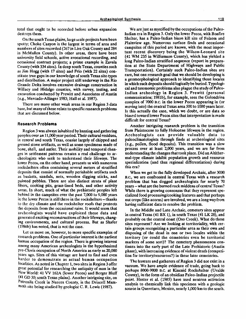
Archeological Synthesis 119
total that ought to be recorded before urban expansion destroys them.
On the south Texas plains, large scale projects have been spotty; Choke Canyon is the largest in terms of area and numbers of sites recorded (267 in Live Oak County and 284 in McMullen County). In other areas, there have been university field schools, active avocational recording, and occasional contract projects; a prime example is Zavala County (with 334 sites). In deep south Texas, counties such as Jim Hogg (with 17 sites) and Frio (with 22 sites) constitute true gaps in our knowledge of south Texas site types and distribution. A major project still underway in the Rio Grande Delta involves extensive drainage construction in Willacy and Hidalgo counties, with survey, testing, and excavation conducted by Prewitt and Associates of Austin (e.g., Mercado-Allinger 1983; Hall et al. 1987).
There are many other weak areas in our Region 3 data base, but many of these relate to specific research problems that are discussed below.
Research Problems
Region 3 was always inhabited by hunting and gathering peoples over an 11,000 year period. Their cultural residues, in central and south Texas, consist largely of chipped and ground stone artifacts, as well as some specimens made of bone, shell, and antler. Their mobility and temporal changes in settlement patterns creates a real challenge to archeologists who seek to understand their Iifeways. The lower Pecos, on the other hand, presents us with numerous rockshelters often containing several meters of stratified deposits that consist of normally perishable artifacts such as baskets, sandals, nets, wooden digging sticks, and painted pebbles. There are also distinct strata of plant fibers, cooking pits, grass-lined beds, and other activity areas. In short, much of what the prehistoric peoples left behind in the campsites over the past 7,000 to 9,000 years in the lower Pecos is still there in the rockshelters - thanks to the dry climate and the rockshelter roofs that protects the deposits from the occasional rains. It would seem that archeologists would have exploited these data and generated exciting reconstructions of their Iifeways, changing environments, and cultural process. But as Shafer (1986b) has noted, that is not the case.
Let us move on, however, to more specific examples of research problems. One of particular interest is the earliest human occupation of the region. There is growing interest among many American archeologists in the hypothesized pre-Clovis occupation of North America as early as 20,000 years ago. Sites of this vintage are hard to fmd and even harder to demonstrate as actual human occupation localities. As noted in Chapter 1, two sites in Region 3 offer great potential for researching the antiquity of man in the New World: 41 VV 162A (lower Pecos) and Berger Bluff (41 GO 30; south Texas plains). Another intriguing site, on Petronila Creek in Nueces County, is the Driscoll Mammoth site being studied by geologist C. R. Lewis (1987).
We are just as mystified by the occupations of the PaleoIndian era in Region 3. Only the lower Pecos, with Bonfire Shelter, has a Paleo-Indian bison kill site of Folsom and Plainview age. Numerous surface finds and occasional campsites of this period are known, with the most important recent discovery being the Wilson-Leonard site (41 WM 235 in Williamson County), which has yielded a long Paleo-Indian stratified sequence (report in preparation at the State Department of Highways and Public Transportation). Certainly such Paleo-Indian sites are rare, but one research goal that we should be developing is a geomorphological approach to identifying those locales in which such deposits should logically be buried. Typological and taxonomic problems also plague the study of PaleoIndian archeology in Region 3. Prewitt (personal communication; 1981b), for example, sees the Golondrina complex of 7000 B.C. in the lower Pecos appearing in (or moving into) the central Texas area 500 to 1000 years later. Is this actually the case, which we doubt, or are data so biased toward lower Pecos sites that interpretation is made difficult for central Texas?
Another intriguing research problem is the transition from Pleistocene to fully Holocene Iifeways in the region. Archeologists can provide valuable data to paleoclimatologists through fmds at archeological sites (e.g., pollen, flood deposits). This transition was a slow process over at least 2,000 years, and we are far from understanding the changes that took place. Did an Altithermal-type climate inhibit population growth and resource specialization (and thus regional differentiation) during this era?
When we get to the fully developed Archaic, after 3000 B.C., we are confronted in central Texas with a research problem that has dogged archeologists for nearly 70 years - what are the burned rock middens of central Texas? While there is growing consensus that they represent specialized food processing/cooking features and that perhaps nut crops (like acorns) are involved, we are a long way from having sufficient data to resolve the problem.
In the Middle and Late Archaic, cemetery sites appear in central Texas (41 BX 1), in south Texas (41 LK 28), and probably on the central coast (Oso Creek). What do these sites represent? Are we looking at territoriality, with certain groups recognizing a particular area as their own and disposing of the dead in one or two locales within the territory (or could the cemeteries even be territorial markers of some sort)? The cemetery phenomenon continues into the early part of the Late Prehistoric (Austin phase), with increasing evidence of violent death (competition for territory/resources?) in these later cemeteries.
The hunters and gatherers of Region 3 did not exist in a vacuum. We have ample evidence of trade, going back to perhaps 8000-9000 B.C. at Kincaid Rockshelter (Uvalde County), in the form of an obsidian Paleo-Indian projectile point. Hester et al. (1985) have used neutron activation analysis to chemically link this specimen with a geologic source in Queretaro, Mexico, nearly 1,000 km to the south.

120 Hester
Clearly, there is also trade among the peoples within the region: coastal shell ornaments show up in the interior of south Texas, in central Texas, and even into the lower Pecos. The peoples of the Late Prehistoric Brownsville complex may have had special trade relationships with the civilized groups of the Huasteca on the Mexican Gulf Coast, as burials in the lower Rio Grande Valley have at times yielded Huastecan vessels, jadeite, and obsidian. In earlier decades, archeologists used to speak of a Gilmore Corridor - a zone along the Texas coast that served to diffuse Mexican traits into the American Southeast. Perhaps such a corridor existed in one form or another (Story 1985), but whatever the case, there were clearly trade links between groups in Region 3 and those outside.
The best example of this can be seen in the distribution . of obsidian artifacts along the Edwards Plateau and into south Texas in Late Prehistoric times, perhaps A.D. 1200-1500. The obsidian is linked through nuclear chemistry to the Malad source in southeastern Idaho; some additional specimens come from Obsidian Cliff, Wyoming. These apparently moved into central Texas as part of a north-south trading system that operated on the Plains in Late Prehistoric times (see Hester and others in Hall et al. 1986).
Such data-oriented research problems are compounded by problems in the archeological taxonomy in Region 3, as well as the rest of Texas. Few archeologists agree any more as to when the Paleo-Indian period terminates. Is it with the end of the Pleistocene or with the end of the lithic technologies so characteristic of Paleo-Indian times? Thus, depending on what reference you consult, the Paleo-Indian period ends in Texas either around 8000 B.C. or as late as 6000 B.C. Should we reserve the term Paleo-Indian for those peoples of the waning Pleistocene who hunted the occasional big game or does the term Archaic automatically apply to any post-Pleistocene adaptation using Paleo-Indian technologies or not? Hunting and gathering is the only lifeway throughout prehistory in the region; thus, when the bow and arrow and ceramics, subsistence changes, settlement patterns, and the like all change after A.D.700-1000, do we call this latter period the Neo-American, as once was fashionable, or is it the Late Prehistoric (clearly distinguishing it from the Archaic), or do we use Prewitt's (1981a) Neo-Archaic, with the assumption that an Archaic hunting and gathering Iifeway continued and there is really nothing new to get taxonomically excited about?
One final research problem that is worth noting involves the transition the Native Americans of Region 3 made from their native lifeways to those imposed on them by the Spanish. How do we measure the acculturation these peoples went through? Or was this a significant process at all? Why did the mission Native Americans continue to make stone tools and native pottery throughout the mission era and even into the early nineteenth century? (Hester 1989). Here we must rely on two kinds of data: those derived from ethnohistoric sources (which are rare) and the Native American quarters of the missions (whose numbers are indeed finite). Many of the mission Native
American quarters have already been damaged by poorly conducted excavations, WP A period restorations, and urban expansion in the nineteenth and twentieth centuries around the missions. This is a research problem that will grow in sophistication, but which may be ultimately unanswerable due to a limited data base.
Theoretical Problems
Texas archeology has sometimes been regarded as provincial and inward looking. Doubtless the insufficient treatment of the rich data from the Amistad caves only furthers that view, since there was an ideal situation for the detailed study of hunting and gathering lifeways - and contributions to hunter-gatherer theory (Shafer 1986b). Region 3 is an area, we repeat again, where only hunting and gathering lifeways existed up to Historic contact; and among the rockshelters of the lower Pecos, the deep stratified sites of the central Texas hill country, and the settlement patterns of the south Texas plain, the archeologist has an ideal laboratory for studying broad issues of interest to hunter-gatherer theory worldwide. Demography, seasonality, economic patterns, catchment analysis, "strategies for survival" (Joachim 1981), and the processes of change in a hunting-gathering lifeway are all fertile fields for substantial contributions from Region 3. This is not only of importance in putting Region 3 on the archeological map but in developing theoretical precepts that will guide future archeological research in the region.
ADAPTATION TYPES
In the frrst meeting designed to organize the SWD overview project, the concept of adaptation type was proposed. It was suggested that such a perspective (based on the work of Fitzhugh 1972, 1975) would serve as a means of facilitating regional syntheses and would benefit the computerized data base, an important aspect of the overview project. Adaptation types would focus on the recognition of broadly shared cultural traits rather than the more common archeological emphasis on localized variation.
In using the adaptation type concept, one must first go back to the originator of the approach. Fitzhugh (1972), in a study of the archeology of the prehistoric central Labrador coast, used the term adaptation type without any clear defmition, although one can see that it was intended as a way of comparing settlement-subsistence systems in the central Labrador area. He proposed coastal adaptations with three variants and interior adaptations (Fitzhugh 1972:161-162) with two variations. A bit more light is shed on his thinking in regard to this concept in a later paper (Fitzhugh 1975), dealing with comparative approaches to northern maritime adaptations. Further definition of adaptation types is provided and the concept is succinctly SUJD
marized as "a general culture-ecological pattern" (Fitzhugh 1972:341-343).

Archeological Synthesis 121
In many respects, the adaptation type seems to be very similar to some of Steward's (1955) views on cultural ecology and to ecological types first proposed for California by Beals and Hester (1960) and more recently summarized in Heizer and Elsasser (1980). The ecological type as applied to California Native Americans emphasized cultural patterns associated with specific environments and the food resources within those environments (see Heizer and Elsasser 1980:Figure 9). The ecological types of California, an area very diverse in terms of environmental variation, consisted of coastal (with tideland collectors and sea hunters-fishers) riverine fisherman; lakeshore fisherman, hunters and gatherers; valley and plains gatherers; foothill hunters and gatherers; and desert hunters and collectors (as well as agriculturalists, as defined for the lower Colorado River in southeastern California). Heizer and Elsasser (1980:58) offered the opinion that the classification of ecological types "should be viewed as an abstraction. Sharp distinctions are rare. Most ecological-cultural boundaries should properly be shown as zones where the transition from one to another is a gradual one."
Review of a similar concept comes from Jochim (1981:6) in his discussion of environmental possibilism. In seeking to move away the position that limited human culture strictly within environmental constraints (environmental determinism), Joachim offers the following observation:
The middle position, that both cultural and natural phenomena interact and mutually affect one another, has gained acceptance. But there are a variety of viewpoints, a variety of formulations on how such interactions are structured. One of these viewpoints is that of environmental possibilism, in which the natural environment as a whole unit sets broad limits on the kinds of behavior and cultural institutions possible ... but the limits are not absolute. The essence of human technology is to transform the environment.
While the adaptation type concept is a useful one, it has been difficult to apply in Region 3. To be sure, there are temporal and spatial patterns within the region (such as the Middle Archaic of central Texas) for which we have good chronological control and some idea of cultural-ecological patterning. The same is true for certain aspects of the lower Pecos sequence. But for the most part, and especially on the south Texas plain, we have neither adequate chronological data nor environmental information. I have already pointed out in this chapter the problems of faunal and vegetal shifts in the south Texas area. Thus, adaptation types for Region 3 should be viewed by the readers as abstractions designed to suggest broad culture-ecological patterns.
PLEISTOCENE FORAGERS AND HUNTERS
This hypothetical adaptation type is dated to before 9200 B.C. (i.e., pre-Clovis). It supposes that occupations by pre-Clovis peoples had spread over much of the New World, a problem that continues to be debated in ar-
cheological circles (cf. Ericson et al. 1982). There are two sites that are potential candidates for this adaptation type, in which hunting and gathering (or foraging) was paramount and in which specialized hunting (for big game) was not of major importance.
The Berger Bluff site (41 GO 30A) in Goliad County on the south Texas coastal plain has yielded a hearth (radiocarbon assayed as early as 11,550 .±.. 800 B.P.; TX3569) and associated fauna and lithics (Brown 1987). The single associated projectile point is triangular and not diagnostic. The fauna are largely very small game (microfauna including rabbits, rats, mice, shrews, moles, birds, fish, and reptiles) and have been extensively studied by Kenneth M. Brown (personal communication). Brown is convinced of the fauna's association with the hearth and the lithics and does not believe they were introduced by natural means (via owl pellets or by carnivores). Some of the smaller mammals at Berger Bluff are either no longer indigenous to the coastal plain (suggesting some considerable environmental change) or, in the case of some microsnails, there are three species whose present range is now far to the north [Brown 1987:4]).
Another site is 41 VV 162A, also known as Cueva Quebrada, on the Rio Grande in the lower Pecos region (Collins 1976; Lundelius 1984). Collins (1976:11-12) describes the deposits as containing at least eight extinct and six surviving faunal taxa with most of the bones broken and burned. The lowest zone contained burned and broken bones, two chert flakes, a fragment of a uniface, and a bone of a small extinct antelope which appears to have cut marks along one edge. Three radiocarbon assays have been obtained from 41 W 162A: 13,920 .±.. 20 B.P. (TX880) and 14,300 .±..22O B.P. (TX881) from the lowest zone, and 12,280 .±..170 B.P. (TX879) in an overlying intermediate zone. This intermediate zone contained definite human materials, including what Collins describes as a Clear Fork gouge. Such tools are not usually thought to equate with a 12,000 year old date; a specimen from Baker Cave (Hester 1983) associated with the Golondrina complex dates to 9000 B.P. Details on the 41 VV 162A situation, including stratigraphic profIles and a detailed faunal analysis can be found in Lundelius (1984).
Finally, in the last few years, C.R. Lewis (geologist, Corpus Christi) has been excavating a fossil locality on Petronila Creek in Nueces County. Pleistocene faunal remains, including elephant, have been exposed, and Lewis is of the opinion (personal communication) that some of the bones have been humanly modified. Whether humans were involved in the Petronila faunal accumulation still remains unclear, and Lewis's careful excavations and periodic photocopied project updates are continuing.
SPECIAliZED HUNTERS
• Early Paleo-Indian 9200-8000 B.C.
• Late Archaic ca 800 B.C.

122 Hester
• Late Prehistoric AD. 1400-1600 This adaptation type is found in much of Region 3, but
in at least three distinctive temporal-cultural contexts. Specialized hunting fIrst appears as an adaptation type with the Clovis complex, with its diagnostic fluted points found across Region 3 (Hester 1986c). To date, however, no mammoth-Clovis point associations have been documented. Mammoth remains are found at the base of BonfIre Shelter in the lower Pecos (Bement 1986), but again, evidence of a kill or butchering locale is tenuous. However, in Bone Bed 2 at BonfIre Shelter (Dibble and Lorrain 1968), there is evidence of a bison jump (or actually, a series of them) representing specialized bison hunting practices in Folsom times (ca 8800 B.C.) and later, in the Plainview complex (ca 8200 B.C.). The bison are of an extinct form, and we can characterize the Folsom and Plainview bison drives at BonfIre as part of a Specialized Hunting adaptation type in Early Paleo-Indian times. Some bison remains and several Folsom points are also known from Kincaid Rockshelter in Uvalde County (T.N. Campbell and Glen L. Evans, personal communications), but due to looting at the site their association cannot be demonstrated.
During the Late Archaic, there is again a notable increase in bison in the Region 3 area (Dillehay 1974). This is reflected by notable accumulations of bison bone in some sites on the Edwards Plateau and by another bison jump, Bone Bed 3, at Bonfire Shelter (Dibble and Lorrain 1968). The typical projectile points are Castroville and coeval broad blade types. Interestingly, similar points are found at about this same time at bison kill sites in the Texas Panhandk (Collins 1968), part of the broader pattern of Specialized Hunting, with a focus on bison during the Late Archaic era.
Good evidence for intensive hunting of bison appears again in the Region 3 archeological record in Late Prehistoric times. It is associated with what is termed the Toyah phase (or horizon; Black 1986). This is a pattern that spread over central Texas and much of the south Texas coastal plain between AD. 1400 and 1600. The southernmost site with evidence of bison hunting is the Hinojosa site (41 JW 8) in Jim Wells County (Black 1986). A bison butchering locale, 41 MC 222, was found along the Frio River drainage during the archeological program that preceded Choke Canyon Reservoir (Hester 1980a; Hall et al. 1986:203-226). In central Texas, Toyah phase sites also have considerable amounts of bison bone (Prewitt 1981:84), and this is seen also on the central coastal plain in Victoria and Golid counties (41 VT 66; Jeffrey Huebner, personal communication; 41 GD 4; Hester and Parker 1970).
The Toyah phase tool kit reflects a bison-oriented technology. This includes bison hunting (using Perdiz or similar stemmed arrow points: 50% of the lithics seen in the assemblage at the Loeve-Fox site in central Texas; Prewitt 1981a:S4), butchering (beveled knives; see Turner and Hester 1985:227), and hide processing (using small end scrapers; Black 1986; Highley 1986).
In closing this discussion of the Specialized Hunting adaptation, it should be made clear that these peoples probably relied very heavily on broad spectrum hunting and gathering, but took advantage of specific resourcesnamely, increased numbers of bison - when they were available. I think this is particularly true for the Late Archaic and Late Prehistoric episodes. Nonetheless, the adaptation type has considerable integrity, as the Specialized Hunting pattern can be recognized as a widespread phenomenon, cross-cutting archeological areas within Region 3 and beyond.
HOLOCENE FORAGERS AND HUNTERS
• Early ca 8000-3000 B.C.
• Late 3000 B.C.-AD. 1700 In the early Holocene, in what is traditionally referred
to as Late Paleo-Indian and Early Archaic times (ca 8000 B.C.- 3000 B.C.) hunting and foraging is an adaptation type seen across Region 3, overlapping the three archeological areas and is related to cultural phenomena beyond the boundaries of Region 3. The Late Paleo-Indian foragers and hunters are typified by the Golondrina complex, especially as seen at Baker Cave (Chadderdon 1983; Hester 1983). The floral and faunal remains from a well preserved hearth at the site (with radiocarbon dates of 7000 B.C.) reflect clear Post-Pleistocene environments, albeit perhaps more moist than later in the Holocene. Broad spectrum hunting and gathering of practically all available plant and animal species is indicated, with a particular focus, based on the hearth data, on snakes (about 16 species; see Hester 1980a). The Golondrina complex is noted elsewhere by its diagnostic, swallow-tailed Golondrina point (Johnson 1964). Campsites of the complex are known as far south as the San Isidro site in Nuevo Leon, Mexico (Epstein 1969), and Golondrina points and sites are scattered across southern Texas, central Texas, and into the lower Pecos. Prewitt (1981a:77) is clearly wrong when he place~ Golondrina points in his Circleville phase, a curious mix· ture of Late and Terminal Paleo-Indian lithics, dated b~ him to ca 6550- 5050 B.C. There is no logical reason for thu widespread cultural pattern to date as much as 500-1()(X years later in central Texas than in the lower Pecos.
Our data are much more meager when it comes to evaluating Terminal Paleo-Indian patterns, such as those which produced the Angostura point type. When excavated data from the Wilson-Leonard site (41 WM 235) arc analyzed, we should have a better perspective on this horizon marker and what it means in terms of culturalecological patterns.
The Early Archaic Holocene foragers and hunters are distinguished mainly by the switch to notched and stemmed points. Indeed, their campsites are often atop Late to Terminal Paleo-Indian sites and are sometimes mixed by erosion. Although Prewitt (1981a) has subdivided the Early Archaic into four phases, some regional specialists do not yet feel comfortable in using his designations (cf. Johnson

Archeological Synthesis 123
1987). Furthermore, it seems clear to us that the Early Archaic foraging-hunting peoples represent, again, a pattern that cuts across archeological areas within Region 3. Projectile point types such as Bell (and a variant called Andice), an early corner-notched series (points called Martindale and Uvalde in central Texas; and Baker and Bandy in the lower Pecos); and an Early Triangular form are the most distinctive. Nonprojectile point tools include Guadalupe tools and a unifacial variant of the Clear Fork tool form. Radiocarbon dates place these materials, or at least assemblages containing all or part of this lithic inventory, between 6100 B.C. (Baker Cave; Hester 1983) and 3400 B.C. (cf. Black and McGraw 1985; Panther Springs site).
Sollberger and Hester (19n) rust pointed out the broad relationships of this Early Archaic pattern, comparing it to similar cultural entities beyond Region 3 and even beyond the present Texas boundaries. Since at that time (19n), there was no designation for the materials that were beginning to be distinguished between Late Paleo-Indian and the Early Archaic (as defined at that time), Sollberger and Hester (1972) proposed the term pre-Archaic. Subsequently, this term has not gained widespread acceptance, and instead the temporal boundaries of what had been called Early Archaic have been pushed back in time (Story 1985). Despite terminological problems- Weir (1976a,b) terms the same era the San Geronimo phase - it seems clear that the Early Archaic foragers and hunters were part of a broader pattern across the entire region.
The faunal record for this era is fairly limited. There are data from Baker Cave on fishing, hunting of small game, and plant food gathering that included desert plants like sotol and lecheguilla (Chadderdon 1983); from 41 LK 31/32 on the Frio River in south Texas (Scott 1982) reflecting fishing (fish otoliths) and the collecting of river mussels and at 41 BX 228 where deer was being hunted, though small game appears to have remained important.
The late Holocene hunters and foragers are essentially indistinguishable in terms of subsistence strategies across Region 3. However, regionally distinct projectile point forms emerge after 3000 B.C., and the broad patterns of earlier times give way to regionalization. Additionally, within each archeological area, the hunters and foragers begin to exploit certain resources or resource areas more intensely-leading in some cases to what I believe are distinct adaptations, such as the Specialized Plant Collector-Hunters of central Texas (see below) and the Coastal Forager-Hunters (see below).
On the southern coastal plains, the late Holocene hunters and foragers likely exploited deer, rabbits, and smaller game (Steele and Hunter 1986) and foraged for reptiles, berries, plant roots and the like, although we have little direct evidence for much of that era. Hester (1981) has proposed that the environments of the middle to late Holocene in southern Texas had developed many of the characteristics that they have today; e.g., there were areas o~ high density (highly concentrated) vs.low density (widely dIspersed) resources. High density resource zones in-
eluded riparian or streamside forests of upper south Texas (e.g., at Choke Canyon on the Frio River) and the less well watered (and thus less riparian resources) savanna areas of deep southern Texas (cf. Starr County; Nunley and Hester 1975). Additionally, there were some sizable areas, such as the south Texas Sand Sheet in deep south Texas, where only temporary occupation was possible (McGraw 1984).
Late Holocene hunters and foragers in the lower Pecos appear to have followed broad spectrum subsistence efforts, though there were clearly microenvironments such as the canyons and the riparian zones on the major streams that yielded nut crops and other foods. In Late or Transitional Archaic times, and perhaps into the Late Prehistoric, lower Pecos foragers appear to have emphasized upland food more intensively, e.g., the baking of sotol bulbs in earth ovens (ring middens; cf. Shafer 1986a). These earth oven accumulations occur within the rockshelters. With more study, it may be determined that this represents an adaptation type similar to the Specialized Plant CollectorHunters of central Texas.
SPECIALIZED PLANT COLLECTORS
This adaptation type is postulated for central Texas, beginning perhaps as early as 3000 B.C., as Holocene foragers and hunters may have begun the process of specializing in exploiting certain resources. Burned rock accumulations began to be formed as a result of some sort of Early Archaic activity (Prewitt 1981a), and these culminated in the burned rock midden phenomenon of the Middle Archaic (the Round Rock phase of Weir 1976a,b; Prewitt 1981a) between 2000 and 1000 B.C. There is a substantial amount of literature on burned rock middens, and no effort is made here to review all of the differing viewpoints as to their function. In a recent symposium of the Council of Texas Archaeologists (Austin, April 15, 1988), a series of papers updated burned rock midden studies. The consensus that seems to have emerged is that these large features - of which there may be one or two at a site or as many as 52 - represent a specialized cooking or food processing technology. Although there are several candidates as to what was being processed or cooked, the most widely held view at this point is that these middens reflect nut crop processing, most likely acorns, but perhaps including walnuts and pecans. This would represent an economic focus in the Fall season and may have involved the cooperative harvesting and processing of the nut crops by bands who had assembled in a productive locale (macrobands; cf. Collins 1972). The burned rock and ashy soil may be in some way related to the leaching process that was likely necessary to remove tannic acids; or they may represent areas of repeated earth oven construction, for baking of acorn foodstuffs (cf. 41 BN 63; Hester 1985).
At site 41 BN 63 in Bandera County (Hester 1985), an occupation zone underlying the burned rock midden could be dated to the late phase of the Early Archaic (La Jita points). During this occupation, small pits were dug for cooking acorns and a number of charred acorns were recovered. Immediately above, the burned rock midden

124 Hester
began to form in the Middle Archaic times with a central, ashy, rock-free area and indications from the profiles of repeated pit digging, probably for earth ovens. The midden was capped in Late Archaic times by flat "roasting griddle" hearths, probably related to a different cooking or processing function.
The regional literature (Suhm 1959; Weir 1976, 1979; Prewitt 1981a, n.d.; Sorrow 1969; Howard 1983; Hester 1970, 1971a; and many others) describes burned rock middens and their contexts. Although there is considerable variability in their form, they are usually dome-shaped knolls within or on a terrace formation. In some geomorphic situations, the burned rock middens are buried in silts and by later occupations. It would appear that the burned rock middens were most commonly situated with close access to water and limestone (to be used as hearth stones or lining for earth ovens?). There is repeated use of the burned rock midden locales, and occupation is adjacent to the middens. These seem to be preferred locales to which bands I)r groups of bands would return on a seasonal basis to exploit, process, and distribute nut crops, most likely acorns. Based on California ethnographic literature (e.g., Heizer and Elsasser 1980) we know that acorns can be stored for a long period, and it is possible that the burned rock middens are somehow linked to the processing of acorns and acorn products that could be stored by the bands for leaner times.
Lest we overemphasize the nut crop exploitation aspect, we should note that deer hunting was also a very important pursuit during this period (cf. Black and McGraw 1985). Intensive collecting of river mussels is also indicated for some sites (Collins 1972; Prewitt 1981a). While we cannot accurately gauge the amount of nut collecting vs. deer hunting, we tend to believe that specialized nut harvesting and processing was the main character of this adaptation type.
COASTAL FORAGER-HUNTERS
Along the central and southern Texas coastline, a coastal-oriented adaptation began around 3000 B.C Sea level had probably reached its maximum highstand of the Holocene, and the offshore barrier islands had been formed. The hunting and gathering peoples along the coast began to exploit the resources of the bays, river mouths, the offshore islands (and to a limited extent, the Gulf beyond), and the Laguna Madre waterway between the mainland and the islands. There was an abundance of shellfISh, waterfowl, and fish, some of which could have been taken in abundance on a seasonal basis (e.g., winter waterfowl migrations; seasonal fishruns, as with the black drum). Earlier the coastallifeway was termed a maritime adaptation (Hester 1976); this has been criticized to some extent for overemphasizing the coastal element of the subsistence regime. Nonetheless, it seems that these coastal resources were likely dominant in the diet, though certainly these peoples could exploit the deer, small game, and some plant foods in the adjacent prairies and riparian zones at the river mouths. They may have even been seasonally transhumant,
moving up rivers inland at certain times. However, I see no archeological evidence for such a system, although Cabeza de Vaca's recollections (Covey 1984) suggest that some groups were transhumant.
The early phase is known as the Aransas phase (or complex; Corbin 1974) and dates around 2000 B.C. and thereafter. There are few absolute dates for this phase. It is perhaps this early phase that most emphasizes the coastal resources. Typical sites are large accumulations of oyster shells (shell middens), and their everyday tools were fashioned from the shells of conch, clam, and other shellfish (Hester 1980a). They used stone dart points, although chert sources were 48-80 km inland. This raw material would have to have been obtained either through trade or specific chert collecting trips (most likely the former, based on Cabeza de Vaca; Covey 1984). Major published sites include Johnson (Campbell 1947) and Kent-Crane (Campbell 1952). Most of the Aransas shell middens have been lost to hurricanes and to modem-day coastal urban and industrial expansion. Once thought to have been largely destroyed, recent surveys have revealed that some Aransas shell middens, specifically the Kent-Crane site, survive today. These should be studied for more data on the Aransas phase before the sites are ultimately wiped out.
Beginning around AD.1200, there is a late phase of the Coastal Forager-Hunter adaptive type. This is correlated to a certain extent with the Late Prehistoric period, known on the southern coast as the Rockport phase (or complex; see Corbin 1974). The type site is Live Oak Point (Campbell 1958b). The bow and arrow was introduced and probably played a significant role in the economic shift from the Aransas to the Rockport. Hunting may have become more important, with deer, antelope, bear, and other game hunted on the nearby prairies; perhaps some types of fIShing and hunting of waterfowl were enhanced by the use of the bow and arrow. Shell middens no longer accumulated, though in many Rockport sites there are the remains of oyster and other shellfish, along with substantial quantities of the large Rabdotus land snails, foraged on the prairies as a diet supplement. This is particularly true at late phase sites on Oso Creek and in the Baffin/Grullo bays south of Corpus Christi (Hester 1969a). A sandy paste pottery, decorated or sometimes waterproofed with asphaltum, was made (Rockport ware) and substantial amounts of bone-tempered pottery (cf. Leon Plain) are also found. Storage of water or foodstuffs in such vessels may have also played an important role in late phase coastal adaptation.
The Rockport complex is often linked to the Karankawa (see Chapter 4), and this may be the case in its very latest protohistoric and early historic aspects. Other groups on or near the coast, such as the Mariame reported by Cabeza de Vaca (Covey 1984) may have also been responsible for Rockport materials. Chippable stone was still at a premium even in the late phase. To make most efficient use of the chert resources that were obtained, a microblade/core technology was developed (Hester and Shafer 1975).

Archeological Synthesis 125
Cemetery sites appear in the Coastal Forager-Hunter adaptation type. Some were likely formed during the Aransas phase (Late Archaic; e.g., the Oso site, 41 NU 2) and others are of Rockport age (Hester and Corbin 1975).
The Coastal Forager-Hunter adaptation type suffers, in terms of evaluating its validity, from sites sampled in WPA days or sites that have yielded only surface collections. Exceptions include Story's (1968) work at Ingleside Point, excavations by Prewitt et al. (1987) at Swan Lake, and recent work at the mouth of the Nueces River by Ricklis (1986). Within a few years, there should be sufficient excavated materials to test and better derme this postulated adaptation type.
MISSION FARMERS-HERDERS
Beginning with the Spanish Colonial epoch in southern Texas (ca A.D.17(0), the local Native American groups were gathered into the missions of the region. It is likely that their native culture had already been disturbed by Lipan Apache intrusion beginning in the seventeenth century and from Spanish diseases that may have "leapfrogged" from settlements in northern Mexico to one Native American group after another in advance of actual Spanish contact (Campbell 1983). The missions had as principal goals the conversion of the Native Americans to Christianity and their transformation into productive Spanish citizens, skilled in stock raising and farming. In the missions at Guerrero, San Antonio, Goliad, and elsewhere, we know that the Native American neophytes received training in agriculture and were entrusted with sheep and goat herds. It is clear that some of the Native Americans adapted to this lifestyle fairly quickly. For example, by the mid-1750s, Mission Espada (San Antonio) had established Rancho de las Cabras, a mission ranch in nearby Wilson County (Ivey 1983; Taylor and Fox 1985). Missionized Native Americans were placed in charge of stock, including goats, sheep, and cattle, kept on the ranch.
At the missions themselves, some Native American families underwent the acculturation process and began to farm nearby plots of land. Many of them in the San Antonio and Goliad areas lived on in these farms after the missions were secularized in 1793.
While we may use the Mission Farmer-Herder as an adaptive type, it must be realized that it applies to comparatively few of the native groups affected by the missions. Many of the Native Americans died from disease and Lipan Apache raids. Even in the missions, ranching and farming were not always sufficient, and h uoting and gathering in the native tradition were important in the dietary scheme. As Salinas (1986) reports, missions in the lower Rio Grande Valley, on the south side of the Rio Grande, were notably unsuccessful, and the Native Americans had to support themselves by hunting and gathering well into the early nineteenth century. In essence, many of the scattered Native American groups of the eighteenth and early nineteenth centuries in Region 3 remained in the Late Holocene forager-hunter adaptation type.
PLAINS NOMAD-HUNTERS
The peoples represented by this adaptation type were intrusive Native American groups in the Texas area during protohistoric and early historic times. Their lifeways have been characterized as highly mobile and with an emphasis on raiding of other Native American groups and, later, the Spanish and other Anglo-European settlers.
The Lipan Apache (sometimes called Plains Apaches; see Tunnell and Newcomb 1969) began moving into Texas sometime in the seventeenth century. They are derived from the southern Plains and eastern New Mexico, as best we can tell, and they had an immediate impact on the hunting and gathering peoples of Region 3. It is likely that their penetration into the region and their raiding of Coahuiltecan and other groups had already disrupted and fragmented some of these groups prior to the mission process (T.N. Campbell, personal communication). After they acquired horses, the Lipan increased their harassment of the Spanish, the missions, and the remaining huntergatherer groups. However, by the late 1760s, they themselves were so endangered by the Comanche that they entreated with the Spanish to build missions for them to provide protection from their enemies. The best known of the missions built for the Lipan Apache is San Lorenzo de la Santa Cruz at present-day Camp Wood, Real County. Though one of the objectives of excavations at the site (Tunnell and Newcomb 1969) was to try to identify specific Lipan material culture archeologicaIly, this was largely unsuccessful. However, Newcomb did provide a detailed review of Lipan Apache history.
The other intrusive group of note is the Comanche. As detailed in Chapter 6, their arrival in Texas in the mideighteenth century, as horse-borne warriors, severely affected the balance of power between the Spanish and the Lipan Apache in what is now Region 3. Much has been written about Comanche lifestyle (Wallace and Hoebe11952; Fehrenbach 1974) and need not be repeated here. Archeologically, their presence is hard to document. In the Texas Panhandle-Plains, occasional burials attributable to the Comanche have been documented (cf. Word and Fox 1975), but none have been found in Region 3. It is possible that some of the historic rock art of the lower Pecos region, as recently published by Turpin (1988; n.d.), may be linked to the Comanches. Metal arrow points are found on rare occasions and some undoubtedly are linked to the Comanche, but there is no way of definitely demonstrating this.
The Lipan Apache and the Comanche continued their raiding patterns in Region 3 well into the midnineteenth century. There were, however, other groups of intrusive Native Americans who also raided settlements in the region into the late 1870s (see Chapter 6).
NATIVE ABORIGINAL REMNANTS-MIGRANTS
As the situation with Native American groups deteriorated in the Southeast and Plains in the late eighteenth and early nineteenth century, many of these groups moved into parts of Texas. As noted in Chapter 6, these included the Kiowa, Kiowa Apache, Mescalero

126 Hester
Apache, Cherokee, Delaware, Caddo, Seminole, Shawnee, Pawnee, and other tribes - all noted in the historic documents as having been present, albeit for brief periods, in Region 3. The Kickapoo (Chapter 6) are the best known of this adaptation type for the region, especially in southern Texas (and adjacent northeastern Mexico). They have survived up to the present time, living in Muzquiz, Coahuila, and now, a Texas band living on designated property near Eagle Pass in Maverick County. They have worked for years as migfant farm laborers in Texas.
Archeologically, the Native Aboriginal RemnantsMigrants left no diagnostic cultural residues. Some metal arrow points may be attributable to them, and there are rock paintings of historic vintage in the lower Pecos (cf. Meyers Spring; Kirkland and Newcomb 1967), also linked to unknown transient aboriginal groups (Turpin 1988).
SPANISH RANCHER-FARMERS
This adaptation type is a general one, applied to the main focus of the Spanish colonists of the eighteenth century. Once missions and presidios had been established, the colonists were moved in to develop farms and ranches in the surrounding country. One notable, forced colonization involving Mexican farmers and ranchers is seen in the occupation of the lower Rio Grande Valley in the 17505 (Salinas 1986). Many old stone buildings and other structures in that area, and north toward Laredo, reflect this adaptation type, though some of the structures may be early nineteenth century in date. The presence of Spanish farms and ranches led to the development of local population centers, serving as markets and commercial locales. These included San Antonio in the early eighteenth century and Laredo by midcentury. Rancho de las Cabras (Taylor and Fox 1985), though largely a ranch of Mission Espada, came later under the control of Spanish ranchers ofthe area. Not many sites of this era have been excavated. The Spanish Governor's Palace, representing colonial San Antonio, has been studied in part by Fox (1977), and some architectural studies were done in eighteenth century buildings prior to the construction of Falcon Lake on the lower Rio Grande (George 1975).
ANGLO RANCHER-FARMERS
Much of Region 3 continued to focus on the raising of sheep, goats, and cattle and the expansion of agriculture on into the nineteenth century. After the Mexican War of Indepl"'ndence in 1821, we could describe the adaptation type as Mexican Rancher-Farmer (cf. Rancho Tulosa, 41 NU 11; Ricklis 1988), and it was not until the 1830s and 1840s that the Anglo-European rancher- farmer moved into parts of central and southern Texas from the United States. Some of these came from abroad, as with the German immigrants into New Braunfels and the Texas Hill Country, and on the south Texas coastal plain, as studied from archeological, architectural, and historical perspectives by Fox and Livingston (1979); see also Fox (1979) and Carter and Ragdale (1976). Sheep and goat ranching became important in the lower Pecos after the Civil War and
continues to be of significance up to the present time. Cattle ranching was of greater importance in the southern Texas coastal plains, and dryland (and later, irrigation) farming grew in significance in the late nineteenth century. Many nineteenth century ranch houses and farmsteads have now been studied (cf. Moore and Moore 1986:55). As an example, Fox and Cox (1983) have investigated a stone structure, the Valenzuela site in Dimmit County, related to nineteenth and twentieth century ranching.
Some archeological studies have focused on the frontier forts that were established to protect the Anglo RancherFarmer and the emerging communities. There has been fieldwork at Fort McIntosh at Laredo (D. Fox 1979), Ft. lnge (Nelson 1981) near Uvalde, and Ft. Martin Scott (Gillespie County; Labadie 1987), but many other frontier forts such as Fort Clark (Brackettville), Fort Duncan (Eagle Pass), and Fort Ringgold (Rio Grande City) have not been examined archeologically.
DEVELOPED SETTLEMENT
This adaptation type encompasses the towns and cities that emerged in Region 3 in the nineteenth and twentieth centuries. Ranching and farming continued as the economic base and other factors, such as oil and banking, contributed to the growth of the region's popUlation centers. The railroad linked these towns and cities; archeological studies of the camps of railroad workers have been studied in the lower Pecos region (Briggs 1974; Patterson 1980). By the twentieth century, there were clearly distinct urban areas (San Antonio, Laredo, Corpus Christi, Brownsville) with outlying rural settlements in great numbers. Some of these have been examined by archeologists in connection with contract archeology projects (see Moore and Moore 1986:49, 77, 79, 80-82). The towns and cities themselves have also seen archeological study, especially San Antonio (cf. D. Fox et al. 1978; Fox and Highley 1985), Laredo (Clark and Juarez 1986), and the Texas coastal town of Texana, Jackson County (Jackson 1977). Even the cemeteries of this era have had archeological research conducted whenever mining or lakes have forced the removal of graves (cf. Taylor et al. 1986).
Final Thoughts on Adaptation Types
In Table 15, we have arranged adaptation types temporally, though without regard for the traditional chronological labels applied in Region 3. This also permits comparison among the three areas - south, central, and lower Pecos Texas-in terms of spatial extent of the adaptation types. Some clearly encompass the whole region, particularly Specialized Hunters in its Paleo-Indian manifestation between 9200 and 8000 B.C. The Holocene Foragers-Hunters adaptation type also spans the three areas, but after 3000 B.C. different adaptations are suggested. In southern Texas, we believe a coastal-adapted orientation developed; by 2000 B.C. in central Texas, there is an apparent focus on nut crop harvesting (likely acorns), undoubtedly supplemented by deer hunting, which results

Archeological Synthesis
TABLE 15
Adaptation Types
ADAPTATION TYPE TEMPORAL AFFilIATION
prior to 9200 B.C. All Pleistocene Foragers and Hunters Specialized Hunters
Holocene Foragers and Hunters
Early Paleo-Indian, Late Archalc ca 800 B.C. Late Prehistoric, AD. 1400-1600 Early.±.8OO().3000 B.C.
All; Central Texas, lower Pecos Central Texas, South Texas All
Late 3000 B.C.-AD. 1700 Specialized Plant Collectors-Hunters Coastal Forager-Hunters Mission Farmers-Herders
ca 3000 B.C. to early centuries AD. ca 3000 B.C. or earlier to Hispanic Historic/Spanish Colonial
South, Central Texas, Lower Pecos Central Texas South Texas South Texas
Plains Nomad-Raiders through eighteenth century
Protohistoric; Historic: seventeenth Central Texas All
to early nineteenth centuries Historic: into twentieth century Native Aboriginal Remnants-Migrants
Spanish Rancher-Farmer Anglo Rancher-Farmer
Historic; eighteenth to early nineteenth century Historic; nineteenth century
All All All All Developed Settlement Historic to present
in burned rock midden sites (our Specialized Plant Collectors- Hunters adaptation type). Based on our reading of the archeological record, there is nothing comparable in south Texas or the lower Pecos at this time, and the pattern must reflect adaptive responses to certain plant resources (oaks as well as walnuts and pecans?) available in the central Texas plateau.
As indicated in Table 15, there is a recurrence of a Specialized Hunters adaptation around 800 B.C. in central and lower Pecos Texas. Bone Bed 3 at Bonfire Shelter is the best example; it is a bison jump of Late Archaic date (see Chapter 1). It is difficult to tell how long this particular adaptation persisted in the two regions. It looks as if a return to Holocene foraging-hunting was in place in the lower Pecos in the late centuries B.C., and that was likely the case in central Texas (i.e., the Transitional Archaic). Specialized Hunters, again focusing on bison, appear around A.D. 1200-1500 in south and central Texas, but as far as we know not in the lower Pecos. The southernmost extent of the Specialized Hunter type occurs at site 41 JW 8, the Hinojosa site in deep southern Texas (see Chapter 4).
We have also shown (Table 15) an intrusive type in all three areas beginning in the seventeenth century A.D. with the Plains Nomad-Raiders. These peoples were at first foot nomads (so-called Plains Apaches), and Lipan Apache groups had clearly penetrated into all three areas by the middle to the end of the seventeenth century. They quickly acquired horses and were a potent military threat until they themselves were threatened by Comanches of this same adaptation type in mid eighteenth century. Plains Nomad~aiders may have persisted into the midnineteenth century In this region. However, by the early nineteenth century there was a mixture of remnant groups of all of the three areas (Chapter 1). Following the Civil War, these Aboriginal Remnants were likely responsible for some of the raiding on settlements on the Region 3 frontier.
This adaptation type also includes what we have described as Aboriginal Migrants. Though not shown in Table 12, they are equivalent temporally to Aboriginal Remnants. The main group involved here are the Kickapoo, who moved into Coahuila in the nineteenth century and who still work in Texas and other states as migrant laborers.
The Mission Farmer-Herder adaptation type refers specifically to the natives of Region 3 who went into the Spanish Colonial system (Coahuiltecan and Karankawa, as well as refugee groups from northern Mexico). As detailed in Chapter 1, the acculturation process transformed some of these peoples into farmers and stock herders; others were the victims of European diseases. As a result a very small population of Mission Farmer-Herder peoples persisted into the early nineteenth century. At that time, they were assimilated into the growing towns of San Antonio and Goliad.
The final three adaptive types related to European presence in Region 3 (Table 15). Under Spanish RancherFarmer we have subsumed all elements of the Spanish Colonial era. Aside from the missions and the garrisons at the several presidios, the bulk of the Spanish colonists based their livelihood on ranching and farming. Their adaptation type might be described as Mexican after independence from Spain in 1821 (and up to 1836) and certainly Hispanic rancher-farmer peoples live throughout the region today. However, the following adaptation type, Anglo Rancher-Farmer, becomes dominant with the immigration of Americans, and later Germans and other Europeans, into Texas in the nineteenth century. Major distinctions that can be seen are: irrigation farming and large ranches in south Texas; smaller ranches and farms in central Texas; goat and sheep ranching in the lower Pecos.

128 Hester
From this agricultural base, Developed Settlement (see Chapter 7) emerges as a viable adaptation type. Markets and banking form the focus of some of the emerging cities, such as San Antonio. The railroad later led to the growth of many small towns throughout the region. By the early
twentieth century, sizable populations could be found in San Antonio, Austin, Laredo, Corpus Christi, Brownsville, and Del Rio. The transformation of some large towns into major cities occurred a bit later in the twentieth century, beyond the scope of our present concerns.

Chapter 10
BIOARCHEOLOGICAL SYNTHESIS
Karl J. Reinhard, Ben W. Olive, and D. Gentry Steele
One of the main problems encountered in the review of the bioarcheology of Region 3 has been the limited number of sites where human skeletal material has been adequately recovered and analyzed. In the preceding chapter it was documented that less than 30% of the burials recovered from recorded sites have been reported in published literature. It was further estimated that of the 323 sites with burials, no more than 80 sites have published detailed bioarcheological reports on the burials recovered. Only 50 of these 80 reports provide individual descriptions of each burial which facilitate subsequent analyses and evaluation.
Four principal reasons probably have led to this minimal utilization ofbioarcheological data in anthropological studies of Region 3. First, there have been few trained bioarcheologists with research interests centering on Region 3 skeletal samples. Second, few sites have produced large skeletal samples tempting scholars to undertake detailed bioarcheological analyses. Third, many of the recovered samples have been poorly preserved, and commonly inadequately conserved and curated. And, fourth, in the past rarely did funding agencies encourage bioarcheological research by providing adequate funding for the recovery, conservation, curation, and analysis of human skeletal remains. The result of these difficulties has been the minimal analysis of bioarcheological remains, and the general consensus (usually unspoken) that bioarcheological studies can contribute little to the understanding of our prehistory.
While the problems outlined above are probably evident throughout North America, they seem to be a particular problem in Region 3 because this area primarily has been occupied by hunters and gatherers throughout prehistory. The consequence of this is that population densities have probably been lower than one typically sees in agriculturally based societies, and skeletal samples have accrued more slowly in the earth; thus, fewer large collections are available for excavation and more postmortem deterioration has probably occurred on those samples which do exist.
However, in the OAO area, Burnett et al. (1988) successfully assessed prehistoric adaptive efficiency through paleo pathological data, thus utilizing bioarcheological data to assess an issue of general anthropological interest. In their study area, they were able to demonstrate that although adaptive efficiency remained relatively stable, varying infection rates and metabolic disorder rates between sites and subsistence strategies could be identified.
It is the purpose of this study to determine whether the aVailable bioarcheological literature from Region 3 in Texas lend~ itself to similar study. An analysis of the adaptive efficiencies of prehistoric inhabitants of Region 3 was chosen because it
fits the mandates of the broader study and involves the analysis of medical disorders, which is one of the most commonly assessed biological features of reported skeletons. If such a study can be undertaken, a secondary goal is to assess the success of differing prehistoric hunter and gatherer subsistence strategies in various ecological zones within Texas. We 'have chosen to compare adaptive success between subregions because there appears to have been little change in hunter and gatherer adaptive strategies through time in Texas, even with tbe great ecologi-cal diversity within Region 3. '
METHODS
The samples from each adaptive subregion Were compared on the basis of sex ratios of recovered skeletal remains, age distributions, and reconstructed life table o( the recovered remains and their pathological lesions. In generol, this information was gathered whenever posSIble from the published literature, but in specific circumstances, unpublishep analyses were relied upon as well. '
For the sex and age of skeletal remains included within the analysis, the information was acquired from unpublished notes on the curated skeletal collection at T ARL (lJilese notes were made available to us by Barbara Jackson and James Boone, T ARI..., University of Texas, Austin) and from those reports and publications which reported specific sex and age estimates for skeletons. AIl age estimates were converted to the age categories utilized for the analysis of the curated T ARL collection (fetal = prior to birth, infant = ()"1 year, child = 1-5 y~ars, older child = 6-10 years, adolescent = 11- 19 years, adult = 20-50 years, and older adult = 50 + years). To generate mortuary tables, the median age for each category was used. For old adults, the median was established at 58 assuming an effective maximum age of 68 years. Table 16 provides a listing of distribution of the sex and ages of the individuals per site for each adaptive region. Table 17 summarizes the sex distributions for each adaptive region, Table 18 summaries the age distributions for each region, and mortuary schedules are listed in Table 20.
Paleopathological information was derived from both published and unpublished sources. Thirty-four sites (Table 19) that included usable paleopathological data were carefully examined and pathological inferences were tabulated into six subcategories: metabolic disorders, dental disorders, degenerative disease, infectious disease, trauma not associated with interpersonal violence, and trauma associated with interpersonal violence. Records of specific lesions or conditions for each disorder subgroup were recorded from the burial reports. Evidence of porotic

130 Reinhard. Olive. and Steele
TABLE 16 Distribution by age/sex by site
Adolese. Sub- Adults
Site
Older
Fetal Infant Child Child M .F adult M F Adult Total
Coastal Strip 41 AS 1 0 41 AS 3 0 41 CF2 0 41 CF 3 0 41 CF 5 0 41CF111 0 41 HG 1 0 41 HG 27 0 41JK91 0 41 NU 1 0 41 NU 2 1 41 NU 3 0 41 NU 8 0 41 NU 23 0 41 NU 71 0 41 SP 1 0 41SP78 0 41 VT 1 0 41 VT 8 0 41 WVoo 0 41 WV67 0 TOTAL South Coastal pla;n 41 BP282 0 Bastrop 0 41 BX 3 0 41 BX 195 0 41 CW3 0 41 CO 37 0 41 CO 62 0 41 FY 42 0 41 GO 1 0 41 GO 2 0 41 KA23 0 41 KY 2/8 0 41 KY 27 0 41 ME 30 0 41 WH 1 0 41 WH 14 0 41WH39 0 41 Z)J 152 0 TOTAL 0
Central prairie 41BL3 G 41 BL28 0 41 BT 1 0 41 BT 7 0 41 BT 10 0 41 BT 48 0 41 BT 55 0 Burnet 0 41CK111 0 Coleman 0 Coleman 0 Coleman 0 41 CV 1 0 41 CV7 0
o o 2 o o o o o o o
10 o o o o o o 3 o o o
15
1 o o o o 2 o 2 o 1 o o o o o 1 1 o 8
o 5 o o o 1 o o o o o o
o o o o o o 2 o o o
12 o o o o o o 6 o o o
20
o 1 o o o o o 2 o o o o o o 1 o o 5
5 o o o o o o o o o o o 1 o
o o o o o o 1 o o o 5 o o o o o 1 8 o
o 16
o o o o 1 o o 1 2 o o o o o o o 3 o 7
2 o o o o o o o o o o o o o
o o
1 o o o o o o o o o o o o o 1 o o o 3
1 o o o o o o o o o o o o o o o 1 o 2
o 1 o o o o o o o o o o 2 o
o o o o o 1 o o o o 5* o o o 1* o o o o o o 7
1
o o o o
1 o o
1 o o o o o o o 5
o o o o o o o o o o o o o o
3 0 0 1 0 1 0 0 0 0 2 0 *4 0 1
11 2 *22 0 0 o 0 *1 0 0 2 0 0 0 0
2 13 0 1 o 0 0 0
1 0 0 0 0 o 0 1* 0 0
12 *13 *25 2 1 o 0 1* 0 0 o 0 1* 0 0 o 0 0 1 0 o 0 *2 0 0 o 0 0 0 2 1 *2 0 0
16 11 *101 1 3 o 1 000 o 0 0 0 0 o 0 0 1 0
52 30 174 6 6
o 0 1 0 0 1 0 0 0 0 4 6 5 0 0 o 1 0 0 0 o 0 0 0 0 2 2 7 0 0 1 0 0 0 0 2 0 3 0 0 3 4 29* 0 0 o 1 1 0 0 2 2 1 0 0
o 0 0 1 1 0 0 0 o 0 0 0 o 0 2 0 0 4 2 0 0 5 6 8 4 1 o 0 0 0
26 27 5842
6 7 17 0 0 6 4 2 5 4 o 0 100 1 0 0 0 0 o 0 2 0 0 o 0 0 0 0 1 0 0 0 0 o 0 1 0 0 1 0 0 0 0 o 0 0 0 o 0 1 0 0 o 0 1 0 0 3 2 6 0 0
200
o 4 o o 11 o 36 o 1 o 3 o 21 o 1 o o 1 1 99 o o o 1 o 4 o 1 o 6 7 169 o o o 1 8 365
o 5 o o 16 o o 1
1 15 o 2 o 8 o 44 o 4 o 6 o 2 o 2 o 1 o 2 o 9 o 31 o
151
2 41 o 28 o 2 o 1 o 2 o o o o o o o o 18 o 7

TABLE 16, continued
Site
41 CV 14 41 CV 17 41 CV44 Coryell 41 ED 1 41 HY29 41 LM2 41 LL4 Mason 41 MM8 McCulloch 41 MK26 41 AE 1 41 AN 1 41 SS2 41 TG 12 41 TV4 41 TV5 41 TV 26 41 TV 36 41 TV41 41 TV 47 41 TV 48 41 TV 88 41 TV 102 41 TV 103 41 TV 134 41 TV 164 41 TV 886 Travis Travis Travis Travis
41 WM 1 41WM5 41 WM6 41 WM8 41 WM9 41 WM 10 41 WM 15 41 WM23 41 WM 139 41 WM230 41 WM268 41 WM 235 Williamson Williamson Williamson Williamson Williamson Williamson TOTAL
Fetal o o o o o o o o o o o o 1 o o o o o o o o o o o o o o o o o o o o o o o o o o o o o o o o o o o o o o
Infant 1 o o o 3 o o o o 1
o o 7 o 4
o o o o o o o 1 3 o o o o o o o o o o o o o o o o o o 1 o o o o o o o o
29
Bioarcheological Synthesis
Older
Child Child 3 1 o 0 o 0 o 0 o 0 o 0 o 0 1 0 o 0 o 0 o 0 o 1 3 0 1 0 o 1 o 0 o 0 o 0 o 0 o 0 o 0 o 0 o 0 o 0 o 0 o 0 o 0 o 0 o 0 o 0 o 0 o 0 o 0
o 0 o 0 o 0 o 1 o 0 o 0 o 0 o 0 o 0 4 0 o 0 o 0 o 0 o 0 o 0 o 0 1 0 o 0
19 6
M 1 o o o o o o o o o o o o o o o o o o o o o o 1 o o o o o o o o o o o o o o o o o o 1 o o o o o o o o 6
Adolese. Sub-
.F I adult
o 3 2 o 2 0 o 0 0 o o o o o o o o o o o o o o o o o o o o 2 o o o o o o o o o o o o o o o o o o o o o
o o 2 o o o 1
o 1
3 o 1
o o o o o o o o o o o 2 o 1 o o o 1 1 o o 4 1 o o o o
11 o o
o 0
o o o o o 2
o o o o o
53
o o o o 1 o o
1 o o o 1 o o o 1 o o o
1 o o o o o o o o o 1 o 1 o o o 4 o 2
1
o o o o
35
Adults
M F 5 1 0 5 0 0
o 0 100 000 000 o 1 0 000 100 500 000 000 400 000 000 1 0 0 000
o 0 o 0
1 0 0 o 0 0 1 0 0 000
12 0 0 o 0 0 o 0 0
o 2 1 0 0 o 0 0 1 0 0 o 0 0 1 0 0 000 000 001 1 0 0 010 o 1 0 2 0 0 200 1 0 0 300 o 1 2 2 0 0 000 000 o 0 0
o 0 100 o 0 0
o 0 91 10 9
Adult o o o o o 1 o o o o o o
1 o o o o o o o o o o o o o o o o 1 o o o o o o o 1 o o o o o o o o o o o o 7
Total 18 7
1 3 3 1 2
7 1 3
21 2 6
1 1
22
1
6
1 1 9 2 4 2 1 3
25 2 2
1 286
131

132 Reinhard. Olive. and Steele
TABLE 16. concluded Older Adolese. Sub- Adults
Site Fetal Infant Child Child M .F adult M F Adult Total
Lower Pecos 41 W1 0 1 0 0 0 0 0 0 0 0 0 0 41 W35 0 2 0 0 0 0 0 0 0 0 0 0 2 41 W55 0 1 1 0 0 0 2 3** 0 0 0 7 41 W67 0 0 0 0 0 0 0 1 0 0 0 2 41 W74 0 4 0 0 0 0 0 1 1 0 8 41 W82 1 0 0 0 0 0 1 1 0 3 0 1 9 41 W87 0 2 0 0 0 0 0 0 0 0 0 0 2 41W88 0 0 0 0 0 0 0 0 0 0 0 1 41 W 162 0 0 0 0 0 0 2 1 1 1 0 0 5 41 W258 0 0 0 0 0 0 2 3 0 0 0 0 6 41 W656 0 0 0 0 0 0 1 0 0 0 0 0 Val Verde 0 0 0 0 0 0 2 0 0 1 0 4
TOTAL 11 0 0 0 11 8 5 6 2 48
* At least one burial in this category is represented by more than one individual.
** At least one burial in this category is represented by more than one individual.
hyperostosis, cribra orbitalia, IIarris lines, or enamel hypoplasia was considered evidence of metabolic disorders. Infectious disease included the lesions of osteomyelitis, periostitis, and any specific insults such as possible treponemiasis. Dental disorders included caries, abscessing, dental wear, and antemortem tooth loss. Degenerative disease includes spinal osteoarthritis, osteo phytosis, and appendicular osteoarthritis. Fractures of the long bones and ribs, excluding parry fractures, were classified as noninterpersonal violence. Evidence of interpersonal violence includes projectile wounds, cranial fractures, and parry fractures. The use of parry fracture evidence as evidence of interpersonal violence is different from the interpersonal violence classifications used by Burnett et al. (1988) but otherwise we followed their suggestions.
Certain guidelines were established in order to code information consistently from the literature. Bone preservation in many sites was very poor. Consequently, lesions affecting the long bones were coded for only if four complete long bones of the leg and arm were present. With respect to categories affecting the crania (porotic hyperostosis, cnbra orbitalia, cranial fracture), crania were included in the counts if it was clear that they were extensively examined by the original author. Tooth wear was coded for only if the wear was reported as being moderate or severe. TemporomandIbular joint deterioration was considered to be a degenerative disease for the purposes of this summary and incidence ofTMJ deterioration were included in the appendicular osteoarthritis tabulations.
With respect to the Crestmont site analyzed by Vernon (n.d.), we could not determine from the preliminary manuscript the "completeness" of the skeletons. Consequently, to maintain consistency with the rest of the analysis, we estimated as closely as possible the number of skeletons complete enough for analysis based on Vernon's brief description of each burial. This estimation indicates
that 23 skeletons were suitable for the study of cranial lesions and 17 were suitable for appendicular lesions. Seven could not be used in the analysis and were not considered. Because we eliminated skeletons from consideration, our total sample (n =31) for this analysis was smaller than that analyzed by Vernon for determination of percentages. Consequently, we derived higher percentages of osseous lesions than did Vernon.
For dental disorders, we derived incidences from several sources. The occurrence of enamel hypoplasia (5/6) is derived from Vernon's Table 10. The incidences of caries (9/23) and abscesses (3f23) are derived from Vernon's descriptions of individual buria1s. The incidence of antemortem tooth loss (10123) was derived both from Vernon's Table 12 and the burial descriptions. Fmally, the incidence of tooth wear (13/18) was derived from Vernon's Tables 9 and 11, minus two crania which had no teeth present.
Both individual burials and mixed burials have been described in the reports. With respect to tabulating the data, this presented some difficulties. The mixed burials could not be tabulated as easily as individual burials. Consequently, the number of infected individuals in a mixed burial was subject to interpretation. In such cases, minimum estimates of infected or affected individuals were used in tabulating the data.
The interpretation of pathological data was complicated by several aspects of osteological analysis and recording. The same terms were not consistently used for the same lesions. For example, osteophytosis is rarely scored as such in osteological reports. VeTtebroJ lipping, arthritis of the centrum, and centru?' exostoses probably represent alternate terms for osteophyt~ Consequently, this analysis required some interpretation ofwntten descriptions. In some reports, the location of lesions we~ noted, but description of the lesions were not. In such cases, it was impossible to place any pathologica1label on the reported pathology and these were not included in any tabulations. Similarly, certain conditions associated with specific insults suc1:

Bioarcheological Synthesis 133
as "saber shins" of treponema infections were noted without specific descriptions of the lesions. Such cases were included in the tabulations although we have some reseIVations about the validity of our diagnosis from incompletely described lesions.
One additional notation of our method concerns Vernon's (n.d.) analysis. Her thorough descriptions of lesions she identified as osteomyelitis fit more closely lesions we have identified as periostitis. Consequently, for this report, we have recIassified her osteomyelitis cases as periostitis.
Fmally, it should be noted that the literature for each subregion was typically examined twice to insure we did not misinterpret the original authors' diagnoses for paleopathological data.
ANALYSIS OF SEX RATIO
Table 17 summarizes the sex ratios for adolescents (estimates based upon individuals 11-19 years of age) and adults. More skeletons were identified as females among the adolescents, although the difference was not significantly different from a predicted ratio of 1:1. Conversely, more of the adults were identified as males, and the grea!er number of males was significantly different than a predicted 1:1 ratio at the 0.05 level of confidence.
There are several points which can be addressed concerning these sex ratios. While one would predict a sex ratio of 1:1 based upon an equal number of sperm carrying X and Y chromosomes, several factors can alter this ratio. At birth in most populations, more males are born than females. Harrison et al. (1964) reported a range in ratios from 106:100 to 113:100. Similarly, it has been reported that in many hunting and gathering populations and incipient agriculturalists, that female infanticide may also have been practiced, although how frequently is not known. Finally, it has been reported that adolescent females face a high
TABLE 17 Sex Ratios for Population In Area 3
Adolese. Adults Area M F M F
Coastal Strip 3 7 52 30
South Texas Coastal Plains 2 0 27 27 Central Texas Prairie 6 8 53 35 Lower Pecos 0 2 11 8 TOTAL 11 17 142 100
mortality rate during their early child bearing years. The anticipated consequence of all of these are that more males would survive into adulthood, and more females would die during their subadult years. The figures for the adults of the Region 3 sample do not contradict this general view.
The difficulty in wholeheartedly endorsing the proposed model based upon the Region 3 samples, however, is that estimating sex on the basis of preseIVed skeletal remains may also bias the sample and may do so by misidentifying some of the skeletons as male rather than female. Skeletal remains, unless they are based upon the complete skeleton with pelvis, are usually identified as being male or female on the basis of their perceived size and robusticity. Since coastal strip samples, as examples, have been recognized as markedly robust (Comuzzie et al. 1986; WUkinson 1973, 1977; Woodbury and Woodbury 1935) the anticipated tendency if errors in sex assessment were made would be towards misidentifying robust females as males.
ANALYSIS OF AGE DISTRIBUTION
Table 16 provides the age distributions of each sample within the four adaptive regions, Table 18 summarizes the age data, and Table 20 provides the skeletal mortality schedules for the complete sample as well as for the combined samples from each adaptive region. Fpes 45 and 46 illustrate the survivorship and mortality rates respectively, for the four samples, while Figures 47 and 48 illustrate mortality rates and survivorship curves for the total Region 3 compared with a Hopewell sample (based on data from Buikstra 1976), model curves developed by Weiss (1973), and life tables generated by D. Carlson, Department of Anthropology, Texas A&M University.
The mean age at death or life expectancy (Ex(O» of Table 20) for the samples based upon all individuals recovered (excepting the fetal remains from the lower Pecos) is 29.6 years. The range for the four adaptive regions is from 28.9 to 303 years. As comparative fpes, Deevey (1960) estimated life expectancies for European Mesolithic and Paleolithic samples as 315 and 32.4 years, respectively. Ascadi and Nemeskeri (1970) estimated life expectancies for European Paleolithic, Mesolithic, and Neolithic samples as 19.9,31.4, and 26.9 years, respectively. Life expectancy for a Hopewell sample was 29.4 years (based upon data provided by Buikstra 1976). Weiss (1973) estimated the life expectancy ranges for hunter and gatherer populations to the Neolithic to be 19-25 years. His estimate was lower than the other researchers because of his attempts to adjust for underrepresentation of subadults in censuses and skeletal series.
TABLE 18 Summary of Age/Distributions for Adaptive Regions
~ Fetal Infant Child Older Child Adolescent Adult Older Adult Total
Coastal Strip 1 15 20 16 30 256 20 358 South Texas Coastal Plains 0 8 5 7 7 111 7 146 Central Texas Prairie 1 29 19 6 24 178 26 283 Lower Pecos 1 11 1 0 2 24 9 48 TOTAL 3 63 45 29 64 569 62 835

134 Reinhard, Olive, and Steele
100 Area 3 Texas
90
80
70
a. 60 .c III '-0 50 > .~
::J Vl 40
30
20
10
0 0 20 40 60
Age
Figure 45. Survivorship rates for the Coastal Strip, South Coastal Plains, Central Plains, and Lower Pecos of Texas
Area 3 Texas
0.9
0.8
0.7
III 0.6 2!
0 0::
~ 0.5 0 t 0 0.4 :!;
0.3
0.2
0.1
0 0 20 40 60
Age
Figure 46. Mortality rates for the Coastal Strip, South Coastal Plains, Central Plains, and Lower Pecos of Texas

Bioarcheological Synthesis 135
Area .3 Texas
0.9
0.8
0.7
en 0.6 tl
"0 0:
~ 0.5 -"0 t 0.4 0 :::::!:
0.3 -• Texas
+ Hopewell
0.2 -o Weiss (MT 25-65)
o -r-------~--------~---------r--------~--------~------~ o 20 40 60
Age
Figure 47. Mortality rates of Texas compared to Hopewell and Weiss
Area 3 Texas 100 -__ ----------------------------------------------------------~
70 -
Q 60 -.c (J)
0 50 > .~
OJ VJ 40 -
30 • Texas
-/. Hopewell
20 -o Weiss (MT 25-65)
10
o -0 20 40 60
Age
Figure 48. Survivorship rates of Texas compared to Hopewell and Weiss

136 Reinhard, Olive, and Steele
TABLE 19 be they recognized cemeteries or habitation sites, may not Sites Used in Adaptive Analysis of Area 3 Populations _________ --..:.. __ .......: _____ --=--_____ ---'reflect a random sample of the individuals who died in the
Site Number Site Name Citation Bur. population. The consequence of these biases is that life expectancies of hunters and gatherers may be slightly overestimated. We would note, also, that techniques for estimating old adults are problematical. Estimates of older individuals may be underestimated or overestimated. Further, what is estimated for maximum old age will affect the median or mean of the old age cohort. Most researchers estimate maximum effective age for adults to be approximately 68 to 70 years, but not all researchers are consistent in establishing the age range for the old adult cohort.
CQl!~l~i Sl[il2 411NY 50 Unspecified Day et al. 1981 41 SP 78 Ingleside Hester and Corbin 1975 411NY 67 Unspecified Day et al. 1981 41 CF 111 Unland Mallouf and Zavaleta 1979 41 AS 80 Palm Harbor Comuzzie et al. 1986
S2 !:&l!~1l!1 41 BX 1 Olmos Lukowski 1986 41 WH 16 Peikert Copas 1984 41 WN 73 Wilson County Steele and Searles n. d.
Project 41 LK 21 Lake Vista Anon. 1961 41 BX26 Hitzfelder Cave Givens 1968 41 CW3 Cochran Wesolowsky 1968 41 CD62 Leyendecker TARL Co. files 41 BX5 Mission San Juan Humphreys 1971
Capistrano 41 FY 42 Frisch Auf! Wesolowsky 1969 41 BX 195 Crystal Rivers Keller 1976 41 KA23 Rudy Haiduk Harrison 1985 41 WH6 Hudgins #1 T ARL Co. files 41 WH39 Crestmont Vernon n.d.
Q!ilnlrl!! p[l!i[i!! 41 LM2 Lynch's Creek Field 1956
Rockshelter 41 HY 29 Greenshaw Wier 1979 41 CK ',11 Meadow Mountain Shafer 1969 41 BL28 Aycock Shelter Watt 1936 41 BL 293 Kell Branch Franciscus et al 1985 Unknown "Gravel Pit Burial" Watt 1937 41 BR2 Adams Branch TARL Co. files 41 MM 19 C.Camp TARL Co. files 41 WM230 Loeve-Fox Prewitt 1974 41 WM7 Mather Farm Prewitt 1974
I.QW!ilr Pe!<Q~ 41 W82 Coontail Spin Benfer and McKern 1968 41 W258 Langtry Creek Benfer and Benfer 1963
BurialCave 41W65fj Conejo Shelter T ARL Co. files 41 W656 Mummy Shelter Turpin 1986 41 W620 Seminole Sink Turpin 1985 41Wl Unspecified Banks and Rutenberg 1982
As can be seen from these figures, most scholars who have not attempted to adjust their estimates for the underrepresentat ion of subadults have estimated life expectancies to be near 30 years of age. Several authors, most notably Weiss (1973 and Cordell et al. (1987), have pointed out, however, that estimating mean age at death for archeological samples is fraught with difficulties. The principal difficulties are that younger individuals are underrepresented in skeletal samples, particularly infants, and the skeletal sample recovered from burial locations,
1
5 1 3 7
12
8 2
1 20
1 53
4
83 6 2
31
2
18 2 2
10 23
6
Figures 45 and 46 illustrate the survivorship curves and the mortality rates for the Texas populations. One of the most notable features of these two fIgUres is the striking similarity of the samples to one another. The lower Pecos sample, the most aberrant sample, shows a higher mortality of the young and a slightly depressed mortality of the adults, but this in all probability is a reflection of the better preservation in the dry rockshelters of the lower Pecos. Here burials commonly found in dry rockshelters are recovered in an excellent state of preservation from dry unconsolidated dust. It is interesting to note in this respect that the central Texas prairie, the area with the next greatest number of rockshelter burials, exhibits the next highest young mortality rate.
Figures 47 and 48 document the similarity of the Region 3 sample to model curves developed by Weiss (1973) and curves developed for a Hopewellian population reported by Buikstra (1976). The Region 3 sample differs primarily in exhibiting a slightly depressed subadult mortality and a slightly elevated adult mortality. Our presumption at this time is that this probably reflects depositional, recovery, and curatoral damage to the Region 3 sample rather than a biological difference in the structure of the living population which they represent.
6 ANALYSIS OF MEDICAL DISORDERS
1 21
The results of the pathological studies are presented in Tables 21-26. There is, in our opinion, variability in the reliability of the differing data sets.
The presence of metabolic disease was measured by the incidence of enamel hypoplasia, Harris lines, porotic hyperostosis, and cribra orbitalia. Enamel hypoplasia and Harris lines are believed to indicate acute phases of metabolic upset due to disease or environmental stress. Porotic hyperostosis and cribra orbitalia probably represent chronic stress due to iron deficiency anemia created by
unknown causes.
The utility of the metabolic data (Table 21) is limited by inconsistent scoring for every disorder type. This is especially true of Harris lines. In only two studies, both from the lower Pecos, was roentgenography employed in analysis. Consequently, this category was only scored in the lower Pecos area and cannot be used as a comparative device for all three areas.

Bioarcheolog ical Sllnthesis 137
TABLE 20 Skeletal Mortality Schedule 01 Region 3 Samples
Low ~ d'x I'x dx !! ~ Lx Tx Ex ex tQ! All 0 1 63 832 7.6 100.0 0.076 96.21 2956.79 29.6 3.3 0.5
1 5 45 769 5.4 92.4 0.059 358.89 2860.58 30.9 12.1 3.0 5 10 29 724 3.5 87.0 0.040 426.38 2501.68 28.7 14.4 7.5
10 19 64 695 7.7 83.5 0.092 717.19 2075.30 24.8 24.3 14.5 19 50 569 631 68.4 75.8 0.902 1291.05 1358.11 17.9 43.7 34.5 50 68 62 62 7.5 7.5 1.000 07.07 07.07 9.0 2.3 59.0
Low ~ d'x I'x dx !! 9! Lx Tx Ex ex tQ! Coastal Strip 0 1 15 357 4.2 100.0 0.042 97.90 2978.85 29.8 3.3 0.5
1 5 20 342 5.6 95.8 0.058 371.99 1880.95 30.1 12.5 3.0 5 10 16 322 4.5 90.2 0.050 439.78 2508.96 27.8 14.8 7.5
10 19 30 306 8.4 85.7 0.098 733.61 2069.19 24.1 24.6 14.5 19 50 256 276 71.7 n.3 0.928 1285.15 1335.57 17.3 43.1 34.5 50 68 20 20 5.6 5.6 1.000 50.42 50.42 9.0 1.7 59.0
Low ~ d'x I'x dx Ix 9! Lx Tx Ex ex tQ! Coastal Plains 0 1 8 146 5.5 100.0 0.055 97.26 3034.25 30.3 3.2 0.5
1 5 5 138 3.4 94.5 0.036 371.23 2936.99 31.1 12.2 3.0 5 10 7 133 4.8 91.1 0.053 443.49 2565.75 28.2 14.6 7.5
10 19 8 126 5.5 86.3 0.063 752.05 2122.26 24.6 24.8 14.5 19 50 111 118 76.0 SO.8 0.941 1327.05 1370.21 17.0 43.7 34.5 50 68 7 7 4.8 4.8 1.000 43.15 43.15 9.0 1.4 59.0
Low ~ d'x I'x dx !! ~ Lx Tx Ex ex tQ! Central Plains 0 1 29 282 10.3 100.0 0.103 94.86 2886.35 28.9 3.3 0.5
1 5 19 253 6.7 89.7 0.075 345.39 2791.49 31.1 12.0 3.0 5 10 6 234 2.1 83.0 0.026 409.57 2446.10 29.5 14.2 7.5
10 19 24 228 8.5 SO.9 0.105 689.36 2036.52 25.2 23.9 14.5 19 50 178 204 63.1 72.3 0.873 1264.18 1347.16 18.6 43.8 34.5 50 68 26 26 9.2 9.2 1.000 82.98 82.98 9.0 2.9 59.0
Low ~ d'x I'x dx !! 9! Lx Tx Ex ex ~ Lower Pecos 0 1 11 47 23.4 100.0 0.234 88.30 2971.28 29.7 3.0 0.5
1 5 1 36 2.1 76.6 0.028 302.13 2882.98 37.6 10.2 3.0 5 10 0 35 0.0 74.5 0.000 372.34 2580.85 34.7 12.5 7.5
10 19 2 35 4.3 74.5 0.057 651.06 2208.51 29.7 21.9 14.5 19 50 24 33 51.1 70.2 0.727 1385.11 1557.45 22.2 46.6 34.5 50 68 9 9 19.1 19.1 1.000 172.34 172.34 9.0 5.8 59.0
TABLE 21 Metabolic 01 ..... Expressed Numerically .nd •• Percent.ges
Specific Pathologies
Enamel Hypoplasia Harris Unes Porotic Hyperostosis Cribra Orbitalia
5/26 0/0
0/15 1/20
Coastal Strip 19%
0% 5%
Coastal Plain
7/19 37% 0/0
9/57 16% 1/37 3%
Central Texas Lower Pecos
0/0 6/7 86% 0/0 1/2 50%
2/23 12% 1/23 4% 0/23 0% 0/23 0%
Rrst number indicates the actual count of skeletons positive for a specific category.
Second number is a percentage expression of the count.
Enamel hypoplasia is documented in recent reports from the lower Pecos, coastal strip, and south Texas coastal plain. However, the low numbers of individuals studied for the trait from the south Texas coastal plain and lower Pecos diminish the comparative utility of the data. The data at hand, though, suggest that the lower Pecos exhibits a higher incidence of enamel hypoplasia compared to both the coastal strip and the south
Texas coastal plains. This suggests that the adaptive strategy in the coastal areas resulted in less acute stress than in the lower Pecos area.
It is likely that the data for the porotic hyperostosis and cribra orbitalia categories do not accurately reflect the actual incidence
of these lesions. Although crania and cranial fragments were extensively examined by researchers, it is posstble that some reporters were not familiar with this pathology and consequently some cases might have been missed. In identifying porotic hyperostosis, roentgenography is of use. However, roentgenography was rarely employed in Texas paIeopathological studies. It appears that the incidence of porotic hyperostosis and cribra orbitalis was greater in the coastal plain. Although these differences are apparent, they may not be real due to analysis inconsistencies and small sample sizes.
Degenerative disease was the most difficult category to assess from the osteological literature. The difficulty lies partially .. i,n

138 Reinhard, Olive, and Steele
inconsistent terminology used in the description of vertebral lesions and the lack of descriptions of the lesions. For example, osteophytosis is sometimes descnbed as osteoarthritis of the vertebral centrum or vertebral lipping. It is therefore a questionable point as to whether osteophytosis or osteoarthritis is represented by mention in the literature of vertebral osteoarthritis with no further description. Also, it is difficult to assess from most reports the condition of the vertebrae. Although vertebrae were frequently recovered in excavation, the poor conditions of preservation for most soils in Texas makes it doubtful that osteophytes or evidence of osteoarthritis can be consis~ently identified in all cases. Poor preservation resulted in a diminished recovery of vertebral elements in all areas except the central Texas area.
Besides the problems noted above for degenerative conditions in the original reports, there exist deficiencies in this analysis that lower the utility of the degenerative disease data. There was no control in this analysis for age of individual. Since degenerative diseases are more commonly present in older individuals, it would have been useful to select specific age brackets for the degenerative disease study. However, the low numbers of individuals that exhibited intact vertebra made age control in this wa) unfeasible. Secondly, there was no control employed for the age of the site from which a given skeletal sample was
excavated. Conceivably, older sites would exhibit more extreme postmortem deterioration which might obliterate the disorders.
Summarmng Table 22, vertebral osteoarthritis appears to be infrequently reported in all regions; ~teophytosis pr~nt in high frequency in all regions; and appendicul~ osteoarthritIs present in all regions, but noticeably less frequent m the lower Pecos. We can see no regional patterns reflected in this data.
Infectious disease (Table 23) is indicated by periostitis, osteomyelitis, and occasionally specific diagnoses. In the Seminole Sink analysis, the term bacterial infection was used to cover infectious disease. The four subregions seem similar in this disorder. This is due to the consistent recovery of long bone shafts in all areas in Region 3. It is the long bones that are frequent foci for bacterial infection.
The data clearly indicate an elevated incidence of infections in the coastal strip and south Texas coastal prairie in contrast to the central Texas prairie and the lower Pecos. Treponemal infection is implicated by the fmd of "saber" tibiae on the Texas coast. Further work by Jackson supported the diagnosis of treponemiasis as present on the coast of Texas (Rathbun 1980). It appears that the coastal ecosystems were more conducive t~ the spread of infectious organisms than the other areas. This contradicts ComUXlie et al, (1986) who contended that a small sample from Palm Harbour (41 AS 80) site did not support
TABLE 22
Specific Pathologies
Vertebral Osteoarthritis Osteophytosis Appendicular Osteoarthritis
SpeCifiC Pathologies
Periostitis Osteomyelitis Specific Insult
*Treponemallnfection
Specific Pathologies
Caries Abscess Antemortem Tooth Loss Toderate/Severe Tooth Wear
Specific Pathologies
Accidental Fracture Parry Fracture Cranial Fracture Projectile Wound
Degenerative Disease Expressed Numerically and as Percentages
Coastal Strip 1/6 14% 4/6 57%
2/18 11%
Coastal Plain 2/32 6% 6/32 19%
13/31 42%
TABLE 23
0/23 10/22 9/24
Central Texas 0%
45% 38%
Infectious Disease Expressed Numberlcally and as Percentages
Coastal Strip 4/25 16% 0/21 0%
1/22* 4%
13/31 0/13 0/14
Coastal Plain 42% 0% 0%
TABLE 24
3/23 0/23 0/22
Dental Disease Expressed Numberlcally and as Percentages,
Coastal Strip Coastal Plain 3/35 9% 12/57 21% 6/44 2/36 6% 9/55 16% 16/45 4/36 6% 25/57 44% 10/45
21/36 58% 33/52 63% 29/48
TABLE 25
Central Texas 3% 0% 0%
Central Texas 14% 36% 22%
60%
Accidental and Aggressive Trauma Expressed Numerically and asPercentages
Coastal Strip Coastal Plain Central Texas 0/16 0% 1/30 3% 0/21 0% 1/18 6% 1/33 3% 3/23 13% 1/15 7% 2/67 3% 2/44 5% 1/21 5% 5/37 14% 10/53 19%
Lower Pecos 1/17 6% 6/17 35% 1/17 6%
2/34 0/34 0/34
11/22 12/22 19/22
14/22
3/22 0/12 1/22 0/14
Lower Pecos 6% 0% 0%
Lower Pecos 50% 55% 86%
64%
Lower Pecos 14% 0% 5% 0%

Bioarcheological Synthesis 139
Rathbun et al.'s (1980) hypothesis that coastal populations were under greater pathological stress.
The strongest paleo pathological data set represented in Region 3 relate to dental disease (Table 24). For each pathology category, relatively large numbers of skeletons (20) have been studied. Perhaps because of their durability, teeth have received the most attention from anthropologists working in Texas.
For all categories, presence/absence was the basis for comparison. In the case of tooth wear, only moderate to severe wear was scored as a worn tooth.
TABLE 26 Comparison of Prehistoric Coastal Plain Data with Historic
Coastal Plain Data
Seecific Pathologies Historic Prehistoric
Enamel Hypoplasia 2/13 15% 010
Harris Unes 010 010
Porotic Hyperostosis 0130 0% 12/40 30% Vertebral Osteoarthritis 0/15 0% 18/53 34% Osteophytosis 1116 6% 010 0% Appendicular Arthritis 2/14 64% 20/53 38% Periostitis 6/13 46% 3/53 6% Osteomyelitis 0113 0% 4/53 8% Specific Insults (Treponemal) 0/14 0% 4/53 8% Caries 6/29 21% 20/46 65% Abscess 6/29 21% 14/40 35% Antemortem Tooth Loss 13/29 45% 10/40 25% Dental Wear 15/29 52% 8/40 20% Accidental Fracture 1/13 8% 3/53 6% Parry Fracture 0116 0% 0/53 0% Cranial Fracture 2/42 5% 0/53 0% Projectile Wound 4/20 20% 2/13 15{%
Caries incidence appears to be highest in the lower Pecos region and lowest in the coastal strip. Abscessing appears with increasing frequency with increasing distance inland. Antemortem tooth loss follows the caries pattern in the four adaptive areas. Although tooth wear is noted as extreme in the lower Pecos (Marks et al.1985), the frequencies of tooth wear indicate no pronounced differences between the four areas.
Overal~ the data indicate that dental disorders were very low along the Texas coast. Probably due to inland dietary variations, dental disease becomes a larger health problem in the coastal plain, central Texas, and the lower Pecos. Goldstein (1948) reported similar results, noting that samples from west Texas had higher incidences of alveolar abscesses and antemortem tooth loss, and similar caries frequencies to samples from south Texas. Unfortunately, the specific sites from which his samples came were not reported so the comparability of his sample to ours cannot be evaluated.
An attempt was made to identify trauma and separate the evidence into accidental trauma and trauma resulting from interpersonal violence (Table 25). Cranial fractures and parry fractures (fracture of the ulna and/or radius) were considered
evidence of interpersonal violence although it is acknowledged that fractures to the forearm can result from accidental means. All other types of fracture were considered to be accidental. Projectile wounds were the strongest evidence of interpersonal violence. The osteological and archeological reports were reviewed for evidence of projectile wounds. Sometimes projectile points were found imbedded in bone or were lying between skeletal elements in a way indicating that a projectile was thrust into the body. This incidence was counted as evidence of projectile wounds. In other cases, projectile points were found in ways that suggested the posSIbility of wounds. These ambiguous associations were not tabulated.
There are no strong trends in the incidence of accident~ parry, or cranial fractures. However, there is a high incidence of projectile wounds in the south Texas coastal plain and the central Texas prairie. This suggests pronounced interpersonal violence in these areas. In the case of the central Texas prairie where 53 burials were examined for projectile wounds, nearly one in five exhibited such evidence.
In addition to these regional comparisons, a historic mission population from the south Texas coastal plain permits a comparison of prehistoric and historic health in this area (Table 26). The subsistence strategy of the historic population is unknown, but it is assumed that it was a mixed subsistence including agriculture.
The historic skeletal sample exhtbits an increase in several pathological categories. These include porotic hyperostosis, osteomyelitis, treponemal infection, vertebral osteoarthritis, carries, and abscess. There are significant decreases in other categories including appendicular osteoarthritis, periostitis, antemortem tooth loss, and tooth wear.
Although paleo pathological analysis of prehistoric Texas has been sporadic, remains and consistency between analyses is rare. The summary of literature indicates that paleopathological data can be used to assess the success of hunter and gatherer adaptive strategies in Region 3. However, certain categories of data have
/ severe limitations. In the comparison of adaptive strategies, metabolic disease data, degenerative disease data, and fracture data cannot be used. However, dental pathology, infectious disease data, and projectile wounds do offer the possibility of comparison between areas.
Schmucker (1985) reports that dental pathological data is of value in the comparison of hunter and gatherer subsistence patterns with agricultural subsistence patterns and also between variations of hunter and gatherer subsistence. In a study of California Native Americans, she noted that heavy wear and few caries was associated with diets based largely on marine resources while less wear and more caries typifies acorn-dependent peoples. The present summary of Texas dental pathology supports Schmucker's assertion of the importance of dental data in assessing subsistence pattern. The Texas data indicate that dental disorders were generally low among coastal peoples with increase in caries, abscessing, and antemortem tooth loss among inland populations.
The increase of caries among inland peoples may be due to an increased reliance on foods high in carbohydrate and sugar. For the south Texas coastal plain peoples, pecan- and acorn-de-

140 Reinhard, Olive, and Steele
pendent subsistence may have been a contributing factor. The diet of the central Texas prairie population resulted in a slight increase in caries, possibly due to the greater utilization of pecans and acorns in the diet and sugar derived from prickly pear fruit. The highest rate of caries occurs in the lower Pecos. Here carbohydrates derived from grass, walnuts, and other plants combined with sugar available from prickly pear fruit, persimmon fruit, mesquite pods, and flowers may have contnbuted to the high incidence of caries. Turpin et aL (1986:306) in their recon<;truction of lower Pecos oral pathology state:
If decay is the primary cause of tooth loss, specific conditions in the oral cavities, such as the prolonged presence of osmotically active substances which decrease the pH of the saliva (acidity), must have prevailed. This condition could result from a heavy dietary reliance on high carbohydrate plant foods such as the sweet, sticky substances extracted from prickly pear (Winkler 1982) and exacerbated by prolonged chewing of fibrous materials such as sotol or lecheguilla (Marks et al. 1985).
Abscessing can occur from periodontal inflammation or caries {Ortner and Putschar 1981). The increase in abscess incidence from the coastal strip to the coastal plain to central Texas and on into the lower Pecos may reflect both the increase in caries evident in the data and poSSIbly from an increase in periodontal disease. It is of interest that abscess incidence reaches a peak in the lower Pecos where caries have the highest incidence.
Antemortem tooth loss also increases among the interior hunter and gatherer populations away from the coastal strip. The very high incidence in the lower Pecos is probably related to carious loss of teeth.
The dental data are important in assessing the adaptive succes.s in the four regions. The low incidence of dental pathologies other than excessive tooth wear on the coastal strip indicates that the subsistence pattern followed here was well adapted to human dentition. This is in sharp contrast to the lower Pecos where the subsistence pattern resulted in a greater incidence in abscesses and caries. It is of interest that our dental analysis parallels the results of Goldstein's 1948 study with respect to caries, abscess, and tooth loss.
The infectious disease data show that the different environments exposed their inhabitants to varying degrees of infectious organisms. It is predictable that the arid lower Pecos exhibits the lowest kvel of infectious disease since arid climates are far less conducive to the survival of pathogens than subtropical climates. Moisture is needed to promote the extracorporal survival of many organisms, and the humid, mesic south Texas coastal plain and coastal strip provided such conditions. Furthermore, mesic environments can support more concentrated human populations. This is another factor that promotes the spread of disease. Consequently, the strong evidence of bacterial disease in the coastal evidence is not surprising and reflects a negative aspect of the environment that would detract from successful adaptation.
Finally, the evidence of interpersonal violence in the south Texas coastal plain and central Texas prairie is of interest. In our
opinion this evidence unequivocally shows that prehistoric violence was high in these areas.
RECENT DEVELOPMENTS IN TEXAS BIOARCHEOLOGY
The analysis of the literature presented here demonstrates that Texas paleopathological data can provide important data regarding prehistoric and historic adaptation strategies. This is despite several inherent problems in working with hunter and gatherer cemeteries such as small size of cemeteries, slow accrual rate of bodies in cemeteries, sporadic excavation, and variable coration of excavated bones. The poor preservation typical of most Texas soils further limits the potential of extracting pathological data from the area
Recently, the skeletal collection of the Texas Archaeological Research Laboratory has been organized, preserved, and curated. This will allow rapid access to the collection and facilitate comparative paleopathological analysis. The elements of each skeleton have been inventoried and basic pathological data are provided on the analysis forms.
Exemplary of the potential of this collection in assessing the comparative health status of prehistoric hunter and gatherers is that by Powell (n.d.). Powell selected a sample of skeletons from the coastal strip, south Texas coastal plain, and the central Texas prairie and submitted these to extensive paleopathological analysis. His analysis has provided provocative data regarding prehistoric health and stress. Several pathological conditions were assessed in his analysis. These are porotic hyperostosislcribra orbitalia, enamel hypoplasia, and osteomyelitis. In the case of porotic hyperostosislcribra orbitalia, low incidence is typical of the coastal regions and high incidence typifies the central plateau of Texas (analogous to the central Texas region of our study). Enamel hypoplasia shows increasing incidence from the coastal strip to the coastal plain and reaches peak incidence on the plateau. Infectious disease exhibits a high incidence of active cases on the plateau with chronic cases in all three areas. With respect to stress, Powell concludes:
From the tests, we saw that the coastal and coastal plain groups have moderate success in buffering stress, although they may experience it during seasonal or random intervals. The plateau groups appear to be unsuccessful in preventing the effects of stress in their populations.
Thus we conclude in this summary that certain classes of paleopathological data have comparative validity, especially relating to dentition. However, in general, paleopathological study is in its initial stages in Texas. Region 3 has great potential in providing data regarding adaptive strategy success, but that potential has only recently been established. In the future we will probably see more emphasis on paleopathological research among hunter and gatherer remains in Texas. We also think this review of the literature can provide a springboard to future studies, and we hope, will aid future researchers in gaining access to the literature and the ideas presented therein.

CHAPTER 11
THE INTERACTION OF ARCHEOLOGY AND BIOARCHEOLOGY: SOME OBSERVATIONS
By Thomas R. Hester and D. Gentry Steele
In this final chapter, we would like to offer some observations on the interaction of archeology and bioarcheology in the Region 3 area. Most of our concerns have to do with the future of these interactions and how they might be best integrated to maximize the study of human adaptation in this region of Texas.
First of all, through our collaboration in the present project, we have been able to put forth a series of adaptation types (see Chapter 9). While we believe these are useful entities for future consideration, there are some pertinent factors to be considered. First of all, a hunting and gathering lifeway persisted in this region throughout all of prehistory, a span of more than 11,000 years. In other regions of the Southwest Division, sedentary agricultural adaptations appeared in prehistoric times and can be clearly contrasted with the hunting and gathering ("Archaic") patterns. Additionally, other regions frequently benefit from tighter chronological controls for the prehistoric record than we currently have for much of Region 3, especially the South Texas Plains. Thus, the temporal differences in some adaptation types are very difficult to isolate or define.
From a bioarcheological perspective, the hypothesis could be offered that there were minimal changes, at best, from Paleo-Indian times up to the period of historic huntergatherers. The Euramerican adaptation types represent a different biological population, a shift that is very obvious. ~ut whether there were comparable changes in prehistory is Impossible to determine at this time. Bioarcheological samples are simply not sufficient at the present to compare adaptation types within Region 3, or to even make such comparisons with adjoining regions. In essence, there is, because of the nature of the bioarcheological sample, a limited ability at this time to recognize or distinguish recognizable biological populations for each of the adaptation types--until historic Euramerican intrusion. None of this is made any easier by current interpretations of the archeological record. Archeologists have in the past been reluctant to look for "migration" or "invasion," especially when it came to using one of these processes to explain changes in the prehistoric record. erhaps we should take a harder look in this regard in future research. For example, the spread of the ~oyah phase might conceivably have involved a new populatIon (cf. Black 1986). There are certainly historic analogs for this, given what we know about the movement of Apache groups into Region 3 prior to Spanish contact (see Chapter 6).
New analytical advances in bioarcheology may also lead to new interpretations of prehistoric subsistence. Trace element and isotopic studies of human bone seem particularly promising. These could even be used to amplify the proposed Mission Herder-Farmer adaptation type. Isotopic studies of Mission Indian skeletal populations might provide some insight as to actual subsistence practices; e.g., hunting and gathering might have still provided the bulk of the diet, rather than agriculture or domesticated animals. This is but one of the integrated research topics that bioarcheology and archeology could share. Extensive prehistoric skeletal collections exist and though some do not have the chronological control that we might wish, almost all are still sources for future integrated studies. We have to develop the best research questions or topics possible. it seems that it has been only recently that the quality of the archeological data and the technical advances of physical anthropology have been joined for integrated, interpretative studies. These include the work already outlined in Chapter 10, and to which might be added the current Master's thesis research by Joseph Powell which seeks to distinguish biological differences in the Late Prehistoric between coastal, prairie and inland archeological "areas." Such studies can help test the validity of some of the adaptation type constructs presented earlier in this volume.
It is ironic indeed that at the very time such bioarcheological and archeological studies are possible, the study of ancient human remains for scientific purposes is distinctly threatened. The nationwide "reburial" movement has, in some states, removed extant prehistoric skeletal collections not only from study, but from the repositories themselves. Research designs that might specifically focus on the excavation of prehistoric skeletal remains (of such antiquity that they can in no way be linked to historic tribes) are strongly discouraged, and at the federal level, the National Advisory Council seeks to prohibit such research at all. We have both served on committees at the state and national level that seek to ensure both the preservation of scientific collections and the concerns of legitimate tribal entities. Archeologists and bioarcheologists must be sensitive to Native American desires, and to work toward the dignified and respectful treatment of curated skeletal remains. We cannot, hoverer, as scientists endorse wholesale reburial of existing collections. We further do not wish to see legitimate research plans foiled by the vagaries of political trends as interpreted by state or federal bureaucracies.

142 Hester and Steele
In this volume, archeologists and bioarcheologists have endeavored to synthesize what is presently known about the human prehistory and early history of Region 3. As we have noted in the selection of the volume title, this is an environmentally broad area, from the Gulf of Mexico to the Rio Grande. our summary adaptation types have been aimed at distinguishing specific modes of human use of the resources across the region. These are resources that are highly varied, marine to riverine, upland to floodplain, and which surely underwent cycles of changes in prehistory, just as they have, though even more dramatically, within the span of the historic era. For some of the areas within Region 3, we have an abundance of data - chronological control for parts of Central Texas and the Lower Pecos, subsistence information from the dry rockshelters of the latter area, and a growing body of data and interpretation for the Late Prehistoric period across the region. But for most of the region, there is still much to be done from an archeological perspective. There are great gaps in chronology, the framework of environmental change, and the shifts in diet and settlement. In few
cases are there bioarcheological resources which can yet help us in upgrading the level of archeological interpretation. There is considerable progress, however, in the integration of archeological and bioarcheological discoveries in determining the nature of Late Prehistoric lifeways. There is also much potential in the study of prehistoric cemetery populations for obtaining information not only in terms of areal biological differences, but also on diet and disease. Unfortunately, some major cemeteries, like Loma Sandia on the South Texas Plains. However, with archeologists working with bioarcheologists on specific problem-oriented studies -- and not just handing the remains over to the osteologist once excavations are complete - there is now great potential for interpretative advances in Region 3. Already demonstrated is the ability of the archeologist and bioarcheologist to work in an integrated fashion in emergency projects or in sensitive situations, such as the removal of graves in modern cemetery relocations (see Fox 1984 and Taylor et al. 1986). It is our hope that the synthesis represented by this volume will further encourage such collaboration in the future.

Acree, F. 1935 Burial Mound on Leon. Bulletin of the Central
Texas Archeological Society 114-25.
Alexander, H. L. 1963 The Levi Site: A Paleo-Indian Campsite in
Central Texas. American Antiquity 28:510-528.
1983 The Pre-Clovis and Clovis Occupations at the Levi Site. In Peopling of the New World, edited by J. E. Ericson, R. E. Taylor and R. Berger, pp. 133-145. Ballena Press, Los Altos, California.
Alexander, R. K. 1970 Archeological Investigations at Parida Cave, Val
Verde County, Texas. Papers of the Texas Archeological Salvage Project 19, The University of Texas at Austin.
1974 The Archeology of Conejo Shelter, A Study of Cultural Stability at an Archaic Rockshelter Site in Southwestern Texas. Ph.D. dissertation, The University of Texas at Austin.
Almaraz, F. D., Jr. 1979 Crossroads of Empire: The Church and State on the
Rio Grande Frontier of Coahuila and Texas, 1700-1821. Archaeology and History of the San Juan Bautista Mission Area, Coahuila and Texas, Report 1. Center for Archaeological Research, The University of Texas at San Antonio.
Anderson, A E. 1932 Artifacts of the Rio Grande Delta Region. Bul
letin of the Texas Archeological and Paleontological Society 4:29-31.
Andrews, R. L. and J. M. Adovasio 1980 Perishable Industries from Hinds Cave, Val Verde
County, Texas. Ethnology Monograph 5. Department of Anthropology, The University of Pittsburgh.
Arbingast, S. A, L. Kennamer, R. Ryan, J. Buchanan, W. Heziep, L. Ellis, T. Jordan, C. Granger, and C. Zlatkovich
1973 Atlas of Texas. Bureau of Business Research, The University of Texas at Austin.
Arnold, J. B. III 1976 An Underwater Archaeological Magnetometer Sur
vey and Site Test Excavation Project Off Padre Island, Texas. Publication 3. Texas Antiquities Committee, Austin.
1977 Underwater Site Test Excavation Off Padre Island, Texas. Publication 5, Texas Antiquities Committee, Austin.
REFERENCES CITED
1981 A Marine Archaeological Magnetometer Survey in the Galveston, Texas Area. In Underwater Archaeology: The Challenge Before Us. The Proceedings of the Twelfth Conference on Underwater Archaeology, edited by Gordon Watts, pp. 209-217. Fathom Eight, San Marino, California.
1982a Underwater Cultural Resources Management. The Computerized Ship Wreck Reference rue. In Underwater Archaeology: Proceedings of the Eleventh Conference on Underwater Archaeology, edited by Calvin R. Cummings, pp. 85-95. Fathom Eight, San Marino, California.
1982b A Matagorda Bay Magnetometer Survey and Site Test Excavation Project. Publication 9. Texas Antiquities Committee, Austin.
Arnold, J. B. III and R. S. Weddle 1978 The Nautical Archeology of Padre Island: The
Spanish Shipwrecks of 1554. Academic Press, New York.
Ascadi, N. 1970 History of Human Life Span and Mortality.
Akademia, Kiedo, Budapest.
Assad, C. and D. R. Potter 1979 An Intensive Archaeological Survey of Enchanted
Rock State Natural Area, Llano and Gillespie Counties, Texas. Archaeological Survey Report 84. Center for Archaeological Research, The University of Texas at San Antonio.
Aten, L. E. 1981 Determining the Seasonality of Rangia cuneata
from Gulf Coast Shell Middens. Bulletin of the Texas Archeological Society 52:179-200.
1983 Indians of the Upper Texas Coast. Academic Press, New York.
Bailey, G. L. 1987 Archeological Bibliography of the Southern Coastal
Conidor Region of Texas. Survey Report 29. Texas Historical Commission, Office of the State Archeologist, Austin.
Banks, K. and G. Rutenberg 1982 A Child Bundle Burial from Val Verde County,
Texas. Texas Archaeological Foundation, Dallas.
Beals, R. L. and J. A Hester 1960 A New Ecological Typology of the California In
dians. In Man and Cultures, edited by A F. C. Wallace, pp. 411-418. University of Pennsylvania Press, Philadelphia.

144 References Cited
Bchrcnsmeyer, A. K. 1975 The Taphonomy and Paleoecology of Plio-Pleis
tocene Vertebrate Assemblages of Lake Rudolf, Kenya. Bulletin, Museum of Comparative Zoology 146(10:473-578.
Behrensmeyer, A. K. and A. P. Hill 1980 Fossils in the Making: Vertebrate Taphonomy and
Paleoecology. University of Chicago Press, Chicago.
Bement, L. C. 1984 Intensive Investigations of 41 BP 191 and 41 BP 192,
The well Bend Prospect, Bastrop County, Texas. Research Report 87. Texas Archeological Survey, The University of Texas at Austin.
1985 Archeological Investigations in Seminole Sink. In: Seminole Sink: Excavation of a Vertical Shaft Tomb, Val Verde County, Texas, compiled by S. Turpin. Research Report 93. Texas Archeological Survey, The University of Texas at Austin.
1986 Excavation of the Late Pleistocene Deposits of Bonfire Shelter, Val Verde County, Texas. Archeol-ogy Series 1. Texas Archeological Survey, The University of Texas at Austin.
Bement, L. C. and S. A. Turpin 1987 Technological Continuity and Functional Change:
The Case of the Dorso End Scraper. Plains Anthropologist 32(116):191-196.
Benfer, R. and A. Benfer 1981 The Mason Ranch Burial Cave, Uvalde County,
Texas. La Tie"a 8(3):16-26.
Benfer, R. and T. W. McKern 1968 Analysis of Human Skeletal Remains from Coon
tail Spin. Bulletin of the Texas Archeological Society 38:6k6-75.
Berlandier, J. L. 1969 The Indians of Texas in 1930. Edited and an
notated by J. C. Ewers. Smithsonian Institution, Washington, D.C.
Betancourt, J. 1977 An Archeological Survey of a Proposed Lignite Mine
Area, Shell Rockdale South Lease, Milam Coun-ty, Texas. Archeological Survey Report 21. Texas Historical Commission, Austin.
Biesaart, L. A., W. R. Roberson, and L. C. Spotts 1985 Prehistoric Archeological Sites in Texas: A Statisti
cal Overview. Special Report 28. Office of the State Archeologist, Texas Historical Commission, Austin.
Birmingham, W. W. and T. R. Hester 1976 Late Pleistocene Archaeological Remains from
the Johnston- Heller Site, Texas Coastal Plain. In Papers on Paleo-Indian Archaeology in Texas: 1. Special Report 3:15-33. Center for Archaeological Research, The University of Texas at San Antonio.
Black, A. and J. D. Ing 1980 Fort McKavett State Historic Site, Menard County,
Texas: Archaeological Investigations 1974-1977. Texas Parks and Wildlife Department, Austin.
Black, S. L. 1978 Archaeological Investigations at tlte Banquete Bend
Site (41 NU 63), Nueces County, Texas. Archaeological Survey Report 63. Center for Archaeological Research, The University of Texas at San Antonio.
1980 The Early Archaic Component at the Panther Springs Creek Site. Paper presented at the Texas Archeological Society Annual Meeting, Austin.
1986 The Clemente and Herminia Hinojosa Site, 41 JW 8: A Toyah Horizon Campsite in Southern Texas. Special Report 18. Center for Archaeological Research, The University of Texas at San Antonio.
n.d. Archaeological and Ethnohistorical Background. In Archaeologica/ Investigations at the Loma Sandia Site (41LK28): A Prehistoric Cemetery and Campsite in Live Oak County, Texas, by A. J. Taylor and C. L. Highley. Texas State Department of Highways and Public Transportation. In preparation.
Black, S. L. and T. R. Hester 1988 Research Problems in the Archaeology of Greater
Southern Texas. Paper presented at the annual meeting of the Society for American Archaeology, Phoenix.
Black, S. L., and A. J. McGraw 1985 The Panther Springs Creek Site: Cultural Change
and Continuity Within the Upper Salado Creek Watershed, South-Central Texas. Archaeological Survey Report 100. Center for Archaeological Research, The University of Texas at San Antonio.
Blair, W. F. 1950 The Biotic Provinces of Texas. The Texas Journal
of Science 2(1):93-116.
Bogush, E. R. 1952 Brush Invasion in the Rio Grande Plain of Texas.
The Texas Journal of Science 4(1):85-91.

References Cited 145
Bomar, G. W. 1983 Texas Weather. University of Texas Press, Austin.
Bond, C. L. 1978 Three Archeological Sites at Hoxie Bridge, William
son County, Texas. Report 43. Anthropological Laboratory, Texas A&M University, College Station.
1979 Palo Alto Battlefield: A Magnetometer and Metal Detector SUlVey. Report 4. Cultural Resource Laboratory, Texas A&M University, College Station.
1982a Mouth of the Colorado River. Cultural Resources Assessment: Anomalies Points 8, 9, and 10. Report submitted to the U.S. Corps of Engineers, Galveston District. Espey, Huston, and Associates, Inc., Austin.
1982b Mouth of the Colorado River. Cultural Resources Assessment: Anomaly Clusters Points 13, 14, 15, and 17. Report submitted to the U.S. Army Corps of Engineers, Galveston District. Espey, Huston, and Associates, Inc., Austin.
Briggs, A. 1974 The Archaeology of 1882 Labor Camps on the
Southern Pacific Railroad, Val Verde County, Texas. M.A. thesis, The University of Texas at Austin.
Briuer, F. L. and G. B. Thomas, eds. 1986 Standard Operating Procedure for Field SUlVeyS.
Research Report 13. Archaeological Resource Management Series, United States Army, Fort Hood, Texas.
Brown,D. O. 1983 The Berger Bluff Site (41 GD 30A): Excavations in
the Upper Deposits. Archaeological Survey Report 115. Center for Archaeological Research, The University of Texas at San Antonio.
Brown,J.H. 1933 Comanche Raid of 1840. Extract from J. H.
Brown's The Indian Wars and Pioneers of Texas. Union National Bank, Houston.
Brown, K. M. 1984 The 1984 Season at Baker Cave. Report submitted
to the Witte Museum, San Antonio Museum Association. On file, Texas Archeological Re-search Laboratory, The University of Texas at Austin.
1985 Three Caches of Guadalupe Tools from South Texas. Bulletin of the Texas Archeological Society 56:75-126.
1987 Early Occupations at Berger Bluff, Goliad County, Texas. Current Research in the Pleistocene 4:3-5.
1988 Some Annotated Excerpts from Alonso de Leon's History of Nuevo Leon. La Tierra 15(2):5-20.
Brown, K. M., D. R. Potter, G. D. Hall, and S. L. Black 1982 Excavations at 41 LK 67, A Prehistoric Site in the
Choke Canyon ReselVoir, South Texas. Choke Canyon Series 7. Center for Archaeological Research, The University of Texas at San Antonio.
Brown, K. M., E. R. Prewitt, and D. S. Dibble 1976 Additional Archeological Resource Assessments in
the Sanderson Canyon Watershed Project Area, Ten-ell County, Texas. Research Report 62. Texas Archeological Survey, The University of Texas at Austin.
Brown, L. F., J. L. Brewton, J. J. Evans, J. H. McGowen, W. A. White, C. G. Groat, and W. L. Fisher
1980 Environmental Geological Atlas of the Texas Coastal Zone- Brownsville-Harlingen Area. Bureau of Economic Geology, The University of Texas at Austin.
Brown, T. M., K. L. Killen, H. Simmons, and V. Wulfkuhle
1982 Resource Protection Planning Process for Texas. Texas Historical Commission, Austin.
Brune, G. 1975 Major and Historical Springs of Texas. Texas
Water Development Board Report 189.
1982 Springs of Texas. Vol. 2. Branch-Smith, Inc., Fort Worth.
Bryant, V. M., Jr. 1969 Late Full-Glacial and Postglacial Pol/en Analysis of
Texas Sediments. Ph.D. dissertation, The University of Texas at Austin.
1974 Prehistoric Diet in Southwest Texas. American Antiquity 39:407-420.
Bryant, V. M., Jr. and R. G. Holloway 1985 A Late Quaternary Paleoenvironmental Record of
Texas: An Overview of the Pollen Evidence. In Pol/en Records of Late Quaternary North American Sediments, edited by V. M. Bryant, Jr. and N. G. Holooway, pp. 39-70. American Association of Stratigraphic Palynologist Foundation, Dallas.
Bryant, V. M., Jr. and H. J. Shafer 1977 The Late Quaternary Paleoenvironment of Texas:
A Model for Archeologist. Bulletin of the Texas Archeological Society 48:1- 25.

146 References Cited
Buikstra, J. E. 1976 Hopewell in the Lower Illinois Valley: A Regional
Study of Human Biological Variability and Prehistoric Mortuary Behavior. Northwestern University Archeological Program, Scientific Papers 2.
Bunker, R. C. 1982 The Geomorphic Framework of Human Occupa
tion in the Frio River Valley, Choke Canyon Dam Reservoir Area, Live Oak and McMullen Counties, Texas. Appendix II inArchaeological Investigations at Choke Canyon Reservoir, South Texas: The Phase I Findings, by G. D. Hall, S. L. Black, and C. Graves, pp. 498-517. Choke Canyon Series 5. Center for Archaeological Research, The University of Texas at San Antonio.
Burnett, B. A, J. P. Harcourt, and J. C. Rose 1988 Bioarcheology of the OAO Study. In Human
Adaptation in the Ozark and Ouachita Mountains" by G. Sabo III, A M. Early, B. A Burnett, J. P. Harcourt, J. C. Rose, and F. Limp., pp.l71-192. Final report submitied to the Southwestern Division of the U.S. Army Corps of Engineers under Contract No. DACW63-84-R-9927 by the Arkansas Archeological Survey.
Byrd, C. L. 1971 Origin and History of the Uvalde Gravel of Central
Texas. Baylor Geological Studies Bulletin 20. Baylor University, Waco.
Caldwell, J. R. 1958 Trend and Tradition in the Prehistory of the Eastern
United States. American Anthropological Association Memoir 88.
Campbell, T. N. 1947 The Johnson Site: Type Site of the Aransas Focus
of the Texas Coast. Bulletin of the Texas Archeological and Paleontological Society 18:40-75.
1948 The Merrell Site: Archaeological Remains Associated with Alluvial Terrace Deposits in Central Texas. Bulletin of the Texas Archeological and Paleontological Society 19:7-35.
1952 The Kent-Crane Site: A Shell Midden on the Texas Coast. Bulletin of the Texas Archeological and Paleontological Society 23-39-77.
1956 Archeological Materials from Five Islands in the Laguna Madre, Texas Coast. Bulletin of the Texas Archeological Society 27:7-46.
1958a Archeology of the Central Southern Sections of the Texas Coast. Bulletin of the Texas Archeological Society 29:145-175.
1958b Archeological Remains from the Live Oak Point Site, Aransas County, Texas. The Texas Journal of Science 10:432-442.
1958c Origin of the Mescal Bean Cult. American Anthropologist 60:156-160.
1962 Origins of Pottery Types from the Coastal Bend Region of Texas. Bulletin of the Texas Archeological Society 32:331-336.
1972 Systematized Ethnohistory and Prehistoric Culture Sequences of Texas. Bulletin of the Texas Archeological Society 43:1-12.
1975 The Payaya Indians of Southern Texas. Special Publication 1, Southern Texas Archaeological Association, San Antonio.
1977 Ethnic Identities of Extinct Coahuiltecan Populations: Case of the Juanca Indians. The Pearce Sellards Series 26. Texas Memorial Museum, Austin.
1979 Ethnohistoric Notes on Indian Groups Associated with Three Spanish Missions at Guerrero, Coahuila. Archaeology and History of the San Juan Bautista Mission Area, Coahuila and Texas, Report 3. Center for Archaeological Research, The University of Texas at San Antonio.
1983 Coahuiltecans and Their Neighbors. In Handbook of North American Indians, Volume 10, W. C. Sturtevant, general editor:343-358. Smithsonian Institution, Washington, D.C.
1986 Name All the Indians of the Bastrop Area. Sayersville HistoricalAssociation Bulletin 7:7-10. Elgin, Texas.
1988 Indians of Southern Texas and Northeastern Mexico, Selected Writings of Thomas Nolan Campbell. Texas Archeological Research Laboratory, The University of Texas at Austin.
Campbell, T. N. and T. J. Campbell 1981 Historic Indians of the Choke Canyon Reservoir
Surrounding Area, Southern Texas. Choke Canyon Series 1. Center for Archaeological Research, The University of Texas at San Antonio.
1985 Indian Groups Associated with Spanish Missions of the San Antonio Missions National Park. Special Report 16. Center for Archaeological Research, The University of Texas at San Antonio.
Campbell, T. N. and W. T. Field 1968 Identification of Comanche Raiding Trails in
Trans-Pecos Texas. West Texas Historical Association Year Book 44:128-144.

References Cited 147
Campbell, T. N. and J. Q. Frizzell 1949 Notes on the Ayala Site, Lower Rio Grande Val
ley, Texas. Bulletin of the Texas Archeological and Paleontological Society 20:63-72.
Carlson, D. L. and F. L. Briuer 1986 Analysis of Military Training Impacts on Protected
Archaeological Sites at West Fort Hood, Texas. Research Report 9. Archaeological Resource Management Series, United States Army, Fort Hood, Texas.
Carlson, D. L., F. Briuer, H. Bruno, and E. Mishuck 1983 Final Report on Statistically Representative Sample
of Sites at West Fort Hood. Report submitted to the U.S. Army, Fort Hood, Texas, by Science Applications, Inc., La Jolla, California.
Carlson, D. L., S. 8. Carlson, F. L. Briuer, E. Roemer, Jr. and W. E. Moore
1986 Archaeological Surveys at Fort Hood, Fiscal year 1983, The Eastem Training Area. Research Report 11. Archaeological Resource Management Series, U.S. Army, Fort Hood, Texas.
Carlson, D. L., D. G. Steele, and H. L. Bruno 1982 Archeological Investigations at the Allison Site (41
NU 185), Nueces County, Texas. Reports of Investigations 1. Archeological Research Laboratory, Texas A&M University, College Station.
Carlson, S. B., C. Assad, E. Roemer, and D. L. Carlson 1983 Archeological and Historic Investigations in Milam
Counties, Texas. Archeological Surveys 1. Archeological Research Laboratory, Texas A&M University, College Station.
Carlson, S. 8., D. L. Carlson, H. B. Ensor, E. A. Miller, and D. E. Young
1988 Archaeological Survey at Fort Hood, Texas, Fiscal Year 1985, The Northwestern Training Area. Research Report 15. Archaeological Resource Management Series, United States Army, Fort Hood, Texas.
Carr, J. T. 1967 The Climate and Physiography of Texas. Texas
Water Developmental Board Report 53.
Carroll, W. M., transl. 1983 Beranger's Discovery of Aransas Pass. Edited and
annotated by F. Wagner. Occasional Papers 8. Corpus Christi Museum, Corpus Christ, Texas.
Carter, E. S. and C. S. Ragsdale 1976 Biegel Settlement: Historic Sites Research, Fayette
Power Project, Fayette County, Texas. Research
Report 59. Texas Archeological Survey, The University of Texas at Austin.
Carter, W. T. 1931 The Soils of Texas. Texas Agricultural Experimen
tal Station Bulletin 431.
Cason,J. F. 1952 Report on Archeological Salvage in Falcon Reser
voir, Season of 1952. Bulletin of the Texas Archeological Society 23:218-259.
Chadderdon, M. F. 1983 Baker Cave, Val Verde County, Texas: The 1976 Ex
cavations. Special Report 13. Center for Archaeological Research, The University of Texas at San Antonio.
Chandler, C. K. 1984 Lithic Resources in the Texas Coastal Bend. La
Tien·a 11(1):26-27.
Chang, K. C. 1972 Settlement Patterns in Archaeology. Addison-Wes
ley Modules in Anthropology 24. Reading, Massachusetts.
Chipman, D. E. 1987 In Search of Cabeza de Vaca's Route Across
Texas: An Historiographical Survey. Southwestern Historical Quarterly, October:128-148.
Clark, J. W., Jr. 1974 Preliminary Investigations at Wulff House, SanAn
tonio. Special Report 14. Texas Historical Commission, Austin.
1976 The Sugar Industry at Mission San Jose y San Miguel de Aguayo. Bulletin of the Texas Archeological Society 47:245-260.
1978 Mission San Jose y San Miguel de Aguayo: Archeological Investigations, December 1974. Report 29. Texas Historical Commission, Austin.
1985 Historical and Archaeological Resources of Riverdale, a Company Town in Goliad County, Texas. Publications in Archaeology, Report 29. State Department of Highways and Public Transportation, Austin.
Clark, J. W., Jr. and A. M. Juarez 1986 Urban Archaeology: A Culture History of a Mexican
Arnerican Barrio in Laredo, Webb County, Texas. Vol.!. Publications in Archaeology, Report 31. State Department of Highways and Public Transportation, Austin.

148 References Cited
Clausen, C. J. and J. B. Arnold III 1977 Magnetic Delineation of Individual Shipwreck
Sites: A New Control Technique. Bulletin of the Texas Archeological Society 46:69-86.
Coastal Bend Archeological Society 1985 Occasional Papers of the Coastal Bend Archeologi
cal Society. Vol. 1. Corpus Christi, Texas.
1986 An Occasional Paper of the Coastal Bend Archeological Society. Vol. 2. Corpus Christi, Texas.
Collins, M. B. 1968 A Note on Broad Corner-Notched Projectile
Points Used in Bison-Hunting in West Texas. The Bullroarer 3(2):13-14. The University of Texas Anthropological Society, Austin.
1969 Texas Excavations at Amistad International Reservoir: Fall 1967. Papers of the Texas Archeological Salvage Project 16. The University of Texas at Austin.
1970 On the Peopling of Hitzfelder Cave. Bulletin of the Texas Archeological Society 4:301-304.
1972 The Devil's Hollow Site, A Stratified Archaic Campsite in Central Texas. Bulletin of the Texas Archeological Society 43:77-100.
1974 A FunctionalAna/ysis of Lithic TechnologyAmong Prehistoric Hunters and Gatherers of South-western France and Western Texas. Ph.D. dissertation, The University of Arizona, Tucson.
1976 Terminal Pleistocene Cultural Adaptations in Southern Texas. Paper presented at the IXth International Union of Prehistoric and Protohistoric Sciences, Nice, France. Manuscript on file, Texas Archeological Research Laboratory, The University of Texas at Austin.
Collins, M. B., G. L. Evans, and T. N. Campbell 1988 Paleoindian Components at Kincaid Rockshelter,
Uvalde County, Texas. Paper presented at the 59th annual meeting of the Texas Archeological Society, October 29. Copy on file at the Texas Archeological Research Laboratory, The University of Texas at Austin.
Collins, M. B., G. D. Hall, and C. B. Bousman n.d. Archeological Applications of Geochronological
Techniques in Southern Texas. La Tierra (in press).
Collins, M. B. and T. R. Hester 1968 A Wooden Mortar and Pestle from Val Verde
County, Taxes. Bulletin of the Texas Archeological Society 39:1-8.
Collins, M. B., T. R. Hester, and T. Ellzey n.d. Excavations at Resaca de la Palma Battlefield.
Notes on file, Texas Archeological Research Laboratory, Austin.
Collins, M. B., T. R. Hester, and F. A. Weir. 1969 Two Prehistoric Cemetery Sites in the Lower Rio
Grande Valley of Texas, Part I. Bulletin of the Texas Archeological Society 40:119-146.
Colquhohn, D. J. and M. J. Brooks 1986 New Evidence from the Southeastern U.S. for Eus
tatic Components in the Late Holocene Sea Levels. Geoarchaeology 1(3):275-291.
Comprehensive Geosurveys, Inc. 1984 Geohazard and Archeological Survey. Prepared for
Exxon Co., U.S.A., by Comprehensive Geosurveys, Inc. Houston. On file at the New Orleans office of the U.S. Minerals Management Service.
Comstock, D. B. and T. L. Galloway 1973 An Assessment of the Archeological and Historical
Resources of the Area Around the Mouth of the Colorado River, Texas. Research Report 19. Texas Archeological Survey, The University of Texas at Austin.
Comuzzie, A. G. 1986 Bioarclteology of Blue Bayou (41 VT 94): A Prehis
toric Mortuary Site from the Central Texas Coast. Masters thesis, Department of Anthropology, Texas A&M University, College Station.
Comuzzie, A. G., M. Marek, and D. G. Steele 1986 Analysis of Human Skeletal Remains from the
Palm Harbor Site (41AS80), a Mortuary Site on the Central Gulf Coast of Texas. Bulletin of the Texas Archeological Society 55:213-249.
Comuzzie, A. G. and D. G. Steele 1987 Development of Enlarged Occlusal Surfaces on
First Molars as a Result of Severe Attrition and Hypercementosis: Examples from Prehistoric Coastal Populations of Texas. Paper presented at the annual meeting of the American Association of Physical Anthropologists, New York.
Cook,O.F. 1908 Changes of Vegetation on the South Texas Prairies.
U.S. Department of Agriculture, Bureau of Plant Identifications, Circular 14.
Copas, W. J. 1984 Preliminary Report on the Analysis of Human
Skeletal Remains from the Peikert Site (41 WH 14) in Wharton County, Texas. Journal of the HOllstonArcheological Society 79:1-7.

References Cited 149
Corbin, J. E. 1963 Archeological Materials from the Northern Shore
of Corpus Christi Bay, Texas. Bulletin of the Texas Archeological Society 34:5-30.
1974 A Model for Cultural Succession for the Coastal Bend Area of Texas. Bulletin of the Texas Archeological Society 45:29-54.
1976 The Archaic of the Texas Coast. In The Texas Archaic: A Symposium, edited byT. R. Hester. Special Report 2. Center for Archaeological Research, The University of Texas at San Antonio.
Cordell, L. S., S. Upham, and S. L. Brock 1987 Obscuring Cultural Patterns in the Archaeological
Record: A Discussion from Southwestern Archaeology. American Antiquity 15:565-577.
Covey, C., transl. and ed. 1984 Cabeza de Vaca's Adventures in the Unknown Inte
riorof America. University of New Mexico Press, Albuquerque.
Crane, C. J. 1982 Macrobotanical Analysis. In Archaeological Inves
tigations at the San Gabriel Reservoir Districts, Central Texas, Vol. 2, edited by T. R. Hays, pp. 15-5-15-2. Institute of Applied Sciences, North Texas State University, Denton, Texas.
Crawford, D. R. 1965 The Granite Beach Site, Llano County, Texas. Bul
letin of the Texas Archeological Society 36:71-97.
Creel, D. 1978 An Archeological Survey in the South Concho
RiVer Area, West Central Texas. Bulletin of the Texas Archeological SOCiety. 49:241-307.
1986 A Study of Prehistoric Burned Rock Middens in West Central Texas. Ph.D. Dissertation, Univer-sity of Arizona.
Creel, D., A. J. McGraw, F. Valdez, and T. C. Kelly 1979 Excavations at 41 LK 106, A Prehistoric Occupation
Site in Live Oak County, Texas. Archaeological Survey Report 62. Center for Archaeological Research, The University of Texas at San Antonio.
Crosby, H. A. 1977 Architecture of Texana. 1831-1882, Jackson County,
Texas. Research Report 57. Texas Archeological Survey, The University of Texas at Austin.
Daniels, R. L. 1976 Preliminary Excavations at the Randig Site, Wil
liamson County, Texas. La Tie"a 3(4):21-28.
Davis, E. M. 1986 Archaeology and Anthropology. In 100 Years of
Science and Technology in Texas, edited by L. J. Klosterman, L. S. Swenson, Jr., and S. Rose, pp. 299-311. Rice University Press, Houston.
Davenport, J. W. 1938 Archeological ExploratiollS at Eagle Cave, Langtry,
Texas. Witte Memorial Museum Bulletin 4. San Antonio.
Davis,J. L. 1977 Treasure, People, Ships and Dreams. Jointly pub
lished by the Institute of Texan Cultures, The University of Texas at San Antonio and the Texas Antiquities Committee, Publication 4.
Day,D. W. 1981 An Assessment of Archeological Sites 41 WY 71
and 41 WY72, Willacy County, Texas. Prewitt and Associates, Inc., Reports of Investigations 17. Austin.
Day, D. W.,J. Laurens-Day, and E. R. Prewitt 1981 Cultural Resources Survey and Assessment in Por-
tions of Hidalgo and Wi//acy Counties, Texas. Prewitt and Associates, Inc., Reports of Investigations 15. Austin.
Deevey, E. S., Jr. 1960 The Human PopUlation. Scientific American, Sep
tember, pp. 195-205.
DcMarcay, G. B. and D. G. Steele 1986 The Value ofrme Screening on Inland Based
Hunter-Gatherer Habitation Sites. Appendix VI in Archaeological Investigations at 41 LK 201, Choke Canyon Reservoir, by C. L. Highley, pp. 250-264. Choke Canyon Series 11, Center for Archaeological Research, The University of Texas at San Antonio.
Dennis, T. S. 1925 Life ofF. M. Buckelew, the Indian Captive, as Re
lated by Himself. Bandera, Texas.
Dering, J. P. 1979 Pollen and Plant Macrofossil Vegetation Record
Recovered from Hinds Cave, Val Verde County, Texas. Masters thesis, Texas A&M University, College Station.

150 References Cited
Dering, P. 1982 Analysis of Carbonized Botanical Remains from
the Choke Canyon Reservoir Area. Appendix III in Archaeological Investigations at Choke Canyon Reservoir, South Texas: The Phase I Findings, by G. D. Hall, S. L. Black, and C. Graves, pp. 518-530. Choke Canyon Series 5. Center for Archaeological Research, The University of Texas at San Antonio.
Diamond, D. D., D. H. Riskind, and S. L. Orzell 1987 A Framework for Plant Community Classification
and Conservation in Texas. Texas Journal of Science 39(3):203-221.
Dibble, D. S. 1965 Bonfire Shelter: A Stratified Bison J(jll Site in the
Amistad Reservoir Area, Val Verde County, Texas. Miscellaneous Papers 3. Texas Archeological Salvage Project, The University of Texas, Austin.
1967 Excavations at Arenosa Shelter, 1965-66. Report submitted to the National Park Service by the Texas Archeological Salvage Project, The University of Texas, Austin.
1970 On the Significance of Additional Radiocarbon Dates From Bonfire Shelter, Texas. Plains Anthropologist 15(50):251-254.
1972 An Assessment of the Archeological Resources to be Affected by Modifications of the LaQuinta Navigation Channel and Basin (Corpus Christi Ship Canal), Texas. Research Report 9. Texas Archeological Salvage Project, The University of Texas at Austin.
1978 The Infierno Phase: Evidence for a Late Occupation in the Lower Pecos River Region, Texas. Paper presented to the 43rd Annual Meeting, Society for American Archeology, Tucson, Arizona.
1979 Archeological Assessments at the Three Rivers Flood Protection Project. Technical Bulletin 26. Texas Archeological Survey, The University of Texas at Austin.
n.d. Excavations at Arenosa Shelter (41 VV 99). Manuscript in preparation.
Dibble, D. S. and D. Lorrain 1968 Bonfire Shelter: A Stratified Bison J(jll Site, Val
Verde County, Texas. Miscellaneous Papers 1. Texas Memorial Museum, The University of Texas at Austin.
Dibble, D. S. and E. R. Prewitt 1967 Survey and Test Excavations at Amistad Reservoir,
1964-1965. Survey Reports 3. Texas Archeological Salvage Project, The University of Texas, Austin.
Dice, L. R. 1943 The Biotic Provinces of North America. University
of Michigan Press, Ann Arbor.
Dillehay, T. D. 1973 An Archeological Reconnaissance of Areas to be Af
fected by the Proposed Natural Gas Pipeline Co. of America Liquefied Natural Gas Project, San Patricio County, Texas. Research Report 18. Texas Archeological Salvage Project, The University of Texas at Austin.
1974 Late Quaternary Bison Population Changes on the Southern Plains. Plains Anthropologist 19(64):180-196.
1975 Seasonality of Rangia cuneata Shellfish Collection. In Pilot Archeological Field Survey, Car Bay, Calhoun County, by G. Fritz. Matagorda Bay-Estuarine Resource Management Study, Texas General Land Office. Austin.
Dillehay, T. D., D. A. Grombacher, E. R. Prewitt, and D. S. Dibble
1975 An Evaluative Synthesis of Impact on Cultural Resources of the South Texas Project Transmission Network, Texas. Research Report 52. Texas Archeological Survey, The University of Texas at Austin.
Doran, G. 1975 The Long Bones of the Texas Indians. Masters
thesis, Department of Anthropology, The University of Texas at Austin.
Doughty, R. W. 1983 Wildlife and Man in Texas. Texas A&M University
Press, College Station.
Durrenberger, J. P. 1965 Anderson's Mill (41TV13O): A Historic Site in
Travis County, Texas. Bulletin of the Texas Archeological Society 36:1- 69.
Dymond, J. Z. 1976 The Paradox of the Lower Pecos. Unpublished
Honors Thesis in Anthropology, The University of Texas at Austin. On file at the Texas Archeological Research Laboratory.

References Cited 151
Eaton, J. D. 1980 Excavations at the Alamo Shrine (San Antonio de
Valero), 1977. Special Report 10. Center for Archaeological Research, The University of Texas at San Antonio.
Eddy,F.W. 1973 Salvage Archeology in the Laneport Reservoir Dis
trict, Central Texas. Report submitted to the National Park Service by the Texas Archeological Survey, The University of Texas at Austin.
1974 Resource Management and Locational Strategies of Certain Prehistoric Sites in Central Texas. Plains Anthropologist 19(64):99-106.
Epstein, J. F. 1960 Centipede and Damp Caves. Excavations in Val
Verde County, Texas, 1958. Report submitted to the National Park Service by the Texas Archeological Salvage Project, The University of Texas, Austin.
1%3 Centipede and Damp Caves. Excavations in Val Verde County, Texas, 1958. Bulletin of the Texas Archeological Society 33(62):1-130.
1%9 The San Isidro Site, An Early Man Campsite in Nuevo Leon, Mexico. Anthropology Series 7. Department of Anthropology, The University of Texas at Austin.
Equilaz de Prado, I. 1966 Los Indios de Nordeste de Mexico en el Siglo
XVIII: Areas de Poblacion y Areas Culturales. Intemational Congress of Americanists, Actas y Memorias, Vol. 2:177-193. Sevilla.
Eriscon, J. E., R. E. Taylor, and R. Berger, eds. 1982 Peopling of the New World. Ballena Press,
Anthropological Papers 23. Los Altos, California.
Espey, Huston, and Associates, Inc. 1981 Proposed Deepwater Channel and Multipurpose
Terminal Construction and Operation Near Brownsville, Texas. Cultural Resources Technical Report. Austin, Texas.
Ewers, J. C. 1973 The Influence of Epidemics on the Indian Popula
tions and Cultures of Texas. Plains Anthropologist 18(6):104-115.
Fairfield Industries 1979 U.S. Army Corps of Engineers Galveston District,
Mouth of Colorado River, Texas Project. Culwral Resources Assessment, August - October, 1979. Galveston, Texas.
Faulk,O.B. 1969 The Comanche Invasion of Texas, 1743-1836.
Great Plains Journal 9(1):10-50.
Fehrenbach, T. R. 1974 Comanches. The Destrnction of a People. Alfred
A. Knopf, New York.
Fenley, F. M. 1957 Old-Timers of Southwest Texas. Hornby Press,
Uvalde, Texas.
Field, A. 1956 Archeological Investigations in Lampasas, Burnet,
Llano and San Saba Counties, Texas. Bulletin of the Texas Archeological Society 27:161-184.
Fitzhugh, W. E. 1972 Environmental Archeology and Cultural Systems in
Hamilton Inlet, Labrador. Smithsonian Contributions to Anthropology 16.
1975 A Comparative Approach to Northern Maritime Adaptations. In Prehistoric MaritimeAdaptations of the Circumpolar Zone, edited by William Fitzhugh, pp. 339-386. Mouton Publishers, The Hague.
Fitzpatrick, W. S., J. Fitzpatrick, and T. N. Campbell 1964 A Rockport Black-on-Gray Vessel from the
Vicinity of Corpus Christi, Texas. Bulletin of the Texas Archeological Society 35:193-204.
Folan, W. J., I. W. Cox, A. A. Fox, and G. M. Hinojosa 1986 Laredo, Texas: Gateway Community on the Texas
Borderland. Archaeological and Historical Investigations for the Laredo City Toll Plaza. Archaeological Survey Report 116. Center for Archaeological Research, The University of Texas at San Antonio.
Fox, A. A. 1977 The Archaeology and History of the Spanish
Governors Palace Park. Archaeological Survey Report 31. Center for Archaeological Research, The University of Texas at San Antonio.
1979 Archaeological and Historical Investigations at 41 BX 180, Walker Ranch, San Antonio, Texas: Phase I. Archaeological Survey Report 83. Center for Archaeological Research, The University of Texas at San Antonio.
1981 Test Excavations at Mission San Francisco de la Espada. Archaeological Survey Report 108. Center for Archaeological Research, The University of Texas at San Antonio.

152 References Cited
1986 Archaeological Investigations at Historic Sites in the Choke Canyon Reservoir, Southern Texas. Choke Canyon Series 12. Center for Archaeological Research, The University of Texas at San Antonio.
1988 Archaeological Investigations at Mission Concepcion, Fall of 1986. Archaeological Survey Report 172. Center for Archaeologicl Research, The University of Texas at San Antonio.
Fox, A. A., F. A. Bass, Jr., and T. R. Hester 1976 The Archaeology and History of Alamo Plaza. Ar
chaeological Survey Report 16. Center for Archaeological Research, The University of Texas at San Antonio.
Fox, A. A., S. L. Black, and S. James 1979 Intensive Survey and Testing of Archaeological Sites
on Coleto Creek, Victoria and Goliad Counties, Texas. Archaeological Survey Report 67. Cen-ter for Archaeological Research, The University of Texas at San Antonio.
Fox, A. A. and I. W. Cox 1983 Archaeological and Historical Investigations at the
Valenzuela Ranch, Dimmit County, Texas. Archaeological Survey Report 126. Center for Archaeological Research, The University of Texas at San Antonio.
Fox, A. A., L. M. Flynn, and I. W. Cox 1987 Archaeological Studies for the San Antonio Channel
Improvement Project Including Investigations at Guenther's Upper Mill (41 BX 342). Archaeological Survey Report 136. Center for Archaeologi-cal Research, The University of Texas at San Antonio.
Fox, A. A. and T. R. Hester 1976a An Archaeological Survey of Coleto Creek, Victoria
and Goliad Counties, Texas. Archaeological Survey Report 18. Center for Archaeological Research, The University of Texas at San Antonio.
1976b Archaeological Test Excavations at Mission San Francisco de la Espada. Archaeological Survey Report 22. Center for Archaeological Research, The University of Texas at San Antonio.
Fox, A. A. and C. L. Highley 1985 History and Archaeology of the Hot Wells Hotel
Site, 41 BX 237. Archaeological Survey Report 152. Center for Archaeological Research, The University of Texas at San Antonio.
Fox, A. A. and J. E. Ivey 1979 Historical Survey of the Lands Within the Alamo
Plaza River Linkage Development Project. Ar-
chaeological Survey Report 77. Center for Archaeological Research, The University of Texas at San Antonio.
n.d. Archaeological and Historical Investigations at Alamo Historical Park, San Antonio, Texas. Archaeological Survey Report 120. Center for Archaeological Research, The University of Texas at San Antonio. In preparation.
Fox. A. A., J. E. Ivey, and J. C. Markey 1981 Cultural Resource Survey, Freeport Harbor, Texas,
45-Foot Navigation Improvement Project, Brazoria County, Texas. Archaeological Survey Report 107. Center for Archaeological Research, The University of Texas at San Antonio.
Fox, A. A. and K. Livingston 1979 Historical, Architectural and Archaeological Inves
tigations at the Steiner-Schob Complex, Victoria County, Texas. Archaeological Survey Report
Fox,D. E.
52. Center for Archaeological Research, The University of Texas at San Antonio.
1970 Archaeological Salvage at Mission San Jose, Decem· ber 1969, April and August 1970. Special Report 3 Texas Historical Commission, Austin. ,
1979 The Lithic Artifacts of Indians at the Spanish Colonial Missions, San Antonio, Texas. Special Report 8. Center for Archaeological Research, The University of Texas at San Antonio.
1979 Archaeological Testing at Fort McIntosh, Laredo Junior College Campus, Laredo, Texas. Archaeological Survey Report 68. Center for Archaeological Research, The University of Texas at San Antonio.
1979 Archaeological Investigations of Two Prehistoric Sites on the Coleto Creek Drainage, Goliad County, Texas. Archaeological Survey Report 69. Center for Archaeological Research, The University of Texas at San Antonio.
Fox, D. E., R. J. Mallouf, N. O'Malley, and W. M. Sorrow 1974 Archaeological Resources of the Proposed Cuero I
Reservoir, DeWitt and Gonzales Counties, Texas. Texas Historical Commission and Texas Water Development Board, Archeological Survey Report 12. Austin.
Fox, D. E., F. Valdez, Jr., and L. O. Bobbitt 1978 An Archaeological Assessment of the Dolores
Aldrete House Property, San Antonio, Texas. Archaeological Survey Report 58. Center for Archaeological Research, The University of Texas at San Antonio.

References Cited 153
Freeman, M. D. and W. B. Fawcett, Jr. 1980 The Antebellum Period in the Stephen F. Austin
Colony: Historical and Archaeological Research in the Palmetto Bend Reservoir Area, Jackson County, Texas. Research Report 70. Texas Archeological Salvage Project, The University of Texas at Austin.
Freeman, M. D. and J. C. Freeman 1981 A Cultural Resource Inventory and Assessment of
the Proposed Stacy Reservoir, Concho, Coleman and Runnels Counties, Texas. Vol. II, Historic Cultural Resources. Espey, Huston and Associates, Document 81052.
Friedman, D. G. 1957 The Prediction of Long Continuing Drought in
South and Southwest Texas. The Travelers Weather Research Center Occasional Papers in Meteorology 1. The Travelers Insurance Companies, Hartford, Connecticut.
Fritz, G. 1972 Pilot Archeological Field Survey, Cox Bay, Calhoun
County. Matagorda Bay-Estuarine Resource Management Study, Texas General Land Office, Austin.
1975 Matagorda Bay Area, Texas: A Survey of the Archeological and Historical Resources. The University of Texas and Texas General Land Office Research Report 45.
Gagliano, S. 1977 Cultural Resources Evaluation of the Northern Gulf
of Mexico Continental Shelf. Interagency Archeological Services, Department of the Inte-rior, Washington, D.C.
Garber, J. F. 1987 Transitional Archaic Structure and Activity Areas
at the Zapotec Site, San Marcos, Texas. La Tierra 14(2):19- 30.
Gatschet, A. S. 1891 The Karanakawa Indians. The Coast People of
Texas. Archaeological and Ethnological Papers of the Peabody Museum, Harvard University 1(2). Cambridge, Massachusetts.
Gebhard, D. 1960 Prehistoric Paintings of the Diablo Region of
Western Texas. Roswell Museum and Art Center. Publications in Art and Science 3, Roswell.
1965 Prehistoric Rock Paintings of the Seminole Canyon Area, Val Verde COllnty, Texas. Report to the National Park Service, University of California at Santa Barbara.
George, E. 1975 Historic Architecture of Texas: The Falcon Reser
voir. Texas Historical Foundation, Austin.
GerstIe, A., T. C. Kelly and C. Assad 1978 The Fort Sam Houston Project: AnArchaeological
and Historical Assessment. Archaeological Survey Report 40. Center for Archaeological Research, The University of Texas at San Antonio.
Gibson, A. M. 1963 The Kickapoos: Lords of the Middle Border.
University of Oklahoma Press, Norman.
Gilbert, L. E. n.d. An Ecosystem Perspective on the Role of Woody
Vegetation, Especially Mesquite, in the Tamaulipan Biotic Region of South Texas. In Proceedings of the Symposium on the Tamaulipan Biotic Province: Resources, Management and Conservation, by D. Riskind and G. H. Blacklock. Unpublished manuscript, on me, Texas Parks and Wildlife Department, Austin.
Gilmore, K. 1967 A Documentary and Archaeological Investigation of
Presidio San Luis de las Amarillas and Mission Santa Cruz de San Saba, Menard County, Texas. Archeological Program Report 8. State Build-ing Commission, Austin.
1969 The San Xavier Missions: A Study in Historical Site Identification. Archeological Program Report 16. State Building Commission, Austin.
1973 The Keeran Site: The Probable Site of La Salle's Fort St. Louis in Texas. Report 24. Texas Historical Commission, Austin.
1974a Mission Rosario: Archeological Investigations 1973 (Part 1). Texas Parks and Wildlife Department, Archeological Report 14. Austin.
1974b Mission Rosario, Archeological Investigations 1974(Part 2). Texas Parks and Wildlife Department, Archeological Report 14. Austin.
Givens, D. R. 1968a A Preliminary Report on Excavations at
Hitzfelder Cave. Bulletin of the Texas Archeological Society 38:47-56.
1968b On the Peopling of America. Current Anthropology 9(2- 3):219.
Goddard, I. 1979 The Languages of South Texas and the Lower Rio
Grande. In The Languages of Native America: Historical and Comparative Assessment, edited by L. Campbell and M. Mithun, pp. 355-389. The University of Texas Press, Austin.

154 References Cited
Goggin, J. M. 1951 The Mexican Kickapoo Indians. Southwestern
Journal of Anthropology 7:314-327.
Goldstein, M. S. 1940a Cranial Deformation Among Texas Indians.
American Journal of Physical Anthropology 27:312-314.
1940b Some Notes on Texas Crania (abstract). American Journal of Physical Anthropology 27:16.
1941 Indian Skeletal Remains from Texas (abstract). Bulletin of the Geological Society of America 52(12), Pt. 2:1999-2000.
1948 Dentition on Indian Crania from Texas. American Journal of Physical Anthropology 6:63-84.
1953 So~e Vital Statistics Based on Skeletal Material. Human Biology 25:3-11.
1957 Skeletal Pathology of Early Indians in Texas. American Journal of Physical Anthropology 15:299-312.
Gould, F. W. 1969 Texas Plants. Texas Agricultural Experiment Sta
tion, Texas A&M University, College Station.
Graham, J. A. and W. B. Davis 1958 Appraisal of the Archeological Resources of Diablo
Reservoir, Val Verde County, Texas. Report to the National Park Service by the Inter-Agency Archeological Salvage Program, Field Office, Austin, Texas.
Graham, R. W. 1976 Friesenhahn Cave Revisited (A Glimpse of
Central Texas 20,000 Years Ago). The Mustang 18(5):1-7.
Green, L. M. and T. R. Hester . 1973 The Finis Frost Site: A Toyah Phase OccupatIOn
in San Saba County, Texas. Bulletin of the Texas Archeological Society 44:69-88.
Greer, J. W. 1967 A Description of the Stratigraphy, Features andAr
tifacts from an Archeological Excavation at the Alamo. Archeological Program Report 3, State Building Commission, Austin.
1967 Middens Circles Versus Mescal Pits. American Antiquity 32:108-109.
1976 Neo-American Occupation at the Wheatley Site, Pedernales Falls State Park, Blanco County, Texas. Bulletin of the Texas Archeological Society 47:89-169.
1979 An Archeological Reconnaissance of the Enchanted Rock Area of Llano and Gillespie Counties, Central Texas. In: D. Kennard, ed. Enchanted Rock, NaturalArea Survey 14:117-166. L.BJ. School of Public Affairs, The University of Texas at Austin.
Greer, J. W. and R. A. Benfer 1963 Langtry Creek Burial Cave, Val Verde County,
Texas. Bulletin of the Texas Archeological Society 33:229-251.
1975 Austin Phase Burials at the Pat Parker Site, Travis County, Texas. Bulletin of the TexasArcheological Society 40:189-216.
Grieder, T. 1965 Report on a Study of the Pictographs in Satan
Canyon, Val Verde County, Texas. Miscellaneous Papers 2. Texas Archeological Salvage Project, The University of Texas at Austin.
Gunn, J. (assembler) 1979 Impact of Climatic Change: Working Pap~rs. ~en
ter for Archaeological Research, The Uruverslty of Texas at San Antonio.
1986 Occupation and Settlement in the Lower F,:edericksburg Basin on the Edwards Plateau. SpeCIal Report 14. Center for Archaeological Research, The University of Texas at San Antonio.
Gunn, J., T. R. Hester, R. Jones, R. L. Robinson, and R. A. Mahula
1982 Climatic Change in Southern Texas. InArchaeological Investigations at Choke Canyon Reservoir, South Texas: The Phase I Findings, by G. D. Hall, S. L. Black, and C. Graves. Choke Canyon Series 5:578-596. Center for Archaeological Research, The University of Texas at San Antonio.
Gunn, J. and R. Mahula 1977 Hop Hill: Culture and Climatic Change in Central.
Texas. Special Report 5. Center for Archaeological Research, The University of Texas at San Antonio.
Gunn, J. and F. A. Weir . 1976 Tool Kit Hypotheses: A Case of Numencal Induc
tion. Newsletter of Lithic Technology 5(3):131-135.
Gunter, R. R. dr I 1985 The Ben Bickham Collection from North Pa e s-
land, Texas. La Tierra 12(1):6-17.

References Cited 155
Hafernik, D. and A. A. Fox 1984 Archaeological Testing of Proposed Sewer Line
Location at Mission San Jose. Archaeological Survey Report 138. Center for Archaeological Research, The University of Texas at San Antonio.
Hall, G.D. 1974 Leona River Watershed, Uvalde County, Texas: An
Archeological and Historical Survey of Areas Proposed for Modification. Research Report 37. Texas Archeological Survey, The University of Texas, Austin.
1981 Aliens Creek: A Study in the Cultural Prehistory of the Brazos River Valley, Texas. Research Report 61. Texas Archeological Survey, The University of Texas at Austin.
1985 Comparative Ecologies: The Texas Chaparral Versus the Australian Outback. La Tierra 12(3):6-19.
Hall, G. D., S. L. Black, and C. Graves 1982 Arcllaeological Investigations at Choke Canyon
Reservoir, South Texas: The Phase I Findings. Choke Canyon Series 5, Center for Archaeological Research, The University of Texas at San Antonio.
Hall, G. D., M. B. Collins, and E. R. Prewitt 1987 Cultural Resource Investigations Drainage Improve
ments, Hidalgo and Willacy Counties, Texas: 1986 Investigations. Reports of Investigations 59. Prewitt and Associates, Inc., Austin.
Hall, G. D. and K. A. Grombacher 1974 An Assessment of the Archeological and Historical
Resources to be Affected by the Brazos Island Harbor Waterway Project, Texas. Research Report 30. Texas Archeological Survey, The University of Texas, Austin.
Hall, G. D., K. A. Grombacher, and D. S. Dibble 1974 A Study of the Archeological and Historical Resour
ces to be Affected by Proposed and Alternate Transmission Line Routes, South Texas Project. Texas Archeological Survey, The University of Texas at Austin.
Hall, G. D., T. R. Hester, and S. L. Black 1986 17,e Prehistoric Sites at Choke Canyon Reservoir,
Southern Texas: Results of Phase II Arclzaeological Investigations. Choke Canyon Series 10. Center for Archaeological Research, The University of Texas at San Antonio.
Hamilton, D. L. 1973 Electrolytic Cleaning and Artifacts Recovered
from the Sea. In Science Diving International, Proceedings of the Third Scientific Symposium of CMAS, edited byN. Flemming, pp. 96-104. British Sub Aqua Club, London.
1976 Conservation of Metal Objects from Underwater Sites: A Study in Methods. Jointly published by the Texas Memorial Museum, Miscellaneous Papers 4, and the Texas Antiquities Committee, Publication 1. Austin.
Harrigan, S. 1985 Isle Without End. Texas Monthly (July):111-112.
Austin.
Harris, E. S. 1985 An Archaeological Study of the Tirnrneron Rockshel
ter (41 HY95), Hays County, South Central Texas. Southern Texas Archaeological Association, Special Publication 4.
Harrison, G. A., J. S. Weiner, J. M. Tanner, and N. A. Barnicot
1964 Human Biology: An Introduction to Human Evolution, Variation and Growth. Oxford University Press, New York.
Harrison, R. R. 1985 A Report on the Haiduk Site Burials. La Tierra
12(3):26-44.
Hartle, D. D. and R. L. Stephenson 1951 Archaeological Excavations at the Falcon Reservoir,
Starr County, Texas. River Basins Surveys, Smithsonian Institution. Unpublished manuscript on file at the Center for Archaeological Research, The University of Texas at San Antonio.
Hays, T. R. . 1982 Archaeological Investigations at the San Gabnel
Reservoir Districts, Central Texas. 4 Vols. Report submitted to the U.S. Army Corps of Engineers, Fort Worth District, by the Archaeology Program, Institute of Applied Sciences, North Texas State University, Denton.
Heizer, R. F. and A. B. Elsasser 1980 The Natural World of the California Indians.
University of California Press, Berkeley.
Hemion, R. H. 1980 Further Notes on the Bromley Cooper Collection
from McMullen County, Texas. La Tierra 7(3):24-29.

156 References Cited
Henderson, J. 1978 Faunal Analysis of Site 41 BX 36, with Data
Presented for 41 BX 377 and 41 BX 428. In The Fort Sam Houston Project: An Archaeological and Historical Assessment, by A. Gerstie, T. C. Kelly and C. Assad, pp. 229-252. Archaeological Survey Report 40. Center for Archaeological Research. The University of Texas at San Antonio.
Herndon,J. 1986 The Tonkawa Look Back Toward Texas. Onward,
July 29:12-16. Austin.
Herring, J. B. 1986 Cultural and Economic Resilience Among the
Kickapoo Indians of the Southwest. Great Plains Quarterly 6:263-275.
Heste:-, J. J. 1972 Blackwater Draw Locality No.1: A Stratified Early
Man Site in Eastern New Mexico. Fort Burgwin Research Center PubliclJtion 1. Southern Methodist University, Dallas.
Hester, T. R. 1968a Paleo-Indian Artifacts from Sites Along San
Miguel Creek: Frio, Atascosa, and McMullen Counties, Texas. Bulletin of the TexasArcheological Society 39:147-161.
1968b Notes on Some Pottery-Bearing Sites in Southern Texas. The Bull-Roarer 3(2):9-11. The University of Texas Anthropological Society, Austin.
1968c Folsom Points from Southwest Texas. Plains Anthropologist 13(40): 117.
1969a Archeological Investigations in KJeberg and Kenedy Counties, Texas. State Building Commission Archeological Program, Report 15.
1969b The Floyd Morris and Ayala Sites: A Discussion of Burial Practices in the Rio Grande Valley and the Lower Texas Coast, Part III. Bulletin of the Texas Archeological Society 40:157-166.
19c9c Human Bone Artifacts from Southern Texas. American Antiquity 34:326-328.
1970a Burned Rock Middens on the Southwestern Edge of the Edwards Plateau, Texas. Plains Anthropologist 15(50):237-250.
1970b Marine Shells from Archaeological Sites in Southwestern Texas. Texas lournal of Science 22:87-88.
1971a Archeological Investigations at the La Jita Site, Uvalde County, Texas. Bulletin of the Texas Archeological Society 42:51-148.
1971b Notes on Baked Clay Objects from the Texas Coast. University of South Carolina, Institute of Archeology andAnthropology Notebook 3(1):15-17.
1971c Loyola Beach: An Example of Aboriginal Adaptation to the Marine Environment of the Lower Texas Coast. Florida Anthropologist 24(3):91-106.
1975a A Chronological Overview of Prehistoric Southern and South- Central Texas. Paper presented at La Reunion Sobre Aspectos de Arquelogia e Historia del Noreste, Monterrey, Nuevo Leon, Mexico.
1975b Chipped Stone Industries of the Rio Grande Plain of Texas: Some Preliminary Observations. Texas lournal of Science 26(1- 2):213-222.
1976 Hunters and Gatherers of the Rio Grande Plain and Lower Coast of Texas. Center for Archaeologi-cal Research, The University of Texas at San Antonio.
1977a The Current Status of Paleo-Indian Studies in Southern Texas and Northeastern Mexico. In Paleo-Indian Lifeways, edited by E. Johnson. The MuseumlournaI17:169-186.
1977b Archaeological Research at the Hinojosa Site (41 JW8), lim Wells County, Southern Texas. Archaeological Survey Report 42. Center for Archaeological Research, The University of Texas at San Antonio.
1978a The Archeology of the Lower Rio Grande Valley of Texas. In Exploration of a Common Legacy: A Conference on Border Architecture, edited by M. E. Heck, pp. 66-81. Texas Historical Commission, Austin.
1978b Background to the Archaeology of Chaptln'osa Ranch, Southern Texas. Volume 1: Studies in the Archaeology of Chaparrosa Ranch. Special Report 6. Center for Archaeological Research. The University of Texas at San Antonio.
1980a Digging Into South Texas Prehistory. Corona Publishing Company, San Antonio.
1980b A Survey of Paleo-Indian Archaeological Remains Along the Texas Coast. In Papers on the Archaeology of the Texas Coast, edited by L. Highley and T. R. Hester, pp. 1-12. Special Report 11. Center for Archaeological Research. The University of Texas at San Antonio.
1981 Tradition and Diversity Among the Prehistoric Hunters and Gatherers of Southern Texas. Plains Anthropologist 26(92):119- 128.

References Cited 157
1983 Late Paleo-Indian Occupations at Baker Cave, Southwestern Texas. Bulletin of the Texas Archeological Society 53:101-119.
1984 The Prehistory of Dimmit County. In County Mesquite Roots, Vol. 1, edited by Laura Knowlton Tidwell, pp. 1-6. Wind River Press, Austin, Texas.
1985 UTSA Archaeological Field School Excavations in Bandera and Victoria Counties, Texas. Friends of Archaeology Newsletter 2:11-14. Center for Archaeological Research, The University of Texas at San Antonio.
1986a Notes on South Texas Archaeology 86-4: A Rock Art Site in Southern Texas. La TIeml13(4):2-4.
1986b Notes on South Texas Archaeology 86-1: The Texas-Idaho Obsidian Connection. La TIerra 13(2):2-5.
1986c Early Human Occupations Along the Balcones Escarpment. In The Ba/cones Escarpment, edited by P. L. Abbot and C. M. Woodruff, pp. 55-62. Geological Society of America, San An-
. tonio.
1986d Baker Cave, A Rich Archaeological Record. In Ancient Texans, by H. J. Shafer, pp. 84-87. Texas Monthly Press, Austin.
1986e The Archaeology of Greater South Texas in 1986: An Overview. La Tierra 13(3):2-5.
1989 Perspective on the Material Culture of the Mission Indians of the Texas-Northeastern Mexico Borderlands. In Columbian Consequences, Vol. 1, edited by D. H. Thomas, pp. 213-229. Smithsonian Institution Press, Washington, D.C.
Hester, T. R., editor 1976 The Texas Archaic: A Symposium. Special Report
2. Center for Archaeological Research, The University of Texas at San Antonio.
1979 A Preliminary Archaeological and Historical Assessment of the Proposed Tenneco Pipeline, Hidalgo to Victoria Counties, Texas. Archaeological Sur-vey Report 51. Center for Archaeological Research, The University of Texas at San Antonio.
Hester, T. R., F. A. Bass, Jr., and T. C. Kelly 1974 Notes on the Miles Site, McMullen County, Texas.
La TIerra 1(4):22-23.
1975 Archaeological Survey of Portions of the Comal River Watershed, Comal County, Texas. Archaeological Survey Report 6. Center for Archaeological Research, The University of Texas at San Antonio.
Hester, T. R. and D. M. Brown 1985 Notes on South Texas Archaeology 1985-4: A
Cache of Bifaces from Southern Texas. La Tierra 12(4):3-5.
Hester, T. R. and M. B. Collins 1969 Burials from the Frisch Auf! Site: 41 FY 42. Texas
Journal of Science 20(3):261-272.
Hester, T. R., M. B. Collins, F.A. Weir, and F. Ruecking, Jr.
1%9 Two Prehistoric Cemetery Sites in the Lower Rio Grande Valley of Texas. Bulletin of the TexasArcheological Society 40:119-166.
Hester, T. R. and J. E. Corbin 1975 Two Burial Sites on the Central Texas Coast.
Texas Journal of Science 26(3-4):519-528.
Hester, T. R. and J. D. Eaton 1983 Middle-Lower Rio Grande Archaeology. InBor
der/ands Sourcebook, A Guide to the Literature on Northern Mexico and the American Southwest, edited by E. R. Stoddard, R. L. Nostrand, and J . P. West, pp. 70-74. University of Oklahoma Press, Norman.
Hester, T. R., G. L. Evans, F. Asaro, F. Stross, T. N. Campbell, and H. Michel
1985 Trace Element Analysis of an Obsidian Paleo-Indian Projectile Point from Kincaid Rockshelter, Texas. Bulletin of the Texas Archeological Society 56:143-154.
Hester, T. R., D. Gilbow, and A. D. Albee 1973 A Functional Analysis of "Clear Fork" Artifacts
from the Rio Grande Plain of Texas. American Antiquity 38(1):90-96.
Hester, T. R. and T. C. Hill, Jr. 1969 Mogollon Artifacts from Southern Texas. The Ar
tifact 7(3):11-15.
1970 Archaeological Research in Southern Texas in 1970. Texas Archeology 15(1):4-5.
1971 An Initial Study of a Prehistoric Ceramic Tradition in Southern Texas. Plains Anthropologist 16(52):195-203.
1973 Prehistoric Occupation at the Holdsworth and Stewart Sites on the Rio Grande Plain of Texas. Bulletin of the Texas Archeological Society 43:33-75.
1975 Some Aspects of Late Prehistoric and Protohistoric Archaeology in Southern Texas. Special Report 1. Center for Archaeological Research, The University of Texas at San Antonio.

158 References Cited
Hester, T. R. and R. C. Parker 1970 The Berclair Site: A Late Prehistoric Component
in Goliad County, Southern Texas. Bulletin of the Texas Archeological Society 44:1-23.
Hester, T. R. and R. W. Rodgers 1971 Additional Data on the Burial Practices of the
Brownsville Complex. The Texas Journal of Science 22(4):367-372.
Hester, T. R. and F. Ruecking, Jr. 1969 Additional Materials from the Ayala Site, a Prehis
toric Cemetery Site in Hidalgo County, Texas, Part II. Bulletin of the Texas Archeological Society 40:147-157.
Hester, T. R. and H. J. Shafer 1975 An Initial Study of Blade Technology on the
Central and Southern Texas Coast. Plains Anthropologist 20(69):175-185.
Hest{'r, T. R., L. White and J. White 1969 Archeological Materials from the Outline Site (41
LS 3) and Other Sites in La Salle County, Texas. Texas Journal of Science 21(2):131-166.
Highley, C. L. 1986 Archaeological Investigations at 41 LK 201, Choke
Canyon Reservoir, Southern Texas. Choke Canyon Series 11. Center for Archaeological Research, The University of Texas at San Antonio.
Highley, L., A. Gerstie, and T. R. Hester 1977 An Archaeological and Historical Assessment of the
Tula Lake Tract, Nueces County, Texas. Archaeological Survey Report 27. Center for Archaeological Research, The University of Texas at San Antonio.
Highley, L., C. Graves, C. Land, and G. Judson 1978 Archaeological Investigations at Scorpion Cave
(41 ME 7), Medina County, Texas. Bulletin of the Texas Archeological Society 49:139-194.
Hill, T. C., Jr. and T. R. Hester 1971 Isolated Late Prehistoric and Archaic Com
ponents at the Honeymoon Site (41 ZV 34), Southern Texas. Plains Anthropologist 15(51):52-59.
1973 A Preliminary Report on the Tortuga Flat Site: A Protohistoric Campsite in Southern Texas. Texas Archeology 17(2):10-14.
Holden, W. C. 1937 Excavation of Murrah Cave. Bulletin of the Texas
Archeological and Paleontological Society 9:48-73.
Holliday, V. T. and K. A. Grombacher 1974 An Assessment of the Archeological and Historical
Resources to be Affected by the Proposed Chiltipin Creek Flood Control Project, San Patricio County, Texas. Research Report 29. Texas Archeological Survey, The University of Texas at Austin.
Holloway, R. G. 1986 Macrobotanical Analysis of Phase II Materials
from the Choke Canyon Reservoir Area, Texas. Appendix II in The Prehistoric Sites at Choke Canyon Reservoir, Southern Texas: Results of Phase II Archaeological Investigations, by G.D. Hall, T. R. Hester, and S. L. Black, pp. 437-451. Choke Canyon Series 10. Center for Archaeological Research, The University of Texas at San Antonio.
House, K. D. 1978 Faunal Analysis in Texas Archeological Sites. In
Texas Archeology: Essays Honoring R. King Harris, edited by K. D. House, pp. 93-131. Southern Methodist University Press, Dallas.
Howard, M. A. 1983 A Quantitative Study of the Booker Site and Other
Burned Rock Midden Sites of the Lake Travis Basin, Central Texas. MA. thesis, The University of Texas at Austin.
1984 Artifact Descriptions. In Archeological and Historical Investigations in the Proposed Bakers's Port Project and Vicinity, Southern Live Oak Penin-sula, San Patricio County, Texas, edited by E. R. Prewitt. Research Investigations 25. Prewitt and Associates, Inc., Austin.
Howard, M. A. and M. D. Freeman 1984 Settlement in the Upper Bull Creek Basin: An Inven
tory and Assessment of Cultural Resources at the Canyon Creek Development, Travis County, Texas. Report of Investigations 32. Prewitt and Associates, Inc., Austin.
Hudgeons, M. D. and T. R. Hester 1977 An Aboriginal Burial at the Dunn Site, De Witt
County, Southern Texas. La Tie"a 4(3):10-14.
Huebner, J. A. 1986 Texas Coastal Clay Objects: Hypothesis Testing
by Archaeological Experimentation. La TiemJ 13(2):32-38.

References Cited 159
Hulbert, R. C., Jr. 1985 Vertebrate Faunal Remains. In The Panther
Springs Creek Site: Cultural Change and Continuity Within the Upper Salado Creek Watershed, South-Central Texas, by S. L. Black and A. J. McGraw, pp. 209-215. Archaeological Survey Report 100. Center for Archaeological Research, The University of Texas at San Antonio.
Humphreys, S. B. 1%9a New Perspectives for Physical Anthropology and
Archeology. Bulletin of the Texas Archeological Society 40:259-262.
1%9b Human Skeletal Material from San Juan Capistrano, San Antonio, Texas. In The History and Archeology of Mission San Juan Capistrano, San Antonio, Texas, Vol. 2., edited by M. K. Schuetz, pp.116-124. Archeological Program Report 11, State Building Commission, Austin.
1971 The Skeletal Biology of Eighteenth Century Coahuiltecan Indians from San Juan Capistrano Mission, San Antonio, Texas. Masters thesis, Department of Anthropology, Southern Methodist Univer-sity, Dallas.
Ing,J. D. 1976 Fort Lipantit/an State Historic Site, Nueces County,
Texas. Archeological Testing-1974. Archeological Report 16. Texas Parks and Wildlife Department, Austin.
Inglis, J. M. 1964 A History of Vegetation on the Rio Grande Plain.
Texas Parks and Wildlife Department Bulletin 45. Austin.
Ippolito, J. E. and W. Childs 1978 Six Archeological Sites in the Milam Mine Area and
a History of Lignite Mining Near Rockdale. Anthropology Lab Report 45. Texas A&M University, College Station.
Ivey, J. E. 1978 Archaeological Investigations at the Gresser House
(41 BX 369) San Antonio, Texas. Archaeological Survey Report 60. Center for Archaeological Research, The University of Texas at San Antonio.
1981 A Reexamination of the Site of Presidio de San Saba. La Tienu 8(4):3-11.
1983 Archaeological Investigations at Rancho de las Cabras, Wilson County, Texas. Second Season. Archaeological Survey Report 121. Center for Archaeological Research, The University of Texas at San Antonio.
n.d.a Historical and Archaeological Investigations at the MengerSoapworks (41 BX 484), San Antonio, Texas. Archaeological Survey Report 79 (unpublished manuscript). Center for Archaeological Research, The University of Texas at San Antonio.
n.d.b Archaeological Investigations at Mission Concepcion and Mission Parkway, Part I: Excavations at Mission Concepcion. Archaeological Survey Report 114. Submitted by the Center for Archaeological Research, The University of Texas at San Antonio, to the National Park Service, Santa Fe.
Ivey, J. E. and A. A. Fox 1981 Archaeological Survey and Testing at Rancho de las
Cabras, Wilson County, Texas. Archaeological Survey Report 104. Center for Archaeological Research, The University of Texas at San Antonio.
Ivey, J. E., T. W. Medlin, and J. D. Eaton 1977 An Initial Archaeological Assessment of Areas
Proposedfor Modification at Fort McIntosh, Webb County, Texas. Archaeological Survey Report 32. Center for Archaeological Research, The University of Texas at San Antonio.
Jackson, A. T. 1938a Picture-Writing of Texas Indians. Anthropological
Papers, Vol. II and Bureau of Research in the Social Sciences Study 27. The University of Texas, Austin.
1938b The Fall Creek Sites. Annual Report of the WP A and The University of Texas Archeological Research, Lake Buchanan, 1936- 1937. The University of Texas Publications 3802, Austin.
1939 A Deep Archeological Site in Travis County, Texas. Bulletin of the Texas Archeological and Paleontological Society 11:203- 225.
1940 Tubular Pipes and Other Tubes in Texas. Bulletin of the Texas Archeological and Paleontological Society 12:99-137.
Jackson, B., J. L. Boone, and M. Hennenberg 1987 Endemic Treponematosis in a Prehistoric Hunting
and Gathering Population on the Texas Coast. Manuscript on me at Texas Archeological Research Laboratory, Austin.
Jackson, M. F. 1977 Texana: Excavations at a 19th Century Inland Coas
tal Town, Jackson County, Texas. Research Report 56. Texas Archeological Survey, The University of Texas, Austin.

160 References Cited
Janota, B. 1980 A Preliminary Study of the Shall Ornaments of the
Texas Coast Between Galveston Bay and the Nueces River. In Papers on the Archaeology of the Texas Coast, edited by L. Highley and T. R. Hester, pp. 29-51. Special Report 11. Center for Archaeological Research, The University of Texas at San Antonio.
Jelks, E. B. 1952 The River Basin Surveys Archeological Salvage
Program in Texas. The Texas Joumal of Science 4(2):131-138.
1953 The River Basin Surveys: Recent Archeological Investigations in Texas, Arkansas, and Kansas. The Texas Joumal of Science 5(3):342-347.
1958 Chronology of the Diablo Range in Southern Texas and North eastern Mexico. Manuscript on me at the Texas Archeological Research Laboratory, The University of Texas, Austin.
1962 The Kyle Site, A Stratified Central Texas Aspect Site in Hill County, Texas. Archeology Series 5. Department of Anthropology, The University of Texas, Austin.
1978 Diablo Range. In Chronologies in New World Archaeology, edited by R. E. Taylor and C. W. Meighan, pp. 71-111. Academic Press, New York.
Jochim, M. A. 1981 Strategies for Survival: Cultural Behavior in an
Ecological Context. Academic Press, New York.
John, E. A. H. 1975 Storms Brewed in Other Men's Worlds. Texas
A&M University Press, College Station.
Johnson, C. A. 1977 Initial Testing Report, 41 LK 28. Unpublished
manuscript on me. Texas State Department of Highways and Public Transportation, Austin.
Johnson, E. H. 1931 The Natural Regions of Texas. University of Texas
Bulletin 3113, Austin.
Johnson, L., Jr. 1961 The Devil's Mouth Site: A River Terrace Mid
den, Diablo Reservoir, Texas. Bulletin of the Texas Archeological Society 30:253-285.
1962 Survey and Appraisal of the Archeological Resources of Stillhouse Hollow Reservoir on the Lampasas River, Bell County, Texas. Report
submitted to the National Park Service by the Texas Archeological Salvage Project.
1964 The Devil's Mouth Site: A Stratified Campsite at Amistad Reservoir, Val Verde County, Texas. Archeology Series 6. Department of Anthropology, The University of Texas, Austin.
1967 Toward a Statistical Overview of the Archaic Cultures of Central and Southwestem Texas. Texas Memorial Museum, Bulletin 12. Austin.
1983 A Review of: Historic Indians of the Choke Canyon Reservoir and Surrounding Area, Southern Texas, by T. N. Campbell and T. J. Campbell. Bulletin of the Texas Archeological Society 54:345- 353.
1987 A Plague of Phases. Bulletin of the Texas Archeological Society 57:1-26.
Johnson, L., Jr., D. A. Suhm, and C. D. Tunnell 1962 Salvage Archeology of Canyon Reservoir: The
Wunderlich, Footbridge and Oblate Sites. Texas Memorial Museum, Bulletin 5. Austin.
Johnson, M. C. 1963 Past and Present Grasslands of Southern Texas
and Northeastern Mexico. Ecology 44(3):456-466.
Johnson, M. L. 1979 Oliva Shell Beads or Dangles, San Patricio County,
Texas. La TIerra 6(3):22-23.
Jones, C. J. and A. A. Fox 1983 Archaeological Testing at Rancho de las Cabras,
Wilson County, Texas, Third Season. Archaeological Survey Report 123. Center for Archaeological Research, The University of Texas at San Antonio.
Jones, J. G. 1986 Analysis of Macrobotanical Materials. In The Cle
mente and Herminia Hinojosa Site, 41 JW 8: A Toyah Horizon Campsite in Southem Texas, by S. L. Black, pp.137-143. Special Report 18, Cen-ter for Archaeological Research, The University of Texas at San Antonio.
Jones, W. K. 1969 Notes on the History and Material Culture of the
Tonkawa Indians. Smithsonian Contributions to Anthropology 2(5).
Jordan, T. G. 1981 Trails to Texas, Southem Roots of West em Cattle
Ranching. University of Nebraska, Lincoln.

References Cited 161
Keller, J. E. and L. J. Campbell 1984 Patterns in Prehistoric Settlement: Examining the
Distribution of Sites in a Portion of the Colorado River Valley: the Colorado Coastal Plains Project, Fayette and Colorado COlin ties, Texas. New World Research, Inc., Report ofInvestigations 83-11.
Kelley, D. 1971 The Tonkawas. In Indian Tribes of Texas, edited
by D. H. Wmfrey, pp. 151-168. Texian Press, Waco.
Kelley, J. C. 1947a The Cultural Affiliations and Chronological Posi
tion of the Clear Fork Focus. American AntiqIlity 13(2):97-109.
1947b The Lehmann Rock Shelter: A Stratified Site of the Toyah, Uvalde, and Round Rock Foci. Bulletin of the Texas Archeological and Paleontological Society 118:115-128.
1948 Arrow or Dart Shaft Tools and Problematical Incised Stones from Central and Western Texas. EI Palacio 55(3).
Kelley, J. C. and T. N. Campbell 1942 What are the Burnt Rock Mounds of Texas?
American Antiquity 7(3):319-323.
Kelley, J. c., T. N. Campbell, and D. J. Lehmer 1940 The Association of the Archaeological Materials
with Geological Deposits in the Big Bend Region of Texas. Bulletin 8. Sul Ross State Teachers College, Alpine.
Kelly, T. C. 1961 The Crumley Site: A Stratified Burnt Rock Mid
den, Travis County, Texas. Bulletin of the Texas Archeological Society 31:239-272.
1979 An Archaeological Reconnaissance of the Palafox Mining Area, Webb County, Southern Texas. Archaeological Survey Report 71. Center for Archaeological Research, The University of Texas at San Antonio.
Kelly, T. C. and T. R. Hester 1975a Archaeological Investigations at Four Sites in the
Dry Comal Watershed, Comal County, South Central Texas. Archaeological Survey Report 15. Center for Archaeological Research, The University of Texas at San Antonio.
1975b Additional Archaeological Survey in the Dry Comal Watershed, Comal County, South Central Texas. Archaeological Survey Report 10. Center for Archaeological Research, The University of Texas at San Antonio.
1978 Archaeological Survey of Uni Oil Refinery Area at Ingleside, San Patricio County, Texas. Report submitted by the Center for Archaeological Research, The University of Texas at San Antonio to the Department of the Army, Corps of Engineers, Galveston District.
Kelly, T. C. and L. Highley 1979 The Jackpurnp Project: An Archaeological Survey
of Portions of Kames and Gonzales Counties, Texas. Archaeological Survey Report 65. Center for Archaeological Research, The University of Texas at San Antonio.
Kenmotsu, R. D. 1982 Cultural Resource Investigations at the Powell Bend
Prospect, Bastrop COUlJty, Texas. Research Report 84. Texas Archeological Survey, The University of Texas at Austin.
Kilman, E. 1959 Cannibal Coast. Naylor, San Antonio, Texas.
Kindler, D. 1985 North Shore San Patricio County. Occasional
Papers of the Coastal Bend Archeological Society 1.
1986 Turkey Creek Site, 41 NU 231, Corpus Christi, Texas. Occasional Papers of the Coastal Bend Archeological Society 2:11- 41.
Kirkland, F. 1937 A Study of Indian Pictures in Texas. Bulletin of the
Texas Archeological and Paleontological Society 9:89-119.
1938 A Description of Texas Pictographs. Bulletin of the Texas Archeological and Paleontological Society 10:11-40.
1939 Indian Pictures in the Dry Shelters of Val Verde County, Texas. Bulletin of the Texas Archeological and Paleontological Society 11:47-76.
1942 Historic Material from Fielder Canyon Cave. Bulletin of the Texas Archeological and Paleontological Society 14:61-71.
Kirkland, F. and W. W. Newcomb, Jr. 1967 The Rock Art of Texas Indians. University of Texas
Press, Austin.
Kochel, R. C. 1980 Interpretations of Flood Hydrology Using Slackwater
Deposits, Lower Pecos and Devils Rivers, SOllthwestern Texas. Ph.D. dissertation, The Univer-sity of Texas at Austin.

162 References Cited
1982 Quaternary Geomorphology of Seminole Canyon State Historical Park, Val Verde County, Texas. In Seminole Canyon: The Art and the Archeology, pp.227-271. Research Report 83. Texas Archeological Survey, The University of Texas at Austin.
Kolter, S. M. 1980 Archeological Assessments of Site 41 ZP 73, Falcon
State Recreation Area, Zapata County, TexJlS. Report of Investigations 9, Prewitt and Associates, Inc., Austin.
1985 Cherry Tree Shelter: Excavation of a Stratified Late Archaic and Neoarchaic Rockshelter, Travis County, TexJlS. Research Report 92. Texas Archeological Survey, The University of Texas at Austin.
Krieger, A. D. 1956 Food Habits of the Texas Coastal Indians in the
Early Sixteenth Century. Bulletin of the TexJlS Archeological Society 27:47-58.
1961 The Travels of Alvar l'Tunez Cabeza de Vaca in Texas and Mexico, 1534-1536. Homenaje a Pablo Martinez del Rio:459-474. Mexico City.
n.d. Archeology, Ethnography, and Early Spanish History of the Falcon Reservoir Area. Unpublished manuscript on file, Texas Archeological Research Laboratory, Austin.
Krieger, A. D. and J. T. Hughes 1950 Archeological Salvage in the Falcon Reservoir
Area: Progress Report 1. Mimeographed. On file, Texas Archeological Research Laboratory, Austin.
Labadie, J. H. 1987 Archaeological Investigations at Fort Martin Scott
(41 GL 52) in Gillespie County, Texas. Archaeological Survey Report 169. Center for Archaeological Research, The University of Texas at San Antonio.
1988 Archaeological Investigations at the Shrew Site (41WN73), Wilson County, TexJlS. Contract Reports in Archaeology 2. State Department of Highways and Public Transportation, Austin.
Labadie, J. H., assembler 1986 La Villita Earthworks (41 BX 677): San Antonio,
Texas. A Preliminary Report of Investigations of
Mexican Siege Works at the Battle of the Alamo. Archaeological Survey Report 159. Center for Archaeological Research, The University of Texas at San Antonio.
Landar,H. 1968 The Karankawa Invasion of Texas. International
Journal of American Linguistics 34(4):242-258.
Lannie, D. D. 1985 Botanical Analysis. In The Panther Springs Creek
Site: Cultural Change and Continuity Within the Upper Salado Creek Watershed, South-Central Texas, by S. L. Black and A. J. McGraw, pp. 215-219. Archaeological Survey Report 100. Center for Archaeological Research, The University of Texas at San Antonio.
LaTorre, F. A. and D. L. LaTorre 1976 The Mexican Kickapoo Indians. University of
Texas Press, Austin.
LeBlanc, R. J. and W. D. Hodgson 1959 Origin and Development of the Texas Shoreline.
In Second Coastal Geography Conference, edited by R. J. Russell, pp. 57-102. Washington, D.C.
Lehmann, V. W. 1984 Bobwhites in the Rio Grande Plain of Texas. Texas
A&M University Press, College Station.
Lewis, C. R. 1987 The Driscoll Mammoth and Associated Fauna,
Nueces County, Texas. Photocopied manuscript distributed by the author; on me, Texas Archeological Research Laboratory, Austin.
Lisk, S. V. 1987 Analysis of Unmodified Shells. In National
Register Assessments of the Swan Lake Site, 41AS 16, on Copano Bay, Aransas County, Texas, by E. R. Prewitt, S. V. Lisk, and M. A. Howard, pp. 137-164. Reports of Investigations 56. Prewitt and Associates, Inc., Austin.
Lord, K. J. 1984 17,e Zooarcheo!ogy of Hinds Cave (41W456).
Ph.D. dissertation, The University of Texas at Austin, published by the Department of Anthropology, Texas A&M University, College Station.
Luke, C. J. 1980 Continuing Archeology on State Highway 16: The
Shep Site 41KR109) and the Wounded Eye Site (41KR107). Publications in Archeology, Report. State Department of Highways and Public Transportation, Highway Designs Division.

References Cited 163
Lukowski, P. 1987 Archaeological Investigations at 41 BX 1, Bexar
County, Texas. Archaeological Survey Report 135. Center for Archaeological Research, The University of Texas at San Antonio.
Lundelius, E. L., Jr. 1967 Late Pleistocene and Holocene Faunal History of
Central Texas. In Pleistocene Extinctions: The Search for a Cause, edited by P. S. Martin and H. E. Wirth, pp. 288-319. Yale University Press.
1972 Fossil Vertebrates from the Late Pelistocene Ingleside Fauna, San Patricio County, Texas. Bureau of Economic Geology, The University of Texas, Austin.
1974 The Last FIfteen Thousand Years of Faunal Change in North America. The Museum Journal XV:141-160.
1984 A Late Pleistocene Mammalian Fauna from Cueva Quebrada, Val Verde County, Texas. In Special Publications of the Carnegie Museum of Natural History 8:456-481. Pittsburgh.
Lux, Konrad 1935 Dental Pathology from Crania Found in Central
Texas. Bulletin of the Central Texas Archeological Society 1:13-15.
1936 A Detailed Report of the Teeth and Supporting Structures as Found in Crania of Aycock Shelter. Bulletin of the Central TexasArcheologist 2:39-42.
Lynn, W. M., D. E. Fox, and N. O'Malley 1977 Cultural Resource Survey of Choke Canyon Reser
voir, Live Oak and McMullen Counties, Texas. Archeological Survey Report 20. Office of the State Archeologist, Texas Historical Commission, Austin.
MacNeish, R. S. 1947 A Preliminary Report on Coastal Tamaulipas.
American Anthropologist 13(1):1-15.
1958 Preliminary Archeological Investigations in Sierra de Tamaulipas, Mexico. Transactions of the American Philosophical Society 48:6.
MaHouf, M. B. 1975 Three Rivers Flood Protection Project, Live Oak
County, Texas: An Archeological and Historical Survey of Areas Proposed for Modification. Report submitted to the Department of the Army, Corps of Engineers, Fort Worth District by the Texas Archeological Survey, The University of Texas at Austin.
Mallouf, R. J., B. J. Baskin, and K L. Killen 1977 A Predictive Assessment of Cultural Resources in
Hidalgo and Willacy Counties, Texas. Survey Report 25, Office of the State Archeologist, Texas Historical Commission, Austin.
Mallouf, R. J., D. E. Fox, and A. K Briggs 1973 An Assessment of the Cultural Resources of Palmet
to Bend Reservoir, Jackson County, Texas. Archeological Survey Report 11. Texas Historical Commission and Texas Water Development Board, Austin.
Mallouf, R. J. and A. N. Zavaleta 1979 The Unland Site: A Prehistoric Groups Burial from
Laguna Atascosa National Wildlife Refuge, Cameron County, Texas. Survey Report 23. Texas Historical Commission, Office of the State Archeologist.
Marks, M. K, J. C. Rose, and E. L. Buie 1985 Bioarcheology of Seminole Sink. In Seminole
Sink: Excavation of a Vertical Shaft Tomb, Val Verde County, Texas, compiled by Solveig A. Turpin, pp. 99-152. Research Report 93. The University of Texas at Austin.
Marmaduke, W. S. 1978 Prehistoric Culture in Trans-Pecos Texas: An
Ecological Approach. Ph.D. dissertation, The University of Texas at Austin.
Marmaduke, W. S. and H. Whitsett 1974 An Archaeological Reconnaissance in the Devil's
River-Dolan Falls Area. In Devil's River, edited by Don Kennard, pp. 76-109. Natural Area Survey 4. The University of Texas at Austin.
1975 An Archaeological Reconnaissance in the Vicinity of the Devil's Sinkhole. In Devil's Sinkhole Area-Headwaters of the Nueces River, A Natural Area Survey, Part VIII:88-117. Division of Natural Resources and Environment, The University of Texas at Austin.
Martin, G. C. 1929 Notes on Some Texas Coast Campsites and Other
Remains. Bulletin of the Texas Archeological and Paleontological Society 1:50-57.
1930a Two Sites on Callo del Oso, Nueces County, Texas. Bulletin of the Texas Archeological and Paleontological Society 2:7-17.
1930b A Vase and Some Carved Stones and Pebbles from Nueces County, Texas. Bulletin of the Texas Archeological Society 2:18- 20.

164 __________________________________ ~R~ef~e~ie~n~c~e~s~C~i~te~dL_ ____________________________________ _
1931 Texas Coastal Pollery. Bulletin of the Texas Archeological and Paleontological Society 3:53-56.
1933 Archaeological Exploration of the Shumla Caves. Witte Memorial Museum Bulletin 3. San Antonio.
1936 Indian Tribes of the Mission Nuestra Senora del Refugio. Privately printed (reprinted 1972, Bootstraps Press, Corpus Christi).
n.d. Preliminary Archaeological Survey of a Portion of the Texas Coast Made by George C. Martin and Wendell H. Potter, 1927-8-9. Privately printed.
Martin, G. C. and W. H. Potter n.d. Preliminary Archaeological Survey of a Portion of
the Texas Coast. Privately printed, ca. 1931. On file, Texas Archeological Research Laboratory, The University of Texas at Austin.
Maslowski, R. F. 1978 The Archeology of Moorhead Cave, Val Verde COWI
ty, Texas. Ph.D. dissertation, The University of Pittsburgh.
Mason, C. C. 1960 Geology and Ground-Water Resources of Dimmit
COUllty, Texas. Bulletin 6003, Texas Board of Water Engineers.
Mason, 1. A. 1935 The Place of Texas in Pre-Columbian Relation
ships Between the United States and Mexico. Bulletin of the Texas Archeological and Paleontological Society 7:29-46.
McClurkan, B. B. 1968 Test Excavations, Javelina Bluff, Val Verde County,
Texas. A Report to the National Park Service by the Texas Archeological Salvage Project, The University of Texas, Austin.
McDonald, D. and 1. B. Arnold III 1')79 Documentary Sources for the Wreck of the New
Spain Fleet of 1554. Texas Antiquities Committee Publication 8. Austin.
McEachern, M. and R. W. Ralph 1981 Archeological Investigations at the Thomas F. Mc-
Kinney Homestead, Travis County, Texas: An Experiment in Historical Archeology, Part II. Bulletin of the Texas Archeological Society 52:5-63.
McGraw, A. 1. I '>79a A Prelimillary Archaeological Survey for the Con
C/uista Project ill Gonzales, Atascosa, alld Live Oak COUll ties, Texas. Archaeological Survey
Report 76. Center for Archaeological Research, The University of Texas at San Antonio.
1979b An Archaeological and Historical Survey of the Haase, Moy, and Wiatrek Properties of the Conquista Project, Kames County, Texas. Archaeological Survey Report 81. Center for Archaeological Research, The University of Texas at San Antonio.
1983 AITOYo de los Muertos and Other Prehistoric Te"ace Sites Along the Rio Grande, Laredo, Texas. Archaeological Survey Report 106. Center for Archaeological Research, The University of Texas at San Antonio.
1984 Archaeology in the South Texas Sand Sheet: A Study of Chevron Properties in Brooks County. Archaeological Survey Report 129. Center for Archaeological Research, The University of Texas at San Antonio.
McGraw, A. 1. and K. Hindes 1987 Chipped Stone and Adobe: A Cultural Resources
Assessment of the Proposed Applewhite Reservoir, Bexar County, Texas. Archaeological Survey Report 163. Center for Archaeological Research, The University of Texas at San Antonio.
McGuff, P. R. 1978 Prehistoric Archeological Investigations at Palmetto
Bend Reservoir: Phase l, Jackson County, Texas. Research Report 58. Texas Archeological Survey, The University of Texas at Austin.
McGuff, P. R. and W. B. Fawcett 1978 Phase II: Palmetto Bend Archaeological Investiga
tions, Re-evaluative Survey, and Testing. Research Report 67. Texas Archeological Survey, The University of Texas at Austin.
McKern, T. W. 1960 Human Skeletal Material. In Centipede and Damp
Caves, Excavations in Val Verde County, Texas, 1958, by J. F. Epstein, p. 162-163. Texas Archeological Salvage Project, The University of Texas at Austin. Submitted to the National Park Service, Contract No. 14-10-333-422.
1969 Burials from Mission San Lorenzo de la Santa Cruz. InA Lipan Apache Mission: San Lorenzo de la Santa Croz - 1762 -1771, by Curtis D. Tunnell and W. W. Newcomb, Jr., pp. 187-189. Bulletin of the Texas Memorial Museum 14, Austin.
McKern, W. C. 1939 The Midwestern Taxonomic Method as an Aid to
Archaeological Culture Study. American Antiquity 4(4):301-313.

References Cited 165
~cKinney, vv. VV. 1981a Early Holocene Adaptations in Central and
Southwestern Texas: The Problem of the Paleoindian-Archaic Transition. Bulletin of the Texas Archeological Society 52:91-120.
1981b The Xarame Indians of Southwestern Texas and Northeastern Coahuila: Preliminary Ethnohistoric Notes. U npubIished manuscript on file with the author.
McReynolds, T., B. McReynolds, and M. McReynolds 1979 Additional Paleo-Indian Artifacts from San
Miguel Creek, Atascosa County, Texas. La Tierra 6(2):20-25.
1980 Additional Late Paleo-Indian Artifacts from Southwestern Atascosa County, Texas. La Tie"a 7(3):34-38.
Meinig, D. VV. 1%9 Imperial Texas: An Interpretive Essay in Cultural
Geography. The University of Texas Press, Austin.
Mercado-Allinger, PA. 1983 Survey, Testin& and Assessment of Cultural Resour
ces in Portions of Willacy County Drainage Dis-trict No.1, Willacy County, Texas. Report of Investigations 20. Prewitt and Associates, Inc., Austin.
~iIler, E. o. and E. B. Jelks 1952 Archeological Excavations at the Belton Reser
voir, Coryell County, Texas. Bulletin of the Texas Archeological and Paleontological Society 23:168-217.
~itcheIl, J. L., C. K. Chandler, and T. C. Kelly 1984 The Rudy Haiduk Site (41 KA 23): A Late Ar
chaic Burial in Karnes County, Texas. La Tie"a 11(2):12-39.
~ock, S. B. 1987 The Painted Pebbles of the Lower Pecos: A Study
of Medium, Form, and Content. MA. thesis, The University of Texas at San Antonio.
Mokry, E. R., Jr. 1980 Notes on Conch Shell Adze Technology, Texas
Coast. In Papers on the Archaeology of the Texas Coast, edited by L. Highley and T. R. Hester, pp.51-6O. Special Report 11. Center for Archaeological Research, The University of Texas at San Antonio.
1987 A Preliminary Archeological Assessment of Cultural Resources in the Vicinity of Shamrock Island, Corpus Christi Bay, Nueces County, Texas. Manuscript on file with the author.
n.d. The Palm Harbor Site, 4lAS80: A Prehistoric Mortuary Site from the Central Texas Coast. In preparation, on file with the author.
Mokry, E. R., Jr. and S. L. Black n.d. A Failed Aboriginal Pottery Firing and Other Late
Prehistoric Materials from 41NU33. In preparation, on file with the authors.
Mokry, E., Jr. and J. L. Mitchell (compilers) 1984 Proceedings of the Texas Coastal Bend Ar
chaeological Palaver #1. Privately distributed. On file, Texas Archeological Research Laboratory, The University of Texas at Austin.
1985 Proceedings of the Texas Coastal Bend Archaeological Palaver #2. Privately distributed. On fIle, Texas Archeological Research Laboratory, The University of Texas at Austin.
1986 Proceedings of the Texas Coastal Bend Archaeological Palaver #3. Privately distributed. On file, Texas Archeological Research Laboratory, The University of Texas at Austin.
Montgomery, J. L. 1978 The Mariposa Site: A Late Prehistoric Site on the
Rio Grande Plain of Texas. Special Report 6(2). Center for Archaeological Research, The University of Texas at San Antonio.
~ooney,J.
1898 Calendar History of the Kiowa Indians. Seventeenth Annual Report of the Bureau of American Ethnology for 1895-1896:141-147.
Moore, VV. and R. Moore 1986 Historical Archaeology in Texas: A Bibliography.
Guidebooks in Archaeology 2. Center for Archaeological Research, The University of Texas at San Antonio.
Moore, G. L., H. J. Shafer, and C. S. VVeed 1978 Archeological Surveys of Granger and North Fork
Reservoirs: Volume J, The Granger Report. Anthropology Research Laboratory Report 38a. Texas A&M University, College Station.
~orton, R. A. and J. G. Paine 1984 Historical Shoreline Changes in Corpus Christi,
Oso, and Nueces Bays, Texas Gulf Coast. Bureau of Economic Geology, The University of Texas at Austin.

166 References Cited
Murray, H. D. 1982 An Analysis ofUnionids (Freshwater Mussels)
Recovered in Phase I Archaeological Investigations at Choke Canyon Reservoir. Appendix V in Archaeological Investigations at Choke Canyon Reservoir, South Texas: The Phase I Findings, by G. D. Hall, S. L. Black, and C. Graves, pp. 541-555. Choke Canyon Series 5. Center for Archaeological Research, The University of Texas at San Antonio.
1986 Freshwater Bivalves. In The Clemente and Herminia Hinojosa Site, 41 JW 8: A Toyah Horizon Campsite in Southern Texas, by S. L. Black, pp. 144-146. Special Report 18. Center for Archaeological Research, The University of Texas at San Antonio.
Myres, S. L. 1971 The Lipan Apaches. In Indian Tribes of Texas: 129-
145. Texian Press, Waco.
Nance, C. R. 1972 Cultural Evidence for the Altithermal in Texas and
Mexico. Southwestern Joumal of Anthropology 28:169-192.
Neck, R. W. 1987 Analysis of Gastropods. In National Register As
sessments of The Swan Lake Site, 4IAS16, on Copano Bay, Aransas County, Texas, by E. R. Prewitt, S. V. Lisk, and M. A. Howard, pp. 165-172. Reports of Investigations 56. Prewitt and Associates, Inc., Austin.
Nelson, G. 1981 Preliminary Archaeological Survey and Testing at
Fort Inge, Texas. Uvalde County, Historical Commission, Uvalde.
Neumann, G. 1952 Archeology and Race in the American Indian. In
Archeology of Eastem United States, edited by J. B. Griffin, pp. 13-34. University of Chicago Press, Chicago.
Newcomb, W. W., Jr. 1955 A Historic Burial from Yellowhouse Canyon, Lub
bock County. Bulletin of the Texas Archeological Society 26:155-189.
1961 The Indians of Texas. University of Texas Press, Austin.
1976 Pecos River Pictographs: The Development of an Art Form. In Cultural Change and Continuity, Essays in Honor of James Bennett Griffi1l, edited by C. E. Cleland, pp. 175-190. Academic Press, New York.
1983 The Karankawa. Handbook of North American Indians, Vol. 10, Southwest, edited by A. Ortiz, pp. 359-367. Smithsonian Institution, Washington, D.C.
Nightengale, B. A. and J. M. Jackson 1983 An Intensive Survey of the Cultural Resources of the
Cummins Creek Prospect, Fayette County, Texas. Research Report 86. Texas Archeological Survey, The University of Texas at Austin.
Nightengale, B. A., J. M. Jackson, and H. M. Moncure 1985 Additional Intensive Survey of Cultural Resources in
the Cummins Creek Prospect, Fayette County, Texas. Research Report 89. Texas Archeologi-cal Survey, The University of Texas at Austin.
Nixon,N. 1982 The Pinta Trail. German-Texas Heritage Society
Newsletter 4(3):38-44.
Nunley, J. P. 1975 Report of Archaeological Survey Activities, 1975.
In Archaeology and Ethnohistory of the Gateway Area, Middle Rio Grande of Texas, assembled by R. E. W. Adams, pp. 40-47. Report submitted to the National Endowment for the Humanities by The University of Texas at San Antonio.
1976 Report on the Second Season's Survey of Archaeological Resources in the Vicinity About Guerrero, Coahuila, Mexico. In Archaeology and Ethnohistory of the Gateway Area. Middle Rio Grande of Texas, assembled by R. E. W. Adams, pp. 38-41. Report submitted to the National Endowment for the Humanities by The University of Texas at San Antonio.
Nunley, J. P., L. F. Duffield, and E. B. Jelks 1965 Excavations at Amistad Reservoir, 1962 Season.
Nunley, P.
Miscellaneous Papers 3. Texas Archeological Salvage Project, The University of Texas at Austin.
1971 Archaeological Interpretation and the Particularistic Model: The Coahuiltecan Case. Plains Anthropologist 16(54):302-310.
Nunley, P. and T. R. Hester 1966 Preliminary Archaeological Investigations in Dim
mit County, Texas. Texas Journal of Science 18(3):233-253.
1975 An Assessment of Archaeological Resources in Portions of Starr County, Texas. Archaeological Survey Report 7. Center for Archaeological Research, The University of Texas at San Antonio.

References Cited 167
Oberste, Msgr. W. H. 1953 Texas Irish Empresarios and Their Colonies: Power
and Hewetson; Mullen and McGloin. Von Boeckmann-Jones Co., Austin.
Odom Offshore Surveys, Inc. 1978 Report of SUTVey Cultural Resources Reconnais
sance, Mouth of Colorado River, Texas. Survey for the U.S. Army Corps of Engineers Galveston District.
Oetteking, B. 1930 Skeletal Remains from Texas. Notes of the
Museum of American Indians, Heye Foundation, 7(3):336-347.
Olds, D. L. 1965 Report on Materials from Brawley's Cave, Bosque
County, Texas. Bulletin of the TexasArcheological Society 36:111-152.
1976 Texas Legacy from the Gulf. Jointly published by the Texas Memorial Museum, Miscellaneous Papers 15 and the Texas Antiquities Committee, Publication 2. Austin.
Olive, B. W. and D. G. Steele 1987 Fifty-Seven Years of Bioarcheological Research in
Central and Southern Texas: the Changing Nature of the Data Base and the Theoretical Orientation of the Research. Paper presented at the annual meeting of the American Association of Physical Anthropologist, New York.
Ortner, D. J. and W. G. J. Putschar 1981 Identification of Pathological Conditions in Human
SKeletal Remains. Smithsonian Institution Press, Washington D.C.
Paine, J. G. 1987 The Swan Lake Site (41AS16) and the Holocene
Highstand Hypothesis. In National Register Assessments of the Swan Lake Site, 4lAS16, on Copano Bay, Aransas County, Texas, by E. R. Prewitt, S. V. Lisk, and M. A. Howard, pp.241-254. Reports of Investigation, Prewitt and Associates, Inc., Austin.
Parsons, M. L. 1962 Testing and Reconnaissance in Amistad ReseTVoir,
Val Verde County, Texas. A report to the National Park Service on file at the Texas Archeological Research Laboratory, The University of Texas, Austin.
1965 1963 Test Excavations at Fate Bell Shelter, Amistad ReseTVoir. Miscellaneous Papers 4. Texas Archeological Salvage Project, The University of Texas, Austin.
1986 Painted Pebbles - Styles and Chronology. InAncient Texans by H. Shafer, pp. 180-185. Texas Monthly Press, Austin.
1988 Plains Indian Portable Art as a Key to two Texas Historic Rock Art Sites. Plains Anthropologist 32(117):257-274.
Parsons, M. and R. E. Burnett 1984 Landmark Inn State Historic Site. Archeological In
vestigations, Medina County, Texas 1975-1980. Texas Parks and Wildlife Department, Austin.
Patterson, J. T. 1936 The Comer-Tang Flint Artifacts of Texas. The
University of Texas Bulletin 3618, Anthropological Papers 1(4). Austin.
Patterson, P. and M. Ford 1974 Oso Creek Flood Control Project Area, Nueces
County, Texas: A Report on the Archeological and Historical Resources. Research Report 35. Texas Archeological Survey, The University of Texas at Austin.
Patterson, P. and H. J. Shafer 1980 Archeological SUTVeyS of Granger and North Fork
ReseTVoirs, Vol. II The North Fork Report. Anthropology Research Laboratory Report 38b. Texas A&M University, College Station.
Patterson, P. E. 1980 Relocation and Restoration of a Baking Oven (Site
41W588) in Val Verde County, Texas. Publications in Archaeology, Report 18. State Department of Highways and Public Transportation, Austin.
1987 Archaeological Excavations at 41LL78, the Slab Site, Llano County, Texas. Publications in Archaeology, Report 34. State Department of Highways and Public Transportation, Austin.
Patton, Peter C. and David S. Dibble 1982 Archeologic and Geomorphic Evidence for the
Paleohydrolic Record of the Pecos River in West Texas. American Journal of Science 282:97-121.
Payne, D. 1970 Camp Life in the Army of Occupation: Corpus
Christi, July 1845 to March 1846. Southwestern Historical Quarterly 73(3):326- 342.
Pearce, J. E. 1919 Indian Mounds and Other Relics of Indian Life in
Texas. American Anthropologist 11:202-216.
1932 The Present Status of Texas Archeology. Bulletin of the Texas Archeological Society 4:44-54.

168 References Cited
1935 Tales that Dead Men Tell. University of Texas Bulletin 3537:0ct. 1.
1938 Geographic Influence and Civilization with Especial Reference to Indian Texas. The Texas Geographic Magazine 2(1):1- 13.
Pearce, J. E. and A. T. Jackson 1933 A Prehistoric Rock Shelter in Val Verde County,
Texas. University of Texas Bulletin 3327, Austin.
PertuIla, T. K., B. D. Skiles, M. B. Collins, M. C. Trachete and F. Valdez, Jr.
1986 "This Everlasting Sand Bed:" Cultural Resources Investigations at the Texas Big Sandy Project, Wood and Upshur Counties, Texas. Reports of Investigations 52. Prewitt and Associates, Austin.
Peter, D. E. 1982 Alternative Perspectives on Burned Rock Mid
dens. In Archaeological Investigations at tile San Gabriel Reservoir Districts, Central Texas, edited by T. R. Hayes, Vol. 2, pp. 20-1-20-15. Archaeology Program, Institute of Applied Sciences, North Texas State University, Denton.
Peter, D. E., T. R. Hayes, and M. Demuynck 1982a Synthesis: The Archaeology of the San Gabriel
Reservoir Districts. In Archaeological Investigations at the San Gabriel Reservoir Districts, Central Texas, edited by T. R. Hays, Volume 2, pp. 16-1-16-30. Archaeology Program, Institute of Applied Sciences, North Texas State University, Denton.
1982b An Evaluation of the "Phase" Concept. InArchaeological Investigations at the San Gabriel Reservoir Districts, Central Texas, edited by T. R. Hays, , Vol. 2, pp. 21-1-21-17. Archaeology Program, Institute of Applied Sciences, North Texas State University, Denton.
Pliska, J. R. 1 ')80 Archeological Investigations at the Three Rivers
Flood Control Project: A Final Report. Technical Bulletin 36, Texas Archeological Survey, The University of Texas at Austin.
Pollard, J. C, J. W. Greer, and H. F. Sturgis 1963 Archeological Excavations at the Boy Scout Rock
shelter (41 TV 69), Travis County, Texas. Bulletin of the Texas Archeological Society 34:31-56.
Pope, R. K. and S. M. Pope 1978 Kickapoo. In Handbook of North American In
dians, Vol. 15, edited by Bruce C Trigger, pp. 656-667. Smithsonian Institution, Washington, D.C
Poteet, S. 1938 The Occurrence and Distribution of Beveled
Knives. Bulletin of the Texas Archeological and Paleontological Society 10:245- 262.
Potter, D. and L. Spencer 1980 An Examination of Prehistoric Human Remains at
the Victoria Regional Wastewater Treatment Plant, Victoria County, Texas. Archaeological Survey Report 94. Center for Archaeological Research, The University of Texas at San Antonio.
Potter, W. H. 1930 Ornamentation on the Pottery of the Texas Coastal
Tribes. Bulletin of the Texas Archeological and Paleontological Society 2:41-44.
Powell, J. F. 1988 Stress and Survival: Models of Adaptive Success
for the Texas Late Prehistoric. Manuscript on file at Texas Archeological Research Laboratory, Austin.
Prewitt, E. R. 1966 Preliminary Report on the Devil's Rockshelter.
Texas Joumal of Science 18(2):206-224.
1974a Preliminary Archeological Investigations in the Rio Grande Delta Area of Texas. Bulletin of the Texas Archeological Society 45:55-65.
1974b Archeological Investigations at the Loeve-Fox Site, Williamson County, Texas. Research Report 49. Texas Archeological Survey, The University of Texas at Austin.
1976 Late Archaic Occupations at the Loeve-Fox Site: The San Marcos and Twin Sisters Phases. In 77le Texas Archaic: A Symposium, edited by T. R. Hester, pp. 67-82. Special Report 2. Center for Archaeological Research, The University of Texas at San Antonio.
1981a Cultural Chronology in Central Texas. Bulletin of the Texas Archeological Society 52:65-89.
1981b A Wooden Mortar from the Stockton Plateau of Texas. Journal of Field Archeology 8:111-117.
1982 Archeological Investigations at the Loeve-Fox and Loeve Tombstone Bluff sites in the Granger Lake District of Central Texas. InArchaeologi-cal Investigations at the San Gabriel Reservoir Districts, Central Texas, edited by T. R. Hays, volume 4. Institute of Applied Sciences, North Texas State University, Denton.
1983 Rowe Valley Revisited: The 1983 TAS Field School. Texas Archeology 27(3):2-4.

References Cited 169
1984 Third Time Charm: The 1984 TAS Field School at Row Valley (41 WM 437). Texas Archeology 28(3):1, 5, 6.
1985 From Circleville to Toyah: Comments on Central Texas Chronology. Bulletin of the Texas Archeological Society 54:201- 238.
n.d. The Rogers Spring Site: 1974 Investigation. Ms. in preparation. Research Report 54. Texas Archeological Survey, The University of Texas at Austin.
Prewitt, E. R., editor 1984 Archeological and Historical Investigations in the
Proposed Baker's Pon Project and Vicinity, Southern Live Oak Peninsula, San Patricio County, Texas. Reports of Investigations 25. Prewitt and Associates, Inc., Austin.
Prewitt, E. R. and D. S. Dibble 1981 The San Felipe Creek Watershed Project, Val Verde
County, Texas: An Archeological Survey. Research Report 40. Texas Archeological Survey, The University of Texas at Austin.
Prewitt, E. R., S. V. Lisk, and M. A Howard 1987 National Register Assessments of the Swan Lake
Site, 4IASl6, on Copano Bay, Aransas County, Texas. Reports of Investigations 56. Prewitt and Associates, Inc., Austin.
Prewitt, E. R. and R. F. Scott 1977 Three Rivers Floodwater Diversion Levee Project,·
Assessments atArcheological Sites 41LK57, 41LK1l3, and 41LK1l4. Report submitted to the Department of the Army, Corps of Engineers, Fort Worth District by the Texas Archeological Survey, The University of Texas at Austin.
Prikryl, D. J. 1981 Redfish Bay Tenninal Survey. Espey, Huston, and
Associates, Inc., Austin.
Rathbun, T. A, J. Sexton, and J. Michie 1980 Disease Patterns in a Formative Period South
Carolina Coastal Population. Miscellaneous Papers 5:52-74. Tennessee Anthropological Association.
Reinhard, K., J. Jones, L. Zimmerman, and R. P. Barros n.d. A Biocultural Summary of the Trans-Pecos of
Western Texas. Manuscript on file at Department of Anthropology, Texas A&M University, College Station.
Ricklis, R. A 1986 Archaeological Investigations at the McKinzie Site
(41NU221): Description and Contextual Interpretations. MA. thesis, The University of Texas at Austin.
1988 Archeological Investigations at the Kirchmeyer Site. Nueces County Historical Commission, Corpus Christi, Texas.
Rick1is, R. A and R. R. Gunter 1985 Archaeological Investigations at the Means Site
(41NU184), Nueces County, Texas. La TIerra 13(1):14-32.
Ripps, G. 1983 The Kickapoo of Eagle Pass. The Texas Humanist
Sept/Oct: 18-19.
Riskind, D. H. 1970 Pollen Analysis of Human Coprolites from Parida
Cave. InArcheologica/ Investigations at Parida Cave, Val Verde County, Texas, by Robert K. Alexander, pp. 89-101. Papers of the Texas Archeological Salvage Project 19. The University of Texas at Austin.
Riskind, D. and G. H. Blacklock n.d. Proceedings of the Symposium on the Tamaulipan
Biotic Province: Resources, Management and Conservation. In preparation, Texas Parks and Wildlife Department, Austin.
Risser, P. G., E. C. Birney, H. D. Blocker, S. W. May, W. J. Parton, and J. A Wiens
1981 The True Prairie Ecosystem. Hutchinson Ross Publishing Co., Stroudsberg, Pennsylvania.
Ritzenthaler R. E. and F. A. Peterson 1970 The Mexican Kickapoo Indians. Milwaukee Public
Museum, Publications in Anthropology 2. Milwaukee.
Roberson, W. R. 1974 The Carrington-Coven House, Archeological Inves
tigations of a 19th Century Residence in Austin, Texas. Office of the State Archeologist, Report 25. Texas Historical Commission, Austin.
Robinson, D. G. 1980 A Cultural Resource Survey of the Rhode Ranch,
McMullen County, Texas. Research Report 79. Texas Archeological Survey, The University of Texas at Austin.

170 References Cited
Robinson, R. L. 1979 Biosilica and Climatic Change at 41 GD 21 and 41
GD 2IA. Appendix IV in Archaeological Investigations of Two Prehistoric Sites 011 the Coleto Creek Drainage, Goliad County, Texas, by D. E. Fox, pp. 102-113. Archaeological Survey Report 69. Center for Archaeological Research, The University of Texas at San Antonio.
19S2 Biosilica Analysis of Three Prehistoric Archaeological Sites in the Choke Canyon Reservoir, Live Oak County, Texas: Preliminary Summary of Climatic Implications. Appendix VIII in Archaeological Investigatiolls at Choke Callyon Reservoir, South Texas: TIle Phase I Findillgs, by G. D. Hall, S. L. Black, and C. Graves, pp. 597-610. Choke Canyon Series 5. Center for Archaeological Research, The University of Texas at San Antonio.
19S6 Biosilica Analysis. In TIle Clemente and Henninia Hinojosa Site, 41 JW 8: A Toyah Horizon Campsite in Southern Texas, by S. L. Black, pp. 176-188. Special Report 18. Center for Archaeological Research, The University of Texas at San Antonio.
Roemer, E. 19S1 All Archaeological Survey for the Conquista Project
of the Nieschwietz-Bodden Properties, Karnes COUllty, Texas. Archaeological Survey Report 92. Center for Archaeological Research, The University of Texas at San Antonio,
Roemer, E., S. B. Carlson and D. L. Carlson 1985 Archaeological Surveys at Fort Hood, Texas: The
FX'82 Range Construction Projects Final Report, Volumes I and II. U.S. Army Fort Hood Archaeological Resource Management Series Research Report 10. S-Cubed, La Jolla, California.
Rose, J. C. and M. K. Marks n.d. Prospectus - Bioarcheological Overview of the
Southwestern Division of the U.S. Army Corps of Engineers.
Ross, R. E. I <)()) 7llc rlrchcology of Eagle Cave. Papers of the Texas
Archeological Salvage Project 7. The University of Texas, Austin.
Ruecking, F., Jr. 1953a Ceremonies of the Coahuillecan Indians of
Southern Texas and Northeastern New Mexico. Tl:tas Journal of Science 5(30):330- 339.
1953b The Economic System of the Coahuiltecans of Southern Texas and Northeastern New Mexico. Texas Journal of Science 6(3):480- 497.
1955a The Coahuiltecan Indians of South Texas and Northeast New Mexico. M.A. thesis, The University of Texas, Austin.
1955b The Social Organization of the Coahuiltecan Indians of Southern Texas and Northeastern New Mexico. Texas Journal of Science 7(4):357-388.
Ruiz, J. F. 1972 RepOrl on the Indian Tribes of Texas in 1828.
Translation edited and annotated by J. C. Ewers. Yale University Library, New Haven, Connecticut.
Salinas, M. 1986 Historical Indian Populations of the Rio Grande
Delta and Vicinity: An Approach to Definition of Basic Ethnic Units. M.A. thesis, The University of Texas at Austin.
Sauer, C. O. 1950 Grassland Climax, Fire and Man. Journal of Range
Management 27:5-11.
Saunders, J. W. 1986 TIle Economy of Hinds Cave. Ph.D. dissertation,
Southern Methodist University, Dallas.
Sayles, E. B. 1935 An Archaeological Survey of Texas. Medallion
Papers XVII. Gila Pueblo, Globe, Arizona.
Scarborough, J. 1967 Excavation of a Burial at the Cocran Site: 41 CW
3. The Bull Roarer 3(1):1-7. University of Texas Anthropological Society, Austin.
Schaedel, R. P. 1949 Karankawa Indians of the Texas Coast. South
western Journal of Anthropology 5:117-137.
Schmucker, B. J. 1985 Dental Attrition: A Correlative Study of Dietary
and Subsistence Patterns. In Health alld Disease ill the Prehistoric Southwest, cdited by C. F. Merbs and R. J. Miller, pp. 275-323. Arizona State University Anthropological Research Papers 34.
Schuetz, M. K. 1956 An Analysis of Val Verde County Cave Material.
Bulletin of the Texas Archeological Society 27:129-160.

References Cited 171
1961 An Analysis of ValVerde County Cave Material, Part II Bulletin of the Texas Archeological Society 31:166-205.
1963 An Analysis of Val Verde County Cave Material, Part III. Bulletin of the Texas Archeological Society 33:131-166.
1968 The History and Archeology of Mission San Juan Capistrano, San Antonio, Texas. Vol. 1. Archeological Program Report 10. State Building Commission, Austin.
1969 The History and Archeology of Mission San Juan Capistrano, San Antonio, Texas. Vol. II. Archeological Program Report 11. State Building Commission, Austin.
Schwarz, T. 1985 Forgotten Battlefield of the First Texas Revolution:
Scifres, C.
TIle Battle of Medina, August 18, 1813. Eakin Press, Austin.
1980 Fire and Range Vegetation of the Rio Grande Plains. In Prescribed Range Burning in the Rio Grande Plains. Texas Agricultural Extension Service, Texas A&M University.
Scott, R. F., IV and D. E. Fox 1982 Excavations at Sites 41 LK 31/32 and 41 LK 202 in
the Choke Canyon Reservoir, South Texas. Choke Canyon Series 8. Center for Archaeological Research, The University of Texas at San Antonio.
Scurlock, D. and D. E. Fox 1977 An Archeological Investigation of Mission Concep
cion, San Antonio, Texas. Report 28. Office of the State Archeologist. Texas Historical Commission, Austin.
Scurlock, D., W. M. Lynn, and R. T. Ray 1974 Archeological Assessment: Padre Island National
Seashore, Texas. Special Report 11, Office of the State Archeologist, Austin.
Sellards, E. H. 1940 Pleistocene Artifacts and Associated Fossils from
Bee County, Texas. Bulletin of the Geological Survey of America 51:1627-1657.
1952 Early Man in America: A Study in Prehistory. University of Texas Press, Austin.
Sellards, E. H., W. S. Adkins, and F. B. Plummer 1932 The Geology of Texas. Volume 1, Stratigraphy.
University of Texas Bulletin 3232. Austin.
Setzler, F. M. 1933 Cave Burials in Southwestern Texas. Explorations
and Field Work of the Smithsonian Institution:35-37.
1934 Cave Burials in Southwestern Texas. Explorations and Fieldwork of the Smithsonian Institution in 1933.
Shafer, H. J. 1963 Test Excavations at the Youngsport Site: A
Stratified Terrace Site in Bell County, Texas. Bulletin of the Texas Archeological Society 34:57-81.
1967 An Archeological Survey of Robert Lee Reservoir, Coke County, Texas. Texas Archeological Salvage Project Survey Report 4. The University of Texas, Austin.
1971 Investigations into South Plains Prehistory, West Central Texas. Papers of the Texas Archeological Salvage Project 20. The University of Texas at Austin.
1975 Clay Figurines from the Lower Pecos Region, Texas. American Antiquity 40(2):148-158.
1976 Defining the Archaic: An Example from the Lower Pecos Area of Texas. In The Texas Archaic: A Symposium, edited by T. R. Hester, pp. 1-9. Special Report 2. Center for Archaeological Research, The University of Texas at San Antonio.
1977 Art and Territoriality in the Lower Pecos Archaic. Plains AnthropolOgist 19:228-230.
1986a Ancient Texans. Rock Art and Lifeways Along the Lower Pecos. Photographs by Jim Zintgraff. Texas Monthly Press, Austin.
1986b The Future of Texas Archeology. Texas Archeology 30(2):1- 6.
Shafer, H. J. and E. P. Baxter 1974 An Archeological Reconnaissance of the Lignite
Project, Atascosa and McMullen Counties, Texas. Anthropology Laboratory Report 4. Texas A&M University, College Station.
1975 An Archeological Survey of the Lignite Project, Atascosa and McMullen Counties, Texas. Anthropology Laboratory Report 7, Texas A&M University, College Station.
Shafer, H. J. and C. L. Bond 1985 An Archeological Review of the Central Texas
Coast. Bulletin of the Texas Archeological Society 54:271-286.

172 References Cited
Shafer, H. J. and V. B. Bryant, Jr. 1977 Archeological and Botanical Studies at Hinds Cave,
Val Verde County, Texas. Annual report to National Science Foundation, Texas A&M University, College Station.
1987 Notes on Hinds Cave, Val Verde County, Texas. North American Archaeologist 5(3):249-263.
Shafer, H. J. and T. R. Hester 1971 A Study of the Function and Technology of Certain
Bifacial Tools from Southem Texas. Archeological Report 20. Texas Historical Survey Committee, Austin.
Shafer, H. J., D. A Story, and J. D. Scurlock 1964 An Investigation and Appraisal of the Archeological
Resources of Belton Reservoir, Bell and Coryell Counties, Texas: 1962. Papers 1. Texas Archeological Salvage Project, The University of Texas, Austin.
Sheldon, R. A 1979 Roadside Geology of Texas. Mountain Press, Mis
soula, Montana.
Shiner, J. L. and M. V. Shiner 1977 Structure and Organization of a Burned Rock Mid
den: The Indian Creek Site, Real County, Texas. Plains Anthropologist 22(78):263-282.
Silver, C. S. 1985 The Rock Art of Seminole Canyon State Historical
Parle: Deterioration and Prospects for Conservation. Report submitted to Texas Parks and Wildlife Department.
Shipman, P. 1981 Life History of a Fossil: An Introduction to
Taphonomy and Paleocology. Harvard University Press, Cambridge.
Shoup, R. 1986 Analysis of the Skeletal Material Recovered from
the Lorna Sandia, 41 LK 28, a Late Archaic Cemetery Site in Live Oak County, Texas. Manuscript in progress.
Simons, H. 1980 Council of Texas Archeologists Microfilm Archive of
Texas Archeology, Index Sections I, Rolls 1-15. Office of the State Archeologist, Texas Histori-cal Commission, Austin.
1 <)83 Council of Texas Archeologists Microfilm Archive of Texas Archeology, Index Sections I and II, Rolls 1-33. Office of the State Archeologist, Texas Historical Commission, Austin.
Sjoberg, A F. 1953a The Culture of the Tonkawa, A Texas Indian
Tribe. Texas Journal of Science 6(3):280-304.
1953b Lipan Apache Culture in Historical Perspective. Southwestern Journal of Anthropology 9:76-98.
Skeels, L. L. M. 1972 An Ethnohistorical Survey of Texas Indians.
Report 22. Office of the State Archeologist, Texas Historical Survey Committee.
Skelton, D. W. 1m Archeological Investigations at the Fayette Power
Project, Fayette County, Texas. Research Report 60. Texas Archeological Survey, The University of Texas at Austin.
1978 The Seasonal Factor of R. Cuneata Clam Collecting. In Prehistoric Archeological Investigations at Palmetto Bend Reservoir: Phase I, Jackson County, Texas, by P. R. McGuff, pp. 262- 275. Research Report 58. Texas Archeological Survey, The University of Texas at Austin.
Skelton, D. W. and M. D. Freeman 1979 A Cultural Resource Inventory and Assessment at
Camp Swift, Texas. Research Report 72. Texas Archeological Survey, The University of Texas at Austin.
Skinner, S. A. 1971 Prehistoric Settlement of the De Cordova Bend
Reservoir, Central Texas. Bulletin of the Texas Archeological Society 42:149-270.
1981 Aboriginal Demographic Changes in Central Texas. Plains Anthropologist 26(92):111-118.
Skinner, S. A, F. L. Briuer, W. A Meiszner, I. Show, and E. Mishuck
1983 Archaeological Survey at Fort Hood, Texas - 1979. Science Applications, La Jolla, California.
Skinner, S. A, F. L. Briuer, G. B. Thomas, I. Show, and E. Mishuck
1981 Initial Survey of Archaeological Resources at Fort Hood, Texas-1978. Science Applications, La Jolla, California.
Smeins, F. 1980 Natural Role of Fire on the Edwards Plateau. In
Prescribed Range Burning of the Edwards Plateau of Texas. Texas Agricultural Extension Service, Texas A&M University.
Smith, H. A 1982 Burned Clay Objects in Southern Texas Ar
chaeological Sites: A Reevaluation. La Tien'a 9(4):34-36.

References Cited 173
1985 The Karankawa Indians of the Texas Coast: Folklore Versus Fact. La Tie"a 12(4):13-19.
1986 Prehistoric Settlement and Subsistence Patterns, Baffin Bay Area of the Lower Texas Coast. Ph.D. dissertation, Southern Methodist University.
Smith, H. P., Jr. 1978 Archaeological Survey and Assessment of Properties
for the Conquista Project in Live Oak and Kames Counties, Texas. Archaeological Survey Report 64. Center for Archaeological Research, The University of Texas at San Antonio.
Smithwick, N. 1900 Evolution of a State, Recollection of Old Texas
Days. Gammel Book Co., Austin.
Sollberger, J. B. and T. R. Hester 1972 The Strohacker Site: A Review of Pre-Archaic
Manifestations in Texas. Plains Anthropologist 17(58):326-344.
Sorrow, W. M. 1968a The Devil's Mouth Site: The Third Season- 1967.
Papers of the Texas Archeological Salvage Project 14. The University of Texas, Austin.
1968b Test Excavations at the Nopal Te"ace Site: Val Verde County, Texas. Papers of the Texas Archeological Salvage Project 15. The University of Texas, Austin.
1969 Archeological Investigations at the John Ischy Site: A Burnt Rock Midden in Williamson County, Texas. Papers of the Texas Archeological Salvage Project 18. the University of Texas, Austin.
1973 Test Excavations in the North Fork Reservoir Area. Report submitted to the National Park Service by the Texas Archeological Survey, The University of Texas at Austin.
Sorrow, W. M., H. J. Shafer, and R. E. Ross 1967 Excavations at Still house Hollow Reservoir. Papers
of the Texas Archeological Salvage Project 11. The University of Texas at Austin.
Steele, D. G. 1986a Analysis of Vertebrate Faunal Remains from 41
~K 201, Live Oak County, Texas. Appendix V IDArchaeological Investigations at 41 LX 201, Choke Canyon Reservoir, Southern Texas, by C. L. Highley, pp. 200-249. Choke Canyon Series 11. Center for Archaeological Research, The University of Texas at San Antonio.
1986b Analysis of Vertebrate Faunal Remains. In The Clemente and Herminia Hinojosa Site, 41 JW 8: A Toyah Horizon Campsite in Southern Texas, by S. L. Black, pp.l08-136. Special Report 18. Center for Archaeological Research The University of Texas at San Antonio. '
Steele, D. G., K. E. Byrd, L. McNatt, and G. Veni 1984 Human and Non-Human Skeletal Remains
Recovered from Sorcerer's Cave, Terrell County, Texas. Texas Journal of Science 36:169-184.
Steele, D. G. and C. A. Hunter 1986 Analysis of Vertebrate Faunal Remains from 41
MC 222 and 41 MC 296, McMullen County, Texas. Appendix III in The Prehistoric Sites at Choke Canyon Reservoir, Southern Texas: Results of Phase II Archaeological Investigations, by G. D. Hall, T. R. Hester, and S. L. Black, pp. 452-502. Choke Canyon Series 10. Center for Archaeological Research, The University of Texas at San Antonio.
Steele, D. G. and E. R. Mokry, Jr. 1985 Archeological Investigations of Seven Prehistoric
Sites Along 050 Creek, Nueces County, Texas. Bulletin of the Texas Archeological Society 54:287-308.
Steele, D. G. and R. A. Searles n.d. Preliminary Analysis of Human and Nonhuman
Skeletal Remains from 41 WN 73. Manuscript on file at Department of Anthropology, Texas A&M University, College Station.
Steely, J. W., compiler 1984 A Catalog of Texas Properties in the National
Register of Historic Places. Texas Historical Commission, Austin.
Steen, R. W. 1948 The Texas Story. Steck Company, Austin.
Steighorst, J. J. 1965 Bay City and Matagorda County: A History. Pem
berton Press, Austin.
Steward, J. H. 1955 Theory of Culture Change. University of Illinois
Press, Urbana.
Stewart, T. D. 1935 Skeletal Remains from Southwestern Texas.
American Journal of Physical Anthropology 20(2):213-231.

174 References Cited
Stock,.I. A. Iwn 'The Prehistoric Diet of Hinds Cave, Val Verde Coun
ty, Texas. M.A. thesis, Texas A&M University, College Station.
Stockton, C. W. and D. M. Meko 1983 Drought Recurrence in the Great Plains as
Reconstructed from Long-Term Tree-Ring Records. Journal of Climate and Applied Meteorology 22:17-29.
Story, D. A. 1968 Archeological Investigations at Two Central Texas
Gulf Coast Sites. Report 13. Archeological Program, State Building Commission, Austin.
11)85 Adaptive Strategies of Archaic Cultures of the West Gulf Coastal Plain. In Prehistoric Food Production in North America, edited by R. I. Ford, pp. 19-56. Anthropological Papers 75. Museum of Anthropolo!:,'Y, University of Michigan, Ann Arbor.
Story, D. A. and V. M. Bryant, Jr. 1966 A Preliminary Study of the Paleoecology of the Amis
tad Reservoir Area. Final report submitted to the National Science Foundation, University of Texas, Austin.
Suhm, D.A. 1955 Excavations at the Collins Site, Travis County,
Texas. Bulletin of the Texas Archeological Society 26:7-54.
N59 The Williams Site and Central Texas Archeology. TIle Texas journal of Science 11(2):218-250.
19W A Review of Central Texas Archeology. Bulletin of the Texas Archeological Society 29:63-108.
1%1 The Beidleman Ranch Site: An Early Man Kill Site in Stonewall County, Texas. Bulletin of the Texas Archeological Society 31:207-212.
Suhm, D. A. and E. B. Jelks 1962 Handbook of Texas Archeology: Type Descriptions.
Texas Archeological Society Special Publication 1 and Texas Memorial Museum Bulletin 4. Austin.
Suhm, D. A., A. D. Krieger, and E. B. Jelks 1954 An Introductory Handbook of Texas Archeology.
Suitm, R. 1<)80
Blilletill of the Texas Archeological Society 25.
The La Paloma Mammoth Site, Kenedy County, Texas. I n Papers of the Archllcolo!{), of the To.:as Coast, by C. L. Highley and T. R. Hester, pp. 79-103. Special Report 11, Center for Archaeologi-
cal Research, The University of Texas at San Antonio. Swanton, J. R.
1940 Linguistic Material from the Tribes of Southern Texas and Northeastern New Mexico. Bureau of American Ethnology, Bulletin 127.
Tate, M. L. 1986 Indians of Texas: An Annotated Research Bibliog
raphy. The Scarecrow Press, Metuchen, New Jersey.
Taylor, A. J. and A. A. Fox 1985 Archaeological Survey and Testing at Rancho de las
Cabras, 41 WN 30, Wilson County, Texas, Fifth Season. Archaeological Survey Report 144. Center for Archaeological Research, The University of Texas at San Antonio.
Taylor, A. J., A. A. Fox, and I. W. Cox 1986 Archaeological Investigations at Morgan Chapel
Cemetery (41 BP 200), A Historic Cemetery in Bastrop County, Texas. Archaeological Survey Report 146. Center for Archaeological Research, The University of Texas at San Antonio.
Taylor, A. J. and C. L. Highley n.d. Archaeological Investigations at the Loma Sandia
Site (41LK28): A Prehistoric Cemetery and Campsite in Live Oak County, Texas. State Department of Highways and Public Transportation, Austin. In preparation.
Taylor, H. C. 1948 An Archeological Reconnaissance in Northern
Coahuila. Bulletin of the Texas Archeological alld Paleontological Society 19:74-87.
1949a The Archaeology of the Area About the Mouth of the Pecos. M.A. thesis, The University of Texas, Austin.
1949b A Tentative Cultural Sequence for the Area About the Mouth of the Pecos. Bulletin of the Texas Archeological and Paleontological Society 20:37-55.
Taylor, W. W. 1958 Archeological Survey of the Mexican Part of
Diablo Reservoir. In Appraisal of the Archeological Resources of Diablo Reservoir, Val Verde County, Texas, by J. A. Graham and W. B. Davis. Report to the National Park Service by thc InterAgency Archeological Salvage Program, Field Office, Austin, Texas.
19M Tethered Nomadism alld Water Territoriality: All Hypothesis. Actas y Memorias 2. XXXV Congreso Internacional de Americanistas, Mexico, 1962.

References Cited 175
Taylor, W. W. and F. G. Rul 1961 An Archeological Reconnaissance Behind the
Diablo Dam. Coahuila, Mexico. Bulletin of the Texas Archeological Society 31:153-165.
Texas Archeological Survey Research Staff 1981 Phase III: Prehistoric Archeological Research
within Palmetto Bend ReseIVoir, Jackson County, Texas. Research Report 82. Texas Archeological Survey, The University of Texas at Austin.
Texas Historical Commission 1985 A Bibliography of Repo11S: Federal Project Review.
Compiled by Review and Compliance Staff, State Historic Preservation Office, Austin.
Thomas, S. J. 1933 The Archaeological Investigation of Fate Bell Shel
ter, Val Verde County, Texas. MA. thesis, The University of Texas at Austin.
Thompson, W. A. 1975 History of the Dairy Industry in the Tri-County Area
of Falfurrias, Texas. M.A. thesis, Texas A&I University, Kingsville.
Troike, R. C. 1962 The Origins of Plains Mescalism. American
Anthropologist 64:946-963.
1964 A Pawnee Visit to San Antonio in 1795. Ethnohistory 11:380- 393.
Tunnell, C. D. 1978 The Gibson Lithic Cache from West Texas. Report
30. Office of the State Archeologist, Texas Historical Commission, Austin.
Tunnell, C. D. and H. P. Jensen, Jr. 1969 Archeological Excavations in Lyndon B. Johnson
State Park, Summer 1968. Archeological Program Report 17. State Building Commission, Austin.
Tunnel~ C. D. and W. W. Newcomb, Jr. 1969 A Lipan Apache Mission, San Lorenzo de la Santa
Cruz 1762-1771. Bulletin 14. Texas Memorial Museum, Austin.
Turner, E. S. and T. R. Hester 1985 A Field Guide to Stone Artifacts of Texas Indians.
Texas Monthly Press, Austin.
Turner, F. 1936 Chronic Arthritis in the Early American Indian in
Central Texas. Central Texas Archeologist 2:35-38.
Turpin, S. A. 1982 Seminole Canyon: The Art and The Archaeology.
Research Report 83. Texas Archeological Survey, The University of Texas at Austin.
1984a Smoke Signals on Seminole Canyon: A Prehistoric Communication System? Plains Anthropologist 29(104):131-138.
1984b The Red Linear Style Pictographs of the Lower Pecos River Region, Southwest Texas. Plains Anthropologist 29(105):181-198.
1984c Prehistory in the Lower Pecos Region: An Overview. Research Report 90. Texas Archeological Survey, The University of Texas at Austin and the National Park Service.
1985a (compiler) Seminole Sink: Excavation of a Vertical Shaft Tomb, Val Verde County, Texas. Research Report 93. Texas Archeological Survey, The University of Texas at Austin.
1985b Pictograph Support for the Smoke Signal v'. Hypothesis. Plains Anthropologist 30(108):165-
166.
1986a Toward the Defmition of a Pictograph Style: The Lower Pecos Bold Line Geometries. Plains
V" Anthropologist 31(112):153- 161.
1986b Pictographs in the Red Monochrome Style in the ~ Lower Pecos River Region. Bulletin of the Texas
v Archeological Society 55:123-144. Austin.
1986c A Mythical Creature in Pecos River Style Art, Southwest Texas. La Tie"a 13(4):15-19.
1986d Bailando Shelter and Meyers Springs: Iconographic Parallels. La Tie"a 13(1):5-8.
1986e Regional Research Design: Lower Pecos River Region. Draft Report for the Texas Historical Commission submitted in partial fulfillment of a National Register Matching Grant. October. On file, Texas Archeological Research Laboratory, The University of Texas at Austin.
1987a The Vanishing Rock Art of Texas Indians. Heritage Magazine 5(1):36-39. Austin.
1987b Be It Ever so Humble: The Rock Shelter Homes of Early Settlers. Heritage Magazine 5(3):22-23.
1987c Ethnohistoric Observations of Bison in the Lower / Pecos River Region: Implications for Environ
mental Change. Plains Anthropologist 32(118):424-429.
1988 Arroyo de los Indios: A Historic Pictograph in J Northern Coahuila, Mexico. Plains
Anthropologist 33(120):279-284.

176 Reterences Cited
n.d. The Inconography of Contact: Spanish Influences in the Rock Art of the Middle Rio Grande. Paper presented at the 1988 Annual Meeting of the Society for American Archaeology, Phoenix.
Turpin, S. A. and L. C. Bement 1985 The Site and its Setting. In Seminole Sink: Excava
tion of a Vertical Shaft Tomb, pp. 1-21. Re-search Report 93. Texas Archeological Survey, The University of Texas at Austin.
1988 The Live Oak Hole Complex: Plains Indian Art and Occupation in the Lower Pecos River Region. Bulletin of the Texas Archeological Society. (in press)
Turpin, S. A., H. H. Eling and L. C. Bement n.d. Notes on fIle at the Texas Archeological Research
Laboratory, Austin.
Turpin, S. A., M. Henneberg, and D. Riskind 1986 Late Archaic Mortuary Practices of the Lower
Pecos River Region, Southwest Texas. Plains Anthropologist 31(114):295-315.
Turpin, S. A., R. P. Watson, S. Dennett, and H. Muessig 1979 Stereophotogrammetric Documentation of Ex
posed Archaeological Features. Journal of Field Archaeology 6(3):329- 337.
Usrey, S. 1980 Archeological Investigations at Seven Sites in Atas
cosa County, Texas. Report 48. Anthropology Laboratory, Texas A&M University.
Usrey, S., S. Grysinski, and C. L. Bond 1978 Archeological Sites 4IAT22 and 4IAT24, South
Central Texas. Report 46. Anthropology Laboratory, Texas A&M University.
Vela, A. 1982 Observations on Discolorations in Grain Sorghum
and Land Snail Shells. La Tierra 9(2):32-33.
Vernon, C. R. n.d. The Prehistoric Skeletal Remains from the Crestmont
Site, Wharton County, Texas. Studies in Archeology 1. Texas Archeological Research Laboratory, The University of Texas at Austin.
Vigness, D. M. 1955 Indian Raids on the Lower Pecos Rio Grande,
1836-1837. Southwestern Historical Quarterly 59(1):14-23.
Villa, P., C. Bouville, J. Courtin, D. Helmer, E. Mahieu, P. Shipman, G. Belloumini, and M. Branca
1986 Cannibalism in the Neolithic. Science 233:431-233.
Wakefield, W. W. 1968 Archeological Survey of Palmetto Bend and Choke
Canyon Reservoir, Texas. Survey Report 5, Texas Archeological Survey, The University of Texas, Austin.
Wallace, E. and E. A. Hoebel 1952 The Comanches, Lords of the South Plains. Univer
sity of Oklahoma Press, Norman, Oklahoma.
Warren, J. E. n.d. Archeological, Historical and Architectural Inves
tigations at the Republic of the Rio Grande Museum Building, Laredo, Texas. Report in preparation, Center for Archaeological Research, The University of Texas at San Antonio.
Watt,F.H. 1936 A Prehistoric Shelter Burial in Bell County Texas.
Central Texas ArcheOlogist 2:5-30.
1937 A Gravel Pit Burial Near Little River. Central Texas Archeologist 3:80-82.
Webb, W. P., ed. 1952 The Handbook of Texas. 2 Vols. Texas State His
torical Association, Austin.
Weddle, R. S. 1968 San Juan Bautista: Gateway to Spanish Texas.
University of Texas Press, Austin.
Weir, F.A. 1976a The Central Texas Archaic. Ph.D. dissertation,
Washington State University. University Microfilms, Ann Arbor.
1976b The Central Texas Archaic Reconsidered. In The Texas Archaic: A Symposium, edited by T. R. Hester, pp. 60-66. Special Report 2. Center for Archaeological Research, The University of Texas at San Antonio.
1979 Greenhaw: An Archaic Site in Central Texas. Bulletin of the Texas Archeological Society 50:5-68.
Weiss,K. M. 1973 Demographic Models for Anthropology. Memoirs,
Society for American Archaeology 27.
Welch, T. G. (editor) 1982 Prescribed Range Burning in Central Texas. Texas
Agricultural Extension Service, Texas A&M University.
Wells, P. V. 1970 Pleistocene and Recent Environments of the Central
Great Plains. Special Publication 3. Depart-ment of Geology, University of Kansas.

References Cited 177
Weniger, D. 1984 The Explorer's Texas: The Lands and Waters.
Eakin Press, Austin.
Wesolowsky, A. B. and T. S. Ellzey 1969 The Skeletal Material from the Frisch Auf! Site:
41 FY 42. Texas Journal of Science 20(3):273-2k715.
Wesolowsky, A. B., T. R. Hester, and D. R. Brown 1976 Archeological Investigations at the Jetta Court Site
(41 TV 51), Travis County, Texas. Bulletin of the Texas Archeological Society 47:25-88.
Westgate, J. W. 1987 A Preliminary Report on a Large Concentration of
the Remains of the Giant Gopher Tortoise, GopheTUs hexagonatus, in the Late Pleistocene Beaumont Formation of Willacy County, Texas. Appendix 4 in Cultural Resource Investigations Along Drainage Improvements, Hidalgo and Willacy Counties, Texas: 1986 Investigations, by G. D. Hall, M. B. Collins, and E. R. Prewitt, pp. 199-219. Reports of Investigations 59. Prewitt and Associates, Inc., Austin.
White, L. D. (editor) 1980a Prescribed Range Burning in the Rio Grande Plains
of Texas. Texas Agricultural Extension Service, Texas A&M University.
1980b Prescribed Range Burning in the Edwards Plateau of Texas. Texas Agricultural Extension Service, Texas A&M University.
Wilkinson, R. G. 1973 The Physical Anthropology of Shell Point. Bulletin
of the Texas Archeological Society 44:31-50.
1977 Osteological Evidence for the Identification of PreContact Karankawa. In Research Essays in Honor of James B. Griffin, edited by C. E. Cleland. Anthropological Papers 16. Museum of Anthropology, University of Michigan.
Willey, G. R. and P. Phillips 1958 Method and Theory in American Archaeology.
University of Chicago Press, Chicago.
Willey, G. R. and J. A. Sabloff 1980 A History of American Archaeology. Second Edi
tion. W. H. Freeman, San Francisco.
Williams-Dean, G. 1978 Ethnobotany and Cultural Ecology of Prehistoric
Man in Southwest Texas. Ph.D. dissertation, Texas A&M University, College Station.
Wilson, E. W. 1930 Burnt Rock Mounds of Southwest Texas. Bulletin
of the Texas Archeological and Paleontological Society 2:59-63.
Winfrey, D. H., et al. 1971 Indian Tribes of Texas. Texian Press, Waco, Texas.
Wingate, R. J. and T. R. Hester 1972 Ten Burials from Green Lake, Texas. Florida
Anthropologist 25(3):119-127.
Winkler, B. A. 1982 Wild Plant Foods of the Desert Gatherers of West
Texas, New Mexico, and Northern Mexico: Some Nutritional Values. MA. thesis. Department of Anthropology, The University of Texas at Austin.
Woodbury, G. 1937 Notes on Some Skeletal Remains of Texas. Univer
sity of Texas Bulletin 3734. Austin.
Woodbury, G. and E. Woodbury 1935 Prehistoric Skeletal Remains from the Texas Coast.
Medallion Papers 18. Gila Pueblo.
Woolridge, W. G. 1981 A Cultural Resource Inventory and Assessment of
the Proposed Stacy Reservoir, Concho, Coleman and Runnels Counties, Texas. Vol. I, Prehistoric Cultural Resources. Espey, Huston & Associates, Inc., Austin.
Woolsey, A. M. 1938 Additional Buchanan Lake Sites. Annual Report
of the WPA and the University of Texas Archeological Research, Lake Buchanan, 1936-1937. The University of Texas Publications 3802. Austin.
n.d. Notes of the 1930's excavation of Horseshoe Cave (41VVl71). On fIle in the county site fIles at the Texas Archeological Research Laboratory, The University of Texas at Austin.
Word, J. H. and C. L. Douglas 1970 Excavations at Baker Cave, Val Verde County,
Texas. Texas memorial Museum Bulletin 16. The Univeristy of Texas at Austin.
Word, J. H. and A. Fox 1975 The Cogdell Burial in Floyd County, Texas. Bul
letin of the Texas Archeological Society 46:1-64.

178 References Cited
Yates, B. D. 1982 Vertebrate Faunal Remains. InArchaeologicalln
vestigations at the San Gabriel Reservoir Districts, Central Texas, by T. R. Hays, Volume 2, pp. 15-57-15-227. Institute of Applied Sciences, North Texas State University, Denton, Texas.
Young, W. C. n.d. Wilson-Leonard Site, Preliminary Report.
Manuscript on me with the author. Young, W. C.
1985 Archaeological Excavations at Site 41BT6, Burnet County, Texas. Publications in Archaeology Report 28. State Department of Highways and Public Transportation, Highway Design Division, Austin.
Zolensky, M. 1982 Analysis of Pigments from Prehistoric Pictographs,
Seminole Canyon State Historical Park. In Seminole Canyon: The Art and The Archaeology, by S. A. Turpin, pp. 279-284. Research Report 83. Texas Archeological Survey, The University of Texas at Austin.