2014 Oregon Big Game Regulations - ODFW
104
2014 OREGON BIG GAME REGULATIONS www.dfw.state.or.us REMEMBER TO REPORT By January 31 for tags valid April 1 - December 31 By April 15 for tags valid January 1 - March 31 See What’s New for 2014 on Page 4.
-
Upload
khangminh22 -
Category
Documents
-
view
0 -
download
0
Transcript of 2014 Oregon Big Game Regulations - ODFW

2014 OREGONBIG GAME REGULATIONSwww.dfw.state.or.us
REMEMBER TO REPORTBy January 31 for tags valid April 1 - December 31
By April 15 for tags valid January 1 - March 31
See What’s New for 2014 on Page 4.

Oregon Department of Fish and Wildlife 3
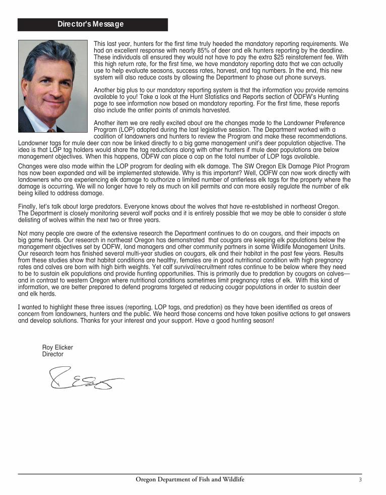
Director’s Message
This last year, hunters for the first time truly heeded the mandatory reporting requirements. We had an excellent response with nearly 85% of deer and elk hunters reporting by the deadline. These individuals all ensured they would not have to pay the extra $25 reinstatement fee. With this high return rate, for the first time, we have mandatory reporting data that we can actually use to help evaluate seasons, success rates, harvest, and tag numbers. In the end, this new system will also reduce costs by allowing the Department to phase out phone surveys.
Another big plus to our mandatory reporting system is that the information you provide remains available to you! Take a look at the Hunt Statistics and Reports section of ODFW’s Hunting page to see information now based on mandatory reporting. For the first time, these reports also include the antler points of animals harvested.
Another item we are really excited about are the changes made to the Landowner Preference Program (LOP) adopted during the last legislative session. The Department worked with a coalition of landowners and hunters to review the Program and make these recommendations.
Landowner tags for mule deer can now be linked directly to a big game management unit’s deer population objective. The idea is that LOP tag holders would share the tag reductions along with other hunters if mule deer populations are below management objectives. When this happens, ODFW can place a cap on the total number of LOP tags available. Changes were also made within the LOP program for dealing with elk damage. The SW Oregon Elk Damage Pilot Program has now been expanded and will be implemented statewide. Why is this important? Well, ODFW can now work directly with landowners who are experiencing elk damage to authorize a limited number of antlerless elk tags for the property where the damage is occurring. We will no longer have to rely as much on kill permits and can more easily regulate the number of elk being killed to address damage.
Finally, let’s talk about large predators. Everyone knows about the wolves that have re-established in northeast Oregon. The Department is closely monitoring several wolf packs and it is entirely possible that we may be able to consider a state delisting of wolves within the next two or three years.
Not many people are aware of the extensive research the Department continues to do on cougars, and their impacts on big game herds. Our research in northeast Oregon has demonstrated that cougars are keeping elk populations below the management objectives set by ODFW, land managers and other community partners in some Wildlife Management Units. Our research team has finished several multi-year studies on cougars, elk and their habitat in the past few years. Results from these studies show that habitat conditions are healthy, females are in good nutritional condition with high pregnancy rates and calves are born with high birth weights. Yet calf survival/recruitment rates continue to be below where they need to be to sustain elk populations and provide hunting opportunities. This is primarily due to predation by cougars on calves—and in contrast to western Oregon where nutritional conditions sometimes limit pregnancy rates of elk. With this kind of information, we are better prepared to defend programs targeted at reducing cougar populations in order to sustain deer and elk herds.
I wanted to highlight these three issues (reporting, LOP tags, and predation) as they have been identified as areas of concern from landowners, hunters and the public. We heard those concerns and have taken positive actions to get answers and develop solutions. Thanks for your interest and your support. Have a good hunting season!
Roy ElickerDirector
BEST TIRE VALUE PROMISE
Over 445 locations to serve you!visit www.LesSchwab.com for the location nearest you
Peace of Mind Tire Protection• Whatevertheroadthrowsatyou,frompotholes tonails-anyroadhazard,weguaranteeyou’re protected
Lifetime Tire & Mileage Care• Tohelpyougetmoremilesoutofyourtiresand moremilespergallonofgas
Lifetime Tire & Mileage Care
FREE WITH EVERY PASSENGER CAR AND LIGHT TRUCK
TIRE PURCHASE
Oregon Department of Fish and Wildlife 3
Director’s Message
This last year, hunters for the first time truly heeded the mandatory reporting requirements. We had an excellent response with nearly 85% of deer and elk hunters reporting by the deadline. These individuals all ensured they would not have to pay the extra $25 reinstatement fee. With this high return rate, for the first time, we have mandatory reporting data that we can actually use to help evaluate seasons, success rates, harvest, and tag numbers. In the end, this new system will also reduce costs by allowing the Department to phase out phone surveys.
Another big plus to our mandatory reporting system is that the information you provide remains available to you! Take a look at the Hunt Statistics and Reports section of ODFW’s Hunting page to see information now based on mandatory reporting. For the first time, these reports also include the antler points of animals harvested.
Another item we are really excited about are the changes made to the Landowner Preference Program (LOP) adopted during the last legislative session. The Department worked with a coalition of landowners and hunters to review the Program and make these recommendations.
Landowner tags for mule deer can now be linked directly to a big game management unit’s deer population objective. The idea is that LOP tag holders would share the tag reductions along with other hunters if mule deer populations are below management objectives. When this happens, ODFW can place a cap on the total number of LOP tags available. Changes were also made within the LOP program for dealing with elk damage. The SW Oregon Elk Damage Pilot Program has now been expanded and will be implemented statewide. Why is this important? Well, ODFW can now work directly with landowners who are experiencing elk damage to authorize a limited number of antlerless elk tags for the property where the damage is occurring. We will no longer have to rely as much on kill permits and can more easily regulate the number of elk being killed to address damage.
Finally, let’s talk about large predators. Everyone knows about the wolves that have re-established in northeast Oregon. The Department is closely monitoring several wolf packs and it is entirely possible that we may be able to consider a state delisting of wolves within the next two or three years.
Not many people are aware of the extensive research the Department continues to do on cougars, and their impacts on big game herds. Our research in northeast Oregon has demonstrated that cougars are keeping elk populations below the management objectives set by ODFW, land managers and other community partners in some Wildlife Management Units. Our research team has finished several multi-year studies on cougars, elk and their habitat in the past few years. Results from these studies show that habitat conditions are healthy, females are in good nutritional condition with high pregnancy rates and calves are born with high birth weights. Yet calf survival/recruitment rates continue to be below where they need to be to sustain elk populations and provide hunting opportunities. This is primarily due to predation by cougars on calves—and in contrast to western Oregon where nutritional conditions sometimes limit pregnancy rates of elk. With this kind of information, we are better prepared to defend programs targeted at reducing cougar populations in order to sustain deer and elk herds.
I wanted to highlight these three issues (reporting, LOP tags, and predation) as they have been identified as areas of concern from landowners, hunters and the public. We heard those concerns and have taken positive actions to get answers and develop solutions. Thanks for your interest and your support. Have a good hunting season!
Roy Elicker Director
BEST TIRE VALUE PROMISE
Over 445 locations to serve you!visit www.LesSchwab.com for the location nearest you
Peace of Mind Tire Protection• Whatevertheroadthrowsatyou,frompotholes tonails-anyroadhazard,weguaranteeyou’re protected
Lifetime Tire & Mileage Care• Tohelpyougetmoremilesoutofyourtiresand moremilespergallonofgas
FREE WITH EVERY PASSENGER CAR AND LIGHT TRUCK
TIRE PURCHASE
Oregon Department of Fish and Wildlife4
Web www.dfw.state.or.us
E-mail [email protected] Headquarters
503-947-6000ODFW in-state toll-free
800-720-6339Information and Education
503-947-6002Licensing
503-947-6100Controlled Hunts
503-947-6102 1-800-708-1782
Wildlife Division 503-947-6301
Mandatory Reporting 1-866-947-ODFW (6339)
Wildlife Violations 1-800-452-7888
The information in this booklet will be furnished in alternate
format for people with disabilities, if needed. Please call 503-947-6002 (voice), or e-mail [email protected]
to request an alternate format.
ODFW prohibits discrimination on the basis of race, color, national origin, age, sex or
disability. If you believe you have been discriminated
against as described above in any program, activity or
facility, or if you desire further information, please contact
ADA Coordinator, ODFW, 4034 Fairview Industrial Dr. SE, Salem, OR 97302, or call
503-947-6000, or write to the Civil Right Coordinator for
Public Access, U.S. Fish and Wildlife Service, 4401 N Fairfax
Dr, Mail Stop: WSFR-4020 Arlington, VA. 22203.
ODFW allows appropriate advertising in this booklet to
help offset the cost of printing.ODFW neither endorses products
or services listed nor accepts any liability arising from the use
of products or services listed.
OREGON DEPARTMENT OF FISH AND WILDLIFE
OREGON FISH AND WILDLIFE COMMISSION
Bobby Levy (Chair) .......................................................Echo
Michael Finley (Vice Chair) ....................................Medford
Holly Akenson .......................................................... Joseph
Laura Anderson ..................................................... Newport
Bob Webber ...................................................... Port Orford
Greg Wolley ............................................................Portland
Roy Elicker, Director Headquarters Office 4034 Fairview Industrial Dr. SE Salem, OR 97302 503-947-6000
REGIONAL OFFICES
High Desert61374 Parrell Rd Bend, OR 97702 541-388-6363
Northeast107 20th Street La Grande, OR 97850 541-963-2138
Northwest17330 SE Evelyn Street Clackamas, OR 97015 971-673-6000
Southwest4192 N Umpqua Hwy Roseburg, OR 97470 541-440-3353
Please visit our website at www.dfw.state.or.us/agen-cy/directory/local_offices.asp for a list of local offices.
What’s new in 2014? Page• Revised evidence of sex regulations and new regulations for bighorn sheep, Rock Mt goat, and pronghorn antelope. ..................................................................................... 27 • Oregon’s first Nonresident Rocky Mt goat tag will be offered in the second Elkhorn
hunt period in 2014. ................................................................................................................... 38• HB 3199 prohibits the use of tracer ammunition exploding targets& sky lanters on ODF protected
lands during declared fire season .............................................................................................. 52• Elk bag limit changes in the Alsea and Trask WMUs.The bag limit for archery hunters and hunters with Oregon Hunting and Fishing Permits NO LONGER INCLUDES ANTLERLESS ELK DURING BULL SEASONS in the Alsea and Trask units. See page 88 for the up to date list of units where the bag limit is extended to include an antlerless deer or antlerless elk. .................................................... 88
• The Jackson Cooperative Travel Management Area has been expanded by adding ~8,000 acres south of Butte Falls. .............................................................................................. 96
• A new Meacham Cooperative Travel Management Area of approximately 41 sq. miles has been added. ............................................................................................................... 97
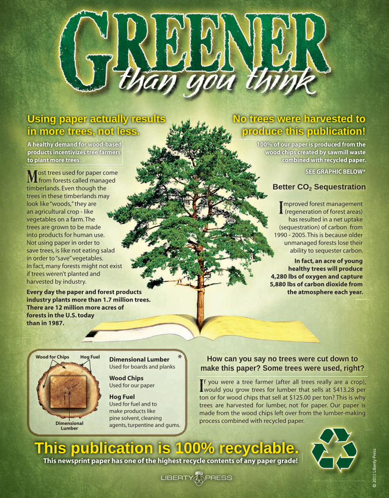
No trees were harvested toproduce this publication!
Using paper actually results in more trees, not less.
How can you say no trees were cut down to make this paper? Some trees were used, right?
f you were a tree farmer (after all trees really are a crop), would you grow trees for lumber that sells at $413.28 per ton or for wood chips that sell at $125.00 per ton? This is why trees are harvested for lumber, not for paper. Our paper is made from the wood chips left over from the lumber-making process combined with recycled paper.
ost trees used for paper come from forests called managed timberlands. Even though the trees in these timberlands may look like “woods,” they are an agricultural crop - like vegetables on a farm. The trees are grown to be made into products for human use. Not using paper in order to save trees, is like not eating salad in order to “save” vegetables.In fact, many forests might not exist if trees weren’t planted andharvested by industry.
Every day the paper and forest products industry plants more than 1.7 million trees.There are 12 million more acres offorests in the U.S. todaythan in 1987.
mproved forest management (regeneration of forest areas)
has resulted in a net uptake (sequestration) of carbon from
1990 - 2005. This is because older unmanaged forests lose their
ability to sequester carbon.
In fact, an acre of younghealthy trees will produce
4,280 lbs of oxygen and capture 5,880 lbs of carbon dioxide from
the atmosphere each year.
Better CO2 Sequestration
A healthy demand for wood-basedproducts incentivizes tree farmersto plant more trees.
Dimensional LumberUsed for boards and planks
Wood ChipsUsed for our paper
Hog FuelUsed for fuel and tomake products likepine solvent, cleaningagents, turpentine and gums.
Wood for Chips Hog Fuel
DimensionalLumber
*
100% of our paper is produced from the wood chips created by sawmill waste
combined with recycled paper.
SEE GRAPHIC BELOW*
© 2
011
Lib
erty
Pre
ssThis publication is 100% recyclable.This publication is 100% recyclable.This newsprint paper has one of the highest recycle contents of any paper grade!
Oregon Department of Fish and Wildlife4
Web www.dfw.state.or.us
E-mail [email protected] Headquarters
503-947-6000ODFW in-state toll-free
800-720-6339Information and Education
503-947-6002Licensing
503-947-6100Controlled Hunts
503-947-6102 1-800-708-1782
Wildlife Division 503-947-6301
Mandatory Reporting 1-866-947-ODFW (6339)
Wildlife Violations 1-800-452-7888
The information in this booklet will be furnished in alternate
format for people with disabilities, if needed. Please call 503-947-6002 (voice), or e-mail [email protected]
to request an alternate format.
ODFW prohibits discrimination on the basis of race, color, national origin, age, sex or
disability. If you believe you have been discriminated
against as described above in any program, activity or
facility, or if you desire further information, please contact
ADA Coordinator, ODFW, 4034 Fairview Industrial Dr. SE, Salem, OR 97302, or call
503-947-6000, or write to the Civil Right Coordinator for
Public Access, U.S. Fish and Wildlife Service, 4401 N Fairfax
Dr, Mail Stop: WSFR-4020 Arlington, VA. 22203.
ODFW allows appropriate advertising in this booklet to
help offset the cost of printing.ODFW neither endorses products
or services listed nor accepts any liability arising from the use
of products or services listed.
OREGON DEPARTMENT OF FISH AND WILDLIFE
OREGON FISH AND WILDLIFE COMMISSION
Bobby Levy (Chair) .......................................................Echo
Michael Finley (Vice Chair) ....................................Medford
Holly Akenson .......................................................... Joseph
Laura Anderson ..................................................... Newport
Bob Webber ...................................................... Port Orford
Greg Wolley ............................................................Portland
Roy Elicker, Director Headquarters Office 4034 Fairview Industrial Dr. SE Salem, OR 97302 503-947-6000
REGIONAL OFFICES
High Desert61374 Parrell Rd Bend, OR 97702 541-388-6363
Northeast107 20th Street La Grande, OR 97850 541-963-2138
Northwest17330 SE Evelyn Street Clackamas, OR 97015 971-673-6000
Southwest4192 N Umpqua Hwy Roseburg, OR 97470 541-440-3353
Please visit our website at www.dfw.state.or.us/agen-cy/directory/local_offices.asp for a list of local offices.
What’s new in 2014? Page• Revised evidence of sex regulations and new regulations for bighorn sheep, Rock Mt goat, and pronghorn antelope. ..................................................................................... 27 • Oregon’s first Nonresident Rocky Mt goat tag will be offered in the second Elkhorn
hunt period in 2014. ................................................................................................................... 38• HB 3199 prohibits the use of tracer ammunition exploding targets& sky lanters on ODF protected
lands during declared fire season .............................................................................................. 52• Elk bag limit changes in the Alsea and Trask WMUs.The bag limit for archery hunters and hunters with Oregon Hunting and Fishing Permits NO LONGER INCLUDES ANTLERLESS ELK DURING BULL SEASONS in the Alsea and Trask units. See page 88 for the up to date list of units where the bag limit is extended to include an antlerless deer or antlerless elk. .................................................... 88
• The Jackson Cooperative Travel Management Area has been expanded by adding ~8,000 acres south of Butte Falls. .............................................................................................. 96
• A new Meacham Cooperative Travel Management Area of approximately 41 sq. miles has been added. ............................................................................................................... 97
No trees were harvested toproduce this publication!
Using paper actually results in more trees, not less.
How can you say no trees were cut down to make this paper? Some trees were used, right?
f you were a tree farmer (after all trees really are a crop), would you grow trees for lumber that sells at $413.28 per ton or for wood chips that sell at $125.00 per ton? This is why trees are harvested for lumber, not for paper. Our paper is made from the wood chips left over from the lumber-making process combined with recycled paper.
ost trees used for paper come from forests called managed timberlands. Even though the trees in these timberlands may look like “woods,” they are an agricultural crop - like vegetables on a farm. The trees are grown to be made into products for human use. Not using paper in order to save trees, is like not eating salad in order to “save” vegetables.In fact, many forests might not exist if trees weren’t planted andharvested by industry.
Every day the paper and forest products industry plants more than 1.7 million trees.There are 12 million more acres offorests in the U.S. todaythan in 1987.
mproved forest management (regeneration of forest areas)
has resulted in a net uptake (sequestration) of carbon from
1990 - 2005. This is because older unmanaged forests lose their
ability to sequester carbon.
In fact, an acre of younghealthy trees will produce
4,280 lbs of oxygen and capture 5,880 lbs of carbon dioxide from
the atmosphere each year.
Better CO2 Sequestration
A healthy demand for wood-basedproducts incentivizes tree farmersto plant more trees.
Dimensional LumberUsed for boards and planks
Wood ChipsUsed for our paper
Hog FuelUsed for fuel and tomake products likepine solvent, cleaningagents, turpentine and gums.
Wood for Chips Hog Fuel
DimensionalLumber
*
100% of our paper is produced from the wood chips created by sawmill waste
combined with recycled paper.
SEE GRAPHIC BELOW*
© 2
011
Lib
erty
Pre
ssThis publication is 100% recyclable.This publication is 100% recyclable.This newsprint paper has one of the highest recycle contents of any paper grade!
Oregon Department of Fish and Wildlife6
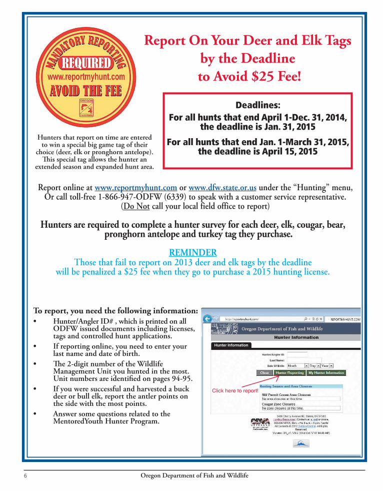
Hunters are required to complete a hunter survey for each deer, elk, cougar, bear, pronghorn antelope and turkey tag they purchase.
REMINDERThose that fail to report on 2013 deer and elk tags by the deadline
will be penalized a $25 fee when they go to purchase a 2015 hunting license.
Report On Your Deer and Elk Tags by the Deadline
to Avoid $25 Fee!
To report, you need the following information:• Hunter/AnglerID#,whichisprintedonall ODFWissueddocumentsincludinglicenses, tags and controlled hunt applications.• Ifreportingonline,youneedtoenteryour last name and date of birth. • The2-digitnumberoftheWildlife Management Unit you hunted in the most. Unitnumbersareidentifiedonpages94-95.• Ifyouweresuccessfulandharvestedabuck deerorbullelk,reporttheantlerpointson the side with the most points.• Answersomequestionsrelatedtothe MentoredYouth Hunter Program.
Hunters that report on time are entered to win a special big game tag of their
choice(deer,elkorpronghornantelope).Thisspecialtagallowsthehunteran
extended season and expanded hunt area.
Deadlines:For all hunts that end April 1-Dec. 31, 2014,
the deadline is Jan. 31, 2015
For all hunts that end Jan. 1-March 31, 2015, the deadline is April 15, 2015
Report online at www.reportmyhunt.com or www.dfw.state.or.usunderthe“Hunting”menu,Orcalltoll-free1-866-947-ODFW(6339)tospeakwithacustomerservicerepresentative.
(Do Notcallyourlocalfieldofficetoreport)
Click here to report!
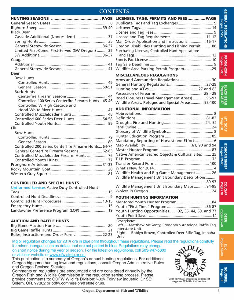
Oregon Department of Fish and Wildlife 7
CONTENTSHUNTING SEASONS .......................................... PAGEGeneral Season Dates ....................................................... 8Bighorn Sheep ........................................................... 39-40 Black Bear
Cascade Additional (Nonresident) .............................. 37Spring Hunts ................................................................ 35General Statewide Season ..................................... 36-37Limited First-Come, First-Served (SW Oregon) .......... 35SW Additional ......................................................... 36-37
CougarAdditional .................................................................... 41 General Statewide Season .......................................... 41
DeerBow Hunts
Controlled Hunts ...................................................... 49 General Season .................................................... 50-51
Buck HuntsCenterfire Firearm Seasons ...................................... 44
Controlled 100 Series Centerfire Firearm Hunts ...45-46 Controlled W High Cascade and Hood-White River Hunts .......................................... 47
Controlled Muzzleloader Hunts ................................. 48Controlled 600 Series Deer Hunts .......................... 54-58Controlled Youth Hunts .............................................. 59
ElkBow Hunts
Controlled Hunts ...................................................... 79 General Season ......................................................... 80
Controlled 200 Series Centerfire Firearm Hunts ... 64-74General Centerfire Firearm Seasons ...................... 62-63Controlled Muzzleloader Firearm Hunts ................... 76 Controlled Youth Hunts .............................................. 77
Pronghorn Antelope .................................................. 31-33Rocky Mountain Goat ..................................................... 38Western Gray Squirrel ..................................................... 81
CONTROLLED AND SPECIAL HUNTSUniformed Services Active Duty Controlled Hunt Tags.......... ........................................................................ 15Controlled Hunt Deadlines ............................................... 9Controlled Hunt Procedures ...................................... 13-15Emergency Hunts ............................................................ 15Landowner Preference Program (LO P) .......................... 19
AUCTION AND RAFFLE HUNTSBig Game Auction Hunts ................................................ 20Big Game Raffle Hunts ................................................... 21Rules, Instructions and Order Forms ......................... 22-23
LICENSES, TAGS, PERMITS AND FEES ...............PAGEDuplicate Tags and Tag Exchanges ................................. 9Leftover Tags .................................................................. 14License and Tag Fees ....................................................... 9License and Tag Requirements ................................ 11-12Mail Order Application and Instructions ................. 16-17Oregon Disabilities Hunting and Fishing Permit ....... 88Purchasing Licenses, Controlled Hunt Applications and Tags .......................................................................... 13Sports Pac License .......................................................... 10Tag Sale Deadlines ........................................................... 9Wildlife Area Parking Permit Program..........................29
MISCELLANEOUS REGULATIONSArms and Ammunition Regulations ............................. 30General Hunting Regulations ................................... 27-29Hunting and ATVs ..............................................27 and 83Possession of Firearms ............................................ 28 - 29Road Closures (Travel Management Areas) ............ 96-97 Wildlife Areas, Refuges and Special Areas ............ 98-100
ADDITIONAL INFORMATIONAbbreviations ................................................................... 8 Definitions ................................................................. 81-82Drought, Fire and Hunting ...................................... 24, 52Feral Swine .................................................................... 24Glossary of Wildlife Symbols ........................................... 8Hunter Education Program ........................................... 85Mandatory Reporting of Harvest and Effort ................. 6Map Availability ...........................................61, 90 and 94Master Hunter Program ................................................. 83Native American Sacred Objects & Cultural Sites ....... 25 T.I.P. Program...................................................................75Transfer Record Form .................................................. 100What’s New for 2014 ....................................................... 4Wildlife Health and Big Game Management .............. 26Wildlife Management Unit Boundary Descriptions ......... ............................................................................. 89-93 Wildlife Management Unit Boundary Maps ........... 94-95Wolves in Oregon .......................................................... 24
YOUTH HUNTING INFORMATIONMentored Youth Hunter Program ................................ 84Youth “First Time” Program .................................... 86-87 Youth Hunting Opportunities ...... 32, 35, 44, 59, and 77Youth Point Saver ...........................................................14
Major regulation changes for 2014 are in blue print throughout these regulations. Please read the regulations carefully for minor changes, such as dates, that are not printed in blue. Regulations may change on short notice during the year or season. For the latest on regulations, call 503-947-6000 or visit our website at www.dfw.state.or.us.This publication is a summary of Oregon’s annual hunting regulations. For additional Oregon big game hunting laws and regulations, consult Oregon Administrative Rules and Oregon Revised Statutes. Comments on regulations are encouraged and are considered annually by the Oregon Fish and Wildlife Commission in the regulation setting process. Please provide comments to: ODFW Wildlife Division; 4034 Fairview Industrial Dr SE; Salem, OR, 97302 or [email protected].
GE
NE
RA
L RE
GU
LATIO
NS
Pages 27-29
PR
ON
GH
OR
NP
ages 31-33B
LAC
K B
EA
RP
ages 35-37M
T. GO
AT
Page 38
BIG
HO
RN
SH
EE
PP
ages 39-40C
OU
GA
RP
ages 41D
EE
RP
ages 45-60E
LKP
ages 62-80S
QU
IRR
EL
Page 81
Cover photo: Left — Matthew McGanty, Pronghorn Antelope Raffle Tag, Interstate UnitRight — Roblyn Brown, Controlled Deer Rifle Tag, Imnaha Unit
Oregon Department of Fish and Wildlife6
Hunters are required to complete a hunter survey for each deer, elk, cougar, bear, pronghorn antelope and turkey tag they purchase.
REMINDERThose that fail to report on 2013 deer and elk tags by the deadline
will be penalized a $25 fee when they go to purchase a 2015 hunting license.
Report On Your Deer and Elk Tags by the Deadline
to Avoid $25 Fee!
To report, you need the following information:• Hunter/AnglerID#,whichisprintedonall ODFWissueddocumentsincludinglicenses, tags and controlled hunt applications.• Ifreportingonline,youneedtoenteryour last name and date of birth. • The2-digitnumberoftheWildlife Management Unit you hunted in the most. Unitnumbersareidentifiedonpages94-95.• Ifyouweresuccessfulandharvestedabuck deerorbullelk,reporttheantlerpointson the side with the most points.• Answersomequestionsrelatedtothe MentoredYouth Hunter Program.
Hunters that report on time are entered to win a special big game tag of their
choice(deer,elkorpronghornantelope).Thisspecialtagallowsthehunteran
extended season and expanded hunt area.
Deadlines:For all hunts that end April 1-Dec. 31, 2014,
the deadline is Jan. 31, 2015
For all hunts that end Jan. 1-March 31, 2015, the deadline is April 15, 2015
Report online at www.reportmyhunt.com or www.dfw.state.or.usunderthe“Hunting”menu,Orcalltoll-free1-866-947-ODFW(6339)tospeakwithacustomerservicerepresentative.
(Do Notcallyourlocalfieldofficetoreport)
Click here to report!
Oregon Department of Fish and Wildlife 7
CONTENTSHUNTING SEASONS .......................................... PAGEGeneral Season Dates ....................................................... 8Bighorn Sheep ........................................................... 39-40 Black Bear Cascade Additional (Nonresident) .............................. 37 Spring Hunts ................................................................ 35 General Statewide Season ..................................... 36-37 Limited First-Come, First-Served (SW Oregon) .......... 35 SW Additional ......................................................... 36-37Cougar Additional .................................................................... 41 General Statewide Season .......................................... 41Deer Bow Hunts Controlled Hunts ...................................................... 49 General Season .................................................... 50-51 Buck Hunts Centerfire Firearm Seasons ...................................... 44 Controlled 100 Series Centerfire Firearm Hunts ...45-46 Controlled W High Cascade and Hood-White River Hunts .......................................... 47 Controlled Muzzleloader Hunts ................................. 48 Controlled 600 Series Deer Hunts .......................... 54-58 Controlled Youth Hunts .............................................. 59Elk Bow Hunts Controlled Hunts ...................................................... 79 General Season ......................................................... 80 Controlled 200 Series Centerfire Firearm Hunts ... 64-74 General Centerfire Firearm Seasons ...................... 62-63 Controlled Muzzleloader Firearm Hunts ................... 76 Controlled Youth Hunts .............................................. 77Pronghorn Antelope .................................................. 31-33Rocky Mountain Goat ..................................................... 38Western Gray Squirrel ..................................................... 81
CONTROLLED AND SPECIAL HUNTSUniformed Services Active Duty Controlled Hunt Tags.......... ........................................................................ 15Controlled Hunt Deadlines ............................................... 9Controlled Hunt Procedures ...................................... 13-15Emergency Hunts ............................................................ 15Landowner Preference Program (LO P) .......................... 19
AUCTION AND RAFFLE HUNTSBig Game Auction Hunts ................................................ 20Big Game Raffle Hunts ................................................... 21Rules, Instructions and Order Forms ......................... 22-23
LICENSES, TAGS, PERMITS AND FEES ...............PAGEDuplicate Tags and Tag Exchanges ................................. 9Leftover Tags .................................................................. 14License and Tag Fees ....................................................... 9License and Tag Requirements ................................ 11-12Mail Order Application and Instructions ................. 16-17Oregon Disabilities Hunting and Fishing Permit ....... 88Purchasing Licenses, Controlled Hunt Applications and Tags .......................................................................... 13Sports Pac License .......................................................... 10Tag Sale Deadlines ........................................................... 9Wildlife Area Parking Permit Program..........................29
MISCELLANEOUS REGULATIONSArms and Ammunition Regulations ............................. 30General Hunting Regulations ................................... 27-29Hunting and ATVs ..............................................27 and 83Possession of Firearms ............................................ 28 - 29Road Closures (Travel Management Areas) ............ 96-97 Wildlife Areas, Refuges and Special Areas ............ 98-100
ADDITIONAL INFORMATIONAbbreviations ................................................................... 8 Definitions ................................................................. 81-82Drought, Fire and Hunting ...................................... 24, 52Feral Swine .................................................................... 24Glossary of Wildlife Symbols ........................................... 8Hunter Education Program ........................................... 85Mandatory Reporting of Harvest and Effort ................. 6Map Availability ...........................................61, 90 and 94Master Hunter Program ................................................. 83Native American Sacred Objects & Cultural Sites ....... 25 T.I.P. Program...................................................................75Transfer Record Form .................................................. 100What’s New for 2014 ....................................................... 4Wildlife Health and Big Game Management .............. 26Wildlife Management Unit Boundary Descriptions ......... ............................................................................. 89-93 Wildlife Management Unit Boundary Maps ........... 94-95Wolves in Oregon .......................................................... 24
YOUTH HUNTING INFORMATIONMentored Youth Hunter Program ................................ 84Youth “First Time” Program .................................... 86-87 Youth Hunting Opportunities ...... 32, 35, 44, 59, and 77Youth Point Saver ...........................................................14
Major regulation changes for 2014 are in blue print throughout these regulations. Please read the regulations carefully for minor changes, such as dates, that are not printed in blue. Regulations may change on short notice during the year or season. For the latest on regulations, call 503-947-6000 or visit our website at www.dfw.state.or.us.This publication is a summary of Oregon’s annual hunting regulations. For additional Oregon big game hunting laws and regulations, consult Oregon Administrative Rules and Oregon Revised Statutes. Comments on regulations are encouraged and are considered annually by the Oregon Fish and Wildlife Commission in the regulation setting process. Please provide comments to: ODFW Wildlife Division; 4034 Fairview Industrial Dr SE; Salem, OR, 97302 or [email protected].
GE
NE
RA
L RE
GU
LATIO
NS
Pages 27-29
PR
ON
GH
OR
NP
ages 31-33B
LAC
K B
EA
RP
ages 35-37M
T. GO
AT
Page 38
BIG
HO
RN
SH
EE
PP
ages 39-40C
OU
GA
RP
ages 41D
EE
RP
ages 45-60E
LKP
ages 62-80S
QU
IRR
EL
Page 81
Cover photo: Left — Matthew McGanty, Pronghorn Antelope Raffle Tag, Interstate UnitRight — Roblyn Brown, Controlled Deer Rifle Tag, Imnaha Unit

Oregon Department of Fish and Wildlife8
PRONGHORN BLACK ROCKY MT BIGHORN COUGAR BUCK ANTLERLESS GENERAL ELK CONTROLLED ANTELOPE BEAR GOAT SHEEP DEER DEER ELK pages 31-33 pages 34-37 page 38 pages 39-40 pages 41 pages 44-49 pages 54-60 pages 62-63 pages 64-79
GENERAL SEASONS
WILDLIFE SYMBOLS AND ABBREVIATIONS
Ave = Avenue ATV = All-terrain vehicleBLM = Bureau of Land ManagementBlvd = BoulevardCo = CountyCr = CreekDr = DriveF = ForkFR = Forest RoadHwy = HighwayI = Interstate Highway
ID = IdentificationLk = LakeLn = LaneMi = MileMt = Mountain or MountNAR = National Antelope RefugeNF = National ForestNP = National ParkNWR = National Wildlife Refuge ODA = Oregon Dept. of AgricultureODF = Oregon Dept. of Forestry
ODFW = Oregon Dept. of Fish & WildlifePOS = Point of SaleRHA = Regulated Hunt AreaRvr = RiverRd = Roadsq mi = Square MilesUSFS = U.S. Forest ServiceUSFWS = U.S. Fish and Wildlife ServiceWA = Wildlife AreaWMU = Wildlife Management Unit
The following abbreviations are used throughout this document in Hunt Tables, Hunt Descriptions and regulations. Abbreviations will be used in upper/lower case and plural.
GENERAL SEASONS
Western Oregon Deer Centerfire FirearmCascade Buck Area
Coast Buck Area
Cascade Bull Elk Centerfire Firearm
Rocky Mt Bull Elk CenterfireFirst Season
Second Season
Coast Bull Elk Centerfire Firearm First Season
Second Season
BowhuntingDeer (Western/Eastern)
Elk (Western/Eastern)
TAGREQUIRED
Western Oregon Deer
Cascade Elk
Rocky Mt Elk1st Season
Rocky Mt Elk2nd Season
Coast 1st Season
Coast2nd Season
Deer and/orElk Bow
DECEMBERNOVEMBEROCTOBERSEPTEMBERAUGUST
See page 51 for late seasons
74
18 - 24
29 - 2
8 - 16
15 - 18
22 - 28
30 28
30 28
GENERAL SEASONS
Black Bear
Eastern Oregon
Western Oregon
SW Additional SW Additional (Nonresident)
Cascade Additional (Nonresident)
Cougar General (statewide)
Additional (see page 41)
TAGREQUIRED
General Black Bear
SWAdditional CascadeAdditional
GeneralCougar
Additional
Jan Feb Mar Apr May Jun Jul Aug Sept Oct Nov Dec
1 31
1 31
1 31
31
1 31
1
301
1 31
4 - 17 25 - 7
Oregon Department of Fish and Wildlife 9
LICENSE AND TAG FEESRESIDENTApplications and Licenses
Controlled Hunt Application .................................................. 8.00Hunting License .................................................................. 29.50Juvenile Hunting License.................................................... 14.50Senior Citizen Hunting License .......................................... 13.75(70 years old and 5-year Oregon resident(defined on page 11))Combination Angling/Hunting License ................................ 58.00Senior Citizen Combination Angling/Hunting ..................... 25.50(70 years old and 5-year Oregon resident (defined on page 11))Sports Pac (resident only) ................................................ 164.75Juvenile Sports Pac (resident only age 12-17) .................. 55.00 Disabled Veteran Angling/Hunting (Permanent) ............... * FreePioneer Angling/Hunting (Permanent)
(65 years old and 50-year Oregon resident) ................. * FreeLandowner Preference Registration ................................... 30.00Landowner Preference Tag Redistribution ......................... 15.00
* Initial documents are issued at Salem, Bend, Central Point, Charleston, Clackamas, Corvallis, La Grande, Newport, Roseburg, Springfield, and Tillamook ODFW offices. Subsequent years may be picked up at any POS license agent. Call Licensing at the headquarters at 503-947-6100 for location or an application to apply for a permanent license by mail.
TagsBighorn Sheep .................................................................. 122.50Black Bear
General Season .............................................................. 14.50Southwest Additional (General) ..................................... 14.50
Spring Black Bear (Controlled) ....................................... 14.50Cougar
General Season ............................................................. 14.50 Additional ........................................................................ 14.50
Deer (Controlled or General) .............................................. 24.50Elk (Controlled or General) ................................................. 42.50Elk (Disabled Veteran and Pioneer) .................................. 22.25Pronghorn Antelope ............................................................ 44.50Rocky Mountain Goat ....................................................... 122.50Upland Game Bird Validation1 .............................................. 8.50Waterfowl Validation1 .......................................................... 11.50Turkey (Spring, Fall or Bonus)1 .......................................... 22.50Juvenile Turkey (Spring, Fall or Bonus)1 ............................ 10.50
NONRESIDENTApplications and Licenses
Controlled Hunt Application .................................................. 8.00Hunting License ................................................................ 148.50Juvenile Hunting License.................................................... 27.503-day Nonresident Hunting License for Migratory Waterfowl and Upland Birds1 ........................ 26.50
TagsBighorn Sheep ............................................................... 1,308.50Black Bear
General Season ............................................................ 190.50Cascade Additional (General) ....................................... 190.50Southwest Additional (General) .................................... 190.50Spring Black Bear (Controlled) ..................................... 190.50
Cougar Additional ........................................................................ 14.50 General Season .............................................................. 14.50
Deer (Controlled or General) ............................................ 383.50Elk (Controlled or General) ............................................... 508.50Pronghorn Antelope .......................................................... 341.50Mountain Goat ............................................................... 1,308.50Game Bird Validation1 ........................................................ 38.50Turkey (Spring, Fall or Bonus)1 .......................................... 77.50Juvenile Turkey (Spring, Fall or Bonus)1 ............................ 10.50
1 See Oregon Game Bird Regulations
• It is the hunter’s responsibility to purchase the correct tag for each species prior to the first valid date of the tag. Tag sale deadline and Sports Pac tag pick up deadline is the day before the hunt begins (see below for Bighorn Sheep, Rocky Mt Goat, general bear, and cougar deadlines). For hunts with more than one hunt period, the tag sale deadline and the Sports Pac tag pick up deadline is the day before the earliest opening date.
• LOP tags must also be purchased by specified Tag Purchase Deadlines below. See page 19 for deadlines on LOP registration forms, distribution forms, and applications.
•Members of the uniformed services with Oregon resident status, returning to Oregon after tag sale deadlines will be permitted to purchase general season tags for themselves at the regular rate. Contact ODFW at 503-947-6100 for information.
• Tags may be purchased or obtained after the deadline date provided an affidavit is signed and a fee for a duplicate tag is paid.
Controlled Hunts Application Deadlines
Spring Black Bear Feb. 10
Results Available Feb. 20
All Others May 15
Results Available June 20
Tag Name Deadline
Bighorn Sheep (Controlled)Last day of huntRocky Mt Goat (Controlled)
Black Bear (Controlled)Day before earliest hunt period opens
Pronghorn Antelope (Controlled)
Deer (Controlled)
Elk (Controlled)
Deer or Elk Bow (General) Aug. 29
Western Oregon Deer Centerfire (General) Oct. 3
Black Bear (General) Oct. 3
Bear (SW Additional) No Deadline*
Cascade Elk Centerfire (General) Oct. 17
Cougar (General) Oct. 3
Cougar (Additional) No Deadline*
Rocky Mt Elk Centerfire, 1st Sea son (General - Limited Open Area)
Oct. 28
Rocky Mt Elk Centerfire, 2nd Sea son (General) Nov. 7
Coast Elk Centerfire, 1st Season (General) Nov. 14
Coast Elk Centerfire, 2nd Season (General) Nov. 21
TAG SALE DEADLINES
*Hunters must purchase the general season tag for that species prior to the deadline to be eligible for the additional tag. ■The agent fee is included in all prices. ■License, tag, application and agent fees are not refundable. ■Exchanges of tags and duplicate tags may be obtained only through ODFW’s headquarters, region offices and some district offices. Duplicate licenses can be obtained at any license agent. ODFW offices are closed on state holidays, and weekends. Hunting licenses may be exchanged for a Combination or Sports Pac within 90 days of purchase.Tags may be exchanged ONLY prior to the seasons for which they are valid. ■A non-resident member of the uniformed services may purchase licenses, tags, and permits at resident rates. ■License or tag may be purchased by mail or fax, use the application form on page 17; in person, visit any license agent; or via the internet, please visit our website at www.dfw.state.or.us/online_license_sales.

Oregon Department of Fish and Wildlife8
PRONGHORN BLACK ROCKY MT BIGHORN COUGAR BUCK ANTLERLESS GENERAL ELK CONTROLLED ANTELOPE BEAR GOAT SHEEP DEER DEER ELK pages 31-33 pages 34-37 page 38 pages 39-40 pages 41 pages 44-49 pages 54-60 pages 62-63 pages 64-79
GENERAL SEASONS
WILDLIFE SYMBOLS AND ABBREVIATIONS
Ave = Avenue ATV = All-terrain vehicleBLM = Bureau of Land ManagementBlvd = BoulevardCo = CountyCr = CreekDr = DriveF = ForkFR = Forest RoadHwy = HighwayI = Interstate Highway
ID = IdentificationLk = LakeLn = LaneMi = MileMt = Mountain or MountNAR = National Antelope RefugeNF = National ForestNP = National ParkNWR = National Wildlife Refuge ODA = Oregon Dept. of AgricultureODF = Oregon Dept. of Forestry
ODFW = Oregon Dept. of Fish & WildlifePOS = Point of SaleRHA = Regulated Hunt AreaRvr = RiverRd = Roadsq mi = Square MilesUSFS = U.S. Forest ServiceUSFWS = U.S. Fish and Wildlife ServiceWA = Wildlife AreaWMU = Wildlife Management Unit
The following abbreviations are used throughout this document in Hunt Tables, Hunt Descriptions and regulations. Abbreviations will be used in upper/lower case and plural.
GENERAL SEASONS
Western Oregon Deer Centerfire FirearmCascade Buck Area
Coast Buck Area
Cascade Bull Elk Centerfire Firearm
Rocky Mt Bull Elk CenterfireFirst Season
Second Season
Coast Bull Elk Centerfire Firearm First Season
Second Season
BowhuntingDeer (Western/Eastern)
Elk (Western/Eastern)
TAGREQUIRED
Western Oregon Deer
Cascade Elk
Rocky Mt Elk1st Season
Rocky Mt Elk2nd Season
Coast 1st Season
Coast2nd Season
Deer and/orElk Bow
DECEMBERNOVEMBEROCTOBERSEPTEMBERAUGUST
See page 51 for late seasons
74
18 - 24
29 - 2
8 - 16
15 - 18
22 - 28
30 28
30 28
GENERAL SEASONS
Black Bear
Eastern Oregon
Western Oregon
SW Additional SW Additional (Nonresident)
Cascade Additional (Nonresident)
Cougar General (statewide)
Additional (see page 41)
TAGREQUIRED
General Black Bear
SWAdditional CascadeAdditional
GeneralCougar
Additional
Jan Feb Mar Apr May Jun Jul Aug Sept Oct Nov Dec
1 31
1 31
1 31
31
1 31
1
301
1 31
4 - 17 25 - 7
Oregon Department of Fish and Wildlife 9
LICENSE AND TAG FEESRESIDENTApplications and Licenses
Controlled Hunt Application .................................................. 8.00 Hunting License .................................................................. 29.50 Juvenile Hunting License.................................................... 14.50 Senior Citizen Hunting License .......................................... 13.75 (70 years old and 5-year Oregon resident(defined on page 11))
Combination Angling/Hunting License ................................ 58.00 Senior Citizen Combination Angling/Hunting ..................... 25.50 (70 years old and 5-year Oregon resident (defined on page 11)) Sports Pac (resident only) ................................................ 164.75 Juvenile Sports Pac (resident only age 12-17) .................. 55.00 Disabled Veteran Angling/Hunting (Permanent) ............... * Free Pioneer Angling/Hunting (Permanent) (65 years old and 50-year Oregon resident) ................. * Free Landowner Preference Registration ................................... 30.00 Landowner Preference Tag Redistribution ......................... 15.00* Initial documents are issued at Salem, Bend, Central Point, Charleston,
Clackamas, Corvallis, La Grande, Newport, Roseburg, Springfield, and Tillamook ODFW offices. Subsequent years may be picked up at any POS license agent. Call Licensing at the headquarters at 503-947-6100 for location or an application to apply for a permanent license by mail.
Tags Bighorn Sheep .................................................................. 122.50 Black Bear General Season .............................................................. 14.50 Southwest Additional (General) ..................................... 14.50 Spring Black Bear (Controlled) ....................................... 14.50 Cougar General Season ............................................................. 14.50 Additional ........................................................................ 14.50 Deer (Controlled or General) .............................................. 24.50 Elk (Controlled or General) ................................................. 42.50 Elk (Disabled Veteran and Pioneer) .................................. 22.25 Pronghorn Antelope ............................................................ 44.50 Rocky Mountain Goat ....................................................... 122.50 Upland Game Bird Validation1 .............................................. 8.50 Waterfowl Validation1 .......................................................... 11.50 Turkey (Spring, Fall or Bonus)1 .......................................... 22.50 Juvenile Turkey (Spring, Fall or Bonus)1 ............................ 10.50
NONRESIDENTApplications and Licenses
Controlled Hunt Application .................................................. 8.00 Hunting License ................................................................ 148.50 Juvenile Hunting License.................................................... 27.50 3-day Nonresident Hunting License for Migratory Waterfowl and Upland Birds1 ........................ 26.50
Tags Bighorn Sheep ............................................................... 1,308.50 Black Bear General Season ............................................................ 190.50 Cascade Additional (General) ....................................... 190.50 Southwest Additional (General) .................................... 190.50 Spring Black Bear (Controlled) ..................................... 190.50 Cougar Additional ........................................................................ 14.50 General Season .............................................................. 14.50 Deer (Controlled or General) ............................................ 383.50 Elk (Controlled or General) ............................................... 508.50 Pronghorn Antelope .......................................................... 341.50 Mountain Goat ............................................................... 1,308.50 Game Bird Validation1 ........................................................ 38.50 Turkey (Spring, Fall or Bonus)1 .......................................... 77.50 Juvenile Turkey (Spring, Fall or Bonus)1 ............................ 10.50 1 See Oregon Game Bird Regulations
• It is the hunter’s responsibility to purchase the correct tag for each species prior to the first valid date of the tag. Tag sale deadline and Sports Pac tag pick up deadline is the day before the hunt begins (see below for Bighorn Sheep, Rocky Mt Goat, general bear, and cougar deadlines). For hunts with more than one hunt period, the tag sale deadline and the Sports Pac tag pick up deadline is the day before the earliest opening date.
• LOP tags must also be purchased by specified Tag Purchase Deadlines below. See page 19 for deadlines on LOP registration forms, distribution forms, and applications.
•Members of the uniformed services with Oregon resident status, returning to Oregon after tag sale deadlines will be permitted to purchase general season tags for themselves at the regular rate. Contact ODFW at 503-947-6100 for information.
• Tags may be purchased or obtained after the deadline date provided an affidavit is signed and a fee for a duplicate tag is paid.
Controlled Hunts Application Deadlines
Spring Black Bear Feb. 10
Results Available Feb. 20
All Others May 15
Results Available June 20
Tag Name Deadline
Bighorn Sheep (Controlled)Last day of huntRocky Mt Goat (Controlled)
Black Bear (Controlled)Day before earliest hunt period opens
Pronghorn Antelope (Controlled)
Deer (Controlled)
Elk (Controlled)
Deer or Elk Bow (General) Aug. 29
Western Oregon Deer Centerfire (General) Oct. 3
Black Bear (General) Oct. 3
Bear (SW Additional) No Deadline*
Cascade Elk Centerfire (General) Oct. 17
Cougar (General) Oct. 3
Cougar (Additional) No Deadline*
Rocky Mt Elk Centerfire, 1st Sea son (General - Limited Open Area)
Oct. 28
Rocky Mt Elk Centerfire, 2nd Sea son (General) Nov. 7
Coast Elk Centerfire, 1st Season (General) Nov. 14
Coast Elk Centerfire, 2nd Season (General) Nov. 21
TAG SALE DEADLINES
*Hunters must purchase the general season tag for that species prior to the deadline to be eligible for the additional tag. ■The agent fee is included in all prices. ■License, tag, application and agent fees are not refundable. ■Exchanges of tags and duplicate tags may be obtained only through ODFW’s headquarters, region offices and some district offices. Duplicate licenses can be obtained at any license agent. ODFW offices are closed on state holidays, and weekends. Hunting licenses may be exchanged for a Combination or Sports Pac within 90 days of purchase.Tags may be exchanged ONLY prior to the seasons for which they are valid. ■A non-resident member of the uniformed services may purchase licenses, tags, and permits at resident rates. ■License or tag may be purchased by mail or fax, use the application form on page 17; in person, visit any license agent; or via the internet, please visit our website at www.dfw.state.or.us/online_license_sales.
Oregon Department of Fish and Wildlife10
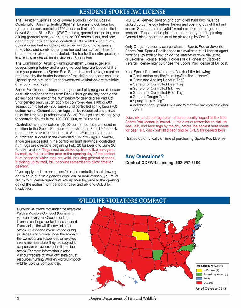
RESIDENT SPORTS PAC LICENSEThe Resident Sports Pac or Juvenile Sports Pac includes a Combination Angling/Hunting/Shellfish License, black bear tag (general season, controlled 700 series or limited first-come, first-served Spring Black Bear (SW Oregon)), general cougar tag, one elk tag (general season or controlled 200 series hunt), and one deer tag (general season or controlled 100 or 600 series hunt), upland game bird validation, waterfowl validation, one spring turkey tag, and combined angling harvest tag. Leftover tags for bear, deer, or elk are not included. The fee for the entire package is $164.75 or $55.00 for the Juvenile Sports Pac.
The Combination Angling/Hunting/Shellfish License, general cougar, spring turkey and angling harvest tags are issued at the time you purchase a Sports Pac. Bear, deer and elk tags must be requested by the hunter because of the different options available. Upland game bird and Oregon waterfowl validations are available after July 1 each year.
Sports Pac license holders can request and pick up general season deer, elk and/or bear tags from Dec. 1 through the day prior to the earliest opening day of the hunt period for deer and elk and Oct. 3 for general bear, or can apply for controlled deer (100 or 600 series), controlled elk (200 series) and controlled spring bear (700 series) hunts. General season tags can be requested and picked up at the time you purchase your Sports Pac if you are not applying for controlled hunts in the 100, 200, 600, or 700 series.
Controlled hunt applications ($8.00 each) must be purchased in addition to the Sports Pac license no later than Feb. 10 for black bear and May 15 for deer and elk. Sports Pac holders are not guaranteed success in the controlled hunt drawings. However, if you are successful in the controlled hunt drawings, controlled hunt tags are available beginning Feb. 20 for bear and June 20 for deer and elk. Tags must be picked up from a license agent, by mail, by fax, or online prior to the opening day of the earliest hunt period for which tags are valid, including general seasons. If picking up by mail, fax, or online remember to allow time for delivery.
If you apply and are unsuccessful in the controlled hunt drawing and wish to hunt in a general deer, elk, or bear season, you must return to a license agent and pick up your tag prior to the opening day of the earliest hunt period for deer and elk and Oct. 3 for black bear.
NOTE: All general season and controlled hunt tags must be picked up by the day before the earliest opening day of the hunt period. Some hunts are valid for both controlled and general seasons. Tags must be picked up prior to any hunt beginning. General black bear tags must be picked up by Oct. 3.
Only Oregon residents can purchase a Sports Pac or Juvenile Sports Pac. Sports Pac licenses are available at all license agent locations, by mail or fax, or via the internet at www.dfw.state.or.us/online_license_sales. Holders of a Pioneer or Disabled Veteran license may purchase the Sports Pac license at full cost.
Your Sports Pac includes one of each of the following: ■Combination Angling/Hunting/Shellfish License* ■Combined Angling Harvest Tag* ■General or Controlled Deer Tag ■General or Controlled Elk Tag ■General or Controlled Bear Tag ■General Cougar Tag* ■Spring Turkey Tag* ■Validation for Upland Birds and Waterfowl are available after July 1.
Deer, elk, and bear tags are not automatically issued at the time Sports Pac license is issued. Hunters must remember to pick up deer, elk, and bear tags by the day before the earliest hunt opens for deer, elk, and controlled bear and by Oct. 3 for general bear.
*Issued automatically at time of purchasing Sports Pac License.
Any Questions?Contact ODFW-Licensing, 503-947-6100.
WILDLIFE VIOLATORS COMPACTHunters: Be aware that under the Interstate Wildlife Violators Compact (Compact), you can have your Oregon hunting licenses and tags revoked or suspended if you violate the wildlife laws of other states. This means if your license or tag privileges which come under the scope of the Compact are suspended or revoked in one member state, they are subject to suspension or revocation in all member states. For more information, please visit our website at: www.dfw.state.or.us/resources/hunting/WildlifeViolatorCompact/wildlife_violator_compact.asp.
As of October 2013
MEMBER STATESIn Process (1)
Passed Legislation (4)
No (6)
Yes (39)
Oregon Department of Fish and Wildlife 11
LICENSE REQUIREMENTSALL HUNTERS
■Must have a valid hunting license. (See exceptions for youths participating in the Mentored Youth Hunter Program on page 84.) » Hunting licenses are valid through December 31 of each year. Hunts extending into or beginning in the following calendar year require a new hunting license. » No one may possess more than one valid annual hunting license. » Hunters, 14 years of age and older, who will be hunting predators on public land, and western gray squirrels, unprotected mammals, and unprotected birds on public or private land must have a valid hunting license. No tags are required. » Any hunter with a valid Oregon or Idaho hunting license may hunt in the waters or on the islands of the Snake Rvr, where the rvr forms the boundary between the two states. All laws and rules of the respective states apply. » To apply for controlled hunts, all hunters must purchase a current hunting license.
■To hunt big game you must have in possession a valid hunting license and a big game tag valid for the dates, area, and species being hunted. ■Licenses, tags, and controlled hunt applications can only be obtained at license agents throughout the state, via the internet (www.dfw.state.or.us/online_license_sales), or through the headquarters office by mail, fax, or in person.
» Licenses and tags may be purchased for you by a family member or friend. ■No person may possess more than one valid annual hunting license. However, for the purpose of acquiring preference points under the controlled hunts system and hunting big game, a youth between the ages of 9 and 13 may hold both a free youth license and a juvenile hunting license.
OREGON RESIDENTS ■Obtaining hunting, combination, or Sports Pac license.
» Oregon Administrative Rule (OAR) 635-010-0015(4)(a) provides the legal standard for purchasing a resident license: “A resident is one who has physically dwelled in Oregon continuously for the six months prior to applying for a license. Temporary absences from Oregon during that time period do not defeat a person’s residency so long as such absences were not for the purpose of establishing residency outside Oregon.
» These requirements are waived for certain active members of the uniformed services and for some foreign exchange students (see OAR 635-010-0015(4) for details). Submitting a false application is a crime.
NONRESIDENTS (INCLUDING NONRESIDENT MEMBERS OF UNIFORMED SERVICES) ■Must obtain a valid nonresident hunting license or nonresident juvenile hunting license if 14 years of age or older. ■Must obtain a valid nonresident tag for each species they will hunt. ■A nonresident license, or a nonresident uniformed services license, and/or tag may be purchased for a person by a family member or friend directly from a license agent or by mail, via the internet (www.dfw.state.or.us/online_license_sales), or fax.
YOUTH (RESIDENT AND NONRESIDENT) ■License, controlled hunt application and big game tag requirements.
» All hunters 12 years of age and older must purchase a hunting license to apply in the big game controlled hunt drawing, to purchase a tag and hunt in any big game season and to apply for and receive landowner preference tags. » Youth 11 years of age are allowed to purchase a juvenile hunting license provided they will turn 12 at the time they hunt. » Youth 9-12 must purchase a hunting license to participate in the point saver program. See page 14.
■No one 11 years of age and younger may hunt for big game. » See exceptions for youths participating in the Mentored Youth Hunter Program on page 84.
■Tags and applications requirements » Youth 13 years of age and younger are required to obtain a FREE license in order to purchase turkey tags or apply for sage grouse hunts and waterfowl reservations.
■Hunters 17 years of age or younger can buy a juvenile hunting license. ■Youth 13 years of age and younger while hunting on property other than land owned by parent or legal guardian must be accompanied by an adult 21 years of age or older. ■Youth 17 and younger must have a Hunter Education Certificate or a department issued document (ex. hunting license) which includes their Hunter Education Certificate Number in their possession to hunt anywhere except on land owned by their parent or legal guardian. See page 85 for Hunter Education information. ■Hunters ages 17 and under must wear a hunter orange exterior garment (shirt, jacket, coat, vest, or sweater) or hat when hunting game mammals or upland birds (except turkey) with any firearm. The exterior garment or hat must have hunter orange visible in all directions (360 degrees).
LANDOWNERS ■A resident does not need a license to hunt on land upon which the person resides and is owned by the person or a member of the person’s immediate family, unless they are hunting a species for which a tag is required. ■ If landowners are purchasing big game tags, applying in the big game controlled hunt drawings or applying for landowner preference tags, a hunting license is required. ■All landowners (residents and nonresidents) eligible for landowner preference must send in appropriate landowner preference forms, purchase a valid hunting license, and apply by specified deadlines to receive landowner preference tags. See page 19 for details. ■A landowner or landowner agent does not need a hunting or trapping license to take predatory animals on land they own, lease, lawfully occupy, possess, or have charge of or dominion over. See page 82 for the definition of a predatory animal.
Oregon Department of Fish and Wildlife10
RESIDENT SPORTS PAC LICENSEThe Resident Sports Pac or Juvenile Sports Pac includes a Combination Angling/Hunting/Shellfish License, black bear tag (general season, controlled 700 series or limited first-come, first-served Spring Black Bear (SW Oregon)), general cougar tag, one elk tag (general season or controlled 200 series hunt), and one deer tag (general season or controlled 100 or 600 series hunt), upland game bird validation, waterfowl validation, one spring turkey tag, and combined angling harvest tag. Leftover tags for bear, deer, or elk are not included. The fee for the entire package is $164.75 or $55.00 for the Juvenile Sports Pac.
The Combination Angling/Hunting/Shellfish License, general cougar, spring turkey and angling harvest tags are issued at the time you purchase a Sports Pac. Bear, deer and elk tags must be requested by the hunter because of the different options available. Upland game bird and Oregon waterfowl validations are available after July 1 each year.
Sports Pac license holders can request and pick up general season deer, elk and/or bear tags from Dec. 1 through the day prior to the earliest opening day of the hunt period for deer and elk and Oct. 3 for general bear, or can apply for controlled deer (100 or 600 series), controlled elk (200 series) and controlled spring bear (700 series) hunts. General season tags can be requested and picked up at the time you purchase your Sports Pac if you are not applying for controlled hunts in the 100, 200, 600, or 700 series.
Controlled hunt applications ($8.00 each) must be purchased in addition to the Sports Pac license no later than Feb. 10 for black bear and May 15 for deer and elk. Sports Pac holders are not guaranteed success in the controlled hunt drawings. However, if you are successful in the controlled hunt drawings, controlled hunt tags are available beginning Feb. 20 for bear and June 20 for deer and elk. Tags must be picked up from a license agent, by mail, by fax, or online prior to the opening day of the earliest hunt period for which tags are valid, including general seasons. If picking up by mail, fax, or online remember to allow time for delivery.
If you apply and are unsuccessful in the controlled hunt drawing and wish to hunt in a general deer, elk, or bear season, you must return to a license agent and pick up your tag prior to the opening day of the earliest hunt period for deer and elk and Oct. 3 for black bear.
NOTE: All general season and controlled hunt tags must be picked up by the day before the earliest opening day of the hunt period. Some hunts are valid for both controlled and general seasons. Tags must be picked up prior to any hunt beginning. General black bear tags must be picked up by Oct. 3.
Only Oregon residents can purchase a Sports Pac or Juvenile Sports Pac. Sports Pac licenses are available at all license agent locations, by mail or fax, or via the internet at www.dfw.state.or.us/online_license_sales. Holders of a Pioneer or Disabled Veteran license may purchase the Sports Pac license at full cost.
Your Sports Pac includes one of each of the following: ■Combination Angling/Hunting/Shellfish License* ■Combined Angling Harvest Tag* ■General or Controlled Deer Tag ■General or Controlled Elk Tag ■General or Controlled Bear Tag ■General Cougar Tag* ■Spring Turkey Tag* ■Validation for Upland Birds and Waterfowl are available after July 1.
Deer, elk, and bear tags are not automatically issued at the time Sports Pac license is issued. Hunters must remember to pick up deer, elk, and bear tags by the day before the earliest hunt opens for deer, elk, and controlled bear and by Oct. 3 for general bear.
*Issued automatically at time of purchasing Sports Pac License.
Any Questions?Contact ODFW-Licensing, 503-947-6100.
WILDLIFE VIOLATORS COMPACTHunters: Be aware that under the Interstate Wildlife Violators Compact (Compact), you can have your Oregon hunting licenses and tags revoked or suspended if you violate the wildlife laws of other states. This means if your license or tag privileges which come under the scope of the Compact are suspended or revoked in one member state, they are subject to suspension or revocation in all member states. For more information, please visit our website at: www.dfw.state.or.us/resources/hunting/WildlifeViolatorCompact/wildlife_violator_compact.asp.
As of October 2013
MEMBER STATESIn Process (1)
Passed Legislation (4)
No (6)
Yes (39)
Oregon Department of Fish and Wildlife 11
LICENSE REQUIREMENTSALL HUNTERS
■Must have a valid hunting license. (See exceptions for youths participating in the Mentored Youth Hunter Program on page 84.) » Hunting licenses are valid through December 31 of each year. Hunts extending into or beginning in the following calendar year require a new hunting license. » No one may possess more than one valid annual hunting license. » Hunters, 14 years of age and older, who will be hunting predators on public land, and western gray squirrels, unprotected mammals, and unprotected birds on public or private land must have a valid hunting license. No tags are required. » Any hunter with a valid Oregon or Idaho hunting license may hunt in the waters or on the islands of the Snake Rvr, where the rvr forms the boundary between the two states. All laws and rules of the respective states apply. » To apply for controlled hunts, all hunters must purchase a current hunting license.
■To hunt big game you must have in possession a valid hunting license and a big game tag valid for the dates, area, and species being hunted. ■Licenses, tags, and controlled hunt applications can only be obtained at license agents throughout the state, via the internet (www.dfw.state.or.us/online_license_sales), or through the headquarters office by mail, fax, or in person.
» Licenses and tags may be purchased for you by a family member or friend. ■No person may possess more than one valid annual hunting license. However, for the purpose of acquiring preference points under the controlled hunts system and hunting big game, a youth between the ages of 9 and 13 may hold both a free youth license and a juvenile hunting license.
OREGON RESIDENTS ■Obtaining hunting, combination, or Sports Pac license.
» Oregon Administrative Rule (OAR) 635-010-0015(4)(a) provides the legal standard for purchasing a resident license: “A resident is one who has physically dwelled in Oregon continuously for the six months prior to applying for a license. Temporary absences from Oregon during that time period do not defeat a person’s residency so long as such absences were not for the purpose of establishing residency outside Oregon.
» These requirements are waived for certain active members of the uniformed services and for some foreign exchange students (see OAR 635-010-0015(4) for details). Submitting a false application is a crime.
NONRESIDENTS (INCLUDING NONRESIDENT MEMBERS OF UNIFORMED SERVICES) ■Must obtain a valid nonresident hunting license or nonresident juvenile hunting license if 14 years of age or older. ■Must obtain a valid nonresident tag for each species they will hunt. ■A nonresident license, or a nonresident uniformed services license, and/or tag may be purchased for a person by a family member or friend directly from a license agent or by mail, via the internet (www.dfw.state.or.us/online_license_sales), or fax.
YOUTH (RESIDENT AND NONRESIDENT) ■License, controlled hunt application and big game tag requirements.
» All hunters 12 years of age and older must purchase a hunting license to apply in the big game controlled hunt drawing, to purchase a tag and hunt in any big game season and to apply for and receive landowner preference tags. » Youth 11 years of age are allowed to purchase a juvenile hunting license provided they will turn 12 at the time they hunt. » Youth 9-12 must purchase a hunting license to participate in the point saver program. See page 14.
■No one 11 years of age and younger may hunt for big game. » See exceptions for youths participating in the Mentored Youth Hunter Program on page 84.
■Tags and applications requirements » Youth 13 years of age and younger are required to obtain a FREE license in order to purchase turkey tags or apply for sage grouse hunts and waterfowl reservations.
■Hunters 17 years of age or younger can buy a juvenile hunting license. ■Youth 13 years of age and younger while hunting on property other than land owned by parent or legal guardian must be accompanied by an adult 21 years of age or older. ■Youth 17 and younger must have a Hunter Education Certificate or a department issued document (ex. hunting license) which includes their Hunter Education Certificate Number in their possession to hunt anywhere except on land owned by their parent or legal guardian. See page 85 for Hunter Education information. ■Hunters ages 17 and under must wear a hunter orange exterior garment (shirt, jacket, coat, vest, or sweater) or hat when hunting game mammals or upland birds (except turkey) with any firearm. The exterior garment or hat must have hunter orange visible in all directions (360 degrees).
LANDOWNERS ■A resident does not need a license to hunt on land upon which the person resides and is owned by the person or a member of the person’s immediate family, unless they are hunting a species for which a tag is required. ■ If landowners are purchasing big game tags, applying in the big game controlled hunt drawings or applying for landowner preference tags, a hunting license is required. ■All landowners (residents and nonresidents) eligible for landowner preference must send in appropriate landowner preference forms, purchase a valid hunting license, and apply by specified deadlines to receive landowner preference tags. See page 19 for details. ■A landowner or landowner agent does not need a hunting or trapping license to take predatory animals on land they own, lease, lawfully occupy, possess, or have charge of or dominion over. See page 82 for the definition of a predatory animal.
Oregon Department of Fish and Wildlife12
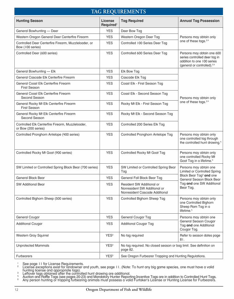
TAG REQUIREMENTS
Hunting Season License Required1
Tag Required Annual Tag Possession
General Bowhunting — Deer YES Deer Bow Tag
Persons may obtain only one of these tags.3,4
Western Oregon General Deer Centerfire Firearm YES Western Oregon Deer Tag
Controlled Deer Centerfire Firearm, Muzzleloader, or Bow (100 series)
YES Controlled 100 Series Deer Tag
Controlled Deer (600 series) YES Con trolled 600 Series Deer Tag Persons may obtain one 600 series controlled deer tag in addition to one 100 series (general or controlled).3,4
General Bowhunt ing — Elk YES Elk Bow Tag
Persons may obtain only one of these tags.3,4
General Cascade Elk Centerfire Firearm YES Cascade Elk Tag
General Coast Elk Centerfire Firearm First Season
YES Coast Elk - First Season Tag
General Coast Elk Centerfire Firearm Second Season
YES Coast Elk - Second Season Tag
General Rocky Mt Elk Centerfire FirearmFirst Season
YES Rocky Mt Elk - First Season Tag
General Rocky Mt Elk Centerfire FirearmSecond Season
YES Rocky Mt Elk - Second Season Tag
Controlled Elk Centerfire Firearm, Muzzleloader, or Bow (200 series)
YES Controlled 200 Series Elk Tag
Controlled Pronghorn Antelope (400 series) YES Controlled Pronghorn Antelope Tag Persons may obtain only one controlled tag through the controlled hunt drawing.4
Controlled Rocky Mt Goat (900 series) YES Controlled Rocky Mt Goat Tag Persons may obtain only one controlled Rocky Mt Goat Tag in a lifetime.4
SW Limited or Controlled Spring Black Bear (700 series) YES SW Limited or Controlled Spring Bear Tag
Persons may obtain one Limited or Controlled Spring Black Bear Tag3 and one General Season Black Bear Tag and one SW Additional Bear Tag.
General Black Bear YES General Fall Black Bear Tag
SW Additional Bear YES Resident SW Additional or Nonresident SW Additional or Nonresident Cascade Additional
Controlled Bighorn Sheep (500 series) YES Controlled Bighorn Sheep Tag Persons may obtain only one Controlled Bighorn Sheep Ram Tag in a lifetime.4
General Cougar YES General Cougar Tag Persons may obtain one General Season Cougar Tag and one Additional Cougar Tag.
Additional Cougar YES Additional Cougar Tag
Western Gray Squirrel YES2 No tag required Refer to season dates page 81.
Unprotected Mammals YES2 No tag required. No closed season or bag limit. See definition on page 82.
Furbearers YES5 See Oregon Furbearer Trapping and Hunting Regulations.
1 See page 11 for License Requirements.2 License exceptions exist for landowner and youth, see page 11. (Note: To hunt any big game species, one must have a valid hunting license and appropriate tags).3 Leftover tags obtained after the controlled hunt drawing are additional.4 Auction and Raffle Tags (see pages 20-23) and Mandatory Hunter Reporting Incentive Tags are in addition to Controlled Hunt Tags.5 Any person hunting or trapping furbearing animals must possess a valid Furtaker’s License or Hunting License for Furbearers.
Oregon Department of Fish and Wildlife 13
The ODFW POS system and online sales are available 24 hours a day. Check with your local license agent to determine store hours for POS sales.Note: As a hunter it is your responsibility to:
■ Ensure the hunts you apply for (all choices in all series) are hunts you want to participate in. ■ Monitor your preference points, tags allocated to specific hunts, and odds of drawing a tag. ■ Ensure the actual area you are interested in hunting is within the hunt boundary and is open for hunting access. ■ Secure access to any private lands you wish to hunt on within the established hunt area boundary.
ODFW strives to make all information available to all hunters and ODFW will not reinstate preference points or change tags because the tag you drew is not the one you wanted or expected.
LICENSESYou can buy a hunting license in person, by mail, via the internet, or by fax. A $2.00 shipping and handling fee applies. You must have a license to apply for controlled hunts or buy tags (license may be purchased before or at the same time you purchase your controlled hunt applications or general season tags.)
1. To purchase in person, go to any license agent.
2. To purchase by mail or fax, use the application form on page 17.
3. To purchase by internet, please visit www.dfw.state.or.us/online_license_sales.
CONTROLLED HUNT APPLICATIONSTO APPLY for a controlled hunt, you must have a VALID HUNTING LICENSE.Application fee is $8.00 per hunt series.Apply at a license agent, via the internet, by mail or by fax.
■ To apply by mail or fax, use the application form on page 17. A $2.00 shipping and handling fee applies. If applying in person or via the internet, you may use the application form as a worksheet to speed up the process. License agents will ask for information shown on the application form. ■ Available hunt choices are listed in the controlled hunt tables for each species/ series. ■ Enter at least one complete hunt number choice (3-digit minimum). You may enter up to four additional hunt choices. All hunt choices on one application for a series must have the same first digit. ■ Hunters should apply for more than one hunt choice in case a particular hunt is cancelled. ■ Verify that all information entered is what you requested before the transaction is completed. The license agent will give you an application
receipt showing your hunt choices. You should check it for accuracy before you leave the license outlet and keep it for proof of application.
PARTY APPLICATIONSYou must indicate if you are applying as an individual, party member or party leader when applying for your controlled hunts. All applicants, including party leader must purchase separate applications. Parties must assign ONE member as the party leader. Each party member, except party leader, must enter their party leader’s hunting license number on their application.
■ The party leader’s hunt choices will be used for the entire party. All members must list the same choices as the party leader on their individual applications. ■ Party-size limitations: 18 hunters for deer and elk; six hunters for black bear; ONLY two hunters for pronghorn antelope. No party applications are permitted for bighorn sheep or Rocky Mt goat. ■ All persons in parties that exceed the allowed party size will be considered single applicants in the drawing. ■ Parties will NOT be split to fill hunt quotas. This also applies to limits on controlled hunts for nonresidents. If the nonresident maximum is reached, parties composed solely or partially of nonresidents will not receive tags in that particular hunt.
CORRECTING ERRORS ORCHANGING APPLICATIONS
If there is an error on your controlled hunt application (incorrect party leader’s license number, hunt choice, etc.), or if you need to change your application, you must contact the Controlled Hunt staff by June 1 to have it corrected. Mail aphotocopy of your application with the corrections marked to ODFW-Controlled Hunts, 4034 Fairview Industrial Dr SE Salem, OR 97302, or fax to 503-947-6113 or 6117.
PURCHASING TAGSYouths who will turn 12 during a season (controlled or general) must purchase their tag prior to the tag sale deadline but may not hunt until they turn 12.General Season TagsYou may purchase or claim tags directly from a license agent, by mail, or fax before the tag sale deadline.To purchase or claim by mail or fax, use the application form on page 17. Be sure to clearly identify which tags you want to purchase and include appropriate fees. If purchasing by mail, fax or via the internet, please remember to allow time for delivery. General season tags available are:
■ Fall Black Bear ■ SW Additional Bear ■ Cascade Additional Bear (Nonresident) ■ Western Oregon Deer ■ Cougar ■ Additional Cougar
■ Deer Bow ■ Elk Bow ■ Cascade Elk ■ Coast Elk First Season ■ Coast Elk Second Season ■ Rocky Mt Elk First Season ■ Rocky Mt Elk Second Season
Controlled Hunt Tags ■ Hunters have the option of deciding whether or not they want to purchase the tag for the hunt choice drawn. ■ Successful applicants may purchase or pick up tags directly from a license agent, or purchase by mail or fax by the day before the hunt. ■ Telephone purchases are not accepted. ■ Check the TAG PURCHASE DEADLINE to allow plenty of time to complete this transaction. ■ To purchase or pick up tags in person, go to a license agent and buy the tag(s) you drew. ■ To purchase tags by mail or fax: Make a photocopy of your license and notification postcard, OR write your full name and hunting license number on a piece of paper. Include a check, money order, VISA or MasterCard for the tag fee amount and a $2.00 shipping and handling fee payable to ODFW. If paying by credit card, include the account number, expiration date and signature to authorize charges. DO NOT SEND CASH. ■ Mail to:
ODFW-Licensing4034 Fairview Industrial Dr SESalem, OR 97302;
■ or fax payment if using a credit card to 503-947-6117 or 6113.
NOTIFICATION ■ Notifications (successful or unsuccessful) will be made available by Feb. 20 (spring black bear) and June 20 (big game). Check draw resuts by visiting the website (www.dfw.state.or.us), calling the ODFW Controlled Hunt Information Line, or returning to any license agent. It is the hunter’s responsibility to verify success in the drawing and purchase or pick up any tags by the earliest opening day before the hunt begins, or by the earliest opening date for hunts with split-season dates, including tags obtained with a Sports Pac. ■ IF SUCCESSFUL: Tags must be purchased or picked up by the day before the hunt begins. In the case of a controlled hunt tag that is also good for general season, the tag must be purchased or picked up by the day before the earliest hunt or by the earliest opening date for hunts with split-season dates. ■ IF UNSUCCESSFUL: Hunters may purchase a general season tag and/or purchase leftover tags if available on a first-come, first-served basis.
ABOUTLICENSES,CONTROLLEDHUNTAPPLICATIONSANDTAGS

Oregon Department of Fish and Wildlife12
TAG REQUIREMENTS
Hunting Season License Required1
Tag Required Annual Tag Possession
General Bowhunting — Deer YES Deer Bow Tag
Persons may obtain only one of these tags.3,4
Western Oregon General Deer Centerfire Firearm YES Western Oregon Deer Tag
Controlled Deer Centerfire Firearm, Muzzleloader, or Bow (100 series)
YES Controlled 100 Series Deer Tag
Controlled Deer (600 series) YES Con trolled 600 Series Deer Tag Persons may obtain one 600 series controlled deer tag in addition to one 100 series (general or controlled).3,4
General Bowhunt ing — Elk YES Elk Bow Tag
Persons may obtain only one of these tags.3,4
General Cascade Elk Centerfire Firearm YES Cascade Elk Tag
General Coast Elk Centerfire Firearm First Season
YES Coast Elk - First Season Tag
General Coast Elk Centerfire Firearm Second Season
YES Coast Elk - Second Season Tag
General Rocky Mt Elk Centerfire FirearmFirst Season
YES Rocky Mt Elk - First Season Tag
General Rocky Mt Elk Centerfire FirearmSecond Season
YES Rocky Mt Elk - Second Season Tag
Controlled Elk Centerfire Firearm, Muzzleloader, or Bow (200 series)
YES Controlled 200 Series Elk Tag
Controlled Pronghorn Antelope (400 series) YES Controlled Pronghorn Antelope Tag Persons may obtain only one controlled tag through the controlled hunt drawing.4
Controlled Rocky Mt Goat (900 series) YES Controlled Rocky Mt Goat Tag Persons may obtain only one controlled Rocky Mt Goat Tag in a lifetime.4
SW Limited or Controlled Spring Black Bear (700 series) YES SW Limited or Controlled Spring Bear Tag
Persons may obtain one Limited or Controlled Spring Black Bear Tag3 and one General Season Black Bear Tag and one SW Additional Bear Tag.
General Black Bear YES General Fall Black Bear Tag
SW Additional Bear YES Resident SW Additional or Nonresident SW Additional or Nonresident Cascade Additional
Controlled Bighorn Sheep (500 series) YES Controlled Bighorn Sheep Tag Persons may obtain only one Controlled Bighorn Sheep Ram Tag in a lifetime.4
General Cougar YES General Cougar Tag Persons may obtain one General Season Cougar Tag and one Additional Cougar Tag.
Additional Cougar YES Additional Cougar Tag
Western Gray Squirrel YES2 No tag required Refer to season dates page 81.
Unprotected Mammals YES2 No tag required. No closed season or bag limit. See definition on page 82.
Furbearers YES5 See Oregon Furbearer Trapping and Hunting Regulations.
1 See page 11 for License Requirements.2 License exceptions exist for landowner and youth, see page 11. (Note: To hunt any big game species, one must have a valid hunting license and appropriate tags).3 Leftover tags obtained after the controlled hunt drawing are additional.4 Auction and Raffle Tags (see pages 20-23) and Mandatory Hunter Reporting Incentive Tags are in addition to Controlled Hunt Tags.5 Any person hunting or trapping furbearing animals must possess a valid Furtaker’s License or Hunting License for Furbearers.
Oregon Department of Fish and Wildlife 13
The ODFW POS system and online sales are available 24 hours a day. Check with your local license agent to determine store hours for POS sales.Note: As a hunter it is your responsibility to:
■ Ensure the hunts you apply for (all choices in all series) are hunts you want to participate in. ■ Monitor your preference points, tags allocated to specific hunts, and odds of drawing a tag. ■ Ensure the actual area you are interested in hunting is within the hunt boundary and is open for hunting access. ■ Secure access to any private lands you wish to hunt on within the established hunt area boundary.
ODFW strives to make all information available to all hunters and ODFW will not reinstate preference points or change tags because the tag you drew is not the one you wanted or expected.
LICENSESYou can buy a hunting license in person, by mail, via the internet, or by fax. A $2.00 shipping and handling fee applies. You must have a license to apply for controlled hunts or buy tags (license may be purchased before or at the same time you purchase your controlled hunt applications or general season tags.)
1. To purchase in person, go to any license agent.
2. To purchase by mail or fax, use the application form on page 17.
3. To purchase by internet, please visit www.dfw.state.or.us/online_license_sales.
CONTROLLED HUNT APPLICATIONSTO APPLY for a controlled hunt, you must have a VALID HUNTING LICENSE.Application fee is $8.00 per hunt series.Apply at a license agent, via the internet, by mail or by fax.
■ To apply by mail or fax, use the application form on page 17. A $2.00 shipping and handling fee applies. If applying in person or via the internet, you may use the application form as a worksheet to speed up the process. License agents will ask for information shown on the application form. ■ Available hunt choices are listed in the controlled hunt tables for each species/ series. ■ Enter at least one complete hunt number choice (3-digit minimum). You may enter up to four additional hunt choices. All hunt choices on one application for a series must have the same first digit. ■ Hunters should apply for more than one hunt choice in case a particular hunt is cancelled. ■ Verify that all information entered is what you requested before the transaction is completed. The license agent will give you an application
receipt showing your hunt choices. You should check it for accuracy before you leave the license outlet and keep it for proof of application.
PARTY APPLICATIONSYou must indicate if you are applying as an individual, party member or party leader when applying for your controlled hunts. All applicants, including party leader must purchase separate applications. Parties must assign ONE member as the party leader. Each party member, except party leader, must enter their party leader’s hunting license number on their application.
■ The party leader’s hunt choices will be used for the entire party. All members must list the same choices as the party leader on their individual applications. ■ Party-size limitations: 18 hunters for deer and elk; six hunters for black bear; ONLY two hunters for pronghorn antelope. No party applications are permitted for bighorn sheep or Rocky Mt goat. ■ All persons in parties that exceed the allowed party size will be considered single applicants in the drawing. ■ Parties will NOT be split to fill hunt quotas. This also applies to limits on controlled hunts for nonresidents. If the nonresident maximum is reached, parties composed solely or partially of nonresidents will not receive tags in that particular hunt.
CORRECTING ERRORS ORCHANGING APPLICATIONS
If there is an error on your controlled hunt application (incorrect party leader’s license number, hunt choice, etc.), or if you need to change your application, you must contact the Controlled Hunt staff by June 1 to have it corrected. Mail aphotocopy of your application with the corrections marked to ODFW-Controlled Hunts, 4034 Fairview Industrial Dr SE Salem, OR 97302, or fax to 503-947-6113 or 6117.
PURCHASING TAGSYouths who will turn 12 during a season (controlled or general) must purchase their tag prior to the tag sale deadline but may not hunt until they turn 12.General Season TagsYou may purchase or claim tags directly from a license agent, by mail, or fax before the tag sale deadline.To purchase or claim by mail or fax, use the application form on page 17. Be sure to clearly identify which tags you want to purchase and include appropriate fees. If purchasing by mail, fax or via the internet, please remember to allow time for delivery. General season tags available are:
■ Fall Black Bear ■ SW Additional Bear ■ Cascade Additional Bear (Nonresident) ■ Western Oregon Deer ■ Cougar ■ Additional Cougar
■ Deer Bow ■ Elk Bow ■ Cascade Elk ■ Coast Elk First Season ■ Coast Elk Second Season ■ Rocky Mt Elk First Season ■ Rocky Mt Elk Second Season
Controlled Hunt Tags ■ Hunters have the option of deciding whether or not they want to purchase the tag for the hunt choice drawn. ■ Successful applicants may purchase or pick up tags directly from a license agent, or purchase by mail or fax by the day before the hunt. ■ Telephone purchases are not accepted. ■ Check the TAG PURCHASE DEADLINE to allow plenty of time to complete this transaction. ■ To purchase or pick up tags in person, go to a license agent and buy the tag(s) you drew. ■ To purchase tags by mail or fax: Make a photocopy of your license and notification postcard, OR write your full name and hunting license number on a piece of paper. Include a check, money order, VISA or MasterCard for the tag fee amount and a $2.00 shipping and handling fee payable to ODFW. If paying by credit card, include the account number, expiration date and signature to authorize charges. DO NOT SEND CASH. ■ Mail to:
ODFW-Licensing4034 Fairview Industrial Dr SESalem, OR 97302;
■ or fax payment if using a credit card to 503-947-6117 or 6113.
NOTIFICATION ■ Notifications (successful or unsuccessful) will be made available by Feb. 20 (spring black bear) and June 20 (big game). Check draw resuts by visiting the website (www.dfw.state.or.us), calling the ODFW Controlled Hunt Information Line, or returning to any license agent. It is the hunter’s responsibility to verify success in the drawing and purchase or pick up any tags by the earliest opening day before the hunt begins, or by the earliest opening date for hunts with split-season dates, including tags obtained with a Sports Pac. ■ IF SUCCESSFUL: Tags must be purchased or picked up by the day before the hunt begins. In the case of a controlled hunt tag that is also good for general season, the tag must be purchased or picked up by the day before the earliest hunt or by the earliest opening date for hunts with split-season dates. ■ IF UNSUCCESSFUL: Hunters may purchase a general season tag and/or purchase leftover tags if available on a first-come, first-served basis.
ABOUTLICENSES,CONTROLLEDHUNTAPPLICATIONSANDTAGS
Oregon Department of Fish and Wildlife14
CONTROLLED HUNT DEADLINESFor controlled hunt deadline information, see page 9.
PREFERENCE POINT SYSTEM ■ Hunters who apply and do not receive their first choice for pronghorn, deer, elk and spring black bear controlled hunts receive a preference point for future controlled drawings for those species. ■ All party applicants will receive one preference point for the species listed above if they do not receive their first hunt choice. ■ Hunters DO NOT have to apply for the same hunt number in consecutive years to gain points. ■ Preference points will be kept on file under a person’s Hunter/Angler ID number. ■ Failure to consistently use the same ID number can prevent you from being successful in the drawing. ■ Party applicant points shall be determined by totaling preference points of all party members and then calculating the average of this total. Average party preference points will be rounded up from .51 and rounded down from .50 to the next whole number (example: 3.51 to 4; 3.50 to 3). ■ Drawing a first choice hunt within a hunt series takes the successful hunter’s point total back to zero whether or not they purchase the tag, except for those hunters with a Pioneer Angling/Hunting License. Successful applicants with a Pioneer Angling/Hunting License shall have one preference point when they next apply for a tag in that hunt number series. Hunters who successfully draw second or lower hunt choices still receive a preference point for future drawings except in the case of a first hunt choice that is cancelled. (See page 15). Their existing preference point total will also carry over. Hunters who indicate a Point Saver number, one ending in 99, will receive a preference point that will add to any existing points for that hunt series. ■ Hunters will not forfeit their preference points if they do not apply for a hunt series for two or more consecutive years. Preference points remain in the system until they are redeemed by drawing a hunt. ■ Applicants who have their license suspended by legal action will forfeit all preference points. ■ Youth participating in the Mentored Youth Hunting Program will receive one mentored youth preference point for each year they register for the program. See page 84.
POINT SAVER HUNT NUMBERSPoint Saver hunt numbers give hunters a preference point and maintain existing preference points. If you do not plan to hunt in a controlled hunt series, you can apply for a Point Saver to gain a preference point. You can still hunt during general seasons and/or purchase leftover
tags if available. You can also apply for an emergency hunt in addition to general, controlled hunt and/or leftover tags.How to Apply: (see page 16 for controlled hunt application procedures).
■ You must have a hunting license. ■ Apply by the appropriate deadline (Feb. 10 for 700 series black bear; May 15 for all other hunt series). ■ You may purchase one Point Saver for the current year, for each series (100, 200, 400, 600, and 700) from July 1 through Nov. 30 if you did not apply during the controlled hunt drawing for that series. ■ Select the Point Saver number for the appropriate hunt series (1 hunt series per application). 199 for Buck Deer299 for Elk499 for Pronghorn Antelope699 for Antlerless Deer799 for Spring Bear ■ You CANNOT apply for other hunt choices within the same series if using the Point Saver number. ■ Youth applying for a Point Saver CANNOT apply for a First Time Youth tag in the same series later in the same year. ■ Youth nine years of age or older are eligible to apply for point savers provided they have a social security number, a hunter/angler ID number and purchase a hunting license.
HOW THE DRAWING WORKSPublic Welcome! For date and time of public drawing, call 1-800-708-1782. ■ The computer assigns each application a 10-digit random number. Members of the public pick a 10-digit number at random for each hunt series. Those random starting numbers are used by the computer to select successful applicants. ■ Hunting parties are maintained by the computer and only the party leader’s 10-digit number is used in the drawing. ■ The controlled hunt drawing allocates 75% of first choice available tags for a hunt to applicants with existing preference points. The remaining 25% will be drawn randomly from a pool of all applicants. This step ensures that all applicants have some chance of drawing a tag each year they apply. ■ All applicants are grouped by preference points and then arranged by 10-digit random number within preference point group. ■ Tags are awarded in each preference point group beginning with the applicant whose 10-digit number matches (or is closest to and above) the start number. ■ The selection continues with the applicant having the next higher number and continues until 75% of available tags are awarded or until all first-choice applicants have received tags. Any remaining tags from the 75% will be added to the 25%. ■ Then all remaining applicants are rearranged solely by 10-digit random
number to award the remaining tags (25% of total available). ■ All applicants in a hunt series are grouped by first hunt choice. Tags are assigned to first choice applicants as above until all tags are assigned or all first choices are filled. Tags are only assigned to second choice applicants after all first choices have been filled. ■ Selection is still based on the draw numbers described above. ■ This sequence is followed for 3rd, 4th and 5th choices. Preference points do not apply to 2nd or lower choices.LEFTOVER CONTROLLED TAGS
Leftover tags for hunts with fewerapplicants than there are tags will be sold on a first-come, first-serve basis beginning at 10 a.m. (Pacific time) on Mar. 15 for black bear and July 1 for all other big game series (see page 19 for LOP leftover tag information) until all tags are sold as follows:
■ Hunts having leftover tags may include: Controlled Deer hunts (100 series), Controlled Elk hunts (200 series), Controlled Pronghorn Antelope (400 series), Controlled Antlerless Deer (600 series) and Controlled Spring Bear (700 series). ■ Only hunts with more tags than applicants (including 1st, 2nd, 3rd, 4th and 5th hunt choices) in the Controlled Hunt Drawing will qualify. Tags awarded through the controlled hunt drawing, but not claimed or purchased will not be included or available for sale. ■ Tags from “unlimited” tag hunts, and hunts where the tag is also valid during a general season, some hunts where access is limited may be excluded from the first-come, first-serve process. ■ A list of hunts and available leftover tags for sale on a first-come, first-serve basis will be made available at license agents and ODFW offices by Mar. 15 for bear and July 1 for all other big game species. ■ Leftover tags except LOP tags may only be purchased in person at license agents or ODFW offices. Mail orders and faxes will not be accepted for leftover tags. ■ Leftover LOP tags may only be purchased through the Controlled Hunts office. ■ Only one leftover tag may be purchased per person per hunt series. ■ Leftover tags are in addition to General Season, Controlled Hunt, or LOP tags you may purchase in a series. ■ Leftover tags MUST be purchased by the day before the earliest opening date. See page 19 for LOP leftover tags. ■ Leftover tags purchased by youth do not impact their eligibility for “First Time” tags in that series. ■ Leftover tags will be sold at the regular price for the current hunting season. However, leftover tags may be sold at a price up to four times the regular amount in the future. ■ No Preference Points will be given or taken away when purchasing leftover tags.
Oregon Department of Fish and Wildlife 15
CANCELLED HUNTS ■ Information about any cancelled hunts will be made available to the general public by Apr. 15. ■ A postcard will be sent to all applicants who apply for a hunt that is cancelled by Apr. 15, stating the hunt applied for has been cancelled and the following options are available:
» Option 1 - The second hunt choice becomes first choice. If a hunter is successful in the draw, no preference points are awarded and existing preference points will return to zero. If unsuccessful, applicants will receive a preference point. » Option 2 - Request an application change for another hunt at no additional cost through the Salem office (submit through mail, fax, etc.), or for a Point Saver at no additional cost. » Option 3 - Withdraw application with refund, receive no preference point. » If ODFW does not receive notification from an applicant, Option 1 will be chosen.
NONRESIDENT APPLICANTS ■ A maximum of 3% of tags for pronghorn antelope and black bear hunts and a maximum 5% of tags for controlled deer and controlled elk hunts can be issued to nonresidents. No less than 5% and no more than 10% of all bighorn sheep and Rocky Mt goat tags will be issued to nonresidents. Less than the maximum percentage may be issued, as nonresident applications receive no preference other than existing preference points in the drawings. The Guides and Outfitters Program impacts the number of nonresident tags available in the drawing. ■ Parties will not be split if the nonresident maximum is reached for any hunt. ■ Parties composed solely or partially of nonresidents will not be eligible to receive tags in a hunt after the nonresident maximum is reached.
CONTROLLED HUNT INFORMATIONThe computer-assisted telephone line allows hunters to access preference point information or to check the status of their applications, by entering their ID number and selecting the type of information desired. You can also access this information on our website at www.dfw.state.or.us. Controlled Hunt staff will also be available during regular business hours.
CONTROLLED HUNTS503-947-6102 -or-
1-800-708-1782 (In Oregon only)
GUIDES AND OUTFITTERSAs enacted by the 1997 Oregon State Legislature, the Guides and Outfitters Program provides guides and outfitters with the opportunity to market nonresident tags. A number of tags equal to one-half the
nonresident tags drawn in the previous year are available through this program. Guides certified by the Oregon State Marine Board submitted applications and competed for the right to market these tags. Tags not sold to guides by Apr. 15 are available in the that year’s big game drawing. Information on Guides and Outfitters can be obtained from Oregon State Marine Board in Salem, 503-378-8587, extension 225.
EMERGENCY HUNTSAn emergency hunt is a hunt held on short notice to address acute agricultural or reforestation damage. Most game damage situations are addressed during the annual big game seasons and the ODFW anticipates very few emergency hunts during any year. Emergency hunts may be held on a private property ownership or multiple ownerships wherein the district biologist has established a hunt area. On average, about 200 tags are issued annually statewide. Emergency hunt bag limits are in addition to any animals harvested during general seasons, controlled hunts, or leftover hunts.
1. How to Apply: Emergency hunt participants are selected from a list established on a county-by-county basis. You may apply for one county only. Applicants can request an emergency hunt application from the headquarters office, any regional office or some district offices, or apply online at https://fwpubapps.dfw.state.or.us/EmergencyHunt. Hard copy applications must be submitted to the headquarters office of ODFW, 4034 Fairview Industrial Drive SE, Salem, Oregon 97302.
2. When to Apply: Applications received between July 1 - July 31 will be randomly assigned to lists. After July 31, names will be placed on lists in the order received. Applications received prior to July 1 will only be valid on the current year’s list ending June 30. Applications from Master Hunters (see page 83 for information) received between July 1 - July 31 will be randomized, then placed at the top of the emergency hunt list by county. All other applications, including Master Hunters, received after July 31 will be placed on lists in the order received.
3. Who May Apply: Hunters 12 years and older at the time of application are eligible. Persons under 18 must be accompanied by a responsible adult (age 21 or older) while hunting. All hunters must possess a valid hunting license. Hunters may apply singly, or in parties of two. ODFW will try to keep parties together for emergency hunts whenever possible. In hunts requiring single hunters, however, party applications may be bypassed for that opportunity but will retain their position on the list.
4. Disqualification: Applicants submitting more than one application will
be disqualified. Application forms that are incomplete or illegible will be disqualified.
5. Landowners: Landowners are eligible to receive Landowner Preference (LOP) tags to hunt on their land within emergency hunt areas. LOP tags issued for an emergency hunt are issued on the same land ownership acreage schedule as are LOP tags for controlled hunts and are in addition to LOP tags issued for controlled hunts and leftover tags. Landowners do not have to be on the emergency hunt list but they must be within the emergency hunt boundary. Landowners can obtain LOP tags for established emergency hunts by contacting the headquarters office, Controlled Hunt Section or any ODFW office.
6. Notification for Emergency Hunts: Individuals listed for a county in which a hunt is to be held will be notified by telephone and given instructions on when and where to check in for the hunt. Individuals unable to meet the time schedule will be bypassed, but will retain their position on the list. Individuals participating in a hunt will be removed from the list.
7. Emergency Hunt Tags: Huntersmust possess a valid hunting license and Emergency Hunt Tag issued by ODFW personnel. Hunters must check in and out of the hunt area as directed by ODFW personnel. Successful hunters must:
» Tag the harvested animal immediately; » Contact the ODFW office that authorized the hunt; and » Pay a fee equal to the regular tag fee for that species.
UNIFORMED SERVICES ACTIVE DUTY CONTROLLED HUNT TAGS
Oregon’s active duty members of the uniformed services stationed outside of the state can obtain a controlled deer, elk, or spring bear hunt tag if they return to Oregon on leave during the season so they can hunt with their family and friends. To qualify for these tags the individual must be from Oregon, currently stationed outside of the state, and maintain Oregon residency.
■ Tags will be issued on a first-come, first-served basis until the authorized number of tags have been issued. ■ All hunt specific regulations for the hunt where a tag is issued will apply. ■ Tag recipient must pay the standard resident price for the tag. ■ For further information please contact an ODFW District Office to make an appointment.
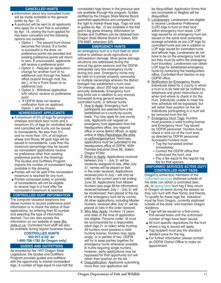

Oregon Department of Fish and Wildlife16
Instructions for Mail Order Application1. Mark box indicating resident or
nonresident. Write in Driver’s License number and state or non-Driver’s ID card number. If you are an Oregon resident, read the statement and sign the Oregon resident box.
2. Print name, mailing address and telephone numbers.
3. Write in Social Security number. This is required by law (ORS 25.752 to 25.783). No annual license will be issued if this number is not provided.
4. Write in your Hunter/Angler ID number. This is on your previous license and tags.
5. If you have already purchased your 2014 license, write the license number in the space provided. See page 87 for Hunter Education Requirements.
6. Print your date of birth and gender.7. Fill out any controlled hunt choices,
in order of priority, from the appropriate hunt tables. All choices in a series must start with the same digit, including Point Saver and LOP hunt choices.
8. Mark license, tag, application, etc. and write dollar amount for each document requested. Write total amount of your order. Fees are not refundable.
9. Mark payment method. If using MasterCard or Visa, list account number, expiration date, CVC number and sign for charge authorization.
10. List party leader’s name, date of birth and license number, if available, for each hunt series. If the party
leader’s hunting license number is not available at the time of mailing, write in their full name and date of birth.
11. To ensure a legible copy, make a clean photocopy of the mail order application for faxing.
12. Mail or fax your application well before the application and tag deadline shown on page 9. There are no exceptions to application or tag sale deadlines.
13. There is a $2 shipping and handling fee for all mail and FAX orders and some internet orders.
STATE AND FEDERAL LAW REQUIRES SOCIAL SECURITY NUMBER COLLECTION
Federal and state laws require ODFW to collect the social security number (SSN) of applicants for hunting and fishing licenses. These laws (Oregon Revised Statutes 25.780-25.785) were enacted as part of a nation-wide effort to improve child support compliance.Social security numbers will not be displayed on licenses or disclosed except as required by state or federal law. Instead, a Hunter/Angler ID number is printed on all licenses, tags, permits, etc. This is your permanent identification number and the primary number for identifying you in our system and maintaining your license history and accumulated preference points for big game controlled hunts.
ATTENTION HUNTERS TRAVELING TO OTHER STATES
Oregon Departmentof Fish and Wildlife has been
testing for chronic wasting disease (CWD) since 1996. To date, CWD has not been detected in the state of Oregon. We urge hunters to help us maintain our healthy deer and elk populations. For further informa-tion on CWD, please visit our website at www.dfw.state.or.us/wildlife/diseases/chronic-wasting/
If you are going to hunt deer (mule deer or white-tail deer), elk, or moose in the following states or provinces, please be advised that there are rules that regulate how you can bring your meat and trophies home.a Coloradoa Illinoisa Kansasa Marylanda Michigana Minnesotaa Missouri
a Montanaa Nebraskaa New Mexicoa New Yorka North Dakotaa Oklahomaa Pennsyvaniaa South Dakota
If you hunt deer, elk or moose in these states or provinces only the following items may be imported to Oregon to reduce the risk of transmitting chronic wasting disease.
a Meat that is cut and wrapped commercially or privatelya Meat that has been boned outa Quarters or other portions of meat with no part of the
spinal column or head attacheda Hides and/or capes with no head attacheda Skull plates with antlers attached that have been cleaned
of all meat and brain tissue (velvet antlers are allowed)a Antlers with no tissue attached (velvet antlers are allowed)a Upper canine teeth (buglers, whistlers, ivories)a Finished taxidermy heads
If you have any questions, please contact the Wildlife Division at Oregon Department of Fish and Wildlife. 503-947-6301
If you hunt deer, elk or moose in these states or provinces only the following items may be imported
There also may be regulations governing exportation of deer, elk, or moose from CWD positive states. Hunters planning to hunt in a state or province known to have CWD are strongly encouraged to review that State’s regulations regarding removal of animals.
a Texasa Utaha Virginiaa West Virginiaa Wisconsina Wyominga Alberta, Canadaa Saskatchewan, Canada
Oregon Department of Fish and Wildlife 17
p Controlled Buck Deer (100 series) Party size: 18 p INDIVIDUAL p PARTY MEMBER p PARTY LEADER 1st Choice 2nd Choice 3rd Choice 4th Choice 5th Choice LOP Choice
p Controlled Antlerless Deer (600 series) Party size: 18 p INDIVIDUAL p PARTY MEMBER p PARTY LEADER 1st Choice 2nd Choice 3rd Choice 4th Choice 5th Choice LOP Choice
p Controlled Elk (200 series) Party size: 18 p INDIVIDUAL p PARTY MEMBER p PARTY LEADER 1st Choice 2nd Choice 3rd Choice 4th Choice 5th Choice LOP Choice
p Controlled Pronghorn Antelope (400 series) Party size: ONLY 2 p INDIVIDUAL p PARTY MEMBER p PARTY LEADER 1st Choice 2nd Choice 3rd Choice 4th Choice 5th Choice LOP Choice
p Controlled Bighorn Sheep (500 series) NO Parties 1st Choice 2nd Choice 3rd Choice 4th Choice 5th Choice
p Controlled Rocky Mt Goat (900 series) NO Parties 1st Choice 2nd Choice 3rd Choice 4th Choice 5th Choice (Resident Only)
p Controlled Black Bear (700 series) Party size: 6 p INDIVIDUAL p PARTY MEMBER p PARTY LEADER
1st Choice 2nd Choice 3rd Choice 4th Choice 5th Choice
SOCIAL SECURITY NO. (required)
HUNTER/ANGLER I.D. NO. (for identification)
HUNTING LICENSE NUMBER (if already purchased)
DATE OF BIRTH (MM-DD-YYYY)
2014 MAIL ORDER APPLICATION
Charge customers may fax this application to 503-947-6117 or 6113. We are unable to accept telephone orders. If you are resubmitting a copy of this form due to a change, write “This is a revision/copy of the original order” at the top of the copy to prevent duplicate charges. “Mail orders, please allow two weeks.”
Issue Date_______________
Initials ___________________
DEPARTMENT USE ONLY
p RESIDENT p NONRESIDENT p NONRESIDENT UNIFORMED SERVICES Driver Lic. # __________________________ State ________________________________
LAST NAME (Please PRINT) FIRST MI
MAILING ADDRESS
CITY STATE ZIP CODE
HOME PHONE NUMBER — AND — CELL PHONE NUMBER
EMAIL ADDRESS
MAIL TO: ODFW — Licensing • 4034 Fairview Industrial Dr. SE, Salem, OR 97302 • 503-947-6100 • FAX 503-947-6117 or 6113
41
COMPLETE SECTION BELOW IF APPLYING FOR A CONTROLLED HUNT PARTY APPLICATION: One person must be designated as the party leader. Write in full name, date of birth, hunt series and PARTY LEADER’S hunting license number, if known. ALL applicants including party leader must apply. HUNTING PARTY APPLICATIONS ARE PROCESSED USING THE PARTY LEADER’S LICENSE NUMBER.
• PHOTOCOPIES OF THIS PAGE MAY BE USED.• License, tag, application and agent fees are NOT REFUNDABLE.
Mark choices(s) and fill in fee(s): See page 9.p $ _______Hunting License (resident, nonresident, or nonresident uniformed services) p $ _______Combination or Sports Pac License (resident only)p $ _______Resident Senior Citizen Licensep $ _______Controlled Hunt Application(s) Total p $ _______Resident General Season Black Bearp $ _______Resident SW Additional Black Bearp $ _______SW Oregon Limited Spring Black Bearp $ _______Nonresident or Nonresident Uniformed Services General Season Black Bear (specify area)__________ p $ _______Nonresident or Nonresident Uniformed Services Additional Black Bear (specify tag)____________p $ _______General Season Cougar p $ _______Additional Cougar p $ _______Deer p Western Oregon Centerfire p Bow or p Controlled Huntp $ _______Elk p Centerfire (specify season) p Bow or p Controlled Huntp $ _______Voluntary Contribution for Predatory Animal Control p $2; p $5; p $10; p $20; p $50; p $100p $ $2.00 Shipping and Handling Fee $ _______GRAND TOTAL
PARTY LEADER’S FULL NAME DATE OF BIRTH HUNT SERIES
PARTY LEADER’S FULL NAME DATE OF BIRTH HUNT SERIES
14
14
CONTROLLED HUNT APPLICATION• To apply for controlled hunt(s) (see page
9 for deadlines), you must purchase a hunting license at this time, or indicate your 2014 hunting license above.
• Check each desired hunt series type. List up to five choices per hunt series and one Landowner Preference choice if you qualify.
• You must indicate if you are an individual, party member or party leader by checking the appropriate box.
• Application fee is $8.00 per hunt series.• DO NOT send in the tag fee with the
controlled hunt application fee.
Party Leader’s Hunting License #
Party Leader’s Hunting License #
PAYMENT METHOD (DO NOT SEND CASH) p Check/Money Order to ODFW enclosed. p MasterCard p VISA CVC# ____________
Signature Credit Card Number Exp. Date
MALE FEMALE
All party members will receive hunt choices identical to the Party Leader, even if individual applications differ. Failure to provide the information requested above regarding Party Leader will enter the hunter as a single applicant, NOT as a member of a hunt party.
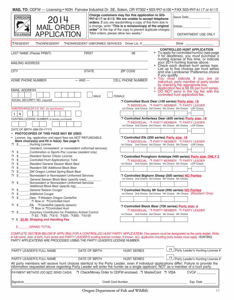
Oregon Department of Fish and Wildlife16
Instructions for Mail Order Application1. Mark box indicating resident or
nonresident. Write in Driver’s License number and state or non-Driver’s ID card number. If you are an Oregon resident, read the statement and sign the Oregon resident box.
2. Print name, mailing address and telephone numbers.
3. Write in Social Security number. This is required by law (ORS 25.752 to 25.783). No annual license will be issued if this number is not provided.
4. Write in your Hunter/Angler ID number. This is on your previous license and tags.
5. If you have already purchased your 2014 license, write the license number in the space provided. See page 87 for Hunter Education Requirements.
6. Print your date of birth and gender.7. Fill out any controlled hunt choices,
in order of priority, from the appropriate hunt tables. All choices in a series must start with the same digit, including Point Saver and LOP hunt choices.
8. Mark license, tag, application, etc. and write dollar amount for each document requested. Write total amount of your order. Fees are not refundable.
9. Mark payment method. If using MasterCard or Visa, list account number, expiration date, CVC number and sign for charge authorization.
10. List party leader’s name, date of birth and license number, if available, for each hunt series. If the party
leader’s hunting license number is not available at the time of mailing, write in their full name and date of birth.
11. To ensure a legible copy, make a clean photocopy of the mail order application for faxing.
12. Mail or fax your application well before the application and tag deadline shown on page 9. There are no exceptions to application or tag sale deadlines.
13. There is a $2 shipping and handling fee for all mail and FAX orders and some internet orders.
STATE AND FEDERAL LAW REQUIRES SOCIAL SECURITY NUMBER COLLECTION
Federal and state laws require ODFW to collect the social security number (SSN) of applicants for hunting and fishing licenses. These laws (Oregon Revised Statutes 25.780-25.785) were enacted as part of a nation-wide effort to improve child support compliance.Social security numbers will not be displayed on licenses or disclosed except as required by state or federal law. Instead, a Hunter/Angler ID number is printed on all licenses, tags, permits, etc. This is your permanent identification number and the primary number for identifying you in our system and maintaining your license history and accumulated preference points for big game controlled hunts.
ATTENTION HUNTERS TRAVELING TO OTHER STATES
Oregon Departmentof Fish and Wildlife has been
testing for chronic wasting disease (CWD) since 1996. To date, CWD has not been detected in the state of Oregon. We urge hunters to help us maintain our healthy deer and elk populations. For further informa-tion on CWD, please visit our website at www.dfw.state.or.us/wildlife/diseases/chronic-wasting/
If you are going to hunt deer (mule deer or white-tail deer), elk, or moose in the following states or provinces, please be advised that there are rules that regulate how you can bring your meat and trophies home.a Coloradoa Illinoisa Kansasa Marylanda Michigana Minnesotaa Missouri
a Montanaa Nebraskaa New Mexicoa New Yorka North Dakotaa Oklahomaa Pennsyvaniaa South Dakota
If you hunt deer, elk or moose in these states or provinces only the following items may be imported to Oregon to reduce the risk of transmitting chronic wasting disease.
a Meat that is cut and wrapped commercially or privatelya Meat that has been boned outa Quarters or other portions of meat with no part of the
spinal column or head attacheda Hides and/or capes with no head attacheda Skull plates with antlers attached that have been cleaned
of all meat and brain tissue (velvet antlers are allowed)a Antlers with no tissue attached (velvet antlers are allowed)a Upper canine teeth (buglers, whistlers, ivories)a Finished taxidermy heads
If you have any questions, please contact the Wildlife Division at Oregon Department of Fish and Wildlife. 503-947-6301
There also may be regulations governing exportation of deer, elk, or moose from CWD positive states. Hunters planning to hunt in a state or province known to have CWD are strongly encouraged to review that State’s regulations regarding removal of animals.
a Texasa Utaha Virginiaa West Virginiaa Wisconsina Wyominga Alberta, Canadaa Saskatchewan, Canada
Oregon Department of Fish and Wildlife 17
p Controlled Buck Deer (100 series) Party size: 18 p INDIVIDUAL p PARTY MEMBER p PARTY LEADER 1st Choice 2nd Choice 3rd Choice 4th Choice 5th Choice LOP Choice
p Controlled Antlerless Deer (600 series) Party size: 18 p INDIVIDUAL p PARTY MEMBER p PARTY LEADER 1st Choice 2nd Choice 3rd Choice 4th Choice 5th Choice LOP Choice
p Controlled Elk (200 series) Party size: 18 p INDIVIDUAL p PARTY MEMBER p PARTY LEADER 1st Choice 2nd Choice 3rd Choice 4th Choice 5th Choice LOP Choice
p Controlled Pronghorn Antelope (400 series) Party size: ONLY 2 p INDIVIDUAL p PARTY MEMBER p PARTY LEADER 1st Choice 2nd Choice 3rd Choice 4th Choice 5th Choice LOP Choice
p Controlled Bighorn Sheep (500 series) NO Parties 1st Choice 2nd Choice 3rd Choice 4th Choice 5th Choice
p Controlled Rocky Mt Goat (900 series) NO Parties 1st Choice 2nd Choice 3rd Choice 4th Choice 5th Choice (Resident Only)
p Controlled Black Bear (700 series) Party size: 6 p INDIVIDUAL p PARTY MEMBER p PARTY LEADER
1st Choice 2nd Choice 3rd Choice 4th Choice 5th Choice
SOCIAL SECURITY NO. (required)
HUNTER/ANGLER I.D. NO. (for identification)
HUNTING LICENSE NUMBER (if already purchased)
DATE OF BIRTH (MM-DD-YYYY)
2014 MAIL ORDER APPLICATION
Charge customers may fax this application to 503-947-6117 or 6113. We are unable to accept telephone orders. If you are resubmitting a copy of this form due to a change, write “This is a revision/copy of the original order” at the top of the copy to prevent duplicate charges. “Mail orders, please allow two weeks.”
Issue Date_______________
Initials ___________________
DEPARTMENT USE ONLY
p RESIDENT p NONRESIDENT p NONRESIDENT UNIFORMED SERVICES Driver Lic. # __________________________ State ________________________________
LAST NAME (Please PRINT) FIRST MI
MAILING ADDRESS
CITY STATE ZIP CODE
HOME PHONE NUMBER — AND — CELL PHONE NUMBER
EMAIL ADDRESS
MAIL TO: ODFW — Licensing • 4034 Fairview Industrial Dr. SE, Salem, OR 97302 • 503-947-6100 • FAX 503-947-6117 or 6113
41
COMPLETE SECTION BELOW IF APPLYING FOR A CONTROLLED HUNT PARTY APPLICATION: One person must be designated as the party leader. Write in full name, date of birth, hunt series and PARTY LEADER’S hunting license number, if known. ALL applicants including party leader must apply. HUNTING PARTY APPLICATIONS ARE PROCESSED USING THE PARTY LEADER’S LICENSE NUMBER.
• PHOTOCOPIES OF THIS PAGE MAY BE USED.• License, tag, application and agent fees are NOT REFUNDABLE.
Mark choices(s) and fill in fee(s): See page 9.p $ _______Hunting License (resident, nonresident, or nonresident uniformed services) p $ _______Combination or Sports Pac License (resident only)p $ _______Resident Senior Citizen Licensep $ _______Controlled Hunt Application(s) Total p $ _______Resident General Season Black Bearp $ _______Resident SW Additional Black Bearp $ _______SW Oregon Limited Spring Black Bearp $ _______Nonresident or Nonresident Uniformed Services General Season Black Bear (specify area)__________ p $ _______Nonresident or Nonresident Uniformed Services Additional Black Bear (specify tag)____________p $ _______General Season Cougar p $ _______Additional Cougar p $ _______Deer p Western Oregon Centerfire p Bow or p Controlled Huntp $ _______Elk p Centerfire (specify season) p Bow or p Controlled Huntp $ _______Voluntary Contribution for Predatory Animal Control p $2; p $5; p $10; p $20; p $50; p $100p $ $2.00 Shipping and Handling Fee $ _______GRAND TOTAL
PARTY LEADER’S FULL NAME DATE OF BIRTH HUNT SERIES
PARTY LEADER’S FULL NAME DATE OF BIRTH HUNT SERIES
14
14
CONTROLLED HUNT APPLICATION• To apply for controlled hunt(s) (see page
9 for deadlines), you must purchase a hunting license at this time, or indicate your 2014 hunting license above.
• Check each desired hunt series type. List up to five choices per hunt series and one Landowner Preference choice if you qualify.
• You must indicate if you are an individual, party member or party leader by checking the appropriate box.
• Application fee is $8.00 per hunt series.• DO NOT send in the tag fee with the
controlled hunt application fee.
Party Leader’s Hunting License #
Party Leader’s Hunting License #
PAYMENT METHOD (DO NOT SEND CASH) p Check/Money Order to ODFW enclosed. p MasterCard p VISA CVC# ____________
Signature Credit Card Number Exp. Date
MALE FEMALE
All party members will receive hunt choices identical to the Party Leader, even if individual applications differ. Failure to provide the information requested above regarding Party Leader will enter the hunter as a single applicant, NOT as a member of a hunt party.

Oregon Department of Fish and Wildlife18
REMEMBER:TAG SALE DEADLINE IS THE DAY
BEFORE THE HUNT BEGINS.FOR HUNTS WITH MORE THAN ONE HUNT PERIOD, THE
TAG MUST BE PURCHASED (OR PICKED UP IF YOU ARE A SPORTS PAC HOLDER)
PRIOR TO THE EARLIEST OPENING DATE.
Oregon Department of Fish and Wildlife 19
LANDOWNER PREFERENCE PROGRAM LOPThe Landowner Preference Program (LOP) was established to acknowledge the contribu-tion of private lands to support wildlife and pro-vide a form of compensation to landowners for resources used by wildlife. Tags are available to landowners, family members and others des-ignated by the landowner based on the acre-age owned and registered in the Landowner Preference Program. Pronghorn hunts are only available to landowners and family members. Recipients of LOP tags may only hunt on the property for which they are registered.How to Apply: Landowners must register, file tag distribution forms and purchase controlled hunt applications prior to the deadlines below. Only one representative landowner, or stockholder of a corporation or Limited Liability Company (LLC), or representative partner of a partnership may register. Registration packets may be obtained by contacting any local ODFW office, or by contacting the ODFW Controlled Hunt office in Salem at 503-947-6102.Landowner tags are not issued automatically upon filing of tag distribution forms. All landowners and eligible applicants must purchase controlled hunt applications prior to the deadlines specified below. Applicants for LOP tags must indicate a landowner preference hunt choice on their applications. After May 15, applications for LOP tags will not be available for purchase through license agents. Applicants must submit their applications to the headquarters office of ODFW. Allow adequate time for receipt and processing.Deadlines for submitting LOP registration and tag distribution forms and LOP controlled hunt applications are in the table below.If applying for LOP tags in the big game drawing, you have the option of applying for up to five hunt choices plus LOP or applying for LOP only.If applying for controlled hunt tags, or if applying for a limited landowner deer or elk tag (see following note), all forms and applications must be received by May 15.Note: LOP tags are not available for the new long duration (August 1 - December 31) or the Melrose 223T (August 1 - March 31) youth elk hunts. In certain controlled buck deer and elk units, LOP tags will be limited to five
tags or 10% of the total controlled hunt tags; whichever is greater. The affected buck deer hunts are: 141C, 142B, 154C, 165R, 168R2 and 170R3.The affected elk hunts are: 226R, 226Y, 248A1, 249A1, 250X, 251A, 252A1, 253X, 254R, 254Y1, 255R, 255Y1, 256R, 256Y1, 259Y, 261X, 262X and 263X. For more information Contact Controlled Hunts 503-947-6101. In addition to the above hunts, the 2013 Oregon Legislature authorized limiting LOP tags for mule deer in Wildlife Manage-ment Units that are below the population management objective. Information regarding implementation of legislative changes to the LOP program will be included in 2014 LOP Registration Packets. All controlled deer and elk hunts occurring on a landowner’s registered property are eligible for the landowner preference program except for the long-duration youth elk hunts described above. Pronghorn antelope hunts with an either-sex or a one doe or fawn bag limit occurring on a landowner’s registered property are also eligible. If an applicant is successful in receiv-ing a LOP pronghorn antelope tag for a hunt with an either-sex bag limit, the LOP tag is automatically issued with a bag limit of one doe or fawn.The number of tags allowed per hunt series is based on registered landowner acreage.LOP tags with a bag limit of one elk or one bull in units where the usual bag limit for bull elk is spike only, remaining after the game mammal controlled hunt drawing will be issued to qualified landowners on a first-come, first-served basis. Tags issued in this manner are in addition to tags drawn in the main drawing. A qualified landowner may purchase only one first-come, first-served tag per hunt series. Such a tag may be for the landowner or for someone other than the landowner listed on their tag distribution form. A hunter receiving a tag through the original game mammal controlled hunt drawing process may exchange that tag for a remaining tag in the first-come, first-served process while tags remain available. Tag purchases and exchanges may be obtained only through the headquarters office and must be made before the earliest opening start date for which the tags are issued. The tag being exchanged shall not be reissued.
MinimumTag Acreage Hunt Type2 401 All hunts except pronghorn antelope, eastern Oregon buck or either-sex deer and eastern Oregon bull and either-sex elk hunts2 1602 All hunts3 1,2002 All hunts4 2,5002 All hunts5 5,0002 All hunts6 10,0002 All hunts8 20,0002 All hunts10 40,0002 All hunts12 80,0002 All hunts14 160,000+2 All hunts.1 Must be contiguous/connected acreage.2 Must be minimum of 160 contiguous/connect-ed acres for pronghorn antelope (only doe/fawn or either sex hunts are eligible), eastern Oregon buck or either-sex deer and eastern Oregon bull and either-sex elk hunts.
In 2013, the Oregon legislature approved the Oregon Landowner Damage Program (Elk Damage Program) to address damage caused by elk on private lands. The new program will be implemented beginning August 1, 2014. To obtain information and regulations for the Elk Damage Program after July 1, 2014, contact the nearest ODFW Office.Suspension from the LOP Program:If a landowner (or the landowner’s partner, member, manager, employee, or any person using an LOP tag provided by the landowner) is convicted of violation of the wildlife laws arising from participating in the LOP program, the department may suspend that landowner from participating in the LOP program for the remainder of the current year plus two additional years. The suspension will include any and all properties associated with that landowner, for the same period of time as the landowner. The department will also revoke any unused LOP tags previously issued for the landowner’s properties.
LOP ELIGIBLE HUNTS AND DEADLINES
LOP ELIGIBLE HUNT SERIES LOP DEADLINES
Purchase of Controlled Hunt Application
Landowner Registration/Tag Distribution Forms (see note 1)
Tag Purchase (see note 3)
100 series deer Day before hunt Sept. 15 (see note 2) Day before hunt
100 series deer (limited) May 15 May 15 Day before hunt
200 series elk (bull and either sex) Day before hunt Sept. 15 (see note 2) Day before hunt
200 series elk (antlerless) Day before hunt Day before hunt Day before hunt
200 series elk (Long Duration Youth) LOP not available LOP not available LOP not available
200 series elk (limited) May 15 May 15 Day before hunt
200 series elk (Leftover limited tags) Sept. 15 (see note 2) Sept. 15 (see note 2) Day before hunt
400 series pronghorn antelope (see note 4) Day before hunt Day before hunt Day before hunt
600 series deer Day before hunt Day before hunt Day before hunt
1 All landowners must submit tag distribution forms by specific deadlines above to be eligible for LOP tags.2 If hunt begins prior to Sept. 15, controlled hunt applications, registration forms, and tag distribution forms must be received before earliest opening date.3 For hunts with more than one hunt period, the tag purchase deadline is the day before the earliest opening date.4 LOP tags are only available for hunts with “doe or fawn” or “either sex” bag limits.
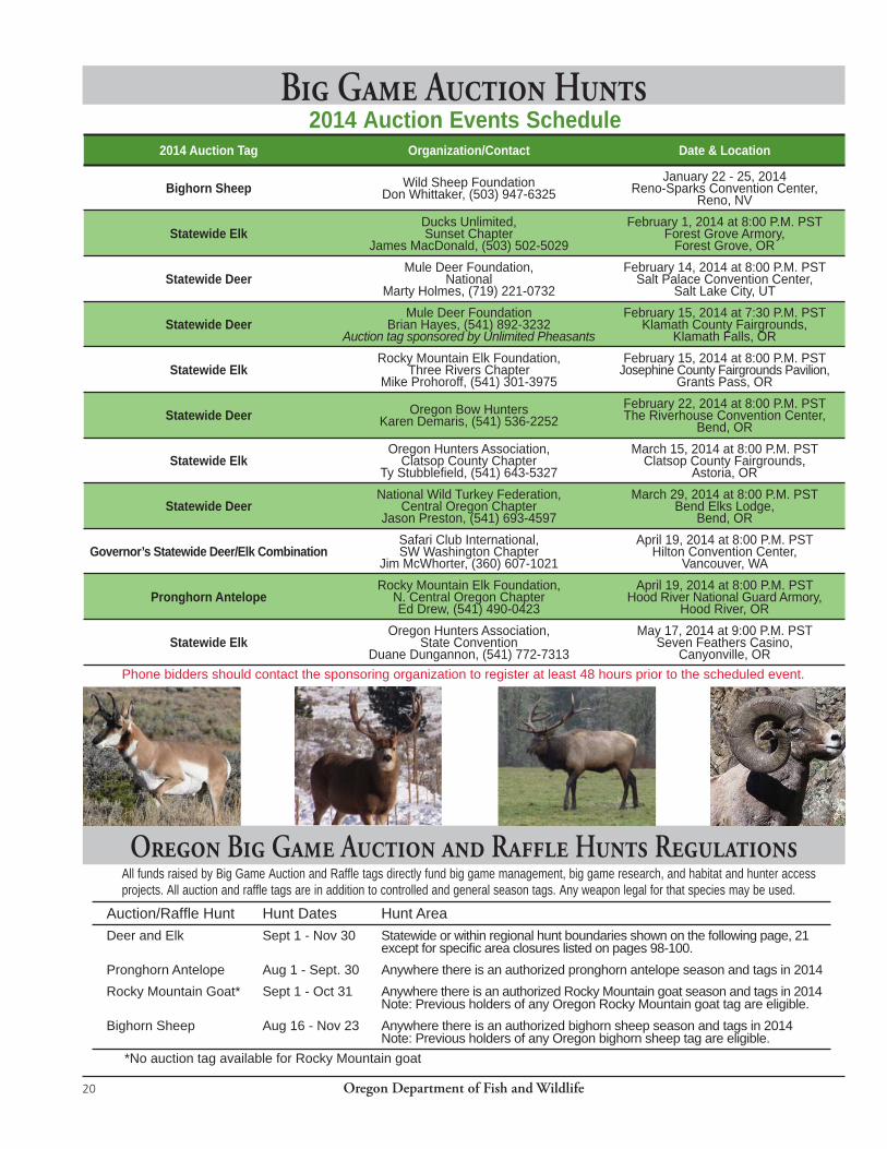
Oregon Department of Fish and Wildlife20
Big Game Auction Hunts
All funds raised by Big Game Auction and Raffle tags directly fund big game management, big game research, and habitat and hunter access projects. All auction and raffle tags are in addition to controlled and general season tags. Any weapon legal for that species may be used.
2014 Auction Events Schedule
Phone bidders should contact the sponsoring organization to register at least 48 hours prior to the scheduled event.
Oregon Big Game Auction and Raffle Hunts Regulations
Auction/Raffl e Hunt Hunt Dates Hunt AreaDeer and Elk Sept 1 - Nov 30 Statewide or within regional hunt boundaries shown on the following page, 21
except for specifi c area closures listed on pages 98-100.Pronghorn Antelope Aug 1 - Sept. 30 Anywhere there is an authorized pronghorn antelope season and tags in 2014Rocky Mountain Goat* Sept 1 - Oct 31 Anywhere there is an authorized Rocky Mountain goat season and tags in 2014
Note: Previous holders of any Oregon Rocky Mountain goat tag are eligible.Bighorn Sheep Aug 16 - Nov 23 Anywhere there is an authorized bighorn sheep season and tags in 2014
Note: Previous holders of any Oregon bighorn sheep tag are eligible. *No auction tag available for Rocky Mountain goat
2014 Auction Tag Organization/Contact Date & Location
Bighorn Sheep Wild Sheep FoundationDon Whittaker, (503) 947-6325
January 22 - 25, 2014Reno-Sparks Convention Center,
Reno, NV
Statewide ElkDucks Unlimited, Sunset Chapter
James MacDonald, (503) 502-5029
February 1, 2014 at 8:00 P.M. PSTForest Grove Armory,
Forest Grove, OR
Statewide DeerMule Deer Foundation,
NationalMarty Holmes, (719) 221-0732
February 14, 2014 at 8:00 P.M. PSTSalt Palace Convention Center,
Salt Lake City, UT
Statewide DeerMule Deer Foundation
Brian Hayes, (541) 892-3232Auction tag sponsored by Unlimited Pheasants
February 15, 2014 at 7:30 P.M. PSTKlamath County Fairgrounds,
Klamath Falls, OR
Statewide ElkRocky Mountain Elk Foundation,
Three Rivers ChapterMike Prohoroff, (541) 301-3975
February 15, 2014 at 8:00 P.M. PSTJosephine County Fairgrounds Pavilion,
Grants Pass, OR
Statewide Deer Oregon Bow HuntersKaren Demaris, (541) 536-2252
February 22, 2014 at 8:00 P.M. PSTThe Riverhouse Convention Center,
Bend, OR
Statewide ElkOregon Hunters Association,
Clatsop County ChapterTy Stubblefield, (541) 643-5327
March 15, 2014 at 8:00 P.M. PSTClatsop County Fairgrounds,
Astoria, OR
Statewide DeerNational Wild Turkey Federation,
Central Oregon ChapterJason Preston, (541) 693-4597
March 29, 2014 at 8:00 P.M. PSTBend Elks Lodge,
Bend, OR
Governor’s Statewide Deer/Elk CombinationSafari Club International, SW Washington Chapter
Jim McWhorter, (360) 607-1021
April 19, 2014 at 8:00 P.M. PSTHilton Convention Center,
Vancouver, WA
Pronghorn AntelopeRocky Mountain Elk Foundation,
N. Central Oregon ChapterEd Drew, (541) 490-0423
April 19, 2014 at 8:00 P.M. PSTHood River National Guard Armory,
Hood River, OR
Statewide ElkOregon Hunters Association,
State ConventionDuane Dungannon, (541) 772-7313
May 17, 2014 at 9:00 P.M. PSTSeven Feathers Casino,
Canyonville, OR

Oregon Department of Fish and Wildlife20
B G A H
All funds raised by Big Game Auction and Raffle tags directly fund big game management, big game research, and habitat and hunter access projects. All auction and raffle tags are in addition to controlled and general season tags. Any weapon legal for that species may be used.
2014 Auction Events Schedule
Phone bidders should contact the sponsoring organization to register at least 48 hours prior to the scheduled event.
O B G A R H R
Auction/Raffle Hunt Hunt Dates Hunt AreaDeer and Elk Sept 1 - Nov 30 Statewide or within regional hunt boundaries shown on the following page, 21
except for specific area closures listed on pages 98-100.Pronghorn Antelope Aug 1 - Sept. 30 Anywhere there is an authorized pronghorn antelope season and tags in 2014Rocky Mountain Goat* Sept 1 - Oct 31 Anywhere there is an authorized Rocky Mountain goat season and tags in 2014
Note: Previous holders of any Oregon Rocky Mountain goat tag are eligible.Bighorn Sheep Aug 16 - Nov 23 Anywhere there is an authorized bighorn sheep season and tags in 2014
Note: Previous holders of any Oregon bighorn sheep tag are eligible. *No auction tag available for Rocky Mountain goat
2014 Auction Tag Organization/Contact Date & Location
Bighorn Sheep Wild Sheep FoundationDon Whittaker, (503) 947-6325
January 22 - 25, 2014 Reno-Sparks Convention Center,
Reno, NV
Statewide ElkDucks Unlimited, Sunset Chapter
James MacDonald, (503) 502-5029
February 1, 2014 at 8:00 P.M. PSTForest Grove Armory,
Forest Grove, OR
Statewide DeerMule Deer Foundation,
NationalMarty Holmes, (719) 221-0732
February 14, 2014 at 8:00 P.M. PST Salt Palace Convention Center,
Salt Lake City, UT
Statewide DeerMule Deer Foundation
Brian Hayes, (541) 892-3232Auction tag sponsored by Unlimited Pheasants
February 15, 2014 at 7:30 P.M. PST Klamath County Fairgrounds,
Klamath Falls, OR
Statewide ElkRocky Mountain Elk Foundation,
Three Rivers ChapterMike Prohoroff, (541) 476-3050
February 15, 2014 at 8:00 P.M. PSTJosephine County Fairgrounds Pavilion,
Grants Pass, OR
Statewide Deer Oregon Bow HuntersKaren Demaris, (541) 536-2252
February 22, 2014 at 8:00 P.M. PSTThe Riverhouse Convention Center,
Bend, OR
Statewide ElkOregon Hunters Association,
Clatsop County ChapterTy Stubblefield, (541) 643-5327
March 15, 2014 at 8:00 P.M. PSTClatsop County Fairgrounds,
Astoria, OR
Statewide DeerNational Wild Turkey Federation,
Central Oregon Chapter Jason Preston, (541) 693-4597
March 29, 2014 at 8:00 P.M. PSTBend Elks Lodge,
Bend, OR
Governor’s Statewide Deer/Elk CombinationSafari Club International, SW Washington Chapter
Jim McWhorter, (360) 607-1021
April 19, 2014 at 8:00 P.M. PST Hilton Convention Center,
Vancouver, WA
Pronghorn AntelopeRocky Mountain Elk Foundation,
N. Central Oregon Chapter Ed Drew, (541) 490-0423
April 19, 2014 at 8:00 P.M. PSTHood River National Guard Armory,
Hood River, OR
Statewide ElkOregon Hunters Association,
State Convention Duane Dungannon, (541) 772-7313
May 17, 2014 at 9:00 P.M. PSTSeven Feathers Casino,
Canyonville, OR
Oregon Department of Fish and Wildlife 21
WIL
LAMET
TE
SANTIAM
WILSON
W E S T E R N OR E G ON
C E N TR A L OR E G ON
S OU T H E A S T O R E GO N
NORTHEAST OREGON
UMATILLA INDIAN RES.
DIXON
MCKENZIE
MEL
RO
SE
POWERS
RO
GU
E
SADDLEMT
SCAPPOOSE
SIXES
TIOGA
STOTT MT
TRASK
BEATYSBUTTE
BEULAH
BIGGS
CHESNIMNUSCOLUMBIA BASIN
DESOLATIONFOSSIL
GRIZZLY
HEPPNER
HO
OD
IMNAHA
INTERSTATE
JUNIPER
KEATING
KENOKLAMATH
FALLS
LOOKOUT MT
MALHEURRIVER
MAUPIN
MAURY
METOLIUS
MINAM
MTEMILY
MURDERERSCREEK
NORTHSIDE
OCHOCO
OWYHEE
PAULINA
FORT ROCK
SILVERLAKE
SILVIES
SNAK
E RV
R
SPRAGUE
STARKEY
STEE
NS M
T
SUMPTER
UKIA
H
UPPE
RDE
SCHU
TES
WAGONTIRE
WA
RN
ER WHITEHORSE
WALLAWALLA
WEN
AHA
WHITERIVER
CRAT
ERLA
KE N
P
WARMSPRINGSTRIBAL
RES.
SLEDSPRINGS
CATHERINE
CREEK
INDIGO
ALSEA
SIUSLAW
APPLEGATE
CHETCO
EVANSCREEK
PINECR
B G R HONE LUCKY WINNER WILL BE DRAWN FOR EACH HUNT AT THE
ANNUAL OREGON HUNTERS ASSOCIATION CONVENTION MAY 17, 2014 AT SEVEN FEATHERS CASINO, CANYONVILLE, OR
RAFFLE HUNTS AVAILABLE IN 2014
(drawn in the order listed) 1. Governor’s Statewide Deer & Elk Combination 2. Statewide Deer 3. Southeast Oregon Deer 4. Central Oregon Deer 5. Northeast Oregon Deer 6. Statewide Elk 7. Northeast Oregon Elk8. Central/Southeast Elk 9. Western Oregon Elk 10. Rocky Mt. Goat 11. Pronghorn Antelope 12. Bighorn Sheep
SEE RAFFLE RULES, INSTRUCTIONS AND ORDER FORM ON FOLLOWING PAGE
Previous Auction And rAffle Hunt Winners
stAteWide elksoutHeAst oregon deer

Oregon Department of Fish and Wildlife22
Raffle Rules:• Residents and nonresidents may purchase raffle tickets.• INCOMPLETE OR ALTERED TICKETS WILL NOT BE ACCEPTED. All tickets must include a name, address,
and telephone number. If this information is not pre-printed on your ticket, you must write it in. Deer and elk tickets must also include a hunt choice selection.
• ALL RAFFLE TICKET SALES ARE NON REFUNDABLE.• Space will be provided on the raffle ticket to designate the tag to another person. To designate the ticket to another person you must include both the first and last name of the designated tag recipient. If these are not included prior to submitting the ticket, the tag will be automatically designated to the entrant named on the pre- printed portion of the ticket. • Each tag will be issued to the designated tag recipient on the winning ticket and cannot be transferred.• All raffle hunts are in addition to controlled and general season tags.• There is no limit on the number of tickets entered by any one individual.• One winner and two alternates will be drawn for each raffle hunt.• If an individual is drawn as the winner of more than one hunt for the same species, the department will issue that person the first raffle tag drawn for that species.• Individuals who purchase a deer auction tag are not eligible to win a deer raffle tag (and vice versa); individuals who purchase an elk auction tag are not eligible to win an elk raffle tag (and vice versa).
How to Purchase Raffle Tickets:• Raffle tickets can be purchased from any point of sale agent, online at www.dfw.state.or.us/online_license_sales, or by mail/fax using the order form on the following page by May 5, 2014. Deer and elk 40 and 100 ticket packages will only be available through the Salem headquarters or by mail/fax order. • Tickets will be pre-printed with the name, address, and telephone number associated with the hunter ID provided to the point of sale agent or entered on the order form. To have these tickets mailed to a different address, you must complete the “mail to” section on the order form. • For deer and elk tickets: You have the option to pre-print your hunt choice on your raffle tickets.
� If you choose to have your tickets pre-printed with a hunt choice, the choice must be made on a per-package basis.
� If you wish to make multiple hunt choices on different tickets from the same package, you must choose “No Hunt Selection”. You must then manually mark your hunt choices before submitting the tickets.
� You must indicate the number of packages that you would like to be printed with a particular hunt choice. � Any raffle ticket submitted without a hunt choice selected (either pre-printed or manually marked) will NOT be
accepted.• For combination deer & elk, bighorn sheep, pronghorn, or Rocky Mountain goat tickets:
� There are no regional hunt choices to select for these hunts. � The combination deer & elk tag is a statewide hunt. Raffle bighorn sheep, pronghorn and Rocky Mountain
goat tags are valid anywhere there is an authorized season and tags for the respective species. � Do not attempt to make a hunt choice for combination deer & elk, Bighorn sheep, pronghorn and Rocky
Mountain goat tickets. Simply purchase the number of packets you would like.
Raffle Instructions:• Completed tickets must be received no later than 5:00 P.M. on Thursday, May 15, 2014. Mail completed raffle
tickets to: ODFW Raffles, P.O. Box 3307, Salem, OR, 97302, or tickets can be hand delivered to the 2014 OHA Convention at the Seven Feathers Casino in Canyonville, OR, on Saturday, May 17, 2014, between 4:30 and
7:30 P.M. • Tickets will be available for sale between 4:30 P.M. and 7:00 P.M. at the OHA State Convention. Completed
tickets delivered to the drawing event must be filled out completely and turned in by 7:30 P.M. The raffle drawing will be conducted at 7:45 P.M.• A summary of raffle tickets sold can be found at: www.OregonRaffleHunts.com.This information will be updated
as it is available.
B G R R I
Oregon Department of Fish and Wildlife 23
PAYMENT METHOD (DO NOT SEND CASH)
p Check/Money Order to ODFW enclosed
p MasterCard p Visa(Required for credit card purchases)
BIG GAME RAFFLE TICKET MAIL/FAX ORDER FORM
You can pre-select your hunt choice for deer and elk tickets. If you do not select a hunt choice at time of ticket purchase, the hunt choice field will be left blank. A hunt choice must be selected (for deer or elk) before tickets are entered into the drawinga The last day to purchase
raffle tickets at a POS* license agent, or online is May 5, 2014.
a Mail order/fax ticket orders must be received by
May 5, 2014 at the following address:
ODFW - Raffles 4034 Fairview Industrial Dr SE Salem, OR 97302 503-947-6100 or FAX: 503-947-6117 or 6113
a Completed tickets must be received at our Salem Head-quarters no later than 5:00 P.M. on Thursday May 15, 2014. Mail completed raffle tickets to:
ODFW - Raffles P.O. Box 3507 Salem, OR 97302 or: tickets can be hand delivered to the 2014 OHA
Convention at the Seven Feathers Casino, Canyon-ville, OR, on Saturday, May 17, 2014, between 4:30 and 7:30 P.M.
Raffle Entrant: This information will be pre-printed on raffle ticketsNameHunter/Angler ID Date of BirthAddressCity/State/ZipPhone
p Do not mail - submit directly into drawing (not available for orders that include tickets with “No Hunt Selection”)
ORMail to: (if different than entrant’s address)
NameAddressCity/State/Zip
Credit Card Number
Expiration Date CVC #
Signature
Enter the number of packages you want printed with each hunt choice
Sout
heas
t
Cent
ral
North
east
No H
unt
Sele
ctio
nTo
tal #
of
pack
ages
TotalPrice
Deer
1 ticket pkg6 ticket pkg
15 ticket pkg40 ticket pkg*
100 ticket pkg*
North
east
Cent
ral/S
E
Wes
tern
No H
unt
Sele
ctio
nTo
tal #
of
Pack
ages
Stat
ewid
e
TotalPrice
Elk1 ticket pkg6 ticket pkg
15 ticket pkg40 ticket pkg*
Combination Deer/Elk
1 ticket pkg6 ticket pkg
15 ticket pkg40 ticket pkg*
Bighorn Sheep
Pronghorn
Rocky Mountain
Goat
GRAND TOTAL
$$$$$
$$$$
x $4.50 =x $11.50 =x $21.50 =
x $51.50 =x $101.50 =
x $6.50 =x $21.50 =x $41.50 =
x $101.50 =x $11.50 =x $31.50 =x $61.50 =
x $151.50 =
x $11.50 =x $51.50 =
x $101.50 =x $11.50 =x $51.50 =
x $101.50 =x $11.50 =x $51.50 =
x $101.50 =
1 ticket pkg6 ticket pkg
13 ticket pkg
1 ticket pkg6 ticket pkg
13 ticket pkg1 ticket pkg6 ticket pkg
13 ticket pkg
$$$$$$$$$$$$$
Stat
ewid
e
Shipping & Handling
$$2.00
DO NOT WRITE IN SHADED
AREA
*Only available through the Salem headquarters or by mail/fax order.
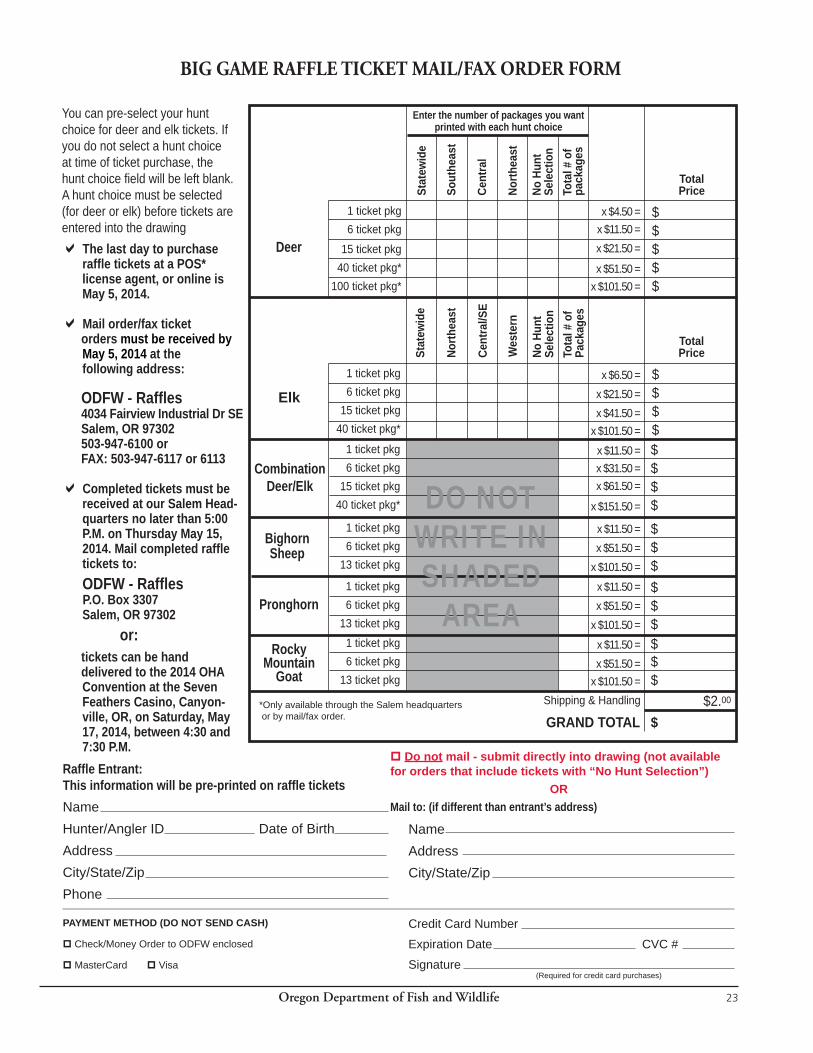
Oregon Department of Fish and Wildlife 23
PAYMENT METHOD (DO NOT SEND CASH)
Check/Money Order to ODFW enclosed
MasterCard Visa(Required for credit card purchases)
BIG GAME RAFFLE TICKET MAIL/FAX ORDER FORM
You can pre-select your hunt choice for deer and elk tickets. If you do not select a hunt choice at time of ticket purchase, the hunt choice fi eld will be left blank. A hunt choice must be selected (for deer or elk) before tickets are entered into the drawing The last day to purchase
raffl e tickets at a POS* license agent, or online is May 5, 2014.
Mail order/fax ticket orders must be received by
May 5, 2014 at the following address:
ODFW - Raffl es 4034 Fairview Industrial Dr SE Salem, OR 97302 503-947-6100 or FAX: 503-947-6117 or 6113
Completed tickets must be received at our Salem Head-quarters no later than 5:00 P.M. on Thursday May 15, 2014. Mail completed raffl e tickets to:
ODFW - Raffl es P.O. Box 3307 Salem, OR 97302 or: tickets can be hand delivered to the 2014 OHA
Convention at the Seven Feathers Casino, Canyon-ville, OR, on Saturday, May 17, 2014, between 4:30 and 7:30 P.M.
Raffl e Entrant: This information will be pre-printed on raffl e ticketsNameHunter/Angler ID Date of BirthAddressCity/State/ZipPhone
Do not mail - submit directly into drawing (not available for orders that include tickets with “No Hunt Selection”)
ORMail to: (if different than entrant’s address)
NameAddressCity/State/Zip
Credit Card Number
Expiration Date CVC #
Signature
Enter the number of packages you want printed with each hunt choice
Sout
heas
t
Cent
ral
North
east
No H
unt
Sele
ctio
nTo
tal #
of
pack
ages
TotalPrice
Deer
1 ticket pkg6 ticket pkg
15 ticket pkg40 ticket pkg*
100 ticket pkg*
North
east
Cent
ral/S
E
Wes
tern
No H
unt
Sele
ctio
nTo
tal #
of
Pack
ages
Stat
ewid
e
TotalPrice
Elk1 ticket pkg6 ticket pkg
15 ticket pkg40 ticket pkg*
Combination Deer/Elk
1 ticket pkg6 ticket pkg
15 ticket pkg40 ticket pkg*
Bighorn Sheep
Pronghorn
Rocky Mountain
Goat
GRAND TOTAL
$$$$$
$$$$
x $4.50 =x $11.50 =x $21.50 =
x $51.50 =x $101.50 =
x $6.50 =x $21.50 =x $41.50 =
x $101.50 =x $11.50 =x $31.50 =x $61.50 =
x $151.50 =
x $11.50 =x $51.50 =
x $101.50 =x $11.50 =x $51.50 =
x $101.50 =x $11.50 =x $51.50 =
x $101.50 =
1 ticket pkg6 ticket pkg
13 ticket pkg
1 ticket pkg6 ticket pkg
13 ticket pkg1 ticket pkg6 ticket pkg
13 ticket pkg
$$$$$$$$$$$$$
Stat
ewid
e
Shipping & Handling
$$2.00
DO NOT WRITE IN SHADED
AREA
*Only available through the Salem headquarters or by mail/fax order.
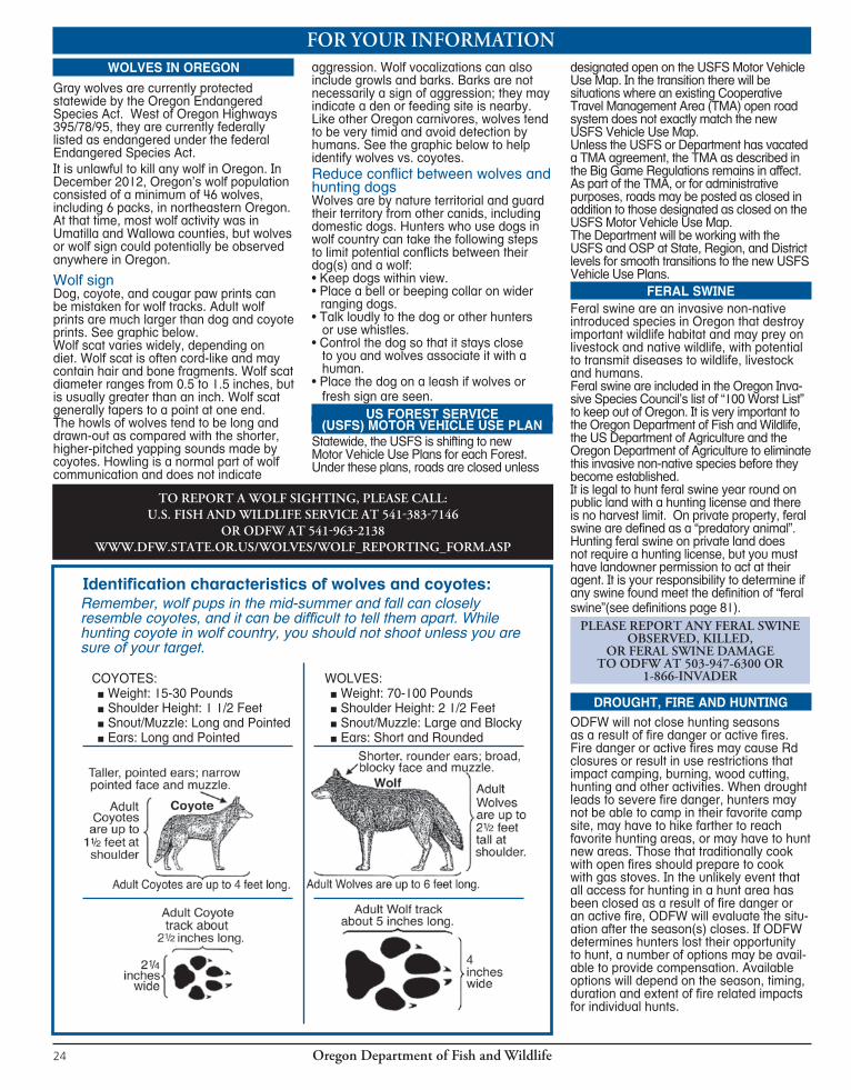
Oregon Department of Fish and Wildlife24
FOR YOUR INFORMATIONWOLVES IN OREGON
Gray wolves are currently protected statewide by the Oregon Endangered Species Act. West of Oregon Highways 395/78/95, they are currently federally listed as endangered under the federal Endangered Species Act.It is unlawful to kill any wolf in Oregon. In December 2012, Oregon’s wolf population consisted of a minimum of 46 wolves, including 6 packs, in northeastern Oregon. At that time, most wolf activity was in Umatilla and Wallowa counties, but wolves or wolf sign could potentially be observed anywhere in Oregon.
Wolf signDog, coyote, and cougar paw prints can be mistaken for wolf tracks. Adult wolf prints are much larger than dog and coyote prints. See graphic below.Wolf scat varies widely, depending on diet. Wolf scat is often cord-like and may contain hair and bone fragments. Wolf scat diameter ranges from 0.5 to 1.5 inches, but is usually greater than an inch. Wolf scat generally tapers to a point at one end. The howls of wolves tend to be long and drawn-out as compared with the shorter, higher-pitched yapping sounds made by coyotes. Howling is a normal part of wolf communication and does not indicate
aggression. Wolf vocalizations can also include growls and barks. Barks are not necessarily a sign of aggression; they may indicate a den or feeding site is nearby. Like other Oregon carnivores, wolves tend to be very timid and avoid detection by humans. See the graphic below to help identify wolves vs. coyotes.Reduce conflict between wolves and hunting dogsWolves are by nature territorial and guard their territory from other canids, including domestic dogs. Hunters who use dogs in wolf country can take the following steps to limit potential conflicts between their dog(s) and a wolf:• Keep dogs within view.• Place a bell or beeping collar on wider
ranging dogs.• Talk loudly to the dog or other hunters
or use whistles.• Control the dog so that it stays close
to you and wolves associate it with a human.
• Place the dog on a leash if wolves or fresh sign are seen.
US FOREST SERVICE(USFS) MOTOR VEHICLE USE PLAN
Statewide, the USFS is shifting to new Motor Vehicle Use Plans for each Forest. Under these plans, roads are closed unless
designated open on the USFS Motor Vehicle Use Map. In the transition there will be situations where an existing Cooperative Travel Management Area (TMA) open road system does not exactly match the new USFS Vehicle Use Map. Unless the USFS or Department has vacated a TMA agreement, the TMA as described in the Big Game Regulations remains in affect. As part of the TMA, or for administrative purposes, roads may be posted as closed in addition to those designated as closed on the USFS Motor Vehicle Use Map.The Department will be working with the USFS and OSP at State, Region, and District levels for smooth transitions to the new USFS Vehicle Use Plans.
FERAL SWINEFeral swine are an invasive non-native introduced species in Oregon that destroy important wildlife habitat and may prey on livestock and native wildlife, with potential to transmit diseases to wildlife, livestock and humans.Feral swine are included in the Oregon Inva-sive Species Council’s list of “100 Worst List” to keep out of Oregon. It is very important to the Oregon Department of Fish and Wildlife, the US Department of Agriculture and the Oregon Department of Agriculture to eliminate this invasive non-native species before they become established.It is legal to hunt feral swine year round on public land with a hunting license and there is no harvest limit. On private property, feral swine are defined as a “predatory animal”. Hunting feral swine on private land does not require a hunting license, but you must have landowner permission to act at their agent. It is your responsibility to determine if any swine found meet the definition of “feral swine”(see definitions page 81).
PLEASE REPORT ANY FERAL SWINE OBSERVED,KILLED,
OR FERAL SWINE DAMAGETOODFWAT503-947-6300OR
1-866-INVADER
DROUGHT, FIRE AND HUNTINGODFW will not close hunting seasons as a result of fire danger or active fires. Fire danger or active fires may cause Rd closures or result in use restrictions that impact camping, burning, wood cutting, hunting and other activities. When drought leads to severe fire danger, hunters may not be able to camp in their favorite camp site, may have to hike farther to reach favorite hunting areas, or may have to hunt new areas. Those that traditionally cook with open fires should prepare to cook with gas stoves. In the unlikely event that all access for hunting in a hunt area has been closed as a result of fire danger or an active fire, ODFW will evaluate the situ-ation after the season(s) closes. If ODFW determines hunters lost their opportunity to hunt, a number of options may be avail-able to provide compensation. Available options will depend on the season, timing, duration and extent of fire related impacts for individual hunts.IV
TOREPORTAWOLFSIGHTING,PLEASECALL:U.S.FISHANDWILDLIFESERVICEAT541-383-7146
ORODFWAT541-963-2138WWW.DFW.STATE.OR.US/WOLVES/WOLF_REPORTING_FORM.ASP
COYOTES: ■ Weight: 15-30 Pounds ■ Shoulder Height: 1 1/2 Feet ■ Snout/Muzzle: Long and Pointed ■ Ears: Long and Pointed
WOLVES: ■ Weight: 70-100 Pounds ■ Shoulder Height: 2 1/2 Feet ■ Snout/Muzzle: Large and Blocky ■ Ears: Short and Rounded
Identification characteristics of wolves and coyotes:Remember, wolf pups in the mid-summer and fall can closely resemble coyotes, and it can be difficult to tell them apart. While hunting coyote in wolf country, you should not shoot unless you are sure of your target.
Oregon Department of Fish and Wildlife 25
Attention Starkey Experimental Forest Hunters!
Research designed to evaluate the response of elk and mule deer to ATV activity during the hunting season will continue in the Starkey Experimental Forest and Range enclosure in 2014. Successful applicants for hunts 152B, 252D and 252R must agree to participate in the research by having a GPS unit (~1.0 lb) on their person while hunting and having a second GPS unit attached to their ATV at all times during the 5-day season.Hunters should be aware that only green dot roads will be open to ATV use, and road 2120 will be closed to all motorized access beyond Rock Spring in the north half of Starkey.The new changes in ATV and motorized access will be in effect five days before each hunt and through each hunt period. Hunters should also be aware of camping restrictions, which limit camps to within 300 feet of open (green dot) roads. For further details of the ATV project and other related research or to view a map of roads open during the hunts, please visit the following websites (www.dfw.state.or.us or www.fs.fed.us/pnw/Starkey), or contact Scott Findholt at 541-962-6538 or Brian Dick at 541-962-6539.
HUNTING ON INDUSTRIAL FOREST LANDSHunters enjoy recreating on industrial forest lands in Oregon to pursue a variety of upland and big game species. These private lands have often been taken for granted as “public” lands. In fact, these private lands are vital in providing access to many of Oregon’s game resources, and hunters play a strong role in maintaining the privilege to access the property of accommodating landowners.In order to manage risks, forest landowners generally have uniform rules for hunters and other recreational users of their lands. These include a prohibition on camping, campfires and OHVs. Hunters should read and obey all signs posted at gates or along roads; the signs are in place to protect workers, equipment and hunters. If no speed limits are posted, drive at a safe speed no faster than conditions will allow. Areas may be posted as active operations and closed to access; these areas are to be avoided. When parked, your unattended vehicle should not block any part of a road or gate or interfere with the flow of wide loads and other equipment. Respecting all resources on industrial forest lands, including roads, gates, plantations, workers and equipment will help maintain a safe place to work and recreate.Access may be restricted at times due to fire season restrictions, especially during the early general archery season. Access policies may change quickly with weather and moisture conditions. It is always a good idea to check with the landowner or the Oregon Department of Forestry’s website www.oregon.gov/ODF/FIRE/CorporateClosures.pdf for hunting access if you’re unsure about the current access policy of a particular landowner. Many companies have hunting access phone lines that contain updated information as well.If you observe suspicious behavior, vandalism, dumping, or a law violation, contact the landowner or Oregon State Police immediately. Acting as an extra set of eyes and ears to protect your and the landowner’s interests is greatly appreciated by all. Have a safe, responsible and enjoyable hunting experience! Remember, recreational access to private land is a priveledge, not a right.
Hunting and Camping Near Water SourcesMuch of eastern Oregon has little water. As a result of this, livestock
and wildlife often are dependent on artifical water sources. Additionally Oregon can experience periodic and sometimes severe drought conditions that impact both natural and artificial water sources. Drought can cause difficulties for livestock and wildlife. When some water sources dry up many animals may be forced to migrate long distances to water. This water can either be permanent streams or springs or artificial sites like guzzlers and livestock water cisterns. Drought impacts of reduced food and water are hardest on the young and the females trying to raise them.
HELP WILDLFIEl Avoid camping at or near waterholes, springs, guzzlers, and other sources of water for wildlife and livestock.l Livestock are constrained by fences and do not have the option of moving
to alternative water sources.l Avoid hunting over water sources when that activity keeps livestock and
wildlife that waters during daylight hours from obtaining essential water.l Never alter or plug water sources to prevent livestock or wildlife from gaining
access to water.l Remember that in many areas livestock producers have to haul water for their livestock, so don’t do anything that would prevent animals from
reaching that water.l More information can be found at the ODFW website “Drought and Fire
Information Page” (www.dfw.state.or.us).
HUNTING AND CAMPING INFORMATION FOR HUNTERS
Camping and Leaving Personal Property on Public LandsRegulations for public use of public lands vary from area to area. It is the responsibility of each hunter to know the rules and regulations which govern public land use in the area they are using. In general, individuals are not allowed to camp or leave personal property or structures such as tree stands on public lands (including BLM or US Forest Service lands) for more than 14 days. However, some areas are closed to camping or may have different stay limits. Hunters should contact the responsible land management agency prior to installing any cameras, tree stands or other personal property.
Many Indian artifacts and all Indian burial sites are considered sacred within Oregon’s Native American culture and serve as important links to the past. The Oregon Legislature has recognized the importance of these sites and artifacts by passing laws that specifically protect these areas and items. Digging up cultural sites is against the law. Taking human remains or sacred objects from a site can lead to serious penalties. State and federal laws covers both private and public land in Oregon. The state law can be found in Oregon Revised Statutes (ORS) Chapters 97, 358 and 390. If you should find any Native American artifacts while out hunting, stop and look around. REMEMBER, DON’T DISTURB THESE SITES. Respect and honor these sites for what they mean to Oregon’s Native Americans and to Oregon’s rich cultural background.
OBJECTS AND CULTURAL SITES
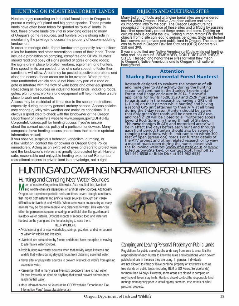

Oregon Department of Fish and Wildlife26
WILDLIFE HEALTH AND BIG GAME MANAGEMENTODFW is currently monitoring important diseases to determine their presence and effect on Oregon’s big game populations. To accomplish this, ODFW’s veterinary staff are asking hunters for their assistance obtaining samples from harvested game animals. Hunters are asked to bring their harvested game animals to department offices or check stations.
Chronic Wasting Disease (CWD) in Deer and ElkCWD is a brain disease of wild and captive deer, elk, and moose. It has been found in free-ranging and/or captive mule deer, white-tailed deer and elk in Colorado, Illinois, Kansas, Maryland, Michigan, Minnesota, Missouri, Montana, Nebraska, New Mexico, New York, North Dakota, Oklahoma, Pennsylvania, South Dakota, Texas, West Virginia, Wisconsin, Wyoming, Utah, Virginia, Alberta and Saskatchewan.
CWD is untreatable and leads to progressive loss of body condition, behavioral changes, excessive salivation, neurologic deficits and eventual death. Researchers believe an abnormal type of infectious protein that invades and destroys cells in the animal’s brain causes the disease. Where CWD originated from and how it is transmitted is not clearly understood but contact with saliva, feces, urine and environmental contamination are thought to play a role. Once animals show symptoms, the disease progresses rapidly and animals die within weeks. Similar diseases exist in domestic sheep (scrapie), cattle (bovine TSE or mad cow disease) and humans (Creutzfeldt-Jakob disease). Current research indicates CWD is restricted to North American deer, elk and moose and is not transmissible to humans.
Between 2002 and 2012, ODFW has sampled more than16,000 deer and elk for CWD and the disease has not been detected in any samples. Oregon’s Fish and Wildlife biologists and veterinary staff remain cautious and continue surveillance to ensure the disease is not present in Oregon. For up-to-date information on CWD, log onto the CWD Alliance website www.cwd-info.org/.
Tuberculosis in Deer and Elk Tuberculosis (TB) is a disease caused by bacteria (Mycobacterium spp.) that produces granulomas or tubercules often visible in the lungs of infected animals. There are three types of TB – human, avian and bovine. Human TB is rarely transmitted to non-humans and avian TB is typically restricted to birds. Bovine – or cattle TB – is the most serious to wildlife and is capable of infecting most mammals including humans. Although Bovine TB was once relatively common in cattle in the U.S., it has historically been a very rare disease in wild deer and elk.
Bovine TB is spread primarily when an infected animal is in close contact with other non-infected animals. Bacteria is transmitted through ingestion of saliva on feed or released into the air by coughing and sneezing. Predators and scavengers can get the disease from eating infected prey animals. Bovine TB is a chronic disease and can take years for visible infections to develop in the lungs and other organs. Infections are often recognized as enlarged lymph nodes in the head region or unusual tan or yellow lumps on the inside surface of the rib cage and in the lung tissue. While it is possible to transmit Bovine TB from animals to people, the likelihood is extremely rare. It is also very unlikely that a person field dressing or eating the cooked meat of a wild deer or elk infected with Bovine TB would become infected.
In November 2001, a case of bovine TB in a single farm-raised elk was confirmed at a ranch near Monument, Oregon. A total of 195 elk and 279 adult cattle from the ranch were killed and examined for signs of TB. No additional TB-positive animals were found. We have no indication that TB is present in wild deer and elk populations in Oregon but ODFW continues to monitor for this disease through statewide surveillance of hunter harvested animals and captive cervids.
Deer Hair Loss Syndrome Deer Hair Loss Syndrome (DHLS) was first documented in black-tailed deer in 1995 near Bangor, Washington. By spring 2002, it had spread into northwestern Oregon and continued south into Jackson and Josephine counties and northern California. It is called a syndrome because the exact cause appears to be multi-factorial. One common factor is deer exhibiting hair loss have large numbers of exotic lice, endemic to southeast Asia, which cause severe skin irritation to the infected animal. Deer are most affected from December to April. Hair loss occurs as deer rub, bite and scratch from irritation caused by the lice. This leaves the damaged hair coat with the appearance of white or yellow patches. As the hair is rubbed off, deer start losing energy reserves because they spend less time foraging and more time grooming. As the winter progresses the hair coat appears “wet” or in rough condition. Infected deer often become emaciated and lethargic and may have diarrhea. Death can occur from pneumonia and hypothermia when exposed to winter climatic conditions. The syndrome occurs primarily west of the Cascades in black-tailed deer. A diffrent species of exotic louse has been found on mule deer in scattered locations in eastern Oregon. Wholesomeness of the Meat With few exceptions, wildlife disease rarely poses a significant threat to human health. Further, TB and CWD have not been found in wild deer or elk in Oregon. However, general caution should be used when field dressing game animals and handling game meat. ODFW offers the following tips for hunters taking to the field this fall:
1. Latex, nitrile, or rubber household cleaning gloves should be worn when field dressing and when removing antlers from the skull. All saws and knives should be cleaned using a solution of common household bleach mixed 1/3 cup bleach to a gallon of water or a commercial bleach containing cleansing solution.
2. Always check for any abnormalities when field dressing an animal that has been killed. If abnormalities are observed in organs, lymph nodes, or meat when field dressing deer or elk, bring the carcass with the abnormal tissue to your nearest ODFW office where our vet staff will diagnose the condition at the ODFW Wildlife Health Lab.
3. As a precaution, avoid contact with or consumption of brain, spinal column and lymphoid tissues. When boning meat trim away all lymph nodes and fatty tissues.
4. Avoid cross-contamination between entrails and raw meat and between raw and cooked meats. Cutting boards, knives, wiping cloths, sponges and other tools should be cleaned and washed between uses. Common household bleach mixed 1/3 cup bleach to a gallon of water can effectively sterilize most utensils when soaked for 10 minutes.
5. Normal cooking will kill almost all disease-causing germs. Be sure to cook your game meat properly to an internal meat temperature of at least 145 degrees Fahrenheit. See www.fsis.usda.gov/is_it_done_yet/brochure_ text/index.asp for further information.
What should Hunters Do? Avoid shooting an animal that appears sick, is acting unusual, or is exhibiting any of the symptoms described above. If you believe an animal is sick, document the animal’s location and call your local ODFW office. Additional information on these diseases can be obtained at your local department office or found on the ODFW website at www.dfw.state.or.us/wildlife/diseases. Hunters harvest-ing deer or elk from states known to have animals with CWD should read the parts ban information on page 28.
Oregon Department of Fish and Wildlife 27
GENERAL HUNTING REGULATIONSSHOOTING HOURS
■ Game mammals may only be hunted from 1/2 hour before sunrise to 1/2 hour after sunset. ■ Neither landowners nor their agents need a permit from ODFW to spotlight predatory animals (as defined in ORS 610.002) on land they own or lawfully occupy. ODA has authority to define “agent” for purposes of the predatory animal statute. Written documentation is not required.
HUNTER ORANGE ■ No person younger than 18 years of age shall hunt with any firearm for any game mammal or upland game bird (excluding turkey) unless the person is wearing in a manner visible from all directions a hat or exterior garment of hunter orange. “Exterior garment” means a shirt, jacket, coat, vest, or sweater. Hunter orange camouflage patterns are acceptable. “Hat” means any head covering.
DECOYS ■ Except for purposes of law enforce-ment or wildlife management, the use of decoys with moving parts is prohibited for all big game species. This prohibition includes, but is not limited to, decoys with parts that are powered by a motor, battery, human action (for example, cable or pull-string), or the wind. Flexible or adjustable parts that permit place-ment or adjustment of a decoy but do not otherwise move do not constitute “mov-ing parts”. This rule is intended to ban decoys that attract wildlife via movement.
VEHICLES, BOATS, AIRCRAFT, ATVSNo Person Shall:
■ Hunt any wildlife from a motor-propelled vehicle. Exceptions: 1) A qualified disabled hunter may obtain an “Oregon Disabilities Hunting and Fishing Permit” to hunt from a motor-propelled vehicle except while the vehicle is in motion or on any public Rd or Hwy, or within Cooperative Travel Management Areas. 2) Landowners and their agents can shoot predatory animals from motorized vehicles on land they own or lawfully occupy. ■ Hunt within eight hours of communicating with or receiving information on the location of game mam mals from an aircraft. For the purpose of this rule “aircraft” includes unmanned aircraft such as drones. ■ Hunt within 8 hours after having been trans ported by he li cop ter or fixed-wing air craft to any point other than an estab-lished airport adequate for fixed-wing aircraft. ■ Shoot at pronghorn antelope from a point within 50 yards of a motor-pro-pelled vehicle, including air craft. Exception: A qualified disabled hunter may obtain an “Oregon Disabilities Hunting and Fishing Permit” to hunt from a motor vehicle except while the vehicle is in motion or on any public Rd
or Hwy, or within Cooperative Travel Management Areas. ■ Hunt or harass animals from snowmo-bile, ATV, or passenger vehicles. ■ (1) Operate a snowmobile or ATV while carrying a firearm or a bow unless the firearm is unloaded, or with a bow, unless all arrows are in a quiver. (2) Subsection (1) of this section does not apply to a person who is licensed under ORD 166.291 and 166.292 to carry a concealed handgun. (3) As used in this section, “unloaded” means: (a) If the firearm is a revolver, that there is no live cartridge in the chamber that is aligned with the hammer of the revolver; (b) if the firearm is a muzzle-loading firearm, that the firearm is not capped or primed; or (c) If the firearm is other than a revolver or a muzzle-loading firearm, that there is no live cartridge in the chamber.(Violation of ORS 821.240 is a Class B traffic violation). ■ Cast an artificial light from a motor ve-hicle while in possession of a weapon; or cast an artificial light upon a game mammal, predatory animal, or livestock from within 500 feet of a motor ve-hicle while in pos ses sion of a weapon. Exception: Landowners or their agents hunting predatory animals on land they own or lawfully occupy. DISGUISING SEX, WASTE, SALE
No Person Shall: ■ Disguise the sex or kind of any wildlife while in the field or in transit from the field. ■ Waste any game mammals or parts thereof, except that meat of cougar need not be salvaged. ■ Sell, trade, barter, exchange, or offer for sale, trade, barter, or exchange, any game mammal or parts thereof EXCEPT as identified in Oregon Administrative Rule 635, Division 200. If you have questions relative to the sale of wildlife parts, or would like a copy of Division 200 please call your local ODFW office. ■ Possess the meat or carcass of any deer, elk, pronghorn antelope, bighorn sheep, or Rocky Mtn goat without evi-dence of sex while in the field, forest, or in transit on any of the hwys or premises open to the public in Oregon, except processed or cut and wrapped meat. Evidence of sex for deer, elk, pronghorn antelope, bighorn sheep, or Rocky Mountain goat is: 1) Either the animal’s scalp which shall include the attached eyes and ears, if animal is female; or ears, antlers or horns, and eyes if the animal is male, OR 2) the head naturally attached to at least one quarter of the carcass OR 3) reproductive organs (testicles, scrotum, or penis, if male; vulva or udder (mammary), if female) naturally attached to one quarter of the carcass or to another major portion of meat. ■ For Hunts with Antler or Horn
Restrictions: if the head is not attached to the carcass, in addition
to leaving the testicles, scrotum, or penis naturally attached to one quarter of the carcass or to another major portion of meat, the head or skull plate with both antlers or horns naturally attached shall accompany the carcass or major portions of meat.
■ For White-tailed Deer Only Hunts and for Mule Deer Only Hunts: in addition to evidence of sex, (testicles, scrotum, penis, vulva, udder, mammary), either the head or tail shall remain naturally attached to one quarter of the carcass or to another major portion of meat as evidence of the species taken.
PROHIBITED METHODSNo Person Shall:
■ Shoot from or across a public Rd, Rd right-of-way or railroad right-of-way, except that persons legally hunting on closed Rds within Cooperative Travel Management Areas are not violating current prohibitions on shooting from or across a public Rd. The same is true for other Rds closed to use of motor vehicles by the public. ■ Hunt for or kill any wildlife for another person. Exceptions: a) a visually im-paired hunter may obtain an “Oregon Disabilities Hunting and Fishing Permit” which allows a sighted person to assist the permit holder. The accompanying person must have a valid Oregon hunt-ing license and can assist the permit holder by: selecting a game mammal or game bird, aiming the firearm, advising the hunter when to shoot, or shoot-ing a game mammal or game bird on behalf of the hunter. b) an able-bodied companion may accompany any person with an “Oregon Disabilities Hunting and Fishing Permit” and kill any animal wounded by the permit holder. The wounded animal must be killed using a legal weapon for the season and species designated on the tag. That companion must immediately attach the permit holder’s tag to the carcass of the animal. A companion dispatching a wounded animal is not required to pos-sess a hunting license or tag. See page 85. c) See page 84 for Mentored Youth Hunter Program exceptions. ■ Hunt any game mammal with dogs, EXCEPT western gray squirrel. ■ Use an artificial light for hunting any wildlife, except raccoon, bobcat and opos sum provided the light is not cast from or attached to a motor vehicle. This includes laser sights or any other sights which project a beam to the target. This does not include battery operated sights which only light the reticle. ■ Hunt any wildlife with infrared or any other night vision sight. ■ Take game mam mals with trap or snare. ■ Use any poisoning, immobilizing, or tranquilizing drug or chemical to hunt or kill any game mam mal.
GE
NE
RA
L RE
GU
LATIO
NS
Pages 27-29

Oregon Department of Fish and Wildlife28
TRESPASSNo Person Shall:Hunt on cultivated or enclosed land of another without permission. Enclosed land may be bounded by a fence, ditch, water, or any other line indicating separation from surrounding territory. In addition, be aware that under ORS 105.700 you can be liable to the landowner for civil restitution if you trespass on land that has been posted. Refer to the above statute for options landowners may use to post their land.
HUNTING PROHIBITEDNo Person Shall:
■ Hunt with a centerfire or muzzleload-ing rifle without a valid unused deer or elk tag for that time period and area on their person (see exceptions)during: standard Eastern Oregon controlled buck deer centerfire firearm season (Oct.4-Oct.15), Cascade bull elk centerfire firearm season, Coast bull elk 1st and 2nd centerfire firearm seasons both General and Controlled, or Rocky Mt bull or either-sex elk centerfire firearm seasons or standard Rocky Mt antlerless elk centerfire firearm seasons (Nov. 22 - Nov. 30).This does not include Controlled W High Cascade (119A) or Hood White Rvr (141A) buck hunts. EXCEPTIONS: (1) Hunters who have a tag for one of the hunts listed above may continue to hunt bear and/or cougar within the time period and area for which their deer or elk tag is valid (used or unused) provided they have a valid, unused bear and/or cougar tag; used deer or elk tags must be on the tagged animal and not on the hunters person. (2) Hunters are not required to have an elk tag to hunt bear or cougar in the Applegate WMU during elk seasons. (3)Landowners, or their agent, hunting predators on lands they own or lease may use centerfire or muzzleloading firearms to hunt on such lands; (4) Hunters may use .22 caliber or smaller centerfire firearms for hunting coyotes in Juniper, Beatys Butte, Whitehorse and Owyhee units, in Wagontire Unit south of Lk Co Rd 5-14 and those portions of the Beulah Unit in Malheur and Baker Cos. during or Rocky Mt bull or either-sex elk centerfire firearm seasons. Legal .22 caliber centerfire firearms include common cartridges such as .222, .223, .22-250, .220 Swift and others less than .23 caliber. ■ Hunt on any refuge closed by state or federal gov ern ment. ■ Hunt within corporate limits of any city or town; public park or cemetery; or on any campus or grounds of a public school, college, or university or from a public Rd, Rd right-of-way, or railroad right-of-way. ■ Hunt game mammals outside any area designated by a controlled hunt tag when such tag is required for that season. ■ Take or attempt to take any game mam-mals or any protected wildlife species of any size or sex or amount, by any method or weapon, during a time or in any area not prescribed in these rules.
OTHER RESTRICTIONS No Person Shall:
■ Hunt in any Safety Zones created and posted by ODFW. ■ Take or hold in captivity any game mam mal. ■ Hold in captivity any wildlife of this state for which a permit is required without first securing a permit. ■ Release without a permit any wildlife brought from an oth er state or country, or raised in cap tiv ity in this state. ■ Resist game enforcement officers. ■ Refuse inspection of any license, tag, or permit by an em ployee of ODFW, any person au thor ized to enforce wild life laws, or a land owner or agent of the landowner on their land. ■ Refuse inspection of any gear used for the purpose of taking wildlife by an employee of the Oregon Department of Fish and Wildlife, or any person authorized to enforce wildlife laws. ■ Hunt protected wildlife. ■ Operate or be transported in a motor-pro-pelled ve hi cle in clud ing aircraft not land-ing on designated air strips in vio la tion of Co op era tive Travel Man age ment Area re stric tions. Co op era tive Travel Man age-ment Areas are listed on pages 96-97. ■ Disturb or remove traps or snares of any licensed trapper while that person is trapping on public lands or on other land by landowner’s permission.
■ Take furbearers, except in compliance with furbearing mammal (pg. 81) regulations. ■ Disturb, damage, remove, alter, or pos-sess any of fi cial ODFW signs. ■ Possess the horns of bighorn sheep that were not taken legally during an authorized season. ■ Sell, lend, or borrow any big game tags. ■ Knowingly provide false information to the Department or Commission on any report required by law.
TAGGING, POSSESSION ANDTRANSPORTATION
■ The owner of a game mammal tag that kills a game mammal for which a tag is issued, shall im me di ate ly remove in its entirety only the month and day of kill and attach the tag in plain sight securely to the game mammal. The tag shall be kept attached to such carcass or remain with any parts thereof so long as the same are preserved. ■ No person shall have in possession any game mammal tag from which all or part of any date has been removed or mutilated except when the tag is legally validated and attached to a game mammal. ■ When a game mammal or part thereof is transferred to the possession of another person, including a meat processor or taxidermist, a written record describing the game mammal or part being transferred and name and address of the person whose tag was originally attached to the carcass and the number of that tag shall accompany such transfer and shall remain with such game mammal or part so long as the same is preserved (see Wildife Transfer Record Form form on page 100). The original tag should remain
with the portion of the animal retained by the hunter. ■ All game mammals in pos ses sion in the field or forest or in transit more than 48 hours after the close of the open sea-son for such mammal must be tagged by ODFW or Oregon State Police. ■ All game mammals or portions thereof shipped by commercial carrier must be tagged by ODFW or Oregon State Police. ■ No person shall receive or have in possession any game mammal or part thereof which: (1) is not properly tagged; (2) was taken in violation of any wildlife laws or regulations; or (3) was taken by any person who is or may be exempt from jurisdiction of such laws or regulations. ■ No person shall possess or transport any game mammal or part thereof, which has been illegally killed, found or killed for humane reasons, except shed antlers, unless they have notified and received permission from personnel of the Oregon State Police or ODFW prior to transporting. ■ Any person who counsels, aids or assists in any violation of the wildlife laws, or shares in any of the proceeds of such violation by receiving or possessing any wildlife, shall incur the penalties provided for the person guilty of such violation.
PARTS BANExcept for the following parts, no person shall import a cervid carcass or parts of a cervid carcass if the cervid was killed in a state or province with a documented case of Chronic Wasting Disease (CWD):
■ Meat that is cut and wrapped commercially or privately; ■ Meat that has been boned out; ■ Quarters or other portions of meat with no part of the spinal column or head attached; ■ Hides and/or capes with no head attached; ■ Skull plates with antlers attached that have been cleaned of all meat and brain tissue (velvet antlers are allowed); ■ Antlers with no tissue attached (velvet antlers are allowed); ■ Upper canine teeth (buglers, whistlers, ivories); ■ Finished taxidermy heads. ■ States or provinces with a documented case of CWD are Alberta, Colorado, Illinois, Kansas, Maryland, Michigan, Minnesota, Missouri, Montana, Nebraska, New Mexico, New York, North Dakota, Oklahoma, Pennsylvania, South Dakota, Texas, West Virginia, Wisconsin, Wyoming, Utah, Virginia, and Saskatchewan. The department shall add by temporary rule any additional states or provinces when any new cases of CWD arise.
POSSESSION OF FIREARMSWhat Does it Mean to Hunters and Hunting in Oregon?
■ In 1995, Oregon Legislators adopted Oregon Revised Statute (ORS) 166.170 giving all authority to regulate possession of firearms solely to the Oregon Legislative Assembly.
Oregon Department of Fish and Wildlife 29
■ In 2003, the Oregon Attorney General determined the Oregon Fish and Wildlife Commission (Commission) cannot limit what firearms can be carried or possessed during hunting seasons. ■ In the same opinion, the Oregon Attorney General confirmed that the Commission has statutory authority to regulate where, when, how and by whom wildlife are taken by hunting. ■ The Commission still determines the season dates, open hunt areas, bag limits and tag numbers for game species. ■ The Commission still determines the weapon type that can be legally used to hunt during a specified season. ■ For the Mentored Youth Hunter Program, the 2007 Oregon Legislature restricted the weapons that can be carried, see page 84.
. More information regarding hunting and the possession of firearms can be obtained from the ODFW website: www.dfw.state.or.us/resources/hunting/big_game/regulations/firearm.pdf
MINIMUM SCHEDULED BAILS ■ Oregon law provides that all viola-tions of the wildlife and commercial fishing laws and regulations are Class A misdemeanors, punishable by a maximum $6,250 fine and a maximum sentence of confinement to the county jail for one year. There is no scheduled bail and mandatory court appearance is required for a wildlife or commercial fishing violation charged as a Class A misdemeanor. ■ In addition, the following minimum bail schedule is directed by ORS 496.951. Bail amounts may be higher depend-ing on the county in which the violation occurs. ■ Violations of wildlife and commercial fishing laws and regulations classified as violations due to the absence of cul-pable mental state or district attorney direction:1. Violations that do not involve “tak-
ing” of wildlife, except for violations of non resident licensing provisions of ORS 497.102 and 497.121 and
provisions of ORS 496.994, $110.2. Violations that involve “taking” of
nongame mammals or game birds and size or quantity limits for fish and shellfish, except salmon, steel-head trout and sturgeon, $160.
3. Violations that involve “taking” of salmon, steelhead trout, sturgeon, wildlife not otherwise provided for and all other wildlife offenses, $435.
GE
NE
RA
L RE
GU
LATIO
NS
Pages 27-29
Don’t forget to display the parking permit that comes with your hunting license on your vehicle at the following wildlife areas:
EE Wilson, Ken Denman, Ladd Marsh, Summer Lake, Sauvie Island, Klamath, Fern Ridge, White River and Phillip W. Schneider.
As of Jan. 1, 2014, these wildlife areas will require parking permits: Elkhorn, Power City, Irrigon, Coyote Springs, Willow Creek and Jewell Meadows.
A free annual permit comes with the purchase of anyhunting license, Sports Pac license and Habitat Conservation Stamp. All other wildlife area users need to purchase a permit:daily permits ($7) and annual permits ($22) are available where �shing and hunting licenses are sold and on the ODFW website (www.dfw.state.or.us).
Display your parking permit at wildlife areas
OREGON DEPARTMENT OF FISH AND WILDLIFE
on’t forget to display the parking permit that comes with your hunting license on your vehicle at the following wildlife areas: hunting license on your vehicle at the following wildlife areas:
Sports Pac license and Habitat Conservation Stamp. All other wildlife area users need to purchase a permit:daily permits ($7) and annual permits ($22) are available where �shing and hunting licenses are sold and on the ODFW website (www.dfw.state.or.us).
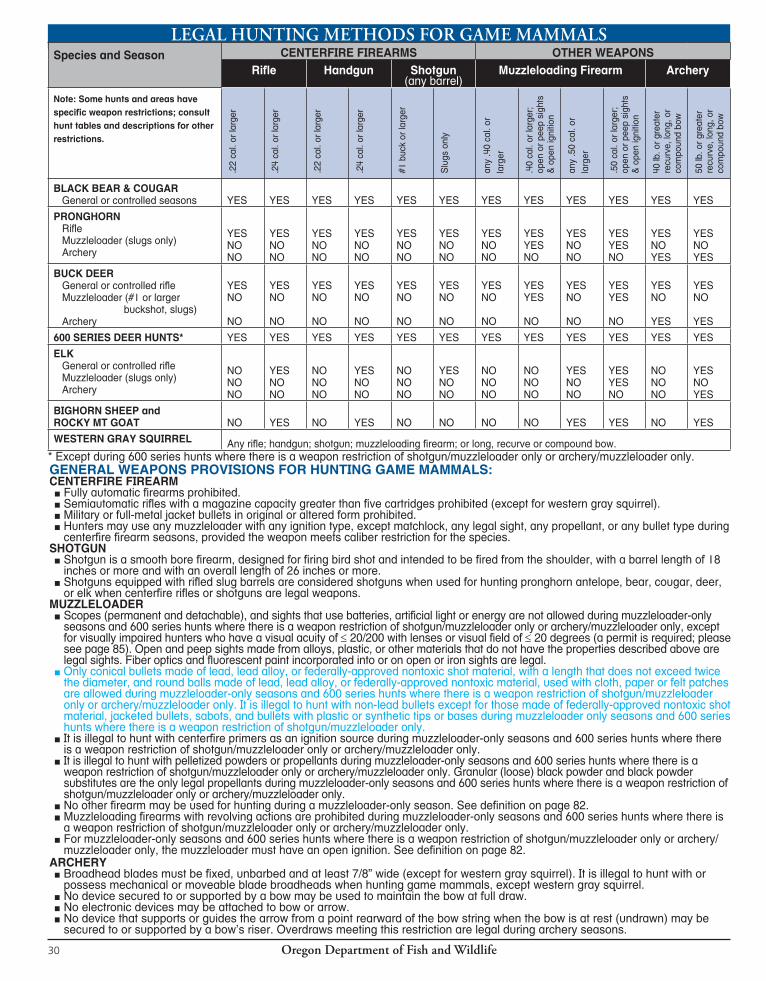
Oregon Department of Fish and Wildlife30
LEGAL HUNTING METHODS FOR GAME MAMMALS
GENERAL WEAPONS PROVISIONS FOR HUNTING GAME MAMMALS:CENTERFIRE FIREARM
■ Fully automatic firearms prohibited. ■ Semiautomatic rifles with a magazine capacity greater than five cartridges prohibited (except for western gray squirrel). ■ Military or full-metal jacket bullets in original or altered form prohibited. ■ Hunters may use any muzzleloader with any ignition type, except matchlock, any legal sight, any propellant, or any bullet type during centerfire firearm seasons, provided the weapon meets caliber restriction for the species.
SHOTGUN ■ Shotgun is a smooth bore firearm, designed for firing bird shot and intended to be fired from the shoulder, with a barrel length of 18 inches or more and with an overall length of 26 inches or more. ■ Shotguns equipped with rifled slug barrels are considered shotguns when used for hunting pronghorn antelope, bear, cougar, deer, or elk when centerfire rifles or shotguns are legal weapons.
MUZZLELOADER ■ Scopes (permanent and detachable), and sights that use batteries, artificial light or energy are not allowed during muzzleloader-only seasons and 600 series hunts where there is a weapon restriction of shotgun/muzzleloader only or archery/muzzleloader only, except for visually impaired hunters who have a visual acuity of ≤ 20/200 with lenses or visual field of ≤ 20 degrees (a permit is required; please see page 85). Open and peep sights made from alloys, plastic, or other materials that do not have the properties described above are legal sights. Fiber optics and fluorescent paint incorporated into or on open or iron sights are legal. ■ Only conical bullets made of lead, lead alloy, or federally-approved nontoxic shot material, with a length that does not exceed twice the diameter, and round balls made of lead, lead alloy, or federally-approved nontoxic material, used with cloth, paper or felt patches are allowed during muzzleloader-only seasons and 600 series hunts where there is a weapon restriction of shotgun/muzzleloader only or archery/muzzleloader only. It is illegal to hunt with non-lead bullets except for those made of federally-approved nontoxic shot material, jacketed bullets, sabots, and bullets with plastic or synthetic tips or bases during muzzleloader only seasons and 600 series hunts where there is a weapon restriction of shotgun/muzzleloader only. ■ It is illegal to hunt with centerfire primers as an ignition source during muzzleloader-only seasons and 600 series hunts where there is a weapon restriction of shotgun/muzzleloader only or archery/muzzleloader only. ■ It is illegal to hunt with pelletized powders or propellants during muzzleloader-only seasons and 600 series hunts where there is a weapon restriction of shotgun/muzzleloader only or archery/muzzleloader only. Granular (loose) black powder and black powder substitutes are the only legal propellants during muzzleloader-only seasons and 600 series hunts where there is a weapon restriction of shotgun/muzzleloader only or archery/muzzleloader only. ■ No other firearm may be used for hunting during a muzzleloader-only season. See definition on page 82. ■ Muzzleloading firearms with revolving actions are prohibited during muzzleloader-only seasons and 600 series hunts where there is a weapon restriction of shotgun/muzzleloader only or archery/muzzleloader only. ■ For muzzleloader-only seasons and 600 series hunts where there is a weapon restriction of shotgun/muzzleloader only or archery/muzzleloader only, the muzzleloader must have an open ignition. See definition on page 82.
ARCHERY ■ Broadhead blades must be fixed, unbarbed and at least 7/8” wide (except for western gray squirrel). It is illegal to hunt with or possess mechanical or moveable blade broadheads when hunting game mammals, except western gray squirrel.
■ No device secured to or supported by a bow may be used to maintain the bow at full draw. ■ No electronic devices may be attached to bow or arrow. ■ No device that supports or guides the arrow from a point rearward of the bow string when the bow is at rest (undrawn) may be secured to or supported by a bow’s riser. Overdraws meeting this restriction are legal during archery seasons.
Species and Season CENTERFIRE FIREARMS OTHER WEAPONSRifle Handgun Shotgun
(any barrel)Muzzleloading Firearm Archery
Note: Some hunts and areas have specific weapon restrictions; consult hunt tables and descriptions for other restrictions.
.22
cal.
or la
rger
.24
cal.
or la
rger
.22
cal.
or la
rger
.24
cal.
or la
rger
#1 b
uck
or la
rger
Slu
gs o
nly
any
.40
cal.
or
larg
er
.40
cal.
or la
rger
; op
en o
r pee
p si
ghts
&
ope
n ig
nitio
n
any
.50
cal.
or
larg
er
.50
cal.
or la
rger
; op
en o
r pee
p si
ghts
&
ope
n ig
nitio
n
40 lb
. or g
reat
er
recu
rve,
long
, or
com
poun
d bo
w
50 lb
. or g
reat
er
recu
rve,
long
, or
com
poun
d bo
w
BLACK BEAR & COUGAR General or controlled seasons YES YES YES YES YES YES YES YES YES YES YES YES
PRONGHORN Rifle Muzzleloader (slugs only) Archery
YESNONO
YESNONO
YESNONO
YESNONO
YESNONO
YESNONO
YESNONO
YESYESNO
YESNONO
YESYESNO
YESNOYES
YESNOYES
BUCK DEER General or controlled rifle Muzzleloader (#1 or larger buckshot, slugs) Archery
YESNO
NO
YESNO
NO
YESNO
NO
YESNO
NO
YESNO
NO
YESNO
NO
YESNO
NO
YESYES
NO
YESNO
NO
YESYES
NO
YESNO
YES
YESNO
YES
600 SERIES DEER HUNTS* YES YES YES YES YES YES YES YES YES YES YES YES
ELK General or controlled rifle Muzzleloader (slugs only) Archery
NONONO
YESNONO
NONONO
YESNONO
NONONO
YESNONO
NONONO
NONONO
YESNONO
YESYESNO
NONONO
YESNOYES
BIGHORN SHEEP and ROCKY MT GOAT NO YES NO YES NO NO NO NO YES YES NO YES
WESTERN GRAY SQUIRREL Any rifle; handgun; shotgun; muzzleloading firearm; or long, recurve or compound bow.* Except during 600 series hunts where there is a weapon restriction of shotgun/muzzleloader only or archery/muzzleloader only.
Oregon Department of Fish and Wildlife 31
PRONGHORN ANTELOPE CONTROLLED
ApplicationDeadline Date:May 15, 2014
All persons in parties that exceed the allowed party
size of two will be considered as single
applicants in the drawing.
TAG SALE DEADLINE: The day before the hunt begins.NO MORE THAN TWO PERSONS MAY APPLY AS A PARTY FOR PRONGHORN ANTELOPE.CONTROLLED HUNT APPLICATION PROCEDURES: Please read pages 13-15.All pronghorn antelope hunts are controlled hunts where the number of hunters is limited and tags are awarded through a public drawing. Hunters should apply for more than one hunt choice. If your first choice hunt is cancelled, you will receive a postcard describing your hunt choice options. See page 15 for further information.
HUNT AREA: Entire wildlife management unit unless indicated by an asterisk(*). Please refer to HUNT DESCRIPTIONS. A map will be sent if indicated in hunt description by [MAP]. Please note additional closure areas listed on pages 96-100 that may affect your hunt area. Additionally, some private lands may be closed to all hunting.
OTHER REGULATIONS: No person shall shoot at a pronghorn antelope from a point within 50 yards of a motor vehicle including aircraft, except persons that have an “Oregon Disabilities Hunting and Fishing Permit” (see page 88).
LANDOWNER PREFERENCE TAGS: Pronghorn antelope hunts with an either-sex or a one doe or fawn bag limit occurring on a landowner’s registered property are also eligible. If an applicant is successful in
receiving a LOP pronghorn antelope tag for a hunt with an either-sex bag limit, the LOP tag is automatically issued with a bag limit of one doe or fawn.See page 19 for further information.
Note: The “2013 1st Choice Applicants” column is not in flu enced by preference points; it only in di cates the number of first choice ap-pli cants for each hunt in 2013. The Fish and Wildlife Com mis sion will not set actual tag numbers for hunts listed here until June 2014. The tag numbers shown were those allocated for 2013 or estimated for new 2014 hunts. Actual tag numbers for 2014 may be higher or lower than those listed based on population conditions.
Private lands will limit access for hunts printed in red. Do not apply unless you have access to a place to hunt.STOP
PRONGHORN ANTELOPE 2013 1ST CHOICE
HUNT # HUNT NAME BAG LIMIT OPEN SEASON 2013 TAGS APPLICANTS 435 Paulina Unit One buck pronghorn Aug. 16 - Aug. 24 16 564 436 Maury Unit One buck pronghorn Aug. 16 - Aug. 24 27 600 437 Ochoco Unit One buck pronghorn Aug. 16 - Aug. 24 94 1,974 438 Grizzly Unit One buck pronghorn Aug. 16 - Aug. 24 10 178 440 Maupin - W Biggs * One pronghorn either sex Aug. 16 - Aug. 24 5 199 443A1 Columbia Plateau No. 1* One doe or fawn pronghorn Oct. 18 - Oct. 26 33 99 443A2 Columbia Plateau No. 2* One buck pronghorn Oct. 18 - Oct. 26 11 267 445A S Fossil - Winlock* One doe or fawn pronghorn Aug. 16 - Aug. 24 11 39 446 Mur der ers Cr Unit One buck pronghorn Aug. 16 - Aug. 24 53 552 447 Northside - Ritter* One buck pronghorn Aug. 16 - Aug. 24 6 76 451A N Sumpter* One buck pronghorn Aug. 16 - Aug. 24 10 156 451B S Sumpter* One buck pronghorn Aug. 16 - Aug. 24 26 179 463 Keating Unit One buck pronghorn Aug. 16 - Aug. 24 16 287 464 Lookout Mt Unit One buck pronghorn Aug. 16 - Aug. 24 20 308 465 Beulah Unit One pronghorn either sex Aug. 16 - Aug. 24 80 1,402 466A1 Malheur Rvr Unit No. 1 One buck pronghorn Aug. 16 - Aug. 24 96 1,341 466A2 Malheur Rvr Unit No. 2 One buck pronghorn Aug. 27 - Sept. 4 94 840 466B Harney Basin* One doe or fawn pronghorn Sept. 6 - Sept. 21 66 156 467 Owyhee Unit One pronghorn either sex Aug. 16 - Aug. 24 81 1,446 468A1 Whitehorse Unit No. 1 One pronghorn either sex Aug. 16 - Aug. 24 66 1,716 468A2 Whitehorse Unit No. 2 One pronghorn either sex Aug. 27 - Sept. 4 70 1,086 469A Steens Mt* One buck pronghorn Aug. 16 - Aug. 24 124 2,072 470A E Beatys Butte* One buck pronghorn Aug. 16 - Aug. 24 93 1,914 470B W Beatys Butte* One buck pronghorn Aug. 16 - Aug. 24 57 1,551 470C Hart Mt* One buck pronghorn Sept. 13 - Sept. 19 40 3,220 471A Juniper* One buck pronghorn Aug. 16 - Aug. 24 82 2,333 472A1 Silvies Unit No. 1 One buck pronghorn Aug. 16 - Aug. 24 41 936 472A2 Silvies Unit No. 2 One buck pronghorn Aug. 27 - Sept. 4 41 721 472B Riley* One doe or fawn pronghorn Sept. 6 - Sept. 21 33 99 473A N Wagontire* One buck pronghorn Aug. 16 - Aug. 24 32 922 473B S Wagontire* One buck pronghorn Aug. 16 - Aug. 24 21 786 474A Warner Unit No.1 One buck pronghorn Aug. 16 - Aug. 24 66 1,340 474B Warner Unit No. 2 One buck pronghorn Aug. 27 - Sept. 4 67 1,093 475A1 E Interstate No. 1* One pronghorn either sex Aug. 16 - Aug. 24 27 353 475A2 E Interstate No. 2* One doe or fawn pronghorn Aug. 27 - Sept. 4 44 104 476A E Fort Rock-Silver Lake* One pronghorn either sex Aug. 16 - Aug. 24 38 429
PR
ON
GH
OR
NP
ages 31-33“
AV
OI
D
TH
E
FE
E”
M
AN
DA
TO
RY
R
EP
OR
TI
NG
R
EQ
UI
RE
D
SE
E
PA
GE
6
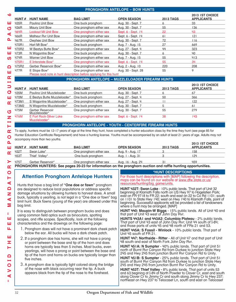
Oregon Department of Fish and Wildlife32
PRONGHORN ANTELOPE – BOW HUNTS 2013 1ST CHOICE
HUNT # HUNT NAME BAG LIMIT OPEN SEASON 2013 TAGS APPLICANTS 435R Paulina Unit Bow One buck pronghorn Aug. 30 - Sept. 7 6 33 436R Maury Unit Bow One pronghorn either sex Aug. 30 - Sept. 7 55 136 464R Lookout Mt Unit Bow One pronghorn either sex Sept. 6 - Sept. 14 22 43 466R Malheur Rvr Unit Bow One pronghorn either sex Sept. 6 - Sept. 14 61 121 467R Owyhee Unit Bow One pronghorn either sex Aug. 30 - Sept. 7 72 116 470R1 Hart Mt Bow* One buck pronghorn Aug. 7 - Aug. 15 27 669 470R2 W Beatys Butte Bow* One pronghorn either sex Aug. 27 - Sept. 4 44 323 473R N Wagontire Bow* One buck pronghorn Aug. 30 - Sept. 7 6 40 474R Warner Unit Bow One pronghorn either sex Aug. 7 - Aug. 15 55 413 475R1 E Interstate Bow* One pronghorn either sex Sept. 6 - Sept. 14 55 34 475R2 Gerber Reservoir Bow* One pronghorn either sex Aug. 2 - Aug. 10 220 208 477R E Slope Bow* One pronghorn either sex Aug. 30 - Sept. 28 55 9 Please read note in hunt description before applying for this hunt
PRONGHORN ANTELOPE – MUZZLELOADER FIREARM HUNTS 2013 1ST CHOICE
HUNT # HUNT NAME BAG LIMIT OPEN SEASON 2013 TAGS APPLICANTS 435M Paulina Unit Muzzleloader One buck pronghorn Aug. 30 - Sept. 7 6 67 470M E Beatys Butte Muzzleloader* One buck pronghorn Aug. 27 - Sept. 4 50 366 473M1 S Wagontire Muzzleloader* One pronghorn either sex Aug. 27 - Sept. 4 11 122 473M2 N Wagontire Muzzleloader* One buck pronghorn Aug. 30 - Sept. 7 5 61 475M Gerber Reservoir One pronghorn either sex Aug. 30 - Sept. 7 55 279 Muzzleloader* 476M E Fort Rock-Silver Lake One pronghorn either sex Sept. 6 - Sept. 14 38 143 Muzzleloader*
PRONGHORN ANTELOPE - YOUTH - CENTERFIRE FIREARM HUNTSTo apply, hunters must be 12-17 years of age at the time they hunt, have completed a hunter education class by the time they hunt (see page 85 for Hunter Education Certificate Requirement) and have a hunting license. Youths must be accompanied by an adult at least 21 years of age. Adults may not accompany more than two youths.
2013 1ST CHOICEHUNT # HUNT NAME BAG LIMIT OPEN SEASON 2013 TAGS APPLICANTS 432T Swan Lake* One pronghorn either sex Aug. 9 - Aug. 17 3 158 453T Thief Valley* One buck pronghorn Aug. 1 - Aug. 31 3 124
475T Gerber Reservoir* One pronghorn either sex Aug. 16 - Aug. 24 31 459 PRONGHORN HUNTERS: See pages 20-23 for information on the pronghorn auction and raffle hunting opportunities.
Attention Pronghorn Antelope Hunters
Hunts that have a bag limit of “One doe or fawn” pronghorn are designed to reduce local populations or address specific damage situations by allowing hunters to harvest does. A small buck, typically a yearling, is not legal in a “One doe or fawn” bag limit hunt. Buck fawns (young of the year) are allowed under this bag limit.
It is easy to distinguish between pronghorn bucks and does using common field optics such as binoculars, spotting scopes, and rifle scopes. Specifically, look at the following characteristics and the drawings on the following page:
1. Pronghorn does will not have a prominent dark cheek patch below the ear. All bucks will have a dark cheek patch.
2. If a pronghorn doe has horns, she will not have a prong or point between the base and tip of the horn and does horns are typically less than 5 inches. Most bucks, even yearlings, will have a prong or point between the base and tip of the horn and horns on bucks are typically longer than five inches.
3. A pronghorn doe is typically light colored along the bridge of the nose with black occurring near the tip. A buck appears black from the tip of the nose to the forehead.
*HUNT DESCRIPTIONSFor those hunt descriptions with [MAP] following the description, maps can be found on our website at www.dfw.state.or.us/resources/hunting/big_game/units.HUNT 432T: Swan Lake - 10% public lands. That part of Unit 32 beginning at Klamath Falls north on US Hwy 97 to Hagelstien Park; east on FR 9718 to FR 22; south and east on 22 to Co Rd 1101; south on 1101 to State Hwy 140; west on Hwy 140 to Klamath Falls, point of beginning. Successful applicants will be provided a list of landowners where a hunt may be arranged. [MAP]HUNT 440: Maupin-W Biggs - 15% public lands. All of Unit 40 and that part of Unit 43 west of John Day Rvr.HUNTS 443A1 and 443A2: Columbia Plateau - 2% pub lic lands. That part of Unit 43 east of John Day Rvr; Unit 44 south of I-84; and those parts of units 45 and 48 north of FRs 21 and 53.HUNT 445A: S Fossil - Winlock - 10% public lands. That part of Unit 45 south of FR 21.HUNT 447: Northside - Ritter - All of Unit 47 and that part of Unit 48 south and east of North Fork John Day Rvr. HUNT 451A: N Sumpter - 40% pub lic lands. That part of Unit 51 north of Burnt Rvr Canyon Rd from Durkee to junction State Hwy 245 and Hwy 245 from junction Burnt Rvr Canyon Rd to Unity.HUNT 451B: S Sumpter - 25% pub lic lands. That part of Unit 51 south of Burnt Rvr Canyon Rd from Durkee to junction State Hwy 245 and Hwy 245 from junction Burnt Rvr Canyon Rd to Unity.HUNT 453T: Thief Valley - 8% public lands. That part of units 53 and 63 begining at I-84 at North Powder to Clover Cr, east and south along Clover Cr to Jimmy Cr and south along Jimmy Cr to Hwy 237; northeast on Hwy 237 to Telocaset Ln, south and east on Telocaset “
AV
OI
D
TH
E
FE
E”
M
AN
DA
TO
RY
R
EP
OR
TI
NG
R
EQ
UI
RE
D
SE
E
PA
GE
6
Oregon Department of Fish and Wildlife 33
Ln to Hwy 203; south and west on Hwy 203 to I-84 (approx. 5 mi. north of Baker City), north on I-84 to point of beginning. HUNT 466B: Harney Basin - 45% public lands. Parts of units 66, 69, 71 and 72 as follows: In Unit 66, that part south and west of the following line: Beginning at the intersection of US Hwy 395 and 500 KV Powerline 6 mi north of Burns; east on 500 KV Powerline to its intersection with US Hwy 20 about 1 mi northeast of Buchanan; southeast on Hwy 20 to Buchanan; south on Crane-Buchanan Rd to State Hwy 78 near Crane, the Unit boundary. In Unit 69, that part north of the following line: Beginning at State Hwy 78 near Princeton, west on Co Rd 404 to Co Rd 405 (Sodhouse Ln); west on 405 to State Hwy 205 near The Narrows. In Unit 71, that part north of the following line: Beginning on US Hwy 395 near MP 17 (T26S, R25E, SW corner of Section 2); east on Iron Mt Rd to Double O Rd; east on Double O Rd to State Hwy 205. Excluding Malheur NWR. In Unit 72, that part south and east of the following line: Beginning at the intersection of US Hwy 395 and 500 KV Powerline 6 mi north of Burns; southwest on 500 KV Powerline to its intersection with US Hwy 20/US Hwy 395 near MP 117 west of Burns. [MAP]HUNT 469A: Steens Mt - 80% public lands. All of Unit 69 excluding Malheur NWR.HUNTS 470A and 470M: E Beatys Butte - 85% public lands. That part of Unit 70, east of the fol low ing: Beginning at Nevada-Oregon line at East Guano Valley Rim; north on East Guano Valley Rim to State Hwy 140; west on Hwy 140 to Lakeview BLM Rd 6176-00; north on 6176-00 to Lakeview BLM Rd 6176-1-K; northwest 6176-1-K to Hart Mt NAR bound ary; north on refuge boundary to Frenchglen-Plush Rd.
HUNTS 470B and 470R2: W Beatys Butte - 95% public lands. That part of Unit 70, exclud ing Hart Mt NAR, west of the fol low ing: Beginning at Nevada-Oregon line at East Guano Valley Rim; north on East Guano Valley Rim to State Hwy 140; west on Hwy 140 to Lakeview BLM Rd 6176-00; north on 6176-00 to Lakeview BLM Rd 6176-1-K; northwest 6176-1-5 to Hart Mt NAR bound-ary; north on ref uge boundary to Frenchglen-Plush Rd.HUNTS 470C and 470R1: Hart Mt - 98% public lands. Posted parts of units 70 and 71 within Hart Mt NAR. Notice: Within the refuge boundary are scattered private inholdings; landowner permission is required to hunt these private inholdings. Please be advised that refuge staff conduct prescribed fires for improvement of wildlife habitat between Aug. 1 and Nov. 15. Every effort will be made to minimize impacts to hunts from burning. Check at headquarters for further information (541-947-2731). HUNT 471A: Juniper - 90% pub lic lands. All of Unit 71, ex clud ing Hart Mt NAR and that part of Malheur NWR north of Foster Flat Rd. HUNT 472B: Riley - 65% public lands. Beginning at the junction of US Hwy 20 and Mayo Ranch Rd near MP 96; north and east on Mayo Ranch Rd and Best Ln to Silver Creek Rd (Harney Co Rd 138); north on Silver Creek Rd to FR 4130; east on 4130 to FR 4135 near Egypt Well; south on 4135, 4120 and 4126 to Forest boundary; east and south on Forest boundary to N Sagehen Hill Rd; south on N Sagehen Hill Rd to US Hwy 20; west on Hwy 20 to Mayo Ranch, point of beginning. [MAP]HUNT 473A, 473R and 473M2: N Wagontire - 80% public lands. That part of Unit 73 north of Lk Co Rd 5-14.
HUNTS 473B and 473M1: S Wagontire - 95% pub lic lands. That part of Unit 73 south of Lk Co Rd 5-14.HUNTS 475A1, 475A2 and 475R1: E Interstate - 60% public lands. That part of Unit 75 east of Klamath-Lake Co line.HUNTS 475R2, 475M and 475T: Gerber Reservoir - 75% public lands. That part of Unit 75 west of Kla math-Lake Co line; that part of Unit 33 southeast of FR 44 (Lone Pine to Teddy Power’s Meadow); and that part of Unit 32 east of the following line: Starting at Beatty; south west on Hwy 140 to Bly Mt Cutoff Rd to Bonanza; west on Hwy 70 to Dairy; west on Hwy 140 to Crystal Springs Rd; south on Crystal Springs Rd to Hill Rd; south on Hill Rd to town of Merrill; south on South Merrill Rd to STateline Rd; east on Stateline Rd to Klamath-Interstate unit boundary. Note: 475T is for youths only (ages 12-17). [MAP] HUNTS 476A and 476M: E Fort Rock-Silver Lake - 70% public lands. All of Unit 76 and that part of Unit 77 east of the Klamath-Lake Co line.HUNT 477R: E Slope - 44% public lands. Do not apply for these hunts unless you are familiar with the following circumstances. Pronghorn antelope are found using timbered areas and are very difficult to find. Hunter success is low. Beginning at Diamond Lk junction; west on State Hwy 138 to Crater Lk NP boundary; south on NP boundary to 2304; southeast on 2304 to 2300, southwest on 2300 to 9740; southeast on 9740 to US Hwy 97; south on Hwy 97 to 43; north and east on 43 to Klamath Marsh Rd; north on Klamath Marsh Rd to 86; north and west on 86 to US Hwy 97; south on Hwy 97 to Diamond Lk junction, point of beginning, excluding Klamath Marsh NWR. [MAP]
PR
ON
GH
OR
NP
ages 31-33
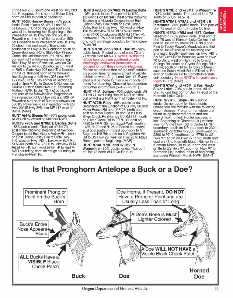
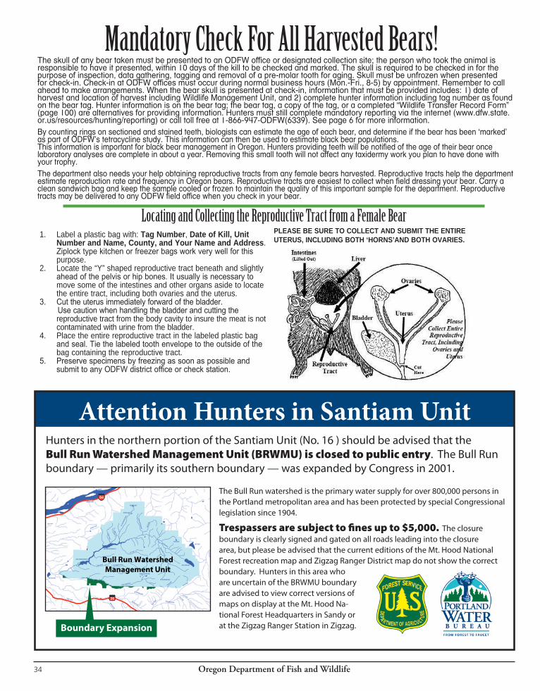
Oregon Department of Fish and Wildlife34
The skull of any bear taken must be presented to an ODFW office or designated collection site; the person who took the animal is responsible to have it presented, within 10 days of the kill to be checked and marked. The skull is required to be checked in for the purpose of inspection, data gathering, tagging and removal of a pre-molar tooth for aging. Skull must be unfrozen when presented for check-in. Check-in at ODFW offices must occur during normal business hours (Mon.-Fri., 8-5) by appointment. Remember to call ahead to make arrangements. When the bear skull is presented at check-in, information that must be provided includes: 1) date of harvest and location of harvest including Wildlife Management Unit, and 2) complete hunter information including tag number as found on the bear tag. Hunter information is on the bear tag; the bear tag, a copy of the tag, or a completed “Wildlife Transfer Record Form” (page 100) are alternatives for providing information. Hunters must still complete mandatory reporting via the internet (www.dfw.state.or.us/resources/hunting/reporting) or call toll free at 1-866-947-ODFW(6339). See page 6 for more information. By counting rings on sectioned and stained teeth, biologists can estimate the age of each bear, and determine if the bear has been ‘marked’ as part of ODFW’s tetracycline study. This information can then be used to estimate black bear populations. This information is important for black bear management in Oregon. Hunters providing teeth will be notified of the age of their bear once laboratory analyses are complete in about a year. Removing this small tooth will not affect any taxidermy work you plan to have done with your trophy. The department also needs your help obtaining reproductive tracts from any female bears harvested. Reproductive tracts help the department estimate reproduction rate and frequency in Oregon bears. Reproductive tracts are easiest to collect when field dressing your bear. Carry a clean sandwich bag and keep the sample cooled or frozen to maintain the quality of this important sample for the department. Reproductive tracts may be delivered to any ODFW field office when you check in your bear.
Mandatory Check For All Harvested Bears!
1. Label a plastic bag with: Tag Number, Date of Kill, Unit Number and Name, County, and Your Name and Address. Ziplock type kitchen or freezer bags work very well for this purpose.
2. Locate the “Y” shaped reproductive tract beneath and slightly ahead of the pelvis or hip bones. It usually is necessary to move some of the intestines and other organs aside to locate the entire tract, including both ovaries and the uterus.
3. Cut the uterus immediately forward of the bladder. Use caution when handling the bladder and cutting the
reproductive tract from the body cavity to insure the meat is not contaminated with urine from the bladder.
4. Place the entire reproductive tract in the labeled plastic bag and seal. Tie the labeled tooth envelope to the outside of the bag containing the reproductive tract.
5. Preserve specimens by freezing as soon as possible and submit to any ODFW district office or check station.
Locating and Collecting the Reproductive Tract from a Female BearPLEASE BE SURE TO COLLECT AND SUBMIT THE ENTIRE UTERUS, INCLUDING BOTH ‘HORNS’AND BOTH OVARIES.
BULL RUN LAKE
LOST LAKE
BULL RUN RESERVOIR #2
BULL RUN RESERVOIR #1
ROSLYN LAKE
BENSON LAKE
BLUE LAKE
HICKMAN LAKE
PALMER LAKE
GOODFELLOW LAKES
BOODY LAKE
Bull Run River
Cedar Creek
Little Sandy River
Gordon Creek
Fir Creek
Big Creek
Lost Creek
Clear Fork
S. Fork Bull Run River
Clear Creek
Blazed Alder Creek
Falls
Cree
k
Hackett Creek
Deer Creek
N. For
k Bull
Run R
iver
Wildcat Creek
W. Branch Falls Creek
Clear Creek
Horseshoe Creek
N. Boulder Creek
Cougar Creek
Cast Creek
Cedar Creek
Bull Run WatershedManagement Unit
84
26
Hunters in the northern portion of the Santiam Unit (No. 16 ) should be advised that the Bull Run Watershed Management Unit (BRWMU) is closed to public entry. The Bull Run boundary — primarily its southern boundary — was expanded by Congress in 2001.
Attention Hunters in Santiam Unit
The Bull Run watershed is the primary water supply for over 800,000 persons in the Portland metropolitan area and has been protected by special Congressional legislation since 1904.
Trespassers are subject to �nes up to $5,000. The closure boundary is clearly signed and gated on all roads leading into the closure area, but please be advised that the current editions of the Mt. Hood National Forest recreation map and Zigzag Ranger District map do not show the correct boundary. Hunters in this area who are uncertain of the BRWMU boundary are advised to view correct versions of maps on display at the Mt. Hood Na-tional Forest Headquarters in Sandy or at the Zigzag Ranger Station in Zigzag. Boundary Expansion
Oregon Department of Fish and Wildlife 35
BLACKBEAR-CONTROLLEDTAG SALE DEADLINE: The day before the hunt begins.CONTROLLED HUNT APPLICATION PROCEDURES: Please read pages 13-15.All spring black bear hunts are controlled hunts where the number of hunters is limited and tags are awarded through a public drawing, except the new limited SW Oregon first-come, first-served spring black bear hunt.BAG LIMIT: One black bear, except that it is unlawful to take cubs less than one year old or sows with cubs less than one year old.HUNT AREA: Entire wildlife management unit unless indicated by an asterisk(*). Please refer to HUNT DESCRIPTIONS BELOW. Please note additional closure areas listed on pages 96-100 that may affect your hunt area.REGULATIONS: Using bait to attract black bear and using dogs to locate and tree black bear is prohibited. Applying a scent or attractant to one’s body or clothing while worn is not baiting.The skull of any bear taken must be presented to an ODFW office or designated collection site; the person who took the animal is responsible to have it presented, within 10 days of the kill to be checked and marked. The skull is required to be checked in for the purpose of inspection, data gathering, tagging and removal of a pre-molar tooth for aging. Skull must be unfrozen when presented for check-in. Check-in at ODFW offices must occur during normal business hours (Mon.-Fri., 8-5) by appointment. Remember to call ahead to make arrangements. When the bear skull is presented at check-in, information that must be provided includes: 1) date of harvest and location of harvest including Wildlife Management Unit, and 2) complete hunter information including tag number as found on the bear tag. Hunter information is on the bear tag; the bear tag, a copy of the tag, or a completed “Wildlife Transfer Record Form” (page 100) are alternatives for providing information. Hunters must still complete mandatory reporting via the
internet (www.dfw.state.or.us/resources/hunting/reporting) or call toll free at 1-866-947-ODFW(6339). See page 6 for more information. NOTE: The “2013 1st Choice Applicants” column is not influenced by preference points; it only indicates the number of first choice applicants for each hunt. Successful individuals may also purchase a 2014 general season black bear tag and a 2014 SW Additional bear tag. Controlled black bear tags not drawn in the February drawing will be sold first-come, first-served beginning Mar. 15 at 10 a.m. Tags purchased in this manner are in addition to other bear tags purchased. Hunters purchasing a SW Oregon spring bear tag prior to the drawing will not be eligible to apply for other controlled spring bear tags or utilize the Point Saver option for spring bear hunts. Hunters planning to apply for other controlled spring bear hunts or a Point Saver should wait until after the drawing to purchase a SW Oregon spring bear tag. Please note there is a limited number of SW Oregon spring bear tags available.NOTE: The number of tags issued to nonresidents will be limited to no more than 3% of the total tags authorized for each hunt.
CONTROLLEDApplication
Deadline Date:Feb. 10, 2014
Applicants may apply singly or as a party
of no more than six persons.
Private lands will limit access for hunts printed in red. Do not apply unless you have access to a place to hunt.STOP
CONTROLLED SPRING BLACK BEAR HUNTS 2013 1ST CHOICE
HUNT # HUNT NAME OPEN SEASON 2014 TAGS 2013 TAGS APPLICANTS 710A Saddle Mt - Scappoose* Apr. 1 - May 31 165 165 73 712A Wilson-Trask* Apr. 1 - May 31 440 440 343 716A N Cascades* Apr. 1 - May 31 385 385 276 717A Alsea-Stott Mt* Apr. 1 - May 31 212 212 397 731A South Central* Apr. 15 - May 31 220 220 109 741 White River Unit Apr. 1 - May 31 80 54 214 742 Hood Unit Apr. 1 - May 31 80 54 73 746A S Blue Mts* Apr. 15 - May 31 550 550 512 749A W Blue Mts* Apr. 1 - May 31 210 212 1,362 752A Starkey* Apr. 15 - May 31 220 220 159 756 Wenaha Unit Apr. 15 - May 31 248 248 417 757A Sled Springs-Chesnimnus* Apr. 15 - May 31 275 273 674 759A Snake Rvr Unit Apr. 15 - May 31 440 440 631 760A Minam-Imnaha* Apr. 15 - May 31 248 248 375 762A Pine Cr-Keating-Catherine Cr* Apr. 15 - May 31 440 440 710 764 Lookout Mt Unit Apr. 15 - May 31 43 44 93
LIMITED FIRST-COME, FIRST-SERVED SPRING BLACK BEAR HUNTHUNT NAME OPEN SEASON 2014 TAGS SW Oregon* Apr. 1 - May 31 4,400 (Tags will be available on a first-come, first-served basis. See hunt description below)
CONTROLLED SPRING BLACK BEAR HUNTS FOR YOUTHSTo apply, hunters must be 12-17 years old at the time they hunt, have completed Hunter Education class by the time they hunt (see page 85 for Hunter Education Requirements) and have a hunting license. Youths must be accompanied by an adult at least 21 years of age. Adults may not accompany more than two youths.
2013 1ST CHOICEHUNT # HUNT NAME OPEN SEASON 2014 TAGS 2013 TAGS APPLICANTS 756T Wenaha Unit Apr. 15 - May 31 55 55 48 757T Sled Springs-Chesnimnus* Apr. 15 - May 31 88 88 75 760T Minam-Imnaha* Apr. 15 - May 31 54 55 37
HUNT 710: Saddle Mt - Scappoose - All of units 10 and 11.HUNT 712A: Wilson-Trask - All of units 12 and 14. There are specific weapon restrictions in the Cascade Head - Lincoln City area of the Trask Unit. See page 98. HUNT 716A: N Cascades - All of Unit 16 excluding the Marion and Linn Co portion outside of the USFS lands: the McKenzie Unit excluding the Linn Co portion outside of the Willamette NF. HUNT 717A: Alsea-Stott Mt - All of units 17 and 18. There are specific weapon restrictions in the Cascade Head - Lincoln City area of the Stott Mt Unit. See page 98.
SW Oregon - All of units 20, 21, 22, 23, 24, 25, 26, 27, 28, 29 and 30. Exception: Lands within 1 mi of Rogue Rvr between Grave Cr and Lobster Cr are closed to bear hunting. Tags will be available on a limited first-come, first-served basis from Dec. 1 through March 31, or until the authorized number of tags are sold, whichever comes first. Note: Purchasing this tag prior to the drawing eliminates your ability to apply for other controlled spring bear tags or point savers. Please refer to note section above. HUNT 731A: South Central - All of units 31, 32, 33, 74, 75, 76 and 77.
HUNT 746A: S Blue Mts - 64% public lands. All of units 45, 46, 47, 48, 50, 51, 65, 66 and 72.HUNT 749A: W Blue Mts - All of units 49, 54 and 55.HUNT 752A: Starkey - 67% public lands. All of Unit 52 except the Starkey Experimental Forest and Range fenced enclosure and a 1/4-mi buffer outside the exterior 8-ft fence.HUNTS 757A and 757T: Sled Springs-Chesnimnus - All of units 57 and 58.HUNTS 760A and 760T: Minam-Imnaha - All of units 60 and 61.HUNT 762A: Pine Cr - Keating - Catherine Cr - All of units 53, 62 and 63.
* HUNT DESCRIPTIONS
BLA
CK
BE
AR
Pages 35-37
“A
VO
ID
T
HE
F
EE
”
MA
ND
AT
OR
Y
RE
PO
RT
IN
G
RE
QU
IR
ED
S
EE
P
AG
E
6
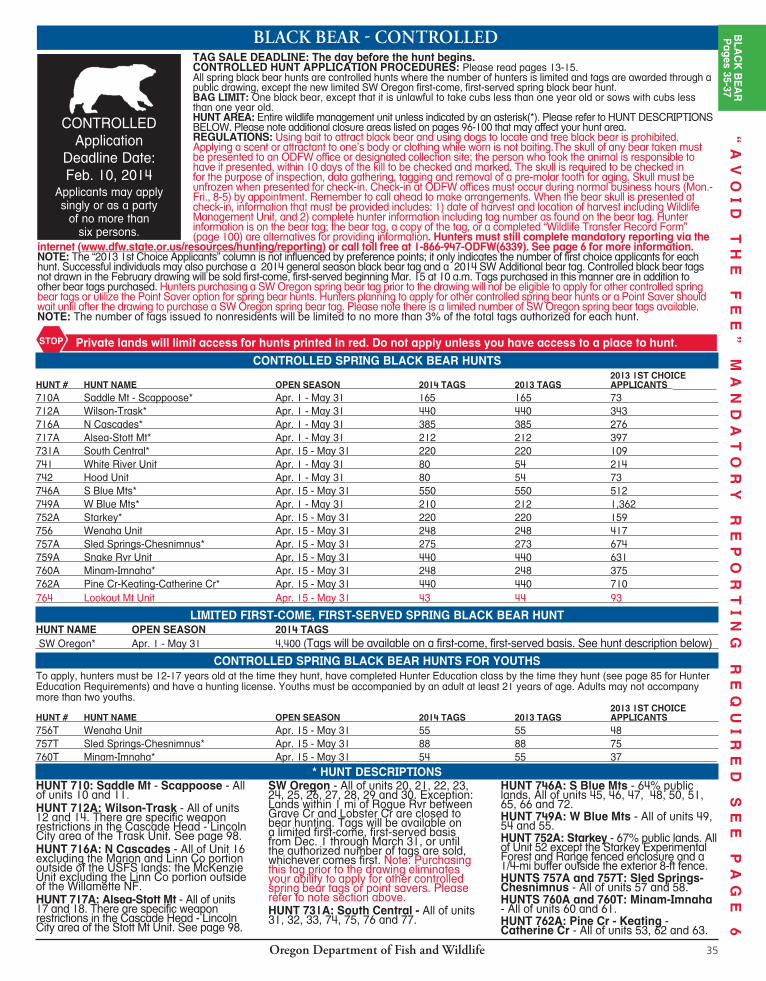

Oregon Department of Fish and Wildlife36
BLACKBEAR-GENERALOPEN SEASON - Western Oregon: Aug. 1 - Dec. 31 - All units west of the eastern boundaries of Santiam, McKenzie, Indigo, Dixon and Rogue units except those lands within one mi of Rogue Rvr between Grave Cr and Lobster Cr, which are closed. OPEN SEASON - Eastern Oregon: Aug. 1 - Nov. 30 - All units east of the eastern boundaries of Santiam, McKenzie, Indigo, Dixon and Rogue units. Southwest Oregon Additional Bear: Aug. 1- Dec. 31 - (all of units 20-30) (Requires a resident SW Additional; a nonresident SW Additional; or a nonresident Cascade Additional bear tag. See next page for units with nonresident tags). An “additional” tag may be purchased throughout the season; however, hunters must purchase the general season tag (see tag sale deadlines on page 9) to be eligible for the additional tag.BAG LIMIT: One black bear per tag, except that it is unlawful to take cubs less than one year old or sows with cubs less than one year old.Note: Nonresident tags are valid for only one of the areas listed on the next page under Nonresident Black Bear Tag Limitations.
OTHER REGULATIONS:Using bait to attract black bear and using dogs to locate and tree black bear is prohibited. Applying a scent or attractant to one’s body or clothing while worn is not baiting.The skull of any bear taken must be presented to an ODFW office or designated collection site; the person who took the animal is responsible to have it presented, within 10 days of the kill to be checked and marked. The skull is required to be checked in for the purpose of inspection, data gathering, tagging and removal of a pre-molar tooth for aging. Skull must be unfrozen when presented for check-in. Check-in at ODFW offices must occur during normal business hours (Mon.-Fri., 8-5) by appointment. Remember to call ahead to make arrangements. When the bear skull is presented at check-in, information that must be provided includes: 1) date of harvest and location of harvest including Wildlife Management Unit, and 2) complete hunter information including tag number as found on the bear tag. Hunter information is on the bear tag; the bear tag, a copy of the tag, or a completed “Wildlife Transfer Record Form” (page 100) are alternatives for providing information. Hunters must still complete mandatory reporting via the internet (www.dfw.state.or.us/resources/hunting/reporting) or call toll free at 1-866-947-ODFW(6339). See page 6 for more information. There are specific weapon restrictions in parts of the hunt area. See page 98-100.
■ Persons may harvest one black bear during specified seasons with a general season black bear tag, one black bear with a SW Additional bear tag, one black bear with a controlled or SW limited spring bear tag and one black bear with a leftover controlled spring bear tag (see page 14), if available. ■ It is unlawful to hunt with a centerfire or muzzleloading rifle without a valid unused deer or elk tag for that time period and area on your person (see exceptions) during: standard Eastern Oregon con trolled buck deer centerfire firearm season (Oct. 4 -Oct. 15), Cascade bull elk centerfire firearm season, Coast bull elk 1st and 2nd centerfire firearm seasons both General and Controlled or Rocky Mt bull elk or either sex centerfire firearm seasons or standard Rocky Mt antlerless elk centerfire firearm seasons (Nov. 22 - Nov. 30). This does not include the controlled W High Cascade (119A) or Hood-White Rvr (141A) buck hunts. EX CEP TIONS: (1) Hunters who have a tag for one of the hunts listed above may continue to hunt bear and/or cougar within the time period and area for which their deer or elk tag is valid (used or unused) provided they have a valid, unused bear and/or cougar tag; used deer or elk tags must be on the tagged animal and not on the hunters person. (2) Hunters are not required to have an elk tag to hunt bear or cougar in the Applegate WMU during elk seasons.
GENERALTag Sale
Deadline Date:Oct. 3, 2014
SANTIAM16
WHITEHORSE68
JUNIPER71
BEULAH65
OWYHEE67
ALSEA18
INDIGO21
PAULINA35
MCKENZIE19
WAGONTIRE73
TIOGA24
DIXON22
SILVIES72
GRIZZLY38
CHETCO27
ROGUE30
KENO31
INTERSTATE75
OCHOCO37
MALHEUR RIVER66
BEATYS BUTTE70
SIUSLAW20
SIXES25
SUMPTER51
MAURY36
FORT ROCK77
APPLEGATE28
WARNER74
NORTHSIDE47
SPRAGUE33
SILVER LAKE76
EVANS CREEK29
METOLIUS39
MURDERERS CR46
BIGGS43WILLAMETTE
15
FOSSIL45
TRASK14
COLUMBIA BASIN44
HEPPNER48
UKIAH49
STEENSMTN69
MEL
ROSE
23
POWERS26
STARKEY52
MINAM60
KLAMATH FALLS32
WILSON12
WHITERIVER
41
UPPER
DESCHUTES
34
KEATING63
MAUPIN40
HOOD42
SLEDSPRINGS
57SCAP
POO
SE11
MTEMILY
54
IMNAHA61
DESOLATION50
CH
ESNIM
NU
S
58
SADDLE MTN10 WENAHA
56
WARMSPRINGS
INDIANRES.
CATH
ERIN
E CR
53
SNAKERIVER
59
PINECREEK
62STOTT MTN
17
LOOKOUTMTN
64
WALLAWALLA
55
CRATERLAKEN.P.
UMATILLA INDIANRESERVATION
Western OregonAug. 1 - Dec. 31
SW Additional BearAug. 1 - Dec. 31
Eastern OregonAug. 1 - Nov. 30
There are no hunting seasons on NP lands or allotted and/or Tribal lands in these areas.
“A
VO
ID
T
HE
F
EE
”
MA
ND
AT
OR
Y
RE
PO
RT
IN
G
RE
QU
IR
ED
S
EE
P
AG
E
6
Oregon Department of Fish and Wildlife 37
NONRESIDENT BLACK BEAR TAG AREASThe number of limited, con trolled hunt, and general season tags issued to nonresident black bear hunters is limited to no more than 3% of all tags.
For general black bear season (including the additional bear tags), the 3% nonresident limit is based on the previous year’s general season black bear hunter distribution patterns by areas throughout the state. In 2014, non res i dent black bear tag sales will be limited in four areas: Northwest, South west, Cascades and Eastern. The number of tags available by area, along with area de scrip tions, for the 2014 season are listed below.
Nonresident hunters who wish to hunt in general black bear seasons may pur chase their black bear tags at any license agent, via the internet, or by mail, if postmarked not later than Oct. 3 (or fax for credit card purchases). The additional tag may be purchased throughout the season; however, hunters must purchase the general season tag prior to the deadline to be eligible to purchase an additional tag. Tags will be issued on a first-come, first-served basis until gone. Ap pli cants should list pre ferred hunting areas in order of priority (see area descriptions below). If you do not receive your first choice, you may receive your second or later choice depending on how many tags remain available at the time of application. Please list only areas where you are willing to hunt.
Area Descriptions/Tag Numbers:
■ Northwest: All of units 10-12, 14, 15, 17, 18. (Number of tags: 263)
■ Southwest: All of units 20 and 23-29. (Number of tags: 328)
■ Cascades: All of units 16, 19, 21, 22, 30, 31, 34, 39, 41, 42 and those portions of units 33 and 77 west of U.S. Hwy 97. (Number of tags: 466)
■ Eastern: All of units 32, 35, 38, 40, 43 and those portions of units 33 and 77 east of U.S. Hwy 97; and all other units east of these units. (Number of tags: 463)
APPLICATION PROCEDURE FOR NONRESIDENTS1. Applicants must provide the following information: full name, current address, date of birth, Social Security number, Angler/Hunter
I.D. (if known) and tele phone number. (See page 17 for mail order form).
2. Applicants must include fees of $182.50 per tag and $140.50 for a non res i dent hunting license (if not already purchased), with the ap pli ca tion.
3. Applicants shall specify areas for which they are applying in order of choice. Nonresident bear hunters may obtain one general season nonresident bear tag for a specified area and one additional nonresident bear tag valid for specified areas of southwest Oregon.
Cascade Additional Nonresident Bear Tag
SW Additional Nonresident Bear Tag
Photo by Don Whittaker
EASTERNAREA
CASCADE AREANW AREA
SW AREA
CASCADE AREA
SANTIAM16
WHITEHORSE68
JUNIPER71
BEULAH65
OWYHEE67
ALSEA18
INDIGO21
PAULINA35
MCKENZIE19
WAGONTIRE73
TIOGA24
DIXON22
SILVIES72
GRIZZLY38
CHETCO27
ROGUE30
KENO31
INTERSTATE75
OCHOCO37
MALHEUR RIVER66
BEATYS BUTTE70
SIUSLAW20
SIXES25
SUMPTER51
MAURY36
FORT ROCK77
APPLEGATE28
WARNER74
NORTHSIDE47
SPRAGUE33
SILVER LAKE76
EVANS CREEK29
METOLIUS39
MURDERERS CR46
BIGGS43WILLAMETTE
15
FOSSIL45
TRASK14
COLUMBIA BASIN44
HEPPNER48
UKIAH49
STEENSMTN69
MEL
ROSE
23
POWERS26
STARKEY52
MINAM60
KLAMATH FALLS32
WILSON12
WHITERIVER
41
UPPER
DESCHUTES
34
KEATING63
MAUPIN40
HOOD42
SLEDSPRINGS
57SCAP
POO
SE11
MTEMILY
54
IMNAHA61
DESOLATION50
CH
ESNIM
NU
S
58
SADDLE MTN10 WENAHA
56
WARMSPRINGS
INDIANRES.
CATH
ERIN
E CR
53
SNAKERIVER
59
PINECREEK
62STOTT MTN 17
LOOKOUTMTN
64
WALLAWALLA
55
CRATERLAKEN.P.
UMATILLA INDIANRESERVATION
APPLEGATE28
KLAMATHFALLS
32
CHETCO27
BEATYS BUTTE70
INTERSTATE75
WARNER74
KENO31
SPRAGUE33EVANS CREEK
29 WHITEHORSE68
POWERS26
SILVER LAKE76
ROGUE30
DIXON22
SIXES25
JUNIPER71 STEENS
MTN69
FORT ROCK77
TIOGA24
MELRO
SE23 WAGONTIRE
73
INDIGO21
OWYHEE67
SILVIES72
MAURY36
MALHEUR RIVER66
SIUSLAW20
PAULINA35
UPPER
DESCHUTES
34
MURDERERS CR46
MCKENZIE19
BEULAH65
OCHOCO37
METOLIUS39
NORTHSIDE47
LOOKOUTMTN 64GRIZZLY
38ALSEA
18
DESOLATION50
SUMPTER51
STOTT MTN17 KEATING
63FOSSIL
45
PINECREEK
62
MAUPIN40
STARKEY52HEPPNER
48
IMNAHA61
CATHERINE CR
53
SANTIAM16
MINAM60WILLAMETTE
15 UKIAH49
TRASK14
WHITERIVER
41
HOOD42
BIGGS43
MT EMILY54
SNAKERIVER
59
WILSON12
WALLAWALLA
55
WENAHA56 SLED
SPRINGS57
CHESNIMNUS
58
SCAPP
OOSE11
SADDLE MTN10
COLUMBIA BASIN44
UMATILLA TRIBAL RESERVATION
NW AREA
SW AREA
CASCADE AREA
CASCADE AREA
EASTERNAREA
WARM SPRINGS TRIBAL
RES.
CRATER LAKE NATIONAL PARK
Using a little information and a few precautions, you can enjoy Oregon’s wildlife lands without
causing undue damage. For useful tips, log onto
ODFW’s website at: www.dfw.state.or.us/resources/
hunting/index.asp#closures
OREGON EXPERIENCES PERIODIC DRY CONDITIONSTHAT CAN LEAD TO WILDFIRES
BLA
CK
BE
AR
Pages 35-37
HUNTERS: RETURN RADIO TRANSMITTERS
Radio transmitters used on deer, elk and other big game animals are property of ODFW. These
transmitters store valuable information and are re-usable. It is legal to harvest an animal with these transmitters. Please call your local ODFW office if you harvest an animal with a
transmitter or find a transmitter. We thank you for your
cooperation.
“A
VO
ID
T
HE
F
EE
”
MA
ND
AT
OR
Y
RE
PO
RT
IN
G
RE
QU
IR
ED
S
EE
P
AG
E
6
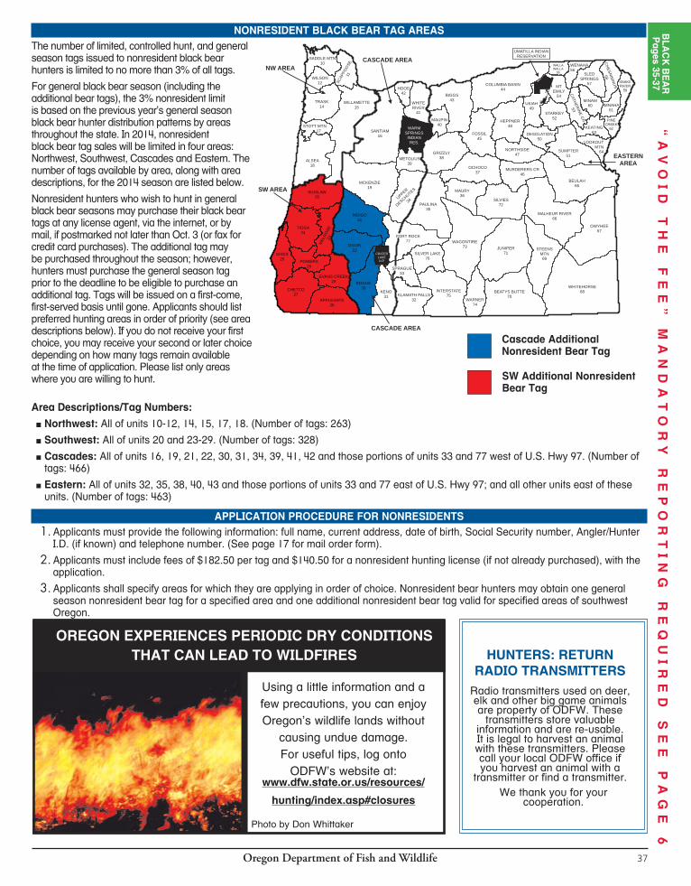
Oregon Department of Fish and Wildlife38
ROCKYMOUNTAINGOAT-CONTROLLEDTAG SALE DEADLINE: Last day of hunt. PARTY APPLICATIONS ARE NOT ALLOWED.CONTROLLED HUNT APPLICATION PROCEDURES: Please read pages 13-15.NOTE: No less than 5% and no more than 10% of all Rocky Mt goat tags can be issued to nonresidents. One Rocky Mt goat tag is estimated to be issued for 951A2 Elkhorn No 2 in 2014. All Rocky Mt goat hunts are controlled hunts where the number of hunters is limited and tags are awarded through a public drawing. A person may draw only one controlled Rocky Mt goat tag in a lifetime. The Fish and Wildlife Commission will not set actual tag numbers for hunts listed here until June 2014. Actual tag numbers for 2014 may be higher or lower than listed based on population conditions. ROCKY MT GOATS ARE LOCATED IN EXTREMELY STEEP AND RUGGED TERRAIN AT HIGHER ELEVATIONS AND HUNTERS SHOULD BE IN GOOD PHYSICAL CONDITION.BAG LIMIT: One Rocky Mt goat. Orientation class with district biologist IS required.HUNT AREA: See HUNT DESCRIPTIONS below. Please note additional closure areas listed on pages 96-100 that may affect your hunt area.OTHER REGULATIONS: Rocky Mt goats taken by hunters must be marked by ODFW personnel prior to hunters leaving the hunt area. ALL HUNTERS MUST CHECK OUT THROUGH THE LOCAL ODFW OFFICE IN THE DISTRICT WHERE THE HUNT OCCURS WITHIN 72 HOURS AFTER COMPLETING THEIR HUNT UNLESS OTHER ARRANGEMENTS HAVE BEEN MADE. Checkout must occur during normal business hours (Mon. - Fri.,
8-5) unless prior arrangements have been made.ROCKY MOUNTAIN GOAT HUNTERS: See page 21 for information on the Rocky Mountain goat raffle hunting opportunity. Nonresidents may purchase raffle tickets.
Private lands will limit access for hunts printed in red. Do not apply unless you have access to a place to hunt.STOP
ROCKY MOUNTAIN GOAT 2013 TAGS 2013 1ST CHOICEHUNT # HUNT NAME OPEN SEASON RESIDENT NONRES. APPLICANTS 946A Strawberry Mt* Sept. 6 - Oct. 19 est. 1 in 2014 NEW 951A1 Elkhorn No. 1* Sept. 13 - Sept. 21 3 2,844 951A2 Elkhorn No. 2* Sept. 22 - Sept. 30 2 est. 1 in 2014 1,573 951A3 Elkhorn No 3* Oct. 18 - Oct. 26 est. 3 in 2014 NEW 956A N Wenaha* Sept. 13 - Sept. 28 est. 1 in 2014 NEW 959A1 Hat Point No 1* Sept. 13 - Sept. 28 2 737 959A2 Hat Point No. 2* Oct. 18 - Oct. 28 2 736 959B S Snake Rvr* Sept. 13 - Sept. 28 1 531 960A1 E Hurricane Cr* Sept. 13 - Sept. 28 1 803 960A2 W Hurricane Cr* Sept. 13 - Sept. 28 1 175 960B Goat Mt* Sept. 13 - Sept. 28 1 636
CONTROLLEDApplication
Deadline Date: May 15, 2014
HUNT 946A: Strawberry Mt - 65% public lands. That part of Unit 46 east of US Hwy 395.HUNTS 951A1, 951A2 and 951A3: Elkhorn - 45% public lands. All of Unit 51. HUNT 956A: N Wenaha - 100% public lands. That portion of Unit 56 within the Wenaha-Tucannon Wilderness; north of the Wenaha Rvr and west of Butte Cr. HUNTS 959A1 and 959A2: Hat Point - 95% public lands. That part of unit 59 north of Freezeout Creek Rd 4230 and Saddle Creek Trail 1776.
HUNT 959B: S Snake Rvr - 95% public lands. That part of unit 59 south of Freezeout Cr Rd 4230 and Saddle Cr Trail 1776.HUNT 960A1: E. Hurricane Cr - 100% public lands. Beginning at Wallowa Lk trailhead; south on trail 1820 to trail 1810; west on 1810 to trail 1807; north on 1807 to Hurricane Creek Rd; north on Hurricane Creek Rd to Airport Ln; east on Airport Ln to Hwy 82; south on Hwy 82 to Wallowa Lk trailhead point of beginning. HUNT 960A2: W. Hurricane Cr - 90% public lands. That part of unit 60 beginning at Lostine; south along Lostine Rvr Rd and East Fork trail
no. 1662 to trail no. 1810; north along trail no. 1810 to trail no. 1807; north along trail no. 1807 to Hurricane Cr Rd; north on Hurricane Cr Rd to Hwy 82; west on Hwy 82 to Lostine, point of beginning. HUNT 960B: Goat Mt - 95% public lands. That part of unit 60 as follows: Beginning at Boundary Campground; north on FR 040 to junction of Rd 8250; southeast on 8250 to junction of Lostine River Rd 8210; south on 8210 to Bowman Trail 1651; southwest on trail 1651 to junction of Bear Cr trail 1653; north on 1653 to Boundary Campground, point of beginning.
* HUNT DESCRIPTIONS
OregonFNAWS.org | Don South 503-647-5954 | George Houston 503-826-9109
More info:
ATTENTION ALL 2014
Workshop & Orientation
July 19, 2014 at 9am
Discovery Center & Museum | The Dalles, OR
Bighorn Sheep & Rocky Mtn Goat Tag Holders
MM
“The BEST Possible Training and Information
for Bighorn Sheep / Rocky Mtn Goat Hunters”
Oregon Department of Fish and Wildlife 39
BIGHORN SHEEP CONTROLLEDTAG SALE DEADLINE: Last day of hunt. PARTY APPLICATIONS ARE NOT ALLOWED.CONTROLLED HUNT APPLICATION PROCEDURES: Please read pages 13-15.All bighorn sheep hunts are controlled hunts where the number of hunters is limited and tags are awarded through a public drawing. You may draw only one controlled bighorn sheep ram tag in a lifetime. Hunters previously holding any Oregon bighorn sheep tag (controlled, raffle, or auction) may obtain either the bighorn raffle tag or bighorn auction tag for additional bighorn hunting opportunity. Details on purchasing raffle tickets and auction date/location are listed on pages 20-23. HUNTERS SHOULD APPLY FOR MORE THAN ONE HUNT AREA. If your first choice hunt is cancelled, you will receive a postcard describing your hunt choice options. See page 15 for further information.BAG LIMIT: One bighorn sheep ram.HUNT AREA: Entire wildlife management unit unless indicated by an asterisk (*). Please refer to HUNT DESCRIPTIONS on following page. A map will be sent out if hunt description indicates [MAP]. Please note additional closure areas listed on pages 96-100 that may affect your hunt area.
OTHER REGULATIONS: Bighorn sheep taken by hunters must have one horn marked (pinned) by ODFW personnel. ALL HUNTERS MUST CHECK OUT THROUGH THE LOCAL ODFW OFFICE IN THE DISTRICT WHERE THE HUNT OCCURS WITHIN 72 HOURS AFTER COMPLETING THEIR HUNT. Checkout must occur during normal business hours (Mon.-Fri., 8-5) unless prior arrangements have been made. Please call the local ODFW office to make arrangements for checkout. NOTE: No less than 5% and no more than 10% of all bighorn sheep tags can be issued to nonresidents. Seven bighorn sheep tags were issued to nonresidents in 2013. NONRESIDENT TAGS WILL PROBABLY BE ISSUED FOR THE FOLLOWING HUNTS IN 2014: HART MT REFUGE, E BEATY’S BUTTE/ALVORD PEAK NO 2, S CENTRAL NO 1, E. JOHNDAY RVR NO 2, W JOHN DAY RVR NO. 2, LOOKOUT MT NO. 1 and LOWER OWYHEE NO. 2. The Fish and Wildlife Commission will not set actual tag numbers for hunts listed here until June 2014. The tag numbers currently shown, for your reference, were those allocated for 2013. Actual tag numbers for 2014 may be higher or lower than those listed based on popula tion conditions.
Private lands will limit access for hunts printed in red. Do not apply unless you have access to a place to hunt.STOP
CALIFORNIA BIGHORN SHEEP 2013 TAGS 2013 1ST CHOICE APPLICANTS
HUNT # HUNT NAME OPEN SEASON RESIDENT NONRES. RESIDENT NONRES.
543A1 E John Day Rvr No. 1* (!) Oct. 18 - Oct. 26 3 627 5 543A2 E John Day Rvr No. 2* (!) Nov.3 - Nov. 11 2 1 368 309 543A3 E John Day Rvr No. 3* (!) Nov. 15 - Nov. 23 3 356 3 543A4 W John Day Rvr No. 1* (!) Oct. 18 - Oct. 26 2 227 1 543A5 W John Day Rvr No. 2* (!) Nov. 3 - Nov. 11 1 1 186 250 543A6 W John Day Rvr No. 3* (!) Nov. 15 - Nov. 23 2 226 1 543B1 E Deschutes Rvr No. 1* Sept. 6 - Sept. 14 2 310 3 543B2 E Deschutes Rvr No. 2* Oct. 18 - Oct. 26 2 186 0 543B3 E Deschutes Rvr No. 3* Nov. 3 - Nov. 11 2 161 1 543C1 W Deschutes Rvr No. 1* Sept. 6 - Sept. 14 3 298 1 543C2 W Deschutes Rvr No. 2* Oct. 18 - Oct. 26 3 248 0 543C3 W Deschutes Rvr No. 3* Nov. 3 - Nov. 11 3 200 0 546A1 Aldrich No. 1* Aug. 16 - Aug. 27 2 525 3 546A2 Aldrich No. 2* Sept. 6 - Sept. 21 est. 1 in 2014 NEW 546B McClellan* Aug. 16 - Aug. 27 1 283 3 548 Potamus* Aug. 16 - Aug. 27 1 274 4 551A Burnt Rvr Canyon* Sept. 13 - Sept. 28 1 371 10 567A1 Lower Owyhee No. 1* Aug. 23 - Sept. 5 5 793 9 567A2 Lower Owyhee No. 2* Sept. 6 - Sept. 19 4 1 434 478 568A1 Sheepshead Mts No. 1* Aug. 23 - Sept. 5 1 296 115 568A2 Sheepshead Mts No. 2* Sept. 6 - Sept. 19 2 204 3 568B1 E Whitehorse No.1* Aug. 23 - Sept. 5 3 649 7 568B2 E Whitehorse No. 2* Sept. 6 - Sept.19 3 270 8 569A1 Steens Mt No. 1* Aug. 23 - Sept. 5 2 817 7 569A2 Steens Mt No. 2* Sept. 6 - Sept. 19 2 377 1 569B N Catlow Rim* Sept. 6 - Sept. 19 2 229 5 570A Hart Mt Refuge* Sept. 6 - Sept. 19 2 1 1,422 214 570B1 E Beatys Butte/Alvord Peaks No. 1 Aug. 23 - Sept. 5 3 592 5 570B2 E Beatys Butte/Alvord Peaks No. 2 Sept. 6 - Sept. 19 2 1 268 273 570C Coleman-E Guano* Aug. 23 - Sept. 5 2 240 2 574 Warner Unit Aug. 23 - Sept. 5 4 1,051 16 575A1 S Central No. 1* Aug. 23 - Sept. 5 4 1 755 295 575A2 S Central No. 2* Sept. 6 - Sept. 19 5 621 6 (!) Access is extremely limited; hunters may have to float the John Day Rvr to access public lands. Access through some private land may be fee only.
CONTROLLED Application
Deadline Date: May 15, 2014
BIG
HO
RN
SH
EE
PP
ages 39-40
Oregon Department of Fish and Wildlife38
ROCKYMOUNTAINGOAT-CONTROLLEDTAG SALE DEADLINE: Last day of hunt. PARTY APPLICATIONS ARE NOT ALLOWED.CONTROLLED HUNT APPLICATION PROCEDURES: Please read pages 13-15.NOTE: No less than 5% and no more than 10% of all Rocky Mt goat tags can be issued to nonresidents. One Rocky Mt goat tag is estimated to be issued for 951A2 Elkhorn No 2 in 2014. All Rocky Mt goat hunts are controlled hunts where the number of hunters is limited and tags are awarded through a public drawing. A person may draw only one controlled Rocky Mt goat tag in a lifetime. The Fish and Wildlife Commission will not set actual tag numbers for hunts listed here until June 2014. Actual tag numbers for 2014 may be higher or lower than listed based on population conditions. ROCKY MT GOATS ARE LOCATED IN EXTREMELY STEEP AND RUGGED TERRAIN AT HIGHER ELEVATIONS AND HUNTERS SHOULD BE IN GOOD PHYSICAL CONDITION.BAG LIMIT: One Rocky Mt goat. Orientation class with district biologist IS required.HUNT AREA: See HUNT DESCRIPTIONS below. Please note additional closure areas listed on pages 96-100 that may affect your hunt area.OTHER REGULATIONS: Rocky Mt goats taken by hunters must be marked by ODFW personnel prior to hunters leaving the hunt area. ALL HUNTERS MUST CHECK OUT THROUGH THE LOCAL ODFW OFFICE IN THE DISTRICT WHERE THE HUNT OCCURS WITHIN 72 HOURS AFTER COMPLETING THEIR HUNT UNLESS OTHER ARRANGEMENTS HAVE BEEN MADE. Checkout must occur during normal business hours (Mon. - Fri.,
8-5) unless prior arrangements have been made.ROCKY MOUNTAIN GOAT HUNTERS: See page 21 for information on the Rocky Mountain goat raffle hunting opportunity. Nonresidents may purchase raffle tickets.
Private lands will limit access for hunts printed in red. Do not apply unless you have access to a place to hunt.STOP
ROCKY MOUNTAIN GOAT 2013 TAGS 2013 1ST CHOICEHUNT # HUNT NAME OPEN SEASON RESIDENT NONRES. APPLICANTS 946A Strawberry Mt* Sept. 6 - Oct. 19 est. 1 in 2014 NEW 951A1 Elkhorn No. 1* Sept. 13 - Sept. 21 3 2,844 951A2 Elkhorn No. 2* Sept. 22 - Sept. 30 2 est. 1 in 2014 1,573 951A3 Elkhorn No 3* Oct. 18 - Oct. 26 est. 3 in 2014 NEW 956A N Wenaha* Sept. 13 - Sept. 28 est. 1 in 2014 NEW 959A1 Hat Point No 1* Sept. 13 - Sept. 28 2 737 959A2 Hat Point No. 2* Oct. 18 - Oct. 28 2 736 959B S Snake Rvr* Sept. 13 - Sept. 28 1 531 960A1 E Hurricane Cr* Sept. 13 - Sept. 28 1 803 960A2 W Hurricane Cr* Sept. 13 - Sept. 28 1 175 960B Goat Mt* Sept. 13 - Sept. 28 1 636
CONTROLLEDApplication
Deadline Date: May 15, 2014
HUNT 946A: Strawberry Mt - 65% public lands. That part of Unit 46 east of US Hwy 395.HUNTS 951A1, 951A2 and 951A3: Elkhorn - 45% public lands. All of Unit 51. HUNT 956A: N Wenaha - 100% public lands. That portion of Unit 56 within the Wenaha-Tucannon Wilderness; north of the Wenaha Rvr and west of Butte Cr. HUNTS 959A1 and 959A2: Hat Point - 95% public lands. That part of unit 59 north of Freezeout Creek Rd 4230 and Saddle Creek Trail 1776.
HUNT 959B: S Snake Rvr - 95% public lands. That part of unit 59 south of Freezeout Cr Rd 4230 and Saddle Cr Trail 1776.HUNT 960A1: E. Hurricane Cr - 100% public lands. Beginning at Wallowa Lk trailhead; south on trail 1820 to trail 1810; west on 1810 to trail 1807; north on 1807 to Hurricane Creek Rd; north on Hurricane Creek Rd to Airport Ln; east on Airport Ln to Hwy 82; south on Hwy 82 to Wallowa Lk trailhead point of beginning. HUNT 960A2: W. Hurricane Cr - 90% public lands. That part of unit 60 beginning at Lostine; south along Lostine Rvr Rd and East Fork trail
no. 1662 to trail no. 1810; north along trail no. 1810 to trail no. 1807; north along trail no. 1807 to Hurricane Cr Rd; north on Hurricane Cr Rd to Hwy 82; west on Hwy 82 to Lostine, point of beginning. HUNT 960B: Goat Mt - 95% public lands. That part of unit 60 as follows: Beginning at Boundary Campground; north on FR 040 to junction of Rd 8250; southeast on 8250 to junction of Lostine River Rd 8210; south on 8210 to Bowman Trail 1651; southwest on trail 1651 to junction of Bear Cr trail 1653; north on 1653 to Boundary Campground, point of beginning.
* HUNT DESCRIPTIONS
OregonFNAWS.org | Don South 503-647-5954 | George Houston 503-826-9109
More info:
ATTENTION ALL 2014
Workshop & Orientation
July 19, 2014 at 9am
Discovery Center & Museum | The Dalles, OR
Bighorn Sheep & Rocky Mtn Goat Tag Holders
“The BEST Possible Training and Information
for Bighorn Sheep / Rocky Mtn Goat Hunters”
Oregon Department of Fish and Wildlife 39
BIGHORN SHEEP CONTROLLEDTAG SALE DEADLINE: Last day of hunt. PARTY APPLICATIONS ARE NOT ALLOWED.CONTROLLED HUNT APPLICATION PROCEDURES: Please read pages 13-15.All bighorn sheep hunts are controlled hunts where the number of hunters is limited and tags are awarded through a public drawing. You may draw only one controlled bighorn sheep ram tag in a lifetime. Hunters previously holding any Oregon bighorn sheep tag (controlled, raffle, or auction) may obtain either the bighorn raffle tag or bighorn auction tag for additional bighorn hunting opportunity. Details on purchasing raffle tickets and auction date/location are listed on pages 20-23. HUNTERS SHOULD APPLY FOR MORE THAN ONE HUNT AREA. If your first choice hunt is cancelled, you will receive a postcard describing your hunt choice options. See page 15 for further information.BAG LIMIT: One bighorn sheep ram.HUNT AREA: Entire wildlife management unit unless indicated by an asterisk (*). Please refer to HUNT DESCRIPTIONS on following page. A map will be sent out if hunt description indicates [MAP]. Please note additional closure areas listed on pages 96-100 that may affect your hunt area.
OTHER REGULATIONS: Bighorn sheep taken by hunters must have one horn marked (pinned) by ODFW personnel. ALL HUNTERS MUST CHECK OUT THROUGH THE LOCAL ODFW OFFICE IN THE DISTRICT WHERE THE HUNT OCCURS WITHIN 72 HOURS AFTER COMPLETING THEIR HUNT. Checkout must occur during normal business hours (Mon.-Fri., 8-5) unless prior arrangements have been made. Please call the local ODFW office to make arrangements for checkout. NOTE: No less than 5% and no more than 10% of all bighorn sheep tags can be issued to nonresidents. Seven bighorn sheep tags were issued to nonresidents in 2013. NONRESIDENT TAGS WILL PROBABLY BE ISSUED FOR THE FOLLOWING HUNTS IN 2014: HART MT REFUGE, E BEATY’S BUTTE/ALVORD PEAK NO 2, S CENTRAL NO 1, E. JOHNDAY RVR NO 2, W JOHN DAY RVR NO. 2, LOOKOUT MT NO. 1 and LOWER OWYHEE NO. 2. The Fish and Wildlife Commission will not set actual tag numbers for hunts listed here until June 2014. The tag numbers currently shown, for your reference, were those allocated for 2013. Actual tag numbers for 2014 may be higher or lower than those listed based on popula tion conditions.
Private lands will limit access for hunts printed in red. Do not apply unless you have access to a place to hunt.STOP
CALIFORNIA BIGHORN SHEEP 2013 TAGS 2013 1ST CHOICE APPLICANTS
HUNT # HUNT NAME OPEN SEASON RESIDENT NONRES. RESIDENT NONRES.
543A1 E John Day Rvr No. 1* (!) Oct. 18 - Oct. 26 3 627 5 543A2 E John Day Rvr No. 2* (!) Nov.3 - Nov. 11 2 1 368 309 543A3 E John Day Rvr No. 3* (!) Nov. 15 - Nov. 23 3 356 3 543A4 W John Day Rvr No. 1* (!) Oct. 18 - Oct. 26 2 227 1 543A5 W John Day Rvr No. 2* (!) Nov. 3 - Nov. 11 1 1 186 250 543A6 W John Day Rvr No. 3* (!) Nov. 15 - Nov. 23 2 226 1 543B1 E Deschutes Rvr No. 1* Sept. 6 - Sept. 14 2 310 3 543B2 E Deschutes Rvr No. 2* Oct. 18 - Oct. 26 2 186 0 543B3 E Deschutes Rvr No. 3* Nov. 3 - Nov. 11 2 161 1 543C1 W Deschutes Rvr No. 1* Sept. 6 - Sept. 14 3 298 1 543C2 W Deschutes Rvr No. 2* Oct. 18 - Oct. 26 3 248 0 543C3 W Deschutes Rvr No. 3* Nov. 3 - Nov. 11 3 200 0 546A1 Aldrich No. 1* Aug. 16 - Aug. 27 2 525 3 546A2 Aldrich No. 2* Sept. 6 - Sept. 21 est. 1 in 2014 NEW 546B McClellan* Aug. 16 - Aug. 27 1 283 3 548 Potamus* Aug. 16 - Aug. 27 1 274 4 551A Burnt Rvr Canyon* Sept. 13 - Sept. 28 1 371 10 567A1 Lower Owyhee No. 1* Aug. 23 - Sept. 5 5 793 9 567A2 Lower Owyhee No. 2* Sept. 6 - Sept. 19 4 1 434 478 568A1 Sheepshead Mts No. 1* Aug. 23 - Sept. 5 1 296 115 568A2 Sheepshead Mts No. 2* Sept. 6 - Sept. 19 2 204 3 568B1 E Whitehorse No.1* Aug. 23 - Sept. 5 3 649 7 568B2 E Whitehorse No. 2* Sept. 6 - Sept.19 3 270 8 569A1 Steens Mt No. 1* Aug. 23 - Sept. 5 2 817 7 569A2 Steens Mt No. 2* Sept. 6 - Sept. 19 2 377 1 569B N Catlow Rim* Sept. 6 - Sept. 19 2 229 5 570A Hart Mt Refuge* Sept. 6 - Sept. 19 2 1 1,422 214 570B1 E Beatys Butte/Alvord Peaks No. 1 Aug. 23 - Sept. 5 3 592 5 570B2 E Beatys Butte/Alvord Peaks No. 2 Sept. 6 - Sept. 19 2 1 268 273 570C Coleman-E Guano* Aug. 23 - Sept. 5 2 240 2 574 Warner Unit Aug. 23 - Sept. 5 4 1,051 16 575A1 S Central No. 1* Aug. 23 - Sept. 5 4 1 755 295 575A2 S Central No. 2* Sept. 6 - Sept. 19 5 621 6 (!) Access is extremely limited; hunters may have to float the John Day Rvr to access public lands. Access through some private land may be fee only.
CONTROLLED Application
Deadline Date: May 15, 2014
BIG
HO
RN
SH
EE
PP
ages 39-40
Oregon Department of Fish and Wildlife40
ROCKY MOUNTAIN BIGHORN SHEEP 2013 TAGS 2013 1ST CHOICE APPLICANTS
HUNT # HUNT NAME OPEN SEASON RESIDENT NONRES. RESIDENT NONRES. 559A N Snake Rvr* Sept. 13 - Sept. 28 1 841 16 560A Hurricane Divide* Sept. 13 - Sept. 28 1 556 7 560B Bear Cr* Sept. 13 - Sept. 28 1 181 1 564A1 Lookout Mt. No. 1 Aug. 30 - Sept. 10 2 490 8 564A2 Lookout Mt No. 2 Sept. 13 - Sept. 28 1 334 2 NOTE: Bighorn sheep are located in extremely steep and rugged terrain at higher elevations and hunters should be in good physical condition.
* HUNT DESCRIPTIONSFor those hunt descriptions with [MAP] following the description, maps can be found on our website at www.dfw.state.or.us/resources/hunting/big_game/units.
HUNTS 543A1, 543A2 AND 543A3: E John Day Rvr - 90% public lands. That part of the John Day Rvr canyon from Clarno Bridge to McDonald Ferry/Rock Cr in Unit 43 east of the John Day Rvr. Access is extremely limited, hunters may have to float the John Day Rvr to access public lands. Access to Public Land through some private land may be by fee only.HUNTS 543A4, 543A5 and 543A6: W John Day Rvr - 60% public lands. That part of the John Day Rvr canyon from Clarno Bridge to McDonald Ferry/Rock Cr in Unit 43 west of the John Day Rvr. Access is extremely limited, hunters may have to float the John Day Rvr to access public lands. Access to Public Land through some private land may be by fee only.HUNTS 543B1, 543B2 and 543B3: E Deschutes Rvr - 40% public lands. That part of the Deschutes Rvr canyon from Sherar’s bridge to the mouth east of the Deschutes Rvr. Access will be limited from the top of the canyon and boat or foot access will be required. Access through some private land may be by fee only.HUNTS 543C1, 543C2 and 543C3: W Deschutes Rvr - 40% public lands. That part of the Deschutes Rvr canyon from Sherar’s bridge to the mouth that is west of the Deschutes Rvr. Access will be limited from the top of the canyon and boat or foot access will be required. Access through some private land may be by fee only.HUNTS 546A1 and 546A2: Aldrich - 85% public lands. That part of Unit 46 west of the following line; starting at junction of Hwy 26 and Dry Cr, follow Dry Cr south to West Dry Cr; follow West Dry Cr south to FS Rd 2140; southeast on FS Rd 2140 to junction of FS Rd 21; follow FS Rd 21 south and east to Co Rd 63; west on Co Rd 63 to unit 46 boundary.HUNT 546B: McClellan - 85% public lands. That part of Unit 46 east of the following line: starting at Junction of Hwy 26 and Dry Cr; follow Dry Cr south to West Dry Cr; follow West Dry Cr south to FS Rd 2140; southeast on FS Rd 2140 to junction of FS RD21; follow RS Rd 21 south and east to Co Rd 63, east on Co Rd 63 to Hwy 395; south on Hwy 395 to Hwy 26 to starting point.HUNT 548: Potamus - That part of Unit 48 beginning where the N Fork John Day
Rvr crosses Hwy 395; west along the N Fork John Day Rvr to Ditch Creek, north along Ditch Cr to FR 53; east along FR 53 to Hwy 395; south along Hwy 395, point of beginning. HUNT 551A: Burnt Rvr Canyon - 95% public lands. That part of Unit 51 south of Hwy 7.HUNTS 559A: N Snake Rvr - 93% public lands. That part of Unit 59 north and west of the following line: Beginning at the mouth of Trail Gulch; south on trail no. 1726 to trail no. 1706; south on 1706 to trail no. 1699; southwest on 1699 to Fingerboard Saddle; south on the Hells Canyon Wilderness boundary to Hat Point Lookout; south on Rd number 315 to Rd number 4240; south then northwest on Rd number 4240 to Imnaha.HUNT 560A: Hurricane Divide - 100% public lands. All of Unit 61 and parts of units 60, 62 and 63 as follows: Beginning at Lostine; south along Lostine River Rd and trail nos. 1670, 1673 to trail no. 1947; east on trail 1947 to trail no. 1910; south on trail 1910 to trail no. 1945; east on trail 1945 to trail no. 1885; north on trail 1885 to trail no. 1816; northwest on trail 1816 to trail no. 1820; north on trail 1820 to Wallowa Lake and Hwy 82; northwest on Hwy 82 to Lostine, point of beginning.HUNT 560B: Bear Cr - 100% public lands. That part of Unit 60 west of Lostine Rvr Rd and trail nos. 1670, 1673 and 1947 to Frazier Pass on Unit 60 boundary.HUNTS 567A1 and 567A2: Lower Owyhee - 84% public lands. The entire Owyhee Unit.HUNTS 568A1 and 568A2: Sheepshead Mts - 95% public lands. That part of Unit 68 north of the following line: Beginning at Burns Junction; south 6 mi on US Hwy 95 to Crooked Cr/Mickey Hot Springs Rd (BLM Rds 6313000, 7282100 and 7282000); west on that route to East Steens Co Rd about 4 mi north of Alvord Ranch.HUNTS 568B1 and 568B2: E Whitehorse - 90% public lands. That part of Unit 68 east and south of the following line: Beginning at OR/NV state line near Denio, north on Co Rd 201 to Whitehorse Rd, east on Whitehorse Rd to Hwy 95, north then east on Hwy 95 to Jordan Valley, east on Jordan Valley - Silver City Rd to OR/ID state line. HUNTS 569A1 and 569A2: Steens Mt - 75% public lands. That part of Unit 69 north of the following line: Beginning on State Hwy 205 at South Steens Lp Rd; east on South Steens Lp Rd to Blitzen Crossing; south and east following Blitzen
Rvr, Ankle Cr and South Ankle Cr to northwest corner of Section 21 in T34S, R33E; due east on north section lines of sections 21 and 22 to Wildhorse Cr; south on Wildhorse Cr to East Steens Co Rd.HUNT 569B: N Catlow Rim - 70% public lands. That part of Unit 69 south and west of the following line: Beginning on State Hwy 205 at South Steens Lp Rd; east on South Steens Lp Rd to Blitzen Crossing; south following the Blitzen Rvr to BLM Rd 8247-1-AO near Huffman Camp; east and south on 8247-1-AO Rd through Smith Flat and down Skull Cr to 8247-0-00 Rd; west on Skull Cr on 8247-0-00 Rd to Hwy 205; north on Hwy 205 to point of beginning. [MAP]HUNT 570A: Hart Mt Refuge - That part of units 70 and 71 within the boundaries of Hart Mt NAR. Within the refuge boundary are scattered private inholdings; landowner permission is required to hunt these private inholdings.HUNTS 570B1 and 570B2: E Beatys Butte/Alvord Peaks - 85% public lands. Those parts of units 68, 69, and 70 as follows: In Unit 68 beginning at the intersection of Wildhorse Cr and East Steens Co Rd (unit boundary); south and east on unimproved Rd past Serrano Springs, across Alvord Desert through Little Sand Gap to Whitehorse Rd about 1 mi west of Whitehorse Ranch; southwest on Whitehorse Rd to Fields-Denio Rd; north on Fields-Denio Rd to East Steens Co Rd (unit boundary); that part of Unit 69 not included in hunts 569A1, 569A2, and 569B, (see hunt descriptions for these hunts); that part of Unit 70 lying east of the following roads: starting on Hwy 140 at the OR/NV border, north on BLM Rd 6176-0-00 to BLM Rd 8249-0-00; north on Rd 8249-0-00 to Rock Cr Ln to unit boundary. [MAP]HUNT 570C: Coleman - E Guano -That portion of Unit 70, excluding Hart Mountain NAR, lying west of the following Rds. Starting at Hwy 140 at the Nevada - Oregon border, north on BLM road 6176-0-00 to BLM Road 8249-0-00, north on 8249-0-00 to the unit boundary.HUNTS 575A1 and 575A2: S Central - 90% public lands. All of Unit 75; all of Unit 71, excluding Hart Mt NAR; and that part of Unit 73 south of Lk Co Rd 5-14.
Oregon Department of Fish and Wildlife 41
COUGAR GENERALGENERAL STATEWIDE SEASON: Jan. 1 - Dec. 31 or until Zone Mortality Quotas have been met, whichever occurs first. OPEN AREA: Entire state is open. However, specific Quota Zones (defined in table below) will be closed if mortality quotas for the year are met in that zone. Please note additional closure areas listed on pages 96-100 that may affect your hunt area.ADDITIONAL COUGAR (Requires an Additional cougar tag): Entire state is open Jan. 1 - Dec. 31 or until Zone Mortality Quotas have been met, whichever occurs first. An “additional” tag may be purchased throughout the season; however, hunters must purchase the general season tag (see tag sale deadlines on page 9) to be eligible for the additional tag.BAG LIMIT: One cougar per tag, except that it is unlawful to take spotted kittens or females with spotted kittens.HUNTING REGULATIONS: No person shall use dogs for the taking or pursuit of cougar. It is unlawfulto hunt with a centerfire or muzzleloading rifle without a valid (used or unused) deer or elk tag for certain time periods and areas; see page 28. Any cougar taken must be presented at a Department of Fish and Wildlife office within 10 days of the kill to be checked and marked. The person who took the cougar is responsible to have it presented for check-in. The hide with skull and proof of sex attached are required. Hide and skull
must be unfrozen when presented for check-in. Hunters are also required to submit the reproductive tract of any female cougar taken. Check-in must occur during normal business hours (8 a.m. to 5 p.m., Monday-Friday. Please call ahead to make an appointment.
When the required parts are presented at check-in, information that must be provided includes: 1) date of harvest and location of harvest including Wildlife Management Unit, and 2) complete hunter information including tag number as found on the cougar tag. Hunter information is on the cougar tag; the cougar tag, a copy of the tag, or a completed “Wildlife Transfer Record Form” (page100) are alternatives for providing information. Hunters must still complete mandatory reporting via the internet (www.dfw.state. or.us/resources/hunting/reporting) or call toll free at 1-866-947- ODFW(6339). See page 6 for more information.HUNT ZONE A, COAST/NORTH CASCADES: All of wildlife management units 10-12, 14-18, 20, 24-27, 39, 41 and 42. There are specific weapon restrictions in the parts of the hunt area. See pages 98-100.HUNT ZONE B, SOUTHWEST CASCADES: All of wildlife management units 19, 21-23 and 28-31.
HUNT ZONE C, SOUTHEAST CASCADES: All of wildlife management units 32-35 and 75-77HUNT ZONE D, COLUMBIA BASIN: All of wildlife management units 38, 40 and 43-45.HUNT ZONE E, BLUE MOUNTAINS: All of wildlife management units 37 and 46-64.HUNT ZONE F, SOUTHEAST OREGON: All of wildlife management units 36 and 65-74.MORTALITY QUOTAS: Hunt zones will be closed early to cougar hunting if individual zone mortality quotas are reached. For information on quotas that may have been reached, contact an ODFW office near you.
COUGAR QUOTA MORTALITY ZONESRefer to WMU boundary descriptions on pages 89-95 for exact boundary locations of each Wildlife Management Unit.
GENERAL
Tag Sale Deadline Date:
Oct. 3, 2014
GENERAL SEASON HUNT HUNT ZONE* NAME QUOTA
A Coast/North Cascades 120 B Southwest Cascades 165 C Southeast Cascades 65 D Columbia Basin 62 E Blue Mountains 245 F Southeast Oregon 120
STATEWIDE TOTAL QUOTA 777*Please refer to Hunt Zone Map below.
SANTIAM16
WHITEHORSE68
JUNIPER71
BEULAH65
OWYHEE67
ALSEA18
INDIGO21
PAULINA35
MCKENZIE19
WAGONTIRE73
TIOGA24
DIXON22
SILVIES72
GRIZZLY38
CHETCO27
ROGUE30
KENO31
INTERSTATE75
OCHOCO37
MALHEUR RIVER66
BEATYS BUTTE70
SIUSLAW20
SIXES25
SUMPTER51
MAURY36
FORT ROCK77
APPLEGATE28
WARNER74
NORTHSIDE47
SPRAGUE33
SILVER LAKE76
EVANS CREEK29
METOLIUS39
MURDERERS CR46
BIGGS43WILLAMETTE
15
FOSSIL45
TRASK14
COLUMBIA BASIN44
HEPPNER48
UKIAH49
STEENSMTN69
MEL
ROSE
23
POWERS26
STARKEY52
MINAM60
KLAMATH FALLS32
WILSON12
WHITERIVER
41
UPPER
DESCHUTES
34
KEATING63
MAUPIN40
HOOD42
SLEDSPRINGS
57SCAP
POO
SE11
MTEMILY
54
IMNAHA61
DESOLATION50
CH
ESNIM
NU
S
58
SADDLE MTN10 WENAHA
56
WARMSPRINGS
INDIANRES.
CATH
ERIN
E CR
53
SNAKERIVER
59
PINECREEK
62STOTT MTN
17
LOOKOUTMTN
64
WALLAWALLA
55
CRATERLAKEN.P.
ZONE FSOUTHEAST OREGON
ZONE EBLUE MOUNTAINS
ZONE ACOAST/NORTH CASCADES
ZONE DCOLUMBIA BASIN
ZONE BSOUTHWEST CASCADES
ZONE CSOUTHEAST CASCADES
UMATILLA INDIANRESERVATION
CO
UG
AR
Pages 41
“A
VO
ID
T
HE
F
EE
”
MA
ND
AT
OR
Y
RE
PO
RT
IN
G
RE
QU
IR
ED
S
EE
P
AG
E
6

Oregon Department of Fish and Wildlife42
Cougar hunters are reminded that it is mandatory to provide the reproductive tract of any female cougar taken. The reproductive tract provides valuable information on the number and frequency of kittens born annually in Oregon and is a critical part of ODFW’s cougar population models. Carrying a clean, empty sandwich bag while hunting, and keeping the sample cooled or frozen in an ice chest or refrigerator after collection, is an easy way to maintain the quality of this important sample for the department. Reproductive tracts may be delivered to any ODFW field office when you check in your cougar.
IN ADDITION TO SKULL AND PROOF OF SEX ATTACHED TO ALL COUGAR HIDES, HUNTERS ARE REQUIRED TO PROVIDE THE REPRODUCTIVE TRACT OF
HARVESTED FEMALE COUGARS
1. Label a plastic bag with: Tag Number,Date of Kill, Unit Number and Name, County, and Your Name and Address. Ziplock type kitchen or freezer bags work very well for this purpose.
2. Locate the “Y” shaped reproductive tract beneath and slightly ahead of the pelvis or hip bones. It usually is necessary to move some of the intestines and other organs aside to locate the entire tract, including both ovaries and the uterus.
3. Cut the uterus immediately forward of the bladder. Use caution when handling the bladder and cutting the
reproductive tract from the body cavity to insure the meat is not contaminated with urine from the bladder.
4. Place the entire reproductive tract in the labeled plastic bag and seal. Tie the labeled tooth envelope to the outside of the bag containing the reproductive tract.
5. Preserve specimens by freezing as soon as possible and submit to any ODFW district office.
PLEASE BE SURE TO COLLECT AND SUBMIT THE ENTIRE UTERUS, INCLUDING BOTH ‘HORNS’ AND BOTH OVARIES.
Visit our website: www.dfw.state.or.us for more pictures on how to find the reproductive tract on a cougar.
Locating and Collecting the Reproductive Tract from a Female Cougar
Oregon Department of Fish and Wildlife 43
HELP OREGON WILDLIFE
Lead can be harmful to wildlife and humans. A nationwide ban on lead shot for waterfowl hunting is credited with saving millions of ducks, geese and waterfowl from lead poisoning. Birds of prey, scavengers and other wildlife can be harmed by eating meat containing lead fragments.
DO YOUR PART TO HELP OREGON WILDLIFE. GET THE LEAD OUT.
Hunters have a long history of supporting and conserving Oregon’s wildlife. Continue that tradition by switching to non-lead ammunition. Non-lead ammunition is available for most rifles, handguns and shotguns.
High performance non-lead bullets have the same stopping power as lead, but leave fewer bullet fragments that can be swallowed by scavengers and other wildlife. Switching
to non-lead ammunition means eagles, scavengers, other wildlife and humans will not be exposed to lead fragments in game meat.
ODFW has a new map that will help you find a shooting range.
l Displays all the shooting ranges in Oregon l Displays information about rangesl Search by type of rangel Search by type of shootingl Find Latitude/Long coordinatesl And More
Need a Place to Go Shooting?Go toOregonshootingmap.com
New interactive
Shooting Ranges Map

Oregon Department of Fish and Wildlife42
Cougar hunters are reminded that it is mandatory to provide the reproductive tract of any female cougar taken. The reproductive tract provides valuable information on the number and frequency of kittens born annually in Oregon and is a critical part of ODFW’s cougar population models. Carrying a clean, empty sandwich bag while hunting, and keeping the sample cooled or frozen in an ice chest or refrigerator after collection, is an easy way to maintain the quality of this important sample for the department. Reproductive tracts may be delivered to any ODFW field office when you check in your cougar.
IN ADDITION TO SKULL AND PROOF OF SEX ATTACHED TO ALL COUGAR HIDES, HUNTERS ARE REQUIRED TO PROVIDE THE REPRODUCTIVE TRACT OF
HARVESTED FEMALE COUGARS
1. Label a plastic bag with: Tag Number,Date of Kill, Unit Number and Name, County, and Your Name and Address. Ziplock type kitchen or freezer bags work very well for this purpose.
2. Locate the “Y” shaped reproductive tract beneath and slightly ahead of the pelvis or hip bones. It usually is necessary to move some of the intestines and other organs aside to locate the entire tract, including both ovaries and the uterus.
3. Cut the uterus immediately forward of the bladder. Use caution when handling the bladder and cutting the
reproductive tract from the body cavity to insure the meat is not contaminated with urine from the bladder.
4. Place the entire reproductive tract in the labeled plastic bag and seal. Tie the labeled tooth envelope to the outside of the bag containing the reproductive tract.
5. Preserve specimens by freezing as soon as possible and submit to any ODFW district office.
PLEASE BE SURE TO COLLECT AND SUBMIT THE ENTIRE UTERUS, INCLUDING BOTH ‘HORNS’ AND BOTH OVARIES.
Visit our website: www.dfw.state.or.us for more pictures on how to find the reproductive tract on a cougar.
Locating and Collecting the Reproductive Tract from a Female Cougar
Oregon Department of Fish and Wildlife 43
HELP OREGON WILDLIFE
Lead can be harmful to wildlife and humans. A nationwide ban on lead shot for waterfowl hunting is credited with saving millions of ducks, geese and waterfowl from lead poisoning. Birds of prey, scavengers and other wildlife can be harmed by eating meat containing lead fragments.
DO YOUR PART TO HELP OREGON WILDLIFE. GET THE LEAD OUT.
Hunters have a long history of supporting and conserving Oregon’s wildlife. Continue that tradition by switching to non-lead ammunition. Non-lead ammunition is available for most rifles, handguns and shotguns.
High performance non-lead bullets have the same stopping power as lead, but leave fewer bullet fragments that can be swallowed by scavengers and other wildlife. Switching
to non-lead ammunition means eagles, scavengers, other wildlife and humans will not be exposed to lead fragments in game meat.
ODFW has a new map that will help you find a shooting range.
l Displays all the shooting ranges in Oregon l Displays information about rangesl Search by type of rangel Search by type of shootingl Find Latitude/Long coordinatesl And More
ODFW has a new map that will help you
Need a Place to Go Shooting?Go toOregonshootingmap.com
New interactive
Shooting Ranges Map

Oregon Department of Fish and Wildlife44
BUCKDEERSEASONS
See Map and
Table for Areas
and Season
Dates
Controlled rifle buck hunting. Closed to all hunting except by controlled tag. See pages 45-47 for controlled hunt opportunities.
Cascade buck area (General Western Centerfire Firearm Season) Oct. 4 - Oct. 17 and Oct. 25 - Nov. 7. Closed during Cascade bull elk centerfire firearm season.
Coast buck area - (General Western Rifle Season) Oct. 4. - Nov. 7.
There are no hunting seasons on NP lands or allotted and/or Tribal lands in these areas.
NOTE: White-tailed deer are protected in all units west of the eastern boundaries of Santiam, McKenzie, Indigo, Dixon and Rogue units, except for the Umpqua hunts (123A, 123R1) and North Bank Habitat hunts (123B, 123M2, 123R2, 623T1) listed on pages 45, 48, 49, and 59.
NOTE: Tag sale deadline is day before the earliest opening day for a season.
OPEN SEASON TAG REQUIRED BAG LIMIT OPEN AREA**
Eastern CONTROLLED SEASON
All eastern Oregon deer centerfire firearm hunting is by controlled hunt tag
Controlled 100 Series Deer Tag
See Controlled Buck Deer information on pages 45-49
See pages 45-49.
Western GENERAL SEASON
Cascade Buck Area
Coast Buck Area
Oct. 4 - Oct. 17 &Oct. 25 - Nov. 7
Oct. 4 - Nov. 7
Western Oregon Deer Tag
Western Oregon Deer Tag
One buck deer having not less than a forked antler
One buck deer having not less than a forked antler
Dixon, Evans Cr, Indigo, McKenzie, Rogue and Santiam units.
Alsea, Applegate, Chetco, Melrose, Powers, Saddle Mt, Scappoose, Siuslaw, Sixes, Stott Mt*, Tioga, Trask*, Willamette and Wilson units. Exception: That part of Saddle Mt Unit north of Burlington Northern railroad tracks to Astoria is closed to all deer hunting except during authorized emergency hunts.
* See page 98 under units 14 and 17 for weapon restrictions in Cascade Head - Lincoln City Area.** See pages 98-100 for refuge and area regulations.
Attention Youth Hunters:To increase youth hunting opportunity, the Western Oregon general buck deer firearm season is extended two days for youth 12-17 years of age. Youth hunters with an unfilled Western Oregon general season deer tag, an unfilled W. High Cascade (119A), or an unfilled Hood-White River (141A) controlled hunt tag may hunt the area of the Western Oregon general deer season Nov. 8-9, 2014. The tag sale deadline is Oct. 3. Bag limit: One buck having not less than a forked antler.
SANTIAM16
WHITEHORSE68
JUNIPER71
BEULAH65
OWYHEE67
ALSEA18
INDIGO21
PAULINA35
MCKENZIE19
WAGONTIRE73
TIOGA24
DIXON22
SILVIES72
GRIZZLY38
CHETCO27
ROGUE30
KENO31
INTERSTATE75
OCHOCO37
MALHEUR RIVER66
BEATYS BUTTE70
SIUSLAW20
SIXES25
SUMPTER51
MAURY36
FORT ROCK77
APPLEGATE28
WARNER74
NORTHSIDE47
SPRAGUE33
SILVER LAKE76
EVANS CREEK29
METOLIUS39
MURDERERS CR46
BIGGS43WILLAMETTE
15
FOSSIL45
TRASK14
COLUMBIA BASIN44
HEPPNER48
UKIAH49
STEENSMTN69
MEL
ROSE
23
POWERS26
STARKEY52
MINAM60
KLAMATH FALLS32
WILSON12
WHITERIVER
41
UPPER
DESCHUTES
34
KEATING63
MAUPIN40
HOOD42
SLEDSPRINGS
57SCAP
POOS
E11
MTEMILY
54
IMNAHA61
DESOLATION50
CHESNIM
NUS
58
SADDLE MTN10 WENAHA
56
WARMSPRINGSINDIANRES.
CATHER
INE C
R
53
SNAKERIVER
59
PINECREEK
62STOTT MTN
17
LOOKOUTMTN
64
WALLAWALLA
55
CRATERLAKEN.P.
UMATILLA INDIANRESERVATION
SOUTHEAST
NORTHEAST
NORTHWEST
SOUTHWEST
CENTRAL
SOUTH CENTRAL
COLUMBIA
APPLEGATE28
KLAMATHFALLS
32
CHETCO27
BEATYS BUTTE70
INTERSTATE75
WARNER74
KENO31
SPRAGUE33
EVANS CREEK29 WHITEHORSE
68
CRATER LAKEN. P.POWERS
26
SILVER LAKE76
ROGUE30
DIXON22
SIXES25
JUNIPER71 STEENS
MTN69
WARM SPRINGSTRIBAL
RES.
FORT ROCK77
TIOGA24
MELRO
SE23 WAGONTIRE
73
INDIGO21
OWYHEE67
SILVIES72
MAURY36
MALHEUR RIVER66
SIUSLAW20
PAULINA35
UPPER
DESCHUTES
34
MURDERERS CR46
MCKENZIE19
BEULAH65
OCHOCO37
METOLIUS39
NORTHSIDE47
LOOKOUTMTN 64GRIZZLY
38
ALSEA18
DESOLATION50
SUMPTER51
STOTT MTN17 KEATING
63
FOSSIL45
PINECREEK
62
MAUPIN40
STARKEY52HEPPNER
48
IMNAHA61
CATHERINE CR
53
SANTIAM16
MINAM60WILLAMETTE
15 UKIAH49
TRASK14
WHITERIVER
41
HOOD42
BIGGS43
MT EMILY54
SNAKERIVER
59
WILSON12
WALLAWALLA
55
WENAHA56
SLEDSPRINGS
57
CHESNIMNUS
58
SCAPP
OOSE11
SADDLE MTN10
COLUMBIA BASIN44
UMATILLA TRIBAL RESERVATION
DE
ER
Pages 45-60“
AV
OI
D
TH
E
FE
E”
M
AN
DA
TO
RY
R
EP
OR
TI
NG
R
EQ
UI
RE
D
SE
E
PA
GE
6
Oregon Department of Fish and Wildlife 45
DE
ER
Pages 45-60
“A
VO
ID
T
HE
F
EE
”
MA
ND
AT
OR
Y
RE
PO
RT
IN
G
RE
QU
IR
ED
S
EE
P
AG
E
6
DEER CONTROLLED 100 SERIES HUNTSTAG SALE DEADLINE: The day before the hunt begins.CONTROLLED HUNT APPLICATION PROCEDURES: Please read pages 13-15.HUNTERS: Please be sure you have access to a place to hunt before you apply for a tag. Always ask permission first to hunt on private lands, respect these properties and be sure to leave gates as you found them. Many units have road closures that will be in effect during hunting seasons. See pages 96-100 for road closure information.CONTROLLED DEER HUNTS: You may submit only one application for the 100 series hunt numbers on pages 45-49. Successful applicants who purchase their controlled hunt tag may not purchase a general season deer tag. The W High Cascade (119A) or Hood-White Rvr (141A) centerfire firearm buck hunt and Trout Cr Mts Bow, tags allow hunting in general seasons as described in the hunt area descriptions of those hunts.Hunters should apply for more than one hunt choice. If your first choice hunt is cancelled, you will re-ceive a postcard describing your hunt choice options. See page 15 for further information.NOTE: The “2013 1st Choice Applicants” column is not in flu enced by preference points; it only in di cates the number of first choice ap pli cants for each hunt.
REGULATIONS: It is unlawful to hunt with a centerfire or muzzleloading rifle during eastern Oregon con trolled buck deer centerfire firearm seasons without a valid deer tag for that time period and area. This does not include the Controlled W High Cascade or Hood-White Rvr buck deer centerfire firearm hunts that occur Sept. 13 - Sept. 21. See page 28 for exceptions.The Fish and Wildlife Com mis sion will not set actual tag numbers for hunts listed here until June 2014. Tag numbers currently shown, for your reference, were those allocated for 2013 or estimated for new 2014 hunts. Actual tag numbers for 2014 may be higher or lower than those listed based on population conditions. NOTE: As a hunter it is your responsibility to ensure the hunts you apply for (all choices in all series) are hunts you want to participate in. It is your responsibility to monitor your preference points, tags allocated to specific hunts, odds of drawing a tag and to ensure the actual area you are interested in hunting is within the hunt boundary and is open for hunting access. ODFW strives to make all information available to all hunters and ODFW will not reinstate preference points or change tags because the tag you drew is not the one you wanted or expected.
HUNT AREA: Entire wildlife management unit unless indicated by an asterisk(*). A map will be sent if indicated in hunt description by [MAP]. Landowner preference tags available, see page 19.
CONTROLLED 100 SERIES BUCK DEER CENTERFIRE FIREARM HUNTS
SOUTHWEST AREA HUNTS
NOTE: White-tailed deer are protected in all units west of the eastern boundaries of Santiam, McKenzie, Indigo, Dixon and Rogue units, except for the Umpqua hunts (123A, 123R1) and North Bank Habitat hunts (123B, 123M2, 123R2, 623T1) listed on pages 45, 48, 49, and 59.
2013 1ST HUNT # HUNT NAME BAG LIMIT OPEN SEASON 2013 TAGS CHOICE APPLICANTS 123A Umpqua* One white-tailed or black-tailed buck Oct. 4 - Oct. 15 22 105 having not less than a forked antler 123B N Bank Habitat* One white-tailed buck having Dec. 27 - Jan. 2, 2015 5 262 not less than a forked antler or one black-tailed deer
SOUTH CENTRAL AREA HUNTS 2013 1ST HUNT # HUNT NAME BAG LIMIT OPEN SEASON 2013 TAGS CHOICE APPLICANTS 131 Keno Unit One buck with visible antler Oct. 4 - Oct. 15 1,045 1,080 132 Klamath Falls Unit One buck with visible antler Oct. 4 - Oct. 15 918 1,088 133 Sprague Unit One buck with visible antler Oct. 4 - Oct. 15 660 308 175 Interstate Unit One buck with visible antler Oct. 4 - Oct. 15 1,620 3,265 176 Silver Lake Unit One buck with visible antler Oct. 4 - Oct. 15 1,980 1,856 177 Fort Rock Unit One buck with visible antler Oct. 4 - Oct. 15 2,750 2,934
CENTRAL AREA HUNTS 2013 1ST HUNT # HUNT NAME BAG LIMIT OPEN SEASON 2013 TAGS CHOICE APPLICANTS 134 Upper Deschutes Unit One buck with visible antler Oct. 4 - Oct. 15 2,750 2,914 135 Paulina Unit One buck with visible antler Oct. 4 - Oct. 15 2,200 4,400 136 Maury Unit One buck with visible antler Oct. 4 - Oct. 15 385 918 137 Ochoco Unit One buck with visible antler Oct. 4 - Oct. 15 3,080 4,625 138 Grizzly Unit One buck with visible antler Oct. 4 - Oct. 15 1,308 2,324 139 Metolius Unit One buck with visible antler Oct. 4 - Oct. 15 400 2,513
COLUMBIA AREA HUNTS 2013 1ST HUNT # HUNT NAME BAG LIMIT OPEN SEASON 2013 TAGS CHOICE APPLICANTS 140 Maupin Unit One buck with visible antler Oct. 4 - Oct. 15 440 342 141B White Rvr Unit One buck with visible antler Oct. 4 - Oct. 15 1,925 2,575 141C White Rvr Unit One buck with visible antler Nov. 15 - Nov. 26 10 1,617 142A Hood Unit One buck with visible antler Oct. 4 - Oct. 15 770 134 142B Hood Unit One buck with visible antler Nov. 15 - Nov. 26 10 277 143A E Biggs* One buck with visible antler Oct. 4 - Oct. 15 715 640 143B W Biggs* One buck with visible antler Oct. 4 - Oct. 15 810 1,024
ApplicationDeadline Date:May 15, 2014
Applicants may apply singly or as a party of
no more than 18 persons.
Private lands will limit access for hunts printed in red. Do not apply unless you have access to a place to hunt.STOP
DE
ER
Pages 45-60
Oregon Department of Fish and Wildlife44
BUCKDEERSEASONS
See Map and
Table for Areas
and Season
Dates
Controlled rifle buck hunting. Closed to all hunting except by controlled tag. See pages 45-47 for controlled hunt opportunities.
Cascade buck area (General Western Centerfire Firearm Season) Oct. 4 - Oct. 17 and Oct. 25 - Nov. 7. Closed during Cascade bull elk centerfire firearm season.
Coast buck area - (General Western Rifle Season) Oct. 4. - Nov. 7.
There are no hunting seasons on NP lands or allotted and/or Tribal lands in these areas.
NOTE: White-tailed deer are protected in all units west of the eastern boundaries of Santiam, McKenzie, Indigo, Dixon and Rogue units, except for the Umpqua hunts (123A, 123R1) and North Bank Habitat hunts (123B, 123M2, 123R2, 623T1) listed on pages 45, 48, 49, and 59.
NOTE: Tag sale deadline is day before the earliest opening day for a season.
OPEN SEASON TAG REQUIRED BAG LIMIT OPEN AREA**
Eastern CONTROLLED SEASON
All eastern Oregon deer centerfire firearm hunting is by controlled hunt tag
Controlled 100 Series Deer Tag
See Controlled Buck Deer information on pages 45-49
See pages 45-49.
Western GENERAL SEASON
Cascade Buck Area
Coast Buck Area
Oct. 4 - Oct. 17 &Oct. 25 - Nov. 7
Oct. 4 - Nov. 7
Western Oregon Deer Tag
Western Oregon Deer Tag
One buck deer having not less than a forked antler
One buck deer having not less than a forked antler
Dixon, Evans Cr, Indigo, McKenzie, Rogue and Santiam units.
Alsea, Applegate, Chetco, Melrose, Powers, Saddle Mt, Scappoose, Siuslaw, Sixes, Stott Mt*, Tioga, Trask*, Willamette and Wilson units. Exception: That part of Saddle Mt Unit north of Burlington Northern railroad tracks to Astoria is closed to all deer hunting except during authorized emergency hunts.
* See page 98 under units 14 and 17 for weapon restrictions in Cascade Head - Lincoln City Area.** See pages 98-100 for refuge and area regulations.
Attention Youth Hunters:To increase youth hunting opportunity, the Western Oregon general buck deer firearm season is extended two days for youth 12-17 years of age. Youth hunters with an unfilled Western Oregon general season deer tag, an unfilled W. High Cascade (119A), or an unfilled Hood-White River (141A) controlled hunt tag may hunt the area of the Western Oregon general deer season Nov. 8-9, 2014. The tag sale deadline is Oct. 3. Bag limit: One buck having not less than a forked antler.
SANTIAM16
WHITEHORSE68
JUNIPER71
BEULAH65
OWYHEE67
ALSEA18
INDIGO21
PAULINA35
MCKENZIE19
WAGONTIRE73
TIOGA24
DIXON22
SILVIES72
GRIZZLY38
CHETCO27
ROGUE30
KENO31
INTERSTATE75
OCHOCO37
MALHEUR RIVER66
BEATYS BUTTE70
SIUSLAW20
SIXES25
SUMPTER51
MAURY36
FORT ROCK77
APPLEGATE28
WARNER74
NORTHSIDE47
SPRAGUE33
SILVER LAKE76
EVANS CREEK29
METOLIUS39
MURDERERS CR46
BIGGS43WILLAMETTE
15
FOSSIL45
TRASK14
COLUMBIA BASIN44
HEPPNER48
UKIAH49
STEENSMTN69
MEL
ROSE
23
POWERS26
STARKEY52
MINAM60
KLAMATH FALLS32
WILSON12
WHITERIVER
41
UPPER
DESCHUTES
34
KEATING63
MAUPIN40
HOOD42
SLEDSPRINGS
57SCAP
POOS
E11
MTEMILY
54
IMNAHA61
DESOLATION50
CHESNIM
NUS
58
SADDLE MTN10 WENAHA
56
WARMSPRINGSINDIANRES.
CATHER
INE C
R
53
SNAKERIVER
59
PINECREEK
62STOTT MTN
17
LOOKOUTMTN
64
WALLAWALLA
55
CRATERLAKEN.P.
UMATILLA INDIANRESERVATION
SOUTHEAST
NORTHEAST
NORTHWEST
SOUTHWEST
CENTRAL
SOUTH CENTRAL
COLUMBIA
APPLEGATE28
KLAMATHFALLS
32
CHETCO27
BEATYS BUTTE70
INTERSTATE75
WARNER74
KENO31
SPRAGUE33
EVANS CREEK29 WHITEHORSE
68
CRATER LAKEN. P.POWERS
26
SILVER LAKE76
ROGUE30
DIXON22
SIXES25
JUNIPER71 STEENS
MTN69
WARM SPRINGSTRIBAL
RES.
FORT ROCK77
TIOGA24
MELRO
SE23 WAGONTIRE
73
INDIGO21
OWYHEE67
SILVIES72
MAURY36
MALHEUR RIVER66
SIUSLAW20
PAULINA35
UPPER
DESCHUTES
34
MURDERERS CR46
MCKENZIE19
BEULAH65
OCHOCO37
METOLIUS39
NORTHSIDE47
LOOKOUTMTN 64GRIZZLY
38
ALSEA18
DESOLATION50
SUMPTER51
STOTT MTN17 KEATING
63
FOSSIL45
PINECREEK
62
MAUPIN40
STARKEY52HEPPNER
48
IMNAHA61
CATHERINE CR
53
SANTIAM16
MINAM60WILLAMETTE
15 UKIAH49
TRASK14
WHITERIVER
41
HOOD42
BIGGS43
MT EMILY54
SNAKERIVER
59
WILSON12
WALLAWALLA
55
WENAHA56
SLEDSPRINGS
57
CHESNIMNUS
58
SCAPP
OOSE11
SADDLE MTN10
COLUMBIA BASIN44
UMATILLA TRIBAL RESERVATION
APPLEGATE28
KLAMATHFALLS
32
CHETCO27
BEATYS BUTTE70
INTERSTATE75
WARNER74
KENO31
SPRAGUE33
EVANS CREEK29 WHITEHORSE
68
CRATER LAKEN. P.POWERS
26
SILVER LAKE76
ROGUE30
DIXON22
SIXES25
JUNIPER71 STEENS
MTN69
WARM SPRINGSTRIBAL
RES.
FORT ROCK77
TIOGA24
MELRO
SE23 WAGONTIRE
73
INDIGO21
OWYHEE67
SILVIES72
MAURY36
MALHEUR RIVER66
SIUSLAW20
PAULINA35
UPPER
DESCHUTES
34
MURDERERS CR46
MCKENZIE19
BEULAH65
OCHOCO37
METOLIUS39
NORTHSIDE47
LOOKOUTMTN 64GRIZZLY
38
ALSEA18
DESOLATION50
SUMPTER51
STOTT MTN17 KEATING
63
FOSSIL45
PINECREEK
62
MAUPIN40
STARKEY52HEPPNER
48
IMNAHA61
CATHERINE CR
53
SANTIAM16
MINAM60WILLAMETTE
15 UKIAH49
TRASK14
WHITERIVER
41
HOOD42
BIGGS43
MT EMILY54
SNAKERIVER
59
WILSON12
WALLAWALLA
55
WENAHA56
SLEDSPRINGS
57
CHESNIMNUS
58
SCAPP
OOSE11
SADDLE MTN10
COLUMBIA BASIN44
UMATILLA TRIBAL RESERVATION
APPLEGATE28
KLAMATHFALLS
32
CHETCO27
BEATYS BUTTE70
INTERSTATE75
WARNER74
KENO31
SPRAGUE33
EVANS CREEK29 WHITEHORSE
68
CRATER LAKEN. P.POWERS
26
SILVER LAKE76
ROGUE30
DIXON22
SIXES25
JUNIPER71 STEENS
MTN69
WARM SPRINGSTRIBAL
RES.
FORT ROCK77
TIOGA24
MELRO
SE23 WAGONTIRE
73
INDIGO21
OWYHEE67
SILVIES72
MAURY36
MALHEUR RIVER66
SIUSLAW20
PAULINA35
UPPER
DESCHUTES
34
MURDERERS CR46
MCKENZIE19
BEULAH65
OCHOCO37
METOLIUS39
NORTHSIDE47
LOOKOUTMTN 64GRIZZLY
38
ALSEA18
DESOLATION50
SUMPTER51
STOTT MTN17 KEATING
63
FOSSIL45
PINECREEK
62
MAUPIN40
STARKEY52HEPPNER
48
IMNAHA61
CATHERINE CR
53
SANTIAM16
MINAM60WILLAMETTE
15 UKIAH49
TRASK14
WHITERIVER
41
HOOD42
BIGGS43
MT EMILY54
SNAKERIVER
59
WILSON12
WALLAWALLA
55
WENAHA56
SLEDSPRINGS
57
CHESNIMNUS
58
SCAPP
OOSE11
SADDLE MTN10
COLUMBIA BASIN44
UMATILLA TRIBAL RESERVATION
APPLEGATE28
KLAMATHFALLS
32
CHETCO27
BEATYS BUTTE70
INTERSTATE75
WARNER74
KENO31
SPRAGUE33
EVANS CREEK29 WHITEHORSE
68
CRATER LAKEN. P.POWERS
26
SILVER LAKE76
ROGUE30
DIXON22
SIXES25
JUNIPER71 STEENS
MTN69
WARM SPRINGSTRIBAL
RES.
FORT ROCK77
TIOGA24
MELRO
SE23 WAGONTIRE
73
INDIGO21
OWYHEE67
SILVIES72
MAURY36
MALHEUR RIVER66
SIUSLAW20
PAULINA35
UPPER
DESCHUTES
34
MURDERERS CR46
MCKENZIE19
BEULAH65
OCHOCO37
METOLIUS39
NORTHSIDE47
LOOKOUTMTN 64GRIZZLY
38
ALSEA18
DESOLATION50
SUMPTER51
STOTT MTN17 KEATING
63
FOSSIL45
PINECREEK
62
MAUPIN40
STARKEY52HEPPNER
48
IMNAHA61
CATHERINE CR
53
SANTIAM16
MINAM60WILLAMETTE
15 UKIAH49
TRASK14
WHITERIVER
41
HOOD42
BIGGS43
MT EMILY54
SNAKERIVER
59
WILSON12
WALLAWALLA
55
WENAHA56
SLEDSPRINGS
57
CHESNIMNUS
58
SCAPP
OOSE11
SADDLE MTN10
COLUMBIA BASIN44
UMATILLA TRIBAL RESERVATION
DE
ER
Pages 45-60
“A
VO
ID
T
HE
F
EE
”
MA
ND
AT
OR
Y
RE
PO
RT
IN
G
RE
QU
IR
ED
S
EE
P
AG
E
6
Oregon Department of Fish and Wildlife 45
DE
ER
Pages 45-60
“A
VO
ID
T
HE
F
EE
”
MA
ND
AT
OR
Y
RE
PO
RT
IN
G
RE
QU
IR
ED
S
EE
P
AG
E
6DEER CONTROLLED 100 SERIES HUNTS
TAG SALE DEADLINE: The day before the hunt begins.CONTROLLED HUNT APPLICATION PROCEDURES: Please read pages 13-15.HUNTERS: Please be sure you have access to a place to hunt before you apply for a tag. Always ask permission first to hunt on private lands, respect these properties and be sure to leave gates as you found them. Many units have road closures that will be in effect during hunting seasons. See pages 96-100 for road closure information.CONTROLLED DEER HUNTS: You may submit only one application for the 100 series hunt numbers on pages 45-49. Successful applicants who purchase their controlled hunt tag may not purchase a general season deer tag. The W High Cascade (119A) or Hood-White Rvr (141A) centerfire firearm buck hunt and Trout Cr Mts Bow, tags allow hunting in general seasons as described in the hunt area descriptions of those hunts.Hunters should apply for more than one hunt choice. If your first choice hunt is cancelled, you will re-ceive a postcard describing your hunt choice options. See page 15 for further information.NOTE: The “2013 1st Choice Applicants” column is not in flu enced by preference points; it only in di cates the number of first choice ap pli cants for each hunt.
REGULATIONS: It is unlawful to hunt with a centerfire or muzzleloading rifle during eastern Oregon con trolled buck deer centerfire firearm seasons without a valid deer tag for that time period and area. This does not include the Controlled W High Cascade or Hood-White Rvr buck deer centerfire firearm hunts that occur Sept. 13 - Sept. 21. See page 28 for exceptions.The Fish and Wildlife Com mis sion will not set actual tag numbers for hunts listed here until June 2014. Tag numbers currently shown, for your reference, were those allocated for 2013 or estimated for new 2014 hunts. Actual tag numbers for 2014 may be higher or lower than those listed based on population conditions. NOTE: As a hunter it is your responsibility to ensure the hunts you apply for (all choices in all series) are hunts you want to participate in. It is your responsibility to monitor your preference points, tags allocated to specific hunts, odds of drawing a tag and to ensure the actual area you are interested in hunting is within the hunt boundary and is open for hunting access. ODFW strives to make all information available to all hunters and ODFW will not reinstate preference points or change tags because the tag you drew is not the one you wanted or expected.
HUNT AREA: Entire wildlife management unit unless indicated by an asterisk(*). A map will be sent if indicated in hunt description by [MAP]. Landowner preference tags available, see page 19.
CONTROLLED 100 SERIES BUCK DEER CENTERFIRE FIREARM HUNTS
SOUTHWEST AREA HUNTS
NOTE: White-tailed deer are protected in all units west of the eastern boundaries of Santiam, McKenzie, Indigo, Dixon and Rogue units, except for the Umpqua hunts (123A, 123R1) and North Bank Habitat hunts (123B, 123M2, 123R2, 623T1) listed on pages 45, 48, 49, and 59.
2013 1ST HUNT # HUNT NAME BAG LIMIT OPEN SEASON 2013 TAGS CHOICE APPLICANTS 123A Umpqua* One white-tailed or black-tailed buck Oct. 4 - Oct. 15 22 105 having not less than a forked antler 123B N Bank Habitat* One white-tailed buck having Dec. 27 - Jan. 2, 2015 5 262 not less than a forked antler or one black-tailed deer
SOUTH CENTRAL AREA HUNTS 2013 1ST HUNT # HUNT NAME BAG LIMIT OPEN SEASON 2013 TAGS CHOICE APPLICANTS 131 Keno Unit One buck with visible antler Oct. 4 - Oct. 15 1,045 1,080 132 Klamath Falls Unit One buck with visible antler Oct. 4 - Oct. 15 918 1,088 133 Sprague Unit One buck with visible antler Oct. 4 - Oct. 15 660 308 175 Interstate Unit One buck with visible antler Oct. 4 - Oct. 15 1,620 3,265 176 Silver Lake Unit One buck with visible antler Oct. 4 - Oct. 15 1,980 1,856 177 Fort Rock Unit One buck with visible antler Oct. 4 - Oct. 15 2,750 2,934
CENTRAL AREA HUNTS 2013 1ST HUNT # HUNT NAME BAG LIMIT OPEN SEASON 2013 TAGS CHOICE APPLICANTS 134 Upper Deschutes Unit One buck with visible antler Oct. 4 - Oct. 15 2,750 2,914 135 Paulina Unit One buck with visible antler Oct. 4 - Oct. 15 2,200 4,400 136 Maury Unit One buck with visible antler Oct. 4 - Oct. 15 385 918 137 Ochoco Unit One buck with visible antler Oct. 4 - Oct. 15 3,080 4,625 138 Grizzly Unit One buck with visible antler Oct. 4 - Oct. 15 1,308 2,324 139 Metolius Unit One buck with visible antler Oct. 4 - Oct. 15 400 2,513
COLUMBIA AREA HUNTS 2013 1ST HUNT # HUNT NAME BAG LIMIT OPEN SEASON 2013 TAGS CHOICE APPLICANTS 140 Maupin Unit One buck with visible antler Oct. 4 - Oct. 15 440 342 141B White Rvr Unit One buck with visible antler Oct. 4 - Oct. 15 1,925 2,575 141C White Rvr Unit One buck with visible antler Nov. 15 - Nov. 26 10 1,617 142A Hood Unit One buck with visible antler Oct. 4 - Oct. 15 770 134 142B Hood Unit One buck with visible antler Nov. 15 - Nov. 26 10 277 143A E Biggs* One buck with visible antler Oct. 4 - Oct. 15 715 640 143B W Biggs* One buck with visible antler Oct. 4 - Oct. 15 810 1,024
ApplicationDeadline Date:May 15, 2014
Applicants may apply singly or as a party of
no more than 18 persons.
Private lands will limit access for hunts printed in red. Do not apply unless you have access to a place to hunt.STOP
DE
ER
Pages 45-60

Oregon Department of Fish and Wildlife46
NORTHEAST AREA HUNTS 2013 1ST
HUNT # HUNT NAME BAG LIMIT OPEN SEASON 2013 TAGS CHOICE APPLICANTS 144 Columbia Basin One buck with visible antler Oct. 4 - Oct. 15 1,980 1,619 145 Fossil Unit One buck with visible antler Oct. 4 - Oct. 15 2.200 2,092 146 Murderers Cr Unit One buck with visible antler Oct. 4 - Oct. 15 990 2,575 147 Northside Unit One buck with visible antler Oct. 4 - Oct. 15 1,430 2,152 148 Heppner Unit One buck with visible antler Oct. 4 - Oct. 15 3,520 3,975 149 Ukiah Unit One buck with visible antler Oct. 4 - Oct. 15 1,815 1,985 150 Desolation Unit One buck with visible antler Oct. 4 - Oct. 15 1,430 1,877 151 Sumpter Unit One buck with visible antler Oct. 4 - Oct. 15 1,540 2,427 152A Starkey* One buck with visible antler Oct. 4 - Oct. 15 825 1,399 152B Starkey Exp Forest* One buck with visible antler Oct. 4 - Oct. 8** 25 247 (**See hunt description for hunt date and hunt area information) 153 Catherine Cr Unit One buck with visible antler Oct. 4 - Oct. 15 424 968 154A E Mt Emily* One buck with visible antler Oct. 4 - Oct. 15 212 566 154B W Mt Emily* One buck with visible antler Oct. 4 - Oct. 15 523 967 154C Mt Emily One buck with visible antler Nov. 15 - Nov. 26 10 1,665 155A Walla Walla Unit* One buck with visible antler Oct. 4 - Oct. 15 220 531 155B Mill Cr Watershed One deer Oct. 4 - Oct. 15 3 120 156 Wenaha Unit One buck with visible antler Oct. 4 - Oct. 15 495 773 157 Sled Springs Unit One buck with visible antler Oct. 4 - Oct. 15 1,925 1,999 158 Chesnimnus Unit One buck with visible antler Oct. 4 - Oct. 15 550 935 159 Snake Rvr Unit One buck with visible antler Oct. 4 - Oct. 15 330 452 160 Minam Unit One buck with visible antler Oct. 4 - Oct. 15 660 690 161 Imnaha Unit One buck with visible antler Oct. 4 - Oct. 15 825 785 162 Pine Cr Unit One buck with visible antler Oct. 4 - Oct. 15 413 787 163 Keating Unit One buck with visible antler Oct. 4 - Oct. 15 473 1,164 164 Lookout Mt Unit One buck with visible antler Oct. 4 - Oct. 15 315 806 165 Beulah Unit One buck with visible antler Oct. 4 - Oct. 15 1,870 3,628 165A SE Beulah* One buck with visible antler Oct. 4 - Oct. 15 486 566
SOUTHEAST AREA HUNTS 2013 1ST
HUNT # HUNT NAME BAG LIMIT OPEN SEASON 2013 TAGS CHOICE APPLICANTS 166 Malheur Rvr Unit One buck with visible antler Oct. 4 - Oct. 15 1,870 3,235 167 Owyhee Unit One buck with visible antler Oct. 4 - Oct. 15 605 1,467 167A NE Owyhee* One buck with visable antler Oct. 4 - Oct. 15 est. 150 in 2014 NEW 168A Trout Cr Mts* One buck with visible antler Oct. 4 - Oct. 15 52 1,738 168B E Whitehorse* One buck with visible antler Oct. 4 - Oct. 15 275 467 169A Steens Mt* One buck with visible antler Oct. 4 - Oct. 15 265 1,198 170A Beatys Butte* One buck with visible antler Oct. 4 - Oct. 15 212 650 171A N Juniper* One buck with visible antler Oct. 4 - Oct. 15 110 107 171B S Juniper* One buck with visible antler Oct. 4 - Oct. 15 110 295 172 Silvies Unit One buck with visible antler Oct. 4 - Oct. 15 848 3,308 173 Wagontire Unit One buck with visible antler Oct. 4 - Oct. 15 214 617 174A N Warner* One buck with visible antler Oct. 4 - Oct. 15 36 471 174B S Warner* One buck with visible antler Oct. 4 - Oct. 15 248 380
*HUNT DESCRIPTIONSFor those hunt descriptions with [MAP] following the description, maps can be found on our website at www.dfw.state.or.us/resources/hunting/big_game/units.HUNT 123A: Umpqua - 50% public lands. All of Unit 23 and those parts of units 21, 22 and 24 within Douglas Co (not including the BLM North Bank Habitat Mgt Area).HUNT 123B: N Bank Habitat Rifle - 100% public lands. No motorized vehicles allowed within the hunt area. N Bank Habitat Mgt Area (Dunning Ranch) - 6,500 acres located approximately 8 mi northeast of Roseburg. Open Area: BLM lands located in T25S, R5W, sections 35 and 36; T26S, R5W, sections 1, 2, 11-14; T25S, R4W, sections 31-33; T26S, R4W, sections 4-8, 18. [MAP]HUNT 143A: E Biggs - 15% public lands. That part of Unit 43 east of John Day Rvr.HUNT 143B: W Biggs - 15% public lands. That part of Unit 43 west of John Day Rvr.HUNT 152A: Starkey - 67% public lands. All of Unit 52 excluding the Starkey Experimental Forest and Range fenced enclosure and a 1/4-mi buffer outside the exterior 8-ft fence.HUNT 152B: Starkey Exp. Forest - 100% public lands. That part of Unit 52 as follows: ap prox i-mate ly 30 sq mi of Starkey Experimental Forest and Range enclosure located within Unit 52. A 1/4-mi buffer along all 8-ft high fences, the 900-
acre feed area, 1,500-acre Campbell Flat and 3,600-acre intensive timber management area are closed to all hunting, except as permitted by ODFW research per son nel prior to any hunt. Hunt ers shall agree to participate in re search collections and activities, which will include a general questionnaire about the hunting experience. See page 25 for ATV research that will affect this hunt. This tag is valid in the Starkey Unit, outside the Experimental Forest and Range enclosure from Oct. 9 - 15. See hunt description for 152A for boundary. [MAP]HUNT 154A: E Mt Emily - 41% public lands. That part of Unit 54 south and east of FR 31 (Summit Rd).HUNT 154B: W Mt Emily - 40% public lands. That part of Unit 54 north and west of FR 31 (Summit Rd).HUNT 155A: Walla Walla Unit - 39% public lands. All of Unit 55 except for the Mill Cr Watershed. See 155B for Mill Cr. Watershed hunt description.HUNT 155B: Mill Cr Watershed - 100% public lands. That part of Unit 55 beginning at Mill Cr Watershed intake at Mill Cr; north on Intake Ridge trail to OR/WA state line in T6N, R38E, Section 15; east on state line to FR 64 (Skyline Rd); southwest on 64 to FR 65 (Tiger Canyon Rd); southwest on FR 65 to Indian Ridge trail; northwest on Indian Ridge Trail to Tiger Cr Bridge on Mill Cr; east on Mill Cr to Mill Cr Watershed intake, point of beginning. See page 100 for specific regulations prior to applying for this hunt. [MAP]HUNT 165A: SE Beulah - 35% public lands. That part of Unit 65 east and south of the
following line: Beginning at junction of Hwy 20 and Harper-Bonita Rd; north on Bonita Rd to Hwy 26; east and south on Hwy 26 to Indian Gulch Rd near Cow Valley Butte; northeast on Indian Gulch Rd to Willow Creek Rd; east on Willow Creek Rd to Huntington Junction; east on Huntington Rd/Malheur Line Rd to I-84; southeast on I-84 to Birch Cr near Farewell Bend; east on Birch Cr to Snake Rvr.HUNT 167A: NE Owyhee - 44% public lands. That portion of Unit 67 east and north of the following line: Beginning on Hwy 20 at Vines Hill (MP 231.5) south then east on BLM Rd. 7326-0-00 approximately 20 miles to Twins Springs Rd (BLM 7320-0-00). South on Twin Springs Rd. approximately 4 miles to the PP&L Transmission line at Sourdough Gulch (T22S R43E Sec 23) easterly on PP&L transmission line approximately 22 miles to the Oregon State Line near Graveyard Point (T23S R46E Sec 18). [MAP] HUNT 168A: Trout Cr Mts - 95% public lands. That part of Unit 68 south of Whitehorse Ranch Rd; west of Hwy 95; and east of Fields-Denio Rd. [MAP]HUNT 168B: E Whitehorse - 80% public lands. All of Unit 68 excluding that area de scribed for Hunt 168A.HUNT 169A: Steens Mt - 80% public lands. All of Unit 69 excluding Malheur NWR and a 40-acre BLM shooting closure adjacent to the community of Frenchglen.HUNT 170A: Beatys Butte - 90% public lands. All of Unit 70 excluding Hart Mt NAR.“
AV
OI
D
TH
E
FE
E”
M
AN
DA
TO
RY
R
EP
OR
TI
NG
R
EQ
UI
RE
D
SE
E
PA
GE
6
Oregon Department of Fish and Wildlife 47
DE
ER
Pages 45-60
“A
VO
ID
T
HE
F
EE
”
MA
ND
AT
OR
Y
RE
PO
RT
IN
G
RE
QU
IR
ED
S
EE
P
AG
E
6
CONTROLLED 100 SERIES HIGH CASCADE BUCK DEER CENTERFIRE FIREARM HUNTS
TAG SALE DEADLINE: The day before the hunt begins. 2013 1ST
HUNT # HUNT NAME BAG LIMIT OPEN SEASON 2013 TAGS CHOICE APPLICANTS 119A W High Cascade* One buck having not Sept. 13 - Sept. 21 3,300 1,739 less than a forked antler 141A Hood-White Rvr* One buck having not Sept. 13 - Sept. 21 165 602 less than a forked antler NOTE: White-tailed deer are protected in all units west of the eastern boundaries of Santiam, McKenzie, Indigo, Dixon and Rogue units, except for the Umpqua hunts (123A, 123R1) and North Bank Habitat hunts (123B, 123M2, 123R2, 623T1) listed on pages 45, 48, 549 and 59.
*HUNT DESCRIPTIONSFor those hunt descriptions with [MAP] following the description, maps can be found on our website at www.dfw.state.or.us/resources/hunting/big_game/units.
HUNT 119A: W High Cascade - 100% public lands. Successful ap pli cants will receive one tag valid for both the W High Cascade hunt and Western Oregon General Deer Rifle season. Hunters who harvest a deer in the W High Cascade hunt may not hunt in the Western Oregon General Deer Rifle season. Approximately 1,900 sq mi HUNT AREA: Parts of units 16, 19, 21, 22, 30, 31 and 77 as follows: Within wilderness boundaries of Rogue-Umpqua Divide and Sky Lks Wilderness areas and beginning at Detroit; northeast on Breitenbush Rd 46 to FR 4660; east on 4660 to FR 4661; north and east on 4661 to FR 5732; north on 5732 to FR 5730; northwest on 5730 to FR 57; east on 57 to FR 58; north on 58 to FR 5850; north on 5850 to Linney Cr; north on Linney Cr to Salmon Rvr; northwest on Salmon Rvr to FR 2618; north on 2618 to Hwy 26; east and south on Hwy 26 to north boundary at Warm Springs Reservation; northwest on north reservation boundary through
Bear Springs to Clear Lk Butte; west and south on the west boundary of the Confederated Tribes of the Warm Springs Reservation (CTWSRO) to the summit of Mt. Jefferson; south along the west CTWSRO boundary and the Cascade crest (Jefferson/Linn Co. line) to the junction of the “crest of the Cascades” with the Pacific Crest National Scenic Trail (PCT) in T11S R8E Sec 17; then south on the PCT to Hwy 20/126 at Santiam Pass; south on Pacific Crest Trail to Southern Pacific Railroad track north of Diamond Peak; southeast on Southern Pacific Railroad track to FR 60; southwest on 60 to Pacific Crest Trail at Windigo Pass; south on Pacific Crest Trail to the boundary of Mt Thielsen Wilderness near Tolo Mt; east and south on eastern wilderness boundary to Pacific Crest Trail near Summit Rock in S36, T28S, R5-1/2E; south on Pacific Crest Trail to Hwy 138; west and north on Hwy 138 to FR 60; northeast on 60 to FR 700; northwest on 700 to FR 770; north on 770 to FR 2154; east on 2154 to FR 362; north on 362 approximately 3/4 mi to FR 2153; north on 2153 to FR 21; west and north on 21 to FR 23; northwest on 23 to FR 5875; north on 5875 to Hwy 58; west on Hwy 58 to FR 5871; north on 5871 to FR 2408; northwest on 2408 to FR 24; east on 24 to FR
1934; north on 1934 to FR 19; east and north on 19 to FR 410; south on 410 to FR 2639; east on 2639 to FR 2638; north on 2638 to Hwy 126; east on Hwy 126 to FR 2654; north on 2654 to FR 15; north on 15 to Hwy 20; west on Hwy 20 to Sheep Cr Rd (FR 2047); north and east on 2047 to FR 2266; east on 2266 to Hwy 22; north and west on Hwy 22 to Detroit, the point of beginning. [MAP]The USFS requires a Wilderness Entry Permit for anyone entering the Three Sisters, Mt Jefferson and Mt Wash ing ton wil der ness areas between Me mo ri al Day and Oct. 31. These permits are free and can be obtained at some trailheads or from offices of the Willamette and Deschutes NFs. Contact the Willamette or Deschutes NF for more information.
Hunt 141A: Hood-White Rvr - 100% public lands. Successful applicants will receive one tag valid for both the Hood-White Rvr hunt and Western Oregon General Deer Rifle season. Hunters who harvest a deer in the Hood-White Rvr hunt may not hunt in the Western Oregon General Deer Centerfire Firearm season. HUNT AREA: All of units 41 and 42 within the Mt Hood Forest Boundary.
Past, Present and FutureColumbian white-tailed deer were first described by early pioneers as a common animal throughout the valleys of western Oregon and Washington. The Columbian white-tailed deer was first recognized as endangered in 1967 and listed under the Federal Endangered
Species Act in 1973 and under the Oregon Endangered Species Act in 1987. Two populations remain; one in the Umpqua Basin near Roseburg and one along the lower Columbia River. Oregon populations recovered sufficiently since listing to be removed from the
state Endangered Species list in 1995. Efforts by ODFW, other state and federal agencies, Douglas County and private landowners have led to the removal of the Roseburg population of the Columbian white-tailed deer from the federal Endangered Species List. Management authority for this population has been
moved from the federal government to Oregon Department of Fish and Wildlife and continues to be monitored after delisting. There are no changes to regulations regarding protection of Columbian white-tailed deer at this time. In 2014, six (6) controlled hunts (2 rifle, 1 muzzleloader, 2 archery and 1 youth), which allow the taking of Columbian white-tailed deer will be offered in the Roseburg area. A very limited number of tags will be offered. White-tailed deer continue to be protected in all western Oregon except for the Umpqua controlled hunt numbers 123A, 123R1 and North Bank Habitat controlled hunt numbers 123B, 123M2, 123R2, 623T1.Oregon Department of Fish and Wildlife continues to live trap and transplant Columbian white-tailed deer from Douglas County into parts of their historic range in unoccupied areas of Western Oregon. All of western Oregon will continue to be closed to hunting Columbian white-tailed deer, except in the controlled hunt areas near Roseburg. The department anticipates that additional hunting opportunity may be offered in future years if populations remain healthy and new populations are re-etablished in historic range. For additional information contact the ODFW Roseburg office at 541-440-3353.
COLUMBIAN WHITE-TAILED DEER
HUNT 171A: N Juniper - 45% public lands.That part of Unit 71 north of the following line: Beginning on US Hwy 395 near MP 17, east on Iron Mt Rd to Double O Rd; east on Double O Rd to State Hwy 205. Excluding Malheur NWR.HUNT 171B: S Juniper - 96% public lands. That part of Unit 71 south of the following
line: Beginning on US Hwy 395 near MP 17, east on Iron Mt Rd to Double O Rd; east on Double O Rd to State Hwy 205. Excluding Hart Mt NAR, that part of Malheur NWR north of Foster Flat Rd, the Oregon State Park adjacent to Frenchglen and a 120-acre BLM shooting closure surrounding the Frenchglen community.
HUNT 174A: N Warner - 60% public lands. That part of Unit 74 north of State Hwy 140.HUNT 174B: S Warner - 35% public lands. That part of Unit 74 south of State Hwy 140.
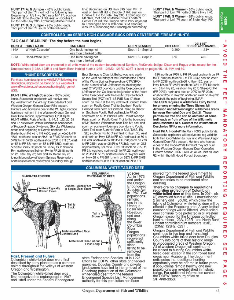

Oregon Department of Fish and Wildlife48
CONTROLLED 100 SERIES DEER MUZZLELOADER FIREARM HUNTS TAG SALE DEADLINE is day before the hunt begins. For hunts with more than one hunt period, the tag sale deadline is day before the earliest opening date. HUNT AREA: Entire wildlife management unit unless indicated by an asterisk(*). A map will be sent if indicated in hunt description by [MAP]. Landowner preference tags available, see page 19. Please note additional closure areas listed on pages 96-100 that may affect your hunt area.
2013 1ST HUNT # HUNT NAME BAG LIMIT OPEN SEASON 2013 TAGS CHOICE APPLICANTS 100M N Muzzleloader* 872 1,392 Willamette Unit One deer Oct. 4 - Nov. 30 Hood Unit & Hood Rvr Valley One deer Oct. 18 - Oct. 28 McKenzie Unit & N Indigo One deer Nov. 15 - Nov. 26 Trask Unit One deer Nov. 8 - Nov. 21 121M S Indigo* One deer Nov. 25 - Dec. 6 55 238 123M1 Melrose-N Sixes* One deer Nov. 15 - Nov. 23 165 138 123M2 N Bank Habitat* One white-tailed buck having not less Nov. 29 - Dec. 5 5 57 than a forked antler or one black-tailed deer 128M Applegate Unit One deer Nov. 15 - Dec. 7 315 1,145 132M Klamath Falls Unit One deer Nov. 1 - Nov. 9 27 137 135M Paulina Unit One antlerless deer Oct. 18 - Oct. 24 32 219 139M1 Metolius Unit No. 1 One deer Oct. 25 - Oct. 31 26 269 139M2 Metolius Unit No. 2 One antlerless deer Oct. 25 - Oct. 31 21 99 145M Flatiron* One buck with visible antler Oct. 18 - Oct. 26 55 30
148M Ditch Cr* One buck with visible antler Oct. 18 - Oct. 26 193 160 151M Baker* One white-tailed deer Nov. 17 - Nov. 30 80 115 153M Union Co* One white-tailed deer Nov. 17 - Nov. 30 440 478 156M N Wenaha-E Sled Springs* One white-tailed deer Dec. 6 - Dec. 14 303 264 166M N Malheur* One buck with visible antler Oct. 18 - Oct. 26 55 93 168M NE Whitehorse* One buck with visible antler Nov. 19 - Nov. 30 26 353 170M Hart Mt * One buck with visible antler Oct. 4 - Oct. 15 15 342 171M Juniper* One buck with visible antler Nov. 29 - Dec. 7 10 436 172M Silvies Unit One buck with visible antler Oct. 18 - Oct. 26 55 171 175M Interstate Unit One deer Oct. 18 - Oct. 26 est. 25 in 2014 NEW 176M Silver Lake-E Fort Rock* One deer Oct. 18 - Oct. 26 43 150 NOTE: White-tailed deer are protected in all units west of the eastern boundaries of Santiam, McKenzie, Indigo, Dixon and Rogue units, except for the Umpqua hunts (123A, 123R1) and North Bank Habitat hunts (123B, 123M2, 123R2, 623T1) listed on pages 45, 48, 49, and 59.
*HUNT DESCRIPTIONSFor those hunt descriptions with [MAP] following the description, maps can be found on our website at www.dfw.state.or.us/resources/hunting/big_game/units.HUNT 100M: N Muzzleloader - 40% public lands. All of units 15, 19 and 42: All of Unit 14 except Cascade Head - Lincoln City Area see page 98 under Unit 14); That part of Unit 21 in the Willamette Rvr drainage north of the following line: beginning along the eastern edge of the Indigo Unit at the Pacific Crest Trail, south on the Pacific Crest Trail to Trail 3641, westerly on Trails 3641, 3643 and 1407 to FS Rd 770, westerly on FRs 770, 2154, 236, 436 to FR 3810, northwest on 3810 to junction of FR 3810 and 5851, north on 5851 to trail 1407, north on 1407 to FR 5850, north and west on 5850 to 745; westerly along FRs 745, 2213, 767, 2212 (Champion Saddle) and county Rd 2460 (Sharps Cr Rd) to BLM Rd 23-1-12; southwest on BLM Rds 23-1-12 and 23-1-13 to BLM Rd 23-3-5.4 (Big River Rd); northwest on BLM Rd 23-3-5.4 to the unit boundary at London Rd [Maps: USFS Umpqua NF, Willamette NF, Umpqua NF –Diamond Lake Ranger District]; and that portion of Unit 41 west of a line beginning at the intersection of Hwy 35 and I-84; east on I-84 to the eastern edge of T3N R12E Sec 31: south along section lines 3.5 miles to power transmission lines; west along power transmission lines to Hood River/Wasco Co line; south along Hood River/Wasco Co line to Husky Rd; south on Huskey Rd. to Fir Mtn Rd; south on Fir Mtn. Rd. to USFW Rd. 17 at Long Prairie; south on USFW Rd. 17 to Shellrock Mtn; west along the section lines to their intersection with Hwy 35. HUNT 121M: S Indigo - 73% public lands. That part of Unit 21 south of the following line: beginning along the eastern edge of Unit 21 at the Pacific Crest Trail; south on the Pacific Crest Trail to Trail 3641; westerly on Trails 3641, 3643 and 1407 to FS Rd 770; westerly on FRs 770, 2154, 236, 436 to FR 3810; northwest on 3810
to junction of FR 3810 and 5851; north on 5851 to Trail 1407; north on 1407 to FR 5850; north and west on 5850 to 745; westerly along FRs 745, 2213, 767, 2212 (Champion Saddle) and County Rd 2460 (Sharps Creek Rd) to BLM Rd 23-1-12; southwest on BLM Rds 23-1-12 and 23-1-13 to BLM Rd 23-3-5.4 (Big River Rd); northwest on BLM Rd 23-3-5.4 to the unit boundary at London Rd. [Maps: USFS Umpqua NF, USFS-Umpqua NF Diamond Lake Ranger District Map]HUNT 123M1: Melrose-N Sixes - 8% public lands. All of Unit 23 and that portion of Unit 25 north of the following line: From the mouth of Sixes Rvr upstream following Sixes Rvr and Middle Fork Sixes Rvr to NF boundary in Section 13, T32S, R13W; east and north along NF boundary to Salmon Cr; northeast on Salmon Cr to Powers Hwy.HUNT 123M2: N Bank Habitat - 100%public lands. No motorized vehicles allowed within the hunt area. N Bank Habitat Mgt Area (Dunning Ranch) - 6,500 acres located approximately 8 mi northeast of Roseburg. Open Area: BLM lands located in T25S, R5W, sections 35 and 36; T26S, R5W, sections 1, 2, 11-14; T25S, R4W, sections 31-33; T26S, R4W, sections 4-8, 18. [MAP]HUNT 145M: Flatiron - 100% public lands. All public lands within Unit 45.HUNT 148M: Ditch Cr - 100% public lands. All public lands within Unit 48.HUNT 151M: Baker - 45% public lands. All of units 51, 62, 63 and 64. HUNT 153M: Union Co - 50% public lands. All of Unit 52, and those parts of units 53, 54, 56 and 57 within Union Co, excluding Starkey Experimental Forest and Range fenced enclosure and a 1/4-mi buffer outside the exterior 8-ft fence.HUNT 156M: N Wenaha - E Sled Springs - 50% public lands. That part of Unit 56 beginning at Troy; south west on Grande Ronde Rvr to Alder
Cr; northwest on Alder Cr to FR 62; north on 62 to FR 6413; west on 6413 to FR 64; north on FR 64 to Oregon-Wash ing ton state line; east on state line to Grande Ronde Rvr; southwest on Grande Ronde Rvr to Troy; and that portion of the Unit 57 east of the Wallowa Rvr from the Minam bridge to Rondowa and east and south of Unit 57 boundary downstream along the Grande Ronde Rvr to the Oregon-Washington state line.HUNT 166M: N Malheur - 80% public lands. That part of Unit 66 north of US Hwy 20.HUNT 168M: NE Whitehorse - 95%public lands. That part of Unit 68 north and east of the mainstem Owyhee Rvr.HUNT 170M: Hart Mt - 98% public lands. Posted parts of units 70 and 71 within Hart Mt NAR. Notice: Within the refuge boundary are scattered private inholdings; landowner permission is required to hunt these inholdings. Please be advised that refuge staff conduct prescribed fires for improvement of wildlife habitat Aug. 1-Nov. 15. Every effort will be made to minimize impacts to hunts from burning. Check at Hart Mt. NAR headquarters for further information (541-947-2831).HUNT 171M: Juniper - 90% public lands. That part of Unit 71 beginning at junction of State Hwy 205 and Rock Cr Ln - Co Rd #412 (Hart Mt Rd); west on Rock Cr Ln to Riecken Corner; north on the Rd from Riecken Corner to Foster Flat Rd; west on Foster Flat Rd to Muncy Lk Rd; north on Muncy Lk Rd to Buzzard Cr; down Buzzard Cr to Iron Mt Rd; east on Iron Mt Rd to Double O Rd; east on Double O Rd to State Hwy 205; south on Hwy 205 to point of beginning. Excluding Malheur NWR lands north of Foster Flat Rd, the Oregon State Park adjacent to Frenchglen and a 120-acre BLM shooting closure surrounding the Frenchglen community. [MAP] HUNT 176M: Silver Lake - E Fort Rock - 66% public lands. All of Unit 76 and that part of Unit 77 east of US Hwy 97.
“A
VO
ID
T
HE
F
EE
”
MA
ND
AT
OR
Y
RE
PO
RT
IN
G
RE
QU
IR
ED
S
EE
P
AG
E
6
Oregon Department of Fish and Wildlife 49
DE
ER
Pages 45-60
“A
VO
ID
T
HE
F
EE
”
MA
ND
AT
OR
Y
RE
PO
RT
IN
G
RE
QU
IR
ED
S
EE
P
AG
E
6
CONTROLLED 100 SERIES DEER BOW HUNTSNOTE: Successful applicants for 123R1, 123R2, 136R, 168R1, 169R, 174R1 and 174R2 will receive one tag valid for the controlled hunt and general deer bow season. You may harvest only one deer. Tags must be purchased or redeemed by the day before the earliest hunt begins.NOTE: Do not purchase a general season deer bow tag if applying for a 100 series controlled hunt. 2013 1ST HUNT # HUNT NAME BAG LIMIT OPEN SEASON 2013 TAGS CHOICE APPLICANTS 123R1 Umpqua Bow* One white-tailed buck having not Aug. 30 - Sept. 28 55 42 less than a forked antler or one black-tailed deer (*see hunt description for details) 123R2 N Bank Habitat Bow* One white-tailed buck having not Sept. 13 - Sept. 28 10 39 less than a forked antler or one black-tailed deer 131R Keno Unit Bow* One buck with visible antler Oct. 25 - Nov. 19 138 163 (only archery deer opportunity) 135R Paulina Unit Bow* One antlerless deer Nov. 17 - Nov. 30 22 63 (only archery deer opportunity) 136R Maury Unit Bow One buck with visible antler Aug. 30 - Sept 28 125 194 Elk bowhunters must also have a controlled Maury Unit deer bow tag (used or unused) to hunt elk in the Maury Unit. 139R1 Metolius Unit No. 1 Bow One deer Nov. 8 - Nov. 30 20 1,853 (only archery deer opportunity) 139R2 Metolius Unit No. 2 Bow One antlerless deer Nov. 8 - Nov. 30 28 83 (only archery deer opportunity) 165R W Beulah* One buck with visible antler Nov. 8 - Nov. 19 20 230 (only archery deer opportunity) 168R1 Trout Cr Mts Traditional Bow* One buck with visible antler Aug. 30 - Sept. 28 Unlimited 29 (Long or recurve bow ONLY; compound bows prohibited) 168R2 SE Whitehorse* One buck with visible antler Nov. 19 - Nov. 30 20 112 (only archery deer opportunity) 169R Steens Mt. Unit Bow* One buck with visible antler Aug. 30 - Sept. 28 138 71 Elk bowhunters must also have a controlled Steens Mt deer bow tag (used or unused) to hunt elk in the Steens Mt Unit. 170R1 Hart Mt No. 1 Bow* One buck with visible antler Aug. 7 - Aug. 15 17 130 (only archery deer opportunity) 170R2 Hart Mt No. 2 Bow* One buck with visible antler Aug. 16 - Aug. 24 17 68 (only archery deer opportunity) 170R3 Hart Mt No. 3 Bow* One buck with visible antler Nov. 1 - Nov. 7 6 152 (only archery deer opportunity) 174R1 N Warner Bow* One buck with visible antler Aug. 30 - Sept. 28 55 81 Elk bowhunters must also have a controlled N. Warner deer bow tag (used or unused) to hunt elk in the N. Warner Area. 174R2 S Warner Bow* One buck with visible antler Aug. 30 - Sept. 28 94 26 Elk bowhunters must also have a controlled S. Warner deer bow tag (used or unused) to hunt elk in the S. Warner Area.
*HUNT DESCRIPTIONSFor those hunt descriptions with [MAP] following the description, maps can be found on our website at www.dfw.state.or.us/resources/hunting/big_game/units.HUNT 123R1: Umpqua Bow - 50% public lands. All of Unit 23 and portions of Units 21, 22 and 24 within Douglas Co (not including the BLM North Bank Habitat Mgt Area). If tag is unfilled after Sept. 22, hunters may continue to hunt in Western Oregon late season bow hunts and must follow the bag limit as outlined on pages 50-51. HUNT 123R2: N Bank Bow - 100%public lands. No motorized vehicles allowed within the hunt area. N Bank Habitat Mgt Area (Dunning Ranch) - 6,500 acres located approximately 8 mi northeast of Roseburg. Open Area: BLM lands located in T25S, R5W, sections 35 and 36; T26S, R5W, sections 1, 2, 11, 12, 13, 14; T25S, R4W, sections 31, 32, 33; T26S, R4W, sections 4, 5, 6, 7, 8, 18. If tag is unfilled after Sept. 22, hunters may continue to hunt in Western Oregon late season bow hunts and must follow the bag limit as outlined on pages 50-51. [MAP]
HUNT 131R: Keno Unit Bow - 41%public lands. All of Unit 31. This tag is NOT valid for the General Deer Bowhunting Season. This would be your only archery season deer opportunity. HUNT 165R: W Beulah - 80% public lands. That part of Unit 65 west of the following line: Beginning at the junction of Hwy 20 and N Fork of Malheur Rvr at Juntura; north on N Fork Malheur Rvr to Little Malheur Rvr; then northerly on Little Malheur Rvr to FR 16; north and east on 16 to Hwy 26 east of Unity. This tag is NOT valid for the General Deer Bowhunting Season. This would be your only archery season deer opportunity.HUNT 168R1: Trout Cr Mts Traditional -95% public lands. That part of Unit 68 south of Whitehorse Ranch Rd and west of US Hwy 95. Restricted to long bows and recurve bows ONLY. Compound bows prohibited. [MAP]HUNT 168R2: SE Whitehorse - 95% public lands. That part of Unit 68 south of the mainstem of the Owyhee River and east of Hwy 95. This tag is NOT valid for the General Deer Bowhunting Season. This would be your only archery season deer opportunity.
HUNT 169R: Steens Mt. - 80% public lands. All of Unit 69 excluding Malheur NWR and a 40-acre BLM shooting closure adjacent to the community of Frenchglen. HUNTS 170R1, 170R2, and 170R3: Hart Mt - 98% public lands. Posted parts of units 70 and 71 within Hart Mt NAR. Every effort will be made to minimize impacts to hunts from burning. Check at Hart Mt. NAR headquarters for further information (541-947-2831). Within the refuge boundary are scattered private inholdings; landowner permission is required to hunt these private inholdings. These tags are NOT valid for the General Deer Bowhunting Season. This would be your only archery season deer opportunity. HUNT 174R1: N Warner - 60% public land. That part of Unit 74 north of State Hwy 140. HUNT 174R2: S Warner - 35% public land. That part of Unit 74 south of State Hwy 140.
Please be aware that there are big game firearm hunts and upland game bird hunts occurring during archery season. This includes some pronghorn antelope hunts, W High Cascade and Hood-White Rvr deer hunts, most youth elk hunts, general black bear season, general cougar season, most bighorn sheep hunts, all Rocky Mt goat and all Access and Habitat auction and raffle hunts.
CONSULT HUNT TABLES FOR HUNTS SCHEDULED DURING ARCHERY SEASONS.
BIG GAME FIREARMS HUNTS SCHED ULED DURING GEN ER AL BOW SEASONS
Oregon Department of Fish and Wildlife48
CONTROLLED 100 SERIES DEER MUZZLELOADER FIREARM HUNTS TAG SALE DEADLINE is day before the hunt begins. For hunts with more than one hunt period, the tag sale deadline is day before the earliest opening date. HUNT AREA: Entire wildlife management unit unless indicated by an asterisk(*). A map will be sent if indicated in hunt description by [MAP]. Landowner preference tags available, see page 19. Please note additional closure areas listed on pages 96-100 that may affect your hunt area.
2013 1ST HUNT # HUNT NAME BAG LIMIT OPEN SEASON 2013 TAGS CHOICE APPLICANTS 100M N Muzzleloader* 872 1,392 Willamette Unit One deer Oct. 4 - Nov. 30 Hood Unit & Hood Rvr Valley One deer Oct. 18 - Oct. 28 McKenzie Unit & N Indigo One deer Nov. 15 - Nov. 26 Trask Unit One deer Nov. 8 - Nov. 21 121M S Indigo* One deer Nov. 25 - Dec. 6 55 238 123M1 Melrose-N Sixes* One deer Nov. 15 - Nov. 23 165 138 123M2 N Bank Habitat* One white-tailed buck having not less Nov. 29 - Dec. 5 5 57 than a forked antler or one black-tailed deer 128M Applegate Unit One deer Nov. 15 - Dec. 7 315 1,145 132M Klamath Falls Unit One deer Nov. 1 - Nov. 9 27 137 135M Paulina Unit One antlerless deer Oct. 18 - Oct. 24 32 219 139M1 Metolius Unit No. 1 One deer Oct. 25 - Oct. 31 26 269 139M2 Metolius Unit No. 2 One antlerless deer Oct. 25 - Oct. 31 21 99 145M Flatiron* One buck with visible antler Oct. 18 - Oct. 26 55 30
148M Ditch Cr* One buck with visible antler Oct. 18 - Oct. 26 193 160 151M Baker* One white-tailed deer Nov. 17 - Nov. 30 80 115 153M Union Co* One white-tailed deer Nov. 17 - Nov. 30 440 478 156M N Wenaha-E Sled Springs* One white-tailed deer Dec. 6 - Dec. 14 303 264 166M N Malheur* One buck with visible antler Oct. 18 - Oct. 26 55 93 168M NE Whitehorse* One buck with visible antler Nov. 19 - Nov. 30 26 353 170M Hart Mt * One buck with visible antler Oct. 4 - Oct. 15 15 342 171M Juniper* One buck with visible antler Nov. 29 - Dec. 7 10 436 172M Silvies Unit One buck with visible antler Oct. 18 - Oct. 26 55 171 175M Interstate Unit One deer Oct. 18 - Oct. 26 est. 25 in 2014 NEW 176M Silver Lake-E Fort Rock* One deer Oct. 18 - Oct. 26 43 150 NOTE: White-tailed deer are protected in all units west of the eastern boundaries of Santiam, McKenzie, Indigo, Dixon and Rogue units, except for the Umpqua hunts (123A, 123R1) and North Bank Habitat hunts (123B, 123M2, 123R2, 623T1) listed on pages 45, 48, 49, and 59.
*HUNT DESCRIPTIONSFor those hunt descriptions with [MAP] following the description, maps can be found on our website at www.dfw.state.or.us/resources/hunting/big_game/units.HUNT 100M: N Muzzleloader - 40% public lands. All of units 15, 19 and 42: All of Unit 14 except Cascade Head - Lincoln City Area see page 98 under Unit 14); That part of Unit 21 in the Willamette Rvr drainage north of the following line: beginning along the eastern edge of the Indigo Unit at the Pacific Crest Trail, south on the Pacific Crest Trail to Trail 3641, westerly on Trails 3641, 3643 and 1407 to FS Rd 770, westerly on FRs 770, 2154, 236, 436 to FR 3810, northwest on 3810 to junction of FR 3810 and 5851, north on 5851 to trail 1407, north on 1407 to FR 5850, north and west on 5850 to 745; westerly along FRs 745, 2213, 767, 2212 (Champion Saddle) and county Rd 2460 (Sharps Cr Rd) to BLM Rd 23-1-12; southwest on BLM Rds 23-1-12 and 23-1-13 to BLM Rd 23-3-5.4 (Big River Rd); northwest on BLM Rd 23-3-5.4 to the unit boundary at London Rd [Maps: USFS Umpqua NF, Willamette NF, Umpqua NF –Diamond Lake Ranger District]; and that portion of Unit 41 west of a line beginning at the intersection of Hwy 35 and I-84; east on I-84 to the eastern edge of T3N R12E Sec 31: south along section lines 3.5 miles to power transmission lines; west along power transmission lines to Hood River/Wasco Co line; south along Hood River/Wasco Co line to Husky Rd; south on Huskey Rd. to Fir Mtn Rd; south on Fir Mtn. Rd. to USFW Rd. 17 at Long Prairie; south on USFW Rd. 17 to Shellrock Mtn; west along the section lines to their intersection with Hwy 35. HUNT 121M: S Indigo - 73% public lands. That part of Unit 21 south of the following line: beginning along the eastern edge of Unit 21 at the Pacific Crest Trail; south on the Pacific Crest Trail to Trail 3641; westerly on Trails 3641, 3643 and 1407 to FS Rd 770; westerly on FRs 770, 2154, 236, 436 to FR 3810; northwest on 3810
to junction of FR 3810 and 5851; north on 5851 to Trail 1407; north on 1407 to FR 5850; north and west on 5850 to 745; westerly along FRs 745, 2213, 767, 2212 (Champion Saddle) and County Rd 2460 (Sharps Creek Rd) to BLM Rd 23-1-12; southwest on BLM Rds 23-1-12 and 23-1-13 to BLM Rd 23-3-5.4 (Big River Rd); northwest on BLM Rd 23-3-5.4 to the unit boundary at London Rd. [Maps: USFS Umpqua NF, USFS-Umpqua NF Diamond Lake Ranger District Map]HUNT 123M1: Melrose-N Sixes - 8% public lands. All of Unit 23 and that portion of Unit 25 north of the following line: From the mouth of Sixes Rvr upstream following Sixes Rvr and Middle Fork Sixes Rvr to NF boundary in Section 13, T32S, R13W; east and north along NF boundary to Salmon Cr; northeast on Salmon Cr to Powers Hwy.HUNT 123M2: N Bank Habitat - 100%public lands. No motorized vehicles allowed within the hunt area. N Bank Habitat Mgt Area (Dunning Ranch) - 6,500 acres located approximately 8 mi northeast of Roseburg. Open Area: BLM lands located in T25S, R5W, sections 35 and 36; T26S, R5W, sections 1, 2, 11-14; T25S, R4W, sections 31-33; T26S, R4W, sections 4-8, 18. [MAP]HUNT 145M: Flatiron - 100% public lands. All public lands within Unit 45.HUNT 148M: Ditch Cr - 100% public lands. All public lands within Unit 48.HUNT 151M: Baker - 45% public lands. All of units 51, 62, 63 and 64. HUNT 153M: Union Co - 50% public lands. All of Unit 52, and those parts of units 53, 54, 56 and 57 within Union Co, excluding Starkey Experimental Forest and Range fenced enclosure and a 1/4-mi buffer outside the exterior 8-ft fence.HUNT 156M: N Wenaha - E Sled Springs - 50% public lands. That part of Unit 56 beginning at Troy; south west on Grande Ronde Rvr to Alder
Cr; northwest on Alder Cr to FR 62; north on 62 to FR 6413; west on 6413 to FR 64; north on FR 64 to Oregon-Wash ing ton state line; east on state line to Grande Ronde Rvr; southwest on Grande Ronde Rvr to Troy; and that portion of the Unit 57 east of the Wallowa Rvr from the Minam bridge to Rondowa and east and south of Unit 57 boundary downstream along the Grande Ronde Rvr to the Oregon-Washington state line.HUNT 166M: N Malheur - 80% public lands. That part of Unit 66 north of US Hwy 20.HUNT 168M: NE Whitehorse - 95%public lands. That part of Unit 68 north and east of the mainstem Owyhee Rvr.HUNT 170M: Hart Mt - 98% public lands. Posted parts of units 70 and 71 within Hart Mt NAR. Notice: Within the refuge boundary are scattered private inholdings; landowner permission is required to hunt these inholdings. Please be advised that refuge staff conduct prescribed fires for improvement of wildlife habitat Aug. 1-Nov. 15. Every effort will be made to minimize impacts to hunts from burning. Check at Hart Mt. NAR headquarters for further information (541-947-2831).HUNT 171M: Juniper - 90% public lands. That part of Unit 71 beginning at junction of State Hwy 205 and Rock Cr Ln - Co Rd #412 (Hart Mt Rd); west on Rock Cr Ln to Riecken Corner; north on the Rd from Riecken Corner to Foster Flat Rd; west on Foster Flat Rd to Muncy Lk Rd; north on Muncy Lk Rd to Buzzard Cr; down Buzzard Cr to Iron Mt Rd; east on Iron Mt Rd to Double O Rd; east on Double O Rd to State Hwy 205; south on Hwy 205 to point of beginning. Excluding Malheur NWR lands north of Foster Flat Rd, the Oregon State Park adjacent to Frenchglen and a 120-acre BLM shooting closure surrounding the Frenchglen community. [MAP] HUNT 176M: Silver Lake - E Fort Rock - 66% public lands. All of Unit 76 and that part of Unit 77 east of US Hwy 97.
“A
VO
ID
T
HE
F
EE
”
MA
ND
AT
OR
Y
RE
PO
RT
IN
G
RE
QU
IR
ED
S
EE
P
AG
E
6
Oregon Department of Fish and Wildlife 49
DE
ER
Pages 45-60
“A
VO
ID
T
HE
F
EE
”
MA
ND
AT
OR
Y
RE
PO
RT
IN
G
RE
QU
IR
ED
S
EE
P
AG
E
6CONTROLLED 100 SERIES DEER BOW HUNTS
NOTE: Successful applicants for 123R1, 123R2, 136R, 168R1, 169R, 174R1 and 174R2 will receive one tag valid for the controlled hunt and general deer bow season. You may harvest only one deer. Tags must be purchased or redeemed by the day before the earliest hunt begins.NOTE: Do not purchase a general season deer bow tag if applying for a 100 series controlled hunt. 2013 1ST HUNT # HUNT NAME BAG LIMIT OPEN SEASON 2013 TAGS CHOICE APPLICANTS 123R1 Umpqua Bow* One white-tailed buck having not Aug. 30 - Sept. 28 55 42 less than a forked antler or one black-tailed deer (*see hunt description for details) 123R2 N Bank Habitat Bow* One white-tailed buck having not Sept. 13 - Sept. 28 10 39 less than a forked antler or one black-tailed deer 131R Keno Unit Bow* One buck with visible antler Oct. 25 - Nov. 19 138 163 (only archery deer opportunity) 135R Paulina Unit Bow* One antlerless deer Nov. 17 - Nov. 30 22 63 (only archery deer opportunity) 136R Maury Unit Bow One buck with visible antler Aug. 30 - Sept 28 125 194 Elk bowhunters must also have a controlled Maury Unit deer bow tag (used or unused) to hunt elk in the Maury Unit. 139R1 Metolius Unit No. 1 Bow One deer Nov. 8 - Nov. 30 20 1,853 (only archery deer opportunity) 139R2 Metolius Unit No. 2 Bow One antlerless deer Nov. 8 - Nov. 30 28 83 (only archery deer opportunity) 165R W Beulah* One buck with visible antler Nov. 8 - Nov. 19 20 230 (only archery deer opportunity) 168R1 Trout Cr Mts Traditional Bow* One buck with visible antler Aug. 30 - Sept. 28 Unlimited 29 (Long or recurve bow ONLY; compound bows prohibited) 168R2 SE Whitehorse* One buck with visible antler Nov. 19 - Nov. 30 20 112 (only archery deer opportunity) 169R Steens Mt. Unit Bow* One buck with visible antler Aug. 30 - Sept. 28 138 71 Elk bowhunters must also have a controlled Steens Mt deer bow tag (used or unused) to hunt elk in the Steens Mt Unit. 170R1 Hart Mt No. 1 Bow* One buck with visible antler Aug. 7 - Aug. 15 17 130 (only archery deer opportunity) 170R2 Hart Mt No. 2 Bow* One buck with visible antler Aug. 16 - Aug. 24 17 68 (only archery deer opportunity) 170R3 Hart Mt No. 3 Bow* One buck with visible antler Nov. 1 - Nov. 7 6 152 (only archery deer opportunity) 174R1 N Warner Bow* One buck with visible antler Aug. 30 - Sept. 28 55 81 Elk bowhunters must also have a controlled N. Warner deer bow tag (used or unused) to hunt elk in the N. Warner Area. 174R2 S Warner Bow* One buck with visible antler Aug. 30 - Sept. 28 94 26 Elk bowhunters must also have a controlled S. Warner deer bow tag (used or unused) to hunt elk in the S. Warner Area.
*HUNT DESCRIPTIONSFor those hunt descriptions with [MAP] following the description, maps can be found on our website at www.dfw.state.or.us/resources/hunting/big_game/units.HUNT 123R1: Umpqua Bow - 50% public lands. All of Unit 23 and portions of Units 21, 22 and 24 within Douglas Co (not including the BLM North Bank Habitat Mgt Area). If tag is unfilled after Sept. 22, hunters may continue to hunt in Western Oregon late season bow hunts and must follow the bag limit as outlined on pages 50-51. HUNT 123R2: N Bank Bow - 100%public lands. No motorized vehicles allowed within the hunt area. N Bank Habitat Mgt Area (Dunning Ranch) - 6,500 acres located approximately 8 mi northeast of Roseburg. Open Area: BLM lands located in T25S, R5W, sections 35 and 36; T26S, R5W, sections 1, 2, 11, 12, 13, 14; T25S, R4W, sections 31, 32, 33; T26S, R4W, sections 4, 5, 6, 7, 8, 18. If tag is unfilled after Sept. 22, hunters may continue to hunt in Western Oregon late season bow hunts and must follow the bag limit as outlined on pages 50-51. [MAP]
HUNT 131R: Keno Unit Bow - 41%public lands. All of Unit 31. This tag is NOT valid for the General Deer Bowhunting Season. This would be your only archery season deer opportunity. HUNT 165R: W Beulah - 80% public lands. That part of Unit 65 west of the following line: Beginning at the junction of Hwy 20 and N Fork of Malheur Rvr at Juntura; north on N Fork Malheur Rvr to Little Malheur Rvr; then northerly on Little Malheur Rvr to FR 16; north and east on 16 to Hwy 26 east of Unity. This tag is NOT valid for the General Deer Bowhunting Season. This would be your only archery season deer opportunity.HUNT 168R1: Trout Cr Mts Traditional -95% public lands. That part of Unit 68 south of Whitehorse Ranch Rd and west of US Hwy 95. Restricted to long bows and recurve bows ONLY. Compound bows prohibited. [MAP]HUNT 168R2: SE Whitehorse - 95% public lands. That part of Unit 68 south of the mainstem of the Owyhee River and east of Hwy 95. This tag is NOT valid for the General Deer Bowhunting Season. This would be your only archery season deer opportunity.
HUNT 169R: Steens Mt. - 80% public lands. All of Unit 69 excluding Malheur NWR and a 40-acre BLM shooting closure adjacent to the community of Frenchglen. HUNTS 170R1, 170R2, and 170R3: Hart Mt - 98% public lands. Posted parts of units 70 and 71 within Hart Mt NAR. Every effort will be made to minimize impacts to hunts from burning. Check at Hart Mt. NAR headquarters for further information (541-947-2831). Within the refuge boundary are scattered private inholdings; landowner permission is required to hunt these private inholdings. These tags are NOT valid for the General Deer Bowhunting Season. This would be your only archery season deer opportunity. HUNT 174R1: N Warner - 60% public land. That part of Unit 74 north of State Hwy 140. HUNT 174R2: S Warner - 35% public land. That part of Unit 74 south of State Hwy 140.
Please be aware that there are big game firearm hunts and upland game bird hunts occurring during archery season. This includes some pronghorn antelope hunts, W High Cascade and Hood-White Rvr deer hunts, most youth elk hunts, general black bear season, general cougar season, most bighorn sheep hunts, all Rocky Mt goat and all Access and Habitat auction and raffle hunts.
CONSULT HUNT TABLES FOR HUNTS SCHEDULED DURING ARCHERY SEASONS.
BIG GAME FIREARMS HUNTS SCHED ULED DURING GEN ER AL BOW SEASONS

Oregon Department of Fish and Wildlife50
GENERAL BOWTag Sale
Deadline Date:Aug. 28, 2014
GENERAL DEER BOW SEASONS
SANTIAM16
WHITEHORSE68
JUNIPER71
BEULAH65
OWYHEE67
ALSEA18
INDIGO21
PAULINA35
MCKENZIE19
WAGONTIRE73
TIOGA24
DIXON22
SILVIES72
GRIZZLY38
CHETCO27
ROGUE30
KENO31
INTERSTATE75
OCHOCO37
MALHEUR RIVER66
BEATYS BUTTE70
SIUSLAW20
SIXES25
SUMPTER51
MAURY36
FORT ROCK77
APPLEGATE28
WARNER74
NORTHSIDE47
SPRAGUE33
SILVER LAKE76
EVANS CREEK29
METOLIUS39
MURDERERS CR46
BIGGS43WILLAMETTE
15
FOSSIL45
TRASK14
COLUMBIA BASIN44
HEPPNER48
UKIAH49
STEENSMTN69
MEL
ROSE
23
POWERS26
STARKEY52
MINAM60
KLAMATH FALLS32
WILSON12
WHITERIVER
41
UPPER
DESCHUTES
34
KEATING63
MAUPIN40
HOOD42
SLEDSPRINGS
57SCAP
POO
SE11
MTEMILY
54
IMNAHA61
DESOLATION50
CH
ESNIM
NU
S
58
SADDLE MTN10 WENAHA
56
WARMSPRINGS
INDIANRES.
CATH
ERIN
E CR
53
SNAKERIVER
59
PINECREEK
62STOTT MTN 17
LOOKOUTMTN
64
WALLAWALLA
55
CRATERLAKEN.P.
UMATILLA INDIANRESERVATION
SOUTHEAST
NORTHEAST
NORTHWEST
SOUTHWEST
CENTRAL
SOUTH CENTRAL
COLUMBIA
“A
VO
ID
T
HE
F
EE
”
MA
ND
AT
OR
Y
RE
PO
RT
IN
G
RE
QU
IR
ED
S
EE
P
AG
E
6
APPLEGATE28
KLAMATHFALLS
32
CHETCO27
BEATYS BUTTE70
INTERSTATE75
WARNER74
KENO31
SPRAGUE33
EVANS CREEK29 WHITEHORSE
68
POWERS26
SILVER LAKE76
ROGUE30
DIXON22
SIXES25
JUNIPER71 STEENS
MTN69
FORT ROCK77
TIOGA24
MELRO
SE23 WAGONTIRE
73
INDIGO21
OWYHEE67
SILVIES72
MAURY36
MALHEUR RIVER66
SIUSLAW20
PAULINA35
UPPER
DESCHUTES
34
MURDERERS CR46
MCKENZIE19
BEULAH65
OCHOCO37
METOLIUS39
NORTHSIDE47
LOOKOUTMTN 64GRIZZLY
38
ALSEA18
DESOLATION50
SUMPTER51
STOTT MTN17 KEATING
63
FOSSIL45
PINECREEK
62
MAUPIN40
STARKEY52HEPPNER
48
IMNAHA61
CATHERINE CR
53
SANTIAM16
MINAM60WILLAMETTE
15 UKIAH49
TRASK14
WHITERIVER
41
HOOD42
BIGGS43
MT EMILY54
SNAKERIVER
59
WILSON12
WALLAWALLA
55
WENAHA56
SLEDSPRINGS
57
CHESNIMNUS
58
SCAPP
OOSE11
SADDLE MTN10
COLUMBIA BASIN44
UMATILLA TRIBAL RESERVATION
WARM SPRINGS TRIBAL
RES.
CRATER LAKE NATIONAL PARK
APPLEGATE28
KLAMATHFALLS
32
CHETCO27
BEATYS BUTTE70
INTERSTATE75
WARNER74
KENO31
SPRAGUE33
EVANS CREEK29 WHITEHORSE
68
POWERS26
SILVER LAKE76
ROGUE30
DIXON22
SIXES25
JUNIPER71 STEENS
MTN69
FORT ROCK77
TIOGA24
MELRO
SE23 WAGONTIRE
73
INDIGO21
OWYHEE67
SILVIES72
MAURY36
MALHEUR RIVER66
SIUSLAW20
PAULINA35
UPPER
DESCHUTES
34
MURDERERS CR46
MCKENZIE19
BEULAH65
OCHOCO37
METOLIUS39
NORTHSIDE47
LOOKOUTMTN 64GRIZZLY
38
ALSEA18
DESOLATION50
SUMPTER51
STOTT MTN17 KEATING
63
FOSSIL45
PINECREEK
62
MAUPIN40
STARKEY52HEPPNER
48
IMNAHA61
CATHERINE CR
53
SANTIAM16
MINAM60WILLAMETTE
15 UKIAH49
TRASK14
WHITERIVER
41
HOOD42
BIGGS43
MT EMILY54
SNAKERIVER
59
WILSON12
WALLAWALLA
55
WENAHA56
SLEDSPRINGS
57
CHESNIMNUS
58
SCAPP
OOSE11
SADDLE MTN10
COLUMBIA BASIN44
UMATILLA TRIBAL RESERVATION
WARM SPRINGS TRIBAL
RES.
CRATER LAKE NATIONAL PARKAPPLEGATE
28
KLAMATHFALLS
32
CHETCO27
BEATYS BUTTE70
INTERSTATE75
WARNER74
KENO31
SPRAGUE33
EVANS CREEK29 WHITEHORSE
68
POWERS26
SILVER LAKE76
ROGUE30
DIXON22
SIXES25
JUNIPER71 STEENS
MTN69
FORT ROCK77
TIOGA24
MELRO
SE23 WAGONTIRE
73
INDIGO21
OWYHEE67
SILVIES72
MAURY36
MALHEUR RIVER66
SIUSLAW20
PAULINA35
UPPER
DESCHUTES
34
MURDERERS CR46
MCKENZIE19
BEULAH65
OCHOCO37
METOLIUS39
NORTHSIDE47
LOOKOUTMTN 64GRIZZLY
38
ALSEA18
DESOLATION50
SUMPTER51
STOTT MTN17 KEATING
63
FOSSIL45
PINECREEK
62
MAUPIN40
STARKEY52HEPPNER
48
IMNAHA61
CATHERINE CR
53
SANTIAM16
MINAM60WILLAMETTE
15 UKIAH49
TRASK14
WHITERIVER
41
HOOD42
BIGGS43
MT EMILY54
SNAKERIVER
59
WILSON12
WALLAWALLA
55
WENAHA56
SLEDSPRINGS
57
CHESNIMNUS
58
SCAPP
OOSE11
SADDLE MTN10
COLUMBIA BASIN44
UMATILLA TRIBAL RESERVATION
WARM SPRINGS TRIBAL
RES.
CRATER LAKE NATIONAL PARK
EASTERN OREGON: Aug. 30 - Sept. 28.(Traditional bows only in the Canyon Cr area of Unit 46 between Aug. 30 - Sept. 5)
Controlled deer bowhunting only. See page 49 for controlled hunt information in Maury, Steens Mt, and Warner units.
See page 51 for restrictions in Mt. Emily, Sled Springs, Chesnimnus, Ochoco, Walla Walla, and Wenaha units.
Closed to all bowhunting (see Eastern Oregon deer area description below).
There are no hunting seasons on NP lands or allotted and/or Tribal lands in these areas.
WESTERN OREGON: Aug. 30 - Sept. 28 All units west of the eastern boundary of Dixon, Indigo, McKenzie, Santiam and Rogue units.
Aug. 30 - Sept. 28 and Nov. 15 - Dec. 7
Aug. 30 - Sept. 28 and Nov. 22 - Dec. 14
Aug. 30 - Sept. 28 and Nov. 29 - Dec. 14
Oregon Department of Fish and Wildlife 51
GENERAL DEER BOW SEASONS
OPEN SEASON BAG LIMIT OPEN AREA (See pages 98-100 for refuge and area regulations).
WE
STE
RN
OR
EG
ON
Aug. 30 - Sept. 28
Aug. 30 - Sept. 28 & Nov. 15 - Dec. 7
Aug. 30 - Sept. 28 & Nov. 22 - Dec. 14
Aug. 30 - Sept. 28 & Nov. 29 - Dec. 14
Aug. 30 - Sept. 28
Aug. 30 - Sept. 5*
Sept. 6 - Sept. 28 (Any legal archery equipment)
Controlled deer bowhunting only
Controlled deer bowhunting only
One buck deer having not less than a forked antler
One deer
One buck deer having not less than a forked antlerOne deer
One buck deer having not less than a forked antlerOne deer
One buck deer having not less than a forked antler
One buck with visible antler
One deer
One buck with visible antler
One buck with visible antler
One buck with visible antler
One buck with visible antler
Applegate, Chetco, Dixon, Powers, Rogue, Scappoose, Tioga, Trask, and Wilson units.
That part of Indigo Unit south of the following line: Beginning along the eastern edge of the Indigo Unit at the Pacific Crest Trail; westerly on Trails 3641, 3643 and 1407 to FS Rd 770; westerly on FRs 770, 2154, 236, 436 to FR 3810; northwest on 3810 to junction of FR 3810 and 5851; north on 5851 to trail 1407; north on 1407 to FR 5850; north and west on 5850 to 745; westerly along FRs 745, 2213, 767, 2212 (Champion Saddle) and Co Rd 2460 (Sharps Cr Rd) to BLM Rd 23-1-12; southwest on BLM Rds 23-1-12 and 23-1-13 to BLM Rd 23-3-5.4 (Big River Rd); northwest on BLM Rd 23-3-5.4 to the unit boundary at London Rd [Map: Eastern Lane Forest Protection District - Cottage Grove Unit]
Evans Cr, Rogue, and Sixes Units.
Melrose Unit
Alsea, Siuslaw, and Stott Mtn. units
McKenzie, Santiam, Willamette units and that part of Indigo Unit in the Willamette Rvr drainage north of the following line: Beginning along the eastern edge of the Indigo Unit at the Pacific Crest Trail; westerly on Trails 3641, 3643 and 1407 to FS Rd 770; westerly on FRs 770, 2154, 236, 436 to FR 3810; northwest on 3810 to junction of FR 3810 and 5851; north on 5851 to trail 1407; north on 1407 to FR 5850; north and west on 5850 to 745; westerly along FRs 745, 2213, 767, 2212 (Champion Saddle) and Co Rd 2460 (Sharps Cr Rd) to BLM Rd 23-1-12; southwest on BLM Rds 23-1-12 and 23-1-13 to BLM Rd 23-3-5.4 (Big River Rd); northwest on BLM Rd 23-3-5.4 to the unit boundary at London Rd [Map: Eastern Lane Forest Protection District - Cottage Grove Unit]That part of Saddle Mt Unit north of Burlington Northern railroad tracks to Astoria is closed to all deer hunting except during authorized emergency hunts.
All units east of the eastern boundary of Dixon, Indigo, McKenzie, Rogue and Santiam units. (Please note exception in sections below.) Approximately 40 sq mi. of the Starkey Experimental Forest within the Starkey Unit shall be closed to all deer bowhunting. Columbia Basin, Biggs, Hood and Maupin units. EXCEPTION: Columbia Basin Unit is closed to all bowhunting beginning at Vinson at the intersection of Hwy 74 and Butter Creek Rd, west on Hwy 74 to Sandhollow Rd, north on Sandhollow Rd to Baseline Rd, west half mile to Sandhollow Rd, north on Sandhollow Rd to Hwy 207, north and east on Hwy 207 to Butter Creek Junction, south on Butter Creek Rd to Hwy 74 at Vinson.Canyon Cr - 100% public lands. Approximately 35.5 sq mi in Unit 46 beginning at the junction of FR 15 and FR 651; north and east on 651 to Table Mt trail head (trail 217); north on 217 to trail 211; north and east on 211 to trail 218; west on 218 to trail 219; west on 219 to Berry Cr; west on Berry Cr to Malheur NF boundary; south and east on forest boundary to FR 15; south and east on 15 to point of beginning. Please visit our website at www.dfw.state.or.us for map. *Weapons Restriction: Traditional archery equipment only (long or recurve bows).
Chesnimnus, Mt. Emily, Ochoco, Sled Springs, Walla Walla, and Wenaha units are closed to all deer bowhunting unless the hunter has a controlled elk bow tag (used or unused) for the respective unit. See page 77-79. Maury, Steens, Warner, Hart Mt. NAR and Trout Cr Mts, that part of Unit 68 south of Whitehorse Ranch Rd and west of US Hwy 95, is closed to general bowhunting.
APPLEGATE28
KLAMATHFALLS
32
CHETCO27
BEATYS BUTTE70
INTERSTATE75
WARNER74
KENO31
SPRAGUE33
EVANS CREEK29 WHITEHORSE
68
POWERS26
SILVER LAKE76
ROGUE30
DIXON22
SIXES25
JUNIPER71 STEENS
MTN69
FORT ROCK77
TIOGA24
MELRO
SE23 WAGONTIRE
73
INDIGO21
OWYHEE67
SILVIES72
MAURY36
MALHEUR RIVER66
SIUSLAW20
PAULINA35
UPPER
DESCHUTES
34
MURDERERS CR46
MCKENZIE19
BEULAH65
OCHOCO37
METOLIUS39
NORTHSIDE47
LOOKOUTMTN 64GRIZZLY
38
ALSEA18
DESOLATION50
SUMPTER51
STOTT MTN17 KEATING
63
FOSSIL45
PINECREEK
62
MAUPIN40
STARKEY52HEPPNER
48
IMNAHA61
CATHERINE CR
53
SANTIAM16
MINAM60WILLAMETTE
15 UKIAH49
TRASK14
WHITERIVER
41
HOOD42
BIGGS43
MT EMILY54
SNAKERIVER
59
WILSON12
WALLAWALLA
55
WENAHA56
SLEDSPRINGS
57
CHESNIMNUS
58
SCAPP
OOSE11
SADDLE MTN10
COLUMBIA BASIN44
UMATILLA TRIBAL RESERVATION
WARM SPRINGS TRIBAL
RES.
CRATER LAKE NATIONAL PARK
EA
STE
RN
OR
EG
ON
DE
ER
Pages 45-60
APPLEGATE28
KLAMATHFALLS
32
CHETCO27
BEATYS BUTTE70
INTERSTATE75
WARNER74
KENO31
SPRAGUE33
EVANS CREEK29 WHITEHORSE
68
POWERS26
SILVER LAKE76
ROGUE30
DIXON22
SIXES25
JUNIPER71 STEENS
MTN69
FORT ROCK77
TIOGA24
MELRO
SE23 WAGONTIRE
73
INDIGO21
OWYHEE67
SILVIES72
MAURY36
MALHEUR RIVER66
SIUSLAW20
PAULINA35
UPPER
DESCHUTES
34
MURDERERS CR46
MCKENZIE19
BEULAH65
OCHOCO37
METOLIUS39
NORTHSIDE47
LOOKOUTMTN 64GRIZZLY
38
ALSEA18
DESOLATION50
SUMPTER51
STOTT MTN17 KEATING
63
FOSSIL45
PINECREEK
62
MAUPIN40
STARKEY52HEPPNER
48
IMNAHA61
CATHERINE CR
53
SANTIAM16
MINAM60WILLAMETTE
15 UKIAH49
TRASK14
WHITERIVER
41
HOOD42
BIGGS43
MT EMILY54
SNAKERIVER
59
WILSON12
WALLAWALLA
55
WENAHA56
SLEDSPRINGS
57
CHESNIMNUS
58
SCAPP
OOSE11
SADDLE MTN10
COLUMBIA BASIN44
UMATILLA TRIBAL RESERVATION
WARM SPRINGS TRIBAL
RES.
CRATER LAKE NATIONAL PARK
“A
VO
ID
T
HE
F
EE
”
MA
ND
AT
OR
Y
RE
PO
RT
IN
G
RE
QU
IR
ED
S
EE
P
AG
E
6
Refer to page 30 for bowhunting equipment restrictions under Legal Hunting Methods and General Provisions. NOTE: Only traditional archery equipment (long or recurve bows) is allowed in the Canyon Cr archery area of the Murderers Cr Unit between Aug. 30 - Sept. 5. NOTE: White-tailed deer are protected in all units west of the eastern boundaries of Santiam, McKenzie, Indigo, Dixon and Rogue units, except for the Umpqua hunts (123A, 123R1) and North Bank Habitat hunts (123B, 123M2, 123R2, 623T1) listed on pages 46, 49, 50, and 59.
Aug. 30 - Sept. 28 and Nov. 15 - Dec. 7
Aug. 30 - Sept. 28 and Nov. 22 - Dec. 14
Aug. 30 - Sept. 28 and Nov. 29 - Dec. 14

Oregon Department of Fish and Wildlife52
USE OF SKY LANTERNS, EXPLODING TARGETS AND TRACER AMMUNITION
Using a little information and a few precautions, you can still enjoy Oregon’s public and private lands without causing undue future damage for the resources and wildlife. Be careful!
For useful tips, log onto ODFW’s website at: www.dfw.state.or.us/resources/hunting/index.asp#closures
Tumblebug Complex Fire 2009
OREGON EXPERIENCES PERIODIC DRY CONDITIONSTHAT CAN LEAD TO WILDFIRES
During the 2013 Legislative Session, House Bill 3199 was passed to prohibit the release of sky lanterns, discharge of exploding targets or discharge of tracer ammunition during a declared fire season on or within one-eighth of a mile of forest protection district lands beginning in 2014.
In addition, visitors to national forests in Oregon and Washington are prohibited from possessing, discharging, and using exploding targets due to concerns over the potential for fire ignition. Any violation of this prohibition is punishable as a Class B misdemeanor by a fine of not more than $5,000 for individuals and $10,000 for organizations or by imprisonment for not more than six months, or both.
PREVENTION HELPS!
Whether you’re hunting, fishing, bird hunting or bird watching, hiking or generally enjoying outdoor activities—tread lightly, help watch and report illegal activities and protect the habitat important to your interests. If you are able to utilize private lands for your outdoor enjoyment, remember access to private lands is a privilege, not a right. Please be respectful on these lands to retain access.
Oregon Department of Fish and Wildlife 53
ATTENTION BIG GAME HUNTERS
spring black bear Day before hunt begins
prOngHOrn anTelOpe Day before hunt begins
bigHOrn sHeep last Day of hunt
rOckY MT. gOaT last Day of hunt
Deer (all controlled Tags) Day before hunt begins*
elk (all controlled Tags) Day before hunt begins*
Deer Or elk bOW ( early & late seasons) aUgUsT 29
WesTern OregOn Deer cenTerFire OcTOber 3
general black bear OcTOber 3
general cOUgar OcTOber 3
cascaDe elk cenTerFire OcTOber 17
rOckY MT. elk, 1sT seasOn cenTerFire OcTOber 28
rOckY MT. elk, 2nD seasOn cenTerFire nOVeMber 7
cOasT elk, 1sT seasOn cenTerFire nOVeMber 14
cOasT elk, 2nD seasOn cenTerFire nOVeMber 21
license agents are not authorized to sell tags after the following dates:
Revised 10/2013
2014 Tag Sale Deadlines
Controlled Hunts Application Deadlines:Spring Black Bear: February 10 n All Others: May 15
Mandatory Reporting -- Avoid the Fee! For hunts that end April 1 - December 31 the Deadline is January 31.
For hunts that end January 1 - March 31 the Deadline is April 15.
IMPORTANT DEADLINES
*For hunts with more than one hunt period, the tag sale deadline is the day before the earliest opening date.
Oregon Department of Fish and Wildlife54
DEER-CONTROLLED600SERIESDEERHUNTSTAG SALE DEADLINE is day before the hunt begins. For hunts with more than one hunt period, the tag sale deadline is the day before the earliest opening date. Favorable winter weather conditions may lead to deer populations exceeding population management objectives in many units. In that case, biologists will recommend antlerless deer hunts where deer exceed the ecological and/or social carrying capacity of a unit. Antlerless deer hunting is an important management tool to keep populations and their habitats healthy. Unanticipated hunts in response to populations exceeding objective will be publicly announced by Apr. 15. All such hunts will have a unique hunt number and will be available for the big game drawing if approved by the Oregon Fish and Wildlife Commission. Most of the antlerless deer hunts recommended for eastern Oregon are in response to specific animal damage situations.CONTROLLED HUNT APPLICATION PROCEDURES: Please read pages 13-15. All antlerless deer hunts are controlled hunts where the number of hunters is limited and tags are awarded through a public drawing. Hunters should apply for more than one hunt choice. If your first choice hunt is cancelled, you will receive a postcard describing your hunt choice options. See page 15 for further information.YOUTH CONTROLLED HUNTS FOR DEER: Controlled deer hunts for youth are listed on page 59.CAUTION TO HUNTERS: Obtaining a tag does not guarantee a place to hunt! Some hunts in these
regulations are composed mostly or entirely of private lands and are printed in red. ODFW tries to design hunts to provide public access; however, in some areas this is not possible. It is the hunter’s responsibility to obtain access to hunt on private property. In areas with high percentages of private land, please make sure you have a place to hunt before you apply for a tag.NOTE: The “2013 1st Choice Applicants” column is not in flu enced by preference points; it only in di cates the number of first choice ap-pli cants for each hunt. NOTE: White-tailed deer are protected in all units west of the eastern boundaries of Santiam, McKenzie, Indigo, Dixon and Rogue units, except for the Umpqua hunts (123A, 123R1) and North Bank Habitat hunts (123B, 123M2, 123R2, 623T1) listed on pages 45, 48, 49, and 59.TAGS: The Fish and Wildlife Commission will not set actual tag numbers for hunts listed here until June 2014. Tag numbers currently shown, for your reference, were those allocated for 2013 or estimated for new 2014 hunts. Actual tag numbers for 2014 may be higher or lower than those listed based on pop u la tion conditions.HUNT AREA: Entire wildlife management unit unless indicated by an asterisk(*). A map will be sent if indicated in hunt description by [MAP]. Landowner preference tags available, see page 19. Please note additional closure areas listed on pages 96-100 that may affect your hunt area.
NORTHWEST AREA HUNTSNOTE: White-tailed deer are protected in all units west of the eastern boundaries of Santiam, McKenzie, Indigo, Dixon and Rogue units, except for the Umpqua hunts (123A, 123R1) and North Bank Habitat hunts (123B, 123M2, 123R2, 623T1) listed on pages 45, 48, 49, and 59. 2013 1ST HUNT # HUNT NAME BAG LIMIT OPEN SEASON 2013 TAGS CHOICE APPLICANTS 610 Saddle Mt Unit One antlerless or spike deer Oct. 25 - Nov. 7 21 1,250 611 Scappoose Unit One antlerless or spike deer Oct. 25 - Nov. 7 20 1,077 612 Wilson Unit One antlerless or spike deer Oct. 25 - Nov. 7 22 664 614 Trask Unit* One antlerless or spike deer Oct. 25 - Nov. 7 50 1,409 615 Willamette Unit One deer Sept. 1 - Feb. 28, 2015 3,180 10,177 616A1 NW Santiam* One antlerless or spike deer Oct. 25 - Nov. 7 250 1,672 616A2 SW Santiam* One antlerless or spike deer Oct. 25 - Nov. 7 106 816 617 Stott Mt Unit* One antlerless or spike deer Oct. 25 - Nov. 7 50 609 618 Alsea Unit One antlerless or spike deer Oct. 25 - Nov. 7 50 1,154 619 W McKenzie* One antlerless or spike deer Oct. 25 - Nov. 7 636 1,740 619A Mill Cr* One antlerless or spike deer Nov. 8-9, 15-16, 420 931 22-23, 29-30, & Dec. 6-7 620A N Siuslaw* One antlerless or spike deer Oct. 25 - Nov. 7 52 517 620B S Siuslaw* One antlerless or spike deer Oct. 25 - Nov. 7 33 198 620C Camas Swale* One deer Oct. 25 - Nov. 7 324 674
SOUTHWEST AREA HUNTSNOTE: White-tailed deer are protected in all units west of the eastern boundaries of Santiam, McKenzie, Indigo, Dixon and Rogue units, except for the Umpqua hunts (123A, 123R1) and North Bank Habitat hunts (123B, 123M2, 123R2, 623T1) listed on pages 45, 48, 49, and 59. 2013 1ST HUNT # HUNT NAME BAG LIMIT OPEN SEASON 2013 TAGS CHOICE APPLICANTS 621A Dorena* One antlerless or spike deer Oct. 25 - Nov. 7 321 680 621B Calapooya* One antlerless or spike deer Oct. 25 - Nov. 7 32 91 622A W Dixon* One antlerless or spike deer Oct. 25 - Nov. 7 32 316 623 Melrose Unit One antlerless or spike deer Oct. 25 - Nov. 7 265 695 623A Central Melrose* One antlerless or spike deer Oct. 25 - Nov. 7 1,100 622 623B1 N Bank Habitat No. 1* One antlerless or spike deer Oct. 18 - Oct. 24 17 16 Master Hunter ONLY, must have completed Master Hunter program to apply. See page 83. 623B2 N Bank Habitat No. 2* One antlerless or spike deer Nov. 15 - Nov. 21 17 23 Master Hunter ONLY, must have completed Master Hunter program to apply. See page 83. 623B3 N Bank Habitat No. 3* One antlerless or spike deer Dec. 13 - Dec. 19 16 26 Master Hunter ONLY, must have completed Master Hunter program to apply. See page 83.
Application Deadline Date:May 15, 2014
Applicants may apply singly or as a
party of no more than 18 persons.
Private lands will limit access for hunts printed in red. Do not apply unless you have access to a place to hunt.STOP
DEER BAG LIMIT DEFINITIONSSee pages 81-82
“A
VO
ID
T
HE
F
EE
”
MA
ND
AT
OR
Y
RE
PO
RT
IN
G
RE
QU
IR
ED
S
EE
P
AG
E
6
Oregon Department of Fish and Wildlife 55
Private lands will limit access for hunts printed in red. Do not apply unless you have access to a place to hunt.
2013 1ST HUNT # HUNT NAME BAG LIMIT OPEN SEASON 2013 TAGS CHOICE APPLICANTS 624A Tioga* One antlerless or spike deer Oct. 25 - Nov. 7 55 613 624B E Tioga* One antlerless or spike deer Oct. 25 - Nov. 7 74 181 625 Sixes Unit One antlerless or spike deer Oct. 25 - Nov. 7 105 606 626 Powers Unit One antlerless or spike deer Oct. 25 - Nov. 7 70 493 627 Chetco Unit One antlerless or spike deer Oct. 25 - Nov. 7 35 470 628A W Applegate* One antlerless or spike deer Oct. 25 - Nov. 7 35 601 629 Evans Cr Unit One antlerless or spike deer Oct. 25 - Nov. 7 25 547
CENTRAL AREA HUNTS 2013 1ST
HUNT # HUNT NAME BAG LIMIT OPEN SEASON 2013 TAGS CHOICE APPLICANTS 638A Lower Willow Cr Agri.* One antlerless deer Oct. 18 - Nov. 30 11 488
COLUMBIA AREA HUNTS 2013 1ST HUNT # HUNT NAME BAG LIMIT OPEN SEASON 2013 TAGS CHOICE APPLICANTS 640 Maupin Unit One antlerless deer Oct. 18 - Oct. 26 5 139 641A The Dalles Orchard* One antlerless deer Sept. 6 - Sept. 14 11 76 (Shotgun/Muzzleloader ONLY) 642A Hood Unit-Hood Rvr Valley* One antlerless deer Nov. 22 - Nov. 30 11 460 643A E Biggs* One antlerless deer Oct. 18 - Oct. 26 22 284 643B W Biggs* One antlerless deer Oct. 18 - Oct. 26 27 549
NORTHEAST AREA HUNTS 2013 1ST HUNT # HUNT NAME BAG LIMIT OPEN SEASON 2013 TAGS CHOICE APPLICANTS 644A1 Umatilla NWR No.1* One antlerless deer Aug. 30 - Sept. 3 15 95 (Shotgun/Muzzleloader ONLY) 644A2 Umatilla NWR No. 2* One antlerless deer Sept. 13 - Sept. 17 15 118 (Shotgun/Muzzleloader ONLY) 644A3 Umatilla NWR No. 3* One deer Oct. 4 - Oct. 8 3 1,202 (Shotgun/Muzzleloader ONLY) 644B1 N Columbia Basin No. 1* One antlerless deer Oct. 25 - Nov. 2 51 302 644B2 N Columbia Basin No. 2* One antlerless deer Nov. 8 - Nov. 16 52 266 644C S Columbia Basin* One antlerless deer Oct. 18 - Oct. 26 100 588 645A N Fossil Hunt* One antlerless deer Oct. 18 - Oct. 26 22 508 647A John Day Valley* One antlerless deer Oct. 18 - Oct. 26 10 212 647B Middle Fork John Day* One antlerless white-tailed deer Oct. 18 - Oct. 26 28 274 648A Heppner Private* One antlerless deer Oct. 18 - Oct. 26 22 256 649A1 N Ukiah No. 1* One antlerless deer Oct. 25 - Nov. 2 51 338 649A2 N Ukiah No. 2* One antlerless deer Nov. 8 - Nov. 16 51 245 649B W Blue Mts* One white-tailed deer Nov. 15 - Dec. 7 122 1,212 (Archery/Muzzleloader ONLY as defined on page 30) 651A Sumpter-Unity Agri* One antlerless deer Oct. 18 - Oct. 26 11 242 654A Rawhide* One antlerless deer Oct. 25 - Nov. 16 44 75 655A Orchards* One white-tailed deer Dec. 1 - Dec. 10 22 354 655B1 Walla Walla No. 1* One antlerless deer Nov. 1 - Nov. 9 43 153 655B2 Walla Walla No. 2* One antlerless white-tailed deer Jan. 1 - Jan. 18, 2015 44 101 657A1 Flora No. 1* One antlerless white-tailed deer Oct. 18 - Oct. 26 44 84 657A2 Flora No. 2* One antlerless mule deer Oct. 18 - Oct. 26 28 69 657B1 N Wallowa Val No. 1* One antlerless mule deer Oct. 18 - Oct. 26 26 194 657B2 N Wallowa Val No. 2* One antlerless white-tailed deer Oct. 18 - Oct. 26 53 183 657C Upper Swamp Cr* One antlerless deer Oct. 18 - Oct. 26 44 93 657D Prairie Creek* One antlerless white-tailed deer Dec. 22 - Dec. 28 est. 30 in 2014 NEW (Centerfire Rifles Prohibited) 660A1 Upper Wallowa Valley No. 1* One antlerless mule deer Oct. 18 - Oct. 26 28 61 (Centerfire Rifles Prohibited) 660A2 Upper Wallowa Valley No. 2* One antlerless white-tailed deer Oct. 18 - Oct. 26 165 177 (Centerfire Rifles Prohibited) 660A3 Upper Wallowa Valley No. 3* One antlerless white-tailed deer Dec. 15 - Dec. 21 66 132 (Centerfire Rifles Prohibited) 660B Lostine-Allen Canyon* One antlerless deer Oct. 18 - Oct. 26 16 62 663A Keating Agri * One antlerless deer Oct. 18 - Oct. 26 11 237 665A Vale Bench* One antlerless deer Oct. 18 - Oct. 26 27 162 (No centerfire rifles allowed for hunting on private land without Landowner permission) 665B Vale-Ontario Agri* One antlerless deer Oct. 18 - Oct. 26 11 99 (No centerfire rifles allowed for hunting on private land without Landowner permission) 665C Moores Hollow-Porter Flat* One antlerless deer Oct. 18 - Oct. 26 30 105 (No centerfire rifles allowed for hunting on private land without Landowner permission) 665D Willow Cr Agri One antlerless deer Oct. 18 - Oct. 26 11 42 (No centerfire rifles allowed for hunting on private land without Landowner permission)
DE
ER
Pages 45-60
“A
VO
ID
T
HE
F
EE
”
MA
ND
AT
OR
Y
RE
PO
RT
IN
G
RE
QU
IR
ED
S
EE
P
AG
E
6
SOUTHWEST AREA HUNTS (CONTINUED)
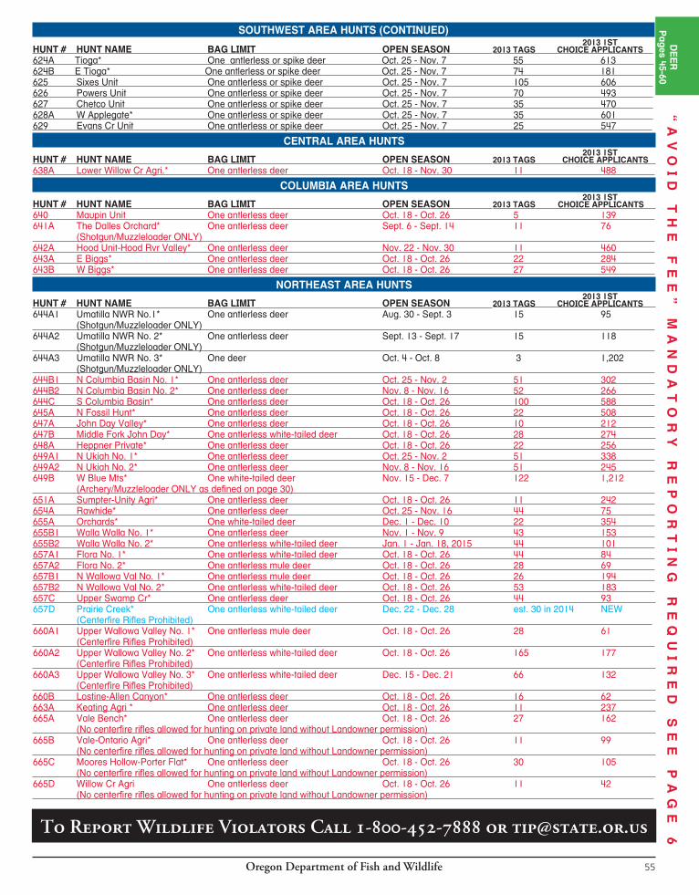
Oregon Department of Fish and Wildlife54
DEER-CONTROLLED600SERIESDEERHUNTSTAG SALE DEADLINE is day before the hunt begins. For hunts with more than one hunt period, the tag sale deadline is the day before the earliest opening date. Favorable winter weather conditions may lead to deer populations exceeding population management objectives in many units. In that case, biologists will recommend antlerless deer hunts where deer exceed the ecological and/or social carrying capacity of a unit. Antlerless deer hunting is an important management tool to keep populations and their habitats healthy. Unanticipated hunts in response to populations exceeding objective will be publicly announced by Apr. 15. All such hunts will have a unique hunt number and will be available for the big game drawing if approved by the Oregon Fish and Wildlife Commission. Most of the antlerless deer hunts recommended for eastern Oregon are in response to specific animal damage situations.CONTROLLED HUNT APPLICATION PROCEDURES: Please read pages 13-15. All antlerless deer hunts are controlled hunts where the number of hunters is limited and tags are awarded through a public drawing. Hunters should apply for more than one hunt choice. If your first choice hunt is cancelled, you will receive a postcard describing your hunt choice options. See page 15 for further information.YOUTH CONTROLLED HUNTS FOR DEER: Controlled deer hunts for youth are listed on page 59.CAUTION TO HUNTERS: Obtaining a tag does not guarantee a place to hunt! Some hunts in these
regulations are composed mostly or entirely of private lands and are printed in red. ODFW tries to design hunts to provide public access; however, in some areas this is not possible. It is the hunter’s responsibility to obtain access to hunt on private property. In areas with high percentages of private land, please make sure you have a place to hunt before you apply for a tag.NOTE: The “2013 1st Choice Applicants” column is not in flu enced by preference points; it only in di cates the number of first choice ap-pli cants for each hunt. NOTE: White-tailed deer are protected in all units west of the eastern boundaries of Santiam, McKenzie, Indigo, Dixon and Rogue units, except for the Umpqua hunts (123A, 123R1) and North Bank Habitat hunts (123B, 123M2, 123R2, 623T1) listed on pages 45, 48, 49, and 59.TAGS: The Fish and Wildlife Commission will not set actual tag numbers for hunts listed here until June 2014. Tag numbers currently shown, for your reference, were those allocated for 2013 or estimated for new 2014 hunts. Actual tag numbers for 2014 may be higher or lower than those listed based on pop u la tion conditions.HUNT AREA: Entire wildlife management unit unless indicated by an asterisk(*). A map will be sent if indicated in hunt description by [MAP]. Landowner preference tags available, see page 19. Please note additional closure areas listed on pages 96-100 that may affect your hunt area.
NORTHWEST AREA HUNTSNOTE: White-tailed deer are protected in all units west of the eastern boundaries of Santiam, McKenzie, Indigo, Dixon and Rogue units, except for the Umpqua hunts (123A, 123R1) and North Bank Habitat hunts (123B, 123M2, 123R2, 623T1) listed on pages 45, 48, 49, and 59. 2013 1ST HUNT # HUNT NAME BAG LIMIT OPEN SEASON 2013 TAGS CHOICE APPLICANTS 610 Saddle Mt Unit One antlerless or spike deer Oct. 25 - Nov. 7 21 1,250 611 Scappoose Unit One antlerless or spike deer Oct. 25 - Nov. 7 20 1,077 612 Wilson Unit One antlerless or spike deer Oct. 25 - Nov. 7 22 664 614 Trask Unit* One antlerless or spike deer Oct. 25 - Nov. 7 50 1,409 615 Willamette Unit One deer Sept. 1 - Feb. 28, 2015 3,180 10,177 616A1 NW Santiam* One antlerless or spike deer Oct. 25 - Nov. 7 250 1,672 616A2 SW Santiam* One antlerless or spike deer Oct. 25 - Nov. 7 106 816 617 Stott Mt Unit* One antlerless or spike deer Oct. 25 - Nov. 7 50 609 618 Alsea Unit One antlerless or spike deer Oct. 25 - Nov. 7 50 1,154 619 W McKenzie* One antlerless or spike deer Oct. 25 - Nov. 7 636 1,740 619A Mill Cr* One antlerless or spike deer Nov. 8-9, 15-16, 420 931 22-23, 29-30, & Dec. 6-7 620A N Siuslaw* One antlerless or spike deer Oct. 25 - Nov. 7 52 517 620B S Siuslaw* One antlerless or spike deer Oct. 25 - Nov. 7 33 198 620C Camas Swale* One deer Oct. 25 - Nov. 7 324 674
SOUTHWEST AREA HUNTSNOTE: White-tailed deer are protected in all units west of the eastern boundaries of Santiam, McKenzie, Indigo, Dixon and Rogue units, except for the Umpqua hunts (123A, 123R1) and North Bank Habitat hunts (123B, 123M2, 123R2, 623T1) listed on pages 45, 48, 49, and 59. 2013 1ST HUNT # HUNT NAME BAG LIMIT OPEN SEASON 2013 TAGS CHOICE APPLICANTS 621A Dorena* One antlerless or spike deer Oct. 25 - Nov. 7 321 680 621B Calapooya* One antlerless or spike deer Oct. 25 - Nov. 7 32 91 622A W Dixon* One antlerless or spike deer Oct. 25 - Nov. 7 32 316 623 Melrose Unit One antlerless or spike deer Oct. 25 - Nov. 7 265 695 623A Central Melrose* One antlerless or spike deer Oct. 25 - Nov. 7 1,100 622 623B1 N Bank Habitat No. 1* One antlerless or spike deer Oct. 18 - Oct. 24 17 16 Master Hunter ONLY, must have completed Master Hunter program to apply. See page 83. 623B2 N Bank Habitat No. 2* One antlerless or spike deer Nov. 15 - Nov. 21 17 23 Master Hunter ONLY, must have completed Master Hunter program to apply. See page 83. 623B3 N Bank Habitat No. 3* One antlerless or spike deer Dec. 13 - Dec. 19 16 26 Master Hunter ONLY, must have completed Master Hunter program to apply. See page 83.
Application Deadline Date:May 15, 2014
Applicants may apply singly or as a
party of no more than 18 persons.
Private lands will limit access for hunts printed in red. Do not apply unless you have access to a place to hunt.STOP
DEER BAG LIMIT DEFINITIONSSee pages 81-82
“A
VO
ID
T
HE
F
EE
”
MA
ND
AT
OR
Y
RE
PO
RT
IN
G
RE
QU
IR
ED
S
EE
P
AG
E
6
Oregon Department of Fish and Wildlife 55
Private lands will limit access for hunts printed in red. Do not apply unless you have access to a place to hunt.
2013 1ST HUNT # HUNT NAME BAG LIMIT OPEN SEASON 2013 TAGS CHOICE APPLICANTS 624A Tioga* One antlerless or spike deer Oct. 25 - Nov. 7 55 613 624B E Tioga* One antlerless or spike deer Oct. 25 - Nov. 7 74 181 625 Sixes Unit One antlerless or spike deer Oct. 25 - Nov. 7 105 606 626 Powers Unit One antlerless or spike deer Oct. 25 - Nov. 7 70 493 627 Chetco Unit One antlerless or spike deer Oct. 25 - Nov. 7 35 470 628A W Applegate* One antlerless or spike deer Oct. 25 - Nov. 7 35 601 629 Evans Cr Unit One antlerless or spike deer Oct. 25 - Nov. 7 25 547
CENTRAL AREA HUNTS 2013 1ST
HUNT # HUNT NAME BAG LIMIT OPEN SEASON 2013 TAGS CHOICE APPLICANTS 638A Lower Willow Cr Agri.* One antlerless deer Oct. 18 - Nov. 30 11 488
COLUMBIA AREA HUNTS 2013 1ST HUNT # HUNT NAME BAG LIMIT OPEN SEASON 2013 TAGS CHOICE APPLICANTS 640 Maupin Unit One antlerless deer Oct. 18 - Oct. 26 5 139 641A The Dalles Orchard* One antlerless deer Sept. 6 - Sept. 14 11 76 (Shotgun/Muzzleloader ONLY) 642A Hood Unit-Hood Rvr Valley* One antlerless deer Nov. 22 - Nov. 30 11 460 643A E Biggs* One antlerless deer Oct. 18 - Oct. 26 22 284 643B W Biggs* One antlerless deer Oct. 18 - Oct. 26 27 549
NORTHEAST AREA HUNTS 2013 1ST HUNT # HUNT NAME BAG LIMIT OPEN SEASON 2013 TAGS CHOICE APPLICANTS 644A1 Umatilla NWR No.1* One antlerless deer Aug. 30 - Sept. 3 15 95 (Shotgun/Muzzleloader ONLY) 644A2 Umatilla NWR No. 2* One antlerless deer Sept. 13 - Sept. 17 15 118 (Shotgun/Muzzleloader ONLY) 644A3 Umatilla NWR No. 3* One deer Oct. 4 - Oct. 8 3 1,202 (Shotgun/Muzzleloader ONLY) 644B1 N Columbia Basin No. 1* One antlerless deer Oct. 25 - Nov. 2 51 302 644B2 N Columbia Basin No. 2* One antlerless deer Nov. 8 - Nov. 16 52 266 644C S Columbia Basin* One antlerless deer Oct. 18 - Oct. 26 100 588 645A N Fossil Hunt* One antlerless deer Oct. 18 - Oct. 26 22 508 647A John Day Valley* One antlerless deer Oct. 18 - Oct. 26 10 212 647B Middle Fork John Day* One antlerless white-tailed deer Oct. 18 - Oct. 26 28 274 648A Heppner Private* One antlerless deer Oct. 18 - Oct. 26 22 256 649A1 N Ukiah No. 1* One antlerless deer Oct. 25 - Nov. 2 51 338 649A2 N Ukiah No. 2* One antlerless deer Nov. 8 - Nov. 16 51 245 649B W Blue Mts* One white-tailed deer Nov. 15 - Dec. 7 122 1,212 (Archery/Muzzleloader ONLY as defined on page 30) 651A Sumpter-Unity Agri* One antlerless deer Oct. 18 - Oct. 26 11 242 654A Rawhide* One antlerless deer Oct. 25 - Nov. 16 44 75 655A Orchards* One white-tailed deer Dec. 1 - Dec. 10 22 354 655B1 Walla Walla No. 1* One antlerless deer Nov. 1 - Nov. 9 43 153 655B2 Walla Walla No. 2* One antlerless white-tailed deer Jan. 1 - Jan. 18, 2015 44 101 657A1 Flora No. 1* One antlerless white-tailed deer Oct. 18 - Oct. 26 44 84 657A2 Flora No. 2* One antlerless mule deer Oct. 18 - Oct. 26 28 69 657B1 N Wallowa Val No. 1* One antlerless mule deer Oct. 18 - Oct. 26 26 194 657B2 N Wallowa Val No. 2* One antlerless white-tailed deer Oct. 18 - Oct. 26 53 183 657C Upper Swamp Cr* One antlerless deer Oct. 18 - Oct. 26 44 93 657D Prairie Creek* One antlerless white-tailed deer Dec. 22 - Dec. 28 est. 30 in 2014 NEW (Centerfire Rifles Prohibited) 660A1 Upper Wallowa Valley No. 1* One antlerless mule deer Oct. 18 - Oct. 26 28 61 (Centerfire Rifles Prohibited) 660A2 Upper Wallowa Valley No. 2* One antlerless white-tailed deer Oct. 18 - Oct. 26 165 177 (Centerfire Rifles Prohibited) 660A3 Upper Wallowa Valley No. 3* One antlerless white-tailed deer Dec. 15 - Dec. 21 66 132 (Centerfire Rifles Prohibited) 660B Lostine-Allen Canyon* One antlerless deer Oct. 18 - Oct. 26 16 62 663A Keating Agri * One antlerless deer Oct. 18 - Oct. 26 11 237 665A Vale Bench* One antlerless deer Oct. 18 - Oct. 26 27 162 (No centerfire rifles allowed for hunting on private land without Landowner permission) 665B Vale-Ontario Agri* One antlerless deer Oct. 18 - Oct. 26 11 99 (No centerfire rifles allowed for hunting on private land without Landowner permission) 665C Moores Hollow-Porter Flat* One antlerless deer Oct. 18 - Oct. 26 30 105 (No centerfire rifles allowed for hunting on private land without Landowner permission) 665D Willow Cr Agri One antlerless deer Oct. 18 - Oct. 26 11 42 (No centerfire rifles allowed for hunting on private land without Landowner permission)
DE
ER
Pages 45-60
“A
VO
ID
T
HE
F
EE
”
MA
ND
AT
OR
Y
RE
PO
RT
IN
G
RE
QU
IR
ED
S
EE
P
AG
E
6SOUTHWEST AREA HUNTS (CONTINUED)
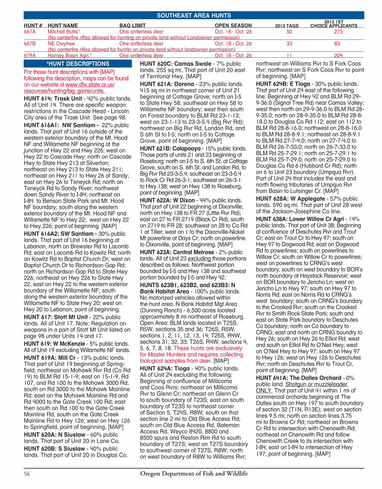
Oregon Department of Fish and Wildlife56
*HUNT DESCRIPTIONSFor those hunt descriptions with [MAP] following the description, maps can be found on our website at www.dfw.state.or.us/resources/hunting/big_game/units.HUNT 614: Trask Unit - 42% public lands. All of Unit 14. There are specific weapon restrictions in the Cascade Head - Lincoln City area of the Trask Unit. See page 98. HUNT 616A1: NW Santiam - 22% public lands. That part of Unit 16 outside of the western exterior boundary of the Mt. Hood NF and Willamette NF beginning at the junction of Hwy 22 and Hwy 226; west on Hwy 22 to Cascade Hwy; north on Cascade Hwy to State Hwy 213 at Silverton; northeast on Hwy 213 to State Hwy 211; northeast on Hwy 211 to Hwy 26 at Sandy; east on Hwy 26 to Teneyck Rd; north on Teneyck Rd to Sandy River; northwest down Sandy River to I-84; northeast on I-84 to Benson State Park and Mt. Hood NF boundary; south along the western exterior boundary of the Mt. Hood NF and Willamette NF to Hwy 22; west on Hwy 22 to Hwy 226; point of beginning. [MAP]HUNT 616A2: SW Santiam - 30% public lands. That part of Unit 16 beginning at Lebanon, north on Brewster Rd to Lacomb Rd; east on Lacomb Rd to Kowitz Rd; north on Kowitz Rd to Baptist Church Dr; west on Baptist Church Dr to Richardson Gap Rd; north on Richardson Gap Rd to State Hwy 226; northeast on Hwy 226 to State Hwy 22, east on Hwy 22 to the western exterior boundary of the Willamette NF; south along the western exterior boundary of the Willamette NF to State Hwy 20; west on Hwy 20 to Lebanon, point of beginning.HUNT 617: Stott Mt Unit - 22% public lands. All of Unit 17. Note: Regulation on weapons in a part of Stott Mt Unit listed on page 98 under Units 14 and 17.HUNT 619: W McKenzie - 5% public lands. All of Unit 19 excluding Willamette NF lands. HUNT 619A: Mill Cr - 13% public lands. That part of Unit 19 beginning at Spring-field; northeast on Mohawk Rvr Rd (Co Rd 19) to BLM Rd 15-1-9; east on 15-1-9, Rd 107, and Rd 100 to the Mohawk 3000 Rd; south on Rd 3000 to the Mohawk Mainline Rd; east on the Mohawk Mainline Rd and Rd 4000 to the Gate Creek 100 Rd; east then south on Rd 100 to the Gate Creek Mainline Rd, south on the Gate Creek Mainline Rd to Hwy 126; west on Hwy 126 to Spring field, point of beginning. [MAP]HUNT 620A: N Siuslaw - 60% public lands. That part of Unit 20 in Lane Co.HUNT 620B: S Siuslaw - 40% public lands. That part of Unit 20 in Douglas Co.
HUNT 620C: Camas Swale - 7% public lands. 255 sq mi. That part of Unit 20 east of Territorial Hwy. [MAP]HUNT 621A: Dorena - 23% public lands. 415 sq mi in northwest corner of Unit 21 beginning at Cottage Grove; north on I-5 to State Hwy 58; southeast on Hwy 58 to Willamette NF boundary; west then south on Forest boundary to BLM Rd 23-1-13; west on 23-1-13 to 23-3-5.4 (Big Rvr Rd); northwest on Big Rvr Rd, London Rd, and S 6th St to I-5; north on I-5 to Cottage Grove, point of beginning. [MAP]HUNT 621B: Calapooya - 15% public lands. Those parts of units 21 and 23 beginning at Roseburg; north on I-5 to S. 6th St. at Cottage Grove, south on S. 6th St. and London Rd. to Big Rvr Rd 23-3-5.4; southeast on 23-3-5.4 to Rock Cr Rd 26-3-1; southwest on 26-3-1 to Hwy 138; west on Hwy 138 to Roseburg, point of beginning. [MAP]HUNT 622A: W Dixon - 44% public lands. That part of Unit 22 beginning at Dixonville; north on Hwy 138 to FR 27 (Little Rvr Rd); east on 27 to FR 2719 (Black Cr Rd); south on 2719 to FR 28; southwest on 28 to Co Rd 1 at Tiller; west on 1 to the Dixonville-Nickel Mt powerline at Days Cr; north on powerline to Dixonville, point of beginning. [MAP]HUNT 623A: Central Melrose - 2% public lands. All of Unit 23 excluding those portions described as follows: Northwest portion bounded by I-5 and Hwy 138 and southwest portion bounded by I-5 and Hwy 42.HUNTS 623B1, 623B2, and 623B3: N Bank Habitat Area - 100% public lands. No motorized vehicles allowed within the hunt area. N Bank Habitat Mgt Area (Dunning Ranch) - 6,500 acres located approximately 8 mi northeast of Roseburg. Open Area: BLM lands located in T25S, R5W, sections 35 and 36; T26S, R5W, sections 1, 2, 11, 12, 13, 14; T25S, R4W, sections 31, 32, 33; T26S, R4W, sections 4, 5, 6, 7, 8, 18. These hunts are exclusively for Master Hunters and requires collecting biological samples from deer. [MAP]HUNT 624A: Tioga - 40% public lands.All of Unit 24 excluding the following: Beginning at confluence of Millicoma and Coos Rvrs; northeast on Millicoma Rvr to Glenn Cr; northeast on Glenn Cr to south boundary of T23S; east on south boundary of T23S to northeast corner of Section 5, T24S, R8W; south on that section line 2 mi to Old Blue Access Rd; south on Old Blue Access Rd, Bateman Access Rd, Weyco 8420, 8800 and 8500 spurs and Reston Rim Rd to south boundary of T27S; west on T27S boundary to southwest corner of T27S, R8W; north on west boundary of R8W to Williams Rvr;
northwest on Williams Rvr to S Fork Coos Rvr; northwest on S Fork Coos Rvr to point of beginning. [MAP]HUNT 624B: E Tioga - 30% public lands. That part of Unit 24 east of the following line: Beginning at Hwy 42 and BLM Rd 29-9-36.0 (Signal Tree Rd) near Camas Valley; west then north on 29-9-36.0 to BLM Rd 28-9-35.0; north on 28-9-35.0 to BLM Rd 28-8-18.0 to Douglas Co Rd 112; east on 112 to BLM Rd 28-8-16.0; northwest on 28-8-16.0 to BLM Rd 28-8-9.1; northeast on 28-8-9.1 to BLM Rd 27-7-4.0; north on 27-7-4.0 to BLM Rd 26-7-33.0; north on 26-7-33.0 to BLM Rd 25-7-29.1; north on 25-7-29.1 to BLM Rd 25-7-29.0; north on 25-7-29.0 to Douglas Co Rd 6 (Hubbard Cr Rd); north on 6 to Unit 23 boundary (Umpqua Rvr). Part of Unit 24 that includes the east and north flowing tributaries of Umpqua Rvr from Basin to Lutsinger Cr. [MAP]HUNT 628A: W Applegate - 57% public lands. 590 sq mi. That part of Unit 28 west of the Jackson-Josephine Co line.HUNT 638A: Lower Willow Cr Agri - 14% public lands. That part of Unit 38; Beginning at confluence of Deschutes Rvr and Trout Cr; east on Trout Cr to Hwy 97; south on Hwy 97 to Dogwood Rd; east on Dogwood Rd to powerlines; south on powerlines to Willow Cr; south on Willow Cr to powerlines; west on powerlines to CRNG’s west boundary; south on west boundary to BOR’s north boundary at Haystack Reservoir; west on BOR boundary to Jericho Ln; west on Jericho Ln to Hwy 97; south on Hwy 97 to Norris Rd; east on Norris Rd to CRNG’s west boundary; south on CRNG’s boundary to the Crooked Rvr; south on the Crooked Rvr to Smith Rock State Park; south and east on State Park boundary to Deschutes Co boundary; north on Co boundary to CRNG; east and north on CRNG boundry to Hwy 26; south on Hwy 26 to Elliot Rd; west and south on Elliot Rd to O’Neil Hwy; west on O’Neil Hwy to Hwy 97; south on Hwy 97 to Hwy 126; west on Hwy 126 to Deschutes Rvr; north on Deschutes Rvr to Trout Cr, point of beginning. [MAP]HUNT 641A: The Dalles Orchard - 0% public land. Shotgun or muzzleloader ONLY. That part of Unit 41 within 1 mi of commercial orchards beginning at The Dalles south on Hwy 197 to south boundary of section 32 (T1N, R13E); west on section lines 9.5 mi; north on section lines 3.75 mi to Browns Cr Rd; northeast on Browns Cr Rd to intersection with Chenowith Rd; northeast on Chenowith Rd and follow Chenowith Creek to its intersection with I-84; east on I-84 to intersection of Hwy 197, point of beginning. [MAP]
SOUTHEAST AREA HUNTS 2013 1ST
HUNT # HUNT NAME BAG LIMIT OPEN SEASON 2013 TAGS CHOICE APPLICANTS 667A Mitchell Butte* One antlerless deer Oct. 18 - Oct. 26 50 273 (No centerfire rifles allowed for hunting on private land without Landowner permission) 667B NE Owyhee One antlerless deer Oct. 18 - Oct. 26 33 83 (No centerfire rifles allowed for huntin on private land without landowner permission) 679A Harney Basin Agri.* One antlerless deer Oct. 18 - Oct. 26 11 204
Oregon Department of Fish and Wildlife 57
HUNT 642A: Hood Unit-Hood Rvr Valley - 50% public lands. All of Unit 42 and that portion of Unit 41 west of a line beginning at the intersection of Hwy 35 and I-84; east on I-84 to the eastern edge of T3N R12E Sec 31; south along section lines 3.5 miles to power transmission lines; west along power transmission lines to Hood River/Wasco Co line; south along Hood River/Wasco Co line to Husky Rd; south on Husky Rd to Fir Mtn Rd; south on Fir Mtn Rd to USFW Rd 17 at Long Prairie; south on USFW Rd 17 to Shellrock Mtn; west along the section lines to their intersection with Hwy 35. HUNT 643A: E Biggs - 15% public lands. That part of Unit 43 east of John Day Rvr. HUNT 643B: W Biggs - 15% public lands. That part of Unit 43 west of John Day Rvr. HUNTS 644A1 644A2, and 644A3: Umatilla NWR - 100% public lands. Shotgun or muzzleloader ONLY. That part of Umatilla NWR in Morrow Co. Note: only a portion of the refuge will be available for hunting as selected by Umatilla NWR personnel. Hunters should contact Umatilla NWR for hunt area description. [MAP]HUNTS 644B1 and 644B2: N Columbia Basin - 2% public lands. That part of Unit 44 north of I-84.HUNT 644C: S Columbia Basin - 2%public lands. That part of Unit 44 south of I-84.HUNT 645A: N Fossil Hunt - 10% public lands. That part of Unit 45 north of State Hwy 19.HUNT 647A: John Day Valley - 5% public lands. Those parts of units 37, 46 and 47 within 1 mi on either side of Hwy 26 from Picture Gorge east to the intersection of Dog Cr Rd and Hwy 26 and within 1 mi on either side of Hwy 395 north of Hwy 26 to Little Beech Cr.HUNT 647B: Middle Fork John Day - 72% public lands. Those parts of units 47 and 50 within 1 mi on either side of Grant Co Rd 20 from the junction of Hwy 7 west to the FS boundary. [MAP]HUNT 648A: Heppner Private - 0% public lands. All private lands in Unit 48 north and west of N Fork John Day Rvr.HUNTS 649A1 and 649A2: N Ukiah - 0% public lands. That part of Unit 49 outside the exterior boundary of the NF and north of Hwy 244. [MAP]HUNT 649B: W Blue Mts - 0% public lands. Archery or muzzleloader ONLY. Those parts of units 44, 49 and 55 outside the exterior boundary of the NF, that part of Unit 54 north and west of FR 31 which is outside the exterior boundary of the NF and that part of units 45 and 48 north of FR’s 53 and 21 outside the exterior boundary of the NF. HUNT 651A: Sumpter-Unity Agri - 5% public lands. On or within 1 mi of agricultural lands in Unit 51; that part of Unit 65 within 6 mi of Unity outside the exterior boundary of the NF. Agricultural lands are described on definitions page.
HUNT 654A: Rawhide - 0% public lands. That part of Unit 54 north of the Umatilla Rvr and west of the eastern boundary of R35E (Longitude W 118° 22’) outside of the exterior boundary of the Umatilla Indian Reservation. [MAP]HUNT 655A: Orchards - 0% public lands. That part of Unit 55 outside the exterior boundary of Umatilla NF.HUNTS 655B1 and 655B2: Walla Walla -0% public lands. That part of Unit 55 west of the eastern boundary of R36E (Longitude W 118° 14.5’). [MAP]HUNTS 657A1 and 657A2: Flora -0% public lands. That part of Unit 57 beginning at the intersection of Joseph Cr and the Oregon-Washington state line; south on Joseph Cr to Wallowa-Whitman Forest Boundary; west along the south edge of Township 5 North to Courtney Cr; west and northwest on Courtney Cr to the Grande Ronde Rvr; northeast on the Grande Ronde Rvr to Oregon-Washington state line; east on state line to Joseph Cr, point of beginning. [MAP]HUNTS 657B1 and 657B2: N Wallowa Valley - 0% public lands. That part of Unit 57 beginning at Enterprise, north on Hwy 3 to Leap Ln ; northwest on Leap Ln to Gaston Rd; west on Gaston Rd to south fork of Whiskey Cr in Section 11; northwest on south fork of Whiskey Cr to Whiskey Cr Rd; west on Whiskey Cr Rd to west section boundary of Section 4; north on section line to Bear Wallow Rd; west on Bear Wallow Rd to Powwatka Rd; north on Powwatka Rd to Dry Cr; southwest on Dry Cr to Promise Rd; south on Promise Rd to Hwy 82; southeast on Hwy 82 to Enterprise, point of beginning. [MAP]HUNT 657 C: Upper Swamp Cr - 0% public lands. That part of Unit 57 beginning at Enterprise; north on Hwy 3 to Co Rd 646 (Swamp Cr Ln); southeast on Swamp Cr Ln to Co Rd 797 (Elk Mt Rd); northeast on Elk Mt Rd to Crow Cr Rd; south and west on Crow Cr Rd to Hwy 82; northwest on Hwy 82 to Enterprise, point of beginning. [MAP]HUNT 657D: Prairie Creek - 0% public lands. Hunting with centerfire rifles prohibited. Those parts of units 57, 58, and 60 beginning at Enterprise; south on Hwy 82 to Ira Pratt Rd; east on Ira Pratt Rd to Crow Cr Rd; east of Crow Cr Rd to Klages Rd; south on Klages Rd to Bicentennial Ln; west on Bicentennial Ln to Dobbin Rd; south on Dobbin Rd to Imnaha Hwy; west on Imnaha Hwy to W. Wallowa Ave; west on W. Wallowa Ave to Airport Ln. to Airway Rd; north on Airway Rd to Steen Rd; north on Steen Rd. to Williamson Rd; north on Williamson Rd to Green Valley Rd; north and west on Green Valley Rd to Hurricane Cr. Rd; north on Hurricane Cr. Rd to Enterprise; point of beginning. HUNTS 660A1, 660A2, and 660A3: Upper Wallowa Valley - 0% public lands. Hunting with Centerfire Rifles Prohibited. Those parts of units 58, 60 and 61 beginning at
Enterprise; south on Hwy 82 to Crow Cr Rd; east on Crow Cr Rd to Klages Rd; south on Klages Rd to Liberty Rd; south on Liberty Rd to Little Sheep Hwy; east on Little Sheep Hwy to Tucker Down Rd; south on Tucker Down Rd to Kinney Lk Rd; east on Kinney Lk Rd to Kinney Lk; south, then west on big game fence to its end above Wallowa Lk; from end of game fence directly west to Hwy 82; north on Hwy 82 to Ski Run Rd; south on Ski Run Rd to Moonshine Ditch; west on Moonshine Ditch to Hurricane Cr; across Hurricane Cr to Upper Alder Slope Ditch; northwest on Upper Alder Slope Ditch to Black Marble Ln; west on Black Marble Ln to Lime Quarry Rd; north on Lime Quarry Rd to upper Alder Slope Ditch; northwest on Alder Slope Ditch to Bennett Gulch; north on Bennett Gulch to Hwy 82; east on Hwy 82 to En ter prise; point of beginning. [MAP]HUNT 660B: Lostine-Allen Canyon -0% public lands. That part of Unit 60 beginning at Wallowa, southeast on Hwy 82 to Sunrise Rd; south on Sunrise Rd to PPL powerline; west on PPL powerline to Sasser Landing Strip Rd; generally west on Sasser Landing Strip Rd to Bear Cr; north on Bear Cr to Diamond Prairie Ditch to Union Pacific Railroad; northwest on Union Pacific Railroad to mouth of Rock Cr on Wallowa Rvr; west up Rock Cr to Hwy 82; southeast on Hwy 82 to Wallowa, point of beginning. [MAP]HUNT 663A: Keating Agri - 5% public lands. On or within 1 mi of agricultural lands in Unit 63. Agricultural lands are described on definitions page.HUNT 665A: Vale Bench - 25% public lands. No centerfire rifles are allowed for hunting on private land unless permission is obtained from landowner. Beginning at Vale, northwest on Hwy 26 to 6th Ave West; due west from this point approximately 8 mi to the northwest corner of section 28 (near Hope Butte); due south from this point approximately 13 mi to Hwy 20; east and north on Hwy 20 to Vale, point of beginning. [MAP]HUNT 665B: Vale-Ontario Agri - 25% public lands. No centerfire rifles are allowed for hunting on private land unless permission is obtained from landowner. Beginning at Vale; east then south on Hwy 20/26 to Snake Rvr at Nyssa; north on Snake Rvr to I-84; northwest on I-84 to S Fork Jacobsen Gulch Rd; west on S Fork Jacobsen Gulch Rd to Alkali Flats Rd; west and south on Alkali Flats Rd to 5th Ave East; west on 5th Ave East to Hwy 26, south on Hwy 26 to Vale, point of beginning. [MAP] HUNT 665C: Moores Hollow-Porter Flat - 10% public lands. No centerfire rifles are allowed for hunting on private land unless permission is obtained from the landowner. That part of Unit 65 north and east of I-84. [MAP]HUNT 665D: Willow Cr Agri - 5% public lands. No centerfire rifles are allowed for
DE
ER
Pages 45-60
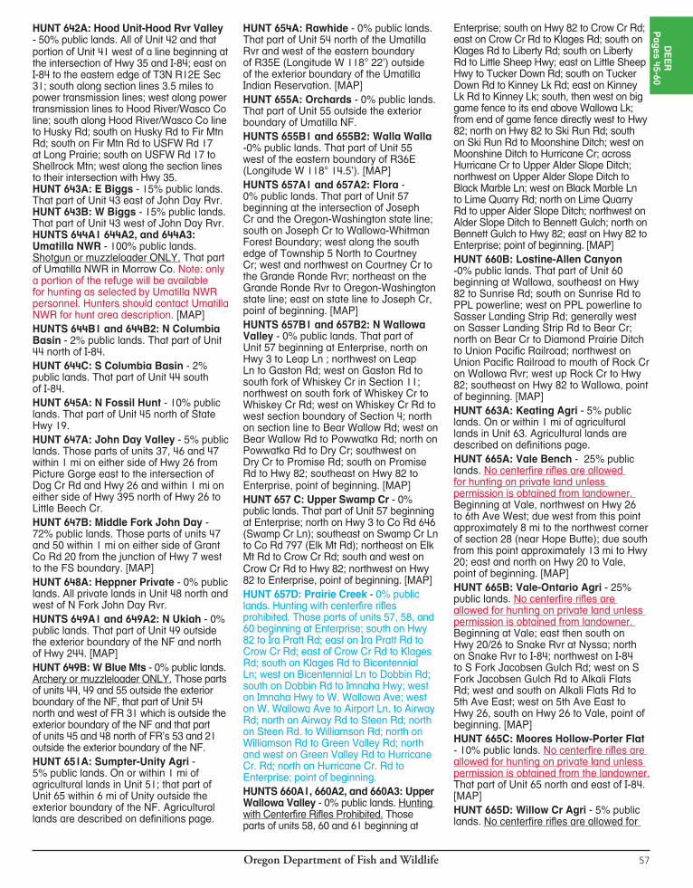
Oregon Department of Fish and Wildlife56
*HUNT DESCRIPTIONSFor those hunt descriptions with [MAP] following the description, maps can be found on our website at www.dfw.state.or.us/resources/hunting/big_game/units.HUNT 614: Trask Unit - 42% public lands. All of Unit 14. There are specific weapon restrictions in the Cascade Head - Lincoln City area of the Trask Unit. See page 98. HUNT 616A1: NW Santiam - 22% public lands. That part of Unit 16 outside of the western exterior boundary of the Mt. Hood NF and Willamette NF beginning at the junction of Hwy 22 and Hwy 226; west on Hwy 22 to Cascade Hwy; north on Cascade Hwy to State Hwy 213 at Silverton; northeast on Hwy 213 to State Hwy 211; northeast on Hwy 211 to Hwy 26 at Sandy; east on Hwy 26 to Teneyck Rd; north on Teneyck Rd to Sandy River; northwest down Sandy River to I-84; northeast on I-84 to Benson State Park and Mt. Hood NF boundary; south along the western exterior boundary of the Mt. Hood NF and Willamette NF to Hwy 22; west on Hwy 22 to Hwy 226; point of beginning. [MAP]HUNT 616A2: SW Santiam - 30% public lands. That part of Unit 16 beginning at Lebanon, north on Brewster Rd to Lacomb Rd; east on Lacomb Rd to Kowitz Rd; north on Kowitz Rd to Baptist Church Dr; west on Baptist Church Dr to Richardson Gap Rd; north on Richardson Gap Rd to State Hwy 226; northeast on Hwy 226 to State Hwy 22, east on Hwy 22 to the western exterior boundary of the Willamette NF; south along the western exterior boundary of the Willamette NF to State Hwy 20; west on Hwy 20 to Lebanon, point of beginning.HUNT 617: Stott Mt Unit - 22% public lands. All of Unit 17. Note: Regulation on weapons in a part of Stott Mt Unit listed on page 98 under Units 14 and 17.HUNT 619: W McKenzie - 5% public lands. All of Unit 19 excluding Willamette NF lands. HUNT 619A: Mill Cr - 13% public lands. That part of Unit 19 beginning at Spring-field; northeast on Mohawk Rvr Rd (Co Rd 19) to BLM Rd 15-1-9; east on 15-1-9, Rd 107, and Rd 100 to the Mohawk 3000 Rd; south on Rd 3000 to the Mohawk Mainline Rd; east on the Mohawk Mainline Rd and Rd 4000 to the Gate Creek 100 Rd; east then south on Rd 100 to the Gate Creek Mainline Rd, south on the Gate Creek Mainline Rd to Hwy 126; west on Hwy 126 to Spring field, point of beginning. [MAP]HUNT 620A: N Siuslaw - 60% public lands. That part of Unit 20 in Lane Co.HUNT 620B: S Siuslaw - 40% public lands. That part of Unit 20 in Douglas Co.
HUNT 620C: Camas Swale - 7% public lands. 255 sq mi. That part of Unit 20 east of Territorial Hwy. [MAP]HUNT 621A: Dorena - 23% public lands. 415 sq mi in northwest corner of Unit 21 beginning at Cottage Grove; north on I-5 to State Hwy 58; southeast on Hwy 58 to Willamette NF boundary; west then south on Forest boundary to BLM Rd 23-1-13; west on 23-1-13 to 23-3-5.4 (Big Rvr Rd); northwest on Big Rvr Rd, London Rd, and S 6th St to I-5; north on I-5 to Cottage Grove, point of beginning. [MAP]HUNT 621B: Calapooya - 15% public lands. Those parts of units 21 and 23 beginning at Roseburg; north on I-5 to S. 6th St. at Cottage Grove, south on S. 6th St. and London Rd. to Big Rvr Rd 23-3-5.4; southeast on 23-3-5.4 to Rock Cr Rd 26-3-1; southwest on 26-3-1 to Hwy 138; west on Hwy 138 to Roseburg, point of beginning. [MAP]HUNT 622A: W Dixon - 44% public lands. That part of Unit 22 beginning at Dixonville; north on Hwy 138 to FR 27 (Little Rvr Rd); east on 27 to FR 2719 (Black Cr Rd); south on 2719 to FR 28; southwest on 28 to Co Rd 1 at Tiller; west on 1 to the Dixonville-Nickel Mt powerline at Days Cr; north on powerline to Dixonville, point of beginning. [MAP]HUNT 623A: Central Melrose - 2% public lands. All of Unit 23 excluding those portions described as follows: Northwest portion bounded by I-5 and Hwy 138 and southwest portion bounded by I-5 and Hwy 42.HUNTS 623B1, 623B2, and 623B3: N Bank Habitat Area - 100% public lands. No motorized vehicles allowed within the hunt area. N Bank Habitat Mgt Area (Dunning Ranch) - 6,500 acres located approximately 8 mi northeast of Roseburg. Open Area: BLM lands located in T25S, R5W, sections 35 and 36; T26S, R5W, sections 1, 2, 11, 12, 13, 14; T25S, R4W, sections 31, 32, 33; T26S, R4W, sections 4, 5, 6, 7, 8, 18. These hunts are exclusively for Master Hunters and requires collecting biological samples from deer. [MAP]HUNT 624A: Tioga - 40% public lands.All of Unit 24 excluding the following: Beginning at confluence of Millicoma and Coos Rvrs; northeast on Millicoma Rvr to Glenn Cr; northeast on Glenn Cr to south boundary of T23S; east on south boundary of T23S to northeast corner of Section 5, T24S, R8W; south on that section line 2 mi to Old Blue Access Rd; south on Old Blue Access Rd, Bateman Access Rd, Weyco 8420, 8800 and 8500 spurs and Reston Rim Rd to south boundary of T27S; west on T27S boundary to southwest corner of T27S, R8W; north on west boundary of R8W to Williams Rvr;
northwest on Williams Rvr to S Fork Coos Rvr; northwest on S Fork Coos Rvr to point of beginning. [MAP]HUNT 624B: E Tioga - 30% public lands. That part of Unit 24 east of the following line: Beginning at Hwy 42 and BLM Rd 29-9-36.0 (Signal Tree Rd) near Camas Valley; west then north on 29-9-36.0 to BLM Rd 28-9-35.0; north on 28-9-35.0 to BLM Rd 28-8-18.0 to Douglas Co Rd 112; east on 112 to BLM Rd 28-8-16.0; northwest on 28-8-16.0 to BLM Rd 28-8-9.1; northeast on 28-8-9.1 to BLM Rd 27-7-4.0; north on 27-7-4.0 to BLM Rd 26-7-33.0; north on 26-7-33.0 to BLM Rd 25-7-29.1; north on 25-7-29.1 to BLM Rd 25-7-29.0; north on 25-7-29.0 to Douglas Co Rd 6 (Hubbard Cr Rd); north on 6 to Unit 23 boundary (Umpqua Rvr). Part of Unit 24 that includes the east and north flowing tributaries of Umpqua Rvr from Basin to Lutsinger Cr. [MAP]HUNT 628A: W Applegate - 57% public lands. 590 sq mi. That part of Unit 28 west of the Jackson-Josephine Co line.HUNT 638A: Lower Willow Cr Agri - 14% public lands. That part of Unit 38; Beginning at confluence of Deschutes Rvr and Trout Cr; east on Trout Cr to Hwy 97; south on Hwy 97 to Dogwood Rd; east on Dogwood Rd to powerlines; south on powerlines to Willow Cr; south on Willow Cr to powerlines; west on powerlines to CRNG’s west boundary; south on west boundary to BOR’s north boundary at Haystack Reservoir; west on BOR boundary to Jericho Ln; west on Jericho Ln to Hwy 97; south on Hwy 97 to Norris Rd; east on Norris Rd to CRNG’s west boundary; south on CRNG’s boundary to the Crooked Rvr; south on the Crooked Rvr to Smith Rock State Park; south and east on State Park boundary to Deschutes Co boundary; north on Co boundary to CRNG; east and north on CRNG boundry to Hwy 26; south on Hwy 26 to Elliot Rd; west and south on Elliot Rd to O’Neil Hwy; west on O’Neil Hwy to Hwy 97; south on Hwy 97 to Hwy 126; west on Hwy 126 to Deschutes Rvr; north on Deschutes Rvr to Trout Cr, point of beginning. [MAP]HUNT 641A: The Dalles Orchard - 0% public land. Shotgun or muzzleloader ONLY. That part of Unit 41 within 1 mi of commercial orchards beginning at The Dalles south on Hwy 197 to south boundary of section 32 (T1N, R13E); west on section lines 9.5 mi; north on section lines 3.75 mi to Browns Cr Rd; northeast on Browns Cr Rd to intersection with Chenowith Rd; northeast on Chenowith Rd and follow Chenowith Creek to its intersection with I-84; east on I-84 to intersection of Hwy 197, point of beginning. [MAP]
SOUTHEAST AREA HUNTS 2013 1ST
HUNT # HUNT NAME BAG LIMIT OPEN SEASON 2013 TAGS CHOICE APPLICANTS 667A Mitchell Butte* One antlerless deer Oct. 18 - Oct. 26 50 273
(No centerfire rifles allowed for hunting on private land without Landowner permission) 667B NE Owyhee One antlerless deer Oct. 18 - Oct. 26 33 83
(No centerfire rifles allowed for huntin on private land without landowner permission) 679A Harney Basin Agri.* One antlerless deer Oct. 18 - Oct. 26 11 204
Oregon Department of Fish and Wildlife 57
HUNT 642A: Hood Unit-Hood Rvr Valley - 50% public lands. All of Unit 42 and that portion of Unit 41 west of a line beginning at the intersection of Hwy 35 and I-84; east on I-84 to the eastern edge of T3N R12E Sec 31; south along section lines 3.5 miles to power transmission lines; west along power transmission lines to Hood River/Wasco Co line; south along Hood River/Wasco Co line to Husky Rd; south on Husky Rd to Fir Mtn Rd; south on Fir Mtn Rd to USFW Rd 17 at Long Prairie; south on USFW Rd 17 to Shellrock Mtn; west along the section lines to their intersection with Hwy 35. HUNT 643A: E Biggs - 15% public lands. That part of Unit 43 east of John Day Rvr. HUNT 643B: W Biggs - 15% public lands. That part of Unit 43 west of John Day Rvr. HUNTS 644A1 644A2, and 644A3: Umatilla NWR - 100% public lands. Shotgun or muzzleloader ONLY. That part of Umatilla NWR in Morrow Co. Note: only a portion of the refuge will be available for hunting as selected by Umatilla NWR personnel. Hunters should contact Umatilla NWR for hunt area description. [MAP]HUNTS 644B1 and 644B2: N Columbia Basin - 2% public lands. That part of Unit 44 north of I-84.HUNT 644C: S Columbia Basin - 2%public lands. That part of Unit 44 south of I-84.HUNT 645A: N Fossil Hunt - 10% public lands. That part of Unit 45 north of State Hwy 19.HUNT 647A: John Day Valley - 5% public lands. Those parts of units 37, 46 and 47 within 1 mi on either side of Hwy 26 from Picture Gorge east to the intersection of Dog Cr Rd and Hwy 26 and within 1 mi on either side of Hwy 395 north of Hwy 26 to Little Beech Cr.HUNT 647B: Middle Fork John Day - 72% public lands. Those parts of units 47 and 50 within 1 mi on either side of Grant Co Rd 20 from the junction of Hwy 7 west to the FS boundary. [MAP]HUNT 648A: Heppner Private - 0% public lands. All private lands in Unit 48 north and west of N Fork John Day Rvr.HUNTS 649A1 and 649A2: N Ukiah - 0% public lands. That part of Unit 49 outside the exterior boundary of the NF and north of Hwy 244. [MAP]HUNT 649B: W Blue Mts - 0% public lands. Archery or muzzleloader ONLY. Those parts of units 44, 49 and 55 outside the exterior boundary of the NF, that part of Unit 54 north and west of FR 31 which is outside the exterior boundary of the NF and that part of units 45 and 48 north of FR’s 53 and 21 outside the exterior boundary of the NF. HUNT 651A: Sumpter-Unity Agri - 5% public lands. On or within 1 mi of agricultural lands in Unit 51; that part of Unit 65 within 6 mi of Unity outside the exterior boundary of the NF. Agricultural lands are described on definitions page.
HUNT 654A: Rawhide - 0% public lands. That part of Unit 54 north of the Umatilla Rvr and west of the eastern boundary of R35E (Longitude W 118° 22’) outside of the exterior boundary of the Umatilla Indian Reservation. [MAP]HUNT 655A: Orchards - 0% public lands. That part of Unit 55 outside the exterior boundary of Umatilla NF.HUNTS 655B1 and 655B2: Walla Walla -0% public lands. That part of Unit 55 west of the eastern boundary of R36E (Longitude W 118° 14.5’). [MAP]HUNTS 657A1 and 657A2: Flora -0% public lands. That part of Unit 57 beginning at the intersection of Joseph Cr and the Oregon-Washington state line; south on Joseph Cr to Wallowa-Whitman Forest Boundary; west along the south edge of Township 5 North to Courtney Cr; west and northwest on Courtney Cr to the Grande Ronde Rvr; northeast on the Grande Ronde Rvr to Oregon-Washington state line; east on state line to Joseph Cr, point of beginning. [MAP]HUNTS 657B1 and 657B2: N Wallowa Valley - 0% public lands. That part of Unit 57 beginning at Enterprise, north on Hwy 3 to Leap Ln ; northwest on Leap Ln to Gaston Rd; west on Gaston Rd to south fork of Whiskey Cr in Section 11; northwest on south fork of Whiskey Cr to Whiskey Cr Rd; west on Whiskey Cr Rd to west section boundary of Section 4; north on section line to Bear Wallow Rd; west on Bear Wallow Rd to Powwatka Rd; north on Powwatka Rd to Dry Cr; southwest on Dry Cr to Promise Rd; south on Promise Rd to Hwy 82; southeast on Hwy 82 to Enterprise, point of beginning. [MAP]HUNT 657 C: Upper Swamp Cr - 0% public lands. That part of Unit 57 beginning at Enterprise; north on Hwy 3 to Co Rd 646 (Swamp Cr Ln); southeast on Swamp Cr Ln to Co Rd 797 (Elk Mt Rd); northeast on Elk Mt Rd to Crow Cr Rd; south and west on Crow Cr Rd to Hwy 82; northwest on Hwy 82 to Enterprise, point of beginning. [MAP]HUNT 657D: Prairie Creek - 0% public lands. Hunting with centerfire rifles prohibited. Those parts of units 57, 58, and 60 beginning at Enterprise; south on Hwy 82 to Ira Pratt Rd; east on Ira Pratt Rd to Crow Cr Rd; east of Crow Cr Rd to Klages Rd; south on Klages Rd to Bicentennial Ln; west on Bicentennial Ln to Dobbin Rd; south on Dobbin Rd to Imnaha Hwy; west on Imnaha Hwy to W. Wallowa Ave; west on W. Wallowa Ave to Airport Ln. to Airway Rd; north on Airway Rd to Steen Rd; north on Steen Rd. to Williamson Rd; north on Williamson Rd to Green Valley Rd; north and west on Green Valley Rd to Hurricane Cr. Rd; north on Hurricane Cr. Rd to Enterprise; point of beginning. HUNTS 660A1, 660A2, and 660A3: Upper Wallowa Valley - 0% public lands. Hunting with Centerfire Rifles Prohibited. Those parts of units 58, 60 and 61 beginning at
Enterprise; south on Hwy 82 to Crow Cr Rd; east on Crow Cr Rd to Klages Rd; south on Klages Rd to Liberty Rd; south on Liberty Rd to Little Sheep Hwy; east on Little Sheep Hwy to Tucker Down Rd; south on Tucker Down Rd to Kinney Lk Rd; east on Kinney Lk Rd to Kinney Lk; south, then west on big game fence to its end above Wallowa Lk; from end of game fence directly west to Hwy 82; north on Hwy 82 to Ski Run Rd; south on Ski Run Rd to Moonshine Ditch; west on Moonshine Ditch to Hurricane Cr; across Hurricane Cr to Upper Alder Slope Ditch; northwest on Upper Alder Slope Ditch to Black Marble Ln; west on Black Marble Ln to Lime Quarry Rd; north on Lime Quarry Rd to upper Alder Slope Ditch; northwest on Alder Slope Ditch to Bennett Gulch; north on Bennett Gulch to Hwy 82; east on Hwy 82 to En ter prise; point of beginning. [MAP]HUNT 660B: Lostine-Allen Canyon -0% public lands. That part of Unit 60 beginning at Wallowa, southeast on Hwy 82 to Sunrise Rd; south on Sunrise Rd to PPL powerline; west on PPL powerline to Sasser Landing Strip Rd; generally west on Sasser Landing Strip Rd to Bear Cr; north on Bear Cr to Diamond Prairie Ditch to Union Pacific Railroad; northwest on Union Pacific Railroad to mouth of Rock Cr on Wallowa Rvr; west up Rock Cr to Hwy 82; southeast on Hwy 82 to Wallowa, point of beginning. [MAP]HUNT 663A: Keating Agri - 5% public lands. On or within 1 mi of agricultural lands in Unit 63. Agricultural lands are described on definitions page.HUNT 665A: Vale Bench - 25% public lands. No centerfire rifles are allowed for hunting on private land unless permission is obtained from landowner. Beginning at Vale, northwest on Hwy 26 to 6th Ave West; due west from this point approximately 8 mi to the northwest corner of section 28 (near Hope Butte); due south from this point approximately 13 mi to Hwy 20; east and north on Hwy 20 to Vale, point of beginning. [MAP]HUNT 665B: Vale-Ontario Agri - 25% public lands. No centerfire rifles are allowed for hunting on private land unless permission is obtained from landowner. Beginning at Vale; east then south on Hwy 20/26 to Snake Rvr at Nyssa; north on Snake Rvr to I-84; northwest on I-84 to S Fork Jacobsen Gulch Rd; west on S Fork Jacobsen Gulch Rd to Alkali Flats Rd; west and south on Alkali Flats Rd to 5th Ave East; west on 5th Ave East to Hwy 26, south on Hwy 26 to Vale, point of beginning. [MAP] HUNT 665C: Moores Hollow-Porter Flat - 10% public lands. No centerfire rifles are allowed for hunting on private land unless permission is obtained from the landowner. That part of Unit 65 north and east of I-84. [MAP]HUNT 665D: Willow Cr Agri - 5% public lands. No centerfire rifles are allowed for
DE
ER
Pages 45-60

Oregon Department of Fish and Wildlife58
hunting on private land unless permission is obtained from landowner. Approximately 75 sq mi in the vicinity of Willow Cr and Jamieson, northwest of Vale in Malheur Co: Starting at the intersection of State Hwy 26 and 6th Ave. W., northwest of Vale, proceed west along 6th Ave. W to its end; continue directly west about 4.5 mi to Hope Flat - Gum Cr Rd; northwest on the Hope Flat - Gum Cr Rd approximately 11 mi to its intersection with the Gum Cr/14th Ave W Rd; east along the Gum Cr/14th Ave W Rd to the intersection with State Hwy 26 and N Rd K; north on N Rd K to a point which is 1 mi northeast of the Willow Cr drainage, southeast and parallel to Willow Cr for approximately 14 mi to 5th Ave E; west on 5th Ave E to Hwy 26, northwest on Hwy 26 to 6th Ave W, point of beginning [MAP]. HUNT 667A: Mitchell Butte - 26% public lands. No centerfire rifles are allowed for
hunting on private land unless permission is obtained from landowner. That part of Unit 67 beginning at Hwy 201 and Oregon-Idaho state line; south on the Oregon/Idaho state line to the Pacific Power and Light (PP&L) transmission line; northwest along the PP&L transmission line to the Succor Cr Rd; north on the Succor Cr Rd to Hwy 201; northwest on Hwy 201 to junction with Woodbridge Rd; west on Woodbridge Rd 3-1/4 mi to southwest corner Section 17 (T22S, R46E); north on section lines 5 mi; west on section lines 4 mi; north at this point 9 mi on section lines; east at this point on section lines 4-1/2 mi to Enterprise Ave; continue east on Enterprise Ave, past Hwy 201 to Snake Rvr; south on Snake Rvr and Oregon-Idaho border to Hwy 201, point of beginning. [MAP]HUNT 667B: NE Owyhee - 27% public lands. No centerfire rifles are allowed for hunting on private land unless permission is obtained from landowner. That part of Unit
67 beginning at Vale; east on US Hwy 20 to Hwy 201; south on Hwy 201 to Enterprise Ave; west on Enterprise Ave to Lytle Blvd; northwest on Lytle Blvd to Sandhollow Rd; southwest to Sandhollow Rd to the JH irrigation canal; west (upstream) on JH canal to Hwy 20 at MP 236; east on Hwy 20 to Vale, point of beginning. [MAP]HUNT 679A: Harney Basin Agri - 45% public lands. Parts of units 66, 69 and 71 as follows: That part of Unit 66 south of US Hwy 20 and west of Crane-Buchanan Rd. In Unit 69, that part north of the following line: Beginning at Hwy 78 near Princeton; south on Lava Bed Rd (Co Rd 404) to Diamond Ln (Co Rd 409); west on Diamond Ln to Hwy 205. In Unit 71, that part north of the following line: Beginning on US Hwy 395 near MP 17; east on Iron Mt Rd to Double O Rd; east on Double O Rd to State Hwy 205. Excluding Malheur NWR. [MAP]
Wallowa Co passed an ordinance in 1989 making all of the county a Hay Quarantine Area. In 2010, this Weed Ordinance (2010-001) was revised and made more restrictive. While the 1989 ordinance made it unlawful to transport into Wallowa County for use on public lands any hay, straw, or grass (whether baled, chopped, or cubed) which is not certified as weed-free. It is now also unlawful to transport uncertified hay, straw, or grass (whether baled, chopped, or cubed) onto private lands, except if you have permission from the landowner; furthermore, it is now unlawful to transport uncertified hay, straw, or grass (whether baled, chopped, or cubed) within Wallowa County. Therefore, if you have uncertified hay, straw, or grass (whether baled, chopped, or cubed) on public land or on private land without the permission of the landowner, you could be cited for it, no matter where you acquired it. To be legal, feed must meet the certification requirements of the North American Weed Management Association (NAWMA).
The reasons for this ordinance are: noxious weeds are being introduced to big game and livestock ranges; farmers, the county, ODFW, and other landowners area spending thousands of dollars for weed control/ an effort is being made to reduce chemical use; and weeds have destroyed major wildlife habitat areas in surrounding states and counties.
Hay pellets are an excellent feed for horses, easily packed, and lawful to use because weed seed is sterilized in the pelleting process. Horse users are urged to use pellets when possible.
Wallowa Co is asking all hunters, campers, and landowners to cooperated in this effort. Hay will be available at the Hay Station in Minam, at Wallowa, Enterprise, and Joseph. The Hay Station will be open three days prior to the Controlled Buck Deer, Second Season Bull Elk, and Controlled Antlerless Elk seasons and four days prior to the First Bull Elk season. For more information call the Wallowa Co Vegetation Manager 541-426-3332; Wallowa Co Extension 541-426-3143; or the Wallowa Mt Visitor Center 541-426-4978.
WALLOWA COUNTY IS A HAY QUARANTINE AREA
Certi� ed Weed Free Straw & Forage is Required for all National Forest Lands
For Local Distribution Listings and More Information:http://www.oregon.gov/ODA/CIO 1-503-986-4620Or Contact Your County Weed Superintendent
Wash vehicles and stock trailers inside and out.
Clean tents and camp gear before your next trip
Drive only on established roads and trails away from weed infested areas.
Within 96 hours before entering back country areas, feed pack animals only feed that is certi� ed weed free.
Remove weed seed from pack animals by brushing them thoroughly and cleaning their hooves before transporting.
When using pack animals, carry only feed that is certi� ed weed free.
CERTIFIED WEED-FREESTRAW & FEED REQUIREDON NAT’L FOREST LANDS
Oregon Department of Fish and Wildlife 59
*HUNT DESCRIPTIONSFor those hunt descriptions with [MAP] following the description, maps can be found on our website at www.dfw.state.or.us/resources/hunting/big_game/units.
HUNT 141T: The Dalles Watershed - 100% public lands. That part of Unit 41 as follows: 22 sq mi in Unit 41 southwest of The Dalles within the boundaries of The Dalles Watershed. This area is closed to motor vehicles. Entry is allowed only by a valid City of The Dalles permit, only for the duration of the hunt. Any
entry into watershed at other times or by persons other than tag holder and one accompaning adult is prohibited. The City of The Dalles entry permit will be limited to the youth with a valid ODFW controlled hunt tag and one adult, 21 years or older, who may not hunt. Early season snows may make this hunt challenging. [MAP]
YOUTH CONTROLLED DEER HUNTSTAG SALE DEADLINE is day before the hunt begins. For hunts with more than one hunt period, the tag sale deadline is day before the earliest opening date. The deer hunts listed below and elk hunts listed on page 77, are part of a program to encourage youth participation in big game hunting.CONTROLLED HUNT Application procedures: Please read pages 13-15. Hunters should apply for more than one hunt choice. If your first choice hunt is cancelled, you will receive a postcard describing your hunt choice options. See page 15 for further information.These hunts are designed to provide young hunters with a safe, well-supervised, low-stress setting where they can enjoy the hunt while building fun da men tal skills. Youths must be accompanied by an adult at least 21 years of age. Adults may not accompany more than two youths.To apply, hunters must be 12-17 years old at the time they hunt, have completed a hunter education class by the time they hunt (see page 85 for Hunter Education Requirement) and possess a hunting license. Youth selected for these hunts will be provided with ad-di tion al in for ma tion and rec om men da tions about preparing for the hunt. See pages 13-15 for application procedures. Hunters should apply for more than one hunt area. USE COMPLETE HUNT NUMBER WHEN APPLYING. HUNT AREA: Entire wildlife management unit unless indicated by an asterisk(*). A map will be sent if indicated in hunt description by [MAP]. Landowner preference tags available, see page 19. Please note additional closure areas listed on pages 96-100 that may affect your hunt area.
NOTE: White-tailed deer are protected in all units west of the eastern boundaries of Santiam, McKenzie, Indigo, Dixon and Rogue units, except for the Umpqua hunts (123A, 123R1) and North Bank Habitat hunts (123B, 123M2, 123R2, 623T1) listed on pages 45, 48, 49, and 59. 2013 1ST HUNT # HUNT NAME BAG LIMIT OPEN SEASON 2013 TAGS CHOICE APPLICANTS 141T The Dalles Watershed* One buck with visible antler Nov. 15 - Nov. 23 5 121 174T Warner Unit One deer Sept. 20 - Sept. 28 20 93 175T Interstate Unit One deer Nov. 22 - Nov. 30 30 778 610T Saddle Mt Unit One spike or antlerless deer Oct. 4 - Nov. 9 50 98 611T Scappoose Unit One spike or antlerless deer Oct. 4 - Nov. 9 50 112 612T Wilson Unit One spike or antlerless deer Oct. 4 - Nov. 9 50 98 614T Trask Unit * One spike or antlerless deer Oct. 4 - Nov. 9 50 113 616T SW Santiam* One deer Nov. 15 - Nov. 26 100 293 617T Stott Mt. Unit* One spike or antlerless deer Oct. 4 - Nov. 9 31 82 618T Alsea Unit One spike or antlerless deer Oct. 4 - Nov. 9 20 85 619T McKenzie Unit One deer Nov. 15 - Nov. 26 100 444 620T1 N Siuslaw * One spike or antlerless deer Oct. 4 - Nov. 9 43 49 620T2 Territorial* One deer Nov. 8-9, 15-16, 10 54 22-23, 29-30 621T N Indigo* One deer Nov. 15 - Nov. 26 75 127 623T1 N Bank Habitat (T) One white-tailed buck having Oct. 4 - Oct. 12 31 111 Mgt Area No. 1* not less than a forked antler or one black-tailed deer 623T2 N Bank Habitat (T) One black-tailed deer Nov. 1 - Nov. 9 32 52 Mgt Area No. 2* 623T3 Melrose* One deer Dec. 15 - Jan. 5, 2015 42 81 625T N Sixes* One spike or antlerless deer Dec. 15 - Jan. 5, 2015 77 53 627T Chetco Unit One deer Dec. 15 - Jan. 5, 2015 25 52 628T Applegate Unit One deer Dec. 15 - Jan. 5, 2015 25 122 629T Evans Cr Unit One deer Dec. 15 - Jan. 5, 2015 55 139 630T Rogue Unit One deer Dec. 15 - Jan. 5, 2015 55 423 632T1 Moyina Hill One deer Oct. 25 - Nov. 2 3 27 632T2 S Bryant Youth One deer Oct. 18 - Oct. 26 est. 5 in 2014 NEW 640T Mid-Columbia Private* One antlerless deer Nov. 22 - Dec. 7 32 45 644T1 Umatilla NWR* One antlerless deer Aug. 23 - Aug. 27 8 19 Shotgun/Muzzleloader ONLY 644T2 Umatilla Co. Private* One antlerless deer Nov. 15 - Dec.7 43 80 648T Morrow Co* One antlerless deer Nov. 22 - Nov. 30 59 90 651T1 Baker No. 1* One antlerless deer Oct. 25 - Nov. 2 32 68 651T2 Baker No. 2* One antlerless white-tailed deer Oct. 25 - Nov. 2 32 13 652T1 Ladd Marsh Bow No. 1* One deer Aug. 30 - Sept. 14 3 14 Archery ONLY 652T2 Ladd Marsh No. 2* One deer Sept. 24 - Oct. 3 3 22 Shotgun/Muzzleloader ONLY 665T Malheur Co* One antlerless deer Aug. 1- Sept. 28 & Oct. 18 - Oct. 31 50 77 675T Paisley* One antlerless deer Sept. 1- Sept. 9 5 22 679T Harney Basin* One antlerless deer Sept. 13 - Sept. 21 28 53 (T) = Mandatory training session. See hunt description.
Private lands will limit access for hunts printed in red. Do not apply unless you have access to a place to hunt.STOP
DE
ER
Pages 45-60
“A
VO
ID
T
HE
F
EE
”
MA
ND
AT
OR
Y
RE
PO
RT
IN
G
RE
QU
IR
ED
S
EE
P
AG
E
6
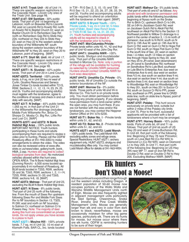
Oregon Department of Fish and Wildlife60
HUNT 614T: Trask Unit - All of Unit 14. There are specific weapon restrictions in the Cascade Head - Lincoln City area of the Trask Unit. See page 98.HUNT 616T: SW Santiam - 30% public lands. That part of Unit 16 beginning at Lebanon; north on Brewster Rd to Lacomb Rd; east on Lacomb Rd to Kowitz Rd; north on Kowitz Rd to Baptist Church Dr; west on Baptist Church Dr to Richardson Gap Rd; north on Richardson Gap Rd to State Hwy 226; northeast on Hwy 226 to State Hwy 22; east on Hwy 22 to the western exterior boundary of the Willamette NF; south along the western exterior boundary of the Willamette NF to Hwy 20; west on Hwy 20 to Lebanon, point of begining. [MAP]HUNT 617T: Stott Mt. Unit: All of Unit 17. There are specific weapon restrictions in the Cascade Head - Lincoln City area of the Stott Mt Unit. See page 98.HUNT 620T1: N. Siuslaw - 60% public lands. That part of Unit 20 in Lane County. HUNT 620T2: Territorial - 100% private lands. 6.9 sq. mi in Unit 20 two mi west of Curtin. Giustina Resources and Seneca Jones Timber Co lands located within T21S, R5W, Sections 2, 11, 12, 13, 14, 23, 24, 25 and 26. Youths and accompanying adult(s) must register with the landowner, agree to the conditions of access and check in and out daily with security. [MAP]HUNT 621T: N Indigo - 65% public lands. 1,055 sq mi. in that part of the Unit 21 in the Willamette Rvr drainage (includes Middle Fork Willamette Rvr, Brice Cr, Sharps Cr, Mosby Cr, Big Rvr, Little Rvr and Lost Cr). [MAP]HUNTS 623T1 and 623T2: N Bank Habitat Mgt Area - 100% public lands. IMPORTANT NOTICE: Youth hunters participating in these hunts and adults accompanying them are required to review a video prior to hunting. Please call the ODFW Roseburg office at 541-440-3353 to make arrangements to obtain the video. The video can also be reviewed online at www.dfw.state.or.us/news/video_gallery/north_bank_HMA_2.asp. Hunters are required to collect biological samples from deer. No motorized vehicles allowed within the hunt area. OPEN AREA: The N Bank Habitat Mgt Area (Dunning Ranch) - 6,500 acres located ap-prox i mate ly 8 mi northeast of Roseburg. All BLM lands located in T25S, R5W, sections 35 and 36; T26S, R5W, sections 1, 2, 11-14; T25S, R4W, sections 31-33; and T26S, R4W, sections 4-8, 18. [MAP]HUNT 623T3: Melrose - That part of Unit 23, excluding the BLM N Bank Habitat Mgt Area. HUNT 625T: N Sixes - 8% public lands. That part of Unit 25 north of the following line: From the mouth of Sixes Rvr upstream following Sixes Rvr and Middle Fork Sixes Rvr to NF boundary in Section 13, T32S, R13W; east and north on NF boundary to Salmon Cr; northeast on Salmon Cr to Powers Hwy. Note: The majority of deer during this hunt are concentrated on private lands. Do not apply unless you have access to a place to hunt.HUNT 632T1: Moyina Hill - 100% private lands. 7.7 sq. mi in Unit 32, 10 mi east of Klamath Falls. BAR CL, Inc. lands located
in T39 - R10 Sec 2, 3, 10, 15; and T38 - R10 Sec 15, 21, 22, 23, 26, 27, 28, 33, 34, and 35. Youths and accompanying adults will be required to attend an orientation with the landowner or their agent. [MAP] HUNT 632T2: S Bryant Youth - 100% Private Lands. 4 sq. mi in Unit 32, 5 miles east of Malin. Basin View Ranch lands in T40S R13E Sec 15, 16, 21, 22, 23, 24. Youth hunters and accompanying adults will be required to check in with the landowner prior to hunting. HUNT 640T: Mid-Columbia Private - Private lands within units 40, 41, 42 and that part of Unit 43 west of the John Day Rvr. HUNT 644T1: Umatilla NWR - 100% public lands. Shotgun and muzzleloader only. That part of the Umatilla NWR located in Morrow Co. Note: only a portion of the refuge will be available for hunting as selected by Umatilla NWR personnel. Hunters should contact Umatilla NWR for hunt area description. HUNT 644T2: Umatilla Co. Private - 0% public lands. All of Umatilla Co outside the exterior boundaries of the NF.HUNT 648T: Morrow Co - 0% public lands. Those parts of units 48 and 44 in Morrow Co. This hunt is on private lands only. You must obtain permission before entering any private property. If you already have permission from a land-owner within the open area, you may hunt there. If you are not familiar with the area and/or the landowners, you may contact the Heppner District Office at 541-676-5230.HUNT 651T1: Baker No. 1 - Private lands within units 51, 62, and 63. HUNT 651T2: Baker No. 2 - Private lands within units 51, 62, and 63.HUNTS 652T1 and 652T2: Ladd Marsh - 100% public lands. The Ladd Marsh WA excluding safety zones and refuge areas. Special Restrictions: HUNT 652T1; archery equipment only, HUNT 652T2; shotguns and muzzleloading rifles only. You may contact Ladd Marsh office for details at 541-963-4954.
HUNT 665T: Malheur Co - 5% public lands. That part of units 65 and 67 as follows: Any private land with landowner permission and public lands within the following boundaries: beginning at Nyssa north on the Snake Rvr to Birch Cr, upstream Birch Cr to I-84, SE on I-84 to Jacobsen Gulch Rd; west on Jacobsen Gulch Rd to Alkali Flat Rd; southwest on Alkali Flat Rd to the Section 13 Northwest parallel to Willow Cr drainage to a point in the center of section 3, 1.5 mi north of Jameson; due south to N Rd K; south on N Rd K to 14th Ave W; west on 14th Ave W to Gum Cr Rd; west on Gum Cr Rd to Hope Flat Gum Cr Rd; south on Hope Flat-Gum Cr Rd to the south line of Sec. 22; west on section lines 1.6 miles; south 12 miles on section line through Hope Spring to Hwy 20; east on Hwy 20 to JH canal; east (downstream) on JH canal to Sandhollow Rd; northeast on Sandhollow Rd to Lyle Blvd; southeast on Lyle Blvd to Enterprise Ave; due west on Enterprise Ave to end, due west on section lines 4.5 mi, due south on section lines 9 mi; due east on section lines 4 mi; due south on section lines 5 mi; due west on section lines to Woodbridge Rd; east on Woodbridge Rd to Hwy 201, south on Hwy 201 to Succor Cr Rd; south on Succor Cr Rd to PPL power line; southeast on PPL power line to OR/ID state line; north on state line to Nyssa; point of beginning. [MAP]HUNT 675T: Paisley - This hunt occurs exclusively on private land, outside but within 2 miles of the Paisley city limits in Unit 75. Prior to the hunt, successful applicants will be provided with a list of landowners where a hunt may be arranged.HUNT 679T: Harney Basin - 45% public lands. Parts of units 66, 69 and 71 asfollows: That part of Unit 66 south of US Hwy 20 and west of Crane-Buchanan Rd. In Unit 69, that part north of the following line: Beginning at Hwy 78 near Princeton; south on Lave Bed Rd (Co Rd 404) to Diamond Ln (Co Rd 409); west on Diamond Ln to Hwy 205. In Unit 71, that part north of the following line: Beginning on US Hwy 395 near MP 17, east on Iron Mt Rd to Double O Rd; east on Double O Rd to Hwy 205. Excluding Malheur NWR. [MAP]
Elk hunters – Don’t Shoot a Moose!
Moose continue to expand their range through out the western states including Oregon. A resident population of 50-60 moose now occupies portions of the Walla Walla and Wenaha Wildlife Management Units north of Elgin. Moose are also frequently sighted in adjacent management units particularly the Sled Springs, Chesnimnus, Snake River, Imnaha and Pine Creek Wildlife Management Units. Moose are generally larger than elk and vary in color from dark brown to black; nevertheless, moose are occasionally mistaken for other big game species, particularly elk. There are no hunts for moose, but moose occur where there are elk hunts. ODFW is reminding hunters to be sure of their target.
Oregon Department of Fish and Wildlife 61
The Oregon Department of Fish and Wildlife has a statutory obligation to address property damage and that is the primary purpose of late antlerless elk hunts. Landowners suffering damage acknowledge these late hunts help them at a time when elk are seeking growing forage, especially pastures.
Late season antlerless elk hunts present hunters with challenges and recognizing these challenges will improve chances for a successful hunt. The Oregon Department of Fish and Wildlife and Oregon State Police would like to provide you with some information to help with one of those challenges and minimize the potential for a violation.
One potential violation during late season hunts is killing a bull after the antlers have dropped. Bulls that have shed their antlers are not legal during antlerless elk seasons. In these regulations, “Antlerless elk” are defined as a cow or calf elk.
From a distance, bulls that have shed antlers may look like a cow elk, especially in low light situations. Hunters with late-season antlerless elk tags are encouraged to look carefully at elk when hunting in late February and March. Avoiding shed-antlered bulls in the late winter will assure compliance with the law and save these valuable animals for breeding stock as well as a potential trophy for a hunter the next fall.
There are several clues to help hunters determine the sex of an elk during these late hunts. Generally, older bulls drop antlers earlier than younger bulls and older bulls also tend to be solitary or in herds with other bulls. Bulls with shed antlers are typically lighter in body color with a more reddish (reddish-brown) mane than cow elk. A close look at the top of the head of a bull reveals the pedicles from which the antlers grow. The bulls most often associated with cow/calf groups are spikes and other young bulls that usually do not drop antlers until late-March or April.
If you make a mistake and believe that you have inadvertently shot a bull, don’t compound the mistake by risking an additional charge of waste. Contact the Oregon State Police and solicit their assistance; this allows for the salvage of the animal which ultimately goes to a charitable institution.
Always promote safe, legal and ethical hunting practices to ensure quality hunting for future generations.
Good hunting!
LATE SEASON ANTLERLESS ELK HUNTS
Bull Elk after dropping antlers (note pedicels)
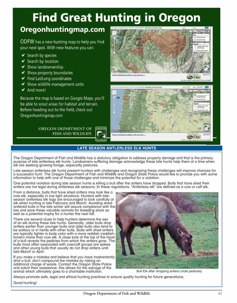

Oregon Department of Fish and Wildlife62
ELKCENTERFIREFIREARMSEASONS
GENERAL ROCKY MT BULL ELK:1st Season: Oct. 29 - Nov. 2 (General Centerfire Firearm Season) 2nd Season: Nov. 8 - Nov. 16 (General Centerfire Firearm Season)
GENERAL ROCKY MT BULL ELK: Columbia Basin Extended Season: Oct. 29 - Dec. 5 (General Centerfire Firearm Season)PUBLIC ACCESS IS EXTREMELY LIMITED IN THIS AREA; OBTAIN PERMISSION BEFORE HUNTING. That part of Biggs Unit east of John Day Rvr and Columbia Basin Unit are open with a one elk bag limit FOR FIRST SEASON GENERAL ROCKY MT ELK TAG HOLDERS ONLY.
GENERAL ROCKY MT BULL ELK:1st Season: Controlled Elk Hunting only. See hunt tables pages 64-68. 2nd Season: Nov. 8 - Nov. 16 (General Centerfire Firearm Season)
CONTROLLED ELK HUNTING ONLY. NO GENERAL SEASON. See pages 64-68 for controlled hunt opportunities.
There are no hunting opportunities on NP lands, or allotted and/or Tribal lands in these areas.
You may only hunt one of the elk seasons listed on this page. Make sure you purchase or redeem the correct tag for the season you want to hunt prior to the earliest hunt date.
NOTE: Coast bull elk 2nd Season tags are valid in all coast general season units Nov. 22-28, including Wilson, Trask and Siuslaw units; however, the bag limit in Wilson, Trask and Siuslaw is SPIKE ONLY.
ELK BAG LIMIT DEFINITIONS: See pages 81 - 82, also refer to spike antler sketches on page 63.3 pt. + = Bull elk having three points or more on one antler including the brow tine. Antlerless = Cow or calf elk. Bull elk = Bull elk with at least one visible antler. One elk = Either sex elk.Spike only = Bull elk with at least one visible unbranched antler (a brow tine is not considered an antler branch under spike only regulations). Refer to sketches on page 63.
GENERAL CASCADE BULL ELK:Oct. 18 - Oct. 24 (General Centerfire Firearm Season)
GENERAL COAST BULL ELK:1st Season: Nov. 15 - Nov. 18 (General Centerfire Firearm Season) 2nd Season: Nov. 22 - Nov. 28 (General Centerfire Firearm Season) SPIKE ONLY ELK bag limit in Wilson, Trask and Siuslaw units.
SANTIAM16
WHITEHORSE68
JUNIPER71
BEULAH65
OWYHEE67
ALSEA18
INDIGO21
PAULINA35
MCKENZIE19
WAGONTIRE73
TIOGA24
DIXON22
SILVIES72
GRIZZLY38
CHETCO27
ROGUE30
KENO31
INTERSTATE75
OCHOCO37
MALHEUR RIVER66
BEATYS BUTTE70
SIUSLAW20
SIXES25
SUMPTER51
MAURY36
FORT ROCK77
APPLEGATE28
WARNER74
NORTHSIDE47
SPRAGUE33
SILVER LAKE76
EVANS CREEK29
METOLIUS39
MURDERERS CR46
BIGGS43WILLAMETTE
15
FOSSIL45
TRASK14
COLUMBIA BASIN44
HEPPNER48
UKIAH49
STEENSMTN69
MEL
ROSE
23
POWERS26
STARKEY52
MINAM60
KLAMATH FALLS32
WILSON12
WHITERIVER
41
UPPER
DESCHUTES
34
KEATING63
MAUPIN40
HOOD42
SLEDSPRINGS
57SCAP
POO
SE11
MTEMILY
54
IMNAHA61
DESOLATION50
CH
ESNIM
NU
S
58
SADDLE MTN10 WENAHA
56
WARMSPRINGS
INDIANRES.
CATH
ERIN
E CR
53
SNAKERIVER
59
PINECREEK
62STOTT MTN 17
LOOKOUTMTN
64
WALLAWALLA
55
CRATERLAKEN.P.
UMATILLA INDIANRESERVATION
SOUTHEAST
NORTHEAST
NORTHWEST
SOUTHWEST
CENTRAL
SOUTH CENTRAL
COLUMBIA
APPLEGATE28
KLAMATHFALLS
32
CHETCO27
BEATYS BUTTE70
INTERSTATE75
WARNER74
KENO31
SPRAGUE33
EVANS CREEK29 WHITEHORSE
68
POWERS26
SILVER LAKE76
ROGUE30
DIXON22
SIXES25
JUNIPER71 STEENS
MTN69
FORT ROCK77
TIOGA24
MELRO
SE23 WAGONTIRE
73
INDIGO21
OWYHEE67
SILVIES72
MAURY36
MALHEUR RIVER66
SIUSLAW20
PAULINA35
UPPER
DESCHUTES
34
MURDERERS CR46
MCKENZIE19
BEULAH65
OCHOCO37
METOLIUS39
NORTHSIDE47
LOOKOUTMTN 64GRIZZLY
38
ALSEA18
DESOLATION50
SUMPTER51
STOTT MTN17 KEATING
63
FOSSIL45
PINECREEK
62
MAUPIN40
STARKEY52HEPPNER
48
IMNAHA61
CATHERINE CR
53
SANTIAM16
MINAM60WILLAMETTE
15 UKIAH49
TRASK14
WHITERIVER
41
HOOD42
BIGGS43
MT EMILY54
SNAKERIVER
59
WILSON12
WALLAWALLA
55
WENAHA56
SLEDSPRINGS
57
CHESNIMNUS
58
SCAPP
OOSE11
SADDLE MTN10
COLUMBIA BASIN44
WARM SPRINGSTRIBAL
RES.
CRATER LAKE NATIONAL PARK
UMATILLA TRIBAL RESERVATION
“A
VO
ID
T
HE
F
EE
”
MA
ND
AT
OR
Y
RE
PO
RT
IN
G
RE
QU
IR
ED
S
EE
P
AG
E
6
Oregon Department of Fish and Wildlife 63
ELKCENTERFIREFIREARMGENERALSEASONS
ILLUSTRATIONS FOR SPIKE ELK HUNTSA “spike only” bag limit applies in some hunts. The sketches below show some antler configurations you may encounter in the field. Please use caution and judgement when selecting your target.
Note: Tag sale deadline is the day before the earliest opening day for a season.
1Refer to page 62 for BAG LIMIT DEFINITIONS.2See page 98 under units 14 & 17 for weapon restrictions in parts of Stott Mt and Trask units referred to as the Cascade Head - Lincoln City Area.Note: It is unlawful to hunt with a centerfire or muzzleloading rifle without a valid elk tag for that time period and area during: Cascade bull elk centerfire firearm season, Coast bull elk centerfire firearm seasons, or Rocky Mt bull elk. or either-sex centerfire firearm seasons or the standard Rocky Mt antlerless elk centerfire firearm seasons (Nov. 22 -30). See page 28 for exceptions.
OPEN SEASON TAG REQUIRED BAG LIMIT1 OPEN AREA (See pages 98-100 for refuge and area regulations).
Oct. 18 - Oct. 24
Nov. 15 - Nov. 18
Nov. 22 - Nov. 28
Oct. 29 - Nov. 2
Oct. 29 - Dec. 5 Columbia Basin Extended Season
Nov. 8 - Nov. 16
Cascade Elk
Coast Elk 1st Season
Coast Elk2nd Season
Rocky Mt Elk1st Season
Rocky Mt Elk1st Season
Rocky Mt Elk2nd Season
One bull elk with visible antler
One bull elk with visible antler
One bull elk with visible antler
One spike elk with at least one visible unbranched antler One bull elk with visible antler
One elk
One bull elk with visible antler
One spike elk with at least one visible unbranched antler
Dixon, Evans Cr, Indigo, Keno, McKenzie, Metolius, Rogue, Santiam and Upper Deschutes units, those parts of Fort Rock and Sprague units west of Hwy 97 and that part of Grizzly Unit west of Hwy 97 and south of Hwy 26.
Alsea, Applegate, Melrose, Scappoose, Siuslaw, Stott Mt2, Trask2, Willamette and Wilson units.
Alsea, Applegate, Melrose, Scappoose, Stott Mt2 and Willamette units.
Wilson, Trask2 and Siuslaw units.
Hood, Maupin and White Rvr units and that part of Biggs unit west of John Day Rvr.
Columbia Basin unit and that part of Biggs unit east of John Day Rvr.
Hood, Maupin and White Rvr units and that part of Biggs unit west of John Day Rvr.
Catherine Cr, Desolation, Imnaha, Keating, Pine Cr, Starkey (except approximately 40 sq mi. of the Starkey Experimental Forest within the Starkey Unit shall be closed to all elk hunting unless the hunter has a valid controlled elk hunt tag for the Experimental Forest), Ukiah units, Heppner unit north and west of N Fork John Day Rvr and Sumpter Unit north of State Hwy 245 and Burnt Rvr Canyon Rd between Unity and Durkee.
GENERALCASCADE
GENERALCOAST1ST SEASON
GENERAL COAST 2ND SEASON
GENERAL ROCKY MT 1ST SEASON
GENERAL ROCKY MT 2ND SEASON
ELK
Pages 62-80
“A
VO
ID
T
HE
F
EE
”
MA
ND
AT
OR
Y
RE
PO
RT
IN
G
RE
QU
IR
ED
S
EE
P
AG
E
6
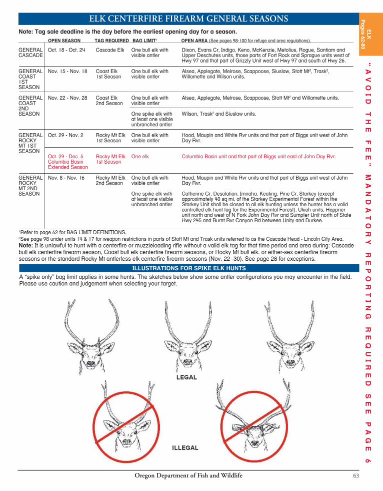

Oregon Department of Fish and Wildlife64
CONTROLLED200SERIESELKCENTERFIREFIREARMTAG SALE DEADLINE: The day before the hunt begins.CONTROLLED HUNT Application procedures: Please read pages 13-15. Hunters should apply for more than one hunt choice. If your first choice hunt is cancelled, you will receive a postcard describing your hunt choice options. See page 15 for further information. You may submit only 1 application for elk (200 series) hunts. This may include bull, either-sex, or antlerless elk (200 series) hunts.CAUTION TO HUNTERS: Obtaining a tag does not guarantee a place to hunt! Some hunts in these regulations are comprised mostly or entirely of private lands and are printed in red. ODFW tries to design hunts to provide public access; however, in areas where this is not possible, it is the hunter’s responsibility to obtain access to hunt on private property. Refer to pages 96-97 for Rd closure information.NOTE: The “2013 1st Choice Applicants” column is not influenced by preference points; it only indicates the number of first choice applicants for each hunt.REGULATIONS: It is unlawful to hunt with a centerfire or muzzleloading rifle without a valid elk tag for that time period and area during: Cascade bull elk centerfire firearm season, Coast bull elk centerfire firearm seasons, or Rocky Mt bull elk or either-sex centerfire firearm seasons or standard Rocky Mt antlerlass elk
centerfire firearm seasons (Nov. 22 - Nov. 30). See page 28 for exceptions.The Fish and Wildlife Com mis sion will not set actual tag numbers for hunts listed here until June 2014. Tag numbers currently shown, for your reference, were those allocated for 2013 or estimated for new 2014 hunts. Actual tag numbers for 2014 may be higher or lower than those listed based on population conditions. NOTE: As a hunter it is your responsibility to ensure the hunts you apply for (all choices in all series) are hunts you want to participate in. It is your responsibility to monitor your preference points, tags allocated to specific hunts, odds of drawing a tag and to ensure the actual area you are interested in hunting is within the hunt boundary and is open for hunting access. ODFW strives to make all information available to all hunters and ODFW will not reinstate preference points or change tags because the tag you drew is not the one you wanted or expected.HUNT AREA: Entire wildlife management unit unless indicated by an asterisk(*). A map will be sent if indicated in hunt description by [MAP]. Landowner preference tags available, see page 19. Please note additional closure areas listed on pages 96-100 that may affect your hunt area.
NORTHWEST AREA HUNTS 2013 1ST
HUNT # HUNT NAME BAG LIMIT OPEN SEASON 2013 TAGS CHOICE APPLICANTS 210 Saddle Mt Unit One antlerless elk Dec.1 - Mar. 15, 2015 10 656 210A1 Onion Peak No. 1* One antlerless elk Dec. 6-7, 13-14, 20 -21, 10 190 27-28 210A2 Onion Peak No. 2* One antlerless elk Jan. 3-4, 10-11,17-18, 10 264 24-25, 2015 210B1 Lewis & Clark No. 1* One antlerless elk Dec. 6-7, 13-14, 20 -21,, 10 200 27-28 210B2 Lewis & Clark No. 2* One antlerless elk Jan. 3-4, 10-11,17-18, 10 211 24-25, 2015 210C Upper Nehalem* One antlerless elk Dec. 1 - Mar. 15, 2015 20 346 210D Lower Columbia* One antlerless elk Dec. 1 - Mar. 15, 2015 10 47 Master Hunter only. Must have completed Master Hunter Program to apply. See page 83. 210E Young’s River* One antlerless elk Dec. 1 - Mar. 15, 2015 10 110 210F1 Camp McGregor No. 1* One antlerless elk Dec. 6-7, 13-14, 20 -21, 11 88 27-28 210F2 Camp McGregor No. 2* One antlerless elk Jan. 3-4, 10-11,17-18, 10 83 24-25, 2015 210X Saddle Mt Unit No. 1 One 3 pt. + Nov. 15 - Nov. 18 1,320 1,445 210Y Saddle Mt Unit No. 2 One 3 pt. + Nov. 22 - Nov. 28 1,320 1,301 211 Scappoose Unit One antlerless elk Jan. 1 - Mar. 31, 2015 est. 20 in 2014 NEW 211A1 S Scappoose No. 1* One antlerless elk Jan. 1 - Mar. 31, 2015 15 311 211A2 S Scappoose No. 2* One antlerless elk Jan. 1 - Jan. 31, 2015 11 97 211A3 S Scappoose No. 3* One antlerless elk Feb. 1 - Mar. 31, 2015 26 105 211B N Central Scappoose* One antlerless elk Jan. 1 - Mar. 31, 2015 10 368 212 Wilson Unit One antlerless elk Dec. 1 - Mar. 15, 2015 10 422 212A1 Miami-Nehalem No. 1* One antlerless elk Dec. 1 - Mar. 15, 2015 11 109 212A2 Miami-Nehalem No. 2* One antlerless elk Dec. 15 - Jan. 31, 2015 20 87 212A3 Miami-Nehalem No. 3* One antlerless elk Feb. 1 - Mar. 15, 2015 22 25 Master Hunter only. Must have completed Master Hunter Program to apply. See page 83. 212C Buick Canyon* One antlerless elk Dec. 15 - Mar. 15, 2015 10 135 214 Trask Unit* One antlerless elk Dec. 1 - Mar. 15, 2015 10 548 214A W Trask* One antlerless elk Dec. 1 - Mar. 15, 2015 20 556 214B Wind Rvr* One antlerless elk Dec. 1 - Mar. 31, 2015 10 193 214C Beaver Cr* One antlerless elk Dec. 1 - Mar. 31, 2015 10 153 214D Pike* One antlerless elk Dec. 1 - Mar. 31, 2015 10 88 214E1 NE Trask No. 1* One antlerless elk Jan. 1 - Mar. 31, 2015 11 149 214E2 NE Trask No. 2* One antlerless elk Feb. 1 - Mar. 31, 2015 10 100
Private lands will limit access for hunts printed in red. Do not apply unless you have access to a place to hunt.STOP
ApplicationDeadline Date:May 15, 2014
Applicants may apply singly or as a party of no
more than 18.
“A
VO
ID
T
HE
F
EE
”
MA
ND
AT
OR
Y
RE
PO
RT
IN
G
RE
QU
IR
ED
S
EE
P
AG
E
6
Oregon Department of Fish and Wildlife 65
Private lands will limit access for hunts printed in red. Do not apply unless you have access to a place to hunt.
NORTHWEST AREA HUNTS (CONTINUED) 2013 1ST
HUNT # HUNT NAME BAG LIMIT OPEN SEASON 2013 TAGS CHOICE APPLICANTS 214F Panther Cr* One antlerless elk Jan. 1 - Jan. 31, 2015 11 42 215A1 Willamette Plus No. 1* One elk Aug. 1 - Mar. 31, 2015 80 322 215A2 Willamette Plus No. 2* One antlerless elk Aug. 1 - Mar. 31, 2015 220 120 216B1 SW Santiam No. 1* One antlerless elk Dec. 20 - Dec. 28 11 168 216B2 SW Santiam No. 2* One antlerless elk Jan. 1 - Jan. 31, 2015 11 268 216C1 Molalla No. 1* One antlerless elk Jan. 1 - Mar. 31, 2015 11 199 216C2 Molalla No. 2* One antlerless elk Jan. 1 - Jan. 31, 2015 11 46 216C3 Molalla No. 3* One antlerless elk Feb. 1 - Mar. 31, 2015 11 19 216D Sandy* One antlerless elk Jan. 1 - Mar. 31, 2015 11 160 216E Green Mt.* One antlerless elk Jan. 1 - Mar. 31, 2015 11 23 216F NW Santiam One antlerless elk Jan. 1 - Mar. 31, 2015 est. 20 in 2014 NEW 217C Lower Siletz Rvr* One antlerless elk Jan. 1 - Jan. 31, 2015 10 210 217D Upper Siletz Rvr* One antlerless elk Jan. 1 - Feb. 28, 2015 10 122 217E Dallas* One antlerless elk Jan. 1 - Jan. 31, 2015 11 85 218A NE Alsea* One antlerless elk Jan. 1 - Jan. 31, 2015 11 215 218B SW Alsea* One antlerless elk Dec. 20 - Dec. 31 11 274 218C SE Alsea* One antlerless elk Jan. 1 - Jan. 31, 2015 11 133 218E SW Alsea Private Lands* One antlerless elk Jan. 1 - Feb. 28, 2015 10 37 218F Central Alsea Private * One antlerless elk Jan. 1 - Feb. 28, 2015 10 141 218G NW Alsea* One antlerless elk Jan. 1 - Feb. 28, 2015 10 267 219A S Central McKenzie* One antlerless elk Jan. 1 - Jan. 31, 2015 est. 20 in 2014 NEW 219C1 NW McKenzie No. 1* One antlerless elk Dec. 20 - Dec. 28 11 50 219C2 NW McKenzie No. 2* One antlerless elk Jan. 1 - Feb. 28, 2015 10 93 219E Horse Rock* One antlerless elk Jan. 1 - Feb. 28, 2015 17 22 219F Scott Mt* One antlerless elk Jan. 1 - Mar. 31, 2015 17 60 219H Pengra* One antlerless elk Aug. 1 - Mar. 31, 2015 32 27 219J Oakridge Private Lands* One antlerless elk Jan. 1 - Feb. 28, 2015 22 40 220A Noti-Saginaw* One antlerless elk Jan. 1 - Feb. 28, 2015 21 54 220B W Siuslaw* One antlerless elk Dec. 1 - Dec. 31 50 275 220C E Siuslaw* One antlerless elk Dec. 1 - Dec. 31 10 60
SOUTHWEST AREA HUNTS 2013 1ST
HUNT # HUNT NAME BAG LIMIT OPEN SEASON 2013 TAGS CHOICE APPLICANTS 220D Elkton* One antlerless elk Aug. 1 - Mar. 31, 2015 40 286 221A NW Indigo* One antlerless elk Dec. 20 - Dec. 28 51 188 221B Cougar Mt Taylor Bt* One antlerless elk Jan. 1 - Feb. 28, 2015 16 52 221C Sutherlin* One antlerless elk Feb. 1 - Feb. 28, 2015 22 93 221D S Indigo Private Lands* One antlerless elk Dec. 1 - Feb. 28, 2015 11 30 222A Dixon Private Lands* One antlerless elk Nov. 15 - Mar. 31, 2015 10 44 223A1 Melrose Unit No. 1* One antlerless elk Aug. 1 - Mar. 31, 2015 220 356 223A2 Melrose Unit No. 2* One elk Aug. 1 - Mar. 31, 2015 10 425 224A Callahan* One antlerless elk Jan. 24-25, 31- Feb. 1, 30 260 7-8, 2015 224B Old Blue* One antlerless elk Jan. 24-25,31 - Feb. 1, 32 391
7-8, 2015 224C Tioga Private* One antlerless elk Dec. 1 - Feb. 28, 2015 21 228 224X Tioga Unit No. 1 One 3 pt. + Nov. 15 - Nov. 19 1,900 789 224Y Tioga Unit No. 2 One 3 pt. + Nov. 22 - Nov. 30 1,900 1,054 225A N Sixes* One antlerless elk Dec. 1 - Feb. 28, 2015 150 455 225B Curry Private* One antlerless elk Dec. 1 - Jan. 31, 2015 20 101 225X Sixes Unit No. 1 One bull elk Nov. 15 - Nov. 19 120 390 225Y Sixes Unit No. 2 One bull elk Nov. 22 - Nov. 30 120 361 226A Powers Unit Private* One antlerless elk Dec. 1 - Feb. 28, 2015 21 137 226X Powers Unit No. 1 One spike only elk Nov. 15 - Nov. 19 400 102 226Y Powers Unit No. 2 One bull elk Nov. 22 - Nov. 30 104 609 227X Chetco Unit No. 1 One bull elk Nov. 15 - Nov. 19 72 197 227Y Chetco Unit No. 2 One bull elk Nov. 22 - Nov. 30 68 128 228A Applegate-Evans Cr* One antlerless elk Nov. 15 - Mar. 31, 2015 21 151 230A W Rogue* One antlerless elk Nov. 15 - Mar. 31, 2015 26 340
SOUTH CENTRAL AREA HUNTS 2013 1ST
HUNT # HUNT NAME BAG LIMIT OPEN SEASON 2013 TAGS CHOICE APPLICANTS 232X Klamath Falls Unit No. 1 One bull elk Oct. 29 - Nov. 2 77 23 232Y Klamath Falls Unit No. 2 One bull elk Nov. 8 - Nov. 16 55 28 233X Sprague No. 1* One bull elk Oct. 29 - Nov. 2 220 38 233Y Sprague No. 2* One bull elk Nov. 8 - Nov. 16 110 85
ELK
Pages 62-80
“A
VO
ID
T
HE
F
EE
”
MA
ND
AT
OR
Y
RE
PO
RT
IN
G
RE
QU
IR
ED
S
EE
P
AG
E
6

Oregon Department of Fish and Wildlife64
CONTROLLED200SERIESELKCENTERFIREFIREARMTAG SALE DEADLINE: The day before the hunt begins.CONTROLLED HUNT Application procedures: Please read pages 13-15. Hunters should apply for more than one hunt choice. If your first choice hunt is cancelled, you will receive a postcard describing your hunt choice options. See page 15 for further information. You may submit only 1 application for elk (200 series) hunts. This may include bull, either-sex, or antlerless elk (200 series) hunts.CAUTION TO HUNTERS: Obtaining a tag does not guarantee a place to hunt! Some hunts in these regulations are comprised mostly or entirely of private lands and are printed in red. ODFW tries to design hunts to provide public access; however, in areas where this is not possible, it is the hunter’s responsibility to obtain access to hunt on private property. Refer to pages 96-97 for Rd closure information.NOTE: The “2013 1st Choice Applicants” column is not influenced by preference points; it only indicates the number of first choice applicants for each hunt.REGULATIONS: It is unlawful to hunt with a centerfire or muzzleloading rifle without a valid elk tag for that time period and area during: Cascade bull elk centerfire firearm season, Coast bull elk centerfire firearm seasons, or Rocky Mt bull elk or either-sex centerfire firearm seasons or standard Rocky Mt antlerlass elk
centerfire firearm seasons (Nov. 22 - Nov. 30). See page 28 for exceptions.The Fish and Wildlife Com mis sion will not set actual tag numbers for hunts listed here until June 2014. Tag numbers currently shown, for your reference, were those allocated for 2013 or estimated for new 2014 hunts. Actual tag numbers for 2014 may be higher or lower than those listed based on population conditions. NOTE: As a hunter it is your responsibility to ensure the hunts you apply for (all choices in all series) are hunts you want to participate in. It is your responsibility to monitor your preference points, tags allocated to specific hunts, odds of drawing a tag and to ensure the actual area you are interested in hunting is within the hunt boundary and is open for hunting access. ODFW strives to make all information available to all hunters and ODFW will not reinstate preference points or change tags because the tag you drew is not the one you wanted or expected.HUNT AREA: Entire wildlife management unit unless indicated by an asterisk(*). A map will be sent if indicated in hunt description by [MAP]. Landowner preference tags available, see page 19. Please note additional closure areas listed on pages 96-100 that may affect your hunt area.
NORTHWEST AREA HUNTS 2013 1ST
HUNT # HUNT NAME BAG LIMIT OPEN SEASON 2013 TAGS CHOICE APPLICANTS 210 Saddle Mt Unit One antlerless elk Dec.1 - Mar. 15, 2015 10 656 210A1 Onion Peak No. 1* One antlerless elk Dec. 6-7, 13-14, 20 -21, 10 190 27-28 210A2 Onion Peak No. 2* One antlerless elk Jan. 3-4, 10-11,17-18, 10 264 24-25, 2015 210B1 Lewis & Clark No. 1* One antlerless elk Dec. 6-7, 13-14, 20 -21,, 10 200 27-28 210B2 Lewis & Clark No. 2* One antlerless elk Jan. 3-4, 10-11,17-18, 10 211 24-25, 2015 210C Upper Nehalem* One antlerless elk Dec. 1 - Mar. 15, 2015 20 346 210D Lower Columbia* One antlerless elk Dec. 1 - Mar. 15, 2015 10 47 Master Hunter only. Must have completed Master Hunter Program to apply. See page 83. 210E Young’s River* One antlerless elk Dec. 1 - Mar. 15, 2015 10 110 210F1 Camp McGregor No. 1* One antlerless elk Dec. 6-7, 13-14, 20 -21, 11 88 27-28 210F2 Camp McGregor No. 2* One antlerless elk Jan. 3-4, 10-11,17-18, 10 83 24-25, 2015 210X Saddle Mt Unit No. 1 One 3 pt. + Nov. 15 - Nov. 18 1,320 1,445 210Y Saddle Mt Unit No. 2 One 3 pt. + Nov. 22 - Nov. 28 1,320 1,301 211 Scappoose Unit One antlerless elk Jan. 1 - Mar. 31, 2015 est. 20 in 2014 NEW 211A1 S Scappoose No. 1* One antlerless elk Jan. 1 - Mar. 31, 2015 15 311 211A2 S Scappoose No. 2* One antlerless elk Jan. 1 - Jan. 31, 2015 11 97 211A3 S Scappoose No. 3* One antlerless elk Feb. 1 - Mar. 31, 2015 26 105 211B N Central Scappoose* One antlerless elk Jan. 1 - Mar. 31, 2015 10 368 212 Wilson Unit One antlerless elk Dec. 1 - Mar. 15, 2015 10 422 212A1 Miami-Nehalem No. 1* One antlerless elk Dec. 1 - Mar. 15, 2015 11 109 212A2 Miami-Nehalem No. 2* One antlerless elk Dec. 15 - Jan. 31, 2015 20 87 212A3 Miami-Nehalem No. 3* One antlerless elk Feb. 1 - Mar. 15, 2015 22 25 Master Hunter only. Must have completed Master Hunter Program to apply. See page 83. 212C Buick Canyon* One antlerless elk Dec. 15 - Mar. 15, 2015 10 135 214 Trask Unit* One antlerless elk Dec. 1 - Mar. 15, 2015 10 548 214A W Trask* One antlerless elk Dec. 1 - Mar. 15, 2015 20 556 214B Wind Rvr* One antlerless elk Dec. 1 - Mar. 31, 2015 10 193 214C Beaver Cr* One antlerless elk Dec. 1 - Mar. 31, 2015 10 153 214D Pike* One antlerless elk Dec. 1 - Mar. 31, 2015 10 88 214E1 NE Trask No. 1* One antlerless elk Jan. 1 - Mar. 31, 2015 11 149 214E2 NE Trask No. 2* One antlerless elk Feb. 1 - Mar. 31, 2015 10 100
Private lands will limit access for hunts printed in red. Do not apply unless you have access to a place to hunt.STOP
ApplicationDeadline Date:May 15, 2014
Applicants may apply singly or as a party of no
more than 18.
“A
VO
ID
T
HE
F
EE
”
MA
ND
AT
OR
Y
RE
PO
RT
IN
G
RE
QU
IR
ED
S
EE
P
AG
E
6
Oregon Department of Fish and Wildlife 65
Private lands will limit access for hunts printed in red. Do not apply unless you have access to a place to hunt.
NORTHWEST AREA HUNTS (CONTINUED) 2013 1ST
HUNT # HUNT NAME BAG LIMIT OPEN SEASON 2013 TAGS CHOICE APPLICANTS 214F Panther Cr* One antlerless elk Jan. 1 - Jan. 31, 2015 11 42 215A1 Willamette Plus No. 1* One elk Aug. 1 - Mar. 31, 2015 80 322 215A2 Willamette Plus No. 2* One antlerless elk Aug. 1 - Mar. 31, 2015 220 120 216B1 SW Santiam No. 1* One antlerless elk Dec. 20 - Dec. 28 11 168 216B2 SW Santiam No. 2* One antlerless elk Jan. 1 - Jan. 31, 2015 11 268 216C1 Molalla No. 1* One antlerless elk Jan. 1 - Mar. 31, 2015 11 199 216C2 Molalla No. 2* One antlerless elk Jan. 1 - Jan. 31, 2015 11 46 216C3 Molalla No. 3* One antlerless elk Feb. 1 - Mar. 31, 2015 11 19 216D Sandy* One antlerless elk Jan. 1 - Mar. 31, 2015 11 160 216E Green Mt.* One antlerless elk Jan. 1 - Mar. 31, 2015 11 23 216F NW Santiam One antlerless elk Jan. 1 - Mar. 31, 2015 est. 20 in 2014 NEW 217C Lower Siletz Rvr* One antlerless elk Jan. 1 - Jan. 31, 2015 10 210 217D Upper Siletz Rvr* One antlerless elk Jan. 1 - Feb. 28, 2015 10 122 217E Dallas* One antlerless elk Jan. 1 - Jan. 31, 2015 11 85 218A NE Alsea* One antlerless elk Jan. 1 - Jan. 31, 2015 11 215 218B SW Alsea* One antlerless elk Dec. 20 - Dec. 31 11 274 218C SE Alsea* One antlerless elk Jan. 1 - Jan. 31, 2015 11 133 218E SW Alsea Private Lands* One antlerless elk Jan. 1 - Feb. 28, 2015 10 37 218F Central Alsea Private * One antlerless elk Jan. 1 - Feb. 28, 2015 10 141 218G NW Alsea* One antlerless elk Jan. 1 - Feb. 28, 2015 10 267 219A S Central McKenzie* One antlerless elk Jan. 1 - Jan. 31, 2015 est. 20 in 2014 NEW 219C1 NW McKenzie No. 1* One antlerless elk Dec. 20 - Dec. 28 11 50 219C2 NW McKenzie No. 2* One antlerless elk Jan. 1 - Feb. 28, 2015 10 93 219E Horse Rock* One antlerless elk Jan. 1 - Feb. 28, 2015 17 22 219F Scott Mt* One antlerless elk Jan. 1 - Mar. 31, 2015 17 60 219H Pengra* One antlerless elk Aug. 1 - Mar. 31, 2015 32 27 219J Oakridge Private Lands* One antlerless elk Jan. 1 - Feb. 28, 2015 22 40 220A Noti-Saginaw* One antlerless elk Jan. 1 - Feb. 28, 2015 21 54 220B W Siuslaw* One antlerless elk Dec. 1 - Dec. 31 50 275 220C E Siuslaw* One antlerless elk Dec. 1 - Dec. 31 10 60
SOUTHWEST AREA HUNTS 2013 1ST
HUNT # HUNT NAME BAG LIMIT OPEN SEASON 2013 TAGS CHOICE APPLICANTS 220D Elkton* One antlerless elk Aug. 1 - Mar. 31, 2015 40 286 221A NW Indigo* One antlerless elk Dec. 20 - Dec. 28 51 188 221B Cougar Mt Taylor Bt* One antlerless elk Jan. 1 - Feb. 28, 2015 16 52 221C Sutherlin* One antlerless elk Feb. 1 - Feb. 28, 2015 22 93 221D S Indigo Private Lands* One antlerless elk Dec. 1 - Feb. 28, 2015 11 30 222A Dixon Private Lands* One antlerless elk Nov. 15 - Mar. 31, 2015 10 44 223A1 Melrose Unit No. 1* One antlerless elk Aug. 1 - Mar. 31, 2015 220 356 223A2 Melrose Unit No. 2* One elk Aug. 1 - Mar. 31, 2015 10 425 224A Callahan* One antlerless elk Jan. 24-25, 31- Feb. 1, 30 260 7-8, 2015 224B Old Blue* One antlerless elk Jan. 24-25,31 - Feb. 1, 32 391 7-8, 2015 224C Tioga Private* One antlerless elk Dec. 1 - Feb. 28, 2015 21 228 224X Tioga Unit No. 1 One 3 pt. + Nov. 15 - Nov. 19 1,900 789 224Y Tioga Unit No. 2 One 3 pt. + Nov. 22 - Nov. 30 1,900 1,054 225A N Sixes* One antlerless elk Dec. 1 - Feb. 28, 2015 150 455 225B Curry Private* One antlerless elk Dec. 1 - Jan. 31, 2015 20 101 225X Sixes Unit No. 1 One bull elk Nov. 15 - Nov. 19 120 390 225Y Sixes Unit No. 2 One bull elk Nov. 22 - Nov. 30 120 361 226A Powers Unit Private* One antlerless elk Dec. 1 - Feb. 28, 2015 21 137 226X Powers Unit No. 1 One spike only elk Nov. 15 - Nov. 19 400 102 226Y Powers Unit No. 2 One bull elk Nov. 22 - Nov. 30 104 609 227X Chetco Unit No. 1 One bull elk Nov. 15 - Nov. 19 72 197 227Y Chetco Unit No. 2 One bull elk Nov. 22 - Nov. 30 68 128 228A Applegate-Evans Cr* One antlerless elk Nov. 15 - Mar. 31, 2015 21 151 230A W Rogue* One antlerless elk Nov. 15 - Mar. 31, 2015 26 340
SOUTH CENTRAL AREA HUNTS 2013 1ST
HUNT # HUNT NAME BAG LIMIT OPEN SEASON 2013 TAGS CHOICE APPLICANTS 232X Klamath Falls Unit No. 1 One bull elk Oct. 29 - Nov. 2 77 23 232Y Klamath Falls Unit No. 2 One bull elk Nov. 8 - Nov. 16 55 28 233X Sprague No. 1* One bull elk Oct. 29 - Nov. 2 220 38 233Y Sprague No. 2* One bull elk Nov. 8 - Nov. 16 110 85
ELK
Pages 62-80
“A
VO
ID
T
HE
F
EE
”
MA
ND
AT
OR
Y
RE
PO
RT
IN
G
RE
QU
IR
ED
S
EE
P
AG
E
6
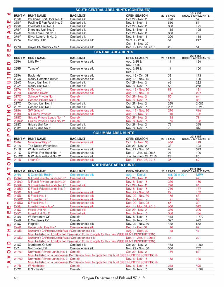
Oregon Department of Fish and Wildlife66
SOUTH CENTRAL AREA HUNTS 2013 1ST
HUNT # HUNT NAME BAG LIMIT OPEN SEASON 2013 TAGS CHOICE APPLICANTS 235X Paulina-E Fort Rock No. 1* One bull elk Oct. 29 - Nov. 2 770 571 235Y Paulina-E Fort Rock No. 2* One bull elk Nov. 8 - Nov. 16 550 571 275X Interstate Unit No. 1 One bull elk Oct. 29 - Nov. 2 330 125 275Y Interstate Unit No. 2 One bull elk Nov. 8 - Nov. 16 165 195 276X Silver Lake Unit No. 1 One bull elk Oct. 29 - Nov. 2 350 73 276Y Silver Lake Unit No. 2 One bull elk Nov. 8 - Nov. 16 200 166 277A Connley Hills* One antlerless elk Sept. 1 - 26 & 51 217 Oct. 18 - Nov. 30 277B Hayes Bt- Murdock Cr.* One antlerless elk Dec. 1 - Mar. 31, 2015 28 51
CENTRAL AREA HUNTS 2013 1ST
HUNT # HUNT NAME BAG LIMIT OPEN SEASON 2013 TAGS CHOICE APPLICANTS 234A Little Rvr* One antlerless elk Aug. 2-24 & 11 186 Nov. 17-30 234B Tumalo* One antlerless elk Aug. 2-24 & 11 100 Dec. 1-31 235A Badlands* One antlerless elk Aug. 15 - Oct. 31 32 173 236A Maury-Hampton Butte* One antlerless elk Aug. 15 - Nov. 15 11 120 236X Maury Unit No. 1 One bull elk Oct. 29 - Nov. 2 66 282 236Y Maury Unit No. 2 One bull elk Nov. 8 - Nov. 16 65 268 237A N Ochoco* One antlerless elk Aug. 15 - Nov. 30 83 131 237B Crooked River* One antlerless elk Aug. 15 - Nov. 30 186 247 237C1 Ochoco Private No. 1 One elk Oct. 29 - Nov. 2 50 64 237C2 Ochoco Private No. 2 One elk Nov. 8 - Nov. 16 50 35 237X Ochoco Unit No. 1 One bull elk Oct. 29 - Nov. 2 254 2,082 237Y Ochoco Unit No. 2 One bull elk Nov. 8 - Nov. 16 242 1,793 238A SW Grizzly* One antlerless elk Aug. 15 - Nov. 30 270 416 238B N Grizzly Private* One antlerless elk Aug. 15- Nov. 30 110 122 238C1 Grizzly Private Lands No. 1* One elk Oct. 29 - Nov. 2 138 78 238C2 Grizzly Private Lands No. 2* One elk Nov. 8 - Nov. 16 165 128 238X Grizzly Unit No. 1 One bull elk Oct. 29 - Nov. 2 72 394 238Y Grizzly Unit No. 2 One bull elk Nov. 8 - Nov. 16 70 316
COLUMBIA AREA HUNTS 2013 1ST
HUNT # HUNT NAME BAG LIMIT OPEN SEASON 2013 TAGS CHOICE APPLICANTS 240A Maupin-W Biggs* One antlerless elk Oct. 18 - Nov. 30 660 174 241A The Dalles Watershed* One elk Oct. 29 - Nov. 2 33 106 241B White Rvr-Hood* One antlerless elk Nov. 22 - Nov. 30 44 323 241C1 N White Rvr-Hood No. 1* One antlerless elk Dec. 1 - Jan. 15, 2015 27 120 241C2 N White Rvr-Hood No. 2* One antlerless elk Jan. 16 - Feb. 28, 2015 28 90 241D Larch Cr* One antlerless elk Dec. 1 - Feb. 28, 2015 36 69
NORTHEAST AREA HUNTS 2013 1ST
HUNT # HUNT NAME BAG LIMIT OPEN SEASON 2013 TAGS CHOICE APPLICANTS 244A S Columbia Basin* One antlerless elk Aug. 1 - Dec 31 est. 25 in 2014 NEW 245A1 N Fossil Private Lands No.1* One bull elk Oct. 29 - Nov. 2 330 69 245A2 N Fossil Private Lands No.2* One elk Nov. 8 - Nov. 16 330 150 245B1 S Fossil Private Lands No.1* One bull elk Oct. 29 - Nov. 2 770 46 245B2 S Fossil Private Lands No. 2* One elk Nov. 8 - Nov. 16 770 137 245C N Fossil* One antlerless elk Nov. 22 - Nov. 30 22 102 245D1 S Fossil No. 1* One antlerless elk Nov. 22 - Nov. 30 165 63 245D2 S Fossil No. 2* One antlerless elk Dec. 6 - Dec. 14 121 43 245D3 S Fossil No. 3* One antlerless elk Dec. 20 - Dec. 28 66 30 245E Fossil-E Biggs Agri* One antlerless elk Aug. 1 - Mar. 31, 2015 660 512 245X Fossil Unit No. 1 One bull elk Oct. 29 - Nov. 2 330 200 245Y Fossil Unit No. 2 One bull elk Nov. 8 - Nov. 16 330 136 246A W Murderers Cr* One elk Nov. 8 - Nov. 16 473 1,779 246B E Murderers Cr* One elk Nov. 8 - Nov. 16 327 672 246C Flagtail* One antlerless elk Nov. 22 - Nov. 30 432 582 246D Upper John Day Rvr* One antlerless elk Dec. 1 - Dec. 31 110 47 246E1 Murderer’s Cr Private Lands Plus 1*One antlerless elk Aug. 1 - Sept. 30 138 47 Must be listed on Landowner Permission Form to apply for this hunt (SEE HUNT DESCRIPTION). 246E2 Murderer’s Cr Private Lands Plus 2*One antlerless elk Dec. 1 - Jan. 31, 2015 55 22 Must be listed on Landowner Permission Form to apply for this hunt (SEE HUNT DESCRIPTION). 246X Murderers Cr Unit One bull elk Oct. 29 - Nov. 2 463 1,365 247 Northside Unit One antlerless elk Nov. 22 - Nov. 30 550 702 247A1 Northside Private Lands No. 1* One elk Oct. 29 - Nov. 2 164 83 Must be listed on a Landowner Permission Form to apply for this hunt (SEE HUNT DESCRIPTION). 247A2 Northside Private Lands No. 2* One elk Nov. 8 - Nov. 16 162 135 Must be listed on a Landowner Permission Form to apply for this hunt (SEE HUNT DESCRIPTION). 247B W Northside* One elk Nov. 8 - Nov. 16 273 495 247C E Northside* One elk Nov. 8 - Nov. 16 398 1,509
“A
VO
ID
T
HE
F
EE
”
MA
ND
AT
OR
Y
RE
PO
RT
IN
G
RE
QU
IR
ED
S
EE
P
AG
E
6SOUTH CENTRAL AREA HUNTS (CONTINUED)
Oregon Department of Fish and Wildlife 67
2013 1ST HUNT # HUNT NAME BAG LIMIT OPEN SEASON 2013 TAGS CHOICE APPLICANTS 247D1 W Grant Private No. 1* One antlerless elk Aug. 1 - Sept. 30 200 101 Must be listed on Landowner Permission Form to apply for this hunt (SEE HUNT DESCRIPTION). 247D2 W Grant Private No. 2* One antlerless elk Oct. 1 - Dec. 31 250 163 Must be listed on Landowner Permission Form to apply for this hunt (SEE HUNT DESCRIPTION). 247D3 W Grant Private No. 3* One antlerless elk Jan. 1 - Mar. 31, 2015 100 48 Must be listed on Landowner Permission Form to apply for this hunt (SEE HUNT DESCRIPTION). 247E1 E Northside Private No. 1* One antlerless elk Aug. 1 - Sep. 30 138 27 Must be listed on Landowner Permission Form to apply for this hunt (SEE HUNT DESCRIPTION). 247E2 E Northside Private No. 2* One antlerless elk Aug. 1 - Mar. 31, 2015 40 63 Must be listed on Landowner Permission Form to apply for this hunt (SEE HUNT DESCRIPTION). 247E3 E Northside Private No. 3* One antlerless elk Dec. 1 - Jan. 31, 2015 55 4 Must be listed on Landowner Permission Form to apply for this hunt (SEE HUNT DESCRIPTION). 247X Northside Unit One bull elk Oct. 29 - Nov. 2 413 1,012 248A1 Heppner No. 1* One bull elk Oct. 29 - Nov. 2 709 3,507 248A2 Heppner No. 2* One spike only elk Oct. 29 - Nov. 2 935 311 248B1 Ritter No. 1* One elk Oct. 29 - Nov. 2 138 121 248B2 Ritter No. 2* One elk Nov. 8 - Nov. 16 220 110 248C Monument* One antlerless elk Aug. 1 - Dec. 31 33 16 248D Heppner* One antlerless elk Nov. 22 - Nov. 30 71 416 248E Willow Creek* One antlerless elk Aug. 1 - Dec. 31 est. 25 in 2014 NEW 249A1 Ukiah Unit No. 1 One bull elk Oct. 29 - Nov. 2 440 2,310 249A2 Ukiah Unit No. 2 One spike only elk Oct. 29 - Nov. 2 990 179 249B McKay Cr* One antlerless elk Dec. 6 - Dec. 14 62 141 249C Central Ukiah* One antlerless elk Nov. 22 - Nov. 30 est. 10 in 2014 NEW 249D S Ukiah* One antlerless elk Nov. 22 - Nov. 30 est. 10 in 2014 NEW 250A Desolation Unit One antlerless elk Nov. 22 - Nov. 30 11 235 250X Desolation Unit One bull elk Oct. 29 - Nov. 2 1,100 2,090 251A N Sumpter* One bull elk Oct. 29 - Nov. 2 770 1,328 251B1 S Sumpter No. 1* One elk Oct. 29 - Nov. 2 138 164 251B2 S Sumpter No. 2* One elk Nov. 8 - Nov. 16 138 125 251C N Sumpter * One antlerless elk Oct. 18 - Oct. 26 11 216 251D S Sumpter* One antlerless elk Oct. 18 - Dec. 31 184 199 251E1 Elkhorn Mt No. 1* One antlerless elk Oct. 18 - Oct. 26 22 58 251E2 Elkhorn Mt No. 2* One antlerless elk Nov. 22 - Nov. 30 21 76 252A1 Starkey No. 1* One bull elk Oct. 29 - Nov. 2 398 2,635 252A2 Starkey No. 2* One spike only elk Oct. 29 - Nov. 2 2,530 80 252B S Starkey* One antlerless elk Nov. 22 - Nov. 30 11 200 252C S Starkey Private* One antlerless elk Nov. 22 - Nov. 30 11 26 252D Starkey Experimental Forest* One bull elk Oct. 29 - Nov. 2 25 831 252E1 Shaw Mt. No. 1* One antlerless elk Oct. 11 - Nov. 2 est. 50 in 2014 NEW 252E2 Shaw Mt. No. 2* One antlerless elk Nov. 8 - Nov. 30 est. 50 in 2014 NEW 252F N Starkey* One antlerless elk Dec. 6 - Dec. 14 10 107 253A S Catherine Cr Private* One antlerless elk Sept. 1 - Nov. 30 268 213 253B S Catherine Cr * One antlerless elk Nov. 22 - Nov. 30 26 101 253C1 Mt Harris No. 1* One antlerless elk Nov. 22 - Nov. 30 165 88 253C2 Mt Harris No. 2* One antlerless elk Dec. 22 - Dec. 31 138 69 253X Catherine Cr Unit One bull elk Oct. 29 - Nov. 2 275 537 254A Pumpkin Ridge* One antlerless elk Aug. 15 - Sept. 28 & 125 247 Nov. 22 - Dec. 31 254X Mt Emily Unit No. 1 One spike only elk Oct. 29 - Nov. 2 660 216 254Y1 Mt Emily Unit No. 2 One bull elk Nov. 8 - Nov. 16 56 2,694 254Y2 Mt Emily Unit No. 3 One spike only elk Nov. 8 - Nov. 16 330 168 255A Mill Cr Watershed* One antlerless or 3 pt. + bull elk Oct. 25 - Nov. 2 25 389 255B Walla Walla Private* One antlerless elk Aug. 1 - Dec. 31 est. 20 in 2014 NEW 255X Walla Walla No. 1* One spike only elk Oct. 29 - Nov. 2 330 44 255Y1 Walla Walla No. 2* One bull elk Oct. 29 - Nov. 16 25 895 255Y2 Walla Walla No. 3* One spike only elk Nov. 8 - Nov. 16 193 36 256A Bartlett Bench* One antlerless elk Aug. 1 - 9 & 22 16 Oct. 18 - 24 256B Troy* One antlerless elk Dec. 1 - Dec. 15 20 25 256X Wenaha Unit No. 1 One spike only elk Oct. 29 - Nov. 2 385 197 256Y1 Wenaha Unit No. 2 One bull elk Nov. 8 - Nov. 16 30 3,284 256Y2 Wenaha Unit No. 3 One spike only elk Nov. 8 - Nov. 16 220 106 257A Elk Cr* One antlerless elk Aug. 1 - 9 & 15 39 Nov. 22 - 30 257B1 Flora No. 1* One antlerless elk Aug. 1 - 9, Oct. 29 - Nov. 2 & 32 57 Nov. 8- 16 257B2 Flora No. 2* One antlerless elk Oct. 29 - Nov. 2 & 32 28 Nov. 8 - 16 257C Whisky Cr* One antlerless elk Aug. 1 - 15 & 27 69 Nov. 29 - Dec. 14 257D E Sled Springs* One antlerless elk Nov. 22 - Nov. 30 50 153
257E W Sled Springs* One antlerless elk Nov. 22 - Nov. 30 104 271
ELK
Pages 62-80
“A
VO
ID
T
HE
F
EE
”
MA
ND
AT
OR
Y
RE
PO
RT
IN
G
RE
QU
IR
ED
S
EE
P
AG
E
6
NORTHEAST AREA HUNTS (CONTINUED)
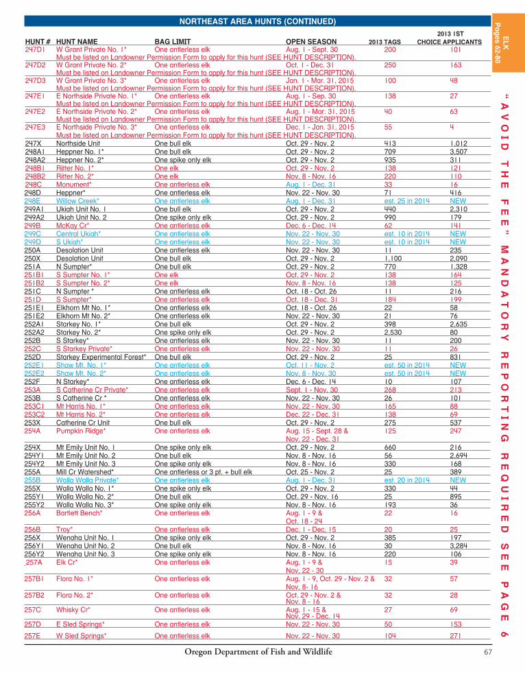
Oregon Department of Fish and Wildlife66
SOUTH CENTRAL AREA HUNTS 2013 1ST
HUNT # HUNT NAME BAG LIMIT OPEN SEASON 2013 TAGS CHOICE APPLICANTS 235X Paulina-E Fort Rock No. 1* One bull elk Oct. 29 - Nov. 2 770 571 235Y Paulina-E Fort Rock No. 2* One bull elk Nov. 8 - Nov. 16 550 571 275X Interstate Unit No. 1 One bull elk Oct. 29 - Nov. 2 330 125 275Y Interstate Unit No. 2 One bull elk Nov. 8 - Nov. 16 165 195 276X Silver Lake Unit No. 1 One bull elk Oct. 29 - Nov. 2 350 73 276Y Silver Lake Unit No. 2 One bull elk Nov. 8 - Nov. 16 200 166 277A Connley Hills* One antlerless elk Sept. 1 - 26 & 51 217 Oct. 18 - Nov. 30 277B Hayes Bt- Murdock Cr.* One antlerless elk Dec. 1 - Mar. 31, 2015 28 51
CENTRAL AREA HUNTS 2013 1ST
HUNT # HUNT NAME BAG LIMIT OPEN SEASON 2013 TAGS CHOICE APPLICANTS 234A Little Rvr* One antlerless elk Aug. 2-24 & 11 186
Nov. 17-30 234B Tumalo* One antlerless elk Aug. 2-24 & 11 100
Dec. 1-31 235A Badlands* One antlerless elk Aug. 15 - Oct. 31 32 173 236A Maury-Hampton Butte* One antlerless elk Aug. 15 - Nov. 15 11 120 236X Maury Unit No. 1 One bull elk Oct. 29 - Nov. 2 66 282 236Y Maury Unit No. 2 One bull elk Nov. 8 - Nov. 16 65 268 237A N Ochoco* One antlerless elk Aug. 15 - Nov. 30 83 131 237B Crooked River* One antlerless elk Aug. 15 - Nov. 30 186 247 237C1 Ochoco Private No. 1 One elk Oct. 29 - Nov. 2 50 64 237C2 Ochoco Private No. 2 One elk Nov. 8 - Nov. 16 50 35 237X Ochoco Unit No. 1 One bull elk Oct. 29 - Nov. 2 254 2,082 237Y Ochoco Unit No. 2 One bull elk Nov. 8 - Nov. 16 242 1,793 238A SW Grizzly* One antlerless elk Aug. 15 - Nov. 30 270 416 238B N Grizzly Private* One antlerless elk Aug. 15- Nov. 30 110 122 238C1 Grizzly Private Lands No. 1* One elk Oct. 29 - Nov. 2 138 78 238C2 Grizzly Private Lands No. 2* One elk Nov. 8 - Nov. 16 165 128 238X Grizzly Unit No. 1 One bull elk Oct. 29 - Nov. 2 72 394 238Y Grizzly Unit No. 2 One bull elk Nov. 8 - Nov. 16 70 316
COLUMBIA AREA HUNTS 2013 1ST
HUNT # HUNT NAME BAG LIMIT OPEN SEASON 2013 TAGS CHOICE APPLICANTS 240A Maupin-W Biggs* One antlerless elk Oct. 18 - Nov. 30 660 174 241A The Dalles Watershed* One elk Oct. 29 - Nov. 2 33 106 241B White Rvr-Hood* One antlerless elk Nov. 22 - Nov. 30 44 323 241C1 N White Rvr-Hood No. 1* One antlerless elk Dec. 1 - Jan. 15, 2015 27 120 241C2 N White Rvr-Hood No. 2* One antlerless elk Jan. 16 - Feb. 28, 2015 28 90 241D Larch Cr* One antlerless elk Dec. 1 - Feb. 28, 2015 36 69
NORTHEAST AREA HUNTS 2013 1ST
HUNT # HUNT NAME BAG LIMIT OPEN SEASON 2013 TAGS CHOICE APPLICANTS 244A S Columbia Basin* One antlerless elk Aug. 1 - Dec 31 est. 25 in 2014 NEW 245A1 N Fossil Private Lands No.1* One bull elk Oct. 29 - Nov. 2 330 69 245A2 N Fossil Private Lands No.2* One elk Nov. 8 - Nov. 16 330 150 245B1 S Fossil Private Lands No.1* One bull elk Oct. 29 - Nov. 2 770 46 245B2 S Fossil Private Lands No. 2* One elk Nov. 8 - Nov. 16 770 137 245C N Fossil* One antlerless elk Nov. 22 - Nov. 30 22 102 245D1 S Fossil No. 1* One antlerless elk Nov. 22 - Nov. 30 165 63 245D2 S Fossil No. 2* One antlerless elk Dec. 6 - Dec. 14 121 43 245D3 S Fossil No. 3* One antlerless elk Dec. 20 - Dec. 28 66 30 245E Fossil-E Biggs Agri* One antlerless elk Aug. 1 - Mar. 31, 2015 660 512 245X Fossil Unit No. 1 One bull elk Oct. 29 - Nov. 2 330 200 245Y Fossil Unit No. 2 One bull elk Nov. 8 - Nov. 16 330 136 246A W Murderers Cr* One elk Nov. 8 - Nov. 16 473 1,779 246B E Murderers Cr* One elk Nov. 8 - Nov. 16 327 672 246C Flagtail* One antlerless elk Nov. 22 - Nov. 30 432 582 246D Upper John Day Rvr* One antlerless elk Dec. 1 - Dec. 31 110 47 246E1 Murderer’s Cr Private Lands Plus 1*One antlerless elk Aug. 1 - Sept. 30 138 47
Must be listed on Landowner Permission Form to apply for this hunt (SEE HUNT DESCRIPTION). 246E2 Murderer’s Cr Private Lands Plus 2*One antlerless elk Dec. 1 - Jan. 31, 2015 55 22
Must be listed on Landowner Permission Form to apply for this hunt (SEE HUNT DESCRIPTION). 246X Murderers Cr Unit One bull elk Oct. 29 - Nov. 2 463 1,365 247 Northside Unit One antlerless elk Nov. 22 - Nov. 30 550 702 247A1 Northside Private Lands No. 1* One elk Oct. 29 - Nov. 2 164 83 Must be listed on a Landowner Permission Form to apply for this hunt (SEE HUNT DESCRIPTION). 247A2 Northside Private Lands No. 2* One elk Nov. 8 - Nov. 16 162 135 Must be listed on a Landowner Permission Form to apply for this hunt (SEE HUNT DESCRIPTION). 247B W Northside* One elk Nov. 8 - Nov. 16 273 495 247C E Northside* One elk Nov. 8 - Nov. 16 398 1,509
“A
VO
ID
T
HE
F
EE
”
MA
ND
AT
OR
Y
RE
PO
RT
IN
G
RE
QU
IR
ED
S
EE
P
AG
E
6
SOUTH CENTRAL AREA HUNTS (CONTINUED)
Oregon Department of Fish and Wildlife 67
2013 1ST HUNT # HUNT NAME BAG LIMIT OPEN SEASON 2013 TAGS CHOICE APPLICANTS 247D1 W Grant Private No. 1* One antlerless elk Aug. 1 - Sept. 30 200 101 Must be listed on Landowner Permission Form to apply for this hunt (SEE HUNT DESCRIPTION). 247D2 W Grant Private No. 2* One antlerless elk Oct. 1 - Dec. 31 250 163 Must be listed on Landowner Permission Form to apply for this hunt (SEE HUNT DESCRIPTION). 247D3 W Grant Private No. 3* One antlerless elk Jan. 1 - Mar. 31, 2015 100 48 Must be listed on Landowner Permission Form to apply for this hunt (SEE HUNT DESCRIPTION). 247E1 E Northside Private No. 1* One antlerless elk Aug. 1 - Sep. 30 138 27 Must be listed on Landowner Permission Form to apply for this hunt (SEE HUNT DESCRIPTION). 247E2 E Northside Private No. 2* One antlerless elk Aug. 1 - Mar. 31, 2015 40 63 Must be listed on Landowner Permission Form to apply for this hunt (SEE HUNT DESCRIPTION). 247E3 E Northside Private No. 3* One antlerless elk Dec. 1 - Jan. 31, 2015 55 4 Must be listed on Landowner Permission Form to apply for this hunt (SEE HUNT DESCRIPTION). 247X Northside Unit One bull elk Oct. 29 - Nov. 2 413 1,012 248A1 Heppner No. 1* One bull elk Oct. 29 - Nov. 2 709 3,507 248A2 Heppner No. 2* One spike only elk Oct. 29 - Nov. 2 935 311 248B1 Ritter No. 1* One elk Oct. 29 - Nov. 2 138 121 248B2 Ritter No. 2* One elk Nov. 8 - Nov. 16 220 110 248C Monument* One antlerless elk Aug. 1 - Dec. 31 33 16 248D Heppner* One antlerless elk Nov. 22 - Nov. 30 71 416 248E Willow Creek* One antlerless elk Aug. 1 - Dec. 31 est. 25 in 2014 NEW 249A1 Ukiah Unit No. 1 One bull elk Oct. 29 - Nov. 2 440 2,310 249A2 Ukiah Unit No. 2 One spike only elk Oct. 29 - Nov. 2 990 179 249B McKay Cr* One antlerless elk Dec. 6 - Dec. 14 62 141 249C Central Ukiah* One antlerless elk Nov. 22 - Nov. 30 est. 10 in 2014 NEW 249D S Ukiah* One antlerless elk Nov. 22 - Nov. 30 est. 10 in 2014 NEW 250A Desolation Unit One antlerless elk Nov. 22 - Nov. 30 11 235 250X Desolation Unit One bull elk Oct. 29 - Nov. 2 1,100 2,090 251A N Sumpter* One bull elk Oct. 29 - Nov. 2 770 1,328 251B1 S Sumpter No. 1* One elk Oct. 29 - Nov. 2 138 164 251B2 S Sumpter No. 2* One elk Nov. 8 - Nov. 16 138 125 251C N Sumpter * One antlerless elk Oct. 18 - Oct. 26 11 216 251D S Sumpter* One antlerless elk Oct. 18 - Dec. 31 184 199 251E1 Elkhorn Mt No. 1* One antlerless elk Oct. 18 - Oct. 26 22 58 251E2 Elkhorn Mt No. 2* One antlerless elk Nov. 22 - Nov. 30 21 76 252A1 Starkey No. 1* One bull elk Oct. 29 - Nov. 2 398 2,635 252A2 Starkey No. 2* One spike only elk Oct. 29 - Nov. 2 2,530 80 252B S Starkey* One antlerless elk Nov. 22 - Nov. 30 11 200 252C S Starkey Private* One antlerless elk Nov. 22 - Nov. 30 11 26 252D Starkey Experimental Forest* One bull elk Oct. 29 - Nov. 2 25 831 252E1 Shaw Mt. No. 1* One antlerless elk Oct. 11 - Nov. 2 est. 50 in 2014 NEW 252E2 Shaw Mt. No. 2* One antlerless elk Nov. 8 - Nov. 30 est. 50 in 2014 NEW 252F N Starkey* One antlerless elk Dec. 6 - Dec. 14 10 107 253A S Catherine Cr Private* One antlerless elk Sept. 1 - Nov. 30 268 213 253B S Catherine Cr * One antlerless elk Nov. 22 - Nov. 30 26 101 253C1 Mt Harris No. 1* One antlerless elk Nov. 22 - Nov. 30 165 88 253C2 Mt Harris No. 2* One antlerless elk Dec. 22 - Dec. 31 138 69 253X Catherine Cr Unit One bull elk Oct. 29 - Nov. 2 275 537 254A Pumpkin Ridge* One antlerless elk Aug. 15 - Sept. 28 & 125 247 Nov. 22 - Dec. 31 254X Mt Emily Unit No. 1 One spike only elk Oct. 29 - Nov. 2 660 216 254Y1 Mt Emily Unit No. 2 One bull elk Nov. 8 - Nov. 16 56 2,694 254Y2 Mt Emily Unit No. 3 One spike only elk Nov. 8 - Nov. 16 330 168 255A Mill Cr Watershed* One antlerless or 3 pt. + bull elk Oct. 25 - Nov. 2 25 389 255B Walla Walla Private* One antlerless elk Aug. 1 - Dec. 31 est. 20 in 2014 NEW 255X Walla Walla No. 1* One spike only elk Oct. 29 - Nov. 2 330 44 255Y1 Walla Walla No. 2* One bull elk Oct. 29 - Nov. 16 25 895 255Y2 Walla Walla No. 3* One spike only elk Nov. 8 - Nov. 16 193 36 256A Bartlett Bench* One antlerless elk Aug. 1 - 9 & 22 16 Oct. 18 - 24 256B Troy* One antlerless elk Dec. 1 - Dec. 15 20 25 256X Wenaha Unit No. 1 One spike only elk Oct. 29 - Nov. 2 385 197 256Y1 Wenaha Unit No. 2 One bull elk Nov. 8 - Nov. 16 30 3,284 256Y2 Wenaha Unit No. 3 One spike only elk Nov. 8 - Nov. 16 220 106 257A Elk Cr* One antlerless elk Aug. 1 - 9 & 15 39 Nov. 22 - 30 257B1 Flora No. 1* One antlerless elk Aug. 1 - 9, Oct. 29 - Nov. 2 & 32 57 Nov. 8- 16 257B2 Flora No. 2* One antlerless elk Oct. 29 - Nov. 2 & 32 28 Nov. 8 - 16 257C Whisky Cr* One antlerless elk Aug. 1 - 15 & 27 69 Nov. 29 - Dec. 14 257D E Sled Springs* One antlerless elk Nov. 22 - Nov. 30 50 153
257E W Sled Springs* One antlerless elk Nov. 22 - Nov. 30 104 271
ELK
Pages 62-80
“A
VO
ID
T
HE
F
EE
”
MA
ND
AT
OR
Y
RE
PO
RT
IN
G
RE
QU
IR
ED
S
EE
P
AG
E
6NORTHEAST AREA HUNTS (CONTINUED)

Oregon Department of Fish and Wildlife68
2013 1ST HUNT # HUNT NAME BAG LIMIT OPEN SEASON 2013 TAGS CHOICE APPLICANTS 257F Cricket Flat* One antlerless elk Nov. 8 - Nov. 30 53 49 257X Sled Springs Unit No. 1 One bull elk Oct. 29- Nov. 2 545 1,689 257Y Sled Springs Unit No. 2 One spike only elk Nov. 8 - Nov. 16 440 169 258A1 Zumwalt No. 1* One antlerless elk Aug. 30 - Sep. 30 42 118
258A2 Zumwalt No. 2* One antlerless elk Nov. 17- Dec. 5 110 147 258A3 Zumwalt No. 3* One antlerless elk Dec. 6 - Dec. 26 110 70 258A4 Zumwalt No. 4* One antlerless elk Dec. 27 - Jan 16, 2015 110 26
258X Chesnimnus Unit One bull elk Nov. 8 - Nov. 16 770 1,884 259 Snake Rvr Unit One antlerless elk Dec. 1 - Dec. 31 est. 75 in 2014 NEW
259A1 Schleur-Park Crs No. 1* One antlerless elk Aug. 1 - Aug. 9 5 5 259A2 Schleur-Park Crs No. 2* One antlerless elk Aug. 10 - Aug. 18 5 5 259A3 Schleur-Park Crs No. 3* One antlerless elk Aug. 23 - Aug. 31 5 1 259X Snake Rvr Unit No. 1* One spike only elk Oct. 29 - Nov. 2 330 70 (see hunt description) 259Y Snake Rvr Unit No. 2* One bull elk Nov. 8 - Nov. 16 275 1,272 (see hunt description) 260A Alder Slope* One antlerless elk Oct. 18 - 26 & 80 94 Centerfire Rifles/Handguns prohibited for hunting Dec. 1 - 31 in part of this hunt, See hunt description. 260X Minam Unit No. 1 One bull elk Oct. 29 - Nov. 2 550 296 260Y Minam Unit No. 2 One bull elk Nov. 8 - Nov. 16 550 271 261 Imnaha Unit One antlerless elk Nov. 22 - Nov. 30 275 348 261A1 Clear Lake-Deadhorse No. 1* One antlerless elk Nov. 17 - Nov. 21 est 20 in 2014 NEW 261A2 Clear Lake-Deadhorse No. 2* One antlerless elk Dec. 1 - Dec. 31 est 50 in 2014 NEW 261X Imnaha Unit One bull elk Oct. 29 - Nov. 2 330 965 262 Pine Cr Unit One antlerless elk Nov. 22 - Nov. 30 165 234 262X Pine Cr Unit One bull elk Oct. 29 - Nov. 2 303 885 263 Keating Unit One antlerless elk Nov. 22 - Nov. 30 62 271 263A1 SW Keating Pvt No. 1* One antlerless elk Aug. 1 - Oct. 31 est. 40 in 2014 NEW 263A2 SW Keating Pvt No. 2* One antlerless elk Nov. 1 - Jan. 31, 2015 est. 40 in 2014 NEW 263X Keating Unit One bull elk Oct. 29 - Nov. 2 248 531 264 Lookout Mt Unit One antlerless elk Oct. 18 - Dec. 31 273 203 264X Lookout Mt Unit No. 1 One elk Oct. 29 - Nov. 2 165 182 264Y Lookout Mt Unit No. 2 One elk Nov. 8 - Nov. 16 165 158 265A1 W Beulah No. 1* One bull elk Oct. 29 - Nov. 2 385 713 265A2 W Beulah No. 2* One elk Nov. 8 - Nov. 16 220 993 265B1 E Beulah No. 1* One elk Oct. 29 - Nov. 2 440 155 265B2 E Beulah No. 2* One elk Nov. 8 - Nov. 16 440 221 265B3 E Beulah No. 3* One antlerless elk Nov. 22 - Dec. 31 371 267 265C Bully Cr One antlerless elk Aug. 1 - Feb. 28, 2015 106 538 265D E Grant* One antlerless elk Nov. 22- Nov. 30 275 242
SOUTHEAST AREA HUNTS 2013 1ST HUNT # HUNT NAME BAG LIMIT OPEN SEASON 2013 TAGS CHOICE APPLICANTS 266A1 Drewsey Valley No. 1* One antlerless elk Aug. 15 - Sept. 30 77 42 266A2 Drewsey Valley No. 2* One antlerless elk Nov. 1 - Nov. 30 32 59 266B N Malheur Rvr* One antlerless elk Nov. 22 - Nov. 30 300 535 266C S Malheur Rvr* One antlerless elk Aug. 15 - Sept. 30 110 160 266X N Malheur Rvr No. 1* One bull elk Oct. 29 - Nov. 2 440 823 266Y N Malheur Rvr No. 2* One bull elk Nov. 8 - Nov. 16 440 776 267 Owyhee Unit One antlerless elk Oct. 18 - Jan. 31, 2015 28 157 268A E Whitehorse* One antlerless elk Oct. 18 - Jan. 31, 2015 28 38 271A1 Silvies-N Juniper No. 1* One antlerless elk Aug. 15 - Sept. 30 164 187 271A2 Silvies-N Juniper No. 2* One antlerless elk Nov. 1 - Nov. 30 129 173 271B1 N Juniper No. 1* One antlerless elk Dec. 1 - Dec. 31 est. 30 in 2014 NEW 271B2 N Juniper No. 2* One antlerless elk Jan. 1 - Jan. 31, 2015 est. 30 in 2014 NEW 272A Silvies Unit One antlerless elk Nov. 22 - Nov. 30 715 1,183 272B West Silvies* One antlerless elk Dec. 6 - Dec. 14 110 84 272X Silvies Unit No. 1 One bull elk Oct. 29 - Nov. 2 550 1,449 272Y Silvies Unit No. 2 One bull elk Nov. 8 - Nov. 16 550 1,238 274X Warner Unit No. 1 One bull elk Oct. 29 - Nov. 2 55 43 274Y Warner Unit No. 2 One bull elk Nov. 8 - Nov. 16 55 19 278A1 High Desert No. 1* One elk Oct. 29 - Nov. 4 est. 300 in 2014 NEW 278A2 High Desert No. 2* One elk Nov. 8 - Nov. 16 est. 300 in 2014 NEW
“A
VO
ID
T
HE
F
EE
”
MA
ND
AT
OR
Y
RE
PO
RT
IN
G
RE
QU
IR
ED
S
EE
P
AG
E
6NORTHEAST AREA HUNTS (CONTINUED)
*HUNT DESCRIPTIONSFor those hunt descriptions with [MAP] following the description, maps can be found on our website at www.dfw.state.or.us/resources/hunting/big_game/units.
HUNTS 210A1 and 210A2: Onion Peak - 6% public lands. Those parts of units 10 and 12 beginning at mouth of Nehalem Bay; north on coast line to Hwy 101 at Seaside; south on Hwy 101 to Hwy 26; east on Hwy 26 to Hwy 53 at Necanicum Junction; south on Hwy 53 to Hwy 101; south on Hwy 101 to mouth of Nehalem Bay, point of beginning. [MAP]
HUNTS 210B1 and 210B2: Lewis & Clark - 0% public lands. That part of Unit 10 beginning at Seaside; north on Hwy 101 to Hwy 202; southeast on Hwy 202 to Fishhawk Falls Hwy; south on Fishhawk Falls Hwy to Hwy 26; west on Hwy 26 to Hwy 101, north on Hwy 101 to Seaside, point of beginning. [MAP]
Oregon Department of Fish and Wildlife 69
HUNT 210C: Upper Nehalem - 18% public lands. 184 sq mi in units 10 and 11 within the first 2 mi either side of the following Rds: Starting at Timber Junction on Hwy 26; north on Timber Rd to Hwy 47; north on Hwy 47 to Hwy 202; west on Hwy 202 to Jewell; southwest on Fishhawk Falls Hwy to Hwy 26. Jewell WA lands are closed to hunting. [MAP] HUNT 210D: Lower Columbia - 28% public lands. Hunters must complete the Master Hunter Program prior to applying for this hunt. 81 sq mi in Unit 10 beginning at the mouth of Clatskanie Rvr; south on Clatskanie Rvr to State Hwy 47 at Clatskanie; south on Hwy 47 to BPA transmission line, west on BPA transmission line to Knappa-Svensen R.F.P.D. boundary; west on Knappa-Svensen R.F.P.D. boundary to Akerstadt Rd; north on Akerstadt Rd to Hillcrest Rd; northwest on Hillcrest Rd to Old Hwy 30; west on Old Hwy 30 to Market Rd; south on Market Rd to George Hill Rd; southeast on George Hill Rd to Knappa-Svensen R.F.P.D. boundary, west on Knappa-Svensen R.F.P.D. boundary to John Day-Fernhill R.F.P.D. boundary; west on John Day-Fernhill R.F.P.D. to BPA transmission line; west on BPA transmission line to Pipeline Rd; southeast on Pipeline Rd to Walluski Way; southwest on Walluski Way to Labiski Rd; west on Labiski Rd to Walluski Lp Rd; west on Walluski Lp Rd to Hwy 202; north on Hwy 202 to BPA transmission line; west on BPA transmission line to Youngs Bay; north on east shore of Youngs Bay to Columbia Rvr; east on Columbia Rvr to Clatskanie Rvr, point of beginning. [MAP] HUNT 210E: Young’s Rvr - 3% public lands. 40 sq mi in Unit 10 within 1 mi west of Hwy 202 from Astoria District ODF Office to southern junction of Walluski Lp Rd and within 1 mi of the following Rds: Hwy 202 from southern junction of Walluski Lp Rd to Klaskanine Fish Hatchery; Lewis and Clark Rd from Miles Crossing to junction with Lewis and Clark Mainline just north of CZ Camp; Fort Clatsop Rd south of Fort Clatsop parking lot; Tucker Cr Rd and Logan Rd from Hwy 101 Alternate to Lewis and Clark Rd; Young’s Rvr Lp Rd from Miles Crossing to junction with Olney Ln; Olney Ln to junction with Hwy 202. [MAP]HUNTS 210F1 and 210F2: Camp McGregor - 16% public lands. That part of Unit 10 within the following boundary: Beginning at Sunset Rest Area on Hwy 26 at MP 29; east along Hwy 26 to McGregor Rd; east and north along McGregor Rd to NoFo Rd; south along NoFo Rd to the ODF/Private land boundary at section 36; east to the Clatsop/Columbia county line; north along the county line and including NW 1/4 of section 30 to the southern boundary of section 18; east to the southeastern corner of section 17; north to Eastside Grade Rd; north on Eastside Grade Rd to Rock Cr; east along Rock Cr to the Columbia Rvr Mainline; north on the Columbia Rvr Mainline to Deep Cr; west and south along Deep Cr to the NE corner of section 19; west to the Clatsop/Columbia co line; south along the co line to the T4N/5N boundary; west along the T4N/5N line to the NW corner of S1 of T4N, R7W; southwest to Hwy 26 at MP 24; southeast along Hwy 26 to Sunset Rest Area, point of beginning. [MAP]
HUNTS 211A1, 211A2, and 211A3: S Scappoose - 10% public lands. That part of Unit 11 beginning at Hwy 26 and Cornelius Pass Rd junction; west on Hwy 26 to Hwy 6; west and north on Hwy 6 to Timber Rd; north on Timber Rd to Timber-Vernonia Rd; north and east on Timber-Vernonia Rd to Hwy 47; north on Hwy 47 to Scappoose-Vernonia Hwy; south and east on Scappoose-Vernonia Hwy to Hwy 30; south and east on Hwy 30 to Cornelius Pass Rd; south and west on Cornelius Pass Rd to Hwy 26, point of beginning. HUNT 211B: N Central Scappoose - 5% public lands. That part of Unit 11 beginning at Scappoose, northwest on the Scappoose-Vernonia Hwy to Hwy 47; north on Hwy 47 to Clatskanie; north on Clatskanie Rvr to state line in Columbia Rvr; southeast on state line to Willamette Rvr; southwest on Willamette Rvr to Multnomah Channel; northwest on Multnomah Channel to Hwy 30 at Sauvie Island bridge; northwest on Hwy 30 to Scappoose, point of beginning.HUNTS 212A1, 212A2, and 212A3: Miami-Nehalem - 15% public lands. 80 sq mi in units 10 and 12 within 1 mi either side of the following Rds: Hwy 53 from Nehalem Hatchery to Hwy 101; N Fork Rd from Hwy 53 to Hwy 101; Foss Rd from Hwy 53 to the mouth of Cook Cr; Miami Foley Rd from Foss Rd to the mouth of Miami River and that part of Unit 12 east of Hwy 101 and west of Miami Foley Rd. [MAP]HUNT 212C: Buick Canyon - 50% public lands. 13 sq mi in Unit 12 beginning at the Foss Rd junction with Sibley Rd; east on Sibley Rd to Buck Mt Rd; southeast on Buck Mt Rd to North Side Rd; east on North Side Rd to Clay Cr Rd; north on Clay Cr Rd to end; due north approximately 1/2 mi to Salmonberry Rvr; northwest on Salmonberry Rvr to Foss Rd; west on Foss Rd to Sibley Rd junction, point of beginning. [MAP]HUNT 214: Trask - 42% public lands. All of Unit 14. There are specific weapon restrictions in the Cascade Head - Lincoln City area of the Trask Unit. See page 98. HUNT 214A: W Trask - 42% public lands. That part of Unit 14 beginning at Tillamook; west on Netarts Hwy to Bayocean Rd (Three Capes Scenic Loop); north and west on Bayocean Rd to Cape Meares Loop Rd; south on Cape Meares Loop Rd. to the coast at Oceanside; south on coast to Proposal Rock; east from Proposal Rock to Hwy 101; southeast on Hwy 101 to the T5S/6S boundary; due east on the T5S/6S boundary to the corner of S34 and 35; northeast in a straight line to Castle Rock campground; north in a straight line to Hebo Lk campground; northeast in a straight line to Square Top Mt; northwest in a straight line to High Peak; north in a straight line to Edwards Butte; northeast in a straight line to Gold Peak; northwest in a straight line through Peninsula Co Park to Hwy 6; west on Hwy 6 to Tillamook, point of beginning. [MAP] HUNT 214B: Wind Rvr - 28% public lands. 109 sq mi. That part of Unit 14 beginning at Willamina Cr Rd in Willamina; north on Willamina Cr Rd to Coast Cr Rd; west on Coast Cr Rd to Gilbert Cr Rd; north on Gilbert Cr Rd to Bald Mt Access Rd; north on Bald Mt Access Rd to Bible Cr Rd; west on Bible Cr Rd to Siuslaw NF FR 14; west on Siuslaw
NF FR 14 to FR 2210; southwest on FR 2210 to FR 2282; south on FR 2282 to Hwy 22; southwest on Hwy 22 to powerline crossing at T5S, R9W, Sec 36; southeast on powerline to 9A Rd; south on 9A Rd to 9 Rd; south on 9 Rd to Hwy 18; east on Hwy 18 to Hwy 18 Business Route; northeast on Hwy 18 Business Route to Willimina Cr Rd; point of beginning. [MAP]HUNT 214C: Beaver Cr - 8% public lands. 100 sq mi. That part of Unit 14 : Beginning at Willamina Cr Rd in Willamina; north on Willamina Cr Rd to Coast Cr Rd; west on Coast Cr Rd to Gilbert Cr Rd; north on Gilbert Cr Rd to Bald Mt Access Rd; north on Bald Mt Access Rd to Homestead Tie Rd; southeast on Homestead Tie Rd to Willamina Cr Rd; northeast on Willamina Cr Rd to East Cr Rd; southeast on East Cr Rd to Green Top Rd; east on Green Top Rd to Gopher Valley Rd; north on Gopher Valley Rd to Peavine Rd; east on Peavine Rd to SW Old Sheridan Rd; north on SW Old Sheridan Rd to Hwy 99W; south on Hwy 99W to Hwy 18; south and west on Hwy 18 to Hwy 18 Business Route; west on Hwy 18 Business Route to Willamina Cr Rd, point of beginning. [MAP]HUNT 214D: Pike - 5% public lands. 80 sq mi. That part of Unit 14 : Beginning at McMinnville; southwest on Hwy 99W to SW Old Sheridan Rd; west on SW Old Sheridan Rd to Peavine Rd; west on Peavine Rd to White Rd; north on White Rd to Wanless Rd; northeast on Wanless Rd to High Heaven Rd; east on High Heaven Rd to Von Rd; northeast on Von Rd to Panther Cr Rd; northwest on Panther Cr Rd to Meadowlake Rd; east on Meadowlake Rd to Haskins Cr Rd; west on Haskins Cr Rd to Haskins Cr Guard Station; northwest on 100 line to Rd 121 in T3S, R6W Section 12; north on 121 to Rd 122; north on 122 to Rd 3-6-12.2; north on 3-6-12.2 to Kutch Cr Rd; north on Kutch Cr Rd to Upper Kutch Rd (in T3S,R6W section 1); north and east on Upper Kutch Rd to Boise Cascade’s N Fairdale Rd; east and north on N Fairdale Rd to Fairdale Rd; north on Fairdale Rd to Old Railroad Grade Rd; east on Old Railroad to Rockyford Rd; north on Rockyford Rd to Pike Rd; southeast on Pike Rd to Hwy 47 at Yamhill; south on Hwy 47 to Hwy 99W; southwest on Hwy 99W to McMinnville, point of beginning. [MAP] HUNTS 214E1 and 214E2: NE Trask - 15% public lands. That part of Unit 14 beginning at the junction of Hwy 8 and Hwy 47 (Forest Grove); south on Hwy 47 to Pike Rd (Yamhill); north and west on Pike Rd to Rockyford Rd; south on Rockyford Rd to Old Railroad Grade; west on Old Railroad Grade to 2-5-29.0 Rd (CCC Rd and Toll Rd); west and north on 2-5-29.0 Rd to 2-6-3 Rd at Murphy Camp; north and east on 2-6-3 Rd (Flora Mainline) to N Fork Trask Rvr Rd at Neverstill; north and west on N Fork Trask Rvr Rd to Williams Rd; north on Williams Rd to 2500 Line Rd; north and west on 2500 Line Rd to Seven Cedars Rd cross-over; north and east on Seven Cedars cross-over to C-Line Rd; north and east on C-line Rd to Beaver Dam Rd; north on Beaver Dam Rd to Hwy 6; east on Hwy 6 to junction with Hwy 8; south and east on Hwy 8 to Hwy 47, point of beginning. [MAP]
ELK
Pages 62-80

Oregon Department of Fish and Wildlife68
2013 1ST HUNT # HUNT NAME BAG LIMIT OPEN SEASON 2013 TAGS CHOICE APPLICANTS 257F Cricket Flat* One antlerless elk Nov. 8 - Nov. 30 53 49 257X Sled Springs Unit No. 1 One bull elk Oct. 29- Nov. 2 545 1,689 257Y Sled Springs Unit No. 2 One spike only elk Nov. 8 - Nov. 16 440 169 258A1 Zumwalt No. 1* One antlerless elk Aug. 30 - Sep. 30 42 118
258A2 Zumwalt No. 2* One antlerless elk Nov. 17- Dec. 5 110 147 258A3 Zumwalt No. 3* One antlerless elk Dec. 6 - Dec. 26 110 70 258A4 Zumwalt No. 4* One antlerless elk Dec. 27 - Jan 16, 2015 110 26
258X Chesnimnus Unit One bull elk Nov. 8 - Nov. 16 770 1,884 259 Snake Rvr Unit One antlerless elk Dec. 1 - Dec. 31 est. 75 in 2014 NEW
259A1 Schleur-Park Crs No. 1* One antlerless elk Aug. 1 - Aug. 9 5 5 259A2 Schleur-Park Crs No. 2* One antlerless elk Aug. 10 - Aug. 18 5 5 259A3 Schleur-Park Crs No. 3* One antlerless elk Aug. 23 - Aug. 31 5 1 259X Snake Rvr Unit No. 1* One spike only elk Oct. 29 - Nov. 2 330 70 (see hunt description) 259Y Snake Rvr Unit No. 2* One bull elk Nov. 8 - Nov. 16 275 1,272 (see hunt description) 260A Alder Slope* One antlerless elk Oct. 18 - 26 & 80 94 Centerfire Rifles/Handguns prohibited for hunting Dec. 1 - 31 in part of this hunt, See hunt description. 260X Minam Unit No. 1 One bull elk Oct. 29 - Nov. 2 550 296 260Y Minam Unit No. 2 One bull elk Nov. 8 - Nov. 16 550 271 261 Imnaha Unit One antlerless elk Nov. 22 - Nov. 30 275 348 261A1 Clear Lake-Deadhorse No. 1* One antlerless elk Nov. 17 - Nov. 21 est 20 in 2014 NEW 261A2 Clear Lake-Deadhorse No. 2* One antlerless elk Dec. 1 - Dec. 31 est 50 in 2014 NEW 261X Imnaha Unit One bull elk Oct. 29 - Nov. 2 330 965 262 Pine Cr Unit One antlerless elk Nov. 22 - Nov. 30 165 234 262X Pine Cr Unit One bull elk Oct. 29 - Nov. 2 303 885 263 Keating Unit One antlerless elk Nov. 22 - Nov. 30 62 271 263A1 SW Keating Pvt No. 1* One antlerless elk Aug. 1 - Oct. 31 est. 40 in 2014 NEW 263A2 SW Keating Pvt No. 2* One antlerless elk Nov. 1 - Jan. 31, 2015 est. 40 in 2014 NEW 263X Keating Unit One bull elk Oct. 29 - Nov. 2 248 531 264 Lookout Mt Unit One antlerless elk Oct. 18 - Dec. 31 273 203 264X Lookout Mt Unit No. 1 One elk Oct. 29 - Nov. 2 165 182 264Y Lookout Mt Unit No. 2 One elk Nov. 8 - Nov. 16 165 158 265A1 W Beulah No. 1* One bull elk Oct. 29 - Nov. 2 385 713 265A2 W Beulah No. 2* One elk Nov. 8 - Nov. 16 220 993 265B1 E Beulah No. 1* One elk Oct. 29 - Nov. 2 440 155 265B2 E Beulah No. 2* One elk Nov. 8 - Nov. 16 440 221 265B3 E Beulah No. 3* One antlerless elk Nov. 22 - Dec. 31 371 267 265C Bully Cr One antlerless elk Aug. 1 - Feb. 28, 2015 106 538 265D E Grant* One antlerless elk Nov. 22- Nov. 30 275 242
SOUTHEAST AREA HUNTS 2013 1ST HUNT # HUNT NAME BAG LIMIT OPEN SEASON 2013 TAGS CHOICE APPLICANTS 266A1 Drewsey Valley No. 1* One antlerless elk Aug. 15 - Sept. 30 77 42 266A2 Drewsey Valley No. 2* One antlerless elk Nov. 1 - Nov. 30 32 59 266B N Malheur Rvr* One antlerless elk Nov. 22 - Nov. 30 300 535 266C S Malheur Rvr* One antlerless elk Aug. 15 - Sept. 30 110 160 266X N Malheur Rvr No. 1* One bull elk Oct. 29 - Nov. 2 440 823 266Y N Malheur Rvr No. 2* One bull elk Nov. 8 - Nov. 16 440 776 267 Owyhee Unit One antlerless elk Oct. 18 - Jan. 31, 2015 28 157 268A E Whitehorse* One antlerless elk Oct. 18 - Jan. 31, 2015 28 38 271A1 Silvies-N Juniper No. 1* One antlerless elk Aug. 15 - Sept. 30 164 187 271A2 Silvies-N Juniper No. 2* One antlerless elk Nov. 1 - Nov. 30 129 173 271B1 N Juniper No. 1* One antlerless elk Dec. 1 - Dec. 31 est. 30 in 2014 NEW 271B2 N Juniper No. 2* One antlerless elk Jan. 1 - Jan. 31, 2015 est. 30 in 2014 NEW 272A Silvies Unit One antlerless elk Nov. 22 - Nov. 30 715 1,183 272B West Silvies* One antlerless elk Dec. 6 - Dec. 14 110 84 272X Silvies Unit No. 1 One bull elk Oct. 29 - Nov. 2 550 1,449 272Y Silvies Unit No. 2 One bull elk Nov. 8 - Nov. 16 550 1,238 274X Warner Unit No. 1 One bull elk Oct. 29 - Nov. 2 55 43 274Y Warner Unit No. 2 One bull elk Nov. 8 - Nov. 16 55 19 278A1 High Desert No. 1* One elk Oct. 29 - Nov. 4 est. 300 in 2014 NEW 278A2 High Desert No. 2* One elk Nov. 8 - Nov. 16 est. 300 in 2014 NEW
“A
VO
ID
T
HE
F
EE
”
MA
ND
AT
OR
Y
RE
PO
RT
IN
G
RE
QU
IR
ED
S
EE
P
AG
E
6
NORTHEAST AREA HUNTS (CONTINUED)
*HUNT DESCRIPTIONSFor those hunt descriptions with [MAP] following the description, maps can be found on our website at www.dfw.state.or.us/resources/hunting/big_game/units.
HUNTS 210A1 and 210A2: Onion Peak - 6% public lands. Those parts of units 10 and 12 beginning at mouth of Nehalem Bay; north on coast line to Hwy 101 at Seaside; south on Hwy 101 to Hwy 26; east on Hwy 26 to Hwy 53 at Necanicum Junction; south on Hwy 53 to Hwy 101; south on Hwy 101 to mouth of Nehalem Bay, point of beginning. [MAP]
HUNTS 210B1 and 210B2: Lewis & Clark - 0% public lands. That part of Unit 10 beginning at Seaside; north on Hwy 101 to Hwy 202; southeast on Hwy 202 to Fishhawk Falls Hwy; south on Fishhawk Falls Hwy to Hwy 26; west on Hwy 26 to Hwy 101, north on Hwy 101 to Seaside, point of beginning. [MAP]
Oregon Department of Fish and Wildlife 69
HUNT 210C: Upper Nehalem - 18% public lands. 184 sq mi in units 10 and 11 within the first 2 mi either side of the following Rds: Starting at Timber Junction on Hwy 26; north on Timber Rd to Hwy 47; north on Hwy 47 to Hwy 202; west on Hwy 202 to Jewell; southwest on Fishhawk Falls Hwy to Hwy 26. Jewell WA lands are closed to hunting. [MAP] HUNT 210D: Lower Columbia - 28% public lands. Hunters must complete the Master Hunter Program prior to applying for this hunt. 81 sq mi in Unit 10 beginning at the mouth of Clatskanie Rvr; south on Clatskanie Rvr to State Hwy 47 at Clatskanie; south on Hwy 47 to BPA transmission line, west on BPA transmission line to Knappa-Svensen R.F.P.D. boundary; west on Knappa-Svensen R.F.P.D. boundary to Akerstadt Rd; north on Akerstadt Rd to Hillcrest Rd; northwest on Hillcrest Rd to Old Hwy 30; west on Old Hwy 30 to Market Rd; south on Market Rd to George Hill Rd; southeast on George Hill Rd to Knappa-Svensen R.F.P.D. boundary, west on Knappa-Svensen R.F.P.D. boundary to John Day-Fernhill R.F.P.D. boundary; west on John Day-Fernhill R.F.P.D. to BPA transmission line; west on BPA transmission line to Pipeline Rd; southeast on Pipeline Rd to Walluski Way; southwest on Walluski Way to Labiski Rd; west on Labiski Rd to Walluski Lp Rd; west on Walluski Lp Rd to Hwy 202; north on Hwy 202 to BPA transmission line; west on BPA transmission line to Youngs Bay; north on east shore of Youngs Bay to Columbia Rvr; east on Columbia Rvr to Clatskanie Rvr, point of beginning. [MAP] HUNT 210E: Young’s Rvr - 3% public lands. 40 sq mi in Unit 10 within 1 mi west of Hwy 202 from Astoria District ODF Office to southern junction of Walluski Lp Rd and within 1 mi of the following Rds: Hwy 202 from southern junction of Walluski Lp Rd to Klaskanine Fish Hatchery; Lewis and Clark Rd from Miles Crossing to junction with Lewis and Clark Mainline just north of CZ Camp; Fort Clatsop Rd south of Fort Clatsop parking lot; Tucker Cr Rd and Logan Rd from Hwy 101 Alternate to Lewis and Clark Rd; Young’s Rvr Lp Rd from Miles Crossing to junction with Olney Ln; Olney Ln to junction with Hwy 202. [MAP]HUNTS 210F1 and 210F2: Camp McGregor - 16% public lands. That part of Unit 10 within the following boundary: Beginning at Sunset Rest Area on Hwy 26 at MP 29; east along Hwy 26 to McGregor Rd; east and north along McGregor Rd to NoFo Rd; south along NoFo Rd to the ODF/Private land boundary at section 36; east to the Clatsop/Columbia county line; north along the county line and including NW 1/4 of section 30 to the southern boundary of section 18; east to the southeastern corner of section 17; north to Eastside Grade Rd; north on Eastside Grade Rd to Rock Cr; east along Rock Cr to the Columbia Rvr Mainline; north on the Columbia Rvr Mainline to Deep Cr; west and south along Deep Cr to the NE corner of section 19; west to the Clatsop/Columbia co line; south along the co line to the T4N/5N boundary; west along the T4N/5N line to the NW corner of S1 of T4N, R7W; southwest to Hwy 26 at MP 24; southeast along Hwy 26 to Sunset Rest Area, point of beginning. [MAP]
HUNTS 211A1, 211A2, and 211A3: S Scappoose - 10% public lands. That part of Unit 11 beginning at Hwy 26 and Cornelius Pass Rd junction; west on Hwy 26 to Hwy 6; west and north on Hwy 6 to Timber Rd; north on Timber Rd to Timber-Vernonia Rd; north and east on Timber-Vernonia Rd to Hwy 47; north on Hwy 47 to Scappoose-Vernonia Hwy; south and east on Scappoose-Vernonia Hwy to Hwy 30; south and east on Hwy 30 to Cornelius Pass Rd; south and west on Cornelius Pass Rd to Hwy 26, point of beginning. HUNT 211B: N Central Scappoose - 5% public lands. That part of Unit 11 beginning at Scappoose, northwest on the Scappoose-Vernonia Hwy to Hwy 47; north on Hwy 47 to Clatskanie; north on Clatskanie Rvr to state line in Columbia Rvr; southeast on state line to Willamette Rvr; southwest on Willamette Rvr to Multnomah Channel; northwest on Multnomah Channel to Hwy 30 at Sauvie Island bridge; northwest on Hwy 30 to Scappoose, point of beginning.HUNTS 212A1, 212A2, and 212A3: Miami-Nehalem - 15% public lands. 80 sq mi in units 10 and 12 within 1 mi either side of the following Rds: Hwy 53 from Nehalem Hatchery to Hwy 101; N Fork Rd from Hwy 53 to Hwy 101; Foss Rd from Hwy 53 to the mouth of Cook Cr; Miami Foley Rd from Foss Rd to the mouth of Miami River and that part of Unit 12 east of Hwy 101 and west of Miami Foley Rd. [MAP]HUNT 212C: Buick Canyon - 50% public lands. 13 sq mi in Unit 12 beginning at the Foss Rd junction with Sibley Rd; east on Sibley Rd to Buck Mt Rd; southeast on Buck Mt Rd to North Side Rd; east on North Side Rd to Clay Cr Rd; north on Clay Cr Rd to end; due north approximately 1/2 mi to Salmonberry Rvr; northwest on Salmonberry Rvr to Foss Rd; west on Foss Rd to Sibley Rd junction, point of beginning. [MAP]HUNT 214: Trask - 42% public lands. All of Unit 14. There are specific weapon restrictions in the Cascade Head - Lincoln City area of the Trask Unit. See page 98. HUNT 214A: W Trask - 42% public lands. That part of Unit 14 beginning at Tillamook; west on Netarts Hwy to Bayocean Rd (Three Capes Scenic Loop); north and west on Bayocean Rd to Cape Meares Loop Rd; south on Cape Meares Loop Rd. to the coast at Oceanside; south on coast to Proposal Rock; east from Proposal Rock to Hwy 101; southeast on Hwy 101 to the T5S/6S boundary; due east on the T5S/6S boundary to the corner of S34 and 35; northeast in a straight line to Castle Rock campground; north in a straight line to Hebo Lk campground; northeast in a straight line to Square Top Mt; northwest in a straight line to High Peak; north in a straight line to Edwards Butte; northeast in a straight line to Gold Peak; northwest in a straight line through Peninsula Co Park to Hwy 6; west on Hwy 6 to Tillamook, point of beginning. [MAP] HUNT 214B: Wind Rvr - 28% public lands. 109 sq mi. That part of Unit 14 beginning at Willamina Cr Rd in Willamina; north on Willamina Cr Rd to Coast Cr Rd; west on Coast Cr Rd to Gilbert Cr Rd; north on Gilbert Cr Rd to Bald Mt Access Rd; north on Bald Mt Access Rd to Bible Cr Rd; west on Bible Cr Rd to Siuslaw NF FR 14; west on Siuslaw
NF FR 14 to FR 2210; southwest on FR 2210 to FR 2282; south on FR 2282 to Hwy 22; southwest on Hwy 22 to powerline crossing at T5S, R9W, Sec 36; southeast on powerline to 9A Rd; south on 9A Rd to 9 Rd; south on 9 Rd to Hwy 18; east on Hwy 18 to Hwy 18 Business Route; northeast on Hwy 18 Business Route to Willimina Cr Rd; point of beginning. [MAP]HUNT 214C: Beaver Cr - 8% public lands. 100 sq mi. That part of Unit 14 : Beginning at Willamina Cr Rd in Willamina; north on Willamina Cr Rd to Coast Cr Rd; west on Coast Cr Rd to Gilbert Cr Rd; north on Gilbert Cr Rd to Bald Mt Access Rd; north on Bald Mt Access Rd to Homestead Tie Rd; southeast on Homestead Tie Rd to Willamina Cr Rd; northeast on Willamina Cr Rd to East Cr Rd; southeast on East Cr Rd to Green Top Rd; east on Green Top Rd to Gopher Valley Rd; north on Gopher Valley Rd to Peavine Rd; east on Peavine Rd to SW Old Sheridan Rd; north on SW Old Sheridan Rd to Hwy 99W; south on Hwy 99W to Hwy 18; south and west on Hwy 18 to Hwy 18 Business Route; west on Hwy 18 Business Route to Willamina Cr Rd, point of beginning. [MAP]HUNT 214D: Pike - 5% public lands. 80 sq mi. That part of Unit 14 : Beginning at McMinnville; southwest on Hwy 99W to SW Old Sheridan Rd; west on SW Old Sheridan Rd to Peavine Rd; west on Peavine Rd to White Rd; north on White Rd to Wanless Rd; northeast on Wanless Rd to High Heaven Rd; east on High Heaven Rd to Von Rd; northeast on Von Rd to Panther Cr Rd; northwest on Panther Cr Rd to Meadowlake Rd; east on Meadowlake Rd to Haskins Cr Rd; west on Haskins Cr Rd to Haskins Cr Guard Station; northwest on 100 line to Rd 121 in T3S, R6W Section 12; north on 121 to Rd 122; north on 122 to Rd 3-6-12.2; north on 3-6-12.2 to Kutch Cr Rd; north on Kutch Cr Rd to Upper Kutch Rd (in T3S,R6W section 1); north and east on Upper Kutch Rd to Boise Cascade’s N Fairdale Rd; east and north on N Fairdale Rd to Fairdale Rd; north on Fairdale Rd to Old Railroad Grade Rd; east on Old Railroad to Rockyford Rd; north on Rockyford Rd to Pike Rd; southeast on Pike Rd to Hwy 47 at Yamhill; south on Hwy 47 to Hwy 99W; southwest on Hwy 99W to McMinnville, point of beginning. [MAP] HUNTS 214E1 and 214E2: NE Trask - 15% public lands. That part of Unit 14 beginning at the junction of Hwy 8 and Hwy 47 (Forest Grove); south on Hwy 47 to Pike Rd (Yamhill); north and west on Pike Rd to Rockyford Rd; south on Rockyford Rd to Old Railroad Grade; west on Old Railroad Grade to 2-5-29.0 Rd (CCC Rd and Toll Rd); west and north on 2-5-29.0 Rd to 2-6-3 Rd at Murphy Camp; north and east on 2-6-3 Rd (Flora Mainline) to N Fork Trask Rvr Rd at Neverstill; north and west on N Fork Trask Rvr Rd to Williams Rd; north on Williams Rd to 2500 Line Rd; north and west on 2500 Line Rd to Seven Cedars Rd cross-over; north and east on Seven Cedars cross-over to C-Line Rd; north and east on C-line Rd to Beaver Dam Rd; north on Beaver Dam Rd to Hwy 6; east on Hwy 6 to junction with Hwy 8; south and east on Hwy 8 to Hwy 47, point of beginning. [MAP]
ELK
Pages 62-80

Oregon Department of Fish and Wildlife70
HUNT 214F: Panther Cr - 50% public lands. 16 sq mi. That part of Unit 14 beginning at intersection of Alder Brook and Hwy 18 one mi east of Rose Lodge; north up Alder Brook to Widow Cr Ridge Rd; north on Widow Cr Ridge Rd to FR 115, south on 115 to Cascade Head Experimental FR (FR 1861), north and west on 1861 to US Hwy 101; south on Hwy 101 to Three Rocks Rd; east on Three Rocks Rd to Old Scenic Hwy 101; south on Old Scenic Hwy 101 to N Bank Rd; east on N Bank Rd to Hwy 18 at Rose Lodge; east on Hwy 18 to Alder Brook, point of beginning. [MAP]HUNT 215A1 and 215A2: Willamette Plus - 1% public lands. All of Unit 15 and that part of Unit 18 as follows: 11 sq mi east of Bellfountain Rd and north of Coon Rd.HUNTS 216B1 and 216B2: SW Santiam - 30% public lands. That part of Unit 16 beginning at Lebanon, north on Brewster Rd. to Lacomb Rd.; east on Lacomb Rd to Kowitz Rd; north on Kowitz Rd to Baptist Church Dr; west on Baptist Church Dr to Richardson Gap Rd; north on Richardson Gap Rd to State Hwy 226; northeast on Hwy 226 to State Hwy 22; east on Hwy 22 to the western exterior boundary of the Willamette NF; south along the westernexterior boundary of the Willamette NF to Hwy 20; west on Hwy 20 to Lebanon, point of beginning. HUNTS 216C1, 216C2, and 216C3: Molalla - 25% public lands. That part of Unit 16 west of the western exterior boundary of Mt Hood and Willamette NF: Beginning at the junction of Hwy 211 and the Molalla FR; south and east on Molalla FR to N Fork Main Line; east on N Fork Main Line to Lukens Cr Rd; east on Lukens Cr Rd to NF boundary; south on the NF boundary to the north bank of the N Santiam Rvr; west on the north bank of the N Santiam Rvr to Stayton-Scio Rd; north on Stayton-Scio Rd and Cascade Hwy to Hwy 213 at Silverton; north on Hwy 213 to Hwy 211; east on Hwy 211 to Molalla FR, point of beginning.HUNT 216D: Sandy - 10% public lands. Those portions of unit 16 west of the western exterior boundary of the Mt Hood NF: Beginning at Interstate 84 at Benson State Park; west on Interstate 84 to Sandy River; southeast on the Sandy River to Teneyck Rd; south on Teneyck Rd to Hwy 211; southwest on Hwy 211 to Hwy 224; southeast on Hwy 224 to western exterior boundary of Mt Hood NF; north on western exterior boundary of Mt. Hood NF to Interstate 84; point of beginning.HUNT 216E: Green Mt. - 18% public lands. 114 sq mi. That part of Unit 16 west of the western exterior boundary of Mt Hood NF. Beginning at Hwy 224 and Hwy 211 Junction in Estacada; south on Hwy 211 to Molalla FR; south and east on Molalla FR to N Fork Main Line; east on N Fork Main Line to Lukens Cr Rd; east on Lukens Cr Rd to Mt. Hood NF boundary; north on western exterior boundary of Mt Hood NF to Hwy 224; west on Hwy 224 to Hwy 211 junction; point of beginning.HUNT 216F: NW Santiam - 22% public lands. That part of Unit 16 outside of the western exterior boundary of the Mt. Hood NF and Willamette NF beginning at the junction of Hwy 22 and Hwy 226; west on Hwy 22 to Cascade Hwy; north on Cascade
Hwy to State Hwy 213 at Silverton; northeast on Hwy 213 to State Hwy 211; northeast on Hwy 211 to Hwy 26 at Sandy; east on Hwy 26 to Teneyck Rd; north on Teneyck Rd to Sandy River; northwest down Sandy River to I-84; northeast on I-84 to Benson State Park and Mt. Hood NF boundary; south along the western exterior boundary of the Mt. Hood NF and Willamette NF to Hwy 22; west on Hwy 22 to Hwy 226; point of beginning. [MAP]HUNT 217C: Lower Siletz Rvr - 25% public lands. 106 sq mi. That part of Unit 17 as follows: Beginning at the intersection of Hwy 18 and USFS Rd 17; east on Hwy 18 to Murphy Rd; south on Murphy Rd to 100 Rd; south on 100 to BLM Rd 6-8-35; east on 6-8-35 to 300 Rd; south and west on 300 to 100 Rd; south on 100 to 800 Rd; west on 800 to BLM Rd 7-9-20 (Box Canyon); west on 7-9-20 to 200 Rd (Gravel Cr Rd); southeast on 200 to 300 Rd; southwest on 300 to 4000 Rd (Werner Rd); west on 4000 to Siletz Rvr at Ichwhit County Park; west on Siletz Rvr to milepost 1 on Hwy 229 at the S Drift Cr Rd intersection; north on S Drift Cr Rd to S Anderson Cr Rd; north on S Anderson Cr Rd to Schooner Cr Rd; east on Schooner Cr Rd to FR 17; north on 17 to Hwy 18, point of beginning. [MAP]HUNT 217D: Upper Siletz Rvr - 10% public lands. 128 sq mi. Beginning at the bridge over the Siletz Rvr, on the south side of Siletz upstream along the north side of the Siletz Rvr to the confluence of the north and south forks of the Siletz Rvr; upstream along the S Fork to the Old Valsetz-Falls City bridge; east on Old Valsetz-Falls City Rd to 1300 Rd; northwest on the 1300 to Fanno Ridge Rd; northwest on Fanno Ridge Rd to BLM Rd 8-8-23; northwest on 8-8-23 to BLM Rd 8-8-11; north on 8-8-11 to BLM Rd 8-8-12; northeast on 8-8-12 to BLM Rd 8-7-23 (M4 and Blackrock mainline); north and west on 8-7-23 to 300 Rd; west on 300 to 100 Rd; south on 100 to 800 Rd; west on 800 to BLM Rd 7-9-20 (Box Canyon); west on 7-9-20 to 200 Rd; southeast on 200 (Gravel Cr Rd) to 300 Rd; southwest on 300 to 4000 Rd (Werner Rd); southwest on 4000 to the Siletz Rvr at Ichwhit Co Park; upstream along the Siletz Rvr to the bridge on the south side of Siletz, point of beginning. [MAP]HUNT 217E Dallas: 17% public lands. That part of Unit 17 beginning at Dallas; northeast on State Hwy 223 to State Hwy 22; Northwest on Hwy 22 to State Hwy 18; west on Hwy 18 to Murphy Rd; south on Murphy Rd to 100 Rd; south on Rd 100 Rd to BLM Rd 6-8-35; east on 6-8-35 to 300 Rd; south on 300 Rd to BLM Rd 8-7-23 (M4 and Blackrock mainline); east on Blackrock mainline to S-line; southwest on S-line to Fanno Ridge Rd; southeast on Fanno Ridge to 1300 Rd; southeast on 1300 Rd to old Valsetz-Fall City Co Rd; east on old Valsetz-Fall City Co Rd to Fall City; southeast on Bridgeport Rd (No 864) and Gardner Rd (No 865) to Hwy 223; north on Hwy 223 to Dallas, point of beginning. [MAP]HUNT 218A: NE Alsea - 15% public lands. That part of Unit 18 beginning at the intersection of Hwys 99 and 20/34 in
Corvallis; west on Hwy 34 to Philomath; west on Hwy 20 to Blodgett; north west on the Summit-Nashville Rd (Co Rd 180) to the Logsdon Rd in Nashville; north on Logsdon Rd to the Green Mt Rd; north on Green Mt Rd to the 1420 Rd; north on 1420 to 1400 Rd; west on 1400 Rd to the old Valsetz-Fall City main Co Rd; east on the old Valsetz-Fall City main Co Rd to Fall City, southeast on Bridgeport Rd (No 864), Gardner Rd (No. 865), Airlie Rd ( No 7) to State Hwy 99; south on Hwy 99 to Corvallis, point of beginning. [MAP]HUNT 218B: SW Alsea - 84% public lands. 468 sq mi. That part of Unit 18 south and west of the following line: Beginning at Waldport; east on State Hwy 34 to FR 3415; south on FRs 3415, 3412 and 3310 to Lobster Cr Rd; south and east on Lobster Cr Rd to Preacher Cr Rd; south on Preacher Cr Rd to FR 35; south on 35 to Panther Cr Rd; south on Panther Cr Rd to Deadwood Cr Rd; south on Deadwood Cr Rd to State Hwy 36, south to the north shoreline of Lake Cr. [MAP]HUNT 218C: SE Alsea - 42% public lands. 381 sq mi. That part of Unit 18 south and east of the following line: Beginning at the intersection of Decker Rd and Bellfountain Rd; west on Decker Rd to State Hwy 34; southwest on Hwy 34 to FR 3415; south on FRs 3415, 3412 and 3310 to Lobster Cr Rd; south and east on Lobster Cr Rd to Preacher Cr Rd; south on Preacher Cr Rd to FR 35; south on 35 to Panther Cr Rd; south on Panther Cr Rd to Deadwood Cr Rd; south on Deadwood Cr Rd to State Hwy 36, south to the north shoreline of Lake Cr. [MAP]HUNT 218E: SW Alsea Private Lands: - 0% public lands. PRIVATE LANDS ONLY within that part of Unit 18 south and west of the following line: Beginning at Waldport; east on State Hwy 34 to FR 3415; south on FRs 3415, 3412 and 3310 to Lobster Cr Rd; south and east on Lobster Cr Rd to Preacher Cr Rd; south on Preacher Cr Rd to FR 35; south on 35 to Panther Cr Rd; south on Panther Cr Rd to Deadwood Cr Rd; south on Deadwood Cr Rd to State Hwy 36, south to the north shoreline of Lake Cr. [MAP] HUNT 218F: Central Alsea Private - 0% public lands. PRIVATE LANDS ONLY. Within that part of Unit 18 beginning at Newport; east on Hwy 20 to state Hwy 34 in Philomath; southwest on Hwy 34 to Waldport; north on Hwy 101 to Newport, point of beginning.HUNT 218G: NW Alsea - 5% public lands. 263 sq mi Beginning at the intersection of US Hwy 101 and US Hwy 20 in Newport; east on Hwy 20 to Co Rd 180 (Nashville Summit Rd) in Blodgett; northwest on Co Rd 180 to the Logsden Rd intersection at Nashville; north on Logsden Rd to Green Mt Rd (BLM Rd 10-8-23.1); north on Green Mt Rd to the 1420 Rd; north on 1420 Rd to the 1400 Rd (Luckiamute Rd); west and north on the 1400 Rd to Old Valsetz-Fall City Rd; west on the Old Valsetz- Fall City Rd to the bridge over the S Fork of the Siletz Rvr; downstream along the south side of the Siletz Rvr to US Hwy 101in Kernville; then south on Hwy 101 to Newport, point of beginning. [MAP]
Oregon Department of Fish and Wildlife 71
HUNT 219A: S Central McKenzie - 22% public lands. Most elk in this area are on Weyerhaeuser lands that are open to hunters only on weekends. 803 sq mi. That part of Unit 19 beginning in Springfield; south on I-5 to Hwy 58; east on Hwy 58 to Lowell; east on N Shore Rd to Willamette NF boundary; north on NF boundary to FR 1806 (Little Fall Cr); northeast on FR 1806 to Willamette NF boundary; east on Willamette NF boundary to FR 1985; northeast on FR 1985 to FR 19; north on FR 19 to Hwy 26; west on Hwy 126 to FR 15; north on FR 15 to FR 1509; northwest on FRs 1509 and 1510 to the Lane Co Line/Calapooia divide; west along the Lane Co Line/Calapooia divide to Brush Cr Rd; north on Brush Cr Rd to Hwy 228; west on Hwy 228 to 1-5; south on I-5 to Springfield, point of beginning. [MAP]HUNTS 219C1 and 219C2: NW McKenzie - 5% public lands. That part of Unit 19 beginning at the junction of I-5 and Hwy 34; south on I-5 to Hwy 228; east on Hwy 228 to Brush Cr Rd; south on Brush Cr Rd to the Lane Co Line/Calapooia Divide; east on the Lane Co Line/Calapooia Divide to the western exterior boundary of Willamette NF; north along the exterior boundary of the Willamette NF to Hwy 20, near Cascadia; west and north on Hwy 20 to Hwy 34; west on Hwy 34 to I-5, point of beginning. [MAP]HUNT 219E: Horse Rock - 20% public lands. 210 sq mi. That part of Unit 19 beginning at Hwy 228 at I-5; east on Hwy 228 to Brush Cr Rd; south on Brush Cr Rd to Marcola Rd; south on Marcola Rd to I-105; west on I-105 to I-5; north on I-5 to Hwy 228, point of beginning. [MAP]HUNT 219F: Scott Mt - 0% public lands. 103 sq mi. That part of Unit 19 beginning at junction of Hwys 228 and 20; west and north on Hwy 20 to Hwy 34; west on Hwy 34 to Steckly Rd; south on Steckly Rd, Sand Ridge Rd and Brownsville Rd to Hwy 228; east on Hwy 228 to Hwy 20 point of beginning. [MAP] HUNT 219H: Pengra - 1% public lands. Approximately 14 sq. mi. That part of Unit 19 beginning at the junction of Hwy 58 and Parkway Rd; east on Hwy 58 to Jasper –Lowell Rd; north and west on Jasper-Lowell Rd to Parkway Rd; south on Parkway Rd to Hwy 58, point of beginning. State and Co parks within this hunt boundary are not open to big game hunting. Do not apply unless you have access to a place to hunt.HUNT 219J: Oakridge Private Lands - 0% public lands. Shotgun or muzzleloader only. Private lands only in the following townships of Unit 19: T20S R3E, T21S R2E, and T21S R3E. Hunters should not apply unless they have access to a place to hunt.HUNT 220A: Noti-Saginaw - 10% public lands. 308 sq mi. That part of Unit 20 beginning at Eugene; west on Hwy 126 to Poodle Cr Rd; north on Poodle Cr Rd to Hwy 36; west on Hwy 36 to BLM Rd 16-7-12.1; south on BLM Rds 16-7-12.1, 16-7-12, 16-7-23, 17-7-14 and 17-7-22.3 to Hwy 126; southwest on Hwy 126 to Penn Rd; east on Penn Rd and Co Rd 4335 to Crow; south from Crow on Territorial Hwy to I-5; north on I-5 to Eugene, point of beginning. [MAP] HUNT 220B: W Siuslaw - 50% public lands. That part of Unit 20 west of the
following line: From the intersection of State Hwy 38 and Weatherly Cr Rd (BLM Rd 22-9-14) east of Scottsburg; north on Weatherly and Big Cr Rds to Upper Smith Rvr Access Rd (BLM Rd 20-11-36); north on BLM Rd 20-11-36 to Twin Sisters; east from Twin Sisters on BLM Rds 20-8-17 and 20-7-8.2 (South Sister Cr Rd) to BLM Rd 19-7-25.1 (Oxbow Access Rd); east on 19-7-25.1 to Siuslaw Rvr Rd (BLM Rd 19-7-25) at Alma; west on BLM Rd 19-7-25 and BLM Rd 18-8-34 to State Hwy 126; west on Hwy 126 to the Siuslaw Rvr at Mapleton. [MAP]HUNT 220C: E Siuslaw - 50% public lands. That part of Unit 20 east of the following line: From the intersection of Hwy 38 and Weatherly Cr Rd (BLM Rd 22-9-14) east of Scottsburg; north on Weatherly and Big Cr. Rds to Upper Smith Rvr Access Rd (BLM Rd 20-11-36); north on 20-11-36 to Twin Sisters; east from Twin Sisters on BLM Rds 20-8-17 and 20-7-8.2 (South Sister Cr Rd) to BLM Rd 19-7-25.1 (Oxbow Access Rd); east on 19-7-25.1 to Siuslaw Rvr Rd (BLM Rd 19-7-25) at Alma; west on 19-7-25 and BLM Rd 18-8-34 to State Hwy 126; west on Hwy 126 to the Siuslaw Rvr at Mapleton. [MAP]HUNT 220D: Elkton - 35% public lands. Southeast corner of Unit 20 in Umpqua Rvr drainage above Scottsburg. [MAP]HUNT 221A: NW Indigo - 23% public lands. 415 sq mi in northwest corner of Unit 21 beginning at Cottage Grove; north on I-5 to State Hwy 58; southeast on Hwy 58 to Willamette NF boundary; west then south on Forest boundary to BLM Rd 23-1-13; west on 23-1-13 to 23-3-5.4 (Big Rvr Rd); northwest on Big Rvr Rd, London Rd, and S 6th St to I-5; north on I-5 to Cottage Grove, point of beginning. [MAP]HUNT 221B: Cougar Mt Taylor Bt - 5% public lands. 65 sq mi. That part of Unit 21 beginning at intersection of I-5 and Hwy 58; south on I-5 to S 6th St, south on S 6th St and London Rd to BLM Rd 21-3-28; east and north on 21-3-28 and BLM Rd 21-3-12 to Mosby Cr Rd; northwest on Mosby Cr Rd to Garoutte Rd; northeast on Garoutte Rd to Government Rd; northwest on Government Rd to Row Rvr Rd; east on Row Rvr Rd to BLM Rd 20-2-32 (Cerro Gordo Rd); north on 20-2-32 and BLM Rd 20-2-29 to Weyerhaeuser Rd 1500; northwest on 1500 to Rd 1000; northeast on 1000 to Rd 20-2-23 (Castle Rock Mainline); northeast on 20-2-23 for 1 mi; north (cross country) from 20-2-23 to BLM Rd 19-2-34; north on Rds 19-2-34, 19-2 33.1, 19-2-33 and 19-2-20.1 to Bear Cr Rd; east on Bear Creek Rd to Rodgers Rd, north on Rodgers Rd to Enterprise Rd, north on Enterprise and N Enterprise Rd to Hwy 58, west on Hwy 58 to I-5, point of beginning. [MAP]HUNT 221C: Sutherlin - 25% public lands. That part of unit 21 east of Sutherlin starting at junction of Nonpareil Rd (Co Rd 19) and Gassy Cr (BLM 25-4-2.0); proceed east and south on 2.0 to junction with Rd 25-4-12.1; proceed east and south on 12.1 and it becomes 25-3W-36.0; continue on 36.0 to Rock Creek Rd (26-3-1.0); north and east on Rock Cr Rd to 23-3-5.4; north and west on 23-3-5.4 to London and London Hill (Co Rd 8A);
west on London Hill Rd to the powerline crossing in section 30 (Unit boundary line); follow powerline south and west to Romie Howard Rd (Co Rd 69); south and east on Romie Howard Rd to BLM Rd 23-4-34; south on 23-4-34 to 24-4-14; south on 24-4-14 to 24-4-22; north and east on 24-4-22 to 24-3-20; east on 24- 3-20 to Nonpareil Rd (Co Rd 19); south and west on Co Rd 19, to point of beginning. Roseburg Forest Products lands in the Hinkle Cr drainage will be open to hunting on weekends only. [MAP]HUNT 221D: S Indigo Private Lands - 0% public lands. PRIVATE LANDS ONLY within that portion of Unit 21 in Douglas Co. HUNT 222A: Dixon Private Lands -0% public lands. PRIVATE LANDS ONLY in Unit 22. HUNT 223A1 and 223A2: Melrose Unit - 14% public lands. All of Unit 23. Note: The majority of elk during this hunt are concentrated on private lands. Do not apply unless you have access to a place to hunt.HUNT 224A: Callahan - 11% public lands. 111 sq. mi. In Unit 24, west of Roseburg, at the junction of Callahan Rd (Co Rd 174) and BLM Rd 27-7-4.0 (Rd 5340); southwest on 27-7-4.0 to Reston Rim Rd (Weyerhaeuser 9540 & 28-8-3.0); south and west on 28-8-3.0 to 28-8-9.1; west to Burnt Mt Rd (28-8-16.0); north and west on 28-8-16.0 to Burnt Ridge Rd (27-9-24.0); north on 27-9-24.0 to 26-9-8.0; north and west on 26-9-8.0 to Rd 5000 (Williams Rvr Rd); east on Rd 5000 to 7000 (Bottom Cr Rd); north and east on Rd 7000 to Rd 2550; Rd 2550 north to Rd 2000 (Bateman Rd); east on Rd 2000 to 8420 Rd; southeast on 8420 to 8800; south and east on 8800 (25-8-1.0); to 8500; east and south on 8500 to 5340; southeast on 5340 to junction of Co Rd 174 and 27-7-4.0, point of beginning. [MAP]HUNTS 224B: Old Blue -10% public lands. 156 sq mi. That part of Unit 24 southwest of Elkton starting at junction of Loon Lake Rd (Co Rd 3) and Soup Cr (Co Rd 72 & BLM 23-9-19.0); east on 23-9-19.0 to 23-9-4.0; south and east on 23-9-4.0 to 23-9-28.0, south & east on 23-9-28.0 to Section 4 (1 mi east of Old Blue); south & east 1/2 mi to 24-8-20 becoming 3606 Rd (Bateman Rd); south and west on 3606 becoming Rd 2000 (still Bateman Rd); south and west on Rd 2000 to 2550; south on 2550 to 7000 Rd (Bottom Cr Rd); southwest on Rd 7000 to 5000 Rd (Williams Rvr Rd); northwest on Rd 5000 to 4000 Rd (E Millicoma Rvr Rd); west on 4000 to 1000 Rd (Matson Cr Rd); north and east on 1000 to Loon Lake Rd (Co Rd 3); east and north on Co Rd 3 to junction of Soup Cr, point of beginning. [MAP]HUNT 224C: Tioga Private - 0% public lands. PRIVATE LANDS ONLY in Unit 24.HUNT 225A: N Sixes - 8% public lands. That portion of Unit 25 north of the following line: From the mouth of Sixes Rvr upstream following Sixes Rvr and Middle Fork Sixes Rvr to NF boundary in Section 13, T32S, R13W; east and north on NF boundary to Salmon Cr; northeast on Salmon Cr to Powers Hwy. Note: The majority of elk during this hunt are concentrated on private lands. Do not apply unless you have access to a place to hunt.
ELK
Pages 62-80
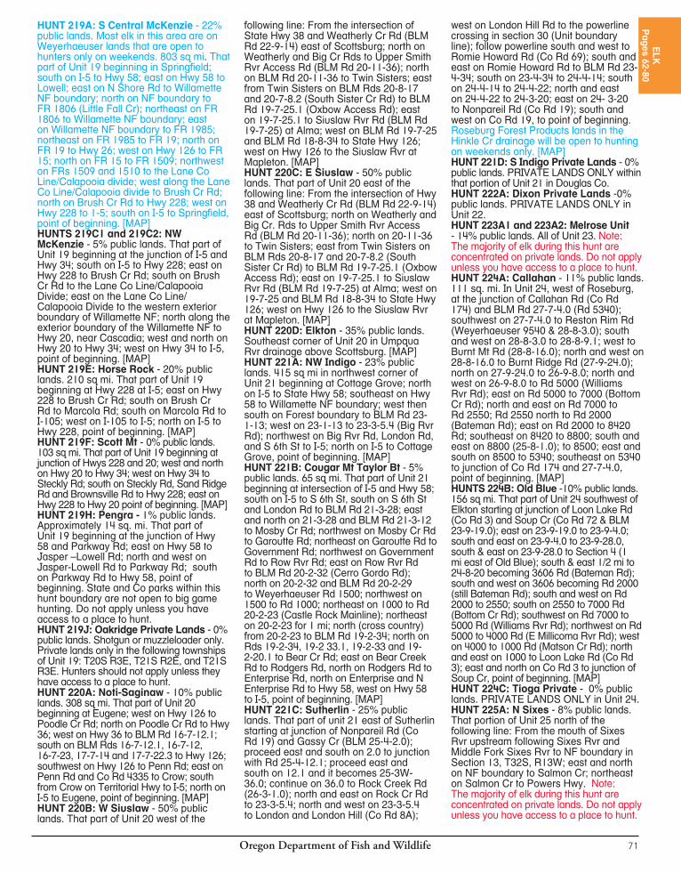
Oregon Department of Fish and Wildlife70
HUNT 214F: Panther Cr - 50% public lands. 16 sq mi. That part of Unit 14 beginning at intersection of Alder Brook and Hwy 18 one mi east of Rose Lodge; north up Alder Brook to Widow Cr Ridge Rd; north on Widow Cr Ridge Rd to FR 115, south on 115 to Cascade Head Experimental FR (FR 1861), north and west on 1861 to US Hwy 101; south on Hwy 101 to Three Rocks Rd; east on Three Rocks Rd to Old Scenic Hwy 101; south on Old Scenic Hwy 101 to N Bank Rd; east on N Bank Rd to Hwy 18 at Rose Lodge; east on Hwy 18 to Alder Brook, point of beginning. [MAP]HUNT 215A1 and 215A2: Willamette Plus - 1% public lands. All of Unit 15 and that part of Unit 18 as follows: 11 sq mi east of Bellfountain Rd and north of Coon Rd.HUNTS 216B1 and 216B2: SW Santiam - 30% public lands. That part of Unit 16 beginning at Lebanon, north on Brewster Rd. to Lacomb Rd.; east on Lacomb Rd to Kowitz Rd; north on Kowitz Rd to Baptist Church Dr; west on Baptist Church Dr to Richardson Gap Rd; north on Richardson Gap Rd to State Hwy 226; northeast on Hwy 226 to State Hwy 22; east on Hwy 22 to the western exterior boundary of the Willamette NF; south along the westernexterior boundary of the Willamette NF to Hwy 20; west on Hwy 20 to Lebanon, point of beginning. HUNTS 216C1, 216C2, and 216C3: Molalla - 25% public lands. That part of Unit 16 west of the western exterior boundary of Mt Hood and Willamette NF: Beginning at the junction of Hwy 211 and the Molalla FR; south and east on Molalla FR to N Fork Main Line; east on N Fork Main Line to Lukens Cr Rd; east on Lukens Cr Rd to NF boundary; south on the NF boundary to the north bank of the N Santiam Rvr; west on the north bank of the N Santiam Rvr to Stayton-Scio Rd; north on Stayton-Scio Rd and Cascade Hwy to Hwy 213 at Silverton; north on Hwy 213 to Hwy 211; east on Hwy 211 to Molalla FR, point of beginning.HUNT 216D: Sandy - 10% public lands. Those portions of unit 16 west of the western exterior boundary of the Mt Hood NF: Beginning at Interstate 84 at Benson State Park; west on Interstate 84 to Sandy River; southeast on the Sandy River to Teneyck Rd; south on Teneyck Rd to Hwy 211; southwest on Hwy 211 to Hwy 224; southeast on Hwy 224 to western exterior boundary of Mt Hood NF; north on western exterior boundary of Mt. Hood NF to Interstate 84; point of beginning.HUNT 216E: Green Mt. - 18% public lands. 114 sq mi. That part of Unit 16 west of the western exterior boundary of Mt Hood NF. Beginning at Hwy 224 and Hwy 211 Junction in Estacada; south on Hwy 211 to Molalla FR; south and east on Molalla FR to N Fork Main Line; east on N Fork Main Line to Lukens Cr Rd; east on Lukens Cr Rd to Mt. Hood NF boundary; north on western exterior boundary of Mt Hood NF to Hwy 224; west on Hwy 224 to Hwy 211 junction; point of beginning.HUNT 216F: NW Santiam - 22% public lands. That part of Unit 16 outside of the western exterior boundary of the Mt. Hood NF and Willamette NF beginning at the junction of Hwy 22 and Hwy 226; west on Hwy 22 to Cascade Hwy; north on Cascade
Hwy to State Hwy 213 at Silverton; northeast on Hwy 213 to State Hwy 211; northeast on Hwy 211 to Hwy 26 at Sandy; east on Hwy 26 to Teneyck Rd; north on Teneyck Rd to Sandy River; northwest down Sandy River to I-84; northeast on I-84 to Benson State Park and Mt. Hood NF boundary; south along the western exterior boundary of the Mt. Hood NF and Willamette NF to Hwy 22; west on Hwy 22 to Hwy 226; point of beginning. [MAP]HUNT 217C: Lower Siletz Rvr - 25% public lands. 106 sq mi. That part of Unit 17 as follows: Beginning at the intersection of Hwy 18 and USFS Rd 17; east on Hwy 18 to Murphy Rd; south on Murphy Rd to 100 Rd; south on 100 to BLM Rd 6-8-35; east on 6-8-35 to 300 Rd; south and west on 300 to 100 Rd; south on 100 to 800 Rd; west on 800 to BLM Rd 7-9-20 (Box Canyon); west on 7-9-20 to 200 Rd (Gravel Cr Rd); southeast on 200 to 300 Rd; southwest on 300 to 4000 Rd (Werner Rd); west on 4000 to Siletz Rvr at Ichwhit County Park; west on Siletz Rvr to milepost 1 on Hwy 229 at the S Drift Cr Rd intersection; north on S Drift Cr Rd to S Anderson Cr Rd; north on S Anderson Cr Rd to Schooner Cr Rd; east on Schooner Cr Rd to FR 17; north on 17 to Hwy 18, point of beginning. [MAP]HUNT 217D: Upper Siletz Rvr - 10% public lands. 128 sq mi. Beginning at the bridge over the Siletz Rvr, on the south side of Siletz upstream along the north side of the Siletz Rvr to the confluence of the north and south forks of the Siletz Rvr; upstream along the S Fork to the Old Valsetz-Falls City bridge; east on Old Valsetz-Falls City Rd to 1300 Rd; northwest on the 1300 to Fanno Ridge Rd; northwest on Fanno Ridge Rd to BLM Rd 8-8-23; northwest on 8-8-23 to BLM Rd 8-8-11; north on 8-8-11 to BLM Rd 8-8-12; northeast on 8-8-12 to BLM Rd 8-7-23 (M4 and Blackrock mainline); north and west on 8-7-23 to 300 Rd; west on 300 to 100 Rd; south on 100 to 800 Rd; west on 800 to BLM Rd 7-9-20 (Box Canyon); west on 7-9-20 to 200 Rd; southeast on 200 (Gravel Cr Rd) to 300 Rd; southwest on 300 to 4000 Rd (Werner Rd); southwest on 4000 to the Siletz Rvr at Ichwhit Co Park; upstream along the Siletz Rvr to the bridge on the south side of Siletz, point of beginning. [MAP]HUNT 217E Dallas: 17% public lands. That part of Unit 17 beginning at Dallas; northeast on State Hwy 223 to State Hwy 22; Northwest on Hwy 22 to State Hwy 18; west on Hwy 18 to Murphy Rd; south on Murphy Rd to 100 Rd; south on Rd 100 Rd to BLM Rd 6-8-35; east on 6-8-35 to 300 Rd; south on 300 Rd to BLM Rd 8-7-23 (M4 and Blackrock mainline); east on Blackrock mainline to S-line; southwest on S-line to Fanno Ridge Rd; southeast on Fanno Ridge to 1300 Rd; southeast on 1300 Rd to old Valsetz-Fall City Co Rd; east on old Valsetz-Fall City Co Rd to Fall City; southeast on Bridgeport Rd (No 864) and Gardner Rd (No 865) to Hwy 223; north on Hwy 223 to Dallas, point of beginning. [MAP]HUNT 218A: NE Alsea - 15% public lands. That part of Unit 18 beginning at the intersection of Hwys 99 and 20/34 in
Corvallis; west on Hwy 34 to Philomath; west on Hwy 20 to Blodgett; north west on the Summit-Nashville Rd (Co Rd 180) to the Logsdon Rd in Nashville; north on Logsdon Rd to the Green Mt Rd; north on Green Mt Rd to the 1420 Rd; north on 1420 to 1400 Rd; west on 1400 Rd to the old Valsetz-Fall City main Co Rd; east on the old Valsetz-Fall City main Co Rd to Fall City, southeast on Bridgeport Rd (No 864), Gardner Rd (No. 865), Airlie Rd ( No 7) to State Hwy 99; south on Hwy 99 to Corvallis, point of beginning. [MAP]HUNT 218B: SW Alsea - 84% public lands. 468 sq mi. That part of Unit 18 south and west of the following line: Beginning at Waldport; east on State Hwy 34 to FR 3415; south on FRs 3415, 3412 and 3310 to Lobster Cr Rd; south and east on Lobster Cr Rd to Preacher Cr Rd; south on Preacher Cr Rd to FR 35; south on 35 to Panther Cr Rd; south on Panther Cr Rd to Deadwood Cr Rd; south on Deadwood Cr Rd to State Hwy 36, south to the north shoreline of Lake Cr. [MAP]HUNT 218C: SE Alsea - 42% public lands. 381 sq mi. That part of Unit 18 south and east of the following line: Beginning at the intersection of Decker Rd and Bellfountain Rd; west on Decker Rd to State Hwy 34; southwest on Hwy 34 to FR 3415; south on FRs 3415, 3412 and 3310 to Lobster Cr Rd; south and east on Lobster Cr Rd to Preacher Cr Rd; south on Preacher Cr Rd to FR 35; south on 35 to Panther Cr Rd; south on Panther Cr Rd to Deadwood Cr Rd; south on Deadwood Cr Rd to State Hwy 36, south to the north shoreline of Lake Cr. [MAP]HUNT 218E: SW Alsea Private Lands: - 0% public lands. PRIVATE LANDS ONLY within that part of Unit 18 south and west of the following line: Beginning at Waldport; east on State Hwy 34 to FR 3415; south on FRs 3415, 3412 and 3310 to Lobster Cr Rd; south and east on Lobster Cr Rd to Preacher Cr Rd; south on Preacher Cr Rd to FR 35; south on 35 to Panther Cr Rd; south on Panther Cr Rd to Deadwood Cr Rd; south on Deadwood Cr Rd to State Hwy 36, south to the north shoreline of Lake Cr. [MAP] HUNT 218F: Central Alsea Private - 0% public lands. PRIVATE LANDS ONLY. Within that part of Unit 18 beginning at Newport; east on Hwy 20 to state Hwy 34 in Philomath; southwest on Hwy 34 to Waldport; north on Hwy 101 to Newport, point of beginning.HUNT 218G: NW Alsea - 5% public lands. 263 sq mi Beginning at the intersection of US Hwy 101 and US Hwy 20 in Newport; east on Hwy 20 to Co Rd 180 (Nashville Summit Rd) in Blodgett; northwest on Co Rd 180 to the Logsden Rd intersection at Nashville; north on Logsden Rd to Green Mt Rd (BLM Rd 10-8-23.1); north on Green Mt Rd to the 1420 Rd; north on 1420 Rd to the 1400 Rd (Luckiamute Rd); west and north on the 1400 Rd to Old Valsetz-Fall City Rd; west on the Old Valsetz- Fall City Rd to the bridge over the S Fork of the Siletz Rvr; downstream along the south side of the Siletz Rvr to US Hwy 101in Kernville; then south on Hwy 101 to Newport, point of beginning. [MAP]
Oregon Department of Fish and Wildlife 71
HUNT 219A: S Central McKenzie - 22% public lands. Most elk in this area are on Weyerhaeuser lands that are open to hunters only on weekends. 803 sq mi. That part of Unit 19 beginning in Springfield; south on I-5 to Hwy 58; east on Hwy 58 to Lowell; east on N Shore Rd to Willamette NF boundary; north on NF boundary to FR 1806 (Little Fall Cr); northeast on FR 1806 to Willamette NF boundary; east on Willamette NF boundary to FR 1985; northeast on FR 1985 to FR 19; north on FR 19 to Hwy 26; west on Hwy 126 to FR 15; north on FR 15 to FR 1509; northwest on FRs 1509 and 1510 to the Lane Co Line/Calapooia divide; west along the Lane Co Line/Calapooia divide to Brush Cr Rd; north on Brush Cr Rd to Hwy 228; west on Hwy 228 to 1-5; south on I-5 to Springfield, point of beginning. [MAP]HUNTS 219C1 and 219C2: NW McKenzie - 5% public lands. That part of Unit 19 beginning at the junction of I-5 and Hwy 34; south on I-5 to Hwy 228; east on Hwy 228 to Brush Cr Rd; south on Brush Cr Rd to the Lane Co Line/Calapooia Divide; east on the Lane Co Line/Calapooia Divide to the western exterior boundary of Willamette NF; north along the exterior boundary of the Willamette NF to Hwy 20, near Cascadia; west and north on Hwy 20 to Hwy 34; west on Hwy 34 to I-5, point of beginning. [MAP]HUNT 219E: Horse Rock - 20% public lands. 210 sq mi. That part of Unit 19 beginning at Hwy 228 at I-5; east on Hwy 228 to Brush Cr Rd; south on Brush Cr Rd to Marcola Rd; south on Marcola Rd to I-105; west on I-105 to I-5; north on I-5 to Hwy 228, point of beginning. [MAP]HUNT 219F: Scott Mt - 0% public lands. 103 sq mi. That part of Unit 19 beginning at junction of Hwys 228 and 20; west and north on Hwy 20 to Hwy 34; west on Hwy 34 to Steckly Rd; south on Steckly Rd, Sand Ridge Rd and Brownsville Rd to Hwy 228; east on Hwy 228 to Hwy 20 point of beginning. [MAP] HUNT 219H: Pengra - 1% public lands. Approximately 14 sq. mi. That part of Unit 19 beginning at the junction of Hwy 58 and Parkway Rd; east on Hwy 58 to Jasper –Lowell Rd; north and west on Jasper-Lowell Rd to Parkway Rd; south on Parkway Rd to Hwy 58, point of beginning. State and Co parks within this hunt boundary are not open to big game hunting. Do not apply unless you have access to a place to hunt.HUNT 219J: Oakridge Private Lands - 0% public lands. Shotgun or muzzleloader only. Private lands only in the following townships of Unit 19: T20S R3E, T21S R2E, and T21S R3E. Hunters should not apply unless they have access to a place to hunt.HUNT 220A: Noti-Saginaw - 10% public lands. 308 sq mi. That part of Unit 20 beginning at Eugene; west on Hwy 126 to Poodle Cr Rd; north on Poodle Cr Rd to Hwy 36; west on Hwy 36 to BLM Rd 16-7-12.1; south on BLM Rds 16-7-12.1, 16-7-12, 16-7-23, 17-7-14 and 17-7-22.3 to Hwy 126; southwest on Hwy 126 to Penn Rd; east on Penn Rd and Co Rd 4335 to Crow; south from Crow on Territorial Hwy to I-5; north on I-5 to Eugene, point of beginning. [MAP] HUNT 220B: W Siuslaw - 50% public lands. That part of Unit 20 west of the
following line: From the intersection of State Hwy 38 and Weatherly Cr Rd (BLM Rd 22-9-14) east of Scottsburg; north on Weatherly and Big Cr Rds to Upper Smith Rvr Access Rd (BLM Rd 20-11-36); north on BLM Rd 20-11-36 to Twin Sisters; east from Twin Sisters on BLM Rds 20-8-17 and 20-7-8.2 (South Sister Cr Rd) to BLM Rd 19-7-25.1 (Oxbow Access Rd); east on 19-7-25.1 to Siuslaw Rvr Rd (BLM Rd 19-7-25) at Alma; west on BLM Rd 19-7-25 and BLM Rd 18-8-34 to State Hwy 126; west on Hwy 126 to the Siuslaw Rvr at Mapleton. [MAP]HUNT 220C: E Siuslaw - 50% public lands. That part of Unit 20 east of the following line: From the intersection of Hwy 38 and Weatherly Cr Rd (BLM Rd 22-9-14) east of Scottsburg; north on Weatherly and Big Cr. Rds to Upper Smith Rvr Access Rd (BLM Rd 20-11-36); north on 20-11-36 to Twin Sisters; east from Twin Sisters on BLM Rds 20-8-17 and 20-7-8.2 (South Sister Cr Rd) to BLM Rd 19-7-25.1 (Oxbow Access Rd); east on 19-7-25.1 to Siuslaw Rvr Rd (BLM Rd 19-7-25) at Alma; west on 19-7-25 and BLM Rd 18-8-34 to State Hwy 126; west on Hwy 126 to the Siuslaw Rvr at Mapleton. [MAP]HUNT 220D: Elkton - 35% public lands. Southeast corner of Unit 20 in Umpqua Rvr drainage above Scottsburg. [MAP]HUNT 221A: NW Indigo - 23% public lands. 415 sq mi in northwest corner of Unit 21 beginning at Cottage Grove; north on I-5 to State Hwy 58; southeast on Hwy 58 to Willamette NF boundary; west then south on Forest boundary to BLM Rd 23-1-13; west on 23-1-13 to 23-3-5.4 (Big Rvr Rd); northwest on Big Rvr Rd, London Rd, and S 6th St to I-5; north on I-5 to Cottage Grove, point of beginning. [MAP]HUNT 221B: Cougar Mt Taylor Bt - 5% public lands. 65 sq mi. That part of Unit 21 beginning at intersection of I-5 and Hwy 58; south on I-5 to S 6th St, south on S 6th St and London Rd to BLM Rd 21-3-28; east and north on 21-3-28 and BLM Rd 21-3-12 to Mosby Cr Rd; northwest on Mosby Cr Rd to Garoutte Rd; northeast on Garoutte Rd to Government Rd; northwest on Government Rd to Row Rvr Rd; east on Row Rvr Rd to BLM Rd 20-2-32 (Cerro Gordo Rd); north on 20-2-32 and BLM Rd 20-2-29 to Weyerhaeuser Rd 1500; northwest on 1500 to Rd 1000; northeast on 1000 to Rd 20-2-23 (Castle Rock Mainline); northeast on 20-2-23 for 1 mi; north (cross country) from 20-2-23 to BLM Rd 19-2-34; north on Rds 19-2-34, 19-2 33.1, 19-2-33 and 19-2-20.1 to Bear Cr Rd; east on Bear Creek Rd to Rodgers Rd, north on Rodgers Rd to Enterprise Rd, north on Enterprise and N Enterprise Rd to Hwy 58, west on Hwy 58 to I-5, point of beginning. [MAP]HUNT 221C: Sutherlin - 25% public lands. That part of unit 21 east of Sutherlin starting at junction of Nonpareil Rd (Co Rd 19) and Gassy Cr (BLM 25-4-2.0); proceed east and south on 2.0 to junction with Rd 25-4-12.1; proceed east and south on 12.1 and it becomes 25-3W-36.0; continue on 36.0 to Rock Creek Rd (26-3-1.0); north and east on Rock Cr Rd to 23-3-5.4; north and west on 23-3-5.4 to London and London Hill (Co Rd 8A);
west on London Hill Rd to the powerline crossing in section 30 (Unit boundary line); follow powerline south and west to Romie Howard Rd (Co Rd 69); south and east on Romie Howard Rd to BLM Rd 23-4-34; south on 23-4-34 to 24-4-14; south on 24-4-14 to 24-4-22; north and east on 24-4-22 to 24-3-20; east on 24- 3-20 to Nonpareil Rd (Co Rd 19); south and west on Co Rd 19, to point of beginning. Roseburg Forest Products lands in the Hinkle Cr drainage will be open to hunting on weekends only. [MAP]HUNT 221D: S Indigo Private Lands - 0% public lands. PRIVATE LANDS ONLY within that portion of Unit 21 in Douglas Co. HUNT 222A: Dixon Private Lands -0% public lands. PRIVATE LANDS ONLY in Unit 22. HUNT 223A1 and 223A2: Melrose Unit - 14% public lands. All of Unit 23. Note: The majority of elk during this hunt are concentrated on private lands. Do not apply unless you have access to a place to hunt.HUNT 224A: Callahan - 11% public lands. 111 sq. mi. In Unit 24, west of Roseburg, at the junction of Callahan Rd (Co Rd 174) and BLM Rd 27-7-4.0 (Rd 5340); southwest on 27-7-4.0 to Reston Rim Rd (Weyerhaeuser 9540 & 28-8-3.0); south and west on 28-8-3.0 to 28-8-9.1; west to Burnt Mt Rd (28-8-16.0); north and west on 28-8-16.0 to Burnt Ridge Rd (27-9-24.0); north on 27-9-24.0 to 26-9-8.0; north and west on 26-9-8.0 to Rd 5000 (Williams Rvr Rd); east on Rd 5000 to 7000 (Bottom Cr Rd); north and east on Rd 7000 to Rd 2550; Rd 2550 north to Rd 2000 (Bateman Rd); east on Rd 2000 to 8420 Rd; southeast on 8420 to 8800; south and east on 8800 (25-8-1.0); to 8500; east and south on 8500 to 5340; southeast on 5340 to junction of Co Rd 174 and 27-7-4.0, point of beginning. [MAP]HUNTS 224B: Old Blue -10% public lands. 156 sq mi. That part of Unit 24 southwest of Elkton starting at junction of Loon Lake Rd (Co Rd 3) and Soup Cr (Co Rd 72 & BLM 23-9-19.0); east on 23-9-19.0 to 23-9-4.0; south and east on 23-9-4.0 to 23-9-28.0, south & east on 23-9-28.0 to Section 4 (1 mi east of Old Blue); south & east 1/2 mi to 24-8-20 becoming 3606 Rd (Bateman Rd); south and west on 3606 becoming Rd 2000 (still Bateman Rd); south and west on Rd 2000 to 2550; south on 2550 to 7000 Rd (Bottom Cr Rd); southwest on Rd 7000 to 5000 Rd (Williams Rvr Rd); northwest on Rd 5000 to 4000 Rd (E Millicoma Rvr Rd); west on 4000 to 1000 Rd (Matson Cr Rd); north and east on 1000 to Loon Lake Rd (Co Rd 3); east and north on Co Rd 3 to junction of Soup Cr, point of beginning. [MAP]HUNT 224C: Tioga Private - 0% public lands. PRIVATE LANDS ONLY in Unit 24.HUNT 225A: N Sixes - 8% public lands. That portion of Unit 25 north of the following line: From the mouth of Sixes Rvr upstream following Sixes Rvr and Middle Fork Sixes Rvr to NF boundary in Section 13, T32S, R13W; east and north on NF boundary to Salmon Cr; northeast on Salmon Cr to Powers Hwy. Note: The majority of elk during this hunt are concentrated on private lands. Do not apply unless you have access to a place to hunt.
ELK
Pages 62-80

Oregon Department of Fish and Wildlife72
HUNT 225B: Curry Private - 0% public lands. Private lands in that part of Unit 25 south of the following line: From the mouth of the Sixes Rvr upstream following Sixes Rvr and Middle Fork Sixes Rvr to the NF boundary in Section 13, T32S, R13W; east and north on Forest boundary to Salmon Cr; northeast on Salmon Cr to Powers Hwy; and private lands in that portion of Unit 27 in Curry Co.HUNT 226A: Powers Unit Private - 0% public lands. PRIVATE LANDS ONLY in Unit 26.HUNT 228A: Applegate-Evans Cr - 35% public lands. All of Units 28 and 29. Note: The majority of elk during this hunt are concentrated on private lands. Do not apply unless you have access to a place to hunt. HUNT 230A: W Rogue - 35% public lands. That part of Unit 30 west of the following line: Beginning at State Hwy 62 and Butte Falls-Prospect Rd; south on Butte Falls-Prospect Rd to Butte Falls Fish Lk Rd southeast of Butte Falls; southeast on Butte Falls Fish Lk Rd to State Hwy 140; east on Hwy 140 to boundary of Unit 30; south on Unit boundary to Oregon-California State line; and that part of Unit 22 in Jackson Co south of the NF exterior boundary. [MAP] Note: The majority of elk during this hunt are concentrated on private lands. Do not apply unless you have access to a place to hunt.HUNTS 233X and 233Y: Sprague - 75% public lands. That part of Unit 33 east of US Hwy 97.HUNT 234A: Little Rvr - 50% public lands. Those parts of units 34 and 35 beginning at Burgess Rd and US Hwy 97; west on Burgess Rd to Ponderosa; west on Ponderosa to FR 4320; south on FR 4320 to Masten Rd; south and west on Masten Rd to FR 6203; west on 6203 to FR 6224; west on 6224 to FR 6220; south on 6220 to FR 62; south on 62 to US Hwy 97; south on Hwy 97 to Crown Pacific Rd 9775; east on 9775 to FR 9775-770; north on 9775-770 to Hwy 31; northwest on Hwy 31 to Hwy 97, point of beginning. [MAP]HUNT 234B: Tumalo - 48% public lands. 140 sq mi in northeast part of Unit 34 and southeast part of Unit 39. Beginning at Deschutes Rvr at Tumalo; north on Deschutes Rvr to confluence with Squaw Cr; southwest on Squaw Cr to Camp Polk Rd; southeast on Camp Polk Rd to Hwy 126; west on Hwy 126 to State Hwy 20; south on Hwy 20 to Gist Rd; south on Gist Rd to Plainview Rd; east on Plainview Rd to Sisemore Rd; south on Sisemore Rd to Tumalo Reservoir Rd; east on Tumalo Reservoir Rd to Tumalo and Deschutes Rvr, point of beginning. [MAP]HUNT 235A: Badlands - 65% public lands. 405 sq mi. That part of Unit 35 beginning at Bend southeast on Hwy 20 to junction with Millican Rd; north on Millican Rd to Bear Cr Rd; east on Bear Cr Rd to Hwy 27; north on Hwy 27 to Prineville and Hwy 126; west on Hwy 126 to Redmond and Hwy 97; south on Hwy 97 to Bend, point of beginning. [MAP]HUNTS 235X and 235Y: Paulina - E Fort Rock - 75% public lands. All of Unit 35 and that part of Unit 77 east of US Hwy 97.HUNT 236A: Maury-Hampton Butte - 53% public lands. That part of Unit 36 outside exterior boundary of Ochoco NF. HUNT 237A: North Ochoco - 7% public lands. 208 sq mi of the northern part of Unit
37. Beginning at Mitchell east on Hwy 26 to Cottonwood Cr; south on Cottonwood Cr to Ochoco NF (ONF); west along exterior boundary of the ONF to Hwy 26; east on Hwy 26 to Mitchell, point of beginning. [MAP]HUNT 237B: Crooked River - 12% public land. 461 sq mi in the southern part of Unit 37. Beginning at the town of Prineville east on Hwy 26 to Ochoco NF (ONF) boundary; east along exterior boundary of the ONF and selected BLM lands (BLM lands adjoining the ONF and along the NF Crooked Rvr) to where Forest Rd 58 exits the east side of the ONF; east on Forest Rd 58 to the South Fork John Day Rvr (SFJDR); south on SFJDR to Grant Co Rd 67; west on Grant Co Rd 67, Crook Co Rd 112 and State Hwy 380 to the Crooked River; west on Crooked Rvr, Prineville Res to Hwy 27 at Bowman Dam; northwest on Hwy 27 to Prineville and Hwy 26, point of beginning. [MAP]HUNTS 237C1 and 237C2: Ochoco Private - 16% public land, 893 sq mi That part of Unit 37 outside the exterior boundary of the Ochoco NF. Private “in-holdings” within the Ochoco NF are closed to hunting with this tag. HUNT 238A: SW Grizzly - 17% public lands. 450 sq mi of Unit 38 in portions of T10, 11, 12, 13, 14S and R13, 14, 15, 16, 17 and 18E. [MAP] HUNT 238B: N Grizzly Private - 0% public lands. PRIVATE LANDS ONLY. 326 sq mi of units 38, 40 and 43 in parts of T6, 7, 8, 9 and 10S, R14, 15, 16, 17, 18, 19 and 20E. [MAP]HUNTS 238C1 and 238C2: Grizzly Private Lands - 0% public lands. PRIVATE LANDS ONLY in Unit 38; Ochoco Lumber Company lands (portions or all of Townships 12 and 13S; and Ranges 15, 16 and 17E) are not included in the hunt area. A map is provided to illustrate the closed Ochoco Lumber Co lands. Private “in-holdings” within the Ochoco Lumber Company lands are open to hunting (with landowners permission) with this tag. HUNT 240A: Maupin-W Biggs - 7% public lands. All of Unit 40 and that part of Unit 43 west of John Day Rvr.HUNT 241A: The Dalles Watershed - 100% public lands. That part of Unit 41 as follows: 22 sq mi in Unit 41 southwest of The Dalles within the boundaries of The Dalles Watershed. This area is closed to motor vehicles. Entry is allowed only by City of The Dalles permit, only for the duration of the hunt. Any entry into watershed at other times or by persons other than tag holders is prohibited. The City of The Dalles entry permits are limited to persons with a valid ODFW controlled hunt tag. After a tag holder harvests an animal, one person may accompany the permit holder to help remove the animal. Persons unable to hunt alone should apply as a party or not apply for this hunt. [MAP]HUNT 241B: White Rvr-Hood - 50% public lands. All of units 41 and 42.HUNTS 241C1 and 241C2: N White Rvr -Hood - 50% public lands. All of Unit 42 and that part of Unit 41 north of Dufur Mill Rd (FR 44).HUNT 241D: Larch Cr - 20% public lands. That part of Unit 41 beginning at Dufur; south on Hwy 197 approximately 12 mi to Tooter Cr Big Game Fence; northwest
on Big Game Fence to Friend Rd; west on Friend Rd to FR 2730; west on 2730 to Forest trail 457; northeast on 457 to Fifteenmile Cr; east on Fifteenmile Cr to NF boundary; north on Forest boundary to FR 44; east on 44 to Dufur, point of beginning. [MAP] HUNT 244A: S Columbia Basin - 5% public land. All of unit 44 south of I -84.HUNTS 245A1 and 245A2: N Fossil Private Lands - Private lands only within that part of Unit 45 north of State Hwy 19. HUNTS 245B1 and 245B2: S Fossil Private Lands - Private lands only within that part of Unit 45 south of State Hwy 19. HUNT 245C: N Fossil - 14% public lands. That part of Unit 45 north of State Hwy 19.HUNTS 245D1, 245D2, and 245D3: S Fossil - 10% public lands. That part of Unit 45 south of State Hwy 19.HUNT 245E: Fossil-E Biggs Agri - 8% public lands. That part of Unit 45 that is on or within one mi of agricultural lands and that portion of Unit 43 that is east of the John Day Rvr that is on or within one mi of agricultural lands and that portion of Unit 44 west of Rock Cr that is on or within one mi of agricultural lands or active CRP lands. Agricultural lands are defined on the definitions page.HUNT 246A: W Murderers Cr - 65% public lands. That part of Unit 46 west of US Hwy 395.HUNT 246B: E Murderers Cr - 65% public lands. That part of Unit 46 east of US Hwy 395.HUNT 246C: Flagtail - 65% public lands. That part of Unit 46 west of US Hwy 395.HUNT 246D: Upper John Day Rvr - 7% public lands. Those parts of units 46, 47 and 65 as follows: In Unit 46: from US Hwy 26 Dog Cr intersection; south on Dog Cr to a line 1/2 mi south of exterior NF boundary from Dog Cr to John Day Rvr. In Unit 65: west of a line 1/2 mi east of the exterior boundary of NF from Rail Cr to Hwy 26 at Dixie Summit. In Unit 47 south from Dixie Summit, west on FS Rd 096 to Ella Gulch; downstream on Ella Gulch to Dixie Cr; downstream on Dixie Cr to the junction of Dixie Cr and the north edge of Section 26; west on sections 26, 27, 28 and 29 to exterior boundary on NF; west on exterior boundary to US Hwy 395. South on US Hwy 395 to 395/26 intersection; east on Hwy 26 to Dog Cr, point of beginning. [MAP] HUNTS 246E1 and 246E2: Murderers Cr Private Lands Plus - 0% public lands. PRIVATE LANDS ONLY in Unit 46 and that part of Unit 65 starting at the junction of Co Rd 62 and the Malheur NF boundary; north on the exterior forest boundary to the junction of Hwy 26; southwest on Hwy 26 to the junction of Co Rd 62, point of beginning. ALL applicants for this hunts must be listed on a Landowner Permission Form of a qualified landowner within the hunt area. You are still eligible to hunt on other private lands within the entire hunt area, but must have permission to hunt at least one property via the form.HUNTS 247A1 and 247A2: Northside Private Lands - 0% public lands. OPEN AREA: Private lands only in Unit 47; by per mis sion from landowner. ALL applicants for these hunts must be listed on a Landowner Permission Form of a
Oregon Department of Fish and Wildlife 73
qualified landowner within the hunt area. You are still eligible to hunt on other private lands within the hunt area, but must have permission to hunt at least one property via the form.HUNT 247B: W Northside - 30% public lands. That part of Unit 47 west of US Hwy 395.HUNT 247C: E Northside - 90% public lands. That part of Unit 47 east of US Hwy 395.HUNTS 247D1, 247D2, 247D3 and 247D4: W Grant Private - 0% public lands. PRIVATE LANDS ONLY in that part of Unit 48 south and east of N Fork John Day Rvr and that part of Unit 47 west of US Hwy 395. ALL applicants for these hunts must be listed on a Landowner Permission Form of a qualified landowner within the hunt area. You are still eligible to hunt on other private lands within the hunt area, but must have permission to hunt at least one property via the form. HUNT 247E1, 247E2, and 247E3: E Northside Private - 0% public lands. PRIVATE LANDS ONLY in that part of Unit 47 east of US Hwy 395. ALL applicants for these hunts must be listed on a Landowner Permission Form of a qualified landowner within the hunt area. You are still eligible to hunt on other private lands within the entire hunt area, but must have permission to hunt at least one property via the form.HUNTS 248A1 and 248A2: Heppner - 38% public lands. That part of Unit 48 north and west of N Fork John Day Rvr.HUNTS 248B1 and 248B2: Ritter - 8% public lands. That part of Unit 48 south and east of N Fork John Day Rvr.HUNT 248C: Monument - 0% public lands. Private lands only in that part of Unit 48 located south of exterior boundary of Umatilla NF and north of mainstem and N Fork John Day Rvr.HUNT 248D: Heppner - 38% public lands. That part of Unit 48 north of mainstem and N Fork John Day Rvr. HUNT 248E: Willow Creek - 0% public lands. Private lands only in that portion of Unit 48 north of the exterior boundary of the Umatilla NF and FR 53.HUNT 249B: McKay Cr - 5% public lands. That part of Unit 49 north of East Birch Cr Co Rd, Indian Lk Rd and FR 21, and all of Unit 44. [MAP] HUNT 249C: Central Ukiah - 35% public lands. That part of Unit 49 south of East Birch Cr Co Rd, Indian Lake Rd and FR 21, and north of Hwy 244.HUNT 249D: S Ukiah - 70% public lands. That part of Unit 49 south of Hwy 244. HUNT 251A: N Sumpter - 40% public lands. That part of Unit 51 north of Burnt Rvr Canyon Rd from Durkee to junction State Hwy 245 and Hwy 245 from junction Burnt Rvr Canyon Rd to Unity.HUNTS 251B1 and 251B2: S Sumpter - 25% public lands. That part of Unit 51 south of Burnt Rvr Canyon Rd from Durkee to junction State Hwy 245 and Hwy 245 from junction Burnt Rvr Canyon Rd to Unity.HUNT 251C: N Sumpter - 40% public lands. That part of Unit 51 north of Burnt Rvr Canyon Rd from Durkee to junction State Hwy 245 and Hwy 245 from junction Burnt Rvr Canyon Rd to Unity.
HUNT 251D: S Sumpter - 25% public lands. That part of Unit 51 south of Burnt Rvr Canyon Rd from Durkee to junction State Hwy 245 and Hwy 245 from junction Burnt Rvr Canyon Rd to Unity.HUNTS 251E1 and 251E2: Elkhorn Mt - 70% public lands. This hunt area is mostly rugged terrain with few Rds; hunters should be prepared. That part of Unit 51 beginning at Baker City, south on Hwy 7 to FR 6550 (near McEwen); north on 6550 to FR 6530; east and north on 6530 to FR 6510; east and north on 6510 to Elkhorn Ridge; northwest on Elkhorn Ridge to Anthony Lks Rd; east on Anthony Lks Rd to Foothill Rd; south on Foothill Rd to Muddy Cr Rd; east on Muddy Cr Rd to Pocahontas Rd; south and east on Pocahontas Rd to Baker City, point of beginning. [MAP]HUNTS 252A1 and 252A2: Starkey - 67% public lands. All of Unit 52 excluding the Starkey Experimental Forest and Range fenced enclosure and a 1/4-mi buffer outside the exterior 8-ft fence.HUNT 252B: S Starkey - 60% public lands. All of Unit 52 south of State Hwy 244.HUNT 252C: S Starkey Private - 0% public lands. PRIVATE LANDS ONLY in that part of Unit 52 south of State Hwy 244, excluding Elkhorn WA.HUNT 252D: Starkey Experimental Forest - 100% public lands. That part of Unit 52 as follows: approximately 30 sq mi of Starkey Experimental Forest and Range enclosure located within Unit 52. A 1/4-mi buffer along all 8-ft high fences, the 900-acre feed area, 1,500-acre Campbell Flat and 3,600-acre intensive timber management area are closed to all hunting, except as permitted by ODFW research personnel prior to any hunt. Hunters shall agree to participate in research collections and activities, which will include a general questionnaire about the hunting experience. See page 25 for ATV research that will affect this hunt. [MAP]HUNT 252E1 and 252E2: Shaw Mtn- 23% public lands. That part of Unit 52 as follows: Beginning 7 mi. south of La Grande at junction of I-84 and FR 43; west and south on FR 43 to FR 4315; south and east on FR 4315 to Wolf Creek Ln to I-84 and north to point of beginning.HUNT 252F: North Starkey - 77% public lands. All of Unit 52 north of Hwy 244. HUNT 253A: S Catherine Cr Private - 0% public land. Private lands only in that part of Unit 53 south of Hwy 237 from Island City to Cove and Mill Cr Rd from Cove to Moss Springs Campground and that portion of unit 63 north of Hwy 203.HUNT 253B: S Catherine Cr - 40% public lands. That part of Unit 53 south of Hwy 237 from Island City to Cove and Mill Cr Rd from Cove to Moss Springs Campground.HUNTS 253C1 and 253C2: Mt Harris - 20% public lands. That part of Unit 53 north of Hwy 237 from Island City to Cove and Mill Cr Rd from Cove to Moss Springs Campground. [MAP]HUNT 254A: Pumpkin Ridge - 25% public lands. That part of Unit 54 beginning at Elgin; south on State Hwy 82 approximately 4-1/4 mi to Courtney Ln; west on Courtney Ln to Summerville Rd; north on Summerville Rd
to Dry Cr Ln; west on Dry Cr Ln to Craig Lp; northwest on Craig Lp to Ruckel Rd; northwest on Ruckel Rd (FR 32) to FR 31; north on 31 to FR 3738 (Phillips Cr Rd); southeast on 3738 to State Hwy 204; east on Hwy 204 to Elgin, point of beginning. [MAP]HUNT 255A: Mill Cr Watershed - 100% public lands. That part of Unit 55 beginning at Mill Cr Watershed intake at Mill Cr; north on Intake Ridge trail to Oregon-Washington state line in T6N, R38E, Section 15; east on state line to FR 64 (Skyline Rd); southwest on 64 to FR 65 (Tiger Canyon Rd); southwest on FR 65 to Indian Ridge trail; north west on Indian Ridge trail to Tiger Cr Bridge on Mill Cr; east on Mill Cr to Mill Cr Watershed intake, point of beginning. See page 100 for specific regulations prior to applying for hunt. [MAP] HUNT 255B: Walla Walla Private - 0% public lands. PRIVATE LANDS ONLY in that part of Unit 55 outside the exterior boundary of the NF.HUNTS 255X, 255Y1, and 255Y2: Walla Walla - 33% public lands. All of Unit 55 except for the Mill Cr Watershed. See 255A for Mill Cr. Watershed hunt description.HUNT 256A: Bartlett Bench - 10% public lands. That part of Unit 56 beginning at Troy; west on Wenaha Rvr to Crooked Cr; north on Crooked Cr to Washington state line; east on state line to Grande Ronde Rvr; southwest on Grande Ronde Rvr to Troy, point of beginning. [MAP]HUNT 256B: Troy - 70% public lands. That part of Unit 56 north of Wenaha Rvr and east of N Fork Wenaha Rvr. [MAP]HUNT 257A: Elk Cr - 20% public lands. That part of Unit 57 south and east of following line: Beginning on Unit 57 boundary at Enterprise; north on Hwy 3 to Charlois Rd (FR 46); southeast on Charlois Rd to FR 4605; north on 4605 to FR 4605-200; north on 4605-200 to FR 4615; north on 4615 to north boundary of Section 9 (T3N, R45W); east on north boundary of section 9 and 10 to Unit 57 boundary at Joseph Cr. [MAP]HUNTS 257B1 and 257B2: Flora - 5% public lands. That part of Unit 57 beginning at Day Ridge Rd; west on Day Ridge Rd to the line between Sections 28 and 29 (T4N, R44E); north on section line to Shamrock Cr; northwest on Shamrock Cr to Courtney Cr; northwest on Courtney Cr to Grande Ronde Rvr; northeast on Grande Ronde Rvr to Oregon-Washington state line; east on state line to Joseph Cr; southwest on Joseph Cr to Wallowa-Whitman Forest boundary; southwest on Forest boundary to Hwy 3; south on Hwy 3 to Day Ridge Rd, point of beginning. [MAP]HUNT 257C: Whisky Cr - 0% public lands. That part of Unit 57 beginning at Enterprise; northwest on Hwy 82 to Promise Rd; north on Promise Rd to Dry Cr; east on Dry Cr to Troy Rd; north on Troy Rd to Tope Cr Lookout Rd; southeast on Tope Cr Lookout Rd to Whisky Cr Rd; south on Whisky Cr Rd to Middle Fork Whisky Cr; east on Middle Fork Whisky Cr to Hick Springs Rd, northeast on Hick Springs Rd to Hwy 3; south on Hwy 3 to Enterprise, point of beginning.
ELK
Pages 62-80
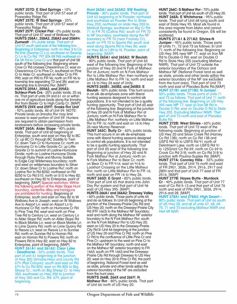
Oregon Department of Fish and Wildlife74
HUNT 257D: E Sled Springs - 10% public lands. That part of Unit 57 east of Powwatka Ridge Rd.HUNT 257E: W Sled Springs - 25% public lands. That part of Unit 57 west of Powwatka Ridge Rd.HUNT 257F: Cricket Flat - 0% public lands. That part of Unit 57 west of Wallowa Rvr.HUNTS 258A1, 258A2, 258A3 and 258A4: Zumwalt - 5% public lands. That part of Unit 57 south and east of the following line: Beginning at Enterprise; north on Hwy 3 to Co Rd 646 (Swamp Cr Ln); southeast on Swamp Cr Ln to Co Rd 797 (Elk Mt Rd) northeast on Elk Mt Rd to Crow Cr and that part of Unit 58 south of the following line: Beginning where Crow Cr Rd crosses Chesnimnus Cr; east on Chesnimnus Cr to Pine Cr; southeast on Pine Cr to Alder Cr; southeast on Alder Cr to FR 990; east on 990 to FR 46; north on FR 46 to township line separating T2 and 3N; east on township line to Imnaha Rvr. [MAP]HUNTS 259A1, 259A2, and 259A3: Schleur-Park Crs - 20% public lands. 25 sq mi. That part of units 59 and 61 on or within one mi of agriculture lands along the Imnaha Rvr from Beeler Cr to High Camp Cr. [MAP]HUNTS 259X and 259Y: Snake Rvr Unit - 92% public lands. All of Unit 59. NOTE: Private lands on Imnaha Rvr may limit access to west portion of Unit 59. Hunters are required to obtain permission from landowners before accessing private lands.HUNT 260A: Alder Slope - 40% public lands. That part of Unit 60 beginning at Enterprise; south and east on Hwy 82 to BC Cr; up BC Cr through BC Saddle to Twin Cr; down Twin Cr to Hurricane Cr; north on Hurricane Cr to Little Granite Cr; up Little Granite Cr to summit of Lostine-Hurricane Divide; north on Lostine-Hurricane Divide through Ruby Peak and Murray Saddle to Eagle Cap Wil der ness boundary; north and west on wilderness boundary to Silver Cr; down Silver Cr to Lostine Rvr; north on Lostine Rvr to Rd 8250; northwest on Rd 8250 to Co Rd 515; north on 515 to Hwy 82; southeast on Hwy 82 to Enterprise, point of beginning. [MAP] Special restriction: Within the following portion of the Alder Slope Hunt boundary, centerfire rifles and handguns are prohibited for hunting: Beginning at Enterprise, south and east on Hwy 82 to W Wallowa Ave in Joseph; west on W Wallowa Ave to Airport Ln; west on Airport Ln to Hurricane Cr Rd; north on Hurricane Cr Rd to Pine Tree Rd; west and north on Pine Tree Rd to Century Ln; west on Century Ln to Alder Slope Rd; north on Alder Slope Rd to Black Marble Ln; west on Black Marble Ln to Lime Quarry Rd; north on Lime Quarry Rd to Reavis Ln; west on Reavis Ln to Sunrise Rd; north on Sunrise Rd to Homan Rd; east on Homan Rd to Powers Rd; north on Powers Rd to Hwy 82; east on Hwy 82 to Enterprise, point of beginning. [MAP]HUNT 261A1 and 261A2: Clear Lake - Deadhorse - 55% public lands. That part of unit 61 beginning at the junction of Hwy 350 (Imnaha Hwy) and county Rd 674 (Rail Canyon); south and east on Rd 674 to Co Rd 805; east on Rd 805 to Big Sheep Cr.; north on Big Sheep Cr. to Hwy 350; southwest on Hwy 350 to junction of Hwy 350 and Co. Rd. 674, point of beginning.
Hunt 263A1 and 263A2: SW Keating Private - 30% public lands. That part of Unit 63 beginning at N Powder; northeast and southeast on Powder Rvr to State Hwy 203; northeast on state Hwy 203 to Medical Springs; southeast on Big Cr Rd 71 to FR 70 (Collins Rd); south on FR 70 to NF boundary; southeast along the NF boundary to FR 70 (near Forshey Cr); south on FR 70 to Sparta Rd; south and west along Sparta Rd to Hwy 86; west on Hwy 86 to I-84 to N. Powder; point of beginning. [MAP]HUNTS 265A1 and 265A2: W Beulah - 80% public lands. That part of Unit 65 west of the following line: Beginning at the junction of Hwy 20 and N Fork of Malheur Rvr at Juntura; north on N Fork Malheur Rvr to Little Malheur Rvr; then northerly on Little Malheur Rvr to FR 16; north and east on 16 to Hwy 26 east of Unity.HUNTS 265B1, 265B2, and 265B3: E Beulah - 50% public lands. This hunt occurs in an elk de-emphasis zone with liberal hunting seasons designed to control elk populations. It is not intended to be a quality hunting opportunity. That part of Unit 65 east of the following line: Beginning at the junction of Hwy 20 and N Fork of Malheur Rvr at Juntura; north on N Fork Malheur Rvr to Little Malheur Rvr; northerly on Little Malheur Rvr to FR 16; north and east on 16 to Hwy 26 near Murray Reservoir.HUNT 265C: Bully Cr - 60% public lands. This hunt occurs in an elk de-emphasis zone with liberal hunting seasons designed to control elk populations. It is not intended to be a quality hunting opportunity. That part of Unit 65 east of the following line: Beginning at junction of Hwy 20 and N Fork Malheur Rvr at Juntura; north on N Fork Malheur Rvr to Bear Cr; north on Bear Cr to FR 416; east on 416 to Lockhart Crossing on the Little Malheur Rvr; north on Little Malheur Rvr to FR 16; north and east on FR 16 to Hwy 26.HUNT 265D: E Grant - 85% public lands. That part of Unit 65 that drains into John Day Rvr system and that part of Unit 46 east of US Hwy 395. [MAP]HUNTS 266A1 and 266A2: Drewsey Valley - 60% public lands. Those parts of units 65 and 66 as follows: In Unit 65 beginning at the junction of the Drewsey-Prairie City Rd and US Hwy 20; north on the Drewsey-Prairie City Rd (FR 1663) to the Malheur NF boundary; east and north along the Malheur NF exterior boundary to the N Fork Malheur Rvr; south on the N Fork Malheur Rvr to US Hwy 20; west on US Hwy 20 to the Drewsey-Prairie City Rd In Unit 66 beginning at the junction of US Hwy 20 and Pine Cr Rd; north on Pine Cr Rd to the confluence of Little Pine Cr and Pine Cr; upstream to the west on Pine Cr to the Malheur NF boundary; north and east on the Malheur NF exterior boundary to FR 1663; south on FR 1663 and the Drewsey-Prairie City Rd through Drewsey to US Hwy 20; west on Hwy 20 to Pine Cr Rd, the point of beginning. National Forest land as well as state, private and other lands within the exterior boundary of the NF are excluded from the hunt area.HUNTS 266B, 266X and 266Y: N Malheur Rvr - 80% public lands. That part of Unit 66 north of US Hwy 20.
HUNT 266C: S Malheur Rvr - 70% public lands. That part of Unit 66 south of US Hwy 20.HUNT 268A: E Whitehorse - 95% public lands. That part of Unit 68 lying south and east of State Hwy 95. Most elk found in this area migrate from Idaho and cannot consistently be found in Oregon. Elk will be scattered.HUNTS 271A1 & 271A2: Silvies-N Juniper - 45% public lands. Those parts of Units 71, 72 and 73 as follows: In Unit 71 north of the following line: Beginning on US Hwy 395 near MP 17, east on Iron Mt Rd to Double O Rd; east on Double O Rd to State Hwy 205 (excluding Malheur NWR). That part of Unit 72 outside the exterior boundary of the Ochoco and Malheur NF (National Forest land as well as state, private and other lands within the exterior boundary of the NF are excluded from the hunt area). That part of Unit 73 north and east of Placidea Butte Rd.[MAP]HUNT 271B1 and 271B2: N Juniper - 50% public lands. Those parts of units 71 and 73 as follows: That part of Unit 71 north of the following line: Beginning on US Hwy 395 near MP 17; east on Iron Mt Rd to Double O Rd; east on Double O Rd to State Hwy 205. Excluding Malheur NWR. That part of Unit 73 north and east of Placidea Butte Rd.HUNT 272B: West Silvies - 60% public lands. That part of Unit 72 west of the following roads: Beginning at junction of US Hwy 20 and Silver Creek Rd (Harney Co Rd 138); north on Co Rd 138 and USFS Rd 45 to USFS Rd 41 north of Delintment Lake; north on USFS Rd 41 to 125Grant Co Rd 69; north on Co 69 to Crook Co Rd 318; north on Co Rd 318 to junction with Paulina-Suplee Rd. [MAP]HUNT 277A: Connley Hills - 55% public lands. That part of Unit 76 north and east of FR 2901, 3036, 2914, 2916, 2917 and 2804 and that part of Unit 77 east of FR 2516. [MAP]HUNT 277B: Hayes Butte - Murdock Cr - 40% public lands. That part of Unit 77 east of Co Rd 5-13 and that part of Unit 76 north and east of FRs 2901, 3036, 2914, 2916 and 28. [MAP]HUNT 278A1 and 278A2: High Desert - 80% public lands. That part of Unit 66 south of US Hwy 20; and all of units 67, 68, 69, 70, 71 and 73 excluding Malheur NWR and Hart Mt NAR.

Oregon Department of Fish and Wildlife76
CONTROLLED200SERIESELKMUZZLELOADERHUNTSTAG SALE DEADLINE: The day before the hunt begins.HUNT AREA: Entire wildlife management unit unless indicated by an asterisk(*). Landowner preference tags available, see page 19.
2013 1ST HUNT # HUNT NAME BAG LIMIT OPEN SEASON 2013 TAGS CHOICE APPLICANTS 200M1 NW Cascade* One elk* outside all NF Lands Nov. 15 - Nov. 21 500 555 *One bull inside all NF Lands 200M2 SW Cascades* One elk* outside all NF Lands Nov. 15 - Nov. 21 400 880 *One bull inside all NF Lands 214M NE Trask* One elk Dec. 18 - Dec. 31 43 116 224M Tioga One 3 pt + Dec. 13- Dec. 28 est. 400 in 2014 NEW 234M E Cascade* One elk Nov. 8 - Nov. 16 162 663 235M Paulina - E Fort Rock* One bull elk Oct. 18 - Oct. 24 55 79 248M Pole Cr.* One bull elk Oct. 18 - Oct. 26 26 232 251M1 Elkhorn No. 1* One antlerless elk Aug. 1 - Oct. 15 66 28 251M2 Elkhorn No. 2* One antlerless elk Oct. 16 - Dec. 31 44 25 253M Mt Harris* One antlerless elk Dec. 6 - Dec. 21 83 2 254M1 Union Agri No. 1* One antlerless elk Aug. 1 - Oct. 15 159 168 254M2 Union Agri No. 2* One antlerless elk Oct. 16 - Jan. 31, 2015 268 254 265M E Grant* One elk Oct. 18 - Oct. 24 193 285 278M High Desert* One elk Oct. 18 - Oct. 26 138 192
Private lands will limit access for hunts printed in red. Do not apply unless you have access to a place to hunt.STOP
*HUNT DESCRIPTIONSFor those hunt descriptions with [MAP] following the description, maps can be found on our website at www.dfw.state.or.us/resources/hunting/big_game/units.HUNT 200M1: NW Cascades - All of units 16 and 19 and that part of Unit 21 in the Willamette Rvr Drainage north of the following line: Beginning along the eastern edge of Unit 21 at the Pacific Crest Trail; south on the Pacific Crest Trail to Trail 3641; westerly on Trails 3641, 3643 and 1407 to FS Rd 770; westerly on FRs 770, 2154, 236, 436 to FR 3810; northwest on 3810 to junction of FR 3810 and 5851; north on 5851 to trail 1407; north on 1407 to FR 5850; north and west on 5850 to 745; westerly along FRs 745, 2213, 767, 2212 (Champion Saddle) and Co Rd 2460 (Sharps Cr Rd) to BLM Rd 23-1-12; southwest on BLM Rds 23-1-12 and 23-1-13 to BLM Rd 23-3-5.4 (Big Rvr Rd); northwest on BLM Rd 23-3-5.4 to the unit boundary at London Rd. [MAPS: USFS Umpqua NF, Willamette NF, Umpqua NF-Diamond Lake Ranger District] HUNT 200M2: SW Cascades - All of units 22, 29, 30 and that part of Unit 21 south of the following line: Beginning along the eastern edge of Unit 21 at the Pacific Crest Trail; south on the Pacific Crest Trail to Trail 3641; westerly on Trails 3641, 3643 and 1407 to FS Rd 770; westerly on FRs 770, 2154, 236, 436 to FR 3810; northwest
on 3810 to junction of FR 3810 and 5851; north on 5851 to Trail 1407; north on 1407 to FR 5850; north and west on 5850 to 745; westerly along FRs 745, 2213, 767, 2212 (Champion Saddle) and Co Rd 2460 (Sharps Cr Rd) to BLM Rd 23-1-12; southwest on BLM Rds 23-1-12 and 23-1-13 to BLM Rd 23-3-5.4 (Big Rvr Rd); northwest on BLM Rd 23-3-5.4 to the unit boundary at London Rd. [MAPS: USFS Umpqua NF, Umpqua NF-Diamond Lake Ranger District] HUNT 214M: NE Trask - 15% public lands. That part of Unit 14 beginning at the junction of Hwy 8 and Hwy 47 (Forest Grove); south on Hwy 47 to Pike Rd (Yamhill); north and west on Pike Rd to Rockyford Rd; south on Rockyford Rd to Old Railroad Grade; west on Old Railroad Grade to 2-5-29.0 Rd (CCC Rd and Toll Rd); west and north on 2-5-29.0 Rd to 2-6-3 Rd at Murphy Camp; north and east on 2-6-3 Rd (Flora Mainline) to N Fork Trask Rvr Rd at Neverstill; north and west on N Fork Trask Rvr Rd to Williams Rd; north on Williams Rd to 2500 Line Rd; north and west on 2500 Line Rd to Seven Cedars Rd cross-over; north and east on Seven Cedars cross-over to C-Line Rd; north and east on C-line Rd to Beaver Dam Rd; north on Beaver Dam Rd to Hwy 6; east on Hwy 6 to junction with Hwy 8; south and east on Hwy 8 to Hwy 47, point of beginning. [MAP]HUNT 234M: E Cascade - 70% public lands. All of units 34 and 39; that part of Unit
38 west of US Hwy 97 and south of US Hwy 26; and that part of Unit 77 west of Hwy 97.HUNT 235M: Paulina - E Ft Rock - 75% public lands. All of Unit 35 and that part of Unit 77 east of Hwy 97. HUNT 248M: Pole Cr - 100% public lands. All public lands within the Unit 48. HUNTS 251M1 and 251M2: Elkhorn All private lands in Unit 51 and Elkhorn Wildlife Area properties. See pg. 99 HUNT 253M: Mt Harris - 20% public lands. That part of Unit 53 north of Hwy 237 from Island City to Cove and Mill Cr Rd from Cove to Moss Springs Campground. [MAP]HUNTS 254M1 and 254M2: Union Agri - 5% public lands. On or within 1 mi of agricultural lands in Unit 52 and those portions of units 53, 54, 56, and 57 on or within 1 mi of agricultural lands in Union Co, excluding Elkhorn WA from Dec. 1 - Jan. 31. Agricultural lands are described on definitions page.HUNT 265M: E Grant - 85% public lands. That part of Unit 65 that drains into John Day Rvr system and that part of Unit 46 east of US Hwy 395. [MAP]HUNT 278M: High Desert - 80% public lands. That part of Unit 66 south of US Hwy 20; and all of units 67, 68, 69, 70, 71 and 73 excluding Malheur NWR and Hart Mt NAR.
“A
VO
ID
T
HE
F
EE
”
MA
ND
AT
OR
Y
RE
PO
RT
IN
G
RE
QU
IR
ED
S
EE
P
AG
E
6
W ith the increase of unlawful marijuana grows being located on State and National lands, hunters should be aware of their surroundings while recreating. Be careful...Be aware!
If you observe camp sites away from main roads, irrigation equipment, cultivated areas or marijuana plants leave the area immediately from the same direction you entered. Note the location of the suspicious activities and report
that information to your local law enforcement agency or the Oregon State Police TIP line at 1-800-452-7888.
Oregon Department of Fish and Wildlife 77
Private lands will limit access for hunts printed in red. Do not apply unless you have access to a place to hunt.
YOUTH-CONTROLLEDELKHUNTSAPPLICATION DEADLINE: MAY 15, 2014. Use complete hunt numbers when applying.TAG SALE DEADLINE is day before the hunt begins. For hunts with more than one hunt period, the tag sale deadline is day before the earliest opening date.The elk hunts listed below and the deer hunts listed on page 59, are part of a program to encourage youth participation in big game hunting. These hunts are designed to provide young hunters with a safe, well supervised, low-stress setting where they can enjoy the hunt while building fun da men tal skills. Youths must be ac com pa nied by an adult at least 21 years of age. Adults may not accompany more than two youths.To apply, hunters must be 12-17 years old at the time they hunt, have completed a hunter safety class by the time they hunt (see page 85 for Hunter Education Requirement) and have a hunting license. Youths selected for these hunts will be provided with ad di tional in for ma tion and rec om men da tions about preparing for the hunt. See pages 13-15 for application procedures. Hunters should apply for more than one hunt area. HUNT AREA: Entire wildlife management unit unless indicated by an asterisk(*). A map will be sent if indicated in hunt description by [MAP]. Landowner preference tags available, see page 19. Please note additional closure areas listed on pages 96-100 that may affect your hunt area.
2013 1ST HUNT # HUNT NAME BAG LIMIT OPEN SEASON 2013 TAGS CHOICE APPLICANTS 210T Saddle Mt Unit One antlerless elk Aug 1 - Dec. 31 10 152 211T Scappoose Unit One antlerless elk Aug. 1 - Dec. 31 20 120 212T1 Wilson Unit No. 1 One antlerless elk Aug. 1 - Dec. 31 10 127 212T2 Wilson Unit No. 2 One antlerless elk Dec. 20 - Dec. 28 22 78 212T3 Wilson Unit No. 3 One antlerless elk Dec. 27 - Jan 4, 2015 22 52 214T Trask Unit* One antlerless elk Aug. 1 - Dec. 31 10 157 216T Santiam Unit* One antlerless elk Aug. 1 - Dec. 31 20 159 217T Stott Mt Unit One antlerless elk Aug. 1 - Dec. 31 10 47 218T Alsea Unit One antlerless elk Aug. 1 - Dec. 31 10 112 219T McKenzie Unit One antlerless elk Aug. 1 - Dec. 31 10 119 220T Siuslaw Unit One antlerless elk Aug. 1 - Dec. 31 10 45 221T1 Indigo Unit One antlerless elk Aug. 1 - Dec. 31 10 96 221T2 Sutherlin* One antlerless elk Jan.1 - 31, 2015 21 21 222T Dixon Unit One antlerless elk Aug. 1 - Dec. 31 10 51 223T Melrose Unit* One antlerless elk Aug. 1 - Mar. 31, 2015 10 32 224T1 Tioga Unit One antlerless elk Aug. 1 - Dec. 31 10 166 224T2 Callahan* One antlerless elk Jan. 3 - 4, 10- 11, 32 37 17-18, 2015 224T3 Old Blue* One antlerless elk Jan. 3 - 4, 10 - 11, 33 69 17 -18, 2015 225T1 Sixes Unit No. 1 One antlerless elk Aug. 1 - Dec. 31 21 72 225T2 Sixes Unit No. 2 One antlerless elk Jan. 1 - Mar. 31, 2015 26 45 226T1 Powers Unit One antlerless elk Aug. 1 - Dec. 31 15 94 226T2 Bone Mt* One antlerless elk Nov. 29 - 30, Dec. 6 -7, 13 -14 10 41 227T Chetco Unit One antlerless elk Aug. 1 - Dec. 31 10 44 228T Applegate-Evans Cr* One antlerless elk Aug. 1 - Dec. 31 10 25 230T1 Rogue Unit One antlerless elk Aug. 1 - Dec. 31 45 245 230T2 W Rogue* One antlerless elk Aug. 1 - Mar 31, 2015 25 46 231T Keno Unit One antlerless elk Aug. 1 - Dec. 31 10 113 233T Spraque Unit One antlerless elk Aug. 1 - Dec. 31 10 36 234T E Cascade* One antlerless elk Aug. 1 - Dec. 31 20 129 235T Paulina- E Fort Rock* One antlerless elk Aug. 1 - Dec. 31 10 49 236T Maury Unit One antlerless elk Aug. 1 - Dec. 31 10 21 237T1 Ochoco Unit No. 1 One antlerless elk Aug. 1 - Dec. 31 10 124 237T2 Ochoco Unit No. 2 One antlerless elk Oct. 18 - Oct. 26 100 132 238T Grizzly Unit One antlerless elk Aug. 1 - Dec. 31 10 34 240T Maupin-W Biggs* One antlerless elk Aug. 1 - Dec. 31 10 16 241T White Rvr-Hood* One antlerless elk Aug. 1 - Dec. 31 10 60 244T Umatilla* One antlerless elk Aug. 1 - Dec. 31 30 130 245T Fossil Unit One antlerless elk Aug. 1 - Dec. 31 40 37 246T1 Murderers Creek - Northside* One antlerless elk Aug. 1 - Dec. 31 50 174 246T2 Flat Cr* One antlerless elk Aug. 1 - Aug. 29 32 12 248T Heppner Unit One antlerless elk Aug. 1 - Dec. 31 75 225 250T Desolation Unit One antlerless elk Aug. 1 - Dec. 31 11 54 251T Sumpter* One antlerless elk Aug. 1 - Dec. 31 20 29 252T1 Starkey Unit* One antlerless elk Aug. 1 - Dec. 31 10 76 252T2 Glass Hill* One elk Nov. 22 - Dec. 31 3 138 253T Catherine Cr Unit One antlerless elk Aug. 1 - Dec. 31 10 36 257T Sled Springs Unit One antlerless elk Aug. 1 - Dec. 31 10 52 258T Chesnimnus Unit One antlerless elk Aug. 1 - Dec. 31 10 56 259T Snake Rvr Unit One antlerless elk Aug. 1 - Dec. 31 10 13 260T Minam Unit One antlerless elk Aug. 1 - Dec. 31 10 31 261T Imnaha Unit One antlerless elk Aug. 1 - Dec. 31 45 67 262T1 Pine Creek Unit One antlerless elk Aug. 1 - Dec. 31 est. 20 in 2014 NEW 262T2 Keating Unit One antlerless elk Aug. 1 - Dec. 31 est. 20 in 2014 NEW 264T Lookout Mt Unit One antlerless elk Aug. 1 - Dec. 31 40 32 265T Beaulah Unit One antlerless elk Aug. 1 - Dec. 31 10 34 266T N Malheur Rvr* One antlerless elk Aug. 1 - Dec. 31 10 47 272T Silvies Unit One antlerless elk Aug. 1 - Dec. 31 10 67 276T Silver Lake Unit One antlerless elk Aug. 1 - Dec. 31 10 33 278T High Desert* One antlerless elk Aug. 1 - Dec. 31 10 48
Private lands will limit access for hunts printed in red. Do not apply unless you have access to a place to hunt.STOP
ELK
Pages 62-80
“A
VO
ID
T
HE
F
EE
”
MA
ND
AT
OR
Y
RE
PO
RT
IN
G
RE
QU
IR
ED
S
EE
P
AG
E
6
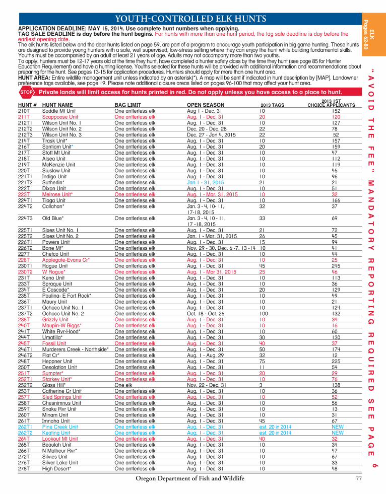

Oregon Department of Fish and Wildlife78
*HUNT DESCRIPTIONSFor those hunt descriptions with [MAP] following the description, maps can be found on our website at www.dfw.state.or.us/resources/hunting/big_game/units.HUNT 214T: Trask Unit - 42% public lands. All of Unit 14. There are spacific weapon restrictions in the Cascade Head - Lincoln City area of the Trask Unit. See page 98. HUNT 216T: Santiam Unit -All of Unit 16, excluding the Willamette National Forest. HUNT 221T2: Sutherlin - 25% public lands. That part of unit 21 east of Sutherlin starting at junction of Nonpareil Road (Co Rd 19) and Gassy Cr (BLM 25-4-2.0) proceed east and south on 2.0 to jct with road 25-4-12.1; proceed east and south on 12.1 and it becomes 25-3W-36.0, and continue on 36.0 to Rock Creek Road (26-3-1.0); north and east on Rock Cr Rd to 23-3-5.4; north and west on 23-3-5.4 to London and London Hill (Co Rd 8A); west on London Hill Rd to the powerline crossing in section 30 ( Unit boundary line); follow powerline south and west to Romie Howard Rd (Co Rd 69); south and east on Romie Howard Rd to BLM Rd 23-4-34; south on 23-4-34 to 24-4-14; south on 24-4-14 to 24-4-22; north and east on 24-4-22 to 24-3-20; east on 24- 3-20 to Nonpareil Rd (Co Rd 19); south and west on Co Rd 19 to point of beginning. Roseburg Forest Products lands in the Hinkle Cr drainage will be open to hunting on weekends only.[MAP]HUNT 223T: Melrose Unit - 14% public land. All of Unit 23. Note: The majority of elk during this hunt are concentrated on private lands. Do not apply unless you have access to a place to hunt.HUNT 224T2: Callahan - 11% public lands. 111 sq. mi. In Unit 24, west of Roseburg, at the junction of Callahan Rd (Co Rd 174) and BLM Rd 27-7-4.0 (Rd 5340); southwest on 27-7-4.0 to Reston Rim Rd (Weyerhaeuser 9540 & 28-8-3.0); south and west on 28-8-3.0 to 28-8-9.1; west to Burnt Mt Rd (28-8-16.0); north and west on 28-8-16.0 to Burnt Ridge Rd (27-9-24.0); north on 27-9-24.0 to 26-9-8.0; north and west on 26-9-8.0 to Rd 5000 (Williams Rvr Rd); east on Rd 5000 to 7000 (Bottom Cr Rd); north and east on Rd 7000 to Rd 2550; Rd 2550 north to Rd 2000 (Bateman Rd); east on Rd 2000 to 8420 Rd; southeast on 8420 to 8800; south and east on 8800 (25-8-1.0); to 8500; east and south on 8500 to 5340; southeast on 5340
to junction of Co Rd 174 and 27-7-4.0, point of beginning. [MAP]HUNT 224T3: Old Blue - 10% public lands. 156 sq mi. That part of Unit 24 southwest of Elkton starting at junction of Loon Lake Rd (Co Rd 3) and Soup Cr (Co Rd 72 and BLM 23-9-19.0); east on 23-9-19.0 to 23-9-4.0; south and east on 23-9-4.0 to 23-9-28.0, south and east on 23-9-28.0 to Section 4 (1 mi east of Old Blue); south and east 1/2 mi to 24-8-20 becoming 3606 Rd (Bateman Rd); south and west on 3606 becoming Rd 2000 (still Bateman Rd); south and west on Rd 2000 to 2550; south on 2550 to 7000 Rd (Bottom Cr Rd); southwest on Rd 7000 to 5000 Rd (Williams Rvr Rd); northwest on Rd 5000 to 4000 Rd (E Millicoma Rvr Rd); west on 4000 to 1000 Rd (Matson Cr Rd); north and east on 1000 to Loon Lake Rd (Co Rd 3); east and north on Co Rd 3 to junction of Soup Cr, point of beginning. [MAP]HUNT 226T2: Bone Mt - 15% public lands. 175 sq mi. Beginning at junction of Hwy 42 and Powers Hwy; south on Powers Hwy to Coal Cr Rd (2000); east on Coal Cr Rd to 1300; northeast on 1300 to 1000; east on 1000 to 1200; east on 1200 to 1201 (Slater Cr Rd); north on 1201 to Hwy 42; west on Hwy 42 to Powers Hwy, point of beginning. [MAP]HUNT 228T: Applegate-Evans Cr - 35% public lands. All of Units 28 and 29. Note: The majority of elk during this hunt are concentrated on private lands. Do not apply unless you have access to a place to hunt. HUNT 230T2: W Rogue - 35% public lands. That part of Unit 30 west of the following line: Beginning at State Hwy 62 and Butte Falls-Prospect Rd; south on Butte Falls-Prospect Rd to Butte Falls Fish Lk Rd southeast of Butte Falls; southeast on Butte Falls Fish Lk Rd to State Hwy 140; east on Hwy 140 to boundary of Unit 30; south on Unit boundary to Oregon-California State line; and that part of Unit 22 in Jackson Co south of the NF exterior boundary. Note: The majority of elk during this hunt are concentrated on private lands. Do not apply unless you have access to a place to hunt. [MAP]HUNT 234T: E Cascade - All of units 34, 39 and 77 west of Hwy 97. HUNT 235T: Paulina-E Fort Rock - 75% public lands. All of Unit 35 and that part of Unit 77 east of Hwy 97. HUNT 240T: Maupin-W Biggs - 7% public lands. All of Unit 40 and that part of Unit 43 west of the John Day Rvr.
HUNT 241T: White Rvr-Hood - 50% public lands. All of units 41 and 42. White River WA closed to elk hunting Dec. 1-31. HUNT 244T: Umatilla - All of units 44, 49, 54, 55 and that part of Unit 43 east of the John Day Rvr. HUNT 246T1: Murderers Cr - Northside - All of units 46 and 47. HUNT 246T2: Flat Cr - 70% public land. That part of Unit 46 beginning at Dayville; east on Hwy 26 to NF Rd 21; south on NF Rd 21 to the exterior boundary of the NF; west on the exterior boundary of the NF to the exterior boundary of the Phillip W. Schneider WA (PWSWA); follow the PWSWA boundary west; continue south to the southern boundary neer Deer Cr; west to the S Fork John Day, continue to follow the west boundary of the PWSWA north to the point where the most norhtern boundary of the PWSWA crosses the S Fork John Day Rvr; from this point, travel north on the S Fork John Day Rvr to Dayville; point of beginning. Contact information for cooperating surrounding private landowners will be provided. [MAP]HUNT 251T: Sumpter - 8% public lands. That part of Unit 51 starting in Baker City; south on Hwy 7 to Auburn Rd; west on Auburn Rd to USFS boundary; north on USFS boundary to Anthony Lakes Hwy; east on Anthony Lakes Hwy to Ellis Rd; north on Ellis Rd to N Powder Rvr Ln; east on N Powder Rvr Ln to I-84; south on I-84 to Baker City. [MAP]HUNT 252T1: Starkey Unit - 67% public lands. All of Unit 52 excluding the Starkey Experimental Forest and Range fenced enclosure and a 1/4-mi buffer outside the exterior 8-ft fence. HUNT 252T2: Glass Hill - Beginning at La Grande; west on Morgan Lake Rd to Glass Hill Rd; south on Glass Hill Rd to FR 4305, south and east on FR 4305 to FR 43 (Ladd Creek Rd); east on the 43 road to I-84; I-84 north to Foothill Rd to La Grande.HUNT 266T: N Malheur Rvr - 80% public lands. That part of Unit 66 north of Hwy 20. HUNT 278T: High Desert - 80% public lands. that part of Unit 66 south of Hwy 20 and all of units 67, 68, 69, 70, 71 and 73 excluding Malheur NWR and Hart Mt NAR.
ODFW Outdoors connects people with Oregon’s fish and wildlife – through Aquatic and Angler, Hunter and Outdoor Skills Education Programs. These hands-on programs teach skills that help you enjoy fishing, hunting, and wildlife viewing as lifelong activities.
Check us out on Facebook at www.facebook.com/odfwoutdoors or visit the ODFW Outdoors section of our website at www.dfw.state.or.us
Oregon Department of Fish and Wildlife 79
CONTROLLED200SERIESELKBOWHUNTSTAG SALE DEADLINE is Aug. 29 FOR ALL HUNTS IN TABLE BELOW.NOTE: Successful applicants for 216R, 217R, 218R, 219R, 221R, 224R, 226R, 230R, 237R1, 237R2, 252R, 257R1, 257R2, and 258R will receive one tag valid for the general elk bow season and a controlled bow season. Do not purchase a general season bow tag if you are successful in the controlled hunt draw. Tags must be purchased by the day before the earliest hunt begins. Hunters who harvest an elk during the general bowhunting season may not hunt in the controlled bow season. You can harvest only one elk per year.HUNT AREA: Entire wildlife management unit unless indicated by an asterisk(*). A map will be sent if indicated in hunt description by [MAP]. Landowner preference tags available, see page 19.
2013 1ST HUNT # HUNT NAME BAG LIMIT OPEN SEASON 2013 TAGS CHOICE APPLICANTS 216R Santiam Bow* One antlerless elk Nov. 29 - Dec. 14 880 160 217R Stott Mt Unit Bow One antlerless elk Nov. 29 - Dec. 14 275 105 218R Alsea Unit Bow One antlerless elk Nov. 29 - Dec. 14 550 238 219R McKenzie Unit Bow* One antlerless elk Nov. 29 - Dec. 14 880 196 221R N Indigo Bow* One antlerless elk Nov. 29 - Dec. 14 660 78 224R Tioga Bow One 3 pt. + Jan. 3 - Jan. 18, 2015 est. 200 in 2014 NEW 226R Powers Unit Bow One elk Aug. 30 - Sept. 28 61 304 230R W Rogue Bow* One antlerless elk Jan. 1- Feb. 28, 2015 55 72 237R1 Ochoco Unit Bow No. 1 One elk Aug. 30 - Sept. 28 327 1,153 Deer bowhunters must also have a controlled Ochoco Unit elk bow tag (used or unused) to hunt deer in the Ochoco Unit 237R2 Ochoco Unit Bow No. 2 One bull elk Aug. 30 - Sept. 28 545 Deer bowhunters must also have a controlled Ochoco Unit elk bow tag (used or unused) to hunt deer in the Ochoco Unit 439 248R Heppner Bow One Elk Aug. 30 - Sept. 28 est. 70 in 2014 NEW 249R Ukiah Bow One Elk Aug. 30 - Sept. 28 est. 40 in 2014 NEW 252R Starkey Exp. Forest Bow* One bull elk Aug. 30 - Sept. 3 25 143 254R1 Mt Emily Unit Bow No. 1 One bull elk Aug. 30 - Sept. 28 56 1,308 Only archery elk opportunity Deer bowhunters must also have a controlled Mt Emily Unit elk bow tag (used or unused) to hunt deer in the Mt Emily Unit. 254R2 Mt Emily Unit Bow No. 2 One spike only elk Aug. 30 - Sept. 28 165 28 Only archery elk opportunity Deer bowhunters must also have a controlled Mt Emily Unit elk bow tag (used or unused) to hunt deer in the Mt Emily Unit. 255R1 Walla Walla Bow No. 1* One bull elk Aug. 30 - Sept. 28 22 444 Only archery elk opportunity Deer bowhunters must also have a controlled Walla Walla Unit elk bow tag (used or unused) to hunt deer in the Walla Walla Unit. 255R2 Walla Walla Bow No. 2 One spike only elk Aug. 30 - Sept. 28 55 11 Only archery elk opportunity Deer bowhunters must also have a controlled Walla Walla Unit elk bow tag (used or unused) to hunt deer in the Walla Walla Unit . 256R1 Wenaha Unit Bow No. 1 One bull elk Aug. 30 - Sept. 28 30 2,602 Only archery elk opportunity Deer bowhunters must also have a controlled Wenaha Unit elk bow tag (used or unused) to hunt deer in the Wenaha Unit. 256R2 Wenaha Unit Bow No. 2 One spike only elk Aug. 30 - Sept. 28 165 30 Only archery elk opportunity Deer bowhunters must also have a controlled Wenaha Unit elk bow tag (used or unused) to hunt deer in the Wenaha Unit. 257R1 Sled Springs Unit No. 1 Bow One elk Aug. 30 - Sept. 28 210 817 Deer bowhunters must also have a controlled Sled Springs elk bow tag (used or unused) to hunt deer in the Sled Springs Unit. 257R2 Sled Springs Unit No. 2 Bow One antlerless or spike elk Aug. 30 - Sept. 28 165 129 Deer bowhunters must also have a controlled Sled Springs elk bow tag (used or unused) to hunt deer in the Sled Springs Unit. 258R1 Chesnimnus Unit Bow No.1 One elk Aug. 30 - Sept. 28 330 585 Deer bowhunters must also have a controlled Chesnimnus Unit elk bow tag (used or unused) to hunt deer in the Chesnimnus Unit. 258R2 Chesnimnus Unit Bow No. 2 One antlerless or spike elk Aug. 30 - Sept. 28 est. 75 in 2014 NEW Deer bowhunters must also have a controlled Chesnimnus Unit elk bow tag (used or unused) to hunt deer in the Chesnimnus Unit. 259R Snake River Unit Bow One elk Aug. 30 - Sept. 28 est. 75 in 2014 NEW
Private lands will limit access for hunts printed in red. Do not apply unless you have access to a place to hunt.STOP
*HUNT DESCRIPTIONSFor those hunt descriptions with [MAP] following the description, maps can be found on our website at www.dfw.state.or.us/resources/hunting/big_game/units.HUNT 216R: Santiam Bow- Those portions of Unit 16 in Linn and Marion Cos excluding Mt. Hood NF and Willamette NF lands.HUNT 219R: McKenzie Unit Bow- All of Unit 19 excluding Willamette NF Land.HUNT 221R: N Indigo Bow - 23% public lands. 415 sq mi in northwest corner of Unit 21 beginning at Cottage Grove; north on I-5 to State Hwy 58; southeast on Hwy 58 to Willamette NF boundary; south on Forest boundary to BLM Rd 23-1-13; west on 23-1-13 to 23-3-5.4 (Big Rvr Rd); northwest on Big Rvr Rd, London Rd, and S 6th St to
I-5; north on I-5 to Cottage Grove, point of beginning. [MAP]HUNT 230R: W Rogue Bow- 35% public lands. That part of Unit 30 west of the following line: Beginning at State Hwy 62 and Butte Falls –Prospect Rd; south on Butte Falls-Prospect Rd to Butte Falls Fish Lk Rd southeast of Butte Falls; southeast on Butte Falls Fish Lk Rd to State Hwy 140; east on Hwy 140 to boundary of Unit 30; south on Unit boundary to Oregon-California State line; and that part of Unit 22 in Jackson Co south of the NF exterior boundary. [MAP] Note: The majority of elk during this hunt are concentrated on private lands. Do not apply unless you have access to a place to hunt.HUNT 248R: Heppner Bow - 38% public lands. That part of Unit 48 north and west of N Fork John Day Rvr.
HUNT 252R: Starkey Exp Forest Bow - 100% public lands. That part of Unit 52 as follows: approximately 30 sq mi of the Starkey Experimental Forest and Range enclosure located within Unit 52. A 50-yard buffer along all 8-ft high fences, the 900-acre feed area, 1,500-acre Campbell Flat and the 3,600-acre intensive timber management area are closed to all hunting, except as permitted by ODFW research personnel prior to any hunt. Hunters shall agree to participate in research collections and activities, which will include a general questionnaire about the hunting experience. See page 25 for ATV research that will affect this hunt. [MAP]HUNTS 255R1 and 255R2: Walla Walla Bow - 33% public lands. All of Unit 55 except for the Mill Cr Watershed. See 255A (page 73) for hunt description.
ELK
Pages 62-80
“A
VO
ID
T
HE
F
EE
”
MA
ND
AT
OR
Y
RE
PO
RT
IN
G
RE
QU
IR
ED
S
EE
P
AG
E
6
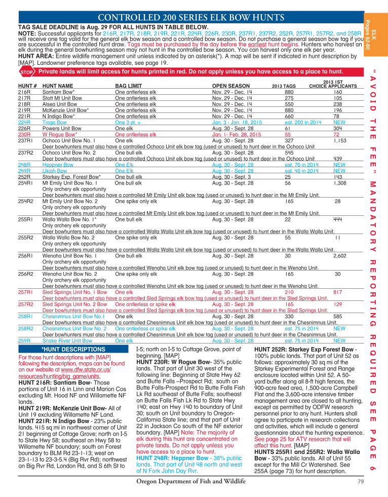
Oregon Department of Fish and Wildlife78
*HUNT DESCRIPTIONSFor those hunt descriptions with [MAP] following the description, maps can be found on our website at www.dfw.state.or.us/resources/hunting/big_game/units.HUNT 214T: Trask Unit - 42% public lands. All of Unit 14. There are spacific weapon restrictions in the Cascade Head - Lincoln City area of the Trask Unit. See page 98. HUNT 216T: Santiam Unit -All of Unit 16, excluding the Willamette National Forest. HUNT 221T2: Sutherlin - 25% public lands. That part of unit 21 east of Sutherlin starting at junction of Nonpareil Road (Co Rd 19) and Gassy Cr (BLM 25-4-2.0) proceed east and south on 2.0 to jct with road 25-4-12.1; proceed east and south on 12.1 and it becomes 25-3W-36.0, and continue on 36.0 to Rock Creek Road (26-3-1.0); north and east on Rock Cr Rd to 23-3-5.4; north and west on 23-3-5.4 to London and London Hill (Co Rd 8A); west on London Hill Rd to the powerline crossing in section 30 ( Unit boundary line); follow powerline south and west to Romie Howard Rd (Co Rd 69); south and east on Romie Howard Rd to BLM Rd 23-4-34; south on 23-4-34 to 24-4-14; south on 24-4-14 to 24-4-22; north and east on 24-4-22 to 24-3-20; east on 24- 3-20 to Nonpareil Rd (Co Rd 19); south and west on Co Rd 19 to point of beginning. Roseburg Forest Products lands in the Hinkle Cr drainage will be open to hunting on weekends only.[MAP]HUNT 223T: Melrose Unit - 14% public land. All of Unit 23. Note: The majority of elk during this hunt are concentrated on private lands. Do not apply unless you have access to a place to hunt.HUNT 224T2: Callahan - 11% public lands. 111 sq. mi. In Unit 24, west of Roseburg, at the junction of Callahan Rd (Co Rd 174) and BLM Rd 27-7-4.0 (Rd 5340); southwest on 27-7-4.0 to Reston Rim Rd (Weyerhaeuser 9540 & 28-8-3.0); south and west on 28-8-3.0 to 28-8-9.1; west to Burnt Mt Rd (28-8-16.0); north and west on 28-8-16.0 to Burnt Ridge Rd (27-9-24.0); north on 27-9-24.0 to 26-9-8.0; north and west on 26-9-8.0 to Rd 5000 (Williams Rvr Rd); east on Rd 5000 to 7000 (Bottom Cr Rd); north and east on Rd 7000 to Rd 2550; Rd 2550 north to Rd 2000 (Bateman Rd); east on Rd 2000 to 8420 Rd; southeast on 8420 to 8800; south and east on 8800 (25-8-1.0); to 8500; east and south on 8500 to 5340; southeast on 5340
to junction of Co Rd 174 and 27-7-4.0, point of beginning. [MAP]HUNT 224T3: Old Blue - 10% public lands. 156 sq mi. That part of Unit 24 southwest of Elkton starting at junction of Loon Lake Rd (Co Rd 3) and Soup Cr (Co Rd 72 and BLM 23-9-19.0); east on 23-9-19.0 to 23-9-4.0; south and east on 23-9-4.0 to 23-9-28.0, south and east on 23-9-28.0 to Section 4 (1 mi east of Old Blue); south and east 1/2 mi to 24-8-20 becoming 3606 Rd (Bateman Rd); south and west on 3606 becoming Rd 2000 (still Bateman Rd); south and west on Rd 2000 to 2550; south on 2550 to 7000 Rd (Bottom Cr Rd); southwest on Rd 7000 to 5000 Rd (Williams Rvr Rd); northwest on Rd 5000 to 4000 Rd (E Millicoma Rvr Rd); west on 4000 to 1000 Rd (Matson Cr Rd); north and east on 1000 to Loon Lake Rd (Co Rd 3); east and north on Co Rd 3 to junction of Soup Cr, point of beginning. [MAP]HUNT 226T2: Bone Mt - 15% public lands. 175 sq mi. Beginning at junction of Hwy 42 and Powers Hwy; south on Powers Hwy to Coal Cr Rd (2000); east on Coal Cr Rd to 1300; northeast on 1300 to 1000; east on 1000 to 1200; east on 1200 to 1201 (Slater Cr Rd); north on 1201 to Hwy 42; west on Hwy 42 to Powers Hwy, point of beginning. [MAP]HUNT 228T: Applegate-Evans Cr - 35% public lands. All of Units 28 and 29. Note: The majority of elk during this hunt are concentrated on private lands. Do not apply unless you have access to a place to hunt. HUNT 230T2: W Rogue - 35% public lands. That part of Unit 30 west of the following line: Beginning at State Hwy 62 and Butte Falls-Prospect Rd; south on Butte Falls-Prospect Rd to Butte Falls Fish Lk Rd southeast of Butte Falls; southeast on Butte Falls Fish Lk Rd to State Hwy 140; east on Hwy 140 to boundary of Unit 30; south on Unit boundary to Oregon-California State line; and that part of Unit 22 in Jackson Co south of the NF exterior boundary. Note: The majority of elk during this hunt are concentrated on private lands. Do not apply unless you have access to a place to hunt. [MAP]HUNT 234T: E Cascade - All of units 34, 39 and 77 west of Hwy 97. HUNT 235T: Paulina-E Fort Rock - 75% public lands. All of Unit 35 and that part of Unit 77 east of Hwy 97. HUNT 240T: Maupin-W Biggs - 7% public lands. All of Unit 40 and that part of Unit 43 west of the John Day Rvr.
HUNT 241T: White Rvr-Hood - 50% public lands. All of units 41 and 42. White River WA closed to elk hunting Dec. 1-31. HUNT 244T: Umatilla - All of units 44, 49, 54, 55 and that part of Unit 43 east of the John Day Rvr. HUNT 246T1: Murderers Cr - Northside - All of units 46 and 47. HUNT 246T2: Flat Cr - 70% public land. That part of Unit 46 beginning at Dayville; east on Hwy 26 to NF Rd 21; south on NF Rd 21 to the exterior boundary of the NF; west on the exterior boundary of the NF to the exterior boundary of the Phillip W. Schneider WA (PWSWA); follow the PWSWA boundary west; continue south to the southern boundary neer Deer Cr; west to the S Fork John Day, continue to follow the west boundary of the PWSWA north to the point where the most norhtern boundary of the PWSWA crosses the S Fork John Day Rvr; from this point, travel north on the S Fork John Day Rvr to Dayville; point of beginning. Contact information for cooperating surrounding private landowners will be provided. [MAP]HUNT 251T: Sumpter - 8% public lands. That part of Unit 51 starting in Baker City; south on Hwy 7 to Auburn Rd; west on Auburn Rd to USFS boundary; north on USFS boundary to Anthony Lakes Hwy; east on Anthony Lakes Hwy to Ellis Rd; north on Ellis Rd to N Powder Rvr Ln; east on N Powder Rvr Ln to I-84; south on I-84 to Baker City. [MAP]HUNT 252T1: Starkey Unit - 67% public lands. All of Unit 52 excluding the Starkey Experimental Forest and Range fenced enclosure and a 1/4-mi buffer outside the exterior 8-ft fence. HUNT 252T2: Glass Hill - Beginning at La Grande; west on Morgan Lake Rd to Glass Hill Rd; south on Glass Hill Rd to FR 4305, south and east on FR 4305 to FR 43 (Ladd Creek Rd); east on the 43 road to I-84; I-84 north to Foothill Rd to La Grande.HUNT 266T: N Malheur Rvr - 80% public lands. That part of Unit 66 north of Hwy 20. HUNT 278T: High Desert - 80% public lands. that part of Unit 66 south of Hwy 20 and all of units 67, 68, 69, 70, 71 and 73 excluding Malheur NWR and Hart Mt NAR.
ODFW Outdoors connects people with Oregon’s fish and wildlife – through Aquatic and Angler, Hunter and Outdoor Skills Education Programs. These hands-on programs teach skills that help you enjoy fishing, hunting, and wildlife viewing as lifelong activities.
Check us out on Facebook at www.facebook.com/odfwoutdoors or visit the ODFW Outdoors section of our website at www.dfw.state.or.us
Oregon Department of Fish and Wildlife 79
CONTROLLED200SERIESELKBOWHUNTSTAG SALE DEADLINE is Aug. 29 FOR ALL HUNTS IN TABLE BELOW.NOTE: Successful applicants for 216R, 217R, 218R, 219R, 221R, 224R, 226R, 230R, 237R1, 237R2, 252R, 257R1, 257R2, and 258R will receive one tag valid for the general elk bow season and a controlled bow season. Do not purchase a general season bow tag if you are successful in the controlled hunt draw. Tags must be purchased by the day before the earliest hunt begins. Hunters who harvest an elk during the general bowhunting season may not hunt in the controlled bow season. You can harvest only one elk per year.HUNT AREA: Entire wildlife management unit unless indicated by an asterisk(*). A map will be sent if indicated in hunt description by [MAP]. Landowner preference tags available, see page 19.
2013 1ST HUNT # HUNT NAME BAG LIMIT OPEN SEASON 2013 TAGS CHOICE APPLICANTS 216R Santiam Bow* One antlerless elk Nov. 29 - Dec. 14 880 160 217R Stott Mt Unit Bow One antlerless elk Nov. 29 - Dec. 14 275 105 218R Alsea Unit Bow One antlerless elk Nov. 29 - Dec. 14 550 238 219R McKenzie Unit Bow* One antlerless elk Nov. 29 - Dec. 14 880 196 221R N Indigo Bow* One antlerless elk Nov. 29 - Dec. 14 660 78 224R Tioga Bow One 3 pt. + Jan. 3 - Jan. 18, 2015 est. 200 in 2014 NEW 226R Powers Unit Bow One elk Aug. 30 - Sept. 28 61 304 230R W Rogue Bow* One antlerless elk Jan. 1- Feb. 28, 2015 55 72 237R1 Ochoco Unit Bow No. 1 One elk Aug. 30 - Sept. 28 327 1,153 Deer bowhunters must also have a controlled Ochoco Unit elk bow tag (used or unused) to hunt deer in the Ochoco Unit 237R2 Ochoco Unit Bow No. 2 One bull elk Aug. 30 - Sept. 28 545 Deer bowhunters must also have a controlled Ochoco Unit elk bow tag (used or unused) to hunt deer in the Ochoco Unit 439 248R Heppner Bow One Elk Aug. 30 - Sept. 28 est. 70 in 2014 NEW 249R Ukiah Bow One Elk Aug. 30 - Sept. 28 est. 40 in 2014 NEW 252R Starkey Exp. Forest Bow* One bull elk Aug. 30 - Sept. 3 25 143 254R1 Mt Emily Unit Bow No. 1 One bull elk Aug. 30 - Sept. 28 56 1,308 Only archery elk opportunity Deer bowhunters must also have a controlled Mt Emily Unit elk bow tag (used or unused) to hunt deer in the Mt Emily Unit. 254R2 Mt Emily Unit Bow No. 2 One spike only elk Aug. 30 - Sept. 28 165 28 Only archery elk opportunity Deer bowhunters must also have a controlled Mt Emily Unit elk bow tag (used or unused) to hunt deer in the Mt Emily Unit. 255R1 Walla Walla Bow No. 1* One bull elk Aug. 30 - Sept. 28 22 444 Only archery elk opportunity Deer bowhunters must also have a controlled Walla Walla Unit elk bow tag (used or unused) to hunt deer in the Walla Walla Unit. 255R2 Walla Walla Bow No. 2 One spike only elk Aug. 30 - Sept. 28 55 11 Only archery elk opportunity Deer bowhunters must also have a controlled Walla Walla Unit elk bow tag (used or unused) to hunt deer in the Walla Walla Unit . 256R1 Wenaha Unit Bow No. 1 One bull elk Aug. 30 - Sept. 28 30 2,602 Only archery elk opportunity Deer bowhunters must also have a controlled Wenaha Unit elk bow tag (used or unused) to hunt deer in the Wenaha Unit. 256R2 Wenaha Unit Bow No. 2 One spike only elk Aug. 30 - Sept. 28 165 30 Only archery elk opportunity Deer bowhunters must also have a controlled Wenaha Unit elk bow tag (used or unused) to hunt deer in the Wenaha Unit. 257R1 Sled Springs Unit No. 1 Bow One elk Aug. 30 - Sept. 28 210 817 Deer bowhunters must also have a controlled Sled Springs elk bow tag (used or unused) to hunt deer in the Sled Springs Unit. 257R2 Sled Springs Unit No. 2 Bow One antlerless or spike elk Aug. 30 - Sept. 28 165 129 Deer bowhunters must also have a controlled Sled Springs elk bow tag (used or unused) to hunt deer in the Sled Springs Unit. 258R1 Chesnimnus Unit Bow No.1 One elk Aug. 30 - Sept. 28 330 585 Deer bowhunters must also have a controlled Chesnimnus Unit elk bow tag (used or unused) to hunt deer in the Chesnimnus Unit. 258R2 Chesnimnus Unit Bow No. 2 One antlerless or spike elk Aug. 30 - Sept. 28 est. 75 in 2014 NEW Deer bowhunters must also have a controlled Chesnimnus Unit elk bow tag (used or unused) to hunt deer in the Chesnimnus Unit. 259R Snake River Unit Bow One elk Aug. 30 - Sept. 28 est. 75 in 2014 NEW
Private lands will limit access for hunts printed in red. Do not apply unless you have access to a place to hunt.STOP
*HUNT DESCRIPTIONSFor those hunt descriptions with [MAP] following the description, maps can be found on our website at www.dfw.state.or.us/resources/hunting/big_game/units.HUNT 216R: Santiam Bow- Those portions of Unit 16 in Linn and Marion Cos excluding Mt. Hood NF and Willamette NF lands.HUNT 219R: McKenzie Unit Bow- All of Unit 19 excluding Willamette NF Land.HUNT 221R: N Indigo Bow - 23% public lands. 415 sq mi in northwest corner of Unit 21 beginning at Cottage Grove; north on I-5 to State Hwy 58; southeast on Hwy 58 to Willamette NF boundary; south on Forest boundary to BLM Rd 23-1-13; west on 23-1-13 to 23-3-5.4 (Big Rvr Rd); northwest on Big Rvr Rd, London Rd, and S 6th St to
I-5; north on I-5 to Cottage Grove, point of beginning. [MAP]HUNT 230R: W Rogue Bow- 35% public lands. That part of Unit 30 west of the following line: Beginning at State Hwy 62 and Butte Falls –Prospect Rd; south on Butte Falls-Prospect Rd to Butte Falls Fish Lk Rd southeast of Butte Falls; southeast on Butte Falls Fish Lk Rd to State Hwy 140; east on Hwy 140 to boundary of Unit 30; south on Unit boundary to Oregon-California State line; and that part of Unit 22 in Jackson Co south of the NF exterior boundary. [MAP] Note: The majority of elk during this hunt are concentrated on private lands. Do not apply unless you have access to a place to hunt.HUNT 248R: Heppner Bow - 38% public lands. That part of Unit 48 north and west of N Fork John Day Rvr.
HUNT 252R: Starkey Exp Forest Bow - 100% public lands. That part of Unit 52 as follows: approximately 30 sq mi of the Starkey Experimental Forest and Range enclosure located within Unit 52. A 50-yard buffer along all 8-ft high fences, the 900-acre feed area, 1,500-acre Campbell Flat and the 3,600-acre intensive timber management area are closed to all hunting, except as permitted by ODFW research personnel prior to any hunt. Hunters shall agree to participate in research collections and activities, which will include a general questionnaire about the hunting experience. See page 25 for ATV research that will affect this hunt. [MAP]HUNTS 255R1 and 255R2: Walla Walla Bow - 33% public lands. All of Unit 55 except for the Mill Cr Watershed. See 255A (page 73) for hunt description.
ELK
Pages 62-80
“A
VO
ID
T
HE
F
EE
”
MA
ND
AT
OR
Y
RE
PO
RT
IN
G
RE
QU
IR
ED
S
EE
P
AG
E
6

Oregon Department of Fish and Wildlife80
GENERALELKBOWSEASONS
ELK BAG LIMIT DEFINITIONS:3 pt. + = Bull elk having three points or more on one antler including the brow tine.Antlerless = Cow or calf elk.Bull elk = Bull elk with at least one visible antler.One elk = Either sex elk. Spike only = Bull elk with at least one visible unbranched antler (a brow tine is not considered an antler branch under spike only regulations). Refer to sketches on page 63.
■ For Controlled Elk Bow Hunts, see page 79. ■ Refer to page 30 for bowhunting equipment restrictions under Legal Hunting Methods. ■ Only traditional archery equipment (long or recurve) may be used to hunt in the Canyon Cr archery area of the Murderers Cr Unit between Aug. 30 - Sept. 5.
OPEN SEASON BAG LIMIT OPEN AREA (See pages 98-100 for refuge and area regulations).
Aug. 30 - Sept. 28
Aug. 30 - Sept. 28
Aug. 30 - Sept. 5**
Sept. 6 - Sept. 28
One elk
One bull elk
One bull 3 pt. +One bull 3 pt. + or antlerlessOne spike only elk
One elk
One bull elk
One elk
One elk
Applegate, Melrose, Scappoose, Siuslaw, Sixes, Stott Mt, Willamette, and Wilson units; and outside NF Lands in the Dixon, Evans Creek, Indigo, McKenzie, Rogue, and Santiam units. Alsea, Chetco Unit; and within NF Lands in the Dixon, Evans Creek, Indigo, McKenzie, Rogue, Santiam, and Trask units. Tioga unit
Saddle Mt Unit
Powers Unit.
Beatys Butte, Beulah, Biggs, Catherine Creek, Columbia Basin, E Fort Rock (that portion east of Hwy 97), Fossil, Grizzly, Hood, Imnaha, Juniper, Lookout Mt, Malheur Rvr, Maupin, Murderers Cr, Northside, Owhyee, Paulina, Pine Cr, Ritter portion of the Heppner Unit (that part of 48 south and east of N Fork John Day Rvr.), Silvies, Steens Mt, S Sumpter (see page 73), Wagontire, White Rvr, and Whitehorse units EXCEPTIONS:
■ Ochoco and Sled Springs units are closed to deer and elk bowhunting unless the hunter has a controlled elk bow tag for the respective unit. ■ Steens Mt Unit is closed to deer and elk bowhunting unless the hunter has a controlled deer bow tag for the respective unit. ■ Columbia Basin Unit is closed to all bowhunting beginning at Vinson at the intersection of Hwy 74 and Butter Creek Rd, west on Hwy 74 to Sandhollow Rd, north on Sandhollow Rd to Baseline Rd, west half mile to Sandhollow Rd, north on Sandhollow Rd to Hwy 207, north and east on Hwy 207 to Butter Creek Junction, south on Butter Creek Rd to Hwy 74 at Vinson.
Desolation, W Fort Rock (that portion west of Hwy 97), Heppner north and west of N John Day Rvr, Interstate, Keating, Keno, Klamath Falls, Maury, Metolius, Minam, Upper Deschutes, Silver Lake, Snake Rvr, Sprague, Starkey, N Sumpter (see page 73), Ukiah, and Warner units. EXCEPTIONS:
■ Starkey Experimental Forest except by controlled elk bow tag. ■ Maury and Warner units are closed to deer and elk bowhunting unless the hunter has a controlled deer bow tag for the respective unit. ■ Chesnimnus Unit is closed to deer and elk bowhunting unless the hunter has a controlled elk bow tag for the unit.
Canyon Cr - 100% public lands. Approximately 35.5 sq mi in Unit 46 beginning at the junction of FR 15 and FR 651; north and east on 651 to Table Mt trail head (trail 217); north on 217 to trail 211; north and east on 211 to trail 218; west on 218 to trail 219; west on 219 to Berry Cr; west on Berry Cr to Malheur NF boundary; south and east on forest boundary to FR 15; south and east on 15 to point of beginning. Please visit our website at www.dfw.state.or.us for map. **Weapons Restriction: Traditional archery equipment only (long or recurve bows).
WESTERNOREGON
EASTERNOREGON
Please be aware that there are big game firearm hunts and upland game bird hunts occurring during archery season. This includes some pronghorn antelope hunts, W High Cascade and Hood-White Rvr deer hunts, most youth elk hunts, general black bear season, general cougar season, most bighorn sheep hunts, all Rocky Mt goat and all Access and Habitat auction and raffle hunts.
CONSULT HUNT TABLES FOR HUNTS SCHEDULED DURING ARCHERY SEASONS.
BIG GAME FIREARMS HUNTS SCHED ULED DURING GEN ER AL BOW SEASONS
VO
ID
T
HE
F
EE
”
MA
ND
AT
OR
Y
RE
PO
RT
IN
G
RE
QU
IR
ED
S
EE
P
AG
E
6
Oregon Department of Fish and Wildlife 81
“Adult Hunting License” is a resident or non res i dent hunt ing license, resident com bi na tion angler’s and hunt ing license, dis abled vet er an’s angling and hunting license, pi o neer’s angling and hunting li cense, or senior citizen’s angling and hunting license.
“Agricultural Lands” are lands notless than 10 acres in extent that have been cultivated and planted or irrigated to domestic crops that are currently in use. Isolated home gardens, aban doned farmsteads, logged lands, range lands and tree farms are not included in this def i ni tion.
“Antler Point” is a point at least 1 inch in length measured from tip of point to nearest edge of beam. This definition applies only to the 3-point elk and spike only elk bag limits.
“Antlerless Deer” means doe or fawn deer.
“Antlerless Elk” means cow or calf elk.“Bait” for hunting game mammals means
any substance placed to attract an animal by its sense of smell or taste, including, but not limited to, food items or minerals (such as salt). Applying a scent or attractant to one’s body or clothing while worn is not baiting.
“Brace Height” is the distance from the back of the bow’s riser at the handgrip to the string when the bow is at rest.
“Broadhead” see Unbarbed Broadhead.“Buck deer” means a male deer with at
least one visible antler.“Buck Pronghorn” means a male
pronghorn antelope with visible horns and a dark cheek patch below the ear.
“Bull elk” for the purposes of a bag limitdefinition, means a male elk with at least one visible antler.
“Carcass” means the skinned or unskinned body, with or without entrails, of a game bird or game mammal.
“Cervid” means any member of thefamily cervidae (deer), including gametes or hybrids.
“Closed Sea son” is any time and place when it is not au tho rized to take a specific species, sex, or size of wildlife.
“Controlled Hunt” is a season where the number or dis tri bu tion of hunters is limited through a public draw ing or other means.
“Doe or fawn pronghorn”, for the purpose of pronghorn bag limits, means a female pronghorn without a dark cheek patch below the ear, or a pronghorn fawn (young of the year) of either sex.
“Eligible Hunter” is someone who will be 12 years of age by the time they hunt.
“Established Airport” is one that the Oregon Department of Aviation has licensed as a public-use airport, registered as a personal-use airport, or specif i cal ly ex empt ed from either licensing or reg is tra tion.
“Feral Swine” are animals of the genus Sus which meet the following conditions: (1) The animals are free roaming on public or private lands and not being held under domestic management confinement; (2) No notification to the land owner, manager, or occupant has been made by the swine owner or their representative of specifically identified and described swine having escaped domestic management confinement within a radius of five miles during the past five days; (3) The swine under consideration do not appear to be domesticated and are not tame; and (4) The swine under consideration do not meet the identification and description of escaped swine in section (2) above.
“Furbearers” are beaver, bobcat, fisher, marten, mink, muskrat, otter, rac coon, red fox and gray fox. Bobcat and Fox Hunters: Bobcat and fox are defined as
furbearers. A Furtaker’s License or a Hunting License for Furbearers is required to take furbearers including bobcat and fox. In addition, a bobcat record card is required prior to hunting, trapping, or harvesting bobcats. For more information please refer to the current Oregon Furbearer Trapping and Hunting Regulations, available at any ODFW office or by contacting Oregon Department of Fish and Wildlife, Trapper Education, 4034 Fairview Industrial Dr SE, Salem, OR 97302; 503-947-6000.
“Game Birds” are any wa ter fowl, snipe, band-tailed pigeon, mourning dove, pheasant, quail, partridge, grouse, or wild turkey.
“Game Mam mals” are pronghorn antelope, bighorn sheep, black bear, cougar, deer, elk, moose, Rocky Mt goat and western gray squir rel.
“General Season” is any season open to the hold er of a valid hunting license and ap pro pri ate game mammal tag without restriction as to the number of par tici pants.
“Hunt” means to take or attempt to take any wildlife by means involving the use of a weap on or with the as sis tance of any mammal or bird. In for ma tion al Note: As per ORS 161.405 “Attempt” de-scribed: A person is guilty of an attempt to commit a crime when the person intentionally engages in conduct which con sti tutes a substantial step toward com mis sion of the crime.
“Immediate Family” means a landowner’s spouse, domestic partner, children, father, moth er, brother, sister, step-children and grandchildren. For the purpose of Landowner Preference, “immediate family” also includes brother-in-law and sister-in-law.
“Inedible” means unfit for humancon sump tion.
“Juvenile hunting license” means a resident, nonresident hunting license
DEFINITIONS
OPEN SEASON: Aug. 30 - Nov. 12
BAG LIMIT: 5 squirrels daily.
POSSESSION LIMIT: 15 in possession.
OPEN AREA: All units west of the eastern boundary of the Santiam, McKenzie, Indigo, Sprague and Interstate units. Exception: No bag limit or closed season in that part of the Rogue Unit south of Rogue Rvr and S Fork Rogue Rvr and north of Hwy 140.
OPEN SEASON: Sept. 13 - Oct. 19
BAG LIMIT: 3 squirrels daily.
POSSESSION LIMIT: 6 in possession.
OPEN AREA: White Rvr and Hood units.
WESTERNGRAY
SQUIRREL
WESTERN GRAY SQUIRREL SQ
UIR
RE
LP
age 81
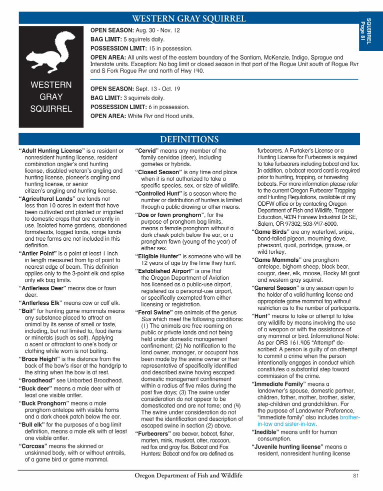

Oregon Department of Fish and Wildlife82
or resident combination angling and hunting license for persons 9 to 17 years of age to hunt wildlife.
“Landowner” means a person who holds title in trust or in fee simple to 40 or more contiguous acres of land provided that a recorded deed or contract of ownership shall be on file in the county in which the land is located; and/or a corporation or Limited Liability Company (LLC) holding title in fee simple to 40 or more contiguous acres of land provided that the corporation or LLC shall be registered with the State of Oregon; and/or a partnership holding title in fee simple to 40 or more contiguous acres of land. Persons who hold title as part of a time share are not eligible for landowner preference.
“Muzzleloader” is any single barreled (shotguns may be double barreled) long gun meant to be fired from the shoulder and loaded from the muzzle with an open ignition system and open or peep sights. This definition applies to muzzleloader-only seasons and 641B, 644A1, 644A2, 644A3, 644T1, 649B and 652T2 and includes: open ignition in-line percussion; sidelock, under-hammer, top-hammer and mule ear percussion; sidelock flintlock and wheelock ignition systems. Matchlock ignition systems are not allowed.
“One deer” means a buck, doe, or fawn deer.
“One elk” means a bull, cow, or calf elk.“Open Ignition” is an ignition system
where the percussion cap, frizzen, or flint is visible and exposed to the weather at all times and is not capable of being closed or covered by any piece of the weapon.
“Point-of-Sale” (POS) is a computerized licensing system available at all locations that sell Oregon’s hunting and angling licenses. Licenses and tags are generated and issued directly to customers from a POS machine at the time of sale.
“Possession” means holding any wildlife or parts there of in custody and any person who counsels, aids, or abets another person holding such wildlife is deemed equally in possession.
“Predatory Animals” means coyotes, rabbits, rodents and feral swine which are or may be destructive to agricultural crops.
“Protected Mammals and Birds” are any game mammal, game bird, furbearer, Threatened or En dan gered species, fisher, ringtail cat, fringed myotis, Townsend’s big-eared bat, pallid bat, silver-haired bat, western small-footed myotis, long-eared myotis, long-legged myotis, yuma myotis, pika (cony), pygmy rabbit, white-tailed jackrabbit, white-tailed antelope
squirrel, Washington ground squirrel, northern flying squirrel, chickaree (pine squirrel), golden-mantled ground squirrel, chipmunks, white-footed vole, all marine mammals and all nongame birds except European starling, house sparrow, Eurasian collared dove, and rock pigeon. Protected species may not be taken without a valid license and tag during authorized seasons or a Scientific Taking Permit. However, rabbits and rodents on private property may be taken with landowner permission.
“Pursue” means the act of trailing, tracking, or chasing wildlife in an attempt to locate, capture, catch, tree, or kill any game mammal or furbearer.
”Resident” is any person who has; (a) has resided in Oregon for a period of at least six consecutive months immediately prior to the date of making application for a license, tag, or permit; (b) Members of the uniformed services of the United States who: (i) Are permanently assigned to active duty in this state, and their spouse and dependent children, (ii) Reside in this state while assigned to duty at any base, station, shore establishment or other facility in this state, (iii) Reside in this state while serving as members of the crew of a ship that has an Oregon port or shore establishment as its home port or permanent station. (c) Aliens attending school in Oregon under a foreign student exchange program.
“Resident Juvenile” is any “Resident” of Oregon 12 through 17 years of age.
“Sabot” is a carrier, bushing or device in which a projectile of a smaller caliber is centered so as to permit firing the projectile within a larger caliber weapon. Cloth, paper or felt patches used with round balls are not considered a sabot.
“Shotgun” is a smooth bore firearm, designed for firing birdshot and intended to be fired from the shoulder, with a barrel length of 18 inches or more and with an overall length of 26 inches or more. Exception: Shotguns equipped with rifled slug barrels are considered shotguns when used for hunting pronghorn antelope, black bear, cougar, deer, or elk when centerfire rifles or shotguns are legal weapons.
“Spike Deer” is a deer with spike (unbranched) antlers.
“Spike only elk” for the purposes of a bag limit definition, means a bull elk with at least one visible unbranched antler (a brow tine is not considered an antler branch under spike only elk regulations).
“Tag” is a doc u ment au tho riz ing thetaking of a des ig nat ed kind of mammal at a specified time and place.
“Take” means to kill or obtain possession or control of any wildlife.
“Three (3) point plus (+) elk” for thepurposes of a bag limit definition, means a bull elk having 3 points or more on 1 antler including the brow tine.
“Unbarbed Broadhead” means a fixed position ar row head where the rear edge of the blade(s) forms an angle with the arrow shaft to which it is attached of 90° or greater. Both of the dashed lines (Figure 1) designate an unbarbed broadhead. Blades with rear edges that form an angle of less than 90 degrees in the direction of the arrow tip (Figure 2, for example) are not legal.
“Uniformed Services” means Army, Navy, Air Force, Marine Corps and Coast Guard, or their reserve components; the National Guard or Oregon National Guard, commissioned corps of the National Oceanic and Atmospheric Administration, and the Public Health Service of the United States Department of Health and Human Services detailed with the Army or Navy.
“Unprotected Mammals and Birds” means European starling, house sparrow, Eurasian collared dove, rock pigeon and any mammal species for which there are no closed seasons or bag limits. However, all general hunting regulations and licensing laws still apply. Common unprotected mammals include coyote, badger, gophers, moles, mountain beaver, marmots, porcupine, skunks, cottontails, black-tailed jackrabbit, rats, mice, opossum, nutria and weasels.
“Visible Antler” means a velvet or hardened antler that is visible above the hairline on the skullcap and is capable of being shed.
“Waste” means to allow any edibleportion of any game mammal (except cougar) or game bird to be rendered unfit for human consumption, or, to fail to retrieve edible portions except internal organs of such game mam mals or game birds from the field. Entrails, in clud ing the heart and liver, are not considered edible.
“Weapon” means any device used to take or at tempt to take wildlife.
“Wildlife” means fish, wild birds,am phib i ans, reptiles, wild mammals and feral swine.
“Wildlife Unit” means a geographicarea described in the section, Wildlife Management Unit Boundary Descriptions, pages 91-95.
Oregon Department of Fish and Wildlife 83
MASTER HUNTER PROGRAMThe Master Hunter Program is an advanced hunter education program designed to help hunters increase their knowledge and help them understand concerns of private landowners. The program’s objectives are:
■ Foster positive relationships between hunters and private landowners. ■ Increase hunting access to private lands by giving landowners a way to identify hunters who have had advanced training. ■ Improve the hunting experience for graduates. ■ Improve the public image of hunters.
The program includes a home study course, a 4-hour class that includes a written test, a test of firearms proficiency, and a requirement to perform 20 hours of volunteer service that benefits Oregon’s natural resources.
A fish and wildlife violation background check will be conducted prior to certification, and no person with a violation in the past 5 years will be allowed to graduate. Additional checks will be conducted each time a certified Master Hunter applies for special hunting privileges. Any conviction or plea of guilt to a wildlife violation (including angling violations) will result in a five year suspension from the program.
MASTER HUNTER PROGRAM INFORMATION
Information on the Master Hunter Program contact 503-947-6019. For detailed information and the enrollment form go to; www.dfw.state.or.us/education/hunter/master_hunter.aspSpecial Opportunities: Master Hunters applying between July 1 and July 31 are given priority when selecting hunters for emergency hunts.
MASTER HUNTER ONLY HUNTSUnless you are eligible for and possess a landowner preference tag, you must successfully complete the Master Hunter Program before applying for these hunts:210D Lower Columbia (elk)212A3 Miami-Nehalem No. 3 (elk)623B’s N Bank Habitat Area (deer)
HUNTING AND ATV’SRESPONSIBILITY OR REGULATION?
The Choice is Yours!Nobody likes regulations; but if irresponsible ATV use continues to cause unacceptable impacts, then regulations will become necessary to ensure protection of public lands. A better alternative would be for ATV users to recognize the impacts their activity can cause and voluntarily take steps to reduce those impacts. ATV users are not unique in this respect - as more and more people use public lands for recreation, the potential impacts of these activities are growing fast.
ROAD CLOSURESThere are a number of reasons why some modes of travel are restricted on public lands. Reasons for restricting travel include:
■ Wildlife and Habitat Protection ■ Minimize Conflict Between Users ■ Public Safety
■ Resource Protection ■ Legal Mandates ■ Fire Protection
OREGON OFF-HIGHWAY VEHICLE LAWS
All ATVs operating on public lands must display an Oregon ATV Operating Permit. Please refer to the Oregon Parks & Recreation website for more information: www.prd.state.or.us.
Permits can be purchased over the telephone, through many Oregon State Parks and Recreation Dept. offices or at one of their 200 vendors. A current vendor list is available online at www.prd.state.or.us. For more information or to purchase a permit over the telephone, call 1-800-551-6949.
Refer to page 27 of this publication for hunting and ATV regulations.
REDUCE ATV IMPACTSWhat you can do to reduce ATV impacts:
■ Know the vehicle use regulations for the area you are hunting and respect road and area closures. ■ Avoid the use of ATVs in wet areas or during wet conditions. Even though the lighter weight and low-pressure tires reduce impacts, ATVs can still do serious damage to wet areas.
INTERESTING FACTS ■ Since 1995, the number of All Terrain Vehicles (ATVs) in Oregon has increased fivefold. There are now over 129,000 valid ATV Operating Permits in the state. ■ Studies have shown that the harvest of bull elk increases with increased hunter access. Eventually this can lead to reduced hunter opportunity. ■ Elk use declines in areas with adjacent roads open to motorized vehicles.
As a hunter, you are responsible to adopt and follow a personal code of ethics that reflects your values
and your respect for wildlife, hunting and pass on the sport of hunting to those who come after you. Remember the following points to help ensure the future of Oregon’s hunting heritage. Respect Landowners• Ask for permission to hunt well
before you plan on hunting.• Leave all gates the way you find them.• Follow all landowner restrictions.• Offer to share part of your harvest
with the landowner.
Respect the Resource• Leave the land better than you
found it.• Adhere to fair chase rules.• Know your capabilities and
limitations as a marksman.• Harvest no more than you will use,
and take care of what you take.• Abide by game laws and
regulations. Report hunting violations to the Oregon State Police at 1-800-452-7888.
Hunter Ethics Respect Others • Follow safe firearm handling
practices and insist your hunting partners do the same.
• Know what is beyond your target. Shot pellets can be fatal to both people and dogs.
• Don’t interfere with another persons hunt.
• If mentoring a youth hunter, be sure to pass on safe, responsible and ethical knowledge and skills.
• Wear hunter orange when hunting. Be Safe – Be Seen.

Oregon Department of Fish and Wildlife84
Pass It OnMentored Youth Hunter Program
The Mentored Youth Hunter Program allows youth ages 9
through 13 to hunt without first passing a hunter education class. It gives unlicensed youngsters the opportunity to receive mentored, one-on-one field training on the ethics, safety, responsibility and enjoyment of hunting while being closely supervised by a licensed adult.
Youth ParticipationA youth may participate in the mentored youth hunter program, without first passing an approved hunter education program, provided the youth:l Is 9 through 13 years of age. At age 14, a youth is no longer eligible to participate in the mentored youth hunt-
ing program. From age 14 through 17, a youth must pass an approved hunter education program and possess his or her own license and/or tags.
l Hunts while accompanied by a supervising hunter who is 21 years of age or older and who has a valid license and tag(s) for the dates, area and species being hunted.
l Annual registration is required. l Has in possession proof of registration. l Reviews and acknowledges understanding of material on
safe hunting practices provided by the department by signing form.
l Follows all regulations regarding hunting in the given wildlife management unit, management area or location.l Remains under the immediate control of the supervising
hunter at all times while the youth is in possession of any legal weapon for the hunt.
Supervising hunterThe supervising hunter shall:l Have a valid hunting license and tag(s) valid for the
dates, area, and species being hunted.l Maintain immediate control of the mentored youth hunter
at all times while the youth is in possession of any legal weapon for the hunt.
l Ensure that all Oregon hunting regulations are followed. The supervising hunter shall be responsible and account-able for all actions of the mentored youth hunter while engaged in hunting.
l Supervise only one mentored youth hunter at any given time while engaged in hunting.
l Review information on safe hunting practices provided by the department with the youth.
SafetyWhile engaged in mentored youth hunting activities:l The supervising hunter shall main-
tain immediate control of the mentored youth hunter at all times while the mentored youth hunter is in possession of any legal weapon for the hunt.
l The supervising hunter shall not accompany more than one mentored youth hunter at any given time while engaged in hunting.
l The supervising hunter and the mentored youth hunter shall not collectively possess more than one weapon legal for the hunt at any given time while engaged in hunting.
Seasons and bag limitsl Any wildlife harvested by the mentored youth hunter shall
be counted towards the supervising hunter’s bag limit.l A youth is not eligible to participate in the mentored
youth hunting program if the youth possesses their own valid hunting license and tag(s) valid for the dates, area and species being hunted.
l The mentored youth hunting program is not applicable to designated youth only seasons and hunts.
Mentored Youth Preference Pointsl Youth participating in the mentored youth hunting pro-
gram will receive one mentored youth preference point for each year the youth registers for the program.
l The mentored youth preference points will be “banked” and held in the licensing system with no expiration date. To redeem banked points, the mentored youth will be required to fill out a form supplied by the department’s License Services Section that clearly states what species the mentored youth wants their mentored youth prefer-ence points moved to.
l Points must be used at one time and may not be split among species.
l Once Mentored Youth Preference Points are redeemed, they are converted to the Preference Point System and are subject to the Oregon Administrative Rules that
govern preference points.For more information please visit: http://www.dfw.state.or.us/resources/hunting/mentored_youth_hunting_program/index.asp
Register online at:www.dfw.state.or.us/online_license_sales or at any POS license agent.
Oregon Department of Fish and Wildlife 85
Who Needs to Take Hunter Education?n Anyone age 17 or under must have proof of hunter education in their possession (certificate or valid license that includes hunter education number) when hunting on land other than their own property, except youth participating in the Mentored Youth Program.n Many states require ALL hunters to have passed hunter education - plan your out-of-state hunts accordingly.
Information for Youth:n Youth may purchase licenses and tags prior to taking course, but must carry proof of having passed hunter education in the field.n There is no minimum age requirement to take a class; however a child must be able to physically handle a firearm safely and understand the concepts of firearm safety and other topics covered in class.
How to Obtain a Duplicate Card?n Download form from: http://dfw.state.or.us/outdoor_skills/hunter/index.aspn Fax to 503-947-6009 or mail to 4034 Fairview Industrial Dr. SE, Salem, OR 97302
https://or.outdoorcentral.us/or/license
Register Online for a Hunter Education Class
For more information call 503-947-6028
WANTED:HUNTER EDUCATION INSTRUCTORS
Do you have a passion for hunting that you would like to pass on to others?
ODFW’s Hunter Education Program NEEDS you!Pass on the hunting tradition to future generations in a safe, fun, and responsible manner. n Firearm and hunter safety n Wildlife management and conservation n Hunter ethics and responsibilities n Outdoor safety
Hunter education instructors are individuals 21 and older who have a passion for hunting. You do not need to be an expert hunter to teach this course; a strong interest in introducing young people and adults to the sport is what is required.
ODFW Hunter Education Program 503-947-6028www.dfw.state.or.us
How do I become a Certified Instructor?
n Easy process: contact the number below for an application.
www.facebook.com/ODFWoutdoors
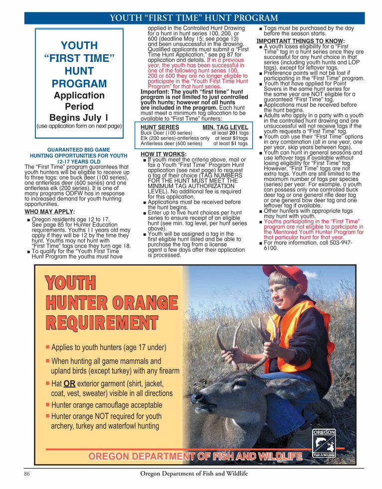
Oregon Department of Fish and Wildlife86
YOUTH “FIRST TIME” HUNT PROGRAM
GUARANTEED BIG GAME HUNTING OPPORTUNITIES FOR YOUTH
12-17 YEARS OLDThe “First Time” program guarantees that youth hunters will be eligible to receive up to three tags: one buck deer (100 series), one antlerless deer (600 series) and one antlerless elk (200 series). It is one of many programs ODFW has in response to increased demand for youth hunting opportunities.WHO MAY APPLY:
■ Oregon residents age 12 to 17. See page 85 for Hunter Education requirements. Youths 11 years old may apply if they will be 12 by the time they hunt. Youths may not hunt with “First Time” tags once they turn age 18. ■ To qualify for the “Youth First Time Hunt Program the youths must have
applied in the Controlled Hunt Drawing for a hunt in hunt series 100, 200, or 600 (deadline May 15; see page 13) and been unsuccessful in the drawing. Qualified applicants must submit a “First Time Hunt Application,” see pg 87 for application and details. If in a previous year, the youth has been successful in one of the following hunt series 100, 200 or 600 they are no longer eligible to participate in the “Youth First Time Hunt Program” for that hunt series.
Important: The youth “first time” hunt program is not limited to just controlled youth hunts; however not all hunts are included in the program. Each hunt must meet a minimum tag allocation to be available to “First Time” hunters:HUNT SERIES MIN. TAG LEVELBuck Deer (100 series) at least 201 tagsElk (200 series)-antlerless only at least 51tags Antlerless deer (600 series) at least 51 tags
HOW IT WORKS: ■ If youth meet the criteria above, mail or fax a Youth “First Time” Program Hunt application (see next page) to request a tag of their choice (TAG NUMBERS FOR THE HUNT MUST MEET THE MINIMUM TAG AUTHORIZATION LEVEL). No additional fee is required for this application. ■ Applications must be received before the hunt begins. ■ Enter up to five hunt choices per hunt series to ensure receipt of an eligible hunt (see min. tag level, per hunt series above). ■ Youth will be assigned a tag in the first eligible hunt listed and be able to purchase the tag from a license agent a few days after their application is processed.
■ Tags must be purchased by the day before the season starts.
IMPORTANT THINGS TO KNOW: ■ A youth loses eligibility for a “First Time” tag in a hunt series once they are successful for any hunt choice in that series (including youth hunts and LOP tags), except for leftover tags. ■ Preference points will not be lost if participating in the “First Time” program. ■ Youth that have applied for Point Savers in the same hunt series for the same year are NOT eligible for a guaranteed “First Time” tag. ■ Applications must be received before the hunt begins. ■ Adults who apply in a party with a youth in the controlled hunt drawing and are unsuccessful will not receive tags if the youth requests a “First Time” tag. ■ Youth can use their “First Time” options in any combination (all in one year, one per year, skip years between tags). ■ Youth can hunt in general seasons and use leftover tags if available without losing eligibility for “First Time” tag. However, “First Time” tags are not extra tags. Youth are still limited to the maximum number of tags per species (series) per year. For example, a youth can possess only one controlled buck deer tag or one general rifle deer tag or one general bow deer tag and one leftover tag if available. ■ Other hunters with appropriate tags may hunt with youth.
■ Youths participating in the “First Time” program are not eligible to participate in the Mentored Youth Hunter Program for that particular hunt for that year.
■ For more information, call 503-947-6100.
YOUTH “FIRST TIME”
HUNT PROGRAMApplication
PeriodBegins July 1
(use application form on next page)
OREGON DEPARTMENT OF FISH AND WILDLIFE
n Applies to youth hunters (age 17 under)n When hunting all game mammals and upland birds (except turkey) with any firearmn Hat OR exterior garment (shirt, jacket, coat, vest, sweater) visible in all directionsn Hunter orange camouflage acceptablen Hunter orange NOT required for youth archery, turkey and waterfowl hunting
YOUTH HUNTER ORANGE REQUIREMENT
Oregon Department of Fish and Wildlife 87
HUNT SAFELYHUNT RESPONSIBLY
WEAR HUNTER ORANGE
HUNTER ORANGE
• All big game tags must be purchased before the season opens (check the regulations for specific dates).
Check each hunt series type you are applying for. List up to 5 choices per hunt series.p Controlled Buck Deer (100) 1st Choice 2nd Choice 3rd Choice 4th Choice 5th Choice First Drawing Appl icat ion Number
p Controlled Antlerless Deer (600) 1st Choice 2nd Choice 3rd Choice 4th Choice 5th Choice First Drawing Appl icat ion Number
p Controlled Elk (200) ANTLERLESS ONLY 1st Choice 2nd Choice 3rd Choice 4th Choice 5th Choice First Drawing Appl icat ion Number
Hunter/Angler I.D. NO. (required)
HUNTING LICENSE NUMBER (required)
DATE OF BIRTH (MM-DD-YYYY)
MALE FEMALE
2014 YOUTH “FIRST TIME” HUNT APPLICATION (For Oregon Residents Age 12-17)
Application Period begins July 1 IMPORTANT INFORMATION!
To qualify for the First Time Youth Program, the youth must have applied in the Controlled Hunt Drawing (Deadline: May 15), been unsuccessful, and unsuccessful in previous years for that same hunt series. Youth that apply for a Point Saver in the same year are not eligible for a First Time Youth tag for that hunt series. Please see page 86 for more information. MAIL TO: ODFW, Controlled Hunts, 4034 Fairview Industrial Dr. SE, Salem, OR 97302 or FAX TO: 503-947-6113 or 6117
LAST NAME (Please PRINT) FIRST MI
MAILING ADDRESS
CITY STATE ZIP CODE
DAYTIME PHONE NUMBER — AND — EVENING PHONE NUMBER
• FAX APPLICATIONS WILL NOT BE VERIFIED.• If you are resubmitting a copy of this form due to a change, write “This is a revision/copy of the
original order” at the top of the copy.
1 4
1 4
1 4
1 4
Hunt must meet minimum tag levels. HUNT SERIES MIN. TAG LEVEL Buck Deer (100 series) . . . . . . . . . . . . . . . . . . . . . . . . . . . at least 201 tags Elk (200 series)-antlerless only . . . . . . . . . . . . . . . . . . . . . at least 51 tags Antlerless Deer (600 series) . . . . . . . . . . . . . . . . . . . . . . . . at least 51 tags

Oregon Department of Fish and Wildlife86
YOUTH “FIRST TIME” HUNT PROGRAM
GUARANTEED BIG GAME HUNTING OPPORTUNITIES FOR YOUTH
12-17 YEARS OLDThe “First Time” program guarantees that youth hunters will be eligible to receive up to three tags: one buck deer (100 series), one antlerless deer (600 series) and one antlerless elk (200 series). It is one of many programs ODFW has in response to increased demand for youth hunting opportunities.WHO MAY APPLY:
■ Oregon residents age 12 to 17. See page 85 for Hunter Education requirements. Youths 11 years old may apply if they will be 12 by the time they hunt. Youths may not hunt with “First Time” tags once they turn age 18. ■ To qualify for the “Youth First Time Hunt Program the youths must have
applied in the Controlled Hunt Drawing for a hunt in hunt series 100, 200, or 600 (deadline May 15; see page 13) and been unsuccessful in the drawing. Qualified applicants must submit a “First Time Hunt Application,” see pg 87 for application and details. If in a previous year, the youth has been successful in one of the following hunt series 100, 200 or 600 they are no longer eligible to participate in the “Youth First Time Hunt Program” for that hunt series.
Important: The youth “first time” hunt program is not limited to just controlled youth hunts; however not all hunts are included in the program. Each hunt must meet a minimum tag allocation to be available to “First Time” hunters:HUNT SERIES MIN. TAG LEVELBuck Deer (100 series) at least 201 tagsElk (200 series)-antlerless only at least 51tags Antlerless deer (600 series) at least 51 tags
HOW IT WORKS: ■ If youth meet the criteria above, mail or fax a Youth “First Time” Program Hunt application (see next page) to request a tag of their choice (TAG NUMBERS FOR THE HUNT MUST MEET THE MINIMUM TAG AUTHORIZATION LEVEL). No additional fee is required for this application. ■ Applications must be received before the hunt begins. ■ Enter up to five hunt choices per hunt series to ensure receipt of an eligible hunt (see min. tag level, per hunt series above). ■ Youth will be assigned a tag in the first eligible hunt listed and be able to purchase the tag from a license agent a few days after their application is processed.
■ Tags must be purchased by the day before the season starts.
IMPORTANT THINGS TO KNOW: ■ A youth loses eligibility for a “First Time” tag in a hunt series once they are successful for any hunt choice in that series (including youth hunts and LOP tags), except for leftover tags. ■ Preference points will not be lost if participating in the “First Time” program. ■ Youth that have applied for Point Savers in the same hunt series for the same year are NOT eligible for a guaranteed “First Time” tag. ■ Applications must be received before the hunt begins. ■ Adults who apply in a party with a youth in the controlled hunt drawing and are unsuccessful will not receive tags if the youth requests a “First Time” tag. ■ Youth can use their “First Time” options in any combination (all in one year, one per year, skip years between tags). ■ Youth can hunt in general seasons and use leftover tags if available without losing eligibility for “First Time” tag. However, “First Time” tags are not extra tags. Youth are still limited to the maximum number of tags per species (series) per year. For example, a youth can possess only one controlled buck deer tag or one general rifle deer tag or one general bow deer tag and one leftover tag if available. ■ Other hunters with appropriate tags may hunt with youth.
■ Youths participating in the “First Time” program are not eligible to participate in the Mentored Youth Hunter Program for that particular hunt for that year.
■ For more information, call 503-947-6100.
YOUTH “FIRST TIME”
HUNT PROGRAMApplication
PeriodBegins July 1
(use application form on next page)
OREGON DEPARTMENT OF FISH AND WILDLIFE
n Applies to youth hunters (age 17 under)n When hunting all game mammals and upland birds (except turkey) with any firearmn Hat OR exterior garment (shirt, jacket, coat, vest, sweater) visible in all directionsn Hunter orange camouflage acceptablen Hunter orange NOT required for youth archery, turkey and waterfowl hunting
YOUTH HUNTER ORANGE REQUIREMENT
Oregon Department of Fish and Wildlife 87
HUNT SAFELYHUNT RESPONSIBLYEvery hunter has the responsibility to enter the field well prepared to hunt in a safe the field well prepared to hunt in a safe ethical manner; the future of our hunting heritage depends on it.
THE FOUR PRIMARY RULES OF FIREARM SAFETYMUZZLE- Control the direction of your muzzle at all times
TRIGGER- Keep your finger outside of the trigger guard until ready to shootACTION- Treat every firearm as though it were loaded-open the action and visually check if it is loaded
TARGET- Be sure of your target and what is in front of it and beyond it
WEAR HUNTER ORANGEMost firearm incidents during big game hunting are vision related- a hunter is shot because they were not seen. Hunter orange clothing makes it much easier for one hunter to recognize another hunter because nothing in nature matches this color. All hunters ages 17 and below must wear a hunter orange hat or vest while hunting big game and upland game birds (except turkey) with any firearm. ODFW strongly encourages you to wear HUNTER ORANGE.
Check us out on Facebook at www.facebook.com\odfwoutdoors or visit the ODFW Outdoors section of our website at www.dfw.state.or.us
• All big game tags must be purchased before the season opens (check the regulations for specific dates).
Check each hunt series type you are applying for. List up to 5 choices per hunt series.p Controlled Buck Deer (100) 1st Choice 2nd Choice 3rd Choice 4th Choice 5th Choice First Drawing Appl icat ion Number
p Controlled Antlerless Deer (600) 1st Choice 2nd Choice 3rd Choice 4th Choice 5th Choice First Drawing Appl icat ion Number
p Controlled Elk (200) ANTLERLESS ONLY 1st Choice 2nd Choice 3rd Choice 4th Choice 5th Choice First Drawing Appl icat ion Number
Hunter/Angler I.D. NO. (required)
HUNTING LICENSE NUMBER (required)
DATE OF BIRTH (MM-DD-YYYY)
MALE FEMALE
2014 YOUTH “FIRST TIME” HUNT APPLICATION (For Oregon Residents Age 12-17)
Application Period begins July 1 IMPORTANT INFORMATION!
To qualify for the First Time Youth Program, the youth must have applied in the Controlled Hunt Drawing (Deadline: May 15), been unsuccessful, and unsuccessful in previous years for that same hunt series. Youth that apply for a Point Saver in the same year are not eligible for a First Time Youth tag for that hunt series. Please see page 86 for more information. MAIL TO: ODFW, Controlled Hunts, 4034 Fairview Industrial Dr. SE, Salem, OR 97302 or FAX TO: 503-947-6113 or 6117
LAST NAME (Please PRINT) FIRST MI
MAILING ADDRESS
CITY STATE ZIP CODE
DAYTIME PHONE NUMBER — AND — EVENING PHONE NUMBER
• FAX APPLICATIONS WILL NOT BE VERIFIED.• If you are resubmitting a copy of this form due to a change, write “This is a revision/copy of the
original order” at the top of the copy.
1 4
1 4
1 4
1 4
Hunt must meet minimum tag levels. HUNT SERIES MIN. TAG LEVEL Buck Deer (100 series) . . . . . . . . . . . . . . . . . . . . . . . . . . . at least 201 tags Elk (200 series)-antlerless only . . . . . . . . . . . . . . . . . . . . . at least 51 tags Antlerless Deer (600 series) . . . . . . . . . . . . . . . . . . . . . . . . at least 51 tags

Oregon Department of Fish and Wildlife88
OREGON DISABILITIES HUNTING AND FISHING PERMIT INFORMATIONIn order to be considered a person with a disability under the wildlife laws, a person shall provide either:
1. Written certification from a licensed physician, licensed physician assistant or certified nurse practitioner which states that the applicant:
a. Is permanently unable to walk without the use of, or assistance from, a brace, cane, crutch, prosthetic device, wheelchair, scooter or walker;
b. Is restricted by lung disease to the extent that the person’s forced expiratory volume for one second, when measured by a spirometer, is less than 35 percent predicted, or arterial oxygen tension is less than 55 mm/Hg on room air at rest;
c. Has a cardiac condition to the extent that the person’s functional limitations are classified in severity as Class III or Class IV, according to standards established by the American Heart Association;
d. Has a permanent, physical impairment that prevents the person from holding or shooting a firearm or bow or from holding a fishing rod in hand; or
e. Has central visual acuity that permanently does not exceed 20/200 in the better eye with corrective lenses, or the widest diameter of the visual field is no greater than 20 degrees; or
2. Written proof that the last official certification of record by the United States Department of Veterans Affairs or any branch of the Armed Forces of the United States shows the person to be at least 65 percent disabled (ORS 496. 018).
The “Oregon Disabilities Hunting and Fishing Permit” is not a license or tag. Hunters must still obtain a hunting license and apply for and/or purchase appropriate tags prior to specified tag sale deadlines to hunt in controlled and general big game seasons. You must be in possession of your “Oregon Disabilities Hunting and Fishing Permit”, license and tag while you are hunting (even holders of a Disabled Veteran/Pioneer license and tag). All license and tag fees are at regular rates. In addition you may only hunt in the time period specified for the tag you possess. Holders of a Disabled Veteran/Pioneer elk tag must also possess an “Oregon Disabilities Hunting and Fishing Permit” to be eligible for an expanded bag limit or to hunt from a parked motor vehicle. An “Oregon Disabilities Hunting and Fishing Permit” does not allow the permit holder to travel on any closed road by means of a motor-propelled vehicle.The following section applies only for persons defined in number (1)e. A visually impaired hunter must comply with all other tag, permit and stamp requirements of the Oregon Fish and Wildlife Commission and applicable hunting laws (ORS 498.170). See page 30 for allowable scope and sights for muzzleloader seasons.
A person who is not visually impaired and who accompanies a hunter who is visually impaired (1)e. that possesses an “Oregon Disabilities Hunting and Fishing Permit” may:
■ assist the hunter in selecting a game animal or bird; ■ assist the hunter aiming or sighting a firearm; ■ advise the hunter when to fire a firearm; ■ shoot a game animal or bird on behalf of the hunter while in the immediate presence of the hunter; and ■ tag and retrieve game animals and birds on behalf of the hunter.
The person accompanying a hunter who is visually impaired: ■ Is required to possess a valid hunting license. ■ May also hunt game animals or birds if the person possesses
the appropriate tags, permits, validations and stamps for the area and time period.
An “Oregon Disabilities Hunting and Fishing Permit” holder may: ■ Hunt from a parked motor-propelled vehicle except on any public road or Hwy, or within Cooperative Travel Management Areas. A public road is the entire right of way of any road over which the public has a right of use. Public roads include, but are not limited to, road related structures that are in the right of way such as tunnels, bridges, or similar structures. Roads on federal, state, or local government lands are public roads. Hunting from a parked motor-propelled vehicle is allowed on private land with the landowner’s permission and on public land where off-road travel is permitted. ■ Have an able-bodied companion accompany them and kill any animal wounded by the permit holder. The wounded animal must be killed using a legal weapon for the season and species designated on the tag. The companion must immediately attach the permit holder’s tag to the carcass of the animal. The companion is not required to possess a hunting license or tag, except a person accompanying a visually impaired hunter is required to possess a valid hunting license (OAR 635-065-0090(3)).
2014 OREGON DISABILITES HUNTING AND FISHING PERMIT BAG LIMIT
For Holders of an “Oregon Disabilites Hunting and Fishing Permit” the bag limit includes antlerless animals in the following units only:FOR DEER ONLYOne Deer During Buck Seasons: Biggs, Columbia Basin (portions of the unit are closed to bowhunting- see page 50 and 51), Hood, Indigo, Maupin, McKenzie, Melrose, Santiam, and Willamette. FOR ELK ONLYAntlerless OR Legal Bull Elk During Bull Seasons: Applegate, Beatys Butte, Beulah, Biggs, Catherine Creek, Chesnimnus, Columbia Basin (portions of the unit are closed to bowhunting- see page 80), E Fork Rock (that portion east of Hwy 97), Fossil, Grizzly, Hood, Imnaha, Juniper, Lookout Mt, Malheur River, Maupin, Melrose, Murderers Creek, Northside, Ochoco, Owyhee, Paulina, Pine Creek, Saddle Mt, Scappoose, Silvies, Siuslaw, Sixes, Sled Springs, Steens Mt, Stott Mt, S Sumpter (251B hunt area; see page 73), Wagontire, White River, Whitehorse, Willamette and Wilson, and outside NF Lands within the Dixon, Evans Creek, Indigo, McKenzie, Rogue, and Santiam units. On NF Lands with the Dixon, Evans Creek, Indigo, McKenzie, Rogue, and Santiam units the bag limit is one legal bull elk. FOR ANTELOPE ONLYPronghorn Antelope: All “buck pronghorn” hunts have a bag limit of “one pronghorn antelope”.
OREGON DISABILITIES HUNTING AND FISHING PERMIT APPLICATION
For more information or to obtain an “Oregon Disabilities Hunting and Fishing Permit” application packet, please visit our website at www.dfw.state.or.us/resources/hunting/disability. Application packets are also available at the headquarters office, regional offices, district offices, or by calling 503-947-6100. Please note: Permits are valid for two calendar years. To renew a permit, the holder must submit a new, updated application form.
Oregon Department of Fish and Wildlife 89
WESTERN OREGON WILDLIFE MANAGEMENT UNIT BOUNDARY DESCRIPTIONSWILDLIFE MANAGEMENT UNITS For the purpose of man ag ing Or e gon’s wildlife, the state has been divided into separate wildlife management units. Unit numbers are identifiable in smaller subunits by the last 2 digits of the number assigned to the rule description.Maps are available from the Bu reau of Land Management (BLM), National Forest (NF), or Oregon Department of Forestry (ODF), as indicated following each descrip tion.ALSEA 42% public lands. Beginning at Corvallis; southwest on State Hwy 34 to Decker Rd; south east on Decker Rd to Bellfountain Rd; south on Bell foun tain Rd to Bell foun tain; east on Dawson Rd (Co Rd 45200) to State Hwy 99W; south on State Hwy 99W to Monroe; south on Ter ri to rial Rd to State Hwy 36; southwest on State Hwy 36 to north shoreline of Triangle Lk; south west on Triangle Lk shore line, Lk Cr, Siuslaw Rvr and north shoreline of Si uslaw Bay to Pacific Ocean; north on Pacific Ocean coastline to north shoreline of Siletz Bay; east on north shoreline of Siletz Bay, Siletz Rvr and S Fork of Siletz Rvr to Valsetz; east on Valsetz-Falls City main Co Rd to Falls City; south east on Bridgeport Rd (No. 864), Gardner Rd (No. 865) and Airlie Rd (No. 7) to State Hwy 99W; south on Hwy 99W to Corvallis, point of be gin ning. (Maps: Siuslaw NF, Eugene/Salem BLM)APPLEGATE 57% public lands. Beginning at Grants Pass; east and southeast on I-5 to Oregon-California state line; west on state line to US Hwy 199; northeast on US Hwy 199 to Grants Pass, point of beginning. (Maps: Siskiyou NF, Rogue Rvr NF, Medford BLM)CHETCO 82% public lands. Beginning at Gold Beach; east on Rogue Rvr to Grants Pass; south west on US Hwy 199 to Oregon-California state line; west on state line to Pa cific Ocean; north west on Pa cific Ocean coast line to Gold Beach, point of be gin ning. (Maps: Siskiyou NF, Coos Bay/Medford BLM)DIXON 77% public lands. Beginning at Shady Cove; northwest on State Hwy 227 and Douglas Co Rd 1 to Prospect-Days Creek power trans mis sion line at a point ap proxi mately 2 mi west of Days Cr; northwest along Prospect-Days Creek, Dixonville-Meridian, Dixonville Loop power transmission line to N Umpqua Rvr; east on N Umpqua Rvr to Toketee; south on Toketee Rd to State Hwy 138; east and south on Hwy 138 to State Hwy 230; southwest on Hwy 230 to State Hwy 62; southwest on Hwy 62 to Shady Cove, point of beginning. (Maps: Umpqua NF, Rogue Rvr NF, Medford-Roseburg BLM)EVANS CR 43% public lands. Beginning at Grants Pass; northwest on Rogue Rvr to Grave Cr bridge; northeast on Grave Cr-Wolf Cr Rd to I-5 at Wolf Cr; north on I-5
to Canyonville; east and south on Douglas Co Rd 1 and State Hwy 227 to Shady Cove; south on State Hwy 62 to Medford; northwest on I-5 to Grants Pass, point of beginning. (Maps: Umpqua NF, Medford BLM)INDIGO 68% public lands. Beginning at Oakridge; southeast on State Hwy 58 to Pacific Crest Trail; south on Pacific Crest Trail to State Hwy 138; north and west on Hwy 138 to Toketee junction; north on Toketee Rd to N Umpqua Rvr; west on N Umpqua Rvr to Dix on ville loop power trans mis sion line; north on Dix on-ville-Albany main power transmission line to Shoe string Rd; east on Shoestring Rd 0.8 mi to London Rd; north on London Rd and South 6th St to I-5; north on I-5 to State Hwy 58; southeast on Hwy 58 to Oakridge, point of be gin ning. (Maps: Willamette NF, Umpqua NF, Eugene/Roseburg BLM)MCKENZIE 60% public lands. Beginning at Lebanon; east on US Hwy 20 to Pacific Crest Trail; south on Pacific Crest Trail to State Hwy 58; northwest on Hwy 58 to I-5; north on I-5 to State Hwy 34; east on Hwy 34 to Lebanon, point of be gin ning. (Maps: Willamette NF, Eugene/Salem BLM)MELROSE 16% public lands. Beginning at Dixonville power substation; south along Dixonville-Meridian, Dixonville-Days Creek, Prospect-Days Creek power trans-mis sion line to Douglas Co Rd 1 at a point ap proxi mately 2 mi west of Days Cr; south-west on Douglas Co Rd 1 to Canyonville; south on I-5, 3/4 mi to Grants Pass - Dixonville, Hanna Tap power trans mis-sion line; west on Grants Pass-Dixonville, Hanna Tap main power trans mis sion line to Southern Pacific railroad tracks ad ja cent to the Nickel Mt Rd junction; southwest on SPRR tracks to Union Cr Rd; north on Union Cr Rd to Live Oak Cr Rd; northeast on Live Oak Cr Rd through Horse Prairie to Olalla Cr Rd; north on Olalla Cr Rd to Ireland Rd; west on Ireland Rd to Benedict Rd; north on Benedict Rd to Tenmile; north on Reston, Coos Bay Wagon, Flournoy Valley, and Melrose Rds to Melrose; north and east on Melqua Rd and Ft McKay Rd to Umpqua Rvr; north on Umpqua Rvr to State Hwy 38 at Elkton; east on Hwy 38 to Drain; northeast on State Hwy 99 to Curtin; northeast on I-5 to South 6th St; south on South 6th St to London Rd; south on London Rd to Shoestring Rd; west 0.8 mi on Shoestring Rd to the Alvey-Dixonville power trans mis sion line; south along Alvey-Dixonville, Dixonville Loop power transmission line to Dix on-ville power substation, point of beginning. (Maps: Roseburg BLM)POWERS 49% public lands. Beginning at Grave Cr Bridge on Rogue Rvr; west on Rogue Rvr to Illahee; north on posted FR to Powers; northwest on Powers Hwy to State Hwy 42; east on Hwy 42 to Tenmile;
south on Benedict Rd to Ireland Rd; east on Ireland Rd to Olalla Cr Rd; south on Olalla Cr Rd through Horse Prairie to Live Oak Cr Rd; southwest on Live Oak Cr Rd to Union Cr Rd; south on Union Cr Rd to Southern Pacific railroad track; northeast on SPRR tracks to Grants Pass-Dixonville Hanna Tap power transmission line adjacent to Nickel Mt Rd; east on Grants Pass-Dixonville Hanna Tap power trans-mis sion line to I-5; south on I-5 to Wolf Cr; south-west on Wolf Cr-Grave Cr Rd to Grave Cr Bridge, point of beginning. (Maps: Siskiyou NF, Medford-Coos Bay-Roseburg BLM)ROGUE 57% public lands. Beginning at Medford; north on State Hwy 62 to State Hwy 230; northeast on Hwy 230 to State Hwy 138; south and east on Hwy 138 to Pacific Crest Trail; south on Pacific Crest Trail to bound ary of Crater Lk NP; west, south and east on Crater Lk NP boundary to Pacific Crest Trail; south on Pacific Crest Trail; southeast on Forest Trail 993 along Fourmile Lk; south on FR 3661 to State Hwy 140; west on Hwy 140 to FR 3601; south on 3601 to Dead Indian Rd; southwest on Dead Indian Rd to Jackson-Klamath Co line; south on Jackson-Klamath Co line to State Hwy 66; west on Hwy 66 to Copco Rd; south on Copco Rd to Oregon-California state line; west on state line to I-5; north on I-5 to Medford, point of beginning. (Maps: Rogue NF, Medford BLM)SADDLE MT 25% public lands. Beginning at the mouth of Columbia Rvr; east on state line to mouth of Clatskanie Rvr; south on Clatskanie Rvr to Clatskanie; south on State Hwy 47 to Timber-Vernonia Hwy; southwest on Timber-Vernonia Hwy to US Hwy 26; northwest on US Hwy 26 to State Hwy 53 at Necanicum Junction; south-west on Hwy 53 to N Fork Nehalem Rvr; southwest on N Fork Nehalem Rvr and north shoreline of Nehalem Bay to Pacific Ocean; north on Pacific Ocean coastline to state line at mouth of Columbia Rvr, point of beginning. (Maps: ODF-Astoria)SANTIAM 63% public lands. Beginning at Lebanon; north on Brewster Rd to Lacomb Rd; east on Lacomb Rd to Kowitz Rd; north on Kowitz Rd to Baptist Church Dr; west on Baptist Church Dr to Richardson Gap Rd; north on Richardson Gap Rd to State Hwy 226; northeast on Hwy 226 to State Hwy 22; west on Hwy 22 to Cascade Hwy; north on Cascade Hwy to State Hwy 213 at Silverton; northeast on Hwy 213 to State Hwy 211; northeast on Hwy 211 to Sandy; north on Teneyck Rd to Sandy Rvr; northwest down Sandy Rvr to state line in Columbia Rvr; northeast on state line to Multnomah-Hood Rvr Co line; southeast on Multnomah-Hood Rvr Co line to Lolo Pass; southeast on Pacific Crest Trail to Barlow Pass; west on Hwy 35 to Hwy 26;
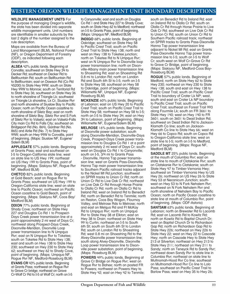
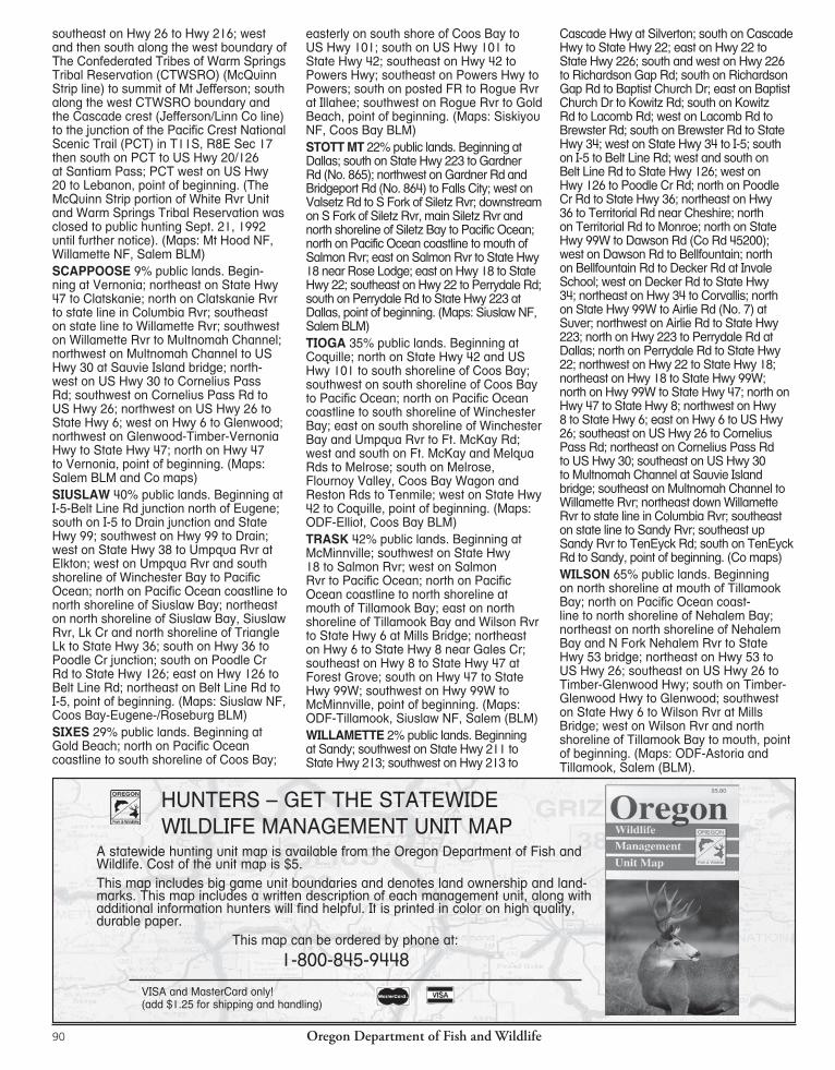
Oregon Department of Fish and Wildlife90
HUNTERS – GET THE STATEWIDE WILDLIFE MANAGEMENT UNIT MAP
VISA and MasterCard only! (add $1.25 for shipping and handling)
A statewide hunting unit map is available from the Oregon Department of Fish and Wildlife. Cost of the unit map is $5.This map includes big game unit boundaries and denotes land ownership and land-marks. This map includes a written description of each management unit, along with additional information hunters will find helpful. It is printed in color on high quality, durable paper.
This map can be ordered by phone at:
1-800-845-9448
southeast on Hwy 26 to Hwy 216; west and then south along the west boundary of The Confederated Tribes of Warm Springs Tribal Res er va tion (CTWSRO) (McQuinn Strip line) to summit of Mt Jefferson; south along the west CTWSRO boundary and the Cascade crest (Jefferson/Linn Co line) to the junction of the Pacific Crest National Scenic Trail (PCT) in T11S, R8E Sec 17 then south on PCT to US Hwy 20/126 at Santiam Pass; PCT west on US Hwy 20 to Lebanon, point of beginning. (The McQuinn Strip portion of White Rvr Unit and Warm Springs Tribal Reservation was closed to public hunting Sept. 21, 1992 until further notice). (Maps: Mt Hood NF, Willamette NF, Salem BLM)SCAPPOOSE 9% public lands. Begin- ning at Vernonia; northeast on State Hwy 47 to Clatskanie; north on Clatskanie Rvr to state line in Columbia Rvr; southeast on state line to Willamette Rvr; south west on Wil lam ette Rvr to Multnomah Channel; northwest on Multnomah Channel to US Hwy 30 at Sauvie Island bridge; north-west on US Hwy 30 to Cornelius Pass Rd; southwest on Cornelius Pass Rd to US Hwy 26; northwest on US Hwy 26 to State Hwy 6; west on Hwy 6 to Glenwood; northwest on Glenwood-Tim ber-Vernonia Hwy to State Hwy 47; north on Hwy 47 to Vernonia, point of beginning. (Maps: Salem BLM and Co maps)SIUSLAW 40% public lands. Beginning at I-5-Belt Line Rd junc tion north of Eugene; south on I-5 to Drain junction and State Hwy 99; southwest on Hwy 99 to Drain; west on State Hwy 38 to Umpqua Rvr at Elkton; west on Umpqua Rvr and south shoreline of Winchester Bay to Pacific Ocean; north on Pacific Ocean coastline to north shoreline of Siuslaw Bay; northeast on north shore line of Siuslaw Bay, Siuslaw Rvr, Lk Cr and north shoreline of Triangle Lk to State Hwy 36; south on Hwy 36 to Poodle Cr junction; south on Poodle Cr Rd to State Hwy 126; east on Hwy 126 to Belt Line Rd; northeast on Belt Line Rd to I-5, point of beginning. (Maps: Siuslaw NF, Coos Bay-Eugene-/Roseburg BLM)SIXES 29% public lands. Beginning at Gold Beach; north on Pacific Ocean coastline to south shoreline of Coos Bay;
easterly on south shore of Coos Bay to US Hwy 101; south on US Hwy 101 to State Hwy 42; southeast on Hwy 42 to Powers Hwy; southeast on Powers Hwy to Powers; south on posted FR to Rogue Rvr at Illahee; southwest on Rogue Rvr to Gold Beach, point of beginning. (Maps: Siskiyou NF, Coos Bay BLM)STOTT MT 22% public lands. Beginning at Dallas; south on State Hwy 223 to Gardner Rd (No. 865); northwest on Gardner Rd and Br idge port Rd (No. 864) to Falls City; west on Valsetz Rd to S Fork of Siletz Rvr; down stream on S Fork of Siletz Rvr, main Siletz Rvr and north shoreline of Siletz Bay to Pacific Ocean; north on Pacific Ocean coastline to mouth of Salmon Rvr; east on Salmon Rvr to State Hwy 18 near Rose Lodge; east on Hwy 18 to State Hwy 22; south east on Hwy 22 to Perrydale Rd; south on Perrydale Rd to State Hwy 223 at Dallas, point of beginning. (Maps: Siuslaw NF, Salem BLM)TIOGA 35% public lands. Beginning at Coquille; north on State Hwy 42 and US Hwy 101 to south shoreline of Coos Bay; southwest on south shoreline of Coos Bay to Pacific Ocean; north on Pacific Ocean coastline to south shoreline of Win ches ter Bay; east on south shore line of Winchester Bay and Umpqua Rvr to Ft. McKay Rd; west and south on Ft. McKay and Melqua Rds to Melrose; south on Melrose, Flournoy Valley, Coos Bay Wagon and Reston Rds to Tenmile; west on State Hwy 42 to Coquille, point of beginning. (Maps: ODF-Elliot, Coos Bay BLM)TRASK 42% public lands. Beginning at McMinnville; southwest on State Hwy 18 to Salmon Rvr; west on Salmon Rvr to Pacific Ocean; north on Pacific Ocean coastline to north shoreline at mouth of Til lamook Bay; east on north shoreline of Tillamook Bay and Wilson Rvr to State Hwy 6 at Mills Bridge; northeast on Hwy 6 to State Hwy 8 near Gales Cr; southeast on Hwy 8 to State Hwy 47 at Forest Grove; south on Hwy 47 to State Hwy 99W; southwest on Hwy 99W to McMinnville, point of be gin ning. (Maps: ODF-Tillamook, Siuslaw NF, Salem (BLM)WILLAMETTE 2% public lands. Beginning at Sandy; southwest on State Hwy 211 to State Hwy 213; southwest on Hwy 213 to
Cascade Hwy at Silverton; south on Cascade Hwy to State Hwy 22; east on Hwy 22 to State Hwy 226; south and west on Hwy 226 to Richardson Gap Rd; south on Richardson Gap Rd to Baptist Church Dr; east on Baptist Church Dr to Kowitz Rd; south on Kowitz Rd to Lacomb Rd; west on Lacomb Rd to Brewster Rd; south on Brewster Rd to State Hwy 34; west on State Hwy 34 to I-5; south on I-5 to Belt Line Rd; west and south on Belt Line Rd to State Hwy 126; west on Hwy 126 to Poodle Cr Rd; north on Poodle Cr Rd to State Hwy 36; northeast on Hwy 36 to Territorial Rd near Cheshire; north on Territorial Rd to Monroe; north on State Hwy 99W to Dawson Rd (Co Rd 45200); west on Dawson Rd to Bell foun tain; north on Bellfountain Rd to Decker Rd at Invale School; west on Decker Rd to State Hwy 34; northeast on Hwy 34 to Corvallis; north on State Hwy 99W to Airlie Rd (No. 7) at Suver; north west on Airlie Rd to State Hwy 223; north on Hwy 223 to Per ry dale Rd at Dallas; north on Perrydale Rd to State Hwy 22; northwest on Hwy 22 to State Hwy 18; northeast on Hwy 18 to State Hwy 99W; north on Hwy 99W to State Hwy 47; north on Hwy 47 to State Hwy 8; northwest on Hwy 8 to State Hwy 6; east on Hwy 6 to US Hwy 26; southeast on US Hwy 26 to Cornelius Pass Rd; northeast on Cornelius Pass Rd to US Hwy 30; southeast on US Hwy 30 to Multnomah Channel at Sauvie Island bridge; southeast on Multnomah Channel to Willamette Rvr; northeast down Willamette Rvr to state line in Columbia Rvr; southeast on state line to Sandy Rvr; southeast up Sandy Rvr to TenEyck Rd; south on TenEyck Rd to Sandy, point of beginning. (Co maps)WILSON 65% public lands. Beginningon north shoreline at mouth of Tillamook Bay; north on Pacific Ocean coast-line to north shoreline of Nehalem Bay; northeast on north shoreline of Nehalem Bay and N Fork Nehalem Rvr to State Hwy 53 bridge; northeast on Hwy 53 to US Hwy 26; southeast on US Hwy 26 to Timber-Glenwood Hwy; south on Timber-Glen wood Hwy to Glenwood; south west on State Hwy 6 to Wilson Rvr at Mills Bridge; west on Wilson Rvr and north shoreline of Tillamook Bay to mouth, point of beginning. (Maps: ODF-Astoria and Tillamook, Salem (BLM).
Oregon Department of Fish and Wildlife 91
EASTERN OREGON WILDLIFE MANAGEMENT UNIT BOUNDARY DESCRIPTIONSBEATYS BUTTE 82% public lands. Begin- ning at Denio; west on Oregon state line to Fort Bidwell-Warner Valley Rd (Lake Co Rd 3-14); north on 3-14 to Adel; north on Co Rd 3-10 through Plush to Co Rd 3-11; east on 3-11 to Hart Refuge and Co Rd 3-12; north and east on 3-12 to Hart Refuge headquarters; east on Hart Mt-Frenchglen Rd (Lake Co Rd 3-12 and Harney Co Rd 412) to Catlow Valley Rd (Harney Co Rd 202); south and east on Catlow Valley Rd to Harney Co Rd 201, 1 mi north of Fields; south on Co Rd 201 through Fields to Denio, point of beginning. Specific hunts do not include Hart Mt NAR. (Maps: Lakeview/Burns BLM)BEULAH 57% public lands. Beginning at Vale; southwest on US Hwy 20 to Drewsey-Prairie City Rd near Drewsey; north west on Drewsey-Prairie City Rd and FR 1663 to the junction with FR 14 near Antelope Mt; northwest on FR 14 and FR 16 to Summit Prairie; north on Co Rd 62 to US Hwy 26; east on Hwy 26 to Ironside; east on Willow Creek Rd to Huntington Junction; east on Huntington Junction Rd/Malheur Line Rd (Durbin Creek), to I-84; south east on I-84 to Birch Cr near Farewell Bend; east on Birch Cr to Snake Rvr; south east along Snake Rvr to Nyssa; north on Hwy 201 to Cairo Junction; and west on US Hwy 20 to Vale, point of beginning. (Maps: Vale/Burns BLM, Malheur/Wallowa-Whitman NF)BIGGS 11% public lands. Beginning at Arlington; south on State Hwy 19 to Fossil; southwest on State Hwy 218 to Shaniko; north on US Hwy 97 to Grass Valley; southwest on State Hwy 216 to Tygh Valley; north on US Hwy 197 to Columbia Rvr; east on Columbia Rvr to Arlington, point of beginning. (Maps: Prineville BLM)CATHERINE CR 24% public lands. Beginning at Elgin; northeast on State Hwy 82 to Minam; south on Minam Rvr to Wallowa-Whitman NF boundary; west on forest boundary to Point Prominence Rd (62 and 6220); south on Point Prominence Rd to Moss Springs Campground; south and east from Moss Springs Campground on Lodgepole Trail 1920 to Cartwheel Ridge Trail 1907; north and east on Cartwheel Ridge Trail 1907 to the divide between Catherine Cr and Minam Rvr drainages and south to Meadow Mt; generally southeast on the divide between Catherine Cr and the Minam Rvr drainages past Burger Butte to Granite Butte; generally south on the divide between Catherine Cr and Eagle Cr drainages to Flagstaff Butte; west on FR 7700582 to FR 77; west on FR 77 to FR 7740; south on 7740 to 7740050; south and west on 7740050 to Big Cr; south along Big Cr to FR 67; west on FR Rd 67 to Big Cr Rd 71; southwest and northwest on Big Cr Rd 71 to Medical Springs; southwest on State Hwy 203 to Powder Rvr; northwest on Powder Rvr to I-84 at N Powder; north on I-84 to State Hwy 82 at La Grande; northeast on Hwy 82 to Elgin, point of beginning. (Maps: Wallowa-Whitman NF, Vale BLM, ODF)CHESNIMNUS 48% public lands. Beginning at Joseph; north on State Hwy
82 to Crow Cr Rd; north on Crow Cr Rd to Chesnimnus Cr; northwest on Chesnimnus Cr to Joseph Cr; northeast on Joseph Cr to Oregon-Washington state line; east and southeast along state line to Snake Rvr; southeast on Snake Rvr to mouth of Imnaha Rvr; southwest on Imnaha Rvr to Imnaha; southwest on Sheep Cr Rd to Joseph, point of beginning. (Maps: Wallowa-Whitman NF, Vale BLM)COLUMBIA BASIN 5% public lands. Beginning at Condon; north on State Hwy 19 to Oregon-Washington state line at Arlington; north east on state line to State Hwy 11; southwest on Hwy 11 to Pendleton; southwest on US Hwy 395 to State Hwy 74; southwest on Hwy 74 to Heppner; southwest on State Hwy 207 to State Hwy 206; west on Hwy 206 to Condon, point of beginning. (Co maps)DESOLATION 87% public lands. Beginning at Dale on US Hwy 395; southeast on N Fork John Day Rvr to Big Cr; northeast on Big Cr to Meadow Cr; northeast on Meadow Cr to FR 5225 at Forks Guard Station; northwest on 5225 to Granite-Ukiah Rd 52; southeast on Granite-Ukiah Rd 52 to Anthony Lks Rd 73; northeast on Anthony Lakes Rd to Summit of Blue Mts west of Anthony Lakes; south along summit of Blue Mts. to the Summit of Anthony Lakes Ski Area (junction of Grant, Baker, and Union counties); southwest on summit of Blue Mts. (Baker/Grant county line) to Hwy 7; southwest along Hwy 7 to Co Rd 20; northwest on Co Rd 20 to US Hwy 395; north on Hwy 395 to Dale, point of beginning. (Maps: Umatilla National Forest, Malheur NF, Prineville BLM, ODF)FORT ROCK 65% public lands. Beginning at Silver Lake; west on State Hwy 31 to Klamath Marsh-Silver Lk Rd; west on Klamath Marsh Rd to Williamson Rvr; west and south on Williamson Rvr returning to Klamath Marsh Rd; west on Klamath Marsh Rd to US Hwy 97; west on Scott Cr Rd 66 one mi to Sand Cr; southwest on Sand Cr to Crater Lk NP boundary; north and west on Crater Lk NP boundary to Pacific Crest Trail; north on Pacific Crest Trail to State Hwy 58; southeast on Hwy 58 to Crescent Cr; north on Crescent Cr to Co Rd 61 to Crescent; east on Co Rd 61 to Crescent; north on Hwy 97 to Gilchrist main logging Rd one mi north of Gilchrist; east on Gilchrist main logging Rd 9775 to State Hwy 31 between milepost 16 and 17; south east on Hwy 31 to Lk Co Rd 5-10 at Horse Ranch; 22 mi east and south on Lk Co Rd 5-10 to junction with Lk Co Rd 5-14; east on Lk Co Rd 5-14 to Lk Co Rd 5-14F at Christ mas Valley; southwest on Lk Co Rd 5- 14F to State Hwy 31, 9 mi east of Silver Lake; west on Hwy 31 to Silver Lk, point of beginning. (Maps: Deschutes/ Winema/ Fremont NF, Lakeview BLM)FOSSIL 16% public lands. Beginning at Fossil; north on Hwy 19 to Condon; east on State Hwy 206 to State Hwy 207; south on Hwy 207 to State Hwy 19; southeast on Hwy 19 to US Hwy 26; west on Hwy 26 to Bridge Cr near Mitchell; northwest on
Bridge Cr to John Day Rvr; northwest on John Day Rvr to State Hwy 218 at Clarno; northeast on Hwy 218 to Fossil, point of be gin ning. (Maps: Umatilla NF, Prineville BLM, ODF)GRIZZLY 28% public lands. Beginning at Redmond; north on US Hwy 97 to Crooked Rvr; north on Crooked Rvr and Deschutes Rvr to S Junction; northeast on S Junction Co Rd to Hwy 97 and US Hwy 197; south on Hwy 97 to Antelope Cr Rd; northeast on Antelope Cr Rd to Antelope; east on Hwy 218 to John Day Rvr at Clarno; southeast on John Day Rvr to Bridge Cr; southeast on Bridge Cr to US Hwy 26 near Mitchell; southwest on Hwy 26 to Prineville; west on US Hwy 126 to Redmond, point of beginning. (Maps: Ochoco NF, Prineville BLM)HEPPNER 34% public lands. Beginning at Heppner; northeast on State Hwy 74 to US Hwy 395; south on Hwy 395 to Long Cr-Monument Rd; northwest on Long Cr-Monument Rd to N Fork John Day Rvr at Monument; southwest on N Fork John Day Rvr to State Hwy 19 at Kimberly; north west on Hwy 19 to State Hwy 207; north on Hwy 207 to Heppner, point of beginning. (Maps: Umatilla NF, ODF)HOOD 65% public lands. Beginning at Hood Rvr; southwest on State Hwy 35 to Barlow Pass (Pacific Crest Trail); northwest on Pacific Crest Trail to Lolo Pass; northwest on Hood Rvr-Multnomah Co line to Columbia Rvr near Bonneville; east on Columbia Rvr to Hood Rvr, point of beginning. (Maps: Mt Hood NF)IMNAHA 74% public lands. Beginning at Joseph; northeast on Imnaha Hwy to Imnaha; south and west on Imnaha Rvr and S Fork of Imnaha Rvr to Hawkins Pass; north on W Fork Trail to Wallowa Lk; north on State Hwy 82 to Joseph, point of beginning. (Maps: Wallowa-Whitman NF)INTERSTATE 56% public lands. Beginning at Bly; west on State Hwy 140 to Beatty; north on Godowa Springs Rd to Sprague Rvr; west on Sprague Rvr one mi to Sycan Rvr; upstream north and east on Sycan Rvr to Pikes Crossing; east on FR 30 to FR 28; east on 28 to FR 29; east on 29 to State Hwy 31; southeast on Hwy 31 to Valley Falls; south on US Hwy 395 to Oregon-California state line; west on state line to Lost Rvr; northwest on Lost Rvr to East Langell Valley Rd; north on East Langell Valley Rd to Gerber Rd; northeast on Gerber Rd to Bly, point of beginning. (Maps: Fremont NF, Lakeview BLM)JUNIPER 89% public lands. Beginning at Burns; east 2 mi on State Hwy 78 to State Hwy 205; south on Hwy 205 through Frenchglen to Hart Mt Rd (Harney Co Rd 412 and Lake Co Rd 3-12); west on Hart Mt Rd to Flagstaff Lk Rd (Lake Co Rd 3-11); west on Flagstaff Lk Rd to Hogback Rd (Lake Co Rd 3-10); northwest on Hogback Rd to US Hwy 395; northeast on Hwy 395 to US Hwy 20; east on Hwy 20 to Burns; point of beginning. Specific hunts do not include Hart Mt NAR. (Maps: Lakeview/Burns BLM)
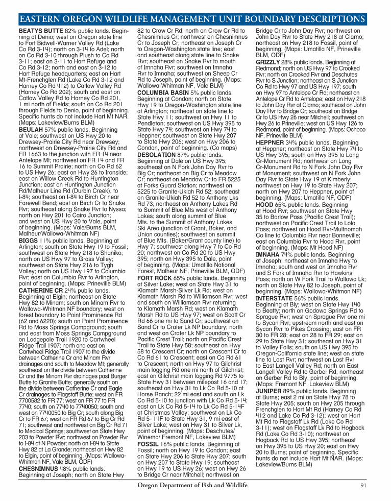
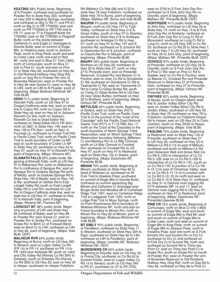
Oregon Department of Fish and Wildlife92
KEATING 58% Public lands. Beginning at N Powder; northeast and southeast on Powder Rvr to State Hwy 203; northeast on Hwy 203 to Medical Springs; southeast and northeast on Big Cr Rd 71 and FR 67; north on Big Cr to FR 7740050; east and north on FR 7740050 to FR 7740 and to FR 77; east on 77 to Flagstaff Butte Rd 7700582; east on Rd 7700582 to Flagstaff Butte; north on the divide between Catherine Cr and Eagle Cr drainages to Granite Butte; east on summit of Eagle Mts. to Hawkins pass; south to Jackson Peak; south to Krag Peak; south and east to Crater Lake; north and east to Red Mt.; north and east to Blue Cr Trail (1865) north of Cornucopia; south on Blue Cr trail to Pine Cr; south and east on Pine Cr to State Hwy 86; southwest on Hwy 86 to Old Richland-Halfway Hwy (Sag Rd); south on Sag Rd to Powder Rvr arm of Brownlee Reservoir; west on Powder Rvr to Hwy 86 near Goose Cr; west on Hwy 86 to I-84; north on I-84 to N Powder; point of beginning. (Maps Wallowa-Whitman NF; Vale BLM) KENO 41% public lands. Beginning at Klamath Falls; south on US Hwy 97 to Oregon-California state line; west on state line to Copco Rd; north on Copco Rd to State Hwy 66; east on Hwy 66 to Jackson-Klamath Co line; north on Jackson-Klamath Co line to Dead Indian Rd; northeast on Dead Indian Rd to FR 3601; north on 3601 to State Hwy 140; east on Hwy 140 to FR 3661; north on 3661 to Fourmile Lk; northwest on Forest Trail 993 to Pacific Crest Trail; north on Pacific Crest Trail to south boundary of Crater Lk NP; east on south boundary of Crater Lk NP to State Hwy 62; southeast on Hwy 62 to Hwy 97; south on Hwy 97 to Klamath Falls, point of beginning. (Maps: Winema NF)KLAMATH FALLS 35% public lands. Be-ginning at Klamath Falls; north on US Hwy 97 to Williamson Rvr; north on Williamson Rvr to confluence of Sprague Rvr; east on Sprague Rvr to Godowa Springs Rd north of Beatty; south on Godowa Springs Rd to State Hwy 140 at Beatty; east on Hwy 140 to Bly; southwest on Gerber Rd to East Langell Valley Rd; south on East Langell Valley Rd to Lost Rvr; southeast on Lost Rvr to Oregon-California state line; west on state line to US Hwy 97; northeast on Hwy 97 to Klamath Falls, point of beginning. (Maps: Winema NF, Fremont NF)LOOKOUT MT 38% public lands. Begin- ning at junction of I-84 and State Hwy 86 northeast of Baker; east on Hwy 86 to Powder Rvr near Goose Cr; east on Powder Rvr to Snake Rvr; southwest on Snake Rvr to Birch Cr at Fare well Bend; west on Birch Cr to I-84; northwest on I-84 to Hwy 86, point of beginning. (Maps: Vale BLM, ODF)MALHEUR RVR 69% public lands. Beginning at Burns; north on US Hwy 395 to Seneca; east on Logan Valley Co Rd (FR 16) to FR 14; southeast on FR 14 to FR 1663 near Antelope Mt; south on 1663 and Otis Valley Rd (Harney Co Rd 304) to Drewsey; south on Drewsey Rd (Harney Co Rd 305) to US Hwy 20; east on Hwy 20 to Harper; southwest on Harper-Follyfarm
Rd (Malheur Co Rds 585 and 513) to state Hwy 78 near Follyfarm; northwest on State Hwy 78 to Burns, point of beginning. (Maps: Malheur NF, Burns and Vale BLM)MAUPIN 9% public lands. Beginning at Maupin; north on US Hwy 197 to Tygh Valley; northeast on State Hwy 216 to Grass Valley; south on Hwy 97 to Shaniko; southeast on State Hwy 218 to Antelope; south west on Antelope Cr Rd to Hwy 97; north on Hwy 97 to Hwy 197 and S Junction Rd; southwest on S Junction Rd to Deschutes Rvr at S Junction; northeast on Deschutes Rvr to Maupin, point of beginning. (Maps: Prineville BLM)MAURY 56% public lands. Beginning at Brothers on US Hwy 20; north west on Hwy 20 to State Hwy 27; north on Hwy 27 to Prineville Dam; east on Prineville Reservoir, Crooked Rvr and Bea ver Cr to Paulina; east on main Co Rd to Grindstone Cr Rd; southeast on Grindstone Cr Rd to Twelvemile Cr Rd; west on Twelvemile Cr Rd to Camp Cr-Glass Buttes Rd; south on Camp Cr-Glass Buttes Rd to US Hwy 20 near Glass Buttes; northwest on Hwy 20 to Brothers, point of beginning. (Maps: Ochoco NF, Prineville BLM)METOLIUS 66% public lands. Beginning at Sisters; west on State Hwy 242 to Pacific Crest Trail; north on Pacific Crest Trail to to the junction of the “crest of the Cascades” with the Pacific Crest National Scenic Trail (PCT) in T11S R8E Sec 17; north on the Crest of the Cascades to the south boundary of Warm Springs Tribal Reservation; east on Warm Springs Tribal Reservation boundary following Jef fer son Cr and Metolius Rvr to Lk Billy Chinook; south on Lk Billy Chinook to Crooked Rvr; southeast on Crooked Rvr to US Hwy 97; south on Hwy 97 to Redmond; west on State Hwy 126 to Sisters, point of beginning. (Maps: Deschutes NF, Prineville BLM)MINAM 74% public lands. Beginning at Minam; southeast on State Hwy 82 to head of Wallowa Lk; south west on W Fork Trail to Hawkins Pass; southwest on summit of Eagle Mts to Granite Butte; northwest on summit separating Big Minam and Catherine Cr drainages past Burger Butte and Meadow Mt to Cartwheel Ridge Trail 1907; west on Cartwheel Ridge Trail to Lodgepole Trail 1920; north on Lodge Pole Trail to Moss Springs; north on Point Prominence Rd to boundary of Wallowa-Whitman NF; north and east on Forest boundary to Minam Rvr; north on Minam Rvr to Hwy 82 at Minam, point of beginning. (Maps: Wallowa-Whitman NF, Vale BLM)MT EMILY 44% public lands. Beginning at Pendleton; northeast on State Hwy 11 to Weston; southeast on State Hwy 204 to Elgin; southwest on State Hwy 82 to I-84; northwest on I-84 to Pendleton, point of beginning. (Maps: Umatilla NF, Wallowa-Whitman NF, ODF)MURDERERS CR 65% public lands. Beginning at Dayville; east on US Hwy 26 to Prairie City; southeast on Co Rd 62 to Summit Prairie; west on Logan Valley Co Rd 16 to Seneca; south on US Hwy 395 to FR 37; southwest on 37 to FR 3750;
west on 3750 to S Fork John Day Rvr; northwest on S Fork John Day Rvr to Dayville, point of beginning. (Maps: Malheur NF, Prineville BLM, ODF)NORTHSIDE 41% public lands. Beginning at John Day; northwest on US Hwy 26 to State Hwy 19; north on Hwy 19 to N Fork John Day Rvr at Kimberly; north east on N Fork John Day Rvr to Long Cr Rd at Monument; southeast on Long Cr Rd to Long Cr; north on US Hwy 395 to Co Rd 20; southeast on Co Rd 20 to State Hwy 7; south on Hwy 7 to US Hwy 26; southwest on Hwy 26 to John Day, point of beginning. (Maps: Malheur NF, Prineville BLM, ODF)OCHOCO 54% public lands. Beginning at Prineville; northeast on US Hwy 26 to Dayville; south on S Fork John Day Rvr to Pine Cr Rd; west on Pine Cr Rd to Suplee; west on Co Rd to Paulina; west on Beaver Cr, Crooked Rvr and Prineville Reservoir to State Hwy 27 at Prineville Dam; northwest on Hwy 27 to Prineville, point of beginning. (Maps: Ochoco NF, Prineville BLM)OWYHEE 82% public lands. Beginning at Nyssa; south on Oregon-Idaho state line to Jordan Valley-Silver City Rd; west on Jordan Valley-Silver City Rd to Jordan Valley; southwest on US Hwy 95 to State Hwy 78; northwest on Hwy 78 to Follyfarm; north east on Follyfarm-Harper Rd to Harper; east on US Hwy 20 to Cairo Junction, south on Hwy 20/26 to Nyssa, point of beginning. (Maps: Vale BLM)PAULINA 76% public lands. Beginning at Redmond; east on State Hwy 126 to Prineville; southeast on State Hwy 27 to US Hwy 20; northwest on Hwy 20 to Millican-Lk Rd 2-1/2 mi east of Millican; southeast and south on Millican-Lk Rd past Dick er son Well and Janes Well (Lk Co Rd 5-12D) to intersection of Lk Co Rd 5-12B; east on Lk Co Rd 5-12B to intersection of Lk Co Rd 5-14C; south on Lk Co Rd 5-14C to junction of Lk Co Rd 5-14; 2 mi east of Christmas Valley; west on Lk Co Rd 5-14 13 mi to junction with Lk Co Rd 5-10; 22 mi north and west on Lk Co Rd 5-10 to State Hwy 31; northwest on Hwy 31 to Gilchrist main logging Rd 9775 between MP 16 and 17; west on Gilchrist main logging Rd to US Hwy 97; northeast on Hwy 97 to Redmond, point of beginning. (Maps: Deschutes NF, Prineville/Lakeview BLM)PINE CR 76% public lands. Beginning at Cornucopia; north on Blue Cr trail (1865) to summit of Eagle Mts; west and south on summit of Eagle Mts to Red Mt; west and south on summit of Eagle Mts to Crater Lake; north and west on summit of Eagle Mts to Krag Peak; north on summit of Eagle Mts to Jackson Peak; north to Hawkins Pass; east and north on S Fork Imnaha Rvr and Imnaha Rvr to Dry Cr; southeast on Dry Cr and northeast on N Fork Dry Cr to Summit Rd; north and northeast on Summit Rd to Thirty-two Point Cr; east on Thirty-two Point Cr to Snake Rvr; south on Snake Rvr to mouth of Powder Rvr; west on Powder Rvr arm of Brownlee Reservoir to Old Richland-Halfway Hwy (Sag Rd); north on Sag Rd to Hwy 86; northeast on Hwy 86 to Pine Cr;
Oregon Department of Fish and Wildlife 93
northwest on Pine Cr to Cornucopia, point of beginning. (Maps: Wallowa-Whitman NF, Vale BLM, ODF)SILVER LAKE 60% public lands. Begin- ning at Silver Lk; southeast on State Hwy 31 to FR 29; west on 29 to FR 28; west on 28 to FR 30; west on 30 to Pikes Crossing; downstream north and southwest on Sycan Rvr to Powers Crossing (Teddy Powers Meadow); northwest on Rd 44 to Yamsey Guard Station at head of Williamson Rvr; north and west on Williamson Rvr to Klamath Marsh-Silver Lk Rd; east on Klamath Marsh Rd through Bear Flat to Hwy 31; east on Hwy 31 to Silver Lake, point of beginning. (Maps: Winema NF, Fremont NF, Lakeview BLM)SILVIES 67% public lands. Beginning at Burns; west on US Hwy 20 to Glass Buttes-Camp Cr Rd near Glass Buttes; north on Glass Buttes-Camp Cr Rd to Twelvemile Cr Rd; east on Twelvemile Cr Rd to Grindstone Cr Rd; northeast on Grind stone Cr Rd to Paulina-Suplee Rd; southeast on Paulina-Suplee Rd to Suplee; east on Pine Cr Rd to S Fork John Day Rvr; southeast on S Fork John Day Rvr to FR 3750 at Bear Cr; east on 3750 to FR 37; northeast on 37 to US Hwy 395; south on Hwy 395 to Burns, point of be-gin ning. (Maps: Ochoco NF, Malheur NF, Burns BLM)SLED SPRINGS 21% public lands. Beginning at Wallowa; west on State Hwy 82 to Elgin; northeast on Grande Ronde Rvr to Oregon-Washington state line; east along state line to Joseph Cr; southwest on Joseph Cr to Chesnimnus Cr; southeast on Ch esnimnus Cr to Crow Cr Rd; south on Crow Cr Rd to Hwy 82; northwest on Hwy 82 to Wallowa, point of beginning. (Maps: Wallowa-Whitman NF, Vale BLM, ODF)SNAKE RVR 92% public lands. Beginning at confluence of Imnaha and Snake Rvr; southeast on Snake Rvr to Thirty-two Point Cr; southwest on Thirty-two Point Cr to Summit Rd; southwest and northwest on Summit Rd to N Fork Dry Cr; southwest on N Fork Dry Cr and northwest on Dry Cr to Imnaha Rvr; north on Imnaha Rvr to Snake Rvr, point of beginning. (Maps: Wallowa-Whitman NF)SPRAGUE 72% public lands. Beginning at Chiloquin; south on Williamson Rvr to US Hwy 97; north on Hwy 97 to State Hwy 62; northwest on Hwy 62 to Crater Lk NP boundary; east and north on Crater Lk NP boundary to Sand Cr; east on Sand Cr to Scott Cr Rd 66; east on Scott Cr Rd one mi to Hwy 97; east on Klamath Marsh-Silver Lk Rd to Williamson Rvr; up stream north, east and south on Williamson Rvr to Yamsey Guard Station; southeast on FR 44 to Sycan Rvr at Powers Crossing; south on Sycan Rvr to Sprague Rvr; west on Sprague Rvr to Williamson Rvr at Chiloquin, point of beginning. (Maps: Winema NF)STARKEY 67% public lands. Beginning on I-84 at State Hwy 82 at La Grande; southeast on I-84 to North Powder; west on N Powder Rvr Ln to Ellis Rd; south on Ellis Rd to Anthony Lks Rd; west on
Anthony Lks Rd 73 to Anthony Lks; west past Anthony Lks to Granite-Ukiah Rd 52; northwest on Granite-Ukiah Rd 52 to Tower Mt Rd 5226; east and north on Tower Mt Rd 5226 past Tower Mt and Frazier Forest Camp to State Hwy 244 (FR 59); east on Hwy 244 (FR 59) to FR 5900230 at Four Corners Forest Camp; north on Rd 5900230 to 2100040, north on Rd 2100040 to FR 21; north on 21 to FR 2135; northeast on 2135 to FR 2135400; northeast on FR 2135400 to Kamela; east on Summit Rd to I-84; southeast on I-84 to Hwy 82, point of beginning. (Maps: Wallowa-Whitman NF, Vale BLM, ODF)STEENS MT 64% public lands. Beginning at the junction of State Hwy 78 and State Hwy 205, 2 mi east of Burns; southeast on Hwy 78 to East Steens Rd (Harney Co Rd 201) near Follyfarm; southwest on East Steens Rd through Andrews to Catlow Valley Rd (Harney Co Rd 202) junction, 1 mi north of Fields; west and north on Catlow Valley Rd to Hwy 205 at Frenchglen; north on Hwy 205 to Hwy 78, point of beginning. (Maps: Burns BLM) SUMPTER 45% public lands. Beginning at Ironside; northwest on US Hwy 26 to Austin junction; northeast on State Hwy 7 to summit of Blue Mountains (Tipton Summit); northeast on Blue Mt summit (Baker/Grant county line) to the Summit of Anthony Lks Ski Area (junction of Grant, Baker, and Union counties); north along the Blue Mt summit to Anthony Lks Rd 73; northeast on Anthony Lks Rd to Ellis Rd; north on Ellis Rd to North Powder River Ln; east on North Powder River Ln to I-84 at North Powder; southeast on I-84 to Malheur Line Rd (Durbin Creek) overpass; west on Malheur Line Rd/Huntington Rd to Huntington Junction; west on Willow Creek Rd to Ironside, point of beginning. (Maps: Malheur NF, Wallowa-Whitman NF, Vale BLM, ODF)UKIAH 35% public lands. Beginning at Pendleton; southeast on I-84 to Mt Emily exit; west on Co Rd to Kamela; southwest on FR 2135400 to FR 2135; southwest on 2135 to FR 21; southwest on 21 to 2100040, south on 2100040 to FR 5900230; south on 5900230 to State Hwy 244 ( FR 59) at Four Corners Forest Camp; west on Hwy 244 ( FR 59) ap-prox i mate ly 2 mi to Tower Mt Rd 5226; south and east on Tower Mt Rd 5226 past Frazier Forest Camp and Tower Mt to Silver Butte Rd 5225; south on Silver Butte Rd 5225 to Meadow Cr; southwest on Meadow Cr to Big Cr; southwest on Big Cr to N Fork John Day Rvr; northwest on N Fork John Day Rvr to US Hwy 395; north on Hwy 395 to Pendle ton, point of beginning. (Maps: Umatilla NF, Wallowa-Whitman NF, Vale BLM, ODF)UPPER DESCHUTES 75% public lands. Beginning at Bend; southwest on US Hwy 97 to Crescent; west on Klamath Co Rd 61 to Crescent Cr; southwest on Crescent Cr to State Hwy 58; northwest on Hwy 58 to Pacific Crest Trail; north on Pacific Crest Trail to US Hwy 242; east on Hwy 242 to Sisters; east on State Hwy 126 to Redmond; southwest on US Hwy
97 to Bend, point of beginning. (Maps: Deschutes NF)WAGONTIRE 85% public lands. Begin- ning on US Hwy 20, 2-1/2 mi east of Millican; southeast on Hwy 20 to US Hwy 395; southwest on Hwy 395 to State Hwy 31 at Valley Falls; northwest on Hwy 31 to Lk Co Rd 5-14F, 9 mi east of Silver Lk; northeast on Lk Co Rd 5-14F to Lk Co Rd 5-14 at Christmas Valley; east 2 mi on Lk Co Rd 5-14 to junction with Lk Co Rd 5-14C, 2 mi east of Christmas Valley; north and north east on Lk Co Rd 5-14C to junction with Lk Co Rd 5-14D; continue north on Lk Co Rd 5-14C to intersection of Lk Co Rd 5-12B; west on Lk Co Rd 5-12B to Junction of Lk Co Rd 5-12D; north on Lk Co Rd 5-12D past Janes Well and Dickerson Well to Hwy 20, point of beginning. (Maps: Lakeview /Prineville/Vale BLM)WALLA WALLA 33% public lands. Beginning at Weston; north on State Hwy 11 to Oregon-Washington state line; east on state line to FR 64; southwest on 64 to Tollgate; northwest on State Hwy 204 to Weston, point of beginning. (Only specific hunts include Mill Cr Watershed.) (Maps: Umatilla NF, Vale BLM, ODF)WARNER 70% public lands. Beginning at Lakeview; northeast on US Hwy 395 to Fort Bidwell-Warner Valley Rd north of Abert Lk; south on Fort Bidwell-Warner Valley Rd through Plush and Adel to Oregon-California state line; west on state line to Hwy 395; north on Hwy 395 to Lakeview, point of beginning. (Maps: Fremont NF, Lakeview BLM)WENAHA 70% public lands. Beginning at Troy; southwest on Grande Ronde Rvr to Elgin; northwest on State Hwy 204 to Tollgate; northeast on FR 64 to Oregon-Washington state line; east on state line to Grande Ronde Rvr; southwest on Grande Ronde Rvr to Troy, point of beginning. (Maps: Umatilla NF, ODF)WHITEHORSE 90% public lands. Beginning at Follyfarm; southeast on State Hwy 78 to US Hwy 95; northeast on Hwy 95 to Jordan Valley; east on Jordan Valley-Silver City Rd to Oregon-Idaho state line; south on Oregon-Idaho state line to the Oregon-Nevada state line; west on the Oregon-Nevada state line to Denio; northeast on Co Rd 201 through Fields and Andrews to Follyfarm, point of beginning. (Maps: Burns/Vale BLM)WHITE RVR 43% public lands. Beginning at The Dalles; east on Columbia Rvr to US Hwy 197; south on Hwy 197 to Deschutes Rvr at Maupin; south on Deschutes Rvr to north boundary of Warm Springs Tribal Reservation boundary; west on northern Warm Springs Tribal Reservation boundary (McQuinn Strip line) to Hwy 216 and Hwy 26; northwest on Hwy 26 to Hwy 35; northeast on Hwy 35 to Hood Rvr; east on Columbia Rvr to The Dalles; point of beginning. (The McQuinn Strip portion of White Rvr Unit and Warm Springs Tribal Reservation was closed to public hunting Sept. 21, 1992 until further notice). (Maps: Mt Hood NF, Prineville BLM)
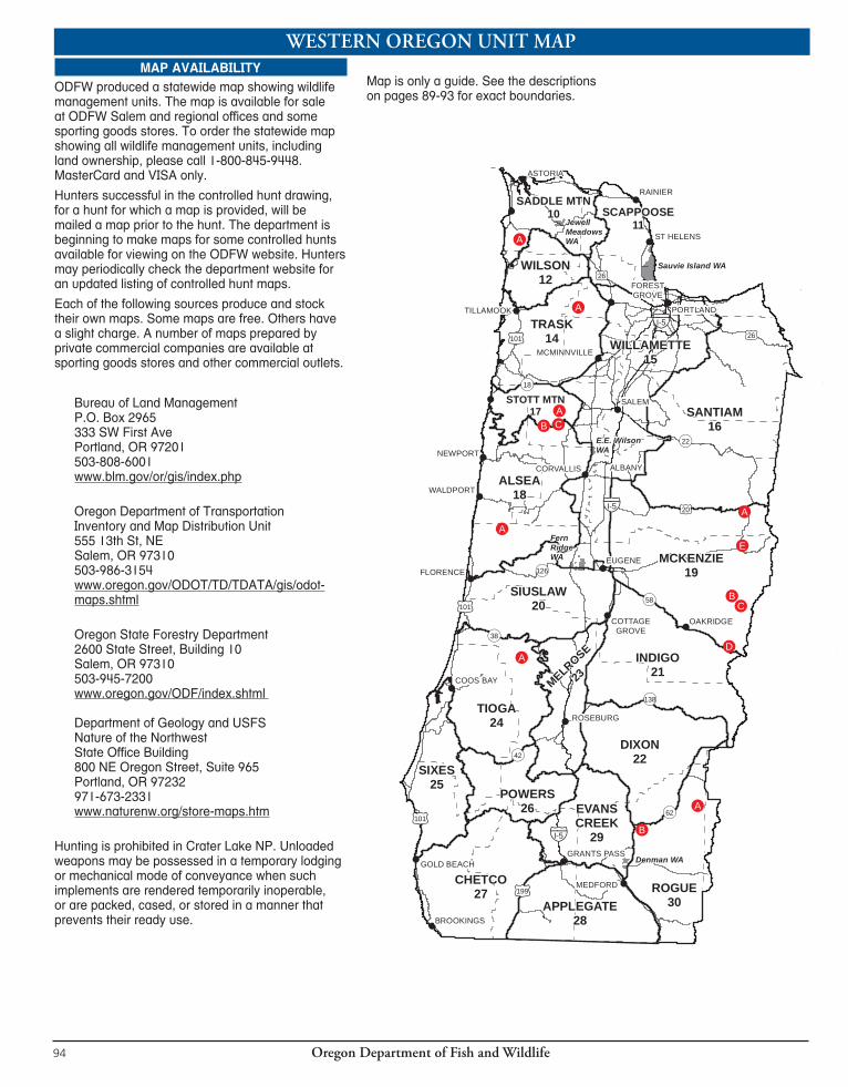
Oregon Department of Fish and Wildlife94
WESTERN OREGON UNIT MAPMAP AVAILABILITY
ODFW produced a statewide map showing wildlife management units. The map is available for sale at ODFW Salem and regional offices and some sporting goods stores. To order the statewide map showing all wildlife management units, including land ownership, please call 1-800-845-9448. MasterCard and VISA only.
Hunters successful in the controlled hunt drawing, for a hunt for which a map is provided, will be mailed a map prior to the hunt. The department is beginning to make maps for some controlled hunts available for viewing on the ODFW website. Hunters may periodically check the department website for an updated listing of controlled hunt maps.
Each of the following sources produce and stock their own maps. Some maps are free. Others have a slight charge. A num ber of maps pre pared by private com mer cial companies are avail able at sporting goods stores and other commercial outlets.
Bureau of Land ManagementP.O. Box 2965333 SW First AvePortland, OR 97201503-808-6001www.blm.gov/or/gis/index.php
Oregon Department of TransportationInventory and Map Distribution Unit555 13th St, NESalem, OR 97310503-986-3154www.oregon.gov/ODOT/TD/TDATA/gis/odot-maps.shtml
Oregon State Forestry Department2600 State Street, Building 10Salem, OR 97310503-945-7200www.oregon.gov/ODF/index.shtml
Department of Geology and USFSNature of the NorthwestState Office Building800 NE Oregon Street, Suite 965Portland, OR 97232971-673-2331www.naturenw.org/store-maps.htm
Hunting is prohibited in Crater Lake NP. Unloaded weap ons may be possessed in a temporary lodg ing or mechanical mode of conveyance when such implements are rendered tem po rari ly in op era ble, or are packed, cased, or stored in a manner that prevents their ready use.
Map is only a guide. See the descriptions on pages 89-93 for exact boundaries.
!
!
!
!
!!!
!
!
!
!
!
!
!
!
!
!
!
!
!
!
!
!
!
!
!
!
!
!
!
!D
!B
!A
!A
!A
!B !C
!A
!A
!B!C
!E!A
!A
Sauvie Island WA
FernRidgeWA
JewellMeadowsWA
E.E. WilsonWA
Denman WA
SALEM
EUGENE
ALBANY
MEDFORD
NEWPORT
RAINIER
ASTORIA
COOS BAY
ROSEBURG
OAKRIDGE
FLORENCE
WALDPORT
PORTLAND
BROOKINGS
CORVALLIS
TILLAMOOK
GOLD BEACHGRANTS PASS
MCMINNVILLE
FORESTGROVE
COTTAGEGROVE
SANTIAM16
ALSEA18
DIXON22
WILLAMETTE15
CHETCO27 ROGUE
30
TRASK14
SIXES25
APPLEGATE28
WILSON12
INDIGO21
MCKENZIE19
TIOGA24
SIUSLAW20
MELROSE
23
POWERS26 EVANS
CREEK29
SCAPPOOSE11
SADDLE MTN10
STOTT MTN17
ST HELENS
£¤26
£¤26
£¤20
!(58
!(22
!(18
!(42
!(126
§̈¦I-5
§̈¦I-5
!(138
!(62
!(38
£¤199
£¤101
£¤101
£¤101§̈¦I-5
0 10 20 30 40Miles
¯
Oregon Department of Fish and Wildlife 95
!
!
!
!
!!!
!
!
!
!
!
!
!
!
!
!
!
!
!
!
!
!
!
!
!
!
!
!
!
!D
!B
!A
!A
!A
!B !C
!A
!A
!B!C
!E!A
!A
Sauvie Island WA
FernRidgeWA
JewellMeadowsWA
E.E. WilsonWA
Denman WA
SALEM
EUGENE
ALBANY
MEDFORD
NEWPORT
RAINIER
ASTORIA
COOS BAY
ROSEBURG
OAKRIDGE
FLORENCE
WALDPORT
PORTLAND
BROOKINGS
CORVALLIS
TILLAMOOK
GOLD BEACHGRANTS PASS
MCMINNVILLE
FORESTGROVE
COTTAGEGROVE
SANTIAM16
ALSEA18
DIXON22
WILLAMETTE15
CHETCO27 ROGUE
30
TRASK14
SIXES25
APPLEGATE28
WILSON12
INDIGO21
MCKENZIE19
TIOGA24
SIUSLAW20
MELROSE
23
POWERS26 EVANS
CREEK29
SCAPPOOSE11
SADDLE MTN10
STOTT MTN17
ST HELENS
£¤26
£¤26
£¤20
!(58
!(22
!(18
!(42
!(126
§̈¦I-5
§̈¦I-5
!(138
!(62
!(38
£¤199
£¤101
£¤101
£¤101§̈¦I-5
0 10 20 30 40Miles
¯
Note: Public land ownership patterns and access are changing throughout the west as a result of executive orders and land exchanges. Contact the local ODFW, BLM, or USFS office where you will be hunting for information on changes and restrictions.
EASTERN OREGON UNIT MAP!!
!!
! !
!!
!
!!!
!
!!!!!
!!!!
!!!!!
!!
!!!!!!
!!
!
!
! !
!
!
!!!
!
!!
!
!
!
!!!
!!
!!
!
!
!!
!
!
!
!
!
!
!!
!
!
!
!
!
!
!
!
!
!!
!
!
!
!
!
!!!!
!
!
!!
!
!
!
!
!
!
!
!
! !
!
!
!!
!
!
!
!
!
!
!
!
!
!
!
!!
!
!!!
!
!
!
!!
!
!
!
!
!
!
!!
!
!
!B
!A
!A
!B
!B
!A
!A
!B
!B!C
!A
!B!A
!A!B
!B
!C
!A
!A
!A
!A
!A
!A
!C!B
!A!E!D
!C!B
!A
!A
!A
!A
!B
!A
!B
!C
!A
!A
!B
!A
!B
!B!C
!D
WHITEHORSE68
OWYHEE67
JUNIPER71
GRIZZLY38
INTERSTATE75
BEATYS BUTTE70
KENO31
SUMPTER51
BEULAH65
BIGGS43
WAGONTIRE73
PAULINA35 SILVIES
72
FOSSIL45
MALHEURRIVER
66
OCHOCO37
COLUMBIA BASIN44
FORT ROCK77
HEPPNER48
MAURY36
UKIAH49
WARNER74
STEE
NS M
TN69
NORTHSIDE47
STARKEY52
MINAM60
SPRAGUE33
KLAMATHFALLS
32
SILVER LAKE76
UPPERDESCHUTES
34
WHITERIVER
41
63KEATING
MAUPIN40
METOLIUS39
SLEDSPRINGS
57HOOD
42
MURDERERSCREEK
46
MT EMILY54
IMNAHA
61
DESOLATION50
CH
ESN
IMN
US
58
56W
ENAH
A
WARMSPRINGSINDIAN
RES..
SNAKERIVER
59
PINECREEK
62LOOKOUTMTN
64
WALLAWALLA
55
CATHERIN
E
CREEK
53
Phillip P.Schneider
WA
Summer Lake WA
White RiverWA
BridgeCreek
WA
Wenaha WA
ElkhornWA
LaddMarsh
WA
KlamathWA
Lower DeschutesWA
VALEBEND
MORO
SPRAY
NYSSA
ELGIN
HINESBURNS
DUFUR
FOSSIL
CONDON
MADRAS
MAUPIN
BONANZA
MITCHEL
ONTARIO
HEPPNER
PAISLEY
REDMONDSISTERS
CRESCENT
DAYVILLE
MONUMENT
UMATILLA
BOARDMAN
LAKEVIEW
LA GRANDE
HERMISTON
HUNTINGTON
ENTERPRISEPILOT ROCK
PRINEVILLE
THE DALLES
HOOD RIVER
CANYON CITY
PRAIRIECITY
JORDAN VALLEY
BAKER
JOSEPH
SHANIKO
ANTELOPE
PENDLETON
KLAMATH FALLS
Riverside WA
CRATERLAKE
NP
£¤97
IrrigonWA
£¤26
£¤20
£¤20
£¤395
£¤395
£¤97
§̈¦84
§̈¦84
£¤95
£¤95
!(78
!(205
!(31
!(19
£¤26
£¤395
£¤97
!(3
UMATILLA INDIANRESERVATION
0 10 20 30 40Miles
¯
Reservation and National Park
!ACooperative Travel Management Areas(approx. location)Wildlife Management Units
Highways
County Boundaries
Wildlife Areas (WA)
!!
!!
! !
!!
!
!!!
!
!!!!!
!!!!
!!!!!
!!
!!!!!!
!!
!
!
! !
!
!
!!!
!
!!
!
!
!
!!!
!!
!!
!
!
!!
!
!
!
!
!
!
!!
!
!
!
!
!
!
!
!
!
!!
!
!
!
!
!
!!!!
!
!
!!
!
!
!
!
!
!
!
!
! !
!
!
!!
!
!
!
!
!
!
!
!
!
!
!
!!
!
!!!
!
!
!
!!
!
!
!
!
!
!
!!
!
!
!B
!A
!A
!B
!B
!A
!A
!B
!B!C
!A
!B!A
!A!B
!B
!C
!A
!A
!A
!A
!A
!A
!C!B
!A!E!D
!C!B
!A
!A
!A
!A
!B
!A
!B
!C
!A
!A
!B
!A
!B
!B!C
!D
WHITEHORSE68
OWYHEE67
JUNIPER71
GRIZZLY38
INTERSTATE75
BEATYS BUTTE70
KENO31
SUMPTER51
BEULAH65
BIGGS43
WAGONTIRE73
PAULINA35 SILVIES
72
FOSSIL45
MALHEURRIVER
66
OCHOCO37
COLUMBIA BASIN44
FORT ROCK77
HEPPNER48
MAURY36
UKIAH49
WARNER74
STEE
NS M
TN69
NORTHSIDE47
STARKEY52
MINAM60
SPRAGUE33
KLAMATHFALLS
32
SILVER LAKE76
UPPERDESCHUTES
34
WHITERIVER
41
63KEATING
MAUPIN40
METOLIUS39
SLEDSPRINGS
57HOOD
42
MURDERERSCREEK
46
MT EMILY54
IMNAHA
61
DESOLATION50
CH
ESN
IMN
US
58
56W
ENAH
A
WARMSPRINGSINDIAN
RES..
SNAKERIVER
59
PINECREEK
62LOOKOUTMTN
64
WALLAWALLA
55
CATHERIN
E
CREEK
53
Phillip P.Schneider
WA
Summer Lake WA
White RiverWA
BridgeCreek
WA
Wenaha WA
ElkhornWA
LaddMarsh
WA
KlamathWA
Lower DeschutesWA
VALEBEND
MORO
SPRAY
NYSSA
ELGIN
HINESBURNS
DUFUR
FOSSIL
CONDON
MADRAS
MAUPIN
BONANZA
MITCHEL
ONTARIO
HEPPNER
PAISLEY
REDMONDSISTERS
CRESCENT
DAYVILLE
MONUMENT
UMATILLA
BOARDMAN
LAKEVIEW
LA GRANDE
HERMISTON
HUNTINGTON
ENTERPRISEPILOT ROCK
PRINEVILLE
THE DALLES
HOOD RIVER
CANYON CITY
PRAIRIECITY
JORDAN VALLEY
BAKER
JOSEPH
SHANIKO
ANTELOPE
PENDLETON
KLAMATH FALLS
Riverside WA
CRATERLAKE
NP
£¤97
IrrigonWA
£¤26
£¤20
£¤20
£¤395
£¤395
£¤97
§̈¦84
§̈¦84
£¤95
£¤95
!(78
!(205
!(31
!(19
£¤26
£¤395
£¤97
!(3
UMATILLA INDIANRESERVATION
0 10 20 30 40Miles
¯
Reservation and National Park
!ACooperative Travel Management Areas(approx. location)Wildlife Management Units
Highways
County Boundaries
Wildlife Areas (WA)
White RiverWMA
A
97
19
A
ElkhornWMA
A
BCA
ABC
D AB
A BC
BA
A
BA
AA
A
B
B
AA
BC
AB
C
A
AA
B
Summer Lake WMA
Phillip W. Schneider
WMA
AB C
DE Ladd
MarshWMA
BridgeCreekWMA
WARM SPRINGS
TRIBALRESERVATION
UMATILLA TRIBAL RESERVATION Wenaha WMAIrrigonWMA
95
95
395205
20395
31
97
20
26
Lower Deschutes WMA
19
395
3
84
84
26
B
A
WHITEHORSE68
JUNIPER71
OWYHEE67
BEULAH65
WAGONTIRE73
PAULINA35
SILVIES72
GRIZZLY38
INTERSTATE75
OCHOCO37
MALHEUR RIVER66
KENO31 BEATYS BUTTE
70
SUMPTER 51
FORT ROCK77
MAURY36
46MURDERERS
CREEK
BIGGS43
FOSSIL45
COLUMBIA BASIN44
STEENS MTN69
HEPPNER48
UKIAH49
WARNER74
NORTHSIDE47
STARKEY52
MINAM60
MT EMILY54
SPRAGUE33
KLAMATHFALLS
32
SILVER LAKE76
WHITE RIVER
41
UPPERDESCHUTES
34
MAUPIN40
63KEATING
METOLIUS39
HOOD42
57SLED SPRINGS
IMNAHA61
DESOLATION50
CHESNIMNUS58
56W
ENAH
A
CATHERINE CR53
LOOKOUTMTN
64
PINE CREEK62
WALLA WALLA
55SNAKERIVER59
VALE
IONE
BEND
MORO
SPRAY
NYSSA
UNITY
BAKER
ELGIN
UKIAH
HINESBURNS
RUFUS
WASCO
DUFUR
FOSSIL
OWYHEE
HAINES
CONDON
CULVER
MADRAS
MAUPIN
MITCHEL
SUMPTER
LOSTINE
HEPPNER
IRRIGON
PAISLEY
SISTERS
DAYVILLE
MONUMENT
BOARDMAN
LONEROCK
ANTELOPE
CHILOQUIN
LA GRANDE
PENDLETON
LEXINGTON
ARLINGTON
HUNTINGTON
LONG CREEK
ENTERPRISEPILOT ROCK
PRINEVILLE
THE DALLES
HOOD RIVER
PRAIRIE CITY
NORTH POWDER
JORDAN VALLEY
SHANIKO
HERMISTON
UMATILLA
WALLOWA
HALFWAY
GRANITE
JOHN DAY
LAKEVIEWKLAMATH FALLS
BONANZA
METOLIUS
JOSEPH
Wildlife Management Units
Reservation and National Park
Wildlife Management Areas (WMA)
Highways
County Boundaries
A Cooperative Travel Management Areas(approx. location) See pages 96-97
10 0 10 20Miles
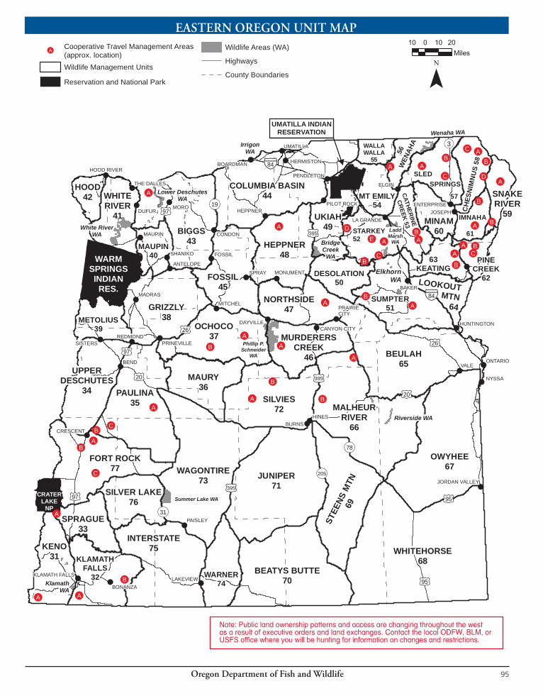
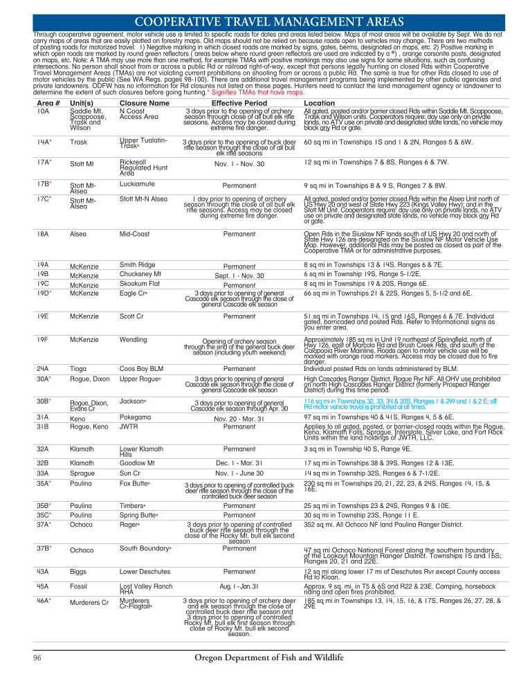
Oregon Department of Fish and Wildlife96
Through cooperative agreement, motor vehicle use is limited to specific roads for dates and areas listed below. Maps of most areas will be available by Sept. We do not carry maps of areas that are easily plotted on forestry maps. Old maps should not be relied on because roads open to vehicles may change. There are two methods of posting roads for motorized travel: 1) Negative marking in which closed roads are marked by signs, gates, berms, designated on maps, etc. 2) Positive marking in which open roads are marked by round green reflectors ( areas below where round green reflectors are used are indicated by a •) , orange carsonite posts, designated on maps, etc. Note: A TMA may use more than one method, for example TMAs with positive markings may also use signs for some situations, such as confusing intersections. No person shall shoot from or across a public Rd or railroad right-of-way, except that persons legally hunting on closed Rds within Cooperative Travel Management Areas (TMAs) are not violating current prohibitions on shooting from or across a public Rd. The same is true for other Rds closed to use of motor vehicles by the public (See WA Regs. pages 98-100). There are additional travel management programs being implemented by other public agencies and private landowners. ODFW has no information for Rd closures not listed on these pages. Hunters need to contact the land management agency or landowner to determine the extent of such closures before going hunting.* Signifies TMAs that have maps.
Area # Unit(s) Closure Name Effective Period Location10A Saddle Mt,
Scappoose, Trask and Wilson
N CoastAccess Area
3 days prior to the opening of archery season through close of all bull elk rifle seasons. Access may be closed during
extreme fire danger.
All gated, posted and/or barrier closed Rds within Saddle Mt, Scappoose, Trask and Wilson units. Cooperators require: day use only on private lands, no ATV use on private and designated state lands, no vehicle may block any Rd or gate.
14A* Trask Upper Tualatin-Trask• 3 days prior to the opening of buck deer
rifle season through the close of all bull elk rifle seasons
60 sq mi in Townships 1S and 1 & 2N, Ranges 5 & 6W.
17A* Stott Mt Rickreall Regulated Hunt Area
Nov. 1 - Nov. 30 12 sq mi in Townships 7 & 8S, Ranges 6 & 7W.
17B* Stott Mt-Alsea
Luckiamute Permanent 9 sq mi in Townships 8 & 9 S, Ranges 7 & 8W.
17C* Stott Mt-Alsea
Stott Mt-N Alsea 1 day prior to opening of archery season through the close of all bull elk rifle seasons. Access may be closed
during extreme fire danger.
All gated, posted and/or barrier closed Rds within the Alsea Unit north of US Hwy 20 and west of State Hwy 223 (Kings Valley Hwy); and in the Stott Mt Unit. Cooperators require: day use only on private lands, no ATV use on private and designated state lands, no vehicle may block any Rd or gate.
18A Alsea Mid-Coast Permanent Open Rds in the Siuslaw NF lands south of US Hwy 20 and north of State Hwy 126 are designated on the Siuslaw NF Motor Vehicle Use Map. However, additional Rds may be posted as closed as part of the Cooperative TMA or for administrative purposes.
19A McKenzie Smith Ridge Permanent 8 sq mi in Townships 13 & 14S, Ranges 6 & 7E.19B McKenzie Chucksney Mt Sept. 1 - Nov. 30 6 sq mi in Township 19S, Range 5-1/2E.19C McKenzie Skookum Flat Permanent 8 sq mi in Townships 19 & 20S, Range 6E.19D* McKenzie Eagle Cr• 3 days prior to opening of general
Cascade elk season through the close of general Cascade elk season
66 sq mi in Townships 21 & 22S, Ranges 5, 5-1/2 and 6E.
19E McKenzie Scott Cr Permanent 51 sq mi in Townships 14, 15 and 16S, Ranges 6 & 7E. Individual gated, barricaded and posted Rds. Refer to informational signs as you enter area.
19F McKenzie Wendling Opening of archery season through the end of the general buck deer
season (including youth weekend)
Approximately 185 sq mi in Unit 19 northeast of Springfield, north of Hwy 126, east of Marcola Rd and Brush Creek Rds, and south of the Calapooia River Mainline. Roads open to motor vehicle use will be marked with orange road markers. Access may be closed due to fire danger.
24A Tioga Coos Bay BLM Permanent Individual posted Rds on lands administered by BLM.
30A* Rogue, Dixon Upper Rogue• 3 days prior to opening of general Cascade elk season through the close of
general Cascade elk season
High Cascades Ranger District, Rogue Rvr NF. All OHV use prohibited on north High Cascades Ranger District (formerly Prospect Ranger District) during this time period.
30B* Rogue, Dixon, Evans Cr
Jackson• 3 days prior to opening of general Cascade elk season through Apr. 30
116 sq mi in Townships 32, 33, 34 & 35S, Ranges 1 & 2W and 1 & 2 E; off Rd motor vehicle travel is prohibited at all times.
31A Keno Pokegama Nov. 20 - Mar. 31 97 sq mi in Townships 40 & 41S, Ranges 4, 5 & 6E.31B Rogue, Keno JWTR Permanent Applies to all gated, posted, or barrier-closed roads within the Rogue,
Keno, Klamath Falls, Sprague, Interstate, Silver Lake, and Fort Rock Units within the land holdings of JWTR, LLC.
32A Klamath Lower Klamath Hills
Permanent 3 sq mi in Township 40 S, Range 9E.
32B Klamath Goodlow Mt Dec. 1 - Mar. 31 17 sq mi in Townships 38 & 39S, Ranges 12 & 13E.
33A Sprague Sun Cr Nov. 1 - June 30 14 sq mi in Township 32S, Ranges 6 & 7-1/2E.
35A* Paulina Fox Butte• 3 days prior to opening of controlled buck deer rifle season through the close of the
controlled buck deer season
230 sq mi in Townships 20, 21, 22, 23, & 24S, Ranges 14, 15, & 16E.
35B* Paulina Timbers• Permanent 25 sq mi in Townships 23 & 24S, Ranges 9 & 10E.35C* Paulina Spring Butte• Permanent 30 sq mi in Township 23S, Range 11 E.37A* Ochoco Rager• 3 days prior to opening of controlled
buck deer rifle season through the close of the Rocky Mt. bull elk second
season
352 sq mi. All Ochoco NF land Paulina Ranger District.
37B* Ochoco South Boundary• Permanent 47 sq mi Ochoco National Forest along the southern boundary of the Lookout Mountain Ranger District. Townships 15 and 16S; Ranges 20, 21 and 22E.
43A Biggs Lower Deschutes Permanent 12 sq mi along lower 17 mi of Deschutes Rvr except County access Rd to Kloan.
45A Fossil Lost Valley Ranch RHA
Aug. 1 - Jan. 31 Approx. 9 sq. mi. in T5 & 6S and R22 & 23E. Camping, horseback riding and open fires prohibited.
46A* Murderers Cr Murderers Cr-Flagtail•
3 days prior to opening of archery deer and elk season through the close of controlled buck deer rifle season and 3 days prior to opening of controlled
Rocky Mt. bull elk first season through close of Rocky Mt. bull elk second
season.
185 sq mi in Townships 13, 14, 15, 16, & 17S, Ranges 26, 27, 28, & 29E
COOPERATIVE TRAVEL MANAGEMENT AREAS
Oregon Department of Fish and Wildlife 97
Area # Unit(s) Closure Name Effective Period Location47A* Northside Camp Cr• 3 days prior to opening of controlled buck
deer rifle season through the close of controlled buck deer rifle season and 3
days prior to opening of controlled Rocky Mt. bull elk first season through close of
Rocky Mt. bull elk second season
54 sq mi in Townships 10, 11, & 12S, Ranges 31, 32, & 33E.
48A* Heppner, Fossil Heppner Regulated Hunt Area
Year-round unless posted otherwise Approx. 63 sq mi in Townships 2, 3, 4, 6, & 7S, Ranges 25, 26, 27, & 28E. Open fires and camping prohibited in posted areas.
49A Ukiah Meacham 3 days prior to opening of archery season through May 31
Approx. 41 sq. mi in Units 49, 52, and 54 in townships 1 & 2 south, township 1 north, ranges 34, 35, and 36 east.
51A* Sumpter Dark Canyon• 3 days prior to opening of controlled buck deer season through the close of the last
elk season
20 sq mi in Townships 11 & 12S, Ranges 40 & 41E.
51B* Sumpter Patrick Cr• 3 days prior to opening of controlled buck deer season through the close of the last elk season and May 1 through June 30
8 sq mi in Townships 10 & 11S, Ranges 35-1/2 & 36E.
52A* Starkey Clear C• 3 days prior to opening of Rocky Mt. bull elk first season through close of Rocky
Mt. bull elk second season
23 sq mi in Township 5S, Ranges 37 & 38E.
52B* Starkey Trail Cr• See 52A effective period 29 sq mi in Townships 6 & 7S, Ranges 35-1/2 & 36E.
52C* Starkey Indian Cr-Gorham Butte•
See 52A effective period 24 sq mi in Townships 6 & 7S, Ranges 36 & 37E.
52D* Starkey Starkey Exp Forest Enclosure
Permanent 40 sq mi in Townships 3 & 4S, Range 34E.
52E* Starkey Dry Beaver-Ladd Canyon•
Permanent 125 sq mi in Townships 4, 5, & 6S, Ranges 35, 36, 37, & 38E.
53A Catherine Cr Hall Ranch 3 days prior to the opening of Rocky Mt. bull elk first season through Apr. 30
3 sq mi in Township 5S, Range 41E.
53B* Catherine Cr Little Catherine Cr• 3 days prior to opening of archery season through May 31
22 sq mi in Townships 3, 4 & 5S, Range 40 & 41E.
56A Walla Walla, Wenaha, Mt Emily
Walla Walla, Wenaha, Mt Emily
Permanent All gated, posted and closed Rds in Walla Walla Ranger District of Umatilla NF.
57A* Sled Springs Noregaard 3 days prior to opening of archery season through May 31
175 sq mi in west one-third of Sled Springs WMU
NOTE: Gates will be open to permit removal of camping equipment during the two days following the end of the antlerless elk rifle season.57B* Sled Springs Shamrock 3 days prior to opening of archery season
through May 3120 sq mi in Township 4 N, Range 44E.
57C* Sled Springs Whiskey Cr 3 days prior to opening of archery season through May 31
45 sq. mi. in Townships 2 & 3 N, Ranges 43, 44, & 45E.
58A* Chesnimnus Chesnimnus• 3 days prior to Chesnimnus rifle bull season through end of Chesnimnus rifle bull season
That part of Chesnimnus Unit in Wallowa-Whitman NF.
58B* Chesnimnus Cemetery Ridge Ridge Rd•
Permanent Cemetery Ridge Rd north of the south boundary of Section 4, Township 3N, Range 48E.
58C* Chesnimnus Wildhorse Ridge-Teepee Butte*
3 days prior to opening of archery season through end of elk rifle season
Posted and gated Rds N of 46 Rd in Chesnimnus Unit closed.
58D Chesnimnus, Imnaha, Snake Rvr, Pine Cr
Hells Canyon National Recreation Area
Permanent Those parts of Chesnimnus, Imnaha, Snake Rvr & Pine Cr units in Eastern Wallowa Co that are closed by the National Recreation Area.
59A Snake River Lord Flat Trail (#1774)
3 days prior to opening of archery season through the end of all elk rifle seasons
15 mi of Rd in Townships 1 S , 1 & 2 N, Ranges 49 & 50E.
59B Snake River PO Saddle Rd 3 days prior to opening of archery season through June 15th
3 mi of Rd in Townships 3 & 4S, Range 48E.
61A* Imnaha Grouse-Lick Crs• 3 days prior to opening of Rocky Mt. bull elk first season through close of Rocky
Mt. bull elk second season
100 sq mi in Townships 2, 3, 4, & 5S, Ranges 46, 47,& 48E.
61B Imnaha Clear Lake Ridge 3 days prior to opening of archery season through Dec. 1
5 sq mi in Township 2 S, Range 47E, Sec. 3 & 4 and Township 1S, Range 47E, Sec. 28, 15, 33, 34, & 22.
62A* Pine Cr, Keating Mehlhorn• Permanent 26 sq mi in Township 6S, Ranges 45 & 46E.
62B* Pine Cr Lake Fork-Dutchman•
3 days prior to opening of archery season to end of all elk rifle seasons and from May 1 to July 1
42 sq mi in Township 6 & 7S, Ranges 46 & 47E.
62C* Pine Cr Okanogan-Fish• 3 days prior to opening of buck deer rifle season to end of all elk rifle seasons and
from May 1 to July 1
20 sq mi in Townships 6 & 7S, Ranges 46 & 47E.
63A* Keating Summit Point Permanent 14 sq mi in Townships 6 & 7S, Ranges 44 & 45E.63B* Keating Eagle Cr Dec. 1 - Apr. 15 17 sq mi in Townships 7 & 8S, Ranges 44 and 45E. 66A* Malheur Rvr Conroy-Cliff• 3 days prior to opening of controlled buck deer
rifle season through the close of controlled buck deer rifle season and 3 days prior to opening of controlled Rocky Mt. bull elk first season through
close of Rocky Mt. bull elk second season
46 sq mi in Townships 16, 17, & 18S, Ranges 32-1/2, 34, & 35E.
66B* Malheur Rvr Devine Ridge-Rattlesnake•
See 66A effective period 59 sq mi in Townships 20 & 21S, Ranges 31, 32, & 32-1/2E.
72A* Silvies Dairy C• See 66A effective period 98 sq mi in Townships 19, 20, 21, & 22S, Ranges 24, 25, & 26E.
72B* Silvies Burnt Cabin• See 66A effective period 22 sq mi in Townships 18 & 19S, Ranges 26 & 27E.
77A* Fort Rock Walker Rim • 3 days prior to opening of controlled buck deer season through the close of
controlled buck deer season
113 sq mi in Townships 24, 25, & 26S, Ranges 8, 9, & 10E.
77B Fort Rock N Paunina Permanent 12 sq mi in Townships 25 & 26S, Range 8E.
77C Fort Rock Sugarpine Mt Permanent 40 sq mi in Township 28, Ranges 9 & 10E.

Oregon Department of Fish and Wildlife98
Unit(s) Area Name Regulation10, 12 Jewell Wildlife Meadows
(Clatsop Co)All areas posted as “Refuge” are closed to public entry. The Beneke Tract is open to hunting only during game mammal and game bird seasons. Posted portions of the Beneke tract are closed to public entry during any open Saddle Mt. Unit elk season except for black-tailed deer hunting only during the general western Oregon rifle season with a valid unused tag. The Humbug Tract is open to hunting only during game mammal and game bird seasons. It is unlawful to shoot firearms and bows from or across open fields during any open Wilson Unit elk season.
11 Sauvie Island WA (Multnomah and Columbia Cos)
Open to bowhunt ing for black-tailed deer Aug. 30 - Sept. 28, except Oak Island (Multnomah-Columbia Co) is closed to deer hunting and Sturgeon Lk Refuge is closed to all hunting. Free daily permits are required and are available at self-service check stations located at Sauvie Island WA headquarters, Willow Bar parking lot off Reeder Rd and North Unit parking lot. Hunters must check in and out daily. Closed to deer hunting after Sept. 28. Closed to hunting for furbearers, predators, unprotected and protected wildlife (except black-tailed deer, rabbit, crow, Eurasian collared dove and game birds). Use of rifles, handguns and crossbows prohibited at all times. Parking permits are required (see page 29 for more information).
12 Gods Valley WA (Clatsop Co)
Vehicles restricted to travel on Co Rds.
14, 17 Cascade Head - Lincoln City Area (Lincoln-Tillamook Cos) (Portions of Stott Mt and Trask units)
The Cascade Head - Lincoln City Area is closed to hunting with centerfire rifles, muzzleloaders, or handguns. Hunting is restricted to archery and shotguns only during authorized seasons, except for department approved emergency hunts. Hunters using shotguns for elk shall use slugs (single projectile) only. Area boundary: Beginning at Pacific Ocean and Siletz River mouth, east along the north of shoreline of the Siletz River to Drift Cr Rd (milepost 1 on Hwy 229); north on Drift Cr Rd to Anderson Cr Rd; north on Anderson Cr Rd to Schooner Cr Rd; west on Schooner Cr Rd to Forest Rd 2200; north and east on FR 2200 to FR 1726; west on FR 1726 to FR 2100; northeast on FR 2100 to the powerline crossing; north along the powerline to State Hwy 18; west on Hwy 18 to Old Scenic Hwy 101; north on Old Scenic Hwy 101 to Three Rocks Rd; west on Three Rocks Rd to US Hwy 101; north on Hwy 101 to FR 1861; west on FR 1861 to Harts Cove trailhead; west on Harts Cove trail to the Pacific Ocean; south along the coastline to the Siletz River, point of beginning.
15 E.E. Wilson WA (Benton Co)
Open to black-tailed deer hunting during authorized seasons, except closed to archery deer hunting when youth pheasant hunts are in progress. (See Game Bird Regulations.) Rabbit hunting is permitted from Nov. 1 through Feb. 28. Hunting by permit only. Permits are available at self-service stations located on the area. Hunters must check in and out daily. Use of rifles, handguns and crossbows prohibited at all times. The possession or use of shot other than federally-approved non-toxic shot is prohibited. Non-toxic shot restrictions do not apply to big game hunting. Parking permits are required (see page 29 for more information).
15, 20 Fern Ridge WA (Lane Co)
Open to black-tailed deer hunting during authorized seasons, see current Oregon Game Bird Regulations. Free daily hunting permits are required for East Coyote, West Coyote, Fisher Butte, Royal-Amazon and Kirk Park units and are available at self-service stations located at area access points. Hunters limited to shotguns and archery equipment only; discharging rifles and handguns prohibited. Parking permits are required (see page 29 for more information).
15 William Finley NWR (Benton Co)
Portions of the refuge are open to deer hunting Aug. 24 - Sept. 22 under regulations for bowhunting seasons. Portions of the refuge are open to deer hunting by hunters with a 615 controlled hunt tag using only archery equipment from Sept. 1 - 22 and using shotguns, archery or muzzleloader from Sept. 23 - Nov. 1. Portions of the refuge are open to hunting of buck deer Sept. 28 - Oct. Nov. 1 under regulations for western Oregon gen-eral buck season. Use of rifles is prohibited. All hunters must obtain a refuge permit and check in and out daily. In for ma tion on open areas and special regu lations available at the refuge.
15 Willamette Rvr Greenway Hunting is permitted with shotguns or bows and arrows only, during authorized seasons on Willamette Rvr Corridor Greenway parcels, except in those parcels where hunting is prohibited.
15 Government Island State Recreation Area (Multnomah Co)
Oregon Parks and Recreation Department prohibits trespass above mean high water mark on their ownerships. Discharge of rifles, handguns, shotguns with slugs or buckshot, and bows is prohibited.
16 Sandy Rvr Delta (Multnomah Co)
This area, bounded by the Sandy Rvr on the west, I-84 on the south and Columbia Rvr on the north is owned and managed by the USFS. The area is closed to all hunting, except the portion of the area north and east of the BPA powerline is open to waterfowl hunting with shotgun only. Lands below the mean high water line of the Columbia Rvr or Sandy Rvr are not affected by this regulation.
18 Tami Wagner WA (Lincoln Co)
Open for wilidlife-orented public use unless otherwise excluded or restricted by the following rules: discharge of any firearm is prohibited except as authorized during game bird and game seasons, or by permit. Camping is prohibited except by permit. Unauthorized motor vehicle use is prohibited. Phone 541-867-4741.
19 Long Ranch (Linn Co) 48 acres 21 mi east of Sweet Home off Hwy 20. Closed to all hunting.20 Dunes National
Recreation AreaUse of rifles and handguns prohibited for all hunting in that part of Siuslaw Unit west of Hwy 101 and north of Tahkenitch Cr.
21, 23 North Bank Habitat Management Area (Dunning Ranch Area) (Douglas Co)
The area is closed to all big game hunting except for and during controlled hunts specific to the management area by hunters possessing a controlled hunt tag for the area. Elk hunting will be allowed by hunters who possess a valid NBHMA controlled hunt tag in addition to a valid elk tag. All BLM lands located in T25S, R5W, Sections 35, 36; T26S, R5W, Sections 1, 2, 11, 12, 13, 14; T25S, R4W, Sections 31,32, 33; T26S, R4W, Sections 4, 5, 6, 7, 8, 18 (6,500 acres located ap prox i mately 8 mi northeast of Roseburg). The use of bait for hunting game mammals is prohibited on NBHMA.
24 Dean Cr Elk Viewing Area (Douglas Co)
All Bureau of Land Management lands within or adjacent to T22S R11W (including Spruce Reach Island located adjacent to Hwy 38 and between the outlets of Koapke and Hinsdale Sloughs) are closed to hunting. Also, other lands located with in the following boundary are closed to hunting during all deer and elk seasons that pertain to this area: Beginning at the intersection of Schofield Rd. and Hwy 38, south on Schofield Rd. to it’s intersection with Hakki Ridge Rd., east on Hakki Ridge Rd. to the crest of Hakki Ridge, east along the crest of Hakki Ridge to it’s intersection with the BLM boundary located in T22S, R11W Section 4, easterly along the BLM boundary to Hwy. 38, west to Hwy. 38 to point of beginning.
25 South Slough National Estuarine Reserve
Specific areas are closed to hunting for public health and safety. Contact reserve head quar ters 541-888-5558 for map of specific closures.
25, 26, 27
Rogue Rvr Area All land within 1 mi of Rogue Rvr between Grave Cr and Lobster Cr closed to bear hunting. All land within 1/4 mi of Rogue Rvr in the wild rvr section from Grave Cr down stream to Watson Cr is closed to all hunting except during authorized seasons.
REGULATIONSFORWILDLIFEAREAS,REFUGESANDSPECIALAREAS
Oregon Department of Fish and Wildlife 99
Unit(s) Area Name Regulation29 Denman WA (Jackson
Co)Use of rifles and handguns prohibited at all times. Open to hunt ing only during game mammal and game bird seasons. All hunters must check in and out daily at self-service check stations located at area access points. Parking permits are required (see page 29 for more information)
31 Klamath WA (Klamath Co) Miller Island Unit is closed to all deer hunting. Parking permits are required (see page 29 for more information).
31 Bear Valley NWR (Klamath Co)
Closed to all public entry except walk-in deer hunting prior to Nov. 1. Closed to all motor vehicle use year round. 6 sq. mi. in T40S, R7 and 8E.
32 Lost Rvr Winter Range Closed to all motor vehicle use Dec. 1 - Apr. 15. 6 sq mi in T39S, R11, 11-1/2 and 12E.
32 Bryant Mt Closed to all motor vehicle use Nov. 1 - Apr. 15. 50 sq. mi. in T39, 40 and 41S, R12 and 13E.
33, 77 Klamath Marsh NWR Closed to all deer and elk hunting.34 Tumalo Winter Range Closed to all motor vehicle use Dec. 1 - Mar. 31. 125 sq mi in T15, 16, 17, 18 and 19S, R10, 11E.35 Newberry Crater Wildlife
Refuge (Deschutes Co)All hunting, injuring, taking, killing, or destroying any wild bird or mammal on public land is prohibited within the rim of Newberry Crater in: T21S, R12E; T22S R12E; T21S, R13E; T22S, R13E (approximately 15 sq mi).
36,37 Prineville Reservoir WA(Crook Co.)
Open to public access and hunting of big game and game birds during authorized seasons. Motorized vehicle travel is restricted to designated open roads. This area is closed to motorized vehicle access from Nov. 15 or Dec. 1 as posted at each gate through April 15 annually. That part of the Ochoco and Maury Unit as follows: 5 square miles in township 16S, Range 17E.
35, 76, 77
Cabin Lake-Silver Lake Winter Range
Closed to all motor vehicle use Dec. 1 - Mar. 31. 342 sq mi in T23, 24, 25, 26, 27, 28 and 29S, R11, 12, 14, 15 and 16E.
38 Rimrock Springs WA Closed to all hunting.38, 43, 45, 47
John Day Fossil Beds National Monument
Closed to all hunting and trapping.
39 Metolius Wildlife Refuge (Jefferson Co)
All hunting, injuring, taking, killing, or destroying any wild bird or mammal on public land is prohibited within T12 and T13S, R9E, bounded by FR 1420 and 1419 on the west, FR 1400 on the south and east and FR 1420-400, Metolius Rvr and posted boundary from Metolius Rvr to Rd 1400 on the north. (36 CFR 261.58(v)). (approx. 5 sq mi)
39 Metolius Winter Range Closed to all motor vehicle use Dec. 1 - Mar. 31. 101 sq. mi. in T11, 12,13 and 14S, R11 and 12E.
41 White Rvr WA Motor vehicles are prohibited except on parking areas, designated campsites, and open roads. No cross country travel or off road motor vehicle use is allowed, except by permit or for administrative use. ATV/OHV and snowmobile use are prohibited on all area lands except for administrative use or by permit. Camping is prohibited except in designated campsites or by permit, and may not exceed 14 days in a 30 day period. Campfires and open burning prohibited except designated campsites. Fires are prohibited during designated fire closures. Running or training dogs is prohibited except by permit or during authorized bird hunting seasons. Parking permits are required (see page 29 for more information).
43 Lower Deschutes WA Open to hunting of big game, game birds and waterfowl during authorized seasons and by permit; except that discharge of firearms is prohibited within the Wild and Scenic waterway boundary from the third Saturday in May through August 31. Access by foot, boat, or bicycle only.
43 John Day Rvr Refuge (Sherman & Gilliam Cos)
Includes all land within 1/4-mi of the John Day Rvr mean high water line from the Columbia Rvr upstream to Thirty Mile Cr. Within this area, from the Columbia Rvr upstream to Rock Cr, the area shall be open to hunting of upland game birds during authorized seasons only between Sept. 1 - Oct. 31, but closed to all waterfowl hunting. The remaining area from Rock Cr upstream to Thirty Mile Cr is open to the hunting of all game birds during authorized seasons. Hunting of big game is allowed during authorized seasons.
44 Cold Springs Refuge (Umatilla Co)
Closed to deer and elk hunting.
44 Irrigon, Coyote Springs, and Power City (Morrow-Umatilla Cos)
Use of rifles and handguns prohibited at all times. Big game hunting is prohibited at Coyote Springs.
44 Umatilla Refuge (Morrow-Umatilla Cos)
Closed to deer and elk hunting except by permit during controlled hunts or emergency hunts specific to the refuge.
44 Willow Cr WA Open to hunting of big game and game birds during authorized seasons.45 Lost Valley Ranch RHA Open to public access and hunting Aug. 1 to Jan. 31. Camping, horseback riding and open fires prohibited. Closed to
all motor vehicle use unless posted otherwise. Approx. 9 sq. mi. in T5 & 6S and R22 & 23E.45, 48 Heppner RHA Open fires and camping prohibited in posted areas. Approx. 63 sq mi in T2, 3 and 5S and R25, 26 27 and 28E.
Closed to all motor vehicle use year-round unless posted otherwise.46 Phillip W Schneider WA
(Grant Co.)Open to public access and hunting Apr. 15 - Jan. 31. Motorized vehicle travel restricted to open rds. Some rds closed seasonally from Dec. 1 - Apr. 14. Entry by permit only Feb. 1 - Apr. 14; including BLM land within exterior boundaries of the area. Parking permits are required (see page 29 for more information).
49 Bridge Cr WA Open to public access and hunting Apr. 15 - Nov. 30. Motorized vehicle travel restricted to open rds. Entry by permit only Dec. 1 - Apr. 14. 20 sq mi in Townships 5 & 6S, Ranges 31 & 32E in southwest corner of Ukiah Unit.
49 McKay Cr Refuge (Umatilla Co)
Closed to deer and elk hunting.
51, 52 Elkhorn WA (Baker-Union Cos)
Open to public access Apr. 11 - Nov. 30, or by permit. Roth Tract closed to all hunting; an entry permit is required at all times of the year. Motorized vehicle travel restricted to open rds. Permanent Rd closure: 7 sq mi in T6S, R38E. ATV and snowmobile use is prohibited on all area lands except for administrative use or by permit.
52 Ladd Marsh WA (Union Co)
All land north and east of Foothill Rd is closed to rifle and handgun shooting and closed to deer and elk hunting except for youth deer hunts (652T1 and 652T2). Big game hunting will be allowed on Ladd Marsh WA as authorized by the Department. All lands west of Foothill Rd are closed to all entry Feb. 1- Mar. 31, except by permit. Parking permits are required (see page 29 for more information).
52 Starkey Experimental Forest Enclosure (Union Co)
A posted 1/4-mi wide buffer zone on NF surrounding the Experimental Forest enclosure is closed to all hunting with a centerfire rifle or bow. The enclosure is open to deer and elk hunting only by permit during controlled hunts. The main study area is open to hunting of other species during authorized seasons. The 12-foot right-of-way along each side of all 8-foot-high perimeter and internal game fences is closed to all motorized travel. Public entry is allowed only through the main gate. The Experimental Forest is closed to all public entry during the winter closure, which runs from Nov. 15 - April 30. Big game auction and raffle tag holders are not eligible to hunt in this area.
52 Spring Cr Winter Range Closed to all motor vehicle use Dec. 15 - Apr. 30. 14 sq mi in T2 and 3S, R36E.52 McCarty Winter Range Closed to all motor vehicle use Dec. 15 - Mar. 31. 12 sq mi in T4 and 5S, R34 and 35E.
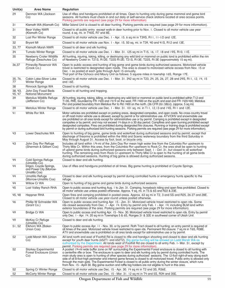

Oregon Department of Fish and Wildlife100
When a game mammal or part thereof is transferred to the possession of another person, a written record (use form below) describing the game mammal or part being transferred indicating the name and address of the person whose tag was originally attached to the carcass and the number of that tag shall accompany such transfer and shall remain with such game mammal or part so long as the same is preserved.
WILDLIFE TRANSFER RECORD FORMHunter/Person transferring wildlife:
Name:______________________________________________________________________________________Phone: __________________________________________
Address: _______________________________________________________________
License #: ____________________________________________________________ Tag #:
Harvest Location (including Wildlife Management Unit): ________
Harvest Date: _________________________________________________________
Signature ____________________________________________________________
Species being transferred:Bear p Elk p
Bighorn Sheep p Mt Goat p
Cougar p Pronghorn Antelope pDeer p Other p _________________________________________________________________________________ (list species)Indicate:Entire carcass p Parts p _________________________________________________________________________________
Number of antler points (list parts)
Transferred to:
Name: _ _ _ _ _ _ _ _ _ _ _ _ _ _ _ _ _ _ _ _ _ _ _ _ _ _ _ _ _ _ _ _ _ _ _ _ _ _ _ _ _ _ _ _ _ _ _ _ _ _ _ _ _ _ _ _ _ _ _ _ _ _ _ _ _ _ _ _ _ _ _ _ _ _ _ _ _ _ _ _ _ _ _ Phone: _________________________________________________
Address: ____________________________________________________________________________________________________________________________________________
INSTRUCTIONS FOR A WILDLIFE TRANSFER RECORD
Unit(s) Area Name Regulation55 Mill Cr Watershed
(Umatilla Co)Closed to all access and hunting except during specific hunt dates by USFS permit and ODFW controlled hunt tag (155B, or 255A). Entry at any other time is prohibited. Each tag holder will be permitted to have one person accompany them during the hunt. After the kill, one person for 155B tag holder or three people for 255A tag holders may assist in removing your animal.
56 Wenaha WA (Wallowa Co)
Open to public access and hunting. Motorized vehicle travel restricted to open rds. Permanent Rd closure: 17 sq mi in T5 and 6N, R42 and 43E along eastern edge of Umatilla Forest in northeast corner of Wenaha Unit.
60 Enterprise Wildlife Area (Wallowa Co)
Open to hunting seven days a week. No entry permit is required. Posted portions of the area lying south of the Union Pacific Railroad line and the entire Marr Tract are closed to all hunting.
60 Wallowa Lake (Wallowa Co)
All land on or within 1/4-mi of Wallowa Rvr from Wallowa Lk upstream to the falls and within 1/4-mi on the west side of Wallowa Lk from Wallowa Lk State Park to Wallowa Rvr outlet is closed to all big game hunting.
65, 67 Snake Rvr Islands (Malheur Co)
Closed to hunting with centerfire rifles and centerfire handguns.
71 Malheur NWR (Harney Co)
Parts of the refuge in Blitzen Valley west of State Hwy 205 are open during authorized deer and pronghorn antelope seasons.
70, 71 Hart Mt NAR (Lake Co) Parts of the refuge will be open for hunting as prescribed under chukar season, controlled pronghorn antelope, bighorn sheep, deer bowhunting and muzzleloader deer. The refuge is open for pronghorn antelope Mandatory Reporting Incentive tag holders, and pronghorn and bighorn sheep auction and raffle tag holders, but is closed for A&H auction and raffle and Mandatory Reporting Incentive deer and elk tag holders. Information on open areas and special regulations are available at the refuge (541-947-2731).
73 Summer Lake WA (Lake Co)
Portions of the Area are open to public access and hunting during authorized mule deer and game bird hunting seasons. It is unlawful to discharge firearms except during deer and game bird hunting seasons or by permit. Centerfire rifles and handguns are prohibited for deer hunting. Closed to deer hunting with firearms during any pheasant, quail or waterfowl hunting seasons east of State Hwy. 31 and posted refuges areas are closed to hunting. Motorized vehicle travel restricted to open rds and some rds may be closed prior to and during waterfowl hunting seasons. Hunters must obtain a daily hunting permit and check out at the end of the day. Permits and Area maps are available at Headquarters (1.1 mi south of the town of Summer Lake). Parking permits are required (see page 29 for more information). Please note: The area south of Thousand Springs Lane (Lake Co. Road 4-17), except the Foster Place unit and specfied open rds and campgrounds may be closed to access seven days prior to general waterfowl hunting seasons.
75 Lost Rvr Winter Range Closed to all motor vehicle use Dec. 1 - Apr. 15. 6 sq mi in T41S and R14E.
REGULATIONSFORWILDLIFEAREAS,REFUGESANDSPECIALAREAS(CONT.)

GuncrafterSFirearms & More
Doug RaafOPEN
Mon. - Sat.9-5 PM
Ron Redding
2305 Pringle Rd.Salem, OR 97302 (503) 362-6197
(303) 293-2882 4965 S. Broadway, Englewood, Co 80113
We will Tan them into Leather or Tan them with the Hair On
We also sell hides and make custom leather products!
BEST TIRE VALUE PROMISE
Free with Every Passenger Car& Light Truck Tire Purchase
OVER 445 LOCATIONS TO SERVE YOUvisit www.LesSchwab.com to find the location nearest you
Peace of MindTire ProtectionWhatever the road throws at you, from potholes to nails–any road hazard, we guarantee you’re protected
Lifetime Tire &Mileage CareTo help you get more miles out of your tires and more miles per gallon of gas
®
CALL NOW 1-800-296-6402
Outdoor businesses can advertise in the Oregon Dept. of Fish & Wildlife’s offi cial regulations!
The Oregon Hunting Regulations guide is distributed to
575,000 hunters each year!
Hunters in Oregon spend $37.3 million a year in hunting related purchases. Advertise your business in the ODFW rules books and take
advantage of a captive audience
Smart, Direct Advertising. That Works!
•Proven•Effective•Essential•Targeted
Online & In PrintOnline & In PrintHunters in Oregon spend $37.3 million a year
2012 OREGONBIG GAME REGULATIONS
www.dfw.state.or.us
Remember to Report!
Mandatory Reporting of
Harvest and Effort
See Page 43
Don’t Forget to Purchase
Your Big Game Raffle Tags!
For Auction and
Raffle Opportunities,
Please See Pages 20-23
Hunters in Oregon spend $37.3 million a year Hunters in Oregon spend $37.3 million a year
Turn in your Combined Angling Tag for a chance to WIN aFish Rite custom aluminum boat(See Page 22 for details.)
2012 OregOn SPOrT FISHIng regulaTIOnSwww.dfw.state.or.us
For ODFW Online License Sales go to:www.dfw.state.or.us/online_license_sales/index.asp
Check out the NEW scanable QR codes on page 45 that take you to our Regulations Update webpages!

--BEND • 63492 Hunnell Road • (541) 693-5000 MEDFORD • 1710 Delta Waters Road • (541) 732-3700
PORTLAND • 9401 SE 82nd Avenue • (503) 777-8700SALEM • 1260 Lancaster Drive SE • (503) 589-0800
> > > All the brands you know and trust. These and many more. < < <
A M M U N I T I O N
---> Also Shop Online at SportsmansWarehouse.com <---