2012_Wollák, K. - Raczky, P.: Large-scale preventive excavations in Hungary.
27
Heritage Management of Farmed and Forested Landscapes in Europe EAC occasional paper no. 4 Edited by Stephen Trow, Vincent Holyoak and Emmet Byrnes Large-scale excavations in Europe: Fieldwork strategies and scientific outcome EAC Occasional Paper No. 6 Edited by Jörg Bofinger and Dirk Krausse
Transcript of 2012_Wollák, K. - Raczky, P.: Large-scale preventive excavations in Hungary.
Heritage Management of Farmed and Forested Landscapes in Europe
EAC occasional paper no. 4
Edited by Stephen Trow, Vincent Holyoak and Emmet Byrnes
Heritage Management of Farmed and Forested Landscapes in Europe
Edited by Stephen Trow, Vincent Holyoak and Emmet Byrnes
Some 40 per cent of Europe is farmed and 47 per cent forested. The future of
the majority of Europe’s archaeological sites therefore depends on rural land
uses that lie outside the spatial planning and development control systems of
its various nation states. This volume, produced by the European Association of
Archaeologists (EAA) and Europae Archaeologiae Consilium (EAC) Joint Working
Group on Farming, Forestry and Rural Land Management, examines the challenges
posed by agriculture, forestry and other rural land uses in terms of the long-term
conservation of Europe’s archaeological sites and the management of its historic
landscapes.
EAC Occasional Paper No. 4
ISBN 978-963-9911-17-8
Edited by Stephen Trow,
Vincent H
olyoak and Emm
et ByrnesH
eritage M
anag
emen
t of Farm
ed an
d Fo
rested Lan
dscap
es in Eu
rop
eEA
C o
ccasion
al pap
er no
. 4
EAC4 cover.indd 1 22/11/2010 13:25:15
Large-scale excavations in Europe: Fieldwork strategies and scientific outcome
Large-scale excavations in Europe: Fieldwork strategies and scientific outcome
EAC Occasional Paper N
o. 6 Large-scale excavations in Europe
EAC Occasional Paper No. 6
Edited by Jörg Bofinger and Dirk Krausse
Edited by Jörg Bofinger and Dirk Krausse
Edited by Jörg Bofinger and Dirk Krausse
During the last decades, the number of large-scale excavations has increased significantly. Such excavations became an important element of archaeological cultural heritage management. This kind of large-area fieldwork offers not only new data, finds and additional archaeological sites, but also gives new insights into the interpretation of archaeological landscapes as a whole. Our view of the results of older excavations and our ideas on settlement structures and land use in the past has changed dramatically. New patterns concerning human “offsite activities”, e.g. field systems, or types of sites which were previously underrepresented, can only be detected by large-scale excavations. Linear projects especially, such as pipelines and motorways, offer the possibility to extrapolate and propose models of land use and environment on the regional and macro-regional scale.In consideration of these new scientific approaches, an international conference took place in Esslingen 2008 with participants from different European countries.
EAC Occasional Paper No. 6
ISBN 978-963-9911-29-1
Large-scale excavations in Europe:Fieldwork strategies and scientific outcome
EAC Occasional Paper No. 6
Proceedings of the International ConferenceEsslingen am Neckar, Germany, 7th – 8th October 2008
Edited by Jörg Bofinger and Dirk Krausse
Verband der Landesarchäologenin der Bundesrepublik
Deutschland
EAC Occasional Paper No. 6
Large-scale excavations in Europe:Fieldwork strategies and scientific outcome
Edited by Jörg Bofinger and Dirk Krausse
Cover: Excavations on the route of the EPS-pipeline in east Württemberg.Photo © Landesamt für Denkmalpflege im Regierungspräsidium Stuttgart.
ISBN 978-963-9911-29-1
Published by:Europae Archaeologia Consilium (EAC), Association Internationale sans But Lucratif (AISBL), Siège socialKoning Albert II-laan 19 Avenue Roi Albert II 19P.O. Box 10 Boîte 101210 Brussel 1210 BruxellesBelgium Belgiquewww.e-a-c.org
© The individual authors 2012
In association with:Landesamt für Denkmalpflege im Regierungspräsidium StuttgartVerband der Landesarchäologen in der Bundesrepublik Deutschland
With financial support of the Ministerium für Finanzen und Wirtschaft Baden-Württemberg
The opinions expressed in this volume are those of the individual authors, and do not necessarily represent official policy.
Brought to publication by Archaeolingua, HungaryManaging editor: Elizabeth Jerem
Copy-editing by Karen Schmitt, Lexis, Stuttgart, GermanyLayout and typesetting by Lukas Kretzschmar, Tebitron, Gerlingen, GermanyCover design by Gergely Hős
Printed by Aduprint Printing and Publishing Ltd, Hungary
Contents
Foreword 7 Marianne Schauman-Lönnqvist
Opening address 9 Jürgen Kunow
Gruß- und Vorwort 11 Dirk Krausse
1 | Die Bedeutung denkmalpflegerisch bedingter Großprojekte für die archäologische Forschung 13 Harald Stäuble
2 | Weaving Strands: Integrating excavations, landscapes and the human past along the A1 major road 23in East Lothian, Scotland
Olivia Lelong and Gavin MacGregor
3 | Routes to the past: large-scale roads excavations in the Republic of Ireland 35 Eamon Cody
4 | Des sondages systématiques et des fouilles réalisées sur de grandes superficies. 45Deux techniques au service d’un passé enseveli
Geertrui Blancquaert and Pascal Depaepe
5 | Contribution des fouilles de grande ampleur à la connaissance des campagnes de la fin de l’Âge 55du Fer et de l’époque romaine : un exemple du sud de la France, Nîmes et ses campagnes
Jean-Pierre Giraud
6 | Unveiling Bronze Age, Iron Age and native Roman communities in lower Nijmegen (the Netherlands) – 65Twelve years of excavations in a fluvial area
Peter W. van den Broeke and Eugene A.G. Ball
7 | The Ottonian margravial centre of Ename: from large-scale excavations to international regulations 85 Dirk Callebaut and Koen De Groote
8 | L’opération archéologique sur le tracé de la ligne à grande vitesse en Wallonie et plus particulièrement 103entre Hélécine et la frontière allemande. Premiers apports et interprétations
Heike Fock et Hélène Remy
9 | Large-scale preventive excavations in Hungary 115 Katalin Wollák and Pál Raczky
10 | The past and present of large-scale excavations in the Czech Republic 137 Martin Kuna and Zdeněk Smrž
11 | Die vorgeschichtliche Siedlungslandschaft am Beispiel von Großprojekten in Sachsen-Anhalt 151 Susanne Friederich
12 | Lineare Projekte in Baden-Württemberg – Erste Erfahrungen und Ergebnisse 157 Jörg Bofinger

13 | Excavations on linear projects in Bavaria – problems and strategies 173 Stefanie Berg-Hobohm
14 | Berlin Brandenburg International – the capital’s new main airport. 185Planning, excavation and results of the archaeological investigations
Sabine Eickhoff (with a contribution from Ulrich Dirks)
15 | Archäologie beim Bau der Nord-Süd Stadtbahn Köln 195 Marcus Trier
Additional conference contributions (summaries) 203
Contributors 207
115
The situation in Hungary until 1990
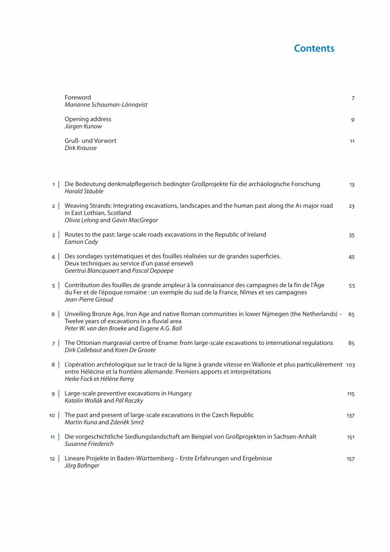
Similarly to other regions in Europe, Hungary also had to start adapting to the changes that started at the begin-ning of the 1990s. One of the important elements in this process was that following over 40 years of operations in a state-controlled legal environment, Hungarian ar-chaeology had to find its place within an ever-changing free market economy. This also meant that the expected professional standards had to be met amidst increas-ing pressures of extensive fieldwork. This situation was related with the underdeveloped state of the road net-work in Hungary and the international expectation that Hungary be an integral part of the pan-European traffic system, the so-called Helsinki Corridors (fig. 9.1). Within the framework of this project, the 350 km long mo-torway system in 1989 had to be significantly expanded. Moreover, following the transition, a new challenge was posed by private industrial developers. Archaeological preparation for this type of rescue work required a new approach, significantly different from previous practic-es. New expectations had to be met by the institutions created in the old system. These included museums at each of the country’s 19 counties and its capital, to some extent the Hungarian National Museum (hereafter Na-tional Museum) – previously in charge of archaeological excavations nationwide –, universities with departments of archaeology and the Archaeological Institute of the Hungarian Academy of Sciences (hereafter Academy In-stitute). Previously, however, these institutions had car-ried out centrally funded, planned excavations. At the beginning of the 1990s, some 200 archaeologists were employed by the network of county museums (Jankov-ich & Nagy 2004, 38). According to common practice, the
majority of those carried out excavations on surfaces of some hundreds of square meters; their field experience lay in projects within this scale.
Large-scale archaeological projects of the past eraExpertise in working over large surfaces was limited to a few excavations that tended to continue for decades, such as the project of the Fejér County Museum at the Roman Period settlement of Tác-Gorsium, where work was going on for 40 years. Projects of comparable di-mensions were carried out by the National Museum at the Copper Age site of Tiszalúc and the Academy In-stitute at the Late Neolithic settlement of Aszód-Papi földek. The Institute of Archaeological Sciences of the Eötvös Loránd University in Budapest (hereafter Uni-versity Institute) carried out research on Roman Period settlements in the Zalalövő area. According to Article 9/1963, a legal regulation valid until 1997, the costs of preventive excavations related to large, state-run investments enjoying a preferential status had to be covered from the budget of the state investment. In reality, however, excavation duties were not always fulfilled. A 1975 publication by the National Museum already called for “rescuing our vanishing ar-chaeological wealth” (Korek 1975). This wording shows that although the extent of destruction was known, no infrastructure was in place to systematically protect ar-chaeological sites except for a few that enjoyed a spe-cial, protected (scheduled) status. Positive examples include rescue work related to the immense industrial development at the “socialist city” of Dunaújváros (the former village of Dunapentele that
9 | Large-scalepreventiveexcavationsinHungaryKatalin Wollák and Pál Raczky
Fig. 9.1: Helsinki corridors.
116 EAC OCCASIONAL PAPER NO. 6
grew into the city of Sztálinváros), where industrial sites and housing projects were accompanied by proper ar-chaeological preparation (Vékony 2003; Ernyey 2003). One of the first examples of planned preventive excava-tions was the archaeological project that preceded the construction of the Tisza II hydroelectric works at the beginning of the 1970s. An area of 5–11 km width was thus uncovered at a length of 40 km before the con-struction of a water reservoir. The area was partially cov-ered by field walks carried out by the National Museum. Although not all 55 sites thus mapped were chosen for excavation, an area of 60,000 m2 was investigated during the course of a decade (Korek 1974; Jankovich 1993).Target-oriented and well-coordinated preventive exca-vations were also carried out at a section of the Dan-ube River that forms the border between Hungary and Slovakia. A hydroelectric complex was planned in the Bős/Gabčíkovo – Nagymaros region of the river. Begin-ning in 1977, a systematic site exploration program that affected three counties was coordinated by the Na-tional Museum. The methodology of the topographic research program1 carried out by the Academy Insti-tute could be profitably used in locating and evaluat-ing sites along the banks of the Danube Bend gorge, densely inhabited from prehistoric times to the Middle Ages and beyond.Sites mapped in the Esztergom area were even includ-ed in Volume 5 of the Archaeological Topography of Hun-gary devoted to Komárom County, published in 1979. The aforementioned dense inhabitation of this region is convincingly illustrated by the 30 km long section of the Roman limes along the riverbank between Eszter-gom and Nagymaros. Three military camps were found within this short distance, in addition to a chain of 23 watchtowers located at a distance of 600 m from each other. The aims of the large-scale excavations initiated at six locations in 1978 did not simply include rescue work in the area to be inundated by the river. They also had the ambitious plan to write a settlement history of “unparalleled dimensions” of the peoples who once in-habited the banks of the Danube (Fülep 1979). Several teams worked side by side, excavating surfaces of sev-eral hundred square meters simultaneously. Aside from such “green field” developments in open areas, large surface recovery was far less characteristic, for example in densely inhabited urban areas.2 No detailed inven-tory was made of the archaeological structures de-stroyed during the course of these constructions. Given the small number of sites uncovered, however, it may be presumed that archaeological rescue work was ig-nored in the case of numerous dam constructions and hydroelectric installations as well as during mining ac-tivities (Makkay 2005). Small-scale developments were even less monitored for archaeological impact.
Development and aims of the La Valletta ConventionSimilar tendencies also became apparent in other Eu-ropean countries inducing the birth of a new interna-tional organization. Instead of the failed XIth congress of UISPP, another conference was held in Southamp-ton, England, in 1986. It was entitled “Public Archaeol-ogy and Cultural Resource Management” and may be regarded as the first conference of what later became the World Archaeological Congress (WAC). Processes impacting on archaeological heritage following World War II were among the main topics of that meeting.
The wealth of cultural and archaeological heritage was discussed in terms of cultural resource management, sustainability and protection (Cleere 1989). The need to efficiently offset damaging factors has led a group of archaeologists in Western Europe to initiate the re-newal of the 1969 convention of the European Council (European Convention on the Protection of the Archae-ological Heritage). Subsequently, a separate committee dealing with archaeological heritage was created with-in ICOMOS, called International Committee on Archae-ological Heritage Management (ICAHM). By 1990, this committee developed its own recommendations in the form of a targeted charter (ICOMOS Charter for the Pro-tection and Management of the Archaeological Heri-tage; Trotzig 2001; Trotzig 2003; Willems 2007). These processes have eventually resulted in the Council of Europe convention (European Convention on the Pro-tection of the Archaeological Heritage [Revised] 1992), which essentially changed the approach to the preser-vation of the archaeological heritage. This so-called La Valletta Convention has made it widely accepted that anthropogenic changes in the environment – whose imprint may be followed in elements of the archaeo-logical heritage – represent a value worth protecting, similar to that of the natural environment. Cultural re-sources preserved in the form of archaeological sites need to be protected in their original state. They can only be investigated using scientific techniques, and such research needs to be carried out under properly controlled circumstances. Efforts will have to be made to incorporate information on archaeological heritage into investment and development already during the phase of planning. The ‘polluter pays’ principle was a decisive element – lifting this wording from the lan-guage of environmental protection – and the conven-tion was signed by 20 European countries, including Hungary, in 1992 and adopted by another 18 countries. All countries involved drafted a new model of financing archaeology induced by the activity of developers. The guiding principle was that costs should be covered by those who have a vested interest in interfering with the integrity of the archaeological site.
Preparatory steps towards large-scale excavationsIn spite of the fact that the majority of developments were state investments at the time, the situation in Hungary was similar to that in Europe, since no system-atic preventive excavations were carried out preceding these developments. The first 7 km section of a motor-way in Hungary was built during the 1960s.3 Archaeolo-gists learnt about two sites in Pest County and another on the territory of Fejér County in the first stage of the construction of the Motorway M7 between Buda-pest and Lake Balaton. However, a coherent strategy of comprehensive preventive excavations was lacking even during the mid-1980s. The situation was similar along the path of Motorway M1 built between Buda-pest and Vienna. In this latter case, rescue excavations at an Avar cemetery of several hundred burials had to be carried out during the course of the construction itself (Jankovich 1997; Makkay 2005). In fact, plans con-cerning the public road network in Hungary have not significantly changed during the past 70 years. Given the central location of Budapest, the web of major roads has been laid out in a radial system. The develop-ment of public roads began in the Western half of the
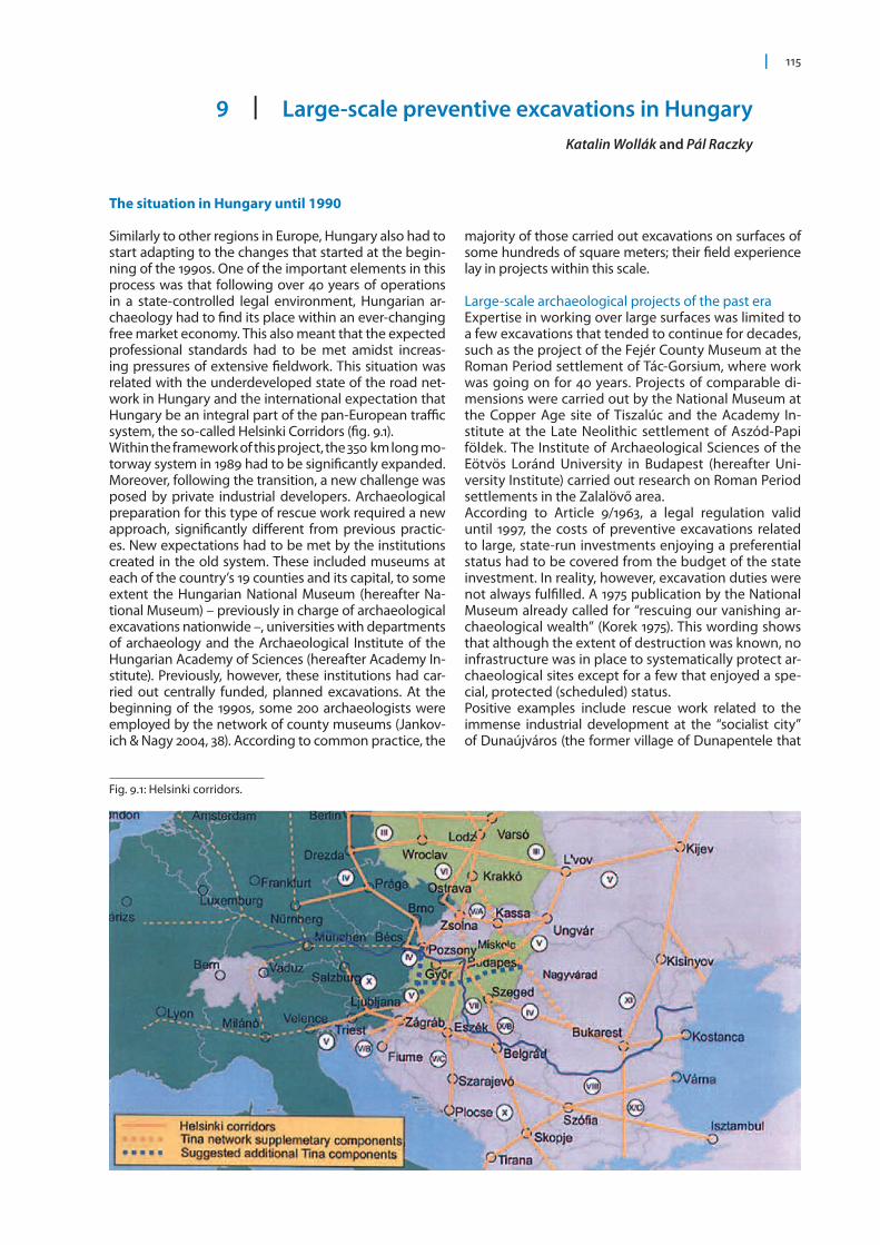
country and continued with the construction of Motor-way M3 towards the East (Budapest–Gödöllő 1980) and Motorway M5 running towards the southern border (Budapest–Újhartyán 1985). However, until 1989, the to-tal length of motorways had not even reached 350 km (KSH; Raczky 2007) (fig. 9.2).The first surveys, including field walks, were carried out in the Budapest–Gyöngyös section of Motorway M3, designed to link the capital with Miskolc and Nyíregy-háza respectively. This work was, however, carried out within the framework of the project “Archaeological Topography of Hungary” during the 1980s. Due to the scarcity of archaeological sites in this section, no ma-jor rescue excavations had to be carried out. A major breakthrough followed beginning with the 1990s when the Győr–Hegyeshalom section of Motorway M1 was in-vestigated. All 23 sites located in the affected area were excavated, although the consistent conservation and analysis of the find material did not follow (Jankovich 1997). The changing circumstances also required differ-ent attitudes from the institutions involved. Whether it was state investments or private developments, due to the lack of a proper legislative background, the expens-es had to be covered by individual settlements with the firms involved; the completely excavated area had to be handed over by strict deadlines. Excavations were carried out simultaneously at various sites, requiring a radically different infrastructural background both in terms of professional archaeologists, technical staff, equipment and other material resources. This situation was compounded by the pressures of accelerated field-work that impacted upon archaeological techniques. This included the mechanized removal of top humus layers, usually mixed by modern tillage, whose find ma-terials (lacking the original archaeological context any-way) usually had to be abandoned. The Budapest His-tory Museum has played a pioneering role in adapting to the new expectations. As a result of cooperating with the Museum of London Archaeological Services, they developed a code of practice for contract archaeology in the capital during the 1980s. Archaeological recovery was integrated within the process of investments and special attention was paid to veritable documentation as well as publishing reports after each excavation.In addition to the role played by the Archaeological To-pography of Hungary in the elaboration of the prepara-tory phases of the large-scale excavations, the so-called microregional projects, initiated by the Academy Institute during the mid-1980s, are worth mentioning (Bökönyi
1992; Bökönyi 1996). Within the framework of these proj-ects, comprehensive studies of the natural environment and settlement history were investigated in well-defined areas including archaeological surveys, test excavations as well as relevant research in natural sciences.
The first phase of large-scale excavations: 1990 (1987)–1997
Archaeological work related to the development of the motorway systemFor the first time, systematic archaeological research was carried out preceding the construction of Motor-way M1 in the surroundings of Győr in Northwestern Hungary. The Győr-Moson-Sopron County Museum employed six archaeologists and subsequently built up a technical staff consisting largely of contracted personnel (Jankovich & Nagy 2004, Table 26). During the field campaigns that began in 1990, the techniques of both excavation and documentation had to be re-newed. Quantities of information had to be retrieved and stored during the course of these rescue excava-tions that reached “industrial dimensions”. The num-ber of features ran into several thousands at numerous sites, and relevant information had to be retrieved, stored and analyzed. Early on the Academy Institute joined this field project in order to support – with its proper logistical and (natural-)scientific background – the complex excavation work required for the histori-cal interpretation of various archaeological periods. An efficient database had to be chosen and developed that could simultaneously handle pictorial and textual information as well as the spatial (GIS) representation of archaeological sites (Csáky & Figler 1995). This applica-tion, however, required digitizing elements of the field documentation. In addition to excavation logbooks, this meant the processing of site plans, profile draw-ings, photographic documentation. This need arose from the fact that the number of archaeological fea-tures to be documented and analyzed multiplied by several orders of magnitude.4 The new wave of constructions that began in the 1990s posed a similar challenge for the 19 county museums and the Budapest History Museum in charge of munici-pal development in Budapest. Initial projects included Motorway M0, the bypass around Budapest where ex-cavations were joined by the Budapest History Museum in 1987. Pioneering institutions were soon joined by the
Fig. 9.2: Length of motorways built in Hungary between 1964 and 1989.
9 Large-scale preventive excavations in Hungary 117
118 EAC OCCASIONAL PAPER NO. 6
museum of Bács-Kiskun County, where the first phase of professional “motorway archaeology” was stimulat-ed by the construction of Motorway M5 in 1987/88. Four sites were discovered within the designated construc-tion area during field walks aimed at determining the archeological implications of the project. In addition, partial preventive excavations were carried out at two quarries to be opened in connection with the construc-tion. The area thus investigated totaled 10,000 m2. The size of this surface significantly exceeded the few hun-dred square meters routinely excavated. Tasks related to documentation, conservation and analysis, there-fore, multiplied. In fact, by 1988 excavations had to be extended to the quarries that later supplied gravel for the motorway construction (Somogyvári 2007). Somewhat later the Csongrád County section of the same motorway was continued during 1991/92. As the first step, the Csongrád County Museum organized field walks in cooperation with the University of Szeged. In addition to data published in the archaeological lit-erature, they also relied on the maps prepared during the First Military Survey ordered by Emperor Joseph II of the Habsburg Dynasty (1763–1787). In certain places, maps on a scale of 1:28,800 dating from the Second Mil-itary Survey (1826–1866) were taken into consideration as well, in addition to known topographic and hydro-logical features and results of aerial photography (Sza-lontai 2003). The 48 km long section of the motorway in Csongrád County yielded over 100 sites in a 500 m wide band. 61 of these fell directly within the path of the planned motorway or the 50 m zone running along either side. Excavations, however, began only two years later in 1993; in the absence of tight deadlines, 17 sites could be uncovered. This was followed by an almost three years break, as the Hungarian government tem-porarily refrained from developing motorways in the immediate proximity of war-struck former Yugoslavia (Szalontai 2001). Development was resumed only in 1998. During the first phase of preventive excavations the museum could single out only relatively few sites for recovery. Therefore other sites, identified within the 30–50 m zone along the path could not be investigated unless their existence was reconfirmed during field walks. During the second phase of excavations, how-ever, it turned out that many of these sites overlapped with the path itself. Moreover, no archaeological work was planned in the areas under overpasses and traffic junctions. Also ignored were areas of those sites where the lack of tillage precluded field walks and no horizon-tal distributions of artifacts brought to light by plough-
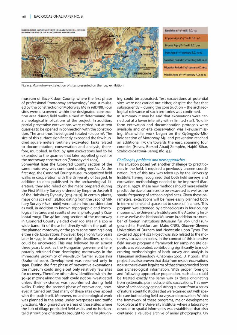
ing could be appraised. Test excavations at potential sites were not carried out either, despite the fact that subsequently – during the construction – the archaeo-logical relevance of such territories was confirmed. In summary it may be said that excavations were car-ried out at a lower intensity with a limited staff. No uni-form excavation and documentation protocols were available and on-site conservation was likewise miss-ing. Meanwhile, work began on the Gyöngyös–Mis-kolc section of Motorway M3, and prevention reached an additional 175 km towards the east, spanning four counties (Heves, Borsod-Abaúj-Zemplén, Hajdú-Bihar, Szabolcs-Szatmár-Bereg) (fig. 9.3).
Challenges, problems and new approachesThis situation posed yet another challenge to practitio-ners in the field, it required a previously unseen coordi-nation. Part of this task was taken up by the University Institute, having recognized that both field surveys and excavation methodology needed to be improved (Rac-zky et al. 1997). These new methods should more reliably predict the size of surfaces to be excavated as well as the spatial frequency of archaeological sites. Given these pa-rameters, excavations will be more easily planned both in terms of time and space, not to speak of finances. This program was attended by archaeologists in four county museums, the University Institute and the Academy Insti-tute, as well as the National Museum in addition to a num-ber of foreign institutions (Museum für Vor- und Früh-geschichte, Frankfurt am Main; CNRS, Glux-en-Glenne; Universities of Durham and Newcastle upon Tyne). The so-called Upper-Tisza Project was also related to the mo-torway excavation series. In the context of this intensive field survey program a framework for sampling site de-posits was elaborated, contributing significantly to mod-ernizing methodologies of both survey and analysis in Hungarian archaeology (Chapman 2002; UTP 2003). This project has also proven that data from rescue excavations (to use the relevant legal term of that time) provided bona fide archaeological information. With proper foresight and following appropriate preparation, such data could be treated exactly the same way as those originating from systematic, planned scientific excavations. This new view of archaeology gained strong support from a series of natural scientific studies that were carried out with spe-cial care both during field surveys and excavation. Within the framework of these programs, major development took place at the University Institute, where a laboratory devoted to spatial informatics was established that also contained a valuable archive of aerial photographs. On
Fig. 9.3: M3 motorway: selection of sites presented on the 1997 exhibition.
9 Large-scale preventive excavations in Hungary 119
this basis, a model integrating geophysical, spatial, and aerial photographic information could be developed (Raczky et al. 2002). Excavations between 1993 and 1996 covered a 100 m-wide band along a 175 km distance of Motorway M3. This surface yielded 150 sites, sometimes requiring research over 30,000–40,000 m2 large territo-ries. It should be considered exemplary that results of this project were presented to the public one year after its accomplishment. Archaeological material from 21 of the most significant sites was exhibited in the National Museum in 1997. This exhibition was then taken to the centers of the four counties involved. The catalogue was published by the time of the Budapest exhibition. Subse-quently, the outstanding assemblages of this exhibition were also presented in Bougon (France) and Frankfurt am Main (Germany). In addition to the lists of artifacts exhibit-ed, the catalogue contained analytical articles that evalu-ated the results from the Neolithic to the late Middle Ages and described the roles played by natural sciences in the project (Raczky et al. 1997; Jankovich 1997).Between 1964 and 1989, some 350 km of the public road system were built in Hungary including motorways (KSH 1990). However, as was mentioned previously, archaeo-logical excavations were carried out only occasionally during this construction work. A major change for the ar-chaeological profession followed at the beginning of the 1990s. Although only 126 km of motorway have been con-veyed between 1990 and 1997 (KSH 1997), the scheduling, technology and programming of archaeological excava-tions were developed during this formative period. Reviewing the problems identified during this first phase of accelerated construction beginning with the 1990s, the following characteristics are worth considering:
1. Until 1997, legislation did not follow the new require-ments. No legal guidance was developed for the preparatory work and there were but minimal regu-lations concerning financing. These were, however, insufficient in preparing an institutional system for a task that would have required renewing the entire
discipline. One of the fixed points was the aforemen-tioned La Valletta Convention; although the entry into force was in Hungary in 1995 (enacted in separate le-gal decree in 2000), that convention did not become part of the Hungarian legal system until 1997.
2. In the eyes of planners, investors and developers, ar-chaeology often seemed the inevitable evil that could stand in the way of motorway constructions. Although the inauguration of newly accomplished sections has always represented considerable politi-cal capital to the ministers in charge (e.g. in the case of Motorway M3), the pace of development has been hectic. No mechanism was available that would have facilitated integrating the knowledge of archaeologi-cal heritage within the planning process. Preparing large-scale investments was characterized by the lack of regulations. Consequently, at the beginning devel-opers did not insist on systematic preventive field sur-veys. The paths of motorways were sometimes arbi-trarily changed and the locations of auxiliary facilities (such as petrol stations) and gravel extraction quar-ries were frequently not negotiated with archaeolo-gists. In case of developments that included multiple players (investors/developers), the cooperation was difficult, seriously hindering planned and systematic excavations.
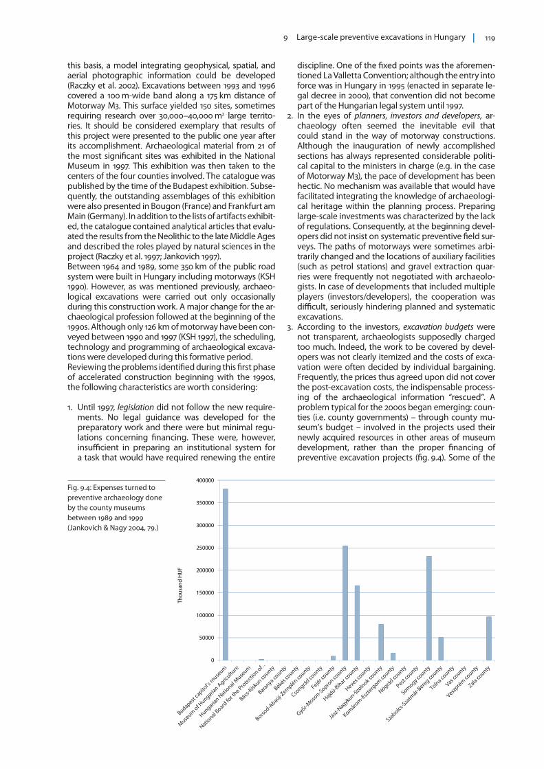
3. According to the investors, excavation budgets were not transparent, archaeologists supposedly charged too much. Indeed, the work to be covered by devel-opers was not clearly itemized and the costs of exca-vation were often decided by individual bargaining. Frequently, the prices thus agreed upon did not cover the post-excavation costs, the indispensable process-ing of the archaeological information “rescued”. A problem typical for the 2000s began emerging: coun-ties (i.e. county governments) – through county mu-seum’s budget – involved in the projects used their newly acquired resources in other areas of museum development, rather than the proper financing of preventive excavation projects (fig. 9.4). Some of the
Fig. 9.4: Expenses turned to preventive archaeology done by the county museums between 1989 and 1999 (Jankovich & Nagy 2004, 79.)
150000
200000
250000
300000
350000
400000
Thou
sand
HU
F
0
50000
100000
120 EAC OCCASIONAL PAPER NO. 6
tasks financed by county museums were necessary at the time, but became superfluous. In addition, many counties began parallel developments of their own (e.g. promoting a variety of digitizing schemes). Due to the resulting diversity, the finds and relevant field information could not be managed by standardized criteria (Jankovich 1997; Raczky 2007).
4. At this point the archaeological profession was confronted with new challenges that it has been ill-equipped to deal with until today. These included the principle that “everything be excavated”, which precluded the development of sampling, site select-ing methodologies, although field directors were often forced to make arbitrary selections of what could be recovered.5 Considering the increase in size of excavated areas (some excavations preceding the construction of Motorways M3 and M0 excee-ded 400,000 m2), the conservation and permanent storage of the tons of resulting find materials be-comes a real issue. The 19th century headquarters of prestigious county museums simply could not accommodate the masses of finds they were sup-posed to deal with.
5. Difficulties of permanent museum storage were not helped by culling the assemblages, the methods of the field documentation and final inventorying of the finds were not compatible. No accredited central authentic database was available for the registration of the archaeological sites, although documentation could no longer be solved without massive develop-ment in information technology (Rezi 2003). Excava-tion methodology had to be revised as tasks could no longer be performed without carefully planned team cooperation. Vertical coordination included overseeing fieldwork by technical staff and those operating heavy machinery (mechanized humus removal sometimes caused massive loss of finds as well as field information).
Adaptions in legislation and efforts towards standardization of proceduresGiven these problems, changing the legislative envi-ronment became inevitable. The first step in this direc-tion was made seven years after the political change in Hungary when Law 140/1997 was implemented. The aim of this legislation was to ensure that the profes-sional-scientific archaeological activities in archaeol-ogy should remain the task of museums and other institutions authorized to carry out excavations. This legislation also raised certain processes – such as exca-vation licensing, supervision and the creation of a new, central database of archaeological sites – to a central management level with the establishment of a new directorate in 1998 (Cultural Heritage Directorate). It was charged with the aforementioned administrative functions and made responsible for archaeological heritage management (Nagy 2003; Wollák 2007a). The principles of the La Valletta Convention became an es-sential part of the Hungarian regulation: the act intro-duced the ‘polluter pays’ principle, so the costs of the necessary rescue excavations – using a new expres-sion: investment-led, preventive excavations – namely the excavation, documentation, primary conservation, and storage should be financed by the developer, who must provide at least 9 thousandth of the investment for these purposes.
In addition to creating a new legal environment, the methodology of preparing and conducting these ex-cavations had to be developed. There was a pressing need for such standards as increasing archaeological capacities became tied down in large-scale preventive excavations induced by motorway constructions span-ning several counties. It became evident that coordina-tion was a need for veritable professional representa-tion and predictable partnership on the sides of both developers and excavating archaeologists. The devel-opment of such methods began during the preventive excavations of Motorway M3 that crossed four counties. The effort was spearheaded by the University Institute. The methodology covered field surveys, the prepara-tion of excavations, field techniques and documenta-tion. The system of these new methods was integrated into a standardized protocol.Drafting such a protocol was strongly supported by the National Motorway Public Company established in 1999.6 This was a closed stock-holding company of 100 % state ownership, put in charge of the nationwide development of the motorway and road networks (railroad development was added to this list in 2007). State bids had to be fulfilled in a market environment, therefore this firm has a vested interest in controlled and predictable archaeological preparatory work. The aforementioned methodological protocol, therefore, was integrated into its working routine as one of the operational phases during motorway construction. Developing the new system of preventive archaeology posed a special challenge to the University Institute, the institution involved in training most archaeolo-gists in Hungary. Unexpected returns, however, soon became evident in education and methodological research as these rescue excavations were conducted over extensive areas and the immense amount of data called for new techniques of data storage, as well as for new types of working schedules and the system-atic application of various analytical techniques (Rac-zky 2008).
Protocol for preventive excavationsThe uniform protocol used in preparing archaeological excavations has crystallized during the course of sev-eral construction phases in the last ten years as well as during the course of continuous archaeological work. This, in essence, includes archaeological field survey, i.e. the localization of archaeological sites as well as mapping their horizontal extent and vertical stratigra-phy, accompanied by dating. The following six phases of this program form a single logical unit:
1. The preliminary phase is aimed at creating a com-prehensive spatial database, suited for integrating and evaluating general topographic data, param-eters of the planned motorway and various levels of archaeological information.
2. The analysis of entries in archaeological archives from the regions affected by motorway construction, in combination with data from literary sources, is aimed at verifying the precise positions of known archaeo-logical sites.
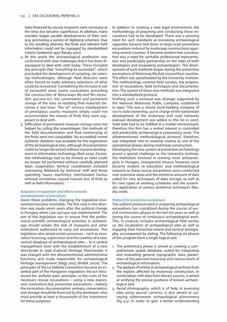
3. Aerial photography, which is of help in assessing sites using special cameras, is also aimed at sur-veying subterranean archaeological phenomena (fig. 9.5). In order to gain a better understanding
9 Large-scale preventive excavations in Hungary 121
of the micro-environments surrounding individual sites, we analyzed a series of satellite and aerial photographs – the first such application of the lat-ter in Hungarian archaeology. One happy coinci-dence in this respect was that aerial photography projects headed by R. Goguey from France and O. Braasch from Germany were launched in Hungary during the 1990s. These different international proj-ects enabled the preparation of aerial photographs within the environment of Motorways M0, M7 and M3. The national aerial photography archives in the Institute of Archaeological Sciences of the Eötvös Loránd University and the Department of Ancient
History and Archaeology at the University of Pécs, grew out of these projects.
4. Systematic field walks cover a 200 m wide band along the planned routes of motorways. During these field surveys all conventional methods of ar-chaeological topographic work are applied in an effort to pinpoint sites as precisely as possible and identify the archaeological periods represented.
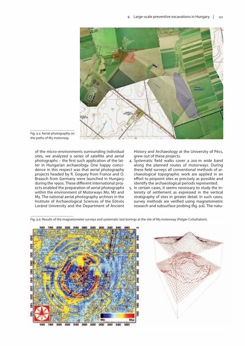
5. In certain cases, it seems necessary to study the in-tensity of settlement as expressed in the vertical stratigraphy of sites in greater detail. In such cases, survey methods are verified using magnetometric research and subsurface probing (fig. 9.6). The natu-
Fig. 9.5: Aerial photography on the paths of M3 motorway.
Fig. 9.6: Results of the magnetometer surveys and systematic test borings at the site of M3 motorway (Polgár-Csőszhalom).
122 EAC OCCASIONAL PAPER NO. 6
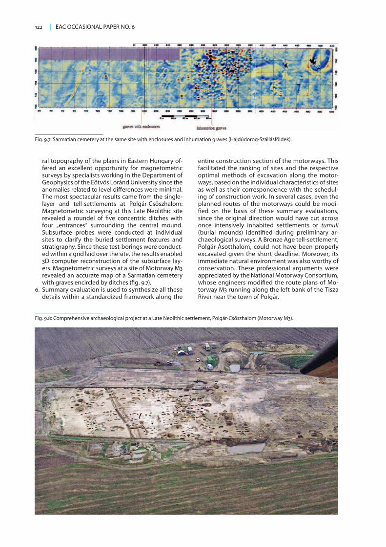
ral topography of the plains in Eastern Hungary of-fered an excellent opportunity for magnetometric surveys by specialists working in the Department of Geophysics of the Eötvös Loránd University since the anomalies related to level differences were minimal. The most spectacular results came from the single-layer and tell-settlements at Polgár-Csőszhalom: Magnetometric surveying at this Late Neolithic site revealed a roundel of five concentric ditches with four „entrances” surrounding the central mound. Subsurface probes were conducted at individual sites to clarify the buried settlement features and stratigraphy. Since these test-borings were conduct-ed within a grid laid over the site, the results enabled 3D computer reconstruction of the subsurface lay-ers. Magnetometric surveys at a site of Motorway M3 revealed an accurate map of a Sarmatian cemetery with graves encircled by ditches (fig. 9.7).
6. Summary evaluation is used to synthesize all these details within a standardized framework along the
entire construction section of the motorways. This facilitated the ranking of sites and the respective optimal methods of excavation along the motor-ways, based on the individual characteristics of sites as well as their correspondence with the schedul-ing of construction work. In several cases, even the planned routes of the motorways could be modi-fied on the basis of these summary evaluations, since the original direction would have cut across once intensively inhabited settlements or tumuli (burial mounds) identified during preliminary ar-chaeological surveys. A Bronze Age tell-settlement, Polgár-Ásotthalom, could not have been properly excavated given the short deadline. Moreover, its immediate natural environment was also worthy of conservation. These professional arguments were appreciated by the National Motorway Consortium, whose engineers modified the route plans of Mo-torway M3 running along the left bank of the Tisza River near the town of Polgár.
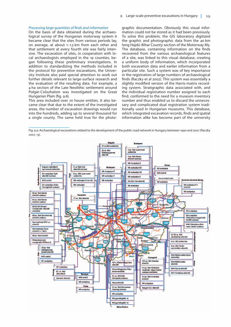
Fig. 9.8: Comprehensive archaeological project at a Late Neolithic settlement, Polgár-Csőszhalom (Motorway M3).
Fig. 9.7: Sarmatian cemetery at the same site with enclosures and inhumation graves (Hajdúdorog-Szállásföldek).
9 Large-scale preventive excavations in Hungary 123
Processing large quantities of finds and informationOn the basis of data obtained during the archaeo-logical survey of the Hungarian motorway system it became clear that the sites from various periods lay, on average, at about 1–1.5 km from each other and that settlement at every fourth site was fairly inten-sive. The excavation of sites, in cooperation with lo-cal archaeologists employed in the 19 counties, be-gan following these preliminary investigations. In addition to standardizing the methods included in the protocol for preventive excavations, the Univer-sity Institute also paid special attention to work out further details relevant to large-surface research and the evaluation of the resulting data. For example, a 4 ha section of the Late Neolithic settlement around Polgár-Csőszhalom was investigated on the Great Hungarian Plain (fig. 9.8).This area included over 70 house entities. It also be-came clear that due to the extent of the investigated areas, the number of excavation drawings would run into the hundreds, adding up to several thousand for a single county. The same held true for the photo-
graphic documentation. Obviously this visual infor-mation could not be stored as it had been previously. To solve this problem, the GIS laboratory digitized the graphic and photographic data from the 40 km long Hajdú-Bihar County section of the Motorway M3. The database, containing information on the finds recovered from the various archaeological features of a site, was linked to this visual database, creating a uniform body of information, which incorporated both excavation data and earlier information from a particular site. Such a system was of key importance in the registration of large numbers of archaeological finds (Raczky et al 2002). This system was essentially a slightly modified version of the Harris-matrix record-ing system. Stratigraphic data associated with, and the individual registration number assigned to each find, conformed to the need for a museum inventory number and thus enabled us to discard the unneces-sary and complicated dual registration system tradi-tionally used in Hungarian museums. This database, which integrated excavation records, finds and spatial information alike has become part of the university
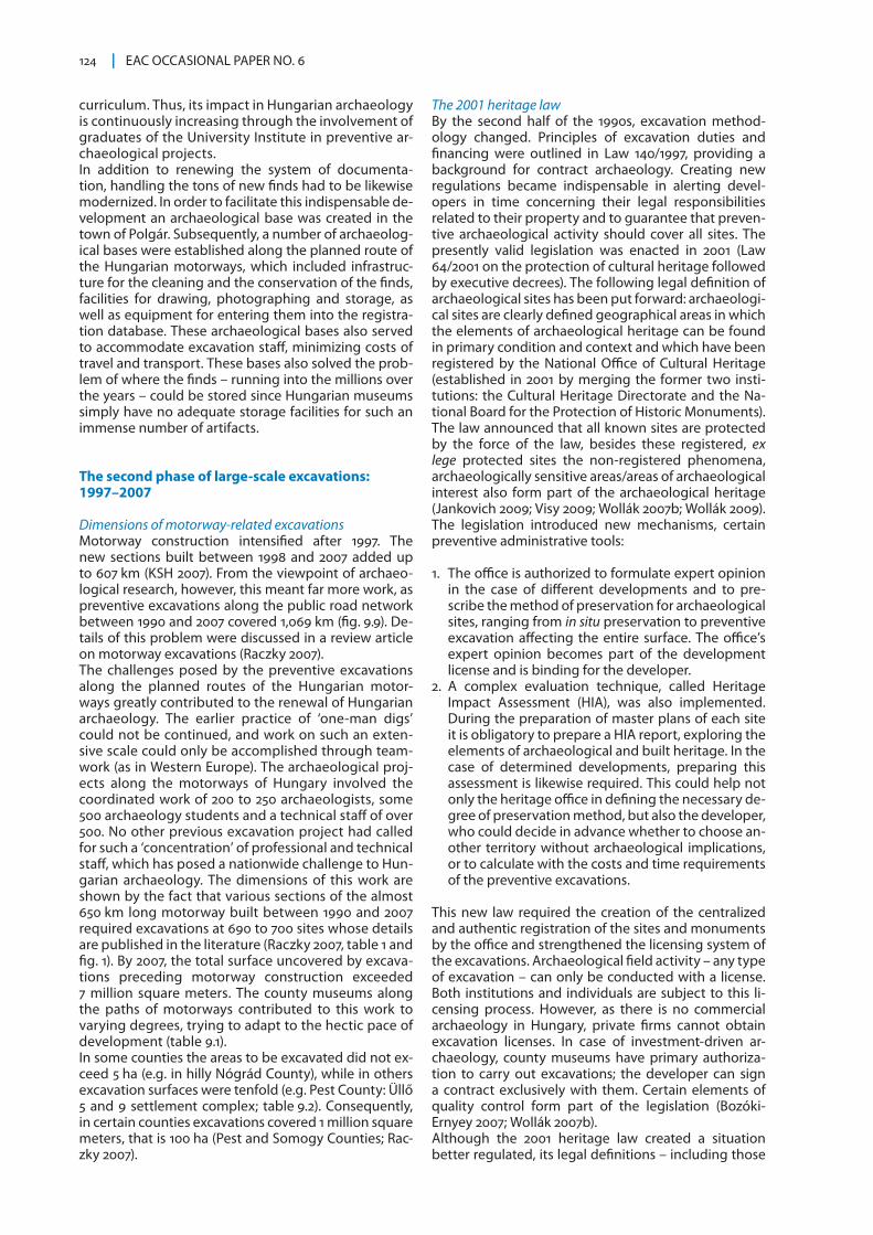
Fig. 9.9: Archaeological excavations related to the development of the public road network in Hungary between 1990 and 2007 (Raczky 2007, 13).
124 EAC OCCASIONAL PAPER NO. 6
curriculum. Thus, its impact in Hungarian archaeology is continuously increasing through the involvement of graduates of the University Institute in preventive ar-chaeological projects. In addition to renewing the system of documenta-tion, handling the tons of new finds had to be likewise modernized. In order to facilitate this indispensable de-velopment an archaeological base was created in the town of Polgár. Subsequently, a number of archaeolog-ical bases were established along the planned route of the Hungarian motorways, which included infrastruc-ture for the cleaning and the conservation of the finds, facilities for drawing, photographing and storage, as well as equipment for entering them into the registra-tion database. These archaeological bases also served to accommodate excavation staff, minimizing costs of travel and transport. These bases also solved the prob-lem of where the finds – running into the millions over the years – could be stored since Hungarian museums simply have no adequate storage facilities for such an immense number of artifacts.
The second phase of large-scale excavations: 1997–2007
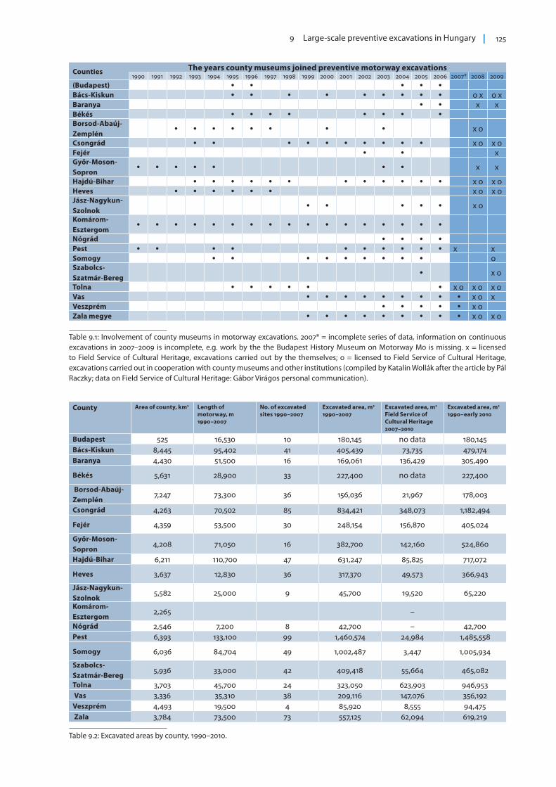
Dimensions of motorway-related excavationsMotorway construction intensified after 1997. The new sections built between 1998 and 2007 added up to 607 km (KSH 2007). From the viewpoint of archaeo-logical research, however, this meant far more work, as preventive excavations along the public road network between 1990 and 2007 covered 1,069 km (fig. 9.9). De-tails of this problem were discussed in a review article on motorway excavations (Raczky 2007).The challenges posed by the preventive excavations along the planned routes of the Hungarian motor-ways greatly contributed to the renewal of Hungarian archaeology. The earlier practice of ‘one-man digs’ could not be continued, and work on such an exten-sive scale could only be accomplished through team-work (as in Western Europe). The archaeological proj-ects along the motorways of Hungary involved the coordinated work of 200 to 250 archaeologists, some 500 archaeology students and a technical staff of over 500. No other previous excavation project had called for such a ‘concentration’ of professional and technical staff, which has posed a nationwide challenge to Hun-garian archaeology. The dimensions of this work are shown by the fact that various sections of the almost 650 km long motorway built between 1990 and 2007 required excavations at 690 to 700 sites whose details are published in the literature (Raczky 2007, table 1 and fig. 1). By 2007, the total surface uncovered by excava-tions preceding motorway construction exceeded 7 million square meters. The county museums along the paths of motorways contributed to this work to varying degrees, trying to adapt to the hectic pace of development (table 9.1).In some counties the areas to be excavated did not ex-ceed 5 ha (e.g. in hilly Nógrád County), while in others excavation surfaces were tenfold (e.g. Pest County: Üllő 5 and 9 settlement complex; table 9.2). Consequently, in certain counties excavations covered 1 million square meters, that is 100 ha (Pest and Somogy Counties; Rac-zky 2007).
The 2001 heritage lawBy the second half of the 1990s, excavation method-ology changed. Principles of excavation duties and financing were outlined in Law 140/1997, providing a background for contract archaeology. Creating new regulations became indispensable in alerting devel-opers in time concerning their legal responsibilities related to their property and to guarantee that preven-tive archaeological activity should cover all sites. The presently valid legislation was enacted in 2001 (Law 64/2001 on the protection of cultural heritage followed by executive decrees). The following legal definition of archaeological sites has been put forward: archaeologi-cal sites are clearly defined geographical areas in which the elements of archaeological heritage can be found in primary condition and context and which have been registered by the National Office of Cultural Heritage (established in 2001 by merging the former two insti-tutions: the Cultural Heritage Directorate and the Na-tional Board for the Protection of Historic Monuments). The law announced that all known sites are protected by the force of the law, besides these registered, ex lege protected sites the non-registered phenomena, archaeologically sensitive areas/areas of archaeological interest also form part of the archaeological heritage (Jankovich 2009; Visy 2009; Wollák 2007b; Wollák 2009). The legislation introduced new mechanisms, certain preventive administrative tools:
1. The office is authorized to formulate expert opinion in the case of different developments and to pre-scribe the method of preservation for archaeological sites, ranging from in situ preservation to preventive excavation affecting the entire surface. The office’s expert opinion becomes part of the development license and is binding for the developer.
2. A complex evaluation technique, called Heritage Impact Assessment (HIA), was also implemented. During the preparation of master plans of each site it is obligatory to prepare a HIA report, exploring the elements of archaeological and built heritage. In the case of determined developments, preparing this assessment is likewise required. This could help not only the heritage office in defining the necessary de-gree of preservation method, but also the developer, who could decide in advance whether to choose an-other territory without archaeological implications, or to calculate with the costs and time requirements of the preventive excavations.
This new law required the creation of the centralized and authentic registration of the sites and monuments by the office and strengthened the licensing system of the excavations. Archaeological field activity – any type of excavation – can only be conducted with a license. Both institutions and individuals are subject to this li-censing process. However, as there is no commercial archaeology in Hungary, private firms cannot obtain excavation licenses. In case of investment-driven ar-chaeology, county museums have primary authoriza-tion to carry out excavations; the developer can sign a contract exclusively with them. Certain elements of quality control form part of the legislation (Bozóki-Ernyey 2007; Wollák 2007b).Although the 2001 heritage law created a situation better regulated, its legal definitions – including those
9 Large-scale preventive excavations in Hungary 125
Counties The years county museums joined preventive motorway excavations1990 1991 1992 1993 1994 1995 1996 1997 1998 1999 2000 2001 2002 2003 2004 2005 2006 2007* 2008 2009
(Budapest) Bács-Kiskun o x o xBaranya x xBékés Borsod-Abaúj-Zemplén
x o
Csongrád x o x oFejér xGyőr-Moson-Sopron
x x
Hajdú-Bihar x o x oHeves x o x oJász-Nagykun-Szolnok
x o
Komárom-Esztergom
Nógrád Pest x xSomogy oSzabolcs-Szatmár-Bereg
x o
Tolna x o x o x oVas x o xVeszprém x o Zala megye x o x o
County Area of county, km2 Length of motorway, m 1990–2007
No. of excavated sites 1990–2007
Excavated area, m2 1990–2007
Excavated area, m2 Field Service of Cultural Heritage 2007–2010
Excavated area, m2 1990–early 2010
Budapest 525 16,530 10 180,145 no data 180,145 Bács-Kiskun 8,445 95,402 41 405,439 73,735 479,174 Baranya 4,430 51,500 16 169,061 136,429 305,490
Békés 5,631 28,900 33 227,400 no data 227,400
Borsod-Abaúj-Zemplén
7,247 73,300 36 156,036 21,967 178,003
Csongrád 4,263 70,502 85 834,421 348,073 1,182,494
Fejér 4,359 53,500 30 248,154 156,870 405,024
Győr-Moson-Sopron
4,208 71,050 16 382,700 142,160 524,860
Hajdú-Bihar 6,211 110,700 47 631,247 85,825 717,072
Heves 3,637 12,830 36 317,370 49,573 366,943
Jász-Nagykun-Szolnok
5,582 25,000 9 45,700 19,520 65,220
Komárom-Esztergom
2,265 –
Nógrád 2,546 7,200 8 42,700 – 42,700 Pest 6,393 133,100 99 1,460,574 24,984 1,485,558
Somogy 6,036 84,704 49 1,002,487 3,447 1,005,934
Szabolcs-Szatmár-Bereg
5,936 33,000 42 409,418 55,664 465,082
Tolna 3,703 45,700 24 323,050 623,903 946,953 Vas 3,336 35,310 38 209,116 147,076 356,192 Veszprém 4,493 19,500 4 85,920 8,555 94,475 Zala 3,784 73,500 73 557,125 62,094 619,219
Table 9.1: Involvement of county museums in motorway excavations. 2007* = incomplete series of data, information on continuous excavations in 2007–2009 is incomplete, e.g. work by the the Budapest History Museum on Motorway M0 is missing. x = licensed to Field Service of Cultural Heritage, excavations carried out by the themselves; o = licensed to Field Service of Cultural Heritage, excavations carried out in cooperation with county museums and other institutions (compiled by Katalin Wollák after the article by Pál Raczky; data on Field Service of Cultural Heritage: Gábor Virágos personal communication).
Table 9.2: Excavated areas by county, 1990–2010.
126 EAC OCCASIONAL PAPER NO. 6
of the archaeological site and its way of registration – provoked fierce debates within the archaeological profession (Szabó et al. 2006). Experts have especially criticized the flaw that the 2001 law treated already known and potential archaeological sites as different entities (Raczky 2006). Consequently, previously non-investigated, but potentially valuable sites were at risk of destruction. They rejected legal arguments that the owner of a real estate or the investor could only be ex-pected to pay excavation costs if he or she were fully aware of the fact of the archaeological importance on the planned construction site. The supreme professional body of archeologists in Hungary, the Archaeological Committee of the Hun-garian Academy of Sciences, published a statement in 2003. This document pointed out that the legal status of newly excavated archaeological materials is uncer-tain, since according to the heritage protection law, archaeological artifacts – in principle – belong to the Hungarian State. After the excavations and subsequent storage, however, ownership is transferred to local, county governments, as the finds get into the stor-age facilities of the county museums. A higher level of uniform national heritage, however, would guarantee state protection to these finds. The statement by the committee also emphasizes that museum inventory-ing of archaeological materials should be rationalized and that finances spent on archaeological projects related to large-scale investments should be centrally controlled in order to create uniform professional stan-dards and coordinate activities in various county muse-ums (Szabó et al. 2006).In spite of its fallacies and incompleteness, the 2001 heritage law and its executive orders have fulfilled an important role: in the case of the overwhelming ma-jority of investment-led projects it became possible to guarantee that viewpoints of heritage protection be respected. Thus protected (scheduled) archaeological sites of special status could be even better preserved, and known sites became subject to mandatory preven-tive excavations that had to be fully documented, thus yielding new archaeological information. Meanwhile, regulating motorway investments also became increasingly standardized. The so-called “mo-torway law” was passed in 2003.7 On the basis of pre-liminary environmental assessment, the government singled out a maximum of two planned motorway paths that were subject to archaeological heritage surveys following the protocol developed by the Uni-versity Institute. The final direction of motorways was decided upon considering all these results, following proper archaeological preparatory work. The majority of county museums authorized to carry out motorway related fieldwork wished to perform the increasing task posed by developers relying on their own staff. Others sought cooperation with the Academy Institute, the University Institute and in some cases with the National Museum. Increasing demand for professional excavations induced the creation of the Archaeosztráda Ltd within the framework of the Hungarian Academy of Sciences in 2003. The staff of the Academy Institute provided the professional back-ground of this organization. In addition some smaller private enterprises – with no independent excavation licenses – entered the scene by the end of the millenni-um. They were usually employed by county museums
where not enough archaeologists were applied in the permanent staff. By this time, the schedule of preventive excavations was in place. Following the heritage impact assess-ment, the possible forms of archaeological interven-tion were determined: which sites need full-surface preventive excavations, where should test excavations be carried out first, and how to proceed afterwards. Areas of the motorway path were also identified where archaeological watch was sufficient following surveys that had showed but a small frequency of ar-chaeological sites, in such areas further intervention could also be carried out necessarily. A sample con-tract was drafted under the direction of the National Office of Cultural Heritage, the body that issues the excavation permits. It provided guidance concerning special points beyond plain legal regulations. Follow-ing the approval of the contract by the Office, field campaigns could begin. The investigated area along the motorway’s planned path was handed over to the institute in charge of preventive excavations follow-ing a complex procedure that included the appro-priation procedure as well. Construction work could begin once fieldwork by archaeologists had officially been accomplished. The National Motorway Consor-tium and its legal follower, the National Infrastructure Development Consortium also offered opportunity for the so-called project supervision assistance, which would identify previously undiscovered archaeologi-cal features along the path under construction and take immediate care of its rescue excavation. In order to help keeping to construction deadlines, the ex-penses of such emergency work were also covered by the developer beyond the excavation budget previ-ously agreed upon with archaeologists.
Publicizing resultsIn addition to tackling immense tasks in the field, county museums also made special efforts to at least the preliminary publication of their results. Since the 1950s, one of the platforms for such publications was the series called “Régészeti Füzetek” (Archaeologi-cal Notebooks), where excavation reports of the past year regularly appeared. Currently, the series entitled “Régészeti Kutatások Magyarországon” (Archeological Investigations in Hungary) publishes annual reports on fieldwork in addition to some articles presenting new results and sources. In addition to the annals of county museums, several independent volumes have been published presenting the results of fieldwork. One of the first such publications was the set of vol-umes showing results of preventive excavations along Motorway M0, the bypass road around Budapest (Sel-meczi & Havassy 1992). Information on archaeological research in Pest County during the years 2001–2006 was available already by the closing year of that proj-ect (Tari 2006). In terms of publication efficiency the next volume was entitled “Paths in the Past” (Raczky et al. 1997), which summarized the results of excavations along Motorway M3. A volume presenting results from Csongrád County came to light in 2003 (Szalontai 2003). The Budapest History Museum excavations preparing Motorway M0 were first summarized in a 2005 publi-cation entitled “Treasure Under the City”, and another volume came out by 2009 (Zsidi 2005; Endrődi & Szilas 2009). The exemplary cooperation between Somogy
9 Large-scale preventive excavations in Hungary 127
County and the Academy Institute between 1994 and 2003 yielded yet another volume entitled „Rolling Time” (Belényesy et al. 2007). In addition to summariz-ing information on the sites recovered along the path of Motorway M7 in Somogy County, this volume also contains a historical summary of various archaeologi-cal periods. Archaeological works carried out between 1999 and 2008 along additional sections of Motorway M7 in Zala County have been published in a digital for-mat (Horváth & Frankovics 2008). Preventive work in the Szeged–Makó section of Motorway M43 was already coordinated by the Field Service of Cultural Heritage in cooperation with the Csongrád County Museum and the University Institute. Results of this research were published in 2009 (Balogh 2009).Following the proportions during the second phase of large surface excavations (Table 9.3) the contribution of an increasing number of counties may be detected (Bozóki-Ernyey 2007). Although the activities of muse-ums have been detailed in the statistics issued by the ministry responsible for culture, sub-divisions of such precision are available only from 2005 (see table 9.1, above).8
“Motorway excavations”: some examplesArchaeologists involved with these excavations were not only interested in professional publication. They were also keen on presenting the cultural wealth that had been recovered to the broader public. One of the most popular forums in this regard has been the series Magyar Múzeumok (Hungarian Museums). The first is-sue in 2007 (Magyar Múzeumok 2007/1) was dedicated to presenting the results of motorway excavations (Wol-lák 2007a). That publication included excavations pre-ceding the constructions of Motorways M0, M3–M35, M5, M6, M6–M60, M7, and M7–M70, as well as flood con-trol projects along the Tisza River that grew out from the so-called Vásárhelyi River Regulation Scheme. 9 It offered a good summary concerning the extent of excavations and the highlights of fieldwork that were deemed worth sharing with the broader public. A few examples deserve brief reviewing here.
During the 2004–2007 construction of Motorway M0, the bypass around Budapest, the Budapest History Mu-seum carried out excavations at seven sites, uncovering a total of 105,912 m2. Special attention was paid to the scientific analysis of data, exhibiting the resulting finds and organizing academic analysis in a way that would keep abreast with fieldwork.10 The institution stands for the principle that the broader public should also ben-efit from these large-scale projects. The 2003–2006 excavations along Motorways M3–M35 were carried out in cooperation between the Hajdú-Bi-har County Museum and the University Institute. Field-work by then followed a carefully developed technolo-gy recovering 13 sites over a surface of 161,019 m2 along the first section and 15 others over another 210,328 m2 of surface along the other sections.Twentysix sites were recovered in the 295,000 m2-area excavated by the Bács-Kiskun County Museum along Motorway M5. (This museum also conducted the pre-ventive excavations of 4 additional public roads and 3 shopping malls.) In their summary evaluation they emphasized that these projects have entirely changed and fine-tuned previous knowledge concerning the county’s history. Archaeologists at the Tolna County Museum found 19 sites along a 29 km stretch of Motorway M6. Nine of these were selected for test excavations, while full re-covery was recommended at the remaining 10 sites. In the first case, verifying excavations could not reveal ad-ditional features at 4 sites, while full recovery became necessary at the remaining 5. According to the plan, work was carried out over a surface of 215,000 m2, in-volving 7–9 working parties. During the course of this rescue work the area that had to be studied increased by 50 %. The museum established its own evaluation center with capacities for documenting, data storage, inventorying, drawing, photographing and storing this material. A conservation workshop was also dedicated to process the large ceramic artefactual assemblage. At the time this paper is written there are still 60 km of motorway to be built in this county, requiring the exca-vation of an area covering 337,736 m2.
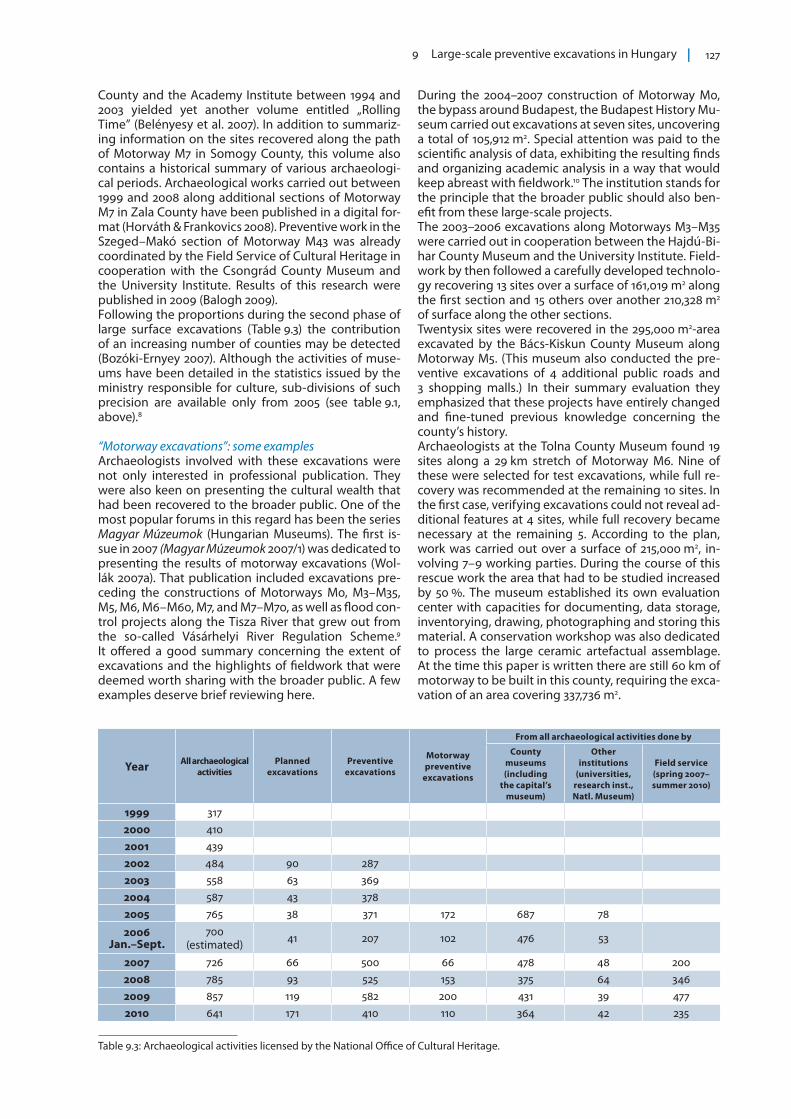
Table 9.3: Archaeological activities licensed by the National Office of Cultural Heritage.
Year All archaeological activities
Planned excavations
Preventive excavations
Motorway preventive
excavations
From all archaeological activities done by
County museums (including
the capital’s museum)
Other institutions
(universities, research inst., Natl. Museum)
Field service (spring 2007–summer 2010)
1999 3172000 4102001 4392002 484 90 2872003 558 63 3692004 587 43 3782005 765 38 371 172 687 78
2006 Jan.–Sept.
700 (estimated) 41 207 102 476 53
2007 726 66 500 66 478 48 2002008 785 93 525 153 375 64 3462009 857 119 582 200 431 39 4772010 641 171 410 110 364 42 235

128 EAC OCCASIONAL PAPER NO. 6
According to a summary by the Baranya County Mu-seum, the planned 90 km long stretch of Motorways M6 and M60 was covered by field walks in a distance of 100 km between 2001 and 2002. Having surveyed 83 % of this surface (17 % were covered by forests, swamps and meadows), 75 sites could be identified. The results were supported by aerial photography with measuring equipment. During the course of the 2005–2006 exca-vations, a surface measuring approximately 400,000 m2 was investigated. Although part of this motorway sec-tion remains to be excavated, that part of the project stretched into phase 3 of large-scale excavations (see below). The Somogy County section of Motorway M7 has al-ready been mentioned in relation to the relevant pub-lication entitled “Rolling Time”. A few additional data, however, are worth reviewing. Preventive excavations between 1999 and 2006 had to be carried out along 80 km of motorway path and an additional 30 km of smaller auxiliary roads and gravel quarries. This meant the recovery of 71 sites over a surface of 1,100,000 m2 that yielded over 1.5 million artifacts. The motorway crosses four geographical areas of radically different character that may be described as follows, proceeding from Northeast to Southwest:
1. Leaving the banks of Lake Balaton, a variegated and largely forested landscape had to be surveyed (this area yielded no sites, not even following the destruc-tion of woodland that was part of the construction).
2. Two large, partially drained swamps also had to be surveyed that yielded sites only along the ancient embankments.
3. Near the banks of Lake Balaton, gently rolling hills oriented north to south revealed once lacustrine sites representing numerous periods.
4. The so-called Little Balaton marshland in the south was characterized by a more loose settlement struc-ture.
Motorway M7(–M70) continued in Zala County, where field walks took place in 1994. Help by aerial photog-raphy and geophysical surveying were also enlisted in locating archaeological sites. Excavations began only in 1999 and lasted until 2008. Fieldwork affected 510,000 m2 and resulted in the recovery of 14 (M70) and 45 (M7) archaeological sites respectively. An archaeo-logical base was established in Becsehely in the build-ing of a former agricultural cooperative, where docu-mentation could be digitized and the conservation and storage of find material also became possible. In addi-tion to relevant publications, the results were also pre-sented in the permanent exhibition of the Nagykanizsa Museum (Magyar Múzeumok 2007/1).Another three articles in the same periodical discuss the results of archaeological excavations carried out within the framework of the Extended Vásárhelyi Proj-ect. This work involved the museums of Jász-Nagykun-Szolnok (JNKSZ) and Borsod-Abaúj-Zemplén (BAZ) counties as well as archaeologists from the National Museum and the University Institute. The aims of this program included flood prevention in the Tisza River Valley. This meant that a system of 6 reservoirs had to be constructed to buffer the effects of capricious periodic flooding. Work began on three reservoirs be-tween 2005 and 2007: in the area of Cigánd-Tiszakarád
the BAZ County Museum uncovered 160,000 m2. At the location of the Tiszaroff reservoir 190,000 m2 were excavated by teams of the JNKSZ County Museum and the National Museum. Finally, when reconstructing the system of dams at the Rákóczifalva-Bivalytó res-ervoir covering a surface of 290,000 m2, work was car-ried out in cooperation between teams of the JNKSZ County Museum and the University Institute (Magyar Múzeumok 2007/1).11
Referring to all relevant archaeological reports and studies would be far beyond the scope of this article. Some, however, were singled out here as they had brought new results from a methodological point of view, for example in handling the mass of post-exca-vational information or applying spatial informatics in reconstructing the layout of sites (Csáky & Figler 1995; Raczky et al. 1997; Raczky et al. 2002). Articles discussing the development of 3D models, the processing of aerial photographs, georeferencing and the use of mobile equipment in spatial informatics are of special interest (Czajlik et al. 1997; Eke et al. 2007).
Achievements of the second phase of large-scale excavationsThe characteristics of the second phase of large-scale excavations are summarized in Table 9.4. As is shown by these developments, the models for surveying and evaluating archaeological heritage have been in place. Museums have become increas-ingly sophisticated in fulfilling tasks related to pre-ventive excavations. Communication with planners, investors and developers has increased. One of the results of this prosperous cooperation is that during the construction of Motorway M5 in Csongrád Coun-ty, the local museum was also commissioned to carry out environmental and ethnographic surveys related to the development (Szalontay 2001; Szalontay 2003). In the late 1990s pyrotechnical surveys, that is the lo-cation and neutralization of abandoned bombs and ammunition, also became part of this standardized procedure.In a system lacking competition, county museums hav-ing exclusive rights to excavate had to be prepared both in terms of personnel and infrastructure to carry out tasks under the pressures of tight deadlines. Not all of these institutions, however, considered the need for long-term solutions concerning conservation, storage and evaluation. Difficulties were compounded by new financial regulations that made it mandatory to apply public procurement procedure for any budgetary de-velopment that would have exceeded a certain sum both in material acquisition and buying services, which circumstances are far too complex to be discussed here. Amidst ever-dwindling central funding, county museums financed by local governments began in-creasingly relying on preventive excavation budgets to complement their budgets spent on basic operations. This solution was successful in temporarily treating symptoms, but created resentment in investors and developers. Organizing the workflow also had to be changed. Field-work had to be compartmentalized into a team system: in addition to technical and scientific staff, field direc-tors also had to oversee manual work and mechanized earth removal. The workload often exceeded a hectare per month, and techniques of excavating throughout
9 Large-scale preventive excavations in Hungary 129
the winter also had to be invented. As information car-ried by the top layers was lost due to mechanical hu-mus removal, therefore, special diligence was required during the excavation. This made the standardiza-tion of field methodology indispensable. One of the fundamental elements in this work was developing a consistent technical nomenclature that had already been exemplified by the wording of the protocol de-veloped by the University Institute. Although a signifi-cant number of county museums have developed their own, well-crafted and coherent field inventory and digitizing systems (Szalontay 2001; Szalontay 2003; Tari 2006; Belényesy et al. 2007; Horváth & Frankovics 2008), these independent achievements lacked compatibility. Moreover, many redundancies resulted from costly par-allel efforts, and sometimes the sophisticated data pro-cessing systems lacked proper archiving. The majority of county museums created storage, data processing and conservation facilities in the immediate proximity of excavations (Becsehely, Vecsés). In other cases facili-ties of the original museum base could be expanded (Szeged: Szalontay 2003; Nyíregyháza: Kurucz 2008), as these museums acquired several tons of find material within a few years. These quantities often exceeded the amount of archaeological materials accumulated dur-ing the preceding century. Large-scale excavations also offered a unique oppor-tunity to compare the results of field walks, surveys and the excavations themselves. Although features of natural topography have a direct bearing on the loca-tion of archaeological sites, the existence of archaeo-logical features was often recognized during archaeo-logical observation or even amidst construction work, also even following unsuccessful field walks. Further-more, in certain cases the sites turned out to be larger than expected. Having evaluated immense quantities
of data acquired during the course of archaeological topographic surveys carried out within the framework of the motorway excavations, important conclusions can be drawn. The average distance between sites was 1–1.5 km, and every fourth site shows signs of intensive habitation. In certain regions where population density must have been relatively high, a greater frequency of intensively inhabited extensive sites could be observed (Raczky 2007, 9). The enlargement in settlement size may also be ex-plained by the fact that investors and developers rarely consented to the use of complex surveying techniques (e.g. geophysical measurements and soil boring) be-yond field walks, and test excavations were not rou-tinely performed either. Previously, however, it was im-possible to make observations relevant to settlement structure such as the existence of clustered habitations and hamlet-type settlements. These observations have revealed weaknesses in the exclusive reliance on field walks in detecting archaeological sites. On average, it may be said, 15 % of the sites hypothesized on the basis of field walks could not be verified by the evidence of excavations. For example, in the 36 km long southeast segment of the M0 bypass road, 51 previously unknown sites were registered during field walks. On the other hand, only 35 sites containing archeological features could be verified through excavation (in three cases no research was carried out). Notably, test trenches showed negative results in 13 cases (Tari 2006).12 These discrepancies raise the important point that the appli-cation of aerial photography in surveying should be reconsidered, as such photographs have been instru-mental in identifying sites known from the literature and pinpointed during field walks (Miklós 2007). In ad-dition, certain surface phenomena such as cemeteries, elements of land use, systems of defense features (cor-
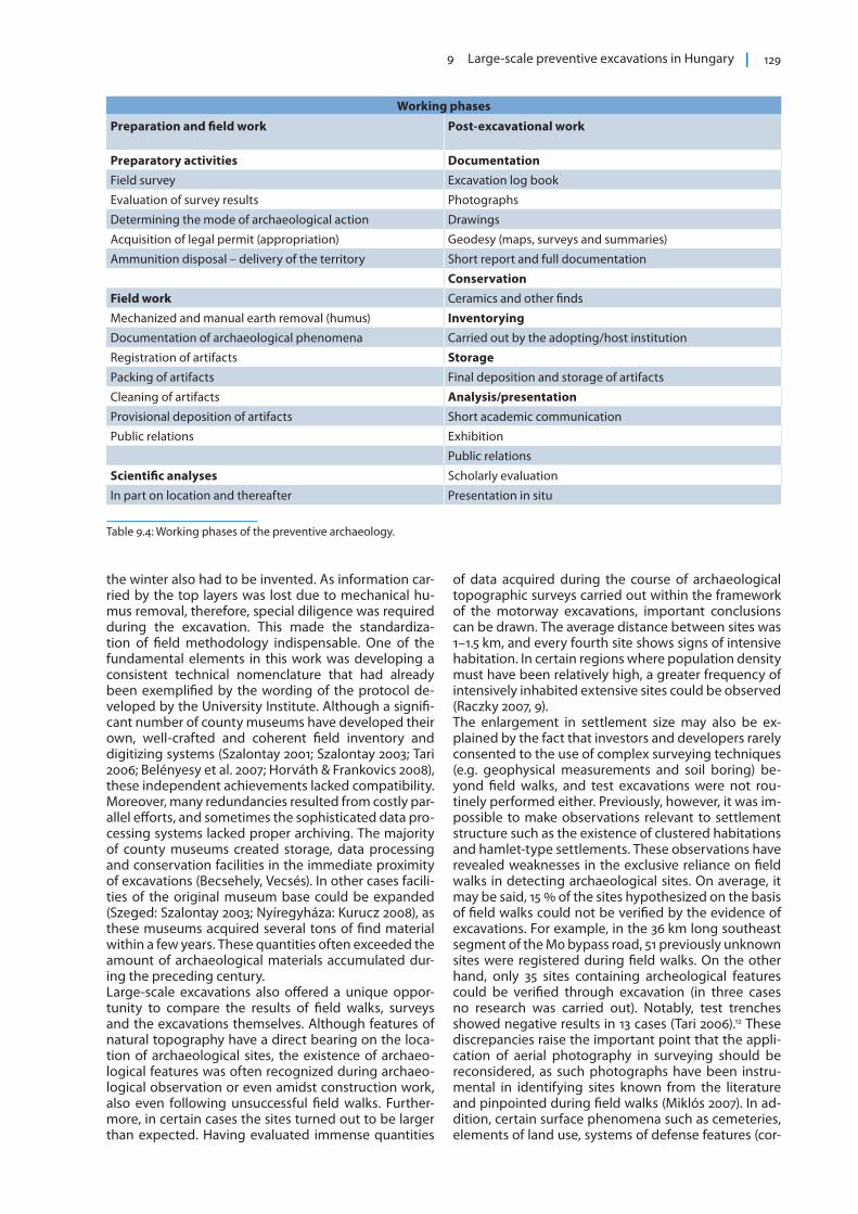
Working phases
Preparation and field work Post-excavational work
Preparatory activities DocumentationField survey Excavation log book
Evaluation of survey results Photographs
Determining the mode of archaeological action Drawings
Acquisition of legal permit (appropriation) Geodesy (maps, surveys and summaries)
Ammunition disposal – delivery of the territory Short report and full documentation
ConservationField work Ceramics and other finds
Mechanized and manual earth removal (humus) InventoryingDocumentation of archaeological phenomena Carried out by the adopting/host institution
Registration of artifacts StoragePacking of artifacts Final deposition and storage of artifacts
Cleaning of artifacts Analysis/presentationProvisional deposition of artifacts Short academic communication
Public relations Exhibition
Public relations
Scientific analyses Scholarly evaluation
In part on location and thereafter Presentation in situ
Table 9.4: Working phases of the preventive archaeology.

130 EAC OCCASIONAL PAPER NO. 6
rals, ditches) cannot be detected through field walks (Czajlik 2009). It is therefore worth considering that fu-ture field walks should be carried out after having con-sulted not only the technical literature and known field observations, but also an analysis of aerial photographs relevant to the area.
The third phase of large-surface excavations: 2007–2010
When characterizing the third phase, the economic environment at the end of the first decade of this mil-lennium cannot be disregarded. Beginning with 2007, Hungary was eligible to apply for financial resources de-tailed in the 2007–2013 budget of the European Union. Therefore it was deemed of critical importance (both by investors and the government) that large-scale de-velopment (such as motorway construction) had no au-thority in coordinating archaeological activity in terms of deadlines and pricing. Systematic regulations were lacking that would have synchronized work within a project that by then had spanned several counties.The development of our profession had not yet reached the level at which consequences of the exploding in-formation in cultural/archaeological heritage man-agement could have been handled in a standardized manner. The quality of activities and outputs by county museums tended to be heterogeneous, which often resulted in the delay of investment projects, thus sig-nificantly increasing their expenses. Given the accel-erating pace of developments, motorway contractors
increasingly expected predictable and transparent per-formance by archaeologists (Csillag 2008, 74) (fig. 9.10).
The Field Service of Cultural HeritageThere was thus increasing consensus that a state con-trolled organ in archaeology would have been a more reliable partner from the contractors’ point of view. During february 2007, the National Motorway Consor-tium was transformed into the National Infrastructure Development Consortium, and this new body main-tained the view that a single negotiator would have been easier to deal with than the variegated complex of 19 county museums and the Budapest History Muse-um. These developments resulted in an arbitrary modi-fication of excavation regulations in April 2007, without the consensus of the broader archaeological commu-nity. Following this political decision by the govern-ment, a centralized body, the Field Service of Cultural Heritage (hereafter Field Service) was established. It obtained exclusive rights to perform all archaeological prevention for those (private and state) “major devel-opments” whose budgets exceeded 2 million euros. One of the expectations was nationwide coordination, and a respect for deadlines. Excavations had to be or-ganized and executed on an industrial scale. Human and material resources had to be transferable and ef-forts were made to eliminate redundancies in the sys-tem, which ran a transparent budget. These changes, however, delivered a major blow onto the network of county museums that for over a century had been in charge of archaeological work, including the acquisi-tion and exhibition or archaeological artifacts. Some
Fig. 9.10: The motorway network of Hungary (Csillag 2008, fig. 70).
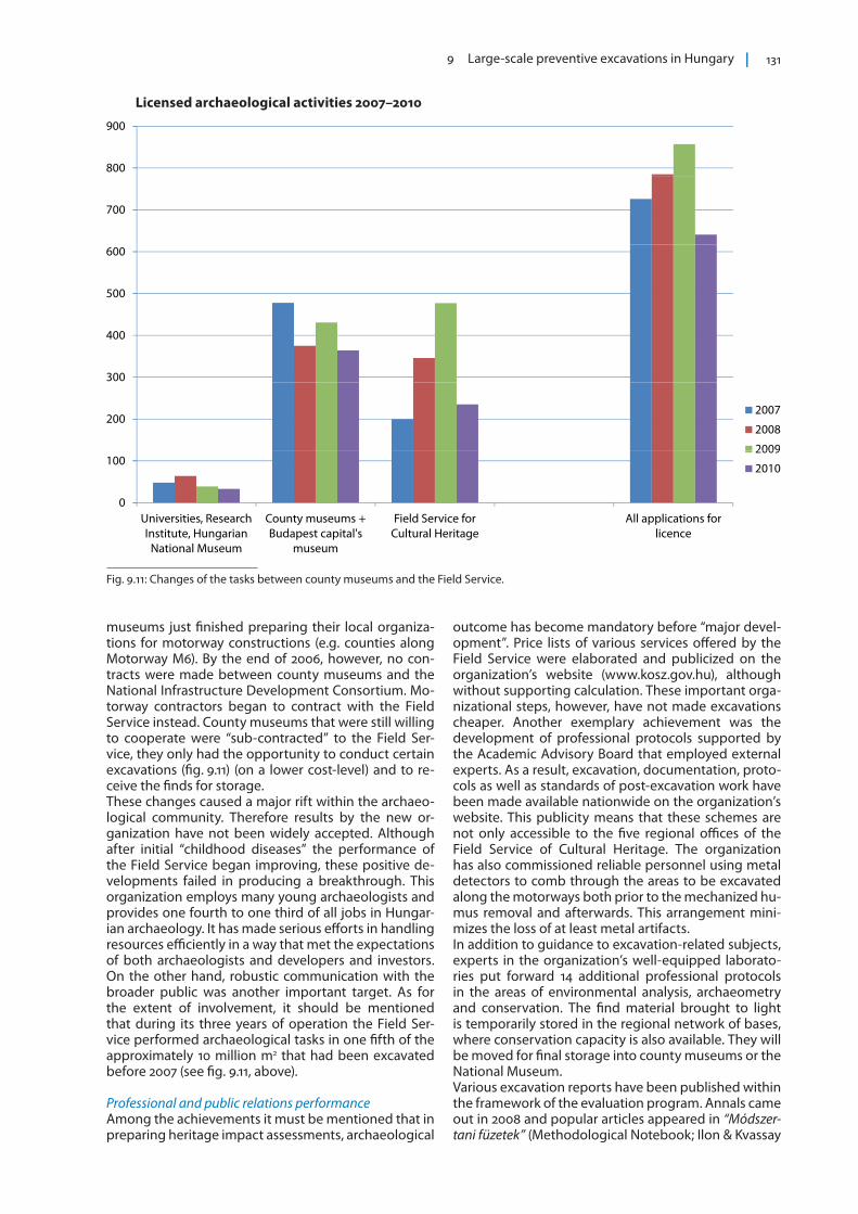
9 Large-scale preventive excavations in Hungary 131
museums just finished preparing their local organiza-tions for motorway constructions (e.g. counties along Motorway M6). By the end of 2006, however, no con-tracts were made between county museums and the National Infrastructure Development Consortium. Mo-torway contractors began to contract with the Field Service instead. County museums that were still willing to cooperate were “sub-contracted” to the Field Ser-vice, they only had the opportunity to conduct certain excavations (fig. 9.11) (on a lower cost-level) and to re-ceive the finds for storage.These changes caused a major rift within the archaeo-logical community. Therefore results by the new or-ganization have not been widely accepted. Although after initial “childhood diseases” the performance of the Field Service began improving, these positive de-velopments failed in producing a breakthrough. This organization employs many young archaeologists and provides one fourth to one third of all jobs in Hungar-ian archaeology. It has made serious efforts in handling resources efficiently in a way that met the expectations of both archaeologists and developers and investors. On the other hand, robustic communication with the broader public was another important target. As for the extent of involvement, it should be mentioned that during its three years of operation the Field Ser-vice performed archaeological tasks in one fifth of the approximately 10 million m2 that had been excavated before 2007 (see fig. 9.11, above).
Professional and public relations performanceAmong the achievements it must be mentioned that in preparing heritage impact assessments, archaeological
outcome has become mandatory before “major devel-opment”. Price lists of various services offered by the Field Service were elaborated and publicized on the organization’s website (www.kosz.gov.hu), although without supporting calculation. These important orga-nizational steps, however, have not made excavations cheaper. Another exemplary achievement was the development of professional protocols supported by the Academic Advisory Board that employed external experts. As a result, excavation, documentation, proto-cols as well as standards of post-excavation work have been made available nationwide on the organization’s website. This publicity means that these schemes are not only accessible to the five regional offices of the Field Service of Cultural Heritage. The organization has also commissioned reliable personnel using metal detectors to comb through the areas to be excavated along the motorways both prior to the mechanized hu-mus removal and afterwards. This arrangement mini-mizes the loss of at least metal artifacts. In addition to guidance to excavation-related subjects, experts in the organization’s well-equipped laborato-ries put forward 14 additional professional protocols in the areas of environmental analysis, archaeometry and conservation. The find material brought to light is temporarily stored in the regional network of bases, where conservation capacity is also available. They will be moved for final storage into county museums or the National Museum. Various excavation reports have been published within the framework of the evaluation program. Annals came out in 2008 and popular articles appeared in “Módszer-tani füzetek” (Methodological Notebook; Ilon & Kvassay
Fig. 9.11: Changes of the tasks between county museums and the Field Service.
Licensed archaeological activities 2007–2010
800
900
700
500
600
300
400
2002007
2008
2009
0
100
Universities Research County museums + Field Service for All applications for
2009
2010
Universities, Research Institute, Hungarian
National Museum
County museums + Budapest capital's
museum
Field Service for Cultural Heritage
All applications for licence
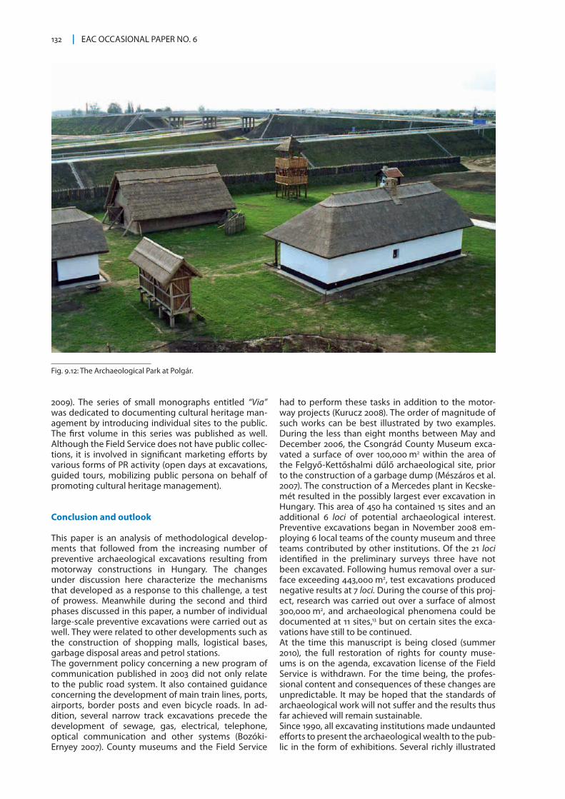
132 EAC OCCASIONAL PAPER NO. 6
2009). The series of small monographs entitled “Via” was dedicated to documenting cultural heritage man-agement by introducing individual sites to the public. The first volume in this series was published as well. Although the Field Service does not have public collec-tions, it is involved in significant marketing efforts by various forms of PR activity (open days at excavations, guided tours, mobilizing public persona on behalf of promoting cultural heritage management).
Conclusion and outlook
This paper is an analysis of methodological develop-ments that followed from the increasing number of preventive archaeological excavations resulting from motorway constructions in Hungary. The changes under discussion here characterize the mechanisms that developed as a response to this challenge, a test of prowess. Meanwhile during the second and third phases discussed in this paper, a number of individual large-scale preventive excavations were carried out as well. They were related to other developments such as the construction of shopping malls, logistical bases, garbage disposal areas and petrol stations.The government policy concerning a new program of communication published in 2003 did not only relate to the public road system. It also contained guidance concerning the development of main train lines, ports, airports, border posts and even bicycle roads. In ad-dition, several narrow track excavations precede the development of sewage, gas, electrical, telephone, optical communication and other systems (Bozóki-Ernyey 2007). County museums and the Field Service
had to perform these tasks in addition to the motor-way projects (Kurucz 2008). The order of magnitude of such works can be best illustrated by two examples. During the less than eight months between May and December 2006, the Csongrád County Museum exca-vated a surface of over 100,000 m2 within the area of the Felgyő-Kettőshalmi dűlő archaeological site, prior to the construction of a garbage dump (Mészáros et al. 2007). The construction of a Mercedes plant in Kecske-mét resulted in the possibly largest ever excavation in Hungary. This area of 450 ha contained 15 sites and an additional 6 loci of potential archaeological interest. Preventive excavations began in November 2008 em-ploying 6 local teams of the county museum and three teams contributed by other institutions. Of the 21 loci identified in the preliminary surveys three have not been excavated. Following humus removal over a sur-face exceeding 443,000 m2, test excavations produced negative results at 7 loci. During the course of this proj-ect, research was carried out over a surface of almost 300,000 m2, and archaeological phenomena could be documented at 11 sites,13 but on certain sites the exca-vations have still to be continued.At the time this manuscript is being closed (summer 2010), the full restoration of rights for county muse-ums is on the agenda, excavation license of the Field Service is withdrawn. For the time being, the profes-sional content and consequences of these changes are unpredictable. It may be hoped that the standards of archaeological work will not suffer and the results thus far achieved will remain sustainable.Since 1990, all excavating institutions made undaunted efforts to present the archaeological wealth to the pub-lic in the form of exhibitions. Several richly illustrated
Fig. 9.12: The Archaeological Park at Polgár.
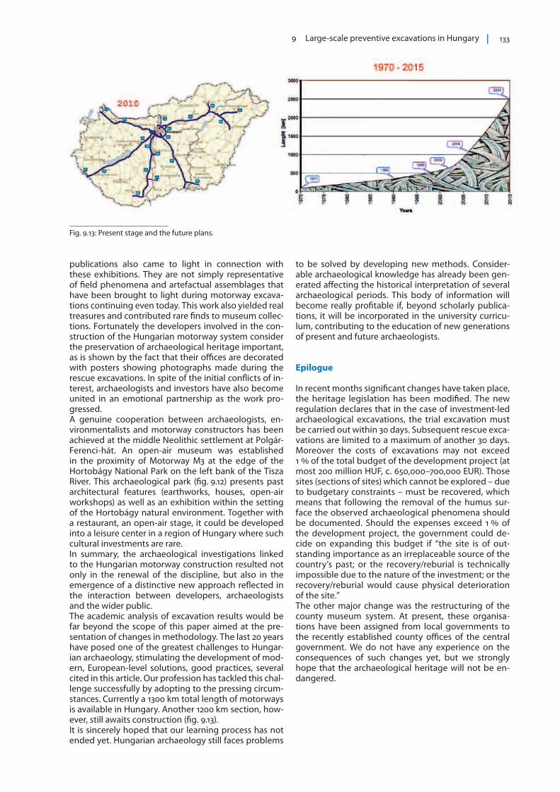
9 Large-scale preventive excavations in Hungary 133
publications also came to light in connection with these exhibitions. They are not simply representative of field phenomena and artefactual assemblages that have been brought to light during motorway excava-tions continuing even today. This work also yielded real treasures and contributed rare finds to museum collec-tions. Fortunately the developers involved in the con-struction of the Hungarian motorway system consider the preservation of archaeological heritage important, as is shown by the fact that their offices are decorated with posters showing photographs made during the rescue excavations. In spite of the initial conflicts of in-terest, archaeologists and investors have also become united in an emotional partnership as the work pro-gressed.A genuine cooperation between archaeologists, en-vironmentalists and motorway constructors has been achieved at the middle Neolithic settlement at Polgár-Ferenci-hát. An open-air museum was established in the proximity of Motorway M3 at the edge of the Hortobágy National Park on the left bank of the Tisza River. This archaeological park (fig. 9.12) presents past architectural features (earthworks, houses, open-air workshops) as well as an exhibition within the setting of the Hortobágy natural environment. Together with a restaurant, an open-air stage, it could be developed into a leisure center in a region of Hungary where such cultural investments are rare. In summary, the archaeological investigations linked to the Hungarian motorway construction resulted not only in the renewal of the discipline, but also in the emergence of a distinctive new approach reflected in the interaction between developers, archaeologists and the wider public.The academic analysis of excavation results would be far beyond the scope of this paper aimed at the pre-sentation of changes in methodology. The last 20 years have posed one of the greatest challenges to Hungar-ian archaeology, stimulating the development of mod-ern, European-level solutions, good practices, several cited in this article. Our profession has tackled this chal-lenge successfully by adopting to the pressing circum-stances. Currently a 1300 km total length of motorways is available in Hungary. Another 1200 km section, how-ever, still awaits construction (fig. 9.13). It is sincerely hoped that our learning process has not ended yet. Hungarian archaeology still faces problems
to be solved by developing new methods. Consider-able archaeological knowledge has already been gen-erated affecting the historical interpretation of several archaeological periods. This body of information will become really profitable if, beyond scholarly publica-tions, it will be incorporated in the university curricu-lum, contributing to the education of new generations of present and future archaeologists.
Epilogue
In recent months significant changes have taken place, the heritage legislation has been modified. The new regulation declares that in the case of investment-led archaeological excavations, the trial excavation must be carried out within 30 days. Subsequent rescue exca-vations are limited to a maximum of another 30 days. Moreover the costs of excavations may not exceed 1 % of the total budget of the development project (at most 200 million HUF, c. 650,000–700,000 EUR). Those sites (sections of sites) which cannot be explored – due to budgetary constraints – must be recovered, which means that following the removal of the humus sur-face the observed archaeological phenomena should be documented. Should the expenses exceed 1 % of the development project, the government could de-cide on expanding this budget if “the site is of out-standing importance as an irreplaceable source of the country’s past; or the recovery/reburial is technically impossible due to the nature of the investment; or the recovery/reburial would cause physical deterioration of the site.”The other major change was the restructuring of the county museum system. At present, these organisa-tions have been assigned from local governments to the recently established county offices of the central government. We do not have any experience on the consequences of such changes yet, but we strongly hope that the archaeological heritage will not be en-dangered.
Fig. 9.13: Present stage and the future plans.
134 EAC OCCASIONAL PAPER NO. 6
Notes
1 Archaeological Topography of Hungary. The first volume was published in 1966, the last, tenth volume in 1998.
2 During the 1980s major excavations were carried out during the renovation of Árpád bridge in Budapest. Expanding the bridge head on the Buda site effected the former Roman legionary camp of Aquincum, the capital of the province Pannonia. The southern wall and associated gate of the camp could be reconstructed. The ruins could be successfully incorporated into the Flórián Square pedestrian subway. The ruins were conserved in a small park near the southwestern exit.
3 The joint entry sections of Motorways M1 and M7 to Budapest, comprising of a 2 ¥ 2 lane express road, were inaugurated in 1964.
4 E.g. the site of Győr–Szabadrét-domb where a total of 935 features were excavated over a surface of 4.5 ha.
5 E.g. during the course of preventive excavations on Motorway M3, where 7 ha of the 22 ha large medieval village of Muhi were affec-ted by the motorway construction, but ultimately only 1.5 ha could be excavated.
6 After 2005 this organization was called the National Motorway Consortium. It was replaced by the National Infrastructure Deve-lopment Consortium in February 2007.
7 Law CXXVIII/2003 concerning the public value and development of the motorway network in the Republic of Hungary.
8 http://istar.okm.gov.hu/kiadvany/?order=name&osap=1946&year=2005 Architectural heritage, tables 1–4. Statistics published by the ministry on the internet: http://istar.okm.gov.hu. The aim of data gathering was the mapping of performance by public collec-tions, including museums. Following 2005, the lists contain data concerning the numbers of archaeologists and other specialists, incomes, certain aspects of the infrastructure, the materials inven-toried and conserved. Last but not least, information is available concerning research and development, publications, exhibitions and other aspects of public relations.
9 Relevant references in Magyar Múzeumok 2007/1 (in Hungarian with English summary): Tari, E.: Egymillió négyzetméter régés-zeti feltárása az M0-s körgyűrű területén; Zsidi, P. & Reményi, L.: A Budapesti Történeti Múzeum kutatásai az M0-ás autópálya ke-leti szektorán; Anders, A.: Megelőző régészeti feltárások az M3-as és M35-ös autópályák nyomvonalán (2003–2006); Somogyvári, Á.: Nagyberuházások és régészet Bács-Kiskun megyében (M5); Ódor, J.G.: Beszámoló az M6 autópálya Tolna megyei szakaszán végzett megelőző feltárásokról; Nagy, E.: Az M6–M60 gyorsforgalmi út Baranya megyei szakasza (2005–2006); Honti, S.: Régészeti kutatá-sok az M7-es autópálya nyomvonalán Somogy megyében; Vándor, L.: Régészeti feltárások az M7–M70-es autópálya zalai szakaszán; Csányi, M., Tárnoki, J. & Polgár, Z.: A Vásárhelyi-terv továbbfejlesz-tése I. üteméhez kapcsolódó feltárások Jász–Nagykun–Szolnok megyében; Szörényi, G.A.: Régészeti kutatások a cigándi árvízi tározó területén (Pácin-Alharaszt); Kocsis, L.: A tiszaroffi víztározó gátjának nyomvonalában végzett megelőző régészeti feltárásról.
10 Since 1994, the Budapest History Museum has published short excavation reports in its own series called “Aquincumi Füzetek” (Aquincum Notebooks).
11 The full series of data was made available by István Ecsedy, whose help is acknowledged here.
12 Grateful thanks are due to Edit Tari who provided detailed infor-mation.
13 Data provided by Károly Belényessy of the Field Service of Cultural Heritage, whose help is gratefully acknowledged here.
[email protected] [email protected]
References
Balogh, Cs. (ed.) 2009: Nyomvonalba zárva Régészeti feltárások az M43-as autóút és a Makót elkerülő út nyomvonalán. Móra Ferenc Múzeum Csongrád Megyei Önkormányzat Megyei Múzeuma, Szeged.
Belényesy, K., Honti, Sz. & Kiss V. (eds) 2007: Gördülő idő. Régészeti feltárások az M7-es autópálya Somogy megyei szakaszán Zamárdi és Ordacsehi között. Somogy Megyei Múzeumok Igazgatósága-MTA Régészeti Intézete.
Bozóki-Ernyey, K. 2007: Preventive Archaeology in Hungary One Step Behind, in Bozóki-Ernyey, K. (ed.): European Preventive Archaeology. Papers of the EPAC Meeting 2004, Vilnius, National Office of Cultural Heritage, Hungary – Council of Europe, Budapest, 105–121.
Bökönyi, S. (ed.) 1992: Cultural and Landscape Changes in South-East Hungary I. Reports on the Gyomaendrőd Project, Archaeolingua, Budapest.
Bökönyi, S. (ed.) 1996: Cultural and Landscape Changes in South-East Hungary II. Prehistoric Roman Barbarian and Late Avar Settlement at Gyoma, Archaeolingua, Budapest.
Cleere, H. 1989: Archaeological heritage management in the modern world, London.
Csáky, Gy. & Figler, A. 1995: Az Intergraph Micro Station alkalmazása régészeti ásatások dokumentációinak kezelésére, in MÚLTUNK JÖVŐJE ’95. Konferencia az informatika és a számítógép alkalmazásáról a régészetben és a múzeumi munka egyéb területein, Budapest.
Chapman, J. 2002: Neolithic pottery at Polgar-10 (Hungary): measuring the habitus. Documenta Praehistorica 29, 127–144.
Csillag, I. 2008: Autópálya-építés és verseny, in Laki, M. & Voszka, É. (eds): Kaleidoszkóp. Versenyhelyzet Magyarországon 2007-ben. Pénzügykutató Rt, Budapest, 69–96.
Czajlik, Z. 2009: Légi régészet Magyarországon. in: Anders, A., Szabó, M. & Raczky, P. (eds): Régészeti dimenziók. Tanulmányok az ELTE BTK Régészettudományi Intézetének tudományos műhelyéből. Bibliotheca Archaeologica 3, Budapest, 23–36.
Czajlik, Z., Marton, Á. & Holl, В. 1997: Az M3-as autópálya régészeti leletmentéseinek térinformatikai feldolgozása, in Raczky, P., Kovács, T. & Anders, A. (eds): „Utak a múltba”. Az M3-as autópálya régészeti leletmentései. Paths into the Past.” Rescue Excavations on the M3 Motorway. Magyar Nemzeti Múzeum-Eötvös Loránd Tudományegyetem Régészettudományi Intézet, Budapest.
Eke, I., Frankovics, T. & Kvassay, J. 2007: Első tapasztalatok a nagyfelületű régészeti feltárások térinformatikai feldolgozása során Zala megyében. Zalai Múzeum 16, 259–269.
9 Large-scale preventive excavations in Hungary 135
Endrődi, A., Szilas, G. (eds) 2009: Régészeti Kutatások Budapest peremén Archaeological investigations on the outskirts of Budapest. Budapesti Történeti Múzeum, Budapest.
Ernyey, E. 2003: Excavations: from treasure hunting to motorway archaeology in Hungary, in Visy, Zs. & Nagy, M. (eds): Hungarian Archaeology at the Turn of the Millennium. Ministry of National Cultural Heritage-Teleki László Foundation, Budapest, 419–421.
Fülep, F. 1979: Előszó. Dunai Régészeti Híradó. Magyar Nemzeti Múzeum, Budapest 5–6.
Horváth, L. & Frankovics, T. (eds) 2008: Régészeti feltárások az M7-M70 autópálya Zala megyei nyomvonalán. http://www.zmmi.hu/gm/m7_kiadvany/Htm/001_Index.htm.
Ilon, G., Kvassay, J. (eds) 2009: Összeköttetés föld fölött és föld alatt: a Győr–Szombathely és Szombathely–Hévíz közötti 400 kV-os távvezeték régészeti kutatásai 2003–2009. Kulturális Örökségvédelmi Szakszolgálat Szombathely, Budapest.
Jankovich, B. D. 1993: A felszíni leletgyűjtés módszerei és szerepe a régészeti kutatásban. Régészeti Továbbképző Füzetek 4. Magyar Nemzeti Múzeum-MTA Régészeti Intézete, Budapest.
Jankovich, B. D. 1997: Raczky Pál, Kovács Tibor, Anders Alexandra (eds): Utak a múltba. Az M3-as autópálya régészeti leletmentései. Recenzió. BUKSZ 1997/4, 473–477.
Jankovich, B. D. 2009: A régészeti örökség helyzete Magyarországon, in Bassa, L. (ed.): Tanulmányok az örökségmenedzsmentről 1. A világörökség és kezelése, Alma Mater Információs Társadalomért Alapítvány, Budapest, 29–54.
Jankovich, B. D. & Nagy, M. 2004: Felmérés a régészet helyzetéről 1989–1999, NKÖM-KÖH, Budapest.
Korek, J. 1974: Archäologische Forschungsberichte aus dem Bereich der zweiten Theiss-Staustufe, in Folia Archaeologica. A Magyar Nemzeti Múzeum évkönyve 25, 249–262.
Korek, J. 1975: Mentsük meg pusztuló régészeti emlékeinket, MRMK, Budapest.
KSH: Magyar statisztikai zsebkönyvek. Központi Statisztikai Hivatal, Budapest 1990, 1997, 2007, 2009.
Kurucz, K. 2008: Nagyberuházásokat megelőző régészeti feltárások Szabolcs-Szatmár-Bereg megyében 1993–2008 között – Large-scale excavations preceding construction project in Szabolcs-Szatmár-Bereg county1993–2008, in Almássy K. & Istvánovits, E. (eds): Nyíregyházi Jósa András Múzeum Évkönyve L., 55–66.
Magyar Múzeumok 2007/1 http://www.magyarmuzeumok.hu/archivum/pdf/2007_1.pdf.
Mészáros, P., Paluch, T., Sóskuti, K. Sz. & Wilhelm, G. 2007: Régészeti kutatások Felgyő határában Magyar Múzeumok 2007/1, 41–43.
Makkay, J. 2005: Úton-útszélen ‘ad honore totius populi Hungariae’, Budapest.
Miklós, Zs. 2007: Légi fényképezés az M7-es autópálya Somogy megyei szakaszán, in Belényesy, K., Honti, Sz. & Kiss V. (eds): Gördülő idő. Régészeti feltárások az M7-es autópálya Somogy megyei szakaszán Zamárdi és Ordacsehi között. Somogy Megyei Múzeumok Igazgatósága-MTA Régészeti Intézete, 237–240.
Nagy, M. 2003: The protection of the archaeological heritage in Hungary, in Visy, Zs. & Nagy, M. (eds): Hungarian Archaeology at the Turn of the Millennium. Ministry of National Cultural Heritage – Teleki László Foundation, Budapest, 30–38.
Raczky, P. 2006: A régészeti lelőhely fogalmának tudományfilozófiai alapon történő axiomatikus meghatározása. Archaeológiai Értesítő 131, 246–247.
Raczky, P. 2007: Az autópálya-régészet helyzete Magyarországon – Módszerek és tapasztalatok az 1990 és 2007 közötti munkálatok alapján – The state of “motorway archaeology” in Hungary. Methods and experience based on the work carried out between 1990 and 2007. Archaeologiai Értesítő 132, 5–36.
Raczky, P. 2008: Motorway Archaeology In Hungary. Methods and experience based on the work carried out between 1990 and 2008, in On the Road to Reconstructing the Past. 36th Annual Conference on Computer Applications and Quantitative Methods in Archaeology Budapest, Hungary (Keynote speech).
Raczky, P., Kovács, T. & Anders, A. (eds) 1997: „Utak a múltba”. Az M3-as autópálya régészeti leletmentései. Paths into the Past.” Rescue Excavations on the M3 Motorway. Magyar Nemzeti Múzeum-Eötvös Loránd Tudományegyetem Régészettudományi Intézet, Budapest.
Raczky, P., Czajlik, Z., Marton, Á., Holl, B. & Puszta, S., 1997: GIS and the evaluation of rescue excavations along the M3 Motorway in Hungary. Poročilo o raziskovanju paleolitika, neolitika in eneolitika v Sloveniji. Documenta Praehistorica 24, 157–170.
Raczky, P., Puszta, S., Czajlik, Z., Holl, B. & Marton, Á. 2002: Investigation of archaeological sites with the integrated application of aerial photography, magnetometer surveys and archaeological excavation, in Jerem, E. & T. Biró, K. (eds): Archaeometry 98. Proceedings of the 31st Symposium Budapest, April 26–May 3 1998. BAR International Series 1043 (Vol. I), 135–143.
Rezi-Kató, G. 2003: A régészeti műemlékek központi adattárától a régészeti műemlékek egységes adatbázisáig, in Visy, Zs. (ed.): Régészeti műemlékek kutatása és gondozása a 3. évezred küszöbén, Pécs, 15–19.
Selmeczi, L. & Havassy, P. (eds) 1992: Régészeti kutatások az MO autópálya nyomvonalán I., II. BTM MŰHELY 5–6. Budapesti Történeti Múzeum, Budapest.
Somogyvári, Á. 2007: Nagyberuházások és régészet Bács-Kiskun megyében (M5). Magyar Múzeumok 2007/1, tavasz 14–17.
136 EAC OCCASIONAL PAPER NO. 6
Szabó, M., Raczky, P. & Zsidi, P. 2006: Az MTA Régészeti Bizottságának szakmai javaslatai az országos közúthálózat fejlesztésének, fenntartásának és üzemeltetésének hosszú és középtávú feladatairól, valamint finanszírozásának egyes kérdéseiről szóló 2044/2003. (III. 14.) kormányhatározat megvalósíthatóságának előmozdítására. Archaeológiai Értesítő 131, 243–245.
Szalontai, Cs. 2001: Beszámoló az M5 autópálya nyomvonalának előzetes feltárásáról, in Erdélyi, P. & Szűcs, J. (eds): Múzeumi kutatások Csongrád megyében. 1999/2000. Szeged, 3–20.
Szalontai, Cs. (ed.) 2003: Úton-útfélen. Múzeumi kutatások az M5 autópálya nyomvonalán. Móra Ferenc Múzeum, Szeged.
Tari, E. (ed.) 2006: Régészeti kutatások másfél millió négyzetméteren. Autópálya és gyorsforgalmi utak építését megelőző régészeti feltárások Pest Megyében 2001–2006. Pest Megyei Múzeumi Füzetek új sorozat 7, Szentendre,1–14.
Trotzig, G. 2001: On the (Revised) European Convention on the Protection of the Archaeological Heritage, presented in Malta. TEA No. 15 Summer. http://www.e-a-a.org/tea15new.pdf.
Trotzig, G. 2003: Ten years of protection of the archaeological heritage, in Memory of the heritage. Naturopa No. 99, Council of Europe, 20.
UTP 2003: The Upper Tisza Project. http://ads.ahds.ac.uk/catalogue/adsdata/UpperTisza_ba_2003/html/home.htm.
Vékony, G. 2003: The history of archaeological fieldwork in Hungary, in Visy, Zs. & Nagy, M. (eds): Hungarian Archaeology at the Turn of the Millennium. Ministry of National Cultural Heritage – Teleki László Foundation, Budapest, 15–22.
Visy, Zs. 2009: Régészeti örökségvédelem a múló időben, in Bassa, L. (ed.): Tanulmányok az örökségmenedzsmentről 1. A világörökség és kezelése. Alma Mater Információs Társadalomért Alapítvány, Budapest, 5–18.
Wollák, K. 2007a: Sztrádarégészet Magyar Múzeumok p.1.http://www.magyarmuzeumok.hu/archivum/pdf/2007_1.pdf.
Wollák, K. 2007b: The Protection of Cultural Heritage by Legislative Methods in Hungary, in Jerem, E., Mester, Zs., & Benczés, R. (eds): Archaeological and Cultural Heritage Preservation Within the Light of new Technologies. Budapest, 73–82.
Wollák, K. 2009: Listing – precondition of protection?, in Schut, P.A.C. (ed.): Listing Archaeological Sites, Protecting the Historical Landscape. EAC occasional paper 3, 53–61.
Willems, W.J.H. 2007: The work of Making Malta: the council of Europe’s Archaeology and Planning Committee 1988–1996. European Journal of Archaeology 10(1), 57–71.
Zsidi, P. (ed) 2005: Kincsek a város alatt Budapest régészeti örökségének feltárása, 1989-2004. Treasures under the city. Archaeolingua Alapítvány és Kiadó, Budapest.