2002 OUR COUNTRY, THEIR COUNTRY: PRELIMINARY COMPARISONS OF THE PIGMENT ROCK-ART ACROSS THE...
38
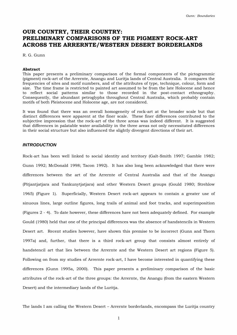
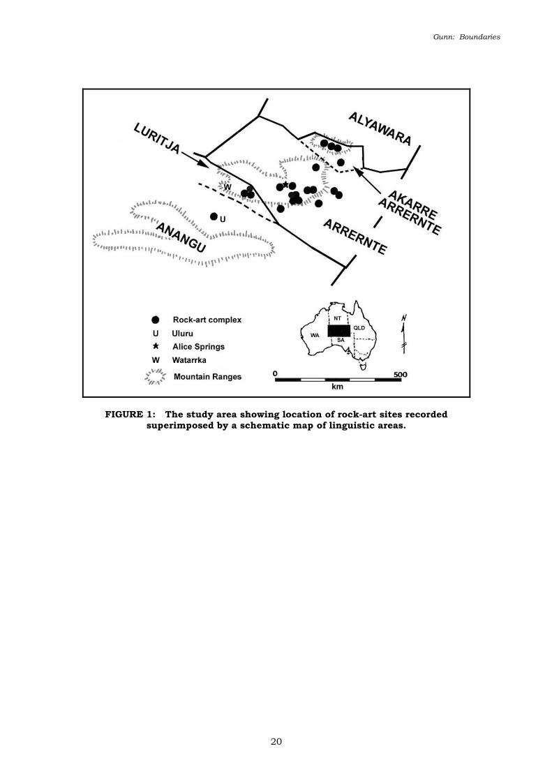
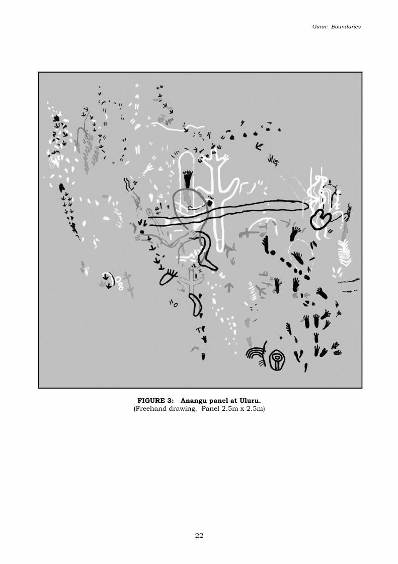
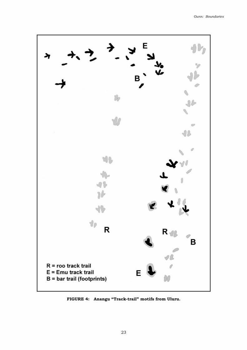
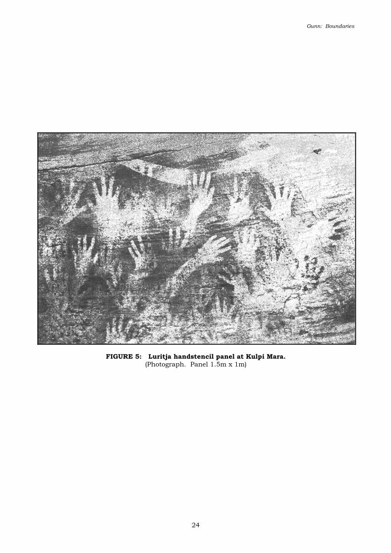
Gunn: Boundaries 1 OUR COUNTRY, THEIR COUNTRY: PRELIMINARY COMPARISONS OF THE PIGMENT ROCK-ART ACROSS THE ARRERNTE/WESTERN DESERT BORDERLANDS R. G. Gunn Abstract This paper presents a preliminary comparison of the formal components of the pictogrammic (pigment) rock-art of the Arrernte, Anangu and Luritja lands of Central Australia. It compares the frequencies of sites and motif numbers, and of the attributes of type, technique, colour, form and size. The time frame is restricted to painted art assumed to be from the late Holocene and hence to reflect social patterns similar to those recorded in the post-contact ethnography. Consequently, the abundant petroglyphs throughout Central Australia, which probably contain motifs of both Pleistocene and Holocene age, are not considered. It was found that there was an overall homogeneity of rock-art at the broader scale but that distinct differences were apparent at the finer scale. These finer differences contributed to the subjective impression that the rock-art of the three areas was indeed different. It is suggested that differences in palatable water availability in the three areas not only necessitated differences in their social structure but also influenced the slightly divergent directions of their art. INTRODUCTION Rock-art has been well linked to social identity and territory (Galt-Smith 1997; Gamble 1982; Gunn 1992; McDonald 1998; Tacon 1992). It has also long been acknowledged that there were differences between the art of the Arrernte of Central Australia and that of the Anangu (Pitjantjatjara and Yankunytjatjara) and other Western Desert groups (Gould 1980; Strehlow 1965) (Figure 1). Superficially, Western Desert rock-art appears to contain a greater use of sinuous lines, large outline figures, long trails of animal and foot tracks, and superimposition (Figures 2 - 4). To date however, these differences have not been adequately defined. For example Gould (1980) held that one of the principal differences was the absence of handstencils in Western Desert art. Recent studies however, have shown this premise to be incorrect (Gunn and Thorn 1997a) and, further, that there is a third rock-art group that consists almost entirely of handstencil art that lies between the Arrernte and the Western Desert art regions (Figure 5). Following on from my studies of Arrernte rock-art, I have become interested in quantifying these differences (Gunn 1995a, 2000). This paper presents a preliminary comparison of the basic attributes of the rock-art of the three groups: the Arrernte, the Anangu (from the eastern Western Desert) and the intermediary lands of the Luritja. The lands I am calling the Western Desert – Arrernte borderlands, encompass the Luritja country
-
Upload
independent -
Category
Documents
-
view
1 -
download
0
Transcript of 2002 OUR COUNTRY, THEIR COUNTRY: PRELIMINARY COMPARISONS OF THE PIGMENT ROCK-ART ACROSS THE...
Gunn: Boundaries
1
OUR COUNTRY, THEIR COUNTRY: PRELIMINARY COMPARISONS OF THE PIGMENT ROCK-ART ACROSS THE ARRERNTE/WESTERN DESERT BORDERLANDS
R. G. Gunn
Abstract
This paper presents a preliminary comparison of the formal components of the pictogrammic
(pigment) rock-art of the Arrernte, Anangu and Luritja lands of Central Australia. It compares the
frequencies of sites and motif numbers, and of the attributes of type, technique, colour, form and
size. The time frame is restricted to painted art assumed to be from the late Holocene and hence
to reflect social patterns similar to those recorded in the post-contact ethnography.
Consequently, the abundant petroglyphs throughout Central Australia, which probably contain
motifs of both Pleistocene and Holocene age, are not considered.
It was found that there was an overall homogeneity of rock-art at the broader scale but that
distinct differences were apparent at the finer scale. These finer differences contributed to the
subjective impression that the rock-art of the three areas was indeed different. It is suggested
that differences in palatable water availability in the three areas not only necessitated differences
in their social structure but also influenced the slightly divergent directions of their art.
INTRODUCTION
Rock-art has been well linked to social identity and territory (Galt-Smith 1997; Gamble 1982;
Gunn 1992; McDonald 1998; Tacon 1992). It has also long been acknowledged that there were
differences between the art of the Arrernte of Central Australia and that of the Anangu
(Pitjantjatjara and Yankunytjatjara) and other Western Desert groups (Gould 1980; Strehlow
1965) (Figure 1). Superficially, Western Desert rock-art appears to contain a greater use of
sinuous lines, large outline figures, long trails of animal and foot tracks, and superimposition
(Figures 2 - 4). To date however, these differences have not been adequately defined. For example
Gould (1980) held that one of the principal differences was the absence of handstencils in Western
Desert art. Recent studies however, have shown this premise to be incorrect (Gunn and Thorn
1997a) and, further, that there is a third rock-art group that consists almost entirely of
handstencil art that lies between the Arrernte and the Western Desert art regions (Figure 5).
Following on from my studies of Arrernte rock-art, I have become interested in quantifying these
differences (Gunn 1995a, 2000). This paper presents a preliminary comparison of the basic
attributes of the rock-art of the three groups: the Arrernte, the Anangu (from the eastern Western
Desert) and the intermediary lands of the Luritja.
The lands I am calling the Western Desert – Arrernte borderlands, encompass the Luritja country

Gunn: Boundaries
2
of the south-west ranges of the greater MacDonnell Ranges block (Figure 1). The core Arrernte
rock-art region is within the south-east ranges of this block, while the sample of Anangu rock-art
is taken from Uluru, a large inselberg in the dune-fields of the Great Sandy Desert and situated
between the MacDonnell and Musgrave Ranges (Gunn 2001).
The Luritja are a Western Desert speaking group who traditionally had close social and cultural
ties to the Anangu and other Western Desert groups to the north-west. In contrast, they had only
loose ties with their Arrernte neighbours to the east and north, through periodic interaction
involving ceremonies and marital exchange. There are also recorded instances of intermittent
conflict and organised battles (Strehlow 1970). These language groups are thought to have
occupied Central Australia at some time in the late Holocene (McConvell 1996; Smith 1988). As
most surviving pigment art here is thought to be of similar age (Smith 1988; Thorley 1998), it will
form the focus of this paper. Petroglyphs (engravings) are both numerous and widespread
throughout Central Australia (Edwards 1966, 1971; Gunn 1995a; Mountford 1960). However, as
these are regarded as having been produced periodically since the Pleistocene and have not been
extensively studied or documented, they are most likely irrelevant to the present paper.
As Strehlow (1965) and Gould (1980) have shown, a principal difference between the Arrernte and
Luritja lands, and those of the Anangu is the greater availability of surface water in the former
regions (see also Tindale 1976). In all areas the annual average rainfall is low (c.200 mm) with
falls generally heavier over the summer months. The rainfall however is unreliable and very
variable with long periods of drought and periodic floods being a feature of the weather pattern.
Temperatures are similarly extreme with prolonged hot spells (>35oC) in summer and frosts
common in winter. One of the major features of the ranges of the MacDonnell Ranges block, is
the occurrence of permanent springs and soaks, which contrasts markedly with the scarcity of
surface water in the surrounding desert areas where rockholes and claypans are entirely
dependent on local rainfall events.
Social ties amongst the Arrernte involved a closely-knit system of totemic clans with well-defined
estates centred on particular sacred sites (Spencer and Gillen 1899; Strehlow 1965, 1970). In
Gunn: Boundaries
3
contrast, the Western Desert groups were more open and allowed fluid movement across the vast
desert areas (Myers 1991). According to the currently popular Information Exchange model
(Gamble 1982; Smith 1992), the rock-art of the Western Desert should therefore show a close
homogeneity, whereas that of the Arrernte should show locally centred, internal heterogeneity.
While apparently the case, further examination of this aspect must await the detailed recording of
a spatially wider range of Western Desert sites.
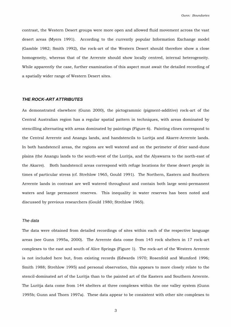
THE ROCK-ART ATTRIBUTES
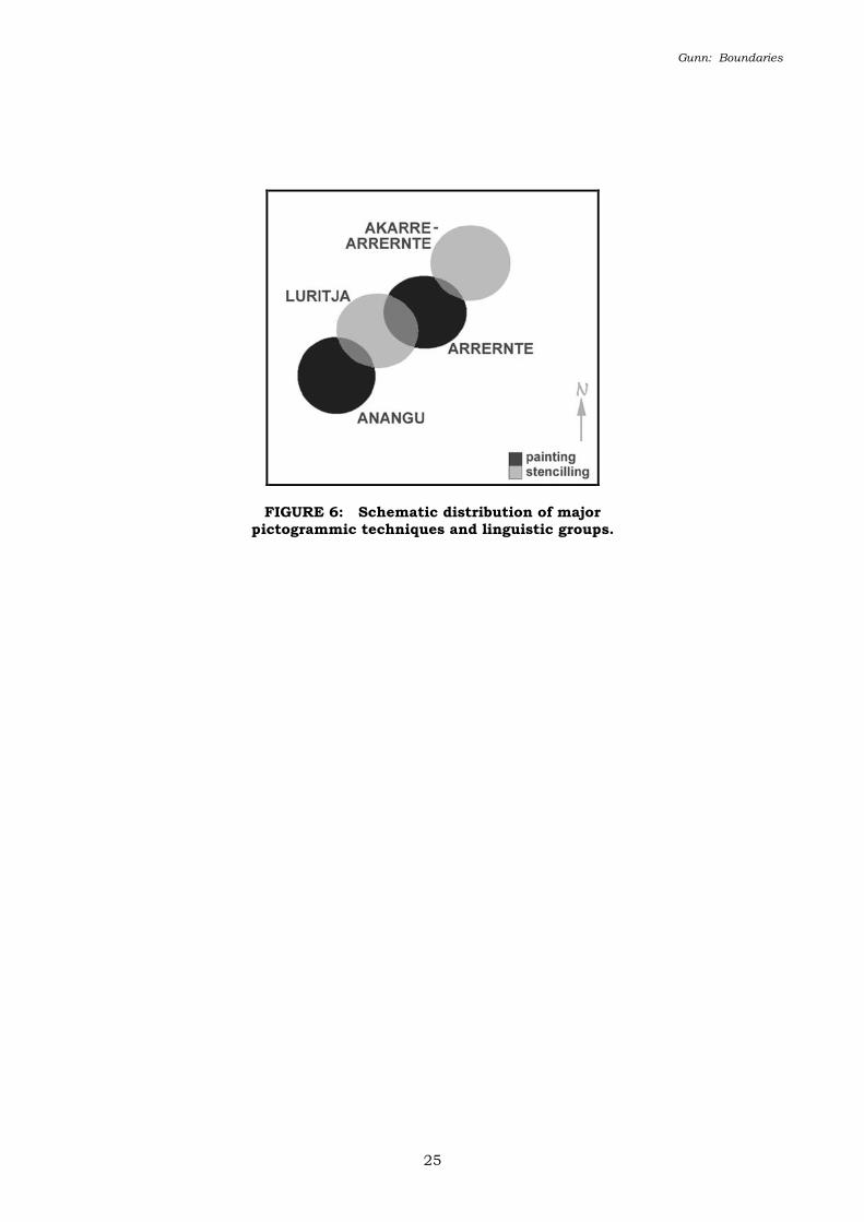
As demonstrated elsewhere (Gunn 2000), the pictogrammic (pigment-additive) rock-art of the
Central Australian region has a regular spatial pattern in techniques, with areas dominated by
stencilling alternating with areas dominated by paintings (Figure 6). Painting clines correspond to
the Central Arrernte and Anangu lands, and handstencils to Luritja and Akarre-Arrernte lands.
In both handstencil areas, the regions are well watered and on the perimeter of drier sand-dune
plains (the Anangu lands to the south-west of the Luritja, and the Alyawarra to the north-east of
the Akarre). Both handstencil areas correspond with refuge locations for these desert people in
times of particular stress (cf. Strehlow 1965, Gould 1991). The Northern, Eastern and Southern
Arrernte lands in contrast are well watered throughout and contain both large semi-permanent
waters and large permanent reserves. This inequality in water reserves has been noted and
discussed by previous researchers (Gould 1980; Strehlow 1965).
The data
The data were obtained from detailed recordings of sites within each of the respective language
areas (see Gunn 1995a, 2000). The Arrernte data come from 145 rock shelters in 17 rock-art
complexes to the east and south of Alice Springs (Figure 1). The rock-art of the Western Arrernte
is not included here but, from existing records (Edwards 1970; Rosenfeld and Mumford 1996;
Smith 1988; Strehlow 1995) and personal observation, this appears to more closely relate to the
stencil-dominated art of the Luritja than to the painted art of the Eastern and Southern Arrernte.
The Luritja data come from 144 shelters at three complexes within the one valley system (Gunn
1995b; Gunn and Thorn 1997a). These data appear to be consistent with other site complexes to
Gunn: Boundaries
4
the north and west (Gunn 1988; Smith and Rosenfeld 1992). The Anangu data derives from 106
shelters around the base of Uluru (Gunn 2001). The Uluru data appears to compliment data from
sites further to the south (Gunn and Thorn 1997b; Mountford 1976) and west (Gould 1969, 1980).
Not all of the data is readily comparable due to differing aims and methods of the different
projects and hence there is some discrepancy in the totals presented here. The available data
however are assumed to be largely representative of their respective areas.
Rock type
The nature and type of shelter-forming rock outcrops varies within each region. In Arrernte lands
the rock-shelters are most common in Devonian sandstones with a smaller number within
quartzite formations. The sandstone varies across the lands from poorly cemented in the far west,
to well cemented in the centre and east. The sandstone that houses the Luritja shelters is a
westerly extension of the poorly cemented sandstones found within the Arrernte lands. The
gradation in cementation between these two language regions is gradual and unmarked. The
Anangu shelters in contrast, are predominantly in arkose and granite, and are geologically
separated from the Luritja sites by the broad sand-dune country of the Amadeus basin.
Art quantity
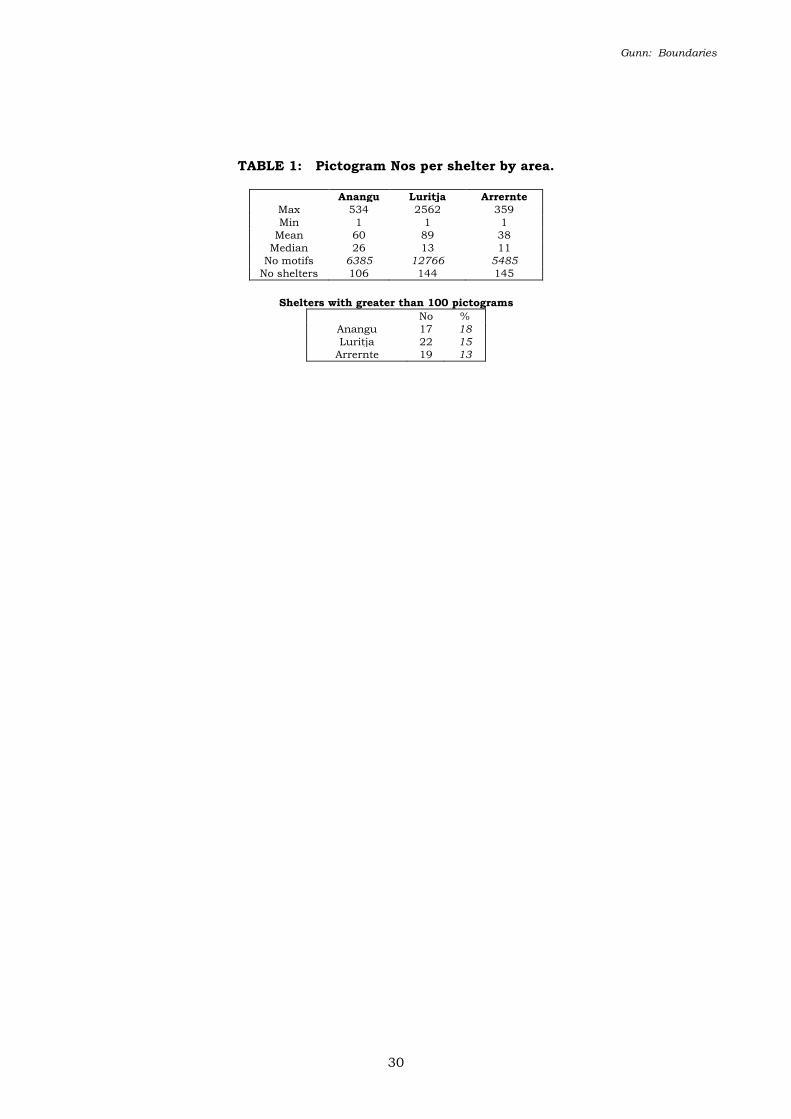
The current sample includes over one hundred rock-art shelters from each of the three linguistic
areas (Table 1). The range of motif numbers is similar for the Arrernte and Anangu sites, while
the high overall density of the Luritja sites (mean = 89 motifs per shelter) can be attributed to a
few exceptional sites as expressed by the motif range (1 to 2562 per site). With the exclusion of
these few exceptional sites, the median in the Luritja sites drops to be comparable with that of the
Arrernte sites. Large art sites (those with more than 100 motifs) occur in similar proportions in
each area (c.15%; Table 1). However, the higher median value of the Anangu sites is seen to
reflect a real trend for a greater density of rock-art per shelter. In this sense then the Luritja art,
with its occasional high densities and low overall median, can be seen to be intermediary in
density between that of the Anangu and the Arrernte.
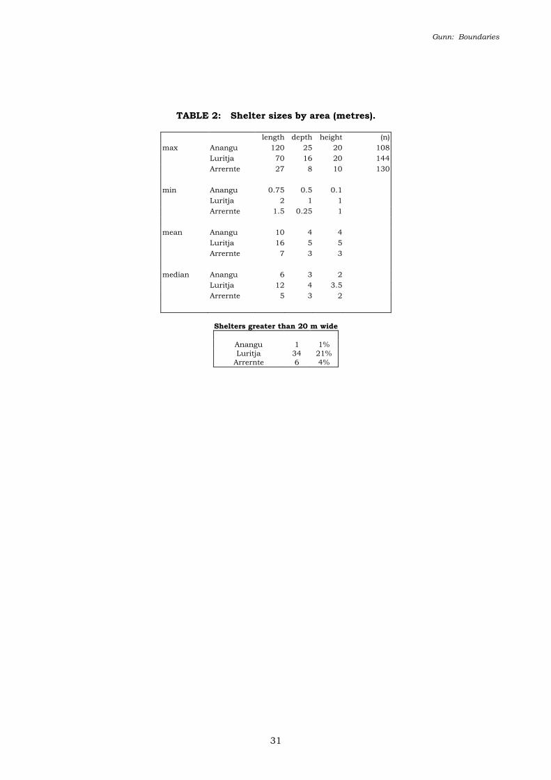
Luritja shelters tend to be larger than either Anangu or Arrernte shelters (Table 2) and an
Gunn: Boundaries
5
exceptionally high proportion are large (>20 m wide). However both the largest and smallest art
shelters occur in Anangu lands suggesting a greater use of available shelters for art production.
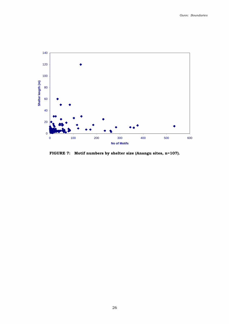
Both Anangu and Luritja shelters tend to be larger than Arrernte shelters (Table 2) thus
suggesting that they provide bigger art panels that, in turn, permit the presentation of a greater
number of motifs. However, while the available panel areas have not been measured, it is clear
that many of the larger Anangu shelters contain few motifs and many small shelters contain high
numbers (Figure 7). This inverse relationship is considered to result from the poorer protection
afforded to the rock-art by the very large shelters. Also, and for reasons unknown, a number of
tiny Anangu shelters contain exceptionally high motif numbers (e.g. 4 x 2 x 1 m with 61 motifs).
Technique
The range of techniques within the three regions is similar (Table 3) with the obvious differences
being the high proportion of painting amongst the Anangu and Arrernte sites, and stencilling
amongst the Luritja sites. On a finer level, the Luritja sites have a relatively higher proportion of
prints including the only recorded examples of the distinctive “patterned handprints” in Central
Australia (Gunn 1998). The Arrernte sites in contrast contain a higher proportion of drawing.
The distribution of drawings requires further consideration as Smith and Rosenfeld (1992)
emphasise the high number of drawings at the Luritja sites at Watarrka (see also Frederick 1999).
However, as no counts are provided, it is not possible to quantify their observation. On the basis
of subject matter, it appears that much of the drawn artwork pertains to the historic period and
reflects post-contact influences. consequently it might not reflect traditional land tenure or
religious affiliations.
The art of each linguistic group across the borderlands then can be differentiated on the basis of
the principal and secondary techniques (Table 3):
Anangu: painting, with no significant minor technique,
Luritja: stencilling, with minor painting, printing and unique patterned handprints,
and
Arrernte: painting with minor drawing.
Gunn: Boundaries
6
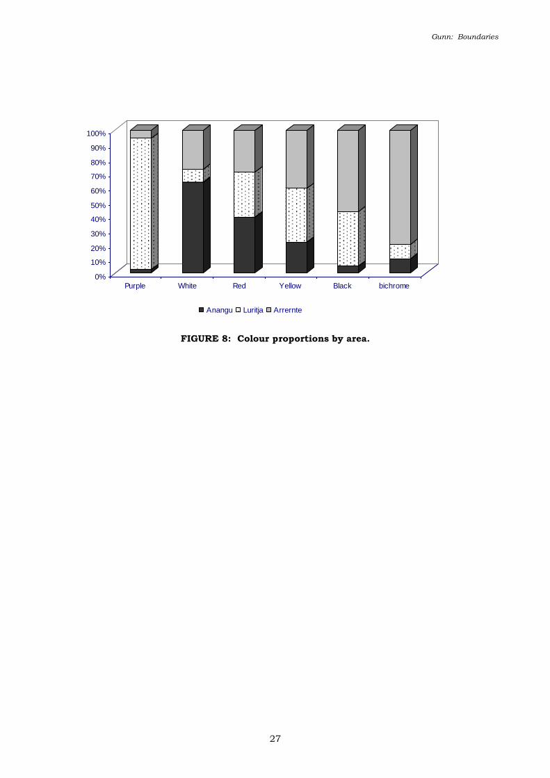
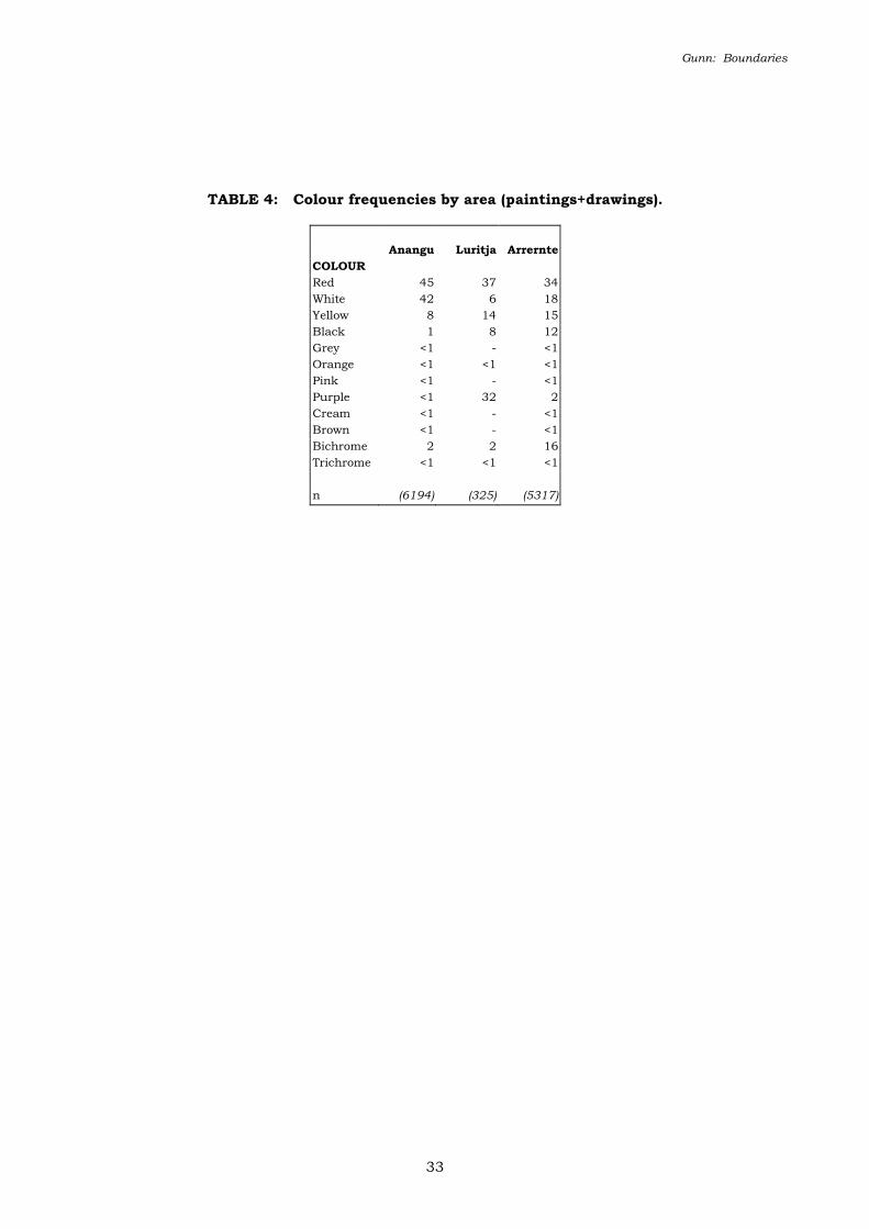
Colour
Red is the dominant colour in all areas and accounts for between one third and one half of all
motifs (Table 4). The minor colours however show significant variation between the three regions.
The Anangu sites have an extraordinarily high proportion of white motifs, the Luritja a high
proportion of purple, and the Arrernte a high proportion of black and bichrome motifs. The
purple at the Luritja sites was a metallic-like pigment (micaceous?) and its prevalence here can be
attributed to the close proximity of an ochre quarry characterised by this pigment. Whether or
not this pigment occurs with similar frequency at the nearby Watarrka sites is unknown, but
examples of motifs in a similar pigment occurred in small numbers in both the Arrernte and
Anangu sites. The relatively high proportion of black in the Arrernte sites can be largely
attributed to the high proportion of drawings, most of which were executed in charcoal. In
contrast, the higher proportion of bichrome motifs within the Arrernte sites is unrelated to other
formal attributes and its use is therefore seen as related directly to function. Proportionally for
each colour, but with the exception of the Luritja purple, there is a general inverse relationship
between the colours used in Arrernte and Anangu rock art (Figure 8). Red is the only colour
evenly represented in all three areas, while white is predominant in Anangu art, and bichrome in
Arrernte art.
Motif types
Motif types refer to the formal archaeological classification of the shape of the motif (see Clegg
1991, Chippendale & Tacon 1998). Through familiarity with an artistic system, it is possible to
classify some motifs according to their traditional meaning. Current motif type labels tend to use
a mix of both archaeological and ethnographic labels (e.g. the archaeological categories of “bar”,
“circle” etc., and the likely ethnographic interpretations of “emu tracks” or “ceremonial object”. It
is stressed however, that this analysis treats the motifs as archaeological data whatever the origin
of their labels).
For this preliminary comparison, the freeform motifs, whose form was not dictated by technique
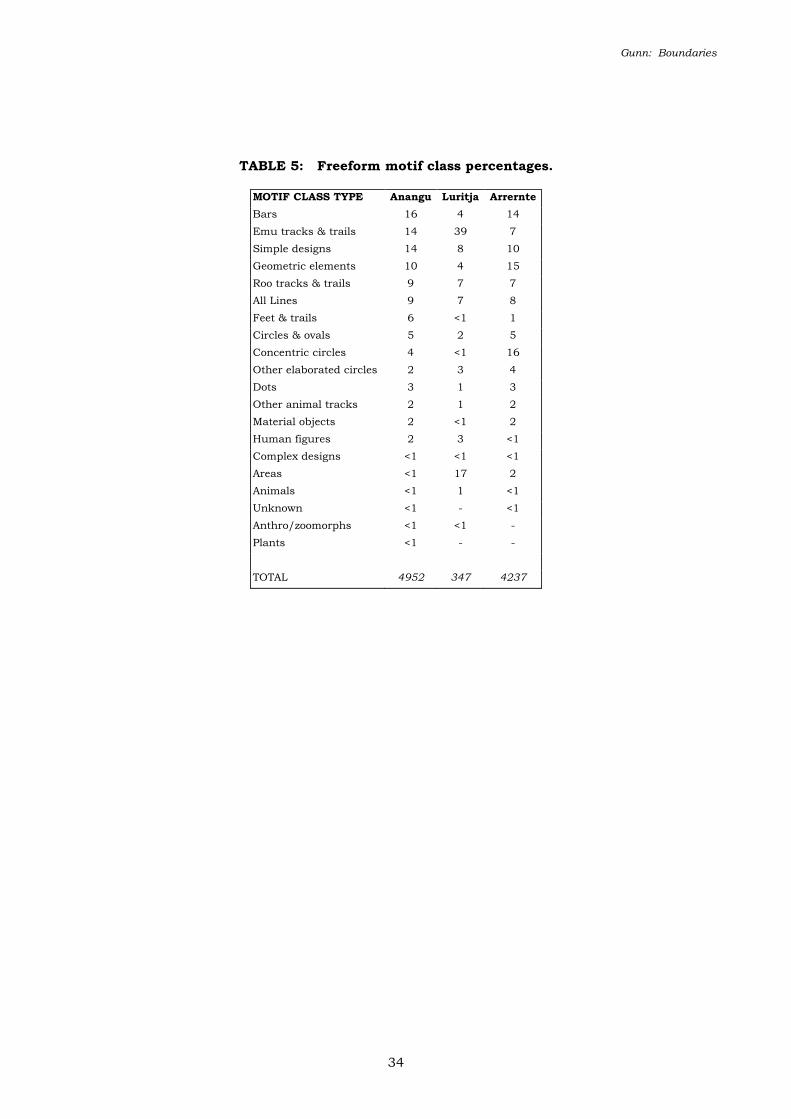
such as stencils and prints, were classified into a common core of twenty motif-type classes (Table
5). The classes were derived for and from the present study and aggregate the potential 266
Gunn: Boundaries
7
individual motif types used in the recording into a more manageable data set. The classes tend to
emphasise the more common motif types, such as the various types of “roo tracks”, at the expense
of the more uncommon types, such as “simple designs”, many of which were unique.
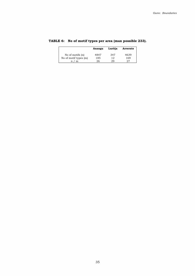
Despite the differences in overall motif numbers, the ratio of types to motif numbers was similar
for each area (Table 6) indicating that, for freeform rock art, variety is largely a product of
quantity.
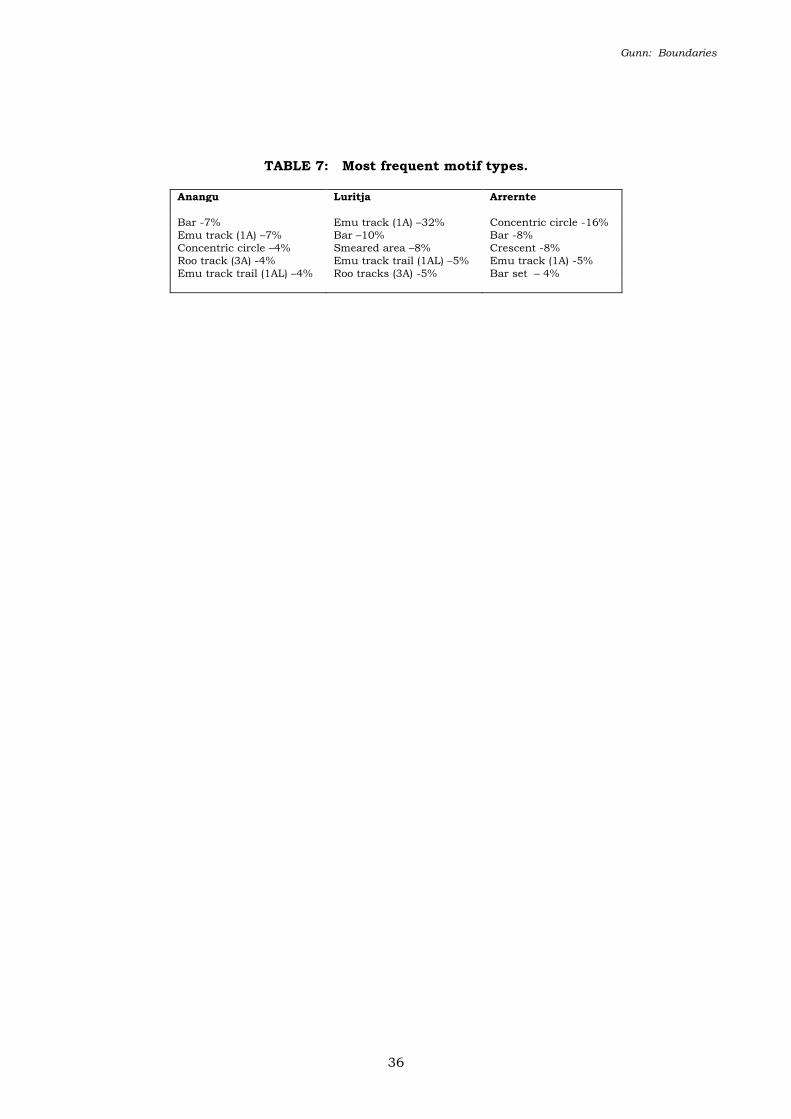
“Bar” and “emu track” motifs were amongst the most common motif types in all three areas
(Table 7). “Concentric circles” were common in both the Arrernte and Anangu art, but form the
most common single motif type in Arrernte art (16% cf. 4%). The high proportion of “smeared
areas” in the Luritja area is seen as reflecting this motif type as a by-product of handstencils and
handprints rather than as a motif in its own right.
A distinct motif sub-type that appears to be a feature of Western Desert rock-art (both Anangu
and Luritja), but which is so far unrecorded within Arrernte lands, is the “human figure with a
concentric circle headdress” (Mountford 1938, 1965, 1976). The predominant headdress type in
Arrernte rock-art is the “feather” type. This type is also common in Western desert rock-art and
in rock-art in other areas of the arid interior (Layton 1992; Ross 1997; Walsh 1988) and in many
areas it occurs as both paintings and peckings. In the Mt Isa region, Ross (1997: 98) found that
figures with “feather” (her “fern”) headdresses were associated with small monochrome figures,
and that more elaborate headdresses were generally associated with large and polychrome figures.
These findings are consistent with the apparent trend in Central Australia, as was the association
of the motif to ceremonial paraphernalia.
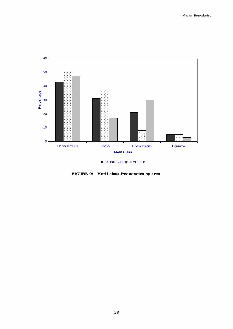
Motif type classes
Aggregating motif types into broader classes for cross regional comparisons (cf. Edwards 1966,
Maynard 1979) it was found that the Luritja paintings have an exceptionally high proportion of
Tracks and corresponding lower proportion of Geometric Elements and Designs (Figure 9).
Otherwise the three groups are broadly similar and suggestive of a common artistic and cultural
Gunn: Boundaries
8
stock. The only numerically significant difference between the Anangu and Arrernte art at this
broad scale is the depiction of more Tracks in the Anangu art and more Geometric Designs
(particularly “concentric circles” motifs) in the Arrernte rock-art.
Motif form
Motif form refers to the graphic structure of the motif: whether it is composed of linear, dot,
outline, or solid elements, or any combinations of these. In all regions, around two thirds of the
Freeform motifs were linear (Table 8) and hence at the broadest level the three areas are seen as
very similar. However, among the numerically fewer form types there are some significant
differences. For example, Arrernte art has a far higher proportion of “outline+infill” and
“linear+outline” than the other two, while Luritja art contains a higher proportion of solid motifs.
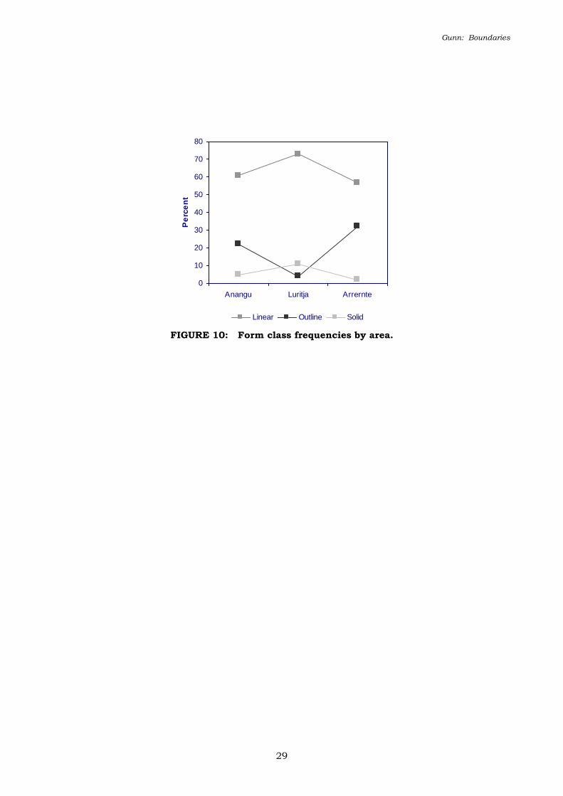
Combining the Freeform motif types into three classes (linear, outline and solid, see Figure 10) as
was done for the motif types, shows the three regions have broad similarities. At a finer level
however, they can be seen to consist of a geographically discontinuous set, with Luritja and
Arrernte art being most different, and Anangu art intermediary between these two.
The distribution of Preform motifs (motifs whose form is dictated by technique such as stencils
and prints) is covered by the distribution of motif technique discussed above.
Motif size
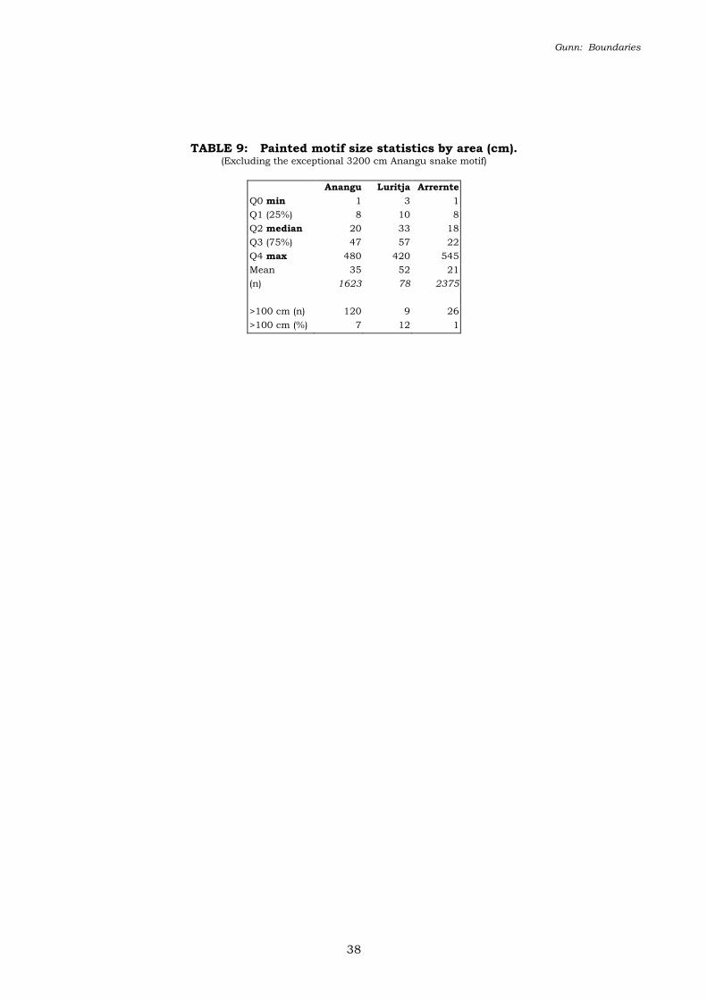
The size of the painted motifs within each area ranged from very small (1-3 cm) to very large
(greater than 400 cm). The exceptional motif was a single, poorly preserved, painted “snake” in
Anangu country that extends for 32 m across the full length of its shelter’s rear wall.
Despite the similarity of the range, the mean and median of the Luritja motifs (33 cm, 52 cm) is
almost double that of the Arrernte and Anangu motifs (Table 9). This indicates that Luritja
paintings are generally of a larger scale than Arrernte or Anangu paintings. In human terms the
former roughly are forearm-size (c.50 cm), and the latter mostly around hand-size (c.18 cm).
Given that paintings are uncommon in Luritja rock-art, as it is dominated by handstencils and
handprints which are by technique “hand” size, this larger painting size is seen as being related to
Gunn: Boundaries
9
the exceptional motifs and hence is not seen as particularly significant overall.
The proportion of paintings greater than 100 cm (Table 9) and the third quartile values for each
area do however indicate a real lack of larger motifs in Arrernte rock-art in comparison to that of
the Anangu and Luritja. As the Arrernte shelters are generally smaller than either Anangu or
Luritja shelters, and although shelter size is unrelated to the quantity of artwork, it appears that
shelter size does have an inhibiting effect on the size of the larger motifs.
DISCUSSION
The principal difference between the three regions, that of technique, can be seen to reflect the
pattern of Central Australian geology, where handstencils tend to be focussed in those areas of
primarily poorly cemented sandstones. Poorly cemented sandstone is more porous and generally
more fragile than well-cemented sandstone. Hence it is more suited to stencilling where there is
no brushing of pigment (which can readily dislodge) and where sprayed pigment can penetrate
further into the irregular rock surface. The correspondence of stencilling with high rock porosity
is also found in other major Australian stencilling areas such as western New South Wales (Gunn
et. al 1997), Queensland’s Central Highlands (Morwood 1979), in the porous, pallid-granites of the
Cue region of WA (Gunn and Webb 2000), and the soft limestone of the Nullarbor (Bednarik
1986).
The correlation of painting with well-cemented sandstone, as shown by the Arrernte rock-art,
appears to be common throughout Australia, particularly in Arnhem Land (Chaloupka 1993), the
Kimberley (Walsh 2000) and the Victoria River region (Gunn 1989), northern Cobar (McCarthy
1976) and the Grampians (Gunn 1983). One area where this does not seem to apply is the
Sydney-Hawkesbury region where stencils and paintings both occur in proportionally high
numbers (McDonald 1998).
The high number of paintings in the Anangu lands is, however, contrary to the pattern of granite
sites elsewhere in Australia where complexes tend to have only low numbers of paintings (Flood
1980; Gunn and Thorn 1994; Gunn in prep).
Gunn: Boundaries
10
The differences in colour across the three study regions may well be related to pigment
availability, but this requires a separate study of pigment sources. However the colourful
appearance of Anangu art is attributed to the greater proportion of white along with red, yellow
and black, and a higher proportion of superimposition.
The similarity in painted motif types indicates that the three regions do indeed have a common
repertoire and that their differences are ones of degree rather than type. Of note here is the
general similarity of Luritja painted art to that of the Anangu with a high concentration on Tracks
(Figures 3 and 4), and the corresponding focus of Arrernte art on Geometric Designs (especially
the “concentric circle” motif; see Figure 2). In line with the observations of previous researchers
(Gould 1980; Strehlow 1965), this is interpreted to reflect differences in the social structure of the
two groups with the Western Desert art reflecting the more open religious networks and land ties
consequent upon their more ephemeral water reserves. In the rock-art this is seen to be manifest
in the profusion of “track” motifs and open-ended “trails” (tracks across the land connecting a
number of Dreaming related places; see Figure 4). In contrast, the tighter Arrernte clan structure
and its affiliation to specific, focal totemic sites consequent on the greater reliability of their water
reserves, is seen to be reflected through the predominance of “concentric circle” and “spoked
circle” motifs. These two types are prominent in particularly important sacred sites. Arrernte
custodians interpret these motifs as representing specific places, with the larger sized examples
invariably referencing the site (and rockhole) at which they are painted. The prominence of
enclosing or graphically bounded motifs in the Arrernte art is seen to reflect the greater more
bounded nature of their society. In contrast, the prominence of open or graphically unbounded
track and trail motifs in the Western Desert reflects their more open social associations.
On the basis that the Luritja ranges were used as retreat areas for the adjoining desert dwellers,
the proliferation of handstencils here, which is far higher than the quantity of painted artwork in
the Arrernte or Anangu complexes, is seen to emphasise social affiliations and propertorial rights
in an area used by a range of non-local groups.

Gunn: Boundaries
11
An aspect not directly addressed in this preliminary study, but acknowledged by previous
research (Gould 1980; Gunn 1995a, 2000; Spencer and Gillen 1899; Strehlow 1965) is that the
rock-art of the Arrernte lands contains a small number of large and very distinct motifs that are
locally unique. These pmara kutata motifs are unique to Arrernte rock-art but appear to have
similarities with the large ceremonial rock-art of the Warlpiri (Meggitt 1962; Mountford 1968) and
further north (Wandjina, “Lightning Brothers” and Bula art of the top-end). The associated cult
ceremonies, which are thought to be a relatively recent introduction into Arrernte lands (Smith
1988), provided the Arrernte clan areas with discreet spatial variations. In contrast the rock-art
of the different Western Desert groups appears to be much more homogeneous.
The reason for the underlying similarity is thought to reflect an earlier homogeneous culture that
extended over much of the arid interior of Australia and may at some time have extended over
much of mainland Australia. This culture is reflected in the remnant suites of fully patinated
peckings (cf. The Panaramitee of Maynard 1979) and the locally distinctive but divergent suites of
more recent peckings and paintings (cf. Flood 1977).
It is clear that rock-art in Central Australia was not used as a boundary maintenance feature, as
has been claimed for rock-art elsewhere (David and Chant 1995). None of the art within the
country of the Arrernte, Luritja or Anangu shows any features that can be interpreted in terms of
boundary definition. It is suggested in contrast, that the rock-art reflects the cultural core areas
of the different language groups, and diffuses outwards from their core places towards the
periphery of their lands where they overlap and merge with the adjacent rock-art style (cf. Conkey
1982: 116; Tindale 1974: 1). With this model, some elements of a neighbour’s style may be
present anywhere within the lands of an adjacent group but the number of elements will be
greatest in sites closest to the shared margins. Also, areas with greater social and cultural ties
(both present and historic) will exhibit a greater degree of similarity than areas of groups with
prolonged enmity.
CONCLUSION
An initial comparison of archaeological attributes of the rock-art across the Arrernte/Western
Gunn: Boundaries
12
Desert borderlands reveals broad-scale similarities and finer resolution differences. The data
suggest that the three regions share a common artistic stock that has evolved in different ways in
response to different physical and social environments. The preoccupation of Arrernte art with
singular, graphically enclosed motifs, such as concentric circles, reflects a tighter clan structure
and land affiliation associated to their more reliable water reserves. In contrast the attention
given to graphically open “track” and “trail” motifs in Anangu and Luritja freeform paintings is
seen as reflecting the more open nature of their land-ties and their close social association
consequent upon the more ephemeral nature of the desert water reserves. Consistent with
interpretations elsewhere in Australia, the handstencil art is seen to reflect both the nature of the
bedrock and the physical and the fluid social environment in which it occurs.
ACKNOWLEDGMENTS
My thanks firstly go to the many senior Arrernte, Luritja and Anangu men who have supported
and assisted in the project over the past 13 years. In particular I would mention Wenten
Rubuntja, Lindsay Cavanagh and Alan Drover, and the late Alan Webb, Sid Cleary, Edward
Johnson and Bruce Hayes. Mick Starkey (Uluru Cultural Heritage Officer) and the Aboriginal
Areas Protection Authority (Alice Springs) assisted with liaison work. June Ross directed me to
some supportive references and John Clegg provided continued optimistic support. Thanks also
to Ken Mulvaney and the two anonymous reviewers who commented on the draft version,
although I accept full responsibility for all errors and wild speculations.
My work in Central Australia has been supported by grants from the Australian Institute of
Aboriginal and Torres Strait Islander Studies, Canberra, the Australian Heritage Commission,
Canberra, and the Central Land Council, Alice Springs. The Aboriginal Areas Protection
Authority, Alice Springs, has supervised most of the grants and provided office space and
facilities.
Gunn: Boundaries
13
REFERENCES
Bednarik, R.G. 1986 The parietal art of South Australia. Journal of the Anthropological Society of
South Australia 24:3-21.
Chaloupka, G. 1993 Journey in time: the World’s longest continuing art tradition. Chatswood: Reed.
Clegg, J. 1991 !Pictures and pictures of… In P. Bahn & A. Rosenfeld (eds) Rock art and prehistory,
pp.109-111. Oxbow Monograph 10. Oxford: Oxbow Books.
Conkey, M. 1982 Boundedness in art and society. In I. Hodder (ed.) Symbolic and structural
archaeology, pp.115-128. Cambridge: Cambridge University Press.
David, B. and D. Chant 1995 Rock Art and Regionalisation in North Queensland Prehistory.
Memoirs of the Queensland Museum 37. Brisbane: Queensland Museum.
Edwards, R. 1966 Comparative study of rock engravings in South and Central Australia.
Transactions of the Royal Society of South Australia, 90:33-38.
Edwards, R. 1970 The rock engravers. Six part series in The Australian, April 1970.
Edwards, R. 1971 Art and Aboriginal prehistory. In D.J. Mulvaney and J. Golson (eds)
Aboriginal Man and Environment in Australia, pp.356-367. Canberra: Australian National
University Press.
Flood, J. 1980 The Moth Hunters. Canberra: Australian Institute of Aboriginal Studies.
Flood, J. 1997 Rock art of the Dreamtime. Sydney: Angus & Robertson.
Frederick, U.K. 1999 At the centre of it all: Constructing contact through the rock-art of Watarrka
National Park, central Australia. Archaeology in Oceania 34(3):132-144.
Gunn: Boundaries
14
Galt-Smith, B. 1997 Motives for Motifs. Unpublished BA (Hons) thesis, Dept. Archaeology and
Palaeoanthropology, University of New England, Armidale.
Gamble, C. 1982 Interaction and Alliance in Palaeolithic Society. Man 17:92-107.
Gould, R.A. 1969 Yiwara: foragers of the Australian desert. New York: Charles Scribner’s Sons.
Gould, R.A. 1980 Living archaeology. Cambridge: Cambridge University Press.
Gould, R.A. 1991 Arid land foraging as seen from Australia: adaptive models and
behavioural realities. Oceania 62: 12-33.
Gunn, R.G. 1983 Aboriginal rock art in the Grampians. Records of the Victorian Archaeological
Survey No 16. Melbourne: Ministry for Conservation.
Gunn, R.G. 1988 Recording and Assessment of Rock Art Sites at Illararri, Tempe Downs Station,
N.T. Unpublished report to the Central Land Council, Alice Springs and the Australian Heritage
Commission, Canberra.
Gunn, R.G. 1989 Langgay rock art survey. Unpublished report to the Conservation Commission
of the Northern Territory, Katherine.
Gunn, R.G. 1992 Dulcie Range Rock Art Survey II. Unpublished report to the Aboriginal Areas
Protection Authority, Alice Springs and the Australian Heritage Commission, Canberra.
Gunn, R.G. 1995a Regional patterning in the Aboriginal Rock Art of Central Australia: A
preliminary report. Rock Art Research 12(2):117-128.
Gunn, R.G. 1995b Kulpi Maru and the rock art of the KM site complex, Central Australia.
Gunn: Boundaries
15
Unpublished report to the Aboriginal Areas Protection Authority, Alice Springs.
Gunn, R.G. 1998 Patterned handprints from Central Australia. Rock Art Research 15(2):75-80.
Gunn, R.G. 2000 Central Australian Rock Art: A second report. Rock Art Research 17(2):111-126.
Gunn, R.G. 2001 The Rock-Art of Uluru: An Archaeological Study. Unpublished report to
Cultural Heritage Unit, Uluru and Kata-Tjuta National Park (Environment Australia), Yulara.
Gunn, R.G. in prep Mudgegonga-2 and the rock art of north-east Victoria. Paper submitted to
Rock Art Research.
Gunn, R.G., K.M. Sale and A. Thorn 1997 The Aboriginal Rock Art of Two Mile Creek and
Amphitheatre Gorge, Mootwingee National Park. Unpublished report to the Mutawintji Land
Council, Broken Hill, and the Australian Institute of Aboriginal and Torres Strait Islander Studies,
Canberra.
Gunn, R.G. and A. Thorn 1994 Aboriginal Rock Art in the Wet Tropics World Heritage area,
Northern Queensland: A Recording and Conservation Assessment. Unpublished report to the
Department of Environment and Heritage, Cairns.
Gunn, R.G. and A. Thorn 1997a The Rock Art of Irtikiri: A Recording and Conservation
Assessment. Unpublished report to the Aboriginal Areas Protection Authority, Alice Springs and
the Australian Institute of Aboriginal and Torres Strait Islander Studies, Canberra.
Gunn, R.G. and A. Thorn 1997b Kulpitjata: A Yankunytjatjara Rock Art Complex in Central
Australia. Report to the Site Custodians for Anungu tours, Yulara, and the Australian Institute of
Aboriginal and Torres Strait Islander Studies, Canberra.
Gunn, R.G. and R.E. Webb 2000 Rock Art of the Cue Region, Western Australia.
Gunn: Boundaries
16
Unpublished report to the Thoo Thoo Warninha Aboriginal Corporation, Cue and the Australian
Institute of Aboriginal Studies, Canberra.
Layton, R. 1992 Australian Rock Art: A New Synthesis. Cambridge: Cambridge University Press.
McCarthy, F.D. 1976 Rock art of the Cobar pediplain in central western New South Wales.
Canberra: Australian Institute of Aboriginal Studies.
McConvell, P. 1996 Backtracking to Babel: The chronology of Pama-Nyungan expansion in
Australia. Archaeology in Oceania 31(3):125-144.
McDonald, J. 1998 Shelter art in the Sydney Basin – a space time continuum: Exploring different
stylistic influences on stylistic change. In C. Chippendale and P. Tacon (eds), The Archaeology of
Rock Art, pp.319-335. Cambridge: Cambridge University Press.
Maynard, L. 1979 The archaeology of Australian Aboriginal art. In S. Mead (ed.), Exploring the
Visual Arts of Oceania, pp.83-111. Hawaii: University Press.
Meggitt, M.J. 1962 Desert People. Sydney: Angus and Robinson. (1974 ed).
Morwood, M.J. 1979 Art and Stone: Towards a Prehistory of Central Western Queensland.
Unpublished PhD thesis, Australian National University, Canberra.
Mountford, C.P. 1938 Contrast in drawings made by an Australian Aborigine before and after
initiation. Records of the South Australian Museum 6(2):111-114.
Mountford, C.P. 1960 Simple rock engravings in Central Australia. Man 192:145-147.
Mountford, C.P. 1965 Ayers Rock: Its People, Their Beliefs and Their Art. Melbourne: Angus and
Robinson.
Gunn: Boundaries
17
Mountford, C.P. 1968 Winbaraku and the Myth of Jarapiri. Adelaide: Rigby.
Mountford, C.P. 1976 Nomads of the Australian desert. Adelaide: Rigby.
Myers, F.R. 1991 Pintupi Country, Pintupi Self. Berkeley: University of California Press.
Rosenfeld, A., and W. Mumford 1996 The Thuiparta rock engravings at Erowalle, Wallace
Rockhole, James Range, Northern Territory. In S. Ulm, I. Lilley and A. Ross (eds), Australian
Archaeology ’95: Proceedings of the 1995 Australian Archaeological Association Annual Conference,
pp.247-255. Tempus 6. St. Lucia: Anthropology Museum, University of Queensland
Ross, J. 1997 Painted Relationships: An Archaeological Analysis of a Distinctive Anthropomorphic
Rock-Art Motif in Northwest Central Queensland. Unpublished BA(Hons) thesis, Department of
Archaeology and Palaeoanthropology, University of New England, Armidale.
Smith, C. 1992 The use of Ethnography in Interpreting Rock Art: A comparative study of Arnhem
Land and the Western Desert of Australia. In M. J. Morwood & D. R. Hobbs (eds), Rock art and
ethnography, pp.39-45. Occasional AURA Publication 5. Melbourne: Australian Rock Art
Research Association.
Smith, M. A. 1988 The Pattern and Timing of Prehistoric Settlement in Central Australia.
Unpublished PhD thesis, Department of Archaeology, University of New England, Armidale.
Smith, M. A. and A. Rosenfeld 1992 Archaeological Sites in Watarrka National Park: The Northern
Sector Plateau. Unpublished report to the Conservation Commission of the Northern Territory,
Alice Springs.
Spencer, B. and F. J. Gillen 1899 The Native Tribes of Central Australia. London: MacMillan and
Co.
Gunn: Boundaries
18
Strehlow, T.G.H. 1965 Culture, Social Structure and Environment in Aboriginal Central Australia.
In R. M. Berndt (ed.), Aboriginal Man in Australia, pp.121 – 145. Melbourne: Angus and
Robertson.
Strehlow, T.G.H. 1970 Geography and the Totemic Landscape in Central Australia: a functional
study. In R. M. Berndt (ed.), Australian Aboriginal Anthropology, pp.92 – 140. Canberra:
Australian Institute of Aboriginal Studies, Canberra, and Nedlands: University of Western
Australia Press.
Strehlow, T.G.H. 1995 The Land of Altjera. Prospect: Strehlow Research Foundation.
Tacon, P. 1992 The Roma Gorge Rock Art Complex: An Assessment and Description.
Unpublished report to the Conservation Commission of the Northern Territory, Alice Springs.
Thorley, P.B. 1998 Shifting Location, Shifting Scale: A Regional Landscape Approach to the
Prehistoric Archaeology of the Palmer River Catchment, Central Australia. Unpublished PhD
thesis, Northern Territory University, Darwin.
Tindale, N.B. 1974 Aboriginal Tribes of Australia. Canberra: Australian National University Press.
Tindale, N.B. 1976 Some ecological bases for Australian tribal boundaries. In N. Peterson (ed.),
Tribes and boundaries in Australia, pp.12-29. Canberra: Australian Institute of Aboriginal
Studies.
Walsh, G.L. 1988 Australia’s greatest rock art. Bathurst: Brille-Brown.
Walsh, G.L. 2000 Bradshaw art of the Kimberley. Toowong: Takarakka Nowan Ka Publications.
Gunn: Boundaries
19
FIGURE 1: The study area showing location of rock-art sites recorded superimposed by a
schematic map of linguistic areas.
FIGURE 2: Arrernte panel at Pmwelyarre.
FIGURE 3: Anangu panel at Uluru.
FIGURE 4: Anangu “Track-trail” motifs from Uluru.
FIGURE 5: Luritja handstencil panel at Kulpi Mara.
FIGURE 6: Schematic distribution of major pictogrammic techniques and linguistic
groups.
FIGURE 7: Motif numbers by shelter size (Anangu sites, n=107).
FIGURE 8: Colour proportions by area.
FIGURE 9: Motif class frequencies by area.
FIGURE 10: Form class frequencies by area.
TABLE 1: Pictogram Nos per shelter by area.
TABLE 2: Shelter sizes by area (metres).
TABLE 3: Techniques percentages by area.
TABLE 4: Colour frequencies by area (paintings+drawings).
TABLE 5: Freeform motif class percentages.
TABLE 6: No of motif types per area (max possible 233).
TABLE 7: Most frequent motif types.
TABLE 8: Freeform type percentages by area.
TABLE 9: Painted motif size statistics by area (cm).
Gunn: Boundaries
20
FIGURE 1: The study area showing location of rock-art sites recorded
superimposed by a schematic map of linguistic areas.

Gunn: Boundaries
21
FIGURE 2: Arrernte panel at Pmwelyarre.
(Traced from photomosaic. Panel 2m x 1 m)
Gunn: Boundaries
22
FIGURE 3: Anangu panel at Uluru.
(Freehand drawing. Panel 2.5m x 2.5m)
Gunn: Boundaries
23
FIGURE 4: Anangu “Track-trail” motifs from Uluru.
Gunn: Boundaries
24
FIGURE 5: Luritja handstencil panel at Kulpi Mara.
(Photograph. Panel 1.5m x 1m)
Gunn: Boundaries
25
FIGURE 6: Schematic distribution of major
pictogrammic techniques and linguistic groups.
Gunn: Boundaries
26
0
20
40
60
80
100
120
140
0 100 200 300 400 500 600
No of Motifs
Sh
elt
er
len
gth
(m
)
FIGURE 7: Motif numbers by shelter size (Anangu sites, n=107).
Gunn: Boundaries
27
0%
10%
20%
30%
40%
50%
60%
70%
80%
90%
100%
Purple White Red Yellow Black bichrome
Anangu Luritja Arrernte
FIGURE 8: Colour proportions by area.
Gunn: Boundaries
28
0
10
20
30
40
50
60
GeomElements Tracks GeomDesigns Figurative
Motif Class
Pe
rce
nta
ge
Anangu Luritja Arrernte
FIGURE 9: Motif class frequencies by area.
Gunn: Boundaries
29
0
10
20
30
40
50
60
70
80
Anangu Luritja Arrernte
Pe
rce
nt
Linear Outline Solid
FIGURE 10: Form class frequencies by area.
Gunn: Boundaries
30
TABLE 1: Pictogram Nos per shelter by area.
Anangu Luritja Arrernte
Max 534 2562 359
Min 1 1 1
Mean 60 89 38
Median 26 13 11
No motifs 6385 12766 5485
No shelters 106 144 145
Shelters with greater than 100 pictograms
No %
Anangu 17 18
Luritja 22 15
Arrernte 19 13
Gunn: Boundaries
31
TABLE 2: Shelter sizes by area (metres).
length depth height (n)
max Anangu 120 25 20 108
Luritja 70 16 20 144
Arrernte 27 8 10 130
min Anangu 0.75 0.5 0.1
Luritja 2 1 1
Arrernte 1.5 0.25 1
mean Anangu 10 4 4
Luritja 16 5 5
Arrernte 7 3 3
median Anangu 6 3 2
Luritja 12 4 3.5
Arrernte 5 3 2
Shelters greater than 20 m wide
Anangu 1 1%
Luritja 34 21%
Arrernte 6 4%

Gunn: Boundaries
32
TABLE 3: Techniques percentages by area.
Technique
Class
CHARACTER TECHNIQUE Anangu Luritja Arrernte
Pictograms Wet pigment Painting 97 4 83
Stencilling 0.5 89 4
Printing 0.5 7 3
Dry pigment Drawing 2 <1 10
Applique Applique (1) - -
Combinations Paint +draw <1 <1 <1
TOTAL (n) (6368) (13004) (5390)
Gunn: Boundaries
33
TABLE 4: Colour frequencies by area (paintings+drawings).
Anangu Luritja Arrernte
COLOUR
Red 45 37 34
White 42 6 18
Yellow 8 14 15
Black 1 8 12
Grey <1 - <1
Orange <1 <1 <1
Pink <1 - <1
Purple <1 32 2
Cream <1 - <1
Brown <1 - <1
Bichrome 2 2 16
Trichrome <1 <1 <1
n (6194) (325) (5317)
Gunn: Boundaries
34
TABLE 5: Freeform motif class percentages.
MOTIF CLASS TYPE Anangu Luritja Arrernte
Bars 16 4 14
Emu tracks & trails 14 39 7
Simple designs 14 8 10
Geometric elements 10 4 15
Roo tracks & trails 9 7 7
All Lines 9 7 8
Feet & trails 6 <1 1
Circles & ovals 5 2 5
Concentric circles 4 <1 16
Other elaborated circles 2 3 4
Dots 3 1 3
Other animal tracks 2 1 2
Material objects 2 <1 2
Human figures 2 3 <1
Complex designs <1 <1 <1
Areas <1 17 2
Animals <1 1 <1
Unknown <1 - <1
Anthro/zoomorphs <1 <1 -
Plants <1 - -
TOTAL 4952 347 4237
Gunn: Boundaries
35
TABLE 6: No of motif types per area (max possible 233).
Anangu Luritja Arrernte
No of motifs (n) 4847 347 4639
No of motif types (m) 185 12 169
n / m 26 29 27
Gunn: Boundaries
36
TABLE 7: Most frequent motif types.
Anangu Luritja Arrernte
Bar -7% Emu track (1A) –32% Concentric circle -16%
Emu track (1A) –7% Bar –10% Bar -8%
Concentric circle –4% Smeared area –8% Crescent -8%
Roo track (3A) -4% Emu track trail (1AL) –5% Emu track (1A) -5%
Emu track trail (1AL) –4% Roo tracks (3A) -5% Bar set – 4%

Gunn: Boundaries
37
TABLE 8: Freeform type percentages by area.
Anangu Luritja Arrernte
FORM TYPE
Linear (L) 61 73 57
O+infill (I) 11 1 22
Outline (O) 11 3 4
LO <1 <1 6
Solid (S) 5 11 2
SL 3 <1 3
Dot 3 7 3
OIL 1 <1 1
OL 2 - <1
Other* 2 4 1
TOTAL No of Form Types (f)
31 14 23
(n) 5295 320 4612
n/f 171 23 201
*Anangu: 22 other types each <1% Arrernte:14 other types each <1%
Gunn: Boundaries
38
TABLE 9: Painted motif size statistics by area (cm). (Excluding the exceptional 3200 cm Anangu snake motif)
Anangu Luritja Arrernte
Q0 min 1 3 1
Q1 (25%) 8 10 8
Q2 median 20 33 18
Q3 (75%) 47 57 22
Q4 max 480 420 545
Mean 35 52 21
(n) 1623 78 2375
>100 cm (n) 120 9 26
>100 cm (%) 7 12 1