2000 Irrigation Water Assessments - Bluffdale City
115
***AMENDED*** BLUFFDALE CITY COUNCIL MEETING AGENDA Wednesday, April 11, 2018 Notice is hereby given that the Bluffdale City Council will hold a meeting Wednesday, April 11, 2018, at the Bluffdale City Hall, 2222 West 14400 South, Bluffdale, Utah, scheduled to begin promptly at 6:30 p.m. or as soon thereafter as possible. Notice is further given that access to this meeting by the Mayor and or City Council may be by electronic means via telephonic conference call. BLUFFDALE CITY COUNCIL REGULAR BUSINESS MEETING 6:30 P.M. 1. Roll Call, Invocation, Pledge of Allegiance* 2. PUBLIC FORUM – (4-minute maximum per person to bring items not already on the agenda before the Council. Participants are encouraged to submit a written statement (1 copy) for items that are complex or that may require more than 4 minutes to present). 3. CONSENT AGENDA – 3.1 Approval of the March 14, 2018 Meeting minutes. 3.2 Approval of the March 16, 2018 Meeting minutes. 4. Presentation of the proposal for bicycle trails in and around Parry Farms, presenter, David Babcock. 5. Consideration and vote on an ordinance adopting a Capital Facilities Plan, Impact Fee Analysis and an Impact Fee Facilities Plan, staff presenter, Brent Ventura. 6. PUBLIC HEARING – Consideration and vote on the Preliminary and Final Subdivision Application for Independence at the Point, Plat M-3 for 27 single-family lots, located at approximately 15395 South Revolutionary Way, 4 Independence, applicants, staff presenter, Caitlyn Miller. 7. Consideration and vote on a resolution authorizing the City Manager to enter into agreements awarding a contract for the Grass Mowing and Trimming Bid for City Park areas, staff presenter, Shane Paddock. 8. PUBLIC HEARING - Consideration and vote on proposed amendments to Chapter 11-2 “Definitions” and Chapter 11-18 “Temporary Uses” to allow occupancy of a temporary dwelling during construction of a new detached single-family home, City of Bluffdale, applicant, staff presenter, Caitlyn Miller. 9. Consideration and vote on an ordinance approving a Second Amendment to the Master Development Agreement for Springview Farms pertaining to lot coverage, staff presenter, Caitlyn Miller. 10. Presentation and discussion on encroachments in public rights-of-way, staff presenter, Michael Fazio.
-
Upload
khangminh22 -
Category
Documents
-
view
2 -
download
0
Transcript of 2000 Irrigation Water Assessments - Bluffdale City

***AMENDED*** BLUFFDALE CITY COUNCIL
MEETING AGENDA Wednesday, April 11, 2018
Notice is hereby given that the Bluffdale City Council will hold a meeting Wednesday, April 11, 2018, at the Bluffdale City Hall, 2222 West 14400 South, Bluffdale, Utah, scheduled to begin promptly at 6:30 p.m. or as soon thereafter as possible. Notice is further given that access to this meeting by the Mayor and or City Council may be by electronic means via telephonic conference call.
BLUFFDALE CITY COUNCIL REGULAR BUSINESS MEETING 6:30 P.M.
1. Roll Call, Invocation, Pledge of Allegiance*
2. PUBLIC FORUM – (4-minute maximum per person to bring items not already on the agenda before the Council. Participants are encouraged to submit a written statement (1 copy) for items that are complex or that may require more than 4 minutes to present).
3. CONSENT AGENDA –
3.1 Approval of the March 14, 2018 Meeting minutes. 3.2 Approval of the March 16, 2018 Meeting minutes.
4. Presentation of the proposal for bicycle trails in and around Parry Farms, presenter, David Babcock.
5. Consideration and vote on an ordinance adopting a Capital Facilities Plan, Impact Fee Analysis and an Impact
Fee Facilities Plan, staff presenter, Brent Ventura.
6. PUBLIC HEARING – Consideration and vote on the Preliminary and Final Subdivision Application for Independence at the Point, Plat M-3 for 27 single-family lots, located at approximately 15395 South Revolutionary Way, 4 Independence, applicants, staff presenter, Caitlyn Miller.
7. Consideration and vote on a resolution authorizing the City Manager to enter into agreements awarding a
contract for the Grass Mowing and Trimming Bid for City Park areas, staff presenter, Shane Paddock.
8. PUBLIC HEARING - Consideration and vote on proposed amendments to Chapter 11-2 “Definitions” and Chapter 11-18 “Temporary Uses” to allow occupancy of a temporary dwelling during construction of a new detached single-family home, City of Bluffdale, applicant, staff presenter, Caitlyn Miller.
9. Consideration and vote on an ordinance approving a Second Amendment to the Master Development
Agreement for Springview Farms pertaining to lot coverage, staff presenter, Caitlyn Miller.
10. Presentation and discussion on encroachments in public rights-of-way, staff presenter, Michael Fazio.

11. Mayor’s Report
12. City Manager’s Report and Discussion
13. PLANNING SESSION - (The planning session is for identifying future items and other council discussion. In accordance with Utah Code § 52-4-201(2)(a), while the meeting may be open to the public, there will not be any opportunity for public input during the planning session).
13.1 – Discussion for the selection of 14600 South alignment from 1000 West to Porter Rockwell Boulevard, staff presenter, Michael Fazio.
*** 13.2 – Discussion regarding adding Accessory Dwelling Units as an allowed use in the Independence Village SD-R Zone, presenter, Todd Greene.
14. Closed meeting pursuant to Utah Code § 52-4-205(1) to discuss the character, professional competence, or
health of an individual, collective bargaining, pending or imminent litigation, strategies to discuss real property acquisition, including any form of a water right or water shares, security issues, or any alleged criminal misconduct (if needed).
15. Adjournment
***AMENDED this 9th day of April 2018 I HEREBY CERTIFY THAT THE FOREGOING NOTICE AND AGENDA WAS FAXED TO THE SOUTH VALLEY JOURNAL, THE SALT LAKE TRIBUNE, AND THE DESERET MORNING NEWS; POSTED AT THE BLUFFDALE CITY HALL, EMAILED OR DELIVERED TO EACH MEMBER OF THE BLUFFDALE CITY COUNCIL; ON THE CITY’S WEBSITE AT WWW.BLUFFDALE.COM AND ON THE PUBLIC MEETING NOTICE WEBSITE, WWW.PMN.UTAH.GOV
Wendy L. Deppe, CMC
City Recorder
In compliance with the American with Disabilities Act, individuals needing assistance or other services or accommodation for this meeting should contact Bluffdale City Hall at least 24 hours in advance of this meeting at 801-254-2200. TTY 7-1-1. *Contact the City Recorder if you desire to give the Invocation.

Agenda Item 3.1

***AMENDED*** BLUFFDALE CITY COUNCIL
MEETING AGENDA Wednesday, March 14, 2018
Notice is hereby given that the Bluffdale City Council will hold a meeting Wednesday, March 14, 2018, at the Bluffdale City Hall, 2222 West 14400 South, Bluffdale, Utah, scheduled to begin promptly at 6:30 p.m. or as soon thereafter as possible. Notice is further given that access to this meeting by the Mayor and or City Council may be by electronic means via telephonic conference call.
BLUFFDALE CITY COUNCIL REGULAR BUSINESS MEETING 6:30 P.M.
1. Roll Call, Invocation, Pledge of Allegiance*
2. PUBLIC FORUM – (4-minute maximum per person to bring items not already on the agenda before the Council. Participants are encouraged to submit a written statement (1 copy) for items that are complex or that may require more than 4 minutes to present).
3. CONSENT AGENDA –
3.1 Approval of the February 21, 2018 meeting minutes.
4. Recognition of Von Brockbank for his years of service on the Planning Commission, Mayor Timothy.
5. Presentation and discussion regarding the Salt Lake County Animal Services 2017 Annual Report for the City of Bluffdale, Carrie Sibert, Community Liaison Coordinator, SLCO Animal Services.
6. Consideration and vote on a resolution authorizing execution of a Development Agreement, Real Estate
Exchange Agreement and Escrow Instructions with Maverik, Inc., staff presenter, Vaughn Pickell.
7. Consideration and vote for a proposed plat amendment to combine Lots 301 and 302 in the Heritage Industrial Park Phase 3 Subdivision (14942 South Heritagecrest Way and 14912 South Heritagecrest Way, respectively), Fred Healey, applicant, staff presenter, Caitlyn Miller.
8. Presentation and consideration of the amendments to the Bluffdale Water Master Plan I and II, staff
presenter, Trevor Andra.
9. ***PUBLIC HEARING – Consideration and vote on proposed amendments to Title 9, Title 10, Chapter 11-15, and Chapter 11-16 of the Bluffdale City Code regarding adopted building codes, updating the reference to the currently adopted General Plan, site plan standards, supplementary regulations and other administrative updates, staff presenter, Caitlyn Miller.
10. Mayor’s Report
11. City Manager’s Report and Discussion

PLANNING SESSION Please Note: The planning session is for identifying future items and other council discussion. In accordance with Utah Code § 52-4-201(2)(a), while the meeting may be open to the public, there will not be any opportunity for public input during the planning session.
12. General Plan review, staff presenter, Grant Crowell.
13. Closed meeting pursuant to Utah Code § 52-4-205(1) to discuss the character, professional competence, or
health of an individual, collective bargaining, pending or imminent litigation, strategies to discuss real property acquisition, including any form of a water right or water shares, security issues, or any alleged criminal misconduct (if needed).
14. Adjournment
***AMENDED this 12th day of March 2018 I HEREBY CERTIFY THAT THE FOREGOING NOTICE AND AGENDA WAS FAXED TO THE SOUTH VALLEY JOURNAL, THE SALT LAKE TRIBUNE, AND THE DESERET MORNING NEWS; POSTED AT THE BLUFFDALE CITY HALL, EMAILED OR DELIVERED TO EACH MEMBER OF THE BLUFFDALE CITY COUNCIL; ON THE CITY’S WEBSITE AT WWW.BLUFFDALE.COM AND ON THE PUBLIC MEETING NOTICE WEBSITE, WWW.PMN.UTAH.GOV
Wendy L. Deppe, CMC
City Recorder
In compliance with the American with Disabilities Act, individuals needing assistance or other services or accommodation for this meeting should contact Bluffdale City Hall at least 24 hours in advance of this meeting at 801-254-2200. TTY 7-1-1. *Contact the City Recorder if you desire to give the Invocation.

DRAFT – FOR DISCUSSION PURPOSES ONLY
BLUFFDALE CITY COUNCIL MEETING MINUTES
Wednesday, March 14, 2018
1
Present: Mayor Derk Timothy 1 Alan Jackson 2 Dave Kallas 3 Ty Nielsen 4 Boyd Preece 5 6 Staff: Mark Reid, City Manager 7 Vaughn Pickell, City Attorney 8 Grant Crowell, City Planner/Economic Development Director 9 Bruce Kartchner, Administrative Services Director 10 Michael Fazio, City Engineer 11 Jennifer Robison, Senior City Planner 12 Caitlyn Miller, Associate City Planner 13
14 Excused: Wendy Aston 15 16 BLUFFDALE CITY COUNCIL REGULAR BUSINESS MEETING 17 18 Mayor Derk Timothy called the meeting to order at 6:35 p.m. 19 20 1. Roll Call, Invocation, Pledge of Allegiance. 21 22 All Members of the Bluffdale City Council were present with the exception of Wendy Aston, who 23
was excused. 24
25 Mark Strong offered the invocation. Ulises Flynn led the Pledge. 26 27 2. PUBLIC FORUM. 28 29 Gary Yates gave his address as 14541 South 2395 West. He was present regarding agenda item 30
number eight and was interested in getting an update on the secondary water he and his neighbors 31
had been promised for the last several years. Mayor Timothy explained that the City was in the 32
process of making the secondary water system affordable so that residents can avoid a $10,000 33
connection fee. The intent was to install pipes as roads are constructed and construct infrastructure 34
as it becomes economically feasible to do so. The previous plan relied on future proposed reuse water 35
from the sewer district. That was determined to be infeasible so the use of wells and canals was being 36
researched. The City was currently focusing on infrastructure. 37
38

DRAFT – FOR DISCUSSION PURPOSES ONLY
BLUFFDALE CITY COUNCIL MEETING MINUTES
Wednesday, March 14, 2018
2
Mr. Yates commented that his street already has the needed infrastructure in place. Over the past five 1
years he has paid high fees for culinary water, which has cost nearly half of what the hypothetical 2
$10,000 connection fee would have been. Mayor Timothy stated that the reuse water comes from the 3
sewer district. The affluent goes into the sewer. The water that flows into the Jordan River is 4
drinkable and very clean. The problem is that they cannot review the total dissolved solids without 5
incurring a major expense. Whoever makes the water usable for plants would have to do so at great 6
expense. 7
8 City Planner, Mark Reid, reported that Mr. Yates lives in the Hidden Dream Subdivision. The pipes 9
are already in place but the water supply is not sufficient to water homes. The expectation when the 10
NSA came in was that they would use more water than they are. As a result, the volume of water is 11
insufficient. The City has purchased enough canal water but it is still necessary to build a reservoir 12
to filter the canal water to mix with the NSA water. 13
14 Mr. Yates asked if they will have to wait until the entire City has the infrastructure in place before 15
they can get secondary water. The Mayor stated they are currently working on a few different options 16
for the pond. One involves working with the County. The City could not afford to purchase property 17
and build the pond now. Mr. Reid explained that based on the volume of water that the NSA expected 18
to provide, the needed water would have been available a few years ago. Unfortunately, the volumes 19
were far lower than expected. If the pond were in place, there would be adequate water. The Mayor 20
informed Mr. Yates that the NSA water is not enough to water even the main park. Mr. Reid agreed 21
to keep Mr. Yates updated on the status of the secondary water and the Mayor’s upcoming meeting 22
with Mayor McAdams. 23
24 Andy Mollerup gave his address as 2429 West 14550 South. He lives in the same neighborhood as 25
Mr. Yates and expressed his frustration that they own shares in the Utah Lake Canal but have no 26
access to it. He asked when the water will be in the pipes and if a pump station could be installed to 27
provide canal water to just their neighborhood. There was some discussion about a possible 28
intermediary solution for the Hidden Dream neighborhood until the pond is constructed. Mayor 29
Timothy asked Mr. Mollerup to contact City Engineer, Michael Fazio, who will research the issue. 30
31
DRAFT – FOR DISCUSSION PURPOSES ONLY
BLUFFDALE CITY COUNCIL MEETING MINUTES
Wednesday, March 14, 2018
3
Mark Strong gave his address as 2628 West Clydesdale Circle. He reported that he is running for the 1
House and wanted to introduce himself to the Council. He looked forward to future communication 2
and interaction with the City. Mayor Timothy wished him luck in his campaign. 3
4 3. CONSENT AGENDA: 5 6
3.1 Approval of the February 21, 2018, Meeting Minutes. 7 8
Ty Nielsen moved to approve the consent agenda. The motion was seconded by Alan Jackson. 9
The vote passed with the unanimous consent of the Council. 10
11 4. Recognition of Von Brockbank for His Years of Service on the Planning Commission, 12
Mayor Timothy. 13 14 Mayor Timothy thanked Von Brockbank and his wife for their many years of service. Mayor Timothy 15
presented Mr. Brockbank with a plaque as a token of the City’s appreciation. 16
17 5. Presentation and Discussion Regarding the Salt Lake County Animal Services 2017 18
Annual Report for the City of Bluffdale, Carrie Sibert, Community Liaison 19 Coordinator, SLCO Animal Services. 20
21 Salt Lake County Animal Services Community Liaison Coordinator, Carrie Sibert, introduced herself 22
as well as Field Supervisor and Bluffdale City Liaison, Carrie Hecht, and Animal Control Officer 23
Melanie Bennett. Ms. Sibert showed a video presentation highlighting some of their 24
accomplishments from 2017. 25
26 Ms. Sibert reported that they were granted a PetSmart Charities Grant. She described the Political 27
Pets campaign and commented that offered several community education programs. Last year they 28
introduced intensive Bite Prevention Training to postal workers throughout the County. The intent 29
was to educate them on interpreting animal behavior and avoid being bitten. 30
31 Agency statistics were presented. Ms. Sibert reported that they ended the year with a 94% live release 32
rate for cats and dogs. Bluffdale had over 200 animals with 95% cats and dogs and 93% in the “other” 33
category. Statistics were presented on licenses and microchips. Last year 759 licenses were issued, 34
57 microchips, and assistance was provided for 18 vicious dogs and 24 dog bites. Data was also given 35

DRAFT – FOR DISCUSSION PURPOSES ONLY
BLUFFDALE CITY COUNCIL MEETING MINUTES
Wednesday, March 14, 2018
4
on priority calls and response times. Ms. Sibert reviewed dispatch calls received, which totaled over 1
1,000 for 2017. 2
3 Ms. Sibert reported that the first Bluffdale Licensing and Vaccination Clinic was held last year and 4
was a great success. They administered over 100 vaccines, licenses, and microchips. Their 2018 5
clinic was recently held, which was also very successful. They participated in the Car Show, Senior 6
Dinner, and the Bluffdale City Parade and conducted numerous humane education visits to schools 7
in the community. Ms. Sibert reported that they attended the unveiling of the New City Hall and 8
worked with Tinkers Cat Café, and the Petapalooza event. 9
10 Ms. Sibert stated that this year’s Petapalooza will be even bigger than last year and they plan to 11
increase the number of vendors from 50 to 75. There will be more animals this year and hopefully a 12
Car Show. The event will be take place at the Viridian Event Center. Ms. Sibert welcomed Bluffdale 13
vendors and businesses to participate. 14
15 Ms. Sibert highlighted a few of the programs offered at the shelter. They were looking for more 16
volunteers and informed the Council that senior citizens can adopt senior cats at no cost as a part of 17
their Senior for Seniors program. She remarked that if the community notices stray cats, they can be 18
contacted for assistance. She indicated that specialized services are also available through their vet 19
clinic. She provided the Council with pamphlets on upcoming events. 20
21 Dave Kallas asked what services the County does and does not provide. City Planner/Economic 22
Development Director, Grant Crowell, reported that the City has a separate contract with the USDA 23
for skunks and raccoons, but essentially all services are provided by Salt Lake County Animal 24
Services. 25
26 In response to a question raised, Ms. Sibert reported that theirs is the largest “no kill” municipal 27
shelter. She explained that the live release rate is the number of animals who left the shelter via 28
adoption and rescue rather than euthanasia. Their goal is to seek out positive outcomes. It was also 29
clarified that the returned to the wild rate is from the TNR program. The TNR program traps, 30

DRAFT – FOR DISCUSSION PURPOSES ONLY
BLUFFDALE CITY COUNCIL MEETING MINUTES
Wednesday, March 14, 2018
5
vaccinates, and neuters feral cats within their jurisdiction. They are then returned to the caregiver of 1
the feral colony. Animals returned to the wild also include ducks, geese, and other wild animals. 2
3 6. Consideration and Vote on a Resolution Authorizing the Execution of a Development 4
Agreement, Real Estate Exchange Agreement and Escrow Instructions with Maverik, 5 Inc., Staff Presenter, Vaughn Pickell. 6
7 City Attorney, Vaughn Pickell, reported that it came to the City’s attention that it was necessary for 8
the City and Maverik to exchange property to accommodate their site plan and facilitate the City in 9
constructing a road network in the area. An agreement was drafted that would allow for the exchange 10
of properties. 11
12 The agreement specifies the following: 13 14
1. Identifies which areas will be exchanged. 15
16 2. Maverik will pay $14/square foot for the net difference between the area the City will 17
convey and the area the City will receive from Maverik. 18
19 3. Gives Maverik a two-week due diligence period, which will end before the City must 20
close its transaction with the Turners. 21
22 4. Establishes escrow instructions for the title company. 23
24 5. Maverik will design and construct 1780 West collaborating with the City Engineer. 25
The City will reimburse Maverik’s costs from impact fees because the facility is being 26
added to the Impact Fee Facilities Plan. 27
28 6. The City has done an individualized impact fee review and agrees that impact fees will 29
not exceed $40,000. 30
31 7. The City agrees to seek amendments to the General Plan and Zoning maps to General 32
Commercial. 33
34

DRAFT – FOR DISCUSSION PURPOSES ONLY
BLUFFDALE CITY COUNCIL MEETING MINUTES
Wednesday, March 14, 2018
6
8. The City agrees to review and process Maverik’s building plans and site plan. 1
2 The Mayor asked why the City needs to agree in the contract to review the building plans and site 3
plan. Mr. Pickell stated that the intent is to expedite the process. He reported that two exhibits were 4
provided to the Council earlier in the day. The first was Exhibit 6, which identifies where the road 5
will be built. Exhibit 7 was a revised site plan that did not include the color of the exchanges. Both 6
were to be attached to the agreement. 7
8 A question was raised regarding a section of road that was thought to belong to Maverik but will 9
remain part of the public road. Mr. Pickell clarified that Maverik will construct it, but the City will 10
not reimburse them for it. 11
12 Ty Nielsen moved to approve the resolution authorizing the City Manager to execute a 13
Development Agreement, Real Estate Exchange Agreement, and Escrow Instructions with 14
Maverik, Inc. The motion was seconded by Alan Jackson. Vote on motion: Alan Jackson-Aye, 15
Ty Nielsen-Aye, Boyd Preece-Aye, Dave Kallas-Aye. The motion passed unanimously. 16
17 7. Consideration and Vote for a Proposed Plat Amendment to Combine Lots 301 and 302 18
in the Heritage Industrial Park Phase 3 Subdivision (14942 South Heritage Crest Way 19 and 14912 South Heritage Crest Way, respectively), Fred Healey, Applicant, Staff 20 Presenter, Caitlyn Miller. 21
22 Associate City Planner, Caitlyn Miller, presented the staff report and reported that Listen 23
Technologies currently owns and operates the building and needs to expand. They have submitted a 24
site plan application and while the staff was reviewing the application, it was discovered that a plat 25
amendment was needed to facilitate the development. Listen Technologies has proposed a building 26
expansion that would cut down into the interior of the second lot they own. The zone allows them to 27
build to one of the property lines, but not over it. The applicants were proposing a plat amendment 28
to facilitate the new building. Ms. Miller displayed a site plan of the two lots in question and stated 29
that, as required by State law, notice was sent to the affected entities, none of which responded with 30
concerns or objections. It was noted that the subject property is two acres in size. 31
32 Ty Nielsen was pleased to see expansion east of Redwood Road. 33

DRAFT – FOR DISCUSSION PURPOSES ONLY
BLUFFDALE CITY COUNCIL MEETING MINUTES
Wednesday, March 14, 2018
7
1 Ty Nielsen moved to approve the proposed plat amendment to combine Lots 301 and 302 in the 2
Heritage Industrial Park Phase 3 Subdivision (14942 South Heritage Crest Way and 14912 3
South Heritage Crest Way, respectively.) The motion was seconded by Alan Jackson. Vote on 4
motion: Alan Jackson-Aye, Ty Nielsen-Aye, Boyd Preece-Aye, Dave Kallas-Aye. The motion 5
passed unanimously. 6
7 8. Presentation and Consideration of the Amendments to the Bluffdale Water Master Plan 8
I and II, Staff Presenter, Trevor Andra. 9 10 Mayor Timothy recommended the above matter be postponed to a later date. 11 12 Ty Nielsen moved to postpone agenda item number 8 to a later date. The motion was seconded 13
by Alan Jackson. The motion passed with the unanimous consent of the Council. 14
15 9. PUBLIC HEARING – Consideration and Vote on Proposed Amendments to Title 9, 16
Title 10, Chapter 11-15 and Chapter 11-16 of the Bluffdale City Code Regarding 17 Adopted Building Codes, Updating the Reference to the Currently Adopted General 18 Plan, Site Plan Standards, Supplementary Regulations, and Other Administrative 19 Updates, Staff Presenter, Caitlyn Miller. 20
21 Ms. Miller presented the staff report and stated that at previous meetings with the City Council, the 22
Council expressed an interest in investigating the possibility of revising the Land Use Table and 23
removing conditional uses and having either permitted or not permitted uses in each zone. Staff has 24
worked with their consultant on the site plan chapters since if there are no longer conditional use 25
permits, new projects would go to a site plan review. The intent was to review the chapter and make 26
sure that the City’s standards comply with the proposed changes. 27
28 The Planning Commission reviewed the proposed amendments and forwarded a positive 29
recommendation to the City Council with the findings set forth in the staff report. The recommended 30
changes were made to the proposed language. 31
32 Ms. Miller reviewed the following proposed changes: 33 34

DRAFT – FOR DISCUSSION PURPOSES ONLY
BLUFFDALE CITY COUNCIL MEETING MINUTES
Wednesday, March 14, 2018
8
1. Language added to Title 9 adopting the State Construction Code as adopted in UCA Title 1
15A. “State Construction and Fire Codes Act” and subsequent amendments thereof as the 2
Building Code of the City of Bluffdale. 3
4 2. Language added referring to the most recently adopted Engineering Standards and outlining 5
process to update the standards in accordance with Utah Code Annotated 10-9a-502. 6
7 3. Revised language in Title 10 to refer to the General Plan as adopted on March 25, 2014 instead 8
of the Comprehensive General Plan adopted in 1992. 9
10 4. Language added to describe the application and approval processes for major and minor site 11
plans. 12
13 5. In accordance with a recommendation of the Utah League of Cities and Towns to keep 14
administrative or quasi-judicial processes out of legislative bodies the Land Use Authority for 15
major site plan applications has been changed from the City Council to the Planning 16
Commission. 17
18 6. Provided basic design guidelines and architectural standards for buildings associated with site 19
plans. 20
21 7. Relocated existing sections from Chapter 11-16: “Supplementary Provisions” to Chapter 15: 22
“Site Plans” to centralize the submittal requirements and approval standards into one chapter 23
of the City Code. 24
25 Ty Nielsen asked why the use of chain-link fencing was limited instead of banned. Ms. Miller stated 26
that although the Planning Commission preferred fencing that would enhance the surrounding area, 27
they recognized that there are some instances where chain-link fencing would be appropriate. As part 28
of the revisions to the language, chain-link fencing is now permissible in a site plan application only 29
in the Sand and Gravel Zone. 30
31

DRAFT – FOR DISCUSSION PURPOSES ONLY
BLUFFDALE CITY COUNCIL MEETING MINUTES
Wednesday, March 14, 2018
9
Council Member Nielsen referred to revision number five and questioned whether the final decision 1
should be made by the Planning Commission or staff as opposed to the City Council. Mr. Crowell 2
explained that it is an administrative process. Currently, most site plans do not come to the Council 3
and are done administratively or via development agreements. The Planning Commission is already 4
the land use authority for site plans. The intent was to streamline the process for applicants. 5
6 Mayor Timothy’s opinion about site plans was that staff does a very good job of making sure that all 7
site plans meet City requirements. If the intent is for a site plan to meet a certain requirement beyond 8
those that are in place, the City Council’s job is to put it in writing. When it goes through staff, they 9
make sure a request meets all of the applicable requirements. The Planning Commission then reviews 10
the request and asks questions. Reference was made to HB 175. 11
12 Mr. Crowell stated that an issue with a site plan between the Planning Commission and City Council 13
involved a charter school where neither body had full control over the situation. The only other issue 14
that has come up on appeal between the City Council and Planning Commission in the last six years 15
involved review of a use permit on the Town Storage. He reported that his interpretation of State 16
Code is that the standards are similar to municipal schools and the issue would not go to either body 17
for site plan review if submitted today. They are permitted uses and have addressed their fees and 18
utility connections with the City Council. He acknowledged that the issue has created a great deal of 19
controversy and has had lasting effects. Staff tries to make the standards very clear in terms of 20
minimum application requirements and minimum design standards for site plans. 21
22 In response to a comment made by Ty Nielsen with regard to item number five, Mr. Crowell stated 23
that it will save a step in the process. With the application requirements and standards, staff was 24
trying to clearly communicate their expectations. Pre-application meetings are held to help in that 25
regard. Mr. Crowell explained that site plans that are less than 15,000 square feet are handled 26
administratively. No change was recommended in that regard. Certain residential uses such as 27
attached or multi-family units require site plan review. Procedural issues were discussed. 28
29 Mayor Timothy opened the public hearing. 30 31
DRAFT – FOR DISCUSSION PURPOSES ONLY
BLUFFDALE CITY COUNCIL MEETING MINUTES
Wednesday, March 14, 2018
10
Ulises Flynn gave his address as 15129 South Skyfall Drive and commented on chain link fencing. 1
He was of the opinion that it makes sense in certain areas. With regard to number five, he did not 2
object to the Planning Commission handling that function. He asked about the impact on residents 3
and how they can express concerns. For example, in Independence there is a problem with parking 4
and the roads are narrow. Mayor Timothy stated that when dealing with a development agreement, 5
the time to speak up is prior the agreement being finalized. In terms of Independence, nothing further 6
can be done. Mr. Flynn questioned how to prevent similar problems in the future. He remarked that 7
sometimes approval is granted based on the laws that are in place but there is not enough vision to 8
predict how to prevent problems in the future. 9
10 Boyd Preece stated that citizens who are concerned with the direction or vision of the City should 11
express their concerns to staff or the City Council. Dave Kallas addressed the process followed by 12
staff. Mr. Crowell explained that if a building exceeds 15,000 square feet or 50 parking spaces, it 13
would be reviewed by the Planning Commission and City Council. If there is something unusual or 14
non-compliant, the project could still be referred to the Planning Commission. 15
16 Mayor Timothy stated that the requirements set forth in the Code give property owners rights 17
pertaining to what they can do with their property. A public hearing will not take away the rights of 18
the landowner. He noted that the time to make changes is before a development proposal is submitted. 19
He also stated that the more requirements that are imposed on a development results in higher prices. 20
It is complicated to balance requirements that are meant to address safety concerns and aesthetics and 21
keep a product affordable. 22
23 Mr. Flynn was not in favor of special service districts and specifically the 30 acres next to the fire 24
station. He was disappointed in that decision and stated that it was not encumbered by DAI and there 25
were opportunities to deny it. There is a large concentration of high density housing in the area and 26
there will be an impact. He thought it would have been better to have developed in phases. He agreed 27
that the Planning Commission should have the ability to grant certain approvals without the City 28
Council. He also understood that desired changes need to be made in advance. 29
30 There were no further public comments. Mayor Timothy closed the public hearing. 31

DRAFT – FOR DISCUSSION PURPOSES ONLY
BLUFFDALE CITY COUNCIL MEETING MINUTES
Wednesday, March 14, 2018
11
1 Boyd Preece asked about the clear view standard. Mr. Crowell responded that there is still work to 2
be done. The standard was adopted in two development agreements but they have discovered 3
conflicts that have not yet been resolved. 4
5 Ty Nielsen moved to approve the proposed amendments to Title 9, Title 10, Chapter 11-15 and 6
Chapter 11-16 of the Bluffdale City Code regarding adopted building codes, updating the 7
reference to the currently adopted General Plan, site plan standards, supplementary 8
regulations, and other administrative updates, as stated. Dave Kallas seconded the motion. 9
Vote on motion: Boyd Preece-Aye, Dave Kallas-Aye, Alan Jackson-Aye, Ty Nielsen-Aye. The 10
motion passed unanimously. 11
12 The Council next went into a closed session and addressed agenda item number 13 after which they 13
continued with the agenda as printed. 14
15 10. Mayor’s Report. 16 17 Mayor Timothy reported that the Legislative Session recently ended. It was his impression that some 18
of the Legislators were not listening to the public and certain bills were going to be passed regardless. 19
HB 175 was discussed, which was passed but did not include municipalities. 20
21 The Mayor indicated that the City Council Visioning Retreat was scheduled for the following Friday. 22
He hoped that all City Council Members could attend. There was some uncertainty as to whether 23
City Recorder, Wendy Deppe, would be present. He questioned whether they should continue to hold 24
the retreat if even one member is not able to be there. He commented that the retreat will be most 25
valuable if every member of the City Council is in attendance. The consensus of the Council was to 26
proceed with the Visioning Retreat as planned. 27
28 11. City Manager’s Report and Discussion. 29 30 In the absence of Mr. Reid, Mr. Pickell reported on the following: 31 32
• The Fire Station roof is nearly complete and the station is almost enclosed. 33

DRAFT – FOR DISCUSSION PURPOSES ONLY
BLUFFDALE CITY COUNCIL MEETING MINUTES
Wednesday, March 14, 2018
12
• The Lions Club Easter Egg Hunt was scheduled for March 31 at 10:00 a.m. 1
• Verizon Wireless is moving forward with the large tower in the Main Park. 2
• There are eight candidates for the Miss Bluffdale Pageant, which will be held on May 5 at 3
Riverton High School. 4
• A Ribbon Cutting for Vintage Park was tentatively scheduled for May 18. 5
• On the 14400 South and 2200 West Project, the first step was to complete the sewer and then 6
the canal crossing the following week. 7
• The Shakeout Event was scheduled for April 21. 8
• The upcoming League of Cities and Towns Meetings were scheduled for April 25 to 27 in 9
St. George. Those interested in attending were asked to get in touch with Mr. Reid. 10
11 PLANNING SESSION 12 13 Ty Nielsen commented on road connections to Herriman and concerns expressed by residents when 14
motorists discover they cannot get through. Typically, they turn around and drive back at high rates 15
of speed. He suggested that action be taken. 16
17 12. General Plan Review, Staff Presenter, Grant Crowell. 18 19 Mr. Crowell reported that staff’s intent is to provide an opportunity to disseminate some of the 20
General Plan information and perhaps save time at the Visioning Retreat. The applicable documents 21
were made available for the Council Members to review. Mr. Crowell stated that not much planning 22
had been done and some of the guidance may already be included in the community outreach that has 23
taken place and plans that have been drafted. He reported that the General Plan was adopted in March 24
of 2014 and was the first plan drafted since the 4,000 acres were disconnected from the City. The 25
west side is generally low density and all planning efforts to this point have been to protect that. Staff 26
also looked at the meaning of the land use categories on the map. Definitions were created and an 27
inventory was prepared. Changes were also made to the 2017 plan and the General Plan attached a 28
specific number to the terms “low density” or “very low density”. 29
30 Mayor Timothy reported that he reviewed the documents and his vision was that the City Council 31
would brainstorm and specify what they want Bluffdale to look like. It seemed to him that staff had 32

DRAFT – FOR DISCUSSION PURPOSES ONLY
BLUFFDALE CITY COUNCIL MEETING MINUTES
Wednesday, March 14, 2018
13
not had an opportunity to speak to the City Council and get feedback on what is expected of them. 1
The goals of the upcoming Visioning Retreat were identified. The Mayor recommended that certain 2
issues be discussed at the retreat including the Point of the Mountain and potential development there. 3
There could also be discussion about potential building heights in the area since that may be an area 4
where taller buildings may be appropriate. He commented that staff should understand the Council’s 5
vision for the future. 6
7 Boyd Preece suggested topics for discussion and recommended the City have a plan in place. With 8
the prison moving, he stated that the City’s plans have not been adapted. He wanted to have a vision 9
that is implemented. Bruce Kartchner suggested the Council have greater direction on issues coming 10
before them. There is a Master Plan and zoning in place and changes are being requested to it. In 11
addition to long-range planning, staff would appreciate more fine-tuned direction on immediate areas 12
that will be coming in in the next three years as the population increases. He was of the opinion that 13
development of the gravel pits will be proposed at some point in the future. He pointed out that there 14
is readily developable land that staff would like more direction on. 15
16 Boyd Preece wanted to hold the visioning session now because there is a lot of momentum with the 17
Point of the Mountain Commission. He commented that those involved are motivated to make 18
changes. If a freeway interchange or Front Runner station are desired, now is a good time to pursue 19
them. Bruce Kartchner commented that there is a disconnect in terms of what the expectation is and 20
the immediate issues. He felt that more than one visioning session may be needed. 21
22 Mayor Timothy commented that many issues can be discussed during regular public meetings. He 23
hoped to make the priority of the Visioning Retreat discussion about the future. The session was 24
scheduled to take place from 9:00 a.m. to 2:00 p.m. If the intent was to do both, Alan Jackson 25
suggested a time limit be imposed on the matters to be discussed. Boyd Preece wanted to address 26
and give staff direction on conditional uses as well. Mr. Kartchner suggested that general guidelines 27
be established and staff asked to come up with the more specific details. 28
29 Alan Jackson thought it was important to look at exact details on zoning and what is permitted and 30
conditional. General issues should be discussed and then ask staff to apply it to the current situation. 31

DRAFT – FOR DISCUSSION PURPOSES ONLY
BLUFFDALE CITY COUNCIL MEETING MINUTES
Wednesday, March 14, 2018
14
He suggested the first hour be set aside for that discussion. The Mayor commented that with regard 1
to conditional uses, the Council is more dependent on the advice of staff. Council Member Jackson 2
suggested the meeting focus on the vision and leave the specifics to staff. 3
4 Mr. Crowell hoped to get feedback from the Council on the term “economic development” and what 5
that means to them. From there they can determine how to make the mechanics of it work with the 6
use table. He sensed that there is a feeling that there is a lack of economic development. What is 7
desired has been set forth in some of the existing planning documents. 8
9 Mayor Timothy commented that the Visioning Retreat is a perfect opportunity to work toward a vision 10
and partnership with landowners. He noted that often landowners have a vision for their own 11
property. If they are combined, a good plan could be put in place. He also suggested that the City 12
have a vision about what is desired. Alan Jackson suggested that urgent issues staff is faced with also 13
be discussed. 14
15 Mr. Crowell hoped to get feedback from the Council on housing density issues, particularly with 16
regard to vacant properties. Alan Jackson wanted to allow enough time to adequately address both 17
long-term planning and immediate needs. The agenda was in the process of being revised to better 18
address pertinent issues. 19
20 Mayor Timothy questioned how many cities have dealt with long-range planning and asked whether 21
the planning that has taken place is taking them in the desired direction at build out. Bruce Kartchner 22
commented that it ties back into the budget since a determination needs to be made as to what the 23
Council wants to spend money on. Boyd Preece’s goal was to have an action plan and something to 24
work toward. 25
26 13. Closed Meeting Pursuant to Utah Code §52-4-205(1) to Discuss the Character, 27
Professional Competence, or Health of an Individual, Collective Bargaining, Pending or 28 Imminent Litigation, Strategies to Discuss Real Property Acquisition, Including Any 29 Form of a Water Right or Water Shares, Security Issues, or Any Alleged Criminal 30 Misconduct (If Needed). 31
32 Ty Nielsen moved to go into Closed Meeting Pursuant to Utah Code §52-4-205(1) to discuss 33

DRAFT – FOR DISCUSSION PURPOSES ONLY
BLUFFDALE CITY COUNCIL MEETING MINUTES
Wednesday, March 14, 2018
15
security issues. The motion was seconded by Alan Jackson. The motion passed with the 1
unanimous consent of the Council. 2
3 The City Council was in closed session from 8:03 p.m. until 9:00 p.m. 4 5 Ty Nielsen moved to adjourn the Closed Meeting. Alan Jackson seconded the motion. The 6
motion passed with the unanimous consent of the Council. 7
8 The Council next addressed the Mayor’s Report and the remainder of the agenda, as printed. 9 10 14. Adjournment. 11 12 The City Council Meeting adjourned at 9:45 p.m. 13 14 15 16 __________________________________ 17 Wendy L. Deppe, CMC 18 City Recorder: 19 20 Approved: _________________________ 21
DRAFT - FOR DISCUSSION PURPOSES ONLY
BLUFFDALE CITY COUNCIL CLOSED MEETING MINUTES
Wednesday, March 14, 2018
1
Present: Mayor Derk Timothy 1 Alan Jackson 2 Dave Kallas 3
Ty Nielsen 4 Boyd Preece 5 6 Staff: Vaughn Pickell, City Attorney 7 Bruce Kartchner, Administrative Services Director 8 Police Chief, Andrew Burton 9 Michael Fazio, City Engineer 10 Grant Crowell, City Planner/Economic Development Director 11 Jennifer Robison, Senior Planner 12
13 At approximately 8:03 p.m. Mayor Derk Timothy called the meeting to order. 14 15 Motion: Ty Nielsen moved to go into Closed Meeting pursuant to Utah Code §52-4-205(1) to 16 discuss security issues. 17 18 Second: Alan Jackson seconded the motion. 19 20 Vote on Motion: The motion passed with the unanimous consent of the Council. 21 22 Security issues were discussed. 23 24 Motion: Ty Nielsen moved to adjourn the Closed Meeting. 25 26 Second: Alan Jackson seconded the motion. 27 28 Vote on Motion: The motion passed with the unanimous consent of the Council. 29 30 The City Council returned to the City Council chambers to resume the open portion of the meeting 31 at 9:00 p.m. 32 33 34 35 ________________________________ 36 Wendy L. Deppe, CMC 37 City Recorder 38 39 Approved: _________________________ 40

Agenda Item 3.2

BLUFFDALE CITY COUNCIL STRATEGIC PLANNING AND VISIONING RETREAT AGENDA
Friday, March 16, 2018 Notice is hereby given that the Bluffdale City Council will hold a Strategic Planning and Visioning Retreat, Friday, March 16, 2018, at the Bluffdale City Hall, 2222 West 14400 South, Bluffdale, Utah, scheduled to begin promptly at 9:00 a.m. or as soon thereafter as possible. Notice is further given that access to this meeting by the Mayor and or City Council may be by electronic means via telephonic conference call.
BLUFFDALE CITY COUNCIL STRATEGIC PLANNING AND VISIONING RETREAT 9:00 A.M.
1. Welcome and Re-Introductions
2. Current Vision and Long-Range Plans
- General Plans
- Sub Plans that support the General Plans
3. Discussion of Future Vision and Long-Range Plans
4. Wrap-up
5. Closed meeting pursuant to Utah Code § 52-4-205(1) to discuss the character, professional competence, or health of an individual, collective bargaining, pending or imminent litigation, strategies to discuss real property acquisition, including any form of a water right or water shares, security issues, or any alleged criminal misconduct (if needed).
6. Adjournment
Dated this 13th day of March, 2018
I HEREBY CERTIFY THAT THE FOREGOING NOTICE AND AGENDA WAS FAXED TO THE SOUTH VALLEY JOURNAL, THE SALT LAKE TRIBUNE, AND THE DESERET MORNING NEWS; POSTED AT THE BLUFFDALE CITY HALL, EMAILED OR DELIVERED TO EACH MEMBER OF THE BLUFFDALE CITY COUNCIL; ON THE CITY’S WEBSITE AT WWW.BLUFFDALE.COM AND ON THE PUBLIC MEETING NOTICE WEBSITE, WWW.PMN.UTAH.GOV
Wendy L. Deppe, CMC
City Recorder
In compliance with the American with Disabilities Act, individuals needing assistance or other services or accommodation for this meeting should contact Bluffdale City Hall at least 24 hours in advance of this meeting at 801-254-2200. TTY 7-1-1.

DRAFT – FOR DISCUSSION PURPOSES ONLY
THE BLUFFDALE CITY COUNCIL STRATEGIC PLANNING AND VISIONING
RETREAT MINUTES Friday, March 16, 2018
1
Present: Mayor Derk Timothy 1 Wendy Aston 2 Alan Jackson 3 Dave Kallas 4 Ty Nielsen 5 Boyd Preece 6 7 Staff: Mark Reid, City Manager 8 Vaughn Pickell, City Attorney 9 Fire Chief, John Roberts 10 Grant Crowell, City Planner/Economic Development Director 11 Bruce Kartchner, Administrative Services Director 12 Michael Fazio, City Engineer 13 Shane Paddock, Public Works Director 14 Jennifer Robison, Senior City Planner 15 Caitlyn Miller, Associate City Planner 16 Natalie Hall, Emergency Preparedness Manager 17 Stephanie Thayer, Accountant/Human Resources Director 18 19 BLUFFDALE CITY COUNCIL STRATEGIC PLANNING AND VISIONING RETREAT 20 21 1. Welcome and Re-Introductions. 22 23 Mayor Derk Timothy called the meeting to order at 9:10 a.m. 24 25 The Mayor reported on the goal of the meeting and raised the question of why the City exists. He 26
explained that cities are intended to serve and benefit the citizens, create roads and infrastructure, and 27
provide a nice place to live. Various types of people reside in the City and all for different reasons. 28
Some like open space, gardening, riding horses, or having a place for their children to play. Others 29
prefer to have a small backyard and do not want property to care for. Some have large families while 30
others have no children. Citizens range in age from old to very young. As a City, the Council’s goal 31
is to meet the needs of the citizens and provide places for residents to work, shop, and recreate. 32
33 2. Current Vision and Long-Range Plans. 34 35
a. General Plans. 36 37
b. Sub Plans that Support the General Plans. 38
39

DRAFT – FOR DISCUSSION PURPOSES ONLY
THE BLUFFDALE CITY COUNCIL STRATEGIC PLANNING AND VISIONING
RETREAT MINUTES Friday, March 16, 2018
2
3. Discussion of Future Vision and Long-Range Plans. 1 2 The vision for the City over the next 50 years was discussed. The Mayor commented that he thought 3
the City had done a good job of planning infrastructure going forward. The concept of complete 4
streets was discussed, which deals with adequate road widths, bike lanes, sidewalks, and trails. The 5
intent was to create areas where residents can live, work, and play. Mayor Timothy commented on 6
the differences in the generations and how to best meet their needs. He used Independence as an 7
example and stated that when it was first approved, the densities proposed were extremely high and 8
unlike anything envisioned previously. Good planning practices were used to make it a successful 9
project. Higher densities were placed near transportation areas in order to not impact lower density 10
areas. The Mayor’s preference was to group various socio-economic areas throughout the City rather 11
than together. 12
13 The Mayor recommended that the Council decide how they would like to move forward with the 14
gravel pits. He stated that the rest of the City will benefit greatly from economic development. The 15
need to address future transportation was also discussed. Mayor Timothy remarked that in discussions 16
with the Wasatch Front Regional Council, he has informed them that the City would like another 17
freeway entrance but they claim that another freeway interchange is not warranted. The Mayor 18
stressed the importance of an interchange because it is a convenient way for residents to access the 19
freeway. The City should also know what is desired so that they can make the owners of the gravel 20
pits aware of the City’s intent. The objective was not to take away land rights but instead to work 21
together. The hope was that the end result will make sense. Since the last meeting the Mayor and 22
staff have had discussions with a Bluffdale business owner who hopes to relocate to 2700 West. His 23
goal is to be able to work close to where he lives. 24
25 City Manager, Mark Reid, discussed the timeline of today’s meeting. He and the Mayor recognized 26
that the City has changed and there are two opposing viewpoints. They presented a vision statement 27
previously, conducted a survey of citizens, and identified vision points. The intent was to achieve 28
balance. Those on both sides of the issue want an open feel, which was defined as open space 29
consisting of trails and parks. Those amenities were determined to be highly important. Because of 30

DRAFT – FOR DISCUSSION PURPOSES ONLY
THE BLUFFDALE CITY COUNCIL STRATEGIC PLANNING AND VISIONING
RETREAT MINUTES Friday, March 16, 2018
3
Bluffdale’s unique location in the valley, access has both positives and negatives. They struggled to 1
balance the two and limit the access. The Mayor’s leadership has provided for Porter Rockwell 2
Boulevard. The understanding was that Herriman residents do not want to travel east and prefer to 3
go north or south. The desire to come east is the ability to get north or south. There was talk of 4
Herriman connecting to 13800 South. Doing so will result in a direct route to Walmart and sales tax 5
leakage from Herriman to Riverton would be severe. 6
7 Desired objectives identified by citizens were as follows: 8 9
• Affordability; 10
• Quality; 11
• Open feeling; 12
• Education; 13
• Security; 14
• Rural feel; 15
• Access; 16
• Location; and 17
• Balance. 18
19 Mr. Reid reported that Bluffdale City has a reputation of being professional and easy to work with. 20
The City Hall Building was used as an example of the vision of the City Council. Mr. Reid 21
commented that previously staff was disjointed trying to function from three different City buildings. 22
He thought they had done a good job of building something that is adequate but not extravagant. 23
Mr. Reid considered this to be a testament to the vision of the City Council and staff working together. 24
He hoped to get input from the Council on issues staff deals with daily. He commented on the corner 25
of 2700 West and Redwood Road and stated that there are many who would like to bring businesses 26
to Bluffdale. 27
28 City Planner/Economic Development Director, Grant Crowell, reported that the most common 29
request of those wishing to establish a commercial business in Bluffdale is to intensify the area of 30

DRAFT – FOR DISCUSSION PURPOSES ONLY
THE BLUFFDALE CITY COUNCIL STRATEGIC PLANNING AND VISIONING
RETREAT MINUTES Friday, March 16, 2018
4
2700 West. There have also been several inquiries about what is going to happen north of the 1
Maverik. He stated that typically property owners do not like the Neighborhood Commercial 2
designation and consider it overly restrictive. Staff was aware of properties that are on the market 3
and frequently are asked similar questions. There has been discussion about the potential for assisted 4
living facilities in the area and now there is a request for a contractor yard. Staff felt that the City 5
does not want to be known as being a place for contractor storage yards. Because of the price of real 6
estate, there is property on 14600 South being proposed for development as a storage yard. Another 7
request was for retail in front and storage in back. Staff was concerned about those types of uses. 8
Boyd Preece commented that he would tend to give more allowances to local Bluffdale businesses. 9
10 Mr. Crowell commented that Mr. Exeter has been adamant that the Neighborhood Commercial 11
designation is overly restrictive for him. Council Member Preece commented that he wants 12
commercial and services and was not as worried about access. He explained that the City has plenty 13
of high-density residential but not much commercial. They also do not have assisted living facilities 14
or a place for the aging population to live. 15
16 Mayor Timothy commented that his parents recently experienced health issues and eventually passed 17
away. Even though his siblings all live in Salt Lake and Utah counties, they were never able to find 18
a suitable location for their parents. They did not want to live with any of the children and chose to 19
maintain their independence. There was nothing in Bluffdale that was even close to meeting their 20
needs. Where they ended up living was very well established. While it had very little parking, the 21
Mayor commented that he never had difficulty finding a place to park. It was his opinion that senior 22
housing does not create the amount traffic that many believe it does. He hoped to see the option 23
become available for senior housing. 24
25 Mr. Reid commented that staff has been told that any area west of Redwood Road should be 26
maintained as one-acre lots. A few developers have also asked to develop senior housing in various 27
areas throughout the City. Staff informed them that the direction of the Council was to avoid certain 28
areas. If there is a change to that direction, staff would like to understand that better. Mr. Reid 29
commented that regional commercial involves the ability of citizens to make certain purchases in the 30

DRAFT – FOR DISCUSSION PURPOSES ONLY
THE BLUFFDALE CITY COUNCIL STRATEGIC PLANNING AND VISIONING
RETREAT MINUTES Friday, March 16, 2018
5
City. Those areas are few and very designated. Mayor Timothy commented on flag lots and stated 1
that they have an impact on the surrounding neighbors. He did not support them. 2
3 Administrative Services Director, Bruce Kartchner, commented on illegal detached apartments that 4
exist. He suggested the Council decide whether to intensify enforcement of existing violations that 5
exist throughout the City. Alan Jackson was of the opinion that they are not impacting anyone. 6
Mr. Kartchner explained that his experience is that people do not want to upset their neighbors by 7
reporting illegal apartments. City Attorney, Vaughn Pickell, commented that the City does not have 8
the resources to prosecute every violation. 9
10 It was noted that if health hazards exist, the Health Department may be contacted. Mr. Crowell stated 11
that complaints are becoming more regular. Enforcement issues were discussed. The zoning map 12
was displayed. A complete application that was being reviewed was presented and procedural issues 13
were discussed. Mr. Crowell explained that the City Council will interpret the General Plan to create 14
an entirely new set of rules for one specific property. Because it is a new application, the Planning 15
Commission’s role is to provide a recommendation to the City Council for the new law they are 16
creating. Connectivity issues were discussed. 17
18 Boyd Preece was of the opinion that the City should pursue as much commercial as possible. The 19
Mayor agreed but stated that commercial development needs to make sense and the entire frontage 20
should be connected. Dave Kallas commented on the connection needed for north/south roads. Boyd 21
Preece recognized the need to work with property owners. With regard to the length of cul-de-sacs, 22
Mr. Crowell discussed the negotiation of the zoning to discuss specific standards. 23
24 Mr. Reid updated the Council on the park in the Day Ranch area. He described the vision for the park 25
and stated that in Independence there are a lot of people but not a lot of open space. Large grassy 26
play areas were planned. He welcomed feedback from the Council. Alan Jackson’s preference was 27
to pursue what the citizens desire. Ty Nielsen identified challenges that exist in other areas but agreed 28
that the amenities should be what the citizens want. Mr. Crowell identified possible amenities. 29
30
DRAFT – FOR DISCUSSION PURPOSES ONLY
THE BLUFFDALE CITY COUNCIL STRATEGIC PLANNING AND VISIONING
RETREAT MINUTES Friday, March 16, 2018
6
Boyd Preece remarked that parks are always a concern due to the need for ongoing maintenance. Ty 1
Nielsen stressed the need for additional staff to perform the needed maintenance. Specific 2
maintenance needs were identified. 3
4 Public Works Director, Shane Paddock, commented on maintenance needs in the City and stated that 5
he and his department will support the direction given by the Council. Mr. Reid commented on the 6
budget and ways to support new personnel. Alan Jackson recommended attracting more business to 7
the City to provide the revenue to pay for services. 8
9 The Council took a break from 10:56 a.m. to 11:13 a.m. 10 11 Mr. Reid displayed a map of potential development of the Geneva property. He commented that the 12
desire of staff is to set aside a retail node at the intersection of Porter Rockwell and Harman Day 13
Drive. He referred to Scenario D/E of the Envision Utah Plan, which shows a new freeway 14
interchange that will connect to Noell Nelson Drive and another interchange between the two gravel 15
pits. The area next to the freeway will be difficult to access because of its location. Various potential 16
road connections were identified. 17
18 Mayor Timothy stressed the importance of developing a plan in the City that they can publish and 19
work toward. He commented that some have claimed that he is difficult to work with. He agreed 20
that that is true in terms of him being steadfast and direct with respect to preventing the connection 21
through Bluffdale to Herriman. He has a reputation within the Legislature for being difficult to work 22
with based on that one issue. He commented that in order to secure State funds it is necessary to have 23
a good plan in writing. 24
25 Boyd Preece commented on traffic connections and how they can create a OD vision in Bluffdale. 26
He also proposed professional office buildings of three to 11 stories. He stated that higher density is 27
needed to support Transit-Oriented Development (TOD). He was not advocating for apartments 28
although he did consider them to be appropriate in some areas. His preference was to start with a 29
high-rise office building and develop areas with retail on the lower floors and residential above. 30
31
DRAFT – FOR DISCUSSION PURPOSES ONLY
THE BLUFFDALE CITY COUNCIL STRATEGIC PLANNING AND VISIONING
RETREAT MINUTES Friday, March 16, 2018
7
Mayor Timothy asked about the elevation change from the gravel pit to the freeway. He was informed 1
that terracing is possible. The elevation change was estimated to be 200 to 250 feet. The Mayor 2
suggested that perhaps the tallest buildings be built at the top where the grade change is closer to the 3
freeway. As the terrain steps down, so would the height. The intent would be to maintain the view. 4
Transit issues were discussed. Dave Kallas shared his vision of transit opportunities such as a front 5
runner station and light rail along Porter Rockwell Boulevard. He hoped to work with Herriman on 6
transit. The Mayor explained that it will be important for the City to show a north-south connection 7
to the Point of the Mountain. 8
9 Building height and development issues were discussed. Mr. Crowell commented on transit changes 10
and challenges the City faces with UTA. Boyd Preece commented that the City may need to hire a 11
lobbyist to implement the City’s plan. Dave Kallas commented that the Clyde Companies are creating 12
a plan for the area because of the pressure for development. The goal was for a site plan to be in place 13
within the next six to seven months. Mr. Reid stated that they feel that Bluffdale City is desirous to 14
work with them. Draper, however, has been very difficult and unwilling to work with Geneva on 15
their plans to construct a park on the Bluffdale side. Geneva was willing to discuss Bluffdale’s plans. 16
17 The Mayor recommended there be a plan for all of the properties to the Point of the Mountain that 18
connect to Lehi. Dave Kallas commented that he has tried to get the Gravel Pit Sub-Committee going 19
and noted that the gravel pits are the largest landowners in the City. Mayor Timothy explained that 20
in discussions about the Master Plan with Geneva and adjoining property owners it has been clear 21
that it is the Point of the Mountain Commission’s plan and Bluffdale needs a plan that addresses their 22
interests. A north-south connection will help the City get what they want. 23
24 Mr. Reid commented that the development of high end apartments will support high wage earners. 25
Mr. Crowell pointed out that Bluffdale is located between two regional planning areas, which is 26
unique. He displayed a map of the TransPlan40 for Utah County and stated that they are between 27
two counties who are planning for regional transportation. There was discussion about including 28
point on a map with UTA for a transit area. 29
30

DRAFT – FOR DISCUSSION PURPOSES ONLY
THE BLUFFDALE CITY COUNCIL STRATEGIC PLANNING AND VISIONING
RETREAT MINUTES Friday, March 16, 2018
8
Mayor Timothy suggested that staff meet with Geneva to help create the plan. Alan Jackson 1
recommended that the City be clear about what they want and work to create a plan. Boyd Preece 2
suggested there be a conceptual plan to support the ideas presented. Mayor Timothy wanted to make 3
sure there are major roads specified on the map. Alan Jackson wanted to see plans that are general 4
but with a vision and suggested they meet with Geneva. Council Member Preece commented that 5
open space is important to incorporate into the project. 6
7 Mr. Crowell shared some of the requirements set forth in the General Plan. He stated that if they 8
were to approach staff today they would have a good starting dialogue of expectations. Alan Jackson 9
commented that the area is a blank slate and the City needs to have a greater vision going forward 10
than they have had in the past. Mr. Crowell commented that economics will help develop the plan. 11
He and Mr. Kartchner had discussed previously how this work relates to the preservation of one-acre 12
lots. 13
14 Mr. Kartchner commented on the economic model of the City. He stated that with the one-acre 15
density there are not sufficient property taxes to fund the maintenance of the roads and provide for 16
other required services. By nature, property taxes must be raised. Many models show that higher-17
density, high value development allows for lower density areas. The Council was willing to go 18
beyond past perceptions to support development in the area and enhance the sustainability of the 19
entire community. 20
21 The Council took a break for lunch from 12:03 p.m. to 12:50 p.m. 22 23 Boyd Preece commented on the budget and suggested they discuss their tax situation every two years. 24
Dave Kallas suggested the possibility of having a retreat to discuss only budget issues. Mr. Reid 25
commented on how the budget has been addressed in the past. The Council typically review budgets 26
by department, large equipment needs, and staff changes. 27
28 In terms of the fire station, Mr. Reid thought they were on track for the fire engine. They have applied 29
for another grant but may need to discuss a leasing option as he was not sure the City has the funds 30

DRAFT – FOR DISCUSSION PURPOSES ONLY
THE BLUFFDALE CITY COUNCIL STRATEGIC PLANNING AND VISIONING
RETREAT MINUTES Friday, March 16, 2018
9
to purchase a new one. Leasing versus buying were discussed. Mr. Kartchner commented that it is 1
always less costly to buy. Leasing is almost always used to ease the cost across multiple years. 2
3 Boyd Preece encouraged the Council to have a conversation on incentives. He did not want to chase 4
retail but wants to provide opportunities to encourage commercial. Mr. Reid commented on the EDA 5
and stated that those funds have helped provide infrastructure. Council Member Preece suggested 6
coordinating with landowners in the area. Mr. Reid explained that the owners of the gravel pits can 7
structure their long-term plans so that when they are done, the property is ready to develop. 8
9 Ty Nielsen questioned the stability of the materials in the gravel pits. Dave Kallas commented on the 10
structural materials used for development. He referred to the map and discussed the vision for 14600 11
South. Mr. Kartchner thought it would be valuable to direct staff to share the vision of what is desired 12
in certain areas. The specific zones could then be studied and adjustments made to the uses. Council 13
Member Kallas reported that he has been approached by individuals who would like to limit storage 14
units going forward. Possible options and legal issues were discussed. 15
16 The Council supported the idea of removing storage units from the commercial use table. Mr. Crowell 17
brought up the issue of garages, which differ from storage units. Potential options were discussed. It 18
was noted that sites with storage units would become legal non-conforming uses and unable to 19
expand. Mr. Pickell suggested the option of vesting the current property owners and then removing 20
all storage units from the use table. It was suggested that all conditional uses be addressed in the use 21
table as well. 22
23 Mr. Crowell commented that the Planning Commission has a concern about conditional uses and 24
would like to meet with the Council to discuss it. Mr. Reid explained that the direction is to look at 25
conditional uses and remove storage units. Mayor Timothy suggested creating an image showing all 26
of the undeveloped land in the City and the development potential in each zone. Another option was 27
to compile a book of maps showing all of the parcels where a particular use could go. Dave Kallas 28
suggested the City Council study the use tables and become familiar with them. Boyd Preece hoped 29
DRAFT – FOR DISCUSSION PURPOSES ONLY
THE BLUFFDALE CITY COUNCIL STRATEGIC PLANNING AND VISIONING
RETREAT MINUTES Friday, March 16, 2018
10
to meet as a Council first to review their desires for uses prior to scheduling a joint meeting with the 1
Planning Commission. 2
3 Mr. Reid referenced a road on 14730 South where a property owner came in to discuss the potential 4
to use EDA money for infrastructure. The property owner is a mason and wants to construct buildings 5
along the back of his two-acre property with lights. There is, however, no power or water in the area. 6
The property is worth approximately $150,000 per acre. Since there are no services, a great deal of 7
infrastructure will be needed to make the property usable. With the EDA they could offer a developer 8
incentives to bring in services, which would greatly improve the area. Mr. Reid noted that the 9
property across the street is worth $300,000 per acre. 10
11 Boyd Preece was concerned about the EDA money running out and he did not want to rush to make 12
changes in the area. He stated that he would be interested in pursuing this option if there would be a 13
return sooner rather than later. Dave Kallas stressed the importance of 14600 South. Mr. Crowell 14
commented on ways to incentivize property. In response to a question raised, Mr. Pickell stated that 15
if the RDA purchases property, when it expires they would still own it. Mr. Crowell explained that 16
the visioning scenario is a tool the City and RDA have available to help facilitate development. 17
18 Mr. Reid explained how tax increment works and stated that taxes are paid on the property to various 19
entities. Each of those entities have offered up the taxes the City would generate above the current 20
level. The City keeps the incremental increase in property taxes generated, which is used to develop 21
the area. This particular EDA was set up with a 15-year window. Before proceeding, Boyd Preece 22
wanted to have a better understanding of what will be required. 23
24 Mr. Crowell identified opportunities that exist on property next to the prison as part of the Point of 25
the Mountain Study Vision. Dave Kallas wanted to give the area more thought and consideration. 26
Mr. Kartchner reported that Stack Construction in Lehi has purchased the Utah Roses property. He 27
commented that there are some challenges in the area from a construction standpoint that were 28
identified by the owners of Bullfrog Spas. This may be an area of the RDA area that they might want 29
to discuss with the Tax Increment Committee to see if they may be willing to extend it. He expected 30

DRAFT – FOR DISCUSSION PURPOSES ONLY
THE BLUFFDALE CITY COUNCIL STRATEGIC PLANNING AND VISIONING
RETREAT MINUTES Friday, March 16, 2018
11
the relocation of the prison property to take longer than the time remaining on the RDA. After that, 1
the property will become a commodity and it will be helpful to have tax increment to use to address 2
the soil issues. Mr. Kartchner had discovered that the both and County and State want to control in 3
order to participate. The City will have to decide how much control they are willing to accept. 4
Mr. Crowell clarified that for the time being the City has land use authority there. Mr. Kartchner 5
explained that because it is a more valuable property due to its location, developers may be willing to 6
pay the additional cost of construction, if necessary. 7
8 Mr. Crowell addressed possible future road connections as the prison property develops. There was 9
discussion about hotels and the potential to create a hotel only zone. A map was displayed of the 10
Draper Prison site from the Point of the Mountain Commission Study. Various scenarios and 11
connections for transit were presented. 12
13 Mayor Timothy asked what would be required to move the UDOT ponds from the freeway using 14
EDA money to a developable area. His preference was to spend the money to move the ponds to a 15
corner that would be valuable. Dave Kallas asked about the prison site and if they could piggy back, 16
on the plan for infrastructure. Mayor Timothy warned the Council about involving the State. He 17
suggested moving the pond in the simplest manner possible. Mr. Reid stated that the City could have 18
the ability to zone property and then sell it to someone else. Possible options were discussed. 19
Mr. Kartchner questioned whether the increase in value was something the City should pursue. The 20
Mayor commented that it would depend on the risk and the City’s pocketbook. Boyd Preece clarified 21
that the area is part of the Point of the Mountain area and not just the Prison site. 22
23 4. Wrap Up. 24 25 The following action plan and priorities were identified: 26 27
1. Develop a Concept Plan with Geneva in conjunction with staff. 28 29
2. Resolve parking issues at townhomes. Require driveways and increase garage sizes going 30 forward. Possible enforcement issues were discussed. 31 32
3. Address storage units. 33

DRAFT – FOR DISCUSSION PURPOSES ONLY
THE BLUFFDALE CITY COUNCIL STRATEGIC PLANNING AND VISIONING
RETREAT MINUTES Friday, March 16, 2018
12
1 4. Consider establishing a retail only zone. 2
3 5. Prepare land use tables with conditional use discussion. 4
5 Mr. Crowell commented on the Maverik rezone application and a possible change to the General Plan 6
and zone change all the way to Bangerter Highway. 7
8 Mr. Reid reminded the Council that the Knight of Heroes event takes place one week from tonight. 9 10 5. Closed Meeting Pursuant to Utah Code § 52-4-205(1) to Discuss the Character, 11
Professional Competence, or Health of an Individual, Collective Bargaining, Pending or 12 Imminent Litigation, Strategies to Discuss Real Property Acquisition, Including Any 13 Form of a Water Right or Water Shares, Security Issues, or Any Alleged Criminal 14 Misconduct (If Needed). 15
16 There was no Closed Meeting. 17 18 6. Adjournment. 19 20 The City Council Meeting adjourned at 2:02 p.m. 21 22 23 24 __________________________________ 25 Wendy L. Deppe, CMC 26 City Recorder: 27 28 Approved: _________________________ 29

Agenda Item 5
THE CITY OF BLUFFDALE, UTAH
ORDINANCE NO. 2018-08
AN ORDINANCE ADOPTING A CAPITAL FACILITIES PLAN, IMPACT FEE ANALYSIS, AND AN IMPACT FEE FACILITIES PLAN. WHEREAS, pursuant to Utah Code Ann. § 11-36a-301, the City of Bluffdale (“City”) recognizes that impact fees imposed must be based on an impact fee facilities plan adopted to determine the public facilities required to serve growth resulting from new development activity; WHEREAS, pursuant to Utah Code Ann. § 11-36a-501, the City gave written public notice of its intent to prepare or amend an impact fee facilities plan; WHEREAS the City has contracted with Horrocks Engineers to prepare a capital facilities plan (“CFP”), impact fee analysis (“IFA”), and an impact fee facilities plan (“IFFP”) to guide future development and funding of capital facilities within the City; WHEREAS, pursuant to Utah Code Ann. §§ 11-36a-502, -504, the City gave written public notice of its intent to adopt an impact fee facilities plan and to adopt an impact fee analysis for Parks & Recreation, Storm Drainage, Culinary Water, Secondary Water, Public Safety and Transportation, and has complied with the noticing requirements therein and has made a copy of the proposed CFP, IFA, and IFFP and impact fee enactment, together with a summary designed to be understood by a lay person, available to the public at least 10 days before a Public Hearing, and has in all other respects complied with the notice, procedural, and substantive requirements of the Impact Fees Act, Title 11, Chapter 36a, of the Utah Code; and WHEREAS the City Council held a public hearing on March 28, 2018, regarding the proposed CFP, IFA, IFFP, and impact fee enactment; NOW THEREFORE, BE IT ORDAINED BY THE CITY COUNCIL OF THE CITY OF BLUFFDALE AS FOLLOWS:
Section 1. Adoption of a Capital Facilities Plan and Impact Fee Facilities Plan. The Bluffdale City Council hereby adopts the capital facilities plan and accompanying impact fee facilities plan titled “Capital Facilities Plan, including Impact Fee Facilities Plan, Impact Fee Analysis” (“IFFP) (attached as Exhibit A) for future development of the City of Bluffdale pursuant to Utah Code § 11-36a-301 for water, transportation, storm drain, public safety, and parks and recreation infrastructure.
Section 2. Adoption of Impact Fee Analysis. The City Council hereby approves and
adopts the impact fee analysis contained in the IFFP attached hereto as Exhibit A for the purpose of determining the maximum amount of the impact fees for water, transportation, storm drain, public safety, and parks and recreation infrastructure.

Section 3. Municipal Impact Fees Imposed. Impact fees are hereby imposed as a condition of the issuance of a building permit or development approval by the City for any development activity which creates additional demand and need for public facilities for water, transportation, storm drain, public safety, and parks and recreation infrastructure. The proposed fees and analysis are set forth in the Impact Fee Analysis contained in the IFFP, particularly Chapter 9. The suggested Impact Fees set forth in the Executive Summary (attached and incorporated herein by this reference as Exhibit A) are hereby adopted as a schedule of impact fees. Other than the adoption of the IFFP and Impact Fee Analysis and the accompanying fees, this ordinance shall not amend the impact fee enactment contained in Title 9, Chapter 4, of the Bluffdale City Code in any other way.
Section 4. Severability. Should any sentence, clause, part or provision of this Ordinance
be declared by a court of competent jurisdiction to be invalid, the same shall not affect the validity of the Ordinance as a whole, or any part thereof, other than the part declared to be invalid
Section 5. Effective Date. In compliance with Utah Code Ann. § 11-36a-401(2), this
ordinance shall take effect ninety (90) days following its adoption by the Bluffdale City Council.
PASSED, ADOPTED AND APPROVED: April 11, 2018. ____________________________________ Mayor Derk Timothy ATTEST: _____________________________ City Recorder Voting by the City Council: “AYE” “NAY” Councilmember Aston _____ ______ Councilmember Jackson _____ ______ Councilmember Kallas _____ ______ Councilmember Nielsen _____ ______ Councilmember Preece _____ ______

Exhibit A
Capital Facilities Plan Including
Impact Fee Facilities Plan Impact Fee Analysis
March 2018

Agenda Item 6

REQUEST FOR CITY COUNCIL ACTION
To: Mayor and City Council
From: Jennifer Robison, Senior Planner
Date: 6 April 2018
Business Date: 11 April 2018
Subject: PUBLIC HEARING – Preliminary and Final Subdivision Application
Independence at the Point Plat M-3 located at approximately 15395 South
Revolutionary Way
Applicants: 4 Independence, LLC
Staff Presentation: Jennifer Robison
RECOMMENDATION: To approve the 2017-60 Preliminary and Final Subdivision Application Independence at
the Point Plat M-3 as recommended by the Planning Commission on April 4, 2018.
BACKGROUND: The proposed application meets the City requirements for preliminary and final plat approval
as outlined in the Bluffdale City Subdivision Ordinance, the Mixed-Use zoning district ordinance, and the
contractual requirements of the Independence at the Point Development Agreement (DA). A Major Change
Application was approved by the City Council on March 22, 2017 to amend the Comprehensive Land Use
Master Plan exhibit to the DA which includes the area for the proposed plat.
CONDITIONS OF APPROVAL: The Planning Commission recommend approval to the City Council for the
Independence at the Point Preliminary and Final Plat M-3 subject to the following conditions:
1. That all requirements of the City Code, adopted ordinances, and the Independence at the Point
Development Agreement and Project Plan are met and adhered to for the proposed plat.
2. That the plat complies with the Bluffdale City Engineering Standards and Specifications and
recommendations by the City Engineer and Public Works Department for all relevant construction and
plat drawings prior to the final plat recording.
3. That for each building permit submittal, the City requires a certification in the form of a grading and
drainage plan for each lot, stamped and certified by a professional engineer. This should be submitted
with the site plan and building permit. No building permit shall be issued without this.
4. That the project adheres to all requirements of the International Fire Code.
5. That all street trees shall be installed in the parkstrips prior to the issuance of a certificate of
occupancy for all dwellings in accordance with the approved Street Tree Plan and all parkstrip
landscaping irrigation and maintenance is the responsibility of adjacent property owner.
6. That the trail and open space construction for Parcel A and Parcel B be completed in accordance to
the Open Space Master Plan approved by the City Council on March 28, 2018 with final design and
details to be approved by City Staff.
7. That the plat provides restrictions for a power easement on lots 781-788 and the builder shall comply
with all requirements of the easement as identified.
8. That any modifications to the slope easement for Harmon Day Drive shall be approved by the City for
lots 788-791 and plans be presented to the City for final approval prior to any construction activities.

PREVIOUS ACTIONS
- April 4, 2018: Planning Commission recommended approval of the applications 5-0.
SUPPORTING DOCUMENTS
- DRC Staff Report for Planning Commission – Dated March 30, 2018
- Comprehensive Land Use Plan

Independence at the Point, Preliminary and Final Subdivision Plat M-3
April 4 - Planning Commission Meeting
Page 1
Community Development Department
Planning Division
2222 West 14400 South
Bluffdale, UT 84065
801.254.2200
DRC STAFF REPORT
30 March 2018
To: City of Bluffdale Planning Commission
Prepared By: Jennifer Robison, Senior Planner, on behalf of the DRC
Re: Independence at the Point Preliminary and Final Plat M-3
Application No.: 2017-60
Applicant(s): 4 Independence, LLC
Project Location: Approximately 15395 South Revolutionary Way
General Plan: Mixed Use
Zoning: Mixed Use* (as modified by the Independence at the Point Development Agreement
specific provisions, as amended)
Acreage: 9.21 acres
Number of Lots: 27 single-family
Request: Recommendation of Preliminary and Final Plat within the Independence at the Point
project.
SUMMARY
Subject to the DRC staff’s recommendations, the proposed applications meet the City requirements for
preliminary and final plat approval as outlined in the Bluffdale City Subdivision Ordinance, the Mixed Use zoning
district ordinance, and the contractual requirements of the Independence at the Point Development Agreement
(DA). A Major Change Application was approved by the City Council on March 22, 2017 to amend the
Comprehensive Land Use Master Plan exhibit to the DA which includes the area for the proposed plat.
ANALYSIS
Anticipated Uses and Layout. The proposed plat is the final phase for single-family homes in the Independence
project on the west side of Noell Nelson Drive and will complete the connection of Heritagecrest Way to Harmon
Day Drive. All public improvements are required to be installed by the developer with this plat.
Open Space and Trail. There is a portion of open space identified as Parcel A and Parcel B to be dedicated to the
City. A trail will be installed as part of the Open Space Master Plan approved by the City Council on March 28,
2018. Final design and details of the trail location and erosion control measures will be approved by the City
Staff.
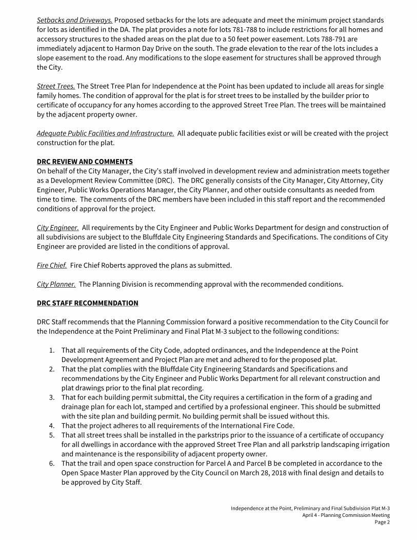
Independence at the Point, Preliminary and Final Subdivision Plat M-3
April 4 - Planning Commission Meeting
Page 2
Setbacks and Driveways. Proposed setbacks for the lots are adequate and meet the minimum project standards
for lots as identified in the DA. The plat provides a note for lots 781-788 to include restrictions for all homes and
accessory structures to the shaded areas on the plat due to a 50 feet power easement. Lots 788-791 are
immediately adjacent to Harmon Day Drive on the south. The grade elevation to the rear of the lots includes a
slope easement to the road. Any modifications to the slope easement for structures shall be approved through
the City.
Street Trees. The Street Tree Plan for Independence at the Point has been updated to include all areas for single
family homes. The condition of approval for the plat is for street trees to be installed by the builder prior to
certificate of occupancy for any homes according to the approved Street Tree Plan. The trees will be maintained
by the adjacent property owner.
Adequate Public Facilities and Infrastructure. All adequate public facilities exist or will be created with the project
construction for the plat.
DRC REVIEW AND COMMENTS
On behalf of the City Manager, the City’s staff involved in development review and administration meets together
as a Development Review Committee (DRC). The DRC generally consists of the City Manager, City Attorney, City
Engineer, Public Works Operations Manager, the City Planner, and other outside consultants as needed from
time to time. The comments of the DRC members have been included in this staff report and the recommended
conditions of approval for the project.
City Engineer. All requirements by the City Engineer and Public Works Department for design and construction of
all subdivisions are subject to the Bluffdale City Engineering Standards and Specifications. The conditions of City
Engineer are provided are listed in the conditions of approval.
Fire Chief. Fire Chief Roberts approved the plans as submitted.
City Planner. The Planning Division is recommending approval with the recommended conditions.
DRC STAFF RECOMMENDATION
DRC Staff recommends that the Planning Commission forward a positive recommendation to the City Council for
the Independence at the Point Preliminary and Final Plat M-3 subject to the following conditions:
1. That all requirements of the City Code, adopted ordinances, and the Independence at the Point
Development Agreement and Project Plan are met and adhered to for the proposed plat.
2. That the plat complies with the Bluffdale City Engineering Standards and Specifications and
recommendations by the City Engineer and Public Works Department for all relevant construction and
plat drawings prior to the final plat recording.
3. That for each building permit submittal, the City requires a certification in the form of a grading and
drainage plan for each lot, stamped and certified by a professional engineer. This should be submitted
with the site plan and building permit. No building permit shall be issued without this.
4. That the project adheres to all requirements of the International Fire Code.
5. That all street trees shall be installed in the parkstrips prior to the issuance of a certificate of occupancy
for all dwellings in accordance with the approved Street Tree Plan and all parkstrip landscaping irrigation
and maintenance is the responsibility of adjacent property owner.
6. That the trail and open space construction for Parcel A and Parcel B be completed in accordance to the
Open Space Master Plan approved by the City Council on March 28, 2018 with final design and details to
be approved by City Staff.

Independence at the Point, Preliminary and Final Subdivision Plat M-3
April 4 - Planning Commission Meeting
Page 3
7. That the plat provides restrictions for a power easement on lots 781-788 and the builder shall comply
with all requirements of the easement as identified.
8. That any modifications to the slope easement for Harmon Day Drive shall be approved by the City for lots
788-791 and plans be presented to the City for final approval prior to any construction activities.
MODEL MOTION
Motion for a Positive Recommendation – “I move we forward a positive recommendation to the City Council for
the Independence at the Point Preliminary and Final Plat M-3 application 2017-60, subject to the conditions and
based on the findings presented in the staff report dated March 30, 2018, (or as modified by the conditions
below):”
1. List any additional findings and/or conditions…

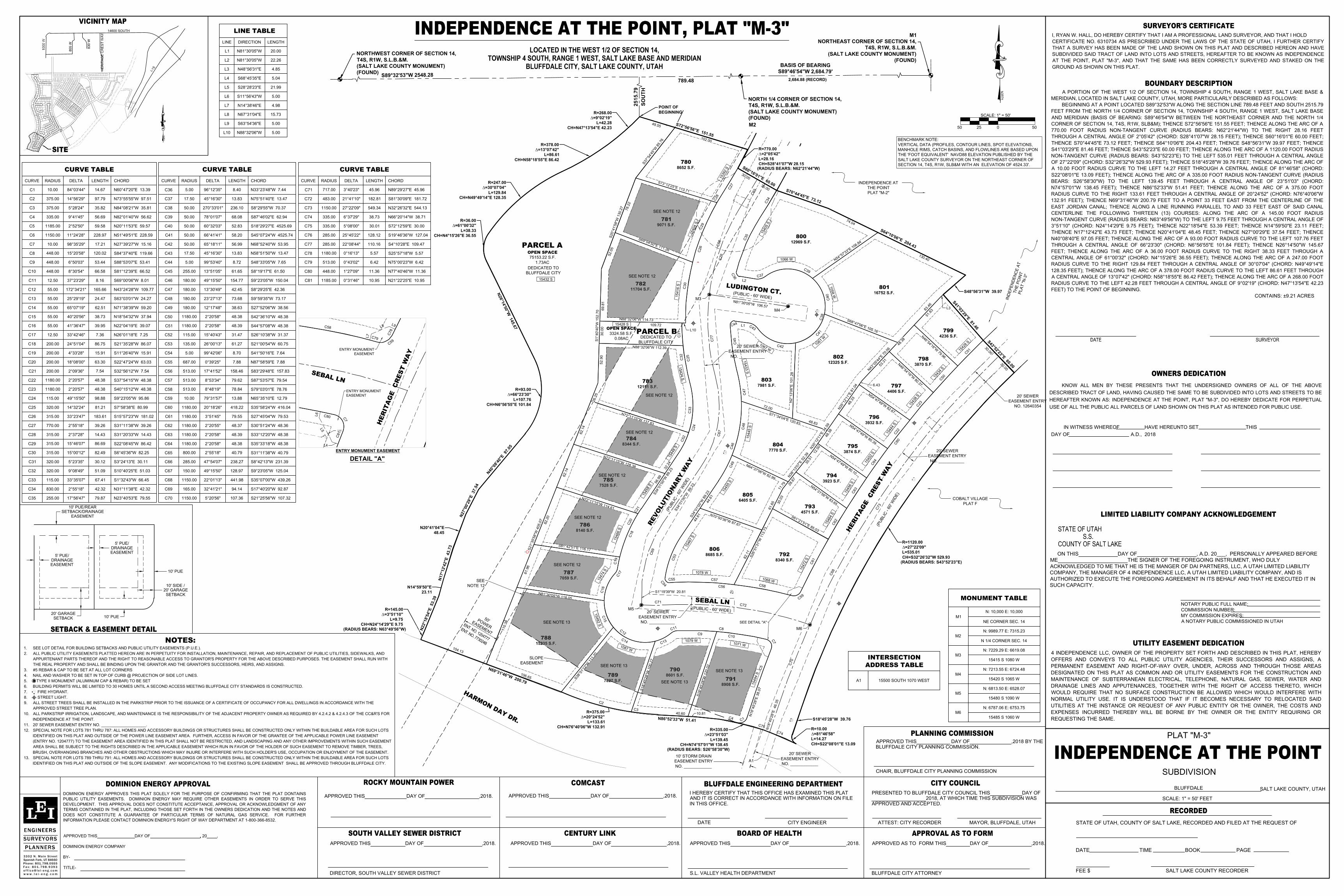
3
0
.
0
0
3
0
.
0
0
780
781
782
783
784
785
786
787
788
789
790
791
792
806
805
793
794
795
804
796
797
798
799
803
802
801
800
7827 S.F.
789
OPEN SPACE
75153.22 S.F.
1.73AC
8685 S.F.
806
4571 S.F.
793
8340 S.F.
792
16752 S.F.
801
3923 S.F.
794
3874 S.F.
795
3932 S.F.
796
12325 S.F.
802
7770 S.F.
804
4236 S.F.
799
3870 S.F.
798
4406 S.F.
797
8908 S.F.
791
S
7
3
°
1
2
'2
5
"
E
1
1
3
.7
1
S
6
9
°
0
4
'5
0
"
E
1
1
1
.
2
6
N88°32'06"W 114.73
N
7
2
°
1
1
'1
5
"
W
1
2
8
.
3
8
N
7
2
°
1
1
'1
5
"
W
1
1
4
.
6
1
S
81°42'5
1"E
116.17
N
81°30'0
5"W
118.05
S
3
8
°
5
1
'
1
2
"
W
1
1
1
.
2
0
S
1
8
°
4
5
'2
8
"
W
1
0
0
.
2
7
S
1
8
°
4
5
'2
8
"
W
1
2
0
.
0
2
S
2
6
°
5
1
'
3
1
"
W
1
1
3
.
7
3
N
7
0
°
5
0
'3
6
"
W
8
7
.
6
7
S
6
1
°
2
1
'
5
1
"
E
8
5
.
0
3
N
5
4
°
3
1
'
5
6
"
W
8
3
.
6
5
N
5
4
°
4
7
'
4
9
"
W
8
0
.
1
0
N
5
4
°
4
7
'
4
9
"
W
8
0
.
3
9
N
5
4
°
4
7
'
4
9
"
W
8
2
.
6
7
N
4
6
°
5
4
'
1
6
"
W
8
0
.
3
7
N
4
6
°
5
4
'
1
6
"
W
7
9
.
9
6
N
6
4
°
3
7
'0
6
"
W
8
2
.
9
9
S
7
1
°
3
4
'0
4
"
E
1
2
0
.
8
3
N2°13'06"E
101.28
S
6
8
°
4
7
'0
6
"
E
1
0
5
.
1
6
N
5
4
°
5
7
'
3
3
"
E
1
0
6
.
8
4
N
4
3
°
0
5
'
4
4
"
E
7
0
.
0
6
8
3
.
4
6
N
3
5
°
1
2
'
1
1
"
E
8
1
.
0
4
4
8
.
8
3
7
2
.
0
0
N
3
5
°
1
2
'
1
1
"
E
3
4
.
5
9
N
3
8
°
1
3
'
0
7
"
E
5
2
.
3
9
1
1
.
7
9
6
1
.
6
5
S
3
7
°
5
4
'
4
5
"
W
8
5
.
7
6
S
2
0
°
4
1
'5
8
"
W
1
3
0
.
2
7
7
8
.
2
2
52.90
S1°40'40"W
152.70
5
2
.
0
5
69.81
2
6
.
2
5
6
2
.
1
4
6
2
.
1
4
8
2
.
2
0
6
1
.
9
6
1
1
0
.
3
8
S
2
1
°
3
5
'5
8
"
W
4
0
5
.
0
7
1
0
6
.
6
5
C
3
C
2
40.6010.81
C
4
C
5
C
7
C8
C9
C
10
C
1
1
C
1
2
C
1
3
C
1
4
C
1
5
C
1
6
C
1
7
C
3
4
C
3
5
C
3
6
L2
C
3
7
C
3
8
C
3
9
C
4
0
C
4
1
C
4
2
C
4
3
L
1C
4
4
C45
C
4
6
C47
C
48
C
4
9
4
4
.
6
1
4
4
.
6
1
S
3
4
°
0
1
'
0
0
"
W
8
9
.
2
3
C
5
3
C
5
4
C55
C56
C57
C
5
8
C
5
9
C
6
1
C
6
2
C
6
3
C
6
4
C
2
2
C
2
3
8
2
.
1
1
3
0
.
0
3
3
5
.
5
1
2
8
.
6
7
1
2
.
5
0
4
8
.
3
8
6.43
4
8
.
3
3
5
3
.
3
1
4
8
.
3
8
5
1
.
8
3
L3
C
6
5
C
6
6
N
81°30'0
5"W
106.57
C
6
7
S
3
4
°
0
1
'
0
0
"
W
8
9
.
2
3
C
6
9
S1°19'39"W 20.81
C71
C
72
C
7
3
N
1
8
°
4
5
'2
8
"
E
4
6
.
3
5
C
7
5
C
7
6
C77
C
7
0
C
6
8
1
0
4
.
1
3
4
9
.5
5
N
1
8
°
4
5
'2
8
"
E
3
8
.
0
7
15235 S.F.
788
6405 S.F.
805
R=145.00
D=3°51'10"
L=9.75
CH=N24°14'29"E 9.75
N
2
2
°
1
8
'
5
4
"
E
5
3
.
3
9
N14°59'50"E
23.11
N
1
7
°
1
2
'4
2
"
E
4
3
.7
3
N20°41'04"E
48.45
N
2
7
°
0
0
'
2
9
"
E
3
7
.
5
4
N
4
0
°
0
8
'
4
0
"
E
9
7
.
0
5
R=93.00
D=66°23'30"
L=107.76
CH=N6°56'55"E 101.84
N
2
6
°
1
4
'
5
0
"
W
1
4
5
.
6
7
R=36.00
D=61°00'32"
L=38.33
CH=N4°15'26"E 36.55
R=247.00
D=30°07'04"
L=129.84
CH=N49°49'14"E 128.35
R=378.00
D=13°07'42"
L=86.61
CH=N58°18'55"E 86.42
R=268.00
D=9°02'19"
L=42.28
CH=N47°13'54"E 42.23
S
7
2
°
5
6
'5
6
"
E
1
5
1
.5
5
R=770.00
D=2°05'42"
L=28.16
CH=S28°41'07"W 28.15
S
6
0
°
1
6
'
0
1
"
E
6
0
.
0
0
S
7
0
°
4
4
'4
5
"
E
7
3
.
1
2
S
6
4
°
1
0
'
0
6
"
E
2
0
4
.
4
3
S48°56'31"W 39.97
S
4
1
°
0
3
'
2
9
"
E
8
1
.
4
6
S
4
3
°
5
2
'
2
3
"
E
6
0
.
0
0
R=1120.00
D=27°22'09"
L=535.01
CH=S32°26'32"W 529.93
S18°45'28"W 39.76
R=10.00
D=81°46'58"
L=14.27
CH=S22°08'01"E 13.09
R=335.00
D=23°51'03"
L=139.45
CH=N74°57'01"W 138.45
N86°52'33"W
51.41
R=375.00
D=20°24'52"
L=133.61
CH=N76°40'06"W 132.91
1
3
0
.
4
0
7
4
.
0
4
3
0
.
0
0
3
0
.
0
0
1
0
2
.0
0
7981 S.F.
803
12969 S.F.
800
C
5
0
C
5
1
C
6
0
N
7
2
°
1
1
'1
5
"
W
1
3
7
.8
3
11704 S.F.
782
12151 S.F.
783
8652 S.F.
780
9071 S.F.
781
8344 S.F.
784
7528 S.F.
785
8140 S.F.
786
OPEN SPACE
3324.58 S.F.
0.08AC
7059 S.F.
787
C
2
7
C
2
6
C
25
C
2
4
S
3
4
°
0
1
'
0
0
"
W
8
9
.
2
3
C
1
8
C
1
9
C
2
0
C
2
1
5
6
.
9
9
3
2
.
2
4
C
2
8
C
2
9
C
30
C31
C
32
C33
C
5
2
L10
109.72
N88°32'06"W 112.39
30.00
8601 S.F.
790
N
6
9
°
3
1
'4
6
"
W
2
0
0
.
7
9
C
7
4
C
1
CURVE TABLE
CURVE
C1
C2
C3
C4
C5
C6
C7
C8
C9
C10
C11
C12
C13
C14
C15
C16
C17
C18
C19
C20
C21
C22
C23
C24
C25
C26
C27
C28
C29
C30
C31
C32
C33
C34
C35
RADIUS
10.00
375.00
375.00
335.00
1185.00
1150.00
10.00
448.00
448.00
448.00
12.50
55.00
55.00
55.00
55.00
55.00
12.50
200.00
200.00
200.00
200.00
1180.00
1180.00
115.00
320.00
315.00
770.00
315.00
315.00
315.00
320.00
320.00
115.00
830.00
255.00
DELTA
84°03'44"
14°56'29"
5°28'24"
9°41'45"
2°52'50"
11°24'28"
98°35'29"
15°20'58"
6°50'03"
8°30'54"
37°23'29"
172°34'21"
25°29'19"
65°07'19"
40°20'56"
41°36'47"
33°42'46"
24°51'04"
4°33'28"
18°08'00"
2°09'36"
2°20'57"
2°20'57"
49°15'50"
14°32'24"
33°23'47"
2°55'18"
2°37'28"
15°46'07"
15°00'12"
5°23'35"
9°08'49"
33°35'07"
2°55'18"
17°56'47"
LENGTH
14.67
97.79
35.82
56.69
59.58
228.97
17.21
120.02
53.44
66.58
8.16
165.66
24.47
62.51
38.73
39.95
7.36
86.75
15.91
63.30
7.54
48.38
48.38
98.88
81.21
183.61
39.26
14.43
86.69
82.49
30.12
51.09
67.41
42.32
79.87
CHORD
N60°47'20"E 13.39
N73°55'55"W 97.51
N84°08'21"W 35.81
N82°01'40"W 56.62
N20°11'53"E 59.57
N51°49'51"E 228.59
N27°39'27"W 15.16
S84°37'40"E 119.66
S88°53'07"E 53.41
S81°12'39"E 66.52
S69°00'06"W 8.01
N43°24'28"W 109.77
S63°03'01"W 24.27
N71°38'39"W 59.20
N18°54'32"W 37.94
N22°04'19"E 39.07
N26°01'18"E 7.25
S21°35'28"W 86.07
S11°26'40"W 15.91
S22°47'24"W 63.03
S32°56'12"W 7.54
S37°54'15"W 48.38
S40°15'12"W 48.38
S9°23'05"W 95.86
S7°58'38"E 80.99
S15°57'23"W 181.02
S31°11'38"W 39.26
S31°20'33"W 14.43
S22°08'45"W 86.42
S6°45'36"W 82.25
S3°24'13"E 30.11
S10°40'25"E 51.03
S1°32'43"W 66.45
N31°11'38"E 42.32
N23°40'53"E 79.55
CURVE TABLE
CURVE
C36
C37
C38
C39
C40
C41
C42
C43
C44
C45
C46
C47
C48
C49
C50
C51
C52
C53
C54
C55
C56
C57
C58
C59
C60
C61
C62
C63
C64
C65
C66
C67
C68
C69
C70
RADIUS
5.00
17.50
50.00
50.00
50.00
50.00
50.00
17.50
5.00
255.00
180.00
180.00
180.00
180.00
1180.00
1180.00
115.00
135.00
5.00
687.00
513.00
513.00
513.00
10.00
1180.00
1180.00
1180.00
1180.00
1180.00
800.00
285.00
150.00
1150.00
165.00
1150.00
DELTA
96°12'35"
45°16'30"
270°33'01"
78°01'07"
60°32'03"
66°41'41"
65°18'11"
45°16'30"
99°53'40"
13°51'05"
49°15'50"
13°30'49"
23°27'13"
12°17'48"
2°20'58"
2°20'58"
15°40'43"
26°00'13"
99°42'06"
0°39'25"
17°41'52"
8°53'34"
8°48'19"
79°31'57"
20°18'26"
3°51'45"
2°20'55"
2°20'58"
2°20'58"
2°55'18"
47°54'07"
49°15'50"
22°01'13"
32°41'21"
5°20'56"
LENGTH
8.40
13.83
236.10
68.08
52.83
58.20
56.99
13.83
8.72
61.65
154.77
42.45
73.68
38.63
48.38
48.39
31.47
61.27
8.70
7.88
158.46
79.62
78.84
13.88
418.22
79.55
48.37
48.39
48.38
40.79
238.27
128.97
441.98
94.14
107.36
CHORD
N33°23'48"W 7.44
N75°51'40"E 13.47
S8°29'55"W 70.37
S87°46'02"E 62.94
S18°29'27"E 4525.69
S45°07'24"W 4525.74
N68°52'40"W 53.95
N58°51'50"W 13.47
S48°33'05"W 7.65
S8°19'17"E 61.50
S9°23'05"W 150.04
S8°29'25"E 42.36
S9°59'35"W 73.17
S27°52'06"W 38.56
S42°36'10"W 48.38
S44°57'08"W 48.38
S26°10'38"W 31.37
S21°00'54"W 60.75
S41°50'16"E 7.64
N87°58'59"E 7.88
S83°29'48"E 157.83
S87°53'57"E 79.54
S79°03'01"E 78.76
N65°35'10"E 12.79
S35°58'24"W 416.04
S27°45'04"W 79.53
S30°51'24"W 48.36
S33°12'20"W 48.38
S35°33'18"W 48.38
S31°11'38"W 40.79
S8°42'13"W 231.39
S9°23'05"W 125.04
S35°07'00"W 439.26
S17°40'20"W 92.87
S21°25'56"W 107.32
CURVE TABLE
CURVE
C71
C72
C73
C74
C75
C76
C77
C78
C79
C80
C81
RADIUS
717.00
483.00
1150.00
335.00
335.00
285.00
285.00
1180.00
513.00
448.00
1185.00
DELTA
3°40'23"
21°41'10"
27°22'09"
6°37'29"
5°08'00"
25°45'22"
22°08'44"
0°16'13"
0°43'02"
1°27'09"
0°31'46"
LENGTH
45.96
182.81
549.34
38.73
30.01
128.12
110.16
5.57
6.42
11.36
10.95
CHORD
N89°29'27"E 45.96
S81°30'09"E 181.72
N32°26'32"E 544.13
N66°20'14"W 38.71
S72°12'59"E 30.00
S19°46'36"W 127.04
S4°10'28"E 109.47
S25°57'18"W 5.57
N75°00'23"W 6.42
N77°40'46"W 11.36
N21°22'25"E 10.95
11
+00
1
2
+
0
0
3
0
.
0
0
3
0
.
0
0
7827 S.F.
789
OPEN SPACE
75153.22 S.F.
1.73AC
8685 S.F.
806
4571 S.F.
793
8340 S.F.
792
16752 S.F.
801
3923 S.F.
794
3874 S.F.
795
3932 S.F.
796
12325 S.F.
802
7770 S.F.
804
4236 S.F.
799
3870 S.F.
798
4406 S.F.
797
8908 S.F.
791
S
7
3
°
1
2
'2
5
"
E
1
1
3
.7
1
S
6
9
°
0
4
'5
0
"
E
1
1
1
.
2
6
N88°32'06"W 114.73
N
7
2
°
1
1
'1
5
"
W
1
2
8
.3
8
N
7
2
°
1
1
'1
5
"
W
1
1
4
.6
1
S
81°42'5
1"E
116.17
N
81°30'0
5"W
118.05
S
3
8
°
5
1
'
1
2
"
W
1
1
1
.
2
0
S
1
8
°
4
5
'2
8
"
W
1
0
0
.
2
7
S
1
8
°
4
5
'2
8
"
W
1
2
0
.
0
2
S
2
6
°
5
1
'
3
1
"
W
1
1
3
.
7
3
N
7
0
°
5
0
'3
6
"
W
8
7
.
6
7
S
6
1
°
2
1
'
5
1
"
E
8
5
.
0
3
N
5
4
°
3
1
'
5
6
"
W
8
3
.
6
5
N
5
4
°
4
7
'
4
9
"
W
8
0
.
1
0
N
5
4
°
4
7
'
4
9
"
W
8
0
.
3
9
N
5
4
°
4
7
'
4
9
"
W
8
2
.
6
7
N
4
6
°
5
4
'
1
6
"
W
8
0
.
3
7
N
4
6
°
5
4
'
1
6
"
W
7
9
.
9
6
N
6
4
°
3
7
'0
6
"
W
8
2
.
9
9
S
7
1
°
3
4
'0
4
"
E
1
2
0
.
8
3
N2°13'06"E
101.28
S
6
8
°
4
7
'0
6
"
E
1
0
5
.
1
6
N
5
4
°
5
7
'
3
3
"
E
1
0
6
.
8
4
N
4
3
°
0
5
'
4
4
"
E
7
0
.
0
6
8
3
.
4
6
N
3
5
°
1
2
'
1
1
"
E
8
1
.
0
4
4
8
.
8
3
7
2
.
0
0
N
3
5
°
1
2
'
1
1
"
E
3
4
.
5
9
N
3
8
°
1
3
'
0
7
"
E
5
2
.
3
9
1
1
.
7
9
6
1
.
6
5
S
3
7
°
5
4
'
4
5
"
W
8
5
.
7
6
S
2
0
°
4
1
'5
8
"
W
1
3
0
.
2
7
7
8
.
2
2
52.90
S1°40'40"W
152.70
5
2
.
0
5
69.81
2
6
.
2
5
6
2
.
1
4
6
2
.
1
4
8
2
.
2
0
6
1
.
9
6
1
1
0
.
3
8
S
2
1
°
3
5
'5
8
"
W
4
0
5
.
0
7
1
0
6
.
6
5
C
3
C
2
40.6010.81
C
4
C
5
C
7
C8
C9
C10
C
1
1
C
1
2
C
1
3
C
1
4
C
1
5
C
1
6
C
1
7
C
3
4
C
3
5
C
3
6
L2
C
3
7
C
3
8
C
3
9
C
4
0
C
4
1
C
4
2
C
4
3
L1C
4
4
C45
C
4
6
C47
C
48
C
4
9
4
4
.
6
1
4
4
.
6
1
S
3
4
°
0
1
'
0
0
"
W
8
9
.
2
3
C
5
3
C
5
4
C55
C56
C57
C
5
8
C
5
9
C
6
1
C
6
2
C
6
3
C
6
4
C
2
2
C
2
3
8
2
.
1
1
3
0
.
0
3
3
5
.
5
1
2
8
.
6
7
1
2
.
5
0
4
8
.
3
8
6.43
4
8
.
3
3
5
3
.
3
1
4
8
.
3
8
5
1
.
8
3
L3
C
6
5
C
6
6
N
81°30'0
5"W
106.57
C
6
7
S
3
4
°
0
1
'
0
0
"
W
8
9
.
2
3
C
6
9
S1°19'39"W 20.81
C71
C
72
C
7
3
N
1
8
°
4
5
'2
8
"
E
4
6
.
3
5
C
7
5
C
7
6
C77
C
7
0
C
6
8
1
0
4
.
1
3
4
9
.5
5
N
1
8
°
4
5
'2
8
"
E
3
8
.
0
7
15235 S.F.
788
6405 S.F.
805
N
2
2
°
1
8
'
5
4
"
E
5
3
.
3
9
N14°59'50"E
23.11
N
1
7
°
1
2
'4
2
"
E
4
3
.7
3
N20°41'04"E
48.45
N
2
7
°
0
0
'
2
9
"
E
3
7
.
5
4
N
4
0
°
0
8
'
4
0
"
E
9
7
.
0
5
R=93.00
D=66°23'30"
L=107.76
CH=N6°56'55"E 101.84
N
2
6
°
1
4
'
5
0
"
W
1
4
5
.
6
7
R=36.00
D=61°00'32"
L=38.33
CH=N4°15'26"E 36.55
R=247.00
D=30°07'04"
L=129.84
CH=N49°49'14"E 128.35
R=378.00
D=13°07'42"
L=86.61
CH=N58°18'55"E 86.42
D=9°02'19"
L=42.28
CH=N47°13'54"E 42.23
S
7
2
°
5
6
'5
6
"
E
1
5
1
.5
5
R=770.00
D=2°05'42"
L=28.16
CH=S28°41'07"W 28.15
S
6
0
°
1
6
'
0
1
"
E
6
0
.
0
0
S
7
0
°
4
4
'4
5
"
E
7
3
.
1
2
S
6
4
°
1
0
'
0
6
"
E
2
0
4
.
4
3
S48°56'31"W 39.97
S
4
1
°
0
3
'
2
9
"
E
8
1
.
4
6
S
4
3
°
5
2
'
2
3
"
E
6
0
.
0
0
R=1120.00
D=27°22'09"
L=535.01
CH=S32°26'32"W 529.93
S18°45'28"W 39.76
R=10.00
D=81°46'58"
L=14.27
CH=S22°08'01"E 13.09
R=335.00
D=23°51'03"
L=139.45
CH=N74°57'01"W 138.45
N86°52'33"W
51.41
R=375.00
D=20°24'52"
L=133.61
CH=N76°40'06"W 132.91
1
3
0
.
4
0
7
4
.
0
4
3
0
.
0
0
3
0
.
0
0
1
0
2
.0
0
7981 S.F.
803
12969 S.F.
800
C
5
0
C
5
1
C
6
0
N
7
2
°
1
1
'1
5
"
W
1
3
7
.8
3
11704 S.F.
782
12151 S.F.
783
8652 S.F.
780
9071 S.F.
781
8344 S.F.
784
7528 S.F.
785
8140 S.F.
786
OPEN SPACE
3324.58 S.F.
0.08AC
7059 S.F.
787
C
2
7
C
2
6
C
2
5
C
2
4
S
3
4
°
0
1
'
0
0
"
W
8
9
.
2
3
C
1
8
C
1
9
C
2
0
C
2
1
5
6
.
9
9
3
2
.
2
4
C
2
8
C
2
9
C
30
C31
C
32
C33
C
5
2
L10
109.72
N88°32'06"W 112.39
30.00
8601 S.F.
790
N
6
9
°
3
1
'4
6
"
W
2
0
0
.
7
9
C
7
4
C
1
LINE TABLE
LINE
L1
L2
L3
L4
L5
L6
L7
L8
L9
L10
DIRECTION
N81°30'05"W
N81°30'05"W
N48°56'31"E
S68°45'35"E
S28°28'23"E
S11°56'43"W
N14°38'46"E
N67°31'04"E
S63°54'36"E
N88°32'06"W
LENGTH
20.00
22.26
4.85
5.04
21.99
5.00
4.98
15.73
5.00
5.00
C
7
C
5
8
C
5
9
C
72
C
7
8
L
9
L
8
L
7
C
7
9
C
8
0
L
6
L
5
L4
C
8
1
LIMITED LIABILITY COMPANY ACKNOWLEDGEMENT
I, RYAN W. HALL, DO HEREBY CERTIFY THAT I AM A PROFESSIONAL LAND SURVEYOR, AND THAT I HOLD
CERTIFICATE NO. 6310734 AS PRESCRIBED UNDER THE LAWS OF THE STATE OF UTAH, I FURTHER CERTIFY
THAT A SURVEY HAS BEEN MADE OF THE LAND SHOWN ON THIS PLAT AND DESCRIBED HEREON AND HAVE
SUBDIVIDED SAID TRACT OF LAND INTO LOTS AND STREETS, HEREAFTER TO BE KNOWN AS INDEPENDENCE
AT THE POINT, PLAT "M-3", AND THAT THE SAME HAS BEEN CORRECTLY SURVEYED AND STAKED ON THE
GROUND AS SHOWN ON THIS PLAT.
SALT LAKE COUNTY, UTAH
INDEPENDENCE AT THE POINT
DATE SURVEYOR
APPROVED THIS DAY OF ,2018.
S.L. VALLEY HEALTH DEPARTMENT
APPROVED THIS DAY OF ,2018.
I HEREBY CERTIFY THAT THIS OFFICE HAS EXAMINED THIS PLAT
AND IT IS CORRECT IN ACCORDANCE WITH INFORMATION ON FILE
IN THIS OFFICE.
DATE
APPROVED AS TO FORM THIS DAY OF ,2018.
BLUFFDALE CITY ATTORNEY
APPROVED THIS DAY OF ,2018.
BLUFFDALE
STATE OF UTAH
S.S.
COUNTY OF SALT LAKE
NO
RT
H
APPROVED THIS DAY OF ,2018.
DIRECTOR, SOUTH VALLEY SEWER DISTRICT
APPROVED THIS DAY OF ,2018 BY THE
BLUFFDALE CITY PLANNING COMMISSION.
CHAIR, BLUFFDALE CITY PLANNING COMMISSION
CITY ENGINEER
PRESENTED TO BLUFFDALE CITY COUNCIL THIS DAY OF
2018, AT WHICH TIME THIS SUBDIVISION WAS
APPROVED AND ACCEPTED.
ATTEST: CITY RECORDER MAYOR, BLUFFDALE, UTAH
4 INDEPENDENCE LLC, OWNER OF THE PROPERTY SET FORTH AND DESCRIBED IN THIS PLAT, HEREBY
OFFERS AND CONVEYS TO ALL PUBLIC UTILITY AGENCIES, THEIR SUCCESSORS AND ASSIGNS, A
PERMANENT EASEMENT AND RIGHT-OF-WAY OVER, UNDER, ACROSS AND THROUGH THOSE AREAS
DESIGNATED ON THIS PLAT AS COMMON AND OR UTILITY EASEMENTS FOR THE CONSTRUCTION AND
MAINTENANCE OF SUBTERRANEAN ELECTRICAL, TELEPHONE, NATURAL GAS, SEWER, WATER AND
DRAINAGE LINES AND APPUTENANCES, TOGETHER WITH THE RIGHT OF ACCESS THERETO, WHICH
WOULD REQUIRE THAT NO SURFACE CONSTRUCTION BE ALLOWED WHICH WOULD INTERFERE WITH
NORMAL UTILITY USE. IT IS UNDERSTOOD THAT IF IT BECOMES NECESSARY TO RELOCATED SAID
UTILITIES AT THE INSTANCE OR REQUEST OF ANY PUBLIC ENTITY OR THE OWNER, THE COSTS AND
EXPENSES INCURRED THEREBY WILL BE BORNE BY THE OWNER OR THE ENTITY REQUIRING OR
REQUESTING THE SAME.
PLAT "M-3"
ENGINEERSSURVEYORSPLANNERS
33 02 N. Ma in St reetSpanish Fork, UT 84660Phone: 801.798.0555F a x : 8 0 1 . 79 8 . 9 3 9 3o f f i c e @ l e i - e n g . c o mw w w . l e i - e n g . c o m
STATE OF UTAH, COUNTY OF SALT LAKE, RECORDED AND FILED AT THE REQUEST OF
DATE TIME BOOK PAGE
FEE $ SALT LAKE COUNTY RECORDER
OWNERS DEDICATION
BOUNDARY DESCRIPTION
SURVEYOR'S CERTIFICATE
UTILITY EASEMENT DEDICATION
PLANNING COMMISSION
RECORDED
CITY COUNCILBLUFFDALE ENGINEERING DEPARTMENT
ROCKY MOUNTAIN POWER
APPROVAL AS TO FORMBOARD OF HEALTHSOUTH VALLEY SEWER DISTRICT CENTURY LINK
COMCAST
POINT OF
BEGINNING
SUBDIVISION
NO
RT
H
14600 SOUTH
HE
RIT
AG
E C
RE
ST
W
AY
I
-
1
5
830 W
1000 W
855 W
MONUMENT TABLE
SITE
SETBACK & EASEMENT DETAIL
NOTES:
1. SEE LOT DETAIL FOR BUILDING SETBACKS AND PUBLIC UTILITY EASEMENTS (P.U.E.).
2. ALL PUBLIC UTILITY EASEMENTS PLATTED HEREON ARE IN PERPETUITY FOR INSTALLATION, MAINTENANCE, REPAIR, AND REPLACEMENT OF PUBLIC UTILITIES, SIDEWALKS, AND
APPURTENANT PARTS THEREOF AND THE RIGHT TO REASONABLE ACCESS TO GRANTOR'S PROPERTY FOR THE ABOVE DESCRIBED PURPOSES. THE EASEMENT SHALL RUN WITH
THE REAL PROPERTY AND SHALL BE BINDING UPON THE GRANTOR AND THE GRANTOR'S SUCCESSORS, HEIRS, AND ASSIGNS.
3. #5 REBAR & CAP TO BE SET AT ALL LOT CORNERS
4. NAIL AND WASHER TO BE SET IN TOP OF CURB @ PROJECTION OF SIDE LOT LINES.
5. TYPE II MONUMENT (ALUMINUM CAP & REBAR) TO BE SET
6. BUILDING PERMITS WILL BE LIMITED TO 30 HOMES UNTIL A SECOND ACCESS MEETING BLUFFDALE CITY STANDARDS IS CONSTRUCTED.
7. FIRE HYDRANT.
8. STREET LIGHT.
9. ALL STREET TREES SHALL BE INSTALLED IN THE PARKSTRIP PRIOR TO THE ISSUANCE OF A CERTIFICATE OF OCCUPANCY FOR ALL DWELLINGS IN ACCORDANCE WITH THE
APPROVED STREET TREE PLAN.
10. ALL PARKSTRIP IRRIGATION, LANDSCAPE, AND MAINTENANCE IS THE RESPONSIBILITY OF THE ADJACENT PROPERTY OWNER AS REQUIRED BY 4.2.4.2 & 4.2.4.3 OF THE CC&R'S FOR
INDEPENDENCE AT THE POINT.
11. 20' SEWER EASEMENT ENTRY NO. ____________________.
12. SPECIAL NOTE FOR LOTS 781 THRU 787: ALL HOMES AND ACCESSORY BUILDINGS OR STRUCTURES SHALL BE CONSTRUCTED ONLY WITHIN THE BUILDABLE AREA FOR SUCH LOTS
IDENTIFIED ON THIS PLAT AND OUTSIDE OF THE POWER LINE EASEMENT AREA. FURTHER, ACCESS IN FAVOR OF THE GRANTEE OF THE APPLICABLE POWER LINE EASEMENT
(ENTRY NO. 1204777) TO THE EASEMENT AREA IDENTIFIED IN THIS PLAT SHALL NOT BE RESTRICTED, AND LANDSCAPING AND ANY OTHER IMPROVEMENTS WITHIN SUCH EASEMENT
AREA SHALL BE SUBJECT TO THE RIGHTS DESCRIBED IN THE APPLICABLE EASEMENT WHICH RUN IN FAVOR OF THE HOLDER OF SUCH EASEMENT TO REMOVE TIMBER, TREES,
BRUSH, OVERHANGING BRANCHES AND OTHER OBSTRUCTIONS WHICH MAY INJURE OR INTERFERE WITH SUCH HOLDER'S USE, OCCUPATION OR ENJOYMENT OF THE EASEMENT.
13. SPECIAL NOTE FOR LOTS 789 THRU 791: ALL HOMES AND ACCESSORY BUILDINGS OR STRUCTURES SHALL BE CONSTRUCTED ONLY WITHIN THE BUILDABLE AREA FOR SUCH LOTS
IDENTIFIED ON THIS PLAT AND OUTSIDE OF THE SLOPE EASEMENT. ANY MODIFICATIONS TO THE EXISTING SLOPE EASEMENT SHALL BE APPROVED THROUGH BLUFFDALE CITY.
2,684.88 (RECORD)
25
15
.7
9
SO
UT
H
KNOW ALL MEN BY THESE PRESENTS THAT THE UNDERSIGNED OWNERS OF ALL OF THE ABOVE
DESCRIBED TRACT OF LAND, HAVING CAUSED THE SAME TO BE SUBDIVIDED INTO LOTS AND STREETS TO BE
HEREAFTER KNOWN AS: INDEPENDENCE AT THE POINT, PLAT "M-3", DO HEREBY DEDICATE FOR PERPETUAL
USE OF ALL THE PUBLIC ALL PARCELS OF LAND SHOWN ON THIS PLAT AS INTENDED FOR PUBLIC USE.
IN WITNESS WHEREOF HAVE HEREUNTO SET THIS
DAY OF A.D., 2018
INDEPENDENCE AT THE POINT, PLAT "M-3"
LOCATED IN THE WEST 1/2 OF SECTION 14,
TOWNSHIP 4 SOUTH, RANGE 1 WEST, SALT LAKE BASE AND MERIDIAN
BLUFFDALE CITY, SALT LAKE COUNTY, UTAH
5050 025
NORTHWEST CORNER OF SECTION 14,
T4S, R1W, S.L.B.&M.
(SALT LAKE COUNTY MONUMENT)
(FOUND)
BASIS OF BEARING
S89°46'54"W 2,684.79'
NORTHEAST CORNER OF SECTION 14,
T4S, R1W, S.L.B.&M.
(SALT LAKE COUNTY MONUMENT)
(FOUND)
10' PUE
10' SIDE /
20' GARAGE
SETBACK
20' GARAGE
SETBACK
10' PUE/REAR
SETBACK/DRAINAGE
EASEMENT
5' PUE/
DRAINAGE
EASEMENT
10' PUE
5' PUE/
DRAINAGE
EASEMENT
789.48
SCALE: 1" = 50' FEET
A PORTION OF THE WEST 1/2 OF SECTION 14, TOWNSHIP 4 SOUTH, RANGE 1 WEST, SALT LAKE BASE &
MERIDIAN, LOCATED IN SALT LAKE COUNTY, UTAH, MORE PARTICULARLY DESCRIBED AS FOLLOWS:
BEGINNING AT A POINT LOCATED S89°32'53"W ALONG THE SECTION LINE 789.48 FEET AND SOUTH 2515.79
FEET FROM THE NORTH 1/4 CORNER OF SECTION 14, TOWNSHIP 4 SOUTH, RANGE 1 WEST, SALT LAKE BASE
AND MERIDIAN (BASIS OF BEARING: S89°46'54"W BETWEEN THE NORTHEAST CORNER AND THE NORTH 1/4
CORNER OF SECTION 14, T4S, R1W, SLB&M); THENCE S72°56'56"E 151.55 FEET; THENCE ALONG THE ARC OF A
770.00 FOOT RADIUS NON-TANGENT CURVE (RADIUS BEARS: N62°21'44"W) TO THE RIGHT 28.16 FEET
THROUGH A CENTRAL ANGLE OF 2°05'42" (CHORD: S28°41'07"W 28.15 FEET); THENCE S60°16'01"E 60.00 FEET;
THENCE S70°44'45"E 73.12 FEET; THENCE S64°10'06"E 204.43 FEET; THENCE S48°56'31"W 39.97 FEET; THENCE
S41°03'29"E 81.46 FEET; THENCE S43°52'23"E 60.00 FEET; THENCE ALONG THE ARC OF A 1120.00 FOOT RADIUS
NON-TANGENT CURVE (RADIUS BEARS: S43°52'23"E) TO THE LEFT 535.01 FEET THROUGH A CENTRAL ANGLE
OF 27°22'09" (CHORD: S32°26'32"W 529.93 FEET); THENCE S18°45'28"W 39.76 FEET; THENCE ALONG THE ARC OF
A 10.00 FOOT RADIUS CURVE TO THE LEFT 14.27 FEET THROUGH A CENTRAL ANGLE OF 81°46'58" (CHORD:
S22°08'01"E 13.09 FEET); THENCE ALONG THE ARC OF A 335.00 FOOT RADIUS NON-TANGENT CURVE (RADIUS
BEARS: S26°58'30"W) TO THE LEFT 139.45 FEET THROUGH A CENTRAL ANGLE OF 23°51'03" (CHORD:
N74°57'01"W 138.45 FEET); THENCE N86°52'33"W 51.41 FEET; THENCE ALONG THE ARC OF A 375.00 FOOT
RADIUS CURVE TO THE RIGHT 133.61 FEET THROUGH A CENTRAL ANGLE OF 20°24'52" (CHORD: N76°40'06"W
132.91 FEET); THENCE N69°31'46"W 200.79 FEET TO A POINT 33 FEET EAST FROM THE CENTERLINE OF THE
EAST JORDAN CANAL; THENCE ALONG A LINE RUNNING PARALLEL TO AND 33 FEET EAST OF SAID CANAL
CENTERLINE THE FOLLOWING THIRTEEN (13) COURSES: ALONG THE ARC OF A 145.00 FOOT RADIUS
NON-TANGENT CURVE (RADIUS BEARS: N63°49'56"W) TO THE LEFT 9.75 FEET THROUGH A CENTRAL ANGLE OF
3°51'10" (CHORD: N24°14'29"E 9.75 FEET); THENCE N22°18'54"E 53.39 FEET; THENCE N14°59'50"E 23.11 FEET;
THENCE N17°12'42"E 43.73 FEET; THENCE N20°41'04"E 48.45 FEET; THENCE N27°00'29"E 37.54 FEET; THENCE
N40°08'40"E 97.05 FEET; THENCE ALONG THE ARC OF A 93.00 FOOT RADIUS CURVE TO THE LEFT 107.76 FEET
THROUGH A CENTRAL ANGLE OF 66°23'30" (CHORD: N6°56'55"E 101.84 FEET); THENCE N26°14'50"W 145.67
FEET; THENCE ALONG THE ARC OF A 36.00 FOOT RADIUS CURVE TO THE RIGHT 38.33 FEET THROUGH A
CENTRAL ANGLE OF 61°00'32" (CHORD: N4°15'26"E 36.55 FEET); THENCE ALONG THE ARC OF A 247.00 FOOT
RADIUS CURVE TO THE RIGHT 129.84 FEET THROUGH A CENTRAL ANGLE OF 30°07'04" (CHORD: N49°49'14"E
128.35 FEET); THENCE ALONG THE ARC OF A 378.00 FOOT RADIUS CURVE TO THE LEFT 86.61 FEET THROUGH
A CENTRAL ANGLE OF 13°07'42" (CHORD: N58°18'55"E 86.42 FEET); THENCE ALONG THE ARC OF A 268.00 FOOT
RADIUS CURVE TO THE LEFT 42.28 FEET THROUGH A CENTRAL ANGLE OF 9°02'19" (CHORD: N47°13'54"E 42.23
FEET) TO THE POINT OF BEGINNING.
CONTAINS: ±9.21 ACRES
SCALE: 1" = 50'
S89°32'53"W 2548.28
M1
M2
M1
N: 10,000 E: 10,000
NE CORNER SEC. 14
M2
N: 9989.77 E: 7315.23
N 1/4 CORNER SEC. 14
ON THIS DAY OF , A.D. 20___, PERSONALLY APPEARED BEFORE
ME THE SIGNER OF THE FOREGOING INSTRUMENT, WHO DULY
ACKNOWLEDGED TO ME THAT HE IS THE MANGER OF DAI PARTNERS, LLC, A UTAH LIMITED LIABILITY
COMPANY, THE MANAGER OF 4 INDEPENDENCE LLC, A UTAH LIMITED LIABILITY COMPANY, AND IS
AUTHORIZED TO EXECUTE THE FOREGOING AGREEMENT IN ITS BEHALF AND THAT HE EXECUTED IT IN
SUCH CAPACITY.
NOTARY PUBLIC FULL NAME:
COMMISSION NUMBER:
MY COMMISSION EXPIRES:
A NOTARY PUBLIC COMMISSIONED IN UTAH
VICINITY MAP
NORTH 1/4 CORNER OF SECTION 14,
T4S, R1W, S.L.B.&M.
(SALT LAKE COUNTY MONUMENT)
(FOUND)
H
E
R
I
T
A
G
E
C
R
E
S
T
W
A
Y
1
5
3
9
2
S
APPROVED THIS DAY OF ,2018.
INDEPENDENCE AT
THE POINT
PLAT "M-2"
DOMINION ENERGY APPROVES THIS PLAT SOLELY FOR THE PURPOSE OF CONFIRMING THAT THE PLAT DONTAINS
PUBLIC UTILITY EASEMENTS. DOMINION ENERGY MAY REQUIRE OTHER EASEMENTS IN ORDER TO SERVE THIS
DEVELOPMENT. THIS APPROVAL DOES NOT CONSTITUTE ACCEPTANCE, APPROVAL OR ACKNOWLEDGMENT OF ANY
TERMS CONTAINED IN THE PLAT, INCLUDING THOSE SET FORTH IN THE OWNERS DEDICATION AND THE NOTES AND
DOES NOT CONSTITUTE A GUARANTEE OF PARTICULAR TERMS OF NATURAL GAS SERVICE. FOR FURTHER
INFORMATION PLEASE CONTACT DOMINION ENERGY'S RIGHT OF WAY DEPARTMENT AT 1-800-366-8532.
APPROVED THIS DAY OF 20
DOMINION ENERGY COMPANY
BY-
TITLE-
DOMINION ENERGY APPROVAL
I
N
D
E
P
E
N
D
E
N
C
E
A
T
T
H
E
P
O
I
N
T
P
L
A
T
"
N
-
3
"
(RADIUS BEARS: N62°21'44"W)
(RADIUS BEARS: S43°52'23"E)
SEE NOTE 12
SEE NOTE 12
SEE NOTE 12
SEE NOTE 12
SEE NOTE 12
SEE NOTE 12
SEE NOTE 12
M5
M6
M3
M3
N: 7229.29 E: 6619.08
15415 S 1080 W
M4
N: 7213.55 E: 6724.48
15420 S 1065 W
M5
N: 6813.50 E: 6528.07
15480 S 1090 W
5
0
'
P
O
W
E
R
E
A
S
E
M
E
N
T
ENT.
NO.
1204777
ENT.
NO.
7730248
PARCEL A
DEDICATED TO
BLUFFDALE CITY
10' STORM DRAIN
EASEMENT ENTRY
NO. ____________
20' SEWER
EASEMENT ENTRY
NO. ____________
LU
D
IN
G
T
O
N
C
T
.
SE
BA
L L
N
(
P
U
B
L
I
C
-
6
0
'
W
I
D
E
)
(
P
U
B
L
I
C
-
6
0
'
W
I
D
E
)
R
E
V
O
L
U
T
I
O
N
A
R
Y
W
A
Y
(P
U
BLIC
- 60' W
ID
E)
(PU
BLIC
- 60' W
IDE
)
(RADIUS BEARS: S26°58'30"W)
(RADIUS BEARS: N63°49'56"W)
1
5
4
0
4
S
15416 S
1
5
4
3
4
S
1
5
4
4
8
S
1
5
4
5
8
S
1
5
4
6
6
S
1
5
4
7
4
S
1
5
4
8
2
S
1
0
8
7
W
1079 W
1
0
7
1
W
1
0
6
8
W
1078 W
1
5
4
6
7
S
1
5
4
5
5
S
1
5
4
4
5
S
1
5
4
3
3
S
1
0
6
7
W
1
0
6
1
W
1
0
5
8
W
1066 W
1
5
4
0
5
S
1
5
4
2
8
S
1
5
4
3
4
S
1
5
4
3
8
S
1
5
4
4
4
S
1
5
4
5
2
S
1
5
4
5
6
S
1
5
4
6
4
S
1
5
4
7
2
S
1
5
4
9
4
S
M4
M6
N: 6787.06 E: 6753.75
15485 S 1060 W
COBALT VILLAGE
PLAT F
SLOPE
EASEMENT
ENTRY MONUMENT EASEMENT
S
E
B
A
L
L
N
H
E
R
I
T
A
G
E
C
R
E
S
T
W
A
Y
DETAIL "A"
SEE DETAIL "A"
ENTRY MONUMENT
EASEMENT
ENTRY MONUMENT
EASEMENT
DEDICATED TO
BLUFFDALE CITY
PARCEL B
BENCHMARK NOTE:
VERTICAL DATA (PROFILES, CONTOUR LINES, SPOT ELEVATIONS,
MANHOLE RIMS, CATCH BASINS, AND FLOWLINES ARE BASED UPON
THE 'FOOT EQUIVALENT' NAVD88 ELEVATION PUBLISHED BY THE
SALT LAKE COUNTY SURVEYOR ON THE NORTHEAST CORNER OF
SECTION 14, T4S, R1W, SLB&M WITH AN ELEVATION OF 4524.33'.
15432 S
15428 S
SEE
NOTE 12
SEE NOTE 13
SEE NOTE 13
SEE NOTE 13
SEE NOTE 13
2.52
20' SEWER
EASEMENT ENTRY
NO. 12640354
20' SEWER
EASEMENT ENTRY
NO. ___________
20' SEWER
EASEMENT ENTRY
NO. ___________
20' SEWER
EASEMENT ENTRY
NO. ___________
H
A
R
M
O
N
D
A
Y
D
R
.
A1
INTERSECTION
ADDRESS TABLE
A1 15500 SOUTH 1070 WEST
AutoCAD SHX Text
DAY OF , 20 . , 20 . , 20 . . .

Agenda Item 7

CITY OF BLUFFDALE, UTAH RESOLUTION NO. 2018-____
A RESOLUTION OF THE BLUFFDALE CITY COUNCIL AUTHORIZING THE CITY MANAGER TO ENTER INTO AGREEMENTS AWARDING A CONTRACT MOWING AND TRIMMING BID FOR 2018 AND ESTABLISHING A CONTINGENCY.
WHEREAS the City of Bluffdale (“City”) owns and maintains a system of parks and trails (“System”);
WHEREAS the City has advertised a Request for Bids for mowing and trimming of the System for the 2018 season (“Project”);
WHEREAS the City opened the bids for the Project on April 3, 2018; and WHEREAS seven bids were submitted, of which the M D Property Services, Inc., bid of
$39,092.00 (Schedule A) and the Intermountain Plantings, LLC, bid of $30,136.00 (Schedule B) were the lowest responsive and responsible bids; NOW, THEREFORE, BE IT RESOLVED BY THE CITY COUNCIL OF THE CITY OF BLUFFDALE AS FOLLOWS:
Section 1. Authorization to Execute Agreement. The City Council hereby authorizes the City Manager to execute the necessary agreements to award the Project, including a notice of award and an agreement, to M D Property Services, Inc., with a Contract Price of $39,092.00 (Schedule A) and/or to Intermountain Plantings, LLC, with a Contract Price of $30,136.00 (Schedule B) for a total contract amount of $______________ for the 2018 season. The City Council authorizes the City Manager to expend an additional 10 percent for contingencies ($__________ per season) that might arise with the Project for a total of $_______________ per season. As specified in the Request for Bids, this is a one year contract with the option by the City to renew on a yearly basis.
Section 2. Effective Date. This Resolution shall become effective immediately upon
its passage and the City Council authorizes and directs the Mayor to execute and cause to be delivered the same. PASSED, ADOPTED AND APPROVED: April 11, 2018.
________________________ Mayor Derk P. Timothy
ATTEST: [seal] ___________________________ Wendy Deppe, City Recorder
Voting by the City Council: Aye Nay Councilmember Aston _____ ______ Councilmember Jackson _____ ______ Councilmember Kallas _____ ______ Councilmember Nielsen _____ ______ Councilmember Preece _____ ______

Grass Mowing and Trimming Bid Opening
April 3, 2018
Bidder Bid Bond
Y/N
Acknowledge Amendment
Y/N
Bid Amount Schedule A
Bid Amount Schedule B
Bid Amount Total A & B
Green Acre Landscape Y Y 57,197.00 49,742.00 106,939.00
TruCo Services Y Y 83,762.01 50,379.58 134,141,59
Lawn Butler Y Y 71,920.00 47,560.00 119,480.00
Green Ridge Landscaping Y Y 26,708.56 18,167.44 44,876.00
Intermountain Planting Y Y 44,294.00 30,136.00 74,430.00
A-Z Landscaping Y Y 44,370.00 41,325.00 85,695.00
MD Property Services Y Y 39,092.00 36,888.00 75,980.00

BID TABULATION
Project:
Manager:
Schedule AMap
Label ITEM DESCRIPTION QUANTITY UNIT UNIT PRICE PARK TOTAL UNIT PRICE PARK TOTAL UNIT PRICE PARK TOTAL UNIT PRICE PARK TOTAL UNIT PRICE PARK TOTAL UNIT PRICE PARK TOTAL UNIT PRICE PARK TOTAL UNIT PRICE PARK TOTAL AVERAGE
UNIT PRICEAVERAGE
PARK TOTALA Bluffdale City Main Park 650,000 SQ FT 825.00$ 23,925.00$ 1,295.73$ 37,576.17$ 896.00$ 25,984.00$ 478.11$ 13,865.19$ 792.73$ 22,989.17$ 500.00$ 14,500.00$ 595.00$ 17,255.00$ -$ 768.94$ $19,512B Camp Williams - Mixing Station 68,500 SQ FT 95.00$ 2,755.00$ 132.70$ 3,848.30$ 112.00$ 3,248.00$ 50.36$ 1,460.44$ 83.54$ 2,422.66$ 150.00$ 4,350.00$ 80.00$ 2,320.00$ -$ 100.51$ $2,551C City Cemetary and Public Works Building 80,000 SQ FT 200.00$ 5,800.00$ 542.39$ 15,729.31$ 672.00$ 19,488.00$ 58.82$ 1,705.78$ 97.57$ 2,829.53$ 150.00$ 4,350.00$ 105.00$ 3,045.00$ -$ 260.83$ $6,618D Market View Parkstrips 3,000 SQ FT 40.00$ 1,160.00$ 12.65$ 366.85$ 48.00$ 1,392.00$ 2.21$ 64.09$ 3.66$ 106.14$ 40.00$ 1,160.00$ 50.00$ 1,450.00$ -$ 28.07$ $712E Palisades Park 49,500 SQ FT 70.00$ 2,030.00$ 100.09$ 2,902.61$ 96.00$ 2,784.00$ 36.39$ 1,055.31$ 60.37$ 1,750.73$ 75.00$ 2,175.00$ 65.00$ 1,885.00$ -$ 71.84$ $1,823F Parry Farms - Baseball Fields 120,000 SQ FT 215.00$ 6,235.00$ 236.65$ 6,862.85$ 184.00$ 5,336.00$ 88.23$ 2,558.67$ 146.35$ 4,244.15$ 175.00$ 5,075.00$ 115.00$ 3,335.00$ -$ 165.75$ $4,206G Parry Farms - Detention Pond 91,476 SQ FT 180.00$ 5,220.00$ 182.97$ 5,306.13$ 160.00$ 4,640.00$ 67.25$ 1,950.25$ 111.56$ 3,235.24$ 150.00$ 4,350.00$ 120.00$ 3,480.00$ -$ 138.83$ $3,523H Ponderosa Park 42,500 SQ FT 65.00$ 1,885.00$ 86.01$ 2,494.29$ 72.00$ 2,088.00$ 31.25$ 906.25$ 51.83$ 1,503.07$ 75.00$ 2,175.00$ 45.00$ 1,305.00$ -$ 60.87$ $1,545I Ten Sleep Circle Park 18,000 SQ FT 48.00$ 1,392.00$ 44.92$ 1,302.68$ 48.00$ 1,392.00$ 13.23$ 383.67$ 21.95$ 636.55$ 40.00$ 1,160.00$ 35.00$ 1,015.00$ -$ 35.87$ $910J Vintage Park 129,400 SQ FT 235.00$ 6,815.00$ 254.24$ 7,372.96$ 192.00$ 5,568.00$ 95.14$ 2,758.92$ 157.81$ 4,576.49$ 175.00$ 5,075.00$ 138.00$ 4,002.00$ -$ 178.17$ $4,521
Total $57,217 $83,762 $71,920 $26,709 $44,294 $44,370 $39,092 $0 $45,920*
Schedule BMap
Label ITEM DESCRIPTION QUANTITY UNIT UNIT PRICE PARK TOTAL UNIT PRICE PARK TOTAL UNIT PRICE PARK TOTAL UNIT PRICE PARK TOTAL UNIT PRICE PARK TOTAL UNIT PRICE PARK TOTAL UNIT PRICE PARK TOTAL UNIT PRICE PARK TOTAL AVERAGE
UNIT PRICEAVERAGE
PARK TOTALA Bluffdale Heights Park 20,000 SQ FT 48.00$ 1,392.00$ 41.90$ 1,215.10$ 48.00$ 1,392.00$ 14.70$ 426.30$ 24.39$ 707.31$ 40.00$ 1,160.00$ 35.00$ 1,015.00$ -$ 36.00$ $913B Bluffdale Heights Detention 30,995 SQ FT 56.00$ 1,624.00$ 61.36$ 1,779.44$ 48.00$ 1,392.00$ 22.78$ 660.62$ 37.80$ 1,096.20$ 40.00$ 1,160.00$ 35.00$ 1,015.00$ -$ 42.99$ $1,091C Center Pocket Park 18,730 SQ FT 48.00$ 1,392.00$ 36.30$ 1,052.70$ 48.00$ 1,392.00$ 13.77$ 399.33$ 22.84$ 662.36$ 40.00$ 1,160.00$ 20.00$ 580.00$ -$ 32.70$ $830D West Pocket Park 83,199 SQ FT 115.00$ 3,335.00$ 164.84$ 4,780.36$ 120.00$ 3,480.00$ 61.17$ 1,773.93$ 101.47$ 2,942.63$ 150.00$ 4,350.00$ 100.00$ 2,900.00$ -$ 116.07$ $2,945E Independence West Park and Trail 175,111 SQ FT 245.00$ 7,105.00$ 343.92$ 9,973.68$ 224.00$ 6,496.00$ 128.75$ 3,733.75$ 213.56$ 6,193.24$ 200.00$ 5,800.00$ 225.00$ 6,525.00$ -$ 225.75$ $5,728F Marketplace Park 63,918 SQ FT 88.00$ 2,552.00$ 123.83$ 3,591.07$ 96.00$ 2,784.00$ 46.99$ 1,362.71$ 77.95$ 2,260.55$ 150.00$ 4,350.00$ 70.00$ 2,030.00$ -$ 93.25$ $2,366G Mt. Jordan Park 160,736 SQ FT 225.00$ 6,525.00$ 315.03$ 9,135.87$ 192.00$ 5,568.00$ 118.17$ 3,426.93$ 196.03$ 5,684.87$ 190.00$ 5,510.00$ 205.00$ 5,945.00$ -$ 205.89$ $5,224H Independence Village Detention Pond 19,314 SQ FT 48.00$ 1,392.00$ 37.43$ 1,085.47$ 48.00$ 1,392.00$ 14.20$ 411.80$ 23.56$ 683.24$ 40.00$ 1,160.00$ 32.00$ 928.00$ -$ 34.74$ $882I Phillip Gates Memorial Park 82,000 SQ FT 150.00$ 4,350.00$ 164.09$ 4,758.61$ 136.00$ 3,944.00$ 60.29$ 1,748.41$ 100.01$ 2,900.29$ 150.00$ 4,350.00$ 120.00$ 3,480.00$ -$ 125.77$ $3,191J Westgate Park Westside 54,903 SQ FT 100.00$ 2,900.00$ 108.98$ 3,160.42$ 96.00$ 2,784.00$ 40.37$ 1,170.73$ 66.96$ 1,941.84$ 75.00$ 2,175.00$ 75.00$ 2,175.00$ -$ 80.33$ $2,038K Westgate Park Eastside 105,055 SQ FT 190.00$ 5,510.00$ 208.75$ 6,053.75$ 168.00$ 4,872.00$ 77.24$ 2,239.96$ 128.12$ 3,715.48$ 150.00$ 4,350.00$ 135.00$ 3,915.00$ -$ 151.02$ $3,832
P1 Marketplace Parkstrip 1,370 SQ FT 40.00$ 1,160.00$ 9.31$ 269.99$ 48.00$ 1,392.00$ 1.01$ 29.29$ 1.67$ 48.43$ 40.00$ 1,160.00$ 20.00$ 580.00$ -$ 22.86$ $580P2 Weatgate - Harmon Day Northside Parkstrip 1,765 SQ FT 40.00$ 1,160.00$ 11.99$ 347.71$ 48.00$ 1,392.00$ 1.30$ 37.70$ 2.15$ 62.35$ 40.00$ 1,160.00$ 30.00$ 870.00$ -$ 24.78$ $629T Trail Corridors (various) 13,069 SQ FT 245.00$ 7,105.00$ 34.20$ 991.80$ 224.00$ 6,496.00$ 9.61$ 278.69$ 15.94$ 462.26$ 40.00$ 1,160.00$ 125.00$ 3,625.00$ -$ 99.11$ $2,515
T1 Pocket Park 1 - Freedom Point Way 8,833 SQ FT 40.00$ 1,160.00$ 30.38$ 881.02$ 48.00$ 1,392.00$ 6.49$ 188.21$ 10.77$ 312.33$ 40.00$ 1,160.00$ 25.00$ 725.00$ -$ 28.66$ $727T2 Pocket Park 2 - Freedom Point Way 13,084 SQ FT 40.00$ 1,160.00$ 44.89$ 1,301.81$ 48.00$ 1,392.00$ 9.62$ 279.07$ 15.96$ 462.84$ 40.00$ 1,160.00$ 20.00$ 580.00$ -$ 31.21$ $792
Total $49,822 $50,379 $47,560 $18,167 $30,136 $41,325 $36,888 $0 $34,285*
Combined MD/IP $69,228Low Bid $44,876
Difference $24,352
Green Acre Landscape TruCo Services Lawn Butler Green Ridge Landscaping Intermountain Planting A-Z Landscaping MD Property Services
MD Property ServicesA-Z Landscaping AVERAGE Intermountain Planting
Grass Mowing and Trimming
PER OCCURANCELawn ButlerGreen Acre Landscape TruCo Services Green Ridge Landscaping
Shane Paddock

Bid Opening Date: 3-Apr-18Total Number of Bids: 7
Required Element
Contractor Licensed Insured References (3) Workers Comp Doc Bid BondGreen Ridge Landscaping N N Y* N N Y Small jobsWithdrew bidMD Property Services Y Y Y Y Y Y LOWEST RESPONSIVE RESPONSIBLE BIDDER (Schedule A)Green Acre Landscape Y N N N N YIntermountain Plantings Y Y Y Y Y Y LOWEST RESPONSIVE RESPONSIBLE BIDDER (Schedule B)TruCo Services Y Y N Y Y N* Insurance company said they could obtain a bid bondLawn Butler Y N N N N YA to Z Y Y Y Y Y Y
COI, $1M Bodily Each, $2M Agg, Auto $1M each
Project: Lawn Mowing and Trimming Bid

Agenda Item 8

REQUEST FOR CITY COUNCIL ACTION To: Mayor and City Council From: Caitlyn Miller, Associate Planner Date: April 6, 2018 Business Date: April 11, 2018 Subject: Creation of a provision to allow occupancy of a temporary dwelling during
the remodeling of an existing detached single family home or construction of a new detached single family home, along with other related administrative items. Bluffdale City, Applicant.
Staff Presentation: Caitlyn Miller, Associate Planner RECOMMENDATION: The Planning Commission forwarded a positive recommendation (5-0) of the proposed amendments to the City Council with the following finding(s):
1) That the words “or his/her designee” be added following “Zoning Administrator” as the Land Use Authority for temporary use approvals.
2) That language be added to clarify that a liability insurance policy is required for commercially-based temporary uses but is not required for temporary dwellings.
3) That language be added to require proof all other applicable permits for temporary uses (e.g. food handler’s permit, mass gathering permit, health department permits, etc.).
SUMMARY: Residents of the City of Bluffdale recently approached members of the City Council to discuss the possibility of creating a provision to allow occupancy of a temporary dwelling during the construction or remodeling of a detached single-family home in certain zones of the city. Upon receiving input from members of the City Council and interested residents, city staff drafted a provision in Chapter 11-18: “Temporary Uses” to allow occupancy of a temporary dwelling. The proposed revisions include the following:
1) Proposed new definitions for “temporary dwelling” and “portable home” 2) Added “occupancy of a temporary or existing dwelling during the remodeling of an existing or
construction of a new detached single-family home” to the list of permitted temporary uses. 3) Outlined the required items applicants will need to include in their application submittal package. These
items include: a. A copy of the building permit issued for the construction or renovation of the single family home. b. Permits to connect to utilities (if applicable) c. A cash bond; d. A scaled site plan drawing; and e. An instrument, in a form acceptable to the City Attorney, acknowledging Bluffdale’s requirement
of only having one dwelling unit on a lot and an agreement to disconnect or demolish the temporary dwelling after the remodeling or construction has been completed.
4) Set an expiration date for the temporary occupancy permit and stated applicants may reapply up to two times.
5) Designated the Zoning Administrator, or his/her designee, as the approval authority for temporary use permits for temporary dwellings.
6) Added an enforcement section to ensure the requirements of city ordinances are met. 7) Added a process for property owners to request an extension of the deadline when their temporary
dwelling permit expires. This extension would be arranged through a development agreement between the property owner and the Bluffdale City Council.

8) Referred to the administrative appeals process as outlined in section 11-3-8(B). PREVIOUS ACTIONS
- March 21, 2018 – The Planning Commission reviewed the proposed language and tabled the item to the April 4, 2018 Agenda with the public hearing left open to allow additional time for review and discussion.
- April 4, 2018– The Planning Commission revisited the proposed language and forwarded a positive recommendation (5-0) to the City Council with the findings listed previously.
SUPPORTING DOCUMENTS
- Proposed Ordinance Language - Staff Report to Planning Commission

ORDINANCE NO. 2018-XX AN ORDINANCE AMENDING CHAPTER 11-18: “TEMPORARY USES” TO ALLOW OCCUPANCY OF A TEMPORARY DWELLING DURING THE CONSTRUCTION OR MAJOR REMODEL OF A DETACHED SINGLE FAMILY HOME IN THE R-1-10, R-1-43, R-1-87, A-5, CRO AND IO ZONES ALONG WITH RELATED ADMINISTRATIVE UPDATES
WHEREAS residents of the City of Bluffdale have approached the City Council to request the creation of a provision to allow occupancy of a temporary dwelling during the construction or remodel of a detached single family home and;
WHEREAS the text amendments set forth herein have been reviewed by the Planning
Commission and the City Council, and all appropriate public hearings have been held and public notice given in accordance with Utah law and local ordinance to obtain public comment regarding the proposed amendments to the Bluffdale City Ordinances.
NOW, THEREFORE, BE IT ORDAINED BY THE CITY COUNCIL OF THE CITY OF BLUFFDALE, UTAH:
Section 1. Text Amendments. The City Council hereby amends Chapter 11-18: “Temporary Uses” of the Bluffdale City Land Use Code.
Section 2. Severability. If any section, part or provision of this Ordinance is held invalid or unenforceable, such invalidity or unenforceability shall not affect any other portion of this Ordinance, and all sections, parts and provisions of this Ordinance shall be severable.
APPROVED, ADOPTED AND PASSED and ordered published by the Bluffdale City Council, this ___ Day of __________, 2018.
CITY OF BLUFFDALE
____________________________
Mayor
ATTEST: [SEAL]
________________________
Wendy Deppe
Bluffdale City Recorder
Council members Voting:
AYE NAY
Alan Jackson ____ ____
Ty Nielsen ____ ____
Boyd Preece ____ ____
Wendy Aston ____ ____
Dave Kallas ____ ____

Chapter 2
DEFINITIONS 11-2-2: GENERAL DEFINITIONS:
The following definitions are specific to this title. If there is occasion to need interpretation of any word or phrase not listed below, the zZoning aAdministrator shall provide the interpretation.
…
PORTABLE HOME: A mobile dwelling unit which is less than 400 square feet, but not less than 200 square feet, in floor area and is permanently attached to a towable trailer.
…
TEMPORARY DWELLING: A recreational vehicle or portable home that is mobile and non-permanent in nature which may be connected to utilities and temporarily occupied during the construction of a new detached single family home. TEMPORARY USES: Uses which are proposed to exist for a relatively short period of time.
TENDER: An offer or proposal made for acceptance.
TIME AND TEMPERATURE DEVICE: Any mechanism that displays the time and/or temperature, but does not display any commercial advertising or identification.
…

Chapter 18 TEMPORARY USES
11-18-1: PURPOSE AND INTENT: 11-18-2: PERMITTED TEMPORARY USES: 11-18-3: APPLICATION FOR TEMPORARY USE: 11-18-4: APPROVAL PROCESS: 11-18-5: ENFORCEMENT AND REMOVAL: 11-18-6: APPEAL:
11-18-1: PURPOSE AND INTENT:
The following regulations are provided to accommodate certain uses that are temporary or seasonal in nature. (Ord. 10-24-00-1, 10-24-2000)
11-18-2: PERMITTED TEMPORARY USES: Certain uses may be permitted on a temporary basis in any zone when approved by the city council, which may delegate such approval to appropriate staff. Permitted tTemporary uses may include, but will not be limited to:
A. Carnivals and circuses.
B. Christmas tree sales lots.
C. Flower stands.
D. Rummage sales.
E. Promotional displays.
F. Tents for religious services.
G. Political rallies.

H. Music festivals.
I. Seasonal fruit and vegetable stands. (Ord. 10-24-00-1, 10-24-2000)
J. Occupancy of a temporary or existing dwelling during the remodeling of an existing or construction of new detached single-family home (allowed only in the A-5, R-1-87, R-1-43, and R-1-10 Zones and Cluster Residential and Infill Overlays).
11-18-3: APPLICATION FOR TEMPORARY USE: Prior to the establishment of any temporary use, an application for a temporary use permit shall be submitted to and approved by the city council. Land Use Authority. The Zoning Administrator, or his/her designee, shall act as the Land Use Authority for this chapter. The application shall contain the following information:
A. A description of the proposed use.
B. A description of the property to be used, rented or leased for the temporary use, including all information necessary to accurately portray the property.
C. Sufficient information to determine the yard requirements, sanitary facilities and availability of parking space to service the proposed use. (Ord. 10-24-00-1, 10-24-2000)
D. For occupancy of a temporary or existing dwelling during renovation or construction of a new detached single family home the following will also be required:
1. A copy of the building permit issued for the remodel of an existing home or for a new home under construction.
2. Permits to temporarily connect the temporary dwelling to utility services. These permits shall be issued and inspected in accordance with all adopted building and fire codes. All utilities must be connected in accordance with adopted city standards.
3. A cash bond in the amount of $3,000 which will be returned upon passage of an inspection by city staff to confirm the temporary or existing dwelling has been disconnected from public utilities or demolished.

4. A site plan of the property drawn to scale showing the location and footprint of the proposed home, the locations of the proposed and existing utilities, the property setbacks, and the proposed location of the temporary dwelling or the current location of the existing dwelling. Temporary dwellings shall not be located in the required front, side, or rear setback and must not encroach on the public right of way or onto adjacent properties.
5. An instrument, in a form acceptable to the City Attorney, containing the following:
a. an acknowledgement that only one dwelling unit is permitted on the property, and;
b. an agreement that the temporary dwelling will no longer be inhabited and all utilities will be permanently disconnected after the new or renovated home passes its final inspection and prior to the issuance of a certificate of occupancy, if applicable, or;
c. an agreement that the existing dwelling unit will be disconnected from utility service and demolished within ten (10) calendar days of the issuance of the certificate of occupancy of the newly-constructed or renovated home, if applicable.
The City of Bluffdale may record this instrument against the property in question.
E. Proof of all other applicable permits (e.g. mass gathering permit, food handlers permit, health department permits, etc.) when required.
11-18-4: APPROVAL PROCESS:
A. Findings For Approval: The city council Land Use Authority may approve the application, provided the council Land Use Authority finds that:
1. The proposed use is a permitted temporary use or in the opinion of the city council is similar to those uses permitted.
2. The proposed use will not create excessive traffic hazards or other unsafe conditions in the area, and that if traffic control is required, it will be provided at the expense of the applicant.
3. The proposed use shall occupy the site for a period not to exceed thirty (30) calendar days, except for Christmas tree lots, which shall not exceed forty (40) calendar days. The transitory occupation of an existing or temporary dwelling during a remodel of an existing home or construction of a new home shall not exceed six (6) months in a calendar year. If an approved occupancy permit expires before construction is completed the applicant may reapply up to two times.
4. The applicant will have sufficient liability insurance in the amount of at least $200,000 for the requested use or event. The City of Bluffdale must be listed as an insured party on this policy. Applications for temporary dwellings are not required to provide this liability insurance.
5. The applicant shall provide for, at their expense, the restoration of the site to its original condition, including clean up and replacement of facilities as may be necessary.

B. Issuance Without City Council ReviewLand Use Authority: The city council Land Use Authority may authorize staff to issue temporary use permits for certain permitted temporary uses without council reviewon their behalf. Where the request is for a temporary use that is not listed or where, in the opinion of staff, the characteristics of the proposed use are not in compliance with the above standards, the staff Land Use Authority or their designee shall halt the processing of the application until the proposed use meets the requirements herein. refer the application to the city council for their action.
C. Conditions Attached: In granting approval, the city council Land Use Authority may attach additional conditions as they deem appropriate to ensure that the use will not pose any detriment to persons or property. The city council Land Use Authority may also require a bond to ensure that necessary clean up or restoration work will be performed. (Ord. 10-24-00-1, 10-24-2000)
11-18-5: ENFORCEMENT AND REMOVAL:
A. Enforcement Authority: The city code enforcement officer and city building official shall have the authority to enforce the provisions herein.
B. Penalty and Continuing Violation: Individuals found in violation of this ordinance may be penalized in accordance with Chapter 1-4. In all instances where the violation of this code or any ordinance hereinafter enacted is a continuing violation, a separate offense shall be deemed committed on each day during or on which the violation occurs or continues to occur beginning from ten (10) calendar days after a notice of violation is sent.
C. City Removal: a. Temporary dwellings shall have their bonds forfeited to the city and the city may
remove or abate the temporary dwelling upon any finding of the following: i. No construction activity has occurred on the property for a period of more
than forty-five (45) calendar days; ii. No construction inspections have been requested or conducted for a period
of more than one hundred eighty (180) calendar days; iii. The owner has not responded to a request for information or a written
notification of the expiration of a permit from the city within forty-five (45) calendar days;
iv. The owner has not reapplied for a temporary use permit within forty-five (45) calendar days of the original temporary use permit’s date of expiration; or
v. The building permit for the home being remodeled or the new home under construction has expired and the owner has not reapplied within forty-five (45) calendar days.
D. Extension of Deadline: a. The City Council may enter into a development agreement with a property owner to
extend the deadline for when a permit for a temporary dwelling expires. The City may record this agreement against the property in question.
11-18-6: APPEALS:

A. Any person adversely affected by a decision of the Land Use Authority may appeal such decision to the Appeals and Variance Hearing Officer in accordance with section 11-3-4(B) of this title within ten (10) calendar days from the date of such decision.

Application 2018-06: Amendments to Chapter 11-2 And Chapter 11-18 of the Bluffdale City Code April 4, 2018, Planning Commission Meeting
Page 1
2222 West 14400 South
Bluffdale, UT 84065 801.254.2200(o) 801.446.8642(f) TTY 7-1-1
STAFF REPORT March 30, 2018
To: City of Bluffdale Planning Commission Prepared By: Caitlyn Miller, Associate Planner Re: Amendments to Chapter 11-2: “Definitions” of the Bluffdale City Land Use Code to propose
new definitions for “temporary dwelling” and “tiny home” and to Chapter 11-18: “Temporary Uses” of the Bluffdale City Land Use Code to propose provisions to allow occupancy of a temporary dwelling during the construction of a single family home. Application No.: 2018-06 Applicant: City of Bluffdale Request: That the Planning Commission review the application for amendments to
Chapters 11-2 and 11-18 of the Bluffdale City Land Use Code and make a recommendation to the Bluffdale City Council.
SUMMARY The Bluffdale City Council and Staff have recently received multiple inquiries regarding occupancy of a temporary dwelling, such as an RV or a tiny home or an existing home, during the construction of a new detached single family home. Upon further discussion of these inquiries, Staff was asked to review the current ordinance and propose some revisions which would allow Bluffdale residents to occupy a temporary dwelling while their new home is being constructed or while their existing home is being renovated. ANALYSIS The following revisions are included in the proposed ordinance amendments:
1) Proposed new definitions for “temporary dwelling” and “portable home.” 2) Added “occupancy of a temporary or existing dwelling during construction of a new detached
single-family home” to the list of permitted temporary uses. 3) Outlined the required items applicants will need to include in their application submittal
package. These items include: a. A copy of the issued building permit for the new home under construction; b. Permits to connect to utilities; c. A cash bond; d. A scaled site plan drawing; and e. An instrument, in a form acceptable to the City Attorney, acknowledging Bluffdale’s
requirement of only having one dwelling unit on a lot and an agreement to disconnect or demolish the temporary dwelling after the new home has been constructed.

Application 2018-06: Amendments to Chapter 11-2 And Chapter 11-18 of the Bluffdale City Code April 4, 2018, Planning Commission Meeting
Page 2
4) Set an expiration date for the temporary occupancy permit and stated applicants may reapply up to two times.
5) Designated the Zoning Administrator, or his/her designee, as the approval authority for temporary use permits for temporary dwellings.
6) Added an enforcement section to ensure the requirements of city ordinances are met. 7) Added a process for property owners to request an extension of the deadline when their
temporary dwelling permit expires. This extension would be arranged through a development agreement between the property owner and the Bluffdale City Council.
8) Referred to the administrative appeals process as outlined in section 11-3-4(B). *Bolded items indicate additions since the Planning Commission meeting on March 21, 2018. MODEL MOTIONS: Motion for a Positive Recommendation – “I move we forward a positive recommendation to the City Council for the Text Amendment Application 2018-06 based on the findings presented in the staff report dated March 30, 2018, (or as modified below):”
1. List any findings for approval…
Motion for a Negative Recommendation – “I move we forward a negative recommendation to the City Council for the Text Amendment Application 2018-06 based on the following findings:”
1. List any findings for denial… ATTACHMENTS
1. Proposed Language

Agenda Item 9
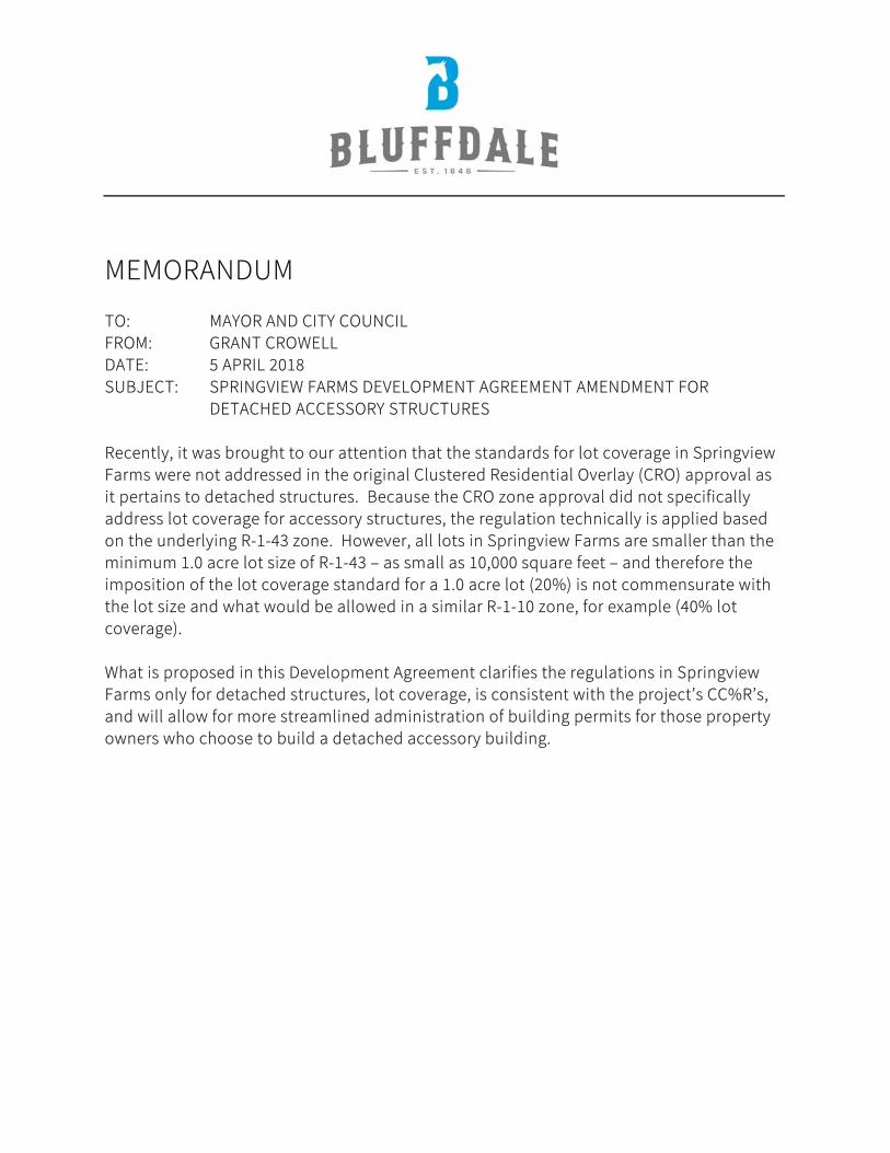
MEMORANDUM
TO: MAYOR AND CITY COUNCIL
FROM: GRANT CROWELL
DATE: 5 APRIL 2018
SUBJECT: SPRINGVIEW FARMS DEVELOPMENT AGREEMENT AMENDMENT FOR
DETACHED ACCESSORY STRUCTURES
Recently, it was brought to our attention that the standards for lot coverage in Springview
Farms were not addressed in the original Clustered Residential Overlay (CRO) approval as
it pertains to detached structures. Because the CRO zone approval did not specifically
address lot coverage for accessory structures, the regulation technically is applied based
on the underlying R-1-43 zone. However, all lots in Springview Farms are smaller than the
minimum 1.0 acre lot size of R-1-43 – as small as 10,000 square feet – and therefore the
imposition of the lot coverage standard for a 1.0 acre lot (20%) is not commensurate with
the lot size and what would be allowed in a similar R-1-10 zone, for example (40% lot
coverage).
What is proposed in this Development Agreement clarifies the regulations in Springview
Farms only for detached structures, lot coverage, is consistent with the project’s CC%R’s,
and will allow for more streamlined administration of building permits for those property
owners who choose to build a detached accessory building.
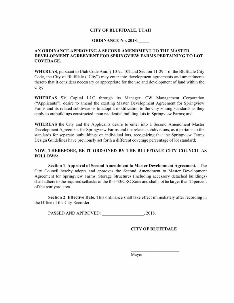
CITY OF BLUFFDALE, UTAH
ORDINANCE No. 2018-_____
AN ORDINANCE APPROVING A SECOND AMENDMENT TO THE MASTER DEVELOPMENT AGREEMENT FOR SPRINGVIEW FARMS PERTAINING TO LOT COVERAGE. WHEREAS, pursuant to Utah Code Ann. § 10-9a-102 and Section 11-29-1 of the Bluffdale City Code, the City of Bluffdale (“City”) may enter into development agreements and amendments thereto that it considers necessary or appropriate for the use and development of land within the City;
WHEREAS SV Capital LLC through its Manager: CW Management Corporation (“Applicants”), desire to amend the existing Master Development Agreement for Springview Farms and its related subdivisions to adopt a modification to the City zoning standards as they apply to outbuildings constructed upon residential building lots in Springview Farms; and
WHEREAS the City and the Applicants desire to enter into a Second Amendment Master Development Agreement for Springview Farms and the related subdivisions, as it pertains to the standards for separate outbuildings on individual lots, recognizing that the Springview Farms Design Guidelines have previously set forth a different coverage percentage of lot standard;
NOW, THEREFORE, BE IT ORDAINED BY THE BLUFFDALE CITY COUNCIL AS FOLLOWS:
Section 1. Approval of Second Amendment to Master Development Agreement. The City Council hereby adopts and approves the Second Amendment to Master Development Agreement for Springview Farms. Storage Structures (including accessory detached buildings) shall adhere to the required setbacks of the R-1-43/CRO Zone and shall not be larger than 25percent of the rear yard area.
Section 2. Effective Date. This ordinance shall take effect immediately after recording in the Office of the City Recorder.
PASSED AND APPROVED: ___________________, 2018.
CITY OF BLUFFDALE
______________________ Mayor

ATTEST: [seal]
____________________ City Recorder
Voting by the City Council: Yes No
Councilmember Aston ____ ____ Councilmember Jackson _________ Councilmember Kallas ____ ____ Councilmember Nielsen ____ ____ Councilmember Preece ____ ____

Agenda Item 10
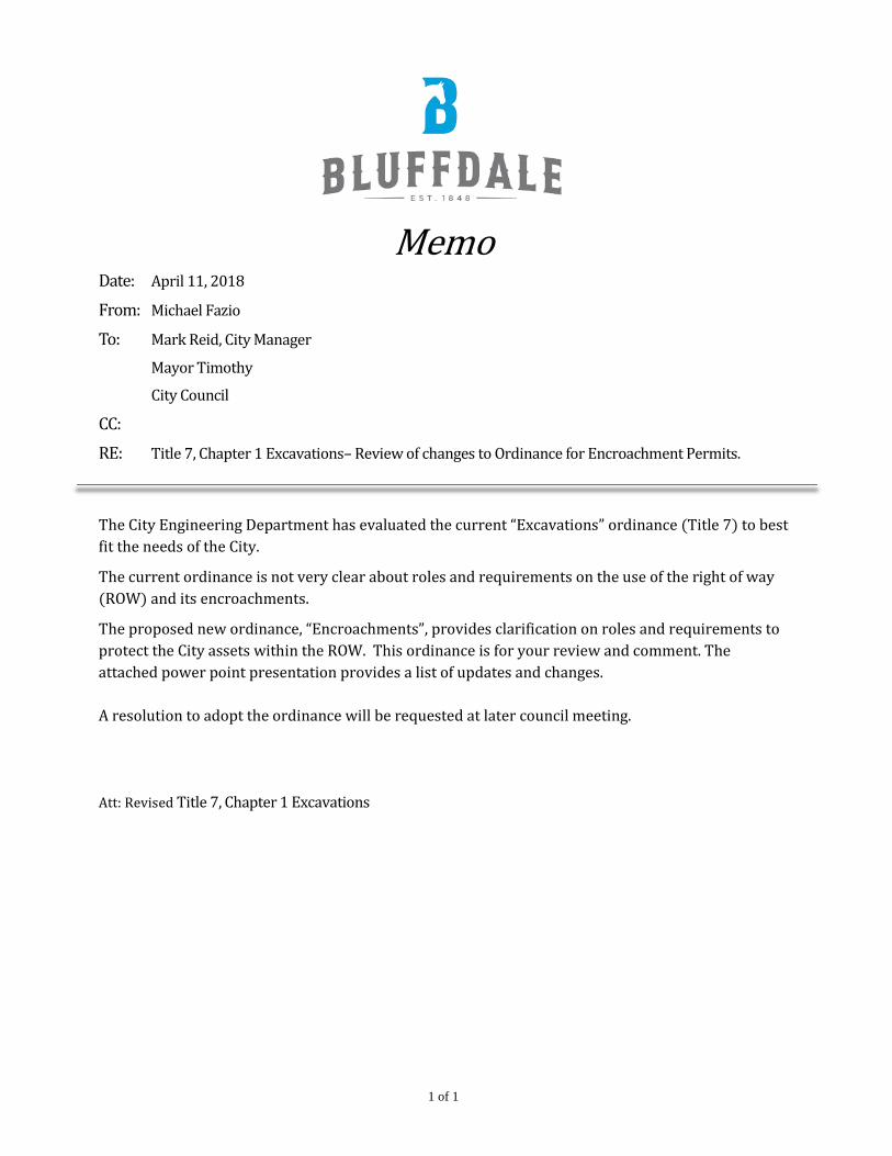
1 of 1
Memo Date: April 11, 2018
From: Michael Fazio
To: Mark Reid, City Manager
Mayor Timothy
City Council
CC:
RE: Title 7, Chapter 1 Excavations– Review of changes to Ordinance for Encroachment Permits.
The City Engineering Department has evaluated the current “Excavations” ordinance (Title 7) to best fit the needs of the City.
The current ordinance is not very clear about roles and requirements on the use of the right of way (ROW) and its encroachments.
The proposed new ordinance, “Encroachments”, provides clarification on roles and requirements to protect the City assets within the ROW. This ordinance is for your review and comment. The attached power point presentation provides a list of updates and changes. A resolution to adopt the ordinance will be requested at later council meeting. Att: Revised Title 7, Chapter 1 Excavations
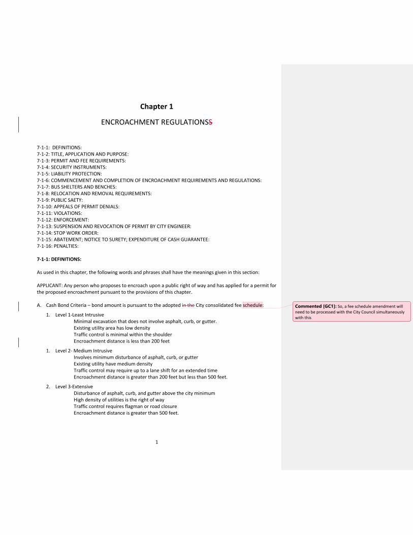
1
Chapter 1
ENCROACHMENT REGULATIONSS
7-1-1: DEFINITIONS: 7-1-2: TITLE, APPLICATION AND PURPOSE: 7-1-3: PERMIT AND FEE REQUIREMENTS: 7-1-4: SECURITY INSTRUMENTS: 7-1-5: LIABILITY PROTECTION: 7-1-6: COMMENCEMENT AND COMPLETION OF ENCROACHMENT REQUIREMENTS AND REGULATIONS: 7-1-7: BUS SHELTERS AND BENCHES: 7-1-8: RELOCATION AND REMOVAL REQUIREMENTS: 7-1-9: PUBLIC SAETY: 7-1-10: APPEALS OF PERMIT DENIALS: 7-1-11: VIOLATIONS: 7-1-12: ENFORCEMENT: 7-1-13: SUSPENSION AND REVOCATION OF PERMIT BY CITY ENGINEER: 7-1-14: STOP WORK ORDER: 7-1-15: ABATEMENT; NOTICE TO SURETY; EXPENDITURE OF CASH GUARANTEE: 7-1-16: PENALTIES: 7-1-1: DEFINITIONS: As used in this chapter, the following words and phrases shall have the meanings given in this section: APPLICANT: Any person who proposes to encroach upon a public right of way and has applied for a permit for the proposed encroachment pursuant to the provisions of this chapter. A. Cash Bond Criteria – bond amount is pursuant to the adopted in the City consolidated fee schedule:
1. Level 1-Least Intrusive Minimal excavation that does not involve asphalt, curb, or gutter. Existing utility area has low density Traffic control is minimal within the shoulder Encroachment distance is less than 200 feet
1. Level 2- Medium Intrusive Involves minimum disturbance of asphalt, curb, or gutter Existing utility have medium density Traffic control may require up to a lane shift for an extended time Encroachment distance is greater than 200 feet but less than 500 feet.
2. Level 3-Extensive Disturbance of asphalt, curb, and gutter above the city minimum High density of utilities is the right of way Traffic control requires flagman or road closure Encroachment distance is greater than 500 feet.
Commented [GC1]: So, a fee schedule amendment will need to be processed with the City Council simultaneously with this

2
CITY ENGINEER: The engineer of the city appointed by the City Council or his/her authorized representative. UTILITY PROVIDER: Each person who provides public utility services within the city in competition with one or more persons providing the same or similar services. EMERGENCY: Any unforeseen circumstances or occurrence, the existence of which constitutes a clear and immediate danger to persons or property, or which causes interruption of utility services. ENCROACH AND ENCROACHMENT: Going upon, over, under, within, or using or doing work upon, any public right of way so as to prevent, obstruct or interfere with the normal use of the public right of way. “Encroach” and ‘encroachment” shall include the performance of any of the following acts on, over, under or within a public right of way: A. Excavating or placing embankments or stockpiling of material; B. Placing or leaving any rubbish, brush, earth or other material of any nature; C. Constructing, placing or maintaining any pathway, sidewalk, curb, gutter, driveway, surfacing, culvert,
drainage facility, pipe, conduit or cable; D. Erecting or maintaining any post, pole, fence, guardrail, wall, loading platform, or any other structure; E. Planting or removing any tree, shrub, grass or growing thing; F. Taking, placing, moving or using any vehicle, or combination of vehicles, or other object of a dimension,
weight or other characteristic prohibited without a permit by the state transportation code; G. Locating, drilling or plugging test holes for seismological exploration or any other similar purpose; H. Conducting land surveying operations or making traffic counts in such a way that it is necessary to
excavate or in any way interfere with the normal flow of traffic; I. Construction activity on adjacent right of way or private property which impacts the public’s use of the
public right of way; and J. Any unusual event or activity that will alter or disrupt traffic and/or damage any physical property.
Examples: parades, sport races, demonstrations.
ENCROACHMENT PERMIT: A permit issued by the city engineer pursuant to the provisions of this chapter. FACILITY OR FACILITIES: Wires, lines, cables, coaxial cables, conduit, manholes, ducts, pipelines, tunnels, vaults, ditches, tracks, poles, antennas, transceivers, amplifiers, switches, electronic devices, structures or other improvements of any kind or nature, whether fixed or movable. MAJOR WORK: Any reasonably foreseeable work in the public right of way that will: a) affect the right of way for more than ten (10) calendar days, b) involve a street cut of more than one hundred feet (100’) in length, or c) involve a street cut of more than two hundred (200) square feet. UTAH MANUAL ON UNIFORM TRAFFIC CONTROL DEVICES (MUTCD): The latest edition of the Utah Manual on Uniform Traffic Control Devices published by the Utah Department of Transportation (UDOT). NEW STREET: A public street that has received new subbase, the reworking of existing pavement or subbase and the application of new surfacing, or the addition of equal to or greater than two inches (2”) of new pavement surfacing overlay. PERMITTEE: A person who has been issued an encroachment permit pursuant to the provisions of this chapter.

3
PUBLIC HIGHWAY: The part of a right of way which is improved for use as a public road, street, way, lane or alley, including shoulders and excluding park strips and sidewalks. PUBLIC RIGHT OF WAY (ROW): Any land, or interest therin, which by deed, conveyance, agreement, dedication, usage or other process of law, has been reserved for or dedicated to the city for the use of the general public for public purposes. RECORD DRAWINGS: Electronic plans (digital and physical drawing) submitted by a contractor upon completion of a particular job. Show the exact dimensions, geometry, and location of all elements of the work completed under the job. RESURFACED STREET: Any street that has received a bituminous pavement overlay, slurry seal, chip seal, fog seal or microsurface application of less than two inches (2”) of thickness. STANDARDS, SPECIFICATIONS, AND PLANS: The latest version of the engineering regulations and/or standard specifications and details for municipal construction published by the city. TELECOMMUNICATION FACILITIES: All equipment and personal property used in connection with the provision of telecommunication services either within or outside of the city, including without limitation all conduits, wiring, cables, fiber optic cables, switches, manholes, poles, antennas, transceivers, amplifiers and all other electronic devices, equipment and related appurtenances. USER: A person or entity engaging in any lawful activity within the public right of way. WORK ZONE: All affected area(s) within the public right of way including, but not limited to, the trench area(s), the travel path or route, and all area(s) occupied by equipment, traffic control, storage, spoils and waste material. 7-1-2: TITLE AND APPLICATION AND PURPOSE: A. Title: This chapter shall be known and may be cited as the ENCROACHMENT REGULATIONS OF THE CITY. B. Application:
1. The provisions of this chapter shall not apply to any officer or employee of the city in discharge of his or her official duties.
2. Work performed by any person under contract with, or at the request of, the city shall be exempt from the fee.
3. The provisions of this chapter shall apply to public rights of way.
C. Purpose: The purpose of this chapter is to regulate encroachments in the public right of way, for the purpose of: 1) protecting and keeping safe the people using the facilities within the ROW, 2) minimizing the disruption of traffic, 3) protecting the city’s investment in its infrastructure by preserving the serviceable life of its streets, sidewalks, curbs, gutters and other improvements, and 4) promoting the efficient flow of traffic. Accordingly, all construction and excavation in, and obstruction of, the public right of way shall be subject to the procedures and requirements of this chapter.
7-1-3: PERMIT AND FEE REQUIREMENTS: A. Permit Required; Exceptions:

4
1. It shall be unlawful for any person, agency or entity to encroach, or to make or cause to be made any encroachment, upon, over, under or within any public right of way in the city without first obtaining a permit from the city engineer.
2. Any owner, lessee, or person in control of property under active agricultural use and immediately
abutting the right of way may, without obtaining a permit, use the untraveled portion of the right of way abutting such property for the growing and maintenance of agricultural crops so long as such use does not interfere with vehicular or pedestrian traffic, or drainage of the right of way.
3. Encroachments for which permits are not acquired shall be subject to a Stop Work Order by the city
under the procedure and penalties set forth in the code. B. Application Form, Filing:
1. Application shall be made in a form acceptable to the city engineer and shall contain, at a minimum, the following:
a) The applicant’s name and address; b) The contractor’s name, license number, and place of business; on-site contact person, cell
number, and an email. c) Sufficient detail as, in the judgement of the city engineer, is necessary to show the purpose,
location, and dimensions of the proposed encroachment and the work zone (traffic control plan).
2. The application shall be completed, signed by the applicant, and filed with the city engineer,
together with the fees, required cash bond (if there is no franchise agreement), certificate of insurance, traffic control plan, and any other documents required by this chapter or the city engineer.
C. Accompanying Exhibits May Be Required: When required by the city engineer, the applicant shall attach
to, or enclose with the application, the following:
1. A plan and profile map, plot, drawing to scale, diagram, or similar exhibit which plainly shows any and all information necessary to locate, delineate, illustrate and identify the proposed encroachment. The scale shall be 1”= 50’ or larger. The city engineer may require the plans to be stamped by a civil engineer licensed in the state of Utah;
2. A traffic control plan that conforms to the latest edition of the UMUTCD; and
3. A proposed work schedule that includes the start date and completion date.
D. Emergency Work:
1. Any person maintaining pipes, lines or other facilities in the public right of way may proceed with work upon existing facilities without a permit when emergency circumstances demand the work to be done immediately, provided a permit could not reasonably and practicably have been obtained.
2. If emergency work is commenced on or within any public right of way during regular business hours
M-F 8:00 am to 5:00 pm, the city engineer shall be notified within one-half (1/2) hour from the time the work is commenced. The person commencing and conducting such work shall take all necessary
5
safety precautions for the protection of the public and the direction and control of traffic and shall ensure that work is accomplished according to the engineering regulations, Public Improvement Standards, Specifications and Plans, the UMUTCD, and other applicable laws, ordinances, regulations and generally accepted industry practices.
3. Any person commencing emergency work in the public right of way during non-business hours
without a permit shall notify the on-call staff member within one-half (1/2) hour from the time work is commenced and shall also notify the city engineer during the first hour of the first regular business day on which city offices are open for business after such work is commenced.
4. Any user performing emergency work shall be required to apply for a permit, and a permit may be
issued, retroactive to the date when the work began. E. Fees; Refunds:
1. Before a permit is issued, the applicant shall pay to the city all required fees as adopted in the City’s Consolidated Fee Schedule.
2. Fees shall not be refunded unless no permit is issued or unless the permit issued is rejected by the
permittee because of special conditions imposed therein. Fees shall be refunded without interest, which shall be retained by the city as reimbursement for administrative costs.
3. Any person found to be causing an encroachment in the public right of way without having a valid
unexpired encroachment permit shall be required to pay a fine as adopted in the City’s Consolidated Fee Schedule.
F. Issuance of Permit; Denial for Good Cause: Upon receiving an application in the proper form, together
with fees, cash bond, and all other required items, the city engineer shall issue a written encroachment permit subject to the conditions set forth in the permit, this chapter, and required by law. The city engineer may deny the permit including but not limited to the following: 1. The applicant has had poor pas performance that has been documented; or
2. The encroachment will not be in the public interest or will be detrimental to the public health, safety
or welfare.
3. The applicant does not have a current franchise or cash bond with the city. G. Permittee Acceptance of Terms and Conditions: By accepting the permit, the permittee agrees to be
bound by all the terms and conditions set forth in the permit and in this chapter. H. Additional Requirements:
1. The city engineer may approve specific designs when the variations from the standards are needed due to site conditions, utility, or topographical constraints. Any variant of these details must be based upon a design stamped by a licensed professional civil engineer to accomplish the purposes of this chapter.
2. The city engineer may provide in the encroachment permit any requirements which he or she finds
will substantially aid in the protection of the right of way, the improvements therein and the

6
traveling public. The city engineer may establish special provisions for the work to be done under the permit, including but not limited to length of trench, the equipment to be used, the type of backfill, paving, traffic signs or devices, hours of work, flagmen, lights and inspections. The city engineer may add such requirements and conditions as an attachments to the permit and it shall become an integral part of the permit.
I. Changes in Authorized Encroachment: No changes shall be made in the location, dimensions, character
or duration of the encroachment as granted by the permit, except on written authorization by the city engineer.
J. Display of Permit: The permittee shall keep the issued encroachment permit, or a copy thereof, at the
site of the encroachment, or in the cab of the vehicle when movement thereof on a public highway is involved, and the permit shall be shown to any authorized representative of the city engineer or law enforcement officer upon demand.
K. Nontransferable: Permits shall not be transferable or assignable, and work shall not be performed under
a permit in any place other than as specified in the permit. Nothing herein contained shall prevent a permittee from subcontracting the work to be performed under a permit; provided however, that the permittee shall be and remain responsible for the performance of the work under the permit and for all bonding, insurance and other requirements of this chapter and under said permit.
L. Permits to Move Certain Vehicles and Objects:
1. Before a vehicle or combination of vehicles or object of a weight or dimension or characteristic prohibited by law without a permit is moved on any public highway, a permit to do so shall first be granted by the state department of transportation, the state highway patrol, or by the city engineer, as applicable. In all cases where the international building code, as adopted by the city, requires the owner of any premises to obtain a relocation permit to move any building or structure onto the premises, the city engineer shall not grant an encroachment permit until the applicant furnishes to the city engineer evidence that the relocation permit has been obtained.
2. Before issuing a permit for the movement of a vehicle or object with a rolling height of over sixteen
feet (16’), the city engineer shall require evidence of approval of height clearance from the public utility companies having overhead line crossing the proposed route.
7-1-4: SECURITY INSTRUMENTS: A. Cash Deposits or Bonds:
1. Restoration: Unless exempt by law, each applicant, before obtaining a permit, shall provide a bond to the city, consisting of cash or a certified check or cashier’s check in a sum sufficient to reimburse the city for restoring the right of way to its original condition according to the city engineer’s cost estimate based on distance, utility density, public safety, and restoration requirements. Such cash deposit may be used by the city for traffic control and emergency work as needed as determined by the city engineer.
2. Time: Where the size, nature, and location of the encroachment warrants, the city engineer may
require an additional time completion deposit which shall be held by the city for the duration of the encroachment activity. The permittee shall forfeit to the city a portion of such deposit for each calendar day that the encroachment continues beyond the number of days specified on the
7
encroachment permit. The daily amount to be forfeited shall be as adopted in the City’s Consolidated Fee Schedule The remainder shall be released within thirty (30) calendar days of the city’s receipt of a written request from the permittee.
3. Cash Bond Criteria – as adopted in the City’s Consolidated Fee Schedule:
a) Level 1- Least Intrusive Minimal excavation that does not involve asphalt, curb, or gutter.
Existing utility area has low density Traffic control is minimal within the shoulder Encroachment distance is less than 200 feet
b) Level 2- Medium Intrusive Involves minimum disturbance of asphalt, curb, or gutter Existing utility have medium density Traffic control may require up to a lane shift for an extended time Encroachment distance is greater than 200 feet but less than 500 feet.
c) Level 3 - Extensive Disturbance of asphalt, curb, and gutter above the city minimum High density of utilities is the right of way Traffic control requires flagman or road closure Encroachment distance is greater than 500 feet. B. Release of Deposits and Bonds: except as otherwise provided in this chapter any cash bond required by
the city pursuant to the provisions of this chapter shall be payable to or for the benefit of the city and shall be filed or deposited with the city engineering department. After the satisfactory completion of all activity associated with the encroachment, the approved final inspection by the construction engineer, and the fulfillment of all conditions of the permit, the city engineer shall release the cash bond upon the application of the permittee. Release shall be in writing, signed by the city engineer or designee.
C. Exemptions to Bond Requirements: Public utilities operating under the jurisdiction of the public utilities
commission of the state, utilities holding a franchise from the city, and governmental agencies are exempt of the obligation of furnishing a restoration bond.
7-1-5: LIABILITY PROTECTION: A. Liability for Damages: The permittee shall indemnify the city for any and all damages caused to the right
of way or improvements therein and/or to properties next to the right of way as a result of acts or omissions of the permittee or arising out of activities performed pursuant to the encroachment permit.
B. Nonliability of City for Damages: The permittee shall indemnify, defend and hold the city harmless from
any claims or judgments for damages or other relief against the city as a result of acts or omissions of the permittee or its contractor, or arising out of or related to the encroachment or other operations under the permit, whether the condition giving rise to the claim or judgment was created in whole or in part by the permittee or its contractor.
C. Liability Insurance: The permittee shall maintain public liability insurance, including, but not limited to, motor vehicle insurance, sufficient to cover any claims for damages for personal injury, including death, and for damage to property which may arise from the encroachment or other operations under the permit, whether such encroachment or other operations are by the permittee, or by any agent, or by
Commented [GC4]: In the agreement
Commented [MF2]:
Commented [MF3]:

8
anyone directly or indirectly employed by the permittee or permittee’s agents. Certificates of insurance shall be filed with the city engineer and shall be subject to approval for adequacy of protection. No permit shall be issued under this chapter unless the applicant has submitted a certificate of insurance from a company authorized to issue insurance in the state, evidencing that the applicant has, at a minimum, comprehensive general liability and property damage coverage, that includes contractual liability coverage, with minimum limits of two million dollars ($2,000,000) for injuries, including accidental death, to any one person; in an amount not less than three million dollars ($3,000,000) on account of injuries sustained in any one accident, and property damage insurance in an amount not less than five hundred thousand dollars ($500,000) for each accident.
D. Responsibility of Subsequent Owners: All obligations, responsibilities and other requirements of the permittee, as set forth in this chapter, shall be binding on subsequent owners of the encroachment. Each subsequent owner shall be required to apply for and receive an encroachment permit modification, including the new owner’s information.
7.1.6: COMMENCEMENT AND COMPLETION OF ENCROACHMENT: A. Time: The permittee shall commence and complete the encroachment as stated in the permit. If the
encroachment is not completed within forty-five (45) days or within such shorter time as stated in the permit, the permit shall be void unless, prior to its expiration, the time for completion has been extended in writing by the city engineer.
B. Notices of Commencement: At least 48 hours prior to commencing any encroachment, the permittee or
designee shall notify the engineering department of the time of commencement and who will perform work related to the encroachment. Additional time may be required by the city engineer as stated in the encroachment permit.
C. Notice of Completion of Encroachment: Upon completion of the work, the permittee or designee shall
notify the engineering department. The work may be deemed to be incomplete until notice of completion and final inspection from the city engineer is accepted.
D. Delay of Completion: Failure to complete the encroachment within the time specified in the permit shall
be a violation. The time for completion will not be extended if the city engineer finds that delay in commencing or prosecuting the encroachment is caused by lack of diligence on the part of the permittee.
E. Inspection Upon Completion: Upon receipt of the notice of completion of the encroachment, the city
engineer or designee shall inspect the site of the encroachment within three (3) working days and ascertain whether or not the permittee has complied with all the conditions and requirements imposed in the permit and the provisions of this chapter. The permittee shall be advised in writing of the results of the inspection. If the city engineer or designee determines that the permittee has not complied with all such conditions and requirements in performing the encroachment, the city engineer or designee may order the permittee to correct the work immediately. If the permittee fails to correct the work within ten (10) days after being ordered to do so in writing, the city engineer may correct the work. The permittee shall reimburse the city for the work performed.
Commented [GC5]: Verify amounts and types with Vaughn
9
7-1-7: CONSTRUCTION/EXCAVATION ENCROACHMENT REQUIREMENTS AND REGULATIONS: A. Permit Required: Any person desiring to perform any construction or excavation work in the public right
of way shall first apply for and obtain a permit for such work. It is unlawful for any person to commence work in the public right of way until the city engineer has approved the application and until a permit has been issued for such work, except as specifically provided to the contrary in this chapter.
B. Persons Eligible for Permit: No person shall be eligible to apply for or receive an encroachment permit for
construction or excavation, except the following:
1. Contractors licensed by the state as general contractors; 2. Public utility companies 3. The city; 4. Local governments, districts, and other political subdivisions of the state; 5. Residents installing, replacing, or maintaining less than five hundred (500) square feet or one
hundred (100) linear feet of sidewalk, curb and gutter, driveway approach, or other work approved by the city engineer, upon a portion of the public right of way adjacent to their residence.
C. Exemptions:
1. It is lawful for a city, county, or state employee to perform routine maintenance work not involving excavations, without first having obtained a permit therefor.
2. A permit is not required for hand-digging excavations for installation or repair of sprinkler systems and landscaping within the unpaved areas of the right of way. However, conformance to all city specifications is required.
D. Inspections; Charges: If, in the judgement of the city engineer, it appears desirable to maintain an
inspector to determine whether work is being done in compliance with the encroachment permit, the city engineer shall assign an inspector, and the permittee shall pay the city in accordance with the City’s Consolidated Fee Schedule. The provisions of this section shall be applicable to all permittees, including governments, districts and other political subdivisions.
E. Project Site Management:
1. The permittee shall keep the work site and haul routes to and from the work site, clean and free from rubbish, debris and mud at all times.
2. The permittee shall clean up the work site within twenty-four (24) hours after receiving notice from
the city. Should the permittee not clean up the site as required, the city may perform the cleaning and recover the full cost of cleaning from the permittee’s cash bond.
F. Compliance with Specifications, Standards, Traffic-Control Regulations and mapping:
1. The work performed in the public right of way shall conform to the requirements of the engineering regulations, design standards, construction specifications and traffic-control regulations of the city as outlined in the UMUTCD.
2. All excavations shall be conducted in a diligent and expeditious manner resulting in a minimum
amount of interference of street and pedestrian traffic. Where existent, all-weather pedestrian access to businesses shall be provided. Permittee shall supply barricades or equivalent structures
10
where necessary to provide safe and efficient traffic flow, and to prevent accidents involving property or persons. Barricades must be in place until all of the permittee’s equipment is removed from the site and the excavation has been backfilled and the right of way restoration has been completed. From sunset to sunrise, all barricades and excavations must be clearly delineated with adequate lighting. Permittee shall notify the engineering department, the police department and the fire department at least forty-eight (48) hours in advance of any planned excavation requiring street closure or traffic detour.
3. The permittee shall request and provide proof or request to the City of mapping all the utilities within the area affected by the permittee requested operation within the public right of way. The permittee shall contact such company that specializes in showing existing utilities on the ground, at least forty-eight (48) hours in advance for starting any operation within the public right of way.
G. Filing of Recorded Drawings: Any person owning, using, controlling, or having an interest in any pipe,
conduit, duct or tunnel under the surface of any public right of way for supplying or conveying gas, electricity, communication facilities, water, steam, ammonia or oil, or for any other purpose, shall survey the installed utilities and or/changes of improvements and file in the office of the city engineer, within sixty (60) days after the complete installation, an AutoCAD drawing with survey points in State plane coordinate system and the corrected set of maps or drawings drawn to scale of not more than fifty feet to one inch (50’=1”) showing the complete installation of all such pipes, conduits, ducts or tunnels. The same may be required showing the location in detail of such pipes, conduits, ducts or tunnels when such are abandoned or altered. Scaled maps and drawings submitted periodically by public utilities shall be deemed in compliance with the intent of this section. All maps and drawings shall be submitted in electronic PDF or CAD format.
H. Completion of work; Restoration of Rights of Way:
1. Upon completion of an encroachment, the public right of way shall be restored by replacing,
repairing or rebuilding it to its original condition before the encroachment was commenced, including the completion of any work necessary to restore the public right of way to a safe and usable condition according to city specifications. All obstructions, materials and debris upon the public right of way shall be removed. Where excavations occur within areas paved, the city engineer may require temporary paving and temporary traffic markers to be installed within twenty four (24) hours after the excavated area is backfilled and compacted according to adopted City standards. When the conditions are correct the temporary may become permanent.
2. In the event that the public right of way is not promptly restored, as provided in this section, or
should the nature of any damage to the public right of way require restoration before the person performing the encroachment can be notified or can respond to notification, the city engineer may make the necessary restoration. The total cost of restoration shall be deducted from the permittee’s cash bond.
I. Storage of Materials:
1. Storage of excavated soil or other materials shall not be permitted unless included in the
encroachment permit. Where permitted, materials shall be stored in accordance with the permit, and the permittee shall be responsible for the safety of the workers and the general public. The permit shall not create any right to use property adjacent to the public right of way, and permittee shall be responsible for coordination with owners of adjacent property.

11
2. In areas too narrow to permit the proper storage of materials, the city engineer may require that
the permittee remove the materials from the encroachment site.
J. Monuments: A monument set for the purpose of preserving survey points, lines or elevation shall not be removed or disturbed without first obtaining permission from the city engineer and Salt Lake County Surveyor. The replacement of a removed or disturbed monument shall be done at the expense of the permittee in accordance with the Salt Lake County requirements.
K. Open Trenches: In any trenching operation, the open trench shall not be in excess of three hundred feet
(300’) ahead of the trench work proper, unless specifically authorized by the city engineer. When any excavation is commenced, the work of making and refilling shall be prosecuted diligently until completion.
L. Interference with Drainage: If the encroachment interferes with drainage, the permittee shall submit a
plan for drainage of the site, in accordance with the city standards, for approval by the city engineer.
M. Small Pipes: Laterals, services and other small diameter pipes shall be jacked, bored, or driven beneath a paved surface unless other methods are approved by the city engineer.
N. Covering Pipes and Conduits: The minimum cover over any pipe or conduit installed under any right of
way shall be thirty inches (30”) of material measured from the existing or proposed flow line of the nearest gutter to the top of the pipe or conduit. If a gutter flow line is not established, the cover shall be thirty inches (30”) of material measured from the surface of the nearest outermost edge of the traveled way to the top of the pipe or conduit. Where there are existing curbs and gutters or where curbs and gutters are under construction, utilities may maintain a minimum thirty inches (30”) of cover starting one foot (1’) back of the curb line in the parkway or sidewalk area. Maximum cover shall be seventy-two inches (72”). Any variation must be approved in writing by the city engineer. The city engineer may permit the installation of pipes or conduits at lesser or greater depths where the required cover cannot be provided.
O. Backfilling: The backfilling and compaction of an excavation shall be in accordance with the adopted City
standards, both as to materials and methods. The backfilling shall commence within forth eight (48) hours after the work in a trench is completed.
P. Paving: Any paving operation that is related to any encroachment permit shall be at least 10-feet wide and shall be paved by using a laydown machine and compacted by a roller compactor with vibrator that can achieve the City required pavement and base compaction according to standards. The pavement joint of new the new and existing pavement shall have less than 0.1 inch per foot elevation difference
Q. Cleanup:
1. Except for materials properly stored, the permittee shall at all times keep the public right of way
clear of all materials, earth and debris. If the permittee fails to do so within twenty-four (24) hours after having been notified by the city engineer, the work may be done by the city engineer and the permittee charged in accordance with the fees adopted by the City Council.
2. When a pole, guy stub or similar timber is removed and not replaced, the entire length thereof shall
be removed from the ground and the hole backfilled and compacted.

12
R. Coordination of Major Work Within the right of Way:
1. Applications for encroachments involving major work shall be accepted by the city engineer at least two months prior to the beginning of any work. The application must be on the city encroachment form. The application must include a construction schedule which identifies, in reasonable detail, the location and anticipated start date and completion date of all anticipated major work.
2. Permit issuance may be denied or delayed by the city engineer where the person requesting a
permit fails to timely apply or does not accurately identify the major work as set forth in this section. Among other things, the city engineer will consider excavation restrictions and other major work when determining the denial or delay.
3. It shall be the general policy of the city engineer to facilitate coordination of major work by
disclosing application information to other applicants. Any requests to maintain the confidentiality of information submitted pursuant to this section will be considered by the city in accordance with the provisions of the Utah government records, access and management act.
4. In issuing or conditioning a permit for major work, the city engineer may do any or all of the
following: 1) schedule work in the public right of way in the order in which applications are filed, and without regard to other work in the public right of way; 2) delay or accelerate the commencement date of major work so that such work is performed simultaneously; or 3) delay or accelerate the commencement date of major work so that such work is performed in sequence, or is separated by a reasonable period of time.
5. Each applicant shall use all available information to coordinate, in good faith, its major work in the
right of way with work proposed by the city and other users.
S. Excess Capacity:
1. Each competitive utility provider applicant must determine the size of facilities required to provide the capacity reasonably anticipated to satisfy the needs of such applicant for a minimum of five (5) years following installation and present its determination to the city.
2. Facilities must be designed and constructed to provide the capacity described above, or such lesser
capacity as reasonably approved by the city engineer.
T. Excavation Restrictions:
1. The city engineer may, from time to time, impose excavation restrictions on portions of the right of way. At times there are locations that may not be included in the moratorium for which excavating may cause irreparable harm to the city infrastructure, example: bridges, utilities, and powerlines. The city engineer will not issue a permit for any portion of the right of way subject to an excavation restriction, except as set forth in this section.
2. The duration of the excavation restrictions will be as follows:
a) Seven (7) years following the completion of a new street or portion thereof;
b) Three (3) years following the resurfacing of a street or portion thereof;
c) Five (5) years following the completion of any excavation work in the right of way. The city engineer may impose the restriction solely on the user who performed the work, or on such

13
owner and other prospective permittees or class of permittees as the city engineer determines.
d) Until excess capacity no longer exists, for any portion of the right of way where excess capacity exists.
3. The excavation restrictions may include, but are not limited to, one or more, or a combination of
the following:
a) A limited restriction prohibiting excavation by one user or type of user that does not preclude excavations by different users or types of users;
b) A comprehensive restriction prohibiting all excavation and construction activity in the affected portion of the right of way;
c) A restriction defining methods and standards of excavation or construction activity within the affected portion of the right of way.
4. The nature, scope and duration of the restriction will be consistent with the terms described in the
notice provided for in this section. The nature, scope and duration of each excavation restriction shall be evidenced in writing, which writing shall be available for inspection during regular business hours at the office of the city engineer.
U. Notice of Excavation Restrictions:
1. The city engineer shall publish, or cause to be published, as needed, the intent to impose
excavation restrictions relating to portions of the right of way which will be under construction. The notice shall be published on the city website. The notice shall describe the following:
a) The nature of the project giving rise to the restriction;
b) The portion of the right of way affected by the restriction;
c) The effective date of the restriction;
d) The duration of the restriction; and
e) The nature of the restriction.
2. Any restricted entity shall, if so determined by the city engineer, have the opportunity for the
following:
a) Locating facilities in the same trench as an applicant;
b) Sharing the cost of joint facilities with an applicant;
c) Collocating facilities within a common conduit;
d) Entering into a lease arrangement with the applicant;
e) Constructing separate facilities in the project area within the same time frame;
f) Otherwise cooperating in a manner mutually agreeable to the users; or
g) Participating in the project in such a manner as the city engineer determines to be in the best interests of the city.

14
h) The notice shall further provide that all interested users must file a permit application with the city engineer not later than six (6) weeks prior to the estimated date of commencement of construction of the proposed project. Nothing herein shall require the city engineer to publish notice of an excavation restriction which applies to only one user, provided that written notice of such excavation restriction is mailed or otherwise provided to such user.
V. Suspension of Excavation Restrictions. The city engineer may temporarily or permanently suspend an
excavation restriction for any of the following reasons:
1. To permit work to be performed by the city;
2. To permit emergency repair work, or, in the discretion of the city engineer, work which could not reasonably have been anticipated by the applicant at the time of publication of the notice of excavation restrictions;
3. Excess capacity no longer exists in the restricted portion of the right of way;
4. To permit the installation of service laterals, the need for which could not have been reasonably anticipated at the time of publication of the notice of excavation restrictions; or
5. Suspension of the restriction is otherwise in the city’s best interest.
7-1-8: BUS SHELTERS AND BENCHES:
A. Improvements: All street improvements (i.e., curb, gutter, and sidewalk) shall be in place, prior to the
installation of a bus bench or bus shelter.
B. Location: Bus benches or shelters shall be located behind the sidewalk, on private property, and only at bus stops designated by the Utah transit authority (UTA); provided, that: 1) a physical barrier exists behind the sidewalk which prevents the placement of a bench or shelter at that location; or 2) the property owner refuses to grant approval for the placement of the bench or shelter behind the sidewalk; and 3) there is adequate depth in the park strip so that the bus bench or bus shelter will not encroach on the sidewalk and there is a minimum distance between the front edge of the bench or shelter and the face of the adjacent curb of forty eight inches (48”) on state roads and twenty four inches (24”) on city streets. Any person requesting approval to locate a bus bench or bus shelter in a public street right of way shall first submit written documentation from the property owner that approval to locate the shelter or bench behind the sidewalk has been refused. Nonetheless, bus benches and bus shelters shall not be located in clear vision areas at intersections and shall not obstruct sidewalks, roadways or other locations where the structures may pose a hazard to motorists or pedestrians. Benches installed by UTA which carry no message may be located within a right of way. However, bus benches or bus shelters proposed to be located adjacent to state roads shall comply with all applicable state provisions governing the location and site development standards for such benches or shelters.
C. Construction and Materials: the following provisions shall govern the construction and materials for bus
benches and bus shelters on public right of way:
1. Bus bench backs and seats shall be constructed of metal, fiberglass or rigid plastic/vinyl materials and shall be kept in good repair. Bench legs shall be constructed of reinforced concrete. The design and materials of bus shelters shall be approved by the city prior to issuing permits.
2. A concrete pad shall be required for all bus benches and bus shelters. The minimum pad size for bus benches shall be four feet by six feet (4’ x 6’) and the minimum pad size for a bus shelter shall be
Commented [GC6]: I think there is a section in the land use ordinance on Bus stops. Reconcile. Although, UTA has no service here or plans for it.

15
two feet (2’) wider than the width of the shelter and two feet (2’) longer than the length of the shelter. Additional space should also be designated for persons in wheelchairs and/or to provide additional waiting area for bus patrons.
3. The minimum pad area for a bus bench or bus shelter may include part of a sidewalk. However, no bus bench or bus shelter shall infringe upon or obstruct any sidewalk, other pedestrian path, or driveway.
4. Bus benches and bus shelters shall be securely fastened to the concrete pad. Upon removal of a
bench or shelter, the concrete pad shall be repaired by the owner of the bench or shelter, including removal of attachment bolts and repair of all holes in the concrete pad.
D. Shelter Design: Bus shelters shall be designed to meet the following requirements:
1. A minimum four feet three inch by fifteen foot (4’3” x 15’) concrete pad for each shelter, with interior seating and patron waiting area;
2. A minimum five foot by eight foot (5’ x 8’) ADA landing pad in park strip (when required);
3. Interior room for wheelchair passengers;
4. Minimum three foot (3’) wide entry;
5. City name and logo on both ends of the shelter;
6. Name and service number to call for service of shelter;
7. Twenty-four (24) hour illumination;
8. The shelter is to be bolted to a concrete pad;
9. All electrical wiring is to be located underground; and
10. All shelters shall include a trash receptacle of a matching color and design.
E. Insurance: for any bus bench or bus shelter sign, the company or person responsible for the bus bench or
shelter sign shall enter into an agreement with the city, which must be approved by the city attorney. This agreement will require, among other things, that the company or person responsible for the bus bench or bus shelter sign provide to the city proof of liability insurance in the minimum amount of one million dollars ($1,000,000), name the city as an additional insured, and indemnify and hold harmless the city from any and all injuries and defense costs arising from the placement or use of the bus bench or bus shelter sign.
F. Violation: Failure to comply with the bus bench and bus shelter provisions shall constitute a violation of
this chapter.
G. Removal: The city engineer may require the removal of a bus bench or bus shelter that does not comply with the requirements of this section. The city engineer shall mail notice, postage prepaid, to the address provided in the agreement. The notice shall state the nature of the non-compliance and the date by which remediation or removal shall be complete, which date shall be no less than thirty (30) calendar days after mailing. Failure to remediate or remove the bus bench or bus shelter within the notice period shall be a separate violation for each day the bus bench or bus shelter remains in place.

16
7-1-8: RELOCATION AND REMOVAL REQUIREMENTS: A. Expense of Owner: If any city construction or other maintenance work in a public right of way requires
the relocation or removal of an encroachment or facility located over, under, in or through any right of way, the owner shall relocate or remove the encroachment or facility at owner’s sole expense. The provisions of this section are not intended in any way to supersede or override any prior right which otherwise exists in favor of the owner.
B. Written Demand by City: When removal or relocation is required, the city engineer shall give the owner a
written demand: 1) specifying that the encroachment or facility must be relocated or removed from the right of way; and 2) stating a reasonable time within which the encroachment or facility must be relocated or removed. If the owner fails to comply, the city may relocate or remove the encroachment or facility at the expense of the owner in accordance with the City’s consolidated fee schedule.
C. Reasonable Time Defined: In determining what is a reasonable time for the purposes of this section, the
city engineer will take into consideration the nature of the encroachment or facility, the urgency of the need for its removal, the cost of its removal, the difficulty of its removal, the value of the intact property of the owner, and other facts peculiar to the particular situation.
D. Restoration: When an encroachment or facility is removed and not replaced, the entire encroachment or
facility must be removed from the right of way and the hole backfilled and compacted and returned to its preexisting condition unless the city engineer permits otherwise. The city engineer may designate a reasonable area for relocation within the right of way.
7-1-9: ROAD CLOSURE / PUBLIC SAFETY:
A. At no time shall a public highway be closed or the use thereof denied to the general public without the
written approval of the city engineer.
B. Interference with Use of Highways: All encroachments shall be planned and executed in such a manner that they will not unreasonably interfere with the safe and convenient travel of the general public.
C. Safety Devices:
1. In the conduct of the encroachment, the permittee must provide and maintain such safety devices, including, but not limited to, lights, barricades, signs, flagmen and message boards, as are necessary to protect the public. Any omission on the part of the city engineer to specify in the permit what safety devices must be provided by the permittee will not excuse the permittee from complying with all laws and regulations relating to the protection of persons under the circumstances. If the city engineer finds that suitable safeguards are not being provided, he or she may provide, maintain and relocate such safety devises as are deemed necessary, or he or she may revoke the permit, subject to appeal as provided in this chapter, and restore the right of way in accordance with existing city standards, charging the permittee in accordance with the fees adopted by the City Council.
2. A permittee making any excavation or leaving any obstruction which could be a hazard to persons using a public right of way shall provide and maintain warning lights far enough away from the excavation or obstruction to give adequate warning to such persons, and at spacing of not more than fifty feet (50’) along the excavation or obstruction, from one-half (1/2) hour before sunset of

17
each day to one-half (1/2) after sunrise the next day, until the work is completed and the right of way is made safe for use.
3. All safety devices shall conform to the requirements of the encroachment permit and requirements of the city engineer.
D. Visibility Aids: When the location or position of an encroachment impairs visibility to vehicular traffic, the
city engineer may require that the encroachment be painted or equipped with reflectors or other aids to visibility, or the city engineer may require the encroachment to be relocated at the sole expense of the permittee. No encroachment shall be maintained across any sidewalk or shoulder of a public highway. No encroachment of any nature shall be permitted or maintained which impedes, obstructs, denies or impairs the sight distance for safe pedestrian or vehicular traffic.
E. Tampering with Traffic Barricades: It is unlawful for any person maliciously or wantonly or without
authorization and legal cause to extinguish, remove or diminish any light illuminating any barricade or excavation or to tear down or remove any rail, fence or barricade protecting any excavation or other construction site.
7-1-10: APPEALS:
A. Appeals; Form: Any person aggrieved by the refusal, suspension or revocation of a permit may appeal to
the city manager within ten (10) days after the date of such action. The appeal shall be in the form of a written notice filed with the city recorder and signed by the applicant or permittee. The notice shall have attached a copy of the application and shall recite and include copies of such other items as have been filed. The notice shall state clearly and concisely the grounds upon which the applicant relies in the appeal.
B. Hearing: The city manager shall set the matter for a hearing on the closest practicable date after the
notice is filed and shall notify the applicant and the city engineer of the hearing date.
C. City Manager Action: At the hearing, the applicant shall establish to the satisfaction of the city manager that he or she is entitled to the issuance of a permit pursuant to the provisions of this chapter. The city engineer may present grounds for the denial of the permit. The city manager decision shall be final.
7-1-11: VIOLATIONS:
A. Failure to comply with any provision of this chapter, the encroachment permit or any order of
suspension, revocation or stop work shall be deemed a violation of this chapter. Each day the violation exists shall be a separate offense. No criminal conviction shall excuse the person from otherwise complying.
7-1-12: ENFORCEMENT: B. Authority: The City Engineer shall enforce all of the provisions of this chapter, employing all legal means
available to do so. The city engineer may designate any department employee as an enforcement official.
C. Enforcement proceedings: Unless otherwise provided this chapter may be enforced through administrative procedures, or by filing civil or criminal actions as provided by law. The city has sole discretion to decide whether to file a civil or criminal case for a violation. The city may file both or one or the other. The possibility of an administrative remedy shall in no way interfere with the city’s right to

18
prosecute violations of this chapter as criminal offenses, or to seek any civil remedy to enjoin, prevent, or abate the violation. If the city chooses to file both civil and criminal charges for the same violation on the same day, no civil fines shall be assessed, but all other remedies shall be available.
7-1-13: SUSPENSION AND REVOCATION OF PERMIT BY CITY ENGINEER:
A. Permit Revocable: Under the provisions of this chapter, the issuance of a permit grants only a revocable
privilege of encroachment and confers no vested rights of any kind or nature upon a permittee. Every encroachment permit issued by the city may be revoked or suspended for the following:
1. Failure by the permittee or agents, officers, employees or contractors to comply with any provision
of the encroachment permit, this chapter, a stop work order or any other applicable ordinance or law relating to the encroachment. The permittee shall be strictly responsible for conformance of the encroachment with all applicable laws;
2. Fraud or misrepresentation of a material fact in the procurement of the encroachment permit;
3. Failure to pay when due any fee, charge or penalty provided in city ordinance;
4. The existence of any condition or doing of any act which does constitute, may constitute, or cause a condition endangering life, health or property; or
5. Any other reason expressly provided for in this chapter, or any act or failure to act identified as a violation in this chapter.
B. Authority: The city engineer may revoke or suspend the encroachment permit without a hearing for
reasons provided in this chapter; however, the suspension or revocation will not take effect until the time period for appealing the decision as set forth in this chapter has passed. Written notice of the suspension or revocation will be given by personal service or registered mail to the permittee. The written notice shall state: the reasons for such decision; that the continuation of the encroachment after the effective date of the suspension or revocation is a class B misdemeanor and a violation of this chapter; that the decision may be appealed; and a general summary of the appeal procedure. If the violation results in a danger to life, health, or property, a stop work order will also be issued.
C. Effect of Revocation or Suspension:
1. After revocation, the permittee must reapply for a new encroachment permit and pay the
application fee. Except for activity specifically described in the order of revocation as required to remove the encroachment, any encroachment or activity that occurs prior to issuance of a new encroachment permit will be a violation of this chapter and punishable as such.
2. A suspension will be in effect for no less than two (2) and no more than ten (10) days. The
reinstatement fee will be as adopted in the City’s consolidated fee schedule or if no reinstatement fee is adopted, fifty percent (50%) of the application fee as adopted. Except for activity specifically described in the order of suspension as required to remove the encroachment during the suspension period, any encroachment or activity that occurs during the suspension period will be a violation of this chapter and punishable as such.
7-1-14: STOP WORK ORDER:
Commented [GC7]: We do not have a civil fine administrative process here
19
A. Issuance of stop work order: A stop work order may be issued for any of the following: causing any encroachment in the right of way without a valid and unexpired encroachment permit; violation of this chapter; failure to comply with any other city ordinance or law related to the encroachment; existence of any condition or doing of any act which does constitute, may constitute, or cause a condition endangering life, health or property.
B. Authority: A stop work order may be issued by the city engineer or engineering inspector directed to any
person or persons causing the encroachment, violation or dangerous condition.
C. Effect: The stop work order will take effect immediately upon delivery to any person performing work or encroaching in the right of way or immediately upon posting of a stop work order at the location of the encroachment. If an encroachment permit has been issued, a copy of the stop work order should, within one business day, be sent by email, facsimile, hand delivery or any mail or delivery service to the address indicated by the permittee on the encroachment permit. Defective mailing or failure to receive delivery, regardless of cause, will not render the stop work order ineffective. The stop work order will remain in effect until the city engineer or engineering inspector has verified remediation of conditions and compliance with requirements for which the stop work order was issued. Except for activity specifically described in the stop work order as required to abate the violation or condition for which the stop work order was issued, any encroachment or activity that occurs during the stop work period will be a violation of this chapter and punishable as such. Failure to comply with a stop work order may result in suspension or revocation of the encroachment permit.
D. Stop work orders are also appealable…
7-1-15: ABATEMENT; EXPENDITURE OF CASH GUARANTEE:
A. Expenditure of Cash Guarantee:
1. When a cash guarantee has been provided, the permittee may be given written notice of a violation
stating the nature of the violation, the work to be done to correct the violation, the estimated cost thereof, and the period of time in which the work must be completed.
2. Work must be commenced and diligently pursued within a reasonable time following the giving of such notice. In determining a reasonable time, the following will be considered: the exigencies of the situation; the nature of the work; the requirements of public safety; and protection of persons and property.
3. If the work is not commenced and pursued as set forth in this section, the city may expend the cash guarantee to perform the work, cause the work to be performed by contract, or both, at the discretion of the city engineer. If the cash guarantee is insufficient, suit may be brought to recover the balance due.
B. Judgement for Costs: In the event the city’s expenses must be made in court, the city will sue and receive judgment for all expenses incurred in the restoration of the property, together with reasonable attorney’s fees, interest, and court costs. The city shall execute upon such judgement in the manner provided by law.
7-1-16: PENALTIES:
A. Criminal:

20
1. Unless otherwise provided herein or by state or federal law, a violation of this chapter is a Class B misdemeanor. Each day that the violation is committed or permitted to continue constitutes a separate offense and is punishable as such.
2. Any person, either by himself/herself, his/her agents, his/her employees or his/her contractor who barricades a right of way, or begins to construct or do any digging, ditching, excavation, trenching or tunneling in, along or across a right of way without having in his/her possession a valid encroachment permit is guilty of a class B misdemeanor. Each day that an excavation, or ditch, trench digging or tunnel along, in or across a right of way continues without a valid encroachment permit constitutes a separate offense and is punishable as such.
B. Civil: Civil penalties for encroachment occurring without a valid, unexpired encroachment permit are in the City fee schedule.
Commented [GC8]: We don’t have this process or fee setup here. Here it is criminal or we sue in court

Encroachment OrdinanceNew ordinance replacing the Excavation Ordinance

Current Ordinance
• The current ordinance is in Title 7 of the City code and is called Excavations
• The current ordinance is not very clear about roles and requirements about the use or the encroachments of City ROW
• Most of all, it does not have a moratorium for pavement excavation or refer to specific details for road repairs.

New Ordinance -Changes and improvements
o Written for the City current needs
o Has a new title that encompasses all possible activities in the ROW
o Updates and improves the definitions, including “As-builts”, “Engineering Standards” and “Bonding” (7.1.1 Definitions)
o It clarifies the purpose of the ordinance (7.1.2 Purpose)
o Clearly lists all the requirements for complying with it, i.e. bonding, traffic control, contact information etc. (7.1.3 Requirements)
o Duration of allowable use of ROW, (45 days)(7.1.5 Commencement)
o Recordation requirements (7.1.7 Regulations)
o Added the paving standards.
o Moratorium on pavement excavations

New ordinance – Plan of Action for Adoption
• For review and comment.• Verify the proposed new ordinance does not have conflicts with
other ordinances.• Would like to have council adopt the ordinance in April.• Fees schedule needs to be changed to be applicable for trenching and
boring work in the ROW.

New ordinance• Chapter 1
• ENCROACHMENTS•
• 7-1-1: DEFINITIONS:• 7-1-2: TITLE, APPLICATION AND PURPOSE:• 7-1-3: PERMIT AND FEE REQUIREMENTS:• 7-1-4: SECURITY INSTRUMENTS:• 7-1-5: LIABILITY PROTECTION:• 7-1-6: COMMENCEMENT AND COMPLETION OF ENCROACHMENT REQUIREMENTS AND REGULATIONS:• 7-1-7: BUS SHELTERS AND BENCHES:• 7-1-8: RELOCATION AND REMOVAL REQUIREMENTS:• 7-1-9: PUBLIC SAETY:• 7-1-10: APPEALS OF PERMIT DENIALS:• 7-1-11: VIOLATIONS:• 7-1-12: ENFORCEMENT:• 7-1-13: SUSPENSION AND REVOCATION OF PERMIT BY CITY ENGINEER:• 7-1-14: STOP WORK ORDER:• 7-1-15: ABATEMENT; NOTICE TO SURETY; EXPENDITURE OF CASH GUARANTEE:• 7-1-16: PENALTIES:

Agenda Item 13

SUNBORN LLC
TAX ID# 33-11-200-037
SUMMIT
ENTERPRISES, LLC
TAX ID# 33-11-400-024
SAVVY
INVESTING, LLC
TAX ID# 33-11-400-045
TR
OY
&
C
HR
IS
TIE
E
YR
E
TA
X ID
# 3
3-1
1-4
00
-0
46
TROY & CHRISTIE
EYRE
TAX ID# 33-11-400-038
GLOVER PLUMBING
SERVICES, II, LLC
TAX ID# 33-11-400-056
8'
SCALE:
80'
TYPICAL 80' WIDE CROSS SECTION
12'11' 11'
7.5' 5'
FUTURE PHASE
1" = 10'
8'
7.5'5'
FUTURE PHASE
DESIGNED DATE PROJECT NO.
DRAWN DATE SHEET NO.
CHECKEDDATE DRAWING NO.
REVISIONS
REV DATE BY
CALL BLUESTAKES@ 1-800-662-4111 AT LEAST 48HOURS PRIOR TO THECOMMENCEMENT OF ANYCONSTRUCTION.
14600 SOUTH WIDENING
N/A
1 OF 3
COB18001SD
02/14/18
02/14/18
02/14/18KT
KT
MF
OPTION 1
AutoCAD SHX Text
BIKE
AutoCAD SHX Text
R/W
AutoCAD SHX Text
R/W
AutoCAD SHX Text
C
AutoCAD SHX Text
L
AutoCAD SHX Text
LANE
AutoCAD SHX Text
MEDIAN
AutoCAD SHX Text
CENTER
AutoCAD SHX Text
STRIP
AutoCAD SHX Text
3:1 MAX CUT OR FILL SLOPE TO MATCH EXIST.
AutoCAD SHX Text
SIDE-
AutoCAD SHX Text
WALK
AutoCAD SHX Text
PARK
AutoCAD SHX Text
BIKE
AutoCAD SHX Text
LANE
AutoCAD SHX Text
STRIP
AutoCAD SHX Text
3:1 MAX CUT OR FILL SLOPE TO MATCH EXIST.
AutoCAD SHX Text
SIDE-
AutoCAD SHX Text
WALK
AutoCAD SHX Text
PARK
AutoCAD SHX Text
14600 SOUTH
AutoCAD SHX Text
14600 SOUTH
AutoCAD SHX Text
NOELL
AutoCAD SHX Text
NELSON
AutoCAD SHX Text
Scale in Feet
AutoCAD SHX Text
0
AutoCAD SHX Text
60
AutoCAD SHX Text
TOTAL ROW = 1.185 ACRES PRESCRIPTIVE = 0.432 ACRES FEE SIMPLE = 0.753 ACRES
AutoCAD SHX Text
LEGEND
AutoCAD SHX Text
EXIST ASPHALT EXIST STORM DRAIN LINES EXIST DETENTION POND/DITCH EXIST STORM DRAIN CATCH BASIN
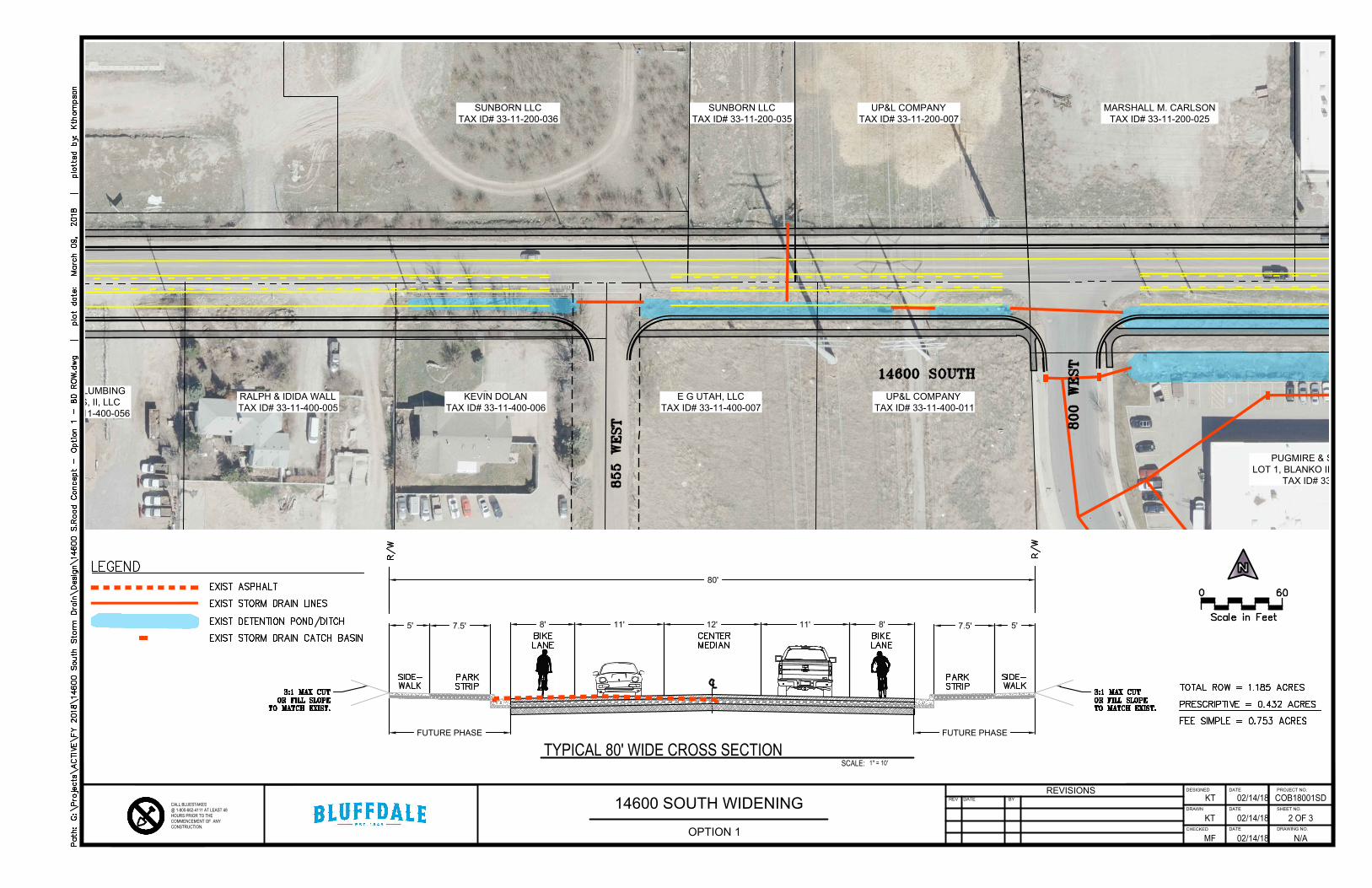
MARSHALL M. CARLSON
TAX ID# 33-11-200-025
UP&L COMPANY
TAX ID# 33-11-200-007
SUNBORN LLC
TAX ID# 33-11-200-035
SUNBORN LLC
TAX ID# 33-11-200-036
GLOVER PLUMBING
SERVICES, II, LLC
TAX ID# 33-11-400-056
RALPH & IDIDA WALL
TAX ID# 33-11-400-005
KEVIN DOLAN
TAX ID# 33-11-400-006
E G UTAH, LLC
TAX ID# 33-11-400-007
UP&L COMPANY
TAX ID# 33-11-400-011
PUGMIRE & STEVENS, LLC
LOT 1, BLANKO IINDUSTRIAL PARK
TAX ID# 33-11-427-027
8'
SCALE:
80'
TYPICAL 80' WIDE CROSS SECTION
12'11' 11'
7.5' 5'
FUTURE PHASE
1" = 10'
8'
7.5'5'
FUTURE PHASE
DESIGNED DATE PROJECT NO.
DRAWN DATE SHEET NO.
CHECKEDDATE DRAWING NO.
REVISIONS
REV DATE BY
CALL BLUESTAKES@ 1-800-662-4111 AT LEAST 48HOURS PRIOR TO THECOMMENCEMENT OF ANYCONSTRUCTION.
14600 SOUTH WIDENING
N/A
2 OF 3
COB18001SD
02/14/18
02/14/18
02/14/18KT
KT
MF
OPTION 1
AutoCAD SHX Text
BIKE
AutoCAD SHX Text
R/W
AutoCAD SHX Text
R/W
AutoCAD SHX Text
C
AutoCAD SHX Text
L
AutoCAD SHX Text
LANE
AutoCAD SHX Text
MEDIAN
AutoCAD SHX Text
CENTER
AutoCAD SHX Text
STRIP
AutoCAD SHX Text
3:1 MAX CUT OR FILL SLOPE TO MATCH EXIST.
AutoCAD SHX Text
SIDE-
AutoCAD SHX Text
WALK
AutoCAD SHX Text
PARK
AutoCAD SHX Text
BIKE
AutoCAD SHX Text
LANE
AutoCAD SHX Text
STRIP
AutoCAD SHX Text
3:1 MAX CUT OR FILL SLOPE TO MATCH EXIST.
AutoCAD SHX Text
SIDE-
AutoCAD SHX Text
WALK
AutoCAD SHX Text
PARK
AutoCAD SHX Text
14600 SOUTH
AutoCAD SHX Text
855 WEST
AutoCAD SHX Text
800 WEST
AutoCAD SHX Text
Scale in Feet
AutoCAD SHX Text
0
AutoCAD SHX Text
60
AutoCAD SHX Text
TOTAL ROW = 1.185 ACRES PRESCRIPTIVE = 0.432 ACRES FEE SIMPLE = 0.753 ACRES
AutoCAD SHX Text
LEGEND
AutoCAD SHX Text
EXIST ASPHALT EXIST STORM DRAIN LINES EXIST DETENTION POND/DITCH EXIST STORM DRAIN CATCH BASIN

RINDLISBACHER FAMILY LTD
PERTNERSHIP
TAX ID# 33-11-276-012
PUGMIRE & STEVENS, LLC
LOT 1, BLANKO IINDUSTRIAL PARK
TAX ID# 33-11-427-027
8'
SCALE:
80'
TYPICAL 80' WIDE CROSS SECTION
12'11' 11'
7.5' 5'
FUTURE PHASE
1" = 10'
8'
7.5'5'
FUTURE PHASE
DESIGNED DATE PROJECT NO.
DRAWN DATE SHEET NO.
CHECKEDDATE DRAWING NO.
REVISIONS
REV DATE BY
CALL BLUESTAKES@ 1-800-662-4111 AT LEAST 48HOURS PRIOR TO THECOMMENCEMENT OF ANYCONSTRUCTION.
14600 SOUTH WIDENING
N/A
3 OF 3
COB18001SD
02/14/18
02/14/18
02/14/18KT
KT
MF
OPTION 1
AutoCAD SHX Text
BIKE
AutoCAD SHX Text
R/W
AutoCAD SHX Text
R/W
AutoCAD SHX Text
C
AutoCAD SHX Text
L
AutoCAD SHX Text
LANE
AutoCAD SHX Text
MEDIAN
AutoCAD SHX Text
CENTER
AutoCAD SHX Text
STRIP
AutoCAD SHX Text
3:1 MAX CUT OR FILL SLOPE TO MATCH EXIST.
AutoCAD SHX Text
SIDE-
AutoCAD SHX Text
WALK
AutoCAD SHX Text
PARK
AutoCAD SHX Text
BIKE
AutoCAD SHX Text
LANE
AutoCAD SHX Text
STRIP
AutoCAD SHX Text
3:1 MAX CUT OR FILL SLOPE TO MATCH EXIST.
AutoCAD SHX Text
SIDE-
AutoCAD SHX Text
WALK
AutoCAD SHX Text
PARK
AutoCAD SHX Text
14600 SOUTH
AutoCAD SHX Text
HERITAGE CREST WAY
AutoCAD SHX Text
790 WEST
AutoCAD SHX Text
Scale in Feet
AutoCAD SHX Text
0
AutoCAD SHX Text
60
AutoCAD SHX Text
TOTAL ROW = 1.185 ACRES PRESCRIPTIVE = 0.432 ACRES FEE SIMPLE = 0.753 ACRES
AutoCAD SHX Text
LEGEND
AutoCAD SHX Text
EXIST ASPHALT EXIST STORM DRAIN LINES EXIST DETENTION POND/DITCH EXIST STORM DRAIN CATCH BASIN

SUNBORN LLC
TAX ID# 33-11-200-037
SUMMIT
ENTERPRISES, LLC
TAX ID# 33-11-400-024
SAVVY
INVESTING, LLC
TAX ID# 33-11-400-045
TR
OY
&
C
HR
IS
TIE
E
YR
E
TA
X ID
# 3
3-1
1-4
00
-0
46
TROY & CHRISTIE
EYRE
TAX ID# 33-11-400-038
GLOVER PLUMBING
SERVICES, II, LLC
TAX ID# 33-11-400-056
8'
SCALE:
80'
TYPICAL 80' WIDE CROSS SECTION
12'11' 11'
7.5' 5'
FUTURE PHASE
1" = 10'
8'
7.5'5'
FUTURE PHASE
DESIGNED DATE PROJECT NO.
DRAWN DATE SHEET NO.
CHECKEDDATE DRAWING NO.
REVISIONS
REV DATE BY
CALL BLUESTAKES@ 1-800-662-4111 AT LEAST 48HOURS PRIOR TO THECOMMENCEMENT OF ANYCONSTRUCTION.
14600 SOUTH WIDENING
N/A
1 OF 3
COB18001SD
02/14/18
02/14/18
02/14/18KT
KT
MF
OPTION 2
AutoCAD SHX Text
BIKE
AutoCAD SHX Text
R/W
AutoCAD SHX Text
R/W
AutoCAD SHX Text
C
AutoCAD SHX Text
L
AutoCAD SHX Text
LANE
AutoCAD SHX Text
MEDIAN
AutoCAD SHX Text
CENTER
AutoCAD SHX Text
STRIP
AutoCAD SHX Text
3:1 MAX CUT OR FILL SLOPE TO MATCH EXIST.
AutoCAD SHX Text
SIDE-
AutoCAD SHX Text
WALK
AutoCAD SHX Text
PARK
AutoCAD SHX Text
BIKE
AutoCAD SHX Text
LANE
AutoCAD SHX Text
STRIP
AutoCAD SHX Text
3:1 MAX CUT OR FILL SLOPE TO MATCH EXIST.
AutoCAD SHX Text
SIDE-
AutoCAD SHX Text
WALK
AutoCAD SHX Text
PARK
AutoCAD SHX Text
14600 SOUTH
AutoCAD SHX Text
NOELL
AutoCAD SHX Text
14600 SOUTH
AutoCAD SHX Text
NELSON
AutoCAD SHX Text
Scale in Feet
AutoCAD SHX Text
0
AutoCAD SHX Text
60
AutoCAD SHX Text
TOTAL ROW = 0.973 ACRES PRESCRIPTIVE = 0.422 ACRES FEE SIMPLE = 0.551 ACRES
AutoCAD SHX Text
LEGEND
AutoCAD SHX Text
EXIST ASPHALT EXIST STORM DRAIN LINES EXIST DETENTION POND/DITCH EXIST STORM DRAIN CATCH BASIN
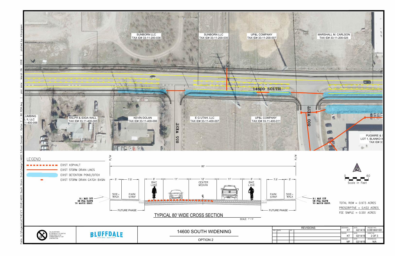
MARSHALL M. CARLSON
TAX ID# 33-11-200-025
UP&L COMPANY
TAX ID# 33-11-200-007
SUNBORN LLC
TAX ID# 33-11-200-035
SUNBORN LLC
TAX ID# 33-11-200-036
GLOVER PLUMBING
SERVICES, II, LLC
TAX ID# 33-11-400-056
RALPH & IDIDA WALL
TAX ID# 33-11-400-005
KEVIN DOLAN
TAX ID# 33-11-400-006
E G UTAH, LLC
TAX ID# 33-11-400-007
UP&L COMPANY
TAX ID# 33-11-400-011
PUGMIRE & STEVENS, LLC
LOT 1, BLANKO IINDUSTRIAL PARK
TAX ID# 33-11-427-027
8'
SCALE:
80'
TYPICAL 80' WIDE CROSS SECTION
12'11' 11'
7.5' 5'
FUTURE PHASE
1" = 10'
8'
7.5'5'
FUTURE PHASE
DESIGNED DATE PROJECT NO.
DRAWN DATE SHEET NO.
CHECKEDDATE DRAWING NO.
REVISIONS
REV DATE BY
CALL BLUESTAKES@ 1-800-662-4111 AT LEAST 48HOURS PRIOR TO THECOMMENCEMENT OF ANYCONSTRUCTION.
14600 SOUTH WIDENING
N/A
2 OF 3
COB18001SD
02/14/18
02/14/18
02/14/18KT
KT
MF
OPTION 2
AutoCAD SHX Text
BIKE
AutoCAD SHX Text
R/W
AutoCAD SHX Text
R/W
AutoCAD SHX Text
C
AutoCAD SHX Text
L
AutoCAD SHX Text
LANE
AutoCAD SHX Text
MEDIAN
AutoCAD SHX Text
CENTER
AutoCAD SHX Text
STRIP
AutoCAD SHX Text
3:1 MAX CUT OR FILL SLOPE TO MATCH EXIST.
AutoCAD SHX Text
SIDE-
AutoCAD SHX Text
WALK
AutoCAD SHX Text
PARK
AutoCAD SHX Text
BIKE
AutoCAD SHX Text
LANE
AutoCAD SHX Text
STRIP
AutoCAD SHX Text
3:1 MAX CUT OR FILL SLOPE TO MATCH EXIST.
AutoCAD SHX Text
SIDE-
AutoCAD SHX Text
WALK
AutoCAD SHX Text
PARK
AutoCAD SHX Text
14600 SOUTH
AutoCAD SHX Text
855 WEST
AutoCAD SHX Text
800 WEST
AutoCAD SHX Text
Scale in Feet
AutoCAD SHX Text
0
AutoCAD SHX Text
60
AutoCAD SHX Text
TOTAL ROW = 0.973 ACRES PRESCRIPTIVE = 0.422 ACRES FEE SIMPLE = 0.551 ACRES
AutoCAD SHX Text
LEGEND
AutoCAD SHX Text
EXIST ASPHALT EXIST STORM DRAIN LINES EXIST DETENTION POND/DITCH EXIST STORM DRAIN CATCH BASIN

RINDLISBACHER FAMILY LTD
PERTNERSHIP
TAX ID# 33-11-276-012
PUGMIRE & STEVENS, LLC
LOT 1, BLANKO IINDUSTRIAL PARK
TAX ID# 33-11-427-027
8'
SCALE:
80'
TYPICAL 80' WIDE CROSS SECTION
12'11' 11'
7.5' 5'
FUTURE PHASE
1" = 10'
8'
7.5'5'
FUTURE PHASE
DESIGNED DATE PROJECT NO.
DRAWN DATE SHEET NO.
CHECKEDDATE DRAWING NO.
REVISIONS
REV DATE BY
CALL BLUESTAKES@ 1-800-662-4111 AT LEAST 48HOURS PRIOR TO THECOMMENCEMENT OF ANYCONSTRUCTION.
14600 SOUTH WIDENING
N/A
3 OF 3
COB18001SD
02/14/18
02/14/18
02/14/18KT
KT
MF
OPTION 2
AutoCAD SHX Text
BIKE
AutoCAD SHX Text
R/W
AutoCAD SHX Text
R/W
AutoCAD SHX Text
C
AutoCAD SHX Text
L
AutoCAD SHX Text
LANE
AutoCAD SHX Text
MEDIAN
AutoCAD SHX Text
CENTER
AutoCAD SHX Text
STRIP
AutoCAD SHX Text
3:1 MAX CUT OR FILL SLOPE TO MATCH EXIST.
AutoCAD SHX Text
SIDE-
AutoCAD SHX Text
WALK
AutoCAD SHX Text
PARK
AutoCAD SHX Text
BIKE
AutoCAD SHX Text
LANE
AutoCAD SHX Text
STRIP
AutoCAD SHX Text
3:1 MAX CUT OR FILL SLOPE TO MATCH EXIST.
AutoCAD SHX Text
SIDE-
AutoCAD SHX Text
WALK
AutoCAD SHX Text
PARK
AutoCAD SHX Text
14600 SOUTH
AutoCAD SHX Text
HERITAGE CREST WAY
AutoCAD SHX Text
790 WEST
AutoCAD SHX Text
Scale in Feet
AutoCAD SHX Text
0
AutoCAD SHX Text
60
AutoCAD SHX Text
TOTAL ROW = 0.973 ACRES PRESCRIPTIVE = 0.422 ACRES FEE SIMPLE = 0.551 ACRES
AutoCAD SHX Text
LEGEND
AutoCAD SHX Text
EXIST ASPHALT EXIST STORM DRAIN LINES EXIST DETENTION POND/DITCH EXIST STORM DRAIN CATCH BASIN

Agenda Item 13

SD-R Independence
Village182 Lots and Homes

SD-R Independence VillagePurpose:
Add Accessory Dwelling Unit to SD-R 11-11I-4: DEVELOPMENT STANDARDS AND DESIGN GUIDELINES: A. Permitted, Conditional And Accessory Uses:
1. Permitted Uses2. Conditional Uses
R-1-10; R-1-43; R-1-87; Residential ZonesA. Permitted Uses: The following land use types are permitted uses in the R-1-10 residential zone. Unless specifically listed, any other use is not a permitted use in the zone. Uses listed as conditional or accessory uses are allowed in the zone only in accordance with the criteria established in this title:
Childcare facilities (less than 6 children).
Parks and recreational facilities.
Planned residential developments in accordance with this title.
Public or private rights of way.
Public or private utilities and maintenance facilities.
Residential facilities for elderly persons or persons with a disability in accordance with chapter 27 of this title.
Single-family dwellings, detached.
Subdivisions pursuant to the subdivision ordinance.
Conditional Uses: The following land use types are allowed as conditional uses in the R-1-10 residential zone. Unless specifically listed, any other use is not allowed as a conditional use in the zone. Each conditional use must be reviewed and approved in accordance with chapter 20 of this title:
Accessory dwelling unit.Cemetery grounds and facilities.
Golf courses.
Public and private schools, not daycare facilities.
Public uses.
Religious buildings and structures.
Water storage facilities, culinary or irrigation
C. Accessory Uses: The following land use types are allowed as accessory uses in the R-1-10 residential zone. Unless specifically listed, any other use is not allowed as an accessory use in the zone. Any accessory use must be clearly incidental to a permitted or conditional use of the property. Accessory uses are not allowed without the approval of a permitted or conditional use of the parcel unless otherwise noted in this section.
Except as a legal nonconforming use, accessory structures for the housing of animals or poultry is not permitted, other than incidental shelter for pets as allowed by city ordinance.
Garages, detached.
Home occupations pursuant to chapter 23 of this title.
Small wind power facilities as provided in chapter 33 of this title.
Storage facilities for machinery and equipment as an accessory use to a permitted or conditional use in the zone and only behind the dwelling unit. The accessory building shall not be larger than ten percent (10%) of the total area of the lot or parcel and must meet all setback requirements. (Ord. 10-24-00-1, 10-24-2000; amd. Ord. 2001-09, 11-19-2001; Ord. 2002-12, 10-8-2002; Ord. 2003-05, 3-11-2003; Ord. 2008-17, 11-11-2008; 2013 Code; Ord. 2013-14, 7-16-2013)
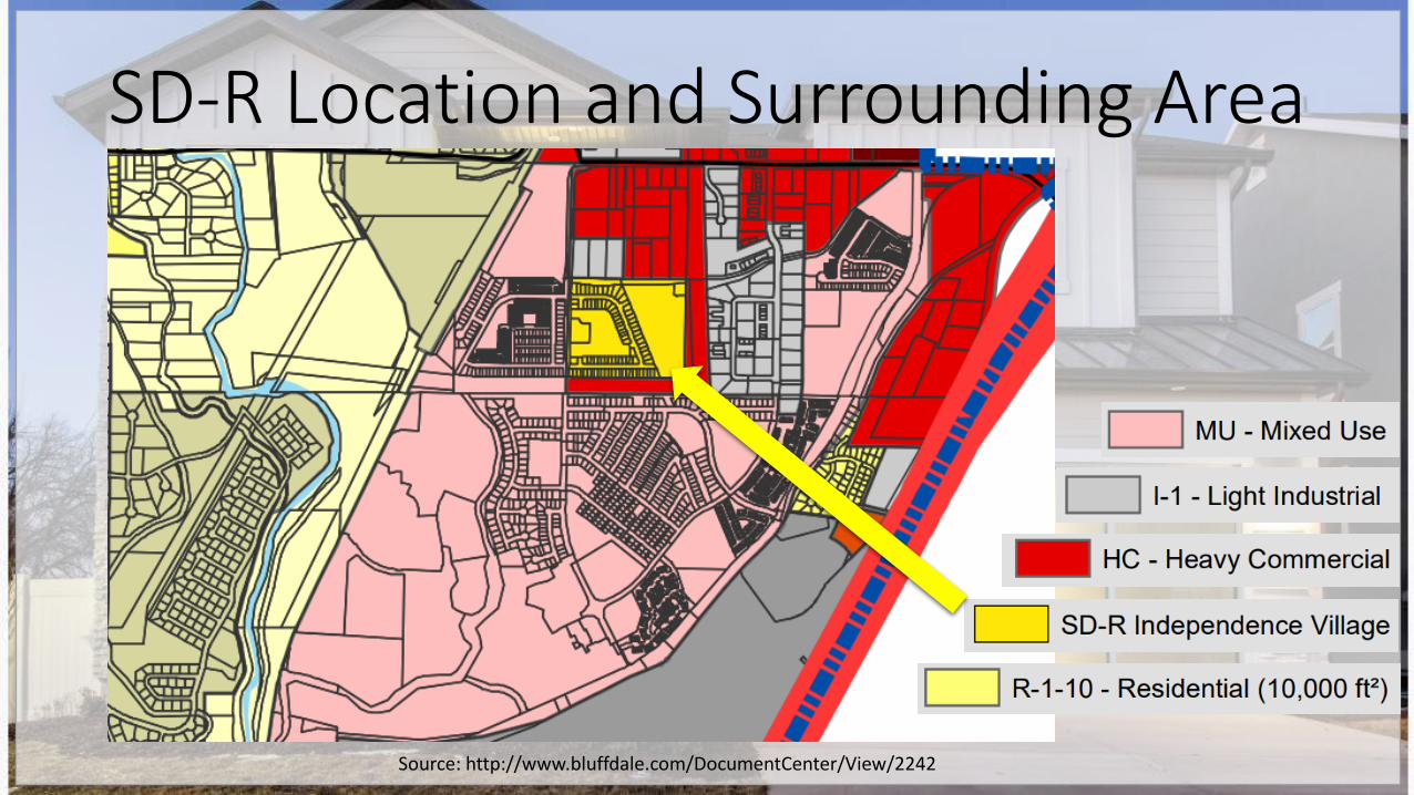
SD-R Location and Surrounding Area
Source: http://www.bluffdale.com/DocumentCenter/View/2242

SD-R Independence Village
Source: https://www.edgehomes.com/communities/independence-village/

Reasons to Add ADU to SD-R1) Oversight
a)When project was in the process for approval ADU was simply overlooked
2) Parking
a)Limited impact
b)Single Family Homes w/ 2 Car Driveways
i) Orange lots (~47%) will have a hard time meeting Standards for off street parking (HOA handles day to day due to CC&R’s)
3) SD-R Zone is most similar to Bluffdale heights an R-1-10 Zone (SD-R has smaller lots minimum 4750 sq ft vs 10,000 sq ft)
4) Aligns with City Plans to have various housing options

Reasons to Add ADU to SD-R5) CC&R’s allow for lease/rental
a)Parking Article 9.10
b)Leasing 9.15
6) Independence Village
a)In addition, due to Developer set up - No basement entrances included in builds. To add a basement entrance is $5-7k.
7) Small Community to allow ADU & Pilot the ability for Permitted ADU

Source: http://www.sterlingcodifiers.com/codebook/index.php?book_id=974

Permitted or Conditional UsePermitted Use
• HOA handles day to day • And approves or denies parking
on street for excess of 72 hours
• No need for application, hearing, etc.
• Standards are met: Yes or No
Conditional Use• Application, Public Hearing,
Written Notice • City Approved City Regulated
Recommendation for Permitted Use be added to SD-R zone

SD-R Independence
Village182 Lots and Homes

Reference: Bluffdale City ADU Standards11-34-3: STANDARDS:The following standards and conditions shall apply to all accessory dwelling units, in addition to any terms and conditions of approval as imposed by the planning commission during the conditional use permit process:
A. Location: An accessory dwelling unit shall only be allowed within a single-family dwelling.
B. Size: The accessory dwelling unit shall be accessory and subordinate to the primary dwelling. For purposes of this subsection, accessory and subordinate requires the accessory dwelling unit to be no more than sixty five percent (65%) of the square footage of the primary dwelling.
C. Number: A maximum of one accessory dwelling unit shall be allowed per single-family dwelling. Accessory dwelling units shall contain no more than one dwelling unit.
D. Parking: At least one off street parking stall shall be provided for each accessory dwelling unit. Such parking stall shall be in addition to all off street parking requirements for the primary dwelling on the lot and shall conform with the city parking standards specified elsewhere in this title.
E. Design And Character: Accessory dwelling units within a single-family dwelling shall retain the compatibility of the primary dwelling with the residential character of the neighborhood and be harmonious in design and structure with the primary dwelling.
F. Construction Codes: The accessory dwelling unit shall comply with all construction, housing and building codes in effect at the time the accessory dwelling unit is constructed and shall comply with all procedures and requirements of the city building regulations.
G. Ownership: The single-family dwelling and the accessory dwelling unit shall remain in single ownership and either the single-family dwelling or the accessory dwelling unit shall be owner occupied.
H. Nontransferable: No conditional use permit issued for an accessory dwelling unit shall be assignable or transferable upon the sale of the single-family dwelling or otherwise, and the conditional use permit shall expressly state that the permit shall terminate upon the sale or transfer of property. (Ord. 2003-05, 3-11-2003)
Source: Chapter 34: Accessory Dwelling Units http://www.sterlingcodifiers.com/codebook/index.php?book_id=974