1st Asia CliC Symposium- State and Fate of Asian Cryosphere ...
59
1st Asia Climate and Cryosphere (CliC) Symposium: “The State and Fate of Asian Cryosphere” Yokohama Institute for Earth Science (JAMSTEC) Yokohama, Japan April 20 to 22, 2006 WCRP Inf. No. 21/2006 November 2006
-
Upload
khangminh22 -
Category
Documents
-
view
0 -
download
0
Transcript of 1st Asia CliC Symposium- State and Fate of Asian Cryosphere ...
1st Asia Climate and Cryosphere (CliC) Symposium: “The State and Fate of Asian Cryosphere”
Yokohama Institute for Earth Science (JAMSTEC)
Yokohama, Japan April 20 to 22, 2006
WCRP Inf. No. 21/2006 November 2006
The WCRP is sponsored by the World Meteorological Organization, International Council for Science, and the Intergovernmental Oceanographic Commission of UNESCO. CliC is a core project of the WCRP, cosponsored by the Scientific Committee for Antarctic Research of the ICSU (SCAR). Contact information; CliC International Project Office Norwegian Polar Institute The Polar Environmental Centre N-9296 Tromsø, Norway http://clic.npolar.no [email protected] Tel: +47 77 75 01 05 Fax: +47 77 75 05 01 NOTE The designations employed and the presentation of material in this publication do not imply the expression of opinion whatsoever on the part of the Secretariat of the World Meteorological Organization concerning the legal status of any country, territory, city or areas of its authorities, or concerning the delimitation of its frontiers or boundaries.
WCRP report of the
1st Asia Climate and Cryosphere (CliC) Symposium:
“The state and fate of Asian Cryosphere”
:
Symposium sponsors
Japan Agency for Marine-Earth Science and Technology (JAMSTEC) World Climate Research Program (WCRP) China Meteorological Administration (CMA) Chinese Academy of Sciences (CAS) National Science Foundation of China (NSFC) Japan Aerospace Exploration Agency (JAXA) Research Institute for Humanity and Nature (RIHN)
Organized by WCRP/CliC SSG China CliC Committee Japan CliC Committee
Symposium Website: http://www.jamstec.go.jp/iorgc/sympo/asiaclic2006/ Reference: WCRP-Informal Report No. 21/2006, November 2006. Report of the 1st Asia Climate and Cryosphere (CliC) Symposium: The State and Fate of Asian Cryosphere. Yokohama Institute for Earth Science (JAMSTEC), 20-22 April, 2006.
Table of Contents
Symposium Statement ............................................................................................................... 1 1. Outline and Objectives .................................................................................................. 2 2. Organization and Support ............................................................................................. 3 3. Participants and Presentation ....................................................................................... 3 4. Symposium Sessions ....................................................................................................... 3 4.1 Opening and program/project session ............................................................................. 3 4.2 Scientific and technical presentations .............................................................................. 3 4.3 National/international activity session ............................................................................ 4 4.4 Split group sessions .......................................................................................................... 4 4.5 Plenary sessions ............................................................................................................... 5 5. Report of the Split Group Discussion ........................................................................... 5 5.1 Glacier .............................................................................................................................. 5 5.2 Permafrost and frozen ground ......................................................................................... 7 5.3 Snow/ hydrology ............................................................................................................... 8 5.4 Cryosphere-atmosphere interaction ................................................................................. 9 5.5 In situ/ satellite observations ............................................................................................. 9 5.6 Model ................................................................................................................................ 11 6. Discussions - Plenary Session ........................................................................................ 13 Appendix 1. Program/Agenda Appendix 2. Participants list Appendix 3. National reports


-1-
Symposium Statement From 20-22 April 2006, at Yokohama Institute of Earth Science, JAMSTEC in Yokohama Japan, 107 people 11 from countries met to present scientific results and CliC related activities, and to discuss the state and fate of Asian cryosphere and identify the necessities for further development of CliC in Asia. Status and activities of CliC, IPY, GEOSS, IGOS and related WCRP program, national CliC programs and related activities in Asia were reported. About 100 outstanding scientific results were presented (40 oral and 42 poster presentations), covering a range of cryosphere topics including glaciers, snow, hydrology and water resources, permafrost, atmosphere-cryosphere interactions, data management, and modeling.
The Symposium identified that the amount of existing data on meteorological, cryospheric, and hydrological variables related to the Asian cryosphere is immense in this region. However, the collaboration among researchers and groups is not sufficient to make optimal use of these data. Required future actions include high-priority involvement in data management and archiving efforts by the Asia-CliC community, the establishment of a better network for present and future observations, obtaining higher quality data, and application of various models to overcome the spatial/temporal constraints. The Symposium also revealed unique characteristics of the cryosphere in Asia. A high degree of diversity among various cryospheric components was noted. At the same time, it was recognized that climatic forcing influencing the Asian cryosphere varies considerably within the region, such as monsoon in low latitude and N/AO in high latitude. This diversity makes it extremely difficult to interpret the regional cryospheric data, especially when examined in the context of global warming.
The Symposium was highly successful in providing an opportunity for the participants to meet and discuss the wide range of scientific and related issues, leading to fruitful future collaborations. The Asian countries need to contribute to international activities through Newsletter, Specialist registration, and Meetings in the future. An Asia CliC Committee may be established to promote future Asia CliC activities, and JAMSTEC may take the role of the support of the activity and information exchange for the immediate future. The Asian participants will be considered as national correspondents. The implementation structure will be discussed further and finalized at the CliC Scientific Steering Group (SSG) meeting in December 2006 (Boulder, USA). Several suggestions to arrange workshops on subjects such as “satellite and snow/hydrology” and “atmosphere-cryosphere interaction” were made, depending on necessity and availability. The result of the 1st Asia CliC Symposium will serve as a strong momentum to the future activities, which leads to the 2nd Asia CliC Symposium that is scheduled to be held in China in 2007.
-2-
1 Outline and Objectives
The background for the 1st Asia-CliC Symposium – the state and fate of Asian Cryosphere was as follows. The cryosphere is changing in Asia, as well as globally, due mainly to global warming and related climate variation. The long-term impact of these changes on the environment is still uncertain, and there is an urgent need to clarify the present condition and evaluate the possible changes.
The Symposium was organized to focus on the Asian Region component of the WCRP CliC (Climate and Cryosphere) Project1. The objectives of the Asia-CliC Symposium were to exchange scientific results and information, to discuss the main issues of CliC in this region, to develop plans for implementation, and to inform Asian countries about CliC activities. The Organizers expected the participation of scientists/engineers, students and also funding bodies from various Asian countries and international community.
The Symposium focused on the eastern part of the Eurasian continent which is considered as Asian Region and surrounding regions. The main topics of interest were:
(1) Glacier distribution/changes (2) Frozen ground/Permafrost condition and changes (3) Snow cover, cold region hydrology and water resources (4) Land surface and atmosphere processes in cold region and mountains (5) Large-scale cryosphere-atmosphere interactions (6) Cryospheric database (7) Satellite and ground base observations of cryosphere (8) Modeling of cryosphere (9) Strategy for future cryospheric research
In addition to general presentation (oral and posters) on the aforementioned topics, one day was reserved for split-sessions talks on specified topics needing more in-depth discussion and/or immediate action by the community. The working language was English.
The Symposium was followed by a semi-opened Integrated Global Observing Strategy Cryosphere (IGOS-Cryo) Theme Meeting (April 24-25), which discussed the satellite and in-situ observations of the cryosphere, including capabilities, requirements, and applications.
1 , CliC had its first Science Conference in April, 2005 in Beijing, China.
-3-
2 Organization and Support
The Symposium was organized by WCRP-CliC Science Steering Group, Japan CliC Committee, and China CliC Committee. The Organizing Committee members were: Barry Goodison (CliC SSG, Chairman), Dahe Qin (China CliC Committee, Chair), Tetsuo Ohata (Japan CliC Committee, Chair), Vladimir Ryabinin (WCRP, Joint Planning Staff), and Victoria Lytle (CliC International Project Office, Director). The Local Organizing Committee (IORGC and FRCGC, JAMSTEC) included Tetsuo Ohata (IORGC), Hironori Yabuki (IORGC), Konosuke Sugiura (IORGC), Setsuko Ichikawa (IORGC), and Miyoko Oki (FRCGC). The event was sponsored by various Institutes, generally in the form of travel support. These include:
Japan Agency for Marine-Earth Science and Technology (JAMSTEC) – host and main sponsor, World Climate Research Program (WCRP), China Meteorological Administration (CMA) Chinese Academy of Sciences (CAS) National Science Foundation of China (NSFC) Japan Aerospace Exploration Agency (JAXA), and the Research Institute for Humanity and Nature (RIHN)
3 Participants and presentation
The meeting was first announced in December 2005, through, among others, the CryoList, the Symposium- and main CliC web-sites. Finally, 107 actual people representing 11 countries participated. Of these, only six were women (Refer to participants list, Appendix 2). There were 49 oral- and 42 poster- presentations.
4 Symposium Sessions
4.1 Opening and program/project session Following opening remarks by Taro Matsuno, former director of Frontier Research Center for Global Change, and talks by the organizers, the program began with an introduction to the CliC project by Barry Goodison, Chairman of the CliC SSG (see agenda, Appendix 1). 4.2 Scientific and technical presentations General scientific presentations were grouped into the eight following topics. Oral and poster presentations were held simultaneously.
-4-
(1) Glacier distribution/changes mainly chaired by T. Yao and K. Fujita, 9 oral- and 10 poster presentations
(2) Frozen ground/permafrost condition and changes chaired by T. Zhang, 4 oral- and 8 poster- presentations
(3) Snow cover, cold region hydrology and water resources mainly chaired by V. Vuglinsky and D. Yang, 10 oral- and 4 poster- presentations
(4) Land surface and atmosphere processes in cold region and mountains chaired by A.G. Georgiadi, 2 oral- and 5 poster- presentations
(5) Large-scale cryosphere-atmosphere interactions chaired by J. Ukita, 3 oral- and 5 poster presentations
(6) Cryospheric database chaired by L. Bian, 2 oral presentations (7) Satellite and ground base observations of cryosphere chaired by L. Bian, 1 oral- and 4
poster- presentation (8) Modeling of cryosphere chaired by L. Bian, 2 oral- and 6 poster- presentations
4.3 National/international activity session Early in the planning stages of this symposium, prospected participants from several Asian countries suggested to have a session on national/international research activities in the region. The session was made on the second day (April 21), chaired by T. Ohata and research activities in the Asia Region by many countries were presented. Some national presentations made were summarized and attached as Appendix 3, as National Reports (Russia, Mongolia, Pakistan, and Nepal Himala 4.4 Split group sessions In this - perhaps the most important - session, the groups were asked to discuss issues related cryospheric research in Asia. Topics included:
(1) Data- sharing and archive (2) Observation needs (3) Gaps in knowledge (4) What activities needed to contribute to "state"? (5) Common programs and projects (6) Modeling needs (7) Future workshops (8) Other people and agency (9) CEOP super sites (10) Data management
Discussions took place in the following six groups: (1) Glacier (Chair: T. Yao, Reporter: K. Fujita)
-5-
(2) Permafrost and frozen ground (Chair: T. Zhang, Reporter: M. Ishikawa) (3) Snow/ hydrology (Chair: V. Vuglinsky, Reporters: D. Yang and K. Sugiura) (4) Cryosphere-atmosphere interaction (Chair: Bian. L, Reporters: R.P. Singh and K. Saito) (5) In situ/ satellite observations (Chair: H. Enomoto, Reporters: B. Raup and C. Xiao) (6) Model (Chair: T. Yamazaki, Reporter: T. Graf)
4.5 Plenary sessions The split group session reports (see section 5) were presented at the plenary sessions. Afterwards, the Symposium had a general discussion time for drafting the Symposium statement in the afternoon of third day April 22, and terminated the Symposium at 16:30. The Symposium statement was slightly changed afterwards by adding scientific discussion parts to it, but not changing the basic agreement made during the plenary session.
5 Report of the Split Group Discussion
5.1 Glacier Asian CliC issues addressed were: 1) Distribution of glaciers, improved understanding, but still not sufficient when climate warming is considered, 2) Little observational data on volume change and continuous mass balance, and 3) Little knowledge on modeling glacier responses to changing climate.
One approach is observation such as volume change and mass balance, but area and terminus changes are not enough. These are possible by satellites although ground truth is necessary. The other is modeling such as mass-balance and flow model, and coupling with GCM product, based on precise inventory by GLIMS and SRTM products.
Data-sharing and archive 1. WGMS: “fluctuations of glaciers”. Limited targets and reducing monitored glaciers 2. GLIMS: present state and future monitoring. Who completes Himalayan database? Volume
evaluation? 3. NSIDC/NOAA: ice core and meteorological data 4. NASA/NEESPI: database for meteorology, hydrology and biology 5. TORP (Tibetan observation and monitoring research platform): Institute of Tibetan Plateau
Research glacier lake
Observation needs 1. Monitoring mass balance and volume changes in glaciers 2. Monitoring glaciers by Chinese National Program and the biggest problem for the other
country

-6-
3. Ice cores by Chinese National Program and CADIP (Central Asia Deep Ice Core Project) 4. Satellite based analyses by GLIMS members and others
Gaps in Knowledge
1. Ice volume and its change 2. Impact of atmospheric aerosol and dust on mass balance and change of glaciers 3. Regional/global gaps in observation and modeling 4. Determination of sources of precipitation and influences on snow accumulation processes
Contribution to “state” Concerning International Polar Year (IPY)
1. High Asia as a “Third pole” 2. Making snapshot of glaciers for completion GLIMS inventory 3. Influence of high Asia on atmospheric processes: interaction between mountain glaciers and
atmosphere Common Programs and Projects
Insufficient financing for research is a common problem in all Asian countries represented. Russia, Uzbekistan, Kazakhstan, Tajikistan, Kyrgyzstan, Afghanistan, Nepal, Bhutan, India, Pakistan, Mongolia, and China: ice cores, monitoring glaciers and glacier inventory, Japan: a project of Ili River Basin (RIHN, contribution to CADIP) and USA: NASA/GLIMS/NEESPI/LCUC (satellite) and NSF/NOAA/CADIP (ice cores). Modeling
1. Need precise meteorological data 2. Downscaling grid data or GCM output to regional one 3. Fluctuation model for worldwide estimation
Future Workshops
1. GLIMS WS at Cambridge, 17-18 Aug. 2006 2. IGS-meeting at Cambridge, 21-25 Aug. 2006
Other People and Agencies Where to apply for financial support? The World Bank, Asian Research Development Bank, Asian Pacific Network, UNEP and HKH-Friends, others?? CEOP 35 Super Sites Glacier monitoring is a more urgent issue for glacier group.
-7-
5.2 Permafrost and Frozen Ground Gaps in Knowledge There exist large environmental gradients in Asia involving Tundra, Taiga, Steppe, and Mountain, where various types of permafrost, active layer, and seasonally frozen ground occur. Several following questions were raised. Do we really understand the distribution, energy and water condition of them? Are currently available observational networks sufficient? Although isotope has been known to be useful tool for analyzing hydrological cycle, do we have knowledge on isotopic composition involved in frozen grounds?
Observation Needs Asia, including Eastern Siberia, is the largest permafrost region on earth. However permafrost observatories are sparse and poorly equipped. Moisture conditions, including water- and ice-contents, are crucially important but are less measured. The observational components are:
1. Active layer thickness 2. Soil temperature (ice & unfrozen water contents) 3. Deep permafrost temperatures 4. Isotopic composition of ground ice 5. (Sub-)surface energy and water balance fluxes 6. Snow cover thickness and duration that significantly influence frozen ground temperatures 7. Vegetation cover that also influence frozen ground temperatures 8. Carbon contents of soil, determining thermal characteristics of frozen ground 9. Periglacial features as indirect phenomenon of permafrost degradation, involving Rock
glacier, pingo, thaw lakes, thermokarst, slope stability and rock fall phenomena
Special attention should be paid to seasonally frozen ground issues, because it is the largest cryospheric component of the earth. Some parameters characterizing soil and seasonal freezing and thawing should be also measured intensively. This includes thickness, timing and duration, frequency of frozen soil, soil temperature, moisture, and area extent.
What Activities are needed to contribute to “state”
1. Permafrost mapping in Asia, alpine permafrost, document changes 2. Thermal State of Permafrost (TSP) of Russia, Mongolia, Tibet and others – Snapshot
Common Programs and Projects
1. Mapping high altitude permafrost in Asia – plateau and mountain permafrost 2. National and international projects of TSP (Russia, Mongolia, Japan) 3. Developing model coupled with atmosphere through surface energy and water balance 4. Data exchange and archiving program

-8-
Modeling Needs 1. Develop a model coupled with atmosphere through surface energy and water balance. This
needs closer corporations with land-surface hydro-meteorologists. 2. Develop distributive model suitable for permafrost studies in Asian high altitudes. 3. Working with GCM community to better represent soil freezing and thawing processes in
land surface schemes. CEOP Super Sites Observations
Implement long-term permafrost observation to pre-existing super stations in Russia, Japan, and Mongolia – including the Altay Mountains, Tibetan Plateau and surrounding mountains.
Data issues Data management and exchange, contribute to GEOSS.
Future Workshops
1. Mountain permafrost mapping workshop in Lanzhou, August, 2006 2. 1st Asian Conference on Permafrost, Lanzhou, August, 2006 3. 9th International Conference on Permafrost, Fairbanks, 2008
5.3 Snow/ Hydrology Specific features of Asian cryosphere are 1) Permafrost, 2) Snow cover, 3) Mountain, and 4) Mountain river run-off formation
Main goal is to assess snow cover and hydrology changes under global climate changes in cryospheric zone of Asia.
Possible research projects include 1) Assess snow-cover characteristics for hydrological purposes, 2) Improve solid precipitation measurements methods in Asian Arctic, 3) Assess river and lake ice changing, 4) Hydrology of large river basins in permafrost region (mountain and plain parts), and 5) Make use of remote sensing data to assess snow cover characteristics.
Problem areas: 1) Snow cover and hydrological data are sparse in mountain, Arctic zones and developing countries in the Asian region, 2) Data availability and unrestricted data exchange, 3) Insufficient use of remote sensing data to assess snow cover characteristics, 4) Shortage of instruments and equipment to measure snow-cover characteristics, and 5) Insufficient gridded data and products (downscaling) for hydrological simulation model development and validation.

-9-
Recommended suggestions to solve the problems are 1) To prepare a scientific program for Asia-CliC regional project as a part of CliC, and 2) To organize working group on snow cover/hydrology. 5.4 Cryospher-Atmosphere Interaction The Symposium identified that the Cryosphere plays a significant role in climate interactions between the atmosphere, snow cover, ice, frozen ground, water vapor and energy transmission during summer and winter monsoon seasons. Recently, numerous studies show a strong interaction between the atmosphere and climate on the cryosphere; and therefore, it is important to understand the coupling between cryosphere-atmosphere- and climate. Current understanding of this interaction is limited. To fill in the knowledge gaps, we must study the effect of the atmospheric parameters (dust, radiation, meteorological) to quantify the effect on cryosphere.
It was agreed upon that the existing gaps between Hydrologists, Atmospheric and Climate scientists and Cryospheric scientists must be overcome by detailed and collaborative study on the changes in cryosphere - including surface/subsurface runoff. Network of observatories must be enhanced.
Through the elaborative efforts of data mining, yet-unavailable data related to Cryosphere, Atmosphere and Meteorological conditions may be discovered and made available to the scientists from various Asian countries. Asia-CliC may play an important role in organizing efforts to mine and compile these data by contacting individual scientists in these countries who are willing to share their data.
In Asian countries, various representative locations with different climatic conditions may be taken up where the data dealing with atmosphere, weather and data related to cryosphere may be collected to quantify the effect of coupling between atmosphere-climate-cryosphere. Various parameters such as dust, forest fires, temperature, radiation, precipitation, grain size, albedo, brightness temperature; etc., should be studied. The participants also identified the lack of observatories in the mountain regions, and stressed that observatories in such areas may be enhanced, which will help in understanding snow and glacier dynamics. Observatories for multi parameters may be planned at few critical locations such as: Japan, Western and Eastern Himalaya, China, Mongolia, few locations in Siberia.
Recent studies have revealed the impact of El-Nino/ENSO and monsoon on cryospheric parameters. Quantitative estimates of the impact could be made. The participants strongly encourage planning of a workshop focused on detailed discussion on coupling between cryosphere-atmosphere-climate in the Asian region. 5.5 In-situ / Satellite Observations Satellite observation is an interdisciplinary contribution to the CliC projects.
-10-
In this group, we exchanged information on satellite data sets, and asked other splinter groups about their requests for satellite data.
Main cryospheric data from satellites have been snow-cover, glacier- and sea-ice data. But these data cover mainly areal- extent and periodic. Thickness and mass information are scarce. Other observations are movement, accumulation, freezing and melting. This information is partly available. The thickness data are targets for future acquisitions.
New Satellites The Chinese satellite FY3 that carries 11 instruments, VNIR and more, will be launched in 2007-01. Possible use for snow cover-, albedo-, snow depth-, moisture-, and temperature- observations. FY1d, FY2c, FY2d are 10-channel instruments that can be used for snow cover observations. Data are freely downloadable from website.
Japanese satellite ADEOS2. Microwave snow-depth data is open to the public. As microwave snow survey has an accuracy problem, depending on the surface conditions, ground-based observations for validation remain important. Satellite and other Data-desires and Difficulties There are requests to obtain multiple sensor data in same season. Access to these type data will reduce classification errors. It will supply new components. Hybrid approaches to combine satellite data to other methodology is required.
Assimilation of satellite data into modeling should be encouraged. We need products that are merged from different sources.
We need more data on volume changes; this is weak compared to map-plane information. For this we need a precise DEM to determine the current state.
PRISM sensor data on ALOS satellite have recently become available. Such new satellite information, and guidance on how to use it, should be distributed within the Asian countries. We would like to ask JAXA to distribute widely on the new satellite data is classifications. Field Observations We need field coordination, GPS measurements, validation for satellite data use. Snow-cover data is one of the more useful satellite data, but observations are difficult in rough terrain, mountainous areas.
Ground observations are rare in regions where access is difficult. To carry out effective field investigations, we need sufficient portable instruments for the necessary field observations.

-11-
CEOP super site data is now integrated and waiting to be used. However, the data is not used actively in the Asian community. We should utilize this data resource more. Use guidelines for accumulated CEOP data may be helpful. Other Splinter Groups Permafrost group: various satellite data are used for frozen ground, permafrost, but there is not enough data, especially for mountain regions, e.g. in central Asia. Need information from different countries on permafrost distribution.
Glacier group: talked about data derived from satellite imagery, but not specifically about satellite data or specific platforms.
Snow hydrology group: inter-comparison of products from different sources is important, but difficult.
5.6 Model Target of Model Modeling of cryosphere elements (e.g. glacier, snow cover, permafrost) should be discussed in each group. Climate simulation models (GCM, regional climate model) will be included in this split group discussion. Identified models capabilities and applications include disaster prevention, water resources management, and so forth. Data- sharing, -archiving, and -management Data are needed for input and validation of models. Many data are available in printed form, however, it is difficult to get and use them. It is necessary to archive data electronically. A centralized inventory of data sources could be created by collecting information about available data through a survey, metadata should include information on how to access the data, data policy and contact person.
Observation Needs The most important meteorological variables required for model forcing are precipitation, particularly snowfall (or phase of precipitation), and radiation. It is necessary to determine spatial variability because in-situ data are very local. Metadata are required in all cases and should include error, methodology, site characteristics (vegetation, topography, scale, hydraulic parameters).
For snow data, minimum requirements are snow depth and snow water equivalent. Snow stratigraphy is needed as well, although there are some problems (e.g. who-does-what, how to get the data?), and new observation methods are also required.

-12-
Ideally, observation should be standardized. Exchange of observation-technique knowledge is recommended. High-altitude sites are very important for model studies. In order to perform these requests, international cooperation is required.
On the other hand, output data from climate model are available for snow models. However, the quality of the output data is a problem, and error analyses are needed over the higher latitudes.
Knowledge Gaps Because our group included mainly snow modelers, the discussion was limited to problems related to snow models. The followings issues/questions were raised.
1. How good are the satellite data sets? More validation? 2. Snow model
– Intercepted snow in forest area (SnowMIP2) – Snow drift in non-forested areas – Snow Melt
3. Present climate models can simulate cryosphere reasonably? – Focus on the atmosphere, neglect state of the land surface? Is there any validation? – Down-scaling technique – Check model outputs to identify problems (snow cover, permafrost…) – How do climate model integrate permafrost? – Is GCM information of frozen soil used?
What activities are needed to contribute to ‘state’ Suggested activities are to increase the use of models to evaluate the state of the cryosphere, to create model output data sets for cryosphere, and to validate the models. Common Programs and Projects Future water-resource predictions in Asia should be planned. For example, is snow cover increasing or decreasing? Where do the changes occur? These problems should be studied with GCM (e.g. CCSR, MRI), and be downscaled to regional scale. A difficult point is how the prediction in mountain areas is performed, and how to prove that the results are validated. How can we address the problems in this area? Down-Scaling studies are essential. Output from GCM is used as input for local scale model.
Demonstration project should be planned to identify the needs and capabilities of models. For example, evaluation of water resources is proposed in the upper Indus basin in Pakistan by using output from regional models. Water resources-, disaster-, and cryosphere- change are the targets for model studies. At any rate, more modelers – especially regional climate modelers – are needed.
-13-
Future Workshops Workshops should be arranged to involve more modelers, and should stress the importance of models for CliC. It is necessary to make attending the meeting attractive for modelers by actively inviting them to participate. Session for modeling (Atmospheric and Hydrological Modeling in Cryosphere) should be enriched. Model contribution from China and Russia are welcomed, because there was only little contribution from these countries in this meeting. Activities and Recommendation 1. Providing data inventory. It is valuable for model studies. 2. Demonstration projects for model as mentioned in “Common program and project”
6 Discussions – Plenary Session
Data Management Oral and poster presentations showed meteorological, hydrological and cryospheric data, and that observation networks were scattered far and wide. An active collaborative study is expected by the Asian CliC community for the effective and good use of data.
Asia CliC Committee In order to enhance CliC studies in the region, the establishment of an Asia CliC committee were identified and advised and international level activities through newsletter, specialist registration and meetings were desired. The function and structure of the Asia CliC committee will be discussed later. The participants expect that JAMSTEC continue to lead the activity and information exchange at least for the present.
Workshops Some of the split groups required to have relevant workshops. Workshops on subjects such as “satellite and snow/hydrology” and “atmosphere-cryosphere interaction” we were suggested in the Symposium. These workshops will be held in future.
Next Asia CliC Symposium China graciously offered to host the 2nd Asia CliC Symposium near Beijing in 2007. India also expressed an interest in becoming a future host.
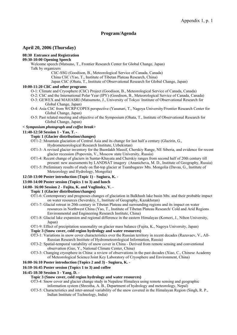
Appendix 1, p. 1 Program/Agenda
April 20, 2006 (Thursday) 08:30 Entrance and Registration 09:30-10:00 Opening Speech
Welcome speech (Matsuno, T., Frontier Research Center for Global Change, Japan) Talk by organizers
CliC-SSG (Goodison, B., Meteorological Service of Canada, Canada) China CliC (Yao, T., Institute of Tibetan Plateau Research, China) Japan CliC (Ohata, T., Institute of Observational Research for Global Change, Japan)
10:00-11:20 CliC and other programs O-1: Climate and Cryosphere (CliC) Project (Goodison, B., Meteorological Service of Canada, Canada) O-2: CliC and the International Polar Year (IPY) (Goodison, B., Meteorological Service of Canada, Canada) O-3: GEWEX and MAHASRI (Matsumoto, J., University of Tokyo/ Institute of Observational Research for
Global Change, Japan) O-4: Asia CliC from WCRP/COPES perspective (Yasunari, T., Nagoya University/Frontier Research Center for
Global Change, Japan) O-5: Past related meeting and objective of the Symposium (Ohata, T., Institute of Observational Research for
Global Change, Japan) < Symposium photograph and coffee break> 11:40-12:50 Session 1 - Yao, T. -
Topic 1 (Glacier distribution/changes) OT1-2: Mountain glaciation of Central Asia and its change for last half a century (Glazirin, G.,
Hydrometeorological Research Institute, Uzbekistan) OT1-3: A revised glacier inventory for the Buordakh Massif, Cherskiy Range, NE Siberia, and evidence for recent
glacier recession (Popovnin, V., Moscow state University, Russia) OT1-4: Recent change of glaciers in Suntar-Khayata and Cherskiy ranges from second half of 20th century till
present: new assessments by LANDSAT imagery (Ananicheva, M. D., Institute of Geography, Russia) OT1-5: Preliminary results of study on flat-top glacier at Tsambagarav Mts. Mongolia (Davaa, G., Institute of
Meteorology and Hydrology, Mongolia) 12:50-13:00 Poster introduction (Topic 1) - Sugiura, K. - 13:00-14:00 Poster session (Topics 1 to 3) and lunch 14:00- 16:00 Session 2 - Fujita, K. and Vuglinsky, V. -
Topic 1 (Glacier distribution/changes) OT1-6: Contemporary and prognoses changes of glaciation in Balkhash lake basin Mts. and their probable impact
on water resources (Severskiy, I., Institute of Geography, Kazakhstan) OT1-7: Glacial retreat in 20th century in Tibetan Plateau and surrounding regions and its impact on water
resources in Northwest China (Yao, T., Institute of Tibetan Plateau Research/ Cold and Arid Regions Environmental and Engineering Research Institute, China)
OT1-8: Glacial lake expansion and regional difference in the eastern Himalayas (Komori, J., Nihon University, Japan)
OT1-9: Effect of precipitation seasonality on glacier mass balance (Fujita, K., Nagoya University, Japan) Topic 3 (Snow cover, cold region hydrology and water resources) OT3-1: Variations in snow cover characteristics over the Russian territory in recent decades (Razuvaev, V., All-
Russian Research Institute of Hydrometeorological Information, Russia) OT3-2: Spatial-temporal variability of snow cover in China - Derived from remote sensing and conventional
observation (Guo, Y., National Climate Center, China) OT3-3: Changing cryosphere in China: a review of observations in the past decades (Xiao, C., Chinese Academy
of Meteorological Science/Joint Key Laboratory of Cryosphere and Environment, China) 16:00-16:10 Poster introduction (Topics 2 and 3) - Sugiura, K. - 16:10-16:45 Poster session (Topics 1 to 3) and coffee 16:45-18:30 Session 3 - Yang, D. -
Topic 3 (Snow cover, cold region hydrology and water resources) OT3-4: Snow cover and glacier change study in Nepalese Himalaya using remote sensing and geographic
information system (Shrestha, A. B., Department of hydrology and meteorology, Nepal) OT3-5: Characteristics and inter-annual variability of the snow covered in the Himalayan Region (Singh, R. P.,
Indian Institute of Technology, India)
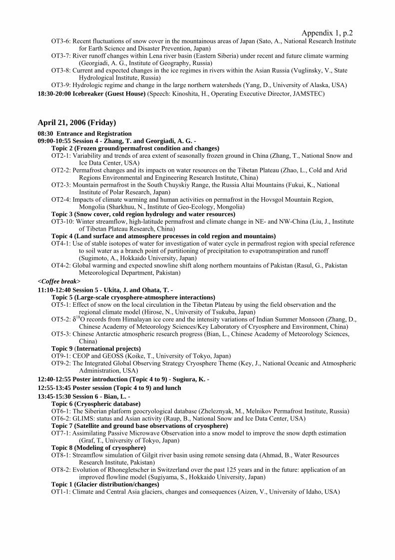
Appendix 1, p.2OT3-6: Recent fluctuations of snow cover in the mountainous areas of Japan (Sato, A., National Research Institute
for Earth Science and Disaster Prevention, Japan) OT3-7: River runoff changes within Lena river basin (Eastern Siberia) under recent and future climate warming
(Georgiadi, A. G., Institute of Geography, Russia) OT3-8: Current and expected changes in the ice regimes in rivers within the Asian Russia (Vuglinsky, V., State
Hydrological Institute, Russia) OT3-9: Hydrologic regime and change in the large northern watersheds (Yang, D., University of Alaska, USA)
18:30-20:00 Icebreaker (Guest House) (Speech: Kinoshita, H., Operating Executive Director, JAMSTEC) April 21, 2006 (Friday) 08:30 Entrance and Registration 09:00-10:55 Session 4 - Zhang, T. and Georgiadi, A. G. -
Topic 2 (Frozen ground/permafrost condition and changes) OT2-1: Variability and trends of area extent of seasonally frozen ground in China (Zhang, T., National Snow and
Ice Data Center, USA) OT2-2: Permafrost changes and its impacts on water resources on the Tibetan Plateau (Zhao, L., Cold and Arid
Regions Environmental and Engineering Research Institute, China) OT2-3: Mountain permafrost in the South Chuyskiy Range, the Russia Altai Mountains (Fukui, K., National
Institute of Polar Research, Japan) OT2-4: Impacts of climate warming and human activities on permafrost in the Hovsgol Mountain Region,
Mongolia (Sharkhuu, N., Institute of Geo-Ecology, Mongolia) Topic 3 (Snow cover, cold region hydrology and water resources) OT3-10: Winter streamflow, high-latitude permafrost and climate change in NE- and NW-China (Liu, J., Institute
of Tibetan Plateau Research, China) Topic 4 (Land surface and atmosphere processes in cold region and mountains) OT4-1: Use of stable isotopes of water for investigation of water cycle in permafrost region with special reference
to soil water as a branch point of partitioning of precipitation to evapotranspiration and runoff (Sugimoto, A., Hokkaido University, Japan)
OT4-2: Global warming and expected snowline shift along northern mountains of Pakistan (Rasul, G., Pakistan Meteorological Department, Pakistan)
<Coffee break> 11:10-12:40 Session 5 - Ukita, J. and Ohata, T. -
Topic 5 (Large-scale cryosphere-atmosphere interactions) OT5-1: Effect of snow on the local circulation in the Tibetan Plateau by using the field observation and the
regional climate model (Hirose, N., University of Tsukuba, Japan) OT5-2: δ18O records from Himalayan ice core and the intensity variations of Indian Summer Monsoon (Zhang, D.,
Chinese Academy of Meteorology Sciences/Key Laboratory of Cryosphere and Environment, China) OT5-3: Chinese Antarctic atmospheric research progress (Bian, L., Chinese Academy of Meteorology Sciences,
China) Topic 9 (International projects) OT9-1: CEOP and GEOSS (Koike, T., University of Tokyo, Japan) OT9-2: The Integrated Global Observing Strategy Cryosphere Theme (Key, J., National Oceanic and Atmospheric
Administration, USA) 12:40-12:55 Poster introduction (Topic 4 to 9) - Sugiura, K. - 12:55-13:45 Poster session (Topic 4 to 9) and lunch 13:45-15:30 Session 6 - Bian, L. -
Topic 6 (Cryospheric database) OT6-1: The Siberian platform geocryological database (Zheleznyak, M., Melnikov Permafrost Institute, Russia) OT6-2: GLIMS: status and Asian activity (Raup, B., National Snow and Ice Data Center, USA) Topic 7 (Satellite and ground base observations of cryosphere) OT7-1: Assimilating Passive Microwave Observation into a snow model to improve the snow depth estimation
(Graf, T., University of Tokyo, Japan) Topic 8 (Modeling of cryosphere) OT8-1: Streamflow simulation of Gilgit river basin using remote sensing data (Ahmad, B., Water Resources
Research Institute, Pakistan) OT8-2: Evolution of Rhonegletscher in Switzerland over the past 125 years and in the future: application of an
improved flowline model (Sugiyama, S., Hokkaido University, Japan) Topic 1 (Glacier distribution/changes) OT1-1: Climate and Central Asia glaciers, changes and consequences (Aizen, V., University of Idaho, USA)
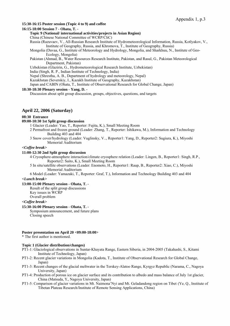
Appendix 1, p.315:30-16:15 Poster session (Topic 4 to 9) and coffee 16:15-18:00 Session 7 - Ohata, T. -
Topic 9 (National/ international activities/projects in Asian Region) China (Chinese National Committee of WCRP/CliC) Russia (Razuvaev, V., All-Russian Research Institute of Hydrometeorological Information, Russia, Kotlyakov, V.,
Institute of Geography, Russia, and Khromova, T., Institute of Geography, Russia) Mongolia (Davaa, G., Institute of Meteorology and Hydrology, Mongolia, and Sharkhuu, N., Institute of Geo-
Ecology, Mongolia) Pakistan (Ahmad, B., Water Resources Research Institute, Pakistan, and Rasul, G., Pakistan Meteorological
Department, Pakistan) Uzbekistan (Glazirin, G., Hydrometeorological Research Institute, Uzbekistan) India (Singh, R. P., Indian Institute of Technology, India) Nepal (Shrestha, A. B., Department of hydrology and meteorology, Nepal) Kazakhstan (Severskiy, I., Kazakh Institute of Geography, Kazakhstan) Japan and CABIN (Ohata, T., Institute of Observational Research for Global Change, Japan)
18:30-18:30 Plenary session - Yang, D. - Discussion about split group discussion, groups, objectives, questions, and targets
April 22, 2006 (Saturday) 08:30 Entrance 09:00-10:30 1st Split group discussion
1 Glacier (Leader: Yao, T., Reporter: Fujita, K.), Small Meeting Room 2 Permafrost and frozen ground (Leader: Zhang, T., Reporter: Ishikawa, M.), Information and Technology
Building 403 and 404 3 Snow cover/hydrology (Leader: Vuglinsky, V.., Reporter1: Yang, D., Reporter2: Sugiura, K.), Miyoshi
Memorial Auditorium <Coffee break> 11:00-12:30 2nd Split group discussion
4 Cryosphere-atmosphere interaction/climate cryosphere relation (Leader: Lingen, B., Reporter1: Singh, R.P., Reporter2: Saito, K.), Small Meeting Room
5 In situ/satellite observations (Leader: Enomoto, H., Reporter1: Raup, B., Reporter2: Xiao, C.), Miyoshi Memorial Auditorium
6 Model (Leader: Yamazaki, T., Reporter: Graf, T.), Information and Technology Building 403 and 404 <Lunch break> 13:00-15:00 Plenary session - Ohata, T. -
Result of the split group discussions Key issues in WCRP Overall problem
<Coffee break> 15:30-16:00 Plenary session - Ohata, T. -
Symposium announcement, and future plans Closing speech
Poster presentation on April 20 <09:00-18:00> * The first author is mentioned. Topic 1 (Glacier distribution/changes) PT1-1: Glaciological observations in Suntar-Khayata Range, Eastern Siberia, in 2004-2005 (Takahashi, S., Kitami
Institute of Technology, Japan) PT1-2: Recent glacier variations in Mongolia (Kadota, T., Institute of Observational Research for Global Change,
Japan) PT1-3: Recent changes of the glacial meltwater in the Terskey-Alatoo Range, Kyrgyz Republic (Narama, C., Nagoya
University, Japan) PT1-4: Production of porous ice on glacier surface and its contribution to albedo and mass balance of July 1st glacier,
China (Matsuda, Y., Nagoya University, Japan) PT1-5: Comparison of glacier variations in Mt. Naimona’Nyi and Mt. Geladandong region on Tibet (Ye, Q., Institute of
Tibetan Plateau Research/Institute of Remote Sensing Applications, China)
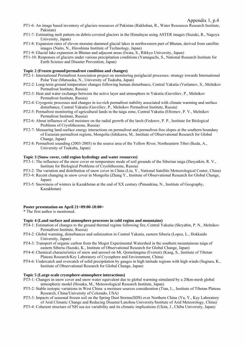
Appendix 1, p.4PT1-6: An image based inventory of glaciers resources of Pakistan (Rakhshan, R., Water Resources Research Institute,
Pakistan) PT1-7: Estimating melt pattern on debris-covered glaciers in the Himalayas using ASTER images (Suzuki, R., Nagoya
University, Japan) PT1-8: Expansion rates of eleven moraine-dammed glacial lakes in northwestern part of Bhutan, derived from satellite
images (Naito, N., Hiroshima Institute of Technology, Japan) PT1-9: Glacial lake expansion in Bhutan and adjacent areas (Iwata, S., Rikkyo University, Japan) PT1-10: Responses of glaciers under various precipitation conditions (Yamaguchi, S., National Research Institute for
Earth Science and Disaster Prevention, Japan) Topic 2 (Frozen ground/permafrost condition and changes) PT2-1: International Permafrost Association project on monitoring periglacial processes: strategy towards International
Polar Year (Matsuoka, N., University of Tsukuba, Japan) PT2-2: Long-term ground temperature changes following human disturbance, Central Yakutia (Varlamov, S., Melnikov
Permafrost Institute, Russia) PT2-3: Heat and water exchange between the active layer and atmosphere in Yakutia (Gavriliev, P., Melnikov
Permafrost Institute, Russia) PT2-4: Cryogenic processes and changes in ice-rich permafrost stability associated with climate warming and surface
disturbance, Central Yakutia (Gavriliev, P., Melnikov Permafrost Institute, Russia) PT2-5: Permafrost monitoring of agricultural lands in the taiga zone, Central Yakutia (Efremov, P. V., Melnikov
Permafrost Institute, Russia) PT2-6: About influence of soil moisture on the radial growth of the larch (Fedorov, P. P., Institute for Biological
Problems of Cryolithozone, Russia) PT2-7: Measuring land-surface energy interactions on permafrost and permafrost-free slopes at the southern boundary
of Eurasian permafrost regions, Mongolia (Ishikawa, M., Institute of Observational Research for Global Change, Japan)
PT2-8: Permafrost sounding (2003-2005) in the source area of the Yellow River, Northeastern Tibet (Ikeda, A., University of Tsukuba, Japan)
Topic 3 (Snow cover, cold region hydrology and water resources) PT3-1: The influence of the snow cover on temperature mode of soil grounds of the Siberian taiga (Desyatkin, R. V.,
Institute for Biological Problems of Cryolithozone, Russia) PT3-2: The variation and distribution of snow cover in China (Liu, Y., National Satellite Meteorological Center, China) PT3-4: Recent changing in snow cover in Mongolia (Zhang Y., Institute of Observational Research for Global Change,
Japan) PT3-5: Snowiness of winters in Kazakhstan at the end of XX century (Pimankina, N., Institute of Geography,
Kazakhstan) Poster presentation on April 21<09:00-18:00> * The first author is mentioned. Topic 4 (Land surface and atmosphere processes in cold region and mountains) PT4-1: Estimation of changes to the ground thermal regime following fire, Central Yakutia (Skryabin, P. N., Melnikov
Permafrost Institute, Russia) PT4-2: Global warming, disturbances and salinization in Central Yakutia, eastern Siberia (Lopez, L., Hokkaido
University, Japan) PT4-3: Transport of organic carbon from the Mogot Experimental Watershed in the southern mountainous taiga of
eastern Siberia (Suzuki, K., Institute of Observational Research for Global Change, Japan) PT4-4: Chemical characteristics of snow and aerosol on Mt. Qomolangma (Everest) (Kang, S., Institute of Tibetan
Plateau Research/Key Laboratory of Cryosphere and Environment, China) PT4-6: Undercatch and overcatch of solid precipitation by gauges in high latitude regions with high winds (Sugiura, K.,
Institute of Observational Research for Global Change, Japan) Topic 5 (Large-scale cryosphere-atmosphere interactions) PT5-1: Changes in snow cover and snow water equivalent due to global warming simulated by a 20km-mesh global
atmospheric model (Hosaka, M., Meteorological Research Institute, Japan) PT5-2: Stable isotopic variations in West China: a moisture sources consideration (Tian, L., Institute of Tibetan Plateau
Research, China/University of Colorado, USA) PT5-3: Impacts of seasonal frozen soil on the Spring Dust Storms(SDS) over Northern China (Yu, Y., Key Laboratory
of Arid Climatic Change and Reducing Disaster/Lanzhou University/Institute of Arid Meteorology, China) PT5-4: Coherent structure of NH sea-ice variability and its climatic implications (Ukita, J., Chiba University, Japan)
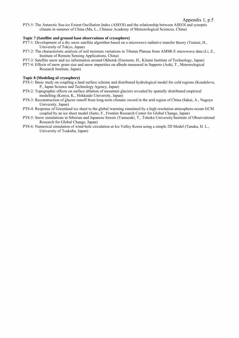
Appendix 1, p.5PT5-5: The Antarctic Sea-ice Extent Oscillation Index (ASEOI) and the relationship between ASEOI and synoptic
climate in summer of China (Ma, L., Chinese Academy of Meteorological Sciences, China) Topic 7 (Satellite and ground base observations of cryosphere) PT7-1: Development of a dry snow satellite algorithm based on a microwave radiative transfer theory (Tsutsui, H.,
University of Tokyo, Japan) PT7-2: The characteristic analysis of soil moisture variations in Tibetan Plateau from AMSR-E microwave data (Li, Z.,
Institute of Remote Sensing Applications, China) PT7-3: Satellite snow and ice information around Okhotsk (Enomoto, H., Kitami Institute of Technology, Japan) PT7-4: Effects of snow grain size and snow impurities on albedo measured in Sapporo (Aoki, T., Meteorological
Research Institute, Japan) Topic 8 (Modeling of cryosphere) PT8-1: Basic study on coupling a land surface scheme and distributed hydrological model for cold regions (Koudelova,
P., Japan Science and Technology Agency, Japan) PT8-2: Topographic effects on surface ablation of mountain glaciers revealed by spatially distributed empirical
modelling (Konya, K., Hokkaido University, Japan) PT8-3: Reconstruction of glacier runoff from long-term climatic record in the arid region of China (Sakai, A., Nagoya
University, Japan) PT8-4: Response of Greenland ice sheet to the global warming simulated by a high resolution atmosphere-ocean GCM
coupled by an ice sheet model (Saito, F., Frontier Research Center for Global Change, Japan) PT8-5: Snow simulations in Siberian and Japanese forests (Yamazaki, T., Tohoku University/Institute of Observational
Research for Global Change, Japan) PT8-6: Numerical simulation of wind-hole circulation at Ice Valley Korea using a simple 2D Model (Tanaka, H. L.,
University of Tsukuba, Japan)
Appendix 2, p. 1
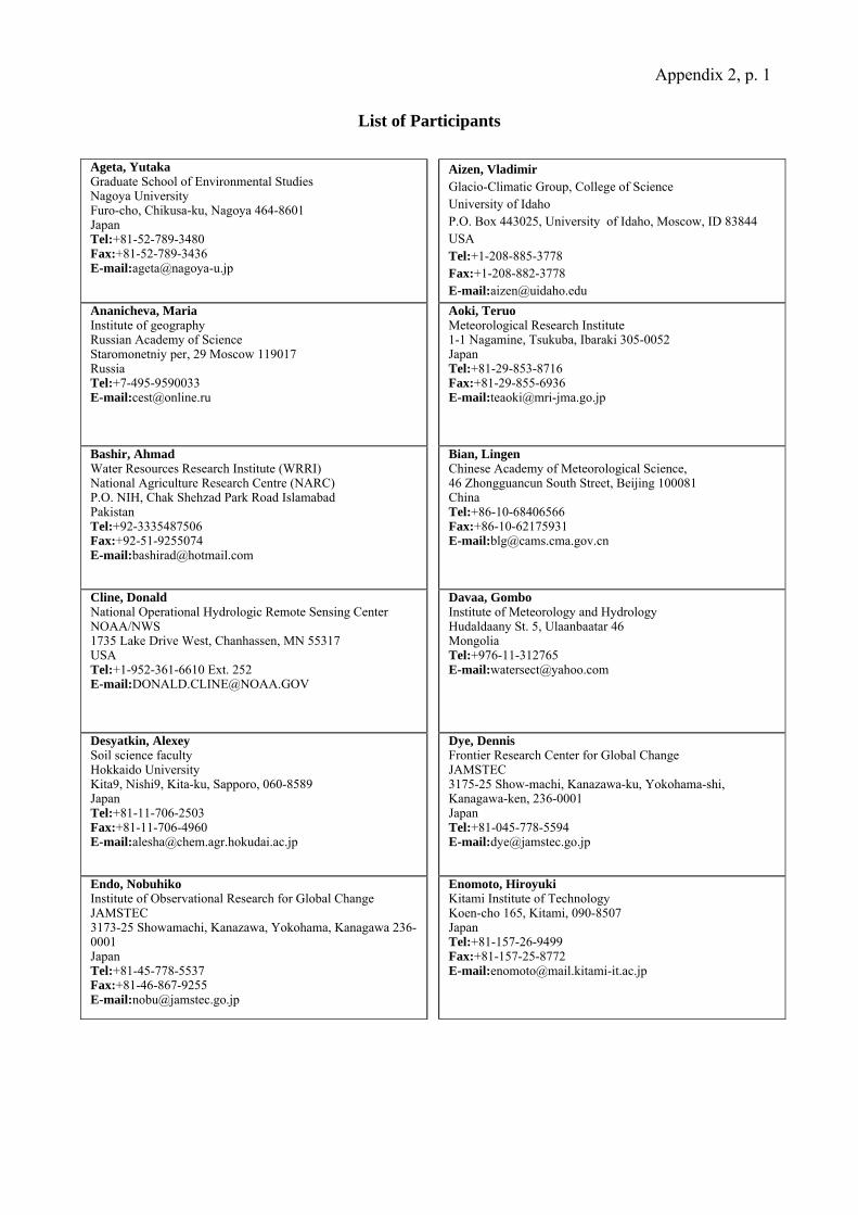
List of Participants
Ageta, Yutaka Graduate School of Environmental Studies Nagoya University Furo-cho, Chikusa-ku, Nagoya 464-8601 Japan Tel:+81-52-789-3480 Fax:+81-52-789-3436 E-mail:[email protected]
Aizen, Vladimir Glacio-Climatic Group, College of Science University of Idaho P.O. Box 443025, University of Idaho, Moscow, ID 83844 USA Tel:+1-208-885-3778 Fax:+1-208-882-3778 E-mail:[email protected]
Ananicheva, Maria Institute of geography Russian Academy of Science Staromonetniy per, 29 Moscow 119017 Russia Tel:+7-495-9590033 E-mail:[email protected]
Aoki, Teruo Meteorological Research Institute 1-1 Nagamine, Tsukuba, Ibaraki 305-0052 Japan Tel:+81-29-853-8716 Fax:+81-29-855-6936 E-mail:[email protected]
Bashir, Ahmad Water Resources Research Institute (WRRI) National Agriculture Research Centre (NARC) P.O. NIH, Chak Shehzad Park Road Islamabad Pakistan Tel:+92-3335487506 Fax:+92-51-9255074 E-mail:[email protected]
Bian, Lingen Chinese Academy of Meteorological Science, 46 Zhongguancun South Street, Beijing 100081 China Tel:+86-10-68406566 Fax:+86-10-62175931 E-mail:[email protected]
Cline, Donald National Operational Hydrologic Remote Sensing Center NOAA/NWS 1735 Lake Drive West, Chanhassen, MN 55317 USA Tel:+1-952-361-6610 Ext. 252 E-mail:[email protected]
Davaa, Gombo Institute of Meteorology and Hydrology Hudaldaany St. 5, Ulaanbaatar 46 Mongolia Tel:+976-11-312765 E-mail:[email protected]
Desyatkin, Alexey Soil science faculty Hokkaido University Kita9, Nishi9, Kita-ku, Sapporo, 060-8589 Japan Tel:+81-11-706-2503 Fax:+81-11-706-4960 E-mail:[email protected]
Dye, Dennis Frontier Research Center for Global Change JAMSTEC 3175-25 Show-machi, Kanazawa-ku, Yokohama-shi, Kanagawa-ken, 236-0001 Japan Tel:+81-045-778-5594 E-mail:[email protected]
Endo, Nobuhiko Institute of Observational Research for Global Change JAMSTEC 3173-25 Showamachi, Kanazawa, Yokohama, Kanagawa 236-0001 Japan Tel:+81-45-778-5537 Fax:+81-46-867-9255 E-mail:[email protected]
Enomoto, Hiroyuki Kitami Institute of Technology Koen-cho 165, Kitami, 090-8507 Japan Tel:+81-157-26-9499 Fax:+81-157-25-8772 E-mail:[email protected]
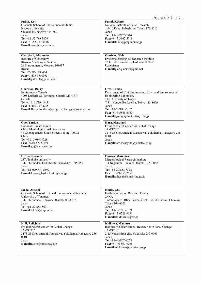
Appendix 2, p. 2Fujita, Koji Graduate School of Environmental Studies Nagoya University Chikusa-ku, Nagoya 464-8601 Japan Tel:+81-52-789-3479 Fax:+81-52-789-3436 E-mail:[email protected]
Fukui, Kotaro National Institute of Polar Research 1-9-10 Kaga, Itabashi-ku, Tokyo 173-8515 Japan Tel:+81-3-3962-5514 Fax:+81-3-3962-5719 E-mail:[email protected]
Georgiadi, Alexander Institute of Geography Russian Academy of Science 29 Staromonetny, Moscow 109017 Russia Tel:+7-095-1290474 Fax:+7-495-9590033 E-mail:[email protected]
Glazirin, Gleb Hydrometeorological Research Institute 72 K. makhsumov st., Tashkent,700052 Uzbekistan E-mail:[email protected]
Goodison, Barry Environment Canada 4905 Dufferin St, Toronoto, Ontario M3H 5T4 Canada Tel:+1-416-739-4345 Fax:+1-416-739-4265 E-mail:[email protected], [email protected]
Graf, TobiasDepartment of Civil Engineering, River and Environmental Engineering Laboratory The University of Tokyo 7-3-1 Hongo, Bunkyo-ku, Tokyo 113-8656 Japan Tel:+81-3-5841-6107 Fax:+81-3-5841-6130 E-mail:[email protected]
Guo, Yanjun National Climate Center China Meterological Administration 46 Zhongguancun South Street, Beijing 100081 China Tel:+8610-68408728 Fax:+8610-62172591 E-mail:[email protected]
Hara, Masayuki Frontier reserch center fot Global Change JAMSTEC 3173-25 Showamachi, Kanazawa, Yokohama, Kanagawa 236-0001 Japan E-mail:[email protected]
Hirose, Nozomu JST, Tsukuba university 1-1-1 Tennodai, Tsukuba-shi Ibaraki-ken, 305-8577 Japan Tel:+81-029-853-5692 E-mail:[email protected]
Hosaka, Masahiro Meteorological Research Institute 1-1 Nagamine, Tsukuba, Ibaraki, 305-0052 Japan Tel:+81-29-853-8598 Fax:+81-29-855-2552 E-mail:[email protected]
Ikeda, Atsushi Graduate School of Life and Environmental Sciences University of Tsukuba 1-1-1 Tennoudai, Tsukuba, Ibaraki 305-8572 Japan Tel:+81-29-853-5691 E-mail:[email protected]
Ishida, ChuEarth Observation Research Center JAXA Triton Square Office Tower-X 23F, 1-8-10 Harumi, Chuo-ku, Tokyo 104-6023 Japan Tel:+81-3-6221-9139 Fax:+81-3-6221-9191 E-mail:[email protected]
Ishii, Reiichiro Frontier reserch center fot Global Change JAMSTEC 3173-25 Showamachi, Kanazawa, Yokohama, Kanagawa 236-0001 Japan E-mail:[email protected]
Ishikawa, Mamoru Institute of Observational Research for Global Change JAMSTEC 2-15 Natsushima-cho, Yokosuka 237-0061 Japan Tel:+81-46-867-9278 Fax:+81-46-867-9255 E-mail:[email protected]
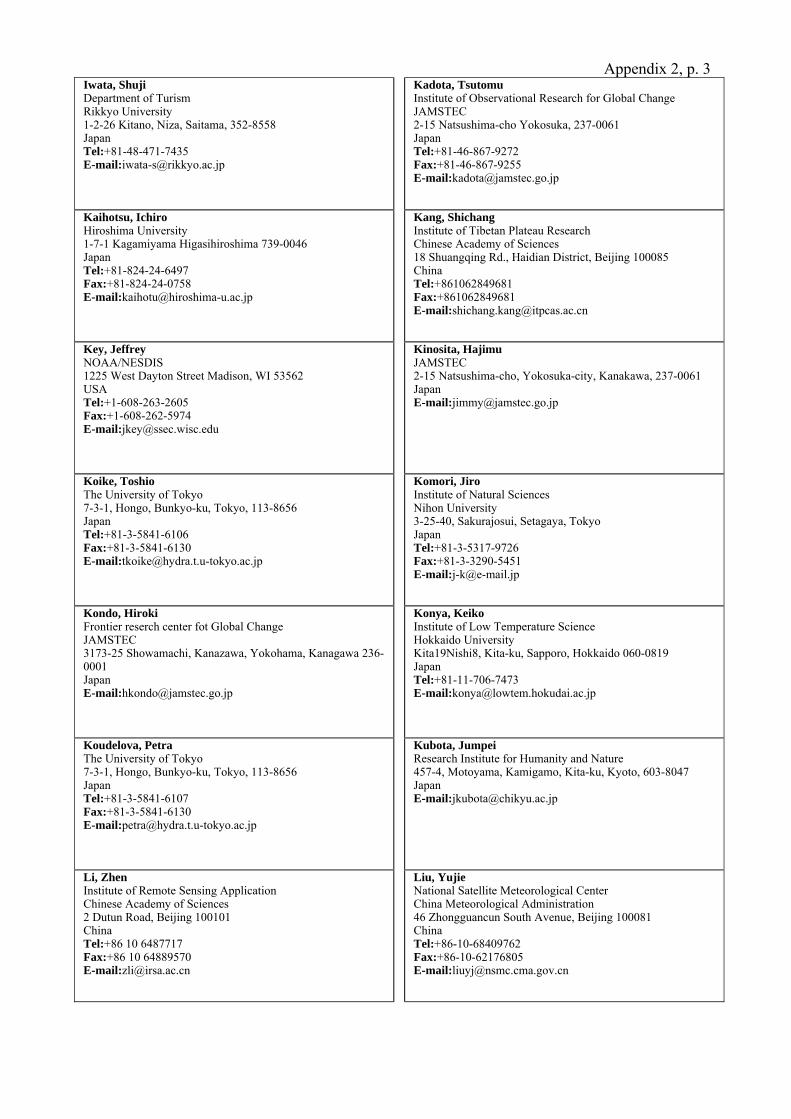
Appendix 2, p. 3Iwata, Shuji Department of Turism Rikkyo University 1-2-26 Kitano, Niza, Saitama, 352-8558 Japan Tel:+81-48-471-7435 E-mail:[email protected]
Kadota, Tsutomu Institute of Observational Research for Global Change JAMSTEC 2-15 Natsushima-cho Yokosuka, 237-0061 Japan Tel:+81-46-867-9272 Fax:+81-46-867-9255 E-mail:[email protected]
Kaihotsu, Ichiro Hiroshima University 1-7-1 Kagamiyama Higasihiroshima 739-0046 Japan Tel:+81-824-24-6497 Fax:+81-824-24-0758 E-mail:[email protected]
Kang, Shichang Institute of Tibetan Plateau Research Chinese Academy of Sciences 18 Shuangqing Rd., Haidian District, Beijing 100085 China Tel:+861062849681 Fax:+861062849681 E-mail:[email protected]
Key, Jeffrey NOAA/NESDIS 1225 West Dayton Street Madison, WI 53562 USA Tel:+1-608-263-2605 Fax:+1-608-262-5974 E-mail:[email protected]
Kinosita, Hajimu JAMSTEC 2-15 Natsushima-cho, Yokosuka-city, Kanakawa, 237-0061 Japan E-mail:[email protected]
Koike, Toshio The University of Tokyo 7-3-1, Hongo, Bunkyo-ku, Tokyo, 113-8656 Japan Tel:+81-3-5841-6106 Fax:+81-3-5841-6130 E-mail:[email protected]
Komori, Jiro Institute of Natural Sciences Nihon University 3-25-40, Sakurajosui, Setagaya, Tokyo Japan Tel:+81-3-5317-9726 Fax:+81-3-3290-5451 E-mail:[email protected]
Kondo, Hiroki Frontier reserch center fot Global Change JAMSTEC 3173-25 Showamachi, Kanazawa, Yokohama, Kanagawa 236-0001 Japan E-mail:[email protected]
Konya, Keiko Institute of Low Temperature Science Hokkaido University Kita19Nishi8, Kita-ku, Sapporo, Hokkaido 060-0819 Japan Tel:+81-11-706-7473 E-mail:[email protected]
Koudelova, Petra The University of Tokyo 7-3-1, Hongo, Bunkyo-ku, Tokyo, 113-8656 Japan Tel:+81-3-5841-6107 Fax:+81-3-5841-6130 E-mail:[email protected]
Kubota, Jumpei Research Institute for Humanity and Nature 457-4, Motoyama, Kamigamo, Kita-ku, Kyoto, 603-8047 Japan E-mail:[email protected]
Li, Zhen Institute of Remote Sensing Application Chinese Academy of Sciences 2 Dutun Road, Beijing 100101 China Tel:+86 10 6487717 Fax:+86 10 64889570 E-mail:[email protected]
Liu, Yujie National Satellite Meteorological Center China Meteorological Administration 46 Zhongguancun South Avenue, Beijing 100081 China Tel:+86-10-68409762 Fax:+86-10-62176805 E-mail:[email protected]
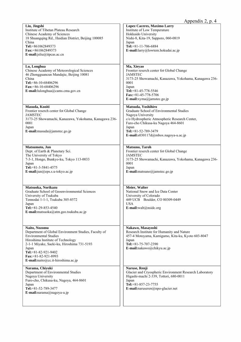
Appendix 2, p. 4Liu, Jingshi Institute of Tibetan Plateau Research Chinese Academy of Sciences 18 Shuangqing Rd., Haidian District, Beijing 100085 China Tel:+861062849373 Fax:+861062849373 E-mail:[email protected]
Lopez Caceres, Maximo Larry Institute of Low Temperature Hokkaido University Nishi-8, Kita-19, Sapporo, 060-0819 Japan Tel:+81-11-706-6884 E-mail:[email protected]
Lu, Longhua Chinese Academy of Meteorological Sciences 46 Zhongguancun Mandajie, Beijing 10081 China Tel:+86-10-68406296 Fax:+86-10-68406296 E-mail:[email protected]
Ma, XieyaoFrontier reserch center fot Global Change JAMSTEC 3173-25 Showamachi, Kanazawa, Yokohama, Kanagawa 236-0001 Japan Tel:+81-45-778-5546 Fax:+81-45-778-5706 E-mail:[email protected]
Masuda, Kooiti Frontier reserch center fot Global Change JAMSTEC 3173-25 Showamachi, Kanazawa, Yokohama, Kanagawa 236-0001 Japan E-mail:[email protected]
Matsuda, Yoshihiro Graduate School of Environmental Studies Nagoya University c/o Hydrospheric Atmospheric Research Center, Furo-cho Chikusa-ku Nagoya 464-8601 Japan Tel:+81-52-789-3479 E-mail:[email protected]
Matsumoto, Jun Dept. of Earth & Planetary Sci. The University of Tokyo 7-3-1, Hongo, Bunkyo-ku, Tokyo 113-0033 Japan Tel:+81-3-5841-4575 E-mail:[email protected]
Matsuno, Taroh Frontier reserch center fot Global Change JAMSTEC 3173-25 Showamachi, Kanazawa, Yokohama, Kanagawa 236-0001 Japan E-mail:[email protected]
Matsuoka, Norikazu Graduate School of Geoenvironmental Sciences University of Tsukuba Tennodai 1-1-1, Tsukuba 305-8572 Japan Tel:+81-29-853-4540 E-mail:[email protected]
Meier, Walter National Snow and Ice Data Center University of Colorado 449 UCB Boulder, CO 80309-0449 USA E-mail:[email protected]
Naito, Nozomu Department of Global Environment Studies, Faculty of Environmental Studies Hiroshima Institute of Technology 2-1-1 Miyake, Saeki-ku, Hiroshima 731-5193 Japan Tel:+81-82-921-9402 Fax:+81-82-921-8993 E-mail:[email protected]
Nakawo, Masayoshi Research Institute for Humanity and Nature 457-4 Motoyama, Kamigamo, Kita-ku, Kyoto 603-8047 Japan Tel:+81-75-707-2390 E-mail:[email protected]
Narama, Chiyuki Department of Environmental Studies Nagoya University Furo-cho, Chikusa-ku, Nagoya, 464-8601 Japan Tel:+81-52-789-3477 E-mail:[email protected]
Naruse, Renji Glacier and Cryospheric Environment Research Laboratory Higashi-machi 2-339, Tottori, 680-0011 Japan Tel:+81-857-23-7755 E-mail:[email protected]
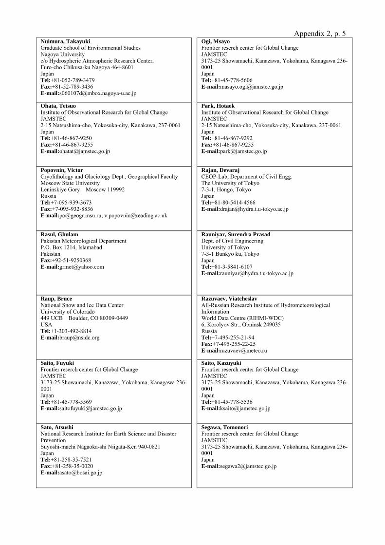
Appendix 2, p. 5Nuimura, Takayuki Graduate School of Environmental Studies Nagoya University c/o Hydrospheric Atmospheric Research Center, Furo-cho Chikusa-ku Nagoya 464-8601 Japan Tel:+81-052-789-3479 Fax:+81-52-789-3436 E-mail:[email protected]
Ogi, Msayo Frontier reserch center fot Global Change JAMSTEC 3173-25 Showamachi, Kanazawa, Yokohama, Kanagawa 236-0001 Japan Tel:+81-45-778-5606 E-mail:[email protected]
Ohata, Tetsuo Institute of Observational Research for Global Change JAMSTEC 2-15 Natsushima-cho, Yokosuka-city, Kanakawa, 237-0061 Japan Tel:+81-46-867-9250 Fax:+81-46-867-9255 E-mail:[email protected]
Park, Hotaek Institute of Observational Research for Global Change JAMSTEC 2-15 Natsushima-cho, Yokosuka-city, Kanakawa, 237-0061 Japan Tel:+81-46-867-9292 Fax:+81-46-867-9255 E-mail:[email protected]
Popovnin, Victor Cryolithology and Glaciology Dept., Geographical Faculty Moscow State University Leninskiye Gory Moscow 119992 Russia Tel:+7-095-939-3673 Fax:+7-095-932-8836 E-mail:[email protected], [email protected]
Rajan, Devaraj CEOP-Lab, Department of Civil Engg. The University of Tokyo 7-3-1, Hongo, Tokyo Japan Tel:+81-80-5414-4566 E-mail:[email protected]
Rasul, Ghulam Pakistan Meteorological Department P.O. Box 1214, Islamabad Pakistan Fax:+92-51-9250368 E-mail:[email protected]
Rauniyar, Surendra Prasad Dept. of Civil Engineering University of Tokyo 7-3-1 Bunkyo ku, Tokyo Japan Tel:+81-3-5841-6107 E-mail:[email protected]
Raup, Bruce National Snow and Ice Data Center University of Colorado 449 UCB Boulder, CO 80309-0449 USA Tel:+1-303-492-8814 E-mail:[email protected]
Razuvaev, ViatcheslavAll-Russian Research Institute of Hydrometeorological Information World Data Centre (RIHMI-WDC) 6, Korolyov Str., Obninsk 249035 Russia Tel:+7-495-255-21-94 Fax:+7-495-255-22-25 E-mail:[email protected]
Saito, Fuyuki Frontier reserch center fot Global Change JAMSTEC 3173-25 Showamachi, Kanazawa, Yokohama, Kanagawa 236-0001 Japan Tel:+81-45-778-5569 E-mail:[email protected]
Saito, Kazuyuki Frontier reserch center fot Global Change JAMSTEC 3173-25 Showamachi, Kanazawa, Yokohama, Kanagawa 236-0001 Japan Tel:+81-45-778-5536 E-mail:[email protected]
Sato, Atsushi National Research Institute for Earth Science and Disaster Prevention Suyoshi-machi Nagaoka-shi Niigata-Ken 940-0821 Japan Tel:+81-258-35-7521 Fax:+81-258-35-0020 E-mail:[email protected]
Segawa, Tomonori Frontier reserch center fot Global Change JAMSTEC 3173-25 Showamachi, Kanazawa, Yokohama, Kanagawa 236-0001 Japan E-mail:[email protected]
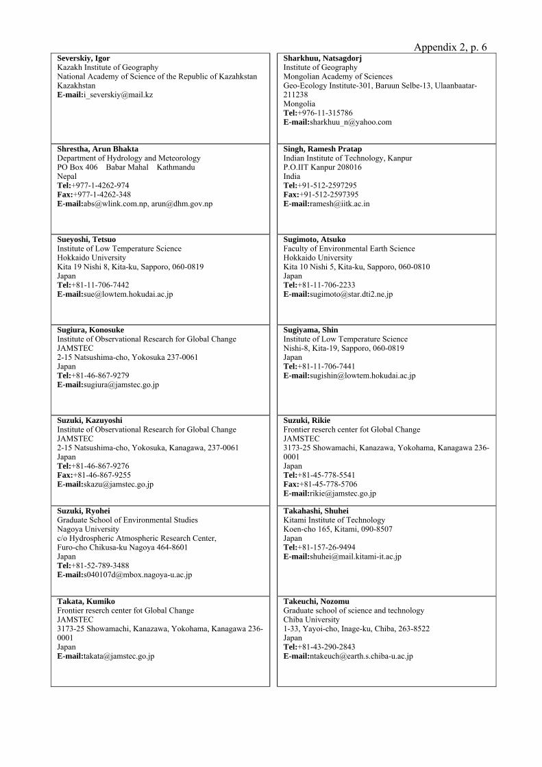
Appendix 2, p. 6Severskiy, Igor Kazakh Institute of Geography National Academy of Science of the Republic of Kazahkstan Kazakhstan E-mail:[email protected]
Sharkhuu, Natsagdorj Institute of Geography Mongolian Academy of Sciences Geo-Ecology Institute-301, Baruun Selbe-13, Ulaanbaatar-211238 Mongolia Tel:+976-11-315786 E-mail:[email protected]
Shrestha, Arun Bhakta Department of Hydrology and Meteorology PO Box 406 Babar Mahal Kathmandu Nepal Tel:+977-1-4262-974 Fax:+977-1-4262-348 E-mail:[email protected], [email protected]
Singh, Ramesh Pratap Indian Institute of Technology, Kanpur P.O.IIT Kanpur 208016 India Tel:+91-512-2597295 Fax:+91-512-2597395 E-mail:[email protected]
Sueyoshi, Tetsuo Institute of Low Temperature Science Hokkaido University Kita 19 Nishi 8, Kita-ku, Sapporo, 060-0819 Japan Tel:+81-11-706-7442 E-mail:[email protected]
Sugimoto, Atsuko Faculty of Environmental Earth Science Hokkaido University Kita 10 Nishi 5, Kita-ku, Sapporo, 060-0810 Japan Tel:+81-11-706-2233 E-mail:[email protected]
Sugiura, Konosuke Institute of Observational Research for Global Change JAMSTEC 2-15 Natsushima-cho, Yokosuka 237-0061 Japan Tel:+81-46-867-9279 E-mail:[email protected]
Sugiyama, Shin Institute of Low Temperature Science Nishi-8, Kita-19, Sapporo, 060-0819 Japan Tel:+81-11-706-7441 E-mail:[email protected]
Suzuki, Kazuyoshi Institute of Observational Research for Global Change JAMSTEC 2-15 Natsushima-cho, Yokosuka, Kanagawa, 237-0061 Japan Tel:+81-46-867-9276 Fax:+81-46-867-9255 E-mail:[email protected]
Suzuki, RikieFrontier reserch center fot Global Change JAMSTEC 3173-25 Showamachi, Kanazawa, Yokohama, Kanagawa 236-0001 Japan Tel:+81-45-778-5541 Fax:+81-45-778-5706 E-mail:[email protected]
Suzuki, Ryohei Graduate School of Environmental Studies Nagoya University c/o Hydrospheric Atmospheric Research Center, Furo-cho Chikusa-ku Nagoya 464-8601 Japan Tel:+81-52-789-3488 E-mail:[email protected]
Takahashi, Shuhei Kitami Institute of Technology Koen-cho 165, Kitami, 090-8507 Japan Tel:+81-157-26-9494 E-mail:[email protected]
Takata, Kumiko Frontier reserch center fot Global Change JAMSTEC 3173-25 Showamachi, Kanazawa, Yokohama, Kanagawa 236-0001 Japan E-mail:[email protected]
Takeuchi, Nozomu Graduate school of science and technology Chiba University 1-33, Yayoi-cho, Inage-ku, Chiba, 263-8522 Japan Tel:+81-43-290-2843 E-mail:[email protected]
Appendix 2, p. 7Tanaka, Hiroshi Center for Computational Sciences University of Tsukuba Teno-dai 1-1-1, Tsukuba, Ibaraki 305-8572 Japan Tel:+81-29-853-4502 Fax:+81-29-853-6879 E-mail:[email protected]
Tanaka, Noriyuki EORC, JAXA Triton Square Office Tower-X 23F, 1-8-10 Harumi, Chuo-ku, Tokyo 104-6023 Japan E-mail:[email protected], [email protected]
Tian, Lide Institute of Tibetan Plateau Research Chinese Academy of Sciences 18 Shuangqing Rd., Haidian District, Beijing 100085 China Tel:+861062849390 E-mail:[email protected]
Tsutsui, Hiroyuki Department of Civil Engineering The university of Tokyo 7-3-1, Hongo, Bunkyo-ku, Tokyo, 113-8656 Japan Tel:+81-3-5841-6105 E-mail:[email protected]
Uekatke, Jun Tokyo Institute of Technology 2-12-1 Ookayama, Meguro-ku, Tokyo, 152-8550 Japan
Ueno, Kenichi The Univ. Tsukuba Teno-dai 1-1-1, Tsukuba, Ibaraki 305-8572 Japan E-mail:[email protected]
Ukita, Jinro Center for Environmental Remote Sensing Chiba University 1-33, Yayoi-cho, Inage-ku, Chiba, 263-8522 Japan Tel:+81-43-290-3847 E-mail:[email protected], [email protected]
Vuglinsky, Valery State Hydrological Institute 2nd Line 23, St. Petersburg Russia E-mail:[email protected]
Xiao, Cunde Chinese Academy of Meteorological Sciences 46 Zhongguancun South Avenue, Beijing 10081 China Tel:+86-10-68407410 Fax:+86-10-62175931 E-mail:[email protected]
Xu, Jianging Frontier reserch center fot Global Change JAMSTEC 3173-25 Showamachi, Kanazawa, Yokohama, Kanagawa 236-0001 Japan E-mail:[email protected]
Yabuki, Hironori Institute of Observational Research for Global Change JAMSTEC 2-15 Natsushima-cho, Yokosuka-city, Kanakawa, 237-0061 Japan Tel:+81-46-867-9268 Fax:+81-46-867-9255 E-mail:[email protected]
Yamaguchi, Satoru National Research Institute for Earth Science and Disaster Prevention Suyoshi-machi Nagaoka-shi Niigata-Ken 940-0821 Japan Tel:+81-258-35-7522 Fax:+81-258-0020 E-mail:[email protected]
Yamazaki, Takeshi Tohoku Univ. / JAMSTEC IORGC Aza-Aoba, Aramaki, Aoba-ku, Sendai, 980-8578 Japan Tel:+81-22-795-5781 Fax:+81-22-795-7758 E-mail:[email protected]
Yang, Daqing Water and Environmental Research Center University of Alaska Fairbanks AK 99775 USA Tel:+1-907-474-2468 E-mail:[email protected]

Appendix 2, p. 8Yao, Tandong Institute of Tibetan Plateau Research Chinese Academy of Sciences 18 Shuangqing Rd., Haidian District, Beijing 100085 China Tel:+861062849071 E-mail:[email protected]
Yasunari, Tetsuzo Hydrospheric Atmospheric Research Center Nagoya University / FRCGC, JAMSTEC Furo-cho, Chikusa-ku, Nagoya 464-8601 Japan Tel:+81-52-789-3465 Fax:+81-52-789-3436 E-mail:[email protected]
Ye, Qinghua Institute of Tibetan Plateau Research Chinese Academy of Sciences 18 Shuangqing Rd., Haidian District, Beijing 100085 China Tel:+861062849397 Fax:+861062849886 E-mail:[email protected]
Yoshizaki, Masanori Institute of Observational Research for Global Change JAMSTEC 2-15 Natsushima-cho, Yokosuka-city, Kanakawa, 237-0061 Japan E-mail:[email protected]
Yu, Yaxun Institute of Arid Meteorology, CMA, Lanzhou Key Laboratory of Arid Climate Change and Reducing Disaster 2070, Donggang East Road, Lanzhau 730020, gansu China Tel:+86-931-4670216-2495 Fax:+86-931-4670216-2493 E-mail:[email protected]
Zhang, Peiqun National Climate Center China Meterological Administration 46 Zhongguancun South Street, Beijing 100081 China Tel:+8610-68407175 Fax:+8610-68407427 E-mail:[email protected]
Zhang, Dongqi Chinese Academy of Meteorological Sciences 46 Zhongguancun South Street, Beijing 100081 China Tel:+861068407410 E-mail:[email protected]
Zhang, Yinsheng Institute of Observational Research for Global Change JAMSTEC 2-15 Natsushima-cho, Yokosuka-city, Kanakawa, 237-0061 Japan Tel:+81-46-8679273 E-mail:[email protected]
Zhang, Tingjun National Snow and Ice Data Center 449 UCB Boulder, CO 80309-0449 USA Tel:+1-303-492-5236 E-mail:[email protected]
Zhao, LinCold and Arid Regions Environmental and Engineering Research Institute Chinese Academy of Sciences 320 Donggang West Road, Lanzhou,Gansu, 730000 China Tel:+86-931-4967391 Fax:+86-931-8276147 E-mail:[email protected]
Zheleznyak, Mikhail Melnikov Permafrost Institute SB RAS / Yakut State University Faculty of Ceology Yakutsk, Respublica Sasha (Yakutia),677010 Russia Tel:+7-4112-33-46-58 Fax:+7-4112-33-44-76 E-mail:[email protected]
Appendix 3, p.1 National Reports
Cryospheric Studies in Russia
Vyacheslav Razuvaev, Vladimir Kotlyakov, Tatiana Khromova
Selected ongoing Russia-CliC Activities A. Glaciers 1. Evolution of the low limit of “hyonosphere” and glaciers in North Eastern Siberia,
including the Pole of Cold of Eurasia The World Atlas of Snow and Ice Resources (1997) introduced a new, “glacier-system” approach for the assessment
of spatial distribution (fields) of Equilibrium Line Altitude (ELA) in high mountains, snow accumulation, solid
precipitation and run-off. As a next step in the development of this approach, the ELA and climatic snow line (low
limit of “khionosphere”) field of evolution study for present and future climate change is proposed. This approach
makes it possible to estimate the evolution of precipitation and run-off in the high mountains. Regions under
investigation are North-East Siberia (IPY 274) including Kamchatka peninsula, Polar Ural and Franz-Joseph Land
(Western Arctic). Other glacier systems will also be studied.
Contact persons: Alexander N.Krenke ([email protected]) and Maria D. Ananicheva ([email protected])
2. The current development of mountain glaciers in Northern Eurasia in conditions of global
climate warming Glaciers are dynamically unstable systems which may react rapidly to climate change. The glacier melts saturating the
soft till deposits leads to highly unstable moraine complexes. Glacier retreat suggests glacial zone landscape changes,
new lakes being formed, and even activation of natural disaster processes, such as catastrophic mudslides, ice
avalanches, floods, etc. The presence of glaciers in itself may pose a threat to human life, economic activity or growing
infrastructures. But continued economical stability and human activity in mountain regions depend on access to current
and relevant information on cryospheric processes. Lack of information and subsequent action may result in financial
and human loss. One of the major aims of the project is to study the current development of mountain glaciers in
Northern Eurasia in conditions of global climate warming and define of the role of local environmental changes -
specifically the origin of natural disasters and glacial processes. The assessment of current and future glacier change
requires an effective monitoring system, including ground-truth and remote-sensing studies. As instrumental time series
from ground observations decrease, and remote sensing information increase, creating a continuous and consistent time
series becomes very difficult. This project aims to resolve the problem and develop a mechanism to simultaneously
analyze and assess glacier extent as a part of glacier monitoring system.
Contact person: Tatiana Khromova ([email protected])
Appendix 3, p.2 3. Glaciers retreat in the central Tien Shan Mountains The retreat of the terminus of glaciers and reduction of glacier areas since their maximum extend during the “Little Ice
Age” maximum (LIA) (XVIIth-XIXth centuries) were estimated using aerial photographs (from 1956 to 1987) and
recent satellite images (2001 to 2004) in the central Tien Shan mountains (Kyrgyz Republic). The glaciers under
investigation are located on Teskey Alatau, Suek and Dzhetim-bel. On average, glaciers in these areas have retreated
900-600 m since the LIA maximum. Thus, in the second part of XXth century, glacier areas changed by about 25-30%
compared with 5-8% between 1880 and 1970s. Unprecedented melt and structural changes of glaciers in the Tien Shan
from the mid-1970s till the beginning of the XXI century most likely resulted from increased summer air temperatures
and decreased summer precipitation (meteorological records from Tien-Shan station and others.). The change in
atmospheric pressure over the central North Atlantic Ocean during the mid-1970s may be one possible reason for these
processes.
This study is supported by ISTC grant №2947
Contact person: Stanislav Kutuzov ([email protected])
4. Polar glaciers and ice caps as indicator of climate change All available data during the last decade indicate a negative development trend in glaciers and ice caps in polar regions.
These negative trends are manifested in:
• reduced glacier length, area and ice surface elevation;
• long-term negative glacier mass balance records;
• shift of equilibrium line altitude (ELA) and ice facies zones;
• change in hydro-thermal state and internal structure of polythermal glaciers;
• temperature changes in the surficial active layer;
• instability of glacier behavior such as surge activity and iceberg outbursts;
• trends in shallow and deep ice cores records.
Nevertheless, these glaciological indicators of climate change derived from conventional observations are often scarce
and sometimes completely lacking. Hence the IPY provides a unique opportunity to combine the extended field
observations with a variety of remote sensing data and to reveal the comprehensive bipolar picture of the current state of
glaciers as the indicator of climate change and the benchmark for comparison with past and future state, interpretation
of most sensitive areas, and modelling. The primary lines of investigations are:
• State and dynamics of polar glaciers and ice caps
• Surficial and internal properties of polar glaciers and ice cap
• Deep ice-core drilling of polar glaciers and ice caps
• Iceberg calving of polar glaciers and ice caps
For each selected glacier, or ice cap, the following parameters will be measured in remotely or in the field:
• surface mass balance
• surface velocities (3-dimensional), preferably including seasonal cycle
• bed topography o surface topography (with high accuracy)
• surface albedo at the end of the ablation season
• calving rates
Appendix 3, p.3 • water pressure in boreholes o temperature profiles in the ice (for polythermal glaciers).
In addition, historical and proxy information on glacier length/area will be combined with new maps and images to
reconstruct glacier evolution from the Little Ice Age to the present. Study methods are:
• Ground mass-balance and hydrological studies on glaciers using standard approaches and snow radar transects
and shallow drilling
• Glacier surface elevation and surface velocity measurements (ground-based, aerial and satellite surveys)
• Interpretation and analysis of radar and passive images in different bands for glacier geometry, velocity,
dynamics and ice-facies studies
• Radio echo-sounding for internal structure and hydrothermal state studies
• Deep ice core drilling, bore hole and ice core studies
• Studies of glacial deposits and landforms
Contact person: Andrey Glazovsky ([email protected])
5. The evaluation of the dynamics of Antarctic Ice Sheet discharge in the second part of XX
century The goal of this project is to measure the impact of climate change on the Antarctic Ice Sheet marginal zone. To do
this, satellite images will be incorporated into a GIS database, these will be combined with direct instrumental geodetic
and glaciological measurements and meteorological data from coastal and island stations. It allows the extension of
time frame information for Antarctic Ice Sheet marginal zone change estimation, and the correlation of glacier and
climate dynamics. So far, the structure and content of the data base has been developed, and several sources of spatial
information have been analyzed. All this information now exists in database an ARCGIS coverage dataset in vector and
raster formats. This arrangement allows simultaneous analyzes of any set of data, entering of new information into data
base on-the-fly, and planning field studies. The databases for ground base-, remote-sensing- and meteorological
information for selected ice drainage basins (II, III, IV, V and VI) of East Antarctica have been formed. These data
were analyzed together with information on ice movement, sheet marginal zone dynamic and accumulations. It was
found that the mass balance of these basins was positive for all instrumental observations periods.
Contact person: Maxim Moskalevsky ([email protected])
6. Changes of hydrothermal state of subsurface snow-firn sequences of Antarctic ice sheet derived
from Kosmos-1500, ERS 1/2 and RADARSAT 1/2 radar images as an indicator of climate
change
Variations in snow density stratigraphy of glaciers and ice sheets are very sensitive to the seasonal and annual surface
temperature changes and therefore can be suggested as good indicators of short-term variations of climate conditions.
Radar images are very sensitive to the water and ice inclusions especially subsurface. They are probably the best
instrument for remote sensing studies of current state and changes in hydrothermal state of upper layers over large areas
such as Antarctic ice sheet. Changes are determined using the spatial and temporal differences in backscatter.
Appendix 3, p.4 Radar images of Antarctic ice sheet were obtained for the first time in 1983-86 by Russian side-
looking radar onboard Kosmos-1500 satellite. Using this data, the first digital radar mosaic of the whole Antarctic ice
sheet (consing of 36 frames) was constructed.
From this, a number of zones with different brightness characteristics were found, indicating subsurface ice lenses.
Subsequent missions of ERS 1/2 and RADARSAT 1/2 satellite provided more detailed radar mosaics of Antarctic ice
sheet and the corresponding backscatter characteristics.
The goal of the project is to compare the data on hydrothermal state of snow-firn sequences derived from the different
sensors to determine the changes which can be correlated with climate variations.
Contact person: Maxim Moskalevsky ([email protected])
B. Snow Cover 1. Change in snow-cover characteristics over Northern Eurasia under present climate change The change in snow-cover characteristics over Northern Eurasia under present climate change is being studied. We
created a homogeneous data base for the period 1936 -2000. Despite warming, the snow depth and snow-water
equivalent increased due to more intensive cyclonic activity and winter precipitation in most of the regions, except in
the southern and western parts of the East-European plain and part of the Turan plain. A method was developed to
estimate the possible upper limit of snow storage that can accumulate due to increase in winter temperatures and
precipitation over multiple years. This upper limit has reportedly not yet been achieved in the North Eurasia territory.
This means that the continuing increase of winter temperatures is not yet likely to result in lower snow storage values.
The relationship between snow cover and circulation patterns regime was studied using various circulation indices. The
next step is to construct future snow cover scenarios using different climate scenarios.
Contact persons: Krenke ([email protected]), V.Razuvaev ([email protected]), L.Kitaev ([email protected]).
2. Snow stratigraphy and long-term meteorological time series in various regions of Northern
Eurasia Data set of snow stratigraphy and long-term meteorological time series in various regions of Northern Eurasia has been
created. Parameterization scheme of the snow cover stratigraphy classes for climate and hydrological models has been
developed and tested against observed data.
This activity is accomplished within INTAS project No 03-515296
Contact person: Adrey B. Shmakin ([email protected])
3. Microwave data for an estimation of characteristics of snow cover Snow cover exerts direct influence on climate dynamics. The ability to assess its current global state and water
equivalent on a seasonal-and long-term scale is important in order to understand climate change and to develop forecast
models. Moreover, assessing Snow-cover Water Equivalent (SWE) on the scale of a river basin is necessary in order to
plan and manage water resources, including forecasting and prevention of floods during melting season. The current
lack of ground-based data on the state of snow cover, especially for the Russian sub-polar regions, necessitates the
collection of new microwave remote sensing data for SWE assessment. Preliminary studies based on AMSR-E and
SSM/I data for the winter periods 2003-2005 on test sites in European part of Russia (the Polar Urals and Siberia)
Appendix 3, p.5 indicate a large (by 2-4 times) difference in ground snow survey data and SWE data retrieved by
remote sensing. Thus, one universal algorithm does not provide the desired accuracy. Additional studies and regional
approach in interpretation of remote sensing data are therefore required. One possible solution is zoning and adaptation
of available algorithms, or searching for new ones that will be valid for the uniform areal climate or landscape
conditions. Implementation of this approach is the major target of this project. Another aim is to calibrate the Russian
radiometer planned for launch on the “Canopus-Vulkan» satellite in 2007. Considerable contribution in the problem
solving might benefit from the synchronous measurements of snow cover parameters specially designed in the frame of
IPY-2007.
Contact person: Gennady Nosenko ([email protected])
C. Ice Cores Ice-core studies on Western firn plateau of Mt. Elbrus in Caucasus Shallow ice cores, 21.41 m depth, were recovered on the Western firn plateau of Mt. Elbrus (5150 m a.s.l.), Caucasus
in 2003. Firn density and temperatures were measured at the drilling site, and distinct seasonal fluctuations of stable
isotope composition were defined in the ice core. Detailed stratigraphic record indicates absence of surface melting and
ice layers in firn pack. This record indicates that Western firn plateau of Mt. Elbrus is the best site for ice-core studies
in Caucasus.
Contact person: Stanislav Kutuzov ( [email protected])
Russian National CliC Committee The Russian National CliC Committee acts as a consulting scientific body of the Russian Academy of Sciences (RAS)
and the Federal Ministry for Hydrometeorology and Environment Monitoring (ROSHYDROMET). The Committee is
directed by the presidium of RAS and the Scientific Technical Council of ROSHYDROMET. Leading scientists and
experts from various Russian universities, institutions and organizations were recruited to serve on the committee,
which is co-chaired by Vladimir Kotlyakov (RAS) and Alexander Bedritzkiy (ROSHYDROMET). Its office is located
at, and hosted by, the Institute of Geography RAS in Moscow. Infrastructure, overhead and operating expenses are
borne by the host.
Since its inception in 2003, several meetings were held to discuss and move the project ahead. The first two meetings
took place in St-Petersburg in November 2003 and May 2004, and the next in Moscow in October 2004. Following a
declaration of the CliC project’s importance for understanding climate change, particularly in polar areas, it was
decided that the main task of Russia-CliC would be coordination of Russian Science efforts in this field of studies. It
was decided to present results of Russian CliC studies on a larger scale and on national and international fora. The
members decided to structure the Committee into four working groups, patterned after the four CliC Project Areas
(CPAs).
1. The terrestrial cryosphere and hydrometeorology of cold regions (Oleg Anisimov and Alexander Krenke,
lead).
2. Glaciers, ice caps and ice sheets, and their relations to sea level (Andrey Glazovsly, lead).
Appendix 3, p.6 3. The marine cryosphere and its interactions with high latitude oceans and atmosphere
(Alexander Danilov, lead)
4. Links between the cryosphere and global climate (Igor Mokhov and Vladimir Katzhov, lead).
5. Data and information management (Vycheslav Razuvaev and Tatiana Khromova).
It was also declared that IPY will be a unique opportunity to improve CliC ideas and CliC studies on both national and
international levels, and a decision was made to actively promote Russian participation in the International Polar Year.
Russian Baseline Hydrometeorological Data Sets RIHMI-WDC is responsible for data processing and storage in Russia for meteorology, aerology, oceanography,
hydrology, and agrometeorology observation data (RIHMI-WDC has the State Hydrometeorological Data Holding).
In creating historical data sets, special emphasis should be given to data quality control and elimination of data
inhomogeneity. The reasons for data inhomogeneity in Russia coincide in many respects. These are modifications in
observation procedures (different frequency of observations), replacement of instruments (rain-gauge by precipitation
gauge), modifications in data processing procedures (introducing corrections for instrumental moistening into
precipitation observations), etc.
Creating sets of metadata on current machine-readable media is of great importance for data rescue challenge.
Historical information on meteorological station is available from different sources; it requires checking, refining and
digitizing.
Some specialized data sets, which may be useful for ASIA-CLiC purposes, were prepared in the recent years as a result
of joint activity with other institutes and data centers in Russia and other countries. Among them:
1. “SNOW_DEPTH_DATA” for 223 meteorological stations of the former USSR
“SNOW CHARACTERISTICS MEASURED ON FIXED PATHS” (This data set contains data of observations of
snow cover on fixed paths on the FSU meteorological stations (1319). The data set contains data for 1966 – 2000).
These data sets were prepared in framework of INTAS project 0077 “Snow Cover Changes Over Northern Eurasia
during the last century: circulation consideration and hydrological consequences (SCCONE)”. The data are
distributed free of charge (http://www.intas0077snowchanges.narod.ru).
2. “Daily and Sub-daily Precipitation for the Former USSR” (DATASET 9813)
This data set was prepared as a result of joint work of RIHMI-WDC (Russia) and National Climatic Data Center
(USA). The data are distributed free of charge for use with a non-commercial purposes according to regulations
outlined in WMO resolution 40. Contact NCDC's Climate Services about costs of copying of the off-line version of
this dataset. (Phone 828-271-4800, Fax 828-271-4876, e-mail [email protected])
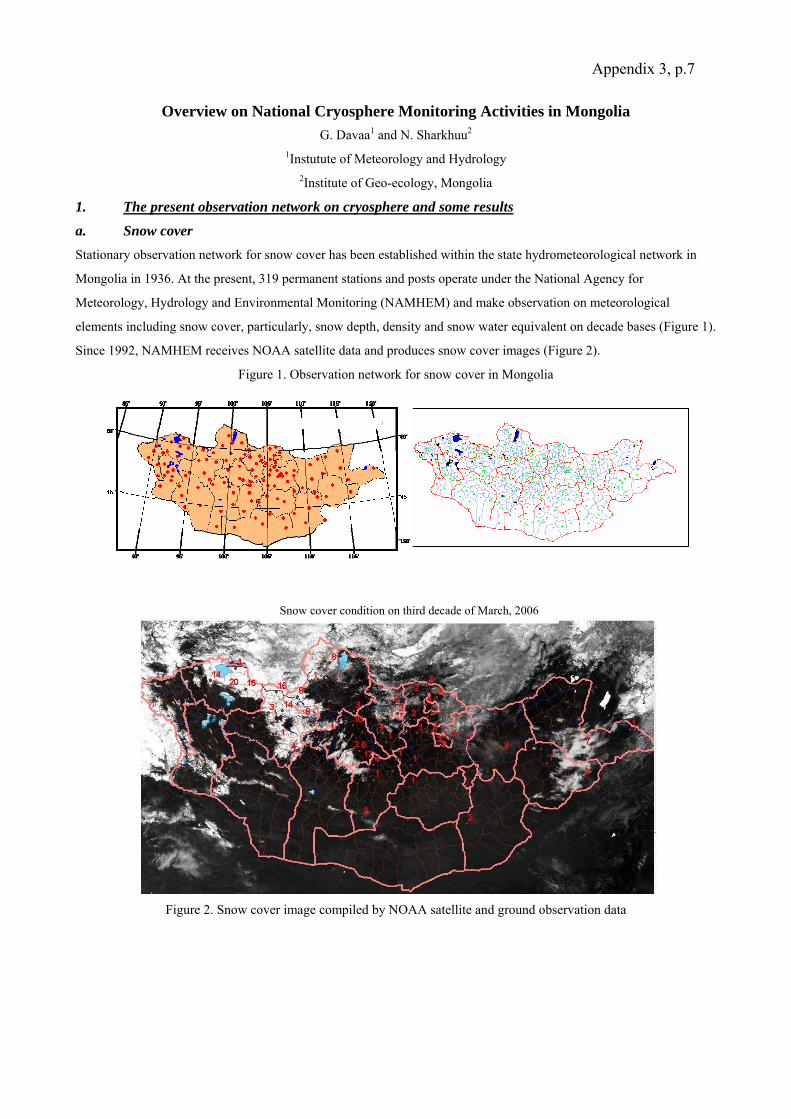
Appendix 3, p.7
Overview on National Cryosphere Monitoring Activities in Mongolia G. Davaa1 and N. Sharkhuu2
1Instutute of Meteorology and Hydrology 2Institute of Geo-ecology, Mongolia
1. The present observation network on cryosphere and some results a. Snow cover Stationary observation network for snow cover has been established within the state hydrometeorological network in
Mongolia in 1936. At the present, 319 permanent stations and posts operate under the National Agency for
Meteorology, Hydrology and Environmental Monitoring (NAMHEM) and make observation on meteorological
elements including snow cover, particularly, snow depth, density and snow water equivalent on decade bases (Figure 1).
Since 1992, NAMHEM receives NOAA satellite data and produces snow cover images (Figure 2).
Figure 1. Observation network for snow cover in Mongolia
Figure 2. Snow cover image compiled by NOAA satellite and ground observation data
Snow cover condition on third decade of March, 2006

Appendix 3, p.8 Snow cover is quite unevenly distributed with time and space, depending on microclimate in
regions in Mongolia. Average thickness of snow cover in mountainous regions varies from 5 to 13 cm (T.Ganbaatar and
B. Erdenetsetseg, 2004) in third decade of January in (Table 1).
Table 1. The average thickness of snow cover, cm, tendency of change, cm/year
zones Stations name Average thickness of snow cover, cm
Change of tendency,cm/year
Baruunkharaa 9.8 0.032 Bayan-Uul 15.6 -0.437 Eroo 6.2 0.124 Erdenemandal 3.1 -0.108 Khatgal 5.2 -0.081 Galuut 6.2 0.135 Orkhon 9.4 0.216 Tariat 3.7 0.021 Tosontsengel 10.5 -0.045 Tsetserleg 1.2 -0.003 Ulaistai 7.0 0.109 Baruunturuun 17.2 0.062 Erdenesant 10.5 -0.003 Sukhbaatar 6.8 0.004 Khujirt 5.2 -0.273 Ulaangom 13.9 0.024
North- western mountainous region
Average 8.2 - 0.01 Binder 1.6 -0.054 Dadal 7.9 0.232 Baruun-Urt 3.5 0.009 Bayan-delger 7.4 0.151 Bayan-Ovoo 7.0 0.004 Choibalsan 3.3 -0.095 Erdenetsagaan 5.6 -0.011 Khalkhgol 7.9 -0.064 Matat 2.2 0.111 Underkhaan 2.5 -0.182
Eastern region
Average 4.9 0.01 Arbaikheer 0.5 0.013 Bayankhongor 1.5 0.038 Mandalgobi 4.0 -0.021 Tonkhil 0.7 0.009 Ylalt 1.2 0.033 Dalanzadgad 0.5 -0.023 Dorboljin 1.2 0.008 Khubsgul 0.9 -0.026 Saikhan-ovoo 1.7 0.089 Tsogt-ovoo 0.5 0.052 Gurbantes 0.2 -0.021 Baitag 7.8 0.227
Southern region
Average 1.7 0.03
The area with annual average air temperature below 0oC or the area with stable snow cover that stands more than 50
days and it will be decreasing in future years. But stable snow cover will remain in Khuvsugul, Khangai, and Khentei
Mountain area. Currently, the area with annual average air temperature below 0oC is 62 % of the country’s territory.
However, it is expected that the area will decrease by 43% in 2020, 31% in 2050 and 27 % in 2080 (T.Ganbaatar and B.
Erdenetsetseg, 2004), see Figure 3.
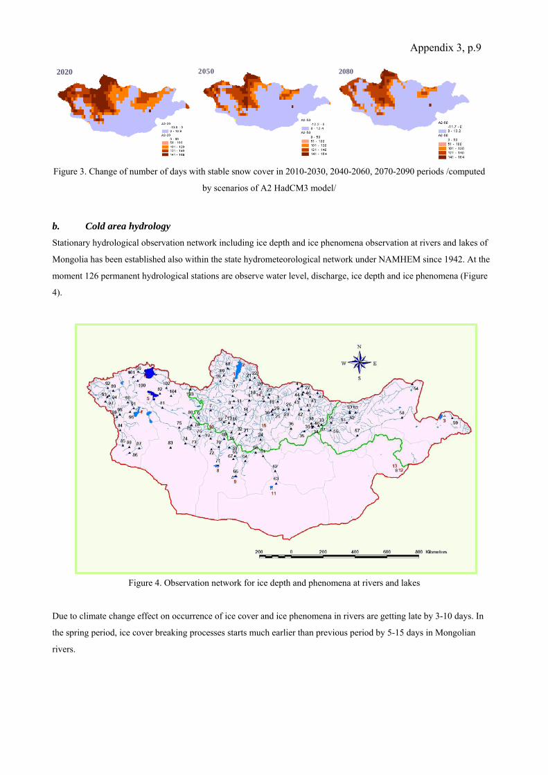
Appendix 3, p.9
b. Cold area hydrology Stationary hydrological observation network including ice depth and ice phenomena observation at rivers and lakes of
Mongolia has been established also within the state hydrometeorological network under NAMHEM since 1942. At the
moment 126 permanent hydrological stations are observe water level, discharge, ice depth and ice phenomena (Figure
4).
Figure 4. Observation network for ice depth and phenomena at rivers and lakes
Due to climate change effect on occurrence of ice cover and ice phenomena in rivers are getting late by 3-10 days. In
the spring period, ice cover breaking processes starts much earlier than previous period by 5-15 days in Mongolian
rivers.
2020 2050 2080
Figure 3. Change of number of days with stable snow cover in 2010-2030, 2040-2060, 2070-2090 periods /computed
by scenarios of A2 HadCM3 model/
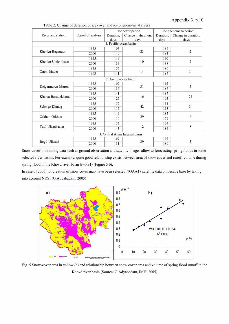
Appendix 3, p.10 Table 2. Change of duration of ice cover and ice phenomena at rivers
Ice cover period Ice phenomena period River and station Period of analysis Duration,
days Change in duration,
days Duration,
days Change in duration,
days 1. Pacific ocean basin
1945 163 185 Kherlen-Baganuur 2000 140 -23 183 -2
1945 149 190 Kherlen-Underkhaan 2000 139 -10 188 -2
1945 155 186 Onon-Binder 1993 141 -14 187 1
2. Arctic ocean basin 1945 167 192
Delgermuren-Moron 2000 136 -31 187 -5
1945 141 187 Kharaa-Baruunkharaa 2000 125 -16 163 -24
1945 157 111 Selenge-Khutag 2000 115 -42 113 3
1945 149 185 Orkhon-Orkhon 2000 110 -39 179 -6
1945 155 194 Tuul-Ulaanbaatar 2000 143 -12 186 -8
3. Central Asian Internal basin 1945 169 194
Bogd-Uliastai 2000 131 -39 189 -5
Snow cover-monitoring data such as ground observation and satellite images allow to forecasting spring floods in some
selected river basins. For example, quite good relationship exists between area of snow cover and runoff volume during
spring flood in the Khovd river basin (r=0.91) (Figure 5 b).
In case of 2005, for creation of snow cover map have been selected NOAA17 satellite data on decade base by taking
into account NDSI (G.Adyabadam, 2005)
Fig. 5 Snow-cover area in yellow (a) and relationship between snow cover area and volume of spring flood runoff in the
Khovd river basin (Source: G.Adyabadam, IMH, 2005)
W = 0.0111P + 0.1641R2 = 0.91
00.10.20.30.40.50.60.70.80.9
0 10 20 30 40 50 60
p, %
W,êì 3Õî âä ãî ë-Áàÿí í óóð ñóìa) b)

Appendix 3, p.11 c. Frozen ground or permafrost Main component of cryosphere in Mongolia is permafrost, which occupies almost two thirds of Mongolia,
predominantly in the Khentei, Huvsugul, Khangai and Altai Mountains and surrounding areas. The territory is
characterized by mountain and arid-land permafrost, sporadic to continuous in its extent, and occupies the southern
fringe of the Siberian permafrost zones. Most of the permafrost is at annual mean air temperatures close to 0°C, and
thus, thermally unstable to climate change and human activities (see Fig. 6).
Figure 6. Schematic map of permafrost distribution and location of monitoring sites in Mongolia. 1. Continuous and
discontinuous (50-100%); 2. Isolated (1-50%); 3. Sporadic (0-1%) permafrost areas. 4. No permafrost or seasonal frost
area. Numbers on the map: 1. Baganuur (a, b), 2. Terelj (a, b, c), 3. Nalaikh (a, b, c), 4. Bogd Khan (c), 5. Argalant (a, b,
c), 6. Gurbanturuu (a, c), 7. Baruun Kharaa (c), 8. Darhad (a, b, c), 9. Dalbay (a, b, c), 10. Ardag (a, b), 11. Hatgal (a,
b), 12. Burenkhan (a, b), 13. Sharga (a, b), 14. Terkh (a, b, c), 15. Chuluut (a, b, c) and 16. Tsengel (a) monitoring sites.
Letters in brackets: a. CALM; b. GTN-P; and c. CPPM measurements.
At present there are 16 permafrost-monitoring sites in Mongolia. These sites include 37 both CALM and GTN-P (5-15
m and deeper) monitoring boreholes, located in the Huvsugul, Khentei and Khangai Mountain regions. Monitoring of
permafrost temperatures in the boreholes is started in mid 1990-s and extended from year to year. More than 10
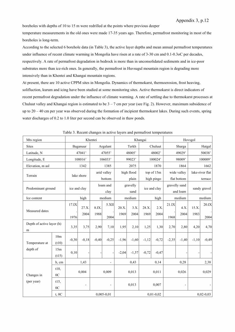
Appendix 3, p.12 boreholes with depths of 10 to 15 m were redrilled at the points where previous deeper
temperature measurements in the old ones were made 17-35 years ago. Therefore, permafrost monitoring in most of the
boreholes is long-term.
According to the selected 6 borehole data (in Table 3), the active layer depths and mean annual permafrost temperatures
under influence of recent climate warming in Mongolia have risen at a rate of 3-30 cm and 0.1-0.3oC per decades,
respectively. A rate of permafrost degradation in bedrock is more than in unconsolidated sediments and in ice-poor
substrates more than ice-rich ones. In generally, the permafrost in Huvsugul mountain region is degrading more
intensively than in Khentei and Khangai mountain regions.
At present, there are 10 active CPPM sites in Mongolia. Dynamics of thermokarst, thermoerosion, frost heaving,
solifluction, kurum and icing have been studied at some monitoring sites. Active thermokarst is direct indicators of
recent permafrost degradation under the influence of climate warming. A rate of settling due to thermokarst processes at
Chuluut valley and Khangai region is estimated to be 3 – 7 cm per year (see Fig. 2). However, maximum subsidence of
up to 20 – 40 cm per year was observed during the formation of incipient thermokarst lakes. During such events, spring
water discharges of 0.2 to 1.0 liter per second can be observed in thaw ponds.
Table 3. Recent changes in active layers and permafrost temperatures
Mts region Khentei Khangai Hovsgol
Sites Baganuur Argalant Terkh Chuluut Sharga Hatgal
Latitude, N 47041’ 47055’ 48005’ 48002’ 49029’ 50038’
Longitude, E 108016’ 106033’ 99023’ 100024’ 98009’ 100009’
Elevation, m asl 1342 1385 2075 1870 1864 1662
Terrain lake shore arid valley
bottom
high flood
plain
top of 15m
high pingo
wide valley
flat bottom
lake-river flat
terrace
Predominant ground ice and clay loam and
clay
gravelly
sand ice and clay
gravelly sand
and loam sandy gravel
Ice content high medium medium high medium medium
Measured dates
17.IX
.
1976
27.X.
2004
8.IX.
1988
5.XII
.
2004
20.X.
1969
3.X.
2004
28.X.
1969
2.X.
2004
21.IX
.
1968
4.X.
2004
15.X.
1983
20.IX
.
2004
Depth of active layer (h)
m 3,35 3,75 2,90 7,10 1,95 2,10 1,25 1,30 2,70 2,80 4,20 4,70
10m
(t10) -0,30 -0,18 -0,40 -0,25 -1,96 -1,60 -1,12 -0,72 -2,35 -1,40 -1,10 -0,49
Temperature at
depth of 15m
(t15) 0,10 - - - -2,04 -1,57 -0,72 -0,47 - - -
h, cm 1,43 - 0,43 0,14 0,28 2,38
t10,
0C 0,004 0,009 0,013 0,011 0,026 0,029
t15,
0C - - 0,013 0,007 - -
Changes in
(per year)
t, 0C 0,005-0,01 0,01-0,02 0,02-0,03
Appendix 3, p.13 d. Glacier
Glacier studies were temporary and descriptive. 10 % of total water resources accumulated in glaciers in Mongolia.
Glaciers are distributed in area of between 46o25-51o50 N, 87o40-100o50 E, at altitude of 2750-4374 m. Spatial
distribution is sporadic and decrease from north-west to south-east. There are totally 262 glaciers with total area of 659
km2. Total water resources accumulated in glacier estimated to be 62.9 km3 (Dashdeleg et al., 1983). All glaciers are
distributed in the Altai Mountain except 2 glaciers located in Khangai and Khuvsugul Mts.
Kharkhiraa, Turgen, Tsambagarav and Tavanbogd glacier areas were 50.13, 43.02, 105.09 and 88.88 sq.km, estimated
from topographic map, scaled as 1:100 000 and compiled in 1940s (Kadota and Davaa, 2003, 2004, Davaa and Kadota
2005). Areas of the Kharkhiraa, Turgen, Munkhhairkhan, Tsambagarav and Sair glaciers were decreasing by 45.5, 33.7,
25.8, 21.4 and 42.5 percent since 1992 till 2002, respectively /table 4./.
Since 2003 up to present, Institute of observational research for global change, JAMSTEC, Japan and Institute of
Meteorology and Hydrology (IMH), Mongolia are carrying out glacier surveys focused on mass balance studies in
Tavanbogd, Turgen and Tsambagarav glaciers.
IMH initiated glacier mass balance and glacier hydrology study site at flat-top Tsambagarav Glacier since 2004 and
obtained preliminary results of investigation.
Table 4. Changes in glacier areas
Glacier massif 1940th 25 June, 1992 10 Sep. 2000 8 Aug. 2002 Kharkhiraa 43.02 - 36.08 31.29
Turgen 50.13 - 34.74 33.83 Munhkhairkhan - 36.96* - 27.42 Tsambagarav 105.09 90.98 74.8 71.52
Sair - 11.51 - 6.62
2. Organization and projects related or can contribute to "Climate and Cryosphere" Organizations which have own observation network or research studies on Climate and Cryoshere are Institute of
Meteorology and Hydrology of NAMHEM, Institute of observational research for global change, JAMSTEC, Japan.
JICA, Japan, National Agency for Water of Ministry of Nature and Environment (MNE), Institute of Geography of
MAS and Institute of Altai Studies are potential candidates to contribute the crysphere and glacier research and water
resources management planning.
Concerning related projects, there are several ongoing international projects which could contribute to the Climate and
Cryosphere study, such as Huvsugul Global Environment Facility/World Bank (GEF/WB) Project, Community based
conservation of biological diversity in the mountain landscapes of Mongolia’s Altai Sayan Eco-Region.
Besides the mentioned ongoing projects, there are some national and internaional project proposals, which also have
certain relation to the glacier studies. For example, “Regime and resources of surface water of the Khovd river basin
and water use”, Integrated River Basin Management Strategy to develop National Program on water resources
management and planning (Government of the Netherlands).
Appendix 3, p.14 3. Essential or urgent issues (observation, scientific studies) related to "Climate
and Cryosphere" in Mongolia Ice core often contain the most direct proxy information available concerning past changes in climate and environment
and also glaciers and ice sheets preserve sequential information on both wet and dry deposition.
Climate change and anthropogenic effect, shortage of water resources and related consequences much clearly
demonstrate importance of glacier study.
Therefore we propose following projects on:
- Integrated River Basin Management in the Khovd river basin with special concerns to climate change
impact assessment on glaciers and to mitigate negative consequences (could be JICA supported,
welcomed Regional Cooperation in the Altai Mts.)
- Will be organized new permafrost monitoring site near the Tsambagarav glacier for permafrost
monitoring and will be combined with glacier monitoring to assess current gryospheric state in the
Tsambagarav Mountain area to support water resource management and planning (National contribution
to IPY).
The Government commitments:
- Use of regional hydrological and meteorological data and network
- Glacier study is officially included in long term program (for period of 2010-2015) of the
National Agency for Hydrology, Meteorology and Environmental Monitoring of Mongolia
- Serious interest of people in the region to study glaciers for better understanding glacier
phenomena and its interrelation with water resources and use, climate
- Human resources
4. International cooperation and contribution to water resource management planning Within the framework of Circumpolar Active Layer Monitoring (CALM) and the Global Terrestrial Network for
Permafrost (GTN-P), Huvsugul Global Environment Facility/World Bank (GEF/WB) Project, Cryogenic Processes and
Phenomena Monitoring (CPPM), Glacier study in Mongolia by IORGC, JAMSTEC, JAPAN and IMH, and cooperation
with JICA, WMO, and UNESCO-IHP activities could make great contributions to cryosphere studies.
References
1. T,Ganbaatar, B.Erdenetsetseg, Climate change impact on Natural resources, Proceedings of the Sixth International
workshop on Climate change in Arid and Semiarid regions of Asia, August, 2004, Ulaanbaatar, Mongolia
2. Impacts of climate change, Report of the Potential Impact of Climate Change and Vulnerability and Adaptation
Assessment for the Livestock Sector in Mongolia (Editor P.Batima, B.Bayasgalan), AIACC, GEF UNEP,
Ulaanbaatar, 2005
3. Sharkhuu, N., and S. Anarmaa (2005), Recent Degradation of Permafrost in Mongolia, paper presented at First
International Symposium on Terristrial and Climate Change in Mongolia, Ulaanbaatar. July 26-28, 2005.
4. Dashdeleg N., Evilkhaan R., Khishigsuren P., Modern Glaciers in the Mongolian Altai Mts., Proceedings of the
Institute of Meteorology and Hydrology, No.8.1983

Appendix 3, p.15 5. Gomboluudev P. Dagvadorj D., “Climate change scenarios in Mongolia”, Proceedings of
workshop on “Climate change and Agriculture”, Darkhan, 2002, pp.
6. Kadota Ts., G.Davaa, Recent glacier variations in Mongolia, a preliminary study, 3rd International Workshop on
Terrestrial Change in Mongolia, Tsukuba, Japan, Nov.2004

Appendix 3, p.16 State of Cryosphere in Pakistan
Bashir Ahmad1 and Ghulam Rasul2
1 Scientific Officer, Water Resources Research Institute, National Agricultural Research Center, Park Road, Islamabad,
Pakistan, Telephone: +92-51-9255022, Fax No: +92-51-9255074, E-Mail: [email protected]
2 Director, Research and Development Division, Pakistan Meteorological Department, P.O.Box 1214, Islamabad-
Pakistan, Telephone: 0092-51-9250369, Fax No: 0092-51-9250368, E-Mail: [email protected]
Country’s Profile Pakistan lies between 24° to 37° N latitude and 61° to 75° longitude, covering an area of 88.2 million hectares
including northern areas. Inherently the country has highly variable topography, climate and culture. The three major
mountain ranges namely: Hindu Kush, Karakoram and Himalaya border in the north followed by plateaus, plains and
coastal areas. The climatic variability is expressed by humid zones in the north-east to hyper-arid in south-west and
west. The major part of the country may be classified as arid to hyper-arid.
The country’s high mountains comprise of the western end of 2,400 km long Himalayan range and some parts in the
Hindu-Kush and Karakoram ranges. Northern areas spread over 72,496 sq. km. with amidst towering snow-clad peaks
with heights varying from 1,000 masl to over 8,000 masl. Of the 14 over 8,000 masl peaks on earth, 4 occupy an
amphitheater at the head of Baltoro glacier in the Karakoram Range. In addition to these, there are 68 peaks over 7,000
masl and hundreds which are over 6,000 masl.
Some of the lower sub-Himalaya mountain ranges in the northeast receive high summer monsoon rainfall and snow
during winter. The forest covers are dense in this mountainous region due to abundant amount of rainfall from
monsoon. The high northern and northwestern areas are out of monsoon reach so the climate is dry and precipitation
occurs only due to western disturbances moving in from the west during winter. Sometimes, meso-scale convective
systems develop due to heating in early summer and produce rain for a short period.
1. The present observation network on cryosphere (Snow cover, glacier, frozen ground, cold area hydrology)
Pakistan Metrological Department (PMD) and Water & Power Development Authority (WAPDA) are the main
agencies having network for continuous monitoring of metrological and hydrological data in Pakistan. In addition to
these government agencies, some international agencies have also established monitoring stations. A brief of
monitoring agencies is as follows:
Pakistan Meteorological Department (PMD) is a federal agency with a mandate to monitor and analyze
meteorological data. It maintains a network of about 200 metrological stations across the country. In northern
areas, the station elevation varies from few hundred meters to 2700m above mean sea level. These stations
record data round the clock and transmit to the headquarters of PMD through V-Sat or SSB or wireless.
During 1990, WAPDA in collaboration with International Development Research Centre (IDRC) and
Canadian International Development Agency (CIDA) set up a program of snow and ice measurement in
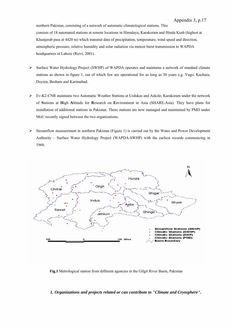
Appendix 3, p.17 northern Pakistan, consisting of a network of automatic climatological stations. This
consists of 18 automated stations at remote locations in Himalaya, Karakoram and Hindu Kush (highest at
Khunjerab pass at 4420 m) which transmit data of precipitation, temperature, wind speed and direction,
atmospheric pressure, relative humidity and solar radiation via meteor burst transmission to WAPDA
headquarters in Lahore (Rizvi, 2001).
Surface Water Hydrology Project (SWHP) of WAPDA operates and maintains a network of standard climate
stations as shown in figure 1, out of which few are operational for as long as 30 years e.g. Yugo, Kachura,
Doyien, Besham and Karimabad.
Ev-K2-CNR maintains two Automatic Weather Stations at Urdukas and Askole, Karakoram under the network
of Stations at High Altitude for Research on Environment in Asia (SHARE-Asia). They have plans for
installation of additional stations in Pakistan. These stations are now managed and maintained by PMD under
MoU recently signed between the two organizations.
Streamflow measurement in northern Pakistan (Figure 1) is carried out by the Water and Power Development
Authority – Surface Water Hydrology Project (WAPDA-SWHP) with the earliest records commencing in
1960.
Fig.1 Metrological station from different agencies in the Gilgit River Basin, Pakistan
1. Organizations and projects related or can contribute to "Climate and Cryosphere".
Appendix 3, p.18
Snow and Ice Hydrology Project (SIHP)
In the 1990s, the International Development Research Center (IDRC), CIDA and WAPDA, under the Snow
and Ice Hydrology Project (SIHP), set up a program of snow and ice measurement in northern Pakistan. The
aim of these stations is to develop a snowmelt forecasting system to estimate water inflows to Mangla and
Tarbela, as well as into Kabul River.
Pakistan Metrological Department
Pakistan Meteorological Department has establishment a High Altitude Research Unit in Research and
Development Division in collaboration with Ev-K2-CNR of Italy and China Meteorological Administration.
PMD would provide the common plateform to Pakistani scientists of various disciplines to undertake
collaborative research with participating organizations. PMD has been maintaining archives satellite and river
discharge data in addition to meteorological data. High Resolution NOAA image HRPT has regularly been
received since 1990. Now ground receiving station for Chinese Satellite Feng Yuan (FY-2d) has also been
established at R& D Division of PMD to receive the image directly. Chinese colleagues will provide the
previous images archived at home station for research purpose.
Water Resources Research Institute (WRRI), National Agricultural Research Center (NARC),
Islamabad
WRRI-NARC is engaged in a project whereby it aims to do a complete inventory of glaciers and glacial lakes
in the Northern Areas. Northern Areas have been divided into ten river sub-basins of Upper Indus basin. Using
SRS data (Landsat ETM+) the inventory was completed and a comprehensive database of glaciers of
Karakoram, Hindu Kush and Himalaya was developed.
Pakistan Council of Research in Water Resources (PCRWR)
A project entitled “Development of an Assessment System to Evaluate the Ecological Status of Rivers in the
Hindu Kush-Hymalayan Region” has been launched by PCRWR. It includes the chain of activities to monitor
water quality to gauge extent of pollution. In addition to water sample analysis, diversity of macro-
invertebrates and rapid bio-assessment are the two major tools to monitor river water quality.
Global Change Impact Study Center, Islamabad
This group is also studying climate change and its impact on water and agricultural resources in Pakistan,
including the Northern Areas. Through various models they are looking at how much water is coming from
glaciers and from precipitation and predicting how climate change on a regional basis could affect these
parameters which in turn would affect water usage and crop cultivation downstream.
Ev-K2-CNR
Stations at High Altitude for Research on Environment in Asia (SHARE-Asia) grew out of Ev-K2-CNR
Committee’s expertise in high altitude and remote area climate research in Himalayan since 1990. The network
Appendix 3, p.19 has been expanded to Pakistan’s Karakoram Mountains by automatic weather station at
Baltoro glacier Urdukas and Askole near K2. Plans for installation of additional stations in Pakistan and
expansion to Tibet are underway. The main objectives of SAHRE-Asia are to acquire knowledge on high
altitude climate in Himalaya and Karakoram, to study the complex mechanism of interaction between the local
and synoptic atmospheric circulation; to contribute to studies to energy and water balance; and to improve
comprehension of the mechanisms governing long-range pollutant transport. PMD and Ev-K2-CNR have
signed an agreement for collaborative research on H_K_H (Hindu Kush-Karakoram-Himalaya) glaciers.
Sustainable Policy Research Institute, Islamabad
Although this research was not confined to the Northern Areas, yet it examined the impact of climate change
on forestry and demand and supply of water in Pakistan with and without climate change over the next 50
years. The assumed change was an increase of 0.90C by 2020 and 1.80C by 2050 and a precipitation change of
3% by 2020 and 6% by 2050 (Khan, 2000).
Asia Pacific Network for Global Change Research, Japan
This is an inter-governmental network for the promotion of global change research in the Asia-Pacific region.
Under its auspices a project was started in 2002 titled “Water resources in South Asia: an assessment of
climate change associated vulnerabilities and coping mechanisms.” The principle aims of this project are to
analyze recent climatic variability and extreme events and their impact on water resources, and to assess the
impact of projected climate change and associated extreme events on the water resources of the countries.
International Water Management Institute, Lahore
IWMI conducted a study whereby it searched various components of the water cycle in the Northern Areas to
find clues for climate change (Khan, 2001). The assumption of this study was that a change in climate has a
magnified affect on hydrologic time series. It analyzed temperature and precipitation data for 30 years, in
monthly time step, from seven stations in the Indus catchment upstream from Tarbela, including Gilgit and
Skardu. Monthly inflows into Tarbela reservoir for the same period were also analyzed.
3. Essential or urgent issues (observation, scientific studies) related to "Climate and Cryosphere" in
your country.
Present studies conducted in the Northern Areas have studied indicators of climate change such as change in
temperature and precipitation, vegetation trends and glacial retreats and surges. Some of them have tried to establish
links between observed variables and climate change but so far such studies are sporadic. Research on a more consistent
basis and larger scale is needed because if climate change is indeed taking place then that will have repercussions on the
hydrology and forests of the region which in turn will be important in determining water management and flood risk
assessment and mitigation strategies in the country. The following gaps and research needs have been identified and
recommended:
Appendix 3, p.20 Gaps in Data
o High Altitude Climate
More extensive observations and recording of climate variables in the area need to be conducted. While
there are many such recordings from lower elevations, many of them for a long period of time, there is a
need to collect reliable climatic data in the higher regions.
o Snow and Ice data
More reliable data on ice and snow needs to be collected and analyzed. Although the Snow and Ice
Hydrology Project of WAPDA has made an attempt in this direction, the data generated via this source is
still not very reliable and is also rather scattered. It also needs to get data from elevations higher than
15,000 ft since this is about the limit for the present stations.
o Glacier data
Glaciers should be studied in greater depth, especially whether they are retreating or advancing and
establish a cause for such phenomena, climatic or otherwise. In this regard some research has already been
done but the picture is unclear at the moment. More primary data needs to be generated from a variety of
locations in Northern Areas to get a clear picture. Furthermore, a better mechanism is required to estimate
the ice reserves of the glaciers. A multi-organizational/ multi-national approach may work well to
establish a denser observational network in the area of interest.
Climate Change and Forests
Since forests are expected to be critically affected by climate change, there is a need to find how and to what
extent forest resources are susceptible to the projected climate change. Furthermore the implications of climate
change on agriculture and agro-forestry in the region also need to be studied. Such research does not exist so
far.
Climate Change and Global Phenomena
Detailed analysis of links between observed climatic variables and global phenomena such as El Niño, La Niña
and the North Atlantic Oscillations (NAO) needs to be done. Some researchers have tentatively explored this
subject and have found evidence for temperature and precipitation differences between El Niño and non-El
Niño years, but more studies need to be conducted in this regard.
4. Other matters you think important to notify to the international community Although there is not extensive literature and data on climate change in the Northern Areas, yet some research in this
area does exist and some is underway. Study of climate change involves looking at trends in temperature, precipitation,
glacial movements and vegetation changes, among others and linking them to global or regional causes. Therefore
mountain areas such as the Karakorums and Himalaya region of Pakistan could prove to be a good laboratory for
studying climate change. Here are some suggestions:

Appendix 3, p.21 Systematic & Consistent Research
Climate change in the region needs to be studied more systematically and intensively because changes in
precipitation and/or temperatures would have significant impacts on river flow rates, flood risk assessments,
dam management, forests and forest management, and overall ecology of the region. Research should be
conducted systematically and consistently on detecting trends in parameters of climate change such as
temperature, precipitation, changes in vegetation or glaciers.
High Altitude Data
Greater emphasis should be placed on gathering higher altitude data on temperatures and precipitation changes
because presently there is almost none. Reliability of such data should also be an important consideration when
planning for the higher altitudes. Data on ice and snow conditions in the upper reaches of the mountains, that
is, above 15,000 ft, should be gathered in order to get a complete picture of climate change in the region.
Glacier Data
Glaciers behavior and surges should be examined in greater detail and causal connection made with climate
change. In this research a section could be devoted for documenting the view of people living around glaciers
who could give anecdotal evidence of their movements over the span of their memories.
Better Coordination
There needs to be greater coordination and data sharing among various organizations and institutions doing
climate change research, and also with international organizations and neighboring countries like China, Nepal
and India. There should be frequent coordination/evaluation meetings to review the progress. This would
enhance greater uniformity in data collection and methodology and provide for greater input into the
interpretation of collected data.
Focal Agency
No major agency in Pakistan has the clear mandate of analyzing the climate change impacts in the country.
However, different departments and individuals carried out few studies from time to time. Regarding glacier
studies in the Karakoram region, many of these have been done by international organizations/researchers and
there is no central repository for data/information generation. Therefore, a central/focal agency with a clear
mandate should be constituted. In case of absence of focal agency, a committee needs to be formulated,
responsible for providing guide lines, coordination and evaluation of these studies carried out under different
departments.
WRRI-NARC can serve as a focal agency because of multi-disciplinary team and its diverse research
background. The Institute has a good facility and expertise in RS and GIS applications which is well proven by
its outputs. There is a reasonable dataset on water resources, climate and mountain environments already
available with the institute which can provide a base for initiating climate change studies. Being as a national

Appendix 3, p.22 institute, it is already well linked with several other research and development
institutions as well as national and international NGOs.
Manpower Training
Pakistan lacks in trained and research oriented manpower. International community is requested to facilitate
local scientists for professional training and research.
Appendix 3, p.23 Snow and Glacier Activities in Nepal Himalaya
Arun B. Shrestha1
1 Department of Hydrology and Meteorology, Nepal
Introduction The Himalayan region of Nepal is the home to 8 of the 10 highest mountain peaks in the world, including Mount
Everest (8848 m a.s.l.) and contains larger numbers of glaciers. There are 3252 glaciers in Nepal covering a total area of
5323 km2. (ICIMOD/UNEP, 2001). These glaciers are huge reservoirs of freshwater in frozen form which maintain
perennial flow of major rivers of Nepal, such as Koshi, Gandaki, Karnali and Mahakali. A large proportion of the
people living in downstream areas rely on these freshwaters to sustain their lives and livelihoods. Melt water generated
by the glaciers are the only reliable source of freshwater which supply clean water for drinking, cooking, washing and
industrial uses in the downstream areas. Moreover, a reliable supply of water in the high-energy mountain rivers and
streams are extremely important for hydropower development and other water resources development in the area.
However, in recent decades global warming has brought some unprecedented changes in glaciers of Nepalese
Himalaya. Studies have indicated that majority of glaciers are retreating in the wake of recent global warming and
resulting climatic changes. Sixty-seven percentages of glaciers are retreating at a startling rate in the Himalayas and
climate change has been identified as the major causal factor (Kadota and Ageta, 1992; Yamada et al., 1992). Retreat of
Himalayan glaciers has raised serious concern with regard to future availability of freshwater in the region. At the same
time, retreat of Himalayan glaciers has resulted into the formation of glaciers lakes at their terminus. Being dammed by
unconsolidated weak natural moraines, these glacier lakes pose potential risk of their catastrophic failure, causing a
huge flash flood in the downstream areas commonly known as Glacier Lake Outburst Flood (GLOF). GLOF is a
relatively new kind of natural hazard in the Himalayan region which has emerged as direct consequence of ongoing
warming. It is estimated that out of the 2,315 glacial lakes in the Nepalese Himalayas, 20 are potentially dangerous
(ICIMOD/UNEP, 2001). Since 1935 Nepal has experienced more than 15 such GLOF events, which has become even
more frequent in recent times. Besides human population developmental infrastructures such as hydropower, irrigation
and drinking water supply projects are particularly vulnerable to such events.
Snow and glaciers play a very important role in the development of water resources of Nepal. Proper assessment of
these natural resources is inevitable for the development of water resources of the country. This is particularly important
in the present context when widespread glacier retreat is indicating the impending threat of a potential water shortage.
Besides, the issue of GLOF hazard has also emerged as a serious threat to the water resources development. A clear cut
understanding of the scientific basis of the processes that are taking place in glacier basins in high mountain areas is
therefore a key factor for the development of huge water resources of the country. Understanding the scientific basis of
the processes obviously demand a comprehensive database and accurate information.
Realizing these facts, Department of Hydrology and Meteorology (DHM) as an implementing agency of His Majesty's
Government of Nepal, initiated "Snow and Glacier Hydrology Project" in 1987. The primary objective of the project is
to gather information and build up a database concerning snow and glaciers in the country through establishment of
network of hydro-meteorological stations in higher Himalaya. These information and database are to be used by the end
user working in the relevant areas such as water resources, disaster management, tourism and others. Since its inception,
Appendix 3, p.24 besides operating the stations, DHM has been conducting measurements and research work in
glacier basin which involve wide ranges of disciplines such as meteorology, hydrology, glaciology, topography,
limnology, geology, geophysics, geomorphology etc.
Activities: Collecting hydro-meteorological data So far, 6 hydro-meteorological stations have been operating in higher Himalaya. The stations are situated at different
location in Higher Himalaya stretching from Makalu in the east to Humla in the west. These stations are equipped to
collect following parameters:
• Air temperature
• Relative humidity
• Precipitation
• Solar radiation
• Wind speed and direction
• River stage and discharge
These stations are both semiautomatic and automatic type. Data collected from these stations are being regularly
published in book format.
Snow survey and snow measurement Snow survey and snow pit measurements are conducted in 3 stations, namely, Khumbu, Langtang and Annapurna.
Data collected from these measurements are later analyzed for estimating Snow Water Equivalent (SWE) as well as for
estimating glacier accumulation. However this activity has not been conducted in a regular and continuous manner
Glacier mass balance measurement and monitoring Glaciers are perfect indicator of climate change as they grow and shrink in response to changing climatic conditions.
Mass balance measurement is the basic tool to monitor and evaluate the overall state of a glacier. A negative mass
balance indicates a depleting ice reserve while a positive mass balance is the indication of growing glaciers. However,
mass balance measurement of glaciers in High Mountain areas has often been hindered by remote location, difficult
terrain and in many occasion due to lack of financial resources. There had been few mass balance measurement works
conducted in the past by Japanese researchers in collaboration with DHM; however, they are not continuous and limited
to one or two locations only. ICSI provided training to ten technicians from Nepal to conduct mass balance survey.
Nepal has yet to decide on benchmark glaciers for long-term monitoring.
Another tool for glacier monitoring is Remote Sensing (RS) technique. There had been works in the past in which RS
technique were used to assess the long term glacier fluctuation. But again they were limited to small areas; and the
entire works were hindered by the difficulty in acquiring the Satellite Imageries as well as their high cost. Efforts are
underway to bring up a long term mass balance measurement project through financial assistant of international

Appendix 3, p.25 agencies working in the similar areas. Currently, DHM with support from UNESCO/IHP has
started a project on Rs and geographical information system (GIS) based study of snow cover area, glacier area and
snowline elevation in Nepal.
Snow and glacier melt runoff modelling Hydro-meteorological data collected from stations in glacier basin of Himalaya allows the application of wide range of
empirical and mathematical models for the simulation and at a later stage forecast of snow and glacier melt runoff in
mountain rivers as well as the regionalization of the specific basin runoff as an important basin parameter for the
planning of water resources projects. Reasonable results have so far been achieved with the application of a parametric
conceptual runoff model (HBV3-ETH) which is based on temperature and precipitation as input variables and a set of
internal model parameters. The model simulates daily runoff from the Imja Khola basin in Khumbu, Langtang Khola
basin in Langtang and Modi Khola basin in Annapurna region. Depending on the availability of data the model can be
applied to other glacier basins in High Mountain areas.
Recently DHM and World Wildlife Conservation Fund-Nepal (WWF-Nepal) imitated a project titled "Climate change
impact in Khumbu Region and identifying impacts of various sectors" (CCIKRIIVS). The objectives of this project are
to study climate change impact assessments on glaciers, Freshwater vulnerability, and development of adaptation
strategies.
Discharge measurement in high mountain rivers The determination of discharge from snow and glacier fed rivers in the Nepalese Himalaya is of prime importance for
the estimation of snow and glacier melt runoff needed for the improved water resources management. Because the
conventional current meter method is not suitable to measure discharge in many steep rivers in High Mountain areas of
Nepal an operational tracer measurement system, consisting of field and laboratory equipment, has been introduced first
time in Nepal through Snow and Glacier Hydrology Project. Considerable discharge measurements data have so far
been collected with the application of this technique. Combining these data with river stage data, rating curves have also
been prepared for few stations.
Monitoring of potentially dangerous glacier lakes There are 2,315 glacier lakes of various sizes in Nepal Himalaya, the total area of which is 75 km2. Among them 20
glaciers lakes have been identified as potentially dangerous (ICIMOD/UNEP 2001). Past field investigation have
identified few glacier lakes as potentially dangerous and recommended to adopt appropriate mitigation measures to
minimize the possible damage in the event of a GLOF. These glacier lakes are Tsho Rolpa in central Nepal, Imja and
Lower Barun in eastern Nepal and Thulagi in western Nepal Himalaya.
The importance of Glacier Lake studies in Nepal was realized only after the outburst of Dig Tsho Glacier Lake in the
Khumbu region of eastern Nepal in 1985, which inflicted heavy losses to lives and properties including developmental
infrastructures in the downstream areas. After this event Glacier Lakes and GLOF phenomenon were realized as a
potential threat to the water resources development of the country. The event highlighted the gravity of this problem
which led to the initiation of systematic study of glacier lakes and GLOF phenomenon in Nepal. As part of ongoing
Appendix 3, p.26 studies on glacier lakes, Department of Hydrology and Meteorology/HMGN in collaboration
with German and Japanese Government; carried out several field studies of glacier lakes such as Thulagi in western
Nepal, Tsho Rolpa, Imja and Lower Barun in eastern Nepal. The multidisciplinary field studies comprised of disciplines
such as hydrology, glaciology, engineering geology, geophysics, topographic survey, geo-radar and geo-thermics. The
objective of these studies has been to assess existing situation of the lake from the prospective of a GLOF and its
potential impact on downstream areas.
The study of Thulagi Glacier Lake concluded that the lake is safe for another 50 years while the studies of Tsho Rolpa,
Imja and Lower Barun revealed that these lakes are potentially dangerous and recommended to adopt some appropriate
mitigation measures.
Tsho Rolpa Glacier Lake: This is the only glacier lake in Nepal Himalaya where mitigation measures have been
adopted. Lake level has been lowered by 3 m on 2002 by constructing a canal structure at the end moraine of the lake. It
has reduced the GLOF risk to some extent; however, the risk has not been completely eliminated.
Imja Glacier Lake: This is second dangerous glacier lake after Tsho Rolpa. Field investigations had shown that the lake
is expanding rapidly and recommended to continuously monitor the lake unless some effective mitigation measures are
adopted.
Lower Barun Glacier Lake: On the basis of field investigation made more than a decade ago, this lake had been put on
the list of potentially dangerous glacier lake. However, a detailed investigations need to be made to assess the present
situation.
Although the DHM has been conducting some studies on glacier lakes since last few years the information collected so
far are still not adequate to draw any conclusions regarding their vulnerability. A more detail nationwide glacier lake
studies and monitoring work need to be initiated with the aid of more sophisticated techniques such as Remote Sensing.
Studies of this kind will eventually help assess GLOF hazard which is an important prerequisite while formulating
water resources development projects in the country. Lack of adequate financial and human resources have been a
major hindrance towards fulfilling these goals.
Future Plan Recently approved National Water Plan (NWP) of HMG/N has included collecting, process and disseminating all
hydro-meteorological information in the country. Further, it has clearly mentioned the importance of snow and glacier
to the water resources development of the country particularly for managing water induced disasters. In order to address
the issue of climate change to the water resources development of the country, the NWP has envisaged a separate
research body within DHM, namely, "Himalayan Climate Change Study and Research Centre."
In this context, future activities will be mainly focused on conducting a nationwide scientific research on snow, glacier
and glacier lakes to assess their vulnerability to climate change and potential impact they might impart to the water
resources of the country. In order to achieve this goal following activities have been planned in future:
• Strengthen and extend existing network of hydro-meteorological station in higher Himalaya
• Provide relevant organizations and individual quality data and information relating to snow and glaciers.

Appendix 3, p.27 • Initiate a nationwide long term glacier mass balance studies including long term
monitoring of glaciers fluctuation in Himalaya.
• Initiate a systematic monitoring of potentially dangerous glacier lakes in High Mountain areas. Based on the
long term monitoring vulnerability assessment of the lake will be made. Further, appropriate mitigation and
adaptation measures will also be devised to minimize the risk of GLOF from these glacier lakes.
• Snow Melt Runoff Modelling work will be extended further to cover major glacier basins and sub-basins.
Besides improving existing model, more sophisticated and state-of -the art model will be introduced for the
accurate assessment of melt discharge in Mountain rivers.
• Research tools such Remote Sensing and GIS will be extensively adopted for studying glacier and glacier lake
monitoring.
• Efforts will be made for the capacity building of the manpower by updating them with modern and
sophisticated technologies and research methodologies through short term and long term trainings.