1998_08_20 - ITL (Reconnaissance Archaeological Site Survey of Part of the Denize Farm Block,...
68
Transcript of 1998_08_20 - ITL (Reconnaissance Archaeological Site Survey of Part of the Denize Farm Block,...
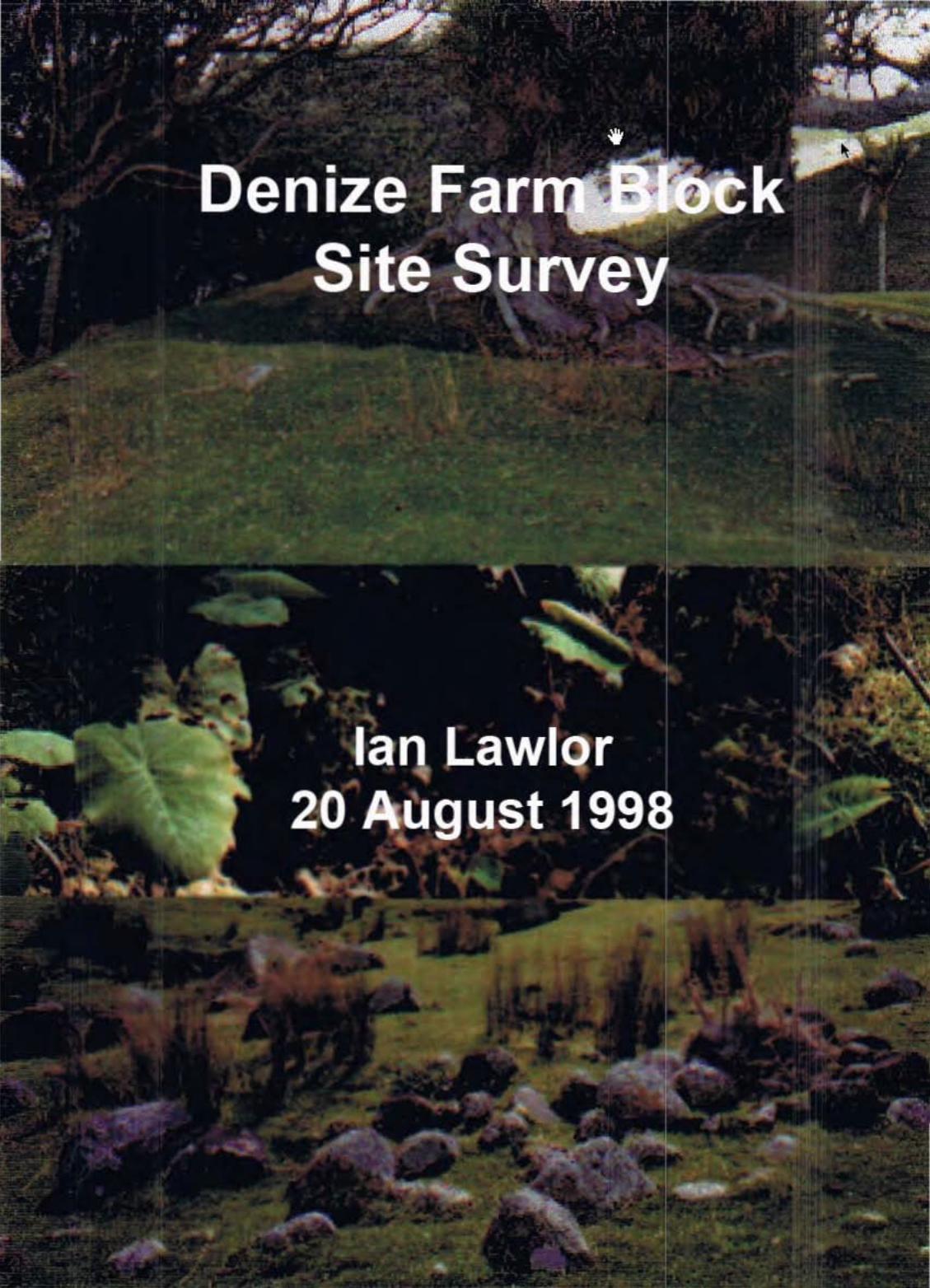
Reconnaissance Archaeological Site Survey of Part of the Oenize Farm Block, Whangapoua, Coromandel
Peninsula, 21 September 1997
Ian Lawlor
20 August 1998
. 7 Prosford Street, Ponsonby, Auckland
(Ph: 64-9-378-0192 or email [email protected])
1 INTRODUCTION This report presents the results of a brief reconnaissance archaeological site survey of part of the Denize Farm Block. The property is located at the northern end of Whangapoua Beach on the eastern coast of the Coromandel Peninsula (Figure 1). The survey was completed at the request of Robin Denize on the 21 5t of September 1997.
There were three survey objectives:
1. To examine historic structures and features known to the Denize family through discovery and through previous archaeological site recording completed under the New Zealand Archaeological Association (NZAA) Site Recording Scheme;
2. To walk over open grassed paddocks located within 1 kilometre of the coast and record any additional archaeological sites; and
3. To report on the survey and provide an interpretation of the archaeology and comment on the significance of the historic places identified.
The Denize family is keenly aware that the farm contains the archaeological remains of both Maori and European occupation. Robin and Barry Denize grew up and went to school on the farm and they have a first hand knowledge of the land and past farm management practices. A number of sites are well known to the family. They include: a large and impressive pa (T1 0/177), located above and immediately to the southwest of the homestead; various concentrations of shell midden and hangi (ie. cooking areas); circular scoop depressions on stream-side flats; and terrace and pit earthworks (T1 0/261) on some of the low coastal ridges and spurs.
The Denize homestead could also be classed as a historic house. The structures and surrounding gardens were built as a summer residence for an English woman by the name of Alberta McLean. Across the farm there are many remnants of farming practices and activities that date to the early 20th century and they reflect Alberta's management practices. These structures and features include stock water troughs, hedgerows, old fence alignments, shelterbelts and various exotic and indigenous plantings.
2 SURVEY Following a conversation with the Denize family , and a brief inspection of the PA (T1 0/177) and a PITS/ TERRACES/ MIDDEN (SHELL) site (T1 0/261) , four hours were spent traversing the open grassed paddocks located within one kilometre of the coast. The northern limit of the survey was the ridge fence-line in the "Airstrip" paddock overlooking New Chums Beach. The' inspection was brief, limited by the hours of daylight, and focused on the areas where sites were known to occur. Most of the ridges, broad clear flats, and stream gullies were walked.
Denize Farm Block Whangapoua Beach, Coromandel 2
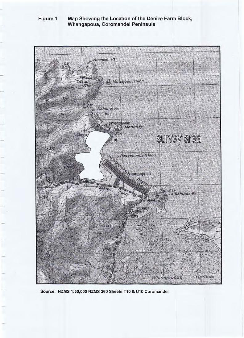
Figure 1 Map Showing the Location of the Denize Farm Block, Whangapoua, Coromandel Peninsula
Source: NZMS 1:50,000 NZMS 260 Sheets T10 & U10 Coromandel
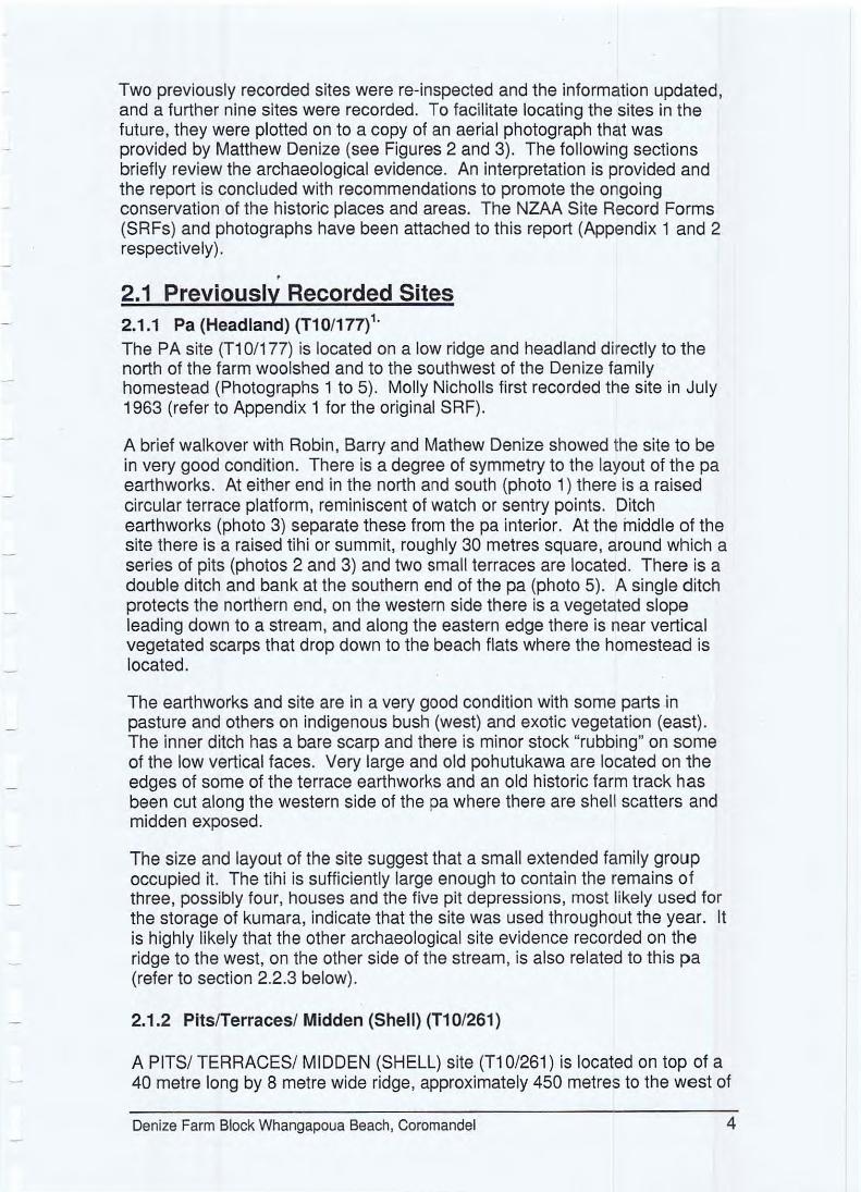
Two previously recorded sites were re-inspected and the information updated, and a further nine sites were recorded. To facilitate locating the sites in the future, they were plotted on to a copy of an aerial photograph that was provided by Matthew Denize (see Figures 2 and 3). The following sections briefly review the archaeological evidence. An interpretation is provided and the report is concluded with recommendations to promote the ongoing conservation of the historic places and areas. The NZAA Site Record Forms (SRFs) and photographs have been attached to this report (Appendix 1 and 2 respectively).
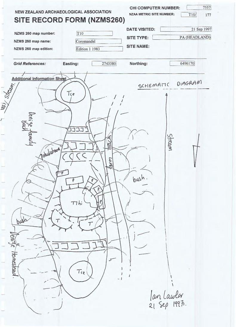
, 2.1 Previously Recorded Sites 2.1.1 Pa (Headland) (T10/177)1 .
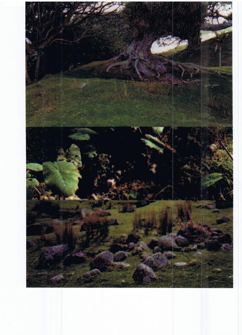
The PA site (Tl 0/177) is located on a low ridge and headland directly to the north of the farm woolshed and to the southwest of the Denize family homestead (Photographs 1 to 5) . Molly Nicholls first recorded the site in July 1963 (refer to Appendix 1 for the original SRF).
A brief walkover with Robin , Barry and Mathew Denize showed the site to be in very good condition. There is a degree of symmetry to the layout of the pa earthworks. At either end in the north and south (photo 1) there is a raised circular terrace platform, reminiscent of watch or sentry points. Ditch earthworks (photo 3) separate these from the pa interior. At the middle of the site there is a raised tihi or summit, roughly 30 metres square , around which a series of pits (photos 2 and 3) and two small terraces are located. There is a double ditch and bank at the southern end of the pa (photo 5). A single ditch protects the norttiern end, on the western side there is a vegetated slope leading down to a stream, and along the eastern edge there is near vertical vegetated scarps that drop down to the beach flats where the homestead is located.
The earthworks and site are in a very good condition with some parts in pasture and others on indigenous bush (west) and exotic vegetation (east). The inner ditch has a bare scarp and there is minor stock "rubbing" on some of the low vertical faces. Very large and old pohutukawa are located on the edges of some of the terrace earthworks and an old historic farm track has been cut along the western side of the pa where there are shell scatters and midden exposed.
The size and layout of the site suggest that a small extended family group occupied it. The tihi is sufficiently large enough to contain the remains of three , possibly four, houses and the five pit depressions, most likely used for the storage of kumara, indicate that the site was used throughout the year. It is highly likely that the other archaeological site evidence recorded on the ridge to the west, on the other side of the stream, is also related to th is pa (refer to section 2.2.3 below).
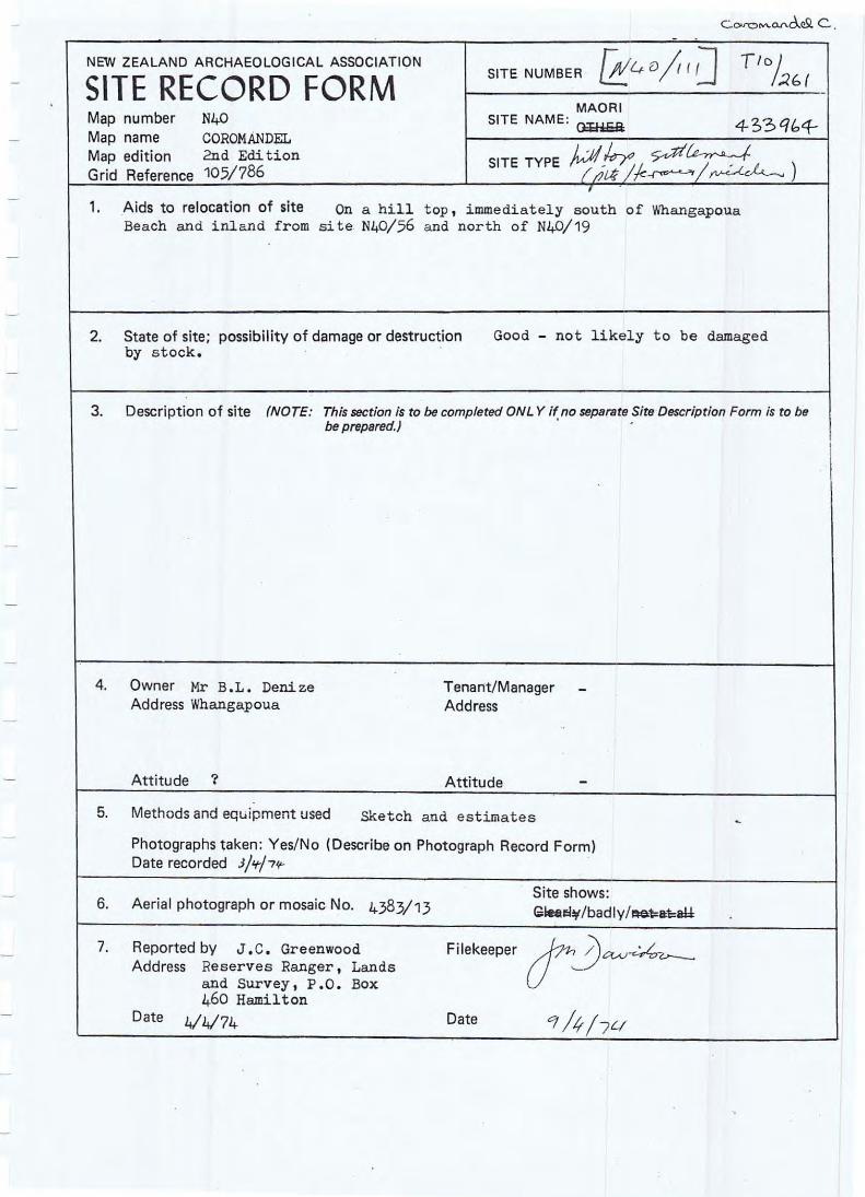
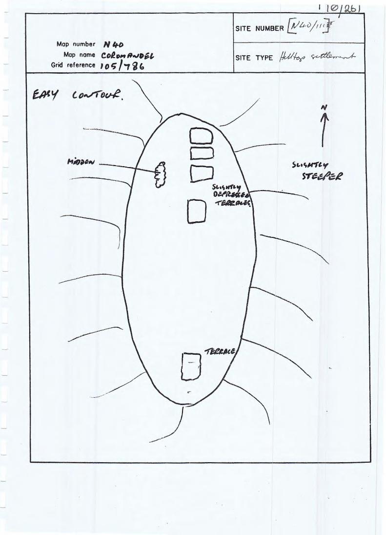
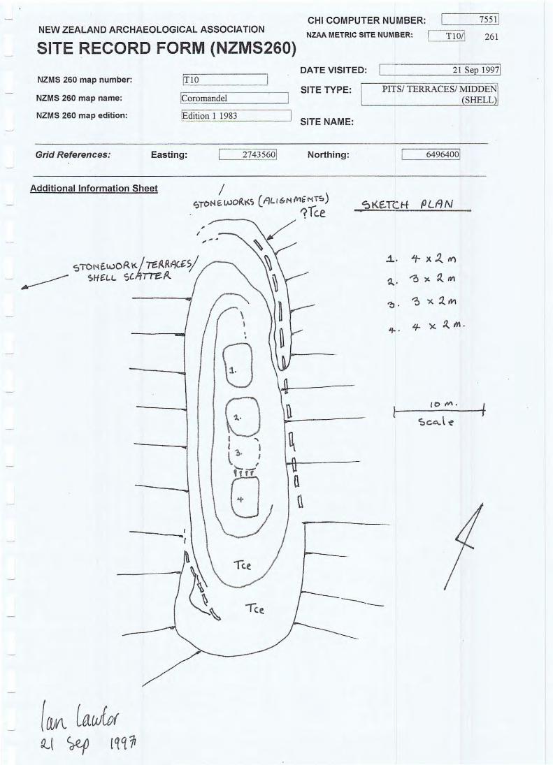
2.1.2 Plts/Terracesl Midden (Shell) (T1 0/261)
A PITSI TERRACESI MIDDEN (SHELL) site (Tl 0/261) is located on top of a 40 metre long by 8 metre wide ridge , approximately 450 metres to the west of
Denize Farm Block Whangapoua Beach, Coromandel 4
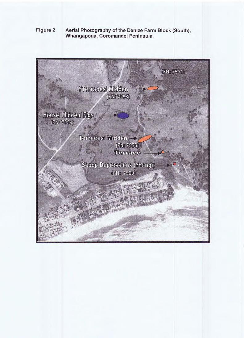
Figure 2 Aerial Photography of the Denize Farm Block (South), Whangapoua, Coromandel Peninsula.
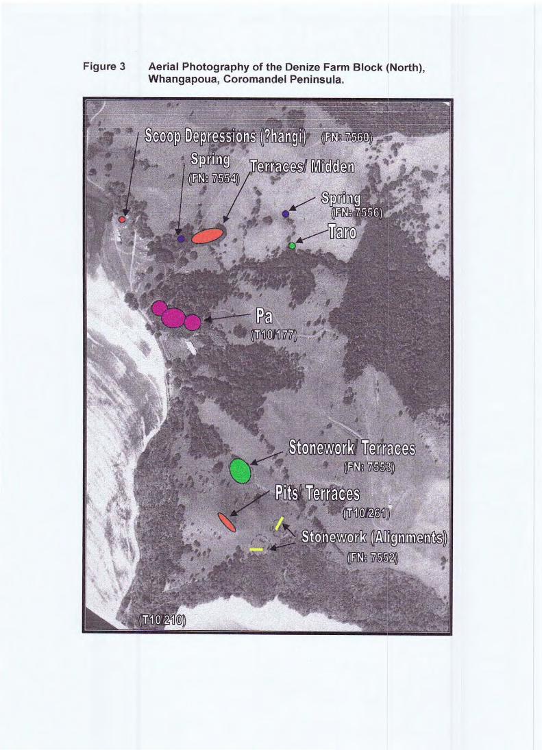
Figure 3 Aerial Photography of the Denize Farm Block (North), Whangapoua, Coromandel Peninsula.
Motuto Point. From this ridge there are spectacular views east 20 kilometres towards Ahuahu and the Mercury Islands (photo 21), southeast 2 kilometres along Whangapoua Beach (photos 6 and 11) towards Raukawa (Te Rehutae Point) and Matarangi Beach some 4 kilometres distant. The site was known to the Denize family as a "hilltop settlement" through previous site recording undertaken in 1974 by J. C. Greenwood, who was at that time a Department of Lands and Survey Reserves Ranger. A patch of shell midden was noted on the western edge of the pits when the site was first recorded but this was not evident during the recent inspection (see Appendix 1 NZAA SRF).
The earthworks on the ridge comprise four rough depressions aligned endon-end. They measure approximately 4 x 2 metres, 3 x 2 metres, 3 x 2 metres and 4 x .2 metres (from north to south) and are cut into the eastern side of the ridge (photos 6 and 7). On the western side of the ridge there is a slight raised bank that may have provided some protection againstthe prevailing westerly winds. In addition, 10 metres down the northeast and southwest corners there are remnants of what appears to be narrow (less than a metre wide) "terrace-like" earthworks.
Interpretation of all earthworks at this site is difficult because they are indistinct and do not provide a clear picture for interpretation. Unlike those earthworks at the pa site located behind the Denize homestead (discussed above), there are few clear edges and the surfaces are smoothed, possibly indicating some antiquity. Alternatively, the site may have been modified following the original occupation, particularly through the browsing and "camping" activities of stock, and through modern pasture management practices. The surrounding "hummocky" topography may also be indicative of past pig rooting (pers. comm. Robin Denize).
Together the features are thought to represent the remains of a Maori kumara storage complex. Alternatively, because of the clear broad views, the site could have functioned as a "watch" or sentry point. However, these interpretations are speculative and would require testing through excavation. The part-ring terrace remnants suggest that, at one time, the ridge-top may have been surrounded by a protective fence or palisade.
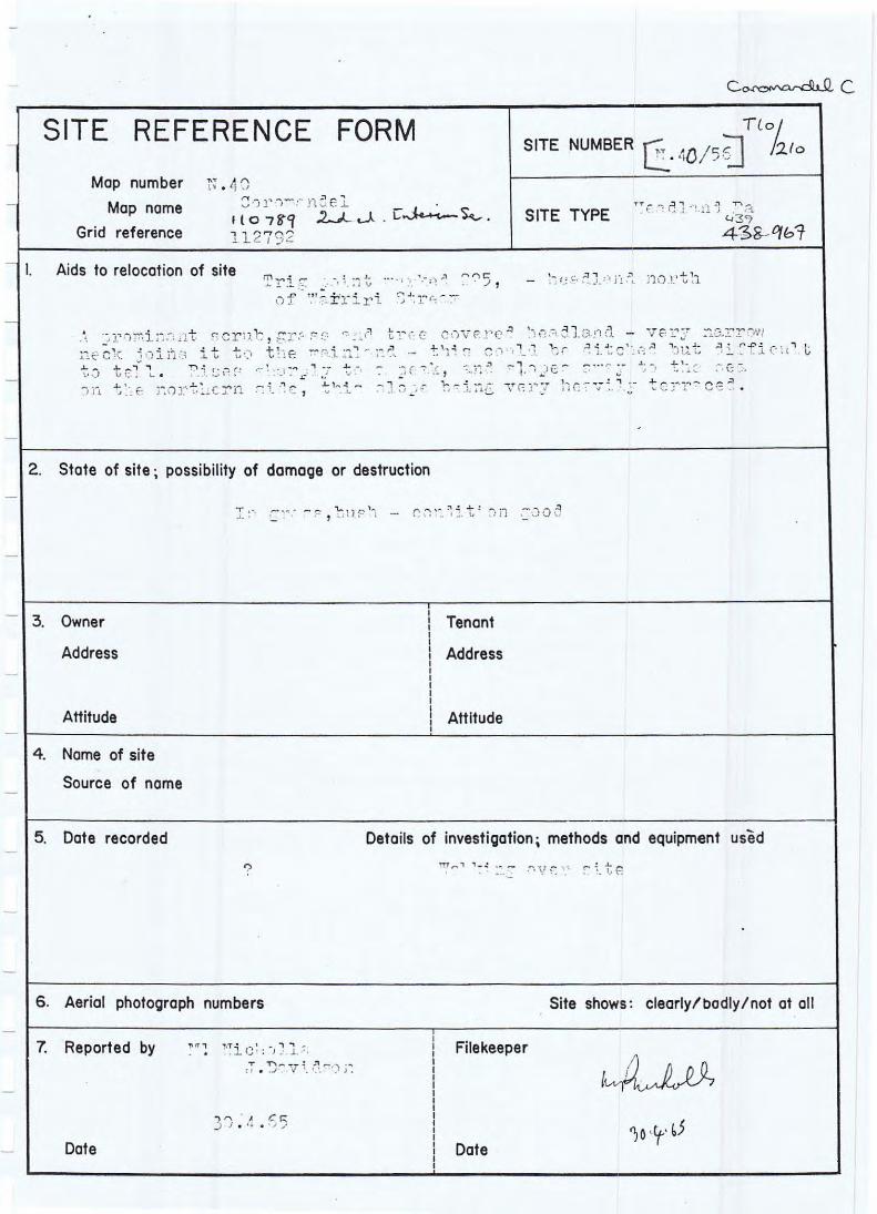
2.1.3 NZAA Sites Not Inspected Three other sites have been recorded in the general area but were not examined during the inspection (see Appendix 1 for the SRFs). These were a second headland pa, a shell midden and a basalt quarry.
Motuto Point is a location of a pa that was recorded by Molly Nichollsand Janet Davidson in April1965 (see Appendix 1 SRF for site T1 0/21 0). It is situated on a high promontory that separates New Chums Beach and Whangapoua Beach (photo 21). The SRF states: "A prominent scrub, grass and tree covered headland - very narrow neck joins it to the mainland - this could be ditched but difficult to tell. Rises sharply to a peak, and slopes away to the sea on the northern side, this slope being heavily terraced."
Denize Farm Block Whangapoua Beach, Coromandel 7
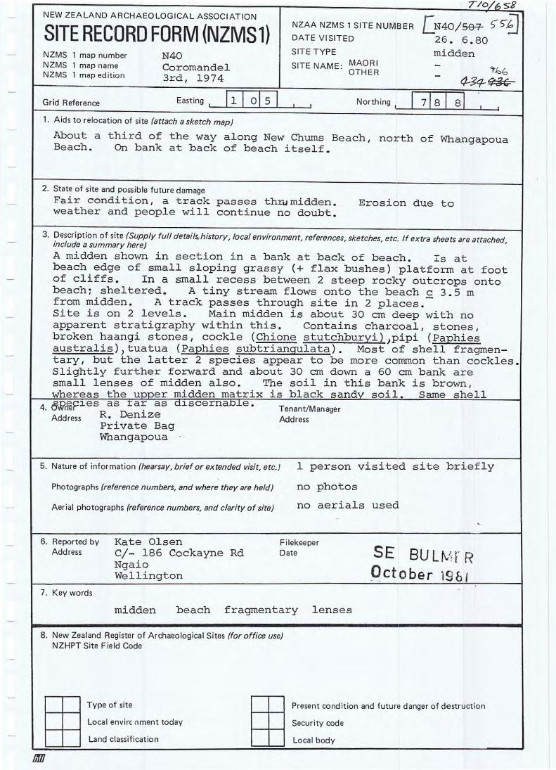
The shell midden (T10/658) is located on New Chums Beach and was recorded by Kate Olsen in June 1980. Shell species within the deposit include cockle, pipi and tuatua with the latter being more predominant. Hangi stones and charcoal-stained sand indicate that ovens were used at this site.
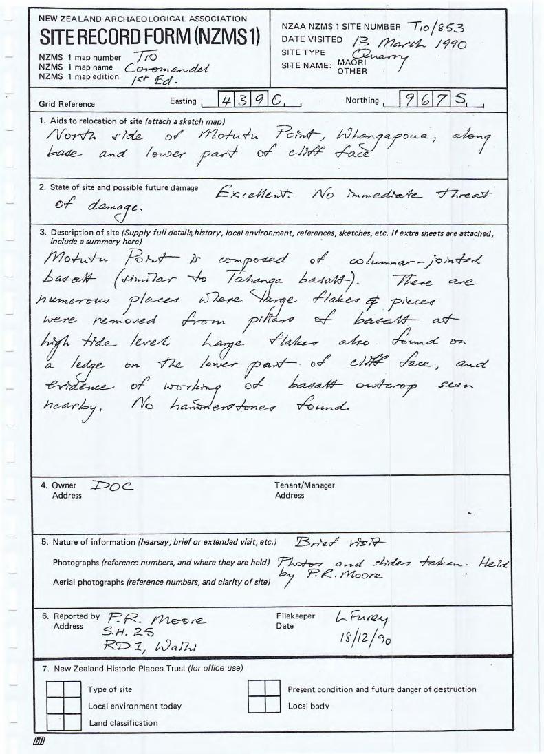
The basalt quarry (T10/853) is located on the north side of Motuto Point along the base of the cliff and was recorded by Phil Moore in March 1990. The site is a location where Maori have removed massive flakes and pieces of columnar-jointed basalt from the cliff, presumably to make adzes. Flakes were also noted on cliff ledges but no hammer stones were found.
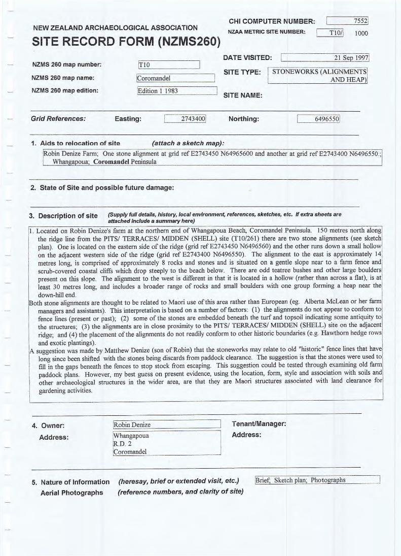
2.2 New Sites 2.2.1 Stonework (Alignments and Heap)/ Terraces (T10/1000)2
Located 150 metres north along the ridgeline from the PITS/ TERRACES/ MIDDEN (SHELL) site (T1 0/261) there are two stone alignments (see Appendix 1 sketch plan) . One is located on the eastern side of the ridge (photo 8 grid reference E2743450 N64965600) and the other runs down a small hollow on the adjacent western side of the ridge (photos 9, 10 and 14 grid reference E2743400 N6496550). The alignment to the east is approximately 14 metres long, comprises approximately 8 rocks and stones, and is situated on a gentle slope near to a farm fence and scrub-covered coastal cliffs that drop steeply to the beach below. There are odd teatree bushes and some large boulders present on this slope. The alignment to the west is different in that it is located in a hollow (rather than across a flat), is at least 30 metres long, and includes a broader range of rocks and small boulders, with one group forming a heap near the down-hill end.
Both stone alignments are probably related to Maori use of this area rather than European (eg. Alberta McLean or her farm managers and assistants). This interpretation is based on a number of factors:
1. the alignments do not appear to conform to present of past fence lines;
2. some of the stones are embedded beneath the turf and topsoil indicating some antiquity to the structures;
3. the alignments are in close proximity to the PITS/ TERRACES/ MIDDEN (SHELL) site (T1 0/261) on the adjacent ridge ; and
4. the placement of the alignments do not readily conform to other historic boundaries (eg. Hawthorn hedge rows and exotic plantings).
A suggestion was made by Matthew Denize (Robin's son) that the stoneworks may be discards from paddock clearance and relate to old "historic" fence lines that have long since been removed or shifted. The idea is that the stones were used to fill in the gaps beneath the fences to stop stock from escaping. This suggestion could be tested through examining old farm paddock plans. However, the best interpretation on present evidence, using the location , form , style and association with soils and other archaeological
Denize Farm Block Whangapoua Beach, Coromandel 8
structures in the wider area, is that they are Maori structures associated with land clearance for gardening activities.
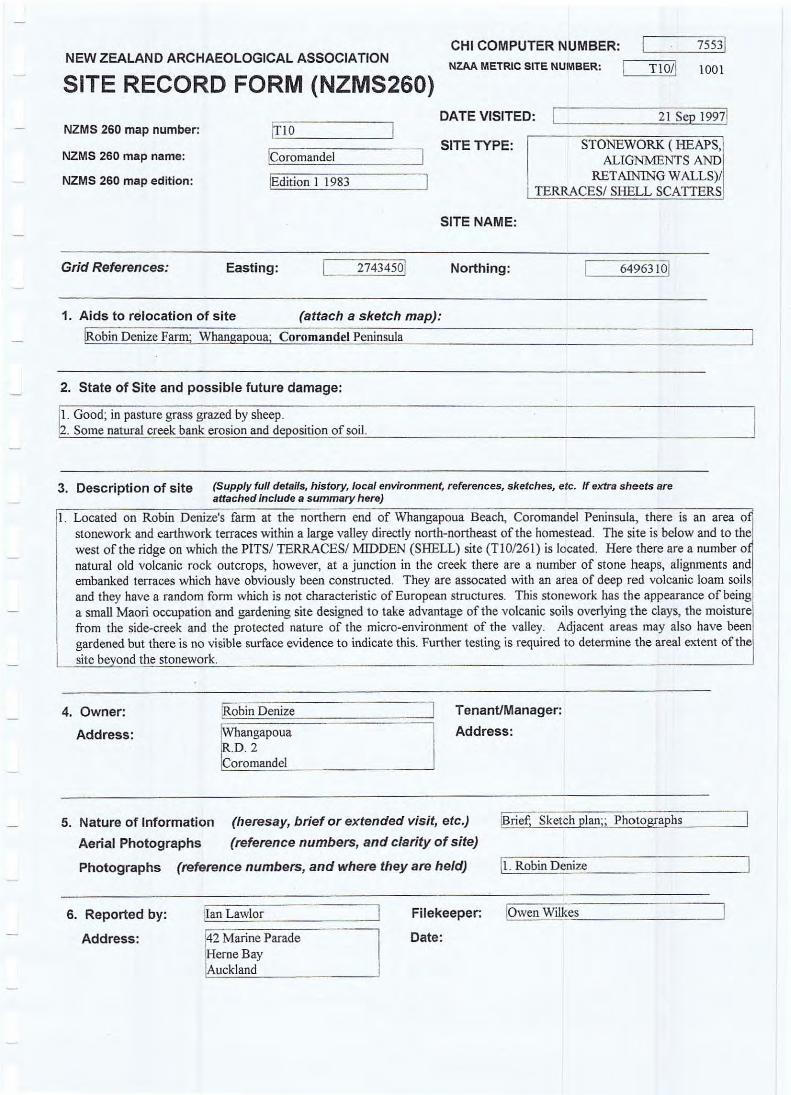
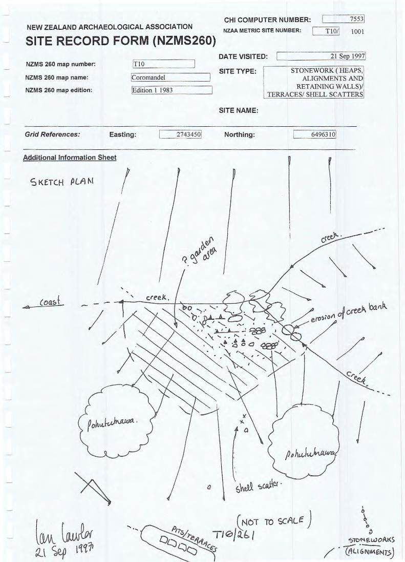
2.2.2 Stonework (Heaps, Alignments and Retaining Wall)! Terraces! Shell Scatters (T1 0!1 001)
There is an area of stonework and earthwork terraces within a large valley directly north-northeast of the homestead (photo 13). The site is below and to the west of the ridge on which the PITS/ TERRACES/ MIDDEN (SHELL) site is located (ie. T1 0!261). Here there are a number of natural old volcanic rock outcrops. However, at a junction in the creek there are a number of stone heaps, alignments and embanked terraces that have obviously been constructed. They are associated with an area of deep red volcanic loam soils and they have a random dry-stone form that is not characteristic of European structures.
This stone and earthwork area has the appearance of being a small Maori occupation and gardening site designed to take advantage of the volcanic soils overlying the clays, the moisture from the adjacent side-creek and the protected nature of the micro-environment of the valley. Adjacent areas may also have been gardened but there is no visible surface rock evidence to indicate this. Further testing is required to determine the aerial eldent of the site beyond the stonework.
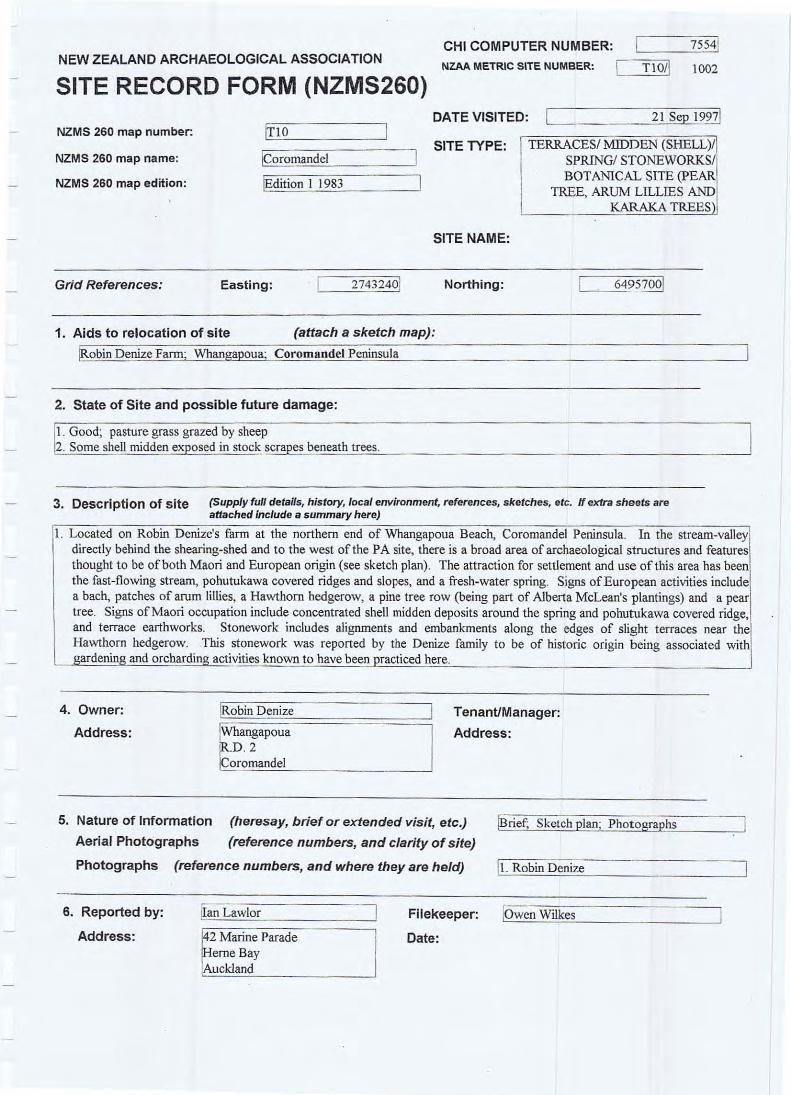
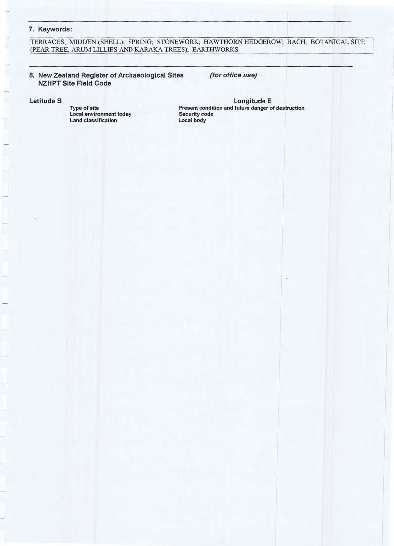
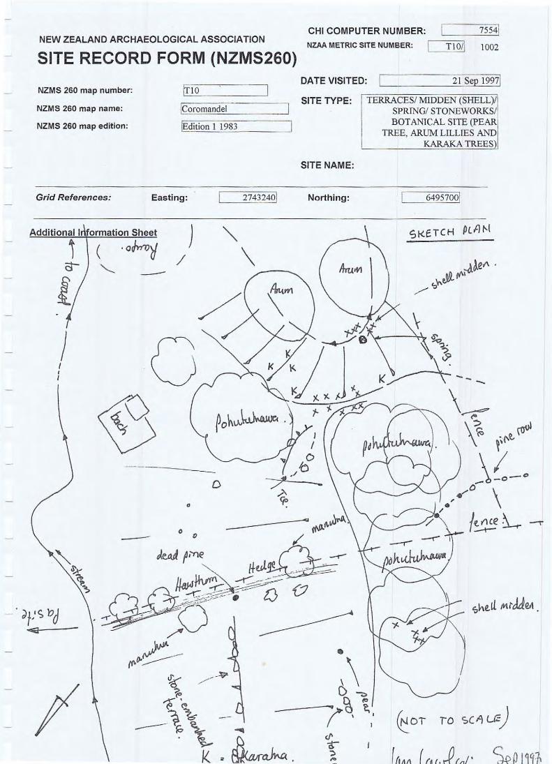
2.2.3 Terraces! Midden (Shell)! Spring! Stoneworks (Retaining Walls, Heaps and Alignments)! Botanical Site (T10!1002)
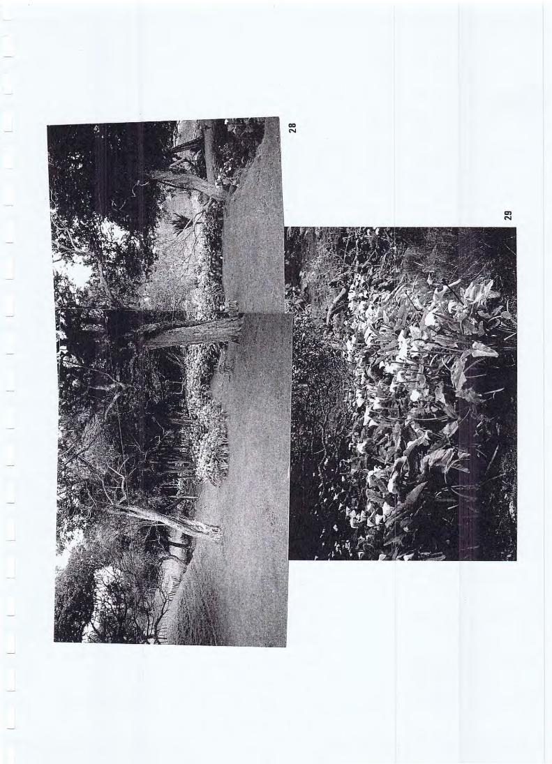
In the stream-valley directly behind the shearing-shed and to the west of the PA site (T1 0/177) there is a broad area of archaeological structures and features thought to be of both Maori and European origin (see Appendix 1 T1 0!1 002 sketch plan). The attraction for settlement and use of this area has been the fast-flowing stream, pohutukawa covered ridges and slopes, and a fresh-water spring. Signs of European activities include a bach, patches of arum lilies (photos 28 and 29), a Hawthorn hedgerow, a pine tree row (being part of Alberta McLean's plantings) and a pear tree. Signs of Maori occupation include concentrated shell midden deposits around the spring and pohutukawa-covered ridge, and terrace earthworks. Stonework includes alignments and embankments along the edges of insubstantial terraces near the Hawthorn hedgerow. The Denize family reported that this stonework is of historic origin being associated with gardening and orcharding activities known to have occurred here.
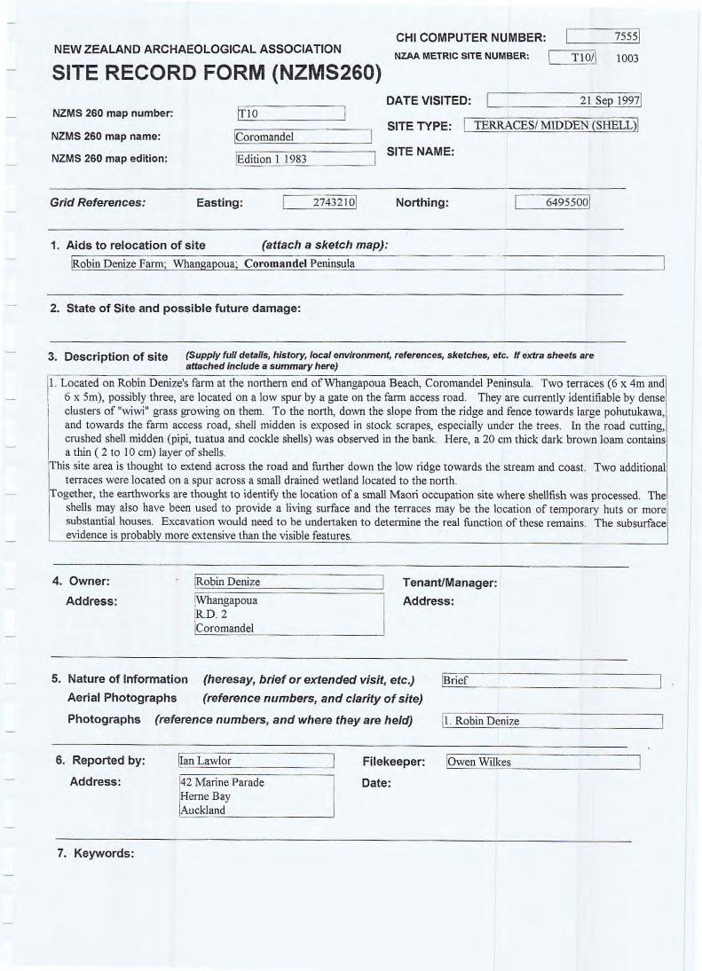
2.2.4 Terraces! Midden (Shell) (T1 0!1 003)
Two terraces (6 x 4 metres and 6 x 5 metres), possibly three, are located on a low spur by a gate on the farm access road. They are currently identified by dense clusters of "wiwi" grass growing on them. To the north, down the slope from the ridge and fence towards large pohutukawa, and towards the farm access road, shell midden is exposed in stock scrapes, especially under the trees. In the road cutting, crushed shell midden (pipi, tutu and cockle shells) was observed in the bank. Here, a 20 centimetre thick dark brown loam contains a thin (2 to 10 centimetres) layer of shells.
Denize Farm Block Whangapoua Beach, Coromandel 9
This site area extends across the road and further down the low ridges towards the stream and coast. Beneath large puriri trees there are dense scatters of crushed cockle shell in a dark black greasy black soil matrix. The wider area appears to have been extensively used for occupation and cooking activities. Two additional terraces were located on a spur across a small drained wetland located to the north of the farm access road .
Together, the earthworks are thought to identify the location of a Maori occupation site where shellfish and other foodstuffs were processed and cooked in hangi . The shells may also have been used to provide a living surface and the terraces are the likely location of temporary huts or more substantial houses. Excavation would be needed to determine the areal extent and function of these remains. The subsurface evidence is probably more extensive than the visible features presently indicate.
2.2.5 Terrace (Historic)! Spring! Trough (Historic)! Botanical Site (Taro) (T1 0!1 004)
A fresh water SPRING (photo 27) is located at grid reference E274291 0 N6495900 and the TARO bed (photos 22 to 24) is located in the same creek down-slope at E2743000 N6495950. The taro plants cover an area of creekbed roughly measuring 3 x 1.5 metres. The plants are very healthy and are of the red stemmed variety. Associated with the spring located above the taro is a historic concrete TROUGH that is one of a number reported by Matthew Denize to be related to Alberta McLean's farming activities (photo 27). Above the spring is a stone-embanked terrace that is also thought to be of recent historic origin (photo 26).
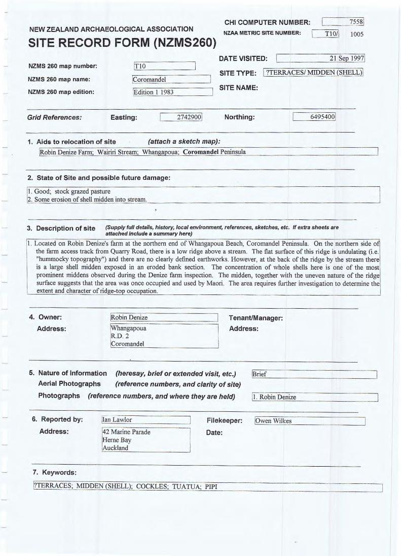
2.2.6 ?Terraces! Midden (Shell) (T1 0!1 005)3 On the northern side of the farm access road from Quarry Road , there is a low ridge above the stream. The flat surface of this ridge is undulating (ie. "hummocky topography") and there are no clearly defined earthworks. However, at the back of the ridge by the stream there is a large shell midden exposed in an eroding bank section. The concentration of whole shells here is one of the most prominent middens observed during the Denize farm inspection. The midden, together with the uneven nature of the ridge surface, suggests that the area was once occupied and used by Maori. The area requires further investigation to determine the extent and character of ridgetop occupation and whether nor not the terraces were occupied .
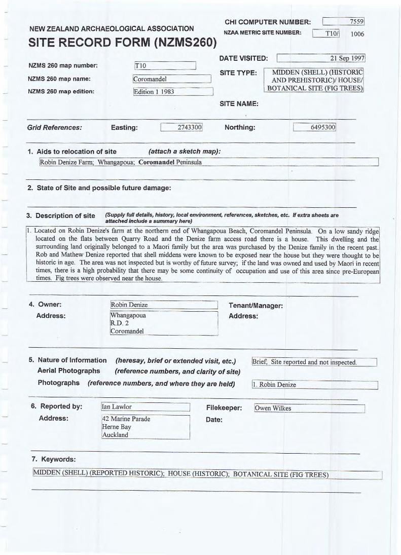
2.2.7 Midden (Shell)! House! Botanical Site (Fig Trees) (T10!1006) On a low sandy ridge located on the flats between Quarry Road and the Denize farm access road there is an old unoccupied house. This dwelling and the surrounding land originally belonged to a Maori family but the Denize family purchased the area in the recent past. Rob and Matthew Denize reported that shell middens were known to be exposed near the house but they were thought to be historic in age. The area was not inspected but is worthy of future survey; if the land was owned and used by Maori in recent times, there is a high probabil ity that there may be some continuity of occupation and use of this area since pre-European times. Fig trees were observed near the house.
Denize Farm Block Whangapoua Beach, Coromandel 10
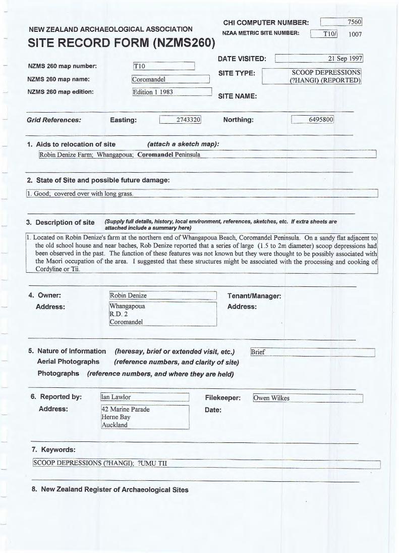
2.2.8 Scoop Depressions (?Hangi) (Reported) (T10/1007) On a sandy fiat adjacent to the old school house and near baches, Robin and Barry Denize reported that a series of large (1.5 to 2 metre diameter) scoop depressions had been observed in the past. The function of these features was not known but they were thought to be possibly associated with the Maori occupation of the area. One suggestion is that these structures might be associated with the processing and cooking of Cordyline or Tii.
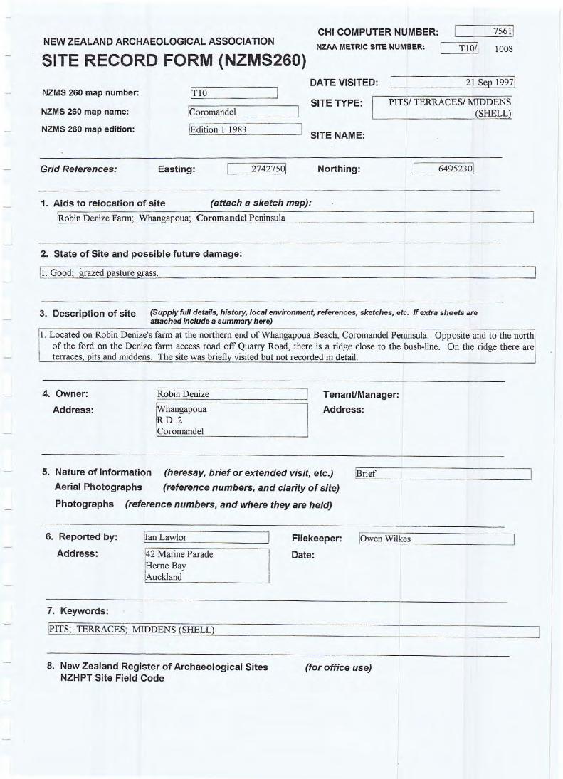
2.2.9 Pits/ Terraces/ Middens (Shell) (T10/1008) Opposite and to the north of the ford on the Denize farm access road , off Quarry Road, there is a ridge close to the bush-line. On the ridge there are terraces, pits and middens. The site was briefly visited but not recorded in detail. Other pit depressions were reported to be located on ridges in the bush and inland from the coast.
3 DISCUSSION A brief inspection of a coastal portion of the Denize Farm Block adjacent to Whangapoua Beach revealed eleven archaeological sites (Figure 4). Two of these, a PA (T10/177) and a PITSITERRACESI MIDDEN (SHELL) site (T10/261), had been previously recorded in 1963 and 1974 respectively. A further three sites located outside the survey area were not inspected. These were on Motuto Point and New Chums Beach and included a headland pa (T1 0/21 0); a shell midden (T1 0/566) and a basalt quarry (T10/853) recorded between 1963 and 1990.
The inspected historic places are an interesting collection. Together with the sites in the wider area they represent a range of both Maori and European activities. Most of the sites however are thought to relate to Maori settlements that were occupied before contact with Europeans. This assumption is based on the absence of historic artefacts (eg. glass, metal and ceramics) from exposed sections and middens. The settlements range from the strategically located pa, defended by substantial ditch and bank earthworks, to open settlements located to take advantage of raised dry ground and the close proximity of freshwater springs, volcanic soils, and local building and food resources in the bush, streams and swamps.
The headland pa at the mouth of the Pungapunga Stream by the Denize homestead (T1 0/177) appears to be one of the main occupation areas. It is strategically located in between a substantial stream (named Wairiri)4 and Whangapoua Beach. Within the pa, the form, size and layout of earthworks, together with the shell midden exposures, suggest that there may be a range of structures present. These included house and hut complexes associated with living areas, 'sentry' platforms, cooking areas and pit complexes. The pit depressions are thought to represent the remains of semi·subterranean storage structures where kumara or sweet potato was over·wintered. Sites recorded around the pa are thought to be directly associated with it.
. However, this suggestion is speculative and requires further investigation through research.
Denize Farm Block Whangapoua Beach, Coromandel 11
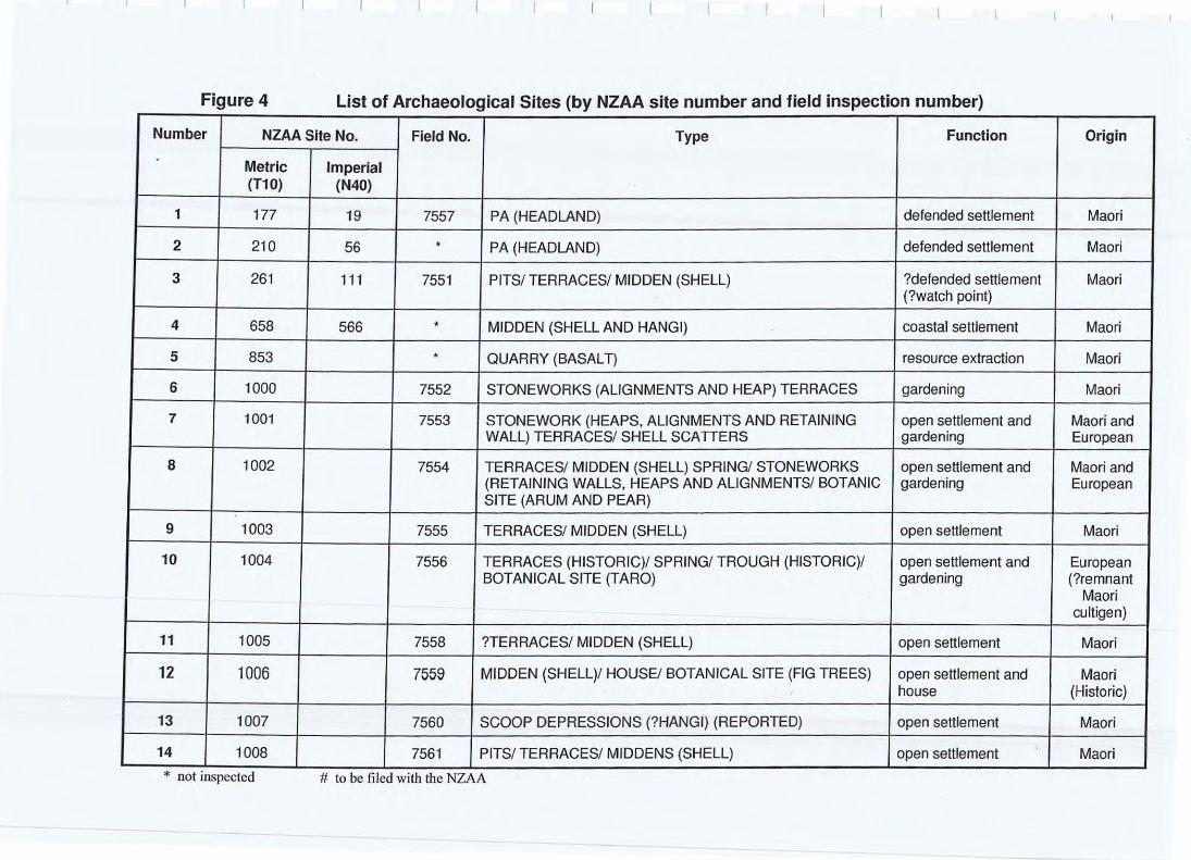
Figure 4 List of Archaeological Sites (by NZAA site number and field inspection number)
Number NZAA Site No. Field No. Type Function Origin
Metric Imperial (T10) (N40)
1 177 19 7557 PA (HEADLAND) defended settlement Maori
2 210 56 • PA (HEADLAND) defended settlement Maori
3 261 111 7551 PITS/ TERRACES/ MIDDEN (SHELL) ?defended settlement Maori (?watch pOint)
4 658 566 • MIDDEN (SHELL AND HANGI) coastal settlement Maori
5 853 • QUARRY (BASALT) resource extraction Maori
6 1000 7552 STONEWORKS (ALIGNMENTS AND HEAP) TERRACES gardening Maori
7 1001 7553 STONEWORK (HEAPS. ALIGNMENTS AND RETAINING open settlement and Maori and WALL) TERRACES/ SHELL SCATTERS gardening European
8 1002 7554 TERRACES/ MIDDEN (SHELL) SPRING! STONEWORKS open settlement and Maori and (RETAINING WALLS. HEAPS AND ALiGNMENTS/ BOTANIC gardening European SITE (ARUM AND PEAR)
9 1003 7555 TERRACES/ MIDDEN (SHELL) open settlement Maori
10 1004 7556 TERRACES (HISTORIC)/ SPRING/ TROUGH (HISTORIC)/ open settlement and European BOTANICAL SITE (TARO) gardening (?remnant
Maori culligen)
11 1005 7558 ?TERRACES/ MIDDEN (SHELL) open settlement Maori
12 1006 7559 MIDDEN (SHELL)/ HOUSEl BOTANICAL SITE (FIG TREES) open settlement and Maori house (Historic)
13 1007 7560 SCOOP DEPRESSIONS (?HANGI) (REPORTED) open settlement Maori
14 1008 7561 PITS/ TERRACES/ MIDDENS (SHELL) open settlement Maori
* not inspected # to be filed with the NZAA
Open settlement sites appear to be focused on the low naturally drained spurs and ridges located immediately above the Pungapunga Stream flats (eg. refer to Figure 4 sites T1 0/1 003 and T1 0/1 005 to T10/1008). The raised spurs are relatively dry and more suited for the construction of houses, cooking shelters and storage pits. The ridges would have also provided access into the interior bush covered hills and gardens, and some natural defence was probably afforded by the original swampy character of the surrounding flats (now drained).
Two open settlement sites are associated with volcanic red loam soils in valleys away from the coast (sites T10/1001 and T1 0/1 002). These sites were most likely located to take advantage of the naturally fertile soils overlying the clays, the moisture from the adjacent side-creeks, rocks for building and the protected nature of the valley micro-environments. The gardens here may have been more productive. Generally, shell middens, hangi (ovens), scoop depressions and stoneworks suggest that a range of activities were associated with these settlements. These included the gathering and cooking of local shellfish and fish, the growing and storing kumara, and the quarrying of basalt rock presumably for manufacturing stone adzes.
From surface evidence alone it is difficult to determine the age and function of these sites. However, it is possible to suggest that the pit depressions are indicative of year-round occupation. Some places were probably seasonally occupied and associated with specific resource-getting activities. On present evidence most of the recorded sites are thought to be over 300 years old however this is speculative and only based on the form, character, setting and absence of evidence. More research would be needed to provide age estimates for occupation and site relationships.
Some archaeological site evidence is related to recent occupation (ie. post 1769). This includes an old uninhabited house (site T1 0/1 006) on the stream flats near the farm access road that belonged to a Maori family (pers. comm Robin Denize). Shell midden around this house suggests that the raised ridge on which it is located was also occupied prior to European contact. There are also the various structures, features and plantings associated with Alberta Mclean's farming operations (sites T10/1002 and T10/1004). Together with the Denize homestead they provide an interesting historic collection.
4 CONCLUSION This report presents the results of a brief reconnaissance inspection of the archaeological evidence on part of the Denize farm Block. It has not included a review of the associated historic records and oral information that is needed to evaluate the significance of these historic places. The recorded sites broadly suggest that the locality has been a favoured settlement area throughout the period human occupation. Archaeologically, most of the earthworks, apart from the pa, will probably not yield detailed stratigraphic information. It is the areas adjacent to the sites, the beachfront flats and swampy margins, which will retain the best preserved evidence. Future
Denize Farm Block Whangapoua Beach, Coromandel 13
development should consider the adverse effects and potential adverse effects that might result from activities, particularly earthworks and drainage. Under present legislation an authority is required from the New Zealand Historic Places Trust before an archaeological site is destroyed, damaged or modified. This is the case regardless of whether or not the site is recorded, scheduled in a plan, or registered as an archaeological site with the Trust.
5 RECOMMENDATIONS The following recommendations are made to promote onoging conservation management:
1. That an application be made to the New Zealand Historic Places Trust to destroy, damage or modify any archaeological site;
2. That Tangata Whenua be consulted to ascertain whether they have a relationship with recorded sites or other places and areas;
3. That in the event of any previously undiscovered archaeological evidence being found during development both Tangata Whenua and the New Zealand Historic Places Trust should be notified.
This brief reconnaissance inspection has identified a number of sites and areas where activities associated with occupation, resource use and settlement have left marks across the landscape. In the future it will be important to use historic records and oral history to identify those places that . deserve particular attention to ensure that a diverse and representative range of historic places are preserved and protected for future generations.
Oenize Farm Block Whangapoua Beach, Coromandel 14
Endnotes
1 Archaeological sites are recorded within the New Zealand Archaeological Association (NZAA) Site Recording Scheme are identified using NZ Mapping Series map sheet numbers (eg. N40 or N44 for imperial and Tl a or TIl metric maps) and consecutive numbers (eg. I, 2, 3 ... ) prefixed by a slash (eg. Tl0/177). The site numbers are allocated by Regional Filekeepers when record forms are first submitted. Those sites recorder before metrication have an imperial site number (eg. the imperial number for the headland pa on Motulo Point is N40/19 and the metric site number is Tl 0/21 0) . Sites recorded after metrication only have a metric site number (eg. Tl0/853) .
2 Site Record Forms (SRFs) were submitted \0 the New Zealand Archaeological Association Site Recording Scheme Waikato Filekeeper (Own Wilkes, C/- Department of Conservation, Private Bag 3072, Hamilton) at the request of Peter Johnston (pers. comm. 17 Aug 1998). Recorded sites have been given Tl0 map sheet numbers 1000 to 1008 (see Figure 4 for a complete list).
3 The question mark at the front of a site type description (eg. ?Terraces) highlights the fact that there is some doubt or uncertainty about the interpretation or identification of the structure or feature.
4 Source: New Zealand Cadastral Map County Series (1 :63,360) NZMS 15 Coromandel Sheet I, 3'" Edition, 1 Dec 1959 and NZMS 260 Metric Map Sheet Tl O.
Denize Farm Block Whangapoua Beach, Coromandel 15
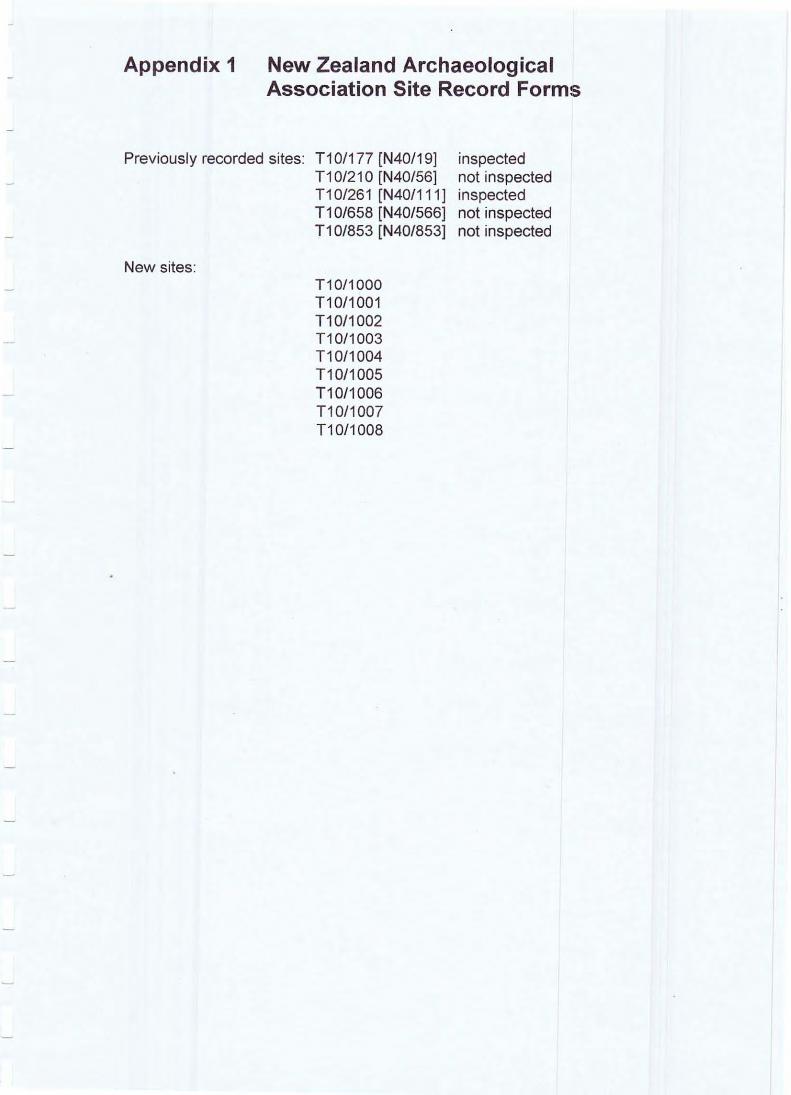
Appendix 1 New Zealand Archaeological Association Site Record Forms
Previously recorded sites: T10/177 [N40/19] T1 0/21 0 [N40/56] T10/261 [N40/111] T10/658 [N40/566] T10/853 [N40/853]
New sites: T1 0/1 000 T10/1001 T10/1002 T10/1003 T1 0/1 004 T10/1005 T10/1006 T10/1007 T10/1008
inspected not inspected inspected not inspected not inspected
SITE REFERENCE FORM SITE
T1O{ NUMBER U:4 0 !19] (::fl'
Map number ~ . 4Q
Map name ~ IO~7~3 SITE TYPE \, 14S7~4- ~~ D ' :l
4-3'? '1(.( Grid reference
L Aids to relocation of site On he"dlaucl behind h o !!'!.:3 te .~d, vt ;';o r the r n Gide of 2" "C r eek.
In e;r rl SS a" d t re~ 6 .
f\ f :~ r :n ro ' d cut throu p:'n on 'lest s ide.
2. State of site; possibility of damage or destruction
I II Gr 8ss ~l n ci trees - gOl,d
, Tenant 3. Owner , , , ,
Address ,
Address , , , , , , , , Attitude Attitude , , ,
4. Name of site -Source of nome
5. Date recorded 9 . '1 . 63
Details of investigation; methods and equipment used
I1ix )i ieRz 'S ;:ll~ ing o ve r site
~
6 . Aerial photograph numbers Site shows: clearly/badly/not at ali
Reported by ,
Filekeeper ~ . .4J.~ 7. : . :Hcho l ls I
,;t~ , I
;\ . J e ; h:f I I I I ,
24 . 7 . IS '5 I I I , ,
~ j lO /6a Date , Date I , ,
... ..
- !
Mop number
Mop nome
Grid reference
,
Tie
SITE NUMBER U IIJO ) '1 ]
tv·<+£>
~fJ.A,ulLI to ,+- 7 n SITE TYPE r J 5 7 ~ It . ..:u. J.. . T...J-~ ~ .
-
[ ) o o
/ ;. ~
. .----
-------.. -
t .
\ x; ..:n-
--- : 75'S;:?) >: F
------- -:5:J:n -~
------ -_._-----..... ! II C c
NEW ZEALAND ARCHAEOLOGICAL ASSOCIATION CHI COMPUTER NUMBER: ~===;---"-7=..,55:'-J7 1 NZAA METRIC SITE NUMBER: I Tl 011 177
SITE RECORD FORM (NZMS260)
ICoromandel
tno DATE VISITED:
SITE TYPE:
21 Sep 19971 NZMS 260 map number:
PA (HEADLAND)I NZMS 260 map name:
NZMS 260 map edition: iEdition I 1983 SITE NAME:
Grid References: Easting: 27433801 Northing: 6496 1701
1. Aids to relocation of s ite (a ttach a sketch map):
2. State of Site and possible future damage:
I. Very good; some pasture. indigenous bush (west) and exotic vegetation (east). An old historic farm track has been cut along l the western side of the earthworks.
3. Description of site (Supply full details, history, local environment, references, sketches, etc. If extra sheets are attached include a summary here)
I. Located on Robin Denize's fann at the northern end of Whangapoua Beach, Coromandel Peninsula. The PA is located on a low ridge directly to the north of the woolshed and 10 the west of the Denize fami ly homestead and bach. The brief walk-over showed the site to be in very good condition. There is a degree of symmetry to the layout of the pa earthworks. At either end in the north and south there is a raised circular platfonn, reminiscent of watch or sentry points. These are separated from the pa interior by ditch earthworks and there is a central raised tihi, roughly 30 metres square, around which a series of pits and two small terraces are located. There is a double ditch and bank at the southern end of the pa.
The size and layout of the site suggests that it was occupied by a small extended family group. The tihi is sufficiently large enough to contain the remains of three, possibly four, houses and the five pit depressions, most likely used for the storage a kumafa, indicate that the site was used throughout the year. It is highly likely that the other archaeological site evidence recorded on the ridge to the west, on the other side ofthe stream, is also related to this oa.
4. Owner: 1R0bin Denize TenanUManager:
Address: Whangapoua iR D 2
Address:
Coromandel
5. Nature of Information (heresay, brief or extended visit, etc.) !Brief; Schematic plan; PhotoS@ll",h",s _ _ _
Aerial Photographs (reference numbers, and clarity of site)
Photographs (reference numbers, and where they are held)
6. Reported by:
Address:
~an Lawlor
~2 Marine Parade Herne Bay \Auckland
Filekeeper:
Date:
11. Robin Denize
IOwen Wilkes
7. Keywords:
A (HEADLAND); DITCHES; DITCH AND BANK; EARTHWORKS; MIDDEN (SHELL); COCKLE; PIP!; TUATUA; PITS; TERRACES; TlliI· POHUTUKAWA
8. New Zealand Register of Archaeological Sites NZHPT Site Field Code
(for office use)
Latitude S Type of srte Local environment today Land classification
Longitude E Present condrtion and future danger of destruction Security code local body
NEW ZEALAND ARCHAEOLOGICAL ASSOCIATION
SITE RECORD FORM (NZMS260)
NZMS 260 map number: Iflo NZMS 260 map name: ICoromandel
NZMS 260 map edition: !Edition 1 1983
Grid References: Easting:
-
1
~
27433801
/ J I
I I
- I
CHI COMPUTER NUMBER: 75571
NZAA METRIC SITE NUMBER: '--:=T=1 0:::;-/1-----'-""17:.:.17
DATE VISITED: 2 1 Sep 19971
SITE TYPE: PA (HEADLAND)i
SITE NAME:
Northing: 6496 1701
I
I ',-----
I ) \ I
~ \ -\
\ , \
c~c
SITE REFERENCE FORM SITE NUMBER
no). c::: 1>0 / 56] 2.10
Mop number t~ . 4'J
- Mop nome ~>j r"-I~" :- n ~ e 1. C~~. T~ (. '": G] ·-).n ~ :n ;"1
flo '7 fl'~ 2....LJ SITE TYPE "3<; Grid reference 11 2792 41>8--%1
- I. Aids to relocation of site 'l'r i ; .. ~ '- ' . I :'.' '.- C,! .. ~ M", :-: ,~;.:, ::J. I j", .~"'.. j10 .l.' t~1 ~ •. " , "i. ,J '-' -- -' f -
c) f '." ~d:l- i ri. S J_. T '~: -. :-:-
-'- ·jl~();;"i.;~,,~: ~lt ~crn .. 1::: , ...... -., ~ f= :;: ~. ~.~? t T ( 12 C ()VF.r>C ~ ~!t!.-:t j1 8.!'"l(1 - -.rE': l":.r :-:"G.r:rCN! i': ",!. • . ..
+ ''' ~ -, 1 1-;:- .:l ..; .J. ,...' - . ' .;, ;l "l11).t ~ . ~fi ell ' t l:E' C1{ j (:ii1 ;:'; ~ t ·) t' l f-! ~ :-:: .i .:"'1 ~ -- _. " ~ C .' - ,
l , I _ .~ -- .. . - .. '; . _,.., .1 , . -, ~ . " .. , ,,: ;1 - , . - ... +,- ,.. -· f:; :: . ~ - + - ' ,
~. :1 , ~.:,~~ : ,_. ~ , . 1 -~ : - 'J ( c ') ~l C .... . ' v: ' .o f !- , -"
.. .. '-'--"J v.: . . c , .' •• J: .. -
j ~. o r 7.:'_ c :rn. :-:i -, - ~l"'. i - .- J t ~ :1. ~"'lC ..,.~ .. \; j"':; 1 .... ,.. _ ~~ ~ , ..... ~ - ... - ... .- ......... .:I :-J.n + ,
" . - , I I; ; ~ ' . .... . _) l . '-' ,= _, . ... -~f ":'" f . "
-
2. State of site; possibility of damage or destruction
- ,. ,-, ,..o .~ . - ~ , "h1l.F l ' j - (; ..... -:'1;+: --, .= ~)O j • 1 •• ~ , . , " - I~ . \, , : J .
-
- 3. Owner I I Tenant I
Address Address -
Attitude Attitude -
4. Nome of site
Source of nome -
5. Dote recorded Details of investigation; methods and equipment used -
? ;rT ...... , , ~ ~ .. - · ....... v c ': . :-- ~. t f; .. -
-
6. Aerial photograph numbers Site shows: clearly I badly I not at all
-7. Reported
I Filekeeper by 1' 1;' 1 l':i e:: * J ~ , l. .: . I
I
I~ <; • :)~ v~. I~~. -:,) ; ~ I I I I - I I I
"'\ '" • A . S5 I .;; ) • 'i I
')0 'it' b) I I
Dote I Dote - I I I
-NEW ZEALAND ARCHAEOLOGICAL ASSOCIATION ~4D/tICJ T I OJ. SITE RECORD FORM
SITE NUMBER ':<6 ( -
Map number MAORI
N40 SITE NAME: ~ 4-33qt,4-Map name eOROMANDEL
)v:JI/.ery ~~ Map edition 2nd Edition G rid Reference 105/786 SITE TYPE ( ti~'//c~/~~ )
, 1. Aids to relocation of site On a hill t op, immediately south of Whangapo.ua
Beach and inland from si te N40/56 and north of N40/19
2. State of site; possibility of damage or destruction Good - not likely to be damaged by stock.
3. Description of site (NOTE: This section is to be completed ONL Y if no separate Site Description Form is to be be prepared.) '.
I
4. Owner Mr B.L. Denize Tenant/Manager -Address Whangapoua Address
Attitude ? Attitude -5. Methods and equipment used Sketch and estimates -
Photographs taken: Yes/No (Describe on Photograph Record Form) Date recorded J/'I'j7'f-
6. Aerial photograph or mosaic· No. Site shows:
4383/13 GIee"t\f/badIY/I!Ie~IO~aI!
7. Reported by J. e . Greenwood Filekeeper ~~)~.~ Address Reserves Ranger, Lands and Survey, P.O. Box 460 Hamil ton
Date 414174 Date "1 IIr hLf
Map number N I#> Map name COe_II~.;'/,
Grid reference , 0 t; /.., 11 "
1/0 b)
SITE TYPE f/dI¥ ~
/ It(
i ~,".t,H7""
S"'~~,;R
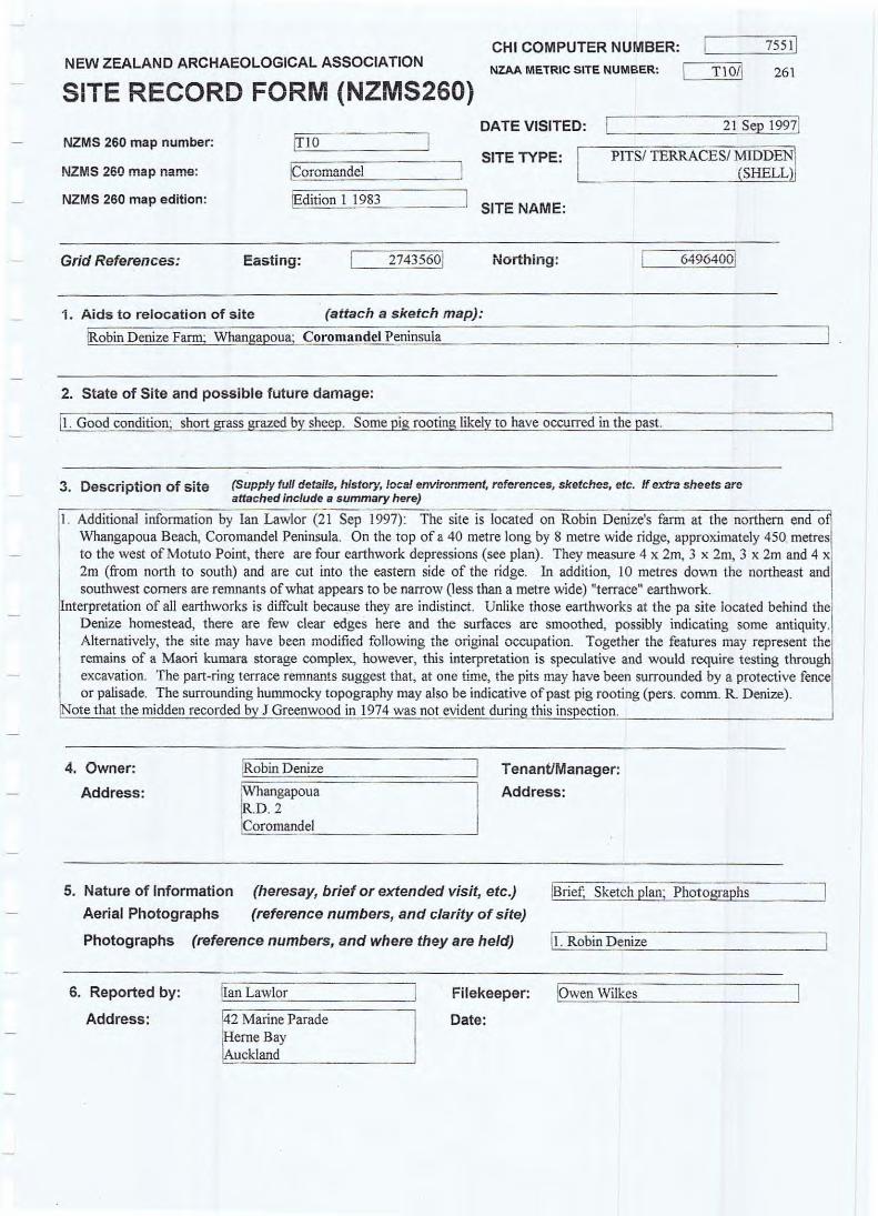
NEW ZEALAND ARCHAEOLOGICAL ASSOCIATION CHI COMPUTER NUMBER: ~,=:::::;-----,7::..:55~1 1 NZAA METRIC SITE NUMBER: [ TIOII 261
SITE RECORD FORM (NZMS260) DATE VISITED: 21 Sep 19971
NZMS 260 map number: trIO NZMS 260 map name: [Coromandel I
SITE TYPE: PITSI TERRACESI MIDDEN I (SHELLlI
NZMS 260 map edition: I'=~~di"o'ti~on~l !-,1 9~8~3 ____ 1 SITE NAME:
Grid References: Easting: 27435601 Northing : 64964001
1. Aids to relocation of site (attach a sketch map):
tRobin Denize Farm; Whangapoua; Corom.ndel Peninsula
2. State of Site and possible future damage:
[I. Good condition; short grass grazed by sheep. Some pig rooting likely to have occurred in the past.
3. Description of site (Supp!y full details, history, local environment, references, sketches, etc. If extra sheets are attached include a summary here)
I. Addilional information by Ian Lawlor (21 Sep 1997): The site is located on Robin Denize's farm at the northern end 0
Whangapoua Beach, Coromandel Peninsula. On the top of a 40 metre long by 8 metre wide ridge, approximately 450 metres to the west of Motuto Point, there are four earthwork depressions (see plan). They measure 4 x 2m, 3 x 2m, 3 x 2m and 4 x
I
, 2m (from north to south) and are cut into the eastern side of the ridge. In addition, 10 metres down the northeast and southwest corners are remnants of what appears to be narrow (Jess than a metre wide) "terrace" earthwork.
nterpretation of all earthworks is diffcult because they are indistinct. Unlike those earthworks at the pa site located behind the Denize homestead, there are rew clear edges here and the surfaces are smoothed, possibly indicating some antiquity. Alternatively, the site may have been modified fo llowing the original occupation. Together the features may represent the remains of a Maori kumara storage complex, however, this interpretation is speculative and would require testing through excavation. The pan·ring terrace remnants suggest that, at one time, the pits may have been surrounded by a protective fence or palisade. The surrounding hummocky topography may also be indicative of past pig rooting (pers. comm. R. Denize).
iNote that the midden recorded by J Greenwood in 1974 was not evident durinp, this inspection.
4. Owner:
Address:
!Robin Denize
~ angapoua
.D.2 Coromandel
Tenant/Manager:
Address:
5. Nature of Information (heresay, brief or extended visit, etc.) !BI1ef; Sketch plan; Photographs
Aerial Photographs (reference numbers, and clarity of site)
Photographs (reference numbers, and where they are held) I.!!l,-. ",R",ob",i",n.=D~e,"n"iz",e _ _ _ _ ___ _ _ ---.J
6. Reported by:
Address:
[Ian Lawlor
2 Marine Parade tHeme Bay [Auckland
Filekeeper: !Owen Wilkes
Date:
7. Keywords:
iTERRACES; EARTHWORKS; PITS; DEPRESSIONS; ?FENCE (PALISADE); KUMARA PITS
8. New Zealand Register of Archaeological Sites NZHPT Site Field Code
(for office use)
Latitude 5 Type of site Local environment today Land classification
Longitude E Present condition and future danger of destruction Security code Local body
NEW ZEALAND ARCHAEOLOGICAL ASSOCIATION CHI COMPUTER NUMBER: 7551 1
NZAA METRIC SITE NUMBER: rl ~T;:l;O!;-1 -----'-~26~1 SITE RECORD FORM (NZMS260)
NZMS 260 map number: [no
NZMS 260 map name: ICoromandel
NZMS 260 map edition: IEdition 1 1983
Grid References: Easting: 27435601
Additional Information Sheet
g 0 1 "' I l~' I ,--'
(J -I
~, one
I ce
1
~ Th
~
U
DATE VISITED:
SITE TYPE:
SITE NAME:
Northing :
21 Sep 19971
PITS! TERRACES! MIDDENj (SHELL)
64964001
C:lKE.Tt.H PLAN
.i . 'l- x .2. 11'1
~ . 'O"~,,.,
'l;J. '0 X Q. M
"to . if. x :t m.
10 M . I 'Scc.. l -e
U
--
T/o/If..SIi NEW ZEALAND ARCHAEOLOGICAL ASSOC IAT ION
[N40/5W- s-s-~ SITE RECORD FORM (NZMS 1) NZAA NZMS 1 SITE NUMBER
DATE VISITED 26. 6.80 NZMS 1 map number N40 SITE TYPE midden NZMS 1 map name Coromandel SITE NAME: MAORI - 'TbE, OTHER NZMS 1 map edition 3rd, 1974 - C/-3q-~
Grid Reference Easting I /1 I 0151 I I Northing I I 7181 81 I I
1. Aids to re location of site (attach a sketch map)
About a third of the way along New Chums Beach, north of Whangapoua Beach. On bank at back of beach itself.
2. State of site and possib le future damage Fair condition, a track passes thru midden. Erosion due to weather and people will continue no doubt.
3. Description of site (Supply full detailSthistory, local environment, references, sketches, etc. If extra sheets are attached, include a summary here) A midden shown in section .in a bank at back of beach. Is at b each edge of small sloping grassy (+ flax bushes) platform at foot of cliffs. In a small recess between 2 steep rocky outcrops onto beach; sheltered. A tiny stream flows onto the beach c 3.5 m from midden. A track passes through site in 2 places. Site is on 2 l evels. Main midden is about 30 cm deep with no apparent stratigraphy within this. Contains charcoal, stones, broken haangi stones, cockle (Chione stutchbur~i})pipi (PaEhies australis})tuatua (PaEhies subtriangulata) . Most of shell fragmen-tary, but the latter 2 species appear to be more common than cockles. Slightly further forward and about 30 cm down a 60 em bank are small lenses of midden also. The soil in this bank is brown, whereas the uPper midden matrix is black sandy soil. Same shell
4. ow~pes as Iar as uJ.scernaD.Le. Tenant/Manager
Address R. Denize Address
Private Bag Whangapoua -
5. Nature of information (hearsay, brief or extended visit, etc.) 1 person visited site briefly ,
Photographs (reference numbers, and where they are held) no photos
Aerial photographs (reference numbers, and clarity of site) no aerials used
.. 6. Reported by Kate Olsen Filekeeper
SE Address C/- 186 Cockayne Rd Date BU L f'..'d" R Ngaio
pctober 19 b I Wellington
7. Key words
midden beach fragmentary lenses
8. New Zealand Register of Archaeological Sites (for office use) NZHPT Site Field Code
§§ Type of site
rn Present condition and future danger of destruction
Local envirc nment today Security code
Land classification Local body
NEW ZEALAND ARCHAEOLOGICAL ASSOCIATION
SITE RECORD FORM (NZMS1) NZMS NZMS NZMS
1 map number -rID 1 map name C~a..-v~ 1 map edition /s:r rEd.
Grid Reference Easting I
NZAA NZMS 1 SITE NUMBER 110 I g 6"3 DATE VISITED /s mc~.c1-... /9'10 SITETYPE ~ SITE NAME: MAORI
OTHER .
f Northing, 17710171$, 1. Aids to relocation of site (attach a sketch map)
/V e-n7'1. .r!de- Or!' r/1 WlA lu ?o,">.4-/ ba4e- a-...d I e-v-.!>er ;p<'W"v'- 0./ e- il#
2. State of site and possible future damage
4. Owner Po cAddress
Tenant/Manager Address
5. Nature of information (hearsay, brief or extended visit, etc.) BrI"~ yi's,9-
r~ a_df~ "7 1? If:. ntoor?Z.-
Photographs (reference numbers, and where they are held)
Aerial photographs (reference numbers, and clarity of site)
6. Reported by p R. rJ~ reAddress S . H. 2. "S
R'D 7./ t.Jcdh.!
7. New Zealand Historic Places Trusl (fDr office use)
Filekeeper Date
~ Type of site
Local environment today
Land clasSIfication
EE Present condition and future danger of destruction
Local body
NEW ZEALAND ARCHAEOLOGICAL ASSOCIATION
SITE RECORD FORM (NZMS260)
NZMS 260 map number: tno NZMS 260 map name: jCoromandel
NZMS 260 map edition: /Edition I 1983
Grid References: Easting: 27434oo!
CH I CO M PUTER N UMBER: ,-::;;:::=.;------,-7-,,-,55=2!
NZAA METRIC SITE NUMBER: TlO!! 1000
DATE VISITED~:=~~~~~~2~I~s=e~p ~I99~7! SITE TYPE: I STONEWORKS (ALIGNMENTSI
. AND HEAP)
SITE NAME:
Northing: 6496550!
1. Aids to relocation of site (attach a sketch map):
obin Denize Farm; One stone alignment at grid ref E2743450 N64965600 and another at grid ref E2743400 N6496550.; Whan a oua· Coromandel Peninsula
2. State of Site and possible future damage:
3. Description of site (Supply full details, history, local environment, references, sketches, etc. "extra sheets are attached include a summary here)
1. Located on Robin Denize's farm at the northern end of Whangapoua Beach, Coromandel Peninsula. 150 metres north along the ridge line from the PITS! TERRACES! MIDDEN (SHELL) site (Tl0I26I) there are two stone alignments (see sketch plan). One is located on the eastern side of the ridge (grid ref E2743450 N6496560) and the other runs down a small hollow on the adjacent western side of the ridge (grid ref E2743400 N6496550). ·The alignment to the east is approximately 14 metres long, is comprised of approximately 8 rocks and stones and is situated on a gentle slope near to a farm fence and scrub-covered coastal cliffs which drop steeply to the beach below. There are odd teatree bushes and other large boulders present on this slope. The alignment to the west is different in that it is located in a hollow (rather than across a flat), is at least 30 metres long, and includes a broader range of rocks and small boulders with one group forming a heap near the down-hill end .
Both stone alignments are thought to be related to Maori use of this area rather than European (eg. Alberta Mclean or her farm managers and assistants). This interpretation is based on a number offaetors: (I) the alignments do not appear to conform to fence lines (present or past); (2) some of the stones are embedded beneath the turf and topsoil indicating some antiquity to the structures; (3) the alignments are in close proximity to the PITSI TERRACES! MIDDEN (SHELL) site on the adjacent ridge; and (4) the placement of the alignments do not readily COliform to other historic boundaries (e.g. Hawthorn hedge rows and exotic plantings).
A suggestion was made by Matthew Denize (son of Robin) that the stoneworks may relate to old "historic" fence lines that have long since been shifted with the stones being discards from paddock clearance. The suggestion is that the stones were used to fill in the gaps beneath the fences to stop stock from escaping. This suggestion could be tested through examining old farm paddock plans. However, my best guess on present evidence, using the location, form, style and association with soils and other archaeological structures in the wider area, are that they are Maori structures associated with land clearance for gardening activities.
4. Owner:
Address:
!Robin Denize
~hangapoua ~tD 2 roromandel
Tenant/Manager:
Address:
5. Nature of Information (heresay, brief or extended visit, etc.) 1'-~~ri""ef'J.;--,S~k~e~tc~h'JP<,:la~n,,-; --,P--,h~o",to~g;:r~ap~h,=s ___ ~ Aerial Photographs (reference numbers, and clarity of site)
Photographs (reference numbers, and where they are held) 11. Robin Denize
6. Reported by:
Address:
7. Keywords:
IlanLawlor
~2 Marine Parade Heme B ay Auckland
Filekeeper: IOwen Wilkes
Date:
STONEWORK; STONE ALIGNMENTS; STONE HEAP; FIELD BOUNDARIES; MAORI GARDEN CLEARANCE; mSTORIC FENCE ALIGNMENTS
8. New Zealand Register of Archaeological Sites NZHPT Site Field Code
(for office use)
Latitude S Type of s ite Local environment today Land classification
Longitude E Present condition and future danger of destruction Security code Local body
NEW ZEALAND ARCHAEOLOGICAL ASSOCIATION
SITE RECORD FORM (NZMS260)
NZMS 260 map number: !n o NZMS 260 map name: ICorom.ndel
NZMS 260 map edition: dition I 1983
Grid References: Easting: 2743400!
Additionallr~formation Sheet
1
( r.
~ifJ'
/ () 0 o
"
CH I COM P UTER N UMBER: ~L::;:::;::;--,-7,,",5 5:=,21 NZAA METRIC SITE NUMBER, T I 011 1000
DATE VISITED: L! ___ _ -'2::.!.I-"'S""ep'-'I-"'99'-'.j7!
SITE TYPE: I STONEWORKS (ALIGNMENTS I . AND HEAP)
SITE NAME:
Northing: 6496550!
-<;K£TCH PLA N
• .. I'm, / Te /{M(£$
. -'- ' -
/
/
/
/
NEW ZEALAND ARCHAEOLOGICAL ASSOCIATION
SITE RECORD FORM (NZMS260)
CHI COMPUTER NUMBER: 7553 1
NZAA METRIC SITE NUMBER: rl -==T=I 0=!::1-'-=1 0"'0"'1
NZMS 260 map number: [ 10 1
NZMS 260 map name: ICoromandel
DATE VISITED:
~ SITE TYPE:
21 Sep 19971
STONEWORK ( HEAPS, ALIGNMENTS AND
RETAINING WALLS)! NZMS 260 map edition: IEdition I 1983 TERRACES! SHELL SCATTERS
SITE NAME:
Grid References: Easting: 27434501 Northing: 64963101
1. Aids to relocation of site (attach a sketch map):
!Robin Denize Farm; Whangapoua; Coromaodel Peninsula
2. State of Site and possible future damage:
1. Good; in pasture grass grazed by sheep . . Some natural creek bank erosion and de osition of soil.
3. Description of site (Supply full details. history, local environment, references, sketches, etc. If extra sheets are attached include a summary here)
I . Located on Robin Denize's farm at the northern end of Whangapoua Beach, Coromandel Peninsula, there is an area 0
stonework and earthwork terraces within a large valley directly north-northeast of the homestead. The site is below and to the west of the ridge on which the PITS! TERRACES! MIDDEN (SHELL) site (T101261) is located. Here there are a number 0
natural old volcanic rock outcrops, however, at a junction in the creek there are a number of stone heaps, alignments and embanked terraces which have obviously been constructed. They are assocated with an area of deep red volcanic loam soils and they have a random form which is not characteristic of European structures. This stonework has the appearance of being a small Maori occupation and gardening site designed to take advantage of the volcanic soils overlying the clays, the moisture ITom the side-creek and the protected nature of the micro-enviroiunent of the vaUey. Adjacent areas may also have been gardened but there is no visible surface evidence to indicate this. Further testing is required to determine the areal extent of the site beyond the stonework.
4. Owner: !Robin Denize TenanUManager:
Address: Wbangapoua R.D.2 Coromandel
Address:
5. Nature of Information (heresay, brief or extended visit, etc.)
Aerial Photographs (reference numbers, and clarity of site)
Photographs (reference numbers, and where they are held)
6. Reported by:
Address:
[ an Lawlor
42 Marine Parade Heme Bay Auckland
Filekeeper:
Date:
~rief; Sketch plan;; PhOlographs
11. Robin Denize
IOwen Wilkes
7. Keywords:
STONEWORKS; EARTHWORKS; TERRACES; STONE ALIGNMENTS; STONE HEAPS; GARDEN; MAORI OCCUPATION SITE; EMBANKED TERRACES
8. New Zealand Register of Archaeological Sites NZHPT Site Field Code
(for office use)
Latitude S Type of site local environment today Land classification
Longitude E Present condition and future danger of destruction Security code local body
NEW ZEALAND ARCHAEOLOGICAL ASSOCIATION
SITE RECORD FORM (NZMS260)
NZMS 260 map number: IT 10
NZMS 260 map name: ICoromandel
NZMS 260 map edition : !Edition I 1983
Grid References: Easting:
Atlditional Information Sheet
S KETCH PLA M I
/ /
, ,
c.rC'ei<. "
27434501
a
CHI COMPUTER NUMBER: 7553 1
NZAA METRIC SITE NUMBER: 1 11 all 100 1
DATE VISITED: 21 Sep 19971
SITE TYPE: STONEWORK (HEAPS,
SITE NAME:
Northing:
ALIGNMENTS AND RETAINING WALLS)I
TERRACESI SHELL SCATTERS
64963 101
,
-
o ),
\ o ;)
--
- "--/ - (fl1l 6NMENT.s)
NEW ZEALAND ARCHAEOLOGICAL ASSOCIATION CH I CO M PUTER N UMBER: ,-:;;::;:;;-----,7-",S S02J41
NZAA METRIC SITE NUMBER: I T1 O!I 1002
SITE RECORD FORM (NZMS260)
NZMS 260 map number: tno NZMS 260 map name: 1C0romandel
NZMS 260 map edition: !Edition 1 1983
Grid References: Easting: 27432401
DATE VISITED: 21 Sep 19971
SITE TYPE: TERRACES! MIDDEN (SHELL)!
SITE NAME:
Northing:
SPRING! STONEWORKS! BOTANICAL SITE (PEAR
TREE, ARUM LILLIES AND KARAKA TREES
1. Aids to relocation of site (attach a sketch map):
1R0bin Denize Fann; Whangapoua; Coromandel Peninsula
2. State of Site and possible future damage:
1. Good; pasture grass grazed by sheep 2. Some shell midden ex osed in stock scra es beneath trees.
3. Description of site (Supply full details, history, focal environment, references, sketches, etc. "extra sheets are attached include a summary here)
1. Located on Robin Denize's fann at the northern end of Whangapoua Beach, Coromandel Peninsula. In the stream-valley directly behind the shearing-shed and to the west of the PA site, there is a broad area of archaeological structures and features thought to be of both Maori and European origin (see sketch plan). The attraction for settlement and use oflhis area has been the fast-flowing stream, pohutukawa covered ridges and slopes, and a fresh-water spring. Signs of European activities include a bach, patches of arum Iillies, a Hawthorn hedgerow, a pine tree row (being part of Alberta McLean's plantings) and a pear tree. Signs of Maori occupation include concentrated shell midden deposits around the spring and pohutukawa covered ridge, and terrace earthworks. Stonework includes aligrunents and embankments along the edges of slight terraces near the Hawthorn hedgerow. This stonework was reported by the Denize family to be of historic origin being associated with Qardenin~ and orcharding activities known to have been oracticed here.
4. Owner:
Address:
lRobin Denize
\Whangapoua /R.D 2 Coromandel
Tenant/Manager:
Address:
5. Nature of Information (heresay, brief or extended visit, etc.) !Brief; Sketch plan; Photographs
Aerial Photographs (reference numbers, and clarity of site)
Photographs (reference numbers, and where they are held) ~Il,,-. .:.:R"'o"'bi"'n.."D"'e"'n"'ize"'-_ _______ _
6. Reported by:
Address:
gan Lawlor
\42 Marine Parade /Herne Bay Auckland
Filekeeper: IOwen Wilkes
Date:
7. Keywords:
TERRACES; MIDDEN (SHELL); SPRING; STONEWORK; HAWTHORN HEDGEROW; BACH; BOTANICAL SITE EAR TREE, ARUM LlLLIES AND KARAKA TREES . EARTHWORKS
8. New Zealand Register of Archaeological Sites NZHPT Site Field Code
(for office use)
Latitude S Type of site Local ertvironmoot today Land classification
Longitude E Present condition and future danger of destruction Security code Local body
NEW ZEALAND ARCHAEOLOGICAL ASSOCIATION
SITE RECORD FORM (NZMS260)
NZMS 260 map number:
NZMS 260 map name: [Coromandel
NZMS 260 map edition: [Edit ion I 1983
Grid References: Easting: 27432401
Additional I formation Sheet ) '" \ i ct- /
(
-I / j
I , I o
D
•
-
CHI COMPUTER NUMBER: 75541 NZAA METRIC SITE NUMBER: ~=:T;::I ;:O!;-I -----'-1"-'00:..:.J2
DATE VISITED: ,-I _ _ _ ____ 2c:..I-"'Se"'pc..:1-=-99:..:..J7[
SITE TYPE: TERRACES! MIDDEN (SHELL)!
SITE NAME:
Northing:
SPRING! STONEWORKS! BOTANICAL SITE (PEAR
TREE, ARUM LILLTES AND KARAKA TREES
64957001
~OT TO SCAUE)
NEW ZEALAND ARCHAEOLOGICAL ASSOCIATION CHI COMPUTER NUMBER: 75551
NZAA METRIC SITE NUMBER: 1r--=T;;;;:l0:=',:1 ---'1"'0-"0'"3
SITE RECORD FORM (NZMS260)
NZMS 260 map number:
NZMS 260 map name: ICoromandel
NZMS 260 map edition: !Edition I 1983
Grid References: Easting: 27432101
DATE VISITED: 21 Sep 19971
SITE TYPE: I TERRACES/ MlDDEN (SHELL)I
SITE NAME:
Northing: 64955001
1. Aids to relocation of site (attach a sketch map):
\Robin Denize Farm; Whangapoua; Coromandel Peninsula
2. State of Site and possible future damage:
3. Description of site (Supply full details, history, local environment, references, sketches, etc. If extra sheets are attached include a summary here)
I. Located on Robin Denize's faml at the northern end ofWhangapoua Beach, Coromandel Peninsula. Two terraces (6 x 4m and 6 x Sm), possibly three, are located on a low spur by a gate on the farm access road. They are current ly identifiable by dense clusters of "wiwi" grass growing on them. To the north, down the slope ITom the ridge and fence towards large pohutukawa, and towards the farm access road, shell midden is exposed in stock scrapes, especially under the trees. In the road cutting, crushed shell midden (pi pi, tuatua and cockle shells) was observed in the bank. Here, a 20 cm thick dark brown loam contains a thin (2 to 10 cm) layer of shells.
This site area is thought to extend across Ibe road and further down the low ridge towards the stream and coast. Two additional terraces were located on a spur across a small drained wetland located to the north.
Together, the earthworks are thought to identify the location of a small Maori occupation site where shellfish was processed. The shells may also have been used to provide a living surface and the terraces may be the location of temporary huts or more substantial houses. Excavation would need to be undertaken to determine the real function of these remains. The subsurface evidence is nrobablv more extensive than the visible features.
4. Owner: !Robin Denize Tenant/Manager:
Address: Whangapoua iRn 2
Address:
Coromandel
5. Nature of Information (heresay, brief or extended visit, etc.) "@"r,,ie"-.f _ ___________ ---.J
Aerial Photographs (reference numbers, and clarity of site)
Photographs (reference numbers, and where they are held) ,,11c..' -"R"'o"'bi"'n-'D~e'"ru'_'·z"'e _ _ _ _ ___ _ _ __.J
6. Reported by:
Address:
7. Keywords:
nan Lawlor
42 Marine Parade iH"eme Bay Auckland
Filekeeper: IOwen Wilkes
Date:
[ ERRACES; MIDDEN (SHELL); SHELL SCATTERS; EARTHWORKS
8. New Zealand Register of Archaeological Sites NZHPT Site Field Code
(for office use)
Latitude S Type of s ite Local environment today Land classification
Longitude E Present condition and future danger of destruction Security code Local body
NEW ZEALAND ARCHAEOLOGICAL ASSOCIATION
SITE RECORD FORM (NZMS260)
NZMS 260 map number: jT lO NZMS 260 map name: ICoromandel
NZMS 260 map edition: !Edition 1 1983
Grid References: Easting: 27432 101
Additional Information Sheet
----_. / I
I
CHI COMPUTER NUMBER: 75551
NZAA METRIC SITE NUMBER: Tl o!1 1003
DATE VISITED: 1 21 Sep 19971
SITE TYI"E: 1 TERRACES! MIDDEN (SHELL)I
SITE NAME:
Northing:
\ \ \
64955001
St<HCH PU)/II .
Tees
(NOT TO SCAL£:)
NEW ZEALAND ARCHAEOLOGICAL ASSOCIATION CHI CO M PUTER N UMBER: ,--':;=:::::;----'-7"'55~61 NZAA METRIC SITE NUMBER: 1 TlO!1 1004
SITE RECORD FORM (NZMS260) DATE VISITED: 21 Sep 19971
NZMS 260 map number:
NZMS 260 map name: ICoromandel SITE TYPE: TERRACE (HISTORIC)!
SPRING! TROUGH (HISTORIC)!
NZMS 260 map edition: !Edition I 1983 BOTANICAL SITE (TARO
SITE NAME:
Grid References: Easting: 27430001 Northing: I 64959501
1. Aids to relocation of site (attach a sketch map):
2. State of Site and possible future damage:
II. Good; healthy taro plants.
3. Description of site (Supply full details, history, local environment, references, sketches, etc. «extra sheets are attached include a summary here)
I . Located on Robin Denize's fann at the northern end of Whangapoua Beach, Coromandel Peninsula. The fresh water SPRING is located al grid reference E2742910 N6495900 and the TARO bed is located in the same creek at E 2743000 N6495950. The taro plants cover an area of creek-bed roughly measuring 3 x 1.5 metres. The plants are very healthy and are of the red stemmed variety. Associated with the spring located above the taro is a historic concrete trough which is one of a number reported by Mathew Denize to be related to Alberta McLean's farming activities. Above the spring is an stone embanked terrace which is also thOllaht to be of recent historic origin.
4. Owner:
Address:
1R0bin Denize
Whangapoua R.D. 2 Coromandel
Tenant/Manager:
Address:
5. Nature of Information (here say, brief or extended visit, etc.) !Brief; Sketch plan; Photographs ~
Aerial Photographs (reference numbers, and clarity of site)
Photographs (reference numbers, and where they are held) l!.1 1~. R=ob<;!i~n!=D~e~mze~' ~ ____ _ ___ ---'
6. Reported by:
Address:
7. Keywords:
Ilan Lawlor
42 Marine Parade {erne Bay
iAuckland
Filekeeper: IOwen Wilkes
Date:
!BOTANICAL SITE (TARO BED); SPRING; TROUGH (HISTORIC); STONE EMBM'KMENT
---~
I
8. New Zealand Register of Archaeological Sites NZHPT Site Field Code
(for office use)
Latitude S Type of srte Local environment today Land classifICation
Longitude E Present condition and future danger of destruction Security code Local body
NEW ZEALAND ARCHAEOLOGICAL ASSOCIATION
SITE RECORD FORM (NZMS260)
NZMS 260 map number: tno NZMS 260 map name: ICoromandel
NZMS 260 map edition: !Edition 1 1983
Grid References: Easting:
~A~dd~i~tio~n~a~I~ln~fu~rm~~~h~e~et ~
" bUbh 1
/ ;
;/ /
'" /
---;'
J
-
'0' --~ -
27430001
CHI COMPUTER NUMBER: 75561
NZAA METRIC SITE NUMBER: rl --':;T; \:;=O!;-I ----'\-"'00~4
DATE VISITED: LI ___ _ --=2'-'-I-"'Se""p'-'I"'99::..:.J71
SITE TYPE: TERRACE (lllSTORlC)!
SITE NAME:
Northing:
...
SPRING! TROUGH (HISTORIC)! BOT ANlCAL SITE (TARO
"'( , ", \
..
, \ \
64959501
'Jl<£Tc.H PUll\( .
~---
NOT TO <QCt) £. f
NEW ZEALAND ARCHAEOLOGICAL ASSOCIATION CHI COMPUTER NUMBER: 75581
NZAA METRIC SITE NUMBER: ~..'::::T=I 0=';-\ -'1"'0"'"0"'5
SITE RECORD FORM (NZMS260) DATE VISITED: 21 Sep 19971
NZMS 260 map number:
NZMS 260 map name:
NZMS 260 map edition :
fno ICoromandel
\Edition 1 1983
SITE TYPE: I ?TERRACES' MIDDEN (SHELL)I
SITE NAME:
Grid References: Easting: 27429001 Northing: 64954001
1. Aids to relocation of site (attach a sketch map):
2. State of Site and possible future damage:
I . Good; stock grazed pasture . Some erosion of shell midden into stream.
3. Description of site (Supply full details, history, local environment, references, sketches, etc. If extra sheets are attached include a summary here)
I. Located on Robin Denize's fann at the northern end of Whangapoua Beach, Coromandel Peninsula. On the northern side of the farm access track from Quarry Road, there is a low ridge above a stream. The flat surface of this ridge is undulating (i .e. "hummocky topography") and there are no clearly defined earthworks. However, at the back of the ridge by the stream there is a large shell midden exposed in an eroded bank section. The concentration of whole shells here is one of the most prominent middens observed during the Denize farm inspection. The midden, together wi th the uneven nature of the ridge surface suggests that the area was once occupied and used by Maori . The area requi res further investigation to determine the extent and character of rid~e-top occupation.
4. Owner:
Address:
!Robin Denize
!whangapoua IRD2 Coromandel
Tenant/Manager:
Address:
5. Nature of Information (heresay, brief or extended visit, etc.) !!o~"n!.'::· e"-f _ _ _ _ _ _ _____ _ ----.l
Aerial Photographs (reference numbers, and clarity of site)
Photographs (reference numbers, and where they are held) ~I I-,-. "'R"'o"'bi"'n-=D~e"'n"'iz"'e _ _ _ _ _ _ _ __ ...J
6. Reported by:
Address :
7. Keywords:
~an Lawlor
\42 Marine Parade \Herne Bay !Auckland
Filekeeper:
Date:
hTERRACES; MIDDEN (SHELL); COCKLES; TUATUA; PIP!
lowen Wilkes
8. New Zealand Register of Archaeological Sites NZHPT Site Field Code
(for office use)
Latitude 5 Type of site Local environment today Land classification
Longitude E Present condition and Mure danger of destruction Security code Local body
NEW ZEALAND ARCHAEOLOGICAL ASSOCIATION CHI COMPUTER NUMBER: ~-,===;-_7,-"5,,,-59"-J1 NZAA METRIC SITE NUMBER: TI011 1006
SITE RECORD FORM (NZMS260)
NZMS 260 map number: ITIO
NZMS 260 map name: ICoromandel
NZMS 260 map edition: jEdition 1 1983
Grid References: Easting: 27433001
DATE VISITED: 21 Sep 19971
SITE TYPE: MIDDEN (SHELL) (HISTORIC
SITE NAME:
Northing:
AND PREHlSTORIC)1 HOUSEl BOT ANlCAL SITE (FIG TREES'
64953001
1. Aids to relocation of site (attach a sketch map):
2. State of Sit e and possible future damage:
3. Description of site (Supply full detailss history, local environment, references, sketches, etc. If extra sheets are attached include a summary here)
1. Located on Robin Denize's farm at the northern end of Whangapoua Beach, Coromande1 Peninsula. On a low sandy ridge located on the flats between Quarry Road and the Denize farm access road there is a house. This dwelling and the surrounding land originally belonged to a Maori family but the area was purchased by the Denize family in the recent past. Rob and Mathew Denize reported that shell middens were known to be exposed near the house but they were thought to be historic in age. The area was not inspected but is worthy of future survey; if the land was owned and used by Maori in recent times, there is a high probability that there may be some cont inuity· of occuparion and use of this area since pre-European times. Fi~ trees were observed near the house.
4. Owner: !Robin Denize Tenant/Manager:
Address: ~angapoua IR D 2
Address:
Coromandel
5. Nature of Information (heresay, brief or extended visit, etc.) !Brief; Site reported and not inspected.
Aerial Photographs (reference numbers, and clarity of site)
Photographs (reference numbers, and where they are held) ,,11-,-. R=ob".i"n -=D"e",I11~·z"e _________ -l
6. Reported by:
Address:
7. Keywords:
ttan Lawlor
142 Marine Parade iHerne Bay !Auckland
Filekeeper: 10wen Wilkes
Date:
IMIDDEN (SHELL) (REPORTED HISTORIC); HOUSE (HISTORIC); BOTANICAL SITE (FIG TREES)
8. New Zealand Register of Archaeological Sites NZHPT Site Field Code
(for office use)
Latitude S Type of site Local environment today Land classification
Longitude E Present condttion and future danger of destruction Security code Local body
NEW ZEALAND ARCHAEOLOGICAL ASSOCIATION CHI COMPUTER NUMBER: r--:;::::::;---,7-",56~01 NZAA METRIC SITE NUMBER: TI 011 1007
SITE RECORD FORM (NZMS260)
NZMS 260 map number: ITI O DATE VISITED: 21 Sep 19971
NZMS 260 map name: ICoromandel I SITE TYPE:
NZMS 260 map edition: IEd,'t,'on 1 1983 I """'-=-'--'-':=:..- - - -' SITE NAME:
Grid References: Easting: 27433201 Northing: 64958001
1. Aids to relocation of site (attach a sketch map):
2. State of Site and possible future damage:
II. Good; covered over with long grass.
3. Description of site (Supply full details, history. local environment, references, sketches, etc. If extra sheets are attached include a summary here)
I. Located on Robin D'enize's farm at the northern end of Whangapoua Beach, Coromandel Peninsula. On a sandy flat adjacent to the old school house and near baches, Rob Denize reported that a series oflarge (1. 5 to 2m diameter) scoop depressions had been observed in the past. The function of these features was not known but they were thought to be possibly associated with the Maori occupation of the area. I suggested that these structures might be associated with the processing and cooking 0
Cordvline or Tii.
4. Owner: ~obin Denize Tenant/Manager:
Address: Iwbangapoua iRn 2
Address:
Coromande!
5. Nature of Information (heresay, brief or extended visit, etc.) t::~:cn,::' e:o..f ___ ____ _____ ----'
Aerial Photographs (reference numbers, and clarity of site)
Photographs (reference numbers, and where they are held)
6. Reported by:
Address:
7. Keywords:
IIan Lawlor
142 Marine Parade iHerne Bay lAuckland
Is c o op DEPRESSIONS (?HANGl); ?UMU Til
8. New Zealand Register of Archaeological Sites
Filekeeper:
Date:
IOwen Wilkes
NZHPT Site Field Code
Latitude S Type of site Local environment today Land classification
(for office use)
Longitude E Present condition and future danger of destruction Security code Local body
NEW ZEALAND ARCHAEOLOGICAL ASSOCIATION CHI COMPUTER NUMBER: 756 11
NZAA METRIC SITE NUMBER: ~-=T=I 0='::-1 -'-'IO:':::O-'JS
SITE RECORD FORM (NZMS260) DATE VISITED:
NZMS 260 map number: [10
NZMS 260 map name: SITE TYPE:
ICoromandel
NZMS 260 map edition: !Edition I 1983 SITE NAME:
Grid References: Easting: 27427501 Northing:
1. Aids to relocation of site (attach a sketch map):
2. State of Site and possible future damage:
II . Good; grazed pasture grass.
21 Sep 19971
PITS, TERRACES' MIDDENSi (SHELL)
64952301
3. Description of site (Supply full details, history, local environment, references, sketches, etc. If extra sheets are attached Include a summary here)
I. Located on Robin Deniz.e's farm at the northern end of Whangapoua Beach, Coromandel Peninsula. Opposite and to the north of the ford on the Denize farm access road off Quarry Road, there is a ridge close to the bush-line. On the ridge there are terraces nits and middens. The site was briefly visited but not recorded in detail .
4. Owner:
Address:
!Robin Denize
~angapoua ~ D 2 Coromandel
Tenant/Manager:
Address:
5. Nature of Information
Aerial Photographs
(heresay, brief or extended visit, etc.)
(reference numbers, and clarity of site)
!Brief
Photographs (reference numbers, and where they are held)
6. Reported by:
Address:
7. Keywords:
nan Lawlor
~2 Marine Parade !Heme Bay
uckland
IPITS; TERRACES; MIDDENS (SHELL)
8. New Zealand Register of Archaeological Sites NZHPT Site Field Code
Filekeeper: IOwen Wilkes
Date:
(for office use)
Latitude S Type of site Local environment today Land classification
Longitude E Present condition and future danger of destruction Security code Local body
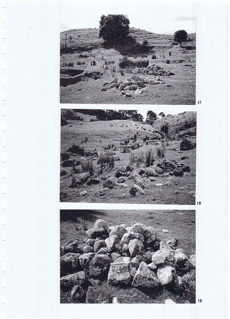
Appendix 2 List of Photographs
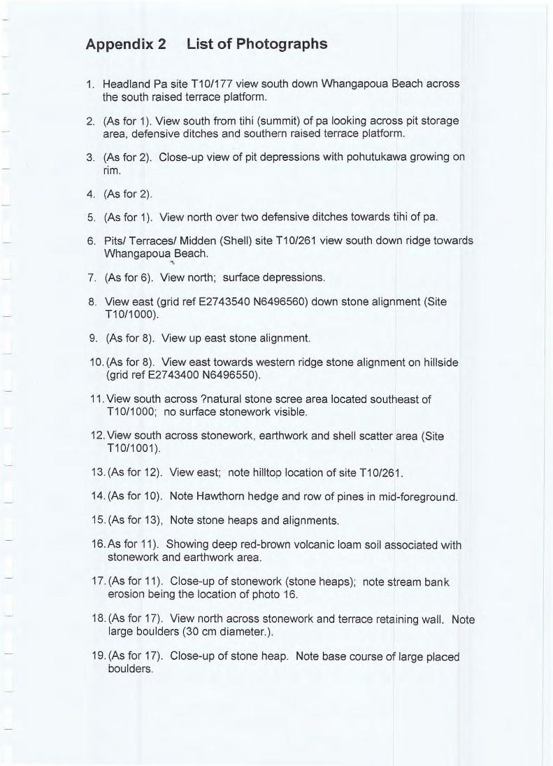
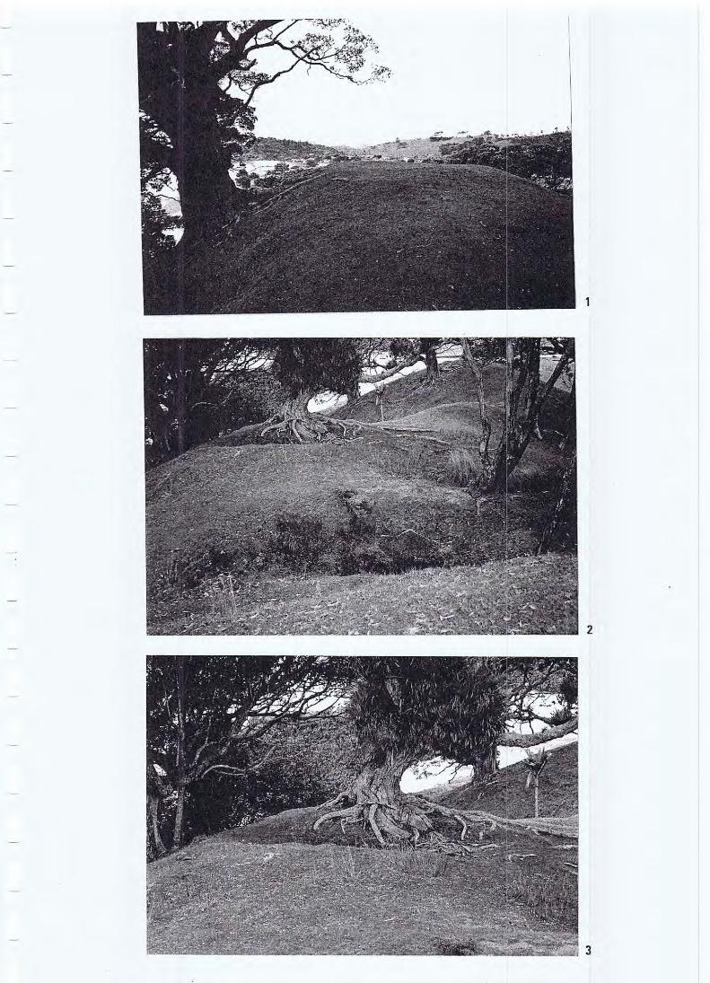
1. Headland Pa site T1 0/177 view south down Whangapoua Beach across the south raised terrace platform.
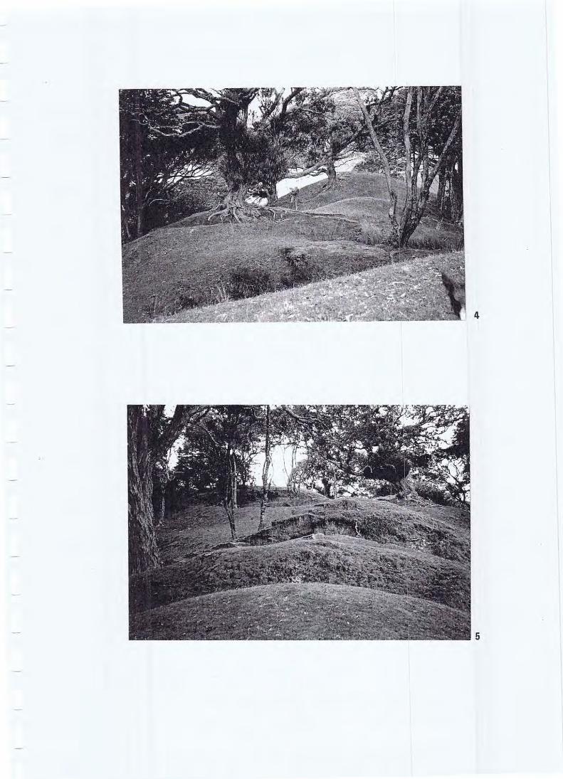
2. (As for 1). View south from tihi (summit) of pa looking across pit storage area, defensive ditches and southern raised terrace platform.
3. (As for 2). Close-up view of pit depressions with pohutukawa growing on rim .
4. (As for 2).
·5. (As for 1). View north over two defensive ditches towards tihi of pa.
6. Pitsl Terracesl Midden (Shell) site T1 0/261 view south down ridge towards Whangapoua Beach.
" 7. (As for 6) . View north; surface depressions.
8. View east (grid ref E2743540 N6496560) down stone alignment (Site T10/1000).
9. (As for 8). View up east stone alignment.
10. (As for 8) . View east towards western ridge stone alignment on hillside (grid ref E2743400 N6496550).
11. View south across ?natural stone scree area located southeast of T1 0/1 000; no surface stonework visible.
12. View south across stonework, earthwork and shell scatter area (Site T1 0/1 001 )
13. (As for 12). View east; note hilltop location of site T10/261 .
14. (As for 10). Note Hawthorn hedge and row of pines in mid-foreground.
15. (As for 13), Note stone heaps and alignments.
16. As for 11). Showing deep red-brown volcanic loam soil associated with stonework and earthwork area.
17. (As for 11 ). Close-up of stonework (stone heaps) ; note stream ban k erosion being the location of photo 16.
18. (As for 17). View north across stonework and terrace retaining wall . Note large boulders (30 cm diameter.).
19. (As for 17). Close-up of stone heap. Note base course of large placed boulders.
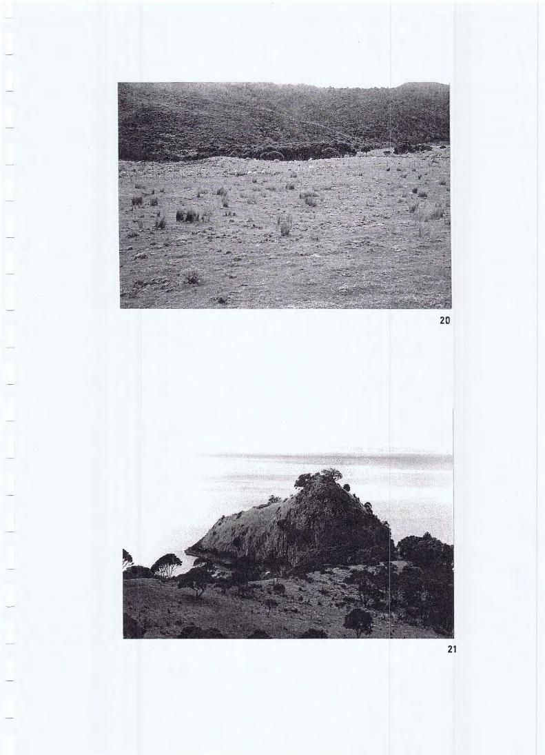
20. View north across a random surface scatter of scoria rocks looking into New Chums Beach from the "Airfield Paddock".
21 . View east onto headland pa site T1 0/21 0 on Motuto Point.
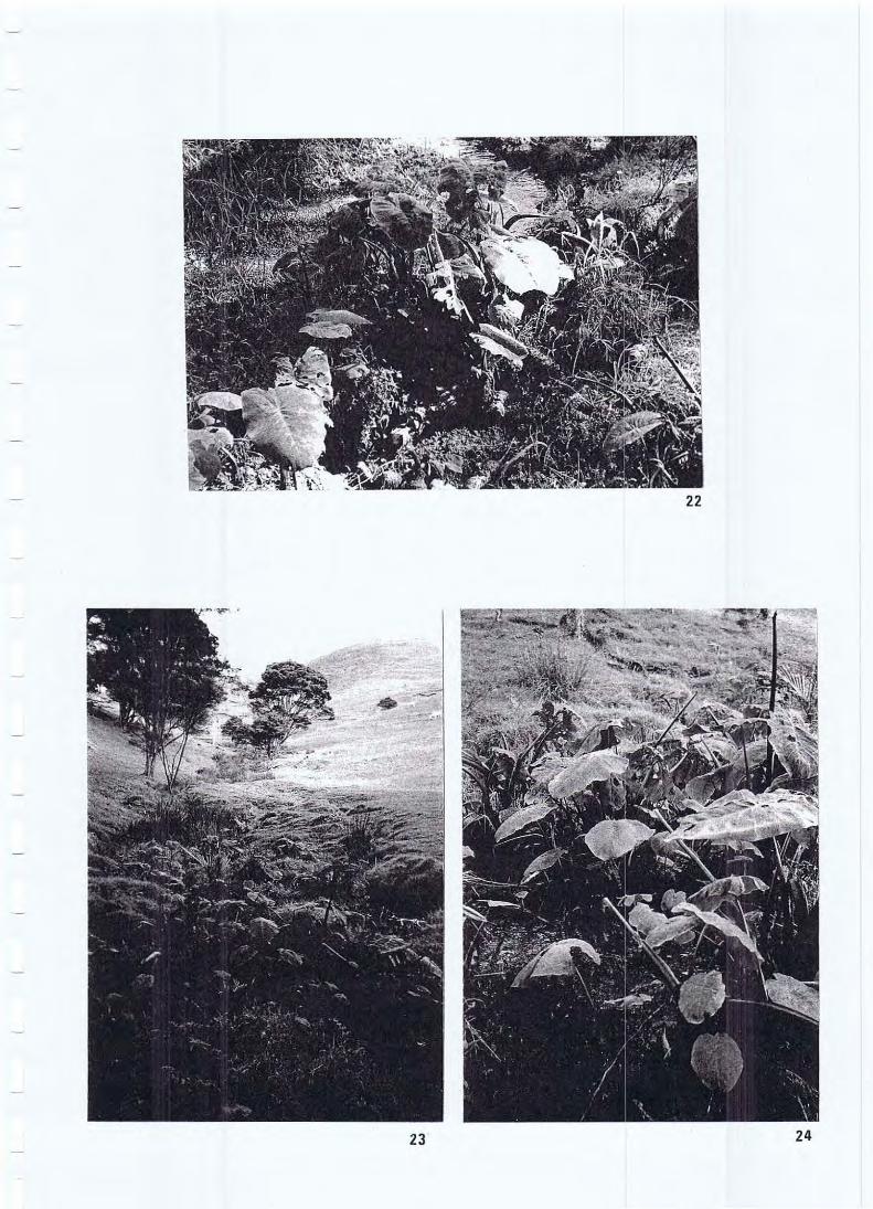
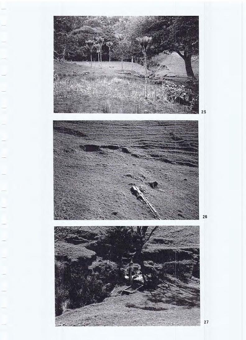
22. Taro (Colocasia esculenta) in spring-fed creek (Site T1 0/1 004) .
23. (As for 22) . View west up creek towards spring.
24. (As for 22).
25. (As for 22) . View south downhill across spring seepage area towards taro patch in creek.
26. (As for 22). Stone retained track (?Ianding) above spring.
27. (As for 22), Historic concrete trough by spring.
28.Arum Lilly patch associated with fresh water spring , terraces, stonework and shell midden (Site T1 0/1 002) .
29. (As for 28) .
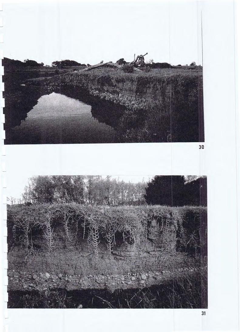
30. The banks of the Pungapunga Stream (grid ref E2743200 N6495200) showing a 70 cm to 1 metre deep alluvial silt deposit overlying a base course of water-worn cobbles. Note the darker charcoal -stained lenses separated by yellow-brown silts indicating numerous flood and deposition events. The low ridge in the background is the location of the house and midden (Site T1 0/1 006).
31 . (As for 30) . Close-up of 1.5 metre deep silt deposit overiying base course cobbles.
2
3
4
5
6
7
C> -
co
•
20
21
22
23 24
26
27
30
31