041018_Council_Packet.pdf - City of Thornton
359
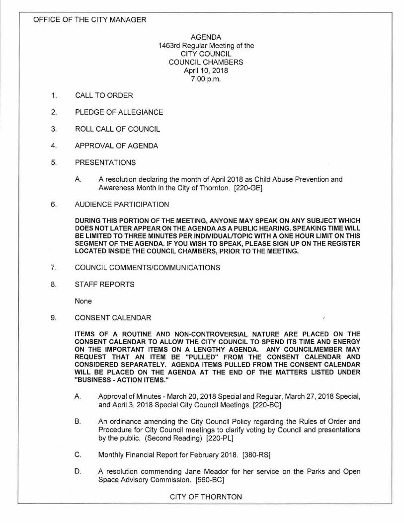
OFFICE OF THE CITY MANAGER 1. CALL TO ORDER AGENDA 1463rd Regular Meeting of the CITY COUNCIL COUNCIL CHAMBERS April 10, 2018 7:00p.m. 2. PLEDGE OF ALLEGIANCE 3. ROLL CALL OF COUNCIL 4. APPROVAL OF AGENDA 5. PRESENTATIONS A A resolution declaring the month of April 2018 as Child Abuse Prevention and Awareness Month in the City of Thornton. [220-GE] 6. AUDIENCE PARTICIPATION DURING THIS PORTION OF THE MEETING, ANYONE MAY SPEAK ON ANY SUBJECT WHICH DOES NOT LATER APPEAR ON THE AGENDA AS A PUBLIC HEARING. SPEAKING TIME WILL BE LIMITED TO THREE MINUTES PER INDIVIDUAL/TOPIC WITH A ONE HOUR LIMIT ON THIS SEGMENT OF THE AGENDA. IF YOU WISH TO SPEAK, PLEASE SIGN UP ON THE REGISTER LOCATED INSIDE THE COUNCIL CHAMBERS, PRIOR TO THE MEETING. 7. COUNCIL COMMENTS/COMMUNICATIONS 8. STAFF REPORTS None 9. CONSENT CALENDAR ITEMS OF A ROUTINE AND NON-CONTROVERSIAL NATURE ARE PLACED ON THE CONSENT CALENDAR TO ALLOW THE CITY COUNCIL TO SPEND ITS TIME AND ENERGY ON THE IMPORTANT ITEMS ON A LENGTHY AGENDA. ANY COUNCILMEMBER MAY REQUEST THAT AN ITEM BE "PULLED" FROM THE CONSENT CALENDAR AND CONSIDERED SEPARATELY. AGENDA ITEMS PULLED FROM THE CONSENT CALENDAR WILL BE PLACED ON THE AGENDA AT THE END OF THE MATTERS LISTED UNDER "BUSINESS - ACTION ITEMS." A Approval of Minutes- March 20, 2018 Special and Regular, March 27, 2018 Special, and April 3, 2018 Special City Council Meetings. [220-BC] B. An ordinance amending the City Council Policy regarding the Rules of Order and Procedure for City Council meetings to clarify voting by Council and presentations by the public. (Second Reading) [220-PL] C. Monthly Financial Report for February 2018. [380-RS] D. A resolution commending Jane Meador for her service on the Parks and Open Space Advisory Commission. [560-BC] CITY OF THORNTON
-
Upload
khangminh22 -
Category
Documents
-
view
0 -
download
0
Transcript of 041018_Council_Packet.pdf - City of Thornton
OFFICE OF THE CITY MANAGER
1. CALL TO ORDER
AGENDA 1463rd Regular Meeting of the
CITY COUNCIL COUNCIL CHAMBERS
April 10, 2018 7:00p.m.
2. PLEDGE OF ALLEGIANCE
3. ROLL CALL OF COUNCIL
4. APPROVAL OF AGENDA
5. PRESENTATIONS
A A resolution declaring the month of April 2018 as Child Abuse Prevention and Awareness Month in the City of Thornton. [220-GE]
6. AUDIENCE PARTICIPATION
DURING THIS PORTION OF THE MEETING, ANYONE MAY SPEAK ON ANY SUBJECT WHICH DOES NOT LATER APPEAR ON THE AGENDA AS A PUBLIC HEARING. SPEAKING TIME WILL BE LIMITED TO THREE MINUTES PER INDIVIDUAL/TOPIC WITH A ONE HOUR LIMIT ON THIS SEGMENT OF THE AGENDA. IF YOU WISH TO SPEAK, PLEASE SIGN UP ON THE REGISTER LOCATED INSIDE THE COUNCIL CHAMBERS, PRIOR TO THE MEETING.
7. COUNCIL COMMENTS/COMMUNICATIONS
8. STAFF REPORTS
None
9. CONSENT CALENDAR
ITEMS OF A ROUTINE AND NON-CONTROVERSIAL NATURE ARE PLACED ON THE CONSENT CALENDAR TO ALLOW THE CITY COUNCIL TO SPEND ITS TIME AND ENERGY ON THE IMPORTANT ITEMS ON A LENGTHY AGENDA. ANY COUNCILMEMBER MAY REQUEST THAT AN ITEM BE "PULLED" FROM THE CONSENT CALENDAR AND CONSIDERED SEPARATELY. AGENDA ITEMS PULLED FROM THE CONSENT CALENDAR WILL BE PLACED ON THE AGENDA AT THE END OF THE MATTERS LISTED UNDER "BUSINESS - ACTION ITEMS."
A Approval of Minutes- March 20, 2018 Special and Regular, March 27, 2018 Special, and April 3, 2018 Special City Council Meetings. [220-BC]
B. An ordinance amending the City Council Policy regarding the Rules of Order and Procedure for City Council meetings to clarify voting by Council and presentations by the public. (Second Reading) [220-PL]
C. Monthly Financial Report for February 2018. [380-RS]
D. A resolution commending Jane Meador for her service on the Parks and Open Space Advisory Commission. [560-BC]
CITY OF THORNTON

OFFICE OF THE CITY MANAGER
9. CONSENT CALENDAR - Continued
COUNCIL AGENDA April10, 2018
E. A resolution approving an Intergovernmental Agreement between Adams 12 Five Star Schools and the City of Thornton for development and use of a school garden for Skyview Elementary School on adjacent property owned by the City of Thornton. [560-AG]
10. PUBLIC HEARINGS
IN ORDER TO SCHEDULE THE TIMING AND LENGTH OF PUBLIC HEARINGS FOR THE CONVENIENCE OF THE COUNCIL, THE GENERAL PUBLIC, AND INTERESTED PARTIES, THE FIRST PUBLIC HEARING WILL BEGIN AT OR BEFORE 7:30P.M., OR AS SOON THEREAFTER AS POSSIBLE. THIS SEGMENT OF THE AGENDA WILL LAST NO MORE THAN TWO HOURS. PROPONENTS AND OPPONENTS WHO WISH TO SPEAK ARE REQUESTED TO SIGN UP, PRIOR TO THE BEGINNING OF THE MEETING, ON THE REGISTER LOCATED INSIDE THE COUNCIL CHAMBERS, AND LIMIT THEIR REMARKS TO THREE MINUTES. GROUPS OF CITIZENS BROUGHT TOGETHER BY A COMMON INTEREST ARE REQUESTED TO CHOOSE A SPOKESPERSON WHOSE TIME TO COMMENT WILL BE EXTENDED TO 10 MINUTES. SPEAKERS MAY BE ASKED TO BE SWORN IN BY THE CITY CLERK IF THEY WISH TO SUBMIT FACTS RATHER THAN OPINIONS.
A. A public hearing regarding an ordinance approving a Rezoning of approximately 123 acres from Single-Family Detached to Planned Development, amending the Zoning Map, and including Planned Development Standards and an Overall Development Plan/Conceptual Site Plan to develop the site as a Single-Family Detached development for property located south of East 1441h Avenue and east of Holly Street (Holly Hills Estates). [Public Hearing] [600-PR]
B. A motion vacating the public hearing and the petitions for annexation of property generally located north and south of East 1 04th Avenue and west of Brighton Road to the City of Thornton (Cooley East Nos. 2, 3, and 4 Annexations). [Public Hearing] [120-AG]
11. ACTION ITEMS
A. Three resolutions acknowledging receipt of the Cooley East Nos. 2, 3, and 4 annexation petitions and establishing May 22, 2018 as the date for consideration of the requested annexations of property generally located north and south of East 1 04th Avenue and west of Brighton Road to the City of Thornton (Cooley East No. 2, 3, and 4 Annexations). (120-AG]
1. A resolution acknowledging receipt of the Cooley East No. 2 Annexation Petition and establishing May 22, 2018 as the date for consideration of the requested annexation of property generally located south of East 1 04th Avenue and west of Brighton Road to the City of Thornton (Cooley East No. 2 Annexation).
2. A resolution acknowledging receipt of the Cooley East No. 3 Annexation Petition and establishing May 22, 2018 as the date for consideration of the requested annexation of property generally located north of East 1 04th Avenue and west of Brighton Road to the City of Thornton (Cooley East No. 3 Annexation).
-2-
CITY OF THORNTON

OFFICE OF THE CITY MANAGER COUNCIL AGENDA April10, 2018
3. A resolution acknowledging receipt of the Cooley East No. 4 Annexation Petition and establishing May 22, 2018 as the date for consideration of the requested annexation of property generally located north of East 1 04th Avenue and west of Brighton Road to the City of Thornton (Cooley East No. 4 Annexation).
B. An ordinance approving a Planned Development Zoning Amendment for 42.44 acres of the Amber Creek property, thereby amending the Overall Development Plan/Conceptual Site Plan, Planned Development Standards, and Planned Development Zoning Map pertaining to Planning Areas D and F, to develop Planning Area D for commercial uses, and Planning Area F for Single-Family Attached uses, for property located generally south of East 136th Avenue and west of Quebec Street (Amber Creek). (Second Reading) [600-PR]
C. A resolution approving Amendment No. 1 to the Intergovernmental Agreement between the Regional Transportation District and the City of Thornton pertaining to the construction of the North Metro Rail Line within the City's boundaries. [220-GE]
D. A resolution authorizing negotiations and, if necessary, eminent domain proceedings to acquire property interests necessary to construct the Thornton Water Project. [900-PR]
E. An ordinance amending City Code Section 26-90(a), contracts approved by City Council; Exceptions, to authorize the City Manager to approve revocable permits issued to the City in addition to easements, permits, rights-of-entry, and rights-ofway that are issued to the City concerning the use of real property for the routine conduct of City business that are already authorized in this section. (First Reading) [500-CA]
12. ADJOURNMENT
'Age~ by Kristen N. Rosenbaum, City Clerk for Kevin S. Woods, City Manager
-3-
CITY OF THORNTON

COUNCIL COMMUNICATION Meeting Date: Agenda Item: Agenda Location: Work Plan# Legal Review:
April 10, 2018 5A Presentations N/A _1st Reading _2nd Reading
Subject: A resolution declaring the month of April 2018 as Child Abuse Prevention and Awareness Month in the City of Thornton.
Recommended by: Robb Kolstad\2- ( (., Approved by: Kevin S. v:;;ds Ordinance previously introduced by:
Presenter(s): City Council
SYNOPSIS:
Representatives from CASA (Court Appointed Special Advocates) and Ralston House will be present to accept formal copies of this resolution for their organizations.
CASA is a volunteer-based, nonprofit organization that trains and supervises community volunteers to represent the best interests of our most vulnerable residents - child victims of physical, sexual, or emotional abuse and neglect. CASA volunteers are appointed by judges to be a voice for these children in court. The desired result is that children are placed into safe, loving homes where they can thrive.
Ralston House is a nonprofit agency that works in collaboration with law enforcement, social services, and the district attorney's office. They specialize in interviewing children and their families in a safe and comfortable place, providing sexual assault medical examinations to ensure the health of children, and providing crisis counseling so children and their families can start the healing process.
RECOMMENDATION:
Staff recommends Alternative No. 1, approval of the resolution declaring the month of April 2018 as Child Abuse Prevention and Awareness Month in the City of Thornton and presentation of formal copies of the resolution to representatives from CASA and Ralston House.
BUDGET/STAFF IMPLICATIONS:
None.
BACKGROUND (ANALYSIS/NEXT STEPS/HISTORY): (includes previous City Council action)
Each year, in Adams and Broomfield Counties, there are over 1,300 children who have been physically, sexually, or emotionally abused or neglected, and who are in ·desperate need of a caring, committed CASA volunteer to speak up for their best interests.
In Adams and Broomfield Counties, there are over 280 CASA volunteers, but there is a great need for more community members to become advocates for children.
The mission of Ralston House is to provide professional, comprehensive services to sexually, physically, and/or emotionally abused children and their families in a safe place so they can share their stories and begin to heal.

COUNCIL COMMUNICATION PAGE2
Child victims or corroborating witnesses are brought to Ralston House instead of going to a police station so children and their families who have experienced traumatic incidents have the opportunity to go where they find comfort and resources to begin the healing process. Law enforcement investigators depend on the Ralston House experts to: 1) interview children to find the truth and protect children, 2) provide sexual assault medical examinations to ensure the health of children, and 3) provide crisis counseling for children and their families in order to start the healing process.

RESOLUTION
A RESOLUTION DECLARING THE MONTH OF APRIL 2018 AS CHILD ABUSE PREVENTION AND AWARENESS MONTH IN THE CITY OF THORNTON.
WHEREAS, every child deserves to grow up in a nurturing environment, free from harm and fear. All children do not receive appropriate care; in fact, too many children become victims at the hands of abusive perpetrators, and it is up to us as a community to tirelessly work to end it through awareness and action. Every responsible person will agree that even one abused child is too many; and
WHEREAS, the City of Thornton prides itself on giving back to the community contributing to the quality of life among our residents; and
WHEREAS, Court Appointed Special Advocates for Children (CASA) of Adams and Broomfield Counties in association with the National Court Appointed Special Advocate (CASA) Association speaks for the best interest of abused and neglected children who are involved in the juvenile courts; and
WHEREAS, in addition, effective child abuse prevention programs, such as Ralston House, succeed because of partnerships among families, social service agencies, schools, religious and civic organizations, law enforcement agencies, and the business community; and
WHEREAS, through community efforts, City of Thornton residents are encouraged to JOin together to raise awareness for those children fallen victim to abuse and neglect throughout the month of April and continuing through the year; and
WHEREAS, through this effort, it will give abused and neglected children in our community and around the country a chance for a safe and positive future.
NOW, THEREFORE, BE IT RESOLVED BY THE CITY COUNCIL OF THE CITY OF THORNTON, COLORADO, AS FOLLOWS:
That the month of April 2018 is hereby declared Child Abuse Prevention and Awareness Month in the City of Thornton, Colorado.
PASSED AND ADOPTED at a regular meeting of the City Council of the City of Thornton, Colorado, on , 2018.
CITY OF THORNTON, COLORADO
Heidi K. Williams, Mayor
ATTEST:
Kristen N. Rosenbaum, City Clerk

COUNCIL COMMUNICATION Meeting Date: Agenda Item: Agenda Location: Work Plan# Legal Review:
April 10, 2018 9A Consent Calendar N/A _ 151 Reading _2nd Reading
Subject: A Motion approving the Minutes of the March 20, 2018 Special and Regular, March 27, 2018 Special, and April 3, 2018 Special City Council Meetings. [220-BC]
Recommended by: Robb Kolstad :j;?_f:::.- Approved by: Kevin S. W~s Ordinance previously
Presenter(s): Kristen Rosenbaum, City Clerk introduced by:
SYNOPSIS:
The official Minutes of the March 20, 2018 Special and Regular, March 27, 2018 Special, and April 3, 2018 Special City Council meetings have been prepared by the City Clerk's Office and are hereby submitted for Council's approval.
RECOMMENDATION:
Staff recommends approval of Minutes as requested .
BUDGET/STAFF IMPLICATIONS:
None
ALTERNATIVES:
1. Approve the minutes as submitted. 2. Approve the minutes with corrections requested by Council.
BACKGROUND (ANALYSIS/NEXT STEPS/HISTORY): (includes previous City Council action)
None

MINUTES THORNTON CITY COUNCIL
SPECIAL MEETING MARCH 20, 2018
Unofficial until approved By City Council
1. CALL TO ORDER- By Mayor Heidi K. Williams at 6:10p.m. in the Training Room of the Thornton City Hall.
2. ROLL CALL OF COUNCIL- Those Present were: Mayor Heidi K. Williams, Mayor ProTem Jan Kulmann, and Councilmembers Sherry Goodman, Adam Matkowsky, Eric Montoya, Sam Nizam, Jacqueline Phillips, Jessica Sandgren, and Joshua Zygielbaum.
STAFF MEMBERS PRESENT- Kevin Woods, City Manager; Luis Corchado, City Attorney; Robb Kolstad, Assistant City Manager; Jeff Coder, Deputy City Manager for City Development; Jason O'Shea, Development Director; Grant Penland, Current Planning Manager; and Kristen Rosenbaum, City Clerk.
MOTION WAS MADE BY COUNCILMEMBER MATKOWSKY AND SECONDED BY COUNCILMEMBER GOODMAN TO RECESS THE MEETING INTO EXECUTIVE SESSION. MOTION PASSED UNANIMOUSLY.
The meeting recessed into Executive Session at 6:13p.m.
Councilmember Montoya left the room at 6:14p.m.
3. ACTION ITEMS
Executive Session pursuant to C.R.S. 24-06-402(4)(b) and (e), conferences with the City Attorney for purposes of receiving legal advice on specific legal questions and determining positions relative to matters that may be subject to negotiations; developing strategy for negotiations; and instructing negotiators regarding: an incentive agreement for Crossing Point Affordable Housing, Woodspring Suites Hotel, and Amber Creek.
Councilmember Montoya returned at 6:36p.m.
4. ADJOURNMENT
MOTION WAS MADE BY COUNCILMEMBER MATKOWSKY AND SECONDED BY MAYOR PROTEM KULMANN TO ADJOURN THE MEETING AT 6:48P.M. MOTION PASSED UNANIMOUSLY.
ATTEST:
Mayor at time of approval
Respectfully submitted,
~baum, City Clerk
Approved at the April 10, 2018, City Council meeting.

MINUTES THORNTON CITY COUNCIL 1462ND REGULAR MEETING
MARCH 20, 2018
Unofficial until approved By City Council
1. CALL TO ORDER- By Mayor Heidi K. Williams at 7:00 p.m. in the Council Chambers of the Thornton City Hall.
2. PLEDGE OF ALLEGIANCE
3. ROLL CALL OF COUNCIL- Those Present were: Mayor Heidi K. Williams, Mayor ProTem Jan Kulmann, and Councilmembers Sherry Goodman, Adam Matkowsky, Eric Montoya, Sam Nizam, Jacqueline Phillips, Jessica Sandgren, and Joshua Zygielbaum.
STAFF MEMBERS PRESENT- Kevin Woods, City Manager; Luis Corchado, City Attorney; Joyce Hunt, Assistant City Manager; Robb Kolstad, Assistant City Manager; Jeff Coder, Deputy City Manager for City Development; Chris Malison, Executive Director for Management Services; Brett Henry, Executive Director for Infrastructure; Mike Soderberg, Executive Director for Community Services; Maria Ostrom, Finance Director; John Cody, Economic Development Director; Jason O'Shea, Development Director; Grant Penland, Current Planning Manager; Chad Howell, Redevelopment Administrator; Ty Robbins, Planner; Cassie Free, Development Engineering Manager; Brian Garner, Principal Planner; Cliff Brown, Deputy Police Chief; Kristen Rosenbaum, City Clerk; and Crystal Sergent, Agenda and Licensing Coordinator.
4. APPROVAL OF THE AGENDA
MOTION WAS MADE BY COUNCILMEMBER ZYGIELBAUM AND SECONDED BY COUNCILMEMBER MONTOYA TO APPROVE THE AGENDA AS PRESENTED. MOTION PASSED UNANIMOUSLY.
5. PRESENTATIONS
A A resolution recognizing the City of Thornton's 2017 Employees and Teams of the Year.
COUNCILMEMBER MONTOYA INTRODUCED, READ IN ITS ENTIRETY, AND MOVED TO APPROVE A RESOLUTION RECOGNIZING THE CITY OF THORNTON'S 2017 EMPLOYEES AND TEAMS OF THE YEAR. MOTION WAS SECONDED BY COUNCILMEMBER ZYGIELBAUM AND PASSED UNANIMOUSLY.
The City Manager recognized the employees and teams of the year. Videos of the Teams of the Year and Employees of the Year were presented to Council.
The City Manager presented the awards to the Employees of the Year.
B. Reception
The meeting recessed at 7:28p.m. and reconvened at 7:46p.m.

MARCH 20, 2018, CITY COUNCIL MINUTES PAGE2
C. 2017 Annual Report on the Thornton Arts . Sciences and Humanities Council.
Thornton Arts, Sciences and Humanities Council President Heather Kopas reported on the activities, accomplishments, and grant funds received in 2017.
6. AUDIENCE PARTICIPATION
George Horgan, 9130 Fir Drive, invited Council to attend the 50 year celebration for American Legion Post 22.
Corky Kyle, 14450 W. 56th Place, Arvada , President of the Kyle Group, is representing his client Jumping Jack Cash. He addressed Council regarding requested changes to the City's pawnbroker ordinance. He answered a question from Council regarding changes he is requesting to be made.
Jeremy Newton, 2761 E. 93rd Place, addressed Council regarding the need for an arts and culture facility in the City, reported on statistics, and the benefits it could bring to the City.
7. COUNCIL COMMENTS/COMMUNICATIONS
Councilmember Goodman reported that Council attended the National League of Cities Conference and Adams County Mayors and Commissioners Youth Awards program.
Councilmember Sandgren reported that Council attended the St. Patty's Day event at the Thornton Active Adult Center and that she participated in the March Meals on Wheels event at the SeniorHub.
Councilmember Montoya reported on Council's lobbying trip to Washington DC and thanked City staff that attended.
Mayor Pro Tem Kulmann reported on the Thornton Community Band Concerts and the Ralston House Gala Dinner.
Mayor Williams reported on the lobbying trip to Washington DC and board and commission vacancies. She spoke about the Food for Hope program.
8. STAFF REPORTS
None
9. CONSENT CALENDAR
MOTION WAS MADE BY COUNCILMEMBER ZYGIELBAUM AND SECONDED BY COUNCILMEMBER MONTOYA TO APPROVE THE CONSENT CALENDAR AS PRESENTED EXCEPT THAT MAYOR PROTEM KULMANN ABSTAIND FROM VOTING ON THE FEBRUARY 27, 2018 REGULAR CITY COUNCIL MINUTES BECAUSE SHE DID NOT ATTEND THAT MEETING.
The City Clerk read into the record the title of the ordinance contained on the Consent Calendar.
MOTION PASSED UNANIMOUSLY.

MARCH 20, 2018, CITY COUNCIL MINUTES PAGE3
THE FOLLOWING COUNCIL DOCUMENTS WERE APPROVED ON THE CONSENT CALENDAR:
A. Approval of Minutes - February 20, 2018 Special and February 27, 2018 Regular City Council Meetings.
B. An ordinance granting a franchise by the City of Thornton to Public Service Company of Colorado the non-exclusive right to provide, sell , and deliver gas and electricity to the City and its residents through the non-exclusive reasonable use of City streets, public utility easements, and other City property.
C. Monthly Financial Report for January 2018.
D. Fire Department monthly statistical report for January 2018.
E. Police Department monthly statistical report for January 2018.
F. A resolution commending Christopher Porter for his service on the Local Licensing Authority.
G. A resolution adopting the Bylaws of the General Employees Money Purchase Plan, Firefighters Money Purchase Plan , and Police Money Purchase Plan Retirement Plan Combined Committee.
H. A resolution approving an Intergovernmental Agreement between the City of Thornton and Adams County, Colorado related to Adams County 88th Avenue Open Space and Thornton Parkway.
I. A resolution granting a non-exclusive revocable permit to Public Service Company of Colorado to use and occupy all City streets, public utility easements, and other City property to provide, sell , and deliver gas and electricity to the City and its residents.
10. PUBLIC HEARINGS
At this time, individuals wishing to provide testimony during the public hearings were sworn in by the City Clerk.
A. A public hearing regarding a resolution approving a Conceptual Site Plan for a proposed commercial and lodging development on approximately 12 acres of land generally located at the southwest corner of West 88th Avenue and Interstate 25 (Conifer Crossing).
Mayor Williams opened the public hearing at 8:16 p.m.
Councilmember Phillips left the Chambers at 8:17p.m. and returned at 8:18p.m.
The City Manager gave the opening remarks.
Grant Penland, Current Planning Manager, stated he was previously sworn. He entered into the record the notice of hearing published in the Northglenn-Thornton Sentinel, the notice mailed to property owners within 1,500 feet, and email correspondence received after the packet distribution, which were marked as City's

MARCH 20, 2018, CITY COUNCIL MINUTES PAGE4
Exhibits 1, 2, and 3, respectively. He also entered into the record the Affidavit of Posting and Posting Log, which was marked as Applicant's Exhibit A.
Mr. Penland presented slides of a vicinity map, an aerial map, the Conceptual Site Plan summary, the Conceptual Site Plan, the conceptual building elevations, the Conceptual Site Plan Evaluation criteria, and the neighborhood meeting overview, which were later marked as City's Exhibit 4.
Pete Kramer, Pure Strike Development, 3809 Old College Road, Bryan, Texas, Applicant, and Erin Griffin, Kimley-Horn and Associates, 9157 Anasazi Indian Way, Highlands Ranch, were sworn in. They presented slides of information regarding Woodspring Suites, Woodspring Suite guest statistics, a Woodspring Suites simulation video, the Conceptual Site Plan map, the Conceptual Site Plan overview, and the neighborhood meeting overview, which were later marked as Applicant's Exhibit B.
Mr. Kramer and Ms. Griffin answered questions from Council regarding the buffering, the Conceptual Site Plan evaluation, promoting development for a healthy center, security concerns, traffic concerns, parking, lighting, neighborhood revitalization, pricing, expected amenities, and schoollockdowns.
Curtis Rowe, Kimley-Horn and Associates, 4582 Ulster Street, Denver, was sworn in. He answered questions from Council regarding the traffic impact study.
No one signed up to speak in support of the resolution.
Several individuals signed up to speak in opposition to the resolution. Their comments included: concerns related to crime; safety; security; property values; school lockdowns; the distance from the hotel to the school; health; the impact the development may have on schools, students, and staff; traffic impacts; neighborhood children safety; profits of business going outside of State since developers are from out of state; types of guests and how long they stay; keeping Polaris Place closed; how the hotel will keep unruly guests out; privacy of neighbors; and how the property will be cared for. Individuals also spoke about not being allowed to hold a neighborhood meeting at City Hall; a suggestion regarding the 1500 feet distance requirement; expectations as to what is developed in the vacant field ; the hotel not being the best use for the property; and cleaning this area up before development occurs.
Ron Davis, 226 Polaris Place, was sworn in. Bill Penney, 7256 Zinnia Street, Arvada, was previously sworn. Grace Taylor, 311 S. Adams Drive, Louisville, Principal at North Star Elementary School, was previously sworn. Melissa Noonan, 2209 E. 1281h Avenue, was previously sworn . Lucinda Nelson, 652 Galaxy Circle, was previously sworn . Jennifer Symank, 506 Starlight Road, was previously sw9rn. Steve Creson, 660 Leo Lane, was previously sworn. Dan Gabel, 625 Planet Place, was previously sworn. John Soper, 235 Starlight Road, was previously sworn. Sandra Wolfe, 8660 Mariposa Street, was previously sworn. She submitted into the record a neighborhood petition opposing the project, which was marked as Opponent's Exhibit A. Kimberly Guerrero, 8675 Mariposa Street, was previously sworn.

MARCH 20, 2018, CITY COUNCIL MINUTES PAGE 5
Craig Memmer, 386 Starlight Road, was sworn in. Max Valdez, 286 Polaris Place, not present in the Chambers. Cindy Valdez, 286 Polaris Place, not present in the Chambers. Arthur Johnson, 430 Leo Lane, was sworn in.
The meeting recessed at 9:46 p.m. and reconvened at 10:00 p.m.
The City Manager responded to a question regarding crime rate statistics for hotels and car lots.
There was discussion by Council regarding the project.
The City Attorney raised a point of order regarding the discussion.
Mr. Kramer answered questions from Council regarding the school's concerns with traffic and safety, a security plan, how the hotel plans to operate, types of guests allowed vs. not allowed, how security cameras are monitored, number of staff and managers onsite, criteria for contacting police, lighting, maintenance of the property, and if the Applicant has any hotels in low income areas.
The public hearing was closed at 10:35 p.m.
MOTION WAS MADE BY COUNCILMEMBER SANDGREN AND SECONDED BY COUNCILMEMBER PHILLIPS TO OPPOSE THIS RESOLUTION.
There was discussion regarding lack of proof of the Conceptual Site Plan Evaluation Criteria.
MOTION PASSED UNANIMOUSLY.
B. A public hearing regarding a Comprehensive Plan Amendment, a Planned Development Zoning Amendment, and an amended Overall Development Plan/Conceptual Site Plan for property generally located south of East 136th Avenue and west of Quebec Street {Amber Creek) _
Mayor Williams opened the public hearing at 10:47 p.m.
The City Manager gave the opening remarks.
Grant Penland, Current Planning Manager, stated he was previously sworn. He entered into the record the notice of hearing published in the Northglenn-Thornton Sentinel and the notice mailed to property owners within 1 ,500 feet, which were marked as City's Exhibits 1 and 2, respectively. He also entered into the record the Affidavit of Posting and Posting Log, which was marked as Applicant's Exhibit A.
Mr. Penland presented slides of a vicinity map, an aerial map, a Comprehensive Plan map; a Comprehensive Plan overview; a Zoning map; the Planned Development Zoning Amendment criteria; the Overall Development Plan/Conceptual Site Plan for Area F, map, and elevation; the Overall Development Plan/Conceptual Site Plan for Area D and map; buffering plan and map; and the neighborhood meeting information, which were later marked as City's Exhibit 3.

MARCH 20, 2018, CITY COUNCIL MINUTES PAGE6
Mr. Penland clarified that the Overall Development Plan was approved in 2002 and the reason this is being brought to Council.
Josh Rowland, LAI Design Group, 88 Inverness Circle East, Centennial, Applicant, was sworn in. He presented slides of the location; overview of the Comprehensive Plan, Overall Development Plan, and Planned Development Amendments; Planned Development Zoning Amendment justification; King Soopers elevations; Meritage Homes elevations; and response to the neighborhood comments, which were later marked as Applicant's Exhibit B.
Mr. Rowland and Drew Warot, Division and Real Estate Manager for King Soopers and City Market, 65 Tejon Street, Denver, who was sworn in, answered questions from Council regarding traffic impacts, concerns with King Soopers following through with the development, what current zoning allows, and the number of units originally planned.
No one signed up to speak in support of the proposed project.
The following individuals signed up to speak in opposition to the proposed project:
Stephen Curtis, 13368 Olive Way, was previously sworn . He stated he is not opposed to the project as long as the site becomes a King Soopers or something equivalent and suggested that the site revert back to the original zoning if not.
Thomas Albert, 13398 Olive Way, was sworn in. He spoke about concerns with traffic, including commercial traffic.
Gary Danis, 13364 Oneida Street, was sworn in. He stated he did not receive a notice about the neighborhood meeting. He spoke about concerns regarding traffic impacts, light pollution, and a nearby playground.
Jared Ruger, 13371 Oneida Street, was sworn in. He stated he has concerns with access into the development and feels there is not a need for King Soopers since there is a King Soopers and Walmart nearby.
Bob Turner, Quadrant Opportunity Fund II, LLC, 981 Southpark Drive, Littleton, was sworn in . He stated he is the property owner adjacent to the proposed project and spoke in support of the project and feels the location for the King Soopers is good for growth in the City.
Mr. Warot addressed concerns regarding access to the development and truck traffic and stated they are willing to work with the community and neighbors with issues they have.
Cassie Free, Development Engineering Manager, was previously sworn in. She answered questions from Council regarding the location of a traffic light.
Mr. Penland clarified the difference between the Comprehensive Plan Amendment and Planned Development Amendment, explained why the changes are being requested, and addressed concerns with light pollution.
The public hearing was closed at 11 :35 p.m.

MARCH 20, 2018, CITY COUNCIL MINUTES PAGE 7
1) A resolution approving a Comprehensive Plan Amendment for 42.44 acres of property to change 22.77 acres designated Commercial to 26.68 acres designated Regional Commercial and to change 19.67 acres designated Residential High to 15.76 acres designated Residential Medium for property located south of East 136th Avenue and west of Quebec Street. (Amber Creek.
MOTION WAS MADE BY COUNCILMEMBER ZYGIELBAUM AND SECONDED BY COUNCILMEMBER MONTOYA TO APPROVE A RESOLUTION APPROVING A COMPREHENSIVE PLAN AMENDMENT FOR 42.44 ACRES OF PROPERTY TO CHANGE 22.77 ACRES DESIGNATED COMMERCIAL TO 26.68 ACRES DESIGNATED REGIONAL COMMERCIAL AND TO CHANGE 19.67 ACRES DESIGNATED RESIDENTIAL HIGH TO 15.76 ACRES DESIGNATED RESIDENTIAL MEDIUM FOR PROPERTY LOCATED SOUTH OF EAST 136TH AVENUE AND WEST OF QUEBEC STREET. (AMBER CREEK). MOTION WAS DISCUSSED AND PASSED BY A MAJORITY VOTE OF THE COUNCIL AS FOLLOWS:
Ayes: Goodman, Kulmann, Montoya, Phillips, Sandgren, Williams, and Zygielbaum
Nayes: Matkowsky and Nizam.
2) An ordinance approving a Planned Development Zoning Amendment for 42.44 acres of the Amber Creek property, thereby amending the Overall Development Plan/Conceptual Site Plan, Planned Development Standards, and Planned Development Zoning Map pertaining to Planning Areas D and F, to develop Planning Area D for commercial uses, and Planning Area F for Single-Family Attached uses, for property located generally south of East 136th Avenue and west of Quebec Street (Amber Creek).
COUNCILMEMBER ZYGIELBAUM INTRODUCED, READ BY TITLE, AND MOVED TO APPROVE AN ORDINANCE, ON FIRST READING, WHICH APPROVES A PLANNED DEVELOPMENT ZONING AMENDMENT FOR 42.44 ACRES OF THE AMBER CREEK PROPERTY, THEREBY AMENDING THE OVERALL DEVELOPMENT PLAN/CONCEPTUAL SITE PLAN, PLANNED DEVELOPMENT STANDARDS, AND PLANNED DEVELOPMENT ZONING MAP PERTAINING TO PLANNING AREAS D AND F, TO DEVELOP PLANNING AREA D FOR COMMERCIAL USES, AND PLANNING AREA F FOR SINGLE-FAMILY ATTACHED USES, FOR PROPERTY LOCATED GENERALLY SOUTH OF EAST 136TH AVENUE AND WEST OF QUEBEC STREET (AMBER CREEK). MOTION WAS SECONDED BY COUNCILMEMBER MONTOYA AND PASSED BY A MAJORITY VOTE OF THE COUNCIL AS FOLLOWS:
Ayes: Goodman, Kulmann, Montoya, Phillips, Sandgren, Williams, and Zygielbaum
Nayes: Matkowsky and Nizam.

MARCH 20, 2018, CITY COUNCIL MINUTES PAGE8
11. ACTION ITEMS
A. A resolution approving the final design for the Development Permit for 7.6 acres of land generally located at the southeast corner of Holly Street and East 120th Avenue to develop an Electric Substation pursuant to Chapter 18 of the Thornton City Code (Snydal Xcel Substation) .
Grant Penland, Current Planning Manager, presented slides and provided information on this item.
MOTION WAS MADE BY COUNCILMEMBER ZYGIELBAUM AND SECONDED BY MAYOR PRO TEM KULMANN TO APPROVE A RESOLUTION APPROVING THE FINAL DESIGN FOR THE DEVELOPMENT PERMIT FOR 7.6 ACRES OF LAND GENERALLY LOCATED AT THE SOUTHEAST CORNER OF HOLLY STREET AND EAST 120TH AVENUE TO DEVELOP AN ELECTRIC SUBSTATION PURSUANT TO CHAPTER 18 OF THE THORNTON CITY CODE (SNYDAL XCEL SUBSTATION). MOTION WAS DISCUSSED AND PASSED UNANIMOUSLY.
B. A resolution authorizing the City of Thornton to apply for and the City Manager to accept, on behalf of the City of Thornton, grant monies and enter into an Intergovernmental Agreement with the City of Northglenn, for a Shared Victim Services Unit for the Cities.
Cliff Brown, Deputy Police Chief, provided information on this item.
MOTION WAS MADE BY COUNCILMEMBER PHILLIPS AND SECONDED BY COUNCILMEMBER MATKOWSKY TO APPROVE A RESOLUTION AUTHORIZING THE CITY OF THORNTON TO APPLY FOR AND THE CITY MANAGER TO ACCEPT, ON BEHALF OF THE CITY OF THORNTON, GRANT MONIES AND ENTER INTO AN INTERGOVERNMENTAL AGREEMENT WITH THE CITY OF NORTHGLENN, FOR A SHARED VICTIM SERVICES UNIT FOR THE CITIES. MOTION PASSED UNANIMOUSLY.
C. An ordinance amending the City Council Policy regarding the Rules of Order and Procedure for City Council meetings to clarify voting by Council and presentations by the public.
Kristen Rosenbaum, City Clerk, provided information on this item.
COUNCILMEMBER MATKOWSKY INTRODUCED, READ BY TITLE, AND MOVED TO APPROVE AN ORDINANCE, ON FIRST READING, WHICH AMENDS THE CITY COUNCIL POLICY REGARDING THE RULES OF ORDER AND PROCEDURE FOR CITY COUNCIL MEETINGS TO CLARIFY VOTING BY COUNCIL AND PRESENTATIONS BY THE PUBLIC. MOTION WAS SECONDED BY COUNCILMEMBER ZYGIELBAUM AND PASSED UNANIMOUSLY.
12. ADJOURNMENT
MOTION WAS MADE BY COUNCILMEMBER SANDGREN AND SECONDED BY COUNCILMEMBER MONTOYA TO ADJOURN THE MEETING AT 11:52 P.M. MOTION PASSED UNANIMOUSLY.

MARCH 20, 2018, CITY COUNCIL MINUTES PAGE9
ATTEST:
Mayor at time of approval
Respectfully submitted,
CrystaiSefQent, AQdaand Licensing Coordinator
Approved at the April 10, 2018, City Council meeting.

MINUTES THORNTON CITY COUNCIL
SPECIAL MEETING MARCH 27,2018
Unofficial until approved By City Council
1. CALL TO ORDER- By Mayor Heidi K. Williams at 6:45p.m. in the Training Room of the Thornton City Hall.
2. ROLL CALL OF COUNCIL- Those Present were: Mayor Heidi K. Williams, Mayor ProTem Jan Kulmann, and Councilmembers Sherry Goodman, Adam Matkowsky, Eric Montoya, Sam Nizam, Jacqueline Phillips, Jessica Sandgren, and Joshua Zygielbaum.
MOTION WAS MADE BY COUNCILMEMBER PHILLIPS AND SECONDED BY COUNCILMEMBER MONTOYA TO RECESS INTO EXECUTIVE SESSION. MOTION PASSED UNANIMOUSLY.
The meeting was recessed at 6:47p.m.
3. ACTION ITEMS
A. Executive Session pursuant to CRS 24-6-402 (4)(e) to determine positions relative to matters that are subject to negotiations, develop strategy for negotiations, and instruct negotiators with regard to a discussion of an incentive agreement between the City and Thornton 164, LLC.
STAFF MEMBERS PRESENT - Kevin Woods, City Manager; Luis Corchado, City Attorney; Jeff Coder, Deputy City Manager for City Development; John Cody, Economic Development Director; Julie Jacoby, Retail Administrator; Maria Ostrom, Finance Director; Mike Soderberg, Executive Director for Community Services; and Robb Kolstad, Assistant City Manager.
The meeting reconvened at 7:03 p.m. and recessed for a Special Thornton Development Authority Meeting at 7:04 p.m.
The meeting reconvened at 7:06 p.m. and recessed at 7:06 p.m.
The meeting reconvened at 7:21 p.m.
MOTION WAS MADE BY COUNCILMEMBER ZYGIELBAUM AND SECONDED BY COUNCILMEMBER MONTOYA TO RECESS THE MEETING INTO EXECUTIVE SESSION. MOTION PASSED UNANIMOUSLY.
The meeting recessed at 7:21 p.m.
B. Executive Session, pursuant to C.R.S. 24-6-402(4)(a) and (e), purchase, acquisition, lease, transfer or sale of any real, personal or other property interest and determining positions relative to matters that may be subject to negotiations; developing strategy for negotiations; and instructing negotiators regarding property generally located at 88th Avenue and Huron Street.
STAFF MEMBERS PRESENT- Kevin Woods, City Manager; Luis Corchado, City Attorney; Jeff Coder, Deputy City Manager for City Development; Maria Ostrom,

MARCH 27, 2018, SPECIAL CITY COUNCIL MINUTES PAGE2
Finance Director; Mike Soderberg, Executive Director for Community Services; and Robb Kolstad, Assistant City Manager.
C. Executive Session pursuant to C.R.S. 24-6-402(4)(f) to discuss personnel matters related to the Municipal Judge.
STAFF MEMBERS PRESENT - Charles Rose, Municipal Judge.
D. Executive Session pursuant to C.R.S. 24-6-402(4)(f) to discuss personnel matters.
STAFF MEMBERS PRESENT- Kevin Woods, City Manager and Luis Corchado, City Attorney.
The meeting reconvened at 9:10p.m.
4. ADJOURNMENT
MOTION WAS MADE BY COUNCILMEMBER MONTOYA AND SECONDED BY COUNCILMEMBER ZYGIELBAUM TO ADJOURN THE MEETING AT 9:10P.M. MOTION PASSED UNANIMOUSLY.
Respectfully submitted,
ATTEST:
Mayor at time of approval
Approved at the April 10, 2018, City Council meeting.

MINUTES THORNTON CITY COUNCIL
SPECIAL MEETING APRIL 3, 2018
Unofficial until approved By City Council
1. CALL TO ORDER - By Mayor Heidi K. Williams at 8:22 p.m. in the Training Room of the Thornton City Hall.
2. ROLL CALL OF COUNCIL- Those Present were: Mayor Heidi K. Williams, Mayor ProTem Jan Kulmann, and Councilmembers Sherry Goodman, Adam Matkowsky, Eric Montoya, Sam Nizam, Jacqueline Phillips, and Jessica Sandgren. Absent- Councilmember Joshua Zygielbaum.
STAFF MEMBERS PRESENT - Charles Rose, Municipal Judge; Luis Corchado, City Attorney; and Kevin Woods, City Manager.
MOTION WAS MADE BY COUNCILMEMBER MATKOWSKY AND SECONDED BY COUNCILMEMBER MONTOYA TO RECESS THE MEETING INTO EXECUTIVE SESSION. MOTION PASSED UNANIMOUSLY.
The meeting recessed at 8:23p.m.
3. ACTION ITEMS
Executive Session pursuant to C.R.S. 24-6-402(4)(f) to discuss personnel matters related to the Municipal Judge's performance appraisal.
Mr. Corchado and Mr. Woods left at 8:33 p.m.
The meeting reconvened at 9:45p.m.
4. ADJOURNMENT
MOTION WAS MADE BY COUNCILMEMBER NIZAM AND SECONDED BY COUNCILMEMBER MONTOYA TO ADJOURN THE MEETING AT 9:56 P.M. MOTION PASSED UNANIMOUSLY.
Heidi K. Williams, City Clerk Designee ATTEST:
Mayor at time of approval
Approved at the April 10, 2018, City Council meeting.

COUNCIL COMMUNICATION Meeting Date: Agenda Item: Agenda Location: Work Plan#
~· April 10, 2018 9B Consent Calendar _ 1st Reading _!__2nd Reading
Subject: An ordinance amending the City Council Policy regarding the Rules of Order and Procedure for City Council meetings to clarify voting by Council and presentations by the public.
Recommended by: Robb Kolstad~'?- Approved by: Kevin S. W;Jds Ordinance previously
Presenter(s): Kristen Rosenbaum, City Clerk introduced by:
Matkowsky
SYNOPSIS:
The Rules of Order and Procedure (Rules of Order) for the conduct of City Council meetings are contained in the City Council Policies. In addition to defining the order of business for City Council agendas, the policy also establishes how business will be conducted during those meetings.
Approval of the proposed ordinance will clarify that resolutions and motions shall pass by the affirmative vote of a majority of the members of Council present. In addition the ordinance will clarify the Mayor's discretion to permit the public to present relevant audio/visual (i.e. PowerPoint) presentations during Audience Participation and public hearings. For public hearings, any councilmember may move to reject the audio/visual presentation as irrelevant.
RECOMMENDATION:
Staff recommends Alternative No. 1, approval of the ordinance on first reading as presented.
BUDGET/STAFF IMPLICATIONS:
None
ALTERNATIVES:
1. Approve the ordinance as presented . 2. Approve the ordinance with specific amendments directed by Council. 3. Do not approve the ordinance.
BACKGROUND (ANALYSIS/NEXT STEPS/HISTORY): (includes previous City Council action)
At the February 6, 2018 Planning Session, City Council directed staff to bring forward amendments to its Rules of Oder and Procedure to clarify voting by Council and presentations by the public.

INTRODUCED BY: __ ___:.:M~a~tk~o::...:.w.:..::s:.!..!kJ..y _ _ _
AN ORDINANCE AMENDING THE CITY COUNCIL POLICY REGARDING THE RULES OF ORDER AND PROCEDURE FOR CITY COUNCIL MEETINGS TO CLARIFY VOTING BY COUNCIL AND PRESENTATIONS BY THE PUBLIC.
WHEREAS, City Council adopted a policy on October 22, 2002 by Ordinance 2736, which established the Rules of Order and Procedure (Rules of Order) for regular City Council meetings; and
WHEREAS, City Council amended its Rules of Order on March 25, 2003 by Ordinance 2761 to place Roll Call of Council and Council Comments/Communications back on its regular meeting agendas; and
WHEREAS, City Council amended its Rules of Order on November 9, 2004 by Ordinance 2850, to add Presentations and Staff Reports under the Audience Participation portion of the meeting; and
WHEREAS, City Council amended its Rules of Order on May 10, 2005 by Ordinance 2881 which amended paragraph 6(f)(4) pertaining to public hearing items to clarify that action on public hearing items may be taken after the public hearing has been closed or at the next Council meeting ; and
WHEREAS, City Council amended its Rules of Order on December 13, 2005 by Ordinance 2934 which added a new section (c) to paragraph 6 to provide a five minute time limit for Council comments and a new section (i) to paragraph 6 to provide for a speaker's timing system to be operated by the City Clerk; and
WHEREAS, City Council amended its Rules of Order on March 23, 2010 by Ordinance 3127 to add a new subparagraph (5) to Paragraph (g) in Section 6 to list City Council's options for action following public hearings on applications and to add a new sentence to Paragraph (g) in Section 6 to specify the timing for continuance of a public hearing when caused by the actions of an applicant; and
WHEREAS, City Council amended its Rules of Order on January 27, 2015 by Ordinance 3323 removing subparagraph 6(h) which requires adjournment of the meeting at 1 0:00 PM unless a motion to extend the meeting has been approved by City Council; and
WHEREAS, City Council amended its Rules of Order on September 13, 2016 by Ordinance 3409 removing subparagraph 5(a) thereby eliminating the invocation; and
WHEREAS, City Council amended its Rules of Order on September 27, 2016 by Ordinance 3409 approving an amendment to subsections 6(b) and 6(g)(3), Regular Meeting Procedures, to change the time for citizen comment from five to three minutes; and

WHEREAS, City Council amended its Rules of Order on April 11, 2017 by Ordinance 3426 approving the reordering of the agenda so that the "Council Comments" portion of the agenda is immediately following comments made by the public under "Audience Participation"; and
WHEREAS, this amendment will clarify that resolutions and motions shall pass by the affirmative vote of a majority of the members of Council present and clarify the Mayor's discretion to permit a member of the public to present relevant audio/visual presentations during Audience Participation and public hearings.
NOW, THEREFORE, BE IT ORDAINED BY THE CITY COUNCIL OF THE CITY OF THORNTON, COLORADO, AS FOLLOWS:
1. That the Rules of Order and Procedure are hereby amended as shown in the attached Council Policy and is hereby approved.
2. If any portion of this ordinance is held to be unconstitutional or invalid for any reason, such decision shall not affect the constitutionality or validity of the remaining portions of this ordinance. City Council hereby declares that it would have passed this ordinance and each part hereof irrespective of the fact that any one part be declared unconstitutional or invalid.
3. All other ordinances or portions thereof inconsistent or conflicting with this ordinance or any portions hereof are hereby repealed to the extent of such inconsistency or conflict.
4. The repeal or amendment of any provision of the Code by this ordinance shall not release, extinguish, alter, modify, or change in whole or in part any penalty, forfeiture, or liability, either civil or criminal, which shall have been incurred under such provision, and each provision shall be treated and held as still remaining in force for the purpose of sustaining any and all proper actions, suits, proceedings, and prosecutions for the enforcement of the penalty, forfeiture, or liability, as well as for the purpose of sustaining any judgment, decree, or order which can or may be rendered, entered, or made in such actions, suits, proceedings, or prosecutions.
5. This ordinance shall take effect upon final passage.
INTRODUCED, READ, PASSED on first reading, ordered posted in full, and title ordered published by the City Council of the City of Thornton, Colorado, on March 20, 2018.
PASSED AND ADOPTED on second and final reading on _____ , 2018.
2

CITY OF THORNTON, COLORADO
Heidi K. Williams, Mayor
ATTEST:
Kristen N. Rosenbaum, City Clerk
THIS ORDINANCE IS ON FILE IN THE CITY CLERK'S OFFICE FOR PUBLIC INSPECTION.
APPROVED AS TO LEGAL FORM:
Luis A. Corchado, City Attorney
PUBLICATION:
Posted in six (6) public places after first and second readings.
Published in the Northglenn-Thornton Sentinel after first reading on March 29. 2018, and after second and final reading on , 2018.
3
City Council Policy
Rules of Order and Procedure
1. Purpose
The purpose of this Council Policy is to establish Rules of Order and Procedures for the conduct of City Council meetings. The intent of this policy is to assist Council in streamlining its meetings to allow more time to focus on substantive issues facing the City.
2. Scope
This policy applies to all regular meetings of the Thornton City Council.
3. Policy
City Council has the authority to establish Rules of Order and Procedures for conducting business at its regular meetings.
4. General Rules
(a) An agenda shall be prepared for each regular City Council meeting containing the specific items of business to be transacted and the order thereof. The agenda shall be available to Councilmembers not later than the Friday preceding the meeting and shall be made available to the public as soon thereafter as practicable.
(b) A majority of the members of the Council may, by vote, either request or compel the attendance of its members and other City officers at any meeting of the Council. Any member of the Council or other officer who, when notified of such a request for attendance, fails to attend such meeting for reasons other than illness, vacation, work, absence from the City, the Councilmember is attending a meeting as a representative of the City or as approved at Council's discretion shall be deemed guilty of misconduct in office unless excused by the Council.
(c) A majority of the members of the Council in office at the time shall be a quorum for the transaction of business at all Council meetings, but, in the absence of a quorum, a lesser number may adjourn any meeting to a later time or date, and, in the absence of all members, the Clerk may adjourn any meeting for not longer than one week.
(d) The presiding officer shall enforce orderly conduct at meetings, and any member of the Council or other officer whose conduct is not in an orderly manner at any meeting shall be deemed guilty of misconduct in office.

(e) A Councilmember once recognized shall not be interrupted when speaking unless called to order by the presiding officer or unless a point of order or personal privilege is raised by another Councilmember or unless the speaker chooses to yield to a question by another Councilmember. If a Councilmember, while speaking, is called to order, the Councilmember shall cease speaking until the question of order is determined, and, if determined to be in order, the Councilmember may proceed. Members of the City staff, after recognition by the presiding officer, shall hold the floor until completion of their remarks or until recognition is withdrawn by the presiding officer.
(f) The presiding officer shall determine all points of order, subject to the right of any Councilmember to request a full Council ruling.
(g) A member of the Council who wishes to terminate discussion of a motion may call for the question in accordance with the Roberts Rules of Order, newly revised and as amended from time to time, except as set forth herein.
(h) Legislative matters.
(1) Resolutions require one reading and become effective immediately after passage. Resolutions are initiated to make appointments, expressions of the City Council's intent or its opinion on matters not actually within its control, approvals of specific transactions such as purchases and agreements (except some transactions which must be done by ordinance); to establish positions of the Council on matters of concern; to deal with special administrative or temporary matters as opposed to general rules of conduct; to acknowledge accomplishments or contributions; and for a variety of other lawful purposes which require formal action but not the enactment of laws.
a. A resolution is required under any circumstance where it is desirable that the action be formally recorded in the office of the City Clerk for future reference.
b. A resolution may be presented verbally in motion form, together with instructions for written preparation. Upon execution of such resolution, it shall become an official action of the Council.
c. Any Councilmember may request that a specific resolution, acknowledging accomplishments or contributions, be placed on a regular meeting agenda under "audience participation"
2

for the purpose of gaining special recognition or additional publicity.
(2) Acts of the Council which are required to be by ordinance, and the procedure for passage, posting and publication of ordinances, including emergency ordinances, shall be as provided in the Charter.
a. The name of the Councilmember introducing each ordinance shall be appended to and made a part of the ordinance. Ordinances shall be numbered in the numerical order in which they are passed.
b. An exact legible copy must be submitted to the City Clerk in writing at the time the ordinance is introduced.
(3) Motions are the formal statement of a proposal or question to the Council for consideration and action. A motion is generally not to be considered as a legislative action of the Council but is in the nature of direction or instruction; however, a motion will generally suffice unless a resolution is specifically called for by law or unless there is some reason for desiring the particular action formalized by separate instrument.
(4) Proclamations are used ceremonially for the purpose of recognizing accomplishments, honoring individuals or groups or setting a designated period for a special event or to declare a symbolic occasion. Proclamations are the prerogative of the Mayor and do not require Council action.
(i) Resolutions and motions shall pass by the affirmative vote of a majority of the members of Council present. provided a quorum exists. Should any Councilmember being present refuse to vote on any measure. the Councilmember's vote shall be recorded in the affirmative. but no such vote shall be recorded if the Councilmember refuses to vote because of a conflict of interest.
(j+) A vote upon all ordinances and resolutions shall be taken by a "yes" or "no" vote and entered upon the records, except that, where the vote is unanimous, it shall only be necessary to state that the vote was unanimous. All abstentions shall also be recorded and the reason for the abstention recorded, if given. Abstentions by reason of conflict of interest shall be sufficient.
(jg) In all roll call votes at any given meeting, the names of the members of the Council shall be called in alphabetical order, and the name to be called
3

first shall be advanced one position alphabetically in each successive roll call vote.
(!k) The rules of procedure and order of business shall be strictly adhered to unless temporarily suspended by a two-thirds vote of the members present.
(ml) The rules contained in the latest revised edition of Robert's Rules of Order, Newly Revised, shall govern the meeting in all cases to which they are applicable and in which they are not inconsistent with the Rules of Order and Procedures adopted by this division. The City Attorney or acting City Attorney shall be the designated parliamentarian.
(D,m) Minutes of each meeting shall be kept in the English language by the Clerk and shall be signed by the presiding officer and Clerk of the meeting.
(QR) The minutes shall not be a verbatim transcript of the proceedings. The recordings of all proceedings shall be retained pursuant to State Statute. The purpose of the minutes shall be to record the City Council's transactions rather than its deliberations; therefore, debates, arguments and discussion among the City Council shall not be included. Specific direction to staff shall be included in the minutes when such direction may affect the outcome of a decision to be made by the City Council. Informational items, such as upcoming meetings and events, brought up by the City Council need not be included in the minutes, provided that the information has previously been conveyed to them through normal communication or correspondence channels. The City Clerk shall include the following in the action minutes of each regular or special meeting:
(1) The name: "Meeting of the City Council of Thornton, Colorado."
(2) The kind of meeting (regular, special).
(3) The place and date of the meeting.
(4) The officer presiding.
(5) The decision in each point of order arising.
(6) A complete record of the City Council's actions, which will, in most instances, be a motion reflecting the decision taken by the Council.
(7) The time and place of reassembling, unless it is the regular meeting time and place.
4
(8) The signature of the City Clerk and the Mayor at the time the minutes are approved.
(9) A statement of whether previous minutes were approved.
(1 0) All motions made and seconded and subject matter of reports given and disposition of such.
(11) A record of the results of each vote taken shall be recorded as provided in the Charter and this Code.
(12) Minutes shall reflect the general topic of the discussion at an executive session.
5. Order of business.
(a) At the beginning of each regular City Council meeting, the Mayor, Mayor Pro Tern or acting Mayor shall call the members to order. Following the pledge of allegiance, the City Clerk shall call the roll, note the absences and announce whether a quorum is present. In the event that a quorum is present, the City Council shall then proceed to the business before it. Business shall be conducted in the following order except that City Council, may by motion, suspend the order of the agenda during a meeting:
(1) Call to Order
(2) Pledge of Allegiance
(3) Roll Call of Council
(4) Approval of the agenda
(5) Presentations
(6) Audience Participation
(7) Council Comments/Communications
(8) Staff Reports
(9) Consent calendar
(1 0) Public hearings
(11) Action Items
5

(12) Adjournment
6. Regular meeting procedures.
(a) If a motion, resolution or ordinance is passed or defeated by Council action, it may be reconsidered by motion from a member who was on the prevailing side no later than the next regular meeting.
(b) Citizens wishing to be heard under "audience participation" on any subject which does not later appear on the agenda as a public hearing are requested to sign up on the register located in the lobby or Council chamber, prior to the meeting. Speaking time will be limited to three minutes per individual/topic with a one-hour limit on that segment of the agenda. Groups of citizens brought together with a common interest are requested to choose a spokesperson and, at the discretion of the Mayor, may be allowed additional time.
Audio/visual presentations must be submitted to the City Clerk's office by 10:00 a.m. the Monday prior to the Council meeting. However. the Mayor has discretion to permit a speaker to show an audio/visual presentation during audience participation. without prior notice to the City Clerk's office. with proper assurances that the individual is not aware of the file having computer vi ruses.
(c) Council comments/communications will be limited to five minutes per individual not including reports of a Councilmember's participation on outside Boards or Committees.
(d) Action items shall be referred to by their agenda item number. Council document numbers and ordinance numbers shall be assigned to each action item and ordinance, respectively, for recordkeeping and retrieval purposes.
(e) Consent calendar.
(1) A consent calendar shall be used for the expeditious handling of routine, non-controversial issues in order to provide more time for the deliberation of major agenda items which establish City policy and goals. Items to be placed on the consent calendar may include but are not limited to the following:
a. Personnel actions, such as the appointment of personnel as mandated by the Charter and approval of new positions.
6

b. Ordinances on first reading and ordinances on second reading, which have not been changed since first reading.
c. Approval of minutes.
d.. Issues which the staff has been directed by the Council to prepare, such as items discussed during a manager's briefing.
e. Contracts which require City Council approval.
f. Annexation Petitions and Findings of Fact.
(2) At the request of Councilmember, an item shall be removed from the consent calendar and placed upon the regular agenda for debate at the end of the "Action Items" segment. A motion to approve the consent calendar shall not be debated and shall only be adopted by a unanimous vote of those Councilmembers present at the meeting. Prior to a vote being taken on the consent calendar, the City Clerk shall be called upon by the Mayor to read, by title, all ordinances for first and second reading which have been placed thereon.
(3) Minutes shall be removed from the consent calendar for corrections of a substantive nature.
(f) At the time the agenda is approved, items may be deleted or additional action items may be added by a Councilmember, the City Manager or the City Attorney, to be placed at the end of the "Action Items" segment.
(g) Federal law, State Statutes, the Charter and this Code call for public hearings on various matters, such as the annual budget or requests for annexations and rezonings. The Council may also direct that a matter of significant interest be scheduled as a public hearing. Where the method of notice for a public hearing is not otherwise specified by law or by Council action, notice shall be given by posting once on the City website at least ten days prior to the hearing, or less than ten days for good cause shown. If the required notices are not provided based on an action of the applicant, the public hearing shall be opened and continued to the next City Council meeting that does not have another public hearing scheduled, unless City Council otherwise directs the City Manager. The purpose of a public hearing is for the City Council to receive input, both negative and positive, to help it in making a determination on a matter it is about to consider. The item is listed on the agenda under the title "public hearings," and the Council may or may not receive a verbal report and/or recommendation from staff, and interested parties and citizens are asked
7

to comment either in support of or in opposition to the item at hand. Public hearings will be conducted, generally, in the following manner:
(1) In order to schedule the timing and length of public hearings for the convenience of the Council, the general public and interested parties, the first public hearing will begin at or before 7:30 p.m., or as soon thereafter as possible. This segment of the agenda will last no more than two hours.
(2) On land use issues, time limits for presentations are established at no more than 15 minutes for the applicants, or at the discretion of the Mayor may be allowed additional time. Presentations will be structured in accordance with procedures established by the City Development Department.
(3) Proponents and opponents who wish to speak shall be requested to sign up prior to the beginning of the meeting, on the register located in the lobby or Council chamber, and limit their remarks to three minutes. Groups of citizens who wish to support or oppose a specific item will be requested to choose a spokesperson and, at the discretion of the Mayor, may be allowed additional time to admit testimony on information over and above that already presented in their behalf. Speakers may be asked to be sworn in by the City Clerk if they wish to submit facts rather than opinions.
Audio/visual presentations must be submitted to the City Clerk's office by 10:00 a.m. the Monday orior to the Council meeting. However. the Mayor has discretion to permit a speaker to show an audio/visual presentation during a public hearing. without prior notice to the City Clerk's office, with proper assurances that the individual is not aware of the file having computer viruses. After the presentation during a public hearing. any councilmember has the right to move that the audio/visual presentation be stricken from the evidentiary record as irrelevant.
(4) Action may be taken on public hearing items after the public hearing has been closed or scheduled for action at the next Council meeting. If it is deemed desirable by the Council to continue a public hearing, it shall be continued to a date certain.
(5) At the conclusion of the public hearing on an application, the City Council may:
a. Continue the public hearing to a future meeting date for additional testimony;
8

b. Close the public hearing, and refer the application to a board or commission for review and recommendation;
c. Close the public hearing, and continue the ordinances or resolutions to a future meeting for action;
d. Close the public hearing, and request an executive session pursuant to state statute;
e. Close the public hearing, and take action on the ordinances or resolutions that relate to the application; or
f. Take any other lawful action.
(h) There shall be a speaker's timing system utilized to monitor the speaker's time under the audience participation portion of the agenda as well as interested parties and citizens testifying at public hearings. The City Clerk shall be responsible for selecting and operating the speaker's timing system.
9

COUNCIL COMMUNICATION Meeting Date: Agenda Item: Agenda Location: Work Plan# Legal Review:
April 10, 2018 9C Consent Calendar N/A _ 151 Reading _2nd Reading
Subject: Monthly Financial Report for February 2018.
Recommended by: Maria Ostrom ~ ' Approved by: Kevin S. Woods Ordinance previously
Presenter(s): Maria Ostrom, Finance Director ~ introduced by:
SYNOPSIS:
The financial report for the two-month period ending February 28, 2018 is attached.
RECOMMENDATION:
For informational purposes only.
BUDGET/STAFF IMPLICATIONS:
None.
ALTERNATIVES:
For informational purposes only.
BACKGROUND (ANALYSIS/NEXT STEPS/HISTORY): (includes previous City Council action)
None.

February 2018
FINANCIAL REPORT
NEW THIS MONTH! REVENUE AND EXPENSE CATEGORIES INCLUDE A TREND INDICATOR SYMBOL ON THE FAR RIGHT:
• On track, performing to plan
Some concerns, staff will monitor and report as needed
• Trending the wrong direction, see narrative/highlights for more details
• General Fund
• Governmental Capital Fund
• Special Revenue Funds
• Water Fund
• Sewer Fund
• Environmental Services Fund
• Thornton Development Authority
• Other City Funds
• Internal Service Funds
1

February 2018
. :~;~ l ' cit, ~~,: ··'. · .. ~~:!hq~~tq~. . v-
GENERAL GOVERNMENT •. ·'i -
...--I --. • •• ..- •- _,. • ¥,' \l' - I II .
.. 1- • . .· ..
, ·Overview of~Funds .• -11 I
. .. ·,
•· ·_' ' .. 1:1 .• • -.;: •I ~.-
Genera I Fund (pages 3-4)
Revenues
-7 Sales and Use Tax, Property Tax, Charges For Services,
Franchise Fees, Licenses and Permits
Expenditures (Operating)
-7 Police, Fire and Emergency Medical Response, Parks
and Recreation, Streets, Traffic, Drainage,
Development Services, Administration
Governmental Capital Fund (pages3-4)
Revenues
-7 Sales and Use Tax, Intergovernmental,
Grants
Expenditures (Capital)
-7 Contractual Obligations (Debt/Incentives),
Maintenance Capital, Expansion Capital
Spec i a I Revenue Funds (page 5)
Revenues
-7 Sales and Use Tax, Adams County Open Space Tax,
Adams County Road and Bridge Tax, Lottery Proceeds,
Grants
Expenditures (Capital)
-7 Parks, Recreation, and Open Space Projects,
Transportation Projects
2

February 2018
GENERAL GOVERNMENT
General Fund and Governmental Capital Fund - Revenue Summary
Description 2017VTD 2018 YTD Difference
Taxes Sales, Use, Assessments $ 5,656,392 $ 5,648,967 $ (7,425) • Property 88,286 264,240 175,954 • Franchise 650,901 717,298 66,397 • Other 152,016 166,772 14,756 •
Builiding Revenues 1,790,537 3,516,024 1,725,487 • Charges for Services 1,980,163 2,051,417 71,254 • Fines and Forfeitures 169,874 291,716 121,842 • Intergovernmental 493,393 552,525 59,132 • Governmental Grants 3,710 (3,710) • Interest, Transfer In, Misc. 1,809,741 1 869 626 59,885 •
Total Revenues $ 12,795,013 $ 15,078,585 $ 2,283,572
R~.w~nu~ Highlight~:
• Building revenues (Building and Construction Use Tax and Contractor Licenses and Building Permit Fees) are up $1. 7M year to date (YTD).
• The City issued 165 single family permits the first two months of 2018 vs. 131 for the same period in 2017, a 26% increase YTD.
• Commercial development activity is up YTD as well. The City issued a building permit for The Summit, a bowling alley and family entertainment center located near Interstate 25 and Washington Street, and the Crossroads Station, the RTD N Line parking structure near 104th Avenue and Colorado Boulevard.
Bottom Line: • YTD combined revenue in the General and Governmental Capital Funds exceeds budgeted
expectations.
3

February 2018
~y- ·~=- ..... ~,, City·:· . -,~(.~:~.-'i:l 1/-. .''~ ,.,_ 0 "' .. . .,. ' -J..I
•. ,-. ·~ ·: ;.__ .... ·I • ,:
. ~....-Thornton ," ,lr=.-~ ----- -:-~~··--Tlj ·=-.... --; -. ~ --..-=v:-;-=-1--·.....rr -- ==-- - - .,....:; • ... I'
GENERAL GOVERNMENT . ' ~,. 11 .. _ .._ 1 . ,, I "T'1 ,. I 11 .,.. I , .1.: ., _..T_ .. ,.., ._ I\-, .. 11 • .1o ,1114 ._ ,,~ ., J ,... L- .- I . , 1 ,
'• \ ' - '" ' ' ' • • I I' "'; "I " I I ,.. - I l • '• -: • ' t I r : ~ ' •' • I - ... fl· • . . • • ...
·· '·.General Fu·n(j_ arid ~Q~~~~r~~~.e·r,t~L~ar:Ht~r ~ f.und - · · ·.,:-1 I _ W .. ..,,_ ___ __ _ .,. __ .,. ---:-- ~ r-!-- _L,__~- ~- z:::- -- ____, ----- - -- - -- - -
General Fund - Expenditure Summary
Department 2017YTD 2018 YTD 2018 Budget
Police Department $ 5,192,732 $ 5,211,951 $ 40,341,086 • Community Services 1,948,865 2,341,396 24,094,846 • Fire Department 2,030,826 2,703,993 18,919,994 • Infrastructure 1,485,504 1,337,040 13,961,875 • City Development 966,499 1,108,447 9,233,307 • Management Services 813,234 943,510 6,624,435 • General Fund Non-Departmental 983,663 1,187,733 6,285,195 • City Manager's Office 483,080 483,587 3,623,092 • Finance 288,455 323,865 2,723,840 • Legal 174,398 258,643 2,268,150 • Economic Development 125,408 126,766 1,068,147 • Legislative 188,459 168,610 870,512 •
Total Expenditures $ 14,681,123 $ 16,195,541 $ 130,014,479
Governmental Capital Fund - Expenditure Summary
Description 2017YTD 2018YTD 2018 Budget
Contractual Obligations $ 74,422 $ 51,242 $ 7,322,604 • Capital Maintenance Projects 177,915 30,230 5,136,188 • Capital Expansion - - 8,030,000 • Public Safety Projects - 410,000 4,132,430 • Community Facilities Plan Projects - 254 6,954,000 •
Total Expenditures $ 252,337 $ 491,726 $ 31,575,222
Capital Carryover $ 176,590 $ 2,365,910 $ 32,318,820
Exoenditure Performance:
• Year to date spending is on track with the 2018 Budget.
• Personnel costs represent more than 70% of the total General Fund budget in 2018. The 2018 Budget includes 30 new positions, including 4 new Police Officer positions that were added with the approval of the first budget amendment on January 23, 2018.
• Utilities, such as water and electricity, represent the second largest General Fund cost center, with more than $7M in 2018. Parks irrigation water accounts for $3M of these costs and will start to ramp up in the late spring months.
• Capital Carryover includes funding for multi-year projects that was appropriated in prior years but was rolled into 2018 as the projects continue. Examples of capital carryover in 2018 include the New Fleet Shop and the Public Safety Facility.
4

February 2018
GENERAL GOVERNMENT
Special Revenue Funds - Revenue Summary
Fund 2017VTD 2018YTD Difference
Adams County Road and Bridge Fund $ 10,489 $ 14,523 $ 4,034 • Adams County Open Space Fund 6,329 6,057 (272) • Parks Fund 196,171 217,082 20,911 • Open Space Fund 212,265 230,658 18,393 • Parks and Open Space Fund 204,634 227,758 23,124 • Conservation Trust Fund 6,154 5,491 (663) • Cash In Lieu Fund 1,754 4, 536 2,782 •
Total Revenues $ 637,796 $ 706,105 $ 68,309
Special Revenue Funds - Expenditure Summary
Fund 2017YTD 2018YTD 2018 Budget
Adams County Road and Bridge Fund $ - $ $ 3,592,188 • Adams County Open Space Fund 1,807,151 • Parks Fund 30,719 15,771 2,211,611 • Open Space Fund 17,663 14,969 2,670,319 • Parks and Open Space Fund 19,518 14,164 46,771,960 • Conservation Trust Fund 83,937 1,961 1,992,053 • Cash In Lieu Fund 86,230 •
Total Expenditures $ 151,837 $ 46,865 $ 59,131,512
Capital Carryover $ 935 $ 42,377 $ 28,548,503
R~v~ny~ P~rfQrm§!nce:
• YTD revenues in the Special Revenue Funds are on track and trending as expected .
Expenditure Performance:
• The 2018 Special Revenue Funds budget includes the construction of the Trail Winds Recreation Center, land acquisition for a new park in southwest Thornton, and nearly $2M dedicated to the construction of trails and pedestrian connections throughout the community.
• Capital Carryover in the Special Revenue Funds includes projects such as the Riverdale Ball Fields, Trail Winds Recreation Center, and the Thorncreek Golf Course improvements, among others.
5

February 2018
ENTERPR SE
Water Fund (pages7-8)
Revenues
-7 Rate Revenue, Tap Fees, Bulk Water Sales, Northern
Leases
Expenditures (Operating and Capital) -7 Building, operating, and maintaining the Water Utility
S e w e r F u n d (page 9)
Revenues -7 Rate Revenue, Tap Fees, Federal Heights
Revenue
Expenditures (Operating and Capital) -7 Building, operating, and maintaining the
Sewer Utility
E n vi r o n m e n t a I S e r vi c e s F u n d (page 10)
Revenues -7 Solid Waste Revenue, Recycling Revenue
Expenditures (Operating and Capital) -7 Trash and recycling services
6

February 2018
ENTERPRISE - . -'~City -oi·-~ :~. •.:'. . ··~l,..·T.h.or~~o·r .. : . •, : -: .I '. :.-,, .' • - ·- f • '.' " •• I • :~--, = ~ - i .X<- -=- :.... .- - I .• --~ c:-c:
•· : ... = :~.~ .~·· ,·_"', • • It~ I
.~· " ... Fu~d s~~m~rvJ. Wa~~~r ;F~~~ __ !:·,~ ~ _"~·-... {'-._,
Water Fund - Revenue Summary
Description 2017YTD 2018 YTD Difference
Water Rate Revenue $ 2,262,655 $ 2,483,451 $ 220,796 • Bulk Water Sales 414,709 392,872 (21,837) • Northern Leases 1,377,911 1,422,910 44,999 • Tap Fees & Contributed 2,156,582 4,351,740 2,195,158 • Oil and Gas Revenues 60,617 346 (60,271) • Grant Revenue • Interest and Other 717,413 884,118 166,705 •
Total Revenues $ 6,989,887 $ 9,535,437 $ 2,545,550
R~v~ny~ Highlight~:
• Customer water consumption is up 6.1% YTD.
• Tap fees are up $2.2M YTD. This increase was expected given the pace of development activity around the City throughout 2017.
7

February 2018
ENTERPRISE ~-- : ~~¥~'l~~~on· __ , . __,-- -~ -. . .. =" .. ,, ,_,-:: - , -- ~ .• ,· .- -
Fund .Summary: W~ter . Fund · ·-~·.~~>=· ~ ·· - ' -- ---- ~-- :___;._____,.-• _ _..:.__ :....:._"_':...,;.____:___=-~---=---·-~~- -_ ~ ___ ___;-._- ~-- -•.
. . .
Water Fund - Expenditure Summary
Description 2017YTD 2018 YTD 2018 Budget
Utility Billing $ 304,224 $ 333,215 $ 1,959,118 • Utilities Operations 469,470 516,029 4,146,223 • Thornton Water Project Team 78,872 118,370 1,082,334 • Water Resources 473,763 555,350 4,771,610 • Farm Management 49,227 53,484 1,113,176 • Water Quality 160,834 190,234 1,271,469 • Water Treatment 489,761 514,011 6,787,507 • Real Estate Management 33,902 24,887 182,541 • Water Legal 19,737 20,861 194,302 • Water Operating General Expenses 1,045 742 1,162,152 7,846 861 •
Water Operating $ 3,125,532 $ 3,488,593 $ 29,355,141
Water Capital $ 84,808 $ 398,191 $ 87,904,967 • Total Expenditures $ 3,210,340 $ 3,886,784 $ 117,260,108
Capital Carryover $ 8,122 $ 1,301,978 $ 92,023,289
Expenditure Performance:
• Year to date spending in the Water Fund is on track with the 2018 Budget.
• Staff will monitor production and consumption data into the spring months, as they have a large impact on water treatment costs for supplies, chemicals, and electricity.
• The 2018 Water Capital budget includes funding for the construction of a pump station at the Cooley East Reservoir, optimization of the treatment process at the Wes Brown Water Treatment Plant, and ongoing capital maintenance and repair projects. Spending on large capital improvement projects will ramp up in the coming months as the weather continues to improve.
• Capital Carryover in the Water Fund includes projects such as the construction of the new Thornton Water Treatment Plant, the Thornton Water Project, and the West Cooley Reservoir flood repairs project, among others.
8

February 2018
1·r : ... ~ ..;~c-itY~~ . _'· .. , I <··, --~l~!hor~t~n. ' .. - ~-·--:"•- ;. , . ,, '·' • • --,.,i · •• • -~ ~ •: f :, '- -
i=U~d Summary,: .~ew~r ~~nd . · ,.-, .. ' ·
ENTERPRISE
Sewer Fund- Revenue Summary
Description 2017 YTD 2018 YTD
Sewer Rate Revenue $ 1,395,713 $ 1,467,537 Tap Fees & Contributed Revenue 182,330 370,243 Federal Heights Revenue 82,156 82,810 Interest and Other 32, 021 41 676
Total Revenues $ 1,692,220 $ 1,962,266
Sewer Fund - Expenditure Summary
Description 2017 YTD 2018 YTD
Utilities Operations $ 199,440 $ 219,160 Metro Wastewater Reclamation - -Sewer Operating General Expenses 353,947 354,047
Sewer Operating $ 553,387 $ 573,207
Sewer Capital $ 21, 780 $ 94 Total Expenditures $ 575,167 $ 573,301
Capital Carryover $ - $ 18,973
Revenue Highlights:
... ,_
·' ,' ~ . ..... . ~. . . ~~ .
Difference
$ 71,824 187,913
654 9,655
$ 270,046
2018 Budget
$ 2,141,302 9,323,922 1,542,482
$ 13,007,706
$ 15,376,483 $ 28,384,189
$ 3,056,407
• • • •
• • •
•
• Sewer rates increased 1.4% effective with January service billed in February. Metro Wastewater, the entity that treats Thornton's sewage flows, increased their rates in 2018, and it was necessary to pass on this rate increase in order to cover the cost of Sewer Fund operations.
• Tap fees are up $188K, an increase that was expected given the pace of development activity throughout 2017.
Expenditure Performance:
• Year to date spending in the Sewer Fund is on track with the 2018 Budget.
• Wastewater generated in the City is transported to the Metro Wastewater Reclamation District (MWRD) for treatment and disposal. Costs to MWRD represent 33% of all of the Sewer Fund operating expenditures in 2018.
• The 2018 Sewer Capital budget advances two large sewer expansion projects, the construction of the Big Dry Creek Interceptor and design of the State Highway 7 Force Main.
9

February 2018
ENTERPRISE
Environmental Services Fund- Revenue Summary
Description 2017 VTD 2018 VTD Difference
Solid Waste Revenue $ 493,275 $ 512,644 $ 19,369 • Special Pickups 19,363 20,736 1,373 • Recycling Revenue 3,426 1,706 (1,720) Interest and Other 16,040 21 853 5,813 •
Total Revenues $ 532,104 $ 556,939 $ 24,835
Environmental Services Fund - Expenditure Summary
Description 2017 VTD 2018 VTD 2018 Budget
Environmental Services $ 409,058 $ 671,734 $ 5,240,468 • Environmental Services General Expenses 160,501 164,363 792,896 •
Total Expenditures $ 569,559 $ 836,097 $ 6,033,364
Capital Carryover $ $ 9,234 $ 223,003
R~v~ny~ Highlight~:
• The City paid an average tip fee of $2.30 per ton in February. The average fee in March increased to $8.61 per ton. The recycling market is unpredictable, and from one month to the next the Environmental Services Fund may receive a recycling rebate or may be required to pay a tip fee. Staff will monitor and continue to report market changes each month.
Expenditure Performance:
• Year to date spending in the Environmental Services Fund is on track with the 2018 Budget.
• Fleet maintenance and acquisition costs represent a large portion of the Environmental Services Fund budget. Two trash collection trucks that were originally budgeted in 2017 were pushed to 2018 with the approval of the first budget amendment. One of the trucks caught fire in early October, and the other truck has not been commissioned for normal service due to continued operational issues. The City is working with the vendor on a resolution moving forward, and is withholding payment until the units are operational.
• Capital Carryover in the Environmental Services Fund includes the design and construction of the new Fleet Shop.
10

February 2018
TH
T D A - T h o r n to n De v e I o p m e n t Au t h o r it y (page 12)
Revenues
-7 Sales and Use Tax, Property Tax
Expenditures (Capital)
-7 Three active urban renewal plan areas including: TDA
North (Larkridge), TDA 144th (The Grove), and TDA South
Other City Funds (page 13)
Revenues
-7 TASHCO (Thornton Arts, Sciences, and
Humanities) Registration and Ticket Fees,
Grants, E-911 Authority Tax, 136th General
Improvement District (GID) Property Tax, and
Debt Service sales tax transfer from Parks and
Open Space funds
Expenditures (Operating and Transfers)
-7 TASHCO programming, E-911 Authority and
136th GID transfer to General Fund, Debt
Service periodic debt payments
Intern a I Service Funds (page 14)
Revenues
-7 Charges for Services, Transfers
Expenditures (Operating and Debt Service)
-7 Risk Management, Information Technology,
Reprographics, Maintenance Services, and
Consolidated Service Center (CSC)
11

February 2018
()' ~· y ·t~ 'lli-~ ~-. ,~ ~.\1 .i. . ,.j !i. '1!., lJ
TDA - Revenue Summary
Fund 2017 YTD 2018 YTD
TDA-South Property Tax $ 2,288 $ 3,763 Interest/Other Revenues 14,338 18,906
Subtota I T DA-South $ 16,626 $ 22,669 TDA-North Sales Tax $ 900,714 $ 720,775 Property Tax - 5,135 Interest/Other Revenues 36,325 45,386
Subtotal TDA-North $ 937,039 $ 771,296 TDA-144th Sales Tax $ 150,637 $ 150,758 Property Tax 294 -Interest/Other Revenues 5,059 9,007
Subtotal TDA-144th $ 155,990 $ 159,765 Total TDA Revenues $ 1,109,655 $ 953,730
TDA - Expenditure Summary
Fund 2017 YTD 2018YTD
TDA-South $ 50,000 $ 51,500 TDA-North 1,050,000 1,282,887 TDA-144th 455,039 469,934
Total Expenditures $ 1,555,039 $ 1,804,321
CaDital Carrvover $ 324,871 $ 4l,Ol6
R~v~ny~ Highlight~:
Difference
$ 1,475 • 4,568 •
$ 6,043
$ (179,939) 5,135 • 9,061 •
$ {165,743)
$ 121 • (294) •
3,948 • $ 3,775 $ {155,925)
2018 Budget
$ 306,000 • 12,268,363 • 4,380,634 •
$ 16,954,997
$ 8,350,366
• Retail sales in the TDA North plan area are down YTD compared to the same period in 2017. This was unexpected. Additionally, Toys "R" Us announced they will close all locations sometime this year. Staff will monitor sales tax collections in this shopping area over the next few months and update the annual sales tax projection once the date of the Toys R Us closure is announced.
Exoendityre Performance:
• Year to date spending in the TDA funds is on track with the 2018 Budget.
12

February 2018
~~- ~~~ (J [)
Other City Funds - Revenue Summary
Description 2017YTD 2018YTD Difference
TASHCO $ 632 $ 821 $ 189 • 136th Avenue GID 116 755 639 • E-911 Authority 86,502 103,658 17,156 • Debt Service 68,280 35,100 (33,180) •
Total Revenues $ 155,530 $ 140,334 $ {15,196)
Other City Funds- Expenditure Summary
Fund 2017 YTD 2018 YTD 2018 Budget
TASHCO $ 2,451 $ 746 $ 121,901 • 136th Avenue GID 5,500 • E-911 Authority 1,100,000 • Debt Service Fund 67,900 34,600 1,800,200 •
Total Expenditures $ 70,351 $ 35,346 $ 3,027,601
Revenue Highlight~: • Revenues for the Thornton Arts, Sciences, and Humanities Council (TASHCO) consist of ticket
sales, Scientific and Cultural Facilities District (SCFD) grant funds, and an annual transfer from the General Fund.
• The !36th GID fund receives property tax from a few properties located within the improvement area near the I-25 interchange.
• The E-911 Authority receives monthly surcharges assessed to telephone customers in Thornton. The surcharges help offset the cost the City incurs to provide 911 service.
• The Debt Service fund is used to accumulate resources for semi-annual bond payments. Transfers from the Parks and Open Space funds occur prior to the bond payments.
Expenditure Performance:
• Year to date spending in the Other City Funds is on track with the 2018 Budget.
• The TASHCO budget includes the planned use of fund balance for public art projects.
13

February 2018
lJ "l)
Internal Service Funds - Revenue Summary
Fund 2017 YTD 2018YTD
Risk Management $ 1,291,843 $ 1,502,624 Information Technology 1,733,108 1,889,205 Reprographics 166,276 166,575 Consolidated Service Center 74,660 87,929 Maintenance Services 1,271,507 1,691,914
Total Revenues $ 4,537,394 $ 5,338,247 $
Internal Service Funds - Expenditure Summary
Fund
Risk Management Information Technology Reprographics Consolidated Service Center Maintenance Services
$
Total Expenditures $
Revenue Highlights:
2017YTD
4,372,426 $ 1,235,092
125,498 74,360
398,523 6,205,899 $
2018 YTD
5,083,140 $ 1,265,420
128,069 87,543
445,093 7,009,265 $
Difference
210,781 156,097
299 13,269
420,407 800,853
2018 Budget
6,292,404 7,538,358
663,731 485,769
6,748,837 21,729,099
• • • • •
• • • • •
• Revenues for the Internal Service Funds are based on budgeted amounts to be charged to/transferred from various City funds.
• Transfers into the Internal Service Funds occur quarterly.
Exoenditure Performance:
• Year to date spending in the Internal Service Funds is on track with the 2018 Budget.
• The Internal Service Funds provide support to the City's other operations.
14

COUNCIL COMMUNICATION Meeting Date: Agenda Item: Agenda Location: Work Plan# Legal Review:
April 10, 2018 9D Consent Calendar N/A __ 1st Reading __ 2nd Reading
Subject: A resolution commending Jane Meador for her service on the Parks and Open Space Advisory Commission.
Recommended by: Mike Soderberg N'£.11$ Approved by: Kevin S. Wo~ Ordinance previously
Presenter(s): Mike Soderberg - Executive Director for Community Services introduced by:
SYNOPSIS:
This resolution recognizes and commends Jane Meador for her time, involvement, and distinguished service as a member of the Parks and Open Space Advisory Commission (POSAC). Ms. Meador is unable to attend a Council meeting, so a plaque expressing the City's appreciation for her service will be mailed to her.
RECOMMENDATION:
Staff recommends approval of this resolution commending Jane Meador for her service.
BUDGET/STAFF IMPLICATIONS:
None.
BACKGROUND (ANALYSIS/NEXT STEPS/HISTORY): (includes previous City Council action)
Jane Meador served on POSAC from September 25, 2012 to March 1, 2018. During her service on POSAC, Ms. Meador was an active participant and worked with the Commission to formulate the goals, policies, guidelines, and criteria that comprise the Parks and Open Space Master Plan. Ms. Meador served as Chairperson of the Commission from April 28, 2015 to April 26, 2016 and ViceChairperson from April22, 2014 to April28, 2015.

RESOLUTION
A RESOLUTION COMMENDING JANE MEADOR FOR HER SERVICE ON THE PARKS AND OPEN SPACE ADVISORY COMMISSION.
WHEREAS, Jane Meador served as a member of the Parks and Open Space Advisory Commission from September 25, 2012 to March 1, 2018; and
WHEREAS, Ms. Meador was an active participant and worked with the Commission to formulate the goals, policies, guidelines, and criteria that comprise the Parks and Open Space Master Plan; and
WHEREAS, Ms. Meador's leadership and service to the Parks and Open Space Advisory Commission have been a valuable contribution to the City of Thornton.
NOW, THEREFORE, BE IT RESOLVED BY THE CITY COUNCIL OF THE CITY OF THORNTON, COLORADO, AS FOLLOWS:
That the City Council wishes to express to Jane Meador its gratitude and appreciation for her leadership role, time, involvement, knowledge, and distinguished service to the Parks and Open Space Advisory Commission and to the citizens of Thornton.
PASSED AND ADOPTED at a regular meeting of the City Council of the City of Thornton, Colorado, on , 2018.
CITY OF THORNTON, COLORADO
Heidi K. Williams, Mayor
ATIEST:
Kristen N. Rosenbaum, City Clerk

COUNCIL COMMUNICATION Meeting Date: Agenda Item: Agenda location: Work Plan# Legal Review:
April 10, 2018 9E Consent Calendar ~ _ 151 Reading _2nd Reading
Subject: A resolution approving an Intergovernmental Agreement between Adams 12 Five Star Schools and the City of Thornton for development and use of a school garden for Skyview Elementary School on adjacent property owned by the City of Thornton.
Recommended by: Mike Soderberg~ ( GS Approved by: Kevin S. Woods Ordinance previously
Presenter(s): Paul Burkholder, Parks and Golf Manager ~vi introduced by:
SYNOPSIS:
The City of Thornton (City) owns a small open space property to the east of Skyview Elementary School, 5021 East 123rd Avenue. The Adams 12 Five Star Schools (District) wishes to use a portion of the open space to establish a school garden for educational purposes. The District has requested a Revocable Permit (Permit) to establish Americans with Disabilities Act (ADA) compliant access, outdoor classroom infrastructure, irrigation, fencing, raised garden beds, and seating. All improvements shall be subject to the City's approval.
RECOMMENDATION:
Staff recommends Alternative No. 1, approval of the Intergovernmental Agreement granting the Revocable Permit to the District to allow for constructing the improvements.
BUDGET/STAFF IMPLICATIONS:
None.
ALTERNATIVES:
1. Approve the Intergovernmental Agreement granting the Revocable Permit to the District to allow for constructing the improvements.
2. Do not approve the Intergovernmental Agreement.
BACKGROUND CANAL YSIS/NEXT STEPS/HISTORY): (includes previous City Council action)
The Revocable Permit will allow the District to make modifications intended to provide educational opportunities for Skyview Elementary School students. The Revocable Permit requires the District to maintain the property and improvements at its sole expense. All improvements are at the District's expense, shall conform to City standards and specifications, and be approved by City staff.
The term of the Revocable Permit is indefinite and would allow the improvements to remain until terminated by the City upon three months notice and without cause. Upon termination of the Revocable Permit, unless otherwise directed by the City, the District shall remove any fixtures, personal property, and restore or repair the permitted property to the original condition.
The Revocable Permit requires the District to provide proof of insurance, including Commercial General Liability.

RESOLUTION
A RESOLUTION APPROVING AN INTERGOVERNMENTAL AGREEMENT BETWEEN ADAMS 12 FIVE STAR SCHOOLS AND THE CITY OF THORNTON FOR DEVELOPMENT AND USE OF A SCHOOL GARDEN FOR SKYVIEW ELEMENTARY SCHOOL ON ADJACENT PROPERTY OWNED BY THE CITY OF THORNTON.
WHEREAS, the Adams 12 Five Star Schools (District) and the City of Thornton (City) are both political subdivisions of the State of Colorado; and
WHEREAS, Section 18(2) of Article XIV of the Colorado Constitution and Sections 29-1-201, et. seq. and 29-20-105 of the Colorado Revised Statutes authorize and encourage governments to cooperate by contracting with one another for their mutual benefit; and
WHEREAS, the District owns and operates Skyview Elementary School located at 5021 E. 123rd Avenue; and
WHEREAS, the City owns property designated as open space immediately adjacent to Skyview Elementary School generally depicted in the attached Exhibit A to the Intergovernmental Agreement (IGA); and
WHEREAS, the District wishes to utilize approximately 2,700 square feet of the City-owned property as a school garden for Skyview Elementary School, also depicted in Exhibit A to the IGA; and
WHEREAS, the City is willing to grant a Revocable Permit to the District to develop and thereafter use the Permitted Area depicted in the attached Exhibit A to the IGA; and
WHEREAS, the District agrees to maintain the improvements on the Permitted Area for the term of the IGA as herein defined.
NOW, THEREFORE, BE IT RESOLVED BY THE CITY COUNCIL OF THE CITY OF THORNTON, COLORADO, AS FOLLOWS:
1. That the IGA is hereby approved and the City Manager is hereby authorized to execute and the City Clerk to attest the IGA substantially in the form attached.
2. That the IGA shall not be effective until executed by both the City and the District.

PASSED AND ADOPTED at a regular meeting of the City Council of the City of Thornton, Colorado, on , 2018.
CITY OF THORNTON, COLORADO
Heidi K. Williams, Mayor
ATTEST:
Kristen N. Rosenbaum, City Clerk
2

INTERGOVERNMENTAL AGREEMENT BETWEEN ADAMS 12 FIVE STAR SCHOOLS AND THE CITY OF THORNTON
FOR DEVELOPMENT AND USE OF A SCHOOL GARDEN FOR SKYVIEW ELEMENTARY SCHOOL ON ADJACENT PROPERTY OWNED BY THE CITY OF THORNTON
THIS INTERGOVERNMENTAL AGREEMENT ("Agreement") is made and entered into this day of , 2018, by and between the City of Thornton, a Colorado home rule municipality, (the "City") and Adams 12 Five Star Schools (the "District") (jointly the "Parties").
WITNESSETH
WHEREAS, the District and the City are both political subdivisions of the State of Colorado; and
WHEREAS, Section 18(2) of Article XIV of the Colorado Constitution and Sections 29-1-201, et. seq. and 29-20-105 of the Colorado Revised Statutes authorize and encourage governments to cooperate by contracting with one another for their mutual benefit; and
WHEREAS, the District owns and operates Skyview Elementary School, located at 5021 E. 123rd Pl., Thornton, CO 80241 ("Skyview"); and
WHEREAS, the City owns property designated as open space and located immediately adjacent to Skyview generally depicted in the attached Exhibit A attached hereto and incorporated herein; and
WHEREAS, the District wishes to utilize approximately 2,700 square feet of the Cityowned property as a school garden for Skyview ("Skyview Garden" or "Improvements"), also depicted in Exhibit A, (the "Permitted Area"); and
WHEREAS, the City is willing to grant a revocable permit to the District to develop and thereafter use the Permitted Area; and
WHEREAS, the District agrees to maintain the Improvements on the Permitted Area for the term of the Agreement as hereinafter defined.
NOW THEREFORE, in consideration of the promises and conditions contained herein, the Parties hereto agree as follows:
A. GRANT OF REVOCABLE PERMIT
1. The City hereby grants a Revocable Permit ("Permit") to the School District to install and maintain the Skyview Garden on the Permitted Area.
2. District shall maintain the Permitted Area at its sole expense, during the terms of this Permit. Maintenance includes irrigation maintenance, trash and graffiti removal, weed control, and removal and replacement of any and all dead plant material within the Permitted Area.
1

3. The Improvements shall include landscaping, irrigation infrastructure, raised beds, ADA-compliant access, benches/seating installation of a fence. Improvements may also include enhancements for science/nature study-related educational activities, outdoor classroom infrastructure, and aesthetic improvements, all of which shall be subject to the City's approval as referenced in Paragraph 4 below.
4. The District shall design and construct the Skyview Garden project at its sole cost. The City shall review and comment on the design prior to construction, and the District's proposal shall conform to any applicable City standards and specifications. The District shall construct the Improvements, and be solely responsible for obtaining from the City any required permits. Upon competition of such construction the District shall provide the City with finai"Record Drawings" of the Permitted Area.
5. The City may terminate this Permit without cause by providing the District three (3) months' notice of the City's intent to terminate. Upon termination date identified in the notice, the District shall have, at the District's cost, removed any fixtures and personal property from the Permitted Area, and restored such property to its previous condition.
B. INSURANCE
1. The District shall procure and maintain in force during the term of this Permit at its own cost, the following coverages:
a. Commercial General Liability Insurance with minimum combined single limits of ONE MILLION DOLLARS ($1 ,000,000) each occurrence and ONE MILLION DOLLARS ($1 ,000,000) general aggregate. The policy shall be applicable to all premises and operations. The policy shall include coverage for bodily injury, broad form property damage, personal injury including coverage for contractual and employee acts. The policy shall include the City as an additional insured.
b. A Certificate of Insurance shall be completed by the District's insurance carrier or agent as evidence that policies providing the required coverages, conditions, and minimum limits are in full force and effect, and shall be subject to review and approval by the City prior to commencement of any services or work under this Agreement. The Certificate shall identify this Agreement.
2. The completed Certificate of Insurance shall be sent to:
City of Thornton Risk Management P.O. Box 291220 Thornton, CO 80229-1220
3. Failure on the part of the District to procure or maintain policies providing the required coverage, conditions, and minimum limits shall constitute a material breach of this Permit upon which the City shall terminate this Permit.
2

C. ADDITIONAL PROVISIONS
1. Governing Laws. This Agreement shall be governed by the laws of the State of Colorado, and any legal action concerning the provisions hereof shall be brought in the County of Adams, State of Colorado.
2. Authority. The Parties hereto warrant that the individual or individuals signing below have the full and lawful authority to execute this Permit.
3. Liability. City shall have no responsibility, liability or obligation with respect to and liability associated with the Permitted Area at any time during the term of the Permit. It is hereby acknowledged by District that any liability associated with the Permitted Area shall be the sole responsibility of District.
4. Representations. District acknowledges and agrees that City makes no representations or warranties to District regarding the Permitted Area or its suitability for District's purposes.
5. Assignability. This Permit shall not be assigned by the District.
6. Amendments. This Permit may only be amended by the Parties by written instrument executed by both Parties.
7. Faith and Credit. Neither Party shall extend the faith or credit of the other to any third person or entity. This Agreement is not and shall not be construed to be a joint venture between the City and the District or an agreement to jointly develop the Permitted Area.
8. Entire Agreement. This Agreement represents the entire Agreement between the Parties and there are no oral or collateral agreements or understandings. This Agreement may be amended only by an instrument in writing signed by the Parties .
9. Notice. Any notice required by this Agreement shall be in writing and shall be deemed to have been sufficiently given for all purposes if sent by certified mail or registered mail, postage and fees prepaid, addressed to the Party to whom such notice is to be given at the address set forth below, or at such other address as has been previously furnished in writing to the other Party or City. Such notice shall be deemed to have been given when deposited in the United States mail.
City of Thornton: City Manager City of Thornton 9500 Civic Center Drive Thornton, CO 80229
School District Superintendent Adams 12 Five Star Schools 1500 East 1281h Avenue Thornton, CO 80241
3

10. Governing Law. This Agreement shall be governed by the laws of the State of Colorado, and any legal action concerning the provisions hereof shall be brought in the County of Adams, State of Colorado.
11. Provisions Construed as to Fair Meaning. The provisions of this Agreement shall be construed as to their fair meaning, and not for or against any Party based upon any attributes to such Party as the source of the language in question.
12. No Implied Representations. No representations, warranties, or certifications, express or implied, shall exist as between the Parties, except as specifically stated in this Agreement.
13. No Third Party Beneficiaries. None of the terms, conditions, or covenants in this Agreement shall give or allow any claim, benefit, or right of action by any third person not a party hereto. Any person other than the City or the District receiving services or benefits under this Agreement shall be only an incidental beneficiary.
14. Integrated Agreement and Amendments. This Agreement is an integration of the entire understanding of the Parties with respect to the matters stated herein.
15. Waiver. No waiver by any Party of any breach or default under this Agreement shall be a waiver of any other or subsequent breach or default.
16. Captions. The captions of the paragraphs are set forth only for the convenience and reference of the Cities and are not intended in any way to define, limit or describe the scope or intent of this Agreement.
17. Unconstitutionality. If any article, section, paragraph, sentence, clause or phrase of this Agreement is held to be unconstitutional or invalid for any reason, such holding shall not affect the validity, enforceability or constitutionality of the remaining provisions of this Agreement.
18. Governmental Immunity. The Parties hereto understand and agree that the Parties, their officers and employees are relying on, and do not waive or intend to waive by any provision of this Agreement, the monetary limitations or any other rights, immunities, and protections provided by the Colorado Governmental Immunity Act, C.R.S. §24-10-101, et seq., as from time-to-time amended, or otherwise available to the Parties, their officers, elected officials, representatives, or their employees.
IN WITNESS WHEREOF, the Parties hereto have executed this Agreement to be effective as of the date first above written.
(Signature Pages to Follow)
4

CITY OF THORNTON, COLORADO
By: Kevin S. Woods, City Manager
ATTEST:
Kristen N. Rosenbaum, City Clerk
APPROVED AS TO FORM:
Luis A Corchado, City Attorney
5

ADAMS 12 FIVE STAR SCHOOLS
By: Christopher E. Gdowski, Superintendent
By: Title:
6

EXHIBIT A
7

COUNCIL COMMUNICATION Meeting Date: Agenda Item: Agenda Location: Work Plan# L::;:;;view:
April10, 2018 lOA Public Hearings ___x_ 151 Reading
11~ _2nd Reading
Subject: An ordinance approving a Rezoning of approximately 123 acres from Single-Family Detached to Planned Development, amending the Zoning Map, and including Planned Development Standards and an Overall Development Plan/Conceptual Site Plan to develop the site as a Single-Family Detached development for property located south of East 144th Avenue and east of Holly Street (Holly Hills Estates).
Recommended by: Jeff Coder ;, 'C.. Approved by: Kevin S. Woods Ordinance previously
Presenter(s): Grant Penland, Current Planning Manager yJ introduced by:
SYNOPSIS:
The applicant is proposing to rezone approximately 123 acres of property as Planned Development (PD) to develop the property for residential use. This rezoning would permit the development of 362 Single-Family Detached (SFD) homes and an Accessory Community Center on property generally located south of East 144th Avenue and east of Holly Street. The subject property was annexed and zoned SFD in 2002 and a Conceptual Site Plan (CSP) for 374 homes was approved by Council in 2004. The proposed development has a residential density of approximately 2.95 dwelling units per acre (DU/acre). The proposed PD Standards provide alternate requirements for building setbacks and architectural review and remove the requirement for a Specific Use Permit (SUP) for an Accessory Community Center. The PO Standards also provide architectural design and material requirements for the Community Center that augment the City's Development Code.
RECOMMENDATION:
Staff recommends Alternative No. 1, to approve the Rezoning, amended Zoning Map, PD Standards, and ODP/CSP for the Holly Hills Estates development.
BUDGET/STAFF IMPLICATIONS:
None.
ALTERNATIVES:
1. Approve the Rezoning, amended Zoning Map, PO Standards, and ODP/CSP. 2. Deny the Rezoning, amended Zoning Map, PO Standards, and ODPICSP. 3. Revise the Rezoning, amended Zoning Map, PO Standards, and ODP/CSP proposal in
response to specific Council direction.
BACKGROUND (ANALYSIS/NEXT STEPS/HISTORY)
Existing Conditions: The site is bounded by East 144th Avenue on the north, the residential estate property in Adams County and the Springvale subdivision on the south, Holly Street on the west, and the proposed Parterre development on the east. The property has historically been used for agricultural uses and is not developed. There are four plugged and abandoned oil and gas wells

COUNCIL COMMUNICATION PAGE2
located on the property. This property has an approved CSP and is subdivided. The proposed plan contains minor changes to the approved plan, the most significant of which is a new street and lots in the location of a fifth, and final oil and gas well to be plugged and abandoned.
OOP\CSP and PO Standards: The ODP/CSP proposes the development of 362 SFD dwelling units in addition to rights-of-way, parks, infrastructure, and community amenities. The ODP/CSP specifies several design standards which, when implemented, will demonstrate a high quality of design for site planning and architecture in order to create a successful and viable residential community. The PO Zoning is requested to allow for reduced setbacks for the homes to allow a larger home and/or garage to be placed on a lot. The proposal also allows an Accessory Community Center as a use-byright in the zone district. Design and material standards promote consistency and quality in materials and design for the Accessory Community Center.
PO Zoning:
The proposed PO zoning meets the City Code criteria for the establishment of a PO Zoning District (Section 18-42(c)), listed below, as shown in the proposed Holly Hills Estates ODP/CSP and PO Standards.
1. The proposed PO district is compatible with present development in the area, and will not have a significant, adverse effect on the surrounding area.
The change in zoning from SFD to PO to develop the property as SFD will not change the overall character of the project, as it remains single-family homes. The project density of approximately 2.95 DU/acre is low enough that it allows some transition between the existing, low-density estate properties located to the south of the property, while being more consistent with similar residential developments west and south of the property. The previously approved development had a residential density of 3.05 DU/acre. This change should therefore have a nominal adverse impact on adjacent homes within the surrounding neighborhoods.
2. The proposed PO district is consistent with the public health, safety and welfare, as well as efficiency and economy in the use of land and its resources.
Adequate infrastructure and services to support the proposed development are planned and will create a neighborhood typical of this section of the City.
3. The proposed PO district is consistent with the overall direction, intent and policies of the City's Comprehensive Plan.
The City's Comprehensive Plan designates this property as Residential Low on the Future Land Use Map. The proposal promotes applicable Comprehensive Plan policies, including the following:
5. 4. 1 Ensure the design and development standards for residential development in Thornton contribute to the long-term stability and desirability of its neighborhoods.
5.4.2 Ensure Thornton has a full range of housing choices so residents can remain in Thornton, as their housing needs change over time.

COUNCIL COMMUNICATION PAGE3
4. The proposed PO district provides for a creative and innovative design which could not otherwise be achieved under the zoning regulations for the districts listed in Section 18-70(a);
The homebuilder is requesting PO zoning to allow flexibility in amenity options for the proposed homes such as room extensions, garage extensions, etc which may require smaller setbacks than allowed by the Development Code. The applicant also wishes to remove the requirement for a SUP for the proposed community clubhouse and its amenities, since it is proposed to be an integrated element of the development.
The proposed PO incorporates the following four Quality Enhancement Standards, as required by Section 18-4 70 of the Development Code:
a. At least 25 percent of the lots within the subdivision have a minimum of 7,500 square feet, and all remaining lots have a minimum area of 6,000 square feet.
b. The subdivision provides public recreational facilities in addition to the public land dedication required by the City Code, subject to approval by the City. An additional park amenity is included within Tract Z. The additional park amenity will be a special climbing play structure located in its own designated area. The designated play area will total a minimum of $30,000.
c. The subdivision dedicates land and guarantees construction of improvements to provide trail connections from project boundaries to existing trails outside the project boundaries such that links are constructed in the City's trail system.
d. At least 40 percent of the homes in the subdivision filing shall have a minimum of 2,400 square feet of gross livable area.
Additional community enhancements being proposed in addition to the Quality Enhancement Standards outlined above include:
a. Parks, open space, and common area landscaping comprise 23.97 percent of the property, not including the Accessory Community Center area.
b. The Accessory Community Center will provide amenities for the residents on approximately 2 acres of land. Amenities include a pool with beach entry and fun water features, a hot tub spa, a trellis shade structure, built-in grills, and a gas fired linear fire pit.
c. A solid masonry wall is proposed along the abutting perimeter public streets.
5. The exceptions from the zoning regulations requested in the proposed PO are warranted by virtue of innovative design and amenities incorporated in the PO district.
The Holly Hills Estates subdivision will feature a clubhouse with a swimming pool and other amenities for the residents. Large lots and homes are proposed, some of which will have sideloaded garages that require a reduced setback. Minimum lot sizes are proposed as 6,200 square feet, where the Code requires 6,000 square-foot lots. The reduced setbacks

COUNCIL COMMUNICATION PAGE4
necessitate exceptions to the zoning code that can only be achieved by zoning the property PD.
The requested setback exceptions are:
1. Homes: • 18 feet to the garage where Code requires 20 feet; • 15 feet to a side loaded garage where Code requires 20 feet; • 7.5 feet internal side where Code requires 10 feet; • 15 feet rear where Code requires 20 feet; and • 20 feet rear when rear yards back to Holly Street or East 144th Avenue where Code
requires 25 feet.
2. Clubhouse: • 20 feet front for the building where Code requires 25 feet; and • 15 feet front for parking where Code requires 25 feet.
Rezoning: The proposed rezoning complies with the following criteria for a rezone:
1. The proposed zoning is sensitive to and compatible with the existing and planned use and development of adjacent properties.
The proposed PO zoning contemplates a low-density residential development that blends well with the surrounding developments. The intent of the proposed development is to provide SFD homes in a well-designed community.
2. The change in zoning represents orderly development of the City and there are, or are planned to be adequate services and infrastructure to support the proposed zoning change and existing uses in the area.
Adequate services are planned to support the proposed development. The zone change contemplates a residential use that is similar to the existing SFD zoning, so services and infrastructure needs are essentially unchanged from the original approval.
3. The change in zoning is in substantial conformance with the goals and policies of the Comprehensive Plan and other adopted plans and policies of the City.
The City's Comprehensive Plan designates this property as Residential Low on the Future Land Use Map. The proposed residential use and dwelling unit density is consistent with the Residential Low land use designation. The proposal promotes applicable Comprehensive Plan policies, including the following:
5.4. 1 Ensure the design and development standards for residential development in Thornton contribute to the long-term stability and desirability of its neighborhoods.
5.4.2 Ensure Thornton has a full range of housing choices so residents can remain in Thornton, as their housing needs change over time.

COUNCIL COMMUNICATION PAGES
4. The change in zoning provides for an appropriate land use of the property.
The proposed PO zoning contains standards that are largely consistent with the current SFD zoning. The change in zoning from SFD to PO is an appropriate land use for the property as it retains a residential character that is compatible with adjacent land uses. The topography and adjacent land uses support residential development of the property.
5. Growth and other development factors in the community support changing the zoning.
The change in zoning will not change the overall residential character of the area and the PO Standards for the development will ensure a high-quality residential community. The PO Standards including the Clubhouse and enhanced park amenities support the zone change. The design of the subdivision will enhance the area and benefit the community.
Public Improvements: The Developer will complete all public improvements that serve this site. The scope and timing of improvements will be determined during the subdivision process through a Development Agreement. Public improvements include improvements to the East 144th Avenue and Holly Street rights-of-way, construction of new internal rights-of-way, and extension of water and sewer to the site.
Drainage: The design of the drainage improvements shall be made in accordance with the requirements of the City. The run-off from the site will be collected in two detention ponds; one located in the southern portion of the property and the other in the northern portion, and will be treated for water quality, and then released to follow historic drainage patterns. No adverse impacts are anticipated with the development of the property resulting from drainage improvements. The developer will be required to obtain and perform any necessary improvements to convey drainage from the site to an approved drainageway.
Water and Sewer: Water and sewer facilities are available to serve the site. The Developer is responsible for extending all necessary water and sewer lines within the site.
Traffic and Circulation: Development Engineering reviewed a traffic impact analysis for the proposed development. The applicant proposes to provide three access points into the development from Holly Street and from East 144th Avenue. All access points to the site will be full movement, unsignalized accesses. All road improvements associated with this project will be completed in accordance with the City's Standards and Specifications. The Fire Department and Development Engineering have reviewed and approved the street layout and accesses. A trail connection will be constructed along the east side of the property from East 144th Avenue extending through the property to the existing sidewalk system within the Springvale subdivision at time of site development. This will provide nonautomotive access to the future Parterre development, which is planned to contain a school.
Landscaping: The project's interior landscaping and exterior streetscape will act to enhance views from Holly Street, East 144th Avenue, and adjacent properties. Parks and open space comprise 23.57 acres of the property. The conceptual landscape plan provides a variety of plant materials in compliance with the City Development Code standards. The final landscape plan and design will be reviewed with the Minor Development Permit (MOP).
Public Land Dedication: Public Land Dedication (PLD) shall be satisfied as outlined within the ODP/CSP. The PLD required for 362 dwelling units is 10.35 acres. The developer is providing 8.69

COUNCIL COMMUNICATION PAGE6
acres of park area. The remainder of the PLO requirement will be satisfied through provision of amenities equal to the cash-in-lieu requirement of the remaining 1.66 acres. Although not anticipated, if the cost of the upgrades and enhanced amenities do not equal the amount required to satisfy the PLO requirement, a cash-in-lieu payment will be paid to the City for the difference in cost. Final park design will be completed at the time of the MOP for landscaping for the subdivision and shall comply with the OOP/CSP, PO Standards, and City Code.
PUBLIC NOTICE AND RESPONSE:
Public Notification: All property owners within at least 1,500 feet of this site were sent notice of the public hearing ten days prior to April 10, 2018. A public notice of the hearing was published in the Northglenn-Thornton Sentinel on March 29, 2018. Notification of the City Council hearing was posted on the property for ten days prior to the April10, 2018, public hearing.
Public Response: A neighborhood meeting was held on January 17, 2018, to present and discuss the proposed Zoning Amendment and the OOP/CSP for the development. Two residents from adjacent neighborhoods attended the meeting with concerns regarding traffic impacts, number of homes, price point of the homes, and Home Owners Association maintenance/responsibilities. There was no significant opposition to the project from those in attendance. The developer addressed as many questions as possible at the meeting.
HISTORY:
• The property was annexed into the City on February 12, 2002, by Ordinance Nos. 2702, 2703, and 2704, and zoned SFO.
• A Conceptual Site Plan was approved by City Council on June 8, 2004, by Resolution C.O. No. 2004-105.
• A Conceptual Site Plan Amendment was approved administratively on April16, 2008. • A Subdivision Plat for the property was recorded on April29, 2014. • A Subdivision Plat Amendment was recorded on May 19, 2017. • A Conceptual Site Plan Amendment was approved administratively on August 1, 2017. • A second Subdivision Plat Amendment was submitted to reconfigure lots and vacate a small
portion of right-of-way internal to the development. This subdivision plat amendment is currently under review.

COUNCIL COMMUNICATION PAGE 7
Holly Hills Estates PD PLZ201701024
-~•_._ CITY OF THORNTON, COLORADO --- ZONING BOUNDARY D LOCATION
VICINITY/ZONING MAP c 1500' NOTICE BOUNDARY CITY LIMITS

COUNCIL COMMUNICATION
PAGE 8
NOTICE OF PUBLIC HEARING PLZ201701 024
The City Council of the City of Thornton will hold a public hearing : ·includes an Overall Development Plan I Conceptual Site Pia; Development Standards for approximately 122.57 acres of lar· development of approximately 362 Single-Family Detached homes ; Center (Holly Hills Estates).
The subject property is generally located near the southeast corner o Street.
This hearing will be held April 10, 2018, at 7:00 p.m. at the Thor Chambers, 9500 Civic Center Drive, Thornton, Colorado.
The City Council agenda is on the City of Thornton website at www.ci·
If you have a disability and need a reasonable accommodation tc meeting, please contact the City's ADA Coordinator at 303-538-7 advance and arrangements will be made to provide any reasonable required. TDD access is available through Colorado Relay at 711 or Development Department by email at citydevelopment@cityofthorntc
A copy of the Development Code (Chapter 18 of the Code of the Cit~ Map are on file with the City Clerk of the City of Thornton for inspec Further, any interested party may appear at this hearing or may com City Council by written notice. Written notice must be received ~ hearing.
Public Nollce
NOTICEOFPUBUCHEA~NG PLZ201701024
n10 Clly Gouncll or lbo City ol Thomton WMI hold o publlo hoorlng con~rnlng ~ rotMing, w~loh ll\ll!udo on · O~oraU Oovolopmont P)or1/ Conctipl~ol Slto Pion (bDf'/CSP)'ond Plollno~ Dovotopmonl SlondnrdS for ' npproxlmoiQiy 12,;!.67 aoros or lmnd In tho ~i_ty II' nil ow lha doYalolintont ol opploxlmolo_~-~]~~~n.Qio·f'omlly Oolllotihllltoma~ end an ·A~r·Commutll y Con to;· (Holly Hilla Estmo.s).
Tllo IWblocLpro!'Oity la.oonoroJiv·looatod 1HJ111 tho aouthoa!ll r.orner of Ehl!l144lh Avonuo Md Holly Sttaat.
Tl~ IJo~rtno wll].llQ Mill Aprll10 2010, al 7:00 p.nt. ot .rM Tltomro~ City Hnll In lho Couooll Cl)omiloru, 9500 Clvle Oonlel D1No. Thornton. Colorado.
The Clly Council agenda Ia on the City of Thornton wabalta at www.cllyollhornton.nrit.
1
II you h~vo n djsnbiUty and n~Od u rOllsop(l)jle accolruriodatlon I!) et!end or p~fllo!palo lp tho illoellllfl, p!Quto CIO~IIIG!Iha CU(ff ADA 'COordln· olor pl303·!i38-724G;.ut ltlial ol ht houra ln advuuco and arf'l'lnQomonta wl be made lo provfde any f'l'lu~ona!l,lo ocoilmmodnllon lhal moy bo roqulrod. TOO aooess Is ovallaHte lhrough Color~do Reilly nt 711 or you can alllo conlaclllto Cllr ·Dov9lopmoo1 Doporlmonl by~ oman at clly(lavoloumorn@cllyollllorntonojlet. •
A copy or lllo Oav•l'1flment Coda (Criaplllr 1 B or I tho c;Odo of tho City of'll\l!lnl911l n(IIJ '\Ia ton., lno MlJR' oro oo ~lo w101111 City Car~ of ho Cily• of'illornton lof' ln!ipocl{ori b!{.'atiY lntoroslod/ IUirlv. Furihor, any 1~1ii!0619d pnrty m4y ap.PiUJr o1 IIIIa hGarlng or mar communlcalo their tnlereet to lho City Counoll by wtlllen noUoo. Written noUce musl be rotGived prior lo. or during the public hea~ng.
CITY COUNCIL OF THE CITY OF THORNTON, COLORADO Heidi K. WI Qme. Mayor
ATTE$T: Ktt8ton N. Roolinboum, City Clark APPROVED liS TO F0RMl luis A. Corchado, City Attorney
Legol NoUce No.: 63737 . First Pirbllel!(lon: Maldl29, 201Q Laal Publh:BIIon: Manih 29, 2018
CITY COUNCIL G~~~~~orthgiann-Tnomtonsanunal
CITY OF THORNTON, COLORADO
Heidi K. Williams, Mayor
ATIEST: Kristen N. Rosenbaum, City Clerk APPROVED AS TO FORM: Luis A. Corchado, City Attorney PUBLISHED: March 29, 2018

COUNCIL COMMUNICATION
PAGE 9
~\\.City of ~Thornton
Thornton City Hall 9500 Civic Center Drive Thornton, CO 80229-4326 www. cityofthornton. net
March 26, 2018
RE: NOTICE OF PUBLIC HEARING- PLZ201701024
Property Owner:
City Development Department Current Planning Division
PH 303-538-7295 FAX 303-538-7373
The Thornton City Council will hold a public hearing concerning a rezoning, which includes an Overall Development Plan I Conceptual Site Plan (ODP/CSP) and Planned Development Standards for approximately 122.57 acres of land in the city to allow for the development of approximately 362 Single-Family Detached homes and an Accessory Community Center (Holly Hills Estates).
Per Thornton City Code, you are receiving this notice because you own property within 1,500 feet of the subject property, which is located near the southeast corner of East 144th Avenue and Holly Street.
The Thornton City Council is holding the public hearing to consider approval of the requested rezoning on April10, 2018, at 7 p.m. at Thornton City Hall in the Council Chambers, 9500 Civic Center Drive, Thornton, Colorado 80229.
All concerned residents and business representatives are invited to attend the meeting or communicate their interest to Thornton City Council by written notice. Written notice must be received prior to, or during the public hearing. Comments can be emailed to [email protected]. If you have any questions concerning this matter, please contact the City Development Department at 303-538-7670.
The city council agenda is on the city of Thornton website at www.cityofthornton.net.
If you have a disability and need a reasonable accommodation to attend or participate in the meeting, please contact the city's ADA Coordinator at 303-538-7245, at least eight hours in advance and arrangements will be made to provide any reasonable accommodation that may be required. TDD access is available through Colorado Relay at 711 or you can also email the City Development Department at [email protected].
Sincerely,
tfr:l/jLJ Lori Hight Senior Planner
cc: FILE- PLZ201701 024

COUNCIL COMMUNICATION PAGE 10
VICINITY MAP
~ Ill 0 0
~ 0 --' 0 u
E 144TH AVENUE
E 136TH AVENUE
Iii
HOLLY HILLS
ESTATES
WI-----, ~ L ~ --' 0 :I:
1" = 2,000'
Iii w
~ u w Ill w :::J a
~oo·~
GRAPHIC SCALE: 1" = 2000' NORTH
LEGAL DESCRIPTION
A PARCEL OF LAND IN THE NORTHWEST QUARTER OF SECTION 20, TOWNSHIP 1 SOUTH, RANGE 67 WEST OF THE SIXTH PRINCIPAL MERIDIAN, CITY OF THORNTON, COUNTY OF ADAMS, STATE OF COLORADO, BEING MORE PARTICULARLY DESCRIBED AS FOLLOWS:
BEGINNING AT THE NORTHWEST CORNER OF SECTION 20 AND CONSIDERING THE NORTH LINE OF SAID NORTHWEST QUARTER OF SECTION 20 TO BEAR NORTH 89"07'32" EAST, WITH ALL BEARINGS CONTAINED HEREIN RELATIVE THERETO:
THENCE NORTH 89"07'32" EAST ALONG SAID NORTH LINE A DISTANCE OF 2,648.59 FEET TO THE NORTHEAST CORNER OF SAID NORTHWEST QUARTER OF SECTION 20;
THENCE SOUTH 00"39'24" EAST ALONG THE EAST LINE OF SAID NORTHWEST QUARTER OF SECTION 20, A DISTANCE OF 2,239.58 FEET TO THE SOUTHEAST CORNER OF HOLLY HILLS ESTATES FILING NO.1 AS RECORDED AT RECEPTION NO. 2014000025876
THENCE ALONG THE SOUTHERLY BOUNDARY OF SAID HOLLY HILLS ESTATES FILING NO. 1 THE FOLLOWING THREE COURSES;
1) SOUTH 89"07'27" WEST, A DISTANCE OF 376.76 FEET;
2)NORTH 00"41'33" WEST, A DISTANCE OF 259.90 FEET;
3) SOUTH 89"07'28" WEST, A DISTANCE OF 2,269.49 FEET TO THE WEST LINE OF SAID NORTHWEST QUARTER OF SECTION 20;
THENCE NORTH 00"43'11" WEST ALONG SAID WEST LINE A DISTANCE OF 1979.73 FEET TO THE POINT OF BEGINNING.
SAID PARCEL CONTAINS AN AREA OF 5,339,183 SQUARE FEET, OR 122.571 ACRES, MORE OR LESS. ALL LINEAL DISTANCE UNITS ARE REPRESENTED IN U.S. SURVEY FEET.
ZONING AMENDMENT- HOLLY HILLS ESTATES A PART OF THE NORTHWEST ONE-QUARTER OF SECTION 20, TOWNSHIP 1 NORTH, RANGE 67 WEST
OF THE 6TH PRINCIPAL MERIDIAN, CITY OF THORNTON, ADAMS COUNTY, STATE OF COLORADO
) : I I I
SFD 1 I ADAMs couNTY ADAMs couNTY PD lrfE:r~- .... Ex SsnNNGGI 1: l A-3 A-
2 EXISTING ZONE ~"'-""-•·-~_j EXISTING ZONE EXISTING ZONE _ __ __ __ __ -- __,- - - - --- - --- - - -
________ JbiL_ __________ jr-__ ~~~~==~-~==~-~-=_j--~------------------~E~-~:4;-4~T~H~~~~~E~--- -- ~~----~N~~~~-~~6~.~3~2~~·E~-----------------------------------r-- ----- -- ·
\ L---1 l\- 1 l PD •EXISTING
I ZONE ~I
I ' I
1:= I
j !~ l ·lr-j ·~ :
~ 11------I ~ i I
" I I . ,.-I
j I. I
I I I
))J-i I I I
1 I
' I I I
I I I
~-:::;r:~~::~R-SEC~: ;;----------------------- -~ ~- --- --- --- ------------ ,~ ~---r----- - -
I
I I I
I I I
I I I
I I --~
I I
I I
1----HOLL Y STREET ROW
I
' ~ s I ~'§; I
g..: ' z I
I I I
I I I I
1
' I ' 1 I
' I I
,..-1 I
1
' I I i I I
1 I I
I ' I I I I
I I ' ... ..... . -... --
S89"07'28"W 2,2b!l.4!1'
PROJ NO.
EXISTING - SFD
PLANNED DEVELOPMENT
(PD)
ADAMS COUNTY A-2
EXISTING ZONE
0' 200' 400'
~ GRAPHIC SCALE: 1" = 200'
ISSUE RECORD 171041
~ NORTH
S89"07'27"W 376176'1
I I I I
PD EXISTING
ZONE
SFD I I I
EXISTING 1 ~
1_j_:
I (I) I ::::J g
) _J ) r-~J::.~
LAI 88 Inverness Circle East,
Bldg. J, Suite 101 Englewood, Colorado 80112 HOLLY HILLS ESTATES
1ST SUBMITTAL 1-------------i 2ND SUBMITTAL
09/26117
11/27117
113118 ZONING
AMENDMENT
1 Des i gn G r o u p
wo rl d wi de
T 303.734.1777 I F 303.734.1778 An:hitecture I Planning I Golf Design
Landscape Architecture I Visual Media www.LAidesigngroup,com
CITY OF THORNTON, COLORADO DRAWN RH 3RD SUBMITTAL
SHEET 1 OF 1 CHECKED DB

COUNCIL COMMUNICAT ION PAGE 11 OVERALL DEVELOPMENT PLAN I CONCEPTUAL SITE PLAN- HOLLY HILLS ESTATES
A PART OF THE NORTHWEST ONE-QUARTER OF SECTION 20, TOWNSHIP 1 NORTH, RANGE 67 WEST
PURPOSE STATEMENT OF THE 6TH PRINCIPAL MERIDIAN, CITY OF THORNTON, ADAMS COUNTY, STATE OF COLORADO
THE PURPOSE OF THIS OVERALL DEVELOPMENT PLAN I CONCEPTUAL SITE PLAN IS TO CREATE A PUBLIC LAND DEDICATION
GUIDE FOR DEVELOPMENT OF THIS 121.2 ACRE PROPERTY OF 362 SINGLE FAMILY DETACHED VICINITY MAP 1" = 2,000' RESIDENTIAL LOTS AND INCORPORATE AN ACCESSORY COMMUNITY CENTER SITE FOR THE USE OF REQUIRED PUBLIC LAND DEDICATION THE HOLLY HILLS ESTATES RESIDENTS. THIS COMMUNITY CENTER IS PROPOSED TO BE CENTRALLY LOCATED IN THE COMMUNITY AND IS ADJACENT TO THE PROPOSED NEIGHBORHOOD PARK.
!362 UNITS x :!.86 PERSONS/UNID x 10 0 ACRES 10.35AC ~
~ 1,000
LEGAL DESCRIPTION PROVIDED PUBLIC LAND DEDICATION
A PORTION OF THE NORTHWEST QUARTER OF SECTION 20, TOWNSHIP 1 SOUTH, RANGE 67 WEST OF THE 6TH P.M., CITY OF THORNTON, COUNTY OF ADAMS, STATE OF COLORADO, MORE PARTICULARLY TRACT Z (NEIGHBORHOOD PARK) 8.69AC. DESCRIBED AS FOLLOWS: CASH-IN-LIEU I FUTURE PLD 1.66AC.
~ ALL THE LAND AS INCLUDED IN THE HOLLY ESTATES FILING NO. 1 PLAT AS RECORDED ON 4/29/2014 AT RECEPTION NUMBER 2014000025876 TOTAL PLD 10.35 AC f-w
E 144TH AVENUE w 0::
LAND USE TABLE ~ ARCHITECTURAL STYLE & MATERIALS HOLLY t)
HILlS w CURRENT USE AGRICULTURAL ci m
RESIDENTIAL AND COMMERCIAL CENTER ARCHITECTURAL STANDARDS SHALL FOLLOW PD > f- ESTA'TES w
CURRENT ZONING DESIGNATION SINGLE FAMILY DETACHED (SFD) ...J w ::::> STANDARDS AND CITY CODE. PROPOSED ZONING DESIGNATION PLANNED DEVELOPMENT (PD) m w 0
0 0:: L GROSS AREA OF PROPERTY (AC.) 90620 0 f-
~ (Jl
PHASE 2 PLAT STREET ROW VACATION (AC.) 0.091 >-QUALITY ENHANCEMENT NOTES 0 ...J
NET AREA OF PROPERTY (AG_) 90710 ...J ...J
0 0 t) :r:
1. IN SINGLE FAMILY DETACHED SUBDIVISIONS, AT LEAST 25 PERCENT OF THE LOTS WITHIN THE RESIDENTIAL SUBDIVISION HAVE A MINIMUM OF 7,500 SQUARE FEET AND ALL REMAINING LOTS HAVE A
MINIMUM AREA OF 6,000 SQUARE FEET OF AREA, PERMITTED RESIDENTIAL DENSITY I 5 DU I AC.
2 THE SUBDIVISION PROVIDES PUBLIC RECREATIONAL FACILITIES IN ADDITION TO THE PUBLIC PROPOSED RESIDENTIAL DENSITY I 3,15 DU I AC. E 136TH AVENUE
LAND DEDICATION REQUIRED BY THE CITY CODE, SUBJECT TO APPROVAL BY THE CITY. AN ADDITIONAL PARK AMENITY IS INCLUDED WITHIN TRACT Z . THE ADDITIONAL PARK AMENITY WILL TOTAL BUILDABLE LOTS 362
BE A SPECIAL CLIMBING PLAY STRUCTURE LOCATED IN ITS OWN DESIGNATED AREA. THE SMALLEST LOT SIZE (S F.) 6.200 DESIGNATED PLAY AREA WILL TOTAL A MINIMUM OF $30,000.00. LARGEST LOT SIZE (S.F.) 20.958
3. THE SUBDIVISION DEDICATES LAND AND GUARANTEES CONSTRUCTION OF IMPROVEMENTS TO AVERAGE LOT SIZE (S.F.) 7.959
NOTES PROVIDE TRAIL CONNECTION(S) FROM PROJECT BOUNDARIES TO EXISTING TRAIL OUTSIDE THE PROJECT BOUNDARIES SUCH THAT LINKS ARE CONSTRUCTED IN THE CITY'S TRAIL SYSTEM MAIN BUILDING MAX HEIGHT (FT) I 35
OTHER PERMITTED STRUCTURES (FT.) I 16 1. ALL LAND USE APPROVALS AND BUILDING PERMITS FOR THE DEVELOPMENT DESCRIBED HEREIN
SHALL BE SUBJECT TO REQUIREMENTS INCLUDING, BUT NOT LIMITED TO, THE PAYMENT OF 4. AT LEAST 40 PERCENT OF THE HOMES IN THE SUBDIVISION FILING SHALL HAVE A MINIMUM OF
IMPACT FEES AND DEVELOPMENT CHARGES, CONCURRENCY MANAGEMENT REQUIREMENTS, 2,400 SQUARE FEET OF GROSS LIVABLE AREA
RESIDENTIAL BUILDING SETBACKS (FT.) DESIGN STANDARDS, MORATORIUMS, BUILDING PERMIT LIMITATIONS, AND OTHER LAND USE
FRONT-PORCH 15 AND DEVELOPMENT REQUIREMENTS IN EFFECT AT THE TIME THAT SUCH PROPOSED
FRONT· FRONT LOADED I SIDE LOADED GARAGE 18/15 DEVELOPMENT APPLIES FOR A BUILDING PERMIT.
SITE DATA SIDE -INTERNAL LOT I AT RIGHT OF WAY 7 5/15 2. DURING THE SUBSEQUENT REVIEWS ASSOCIATED WITH ACTUAL DEVELOPMENT OF THE SITE
REAR • INTERNAL LOTS 15 IDENTIFIED IN THE HOLLY HILLS OVERALl DEVELOPMENT PLAN I CONCEPTUAL SITE PLAN, THE
LAND USE TABLE SQ FT. ACRES DWELLING REAR-EXTERNALLOTS 20 DEVELOPMENT DIRECTOR AND/OR THE DEVELOPMENT ENGINEERING MANAGER MAY ALLOW
UNITS/ LOTS FOR MINOR ADJUSTMENTS IN THE FINAL SITE PLAN, SUBDIVISION PLAT, FINAL LANDSCAPE PLAN
RESIDENTIAL LOT AREA MIN. LOT FRONTAGE (FT.) I 60 AND ASSOCIATED FINAL ENGINEERING DOCUMENTS. THE CHANGES TO THE DEVELOPMENT 2,907,602 65 940 AC 362 WOULD BE DUE TO ACTUAL SITE CONDITIONS, UNFORSEEN TECHNICAL ISSUES INVOLVING
COMMUNITY CENTER LOT AREA 96,357 2.212 AC. . MIN. CUL-DE-SAC LOT FRONTAGE (FT.) I 40 INFRASTRUCTURE ON THE SITE AND CHANGES TO THE BUILDING PRODUCTS PREVIOUSLY LANDSCAPE AREA (TRACTS) 947,369 21 .749AC. - MIN. RESIDENTIAL FLOOR AREA (S.F,J I 1,000 IDENTIFIED OR DESCRIBED ON THE OVERALL DEVELOPMENT PLAN I CONCEPTUAL SITE PLAN
GRAPHIC AND APPROVED BY THE CITY COUNCIL TOTAL (NET AREA OF PROPERTY) 3,951,328 90 71 AC
COMMUNITY CENTER (LOT 21A, BLOCK 10) 3 VISUAL OBSTRUCTIONS GREATER THAN 30 INCHES (2.5 FEET) IN HEIGHT SHALL NOT BE LOCATED
MAX. FLOOR AREA RATIO 025 WITHIN SIGHT VISIBILITY TRIANGLES AS DEFINED BY THE CITY OF THORNTON DEVELOPMENT
PROPOSED FLOOR AREA RATIO 0068 CODE.
4 A HOMEOWNER'S ASSOCIATION OR METRO DISTRICT SHALL MAINTAIN LANDSCAPING IN COMMON MAX ALLOWABLE BUILDING HEIGHT (FT.) 30 OPEN SPACE TRACTS AND ADJACENT RIGHTS-OF-WAY. THIS INCLUDES RIGHT-OF-WAY
PROPOSED MAX. BUILDING HEIGHT (FT.) 26 LANDSCAPING ALONG HOLLY STREET AND E. 144TH AVENUE. RIGHT-OF-WAY LANDSCAPING IN FRONT YARD OF LOTS (AND SIDE YARD OF CORNER LOTS) WILL BE THE RESPONSIBILITY OF THE
MINIMUM SETBACKS (FT.) PROPERTY OWNER
BUILDING SETBACK FROM PUBLIC ROW OR RESIDENTIAL 20 PROPERTY LINE
SHEET INDEX OWNERSHIP CONTACT OFF STREET PARKING SETBACK FROM PUBLIC ROW OR 10 RESIDENTIAL PROPERTY LINE
POOL SETBACK FROM PUBLIC ROW OR RESIDENTIAL 20 SHEETS DESCRIPTION TOLL BROTHERS COLORADO PROPERTY LINE ATTN: MARK BAILEY
FENCING FROM PUBLIC ROW 10 1 COVER SHEET 10 INVERNESS DRIVE EAST, SUITE 125
2 SITE PLAN ENGLEWOOD, CO 80112 OFFICE PHONE: 303-708-0730
OFF STREET PARKING 3 OVERALL LANDSCAPE PLAN
REQUIRED OFF STREET PARKING (INCLUDES ADA AND VETERAN) 12 4-12 DETAILED LANDSCAPE PLANS PROPOSED OFF STREET PARKING (INCLUDING ADA AND VETERAN) 23
EXISTING CONDITIONS MAP ADA· ACCESSIBLE SPACES (VAN I REGULAR) 1/1
13
VETERAN SPACES 2 14 COMMUNITY CENTER ELEVATIONS
PROJ NO. ISSUE RECORD
171041 1 88 Inverness Circle East,
ESTATES 1ST SUBMITTAL 09/26/17
LA I Bldg. J, Su~e 101 HOLLY HILLS Englewood, Colorado 80112 2ND SUBMITTAL 11/27/17 COVER T303.734.1777 I F303.734.1778 DRAWN RH 3RD SUBMITTAL 1/3/16
D esign Architecture 1 Planning 1 Golf Design CITY OF THORNTON, COLORADO
4TH SUBMITTAL 2/20/16 SHEET Landscape Architecture 1 Visual Media 5TH SUBMITTAL 3/1/16 G r o u p www.LAidesigngroup com SHEET 1 OF 14
CHECKED DB world wide

COUNCILCOMMUNICATION--------------------------------------------------------------------------------------------------------------------------------------------------~ PAGE 12
OVERALL DEVELOPMENT PLAN I CONCEPTUAL SITE PLAN- HOLLY HILLS ESTATES ADAMS COUN1Y
A--1 EXISTING ZONE
GERRITY OIL & GAS CORP. A PART OF THE NORTHWEST ONE-QUARTER OF SECTION 20, TOWNSHIP 1 NORTH, RANGE 67 WEST OF THE 6TH PRINCIPAL MERIDIAN, CI1Y OF THORNTON, ADAMS COUN1Y, STATE OF COLORADO
l~~OJJ)~ 1/ SUBDNISlON I == REC. NO. I
_ :::~
\
BOOK 3885, PG 783 REG 117882
UNPLATTED MATTHEW&
LISABETH SANCHEZ
\\ \l
I I ----- C1151589
I I
(i ;/
88 Inverness Cin:!e East, Bldg J, Su~o 101
Englewood, Colorado 80112
- ] -
LAI Design G r o u p
T 303.734.1777 I F 303 734 1778 Archilecture 1 Planning 1 Golf Design
Landscape Architecture 1 Visual Media www.LAidesigngroup.com
world wide
UNPLATTED BRUCE A. WINSETT REG. NO.
12000025573 ADAMS COUN1Y
A-2 EXISTING ZONE
HOLLY HILLS ESTATES CITY OF THORNTON, COLORADO
PD EXISTING ZONE
PARTERRE SUBDIVISION FILING N0. 1
REC. NO. 2011000028945
UNPLATTED BRUCE A. WINSETT REC. NO.
12000025573
PROJ NO.
DRAWN
CHECKED
171041
RH
DB
PROPOSED GRADING EASEMENT BY SEPARATE DOCUMENT
PARTERRE SUBDIVISION FILING N0. 1
REG. NO. 2011000028945
8' CONCRETE TRAIL [TYP.)
UNPLATTED
I OWNER: PLATEAU 470 LLC 12460 1ST STREET PO BOX 247
EASTLAKE, CO 80614
PD EXISTING
ZONE
PARTERRE SUBDIVISION FILING N0. 1
REG. NO. 2011000028945
8' CONCRETE TRAIL [TYP)
EXISTING 50' UNDERGROUND PIPELINE EASEMENT BOOK 1055, PAGE 501 & BOOK 1862, PAGE 817 AMENDED BY REG, NO. 2008000030721
PARTERRE SUBDIVISION FILING N0. 1
REG. NO, 2011000028945
SPRINGVALE HOME OWNERS ASSOCIATION, INC
SPRINGVALE SUB. FILING NO, 5, BLOCK 1,
TRACT L REC #C0649205
ISSUE RECORD
1ST SUBMITTAL 09/26/17 2ND SUBMITIAL 11127/17 3RD SUBMITI AL 113/18 4TH SUBMITIAL 2/20/18 5TH SUBMITIAL 3/1/18
NOTES
LEGEND
PROPER1Y BOUNDARY
PROPER1Y LOT LINE
CENTERLINE
EASEMENT LINE
EXISTING EASTMENT
PORTAPOT1Y
1 ACCORDING TO THE CI1Y OF THORNTON DEVELOPMENT CODE, A PERSON SHALL NOT ERECT, PLACE, OR MAINTAIN AN STRUCTURE, BERM, PLANTLIFE, OR ANY OTHER ITEM IF THE ITEM IS BETWEEN 2 1/2 FEET AND EIGHT FEET IN HEIGHT MEASURES FROM THE TOP OF THE ADJACENT STREET CURB WITHIN THE SIGHT VISIBILI1Y TRIANGLES,
~0' @ GRAPHIC SCALE: 1" = 200' NORTH
2 SITE PLAN
SHEET 2 OF 14

COUNCILCOMMUNICATION----------------------------------------------------------------------------------------------------------------------------------------------------~ PAGE 13
LAI Design G r o u p
world wide
88 Inverness Circle East, Bldg, J, Suite 101
Englewood, Colorado 80112 T303.734.1777 I F303.734.1778
Architecture 1 Planning 1 Golf Design Landscape Architecture 1 Visual Media
www LAidesigngroup com
OVERALL DEVELOPMENT PLAN I CONCEPTUAL SITE PLAN- HOLLY HILLS ESTATES A PART OF THE NORTHWEST ONE-QUARTER OF SECTION 20, TOWNSHIP 1 NORTH, RANGE 67 WEST
OF THE 6TH PRINCIPAL MERIDIAN, CITY OF THORNTON, ADAMS COUNTY, STATE OF COLORADO
PROJ NO. 171041
HOLLY HILLS ESTATES DRAWN RH
CITY OF THORNTON, COLORADO CHECKED DB
TRACT TABLE
TRACT SQ. FT.
TRACT A 176,007
TRACTB 2,962
TRACTC 2,564
TRACTD1 10,604
TRACTE 2,564
TRACTF 3,310
TRACTG1 4,926
TRACTH 3,776
TRACT J 24,697
TRACT K 5,271
TRACTL1 6,643
TRACTM 100,365
TRACTN 3,256
TRACTO 41,466
TRACTP 3,960
TRACTQ 4,167
TRACTR 4,394
TRACTS 56,432
TRACTT 6,694
TRACTU 4,601
TRACTV 3,933
TRACTW 4,601
TRACT X 4,601
TRACTY 4,160
TRACTZ 376,747
TRACTBB 51.492
TRACTCC 3,933
TRACTDD 12,996
TRACTEE 9,765
TOTAL 947,369
ACRES OWNED/
MAINTAINED
4.04AC. H.O.A.
0.07 AC. H.O.A.
0.06AC. H.O.A.
024AC. H.OA.
0.06AC. H.O.A.
0.06AC. H.O.A.
0.1 1 AC. H.O.A.
006AC. H.O.A.
0.57 AC. HO.A.
0.12AC. H.O.A.
0.20AC. H.O.A.
2.30 AC. H.O.A.
0.07 AC. HO.A.
0.95 AC. H.O.A.
009AC. H.O.A.
0.10AC. H.O.A.
0.10AC. H.OA.
1.30AC. H.OA.
0.20 AC. H.O.A.
0.11 AC. H.O.A.
0.09AC. H.O.A.
0.1 1 AC. H.O.A.
0.11 AC. H.O.A.
0.10AC. H.O.A.
6,69AC. METRO DISTRICT
1.16AC. H.O.A.
0.09AC. H.OA
0.30 AC. H.O.A.
0.22 AC. H.O.A.
21 .75AC.
LEGEND
PROPERTY BOUNDARY
PROPERTY LOT LINE
CENTER LINE
USE
LSCP. AREA, TRAIL, BUFFER, UTILITY/DRAINAGE, DET. ESMT.
LSCP. AREA, TRAIL, BUFFER, UTILITY EASEMENT
LSCP. AREA, TRAIL, BUFFER, UTILITY EASEMENT
LSCP. AREA, TRAIL, BUFFER, UTILITY EASEMENT
LSCP AREA, TRAIL, BUFFER, UTILITY EASEMENT
LSCP. AREA, TRAIL, BUFFER, UTILITY EASEMENT
LSCP. AREA, TRAIL, BUFFER, UTILITY EASEMENT
LSCP. AREA, TRAIL, BUFFER, UTILITY EASEMENT
LSCP. AREA, TRAIL, BUFFER, UTILITY EASEMENT
LSCP. AREA, TRAIL, BUFFER, UTILITY EASEMENT
LSCP. AREA, DRAINAGE, UTILITY EASEMENTS
LSCP. AREA, TRAIL, BUFFER, UTILITY EASEMENT
LSCP. AREA, TRAIL, BUFFER, UTILITY EASEMENT
LSCP. AREA, TRAIL, BUFFER, UTILITY EASEMENT
LSCP. AREA, TRAIL, BUFFER, UTILITY EASEMENT
LSCP AREA, TRAIL, BUFFER, UTILITY EASEMENT
LSCP. AREA, TRAIL, BUFFER, UTILITY EASEMENT
LSCP. AREA, TRAIL, BUFFER, UTILITY EASEMENT
LSCP. AREA, TRAIL, BUFFER, UTILITY EASEMENT
LSCP. AREA, TRAIL, BUFFER, UTILITY EASEMENT
LSCP. AREA, TRAIL, BUFFER, UTILITY EASEMENT
LSCP. AREA, TRAIL, BUFFER, UTILITY EASEMENT
LSCP. AREA, TRAIL, BUFFER, UTILITY EASEMENT
LSCP. AREA, TRAIL, BUFFER, UTILITY EASEMENT
NEIGHBORHOOD PARK
DETENTION AREA, UTILITY EASEMENTS
LANDSCAPE AREA
LANDSCAPE AREA
LANDSCAPE AREA
EASEMENT LINE
RECREATIONAL AMENITY
():> DECIDUOUS TREES
.. EVERGREEN TREES
~ SHRUBBEDS
3.5' OPEN RAIL FENCE
- 6' SINGLE SIDED PRIVACY FENCE
---o---- SOLID MASONRY WALL
NOTES
DESIGN SHOWN IS CONCEPTUAL ACTUAL DESIGN WILL BE DETERMINED AT THE TIME OF THE DEVELOPMENT PERMIT
2 LANDSCAPING WILL BE DESIGNED TO THE CITY CODE WATER-WISE PRINCIPLES.
o~r ·@ GRAPHIC SCALE: 1" = 200' NORTH
ISSUE RECORD
1ST SUBMITTAL 09/26/17 OVERALL 2ND SUBMITTAL 11127/17 3
3RD SUBMITTAL 113/18 LANDSCAPE 4TH SUBMITTAL 2/20/18 --- PLAN 5TH SUBMITTAL 3/1/18
SHEET 3 OF 14

COUNCIL COMMUNICATION PAGE14
-- - --- __/
i : ~ i
LAI Design G r o u p
world wide
I ...
OVERALL DEVELOPMENT PLAN I CONCEPTUAL SITE PLAN- HOLLY HILLS ESTATES
c ,----,
A PART OF THE NORTHWEST ONE-QUARTER OF SECTION 20, TOWNSHIP 1 NORTH, RANGE 67 WEST OF THE 6TH PRINCIPAL MERIDIAN, CITY OF THORNTON, ADAMS COUNTY, STATE OF COLORADO
KEY MAP
I '- - ----~-- -i - -------- ------- -- I r------,-------r------,
~ I-w I w I 0::: I\ I-en I \ ~
_J
I[ 0
11 :r:
) I II I
1\ I I I I I I I I
I I
I I
I I I PROPERTY 8 NOAA
88 Inverness Circle East, Bldg, J, Suite 101
Englewood, Colorado 80112
T 303.734.1777 I F 303.7341778 Architecture 1 Planning 1 Golf Design
Landscape Architecture 1 Visual Media www LAidesigngroup com
I I I I
I I I I I I I I I I I I I I I I L _ l _ _ , -
---- ---- ---- ----- - ------ - - -- - - --
EAST 144TH AVENUE
13 14
I
I
: SHEET : SHEET -- : SHEET : I 1 4 I 5 I 6 I I I I I
~------~----- - -~------i I I I I I SHEET I SHEET I SHEET I I 7 I 8 I 9 I I I I I
~-~----~-------~------~ I , I I I I SHEET I SHEET I SHEET I I 10 I 11 I 12 I I I I I
l------J-------L------J LEGEND
PROPERTY BOUNDARY
PROPERTY LOT LINE
-- - -- CENTER LINE
------- EASEMENT LINE
SB RECREATIONAL AMENITY
6B
5
4B 7B
4 I
I I-w w
8B w a:: I-en ~
3' 0 3B :r: z ~
l 9B
2B 2
.),
1B
HOLLY HILLS ESTATES CITY OF THORNTON, COLORADO
17A
18A
19A
20A .5' OPEN RAIL FENCE
ISSUE RECORD PROJ NO. 171041
1ST SUBMITTAL 09/26/17
2ND SUBMITTAL 11/27/17
DRAWN RH 3RD SUBMITTAL 1/3/18
4TH SUBMITTAL 2/20/18
5TH SUBMITTAL 3/1/18
CHECKED DB
I
---o----
-
DECIDUOUS TREES
EVERGREEN TREES
SHRUB BEDS
3.5' OPEN RAIL FENCE
6' SINGLE SIDED PRIVACY FENCE
SOLID MASONRY WALL (TYP .)
BLUEGRASS SOD
NATIVE SEED
GRAPHIC SCALE: 1" = 60' NORTH
4 LANDSCAPE
PLAN SHEET 4 OF 14

COUNCIL COMMUNICATION
PAGE 15 OVERALL DEVELOPMENT PLAN I CONCEPTUAL SITE PLAN- HOLLY HILLS ESTATES
: Ji - L__ ~ li-~ :-1 10'MAINTENANCEACCESSROAD I I
I
·":...w .w
(/)
7A
-I
A PART OF THE NORTHWEST ONE-QUARTER OF SECTION 20, TOWNSHIP 1 NORTH, RANGE 67 WEST OF THE 6TH PRINCIPAL MERIDIAN, CITY OF THORNTON, ADAMS COUNTY, STATE OF COLORADO
---- ---- ---- ---- I I I
EAST 144TH AVENUE ----------- - ---------.--
- -------------- ------- ---- ---.....---
----- 10' SIDEWALK
SIGHTTRIANGLE [TYP.) ' .
SOLID MASONRY WALL [TYP.)
25 26 1 27 1 3A 4
I
ItO l tlJ w
I (/)
lw w
10A 11 12 1A 2A 3A
9A
(/) -
I ~ _J
2 I
I ~ <(
28 27 26
13A 15A 14A
1:2:
I
1A 2A 3A
I 28 27 26 25 I
I
-ISSUE RECORD
PROJ NO. 171041 1ST SUBMITTAL 09/26/17
KEY MAP
r------,-------r------, I I 1 - I 1 SHEET 1 SHEET 1 SHEET 1 I 4 I 5 I _6 I I I I I I
~------~-------~------~ I I I I I SHEET I SHEET I SHEET I I 7 I ~ I 9 I I I I I I
~------~~------~------~ I I I I I SHEET I SHEET I SHEET I I 10 I 11 l 12 I I I I I L------J _______ L ______ J
LEGEND
PROPERTY BOUNDARY
PROPERTY LOT LINE
-- --- CENTER LINE
------- EASEMENT LINE
RECREATIONAL AMENITY
CP DECIDUOUS TREES
EVERGREEN TREES II
~~, _ _., SHRUB BEDS
3 5' OPEN RAIL FENCE
.......g....... 6' SINGLE SIDED PRIVACY FENCE
---o---- SOLID MASONRY WALL [TYP.)
I I BLUEGRASS SOD
I. -" . -• - .I NATIVE SEED
0' 60' 120'
~ @ GRAPHIC SCALE: 1" = 60' NORTH
5 LAI
88 Inverness Circle East, Bldg. J, Sule 101
Englewood, Colorado 80112 T303.734.1777 I F303.734.177B
Architecture 1 Planning 1 Golf Design Landscape Architecture 1 Visual Media
HOLLY HILLS ESTATES 2ND SUBMITTAL 11/27/17 LANDSCAPE 3RD SUBMITTAL 1/3/18
Design G r o u p
world wide
CITY OF THORNTON, COLORADO www LAidesigngroup com
DRAWN RH
CHECKED DB
4TH SUBMITTAL 2/20/18 PLAN ---5TH SUBMITTAL 3/1118 --- SHEET 5 OF 14
---

COUNCIL COMMUNICATION PAGE 16 OVERALL DEVELOPMENT PLAN I CONCEPTUAL SITE PLAN- HOLLY HILLS ESTATES
A PART OF THE NORTHWEST ONE-QUARTER OF SECTION 20, TOWNSHIP 1 NORTH, RANGE 67 WEST OF THE 6TH PRINCIPAL MERIDIAN, CITY OF THORNTON, ADAMS COUNTY, STATE OF COLORADO
I I I ~~~~~~~~~~~~~~~~~~~~~~~~~=r--- - - ---------
EAST 144TH AV~~~E _________ --f_!~P~R~~~D~RY._ _ _____ ---- h ~ ~ ~-r: _-_-_-_ -_-_ -_ ----~~--~ ____..,_---:-~~-:;.::;., _ ..=--., _f_£ SIGHTTRIANGLE[TYP.) I ; ~~ :
··- ~ ·-..)f · Jt- · J:l . : t_ I :.b ..,.._ _ -== i ~~~-~---' / ' / ' / , - ,~ .,~...._,; - / -- - -- --- -- -I -I _/ ·~~ ~ !'r:;:::: I
j~--". / .•. /
, ... ,r~~·~T ,. /~~ I ~~ • ~;~~?- ~ - I
6' SINGLE SIDED PRIVACYlFENCE ____,.,./ 1 ' _ - • • ~
I rfJ • • · j-- EXISTING 50'
6' SIDEWALK ~ ~ ~ ~ : • : • • • : PIPELINE EASEMENT
~~~~-~~ --~~~~-~ -~-~~~~-~ -~ -~-~~~-~_± -~-~-~~-;!E~A~S~T~1~4~3~R~D~A~V~E~N~U~E~~-~ -~-~~~~=~-~~~;Q-~~+ I ~1\ ': . : ;. ;O~C~ETE e.- • SIDEWALK
( . . .
r I
4
I I
- I II
I.() I
11B 10B 7A SA 6A 9A SA
6' SIINGLE SIDED PRIVAL FENCE --............ f\ -"I
I t!J J ~t SA SA 7A SA 9A 10A
14A 11A 12A 13A
I 1-w w 0:: 1-CJ)
,. . . . TIJAF • r------ PROPERTY BOUNDARY i- . .
CJ)
wJ w 1--CJ) I • •
~ · __J
I !
~ . <(
16A 17A 1SA 19A 20A 22A 21A 24A 23A
~ .
MAILBOX KIOSK -' - ~ ~
~r 0 --i .
15A ;;, I
6' SIDEWALK - ~ MF 1./,y
len :::> (.) 0 __J
I
,,rl- • ' 't ... • . ., I
\! .u )-- ~~- ·
.· A, . >. . f t ... 0 ..
":: -i • •
I -
I p;~ ::::::
~i9~;-;~-~-;-~ -~-~-~-~-~-;~-;F-~ -~-~-~E~A~ST~1~43~R~D~D~R~IV~E;;;-~-9-~-;-;~-F~~-~-~til ~ ~ ~j::: ~: ;;; • I I I~ ,\ >-.TU ~ ~~~·. >. >. : I 6' SINGLE SIDED PRIVACY FENCE ----J ~ -. . .
I SA SA 7A SA 9A 10A 11A 12A 13A 14A !l·. I "1/: : ~~.;e :-:~ 4A I ~ I . SEED ••
---~·~+-------~----~-------i-------+------~--------t-------+--------r-------t------~~~~ ~~'~N~~~: I l f? I • SIDEWALK
6' SJOEWAUI __...,~ ~ • • • •'~ • -~ 50'
I V PLUGGED AND ABANDONED GAS WELL ~~ • • / • •. ~- ~ EXISTING ~ • . • • • PIPELINE EASEMENT
C 19A 17A 15A I ·.'1 • I + • • • 25 I 24A 23A 22A 21A 20A 1SA 1GA
~ I · . ·. ·. · . 1--1 MP l ~ :__· . > :
-~-------~--~~w~~cr ~----------~-~-~?-l--------=-=!~===-==~==-==========~~~~~~~~.~M~A~T~~~H~LI~NE~-~~~E~E~s~H~EE~(~9~~~~~~~ : "/ ~ - 1
88 Inverness Circle East, Bldg, J, Su~e 101
PROJ NO_ 171041 ISSUE RECORD
1ST SUBMITTAL 09126/17
KEY MAP
r--~---,-------r------, I I -.. -r I 1 SHEET -; I ''SHEET r SHEET I I 4 I 5 i 6 I I .1//, . I I
~-----~~-~~~~--~------~ I I ·v/ ··' I I I SHEET I SHEET I SHEET I I 7 I 8 I 9 I I
1 I -:- I I
~------~-------~------~ I I I I I SHEET I SHEET I - -SHEET I I 10 I 11 I 12 I I I I I l------J ____ __ _ L ___ _ __ J
LEGEND
PROPERTY BOUNDARY
PROPERTY LOT LINE
-- - -- CENTER LINE
------- EASEMENT LINE
RECREATIONAL AMENITY
DECIDUOUS TREES
EVERGREEN TREES
SHRUB BEDS
3,S' OPEN RAIL FENCE
D D D 6' SINGLE SIDED PRIVACY FENCE
--Q--- SOLID MASONRY WALL [TYP,)
I . I BLUEGRASS SOD
I. . . • . . t • .I NATIVE SEED
o~~··il~~~~~~~~~r ~ GRAPHIC SCALE: 1" = 60' NORTH
6 LAI Design G r o u p
Englewood, Colorado 80112 T 303.734 1777 I F 303.734 1778
Architecture 1 Planning 1 Golf Design Landscape Architecture 1 Visual Media
HOLLY HILLS ESTATES CITY OF THORNTON, COLORADO
1-------------1 2NDSUBMITTAL 11127/17
DRAWN RH 3RD SUBMITTAL 113/18 4TH SUBMITTAL 2/20/18
1-------------1 5TH SUBMITTAL 3/1/18
LANDSCAPE PLAN
www.LAidesigngroup.com SHEET 6 OF 14 CHECKED DB
world wide

COUNCIL COMMUNICATION PAGE 17
~
...
, ___ -----1-
,-
'
0
I '
0
~-~ ~
p
I, II
ROPER I
I n I • ' I I II I I \ 1 I I ~ I I I
I I I I I I I I I I
: I I I I I\ I I I I I I I I 1
I I I I \ I I I I I I
I I I I I I I I
I I I I I I I 1 I I I I I I I I I I I I I I I I I I I I I I I I I I I I I I -- ,. I I- I---- -ljll 1- ~-~ J ••.
LAI Des i gn G r o u p
world wid•
... I J
88 Inverness Circle East, Bldg, J, Sune 101
Englewood, Colorado 80112
T 303.734,1777 I F 303.734,1778 Architecture 1 Planning 1 Golr Destgn
Landscape Architecture 1 Visual Media www LAidesigngroup com
1 I l I I '
I \ I \ I I
OVERALL DEVELOPMENT PLAN I CONCEPTUAL SITE PLAN- HOLLY HILLS ESTATES A PART OF THE NORTHWEST ONE-QUARTER OF SECTION 20, TOWNSHIP 1 NORTH, RANGE 67 WEST
OF THE 6TH PRINCIPAL MERIDIAN, CITY OF THORNTON, ADAMS COUNTY, STATE OF COLORADO
6
9
10
I
1-
6
9
10
MATCHLINE- SEE SHEET 10 Ill/ I 1111 11 I
HOLLY HILLS ESTATES CITY OF THORNTON, COLORADO
21
I
I-w w a:: I-en s r
14
13
I .cg I I I · i I 1
1
'b I . ; . I h
I . I .
~* -· t- -..
PROJ NO. 171041
DRAWN RH
CHECKED DB
I KEYMAP
... TlJ!lF
'•. I , . I
ISSUE RECORD
1ST SUBMITTAL 09/26/17 2ND SUBMITTAL 11/27/17 3RD SUBMITTAL 1/3/18 4TH SUBMITTAL 2120116 5TH SUBMITTAL 3/1/18
- r--~---,-------r------, I . 1· ~ - I I 1 SHEET ., 1 ', SHEET 1 SHEET 1 I 4 I 5 I 6 I I I I I
~- - ----~-------~------i I I I I I SHEET I SHEET I SHEET I I 7 I 8 I 9 I I I I I
~------~-------~------~ I I I I I SHEET I SHEET I SHEET I I 10 I 11 I 12 I I I I I
L------J-------L------J LEGEND
PROPERTY BOUNDARY
PROPERTY LOT LINE
CENTER LINE
------- EASEMENTUNE
RECREATIONAL AMENITY
DECIDUOUS TREES
EVERGREEN TREES
SHRUB BEDS
3.5' OPEN RAIL FENCE
6' SINGLE SIDED PRIVACY FENCE
--Q-- SOLID MASONRY WALL (TYP.)
BLUEGRASS SOD
NATIVE SEED
~o·~ GRAPHIC SCALE: 1" = 60' NORTH
LANDSCAPE 7
PLAN SHEET 7 OF 14

COUNCIL COMMUNICATION PAGE 18
I -
. 1'-1 . .!- • . w ' w . ' ::X: .. '
, (f)
~ ·· u; , WI '
• ~ • - TRACTZ
~ · · .
TURf
(.) ·-: '!q: I ,• NE,IGHB;ORHOOO P~K ... ~. . . .
.. I
. -•. ..... ·
LAI Design G r o u p
world w i de
88 Inverness Circle East, Bldg. J, Sune 101
Englewood, Colorado 80112
T 303.734.1777 I F 303.734.1778 Architecture 1 Planning 1 Golf Design
Landscape Architecture 1 Visual Media WNW LAidesigngroup com
OVERALL DEVELOPMENT PLAN I CONCEPTUAL SITE PLAN- HOLLY HILLS ESTATES A PART OF THE NORTHWEST ONE-QUARTER OF SECTION 20, TOWNSHIP 1 NORTH, RANGE 67 WEST
OF THE 6TH PRINCIPAL MERIDIAN, CITY OF THORNTON, ADAMS COUNTY, STATE OF COLORADO
PROJ NO.
1A 2A 3A
28B 27B 26B
- - -EAST 142ND WAY - +---m-
IGJ w
IV5 1B 2B
_.....•-- 6' SfNGL SIDED PRIVACY NCE
3B 1:11 lu;
........L.---,-- --'----.Wz
I:E 24B I ~
. ~
I
- -EASf141STDRIVEc.-~+-
I I
9B 101
I 5'SIDEWAL
I I I
25B 24B I 238 -- -+ -I
ISSUE RECORD 171041
1ST SUBMITTAL 09/26/17
KEY MAP
r------,-------r------, I I -r I 1 SHEET - 1 <SHEET ! SHEET 1 I 4 I 5 I 6 I I I I I ~------~-------~~-----i I I I I I SHEET I SHEET I SHEET I I 7 I 8 I 9 I I I I I
~------~-------~------~ I I I I I SHEET I SHEET I SHEET I I 10 I 11 I 12 I I I I I L ______ J _______ L ______ J
--o----
0'
LEGEND
PROPERTY BOUNDARY
PROPERTY LOT LINE
CENTER LINE
EASEMENT LINE
RECREATIONAL AMENITY
DECIDUOUS TREES
EVERGREEN TREES
SHRUB BEDS
3.5' OPEN RAIL FENCE
6' SINGLE SIDED PRIVACY FENCE
SOLID MASONRY WALL (TYP.)
BLUEGRASS SOD
NATIVE SEED
60' 120'
~ @ GRAPHIC SCALE: 1" = 60' NORTH
8 HOLLY HILLS ESTATES 2ND SUBMITTAL 11/27117 LANDSCAPE DRAWN 3RD SUBMITTAL 1/3/18 RH
CITY OF THORNTON, COLORADO 4TH SUBMITTAL 2/20/18 PLAN 5TH SUBMITTAL 3/1118
SHEET 8 OF 14 CHECKED DB

COUNCIL COMMUNICATION PAGE19 OVERALL DEVELOPMENT PLAN I CONCEPTUAL SITE PLAN-HOLLY HILLS ESTATES
I -+--------- ---~----=-- - --EAST 142ND PLACE-I
I I 1 4A 5A 6A 7A BA 9A 10A
I I
I I
1 8 248 238 228 218 208 198
I . I -- - - - -
co .
tl:J I ~ . en
78 88 98 108 wf 58 68
w ";> I -~ .
:E I u
48~ 1 238 228 218 208 198
~ I
I ..
--11A
188
A PART OF THE NORTHWEST ONE-QUARTER OF SECTION 20, TOWNSHIP 1 NORTH, RANGE 67 WEST OF THE 6TH PRINCIPAL MERIDIAN, CITY OF THORNTON, ADAMS COUNTY, STATE OF COLORADO
!>' ""'' "'""" ~"". ~ ~ t·
6' Sl~ ;w; I I
12A 13B 148 ,: .
i MAILBOX KIOSK --c:
f SIDEWALK -
178 168 158 ~ ~~ ~ ~ ... ~ y
- -EAST 142ND WAY - --+ 1-
- ' SIDEWALK --- f\ 1\
~ :F ~ I '
138 ~ ,~[ 118 128 148
M:z I )
I I
P~l ~~ I I I • I
6' SINGLE SIDED P VACY FENCE ~ ~ I
188 178 I ,.., ~ ~ 168 158 ~ /j
I I II
SIGKT TRI~NGlE (TYP.) ~/ • . . !' I. IJ ;;
I I t
------
PROPERTY BOUNDARY
\ \ \ \
I - - EAST 141 ST DRIVE- - - -~Jr
\ \
I
I I I I I 23B - --I
11B
22B --
12B
218 - --88 Inverness Circle East,
Bldg. J, Su~e 101
13B 14B 15B 16B
208 198
-- --PROJ NO. 171041
EXISTING 50' PIPELINE EASEMENT
/
'> /
/
----------ISSUE RECORD
1ST SUBMITTAL 09/26/17
KEY MAP
r------,-------~------, I I I I 1 SHEET 1 ·SHEET 1 SHEET 1 I 4 I 5 I 6 I I I I I
~------~-------~------~ I I I I I SHEET I SHEET I SHEET I I 7 I ~- I 9 I I I I I ' I
~ ---- - -~- ---- - -~------~ I I I I I SHEET I SHEET I SHEET I I .10 I 11 I 12 I I I I I ~ ------J _______ L ______ J
' --~
D a D
---o----1 -- I L •••• - • . .I
LEGEND
PROPERTY BOUNDARY
PROPERTY LOT LINE
CENTER LINE
EASEMENT LINE
RECREATIONAL AMENITY
DECIDUOUS TREES
EVERGREEN TREES
SHRUB BEDS
3.5' OPEN RAIL FENCE
6' SINGLE SIDED PRIVACY FENCE
SOLID MASONRY WALL (TYP.)
BLUEGRASS SOD
NATIVE SEED
GRAPHIC SCALE: 1" = 60' NORTH
9 LAI Englewood, Colorado 80112 T 303.734 1777 I F 303,734.1778
Architecture 1 Planning 1 Golf Design Landscape Architecture 1 Visual Media
HOLLY HILLS ESTATES 2ND SUBMITTAL 11127/17 LANDSCAPE 3RD SUBMITTAL 1/3/18
Design G r o u p
world w ide
CITY OF THORNTON, COLORADO www LAidesigngroup com
DRAWN RH
CHECKED DB
4TH SUBMITTAL 2/20/18 PLAN 5TH SUBMITTAL 3/1/18
SHEET 9 OF 14

COUNCIL COMMUNICATION PAGE 20
\ LAI Desi g n G r o u p
wor ld w i de
88 Inverness Circle East, Bldg J, Su~e 101
I
Englewood, Colorado 80112
I
T 303 734. 1777 I F 303,734 1778
Architecture 1 Planning 1 Gol f Design Landscape Archileclure 1 Vi sual Media
www LAidesigngroup,com
I ' I I I I
r+-1 I I I I
1 I I I I I I
I
~ II I I I 1
I I I I I I I I l I
II I I I I t 1 I 1 I 1 I I I
I ~ I I I I l 1 I I I I
OVERALL DEVELOPMENT PLAN I CONCEPTUAL SITE PLAN- HOLLY HILLS ESTATES A PART OF THE NORTHWEST ONE-QUARTER OF SECTION 20, TOWNSHIP 1 NORTH, RANGE 67 WEST'
OF THE 6TH PRINCIPAL MERIDIAN, CITY OF THORNTON, ADAMS COUNTY, STATE OF COLORADO
12 -------
lA
3A
SIGKT TRIANGLE (TYP.
4A
SA
II\ I I \ I I \ I\ \ I \ \ I \ \
\ I \ , \
I \ I I
I ~~ ,_
I 1--0:: ::::> 0 (.)
2A
3A
4A
THIS SECTION OF SIDEWALK WHICH IS NOT ADJACENT TO A LOT OR TRACT SHALL
BE MAINTAINED BY THE HOMEOWNER'S ASSOCIATION OR METRO DISTRICT
I \ --- --1 ---- - ~
HOLLY HILLS ESTATES CITY OF THORNTON, COLORADO
SA
9A
8A
7A
6A
PROPERTY BOUNDARY
PROJ NO. 171041
DRAWN RH
CHECKED DB
4A
3A
2A
I
I 10) ...--
f----- .... ...-- -1-w
·~ 11 en w
l ~t--
ISSUE RECORD
1ST SUBMITTAL 09126117
KEY MAP
r------,-------r------, I I I
SHEET 1 SHEET 1 SHEET 1 4 I 5 I 6 I
I I I
----- - ~-------~------i I I I SHEET I SHEET I SHEET I
7 I , 8 I 9 I I I I
----~-~-------~------~ I I I SHEET I SHEET I SHEET I
10 I 11 I 12 I I I I ______ J _______ L ______ J
LEGEND
PROPERTY BOUNDARY
PROPERTY LOT LINE
-- - -- CENTER LINE
- ----- EASEMENT LINE
RECREATIONAL AMENITY
DECIDUOUS TREES
EVERGREEN TREES
SHRUB BEDS
3_5' OPEN RAIL FENCE
a a a 6' SINGLE SIDED PRIVACY FENCE
---D---- SOLID MASONRY WALL (TYP.)
BLUEGRASS SOD
NATIVE SEED
o~r@ GRAPHIC SCALE: 1" = 60' NORTH
10 2ND SUBMITTAL 11127117 LANDSCAPE 3RD SUBMITTAL 113118 4TH SUBMITTAL 2120118 PLAN 5TH SUBMITTAL 311118
SHEET 10 OF 14

COUNCIL COMMUNICATION PAGE 21
al
I
I I I I I I I I I
I
LAI Design G r o u p
world wide
1A
10A
G' Sl GlE SIDED PRIVACY FENCE
BB Inverness Circle East, Bldg J. Su~e 101
Englewood, Colorado 80112
T 303.734.1777 I F 303.734.1778 Architecture 1 Planning 1 Golf Design
Landscape Architecture 1 Visual Media www lAidesigngroup.com
8A
15A
OVERALL DEVELOPMENT PLAN I CONCEPTUAL SITE PLAN- HOLLY HILLS ESTATES A PART OF THE NORTHWEST ONE-QUARTER OF SECTION 20, TOWNSHIP 1 NORTH, RANGE 67 WEST
OF THE 6TH PRINCIPAL MERIDIAN, CITY OF THORNTON, ADAMS COUNTY, STATE OF COLORADO
\ 26B
--~-r--27B 3.5' OPEN RAIL FENCE
"' :l: ,., -- --3.5' OPEN RAIL
I 238
+ -I
KEY MAP
r------,-------r------, I I - I I I SHEET I SHEET I SHEET I I 4 I 5 I 6 I
--r- I I I I I ~------~-------~------i
28B
19A 20A 21A 22B 16A 17A 18A
6' SINGLE SIDED PRJ ACY FENCE
PROPERTY BOUNDARY
HOLLY HILLS ESTATES CITY OF THORNTON, COLORADO
27B
NGLE [TYP.)
23B
18
PROJ NO.
DRAWN
CHECKED
2B 3B
26B 25B 24B
24B 25B 26B
ISSUE RECORD 171041
1ST SUBMITTAL 09/26/17 2ND SUBMITTAL 11/27/17
RH 3RD SUBMITTAL 1/3/18 4TH SUBMITTAL 2/20/18 5TH SUBMITTAL 3/1118
DB
I I I I I SHEET I SHEET I SHEET I
I I 7 I ~ I 9 I I I I I
I ~------~-------~------~ I I I I 4 I SHEET I SHEET I SHEET I
I 10 I 11 I 12 I
I I I I I t ______ J _______ L ______ J
I LEGEND
I PROPERTY BOUNDARY
1 23B PROPERTY LOT LINE
I ~ ----- CENTER LINE
------- EASEMENT LINE
l tl:J RECREATIONAL AMENITY
W=
CP I= DECIDUOUS TREES (f)
1 w-W= ~ EVERGREEN TREES (f)=
~ SHRUB BEDS
· ~ 3.5' OPEN RAIL FENCE
I ~ -a 1:1 D 6' SINGLE SIDED PRIVACY FENCE
·u rf-- ---o-- SOLID MASONRY WALL [TYP) <(
I ~ BLUEGRASS SOD
NATIVE SEED
GRAPHIC SCALE: 1" = 60' NORTH
11 LANDSCAPE
PLAN SHEET 11 OF 14

COUNCIL COMMUNICATION PAGE 22
228 218 .<UD
OVERALL DEVELOPMENT PLAN I CONCEPTUAL SITE PLAN- HOLLY HILLS ESTATES A PART OF THE NORTHVVEST ONE-QUARTER OF SECTION 20, TOWNSHIP 1 NORTH, RANGE 67 \NEST
OF THE 6TH PRINCIPAL MERIDIAN, CITY OF THORNTON, ADAMS COUNTY, STATE OF COLORADO
-1 238
+-1
-- ____ ,__ ,~~ -- MATCHtiNg ~ SEE- SHErr9~<f . (~ In . ~ > :- : :-·--- ·~-- .. - l-~ .. ill!--~,__4 ~ .....~.\1 .... Ill! 11 ~----------• NATIVE~EEil • ~ + - _:} , • · · • • L.~ --rz - ::""' '--:L - _,), -~ • • • • '11' =-' • . . . .•
KEY MAP
r--~~--,-------r------, I I - 1 I 1 SHEET 1 SHEET 1 SHEET 1
1 · ~ ~8'CONCR E
- - ----- -EAST141STLANE - - - - - -- - - - 1 - ~ ••• 51~-o/
~~~~~~~~~~~~~~~~9~~~~~ . -~ ;;;;;;; .l '""\ ~ .._i., • • • • • • '- EXISTING 50' '\ • NATIVE. • PIPELINE EASEMENT
I • I I 41 58
I I
I I 1 238 22B
~ I tiJ I
=w = :C en • - w) = W ::-U)
, I
~ · :E I ~fB <(
28B
::2: 1 . •
68 78 88 98 108 118
208 198 168 188 17B 21B
~· -~--·-
. .., . s:ED . ·. 6' SINGLE SIDED PRIVACY FENCE• "" 1 J/
T RF 128 138 IJ:j -
15B 148
w a: 1--U)
1--U)
::::> (..) 0 _.
I
~---: ...-:-: ""': ----- MAILBOX KIOSK
)_ ·- ~· ...----- PROPERTY BOUNDARY
358
J.5' 0P8 RAIL FENCE~~
34B . .
• NATIVE· • 29B 30B 318
' SINGLE SIDED PRI ACY FENCE \
\
\_ PROPERTY BOUNDARY
PLUGGED & ABANDONED GAS WELL
32B • · TRAcT · . • ... ,.. ..., L1 .. , •
• NATIVE. • • · SEED • • ~-~- - -- -
33B • SEED •
} I 368 ruRF
~----------~ -ff, I ·,,. ../_-l.: ~ -.: ~ 6' SINGLESIDEDPRIVACYFENCE ----.... 37A \~/ • • •
~~./ ... -.· ... ...-=""" .. • "' "' ....
• ~ "' .. "" + • • .8' CONCRETE.
I • • • • SIDEWALK 'J 'GATED EMERGENCY • • • 1 • ,Acq:ss _ • • • • • -~ •
I· 1· • • • NATIVE· • • -........ t • • • , SEED • • • 1- EXISTING 50' • • • • • • • • • PIPELINE EASEMENT
I. • • • • • . • . :J • • • - • • • • •
38A
3.5' OPEN RAIL FENCE
-, ------ , I I I
I ~--1 I I [ I H-- ;- - - _j
PROJ NO. ISSUE RECORD
LAI Design G r o u p
world wid•
88 Inverness Circle Eas1, Bldg J, Su~o101
Englewood, Colorado 80112
T 303 734.1777 I F 303 734 1778
Architecture 1 Planning I Golf Design Landscape Architecture 1 Visual Media
www,LAidesigngroup com
HOLLY HILLS ESTATES DRAWN
CITY OF THORNTON, COLORADO CHECKED
171041 1ST SUBMITTAL 09/26117 2ND SUBMITTAL 11/27117
RH 3RD SUBMITTAL 113118 4TH SUBMITTAL 2120118 5TH SUBMITTAL 311118
DB
I 4 I 5 I 6 I I I I I I
~------~-------~------i I I I I I SHEET I SHEET I SHEET I I 7 I 8 I 9 I I I I I
~------~-------~------~ I I I I I SHEET I SHEET I SHEET I I 10 I 11 I 12_ I I I I I
L------J-------L------J LEGEND
PROPERTY BOUNDARY
PROPERTY LOT LINE
-- - -- CENTER LINE
------- EASEMENT LINE
RECREATIONAL AMENITY
DECIDUOUS TREES
EVERGREEN TREES
SHRUB BEDS
3 5' OPEN RAIL FENCE
- 6' SINGLE SIDED PRIVACY FENCE
--Q-- SOUD MASONRY WALL (TYP.)
BLUEGRASS SOD
NATIVE SEED
~0' @ GRAPHIC SCALE: 1" = 60' NORTH
12 LANDSCAPE
PLAN SHEET 12 OF 14

COUNCIL COMMUNICATION PAGE 23
~
LA I Design G r o u p
world Wi de
I ' ~ LL~ BENO -SUBDIVISION
REC. NO, 201700003705\
BB r nverness Circle East, Bldg J, Suile 101
Englewood, Colorado 80112
T 303 734,1777 I F 303 734.1778
Architecture I Planning I Golf Design Landscape Architecture I Visual Media
www LAidesigngroup com
ADAMS COUNTY A-3
EXISTING ZONE
OVERALL DEVELOPMENT PLAN I CONCEPTUAL SITE PLAN- HOLLY HILLS ESTATES GERRilY OIL & GAS CORP,
BOOK 3685. PG 783 REC #7882
A PART OF THE NORTHWEST ONE-QUARTER OF SECTION 20, TOWNSHIP 1 NORTH, RANGE 67 WEST OF THE 6TH PRINCIPAL MERIDIAN, CITY OF THORNTON, ADAMS COUNTY, STATE OF COLORADO
PROJ NO. 171041
HOLLY HILLS ESTATES DRAWN RH
CITY OF THORNTON, COLORADO CHECKED 08
' - -' ' .............. __ ' ''' '""· SPRINGVALE HOME
ASSOCIATION, INC.· SPRINGVALE SUB
FILING NO. 5, BLOCK 1, TRACTL
REC #C0649205 o~~l~~~~~~~r ~ GRAPHIC SCALE: 1" = 200' NORTH
ISSUE RECORD
1ST SUBMITTAL 09/26/17 13 2ND SUBMITTAL 11/27/17 EXISTING 3RD SUBMITTAL 1/3/18 4TH SUBMITTAL 2120/18 CONDITIONS 5TH SUBMITTAL 3/1/18
SHEET 13 OF 14
J

COUNCIL COMMUNICATION PAGE 24
051~.~~~ ELEVATION
0 1/8"=1'..0"
FASCIA BOARD, PAINT DARK BROWN - -----
BOARD & BATTEN SIDING, PAINT BEIGE
EAST ELEVATION 1/B" = 1'..0"
LAI Des g n G r o u p
88 Inverness Circle East, Bldg J. Suite 101
Englewood, Colorado 80112
T 303 734.1777 I F 303.734.1776
Architecture I PlanninbGolf Landscape Architectureq~itmll
www.LAidesigngro~edia
34% 41% 25%
100%
OVERALL DEVELOPMENT PLAN I CONCEPTUAL SITE PLAN- HOLLY HILLS ESTATES A PART OF THE NORTHWEST ONE-QUARTER OF SECTION 20, TOWNSHIP 1 NORTH, RANGE 67 WEST
OF THE 6TH PRINCIPAL MERIDIAN, CITY OF THORNTON, ADAMS COUNTY, STATE OF COLORADO
EXTERIOR FINISH AREA ANALYSIS (Sq. Ft.)
TOTAL
1961 31% 2411 45% 1447 24% -5819
EAST
606 873 474 -
1953
~ §Q!ill!. NORTH
31% 595 28% 300 53% 460 36% 706 49% 516 36% 316 33% 633 23% 243 11% 97 - - -
1934 1059 873
PREMANUFACTURED ATTIC VENT. PAINT DARK BROWN
STONE VENEER EXTERIOR SIDING WINDOW GLAZING
TOTAL
HOLLY HILLS ESTATES CITY OF THORNTON, COLORADO
PREFINISHED ALUMINUM STOREFRONT ASSEMBLY, DARK BRONZE
PROJ NO.
DRAWN
CHECKED
171041
RH
DB
HORIZONTAL LAP SIDING (7" REVEAL w/1" LAP), PAINT DARK GREEN
SYNTHETIC STONE VENEER, LIGHT & MEDIUM TANS & BEIGES
WOOD HEADER, PAINT DARK BROWN
ISSUE RECORD
4TH SUBMITTAL 2120/18
5TH SUBMITTAL 3/1118
ARCHITECTURAL ASPHALT SHINGLES, DARK GREY
COMMUNITY CENTER
ELEVATIONS
14
SHEET 14 OF 14

INTRODUCED BY: ------
AN ORDINANCE APPROVING A REZONING OF APPROXIMATELY 123 ACRES FROM SINGLE-FAMILY DETACHED TO PLANNED DEVELOPMENT, AMENDING THE ZONING MAP, AND INCLUDING PLANNED DEVELOPMENT STANDARDS AND AN OVERALL DEVELOPMENT PLAN/CONCEPTUAL SITE PLAN TO DEVELOP THE SITE AS A SINGLE-FAMILY DETACHED DEVELOPMENT FOR PROPERTY LOCATED SOUTH OF EAST 144TH AVENUE AND EAST OF HOLLY STREET (HOLLY HILLS ESTATES).
WHEREAS, Toll Brothers Colorado is the owner and developer (Owner) of certain real property (Property) within the City of Thornton (City), described in Exhibit A attached hereto and incorporated herein by reference; and
WHEREAS, the Owner has submitted to the City an application to rezone approximately 123 acres of land as described in Exhibit B, including Planned Development (PO) Standards as described in Exhibit C, and approve an Overall Development Plan/Conceptual Site Plan (ODP/CSP) to develop a Single-Family Detached residential development; and
WHEREAS, the proposed application is consistent with the goals and desires of the City, provides for orderly growth within the City, and provides for the beneficial and efficient use of the Property; and
WHEREAS, the aforesaid rezoning application, Zoning map in Exhibit D, ODP/CSP maps in Exhibit E, and all supporting documents are hereby incorporated as if fully set forth herein; and
WHEREAS, the application to rezone the Property is a matter of public record in the custody of the City Development Department, and is available for public inspection during business hours of the City; and
WHEREAS, on April 10, 2018 the City Council conducted a public hearing on said application, pursuant to the procedural and notice requirements of Chapter 18 of the Thornton City Code; and
WHEREAS, at said public hearing, the City Council having considered the evidence presented in support of and in opposition to the application, the applicable zoning requirements, the City's Comprehensive Plan, staff recommendations, and so having considered the record and given appropriate weight to the evidence.

NOW, THEREFORE, BE IT ORDAINED BY THE CITY COUNCIL OF THE CITY OF THORNTON, COLORADO, AS FOLLOWS:
1. That it is found that the Owner and the City have complied with the provisions of Section 18-41 of the Thornton City Code pertaining to zoning applications.
2. That City Council finds that the proposed ODP/CSP and PD Zoning District meets the Thornton City Code criteria in Sections 18-42 and 18-43 as follows:
a. The proposed PD Zoning District, PD Standards, and ODP/CSP are compatible with present and proposed development in the area and will not have a significant, adverse effect on the surrounding area.
b. The proposed PD District, PD Standards, and ODP/CSP provides for a creative and innovative design which could not otherwise be achieved under the zoning regulations for the districts listed in Section 18-?0(a).
c. The exceptions from the zoning regulations requested in the proposed PD are warranted by virtue of innovative design and amenities incorporated in the PD district.
d. The proposed PD Zoning District is consistent with the overall direction, intent, and policies of the City's Comprehensive Plan. The City of Thornton's land use and growth coordination policies and goals are to:
i. Provide for a choice of high-quality housing types for all of Thornton's residents in appropriate locations throughout the community.
ii. Encourage residential development patterns that are compatible and can be served in a cost effective manner.
iii. Encourage a mix of compatible, interconnected land uses.
iv. Provide for a balance of high-quality residential growth that makes Thornton a desirable place to live and work.
e. The PD Zoning District, PD Standards, and ODP/CSP provides an effective complement to existing neighboring residential areas.
2

3. The Holly Hills Estates PO Zoning, PO Standards and ODP/CSP are hereby approved with the following conditions:
a. Approval of the Zoning does not waive any additional requirements of the development as established with the Subdivision Plat, Developer's Agreement, or any Development Permit associated with the Property.
b. At the time of submitting a request for a Minor Development Permit for landscaping, the Owner shall provide a landscape plan that is consistent with the City's water-wise landscape regulations which emphasizes the use of drought-tolerant materials.
c. The timing of the public improvements, amenities, and landscaping shall be determined in the Developer's Agreement required for the residential development.
4. During subsequent reviews associated with actual development of the site identified in the ODP/CSP, the Development Director may allow for minor adjustments in the final site plan, final landscape plan, and associated final engineering documents. Any changes to the development would be due to actual site conditions, unforeseen technical issues involving infrastructure, and changes to the building product previously identified or described on the ODP/CSP graphic and would need City Council approval.
5. All land use approvals and building permits for the development described herein shall be subject to requirements including, but not limited to, the payment of impact fees and development charges, concurrency management requirements, design standards, moratoriums, building permit limitations, and other land use and development requirements in effect at the time that such proposed development applies for a building permit.
6. The Council finds that the application for the PO Rezoning and amending the Official Zoning Map is hereby approved.
7. The conditions set forth in this ordinance shall run with the land and be binding upon the Owner and its successors and assigns.
8. This ordinance shall take effect on the date of final passage.
3
INTRODUCED, READ, PASSED on first reading, ordered posted in full, and title ordered published by the City Council of the City of Thornton, Colorado, on - ----' 2018.
PASSED AND ADOPTED on second and final reading on _____ , 2018.
CITY OF THORNTON, COLORADO
Heidi K. Williams, Mayor
ATTEST:
Kristen N. Rosenbaum, City Clerk
THIS ORDINANCE IS ON FILE IN THE CITY CLERK'S OFFICE FOR PUBLIC INSPECTION.
APPROVED AS TO LEGAL FORM:
Luis A. Corchado, City Attorney
PUBLICATION:
Posted in six (6) public places after first and second readings.
Published in the Northglenn-Thornton Sentinel after first reading on _ _ ___ , 2018, and after second and final reading on , 2018.
4

EXHIBIT A
HOLLY HILLS ESTATES
LEGAL DESCRIPTION - ODP/CSP
A PORTION OF THE NORTHWEST QUARTER OF SECTION 20, TOWNSHIP 1 SOUTH, RANGE 67 WEST OF THE 6TH P.M., CITY OF THORNTON, COUNTY OF ADAMS, STATE OF COLORADO, MORE PARTICULARLY DESCRIBED AS FOLLOWS: ALL THE LAND AS INCLUDED IN THE HOLLY ESTATES FILING NO. 1 PLAT AS RECORDED ON 4/29/2014 AT RECEPTION NUMBER 2014000025876

EXHIBIT B
HOLLY HILLS ESTATES
LEGAL DESCRIPTION- REZONING
A PARCEL OF LAND IN THE NORTHWEST QUARTER OF SECTION 20, TOWNSHIP 1 SOUTH, RANGE 67 WEST OF THE SIXTH PRINCIPAL MERIDIAN, CITY OF THORNTON, COUNTY OF ADAMS, STATE OF COLORADO, BEING MORE PARTICULARLY DESCRIBED AS FOLLOWS:
BEGINNING AT THE NORTHWEST CORNER OF SECTION 20 AND CONSIDERING THE NORTH LINE OF SAID NORTHWEST QUARTER OF SECTION 20 TO BEAR NORTH 89°07'32" EAST, WITH ALL BEARINGS CONTAINED HEREIN RELATIVE THERETO:
THENCE NORTH 89°07'32" EAST ALONG SAID NORTH LINE A DISTANCE OF 2,648.59 FEET TO THE NORTHEAST CORNER OF SAID NORTHWEST QUARTER OF SECTION 20; THENCE SOUTH 00°39'24" EAST ALONG EAST LINE OF SAID NORTHWEST QUARTER OF SECTION 20 A DISTANCE OF 2,239.58 FEET; THENCE SOUTH 89°07'27" WEST A DISTANCE OF 376.76 FEET; THENCE NORTH 00°41'33" WEST A DISTANCE OF 259.90 FEET; THENCE SOUTH 89°07'28" WEST A DISTANCE OF 2,269.49 FEET TO THE WEST LINE OF SAID NORTHWEST QUARTER OF SECTION 20; THENCE NORTH 00°43'11" WEST ALONG SAID WEST LINE A DISTANCE OF 1,979.73 FEET; TO THE POINT OF BEGINNING
SAID PARCEL CONTAINS AN AREA OF 5,339,183 SQUARE FEET, OR 122.571 ACRES, MORE OR LESS. ALL LINEAL DISTANCE UNITS ARE REPRESENTED IN U.S. SURVEY FEET.

EXHIBIT C
HOLLY HILLS ESTATES PLANNED DEVELOPMENT PO STANDARDS
All land use approvals and building permits for the development described herein shall be subject to requirements including, but not limited to, the payment of impact fees and development charges, concurrency management requirements, design standards, moratoriums, building permit limitations, and other land use and development requirements in effect at the time that such proposed development applies for a building permit.
All regulations not specified in these Planned Development (PD) standards for the development shall conform to the requirements for each use or most compatible zoning district as outlined in the City Code in effect at the time of development as determined by the Development Director.
1. Permitted Uses
A. Single-family detached dwellings B. Public and private parks and open space C. Private recreation areas D. Accessory Community Center
2. Temporary Uses Permitted
A. Model Homes B. Temporary construction trailers, sales offices, parking and related facilities and utilities. Such
facilities shall be removed within 60 days of the last sale of units in the projects or phase of the project associated with the trailer or sales office. (TUP)
C. Crop production until development occurs.
3. Site Development Standards
A. Single-family detached dwellings
i. Maximum DU I AC 5
ii. Minimum lot size 6,200 SF
iii. Maximum building height
(a) Main building 35FT
(b) Other permitted structures 16FT
iv. Minimum lot setbacks
(a.1) Front yard (to porch) 15FT With no living space above
1

(a.2) Front yard (to front-loaded 18FT garage)
(a.3) Front yard (to side-loaded 15FT garage)
(b.1) Rear yard 15FT
(b.2) Rear yard (external) 20FT When rear yard backs to Holly Street, E 1441h Avenue or site property line.
(c.1) Side yard 7.5 FT
(c.2) Side yard at public right-of- 15FT Setback applies to both the way structure and driveway
v. Minimum lot frontage 60FT
vi. Minimum lot frontage on cul-de-sac 40FT
vii. Minimum floor area 1,000 SF
viii. Covered porches and decks less than nine feet above dwelling first floor elevation can encroach into the rear yard but remain a minimum of ten feet from rear property line.
ix. Single Family Home Fa<;ade Model/ Elevation Placement Requirements. (This section replaces the model/ elevation placement regulations only. All other residential design criteria in the Development Code still applies.)
a. No identical home model elevation shall be repeated more than once every four lots (i.e. the first and fourth lots in a row may contain the same model elevation, but the second and third lots must contain two different model elevations). No model elevation shall be repeated directly across the street from itself. This requirement will be regulated during the building permit application process.
No more than two of the same model may be built next to each other (the first and second lots in a row may contain the same model with different elevations, but the third lot must contain a different model.)
No color scheme may be repeated next to each other or across the street. The builder will provide fifteen color schemes for buyers to choose from. These color schemes include varying roofing colors and materials, main paint and trim paint, and stone I stucco I brick colors.
A model is considered different from other models with significantly different floor plans. A home model elevation differs from another home model elevation by incorporating at least four (4) out of the following twelve (12) criteria in different ways.
(1) The placement of windows and doors on the front fa<;ade elevation (at least a two-foot vertical or horizontal variation in size or location is required).
(2) The use of different materials on the front fa<;ade elevation .
2

(3) The width of the front facyade elevation must differ more than two feet.
(4) The locations and proportions of the front porches must vary substantially.
(5) The location and proportion of the garage doors must vary substantially.
(6) Variations in the front plane and roofline.
(7) Use of roof dormers.
(8) A variation of building types: ranch , two-story and split-level.
(9) Window shapes that are substantially different.
(10) Variation of siding applications and proportions (shake, lap, board and batten).
(11) A variation of at least two of the following architectural details: column bases, gable brackets, cornice details, or porch rails.
(12) A variation of at least one of the following: shutters, window grids, or garage door windows.
B. Accessory Community Center Site
i. Maximum floor area ratio 0.25
ii. Maximum building height 30FT
iii. Minimum setbacks
(a) Building and accessory 20FT From all property lines structures
(b) Off-Street Parking 15FT From all property lines
(c) Pool 20FT From all property lines
(d) Fencing 10FT From public right-of-way
iv. Off-street Parking
(a) Minimum required standard 12 spaces Note: Of the minimum required spaces, 1 is required per Federal ADA Standards to be accessible, and 1 is required by the City to be designated Veteran parking space. Should additional spaces be provided beyond the minimum, additional accessible spaces may be required per Federal standards.
v. Minimum building architectural standards
a. Materials
3

(1) Exterior materials may be wood, brick, stone, or stucco finish .
(2) Minimum of 30% of the front fayade shall be brick or stone. All other sides to have a minimum of 15% brick or stone.
(3) Roofing shall be dimensional asphalt or tile shingles. Standing seam metal roofing shall be allowed as an accent feature.
(4) Building may be wood framed or masonry construction.
(5) Siding may be hardboard or cementitious.
(6) Trim and body color shall be different.
(7) Smooth faced concrete block, and tilt-up concrete panels with no exterior textured finish are prohibited. Precast concrete must be textured-coated or have integral color and shall be articulated with design detailing or have application of other building materials to create detailed design interest.
(8) Metal siding is prohibited as a primary building material.
b. Windows
(1) Minimum of 25% of the front fayade shall be windows. All other sides shall have a minimum of 15% windows. Doors with a minimum of 24 square feet of glass count towards these percentages.
c. Architectural elements and detailing
(1) Use style, colors and materials complimentary to overall look of subdivision.
(2) Large flat, unbroken wall planes should be avoided.
(3) Use a variety of colors which are complementary and avoid the use of one color or all dark and/or flat colors.
(4) Consistent design theme and elements should be used throughout the building .
(5) Create intertest and focal points by using details such as canopies, awnings, cornice treatments, and windows of various shapes and sizes.
vi. Minimum building architectural standards for accessory buildings (less than 800 SF)
a. May be separate or attached (by roof) to main building.
b. Meet material standards in (section 3.B.v.a.) with the exception of: a minimum of 15% of front fayade being brick or stone, all other sides a minimum of 5%.
c. Windows are not required in the accessory structure.
d. Accessory buildings exceeding 800 SF shall meet the minimum requirements listed in (section 3.B.v.a.)
4
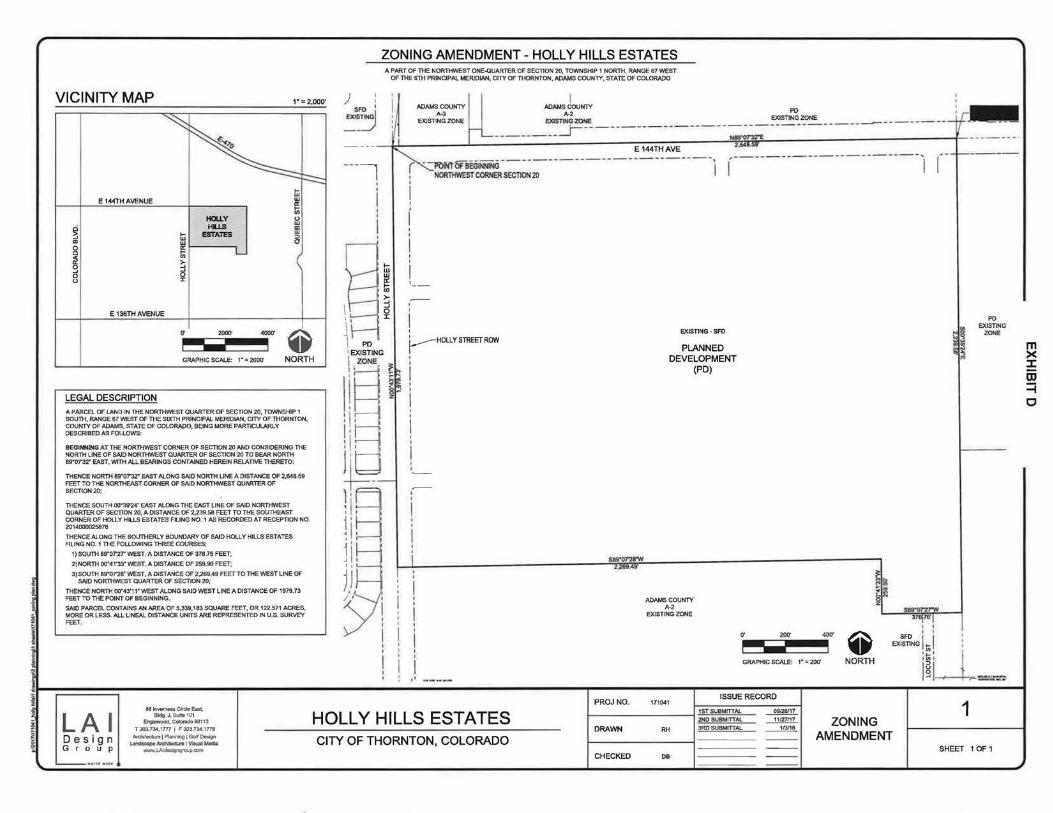
VICINITY MAP ,. -2 000' -
~
) : SRl 1
E7JSTj
ZONING AMENDMENT-HOLLY HILLS ESTATES A PART OF THE NORTHWEST ONE-QUARTER OF SECTION 20, TOWNSHIP 1 NORTH. RANGE 67 WEST
OF THE lfTH PRINCIPAL MERIDIAN, CITY OF THORNTON. ADAMS COUNTY, STATE OF COLORADO
ADAMS COUNTY A-3
EXISTING ZONE
~ ,----------------------, ~ --
r---::: E 144TH AVENUE
HOUY Hl.LS
~ ... ESTATES w ., w 0 a:
~ t; >-g ::l
0 0 0 "
E 136THAVENUE
0' 2000'
t:i w a: :;; 0 w ffi :::> 0
L
4000'
~
' ' I I
f-----HOLLY STREET ROW
GRAPHIC SCALE: 1• "' 2000' NORTH i LEGAL DESCRIPTION
A PARCEL OF LAND IN THE NORTHVVEST QUARTER OF SECTION 20, TOWNSHIP 1 SOUTI-1, RANGE 67 WEST OF THE SIXTH PRINCIPAL MERIDIAN, CITY OF n-tORNTON, COUNTY OF ADAMS, STATE OF COLORADO, BEING MORE PARTICULARLY DESCRIBED AS FOLLOWS:
BEGINNING AT THE NORniWEST CORNER OF SECTION 20 AND CONSIDERING THE NORTH LINE OF SAID NORTHWEST QUARTER OF SECTION 20 TO BEAR NORTH eg•onr EAST, WITH ALL BEARINGS CONTAINED HEREIN RELATrvE THERETO:
THENCE NORTH eg•o7'32• EAST ALONG SAID NORTH LINE A DISTANCE OF 2,648 59 FEET TO THE NORTHEAST CORNER OF SAID NORTHWEST QUARTER OF SECTION20;
THENCE SOUTH oo•39'24" EAST ALONG THE EAST LINE OF SAID NORTHWEST QUARTER OF SECTION 20, A DISTANCE OF 2.239.5B FEET TO THE SOUTHEAST CORNER OF HOLLY Hl..LS ESTATES FUNG NO~ 1 AS RECORDED AT RECEPTION NO. 20,4000025876
THENCE ALONG THE SOL.miERLY BOUNDARY OF SAID HOLLY HILLS ESTATES FILING NO. 1 n-tE FOU.OWING n-tREE COURSES;
1) SO UTI-I 89"07'2T WEST, A DISTANCE OF 378 76 FEET;
2)NORn-t 00"41'33" WEST, A DISTANCE OF 259.90 FEET;
3) SOUTH SS007'26" WEST, A DISTANCE OF 2,269.49 FEET TO TI-lE WEST LINE OF SAID NORn-tWEST QUARTER OF SECTION 20;
THENCE NORTH 00"43'1 1" WEST ALONG SAID WEST LINE A DISTANCE OF 1979.73 FEET TO ntE POINT OF BEGINNING,
SAJD PARCEL CONTAINS AN AREA OF 5,339,183 SQUARE FEET, OR 122..571 ACRES, MORE OR LESS. ALL LINEAL DISTANCE UNITS ARE REPRESENTED IN U.S.. SURVEY FEET.
LAI Design G r o u p
88 Inverness CIF1:1e East. Bldg. J,Suit810t
Englewood, Colarado80112
T 303.734.1177 I F 303.734.1 ne M:tlil8ctw8\ Planning 1 Goll Design
~~·I~W«iil www..lAidasigngroup,com
I I
'I
HOLLY HILLS ESTATES CITY OF THORNTON, COLORADO
EXISTING - SFD
PLANNED DEVELOPMENT
(PO)
ADAMS COUNTY A-2
EXISTING ZONE
0' 200' 400'
GRAPHIC SCALE: 1" = 200'
~ NORTH
SFO I I I
PO EXISTING
ZONE
EXISTING 1 ~ '__L: i ~i =~-=
m >< ::I: OJ =i c

EXHIBIT E
OVERALL DEVELOPMENT PLAN I CONCEPTUAL SITE PLAN- HOLLY HILLS ESTATES
PURPOSE STATEMENT THE PURPOSE OF THIS OVERALL DEVELOPMENT PLAN I CONCEPTUAL SITE PLAN IS TO CREATE A GUIDE FOR DEVELOPMENT OF THIS 121.2 ACRE PROPERTY OF 362 SINGLE FAMILY DETACHED RESIDENTIAL LOTS AND INCORPORATE AN ACCESSORY COMMUNITY CENTER SITE FOR THE USE OF THE HOLLY HILLS ESTATES RESIDENTS THIS COMMUNITY CENTER IS PROPOSED TO BE CENTRALLY LOCATED IN THE COMMUNITY AND IS ADJACENT TO THE PROPOSED NEIGHBORHOOD PARK
LEGAL DESCRIPTION A PORTION OF THE NORTHVv'EST QUARTER OF SECTION 20, TOWNSHIP 1 SOUTH, RANGE 67 \NEST OF THE 6TH PM, CITY OF THORNTON, COUNTY OF ADAMS, STATE OF COLORADO, MORE PAATICULARLY DESCRIBED AS FOLLOWS: ALL Tt-E. LAND AS INCLUDED IN THE HOll.. Y ESTATES FlUNG NO 1 PlAT AS RECORDED ON 4/2912014 AT RECEPTION NUMBER 2014000025676
ARCHITECTURAL STYLE & MATERIALS RESIDENTIAL AND COMMERCIAL CENTER ARCHITECTURAL STANDARDS SHAll. FOLLOW PO STANDARDS AND CITY CODE,
QUALITY ENHANCEMENT NOTES 1, IN SINGLE FAMILY DETACHED SUBDIVISIONS, AT lEAST 25 PERCENT OF THE LOTS 1M THIN THE
SUBDIVISION HAVE A MINIMUM OF 7,500 SQUARE FEET AND ALL REMAINING LOTS HAVE A MINIMUM AREA OF 6,000 SQUARE FEET OF AREA
2 THE SUBDIVISION PROVIDES PUBLIC RECREATIONAL FACILITIES IN ADDITION TO THE PUBLIC LAND DEDICATION REQUIRED BY THE CITY CODE, SUBJECT TO APPROVAL BY THE CITY. AN ADDITIONAL PARK AMENITY IS INCLUDED WTHIN TRACT Z THE ADDITIONAL PARK AMENITY VVILL BE A SPECIAL CLIMBING PlAY STRUCTURE LOCATED IN ITS 0Vv1\l DESIGNATED AREA THE DESIGNATED PLAY AREA 'MLL TOTAL A MINIMUM OF $30,000 00
3 THE SUBDMSION DEDICATES LAND AND GUARANTEES CONSTRUCTION OF IMPROVEMENTS TO PROVIDE TRAIL CONNECTION(S) FROM PROJECT BOUNDARIES TO EXISTING TRAIL OUTSIDE THE PROJECT BOUNDARIES SUCH THAT LINKS ARE CONSTRUCTED IN THE CllY'S TRAIL SYSTEM
4 AT LEAST 40 PERCENT OF THE HOMES IN THE SUBDIVISION FILING SHALL HAVE A MINIMUM OF 2,400 SQUARE FEET OF GROSS LIVABLE AREA
SITE DATA
LAND USE TABLE SQ FT, ACRES DWEWNG UNITS/LOTS
RESIDENTIAL LOT ARE..A zoo7.602 65.9COAC_ 3112 COMMUNITY CENTER LOT AREA ll6.357 U121C.. LANDSCAPE AREA (TRACTS) 947,369 21 ,749AC.
TOTAL (NET AREA OF PROPERTY) 3,951,328 90 71 AC
A PART OF THE NORTH\NEST ONE-QUARTER OF SECTION 20, TOWNSHIP 1 NORTH, RANGE 67 WEST OF THE 6TH PRINCIPAL MERIDIAN, Clrt OF THORNTON, ADAMS COUNTY, STATE OF COLORADO
PUBLIC LAND DEDICA T/ON
REQUIRED PUBLIC LAND DEDICATION
f362 UNITS x 2.86 PERSONSIUNID x 10.J ACRES 1,000
PROVIDED PUBLIC LAND DEDICATION
'!<ACT Z (NEIGHBORH OD PARK) CAS I-l-l N-U EU I FUTURE PLD
TOTAL PLD
LAND USE TABLE
CIJA!191TUSE
10.J5AC_
166AC
103SAC
1 ~ ~~,~n~~~oo~~,-------------+~SI~~N~G~•L~~N'~1Fw~11~~v~~:~r~~D28~0~~ · PK<.SE21'lATSTREEl Hll'l! D.OV1
NET AREA OF PROPERTY (AC.l !l0.710
RESIDENTIAL PElUoi!TTED ReSIDENTIAL DENSITY
TOTAL SUll.OASLE t.OTS
SMAlllllT LOT SIZE(s.F. LAAOESTLOTSIZE S.F.) AVCRAGELOT$1Z£ (S.F.)
llAIN BUILJJING MAA. HElGtfT (FT.)
FRONT- FRONTLOAOED /SIOE ~GARAGE SinE ·INTERNAL LOT I AT RIGHT OF WAY
- -lt<TERNAI. LOTS REAR- EXTE.RNAL LOTS
MIN. LOT FRONTAGE (FT.)
MIN. RESIOCNTIAI..Fl.OOR AREI\IS.F.)
COMMUNITY CENTER (LOT 21A, BLOCK 10) MAX. Fl.OOR AREA AA110 PROPOSED F\.0011 MEA RAllO
MAX. AI.I.OWABI..E I!UII.DIN<l t<EIGI<T (FT.)
BUJI..OINGS£TBACKFROM PUBUCROW<lfl RESIDENTIAL PROPERTY LINE
OFF STREET PARKir«l SETBACK FROM PUBLIC ROW OR f'.ESOOEmw. PROPERTY UNE POOL SETBI\CK AAOM PUili.IC ROll OR RESIDEHTW.. PROPERTY UNE FENCIHG FROM PlJBllC RCNI
OFF STREET PARKING
500, /AC l.15 0U IN;.
...200
3S 16
15 11115
7..511$
15
60
40 1.000
0.25
0.0158
30
20
10
10
lltOURED OFF STREET PARKING ONCUJOES ADA AND VETERNil 12
ADA - ACCESSIBlE sPACES (VAN I'IEGULAA) 1 / 1
VE" ERAN sPACES 2
PROJ NO. 171041
LAI S81nverneS5Cifde East,
Bldg. J, Suite101 Englewood, Colorado 80112
T303734,17771 F3037341n8 Architecture 1 Planning IGolrOe&lgn
Landscape Architecture 1 Visual Media
HOLLY HILLS ESTATES De s ign G r o u p wwwl.Aide;igngroupcom
CITY OF THORNTON, COLORADO DRAWN RH
CHECKED DB
VICINITY MAP 1"'= 2.000"
E 144THAVENUE
~ 0
" ~ 0
"
E 136TH AVENUE
NOTES 1. ALL LAND USE APPROVALS AND BUILDING PERMITS FOR THE DEVELOPMENT DESCRIBED HEREIN
SHALL BE SUBJECT TO REQUIREMENTS INCLUDING, BUT NOT LIMITED TO, THE PAYMENT OF IMPACT FEES AND DEVELOPMENT CHARGES, CONCURRENCY MANAGEMENT REQUIREMENTS, DESIGN STANDARDS, MORATORIUMS, BUILDING PERMIT LIMITATIONS, AND OTHER LAND USE AND DEVELOPMENT REQUIREMENTS IN EFFECT AT THE TIME THAT SUCH PROPOSED DEVELOPMENT APPLIES FOR A BUILDING PERMIT.
2 DURING THE SUBSEQUENT REVIEWS ASSOCIATED WoTH ACTUAL DEVELOPMENT OF THE SITE IDENTIFIED IN THE HOLLY HILLS OVERALL DEVELOPMENT PLAN I CONCEPTUAl SITE PLAN, THE DEVELOPMENT DIRECTOR AND/OR THE DEVELOPMENT ENGINEERING MANAGER MAY AllOW FOR MINOR ADJUSTMENTS IN THE ANAL SITE Pl.AJ'I,I, SUBDIVISION PLAT, FINAL LANDSCAPE PLAN AND ASSOCIATED ANAL ENGINEERING DOCUMENTS. THE CHANGES TO THE DEVELOPMENT WOULD BE DUE TO ACTUAL SITE CONDITIONS, UNFORSEEN TECHNICAL ISSUES INVOLVING INFRASTRUCTURE ON THE SITE AND CHANGES TO THE BUILDING PRODUCTS PREVIOUSLY IDENTIFIED OR DESCRIBED ON THE OVERALL DEVELOPMENT PLAN I CONCEPTUAL SITE PLAN GRAPHIC AND APPROVED BY THE CITY COUNCIL
3. VISUAL OBSTRUCTIONS GREATER THAN 30 INCHES (2.5 FEET) IN HEIGHT SHALL NOT BE LOCATED VVITHIN SIGHT VISIBILITY TRIANGLES AS DEFINED BY THE CITY OF THORNTON DEVELOPMENT CODE,
4 A HOMEOIJIAIIEFfS ASSOCIATION OR METRO DISTRICT SHAlL MAINTAIN LANDSCAPING IN COMMON OPEN SPACE TRACTS AND ADJACENT RIGHTS-OF-WAY THIS INCLUDES RIGHT-OF-WAY LANDSCAPING ALONG HOLLY STREET AND E 144TH AVENUE RIGHT-OF-WAY LANDSCAPING IN FRONT YARD OF LOTS (AND SIDE YARD OF CORNER LOTS) VVILL BE THE RESPONSIBILITY OF THE PROPERTY OWNER
SHEET INDEX OWNERSHIP CONTACT
SHEETS
1
2
3
4-12
13
14
DESCRIPTION
COVER SHEET
SITE PLAN
OVERALL LANDSCAPE PLAN
DETAILED LANDSCAPE PLANS
EXISTING CONDITIONS MA.P
COMMUNITY CENTER ELEVATIONS
TOLL BROTHERS COLORADO AnN: MARK BAILEY 10 INVERNESS DRIVE EAST, SUITE 125 ENGLEIJVOOD, CO 80112 OFFICE PHONE: 303-70B-0730
ISSUE RECORD
1ST SUBMITTAL 09126117 1 2ND SUBMITTAL 111V/17 COVER 3RD SUBMITTAL ~ 4TH SUBMITTAL 2120118 SHEET 5TH SUBMITTAL ~ SHEET 1 OF 14
----

L A I D esign G r o u p
OVERALL DEVELOPMENT PLAN I CONCEPTUAL SITE PLAN- HOLLY HILLS ESTATES ADAMS COUNTY
A-3 EXISTING ZONE
i l ~--=1 I UNPLATIEO I c:Lul o. <IW!Y ._ s&&.
BOOK 2538, PG 424
I \
GERRITY OIL & GAS CORP BOOK 3885, PG 783
RECf7882
\ :~~~ \l USABEll-1 SANCHEZ \-- 01151589
I :::=] I--
(f J/
A PART OF THE NORTHVVEST ONE-QUARTER Of' SECTION 20, T0\1\INSHJP 1 NORTH, RANGE 67 VVEST OF THE 6TH PRINCIPAL MERIDIAN, CITY OF THORNTON, ADAMS COUNTY, STATE OF COLORADO
ADAMS COUNTY A-2
EXISTING ZONE
PO EXISTING ZONE
PARTERRE SUBDIVISION Fn.JNGNO 1
REC NO 2011000028945
UNPLATTED BRUCE A. WINSETT REC.NO.
12000025573
PROJNO. 171041 861rwa~T~eM CVcle Ea~.
Bldg J,Sulle101 Englewood, Colorado 80112
T303,73417771 F3037341n8 Architecture! Planning IGoltOes1gn
LandscapeArchileccurelVLsual Media
HOLLY HILLS ESTATES DRAWN RH
CITY OF THORNTON, COLORADO www LAidesi9ngroup com
CHECKED 08
PROPOSED GRADING E.ASEMENTBY SEPARATE DOCUMENT
3' CCNCRETE TRAIL (TVP,)
UNP\.ATTED
112~~~~ 5~~:~~~~47 EASTLAKE, CO
80614
PO EXISTING
ZONE
\ PARTERRE SUBDIVISION
> FIUNGN0.1
REC. NO. 2011000028945
_/
EXISTING SO' UNDERGROUND PIPEUNE EASEMENT BOO!( 1055, PAGE 501 &
BOOK 1862, PAGE 817 AUENDEOBY REC NO '2008000030721
PAATERRE SUBDMSION FILING N0. 1
REG. NO. 20 t 1000028945
SPRtiGVAl.E HOME O'MIERS ASSOCIATION, INC.
SPRINGVALE SUa fiUNG No 5, SlacK 1,
TRACTL RECi~e0849205
ISSUE RECORD
1STSUBMinli.L ~ 2NO SUBMITfAI... 11127117
3RD SUBMITTAL ~ 4TH SUBMITTJ..L 2120118
5TH SUBMITTAL ~
LEGEND
PROPERTY SOUNOARY
PROPERTY LOT UNE
-- - -- CENTER UNE
- ----- - EASEMENTUNE
EXISTING EASTMENT
l!l PORTA POTTY
NOTES
1. ACCORDING TO THE CITY OF THORNTON DEVELOPMENT C00C. AP£RSON SHALL NOT Ef>ECT. PLI,CE. OR MAlNTAIN AN STRUCTURE. BERM, Pl.Nil\JFE. 9R i'Ni OTHER ITEM IF THE ITEM JS 9E1'Y>EE>/2 112 FEET AND EIGHT FEET IN HEIGHT MEASURES FROM THE TOP OF THE ADJACENT STREET CURB VVITHIN niE SIGHT VISIBIUTY TRIANGLES,
o· 200'
GRAPHIC SCALE: 1~ • 200'
SITE PLAN
400'
~ NORTH
2
SHEET 2 OF 14

OVERALL DEVELOPMENT PLAN I CONCEPTUAL SITE PLAN- HOLLY HILLS ESTATES A PART OF THE NORTH'YVEST ONE-QUARTER OF SECTION 20, TO~St-UP 1 NORTH, RANGE fr7 WEST
OF THE 6TH PRINCIPAL ME.RIDlAN, CfTY OF THORNTON. ADPMS COUNTY, STATE OF COLORADO TRACT TABLE
TRACT SQ. FT. ACRES OWNED/ USE
MAINTAINED
TRACT A 176,007 4.04AC. HO.A. LSCP AREA. TRAIL, BUFFER, UTIUTYJORAINAGE, DET. ESMT,
TRACTS 2.982
TRACTC ~564
TRACT01 10,604
TRACTE 2,564
TRACTF 3,310
TRACTG1 4,928
TRACTH 3,776
TRACT J 24,897
TRACTK 5,271
TRACTL1 8.643
TRACTM 100,385
TRACTN 3,256
TRACTO 41.466
TRACTP 3,980
TRACTQ 4,187
TRACTR 4.394
TRACTS 56.432
TRACTT 8,894
TRACTU 4,601
TRACTV 3,933
TRACTW 4.601
TRACT X 4.601
TRACTY 4,160
lRACTZ 378,747
TRACTBS 51,492
TRACTCC 3.933
TRACTOO 1~996
TRACTEE 9,765
TOTAL 947,369
0,07AC. H ... OA....
006AC HOA 024AC HOA 006AC HOA OOBAC HOA 011AC HOA 008AC H.OA
057AC HOA 012AC HOA 020AC HOA
2...30AC HOA 0 ... 07AC. HOA 09SAC... HO.A.
0.09AC. HOA.
0.10AC ... HOA. 0.10AC. HO.A.
t ... 30AC. HOA,
020AC, HO.A.
0...11AC. H.O.A,
0.09AC. H.O.A.
0,11 AC.. HOA 011AC H.OA.
010AC H.OA 869AC. METRO DISTRICT
L18AC. HOA 009AC HOA 030AC HOA o.22AC HOA
2175AC.
LEGEND
PROPERlY BOUNDARY
PROPERlY LOT LINE
CENTER UNE
LOCP.~ TIW..I!Ufftll UllJTYIJ.W,9<T
LSCP. i>i'8.. TRAIL. BUFfER. llllUTY EASEMENT
....... ~ IRAl. BUFFER. UTliTY EAStliEHT
L.OCP.~ IRAI.!IUFFER.UIIJIY~
LSCP AREA. TRAIL, BUFFER, unLJTY EASEMENT
LSCP. AREA. TRAIL, BUFFER, UTft.JTY EASBENT
LSCP. AA£A, TRAIL. BUFFER. UTIUTY EASEMENT
LSCP AREA, TRAIL, BUFFER, UTILITY EASEMENT
LSCP AREA, TRAIL, BUFFER, UTILITY EASEMENT
LSCP AREA, DRAINAGE, UTIUTY EASEMENTS
LSCP. AREA, TRAIL. BUFFER, UTllJTY EASE&.ENT
LSCP. AREA, lRAil. BUFFER, UTlUTY EASEMENT
LSCP. AAEA, TRAIL. BUFFER, UTIUTY EASEMENT
LSCP ... AREA, TRAIL. BUFFER, UTIUTY EASEMENT
LSCP AREA, TRAIL, BUFFER, UTIUTY EASEMENT
LSCP. AREA. TRAil. BUFfER.llllUTY EASEMENT
LSCP ... AREA, TRAI...,Bt..IFFER,UTIJTYEASEL1ENT
LSCP ... AREA, TRAIL, BUFFER, UTIUTY EASEMENT
LSCP. AREA, TRAIL, BUFFER, UTIUTY EASEMENT
LSCP. AREA, TRAIL, BUFFER, UTIUTY EASEMENT
LSCP. AFEA. TRAIL. BUFFER. UTiliTY EASEMENT
LSCP. AREA. TRAL. B1.JFFER. Ull.ITY EASEMENT
LSCP- AREA, TRAIL, BUFFER, UTRJTY EASEMENT
NEIGHBORHOOD PARK
DETENTION ARiA. UTIUTY EASEMENTS
LANDSCAPE AREA
lANOSCNJE AREA
LANDSCAPE AREA
EASEMENT UNE
RECREATIONAL AMENilY
@> DECIDUOUS TREES
- EVERGREEN TREES
~ SHRUBBEDS
3..5' OPEN RAIL FENCE
6' SINGLE SIDED PRIVACY FENCE
-o--- SOLID MASONRY WALL
NOTES
DESIGN SHOWN IS CONCEPTUAL ACTUAL DESIGN W1LL BE DETERMINED AT THE TIME OF THE DEVELOPMENT PERMIT,
2 LANDSCAPING VVIU... BE DESIGNED TO THE CrTY CODE WATER·IMSE PRINCIPLES
ISSUE RECORD
1------------l ~~~ ~~~:~~~ ~ ~ _______ill!!!.
0' 200'
GRAPHIC SCALE: 1" = 200'
400'
3
@ NORTH
3RD SUBMITTAl..
4TH SUBMITTAL t------------1 5TH SUBMITTAL
~ ----1!!!1!..
OVERALL lANDSCAPE
PlAN SHEET 3 OF 14

____ _., /
______ __/ ~ I
8SJnvernessCireleEast.
LA I BldgJ, Suile:101 Englewood, Colorado 80112
T 303 734 1777 I F 303 734 1776
Design An::hiteclureiP\aming ] GolfOt:sign Landsca~ Arehiteclure I Visual Media
G r o u p www LAidesi'ijngroup com
OVERALL DEVELOPMENT PLAN I CONCEPTUAL SITE PLAN- HOLLY HILLS ESTATES A PART OF THE NORTHWEST ONE-QUARTER OF SEC110N 20, TO\NNSHIP 1 NORTH, RANGE fil WEST
OF THE 6TH PRINCIPAL MERIDIAN, CITY OF ~TO!'II, ADAMS COUNTY, STATE OF COLORADO
r--- , I
- --~ -- -------------
78
I
I t:i
BB w a:: tn ~ l
liB
PROJ NO 171041
HOLLY HILLS ESTATES DRAWN RH
CITY OF THORNTON, COLORADO CHECKED 00
-----1 I
ISSUE RECORD
1ST SUBMITTAL ~ 2ND SUBMITTAL ~ JRO SUBMITTAL ~ 4TH SUBMITTAL ~ 5TH SUBMITTAL ~
KEY MAP
LEGEND
PROPERTY BOUNDARY
PROPERTY LOT LINE
- - - -- CENTER UNE
-- - ----- EASEMENTUNE
RECREATIONAL AMENITY
DECIDUOUS TREES
EVERGREEN TREES
SHRUB BEDS
3,5' OPEN RAIL. FENCE
6' SINGLE SIDED PRIVACY FENCE
-Qo--- SOLID MASONRY WALL (TYP)
·!· .... ->: 6 ~"~ BLUEGRASS SOD
NATIVE SEED
... 120'
~ GRAPHIC SCALE: 1" = 60' NORTH
4 LANDSCAPE
PLAN SHEET 40F 14

Ji
OVERALL DEVELOPMENT PLAN I CONCEPTUAL SITE PLAN- HOLLY HILLS ESTATES
_L___.:__j-+-:..__t_ I I
10' MAINTENANCE ACCESS ROAD I I
A PART OF THE NORTHWEST ONE-QUARTER OF SECTION 20, TOWNSHIP 1 NORTH, RANGE 01 WEST OF THE 6TH PRINCIPAL MERIDlAN, CITY OF THORNTON, ADAMS COUNTY. STATE OF COLORADO
I KEY MAP
--- - --------- - ---- -- - ~--
I I
- .J-7-~ I
LAI Desig n G r o u p
SBinvernessCireleEaat, Bldg J,Suila101
Englewood, Color.ido 60112
T 303 734 1777 I F 303 734 1776 Arcn;t«.t•n[Pianning[Golf0<t5ign
Landsea.pe ArctliteclUfe I V•ual Media www lAJdes~ng(O\Ip com
11 12
13A 14A
HOLLY HILLS ESTATES CITY OF THORNTON, COLORADO
28 27 26
PROJ NO. ISSUE RECORD
171041 1ST SUBMITTAL ~ 2ND SUBMITTAl.. 11m111
DRAWN RH 3ROSUBMITTAL ~ 4TH SUBMITTAL ~ 5TH SUBMITTAl. ~
CHECKED DB
- --
LEGEND PROPERTY BOUNDARY
PROPERTY LOT UNE
-- - -- CENTER UNE
------- EASEMENT LINE
RECREATIONAL AMENITY
():; DECIDUOUS TREES
$8 EVERGREEN TREES
~ SHRUBBEDS
3.S OPEN RAJL FENCE
6' SINGLE SIDED PRIVACY FENCE
---a------ SOliD MASONRY WALL (TYP.)
J. ~~:--~> .. : ~;:·>.~ :.;·:.) BLUEGRASS SOD
I • • .I NATIVE SEED
0' 60' 1 2~
~ GRAPHIC SCALE: 1" = 60' NORTH
5 LANDSCAPE
PLAN SHEET 5 OF 14

I
"" SA
LAI Design G r o u p
SA 7A
6B lnve~ Cirde East, Bldg_J, Suite101
Engtewood. Colorado 60112
T 303 734.1 777 I F 303 73<1.1778
Archite~ure I Planning I Golf Doa~n Landsc:a!J4Architecture iVi&ual Medi"
-L.Akl~ngroup.com
8A
OVERALL DEVELOPMENT PLAN I CONCEPTUAL SITE PLAN- HOLLY HILLS ESTATES
9A
A PART OF THE NORTHWEST ONE-QUARTER OF SECTION 20, TOVv'NSHIP 1 NORTH, RANGE 67 VIlEST OF THE 6TH PRINCIPAL MERIDIAN, CITY OF THORNTON, ADAMS COUNTY, STATE OF COLORADO
10B 11B
PROJNO,
HOLLY HILLS ESTATES DRAWN
CITY OF THORNTON, COLORADO CHECKED
171041
RH
DB
I I
_ J. I
ISSUE RECORD
1ST SUBMITTAL ~ 2ND SUBMITTAL ~ 3RD SUBMIITAL ~ 4TH SUBMIITAL ~ 5TH SUBMITTAL ~
=
KEY MAP
LEGEND
PROPERTY BOUNDARY
PROPERTY LOT UNE
- - - -- CENTER LINE
------ - EASEMENTUNE
RECREATlONALAMENITY
OECIDLK>US TREES
EVERGREEN TREES
SHRUB BEDS
3 5' OPEN RAIL FENCE
6' SINGLE SIDED PRIVACY FENCE
~ SOLID MASONRYWALL(TYP)
1·<·-"··; ';:·::· ... ~ :>·I BLUEGRASS SOD
L ; NATIVE SEED
rt 60 12rt
~ GRAPHIC SCALE: 1" = 60' NORTH
6 LANDSCAPE
PLAN SHEET 6 OF 14

LA I Design G r o u p
0
0
:.1---as Inverness <A-de East.
Bldg J, Suile101
/II J l I II I II I II I II I I I I I I I I I 1 I I I I I I I I I I I I I I 1 I I I I I 1 I I I
I I
I j I I I I I I I I
Engi-OQd, Coloritdo 50112
T 303 734 1777 I F 303 734 1776 ArehitetturejPianning I Golf Design
land&CiipeArchiteelure j VisuaJ Media www LAI~igngroup =m
OVERALL DEVELOPMENT PLAN I CONCEPTUAL SITE PLAN - HOLLY HILLS ESTATES A PART OF THE NORTHVI.EST ONE-QUARTER OF SECTION 20, TOV\!NSHIP 1 NORTH, RANGE 67 WEST
OF THE 6TH PRINCIPAL MERIDIAN, CITY OF THORNTON, ADAMS COUNTY, STAT~ OF COLORADO
10
I
I fw
~ U)
w 0 :c z
T I
I I
I I
l I
l I
I
HOLLY HILLS
10
ESTATES CITY OF THORNTON, COLORADO
21
20
,.
18
17
18
15
14
13
PROJ NO. 171041
DRAWN RH
CHECKED DB
ISSUE RECORD
1ST SUBMITTAL ~ 2ND SUBMITTAL --.!.!P11L 3RO SUBMITTAL ~ 4TH SUBMITTAL 2120/18 5TH SUBMITTAL ~
KEY MAP
LEGEND
PROPERTY BOUNDARY
PROPERTY LOT LINE
-- - -- CENTER LINE
-o----1- <·-'"! ? ·:·.: .. ,.~ :.:···1 I. • • I
0'
EASEMENT UNE
RECREATIONAL AMENITY
DECIDUOUS TREES
EVERGREEN TREES
SHRUB BEDS
3.5' OPEN RAIL FENCE
6' SINGLE SIDED PRIVACY FENCE
SOLID MASONRY WALl (TYP.)
BLUEGRASS SOD
NATIVE SEED
60' 120'
~ GRAPHIC SCALE: 1" = 60' NORTH
LANDSCAPE 7
PLAN SHEET 7 OF 14
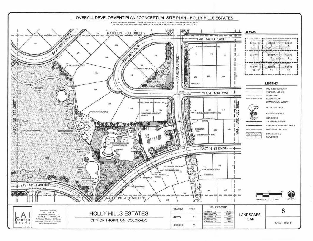
I
6Bk1vert!e5$CitcleEa15C,
LA I Bldg. J,Suite101 Englewood, Colon!.do 60112
T 303 734 1777 I F 303 734 1 77a
Des i gn Architedure 1 Planning I Goll Design Landsc:ap•ArchitectureiVisual Media
G r o u p www.LAidesigngrcup com
OVERALL DEVELOPMENT PLAN I CONCEPTUAL SITE PLAN - HOLLY HILLS ESTATES A PART OF THE NORTHWEST ONE-QUARTER OF SECTION 20, TOWNSHIP 1 NORTH, RANGE 67 ~ST
OF THE 6TH PRINCIPAL MERIDIAN, CHY OF THORNTON, ADAMS COUNTY, STATE OF COLORADO
1A
288
6'SIDEWALK
2A JA
278 268
KEY MAP
LEGEND
PROPERTY BOUNDARY
PROPERlY LOT UNE
-- - -- CENTER LINE
------- EASEMENTUNE
RECREATIONAL AMENITY
DECIDUOUS TREES
EVERGREEN TREES
SHRUB BEDS
3 5' OPEN RAIL FENCE
6' SINGLE SIDED PRIVACY FENCE
--a----. SOLID MASONRY WALL(TYP)
(· .. :-.<·. o>;·.:->.~ ,_>., BWEGRASS SOD
L * • w NATIVE SEED
141ST DRIVE~-~+-
I
o· 60' 120
~ GRAPHIC SCALE: 1" = 60' NORTH
PROJ NO. ISSUE RECORD
171041
HOLLY HILLS ESTATES 1STSUBMrTTAi.. ~ 2ND SUBMITTAL ~ LANDSCAPE
DRAWN RH 3ROSUBMmAL ~
CITY OF THORNTON, COLORADO 4TH SUBMITTAL 2120118 PLAN 5TH SUBMITTAl.. ~
8
SHEET 8 OF 14 CHECKED DB

---.- -I I 1 4A 5A 6A 7A SA
I I
I I 18
248 238 228 218
I
OVERALL DEVELOPMENT PLAN I CONCEPTUAL SITE PLAN- HOLLY HILLS ESTATES
9A 10A 11A
208 199 188
A PART OF THE NORTH'IM:.ST ONE-QUARTER OF SECTION 20, TO'NNSHIP 1 NORTH, RANGE 67 \M::ST OF THE 6TH PRINCIPAL MERIDlAN, CITY OF THORNTON, ADAMS COUNTY, STATE OF COLORADO
~Sf ~SilEIIFRVAC ,~
~"i~ ISS ~ 12A 14'8 ~~
' . ~QOSIC~
SIDEWAlJ(- ;
178 1138 158 ~ r:~ '
~~ '
~
--
. - t-- --------- -------EAST 142ND WAY --t CO u
tu l ~ . (j) 88 liB 511 68 78 w w U: l
-~· ~ . 0
208 48~ · 238 228 218 198
:21 I
I I
'"I 118 128 138 148
I I I I I 238 228 218 208 198
+----- -- .... ..... --I
............ ~fll
LA I Bldg, J, Suite 101 EnQiewood, Coklr.uk1 80112
T 303.7341777 I F 30J 734 1ns
Des i gn Arm~ecture 1 P laming I Gol l Oe5ign Lands.cape Atch.1edt.Te I VIsual Medla
G r o u p www I..Aidesi;ngroup com
eSIDEWALK-~ I
. ' ' 108 119 . 128 138 148 ' .
I
' ' )i ~ I I
S~OO)B) ~ra<CE"" ~· ' I
188 178 188 I ISS '= ~
SGrrTP'PJ~P .. ~ w ~ ~~L_
158
HOLLY HILLS ESTATES CITY OF THORNTON, COLORADO
PROJ NO. 171041
DRAWN RH
CHECKED DB
\ \ \ \ \ \
) /
/ /
ISSUE RECORD
1ST SUBMITTAL ~ 2ND SUBMITTAL .......!.:!..!2 3RDSUBMITIAL. ~ 4TH SUBMITTAL 2/20118 5TH SUBMITTAL. ____1!1!!!.
-=
KEY MAP
LEGEND
PROPERTY BOUNDARY
PROPERTY LOT UNE
-- - -- CENTER LINE
------ EASEMENTUNE
RECREATIONAL AMENITY
DECIDUOUS TREES
EVERGREEN TREES
SHRUB BEDS
3 S OPEN RAIL FENCE
6' SINGLE SIDED PRIVACY FENCE
-Q-- SOUDMASONRYWAll(lYP.)
(---~-~ • • •• 0 '! .. :: :. ~ I BLUEGRASS SOD
I I NATIVE SEED
120'
GRAPHIC SCALE: 1~ = 60' NORTH
9 LANDSCAPE
PLAN SHEET 9 OF 14

LA I Design G r o u p
ea lrwamesa Circle East, Sldg, J,SUite101
EngleWood, Colorado 80112
T 303 7341777 I F 303.1341778
Atehitec1.urel Planning I Golf Design Landscape Architecture l VISual Media
wwwi.Aides~gngroupccm
I I I I I I I: I I I I I I I I I I
OVERALL DEVELOPMENT PLAN I CONCEPTUAL SITE PLAN - HOLLY HILLS ESTATES A PART OF THE NORTH'vVEST ONE-QUARTER Of SC.CllON 20, TOWNSHIP 1 NORTH, RANGE 67 WEST
OF THE 6TH PRINCIPAL MERIDIAN, CITY OF THORNTOC'II, ADAMS COUNTY, STATE OF COLORADO
9A
2A
4A
3A
KEY MAP
LEGEND
PROPERTY BOUNDARY
BA PROPERTY LOT UNE
SA
6A 6' SINGLE SIDED PRIVACY FENCE
I
1\ I
I \
\ \ \ \ \ \ \ \ \ \ ~\
\--. I --. I I
3A
4A
TI-llS SECTION OF SIDEWALK ~M-ilCH IS NOT ADJACENT TO A L.OT OR TRACT SHAU.
BE MAINTAINED BV iHE HOMEOWNER'S ASSOCIATION OR METRO DISTRICT
----~
HOLLY HILLS ESTATES CITY OF THORNTON, COLORADO
7A
6A SA
PROJ NO.
DRAWN
CHECKED
- - - -- CENTER LINE
- ---- - - EASEMENTUNE
2A RECREATIONALAMENITY
DECIDUOUS TREES
EVERGREEN TREES
SHRUB BEDS
3,5' OPEN RAIL FENCE
6' SINGLE SIDED PRIVACY FENCE
-.Q-- SOLID MASONRY WAll.. (TYP.)
1<··: : ··::•. ··I BLUEGRASSSOO
I NATIVE SEED
I 0' 60'
~ 120
GRAPHIC SCALE: 1• = 60' NORTH
ISSLJt RECORD
10 171041
16T·SUEilQ"A!.. ~ 2ND SUBMITTAl 11127117 LANDSCAPE
RH 3RD SUBMITTAL ~ 4TH SUBMITIAL ~ PLAN 5TH SUBMITTAL ~ SHEET 10 OF 14
DB

I I I I I I I I
I
LAI Design G r o u p
sa lnvemee& Circle Eut, Bldg, J, Suite 101
Englewood, Colorado 80112
T 303 7341777 I F 303.734 1na Art:hitcctl..ll"e I Planning I Golf D~lgn
Landscape Architecture I Vi&ual Media wwwl.Aidesigngroupcom
OVERALL DEVELOPMENT PLAN I CONCEPTUAL SITE PLAN- HOLLY HILLS ESTATES A PART OF TI-lE NORTHWEST ONE-QUARTER OF SECTION 20, TOWNSHIP 1 NORTH, RANGE 67 \1\/EST
OF n-tE 6TH PRINCIPAL MERIDIAN, CITY OF THORNTON, ADAMS COUNTY, STATE OF COLORADO
PROPERTY BOUNDARY
PROJ NO. 171041
HOLLY HILLS ESTATES DRAWN RH
CITY OF THORNTON, COLORADO CHECKED DB
I ·a I
I I I
I
I
I
ISSUE RECORD
1ST SUBMITTAL ~ 2ND SUBMITTAL 11127117 3RC SUBMITTAL ~ 4TH SUBMITTAL 2nJJ/18 5TH SUBMITTAL ~
KEY MAP
LEGEND
PROPERTY BOUNDARY
PROPERTY LOT UNE
-- - -- CENTER UNE
------ EASEMENTUNE
RECREATIONAL AMENITY
OECJOUOUS TREES
EVERGREEN TREES
SHRUB BEDS
3.5' OPEN RAIL FENCE
6' SINGLE SIDED PRIVACY FENCE
-Q-- SOUOMASONRYWAIJ.(TYP.)
f'·c'·-:·:o:;:-."';:. :.>J BLUEGRASS SOD
I I NATIVE SEED
o· so· 120'
~ GRAPHIC SCALE: 1 ~ = 60' NORTH
11 LANDSCAPE
PLAN SHEET 11 OF 14

~ 238 Z28 218
+ -.... """ <=1 """' ""' I
""'"""
OVERALL DEVELOPMENT PLAN I CONCEPTUAL SITE PLAN- HOLLY HILLS ESTATES
'l~lj
"""'"""' """-
A PART OF THE NORTHWEST ONE-QUARTER OF SECTION 20, TOWNSHIP 1 NORTH, RANGE 67 \NEST OF THE 6TH PRINCIPAL MERIDIAN, CITY OF THORNTON, ADAMS COUNTY, STATE OF COLORADO
- ==""
- -t--- ----- -EAST141STLANE- -----
I
LAI Desi g n G r o u p
SB 68 78
228 218 208 198
288 298 308 318
B"SINGLE SIDED PR 'ACY FENCE
\
PROPERTY BOUNDARY
PlUGGED&
881nvernessCircleE.o!st, 81dg, J,Suite101
Englewood, Cclcradc 80112
ABANDONED GAS WELl
T 303 7341777 I F 303 734 1778
Architecture I PLanning I GclrDesign
Landscape Architecture I Visual Media www LAidesigngrcup com
98
188
108
178
" "TRACT• • • • • L 1 ~ • ..
• . NATIVE. . · sao .• _ ..... _ ..... _
6' SINGLE SIDED PRIVACY FENCE
118 128
168 158
348 338
HOLLY HILLS ESTATES CITY OF THORNTON, COLORADO
138
148
358
PROPERTY BOUNDARY
EXISTING 50' PIPE~E EASEMENT
KEY MAP
LEGEND
PROPERTY BOUNDARY
PROPERTY LOT LINE
-- - - - CENTER LINE
-- - ---- EASEMENTLINE
RECREATIONAL AMENITY
~ DECIDUOUS TREES
~ EVERGREEN TREES
~"'::/ SHRUB BEDS
3 5' OPEN RAIL FENCE
6' SINGLE SIDED PRIVACY FENCE
--o---- SCUD MASONRY WALL (TYP)
f"-·~ :'*$•}.._:~. 3 BLUEGRASSSOD
I • • I NATIVE SEED
0' 60' 120
~ GRAPHIC SCALE: 1" = 60' NORTH
12
SHEET 12 OF 14

I..
\
I II _I' 'II
l WUtJIIfalo -_, -=---· Ra:...O
20\70Cro37059 \
68 Inverness CWde Eolst,
LA I Bldg J,Sui&e101 Engtewoocl. Coklr.Kto 80112
T 303 734,17Ti" I F 303 734 1ns Afdl letlure I Plan!Wng I Goll Design
ADAMS COONTY A-3
EXtsTINGZONE
Design G r o u p
Lanascape Afctuteeture I Vtsu.l Me<llil www LAldeSigngoup CQlTl
~•-<~• ttlo L ,.t
OVERALL DEVELOPMENT PLAN I CONCEPTUAL SITE PLAN- HOLLY HILLS ESTATES GERRITY OL & GAS CORP
SOC»( 38&5, PG 783 R£CJ78112 ,,,,,'
A PART OF THE NORTHWEST ONE-QUARTER OF SECTKJN 20, TOWNSHIP 1 NORTH, RANGE D7 WEST OF TtE 6TH PRINCIPAL MEA.IOIAN, OTY OF THORNTON, PnPMS COUNTY, STATE OF COLORADO
PROJ NO. 171041
HOLLY HILLS ESTATES DRAWN RH
CITY OF THORNTON, COLORADO CHECKED 00
ISSUE RECORD
1ST SUBMITIAL ~ 2ND SUBMITTAL .......l.1tm!Z. 3RD SUBMrTTAL 113118 4TH SUBMITTAL 2120118
5TH SUBMITIAL ~
---
200" 400'
~ GRAPHIC SCALE: 1" = 200' NORTH
13 EXISTING
CONDITIONS SHEET 13 OF 14
J

LAI Des gn G r o u p
FASCIA BOARD, PAM DARK BROWN ------,.
BOARD & BAmN SIDING, PAM"BBGE
sa Inverness CJrde East. Bldg J,Sul~101
Englev.ood,Colorado80112
T 303,734.1777 I F 303.734.1178
Archltectu~&IPtannlnliJGolf Landscape Ardlltrc:UeQeMaj
www.t.Ald~ngr~
34% 41% 25%
100%
OVERALL DEVELOPMENT PLAN I CONCEPTUAL SITE PLAN- HOLLY HILLS ESTATES A PART OF THE NORll<WEST ONE.OUARTCROF SECTION 20, TOWNSHIP 1 NORTH, RANGE 67 WEST
OF THE 6TH PRINCIPAL l.tE.fUDW\1, CITY OF THORNtON, ADAMS COUNTY, STATE OF COlORADO
EXTERIOR FINISH AREA ANALYSIS (Sq. Ft.)
!Q!!!. ~ l!l!5§! ll!2!li!:! NORTH
1961 31% 606 31% 595 29% 300 53% 460 STONE VENEER 2411 45% 873 36"4 706 49% 516 36% 316 EXTERK>ft SI>ING 1447 24% 47-4 33% 63J 23% 243 11% 07 WINDOW GLAZING
5819 1953 1934 1059 673 TOTN....
HOLLY HILLS ESTATES CITY OF THORNTON, COLORADO
PREFINISHED ALUMINUM STOREFRONT ASSEMBLY, DARK BRONZE
PROJNO.
DRAWN
CHECKED
171041
RH
DB
HORIZONTAL LAP SIDING (T REVEAL w/1" LAPt PANT DARK GREEN
ISSUE RECORD
4TH SUBMITIAl 2120/16 Snt SUBMIITAL ~
ARCHrTECTURAL ASPtW.. T SHINGLES. DARK GREY
COMMUNITY CENTER
14
ELEVATIONS SHEET 14 OF 14

COUNCIL COMMUNICATION Meeting Date: Agenda Item: Agenda location: Work Plan#
L~ April10, 2018 lOB Public Hearings _1 51 Reading _2nd Reading
subject: A motion vacating the public hearing and the petitions for annexation of property generally located north and south of East 1 04th Avenue and west of Brighton Road to the City of Thornton (Cooley East Nos. 2, 3, and 4 Annexations).
Recommended by: Jeff Coder ~ Approved by: Kevin S. Woods Ordinance previously
Presenter(s): Grant Penland, Current Planning Manager ~ introduced by:
SYNOPSIS:
On February 27, 2018, City Council acknowledged the receipt of the Cooley East Nos. 2, 3, and 4 annexation petitions and established April 10, 2018 as the date for consideration of the requested annexations. Due to lack of proper noticing of the proposed annexations, the annexations can no longer lawfully be considered on April 10, 2018. The original petition acceptance must be vacated as well as the public hearing. New petitions will be presented, and a new public hearing date will be established for consideration of the proposed annexations.
RECOMMENDATION:
Staff recommends that City Council approve a motion vacating the public hearing and the petitions for annexation.
BUDGET/STAFF IMPLICATIONS:
None.
BACKGROUND (ANALYSIS/NEXT STEPS/HISTORY):
The Cooley East No. 2, No. 3, and No. 4 properties are located generally north and south of East 104th Avenue and west of Brighton Road. The City acquired the properties on December 28, 2016 in order to expand the City's water resources, improve floodway areas, and protect wetland areas.
The Cooley East No. 2 annexation also includes an approximate 2-acre parcel owned by Adams County. Adams County has agreed to include this parcel, upon which exists a portion of the South Platte River Trail, in the annexation to provide jurisdictional consistency. No improvements are planned on the County-owned parcel at this time.

COUNCIL COMMUNICATION Meeting Date: Agenda Item: Agenda Location: Work Plan# '::?IlL' April 10, 2018 llA 1-3 Action Items
_1 51 Reading _2nd Reading
Subject: Three resolutions acknowledging receipt of the Cooley East Nos. 2, 3, and 4 annexation petitions and establishing May 22, 2018 as the date for consideration of the requested annexations of property generally located north and south of East 1 04th Avenue and west of Brighton Road to the City of Thornton (Cooley East No.2, 3, and 4 Annexations).
Recommended by: Jeff Coder f.'?J C Approved by: Kevin S. Woods Ordinance previously
\U introduced by:
Presenter(s): Grant Penland, Current Planning Manager
SYNOPSIS:
The City is proposing to annex approximately 214 acres of land for water resource expansion and improvements. The City is the owner of the majority of the properties and Adams County is the owner of an approximate 2-acre parcel within Cooley East No. 2. The annexation does not include any rightof-way. The first step in the annexation process, per Title 31, Article 12 (Municipal Annexation Act of 1965) of the Amended Colorado Revised Statutes, is for City Council to acknowledge receipt of the petitions for annexation by resolution and establish the date to consider the merits of annexing the land requested by the petitioner.
Acknowledging receipt of the petitions for annexation does not bind the City to annex the unincorporated property. It only determines that the petition is in proper form and that the properties are capable of being annexed to the City in accordance with the Colorado Revised Statutes.
RECOMMENDATION:
Staff recommends Alternative No. 1, approval of the attached resolutions acknowledging receipt of the petitions for annexation of the unincorporated properties and establishing May 22, 2018 as the date for consideration of the annexation request.
BUDGET/STAFF IMPLICATIONS:
None.
ALTERNATIVES:
1. Accept the petitions for annexation. 2. Do not accept the petitions for annexation.
BACKGROUND (ANALYSIS/NEXT STEPS/HISTORY): (includes previous City Council action)
The Cooley East No. 2, No. 3, and No. 4 properties are located generally north and south of East 1 04th Avenue and west of Brighton Road. The City of Thornton acquired the properties on December 28, 2016 in order to expand the City's water resources, improve floodway areas, and protect wetland areas.

COUNCIL COMMUNICATION PAGE2
The Cooley East No. 2 annexation also includes an approximate 2-acre parcel owned by Adams County. Adams County has agreed to include this parcel, upon which exists a portion of the South Platte River Trail, in the annexation to provide jurisdictional consistency. No improvements are planned on the County-owned parcel at this time.
Attached are copies of the signed annexation petitions and maps depicting the properties proposed for annexation. In addition, the following data is presented:
Cooley East No. 2 Annexation
Area proposed for annexation: Percent of contiguity: Percent of contiguity required by State law: Percent of landowners of the area proposed for annexation signing petition (exclusive of streets):
Cooley East No.3 Annexation
Area proposed for annexation: Percent of contiguity: Percent of contiguity required by State law: Percent of landowners of the area proposed for annexation signing petition (exclusive of streets):
Cooley East No. 4 Annexation
Area proposed for annexation: Percent of contiguity: Percent of contiguity required by State law: Percent of landowners of the area proposed for annexation signing petition (exclusive of streets):
29.585 acres 21.4 percent
16.67 percent
100 percent
57.1 09 acres 18.9 percent
16.67 percent
100 percent
127.065 acres 25.4 percent
16.67 percent
100 percent
The next step in the annexation process is to send an impact report to Adams County at least 25 days prior to the City Council meeting and publish newspaper notifications in accordance with state statutes.
On May 22, 2018, City Council will consider the annexation, zoning, and the findings of fact for the annexation. After the second reading, the annexation map is routed for signatures and the annexation ordinance and map are recorded with the Adams County Clerk and Recorder.

COUNCIL COMMUNICATION
PAGE 3
Cooley East 2, 3 and 4 w+N PLAX201700328, PLAX201700330 and PLAX201700337 s
Cooley East 4
Cooley East 3
Cooley Ea t 2
--· ZONING BOUNDARY
a 15DO' NOTICE BOUN DA RY

COUNCIL COMMUNICATION PAGE4
~
CASE NO. PlAX201700328
ANNEXATION TO THE CITY OF THORNTON A PARCEL OF LAND SITUATED IN THE NORTHWEST QUARTER OF SECTION 16,
TOWNSHIP 2 SOUTH, RANGE 67 WEST OF THE SIXTH PRINCIPAL MERIDIAN, ADAMS COUNTY, STATE OF COLORADO
LEGAL DESCRIPTION
ALL OF LOT 1 AND LOT 2 OF CAMAS SUBDIVISION FILING NO. 2, ACCORDING TO THE PLAT RECORDED MAY 19, 2000, IN FILE 18, MAP NO. 224 AS RECEPTION NO. C0672258 AND A PORTION OF PARCEL B OF WESTERN PAVING CONSTRUCTION CO. AND BRANNAN SAND & GRAVEL CO. ACCORDING TO THE PLAT RECORDED MAY 21, 1975 IN FILE NO 14, MAP NO. 220 AS RECEPTION NO A081745 OF THE RECORDS OF ADAMS COUNTY, COLORADO, LOCATED IN THE NW1/4 OF SECTION 16, T2S, R67W OF THE 6TH P.M. , COUNTY OF ADAMS, STATE OF COLORADO, BEING MORE PARTICULARLY DESCRIBED AS FOLLOWS:
COMMENCING AT THE NORTHWEST CORNER OF SAID SECTION 16, FROM WHICH THE W1/4 CORNER OF SAID SECTION 16 BEARS S00'19'39"E, 2617 82 FEET (BASIS OF BEARING), THENCE S00'19'39"E, 75.00 FEET ALONG THE WEST LINE OF THE NW1/4 OF SAID SECTION 16 TO THE SOUTHERLY RIGHT-OF- WAY LINE OF E. 104TH AVENUE (STATE HIGHWAY 44) AND THE POIN1 OF BEGINNING·
THENCE N89'34'42"E, 1634.33 FEET ALONG THE SOUTHERLY RIGHT-OF-WAY LINE OF SAID E 104TH AVENUE (STATE HIGHWAY 44) TO THE NORTHEASTERLY CORNER OF LOT 1 OF SAID CAMAS SUBDIVISION FILING NO. 2:
THENCE ALONG THE EASTERLY AND SOUTHERLY LINES OF LOT 1 AND LOT 2 OF SAID CAMAS SUBDIVISION FILING NO. 2 THE FOLLOWING COURSES:
THENCE S50'14'53"E, 291.06 FEET;
THENCE S37'45'07"W, 401 78 FEET;
THENCE S10'25'07"W, 79.96 FEET;
THENCE S89'40'31"W, 1079.35 FEET;
THENCE S12'06'52"W, 670 83 FEET;
THENCE S89'46'21"W, 370.45 FEET TO THE Nl/16 CORNER OF SAID SECTION 16/17;
THENCE N00'19'39"W. 1233.91 FEET ALONG THE WEST LINE OF THE NW1/4 OF SAID SECTION 16 AND CONTIGUOUS TO THE CITY OF THORNTON BOUNDARY AS SHOWN ON THE WEST COOLEY GP 4 ANNEXATION, ORDINANCE NO 3029. RECEPTION NO 2008000017887 TO THE e.Q!HLOF BEGINNING.
SAID PARCEL CONTAINS 29.585 ACRES, MORE OR LESS.
NOTES:
VICINITY MAP SCALE: 1" = 2000'
1. NOTICE: ACCORDING TO COLORADO LAW YOU MUST COMMENCE ANY LEGAL ACTION BASED UPON ANY DEFECT IN THIS SURVEY WITHIN THREE YEARS AFTER YOU FIRST DISCOVER SUCH DEFECT. IN NO EVENT MAY ANY ACTION BASED UPON ANY DEFECT IN THIS SURVEY BE COMMENCED MORE THAN TEN YEARS FROM THE DATE OF THE CERTIFICATION SHOWN HEREON.
2. THE BEARINGS ARE BASED ON THE WEST LINE OF THE NORTHWEST QUARTER OF SECTION 16, T2S, R67W OF THE 6TH P.M. AND ASSUMED TO BEAR S00"19'39"E
3. THE POSITION OF THE RIGHT-OF-WAY FOR E. 104TH AVENUE SHOWN ON THIS MAP WAS DETERMINED FROM COLORADO DEPARTMENT OF TRANSPORTATION RIGHT-OF-WAY PLANS FOR PROJECT FBR 044A-010 DATED DECEMBER 16, 2013 WHICH SHOWS THE EXISTING RIGHT OF WAY BEING 75.00 FEET SOUTH OF, AND PARALILEL TO, THE SECTION LINE
4. PARCEL B WAS DEEDED TO ADAMS COUNTY BY THE PLAT OF WESTERN PAVING CONSTRUCTION CO. AND BRANNAN SAND & GRAVEL CO. RECORDED AT FILE 14, MAP 220 AT RECEPTION NO. AOB1745. PER THE ADAMS COUNTY CAMAS SUBDIVISION FILING NO. 2 PLAT THE 25.00' PORTION OF PARCEL 8 ADJACENT TO EAST 1 04TH AVENUE IS BEING DEPICTED AS RIGHT OF WAY. ACCORDING TO THE ADAMS COUNTY PUBLIC WORKS DEPARTMENT, THE NORTHERLY 25.00 FEET OF PARCEL B IS CONSIDERED RIGHT OF WAY THOUGH IT HAS NOT BEEN FORMALLY DEEDED TO COOT AS RIGHT OF WAY.
CONTIGUITY STATEMENT:
TOTAL PERIMETER BEING ANNEXED= 5,761 .67 FEET
1/6 TOTAL PERIMETER= 960.28 FEET
TOTAL PERIMETER CONTIGUOUS TO THORNTON CITY LIMITS = 1,233.91 FEET
% OF CONTIGUOUS BOUNDARY = 21.4%
}
" I
SITE
SURVEYOR'S STATEMENT:
I, STEVEN DYNES, A REGISTERED PROFESSIONAL LAND SURVEYOR IN THE STATE OF COLORADO, BASED SOLIELY ON AN EXAMINATION OF THE RECORDS OF THE ADAMS COUNTY CLIERK AND RECORDER'S OFFICES, DO HEREBY STATE THAT THE MAP HEREIN IS A CORRECT DELINEATION OF THE FOLLOWING DESCRIBED PARCEL OF LAND AND THAT AT LEAST ONE-SIXTH (1/6) OF THE PERIPHERAL BOUNDARY OF SAID PARCEL IS CONTIGUOUS TO THE PRESENT BOUNDARY OF THE CITY OF THORNTON, COUNTY OF ADAMS, STATE OF COLORADO.
STEVEN A. DYNES PLS 24949 CITY SURVEYOR FOR AND ON BEHALF OF THE CITY OF THORNTON
RECORDER'S CERTIFICATE STATE OF COLORADO )
)ss. COUNTY OF ADAMS ) I HEREBY CERTIFY THAT THIS INSTRUMENT WAS FILED FOR RECORD
IN MY OFFICE ON THE DAY OF , 2017 ,
AT O'CLOCK _. M.,
RECEPTION NO.-----------~
CLERK AND RECORDER BY: _________ _
DEPUTY BY: _________ _
CITY OF THORNTON
INFRASTRUCTURE DEPARTMENT
INFRASTRUCTURE ENGINEERING
SECTOR ENGINEERING SERVICES
DIVISION 12450 WASHINGTON STREET
THORNTON, COLORADO 80241
(720) 977-6210
10/1f!l2017 AOCO PARCEL 7/13115>17 AOO CASE NO.
11201? MARK DATE DESC RIPTION
PROJECT NO: CAOOWG RLE:
ORAWNBY: BZ CHECKEOBY: D DESIGNED BY:
SHEET TITLE
SHEET 1 OF 2
~--------------------------------------------------------------------------------------------------------------------------------------------~------------~

COUNCIL COMMUNICATION PAGE 5
"t>
~ ~ "' ~
~
flOOOWAY BOUNDARY
/ /
LOT 1
/
CAMAS SUBDIVISION FILING NO. 5
FILE 18. MAP 225 REG. NO C0672259
NET/4, NEI/4, SEC. 17
~ ACC£55 AND MAINTENANCE Q ESMT. REC. 20150000.J0372
~ CITY OF THORNTON l'l" WEST COOLEY GP 4 ANNEXATION ~ ORDINANCE NUMBER 3029 0 RECEPTION NUMBER ~ 2008000017887
£ ·~
i
~
LOT 2 CAMAS SUBDIVISION
FILING NO. 5 FILE 18. MAP 225
REG. NO. CD672259
CITY OF THORNTON WEST COOLEY GP 5
ANNEXATION ORDINANCE NUMBER 3030
RECEPTION NUMBER 2008000017899
;;I LOT 1 ii: CAMAS SUBDIVISION ~ FILING NO 4 - REPLA T i! REG. NO. 200150727000759.J10
~·
ANNEXATION TO THE CITY OF THORNTON A PARCEL OF LAND SITUATED IN THE NORTHWEST QUARTER OF SECTION 16,
TOWNSHIP 2 SOUTH, RANGE 67 WEST OF THE SIXTH PRINCIPAL MERIDIAN, ADAMS COUNTY, STATE OF COLORADO
CITY OF THORNTON COOLEY EAST NO. 1 ANNEXATION
ORDINANCE NUMBER 3430 RECEPTION NUMBER
2017000048915
LOT 1 CAMAS SUBDIVISION
FILING NO J FILE 18, MAP 253
REG. NO. C0687158
() / j ,
I 1---FLOOD\YAY
BOUNDARY
LEGEND:
APPROX POSITION JO' ACCESS EASEMENT
AMELIA SANGER Bl< 1061, PG 461
2652.67'
S1/2, NWT/4, SEC. 16
~ EXISllNG CITY OF THORNTON LIMITS
0 ALIQUOT LAND CORNER
NT/2, N1/2, NWT/4, SEC. 16
UNPLATTED AGGREGATE INDUSTRIES-WCR, INC.
15' ROADWAY ESMT. (DURING GRAVEL OPERA.TI(XIIS) BRANNAN SAND & GRAVEL REC, CO.J15277
UNPLATTED AGGREGATE INDUSTRIES-WCR. INC.
1" = 150' ALL DISTANCES ARE IN FEET
0 150 300 450
CITY OF THORNTON
INFRASTRUCTURE DEPARTMENT
INFRASTRUCTURE ENGINEERING
SECTOR ENGINEERING SERVICES
DIVISION 12450 WASHINGTON STREET
THORNTON, COLORADO 80241
(720) 977·6210
0/11)(2()1 7 AOCO PARCEl 113/Z017 AOO CASE NO. 1(,~017
DATE DESCRIPTION
CHECKED BY: SD DESIGNED BY:
SHEET TITLE
SHEET 2 OF 2 0 ~~----------------------------------~----~-~-~ __ co_R_._~_c_._,_s ________________________________________________________________________________________________________________________________ L-----------------~

COUNCIL COMMUNICATION PAGE6
~ :;:>
CASE NO. PLAX201700330
ANNEXATION TO THE CITY OF THORNTON A PARCEL OF LAND SITUATED IN THE SOUTHWEST QUARTER OF SECTION 9 ,
TOWNSHIP 2 SOUTH, RANGE 67 WEST OF THE SIXTH PRINCIPAL MERIDIAN, ADAMS COUNlY, STATE OF COLORADO LEGAL DESCRIPTION
A TRACT OF LAND BEING A PORTION OF THAT SPECIAL WARRANTY DEED AS RECORDED AT RECEPTION NO. 2016000113582 ON 12/28/2016 IN THE ADAMS COUNTY CLERK AND RECORDER'S OFFICE LOCATED IN THE SW1 /4 OF SECTION 9, T2S, R67W OF THE 6TH PM., COUNTY OF ADAMS, STATE OF COLORADO, DESCRIBED AS FOLLOWS:
COMMENCING AT THE SOUTHWEST CORNER OF SAID SECTION 9, FROM WHICH THE Sl/4 CORNER OF SAID SECTION 9 BEARS N89'34'42"E, 2655.88 FEET (BASIS OF BEARING), THENCE N00'28'52"W, 50.00 FEET ALONG THE WEST LINE OF THE SWl/4 OF SAID SECTION 9 TO THE NORTHERLY RIGHT-OF-WAY LINE OF EAST 104TH AVENUE (STATE HIGHWAY 44) AS SHOWN ON THE COLORADO DEPARTMENT OF TRANSPORTATION RIGHT OF WAY PLANS FOR PROJECT FBR 044A-01 0 DATED DECEMBER 16, 2013 AND THE fOINT OF BEGINNING:
THENCE CONTINUING N00'28'52"W, 1273.98 FEET ALONG THE WEST LINE OF THE SWl/4 OF SAID SECTION 9 TO THE W-Sl/16 CORNER OF SAID SECTION 9;
THENCE N89'40'52"E, 1328. 16 FEET ALONG THE NORTH LINE OF THE SWl/4 OF THE SWl/4 OF SAID SECTION 9 TO THE SW1/16 CORNER OF SAID SECTION 9;
THENCE N89'40'52"E, 664 06 FEET ALONG THE NORTH LINE OF THE SE1 /4 OF THE SWl/4 OF SAID SECTION 9 TO THE C-E-WI/64 CORNER OF SAID SECTION 9:
THENCE S00'28'04"E, 1280.41 FEET ALONG THE EAST LINE OF THE WI /2 OF THE SEl/4 OF THE SWI/4 OF SAID SECTION 9 TO THE NORTHERLY RIGHT-OF-WAY LINE OF EAST 104TH AVENUE (STATE HIGHWAY 44) AS DESCRIBED IN BOOK 765 AT PAGE 272 OF THE RECORDS OF ADAMS COUNTY, COLORADO;
THENCE S89'34'42"W, 357.67 FEET ALONG THE NORTHERLY RIGHT-OF-WAY LINE OF SAID EAST 104TH AVENUE (STATE HIGHWAY 44) TO A POINT;
THENCE CONTIGUOUS TO THE CITY OF THORNTON BOUNDARY AS SHOWN ON THE COOLEY EAST NO, 2 ANNEXATION MAP S89'34'42"W, 400.80 FEET ALONG THE NORTHERLY RIGHT-OF- WAY LINE OF SAID EAST 104TH AVENUE (STATE HIGHWAY 44) TO THE SOUTHWESTERLY CORNER OF PARCEL F CONVEYED TO AGGREGATE INDUSTRIES-WCR, INC. AS DESCRIBED IN WARRANTY DEED RECORDED MAY 17, 2004, AS RECEPTION NO 20040517000362200 OF THE RECORDS OF ADAMS COUNTY. COLORADO;
THENCE DEPARTING SAID EXISTING CITY OF THORNTON BOUNDARY N00'28'18"W, 200.00 FEET ALONG THE WESTERLY LINE OF SAID PARCEL F TO THE NORTHERLY LINE OF THE SOUTHERLY 240.00 FEET OF THE SW1 /4 OF THE SW1 /4 OF SAID SECTION 9;
THENCE S89'34'42"W, 319,91 FEET ALONG NORTHERLY LINE OF THE SOUTHERLY 240.00 FEET OF THE SW1/4 OF THE SWl/4 OF SAID SECTION 9 TO THE NORTHEASTERLY CORNER OF PARCEL E CONVEYED TO AGGREGATE INDUSTRIES- WCR, INC AS DESCRIBED IN WARRANTY DEED RECORDED MAY 17, 2004, AS RECEPTION NO. 20040517000362200 OF THE RECORDS OF ADAMS COUNTY, COLORADO;
THENCE S00'25'18"E, 200.00 FEET ALONG THE EASTERLY LINE OF SAID PARCEL E TO THE NORTHERLY RIGHT -OF-WAY LINE OF SAID EAST 104 TH AVENUE (STATE HIGHWAY 44) AS SHOWN ON THE COLORADO DEPARTMENT OF TRANSPORTATION RIGHT OF WAY PLANS FOR PROJECT FBR 044A-010 DATED DECEMBER 16, 2013;
THENCE CONTIGUOUS TO THE CITY OF THORNTON BOUNDARY AS SHOWN ON THE COOLEY EAST NO. 2 ANN EXATION MAP THE FOLLOWING THREE (3) COURSES;
1 THENCE S89'34'42"W, 587. 45 FEET ALONG THE NORTHERLY RIGHT- OF-WAY LINE OF SAID EAST 104TH AVENUE (STATE HIGHWAY 44) TO AN ANGLE POINT THEREOF;
2. THENCE N86'25'10"W, 143 28 FEET ALONG THE NORTHERLY RIGHT- OF-WAY LINE OF SAID EAST 104TH AVENUE (STATE HIGHWAY 44) TO AN ANGLE POINT THEREOF;
3. THENCE S89'34'42"W, 183.00 FEET ALONG THE NORTHERLY RIGHT- OF-WAY LINE OF SAID EAST 104TH AVENUE (STATE HIGHWAY 44) TO THE POINT OF BEGINNING.
SAID PARCEL CONTAINS 57.109 ACRES, MORE OR LESS
TE w
Union POl<• lit ~uiO ~ unloaa J,"".Otilfl\
NOTES:
VICINITY MAP SCALE: 1" = 2000'
1. NOTICE: ACCORDING TO COLORADO LAW YOU MUST COMMENCE ANY LEGAL ACTION BASED UPON ANY DEFECT IN THIS SURVEY WITHIN THREE YEARS AFTER YOU FIRST DISCOVER SUCH DEFECT. IN NO EVENT MAY ANY ACTION BASED UPON ANY DEFECT IN THIS SURVEY BE COMMENCED MORE THAN TEN YEARS FROM THE DATE OF THE CERTIFICATION SHOWN HEREON.
2. THE BEARINGS ARE BASED ON THE SOUTH LINE OF THE SOUTHWEST QUARTER OF SECTION 9, T2S, R67W OF THE 6TH P.M. AND ASSUMED TO BEAR N89"34'42"E
3. THE POSITION OF THE RIGHT-OF-WAY FOR E. 104TH AVENUE SHOWN ON THIS MAP WAS DETERMINED FROM COLORADO DEPARTMENT OF TRANSPORTATION RIGHT-OF-WAY PLANS FOR PROJECT FBA 044A-01 0 DATED DECEMBER 16, 2013.
4. PARCEL B WAS DEEDED TO ADAMS COUNTY BY THE PLAT OF WESTERN PAVING CONSTRUCTION CO. AND BRANNAN SAND & GRAVEL CO. RECORDED AT FILE 14, MAP 220 AT RECEPTION NO. A081745. PEA THE ADAMS COUNTY CAMAS SUBDIVISION FILING NO. 2 PLAT THE 25.00' PORTION OF PARCEL B ADJACENT TO EAST 1 04TH AVENUE IS BEING DEPICTED AS RIGHT OF WAY.
CONTIGUITY STATEMENT:
TOTAL PERIMETER BEING ANNEXED= 8,938.71 FEET
1/6 TOTAL PERIMETER = 1,156.45 FEET
TOTAL PERIMETER CONTIGUOUS TO THORNTON CITY LIMITS = 1,314.53 FEET
%OF CONTIGUOUS BOUNDARY= 18.9%
SURVEYOR'S STATEMENT:
I, STEVEN DYNES, A REGISTERED PROFESSIONAL LAND SURVEYOR IN THE STATE OF COLORADO, BASED SOLIELY ON AN EXAMINATION OF THE RECORDS OF THE ADAMS COUNTY CLERK AND RECORDER'S OFFICES, DO HEREBY STATE THAT THE MAP HEREIN IS A CORRECT DELINEATION OF THE FOLLOWING DESCRIBED PARCEL OF LAND AND THAT AT LEAST ONE-SIXTH (1/6) OF THE PERIPHERAL BOUNDARY OF SAID PARCEL IS CONTIGUOUS TO THE PRESENT BOUNDARY OF THE CITY OF THORNTON, COUNTY OF ADAMS, STATE OF COLORADO.
STEVEN A. DYNES PLS 24949 CITY SURVEYOR FOR AND ON BEHALF OF THE CITY OF THORNTON
RECORDER'S CERTIFICATE STATE OF COLORADO )
)ss. COUNTY OF ADAMS ) I HEREBY CERTIFY THAT THIS INSTRUMENT WAS FILED FOR RECORD
IN MY OFFICE ON THE DAY OF----~· 2017.
AT O'CLOCK _ . M.,
RECEPTION NO.------------
CLERK AND RECORDER BY: _________ _
DEPUTY BY: _________ _
CITY OF THORNTON
INFRASTRUCTURE DEPARTMENT
INFRASTRUCTURE ENGINEERING
SECTOR ENGINEERING SERVICES
DIVISION 12450 WASHINGTON STREET
THORNTON, COLORADO 00241
(720) 977-621 0
IO/IIn<ll1 AOCO PARCEl 7/1312017 ADO CASE NO.
1412017 MARK DATE DESCRIPTION
PROJECT NO' CAD OWG FILE:
DRAWNBY: BZ CHECKED BY: SO DESIGNED BY:
SHEET TITLE
SHEET 1 OF 2
w~--------------------------------------------------------------------------------------------------------------------------------------------------~--------------~

COUNCIL COMMUNICATION
PAGE 7
UNPLATTED COUNTY OF ADAMS
~
/ SET/4 SEC. 8
\ I
_)
60' ~PIPELINE [~l SUNCOR O l i;MCl' -") PIPELINE CO
A :MIOOOOCI10218
\ POINT OF BEGINNING
/
CITY OF THORNTON WEST COOLEY GP 4 ANNEXATION
ORDINANCE NUMBER 3029 RECEPTION NUMBER
2000000017887
LOT 1 CAMAS SUBDIVISION
FILING NO. 5 FILE 18, MAP 225
REC. NO. C0672259
ANNEXATION TO THE CITY OF THORNTON A PARCEL OF LAND SITUATED IN THE SOUTHWEST QUARTER OF SECTION 9,
TOWNSHIP 2 SOUTH, RANGE 67 WEST OF THE SIXTH PRINCIPAL MERIDIAN, ADAMS COUNTY, STATE OF COLORADO
I I I
(
I
(
I
---· I
I
I
9
UNPLATTED RECEPTION NO. 2016000113582
N89'40'52"E 1328.16'
N. UNE SWI/4. SWI/4, SEC. 9
N89'40'52"E 664.06'
N. LINE SE1/4, SWI/4, SEC. 9
SW1 /16 COR. SEC. 9
WT/2, SET/ 4, SWT/4, SEC. 9
UNPLATTED RECEPTION NO. 2016000113582
C-E-W1/64 COR.
/ /
/
SEC. 9 ./"'
/ /
/
./' /
flDDtiW._Y BOUNDARY
UNPLATTED I
I I
RECEPTION NO. 2016000113582
I I I I I I
SWT/4, SWT/4, SEC. 9
UNPLATTED RECEPTION NO. 2016000113582
ANNEXA DON ARFA -57 109 ACRES *
\ PERt,jANENT ESMT, PE-6
0 v DEPT. fiT lJWl!iP'OMlATlON ., -- - - - 1 sr,ut:or-COl.O.
1 1 REC ::01 JG0001Sn8 PARCEL F REC. NO.
20040517000362200 I ' I I
w . ro· .:-8 I{) • No • 0 gN (/)
589'34' 42"W :;;:: 319.91' 00 0
-~ 0
~ci UNPLA TTED o ~
0 z
PARCE'L 8,, WESTERN PAVING CONSTRUCTION CQ.
BRANNAN SAND & GRAVEL CO.·.
DEPT. OF HIGHWAYS STATE OF COLO.
PARCEL NO. 5 SPL. WARRANTY DEED
8K. 758, PG. 531 REC. 573038
FILE 14, MAP 220 · PARCEL NO. 4 REV
.)
r::._c. NO. A08~1 745 (SE\E NOTE 4{) ~::.;,--,. --'. SPL WARRANTY DEED ~·~ ...-::!--' / 8K. 1192, PG. 442
LOT 1 •~ CITY OF THORNTON / 4"" CAMAS SUBDIVISION : r\ COOLEY EAST NO 2 ANNEXATION / ~~ FIL~L:~~ :~p ~24 :..,.J V •·- .
REC. NO C0672258 'loET AREA :r;; LEGEND:
EXISTING CITY OF THORNTON LIMITS
0 ALIQUOT LAND CORNER
w ~ ~ ~ (!; N ~ 0 8 0 z V1
"' ~ "' " ~ "' ~ iii ~ ~
~
ET/2. S£1/4. SWT/4, SEC. 9
/ .~
: ...
!" = 150' ALL DISTANCES ARE IN FEET
0 150 300
/
450
CITY OF THORNTON
INFRASTRUCTURE DEPARTMENT
INFRASTRUCTURE ENGINEERING
SECTOR ENGINEERING SERVICES
DIVISION 12450 WASHINGTON STREET
THORNTON, COLORADO 80241
(720) 977-6210
z 0 ~ 0 ::;ii=
- · ;!i omo.. !1ccSZi!:'li ::;u8<D~ ~zfd~..,
~~~~g 2 o..,.;!:w ~iE::O!OU'i
"- 3: a:_ il:i OUlgj-' ~ 1-8 u u
10/1 112017' ADCO PARCEL 11 17 ADDCASENO. 1 l1
MARK DATE DESCRIPTION
PROJECT NO: CAD DWG FILE:
DRAWN BY: B7. CHECKED BY: SO DESIGNED BY:
SHEET TITLE
SHEET 2 OF 2

COUNCIL COMMUNICATION
PAGE 8
CASE NO. PlAX201700337
ANNEXATION TO THE CITY OF THORNTON A PARCEL OF LAND SITUATED IN THE SOUTH HALF OF SECTION 9,
LEGAL DESCRIPTION TOWNSHIP 2 SOUTH, RANGE 67 WEST OF THE SIXTH PRINCIPAL MERIDIAN, ADAMS COUNlY, STATE OF COLORADO
c:
A TRACT OF LAND BEING A PORTION OF THAT SPECIAL WARRANTY DEED AS RECORDED AT RECEPTION NO. 2016000113582 ON 12/28/2016 IN THE ADAMS COUNTY CLERK AND RECORDER'S OFFICE LOCATED IN THE S1/2 OF SECTION 9. T2S, R67W OF THE 6TH PM, COUNTY OF ADAMS, STATE OF COLORADO, DESCRIBED AS FOLLOWS:
COMMENCING AT THE SOUTHWEST CORNER OF SAID SECTION 9, FROM WHICH THE S1/4 CORNER OF SAID SECTION 9 BEARS N89'34'42"E, 2655.88 FEET (BASIS OF BEARING), THENCE N00'28'52"W, 1323 98 FEET ALONG THE WEST LINE OF THE SW1/4 OF SAID SECTION 9 TO THE W-S1/16 CORNER OF SAID SECTION 9 AND THE POINT OF BEGINN!lli2;
THENCE CONTINUING N00'28'52"W, 908,98 FEET ALONG THE WEST LINE OF THE SW1/4 OF SAID SECTION 9 TO THE SOUTHWESTERLY CORNER OF THAT TRACT OF LAND CONVEYED TO COUNTY OF ADAMS AS DESCRIBED AT RECEPTION NUMBER C1 025739 OF THE RECORDS OF ADAMS COUNTY, COLORADO;
THENCE S89'03'17"E, 230.19 FEET ALONG THE SOUTHERLY LINE OF THAT TRACT OF LAND AS DESCRIBED AT SAID RECEPTION NUMBER C1025739 TO THE SOUTHEASTERLY CORNER THEREOF;
THENCE N00'46'49"E. 241 00 FEET ALONG THE EASTERLY LINE OF THAT TRACT OF LAND AS DESCRIBED AT SAID RECEPTION NUMBER C1025739 TO AN ANGLE POINT THEREOF:
THENCE N25'43'11 "W, 198.00 FEET ALONG THE NORTHEASTERLY LINE OF THAT TRACT OF LAND AS DESCRIBED AT SAID RECEPTION NUMBER C1025739 TO THE NORTH LINE OF THE NW1/4 OF THE SW1/4 OF SAID SECTION 9;
THENCE N89'46'49"E, 1177.38 FEET ALONG THE NORTH LINE OF THE NW1/4 OF THE SW1/4 OF SAID SECTION 9 TO THE C-W1/16 CORNER OF SAID SECTION 9;
THENCE N89'47'16"E, 1328.32 FEET ALONG THE NORTH LINE OF THE NE1/4 OF THE SW1/4 OF SAID SECTION 9 TO THE C1/4 CORNER OF SAID SECTION 9;
THENCE N89'46'26"E, 1585.84 FEET ALONG THE NORTH LINE OF THE SE1/4 OF SAID SECTION 9 TO THE WESTERLY RIGHT-OF-WAY LINE OF THE FULTON DITCH;
THE FOLLOWING COURSES AND DISTANCES ARE ALONG THE WESTERLY RIGHT-OF-WAY LINE OF SAID FULTON DITCH:
THENCE SOUTHWESTERLY, 58 ,55 FEET ALONG THE ARC OF A CURVE CONCAVE TO THE SOUTHEAST TO A POINT TANGENT, SAID ARC HAVING A RADIUS OF 1750,00 FEET, A CENTRAL ANGLE OF 01'55'01 ". AND BEING SUBTENDED BY A CHORD THAT BEARS S32'26'06"W, 58.55 FEET;
THENCE S31'28' 35"W. 42.00 FEET TO A POINT OF CURVE TO THE LEFT:
THENCE SOUTHWESTERLY, 236.37 FEET ALONG THE ARC OF SAID CURV1E TO A POINT TANGENT. SAID ARC HAVING A RADIUS OF 1850,00 FEET, A CENTRAL ANGLE OF 07'19'13'', AND BEING SUBTENDED BY A CHORD THAT BEARS S27'48'59"W, 236.2D FEET;
THENCE S24'09'22"W, 108.95 FEET TO A POINT OF CURVE TO THE RIGHT;
THENCE SOUTHWESTERLY, 352.92 FEET ALONG THE ARC OF SAID CURVE TO A POINT TANGENT, SAID ARC HAVING A RADIUS OF 950.00 FEET, A CENTRAL ANGLE OF 21'17'06", AND BEING SUBTENDED BY A CHORD THAT BEARS S34'47'55"W, 350.89 FEET;
THENCE S45'26'28"W, 238 49 FEET TO A POINT OF CURVE TO THE LEFT;
THENCE SOUTHWESTERLY, 225 43 FEET ALONG THE ARC OF SAID CURVE TO A POINT TANGENT, SAID ARC HAVING A RADIUS OF 450.00 FEET, A CENTRAL ANGLE OF 28'42'10", AND BEING SUBTENDED BY A CHORD THAT BEARS S31'05'23"W, 223 08 FEET;
THENCE S16'44'17"W, 229.01 FEET TO A POINT OF CURVE TO THE RIGHT;
1i THENCE SOUTHWESTERLY, 68.10 FEET ALONG THE ARC OF SAID CURVE ~ TO THE SOUTH LINE OF THE N1 /2 OF THE SE1 /4 OF SAID SECTION 9, ~- SAID ARC HAVING A RADIUS OF 250.00 FEET, A CENTRAL ANGLE OF
LEGAL DESCRIPTION (CONTINUED)
THENCE LEAVING THE WESTERLY RIGHT -OF -WAY LINE OF SAID FULTON ,o:J' DITCH, S89'41'12"W. 787.50 FEET ALONG THE SOUTH LINE OF THE N1/2 OF THE SE1/4 OF SAID SECTION 9 TO THE C-S1/16 CORNER OF SAID SECTION 9;
THENCE S89'40'52"W, 30.00 FEET ALONG THE NORTH LINE OF THE SE1 /4 OF THE SW1/4 OF SAID SECTION 9 TO THE WEST LINE OF THE EASTERLY 30 00 FEET OF THE SE1 /4 OF THE SW1 /4 OF SAID SECTION 9;
THENCE S00'27'50"E, 570.00 FEET ALONG THE WEST LINE OF THE EASTERLY 30.00 FEET OF THE SE1 /4 OF THE SW1 /4 OF SAID SECTION 9 TO THE SOUTHEASTERLY LINE OF PARCEL D CONVEYED TO AGGREGATE INDUSTRIES- WCR, IN C. AS DESCRIBED IN WARRANTY DEED RECORDED MAY 17, 2004, AS RECEPTION NO 20040517000362200 OF THE RECORDS OF ADAMS COUNTY, COLORADO;
-£ IGoWIA
THENCE S44'36'27"W, 603.08 FEET ALONG THE SOUTHEASTERLY LINE OF SAID PARCEL D TO A POINT OF CURVE TO LEFT;
THENCE SOUTHWESTERLY, 331.61 FEET ALONG THE ARC OF SAID CURVE AND ALONG THE SOUTHEASTERLY LINE OF SAID PARCEL D TO THE NORTHERLY RIGHT-OF-WAY LINE OF SAID EAST 104TH AVENUE (STATE HIGHWAY 44), SAID ARC HAV1NG A RADIUS OF 647.27 FEET, A CENTRAL ANGLE OF 29'21'15", AND BEING SUBTENDED BY A CHORD THAT BEARS S29'55'50"W, 328 00 FEET;
THENCE S89'34'42"W, 41 05 FEET ALONG THE NORTHERLY RIGHT- OF-WAY LINE OF SAID EAST 104TH AVENUE (STATE HIGHWAY 44) TO THE EAST LINE OF THE W1/2 OF THE SE1/4 OF THE SW1/4 OF SAID SECTION 9 SAID POINT ALSO BEING ON THE EASTERLY LINE OF THE EXISTING CITY OF THORNTON BOUNDARY AS SHOWN ON THE COOLEY EAST NO. 3 ANNEXATION MAP;
THENCE ALONG THE EXISTING CITY OF THORNTON BOUNDARY THE FOLLOWING THREE (3) COURSES;
1. THENCE N00'28'04"W, 1280.41 FEET ALONG THE EAST LINE OF THE W1/2 OF THE SE1/4 OF THE SW1/4 OF SAID SECTION 9 TO THE C- E- W1/64 CORNER OF SAID SECTION 9;
2. THENCE S89'40'52"W, 664 06 FEET ALONG THE NORTH LINE OF THE SE1/4 OF THE SW1/4 OF SAID SECTION 9 TO THE SW1/16 CORNER OF SAID SECTION 9:
3. THENCE S89'40'52"W, 1328.16 FEET ALONG THE NORTH LINE OF THE SW1 /4 OF THE SW1 /4 OF SAID SECTION 9 TO THE POINT OF BEGINNING.
SAID PARCEL CONTAINS 127.065 ACRES, MORE OR LESS.
NOTES:
1. NOTICE: ACCORDING TO COLORADO LAW YOU MUST COMMENCE ANY LEGAL ACTION BASED UPON ANY DEFECT IN THIS SURVEY WITHIN THREE YEARS AFTER YOU FIRST DISCOV1ER SUCH DEFECT. IN NO EVENT MAY ANY ACTION BASED UPON ANY DEFECT IN THIS SURVEY BE COMMENCED MORE THAN TEN YEARS FROM THE DATE OF THE CERTIFICATION SHOWN HEREON.
2. THE BEARINGS ARE BASED ON THE SOUTH LINE OF THE SOUTHWEST QUARTER OF SECTION 9, T2S, R67W OF THE 6TH P.M. AND ASSUMED TO BEAR N69"34'42"E
3. THE POSITION OF THE RIGHT-OF-WAY FOR E. 1 04TH AVENUE SHOWN ON THIS MAP WAS DETERMINED FROM COLORADO DEPARTMENT OF TRANSPORTATION RIGHT-OF-WAY PLANS FOR PROJECT FBR 044A-010 DATED DECEMBER 16, 2013.
4. PARCEL B WAS DEEDED TO ADAMS COUNTY BY THE PLAT OF WESTERN PAVING CONSTRUCTION CO. AND BRANNAN SAND & GRAVEL CO. RECORDED AT FILE 14, MAP 220 AT RECEPTION NO. AOB1745. PER THE ADAMS COUNTY CAMAS SUBDIV1SION FILING NO. 2 PLAT THE 25.00 PORTION OF PARCEL B ADJACENT TO EAST 104TH AV1ENUE IS BEING DEPICTED AS RIGHT OF WAY.
CONTIGUITY STATEMENT:
TOTAL PERIMETER BEING ANNEXED = 12,665.39 FEET
1/6 TOTAL PERIMETER= 2,144.23 FEET
TOTAL PERIMETER CONTIGUOUS TO THORNTON CITY LIMITS = 3,272.63 FEET
VICINITY MAP SCALE: 1 " = 2000'
SURVEYOR'S STATEMENT:
I, STEVEN DYNES, A REGISTERED PROFESSIONAL LAND SURVEYOR IN THE STATE OF COLORADO, BASED SOLELY ON AN EXAMINATION OF THE RECORDS OF THE ADAMS COUNTY CLERK AND RECORDER'S OFFICES, DO HEREBY STATE THAT THE MAP HEREIN IS A CORRECT DELINEATION OF THE FOLLOWING DESCRIBED PARCEL OF LAND AND THAT AT LEAST ONE-SIXTH (1 /6) OF THE PERIPHERAL BOUNDARY OF SAID PARCEL IS CONTIGUOUS TO THE PRESENT BOUNDARY OF THE CITY OF THORNTON, COUNTY OF ADAMS, STATE OF COLORADO.
STEVEN A. DYNES PLS 24949 CITY SURVEYOR FOR AND ON BEHALF OF THE CITY OF THORNTON
RECORDER'S CERTIFICATE STATE OF COLORADO )
)ss. COUNTY OF ADAMS ) I HEREBY CERTIFY THAT THIS INSTRUMENT WAS FILED FOR RECORD
INMYOFFICEONTHE DAYOF ____ ~ 2017,
AT ___ O'CLOCK _.M ..
RECEPTION NO.-----------------------
CLERK AND RECORDER BY: ___ _______ _
DEPUTY
BY: _____________ _
CITY OF THORNTON
INFRASTRUCTURE DEPARTMENT
INFRASTRUCTURE ENGINEERING
SECTOR ENGINEERING SERVICES
DIVISION 12450 WASHINGTON STREET
THORNTON., COLORADO 60241
(720) 977-6210
7113/2017 ADD CASE NO '1/2017
MARK DATE DESCRIPTION
PROJECT NO: CAD DWG FILE: COOLEY EAST-ANNEX 4.DWG DRAWNBY: BZ CHECKED BY: SO DESIGNED BY:
SHEET TITLE
SHEET 1 OF 4 E) 15'36'27", AND BEING SUB TENDED BY A CHORD THAT BEARS %OF CONTIGUOUS BOUNDARY= 25.4%
~L-------S~2~4~·3~2~'3~1-"W~·~67~8~9~F~E=E~T;~------------------------------------------------------------------------------------------------------------------------------------------------_L----------------~

COUNCIL COMMUNICATION
PAGE 9
( r
\ \
S89'03'17"E 230.1 9'
I
PO/NT Of COMMENCEMENT SW COR. SEC. 9
NW COR. SEC. 16 T2S, R67W, 6TH P.M.
I I
ANNEXATION TO THE CITY OF THORNTON A PARCEL OF LAND SITUATED IN THE SOUTH HALF OF SECTION 9,
TOWNSHIP 2 SOUTH, RANGE 67 WEST OF THE SIXTH PRINCIPAL MERIDIAN, ADAMS COUNTY, STATE OF COLORADO
I
I I I I I
/ / / / ,/ NWI/4,NW1/4, \\ / / SEC.
9 ~ ~ EAGLE'S ROOST RESERVOIRS ~NPLA TTED ... / / ~ ~ ' CITY AND COUNTY OF DENVER
9 __.- __.- _/_/ ~89"46'49•E _).-3:i.·s:Jii:'··· ./- N. LIN£ NWI/4, SWI/4, S£C. 9 'o: (.) :
---- N89'46'49"E 11 ~7.38' N89'47'16"E 1328. 32'--CJ.U.~ {XJ'I'IER{;~ Clrt-
ORAINAGEWI\Y F"AC!llllES ESMT. URBAN DRAINAGE &
FLOOO CONTROL OIST. REC 2009000022582
JO' RECREATIONAL TRAIL ESMT ADAMS COUNTY
REC 2016000057790
I I ;. I~
C-W1/16 COR. SEC. 9
"' tJ \:j
.:( lt "' "'
ADAMS COUNTY N. LIN£ N£1/4, SWI/4, SEC. 9
-.t LL. 0 t'")
1-w w I Vl
w w Vl
L __ "' !" " lt
ANNEXA nON ARfA • 127: 065 ACR£S ±
NWT/4, SWT/4, SEC. 9
SEWER EASOIENT I.IETRO
WAS'TEWATER RECl.AWA"TlON DIST.
UNPLATTED R£C£PllON NO. 201600011J582
REC. C0640211
LEGEND:
~ EXISTING CllY OF THORNTON LIMITS
0 ALIQUOT LAND CORNER
UNPLATTED R£C£PllON NO. 2016000113582
CITY OF THORNTON COOLEY EAST NO. 3 ANNEXATION
8 "' z ~ ....
"' NET/4, SWT/4, SEC. 9
UNPLATTED R£C£PllDN NO. 2016000113582
N. LIN£ S£1/4, SWI/4. S£C. 9
0
C-E-W1/64 COR. SEC. 9
\:: N. UN£ S£1/4~~ 51111/4. SEC. 9
_./'
/
/ ~FLOOOWAY BOUNDARY
-.t LL. 0
-.t
UNPLA TTED 1--R~rw I.Jrl "Jfl1Rfllln11 "l~
1" = 150'
I (/)
w w (f)
ALL DISTANCES ARE IN FEET
150 300 450
CITY OF THORNTON
INFRASTRUCTURE DEPARTMENT
INFRASTRUCTURE ENGINEERING
SECTOR ENGINEERING SERVICES
DIVISION 12450 WASHINGTON STREET THORNTO~~?LORAOO
(720) 977-6210
71!312017 ADO CASE NO. 114/2017
MARK DATE OESCRIPTlO
SHEET TITLE
SHEET 2 OF 4

COUNCIL COMMUNICATION PAGE 10
ANNEXATION TO THE CITY OF THORNTON A PARCEL OF LAND SITUATED IN THE SOUTH HALF OF SECTION 9,
TOWNSHIP 2 SOUTH, RANGE 67 WEST OF THE SIXTH PRINCIPAL MERIDIAN, ADAMS COUNlY, STATE OF COLORADO
EAGLE'S ROOST RESERVOIRS CITY AND COUNTY OF DE:NVE:R
.N89'47'16"E 1328.32'-...Q+¥-QF- CQU11mC~ CIT¥-
'<t
I.J.... 0 ('I
1-w w I (/)
w w (/)
ADAMS COUNTY N. UNE: NE:T/4. SWT/4. SE:C. 9
ANNExA VON AREA #
l2l Q65 AC8E:S ;t
NEI/4, SWI/4, SEC. 9
UNPLATTED RE:CE:PnDN NO. 20!6000l!J582
/ C-E-Wl/64 COR. / SEC. 9
'= N. UNE: SE:T/4~ ~ SWT/ 4, SE:C. 9 ~
UNPLATTED RE:CE:PnON NO. 2015000l!J582
I
/ C1/4 COR. SEC. 9
C-S1/16 COR. SEC. 9 -----·---BULL SEEP DITCH
, EAGLE'S ROOST RESERVOIRS I CI TY AND COUNTY OF DENVER
I / STANDING WATER/ SWAMP
f"·~.-N89'46'26"E 1585.84' N69'46'26"E 2646.21'
Nl/2, SEI/4, SEC. 9
N. UNE: Sl/2, S£1/4, SE:C. 9
264~. 06'
LEGEND:
~ EXISTING CITY OF THORNTON LIMITS
0- ALIQUOT LAND CORNER
SEE SHEET 4 OF 4
0
/
/
L=236.37'/ R-1850.00'•
/
D-7'19'13' CH• S27'48'59"w---236.2.0'
S24'09'22"W / 108.95'
UNPLATTED
CITY OF THORNTON
INFRASTRUCTURE DEPARTMENT
INFRASTRUCTURE ENGINEERING
SECTOR ENGINEERING SERVICES
DIVISION 12450 WASHINGTON STREET
THORNTON, COLORADO 80241
(720) 977·6210
--·~:·~~ 1----+--+------1
7/l3/21117 ADD CASE NO.
MAAA DATE DESCRIPTION
PROJECT NO: CAD DWG FILE: COOLEY EAST·ANNEX 4.DWG DAAWNBY: BZ CHECKED BY: SD DESIGNED BY:
SHEET TITLE
1" = 150' ALL DIS TANCES ARE IN FEET
SHEET 3 OF 4
150 300 450

COUNCIL COMMUNICATION PAGE 11
3:
" .. ~ z z <(
..:. ~ ~ 8 9 ~ 0
'<t
LL. 0
N
1-w w J: (/)
w w (/) N. LIN£ S£1/4, SWI/4, SEC. 9
Wl/2, SEI/4, SWI/4, SEC. 9
0>
<J 0 ljj "l ~{ - ;;:
13: : UNPLATTED ~ ~~ RECEPTION NO. 20160001135 2
"' fJ) lj lu 0 <!: CITY OF THORNTON z :::; COOLEY EAST NO. 3 ANNEXATION
l,j
DEPT. OF t-116ti'WA STATE OF COLO.
• -PARCEL NO. 4 REV SPL. WARRANTY DEED BK. 11, PG. 4~
CITY OF THORNTON COOLEY EAST NO. 2 ANNEXATION
/ / J I
/ (DURING G~~;~:~~~~~j
~ n-lE FULTON IRRIGAnNG DITCH CO
REC COJ152.77
f / !if ... ~;-;..
.' I '~
I I I f
I I I
I
ANNEXATION TO THE CITY OF THORNTON A PARCEL OF LAND SITUATED IN THE SOUTH HALF OF SECTION 9,
TOWNSHIP 2 SOUTH, RANGE 67 WEST OF THE SIXTH PRINCIPAL MERIDIAN, ADAMS COUNTY, STATE OF COLORADO
// .., /~·.. I
~ . c-S1/16 c~~~-- -~- - · __ _ _)
SEE SHEET 3 OF 4
0>
<J bj
~ i fJ) ... :::-bj
N
~ ~
~ N. LIN£ S£1/4, :: SWI/4, SEC. 9
/"'
/
_.../ ~FLOOOWAY BOUNDARY
UNPLATTED RECEPTION NO. 2016000113582
El/2, SET/4. SWI/4, SEC. 9
./
(. I L=331.61' R-6~7. 27' I D=29'21 'ts• CH=S29'55'50"W 328.00'
I S1 A COR. SEC. 9 I 40' RIGHT OF WAY
/ BK. 7'!}' PG. 138
DEPT. OF HIGHWAYS STATE OF COLO. PARCEL NO. 6A
---..._\
\ PARCEL 8 .
BULL SffP DITCH
/"' _...-/
"-..\ __..-7
/_/
/ "'" 'i;;/ / &j HAZEL nNE <ri (ij HEIGHTS ~/ ~
;;: fJ)
~· :::bj
~ l,j
SPL. WARRANTY DEED BK. 765, PG. 272 WESTERN PAVING CONSTRUCTION CO.
Nl/2, Nl/2, NWT/4, SEC. 16
UNPLATTED AGGREGATE INOUSTRIES-WCR, INC.
BRANNAN SAND & GRAVEL CO. FIL£ 14, MAP 220 REC. NO. A08f745 {SE£ NOT£ 4}
II ;I
LEGEND:
~ EXISllNG CITY OF THORNTON LIMITS
-0 AUOUOT LAND CORNER
LL= 68.10' R• 250.00' 0=1 5"36'27" CH=S24'32'31 "W 67.89'
E-S1/16 COR. SEC. 9
N. LIN£ Sl/2. S£1/4, SEC. 9
2644.08'
!" ~ 150' I f ALL DISTANCES ARE lN FEET
!50 300 450
CITY OF THORNTON
INFRASTRUCTURE DEPARTMENT
INFRASTRUCTURE ENGINEERING
SECTOR ENGINEERING SERVICES
DIVISION 12450 WASHINGTON STREET
THORN TON. COLORADO 80241
(720) 977-6210
1131'!017 ADD CASE NO.
DATE DESCRIPTION
PROJECT NO: CAO OWG FILE: COOLEY EAST·ANNEX 4,0WG DRAWNBY' BZ CHECKED BY: SD DESIGNED BY:
SHEET TITLE
SHEET 4 OF 4

RESOLUTION
A RESOLUTION ACKNOWLEDGING RECEIPT OF THE COOLEY EAST NO. 2 ANNEXATION PETITION AND ESTABLISHING MAY 22, 2018 AS THE DATE FOR CONSIDERATION OF THE REQUESTED ANNEXATION OF PROPERTY GENERALLY LOCATED SOUTH OF EAST 1 04TH AVENUE AND WEST OF BRIGHTON ROAD TO THE CITY OF THORNTON (COOLEY EAST NO. 2 ANNEXATION).
WHEREAS, the City of Thornton (City) and Adams County are the owners of unincorporated property described herein, together comprising 100 percent of an area proposed for annexation pursuant to Title 31, Article 12, Section 107, Colorado Revised Statutes, and has submitted a petition for annexation of certain unincorporated property to the City and the Petition for Annexation is attached hereto and incorporated herein by this reference as Attachment A; and
WHEREAS, Title 31, Article 12, Section 108, Colorado Revised Statutes, requires that the City acknowledge receipt of the Petition for Annexation and establish a date, time, and place that the City will consider the annexation and various requirements of Title 31, Article 12, Colorado Revised Statutes; and
WHEREAS, the City Council at its regular meeting on April 10, 2018 reviewed the Petition for Annexation and various documents submitted in support of the Petition for Annexation; and
WHEREAS, the City Council has examined the record in this case; examined the various exhibits; considered the request and the recommendations of the City staff; considered the applicable requirements of the Municipal Annexation Act of 1965, as amended; and based upon the record which has been made concerning the request, has arrived at its decision.
NOW, THEREFORE, BE IT RESOLVED BY THE CITY COUNCIL OF THE CITY OF THORNTON, COLORADO, AS FOLLOWS:
1. The Petition for Annexation is in substantial compliance with the requirements of Title 31, Article 12, Colorado Revised Statutes, and in particular Section 31-12-107 thereof. The City Manager is directed to follow the procedures outlined in Sections 31-12-108 to 31-12-110, Colorado Revised Statutes.
2. Consideration of the Petition for Annexation is scheduled for the City Council meeting on Tuesday, May 22, 2018 at 7:00p.m. in the Council Chambers of the City of Thornton located at 9500 Civic Center Drive, Thornton, Colorado 80229.

PASSED AND ADOPTED at a regular meeting of the City Council of the City of Thornton, Colorado, on , 2018.
CITY OF THORNTON, COLORADO
Heidi K. Williams, Mayor
ATTEST:
Kristen N. Rosenbaum, City Clerk
2

Attachment A RECEIVED
PETITION FOR ANNEXATION
Cooley East No. 2 Annexation THORNTON CITY CLERI_(
The undersigned, in accordance with Article 12, Chapter 31, C.R.S., as amended, hereby petition(s) the City Council of the City of Thornton, Colorado, for annexation to the City of Thornton of the following described unincorporated territory situate and being in the County of Adams, State of Colorado, to wit:
(LEGAL DESCRIPTION) Exhibit A
Petitioner(s) further state(s) as follows:
(1) That it is desirable and necessary that such area be annexed to the City of Thornton, Colorado.
(2) That the requirements of Sections 31-12-104 and 31-12-105 of the Colorado Revised Statutes exist or have been met.
(3) That not less than one-sixth of the perimeter of the area proposed to be annexed is contiguous with the existing boundary of the City of Thornton, Colorado.
(4) That a community of interest exists between the area proposed to be annexed and the City of Thornton, Colorado.
(5) That the territory proposed to be annexed is urban or will be urbanized in the near future.
(6} That the territory proposed to be annexed is integrated with or is capable of being integrated with the City of Thornton, Colorado.
(7) That, in establishing the boundaries of the territory proposed to be annexed, no land held in identical ownership, whether consisting of one tract or parcel of real estate or two or more contiguous tracts or parcels of real estate:
(a) Is divided into separate parts or parcels without the written consent of the landowner(s) thereof, unless such tracts or parcels are separated by a designated street, road or other public way;
(b) Comprising twenty (20) acres or more which, together with the buildings and improvements situated thereon has a valuation for assessment in excess of two hundred thousand dollars ($200,000) for ad valorem tax purposes for the year preceding the annexation is included within the territory proposed to be annexed without the written consent of the landowner(s).

(8) That in establishing the boundaries of the area proposed to be annexed, the entire width of any street or alley is included within the area annexed.
(9) That the signers of this Petition for Annexation are landowners of more than fifty percent (50%) of the area proposed to be annexed, excluding public streets and alleys.
( 1 0) That no part of the territory proposed to be annexed is more than three (3) miles from a point on the boundary of the City of Thornton as such was established more than one year before this annexation is effective.
(11) That the territory proposed to be annexed by the City of Thornton or substantially this same area has not been the subject of an election for annexation to the City ofThomton with in the preceding twelve (12) months.
(12) That the territory proposed to be annexed is located within the following special district(s) and no other(s):
Adams County Central Colorado Water Conservancy District South Adams County Fire Protection District Rangeview Library District Regional Transportation District Brighton 27 J School District Urban Drainage and Flood Control District Urban Drainage and Flood, South Platte
(13) That the mailing address of each signer, the legal description of the land owned by each signer and the date of signing of each signature are all shown on this Petition for Annexation.
(14) That no person has signed this Petition for annexation more than one hundred eighty (180) days prior to the date of filing the Petition for Annexation with the Thornton City Clerk.
(15) That this Petition for Annexation is accompanied by four (4) prints of the annexation map containing the following information:
(a) A written legal description of the boundaries of the territory proposed to be annexed.
(b) A map showing the boundary of the territory proposed to be annexed, such map prepared and containing the seal of a registered engineer or land surveyor.
(c) Within the annexation boundary map there is shown the location of each ownership tract in unplatted land, and if part or all of the area is to be platted, then the boundaries and the plat number of plots or of lots and blocks are shown.

(d) Next to the boundary of the territory proposed to be annexed is drawn the contiguous boundary of any other municipality abutting the territory proposed to be annexed.
(16) That the area proposed to be annexed will not result in the detachment of area from any school district.
(17) That the territory proposed to be annexed is not presently a part of any incorporated city, city and county, or town.
(18) That the legal description of the land owned by each signer of this petition is set forth in Exhibit "A" attached hereto and hereby incorporated as if fully set forth herein.
(19) That upon the annexation ordinance becoming effective, all lands within the territory proposed to be annexed shall become subject to the Charter of the City of Thornton, Colorado, and all ordinances, resolutions, rules and regulations of the City of Thornton, except for general property taxes, which shall become effective January 1 of the next seceding year following passages of the annexation ordinance.
THEREFORE, the Petitioner(s) request that the City Council of the City of Thornton, Colorado, approve the annexation of the territory described herein.
Signature of Landowner Date of Signature
J~:wA~s. U~er City of Thornton
Mailing Address: 9500 Civic Center Drive Thornton, CO 80229
Legal Description of land owned by signer: ALL OF LOT 1 AND LOT 2 OF CAMAS SUBDIVISION FILING NO. 2, A SUBDIVISION LOCATED IN THE NW1/4 OF SECTION 16, T2S, R67W OF THE 6TH P.M., COUNTY OF ADAMS, STATE OF COLORADO, ACCORDING TO THE PLAT RECORDED MAY 19, 2000, AS RECEPTION NO. C0672258 OF THE RECORDS OF ADAMS COUNTY, COLORADO.

Signature of Landowner Date of Signature
~~ lff?>O ?u4 Mailing Address:
BNrUfon1 aJ AJtt~t<~ CLJu~-f;y ftt.kwy
ll060(
Legal Description of land owned by signer: PARCEL B OF WESTERN PAVING CONSTRUCTION CO. AND BRANNAN SAND & GRAVEL CO. ACCORDING TO THE PLAT RECORDED MAY 21, 1975 IN FILE NO. 14, MAP NO. 220 AS RECEPTION NO. A081745 OF THE RECORDS OF ADAMS COUN1Y, COLORADO, LOCATED IN THE NW1/4 OF SECTION 16, T2S, R67W OF THE 6TH P.M., COUNTY OF ADAMS, STATE OF COLORADO, EXCEPT THE NORTHERLY 25.00 FEET THEREOF.
APPROVED AS TO fORM
Q~.~.~~~~=~ ..... -,

AFFIDAVIT OF CIRCULATOR
The undersigned, being of lawful age, who being first duly sworn upon oath deposes and says:
That (he or she) was the circulator of the foregoing Petition for Annexation of lands to the City of Thornton, Colorado, consisting of _2._ pages, including this page, and that each signature thereon was witnessed by your affiant and is the true signature of the person whose name it purports to be.
Signature of Circulator Date of Signature
# Print Name: ry floBB/tJS
STATE OF COLORADO) ) ss.
COUNTY OF A DAm$ )
!Jie foregoJng AFFIDAVIT OF CIRCULATOR was subscribed and sworn to before me thisjj,j!!}. day of\ fA¥1UOrlj , 20.18_, by !j !<oi:Jb/aS---- .
Witness my hand and official seal.
(s~+-------~~~--~ DESIRAE A LOVATO NOTARY PUBLIC
STATE OF COLORADO NOTARY ID 2011404M75
MY COMMISSION EXPIRES 1212712020 ~~Ju Notary PubiiC
My commission expires: ___ ..._) =~--.....;.~____;,.7_-.....;.2_0-=l=--D-__

EXHIBIT A
COOLEY EAST NO. 2 ANNEXATION LEGAL DESCRIPTION
ALL OF LOT 1 AND LOT 2 OF CAMAS SUBDIVISION FILING NO. 2, ACCORDING TO THE PLAT RECORDED MAY 19, 2000, IN FILE 18, MAP NO. 224 AS RECEPTION NO. C0672258 AND A PORTION OF PARCEL B OF WESTERN PAVING CONSTRUCTION CO. AND BRANNAN SAND & GRAVEL CO. ACCORDING TO THE PLAT RECORDED MAY 21, 1975 IN FILE NO. 14, MAP NO. 220 AS RECEPTION NO. A081745 OF THE RECORDS OF ADAMS COUNTY, COLORADO, LOCATED IN THE NW1/4 OF SECTION 16, T2S, R67W OF THE 6TH P.M., COUNTY OF ADAMS, STATE OF COLORADO, BEING MORE PARTICULARLY DESCRIBED AS FOLLOWS:
COMMENCING AT THE NORTHWEST CORNER OF SAID SECTION 16, FROM WHICH THE W1/4 CORNER OF SAID SECTION 16 BEARS S00°19'39"E, 2617.82 FEET (BASIS OF BEARING), THENCE S00°19'39"E, 75.00 FEET ALONG THE WEST LINE OF THE NW1/4 OF SAID SECTION 16 TO THE SOUTHERLY RIGHT-OF-WAY LINE OF E. 104TH AVENUE (STATE HIGHWAY 44) AND THE POINT OF BEGINNING;
THENCE N89°34'42"E, 1634.33 FEET ALONG THE SOUTHERLY RIGHT-OF-WAY LINE OF SAID E. 104TH AVENUE (STATE HIGHWAY 44) TO THE NORTHEASTERLY CORNER OF LOT 1 OF SAID CAMAS SUBDIVISION FILING NO. 2:
THENCE ALONG THE EASTERLY AND SOUTHERLY LINES OF LOT 1 AND LOT 2 OF SAID CAMAS SUBDIVISION FILING NO. 2 THE FOLLOWING COURSES:
THENCE S50°14'53"E, 291.06 FEET;
THENCE S37°45'07'W, 401.78 FEET;
THENCE S10°25'07'W, 79.96 FEET;
THENCE S89°40'31"W, 1079.35 FEET;
THENCE S12o06'52"W, 670.83 FEET;
THENCE S89°46'21'W, 370.45 FEET TO THE N1/16 CORNER OF SAID SECTION 16/17;
THENCE N00°19'39"W, 1233.91 FEET ALONG THE WEST LINE OF THE NW1/4 OF SAID SECTION 16 AND CONTIGUOUS TO THE CITY OF THORNTON BOUNDARY AS SHOWN ON THE WEST COOLEY GP 4 ANNEXATION, ORDINANCE NO. 3029, RECEPTION NO. 2008000017887 TO THE POINT OF BEGINNING.
SAID PARCEL CONTAINS 29.585 ACRES, MORE OR LESS.

CASE NO. PLAX201700328
ANNEXATION TO THE CITY OF THORNTON A PARCEL OF LAND SITUATED IN THE NORTHWEST QUARTER OF SECnON 16,
TOWNSHIP 2 SOUTH, RANGE ffl WEST OF THE SIXTH PRINCIPAL MERIDIAN, ADAMS COUNTY, STATE OF COLORADO
LEGAL DESCRIPTION
AU OF LOT 1 ANll LOI 2~ OF C~AS SUBOI'AS!ON FIUNC NO. 2, ACCOROINC TO THE PLAT REC0ftll£0 MAY 19, 2000, I fiLE 18, MAP NO. 224 AS REC(PTION NO. C0672258 AND A PORTIO.' OF PARC(l B OF WESTERN PAV1NG CONSTRUCTION CO. AND BRANNAN SAND & GRAVEL CO. ACCORDING TO THE PLAT RECORDED MAY 21. 1975 IN FlLE NO. 14. MAP NO. 220 AS RECEPTION NO. A081745 OF THE RECORDS OF ADAMS COUNTY, COLORADO, LOCATED IN THE NW1/4 OF SECTION 16, T2S, R67W OF THE 6TH P.M .. COUNTY Of ADAMS, STATE Of COLORADO, BEING MORE PARTICULARLY DESCRIBED AS FOLLOWS'
COMMfNQNG AT THE NORTHv.t:ST CORNER Of SAID SECTION 16, fROM WHICH THE W1/4 CORNER OF SAID SECTION 16 BEARS S0019'39"E, 2617.82 FlEET (BASIS OF BEARING), THENCE S001 9'39"E, 75.00 FEET ALONG THE WEST LINE Of THE NW1/4 Of SAID SECTION 16 TO THE SOUTHERLY RIGHT-OF-WAY LINE OF E. 104TH AVENUE (STATE HIGHWAY 44) AND THE POINT OF BEGINNING·
THENCE N89'34'42"E, 1634~33 fEET ALONG THE SOUTHERLY RIGHT-OF-WAY LINE OF SAID E. 104TH AVENUE (STATE HIGHWAY 44) TO THE NORTHEASTERLY CORNER OF LOT 1 OF SAID CAMAS SUBDIV1SION FILING NO. 2'
THENCE ALONG THE EASTERLY AND SOUTHERLY LINES Of LOT 1 AND LOT 2 OF SAID CAMAS SUBDIV1SION fiLING NO. 2 THE fOLLOWING COURSES'
THENCE 55014.53"£, 291.06 FlEET;
THENCE S37'45'07"W, 401.78 FEET;
THENCE 51 0'25'07"W, 79.96 FlEET;
THENCE S89'40'31"W, 1079.35 fEET;
THENCE S12'06'52"W, 670.83 fEET;
THENCE S89'46'21"W, 370.45 FlEET TO THE N1/16 CORNER OF SAID SECTION 16/17;
THENCE N0019'39"W, 1233.91 fEET ALONG THE WEST UNE OF THE NW1/4 OF SAID SECTION 16 AND CONTIGUOUS TO THE OTY Of THORNTON BOUNDARY AS SHOWN ON THE v.t:ST COOLEY GP 4 ANNEXATION, ORDINANCE NO. 3029, RECEPTION NO. 2008000017887 TO THE POINT Q[ ~
SAID PARCEL CONTAINS 29.585 ACRES, MORE OR LESS.
VICINITY MAP SCALE: 1" = 2000'
1 ~ NOT1CE: ACCORDING TO COLORADO LAW YOU MUST COMMENCE ~y LEGAL ACTION BASED UPON ANY DEFECT IN THIS SURVEY WITHIN THREE YEARS AFTER YOU ARST OtSCOVEA SUCH DEFECT~ IN NO EVENT MAY ~y ACTtoN BASED UPON ~y DEFECT IN THIS SURVEY BE COMMENCED MORE THAN TEN YEARS FROM THE DATE OF THE CEAllFlCAllON SHOWN HEREON,
2. THE BEARINGS ARE BASED ON THE WEST LINE OF THE NORTHWEST QUARTER OF SECTION 16, T2S, R67W OF THE 6TH P M AND ASSUMED TO BEARS00"19'39"E
3. THE POSmON OF THE RtGHT-OF-WAY FORE 104TH AVENUE SHOWN ON THIS MAP WAS DETERMINED FROM COLORADO DEPARTMENT OF TRANSPORTATION RIGHT-OF-WAY PlANS FOR PROJECT FBR 044A-010 DATED DECEMBER 16, 2013WHICH SHOWS THE EXISTING RIGHT OF WAY BEING 75 00 FEET SOUTH OF, AND PARAll.EL TO, THE SECTION LINE.
4, PAACELBWAS DEEDED TO ADAMS COlHT'YBYTHE PLAT Of WESTERN PAVING CONSTRUCTION CO AND BRANNAN SAND & GRAVEL CO RECORDED AT ALE 14, MAP 220 AT RECEPTION NO AOB1745 PEA THE MJMtS COUNTY CAMAS SUBDIVISION FlUNG NO 2 PLAT THE 25 00' PORTION OF PARCEL 8 ADJACENT TO EAST 1 04TH AVENUE IS BEING DEPICTED AS RIGHT OF WAY. ACCORDING TO THE ADAMS COUNTY PUBUC WORKS DEPARTMENT, THE NORTHERLY 25 00 FEET OF PARCEL 8 IS CONSIDERED RIGHT OF WAY THOUGH IT HAS NOT BEEN FORMAU.YDEECEOTOCOOT AS RIGHT OF WAY.
CONTIGUITY STATEMENT:
TOTAL PERIMETER BEING ANNEXED = 5,761 67 FEET
1/6TOTALPERIMETEA = 96028 FEET
TOTAL PERIMETER CONTIGUOUS TO THORNTON CITY LIMITS = 1,233,91 FEET
%OF CONTIGUOUS BOUNDARY= 21~4%
•"' UnlonF':Itlt>c:A..to
· untJadF~
SURVEYOR'S STATEMENT:
I, STEVEN DYNES, A REGISTERED PROFESSIONAL LAND SURVEYOR IN THE STATE OF COLORADO, BASED SOLELY ON AN EXAMINATION OF THE RECORDS OF THE ADAMS COUNTY CLERK AND AECOPDER'S OFACES, DO HEREBY STATE THAT THE MAP HEREIN IS A CORRECT DELINEATION OF THE FOLLOWING DESCRIBED PARCEL OF LAND AND THAT AT LEAST ONE-SIXTH (1/$) OF THE PERIPHERAL BOUNDARY OF SAID PARCEL IS CONTIGUOUS TO THE PRESENT BOUNDARY OF THE CITY OF THORNTON, COUNTY OF ADAMS, STATE OF COLORADO
STEVEN A DYNES PLS 24949 CITY SURVEYOR FOR AND ON BEHALF OF THE CITY OF THORNTON
RECORDER'S CERTIFICATE
STATE OF COLORADO ) )ss
COUNTY OF ADAMS ) I HEREBY CERTIFY THAT THIS INSTRUMENT WAS FILED FOR RECORD
IN MY OFFICE ON THE DAVOF _____ ,2017,
AT ___ O'CLOCK _ M,
RECEPTION NO __________ _,
CLERK AND RECORDER
BY' ---------
OEPUTY av, ______ _
CITY Of l>iORNTON
INFRASTRUCTURE DEPARTMENT
INFRASTRUCTURE ENGINEERING
SECTOR ENGINEERING SERVICES
DMSION
SHEET 1 OF 2

~ i N
~ ~
~
LOT1 ~~! CAM~tN~a,gV!fON f\4C =:tJm F1lE 18, MAP 225
REC. NO. C0672259
Nf:l/4, NEI/4, SEC. 17
~ ...... CITY OF THORNTON tl_ WEST COOLEY GP 4 ANNEXATION
ORDINANCE NUMBER 3029 o RECEPTION NUMBER ~ 2008000017687
I
ANNEXATION TO THE CITY OF THORNTON A PARCEL OF LAND SITUATED IN THE NORTHWEST QUARTER OF SECTlON 16,
TOWNSHIP 2 SOUTH, RANGE 67 WEST OF THE SIXTH PRINCIPAL MERIDIAN, ADAMS COUNTY, STATE OF COLORADO
P/ },
0
N1/2, Nl/2, NWI/4, SEC. 16
UNPLATTE:D AGGREGATE INDUSTRIES-WCR. INC.
•• - 150' .W. DISTANCES ARE 1!1 FEtlT
tSO
INFRASTRUCTURE DEPARTMENT
INFRASTRUCTURE ENGINEERING
SECTOR ENGINEERING SERVICES
DMSION 1.24$0 WASHJOOTON.smttr
THOP.'<l'Oot OOLORAOO ...... (720) 977-6210
OfECKEDSV':
SHEET TITLE
SHEET 2 OF 2

RESOLUTION
A RESOLUTION ACKNOWLEDGING RECEIPT OF THE COOLEY EAST NO. 3 ANNEXATION PETITION AND ESTABLISHING MAY 22, 2018 AS THE DATE FOR CONSIDERATION OF THE REQUESTED ANNEXATION OF PROPERTY GENERALLY LOCATED NORTH OF EAST 1 04TH AVENUE AND WEST OF BRIGHTON ROAD TO THE CITY OF THORNTON (COOLEY EAST NO. 3 ANNEXATION).
WHEREAS, the City of Thornton (City) is the owner of unincorporated property described herein, comprising 100 percent of an area proposed for annexation pursuant to Title 31 , Article 12, Section 1 07, Colorado Revised Statutes, and has submitted a petition for annexation of certain unincorporated property to the City and the Petition for Annexation is attached hereto and incorporated herein by this reference as Attachment A; and
WHEREAS, Title 31, Article 12, Section 108, Colorado Revised Statutes, requires that the City acknowledge receipt of the Petition for Annexation and establish a date, time, and place that the City will consider the annexation and various requirements of Title 31, Article 12, Colorado Revised Statutes; and
WHEREAS, the City Council at its regular meeting on April 10, 2018 reviewed the Petition for Annexation and various documents submitted in support of the Petition for Annexation; and
WHEREAS, the City Council has examined the record in this case; examined the various exhibits; considered the request and the recommendations of the City staff; considered the applicable requirements of the Municipal Annexation Act of 1965, as amended; and based upon the record which has been made concerning the request, has arrived at its decision.
NOW, THEREFORE, BE IT RESOLVED BY THE CITY COUNCIL OF THE CITY OF THORNTON, COLORADO, AS FOLLOWS:
1. The Petition for Annexation is in substantial compliance with the requirements of Title 31, Article 12, Colorado Revised Statutes, and in particular Section 31-12-1 07 thereof. The City Manager is directed to follow the procedures outlined in Sections 31-12-1 08 to 31-12-110, Colorado Revised Statutes.
2. Consideration of the Petition for Annexation is scheduled for the City Council meeting on Tuesday, May 22, 2018 at 7:00p.m. in the Council Chambers of the City of Thornton located at 9500 Civic Center Drive, Thornton, Colorado 80229.

PASSED AND ADOPTED at a regular meeting of the City Council of the City of Thornton, Colorado, on , 2018.
CITY OF THORNTON, COLORADO
Heidi K. Williams, Mayor
ATTEST:
Kristen N. Rosenbaum, City Clerk
2

f ATTACHMENT A :-· ~
RECEIVED
MAR 21 201~ PETITION FOR ANNEXATION
Cooley East No. 3 Annexation THORNTON CITY CL£RK
The undersigned~ in accordance with Article 12, Chapter 31, C.R.S., as amended, hereby petition(s) the <tity· Council of the City of Thornton, Colorado, for annexation to the City of Thornton of the following described unincorporated territory situate and being in the County of Adams, State of Colorado, to wit:
(LEGAL DESCRIPTION) Exhibit A
Petitioner(s) further state(s) as follows:
(1) That it is desirable and necessary that such area be annexed to the City of Thornton, Colorado.
(2) That the requirements of Sections 31-12-104 and 31-12-105 of the Colorado Revised Statutes exist or have been met.
(3) That not less than one-sixth of the perimeter of the area proposed to be annexed is contiguous with the existing boundary of the City of Thornton, Colorado.
(4) That a community of interest exists between the area proposed to be annexed and the City of Thornton, Colorado.
(5) That the territory proposed to be annexed is urban or will be urbanized in the near future.
(6) That the territory proposed to be annexed is integrated with or is capable of being integrated with the City of Thornton, Colorado.
(7) That, in establishing the boundaries of the territory proposed to be annexed, no land held in identical ownership, whether consisting of one tract or parcel of real estate or two or more contiguous tracts or parcels of real estate:
(a) Is divided into separate parts or parcels without the written consent of the landowner(s) thereof, unless such tracts or parcels are separated by a designated street, road or other public way;
(b) Comprising twenty (20) acres or more which, together with the buildings and improvements situated thereon has a valuation for assessment in excess of two hundred thousand dollars ($200,000) for ad valorem tax purposes for the year preceding the annexation is included within the territory proposed to be annexed without the written consent of the landowner(s).

(8) That in establishing the boundaries of the area proposed to be annexed, the entire width of any street or alley is included within the area annexed.
(9) That the signers of this Petition for Annexation are landowners of more than fifty percent (50%) ofthe area proposed to be annexed, excluding public streets and alleys.
(1 0) That no part of the territory proposed to be annexed is more than three (3) miles from a point on the boundary of the City of Thornton as such was established more than one year before this annexation is effective.
(11) That the territory proposed to be annexed by the City of Thornton or substantially this same area has not been the subject of an election for annexation to the City of Thornton with in the preceding twelve (12) months.
(12) That the territory proposed to be annexed is located within the following special district(s) and no other(s):
Adams County Central Colorado Water Conservancy District South Adams County Fire Protection District Rangeview Library District Regional Transportation District Brighton 27 J School District Urban Drainage and Flood Control District Urban Drainag~ and Flood, South Platte
(13) That the mailing address of each signer, the legal description of the landowner by each signer and the date of signing of each signature are all shown on this Petition for Annexation.
( 14) That no person has signed this Petition for annexation more than one hundred eighty (180) days prior to the date of filing the Petition for Annexation with the Thornton City Clerk.
(15) That this Petition for Annexation is accompanied by four (4) prints of the annexation map containing the following information:
(a) A written legal description of the boundaries ofthe territory proposed to be annexed.
(b) A map showing the boundary of the territory proposed to be annexed, such map prepared and containing the seal of a registered engineer or land surveyor.
(c) Within the annexation boundary map there is shown the location of each ownership tract in unplatted land, and if part or all of the area is to be platted, then the boundaries and the plat number of plots or of lots and blocks are shown.

(d) Next to the boundary of the territory proposed to be annexed is drawn the contiguous boundary of any other municipality abutting the territory proposed to be annexed.
(16) That the area proposed to be annexed will not result in the detachment of area from any school district.
(17) That the territory proposed to be annexed is not presently a part of any incorporated city, city and county, or town.
(18) That the legal description of the land owned by each signer of this petition is set forth in Exhibit .. A .. attached hereto and hereby incorporated as if fully set forth herein.
(19) That upon the annexation ordinance becoming effective, all lands within the territory proposed to be annexed shall become subject to the Charter of the City of Thornton, Colorado, and all ordinances, resolutions, rules and regulations of the City of Thornton, except for general property taxes, which shall become effective January 1 of the next succeeding year following passages of the annexation ordinance.
THEREFORE, the Petitioner(s) request that the City Council of the City of Thornton, Colorado, approve the annexation of the territory described herein.
Signature of Landowner Date of Signature
Kl&!~.~~ger Mailing Address: 9500 Civic Center Drive
Thornton, CO 80229

AFFIDAVIT OF CIRCULATOR
The undersigned, being of lawful age, who being first duly sworn upon oath deposes and says:
That (he or she) was the circulator of the foregoing Petition for Annexation of lands to the City of Thornton, Colorado, consisting of .J:L_ pages, including this page, and that each signature thereon was witnessed by your affiant and is the true signature of the person whose name it purports to be.
Signature of Circulator
~ Date of Signature
Print Name: :ry {Zob ~; t\S
STATE OF COLORADO) ) ss.
COUNTY OF Al2AMS )
The foregoing AFFIDAVIT OF CIRCULATOR was subscribed and sworn to before me this~dayof MMCH ,20J.B.,by TY ~eei~
Witness my hand and official seal.
(SEAL) DESIRAE A LOVATO
NOTARY PUBLIC STATE OF COLORADO
NOTARY ID 201t404475 MY COMMISSION EXPIRES 12/27/2020
~~~)~ Notary Public
My commission expires: 12.) 2 71 Z.D20

EXHIBIT A COOLEY EAST NO. 3 ANNEXATION LEGAL DESCRIPTION
A TRACT OF LAND BEING A PORTION OF THAT SPECIAL WARRANTY DEED AS RECORDED AT RECEPTION NO. 2016000113582 ON 12128/2016 IN THE ADAMS COUNTY CLERK AND RECORDER'S OFFICE LOCATED IN THE SW1/4 OF SECTION 9, T2S, R67W OF THE 6TH P.M., COUNTY OF ADAMS, STATE OF COLORADO, DESCRIBED AS FOLLOWS:
COMMENCING AT THE SOUTHWEST CORNER OF SAID SECTION 9, FROM WHICH THE S1/4 CORNER OF SAID SECTION 9 BEARS N89°34'42"E, 2655.88 FEET (BASIS OF BEARING), THENCE N00°28'52"W, 50.00 FEET ALONG THE WEST LINE OF THE SW1/4 OF SAID SECTION 9 TO THE NORTHERLY RIGHT-OF-WAY LINE OF EAST 104TH AVENUE (STATE HIGHWAY 44) AS SHOWN ON THE COLORADO DEPARTMENT OF TRANSPORTATION RIGHT OF WAY PLANS FOR PROJECT FBR 044A-010 DATED DECEMBER 16, 2013 AND THE POINT OF BEGINNING;
THENCE CONTINUING N00°28'52'W, 1273.98 FEET ALONG THE WEST LINE OF THE SW1/4 OF SAID SECTION 9 TO THE W-51/16 CORNER OF SAID SECTION 9;
THENCE N89°40'52"E, 1328.16 FEET ALONG THE NORTH LINE OF THE SW1/4 OF THE SW1/4 OF SAID SECTION 9 TO THE SW1/16 CORNER OF SAID SECTION 9;
THENCE N89°40'52"E, 664.06 FEET ALONG THE NORTH LINE OF THE SE1/4 OF THE SW1/4 OF SAID SECTION 9 TO THE C-E-W1/64 CORNER OF SAID SECTION 9;
THENCE S00°28'04"E, 1280.41 FEET ALONG THE EAST LINE OF THE W1/2 OF THE SE1/4 OF THE SW1/4 OF SAID SECTION 9 TO THE NORTHERLY RIGHT-OF-WAY LINE OF EAST 104TH AVENUE (STATE HIGHWAY 44) AS DESCRIBED IN BOOK 765 AT PAGE 272 OF THE RECORDS OF ADAMS COUNTY, COLORADO;
THENCE S89°34'42'W, 357.67 FEET ALONG THE NORTHERLY RIGHT-OF-WAY LINE OF SAID EAST 104TH AVENUE (STATE HIGHWAY 44) TO A POINT;
THENCE CONTIGUOUS TO THE CITY OF THORNTON BOUNDARY AS SHOWN ON THE COOLEY EAST NO.2 ANNEXATION MAP S89°34'42"W, 400.80 FEET ALONG THE NORTHERLY RIGHT-OFWAY LINE OF SAID EAST 104TH AVENUE (STATE HIGHWAY 44) TO THE SOUTHWESTERLY CORNER OF PARCEL F CONVEYED TO AGGREGATE INDUSTRIES-WCR, INC. AS DESCRIBED IN WARRANTY DEED RECORDED MAY 17,2004, AS RECEPTION NO. 20040517000362200 OF THE RECORDS OF ADAMS COUNTY, COLORADO;
THENCE DEPARTING SAID EXISTING CITY OF THORNTON BOUNDARY N00°28'18"W, 200.00 FEET ALONG THE WESTERLY LINE OF SAID PARCEL F TO THE NORTHERLY LINE OF THE SOUTHERLY 240.00 FEET OF THE SW1/4 OF THE SW1/4 OF SAID SECTION 9;
THENCE S89°34'42"W, 319.91 FEET ALONG NORTHERLY LINE OF THE SOUTHERLY 240.00 FEET OF THE SW1/4 OF THE SW1/4 OF SAID SECTION 9 TO THE NORTHEASTERLY CORNER OF PARCEL E CONVEYED TO AGGREGATE INDUSTRIES-WCR, INC. AS DESCRIBED IN WARRANTY DEED RECORDED MAY 17,2004, AS RECEPTION NO. 20040517000362200 OF THE RECORDS OF ADAMS COUNTY, COLORADO;
THENCE S00°25'18"E, 200.00 FEET ALONG THE EASTERLY LINE OF SAID PARCEL E TO THE NORTHERLY RIGHT-OF-WAY LINE OF SAID EAST 104TH AVENUE (STATE HIGHWAY 44) AS SHOWN ON THE COLORADO DEPARTMENT OF TRANSPORTATION RIGHT OF WAY PLANS FOR PROJECT FBR 044A-010 DATED DECEMBER 16, 2013;

THENCE CONTIGUOUS TO THE CITY OF THORNTON BOUNDARY AS SHOWN ON THE COOLEY EAST NO. 2 ANNEXATION MAP THE FOLLOWING THREE (3) COURSES;
1. THENCE S89.34'42"W, 587.45 FEET ALONG THE NORTHERLY RIGHT-OF-WAY LINE OF SAID EAST 104TH AVENUE (STATE HIGHWAY 44) TO AN ANGLE POINT THEREOF;
2. THENCE N86°25'10"W, 143.28 FEET ALONG THE NORTHERLY RIGHT-OF-WAY LINE OF SAID EAST 104TH AVENUE (STATE HIGHWAY 44) TO AN ANGLE POINT THEREOF;
3. THENCE S89.34'42'W, 183.00 FEET ALONG THE NORTHERLY RIGHT-OF-WAY LINE OF SAID EAST 104TH AVENUE (STATE HIGHWAY 44) TO THE POINT OF BEGINNING.
SAID PARCEL CONTAINS 57.109 ACRES, MORE OR LESS.

CASE NO. PLAX201700330
ANNEXATION TO THE CITY OF THORNTON A PARCEL OF LAND SITUATED IN THE SOUTHWEST QUARTER OF SEC110N 9,
TOWNSHIP 2 SOUTH, RANGE 67 WEST OF THE SIXTH PRINCIPAL MERIDIAN, ADAMS COUNTY, STATE OF COLORADO LEGAL DESCRIPTION
A 1RACT OF LAND BEING A PORTION OF THAT SPECIAL WARRANTY DEED AS RECOROEO AT RECEPllON NO. 2016000113582 ON 1212812016 IN THE ADAMS COUNTY CLERK AND RECORDER'S OFFICE LOCATED IN THE SW114 OF SECllON 9. T2S. R67W OF THE 6TH PM., COUNTY OF ADAMS. STATE OF COLORADO, DESCRIBED AS FOLLOWS:
CCNr.rENC!NC AT THE SOUTHWEST CORNER OF SAID SECllON 9, FROM WHICH THE 5114 CORNER OF SAID SECllON 9 BEARS N89'34'42"E, 2655.88 FEET (BASIS OF BEARING), THENCE N00'28'52"W, 50.00 FEET .ALONG THE WEST LINE OF THE SW114 OF SAID SECTION 9 TO THE NORTHERLY RIGHT-OF-WAY LINE OF EAST 104TH AVENUE {STATE HIGHWAY 44) AS SHOI'.N ON THE COLORADO DEPARTMENT OF 1RANSPORTAllON RIGHT OF WAY PLANS FOR PROJECT FSR 044A-010 DATED DECEMBER 16. 2013 AND THE P()NT OF BEGINNING·
THENCE CONllNUING N00'28'52"W. 1273.98 FEET ALONG THE WEST LINE OF THE SW114 OF SAID SECTION 9 TO THE W-S1I16 CORNER OF SAID SECllON 9;
THENCE NB9'40'52"E. 1328.16 FEET ALONG THE NORTH LINE OF THE SW114 OF THE SW114 OF SAID SECllON 9 TO THE SW1I16 CORNER OF SAJD SECllON 9;
THENCE N89'40'52"E, 664.06 FEET ALONG THE NORlH LINE OF THE SE1 14 OF THE SW1 14 OF SAID SECTION 9 TO THE C-E-Wl/o4 CORNER OF SAID SECllON 9;
THENCE S00'28'04"E, 1280.41 FEET ALONG THE EAST LINE OF THE W112 OF THE SE1 I 4 OF THE SW1 I 4 OF SOlO SECllON 9 TO THE NORTHERLY RIGHT-OF-WAY LINE OF EAST 104TH AVENUE (STATE HIGHWAY 44) AS DESCRIBEO IN BOOK 765 AT PAGE 272 OF THE RECORDS OF ADAMS COUNTY, COLORADO;
THENCE S89'34'42"W, 357.67 FEET ALONG THE NORTHERLY RIGHT-OF-WAY UNE OF SAID EAST 104TH AVENUE {STATE HIGHWAY 44) TO A POINT;
THENCE CONllGUOUS TO THE CITY OF THORNTON BOUNDARY AS SHOI'.N ON THE COOLEY EAST NO, 2 ANNEXAllON MAP S89'34'42"W, 400.80 FEET ALONG THE NORTHERLY RlGHT- OF- WAY LINE OF SAJO EAST 104TH AVENUE (STATE HIGHWAY 44) TO THE SOUTHWESTERLY CORNER OF PARCEL F CONVE'IW TO AGGREGATE INDUS1RIES-WCR, INC. AS DESCRIBED IN WARRANTY DEED RECOROEO MAY 17, 2004, AS RECEPllON NO. 20040517000362200 OF THE RECORDS OF ADAMS COUNTY, COLORADO;
THENCE DEPARllNG SAID EXISllNG CITY OF THORNTON BOUNDARY N00'28'18"W, 200.00 FEET ALONG THE WESTERLY LINE OF SAID PARCEL F TO THE NORTHERLY LINE OF THE SOUTHERLY 240.00 FEET OF THE SW114 OF THE SW114 OF SAID SECllON 9;
THENCE S89'34'42"W, 319.91 FEET ALONG NORTHERLY LINE OF THE SOUTHERLY 240.00 FEET OF THE SW114 OF THE SW114 OF SAID SECllON 9 TO THE NORTHEASTERLY CORNER OF PARCEL E CONVEYED TO AGG!REGATE INDUS1RIES-WCR, INC, AS DESCRIBED IN WARRANTY DEEO RECORDED MAY 17, 2004, AS RECEPllON NO. 20040517000362200 OF THE RECORDS OF ADAMS COUNTY, .COLORADO;
THENCE S00'25'18"E. 200.00 FEET ALONG THE EASTERLY LINE OF SAJD PARCEL E TO THE NORTHERLY RIGHT-OF-WAY LINE OF SAID EAST 104TH AVENUE {STATE HIGHWAY 44) AS SHOWN ON THE COLORADO DEPARTMENT OF 1RANSPORTAT10N RIGHT OF WAY PLANS FOR PROJECT FBR 044A-010 DATED DECEMBER 16, 2013;
THENCE CONllGUOUS TO THE CITY OF THORNTON BOUNDARY AS SHOI'.N ON THE COOLEY EAST NO. 2 ANNEXATION MAP THE FOLL0v.1NG THREE {3) COURSES;
1. THENCE S89'34'42"W, 587 45 FEET ALONG THE NORTHERLY RIGHT-OF-WAY LINE OF SAID EAST 104TH AVENUE {STATE HIGHWAY 44) TO AN ANGLE POINT THEREOF;
2. THENCE N86'25'10"W, 143.28 FEET ALONG THE NORTHERLY RIGHT-OF-WAY LINE OF SAJO EAST 104TH AVENUE {STATE HIGHWAY 44) TO AN ANG!LE POINT THEREOF;
3. THENCE S89'34'42"W, 183.00 FEET ALONG THE NORTHERLY RIGHT-OF-WAY LINE OF SAID EAST 104TH AVENUE (STATE HIGHWAY 44) TO THE ~Q[ BEGINNING,
SAID PARCEL CONTAINS 57.109 ACRES, MORE OR LESS.
,/
TE •· •
• UnionP:IeitttAuto
•!.Hoed Fa~
VICINITY MAP SCALE: 1• = 2000'
1. NOTICE: ACCORDING TO COLORADO LAW YOU MUST COMMENCE ANY LEGAL ACTION BASED UPON ANY DEFECT IN THIS SURVEY WITHIN THREE YEARS AFTER YOU ARST DISCOVER SUCH DEFECT IN NO EVENT MAY 1WY ACTION BASED UPON N4Y DEFECT IN THlS SURVEY BE COMMENCED MORE THAN TEN YEARS FROM THE DATE OF THE CERTIFICATION SHONN HEREON.
2 THE BEARINGS ARE BASED ON THE SOUTH UNE OF THE SOUTHWEST QUARTER OF SECTION 9, T2S, R67W OF THE 6TH P M AND ASSUMED TO BEAR N89"34'42-E
3 THE POSITION OF THE RtGHT-OF-WAY FORE 104TH AVENUE SHOWN ON THIS MAP WAS DETERMINED FROM COLORADO DEPARTMENT OF TRANSPORTATION RIGHT .OF-WAY PLANS FOR PROJECT FBR 044A-010 DATED DECEMBER 16,2013
4 PARCEL B WAS DEEDED TO ADAMS COUNTY BY THE PLAT OF WESTERN PAVING CONSTRUCTION CO, AND BRANNAN SAND & GRAVEL CO, RECORDED AT ALE 14, MAP 220 AT RECEPnON NO AOB1745 PER THE ADAMS COUNTY CAMAS SUBDMSION FlUNG NO 2 PLAT THE 25JXl' PORTION OF PARCEL 8 ADJACENT TO EAST 1 04TH AVENUE IS BEING DEPICTED AS RIGHT OF WAY.
CONTIGUITY STATEMENT:
TOTAL PERIMETER BEING AN~D = 6,938 71 FEET
1/6 TOTAL PERIMETER :o:: 1 ,156A5 FEET
TOTAL PERIMETER CONTIGUOUS TO THORNTON CITY LIMITS = 1,314 53 FEET
% OF CONTIGUOUS BOUNDARY = 16 9%
SURVEYOR'S STATEMENT:
I. STEVEN DYNES, A REGISTERED PROFESSIONAL LAND SURVEYOR IN THE STATE OF COLORADO, BASED SOLELY ON AN EXAMINATION OF THE RECORDS OF THE ADAMS COUNTY CLERK AND RECOPDER'S OFACES, DO t-EAEBY STATE THAT THE MAP HEREIN IS A CORRECT OEUNEATION OF THE FOlLOWING DESCRIBED PARCEL OF LAND AND THAT AT l£AST ONE-SIXTH {1/6) OF THE PERIPHERAL BOUNDARY OF SAID PARCEllS CONTIGUOUS TO THE PRESENT BOUNDARY OF THE CITY OF THORNTON, COUNTY OF ADAMS, STATE OF COLORADO.
STEVEN A. DYNES PLS 24949 CITY SURVEYOR FOR AND ON BEHALF OF THE CITY OF THORNTON
RECORDER'S CERTIFICATE STATE OF COLORADO )
""' COUNTY Of ADAMS ) I HEREBY CERTIFY THAT THIS INSTRUMENT WAS FILED FOR RECORD
IN MY OFFICE ON THE DAYOF _____ ,2017,
AT O'CLOCK M ,
RECEPTION NO ----------~
CLERK AND AE(X)A.DER
ey, ----------
DEPUTY
BY:
CITY OF THORNTON
INFRASTRUCTURE DEPARTMENT
INFRASTRUCTURE ENGINEERING
SECTOR ENGINEERING SERVICES
DIVISION
SHEET 1 OF 2

UNPLATTro COUNTY Of ADAUS
/'-~~ \
/ I se1/4 sec. B ..)
/
aTY OF THORNTON WEST COOLEYGP 4 ANNEXATION
ORDINANCE NUMBER 3029 RECEPTION NUMBER
2006000017687
wr 1 CAMAS SUBDIVISION
F1LING NO. 5 FILE 18, MAP 225
f?EC. NO. C0672259
ANNEXATION TO THE CITY OF THORNTON A PARCEL OF LAND SITUATED IN THE SOUTHWEST QUARTER OF SECTION 9,
TOWNSHIP 2 SOUTH, RANGE 67 WEST OF THE SIXTH PRINCIPAL MERIDIAN, ADAMS COUNTY, STATE OF COLORADO
UNPLATTED RECEPTION NO. 20f600tm.J582 UNPLATTED
RECEPTION NO. 201600DI13582
NB9'40'52"E 1328.16' NB9"40'52"E 664.06'
It UN£ SWI/4, SWJ/4, S£C. 9 N. UN£ SEJ/4, Sln'/4. SE"C. 9
W1/2, se1/4. SWI/4, SEC. 9
SWI/4. SWI/4. SEC. 9
J 'i }
UNPLATTro RECEPTION NO. 2011000'1135112
ANNf'XA T1QN ARfA • 57,7Cl9 AQifS' $'
PARCt:L a . 'M:STf:RN PAVING CONSTRUCTION CO.
BRANNAN SAND cl' GRA ~ CC.. •" F11.£ 14, MAP 220 • • PAACE:L NQ. -4 1RE:V
~C. NO. A081745 (Sff NOTe: ~) ~_:::;:,. ~· ::-,~~44o:m LOT 1 /ISLAND \ CITY OF THORNTON / _/.f)"
CAM~tN~U~~Vf:ON ~ C~~YEASTN0. 2ANNEXATION / /~· FILE 18, MAP 224
REC. ND. C067Z2j!J orv / 4 / ~"'!
WlE!ill.;_
~ EXISl\NG ct1Y OF THORNTON UMITS
0- AUQUOT LAND CORNER
/ I
I
/ /
/
0
/
C-E-WI/64 COR. ~ SEC. 9 ~
~ /
/ ~"""~' / """"""
UNPLATTED RECEPTION Na 2016000113582
£1/2. S£1/4, SW1/4, sec. 9
1" ~ 150' AIL DISTANCES ARE IN FEET
150 300 450
CITY OF THORNTON
INFRASTRUCTURE DEPARTMENT
INFRASTRUCTURE ENGINEERING
SECTOR ENGINEERING SERVICES
DIVISION 12450 WASHINGTON STREET
THORNTON, COLORADO 80241
(720) 9n-521o
WNBY Cl'-reCKf:O~ DESIGN Y:
SHEET TITLE
OES
SHEET 2 OF 2
CN

RESOLUTION
A RESOLUTION ACKNOWLEDGING RECEIPT OF THE COOLEY EAST NO. 4 ANNEXATION PETITION AND ESTABLISHING MAY 22, 2018 AS THE DATE FOR CONSIDERATION OF THE REQUESTED ANNEXATION OF PROPERTY GENERALLY LOCATED NORTH OF EAST 104TH AVENUE AND WEST OF BRIGHTON ROAD TO THE CITY OF THORNTON (COOLEY EAST NO.4 ANNEXATION).
WHEREAS, the City of Thornton (City) is the owner of unincorporated property described herein, comprising 100 percent of an area proposed for annexation pursuant to Title 31, Article 12, Section 107, Colorado Revised Statutes, and has submitted a petition for annexation of certain unincorporated property to the City and the Petition for Annexation is attached hereto and incorporated herein by this reference as Attachment A; and
WHEREAS, Title 31, Article 12, Section 108, Colorado Revised Statutes, requires that the City acknowledge receipt of the Petition for Annexation and establish a date, time, and place that the City will consider the annexation and various requirements of Title 31, Article 12, Colorado Revised Statutes; and
WHEREAS, the City Council at its regular meeting on April 10, 2018 reviewed the Petition for Annexation and various documents submitted in support of the Petition for Annexation; and
WHEREAS, the City Council has examined the record in this case; examined the various exhibits; considered the request and the recommendations of the City staff; considered the applicable requirements of the Municipal Annexation Act of 1965, as amended; and based upon the record which has been made concerning the request, has arrived at its decision.
NOW, THEREFORE, BE IT RESOLVED BY THE CITY COUNCIL OF THE CITY OF THORNTON, COLORADO, AS FOLLOWS:
1. The Petition for Annexation is in substantial compliance with the requirements of Title 31, Article 12, Colorado Revised Statutes, and in particular Section 31-12-107 thereof. The City Manager is directed to follow the procedures outlined in Sections 31-12-108 to 31-12-110, Colorado Revised Statutes.
2. Consideration of the Petition for Annexation is scheduled for the City Council meeting on Tuesday, May 22, 2018 at 7:00p.m. in the Council Chambers of the City of Thornton located at 9500 Civic Center Drive, Thornton, Colorado 80229.

PASSED AND ADOPTED at a regular meeting of the City Council of the City of Thornton, Colorado, on , 2018.
CITY OF THORNTON, COLORADO
Heidi K. Williams, Mayor
ATTEST:
Kristen N. Rosenbaum, City Clerk
2

RECEIVED
MAR 21 201~
ATIACHMENTA
PETITION FOR ANNEXATION
: • ::;~\Nf1JN CITY CLERK Cooley East No. 4 Annexation
The undersigned, in accordance with Article 12, Chapter 31, C.R.S., as amended, hereby petition{s) the City Council ofthe City of Thornton, Colorado, for annexation to the City of Thornton of the following described unincorporated territory situate and being in the County of Adams, State of Colorado, to wit:
(LEGAL DESCRIPTION) Exhibit A
Petitioner(s) further state(s) as follows:
(1) That it is desirable and necessary that such area be annexed to the City of Thornton, Colorado.
(2) That the requirements of Sections 31-12-104 and 31-12-105 of the Colorado Revised Statutes exist or have been met.
(3) That not less than one-sixth of the perimeter of the area proposed to be annexed is contiguous with the existing boundary of the City of Thornton, Colorado.
(4) That a community of interest exists between the area proposed to be annexed and the City of Thornton, Colorado.
(5) That the territory proposed to be annexed is urban or will be urbanized in the near future.
(6) That the territory proposed to be annexed is integrated with or is capable of being integrated with the City of Thornton, Colorado.
(7) That, in establishing the boundaries of the territory proposed to be annexed, no land held in identical ownership, whether consisting of one tract or parcel of real estate or two or more contiguous tracts or parcels of real estate:
(a) Is divided into separate parts or parcels without the written consent of the landowner(s) thereof, unless such tracts or parcels are separated by a designated street, road or other public way;
(b) Comprising twenty (20) acres or more which, together with the buildings and improvements situated thereon has a valuation for assessment in excess of two hundred thousand dollars ($200,000) for ad valorem tax purposes for the year preceding the annexation is included within the territory proposed to be annexed without the written consent of the landowner(s).

(8) That in establishing the boundaries of the area proposed to be annexed, the entire width of any street or alley is included within the area annexed.
(9) That the signers of this Petition for Annexation are landowners of more than fifty percent (50%) of the area proposed to be annexed, excluding public streets and alleys.
(10) That no part of the territory proposed to be annexed is more than three (3) miles from a point on the boundary of the City of Thornton as such was established more than one year before this annexation is effective.
( 11) That the territory proposed to be annexed by the City of Thornton or substantially this same area has not been the subject of an election for annexation to the City of Thornton with in the preceding twelve (12) months.
(12) That the territory proposed to be annexed is located within the following special district(s) and no other(s):
Adams County Central Colorado Water Conservancy District South Adams County Fire Protection District Rangeview Library District Regional Transportation District Brighton 27 J School District Urban Drainage and Flood Control District Urban Drainage and Flood, South Platte
(13) That the mailing address of each signer, the legal description of the landowner by each signer and the date of signing of each signature are all shown on this Petition for Annexation.
(14) That no person has signed this Petition for annexation more than one hundred eighty (180) days prior to the date of filing the Petition for Annexation with the Thornton City Clerk.
(15) That this Petition for Annexation is accompanied by four (4) prints of the annexation map containing the following information:
(a) A written legal description of the boundaries of the territory proposed to be annexed.
(b) A map showing the boundary of the territory proposed to be annexed, such map prepared and containing the seal of a registered engineer or land surveyor.
(c) Within the annexation boundary map there is shown the location of each ownership tract in unplatted land, and if part or all of the area is to be platted, then the boundaries and the plat number of plots or of lots and blocks are shown.

(d) Next to the boundary of the territory proposed to be annexed is drawn the contiguous boundary of any other municipality abutting the territory proposed to be annexed.
(16) That the area proposed to be annexed will not result in the detachment of area from any school district.
(17) That the territory proposed to be annexed is not presently a part of any incorporated city, city and county, or town.
(18) That the legal description of the land owned by each signer of this petition is set forth in Exhibit "A" attached hereto and hereby incorporated as if fully set forth herein.
(19) That upon the annexation ordinance becoming effective, all lands within the territory proposed to be annexed shall become subject to the Charter of the City of Thornton, Colorado, and all ordinances, resolutions, rules and regulations of the City of Thornton, except for general property taxes, which shall become effective January 1 of the next succeeding year following passages of the annexation ordinance.
THEREFORE, the Petitioner(s) request that the City Council of the City of Thornton, Colorado, approve the annexation of the territory described herein.
Signature of Landowner Date of Signature
h-AW~ Kevin'S. Woods, City Manager
Mailing Address: 9500 Civic Center Drive Thornton, CO 80229
Date

AFFIDAVIT OF CIRCULATOR
The undersigned, being of lawful age, who being first duly sworn upon oath deposes and says:
That (he or she) was the circulator of the foregoing Petition for Annexation of lands to the Crty of Thornton, Colorado, consisting of __!::/__ pages, including this page, and that each signature thereon was witnessed by your affiant and is the true signature of the person whose name it purports to be.
Signature of Circulator Date of Signature
Print Name: 7¥ ~ bbi flJ
STATE OF COLORADO) ) ss.
COUNTY OF AD«\MS)
The foregoing AFFIDAVIT OF CIRCULATOR was subscribed and sworn to before me this Zl.st day of tfAgcH: , 2016_, by T'/ RcW!NS .
Witness my hand and official seal.
(SEAL)
OESIRAE A LOVATO NOTARY PUBLIC
STATE OF COLORADO NOTARY ID 20164048475
MY COMMISSION EXPIRES 1212712020
My commission expires: ---=--\ 7-:;........o/c.....:2::....1~/-=7...=b::....:'Z-==O----

EXHIBIT A COOLEY EAST NO. 4 ANNEXATION LEGAL DESCRIPTION
A TRACT OF LAND BEING A PORTION OF THAT SPECIAL WARRANTY DEED AS RECORDED AT RECEPTION NO. 2016000113582 ON 12/28/20161N THE ADAMS COUNTY CLERK AND RECORDER'S OFFICE LOCATED IN THE S1/2 OF SECTION 9, T2S, R67W OF THE 6TH P.M., COUNTY OF ADAMS, STATE OF COLORADO, DESCRIBED AS FOLLOWS:
COMMENCING AT THE SOUTHWEST CORNER OF SAID SECTION 9, FROM WHICH THE S1/4 CORNER OF SAID SECTION 9 BEARS N89°34'42"E, 2655.88 FEET (BASIS OF BEARING), THENCE N00°28'52"W, 1323.98 FEET ALONG THE WEST LINE OF THE SW1/4 OF SAID SECTION 9 TO THE W-S1/16 CORNER OF SAID SECTION 9 AND THE POINT OF BEGINNING;
THENCE CONTINUING N00.28'52'W, 908.98 FEET ALONG THE WEST LINE OF THE SW1/4 OF SAID SECTION 9 TO THE SOUTHWESTERLY CORNER OF THAT TRACT OF LAND CONVEYED TO COUNTY OF ADAMS AS DESCRIBED AT RECEPTION NUMBER C1025739 OF THE RECORDS OF ADAMS COUNTY, COLORADO;
THENCE S89.03'17"E, 230.19 FEET ALONG THE SOUTHERLY LINE OF THAT TRACT OF LAND AS DESCRIBED AT SAID RECEPTION NUMBER C1025739 TO THE SOUTHEASTERLY CORNER THEREOF;
THENCE N00"46'49"E, 241.00 FEET ALONG THE EASTERLY LINE OF THAT TRACT OF LAND AS DESCRIBED AT SAID RECEPTION NUMBER C1 025739 TO AN ANGLE POINT THEREOF;
THENCE N25.43'11"W, 198.00 FEET ALONG THE NORTHEASTERLY LINE OF THAT TRACT OF LAND AS DESCRIBED AT SAID RECEPTION NUMBER C1025739 TO THE NORTH LINE OF THE NW1/4 OF THE SW1/4 OF SAID SECTION 9;
THENCE N89.46'49"E, 1177.38 FEET ALONG THE NORTH LINE OF THE NW1/4 OF THE SW1/4 OF SAID SECTION 9 TO THE C-W1/16 CORNER OF SAID SECTION 9;
THENCE N89"47'16"E, 1328.32 FEET ALONG THE NORTH LINE OF THE NE1/4 OF THE SW1/4 OF SAID SECTION 9 TO THE C1/4 CORNER OF SAID SECTION 9;
THENCE N89.46'26"E, 1585.84 FEET ALONG THE NORTH LINE OF THE SE1/4 OF SAID SECTION 9 TO THE WESTERLY RIGHT-OF-WAY LINE OF THE FULTON DITCH;
THE FOLLOWING COURSES AND DISTANCES ARE ALONG THE WESTERLY RIGHT-OF-WAY LINE OF SAID FULTON DITCH:
THENCE SOUTHWESTERLY, 58.55 FEET ALONG THE ARC OF A CURVE CONCAVE TO THE SOUTHEAST TO A POINT TANGENT, SAID ARC HAVING A RADIUS OF 1750.00 FEET, A CENTRAL ANGLE OF 01 °55'01", AND BEING SUBTENDED BY A CHORD THAT BEARS S32.26'06"W, 58.55 FEET;
THENCE S31 •28'35"W, 42.00 FEET TO A POINT OF CURVE TO THE LEFT;
THENCE SOUTHWESTERLY, 236.37 FEET ALONG THE ARC OF SAID CURVE TO A POINT TANGENT, SAID ARC HAVING A RADIUS OF 1850.00 FEET, A CENTRAL ANGLE OF 07.19'13", AND BEING SUBTENDED BY A CHORD THAT BEARS S27.48'59"W, 236.20 FEET;
THENCE S24.09'22"W, 108.95 FEET TO A POINT OF CURVE TO THE RIGHT;
THENCE SOUTHWESTERLY, 352.92 FEET ALONG THE ARC OF SAID CURVE TO A POINT TANGENT, SAID ARC HAVING A RADIUS OF 950.00 FEET, A CENTRAL ANGLE OF 21°17'06", AND BEING SUBTENDED BY A CHORD THAT BEARS S34.47'55"W, 350.89 FEET;
THENCE S45.26'28"W, 238.49 FEET TO A POINT OF CURVE TO THE LEFT;

THENCE SOUTHWESTERLY, 225.43 FEET ALONG THE ARC OF SAID CURVE TO A POINT TANGENT, SAID ARC HAVING A RADIUS OF 450.00 FEET, A CENTRAL ANGLE OF 28°42'10", AND BEING SUBTENDED BY A CHORD THAT BEARS S31°05'23"W, 223.08 FEET;
THENCE S16°44'17"W, 229.01 FEET TO A POINT OF CURVE TO THE RIGHT;
THENCE SOUTHWESTERLY, 68.10 FEET ALONG THE ARC OF SAID CURVE TO THE SOUTH LINE OF THE N1/2 OF THE SE1/4 OF SAID SECTION 9, SAID ARC HAVING A RADIUS OF 250.00 FEET, A CENTRAL ANGLE OF 15°36'27", AND BEING SUBTENDED BY A CHORD THAT BEARS S24°32'31"W, 67.89 FEET;
THENCE LEAVING THE WESTERLY RIGHT-OF-WAY LINE OF SAID FULTON DITCH, S89°41'12'W, 787.50 FEET ALONG THE SOUTH LINE OF THE N1/2 OF THE SE1/4 OF SAID SECTION 9 TO THE CS1/16 CORNER OF SAID SECTION 9;
THENCE S89°40'52"W, 30.00 FEET ALONG THE NORTH LINE OF THE SE1/4 OF THE SW1/4 OF SAID SECTION 9 TO THE WEST LINE OF THE EASTERLY 30.00 FEET OF THE SE1/4 OF THE SW1/4 OF SAID SECTION 9;
THENCE S00°27'50"E, 570.00 FEET ALONG THE WEST LINE OF THE EASTERLY 30.00 FEET OF THE SE1/4 OF THE SW1/4 OF SAID SECTION 9 TO THE SOUTHEASTERLY LINE OF PARCEL D CONVEYED TO AGGREGATE INDUSTRIES-WCR, INC. AS DESCRIBED IN WARRANTY DEED RECORDED MAY 17,2004, AS RECEPTION NO. 20040517000362200 OF THE RECORDS OF ADAMS COUNTY, COLORADO;
THENCE S44°36'27"W, 603.08 FEET ALONG THE SOUTHEASTERLY LINE OF SAID PARCEL D TO A POINT OF CURVE TO LEFT;
THENCE SOUTHWESTERLY, 331.61 FEET ALONG THE ARC OF SAID CURVE AND ALONG THE SOUTHEASTERLY LINE OF SAID PARCEL D TO THE NORTHERLY RIGHT-OF-WAY LINE OF SAID EAST 104TH AVENUE (STATE HIGHWAY 44), SAID ARC HAVING A RADIUS OF 647.27 FEET, A CENTRAL ANGLE OF 29°21 '1 5", AND BEING SUBTENDED BY A CHORD THAT BEARS S29°55'50"W, 328.00 FEET;
THENCE S89°34'42"W, 41.05 FEET ALONG THE NORTHERLY RIGHT-OF-WAY LINE OF SAID EAST 104TH AVENUE (STATE HIGHWAY 44) TO THE EAST LINE OF THE W1/2 OF THE SE1/4 OF THE SW1/4 OF SAID SECTION 9 SAID POINT ALSO BEING ON THE EASTERLY LINE OF THE EXISTING CITY OF THORNTON BOUNDARY AS SHOWN ON THE COOLEY EAST NO. 3 ANNEXATION MAP;
THENCE ALONG THE EXISTING CITY OF THORNTON BOUNDARY THE FOLLOWING THREE (3) COURSES; .
1. THENCE N00°28'04"W, 1280.41 FEET ALONG THE EAST LINE OF THE W1/2 OF THE SE1/4 OF THE SW1/4 OF SAID SECTION 9 TO THE C-E-W1/64 CORNER OF SAID SECTION 9;
2. THENCE S89°40'52"W, 664.06 FEET ALONG THE NORTH LINE OF THE SE1/4 OF THE SW1/4 OF SAID SECTION 9 TO THE SW1/16 CORNER OF SAID SECTION 9;
3. THENCE S89°40'52'W, 1328.16 FEET ALONG THE NORTH LINE OF THE SW1/4 OF THE SW1/4 OF SAID SECTION 9 TO THE POINT OF BEGINNING.
SAID PARCEL CONTAINS 127.065 ACRES, MORE OR LESS.

CASE NO, Pl.AX201700337
ANNEXATION TO THE CITY OF THORNTON A PARCEL OF LAND SITUATED IN THE SOUTH HALF OF SECTION 9,
LEGAL DESCRIPTION TOWNSHIP 2 SOUTH, RANGE 67 WEST OF THE SIXTH PRINCIPAL MERIDIAN, ADAMS COUNTY, STATE OF COLORADO
A TRACT OF LAND BEING A PORTION OF THAT SPECIAL WARRANTY DEED AS RECORDED AT RECEPTION NO. 2016000113582 ON 12/28/2016 IN nHE ADAMS COUNTY CLERK AND RECORDER'S OFFICE LOCA TIED IN THE S1 / 2 OF SECTION 9, T2S, R67W OF nHE 6TH P.M .. COUNTY OF ADAMS, STATIE OF COLORADO. DESCRIBED AS FOLLOWS'
COMMENCING AT nHE SOUnHWEST CORNER OF SAID SECTION 9, FROM WHICH THE S1/4 CORNER OF SAID SECTION 9 BEARS N89'34'42"E, 2655.88 FEET (BASIS OF BEARING), THENCE N00'28'52"W, 1323. 98 FEET ALONG nHE WEST LINE OF nHE SW1/4 OF S"'D S£Cll0N 9 TO THE W-S1/16 CORNER OF SAID SECTION 9 AND THE PQ!NT QF BtCfNNiNG-
nHENCE CONTINUING N00'28'52"W, 908.98 FEET ALONG nHE WEST LINE OF nHE SW1/4 OF SAID SECTION 9 TO nHE SOUnHWESTERLY CORNER OF nHAT TRACT OF LAND CONVEYED TO COUNTY OF ADAMS AS DESCRIBED AT RECEPTION NUMBER C1025739 OF nHE RECORDS OF ADAMS COUNTY, COLORADO;
THENCE S89'03'17"E. 230.19 FEET ALONG nHE SOUTHERLY LINE OF nHAT TRACT OF LAND AS DESCRIBED AT SAJD RECEPTION NUMBER C1025739 TO THE SOUnHEASTERL Y CORNER nHEREOF;
THENCE N00'46'49"E, 241 ,00 FEET ALONG nHE EASTERLY LINE OF THAT TRACT OF LAND AS DESCRIBED AT SAID RECEPTION NUMBER C1025739 TO AN ANGLE POINT THEREOF;
THENCE N25'43'11 "W, 198.00 FEET ALONG nHE NORnHEASTERLY LINE OF THAT TRACT OF LAND AS DESCRIBED AT SAID RECEPTION NUMBER C1D25739 TO nHE NORnH UNE OF nHE NW1 / 4 OF nHE SW1 / 4 OF SAID SECTION 9;
THENCE N89'46'49"E, 1177.38 FEET ALONG THE NORTH LINE OF nHE NWl/4 OF nHE SW1/4 OF SAID SECTION 9 TO nHE C-Wl / 16 CORNER OF SAID SECTION 9;
nHENCE N89'47 '16"E. 1328.32 FEET ALONG nHE NORnH LINE OF nHE NE1/4 OF nHE SW1/4 OF SAID SECTION 9 TO nHE C1/4 CORNER OF SAID SECTION 9;
THENCE N89'~5'26 " E, 1585.84 FEET ALONG nHE NORTH LINE OF THE SE1/4 OF SAID SECllON 9 TO THE WESTIERLY RIGHT-OF-WAY LINE OF nHE FULTON DITCH;
nHE FOLLOv.1NG COURSES AND DISTANCES ARE ALONG THE WESTIERLY RIGHT-OF-WAY LINE OF SAID FULTON DITCH'
THENCE SOUnHWESTERLY. 58. 55 FEET ALONG nHE ARC OF A CURVE CONCAVE TO THE SOUTHEAST TO A POINT TANGENT, SAID ARC HAVING A RADIUS OF 1750.00 FEET, A CENTRAL ANGLE OF 01'55'01 ", AND BEING SUBTIENDED BY A CHORD nHAT BEARS S32'26'06" W, 58.55 FEET;
nHENCE S31'28'35"W, 42.00 FEET TO A P~NT OF CURVE TO nHE LEFT;
nHENCE SOUTHWESTERLY. 236.37 FEET ALONG nHE ARC OF SAID CURVE TO A POINT TANGENT. SAID ARC HAV1NG A RADIUS OF 1850.00 FEET. A CENTRAL ANGLE OF 07'19'13", AND BEING SUBTENOED BY A CHORD THAT BEARS S27"48'59"W, 236.20 FEET;
nHENCE S24'09'22"W, 108,95 FEET TO A POINT OF CURVE TO nHE RIGHT;
THENCE SOUTHWESTIERL Y, 352,92 FEET ALONG THE ARC OF SAID CURVE TO A POINT TANGENT. SAID ARC HA V1 NG A RADIUS OF 950.00 FEET. A CENTRAL ANGLE OF 21 '17'06". AND BEING SUBTENDED BY A CHORD nHAT BEARS S34'47'55" W. 350.89 FEET;
nHENCE S45'26 '28"W, 238.49 FEET TO A P~NT OF CURVE TO THE LEFT;
THENCE SOUTHWESTIERLY, 225,43 FEET ALONG THE ARC OF SAID CURVE TO A POINT TANGENT, SAID ARC HAVING A RADIUS OF 450~00
FEET, A CENTRAL ANGLE OF 28'42'10", AND BEING SUBTENDED BY A CHORD THAT BEARS S31'05'23"W; 223.08 FEET;
THENCE S16'44'17"W, 229.01 FEET TO A POINT OF CURVE TO THE RIGHT;
nHENCE SOUTHWESTIERLY. 68.10 FEET ALONG nHE ARC OF SAID CURVE TO nHE SOUnH LINE OF nHE N1 / 2 OF nHE SE1 / 4 OF SAID SECTION 9, SAID ARC HAV1NG A RADIUS OF 250.00 FEET. A CENTRAL ANGLE OF 15'36'27", AND BEING SUBTENDED BY A CHORD THAT BEARS S24 ' • 67 89 FEET;
LEGAL DESCRIP]ON (CONTINUED)
nHENCE LEAV1NG THE WESTERLY RIGHT-OF-WAY LINE OF SAID FULTON DITCH, S89'41'12"W, 787.50 FEET ALONG nHE SOUTIH LINE OF THE N1 / 2 OF THE SE1 / 4 OF SAID SECTION 9 TO THE C-S1 / 16 CORNER OF SAID SECTION 9:
THENCE S89'40'52"W, 30.00 FEET ALONG nHE NORTH LINE OF THE SE1 /4 OF nHE SW1 /4 OF SAID SECTION 9 TO nHE WEST LINE OF nHE EASTERLY 30. 00 FEET OF nHE SE1/4 OF nHE SW1/4 OF SAID SECTION 9;
THENCE S00'27'50"E, 570.00 FEET ALONG nHE WEST LINE OF nHE EASTIERL Y 30.00 FEET OF nHE SE1/4 OF nHE SW1 / 4 OF SAID SECTION 9 TO nHE SOUTIHEASTIERLY UNE OF PARCEL D CONVEYED TO AGGREGATIE INDUSTRIES-WCR. INC. AS DESCRIBED IN WARRANTY DEED RECORDED MAY 1 7, 2004, AS RECEPTION NO, 20040517000362200 OF nHE RECORDS OF ADAMS COUNTY, COLORADO;
THENCE S44'36'27"W, 603.08 FEET ALONG nHE SOUnHEASTERL Y LINE OF SAID PARCEL 0 TO A POINT OF CURVE TO LEFT;
THENCE SOUnHWESTERLY. 331 .61 FEET ALONG nHE ARC OF SAID CURVE AND ALONG THE SOUnHEASTERLY LINE OF SAID PARCEL D TO nHE NORTIHERLY RIGHT-OF-WAY LINE OF SAID EAST 104nH AVENUE (STATIE HIGHWAY 44), SAID ARC HAV1NG A RADIUS OF 647.27 FEET, A CENTRAL ANGLE OF 29'21'15", AND BEING SUBTENDED BY A CHORD THAT BEARS S29 '55'50"W, 328.00 FEET;
II LJ . .,Io!1P:::Itll k: .t..t~o
" u"'oaer:OCllit>·
THENCE S89'34'42"W, 41 . 05 FEET ALONG nHE NORTIHERLY RIGHT-OF-WAY LINE OF SAID EAST 104nH AVENUE {STATE HIGHWAY 44) TO THE EAST LINE t;_...:.:_ _______________________ _J
OF nHE W1/2 OF nHE SE1/4 OF nHE SW1/4 OF SAID SECTION 9 SAID P~NT ALSO BEING ON THE EASTIERL Y LINE OF THE EXISTING CITY OF nHORNTON BOUNDARY AS SHOWN ON nHE COOLEY EAST NO, 3 ANNEXATION MAP;
nHENCE ALONG THE EXISTING C1TY OF nHORNTON BOUNDARY nHE FOLL0v.1NG nHREE (3) COURSES;
1. nHENCE N00'28'0i"W, 1280.41 FEET ALONG THE EAST LINE OF THE W1/2 OF nHE SE1/4 Of THE SW1/4 OF SAID SECTION 9 TO nHE C-E-W1 / 64 CORNER OF SAID SECTION 9;
2 nHENCE S89'4D'S2"W, 664.06 FEET ALONG nHE NORnH UNE OF nHE SE1/4 OF nHE SW1/4 OF SAID SECTION 9 TO nHE SW1/16 CORNER OF SAID SECTION 9;
3, THENCE S89'40'52"W, 1328.16 FEET ALONG THE NORTH LINE OF nHE SW1 / 4 OF nHE SW1 /4 OF SAID SECTION 9 TO nHE POINT Qf BEG!/!~IN<i
SAID PARCEL CONTAINS 127.065 ACRES, MORE OR LESS.
1. NOTICE: ACCORDING TO COLORADO LAW YOU MUST COMMENCE ANY LEGAL ACTION BASED UPON ANY DEFECT IN THIS SURVEY WITHIN THREE YEARS AFTER YOU ARST DISCOVER SUCH DEFECT IN NO EVENT MAY ANY ACTION BASED UPON ANY DEFECT IN THIS SURVEY BE COMMENCED MORE THAN TEN YEARS FROM THE DATE OF THE CERTIFICATION SHOWN HEREON
2 THE BEARINGS ARE BASED ON THE SOUTH LINE OF THE SOUTHWEST QUARTER OF SECTION 9, T2S, R67W OF THE 6TH P.M AND ASSUMED TO BEAR N89"34'42"E
3 THE POSITION OF THE RIGHT-OF-WAY FORE 104TH AVENUE SHOWN ON THIS MAPWN3 DETERMINED FROM COLORADO DEPARTMENT OF TRANSPORTATION RIGHT-OF-WAY PlANS FOR PROJECT FBR 044A-G10 DATED DECEMBER 16, 2013
4. PARCEL B WAS DEEDED TO ADAMS COUNTY BY THE PLAT OF WESTERN PAVING CONSTRUCTION CO AND BRANNAN SAND & GRAVEL CO RECORDED AT FILE 14, MAP 220 AT RECEPTION NO A081745 PER THE ADAMS COUN1Y CPN.AS SUBDIVISION FILING NO 2 PLAT THE 25,00' PORTION OF PARCEL 8 ADJACENT TO EAST 104TH AVENUE IS BEING DEPICTED AS RIGHT OF WAY,
CONTIGUITY STATEMENT:
TOTAL PERIMETER BEING ANNEXED= 12,665.39 FEET
1/6 TOTAL PERIMETER= 2,14423 FEET
TOTAL PERIMETER CONTIGUOUS TO THORNTON CITY UMITS = 3,272 63 FEET
'% OF CONTIGUOUS BOUNDARY = 25,4%
VICINITY MAP SCALE: 1" = 2000'
SURVEYOR'S STATEMENT:
I, STEVEN DYNES, A REGISTERED PROFESSIONAL LAND SURVEYOR IN THE STATE OF COLORADO, BASED SOLELY ON AN EXAMINATION OF THE RECORDS OF THE ADAMS COUNTY CLERK AND RECORDER'S OFFICES. DO HEREBY STATE THAT THE MAP HEREIN IS A CORRECT OEUNEATION OF THE FOLLOWING DESCRIBED PARCEL OF LAND AND THAT AT LEAST ONE-SIXTH (1/6) OF THE PERIPHERAL BOUNDARY OF SAID PARCEL IS CONTIGUOUS TO THE PRESENT BOUNDARY OF THE CITY OF THORNTON, COUNTY OF ADAMS, STATE OF COLORADO
STEVEN A DYNES PLS 24949 CITY SURVEYOR FOR AND ON BEHALF OF THE CITY OF THORNTON
RECORDER'S CERTIFICATE
STATE OF COLORADO ) )ss
COUNTY OF ADAMS ) I HEREBY CERTIFY THAT THIS INSTRUMENT WAS FILED FOR RECORD
IN MY OFFICE ON THE DAY OF _____ 2017,
AT O'CLOCK _. M ,
RECEPTION NO -----------'
CLERK AND RECORDER sv, _________ _
DEPUTY
BY ---------·
INFRASTRUCTURE DEPARTIMENT
INFRASTRUCTURE ENGINEERING
SECTOR ENGINEERING SERVICES
DMSION
SHEET 1 OF 4

I I
I I
;---
1 \
\ S89'0J'
I I
I
I
230.
I
I I
ANNEXATION TO THE CITY OF THORNTON
NWI/4, SWI/4, S£C. 9
UNPLATTED R£C£PnON NO. 201600011.3582
~
~ EXISTING Cll'l" OF lHORNTON LIMilS
0- A.UQUOT LAND CORNER
UNPLATT£D R£cu>nON NO. 201600011.3582
CITY OF THORNTON COOLEY EAST NO. 3 ANNEXATION
C-W1/16 COR. SEC. 9
£AGI.E'S ROOST R£5£RVOIRS OTY AND COUNTY OF DENVER
ANNfPllQtJ ARfA -tzz;QCM AQ!Ei +
N£1/4. SWI/4, S£C. 9
UNPLATT£D RECEPnON NO. 20160lXJI1.J582
1" ~ 150' ALL DISTANCES ARE IN FEET
0 150 ~00 450
.;t
u.. 0 ,., 1-w w :I: en w w en
w w en
CITY OF THORNTON
INFRASTRUCTURE DEPARTMENT
INFAASffiUCTURE ENGINEERING
SECTOR ENGINEERING SERVICES
DIVISION I
SHEET 2 OF 4

ANNEXATION TO THE CITY OF THORNTON A PARCEL OF LAND SITUATED IN THE SOUTH HALF OF SECTION 9,
TOWNSHIP 2 SOUTH, RANGE 67 WEST OF THE SIXTH PRINCIPAL MERIDIAN, ADAMS COUNIY, STATE OF COLORADO
£AGI..£'S ROOST RESERVOIRS OTY AND COUNTY OF DENVER
.N69'47'16"E 1J26.32'~QO' ~~~CIT¥-
AOAIIS COUNTY II. UN£ Nfl/4, SW7/4, ~C. g
.q
LL. 0
N
1-w w :I: (f)
w w (f)
ANNEXA 1IQN ABfi' -12ZQM AQj'£5' *
NEI/4, SW7/4, SEC. 9
UNPLATTW RECEI'TTON NO.. 2016000H:JSIJ2
£Act.E'S ROOST /1£SOlVOIRS / arr AIID ()(')I.MTf oF .tlOI\oOt
I / .. _ ... ""_ -CXJUUFFCF arc.N69'46'26"E 1565.64' Nao-<6'20'1: ~·
----·~ COIJ~ ... _ N, LV- 5£1/•. !EC. 9
II -- - .. ~ ---~ <:'---~~SEEPOI~
;--=~ ·-. :\ '\ / )ll '
I )•!) -/ /, .#/ ... )
I fj/ --· ~=· I II UNPLA 17W / :: RECEPTTDN Na 2016000113582
i:/ ; ·-~~~;a ~ ),//~~L- - ___ Jf/n~ ~~:~
[. ..._, Nl/2, SEI/4, SEC. 9
UNPLATTW
CITY OF THORNTON
INFRASTRUCTURE DEPARTMENT
INFRASTRUCTURE ENGINEERING
SECTOR ENGINEERING SERVICES
DIVISION 12450 WASHINGTON STREET
THORNTON, COLORADO 00241
(72o) 9n-e21o
c-~-W1 /64 COR. SEC. 9
__;·~·- . ~ S!6'44'17"W . _} 229.01 '
C-S
1
/
1
S C~~. .. / .. . N. UN-F 2S44,-,S1-,/>'""".~:::-SCI-/--'f.-S£C.-g _ ______ :~~~~~ii!ii~ i1lr.oT1 1412017
RK DATE DESCRIPTION
// /
UNPLATTW RECEPTION Na 201600011.3582
4
'-..\
----~ / /
/
----
/ / ) _....- /
L_.,../ y
SEE SHEET 4 OF 4
LEW!Q;_
~ EXJSTING CTY Of THORNTON UloliTS
0 AUQOOT LAND CORNER
0
1" ~ 150' ALL DISTANCES ARE IN FEET
150 300
SHEETTin..E
SHEET 3 OF 4
450

~
u... 0
N
w ILl :I: Vl
W1/ 2. Sf:1/4, SW1/ 4. Sf:C. 9
UNPLAT7FD I R[C£PnON NO. 201600011Js's2
CITY OF THORNTON COOLEY EAST NO. 3 ANNEXATION
I
I
I J
I I I I
ANNEXATION TO THE CITY OF THORNTON A PARCEL OF LAND SITUATED IN THE SOUTH HALF OF SECTION 9,
TOWNSHIP 2 SOUTH, RANGE 67 WEST OF THE SIXTH PRINCIPAL MERIDIAN, ADAMS COUN1Y, STATE OF COLORADO
SEE SHEET 3 OF 4 S89"40'52"W
JO.OO>
/
/ ~ /~·-. ~ ~ . c-51/16 c()R~-----·?' __ _ _)
/ /~F'LOOOWAY BOUNDARY
UNPl.AT7FD R~ClF»DN NO. 2016000113562
PARCEL 8, WE:STE:F?N PA VINC CONSTRUCnON CO. BRANNAN SAND dr GRA VEl CO. FILE 14, MAP 220 REC. NO. A081745 (Sff NOTf 4)
I ' ;I
I f
8UU. SEEP DITCH
~
~ EXISTING CITY Of lHORNTON Ul.IITS
0 AUOUOT LAN0 CORNfR
E-51/16 COR. SEC. 9 It UN£ SJ/ 2. S£1/4. SEC. 9
Z644.08'
! " - 150" AIL DISTANCES ARE IN FEET
150 300 450
CITY OF THORNTON
INFRASTRUCTURE DEPARTMENT
INFRASTRUCTURE ENGINEERING
SECTOR ENGINEERING SERVICES
DIVISION 124!10 W,I.SillN<llOII STReET
THOANTClN. COI.OAAOC
""'" (720) 9n-6210
$HIOETTTTLE
SHEET 4 OF 4

COUNCIL COMMUNICATION Meeting Date: Agenda Item: Agenda Location: Work Plan# Legal Review:
April1 0, 2018 llB Action Items ~ _1 51 Reading _lL_ 2nd Reading
Subject: An ordinance approving a Planned Development Zoning Amendment for 42.44 acres of the Amber Creek property, thereby amending the Overall Development Plan/Conceptual Site Plan, Planned Development Standards, and Planned Development Zoning Map pertaining to Planning Areas D and F, to develop Planning Area D for commercial uses, and Planning Area F for Single-Family Attached uses, for property located generally south of East 136th Avenue and west of Quebec Street (Amber Creek).
Recommended by: Jeff Coder ft'!C Approved by: Kevin S. Woods Ordinance previously
Presenter(s): Grant Penland, Current Planning Manager ~ introduced by:
Zygielbaum
SYNOPSIS:
On March 20, 2018, City Council voted 7-2 to approve, on first reading, an ordinance approving a Planned Development Zoning Amendment for 42.44 acres of the Amber Creek property, thereby amending the Overall Development Plan/Conceptual Site Plan, Planned Development Standards, and Planned Development Zoning Map pertaining to Planning Areas D and F, to develop Planning Area D for commercial uses, and Planning Area F for Single-Family Attached uses, for property located generally south of East 136th Avenue and west of Quebec Street (Amber Creek).
Zoning Amendment
The applicant is proposing to amend the Planned Development (PO) zoning for 42.44 acres of property applicable to, and corresponding with, the proposed Regional Commercial and Residential Medium land use designations as described above. The proposed changes to the Amber Creek PO Standards pertain only to Planning Areas D and F, and make no substantive changes to the zoning or uses allowed in the respective Planning Areas. Modifications to the PO Standards intend to update the land area associated with the Planning Areas and clarify development and dimensional standards. The remaining development and design standards that augment the City's Development Code remain unchanged.
This PO Zoning Amendment would permit the development of a large format grocery store and other commercial uses within Planning Area F. Within the adjoining Planning Area D, the applicant is proposing 102 SFA homes in a paired home (duplex) style format. The proposed Single-Family Attached (SFA) development has a residential density of 7.7 dwelling units per acre (DU/acre).
The City of Thornton applies the zoning designation to the centerline of any street adjacent to the property boundary; therefore, the property acreage described for the zoning designation (42.44-acres) is more than the legally described boundary of the property (35.9-acres).
Overall Development Plan/Conceptual Site Plan (ODP/CSP)
As contained in Section 18-42 of the Development Code, each planned development district shall be established by a separate ordinance and an approved overall development plan for the property as a whole shall be part of the ordinance establishing a PO district. The Amber Creek Overall Development Plan/Conceptual Site Plan (ODP/CSP), approved by Council in 2003 through

COUNCIL COMMUNICATION PAGE2
Ordinance 2754, consists of Planning Areas A, B, D, F, and H. This ODP Amendment proposes a slight modification to the existing Amber Creek ODP by shifting the boundary between Planning Area F (Commercial) and Planning Area D (Residential) to allow a larger commercial development area to provide ample space for a large format grocery anchor store and several commercial development pad sites. Planning Area F will remain as a commercial use area and Planning Area D will remain a residential use area. The remaining Planning Areas A and B remain unchanged as Single-Family Detached and these areas are largely developed. Planning Area H remains unchanged as Open Space/Park. Vehicular access into Planning Areas F and D remain consistent with the original ODP.
The Conceptual Site Plan (CSP) for Planning Area F proposes a King Soopers Marketplace with a fuel facility (Anchor Site) and four commercial parcels for future development. The applicant is proposing a landscaped pedestrian plaza for Parcel 2, located at the northeast corner of the property. On-site detention is proposed at the southeast corner of the property, shown as Tract B-A on the CSP. The CSP proposes vehicular access from East 136th Avenue on the north, Quebec Street on the east, and East 134th Avenue on the south. Internal pedestrian circulation includes detached sixfoot wide sidewalks providing connections from the King Soopers Marketplace to the commercial parcels and the perimeter of the site. The perimeter of the site has 1 0-foot wide detached sidewalks along East 136th Avenue, Quebec Street, and East 134th Avenue.
The CSP for Planning Area D proposes a residential paired home community consisting of 102 SFA dwelling units with parks and amenities on approximately 13.2-acres.
RECOMMENDATION:
Staff recommends Alternative No. 1, to approve the proposed PD Zoning Amendment, ODP/CSP, PD Standards, and PD Zoning Map.
BUDGET/STAFF IMPLICATIONS:
Approval of this proposal would allow the development of a large format grocery store and other commercial uses that would contribute positively to the City's tax base.
ALTERNATIVES:
1. Approve the PD Zoning Amendment, ODP/CSP, PD Standards, and PD Zoning Map. 2. Deny the PD Zoning Amendment, ODP/CSP, PD Standards, and PD Zoning Map. 3. Revise the PD Zoning Amendment, ODP/CSP, PD Standards, or PD Zoning Map in response
to specific Council direction.
BACKGROUND (ANALYSIS/NEXT STEPS/HISTORY)
Existing Conditions:
The 35.9-acre site is bound by East 136th Avenue on the north, East 134th Avenue on the south, Newport Street on the west, and Quebec Street on the east. A developed portion of the Amber Creek residential community is just beyond these boundaries to the south and west. The property has historically been used agriculturally and is not developed. There are no oil and gas wells located on

COUNCIL COMMUNICATION PAGE3
the property, and subsurface rights are under the same ownership as the land. There are no significant areas of vegetation or water on the property.
PO Zoning Amendment:
The proposed PO Zoning Amendment meets the City Code criteria listed below for a change in a zoning district classification or boundary (Section 18-41 (c)(5)(b)) as demonstrated by the proposed Amber Creek ODP and PD Standards.
1 . Growth and other development factors in the community support changing the zoning.
The proposed PO Zoning Amendment represents little change from the current entitlements for commercial and residential uses on the property. More specifically, a change from high density residential to medium density residential uses within Planning Area 0 will not change the overall character of the project, as it retains approximate proportions of commercial and residential. The density range specified by the PD Zoning remains unchanged at five to 15 dwelling units per acre. The applicant is proposing to update the PO Standards to reflect the respective acreage of commercial and residential land use areas and to adjust the development and dimensional standards appropriately.
2. The change in zoning represents orderly development of the City and there are, or are planned to be, adequate services and infrastructure to support the proposed zoning change and existing uses in the area.
The commercial and residential uses contemplated by the PD Zoning Amendment will have adequate infrastructure to serve multiple modes of transportation and all utilities to serve the development in addition to parks, trails, and amenities for residents, as planned.
3. The change in zoning provides for an appropriate use of the property.
The proposed PD Zoning Amendment does not substantively change the uses of the property from current entitlements as the uses proposed are permitted by the Amber Creek PD Zoning. Planning Areas F and D will retain commercial and residential uses, respectively. The PO Zoning Amendment intends to update the PO Standards with the respective acreage of commercial and residential land use areas and to adjust the development and dimensional standards appropriately.
4. The change in zoning is in substantial conformance with the goals and policies of the Comprehensive Plan and other adopted plans and policies of the city.
The applicant is proposing an amendment to the City's Comprehensive Plan concurrent with the proposed PD Zoning Amendment so the change will be in substantial conformance with the Comprehensive Plan. The proposal promotes the applicable Comprehensive Plan policies, including the following :
5.4.2 Ensure Thornton has a full range of housing choices so residents can remain in Thornton, as their housing needs change over time.

COUNCIL COMMUNICATION PAGE4
6. 2. 1: Promote the development and maintenance of healthy, sustainable, and viable commercial centers.
6.2.2: Assure adequately zoned commercial/and in advance of residential development.
5. The proposed zoning is sensitive to and compatible with the existing and planned use and development of adjacent properties.
The proposed PO Zoning Amendment retains the current land use entitlements while ensuring a higher degree of buffering between residential and commercial uses including increased landscaping and minimum building separation between residential and commercial uses.
4. The amendment to the official map is being initiated by the City to rectify an error.
Not applicable.
The proposed PD Zoning Amendment is justified by additional enhancements to the residential and commercial Planning Areas by utilizing the following methods, as proposed by the applicant:
• Residential units will face Newport Street and East 134th Avenue to create a more pedestrian friendly streetscape.
• Residential roads internal to Planning Area D will be private. • An additional architectural quality enhancement standard from the options available in Sec. 18-
470. • Additional housing option not currently available in Amber Creek (paired home). • Increased landscaping material between the commercial and residential Planning Areas. • Increased landscaping materials along East 136th Avenue and Quebec Street adjacent to
commercial uses. • A 20 percent increase in landscaping material within the residential Planning Area D. • An extra recreational amenity within the residential Planning Area D. • A masonry wall along East 136th Avenue where adjacent to residential uses. • All homes within the residential Planning Area D will have a garage door with windows.
Overall Development Plan/Conceptual Site Plan (ODP/CSP):
The amended ODP/CSP affects Planning Area F and Planning Area D. The Plans may be evaluated in accordance with the City Code criteria for CSP's (Section 18-43(g)), listed below, as demonstrated by the proposed CSP for Planning Areas D (residential) and F (commercial).
1. The proposed project is consistent with the Comprehensive Plan and all requirements of this chapter.
Planning Area F - Regional Commercial: Council approved the Comprehensive Plan Amendment by resolution at the March 20, 2018 meeting to change the designation of the site from Commercial to Regional Commercial so that the proposed project complies with the Comprehensive Plan.

COUNCIL COMMUNICATION PAGES
Planning Area 0 - Residential Medium: Council approved the Comprehensive Plan Amendment by resolution at the March 20, 2018 meeting to change the designation of the site from Residential High to Residential Medium so that the proposed project complies with the Comprehensive Plan .
2. The proposed project is consistent with the current zoning on the property or conditioned on the approval of an existing application for a zoning district amendment.
Planning Area F - Regional Commercial: The PO Zoning of the property permits commercial uses so the proposed project complies with the zoning.
Planning Area 0- Residential Medium: The PO Zoning of the property permits SFA residential uses so the proposed project complies with the zoning.
3. The CSP is in compliance with all applicable uses, development and design standards set forth in this Code.
Planning Area F - Regional Commercial: The CSP for this Planning Area proposes uses, development, and design standards that are compliant with the PO Zoning and the City Development Code, as applicable.
Planning Area D - Residential Medium: The CSP for this Planning Area proposes uses, development, and design standards that are compliant with the PO Zoning and the City Development Code, as applicable.
4. Adequate facilities and services exist, or are planned by the project to serve the development at the time of construction.
Planning Area F- Regional Commercial and Planning Area 0- Residential Medium.
Public Improvements: The Developer will complete all public improvements that serve this site. The scope and timing of improvements will be determined during the subdivision process through a Development Agreement. Public improvements generally include improvements to the East 136th Avenue, Newport Street, East 134th Avenue, and Quebec Street rights-of-way, construction of new internal rights-of-way, and extension of water and sewer to the respective development sites.
Drainage: The design of the drainage improvements shall be made in accordance with the requirements of the City. Generally, the run-off from the site will be conveyed to a detention and water quality pond located in the southeastern portion of the property. The outlet structure for this detention and water quality pond releases stormwater runoff into the existing 60-inch diameter storm sewer within Quebec Street, which discharges into the Pheasants Run drainage way at a point approximately 400 feet to the south. No adverse impacts are anticipated with the development of the property resulting from drainage improvements.
Water and Sewer: Water and sewer facilities are available to serve the site. The Developer is responsible for extending all necessary water and sewer lines within the site.

COUNCIL COMMUNICATION PAGE6
Utilities: All utilities are available to serve the site. The Developer is responsible for extending all necessary gas, electric, telephone, and cable utilities within the site.
5. Compatibility with the surrounding area is demonstrated by proposed improvements, including screening and buffering that has been provided to minimize impacts to adjacent uses.
Planning Area F - Regional Commercial: To mitigate conflicts between commercial and residential uses, the applicant is proposing increased buffering methods between the commercial and residential Planning Areas. The amended ODP/CSP proposes a 1 00-foot minimum structure proximity separation between commercial structures in this Planning Area and residential structures in Planning Area D. Additionally, the rooftop of the grocery store anchor includes extra screening to help conceal views of the rooftop equipment. Lastly, the applicant is proposing enhanced landscape requirements for Planning Area F to include additional tree equivalents along the major arterial roadways, and a masonry wall along residential areas adjacent to East 136th Avenue.
Planning Area D - Residential Medium: To mitigate conflicts between residential and commercial uses, the applicant is proposing increased buffering methods between the residential and commercial Planning Areas. The amended ODP/CSP proposes a 25-foot wide landscape buffer along all site property lines in Planning Area D adjacent to a commercial use. Landscape buffers will be landscaped with a minimum of one tree equivalent for every 500 square feet of buffer area and consist of a minimum 75 percent evergreen plantings. Additionally, the residential developer will add 25 percent more landscaping to the detention area, adding to the landscape proposed by the commercial developer.
HISTORY:
The property was annexed to the City and zoned PO on January 14, 2003 through Ordinance No. 2754.

COUNCIL COMMUNICATION
PAGE 7
Amber Creek + PLSPCD201700067, PLZ201700070, PLCSP201700069, and PLCSP201701126w s E
CITY OF THORNTON, COLORADO
~~, ICINITY/ZONING MAP --- ZONING BOUNDARY LOCATION
c 1500' NOTICE BOUNDARY CITY LIMITS

COUNCIL COMMUNICATION
PAGE 8 ICINITYMAP AMBER CREEK
ZONING MAP LOCATED IN THE NORTHEAST 1/4 SECTION 29, TOWNSHIP 1 SOUTH, RANGE 87 WEST OF THE 8Tll PRINCIPAL MERIDIAN
CITY OF THORNTON, COUNTY OF ADAMS, STATE OF COLORADO
0' 600' 1200'
~ GRAPHIC SCALE: 1" = 600' NORTH
LEGAL DESCRIPTION
A PARCEL OF LAND IN THE NORTHEAST ONE-QUARTER OF SECTION 29, TOWNSHIP 1 SOUTH, RANGE 67 WEST OF THE SIXTH PRINCIPAL MERIDIAN, IN THE CITY OF THORNTON, COUNTY OF ADAMS, STATE OF COLORADO; BEING ALL OF LOT 1-BLOCK 14, LOT 1-BLOCK 15 AND TRACT B-A OF AMBER CREEK SUBDIVISION FILING NO.1-FIRST AMENDMENT RECORDED UNDER RECEPTION NO. 20060615000824990, ALONG WITH A PORTION OF THE EAST 134TH AVENUE, EAST 136TH AVENUE AND QUEBEC STREET RIGHT-OF-WAYS; SAID PARCEL OF LAND BEING MORE PARTICULARLY DESCRIBED AS FOLLOWS:
BASIS OF BEARINGS: BEARINGS ARE BASED UPON THE EAST LINE OF SAID NORTHEAST ONE-QUARTER OF SECTION 29, SAID TO BEAR SOUTH 00'32'43" EAST, A DISTANCE OF 2839.59 FEET FROM THE NORTHEAST CORNER OF SAID SECTION 29 MONUMENTED BY A 2.5" ALUMINUM CAP, 0.8' BELOW ASPHALT ROADWAY, STAMPED "PETROLEUM FIELO S~ T1S R67W, S201S~ - , S29IS2~ 20_, PLS 38_", TO THE EAST ONE-QUARTER CORNER OF SAID SECTION 29 MONUMENTED BY A 3.25" ALUMINUM CAP, 0.3' DOWN IN A RANGE BOX WITH A LID MARKED "SURVEY", STAMPED "PETROLEUM FIELO SERVICES, T1S R67W, X, S291S28, 2015, PLS 38304".
BEGINNING (P.O.B.) AT SAID NORTHEAST CORNER OF SECTION 29;
THENCE SOUTH 00'32'43" EAST ALONG SAID EAST LINE OF THE NORTHEAST ONE-QUARTER OF SECTION 29, A DISTANCE OF 1309.25 FEET TO THE CENTER LINE OF EAST 134TH AVENUE;
THENCE ALONG SAID CENTER LINE OF EAST 134TH AVENUE AND CONTINUING ALONG THE CENTER LINE OF NEWPORT STREET THE FOLLOWING ELEVEN (11) COURSES:
1) SOUTH 89'06'38" WEST, A DISTANCE OF 448.35 FEET TO A POINT OF CURVATURE TO THE LEFT, HAVING A RADIUS OF 260.00 FEET AND A CENTRAL ANGLE OF 44'39'51 ";
2)SOUTHWEST ALONG THE ARC A DISTANCE OF 202.68 FEET, WITH A RESULTING CHORD BEARING S66'46'43"W, 197.59 FEET;
3)SOUTH 44' 26'47" WEST, A DISTANCE OF 136.77 FEET TO A POINT OF CURVATURE TO THE RIGHT, HAVING A RADIUS OF 260.00 FEET AND CENTRAL ANGLE OF 90'00'00";
4) WEST ALONG THE ARC A DISTANCE OF 406.41 FEET; 5)NORTH 45"33'13" WEST, A DISTANCE OF 199.43 FEET TO A POINT OF CURVATURE TO THE RIGHT, HAVING A
RADIUS OF 1000.00 FEET AND A CENTRAL ANGLE OF 3'57'34"; 6)NORTHWEST ALONG THE ARC A DISTANCE OF 69.10 FEET; 7)NORTH 41"35'39" WEST, A DISTANCE OF 222.22 FEET TO A POINT OF CURVATURE TO THE RIGHT, HAVING A
RADIUS OF 260.00 FEET AND A CENTRAL ANGLE OF 66"02'26"; B) NORTH ALONG THE ARC A DISTANCE OF 390.44 FEET; 9)NORTH 44"26'47" EAST, A DISTANCE OF 159.73 FEET TO A POINT OF CURVATURE TO THE LEFT, HAVING A RADIUS
OF 260.00 FEET AND A CENTRAL ANGLE OF 45"20'26"; 10) NORTHEAST ALONG THE ARC A DISTANCE OF 205.75 FEET; 11) NORTH 00"53'39' WEST, A DISTANCE OF 465.57 FEET TO THE NORTH LINE OF SAID NORTHEAST ONE-QUARTER
OF SECTION 29;
THENCE NORTH 89"06'52" EAST ALONG SAID NORTH LINE OF THE NORTHEAST ONE-QUARTER OF SECTION 29, A DISTANCE OF 1230.77 FEET TO SAID NORTHEAST CORNER OF SECTION 29, ALSO BEING THE POINT OF BEGINNING (P.O.B.).
~ THE ABOVE DESCRIBED PARCEL DESCRIPTION CONTAINS 1,648,680 SQUARE FEET (42.440 ACRES) MORE OR LESS.
CITY OF THORNTON
POS EXISTING ZONE
,---E 136TH AVE NORTH LINE NORTHEAST 1/4 OF SECTION 29 ---- N89'06'52"E
AMBER C R EEK
PO EXISTING
ZONE
EAST 134TH p.\1~
AMBER CREEK
POS EXISTING
ZONE
L=69.10' R=1000.00' 11.=3"57'34" Ch=N43"34'26"W Ch L=69.09'
L=408.41' R=260.00'
6=90'00'00" Ch=S89'26'47"W
Ch L=367.70'
PLANNED DEVELOPMENT
(PD)
L=202.68' R=260.00'
11.=44"35'48" Ch=S66"46'43"W
Ch L=197.59'
AMBER CREEK
PO EXISTING ZON E
E 134THAVE . ___ :I ... ----..::S89~":f;l06'F:l36~~"W.._. -----, ~z
- 448.35' 0
~ ~-
DATE 3-21-17 ISSUE RECORD
2ND SUBMITTAL 10/6/17
CASE NUMBER: PLZ201700070
CREXISTING
ZONE
POINT OF BEGINNING
SFA
EXISTING
ZONE
0' 200' 400'
~ GRAPHIC SCALE: 1" = 200'
SFD
EXISTING
ZONE
~ NORTH
1 Design
AMBER CREEK PROJ NO. 13082 3RD SUBMITTAL 12107/17 ZONING 4TH SUBMITTAL 01/22116
CITY OF THORNTON, COLORADO DRAWN RH 5TH SUBMITTAL 02105/16 AMENDMENT SHEET1 OF1
CHECKED DB

COUNCIL COMMUNICATION
PAGE 9
LEGAL DESCRIPTION LOT 1, BLOCK 14,AND LOT 1, BLOCK 15, AND TRACT B-A, AMBER CREEK SUBDIVISION FILING NO, 1 -FIRST AMENDMENT
HAVING AN AREA OF 1,563,433 SQ. FT, 35.891 ACRES, MORE OR LESS.
VICINITY MAP
( SUBJECT
PROPERTY
EAST 136TH A ENUE ~ r--T:;; I ~ I ,
I ' -~ I'- PORTION BEING
I "' AMENDED
I I \ ~. AMBER CREEK _, ..... t"' J '\
PROPERTY ----.__
~ -E~
'-.._,_ .....-...-EAST 126THA
'\ ../ ..... tiJ f ~\_
w w <>:: w <>:: In ..... ---- Ul ---
-----o
~
'"
- > w
(]) ....J In ....J w 0 :::> IL___j I 0
EAST 120TH A ENUE 0 1000 2000 North
OVERALL DEVELOPMENT PLAN AMENDMENT TO A PORTION OF
AMBER CREEK SUBDIVISION A TRACT OF LAND BEING A PORTION OF THE NE 1/4 SEC. 29,
TOWNSHIP 1 SOUTH RANGE 67 WEST OF 6TH P.M. CITY OF THORNTON, COUNTY OF ADAMS, STATE OF COLORADO
EXISTING ZONE: POS
"""' ' FULL MOVEMENT I TRAIL CROSSING E. 136TH AVE. 10 DETA~H~D SIDEWAL~ _ - - -- INTERSECTION--~- ATGRADE --- --90'R.O.W.-- --
- --- --------
-=~~9 :Fr~~=---~=-~~=-~~~;;~=::~::;--r-1
I 10' DETACHED I
A SINGLE FAMILY
DETACHED
.....,: SIDEWALK/TRAIL I
~~ oq 1
~~ I :S:ail w z
I ) FULL MOVEMENT 3/4 MOVEMENT
I INTERSECTION I - - INTERSECTION II
(- i"' i F
COMMERCIAL 22.7 ACRES
I
I I D
RESIDENTIAL MEDIUM DENSITY
13.2ACRES I
SITE PLAN
10' DETACHED SIDEWALK I TRAIL
FULL MOVEMENT INTERSECTION
DETENTION
I I I I I I
1!..--::==~::::::::~-~-~ l
B SINGLE FAMILY
DETACHED
rr
~I
I
I
10<1
I
.I 1- · cn 3; uo wet: ffi fil :::J ~ o -
1
10' DETACHED SIDEWALK
FULL MOVEMENT INTERSECTION
I
20<1 300'
NORTH Graphic Scale: 1 •• = 1 00'
LEGEND AREA BOUNDARY
RIGHTOFWAY ----
VEHICULAR CIRCULATION ---7 PEDESTRIAN CIRCULATION - - -i
TECHNICAL DATA LAND USE GROSS
ACRES
RESIDENTIAL 13.2 PLANNING AREA D: PAnO HOMES, SINGLE FAMILY ATTACHED, TOWNHOUSES, APARTMENTS, SFD
COMMERCIAL 22.7
PLANNING AREA F: COMMERCIAL
TOTALS 35.9 ACRES
CASE NUMBER: PLZ201700070
LAND USE PLAN PLANNINGAREAA SFD PLANNING AREA B SFD PLANNING AREA D RESIDENTIAL
MEDIUM DENSITY PLANNING AREA F COMMERCIAL PLANNING AREA H OPEN SPACE I PARK
DENSITY I MAX. DWELLING %OF PROJECT F.A.R. UNITS BY ACREAGE
5.0 ·15.0 DUlAC 198 36.8
0.30 F.A.R. 63.2
198 100.0%
PLANNING AREA D STREET CROSS SECTIONS
0' SETBACK _j ~ BOTH SIDES ~
~
PRIVATE ROAD SCALE: 1" = 10'
0' SETBACK _j BOTH SIDES
PRIVATE ALLEY SCALE: 1" = 10'
33.5' PRIVATE ROAD
5.5' I 13.0'
SIDEWALK
30.0' PRIVATE ALLEY
13.0'

COUNCIL COMMUNICA TION PAGE 10 AMBER CREEK- PLANNING AREA D (PAIRED HOMES) CONCEPTUAL SITE PLAN
LOT 1, BLOCK 15 AMBER CREEK FILING NO, 1- FIRST AMENDMENT BEING A PART OF THE NORTHEAST ONE-QUARTER OF SECTION 29, TOWNSHIP 1 SOUTH, RANGE 67 WEST OF THE 6TH PRINCIPAL MERIDIAN,
LA I CITY OF THORNTON, COUNTY OF ADAMS , STATE OF COLORADO
VICINITY MAP Design
PURPOSE STATEMENT SHEET INDEX 1" = 2,000' G r o u p
THE PURPOSE OF THIS CONCEPTUAL SITE PLAN IS TO CREATE A GUIDE FOR SHEETS DESCRIPTION world wide
DEVELOPMENT OF THIS 13.2 ACRE PROPERTY FOR THE SUBSEQUENT SUBDIVISION INTO
~ 88 Inverness Circle East, Bldg J Suite 101
102 SINGLE FAMILY ATTACHED RESIDENTIAL LOTS 1 COVER SHEET E 144THAVE UE Englewood. Colorado 80112
2 CONCEPTUAL SITE PLAN T 303.734.17771 F 303.734.1778
3 OVERALL LANDSCAPE PLAN Architecture I Planning I Golr Design
PO JUST/FICA TION AND SUBDIVISION I- landscape Architecture 1 VIsual Media 4 EXISTING CONDITIONS MAP UJ www LAidesigngroup com
UJ
QUALITY ENHANCEMENTS 0:: .~ I-en
THE FOLLOWING ENHANCEMENTS ARE PROPOSED BY THIS CSP ~ -'
LAND USE TABLE (PLANNING AREA D PER PO STANDARDS) 0 ::c CWC CONSULTING GROUP 1. PLANNED DEVELOPMENT (PO! JUSTIFICATIONS
VACANT CML ENGINEERING • lAND SURVEYING THE FOLLOWING ITEMS ARE JUSTIFICATION FOR THE PO ZONING CHANGES BEING CURRENT USE CONSTRUCTlON SERVICES PROPOSED IN THE RESIDENTIAL AND COMMERCIAL AREAS CURRENT ZONING DESIGNATION PLANNED DEVELOPMENT
9360 TEDDY lANE, SUITE 203 A, PROPOSED RESIDENTIAL UNITS ARE FRONTING NEWPORT ST. AND E 134TH ST GROSS AREA OF PROPERTY (AC.) 1320 E 136TH AVENUE LONE TREE, CO 80124
CREATING A MORE PEDESTRIAN FRIENDLY STREETSCAPE 10 57 PHONE 303 39527011· FAX 303 395.2701 NET AREA OF PROPERTY (AC )
AMB£RCREEK p B, STREETS INTERNAL TO THE RESIDENTIAL SITE ARE PROPOSED AS PRIVATE
(GROSS MINUS PRIVATE STREETS AND ALLEYS AND C. A 5TH ARCHITECTURAL QUALITY ENHANCEMENT STANDARD WILL BE CHOSEN FROM
ROW TO BE DEDICATED ALONG NEWPORT AND 134TH) THE LIST IN SECTION 18-470(6). D PRODUCT DIFFERENTIATION FROM REST OF RESIDENTIAL PRODUCT IN AMBER
I-CREEK TOTAL BUILDABLE LOTS 102 UJ E. INCREASED BUFFER LANDSCAPE WIDTH AND MATERIALS BETWEEN RESIDENTIAL UJ
SMALLEST LOT SIZE (S.F.) 2,360 0:: AND COMMERCIAL SITES.
3.243 I-LARGEST LOT SIZE (S.F. ) en F INCREASED LANDSCAPE MATERIALS ALONG QUEBEC ST. AND E 136TH AVE. AVERAGE LOT SIZE (SF,) 2.486 (.)
ADJACENT TO COMMERCIAL UJ lD UJ _J 2. REQUIRED QUALITY ENHANCEMENTS FOR RESIDENTIAL PRIMARY BUILDING MAX. HEIGHT (FT.) I 35 ::l a
@ <( OTHER PERMITTED STRUCTURES (FT ) I 16 z THE FOLLOWING ITEMS ARE JUSTIFICATION FOR THE PO ZONING CHANGES BEING PROPOSED IN THE RESIDENTIAL AND COMMERCIAL AREAS
RESIDENTIAL BUILDING SETBACKS (FT.) I- <( E 128TH AVENUE z SUBDIVISION QUALITY ENHANCEMENTS (SECTION 18.584J · 3 ARE REQUIRED 15' FRONT SETBACK TO STRUCTURE FROM PROPOSED ROW FOR UNITS FRONTING NORTH _J
A A TWENTY PERCENT INCREASE IN LANDSCAPE MATERIALS E. 134TH AVE, AND NEWPORT ST. w a.. B. AN EXTRA RECREATIONAL AMENITY- A HORSESHOE PIT WILL BE ADDED TO AMENITY FRONT (TO STRUCTURE) I 10 Cl w D.
I 5 NOTES c A MASONRY WALL ALONG E. 136TH AVENUE ADJACENT TO RESIDENTIAL UNITS. SIDE (OUTER WALL) CJ) I-INTERNAL SIDE (SHARED WALL) 0 0
QUALITY ENHANCEMENTS (SECTION 18-47Q!6}!· 4 ARE REQUIRED REAR (GARAGE) 0 w CJ) (.) 1. ALL LAND USE APPROVALS AND BUILDING PERMITS FOR THE DEVELOPMENT 0::: z-A NO MORE THAN 25 PERCENT OF THE HOMES IN A SUBDIVISION FILING ARE THE SAME
DESCRIBED HEREIN SHALL BE SUBJECT TO REQUIREMENTS INCLUDING, BUT NOT _J MODEL (WITH DISTINCTLY DIFFERENT FLOOR PLANS) MIN. LOT FRONTAGE (FT_) I 25 LIMITED TO, THE PAYMENT OF IMPACT FEES AND DEVELOPMENT CHARGES, 0
B, ALL THE HOMES IN A SUBDIVISION FILING SHALL HAVE ROOFS WITH HIGH PROFILE ~ <( f-MIN, RESIDENTIAl FLOOR AREA (LIVING SPACE S F,) I 1,620 CONCURRENCY MANAGEMENT REQUIREMENTS, DESIGN STANDARDS, z COMPOSITION SHINGLES SUCH AS SLATE, TILE, SHAKE, DIMENSIONAl ASPHAlT
MORATORIUMS, BUILDING PERMIT LIMITATIONS, AND OTHER LAND USE AND w => 0:: SHINGLES, ETC. DEVELOPMENT REQUIREMENTS IN EFFECT AT THE TIME THAT SUCH PROPOSED w I- 0 C. A SUBDIVISION FILING SHALL BE DESIGNED WITH ALLEY GARAGES OR 50 PERCENT LANDSCAPE AREA REQUIRED (20%) I 211 AC. DEVELOPMENT APPLIES FOR A BUILDING PERMIT. ::I: OF THE HOMES SHALL BE DESIGNED WITH REAR GARAGES LANDSCAPE AREA PROVIDED I 3.90 AC_ (169,875 SF) 0::: a.. f-
D. THE MAIL BOX KIOSK FOR A SUBDIVISION FILING SHALL BE ARCHITECTURALLY 2 DURING THE SUBSEQUENT REVIEWS ASSOCIATED WITH ACTUAL DEVELOPMENT OF (.) w INTEGRATED INTO THE DEVELOPMENT.
RESIDENTIAL-COMMERCIAL PROXIMITY SEPARATION AS SHOWN ON PLANS THE SITE IDENTIFIED IN THE AMBER CREEK CONCEPTUAL SITE PLAN, THE PLANNING (.) E 100 PERCENT OF THE DWELLING UNITS IN A SUBDIVISION FILING SHALL HAVE A
(STRUCTURE TO STRUCTURE) 100-FEET MIN. DIRECTOR AND/OR THE DEVELOPMENT ENGINEERING MANAGER MAY ALLOW FOR 0::: GARAGE DOOR WITH WINDOWS MINOR ADJUSTMENTS IN THE FINAL SITE PLAN, SUBDIVISION PLAT, FINAL z LANDSCAPE PLAN AND ASSOCIATED FINAL ENGINEERING DOCUMENTS. THE w
0 CHANGES TO THE DEVELOPMENT WOULD BE DUE TO ACTUAL SITE CONDITIONS, al LANDSCAPE IMPROVEMENTS UNFORSEEN TECHNICAL ISSUES INVOLVING INFRASTRUCTURE ON THE SITE AND
~ (.) CHANGES TO THE BUILDING PRODUCTS PREVIOUSLY IDENTIFIED OR DESCRIBED ON THE CONCEPTUAL SITE PLAN GRAPHIC AND APPROVED BY THE CITY COUNCIL <(
DESCRIPTION PO DEVELOPERS SUBDIVISION FINAL NOTES: 1 THE RESIDENTIAL DEVELOPMENT OF AMBER CREEK 3. VISUAL OBSTRUCTIONS GREATER THAN 30 INCHES (2.5 FEET) IN HEIGHT SHALL NOT STANDARDS AGREEMENT QUALITY REQUIREMENT
WILL ADD 25% MORE LANDSCAPING TO THE DETENTION BE LOCATED WITHIN SIGHT VISIBILITY TRIANGLES AS DEFINED BY THE CITY OF ENHANCEMENT AREA ABOVE AND BEYOND THAT WHICH IS REQUIRED BY THORNTON DEVELOPMENT CODE.
134TH & NEWPORT R O.W. 1.5 TE /50 LF +25% +20% 15TE/32LF THE COMMERCIAL DEVELOPMENT. (PER CITY CODE) 2 THE PO STANDARDS DO NOT HAVE INCREASED 4 A HOMEOWNER'S ASSOCIATION/METRO DISTRICT SHALL BE FORMED FOR COMMON
E. 136TH AVE. R.O.W. 1.5 TE /40 LF . +20% 15TE/32LF LANDSCAPE REQUIREMENTS FOR TREES ALONG 134TH AND RIGHT-OF-WAY LANDSCAPE MAINTENANCE MINOR PARKS 1 TE/600SF +20% 1 TE /500 SF AVE AND NEWPORT STREET, OR INTERNAL AREAS, THE
LANDSCAPE BUFFER 1 TE /500 SF +20% 1 TE/400SF BASE REQUIREMENT DEFAULTS TO THE CITY CODE. 5 THE CITY OF THORNTON WILL MAINTAIN THE CONCRETE SURFACE OF THE REGIONAL TRAIL ALONG NEWPORT STREET AND EAST 134TH AVENUE THE (ADJACENT TO COMMERCIAL) HOMEOWNERS ASSOCIATION/METRO DISTRICT WILL MAINTAIN THE LANDSCAPING PROJECT#: 171057 INTERNAL AREAS 1 TE /600 SF - +20% 1 TE /500 SF ADJACENT TO THE REGIONAL TRAIL AS WELL AS DAY TO DAY MAINTENANCE OF THE
(PER CITY CODE) REGIONAL TRAIL SUCH AS SNOW REMOVAL RECORD
SITE DATA 6. RETAINING WALL LOCATIONS AND HEIGHTS, AND FENCING IS SUBJECT TO CHANGE l st Su~mittal J0/20/lZ THESE ITEMS WILL BE FINALIZED WITH THE MOP AND CONSTRUCTION DRAWINGS 2Dd Sub!llitial 12/11/17
PROPERTY AREA: 574,908 S.F OR 13 20 ACRES -NET REQUIRED PUBLIC LAND DEDICATION: ~[Q ~Yb!llitla ! 01/26/18
(102 UNITS x 2.86 PERSONSIUNm x 10,0 ACRES; 2 92 ACRES 4th Sub!IJitlal 02/23/18
LAND USE TABLE SQ. FT. ACRES % OF DWELLING 1,000 OWNERSHIP CONTACT 5th Submittal 03/13/18
SITE UNITS /LOTS PROVIDED PUBLIC AMENITY RESIDENTIAL LOT AREA 253.547 582 AC 44% 102 LAND DEDICATION
ACRES DESCRIPTION SHEET STRATUS AMBER CREEK, LLC
PRIVATE R 0 W. AREA 103,260 2,37 AC 18% . POCKET PARK O.BBAC. PARK, PLAYGROUND, SHADE STRUCTURE ATTN: RICHARD DEAN COMMON AREA (TRACTS) 206,769 4.75AC. 36% . AMENITYC 0 19AC. ORNAMENTAL GARDEN WITH BENCHES 8480 E. ORCHARD ROAD, SUITE 1100
1 of4 ROW TO BE DEDICATED 11.332 0.26AC. 2% . AMENITYD 0 23AC. SHADE STRUCTURE WITH TABLES GREENWOOD VILLAGE, CO 80111
TOTAL 574,908 13 20 AC. 100% - TOTAL PLD PROVIDED 139AC OFFICE PHONE: 720-214-5000
COVER PERMITTED DENSITY: 5 - 15DU. /AC.
SHEET PLD REQUIRED 2.92AC. PROPOSED DENSITY: 7 7 DU /AC
DEFICIT TO TO BE PAID FOR PLD DEFICIT 1.53AC
WITH CASH-IN-LIEU

COUNCIL COMMUNICATION PAGE 11
AMBER CREEK- PLANNING AREA D (PAIRED HOMES) CONCEPTUAL SITE PLAN
EAST 135TH LANE
CITY OF THORNTON ZONING: PARKS & OPEN SPACE
PROPERTY BOUNDARY
PD EXISTING
ZONE
EAST 135TH AVENUE
PROPOSED 5' ROW TO BE DEDICATED BY PLAT AMENDMENT
PROPERTY BOUNDARY
PD EXISTING
ZONE
10' REGIONAL TRAIL
E. 134TH AVE.
LOT 1, BLOCK 15 AMBER CREEK FILING N0. 1- FIRST AMENDMENT BEING A PART OF THE NORTHEAST ONE-QUARTER OF SECTION 29, TOWNSHIP 1 SOUTH, RANGE 67 WEST OF THE 6TH PRINCIPAL MERIDIAN,
CITY OF THORNTON, COUNTY OF ADAMS, STATE OF COLORADO
EAST 136TH AVENUE (PUBLIC 90' R.O.W.)
, I
I
rROPERTY BOUNDARY I I
I
25' LANDSCAPE BUFFER
I (
I I I
I
RET~INING WALLS
I
I I
I I I I r--,_.
I , I I I \
\ · \
\
I ! '··
\ I IRETA! I I I I I I I I I I
100' STRUCTURE PROXIMITY SEPARATION
NGWALLS
100' STRUCTURE -PROXIMITY SEPARATION
PD EXISTING
ZONE
~-2~~~c;~;F;----1 PROPERTY BOUNDARY·
LEGEND
PROPERTY BOUNDARY
PROPERTY LOT LINE
CENTER LINE
EASEMENT LINE
LANDSCAPE BUFFER
LEGAL DESCRIPTION A PARCEL Of LAND IN THE NORTHEAST ONE-QUARTER Of SECTION 29, TOWNSHIP 1 SOUTH, RANGE 67 WEST Of THE SIXTH PRINCIPAL MERIDIAN, IN THE CITY Of THORNTON, COUNTY Of ADAMS, STATE OF COLORADO; BEING A PORTION OF LOT 1, BLOCK 14, AND LOT 1, BLOCK 15, AMBER CREEK SUBDIVISION FILING NO. 1- FIRST AMENDMENT; SAID PARCEL BEING MORE PARTICULARLY DESCRIBED AS FOLLOWS:
BASIS OF BEARINGS: BEARINGS ARE BASED UPON THE EAST LINE OF SAID NORTHEAST ONE-QUARTER OF SECTION 29, SAID TO BEAR SOUTH 00'32'43' EAST, A DISTANCE OF 2639.59 FEET FROM THE NORTHEAST CORNER OF SAID SECTION 29 MONUMENTED BY A 2,5' ALUMINUM CAP, 0 8' BELOW ASPHALT ROADWAY, STAMPED 'PETROLEUM FIELDS_ T1S R67W, S20)S~ --, S29)S2_ 20~ PLS 38_', TO THE EAST ONE-QUARTER CORNER OF SAID SECTION 29 MONUMENTED BY A 325' ALUMINUM CAP, 03' DOWN IN A RANGE BOX WITH A LID MARKED 'SURVEY', STAMPED 'PETROLEUM AELD SERVICES, T1S R67W, %, S29jS28, 2015, PLS 38304' ,
COMMENCING (P.O.C.) AT SAID NORTHEAST CORNER OF SECTION 29; THENCE SOUTH 89'06'52' WEST ALONG THE NORTH LINE OF SAID NORTHEAST ONE-QUARTER OF SECTION 29, A DISTANCE OF 907.41 FEET; THENCE SOUTH 00'53'08' EAST, A DISTANCE OF 60.00 FEET TO THE NORTH LINE OF LOT 1, BLOCK 14, AMBER CREEK SUBDIVISION FILING NO 1-FIRST AMENDMENT, RECORDED UNDER RECEPTION NO, 20060815000824990, ALSO BEING THE SOUTH RIGHT -OF-WAY LINE OF EAST 136TH AVENUE TO THE POINT OF BEGINNING (P.O.B,);
THENCE THE FOLLOWING THIRTEEN (13) COURSES: 1) SOUTH 00'04'12' WEST, A DISTANCE Of 158.00 FEET; 2) SOUTH 30'10'26' WEST, A DISTANCE Of 133.19 FEET; 3) SOUTH 00'00'26' WEST, A DISTANCE OF 15932 FEET; 4) NORTH 90'00'00' WEST, A DISTANCE OF 60.69 FEET; 5) SOUTH 00'00'00" EAST, A DISTANCE OF 167,20 FEET; 6) SOUTH 34'15'22' EAST, A DISTANCE OF 92 56 FEET; 7) SOUTH 00'00'00' EAST, A DISTANCE OF 19615 FEET; 8) SOUTH 11'53~3" EAST, A DISTANCE OF 41.70 FEET; 9) SOUTH 45'00W EAST, A DISTANCE OF 104 85 FEET; 10) NORTH 90'00'00' EAST, A DISTANCE OF 289.68 FEET TO A POINT OF NON-TANGENT CURVATURE TO THE
LEFT, HAVING A RADIUS OF 17500 FEET ANDA CENTRAL ANGLE OF 25'42'13', SUBTENDED BY A CHORD WHICH BEARS SOUTH 38'52'16' EAST, A DISTANCE OF 77 85 FEET;
11) SOUTHEAST ALONG THE ARC A DISTANCE Of 78 51 FEET TO A POINT OF REVERSE CURVATURE TO THE RIGHT, HAVING A RADIUS OF 125.00 FEET AND A CENTRAL ANGLE OF 43'29'46';
12) SOUTHEAST ALONG THE ARC A DISTANCE OF 94.89 FEET; 13) SOUTH 08'13'37' EAST, A DISTANCE OF 83.29 FEET TO THE SOUTH LINE OF LOT 1, BLOCK 15, SAID AMBER
CREEK SUBDIVISION FILING NO. 1-FIRST AMENDMENT, ALSO BEING THE NORTH RIGHT-OF-WAY LINE OF EAST 134TH AVENUE, TO A POINT OF NON-TANGENT CURVATURE TO THE LEFT, HAVING A RADIUS OF 300.00 FEET AND A CENTRAL ANGLE 31'55'54', SUBTENDED BY A CHORO WHICH BEARS SOUTH 60'24'44' WEST, A DISTANCE Of 165.04 FEET;
THENCE ALONG SAID SOUTH LINE Of LOT 1, BLOCK 15, ALSO BEING SAID NORTH RIGHT-OF-WAY LINE Of EAST 134TH AVENUE, THE FOLLOWING SIX (6) COURSES:
1) SOUTHWEST ALONG THE ARC A DISTANCE OF 167.19 FEET; 2) SOUTH 44"26'47' WEST, A DISTANCE OF 136 77 FEET TO A POINT OF CURVATURE TO THE RIGHT, HAVING A
RADIUS OF 220.00 FEET AND CENTRAL ANGLE OF 90'00W; 3) WEST ALONG THE ARC A DISTANCE OF 345.58 FEET; 4) NORTH 45'33'13" WEST, A DISTANCE OF 199.43 FEET TO A POINT OF CURVATURE TO THE RIGHT, HAVING A
RADIUS OF 960.00 FEET AND A CENTRAL ANGLE OF 3'5734'; 5) NORTHWEST ALONG THE ARC A DISTANCE OF 66.34 FEET; 6) NORTH 41'35'39' WEST, A DISTANCE OF 22222 FEET TO A POINT OF CURVATURE TO THE RIGHT. HAVING A
RADIUS OF 22000 FEET AND A CENTRAL ANGLE OF 86"0226';
THENCE ALONG THE WEST LINE OF SAID LOT 1, BLOCK 15, ALSO BEING THE EAST RIGHT-OF-WAY LINE OF NEWPORT STREET, THE FOLLOWING FOUR (4) COURSES:
1) NORTH ALONG THE ARC A DISTANCE OF 330.37 FEET; 2) NORTH 44'26'47' EAST, A DISTANCE Of 159 73 FEET TO A POINT OF CURVATURE TO THE LEFT. HAVING A
RADIUS Of 300.00 FEET AND A CENTRAL ANGLE OF 45'20'28'; 3) NORTHEAST ALONG THE ARC A DISTANCE OF 237.40 FEET; 4) NORTH 00'53'39' WEST, A DISTANCE Of 405 56 FEET TO THE NORTH LINE OF SAID LOT 1, BLOCK 15, ALSO
BEING SAID SOUTH RIGHT-OF-WAY LINE OF EAST 136TH AVENUE;
THENCE NORTH 89"06'52' EAST ALONG SAID NORTH LINE OF SAID LOT 1, BLOCK 15, AND CONTINUING ALONG SAID NORTH LINE OF LOT 1, BLOCK 14, ALSO BEING SAID SOUTH RIGHT-OF-WAY LINE OF EAST 136TH AVENUE, A DISTANCE OF 283 35 FEET TO THE POINT OF BEGINNING (P.O.B.).
THE ABOVE DESCRIBED PARCEL DESCRIPTION CONTAINS 574,908 SCUARE FEET (13198ACRES) MORE OR LESS.
DETENTION POND I l I ____ _Lj
ti:i w 0:::
tn
NOTES
1. ALONG NEWPORT STREET AND EAST 134TH AVENUE, 5' OF RIGHT OF WAY TO BE DEDICATED BY PLAT AMENDMENT.
EAST 134TH AVENUE EXISTING 80' PUBLIC ROW
PROPOSED PUBLIC 85' ROW
u w ID w ::::J 0
PD EXISTING
ZONE 0
o· 1oo· 2oo·
~ GRAPHIC SCALE: 1" = 100'
~ NORTH
LAI Des i gn G r o u p
L---- world wid•
88 Inverness Circle East, Bldg J Suite 101 Englewood, Colorado 80112
T 303.734.1777) F 303,734,1778
Art:hileclura I Planning I Gall Dosign landscape Archilacture I VIsual Media
www,L.Aldesigngroup.com
CWC CONSULTING GROUP CML E.NGINEERJNG •lAND SURVEYING
CONSTRUCTION SERVICES
9360lEJIJY LANE, SUITE 203 LONE TREE, CO 80124
PHONE 303 395~700 ·FAX 303 3115 2701
_J <( z I- <( z _J
w a.. 0 w U) I- 0 w U) (..)
a:: z -_J 0
~ <( 1-z w :::> 0::: w I- 0
:::c a:: a.. 1-
ow a::U wz coO ~(.) <(
PROJECT#: 171057
RECORD
1 s1 Submittal
2nd Submittal 3rd Submittal
4th Submittal
Slh Submittal
SHEET
2 of4
lD/20/17
12111117
01/26/18
02123/1B
03/13/18
CONCEPTUAL SITE PLAN

COUNCIL COMMUNICATION PAGE 12
EAST 135TH LANE
PD EXISTING
ZONE
AMBER CREEK- PLANNING AREA D (PAIRED HOMES) CONCEPTUAL SITE PLAN LOT 1, BLOCK 15 AMBER CREEK FILING NO 1- FIRST AMENDMENT
BEING A PART OF THE NORTHEAST ONE-QUARTER OF SECTION 29, TOWNSHIP 1 SOUTH, RANGE 67 WEST OF THE 6TH PRINCIPAL MERIDIAN, CITY OF THORNTON, COUNTY OF ADAMS, STATE OF COLORADO CITY OF THORNTON
ZONING: PARKS/OPEN SPACE
PD EXISTING
ZONE
EAST 135TH AVENUE
10' SIDEWALK EAST 136TH AVENUE
L,----'--1 • ' •
PR,OPERTY .BOUNDARY
zJ• LANDSCAPE BUFFER I
1 00' STRUCTURE PROXIMITY SEPARATION
CONCRETE BLOCK RETAINING WALL I 6' MAX HEIGHT. SEE NOTE l
CONCRETE BLOCK RETAINING WALl
16' MAX HEIGHT SEE NOTE 3,
CONcRETE BLOCK RETAINING WALL 4' M!'J( HEIGHT. SEE NOTE 3.
I I I I
I I r--:--' PD
EXISTING ZONE I
I I I I \
\ \
\ \
CONCRETE BLOCK RETAINING WALL 6' MAX HEIGHT. SEE NOTE 3.
CONCRETE BLOCK RETAINING WALL 6' MAX HEIGHT. SEE NOTE 3.
J 00' STRUCTURE PROXIMITY SEPARATION
~; ~o7c;,;~;F;-----\ PROPERTY BOUNDARY·
TRACT TABLE
TRACT SQ. FT. ACRES
TRACT A 159.045 3.65 AC.
TRACTB 10,490 0.24AC.
TRACTC 27,103 0.62AC.
TRACTD 1,243 0.03AC.
TOTAL 197,881 4.54AC.
...
OWNED/ MAINTAINED
H.O.A.
H.O.A.
H.O.A.
H.O.A,
USE
PARK, LSCP. AREA, BUFFER
LSCP. AREA, TRAIL
LSCP. AREA, TRAIL
LSCP. AREA, TRAIL
LEGEND
PROPERTY BOUNDARY
PROPERTY LOT LINE
CENTER LINE
EASEMENT LINE
RECREATIONAL AMENITY
DECIDUOUS TREES
EVERGREEN TREES
SHRUB BEDS
"""'m .. ,,. ., • .," .l 6' MAX HEIGHT. SEE NOTE 3.
NOTES PROPERTY BOUNDARY 1. DESIGN SHOWN IS CONCEPTUAL. ACTUAL
DESIGN WILL BE DETERMINED AT THE TIME OF THE DEVELOPMENT PERMIT
E. 134TH AVE.
POS EXISTING
ZONE
CONCRETE BLOCK RETAINING WALl 3' MAX HEIGHT. SEE NOTE 3.
PD EXISTING
ZONE "
2 LANDSCAPING WILL BE DESIGNED TO THE CITY CODE WATER-WISE PRINCIPLES.
3 MAX RETAINING WALL HEIGHTS ARE SUBJECT TO CHANGE WITH CIVIL CONSTRUCTION DOCUMENTS. RETAINING WALLS WILL BE CONSTRUCTED WITH EITHER THIS RESIDENTIAL DEVELOPMENT OR THE KING SOOPERS DEVELOPMENT, WHICHEVER COMES FIRST.
o~r ~ GRAPHIC SCALE: 1" = 100' NORTH
LAI Design G r o u p
L....--- warld wid•
BB lnvemess Clrt:le Easl, Bldg J Suite 101 Englewood, Colorado 80112
T 303.734.17771 F 303.734.1778
Architecture I Planning I Golf Design landscape Arthltecture I Visual Media
www lAideslgngroup com
CWC CONSULTING GROUP CML ENGINEERING ·LAND SURVEYING
CONSTRUCTION SERVICES
9360 TEOOY LAAE, SUITE 200 lONE TREE, CO 11012~
PHONE 303 3952700 ·FAX 303 395 2701
_j <( z I- <( z _j w a.. 0 w en I- 0 w en u 0::: z-
_j 0 ~ <( I-z w => 0::: w I- 0
:r: 0::: a.. I-
uw o:::U wz coO ~(.) <(
PROJECT#: 171057
RECORD
1st Submittal
2nd Submittal
3rd Submittal
4th Submittal
5th Submittal
SHEET
10{20/] 7 12/11117 01{26/18 02/23/18 03/13/18
3 of4
OVERALL LANDSCAPE
PLAN

COUNCIL COMMUNICATION
PAGE 13
I
l
CONCEPTUAL SITE PLAN LOT 1, BLOCK 15 AMBER CREEK FILING NO. 1 ·FIRST AMENDMENT
BEING A PART OF THE NORTHEAST ONE-QUARTER OF SECTION 29, TOWNSHIP 1 SOUTH, RANGE 67 MST OF THE 6TH PRINCIPAL MERIDIAN, CITY OF THORNTON, COUNTY OF ADAMS, STATE OF COLORADO
200 0 200 400
SCALE: 1" = 200'
LAI Desi gn G r o u p
1----- world wid•
BB Inverness Circle east, Bldg J Sui1e 101 Englewood, Cok>mdo 80112
T 303.734.1n71 F 303,7J4.1nB
Architecture I Planning 1 Golf Design Landsca.pe Architectwel Visual Med:a
www.LAideslgngraup.cam
CWC CONSULTING GROUP CIVIL EN~NEEmNG • LAND SURVEYING
CONSTRlK:IlON SER\IICES
93M TEDDY LANE. SUITE 203 LONE TREE, CO 80124
PHONEW 395.2700 ·FAX 303 395 2701
_J <( z .__
<( z _J UJ a_ ClUJ (f) .__ 0 UJ- 0 ~(f) z-
~ _J 0 <( 1-
z UJ => 0:: UJ .__ 0
~ I a_ 1-
(_)UJ ~(_) UJZ ceO ~(_) <(
LAI PROJECT#: 171057 CWC PROJECT#: 130-00055
RECORD htSybmjtlgl jQ/20/2017
2nd Submittal 12/11/2017
3rd Subl!littal 01/26/2018
4th Submittal 02/23/2018
5th Submittal 03/1312018
SHEET
4 of4
EXISTING CONDITIONS
SHEET

COUNCIL COMMUNICATION PAGE14
i j j t -:
CONCEPTUAL SITE PLAN LOT 1 BLOCK 14 AMBER CREEK SUBDIVISION FILING No.1· FIRST AMENDMENT
SITUATED IN THE NE 1/4 OF SEC. 29, T. 1 S., R. 67 W., OF THE 6TH P.M., CITY OF THORNTON, COUNTY OF ADAMS, STATE OF COLORADO
LANDSCAPE TABLE - INCLUDES: ANCHOR SITE, PARCEL 2 & TRACT 8-A ' 1()(1. ' '
N ~,.,.,) LAND LAND LANDSCAPE REMAINING § • LOT AREA AREA LANDSCAPE LANDSCAPE
PRVD, LANDSCAPE REQD PRVD' " (ACRE) (S.F.) ROW REQD ~ •• ~lltJ: ANCHOR 30% 29.3% ••
5,214SF .... SHEET No • TOTAL 1785 777,459 233,23/SF 228,023SF -ANCHOR 30'11 30.9% 18,320 SF ROW OSF CSP 1 OTALWIROW 1827 795,779 238,734SF 246,343 SF 0 Lennar a1Lew1s Poinle
8"' I r, CSP2 ~ ~ "' t, "' LSl '';:~
LANDSCAPE TABLE- PARCELS 1, 3-5 '<' LS2
LAND LAND LANDSCAPE i i .~~>Iii ,~-,.o.! I 11fllho\,wl tU
LOT AREA AREA LANDSCAPE
* LS3 (ACRE) (S.F.) REQD PRVD j L
PARCEL 1 49,776 30'11
TBD I SITE Al 114 14,933SF -
30% (I
A2 PARCEL 3 1.44 62,539 18.762 TBD ·f~ Rivordale Golf Cour~ - ,:} ( PARCEL4 30%
TBD :") A3 117 50,827 15,248SF ,~iJ!h c ... .l'1 ,._.f\otuo
'.
PARCELS 47,809 30%
TBD ,]
'\.\.' 1" ..... ~ . . A4 110 14,342SF ,~,~ • -
'THE 30% LANDSCAPE REQUIREt.ENT FOR PARCELS 1, Joe' WI.L BE c.II.C\AAIEO 1 1::w·:"'
" AS THE AGGREGATE OF TilE~ COIW14EOLA!illOCAI>EO AREA, \ * EXl VICINITY MAP PPl
SCALE: 1' • 2500'
SITE DATA TABLE CONTACTS: ARCHITECTURAL STYLE A CONTEMPORARY JUXTAPOSITION OF WARM AND COOL TONED MASONRY BLOCK,
LOT SIZE 988,501 SQ.FT, CIVIL ENGINEER I APPLICANT DIFFERENTIATED BY TEXTURE AND COLOR, AND NATURAL WOOD-LOOK FIBER CEMENT SIDING 22.69ACRES GALLOWAY & COMPANY FEATURED ON TWO LARGE CENTRAL VESTIBULES THE VESTIBULE AND CENTRAL GARDEN
BUILDING FLOOR AREA 6162 WILLOW DRIVE, SUITE 320 CANOPY ARE A CLEAN, UNDERSTATED DESIGN TO FURTHER ENHANCE THE CONTEMPORARY GREENWOOD VILLAGE, CO 80111 LOOK STOREFRONT WINDOWS HAVE BEEN MAXIMIZED TO ALLOW FOR PLENTIFUL NATURAL LIGHT
RETAIL 7,000 SQ. FT. 0,161 ACRES JENNY ROMANO, PE AND TRANSPARENCY ALONG THE FA9ADE. THE RETAIL BUILDING HAS CONTINUED THIS SIMPLE BUS: (300) 770-all84 PALETTE WITH LARGER EXPANSES OF THE NATURAL WOOD-LOOK FIBER CEMENT SIDING TO
GROCERY 128,384 SQ,FT. 2,947 ACRES FAX: (JOO) 770-3636 CONTRAST THE MASONRY BLOCK
FUEL FACILITY KIOSK 208 SQ.FT, 0.005ACRES ARCHITECT OF RECORD EXISTING ZONING TOTAL BUILDING AREA 135,592 SQ.FT. 3.113ACRES CR ARCHITECTURE & DESIGN
1675 BROADWAY, SUITE 2480 THE PARCEL IS CURRENTLY ZONED PLANNED DEVELOPMENT (PO) CONSTRUCTION TYPE DENVER, CO 80202
STEFANI HUEY LAND USE DESIGNATION RETAIL liB BUS: (303) 86J.8100
SURVEYOR THE DEVELOPMENT FALLS UNDER THE LAND USE CLASSIFICATION FOR REGIONAL COMMERCIAL GROCERY VB
GALLOWAY & COMPANY FUEL FACILITY KIOSK liB 6162 WILLOW DRIVE, SUITE320 USES PER PO GREENWOOD VILLAGE, CO 80111
ZONING DISTRICT PLANNED DEVELOPMENT (PO) BRIAN DENNIS, PLS THE USES PROPOSED FOR THIS PROJECT PER PLANNED DEVELOPMENT REQUIREMENTS INCLUDE BUS: (303) 77~ THE FOLLOWING: GENERAL MERCHANDISE, FOOD/GROCERY, AND MOTOR VEHICLE FUELING
ALLOWED PROPOSED FAX: (303) 77~636 STATION AS A SUP.
BUILDING HEIGHT 35' 33'-0" TITLE COMPANY PUBLIC LAND DEDICATION FLOOR AREA RATIO 0,3 0.22 HERITAGE TITLE COMPANY 4582 SOUTH ULSTER ST, SUITE 1300 THE OWNER/DEVELOPER WILL WORK WITH THE CITY OF THORNTON TO DETERMINE A
SITE COVERAGE NO LESS THAN 30% OPEN SPACE 309% DENVER, CO 80237 CASH-IN-LIEU AMOUNTTO BE PAID TO THE CITY IN PLACE OF A PUBLIC LAND DEDICATION FOR BUS: (303) 476-5800 THIS PROJECT,
LAND USE REGIONAL COMMERCIAL FAX: (303) 628-1671
REQUIRED PROVIDED
FRONT 30' FROM E. 136TH AVE R.O.W. (SIDE YARD) 247' PHOTOMETRICS
BUILDING SETBACKS REAR 30' FROM QUEBEC ST. R.O.W. (FRONT YARD) EATON APPLICATIONS ENGINEERING
538' 1121 HIGHWAY 74 SOUTH
LEFT SIDE 30'. FROM SOUTH SIDE R.O.W. (SIDE YARD) 132' PEACHTREE CITY, GA 30269 ERICA LAWSON
RIGHT SIDE 30' FROM WEST SIDE R.O W. (REAR YARD) 80' BUS: (770) 486-4873 FAX: (770) 488-4599
FRONT 30' FROM E. 13BTH AVE R.O.W. (SIDE YARD) 25'
REAR PARKING SETBACKS
30' FROM QUEBEC ST. R.O.W. (FRONT YARD) 25'
LEFT SIDE 30' FROM SOUTH SIDE R.O,W. (SIDE YARD) 28'
RIGHT SIDE 30' FROM WEST SIDE R.O,W, (REAR YARD) 25'
REQUIRED PROVIDED
PARKING ACCESSIBLE PARKING 12 SPACES 21 SPACES
TOTAL PARKING 1 SPACE FOR EVERY 250 S.F. (542 SPACES) 549 SPACES
SHEET INDEX
DESCRIPTION
COVER SHEET SITE PLAN OVERALL LANDSCAPE PLAN OVERALL LANDSCAPE PLAN TYPICAL SECTIONS STORE ELEVATION RENDERINGS RETAIL ELEVATION RENDERINGS LINE OF SIGHT STUDY FUEL EXTERIOR ELEVATIONS & RENDERINGS EXISTING CONDITIONS PHOTOMETRIC PLAN
BASIS OF BEARING THE WEST LINE OF THE NORTHEAST QUARTER OF SECTION 29, TOWNSHIP 1 SOUTH, RANGE 67 WEST OF THE 6TH PM BEING MONUMENTED AT ITS NORTHWEST CORNER BY A J.114' ALUMINUM CAP, INSCRIBED 'PETROLEUM FIELD SERVICE-2016-PLS 38304', ON A NUMBER 6 REBAR, AND AT ITS SOUTHWEST CORNER BY A 3-114' ALUMINUM CAP,INSCRIBED 'CARTER & BURGESS-2003-PLS 24942' ON A NUMBER 6 IS ASSUMED TO BEAR NORTH 0' 34' 49' WEST, WITH A DISTANCE OF 2638 87 FEET BETWEEN SAID MONUMENTS
LEGAL DESCRIPTION A PARCEL OF LAND IN THE NORTHEAST ONE-QUARIER OF SECTION 29, TOWNSHIP 1 SOUTH, RANGE 67 WEST OF THE SIXTH PRINCIPAL MERIDIAN, IN THE CITY OF THORNTON, COUNTY OF ADAMS, STATE OF COLORADO, SAID PARCEL BEING MORE PARTICULARLY DESCRIBED AS FOLLOWS:
COMMENCING (P.O C) AT SAID NORTHEAST CORNER OF SECTION 29; THENCE SOUTH 89'06'52' WEST ALONG THE NORTH LINE OF SAID NORTHEAST ONE-QUARTER OF SECTION 29, A DISTANCE OF 907 41 FEET; THENCE SOUTH 00'53'08' EAST, A DISTANCE OF 60 00 FEET TO THE NORTH LINE OF LOT 1, BLOCK 14, AMBER CREEK SUBDIVISION FILING NO 1- FIRST AMENDMENT, RECORDED UNDER RECEPTION N0. 20060815000824990, ALSO BEING THE SOUTH RIGHT-OF-WAY LINE OF EAST 136TH AVENUE TO THE POINT OF BEGINNING (P 0 B );
THENCE ALONG SAID NORTH LINE OF LOT 1, BLOCK 14, ALSO BEING SAID SOUTH RIGHT-OF-WAY LINE OF EAST 136TH AVENUE, THE FOLLOWING THREE (3) COURSES:
1) NORTH89'06'52'EAST, A DISTANCE OF 648 58 FEET; 2) SOUTH 88'0174" EAST, A DISTANCE OF 20 04 FEET; 3) NORTH 89'06'52' EAST, A DISTANCE OF 156 95 FEET TO THE NORTHEAST CORNER OF SAID
LOT 1, BLOCK 14;
THENCE SOUTH 00'32'43' EAST ALONG THE EAST LINE OF SAID LOT 1, BLOCK 14, AND CONTINUING ALONG TRACT B-A OF SAID AMBER CREEK SUBDIVISION FILING NO. 1-FIRST AMENDMENT, ALSO BEING THE WEST RIGHT-OF-WAY LINE OF QUEBEC STREET, A DISTANCE OF 1208 25 FEET TO THE SOUTHEAST CORNER OF SAID TRACT B-A;
THENCE SOUTH 89'06'38' WEST ALONG THE SOUTH LINE OF SAID TRACT B-A, ALSO BEING THE NORTH RIGHT-OF-WAY LINE OF EAST 134TH AVENUE, A DISTANCE OF 367 08 FEET TOA POINT OF CURVATURE TO THE LEFT, HAVING A RADIUS OF 300.00 FEET ANDA CENTRAL ANGLE OF 12'43'57';
THENCE WEST ALONG THE ARC A DISTANCE OF 88 07 FEET ALONG SAID SOUTH LINE OF TRACT B-A AND CONTINUING ALONG THE SOUTH LINE OF SAID LOT 1, BLOCK 14, AND CONTINUING ALONG THE SOUTH LINE OF LOT 1, BLOCK 15, SAID AMBER CREEK SUBDIVISION FILING NO 1-FIRST AMENDMENT, ALSO BEING SAID NORTH RIGHT-OF-WAY LINE OF EAST 134TH AVENUE;
THENCE THE FOLLOWING THIRTEEN (13) COURSES: 1) NORTH 08'13'37' WEST, A DISTANCE OF 83 29 FEET TO A POINT OF CURVATURE TO THE LEFT,
HAVING A RADIUS OF 125 00 FEET AND A CEMTRAL ANGLE OF 43'29'46'; 2) NORTHWEST ALONG THE ARC A DISTANCE OF 94 89 FEET TO A POINT OF REVERSE
CURVATURE TO THE RIGHT, HAVING A RADIUS OF 175 00 FEET AND A CENTRAL ANGLE OF 25'42'13';
3) NORTHWEST ALONG THE ARC A DISTANCE OF 78 51 FEET; 4) SOUTH 90'00'00' WEST, A DISTANCE OF 289 88 FEET; S) NORTH 45'00'00' WEST, A DISTANCE OF 104 85 FEET; 8) NORTH 11'53'03' WEST, A DISTANCE OF 41 70 FEET; 7) NORTH 00'00'00' EAST, A DISTANCE OF 19815 FEET; 8) NORTH 34'15'22' WEST, A DISTANCE OF 92 56 FEET; ·i) NORTH 00'00'00' EAST, A DISTANCE OF 187 20 FEET; 10) NORTH 90'00'00' EAST, A DISTANCE OF 60 89 FEET; 11) NORTH 00'00'26' EAST, A DISTANCE OF 159 32 FEET; 11) NORTH 30'10'28' EAST, A DISTANCE OF 13319 FEET; 13) NORTH 00'04'12' EAST, A DISTANCE OF 158 00 FEET TO SAID NORTH LINE OF LOT 1, BLOCK
14, ALSO BEING SAID SOUTH RIGHT .(JF-WAY LINE OF EAST 138THAVENUE, ALSO BEING THE POINT OF BEGINNING (P.O.B.).
BENCHMARK THE BASIS OF ELEVATIONS FOR THIS SURVEY IS NAVD 88 AS REFERENCED FROM CITY OF THORNTON BENCHMARK 133-50, BEING THE NORTHWEST UPPER FLANGE BOLT, WITH A CHISELED '+',OF A FIRE HYDRANT IN THE SOUTHWEST QUADFIANT OF 133RD AVE. AND COLORADO BLVD. HAVING A PUBLISHED NAVDBB ELEVATION OF 5291 !5 FEET
G n ~anni~JLC?.~~y 61625 WilowDrtve,Sula320 G~dViiiiii118,COtl0111 30J.77088&4 0 ~.glllowayUS.com
King Soopers Supermarket I Petroleum 6ST.sntl o.-,eo.rom l'h:ni303)TI'a.~
F1111(JO:l)&TI!n82
THESE F\.ANS ARE AN INSTRUMENT OF SERVICE AND ARE THE PROPERTY OF GALLONAY, AND MAY NOT BE DLJI'UCATED, DISQOSED, OR REPRODUCED WITI-lOIJT THE VIRITTEN CONSENT OF THE ARCHITECT COPYRIGHTS AND INFRINGEMENTS WILL BE ENFORCED AND PROSECUTED
# Data I118U8/Descl'1ptlon lnll
1 :wQ/17 1.t C8P Bubmltbll AJV 2 'iOi8ii'f 2nd CSP Submlllal ACJ [ 21&118 ~ C8P ........ ACJ
ProjtciNo KS6000118
Otawn9,' RDG JRR
"'" MMCH2017
COVER SHEET
CSP 1

COUNCIL COMMUNICATION PAGE 15 CONCEPTUAL SITE PLAN
LOT 1 BLOCK 14 AMBER CREEK SUBDIVISION FILING No. 1 • FIRST AMENDMENT SITUATED IN THE NE 1/4 OF SEC. 29, T.1 S., R. 67 W., OF THE 6TH P.M.,
CITY OF THORNTON, COUNTY OF ADAMS, STATE OF COLORADO
CITY OF THORNTON I \ I ZONING: PARKS~OPENSPA~ _, _______ _j , \,L ~-------- - - - - - E. 136TH
~-
~I" I ~--I
I I ' I AMBER CREEK
I I SUBDIVISION FILING No. 1 -
FIRST AMENDMENT
ffi I ZONING: PLANNED
DEVELOPMENT
~ 3:1 ~~ I 0 ~ I ~- 1 I 1 I
'
! I
I I I
I
I I I LOT 1
I BLOCK 15
/
RESIDENTIAL
AMBER CREEK SUBDIVISION FILING No. 1
- FIRST AMENDMENT ZONING: PLANNED
DEVELOPMENT
ANCHOR SITE 826,013SF (1437\AC)
BLDG AREA=128,384 5 F
~FF
PEDESTRIAN PLAZA
PARCEL2 51 ,58\SF (1184,t.C)
-~--
TRACTB-A DETENTION DRAINAGE
99,865 S.F. (2.293 AC)
- E.-134TH AVENUE (80' R.O.W.)
EASEMENT
47,0CSSF (1098 AC)
BLOCK 1 lA
I
:--® 1 I I l I I
... I I I I I I I
I
ltu w
I I
~~ lu ~ w~ al~ w ::::>
10 0
I 0 w J: (.)
I ~ I < ~
I ~ u..
I ~ I ~ I 0 z
I z 0 N
I I I I I I I I N I ~ I
I •• •• I
.... •I I
0 20 50 100
SCALI: 1"=100'
SCHEDULE CD ASPHALT PAVEMENT (TYP)
0 0 CD ® 0 0 0 0
PROPOSED CURB AND GUTIER
PROPOSED CONCRETE SIDEWALK SIZE AS NOTED
PROPOSED R1-1 "STOP" SIGN PERM U.T CD
PROPOSED TRASH COMPACTOR; REFERENCE ARCH PLANS
PROPOSED PHARMACY DRIVE THRU; REFERENCE ARCH PLANS
PROPOSED TRUCK DOCK; REFERENCE ARCH PLANS
PROPOSED FIRE HYDRANT; REFERENCE UTILITY PLANS
PROPOSEDB.ECT!l!CTRANSFORMER COIITIIACTORSHALL CIO<lAiliNATE WITH UTILITY PROVIDER TO INSTAU.TAANSfORMER WITH PRECAST CONCRm SLAB,
® EXISTING CONCRm CURD AND GUTTER TO REIAAIN
@ STRIPE WHITE PAVEMENT MARKINGS · FLOW ARROW AND STOP OAR
@ PROPOSED ADA PARKING STALL PAINTED ACCESSS AISLE AND SIGNAGE (TYP. 20).
@ PROPOSED "NO PARKING · FIRE LANE" SIGN
® PROPOSED ENHANCED CROSSWALK PAVING
@ PROPOSEDHAt.IJ!CAPRAiof',
® FUTURE SIDEWALK (BY OTHERS)
® PROPOSED 208 SF FUELING KIOSK.
® PROPOSED FUELING CANOPY
@ PROPOSED MULTI-PRODUCT FUELING DISPENSER ON CONCRETE ISLAND
® PROPOSED UNDERGROUND STORAGE TANK
® PROPOSED CliCK-LIST GROCERY PICKU'.
@ PROPOSED SITE LIGHT.
® PROPOSED PRE-CAST BOLLARD ALONG FROr!T SIDEWALK
@ PROPOSED 10' SIDEWALK (BY OTHERS)
@) PROPOSED STRIPED ISLAND.
® PROPOSED MONUMEr!T SIGN
® FUTURE MONUMENT SIGN (BY OTHERS)
® PROPOSED ARCHITECTURAL CONCRETE; REFERENCE ARCH PLANS.
® FUTURE ACCESS, LOCATION SUBJECT TO CHANGE
® PROPOSED BICYClE RACK
® PROPOSED "TRUCKS MUST TURN RIGHT" SIGN
® PROPOSED RAISED ISLAND
@ PROPOSED RETAINNG WALL (BY OTHERS)
@ PROPOSED STREET LIGHT (BY OTHERS)
NOTE: NO PARKING-FIRE LANE SIGNS WILL BE INSTALLED PER FIRE DEPT. REQUIREMENTS
SITE LEGEND PROPERTY BOUNDARY
- - - -- - - - ADJACENT PROPERTY BOUNDARY LINE
EXISTING EASEMEr!T LINE
OJ
PROPOSED CURD AND GUTIER
FUTURE (BY OTHERS)
EXISTING TO liE REMOVED
PROPOSED PARKING COUr!T
PROPOSED SITE LIGHTING; REF PHOTOMETRIC PLAN
PROPOSED TRAFFIC SIGNAL
PROPOSED CART CORRAL
PROPOSED INLET/MANHOlE
PROPOSED ADA RAMF
.__ ____ ____,'j PROPOSED HEAVY OUTY CONCRETE PAVING
SCHEDULE 1, ALL DIMENSIONS ARE TO FLOWLINE OF CURD UNLESS OTHERWISE NOTED
2. All CURD AND GLITTER SHALL BE 8" VERTICAL WITH 12" GUTTER .
3 ALL IMPROVEMEr!TS SHALL BE PERFORMED IN ASINGLE PHASE OF CONSTRUCTION
G n ~ann~JL~~y 8182S_W~IDw[)rfw,SIIhl2D
Greenwood VIlli •. CO 80111 30377058&40 ._galk!wlyUScom
King Soopars Supermarket I Palrolaum ~T~SMI
o.-,CO IOttl R'allpa:l]17aJCISJ
F•t»JJat1.t2a
tiUil!i~.4HENtMTNU"i.'UfOT ~NIL1'1C~C7 GAU_ONA'f, N'D t.IA.YNOT BED..RJCATID, DISCLOSED, OR REf'lOOUCED Wm «>UT TI-E v.RITTEN CONSENT OF THE ~CICIP'T'R;oHfao\NP wa:nl[_VCN'JIW.U.K~CIIIIC."':ONO -
11 Data a.u.to.cripfo'l lnll 1 ~17 IIICSP SI.ItMMW AN 2 10N11 2ndCSP~ ACJ [ 2mlts idCIP~- ACJ
ICSS000116
RDG JRR
"''" SrTEPLAN
CSP2

COUNCIL COMMUNICATION PAGE 16
j
I i J "i
I i li
I j
f 8
J f
dlANTINGoE:I:u~u:~~s ~ --EV-ER-GR-EE-N-TRE-ES ________ _
Q\..37 ORNAMENTAL TREES c=J TURFSOD
~~p~7.Nm.TIN~G~BEMD AA~~~S~------
c=l ~ERJgATEO GRASS I VVILDFLO\NER
c=J ~~~bORARY ORYLANO OVERLOT
\.-#!I''\ STEEL EDGING
CONCEPTUAL SITE PLAN LOT 1 BLOCK 14 AMBER CREEK SUBDIVISION FILING No. 1 • FIRST AMENDMENT
SITUATED IN THE NE 1/4 OF SEC. 29, T.1 S., R. 67 W., OF THE 6TH P.M., CITY OF THORNTON, COUNTY OF ADAMS, STATE OF COLORADO
THORNTON, CO CSP NOTES
• Design shown is conceptual. Actual design will be determined at the
time of the Development Permit.
• The landscaping will be designed to the City Code water-wise
principles.
• Parking lot islands square footage will be a minimum 10% of the
parking stall square footage (number of parking spaces X 9 X 18 X
10% =parking lot island square footage)
PARKING LOT LANDSCAPE AREA
II OF FORMULA AR~ SPACES REQUIRED
549 549X9X18 X010
8,9QOSF
AR~
PROVIDED
12,250 SF
- -- - ------ - -- - -- - - - -E. 136TH AVENUE
)R 0 W. VARIES)
__.::::::::::::.: -. - ........ ~ • 1
-
FUTURE COMMERCIAL
PARCEL 1 49,n6S F. (1143AC)
MATCHLINE: SEE SHEET LS 2
FUTURE COMMERCIAL
PARCEL3 UMtS1.1t,+lUQ
N
~ •• •• ..... 0 10 JO 50
SCALE: 1"=50'
GaUoway Plann'ng. AlttlKaclu ra .~ 6 1lt2S. WIIbwllriw,Suit•320 ~Vilagt, C080111 303170 &11&4 0 -a~ com
King Soopers Supermarket I Petroleum f.Slllian $hlt Onw,CO IIOttl "'- (llnl 17 .. lO!ol , .. llOlllf\1282
THEK:fU.I.OtNif.»..~HIQf" liJt-'UAIONl:l:~c::aJ GALLONAV, At>IJ MAY NOT BE Dl.!A...ICATEO, OISCLOSEO, OR REPRODUCED WITHOUT THE 'M'fm EN CONSE NT OF TI-E McH:Iall ~1'14'10 ~DITIWU.M'ORIMCmAND -=
PltljectNa KS80001115
Df1t«"&t SRA Cl'lklced&r. on Cillo NARCH 2017
OVERALL LANDSCAPE PLAN
LS 1

COUNCIL COMMUNICATION
PAGE 17
I i J
!
I i li
I I i l
CONCEPTUAL SITE PLAN
dLANTINGDE:I:u~u:~~s
LOT 1 BLOCK 14 AMBER CREEK SUBDIVISION FILING No. 1 • FIRST AMENDMENT SITUATED IN THE NE 1/4 OF SEC. 29, T. 1 S., R. 67 W., OF THE 6TH P.M.,
CITY OF THORNTON, COUNTY OF ADAMS, STATE OF COLORADO
~ --EV-ERG-RE-EN-TR-EE_S ______ _
Q'-.31 ORNAMENTAL TREES c::=J TURF SOD
fiHliHll] PLANTING BED AREAS
~ IRRIGATED GRASS /IMLDFLOINER ~ SEED c=:=J ~~~ORARY DRYLANO OVERLOT
' - -" ~ ...,.. \ STEEL EDGING
-s. • I .. . . . . . I ·......... I
~ . . . . .. 4 ..... . . . . . -:-:-:-: ........
0···.·.·
.. .. . . . o:: ·G·o-- ·: .
\ ·_···.· :·
l :· ~ ~-:
I ... . . k>.·". f.:57 " 1 :~::.
ANCHOR SITE 628,01JSF. (I-4371AC)
PROPOSED GROCERY a.oo AREI\•128.384 SF
lillll!!FF
NOTE: A BERM WILL BE CONSTRUCTED BETWEEN PROPERTIES TO SATISFY THE 6' SCREENING REQUIREMENT PER CITY CODE. SEE SECTIONS X1-X3, SHEET LS 3.
/ /
MATCHLINE: SEE SHEET LS 1
(80' R.O.W.)
FUTURE COMMERCIAL
PARCEL4 50827SF (I 1671\C)
FUTURE COMMERCIAL
PARCELS ~7.8()gS F (1 OO!IAC)
l:iJ L.U 0::~ ~~
'(.)~ L.Uo
t ffi!!>
._ i 5 I
I
I
t \ I
1
N
~ •• •• .... 0 10 JO
~ SCALE: 1"=60'
50
I
Galloway Aanning. Ardliledin.~ &182&.W.OW~. Sule l20 0ft-dVillu-. C080fl1 l0377088&40 www~.wm
King Soopers Supermar1<et I Petroleum J$hf0'1Sh .. .... ,,,.., Ftln tJOll77 .. :!0» h•IXOJJ11-9lel
1JQfli'Uo'f~Nit4N'~CII'" .salVU'JJG~ ~~RIYOI GAUONAY, AN() MAY NOT BE DUA.JCATED DISCLOOED, OR REPROOUCED Win-lOUT THE ~ITT EN CONSENT OF THE AA<Htm C(PVmCtffJ.Nt) N~W«Wi.Hf•V!!U.•~N<D -""""
ill Data luue/Oeaaiptlon lnlt.
!... 3120117 !.!!£!P---~- A.N 2 1011117 2t!CICSP8ubmlllf N:;J
!:2N18 ~~-ICJ
......... .....,.,., .. "'""'"' SRA c ..... ., DTT
"'" I.IARCH2017
OVERALL LANDSCAPE PLAN
LS 2

COUNCIL COMMUNICATION
PAGE 18
f ~ r
~ f
I I ri
I J I s l 0
f 10 20
SCALE: 1"==20'
RESIDENTIAL UNIT
RESIDENTIAL UNIT
CONCEPTUAL SITE PLAN LOT 1 BLOCK 14 AMBER CREEK SUBDIVISION FILING No.1· FIRST AMENDMENT
SITUATED IN THE NE 1/4 OF SEC. 29, T.1 S., R. 67 W., OF THE 6TH P.M., CITY OF THORNTON, COUNTY OF ADAMS, STATE OF COLORADO
~=====-
lANDSCAPE AREA lANDSCAPE AREA
KING SOOPERS (TREES APPROX. 10 VR DRIVE AISLE
MATURITY) TRUCK ACCESS BY OTHERS, INCLUDING PATH
lANDSCAPE AREA BY OTHERS, INCLUDING PATH
lANDSCAPE AREA
(fREES APPROX. 10YR
MATURITY)
lANDSCAPE AREA (TREES
DRIVE AISLE TRUCK ACCESS
I I
KING J SOOPERSl
SECTION 2-2A
SECTION 1-1A
~R.ES~ID~E~N-TIA•L~~--JU~LA~N~D~SC~APLEU~~A"Ru•~E~A·~-·-=-" ---.~~A-PP_R._ox_._10~Y-R•~----~D~RI~VE~A~IS~L~E ~--·-+~---------~~PI~CK~U-P----------•~~KI~NG~ 1_ UNIT TJ,JTN<H'ATH MATURITY) TRUCKACCESS DRIVE SOOPERS
SECTION 3-3A 3
SCALE: 1"=100'
Galloway Plsnnl t!Q1~~. 8162S,WilloWDrive,Suh320 GntenWOodVilllge, CO lll111 3CB.7708884 0 .....-.galla.dyl}Seom
King Soopers Supermarket I Petroleum esT~sn.t
a.-,CO&Om l'lln(l031m•ll»l F•(l00]871.ml
ttn£~NI'[AHf'o'51~(11r SflfiiG'NiDAM'~~tT GALHJJVAY, AND MAY Nor BE DUPLICATED, DISCLOSED, OR REPRODUCED WITI-IOUT THE WRITTEN CONSENT OF THE
NltHJECl ~·~ r~~6WU.DEfloiFOIIC£D#Q
"""""""'
a 0.S. IMWI~ lnlt. 1 3120117 11i1CIP~ IUV 2 tQ,IB/17 2ndCSP~ ACJ ~215118 3rGCSP~ ACJ
~tojiiCINo KSEI000-118
Ot""&i SRA Checi!MIBv on Otto MMCH2017
TYPICAL SECTIONS
LS 3

COUNCIL COMMUNICATION PAGE19
_A_,, .• -~RY
~~---
Aros!ontB.IIIng ...... ,. .. ~&-(~!~'~"""' ...,........,,.,.
~..,....,- ~~--
WEST ELEVATION
NORTH ELEVATION
A.1 ELEVATION RENDERINGS
December 6, 2017
~ --TI~
IOO'·O'L FINFLR~
KING SOOPERS 116
SWC OF 136TH & QUEBEC THORNTON, CO
516384
architecture + cJ e sign

COUNCIL COMMUNICATION PAGE 20
~ VF1NFlR
_ _1_00'·0'~. A~
EAST ELEVATION
WEST ELEVATION
A.2 ELEVATION RENDERINGS
December 6, 2017
NORTH ELEVATION
MATERIAL LEGEND
BL~ ~~!D:t~Bas3ile l.hi: ""tnrl'llll ---
·-.... ''"'''" 59371\NF
~ ~ .:::--n: :."': l.iC'Or Re-ftnsf\edMe!:il [~:;'tbr<l·rg ·Medllneronze ~-~~~
MC:IJ2 Pl&-,nhc!Me!lif ~=lbldrg 9Yert.fehilc FoiUS9BTsn~l!J.
f.I).IJf Pr~lin~tciMe~ ~~=lhl<lrg MeciurBBralze f'oi"U38«cJowTispQJ!5
W.lr2 e-linulfMelil ~~~lb1dng 3venfetilk Fa'uS&iii~IS
PT-'11 ~&.-.tt!m,_,. ~.-.h rNGQU " llAJ. I fil:iMO. ..._
RETAIL SHOPS AT KS116
SWC OF 136TH & QUEBEC THORNTON, CO
517325
architecture + design

COUNCIL COMMUNICATION PAGE 21
VIEW A: FFE = 5171; EE=5191
VIEW 8: FFE=5171; EE=5201
VIEW C: FFE = 5171; EE=5196 FFE - Finish Floor Elevation EE- Eye Elevation (approximate) NOTE: REFERENCE KEY PLAN FOR VIEW LOCATIONS
A.3 LINE OF SIGHT STUDY
December 6, 2017
KING SOOPERS 116
SWC OF 136TH & QUEBEC THORNTON, CO
516384
.._,-
architecture + des i g n
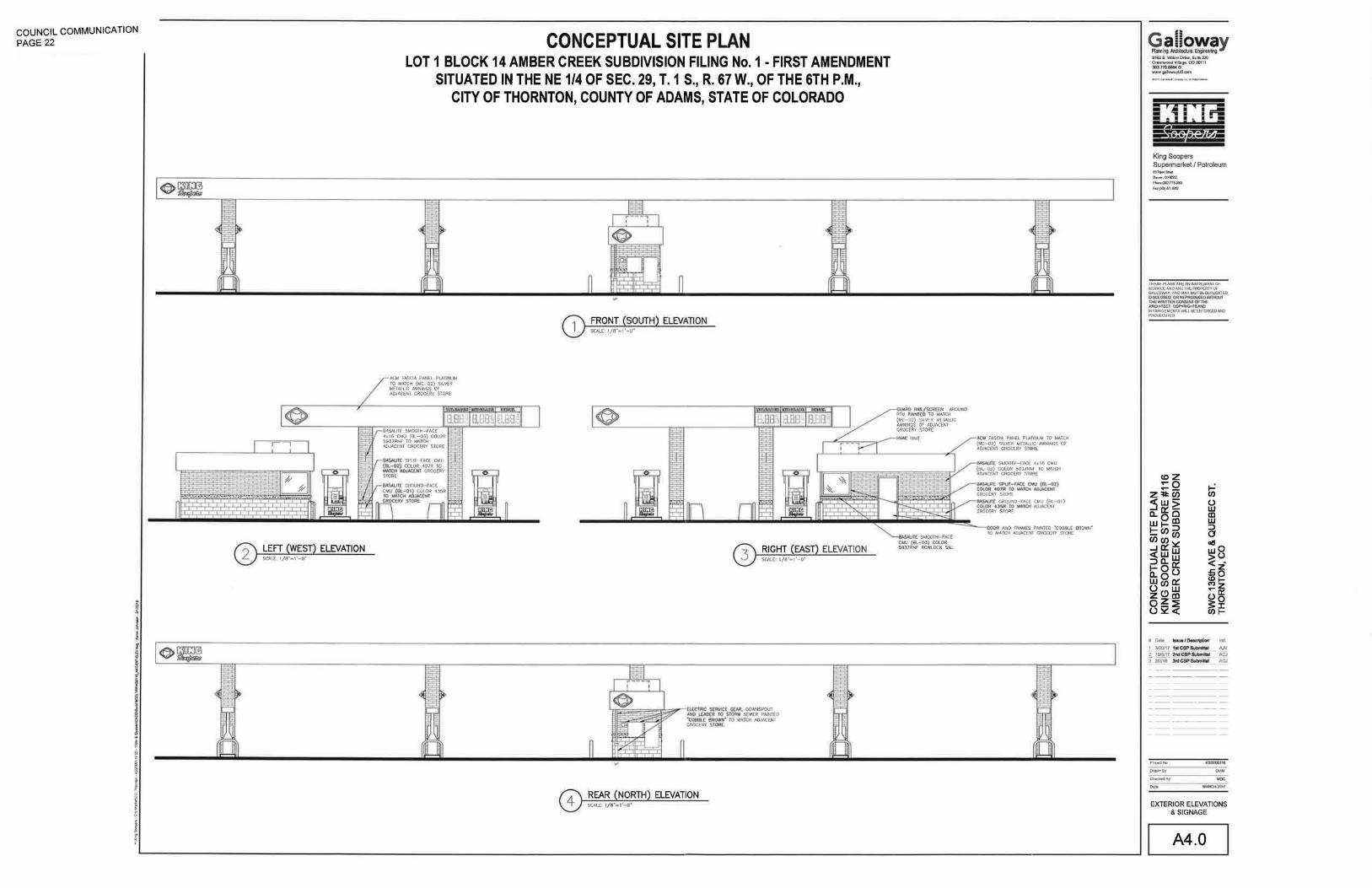
COUNCIL COMMUNICATION PAGE 22
~ I J
f I f ~
ELEVATION
CONCEPTUAL SITE PLAN LOT 1 BLOCK 14 AMBER CREEK SUBDIVISION FILING No.1 -FIRST AMENDMENT
SITUATED IN THE NE 1/4 OF SEC. 29, T. 1 S., R. 67 W., OF THE 6TH P.M., CITY OF THORNTON, COUNTY OF ADAMS, STATE OF COLORADO
ACM FASCIA PANEL PLATINUM TO MATCH (MC-02) SILVER METALLIC AWNINGS OF ADJACENT GROCERY STORE
ELEVATION
ELEVATION
~~~~ AROUND RTU PHI'IT£0 TO MATCH (MC-02) SILVER METAWC AWNINGS OF ADJACENT GROCERY STORE
~ If: SMOOTH-FACE CMU (BL-OJ) COLOR 5937RNF ROWLOCK SILL
U FASCIA PANEL PLATINUM TO MATCH {MC-02) SILVER METALLIC AWNINGS OF ADJACENT GROCERY STORE
000R AND FRAMES PAINTED "COBBLE BROWN" TO MATCH ADJACENT GROCERY STORE
Q~!lli?~Y 8162 S Willow Driva, SuiiB 320 Greanwood Village, CO 80111 l03..710lie!W O www gallowa~S.com
King Soopers Supermarket I Petroleum 65TijonStr'"l o.,.,..,.coi!0223 Plano(300)179-3053
Fu{JID)811!1262
THESE PLANS ARE AN INSTRUMENT OF SERVICE AND ARE THE PROPERTY OF GALLOWAY, AND MAY NOTBEOOPLICATED,
~lJ~~Jt;M ~ro:r~rfiPCII INFRINGEMENTS WILL BE ENFORCED AND
, Data tuu..l~ lrVL
!__ 3120/17 hll (;$@ Qltwnlill AJV 2 11Y8/17 ::WSCSP&A:Imll»> ACJ ! 212.118 ln:ICSP~ ACJ
ProJect No
Drawn By-
Checked By ... EXTERIOR ELEVATIONS
&SIGNAGE
A4.0

COUNCIL COMMUNICATION PAGE 23
I I j
t • ~:
I i 1i
I j i 6
l f
·------
I [ '· I
I I I I
/ {' ., I. I
' I ' ' \
', ' ,
'~ ',
ZONING: PLANNED
DEVELOPMENT :30" IWl< TIWl e,.\SE.\IENT
VACATED IN AMBER CREEK SUBDIVISION
FLWG NO.I · FIRST MIENOI>IENT SEE ITEM ••.COM!OOO BAllO
JTEIHI, COioOMENT B.
LOTI BLOCK 15
I
"
I
1 I I I I I I
CONCEPTUAL SITE PLAN LOT 1 BLOCK 14 AMBER CREEK SUBDIVISION FILING No. 1 • FIRST AMENDMENT
SITUATED IN THE NE 1/4 OF SEC. 29, T.1 S., R. 67 W., OF THE 6TH P.M., CITY OF THORNTON, COUNTY OF ADAMS, STATE F COLORAD? I
30' ADDITIONAL ROW AMBER CREEK FILING NO. 1
SEE ITEM 14 ZONING: PARKS & OPEN SPACE \l..__
·~=-~~~~~,r-~~~
- ----;-' / .
- --··""'
' ' ' . '
- ......
' \
' '
'· ' · - '
LOT1 BLOCK 14
AMBER CREEK SUBDIVISION FILING NO 1 · FIRST AMENDMENT
REG. 20060815000824990
\
'
'
' I ZONINO: ~NED OEV!l.OPM!ton' I I I I
' '
\ _____ , ',~~
' \
\
~EEL CULVERT
\
I
I
I I
' \
m~ ~u; I ~~~~ I ~ ~ I ~ I
I I I I I I I. I I I
I
I i 2
D;Rt STOCKPILE AS OF JANUARY 31, ~~~ INACTIVE USE
TRACTB·A DETENTION DRAINAGE
.....................
',, ..............
,, .................. :... .........
SEE ITEMS 1, 2 AND 3.
----
ZONING: PLANNED
DEVELOPMENT
----------------~---~
' \ I
' I
~' ~ SA/fTAAYSEWtR~NT '
AMBER CREEK SU601VISION ' . .--, ,__ FlUNG N0.1 ·FIRST MIENDMENT
SEE ITEM 21, COI.'MENT A.
lA
SC"RCP I NV•! 138.98'
LEGEND
•
0
-lJEc----
FOUND SECTION CORNER MONUI.ENT AS NOTED
FOUND NO !REBAR WITH A 1-114" YEllOW PlASTIC CAP INSCRIBED "AZTE~S 36587'
SET 18" LONG NO. 5 REBAR WITH A ..,,.. ORANGE PlASTIC CAP INSCRIBED "GALLOWAY-lS 38587'
IN ACTIVE CONSTRUCTION AREA, NO MONUI.ENT SET AT THIS TII.E CALCULATED POSITION
LIGHT POLE
ELECTRICAL BOX
ELECTRICAL CABLE, UNDERGROUND
WATERV~VE
FIRE HYDRANT
~3 WATER MANHOLE
- -W- WATERLINE,UNDERGROUND
----sr~---
-ur----
-F'(}-----
STORM SEWER LINE, UNDERGROUND
STORM SEWER MANHOLE
SANITARY SEWER MANHOLE
TELEPHONE RISER
TELEPHONE CABLE, UNDERGROUND
FIBER OPTIC CABLE, UNDERGROUND
SIGN
- - - - EXISTING EASEMENTS, WIDTH & TYPE AS NOTED
-- ---- SECTION LINE
LOT AND/OR PROPERTY LINE
E=::J CONCRETESURFACE
ASPH~ T SURFACE
[==J DIRTALLSLRFACE
RECORD DIMENSION FROM AMBER (R) CREEK SUBDriiSION FliNG NO I •
FIRST AMENDMENT
(M) MEASURED DIMENSION, THIS SURVEY
REC RECEPTION NUMBER
BENCHMARK THE BASIS OF ELEVATIONS FOR THIS SURVEY IS NAVD 88 AS REFERENCED FROM CITY OF THORNTON BENCHMARK 13:1-50, BEING THE NORlHWEST UPPER FLANGE 801. T, WITH A CHISELED ···.OF A FIRE HYDRANT IN lHE SOUTHWEST QUADRANT OF 133RD AVE. AND COLORADO BLVD HAVING A PUBLISHED NAVD88 ELEVATION OF 5291 55 FEET.
N
~ •• •• .... 0 20 50 100
SCALE: 1"=100'
Galloway ~OIIring. AR:IIIIsdum. Eng;-tng. 8182 S,WiWNOrtvt,SIJit•320 QfHnlfiiOOCIVIIIQt, C0all11 3(1)710&6&40 W'INI~oom
King Soopers Supermari<et I Petroleum en..-. &hi! o.w.eoeom ,.._!»lln•w F•()»)llt«!t2
11-01[ "'-H4 ~ ~·IH!HlUI4EHI'01 ~ ... o.o.t.ME:r~~R'rv~F GALLOWAY, A.NOMAV NOT BE DLJF\.ICATEO, DISCLOSED, OR REPRODUCED WITHOlJT ti-EI'MilTtN~Of'1HE" ~rc:r~•NC ~Gl~WU.-~QICI;DNm -QMD
II OlD laue I DMct1ption lnll 1 3120111 tiiCBPSUbmltlal AJV r 101&117 2ndC8Piubmlbl ACJ [ 21&118 3rdC8P&iwnlllal ACJ
""'"'"" "'"""""' JAR
c ...... .., RDG
""" EXISTING CONDITIONS
EX 1

COUNCIL COMMUNICATION PAGE 24
We m1111o no repr~enlotlort •• to Itt C:Oh'lpletaness. all'rcncv 01 KCUrKY Mcaute ofrl!aSOOt ~heteflt to CAD •nd lh11 addltlomtl dlgi .. J d4to UUI310 proci.lco •lightiog appUe:ution. AJf cfrQifal CAO Cftltll Dpp!!rillf To Gil ntramaly auuliii~P , tiOW4ver, this eppatt"n.t actutaey it an ortifad or~elK:hniquoet utod 10 oenenne II, 111nd'lt. ln l'tD way\ntondctd to lmptV' actual fiC('tlt•cy. lhto ~ ol-ll!Jdlll ralc.M,..,. rnpomlbliryrot the 1ccuracy 1nd cottil!!dnut of (l~ rnecttutementr., aret~~ . lnventO(Iol or other dlltlll bltaclH torn &his:, ellter mtnu•lly or wtth lho uso of a computer Thl't llglit rovol~~nolylh is •n ~timata en,, and It ba:sod on altUnlted relh!etan~CI vatu .. for lnletJor tpplfcarfon11 01 ca~mated pole ktcllkln.a baud O't ~~pecifted lght Ieveli (Of 011:h::tlor •Pp~tiHioo•~ My "orfance !tom rdec;anco vJRJee, obttruc:tlonl,llgt'lllosa factotl ~ dlmeMional dlla Win •ffiKltlho ectuaf tlgt,t lev& obtailed. Thlt anatyt.A k a IM1htmaticAI moc11!J lind can be onl ~ as accu rate as Is permitted by the third party software and the IES standards used In addition calculated values may 11"3JY from actu~ mcr.uuremenlsl n ceftaln lll\JalfaRJ duft ta vatiaJleet., such as but not limited to, l111mp OU!,ptlt, input vottage ballast variances,manuhu:turing tolerances and application variances. The presence or objects will de~ease light levels and may cause some shadowing Lighting application drawings are being provided lo the recipient of this disclaimer,
CONCEPTUAL SITE PLAN
Luminaire Sch11dul11
Syr~"bol Qty
0
-fE] 2
-tEl l
-fEI • -fB 1
-fEI '
. =l.l·J i=!IJ 1200
1100
1000
900
800
700
600
500
400
300
2 00
100
0
Label
fCl 0.900
PC2 SINGLE 0o900
I.OA41 0.911
LDB11 SINGLE 0, 912
LOCi\ Oa912
U:(lllKSI 0,912
LDEUHSS 0.912
LDE61HSS 0 . 912
LOf4HISS 0.912
LDG71 0.912
LDG72 Bli.CK-BACK o.snz
LDG91 0.912
LWBl 0.912
LWB2 0,912
LOT 1 BLOCK 14 AMBER CREEK SUBDIVISION FILING No.1· FIRST AMENDMENT SITUATED IN THE NE 1/4 OF SEC. 29, T. 1 S., R. 67 W., OF THE 6TH P.M.,
CITY OF THORNTON, COUNTY OF ADAMS, STATE OF COLORADO
calculation Summary
·-Total Watts jw-~~o. L11111AM Label CalcTypa Units Min Avg/Hin Max/Mln
CRUS-SC- U:O-SS-CW-UE: 13554 Cal<::Pu@GAAOE II\W.ln~ f< 1,01 0 . 0 •• A.
CR03- FO-I.EO- 30-SS-CW-U'E 36ol 2614 29.3 14.1 1.52 ).Oli
G LEON-A t-0 4 -LEO-VOL 'r-TJ-BZ 225 1350 2 ~ 0 11 0,15 1.0 0 , 0
GLEON-AF-0? -LED-VOL T-T4 <T-BZ 391 '" ~ 2 3 56 ,, l.' 0.0 )I.A . III.A.
GLEON -A f- 0?- LEO- VOL T-T2-BZ 391 1564 41J11 ,, o.o 0,0
GLECN-Af-0~ -LE:D-VOLT-SLJ-BZ-HSS 225 225 20513 f< 2 .5~ 4 .8 l.J
GLEON-Af-04- LEO-VOL T-SL4-BZ-HSS '" 19489 f< 2.6& ... 1.0 2 , 66
Gt.EON-AE"-06- U:O- VOL T -SU -BZ-HSS 2899( f< 5 . 63 8.5 '·' GLEON -A F -0 4-LEO-VOL T-SL2-BZ-HSS 900 19988 ,, 5.29 '·' J.l loll
G LEON -AF-07 - LED-VOL T-5WQ-BZ: I 4 "3 ~ 1 FRONT DRIVE: :11Wiln~~ ,, t . 21 '·' ).2
QH 2 GLEON - A.f-07-LE:D-VOLT-5WQ-BZ J91 [HlP ,, 1.5 6,13
GLEON-At-09-LED-VOLT-5WQ-BZ 501 1002 js6051 KROGER MAIN PAAI<ING :tt~ln.-~ ,, t.l3 5.9 2.2 &.sa
GW:::-AF-Ol-LEO-VOLT-T4£T-BZ 59 "' 16395 f< ).95 0.5 l,, ~ - 08 •• 47
G,.;c-Af-02-L£0-VOLT-T4fT-BZ ll3 1469 112497 SIDE PARKING 2 ' CLICK LIST !l.unttu~(• J.50 6.6 2.2 1-59 1.00
"-'" ,, .. \,.alo...o'llo.o\ •L&'-o'l.al. o 'a\lt..tl ~~ •'- pt..o'o.- '"•".o\ ... t.ot..ol•l o ~ •• ..,._. '"-t .._.\.ot.a ._., 1\_.. l 1 ••• .._,, .. , lll•lll 11.-0 I ot.ll•lt t-o tl Ut o t •••• o '' t.o1t\ o l.o1 tl ol •••I • l ol.•\ t\ • lol t l • i·• 1o1f; \at. 0 ... .._ .. , ...... I It I tJO' ot o \• ~ o \ I I I~ It 111 I 'I. I '0 t l t ,._, tIt I ' I I I fl..• 1 1 I o I • \Ill Ill I I o I I I I I o' I I I l I' 0 t I. 1 \I I. t I\~ l I 1 I I 1 t t 1 II 1 I o t I I 1 I 1 1 o t I I It o t 1 I I\ o ... t o t .. o I • t o J .o t • t o I o ~-' I ...
\o\olo\olo'l,t t tt11•161•1•\, .. tlolttt l t'llolo 1 41 olol•loltl•l•i,.ttoLoloo1ol,.ol t \••••tt+••••1i,t111.ttll oi. JUl.llltat.lllJio._.totot.otololltot.o l otololotot.ol•tatol ..... , ........... w,..u Project manager to specify
fixture voltage for each fixture type
I I 0 1 00 2 00 3 00 500
I 600 700 800 900 1000 1100 1200
Lu111inair" Locat.lon Sulm'ary
LulliNG Label
494,5 1092,15 35
-105.:ii 1018.25 .)5
195 J5
LDM1 194.15 1001,25 35
l.DC11 .?59,51
t.Df41HSS 129,4
62,511 845,59 15
845,)9
845.39
153,962
181,914 845 .39 15
212.36
6~ ,515
16,502 939,462
15 130.315 839.262 15
839.262 15
fC2 198.315 839.162 15
fC2 212 .JO~ 839.262 15
164.415 839 ,062 15
11ij,402 839,062
96.615 838,862
fC2 110,602
t.OC11 8J1.97 JS
t.OF41HSS 19 .2 8Jt,06 35
6~ .511 82?,59 15
85,862 82?,39
119,9)9 82?,39 15
CCI 15),962 927,39
821,39 15
21,2,)6 921,39 15
62 .. 515 814,217 15
f---lr'c-'---t;-:.:..::-::c- ::::::: :: fC2
fC2
"
41 LDB7l
-:;a--· LDB11
LOG12
LOIJ91
51 L004lHSS
52 LDG91
LW82
L~B1
56 LOGlt
LDf41HSS
LWB2
65 t.OGl1
t.DG1 2
LDC'll
LDC'll
LOFUHSS
LDGJI
LOGl2
LDGH
LDG'l2
LDG12
LOGll
LOG12
LOA41
L0£4\11SS
LOE:UHSS
LOE:41HSS
LOE:6lttSS
110,202 814,011 15
1]0 , 315 814,0?7 15
144,J02 8l~.on 15
814,071 15
198,315 814,011 15
2l:Z.JO.:! OU,Oll \5
909,59
85,962 909,39
15
15
212a36 80'1,39 15
461.24 790.03
591.01 180.ll 35
l!6,l9
92.14
700..28
209,'}1 686,6'} 15
955 642,.93 35
15
33.2,1 J5
616,56 35
99.5 S~S.O'J lS
594,99 u. 156,8 595,0~ 15
63,6!1 35
4%,09 35
494 .69 35
312,1 493 .19 35
23,06 00.6
101,49 438.53 jJS
"JB .OJ
24.06 419 ,6& 15
39?,)8
311.85 IS
139,1 JS
536.51 JS
351,09 35
-18,.01 211.61 15
444,.1 241,3 35
332,1 241.1
240,9
·11-'1 214.52 15
-17,61 \4 8.69 15
\.12 126,5 15
L!6a5
140.9 126,5 15
212.1 12&.5 15
116 ,9~ 35
116 .5~ J5
322.92 105,94 J5
83.59
" 64.4/i 4,91 35
08.4~ -lt.~B
351,45 .. Jt.11'1 35
564,59 -12,19
210
!80
30.549
30.187
30,181
30,181
30,549
30,187
30,549
JO.I81
)0.549
J0.181
J0.549
30,181
30,549
30,181
J0 .549
JO,HP
30.187
JJI,355 U
l80
180
tao
180
180
ISO
180
tao
180
2'0
180
190
90
Applicallons Engineering
1121 Highway 74 South
Peachb"ee City, GA 30269
MliiD!:oopeM
King Soopers Supermarket I Petroleum 6STojan!ifttl ~.oorrm
l'hoN(liD)JTS.X&l
fuf)03)111-92&1
~""'"''IIJ~ Att..sl~! ('# S!IN!G.NCASIE M.~'t'(#> GALLOW~Y. ANO MAY NOTBEOJF'UCATED. OISa.OSEO, <>A REPROD.JCmWTHOUT THE ~1TTEN o:JNSENT OF HE ARCH ITECT COPYR~HTSAN> INFRINGEMENTS 'MLL BE EtFORCEONIO ..,..,,..,
t-= en (.) w ID w :::1 0 DIS wO >U < -..c:z .... o <etMz --o::: uo 3:I C/JI-
1 Date laue lllMalptlon lnlt.
1 312W17 111 CSP SUbtrC11 AJY 2 11Wf17 WCSP~ N:.J I 'UJJ1B JrdCSP~ ACJ
W.AA041011
PHOTOMETRIC PLAN
pp 1

INTRODUCED BY: ---=Z::.zv~a~ie:.!.::lb~a:..:::u::....:.m!.....-__
AN ORDINANCE APPROVING A PLANNED DEVELOPMENT ZONING AMENDMENT FOR 42.44 ACRES OF THE AMBER CREEK PROPERTY, THEREBY AMENDING THE OVERALL DEVELOPMENT PLAN/CONCEPTUAL SITE PLAN, PLANNED DEVELOPMENT STANDARDS, AND PLANNED DEVELOPMENT ZONING MAP PERTAINING TO PLANNING AREAS D AND F, TO DEVELOP PLANNING AREA D FOR COMMERCIAL USES, AND PLANNING AREA F FOR SINGLE-FAMILY ATTACHED USES, FOR PROPERTY LOCATED GENERALLY SOUTH OF EAST 136TH AVENUE AND WEST OF QUEBEC STREET (AMBER CREEK).
WHEREAS, Stratus Amber Creek, LLC is the owner and developer (Owner) of certain real property (Property) within the City of Thornton (City), described in Exhibit A attached hereto and incorporated herein by reference; and
WHEREAS, the Owner has submitted to the City an application to rezone approximately 42.44 acres of land as described in Exhibit B, including Planned Development (PO) Standards as described in Exhibit C, and approve an amendment to the Overall Development Plan/Conceptual Site Plan (ODP/CSP) to develop a portion of the site with Commercial uses and a portion of the site with Single-Family Attached residential uses; and
WHEREAS, the proposed application is consistent with the goals and desires of the City, provides for orderly growth within the City, and provides for the beneficial and efficient use of the Property; and
WHEREAS, the aforesaid PO Zoning Amendment application, Zoning map in Exhibit D, amended ODP/CSP map in Exhibit E, and all supporting documents are hereby incorporated as if fully set forth herein; and
WHEREAS, the PO Zoning Amendment application is a matter of public record in the custody of the City Development Department, and is available for public inspection during business hours of the City; and
WHEREAS, on March 20, 2018, the City Council conducted a public hearing on said application, pursuant to the procedural and notice requirements of Chapter 18 of the Thornton City Code; and
WHEREAS, at said public hearing, the City Council having considered the evidence presented in support of and in opposition to the application, the applicable zoning requirements, the City's Comprehensive Plan, staff recommendations, and so having considered the record and given appropriate weight to the evidence.
NOW, THEREFORE, BE IT ORDAINED BY THE CITY COUNCIL OF THE CITY OF THORNTON, COLORADO, AS FOLLOWS:

1. That it is found that the Owner and the City have complied with the provisions of Section 18-41 of the Thornton City Code pertaining to zoning applications.
2. That City Council finds that the proposed PO Zoning Amendment, OOP/CSP, PO Standards, and PO Zoning Map meet the Thornton City Code criteria in Sections 18-42 and 18-43 as follows:
a. The proposed PO Zoning Amendment, OOP/CSP, PO Standards and PO Zoning Map are compatible with present and proposed development in the area and will not have a significant, adverse effect on the surrounding area.
b. The proposed PO Zoning Amendment, OOP/CSP, PO Standards and PO Zoning Map provides for a creative and innovative design which could not otherwise be achieved under the zoning regulations for the districts listed in Section 18-?0(a).
c. The exceptions from the zoning regulations requested in the proposed PO Zoning Amendment are warranted by virtue of innovative design and amenities incorporated in the PO district.
d. The proposed PO Zoning Amendment is consistent with the overall direction, intent, and policies of the City's Comprehensive Plan. The City of Thornton's land use and growth coordination policies and goals are to:
i. Provide for a choice of high-quality housing types for all of Thornton's residents in appropriate locations throughout the community.
ii. Encourage residential development patterns that are compatible and can be served in a cost effective manner.
iii. Encourage a mix of compatible, interconnected land uses.
iv. Provide for a balance of high-quality residential growth that makes Thornton a desirable place to live and work.
e. The PO Zoning Amendment, OOP/CSP, PO Standards and PO Zoning Map provides an effective complement to existing neighboring residential areas.
3. The proposed amendment to the Amber Creek PO Zoning, PO Standards, and OOP are hereby approved with the following conditions:
2

a. Approval of the Zoning does not waive any additional requirements of the development as established with the Subdivision Plat, Developer's Agreement, or any Development Permit associated with the Property.
b. At the time of submitting a request for a Minor Development Permit for landscaping, the Owner shall provide a landscape plan that is consistent with the City's water-wise landscape regulations which emphasizes the use of drought-tolerant materials.
c. Prior to the development of the Property, a Subdivision Plat Amendment shall be recorded to create developable lots and grant easements necessary to serve the development.
d. The timing of the public improvements, amenities, and landscaping shall be determined in the Developer's Agreement required for the residential development.
4. During subsequent reviews associated with actual development of the site identified in the ODP/CSP, the Development Director may allow for minor adjustments in the final site plan, final landscape plan, and associated final engineering documents. Any changes to the development would be due to actual site conditions, unforeseen technical issues involving infrastructure, and changes to the building product previously identified or described on the ODP/CSP graphic and would need City Council approval.
5. All land use approvals and building permits for the development described herein shall be subject to requirements including, but not limited to, the payment of impact fees and development charges, concurrency management requirements, design standards, moratoriums, building permit limitations, and other land use and development requirements in effect at the time that such proposed development applies for a building permit.
6. The Council finds that the application for the PO Rezoning and amending the Official Zoning Map is hereby approved.
7. The conditions set forth in this ordinance shall run with the land and be binding upon the Owner and its successors and assigns.
8. This ordinance shall take effect on the date of final passage.
3

INTRODUCED, READ, PASSED on first reading, ordered posted in full, and title ordered published by the City Council of the City of Thornton, Colorado, on March 20. 2018.
PASSED AND ADOPTED on second and final reading on _____ , 2018.
CITY OF THORNTON, COLORADO
Heidi K. Williams, Mayor
ATTEST:
Kristen N. Rosenbaum, City Clerk
THIS ORDINANCE IS ON FILE IN THE CITY CLERK'S OFFICE FOR PUBLIC INSPECTION.
APPROVED AS TO LEGAL FORM:
Luis A. Corchado, City Attorney
PUBLICATION:
Posted in six (6) public places after first and second readings.
Published in the Northglenn-Thornton Sentinel after first reading on March 29, 2018, and after second and final reading on , 2018.
4

EXHIBIT A
AMBER CREEK
LEGAL DESCRIPTION - PROPERTY
A PARCEL OF LAND IN THE NORTHEAST ONE-QUARTER OF SECTION 29, TOWNSHIP 1 SOUTH, RANGE 67 WEST OF THE SIXTH PRINCIPAL MERIDIAN, IN THE CITY OF THORNTON, COUNTY OF ADAMS, STATE OF COLORADO, SAID PARCEL BEING MORE PARTICULARLY DESCRIBED AS FOLLOWS:
BASIS OF BEARINGS: BEARINGS ARE BASED UPON THE EAST LINE OF SAID NORTHEAST ONE-QUARTER OF SECTION 29, SAID TO BEAR SOUTH 00°32'43" EAST, A DISTANCE OF 2639.59 FEET FROM THE NORTHEAST CORNER OF SAID SECTION 29 MONUMENTED BY A 2.5" ALUMINUM CAP, 0.8' BELOW ASPHALT ROADWAY, STAMPED "PETROLEUM FIELD S_, T1S R67W, S201S_, --, S291S2_, 20_, PLS 38_", TO THE EAST ONE-QUARTER CORNER OF SAID SECTION 29 MONUMENTED BY A 3.25" ALUMINUM CAP, 0.3' DOWN IN A RANGE BOX WITH A LID MARKED "SURVEY", STAMPED "PETROLEUM FIELD SERVICES, T1S R67W, %, S291S28, 2015, PLS 38304".
COMMENCING (P.O.C.) AT SAID NORTHEAST CORNER OF SECTION 29; THENCE SOUTH 89°06'52" WEST ALONG THE NORTH LINE OF SAID NORTHEAST ONEQUARTER OF SECTION 29, A DISTANCE OF 907.41 FEET; THENCE SOUTH 00°53'08" EAST, A DISTANCE OF 60.00 FEET TO THE NORTH LINE OF LOT 1, BLOCK 14, AMBER CREEK SUBDIVISION FILING NO. 1-FIRST AMENDMENT, RECORDED UNDER RECEPTION NO. 20060815000824990, ALSO BEING THE SOUTH RIGHT-OF-WAY LINE OF EAST 136TH AVENUE TO THE POINT OF BEGINNING (P.O.B.);
THENCE ALONG SAID NORTH LINE OF LOT 1, BLOCK 14, ALSO BEING SAID SOUTH RIGHT-OF-WAY LINE OF EAST 136TH AVENUE, THE FOLLOWING THREE (3) COURSES:
1) NORTH 89°06'52" EAST, A DISTANCE OF 648.58 FEET; 2) SOUTH 88°01'24" EAST, A DISTANCE OF 20.04 FEET; 3) NORTH 89°06'52" EAST, A DISTANCE OF 156.95 FEET TO THE
NORTHEAST CORNER OF SAID LOT 1, BLOCK 14;
THENCE SOUTH 00°32'43" EAST ALONG THE EAST LINE OF SAID LOT 1, BLOCK 14, AND CONTINUING ALONG TRACT B-A OF SAID AMBER CREEK SUBDIVISION FILING NO. 1-FIRST AMENDMENT, ALSO BEING THE WEST RIGHT-OF-WAY LINE OF QUEBEC STREET, A DISTANCE OF 1208.25 FEET TO THE SOUTHEAST CORNER OF SAID TRACT B-A, ALSO BEING THE NORTH RIGHT-OF-WAY LINE OF EAST 134TH AVENUE;

THENCE ALONG THE SOUTH LINE OF SAID TRACT B-A, CONTINUING ALONG THE SOUTH LINE OF SAID LOT 1, BLOCK 14, AND THE SOUTH AND WEST LINES OF LOT 1, BLOCK 15 OF SAID AMBER CREEK SUBDIVISION FILING NO. 1-FIRST AMENDMENT, ALSO BEING THE NORTH RIGHT-OF-WAY LINE OF EAST 134TH AVENUE, CONTINUING ALONG THE EAST RIGHT-OF-WAY LINE OF NEWPORT STREET THE FOLLOWING ELEVEN (11) COURSES:
1) SOUTH 89°06'38" WEST, A DISTANCE OF 367.08 FEET TO A POINT OF CURVATURE TO THE LEFT, HAVING A RADIUS OF 300.00 FEET AND A CENTRAL ANGLE OF 44°39'51";
2) SOUTHWEST ALONG THE ARC A DISTANCE OF 233.86 FEET; 3) SOUTH 44°26'47" WEST, A DISTANCE OF 136.77 FEET TO A POINT OF
CURVATURE TO THE RIGHT, HAVING A RADIUS OF 220.00 FEET AND CENTRAL ANGLE OF 90°00'00";
4) WEST ALONG THE ARC A DISTANCE OF 345.58 FEET; 5) NORTH 45°33'13" WEST, A DISTANCE OF 199.43 FEET TO A POINT OF
CURVATURE TO THE RIGHT, HAVING A RADIUS OF 960.00 FEET AND A CENTRAL ANGLE OF 3°57'34";
6) NORTHWEST ALONG THE ARC A DISTANCE OF 66.34 FEET; 7) NORTH 41°35'39" WEST, A DISTANCE OF 222.22 FEET TO A POINT OF
CURVATURE TO THE RIGHT, HAVING A RADIUS OF 220.00 FEET AND A CENTRAL ANGLE OF 86°02'26";
8) NORTH ALONG THE ARC A DISTANCE OF 330.37 FEET; 9) NORTH 44°26'47" EAST, A DISTANCE OF 159.73 FEET TO A POINT OF
CURVATURE TO THE LEFT, HAVING A RADIUS OF 300.00 FEET AND A CENTRAL ANGLE OF 45°20'28";
10)NORTHEAST ALONG THE ARC A DISTANCE OF 237.40 FEET; 11)NORTH 00°53'39" WEST, A DISTANCE OF 405.56 FEET TO THE NORTH
LINE OF SAID LOT 1, BLOCK 15, ALSO BEING SAID SOUTH RIGHT-OFWAY LINE OF EAST 136TH AVENUE;
THENCE NORTH 89°06'52" EAST ALONG SAID NORTH LINE OF SAID LOT 1, BLOCK 15, AND CONTINUING ALONG SAID NORTH LINE OF LOT 1, BLOCK 14, ALSO BEING SAID SOUTH RIGHT-OF-WAY LINE OF EAST 136TH AVENUE, A DISTANCE OF 283.35 FEET TO THE POINT OF BEGINNING (P.O.B.}.
THE ABOVE DESCRIBED PARCEL DESCRIPTION CONTAINS 1,563,434 SQUARE FEET (35.892 ACRES) MORE OR LESS.
2

EXHIBIT B
AMBER CREEK
LEGAL DESCRIPTION - PD ZONING AMENDMENT
DESCRIPTION
A PARCEL OF LAND IN THE NORTHEAST ONE-QUARTER OF SECTION 29, TOWNSHIP 1 SOUTH, RANGE 67 WEST OF THE SIXTH PRINCIPAL MERIDIAN, IN THE CITY OF THORNTON, COUNTY OF ADAMS, STATE OF COLORADO, SAID PARCEL BEING MORE PARTICULARLY DESCRIBED AS FOLLOWS:
BASIS OF BEARINGS: BEARINGS ARE BASED UPON THE EAST LINE OF SAID NORTHEAST ONE-QUARTER OF SECTION 29, SAID TO BEAR SOUTH 00°32'43" EAST, A DISTANCE OF 2639.59 FEET FROM THE NORTHEAST CORNER OF SAID SECTION 29 MONUMENTED BY A 2.5" ALUMINUM CAP, 0.8' BELOW ASPHALT ROADWAY, STAMPED "PETROLEUM FIELD S_, T1S R67W, S20IS_, --, S291S2_, 20_, PLS 38_", TO THE EAST ONE-QUARTER CORNER OF SAID SECTION 29 MONUMENTED BY A 3.25" ALUMINUM CAP, 0.3' DOWN IN A RANGE BOX WITH A LID MARKED "SURVEY", STAMPED "PETROLEUM FIELD SERVICES, T1S R67W, %, S29IS28, 2015, PLS 38304".
BEGINNING (P .O.B.) AT SAID NORTHEAST CORNER OF SECTION 29;
THENCE SOUTH 00°32'43" EAST ALONG SAID EAST LINE OF THE NORTHEAST ONE-QUARTER OF SECTION 29, A DISTANCE OF 1309.25 FEET TO THE CENTER LINE OF EAST 134TH AVENUE;
THENCE ALONG SAID CENTER LINE OF EAST 134TH AVENUE AND CONTINUING ALONG THE CENTER LINE OF NEWPORT STREET THE FOLLOWING ELEVEN (11) COURSES:
1) SOUTH 89°06'38" WEST, A DISTANCE OF 448.35 FEET TO A POINT OF CURVATURE TO THE LEFT, HAVING A RADIUS OF 260.00 FEET AND A CENTRAL ANGLE OF 44°39'51";
2) SOUTHWEST ALONG THE ARC A DISTANCE OF 202.68 FEET; 3) SOUTH 44°26'47" WEST, A DISTANCE OF 136.77 FEET TO A POINT OF
CURVATURE TO THE RIGHT, HAVING A RADIUS OF 260.00 FEET AND CENTRAL ANGLE OF 90°00'00";
4) WEST ALONG THE ARC A DISTANCE OF 408.41 FEET; 5) NORTH 45°33'13" WEST, A DISTANCE OF 199.43 FEET TO A POINT OF
CURVATURE TO THE RIGHT, HAVING A RADIUS OF 1000.00 FEET AND A CENTRAL ANGLE OF 3°57'34";
6) NORTHWEST ALONG THE ARC A DISTANCE OF 69.10 FEET;

7) NORTH 41°35'39" WEST, A DISTANCE OF 222.22 FEET TO A POINT OF CURVATURE TO THE RIGHT, HAVING A RADIUS OF 260.00 FEET AND A CENTRAL ANGLE OF 86°02'26";
8) NORTH ALONG THE ARC A DISTANCE OF 390.44 FEET; 9) NORTH 44°26'47" EAST, A DISTANCE OF 159.73 FEET TO A POINT OF
CURVATURE TO THE LEFT, HAVING A RADIUS OF 260.00 FEET AND A CENTRAL ANGLE OF 45°20'26";
10)NORTHEAST ALONG THE ARC A DISTANCE OF 205.75 FEET; 11)NORTH 00°53'39" WEST, A DISTANCE OF 465.57 FEET TO THE NORTH
LINE OF SAID NORTHEAST ONE-QUARTER OF SECTION 29;
THENCE NORTH 89°06'52" EAST ALONG SAID NORTH LINE OF THE NORTHEAST ONE-QUARTER OF SECTION 29, A DISTANCE OF 1230.77 FEET TO SAID NORTHEAST CORNER OF SECTION 29, ALSO BEING THE POINT OF BEGINNING (P.O.B.).
THE ABOVE DESCRIBED PARCEL DESCRIPTION CONTAINS 1,848,680 SQUARE FEET (42.440 ACRES) MORE OR LESS.
2

EXHIBIT C
AMBER CREEK PLANNED DEVELOPMENT PD STANDARDS
PLZ 201700070 Revised January 22, 2018
All land use approvals and building permits for the development described herein shall be subject to requirements including, but not limited to, the payment of impact fees and development charges, concurrency management requirements, design standards, moratoriums, building permit limitations, and other land use and development requirements in effect at the time that such proposed development applies for a building permit.
A. PLANNING AREAS "A" and "C" RESIDENTIAL LOW DENSITY Size: 35.5 acres 152 lots maximum
A portion of Amber Creek will be devoted to traditional single-family detached residential lots, 6,000 sq. ft. and larger at a density not to exceed 4.46 dwelling units per acre.
1. Permitted Uses
a. Single-family dwellings (detached only). b. Public and Private schools. c. Private recreation areas, centers or clubs (SUP). d. Clubhouses and/or Homeowners' Association (HOA) meeting places associated
with recreational amenities. e. Neighborhood parks or playgrounds. f. Local utilities. g. Churches and places of religious worship (SUP). h. Day care facilities (SUP). i. Library (SUP).
2. Accessory Uses
Accessory structures and uses necessary and customarily incidental to permitted use such as storage sheds, detached garages, gazebos and swimming pools.
3. Temporary Uses Permitted
a. Model Homes. b. Temporary construction and sales offices and facilities (TUP). c. Crop production until development occurs
4. Site Development Standards
a. Minimum lot size: 6,000 square feet. b. Average lot size: 6,300 square feet. c. Minimum area of home: 1 ,200 square feet.
Basements and garages are not part of calculation. d. Minimum setbacks: Front yard : 20 feet. Side yard: 10 feet.
7.5 feet for lots 70 feet wide and greater, when a three-car garage is built. Rear yard: 20 feet.
1

Corner Side Yard: 15 feet from local or collector. From Minor Arterial: 25 feet from edge of right-of-way. From Major Arterial: 35 feet from edge of right-of-way.
PLZ 201700070 Revised January 22, 2018
Accessory structures shall be a minimum of five feet from side and rear property lines and shall not be allowed in the front setback.
e. Minimum distance between structures: 20 feet.
Notes: Projections into required setback: cornices, canopies, chimneys, open stairs, eaves or other similar architectural features may extend two (2) feet into required side yard setback and two (2) feet into required front and/or rear yard setbacks.
f. Minimum lot frontage: 60 feet other than at cul-de-sac 40 feet at cul-de-sac
g. Maximum height: Principal Structure 35 feet; Accessory Structure 16 feet
h. Maximum lot coverage: Sixty (60) percent for residential structures; Twenty-five (25) percent for nonresidential structures; Seventy-five (75) percent for all structures combined.
i. Off-street parking: two enclosed spaces per lot and two spaces in the driveway in front of the garage per lot.
B. PLANNING AREA "8" - RESIDENTIAL LOW DENSITY Size: 45.9 acres 205 lots maximum
A portion of Amber Creek will be devoted to traditional single-family detached residential lots, 7,000 sq. ft. and larger at a density not to exceed 4.46 dwelling units per acre.
1. Permitted Uses:
a. Single-family dwellings (detached only). b. Public and Private schools. c. Private recreation areas centers or clubs (SUP). d. Clubhouses and/or HOA meeting places associated with recreational amenities. e. Neighborhood parks or playgrounds. f. Local utilities. g. Churches and places of religious worship {SUP). h. Day care facilities (SUP). i. Library (SUP).
2. Accessory Uses
Accessory structures and uses necessary and customarily incidental to permitted use, such as storage sheds, garages, gazebos and swimming pools.
3. Temporary Uses Permitted
a. Model Homes. b. Temporary construction and sales offices and facilities . c. Crop production until development occurs
2

PLZ 201700070 Revised January 22, 2018
4. Site Development Standard
Notes:
a. b. c.
d.
e.
f. g. h.
i.
Minimum lot size: 7,000 square feet. Average lot size: 7,300 square feet. Minimum area of home: 1,200 square feet. Basements and garages are not part of calculation. Minimum setbacks: Front yard : 20 feet. Side yard: 10 feet. 7.5 feet for lots 70 feet wide and greater, when a three-car garage is built. Rear yard: 20 feet. Corner Side Yard: 15 feet from local or collector. From Minor Arterial: 25 feet from edge of right-of-way. From Major Arterial: 35 feet from edge of right-of-way. Accessory structures shall be a minimum of five feet from side and rear property lines and shall not be allowed in the front setback. Minimum distance between structures: 20 feet.
Projections into required setback: cornices, canopies, chimneys, open stairs, eaves or other similar architectural features may extend two (2) feet into required side yard setback and two (2) feet into required front and/or rear yard setbacks.
Minimum lot frontage: 60 feet other than at cul-de-sac. 40 feet at cul-de-sac. Maximum height: Principal Structure 35 feet, Accessory Structure 16 feet. Maximum lot coverage: Sixty (60) percent for residential structures; Twenty-five (25) percent for nonresidential structures; Seventy-five (75) percent for all structures combined. Off street parking: two covered spaces and two spaces in the driveway in front of covered spaces per lot.
C. PLANNING AREA "D" - RESIDENTIAL MEDIUM /loiiGM DENSITY 13.2-f.0...8 acres- may be divided as necessary as platting occurs 198 units maximum
This planning area provides for medium moderate to higher density attached and detached residential housing types. Densities may range from 5 dulac up to a max of 15.0 dulac.
This These planning area is aFe designed to allow flexibility to provide single family attached homes, multifamily apartments, condominiums, townhomes, or cluster homes or other lifestyle housing GhoiGes as transitional btlffer areas between single-family residential neighborhoods and tRe commercial zoned parGel on the Garner of East 136th .A.venue and Quebec Street property in the development.
1. Permitted Uses:
a. Single-family detached residential lots - including cluster/auto-court designs. b. Attached single-family dwellings such as duplexes or townhomes. c. Apartments or condominiums (Multifamily). d. Pri•;ate reGreation area Genter or Glub. e. Clubhouse and/or HOA meeting places associated with recreational amenities.
3

f. Neighborhood parks or playgrounds. g. Local utilities. h. Churches and other places of religious worship (SUP). i. Day care facilities (SUP). j. Library (SUP).
PLZ 201700070 Revised January 22, 2018
k. Onsite rental/management offices (if associated with a residential complex)
2. Accessory Uses
Accessory structures and uses necessary and customarily incidental to permitted uses, i.e., outside storage, swimming pools, maintenance facilities and leasing or management offices.
3. Temporary Uses Permitted:
Temporary construction and sales offices and facilities .
Temporary use permits may be granted as regulated by the City of Thornton Development Code, as amended within the SFA zone.
4. Site Development Standards:
a. Minimum project area: 1 Acre b. Minimum floor area: ~ 800 square feet for each attached dwelling unit. c. Minimum lot sizes: Condominiums: 2,000 square feet/ unit
Apartments: 1,740 square feet I unit Single-Family attached: 1,250 square feet Single-Family Detached: 2,500 Square feet
d. All +Ae development must meet the requirements of the Design Standards in the City of Thornton Development Code as amended (Article IV) depending on the type of unit built.
e. Minimum building setbacks; maximum building height; off-street parking requirements, and maximum lot coverage will be in accordance with the Development Code depending on the type of unit built, with the following exceptions: i. Single Family Attached Minimum Setbacks:
a. Front yard: 10 feet (to main structure) b. Side yard: 5 feet to outer wall I 0 feet if subdivided along a party wall c. Rear yard: 0 feet to a drive/street
ii. Single Family Detached Patio/Cluster Home Minimum Setbacks: a. Front yard: 10 feet (to main structure) b. Side yard: 5 feet I 0 feet with a use easement c. Rear yard: 5 feet
f. Allowable Encroachments: Porches, eaves, window wells, air conditioning units and other building accessories may encroach into building setbacks.
g. Street Design: Private roads Streets can have a minimum radius of 90'. 'llith a posted speed limit of 10 mph.
4

5. Residential Structure Proximity to Commercial Structure:
PLZ 201700070 Revised January 22, 2018
a. In lie1::1 of using the Residential Pro>dmity Slope (Section 18 452) , all buildings/structures in Planning Area "On must ha'le a minimum setback separation of 40' 100' from any site property line adjacent to a commercial use main residential structure to a commercial use structure. There shall be a minimum building separation of 1 00 feet between any primary residential use structure and any commercial use structure. Reference Exhibit A on page 14.
D. PLANNING AREA "F" - COMMERCIAL Size: 22.7 24.3 acres
This planning area provides for retail and office uses complimentary to serve the needs of residents of the community. that serve residents within the larger residential communities of the Gity:
1. Permitted Uses:
a. Churches and other places of religious worship. b. Day care facilities. c. Cultural arts facilities. d. Nursing and convalescent homes. e. Schools, public and private. f. Financial institutions with drive-through (SUP). g. Financial institutions without drive-through. h. Auto service center (SUP). i. General office, includes medical office. j. Medical clinic. k. Community park or recreation center. I. Neighborhood park or playground. m. Private recreation center, club or area. n. Animal clinic. o. Business school. p. Catering service. q. Clubs and lodges. r. Commercial amusement (indoor). s. Dry cleaning, laundry. t. Furniture store. u. General merchandise, food/grocery store, drug store. v. Household equipment and appliance repair without outside storage. w. Library. x. Motor vehicle fueling station, with convenience store and/or quick service
restaurant. (SUP) y. Nursery, garden shop, plant sales. (SUP) z. Personal service uses. aa. Restaurant with drive-in or drive-thru. (SUP) bb. Restaurant without drive-in or drive-thru. cc. Theaters. dd. Transit passenger shelter
5

ee. Drainage and related facilities
2. Temporary Uses (by permit)
a. Christmas tree lot. b. Seasonal sales stands. c. Temporary construction yard, construction sales office.
3. Accessory Uses
Outside display, sales and storage.
4. Site Development Standards
a. Minimum setbacks:
PLZ 201700070 Revised January 22, 2018
i. Front and side yard: adjacent to public ROW: 30 feet ii. Rear yard: 30 feet. iii. Between buildings: 15 feet.
b. Maximum floor area ratio: 0.3. c. Maximum height: 35 feet. Certain architectural projections, i.e., clock towers, bell
towers, etc. , may exceed this maximum provided they are approved at Development Plan review (limited to 12 feet above maximum height).
d. Maximum lot coverage: 60 percent. Aboveground parking structures are included; surface parking lots and underground parking lots are not included in lot coverage calculation.
e. Parking- as required by Division Five and Six of the Development Code.
5. Accessory Uses
Accessory structures and uses necessary and customarily incidental to permitted use.
6. Commercial Structure Proximity to Residential Structure
a. In lieu of using the Residential Prm<imity Slope (Section 18 452), all buildings/structures in Planning Area "F' must have a minimum setback separation of 60' 1 00' from any site property line adjacent to a residential use commercial use structure to a main residential structure. There shall be a minimum building separation of 100 feet between any primary residential use structure and any commercial use structure. Reference Exhibit A on page 14.
7. Landscaping - Enhanced landscaping will be applied to the landscape requirements for Planning Area "F". See Section G - Landscaping for details.
E. PLANNING AREA "H" -PARK/OPEN SPACE Size: 18.6 Acres
The intent of this planning area is to provide a park facility for residents of the development on surrounding areas.
6

1. Permitted Uses.
Main Uses Permitted in Open Space:
a. Parks and/or playgrounds b. Recreational facilities seRtef c. Public Utilities d. Public roads and or private roads/parking lots e. Drainage/facilities f. Irrigation/agricultural ditches g. Parks and tot lots h. Pedestrian bridges i. Recreation uses j. Site furniture k. Trails I. Trail head or parks parking
2. Accessory Uses
PLZ 201700070 Revised January 22, 2018
Accessory structures and uses necessary and customarily incidental to permitted use.
F. PUBLIC USE SITE Size: 6.5 acres
The intent of this planning area is to provide additional land for public uses to allow the expansion of the adjoining school site.
1. Permitted Uses.
a. Parks and/or playgrounds. b. Public schools. c. Recreational center. d. Public utilities. e. Public roads and or private roads/parking lots.
2. Accessory Uses.
Accessory structures and uses necessary and customarily incidental to permanent structure.
3. Additional Provisions: Parking will be provided in accordance with the parking provisions in the Development Code for the allowed uses.
G. LANDSCAPING
1. Landscaping enriches the appearance of all types of residential and commercial projects, increases property values, provides a buffer between different land uses, and enhances the overall appeal of the community. If the Developer removes any deciduous
7

PLZ 201700070 Revised January 22, 2018
trees over four inches in diameter and any evergreen trees over 6-foot in height due to site plan restriction, then the developer shall mitigate the replacement of the trees per City of Thornton Code.
Landscaping Requirements
a. Quebec Street and E 1361h Avenue other Rlajor roadways within the de\1elopment: Planning Area "F" rights-of-way (excluding medians) along East 1361h Avenue and Quebec Street shall be landscaped with a minimum of ooe 1.5 tree equivalents for each 3G 40 linear feet of street frontage.
b. Landscaping of all common areas shall be per Development Permit and shall be installed in accordance with the phasing plan approved with the Development Permit and/or Developer's Agreement.
c. Landscaping will be installed by the owner/developer(s) along East 1361h Avenue and developers shall install a perimeter fence consisting of double sided .... ~ood faRGe masonry wall along residential areas adjacent to East 136th Avenue and Quebec Street. This perimeter fence wall shall be six feet tall and shall incorporate accent posts and/or pillars of a masonry material at a minimum of 75-feet on center.
d. As new drought tolerant regulations are approved, these landscaping standards may need to be amended.
e. All landscaping shall be in accordance with the Thornton City Code in effect at the time of approval, unless noted otherwise in these PO Standards.
f. Single-Family Detached Areas.
All portions of lots which are not occupied by driveways, sidewalks or buildings shall be landscaped in accordance with the Thornton City Code In effect at the time of the Development Permit approval.
1. Homebuilders of single-family detached units located on individual lots shall install at least two-eRe tree equivalent in the front yard which meet the size requirement of the Thornton City Code.
2. All front yards shall be landscaped using water-wise landscape principles per the Thornton City Code, and shall be delivered equipped with a functioning, practical and water-wise automatic irrigation system.
g. Residential Medium I High Density Areas.
All portions of the property which are not occupied by structures, water bodies, surfaced by streets, roads, driveways, sidewalks, parking areas or City approved trails or paths shall be landscaped to meet or exceed the provisions set forth in the Thornton City Code unless otherwise noted below.
8

Parks.
PLZ 201700070 Revised January 22, 2018
1. VVithin the common Common areas of all single-family attached projects, tl=lefe shall be-a landscaped area of at least 20 feet in depth to be and maintained by the owner or property owner's association.
2. Final landscaping plans for Residential Medium I High Density Areas shall be approved through the Development Permit Process.
3. A 25-foot landscape buffer shall be provided along all site property lines in Planning Area "D" adjacent to a commercial use. Landscape buffers shall be landscaped with a minimum of one tree equivalent for every 500 square linear feet of buffer teAgtR area. Tree mix in buffer area must be a minimum of 75% evergreen. Reference Exhibit A on page 14 for buffer locations.
Park/Open Space. An 18.6-acre open space tract is included in Amber Creek. This open space will consist of a developed public park to be maintained by the City of Thornton and natural open space, which will connect to the Brantner Gulch regional trail system and will also allow connectivity to the school site to the south. The final size, configuration and amenities will be determined at the time of Development Permit and Subdivision Plat following the guidelines of the Parks and Open Space Master Plan. Private parks or recreation facilities shall be owned and maintained by a HOA unless included in a Medium /l=ligh Density Residential development and then the Medium-+ ~ Density Residential development will own and maintain the facilities. Landscaping of all parks shall be in accordance with the City of Thornton Landscape Regulations for the landscaping of parks, in effect at the time of Development Permit approval. Construction drawings shall be in accordance with the City of Thornton Standards and Specifications for the Design and Construction of Public Improvements in effect at the time of construction plan approval.
General Provisions.
1. Once an individual landscape plan has been approved through the development process, specific provisions within that approved plan shall control over similar provisions within this section of the PD Standards. Any landscaping requirement within the PO Standards not specifically changed in approved landscape plans shall remain in effect.
2. All common area and front yard landscaping within the Planning Areas shall be per Development Permit and installed by the builder and/or developer. Landscaping of common areas shall be per Development Permit, and will be installed in accordance with a phasing plan approved with the Developer's Agreement.
3. All properties shall feature landscape areas in the front, side or rear yards that separate parking areas or other vehicular use areas, or buildings from adjacent property lines.
9

PLZ 201700070 Revised January 22, 2018
The dedicated public park will be maintained by the City of Thornton. Parks within residential areas will be maintained by the applicable HOA, Condominium Association, or owner of the apartment complex in which the park is situated.
Within Public Park areas there shall be:
1. A minimum of one tree or ten shrubs or a combination of trees and shrubs for every 3,000 square feet of area.
2. A functioning, underground, automatic irrigation system to provide irrigation coverage per City of Thornton Standards and Specifications.
3. Natural and/or manmade landscaping features which may include turf grass sod, playfields, grass seed mix or other ground cover, shrubs beds, natural areas, benches, barbecues, monumentation, statues, walkways and playground equipment, trails, lighting, pavilions, sport courts.
Minor Pocket Parks.
Pocket parks will be maintained by the applicable HOA, Condominium Association, or owner of the apartment complex in which the park is situated.
1. Each minor pocket park shall be landscaped with a minimum of one tree equivalent for every 4SQ 600 square feet of area.
2. Each minor pocket park shall be designed per City of Thornton Parks and Open Space Design Guidelines and include, at a minimum, a tot lot, which includes play equipment that incorporates a slide, climbing apparatus and other features suitable for fffiH..-6 to 12 year-old children. One slide must be eight feet tall per Parks and Open space guidelines.
Subdivision.
The applicable HOA, Condominium Association, or owner of the apartment complex shall maintain the landscape areas throughout the subdivision including the right-of-way. The City of Thornton shall maintain the integrity of the concrete surface of the Regional Trail throughout the subdivision and the Public Park dedicated to and owned by the City. The day to day maintenance of the trail including removal of snow, sleet, ice and graffiti is the responsibility of the HOA or metro district.
1. Landscaping and monumentation shall be of a consistent nature throughout the subdivision.
2. Within the buffer to arterial streets shall be a six-foot high privacy fence constructed of masonry, stone, wood , stucco or a combination of such materials, with masonry columns. This fence will be double-sided along the arterial roadways for sound attenuation.
3. Landscaping along the collector roads shall be installed by the overall developer and shall exceed the Thornton City Code for landscaping along
10

PLZ 201700070 Revised January 22, 2018
collector roads by at least 20 percent. For every W-40 linear feet of frontage there shall be 1.5 tree equivalents.
H. PUBLIC LAND DEDICATION
The owner agrees to satisfy the Public Land Dedication (PLD) requirements specified in the City's subdivision regulations as follows:
Area "H" will be developed with approximately 8-9 acres as a Neighborhood Park following the City of Thornton's Parks and Open Space Master Plan Guidelines and the balance developed as trails and open space to be utilized for active and passive recreation. PLD credit will be issued for all developed park areas and 1 0-foot-trail surfaces within Area "H".
1. Full PLD credit shall be granted for the land area and the cost of improvements to City standards of the trail corridor along Brantner Gulch, which shall include the installation of a ten-foot wide concrete trail outside of the floodplain. The land portion credited will be the length of the trail multiplied by ten feet.
2. Full PLD credit shall be granted for the land area and cost of improvements to any of the mini-pocket parks that may be constructed to serve the residents of the Areas "A", "B", "C" and "D".
3. Full PLD credit shall be granted for the land area or afKI cost of improvements to any sidewalks/trails wider than the minimum 10 foot required width for trails associated with Regional Trail Underpass or minimum for all other required walks/trails. The land portion credited will be the extra walk/trail width multiplied by the length of the walk/trail.
4. In the event that the cost of the above-mentioned improvements does not meet or exceed the required amount of PLD per the City Code, the balance shall be paid as a cash-in-lieu fee.
I. GENERAL PROVISIONS
Open Space. Open spaces and Trail Corridors shall be incorporated throughout the development, connecting the various single-family areas. Alignment, width and materials shall be determined at the time of Preliminary Plat or Development Permit. Open Space corridors along Brantner Gulch shall be dedicated to the City of Thornton for ownership and integration with the City's Trail System. Landscaping of the Trail Corridors will be in conformance with the Thornton City Code and Standards and Specifications for the landscaping of parks
Homeowners' Associations. A HOA shall be created to own and maintain the private open space and mini-pocket park areas within this subdivision.
Architectural Review Criteria. All structures constructed within this development must meet the standards set forth in Section 18-532 of the Thornton City Code, as amended.
Fencing.
11

PLZ 201700070 Revised January 22, 2018
1. The Developer shall install perimeter fencing along the residential areas adjacent to 136th Avenue and Quebec Street six feet in height or greater constructed of masonry, stone, wood, stucco or a combination of such materials, with masonry columns, and double-sided along the minor arterial roadways. Within the Medium I High Density Residential area perimeter fencing may be eliminated. All fence materials, colors and styles utilized for perimeter fencing and public area fencing will be approved in the Development Permit process.
2. Owners of lots that have frontage on open space or trail corridors may install fencing along these common lot lines. However, any fencing installed along open space or trail corridors must be open-style fencing. Open-style fencing shall be interpreted to mean a style of fencing that allows clear visibility through the materials such as split rail, post and board or wrought iron fencing. Alternatively, owners along these corridors or open spaces may elect to eliminate fencing along their property lines. Open-style fencing may not exceed four feet in height from the grade of the adjacent open space. Lots that share lot lines with adjacent lots may install solid wood privacy fencing not to exceed six feet in height. Private fencing associated with individual lots and trail corridors shall be consistent throughout the community and will be compatible in style, color, and materials with the residential architecture. These provisions shall be included in the covenants, enforced by the HOA, and all fences will require the written approval of the HOA prior to installation.
Lighting Requirements. Residential lighting within public right-of-way shall be provided in accordance with the City of Thornton's Standards and Specifications. All decorative lighting and interior common area lighting shall be provided in accordance with the City of Thornton standards for illumination of parking lots and other public spaces. All light fixtures shall be located and designed such that off-site glare and ambient illumination does not pose a nuisance to the motoring public and adjacent properties. All lighting within Medium I High Density Residential Planning Areas shall be in accordance with the Thornton City Code.
Signage. All signage shall be in accordance with the Thornton City Code in effect at the time of approval.
Density Standards. The dwelling unit density in any residential Planning Area is considered a maximum gross density, which shall apply to the entire Planning Area. The maximum gross density for any Planning Area shall be computed by dividing the total number of dwelling units by the gross area within the Planning Area.
Administrative Changes. The Overall Development Plan is intended to depict the general locations and illustrative concepts expressed in the narrative provisions of this PO District. In granting Preliminary Plat or Development Permit approval, the City of Thornton shall allow minor variations for the purpose of establishing:
1. Final road alignments 2. Final configurations of lot and tract sizes 3. Final building envelopes 4. Final access and parking locations
Overall Development Plan Requirements. Development of Amber Creek shall be in accordance with the attached Overall Development Plan. Specific lot, building envelopes and
12

PLZ 201700070 Revised January 22, 2018
building footprints shall be determined through the Subdivision and Development Permit process.
CoAGessions in Lieu of Regional Tr;ail UAderpass. The items listed belov.· are to be incorporated into the designs of proposed planning areas 'D' and 'r' of the revised ODP in lieu of the regional trail underpass at E. 1361
1-1 Avenue. A Increase concreto trail sidewalk 'Nidth adjacent to the commercial along E. 136111~
and Quebec Street from an 8 foot 'l+'alk to a 1 0 foot walk 8 feet to 1 0 feet.. B. Improvements adjacent to residential and commercial along 134111 St. /we. and Newport
St:-91 . Increase concrete trail sido·Nalk width from an 8 foot 'Nalk to a 10 foot 'Nalk 8 feet to 10 feet. 92. Dedicate an additional 5 feet of right of way on the north side of 134111 St. Ave. and
Newport St., increasing the right of way to 85 feet to allow for additional landscaping.
93. Provide a Q foot landscape area (tree la•Nn) bet\veen from back of curb to and 10 foot trail sidewalk. 94. Provide a 9.5 foot landscape area between 10 foot trail sidewalk and adjacent
residential property lines with enhanced landscaping and materials at 25% above code requirements.
95. Shared walkways private sidewalks from residential units fronting along 1341h-Sf.:. and Newport St. to serve the units are grouped together to limit number of access points onto trail the public sidewalk.
C. Add $25k worth of additional play equipment to the Amber Creek Park or pay $30K cash in lieu to tho City.
D. In addition to the improved landscaping required by commercial site, an increase of 25% of landscaping and materials around the detention areas at E. 134111-St. /we. and Quebec Street.
1. Include a 1 0' concreto trail ringing the commercial and residential parcels (inside track of E. 136111 Ave., Quebec St. , Newport St. and E. 1341h~
2. Add $20 25k worth of additional play equipment to the Amber Creek Park. 3. Dedicate an additional 5' to the inside of the Newport St. and E. 134111 Ave. right of
way& 4. Q' 1 0' landscaped buffer between the 1 0' trail and the adjacent street. 5. Q' 1 0' landscaped buffer between tho 1 0' trail and the adjacent homes property line. 6. Enhanced landscaping in the buffers. 7. Create separate walks (within the residential properties along Newport) to serve the
residences, ganged up so one access point from the regional trail serves 2 4 units 8. Enhance the landscaping around the detention areas at E. 134111-St. and Quebec St.
These concessions are being included with the understanding that the regional trail underpass requirement is being waived.
13

VICINITY MAP AMBER CREEK ZONING MAP
LOCATBIIN THE NORTHEAST 114 SEcnON 29, TOWNSHIP 1 SOtiTH, RANGE 17WE!IT Of lltfliTH ~AI.. ME"IUDIAH cnY OF THORNTON, COUNTY OF ADAMS, STATE OF COLORADO
I I
I I i I I L ___________ _____ _j
rt~~liiilliisolo~· ~~~12oo· ~ GRAPHIC SCALE: 1• = 600' NORTH
LEGAL DESCRIPTION
A PARCEL OF LAND IN lliE NORTHEAST ONE-QUARTER OF SECT10N 29, TOWNSHIP 1 SOUTH, RANGE 61 WEST OF THE SIX111 PRINCIPAL MERJOIAN, IN THE CITY OF THORNTON, COUNTY OF ADAMS, STATE OF COLORADO; BEING ALL OF LOT 1-SLOCK 14, LOT 1-8LOCK 15 AND TRACT B-A OF AMBER CREEK SUBDIVISION FILING NO. 1~1RST AMENDMENT RECORDED UNDER RECEPTION NO, 20060815000824990, ALONG WITH A PORTION OF THE EAST 134TI-i AVENUE, EAST 136TH AVENUE AND QUEBEC STREET RIGHT -OF-WAYS; SAID PARCEL OF LAND BEING MORE PARTICULARLY DESCRIBED AS FOLLOWS:
BASIS OF BEARINGS: BEARINGS ARE BASED UPON TI-lE EAST LINE OF SAID NORTHEAST ONE-QUARTER OF SECTION 29, SAID TO BEAR SOUTH 00a32'43• EAST, A DISTANCE OF 2639.59 FEET FROM THE NORn-tEAST CORNER OF SAID SECTION 29 MONtAIENTED BY A 2.5" ALUMINUM CAP, 0.8' BELOW ASPHALT ROADWAY, STAMPED 'PETROLEUM FIELD S_. T1S R67W, S20f$_. - , S291S2_. 20_, PLS 38_', TO THE EAST ONE-QUARTER CORNER OF SAro SECTION 29 MONUMENTED BY A 3.25' ALUMrNUM CJJI, 0.3' DOVw'N IN A RANGE BOX WfTH A LID MARKED "SURVEY", STAMPED "PETROLEUM FIELD SERVICES, T1SR67W, Y,...S2iJS28,2015, PLS 38304"'.
BEGINNING (P.O.B.) AT SAID NORTHEAST CORNER OF SEcnoN 29;
THENCE SOUTH 00"32'43" EAST ALONG SAID EAST LINE OF THE NORTHEAST ONE..QUARTER OF SECTION 29, A DISTANCE OF 1309.25 FEET TO THE CENTER LINE OF EAST 134TH AVENUE;
THENCE ALONG SAID CENTER LINE OF EAST 134TH AVENUE AND CONTINUING ALONG THE CENTER LINE OF NEWPORT STREET THE FOLLOWING ELEVEN (1 1) COURSES:
1) SOUTH 89' 06'38" WEST, A DISTANCE OF 448.35 FEET TO A POINT OF CURVATURE TO THE LEFT, HAVING A RADIUS OF 260.00 FEET AND A CENTRAL ANGLE OF 44' 39'51';
2}SOlJTHWEST ALONG THE ARC A msTANCE OF 202 68 FEET, WITH A RESULTING CHORD BEARING S66"46'43"W, 197.59 FEET;
3)SOUTH 44'26'4r WEST, A DISTANCE OF 136.n FEET TO A POINT OF CURVATIJRE TO THE RIGHT, HAVING A RADIUS OF 260.00 FEET AND CENTRAL ANGLE OF 90"00'00";
4)WEST ALONG lliEARCADISTANCE OF 408A1 FEET; S)NORTH 45'33'13" WEST, A DISTANCE OF 199..-13 FEET TO A POINT OF CURVATIJRE TO THE RIGHT, HAVING A
RADIUS OF 1000.00 FEET AND A CENTRAL ANGLE OF 3"57'34'; 6)NORTIIWEST ALONG THE ARC A DISTANCE OF 69,10 FEET; 7)NORTH 41'35'39' WEST, A DISTANCE OF 222 22 FEET TO A POINT OF CURVATIJRE TO THE RIGiiT, HAVING A
RADIUS OF 260.00 FEET AND A CENTRAL ANGLE OF 86'02'26"; B) NORTH ALONG THE ARC A DISTANCE OF 390A4 FEET; 9)NORTH 44' 26'4r EAST, A DiSTANCE OF 159.73 FEET TO A POINT OF CURVATIJRE TO THE LEFT, HAVING A RADIUS
OF 260.00 FEET AND A CENTRAl ANGLE OF 45' 20"26"; 10) NORntEAST ALONG THE ARC A DISTANCE OF 205.75 FEET; 11) NORTH 00'53'39" WEST, A DISTANCE OF 465.57 FEET TO TilE NORTH LINE OF SAID NORntEAST ONE-CUARTER
OF SECTION 29;
THENCE NORTH 89'06'52" EAST ALONG SAID NORTH LINE OF nfE NORTHEAST ONE-QUARTER OF SECTION 29, A DISTANCE OF 1230.77 FEET TO SAJD NORTHEAST CORNER OF SECTION 29, ALSO BEING THE POINT OF BEGINNING (P.O.B.).
THE ABOVE DESCRIBED PARCEL DESCRIPTION CONTAINS 1,848,680 SQUARE FEET (42.440 ACRES) MORE OR LESS.
NORTH LINE NORTHEAST 1/4 OF SECTION .2:9
EAST 135Tli LANE
AMBER CREEK PO EXISTING
ZONE
EAST 135TH AVE
L-205.75' R=260,00'
.6=45' 20'26" Ch=N21 "48"34"E ,6
Ch L=200.42" ~·
~'
EAST134Tli I'* AMBER CREEK POS EXISTING
ZONE
L=390A4' R=260.00' .6.=86"02'26" Ch=ND1"25'34"E Ch L=354.77'
CITY OF THORNTON POS EXISTING ZONE
____ E 136TH AVE
L=69.10' R=1000,00' lF3' 5Tl4' Ch=N43'S4'26"W Ch L=69 09'
PLANNED DEVELOPMENT
(PO)
L•202.68' R=260.00'
.6=44~'48'
Ch=S66"46'43"YJ Ch L=197.59'
AMBER CREEK PO EXISTING ZONE
DATE 3-21-17 ISSUE RECORD
[)F> ,-,)·: J /.) I
AMBER CREEK PROJ NO. 2ND SUBMITTAL 1016117
13082 3RD SUBMITTAL 12107/17
4TH SUBMITTAL 01122/18
CITY OF THORNTON, COLORADO DRAWN RH 5TH SUBMITTAL 02/05/18
CHECKED DB
CASE NUMBER: PLZ201700070
~ .. !:! t·
1-(/l
u w m w ::> a
g: z 0 ;:: 0 w "' ~ ~
~ ~ ~ w z ::; 1-
~
CREXISTING ZONE
0"
POINT OF BEGINNING
SFA EXISTING
ZONE
200'
GRAPHIC SCAlE: 1" = 200'
ZONING AMENDMENT
SFD EXISTING
ZONE
trJ :>< ::r: ........ to ........ t--3 0
-~ NORTH
1
SHEET 1 OF1

LEGAL DESCRIPTION LOT 1, BLOCK 14, AND LOT 1, BLOCK 1S, AND TRACT B-oA, AMBER CREEK SUBDMSION flJNG N0.1- FIRST ~EHT
HA\IIHOAAAIEAOF 1.5113,4-DSO FT,35att~UOAE0Rl£SS
VICINITY MAP
--.. ..... -. \
A SINGLE FAMILY
DETACHED
SITE PLAN
OVERALL DEVELOPMENT PLAN AMENDMENT TO A PORTION OF
AMBER CREEK SUBDIVISION A lRACT OF LAND BEING A PORTION OF TliE NE 114 SEC. 29,
TOWNSHIP I SOUTH RANGE 67 WEST OF 611i P,M CITY OF THORNTON, COUNTY OF ADAMS, STATE OF COLORAOO
EXISTING ZONE: POS
f.AONUMENTATION / I
I
--)~
D RESIDENTIAL
MEDIUM DENSITY t3.2ACRES
F COMMERCIAL 22,7 ACRES
8 SINGLE FAMILY
DETACHED
314 MOVEMENT INTERSECTION
(- . ., I
I
I I
I I I
I :;;~ I fr} ~
I ~~ OT I
I I
I I
I I 111 DEfACiti) SICEWAIX
6 1-LJ-i NORTli Graphic Seale: 1 .. - 1 00'
RIGHT OF WAY
VEHICUI.AA CRCU.ATION -----+ P8JESTRIANCIRCULATION - - ~
TECHNICAL DATA INilUSE GROSS
A£RfS
RESilBIIW. 1:U PI.ANNHGAREA&.PATlO to.IES,SINGI.EFAMA.Y ATTAaiED,~. APAR'IlENTS,Sftl
COMMERCIAL 22.7
F'I.NINNGMEAF: --TOTAlS "'""""
CASE NUMBER: Pl..Z201700070
LAND USE PLAN PI.AHNINGAREAA SFD PI..AHNINGARE.\8 SRI A.NNNGMEAO RESIDENJW.
MEilUI DEI<m PI.ANNNG ~ F COMNERCW.. PlANNINGAREAH OPENSPACE/PARK
DBISITYI WA'X.OWBJ..ING %0FPRo.ECT FAJl "'"" """'"""" 50-15.0DIJIAC ""
,..
OlOFAR. 632
'" "."'
PLANNING AREA D STREET CROSS SECTIONS
~I 33.5' PRIVATE RQtD
i"f m 130' ,. § I ><
I (lJ
.SErBN:.!(_; I ~ =i • I -BOlliS<JES
~ l < • m PRIVATE ROAD SCALE: 1"=10'
~I 30.0'PRIVATEAil£'t' ·rc ~I
her
.,mfoa(_/ ' I BOTI-ISIDES ~ ~
PRIVATEAll.EY SCALE; 1' • oa

AMBER CREEK- PLANNING AREA D {PAIRED HOMES} CONCEPTUAL SITE PLAN LOT 1, BLOCK 15 AMBER CREEK FlUNG NO, 1 - FIRST AMENOMENT
BEING A PART OF THE NORTHEAST ONE-QUARTER OF SECTION 29, TOWNSHIP 1 SOUTH, RANGE 87 WEST OF THE 8TH PRINCIPAL MERIDIAN,
LA I CITY OF THORNTON, COUNTY OF A.OAMS, STATE OF COLORADO
PURPOSE STATEMENT SHEET INDEX VICINITY MAP Design
,. = 2,000' G r o u p
THE PURPOSE OF THIS CONCEPnJAL SITE PLAN IS TO CREATE A GUIDE FOR SHEETS DESCRIPTION L._•.,ld•ICII
DEVELOPMENT OF THIS 13.2 ACRE PROPERTY FOR THE SUBSEQUENT SUBDIVISION INTO 1 COVER SHEET 881nvemeN Circle East, Bld\l J SUitv 101
102 SINGLE FAMILY ATTACHED RESIDENTIAL LOTS. E 144THAVe UE ~ Engle'M)Od. ColomOo 80112
2 CONCEPTUAL SITE PLAN .... 0 T 303 734 11771 F 303.734 1na
' OVERALL LANDSCAPE PLAN A.n,;l1•le~::turn1Piannlng1Gol1De:;;,gn
PD JUST/FICA TION AND SUBDIVISION • EXISTING CONDITIONS MAP Iii Laqd:Kll(lCArctlitedute1Vj$ual Med,J
WIINILAide$1gr.gHlupr.orn w
QUALITY ENHANCEMENTS e: f1¥! .,
THE FOLLOWING ENHANCEMENTS A.RE PROPOSED BY THIS CSP. ~ 1. PLANNED DEVELOPMENT {PO} JUSTIACATlONS
LAND USE TABLE (PLANNINGAREADPERPOSTANDAROS) J: CWC CONSULTING GROUP Q1RREH1' USE VACANT tm.EJ«HEAA«<·I.NC)SlJM't"'tG
THE FOLLOWING ITEMS ARE JUSTIACATION FOR THE PO Za.!G CHANGES BEING ~"""""' PROPOSED IN THE RESIDEN'T1AL AND COMMERCIAL AREAS. CURRENT ZONING DESIGNATION PUINJ6) DEVEI.OI'MENT DOTEm'I'I..AI£,SI.J'It203
A. PROPOSED RESIDENTIAL UNITS A.RE FRONTING NEWPORT ST. AND E. 134TH ST. GROSS AREA OF PROPERTY (AC.) 13.20 E 131JTH AVENUE I.Of£TREE,COSI1a4 CREATING A MORE PEDESTRIAN FRIENDLY STREETSCAPE. NET AREA OF PROPERTY (AC,) 10.57
~~~p flttCI£3J13115.Z1D0.FAJI:XI3.3152701
B. STREETS INTERNAL TO THE RESIDENTIAL SITE ARE PROPOSED AS PRIVATE. (GROSS MINUS PRIVATE STREETS AND ALLEYS AND C. A !5TH ARCHITECnJRA.L QUALITY ENHANCEMENT STANDARD WIU. BE CHOSEN FROM ROW TO BE DEDICATED ALONG NEWPORT AND 134TH)
lliE UST IN SECTION 18-470(6). D. PRODUCT DIFFERENTIATION FROM REST OF RESIDENTIAL PRODUCT IN AMBER .... CREEK. TOTAL BUILDABLE LOTS 102 w E. INCREASED BUFFER LANDSCAPE WIDTH AND MATERIALS BETWEEN RESIDENTIAL SMALLEST LOT SIZE (S.F. 2,360 M!
AND COMMERCIAL SITES. LARGEST LOT SIZE IS.F 3.243 .... F. INCREASED lANDSCAPE MATERIALS ALONG QUEBEC ST. AND E 136Tll AVE. en
AVERAGE LOT SIZE (S.F.) 2,488 0 ADJACENT TO COMMERCIAL. w
"' w 2. REQUIRED QUAIJTY ENHANCEMENTS FOR RESIDENTIAL PRIMARY BUILDING MAX. HEIGHT IF . 35 ::> ....J a
@ ~ OTHER PERMITTED STRUCTURES (FT. 18 z lHE FOU.OWING fTEMS ARE JUSllFICATlON FOR THE PO ZONING CHANGES BEING
i= PROPOSED IN THE RESIDENTIAL AND COMMERCIAL AREAS. RESIOCHTW- BUII.DING SETBAa<S (FT. ::s E 128TIH AVENUE z J!!!!!l~~ITY§!!IWICEIAE!!J:l!lll.l;~ 18.084)- .3,!,!!!i !!!;9\!l!!!i:D 16' FRONT SET8Ad! TO STRUC1'uRE FROM PROPDSED ROW FOR UNITS· FRONTING NORTH
A. A 1WEifTY PERCENT lltCREASE IN LANDSCAPE MATERIALS. E. 134TH AVE. AND NEWPORT ST. w a. B. AN EXTRA RECREATIONAL AMENITY- A HORSESHOE PIT WILL BE A.ODEO TO AMENITY FRONT (TO STRUCnJAE) 10 0 w 0.
SIDE (OUTER W/ll!.. 5 NOTES C. A MASONRY W/ll!..ALONG E. 136Tll AVENUE ADJACENT TO RESIDENTIAL UNITS. INTERNAL SIDE (SHARED WA.Lll 0 en 1- 0
OUALITY ENHANCEMENTS iSEgnoN 111-470!8!1-~A.RE RSOOIRED REAR (GAAAGE) 0 w en (.) 1, ALL LAND USE APPROVALS AND BUILDING PERMrrS FOR lliE DEVELOPMENT 0:: z A. NO MORE THAN 2S PERCENT OF niE HOMES IN A SUIJDMSION I'UIG ARE THE SAME DESCRIBED HEREIN SHALL BE SUBJECT TO REQUIREMENTS INCI.UDING, BUT NOT ....J MODEL (WfTH DISTINCTLY DIFFERENT FLOOR PLANS). UIH. LOT FRONTAGE (F' • 2S liMITED TO, THE PAYMENT OF JMPACT FEES AND DEVB..OPMENT atARGES, 0
::::.:::: ~ t-B. AlL TIE HOMES IN A SUBOMStON AUNG SHAU.. HAVE ROOFS WITH HIGH PROFllE MIH. RESIOEHTIAL FLOORAREA(I.MIIGSPACE SJ'. ) 1,820 CONCURRENCY MANAGEMENT REQUIREMENTS, DESIGN STANDARDS, z COMPOS/T10N SHINGLES SUCH AS SlATE. TILE, SHAKE, DIMENSIONAL ASPHALT MORATORIUMS, BUILDING PERMrr UMrrATIONS, AND OlliER LAND USE AND w ::::> 0:: SHINGLES, ETC. LANDSCAPE AREA. REQUIRED (20%)
DEVB.OPMENT REQUIREMENTS IN EFFECT AT lliE TIME THAT SUCH PROPOSED w 1- 0 C. A SUBOMSION FILING SHAll BE DESIGNED WITH ALLEY GARAGES OR 50 PERCENT 2.11 AC. DEVELOPMENT APPUES FOR A BUILDING PERMrr. :X: OF THE HOMES SHALL BE DESIGNED Willi REAR GARAGES. LANDSCAPE AREA PROV10ED :1.901\C.. 16i,875SF) 0:: a. t-
0. THE MAIL BOX KIOSK FOR A SUBDMSION FlUNG SHALL BE ARCHITECTURALLY 2. DURING lliE SUBSEQUENT REVIEWS ASSOCIATED WITH ACTUAL DEVELOPMENT OF (.) w INTEGRATED INTO THE DEVELOPMENT-RESIDENTIAL-COMMERCIAL PROXIMITY SEPARATION AS SHOWN ON PLANS THE SITE IDENTIFIED IN THE AMBER CREEK CONCEPnJAL SITE PLAN, THE PLANNING (.) E. 100 PERCENT OF THE DWEU.ING UNITS IN A SUBOMSION FILING SHALL HAVE A
(STRUCTURE TO STRUCnJRE) 100-FEET MIN. DIRECTOR AND/OR lliE DEVELOPMENT ENGINEERING MANAGER MAY All.OW FOR 0:: GARAGE DOOR WITH WINDOWS, MINOR ADJUSTMENTS IN THE ANAL SITE PlAN, SUBOIVIStON PLAT, FINAL z LANDSCAPE PLAN AND ASSOCIATED FINAL ENGINEERING DOCUMENTS, THE w 0 CHANGES TO THE DEVELOPMENT WOU1.D BE DUE TO ACnJAL SITE CONDrriDNS. co
LANDSCAPE IMPROVEMENTS UNFORSEEN TECHNICAL ISSUES INVOLVING INFRASTRUCTURE ON THE SITE AND :::2 (.) CHANGES TO THE BUILDING PRODUCTS PREVIOUSLY IDENTIFIED OR DESCRIBED ON THE CONCEPTUAL SITE PLAN GRAPHIC AND APPROVED BY THE CITY COUNCIL. ~
DESCRIPTION PO DEVELOPERS SUBDMSION FINAL NOTES: 1. THE RESlOENTIAL DEVELOPMENT OF AMBER CREEK 3. VISUAL OBSTRUCTIONS GREATER THAN 30 INCHES (2,5 FEET) IN HEIGHT SHALL NOT STANDARDS AGREEMENT QUALITY REQUIREMENT
WILL ADO 25% MORE LANDSCAPING TO THE DETENTION BE LOCATED WITHIN SIGHT VISIBILITY TRIANGLES AS DEFINED BY THE CITY OF ENHANCEMENT AREA ABOVE AND BEYOND THAT WHICH IS REQUIRED BY THORNTON DEVELOPMENT CODE. 134nt & NEWPORT RO.W. ltP~~og~El
+25% +20% 1.5TEIJ2LF THE COMMERCIAL DEVELOPMENT. 2. THE PO STANDARDS DO NOT HAVE INCREASED 4. A HOMEOWNER'S ASSOCIATION/METRO DISTRICT SHALL BE FORMED FOR COMMON
E 136TH AVE. RO.W. 1.5TE/40LF +20% 1.5TE/32LF LANDSCAPE REQUIREMENTS FOR TREES ALONG 134lli AND RIGKT-OF-WAY L.ANDSCAPE MAINTENANCE.
MINORPAAAS 1 TE/600SF •20% 1 TE/500SF AVE. AND NEWPORT STREET, OR INTERNAL AREAS. THE
LANDSCAPE BUFFER 1TE/500SF +20% 1TE/400SF BASE REQUIREMENT OEFAUL TS TO lliE CITY CODE. 5. THE CrTY OF THORNTON WILl. MAINTAIN THE CONCRETE SURFACE OF THE REGIONAL TRAIL ALONG NEWPORT STREET AND EAST 134TH AVENUE. TIHE
(ADJACENT TO COMMERCIAL) HOMEOWNERS ASSOCIATION/METRO DISTRICT WIU. MAINTAIN THE LANDSCAPING PROJECT II: 171057 INTERNAL AREAS ~~~~)
+20% 1TE/500SF ADJACENT TO THE REGIONAL TRAIL AS WaLAS DAY TO DAY MAINTENANCE OF THE REGIONAL TRAIL SUCH AS SNOW REMOVAL RECORD
SITE DATA 6. RETAINING W/ll!.. LOCATIONS AND HEIGHTS, AND FENCING IS SUBJECT TO CHANGE 1!11S!.!!z!:I!i.UII ~ THESE ITEMS WILL BE FINAUZED WITH THE MOP AND CONSTRUCTION DRAWINGS. 2DdS!.!Iit!!!!Ui!l ~
PROPERTY AREA:. 574,908 S.F. OR 13.20 ACRES- NET REQUIRED PUBLIC LAND DEDICATION: ~~!il!!!!tlll ~ (102 UNITS x 2.86 PERSONSIUNm x 10.0 ACRES= 2.92 ACRES ~Submittal --=a.
U\HD USE TABLE SQ. FT. ACRES %OF DWEU.ING 1,000 OWNERSHIP CONTACT 5i!l~I,!~!Uil ~
SITE UNITS/LOTS PROVIDED PUBUC AMENI'TY RESID£NTIAL LOT AREA 253.547 5.82AC, ..... 101! LAND DEDICATION ACRES DESCRIPTION SHEET STRAnJS AMBER CREEK. LLC PRIVATE RO.W. AAEA 103.260 2.37 AC. 18% - POCKET PARK 0,88AC, PARK. PLAYGROUND, SHA.OE STRUCnJRE ATTN: RICHARD DEAN COYAON AREA (TRACTS! 206,769 .4.75AC. 36% - AMENITYC 0.19AC. ORNAME!ITAL GAROel wrrK BENC>£S 11480 E. ORCHARO ROAD, SUITE 1100 1 of4 ROWm BE OEDtCATED 11,332 0.26AC. 2% . AMENITYD 0.23 AC, SHADE SmucTURE wmt TABLES GREENWOOD VILLAGE, CO
80111 TOTAL 57.4,908 13.20 AC. 100% TOTAL PLD PROVIDED 1.39AC. OFFICE PHONE: 720-214-SOOO
COVER PERMrTTED DENSITY: 5-15DU, /AC.
SHEET PLO REQUIRED 2.92AC PROPOSED DENSITY: 7.7DU. IAC.
DEFICIT TO TO BE PAID FOR PLDDEFICIT 1,53AC
WITH CASH-fN.UEU.

AMBER CREEK- PLANNING AREA D (PAIRED HOMES) CONCEPTUAL SITE PLAN
EAST 135TH LANE
CITY OF THORNTON ZONING: PARKS & OPEN SPACE
PO EXISTING
ZONE
EAST 135TH AVENUE
PO EXISTING
ZONE
E. 134TH AVE.
LOT 1, BLOCK 15 AMBER CREEK FILING NO. 1 - FIRST AMENDMENT BEING A PART OF THE NORTHEAST ONE-QUARTER OF SECTION 29, TOWNSHIP 1 SOUTH, RANGE 87 WEST OF THE 8TH PRINCIPAL MERIDIAN,
CITY OF THORNTON, COUNTY OF ADAMS, STATE OF COLORADO
EAST 136TH AVENUE (PUBLIC 90' R.O.W.)
rr . --f'RO"£RTYIIIlONDARY I l
I I
25'~111EF<II I
(
I
PO EXISTING
ZONE
LEGEND
PROPERTY BOUNDARY
PROPERTY LOT LINE
CENTERLINE
EASEMENT LINE
LANDSCAPE BUFFER
LEGAL DESCRIPTION A PNII:S. OFINID lilliE-~OFsm1l01121. ~I 5Q/Til!WIOE <I WEST OF liE So:Tl!I'!IOa'ALIIERrliAH. fl M'C(TYOF- COIJII1Y OF-STMfOFCO.auDG;DIG A f'QmOJI OF LOT 1,11l00(14,NC>L0t I, IILOO< 15.-QIWC- fLIIQ 110. 1 •fl!IST - :SAIOPMCS. -~·NmCUWILl',...,.,....,_
.,_ Of IEMIIQI: 8SAR1NG8 liE BASED UPON 1lE EAST LWE Of SAD NORl1£AST aE-CilWmR OF SECT10N 2t, SAID TO BEAR SOUTH fl0•32'4!" EAST, A DISTN«:E OF 2839.51 FEET FROM THE ~T't£AST CORNER OF SAID SECTlON 28 ~ JT AU" oii.IMWCII', OJ'I!SO!U!A!AU -·· -1'EIIUUWIED$~ TIS-· Slll!5--. $ZIIIt.lll- I'Ul.ll_ ", n> lliE WT -caoER Of loWSfiCnCI'I ll-....aorm IY A lZ' AUUCir.l W , U' I)(JrMII t1 Ia RAHJE IIGX Wl'rn A LO ~ "llMVE'r. STNr.F£0 "Pff'AAtS..t rnD :sevua l1SAI1W, K~"20l5,.P\.S3131)&',
co.EMC:INGl ".O.C~ AT SAID NORTHEAST CORNER OF SECTION 21; THENCE 90U'1'M 88-on2" fteT 1t.C1NG THE NORlH lM OF SAD NORTHEAST Ofr£..QI.JMlER Of !ECTIOH 21. A DtSTAHCE Of tcn.4t FEET; n£HCE soutH IXr5!'08" EAST, A DISTANCE OF 80.00 FEETTDTHE NORlH UNE OF LOT 1, El.OCK 14,AA8ERCREEK8I..IIDIVISKW FI..ING NO. t.fiR9T AMEHDMENT, RECORDED UNDER RECEPT10N NO. 200110815000124880, ALSO BEt4G THE SOUTH RIGHT-3'-WAY LINE OF EAST 138m AVENUE TO THE POINT Of IEQIIiiiNG jP.O.S,J;
llENCE THE FO..l.OWING THRTEEN (13) COURSES: 1) SOIJ1li 00"'04'12' WEST, A DtSTAHCE OF 15UIO FEET; 2) SOUT1i 30•10'2t' WEST, A DISTMCE Of 13:U9 FEET; 3) SOIJTH00'*00'21"VtUT,ADtSTAHCEOF 15832FEE1'; 4) l«lRTH I0"''01Xr WEST, A D19TANC£ OF 110.89 FEET; 5) SOUTH ocroow EAST, A DISTANCE OF 181.20 FEET; 8) SOUTH 34•1m"EAST,ADISTAACEOFR2.58 FEET; 7) SOI.J'TH 00"'01700" EAST, A DI!TAHCE OF 11815 FEET; 8) SOU'l'ti11"S3'03"EAST,ADISTAHCEOF41.70FEET; 9) SOUTH4$"tiO'OO"EAS'T,ADISTAHCEOf104.8SFEET; 10) NORTH WOO'OO' EAST, A DISTANCE OF 288.88 FEET TO A POINT OF NIJN.TMGENT CURVATlR: TO 1ll:
LEFT, HAVlNG A IWMIJS OF 175.00 FEET JRJ A CEff'TRAI.. AHGLE Of 25"42'13', SIJBT9rmED BY A CHORD WHtOt BEARS SOUTH lll"52'1r EAST, A Dm.t.ra CF17 J5 FEET;
11) 90UTHEAST AUlNG 1l1E MC A DISTANCE OF 1'8.51 FEET TO A POffT OF REVERSE CURVATURE TO THE RIGHT, HAVING A RADIUS OF 125.00 FEET MD A CENTRAl. ANGlE Of 43•29'48";
12) SOUT1EAST Al.CfiGTtEMCADI8TANCEOF94.89FEET; 13) SOUTH 011•1nr EAST, A DISTANCE OF 83.28 FEET TO THE SOIJTH Lt4E OF LOT 1, BLOCK 15, SAID AMBER
CREEK SJBDIVISION Fl.JNG HO. 1.fRST MENDMENT, ALSO BEING THE NORTH FUGHT-Of-WAY ~E OF EAST 134TH AVENUE, TO A POINT OF NON-TAHGENT CURVAT\.R. TO THE lEFT, ~VINCA fW)fJS OF 30000 FEET AND Ac:&fTllALANGLE 31~. Sl..lrr9llEI BY A CHOfiO YMiCH BEARS SOUTH 80"24'44" MST, AI:XSTAHCE Of'I85.04FEET;
THENCE ALONG SAil SOOT1i ut£ OF LOT 1, BLOCK 15, AlSO BEING SAID NORTH RIGHT-Of-WAY LH OF EAST 134TH AVENUE, THE FOU.OWING SIX (tl) COURSES:
1) SOUTHWE5T ALONG 1HEARCADISTANCEOF167.1SIFEET: 2) SOUT1i 44"'2S'4T WEST, A DISTANCE OF 1311.77 FEET TO A POINT OF OJRVATURE TO THE IUGHT, HAVWG A
....... ~mDOfm NDCUIAALNOUOF........, 3) VEST H.CIHGlHEARCAOISTANCeOF345.58FEET; 4) Nam145"33'13" WEST, A DCSTNtCE OF 1111.43 FEET TO A POINT OF ct.RVAllft TO TlE RIGHT, HAVING A
RotOAJS OF NO.OO FEET AND A CBflRALANGlE OF :J•snr; 5} r«:llm1WEST AlONG 1l£ ARC A DISTANCE OF 88 34 FEET; 6) NORTH 41"35'39" WEST, A DISTANCE OF 222.22 FEET TO A PONT OF CtRV~nll:E TOnE R:lim, KlloVWG A
RADfJS Of 220.00 FEET AMJA CENTRAL ANGLE OF llrOZ'N;
TtENCE ALONG THE WEST LliE OF SND LOT 1, Bl.()Q( 15, ALSO E£N; THE EAST RIGHT-OF-WAY l.&: OF NEWPCRT STREET, THE FW.OWING 1'011< ~) OOU!Olell:
f) frllfmi~ 1l£MC ADISTAHCEOF33037 RET; 2) POUH 44"'1S4T EAST, A DISTAM:E OF 159 73 FEET TO A POINT OF ct.RVA'TUE TO THE IHT, HA'mG A
RADlJS Of 300.00 FEET IHl A CENTRAl ANGlE OF 45'"20'28"; 3) NORTHEASTAlDNG11EMCADISTANCEOF237 <tO ltET; 4) NORTH 00"53'39" WEST, A DISTNCE Of .WS.s& FEET TOn£ NORTH LINE Of SAl) LOT 1, BlOCK 15, AlSO
sa«; SoUl SOOTH RIGfT-OF-WAY UHE OF EAST 13111H A'VENJE;
TI£NCE NORTH 19"08'52" EAST ALONG SQl NORTH UfrE OF SAl) LOT 1, II.OCK 15, Nt) COKTKJWG ALONG SAil NORTH 1.11E OF LOT 1,11.0CK 14, ALSO BEftG SAil SOVlH fiGHT.()f.WAY L.l£ Of EAST 111lMAYEHUE, A DISTMCE OF 1J335Ff£TTOTHEI'OIITOF-f'.O.B+
ll£N40'1E DESCRIBED PARCB. DESCRPllON CONTAINS 514,!0 SQUARE FEET (13.198 ACRES) YORE OR LESS.
(\ I DETENTlON J -l :
- - -- -~ EAST 134TH AVENUE
EXISTING 80' PUBLIC ROW PROPOSED PUBLIC 85' ROW
NOTES
1. ALONG NEWPORT SlREET AKJ EAST 1341ll AVENUE, 5'0F RIGHT OF WAY TO BE DEDICATED BY PLAT AMENDMENT.
PO EXISTING
ZONE
0' 100' 200'
~ GRAPHfC SCALE: 1• = 100' NORTH
LA I Design G r o u p
.. , .. · · ~ · 8S lrMilr'nM6 Citde Ea&~ 13klg J SUb 101
Engle-Mlod, Color9do etl112 T303 7341m I FJOJ 734,1n8
N";lli\&,;tLJre 1 Pla11ning I Golt Oe~~ Lano.ls~peArchllecturejViiWliMedl<l
www LAidt1~19ngroup com
CIVL eHGINEfRirtG • LAIC)SUM'YIG
COHSTRIJCTI)N""""'' 13111TBlD\'lNE,SISI'E21D
I.CINE'Jt&.COI(lcy. PHDNED.»S.ZZDD·FAII~&.mt
....J <z ~:5 wa. Ow (/) 1-- 0 w-u 0::(/) ~ ....J<( w w=> o::li: (.)W o::U wz coO :::2(.) <(
PROJECTI: 171057
RECORD
11(Submittal
2nd Submittal
3rd Submil;tll .thSybmittal
5th SybmittBl
SHEET
2 of4
CONCEPTUAL SITE PLAN

EAST I 35TH lANE
PD EXISTING
ZONE
E. 134TI! AVE.
POS EXISTING
ZONE
AMBER CREEK- PLANNING AREA D (PAIRED HOMES) CONCEPTUAL SITE PLAN LOT 1, BLOCK 15 AMBER CREEK FILING NO. 1 ·FIRST AMENDMENT
BEING A PART OF THE NORTHEAST ONE-QUARTER OF SEC'IlON 29, TOWNSHIP 1 SOliTH, RANGE 67 WEST OF THE 6T11 PRINCIPAL MERIDIAN, CITY OF THORNTON C/TY OF THORNTON, COUNTY OF ADAMS, STATE OF COLORADO
ZONING: PARKS/OPEN SPACE
EAST I 361M AVENUE
~--[_ --=---PD
EXISTING ZONE
EAST 135TH AVENUE
1 Pf\OPERTY BOUNDAAY
#IMJSCN'E 8U'fER
PD EXISTING
ZONE
TRACT TABLE
TRACT SQ. FT. ACRES
TRACT A 159,045 3.65 AC.
TRACTB 10,490 0.24AC.
TRACTC Z1.103 OIJ21>1:.,
TRACTD 1l43 0.03K:..
TOTAL 197,881 4.54 1>1:..
OWNED/ MAINTAINED
H.OA
H.OA
H.OA
H.O.A.
USE
PARK,t.SCP. AREA, BUFFER
I.SCI'. AREA, TRAIL
t.SCP.AREA. TRAIL
t.SCP. AREA, TRAIL
LEGEND
PROPERTY BOUNDARY
PROPERTY LOT LINE
CENTERLINE
~--f NOTES
EASEMEHT LINE
RECREATIONAL AMENITY
DECIDUOUS TREES
EVERGREEN TREES
SHRUBBEOS
r MAX HEIGHT. SEE NOTE 3.
PD EXISTING
ZONE
1. DESIGN SHOWN IS CONCEPTUAl.. ACTUAL DESIGN Wll BE DETERMINED AT THE TIME CW THE DEVELOPMENT PERMIT.
2. LANDSCAP1NG WIU. BE DESIGNED TO niE CITY CODE WATER-WISE PRJNCIPL.ES.
3. MAX RETAINING WALL HEIGHTS ARE SUBJECT TO CHANGE WITH CIW. CONSTRUCTION DOCUMENTS. RETAINING WALLS WILL BE CONSTRUCTED WITH EITHER THIS RESIDENTW. DEVB.OPMENT OR THE KING SOOPERS DEVELOPMENT, WHICHEVER COMES FIRST.
D' 100' 200'
~ NORTH
LAI Design G r o u p
881"""'"*' Cirde East. Bldg JSui111101 Engte-Mxxt,Colorado80112
T J03 734.1m IF 303 734,1n8
/lr~•lecturnl FlaonL,Iill Gol10e$1pn Landscup~Arr:mtec1ure1Visu31 MO<JI<l
www LAiduslgngroup com
(!¥! CWC CONSULTING GROUP CM.~·I.NC)Iii..IM'YWG
ClHl1IJCTJOH SERI'l(Ei
DII TBlCIY INE, SJTE2113 I..OtEli&. COI0\24
~ ... ,.,.,..mJOUIV1
PROJECT 1: 171057
RECORD
111Submitta!
2nd Submittal
3m Submittal 4th S\bftittal 511 Submittal
SHEET
3 of4
OVERALL LANDSCAPE
PLAN

I
CONCEPTUAL SITE PLAN LOT 1, BLOCK 15 AMBER CREEK FILING NO. 1 - FIRST AMENDMENT
BEING A PART OF THE NORTHEAST ONE-QUARTER OF SECTION 29, TOWNSHIP 1 SOUTH, RANGE 67 WEST OF THE 6TH PRINCIPAL MERIDIAN, CITY OF THORNTON, COUNlY OF ADAMS, STATE OF COLORADO
~ - -- - ----
200 400
seAl£: 1"= zoo·
'[--
LAI Design G r o u p
88 ltwumoss Cft:lo En6\, Bldg J Sullo 101 f.no-oas.~tot11
T 303 734,11771 F303 734. 1rn
Ar.:hoiC':::llre 1 r·'an,..,n~ I ::>on :>csn~ Lar.t1~c;t"'OJ Arc!lllu::-,~rl! I V1~u:ol M~'d D
'~''10.' lA dn:l:g~~ro:.Jp COi":
CIVR. EtGieiiNG •I..W) QJFMYIIG -'""""'· DOTEOOY'lNE_SUTE~ lat: lRfE. COanz4
PHIJJe"D.!I!inDO-FAK~
.....I <Cz 1-<( Z....J wa.. Ow (/) 1- 0 w-u 0:::(/):Z
~~g W:::>~ w 1-0 o::a_j:!: (.)W o::U wz coO :::2(.) <(
LAI PROJECT I: 171057 CWC PROJECT .. 13()..00065
RECORD
t•N!nfM! 2nd Subr!itta! W&br!!tl! 4thSubr'r!t:tal ..............
---llii2!II2IIJ 12m12011
~ ---=.L
0311312018
SHEET
4 of4
EXISTING CONDITIONS
SHEET

CONCEPTUAL SITE PLAN LOT 1 BLOCK 14 AMBER CREEK SUBDIVISION FILING No. 1 • FIRST AMENDMENT
SITUATED IN THE NE 1/4 OF SEC. 29, T. 1 S., R. 67 W., OF THE 6TH P.M., CITY OF THORNTON, COUNTY OF ADAMS, STATE OF COLORADO
LANDSCAPE TABLE -INCLUDE9: ANCHORSITE, PARCS. 2 URACT"" N . .,.,.,
LAND LAND '-"''lSCAPE LANDSCAPE ~
....... .., ~ LOT ..... AREA
"""" PR\11)" PRVD, LANDSCAPE - (S.F.) ROW Rea>
'""""" """""' 1105 m .... ,..
"'"' - 5,214SF == SHEET No. ="- """'"' Z!B,02!SF
lror~ 1127 "'-"' ""' "'ft 18,321JSFROW OSF CSP 1 _ ..
"'-"'" O len".<~r;:a t l£'\'.1<ci-'OW1 1E'
= , h CSP2 . LSl LANDSCAPE TABLE - PARCB.S U-S LS2 -LAND LAND " LANDSCAPE LANDSCAPE
... • LOT ..... AREA
* LS3 """'"' (S.F.) REQD PIMl
PARCEll ,_,. "·"' ""' 1!0 . SITE Al
''-"'" ~
PARCB. 3 , ... "-"" ""' ,.,., 1110 '
RIJ~>rn:l!Pl;.:.ltl't'W AZ ,.,.,.,_,
1,17 """ ...
Till .•
A3 "-"'" . . ""'
p ,.,...,_, '·" ... 1Ufl5F Till , .. . I A4 .
"1l£3117i I.NOJCAPE REaJI88fl'FORPAR12.S 1. WWU.IIE ~1m ASTI£~TE OFn&lCCIIIND I..NOlCN'EDNfEA EXl
VICINITY MAP PPl ~1"• 2500'
SITE DATA TABLE CONTACTS: ARCHITECTURAL STYLE Aoam:IIPCNR'I' IJXTAPOSn'lOfll OF WNW NC) COOL TtHD fMSONRY aoc:l(.
LOT SIZE 818,501 SQ.FT. I 22.6iACRES CML ENGINEER f APPI..JCANT DI'FEI'Eiffi\TEIBY T'EXT\H MD COlOR, HIJ "'-1\IIAL 'MXlD-lOOI( FliER CBEHT 8llWG (Wl.OWAYl~Nf'f ftATlAIB) ON TWO LARGE cemw. VES'TBUlf5. TtE VE!TIU.E AtiJ CEH11W. GARDB\1
BUILDING FlOOR AREA 11112 WIU.OW DRIVE. !IU1E 320 CN«lP''' NEACUAN.lHIERSTATBI DESIGN TO~ etWa. THE COH'TBii"'RARY GREfNWOODVUAQE, co 10111 LOOK. ~WIIJOWSHAIIE BEEN Mo\'ICMlS)lONJ.CYN FOR PI..EHTFUI.No\TUFW. LIGHT
RETAIL 7,DOOSQ. FT. 0,181 ACRES JBitY ROMN«J, P'E J«JTRNaPAASICY ALONG TtE FA(:ADE. lll! RaAL IUL.DifG HAS COHTJilBllt3 Sllf'lE BU8:(303)'17NIIo4 PMETTEWITH I.AROEREXPANSE.SOFTtENATURAL WQOD.lOOK FIIISI ceEf'J'SOINO TO
GROCERY 128,384 SO..FT. 2.947ACRE9 FAX:(3113'7f0.31311 CONTRASTM IMSilhRY BLOCK.
FUEL FACIUTY KJ08K 201 SQ.FT. 0.005ACRE8 AROifTEC'T Of RECORD EXISTING ZONING CAMCtmCT\IElOESIQN TOTAI..EIUI.DtNGNfEA 138.1182 SQ.FT. 3 113~ 11nifJIIIJNN(AY,SI.m.11&a0 1HE PNUL 15 ClRIEHTl 'f ZDfrEI f'lNrtE) DE\EI.OPIEP« fDI
""""""-" TYPE ,.,..._, _
I IITB'NI,._.., LAND USE DESIGNATION RETAIL •• BUS:(30a}IIIU100
I SUR'IEYOR M DEVB.CIFIIM' FNJ.S lN)Eft Tt£ lNC) U8E CI..A&IIRt.\TlON FOR REGIOtW. CCU1ERCW. GROCERY VB
CWJ.DWAY I OOWNIY AJEL FACILITY KIOSK •• 1111Z WIWJW DRIVE, sum: 3211
I USES PERPD GREENWOOD VLLAGE, CO 1Dt1t
I ZONING D&STRICT l'tNO<B>"""""""'l""' BAWIOBfiiiB,PLS Tt£ U8E.5 PR0P0Sm FOR TitS PRO..ET PERPLNI\EDDEYB.OPIENT~ IClL.QE
BUS: (31131~ THE l'tiU.CM1NQ:GfHERAI..MEADWDSE, FOOOQROCStY, NCI MC1T'OR YBIIQ.E FIJElJrtQ ALLOWB> PROPOSED FAX: (30311'70o313S STATICNA:!IAIU'.
BULDING HEIGHT ... ..-<1'
! !J!l.EOOMPA'IY PUBLIC LAND DEDICATION
R.OCJR~RAno 0 3 0.22 teliAGEnn.£t::61'1iii 4512 aounti..UnRST, !OOi 1300 n£ CWrEMIEVB.DPER WU WORK wmt n£ QTY CS 1HORHTON TO DETBaiiE A
~ SITE CO\IEJWlE NO L£SS ~ 30% OPEH SPN::E .... """"'"'""" ~ ANOUNT108E PM> TO THE an' 111'\AC.E OF AP\.IIJC I.NI)DEOICATQ FtiR
8US!(31J3)4JMBOO 111SPIIOECT.
l LAND USE REGIONAL COMMERCIAL FAX:(303)121-1511
RE""""'D PROVIDED
FRONT :.l' FROM E. 1l8TH AVE R.O,W. (810E YARD) PHOTOMETRICS
I 2<T
BUR.DINGSE'J'BIIO(S REAR Jfl,..,.,.,. OUOIEC liT, R.O,W~ (FAOHT VAAO) .... EATON APPLICAT10N8 £NIJIEERitG 1121 HIGHWAY74 8QU'T1ol
L£FTSIDE 30' FROM SOUTH smE RD W, (SlOE YARD) 132' F90fllti.aTY, GA ldMD
i BOCA lAWSON
RIGKTSIOE lO' FRCIII WEST SIDE RO.W (R£AR YARD) oa """"""......,
i F.U:(110)......_
FliONT 30' FRC:IW E fl81lt AVE RO.W, (SI)E YARD) ... REAR J/lrR:Ollrl C2lmiB: IT.IIt..O.W. ~'AOKT YARO) 25'
j ·-SET1IACOCS L£FTSIDE 30' FROM SDUni SIDE R.O W. (SIDE YARD) 28'
I RIGHT SIDE 30' FROM WEST SllE R.O.W. (REAR YARD) "' REQUIRED PROVIDED
i P-"""'NG ACCf.SSIIiiiiLE PAAJ<:INO~ 12SPACES 218PACES
! TCITALPARKING tsPACE f(IA:~$U.""'PACESJ ..... """'
SHEET INDEX
DESCRIPTION COVER SHEET SITE PLAN OVERAU LANDSCAPE PLAN OVERAU LANDSCAPE PLAN TYPICAL SECTIONS STORE ELEVATION RENDERINGS RETAIL ELEVATION RENDERINGS LINE OF SIGHT STUDY FUEL EXTERIOR ELEVATIONS & RENDERINGS EXISTING CONDITIONS PHOTOMETRIC PLAN
BASIS OF BEARING 1l£ WEST~E OFTME I«<R1HEASTOUt.RTER Of 5ECTICIN 21, T~P 190UTM, R.tMI: 11 'MST OF Tl£ lffH PM, IEING MONliENTBI AT ITS NORTtfNE!T COlDER 1Y A 3-1.'1' .ftLVIIUI CAP, MCMIB) 'PETR<l.B.II FELD SBMC£.21111-PLS 3DW, ON A JrUI5ER 6 REIIM, NfD AT miSOUTHWESTCCRERIYAS-114'~CAP,MCRBfl)"CARTERI~
~DNA PUI8ER 8 ISASSUIEDTOBEAR NORTH lrK'G"WEl!IT, wmtADISTANCE.OF 21138.87 FEET BE1"MMJt MD MONUIENT9.
LEGAL DESCRIPTION APMCB. OF LN11 1H n£Ham£AST CH:-o.wmR OF SfCTION21, TOWNSHP 1 SOIJllf. RMOE f1 WEST Of THE SIXTH PRINCIPJirli!IERI)Wr(, It 11£ crrY OF M:IAHTON, COUrm' Of .t£liiM3, STAlE Of OCI.QW)O, SAil PARCB. 8EI'IG MCIRE PNmO.llfi.Y DE3CRIEI Ni Rl.l.OW8:
CCIMNCIIG (P.O.t.) ATSMIHOfm£ASrcaNRDFSEC1'01 21; nac::ESOUTM.-.r.iZ" WEST AI..QIIi Tl£ liiOIITM LIE OF SAIJ NORTl£A8T ClfE.CI.WnBl OF SECTION 1!1, A DISTANCE fS 11117 41 FtET; Tli:HCE MIUTHOD"53'08"EA9T, A DSTANa: OfiD.OD FEETTO'T14E NORTM LIE OF LOT 1, II...ClC* 14, ~a&KSlliDMSION FU«> NO. 1· FR!T MEtaEN'T, AECORDEPIHIER REC6"1'1CN NO 20DIIDI15DDD824ICIO,IUI08EINGTt£SOUTHRIIlHT~YL.JEOFEAST13fTH AVBl.IE TO TlE POifT OF IIEGNtiNG (P.Q,B.~
TlBICEALONG SMJ NCifml LINE OF LOT 1, 11LDCK 14,AUIO IEING SAil MIUTlt RIGHT-Cif..WA'f LIE OF EASl' 13101 A\91£, 1t£ FCU~ntRI:E(3) 00URSES:
1) NORnt 11"01'1!2' EAST , A DISTANCE OF MIJI FEET; ~ SOUTH 11"01'24' EA!T, A DISTANCE OF 20 04 FEET: ~ NORTH W"'r52"Wl',ADI!JTANCE OF 15Uii RET TO Tt£ NORTtiEASTCCHCBI.CF MD
L.OT1, a.()CI( M;
nt:HCE 80UT1t en2'G"EAST ALONG TlE EAST liE OF SAl) LOT 1, ll.OQ( M, Nf) CCJirfTN..WrG -.eNG TMCTUOf SAIDA&&R CREB(SI.IDVI!IOH Fl.NINO. 1.fiR!ITMEtOENT, ALSO BEllO THE WE8TRDrr4F-WAY LJEOFQt.EBECm&T, AIX!JTANCt: OF 12GI.25 FEET TOn£ !IOU1lEMT otlRIER OF 9AIJ 1MCT 1-A:
THENCE sount wonr' 'lEST ALOHG Tt£ 80UTlt LJrE OF SAID 1RilCT 8-A, M.SO 8EWG '0£ NORI11 RDtT~'f LIN: OF EA!T1341M AIJENUE,AOISTAHce OF 3Si'.oll FEET TOA POifT OF CURYA'TUI:TOTlE LEFT, IMVIGA RADP.J8 OF :!OO.OOFEET NfJ Acamw.ANGLE OF12"4tV:
THENCE WEST H.C»>G THE NC A DISTANCE OF 18.1711EEf AI.OIG SAO SOlii'H LME OF TfW:T U. NCI~H.OHCilli!SOUTH Uril: OF SAil lOT 1, 1UJCK 14,NfJCOHTII.IIrlliALONG lll! SOIJTHI.JrE OI' LDT 1, acoc15,SAOMIIER~~R.IGHO t-fRIT .-.oratT . .Irl$0 IIEJrtG S.t.l:l tomf RI(J(T.QF.w.\Y LJE OF EAST 1)crt!A\9LIE;
TlBICE:lte I'OlJDIMrG 'MmEN (1!t COlRlES: 1) NCIR'04 .. 1'ni'WEST, ADIST~OFa.111Ff!ETTOAPOifi'OFClRV~TOTI£1.ST,
ltii.VNJA RADIU9 OF '121.00 FEET NGAcamw. NG.£0Fa"2t'.W: ~ NORTHWEST ALONG TIE ARC A DISTANCE OF 14. f!!T TO A POiriT OF AfY8l3E
CI.RVAT\RE TO Tt£ AIGtfT, HAVIGA RADIJS OF 175.011 RET Atl:l Acarnw.NG..E OF 25"42'13':
~ NORJHWESI' ALONG 1l£ ARC A DISTANCE OF 71.!11 FEET: ~ DIIH'IO'Oih'IO" IIIUI'.AQSIAHC(CIF ::WM Jm: ~ ICIRnltJWW'\IIO'f,AOI5tHIUC. -..eRn:
• M::llutc 11"U'W IIIQT,AQIIJMCI.CJF.4IJOfUJ; n KllmtCIO"W''ID'EAIT.A'OIIINIC!!QP.III.UnD,.
• liiCiml )1'1}'2'NI!IJ, AQIS'INQOF IUIIUJ: JCJmf CIO"W'W aal,Ac.fAIU.C.: lirJOilEJj
ICII ICIRf'HinCI'OO"U;SJ. Aa.wt::eOI'eoaiUTl "l NCIRJl400"Q011'WT."~Of'I:Sll:ZFOO'. UJ NOit~~fASf.AIJIII'WJCI:CI'tD.IIriD. 13) NORTH 110"04'1TEA&T, ADISTAICEOF 151!1.00 FEET TO UoiJ NOR11t IJiE Of lDT 1, !aDO(
14, AL!O BEWG SAl) SOUTH RIGHT .a-wAY LitE Of EAST UITH AVENJE, ALSO IIEJoiG 1l£ I"OifT OF IIEGIN'G (P .O.B.).
BENCHMARK THE BASG OF B.EVAn::NS FOR TtiS aRVE'1' I& ~W. AS REfEREH(B) FRCIII art OF THORNT'ON IIENCtWRIC 1:!3-60, BEING TlE NORTHWEST LPP6I flAHGE Ba..T, wnH A aaaBl '+", OF AfltEHYOIWfl' II TI£SOUTHWESTOJMJ!Wfr0F U'RI AVE NfJ CQ.OfW)CJ a.W HAVIGAPliiJS'ED NA\1011 ELEVATIOJf Of 5Zit'l.51!1 FEET.
King Sooporo SuperrnaJ1<et I~ .,.._ -·=_,.._ ~ .. -
. ~:~~a .... ,~ ...
:::;:.:~ ~ !, 2151&~CII' .... Ia
-------
-------
....
COVER SHEET
CSP 1

I J
!
I i
--~- !..
~ , I ~ -- - --
1 I AMBER CREEK
' I
SUBDIVISION FILING No. 1 -FIRST AMENDMENT ZONING: PLANNED
Hi I ~~I
i~l ~el ~ I I 1
) I , I
DEVELOPMENT
I I , I
I I LOT1 BLOCK15 I
/
RESIDENTIAL
AMBER CREEK SUBDIVISION FILING No. 1
• FIRST AMENDMENT ZONING: PLANNED
DEVELOPMENT
'"" r, "-, " i " f '
CONCEPTUAL SITE PLAN LOT 1 BLOCK 14 AMBER CREEK SUBDIVISION FILING No. 1 • FIRST AMENDMENT
SITUATED IN THE NE 1/4 OF SEC. 29, T. 1 S., R. 67 W., OF THE 6TH P.M., CITY OF THORNTON, COUNTY OF ADAMS! STATE OF COLORADO
, I ''-~_ -
19,885SF (2.a3AC)
' I
ltu · ~-' (I) i lu"' w~ ID~ w -® :a
r I·
I
~ : l
~ ~
' I
/
y _ ~ E.-134-TH AVENUE- ------- ---J • ./·-::: >- \80'RO:W) !
/. -/"'/ : ~ ~ BLOCK 1 '
/ / wS I
,-1
l l I I I I I I I I I I I I~
(.)
~~ <
I ~ I ~ I ~ I ~ lg I ~ I I I I I I I I I I I I I
N
~ •• == Q ftl 50 100
.-.-; I SCIU: 1"•1oo'
SCHEDULE 0-,·-~ 0----0 ___ ..... _
0 1'KQ10:5ED .. 1 "!1tP'JICiii'Bt iiiU.T~
0 fiROIOSED TRA5t CCIFACTOR; REFERBaARCH PI.M9.
0 fiROIOSBJ PHAAMAC't'IR\EllRJ; REfEREI'riCENOl PLAN9
0 - ........... ~ ...... ..-. Q) PfUIOSED FIRE tMif!.ANT; REFBIEHCE liTUTY PlMl.
(!)=n~~~~ wmt PRECAST CONCRETE 9U&
@) t'IIDWGiCD«<I!TECUIII»>llQ11"111lf'O~
@ !I'T'JIIIfi£'Mf'T(FA\&fJIT~. ftOIJfllfltD/IINO S1lJIIM.
@ ~10ft P"JMICitH.l.MIIrED,I'IIXUS:SA$.! NIJSIGMGE
@ f'IQIIOIB)"N)PNIIIKJ . f'IIIEiRIIE"SII ®--"""""""·®---· @) fVNIE-.clll'o-@ _ ... ,1\llJIO ......
® --~-® PROPOIIEDMU.1WIAODUCTREI.f«JDISPENSEROHCXlfrDE1EIIII.NIJ. @ _ __ ._
@-..-liT-.......
@""""""'"""'"""· @ MOJIOIB PIE-CA!Taa.LNI).M.OHG FRlOHT &llEWAIJL
®-'"-"""""""'" ®-·-...,.,· @ PROPOOEDMON.OENT-.
@""""'_,._...,,_ @ PROPOIIB)ARQIIECTUW.~REFBIIENCE.WXPLANS. @ Mlllf: .tO:aS, LOCAT10N SUil.ECfTOOWGE,
@""""""OOC'IC..E""" @_.....,_......,.....,.,...'"'1' @.....,...,....,......, ®_..,,__.,......., ® PROPOOE> S1RIET UOHT Ill' OTIERS)
NOTE: NO PARKINC7FIRE LANE SIGNS WILL BE INSTALLED PER FIRE DEPT. REQUIREMENTS
SITE LEGEND .....,......,_ - ------ ~IWI'EJfi'Y~
EXlSTIIG EASaENT LOE
F'RCI'(E)aJIINI)GUT'TER
FVIIA',..,""""'l
-----..,----- EXISTIIIGTCBEREMO\'BJ
(!] ~PNICNOCOUff --.......... ""·- ..... lE) PROPOSED CART CORRAL
Qa(j PIUDIIDICITAWHU:
~. f'ROPOSEDNJAINP
I". · . ._. .. ~ ··.·· .. :.·j PRCJIOISEDtEAVYIJIJTYCCJHCRETEPAW!IG
SCHEDULE
2 AU a.R1 Nil lliiiT1tJI AWL .:i r'II'ER11:.II. ...-ni tl' QlllBl
:I H.L~IKIU.-PEIRI!MDIJIIA~I'HA!II!:~~
Galloway ,.,.. __ ......... ca.-, ... .__...,-w.,n --· --
Ki1g Soopor& S_....,.../_m .,.._ -.co .a -.. --.. -
• 0111111 -..1.,_.... .._ !_iii'D\1~/:!!!.
!.!!!!!!!!~~ !_W11~!!?=!
SITE PIAN
CSP2

I I l
i J
' I i l f f E
CONCEPTUAL SITE PLAN LOT 1 BLOCK 14 AMBER CREEK SUBDIVISION FILING No. 1 • FIRST AMENDMENT
SITUATED IN THE NE 1/4 OF SEC. 29, T. 1 S., R. 67 W., OF THE 6TH P.M., CITY OF THORNTON, COUNTY OF ADAMS, STATE OF COLORADO
THORNTON. CO CSP NOTES
• Design shown Is conceptual. Actual design will be datermlnad at the time of the Development Panmlt.
• The landac:aplng will be daalgnad to the City Code water-wise prtnciples.
• Parking lollllando square footage will be a minimum 10% of the pet1dng atalt oq<Jare foo!age (number of parking spaces X 9 X 18 X 10% = parldng lot island square footsge)
- ---- - --- - - -- - ------
I ~
E. 136TH AVENUE - (JlO._!. V~ _
/JL-" / l\ ",~-~ \, " \
'
FUTURE COMMERCIAL
PARCEL1 d,JJII.F.(1 1GAC)
. ~\ \ \\\\\"®\\\\\\\\\ \~
~~~~~~~\~ \
FUTURE COMMERCIAL
PARCEL3 I2,SJISJ'. (1A31.M:I
. --.. ·- .... ,
I --1 '
I I .I
II
.,
N
~ •• •• .... 01 0 30
I"'M; 150
I
Galloway --.Ja .. ..... a... ..... o--"-'COitUI ..,._0 ---Klng8oopofo Supennar1<ot I Petroleum .,._ -----.....-
. a- -- ~~ ... 1 31D'\7 1111C&fls.a... Mi. !:~~~ !_W'\& 3"110P ..... N:.J
.... DTT
OVERALl LANDSCAPE PLAN
LS 1

I I I
I I i j
I I I
dLANTING..'!::! oG -=-.. :..-.. -
cz=:j l\JRFSOD mmms ......,......, ..... c.:::::::::::J ~lED GRASSIWLDFLOWER
c:=:J ~DRYI.ANDOYERLOT
' - STEEL EDGING '-~ ' --------------
CONCEPTUAL SITE PLAN LOT 1 BLOCK 14 AMBER CREEK SUBDIVISION FILING No. 1 • FIRST AMENDMENT
SITUATED IN THE NE 1/4 OF SEC. 29, T. 1 S., R. 67 W., OF THE 6TH P.M., CITY OF THORNTON, COUNTY OF ADAMS, STATE OF COLORADO
ANCHOR SITE GI,OIISJ'. ('IUflACj
PROPOSED GROCERY IIJ)Q~ll,iMIU'.
IDHIIIF.I.
MATCHUNE: SEE SHEET LS 1
I
----------~~
NOTE: A BERM WILL BE CONSTRUCTED BETWEEN PROPERTIES TO SATISFY THE 6' SCREENING REQUIREMENT PER CITY CODE. SEE SECTIONS X1-X3, SHEET LS 3.
. . ....... - .... . • • • • .. • • .. ~ 4 .. • • • .. .. . . . - ............. . o 0 0 0 0 L 0 0 0 0 0 0 0 0 0 0 0 .............. - .... ....................... . . . . . . . . .. . . . . .. .. .. . . .... . - ...... - ....... .. . . . .. . . . . . . . ' ..... . . . . . . .. . .. .. . . . .. . . . .. . .. . . . . .. . . . . . . .. . . . . . . . . . . . . . . . . . . . . . . . "o I a o ,- o'" o 0 o o o' o o 'o o o o o ... o o o o o o' o • • " o .......... . .............. ...... - ....... - .. . . . . . . . . . . . .. . . . . . . . . . . . . . .. . . . . . . .. .. .. . . .. . . .. . . . . . . .. .. . . . . . . .. :-:.:-: <. :-:-: ': <-: -: < -:.:-:.:-: ..... . .............
f.· / ~
N
~ •• ... --010 )0 50
5M I SCAlE 1": 60 '
/ ./ (80' R.O,W.)
L-----------------------------------~--~------------------~~------~~~~~~----~~----------~
~~~y aw&-.::... ... • --.~m_,,, --· _ _,_
KingSupermarket I Petn:Hum .,.._ -::-..:::.-
tl t:llilllo --}~ .....
1 312D117 hii.C8P!ktl'!e!l ~ Z 1n'172ndCF~ fCJ
s 215111 ~ CSPS!blal ~
OTT
LS2
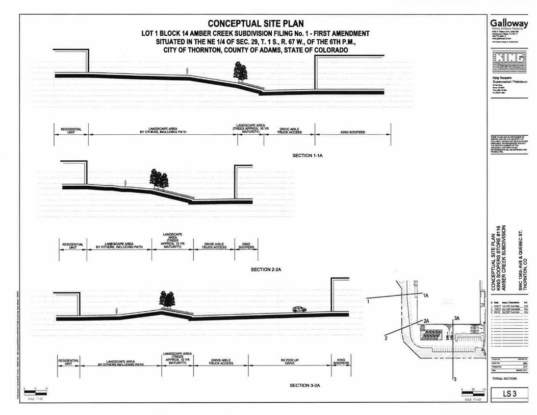
lO 20
RESlOEHTW. UNIT
RESIDENTIAL UNIT
II
RESIOENTW. UNIT
II
LANOSCI\PE AAEA
CONCEPTUAL SITE PLAN LOT 1 BLOCK 14 AMBER CREEK SUBDIVISION FILING No. 1 • FIRST AMENDMENT
SITUATED IN THE NE 1/4 OF SEC. 29, T. 1 S., R. 67 W., OF THE 6TH P.M., CITY OF THORNTON, COUNTY OF ADAMS, STATE OF COLORADO
r:=======-
LANDSCAPE AAEA
IIIHG SOOPERS (TREES APPROX. 10 'IR DRIVE AISLE
MATVRrTY) TRUCK 1\CCESS LANDSCAPE AAEA
BY OTHERS, INCLUDING PIITH
I I SECTION 1-1A
BY OTHERS, INCLUDING PIITH
DRIVE AISLE TRUCK ACCESS
SECTION 2-2A
RX I'!CK UP ORI\IE
SECTION 3-3A
[
KtNG SOOPERS
.. !00
Galloway --~--e'ICZ!IW..DIM, .... GI =..~CCIC11 1 -
King,._.,. Supermarket I Petroleum
:=:m -... -~ ... -
, .,. ..... ~ -!_ 3120117 1 ... CSPI!:ylll!*f AN 2 1CIN17 2nCICSP~ ACJ
!:n11~~
lYPICAI... SECTIONS
LS3

WEST ELEVATION
: !"11":-= A.1 ELEVATION RENDERINGS : •• 1 cr: ml:frtH December 6, 2017
KING SOOPERS 116
SWC OF 136TH & QUEBEC THORNTON, CO architecture + c.i e s , g n
516384

EAST ELEVATION
WEST ELEVATION
= !" ~ ; ' :--= A.2 ELEVATION RENDERINGS - ...,. • • 11'"""""1!!! - a I • • I -Ji',£,j£§id December 6, 2017
NORTH ELEVATION
RETAIL SHOPS AT KS116
SWC OF 136TH & QUEBEC THORNTON, CO
517325
architecture + ci e s ' iJ"

VIEW A: FFE = 5171; EE=5191
VIEW 8: FFE=5171; EE=5201
VIEW C: FFE = 5171 ; EE=5196
FFE- Foni$11 Fblt Elevalion EE- Eye Elevation (approximate) NOTE: REFERENCE KEY PLAN FOR VIEW LOCA liONS
E :1 ! ~ ~ ~ A.3 LINE OF SIGHT STUDY
i,.B¥;&)¥J DecemberS, 2017
KING SOOPERS 116
SWC OF 136TH & QUEBEC THORNTON, CO
516384
architecture + des i g 11

0 ~.J!f&D ELEVATION
CONCEPTUAL SITE PLAN LOT 1 BLOCK 14 AMBER CREEK SUBDIVISION FILING No. 1 • FIRST AMENDMENT
SITUATED IN THE NE 1/4 OF SEC. 29, T. 1 S., R. 67 W., OF THE 6TH P.M., CITY OF THORNTON, COUNTY OF ADAMS, STATE OF COLORADO
0 ~IGKT (EAST) ELEVATION ~t/W"-1 '-r
0 ~).~~-RTH) ELEVATION
~~~y 4-L~ta.. .... ,.._....,_,m..,, - 0 ---
King Soopofa Supennartcet/-·--.ca .. -.. -~ .. -
.~:~~~~~ ... ,~ .. 1 itD't? 'lllal'...,.. AN 21CIIM72niiCP...._. N;.j
[~!IIJ!CF..- ICJ
EXTERIOR ELEVATIONS &SIGNAGE
A4.0

f I. i
I f I j f
LOTI
"""'" I I •
CONCEPTUAL SITE PLAN LOT 1 BLOCK 14 AMBER CREEK SUBDIVISION FILING No. 1 ·FIRST AMENDMENT
SITUATED IN THE NE 1/4 OF SEC. 29, T. 1 S., R. 67 W., OF THE 6TH P.M.,
CI~:::~:N&::~·~:NTY OF ADAMS, STATE 0 COLORAD\j__
-~~~ ~~~~~r-~~~
9EER8'2\,co.ENT A.
\
' '
·,
LOT1 BLOCK14
AMBER CREEK SUBDMSION FlUNG NO 1 - FIRST AMENDMENT
REC. 20060815000824990
'
' '
'
'.
. ' \
LEGEND
• fOUIJ SECTDI CXIRJiER WCifU8'T .. NO!ED.
RllKI NO.6 fEIIM 'MTHA 1-UC' • m.u:M'Pl.ASTICCN' ..aE) "Amef\B-
SETiri.OtGr«>. JREIINlWmU. @ 1-W"aw«if.PlA!TJCCN'NSaaiiB)
"GGIUDWAY4.Stii5S7'
0 ttACilYECCINSTRLICilDHNfEANO IDMEHTSET ATTtr.JTIE CAU:W.TBI""""'"'
<> LJC>ITPOL.E
CD "-""""'LBQX
- UE--- """'""'-CAIU.-.. WAlEJlYALYE
l;l lftHYDRN<T
8 ... ,._.,.. - - -w- WATERl.IE,lNJERGROUiriD
~ STORM SEWBli.JIIE. L.N:IBGlCUIJ
@ """"' .............. @ SANTARV SEWER IIWftCU:
@ --__, ___ ~CAAE\.JCISI:JQ.ICI
_,o--- FIERII'TlCCAI!ILlHl601tlH) -- - - - EXISl'IGEASEIBTS, W11TH I TYPE AS NOTED
------ '""""'"""
c::=J DRTFU.st.tR:e
f!EaR)DIENSIIJN I'ROII~ ("> a&KstiiDMSION FI.Ni IC).t .
FIRSTMt:IOENT.
{Ill) IEASlJE) DErtSI(J(. Ttl3 SliMY
REC. IEQPIIQNIUEER
BENCHMARK 11£IWIIS Of IUVATlCNS ~THIS SlJliiEY IS IMVD ata RS'BBI:8J FROM QTY OF THiliWTtJN IECHWI( 133-5D.IEIG Tl£ NORIHW'IeSTI.f'filR RANGE Ba.T, WITH A QISE1S) "+",Of A FIE H'tDIWfT .. THE SWTHWEST WNIWfT Of tliRDAV£.. Nil COUliWX) ll.YO. K\VftGAPI..B..IHDNAW.a.EVAT10NOFSi!t1.55FEEI'.
N
~ •• == ti·Y 100 -.. '
sat£; , •• ,DO'
~~~y C!Ct.a.~-... ... ... ~-....CDIInlt .. ,._,. ---
King Sooponl Supennotkoil_ .... _ -----.... -
• 0.. -..,o..:..- .... L Y.Df7 ..... CSP....... AN _!. taJIIt'l7211111aiP~ N!J
~~.5!
RDG
EXISTING CONDITIONS
EX1

,,..,., '" !!I
-!El • -iEI • -!El • -!EJ I
-!El • -!EJ I
-fEI • -fEI '
G:H:J u -fEI •
r-c·:r 1-f ·
1200
1100
900
BOO
700
600
500
I 400
I t
~ 300
I 200
j 100 ;
' J t q
I !
CONCEPTUAL SITE PLAN LOT 1 BLOCK 14 AMBER CREEK SUBDIVISION FILING No.1- FIRST AMENDMENT
SITUATED IN THE NE 1/4 OF SEC. 29, T. 1 S., R. 67 W., OF THE 6TH P.M., CITY OF THORNTON, COUNTY OF ADAMS, STATE OF COLORADO
I ~• U•M
"""'" I LOD4115!1
I ~DE4IIl5S l•.n:t [o.nz
I' ·"' ) LDIOil
r= • ) !Uoo.-MC!t l.._nz
'""'' f•·•n 1 550U
ll.WBl [uts
lun
•• h••••••• • HUooooOoOo o o io o'"'-'~l..loo ooooa.~ o, ..,..., , , ,,,,_.,,.,uoo l.loouoo ooooo~._., , , , ,,,,,,.._, ,,, , .. \ o ooo_.. looo o.ooo'oo,..o-ooooo oo ooo 0 o0 oo oo ooo oo• OoOo'-•'~h•o huooO o , o\ol,tloi-o ooUOoho,ooooo..,. OAO 'lO._..._,._.._., _,u h onoooOOh Oooo oooo ooo o ...., OoO O O,IOOdO OOOo~'uLo lio ooooooooi O IO .. hUOAOoOoOoOoOoOoooo o
-, ,u .. uh1 ooo o.o .. &.o0 oOoloo 0 ..,, ,,., .. , _,,,._..._. ,, ._. ... ....,.., ,.., ,hO • OOOU•o • toU •oooo o o o uoo oo oovo,•'•"••••••oo oo 0 o ooooo o oooo oo oOnoo oo o oo o ooo o o o• •• ••
h\o\ oO ~ O , U 0 0 UU O I o I Oo 0 I I I 0 OU U 0.. o• Oo 0 I .......... I o O.J' 0 0 0 o o o 0 0 o 0 fl .... ..... o o 0 o UO 0 0 o 0 oh o 0 .. 0 I U Y "" ' 0~ 0 0 0 0 '"' 0 io h 0 0 •• 0 0 0 0 Oo 0 0 0 OO U I 0 I I OVo o 0 1--' Oo U 0 U .......... ~ ..... ............................ .................................................... .......................... _. .. .. '.!..'· ~·~· IO OoO OOI Oo OoOO ... U " OI .. hO.o o o .. loO.oO.O O.O V ' -1 . .......... ._. .._. , ,OOU~OOIU"' OOO.O UI0 .. 00fi OOOUIOo0o0 00ooooo I.O V OOUIOUk'UI..o
o o ooo oooO o OOooo o o o o o" oo OO"M io VOJoO,U I OOOo ... OHU0 0 0 00H 0o04UUU
I 100
r ~
._..,/lll.cTIC&a/llln
1,01 12.1 l···· n,u jt.U :r .... . .. , .... . ... t\,9 . .. z.u '·' '·' ....
... '·" '·"
Project manager to spKII'y flxtuno voltage for each fixture type
~Look~ ..
l -· j t.tAU -~r1 . f
u
.. ..
... ...
"' " .... " ...,, 1'1 l iM'\~
n "" ... "' .. ...
.. "' b I ~C .. "' u Ira
I »
""' tl uoou .. ..., L:XIt:
.. ·-" ..... .. .. .. --" () ... ,_ ....
""" " ( l.«ll
.... ...,,
..., ... "
.... u ... , .. ----""" .. ..
LMH-.. u t.u
" I~
'"'"
lU, t )t
jnl. KZ
a.n.n•
1l.oMI
1». Jll .... ~, ....... i k . t n
n~Ut
1110,102
J4),, 1l
...... IJJI..JU
IJt".-Ja
1u .ru Lfi.M:I , ... ~. n .tu
ln •-m t U . MJ
tn. r. t
IQ,I o
·n~•
no.n .....
....... "·"
"'·'
'"·" (Jt. H
~ ·lt.,:
·•• ·•1
1 ~s1.1s
:nvn ~
u re .a tn I n
" , .. '" ..
IU, M u , .. 5.)9 In ... "'·n ... l-h. t 4 .. ....... n Ut., )O .. U't, r N .. UJ.,ta . .. Dt,.-, I'-' Ut ,toQ " Ut1 1R In
" •:r. tf " .. .. rn,)t ...
II•
U t ,rrt lh t : •~m h • 114 ,~ " tu,.-n ... tt t ,n' u .. t H . tl1 ..
" , .. .u .u ..
-. ... .n .. l u
fN,OJ .. , • • u n
m ,u " , ... ,. , .. ("'-· '' .. .. .. ,.
U I .M I» IH. K .. .. ..
" , ..
U) ,U " I O'IJ !U .. '" ~ ... .. .. ... ...... i " ...... I-"
"'·" .. , ..... .. U IL,,. ,, ..
1 .. .. II>
" •·•I I»
1 ~ 11.11 ..
. ~n
m
. I••
, .. •
. I•
. I•• ... . .,, "' .. .. UhMl .,.
..
...
... . ... . ..
I " IN
j >H
... lnJ
.... ... .. . l ot
1 .. ..
. I•
...... ,_,.,.
N . lf'l'
.... .
)1., )11
,._.._.
.
, .
King Soopefa Supermarbl/ Petroleum
:::a -.. -~'"-
•"- .... ,~ 1 312W171.C!P ...... i"10M72ri:IC:.a8111111111 IC.J f2am a.ICIIP....... N:,J
pp 1

COUNCIL COMMUNICATION Meeting Date: Agenda Item: Agenda Location : Work Plan#
~ April 10, 2018 llC Action Items _1 51 Reading _2nd Reading
Subject: A resolution approving Amendment No. 1 to the Intergovernmental Agreement between the Regional Transportation District and the City of Thornton pertaining to the construction of the North Metro Rail Line within the City's bo~ndaries.
Recommended by: Joyce Hunt ~ Approved by: Kevin S. Woods Ordinance previously
Presenter(s): Joyce Hunt, Assistant City Manager 'fvJ introduced by:
Robb Kolstad, Assistant City Manager
SYNOPSIS:
The resolution approves Amendment No. 1 to the Intergovernmental Agreement (IGA) between the Regional Transportation District (RTD) and the City of Thornton (City) which was approved in December 2013 pertaining to construction of the North Metro Rail Line (NMRL) within the City's boundaries. The Amendment incorporates informal memorandums of understanding that were developed to address changed conditions that came to light as a result of final design plans. The original IGA was based on the 30% design plan assumptions for the stations located in the City that changed based on the value engineering analyses done by RTD and its contractor Regional Rail Partners (RRP) and progression through final design. Amendment No. 1 also includes three items that were not included in the original IGA: a) request by the City to construct a pedestrian underpass at the 881h at Original Thornton Station; b) reconstruction by RTD of a pond in Grand View Park and Open Space to improve the conditions of the pond to better accept drainage from the RTD Station, Colorado Marketplace, and development of the southeast corner of 1 041h Avenue and Colorado Boulevard; and c) construction of an approximate 150 space surface parking on City-owned property east of the railroad and south of 1241h Avenue to provide over-flow parking and Eastlake business parking. RTD will pay approximately 86% of the cost to construct the parking lot which will continue to be owned and maintained by the City. The Amendment also changes the date to December 31, 2019 by which RTD agrees to submit an executed annexation petition to annex the NMRL from 1361h Avenue to 1681h Avenue into the City.
RECOMMENDATION:
Staff recommends Alternative No. 1 , approval of the resolution adopting Amendment No. 1 to the IGA to incorporate all of the changes that have occurred based on final design plans to improve the operation of the NMRL within the City.
BUDGET/STAFF IMPLICATIONS:
The net amount due to RTD is $233,035. The Capital Improvement Budget includes funds for this obligation.
ALTERNATIVES:
1. Approve Amendment No. 1 to revise the original IGA to reflect changed conditions. 2. Do not approve Amendment No. 1 to revise the original IGA.

COUNCIL COMMUNICATION PAGE2
BACKGROUND CANAL YSIS/NEXT STEPS/HISTORY):
Amendment No. 1 incorporates the following informal Memorandum's of Understanding:
1. 88th Avenue Station. The design of the 88th Avenue Station changed from the original concept in two ways. The first change was the result of value engineering done by RTD/RRP which determined that based on track alignment, it would be better to construct a bridge crossing over 88th Avenue for the rail and eliminate the at-grade crossing at this location as originally planned. The decision to elevate the crossing at 88th Avenue created an opportunity to place a protected pedestrian crossing tunnel under the railway since the station at 88th Avenue would be fenced off and eliminate the ability of pedestrians located west of the tracks to easily access the Station. The pedestrian tunnel, which is considered a "betterment" under the OriginaiiGA and solely the cost of the City, was priced at $990,499. The second change came about as a result of design of the realignment of Welby Road which moved the curve of the road further east necessitating construction of a short entrance road from realigned Welby Road into the 88th Avenue Station. The City agreed to construct this short entrance piece as part of its larger Welby Road realignment project and RTD agreed to pay the City $250,000 for the entrance road and right-of-way. RTD also agreed to change the surface treatment of the large walls at the Stations from a very rough surface to a smoother "stone" finish that was more esthetically pleasing and wouldn't cause as many problems brushing against the smoother surface as the rough surface.
2. 1 04th Regional Detention Pond. The design of the 1 04th Station also changed from the original concept as a result of value engineering done by RTD/RRP. That analysis determined that the original plan to construct the Station and provide parking underneath the bridge going over 1 04th Avenue would be more costly than moving the Station south and constructing a parking garage where the existing old 'farmer' pond was on the site. That decision resulted in a change to RTD/RRP's plans on how to deal with drainage from their Station site and RTD/RRP's original concept was to build a very large pond on the east side of Colorado Boulevard that would serve just their needs. The City looked at this design and determined that a better solution to address RTD's needs, Colorado Marketplace needs (which had used the old farmer pond), as well as the current and future drainage needs of properties located on the southeast corner of 1 04th Avenue and Colorado Boulevard, could be achieved by redesigning an existing pond. RTD agreed to pay the City ($80,000) to do the design and obtain the permitting for this redesigned pond. RTD/RRP would be responsible to construct the improvements.
3. Claude Court Realignment. The City had secured a Denver Regional Council of Governments grant to pay for the construction of the realigned Welby Road but ran into some regulatory issues that made it infeasible to utilize the grant at this location. The City investigated alternatives as to where these grant funds could be used and determined that the grant could be used to pay for the construction to realign Claude Court. RTD's contract with RRP had provided that RRP would construct the realigned Claude Court and give the City a "credit" for the amount of money that would be returned by taking this obligation out of the RRP contract ($427,464).
4. Overflow Parking Lot. The Final Environmental Impact Statement (2011) for the 124th Avenue Station anticipated a need for "opening day" surface parking of 410 spaces with future parking spaces to be provided with a three-story parking structure (2035). When the 124th Avenue Station became the "interim" end-of-line Station, the City requested RTD update their parking study. RTD updated their corridor parking demand model in late 2014 to remove the planned parking spaces from the 144th and 162nd Stations from the model. The result of that analysis, targeted to the number

COUNCIL COMMUNICATION PAGE 3
of spaces that would be required for 2020, indicated a need for 127 additional spaces along the corridor. RTD indicated that due to contractual obligations, site constraints and right-of-way impacts, the only station area that had the potential to add the additional spaces was in the vicinity of the 1241h Avenue Station. RTD had originally wanted to place the parking along 151 Street, from 1241h Avenue north to Birch Street on City-owned property. However, their design would not meet setback and other development requirements. Further, the City had planned to provide parking for the local businesses in the area to the east side of the railroad tracks as well as a plaza entrance to the Station and not parking for RTD commuters. The City did acknowledge the need to provide overflow parking for RTD so as not to impact the Eastlake business community and neighborhood. The logical place to locate an overflow parking lot, which could accommodate RTD commuters as well as people working at Eastlake businesses and shoppers, was on City-owned property on the south side of 1241h Avenue adjacent to the railroad tracks (an old Adams County Shop Site). RTD indicated they would pay their proportionate share of the cost to construct an approximate 150-vehicle parking lot (130 out of 150) to the City. The lot would continue to be owned and controlled by the City. RTD commuters would be allowed to use the lot. The establishment of this lot does not change the requirement provided in the Planned Development Standards for the 1241h Station and the OriginaiiGA that RTD would conduct monthly park-n-ride utilization surveys of the Eastlake Station lot and at such time as the Station is 90% utilized, RTD will increase the amount of parking at the Station, contingent upon RTD Board approval and funding.
5. 1361h Avenue Drainage Improvements. The City and RTD had received numerous complaints concerning standing water in the RTD right-of-way north of 1361h Avenue. The City surveyed the right-of-way and developed a plan to fill select low areas and grade swales to minimize ponding and drain the water to the north to the City's storm drain system. Amendment No. 1 incorporates the 1361h Avenue Drainage Improvements Memorandum of Understanding (MOU) in which RTD reviewed and approved the design and granted the City permission to work in their Right-of-Way to make these improvements.

RESOLUTION
A RESOLUTION APPROVING AMENDMENT NO. 1 TO THE INTERGOVERNMENTAL AGREEMENT BETWEEN THE REGIONAL TRANSPORTATION DISTRICT AND THE CITY OF THORNTON PERTAINING TO THE CONSTRUCTION OF THE NORTH METRO RAIL LINE WITHIN THE CITY'S BOUNDARIES.
WHEREAS, the Regional Transportation District (RTD) and the City of Thornton (City) entered into an Intergovernmental Agreement (IGA) regarding the rights and responsibilities of each party associated with the construction of the North Metro Rail Line (NMRL) within the City's boundaries on December 3, 2013 (C.D. No. 2013-189); and
WHEREAS, subsequent to entering into the IGA, RTD awarded a contract to Regional Rail Partners (RRP) for the construction of the NMRL from Denver Union Station to the 1241h Avenue Station located in the City; and
WHEREAS, since the execution of the IGA, several matters were addressed by the Parties through Memoranda of Understanding with the intention to memorialize them in an amendment to the IGA; and
WHEREAS, the Parties desire to amend the IGA to incorporate the provisions of the MOUs and other matters in the IGA.
NOW, THEREFORE, BE IT RESOLVED BY THE CITY COUNCIL OF THE CITY OF THORNTON, COLORADO, AS FOLLOWS:
1. Amendment No. 1 to the IGA between the Regional Transportation District and the City of Thornton is hereby approved in the form attached hereto and incorporated herein by this reference.
2. The City Manager is hereby authorized to execute the IGA on behalf of the City and the City Clerk to attest.
PASSED AND ADOPTED at a regular meeting of the City Council of the City of Thornton, Colorado, on , 2018.
CITY OF THORNTON, COLORADO
Heidi K. Williams, Mayor
ATIEST:
Kristen N. Rosenbaum, City Clerk

FIRST AMENDMENT TO THE INTERGOVERNMENTAL AGREEMENT BY AND BETWEEN THE CITY OF
THORNTON AND THE REGIONAL TRANSPORTATION DISTRICT
This First Amendment to the Intergovernmental Agreement ("First Amendment") made this day of , 2018 is by and between the CITY OF THORNTON ("City"), a home rule municipal corporation of the State of Colorado organized pursuant to Article XX of the Colorado Constitution, and the REGIONAL TRANSPORTATION DISTRICT ("RTD''), a political subdivision of the State of Colorado organized pursuant to the Regional Transportation District Act, C.R.S. 32-9-101, et seq. The City and RTD may hereinafter be referred to individually as a "Party" and collectively as "Parties".
RECITALS
RTD and the City entered into the Intergovernmental Agreement ("IGA") dated December 17, 2013 pertaining to the construction of the portion of the North Metro Rail Line ("NMRL") traversing the City setting forth the understanding of the Parties including responsibilities for certain costs, conveyance of property interests, a review and approval process for the design, construction and inspection of improvements, and the City's local agency contribution.
Subsequent to entering into the IGA, RTD awarded a contract to Regional Rail Partners ("RRP") for the construction of the NMRL from Denver Union Station to the 1241h
Avenue Station located in the City.
Since the execution of the IGA, several matters were addressed by the Parties through memoranda of understanding with the intention to memorialize them in an amendment to the IGA, as follows:
1. MOU Regarding the RTD FasTracks 881h Avenue Station Driveway (Undated) (the "Welby Road MOU"), Exhibit G;
2. MOU Regarding the RTD North Metro Rail Line 1 041h Avenue Station Drainage Improvements dated October 7, 2016 (the "1 041h Avenue Station MOU") Exhibit H-4;
3. MOU Regarding the City of Thornton 1361h Drainage Improvements Along the RTD North Metro Corridor ROW dated October 17, 2016 (the "1361h Avenue Station MOU") Exhibit H-17.; and
1

4. MOU Regarding Right of Way for Claude Court dated 1/26/16 (the "Claude Court MOU") Exhibit H-18.
In addition, the Parties entered into an Intergovernmental Agreement- 2016 Local Government Requests Program (Local Funds) on January 1, 2017 (the "Grant IGA"), and are parties to a lease between the City and the Union Pacific Railroad Company ("UP"), dated April 30, 1998, that was assigned to RTD by the UP on June 25, 2009 regarding parking at the Northern Lights Little League Ballfields (the "Parking Lease"). Neither the Grant IGA nor the Parking Lease are modified or amended by this First Amendment. The Parking Lease will be amended by separate document of even date herewith.
AGREEMENT
NOW THEREFORE, in consideration of the foregoing premises and for other good and valuable consideration, the receipt and sufficiency of which are hereby acknowledged, the Parties agree to amend the IGA as follows:
1. It is expressly agreed by the Parties that this First Amendment is supplemental to the IGA and all terms, conditions, and provisions thereof, unless specifically modified herein, are to apply to this First Amendment as though they were expressly re-written, incorporated, and included herein. Unless otherwise indicated, all capitalized terms contained in this First Amendment shall have the same meaning as given to them in the I GA. The Recitals, above are hereby incorporated into this First Amendment. It is agreed the IGA is and shall be modified, altered, and changed as set forth herein, below.
2. Paragraph 2.2 Exhibits, Exhibit G, Welby Road Alignment, is deleted in its entirety and replaced with Exhibit G, Welby Road MOU and Paragraph 2.2 is amended by adding the following:
Exhibit C-1 Right-of-Entry License Form;
Exhibit C-2 Access Easement Form;
Exhibit C-3 Temporary Construction Easement Form;
Exhibit G: Welby Road MOU;
Exhibit G-1: Revised Welby Road Realignment;
Exhibit G-2: Welby Access Drive Design Plan and Profile;
Exhibit G-3: Welby Slope Easement SE1;
Exhibit G-4: Assignment Agreement of the Welby Slope Easement;
2

Exhibit G-5 Original Thornton at 881h Station Subdivision Plat recorded at Reception No. 2017000112698 in the offices of the Adams County Clerk and Recorder on December 22, 2017 ("Original Thornton at 881h Station Subdivision Plat");
Exhibit H-1: Right-of-Entry License from RTD;
Exhibit H-2: 881h Avenue Station Trails and Retaining Walls RTD Will Maintain;
Exhibit H-3 881h Avenue Station Trails City Will Maintain;
Exhibit H-4: 1 041h Avenue MOU;
Exhibit H-5: Sedimentation Basin;
Exhibit H-6: Northern Lights Ballfields Parking Lease;
Exhibit H-7: Northern Lights Ballfields Parking Lease Amendment;
Exhibit H-8: 1 001h Avenue Sidewalk and Roadway Improvements;
Exhibit H-9: Eastlake Parcel 42-C Quit Claim Deed;
Exhibit H-1 0: Eastlake Access Sidewalks;
Exhibit H-11 : Eastlake Future Ticketing Stations;
Exhibit H-12: Eastlake Parcei42-G Quit Claim Deed;
Exhibit H-13: Eastlake Parcel PE Access Easement for Parcel 42-G;
Exhibit H-14: Eastlake Parcel TCE Temporary Construction Easement for Parcel 42-G;
Exhibit H-15: Eastlake Parcei42-A Quit Claim Deed;
Exhibit H-16: Eastlake Parking Lot;
Exhibit H-17: 1361h Avenue Station MOU; and
Exhibit H-18: Claude Court MOU.
3. Paragraph 4.1 Local Agency Contribution Payment, the last sentence is deleted and replaced with the following:
"The City has fully satisfied its Local Agency Contribution for the stations at 881h Avenue (the "881h Avenue Station"), 1041h Avenue, 1121h Avenue, and the Eastlake station at 1241h
Avenue (the "Eastlake Station") and no further Local Agency Contribution is required from the City with respect to these stations. The Local Agency Contribution for the 162nd Avenue Stations has not been met and shall be satisfied by the value of (i) City staff time
3

required to perform necessary activities associated with environmental clearances, planning, design, construction and inspections of the 144th and 162nd Avenue Stations, and (ii) Project Permit fees for plan reviews, permits, inspections and approvals required by City codes and the value of any pedestrian/bicycle access to the stations constructed by the City."
4. Paragraph 6.5.1, Welby Road Realignment, is deleted in its entirety and replaced with the following:
"6.5.1 Welby Road Realignment and Access Drive to the 88th Avenue Station. Subsequent to execution of the IGA, the Parties entered into the Welby Road MOU, Exhibit G. The Welby Road MOU is hereby terminated by this First Amendment and is of no further force or effect. Pursuant to the Welby Road MOU, City constructed realigned Welby Road as depicted on Exhibit G-1. To connect the 88th Avenue Station to realigned Welby Road, the City (i) acquired real property rights for, and designed, the Welby access drive (the "Welby Access Drive") (Exhibit G-2), and (ii) acquired a slope easement for Welby Road via the Welby Road Slope Easement Exhibit G-3 (the "Welby Slope Easement"). RTD has accepted the Welby Access Drive and the Welby Slope Easement improvements, and the Welby Slope Easement has been assigned to RTD by the City pursuant to an Assignment Agreement Exhibit G-4. The City vacated the portion of Welby Road no longer needed due to the realignment of Welby Road, and reserved utility easements in the vacated right-of-way by Ordinance No. 3425 approved on March 28, 2017. Thornton released all such reserved easements by the Original Thornton at ssth Station Subdivision Plat, Exhibit G-5."
5. Paragraphs 6.5.4 and 6.5.4.1 are added as follows:
"6.5.4 88th Avenue Station Underpass. RTD constructed a twelve-foot (12') wide concrete pedestrian underpass and a twelve-foot (12') wide connecting trail through the 88th Avenue Station (collectively "Underpass") at the request of the City as a Betterment. Upon final acceptance of the Underpass by RTD and written notice of such acceptance to the City, RTD shall grant the City a Right-of-Entry License, in substantially the same form as attached as Exhibit H-1, for passage through the Underpass for trail use."
"6.5.4.1 Trail Construction and Maintenance. The construction and maintenance of the trails and retaining walls within the RTD property shall be performed in accordance with the Original Thornton at 88th Station Subdivision Plat (See General Note 11) Exhibits G-5, H-2 and H-3."
6. Paragraph 6.5.5 is added as follows:
"6.5.5 Regional Detention Facility at 1 04th Avenue East of Colorado Boulevard. Subsequent to execution of the IGA, the Parties entered into the 1 Q4th Avenue Station
4

MOU, Exhibit H-4 . The 1 041h Avenue Station MOU is hereby terminated by this First Amendment and is of no further force or effect. The City agreed to allow RTD to move the existing retention pond acquired from Colorado Marketplace (the "Colorado Marketplace Detention Pond") to enable construction of 1 041h Avenue Station, to the east side of Colorado Boulevard onto the Grandview Ponds Open Space owned by the City. RTD constructed a detention basin to replace the Colorado Marketplace Detention Pond volume, providing detention for the 1 041h Avenue Station, and areas east of Colorado Boulevard that are tributary to the new detention basin location ("Regional Detention Facility.") The City designed and obtained all required permits for the Regional Detention Facility. RTD shall construct all facilities necessary to send the flows previously collected in the Colorado Marketplace Retention Pond to the Regional Detention Facility. RTD constructed and will maintain a sedimentation basin upstream from the Regional Detention Facility on City property. The City will grant to RTD a Right-of-Entry License in substantially the form attached as Exhibit C-1 , for the use and maintenance of the sedimentation basin, Exhibit H-5, as further addressed in an intergovernmental agreement between the Parties regarding the operation and maintenance responsibilities of the Parties related to the NMRL. The City will maintain all City owned or dedicated drainage facilities once constructed, including without limitation the Regional Detention Facility.
In consideration for RTD's use of the Regional Detention Facility herein, RTD shall amend Article Ill of the Parking Lease, Exhibit H-6 by an Amendment in substantially the form attached hereto as Exhibit H-7 to add the following:
'C. Notwithstanding the foregoing paragraphs of this Article, the annual rent payments related to the access to parking at the Northern Lights Little League Ballfields shall be waived effective January 2018 and shall continue to be waived until January 1 of the year following the date that the NMRL extends beyond 1401h
Avenue Extended."'
7. Paragraph 6.5.6 is added as follows:
"6.5.6 1 001h Avenue Sidewalk and Roadway Improvements.
The City constructed the sidewalk/trail on the south side of 1 oath Avenue west of the regional trail junction which the City owns and maintains. RTD shall be responsible for the reconstruction of the regional trail south to tie into new location and profile of 1 oath Avenue as depicted in the hatched area of Exhibit H-8. Once reconstructed, the City shall maintain such area."
8. Paragraph 6.5.7 and its subparagraphs 1 through 6 are added as follows:
5

"6.5.7 Eastlake Station.
Due to revisions to the Eastlake Station design, the Parties desire to exchange Eastlake parcels as described herein by quit claim deed upon execution of this First Amendment unless otherwise provided herein.
6.5.7.1 The City is designing a plaza (the "Eastlake Plaza") at the Eastlake Station on Parcel 42-C, east of the NMRL station platforms and will be responsible for all costs and expenses associated with the design, construction, operation and maintenance of the Eastlake Plaza. RTD shall convey to the City by quit claim deed, Parcel 42-C as described in Exhibit H-9. Upon such conveyance, the City shall assume responsibility for the stormwater plan management practices related to temporary erosion control on Parcel 42-C.
6.5.7.2 RTD shall construct portions of the access sidewalks towards the First Street right-of-way on the north and south end of the Eastlake Station platform, Exhibit H-1 0. The City shall own and maintain the sidewalks.
6.5.7.3 When RTD determines ticketing/validation machines are operationally necessary on the First Street (east) side at the Eastlake Station, the City will grant to RTD an easement in substantially the form as Exhibit C, to install, use and maintain ticketing/validation machines and security cameras on two sites as generally depicted in Exhibit H-11 or as otherwise mutually agreed by the Parties.
6.5.7.4 The City shall convey to RTD via quit claim deed in substantially the form as Exhibit E, Parcel 42-G described in Exhibit H-12 , an access easement in substantially the form as Exhibit C-2 described in Exhibit H-13, and a temporary construction easement in substantially the form as Exhibit C-3 described in Exhibit H-14, to construct and maintain an electrical relay house on the east side of Eastlake Station.
6.5.7.5 RTD shall convey to the City by quit claim deed in substantially the form as Exhibit E, Parcel 42-A located within City Right-of-Way as described in Exhibit H-15.
6.5.7.6 (a) The City will design, construct, own and maintain a surface parking lot south of 1241h Avenue (the "Lot") on property owned by the City, as shown on Exhibit H-16 (the "Lot Property"). RTD shall contribute One Million One Hundred Thousand Dollars ($1, 1 00,000) (the "RTD Funds") to the City for construction of one hundred thirty (130) Lot parking spaces and the City hereby grants RTD transit patrons a license to use the Lot upon initial acceptance of the Lot until December 31, 2035 unless extended by mutual agreement of the Parties.
6

The City agrees that during this period, hours of use for no less than one hundred thirty (130) spaces in the Lot will be no more restrictive than the restrictions placed by RTD on parking at the Eastlake Station, provided that the City may prohibit overnight parking at the Lot. Also during this period, RTD may include the one hundred thirty (130) spaces in its count of parking spaces in order to determine parking needs for the NMRL.
(b) RTD shall remit to the City (1) 20% of the RTD Funds on or before January 31, 2019 (2) an additional 50% (to 70% of the total) of the RTD Funds within 30 days after the City posts its advertisement for construction of the Lot and (3) the remaining RTD Funds upon initial acceptance of the Lot by the City which is when the City and RTD patrons may begin to use the Lot. The City will invoice RTD for each of the three payments described above and RTD shall pay within thirty (30) days of receipt. The City shall be responsible for all costs for the design, construction, ownership, operation and maintenance of the Lot in excess of the RTD Funds.
9. 6.5.8 Subsequent to execution of the IGA, the Parties entered into the 1361h
Avenue Station MOU Exhibit H-17 and completed the responsibilities contained therein. Upon execution of this First Amendment, this First Amendment shall entirely replace and supersede the 1361h Avenue Station MOU, which shall be deemed terminated and of no further force or effect.
10. 6.5.9 Subsequent to execution of the IGA, the Parties entered into the Claude Court MOU Exhibit H-18 and completed the responsibilities contained therein. Upon execution of this First Amendment, this First Amendment shall entirely replace and supersede the Claude Court MOU, which shall be deemed terminated and of no further force or effect.
11. 6.5.1 0 The City shall remit payment of Two Hundred Thirty-Three Thousand, Thirty Five Dollars ($233,035) as a reconciliation of all MOU matters between RTD and the City related to the NMRL from the 881h Avenue Station to the Eastlake Station resulting in the net balance due to RTD within thirty (30) days after receipt of an invoice from RTD.
12. Paragraph 6.6 Annexation "December 31, 2014" in the first sentence is deleted and replaced with "December 31, 2019".
13. All exhibits referenced in this First Amendment are incorporated herein by this reference.
14. All other terms of the IGA are ratified by the Parties hereto.
7

IN WITNESS WHEREOF, the Parties hereto have executed this First Amendment to be effective as of the day and year above written.
ATTEST:
By: __________________ _ Kristen N. Rosenbaum City Clerk
APPROVED AS TO LEGAL FORM:
By: __________________ ___ Luis A. Corchado City Attorney
APPROVED AS TO LEGAL FORM:
By: ____________________ _ Lori L. Graham Associate General Counsel
8
CITY OF THORNTON
By: ______________________ _ Kevin S. Woods City Manager
REGIONAL TRANSPORTATION DISTRICT By: ______________________ _
Henry Stopplecamp Assistant General Manager Capital Programs

Exhibit C-1 RIGHT OF ENTRY LICENSE
This RIGHT OF ENTRY LICENSE (this "license") is made this __ day of------' 2018 (the "Effective Date"), by and between and
(individually a "Party'' and collectively, the "Parties").
Subject to and in accordance with the terms, covenants and conditions contained in this License, and in consideration of the mutual agreements contained herein, the receipt and sufficiency of which is hereby acknowledged, the Parties agree as follows:
I. LICENSED AREA. Licensor owns a parcel of property _________________ (the "Property'') and Licensee desires access to enter upon
the Property (the "Licensed Area") for the purposes indicated herein. The Property and the Licensed Area are indicated on Exhibit A, attached hereto and incorporated herein by this reference.
II. USE. The Licensee has requested Licensor to grant the Licensee the right to enter upon the Property for the purpose of (describe use) (the "Use") subject to and in accordance with terms and conditions contained in this License.
Ill. GRANT. Licensee hereby grants a revocable, nonexclusive, nontransferable license to Licensee, to enter upon the Licensed Area and engage in the Use, subject to and in accordance with the terms, covenants and conditions of this License. Licensee shall retain all other rights in and usage of the Licensed Area not inconsistent with the reasonable use of the foregoing grant.
IV. TERM. The term of this License shall commence on the Effective Date and shall continue in full force and effect thereafter unless terminated by Licensee based on default of this License by Licensee, after Licensor provides notice of default and a reasonable cure period to Licensee to enable it to cure such default (the "Term").
V. WARRANTIES. If the Use voids or impairs any warranty or warranties in effect on the Licensed Area or the Property, Licensee shall fully assume and perform the obligations of such warranty or warranties, such obligation to survive expiration or termination of this License.
VI. HAZARDOUS SUBSTANCES. Licensee shall not use, produce, treat, generate, release, discharge, store, transport, or cause to be transported, or dispose of any hazardous substances at, on, under, in, or about the Licensed Area in violation of applicable law. The term "hazardous substances" shall mean any toxic or hazardous, or noxious substance, material, or waste which is regulated by any local government authority having jurisdiction over the Licensed Area, the State of Colorado, or the United States government.
VII. INSURANCE.
A. Licensee shall obtain and maintain at its sole cost and expense, the following types of insurance, at minimum, with an insurer or insurers and in a form satisfactory to licensee:
1. Comprehensive general liability insurance with which shall provide coverage for limits of not less than $ 2,000,000.00 bodily injury liability and property damage liability combined single limits.
9

2. Prior to entry upon, above or adjacent to the Property, Licensee agrees to furnish Licensor with a certificate of insurance. Licensee shall provide thirty (30) days advance notice of cancellation of the policy by Registered or Certified mail.
3. The comprehensive general liability certificate shall have the following endorsements attached thereto:
a) An endorsement naming Licensor an additional insured;
b) An endorsement providing that all policy or endorsement limitation(s} relating specifically to operations on or near railroad property are eliminated;
c) A Broad Form Property Damage endorsement; and
d) An endorsement providing that in the event of reduction or exhaustion of the applicable aggregate limit or limits of liability under the primary policy or policies referred to in the certificate of insurance solely by reason of losses paid hereunder on account of occurrences during the policy period, the excess policy, if any, referred to in the certificate shall (1) in the event of reduction, apply as excess of the reduced limit of liability thereunder; and (2) in the event of exhaustion, continue in force as though it were primary insurance.
B. Liability of Licensee under this section shall not be limited to coverage provided under said insurance policies.
C. Notwithstanding any to the contrary contained herein, the Parties, officers, and its employees, are relying on, and do not waive or intend to waive, by any provision of this License, any rights, protections, or privileges provided by the Colorado Governmental Immunity Act, C.R.S. 24-10-101 ~-.as it is from time to time amended, or otherwise available to the Parties, its officers, or employees.
VIII. ASSIGNMENT. This License may not be assigned, in whole or in part, by Licensee without the prior written consent of Licensor. No assignment shall release Licensee from any responsibility or liability hereunder. Any assignment in violation of this Section shall be null and void.
IX. APPLICABLE LAWS; VIOLATION. Licensee shall use and occupy the Licensed Area in a safe and careful manner and shall comply with all applicable ordinances and regulations of the city and county in which the Licensed Area is situated, the laws of the State of Colorado and of the United States of America, and all other rules of governmental authorities as may be in force and effect during the Term.
X. NOTICES. All notices provided for herein shall be in writing and shall be personally delivered or mailed by registered or certified United States mail, postage prepaid, return receipt requested, to the Parties at the addresses given below or at such other address that may be specified by written notice in accordance with this Section:
Licensor: Licensee:
with a copy to:
10

XI. ENTIRE AGREEMENT. This License represents the entire agreement between the Parties regarding the Licensed Area.
XII. AMENDMENT. No change, alteration or modification to any of the provisions hereof shall be effective unless contained in a written agreement signed by the Parties.
XIII. WAIVER, SEVERABILITY. The failure of any Party to exercise any right hereunder, or to insist upon strict compliance by the other Party, shall not constitute a waiver of either Party's right to demand strict compliance with the terms and conditions of this License. If any provision of this License is held to be unenforceable for any reason, its unenforceability shall not affect the remainder of this License, which shall remain in full force and effect and enforceable in accordance with its terms.
XIV. GOVERNING LAW AND VENUE. This License shall be interpreted and enforced according to the laws of the State of Colorado. Jurisdiction and venue for all disputes shall be in the county in which the Licensed Area is located and Licensee expressly submits itself to the jurisdiction thereof.
XV. AUTHORITY OF THE PARTIES. The Parties represent that each has taken all actions that are necessary or that are required by its procedures, bylaws, or applicable law to legally authorize the undersigned signatories to execute this License on behalf of the Parties and to bind the Parties to its terms.
XVI. COUNTERPARTS. This License may be executed in counterparts. Signatures on separate originals shall constitute and be of the same effect as signatures on the same original. Electronic and faxed signatures shall constitute original signatures.
IN WITNESS WHEREOF, the Parties have executed this License effective as of the date first above written.
LICENSOR:
LICENSEE
11

Exhibit C·2 ACCESS EASEMENT
This Access Easement entered into this day of _______ _. 2018, by and between---- located
at ("the Grantor") and ______ located at----------------("Grantee").
RECITIALS
For good and valuable consideration, the receipt and sufficiency of which Is hereby acknowledged, the Grantor does hereby grant, sell and convey unto the Grantee, a permanent, non-exclusive, access easement for purposes of ingress and egress through, on, over, across and along and In all of the property situated in the County of Adams, State of Colorado, being described more fully on Exhibit A attached hereto and incorporated herein by this reference ("the Property") subject to the terms contained herein.
XVII. TERMS OF THE EASEMENT
1. The right to use this Easement shall belong to the Grantee. Grantee has a right of entry and access in, to, through, on, over, under, and across the Property at any and all times deemed necessary by the Grantee for all purposes necessary and at all times convenient and necessary to exercise the rights granted to it by this Easement. 2. No building, structure, or other above or below ground obstruction that may interfere with the purposes for which this Easement is granted may be placed, erected, installed or permitted upon the Property. In the event the terms of this paragraph are violated, such violation shall immediately be eliminated by the Grantor upon receipt of written notice from the Grantee or in the event the corrections have not been made within 10 days of receipt of such violation notice the Grantee shall have the immediate right to correct or eliminate such violation at the sole expense of the Grantor, who shall promptly reimburse the Grantee for any expense related thereto. The Grantor shall not, in any manner, Interfere In any manner with the purposes for which the Easement Is granted; however, the Grantor reserves the right to grant access easement to others without the permission of the Grantee. The Grantee shall cooperate with all other access easement holders on the Property.
3. The benefits and burdens of this Easement shall be binding upon and shall inure to the benefit of the Grantee and the Grantor and both of their assigns and successors 4. The provisions of this Easement, including all benefits and burdens, shall run with the land. 5. The signatory hereby warrants that it has full and lawful authority to grant this Easement and the Grantor hereby agrees to defend the Grantee In the exercise of Its rights hereunder against any defect In the Grantor's title to the Property. IN WITNESS WHEREOF, the Grantor has executed this Access Easement effective as of the date first above written.
GRANTOR:
By:. _____________________________ ___
STATE OF _____ _
COUNTY OF ____ _
Acknowledged before me this __ day of ______ 20, by _________ .
WITNESS my hand and official seal.
My commission expires:'------ ------·
NOTARY PUBLIC
GRANTEE:
By:. _______________________________ _
12

EXHIBITC-3 TEMPORARY CONSTRUCTION EASEMENT
THIS TEMPORARY CONSTRUCTION EASEMENT, made this __ day of------20_ is made between ("Grantor") and -------------("Grantee").
RECITALS
WHEREAS, the Grantor owns certain property located within Adams County and more particularly described in Exhibit A attached hereto and incorporated herein by this reference (the "Property"); and
WHEREAS, the Grantee requires the Property for the construction of \.----------------1 (the "Project"), located in Adams County.
NOW THEREFORE, in consideration of the sum of TEN AND N0/100 ($10) DOLLARS, and other good and valuable consideration, the receipt and sufficiency of which is acknowledged, the Grantor hereby grants to the Grantee a Temporary Construction Easement on the Property for the purpose of performing the necessary activities related to the Project.
1. Said Temporary Construction Easement shall commence upon execution of this Easement and shall continue for a one year term. Grantor also grants to the Grantee the option to extend this Temporary Easement on a month-to-month basis not to exceed one additional year by providing a written notice of its desire to extend the easement term to the Grantor for such extension.
2. As a condition to the grant of this Temporary Construction Easement, the Grantee covenants and agrees to restore the Property, including landscaping, fences, or other improvements to a condition comparable to its original condition.
3. During the term of this Temporary Construction Easement, Grantor shall not erect or construct, or allow to be erected or constructed any building or other structure within said Temporary Construction Easement, which may interfere with City's full enjoyment of the rights hereunder.
4. To the extent permitted by law, and without waiving any of its rights under the Colorado Governmental Immunity Act, Grantee shall indemnify and save and hold harmless Grantor against all claims and liability for damages, loss or expense caused by any injury or death to any person or damage to property resulting from the acts of the Grantee if the same shall in any way be connected with or result from the use of the easement and Property unless caused by the sole negligence of Grantor or its agents.
5. The parties hereto agree that neither has made or authorized any agreement with respect to the subject matter of this instrument other than expressly set forth herein, and no oral representation, promise, or consideration different from the terms herein contained shall be binding on either party, or its agents or employees, hereto.
6. Grantor warrants that it has full and lawful authority to make the grant contained herein.
7. All of the covenants herein contained shall be binding upon and inure to the benefit of the parties hereto, their respective heirs, personal representatives, successors and assigns.
8. The signatory hereto warrants that he has full and lawful authority to make the grant hereinabove contained as Grantor.
IN WITNESS WHEREOF, the undersigned has set his hand hereto on the day and year first above written.
GRANTOR
GRANTEE
13

1. General
EXHIBIT G -Welby Road MOU
Memorandum of Understandlne ("MOU~)
Re1ardin1 the RTD FasTracks 88th Avenue Station Driveway
A. Parties to this MOU are the City ofThornton ("COT") and the Regional Transportation
District ("RTD"), collectively the Parties.
B. The Intergovernmental Agreement dated December 3, 2013 entered Into between the
Parties ("IGA"), Paragraph 6.5.1 anticipates that COT is designing and constructing a
realigned Welby Road. RID has requested that COT construct, during the prosecution of the
Welby Road Realignment wort<, an RTO FasTracks 88th Avenue Station Driveway from the
Welby Road Realignment for direct access to the 88th Avenue Station ("RTD Driveway").
C. The Parties hereto acknowledge that since the Colorado Agricultural Ditch Company
("COAG") Is affected by the RTD Driveway, the Parties are relying on each other to finalize
and comply with ditch crossing agreements respectively between COT and COAG regarding
construction and between RTD and COAG regarding maintenance.
D. It has been determined that it is mutually beneficial to RTD and COT for COT to construct
the RTD Driveway.
E. The understandings set forth in this MOU will be reflected in an amendment to the IGA. Any
commitment of financial resources shall be subject to prior appropriation and availability of
said funds in accordance with th respective laws of the Parties.
2. Responsibilities of the Parties
A. RTDshall:
i. Convey a Right of Entry License of the property depicted on "Exhibit A" attached
hereto and Incorporated herein (the "Property") to COT to enable COT to
construct the RTD Driveway on the RTD property.
ii. Approve the design for the RTD Driveway and ditch crossing.
Ill. Credit COT $250,000 for the design, construction and slope easement required for
the RTD Driveway and the COAG ditch crossing. This credit anticipates that the
work will be able to be completed within the time frame of the present Welby
Road Realignment construction contract with COT's contractor.
iv. After receipt of notice of Initial acceptance of the RTD Driveway, RTD shall finalize
the crossing agreement between RTD and COAG and accept the RTD DriVeway and
ditch crossing.
B. COTshall:
i. Construct the RTD Driveway in accordance with the design approved by RTD.
II. Construct the COAG ditch crossing in accordance with the design approved by
COAG.
Ill. Provide written notification to RTD of Initial acceptance of the RTD Driveway.
iv. At the time RTD accepts the RTD Driveway and finalizes the crossing agreement
between RTD and COAG, COT shall convey to RTD the slope easement COT was
required to obtain prior construction of the RTD Driveway in substantially the
same form attached to the IGA as EMhlbit C.
14
v. At the time RID accepts the RTD Driveway and finalizes the crossing agreement between RTD and COAG, COT shalt assign any remaining warranty on the RTD Driveway to RTO.
3. RTO will have access to the RID Driveway only at such time that RTDs accepts the RTD Driveway and has entered into the crossing 11reement with COAG.
4. Conveyance of a Risht of Entry License for the RTD Driveway must be conveyed to COT on or before March 10, 2016ln order to facilitate the construction schedule for the RTD Driveway to
avoid delay to COT. 5. The credit cited in paragraph 2.A.Iv, above, related to the RTD Driveway will be addressed in an
amendment to the IGA and may be used by COT to offset costs associated with design and construction of the 88111 Avanua Pedestrian Underpass.
This MOU sets forth the understandin1s of the Parties with respect to the RID Driveway, and will be Incorporated as a formal amendment to the IGA. In the event of a conflict between the IGA and this MOU, this MOU shall govern with respect to the subject matter of this MOU.
IN WITNESS WHEREOF, COT and RTD have executed, through their respective lawfully empowered representatives, this MOU as of the day and year above written.
aTY OF THORNTON
REGIONAL TltANSPORTAnON DISDICT
_.»v· >--........ Ashland Vaughn,
2
15

®rn~t~ ®Wfl~J@j ®~©'iJO@OO ~@j
'iJ~®9 00®®\Wl 0 0
®'iJ[}{] lPolMJ ~ I (2) I
NATIONWIOI! ~GI£ SERVTEMPORARY P.O. BOX m428
STEAMBOAT SPRINClS. co •CONSTRUCTION REC. NO. 2007000106571EASEMENT FOR
20' E.XCLUSIVE WATERLINE EASEMENT PER Rec. NO. 2001 u0009RTO DRIVEWAY
AND COAG DITCH CROSSING
---
N82'46'0S"W R "'90.31' 155.86' A •25'50'12" L =40.72' CH-40.38' TRACTN C B -to! 20" 1 5'38" E WEL8Y STAnON SUBDIVISION
REC. NO. 20070000118009 WESTSIDE WELBY LLC \
\
N
t 0' 20' 40'
SCALE 1" • 40'
.. A1N• P•\121d·OU•II
OWG-·1--~ a•oao ..!i4...- a.''..!!I"'IL--o"'l• Ol•lt•Ha
tc:lr&.lt ICALE t" • 40'
7100 E. II!LLEVII!W AVENUE, SUITE 350 GREENWOOD VIU.AGE, CO 80111·1838
REC. NO. 2013000050171
flo!IS EXHIBIT DOES NOT REPRESENT\ A MONUMENTEO LAND SURVEY. IT IS
80' INTENOEO TO DEPICT ONLY THE ATTACHED lEGAL OI!SCRIPTION.
*&.tM~Au, ..... • .......,c-...•m n .. uiNJ),IJ•IM J111 U6J)U.'-IIt' .~ ...... ~ ......... f.
16
I I
0 0 . g
I \
TEMPORARY CONSTRUCTION EASEMENT FOR RTD DRIVEWAY
WELBY ROAD CITY OF THORNTON
17

•• , ll f I ..
. ..
,.£.city of "'\1"'"Thornton
18
··• EXHIBIT G-2 ... Welby Access
Drive Design ... Plan and Profile

EXHIBIT G-3 Welby Slope Easement SE1 RECZP~IONf: 2015000008727, 02/03/2015 at 01:31:11 PM, 1 OF 5, ~0 Pgs: 0 Doc 'l'yp.:llAS Stan Martin, Adalns County, CO
SLOPE EASE'-IENT
r-::~ ~~ ~
THIS GRANT OF SLOPE EASEMENT 11 made lhle 0 day of Nll\lt@of2015, belwaon Woslllldo Welby LLC, a Colonldo Llmltsd Uablllty Company duly organized and tldsltng undll' and by vi!IUt of lh• lawa of \he State of Colorado located al 7100 Belevlew AveliiJI, Sulta 360, Greenwood VIllage, CO 80111 the 'Grantor: and the City of Thomlon a Colorado home rule munfclptllty, lhe •orantn.' whott ltgll addrMa Ia 9500 CMc Ctnt• Or1Ye, Thomton, CO 80229, County or Adam~ end Sltlle of Coloredo. Grantor n Grantee may ba rwflmld to neraln aeparately 111111 ~ltcllvtly 11 'P*V or 'Pirtltl."
1. Gtwlkx', for 1nd In conaklnllcn of 1t1e ~ n ca"ldklor. •t forth hwltln
I I
and oilier good 11\d valuable consldll'allon, the receipt and sufllc::ltncy d tM1Ich 11 IICknoMIIdgld, rw.b)' grw~~a, aelll em c:onveyato o...ue. 1111 BUOQ8liiOI1I and aselgns, 11 perpetual non-exclualveelope eaaemllf'll for the~ of providing and nuMIIIIInlng; 1) 11 proper light dlalance and Ina of alghli 2) llltoralauppolt; and, 3) pop.- chlhlge grade, N determined by the Thom!Dn lnflallnJdure Department for 11 public rOI!Miy, rosd ehoiAder and atlend8nt roed lmPtOYemlrrla and conetructlon, and tor the purpoM of IXllllllnldlng, opnllng, mU!Ialnlng. rept'*'l), recont~. hlprovtng, hlpaclfng, repU1ng, at.IMIYfng and 11116lg at anv l'tii80illbl11 tme and necsaaary appnonanoea colleciiYaly doflnod sa lha 'Siol)lll~rovamarU. • lhrougll. over, ln:ler, IICtOSIIIId on GrantoB real propl!ty 111 dalct'*l In Exhibit A. atta:hlld ·~~erato lnd lnCOIJIOralld herein by INI ref~~W~Ca (1he 'Siope~lllll').
Grarmr 1\Jrthll' llfllnlll tha tllawlng:
Grlll'lllor ~~~ lo Gnantee, b -..en, c:ontr.dln or -.lgnl, anclllll eganla end nployeet tul r1ght to enw Ill a!lrt1810n&bl!llmaa upon the Slope Euemanl Ul llliWY. ~. .r. ramova, ra,-., I'IICOIIIIIruct lnBped, !mprov11 and malnlllln U. sq. II'IIPIIMmllllll.
The right 1o -nabla hgl'llll and eg11111 fNflf Wid ~C~W~ Cbnlor'e property ftJr the JUP01111 of aan:lslng 11el1ghla hen~ln g111m.d.
The right to mart lhB locallon d tht. Slope Eanment by aullable merlin 111t In or on 1t1e ~und: provided lhlt p8I'IIIIIW1t '!W1<Irl 811111 be pllllld In loCIIIonl which wiU not lnlelfere with .ny ,....},Ill uae Gran1Dr WID rnakll Ill this Slope EINIIIIII'Il
Further, lor any oonatJUcUon l'llated to niJIIk' ot raptllr*TIInt UIOdllad w1111 \hll Stop• Eaaemlnt. except a nee~•Nry to ICCOirlnodlde 1t1e Slosle Improvement~. Grantee eheU rwtora the proptrty undtll)1ng the Slope Eaaemlnt and eull'Oiftllng property to llldlstanllally the 118me oondiflon and wll ~ repair any damage to lhe proporty undlll1ylng the Slopl Eatem.nl and Glanlor'e eunountl~ property IWIUitlng tom Granlee'e u1e, operation, malnter11111ce, reptllr, ~. rap!Kement. lnspedlon or mllniiiiMCI or lhe stope Euement tmpruwm.nll IWlen8Y8I" •m• mey OCQI'. In lhe IMint the prcperty un~ lhB Stopa Euamenlla not rwkncl or ~d by Gran1H 111 required under thlll paragraph, Grantee agrees tp be labia for lha n~aaonab61 0011t of aL.dl rHIDratlon or l'8plllr undiiMI<an by or at the dlradlar~ of Granlllr, I Oranfa' glv11 prior natlc:8 ID QIWllee lldvlllng GraniH Df lhe nace11ly of rapllinJ and IPil'Ning GnlniM 1 reuonlble t1m1ta !*form IUCil reatoratlon.
19

Grantor reserves the right to use and occupy the Slope Easement herein granted for any purpose consistent with the rights and privileges above granted and which will not materially Interfere with or endanger any of the Grantee's Slope Improvements, If any, or otherwise materially interfere with Grantee's rights hereunder, including without limitation, the use of the Slope Easement for streets, parking, and the installation of utilities and similar uses. The rights granted herein shall be possessed and enjoyed by Grantee, its successors and assigns, so long as this Slope Easement is maintained and operated by Grantee, its successors or assigns. In the event Grantor alters the elevation of the property adjacent to the Slope Easement or modif~es the slope on the Slope Easement In a manner approved by Grantee, that achieve the same purposes related to slope provided in this Slope Easement, Grantor may request Grantee to relinquish all or a portion of this Slope Easement upon completion of the improvements and upon such request Grantee shall release all or a portion of this Slope Easement, as applicable. If Grantee permanently abandons and ceases to use the Slope Easement herein granted, all of Grantee's right, title and interest shall revert to the then owner of the property underlyinu the Slope Easement.
The Parties agree that neither has made or authorized any agreement with respect to the subject matter of this instrument other than expressly set forth herein, and no oral represeutatlon, promise, or consideration different from the terms herein contained shall be binding on either Party, or its agents or employees, hereto.
Grantor warrants that he has full and lawful authority to make the grant hereinabove contained and promise and agree to defend Grantee in the exercise of its rights hereunder aRainst
. any defect in Grantor's title to the land Involved or Grantor's rights to make the grant hereinabove contained.
·:i ,; ·,; ;ir:~;,;m: Wlmnevor used herein; the singular number ~;hall include the· plural, tho plural the s!tiiJUIE~r; · and the use of any gender shall be applicable to all genders. All of the covenants contained In this
" Slope Easement !;hall be binding upon and inure to the benefit of the Parties hereto, their successors and assignees.
-.·• ·, . IN WITNESS WHEREOF, the undersigned Parties have executed this Slope Easement effective as of the day and year first above written.
STATE OF l1.Cl ~\ ,_, LlO )
)ss. COUNTY OF .l\ra~H )
By: Andrew R. Klein Its: Manager ;
c--:c ~:>l' ~ By: Daniel M. Watters Its: Manager
3
20

The foregoing Instrument was acknowledged before me this _!_1__ day of IU,\br"t'\.r r , 2015, by Andrew R. Klein and Daniel M. Watters as Managers of
Westside Welby, LLC. I<IYIH JAM~8 8MITII
WITNESS h d ffl I I I IT:T~T~~~~~~~2oo · my an and o c a sea · NOTARY 10 • 2ooe4ouooe My commission expires: 1•/ ,r;{ ,7 . MYCOMMINtOH IXI'IR~aoorotiA u . 2017
' .. ,,/ ~ c_:.. -. ,~.,....-_-?-..·~ ~-,../~ . .. ··
GRANTEE
APPROVED AS TO FORM: !' ·•. :~ ,. , ; ·•.:.;,- s:· i .- . . ~ !)I
Margaret Emerich, City Attorney
. 4
21

EXHIBIT"A"
WELBY ROAD SLOPE EASEMENT SE-1
RIGHT OF WAY PROJECT 2015 SEPTEMBER 21, 2015
PROPERTY DESCRIPTION
THAT CERTAIN PORTION OF TRACT N, WELBY STATION SUBDIVISION, IN THE COUNTY OF ADAMS. STATE OF COLORADO, PER PLAT RECORDED AT RECEPTION NO. 20070000660091N THE OFFICE OF THE CLERK AND RECORDER OF SAID COUNTY, SITUATED IN THE SOUTHEAST QUARTER OF THE SOUTHWEST QUARTER OF SECTION 24, TOWNSHIP 2 SOUTH, RANGE 68 WEST OF THE 6TH PRINCIPAL MERIDIAN, SAID COUNTY AND STATE, DESCRIBED AS FOLLOWS:
COMMENCING AT THE NORTHEAST CORNER OF THE SOUTHEAST QUARTER OF SOUTHWEST QUARTER OF SECTION 24 , TOWNSHIP 2 SOUTH. RANGE 68 WEST OF THE 6TH P.M., WHENCE THE SOUTH QUARTER OF SAID SECTION 24 BEARS SOUTH 00"12'17" EAST A DISTANCE OF 1316 34 FEET;
THENCE SOUTH 35'59'15" WEST A DISTANCE OF 389 00 FEET TO THE TRUE POINT OF BEGINNING;
THENCE NORTH 82'46'06" WEST, A DISTANCE OF 155.86 FEET:
THENCE ON THE ARC OF A CURVE TO THE RIGHT. A RADIUS OF 90.31 FEET, A CENTRAL ANGLE OF 25'50'12", A DISTANCE OF 40 72 FEET, (A CHORD BEARING NORTH 20'15'38" EAST, A DISTANCE OF 40 38 FE En:
THENCE SOUTH 73"44'43" EAST, A DISTANCE OF 3U7 FEET;
THENCE ON THE ARC OF A CURVE TO THE LEFT, A RADIUS OF 158.50 FEET, A CENTRAL ANGLE OF 16"34'29", A DISTANCE OF 45.85 FEET, (A CHORD BEARING SOUTH 82"03'36" EAST, A DISTANCE OF 45.69 Fe en:
THENCE NORTH 89"39'10" EAST, A DISTANCE OF 60.02 FEET;
THENCE SOUTH 06'44'48" EAST, A DISTANCE OF 43.01 FEET. MORE OR LESS, TO THE TRUE POINT OF BEGINNING
THE ABOVE DESCRIBED PARCEL CONTAINS 5,363 SQ. FT (0 123 ACRES), MORE OR LESS.
AS SHOWN ON THE EXHIBIT ATTACHED HERETO AND MADE A PART HEREOF.
ROBERT D. SNODGRASS. PLS 36580 COLORADO LICENSED PROFESSIONAL LAND SURVEYOR FOR AND ON BEHALF OF AZTEC CONSULTANTS, INC 300 EAST MINERAL AVENUE. SUITE 1 LITTLETON, CO 80122
22
V·\51714-04. Welby Road Ex1ensron\Logals\SE-1.docx 091211201 ~
1 of 2 Sheats

CD NATIONWIDE MORTGAGE SERVICES INC.
®~11/~} ®W#J'll/~ ®~©lJ'O©an ~~
'IT'%:®11 00®®~ 0 @Lf~ !Pa~ ~ I
I P.O. BOX n242B
STEAMBOAT SPRINGS. CO 80471 REC. NO. 2007000106578
20' EXCLUSIVE WATERLINE EASEMENT PER REC. NO. 2007000066009
R =158.50 t. =16'34'29" I
-=~....,5.&5:__
_Qi=45.69' a6~- g
CB~~~ . i~~~~'~"": r-tlc:r-r..,.~~ ~-~--·
S 06'44'48" E 43.01' N82' 46'0S'W
R =90.31' 155.86' l!. =25'50'12" L=40.72' CH =40.38' CB =N 20"15'38" E
N
TRACTN WELBY STATION SUBOIVISION
REC. NO. 2007000066009 WESTSIDE WELBY LLC
7100 E. BELLEVIEW AVENUE, SUITE 350 GREENWOOD VILLAGE. CO 80111-1636
REC. NO. 2013000050171 \ \ t
liiiiiiiiiZ~Iiji;-Z~~~~ THIS EXHIBIT OOES NOT REPRESEN'T\ ----- I A MONUMENTEO lAND SURVEY. IT IS 0' 20' 40' 80' INTENDED TO DEPICT QNL V THE
SCALE 1" ., 40' ATTACHED lEGAL DESCRIPTION.
fiAT ... P l \6210 •001·1~
OWG N.IOII ' U .. l MO«L.oGH OlfG•~O«•.::J:IIDas __
*''\t"Mtn.ltu, li.l l .,nlfttft. C'Iilu,. AII IU 1't111HII3l1J71)olttl lln1 4lf'I""'"J ._MWAitf1 f ....... l!ftlllll
23
I I
EXHIBIT A SE-1
0 0 . ~
WELBY ROAD CITY OF THORNTON ,....,. !.1714 04

EXHIBIT G-4
ASSIGNMENT OF EASEMENT J -1' (2.'/;~01~ ~
This Assignment of Easement is entered into this :n fl day of ..J/Jrv 0 ~". ~, by and between, the City of Thornton, a home rule Colorado municipal corporation ("Assignor"), and the Regional Transportation District ("RTD") a political subdivision of the State of Colorado ("Assignee").
WITNESSETH
WHEREAS, the Assignor is the owner of an easement located in Adams County, Colorado, which is set forth in Exhibit A, attached hereto and incorporated herein by this reference and recorded in the Office of the Adams County Clerk and Recorder at Reception Number 2016000008727 and dated November 17, 2015, (the "Easement"); and
WHEREAS, the Assignor desires to assign to the Assignee all of the rights, duties and responsibilities of the Easement to the Assignee.
NOW, THEREFORE, in consideration of the promises and conditions contained herein, the Assignor hereby grants, and assigns all rights, responsibilities and duties to Assignee, pursuant to the Easement and shall no longer be obligated to perform any right, duty or responsibility under the Easement and Assignee agrees to assume all of the rights, duties and responsibilities under the Easement.
IN WITNESS WHEREOF, the parties hereto have executed this Assignment of Easement to be effective as of the date first above written
ASSIGNOR THE CITY OF THORNTON, COLORADO
STATE OF COLORADO ) )ss.
COUNTY OF ADAMS )
Acknowledged to before me this~ day of June, 2017 by Manager for the City of Thornton. Colorado.
WITNESS my hand and official seal.
My commission expires: l ~ /1 ~ /1 S
ATIEST:
er esources Manager Acting for xecutive Director, Infrastructure
ANDREA SHORT NOTARY PUBUC
STATIO OF COLORADO NOTARY ID 20104016Z01
MY COMMISSION EXPIRU 121tel2018

(
APPROVED AS TO FORM: ·s A. Corchado, City Attorney
STATE OF COLORADO ) )ss
COUNTY OF DENVER . )
WITNESS my hand and official seal.
ASSIGNEE REGIONAL TRANSPORTATION DISTRICT
By: He~J:Y J. S ~p ec amp , P • E. Assistant General Manager, Capital Programs
My "'ss~xpires: 0'1 } ~3 J;).OJ 9
(~U.~ APPROVED AS TO FORM FOR RTD:
_Uk~;._ By: Lori L. Graham
Associate General Counsel
Date: J-2-s--1~
2
25
of the

Exhibit A
RECEl'TIONt: 2016000008727, 02/03/201S at 01:31:11 I'M, 1 01.' 5, 'I'D Pqe : 0 Doe 'l'ypa :~ Stan Martin, Adaruo County, co
g-· ' .
ILOPI! EASEMENT
THIS GRANT OF SI.OPE EASEMENT II 1111C1e lhit __r)__ city ol ~2018, '*-' W"'--dt Wilby LLO, I C4lndo Unll.cl Lllbilql Company ~Jy orDMLtld lftd lld11fng unci« 1nc1 bv Wtu. ollhtlllwl ollht S.. of Co!orlda loc*ed II 7100 llllle';leW A-. Suhe 380, Gt...-c! Wllge, CO 80111 lila 'Onlnlot; end the Cly of Thomlon a Cofotldo homt ,... lllllllclpllty, lh• 'Gnn!M,. ¥111011 -- tdct-. 11 0000 CMo CtiiCtr DIM!, 'll1omlocl, co 110.229, County or Adamt end Slale t:l Cokndo. ~ lftd GtwMe lillY be reltnvd to nnn Ml*lteiY nl cotleciJ'itly a"PII1Y" or "Pill!-.'
1. Grarblr, far and In Clllllliden6ln lllllle CII'Jtl1eiO and conclllant ... lol1h ~~~~~~~
I I
tll1d - good lnd ~ OOIIIIIIIrltlon, '" I'ICIIpt lnd lllflldenty of ¥lhiCII Is ~"-by pt.. Mllllld ~IDG/IrUIIe,"' &1-&lld ~I ~ .......xa'UII\Ie lllopD -...nt lor the IMJ'POM ol p:ovki:1Q end maWell*lg: 1) a plcpt lillhl~ and Ina ol11(jhl; 2) latoraiiUI'I'Ofl; In!, 3) ~dniNge ~ M detonnllllld IJIIIhe Tl1omlon lnfralbudllll Dtplrtm.nlllr a pllbllc ...-y, lll8d llbcUdor and ·~ l'Oeil h!PfO'IOII'OnW lnd CCII!Slnldbl, - far the pijri)Cie of aoatlrUdlng, ~1'9· rnMllln'ng, rtpllclrv, ,_lrlx*IQ,ImpvWig, 1.-p~ I'IPoliMII. 111'\9/lnU tllld t-.; llllrf ~ Clnelnd .-y ~ "'*~ ciiiNd. U.t 'Slopt lrnpm\!lmlnll, 'll'ii'OUQII. OYW, Llldlr, -lnd an Gnnal'a 1'1111 property a dMGrlled In Eld'ibil A. a1lad1ed - lnd lncorpcnlod honlln by this nlferwnc. CU. 'Slope EMM~enl'~
GraniDr IUrthw piiiUlelolowtlg:
o..ntor QIWibl to Gtwllle, Ia -· conlndon 01 ...V.... tncl II egenla end~ Yll;hlto.,...., llal-o tmu upon 1111 &lope a-mont 111 rurwy, """'*"<~ • ....-~r . .....,.,.., np~oo~. IW00<1ICnd, hplld, mpraw and ma>.ralnhStop.t~
T!. ft!til lo ,._... l1grwol end ~~~- OYWIIICI ecrou Grvib'l J1101*1Y far tho PIJ'I)aa8 oiiiMftlllng ""'r1ghll hnln grerad.
Till ft!tiiiD mill< the toc.11an a1 !hit Slape e-n.nt IJII oullllble rnlll<erw lit In or on the WOtnl; proWled lllltl)lfllllllllll f11111<- alllll be placed In loct!lcnt whldl lOIII net inCa1tre Yl4lh eny IUDIIIM ._ GlwTtor .... makll ol tiH SlOpe e-norL
Pullllor, lor any CIOIIIIrudlon nolllad to ,..,W or ,.~ flSIOdllld Yl4lh lhll Slope EAMmlnl, Willi a n-1111)' Ill IICQ)II)fnOdlil IN SIOpl L'nptOVtmtn!J, GrtniM lholll .. a!Dro 11\o 11f1J1UY ~ IN ~ Ella.......rt ond auii'<UIIflng prop.rty ID u.-- tr. u"" oonclllon 111\11 w1 protnp41y repa~ any dllftlllt lo the pt09llty W\d~ the Slopl EAIII!llnl and <lrlntll'o tllllllln"'G pteper!y ta~l11nQ toni Gfonl_.o uoo, llplrllllon, mlint ... nce, ,.pel(, rooonolrudlon, llop!1C811lenl, -.opsdlon ~ mol~ ct flO Slope Ellemont ,_.,.. "'*-'-m.r oocur. In the .....m the IIOPIIIY unc~~t¥nu tlw Slopl Ealmonllt not r-.c1 ~ ll!llhd 11v o..m. • ~ llndwthlt pe!WQ18ph, Grttt• ~ Ill w llodo lot the ....,oneble cool d aucl'l-.acn Ol'h!plll' uf1<*takan by~otthedii'ICik>n vi Glanllll', NOr-nor glwl prlar notlc:e II> Gtlrlleo tdvlllng C3nriee o1 the n-.liy d .n and alatllog Oronte• • reucmtolo tlmoiD porilliTn IUCh ~
3
26

Grantor re68MJS the right to use and cx:cupy the Slope Elisemenl herein granted for any purpose consistent with the rights end privileges abo\18 granted and wlllch will not mate~ally Interfere with or endanger any or lha Grantee's Slope lmprovemenl.a, if any, or othelwlse materially lnt.erfera v.ith Grantee's tights hereunder. Including without limitation, the un of tho Slope Easement lor streets, parldng, and the lnt tallellon or utilities and similar usaa. The right. granted herein ahaU be possasaed and enjoyed by Grantee. Its successors and assigns, so long as this Slope Easement Is maintained and operated by Grantee, '" aucc:essors or asslgns. In the evant Gran.tor alters the elevallon of the property adjacent to the Slope Euement or mod!Oes the slope on the Slope Easement In a manner approved by Grantee, that achieve tha same put'J)()Ms related to alope provided In this Slope Easement. Grantor may requost Gnlntee to relinquish ell or a portion of this Slopo Easemont upon completion of tho Improvements and upon such request Grantee shall releasa all or a portion or this Slope Ea&ement, as applicable. If Grantee permananlly abandons and e&a68s to use the Slopo Easement herein granted, all of Gl'llntee'a tight, Utle and Interest shall revert to the then owner of the property underlytno the Slope Essement
The Parties agree that neither has made or eulhoriZAid any agrvament with respecl to the sul:lject matter olthls Instrument other than expressly set forlh herein, and no oral r8(111!$811bltlon, promise, or consideration different from the terms herein C:OI'\Ialned shaD be blndlng on either Perty, or Its agents or employees, hereto.
Grantor warrants that he has full and lawfUl authority to make the grant herelnabo\18 ccntatnlld end promise lll1d agree to defend Grantee In the el(ercise of Ita rights hereunder 11118lnst any defect In GrantOI's Ulle to the la.nd lnlllllved or Grantor's rights to make the grant herelnabow contained.
,, ,, . ., 'i"'? "1r· Wtvmevur used hereto; the singular numher !-lmlllnciude ilia plural, tho tl!or.lllhe s!uuuf<lr. and the use of any gender shall be applicable to all yonders. All of the coii808!U contlllned In this
·• ·· Slope Easement shall he binding upon and inure lo lha benenl of the Pallles hereto. their successors and assignees .
. . · ·, IN WITNESS WHEREOF, the underulgned Parties have executed this Slope Easement effective as ol1he day and year nrst abow written.
STATEOFl1
.fll9\o..~D ) )ss.
COUNTY OF Ar o 1Mh 1-( )
By:And~R n Its: Manager
c-.~ . '?;i??~ By: Danlol M. Wanais Its: Manager
3
4
27

The foregoing Instrument was aclcnowtedged befOil! me this _!j_ day of tUN::<eb ( , 2015, by Andrew R. Klein and Daniel M. Watteltl as Managers of
Westsldo Welby, LLC.
GRAIIITEE
KlYI~ JAIOU IIIItH HOTAftY ~UIUC
STAll O• COlORI\00
UY~=~~~~::~~o:~>, Htt
NOi'AR"fri£ .
AI'I>ROVED AS TO FORM: , :· • · .r ··.·)' 6 r .• , .. • Ot Margaret Emerich, City Attorney
. 4
5
28
.,,.-, ~ ..

EXHIBIT"A"
WELBY ROAD SLOPE EASEMENT SE-1
RIGHT OF WAY PROJECT 2015 SEPTEMBER 21,2015
PROPERTY DESCRIPTION
THAT CERTAIN PORTION OF TRACT N. WELBY STATION SUBOIVISION.IN THE COUNTY OF ADAMS. STATE OF COLORADO. PER PLAT RECORDED AT RECEPTION NO. 2007000066009 1N THE OFFICE OFTHE CL£RK AND RECORDER OF SAID COUNTY. SITUATED IN THE SOUTHEAST QUARTER OF THE SOUTHWEST QUARTER OF SECTION 2•. TOWNSHIP 2 SOUTH, RANGE 68 WEST OF THE 6TH PRINCIPAL MERIDIAN, SAID COUNTY AND STATE. DESCRIBED AS FOLl OWS:
COMMENCING AT THE NORTHEAST CORNER OF THE SOUTHEAST QUARTER OF SOUTHWEST QUARTER OF SECTION 24, TOWNSHIP 2 SOUTH, RIVIGE 68 WEST OF THE 6TH P M , WHENCE THE SOUTH QUARTER OF SAID SECTION 24 BEARS SOUTH 00'12'17" EAST A DISTANCE OF 1316.3-4 FEET,
THENCE SOUTH 35'59'15' WEST A DISTANCE OF 389 00 FEET TO THE TRUE POINT OF BEGINNING;
THENCE NORTH 82'46'06" WEST, A DISTANCE OF 1~M!I FEET:
THENCE ON THE ARC OF A CURVE TO THE RIGHT,ARADIUSOF 90 31 FE!;T. A CENTRAL ANGLE OF 25'50'12' , A DISTANCE OF 40 72 FEET, (A CHORD BEARING NORTH 20' 15'38" EAST, A DISTANCE OF 40 38 FEET):
THENCE SOUTH 73'44'43" EAST. A DISTANCE OF 31.07 FEET.
THENCE ON THE ARC OF A CURVE TO THE L£FT, A RADIUS OF 158.50 FEET. A CENTRAL ANGlE OF 1&"3-4'29", A DISTANCE OF 45.85 FEET, (A CHORD BEAAI.NG SOUTH 82'03'38" EAST. A OISTAJNCE OF 45.69 FEET}:
THENCE NORTH 89'39'10" EAST, A DISTANCE OF 60.02 FEET,
THENCE SOUTH 06'44'48" EAST. A DISTANCE OF 43.01 FEET. MORE OR LESS. TO THE TRUE POINT OF BEGINNING
THE ABOVE DESCRIBED PARCEL CONTAINS 5.363 SC FT (0 123 ACRES). MORE OR LESS.
ATIACHED HERETO AND MADE A PART HEREOF
ROBERT D. SNODGRASS, PLS 36580 COLORADO LICENSED PROFESSIONAL LAND SURVEYOR FOR AJNO ON BEHALF OF AZTEC CONSULTANTS, INC. 300 EAST MINERAL AVENUE. SUITE 1 umeroN. co a0122
29
V'\l1714-!M ·Welby Road E~enoionll.egab\SE- 1 docx 091211201~
1 of 2Shttls

AREA OF QUESTIONABLE OWNERSHIP @~1.1/~ @W!J'U/f!J
@~©'U'O@!f~ ~~
,. '"""'' '" A«>M """''"'OF CO? ~ //
~C)/" 'TI'~@g ~®®~ ~ ? <¢4,. ((l' / @'i]'C"f) lfJo[MJ ~
/ / ~v -~"~" CD ~ ~ NATIONWIDE MOATGAGE SERVICES INC.
N
t 0' 21)' .0'
SCALE 1' • 40'
, •• 1'11,.\l.!!!iH!'t>! DIM: ~AICI llHMNOOl\...OQII OWCi o~ 0«•.!2!.,_ CAU;t IM- UI •IC!
""' &eM! , . '.,
P.O. BOX n242B
/ sT~~o~6.siO::~r:~;~~~om / >(I' EXCLUSIVE WATORLINE
EASEMENT PER REC. NO. 2007QOOOeBOOll
TAACTIII WELBY STATION SUBOIVISIOIII
AEC. NO. '2001tl0004100!1 WlillnJIDE Wl!LBY UC
1100 E. BElL""'EW AVEto!UE. SUITE 350 GR~£tm000 ~ ILI.AGE. CO 801 11· 1636
REC. NO. 20130000SOt71
'I)IIS EXHIB. IT DO!S IIOTAEPRE.!Ie.llf\ A MOM.IMENlfiO 1..'.'10 SOIIIIFt', IT I$
1!0' IMTENOI!O TO OCI'1CI OHLVtHe ~TTAOIEO lEGAL DESCRIPTION.
... ,"'l,lloottool'' fl ,,.ul l o11II 1Mo.C ........ IU , .. ., IK'l'U·I ttl FuoiJ.iiiiJILUtr .... ""',_11 .........
7
30
0 0
EXHIBIT A SE·1
g
WELBY ROAD CITY OF THORNTON 4 \I I U tl 1

EXHIBIT G~5 .. .,., C..1:':!'l \lo PLSU820HC<I1&l
ORIGINAL THORNTON AT 88TH STATION SUBDIVISION PURPOSE STATEMENT: TI-'O~.:..NAl t..OI\.,IIHI"'I M'IO!\!A-'1:,.... "'OII::A~~ !t'I~IJ,I•$ ... -~0 IQ
UJtQ ~~~~'!f:tJ:.t.:> .. ~i~'!'~~~~~~.t~~=~~ ~!;..~'!:Ua~~~c~6;:\':.~;A.":;::~~~~:. ~~'II~ JUII..tli.W1101¥ot ... ,omq,~ .. "LL~ I IIoo!U "" "'"" .... C. .. a.ok.ll ,.....,.,..,,tO n • .ou"""U.UV<I .. t:. LEGAL DESCRir'TION & DEDIC A. TJ~: lltL'MA.Il.'I•;M~.,.P.OMOnf.~ •!><'F'PA.•f:~U• 0 ... 4fl11 tt:W"' fl1( lit:'-' ·Ohl! pY Jiti(,R (II- :lk;.iiiCI-'o I..IU"''I~I"'""l~t---C&.oiV,::!.J~·r !llf~-,! ~~ >N~II'/Il "-"t~Mo ::;.IT) ICa>i,.,Jo ... l~ \;IJI.IIII• t;r "I:A ... ~ ~'JI,I(!;F C;)'.!':ii•\."XX Dr Ml I.OO~E PMl ltC\VA~ llUIO:,...Oioiii.D.Ot!,,;lUT ... S
~ R<oo'lt(»f.._, ...... IU¥iii\'&.~Y4~C,_..i.f'II'QI! I~f:t 0'-f\fl!ltt Lf-'1
~ .... ::t.~:~r:,"!;.;&;~~~=l.r::::c'~ ~~t:,t;.lt ,tj.',CI"!'<.~If11"1,, N!J:II-'Q I' ft. UW('fnl0of,.;;.i01LM<UIU~)
~~~N~·~-.~':.. .;Wpfr'Sc~~:'J:,'~~~-~~~~::: 6!'~W.t.rro>li!IO~. I \r• l~~"l"t"-"l •WO>Y.tllll"f~l'A. Cxl;l.rt~• ~~tJlXtl~PI)I Iol.Uft•'.W.IIC)oo*l)'-l .... t l'll ~~l'f Q(r..tt-6fi¥,X~~O/W'J.~IIb ,. .,otto)J~~11()..4Unf" :4ftlt'.:r,....,:t ~ ..... ~ ~ Ill 'U,'I\IlN ... U IOI "'-"11'~""-J(f.l-'o!r .. '-" W 'l' h'1.1010o"'o\ tQ/-'tWC'~..., ....... ,.. II!.CI'U\~.J •• , '1 ..,.1 ...... ,., -.!l(w, ... "(Jt .. ~ «1\tOfft
rDII/iTtt';."l"'"'fa.IJ. I Ufi!>f• · ••_,•(.(lllf.o.~lnV,C.I .. MI• AACII;fl!li• rt ... rCJUt,,..,,..,., .. ,.,.~ .,~·,y_s.»,a,•,wu() tt'(o. ,..,"'"'•"'•JI .. i•'l6 ,,, .. ,.;,y " "'l' '~•·-,&~1,,..~,w .. ~W.•N:• •' 'IIQ'ill, t l -"'11"1 • ). .... Ill ~ \AOL«t~tfHt~ •W. J.. ""'•.J~o.....,~ ,.. fWI'A 'IC& •• ,...,..,.~.,.. t.o<Jll't)I,'41Uo~\' IVfJUj:t.• ~ l.,...,...l\'1 "1:.4'~ .... ,~ ...... fl"'jf'l"'_; ~'OIO'Y II f411M! I( liUJUpt~l)o.UI!IA ...... ~
ttC14'1: .... ~·:u 6)111»Q1r'W"Itll .... lo(W1>~11',U• III 'lW.,Ur.t4(.r tj_JUI"''{I\/.OtJM«'~ iiiC•f U:i "'iil.f;U.of .... rW. .. I ~"" f\r.,_artt"''ll ~MWCijoC)~~ ·~~ .. "~(IIII""~N~Oijil~.u.L ,II&.W"'U 110V~• loUOI~t - ~t14Ht\niO'III,I\IIIIY.wiiCII;\ ......
l, «...,.l.olt~I ""' UII...._.O.t'OI,.f'-otl .....,,\N..HOIIl~ o.,\ <.1~ rl)lWa+uu """""':" ' "'f"W,'fo'.),..(lf"&'n"l' ~~~~..- ,. .. ...,ru;t ... ?::~~~ .. t~~~;:,~~ ... ,on.rru.r ll fJ N4 ~oArM«~
lt<VkL._O...,;J)(Nr·-"'IU~;lt'.AS"'~..._YR. tc.H I~t wkrl~ l ... fO.!QIIoll~ltiO(l! r.:a.•Q
1 ~~:J';..~:::::;u<t"!~~:~::':'~'):.~u~~~~~ ~":;;!t·:,._ N<~N< ~Uhl'lolor\ n ''' •u•t•.
1 .111rn:.n;. J .~frn.,.•llll1 v-uc.u<.•H'I) "-"~"'IA '--."" I"~, ,..,u. • ·~• "'',....ll""".o,u)'A'G UU11 •1.•1 ..... -.cwr-»" •t~\: AQ41J.II(t c;--!-t'l' l '
~~~~;:::-.. t~~:t,~~~~=:!::~~-,~:~:~~~:e. •.. tHICt't(J,_...., •• ...,, ... U~ .. ~-~:~·Iol.rr•tv~IO to\'Ut'!llltl* f'I.CWC O:t-rt.cr.r:-llltllll'l 1!11)111!~ .H>tf..._.,-....,,uf\ ... , 1or ·~·· 'ftC:I'(u.(loorr1 .... ftll:l~• t W"''rf)'Jo ... Ole.o.-.-.llfUJIJ • Ol l : t UI"(} I ,..,.AOll,o'-t.~('l••dtu, ·, , ~·IMr"tJO.~•,...:J~qo .. ,,,,uto,ttt..O.tl• ..,. , , :;..,.,. .... """""
~,.,C(:I(r.f(DUrii<IQI"''.:»o Kt\"C«WlV::
ll'l l.f.A~I!f;Jlollllll .... ""-11•"'·"'· ...... ·· ·n.. .. ,...a ..... "'•...., .......... .u :~~"'f,~r,~;r,lgrr~~~" .. ,\'~~?r:f'~ ~ ~s:r~~:=r~:t:1S:. "Juo •• •~nttM"='""~1'"n."' ~""-~~~r.,9.:.~flao'~ut
ill. I .
, =~:c~r..!~:.~u.~· ~~~::....:f~,·~~~-~ q.~~ IUU,Iolot'tt:f'll .. lft"C.
I Jtl.,., , lli.Moi(IIII,-UlltC.i.AI'CiC)!II~£\MVI'~A~!i.l.uc:f;;~ H l)f[£1, JI,W,tt..,...,.....~•l .... t "too<l(o, l t.)'Wo._~P.IiUIC\iN'i: .\OI'ii.....a.C.F
· '"'" r~:~'=~~~~=~:::~~~~.~-;;~~~=~~~?.~ }!f.l:il oih ~l.l..tll,.g ~ ~M !U f ....
=~~".:~;r;~~'"~::' .:'u~~~.Jr'~'.!~.:'~~ ~~~;~:t~~~e:~:C.!.,:':,'::J!trv"::,~:!.:~' ._," ....,,,,C .... ~(o1fJoliC!'4AIIIIII1~'1YU htU,I il(l l lool,K•.t1o• tll'~I-.VU.
I.OCArf.O IN rHE SUUrHWESI OIJAArER OF S(lCfi(JN24, TOWNSI11P 1. ;:iUUIII, RANGE 8lll,t,1:~f CFnE ftl• IP U
r:1TV Of TttORNTON COUNTY OF ACJJ\MS, STATI:.OI COl.OI~AUO mli"r r' or.~
SHEET INDEX • OCI'i'l"1•·•'n ~ ~~~~· • iVolll iJMlJ ' c_._ • ....,..~-olil'fl'f!V.\C .\11\l~ ~
LEGAL DESCRIPTION & DEDICATIOt.l -CONTINUED: ;,.,.1'-"t ii)-'Q. ~IN»>'I.t.l !''-'ft"A/J"="-'rol1od.l .o, I:',.AOII..N<C .. UJ.I.U, A....O" ' •Ift:O' •Oi.. U)\1 • ..... if J~VH!IIA U._....., .,_,_tt.f 1.';.79-" A IWW£1" ~Wittl,, A(~UAI!II-.clfY'4\'fUI'I,. talUKtOI " .. tl,.(t ..o!iJol"' ,...;,....u~u .... ~o;:J tl •I U ,
' !'nr"""""'- I\~UIN11G1Mf()[;Q\ Aa.9M" II'-'CI..,.._ .~.~ ~ ""IH!fC. ' ~•<rMI:l! ••~~~o~~ ~ oo........_,_ c,; l • "'ltll
) ~.:Chfl.'lt!o*Oi' "'lt\tl 14fl .. j t~.IMW>.,;ioO'If'h'\~IQI ,.,..._,., ,. Mc'olJ1U'CUfii U tr . ll 1:f.,..M<I.tf*"OQI' 'f7H,..,Alrtlt...C(-(If of W" fffl ... ""'') ~MOO,tAC&.N tlii J(U,
f "-'*J C.l 0"4UAo .. fC)"" Jl.b•I , IIJ .... .IM IM.._, t t.~ h"jof)U-'W'Itl)l'l'.#
~~~~:~•:tJ-:.3lt'f.~~:=~:~~;;~:=~HI WIW ~ """-iiii'W".......::I!'V"'M"IOI., ,tAIIA n!IIICO. ...... ll'll',..«ofi\Uift}Ot'lt'l tlotliU.O.~
" ' l l•lftr'\. 'II ·f,4~lfi..C'¥1C(IIAOAW't:()Mtt Wf, ll~\h)AQ<t""" Nol'i(.('Cll-" f 11"1- r-A ...... ..,..
0/,...lot! t'UI ""CKMtr-~V)U\'C:'MI:-"l!r .. Cill'io<l. ftl' tllllrtct, NCJM.A
1' ':Z!=.:u~,:~r.!f'..-. ... UUTMLo rOU~K.ICt:: .... MOfo)W!IW;\.41('(\'UIIo(i" Cll'l{lil.f&AI
11 ... ~. liM~ jli~.U itC h!Nff"l'f"ll fl .. ' I,.I,O,_(~ I)'fl'-''• 1. ~:R."u •w• ur,o\(.'l~"""'~r:w' -' l i'"l'NI(o• ''-"'-'U 1111nr· ~b Nt IUI,...iO' n .. ll'fl
1J "'-'V.tnl! f~MPII Jo v.t •Mn lftl~{li'Q,ff!I(Utr"\ U>it~ (WNtu cr
cu:IN; .. OI'~(Vtti'IO 'I •"'-~~CI:"Not,_t.~f~tl"' .)o'ft':.-. fi.IOI.J O' tl • tu~ "''"' ()<OI<Y..NU-' ~ t"l.,. ... .-t\JIAW.A'~CWOt t ltn . .M.')
"""'""'<U'III' ..... U ... IINII II II . h'I/JfW 'NoOI II ' #OI~ ~ ,,. )Ut......,IU t l;:!ilo'Pi' X'lliN .. 0,.4(.AD!IlPt<.."1
'::.~ ... ,~,\ctl" -"GI?K M M V), f, II\O~a ii'Jol lloll. '-"LllQI Jl ,..., 11 ~llf)t C i f'Ot!'nl A~O-'OIIl.a-ffl IIIIJIHi""• W t-.i.:t'CI'Jtllt\(1 'N"!
!~ffi~:B~'.:,'JI,.v.u wl9• li'f*"(.I.Uit~•tWIU,J>"''"' l,.,_, ..... ~A .......... fto.t.t.UI). t\oYI-'W • t:l. .. .ll .... ll<dil U"'!!U.Io ~ rt!M n ti,Ao.r-u,A:. •~M.'-"11111 • ._1-o l-'l •tU.~YAf"trrit '""''i.Mi t.,CW IIN(-'(0' ~ "'C'n
,_, tJT""'.r.to't.·~t~"'<~·c<~......,.-vt..•(.ai~M.tLttJitLU. ~ ""1'<"""' ' 0 'lUVIO'rrttrnr· I ,...~ IC9-'t'll-"!t,,
tft((\ill!l"""''-'tt'tN ..... -c=r,... • .,.J H~Mm. l•llvt:UU l , r!,JITTElJ .O.U S~~VIJ(D1t\~(Ct:.~~toa-.l \loM ~.n•wil 31 .... t.(t ~t( .. IWtttvt;_..,t~""'"" ... LfL\o~ ..... -'tLf~ rr~I:=4~,.;9,.Cf' l.lfWII.tta"'lUfl'(.F lttl .. 'ltOio f..l!C:'IUol' l4' ... :i'-IIICJI' .... Ol.C.'I"r&f.O , • .._ ... fi' • ICJI'W'III(o 1'-u4'1~~Wt lVA ~Uiolii.Jil ••.tl t UH •.t ~,fot.;;~ .jl ti!U•' tOt'UoiiJOifC;t I .IM,,..,.AMIIII":tO/'IIttlf:tl ~fllJI)t1{0uot Kf\.lol.l' . .... 11 ~t ,lt ~*-11'"-'-' .... IJRi'IO'\fCWI.r;\."""
~ ;~1~~::::-:?: ~:;:·~~.·~ e~~-:.~~~~~·,-m~-::~=~·'g,~~;~~~~ .. 't!i ... ~~~~------------------~·
31
LEGAL OESCr~I~TION & DEDICATION •CONliNUE"D: c; "hi rl<lJ!K'IT~ 21T'o(.\I)W,;~ll'l t;;t TW!o'li.>GII 'It;: 'IA~I;NS,o!"f'l~Uo ~l"Vl'-~ •""'"'r.;"'!!l\.., ..... YI\I' •I[(.(}IO.V\l'~-.)AU(('~\0\:.S<l ~·£ .. -oc.-:c~£.-'UJt' 01-.. fM,....'IT 1.lili~J. o~:l'ot~'r :lff'-"C:G8'/ I'IVIErE.-£(i.'! llllllrr':IH~ .. 1o1t ~~ k oVA loll~ lUI:> .,1-'l'• C~ ltHI'I'l!!oto G'.~ll, .. fo)JU~If£1l ' ll£C'Oillo'l.o'M71Tl.).•IN...III{~
N.l...OII 111(-'Uint<'l.vtlJ!<IJI M'~ 'III.IUI/1.1\l' UU,.>IJ'.I.:A.rfRr--l .. !/JI ~~ olol~ nrU('A(fn fl!
11-'(CUY~'f rot-:•II ,.,CII
RECORDER'S CEilTlFic.ATE: t1Al'!'(t<CfllfW00 1
~ r. l,l».T'tCJ<""">.W~ f
~)~'f~:',:L,;!;--:::--~~~~·:.-::_~ , ... l.,.rlon u ~"''u'
llrf'.(f'u~~tm Ul1 QpruljiC:'II __ _
<UM~U<A:NX!l
"'·-----

---------------------, ORIGINAL THORNTON AT 88TH STATION SUBDIVISION
GEIIIERAL. NOTES:
'Wfllrot"''" IMJII I""'• ;-I\O,'I)O '''")U'tl' t-' " \: 1 I'Qr~lf,(IIOI"'<::., , , 1'1\!M~'"'f oiQP'Qo\"'-J't ''" " """"·'U'l l llr•V'\IIIO:K'O'--a.)l~ '•'-~' "-1'1.. ~~~:~~;;~:=_~;.~~:.'!~~~\r.~:~~~~<;_f~~~~~ ~ .......... "-" .. TJ.IIK.Iii\A,~UD fOCit':r!«.'I•\1111 ... 1UU\Tori.C:CE.H,~,..._~!".AI<UrwNL 0~ THE 0:-l'~lltl ~r; u.A'I &EMEti<&Mih' rn"tCOWLIS"'IltEII·1'EWEDPliPii"Oii.tl> Ill" Ttoff,oi.$J~'E~ flo<EiE Eoi.SEI.~Itl~ ,;,vlliJt UtC'I U5.VE HOY"=.VERllr llrf"!l ~IAV' CIIO:O:I I11F E~(lUSI\IE 1011:;1-t.'~'IIT~ ,o,f :io/1'\>IA,N 1\o'I..LY D11 L:Rol'llf!>.
l 1115 l'llt'a1.A.f't oSMJJ LOCAIHJW:IIIN rHE: IOIFICAA Ft.CilJ.»>lAtl.l.~ ~·I~VIillfl ll•r n.,lYJt,l flt:UIW\0:1:: AAlt: l',IJ.I (foiiiJI n:n ~AJ,.IS C\'\l.nv WI' h\J\I!.E• GIIQ!l•~o1:W;(I:do Cfl''"""''rJ P~a. ~::u~ r·~~ '1S'JllW0.0.1£"'AI\CH S, ltll'
3 NUrC:.t I.I:D:'Jo~t) TO&;,;OI.~lAWYti\J~\J~ I UAo ... \CM'l: .wfllfu.L K.~ U'>Sfl•Vf':')'II#YIXHCI_., n~5:1U~SEYWII)I'H f~.U:lrNI.'J~r£U~OUfi~T t,ICi('O'o(A AIOIIM. I t iOI ri~EWiil ""'¥ ..... I'IICt l~'+IIJI,t.(lowQ'iNfYCHKl ' " n~ 7 /sl'ot'f Jr. ~·~W'IftUioiO'If. llfAI/ 11 !f~I11Pracl.o-.,fe;.tJC. JHE C: ERTifJ:J.JICI'i ~~~~ I IIC:CifOt
• N'.ut,.,.~~ ~H. -(,• Ii •JP7111 ,U.•.Oo' h ii' 1<0.C~t~M1Ut'QI"ItC il!(ll>t•,...t..'>I QWI. ~ I\Io¥$!.C.r , •, 111MitW I ;.Idl9t•t.o4M'ot Pi i'n 'lil .... n ..- fllrt P O "KI t)JIU~tAU ,Y flf •"Y'.tllt$1oW,AW\ .. ,olll l ll / ... ll~~'
i ihG Wlfo't:V IXIE~ 1101 ~-~II/UTE~ T11LIO ~~II" ,W.'Utl.:llHGih(EP.HIJ OHO.P f{JU£lE~•....:OWHf~SI-o"P Llll F~I$EII'i"HI:ol ~ f1(Cnll0 rCo!'l.o.&.l Tlflf' r<wFllRMMIOI'o t:~ ~TI':OPJl .IAL"ll\11 nK'~E11~-<iiJ~IIf'RD.E.Il U'OIICOAoaoJlUfHTrLI'I HIF -HSJ""""Cf hOI.AIMJIJ»""~,\\\.'l:TtoRI..I'MlTITli'LI-I"Su~'A"~.:-rccwsw.•(:.~oovi"\.C ~CtiNo\1 4'SGIXIA.lt:~ • IAVloONI (<"I:T ~ 01\T f. Ol'~'f""")l ll,n•TA.T HAl I'M
~~Htl. 'I~P, ~1! A'.>o'lff~'FH I f'o)R M'Eii f.A'I 1~1 fon-;o.J~f': "'hU f&.U;""f'H CG!If'jlffT IV.QC)I ttli~C'tMN"AI~ '«J I ~f,~f' "''fiia.Q IJfUTloiiKK.KI'-'o\TP.'<.E':mtv-O M.ll (".t'A,(IlllillfC .. 'A• 'OH.lU'IV,'l' l'l'\111't. .... lli"
,O.I..ICC'4W ~U.l'flll OClt'I'EOIC:llot-l.l&AJ...cr.Jtloi.J~.,;tii,;)'~ ' ... '«.O:\UPIY OI'IIIV\IIhl'I<\I:C<HIOWXIt>W:.~),>•IJI'IflllCU'J()t.r+'.) lf~IJil.l'o8.....,..1<'11011.M f'A.f'.t' )<'t\\IJI30EliEN.IIha) T0ii£ :1Ufk.~ JIJ(OliV-'tQIA'fOfltn'Jr'Uf
APOei.ICM:CUS ~lt:llf F'tVrl' AIHSIM IIN""I~fQill>I(ILTCJI,tuloiC tlf:T~ r"Nlnl:,o.'nOH~CO~-'UOJ5JIU,j01'1,0.TII(t, l'f)lJI,IUI~b\Z..lti;AJQOSI11J:IlrrrJI'n l.l~'UWUI'I fi.:OI.O'Uil:!o.lllj()l ~!Jrt,o..u:
0 fTo311£t.:.et!OL[lJNj;JAO\NGWU:OOWTI""1111LI: rror l'~r~~ U"niLifYI. 111.>(..~9 ~Q~lEI.tiE.'II'i H.ofl ~Uirlll.' tA'tu !.A."ti.'TIC#o C." C,o.r~-101-tFJ lt aE>~ A£ ll,fl.IU'oi'<WIIYT~I;IIVNIO ";llAITin:I\E I!; .... $0 ~U .... ,llij..)U'! ....... l~NU UIY"Jf t(.IUHfi.'I.OIICI~Ac;r~_WA £n:li.V>1.'ft>'Aii(:;J!.!, loHJ CONTR-!R.T ~ t<I'IA p,;,ofVIJA........, n.r f ... ~t/lflloe,.( .. 'ft"OO I'I!I N&l~lflt.IL';S,f ...... .Jir.f ..... tQliVI't <UT'"[Cf fW1 ... :)111tllllf M}'tN:~~...,_,. fo(olol"fltin- I Jt ! H r«'''"""-'UOf fHii I'AC!foEAT\" IH'".4.1tD tl<'lol~l!l)f It!~ Of" OF Tt.<)Fitll:l-'1 C.OLOIUOJ TOIJrlm"m: II ~ SF"I!Cli"1-COoal<:li.11.JHd
I "tl 1/\'l(l •:t:I: H'f'll.~JAJ.., .ucJ ~uou....Cit'O\UII."' f-:11 lllllll-vt:lnrwntf :W!ini~WJ llf .. W ~1..61. ~~CT TO~!Ao lllfl1)1f~ M:I.WMO 11\JI ...ott UoltU loio" tool': t 'llt.t.<Jtl WAC11U:t.'"'Ja'tl 'lt"'' ct•~~wc;~~~.._.n-t,.r
!n-~~~::.,=~~~~f;:-~r~~Mt~~~~~:t" e.t.QI,"'f oOf>\:.t(!JO ~<.otovr.IIT"+'t''.lt~fOH."-IIUI.~f&o¥¥1
Q a.I.L fiWI>t: OS rLJIOO"II.A.~[I\~ UL<ftll<l, 11(,1...,. I~IC:1U!! Sllr:(Cf.,i.;;~~ ~A1S"'Ij~ Of IVIY ~IIIH'-01 I'IIAT:IOEVERio I>I"OSLNQAIII: Sl,I{L<i;I IO N..I.Nf'liC.'ill.£ Q(O!~CI Rl'tf3NIOAF.I'JU\.\f'o'HV TIJtCIIVIJFn-~NEJWIY&f~UIL.i£(1 11) 111E ~UliJ..U:L•F.H'I.~J.Hfl ~~~l,o:iflf liiE :lE~B..OH'RSu.>Aa:W:IIl ~IU MICIM.OCio~~ II~KCI0tlt,11'o"£1J11HI' C·l~llF 1hi:k!l10h ..... U'fl18 ..:t"UCJNol;.l tf¥.h.SI.'Okto01fk:lol ll~fiiii{TO<O£H'.IJ.'I..V•1tl'.:.tfl'fC.LLl>t.IF}I MI.Ml'l Ll.lf ED IO,C",tlfU~t.:(])'Dt' ThO'UffQII ~H""-"I"U•I o.N,;JI Q'fiU,I\M.'!; ,...,.,"' WOII6 nc IW,UJU"I 'IJitoK"~ "' ..wtlll•ltt 1<1 r:IUt•-.itiU.A'Nif, ,. .... Q\1' Ul' llQilW I(I~o.lWU"T"'W'''P'l III!Ul!PI{I Qt.:.u'I!..'IO f.Hl I'U\/ffl ~~~ t>"'.'tl(~
i !10{1Mfvl3Qif1Vtnw.CU&EW-J.I .... I~.II fllf'IHNI lflfR~no-~l<r"ltr.\'-S
:'"' IWJ.Cft013WIOMITlf!l Co tli :.V'Io lf',U nc(SIE IIIWotkf<o!.~ t'J)o.l(l"'-1 Jl) rt-o( ouor n ojAiil()ttiJf'vni;t>~'£ttl {".I'D£ """cHmMc "'""'' ,., .... !t>o~ t.Of EJV<."T. nAC( r:..q W.'tf11\t. lo.SIA.:..OCJ\1"£ IIE~,I<l"""l Uf{". :lRH«O"'l<f< OPI£rcn"Ct' If I Mt"tlr.l.ll~l!tlwt.tH;r.UI: rEt:l NIUI£011 (Uf •01 ltil(oJUI'4E.oii~PEOfA.OM1~ I();'
r~~:,~r.::::r.~.:~=~:-r.~~~::r~~~.,'~"t:t:' KJ»ot;(Ioii"..J•,..;\III:o"lllll.n'r'IF<IA.'<OL.E
I~ A:ii.JII•tJ:f Utol.ll'( V.~IJI./'11 f)(t:4~tli~G OIJUJ.IOo'JfOOII'ItiiT~JN.Jr .. t."l.OI:oVtI"M EW:II I S ISiof:O\i:ll'r' UJ-!AI.IID.l 10 TJ II': tort tl' 1101'lHin()'ofOi£flTl!'. 0.1'1\C: >JIM..IM&C.. ~tV~&:t.1C!\l~M:r.•,::o.·ens t,/i£ ~-Ll.Jfi.C'IO;;'/;jllltauJo-.Q;f
~~--;~:.~ · ~~~~~~·~~·.~~-;.:~;.:'!.'!>~!{~~:~~:.:,. f<ll! ll., M.t...,n. h.A.'Io":f OF!olfFA!'IF:I.II':~IMIIA
LOCATED IN THE SOU riiWCST QUAKI EK OF SECTION 2'1, TOWNSHir 'J SOLJTI ~ RANGE fi3 WEST o.r: THE 5TH PM
CITV OF lHOR~ITON, COUNTY Of A0•'f..4S. SlATE OF C:OLORAOO
01 l..u\ll.U!OOUI I :iA'<::tit:"~ CAA.III(~O h) lUI O;IIYIG~!I; ...... ~ IJI!ji-\AI futl IIEf'\.R:r"OSC'iQ~.IJI"tllM< ~w.:f41A .. HII, W~'(.Cf"t.i ~lllOMIINiJt:(ftrNro lito\( ,#,Cl Tt:SIIlDW,.. ~(l Y1. f,lf".HI:f SIJr"K:Hfrol(. TIH.""='C~I~CI.L.UUJ<IN.I I.MitAU~•II .OO.UWRfol\~'EN'Pl1'1flN.IiOWES n-.lOU:IO tHFIHI(II..I'JHt;PR:)rof;nTV:)I .... I il\<lll II.~$~;)1WJ.IoWIIIA"IIn!t. INUCrtiKALP11kCMIIVUffkt.L'tlt.rhCTCf"'OIfl{)!j li lMOI'V<DI:<'lllJ ~~,.,..,.,.,_ MtlNHWliYIIll~ ..... DIW.Df1h5.......e~~.l'lll til ou:I"LWilUlE Jflll:ll.VIl!Hol\oW,f'Of l'<f.INII) liCN'HU l'lfl<CTAAl ~A~L<EHI;Iottii.AJNIJ Pf:).'(ii.'AI.. IJ~ :1(11A I~ r'llor;l~ TIIF.E 8f\4r...;:He~ Ah.ll \ltt<f"ll tJm'IRI~}TOOtl.'lC'.II n.f; : RAA.II U.O N TII..~T<>AII.£1..'$£1.0£tHS ltOT>FfVf.Nl Ut:IA<OC~lVInl~IIIYO'oVWER/l~kifiCJf9 fAlS IOI.OA.tii,I.Ui ft<ETOVIIISI'IAWEAA'UPASSI\oli.EC{!)If•lllt'..tl llt( ClN~ kA~"f" l'ltC 11:0(~! H) et.AinA.J":T NDfi(I'.W. IHEUI-!OfMM:~.I)o\1-D ~V~~I'. l.ffii;'/UO(tlll AISI'<[E:3((] I(} II'I'AillR.I' fH~ lll'"'-'Loilo'D,o.~~U ::C!iUN'ID"~ ""'ll .. !i TO!Iot.!oT40Ci1l.Y-hG'~"I!I\Tt'O."IItf"'n<.!:CITl'S~ll'l::IU:""..PON$1\'l£f0RQIILt l.w>tiE'INCEC'F niE~ICo'tlt.Tl! !11/l f~~t:I ·~ ·;~L()L ...,_; lll£AWOY•L Oft:.RN'11fl ~CW oC€A.'IOt~Er.
1~ '-OLM'JClJ AC;($5 Eio."ii'offfl U.O:I ll.JIIt(;Y .IlW"I'IU ruormtus NOLAHr.o~""'-D ~Ofi.II(Q'f OV-IIJUIIO lti\.CflVfOU IOI(~PUFOIIOil~al..,0 &)0~!.90T W.hl.'UiS ..ClW~(f cw:--..ornrcv vn•nrn. f'G'OE91"-W4'> NIJ 'i CYf.\£~ 111C :~>ll.'fo:t')rno."fnrv OI'IIH[A I$'1(~(J~!;I BI.EfQI'M,..WilOIJ,._C( ;;ro flif. ~MniOIT
I').A IUfi i CN ""''U."~I<I ~IIER'EIII" II~11UI~IC! I l, .,acr.IC·.\\Ift1-'llf1ot !IJIQ.VaiOII,A:j'iHtJ .. OI'Iti"PlAT FOitlt IU D, lfO~M .... 'AilA ~Tn.'I0!1 lt'E CITYI'JIS r..: ,,f,Ho lol ... ('C~'I..~.,.~ U>-':1-E~EI<f TO ,..,SPlCI 'II-IE ~1-'Ail\'EULN•3 foii'JI~ PEII"'I'UII t~•!R{It.lfl"~ W\IHD,...H<:Ii F ~~ lhliO\\'IW\ CP ~~~~~rKr•IYWI.l lll('ltsP(IH:II8iE '0.'{ RaLt.IAIS W-1 I'll~ 1.0IYfO" AAVo.lllo>I!...C~ ~llllf!UoN'"..( PVlfLII\'(,I!P.:flr0 .... 11:"U IIYI~f.C:IIr lllf:li.QI£10lY'IIUI'ffOJ'f:f\1'f '""""'-i\0R~lil("ol'fSISIII<H'O"f1~ ~-Ui 0.U. """'lllffl.lo~V~ ll'IEO.SO.I:NI~
II.HLEAg:....U.I:'I>VII"'tlrti@~CAI(fOW(ll(ll>~WiiONI>¥.11'1'e'lllltl-'\t\fi)U:;A.' CAM'"lV lifl 11-te I'MHl' STATk.\11 SIU,:Nts.KIN Nlr.I:E/1(0f"J0ro\TEll il't TIISP\.AT
U JIC.OilA.'Hol~lUOf :II Nit: A j t\' fO..,JAll"'IUitN'tlt!"W"lOM.31f/J 'Afli,.Vt
~ '""'"''Ul ~ ua• l·
..._ • ._"",.,...,.,..,m.a. " ' ~'",..,.. tl-4"1)t ,.__.,~ ... n10r ll I• I ~1)/r{'li<JII StlfJhCntVflCt'EOIHt.:C!i.'t.tfCt"IONVolhiiH[ArDI•I)IUIU'CtnO Cf.lt!UlO.'\ c.o!AIIni'A RA.1. li-cr o'Ott~•Wlft nl.:tl~ rr;""" PH1Jo.Aiit•llJ! N O(}lolf_UO I<'(J'I."..,·tr rt11111<'"~ror. NmFi~n~.v .. wlS TI"-IIUJijl'>tl'(~()rnt ~OO nii!Ot.'11. WAS~Ciii.AT'W!JSUHi~c;,ooFtfllll•)f~'fWII'3 IUltOW.O,.tM.~I(I F Wio.YI-Vo.~ st=T5 •O.OIN!H'..i~WI,I'Io't:IIOti\I,OJ(oJ......:.t'E.RIYOEE:lli T>tL:CU~IU.-Q'(I'tA:I"tftf((;IW
:,'!':'"-o:i~::-.·~=·~~~~::.1'':.~~[)111] C:(lf~l lllo l ... 'lfff:l&I I Mfl~• .. vo."tjt'"t bk't(r""'lUifll' .... ~l· "'-.M.t:G BA.."f'OO+II'I!fJRE~IlE.()CJo,;.(.'U.AI~ CCfi:S.OIIUIIU'(.UU M.)Jf(WM ~ol: TIJ ll,X:Jill; N.IOOOT.IIUOI CT'NAV Hll-' l'flo.'"f"(f\lV~IItiV..IUI\ ..... fU! ()IU ~l'l"f\J~ll-i£1'"..1'11:t'L'I'](ti] F Tilot.C"'IIUoil l'ti(i~lU~\\Io\Yl!'C!i.
.w'Qo1J#NI.fl".l'llllf,..,~t~AN,.1Wnf"""'IMIO J"M~"'-"'IMIIMI ~LI( EAST·I~ro1')!.1rott,o.s9oO-M<o•-t=.ll(llH
' I '110\lif<'fii<EIIt:&'f ll.t:I.(Ait ~ ""-l .'l!r.U:RiitJ; U~EJITL~l>lil't:CP:o CoiUI' llliRiiii..I!I.Cf::IJoi"A'\o(CI'N'ffl•)F~:WUAI::COfOt:OIIV~C6'r.O!oloiiA10U"t 2t.I/';>:))J,jllol'h~ O:O ttll'Y OOi "!~IT,\'11-oct1~jilrfg,l.C¢.1.T€DWHI~ r">t!li~IITlUI"ORTiiltoi!A\Ir.!l&l'fo()AI.•, ASriCJ(no:Jt,lt,lri~~HN>~.e-r
A.M-<01 1\l.lL:.l:.i oil ti'JI:II~tlllill>~lt-Vt\lG.t~ O'AJW)""J"I•fT :iooi..O l)fQtlfoiiC~
ID .0.U. t:~II3.VURr.H.l.':£;1.:; 611J\'~P.S.t!TIIl'i rw.t.SO["'(E$ WCCi~CII -"'t;oJII:I OJ Nl'frt.JTEP£gr¥.iiAT~~·I!Io Ofi!./JOli;..on'fEIOENI~ ICOf\Noii'NI (.I.!O.Onl~!l m~YMoi'.~:IO""c.JI,I:Irll!) ~ .... Uoi.S,W ... IIEJ'CI'ij'llAfiP(ti.'•e'~~ IIPPL.I~tW~t- OCooly ll;.<(:;ttJoii.OUIALS~~~O~~OI\l'loeG'INC, TUH'I ,..,. I Mf"~'ll'I'OHIOoiH'UIIt\~') l~~~'lllll otM<IIf:V~TC:I L"U-.10>1 Of\'WUBYR(),I.,:JC ("oi.Wff.I!IIOIU,tl, r.~,V.WHr <llll~ll ,l!JWiol)lf'lJ#I:lllO nE.Ell1tHf!I.IO-IUoU"~r 11UIII~/'!; HIIVEfO'!IEEio~<::VIi)EO<O'i..-tRt..otl
~IJ,II""'ll'".fJoiT 01" <1\V fiJlCRI: '¥3>MA.Sfte,.;oc.,\t'.;oll._.,h't,..;o'f"'lf'JI~£.G:R '>1\ft:lllM nii"! .... ICfO-.I..Ool\.l'~ ... (!lf.'(.f.o..'doi"HI ~IW:I{Il\~U 1!J II« TOP OF l i!I::Sl!OUw:E IHJ"'..Aetil.i,o.Tfi.O.'I{;N.Ilf~l,IJ.l""ICITOII#.t(\.'1'\0I a< oOO.ottr«::L'A~fo~
~.::-=::=~;..·~~=~~~~~'7:/(.~:~~~~·~~#~ "''"IIJOWfD 'N l"f.P~o>UoTVCoVIN,.'li~ IIJI
~< '11 Tl<££\o'UI\ I> PMio..-.<J l Of:IIU\1 I.AA• • .,>::I\Ftt;V tfi£U """'4oA116:1 .. i)l~U; I ,.(.fl l "l .~H',..VL'I.COM>llll 50 ..... ~tiECI: t.:N,O..o"o,ll,lf.LJollt..ll .\UA~'o'(lMJ ~tti.Oi !l.E~~GU1Qfli"..1.~11o~ \!!l'f't':'\o\lt\II'IAIE.'!t ~.EREf'lllo(.;llfiHifi!l~l~: na: ~HII fA\&(~(11101 0'\"CC!.IIE llfo:';(illl~:~ rf(;R tiU'~'o!l•j (.N ~ti-"-'.CfiC IH-U 'II._I~ ~ ,. ,uo
32
L.ANO USE TAIIU!:
(·; . ... : .. ·1 '"''"0··'
1 . ..... .... ,
.,._.!=•m•- ~-~:~·~ ....,~ ·~·, ..... , ,..... 1(([-.,.lfdU-:-~n::U"'...; .,, .. .0:.."'"1 .-. ~ ~~~UVM.' """'

ORIGINAL THORNTON AT 88TH STATION SUBDIVISION
,.~ ... ~~.(1' .,.,,..,lllc'.il A4lf~Nr~J
ReCNIJ. :UI~IP/1
I i N
I
/ (
I I I
I ' /'f-......_: • ,' 1/'-........ . .,,~_..~ , ,
4'i'LW (.7/I/ ,, wUvoJq.~ r J
~·i,· ''
I .' I
' ' ..
33
I.OCA.TEO IN THE SOUTHWEST CI.UARTER OF SECTION 24, TOWNSHIP 2 SOUTH, RANGE G6 WEST Of THE 6TH PM
CITY Or fiO~NTO.'IJ, COUNTY Of' AOAMS, SrArt:: Or' COo..OHACO
~~Ff:ICI' '•
,..,...,,_,...lr"'..,H'tl"" PAOCRn~N!:
.-t••.M"·• • (t\t-~.....,.., tu.\ ,,.....,., . ........_~,
·----------~ ,,, ..... ,,,t<J .......... + MC.tt(t'o~"i'lllll~u • ..,...._«""M•tn .. ,,rlrO'o'
.-..W...UUC/oi'OHA~lOtOHO t A£1>AAIJJI~O'l'\.llllblt'
lfn) '41 ..,. ~ c:.-o""" I'M :a~?U"""~""'"""'•-,..~Yit}yllfi. C"\11 c;,. ........ """"'clA.:.ZfA.Ctliiftalo
" 1 Q'J'Jiiii-~\. t l~~fO:IAl '-!1 111
-·· ~~~t~;tr~l£ .. .,~
ORIGINAL THORNTON AT 88TH STATION SUBDIVISION -'.
.l lJI " ' ' '
;
fl~l(rJ IIUJ(:,tr,'ltilf;
HI( IQ,AIM'NI
:
i I
nno.•TIIUM'IIf.r.'l Nt'C.MJ CWI?_If2
t.:.ti!Y)I_,I..,f.-.Uio\,t.l N..: IUl':I•JCOH(loUJI
D;.Gtlltllll I~ ,"')IJ f ~~~~'~ti~~-·
I ! · '
/
I I
I
,' f LOCATCD IN THE SOUTHWEST QUARTER OF SECTION 24,
~ TOWNSHIP2SOUTH RANGECiOWESl OF IHE.SrHPM ~_!tq I C1TY OF THORNTON, COUNTY OF ADAMS, STATE OF COLOfiADO
~ft•l-., oil ....... l SIIEET~OI"~
·· , .;-
6,~:~~:Cf· A(OM-II ,_.._II'tlt
6, ~-~~t.· !~~:,~: \1 •101• u
f:l) -"'DI""Y'I .-,VAotA
:;;<J':OT!f,'[J~J,I1MW
iiEI\C:tUHE'I'C\"1
~~~~~~~~zl•f~
>l•43'21'l!r FttiDI.OG'
. ....... f' IIIV;··3U't9r.f.•v;
/
1\~8'21 19' f>t. J4od1
~ LlfA "«ft'IIJrHO..tlo._.,.l fttOrut."'LN .-n.w::lfilr. DIU..:I-.o!l~'liii'A.'f
Uoflf'Wllf ._"'f'IOl r~L ... .-. t!t~ l--r--
0
T·,·_:_:_,· ·-·,..---,-...,.-I\~)~~~ -----------• ~~\ :N
.......... -
34
\4'\lt~l.,... + u<.1~.;CMII:II<Itr.l'"(O • I'UJII'MtYU'IfNIIJE! oolol/rN~
l't fNWIIN'(ft&UI'ot•IIIJMII ~,. ~IMt(/J .... )tJoil"

ORIGINAL THORNTON AT 88TH STATION SUBDIVISION
! N
1
•••t<c•t~~J•rou""""-. ~Vfli().l'
/Uf:Nfl.JU~
t.. .. ~u,..;,,,.,;.: t,..,;=~r
ClfY(Y/110/W/'rJN ~f:.NDOI.WIJ!NI
UARCIIII..IIW VN't.~~mo
LOCATED IN THE SOUrttWEST QUMTEH OF SECTION 24, TOWNSHIP2 80l1Tii, RANGE liB WEST OF THE liTH PM.
CITY OF THORNTON, COUNTY 0~ A,DAMS, STATE OF COLORADO
I
l j
/~ /IN'' ~_,'~"""
.... ~\ I
I
I
35
.U.I'"',/I/IM
~·••"''n"-At \ rt~'ULO.lC~Jof .C( oi> Mt*"CCIC .. I .\t .. IW
IMI'.,f,trftftt"'"'~ ................. ~·~,..,. -..;~~ ... , ......
, . .. ::
\

EXHIBIT H-1 RIGHT OF ENTRY LICENSE
This RIGHT OF ENTRY LICENSE (this "License") is made this __ day of , 2018 (the "Effective Date"), by and between the Regional Transportation District, a political subdivision of the State of Colorado ("RTD") and the City of Thornton, a Colorado municipal corporation (referred to as "Licensee"), with a mailing address of 9500 Civic Center Drive, Thornton, CO 80229 (individually a "Party" and collectively, the "Parties").
Subject to and in accordance with the terms, covenants and conditions contained in this License, and in consideration of the mutual agreements contained herein, the receipt and sufficiency of which is hereby acknowledged, the Parties agree as follows:
I. LICENSED AREA. RTD owns a parcel of property that is adjacent to the 881h Avenue Station in Thornton, Colorado (the "RTD Property") and Licensee desires public access to enter upon the RTD Property (the "Licensed Area") for the purposes indicated herein. The RTD Property and the Licensed Area are Indicated on Exhibit A, attached hereto and incorporated herein by this reference.
II. USE. The Licensee has requested RTD to grant the Licensee the right to enter upon the RTD Property for the purpose of public access to a concrete trail and underpass (the "Use") subject to and in accordance with terms and conditions contained in this License.
Ill. GRANT. RTD hereby grants a revocable, nonexclusive, nontransferable license to Licensee, to enter upon the Licensed Area and engage in the Use, subject to and in accordance with the terms, covenants and conditions of this License. RTD shall retain all other rights in and usage of the Licensed Area not inconsistent with the reasonable use of the foregoing grant.
IV. TERM. The term of this License shall commence on the Effective Date and shall continue in full force and effect thereafter unless terminated by RDT based on default of this License by Licensee, after RTD provides notice of default and a reasonable cure period to Licensee to enable it to cure such default (the "Term").
V. WARRANTIES. If the Use voids or impairs any warranty or warranties in effect on the Licensed Area or the RTD Property, Licensee shall fully assume and perform the obligations of such warranty or warranties, such obligation to survive expiration or termination of this License.
VI. HAZARDOUS SUBSTANCES. Licensee shall not use, produce, treat, generate, release, discharge, store, transport, or cause to be transported, or dispose of any hazardous substances at, on, under, in, or about the Licensed Area in violation of applicable law. The term "hazardous substances" shall mean any toxic or hazardous or noxious substance, material, or waste which is regulated by any local government authority having jurisdiction over the Licensed Area, the State of Colorado, or the United States government.
VII. INSURANCE.
D. Licensee shall obtain and maintain at its sole cost and expense, the following types of insurance, at minimum, with an insurer or insurers and in a form satisfactory to RTD:
1. Comprehensive general liability insurance with which shall provide coverage for limits of not less than $ 2,000,000.00 bodily injury liability and property damage liability, combined single limits.
2. Prior to entry upon, above or adjacent to the RTD Property, Licensee agrees to furnish RTD with a certificate of insurance. Licensee shall provide thirty (30) days advance notice of cancellation of the policy by Registered or Certified mail.
36

3. The comprehensive general liability certificate shall have the following endorsements attached thereto :
e) An endorsement naming RTD an additional insured;
f) An endorsement providing that all policy or endorsement limitation(s) relating specifically to operations on or near railroad property are eliminated;
g) A Broad Form Property Damage endorsement; and
h) An endorsement providing that in the event of reduction or exhaustion of the applicable aggregate limit or limits of liability under the primary policy or policies referred to in the certificate of insurance solely by reason of losses paid hereunder on account of occurrences during the policy period, the excess policy, if any, referred to in the certificate shall (1) in the event of reduction, apply as excess of the reduced limit of liability thereunder; and (2) in the event of exhaustion, continue in force as though it were primary insurance.
E. Liability of Licensee under this section shall not be limited to coverage provided under said insurance policies.
F. Notwithstanding any to the contrary contained herein, the Parties officers, and its employees, are relying on, and do not waive or intend to waive, by any provision of this License, any rights, protections, or privileges provided by the Colorado Governmental Immunity Act, C.R.S. 24-10-101 ~ .. as it is from time to time amended, or otherwise available to the Parties, its officers, or employees.
VIII. ASSIGNMENT. This License may not be assigned, in whole or in part, by Licensee without the prior written consent of RTD. No assignment shall release Licensee from any responsibility or liability hereunder. Any assignment in violation of this Section shall be null and void.
IX. APPLICABLE LAWS; VIOLATION. Licensee shall use and occupy the Licensed Area in a safe and careful manner and shall comply with all applicable ordinances and regulations of the city and county in which the Licensed Area is situated, the laws of the State of Colorado and of the United States of America, and all other rules of governmental authorities as may be in force and effect during the Term.
X. NOTICES. All notices provided for herein shall be in writing and shall be personally delivered or mailed by registered or certified United States mail, postage prepaid, return receipt requested, to the Parties at the addresses given below or at such other address that may be specified by written notice in accordance with this Section:
Licensor: Regional Transportation District Licensee: City of Thornton
Manager of Real Property City Manager's Office
1560 Broadway, Suite 650 9500 Civic Center Drive
Denver, CO 80202 Thornton, CO 80229
with a copy to:
General Counsel City of Thornton
1600 Blake Street City Attorney's Office
37

Denver, CO 80202 9500 Civic Center Drive
Thornton, CO 80229
XI. ENTIRE AGREEMENT. This License represents the entire agreement between the Parties regarding the Licensed Area.
XII. AMENDMENT. No change, alteration or modification to any of the provisions hereof shall be effective unless contained in a written agreement signed by the Parties.
XIII. WAIVER, SEVERABILITY. The failure of any Party to exercise any right hereunder, or to insist upon strict compliance by the other Party, shall not constitute a waiver of either Party's right to demand strict compliance with the terms and conditions of this License. If any provision of this License is held to be unenforceable for any reason, its unenforceability shall not affect the remainder of this License, which shall remain in full force and effect and enforceable in accordance with its terms.
XIV. GOVERNING LAW AND VENUE. This License shall be interpreted and enforced according to the laws of the State of Colorado. Jurisdiction and venue for all disputes shall be in the county in which the Licensed Area is located and Licensee expressly submits itself to the jurisdiction thereof.
XV.AUTHORITY OF THE PARTIES. The Parties represent that each has taken all actions that are necessary or that are required by its procedures, bylaws, or applicable law to legally authorize the undersigned signatories to execute this License on behalf of the Parties and to bind the Parties to its terms.
XVI. COUNTERPARTS. This License may be executed in counterparts. Signatures on separate originals shall constitute and be of the same effect as signatures on the same original. Electronic and faxed signatures shall constitute original signatures.
38

IN WITNESS WHEREOF, the Parties have executed this License effective as of the date first above written.
ATTEST:
LICENSOR: REGIONAL TRANSPORTATION DISTRICT
By:
APPROVED AS TO LEGAL FORM:
By: Lori L. Graham, Associate General Counsel
LICENSEE CITY OF THORNTON
By: .~--~~~~=-~~~~~---Brett Henry, Executive Director-Infrastructure
By: ~----~------~~~--------Kristen N. Rosenbaum, City Clerk
APPROVED AS TO FORM: Luis A. Corchado, City Attorney
By: ~~~~~~~~------------Senior Assistant City Attorney
39

40
EXHIBIT H-1 -88th Station Trail Depiction and Easement from RTD

JliiJJ RTD CoJJstructed & Maintained Tiail RTD Constt· & ~htintnin·R mining Wall
41
EXHIBIT H-2 Trails and Retaining Walls RTD to Construct & Maintain
11'1-QB--. o~-...
MIJIIJIIIO/MIIItWI..,.._ --•1()(4f ~tll

RTD Conslmcled & Maintained TraU
42
EXHIBIT H-3 -88th Avenue Station Trails City Will Maintain
IIIlD~~ .... __ ........

EXHIBIT H- 4 1 04th Avenue MOU
1. General
Memorandum of Understanding Retarding the RTD North Metro Rail Une ("NMRL")
104th Avenue St•tlon Dralnase Improvements Dated October 7, 2016 ("MOU")
A. Parties to this MOU are the City of Thornton ("COT") and the Regional Transportation District ("RTO"), collectively the "Parties•.
B. The Intergovernmental Agreement dated December 3, 2013 entered Into between the Parties ("IGA"), Paragraph 1.3, anticipates changes In NMRLscope throughout the design/build process.
C. In the spring of 2014, a revised layout for the 1041h Avenue Statloo ("Project") was proposed.
D. The revised layout requires the construction of a parking structure in a location where a detention pond ("Pond") currently exists, west of Colorado Boulev.,d on the Riverdale Tributary to Grange Hall Creek ("Riverdale Tributary"). The Pond serves as the detention and water quality facility for the adjoining Colorado Marketplace retail center property ("Colorado Marketplace").
E. In order to accommodate the Project, the Riverdale Tributary flows will need to bypass the Pond and be piped to a new outfall located east of Cololilldo Boulevard l"Outfalllmprovements").
F. COT asrees to allow the reconstruction of COT's most westerly Grand View Pond, as shown on the attached EKhlblt A, to meet the drainage requirements for the Project, Including detention and water quality volume for the Colorado Marketplace and RTD NMRL sites, as well as areas east or Colorado Boulevard tributary to the Pond (NReglonal Detention Facility").
G. RTO agreesto pay for the design and reconstruction of the Regional Detention Facility which shall be designed to meet the Urban Drainage and Flood Control District ("UDFCD"I capital maintenance reimbursement requirements for design and construction. COTs hall have sole discretion to approve the Rna I design ofthe Regional Detention Facility.
H. RTD will not be responsible for the maintenance of the Regional Detention FacUlty. I. The Project will alter the existing conditions of the Riverdale Tributary crossing of
Colorado Bouleva1d, Including reconstructing one or more storm sewer Inlets on the west side of Colorado Boulevard and directing undetained storm drainage from the Project through the Outfall Improvements to a sedimentation basin ("Sedimentation Basin Improvements"). The Sedimentation Basin Improvements shall be sized to handle RTO's 104th Station site, the Colorado Marketpl;,ce, and property currently
43

owned by Adams County Housing Authority, which ultimately drains to the Regional
Detention Facility.
J. Any commitment of financial resources by the Parties Is shall be subject to prior
appropriation and availability of said funds in accordance with the respective laws of
the Parties.
2. Responsibilities of the Parties
A. RTDshall:
I. credit COT the actual costs for designing the Regional Detention Facility (
approximately $80,000);
il. construct the Regional Detention Facility;
Iii. obtain necessary environmental permits for the Riverdale Tributary Outfall
Improvements;
iv. design and construct the Riverdale Tributary Outr.llllmprovements; and
v. design, construct, and maintain the Sedimentation Basin Improvements to
UDFCD standards.
B. COT shall:
I. obtain RTD comments on and contract for the design of the Regional
Detention Faclllty;
II. obtain necessary environmental permits for the Regional Detention Facility;
Ill. use Its best efforts to secure any required environmental permits no later
than December 1, 2016;
lv. facilitate UDFCD design review and construction Inspection for UDFCD
maintenance eligibility of the Regional Detention Facility and Sedimentation
Basin Improvements;
v. grant RTD a temporary construction easement to allow RTD to construct the
Regional Detention Facility in exchange for a credit to COT for the value of
such easement; and
vi. grant RTD access for the maintenance of the Sedimentation Basin
Improvements through an amendment to the IGA.
3. As additional consideration for RTD's use of the Regional Detention Facility, RTO will
amend the terms of a lease entered into by and between COT and Union Pacific Railroad
Company dated April 30, 1998 (Audit Number 205015 (Folder 111574-83)) marked Exhibit
1!. attached hereto (uthe Lease") and later assigned to RTD on June 25, 2009 related to
access to parking at the Northern Lights Little Laa&ue Ballflelds by waiving the annual
44

Lease pavment due bv the City until such time as the NMRL extends bevond such ballflelds .•
4. The credits desc;rlbed In Paragraphs 2A I, and 28 v. and vi. of this MOU mav be used bv COT to offset RTD costs associated with deslan and construction of the BS'h Avenue Pedestrian Underpass.
This MOU sets forth the general Intent and goals of the Parties with respect to the Project, and serves as a guiding document for the cooper~tlve purposes and efforts described; however, the MOU Is not Intended, and shall not be construed to be, a les<~IIV binding document or to confer remedl&s on anv partv. Including without limitation RTD and COT, In the event of e violation under the MOU or the failure of eltfle.r RTD or COT to perform as specified In this MOU.
an OF THORNTON
a~~ ){mes W. Kaiser, PE FasTracks Coordinator
REGIONAL TRANSPORTAnON DISTRICT
45

46

'\
EXI!!BIT ll to 11-4
:fiLE COPY LEASE OF PROPERTY
THIS l.EAS'8 (•U..o') l.uOICit6 iolooa Lbo~tloy of llri/ .~911.• ·, bdweuJ UNIOHPACD'IC IWLROADCOMPAHV ("Louor") lOCI OF11JORNJ'ON, 1 Colortdo Jllllllic ~ ~ IObow aoldltiH It P. 0 . Bot l91220, 'lbomloo, CoiOitdo 10129· 1210('~").
IT IS AGREED III:JWUIII THE PAII.'nEUS IIOLLOWS:
Altiolcl P.REMJSISa tiS&
4uorl-10laloooad~Jwos6vu!Lcssortbo ~("''rmmboo")oJ l!&nlaU (TloomiOCI). Col«>do,&11bOWIIODdsopolaldolodMy U, U97, ..t..S ll.ddbil A,hcmoiiWA<d ondudtap&Hhlnof,MjociiOiho~o(.,_bl.etitaador~tB..WIIot«oaad modu ponl•u•t no ProiAI~t~~lllll)' bt l*d a pnilla ... cllldoa blxltoll ao- lOIII IPO<iol ellallllr.1opukMIJ91bA'••aad~*'Oibc piiiPOSCI.
Al1ldo Jl. DRM.
TbotmDofdlls ~..a~o-..u-"".oo o..oNr 15, am,IIICI..:"'-Ieftllltltlrd u Jllllridcd lalhh l.caJ<, IIWC11111dl"ofooc,..; IIIII u...n.., sl>all.....,..tlall7 bt """ad..S 11om 'ftiiiiO rc- for_,.,_,...."""" MklolU, RENT,
I\. '-WU,..-~~>lMJoor,!ft .m-,lllllofOaon.ou-tlfourHIIIlbollilpcy. FlwD<IU&n(SI,~85.00)pa-.m . Tbo-WIIboiiiCIOIIIcdb)o'JhNal'lr«cuu()%)...-lly, c:.umula!lYI! .. d COIVJIO'IIIclod.
B. No!IIIOrtlfwiQDCIOovay Tbrn (l) yCAn,l.&tiQr may rcddcl18illc lkl'l:II<.IDIIIc cvOAI l.euor do .. rtclclcallrlo lU 1'0111, L_.llllall DO lift r-of wcll clllfll" ID ""L
MlcloiV. SPEC:W. PROYJSION ·~CEIIWUUCADE
L--. oJlt$1oc'uoloCGIC oad ·~ Jh.ollcoMW<f ...tmalalolo.11 oil dmot dllliAs lila tmn oflhlol.uso, c ftnuillon'..., of o doslp ~tmy Co Lo$$«, In tbc locozloa .,...., oo lho onuhcd. Et.hlhil A.
Anla!e V. SPECIAL PROVISION- U18URANCE
A. At oh dmn dudq l!>.o - of IIIIo 1Ao;c, ~.taco Jhall, ol luscc's .sole cost 11114 osponse, procwund nwnwn lho ronowloaln-co..enec:
aa....l Publi< llllllft!l' P19Yldlll&bodlly ii!J..y, lndudlaa dcoolh, pa-~1111 iqJul)' cod prap:mo dorn.tao '""""" wllh cocnblncd olr.tlc limit a( Ill leu! (Me MU!ioa Do~1111 (SI.OOO,OOO.OO) p<r
r.h.~
C<PtleD: 1l!AY 15 I~''J
Draft 9129/16
47

Draft 9/29116
.. IM AYI ----!---··--------·--·•::.:..J,-• -- ocnc:iirCI!t You it•"" -.sci
-DCKTrOfi!Wll~rc-
48
1-·~o·
-~~ •.ACIIIO IUII..DM C-All
""·"'r.~~·~
~~~~~·-SCH,III" • 400'
CIPI'JCii fll ~~IIC'IS • M'"- IITAit --DATCof•ol•t>
.,.. n.r•"'"~u • I. I e I II D • !.WE .... -~: ____ _
IIIICE-IC'IJE- ........ 11-*++-~AIW QU'I'...U ... ,., ... -···

.usa .............. ~u" .a z-..... '*-...._ ... *" "'•• • ~"• ... ., .. ._. ...... ....-....-- ... . I • a • .,_, .....U ...... IJ.I .u.-, .. ..._... u ... .,., ... ...,. .., ........
~,.._. . UJJ ·~,., ............... It .............. -'- .... ,,., .... Wtl -~ •• -·
:.::..':='i:N~ :-::=.. nu::-.;:'.:.. c:!...t .................. MtWMM IJ~ .. C. U NMM - Itt,...., .._ ........ ,,.,. C.1 • ........... , .. .....,. ..... W•
::.::U*:.':::::: =-':.t'".:=!a •=:-uW:W-=::•.t:. -:.r-....:-u..::!:!~ ....... f'l ..... tl .. tW••"'-•~-~ ................ ~_, ............ .., ....... II
::-:::.~.~· :.:.. -= = :.::.r=:·.-::::-::-::.::.~::.~ .. ':-':.:: --· •· u. .... aw-....._ •• \oM ........... ., .. ,"'- u ., 6&. ~ .. t , ....... ...u." =:-..:-:-:!----==:.-:w .. ~~~ :' .. U:, ::::::.-~:: ~ ~•••1 ... a.. ....... , ............ u . u ...... f' ~ ......... .......,_, .... ::r ................ . '-... (:. ~:: .... ,.:::.r.:# u~.-:,-=== .. :-.:.::.=-.:~.:·:u:...-:. a:::~ .. !'i-:t. ,..,_. -'/w ~ ,.,__. .... ,.,. •• .. tC .... ~ hfti.Mo ... UU - ........ ~··· ~ ........... ~ ~ .-..u.-, -......&MU.. .-..-1 .. ~\&a.,
:'.:':'.!:.. ~~r=.=:-t.~===-•=-".: :u~ ::::~ ... _..._..,. ......... ., .............................. ~ .. ,... ... , .. "" ::::.~..:·::~-= .:::::r::.:::"=:: =~'.:....U. ... :... ... : .:::.:: "' •• 1M .......... 11..-JI _... ... ..,, Wttl _..y .. " ........................... ., .... ,_ ... , .. II
::;:ia.. ~-:... ":!"..;:.': =·=--==-~:,-::-=. ·:.:-..=. ... =...,. •· ... ..-u. • -.. • .,..... .. ....., _. ......,..,. ,, ....... --. .w......,. .--..,...,
~~·.:~·:;!!,a:=: :..-:'l ===·.:--~-= =:-.=.::-.. ~..=..-::. :.:L. .. ~ =-~ =-..:'.::-:-,::-:i:.:'.:;-.i.. --..::: :.:W:U. ;r.::" ~-.::J:.~-:..1!!....~ .. ~ ......... -:r:, ~ :=.u. it~:::.:::. == ~--=.:=:.:-: = = == = =!! =::: ~u:-:'..': ~ w ,..,. • ..,... ., ~ • ..,....c .... ...,..... •· .. ~ _.,_., .. ......,.. ..... d:J ......... •r ~.a.......,....._..,, •r .._ ... MIIIN'P er ... .....,,.t _. .. ..,., _. ............ , ..U h .......... ., ....... N .......... .ttMA NRir Rl) _.,. _,.., ....UU. d =: :!~.=.:=::"~:::J· .:!.!~ .!!::'~ -:=ua;-:::.::. ':';:;;.:':....n ... ::::::::. ~==-·=· ;,::!•:!-:.=. ~ ... ~~- ........... .,.. ... .
' · ,. ...,.., .. .u.........,. .,, •• ,_ ,_...... ..... ~ .. •u ...... , .... nAil ..... , ... tw.t •Ltabo *- .u.&..a... d .... ,~ ....,_..., ... lb1M1'.- ~·. tt ................... . ..... ~ .. ..,._.,.., ......................... u.&iltf- It UM, Qf,l ollollttl&.,llUI" ....... "UWa&, ............ ~ ... ,......,. "'*·• ... """• '" ..... '""-a~ .wa,., .. •r tfll!llll,.._.. ,_..... .. •llhw ... -. "" ..,_, ..... .a..t . ....... , ... -~.a. .. Lll ,......,_..-. ftl .. " ... , •• ~'" ~••ln .• •• Dl fdl_...dMJ _. lUIJ .......... :, ... --. ... ~ ..... .....,., ....._...,. M ·~ ~ ............. u ................... _. ..... ~~ ...... "a..al ... .
-·· .. ......... -· 1. W WUUat. ............. .US ....... -.~,. -'-~n4 .,. ... ,... U.n.,.....,,
-~ ....... -.u .. ,au~....,. ... ,~ .. ~., ....... ... u..,.. c.a, .
....... Al11 •• .u...., u ......................... .., ......... a... •• ..... J.al. ftl-.1 ........ t.....-u H --.. .... ........... ·- a.....•• tlf• e1 11M '""'"'-• .._ • ..... & ..... 111M tfJh. ~.., ..... u ... , ................ .
Draft 9129/lli
49

•-" lltlll --·-a. .,_ .........,..__.,..... •l _... ............ Ul .U ....._ ....... lt ... 'f'Ue.lt .......... .._........ ....... lie., ..................... I'., ................ , • .,..., ...... ""' •• • , ...... t•• .,.. .. ,..L ... - tUJ ...a,a ..,_ __, 1.--.. ........ ....U ,....,... .. , Jlf'll't'llftJ' .....
::".:.-:= :•.:!:'!:.':e.:~ -::.!'=.•a.:=.·!.~'i:::u:. ':! :.:!:~ ............. IIU&.f &a ef ........u&_. ... ,...,., _. .. ......a.l .C ... tit ... II'IIIWit6.
•· n ...... a.u..,. -'"••..,.. .._.....,. ...... ~ ~~ IAlnr oe• ..,. ., ... , ......... _..a. •• •'- ......... ""-" ..,, ., •• •. .,......_, .., u _, u... ~ ..._, tn ~· a.. ... ,. Mil :£,~itt ..... 1& IU.... ......... itll ......................... ..,..., Utt ..,. ..... ~ tti.U N ...... ....... UU ......... ., ... •U •• WI' f*'UIM •I , .... , .......... '",.......,. t¥ fJ ..... •"""" tl ..... -.I••W:• .......... ~·· •w• .... ...,.,_,.. • ~· .._. •• nu • ..u...., ~ ....... ....,."' .. , ..... u ..... ........... ......... .
...... ...u ............... , .......... ,J.f.ftll fj ............ , ............... ... 0..1' .,.h ~· ........ - ... ......... u .-:u .. tuJ ...... ,....,.,, a.... .... w ~ .._ ..S..._,'4YMit __,,,_,, ...,...... N•. 6. R1d• a.M .. io ... _.. ,.....,..., .., ... "••'•• fJ ,.,.,-,.........,..d.,.. ..Ut ... WI'l........., ....uaau !f ,...._.,,.....,......a- al • .. ,... .. ,, ::.=:r-:::::.~ ...... u ......... u ..,,, • y .. - ............. ......,... •• '*' ...U.lt. -..
- .. ..u •• --................ - ....... ea. ...... ~· .... ..,,.,.,.., ... ,..,_...l\.1 , • ...,, .-1 "', ..... b -.&6t ,.....,....., •• ,_...,.-'AU .. .U.. ....... ~4. ...... .....,. .................. ,,._, --·•~, ... .,...., ...... .._n ... ,u• ..... ..,....-., -.e. r-.... UUit ... - ...... -. ..... ...,_., N ................. We M"'J
:.~ t :.~ .. ~~ ~=-:.r:r~. =~~~ ~~ ..::.-:·.:=;.·~~d ........ ....-. ............... ll.e'l'klll • .-.
•· ..,., ... NY "" .. '-""'- • ,,....,..,., M •:.. •• u ... n. " ••-•& .. , • ......,., •• .. ._,,.., •1 ..,..,....._ d bt' "' .. ..._rd."' taU '-• ... ......,. -. ,rl.N -...-. •• &,e,u••· ~ .... -a .................. ......,., ...... ~_. ·-9·"-· .. , ,..,.. ..... .,.., .............. ~ ...... .. ~··· .......... ....u ... ~ .. -..u ........ ,,"' ...... .
... • ... , .................. u ............. u .......................... ,. • .. -,....._ ............................ "-'"• .............................................. . ,__._,._ -... ~-=.~~{.:;~=:'..:-z=.·::-.;=:u:,rr·~ :!:.. ·~ ,, .~.~u. .......... _. ........... ,., ~ ... , -... .a..! ......_..,.,. .......... ...... ~. J.a,d ...... , w.J ..... lW.Mta.M, tlll!f .....n el",.,........ Lu U. ~ ar till• 1_..,1 ............ ., ............ '""'~- ............... i~Ml\ .......... UtM .. ....... ........ "*1 ,_ ... ......,.... ....... "" ...... ....-tA- .. .., ........ ,, ................ ,.. c. .......... , ................ ~·· ......... ~ ........................ .. ......... .....-. ............................. . ... u.. ••. . .....
II ...................... ill!-'~.--- .... .._... fi,M~_ .... , .......... UalM ..... , .. ...._,., ...... ..U.. M .at~ ...... , a.. 1......U.....11111'? h .... tl .... ,.......,.. ~· .,.._.,, • ..... ....... llo _,..·-&..---
fti•MN•t. .. M1C,..,.-,.,.. .. ....__,..1&.1Uo ~ • .....-•• u ...... ._,., .. hla ........................... ,....,.. tM ............. Q&e ............ _.., .......... ....-.1 ....,....,.......,_,.. -a ....... .....,.,. &. ...,,._. m .... h ...... """ .. ...,..__.,.,. ...,., ,, .. ftl ......... ~ ·~.., ................... .
ren i O!. · ·~~ .. ,....._..,_.,......,
Draft 9129/16
50

Draft 9/29/16
Ju(val,2009
CITY OFmORNTON ATrNa AHDY JENNINGS HOG ClVIC CIJft'ER DRIVE TttORNTON,CO SODJ.UlO
)
• Re(- It medo to &Itt t-o bo~• UHION PAC!l'IC RAJI.ROAD COMPANY f'RaUrood'? and lho CnY OP 1'tiORNTOO, boarina Rllkoad'o •llf•onont A»dil Numllct 20SOIS (Foldor IS74--Il), lneltadln& 111)1 IUpplornent OIIIMncftnlflllhoriiO, Jr 011'/0 (''A&ftei!ICar') eCMOrln& lite of iWln>ld proptlty all- t.sllaJco (Thorn~~!<~), Colonolo.
Pr.uo bo lllllloed thai oniUDO 25, 2009, Union hclllo RallJo&d Con~p~~~y told tiM land IMc lncltldu the IWCICI pro~~~lllu auoclak4 with 1M above ret.......cd ~t<~a~tJII to Ill• Ropnal 'l'nallpci!YIIon District, o.polfllc:al wbdMsiOII orlhoSIIIoofColOIIdo, (''li.TDj. The Ra~'•laiCRIIIa tho olxavo 111•1'11\Ctd .,tt«<IClll wud~ly uslpcd to llTD. llcntAI-IIIod ~ lho ..,...._ waf"'O''IId·botwoa UPAA oad RTDailhodmaorcloollls-
lf)'Otllla~o any questiOIIII'IptdiAa 1\1111ntllf&IIIJ orlh• obo~ ntrCft4\0IIIopo111110111, !111" llloould -1101 SIIWI K. Aku ODd/or houtdf In dae Real Ptopo11)' lbnctlon I& Rll);
SulnK.AIIo.s Maotaer, Rail Propu~y Rttloool TtiiiSpONIIOII DIJ!rlct IS SO 8n*wii,)',S&dto700 O.IIYOr, Colondo IOlln (101)299·2~()
If~ ha" uy qii'MiloN lilt !Alba PloUic RlllnMol Ccx10piiiJ ntpnlhalllls~~~~~~er, :ro11• 000\l.tCt • u•oz.s~-lm.
~'"· l),..;y4. ~ DMioi(IM)A,Lell Dtn.!or-Red a.-
51

:.A.\. .,,.., ef "W" ftlimlon
lnlllotalby:
CITY OP THORNTON I'IHANCI
atiiCIC lllQUIST 123293 C,ll. _ _ ___ _
AMOUNI': ·1/ ~.~ \1 ';! ~ DATe: ..Jq"-. --- ati CIC flUff OP·----
PAVU R.l D ,il "o 1IO Q M.oW Ciledralnlct liilii
_......;.;~.;;;~._e.;.;• o;.....__ ..,.;;.· '"---l,_,("...,w""'"'~s .... ("'F-'r_l...'"'-=-""•1"'"'"'' ~">=-.zD""',<"'t ... · ._,0._.!611..., _,,d '"""'""~~an W/OI~<k -----'f':...o;;;......:~'---ox,_,____'l...L!"'l~B!z~G:i'irr6:::....-__ ___,_,0Ci>r• CJ~«~~:ID: ---
l\) l!.f\ ~<.r Qh
PAnt IJTANP H•M
Draft 9129116
Co 'iloJj h-25~ .,.,,,.,_ lf•fi ftii:CW ------------
ucowr Qt••nmc
A UNTS .AYAIIl.l UR ONLY
.UpPUJ"•
JHVO(c:t!_,
DUIDATI
52

1041h AVE STATION
lil"' ~~ RICIHT-{)F- ENT'RY U"~ .<!2 (GRANDVIEW PONDS)
EXHIBIT H-5
•CITY OF THORNTON
12450 No. Wos hinglon Th<lrnlm1, CO BO~~ 1
~IGIN!:E~t!NC SERVICES 720-97?-6210
53
FILE #: PAGE 1 OF

'\
Draft 9129/16
EXHIBIT H-6
ExhiDJ~ A.
·fiLE COPY LEASE OF PROPERTY
1'HISL'E.AS'E('W16")btol~:~tdiJKooatbc~d'yot (kt;vi ,V9Ji~ ~ UMON IA.CIJJC JWLROAD COMPANY ("'Asor")llld OY TUOIINJ'ON, • Qllorwlo DIUIIIdpN ~ lliloulllf4Ral II P. 0. ~291220, 'lbomlollo ColarD> 102l9-1220rW..").
ITISAGRBED8En\IUNTIII.PA.R1'lUASfOLLOWB:
Miele l IRI.MISES!"UU.
J.eaurr.s..rtDt-..t ~~-&um.~rlbe paabu("l'mnbD'? II l!utlab (lboiNCII}. CO!ar.ldo, IUIIoWII GD dll plal ..... luly IS, 1997, -b4 E!Cblbil A. bcotiD aaacbod IIIII JMde 1 put"-t: -'Jeclla tboopvolololq ol'tbb Lase ad ofEabllrit B ~lllcW blniD IIIII mldu put .. ....,_ n. PJIIII!sa Dill)' be lllld lbrpad:laJ Clll olurlq IIIA1tlll piiJ.OUM l!pCCial ._.. 111 •JII'k a li9da A- ud f<ll' 1111 ao.r pwpooc.
Anlole n. 'lDM.
Tloe lcllll ofdllto a-taiWJ CICI-o oa Dcta'blf 15, lm,llld _,eaiOGIIwllnlllllllacl upollided II dlis La.,IW!alllld IIIIa•~ llld lll.ftolhr, ..U .......,.de&llji._IDDdcd frvm feM toy•blllllldloor-yar-
Anlclo JU. RBNT.
A. r.-.... !!lYle lM.tor, ill lllY-.1'1111 of011e1'llol-.d Four lllnkwollil&hl1· five Oolilrs (11,~15.00)perlllllllllll. 1hc -lhall be bcr011ed b)' 'Ibree ~ (l'K) IIIIM1ly, CllllllllillilleUd~
B. NGI~~~~~~e1illlllOJKUVCIJ rr.- ())ycm, LeiiOI' 1110)' ~tile nt11.11llbe CYmt LePar601s .. ~ lllc 1'11111, L-ad! ooll(r t.ueoflllcb chlll&eill..,l
AnldeiV. SPICL\L lB.OVUION • Rl'lani..UUUCAD&
Lcaoe, II Le~~rntolo- llld cxpcme, ~l.:onatnlcC llld llllillllin, 11 Ill lima dll'iDIIIIe llllllaflhll I.e-.• &nwbm!Oideohdl:slplllWKtmy ID Lasar, ill tllolocldoa slloMiaolboo IIIKhld lizhillit A.
Arliole V. SPECIAl. i'lllOVlSION • IHSVRANCE
A. At all tlmu dlllfat lila - Gl tills LaM, l.eale 1hll~ ll l.eua'1 18le cost. IIIII uponae, pracun IIIII maire.ain 1bo IDIICIYdnJ w.-CUVCIIII:
Ocnmll'llbllc Lillrilil)' pnvldlhl bodily ~Ill). indudilll d<8dt, pcrtolllll iqjuly IIIII ptope11y damaae CDvetCo wiriii:DIIIblud lllnllolimit ol' llltlft One Mllllaa Dollats (.S I ,OQO,OOO.OO) pu
f. h.'
~dPr!11J' mAv 1 s 13'lJ
54

I N
II II·
I
. I
Draft 9129116
) I ~~~~·· ;__· -~ -2&
I
Gf1H AVl., - .... !. ....
55
SW1/t
f . IS ,lt&l
I
I I
I I I .I
------------···-··-·'*-,;;: i;lii.euott "10'.1 ltGII Ntt ...,.m -·~~~~---r.-r .. ,.. - ·~ _.., .. ·-.. "l'l~~
10 xw.,...-.·-ICH,IIf"• ...
CltfCt .-~~ ... AL IIU.It ~ ........ DAft• t~ • • .-,
WN ru. •n·aJ ... I e I M. e
.,_ -· - ..... :..-.... 91!1'H!B IINUII~ 1MawM ·--· ......... UfiMCO IUW DUr&.tCI ,.,_ -· • •

.-u l.IDIH Ul~ ....
lllloU1 .. tM ......... ~ua, •I ~ ............ ""wr ...... ·--~~ ..._ N-. .......... u ....................... .
... ...!;. uu ':::. -=·~::.:· ~:.::... cl,::.::. .u::-..:.:z ':U.-:..u •• 11111 ..... ~ . .....-........ , ........................... , ..... .... ....,.. ..... a ... ,., .. _ • ._.t_,_....., 41 . &1'-M•III ... ,..SJIIIIIIOI..,.N .. ~MIIU• .. _.,..,_...,.._, ....
ec- '""'-"" '-''•--. ......,. ... u ~,...c.., .. -.&-• 4 ~~ ,..,_ru, W.~ __,. • .._......_, ...... ,.,...,.._., ......... ~wu. ..,.~ .......... _ ... ...... ..,t.t.-- ... a-4...-- ...................... ,. .. .. '1 .. ......... .,. ---· '' ~..., .,.~. ~-~ ........ l'fthe;t.6-~~ .... ._ ............. .. ~........,u .... -.IMM_.MU .....,..'-~·~ ....... .,....,.. ... ....,.. •• _..._._ --· •• &IW.. lW..u-., ......................... Q ... a.a.. .......... ,..,.. ....aa ,. ~ :.::...--:::.:-...-~ ,.....; &:':;=.;'.:--'...:: ~'-_..=,..1 ., ........ c.• .. , ........... " a.... _.... ...,...,. .• ~ ...... ="'· -... ... •t ~.;';-.. ~.:: ..... :;:~ ~.~ ~:::: :=:--.:.=.::-.ttMu•:r .. -:..-:. ~ lfll till , ...... ,.,..,_--~~...,.... at Mf' •I .............. ,=.:,.., UU ........ ......,.-.. , .,_..,, --::.::. -~ ....... .w.. --......... ............. &.MM-\&M, ='=:t.. ~w ...... !:" ... ·:::: :::--.=:: :u-.:-..:-:=:-... .--........ ............. ~ ......................................... "* .. ,...... ... lrlllt-.Htt...,....., .... ~'-*17 ....... •• ·&111 ....... -. ... ., ...... ... ::-' ... , ~ :-.:::::::::,~~~~-=----== ~·::=-~ .. -:. ......... ~- IIMIJ ....... ._ ......... ., r6,.,....... .... ftt. ........ .., ~...,.&-... •I' 6e .. ......., • ~•'• ......,.iMilt!r ,_ ........_ ,_.......,..,. lfltU••
... III ..... MVIlrlri ........................................ IM
:-=::-..:..:-:~ !:, '= =-~ === =-~-=-=-:I=-::L...-:" .,-:::-.:::::. =.~':I!:':;:=:--...:::.=.:.;:--:.::-=.~:=·~- ... :.:-::::-.:·~ ~_.. 'P .,.......,..... Ut .-. ... "" .......... fltMI• -r ...,._, ...-....-..., ..::-:.: .......... u.....,. ....... -a ...... ,..-~., ........ ...._... •w ~..,.....,.... ....,._....,.11•e-..t"-•" ....... _,~.-~ ........... , IIUJ.....,.. ..,._ ,..u-.f. ....... -.-... .......................................................... ... f'l'tflltlllltt_......_,. ............... , .. ~ ................ ~ .... .. == .:::f~·.::.=:-:,-=:".t ~=--=: ,::;':::'.:..:: :..·:::: =~ :!"·_:.. -::..~&a .. ..:t· ..:.!.-.=':;.,,:=;:-::..:. ~,.::: .:"" .... ....... u:- dU..-w , .......... "' ,_..._.. __ ~ ..._, -"J .... •• ._ .. .......,... ....... ......................... """ ........................... .
•• ,_......,., .. ...,....,.,,.,h•1, .... ..._ ..................... ~ ... tU .... ·~· ......... ..,'Iiiii ................... ., ....................... ~· ................. . ............... .,..._ ....... ~ ....... _., .. .......,, ....,..,._ .. LllltrUl" ... -UM .. u •A·•· n 1111.. M ....... • __.., trr 1a a..., w •••dd ..................... .,., • ....,..,_.._, ............... ....,..:z... ....................... ,~ ............ - .......... ...... .:t.:f.~::~·.:::.~~u.":':...'-.:.~~·!.=::-W'!.:u-::-..-:.. .. ... .._. __..,....., .....U.M .. "-~ n ...tt-- ....._. , • ....,. ••...., ._.,.., -·· -· ......_. dU _...,. .. ,.,.In 1111•su.u&.• ... _......_ IMiftl,l .. • -. • ...a-n .. _.,. __ ,
1. au _.uti .. ....,. .. .u-. '"""' ... ..,. .. 141, ~~ u ....... u •• .....-sr .......,., ...... .-u..., Ju ..,..ttJ,a.au ~ .. •• ..,..~·~~ ...... e. ............ ~-
....... ~ ... .u- ..,.,.._ .. .n. ................... 1' ... ''" .... , ~· ...
=..t~'='=~~ .. ..;·.:·u==~~-== ........ w...-..........
..... ., .. •·~~-.w~.a•
Draft 9129/16
56

-WUHif -·-_._ u.. MW • ·- -· "MMA''
A.. ......................... •I-.&. l.Maoro ... _.M UJ ...U ......... .-Jr ... ~, ................ ~ .. ,._._._ .t .... ---. ........................ IIJ'I'&.f ~ _..._ .. --....... el iUI ...U. ..._. _., ...... I...&NII ..U .......... * ...,..IF ... -~~--~- ......... ...-. ............................. --ua.-..... _...,.. .. ~ .... ~-.. _ ....... ~ .t\Mirll. IW111111Ll-...,. ~ ec ................. a." ...ula. ......... -- .-..... .......... .,......,
•· ~~....., .. &4,..,.. ......... _.~••••.....-~........,o" 4t"P.a .. .. .....u...u. ........... .._. ..... •• ~- .... ~ .... w &1M ...... 1&1 ....... - .... .. ... '-"' ...U .................... '"..., _.,......., • ...._ ..... _,. CIN .......... "Ul U........., :•:...= -=..-.m~·..:e:.·=.::. ~-... ·=:-: =:.=r.::::....w.::· ~.~ ....... ·-"· -...& ...,.. .. ..u. w·~ ........ .a wu•n~nn •• II•W. ................... 1.1 ,..., .,,.,.,. ........... ~ .... ......: ..... " ....... ., ..................... , ................... .. .:a.....a.-.~ ........................................................................ .. _,. -:c?· 4IM ..t.t. .. ............ ......,_..., ....... .&W. ~INd. II, ...... ..... _.........., • .. .._..,....,..u.._~, .. ..,~ •• .......,_,,_, -~ .,.... . ....,. .... ,. .a.: .
.. ........ - .. --' ............... a-u. ..... ~ .......... Ml
::U..:J,.~---...!':e.~.:.:::~~·:-.. ~ =~~ =~ '"""" ....,. , ...,.... ,.., .. _. • a... ... M ............... .._.. ...... ......_ u • ,.n,
~ ~:: :..a::.~'::.. .. =-~~:.c-~ ::..::.:,"::!.-: =-~~ ~ .=.!'!a:r ....................... ., ... ...... u. --~
A.. ..-. ... ....a.1 ...,Nl•M tii4 ,_, ... . M Wllllt •r l,a Ill"' • •N1 ... _ __, •• "'-'._.~ ., .. '""""' .. ,..., ............. , .................. - ...... --..... ., C...t••· ....... ...... ..., ................... ~ ......... ~ . .., ,..,.n.l ..................... . •UN~u ~·- ....._-..o.,."""' ... ....U..,. a ..... h., ..,.._..
•• • . ....,... u ... ---· .......... ..a1 h u...... .... .a.-"*' ....... • , .... ...-.... ................... ....-£ .. ~~ _ ................................ .a4l ~.
•~~et4-.11. -.-a..
............ .._ --...:'.:=:-~ ;a':':.:,~·~=---=·:.a::tl-:s~!-=-,::'&!'~. , ..... ... q...... ., ......
•• ,. 4. ., 4 .. , ............... ,-.-...
Draft 9129116
57

Draft 9/29/16
11Jb123,2«19
cmror TBOKNTON A.'l"'1ff ANDY JINNIKGB Ml CMCa:tm:RDJUVJ!. l'BORNl'OK, m IOJ3.1UO
)
A.,._ Iii 1111dit to 1M Ltuo ~'UNION PACIFlC lWU\OAD COMPANY~") ..t 111o arv or Tt!CliiNroN, ~~<w~n• ltaliR!od'• ...-... l.udfr lf""*" :mo1s (rcllllor IS7MJ), lr>d~a&IIIY IIIPPitm<lolot -ndmul dwNeD, Ifill)',("~!")_.._ of ..... pmpllty .ur-8t.stluo {Tllornron), Cdortdo.
,.._tr. 1chlood IIIII an J1110 2S, 2001, Unbo r.-1114 R11lraod Co/npllly told IN lollll dl•lloolud• .. ~.--1-. ~ wHh lbo oboYt toi'...,...J All-Ill (Q IN ~~rtalloo Dls11lcl. "pal•loll..w&Yillooarlho Sll&oofc.l9flllo, ('1m)"), 'Tlloii.IIIMod'floWon ~~~ IIIKt¥•""••.-1 q-mrwu·4.t!y IIIWd le>Rn>. R.!UI-Ialed ""'"' ~-""'* "'"1'1'1"1«1 bolwo• UPAA _.ft'l'l)•lk•l..,.ofo'lotlrt~o
lhau """ uy ~ ~t~dlna RlluN a..WO oflho obcwe tlf......-1 ,..moll!, liUU -.!d -'-1 Sulm K. 1\lru endfcw IHJ llllf In lbo llciiiiPrapcll)' ru!Ki!on 11 R11l:
S-.IC.A*o Mllllflll",biiP"'P"<1)1 ltqloalll ~tlorl DliiDic IS~ llnoodllloy, lltilt '1011 Dllnw, Colanllo IIIICD (103)J9t-:M40
lryou b" •nyq.rarlad filrtltllort Paclfta Rallnld~ N&anllallllh IMIIor,youCIII-,.. ot40M44-1Ul.
(J,_;.t IJ. of..:t o.nr.r (Din) A. t.er. Dlr•w-Rt~IIIIMc
cc; l'olalw IS'I4-Il SllunAI•-RTD
58

EXHIBITH-7 FIRST AMENDMENT TO LEASE OF PROPERTY
This First Amendment to Lease of Property is entered into this __ day of 2018, by and between the REGIONAL TRANSPORTATION DISTRICT ("RTD"), successor in interest to Union Pacific Railroad Company ("Lessor''), and the City of Thornton, a Colorado municipal corporation ("City") located at 9500 Civic Center Drive, Thornton, Colorado 80229 and collectively the "parties".
RECITALS
WHEREAS, Union Pacific Railroad Company and the City of Thornton entered into a Lease of Property on April 30, 1998 (the "Lease"); and
WHEREAS, RTD is the successor in interest to the Union Pacific Railroad Company; and
WHEREAS, RTD and the City desire to amend the Lease.
NOW, THEREFORE, in consideration of the promises and conditions contained herein, the parties hereto agree to amend the Lease as follows.
1. Article Ill- Rent. The following paragraph is inserted:
"C. Notwithstanding, the foregoing paragraphs of this Article, the annual rent payments related to the access to parking at the Northern Lights Little League Ball Fields shall be waived effective January 2018, and shall continue to be waived until January of the year following the date that the North Metro Rail Line extends beyond the 144th Avenue Station."
2. All other terms and conditions of the Lease are ratified by the parties hereto.
IN WITNESS WHEREOF, the parties hereto have executed this First Amendment to Lease of Property to be effective as of the date first above written.
59

REGIONAL TRANSPORTATION DISTRICT
By: Title :
STATE OF COLORADO )ss.
COUNTY OF ADAMS )
Acknowledged before me this day of 2018, by ________ as'--------- for REGIONAL TRANSPORTATION DISTRICT.
WITNESS my hand and official seal.
My commission expires:---- ---------
NOTARY PUBLIC
CITY OF THORNTON, COLORADO
Kevin S. Woods, City Manager
ATTEST:
Kristen N. Rosenbaum, City Clerk
APPROVED AS TO FORM:
Luis A. Corchado, City Attorney
60

... ~'
7.-----..-- EXHIBIT H-8 100th Avenue Sidewalk and Roadway Improvements
~ ··~· .. ~ \I Stantec ;:!l-~
61
J'(P!CAL_ UCT!<:N
"""'' ~~~''""
RTD shall be responsible for any reconstruction of the regional trail south of 100th avenue, to tie into new location and profile of 100th Avenue .
_..__... ....... -NORTH METRO RAil UNE
STFUJCI\JRAl RETAIN INC WAlLS
WH.ltoOntA.\I'ElA'(()lJT
EXHIBIT H-9 QUIT CLAIM DEED
THIS DEED, made this __ day of 2018, between the REGIONAL
TRANSPORTATION DISTRICT, a political subdivision of the State of Colorado, whose legal address is 1600
Blake Street, Denver, Colorado 80202-1399, grantor, and CITY OF THORNTON, a Colorado municipal
corporation, whose legal address is 9500 Civic Center Drive, Thornton, Colorado 80229, grantee.
WITNESS, that the grantor, for and in consideration of the sum of ONE DOLLAR AND 00/100 ($1.00) and other valuable consideration, the receipt and sufficiency of which is hereby acknowledged, has remised, released, sold and QUIT CLAIMED, and by these presents does remise, release, sell and QUIT CLAIM unto the grantee, its heirs, successors and assigns forever, all the right, title, interest, claim and demand which the grantor has in and to the real property, including any after-acquired title or other related property interests vesting in the grantor as the result of right of way vacations under§§ 43-2-30 I through-303 of the Colorado Revised Statutes, together with improvements, if any, situate, lying and being in the City of Thornton, County of Adams, and State of Colorado, described as follows:
LEGAL DESCRIPTION SET FORTH IN EXHIBIT A ATTACHED HERETO AND INCORPORATED HEREIN
TO HAVE AND TO HOLD the same, together with all and singular the appurtenances and privileges thereunto belonging, or in anywise thereunto appertaining, and all the estate, right, title, interest and claim whatsoever of the grantor, either in law or equity, to the only proper use, benefit and behoof ofthe grantee, its heirs and assigns forever.
IN WITNESS WHEREOF, the grantor has executed this deed on the date set forth above.
REGIONAL TRANSPORTATION DISTRICT
Print Name: Print Title:
STATE OF COLORADO
COUNTY OF _____ _
The foregoing instrument was acknowledged before me this_ day of __________ 2018, by
Witness my hand and official seal. My commission expires:
Notary Public
62

EXHIBIT"A" PARCEL NO. NM-42C Date: Oetober 7, l013
DESCRIPTION
Parcel No. NM-42C of the RTD North Metro Corridor Commuter Rail Project, being a portion of a tract of land described at Reception No. C0919287, recorded on January 28, 2002 at the Adams County Clerk and Recorders Office, Adams County, Colorado, located in the Northeast Quarter of Section 35, Township I South, Range 68 West of the 6th Principal Meridian, Adams County, Colorado, being more particularly described as follows:
COMMENCING at the East Quarter Comer of said Section 35 (a found 2-3/8" aluminum pipe with a 3-1/4" cap stamped "CITY OF THORNTON UNLAWFUL TO DISTURB 114 TIS R68W S35 S36 1997 PLS 24965"); WHENCE the Center Quarter Comer of said Section 35 (a found 3-1/4" K 30" flared end aluminum monument stamped "CITY OF THORNTON UNLAWFUL TO DISTURB TIS R68W Cl/4 535 l988PLS 20155 CADASTRAL SURVEY") bears N89°45'43"W a distance of2646.33 feet (basis of bearing- assumed); THENCE N87°57'08"W a distance of 475.31 feet to the most easterly comer of said tract of land being the POINT OF BEGINNING;
THENCE N89°45'38"W coincident with the north right of way line of East l241h
Avenue a distance of 65.46 feet; THENCE N23° 19'36"W coincident with a line 60.00 feet southwesterly of and parallel with the southwesterly right of way line ofNort.h 1st Street a distance of 885.94 feet; THENCE N66"40'05"B a distance of 60.00 feet; THENCE S23"19'36"E coincident with said southwesterly right ofway line ofNorth Is' Street a distance of912.11 feet to the POINT OF BEGINNING.
Containing 53,941 square feet, (1.238 Acres), more or Jess.
63

Exhibit H-10 Eastlake .statlon PJ.atforrn - East SiQ_e~~~~s
~ :1-;_ . - .J --: -·-- . -r --EllSilAKf PLAZA
• Sidewalk by RTD
~ ...... -- -- -
64
/ I
.. .,. __ ... _,.. __ _
I /
.•
!
I / ____________ _
. .. .. ICioAl.l.t , .... 41
lffi N

Exhibit H-11 Eastlake Station - East Sidew.alks and G~ne(a l ocation of Future } icketinQ Kiosk
\ • ~ \ ''.\1' :· l( \' 'l .~\,, I
I ·~ ,' I , "~.·~/) I I \ / ,' ;/ffjf
I <. ) •. I ";t
.':~·, ~~· .,. '\ \ .. .I •I I I ,~)~~~; r ~ 1 , •
.~~.~~- !r.,J!i, 1111
EA9D.AKE PLAZA Proposed Kiosk .EB
65

EXHIBIT H-12
QUIT CLAIM DEED
THIS DEED, made this __ day of _________ ___.. 2018, between the CITY OF
THORNTON, a Colorado municipal corporation, whose legal address is 9500 Civic Center Drive, Thornton,
Colorado 80229, Grantor, and REGIONAL TRANSPORTATION DISTRICT, a political subdivision of the State of
Colorado, whose legal address is 1600 Blake Street, Denver, Colorado 80202-1399, grantee.
WITNESS, that the grantor, for and in consideration of the sum of ONE DOLLAR AND 00/100 ($1.00) and other valuable consideration, the receipt and sufficiency of which is hereby acknowledged, has remised, released, sold and QUIT CLAIMED, and by these presents does remise, release, sell and QUIT CLAIM unto the grantee, its heirs, successors and assigns forever, all the right, title, interest, claim and demand which the grantor has in and to the real property, including any after-acquired title or other related property interests vesting in the grantor as the result of right ofway vacations under§§ 43-2-30 I through-303 of the Colorado Revised Statutes, together with improvements, if any, situate, lying and being in the City of Thornton,. County of Adams, and State of Colorado, described as follows:
LEGAL DESCRIPTION SET FORTH IN EXHIBIT A ATTACHED HERETO AND INCORPORATED HEREIN
TO HAVE AND TO HOLD the same, together with all and singular the appurtenances and privileges thereunto belonging, or in anywise thereunto appertaining, and all the estate, right, title, interest and claim whatsoever of the grantor, either in law or equity, to the only proper use, benefit and behoof of the grantee, its heirs and assigns forever.
IN WITNESS WHEREOF, the grantor has executed this deed on the date set forth above.
CITY OF THORNTON, COLORADO
Print Name: Print Title:
STATE OF COLORADO
COUNTY OF _____ _
The foregoing instrument was acknowledged before me this_ day of __________ 2018, by
Witness my hand and official seal. My commission expires:
Notary Public
66

EXHIBIT "A" PARCEL NO. NM-4lG REVl
Date: March 8, l017 DESCRIPTION
Parcel No. NM-42G REVl of the RTD North Metro Corridor Commuter Rail Project, being a portion of a tract ofland described at Reception No. C0919287, recorded January 28, 2002 1n the Adams County Clerk and Recorder's Office, located in the Northeast Quarter of Section 3S, Township 1 South, Range 68 West of the 6th Principal Meridian, Adams County, Colorado, being more particularly described as follows:
COMMENCJNG at the East Quarter Comer of said Section 35 (a found 2-3/8 inch aluminum pipe with a 3-1/4 inch cap stamped "CITY OF THORNTON UNLAWFUL TO DISTURB 1/4 TlS R68W S35 S36 1997 PLS 24965"): WHENCE a 2 foot Witness Comer West of the Center Quarter Comer of said Section 35 (a found 3-1/4" aluminum cap stamped "WC TIS R68W 2.0 C l/4 S 35 2003 PLS 26600") bears N89°45'43"W a distance of 2646.33 feet (basis of bearing- assumed); THENCE N45°15'19"W a distance of 1310.62 feet to the easterly Right of Way line of the RTD North Metro Corridor as described at Reception No. 2009000046216, recorded June 26,2009, at said Clerk and Recorder's Office, also being the POINT OF BEGINNING;
THENCE N66°40'05"E a distance of 40.00 feet; THENCE S23a 19'36"E a distance of 100.00 feet to the northerly line of NM-42C described at Reception No. 2014000028474, recorded May 9, 2014, in said Clerk and Recorder's Office; THENCE S66°40'05"W, coincident with said northerly line, a distance of 40.00 feet to said easterly Right of Way line; THENCE N23°19'36"W, coincident with said easterly line, a distance of 100.00 feet to the POJNT OF BEGJNNJNG;
K:\0721 ZO_FasuacksiNORm MIITRO\Deo<;\Ugals\NM -420 RBV I.Jt>w .oheol.doc !'ago I of I
67

\ '\
0 2ti' 60'
~I
~. \
\
\ , .. ~ '
\ \ \ I
\\ • ''\ ·• I \) . '
SCIIIe: 1" • 50'
\
N89'45'43'W 2646.33' (S... ofBMtfng- .uum«<)
2' Wltn_. comer West of lhl Center 1/4 Comer Section 3& (a found 3-1/4' Aluminum Cap m.rl!ad 'WC T1S R68W 2.0 C 1/4 S 35 2003 PLS 26600' POINT OF COMMENCEMENT
Eut. 1/4 Comer Section 35 Found 2 318" Aluminum Pipe with a3114" Cap Stamped
"CilY OF THORNTON UNLAWFUL TO DISTURB 1/4 T1S RBBW 835 5361997 PLS 241186'
This exhlbU doea not represenl a manuman!ed turvay and lllnlended ooiY to depict the atlaeMd PfOPI!Iy deacripUon,
JACO&S PROJECT NO,
CLJ[NT PROJECT NO,
VMCV7417
072120
1'•50'
rnu::
RTD North Metro Corridor Commuter Rail Adams County, Colorado
NE 1/4 Sec. 35, T1S, R68W, 6th P.M.
Illustration to Exhibit 11
A 11
Parcel Nt.4-42G-REV1 1==-r:=::::-::::-
68
\\
Exhibit H-13
ACCESS EASEMENT
This Access Easement entered into this day of , 2018, by and between the City of Thornton located at 9500 Civic Center Drive, Thornton, Colorado 80229 ("the Grantor") and Regional Transportation District located at 1560 Broadway, Suite 650, Denver, CO 80202 ("Grantee").
RECITALS
For good and valuable consideration, the receipt and sufficiency of which is hereby acknowledged, the Grantor does hereby grant, sell and convey unto the Grantee, a permanent, non-exclusive, access easement for purposes of ingress and egress through, on, over, across and along and in all of the property situated in the County of Adams, State of Colorado, being described more fully on Exhibit A attached hereto and incorporated herein by this reference ("the Property") subject to the terms contained herein.
TERMS OF THE EASEMENT
1. The right to use this Easement shall belong to the Grantee. Grantee has a right of entry and access in, to, through, on, over, under, and across the Property at any and all times deemed necessary by the Grantee for all purposes necessary and at all times convenient and necessary to exercise the rights granted to it by this Easement.
2. No building, structure, or other above or below ground obstruction that may interfere with the purposes for which this Easement is granted may be placed, erected, installed or permitted upon the Property. In the event the terms of this paragraph are violated, such violation shall immediately be eliminated by the Grantor upon receipt of written notice from the Grantee or in the event the corrections have not been made within 1 0 days of receipt of such violation notice the Grantee shall have the immediate right to correct or eliminate such violation at the sole expense of the Grantor, who shall promptly reimburse the Grantee for any expense related thereto. The Grantor shall not, in any manner, interfere in any manner with the purposes for which the Easement is granted; however, the Grantor reserves the right to grant access easement to others without the permission of the Grantee. The Grantee shall cooperate with all other access easement holders on the Property.
3. The benefits and burdens of this Easement shall be binding upon and shall inure to the benefit of the Grantee and the Grantor and both of their assigns and successors.
4. The provisions of this Easement, including all benefits and burdens, shall run with the land.
5. The signatory hereby warrants that it has full and lawful authority to grant this Easement and the Grantor hereby agrees to defend the Grantee in the exercise of its rights hereunder against any defect in the Grantor's title to the Property.
IN WITNESS WHEREOF, the Grantor has executed this Access Easement effective as of the date first above written.
CITY OF THORNTON, COLORADO
Kevin S. Woods, City Manager
ATTEST:
Kristen N. Rosenbaum, City Clerk
APPROVED AS TO LEGAL FORM:
Luis A. Corchado, City Attorney
69

STATE OF COLORADO ) ) ss.
COUNTY OF ADAMS )
Acknowledged before me this __ day of ______ , 2018, by Kevin S. Woods as City Manager for City ofThomton.
WITNESS my hand and official seal.
My commission expires: -------------
NOTARY PUBLIC
APPROVED AS TO LEGAL FORM:
Lori L. Graham Associate General Counsel
70
REGIONAL TRANSPORTATION DISTRICT
By: Henry Stopplecamp Title: Assistant General Manager Capital Programs

EXIDBIT "A" PARCEL NO. PE-42C
Date: March 8, 2017 DESCRIFfiON
A Permanent Easement for the RTD North Metro Corridor Commuter Rail Project, bei.ng a portion of a tract of land described at Reception No. C0919287, recorded January 28, 2002 in the Adams County Clerk and Recorder's Office, located in the Northeast Quarter of Section 35, Township I South, Range 68 West of the 6!h Principal Meridian, Adams County, Colorado, being more particuliU'ly described as follows:
COMMENCING at the East Quarter Comer of said Section 35 (a found 2-3/8 inch aluminum pipe with a 3-1/4 inch cap stamped "CITY OF THORNTON UNLAWFUL TO DISTURB 1/4 TIS R68W S35 S36 1997 PLS 24965"); WHENCE a 2 foot Witness Comer West of the Center Quarter Comer of said Section 35 (a found 3-1/4" aluminum cap stamped "WC TlS R68W 2.0 C 114 S 35 2003 PLS 26600") bears N89°45'43''W a distance of 2646.33 feet (basis of bearing- assumed); THENCEN45°15'19"W a distance of 1310.62 feet to the easterly Right of Way line of the RTD North Metro Corridor as described at Reception No. 2009000046216, recorded June 26,2009, at said Clerk and Recorder's Office, also being lhe POINT OF BEGINNING;
THENCE N23°19'36"W, coincident with said easterly Right of Way line, a distance of 25.00 feet; THENCE N66°40'05"E a distance of 60.00 feet to the most easterly line of said tract of land, also being the westerly Right of Way line of First Street; TIIENCE S23°19'36"E, coincident wilh said easterly line, a distance of 25.00 feet; THENCE S66° ' "W a distance of 60.00 feet to the POINT OF BEGINNING.
K:\072120_Faslnlcks\NORTH MI!TRO\Desc\Legals\PEs\PE-42C_row.d!cet.doc Pa~ I or!
71

l
'I
Illustration tq~~hl~it" 11
~~ l
"
~
~ \ 0 211' aD' ,..... __
I Scale: 1" • 50'
r- - - , Parcel PE-42C L - - ~ Area = 1 500 S!!.Fl
0.034 Ai:lu +I·
N89.45'43"W 2646.33' {Bam ofBNdng -•oum«<)
2' Witness Comer West of the Center 1/4 Comer Section 36 (a found 3-114" Aluminum Cap malt<ed "WC T1S R&8W 2.0 C 1/4 S 35 2003 PLS 26600" POINT OF COMMENCEMENT
East 1/4 Comer Seotion 35 Found 2 318" Aluminum Pipe with a 3 1/4" Cap Stamped
•ciTY OF THORNTON UNLAWFUL TO DISTURB 1/4 T1S R68W S35 5361997 PLS 24966"
Thlllexhlbtt does not represent a monumented au rvey and lslnlendtd only 1o depid lhe sttachid PltlPI'tv cleaaiplkin.
JAC085 PROJECT NO.
CUENT PROJECT l«l.
REVISION DESCRIPTION
DRAWN
~COBS
WVXV7417
072120
1'•50'
PlLE:
RTD North Metro Corridor Commuter Rail Adams County, Colorado
NE 1/4 Sec. 35, T1 S, R68W, 6th P.M.
Illustration to Exhibit "A" Parcel PE -42C
72
. \
\

EXHIBIT H-14 TEMPORARY CONSTRUCTION EASEMENT
THIS TEMPORARY CONSTRUCTION EASEMENT, made this __ day of 2018, by and between the City of Thornton located at 9500 Civic Center Drive, Thornton, Colorado 80229 ("the Grantor") and Regional Transportation District located at 1560 Broadway, Suite 650, Denver, CO 80202 ("Grantee").
RECITALS
WHEREAS, the Grantor owns certain property located within Adams County and more particularly described in Exhibit A attached hereto and incorporated herein by this reference (the "Property"); and
WHEREAS, the Grantee requires the Property for the construction of \....---------------'(the "Project"), located in Adams County.
NOW THEREFORE, in consideration of the sum of TEN AND N0/100 ($10) DOLLARS, and other good and valuable consideration, the receipt and sufficiency of which is acknowledged, the Grantor hereby grants to the Grantee a Temporary Construction Easement on the Property for the purpose of performing the necessary activities related to the Project.
1. Said Temporary Construction Easement shall commence upon execution of this Easement and shall continue for a one-year term. Grantor also grants to the Grantee the option to extend this Temporary Easement on a month-to-month basis not to exceed one additional year by providing a written notice of its desire to extend the easement term to the Grantor for such extension.
2. As a condition to the grant of this Temporary Construction Easement, the Grantee covenants and agrees to restore the Property, including landscaping, fences, or other improvements to a condition comparable to its original condition .
3. During the term of this Temporary Construction Easement, Grantor shall not erect or construct, or allow to be erected or constructed any building or other structure within said Temporary Construction Easement, which may interfere with City's full enjoyment of the rights hereunder.
4. To the extent permitted by law, and without waiving any of its rights under the Colorado Governmental Immunity Act, Grantee shall indemnify and save and hold harmless Grantor against all claims and liability for damages, loss or expense caused by any injury or death to any person or damage to property resulting from the acts of the Grantee if the same shall in any way be connected with or result from the use of the easement and Property unless caused by the sole negligence of Grantor or its agents.
5. The parties hereto agree that neither has made or authorized any agreement with respect to the subject matter of this instrument other than expressly set forth herein, and no oral representation, promise, or consideration different from the terms herein contained shall be binding on either party, or its agents or employees, hereto.
6. Grantor warrants that it has full and lawful authority to make the grant contained herein.
7. All of the covenants herein contained shall be binding upon and inure to the benefit of the parties hereto, their respective heirs, personal representatives, successors and assigns.
8. The signatory hereto warrants that he has full and lawful authority to make the grant hereinabove contained as Grantor.
73

IN WITNESS WHEREOF, the undersigned has set his hand hereto on the day and year first above written.
ATTEST:
Kristen N. Rosenbaum, City Clerk
APPROVED AS TO LEGAL FORM:
Luis A. Corchado, City Attorney
STATE OF COLORADO ) )ss.
COUNTY OF ADAMS )
CITY OF THORNTON, COLORADO
Kevin S. Woods, City Manager
Acknowledged before me this __ day of ______ , 2018, by Kevin S. Woods as City Manager for City ofThomton.
WITNESS my hand and official seal.
My commission expires: _____________ ,
NOTARY PUBLIC
APPROVED AS TO LEGAL FORM:
Lori L Graham Associate General Counsel
74
REGIONAL TRANSPORTATION DISTRICT
By: Henry Stopplecamp Title: Assistant General Manager Capital Programs

' I
\
I • \ \· \
\,
Illustration to ·Exhibit "Ah· ' .
\
N09'45'43'W 2646.33' (B•Jh o!Btllfng • ouumod)
2' Witness Comer West of lhe Center 1/4 Comer Section JS(o lcund 3-1/4" Aluminum Ca~ mar1<ed 'WC T1 S R88W 2..0 C 1/4 S 35 2003 PLS 26600" POINT OF COMMENCEMEf\IT
East 1/4 Comer Section 35 Found 2 318' Aluminum Pipe with a 3 1/4' Cap Stamped
'CITY OF THORNTON UNLAWFUL TO DISTURB 1/4 T1S R68W 535 538 1997 PLS 24965'
Till' odllbillloo' nolr~uot o monumcntod IUJVOY Qlld lllnttlldod only to dtplc! lila odiiCI!ed proporl)' dolc:/lpUan.
·~ PRO.;f:tf '\0 l!MM41)
(1;1011' '~Cf NO OU12tll
F lrstllmcmdm~nt to IIIMRL !Gil LLG 12·14-17 CLEAN
55
75
Scale: 1' • 50'
... I
\

Exhibit H-15 QUIT CLAIM DEED
THIS DEED, made this __ day of _________ --~. 2018, between the REGIONAL
TRANSPORTATION DISTRICT, a political subdivision of the State of Colorado, whose legal address is 1600
Blake Street, Denver, Colorado 80202-1399, grantor, and CITY OF THORNTON, a Colorado municipal
corporation, whose legal address is 9500 Civic Center Drive, Thornton, Colorado 80229, grantee.
WITNESS, that the grantor, for and in consideration of the sum of ONE DOLLAR AND 00/100 ($1.00) and other valuable consideration, the receipt and sufficiency of which is hereby acknowledged, has remised, released, sold and QUIT CLAIMED, and by these presents does remise, release, sell and QUIT CLAIM unto the grantee, its heirs, successors and assigns forever, all the right, title, interest, claim and demand which the grantor has in and to the real property, including any after-acquired title or other related property interests vesting in the grantor as the result of right of way vacations under§§ 43-2-30 I through-303 of the Colorado Revised Statutes, together with improvements, if any, situate, lying and being in the City of Thornton, County of Adams, and State of Colorado, described as follows:
LEGAL DESCRIPTION SET FORTH IN EXHIBIT A ATTACHED HERETO AND INCORPORATED HEREIN
TO HAVE AND TO HOLD the same, together with all and singular the appurtenances and privileges thereunto belonging, or in anywise thereunto appertaining, and all the estate, right, title, interest and claim whatsoever of the grantor, either in law or equity, to the only proper use, benefit and behoof of the grantee, its heirs and assigns forever.
IN WITNESS WHEREOF, the grantor has executed this deed on the date set forth above.
REGIONAL TRANSPORTATION DISTRICT
Print Name: Print Title:
STATE OF COLORADO ) )
COUNTY OF ____ _;
The foregoing instrument was acknowledged before me this_ day of __________ 2018, by
Witness my hand and official seal.
My commission expires:
Notary Public
76

EXHIBIT "A" PARCELNO.NM-42A Date; October 10,20 I 3
DESCRIPTION
Parcel No. NM-42A of the RTD North Metro Corridor Commuter RBil Project, being a portion of a tract of land described at Reception No. C0919287, recorded on January 28, 2002 at the Adams County Clerk and Recorders Office, Adams County, Colorado, located in the Northeast Quarter of Section 35, Township I South, Range 68 West of the 6th Principal Meridian, Adams County, Colorado, being more particularly described as follows;
COMMENCING at the East Quarter Comer of said Section 35 (a found 2-3/8" aluminum pipe with a 3-1/4" cap stamped "CITY OF THORNTON UNLAWFUL TO DISTURB 114 Tl S R68W S3S S36 1997 PLS 24965"); WHENCE the Center Quarter Comer of said Section 35 (a found 3-1/4" K 30" flared end aluminum monument stamped "CITY OF THORNTON UNLAWFUL TO DISTURB TIS R68W Cl/4 S3S 1988PLS 20155 CADASTRAL SURVEY") bears N89°45'43"W a distance of2646.33 feet (basis of bearing- assumed); THENCE N46° 18'1 O"W a distance of 1740.64 feetto the southwesterly line of the most westerly I 00.00 feet of said tract of land, being the POINT OF BEGINNING;
THENCE N23° l9'36"W coincident with said southwesterly line a distance of I 40.75 feet; THENCE N66°42'02"E a distance of 4.46 feet; THENCE along the arc of a curve to the right, non-tangent with the last and following described courses llaving a central angle of3°27'17", a radius of 1477.00 feet, a chord bearing of S2 I 0 36'39"E a distance of 89.05 feet, and an arc distance of 89.06 feet; THENCE S64° l4'43"E a distance of 8.56 feet; THENCE along the arc of a curve to the right, non-tangent with the last and following described courses having a central angle of )0 37'13", a radius of 1483.0() feet, a chord bearing of S I 8°50'1 3 "E a distance of 41.93 feet, and an arc distance of 4 I .93 feet; THENCE S26°34'18"W a distance of 5.39 feet to the POINT OF BEGINNING.
Containing 600 square feet, (0.0 14 Acres), more or less.
Prepared b Kenneth Forand on 707 17111 s Denver, CO 303.820.5240
77
Page 3 of7

DEPICIION TO EXHIBIT A
78

EXHIBITH-16
124MAVeNUI! --p'ARK!Na-1:01
79
MapLaror•
Identlrr Resultt
Coordinate Position lombert: 3151507, 1760732 Parcels
Pmol #: PIN: Ta""shlp:
vklwr~rt
0157335401J03 1573354010)3 1573
Section: Block: Parcel: Area: stod<ed : lmps_Only: Mtp_Acct:
+ Parcel Data SUbdivision Name: EASTLAI<E
SUBD PiO'cel Addr: Owner Name:
OwnerAddr:
Owner loc:
Lcljjal Dose;
C!TV Of THORNTON 95000VIC CENTER DR THORNTON (080229 :;LJD:[A:lTLAKC stJ80 DESC: PLOT 151/2
351 01 003 213047.2195305 N N N

1. General
EXHIBIT H·l1
Memorandum of Understanding
Regarding the City of Thornton 13&1h Drainage Improvements
Along the RTD North Metro Corridor ROW
October 20, 2016 ("MOU"I
A. Parties to this MOU are the City of Thornton ("COT") and the Regional Transportation District
("RTD"), collectively the Parties.
B. The Parties entered into an Intergovernmental Agreement regarding the rights and responsibilities
of each party associated with the construction of the North Metro Rail Line dated December 17,
2013.
C. COT and RTD have received numerous complaints concerning standing water in the RTD right of
way north of 136th Avenue.
D. COT surveyed the RTD right of way from 136th Avenue to approximately 2000 feet north of 1361h
Avenue ("ROW"), and developed a plan to fill select low areas and grade swales to minimize
ponding and drain the water to the north into the city's storm drain system without disturbing any
established wetlands; which plan has been reviewed and approved by RTD.
2. Responsibilities ofthe Parties
A. COT shall: Perform all design, obtain all necessary permits, install erosion control best management
practices (BMPs}, grade swales and fill select areas (no defined wetlands will be disturbed) with soil
removed from the swales. After the grading work is complete, all disturbed areas will be seeded
and maintained by COT until ground cover is established to 75% of pre-project density
("Establishment Period"). Work shall be performed based on the approved plan shown at Exhibit
A, attached hereto. COT will repair and restore any damage to RTD ROW due to improvements
constructed as part ofthis agreement during the Establishment Period, or until such time that RTD
constructs Phase 2 ofthe North Metro Rail Line project; whichever comes first. COT will notify RTD
at least two working days prior to commencing work to allow time for an RTD inspector to be
present during construction.
B. RTD shall: Review and approve the design, submit the plan to Suncorforapproval if any work is
planned within the Suncor Easement, and grant COT permission to work in the ROW from 136111
Avenue to approximately 2000 feet to the north. After the Establishment Period, and temporary
BMPs are removed, RTD will resume maintenance ofthe right of way.
MOU: Drainage North of 136tll Avenue Page I J October 20, 2016
80

IN WITNESS WHEREOF, COT and RTD have executed, through their respective lawfully empowered representiltlves, this MOU as of the day ilnd year above written.
CITY OF THORNTON
,/") #//~ ~ B · ~--n- ~~r ~~ ~a es W.ICalser, PE FastTrack's Coordinator
REGIONAL JIIIAIUPORTA110N DISTRICT'
MOU: Drainage North of 1361h Avenue Page 12 October 20, 20L6
81

J I
t !
\::Ot:li~C l I.JS:I wl~ KAISER, p E. SENIOR CIVIL ENGINEER
PET£ 8REZALL P.QOJECT MANAGER
AL ALVA CONSTRUCTION SUPERVSO~
• •
• CITY OF THORNTON • 136TH AND YORK ST. RR DRAINAGE IMPROVEMENTS AUGUST2016
720-977-6'266
720-977-6251 i,i
72o-977-5217 ~ ':-:..4:! ·
I SHERI' !NQE}C;
I COYER Sm:t:f 2 STA; 1-7 JIWlFUE VU:W, &A3T Of' RR 3. STA: l-6 PROF! I...£ VIEW, WEST OF RR ~, S'I'A:: (}-17 PROf'llE Vlirof, \9[!$1 OP RR 5, STA: 17-28 PROJ'II.E Vl£W. WEST ot' RR. DITCH 6 SCffOOL RASI!:RAU. P'IELD AERIAL (GIS)
CARlOS BOTELLO EN!JNEE'liNG INTERN 120-977-6207 7. PROnLB VIEW, ADH.CENT 1'0 SCIIOOL. WEST OJ' RR 8 STA! l-6t-90 CUT SE:C'l'IONS, E'AST OF RR
~COLE HARWELL. P,E IHD. C :VJNAGE ENGINEER JOJ-299-2267
E:W.Il...lll!m!
1 Cri'Y 8HA.LL lNS'I'ALL EROSION COtiTROL DEVICES 2 Sf:HO DISnJRR'I!:D AREit Arn:R GRADrn'G 3 INCREASR 8ERW 1-lEIOIIT ON WFS'I' SIDE or TRo\CKS 'JO
FIE:ID P'Jl' & V£JUF't 8'f &NGlNEI!!R ONSrFE {STA4+00 TO STA 5+00). .. WGN CIJANNCL TO R)OSTIN'C DITCH TO WNIMI2E ROW GRAOfNG 'IHI!Rt!:~ POSSIAII: (nEIJl P'IT)
• TRACK SJDE DnCH WILL CBNI!RAI.L'f llE -'1: L smE SLOPE WITH l'-2' ROTTOLI.S,
6 o\DD 3' RlPRAP TO ltU£1' AND OT.m.£1' OF 24'' PIPE J LOCATED A'l' STATION 7+04L .. DO NOT DtSTURB TRACK Dt'BANKWENT
-------
r ~
f ,.
D -
I ' .
N N T.S
IIOI.D I.JlCI.nOiol
9. STA:;l-+?5 10 4+75 CUT SECT10N5, lfEST OF RR 10. Sl'.\:5-10 CU'T SBCTIONS, WEST OF RR 11 STA: 11-18 CUT SECTIONS, "[51' OP' RR 1:i!. WES'1' 10 EAST PROFilE WI TI-l 24"' PIPE
A\..cityof ?Thornton
• INFRASTRUCTURe
DEPARTMENT
·~ooW-'5HIN!JT{11t5Tl'li!ET 11-01-'HI~~ploo.t.OO
17roi917U!10
r-----------~----~--------------------------------------~----.r~----------------------~~~ ~ t~
\ . !~ "''-' -· _l ....... .. -... ·· . ~;;~ · ·-·-· - PIO
»JO
! "' • !
l.oux .. , """ ----- --5215
~~ I
:'>iiQ
5205 I
-- -- ~--- -OIO'l o.;o 1·•00 ! •!'>
HMll, S(:Alf: 1"<>110
l :
:I i I
I I I I
- ---------~- ---1• 00 I•W >• 00 J~~ ....
EAS! OF RAILROAD TRACKS
82
......
~lA: I I E-0,\jTQFRflll\f.CI( f'l..,\1'1.411UP\'h'1Ll
.....

fl2lfl
S230
:122~
..... .. :1220 ~ -~ .. &ZIS
'ZIO
!IZOIJ
o•qo 0• )1)
!IZJ!i
.... •u• )ZJ:O
!121'
0210
---·--· -- -~11$
=11==-l--' - '---L_-' ~ ·-·:·--..•. ·---1- - - l- · -;--...,_======:r-::.::=l-=:Rull!ll;.:..::::..:..+.:.=:.::~
1-•~os- 1. .520.5
, .. '"' to:'t 11t!A ltOD OtM 1• "" O• OO
83
CIJYCWT~T()lrt
INI'AASfRUOTURE OEPARTMEHT
~~~r.w~~' ll,.,..jtJIIlll.
-·

:~~ I c l ,,~ ;.r.n'.n
} 5220
t:•oc-\ ! ~---... -~- ~& -~-
I 521!i -
I :\..,... ~210
·~ !i20S ~I)J:.
WEST OF RA!LROAQ TRACKS
~21~ .-------------....,4------,---.-------------:--------,.----------.------,
........ __ , ~.A ~A -
·.=..-... .. ______ ...... _ .. .. _ .. ____ ... .... ..., ..
... .. __
'"'
. ... __
WEST OF' RAILROJ\0 JBACf(S
84
INFRASTRUCTURE DEPARTMENT
IU'I(JW.I.!\HI-If!TOJ.I~mEtr
lftVfiiii~WLORAOO
!7XI;qnn~IO
STA ~17 WE'Sl"OFMm.\Col..!l ~l...o'HANU~U'Il.£
INFRASTRUCTURE DEPARTMENT
l?t(liWA.!\Hit..CoTOH&Tf!EET lhORNl~DLOR,oO()
l<o<'t!i'tlnb~·o
&T~TIO~~ •r·~O VIE5TDPIIROOCH
PROfli.E\'IE~I

1 I
I I
l SC1-10a.. BASEBA:.L FlElO
WEST Of RAILROAD TRACtCS CO.~ !OUM ...... CIS
::: ..-1. .. / _____ -,....--__ ···t··---- ---..... _~_zr:~-- . --=----. - ---~- ·====1:: :::: r· · 1 · · - : - -·-· - ····- · - · · ·- .. -·- : . t: O+OD 1+00 t .UO 1+00 2+00 2+-'0 l tOO .lto~ oltDD HM) !HOD 5+M CU OD
•U::SI Of RAILIIDL\O ... ITM.~K~
85
INFilASTRUCTURE DEPARTMENT
"ir,J;,~~cm!," (7i!Oiffl\IZUJ
"""
INFAA8TRUC:TURE DEPAIITMENT
IJ:&'V~ ll'lU)11UUO

t • rJTVflf'TH:'l!NrCN
" ~ w .. . .. ,.
::~· 1 ...
·~
r~- . . IN~'m:'tf.J:W'E : -........ .• ..... , r··W ... - -' __ ...... . --- . ; I"·
~ -~--b-H .. 1~!10WACii"'GIOilOIIIEEI .. .. .. , . --· ~ THOAI"'c:&.~AADO ·-..... ~ ~·
""'"" _ .. -···· ~ ~IJU-6110 (\ f'ollolJII .
I-'M ..... <«• •' , ... _,.. .. !IIIIICJI,- 1
" . . .. "'II " . ... ~~'11w..,., . ,. .. HOO 4+00 6+90
.,. ,....-- ~, 1 "" .~ ·~ ~ ' ····- I _.·'· ., Iii iii _j ., __ < - ~-' j Y · ~~
~ .. • • ..- 4--.. .. ··, .... J ;- ~
oojo .... , il f---·--1 u.tii;),IU.t I ..-~"'""~-1
"'II ~ . .... ... _ ft . •"' c
2.+(]0 .
5-t-00 ~ .. - " . ~ ~ .,'-· .. JJ ... L -··· '·~··· ·- · ·· - ~ ·-- ;-·- .. ···:· .. .. ~ .. LCMID l:;;;::;:.bE ,.;.~ ....
I I -
I --------- EXISllNG ._,.,. .... ....;., • .,, I ~ t;,..,...
!!t- •· 1---·-rl .. , .. .,..,,. 1- :-• ~ u.iMw • - I --- PROPOSEO
! - ~ ' . ..... .-.. J ; OO • iltOO "
'J1"'•4•.,.
t t=f .., ..... WTDFfl'l
c:ur!IEC.mt~s
US.Z AX 66 L8tl61l lk6t:iS IIIIM.lllW.Ll._W
,..,.,
86

-----:-------,----,,•u• ~---~--.----,,-
· LJ _____ j / 1·· l"l: - ......... 1.;
4+00 4+50
..LCENO
}f:::::EH3:C::i:i ===:===iu flti _ ..... ~
,... _
7+50
~-------~- ~~--------~·- ~~----------~-----,
.. I
\,. -LJ ... ~ I ~-----· -~ -- -1 ·~ !
5+00 8•00
" " H I dr,.r ............. .,
87
lNFRASiRUCTURE DEPARTMENT
'~4't~Wll!>" rr2fi!Ott,_..llfl
.,A1IQNI.h16f01o.7S
=J.f'Jt'..,::J
,. ...
INFRASmUCTURE DEPAAIMEI<I
"" ~~~u (Y"~'In~tiO
IJIA:S.'O \~Of"~
cvr SECr10f'd
PAQ.tltl

t ... ... .,....--
IL.~J·1 ... ... ..
~j ' ,. r· --- -~ · -/ ~ -~ . '"'' .... "' ........ . ·-·····-ILH1H n
(\.f'rfl'ltU
.... l . ·-i(lll10 .,., .. . . • 11+00 l.J+OO
. ...
.... '" .. L J 1 r~···--'1 r·- -....:::·--· _ .. --./
} .. ... -llftilfU7 D.I ... Udo.
' t"' . .. ·-· .,..
""" . . . 12+00 14+00
! l fCllJO
I ···-······· EY.ISIING j --- PROPOSeD r.t'il (I" UfitQQftD W ACJs$
\ "".------ - --- -----5230
5225 ·5225
ToP Of' 2'' ~PC
5220 8URI£Jl 2t" I!R 5220 . ton~ . .. . •
~ ~I TOM Of :l4• "'rtllo
5215 5215
5210
5205
0' 50' 100' 150' 200'
\\'£Sf JO EAS! PROf iLE 1\llH 24" PIPE
88
u.u ...
.. ...
.. -II'" .. . ....
1- ..
f.- ~
!!<- .. _
~·
' JJ ..
1 t I
··-···j····- -··· ·····-..... Jl -f -·~ · • . . ""'
15>00
-· I -
~I . .. ·· ···- ······· - · ,..~ ... ~· I ... m ..
I .· . . . . 16+<10
I "' ., E3l -Ftlll.
--.ltiU'I"'.W
LEGEND
i:.XISnNG 'ROf'OSEO
• C:IT~Of TtOlNic.-1
INFRASTRUCTURE DEPARTMENT
";~to-w~· ~'i'lll &11 ,...10
<n !Z
ti~ h ~
~~ ~~ ~
~ . ... -~~
Slk.IJ.'II 'Nf&TOF~ ==reo•
PIGE ~~
INFAASTR\JCnJRE DEPARTMENT
"i.'~~!:m.&' (IM\~I~iiO
rmtu

Final 01.26.16
1. General
Exhibit H-18
Memorandum of Understanding ("MOU")
Regarding Right of Way for Cl11ude Court
A. Parties to this MOU are City of Thornton ("COT") and the Regional Transportation District ("RTD"),
collectively the Parties.
B. The Parties agree to work together in good faith to transfer real property from RTD to COT related to
relocation of Claude Court at the Eastlake 1241h Station ("Eastlake Station") of the RTD North Metro Rail
Line in the City ofThornton.
C. The Intergovernmental Agreement dated December 3, 2013 ("IGA") anticipated the relocation and
construction of existing Claude Court ("Existing Claude Court") along the western boundary of the station
site to accommodate the station site layout and parking.
D. It has been determined that it is mutually beneficial to RTD and COT for COT to construct relocated
Claude Court ("New Claude Court") and COT needs the right-of-way for the street in order to proceed
with construction in a timely manner.
E. The understandings set forth in this MOU will be reflected in an amendment to the IGA. Any commitment
of financial resources shall be subject to prior appropriation and availability of said funds in accordance
with the respective laws of the Parties.
2. Responsibilities of the parties
A. RTD shall:
i. Transfer the real property (2.038 acres) for dedicated right of way for the New Claude Court as
depicted on attached "Exhibit A" attached hereto and incorporated herein (the "Property"). RTD
will effectuate the transfer via a quit claim deed in substantially the same form attached to the
IGA as Exhibit E (except that RTD will be the grantor, and COT will be the grantee).
ii. Grant COT right of entry via separate License Agreement on remaining RTD property as required
for purposes of constructing ancillary improvements related to Claude Court construction for
benefit of the RTD Eastlake station site.
B. COT shall:
i. Submit an Ordinance to Vacate Existing Claude Court right of way (0.984 acre) as depicted on
attached "Exhibit B" attached hereto and incorporated herein to City Council for formal action
within one year of execution of this MOU.
ii. Provide right of entry to RTD's Contractor, Regional Rail Partners, within New Claude Court right
of way for purposes of constructing improvements related to the North Metro Rail Line Project.
C. RTD and COT shall coordinate grading for a temporary drainage swale from New Claude Court's storm
inlets east to the Existing Claude Court's right of way.
3. Transfer of the Property for New Claude Court will be completed by January 29, 2016 in order to facilitate the
construction schedule for New Claude Court to avoid delay to COT and RTD contractors.
4. The credit negotiated between RTD and COT related to removal of construction of New Claude Court from
RRP's contract will be addressed in an amendment to the IGA and may be used by COT to offset costs
associated with construction of the gg'h Avenue Pedestrian Underpass.
This MOU sets forth the understandings of the Parties with respect to New Claude Court and Existing Claude Court, and
will be incorporated as a formal amendment to the IGA. In the event of a conflict between the IGA and this MOU, this
MOU shall govern with respect to the subject matter of this MOU.
1
89

Final 01.26.16 IN WITNESS WHER£OF, COT and RTD have executed, through their respective lawfully empowered
representatives, this MOU as of the day and year above written.
CITY OF THORNTON
REGIONAL TRANSPORTATION DISTRICT
(--By:, --:c=--*=-. __ ~~ Date: 01/26/2016
Ashland Vau&hn, North Metro Une Project Manaaer
2
90

Exhibit A to the MOU
EXHIBIT "A" CLAUDE COURT
Date: November 10, 2015 DESCRIPTION
COMMENCING at the East Quarter Comer of said Section 35 (a found 3-1/4" cap in range box stamped "CITY OF THORNTON UNLAWFUL TO DISTURB 114 TIS R68W S35 S36 1997 PLS 24965"); WHENCE the Center Quarter Comer of said Section 35 (as monumented by a found 2' witness comer being a 3-1/4" aluminum cap stamped "WC TIS R68W 2.0 C 114 S 35 2003 PLS 26600") bears N89°45'43"W a distance of2646.33 feet (basis ofbearing- assumed); THENCE N89°45'43"W, coincident with the southerly line of said Northeast Quarter, a distance of798.00 feet to the westerly Right-of-Way line of Claude Court as shown on Huffy Business Park Subdivision, recorded at Reception No. 81101857 on November 4, 1992 in said office; THENCE N23°19'36"W, coincident with said westerly Right-of-Way line, a distance of879.74 feet to the intersection of said westerly Right-of-Way and the westerly extension of the northerly line of Parcel NM-428 described at Reception No. 2014000028474, recorded May 9, 2014 and the POINT OF BEGINNING;
THENCE N86°35'53''W, coincident with said westerly extension, a distance of27.72 feet to a non-tangent curve to the right; THENCE along the arc of a curve to the right, having a central angle of 7°09'06", a radius of 1495.00 feet, a chord bearing ofS01 °04'07"W a distance of 186.49 feet, and an arc distance of 186.61 feet; THENCE S04°38'40"W, tangent with the last described curve, a distance of301.46 feet tangent with the following described curve; THENCE along the arc of a curve to the right, having a central angle of 18°31'47", a radius of 620.00 feet, a chord bearing of S l3°54'34"W a distance of 199.64 feet, and an arc distance of 200.51 feet to the northerly line of East 1241
h Avenue as described in Reception No. Cl201634, recorded August 29, 2003 THENCE along the arc of a curve to the right, coincident with said northerly line and nontangent with the last described curve, having a central angle of5°25'58", a radius of979.50 feet, a chord bearing of N68°28'50"W a distance of 92.84 feet, and an arc distance of 92.88 feet; THENCE N19°31'36"E, non-tangent with the last described curve, a distance of 10.78 feet; THENCE N67°28'1 O"E, a distance of 4.84 feet; THENCE N21 °30'49"E, a distance of 3.82 feet tangent with the following described curve;
K:\072120 _FastraoksiNORTH MIITRO\DcociLegols'STATION\Easllakc 124th\Ciaudc Court.doc Poge I of2
91

Exhibit "A" Continued November 10, lOtS
THENCE along the arc of a curve to the left, having a central angle of16°52'09", a radius of 530.00 feet, a chord bearing ofN13°04'45 "E a distance of 155.48 feet, and an arc distance of 156.04 feet; THENCE N04°38'40"E, tangent with the last described curve, a distiUlCe of 301 .46 feet tangent with the following described curve; 11IENCE along the aiC of a curve to the left, having a central angle of27°56'39", a radius of 1405.00 feet, a chord bearing ofN09°19'39"W a distance of 678.47 feet, and an arc distance of 685.24 feet; THENCE N23° 19'36"W, non-tangent with the last described cwve, a distance of 144.95 feet; THENCE N66°40'24"E, a distance of 17.14 feet to said westerly Right-of-Way line of Claude Court; THENCE S23°19'36"E, coincident with said Right-of-Way line, a distance of688. 11 feet to the POINT OF BEGINNING.
Containing 88,771 square feet, (2.038 Acres), more or less.
K:\072120 _faot111ckt\NORTH METROIDeo<:\LegalsiSTA TION\E&•tl.ske 124th\Ciaude Cou11 doc l'llee2 af2
92

EXHIBIT ------11.- ----~~~~~~~~~~~-T---\ \~\ Parcel cantaii'IS 88, m aq ft or 2.038 ac +I
120' 240'
' D ----' This exhibit does not represent a monumented survey and is intended only to depict the attached property description.
.6 = 27"56'39" R"' 1405.00' L = 685.24' CH = N09.19'39'W
678.47'
R.maln<ler of Lat 2 Huffy Buslnoos Peril SubOvllion
R>oo. No. 811011157 Naoomber 04, 11182
.6 = 16"52'09" R= 530.00' L = 156.04' CH = N13"04'45"E
155.48'
' .... Nr, N21"30'49"E ~~'j: l.q,
6 3.82'
, ~~ 1<<1l).f ..., N67"28'10"~
... ~~'"" -iv~ ~ 4.84 " ·~~ N19"31'36"E
10.78'
IJ()'
IMCY741S
CL.IDIT I'IIOJECT NO. ~1.dwg
-707 11111 S1totl. sux. 2400. o.r- ca 80202
__ .. __ 1"•120'
ne--loltf-IO~IIolfAWI_"_,_ ftC-IIIICA!ID.NII_CII_,__H __ -~••r,. ... .,.-.
\
POINT OF BEGINNI~ \ \ r-----~ \ ,.
.6 :a 07"09'06" \ R = 1495.00' L = 186.61' \ \
\CH = S01"04'07"W ?- \ ~ \ \
~, 'r \\-? 15" UtilllyEIIIII. \ ~~
CllyaiNootllgloM \ \ ' .~ \ Ilk 3e&I,Pgll07 . "'
~ ~.-y23, 1812 \ ~ \
~\ ~'\ ~ \ \ '' ~ \ \'il ~\
V'~ To~ \~~ \\ \
Rllmolndor ·-;. \ ~~~ ~ \ "-" No 20151100089825 ~ \ '"! ~ \ ~
Auguol21. 2015 ~ ~ ': \~'\ \
NE t/4 StiC .35
.6 = 18"31'47" R=620.00' L•199.64' CH • S13"54'34"W
200.51'
,. \ \~
1,\ \ \ \ POINT Of COMMENCEMENT
E 1/4 Cor Sec 35, A found J-1/4" Cap Stomped
"CITY OF THORNTON UNLAWFUL TO DISTURB
1/4 T1S R68W S35 536 1997 PLS 24965"
\
. -I ~
RTD North ~etro Corridor Commuter Rail NE 1/4 Section 35, T1S, R68W, 6th P.M.
Adorns County, Colorado
Claude Ct. Eastlake 124th Avenue Station
llWSIIlH: - NO. 9IIEE1' NO. Claud1Court 1.dwg 1 OF 2
93
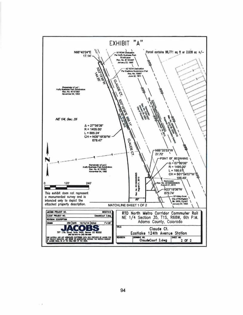
EXHIBIT "A" N66"40'24"E
17.14'
R111111lndtr or L.ol 1 Hllfflt Buolnau Parle SUbdlvilloo
lloc:. No. 111 101887 -••r04, 1992
NE f/4, Sl1c.. 35
ll = 27.56'39" R = 1405.00' L = 685.24' CH = N09.19'39"W
678.47'
0 120' 240'
~ This exhibit does not represent o monumented survey and is intended only to depict the attached property description .
.w:c&S ~ECT NO.
707 17th Sltool, !WIIo 2400, Donwr CO 80202 c-) ........ .._
lie IIAI1JIIIoi,IIIO lilt. -ID ~OAT~ 'IUol Na .. O I!- roo ftllMIIltl__.llO.,.,_OI_III1lQIIMWIIIN-f/l-~· ATIMIIIIU- IWIII(ua.
RTD North Metro Corridor Commuter Rail NE 1/4 Section 35, T1S, R68W, 6th P.M.
Adams County, Colorado
Claude Ct. Eastlake 124th Avenue Station
IPSIOII: ~C NO. Sllf!J NO. ClaudeCourt 2.dwg 2 or 2
94

Exhibit B to the MOU
EXHJBIT"A" CLAUDE COURT VACATION
Date: November 10, Z015 DESCRIPTION
A Parcel of Land, being a portion of Claude Court, as shown, in part, on the plat offfiJFFY BUSINESS PARK SUBDMSION, Reception Number Bll01857, recordedNovember4, 1992, and in part on the plat ofEASTLAKE SUBDIVISION, Reception Number 19897, recorded June 22, 1911 and being a portion of East 12411 Avenue as described at Reception Number Cl201634, recorded August 29, 2003 at the Adams County Clerk and Recorders Office, Adams County, Colorado, located in the Northc:a.st Quarter of Section 35, Township 1 South, Range 68 West of the 6th Principal Meridian, City of Thornton, Adams County, Colorado, being more particularly described as follows:
COMMENCING at the East Quarter Comer of said Section 35 (a found 2-3/8 inch aluminum pipe with a 3-114 inch cap in Range Box stamped ''CITY OF THORNTON UNLAWFUL TO DISTURB 114 TlS R68W S35 S36 1997 PLS 24965''); WHENCE the Center Quarter Comer of said Section (as monumented by a found 2' witness comer being a 3-114" alwninum cap stamped "WC TIS R68W 2.0 C 1/4 S 35 2003 PLS 26600") bean N89"45'43"W a distance of2646.33 feet (basis of bearing - assumed); TIIENCE N89"45'43''W, coincident with the southerly line of said Northeast Quarter, a distance of 741.27 feet to a point on the southerly extension of the easterly Right-of-Way line of said Claude Court; THENCE N23°19'36''W, coincident with said southerly extension, 78.91 feet to the point being the POINT OF BEGINNING;
THENCE N89alS'OS"W, a distance of 123.8S feet to a northeasterly line of said East 124111 Avenue; THENCE the following three (3) courses coincident with said northeasterly lines of East 124111 Avenue:
1) N38"~3'04"E, a distance of2~.13 feet; 2) N8~"08'57"E, a distance of 14.20 feet; 3) NS5"14'56"E, a distance of25.89 feet to the westerly Right-of-Way line of said Claude Court;
THENCE N23"19'36"W, coincident with said westerly Right-of-Way line, a distance of760.64 feet to the intersection of said westerly Right-of-Way line and the westerly extension of the northerly line of Parcel NM-428 described at Reception No. 2014000028474, recorded May 9, 2014; TIIENCE S86"35'53"E, coincident with said westerly extension, a distance of58.22 feet to said easterly Right-of-Way line; THENCE S23°19'36"E, coincident with said easterly Right-of-Way line, a distance of 797.32 feet to the POINT OF BEGINNING.
Containing 42,877 square feet, (0.984 Acres), more or less.
ing Group Inc.
K:I072120_Fastnok.siNORTH METRO\Dcscll..cgalsiSTATJONIEasiL4ko 1241h1Claude_ Court Vacation doc Paae 1 of I
95

Parcel contains 42,8n sq ft or 0.984 oc t /-
10' ROW Dedlcellon Per Hullv Buolnaa Por1c
SUbdilll$1011 Roc. No 81101851 N<>vombor 4, 1992
m 11111 Shill. Sullt 2400. .,_., ca 80202 __ ... ""'_ l!llllllmiL•Jil'I~-- .. ,..IIIDrr-r• flll·~~:r.:~-1111--
\ RTD North Metro Corridor Commuter Rail NE 1/4 Section 35, T1S, R68W, 6th P.M. City of Thornton, Adams County, Colorado
Claude Ct. Vacation Eastlake 124th Avenue Station
REVIS10N: 1lMIIIIIG NO. HEr NO. ClaudeCaurtVacatlon_1.dwg 1 or 1
96

COUNCIL COMMUNICATION Meeting Date: Agenda Item: Agenda Location: Work Plan# Legal Review:
April10, 2018 llD Action Items 341 ~ __ 151 Reading __ 2nd Reading
Subject: A resolution authorizing negotiations and, if necessary, eminent domain proceedings to acquire property interests necessary to construct the Thornton Water Project.
Recommended by: Brett Henry~~ Approved by: Kevin S. Woods Ordinance previously
Presenter(s): Mark Koleber, Thornton Water Project Director ~ introduced by:
SYNOPSIS:
The Thornton Water Project (TWP) includes constructing approximately 75 miles of 48-inch water pipeline, a source water pump station, a booster pump station, and a regulating water storage tank. In order to construct the TWP, the City of Thornton (City) must first acquire the necessary easements and other property interests.
The City has identified areas in the Town of Windsor (Windsor) and in the Town of Johnstown (Johnstown), referenced as TWP Work Package 1, where construction can be completed ahead of planned development. This will save the City money compared to post-development construction. Construction can proceed within town limits without the major land use permits required for construction in unincorporated Weld or Larimer counties. Negotiations are ongoing with all property owners. Bidding for construction within Windsor and Johnstown is planned for January 2019, and the City needs to be in possession of all required property interests to proceed with bidding.
RECOMMENDATION:
Staff recommends Alternative No. 1, approval of the resolution to authorize negotiations and, if necessary, eminent domain proceedings, to acquire property interests necessary to construct the TWP within the proposed schedule.
BUDGET/STAFF IMPLICATIONS:
The 2018 TWP Land Acquisition budget is $9,182,520.
ALTERNATIVES:
1. Approve the resolution authorizing negotiations and, if necessary, eminent domain proceedings, to acquire property interests necessary to construct within the Town of Windsor and the Town of Johnstown (TWP Work Package 1 ).
2. Do not approve the resolution and continue attempting to acquire the needed easements without the use of eminent domain, which may result in not acquiring all the necessary easements to build the TWP, or a delay in constructing the TWP.

COUNCIL COMMUNICATION PAGE2
BACKGROUND CANAL YSIS/NEXT STEPS/HISTORY): (includes previous City Council action)
City Council gave staff direction at the April 3, 2018 Planning Session to bring a resolution to City Council authorizing negotiations and, if necessary, eminent domain proceedings to acquire property interests necessary to construct the TWP Work Package 1.
A total of 16 parcels will need to be crossed for construction within Windsor (7 parcels) and Johnstown (9 parcels). Thornton's land agents have been negotiating with property owners in Windsor and Johnstown to acquire the necessary easements to construct the TWP through these towns.
Thornton staff identified properties within Windsor and Johnstown, in addition to those that were planned for near-term development, for early TWP construction in order to create Work Package 1 -a cost-efficient work package for construction. The early construction will be completed entirely within the Windsor and Johnstown corporate limits, so major land use permits from Weld or Larimer counties will not be required. Bidding for construction services of the TWP Work Package 1 is planned to begin in January 2019.
In July of 2017, staff identified two areas along the TWP alignment on which near-term development was planned. City Council directed staff to pursue early construction of the TWP across these areas in order to avoid the additional cost of post-development construction.

RESOLUTION
A RESOLUTION AUTHORIZING NEGOTIATIONS AND, IF NECESSARY, EMINENT DOMAIN PROCEEDINGS TO ACQUIRE PROPERTY INTERESTS NECESSARY TO CONSTRUCT THE THORNTON WATER PROJECT.
WHEREAS, the City of Thornton (City) is a home rule municipality of the State of Colorado delegated with the legal authority and power of eminent domain; and
WHEREAS, the City's population is projected to increase from its current population of 133,542 residents (City of Thornton, Third Quarter 2016, Population and Housing Inventory Summary estimate) to 242,000 residents by 2065; and
WHEREAS, the City has proactively planned for the anticipated population increase to ensure that the City can provide a high-quality, reliable, diverse, and economical water supply to meet the needs of its residents and businesses; and
WHEREAS, the City's existing water system, including an extensive water conservation program, has served to meet municipal and industrial water needs of the City's current water customers in its service area, as well as to meet existing contractual obligations; and
WHEREAS, the City's water supply projects in development will allow the City to provide water service up to a population of 150,000 residents. However, beyond 150,000 residents, which the City projects to reach by 2025, additional water supplies are needed to ensure reliable water service to the City's water customers; and
WHEREAS, water from the Water Supply and Storage Company (WSSC) system in Northern Colorado was purchased by the City in the mid-1980s from willing sellers and this high quality source has been decreed in Water Court for use in the City, but the City currently lacks the infrastructure necessary to deliver that water to the City; and
WHEREAS, the City has approved the construction, operation, and maintenance of a water project known as the Thornton Water Project (TWP), a water pipeline that will provide the infrastructure necessary to convey the City-owned WSSC system water from northern Colorado to the City; and
WHEREAS, the City has determined that it is necessary to acquire certain properties and property interests, as shown in Exhibits A 1 - A 18 attached hereto and incorporated herein by this reference, in fee simple, by right-of-way, permanent easements, and temporary construction easements or whatever other property interests that may be required for the design and construction of the TWP to serve the public purpose of providing the City's customers the benefit of Thornton's decades-long planning for and investment in this additional high quality water supply to enhance the diversity and reliability of the City's water supply, provide drought resiliency, help address source water quality issues,

and meet municipal and industrial demands of the City's water customers through 2065; and
WHEREAS, the City intends to acquire the properties and property interests identified in Exhibits A 1 -A 18 for the lWP; and
WHEREAS, the property interests identified above are necessary for the lWP and there is an immediate need to secure those interests; and
WHEREAS, for the specific properties and property interests necessary for the lWP, as shown in Exhibits A 1 -A 18, City Council authorizes City staff and consultants to conduct good faith negotiations with the property owners in accordance with the law; and
WHEREAS, City Council directs that if good faith negotiations for the voluntary acquisition of such property prove unsuccessful the City is authorized to commence eminent domain proceedings to acquire properties and to prosecute the proceedings to their conclusion; and
WHEREAS, the lWP is necessary for the health, safety, and welfare of the residents of the City.
NOW, THEREFORE, BE IT RESOLVED BY THE CITY COUNCIL OF THE CITY OF THORNTON, COLORADO, AS FOLLOWS:
1. The acquisition of the properties and property interests described in Exhibits A 1 - A 18, or whatever other property interests that may be required, for the design, construction, operation, and maintenance of the lWP is necessary for completion of the lWP.
2. The acquisition of such properties and property interests for the lWP serves the public purpose of providing the City's customers the benefit of the City's decades-long planning for and investment in a high quality water supply from the WSSC water system to enhance the diversity and reliability of the City's water supply, provide drought resiliency, help address source water quality issues, and meet municipal and industrial demands of the City's water customers through 2065 and is necessary for the health, safety, and welfare of the residents of the City.
3. That the City Manager, or designee, is hereby authorized to negotiate in good faith with and to make offers of just compensation to the owners of the properties for the voluntary acquisition thereof.
4. If negotiations for the acquisition of the properties prove unsuccessful that upon approval of the City Manager, the City Attorney, or designee, and other proper officials and City staff are authorized to file an eminent domain action, or any other proceedings as may be necessary, to acquire the
2

properties described in Exhibits A 1 - A 18, and the City is authorized to employ all necessary persons for this purpose, including special eminent domain counsel, appraisers, surveyors, engineers, and other experts as necessary. The City also authorizes obtaining immediate possession of the properties, if deemed necessary to further the TWP.
5. The City, its staff, or consultants, consistent with the intent of the TWP, shall have the authority to amend or modify the legal descriptions of the parcels to be acquired, the nature of the interests to be acquired, and may add or delete parcels, in whole or in part, as deemed necessary for the TWP and any such amendments shall be included in the definition of the properties and property interests described in Exhibits A 1 -A 18.
6. That the City Manager, or designee, is authorized to execute and the City Clerk to attest any document necessary for the acquisition of the property or property interests required for the TWP.
PASSED AND ADOPTED at a regular meeting of the City Council of the City of Thornton, Colorado, on , 2018.
CITY OF THORNTON, COLORADO
Heidi K. Williams, Mayor
ATTEST:
Kristen N. Rosenbaum, City Clerk
3

Thornton Water Project
105907000022
Parcel Boundary CITY OF THORNTON COLORADO W.E -· · County Boundary
Eminent Domain Considered
s 1 inch = 1,400 feet
0 700 1,400 4/512016 - - !feet
Thornton Water Project Johnstown Area Alignment
Potential Eminent Domain Parcels Exhibit A1

CITY OF THORNTON COLORADO 12450 WASHINGTON ST THORNTON. CO 80241-2405 0 400
Thornton Water Project
I:IParcel Boundary - · River/Stream/Canal/Ditch
Easement Acquisition Area
Exhibit A2-Page 1

Exhibit A2 - Page 2
Weld County Parcel No. 105917000010
Township 4 North, Range 67 West, Section 17, 6th Principal Meridian
Acquire a 50-foot permanent easement and a 40-foot temporary construction easement, plus additional temporary construction easement up to 200 feet in width for tunnel crossings of the little Thompson River and Hillsborough Ditch, within the westerly 200 feet of Weld County Parcel Number 105917000010 as depicted on Exhibit A2 - Page 1.

~Tllornton ~ ~ WATE.n PROJECT
CITY OF THORNTON COLORADO 12450 WASHINGTON ST THORNTON, CO 80241-2405
4/5/2018
0 200
Thornton Water Project
CParcel Boundary ---·- River/Stream/Canal/Ditch • i Easement Acquisition Area
Exhibit A3-Page 1

Exhibit A3 - Page 2
Weld County Parcel No. 105908300002
Township 4 North, Range 67 West, Section 8, 6th Principal Meridian
Acquire a 50-foot permanent easement and a 40-foot temporary construction easement within the westerly 200 feet ofthe southerly 200 feet of Weld County Parcel Number 105908300002 as depicted on Exhibit A3 - Page 1.

CITY OF THORNTON COLORADO 12450 WASHINGTON ST THORNTON, CO 80241-2405
4/5/2018
0 225
Thornton Water Project
CParcel Boundary Exhibit A4-Page 1 - River/Stream/Canal/Ditch - Easement Acquisition Area

Exhibit A4 - Page 2
Weld County Parcel No. 105907000022
Township 4 North, Range 67 West, Section 7, 6th Principal Meridian
Acquire a 50-foot permanent easement and a 40-foot temporary construction easement, plus additional temporary construction easement up to 200 feet in width for tunnel crossing of the Hillsborough Ditch, within the southerly 200 feet; and westerly 150 feet of the southerly 750 feet of Weld County Parcel Number 105907000022 as depicted on Exhibit A4- Page 1.

CITY OF THORNTON COLORADO 12450 WASHINGTON ST THORNTON, CO 80241-2405
4/5/2018
0 150
Thornton Water Project
I:]Parcel Boundary ··- River/Stream/Canal/Ditch
Easement Acquisition Area
Exhibit AS-Page 1

Exhibit AS - Page 2
Weld County Parcel No. 10S907300044
Township 4 North, Range 67 West, Section 7, 6th Principal Meridian
Acquire a 50-foot permanent easement and a 40-foot temporary construction easement within the easterly 150 feet of the northerly 800 feet of Weld County Parcel Number 105907300044 as depicted on Exhibit AS- Page 1.

CITY OF THORNTON COLORADO 12450 WASHINGTON ST THORNTON, CO a0241-2405 0
N II'. E s
200
Thornton Water Project
400
CParcel Boundary Easement Acquisition Area
Exhibit AS-Page 1

Exhibit A6 - Page 2
Weld County Parcel No. 105907300043
Township 4 North, Range 67 West, Section 7, 6th Principal Meridian
Acquire a 50-foot permanent easement and a 40-foot temporary construction easement, plus additional temporary construction easement up to 150 feet in width for tunnel crossing of the Great Western Railroad, within the easterly 150 feet of the southwest J4 of Section 7, Township 4 North, Range 67 West, 6th Principal Meridian in Weld County Parcel Number 105907300043 as depicted on Exhibit A6- Page 1.

11.:i.\..Thomton ~~WATER PROJECT
CITY OF THORNTON COLORADO 12450 WASHINGTON ST THORNTON, CO 60241·2405
4/5/2018
Thornton Water Project
CParcel Boundary Exhibit A7-Page 1 - Easement Acquisition Area

Exhibit A7 - Page 2
Weld County Parcel No. 105907000001
Township 4 North, Range 67 West, Section 7, 6th Principal Meridian
Acquire a 50-foot permanent easement and a 40-foot temporary construction easement, plus additional temporary construction easement up to 150 feet in width for tunnel crossings of the Great Western Railroad and Colorado State Highway 60, within the easterly 150 feet; and the easterly 1,500 feet of the northerly 150 feet of Weld County Parcel Number 105907000001 as depicted on Exhibit A7- Page 1.

li:i.t Thornton ~~WATER PROJECT
CITY OF THORNTON COLORADO 12450 WASHINGTON ST THORNTON, CO 80241-2405
4/5/2018
0 150
Thornton Water Project
CParcel Boundary ~ - River/Stream/Canal/Ditch
Easement Acquisition Area
Exhibit AS-Page 1

Exhibit AS - Page 2
Weld County Parcel No. 105906300040
Township 4 North, Range 67 West, Section 6, 6th Principal Meridian
Acquire a 50-foot permanent easement and a 40-foot temporary construction easement, plus additional temporary construction easement up to 150 feet in width for tunnel crossing of Colorado State Highway 60, within the easterly 150 feet of Weld County Parcel Number 105906300040 as depicted on Exhibit A8 -Page 1.

II.ALTbomton ~~WATER PROJECT
CITY OF THORNTON COLORADO 12450 WASHINGTON ST THORNTON. CO 80241·2405
. ,,
0
" w.r; s
225
Thornton Water Project
450
CParcel Boundary - River/Stream/Cana I/O itch
Easement Acquisition Area
Exhibit A9-Page 1

Exhibit A9 - Page 2
Weld County Parcel No. 105906000005
Township 4 North, Range 67 West, Section 6, 6th Principal Meridian
Acquire a 50-foot permanent easement and a 40-foot temporary construction easement within the southerly 350 feet of the westerly 1,260 feet; and the westerly 200 feet of Weld County Parcel Number 105906000005 as depicted on Exhibit A9- Page 1.

~Thornton ~ =\f-\'lATER PROJECl
CITY OF THORNTON COLORADO 12450 WASHINGTON ST THORNTON, CO 80241-2405
4/5/2018
0
•' \.F. s
250
Thornton Water Project
CParcel Boundary -- County Boundary • i Easement Acquisition Area
Exhibit A10-Page 1

Exhibit A10 - Page 2
Weld County Parcel No. 106101000014
Township 4 North, Range 68 West, Section 1, 6th Principal Meridian
Acquire a 50-foot permanent easement and a 40-foot temporary construction easement within the easterly 200 feet of Weld County Parcel Number 106101000014 as depicted on Exhibit A10- Page 1.

Thornton Water Project
080719000045
08073020100,1
08073032·1 016
Parcel Boundary CITY OF THORNTON COLORADO W. E --- County Boundary
Eminent Domain Considered
s 1 inch = 1 ,200 feet
0 600 1,200 4/5/2018 - - •Feet
Thornton Water Project Windsor Area Alignment
Potential Eminent Domain Parcels Exhibit A11

~Thornton ~ ~ WATiiR PnOJ!:CT
CITY OF THORNTON COLORADO 12450 WASHINGTO~i ST THORNTON, CO 802,11-2405 0
N IV.E .:7-i s
250
Thornton Water Project
500
I I Parcel Boundary -- County Boundary
Easement Acquisition Area
Exhibit A 12-Page 1

Exhibit A12 - Page 2
Weld County Parcel No. 080731335003
Township 6 North, Range 67 West, Section 31, 6th Principal Meridian
Acquire a 50-foot permanent easement and a 40-foot temporary construction easement within the westerly 150 feet of Weld County Parcel Number 080731335003 as depicted on Exhibit A12- Page 1.

CITY OF THORNTON COLORADO 12450 WASHINGTON ST THORNTON, CO 80241-2405
4/5/2018
0
N W.E s
200
Thornton Water Project
CParcel Boundary -- County Boundary
Easement Acquisition Area
Exhibit A13-Page 1

Exhibit A13 - Page 2
Weld County Parcel No. 080731335004
Township 6 North, Range 67 West, Section 31, 6th Principal Meridian
Acquire a 50-foot permanent easement and a 40-foot temporary construction easement within the westerly 150 feet of Weld County Parcel Number 080731335004 as depicted on Exhibit A13- Page 1.

Thornton Water Project
. - ---------. - ~. - -- . - . ""' ~ ~ . -- ..,..._- - .. • ''i~~-~- ·- _..,=~- -~· ~ -· .... • . - ~-. ~ ~· ~- ' 1 -· ·.- -· u~ . · •
~ . ... - -- ~ -
~Thomton ~ ~ WAT~R PROJECT
CITY OF THORNTON COLORAD O 12450 WASHINGTON ST THORNTON. CO 80241-2405
415/2018
0 400
CParcel Boundary - - County Boundary
Easement Acquisition Area
Exhibit A14-Page 1

Exhibit A14 - Page 2
Weld County Parcel No. 080730321016
Township 6 North, Range 67 West, Section 30 and 31, 6th Principal Meridian
Acquire a 50-foot permanent easement and a 40-foot temporary construction easement within the westerly 150 feet of Weld County Parcel Number 080730321016 as depicted on Exhibit A14- Page 1.

~'nlomton ~ ~ WATf.~ PROJECT
CITY OF THORNTON COLORADO 12450 WASHINGTON ST THORNTON. CO 80241-2405 0 300
Thornton Water Project
CParcel Boundary Exhibit A15-Page 1 - River/Stream/Canal/Ditch -- County Boundary
Easement Acquisition Area

Exhibit A15 - Page 2
Weld County Parcel No. 080730201001
Township 6 North, Range 67 West, Section 30, 6th Principal Meridian
Acquire a 50-foot permanent easement and a 40-foot temporary construction easement within the westerly 150 feet of Weld County Parcel Number 080730201001 as depicted on Exhibit A15- Page 1.

f1.ltThomton \\.__ ~ WA.TOl PROJ~CT
CITY OF THORNTON COLORADO 12450 WASHINGTON ST THORNTON, CO 80241-2405 0
I
\\'·· s
300
Thornton Water Project
Exhibit A 16-Page 1 - River/Stream/Canal/Ditch -- County Boundary
Easement Acquisition Area
600 Feet

Exhibit A16 - Page 2
Weld County Parcel No. 080719000045
Township 6 North, Range 67 West, Section 19, 6th Principal Meridian
Acquire a 50-foot permanent easement and a 40-foot temporary construction easement, plus additional permanent and temporary construction easements up to 250 feet in width for tunnel crossing oft he Cache Ia Poudre River, within the westerly 250 feet of Weld County Parcel Number 080719000045 as depicted on Exhibit A16 - Page 1.

f/AThomton \\......~ WATER PROJCCT
CITY OF THORNTON COLORADO 12450 WASHINGTON ST THORNTON. CO 80241-240 5
\\". F. s
0 175
Thornton Water Project
350
C Parcel Boundary - River/Stream/Canal/Ditch -- County Boundary
Easement Acquisition Area
Exhibit A17-Page 1

Exhibit A17- Page 2
Weld County Parcel No. 080719000050
Township 6 North, Range 67 West, Section 19, 6th Principal Meridian
Acquire a 50-foot permanent easement and a 40-foot temporary construction easement, plus additional permanent and temporary construction easements up to 250 feet in width for tunnel crossing oft he Cache Ia Poudre River, within the westerly 250 feet of Weld County Parcel Number 080719000050 as depicted on Exhibit A17- Page 1.

11A\,.Thomton ~ ~ WATI:A PROJ ECT
CITY OF THORNTON COLORADO 12450 WASHINGTON ST THORNTON. CO 60241-2405
4/5/2018 1 lltl 'I t 'I •U ~'I
0
Thornton Water Project
CParcel Boundary - River/Stream/Canal/Ditch -- County Boundary
Easement Acquisition Area
Exhibit A 18-Page 1

Exhibit A18 - Page 2
Larimer County Parcel No. 8624000901
Township 6 North, Range 68 West, Section 24, 6th Principal Meridian
Acquire a 50-foot permanent easement and a 40-foot temporary construction easement, plus additional temporary construction easement up to 150 feet in width for tunnel crossing of Colorado State Highway 392, within the easterly 150 feet oft he northerly 1,200 feet of Larimer County Parcel Number 8624000901 as depicted on Exhibit A18- Page 1.

COUNCIL COMMUNICATION Meeting Date: Agenda Item: Agenda Location: Work Plan# Leg a ~ Review:
April 10, 2018 llE Action Items ~ ~ _x_ 1st Reading __ 2nd Reading
Subject: An ordinance amending City Code Section 26-90(a), contracts app?bved by City Council; Exceptions, to authorize the City Manager to approve revocable permits issued to the City in addition to easements, permits, rights-of-entry, and rights-of-way that are issued to the City concerning the use of real property for the routine conduct of City business that are already authorized in this section.
Recommended by: Brett Henry w~ Approved by: Kevin S. Woods Ordinance previously
Presenter(s): Mark Koleber, Thornton Water Project Director ~ introduced by:
SYNOPSIS:
The City Code currently authorizes the City Manager to approve easements, permits, or similar documents between governmental bodies, but excluding revocable permits, concerning the use of real property for the routine conduct of City business. The Code doesn't differentiate between revocable permits issued by the City or revocable permits received by the City. This proposed ordinance amends the City Code to authorize the City Manager to approve revocable permits issued to the City in addition to documents issued to the City that the City Manager is already authorized to approve. City Council will continue to approve all revocable permits that are granted by the City for use of public properties.
Thornton's City Code requires City Council to approve by resolution all intergovernmental agreements and all revocable permits but includes an exclusion that authorizes the City Manager to approve any easement, utility permit, or other similar document between governmental bodies concerning the use of real property issued to the City when the document is necessary for the routine conduct of City business, but not revocable permits. The Code further states that the City Manager is authorized to approve these documents so long as the amount is not greater than $10,000. Staff anticipates that the City will need to acquire or enter into over 300 revocable permits, easements, utility permits, or other similar documents to construct the Thornton Water Project (TWP), many of which could involve an amount over $10,000 and be with various types of governmental entities. Given the large number of these documents and the fact that the payments must be included in an approved budget, staff is recommending the Code be changed to remove the requirement for City Council to approve such documents received by the City and allow the City Manager to approve them.
RECOMMENDATION:
Staff recommends Alternative No. 1, approval of the ordinance to amend the City Code to authorize the City Manager to approve revocable permits issued to the City in addition to documents issued to the City that the City Manager is already authorized to approve (all agreements that grant easements, permits, rights-of-entry, and rights-of-ways that are issued to the City concerning the use of real property for the routine conduct of City business). The ordinance also removes the limitation that the City Manager may only approve such agreements issued to the City that involve amounts less than $10,000 because the payments must be included in an approved budget.
BUDGET/STAFF IMPLICATIONS:
The acquisition of property interests, including revocable permits, are included in the 2018 TWP Land Acquisition budget.

COUNCIL COMMUNICATION PAGE2
ALTERNATIVES:
1. Approve the ordinance to amend the City Code to remove the requirement that City Council approve revocable permits and the receipt of easements, utility permits, or other similar documents that involve amounts greater than $10,000 from other governmental bodies.
2. Do not approve the ordinance and continue to bring individual revocable permits, as well as easements, utility permits or other similar documents that involve amounts in excess of $10,000 to City Council for consideration of approval.
BACKGROUND (ANALYSIS/NEXT STEPS/HISTORY): (includes previous City Council action)
Staff reviewed this item with City Council at the April 3, 2018 Planning Session and Council gave direction to bring an ordinance forward amending the City Code.

INTRODUCED BY: _____ _
AN ORDINANCE AMENDING CITY CODE SECTION 26-90(A), CONTRACTS APPROVED BY CITY COUNCIL; EXCEPTIONS, TO AUTHORIZE THE CITY MANAGER TO APPROVE REVOCABLE PERMITS ISSUED TO THE CITY IN ADDITION TO EASEMENTS, PERMITS, RIGHTS-OF-ENTRY, AND RIGHTS-OF-WAY THAT ARE ISSUED TO THE CITY CONCERNING THE USE OF REAL PROPERTY FOR THE ROUTINE CONDUCT OF CITY BUSINESS THAT ARE ALREADY AUTHORIZED IN THIS SECTION.
WHEREAS, Chapter 26 of the City Code regulates finance and taxation in the City and provides for contracts to be approved by City Council with certain exceptions for easements, utility permits, or similar documents involving amounts less than $10,000 between governmental bodies necessary for the routine conduct of City business; and
WHEREAS, currently the City Code requires that all revocable permits be approved by City Council by resolution; and
WHEREAS, the City Council has determined that it is in the City's best interest for the efficient conduct of routine City business to eliminate the requirement that all revocable permits be approved by City Council by resolution and clarify that only revocable permits granted by the City need to be approved by City Council by resolution; and
WHEREAS, currently the City Code does not allow the City Manager to approve the receiving of easements, utility permits, or similar documents between governmental bodies necessary for the routine conduct of City business if the cost of such documents exceeds $10,000.00; and
WHEREAS, the City Council has determined that it is in the City's best interest for the efficient conduct of routine City business to eliminate the prohibition against the City Manager approving the receiving of easements, utility permits, or similar documents between governmental bodies necessary for the routine conduct of City business if the cost of such documents exceeds $10,000.00.
NOW, THEREFORE, BE IT ORDAINED BY THE CITY COUNCIL OF THE CITY OF THORNTON, COLORADO, AS FOLLOWS:
1. Section 26-90(a) is hereby amended by the addition of the words doubleunderlined and the deletion of the words stricken to read as follows:
Sec. 26-90. Contracts approved by city council; exceptions.
(a) The city council shall approve all intergovernmental agreements and ~all revocable permits issued by the city by resolution. Except, the city manager may approve agreements that grant the receiving of any

easement,§, HWity permit,§, riqhts-of-entrv. and rights-of-way issued to the ~ or similar document between gov:emmental boales, but excluding revocable permits, concerning the use of real property when such document is necessary for the routine conduct of city business ana aoes not invoWe an amount in excess of $1 0,000.00; such documents are predominantly unilateral in nature anG-at=e not deemed to be intergovernmental agreements for purposes of this article.
2. If any portion of this ordinance is held to be unconstitutional or invalid for any reason, such decision shall not affect the constitutionality or validity of the remaining portions of this ordinance. City Council hereby declares that it would have passed this ordinance and each part hereof irrespective of the fact that any one part be declared unconstitutional or invalid.
3. All other ordinances or portions thereof inconsistent or conflicting with this ordinance or any portions hereof are hereby repealed to the extent of such inconsistency or conflict.
4. The repeal or amendment of any provision of the Code by this ordinance shall not release, extinguish, alter, modify, or change in whole or in part any penalty, forfeiture, or liability, either civil or criminal, which shall have been incurred under such provision, and each provision shall be treated and held as still remaining in force for the purpose of sustaining any and all proper actions, suits, proceedings, and prosecutions for the enforcement of the penalty, forfeiture, or liability, as well as for the purpose of sustaining any judgment, decree, or order which can or may be rendered, entered, or made in such actions, suits, proceedings, or prosecutions.
5. This ordinance shall take effect upon final passage.
INTRODUCED, READ, PASSED on first reading, ordered posted in full, and title ordered published by the City Council of the City of Thornton, Colorado, on -------' 2018.
PASSED AND ADOPTED on second and final reading on ______ , 2018.
CITY OF THORNTON, COLORADO
Heidi K. Williams, Mayor
ATTEST:
Kristen N. Rosenbaum, City Clerk
2

THIS ORDINANCE IS ON FILE IN THE CITY CLERK'S OFFICE FOR PUBLIC INSPECTION.
APPROVED AS TO LEGAL FORM:
Luis A. Corchado, City Attorney
PUBLICATION:
Posted in six (6) public places after first and second readings.
Published in the Northglenn-Thornton Sentinel after first reading on _ ____ , 2018, and after second and final reading on , 2018.
3