() Stantec - Wisconsin DNR
76
Stantec Consulting Services Inc. 12075 Corporate Parkway Suite 200, Mequon WI 53092-2649 April 24, 2020 File: 193804026 Attention: Mr. Adam McIlheran Hydrogeologist Wisconsin Department of Natural Resources Southeast Region, Milwaukee Service Center 2300 N. Dr. Martin Luther King Drive Milwaukee, WI 53212 Reference: Response to NR716 Site Investigation Review: Eco-Tech of Milwaukee, Inc., 1016 North Hawley Road, Milwaukee, WI WDNR BRRTS #03-41-285162 and #02-41-278837 Dear Mr. McIlheran, During December 2019, Stantec Consulting Services Inc. (Stantec) submitted the Supplemental NR 716 Site Investigation Information, Eco-Tech of Milwaukee, Inc. (Stantec, 2019) in support of the Site Investigation and Remedial Action Options Report (SIR/RAOR) dated June 20, 2018 and prepared by LF Green Development, LLC (LF Green) requesting concurrence from the Wisconsin Department of Natural Resources (WDNR) that no further investigation is required at the Eco-Tech of Milwaukee, Inc. property located at 1016 North Hawley Road, Milwaukee, Wisconsin (the Property or the Site). In email correspondence dated March 12, 2020, the WDNR responded with a request for additional information. In response, Stantec prepared this letter which provides the WDNRs requests in underlined bold italics, followed by Stantec’s response to address that request. Please use this information to complete the NR716 SI review. WDNR requests (in italics) and applicable responses are provided below. Sources/Receptors: Figure 2, or an additional figure, should include all pertinent site features to the extent practical, including surface covers, river wall, utilities, parcel numbers, addresses, identify RR property to north and land use on other properties on the figure including BRRTS cases if applicable, and any other pertinent historical source features. Response: Figure 2 has been updated to include these features. Sources/Receptors: A description of any utilities in or around the site should be included and a determination if they are or could be a migration pathway. This would include any outfalls or seeps along the river. Response: Per the Triad Engineering Inc. (Triad) Site Investigation Work Plan dated October 5, 2001 (Triad, 2001) referenced within the Bloom Companies, LLC (Bloom) Work Plan, Eco-Tech Site Investigation dated March 2012 (Bloom, 2012), the buildings which previously occupied the Property had no municipal sewer or water connections. A sump and possibly a leach bed was located beneath one of the building connections (Bloom, 2012). An apparent sump near the northwest property corner of the building remained visible as of November of 2013, and its approximate reported location is included on the updated figure sets as part of this submittal. Stantec did not observe evidence of the sump during site investigation activities performed at the Property in April 2019. The reported sump location is in a proposed area of cut as part of grading for future levee construction and will be removed thereby eliminating the potential for this feature to be a migration pathway. () Stantec Design with community in mind
-
Upload
khangminh22 -
Category
Documents
-
view
2 -
download
0
Transcript of () Stantec - Wisconsin DNR

Stantec Consulting Services Inc. 12075 Corporate Parkway Suite 200, Mequon WI 53092-2649
April 24, 2020 File: 193804026
Attention: Mr. Adam McIlheran Hydrogeologist Wisconsin Department of Natural Resources Southeast Region, Milwaukee Service Center 2300 N. Dr. Martin Luther King Drive Milwaukee, WI 53212
Reference: Response to NR716 Site Investigation Review: Eco-Tech of Milwaukee, Inc., 1016 North Hawley Road, Milwaukee, WI WDNR BRRTS #03-41-285162 and #02-41-278837
Dear Mr. McIlheran,
During December 2019, Stantec Consulting Services Inc. (Stantec) submitted the Supplemental NR 716 Site Investigation Information, Eco-Tech of Milwaukee, Inc. (Stantec, 2019) in support of the Site Investigation and Remedial Action Options Report (SIR/RAOR) dated June 20, 2018 and prepared by LF Green Development, LLC (LF Green) requesting concurrence from the Wisconsin Department of Natural Resources (WDNR) that no further investigation is required at the Eco-Tech of Milwaukee, Inc. property located at 1016 North Hawley Road, Milwaukee, Wisconsin (the Property or the Site). In email correspondence dated March 12, 2020, the WDNR responded with a request for additional information. In response, Stantec prepared this letter which provides the WDNRs requests in underlined bold italics, followed by Stantec’s response to address that request. Please use this information to complete the NR716 SI review.
WDNR requests (in italics) and applicable responses are provided below.
Sources/Receptors: Figure 2, or an additional figure, should include all pertinent site features to the extent practical, including surface covers, river wall, utilities, parcel numbers, addresses, identify RR property to north and land use on other properties on the figure including BRRTS cases if applicable, and any other pertinent historical source features.
Response: Figure 2 has been updated to include these features.
Sources/Receptors: A description of any utilities in or around the site should be included and a determination if they are or could be a migration pathway. This would include any outfalls or seeps along the river.
Response: Per the Triad Engineering Inc. (Triad) Site Investigation Work Plan dated October 5, 2001 (Triad, 2001) referenced within the Bloom Companies, LLC (Bloom) Work Plan, Eco-Tech Site Investigation dated March 2012 (Bloom, 2012), the buildings which previously occupied the Property had no municipal sewer or water connections. A sump and possibly a leach bed was located beneath one of the building connections (Bloom, 2012). An apparent sump near the northwest property corner of the building remained visible as of November of 2013, and its approximate reported location is included on the updated figure sets as part of this submittal. Stantec did not observe evidence of the sump during site investigation activities performed at the Property in April 2019. The reported sump location is in a proposed area of cut as part of grading for future levee construction and will be removed thereby eliminating the potential for this feature to be a migration pathway.
() Stantec
Design with community in mind

April 24, 2020 Page 2 of 9
Reference: Response to NR716 Site Investigation Review, Eco-Tech of Milwaukee, Inc. 1016 North Hawley Road, Milwaukee, WI WDNR BRRTS #03-41-285162 and #02-41-278837
In May and August of 2018 Stantec visually evaluated the integrity of the entire Works Progress Administration (WPA) wall along the Menomonee River/southern Property boundary throughout the Project Corridor. Stantec evaluated and documented outfalls, weep holes, and potential wall stress and failures. Stantec observed no active seeps or outfalls from the WPA wall bordering the Property, including areas east and west of the Property. Photos and documentation are available upon request.
Soil Assessment: Clarify which COCs you are attributing to which sources at the site (such as metals and PAHs due to fill, PVOCs due to petroleum storage, CVOC impacts due to historical activities, etc.). If multiple sources of certain COCs are attributable that should be stated.
Response: Petroleum volatile organic compounds (PVOCs) reported in Property soils consist primarily of naphthalene, benzene, ethylbenzene, toluene, and xylenes. The petroleum compounds were reported in both saturated and unsaturated samples in the northern and central portions (and a small, isolated area on the eastern end) of the Property and likely correspond with the location of several former petroleum aboveground storage tanks (ASTs) and historical surface releases occurring from railroad offloading of petroleum product (refer to Figure 8). PVOC concentrations are highest within the former AST area.
Chlorinated volatile organic compounds (CVOCs) were primarily reported in two distinct areas – the northwest Property corner and within the former AST area (refer to Figures 5, 6 and 7). The CVOC detections are likely related to activities conducted within and adjacent to the former structures and tanks in these areas. The facility had operated as a waste oil and rag reclamation service, a potential source of CVOCs. A sump was located in the northwestern portion of Property, and historical evidence indicates that the sump discharged to a leach bed located beneath the former structure. No CVOC detections in soil at the Property were reported at concentrations greater than direct contact standards.
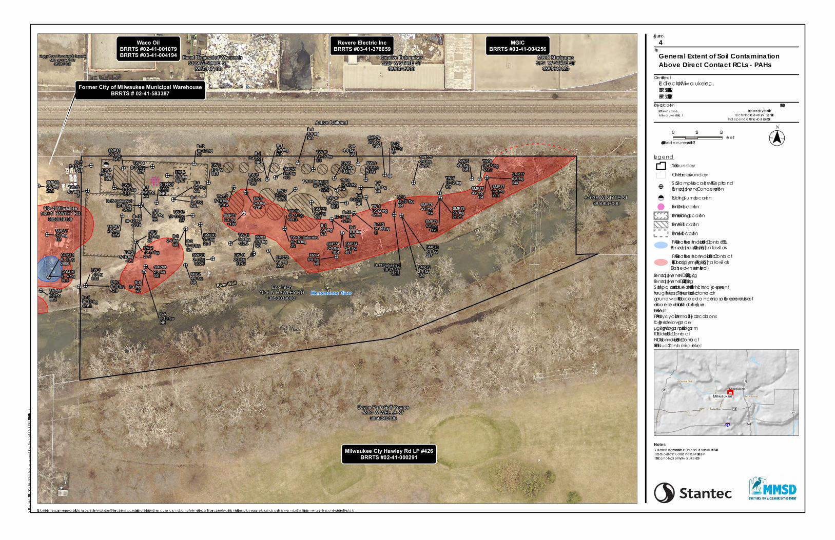
Polycyclic aromatic hydrocarbons (PAHs) are present along the southern and eastern portions of the Property and at other shallow, isolated areas typically associated with fill materials (refer to Figure 4). None of the reported concentrations exceed Industrial Direct Contact (IDC) Residual Contaminant Levels (RCLs).
Metals, including lead, cadmium, barium and mercury at concentrations greater than Groundwater Pathway RCLs and arsenic at concentrations greater than the IDC RCL, are present across the Property (refer to Figure 3). The arsenic concentrations are generally just above the established background threshold value (BTV) in soil and are likely associated with background concentrations. Remaining metals concentrations greater than the Groundwater Pathway RCL are likely associated with the presence of fill materials.
Due to the widespread presence of fill across the Property, the following note has been added to the figures depicting metal and PAH soil concentrations on Figure 3 and Figure 4, respectively:
“Soil impacts are attributed to historic fill which may be present throughout the property. Therefore, direct contact or groundwater RCL exceedances may also be present outside of estimated extents illustrated on this figure.”
~ Stantec
Design with community In mind

April 24, 2020 Page 3 of 9
Reference: Response to NR716 Site Investigation Review, Eco-Tech of Milwaukee, Inc. 1016 North Hawley Road, Milwaukee, WI WDNR BRRTS #03-41-285162 and #02-41-278837
Soil Assessment: Submit any missing borehole abandonment forms or an acceptable explanation why they were not submitted.
Response: Borehole abandonment forms for the March 2012 soil borings (B-10 through B-16, TW-6 through TW-16), the April 2019 soil borings (SMP-67 through SMP-81) and geotechnical boring STN-07 performed in October 2018 were not previously provided and are included as Appendix A, Appendix B and Appendix C, respectively in this letter response.
Borehole abandonment forms for the August 2017 through October 2018 soil borings (EW-1 through EW-11) were previously submitted to WDNR as part of the LF Green Site Investigation and Remedial Action Options Report dated June 20, 2018 (LF Green, 2018). Temporary monitoring wells installed in March 2012 remain on site and will be abandoned prior to construction.
Soil Assessment: Soil figures appear to indicate no soil impacts offsite to the north. Clarify what data or information this is based upon. Confirm that the SIR is stating vertical delineation of soil impacts is achieved by intersection with the water table.
Response: The soil data indicate that petroleum constituents on the Property are present adjacent to the railroad corridor where multiple ASTs were located and where railroad off-loading and on-loading occurred.
Stantec reviewed documentation available for investigations performed at the north-adjoining property to the Site, former Waco Oil Company (refer to Figure 2), to further assess impacts that may have been previously documented north of the Site. As outlined in the report entitled Final Case Closure – Waco Oil Company (Bulk Storage Area) prepared by Delta Environmental Consultants, Inc. (Delta), several soil borings were installed within the railroad right of way to assess offsite/downgradient impacts from a former Waco Oil AST bulk storage area adjacent to the railroad (BRRTS #02-41-001079). The Residual Soil Contamination Map (Figure 1) of the Delta (2005) submittal indicated that one downgradient soil boring (B-30) installed in October 1988 approximately 25 feet north of the Property boundary had significant PVOC detections; this figure is included in Appendix D of this submittal. These results, together with soil analytical data collected as part of subsequent investigations performed on the Property, suggest that soil impacts likely extend off-site to the north of the Property beneath the railroad corridor. Figure 8 has been updated to show inferred impacted PVOC contamination extent on the north-adjoining railroad property.
Based on groundwater elevations collected from temporary monitoring wells and conditions encountered during drilling, seven of the 17 deep soil samples collected in March 2012 (Tables 5, 6 and 7) are considered saturated. Therefore, in some areas, contamination extends through the soil column into groundwater.
Soil Assessment: Not all soil sample data listed in the SIR tables appear to be included in the figures, and some data on the figures are not included in any tables, such as the 2001 soil data and the STN series borings. Revisions should be made where necessary for the information depicted in the figures and tables to correlate, noting any discrepancies if necessary.
~ Stantec
Design with community In mind

April 24, 2020 Page 4 of 9
Reference: Response to NR716 Site Investigation Review, Eco-Tech of Milwaukee, Inc. 1016 North Hawley Road, Milwaukee, WI WDNR BRRTS #03-41-285162 and #02-41-278837
Response: The soil boring and associated analytical data from the December 2001 and April 2002 Arcadis G&M, Inc. (Arcadis) investigations (B-1 through B9 and MW-2 through MW-5) is now incorporated on all soil figures and is summarized compared to current standards on Table 3 of this submittal. STN-07, performed as part of the October 2018 LF Green investigation, is also represented on these figures and analytical results are included on Table 12 of this submittal. The soil and groundwater data collected from these locations were provided in the LF Green (2018) SIR/RAOR and were used to determine total VOCs in soil and groundwater in the LF Green (2018) SIR/RAOR.
Soil Assessment: Update tables where necessary with current RCLs (table 3 SIR) and indicate or note if the sample was saturated or unsaturated (including Table 12).
Response: Soil tables, including Table 3, are updated for comparison with current soil RCLs. Soil tables (Tables 3, 5, 6, 7, 12 and 13) have been updated to include the depth at which groundwater was encountered during drilling and whether the samples were saturated or unsaturated.
Soil Assessment: The units used for concentrations of similar COCs for all soil tables should be consistent for comparative purposes.
Response: Due to the volume of soil information available for the Property from legacy investigations and from activities performed as a part of this SIR/RAOR and SI update, it was decided by Stantec and LF Green that converting units to match across all investigations would be impractical. In order to maintain consistency for comparative purposes, the soil tables from all investigations in this submittal have been updated to have the same color coordination for evaluating RCLs. A telephone conversation between Kate Juno (LF Green) and Adam McIllheran (WDNR) on March 27, 2020 confirmed that this would be a reasonable approach to WDNR.
Soil Assessment: Clarify "not available" in the soil table notes.
Response: This should state “not analyzed” and has been updated in the soil tables.
Soil Assessment: If not all analytes are shown in the table, an explanation should be included as to which were left out and why (only detects included, etc.).
Response: Tables have been updated to indicate that analytes not detected are not shown for ease of review.
Soil Assessment: Cross-sections should include which sample concentrations were used to determine extents shown and indicate the sample interval. Identify the water table, surface features, source areas, soil types on all x-sections.
Response: An updated cross section is provided as Figure 15.
Groundwater Assessment: Clarify which monitoring wells are still present and able to be sampled, which are NR 141 compliant monitoring wells and which are not. This should be shown in applicable figures.
~ Stantec
Design with community In mind

April 24, 2020 Page 5 of 9
Reference: Response to NR716 Site Investigation Review, Eco-Tech of Milwaukee, Inc. 1016 North Hawley Road, Milwaukee, WI WDNR BRRTS #03-41-285162 and #02-41-278837
Response: Eleven temporary wells and five NR-141 compliant flush mounted monitoring wells are associated with previous investigation activities at the Property. Based on a July 2019 well integrity survey completed by Stantec and LF Green, nine temporary wells and two NR-141 compliant monitoring wells were found. Temporary wells TW-11 and TW13 and monitoring wells MW-1, MW-4, and MW-5 were not found. Based on the survey, none of the remaining temporary wells are suitable for sampling, and only two monitoring wells (MW-2 and MW-3) were present and could be sampled. All temporary and permanent monitoring wells located will be abandoned prior to construction.
Groundwater figures have been updated as part of this submittal to differentiate between Bloom (2012) temporary wells and the Arcadis Chapter NR 141 WAC monitoring wells installed in 2001 and 2002.
Groundwater Assessment: Submit well construction and development forms where appropriate or an explanation why they were not submitted.
Response: Well construction forms for monitoring wells MW-1 through MW-5 installed by Arcadis in 2001 and 2002 were likely included in the Arcadis Draft Time Critical Removal Action Workplan, Amber Oil Site dated March 16, 2004 (Arcadis, 2004); however, the entire report is not located in WDNR or United States Environmental Protection Agency (USEPA) files and is therefore not available for review. Only temporary wells were installed as a part of the Bloom (2012) scope of work. Temporary well construction was documented on boring logs, and elevation survey information was documented in Table 2 of the LF Green (2018) SIR/RAOR and is included as Table 2 of this submittal.
Temporary monitoring wells (TW-6 through TW-16) were installed at 11 of the Bloom (2012) soil boring locations. Temporary well locations are indicated on Figure 2. Groundwater was encountered at between nine and 19 feet below ground surface (Table 2). The temporary wells were set to a depth of 15 to 22 feet and constructed of 1-inch diameter schedule 40 polyvinyl chloride (PVC) with a 10-foot screened section. Following installation, the temporary monitoring wells were developed and sampled. Groundwater samples were collected from MW-1, MW-2, MW-3 and MW-4 which were installed during the Arcadis investigations completed in 2001 and 2002. MW-5, also installed in 2002, could not be located and its screen configuration is unknown. Temporary monitoring well TW-8 was installed by Bloom in 2012 near MW-5 to assess groundwater quality in the eastern area of the Site.
Groundwater Assessment: The SIR should state if there were any deviations from the work plan and if there were any data collection or analysis issues and if they affected data interpretation or conclusions.
Response: The Bloom March 2012 Work Plan, Eco-Tech Site Investigation included provisions for installing five additional permanent wells and three piezometers at the Site. At the time of the 2012 site investigation, the Property was in receivership. After the 2012 soil borings and temporary wells were installed and sampled, Milwaukee Metropolitan Sewerage District (the District) was unable secure an access agreement to install and sample the five permanent wells and three piezometers as scoped in the Bloom (2012) Work Plan. The District was not able secure access to the Property until 2017, at which time the investigation focused on soil contaminant levels and flood management control construction.
Several constituents were detected at concentrations greater than the laboratory detection limit, but less than the reporting limit, in the groundwater analytical data collected as part of the Arcadis
~ Stantec
Design with community In mind

April 24, 2020 Page 6 of 9
Reference: Response to NR716 Site Investigation Review, Eco-Tech of Milwaukee, Inc. 1016 North Hawley Road, Milwaukee, WI WDNR BRRTS #03-41-285162 and #02-41-278837
(2001) investigation. These constituents are qualified with a “J” flag in Table 4 and represent estimated concentrations. None of the “J”-flagged constituents were present at concentrations greater than the ES; therefore, the presence of estimated concentrations does not affect the conclusions presented in this SIR/RAOR.
Groundwater Assessment: The SIR states groundwater flow is to the southeast and has contaminant impacts. The SIR should also include a discussion of how direction was determined, flow rate, and a hydraulic conductivity of subsurface materials.
Response: Groundwater flow on the Property was determined to be to the south toward the Menomonee River; this is depicted on Figure 3 of the LF Green (2018) SIR/ROAR using groundwater elevation measurements taken from both temporary and permanent monitoring wells on the Property in August 2012. Groundwater flow on the north-adjoining former Waco Oil property (BRRTS #02-41-001079) was determined to be southeast. A Groundwater Elevation Contour Map from Delta (2005) illustrating a groundwater flow direction to the southeast using data collected in October 2000 is included in Appendix D of this submittal.
Hydraulic conductivity and flow rates were not determined for the Property. The Property was historically a quarry that was backfilled with fill containing lime kiln dust and foundry sand. Based on high silt fraction observed in the fill soils, the hydraulic conductivity of the fill material is estimated at 10-3 to 10-6 centimeters per second.
Groundwater Assessment: SIR should state whether it is believed the groundwater in bedrock is impacted and risk has been adequately characterized, with reasons to support the statement.
Response: The depth to bedrock was measured between nine and 23 feet below ground surface with an average depth of 15 feet (Table 1). Deeper bedrock zones are more likely due to historical quarrying activities. Strong downward vertical gradients have been measured on the open Ashland Chemical site (BRRTS #02-41-242041), approximately 900 feet west of the Property. Slight upward vertical gradients have been measured on the closed Central Redi-Mix site (BRRTS #02-41-552683), approximately 900 feet east of the Property. However, Site conditions and contaminant distribution indicate a low potential for groundwater impacts within bedrock at the Property. The highest concentrations of VOCs, primarily petroleum related compounds, are present in the vicinity of the former ASTs in the north central area of the Property and decrease moving laterally from that area. Contamination from CVOCs is limited to the northwestern portion of the Property. Based on this information, contamination in bedrock beneath the Site, if present, is likely to be very limited in extent. Post-construction groundwater monitoring of permanent monitoring wells within the source areas identified will provide the data necessary to determine if assessment of deeper groundwater is warranted.
Groundwater Assessment: Data and figures indicate some groundwater impacts offsite to the north. State whether any impacts over PALs or ESs extend offsite, which COCs, and if you believe they are delineated or reasons for no further delineation (offsite source impacts, upgradient, access constraints, etc.). This would make clearer any argument that further delineation in any given direction is not feasible.
Response: Groundwater impacts from petroleum constituents exceeding the ES were measured in temporary well TW-16, located adjacent to the railroad corridor and are likely derived from rail
~ Stantec
Design with community In mind

April 24, 2020 Page 7 of 9
Reference: Response to NR716 Site Investigation Review, Eco-Tech of Milwaukee, Inc. 1016 North Hawley Road, Milwaukee, WI WDNR BRRTS #03-41-285162 and #02-41-278837
off-loading/on-loading of petroleum product. Stantec concludes that PVOC groundwater impacts exceeding the PAL (from benzene, ethylbenzene and xylenes) likely extend slightly onto the railroad corridor as indicated on updated Figures 9, 10 and 12. Several BRRTS sites are located north of the railroad corridor and show no evidence of northward contaminant migration from the Property (beyond the railroad corridor). Review of available information for these sites generally indicate groundwater flow south and southeast toward the Property.
The Waco Oil Company site (BRRTS #02-41-001079) north of the railroad corridor also historically operated as a bulk petroleum storage facility, but the PVOC groundwater contamination plume for this site is reportedly confined to the former Waco Oil property (Attachment C). Soil samples collected within the railroad corridor during the Waco Oil site investigation (approximately 20 feet north of the Property) show detectable levels of PVOCs at depths of 10-12 feet below the ground surface, near the water table interface. Although groundwater data was apparently not collected from the railroad corridor, the occurrence of PVOCs at depth in soil suggests the potential for groundwater contamination from the former Waco Oil site to extend beneath the railroad corridor. Petroleum contamination in groundwater within the railroad corridor is likely attributable to the north-adjoining and upgradient former Waco Oil property; therefore, further delineation of PVOC impacts to groundwater north (upgradient) of the Site is not warranted.
Groundwater Assessment: A table was included with groundwater results from 2001, but it is unclear if that data was collected from monitoring wells, and how it was used in the SIR evaluation or figures. This needs to be discussed. Clarify how many rounds of groundwater sampling data have been collected from the wells onsite.
Response: Groundwater samples were collected from six of the soil borings performed by Arcadis in 2001 (B-1 through B-6) and from MW-1. These results of this one-time sampling event are summarized on Table 4 of this submittal but are not included as part of the groundwater analysis performed for the Property due to their age and lack of data available for review supporting appropriate groundwater sampling techniques. Therefore, only the 2012 groundwater results collected concurrently from the temporary monitoring wells and permanent monitoring wells were used to determine the extent of groundwater impacts.
MW-2 through MW-5 were installed by Arcadis (or Giles on behalf of Arcadis) in 2002 as part of an immediate removal action conducted by USEPA for the former Amber Oil site. Stantec was unable to locate a copy of this report from review of WDNR and USEPA databases, and the 2002 groundwater data collected from these wells is not available.
In 2012, Bloom located monitoring wells MW-1 through MW-4, surveyed the well elevations (Table 2), and sampled the wells for VOCs, PAHs and metals. Because MW-5 could not be located, Bloom installed TW-8 and sampled temporary wells TW-7 through TW-16. Results obtained from TW-8 were used to evaluate the easterly extent of groundwater contamination.
The number of groundwater sampling events for each sample location is summarized below:
~ Stantec
Design with community In mind

April 24, 2020 Page 8 of 9
Reference: Response to NR716 Site Investigation Review, Eco-Tech of Milwaukee, Inc. 1016 North Hawley Road, Milwaukee, WI WDNR BRRTS #03-41-285162 and #02-41-278837
Sample location(s) Sample type Year(s) sampled Sampled by
B-1 through B-6 Groundwater grab sample from borehole
2001 Arcadis
MW-1 Monitoring well 2001 Arcadis
MW-2 through MW-4 Monitoring well 2002, 2012 Arcadis, Bloom
MW-5 Monitoring well 2002 Arcadis
TW-7 through TW-16 Temporary well 2012 Bloom
Groundwater Assessment: Any tables with groundwater results should show the results in µg/L or ppb, as are the standards. Date of sampling should be included.
Response: Updated groundwater tables are provided (Tables 4, 9, 10 and 11).
Thank you for your continued assistance with this project. We look forward to working with you as remediation activities associated with this Project move forward. Please do not hesitate to contact me with any questions related to this request.
Regards,
STANTEC CONSULTING SERVICES INC. Whitney Cull Geological EIT [email protected]
STANTEC CONSULTING SERVICES INC. Stu Gross, PG Senior Project Manager [email protected]
~ Stantec
Design with community In mind

April 24, 2020 Page 9 of 9
Reference: Response to NR716 Site Investigation Review, Eco-Tech of Milwaukee, Inc. 1016 North Hawley Road, Milwaukee, WI WDNR BRRTS #03-41-285162 and #02-41-278837
Enclosures: Figures: Figure 1: Property Location and Local Topography Figure 2: Soil Borehole/Temporary and Monitoring Well Locations Figure 3: General Extent of Soil Contamination Above Direct Contact RCLs – Metals Figure 4: General Extent of Soil Contamination Above Direct Contact RCLs – PAHs Figure 5: Soil Isoconcentration Map – Tetrachloroethene Figure 6: Soil Isoconcentration Map – Trichloroethene Figure 7: Soil Isoconcentration Map – Cis 1,2 Dichloroethene Figure 8: Soil Isoconcentration Map – Total Benzene/Toluene/Ethylbenzene/Xylenes Figure 9: Groundwater Isoconcentration Map – Benzene Figure 10: Groundwater Isoconcentration Map – Ethylbenzene Figure 11: Groundwater Isoconcentration Map – Toluene Figure 12: Groundwater Isoconcentration Map – Total Xylenes Figure 13: Groundwater Isoconcentration Map – Vinyl Chloride Figure 14: Groundwater Isoconcentration Map – Trichlorethene Figure 15A: Cross Section; A – A’ Figure 15B: Cross Section; B – B’ Tables: Table 1: Depth to Bedrock Table 2: Groundwater Elevation Measurements Table 3: Soil Analytical Results (VOCs, Arsenic and Lead) 2001 Table 4: Groundwater Analytical Results – 2001 Table 5: Soil Analytical Results – VOCs 2012 Table 6: Soil Analytical Results – SVOCs 2012 Table 7: Soil Analytical Results – Metals 2012 Table 8: Soil Analytical Results – Asbestos 2012 Table 9: Groundwater Analytical Results – VOCs 2012 Table 10: Groundwater Analytical Results – SVOCs 2012 Table 11: Groundwater Analytical Results – Metals 2012 Table 12: Soil Analytical Results – 2017-2018 Investigation Table 13: Soil Analytical Results – 2019 Investigation Appendices: Appendix A: Borehole Abandonment Form – March 2012 Appendix B: Borehole Abandonment Form (STN-07) – October 2018 Appendix C: Borehole Abandonment Forms – April 2019 Appendix D: Waco Oil Investigation Data – Delta, 2005
~ Stantec
Design with community In mind

FIGURES
() Stantec
Design with community in mind

Project Location
Client/Project
Figure No.
Title
")NN
")EE
")T
")O
")K
")ES
")D
")M
")YY
ST100ST341
ST57ST32
ST38
ST190
ST181
ST59
ST175
ST24
ST145
ST241
£¤18
Milwaukee
Waukesha
§̈¦894
§̈¦41
§̈¦94
§̈¦794
§̈¦43
1
Eco-Tech of Milwaukee, Inc.
BRRTS #03-41-285162 &
BRRTS #02-41-278837
Notes
Legend
Site Boundary
V:\
1938
\a
ctive
\193
804026\
GIS
\P
roje
cts
\So
il_M
ana
ge
me
nt\
Ec
o_T
ec
h\
fig
1_lo
ca
tio
n_1
9380402
6.m
xd
Re
vise
d: 202
0-0
3-2
7 B
y: a
swa
im
($$¯193804026
Disclaimer: Stantec assumes no responsibility for data supplied in electronic format. The recipient accepts full responsibility for verifying the accuracy and completeness of the data. The recipient releases Stantec, its officers, employees, consultants and agents, from any and all claims arising in any way from the content or provision of the data.
C. of Milwaukee,
Milwaukee Co., WI
Prepared by AJS on 2019-12-03
Technical Review by WC on 2019-12-06
Independent Review by SJG on 2019-12-11
Property Location and Local Topography
1. Coordinate System: NAD 1927 StatePlane Wisconsin South FIPS 4803
2. Data Sources Include: Stantec, MMSD
3. Background: USGS 7.5' Topographic Quadrangles
0 1,000 2,000Feet
1:24,000 (At original document size of 11x17)
Site Boundary
CJ
() Stantec 1f'MMSD PARTNERS FOR A CLWER lll~ROMMENT

Project Location
Client/Project
Figure No.
Title
ST181
ST57
ST341
ST175
Milwaukee
Wauwatosa
£¤18
Milwaukee
Milwaukee
§̈¦94
!<
!²!²
!²!²
!²!²
!²!²!²!²
!²!²
!²!²
!²!²
!²!²
!²!²!²
!²!²
!²!²!²!²!²
!²!²!²!²!²
!²!² !²!²!²
!²!²
!²!²!²
!²!²!²
!²!²
!²
!²!²!²!²!²!²
!²
!²
!²
!²
!²
!²
!²!²
!²
!²
!²
!²!²
!²!²
!² !²!²!²
!²!²!²
!²
!²
!²
!²!²!²
!́
!́
!́ !́
!́
!́
!́
!́
!́
!́
!́
!́
!́
!́
!́
!́
!́AA'
B'
B
Menomonee River
MW-2
MW-1
MW-3 MW-4
MW-5
City of Milwaukee1028 N HAWLEY RD
3850039100
A-1 Excel Disposal of Wisconsin5309 W STATE ST
3850047100
Active Railroad
Happy Paws Grooming & Daycare5401 W STATE ST
3850861000
5103R W STATE ST3850037000
Doyne Park Golf Course5300 W WELLS ST
3850040100
Eco-Tech1016 N HAWLEY RD
3850038000
MGIC Mortgages5151 W STATE ST
3850046120
Creative Enterprises5227 W STATE ST
3850045000
Gravel Road
River Wall
B-1
B-2
B-3
B-4B-5
B-6
B-7
B-8B-9
EW-1
EW-2
EW-3EW-4
EW-5
EW-6
EW-7EW-8
EW-9
EW-10
EW-11
STN-07TW-6
B-10B-11 B-12
B-13 B-13 SaturatedB-14
B-14SB-15
B-15 Saturated
B-16
SMP60
SMP61
SMP66
SMP67
SMP68
SMP69
SMP70
SMP71
SMP72
SMP73
SMP74
SMP75
SMP76 SMP77
SMP78
SMP79
SMP80
SMP81
TW-7 TW-8TW-9
TW-10TW-11
TW-12
TW-14
TW-15
TW-16
TW-13
COM19/TW11
TW-6
2
Eco-Tech of Milwaukee, Inc.
BRRTS #03-41-285162 &
BRRTS #02-41-278837
Notes
Legend
Site Boundary
Other Parcel Boundary
!́ NR 141 Monitoring Well/Soil Boring Location
!́ Temporary Well/Soil Boring Location
!² Soil Boring Location
Former Drum Location
!< Building Sump Location
Geologic Cross Section Line, Figures 15A-15B
Former Building Location
Former AST Location
Former UST Location
V:\
1938
\a
ctive
\193
804026\
GIS
\P
roje
cts
\So
il_M
ana
ge
me
nt\
Ec
o_T
ec
h\
fig
2_b
ore
ho
le_l
oc
atio
ns_
193
804026.m
xd R
evis
ed
: 2020-0
4-0
7 B
y: a
swa
im
($$¯193804026
Disclaimer: Stantec assumes no responsibility for data supplied in electronic format. The recipient accepts full responsibility for verifying the accuracy and completeness of the data. The recipient releases Stantec, its officers, employees, consultants and agents, from any and all claims arising in any way from the content or provision of the data.
C. of Milwaukee,
Milwaukee Co., WI
Prepared by AJS on 2019-12-03
Technical Review by WC on 2019-12-06
Independent Review by SJG on 2019-12-11
Soil Borehole/Temporary andMonitoring Well Locations
1. Coordinate System: NAD 1927 StatePlane Wisconsin South FIPS 4803
2. Data Sources Include: Stantec, MMSD
3. Background: USGS 7.5' Topographic Quadrangles
0 25 50Feet
1:600 (At original document size of 11x17)
Former City of Milwaukee Municipal WarehouseBRRTS # 02-41-583387
Milwaukee Cty Hawley Rd LF #426BRRTS #02-41-000291
Waco OilBRRTS #02-41-001079BRRTS #03-41-004194
Revere Electric IncBRRTS #03-41-378659
MGICBRRTS #03-41-004256
• r--L - _!
() Stantec 1f'MMSD PARTNERS FOR A CLWER lll~ROMMENT

Project Location
Client/Project
Figure No.
Title
ST181
ST57
ST341
ST175
Milwaukee
Wauwatosa
£¤18
Milwaukee
§̈¦94
!²!²
!²!²
!²!²
!²!²!²!²
!²!²
!²!²
!²!²
!²
!² !²
!²
!²!²
!²!²!²
!²!²
!²!²!²!²!²
!²!²!²!²!²
!²!² !²!²!²
!²!²
!²!²!²
!²!²!²
!²
!²
!²!²
!²!²
!²
!²
!²
!²
!²
!²!²!²
!²
!²!²!²!²!²!²
!²
!²
!²
!²
!²
!²
!²!²
!²
!²
!²
!²!²
!²!²
!² !²!²!²
!²!²!²
!²
!²
!²
!²!²!²!²!²
!²!²!² EW-11-3 fbgAs = 13.4Pb = 84.1
EW-18-10 fbgAs = NRPb = NR
EW-21-3 fbgAs = 9
Pb = 122
EW-28-10 fbgAs = NRPb = NR
EW-210-11 fbgAs = NRPb = NR
EW-31-3 fbg
As = 10.5Pb = 16.4
EW-39-10 fbgAs = NRPb = NR
EW-41-3 fbg
As = 2.7JPb = 25.5
EW-44-5 fbgAs = 4.7JPb = 32.5
EW-49-10 fbgAs = NRPb = NR
EW-53-5 fbgAs = 18.1Pb = 64.9
EW-59-10 fbgAs = NRPb = NR
EW-60-3 fbgAs = 5.6JPb = 10
EW-66-8 fbgAs = NRPb = NR
EW-68-10 fbgAs = NRPb = NR
EW-73-5 fbg
As = 12.6Pb = 95.3
EW-79-10 fbgAs = NRPb = NR
EW-85-6 fbgAs = 14
Pb = 4.2
EW-89-10 fbgAs = NRPb = NR
EW-94-5 fbgAs = 5.9Pb = 6
EW-97-8 fbgAs = NRPb = NR
EW-99-10 fbgAs = NRPb = NR
EW-102-4 fbg
As = 5.3JPb = 17.2
EW-107-8 fbgAs = NRPb = NR
EW-112-3 fbg
As = 11.5Pb = 110
EW-113-5 fbgAs = NRPb = NREW-11
8-9 fbgAs = NRPb = NR
STN-072 fbgAs = NRPb = NR
STN-074 fbgAs = NRPb = NR
TW-612-14 fbgAs = 2.2Pb = 21.1
TW-711-12 fbgAs = 0.56Pb = 9.94
TW-815-17 fbgAs = < 3.15Pb = 7.42
TW-912-15 fbgAs = 0.67Pb = 10.2
TW-9 Saturated15-17 fbgAs = 1.1Pb = 6.96
TW-1012-14 fbgAs = 1.4Pb = 27.4
TW-10 Saturated16-18 fbgAs = 1.8Pb = 44.5TW-11
5-9 fbgAs = 1.7
Pb = 6.22
TW-128-10 fbgAs = 0.6Pb = 6.05
TW-1310-13 fbgAs = 0.96Pb = 9.97
TW-148-10 fbg
As = 8.22Pb = 12.4
TW-155-7 fbg
As = 3.98Pb = 39
TW-1612-15 fbg
As = < 2.86Pb = 9.68
B-1010-12 fbgAs = 1.2Pb = 9.33
B-117-10 fbg
As = 4.75Pb = 42.9
B-127-9 fbgAs = 2.1Pb = 10.1
B-1312-15' fbgAs = 0.73Pb = 6.35
B-13 Saturated15-17 fbgAs = 1.4Pb = 5.62
B-1412-14' fbgAs = 1.8Pb = 9.08
B-14S14-16 fbgAs = 5.2Pb = 26
B-1510-12 fbgAs = 1.6
Pb = 7.65B-15 Saturated
12-15 fbgAs = 1.8
Pb = 5.78
B-1610-12 fbgAs = 1.1Pb = 6.12
SMP602-4 fbgAs = <0.74Pb = 6.5
SMP610-2 fbgAs = 4.9Pb = 60.8
SMP660-2 fbgAs = 3.3Pb = 22.2
SMP672-4 fbg
As = 5.4Pb = 19.6
SMP682-4 fbgAs = 11.1Pb = 116
SMP692-4 fbgAs = 8.1Pb = 240
SMP702-4 fbg
As = 5.6Pb = 4.2
SMP712-4 fbg
As = 8.2Pb = 34.8
SMP722-4 fbgAs = 11.7Pb = 59.1
SMP732-4 fbgAs = 16
Pb = 10.7
SMP742-4 fbg
As = 4.3Pb = 75
SMP746-8 fbgAs = NRPb = NR
SMP752-4 fbgAs = 5.5Pb = 7.7
SMP756-8 fbgAs = NRPb = NR
SMP760-2 fbgAs = 8.7Pb = 10.1
SMP772-4 fbgAs = 6.7Pb = 66.9
SMP774-6 fbgAs = NRPb = NR
SMP776-8 fbgAs = NRPb = NR
SMP782-4 fbgAs = 6.9Pb = 10.1
SMP784-6 fbgAs = NRPb = NR
SMP786-8 fbgAs = NRPb = NR
SMP792-4 fbgAs = 7.4Pb = 5.0
SMP802-4 fbg
As = 10.7Pb = 11.7
SMP812-4 fbg
As = 5.2Pb = 43.9
COM190 - 2 fbgAs = NRPb = NR
COM192 - 4 fbgAs = 8.8Pb = 21.1
COM194 - 6 fbgAs = 43.7Pb = 72.1
COM196 - 8 fbgAs = NRPb = NR
COM1910 - 12 fbgAs = NRPb = NR
B-12-4 fbgAs = 37Pb = 80
B-16-8 fbgAs = NRPb = NR
B-22-4 fbgAs = 25Pb = 4
B-26-8 fbg
As = NRPb = NR
B-32-4 fbgAs = NRPb = NR
B-38-10 fbgAs = 4Pb = 10
B-42-4 fbgAs = NRPb = NR
B-46-8 fbgAs = NDPb = 5
B-52-4 fbgAs = NDPb = ND
B-56-8 fbgAs = 2.8Pb = 15
B-62-4 fbgAs = NRPb = NR
B-68-10 fbgAs = NDPb = 11
B-70-2 fbg
As = NDPb = ND B-7
6-8 fbgAs = NRPb = NR
B-84-6 fbgAs = NRPb = NR
B-96-8 fbg
As = NDPb = ND
MW-24-6 fbg
As = NRPb = NR
MW-36-8 fbg
As = NRPb = NR
MW-46-8 fbg
As = NRPb = NR
MW-54-6 fbg
As = NDPb = ND
Menomonee River
City of Milwaukee1028 N HAWLEY RD
3850039100
A-1 Excel Disposal of Wisconsin5309 W STATE ST
3850047100
Active Railroad
Happy Paws Grooming & Daycare5401 W STATE ST
3850861000
5103R W STATE ST3850037000
Doyne Park Golf Course5300 W WELLS ST
3850040100
Eco-Tech1016 N HAWLEY RD
3850038000
MGIC Mortgages5151 W STATE ST
3850046120
Creative Enterprises5227 W STATE ST
3850045000
Gravel Road
River Wall
3
Eco-Tech of Milwaukee, Inc.
BRRTS #03-41-285162 &
BRRTS #02-41-278837
Notes
Legend
Site Boundary
Other Parcel Boundary
!²Soil Sample Location with Depth and
Concentration
Arsenic (As) Greater than IDC RCL + BTV ( > 8.3
mg/kg) (Dashed where Inferred)
Metals Greater than Groundwater Pathway RCLs
(Pb, Cd, Ba and/or Hg)(Dashed where Inferred)
Former Drum Location
Former Building Location
Former AST Location
Former UST Location
V:\
1938
\a
ctive
\193
804026\
GIS
\P
roje
cts
\So
il_M
ana
ge
me
nt\
Ec
o_T
ec
h\
Fig
3_So
il_D
C_M
eta
ls_1938
04026.m
xd R
evis
ed
: 2020-0
4-1
7 B
y: a
swa
im
193804026
Disclaimer: Stantec assumes no responsibility for data supplied in electronic format. The recipient accepts full responsibility for verifying the accuracy and completeness of the data. The recipient releases Stantec, its officers, employees, consultants and agents, from any and all claims arising in any way from the content or provision of the data.
C. of Milwaukee,
Milwaukee Co., WI
Prepared by AJS on 2019-12-03
Technical Review by WC on 2019-12-06
Independent Review by SJG on 2019-12-11
General Extent of Soil ContaminationAbove Direct Contact RCLs - Metals
1. Coordinate System: NAD 1927 StatePlane Wisconsin South FIPS 4803
2. Data Sources Include: Stantec, MMSD, LF Green
3. Orthophotography: Milwaukee 2015
Soil impacts are attributed to historic fill which may be present
throught the property. Therefore, direct contact or
groundwater RCL exceedances may also be present outside of
estimated extents illustrated on the figure.
Ba = Barium
Cd = Cadmium
Pb = Lead
NR = No Result
ND = Not Detected
fbg = feet below grade
mg/kg = milligrams per kilogram
BTV = Background Threshold Value
IDC = Industrial Direct Contact
RCL = Residual Contaminant Level
0 25 50Feet
1:600 (At original document size of 11x17)($$¯
Former City of Milwaukee Municipal WarehouseBRRTS # 02-41-583387
Milwaukee Cty Hawley Rd LF #426BRRTS #02-41-000291
Waco OilBRRTS #02-41-001079BRRTS #03-41-004194
Revere Electric IncBRRTS #03-41-378659
MGICBRRTS #03-41-004256
CJ
·--1 L--
() Stantec 1f'MMSD PARTNERS FOR A CLWER lll~ROMMENT
Project Loca tion
Client/Project
Figure No.
Title
ST181
ST57
ST341
ST175
Milwaukee
Wauwatosa
£¤18
Milwaukee
Milwaukee
§̈¦94
!<
!²!²
!²!²
!²!²
!²!²!²!²
!²!²
!²!²
!²!²
!²
!² !²
!²
!²!²
!²!²!²
!²!²
!²!²!²!²!²
!²!²!²!²!²
!²!² !²!²!²
!²!²
!²!²!²
!²!²!²
!²
!²
!²!²
!²!²
!²
!²
!²
!²
!²
!²!²!²
!²
!²!²!²!²!²!²
!²
!²
!²
!²
!²
!²
!²!²
!²
!²
!²
!²!²
!²!²
!² !²!²!²
!²!²!²
!²
!²
!²
!²!²!²!²!²
!²!²!²
STN-072 fbgNR
EW-11-3 fbg8.3J
EW-18-10 fbg<2.8
EW-21-3 fbg29
EW-28-10 fbg
<3.1
EW-210-11 fbg27.4
EW-31-3 fbg
14.6
EW-39-10 fbg<3.6
EW-44-5 fbg66.5J
EW-53-5 fbg55.8 EW-6
0-3 fbg<2.9
EW-66-8 fbg<291
EW-73-5 fbg
96.5J
EW-85-6 fbg<39.6
EW-94-5 fbg<164
EW-102-4 fbg
90.8
EW-112-3 fbg
31.7J
TW-612-14 fbg<21.5
TW-711-12 fbg8.9
TW-815-17 fbg<23.2
TW-912-15 fbg24
TW-9 Saturated15-17 fbg
<22.6
TW-1012-14 fbg<49.3
TW-10 Saturated16-18 fbg9.2
TW-115-9 fbg<22.3
TW-128-10 fbg
<19.4
TW-1310-13 fbg
9.7
TW-148-10 fbg
60.7
TW-155-7 fbg
6
TW-1612-15 fbg8.8
B-1010-12 fbg7.1
B-117-10 fbg
30.8
B-127-9 fbg13
B-1312-15' fbg194
B-13 Saturated15-17 fbg
<20.3
B-1412-14' fbg
<21.9B-14S14-16 fbg11
B-1510-12 fbg
<20.9
B-15 Saturated12-15 fbg
<20.6
B-1610-12 fbg<21.3
SMP602-4 fbg25.0
SMP610-2 fbg151
SMP660-2 fbg88.2
SMP672-4 fbg
32.4
SMP682-4 fbg<63
SMP692-4 fbg331
SMP702-4 fbg3.02 J
SMP712-4 fbg
<100
SMP722-4 fbg15.2
SMP732-4 fbg109
SMP742-4 fbg401
SMP746-8 fbg
10.4
SMP752-4 fbg<29
SMP756-8 fbg287
SMP760-2 fbg
7.95
SMP772-4 fbg29.2
SMP774-6 fbg
134
SMP776-8 fbg240
SMP782-4 fbg21.2 J
SMP784-6 fbg
<14
SMP786-8 fbg
<120
SMP792-4 fbg44.8 J
SMP802-4 fbg20.1
SMP812-4 fbg
34.7
COM192 - 4 fbg98.5
COM196 - 8 fbg2880
B-12-4 fbg
NR
B-16-8 fbgNR
B-22-4 fbgNR
B-26-8 fbgNRB-3
2-4 fbgNR
B-38-10 fbgNR
B-42-4 fbgNR
B-46-8 fbgNR
B-52-4 fbgNR
B-56-8 fbgNR
B-62-4 fbg
NR
B-68-10 fbgNR
B-70-2 fbg
NR
B-76-8 fbgNR
B-84-6 fbg
NR
B-96-8 fbgNR
MW-24-6 fbgNR
MW-36-8 fbgNR
MW-46-8 fbg
NR
MW-54-6 fbg
NR
Menomonee River
City of Milwaukee1028 N HAWLEY RD
3850039100
A-1 Excel Disposal of Wisconsin5309 W STATE ST
3850047100
Active Railroad
Happy Paws Grooming & Daycare5401 W STATE ST
3850861000
5103R W STATE ST3850037000
Doyne Park Golf Course5300 W WELLS ST
3850040100
Eco-Tech1016 N HAWLEY RD
3850038000
MGIC Mortgages5151 W STATE ST
3850046120
Creative Enterprises5227 W STATE ST
3850045000
River Wall
4
Eco-Tech of Milwa ukee, Inc.BRRTS #03-41-285162 &BRRTS #02-41-278837
Notes
LegendSite Bounda ryOther Pa rcel Bounda ry
!²Soil S a mple Loca tion with Depth a ndBenzo(a )pyrene Concentra tion
!< Building Sump Loca tionFormer Drum Loca tionFormer Building Loca tionFormer AST Loca tionFormer US T Loca tionPAHs Grea ter tha n Industria l Direct Conta ct RCLs(Benzo(a )pyrene > 2,110 μg/kg) in Sha llow SoilsPAHs Grea ter tha n Non-Industria l Direct Conta ctRCLs (Benzo(a )pyrene > 115 μg/kg) in Sha llow Soils(Dashed where Inferred)
V:\1938\active\193804026\GIS\Projects\Soil_Management\Eco_Tech\Fig4_Soil_PAH_193804026.mxd Revised: 2020-04-17 By: aswaim
193804026
Discla imer: Sta ntec a ssumes no responsibility for da ta supp lied in electronic forma t. The recipient a ccepts full responsibility for verifying the a ccura cy a nd comp leteness of the da ta . The recipient relea ses Sta ntec, its officers, emp loyees, consulta nts a nd a ge nts, from a ny a nd a ll c la ims a rising in a ny wa y from the content or provision of the da ta .
C. of M ilwa ukee, Milwa ukee Co., W I
Prepa red b y AJS on 2019-12-03Technica l Review b y W C on 2019-12-06
Ind epend ent Review b y SJG on 2019-12-11
General Extent of Soil ContaminationAbove Direct Contact RCLs - PAHs
1. Coord ina te S ystem: NAD 1927 Sta tePla ne W isconsin South FIPS 48032. Da ta Sources Inc lud e: Sta ntec, M M SD, LF Green3. Orthophotogra phy: M ilw a ukee 2015
Benzo(a )pyrene NIDC RCL = 115 μg/kgBenzo(a )pyrene IDC RCL = 2,110 μg/kgSoil impa cts are a ttributed to historic fill which ma y be presentthrought the property. Therefore, direct conta ct or groundwa ter RCL exceed a nces ma y a lso be present outside ofestima ted extents illustra ted on the figure.NR = No ResultPAHs = Polycyc lic Aroma tic Hydroca rbonsfbg = feet below gra deμg/kg = microgra ms per kilogra mIDC = Industria l Direct Conta ctNIDC = Non-Ind ustria l Direct Conta ctRCL = Resid ua l Conta mina nt Level
0 25 50Feet
1:600 (At orig ina l d ocument size of 11x17) ($$¯
Former City of Milwaukee Municipal WarehouseBRRTS # 02-41-583387
Milwaukee Cty Hawley Rd LF #426BRRTS #02-41-000291
Waco OilBRRTS #02-41-001079BRRTS #03-41-004194
Revere Electric IncBRRTS #03-41-378659
MGICBRRTS #03-41-004256
--
() Stantec 1f'MMSD PARTNERS FOR A CLWER lll~ROMMENT

Project Location
Client/Project
Figure No.
Title
ST181
ST57
ST341
ST175
Milwaukee
Wauwatosa
£¤18
Milwaukee
§̈¦94
!<
!²!²
!²!²
!²!²
!²!²!²!²
!²!²
!²!²
!²!²
!²
!² !²
!²
!²!²
!²!²!²
!²!²
!²!²!²!²!²
!²!²!²!²!²
!²!² !²!²!²
!²!²
!²!²!²
!²!²!²
!²!²
!²
!²!²!²!²!²!²
!²
!²
!²
!²
!²
!²
!²!²
!²
!²
!²
!²!²
!²!²
!² !²!²!²
!²!²!²
!²
!²
!²
!²!²!²
!²
!²
!²!²
!²!²
!²
!²
!²
!²
!²
!²
B-12-4 fbg
1.83B-16-8 fbg1.83
B-22-4 fbg<0.022
B-26-8 fbg<0.036
B-32-4 fbg<0.031
B-38-10 fbg<0.018
B-42-4 fbg<0.019
B-46-8 fbg<0.017
B-52-4 fbg
0.151B-56-8 fbg0.244
B-62-4 fbg<0.024
B-68-10 fbg
<0.019
B-70-2 fbg0.153
B-76-8 fbg<0.089
B-84-6 fbg<0.042
B-96-8 fbg<0.087
MW-24-6 fbg<0.016
MW-36-8 fbg<0.018
MW-46-8 fbg<0.018
MW-54-6 fbg<0.206
EW-11-3 fbg0.541
EW-18-10 fbg<0.0253
EW-21-3 fbg0.0698
EW-28-10 fbg<0.025
EW-210-11 fbg
<0.025
EW-31-3 fbg2.19
EW-39-10 fbg
<0.025
EW-41-3 fbgNR
EW-44-5 fbg0.0664
EW-49-10 fbg
<0.05
EW-53-5 fbg<0.0253
EW-59-10 fbg<0.2
EW-60-3 fbg0.4EW-6
6-8 fbg<0.125
EW-68-10 fbg
<0.204
EW-73-5 fbg9.43
EW-79-10 fbg<0.25
EW-85-6 fbg0.926J
EW-89-10 fbg<0.103
EW-112-3 fbg
<0.0291
EW-113-5 fbg<0.025
EW-118-9 fbg<0.0291
STN-074 fbg0.176
B-1010-12 fbg<0.025B-11
7-10 fbg0.142
B-127-9 fbg<0.025
B-1312-15' fbg<0.025
B-13 Saturated15-17 fbg<0.025
B-1412-14' fbg<0.025
B-1510-12 fbg
<0.025
B-1610-12 fbg
<0.025
SMP602-4 fbg<0.011
SMP610-2 fbg<0.014
SMP660-2 fbg0.0374 J
SMP702-4 fbg<0.019
SMP712-4 fbg0.246
SMP722-4 fbg<0.025
SMP732-4 fbg0.0822 J
SMP742-4 fbg<0.023
SMP746-8 fbg<0.021
SMP752-4 fbg<0.024
SMP760-2 fbg0.0727
SMP772-4 fbg<0.013
SMP774-6 fbg<0.013
SMP776-8 fbg<0.014
SMP782-4 fbg<0.025
SMP784-6 fbg<0.031
SMP786-8 fbg<0.015
SMP792-4 fbg<0.024
SMP802-4 fbg<0.024
SMP812-4 fbg0.316 TW-7
11-12 fbg<0.025
TW-815-17 fbg<0.025
TW-912-15 fbg<0.216
TW-1012-14 fbg<0.216
TW-10 Saturated16-18 fbg<0.025
TW-115-9 fbg<0.025
TW-1310-13 fbg<0.216
TW-155-7 fbg<0.025
TW-1612-15 fbg<0.025
TW-148-10 fbg
<0.025
TW-128-10 fbg0.34
TW-9 Saturated15-17 fbg<0.216
SMP756-8 fbg<0.017
SMP692-4 fbg<0.020
SMP682-4 fbg
0.843
SMP672-4 fbg
0.0467 J
B-15 Saturated12-15 fbg<0.025
B-14S14-16 fbg<0.216
TW-612-14 fbg<0.025
STN-072 fbg
<0.0266
EW-107-8 fbg<0.025
EW-102-4 fbg0.04J
EW-99-10 fbg<0.0263
EW-97-8 fbg<0.312
EW-94-5 fbg<0.0625
Menomonee River
City of Milwaukee1028 N HAWLEY RD
3850039100
A-1 Excel Disposal of Wisconsin5309 W STATE ST
3850047100
Active Railroad
Happ y Paw s Groo ming & D aycare5401 W STATE ST
38508 61000
5103R W STATE ST3850037000
Doyne Park Golf Course5300 W WELLS ST
3850040100
Eco-Tech1016 N HAWLEY RD
3850038000
MGIC Mortgages5151 W STATE ST
3850046120
Creative Enterprises5227 W STATE ST
3850045000
River Wall
3 mg/kg
5
Eco-Tech of Milwaukee, Inc.
BRRTS #03-41-285162 &
BRRTS #02-41-278837
Notes
Legend
Site Boundary
Other Parcel Boundary
!² Soil Sample Location with Depth and Concentration
!< Building Sump Location
Former Drum Location
Former Building Location
Former AST Location
Former UST Location
Tetrachloroethene Isoconcentration Line
3 mg/kg
V:\
1938
\a
ctive
\193
804026\
GIS
\P
roje
cts
\So
il_M
ana
ge
me
nt\
Ec
o_T
ec
h\
fig
5_So
il_Is
o_P
CE_1
93
804026.m
xd R
evis
ed
: 2020-0
3-2
7 B
y: a
swa
im
193804026
Disclaimer: Stantec assumes no responsibility for data supplied in electronic format. The recipient accepts full responsibility for verifying the accuracy and completeness of the data. The recipient releases Stantec, its officers, employees, consultants and agents, from any and all claims arising in any way from the content or provision of the data.
C. of Milwaukee,
Milwaukee Co., WI
Prepared by AJS on 2019-12-03
Technical Review by WC on 2019-12-06
Independent Review by SJG on 2019-12-11
Soil Isoconcentration MapTetrachloroethene
1. Coordinate System: NAD 1927 StatePlane Wisconsin South FIPS 4803
2. Data Sources Include: Stantec, MMSD, LF Green
3. Orthophotography: Milwaukee 2015
NIDC RCL = 33 mg/kg
IDC RCL = 145 mg/kg
NR = No Result
fbg = feet below grade
mg/kg = Milligrams per kilogram
IDC = Industrial Direct Contact
NIDC = Non-Industrial Direct Contact
RCL = Residual Contaminant Level
0 25 50Feet
1:600 (At original document size of 11x17) ($$¯
Former City of Milwaukee Municipal WarehouseBRRTS # 02-41-583387
Milwaukee Cty Hawley Rd LF #426BRRTS #02-41-000291
Waco OilBRRTS #02-41-001079BRRTS #03-41-004194
Revere Electric IncBRRTS #03-41-378659
MGICBRRTS #03-41-004256
• C m ·--
() Stantec 1f'MMSD PARTNERS FOR A CLWER lll~ROMMENT

Project Location
Client/Project
Figure No.
Title
ST181
ST57
ST341
ST175
Milwaukee
Wauwatosa
£¤18
Milwaukee
§̈¦94
!<
!²!²
!²!²
!²!²
!²!²!²!²
!²!²
!²!²
!²!²
!²
!² !²
!²
!²!²
!²!²!²
!²!²
!²!²!²!²!²
!²!²!²!²!²
!²!² !²!²!²
!²!²
!²!²!²
!²!²!²
!²!²
!²
!²!²!²!²!²!²
!²
!²
!²
!²
!²
!²
!²!²
!²
!²
!²
!²!²
!²!²
!² !²!²!²
!²!²!²
!²
!²
!²
!²!²!²
!²
!²
!²!²
!²!²
!²
!²
!²
!²
!²
!²
B-12-4 fbg<0.125
B-16-8 fbg0.951
B-22-4 fbg<0.025
B-26-8 fbg<0.04
B-32-4 fbg<0.035
B-38-10 fbg<0.02
B-42-4 fbg<0.021
B-46-8 fbg<0.019B-5
2-4 fbg<0.023
B-56-8 fbg0.034
B-62-4 fbg<0.027
B-68-10 fbg<0.021
B-70-2 fbg<0.049
B-76-8 fbg<0.1
B-84-6 fbg<0.047
B-96-8 fbg<0.099
MW-24-6 fbg<0.018
MW-36-8 fbg<0.02
MW-46-8 fbg<0.02
MW-54-6 fbg<0.232
EW-11-3 fbg<0.0258
EW-18-10 fbg<0.0253
EW-21-3 fbg<0.025
EW-28-10 fbg<0.025 EW-2
10-11 fbg<0.025
EW-31-3 fbg0.449
EW-39-10 fbg<0.025
EW-41-3 fbg
NR
EW-44-5 fbg0.0305J
EW-49-10 fbg<0.05 EW-5
3-5 fbg0.0336J
EW-59-10 fbg<0.2
EW-60-3 fbg<0.025
EW-66-8 fbg<0.125
EW-68-10 fbg<0.204
EW-73-5 fbg<0.326 EW-7
9-10 fbg<0.25
EW-85-6 fbg<0.312
EW-89-10 fbg<0.0515
EW-94-5 fbg<0.0625
EW-97-8 fbg<0.312
EW-99-10 fbg<0.0263
EW-102-4 fbg<0.0263
EW-107-8 fbg<0.025
EW-112-3 fbg<0.0291
EW-113-5 fbg<0.025
EW-118-9 fbg<0.0291
STN-072 fbg<0.0266
STN-074 fbg<0.0298
TW-612-14 fbg<0.025
B-1010-12 fbg<0.025
B-117-10 fbg0.04
B-127-9 fbg<0.025
B-1312-15' fbg<0.025
B-13 Saturated15-17 fbg<0.025
B-1412-14' fbg<0.025B-14S14-16 fbg<0.189
B-1510-12 fbg<0.025
B-15 Saturated12-15 fbg<0.025
B-1610-12 fbg
<0.025
SMP602-4 fbg<0.012
SMP610-2 fbg<0.016
SMP660-2 fbg<0.019
SMP672-4 fbg<0.022
SMP682-4 fbg0.130 J
SMP692-4 fbg<0.023
SMP702-4 fbg<0.022
SMP712-4 fbg<0.016
SMP722-4 fbg<0.029
SMP732-4 fbg<0.032
SMP742-4 fbg<0.026
SMP746-8 fbg<0.024
SMP752-4 fbg<0.028
SMP756-8 fbg<0.020
SMP760-2 fbg<0.014
SMP772-4 fbg<0.015
SMP774-6 fbg<0.015
SMP776-8 fbg<0.016
SMP782-4 fbg<0.028
SMP784-6 fbg<0.036
SMP786-8 fbg<0.017
SMP792-4 fbg<0.028
SMP802-4 fbg<0.028
SMP812-4 fbg0.0837 J TW-7
11-12 fbg<0.025
TW-815-17 fbg<0.025
TW-912-15 fbg<0.189
TW-9 Saturated15-17 fbg<0.189
TW-1012-14 fbg<0.189
TW-10 Saturated16-18 fbg<0.025
TW-115-9 fbg<0.025
TW-128-10 fbg<0.189
TW-1310-13 fbg<0.189
TW-148-10 fbg<0.025
TW-155-7 fbg<0.025
TW-1612-15 fbg<0.025
Menomonee River
City of Milwaukee1028 N HAWLEY RD
3850039100
A-1 Excel Disposal of Wisconsin5309 W STATE ST
3850047100
Active Railroad
Happy Paws Grooming & Daycare5401 W STATE ST
3850861000
5103R W STATE ST3850037000
Doyne Park Golf Course5300 W WELLS ST
3850040100
Eco-Tech1016 N HAWLEY RD
3850038000
MGIC Mortgages5151 W STATE ST
3850046120
Creative Enterprises5227 W STATE ST
3850045000
Gravel Road
River Wall
6
Eco-Tech of Milwaukee, Inc.
BRRTS #03-41-285162 &
BRRTS #02-41-278837
Notes
Legend
Site Boundary
Other Parcel Boundary
!² Soil Sample Location with Depth and Concentration
!< Building Sump Location
Former Drum Location
Former Building Location
Former AST Location
Former UST Location
Trichloroethene Isoconcentration Line
0.1 mg/kg
V:\
1938
\a
ctive
\193
804026\
GIS
\P
roje
cts
\So
il_M
ana
ge
me
nt\
Ec
o_T
ec
h\
fig
6_So
il_Is
o_T
CE_1
93804026
.mxd
R
evis
ed
: 2020-0
3-2
7 B
y: a
swa
im
193804026
Disclaimer: Stantec assumes no responsibility for data supplied in electronic format. The recipient accepts full responsibility for verifying the accuracy and completeness of the data. The recipient releases Stantec, its officers, employees, consultants and agents, from any and all claims arising in any way from the content or provision of the data.
C. of Milwaukee,
Milwaukee Co., WI
Prepared by AJS on 2019-12-03
Technical Review by WC on 2019-12-06
Independent Review by SJG on 2019-12-11
Soil Isoconcentration MapTrichloroethene
1. Coordinate System: NAD 1927 StatePlane Wisconsin South FIPS 4803
2. Data Sources Include: Stantec, MMSD, LF Green
3. Orthophotography: Milwaukee 2015
NIDC RCL = 1.3 mg/kg
IDC RCL = 8.41 mg/kg
NR = No Result
fbg = feet below grade
mg/kg = Milligrams per kilogram
IDC = Industrial Direct Contact
NIDC = Non-Industrial Direct Contact
RCL = Residual Contaminant Level
0 25 50Feet
1:600 (At original document size of 11x17) ($$¯
Former City of Milwaukee Municipal WarehouseBRRTS # 02-41-583387
Milwaukee Cty Hawley Rd LF #426BRRTS #02-41-000291
Waco OilBRRTS #02-41-001079BRRTS #03-41-004194
Revere Electric IncBRRTS #03-41-378659
MGICBRRTS #03-41-004256
() Stantec 1f'MMSD PARTNERS FOR A CLWER lll~ROMMENT

Project Location
Client/Project
Figure No.
Title
ST181
ST57
ST341
ST175
Milwaukee
Wauwatosa
£¤18
Milwaukee
§̈¦94
!<
!²!²
!²!²
!²!²
!²!²!²!²
!²!²
!²!²
!²!²
!²
!² !²
!²
!²!²
!²!²!²
!²!²
!²!²!²!²!²
!²!²!²!²!²
!²!² !²!²!²
!²!²
!²!²!²
!²!²!²
!²!²
!²
!²!²!²!²!²!²
!²
!²
!²
!²
!²
!²
!²!²
!²
!²
!²
!²!²
!²!²
!² !²!²!²
!²!²!²
!²
!²
!²
!²!²!²
!²
!²
!²!²
!²!²
!²
!²
!²
!²
!²
!²
0.2 mg/kg
B-12-4 fbg<0.169
B-16-8 fbg0.524
B-22-4 fbg<0.019
B-26-8 fbg0.069
B-32-4 fbg<0.027
B-38-10 fbg<0.016
B-42-4 fbg<0.017
B-46-8 fbg<0.015
B-52-4 fbg<0.018 B-5
6-8 fbg<0.017
B-62-4 fbg<0.021
B-68-10 fbg<0.016
B-70-2 fbg<0.038
B-76-8 fbg<0.079
B-84-6 fbg<0.037
B-96-8 fbg<0.078
MW-24-6 fbg<0.015
MW-36-8 fbg<0.015 MW-4
6-8 fbg<0.016
MW-54-6 fbg<0.183
EW-11-3 fbg<0.0258
EW-18-10 fbg<0.0253
EW-21-3 fbg<0.025
EW-28-10 fbg<0.025
EW-210-11 fbg<0.025
EW-31-3 fbg<0.0275
EW-39-10 fbg0.0494J
EW-41-3 fbgNR
EW-44-5 fbg<0.0255
EW-49-10 fbg<0.05
EW-53-5 fbg<0.0253
EW-59-10 fbg<0.2
EW-60-3 fbg<0.025
EW-66-8 fbg0.241J
EW-68-10 fbg<0.204
EW-73-5 fbg<0.326
EW-79-10 fbg<0.25
EW-85-6 fbg<0.312
EW-89-10 fbg<0.0515
EW-94-5 fbg<0.0625
EW-97-8 fbg<0.312
EW-99-10 fbg<0.0263
EW-102-4 fbg<0.0263
EW-107-8 fbg0.0705
EW-112-3 fbg<0.0291
EW-113-5 fbg<0.025
EW-118-9 fbg<0.0291
STN-072 fbg<0.0266
STN-074 fbg<0.0298
TW-612-14 fbg<0.025
B-1010-12 fbg<0.025B-11
7-10 fbg<0.025
B-127-9 fbg<0.025
B-1312-15' fbg<0.025
B-13 Saturated15-17 fbg<0.025
B-1412-14' fbg<0.025
B-14S14-16 fbg<0.133
B-1510-12 fbg<0.025
B-15 Saturated12-15 fbg<0.025
B-1610-12 fbg<0.025
SMP602-4 fbg<0.022
SMP610-2 fbg<0.028
SMP660-2 fbg<0.034
SMP672-4 fbg<0.039
SMP682-4 fbg<0.24
SMP692-4 fbg<0.041
SMP702-4 fbg<0.039
SMP712-4 fbg<0.028
SMP722-4 fbg<0.052
SMP732-4 fbg<0.058
SMP742-4 fbg<0.047
SMP746-8 fbg<0.044
SMP752-4 fbg<0.051
SMP756-8 fbg<0.036
SMP760-2 fbg<0.025
SMP772-4 fbg<0.026
SMP774-6 fbg<0.027
SMP776-8 fbg<0.029
SMP782-4 fbg<0.051
SMP784-6 fbg<0.064
SMP786-8 fbg<0.030
SMP792-4 fbg<0.050
SMP802-4 fbg<0.050
SMP812-4 fbg<0.047
TW-711-12 fbg<0.025
TW-815-17 fbg<0.025
TW-912-15 fbg<0.133
TW-9 Saturated15-17 fbg<0.133
TW-1012-14 fbg<0.133
TW-10 Saturated16-18 fbg<0.025
TW-115-9 fbg<0.025
TW-128-10 fbg<0.133
TW-1310-13 fbg<0.133
TW-148-10 fbg<0.025
TW-155-7 fbg<0.025
TW-1612-15 fbg<0.025
Menomonee River
Gravel Road
River Wall
City of Milwaukee1028 N HAWLEY RD
3850039100
A-1 Excel Disposal of Wisconsin5309 W STATE ST
3850047100
Active Railroad
Happy Paws Grooming & Daycare5401 W STATE ST
3850861000
5103R W STATE ST3850037000
Doyne Park Golf Course5300 W WELLS ST
3850040100
Eco-Tech1016 N HAWLEY RD
3850038000
MGIC Mortgages5151 W STATE ST
3850046120
Creative Enterprises5227 W STATE ST
3850045000
7
Eco-Tech of Milwaukee, Inc.
BRRTS #03-41-285162 &
BRRTS #02-41-278837
Notes
Legend
Site Boundary
Other Parcel Boundary
!² Soil Sample Location with Depth and Concentration
!< Building Sump Location
Former Drum Location
Former Building Location
Former AST Location
Former UST Location
Cis 1, 2 Dichloroethene Isoconcentration Line
0.02 mg/kg
0.2 mg/kg
V:\
1938
\a
ctive
\193
804026\
GIS
\P
roje
cts
\So
il_M
ana
ge
me
nt\
Ec
o_T
ec
h\
fig
7_So
il_Is
o_C
is_1
93
804026.m
xd R
evis
ed
: 2020-0
3-2
7 B
y: a
swa
im
193804026
Disclaimer: Stantec assumes no responsibility for data supplied in electronic format. The recipient accepts full responsibility for verifying the accuracy and completeness of the data. The recipient releases Stantec, its officers, employees, consultants and agents, from any and all claims arising in any way from the content or provision of the data.
C. of Milwaukee,
Milwaukee Co., WI
Prepared by AJS on 2019-12-03
Technical Review by WC on 2019-12-06
Independent Review by SJG on 2019-12-11
Soil Isoconcentration MapCis 1,2 Dichloroethene
1. Coordinate System: NAD 1927 StatePlane Wisconsin South FIPS 4803
2. Data Sources Include: Stantec, MMSD, LF Green
3. Orthophotography: Milwaukee 2015
NIDC RCL = 156 mg/kg
IDC RCL = 2,340 mg/kg
NR = No Result
fbg = feet below grade
mg/kg = Milligrams per kilogram
IDC = Industrial Direct Contact
NIDC = Non-Industrial Direct Contact
RCL = Residual Contaminant Level
0 25 50Feet
1:600 (At original document size of 11x17) ($$¯
Former City of Milwaukee Municipal WarehouseBRRTS # 02-41-583387
Milwaukee Cty Hawley Rd LF #426BRRTS #02-41-000291
Waco OilBRRTS #02-41-001079BRRTS #03-41-004194
Revere Electric IncBRRTS #03-41-378659
MGICBRRTS #03-41-004256
• 0 ~ . - -. L--
() Stantec 1f'MMSD PARTNERS FOR A CLWER lll~ROMMENT

Project Location
Client/Project
Figure No.
Title
ST181
ST57
ST341
ST175
Milwaukee
Wauwatosa
£¤18
Milwaukee
§̈¦94
!<
!²!²
!²!²
!²!²
!²!²!²!²
!²!²
!²!²
!²!²
!²
!² !²
!²
!²!²
!²!²!²
!²!²
!²!²!²!²!²
!²!²!²!²!²
!²!² !²!²!²
!²!²
!²!²!²
!²!²!²
!²
!²
!²!²
!²!²
!²
!²
!²
!²
!²
!²!²!²
!²
!²!²!²!²!²!²
!²
!²
!²
!²
!²
!²
!²!²
!²
!²
!²
!²!²
!²!²
!² !²!²!²
!²!²!²
!²
!²
!²
!²!²!²!²!²
!²!²!²
EW-11-3 fbg<0.0515
EW-18-10 fbg<0.0505
EW-21-3 fbg0.1996
EW-28-10 fbg<0.05
EW-210-11 fbg0.479
EW-31-3 fbg
<0.0549 EW-39-10 fbg0.203
EW-44-5 fbg4.2298
EW-49-10 fbg1.657
EW-53-5 fbg
3.531
EW-59-10 fbg<0.4
EW-60-3 fbg<0.05
EW-66-8 fbg91.409
EW-68-10 fbg
31.014
EW-73-5 fbg
220.257
EW-79-10 fbg157.918
EW-85-6 fbg68.782
EW-89-10 fbg38.28
EW-94-5 fbg7.149
EW-97-8 fbg46.324EW-9
9-10 fbg0.1995
EW-102-4 fbg0.1475
EW-107-8 fbg2.869
EW-112-3 fbg
3.159
EW-113-5 fbg<0.05
EW-118-9 fbg
<0.0581
STN-072 fbg
0.5126 STN-074 fbg0.2445
TW-612-14 fbg14.029
TW-711-12 fbg
0.8484
TW-815-17 fbg
<0.0847
TW-912-15 fbg
28.499
TW-9 Saturated15-17 fbg
24.069
TW-1012-14 fbg
309.139
TW-10 Saturated16-18 fbg8.116
TW-115-9 fbg
<0.0921
TW-128-10 fbg
26.849
TW-1310-13 fbg
15.849
TW-148-10 fbg<0.0921
TW-155-7 fbg
<0.08447
TW-1612-15 fbg
0.331
B-1010-12 fbg3.273
B-117-10 fbg
1.449
B-127-9 fbg3.0079
B-1312-15' fbg0.606
B-13 Saturated15-17 fbg
0.6364
B-1412-14' fbg
1.4232
B-14S14-16 fbg30.199
B-1510-12 fbg
<0.0847
B-15 Saturated12-15 fbg<0.0847
B-1610-12 fbg
<0.0921
SMP602-4 fbg<0.042
SMP610-2 fbg<0.053
SMP660-2 fbg0.17156
SMP672-4 fbg0.2315
SMP682-4 fbg
38.3053
SMP692-4 fbg1.1579
SMP702-4 fbg<0.074
SMP712-4 fbg<0.053
SMP722-4 fbg<0.098
SMP732-4 fbg0.1944
SMP742-4 fbg<0.089
SMP746-8 fbg0.1722
SMP752-4 fbg0.4207
SMP756-8 fbg0.3132
SMP760-2 fbg<0.048
SMP772-4 fbg<0.049
SMP774-6 fbg<0.051
SMP776-8 fbg<0.055SMP78
2-4 fbg<0.097
SMP784-6 fbg0.3363
SMP786-8 fbg0.7231
SMP792-4 fbg0.1953
SMP802-4 fbg1.0383
SMP812-4 fbg<0.089
COM190 - 2 fbg0.0499
COM1910 - 12 fbg
<0.022
B-12-4 fbg405.68
B-16-8 fbg
365.6
B-22-4 fbg15.5
B-26-8 fbg21.873
B-32-4 fbg<0.053 B-3
8-10 fbg<0.031
B-42-4 fbg0.059
B-46-8 fbg0.085
B-52-4 fbg<0.035B-5
6-8 fbg0.06
B-62-4 fbg<0.041
B-68-10 fbg<0.032
B-70-2 fbg
12.9B-7
6-8 fbg87.878
B-84-6 fbg3.015
B-96-8 fbg281.677
MW-24-6 fbg<0.016
MW-36-8 fbg<0.017
MW-46-8 fbg
0.064
MW-54-6 fbg
198.371
Menomonee River
City of Milwaukee1028 N HAWLEY RD
3850039100
A-1 Excel Disposal of Wisconsin5309 W STATE ST
3850047100
Active Railroad
Happy Paws Grooming & Daycare5401 W STATE ST
3850861000
5103R W STATE ST3850037000
Doyne Park Golf Course5300 W WELLS ST
3850040100
Eco-Tech1016 N HAWLEY RD
3850038000
MGIC Mortgages5151 W STATE ST
3850046120
Creative Enterprises5227 W STATE ST
3850045000
River Wall
8
Eco-Tech of Milwaukee, Inc.
BRRTS #03-41-285162 &
BRRTS #02-41-278837
Notes
Legend
Site Boundary
Other Parcel Boundary
!² Soil Sample Location with Depth and Concentration
!< Building Sump Location
Former Drum Location
Former Building Location
Former AST Location
Former UST Location
BTEX Isoconcentration Line (dashed where inferred)
10 mg/kg
100 mg/kg
V:\
1938
\a
ctive
\193
804026\
GIS
\P
roje
cts
\So
il_M
ana
ge
me
nt\
Ec
o_T
ec
h\
fig
8_So
il_Is
o_B
TEX
_19380402
6.m
xd R
ev
ise
d: 2020
-03
-27
By: a
swa
im
193804026
Disclaimer: Stantec assumes no responsibility for data supplied in electronic format. The recipient accepts full responsibility for verifying the accuracy and completeness of the data. The recipient releases Stantec, its officers, employees, consultants and agents, from any and all claims arising in any way from the content or provision of the data.
C. of Milwaukee,
Milwaukee Co., WI
Prepared by AJS on 2019-12-03
Technical Review by WC on 2019-12-06
Independent Review by SJG on 2019-12-11
Soil Isoconcentration Map - TotalBenzene/Toluene/Ethylbenzene/Xylenes
1. Coordinate System: NAD 1927 StatePlane Wisconsin South FIPS 4803
2. Data Sources Include: Stantec, MMSD, LF Green
3. Orthophotography: Milwaukee 2015
BTEX = Benzene/Toluene/Ethylbenzene/Xylenes
fbg = feet below grade
mg/kg = Milligrams per kilogram
0 25 50Feet
1:600 (At original document size of 11x17) ($$¯
Former City of Milwaukee Municipal WarehouseBRRTS # 02-41-583387
Milwaukee Cty Hawley Rd LF #426BRRTS #02-41-000291
Waco OilBRRTS #02-41-001079BRRTS #03-41-004194
Revere Electric IncBRRTS #03-41-378659
MGICBRRTS #03-41-004256
() Stantec 1f'MMSD PARTNERS FOR A CLWER lll~ROMMENT

Pro jec t Lo c a tio n
Client/Pro jec t
Figure No .
Title
ST181
ST57
ST341
ST175
Milwaukee
Wauwatosa
£¤18
Milwaukee
§̈¦94
!<
!́
!́
!́ !́
!́
!́
!́
!́
!́
!́
!́
!́
!́
!́
!́
!́
!́
Menomonee River
City of Milwaukee1028 N HAWLEY RD
3850039100
A-1 Excel Disposal of Wisconsin5309 W STATE ST
3850047100
Active Railroad
Happy Paws Grooming & Daycare5401 W STATE ST
3850861000
5103R W STATE ST3850037000
Doyne Park Golf Course5300 W WELLS ST
3850040100
Eco-Tech1016 N HAWLEY RD
3850038000
MGIC Mortgages5151 W STATE ST
3850046120
Creative Enterprises5227 W STATE ST
3850045000
Gravel Road
River Wall
500 μg/L
50 μg/L
5 μg/L0.5 μg/L
MW-2<2
MW-13.4
MW-33.48 MW-4
1.4
MW-5NR
TW-780.6
TW-826
TW-91030
TW-10419
TW-11<93.5
TW-1272.8
TW-14<2
TW-15<2
TW-161200
TW-13NR
COM19/TW11<0.40
TW-6NR
9
Ec o -Tec h o f M ilwa ukee, Inc .BRRTS #03-41-285162 &BRRTS #02-41-278837
Notes
LegendSite Bo und a ryOther Pa rc el Bo und a ry
!́NR 141 M o nito ring W ell/So il Bo ring Lo c a tio n a ndCo nc entra tio n
!́Tem po ra ry W ell/So il Bo ring Lo c a tio n a ndCo nc entra tio n
!< Build ing Sum p Lo c a tio nFo rm er Drum Lo c a tio nFo rm er Build ing Lo c a tio nFo rm er AST Lo c a tio nFo rm er UST Lo c a tio n
Benzene Iso c o nc entra tio n Line (d a shed whereinferred )
0.5 μg/L5 μg/L50 μg/L500 μg/L
V:\1938\active\193804026\GIS\Projects\Soil_Management\Eco_Tech\fig9_GW_Iso_benzene_193804026.mxd Revised: 2020-04-07 By: aswaim
193804026
Disc la im er: Sta ntec a ssum es no respo nsib ility fo r d a ta supplied in ele c tro nic fo rm a t. The rec ipient a c c epts full respo nsib ility fo r verifying the a c c ura c y a nd c o m pleteness o f the d a ta . The rec ipient rele a ses Sta ntec , its o ffic ers, em plo yees, c o nsulta nts a nd a ge nts, fro m a ny a nd a ll c la im s a rising in a ny w a y fro m the c o ntent o r pro visio n o f the d a ta .
C. o f M ilwa ukee, M ilwa ukee Co ., W I
Prepa red b y AJS o n 2019-12-03Tec hnic a l Review b y W C o n 2019-12-06
Ind epend ent Review b y SJG o n 2019-12-11
Groundwater Isoconcentration MapBenzene
1. Co o rd ina te System : NAD 1927 Sta tePla ne W isc o nsin So uth FIPS 48032. Da ta So urc es Inc lud e: Sta ntec , M M SD, LF Green3. Ortho pho to gra phy: M ilw a ukee 2015
Benzene PAL = 0.5 μg/LBenzene ES = 5.0 μg/LAll NR 141 M o nito ring W ells & Tem po ra ry W ells Sa m ple d April 2012μg/L = M ic ro gra m s per LiterNR = No ResultPAL = Preventa tive Ac tio n Lim itES = Enfo rc em e nt Sta nd a rd
0 25 50Feet
1:600 (At o rig ina l d o c um ent size o f 11x17) ($$¯
Former City of Milwaukee Municipal WarehouseBRRTS # 02-41-583387
Milwaukee Cty Hawley Rd LF #426BRRTS #02-41-000291
Waco OilBRRTS #02-41-001079BRRTS #03-41-004194
Revere Electric IncBRRTS #03-41-378659
MGICBRRTS #03-41-004256
• C ~ . - -. L--
() Stantec

Pro jec t Lo c a tio n
Client/Pro jec t
Figure No .
Title
ST181
ST57
ST341
ST175
Milwaukee
Wauwatosa
£¤18
Milwaukee
§̈¦94
!<
!́
!́
!́ !́
!́
!́
!́
!́
!́
!́
!́
!́
!́
!́
!́
!́
!́
TW-74.4 TW-8
<5
TW-91340
TW-10412
TW-11<101
TW-1230.8
TW-14<2
TW-15<2
TW-163050
TW-13NR
TW11<0.30
TW-6NR
MW-2<2
MW-1<5
MW-3<2
MW-4<2
MW-5NR
Menomonee River
City of Milwaukee1028 N HAWLEY RD
3850039100
A-1 Excel Disposal of Wisconsin5309 W STATE ST
3850047100
Active Railroad
Happy Paws Grooming & Daycare5401 W STATE ST
3850861000
5103R W STATE ST3850037000
Doyne Park Golf Course5300 W WELLS ST
3850040100
Eco-Tech1016 N HAWLEY RD
3850038000
MGIC Mortgages5151 W STATE ST
3850046120
Creative Enterprises5227 W STATE ST
3850045000
Gravel Road
River Wall
350 μg/L
35 μg/L
3.5 μg/L
10
Ec o -Tec h o f M ilwa ukee, Inc .BRRTS #03-41-285162 &BRRTS #02-41-278837
Notes
LegendSite Bo und a ryOther Pa rc el Bo und a ry
!́NR 141 M o nito ring W ell/So il Bo ring Lo c a tio n a ndCo nc entra tio n
!́Tem po ra ry W ell/So il Bo ring Lo c a tio n a ndCo nc entra tio n
!< Build ing Sum p Lo c a tio nFo rm er Drum Lo c a tio nFo rm er Build ing Lo c a tio nFo rm er AST Lo c a tio nFo rm er UST Lo c a tio n
Ethylb enzene Iso c o nc entra tio n Line (Da shed whereInferred )
3.5 μg/L35 μg/L350 μg/L
V:\1938\active\193804026\GIS\Projects\Soil_Management\Eco_Tech\fig10_GW_Iso_ethylbenzene_193804026.mxd Revised: 2020-04-07 By: aswaim
193804026
Disc la im er: Sta ntec a ssum es no respo nsib ility fo r d a ta supplied in ele c tro nic fo rm a t. The rec ipient a c c epts full respo nsib ility fo r verifying the a c c ura c y a nd c o m pleteness o f the d a ta . The rec ipient rele a ses Sta ntec , its o ffic ers, em plo yees, c o nsulta nts a nd a ge nts, fro m a ny a nd a ll c la im s a rising in a ny w a y fro m the c o ntent o r pro visio n o f the d a ta .
C. o f M ilwa ukee, M ilwa ukee Co ., W I
Prepa red b y AJS o n 2019-12-03Tec hnic a l Review b y W C o n 2019-12-06
Ind epend ent Review b y SJG o n 2019-12-11
Groundwater Isoconcentration MapEthylbenzene
1. Co o rd ina te System : NAD 1927 Sta tePla ne W isc o nsin So uth FIPS 48032. Da ta So urc es Inc lud e: Sta ntec , M M SD, LF Green3. Ortho pho to gra phy: M ilw a ukee 2015
Ethylb enzene PAL = 140 μg/LEthylb enzene ES = 700 μg/L
All NR 141 M o nito ring W ells & Tem po ra ry W ells Sa m ple d April 2012μg/L = M ic ro gra m s per LiterNR = No ResultPAL = Preventa tive Ac tio n Lim itES = Enfo rc em e nt Sta nd a rd
0 25 50Feet
1:600 (At o rig ina l d o c um ent size o f 11x17) ($$¯
Former City of Milwaukee Municipal WarehouseBRRTS # 02-41-583387
Milwaukee Cty Hawley Rd LF #426BRRTS #02-41-000291
Waco OilBRRTS #02-41-001079BRRTS #03-41-004194
Revere Electric IncBRRTS #03-41-378659
MGICBRRTS #03-41-004256
() Stantec 1f'MMSD PARTNERS FOR A CLWER lll~ROMMENT

Pro jec t Lo c a tio n
Client/Pro jec t
Figure No .
Title
ST181
ST57
ST341
ST175
Milwaukee
Wauwatosa
£¤18
Milwaukee
§̈¦94
!<
!́
!́
!́ !́
!́
!́
!́
!́
!́
!́
!́
!́
!́
!́
!́
!́
!́
Menomonee River
City of Milwaukee1028 N HAWLEY RD
3850039100
A-1 Excel Disposal of Wisconsin5309 W STATE ST
3850047100
Active Railroad
Happy Paws Grooming & Daycare5401 W STATE ST
3850861000
5103R W STATE ST3850037000
Doyne Park Golf Course5300 W WELLS ST
3850040100
Eco-Tech1016 N HAWLEY RD
3850038000
MGIC Mortgages5151 W STATE ST
3850046120
Creative Enterprises5227 W STATE ST
3850045000
Gravel Road
River Wall
TW-72.6 TW-8
<5
TW-92890
TW-101790
TW-11<102
TW-1211.9
TW-14<2
TW-15<2
TW-1640
TW-13NR
TW11<0.21
TW-6NR
MW-2<2
MW-1<5
MW-3<2
MW-4<2
MW-5NR
800 μg/L
80 μg/L
11
Ec o -Tec h o f M ilwa ukee, Inc .BRRTS #03-41-285162 &BRRTS #02-41-278837
Notes
LegendSite Bo und a ryOther Pa rc el Bo und a ry
!́NR 141 M o nito ring W ell/So il Bo ring Lo c a tio n a ndCo nc entra tio n
!́Tem po ra ry W ell/So il Bo ring Lo c a tio n a ndCo nc entra tio n
!< Build ing Sum p Lo c a tio nFo rm er Drum Lo c a tio nFo rm er Build ing Lo c a tio nFo rm er AST Lo c a tio nFo rm er UST Lo c a tio n
To luene Iso c o nc entra tio n Line80 μg/L800 μg/L
V:\1938\active\193804026\GIS\Projects\Soil_Management\Eco_Tech\fig11_GW_Iso_toluene_193804026.mxd Revised: 2020-04-07 By: aswaim
193804026
Disc la im er: Sta ntec a ssum es no respo nsib ility fo r d a ta supplied in ele c tro nic fo rm a t. The rec ipient a c c epts full respo nsib ility fo r verifying the a c c ura c y a nd c o m pleteness o f the d a ta . The rec ipient rele a ses Sta ntec , its o ffic ers, em plo yees, c o nsulta nts a nd a ge nts, fro m a ny a nd a ll c la im s a rising in a ny w a y fro m the c o ntent o r pro visio n o f the d a ta .
C. o f M ilwa ukee, M ilwa ukee Co ., W I
Prepa red b y AJS o n 2019-12-03Tec hnic a l Review b y W C o n 2019-12-06
Ind epend ent Review b y SJG o n 2019-12-11
Groundwater Isoconcentration MapToluene
1. Co o rd ina te System : NAD 1927 Sta tePla ne W isc o nsin So uth FIPS 48032. Da ta So urc es Inc lud e: Sta ntec , M M SD, LF Green3. Ortho pho to gra phy: M ilw a ukee 2015
To luene PAL = 160 μg/LTo luene ES = 800 μg/L
All NR 141 M o nito ring W ells & Tem po ra ry W ells Sa m ple d April 2012μg/L = M ic ro gra m s per LiterNR = No ResultPAL = Preventa tive Ac tio n Lim itES = Enfo rc em e nt Sta nd a rd
0 25 50Feet
1:600 (At o rig ina l d o c um ent size o f 11x17) ($$¯
Former City of Milwaukee Municipal WarehouseBRRTS # 02-41-583387
Milwaukee Cty Hawley Rd LF #426BRRTS #02-41-000291
Waco OilBRRTS #02-41-001079BRRTS #03-41-004194
Revere Electric IncBRRTS #03-41-378659
MGICBRRTS #03-41-004256
• C ~ . - -. L--
() Stantec 1f'MMSD PARTNERS FOR A CLWER lll~ROMMENT

Projec t Loc a tion
Clien t/Projec t
Figure No.
Title
ST181
ST57
ST341
ST175
Milwaukee
Wauwatosa
£¤18
Milwaukee
§̈¦94
!<
!́
!́
!́ !́
!́
!́
!́
!́
!́
!́
!́
!́
!́
!́
!́
!́
!́
City of Milwaukee1028 N HAWLEY RD
3850039100
A-1 Excel Disposal of Wisconsin5309 W STATE ST
3850047100
Active Railroad
Happy Paws Grooming & Daycare5401 W STATE ST
3850861000
5103R W STATE ST3850037000
Doyne Park Golf Course5300 W WELLS ST
3850040100
Eco-Tech1016 N HAWLEY RD
3850038000
MGIC Mortgages5151 W STATE ST
3850046120
Creative Enterprises5227 W STATE ST
3850045000
Menomonee River
Gravel Road
River Wall
TW-7<30 TW-8
<15
TW-94670
TW-101690
TW-11<288
TW-1234.9
TW-14<6
TW-15<6
TW-162360
TW-13NR
TW11<0.96
TW-6NR
MW-2<6
MW-1<15
MW-3<6
MW-4<6
MW-5NR
2000 μg/L
200 μg/L
12
Eco-Tec h of M ilw a ukee, In c .BRRTS #03-41-285162 &BRRTS #02-41-278837
Notes
Legen dSite Boun da ryOther Pa rc el Boun da ry
!́NR 141 M on itorin g W ell/Soil Borin g Loc a tion a n dCon c e n tra tion
!́Tem pora ry W ell/Soil Borin g Loc a tion a n dCon c e n tra tion
!< Buildin g Sum p Loc a tionForm er Drum Loc a tionForm er Buildin g Loc a tionForm er AST Loc a tionForm er UST Loc a tion
Tota l Xylen es Isocon c en tra tion Lin e (Da shed w hereIn ferred)
200 μg/L2000 μg/L
V:\1938\active\193804026\GIS\Projects\Soil_Management\Eco_Tech\fig12_GW_Iso_xylenes_193804026.mxd Revised: 2020-04-07 By: aswaim
193804026
Disc la im er: Sta n tec a ssum es n o respon sib ility for da ta supplied in elec tron ic form a t. The rec ipie n t a c c epts full respon sib ility for verifyin g the a c c ura c y a n d c om pleten ess of the da ta . The rec ipie n t rele a ses Sta n tec , its offic ers, em ployees, c on sulta n ts a n d a ge n ts, from a n y a n d a ll c la im s a risin g in a n y w a y from the c on ten t or provision of the da ta .
C. of M ilw a ukee, M ilw a ukee Co., W I
Prepa red b y AJS on 2019-12-03Tec h n ic a l Review b y W C on 2019-12-06
In d epen d e n t Review b y SJG on 2019-12-11
Groundwater Isoconcentration MapTotal Xylenes
1. Coord in a te System : NAD 1927 Sta tePla n e W isc on sin South FIPS 48032. Da ta Sourc es In c lud e: Sta n tec, M M SD, LF Gree n3. Orthophotogra phy: M ilw a ukee 2015
Tota l Xyle n es PAL = 400 μg/LTota l Xyle n es ES = 2000 μg/L
All NR 141 M on itorin g W ells & Tem pora ry W ells Sa m pled April 2012μg/L = M ic rogra m s per LiterNR = No ResultPAL = Preven ta tive Action Lim itES = En forc em e n t Sta n d a rd
0 25 50Feet
1:600 (At orig in a l docum en t size of 11x17) ($$¯
Former City of Milwaukee Municipal WarehouseBRRTS # 02-41-583387
Milwaukee Cty Hawley Rd LF #426BRRTS #02-41-000291
Waco OilBRRTS #02-41-001079BRRTS #03-41-004194
Revere Electric IncBRRTS #03-41-378659
MGICBRRTS #03-41-004256
() Stantec 1f'MMSD PARTNERS FOR A CLWER lll~ROMMENT

Pro jec t Lo c a tio n
Client/Pro jec t
Figure No .
Title
ST181
ST57
ST341
ST175
Milwaukee
Wauwatosa
£¤18
Milwaukee
§̈¦94
!<
!́
!́
!́ !́
!́
!́
!́
!́
!́
!́
!́
!́
!́
!́
!́
!́
!́
Menomonee River
City of Milwaukee1028 N HAWLEY RD
3850039100
A-1 Excel Disposal of Wisconsin5309 W STATE ST
3850047100
Active Railroad
Happy Paws Grooming & Daycare5401 W STATE ST
3850861000
5103R W STATE ST3850037000
Doyne Park Golf Course5300 W WELLS ST
3850040100
Eco-Tech1016 N HAWLEY RD
3850038000
MGIC Mortgages5151 W STATE ST
3850046120
Creative Enterprises5227 W STATE ST
3850045000
Gravel Road
River Wall
TW-7<2 TW-8
<2
TW-9<100
TW-10<100
TW-11<84.5
TW-121.1
TW-141.4
TW-15<2
TW-16<100
TW-13NR
TW11<0.14
TW-6NR
MW-2<2
MW-1<2
MW-3<2
MW-4<2
MW-5NR
13
Ec o -Tec h o f M ilwa ukee, Inc .BRRTS #03-41-285162 &BRRTS #02-41-278837
Notes
LegendSite Bo und a ryOther Pa rc el Bo und a ry
!́NR 141 M o nito ring W ell/So il Bo ring Lo c a tio n a ndCo nc entra tio n
!́Tem po ra ry W ell/So il Bo ring Lo c a tio n a ndCo nc entra tio n
!< Build ing Sum p Lo c a tio nFo rm er Drum Lo c a tio nFo rm er Build ing Lo c a tio nFo rm er AST Lo c a tio nFo rm er UST Lo c a tio n
V inyl Chlo rid e Iso c o nc entra tio n Line0.02 μg/L0.2 μg/L
V:\1938\active\193804026\GIS\Projects\Soil_Management\Eco_Tech\fig13_GW_Iso_vc_193804026.mxd Revised: 2020-04-07 By: aswaim
193804026
Disc la im er: Sta ntec a ssum es no respo nsib ility fo r d a ta supplied in ele c tro nic fo rm a t. The rec ipient a c c epts full respo nsib ility fo r verifying the a c c ura c y a nd c o m pleteness o f the d a ta . The rec ipient rele a ses Sta ntec , its o ffic ers, em plo yees, c o nsulta nts a nd a ge nts, fro m a ny a nd a ll c la im s a rising in a ny w a y fro m the c o ntent o r pro visio n o f the d a ta .
C. o f M ilwa ukee, M ilwa ukee Co ., W I
Prepa red b y AJS o n 2019-12-03Tec hnic a l Review b y W C o n 2019-12-06
Ind epend ent Review b y SJG o n 2019-12-11
Groundwater Isoconcentration MapVinyl Chloride
1. Co o rd ina te System : NAD 1927 Sta tePla ne W isc o nsin So uth FIPS 48032. Da ta So urc es Inc lud e: Sta ntec , M M SD, LF Green3. Ortho pho to gra phy: M ilw a ukee 2015
V inyl Chlo rid e PAL = 0.02 μg/LV inyl Chlo rid e ES = 0.2 μg/L
All NR 141 M o nito ring W ells & Tem po ra ry W ells Sa m ple d April 2012μg/L = M ic ro gra m s per LiterNR = No ResultPAL = Preventa tive Ac tio n Lim itES = Enfo rc em e nt Sta nd a rd
0 25 50Feet
1:600 (At o rig ina l d o c um ent size o f 11x17) ($$¯
Former City of Milwaukee Municipal WarehouseBRRTS # 02-41-583387
Milwaukee Cty Hawley Rd LF #426BRRTS #02-41-000291
Waco OilBRRTS #02-41-001079BRRTS #03-41-004194
Revere Electric IncBRRTS #03-41-378659
MGICBRRTS #03-41-004256
() Stantec 1f'MMSD PARTNERS FOR A CLWER lll~ROMMENT

Pro jec t Lo c a tio n
Client/Pro jec t
Figure No .
Title
ST181
ST57
ST341
ST175
Milwaukee
Wauwatosa
£¤18
Milwaukee
§̈¦94
!<
!́
!́
!́ !́
!́
!́
!́
!́
!́
!́
!́
!́
!́
!́
!́
!́
!́
Menomonee River
City of Milwaukee1028 N HAWLEY RD
3850039100
A-1 Excel Disposal of Wisconsin5309 W STATE ST
3850047100
Active Railroad
Happy Paws Grooming & Daycare5401 W STATE ST
3850861000
5103R W STATE ST3850037000
Doyne Park Golf Course5300 W WELLS ST
3850040100
Eco-Tech1016 N HAWLEY RD
3850038000
MGIC Mortgages5151 W STATE ST
3850046120
Creative Enterprises5227 W STATE ST
3850045000
Gravel Road
River Wall
TW-7<5 TW-8
<5
TW-9<100
TW-10<100
TW-11<122
TW-12<5
TW-141
TW-15<2
TW-16<100
TW-13NR
TW11<0.30
TW-6NR
MW-2<2
MW-1<5
MW-3<2
MW-4<2
MW-5NR
0.5 μg/L
14
Ec o -Tec h o f M ilwa ukee, Inc .BRRTS #03-41-285162 &BRRTS #02-41-278837
Notes
LegendSite Bo und a ryOther Pa rc el Bo und a ry
!́NR 141 M o nito ring W ell/So il Bo ring Lo c a tio n a ndCo nc entra tio n
!́Tem po ra ry W ell/So il Bo ring Lo c a tio n a ndCo nc entra tio n
!< Build ing Sum p Lo c a tio nFo rm er Drum Lo c a tio nFo rm er Build ing Lo c a tio nFo rm er AST Lo c a tio nFo rm er UST Lo c a tio n
Tric hlo ro ethene Iso c o nc entra tio n Line0.5 μg/L
V:\1938\active\193804026\GIS\Projects\Soil_Management\Eco_Tech\fig14_GW_Iso_tce_193804026.mxd Revised: 2020-04-07 By: aswaim
193804026
Disc la im er: Sta ntec a ssum es no respo nsib ility fo r d a ta supplied in ele c tro nic fo rm a t. The rec ipient a c c epts full respo nsib ility fo r verifying the a c c ura c y a nd c o m pleteness o f the d a ta . The rec ipient rele a ses Sta ntec , its o ffic ers, em plo yees, c o nsulta nts a nd a ge nts, fro m a ny a nd a ll c la im s a rising in a ny w a y fro m the c o ntent o r pro visio n o f the d a ta .
C. o f M ilwa ukee, M ilwa ukee Co ., W I
Prepa red b y AJS o n 2019-12-03Tec hnic a l Review b y W C o n 2019-12-06
Ind epend ent Review b y SJG o n 2019-12-11
Groundwater Isoconcentration MapTrichloroethene
1. Co o rd ina te System : NAD 1927 Sta tePla ne W isc o nsin So uth FIPS 48032. Da ta So urc es Inc lud e: Sta ntec , M M SD, LF Green3. Ortho pho to gra phy: M ilw a ukee 2015
Tric hlo ro ethene PAL = 0.5 μg/LTric hlo ro ethene ES = 5 μg/L
All NR 141 M o nito ring W ells & Tem po ra ry W ells Sa m ple d April 2012μg/L = M ic ro gra m s per LiterNR = No ResultPAL = Preventa tive Ac tio n Lim itES = Enfo rc em e nt Sta nd a rd
0 25 50Feet
1:600 (At o rig ina l d o c um ent size o f 11x17) ($$¯
Former City of Milwaukee Municipal WarehouseBRRTS # 02-41-583387
Milwaukee Cty Hawley Rd LF #426BRRTS #02-41-000291
Waco OilBRRTS #02-41-001079BRRTS #03-41-004194
Revere Electric IncBRRTS #03-41-378659
MGICBRRTS #03-41-004256
() Stantec 1f'MMSD PARTNERS FOR A CLWER lll~ROMMENT

600
605
610
615
620
625
630
635
640
EAST
A'
(LOOKING NORTH)
TW-15626.75 EW-3
626.5
EW-4627.07
EW-5627.15
TW-12627.31 EW-6
627.10EW-7
626.85
EW-8627.63 TW-9
627.38
EW-9627.72
B-12627.95
MW-5631.09
TW-8631.09
WEST
A'
5-7
1-3
9-10
4-5
9-10 9-10
FORMER BUILDING LOCATIONFORMER ASTLOCATION
FORMER ASTLOCATIONFORMER AST
LOCATIONFORMER ASTLOCATION
3-5
6-8
0-3
8-108-10
3-5
9-10
5-6
12-15
4-5
7-8
9-10
7-9
4-6
15-17
600
605
610
615
620
625
630
635
640
Project LocationC. of MilwaukeeMilwaukee Co., WI
193804026Prepared by AJR on 2020-04-22
Technical Review by RK on 2019-04-22Independent Review by GJS on 2019-12-12
Client/ProjectEco-Tech of Milwaukee, Inc.BRRTS #03-41-285162BRRTS #02-41-278837
Title
Figure No.
15A
V:\1
938\
activ
e\19
3804
026\
CAD\
Dwg\
Shee
tsOt
her\
Cont
amin
atio
n Cr
oss
Sect
ions
.dw
g
Rev
ised:
202
0-4-
23 B
y:--
--
Disclaimer: Stantec assumes no responsibility for data supplied in electronic format. The recipient accepts full responsibility for verifying the accuracy and completeness of the data. The recipient releases Stantec, its officers, employees, consultants and agents, from any and all claims arising in any way from the content or provision of the data.
Cross Section; A-A'
Fill
Bedrock
Silty Sand
N
0Feet
20 40
1:240 (At original document size of 11x17)
0Feet
3 6
Vertical ScaleHorizontal Scale
Extent of PVOC Concentrations in Soil ExceedingNR 720 IDC RCLs
Extent of VOC Concentrations in GroundwaterExceeding NR 140 ES
Inferred Stratigraphic Layering, NoInformation.
Approximate Groundwater Table ElevationMeasured on 8/23/2012
Former UST(Unknown Size)
Legend
MW-XX(XXX.XX)
Boring/Well Name andSurface Elevation
ELEV
ATIO
N, F
EET
ABOV
E M
EAN
SEA
LEVE
L
AST Aboveground Storage TankES Enforcement Standardfbg Feet Below GradeIDC RCLs Industrial Direct Contact Residual
Contaminant LevelsPVOC Petroleum Volatile Organic CompoundUST Underground Storage TankVOC Volatile Organic Compound
Well Screen Interval
Sample Depth of "Y-Z" fbg"Y-Z"
Groundwater
Soil
-
(i Stantec

ELEV
ATIO
N, F
EET
ABOV
E M
EAN
SEA
LEVE
L
610
615
620
625
630
635
610
615
620
625
630
635
B-9629.77
TW-16628.29
EW-7627.16
TW-10628.25
MW-3628.13
MENOMONEERIVER
(LOOKING EAST)NORTH
BFORMER ASTLOCATION
SOUTHB'
FORMER ASTLOCATION
EW-11628.13
2-3
3-5
8-9
6-8
12-14
9-10
3-5
12-15
6-8
N
Project LocationC. of MilwaukeeMilwaukee Co., WI
193804026Prepared by AJR on 2020-04-15
Technical Review by RK on 2020-04-15Independent Review by GJS on 2019-12-12
Client/Project
Title
Figure No.
15B
V:\1
938\
activ
e\19
3804
026\
CAD\
Dwg\
Shee
tsOt
her\
Cont
amin
atio
n Cr
oss
Sect
ions
.dw
g
Rev
ised:
202
0-4-
23 B
y:--
--
Disclaimer: Stantec assumes no responsibility for data supplied in electronic format. The recipient accepts full responsibility for verifying the accuracy and completeness of the data. The recipient releases Stantec, its officers, employees, consultants and agents, from any and all claims arising in any way from the content or provision of the data.
Fill
Bedrock
Silty Sand
Eco-Tech of Milwaukee, Inc.BRRTS #03-41-285162BRRTS #02-41-278837
0Feet
15 30
1:240 (At original document size of 11x17)
0Feet
2.5 5
Vertical ScaleHorizontal Scale
WPA WALL
RIVERELEVATION~614
Extent of PVOC Concentrations in Soil ExceedingNR 720 IDC RCLs
Extent of CVOC Concentrations in Soil ExceedingNR 720 IDC RCLs
Inferred Stratigraphic Layering, NoInformation.
Approximate Groundwater Table ElevationMeasured on 8/23/2012
AST Aboveground Storage TankCVOC Chlorinated Volatile Organic CompoundES Enforcement Standardfbg Feet Below GradeIDC RCLs Industrial Direct Contact Residual
Contaminant LevelsPVOC Petroleum Volatile Organic CompoundUST Underground Storage TankVOC Volatile Organic CompoundWPA Works Progress Administration
Legend
Well Screen Interval
Sample Depth of "Y-Z" fbg"Y-Z"
Groundwater
Soil
MW-XX(XXX.XX)
Boring/Well Name andSurface Elevation
Extent of VOC Concentrations in GroundwaterExceeding NR 140 ES
Cross Section; B-B'
(i Stantec

TABLES
() Stantec
Design with community in mind

Table 1. Depth to Bedrock
Boring Location Ground Surface Elevation (msl) Depth to Refusal (fbg) Approximate Bedrock
Elevation (msl)
B-1 624* 14+ >610
B-2 623* 14+ >609
B-3 623* 14+ >609
B-4 626* 14+ >612
B-5 627* 14+ >613
MW-1 627.27 13.5+ >613.8
B-10 626.9 16 610.9
B-11 626.49 14 612.49
B-12 627.95 9 618.95
B-13 627.78 17 610.78
B-14 628.21 18 610.21
B-15 627.25 15 612.25
B-16 627* 14 613
TW-6 627.96 11 616.96
TW-7 626.25 11 615.25
TW-8 631.09 23 608.09
TW-9 627.38 17 610.38
TW-10 628.78 18 610.78
TW-11 627.48 13 614.48
TW-12 627.31 13 614.31
TW-13 627.29 13 614.29
TW-14 626.76 15 611.76
TW-15 626.75 13 613.75
TW-16 628.57 16 612.57
* Elevation estimated from topographic contours
+ Depth to bedrock could not be confirmed but is greater than the value listed
msl Mean sea level
fbg Feet below grade
Page 1 of 1

Table 2. Groundwater Elevation Measurements
Well Number
Ground Surface
Elevation (msl)
Top of Casing Elevation
(msl)
Depth to Water (fbg)
4/3/2012
Groundwater Elevation
(msl)
Depth to Water (fbg) 8/23/2012
Groundwater Elevation
(msl)
MW-1 627.27 626.98 12.84 614.14 11.56 615.42
MW-2 627.60 627.53 11.66 615.87 12.05 615.48
MW-3 627.93 627.75 12.19 615.56 12.66 615.09
MW-4 630.68 630.20 13.52 616.68 >15.84 <614.36
MW-5 NA NA NA NA NA NA
TW-6 627.96 633.23 16.85 616.38 >21 <612
TW-7 626.25 631.23 17.64 613.59 18.36 612.87
TW-8 631.09 632.42 17.76 614.66 18.58 613.84
TW-9 627.38 631.82 16.86 614.96 17.51 614.31
TW-10 628.78 632.56 17.10 615.46 17.74 614.82
TW-11 627.48 628.19 12.71 615.48 13.65 614.54
TW-12 627.31 629.70 9.58 620.12 14.25 615.45
TW-13 627.29 631.12 >13 <618.12 NA NA
TW-14 626.76 627.64 10.05 617.59 9.94 617.70
TW-15 626.75 627.27 9.91 617.36 9.21 618.06
TW-16 628.57 632.20 17.29 614.91 17.69 614.51
Notes: MW-5 could not be located
TW-13 temporary well was removed by trespassers
msl Mean sea level
fbg Feet below grade
Page 1 of 1

2-4' 6-8' 2-4' 6-8' 2-4' 8-10' 2-4' 6-8' 2-4' 6-8'12 12 12 12 12 12 12 12 8 8U U U U U U U U U U
12/4/2001 12/4/2001 12/4/2001 12/4/2001 12/4/2001 12/4/2001 12/4/2001 12/4/2001 12/4/2001 12/4/2001RCRA MetalsArsenic mg/kg 8* [0.677] 8* [3] 8* [0.584] 8 37 n/a 25 n/a n/a 4 n/a BRL BRL 2.8Lead mg/kg 400 800 52* [27] 52 80 n/a 4 n/a n/a 10 n/a 5 BRL 15VOCs1,1-Dichloroethane µg/kg 5,060 22,200 483 n/v <199 302 <23 <38 <32 <18 <20 <18 <21 <201,2,4-Trimethylbenzene µg/kg 219,000 219,000 n/v 120,000 59 11,200 18,000 <30 <17 45J 59 <20 <181,3,5-Trimethylbenzene µg/kg 182,000 182,000 n/v 69,100 36,300 6,350 8,550 <30 <20 <21 <19 <23 <21Benzene µg/kg 1,600 7,070 5.12 n/v 3,680 14,000 <19 53J <27 <15 <17 <15 <18 <16cis-1,2-Dichloroethene µg/kg 156,000 2,340,000 41.2 n/v <169 524 <19 69J <27 <16 <17 <15 <18 <17Ethylbenzene µg/kg 8,020 35,400 1,570 n/v 62,200 38,500 1,220 8,200 <25 <14 <16 16J <17 32JIsopropylbenzene (Cumene) µg/kg 268,000 268,000 n/v n/v 9,300 5,400 347 934 <33 <19 34J <19 <22 <20Xylene (total) µg/kg 260,000 260,000 3,960 n/v 241,000 252,000 14,530 4,760 <53 <31 59J 69J <35 <33n-Butylbenzene µg/kg 108,000 108,000 n/v n/v <223 <105 <26 <42 <36 <20 24J <20 <19 <22n-Propylbenzene µg/kg 264,000 264,000 n/v n/v 36,700 <82 1,570 4,000 <28 <16 40J 18J <19 <17Naphthalene µg/kg 5,520 24,100 658 n/v 12,000 12,000 1,430 1,840 <75 <43 63J <43 <50 <46p-Isopropyltoluene µg/kg 162,000 162,000 n/v n/v 6,740 6,740 794 583 <31 <18 <19 <18 <21 <19sec-Butylbenzene µg/kg 145,000 145,000 n/v n/v <25.8 4,230 345 371 <34 <19 65J <19 <22 <21tert-Butylbenzene µg/kg 183,000 183,000 n/v n/v <25.8 <89 <22 <35 <30 <17 <19 <17 <20 <19Tetrachloroethene µg/kg 33,000 145,000 4.54 n/v 1,830 1,830 <22 <36 <31 <18 <19 <17 151 244Toluene µg/kg 818,000 818,000 1,107 n/v 98,800 61,100 500 8,860 <29 <17 21J <16 <19 28JTrichloroethene µg/kg 1,300 8,410 3.58 n/v <125 951 <25 <40 <35 <20 <21 <19 <23 34JRCL: Wisconsin Soil Residual Contaminant Level (as of December 2018)
J: Qualified results indicating value detected between limit of detection and limit of quantificationfbg: Feet below graden/a: Not analyzedn/v: No standard/guideline valuemg/kg: Milligrams per kilogram µg/kg: Micrograms per kilogram<x: Analyte not detected to a detection limit of xAnalytes not detected are not shown for ease of reviewBRL: Below reporting limit (orginal laboratory report not available)XX* [XXX]= Standard in bold is the BTV being utilized for the purpose of evaluation under ch. NR700 WAC. The established WAC RCL is noted in brackets
Exceeds Groundwater Migration Pathway RCL
Saturated (S)/Unsaturated (U)Sample Collection Date
Non-Industrial
Direct Contact
RCL
Industrial Direct
Contact RCL
1,382
Exceeds Non-Industrial Direct Contact RCLExceeds Industrial Direct Contact RCL
Table 3. Soil Analytical Results (VOCs, Arsenic and Lead) 2001
Soil Sample Location B1 B2 B3 B4 B5Groundwater
Migration Pathway RCL
Background Threshold
Value (BTV)
Sample Depth (fbg)Groundwater Depth Encountered (fbg)
Page 1 of 2
~
~ - -
-
- - - -

RCRA MetalsArsenic mg/kg 8* [0.677] 8* [3] 8* [0.584] 8Lead mg/kg 400 800 52* [27] 52VOCs1,1-Dichloroethane µg/kg 5,060 22,200 483 n/v1,2,4-Trimethylbenzene µg/kg 219,000 219,000 n/v1,3,5-Trimethylbenzene µg/kg 182,000 182,000 n/vBenzene µg/kg 1,600 7,070 5.12 n/vcis-1,2-Dichloroethene µg/kg 156,000 2,340,000 41.2 n/vEthylbenzene µg/kg 8,020 35,400 1,570 n/vIsopropylbenzene (Cumene) µg/kg 268,000 268,000 n/v n/vXylene (total) µg/kg 260,000 260,000 3,960 n/vn-Butylbenzene µg/kg 108,000 108,000 n/v n/vn-Propylbenzene µg/kg 264,000 264,000 n/v n/vNaphthalene µg/kg 5,520 24,100 658 n/vp-Isopropyltoluene µg/kg 162,000 162,000 n/v n/vsec-Butylbenzene µg/kg 145,000 145,000 n/v n/vtert-Butylbenzene µg/kg 183,000 183,000 n/v n/vTetrachloroethene µg/kg 33,000 145,000 4.54 n/vToluene µg/kg 818,000 818,000 1,107 n/vTrichloroethene µg/kg 1,300 8,410 3.58 n/vRCL: Wisconsin Soil Residual Contaminant Level (as of December 2018)
J: Qualified results indicating value detected between limit of detection and limit of quantificationfbg: Feet below graden/a: Not analyzedn/v: No standard/guideline valuemg/kg: Milligrams per kilogram µg/kg: Micrograms per kilogram<x: Analyte not detected to a detection limit of xAnalytes not detected are not shown for ease of reviewBRL: Below reporting limit (orginal laboratory report not available)XX* [XXX]= Standard in bold is the BTV being utilized for the purpose of evaluation under ch. NR7
Exceeds Groundwater Migration Pathway RCL
Saturated (S)/Unsaturated (U)Sample Collection Date
Non-Industrial
Direct Contact
RCL
Industrial Direct
Contact RCL
1,382
Exceeds Non-Industrial Direct Contact RCLExceeds Industrial Direct Contact RCL
Table 3. Soil Analytical Results (VOCs, Arsenic and Lead) 2001
Soil Sample LocationGroundwater
Migration Pathway RCL
Background Threshold
Value (BTV)
Sample Depth (fbg)Groundwater Depth Encountered (fbg)
B8 B9 MW-2 MW-3 MW-4 MW-52-4' 8-10' 0-2' 6-8' 4-6' 6-8' 4-6' 6-8' 6-8' 4-6'
12/4/2001 12/4/2001 4/12/2002 4/12/2002 4/12/2002 4/12/2002 4/11/2002 4/11/2002 4/11/2002 4/11/2002
n/a BRL BRL n/a n/a BRL n/a n/a n/a BRLn/a 11 BRL n/a n/a BRL n/a n/a n/a BRL
<25 <19 <45 <93 <44 <92 <18 <20 <19 <215<23 <18 1,430 2,450 3,990 81,200 47J <17 <18 121,000<27 <21 1,080 7,570 16,700 42,200 <18 <20 <20 58,400<21 <16 <38 <78 <37 <77 <14 <15 <16 <181<21 <16 <38 <79 <37 <78 <15 <15 <16 <183<20 <15 198 13,600 348 39,900 <14 <15 <15 23,900<25 <20 52J 1,750 104J 7,700 <18 <19 <19 8,510<41 <32 11,940 47,700 2,393 199,500 <13 <14 43J 169,600<28 <22 <51 2,640 <49 18,700 30J <21 <21 20,900<22 <17 121J 6,960 495 24,000 <15 <16 <17 32,400<58 <46 3,470 3,330 1,360 19,200 110J <43 <45 26,700<24 <19 3,740 1,120 449 5,530 <17 <18 <19 8,950<26 <20 143J 820 <46 7,440 <18 <19 <20 5,650<23 <18 <43 <88 <41 257J <16 <17 <18 <203<24 <19 153 <89 <42 <87 <16 <18 <18 <206<22 <18 792 26,500 237 42,200 <16 <17 21J 4,690<27 <21 <49 <100 <47 <99 <18 <20 <20 <232
B6 B7
Boring Logs Not AvailableAssumed Unsaturated
Page 2 of 2
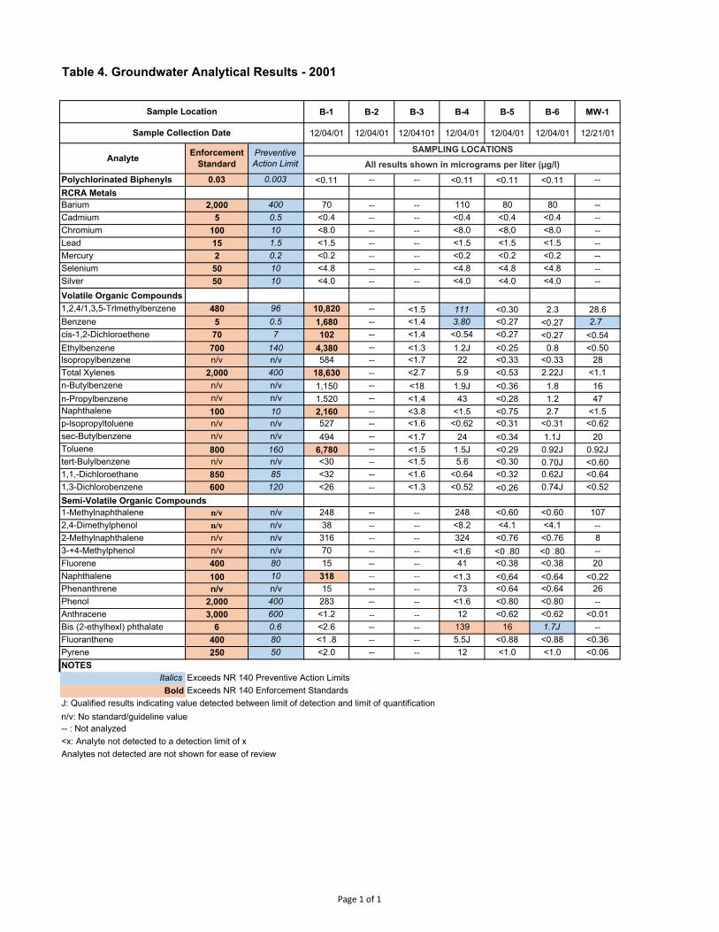
Table 4. Groundwater Analytical Results - 2001
B-1 B-2 B-3 B-4 B-5 B-6 MW-1
12/04/01 12/04/01 12/04101 12/04/01 12/04/01 12/04/01 12/21/01
Polychlorinated Biphenyls 0.03 0.003 <0.11 -- -- <0.11 <0.11 <0.11 --
RCRA MetalsBarium 2,000 400 70 -- -- 110 80 80 --Cadmium 5 0.5 <0.4 -- -- <0.4 <0.4 <0.4 --
Chromium 100 10 <8.0 -- -- <8.0 <8,0 <8.0 --
Lead 15 1.5 <1.5 -- -- <1.5 <1.5 <1.5 --
Mercury 2 0.2 <0.2 -- -- <0.2 <0.2 <0.2 --Selenium 50 10 <4.8 -- -- <4.8 <4.8 <4.8 --
Silver 50 10 <4.0 -- -- <4.0 <4.0 <4.0 --
Volatile Organic Compounds1,2,4/1,3,5-Trlmethylbenzene 480 96 10,820 -- <1.5 111 <0.30 2.3 28.6Benzene 5 0.5 1,680 -- <1.4 3.80 <0.27 <0.27 2.7cis-1,2-Dichloroethene 70 7 102 -- <1.4 <0.54 <0.27 <0.27 <0.54Ethylbenzene 700 140 4,380 -- <1.3 1.2J <0.25 0.8 <0.50lsopropylbenzene n/v n/v 584 -- <1.7 22 <0.33 <0.33 28Total Xylenes 2,000 400 18,630 -- <2.7 5.9 <0.53 2.22J <1.1n-Butylbenzene n/v n/v 1,150 -- <18 1.9J <0.36 1.8 16n-Propylbenzene n/v n/v 1,520 -- <1.4 43 <0.28 1.2 47Naphthalene 100 10 2,160 -- <3.8 <1.5 <0.75 2.7 <1.5p-lsopropyltoluene n/v n/v 527 -- <1.6 <0.62 <0.31 <0.31 <0.62sec-Butylbenzene n/v n/v 494 -- <1.7 24 <0.34 1.1J 20Toluene 800 160 6,780 -- <1.5 1.5J <0.29 0.92J 0.92Jtert-Bulylbenzene n/v n/v <30 -- <1.5 5.6 <0.30 0.70J <0.601,1,-Dichloroethane 850 85 <32 -- <1.6 <0.64 <0.32 0.62J <0.641,3-Dichlorobenzene 600 120 <26 -- <1.3 <0.52 <0.26 0.74J <0.52Semi-Volatile Organic Compounds1-Methylnaphthalene n/v n/v 248 -- -- 248 <0.60 <0.60 1072,4-Dimethylphenol n/v n/v 38 -- -- <8.2 <4.1 <4.1 --
2-Methylnaphthalene n/v n/v 316 -- -- 324 <0.76 <0.76 83-+4-Methylphenol n/v n/v 70 -- -- <1.6 <0 .80 <0 .80 --
Fluorene 400 80 15 -- -- 41 <0.38 <0.38 20Naphthalene 100 10 318 -- -- <1.3 <0,64 <0.64 <0.22Phenanthrene n/v n/v 15 -- -- 73 <0.64 <0.64 26Phenol 2,000 400 283 -- -- <1.6 <0.80 <0.80 --
Anthracene 3,000 600 <1.2 ‐‐ ‐‐ 12 <0.62 <0.62 <0.01Bis (2-ethylhexl) phthalate 6 0.6 <2.6 -- -- 139 16 1.7J --
Fluoranthene 400 80 <1 .8 -- -- 5.5J <0.88 <0.88 <0.36Pyrene 250 50 <2.0 -- -- 12 <1.0 <1.0 <0.06NOTES
ItalicsBold
J: Qualified results indicating value detected between limit of detection and limit of quantificationn/v: No standard/guideline value-- : Not analyzed<x: Analyte not detected to a detection limit of xAnalytes not detected are not shown for ease of review
Exceeds NR 140 Preventive Action LimitsExceeds NR 140 Enforcement Standards
Sample Location
Sample Collection Date
All results shown in micrograms per liter (µg/l)Analyte Enforcement
StandardPreventive Action Limit
SAMPLING LOCATIONS
Page 1 of 1

Table 5. Soil Analytical Results - VOCs 2012
Non-IndustrialDirect Contact
Pathway
Industrial Direct
Contact Pathway
Groundwater Migration Pathway
TW-6 TW-7 TW-8 TW-9 TW-9 TW-10 TW-10 TW-11 TW-12 TW-13 TW-14
12-14 11-12 15-17 12-15 15-17 12-14 16-18 5-9 8-10 10-13 8-1011.58 12.66 16.43 12.42 12.42 13.32 13.32 12.0 7.19 13.0 9.17
S U U S S U S U S U U3/28/2012 3/28/2012 3/28/2012 3/28/2012 3/28/2012 3/28/2012 3/28/2012 3/28/2012 3/28/2012 3/28/2012 3/28/2012
640 640 0.1402 < 0.025 < 0.025 < 0.025 < 0.16 < 0.16 < 0.16 < 0.025 < 0.025 < 0.16 < 0.16 < 0.025219 219 6.01 1.99 < 0.0281 9.57 14.5 104 2.45 0.217 33.3 32.4 < 0.0305182 182 1.8 0.845 < 0.0271 2.46 6.17 35.2 0.816 0.12 11.2 27.7 < 0.0295
0.652 2.87 0.00284 < 0.025 < 0.025 < 0.025 < 0.138 < 0.138 < 0.138 < 0.025 < 0.025 < 0.138 < 0.138 < 0.0251,6 7.07 0.00512 0.139 0.0234 < 0.025 < 0.139 < 0.139 < 0.139 0.256 < 0.025 < 0.139 < 0.139 < 0.0259.6 43 0.00506 < 0.036 < 0.036 < 0.036 < 0.36 < 0.36 < 0.36 < 0.036 < 0.0391 < 0.36 < 0.36 < 0.0391159 669 0.0155 0.067 0.075 0.058 < 0.417 < 0.417 < 0.417 < 0.0417 0.067 < 0.417 < 0.417 0.0638.02 35.4 1.57 2.36 0.202 < 0.025 2.97 5.83 40.3 1.26 < 0.0254 3.55 2.35 < 0.0254
* * * 7.19 0.551 < 0.0589 13.6 16.5 182 3.82 < 0.064 14.8 8.36 < 0.06461.8 1150 0.00256 < 0.0323 < 0.0323 < 0.0323 < 0.323 < 0.323 < 0.323 < 0.0323 < 0.0351 < 0.323 < 0.323 < 0.0351
* * * 2.75 0.045 < 0.0258 6.9 0.91 69.3 1.11 < 0.028 5.34 4.52 < 0.02833.0 1 45 0.00454 < 0.025 < 0.025 < 0.025 < 0.216 < 0.216 < 0.216 < 0.025 < 0.025 0.34 < 0.216 0.0246818 818 1.1070 1.59 < 0.0284 < 0.0284 4.89 0.7 17.7 1.68 < 0.0309 3.06 0.46 < 0.0309
1.300 8.41 0.00358 < 0.025 < 0.025 < 0.025 < 0.189 < 0.189 < 0.189 < 0.025 < 0.025 < 0.189 < 0.189 < 0.025260 260 3.96 9.94 0.595 < 0.0847 20.5 17.4 251 4.92 < 0.0921 20.1 12.9 < 0.0921
NOTESRCL: Wisconsin Soil Residual Contaminant Level (as of December 2018)
*m, p & o-Xylene RCL based on Total Xylenes
Results reported as milligrams per kilogram (mg/kg)
Exceeds Industrial Direct Contact RCL
TrichloroetheneXylenes, Total
1.382
m,p-XyleneMethylene chlorideo-XyleneTetrachloroetheneToluene
1,3,5-Trimethylbenzene
Benzene
Exceeds Non-Industrial Direct Contact RCL
Exceeds Groundwater Migration Pathway RCL
Analyte
Sample Collection Date
Groundwater Depth Encountered (feet below grade) 1
Saturated (S)/Unsaturated (U) 2
Sample Depth (feet below grade)
1,1,1-Trichloroethane1,2,4-Trimethylbenzene
1,2-Dichloroethane
BromomethaneChloromethaneEthylbenzene
Sample Location
Page 1 of 2

Table 5. Soil Analytical Results - VOCs 2012
Non-IndustrialDirect Contact
Pathway
Industrial Direct
Contact Pathway
Groundwater Migration Pathway
640 640 0.1402219 219182 182
0.652 2.87 0.002841,6 7.07 0.005129.6 43 0.00506159 669 0.01558.02 35.4 1.57
* * *61.8 1150 0.00256
* * *33.0 1 45 0.00454818 818 1.1070
1.300 8.41 0.00358260 260 3.96
NOTESRCL: Wisconsin Soil Residual Contaminant Level (as of December 2018)
*m, p & o-Xylene RCL based on Total Xylenes
Exceeds Industrial Direct Contact RCL
TrichloroetheneXylenes, Total
1.382
m,p-XyleneMethylene chlorideo-XyleneTetrachloroetheneToluene
1,3,5-Trimethylbenzene
Benzene
Exceeds Non-Industrial Direct Contact RCL
Exceeds Groundwater Migration Pathway RCL
Analyte
Sample Collection Date
Groundwater Depth Encountered (feet below grade) 1
Saturated (S)/Unsaturated (U) 2
Sample Depth (feet below grade)
1,1,1-Trichloroethane1,2,4-Trimethylbenzene
1,2-Dichloroethane
BromomethaneChloromethaneEthylbenzene
Sample Location TW-15 TW-16 B-10 B-11 B-12 B-16
5-7 12-15 10-12 7-10 7-9 12-15 15-17 12-14' 14-16 10-12 12-15 10-12
9.39 13.66 ‐‐ ‐‐ ‐‐ 16 16 14 14 ‐‐ ‐‐ ‐‐
U U U U U U S U S U U U3/28/2012 3/28/2012 3/28/2012 3/28/2012 3/28/2012 3/28/2012 3/28/2012 3/28/2012 3/28/2012 3/28/2012 3/28/2012 3/28/2012< 0.025 < 0.025 < 0.025 < 0.025 < 0.025 <.025 < 0.025 < 0.025 < 0.16 < 0.025 < 0.025 0.044
< 0.0281 < 0.0291 3.09 0.156 2.9 0.311 0.241 1.37 59.6 <.0281 < 0.0281 < 0.0305< 0.0271 0.231 0.923 0.03 0.727 0.088 0.135 0.4 18.7 <.0271 < 0.0271 < 0.0295< 0.025 < 0.025 < 0.025 < 0.025 0.0598 < 0.025 < 0.025 < 0.025 < 0.138 < 0.025 < 0.025 < 0.025< 0.025 < 0.025 0.033 0.23 0.0839 < 0.025 0.05 0.0762 < 0.139 < 0.025 < 0.025 < 0.025< 0.036 < 0.0373 0.061 < 0.036 < 0.036 < 0.0391 < 0.036 0.082 < 0.36 < 0.036 < 0.036 < 0.0391
< 0.0417 0.085 0.068 0.097 < 0.0417 0.064 0.055 0.077 < 0.417 < 0.0417 < 0.0417 0.063< 0.025 0.148 0.839 0.0865 0.365 0.064 0.328 0.355 4.6 < 0.025 < 0.025 <0.0254
< 0.0589 0.12 1.38 0.321 1.08 0.308 0.19 0.685 15.5 < 0.0589 < 0.0589 < 0.064< 0.0323 < 0.0335 < 0.0323 < 0.0323 < 0.0323 < 0.0351 < 0.0323 < 0.0323 < 0.323 < 0.0323 0.038 <.0351< 0.0258 < 0.0268 0.479 0.273 0.507 0.163 0.041 0.219 7.57 < 0.0258 < 0.0258 < 0.028< 0.025 < 0.025 < 0.025 0.142 < 0.025 < 0.025 < 0.025 < 0.025 < 0.216 < 0.025 < 0.025 < 0.025
< 0.0284 0.038 0.541 0.538 0.969 0.045 < 0.0284 0.089 2.36 < 0.0284 < 0.0284 <.0309< 0.025 < 0.025 < 0.025 0.04 < 0.025 < 0.025 < 0.025 < 0.025 < 0.189 < 0.025 < 0.025 < 0.025
< 0.0847 0.12 1.86 0.594 1.59 0.472 0.23 0.903 23.1 < 0.0847 < 0.0847 < 0.0921
Results reported as milligrams per kilogram (mg/kg)
B-14 B-15B-13
Page 2 of 2
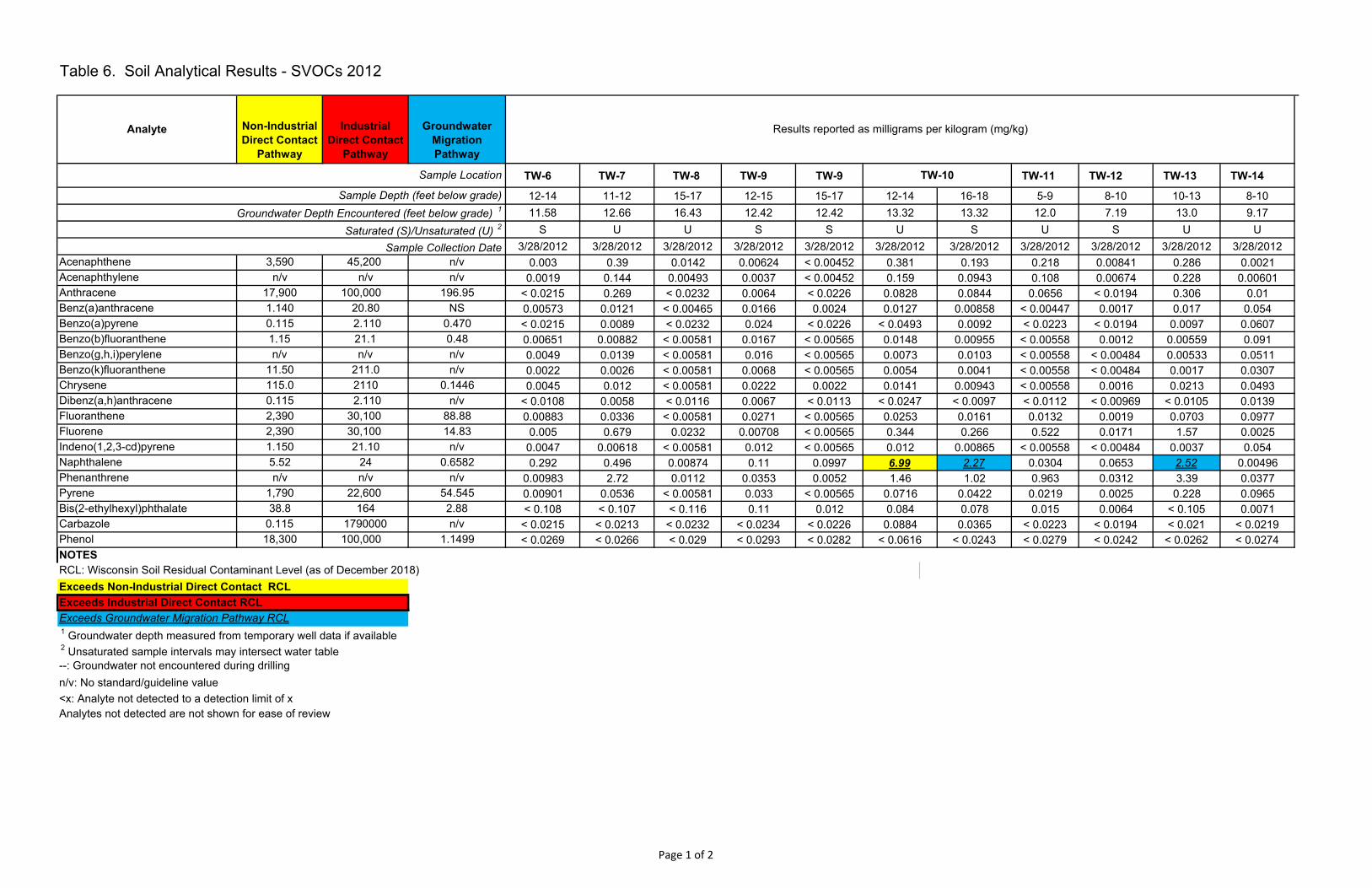
Table 6. Soil Analytical Results - SVOCs 2012
Non-IndustrialDirect Contact
Pathway
Industrial Direct Contact
Pathway
Groundwater Migration Pathway
TW-6 TW-7 TW-8 TW-9 TW-9 TW-11 TW-12 TW-13 TW-14
12-14 11-12 15-17 12-15 15-17 12-14 16-18 5-9 8-10 10-13 8-1011.58 12.66 16.43 12.42 12.42 13.32 13.32 12.0 7.19 13.0 9.17
S U U S S U S U S U U3/28/2012 3/28/2012 3/28/2012 3/28/2012 3/28/2012 3/28/2012 3/28/2012 3/28/2012 3/28/2012 3/28/2012 3/28/2012
3,590 45,200 n/v 0.003 0.39 0.0142 0.00624 < 0.00452 0.381 0.193 0.218 0.00841 0.286 0.0021n/v n/v n/v 0.0019 0.144 0.00493 0.0037 < 0.00452 0.159 0.0943 0.108 0.00674 0.228 0.00601
17,900 100,000 196.95 < 0.0215 0.269 < 0.0232 0.0064 < 0.0226 0.0828 0.0844 0.0656 < 0.0194 0.306 0.011.140 20.80 NS 0.00573 0.0121 < 0.00465 0.0166 0.0024 0.0127 0.00858 < 0.00447 0.0017 0.017 0.0540.115 2.110 0.470 < 0.0215 0.0089 < 0.0232 0.024 < 0.0226 < 0.0493 0.0092 < 0.0223 < 0.0194 0.0097 0.06071.15 21.1 0.48 0.00651 0.00882 < 0.00581 0.0167 < 0.00565 0.0148 0.00955 < 0.00558 0.0012 0.00559 0.091n/v n/v n/v 0.0049 0.0139 < 0.00581 0.016 < 0.00565 0.0073 0.0103 < 0.00558 < 0.00484 0.00533 0.0511
11.50 211.0 n/v 0.0022 0.0026 < 0.00581 0.0068 < 0.00565 0.0054 0.0041 < 0.00558 < 0.00484 0.0017 0.0307115.0 2110 0.1446 0.0045 0.012 < 0.00581 0.0222 0.0022 0.0141 0.00943 < 0.00558 0.0016 0.0213 0.04930.115 2.110 n/v < 0.0108 0.0058 < 0.0116 0.0067 < 0.0113 < 0.0247 < 0.0097 < 0.0112 < 0.00969 < 0.0105 0.01392,390 30,100 88.88 0.00883 0.0336 < 0.00581 0.0271 < 0.00565 0.0253 0.0161 0.0132 0.0019 0.0703 0.09772,390 30,100 14.83 0.005 0.679 0.0232 0.00708 < 0.00565 0.344 0.266 0.522 0.0171 1.57 0.00251.150 21.10 n/v 0.0047 0.00618 < 0.00581 0.012 < 0.00565 0.012 0.00865 < 0.00558 < 0.00484 0.0037 0.0545.52 24 0.6582 0.292 0.496 0.00874 0.11 0.0997 6.99 2.27 0.0304 0.0653 2.52 0.00496n/v n/v n/v 0.00983 2.72 0.0112 0.0353 0.0052 1.46 1.02 0.963 0.0312 3.39 0.0377
1,790 22,600 54.545 0.00901 0.0536 < 0.00581 0.033 < 0.00565 0.0716 0.0422 0.0219 0.0025 0.228 0.096538.8 164 2.88 < 0.108 < 0.107 < 0.116 0.11 0.012 0.084 0.078 0.015 0.0064 < 0.105 0.0071
0.115 1790000 n/v < 0.0215 < 0.0213 < 0.0232 < 0.0234 < 0.0226 0.0884 0.0365 < 0.0223 < 0.0194 < 0.021 < 0.021918,300 100,000 1.1499 < 0.0269 < 0.0266 < 0.029 < 0.0293 < 0.0282 < 0.0616 < 0.0243 < 0.0279 < 0.0242 < 0.0262 < 0.0274
NOTESRCL: Wisconsin Soil Residual Contaminant Level (as of December 2018)
1 Groundwater depth measured from temporary well data if available 2 Unsaturated sample intervals may intersect water table--: Groundwater not encountered during drillingn/v: No standard/guideline value<x: Analyte not detected to a detection limit of xAnalytes not detected are not shown for ease of review
TW-10
Phenanthrene
Fluorene
Phenol
Pyrene
Results reported as milligrams per kilogram (mg/kg)Analyte
Acenaphthene
AnthraceneBenz(a)anthraceneBenzo(a)pyrene
Sample Depth (feet below grade)Groundwater Depth Encountered (feet below grade) 1
Saturated (S)/Unsaturated (U) 2
Exceeds Groundwater Migration Pathway RCL
Sample Collection Date
Sample Location
Exceeds Non-Industrial Direct Contact RCLExceeds Industrial Direct Contact RCL
Benzo(k)fluoranthene
Acenaphthylene
Benzo(b)fluorantheneBenzo(g,h,i)perylene
Bis(2-ethylhexyl)phthalateCarbazole
ChryseneDibenz(a,h)anthraceneFluoranthene
Indeno(1,2,3-cd)pyreneNaphthalene
Page 1 of 2

Table 6. Soil Analytical Results - SVOCs 2012
Non-IndustrialDirect Contact
Pathway
Industrial Direct Contact
Pathway
Groundwater Migration Pathway
3,590 45,200 n/vn/v n/v n/v
17,900 100,000 196.951.140 20.80 NS0.115 2.110 0.4701.15 21.1 0.48n/v n/v n/v
11.50 211.0 n/v115.0 2110 0.14460.115 2.110 n/v2,390 30,100 88.882,390 30,100 14.831.150 21.10 n/v5.52 24 0.6582n/v n/v n/v
1,790 22,600 54.54538.8 164 2.88
0.115 1790000 n/v18,300 100,000 1.1499
NOTESRCL: Wisconsin Soil Residual Contaminant Level (as of December 2018)
1 Groundwater depth measured from temporary well data if available 2 Unsaturated sample intervals may intersect water table--: Groundwater not encountered during drillingn/v: No standard/guideline value<x: Analyte not detected to a detection limit of xAnalytes not detected are not shown for ease of review
Phenanthrene
Fluorene
Phenol
Pyrene
Analyte
Acenaphthene
AnthraceneBenz(a)anthraceneBenzo(a)pyrene
Sample Depth (feet below grade)Groundwater Depth Encountered (feet below grade) 1
Saturated (S)/Unsaturated (U) 2
Exceeds Groundwater Migration Pathway RCL
Sample Collection Date
Sample Location
Exceeds Non-Industrial Direct Contact RCLExceeds Industrial Direct Contact RCL
Benzo(k)fluoranthene
Acenaphthylene
Benzo(b)fluorantheneBenzo(g,h,i)perylene
Bis(2-ethylhexyl)phthalateCarbazole
ChryseneDibenz(a,h)anthraceneFluoranthene
Indeno(1,2,3-cd)pyreneNaphthalene
TW-15 TW-16 B-10 B-11 B-12 B-165-7 12-15 10-12 7-10 7-9 12-15' 15-17 12-14' 14-16 10-12 12-15 10-12
9.39 13.66 ‐‐ ‐‐ ‐‐ 16 16 14 14 ‐‐ ‐‐ ‐‐
U U U U U U S U S U U U3/28/2012 3/28/2012 3/28/2012 3/28/2012 3/28/2012 3/28/2012 3/28/2012 3/28/2012 3/28/2012 3/28/2012 3/28/2012 3/28/2012< 0.00413 0.109 0.0298 0.0023 0.0189 0.019 0.375 0.00899 0.0198 < 0.00419 0.0529 < 0.00425< 0.00413 0.0791 0.01 0.0013 0.0142 0.01 0.201 0.0043 0.0102 < 0.00419 0.0195 < 0.00425< 0.0207 0.0332 0.014 0.0067 0.018 0.048 0.12 < 0.0219 0.0069 < 0.0209 0.015 < 0.02130.00595 0.0109 0.0101 0.0172 0.0187 0.0578 0.00801 < 0.00438 0.00954 0.0031 0.0037 0.00330.0064 0.0088 0.0071 0.0308 0.013 0.194 < 0.0203 < 0.0219 0.011 < 0.0209 < 0.0206 < 0.0213
0.00876 0.0083 0.00873 0.0256 0.00501 0.0951 < 0.00508 < 0.00548 0.00877 0.0041 < 0.00514 0.00230.00624 0.0092 0.00933 0.0979 0.0132 0.236 < 0.00508 < 0.00548 0.013 0.0023 0.0033 0.00340.0037 0.0024 0.0034 0.00862 0.0031 0.0381 < 0.00508 < 0.00548 0.0027 0.0015 < 0.00514 0.00110.005 0.0127 0.00857 0.0163 0.0181 0.0829 0.00821 < 0.00548 0.012 0.0034 0.0031 0.0041
< 0.0103 < 0.0107 < 0.00997 0.0142 < 0.00978 0.0941 < 0.0102 < 0.011 0.0062 < 0.0105 < 0.0103 < 0.01060.00678 0.023 0.0149 0.0358 0.0299 0.0616 0.0154 < 0.00548 0.0113 0.0054 0.0025 0.0032
< 0.00517 0.266 0.0546 0.0019 0.0161 0.019 0.721 0.0119 0.0233 < 0.00524 0.0952 < 0.005320.00678 0.0046 0.00538 0.0405 < 0.00489 0.122 < 0.00508 < 0.00548 0.0105 0.0025 < 0.00514 0.0017
< 0.00413 0.155 0.0513 0.0038 0.442 0.208 0.429 0.232 0.239 < 0.00419 < 0.00411 0.00130.0024 0.448 0.128 0.0273 0.14 0.0636 0.86 0.0109 0.0888 0.0042 0.0615 0.00923
0.00831 0.0336 0.0352 0.0329 0.0352 0.0869 0.0361 < 0.00548 0.0175 0.0047 0.0035 0.00587< 0.103 < 0.107 0.042 < 0.105 0.031 < 0.502 0.073 0.022 0.0094 < 0.105 < 0.103 0.006
< 0.0207 < 0.0214 < 0.0199 < 0.0209 < 0.0196 < 0.1 < 0.0203 < 0.0219 < 0.0228 < 0.0209 < 0.0206 < 0.0213< 0.0258 < 0.0267 < 0.0249 < 0.0262 0.0762 < 0.125 < 0.0254 < 0.0274 < 0.0285 < 0.0262 < 0.0257 < 0.0266
Results reported as milligrams per kilogram (mg/kg)
B-13 B-14 B-15
Page 2 of 2

Table 7. Soil Analytical Results - Metals 2012
Analyte
Non-Industrial
Direct Contact Pathway
Industrial Direct
Contact Pathway
Groundwater Migration Pathway
Background Threshhold Value (BTV)
TW-6 TW-7 TW-8 TW-9 TW-9S TW-10 TW-10S TW-11 TW-12 TW-13 TW-14 TW-15 TW-16
12-14 11-12 15-17 12-15 15-17 12-14 16-18 5-9 8-10 10-13 8-10 5-7 12-15
11.58 12.66 16.43 12.42 12.42 13.32 13.32 12.0 7.19 13.0 9.17 9.39 13.66
S U U S S U S U S U U U U
3/28/2012 3/28/2012 3/28/2012 3/28/2012 3/28/2012 3/28/2012 3/28/2012 3/28/2012 3/28/2012 3/28/2012 3/28/2012 3/28/2012 3/28/2012Arsenic 8* [0.677] 8* [3] 8* [0.584] 8 2.2 0.56 < 3.15 0.67 1.1 1.4 1.8 1.7 0.6 0.96 8.22 3.98 < 2.86Barium 15,300 100,000 364* [164.8] 364 34.8 21.9 67.8 46.8 45.5 81.4 41.1 25.4 31.4 35.1 38.4 53.7 48Cadmium 71 985 1* [0.752] 1 1.06 0.512 1.51 0.877 0.975 0.952 0.863 0.894 0.82 0.769 1.48 1.7 0.731Chromium 100,000 100,000 360,000 44 14.4 7.1 32.4 15.8 15.6 20.4 12.9 11.9 11.6 11.2 12.1 20.8 12.3Lead 400 800 52* [27] 52 21.1 9.94 7.42 10.2 6.96 27.4 44.5 6.22 6.05 9.97 12.4 39 9.68Selenium 391 5,840 0.52 n/v < 2.9 < 2.88 < 3.15 < 3.15 < 3.08 < 2.59 < 2.63 < 3.08 < 2.61 < 2.85 < 2.93 < 2.73 < 2.86Silver 391 5,840 0.849 n/v < 0.29 < 0.288 < 0.315 < 0.315 < 0.308 < 0.259 < 0.263 < 0.308 < 0.261 < 0.285 < 0.293 < 0.273 < 0.286Mercury 3.13 3.13 0.208 n/v < 0.0287 0.081 0.019 0.019 0.024 0.0434 0.0699 0.352 < 0.0298 < 0.0318 0.027 0.025 0.025NOTESRCL: Wisconsin Soil Residual Contaminant Levels - Dec 2017
1 Groundwater depth measured from temporary well data if available 2 Unsaturated sample intervals may intersect water table--: Groundwater not encountered during drillingn/v: No standard/guideline value<x: Analyte not detected to a detection limit of xAnalytes not detected are not shown for ease of reviewXX* [XXX]= Standard in bold is the BTV being utilized for the purpose of evaluation under ch. NR700 WAC. The established WAC RCL is noted in brackets
Exceeds Non-Industrial Direct Contact RCLExceeds Industrial Direct Contact RCLExceeds Groundwater Migration Pathway RCL
Results reported as milligrams per kilogram (mg/kg)
Sample Depth (feet below grade)
Sample Location
Groundwater Depth Encountered (feet below grade) 1
Saturated (S)/Unsaturated (U) 2
Sample Collection Date
Page 1 of 2

Table 7. Soil Analytical Results - Metals 2012
Analyte
Non-Industrial
Direct Contact Pathway
Industrial Direct
Contact Pathway
Groundwater Migration Pathway
Background Threshhold Value (BTV)
Arsenic 8* [0.677] 8* [3] 8* [0.584] 8Barium 15,300 100,000 364* [164.8] 364Cadmium 71 985 1* [0.752] 1Chromium 100,000 100,000 360,000 44Lead 400 800 52* [27] 52Selenium 391 5,840 0.52 n/vSilver 391 5,840 0.849 n/vMercury 3.13 3.13 0.208 n/vNOTESRCL: Wisconsin Soil Residual Contaminant Levels - Dec 2017
1 Groundwater depth measured from temporary well data if available 2 Unsaturated sample intervals may intersect water table--: Groundwater not encountered during drillingn/v: No standard/guideline value<x: Analyte not detected to a detection limit of xAnalytes not detected are not shown for ease of reviewXX* [XXX]= Standard in bold is the BTV being utilized for the purpose of
Exceeds Non-Industrial Direct Contact RCLExceeds Industrial Direct Contact RCLExceeds Groundwater Migration Pathway RCL
Sample Depth (feet below grade)
Sample Location
Groundwater Depth Encountered (feet below grade) 1
Saturated (S)/Unsaturated (U) 2
Sample Collection Date
B-10 B-11 B-12 B-13 B-13 B-14 B-14S B-15 B-15S B-16
10-12 7-10 7-9 12-15' 15-17 12-14' 14-16 10-12 12-15 10-12
‐‐ ‐‐ ‐‐ 16 16 14 14 ‐‐ ‐‐ ‐‐
U U U U S U S U U U
3/28/2012 3/28/2012 3/28/2012 3/28/2012 3/28/2012 3/28/2012 3/28/2012 3/28/2012 3/28/2012 3/28/20121.2 4.75 2.1 0.73 1.4 1.8 5.2 1.6 1.8 1.1
21.9 103 33 30.7 21.1 55.2 36.2 27.4 21 27.60.525 1.35 0.532 1.06 0.772 1.02 0.816 0.959 0.867 0.85
7.71 15.4 6.76 17.1 11.5 12.3 9.36 15.7 13.5 13.49.33 42.9 10.1 6.35 5.62 9.08 26 7.65 5.78 6.12
< 2.73 < 2.83 < 2.71 < 2.68 < 2.68 < 3.03 < 3.07 < 2.81 < 2.71 < 2.91< 0.273 < 0.283 < 0.271 < 0.268 < 0.268 < 0.299 < 0.307 < 0.281 < 0.271 < 0.2910.0745 0.219 0.0377 0.026 < 0.0327 0.0572 0.0521 < 0.0333 0.029 0.117
Results reported as milligrams per kilogram (mg/kg)
Page 2 of 2

Table 8. Soil Analytical Results - Asbestos 2012
TW-6 TW-7 TW-8 TW-9 TW-9 Saturated TW-10 TW-10
Saturated TW-11 TW-12 TW-13 TW-14 TW-15 TW-16
Sample Depth (feet below ground surface) 12-14 11-12 15-17 12-15 15-17 12-14 16-18 5-9 8-10 10-13 8-10 5-7 12-15Tremolite (asbestos) < 0 < 0 < 0 < 0 < 0 < 0 < 0 < 0 < 0 < 0 < 0 < 0 < 0Other (Matrix) 98 99 100 99 100 100 100 100 100 100 100 100 100Natural Fiber < 0 < 0 < 0 < 0 < 0 < 0 < 0 < 0 < 0 < 0 < 0 < 0 < 0Hair < 0 < 0 < 0 < 0 < 0 < 0 < 0 < 0 < 0 < 0 < 0 < 0 < 0Fibrous Glass < 0 < 0 < 0 < 0 < 0 < 0 < 0 < 0 < 0 < 0 < 0 < 0 < 0Crocidolite (asbestos) < 0 < 0 < 0 < 0 < 0 < 0 < 0 < 0 < 0 < 0 < 0 < 0 < 0Chrysotile (asbestos) < 1 < 1 < 0 < 1 < 0 < 0 < 0 < 0 < 0 Trace Trace < 0 < 0Cellulose < 1 < 0 < 0 < 0 < 0 < 0 < 0 < 0 Trace < 0 < 0 < 0 < 0Artificial Fiber < 0 < 0 < 0 < 0 < 0 < 0 < 0 < 0 < 0 < 0 < 0 < 0 < 0Anthophylite (asbestos) < 0 < 0 < 0 < 0 < 0 < 0 < 0 < 0 < 0 < 0 < 0 < 0 < 0Amosite(asbestos) < 0 < 0 < 0 < 0 < 0 < 0 < 0 < 0 < 0 < 0 < 0 < 0 < 0Actinolite (asbestos) < 0 < 0 < 0 < 0 < 0 < 0 < 0 < 0 < 0 < 0 < 0 < 0 < 0
B-10 B-11 B-12 B-13 B-13 Saturated B-14 B-14
Saturated B-15 B-15 Saturated B-16
Sample Depth (feet below ground surface) 10-12 7-10 7-9 12-15' 15-17 12-14' 14-16 10-12 12-15 10-12
Tremolite (asbestos) < 0 < 0 < 0 < 0 < 0 < 0 < 0 < 0 < 0 < 0Other (Matrix) 100 99 100 100 100 100 99 100 100 100Natural Fiber < 0 < 0 < 0 < 0 < 0 < 0 < 0 < 0 < 0 < 0Hair < 0 < 0 < 0 < 0 < 0 < 0 < 0 < 0 < 0 < 0Fibrous Glass < 0 < 0 < 0 < 0 < 0 < 0 < 0 < 0 < 0 < 0Crocidolite (asbestos) < 0 < 0 < 0 < 0 < 0 < 0 < 1 < 0 < 0 < 0Chrysotile (asbestos) Trace 1 < 0 Trace < 0 < 0 Trace < 0 < 0 < 0Cellulose < 0 < 0 < 0 < 0 < 0 Trace < 0 < 0 < 0 < 0Artificial Fiber < 0 < 0 < 0 < 0 < 0 < 0 < 0 < 0 < 0 < 0Anthophylite (asbestos) < 0 < 0 < 0 < 0 < 0 < 0 < 0 < 0 < 0 < 0Amosite(asbestos) < 0 < 0 < 0 < 0 < 0 < 0 < 0 < 0 < 0 < 0Actinolite (asbestos) < 0 < 0 < 0 < 0 < 0 < 0 < 0 < 0 < 0 < 0Units in Percent Samples identified as saturated were collected below the water table<x: Analyte not detected
Sample Location
Sample Location
Analyte
Analyte
Page 1 of 1

MW-1 MW-2 MW-3 MW-4 TW-7 TW-8 TW-9 TW-10 TW-11 TW-12 TW-14 TW-15 TW-16
4/4/2012 4/4/2012 4/4/2012 4/4/2012 4/4/2012 4/4/2012 4/4/2012 4/4/2012 4/4/2012 4/4/2012 4/4/2012 4/4/2012 4/4/2012
Analyte Enforcement Standard
Preventive Action Limit
1,1,1-Trichloroethane 200 40 <5 <2 <2 <2 <10 <5 <100 <100 <88.5 <5 2.46 <2 <1001,1-Dichloroethane 850 85 <5 0.67 <2 <2 <10 <5 <100 <100 <144 <5 8.37 <2 <1002-Butanone 4,000 800 <50 <20 <20 <20 <100 <50 <1000 <1000 <872 28 <20 <20 <1000Acetone 9,000 1800 <100 <40 <40 <40 <200 <100 <2000 <2000 <3590 37 <40 <40 <2000Benzene 5 0.5 3.4 <2 3.48 1.4 80.6 26 1,030 419 <93.5 72.8 <2 <2 1,200Bromomethane 10 1.0 <9.8 <6.21 2.4 <6.21 <10.4 <9.8 <311 <311 <518 <9.8 <6.21 <6.21 <311Carbon disulfide 1,000 200 32 <2 0.71 <2 5.2 <5 <100 <100 <101 <5 <2 <2 <100cis-1,2-Dichloroethene 70 7 <93 <3.72 <3.72 <3.72 <18.6 <9.3 <186 <186 <310 6 2.9 <3.72 <186Ethylbenzene 700 140.0 <5 <2 <2 <2 4.4 <5 1,340 412 <101 30.8 <2 <2 3,050m,p-Xylene n/v n/v <10 <4 <4 <4 <20 <10 3550.00 1240 <199 33.2 <4 <4 2320o-Xylene n/v n/v <5 <2 <2 <2 <10 <5 1120.00 453 <121 1.7 <2 <2 37Toluene 800 160.0 <5 <2 <2 <2 2.6 <5 2,890 1,790 <102 11.9 <2 <2 400Trichloroethene 5 0.5 <5 <2 <2 <2 <5 <5 <100 <100 <122 <5 1 <2 <100Vinyl chloride 0.20 0.02 <2 <2 <2 <2 <2 <2 <100 <100 <84.5 1.1 1.4 <2 <100Xylenes, Total 2,000 400 <15 <6 <6 <6 <30 <15 1,670 1,690 <288 34.9 <6 <6 2,3601,2-Dichlorobenzene 600 600 <2.56 <2.51 <5.16 <5 <6.09 <4.88 <2.66 <2.67 <5.94 0.43 <2.19 <3.06 <2.67NOTES
ItalicsBold
n/v: No standard/guideline value<x: Analyte not detected to a detection limit of xAnalytes not detected are not shown for ease of review
Exceeds NR 140 Enforcement Standards
Table 9. Groundwater Analytical Results - VOCs 2012
Sample Location
Sample Collection Date
All results shown in micrograms per liter (µg/l)
Exceeds NR 140 Preventive Action Limits
Page 1 of 1

MW-1 MW-2 MW-3 MW-4 TW-7 TW-8 TW-9 TW-10 TW-11 TW-12 TW-14 TW-15 TW-16
4/4/2012 4/4/2012 4/4/2012 4/4/2012 4/4/2012 4/4/2012 4/4/2012 4/4/2012 4/4/2012 4/4/2012 4/4/2012 4/4/2012 4/4/2012
Analyte Enforcement Standard
Preventive Action Limit
1,2-Dichlorobenzene 600 60 <2.56 <2.51 <5.16 <5 <6.09 <4.88 <2.66 <2.67 <5.94 0.43 <2.19 <3.06 <2.672,4-Dimethylphenol n/v n/v <2.56 <2.51 <5.16 <5 <6.09 <4.88 3.24 <6.79 <5.94 <2.1 <2.19 <3.06 <2.67Acenaphthene n/v n/v 7.31 <2.51 <1.2 0.4 37.3 17.8 1.3 9.16 55.1 0.36 <2.19 <3.06 4.69Acenaphthylene n/v n/v 3.32 <2.51 0.37 <5 19.1 9.12 1.1 4.47 22.7 <2.1 <2.19 <3.06 3.03Anthracene 3000 600 4.07 <2.51 <5.16 <5 13.3 5.15 0.61 2.73 27.4 0.000067 <2.19 <3.06 1.3Diphenylhydrazine n/v n/v <2.56 <2.51 <5.16 <5 <6.09 <4.88 <2.66 <2.67 <5.94 < 0.0021 <2.19 <3.06 <2.67Benz(a)anthracene n/v n/v 1.7 <0.251 <0.516 <0.5 0.701 0.35 0.16 0.31 1.28 0.0001 <0.219 <0.306 0.326Benzidine n/v n/v <12.8 <12.5 <25.8 <25 <30.5 <24.4 <13.3 <13.4 <29.7 < 0.0105 <10.9 <15.3 <13.3Benzo(a)pyrene 0.2 0.02 1.8 <0.251 <0.516 <0.5 0.46 <0.488 <0.266 <0.267 <0.594 < 0.00021 <0.219 <0.306 <0.267Benzo(b)fluoranthene 0.2 0.02 1.2 <0.251 <0.516 <0.5 <0.609 <0.488 <0.266 <0.267 <0.594 < 0.00021 <0.219 <0.306 <0.267Benzo(g,h,i)perylene n/v n/v 0.928 <0.251 <0.516 <0.5 0.54 <0.488 <0.266 <0.267 <0.594 < 0.00021 <0.219 <0.306 <0.267Benzo(k)fluoranthene n/v n/v 0.481 <0.251 <0.516 <0.5 0.23 <0.488 <0.266 <0.267 <0.594 < 0.00021 <0.219 <0.306 <0.267Bis(2-ethylhexyl)phthalate 6 0.6 <2.56 1.4 10 0.54 4.2 2.4 1.7 3.78 22.4 0.00097 0.22 0.34 <2.67Butyl benzyl phthalate n/v n/v <2.56 <2.51 <5.16 <5 <6.09 <4.88 <2.66 <2.67 <5.94 < 0.0021 <2.19 <3.06 <2.67Carbazole n/v n/v 3.42 <0.251 <0.516 <0.5 <0.609 <0.488 0.284 1.66 <0.594 < 0.00021 <0.219 <0.306 <0.267Chrysene 0.2 0.02 2.22 <0.251 <0.516 <0.5 <6.09 0.21 0.18 0.2 2.14 0.000086 <0.219 <0.306 0.494Di-n-butyl phthalate 1000 100 <2.56 <2.51 0.34 0.45 <6.09 <4.88 0.92 <2.67 <5.94 0.00034 0.26 0.44 <2.67Di-n-octyl phthalate n/v n/v <2.56 <2.51 <5.16 <5 <6.09 <4.88 <2.66 <2.67 <5.94 < 0.0021 <2.19 <3.06 <2.67Dibenz(a,h)anthracene n/v n/v <2.56 <0.251 <0.516 <0.5 <0.609 <0.488 <0.266 <0.267 <0.594 < 0.00021 <0.219 <0.306 <0.267Diethyl phthalate n/v n/v <2.56 <2.51 <5.16 <5 <6.09 <4.88 1.1 <2.67 <5.94 0.00054 0.31 0.5 <2.67Dimethyl phthalate n/v n/v <2.56 <2.51 <5.16 <5 <6.09 <4.88 <2.66 <2.67 <5.94 < 0.0021 <2.19 <3.06 <2.67Fluoranthene 400 80 3.1 <0.251 0.2 <0.5 1.31 0.34 0.17 0.513 3.05 0.000226 <0.219 <0.306 0.691Fluorene 400 80 16.9 <0.251 1.22 <0.5 76.8 36.9 3.02 19 96.3 0.000388 <0.219 <0.306 8.69Indeno(1,2,3-cd)pyrene n/v n/v 0.867 <0.251 <0.516 <0.5 <0.609 <0.488 <0.266 <0.267 <0.594 < 0.00021 <0.219 <0.306 <0.267Isophorone n/v n/v <2.56 <2.51 <5.16 <5 <6.09 <4.88 <2.66 <2.67 <5.94 < 0.0021 <2.19 <3.06 <2.67m,p-Cresol n/v n/v <2.56 <2.51 <5.16 <5 <6.09 <4.88 12.1 15.9 <5.94 < 0.0021 <2.19 <3.06 <2.67Naphthalene 100 10 6.78 <0.251 <0.516 <0.5 20.5 7.0 83.9 101 26.3 0.00201 <0.219 <0.306 243o-Cresol n/v n/v <2.56 <2.51 <5.16 <5 <6.09 <4.88 10.1 7.23 <5.94 < 0.0021 <2.19 <3.06 <2.67Pentachlorophenol 1 0.1 <6.39 <6.26 <12.9 <12.5 <15.2 <12.2 <6.64 <6.68 <14.9 < 0.00524 <5.46 <7.66 <6.67Phenanthrene n/v n/v 37.9 <0.251 <0.516 <0.5 131 37.7 3.74000 34.5 281 0.00022 <0.219 <0.306 14.1Phenol 2000 400 <2.56 <0.251 <0.516 <0.5 <0.609 2.52 38.2 33.3 <0.594 < 0.00021 <0.219 <0.306 <0.267Pyrene 250 50 5.33 <0.251 0.18 0.15 3.77 1.08 0.335 1.26 12.6 0.000212 <0.219 <0.306 0.814NOTES
ItalicsBold
n/v: No standard/guideline value<x: Analyte not detected to a detection limit of xAnalytes not detected are not shown for ease of review
Exceeds NR 140 Enforcement Standards
Table 10. Groundwater Analytical Results - SVOCs 2012
Sample Location
Sample Collection Date
All Results shown in micrograms per liter (µg/l)
Exceeds NR 140 Preventive Action Limits
Page 1 of 1

MW-1 MW-2 MW-3 MW-4 TW-7 TW-8 TW-9 TW-10 TW-11 TW-12 TW-14 TW-15 TW-16
4/4/2012 4/4/2012 4/4/2012 4/4/2012 4/4/2012 4/4/2012 4/4/2012 4/4/2012 4/4/2012 4/4/2012 4/4/2012 4/4/2012 4/4/2012
Analyte Enforcement Standard
Preventive Action Limit
Arsenic 10 1 13 <62.5 <62.5 <62.5 <62.5 <62.5 27 25 30 12 <62.5 48 18Barium 2000 400 212 369 258 172 239 266 132 45 156 177 159 1060 219Cadmium 5 0.5 <62.5 <62.5 <62.5 <62.5 <62.5 <62.5 2.1 <62.5 <62.5 1.5 <62.5 26 5.1Chromium 100 10 <62.5 9.1 <62.5 <62.5 <62.5 9.1 27 4.0 <62.5 22 <62.5 393 65.4Lead 15 1.5 <62.5 40 <62.5 12 12 22 21 13 <62.5 20 <62.5 223 83Selenium 50 10 <62.5 <62.5 <62.5 <62.5 <62.5 <62.5 <62.5 <62.5 <62.5 <62.5 <62.5 <100 <62.5Silver 50 10 <62.5 <62.5 <62.5 <62.5 <62.5 <62.5 <62.5 <62.5 <62.5 <62.5 <62.5 <100 <62.5Mercury 2 0.2 <0.5 <0.5 <0.5 <0.5 <0.5 <0.5 <0.5 <0.5 <0.5 0.29 <0.5 7.5 <0.5NOTES
ItalicsBold
n/v: No standard/guideline value<x: Analyte not detected to a detection limit of xAnalytes not detected are not shown for ease of review
Table 11. Groundwater Analytical Results - Metals 2012
Exceeds NR 140 Preventive Action LimitsExceeds NR 140 Enforcement Standards
Sample Location
Sample Collection Date
All Results shown in micrograms per liter (µg/l)
Page 1 of 1

1-3 8-10 1-3 8-10 10-11 1-3 9-10 1-3 4-5 9-10 3-5 9-10 0-3 6-8 8-10 3-5 9-10 5-6 9-10 4-5 7-8 9-10 2-4 7-8 2-3 3-5 8-9 2 412 12 11 11 11 -- -- -- -- -- -- -- -- -- -- -- -- -- -- -- -- -- 8 8 -- -- -- 8 8U U U 11 11 U U U U U U U U U U U U U U U U U U U U U U U U
10/5/2017 08/03/17 10/5/2017 10/5/2017 10/5/2017 10/5/2017 08/03/17 10/5/2017 10/5/2017 10/5/2017 10/5/2017 10/5/2017 10/5/2017 10/5/2017 10/5/2017 10/5/2017 10/5/2017 10/5/2017 10/5/2017 10/5/2017 10/5/2017 10/5/2017 10/5/2017 10/5/2017 10/5/2017 10/5/2017 10/5/2017 10/4/2018 10/4/2018RCRA MetalsArsenic mg/kg 8* [0.677] 8* [3] 8* [0.584] 8 13.4 NA 9.0 NA NA 10.5 NA 2.7J 4.7J NA 18.1 NA 5.6J NA NA 12.6 NA 14.0 NA 5.9 NA NA 5.3J NA 11.5 NA NA NA NABarium mg/kg 15,300 100,000 364* [164.8] 364 168 NA 99.8 NA NA 78.6 NA 19.5 32.0 NA 163 NA 83.6 NA NA 35.7 NA 100 NA 14.5 NA NA 55.3 NA 125 NA NA NA NACadmium mg/kg 71 985 1* [0.752] 1 0.33J NA 0.65 NA NA 0.56J NA <0.13 0.34J NA 2.3 NA <0.15 NA NA <0.20 NA <0.20 NA <0.16 NA NA <0.18 NA 0.76J NA NA NA NAChromium mg/kg 100,000 100,000 360,000 44 12.3 NA 18.0 NA NA 20.5 NA 17.1 10.5 NA 28.1 NA 34.4 NA NA 4.2 NA 6.3 NA 2.9 NA NA 4.8 NA 17.0 NA NA NA NALead mg/kg 400 800 52* [27] 52 84.1 NA 122 NA NA 16.4 NA 25.5 32.5 NA 64.9 NA 10.0 NA NA 95.3 NA 4.2 NA 6.0 NA NA 17.2 NA 110 NA NA NA NASelenium mg/kg 391 5,840 0.52 n/v 2.9J NA <1.1 NA NA <1.1 NA <1.1 <1.2 NA <2.6 NA <1.3 NA NA <1.6 NA <1.7 NA <1.3 NA NA <1.5 NA <1.1 NA NA NA NASilver mg/kg 391 5,840 0.849 n/v <0.37 NA <0.35 NA NA <0.35 NA <0.35 <0.36 NA <0.79 NA <039 NA NA <0.51 NA <0.51 NA <0.40 NA NA <0.46 NA <0.36 NA NA NA NAMercury mg/kg 3.13 3.13 0.208 n/v 0.092 NA 0.11 NA NA 0.054 NA <0.011 0.021J NA 0.074 NA 0.016J NA NA <0.017 NA <0.016 NA <0.013 NA NA <0.016 NA 0.072 NA NA NA NAVOCsBenzene µg/kg 1,600 7,070 5.12 n/v <25.8 <25.3 <25.0 <25.0 <25.0 <27.5 <25.0 NA 72.8 <50.0 264 <200 <25.0 389J <204 757J 618J <312 250 <62.5 <312 71.9J <26.3 247 237 <25.0 <29.1 <26.6 <29.8n-Butylbenzene µg/kg 108,000 108,000 n/v n/v <25.8 <25.3 <25.0 <25.0 <25.0 <27.5 108 NA <25.5 537 104 8890 <25.0 <125 7560 <326 <250 <312 1570 2760 <312 271 <26.3 <25.0 102 <25.0 <29.1 34.9 <29.8sec-Butylbenzene µg/kg 145,000 145,000 n/v n/v <25.8 <25.3 <25.0 <25.0 <25.0 <27.5 209 NA 210 423 <25.3 7300 <25.0 2660 2830 1620 1490 2390 365 432 2260 437 <26.3 <25.0 <29.1 <25.0 <29.1 <26.6 <29.8tert-Butylbenzene µg/kg 183,000 183,000 n/v n/v <25.8 <25.3 <25.0 <25.0 <25.0 <27.5 35.0J NA <25.5 <50.0 <25.3 392J <25.0 <125 <204 <326 <250 <312 <51.5 <62.5 <312 <26.3 <26.3 <25.0 <29.1 <25.0 <29.1 <26.6 <29.81,2-Dibromoethane (EDB) µg/kg 50 221 0.028 n/v <25.8 <25.3 <25.0 <25.0 <25.0 <27.5 <25.0 NA <25.5 <50.0 <25.3 <200 <25.0 <125 <204 <326 <250 <312 <51.5 <62.5 <312 <26.3 <26.3 <25.0 <29.1 <25.0 <29.1 <26.6 <29.81,2-Dichlorobenzene µg/kg 376,000 376,000 1,168 n/v <25.8 <25.3 <25.0 <25.0 <25.0 <27.5 341 NA <25.5 <50.0 <25.3 <200 <25.0 <125 <204 <326 <250 <312 <51.5 <62.5 <312 <26.3 <26.3 <25.0 <29.1 <25.0 <29.1 <26.6 <29.81,3-Dichlorobenzene µg/kg 297,000 297,000 1,153 n/v <25.8 <25.3 <25.0 <25.0 <25.0 <27.5 55.5J NA <25.5 <50.0 <25.3 <200 <25.0 <125 <204 <326 <250 <312 <51.5 <62.5 <312 <26.3 <26.3 <25.0 <29.1 <25.0 <29.1 <26.6 <29.81,4-Dichlorobenzene µg/kg 3,740 16,400 144 n/v <25.8 <25.3 <25.0 <25.0 <25.0 <27.5 235 NA <25.5 <50.0 <25.3 <200 <25.0 <125 <204 <326 <250 <312 <51.5 <62.5 <312 <26.3 <26.3 <25.0 <29.1 <25.0 <29.1 <26.6 <29.8Dichlorodifluoromethane µg/kg 126,000 530,000 3,086 n/v <25.8 <25.3 <25.0 <25.0 <25.0 <27.5 <25.0 NA <25.5 <50.0 <25.3 <200 <25.0 <125 <204 <326 <250 <312 <51.5 <62.5 <312 <26.3 <26.3 <25.0 <29.1 <25.0 <29.1 <26.6 <29.81,1-Dichloroethane µg/kg 5,060 22,200 483 n/v <25.8 <25.3 <25.0 <25.0 <25.0 <27.5 <25.0 NA <25.5 <50.0 <25.3 <200 <25.0 <125 <204 <326 <250 <312 <51.5 <62.5 <312 <26.3 <26.3 <25.0 <29.1 <25.0 <29.1 <26.6 <29.81,2-Dichloroethane µg/kg 652 2,870 2.84 n/v <25.8 <25.3 <25.0 <25.0 <25.0 <27.5 <25.0 NA <25.5 <50.0 <25.3 <200 <25.0 <125 <204 <326 <250 <312 <51.5 <62.5 <312 <26.3 <26.3 59.6J 45.7J <25.0 <29.1 <26.6 <29.81,1-Dichloroethene µg/kg 320,000 1,190,000 5.02 n/v <25.8 <25.3 <25.0 <25.0 <25.0 <27.5 <25.0 NA <25.5 <50.0 <25.3 <200 <25.0 <125 <204 <326 <250 <312 <51.5 <62.5 <312 <26.3 <26.3 <25.0 <29.1 <25.0 <29.1 <26.6 <29.8cis-1,2-Dichloroethene µg/kg 156,000 2,340,000 41.2 n/v <25.8 <25.3 <25.0 <25.0 <25.0 <27.5 49.4J NA <25.5 <50.0 <25.3 <200 <25.0 241J <204 <326 <250 <312 <51.5 <62.5 <312 <26.3 <26.3 70.5 <29.1 <25.0 <29.1 <26.6 <29.8trans-1,2-Dichloroethene µg/kg 1,560,000 1,850,000 62.6 n/v <25.8 <25.3 <25.0 <25.0 <25.0 <27.5 <25.0 NA <25.5 <50.0 <25.3 <200 <25.0 <125 <204 <326 <250 <312 <51.5 <62.5 <312 <26.3 <26.3 <25.0 <29.1 <25.0 <29.1 <26.6 <29.8Ethylbenzene µg/kg 8,020 35,400 1,570 n/v <25.8 <25.3 30.0J <25.0 <25.0 <27.5 <25.0 NA 1170 686 330 <200 <25.0 14500 5230 13400 16700 5860 5620 224 1600 <26.3 <26.3 141 184 <25.0 <29.1 42.7 <29.8Hexachloro-1,3-butadiene µg/kg 1,630 7,190 n/v n/v <25.8 <25.3 <25.0 <25.0 <25.0 <27.5 <25.0 NA <25.5 <50.0 <25.3 <200 <25.0 <125 <204 <326 <250 <312 <51.5 <62.5 <312 <26.3 <26.3 <25.0 <29.1 <25.0 <29.1 <26.6 <29.8Isopropylbenzene (Cumene) µg/kg 268,000 268,000 n/v n/v <25.8 <25.3 <25.0 <25.0 <25.0 <27.5 <25.0 NA 231 261 32.8J 2230 <25.0 2740 1900 2610 1930 1940 704 193J 1450 937 <26.3 <25.0 56.9J <25.0 <29.1 <26.6 <29.8p-Isopropyltoluene µg/kg 162,000 162,000 n/v n/v <25.8 <25.3 <25.0 <25.0 <25.0 <27.5 <25.0 NA 123 184 32.0J <200 <25.0 2510 2330 1260 1280 1600 192 684 2310 <26.3 <26.3 <25.0 33.4J <25.0 <29.1 <26.6 <29.8Methylene Chloride µg/kg 61,800 1,150,000 2.56 n/v <25.8 <25.3 <25.0 <25.0 <25.0 <27.5 <25.0 NA <25.5 <50.0 <25.3 <200 <25.0 <125 <204 <326 <250 <312 <51.5 <62.5 <312 <26.3 <26.3 34.8J 34.8J <25.0 <29.1 <26.6 <29.8Naphthalene µg/kg 5,520 24,100 658 n/v <41.3 <40.4 141J <40.0 <40.0 <44.0 229J NA 308 549J 308 <200 <40.0 13600 8210 11400 8440 8220 3880 5210 18400 <42.2 <42.2 150J 599 <40.0 <46.6 261 58.4n-Propylbenzene µg/kg 264,000 264,000 n/v n/v <25.8 <25.3 <25.0 <25.0 <25.0 <27.5 71.8 NA 618 674 139 6040 <25.0 9410 5530 9170 7390 8770 3320 817 6920 3700 57.1J 82.6J 106 <25.0 <29.1 <26.6 371,1,1,2-Tetrachloroethane µg/kg 2,780 12,300 53.4 n/v <25.8 <25.3 <25.0 <25.0 <25.0 <27.5 <25.0 NA <25.5 <50.0 <25.3 <200 <25.0 <125 <204 <326 <250 <312 <51.5 <62.5 <312 <26.3 <26.3 <25.0 <29.1 <25.0 <29.1 <26.6 <29.81,1,2,2-Tetrachloroethane µg/kg 810 3,600 0.156 n/v <25.8 <25.3 <25.0 <25.0 <25.0 <27.5 <25.0 NA <25.5 <50.0 <25.3 <200 <25.0 <125 <204 <326 <250 <312 <51.5 <62.5 <312 <26.3 <26.3 <25.0 <29.1 <25.0 <29.1 <26.6 <29.8Tetrachloroethene µg/kg 33,000 145,000 4.54 n/v 541 <25.3 69.8 <25.0 <25.0 2190 <25.0 NA 66.4 <50.0 <25.3 <200 400 <125 <204 9430 <250 926J <103 <62.5 <312 <26.3 40.0J <25.0 <29.1 <25.0 <29.1 <26.6 176Toluene µg/kg 818,000 818,000 1,107 n/v <25.8 <25.3 65.8 <25.0 379 <27.5 103 NA 546 126J 1130 <200 <25.0 8520 1310 27900 15400 3810 3380 <62.5 <312 <26.3 42.3J 1170 1120 <25.0 <29.1 85.3 52.41,2,4-Trichlorobenzene µg/kg 24,000 113,000 408 n/v <49.0 <48.0 <47.6 <47.6 <47.6 <52.3 <47.6 NA <48.5 <95.1 <48.0 <380 <47.6 <238 <388 <619 <476 <594 <98.0 <119 <594 <50.1 <50.1 <47.6 <55.3 <47.6 <55.3 50.6 56.61,1,1-Trichloroethane µg/kg 640,000 640,000 140.2 n/v <25.8 <25.3 26.4J <25.0 <25.0 184 <25.0 NA <25.5 <50.0 <25.3 <200 <25.0 <125 <204 <326 <250 <312 <51.5 <62.5 <312 <26.3 <26.3 <25.0 <29.1 <25.0 <29.1 111 1381,1,2-Trichloroethane µg/kg 1,590 7,010 3.24 n/v <25.8 <25.3 <25.0 <25.0 <25.0 <27.5 <25.0 NA <25.5 <50.0 <25.3 <200 <25.0 <125 <204 <326 <250 <312 <51.5 <62.5 <312 <26.3 <26.3 <25.0 <29.1 <25.0 <29.1 <26.6 <29.8Trichloroethene µg/kg 1,300 8,410 3.58 n/v <25.8 <25.3 <25.0 <25.0 <25.0 449 <25.0 NA 30.5J <50.0 33.6J <200 <25.0 <125 <204 <326 <250 <312 <51.5 <62.5 <312 <26.3 <26.3 <25.0 <29.1 <25.0 <29.1 <26.6 <29.8Trichlorofluoromethane µg/kg 1,230,000 1,230,000 4,477 n/v <25.8 <25.3 <25.0 <25.0 <25.0 <27.5 <25.0 NA <25.5 <50.0 <25.3 <200 <25.0 <125 <204 <326 <250 <312 <51.5 <62.5 <312 <26.3 <26.3 <25.0 <29.1 <25.0 <29.1 <26.6 <29.81,2,3-Trichloropropane µg/kg 5 109 52 n/v <25.8 <25.3 <25.0 <25.0 <25.0 <27.5 <25.0 NA <25.5 <50.0 <25.3 <200 <25.0 <125 <204 <326 <250 <312 <51.5 <62.5 <312 <26.3 <26.3 <25.0 136 <25.0 <29.1 <26.6 <29.81,2,4-Trimethylbenzene µg/kg 219,000 219,000 n/v 41.7J <25.3 78.4 <25.0 <25.0 49.0J 184 NA 2440 2610 705 <200 <25.0 62800 40000 86400 80200 75800 18000 17200 78400 <26.3 <26.3 393 633 <25.0 <29.1 179 1011,3,5-Trimethylbenzene µg/kg 182,000 182,000 n/v <25.8 <25.3 <25.0 <25.0 <25.0 <27.5 46.9J NA 1350 220 226 <200 <25.0 17300 12000 31900 24600 26600 4520 7350 25800 <26.3 <26.3 216 247 <25.0 <29.1 53.1 <29.8Vinyl chloride µg/kg 67 2,080 0.138 n/v <25.8 <25.3 <25.0 <25.0 <25.0 <27.5 <25.0 NA <25.5 <50.0 <25.3 <200 <25.0 <125 <204 <326 <250 <312 <51.5 <62.5 <312 <26.3 <26.3 <25.0 <26.3 <25.0 <29.1 <26.6 <29.8m&p-Xylene µg/kg n/v n/v n/v n/v <51.5 <50.5 89.0J <50.0 <50.0 <54.9 <50.0 NA 1810 503 1330 <400 <50.0 48900 18000 124000 92800 36100 20600 3080 21600 75.0J <52.6 906 1050 <50.0 <58.1 226 85o-Xylene µg/kg n/v n/v n/v n/v <25.8 <25.3 78.8 <25.0 <25.0 <27.5 <25.0 NA 631 292 477 <200 <25.0 19100 6270 54200 32400 22700 8430 3720 22500 <26.3 <26.3 405 568 <25.0 <29.1 132 47.5Xylene (total) µg/kg 260,000 260,000 3,960 n/v <51.5 <50.5 78.8 <50.0 <50.0 <54.9 <50.0 NA 2441 795 1807 <400 <50.0 68000 24270 178200 125200 58800 29030 6800 44100 0 1311 1618 0 0 358 132.5PAHsAcenaphthene µg/kg 3,590,000 45,200,000 n/v n/v <4.1 <4.3 9.4J <4.7 9.0J <4.2 <5.6 NA 133 NA 38.5 NA <4.5 1100J NA 260J NA 165J NA 1060 NA NA <27.5 NA 57.9 NA NA NA NAAcenaphthylene µg/kg n/v n/v n/v n/v <3.5 <3.7 15.7 <4.0 9.4J 3.7J <4.8 NA 46.6J NA 17.9J NA <3.8 <382 NA 136J NA 86.8J NA 312J NA NA <23.4 NA 33.9J NA NA NA NAAnthracene µg/kg 17,900,000 100,000,000 196,949 n/v <6.1 <6.3 22.7 <6.9 20.3 13.1J <8.2 NA 85.8J NA 29.6J NA <6.6 <661 NA <178 NA 97.5J NA <372 NA NA <40.5 NA 212 NA NA NA NABenzo(a)anthracene µg/kg 1,140 20,800 n/v n/v 13.2 <3.5 37.5 <3.9 32.8 21.0 <4.6 NA <27.5 NA 51.3 NA <3.7 <367 NA 179J NA 99.4J NA <207 NA NA <22.5 NA 56.3 NA NA NA NABenzo(a)pyrene µg/kg 115 2,110 470 n/v 8.3J <2.8 29.0 <3.1 27.4 14.6 <3.6 NA 66.5J NA 55.8 NA <2.9 <291 NA 96.5J NA <39.6 NA <164 NA NA 90.8 NA 31.7J NA NA NA NABenzo(b)fluoranthene µg/kg 1,150 21,100 479 n/v 10.3 <3.1 34.6 <3.4 30.0 9.8J <4.1 NA 67.5J NA 37.6 NA 3.3J <327 NA <87.8 NA <44.5 NA <184 NA NA <20.0 NA 106 NA NA NA NABenzo(g,h,i)perylene µg/kg n/v n/v n/v n/v 8.0 2.3J 12.4 <2.5 10.4 5.5J <2.9 NA 69.5 NA 129 NA 5.2J <235 NA 118J NA 51.2J NA <132 NA NA 223 NA 39.2 NA NA NA NABenzo(k)fluoranthene µg/kg 11,500 211,000 n/v n/v 7.6J <2.8 35.2 <3.1 30.8 12.5 <3.6 NA 43.3J NA 28.2 NA <2.9 <290 NA <78.0 NA <39.6 NA <164 NA NA 60.2 NA 63.9 NA NA NA NAChrysene µg/kg 115,000 2,110,000 144.6 n/v 21.3 5.2J 54.3 <4.1 47.6 23.6 <4.9 NA 133 NA 89.7 NA 11.0J <390 NA 173J NA 109J NA <220 NA NA 167 NA 115 NA NA NA NADibenz(a,h)anthracene µg/kg 115 2,110 n/v n/v 3.0J <2.5 5.2J <2.7 5.3J 2.6J <3.2 NA <19.4 NA 20.6 NA <2.6 <259 NA <69.5 NA <35.3 NA <146 NA NA 16.3J NA 19.3J NA NA NA NAFluoranthene µg/kg 2,390,000 30,100,000 88,878 n/v 17.6J <5.8 65 <6.3 57.4 37.2 <7.5 NA 149J NA 60.5 NA <6.0 <603 NA 287J NA 177J NA <340 NA NA 38.6J NA 71.6J NA NA NA NAFluorene µg/kg 2,390,000 30,100,000 14,830 n/v 4.5J <4.6 9.2J <5.0 10.6J <4.4 <6.0 NA 251 NA 44 NA <4.8 1140J NA 333J NA 223 NA 395J NA NA <29.4 NA 81.8 NA NA NA NAIndeno(1,2,3-cd)pyrene µg/kg 1,150 21,100 n/v n/v 4.4J <2.4 12.6 <2.7 10.8 4.8J <3.2 NA 37.4J NA 335 NA <2.5 <255 NA <68.4 NA <34.7 NA <143 NA NA 40.1J NA 43.2 NA NA NA NA1-Methylnaphthalene µg/kg 17,600 72,700 n/v n/v 166 <4.5 199 <4.9 212 77 <5.8 NA 862 NA 838 NA 5.5J 19700 NA 3490 NA 5450 NA 12100 NA NA <28.5 NA 734 NA NA NA NA2-Methylnaphthalene µg/kg 239,000 3,010,000 n/v n/v 201 <5.6 288 <6.1 306 85.4 <7.2 NA 665 NA 1290 NA <5.8 28500 NA 6450 NA 7870 NA 19700 NA NA <35.5 NA 1380 NA NA NA NANaphthalene µg/kg 5,520 24,100 658 n/v 146 <9.3 171 <10.2 148 40.9 <12.1 NA 152J NA 748 NA <9.7 17900 NA 4170 NA 5490 NA 5380 NA NA <59.7 NA 464 NA NA NA NAPhenanthrene µg/kg n/v n/v n/v n/v 92.2 <12.9 172 <14,2 167 104 <16.8 NA 628 NA 384 NA <13.5 1490J NA 779J NA 670 NA 3700 NA NA <82.6 NA 460 NA NA NA NAPyrene µg/kg 1,790,000 22,600,000 54,545 n/v 31.7 <5.0 77.8 <5.5 72.1 43.8 <6.5 NA 215 NA 115 NA 7.1J <522 NA 441J NA 263 NA <294 NA NA 113 NA 174 NA NA NA NANOTESRCL: Wisconsin Soil Residual Contaminant Level (as of December 2018)
J: Qualified results indicating value detected between limit of detection and limit of quantificationfbg: Feet below grade--: Groundwater not encountered during drillingn/v: No standard/guideline valuemg/kg: Milligrams per kilogram µg/kg: Micrograms per kilogram<x: Analyte not detected to a detection limit of xAnalytes not detected are not shown for ease of review
EW-11
Exceeds Non-Industrial Direct Contact RCLExceeds Industrial Direct Contact RCLExceeds Groundwater Migration Pathway RCL
STN-07EW-4 EW-5 EW-6 EW-7 EW-8
1,382
EW-1 EW-2 EW-3
XX* [XXX]= Standard in bold is the BTV being utilized for the purpose of evaluation under ch. NR700 WAC. The established WAC RCL is noted in brackets
Table 12. Soil Analytical Results - 2017-2018 Investigation
Soil Sample Location
Groundwater Pathway RCL
Industrial Direct Contact RCL
Non-Industrial Direct Contact
RCL
Background Threshold
Value (BTV)
Sample Depth (fbg):Groundwater Depth Encountered (fbg)
Saturated (S)/Unsaturated (U)Sample Collection Date:
EW-9 EW-10
Page 1 of 1
- - - - - - -
-

Sample Location SMP67 SMP68 SMP69 SMP70 SMP71 SMP72 SMP73 SMP76Sample Date 1-Apr-19 2-Apr-19 1-Apr-19 3-Apr-19 3-Apr-19 1-Apr-19 3-Apr-19 3-Apr-19 3-Apr-19 2-Apr-19 2-Apr-19 2-Apr-19
Sample ID SMP67 2-4 SMP68 2-4 SMP69 2-4 SMP70 2-4 SMP71 2-4 SMP72 2-4 SMP73 2-4 SMP74 2-4 SMP74 6-8 SMP75 2-4 SMP75 6-8 SMP76 0-2
Sample Depth (feet below grade) 2 - 4 ft 2 - 4 ft 2 - 4 ft 2 - 4 ft 2 - 4 ft 2 - 4 ft 2 - 4 ft 2 - 4 ft 6 - 8 ft 2 - 4 ft 6 - 8 ft 0 - 2 ft
Sampling Company STANTEC STANTEC STANTEC STANTEC STANTEC STANTEC STANTEC STANTEC STANTEC STANTEC STANTEC STANTEC
Laboratory CTLBA CTLBA CTLBA CTLBA CTLBA CTLBA CTLBA CTLBA CTLBA CTLBA CTLBA CTLBA
Laboratory Work Order Wisconsin RCL Wisconsin RCL Wisconsin RCL 144081 144081 144081 144081 144081 144081 144081 144081 144081 144081 144081 144081
Laboratory Sample ID Wisconsin Direct Contact Direct Contact Soil to 261531 261555 261524 261562 261561 261527 261563 261558 261557 261541 261540 261543Groundwater Depth Encountered (feet below grade) SBTV Industrial Non-Industrial Groundwater -- -- -- -- -- -- -- -- -- -- -- --
Saturated (S)/Unsaturated (U) Units (A) (B) (C) (D) U U U U U U U U U U U U
Arsenic mg/kg 8.3 8* [3] 8* [0.677] 8* [0.584] 5.4 11.1 8.1 5.6 8.2 11.7 16.0 4.3 - 5.5 - 8.7
Lead mg/kg 51.6 800 400 51.6* [27] 19.6 116 240 4.2 34.8 59.1 10.7 75.0 - 7.7 - 10.1
Acenaphthene µg/kg n/v 45,200,000 3,590,000 n/v <0.67 <45 17.2 J 3.38 J 1,630 1.50 J 8.67 84.3 <0.89 582 670 <0.35
Acenaphthylene µg/kg n/v n/v n/v n/v 13.5 <41 45.1 2.92 J <67 2.70 J 5.52 237 4.91 J 242 366 <0.31
Anthracene µg/kg n/v 100,000,000 17,900,000 196,949 51.0 <63 164 <2.4 <100 14.2 32.1 <10 <1.2 <29 <54 <0.48
Benzo(a)anthracene µg/kg n/v 20,800 1,140 n/v 82.7 177 J 177 6.98 J 257 J 30.4 142 1720 21.4 77.9 J 159 J <0.61
Benzo(a)pyrene µg/kg n/v 2,110 115 470 32.4 <63 331 3.02 J <100 15.2 109 401 10.4 <29 287 7.95
Benzo(b)fluoranthene µg/kg n/v 21,100 1,150 478 50.7 <78 255 4.79 J <130 36.0 309 979 20.3 <36 311 17.8
Benzo(e)pyrene µg/kg n/v n/v n/v n/v 18.8 <110 911 4.39 J <180 13.0 166 1,100 15.7 <50 303 J 19.3
Benzo(g,h,i)perylene µg/kg n/v n/v n/v n/v 19.0 161 J 745 <3.5 218 J 11.3 92.1 544 13.6 63.0 J 448 41.9
Benzo(k)fluoranthene µg/kg n/v 211,000 11,500 n/v <2.1 <140 <10 <5.3 <230 <1.5 <1.5 <23 5.36 J <65 <120 <1.1
Chrysene µg/kg n/v 2,110,000 115,000 144 43.4 <94 173 5.84 J <160 20.6 139 2410 45.8 <43 81.8 J 39.4
Dibenzo(a,h)anthracene µg/kg n/v 2,110 115 n/v 5.00 <94 193 <3.5 <160 3.35 J 21.8 142 8.01 <43 123 J <0.73
Fluoranthene µg/kg n/v 30,100,000 2,390,000 88,878 51.4 182 J 157 6.64 J 166 J 29.7 214 1,740 36.4 63.2 J 131 J 10.4
Fluorene µg/kg n/v 30,100,000 2,390,000 14,830 8.51 266 J 21.8 J <1.6 2,590 2.45 J 5.95 <6.8 <0.83 250 <36 1.65 J
Indeno(1,2,3‐cd)pyrene µg/kg n/v 21,100 1,150 n/v 10.9 122 J 244 <2.9 <130 7.83 79.0 281 10.9 38.5 J 201 J 14.2
Methylnaphthalene, 1‐ µg/kg n/v 72,700 17,600 n/v 332 4,010 1,300 68.1 32600 65.9 60.0 1,560 122 7,710 9,280 8.62
Methylnaphthalene, 2‐ µg/kg n/v 3,010,000 239,000 n/v 447 7,930 2,140 109 40,500 94.1 115 2,670 168 13,600 15,400 11.3
Naphthalene µg/kg n/v 24,100 5,520 658 241 4630 1300 19.2 11100 45.0 64.7 604 118 2270 2950 6.63
Phenanthrene µg/kg n/v n/v n/v n/v 372 751 997 17.3 3,720 120 195 3,560 87.3 4,590 4,670 38.1
Pyrene µg/kg n/v 22,600,000 1,790,000 54,546 96.9 457 258 7.11 J 559 33.2 307 2,840 39.5 210 341 18.7
Benzene mg/kg n/v 7.07 1.6 0.0051 <0.0073 0.0463 0.0634 <0.0072 <0.0052 <0.0096 <0.011 <0.0087 <0.0081 0.0152 J 0.00820 J <0.0047
Bromodichloromethane mg/kg n/v 1.83 0.418 0.0003 <0.023 <0.14 <0.024 <0.023 <0.017 <0.031 <0.034 <0.028 <0.026 <0.030 <0.022 <0.015
Butylbenzene, n‐ mg/kg n/v 108 108 n/v <0.038 <0.23 <0.039 <0.038 <0.027 <0.050 <0.056 <0.045 0.220 <0.049 <0.035 <0.024
Butylbenzene, sec‐ (2‐Phenylbutane) mg/kg n/v 145 145 n/v <0.041 0.694 J <0.042 <0.040 <0.029 <0.054 <0.060 <0.049 <0.045 0.214 0.152 <0.026
Carbon Tetrachloride (Tetrachloromethane) mg/kg n/v 4.03 0.916 0.0039 <0.032 <0.19 <0.033 <0.032 <0.023 <0.042 <0.047 <0.038 <0.035 <0.041 <0.030 <0.021
Chloroethane (Ethyl Chloride) mg/kg n/v 2,120 2,120 0.2266 <0.087 <0.52 <0.090 <0.087 <0.062 <0.12 <0.13 <0.10 <0.097 <0.11 <0.081 <0.056
Chloroform (Trichloromethane) mg/kg n/v 1.98 0.454 0.0033 <0.031 0.347 J <0.032 <0.030 <0.022 <0.040 <0.045 <0.037 <0.034 <0.039 <0.028 <0.020
Dichloroethane, 1,1‐ mg/kg n/v 22.2 5.06 0.4834 <0.036 <0.22 <0.038 <0.036 <0.026 <0.048 <0.054 <0.044 <0.040 <0.047 <0.034 <0.023
Dichloroethene, cis‐1,2‐ mg/kg n/v 2,340 156 0.0412 <0.039 <0.24 <0.041 <0.039 <0.028 <0.052 <0.058 <0.047 <0.044 <0.051 <0.036 <0.025
Dichloroethene, trans‐1,2‐ mg/kg n/v 1,850 1,560 0.0626 <0.015 <0.087 <0.015 <0.014 <0.010 <0.019 <0.022 <0.017 <0.016 <0.019 <0.013 <0.0094
Ethylbenzene mg/kg n/v 35.4 8.02 1.57 <0.031 0.699 0.0815 J <0.030 <0.022 <0.040 <0.045 <0.037 <0.034 <0.039 <0.028 <0.020
Hexanone, 2‐ (Methyl Butyl Ketone) mg/kg n/v 1,760 237 n/v <0.16 <0.96 <0.17 <0.16 <0.11 <0.21 <0.24 <0.19 <0.18 <0.21 <0.15 <0.10
Isopropylbenzene mg/kg n/v 268 268 n/v <0.036 0.266 J 0.0444 J <0.036 <0.026 <0.048 <0.054 <0.044 <0.040 <0.047 <0.034 <0.023
Isopropyltoluene, p‐ (Cymene) mg/kg n/v 162 162 n/v <0.032 1.22 <0.033 <0.032 <0.023 <0.042 <0.047 <0.038 <0.035 0.267 0.159 <0.021
Methyl Ethyl Ketone (MEK) (2‐Butanone) mg/kg n/v 28,400 28,400 1.6661 <0.13 <0.79 <0.14 <0.13 <0.093 <0.17 <0.19 <0.16 <0.15 <0.17 <0.12 <0.084
Methylene Chloride (Dichloromethane) mg/kg n/v 1,150 61.8 0.0026 <0.044 <0.26 <0.045 <0.043 <0.031 <0.058 <0.065 <0.052 <0.048 <0.056 <0.040 <0.028
Naphthalene mg/kg n/v 24.1 5.52 0.6582 0.117 J 2.47 0.466 <0.042 <0.030 <0.056 <0.062 0.114 J 0.126 J 3.75 1.07 <0.027
Propylbenzene, n‐ mg/kg n/v 264 264 n/v <0.038 0.800 0.0521 J <0.038 <0.027 <0.050 <0.056 <0.045 <0.042 0.279 0.172 <0.024
Tetrachloroethene (PCE) mg/kg n/v 145 33 0.0045 0.0467 J 0.843 <0.020 <0.019 0.246 <0.025 0.0822 J <0.023 <0.021 <0.024 <0.017 0.0727
Toluene mg/kg n/v 818 818 1.1072 0.0451 J 1.36 0.283 <0.019 <0.013 <0.025 0.0284 J <0.023 <0.021 0.0705 J <0.017 <0.012
Trichloroethane, 1,1,1‐ mg/kg n/v 640 640 0.1402 0.560 <0.21 <0.036 <0.035 <0.025 <0.046 <0.052 <0.042 <0.039 <0.045 <0.032 <0.023
Trichloroethane, 1,1,2‐ mg/kg n/v 7.01 1.59 0.0032 <0.023 <0.14 <0.024 <0.023 <0.017 <0.031 <0.034 <0.028 <0.026 <0.030 <0.022 <0.015
Trichloroethene (TCE) mg/kg n/v 8.41 1.3 0.0036 <0.022 0.130 J <0.023 <0.022 <0.016 <0.029 <0.032 <0.026 <0.024 <0.028 <0.020 <0.014
Trimethylbenzene, 1,2,4‐ mg/kg n/v 219 219 1.38 0.107 J 33.4 0.277 <0.038 0.0757 J <0.050 <0.056 <0.045 0.384 4.39 2.70 <0.024
Trimethylbenzene, 1,3,5‐ mg/kg n/v 182 182 1.38 <0.032 22.2 0.0651 J <0.032 0.0440 J <0.042 <0.047 <0.038 0.228 1.73 1.39 <0.021
Vinyl Chloride mg/kg n/v 2.08 0.067 0.0001 <0.015 <0.087 <0.015 <0.014 <0.010 <0.019 <0.022 <0.017 <0.016 <0.019 <0.013 <0.0094
Xylene, m & p‐ mg/kg n/v n/v n/v n/v 0.0806 J 22.5 0.424 <0.039 <0.028 <0.052 <0.058 <0.047 0.0641 J 0.174 0.143 <0.025
Xylene, o‐ mg/kg n/v 434 434 n/v 0.0675 J 13.7 0.306 <0.035 <0.025 <0.046 <0.052 <0.042 0.0450 J 0.122 J 0.117 <0.023
Notes:WISCONSIN SBTV Wisconsin Soil Background Threshold ValueWISCONSIN RCL Wisconsin Soil Residual Contaminant Levels (as of December 2018)
XXX Concentration exceeds Wisconsin Soil Background Threshold Value ‐ Industrial and Non‐industrial soilsXXX Concentration exceeds Wisconsin Direct Contact Industrial ‐ Residual Contaminant Levels ‐ Dec 2018XXX Concentration exceeds Wisconsin Direct Contact Non‐Industrial ‐ Residual Contaminant Levels ‐ Dec 2018XXX Concentration exceeds Wisconsin Soil to Groundwater ‐ Residual Contaminant Levels ‐ Dec 2018
15.2 Measured concentration did not exceed the indicated standard
<0.50 Laboratory reporting limit was greater than the applicable standard<0.03 Analyte was not detected at a concentration greater than the laboratory reporting limit
n/v No standard/guideline value
mg/kg Milligrams per kilogram µg/kg Micrograms per kilogram
- Parameter not analyzed
J The reported result is an estimated value.-- Groundwater not encountered during drilling
XX* [XXX] Standard in bold is the SBTV being utilized for the purpose of evaluation under ch. NR700 WAC. The established WAC RCL is noted in brackets
Metals
Table 13. Soil Analytical Results - 2019 Investigation
Polycyclic Aromatic Hydrocarbons
Volatile Organic Compounds
SMP74 SMP75
Page 1 of 2
I I

Sample LocationSample Date
Sample ID
Sample Depth (feet below grade)
Sampling Company
Laboratory
Laboratory Work Order Wisconsin RCL Wisconsin RCL Wisconsin RCL
Laboratory Sample ID Wisconsin Direct Contact Direct Contact Soil to Groundwater Depth Encountered (feet below grade) SBTV Industrial Non-Industrial Groundwater
Saturated (S)/Unsaturated (U) Units (A) (B) (C) (D)
Arsenic mg/kg 8.3 8* [3] 8* [0.677] 8* [0.584]
Lead mg/kg 51.6 800 400 51.6* [27]
Acenaphthene µg/kg n/v 45,200,000 3,590,000 n/v
Acenaphthylene µg/kg n/v n/v n/v n/v
Anthracene µg/kg n/v 100,000,000 17,900,000 196,949
Benzo(a)anthracene µg/kg n/v 20,800 1,140 n/v
Benzo(a)pyrene µg/kg n/v 2,110 115 470
Benzo(b)fluoranthene µg/kg n/v 21,100 1,150 478
Benzo(e)pyrene µg/kg n/v n/v n/v n/v
Benzo(g,h,i)perylene µg/kg n/v n/v n/v n/v
Benzo(k)fluoranthene µg/kg n/v 211,000 11,500 n/v
Chrysene µg/kg n/v 2,110,000 115,000 144
Dibenzo(a,h)anthracene µg/kg n/v 2,110 115 n/v
Fluoranthene µg/kg n/v 30,100,000 2,390,000 88,878
Fluorene µg/kg n/v 30,100,000 2,390,000 14,830
Indeno(1,2,3‐cd)pyrene µg/kg n/v 21,100 1,150 n/v
Methylnaphthalene, 1‐ µg/kg n/v 72,700 17,600 n/v
Methylnaphthalene, 2‐ µg/kg n/v 3,010,000 239,000 n/v
Naphthalene µg/kg n/v 24,100 5,520 658
Phenanthrene µg/kg n/v n/v n/v n/v
Pyrene µg/kg n/v 22,600,000 1,790,000 54,546
Benzene mg/kg n/v 7.07 1.6 0.0051
Bromodichloromethane mg/kg n/v 1.83 0.418 0.0003
Butylbenzene, n‐ mg/kg n/v 108 108 n/v
Butylbenzene, sec‐ (2‐Phenylbutane) mg/kg n/v 145 145 n/v
Carbon Tetrachloride (Tetrachloromethane) mg/kg n/v 4.03 0.916 0.0039
Chloroethane (Ethyl Chloride) mg/kg n/v 2,120 2,120 0.2266
Chloroform (Trichloromethane) mg/kg n/v 1.98 0.454 0.0033
Dichloroethane, 1,1‐ mg/kg n/v 22.2 5.06 0.4834
Dichloroethene, cis‐1,2‐ mg/kg n/v 2,340 156 0.0412
Dichloroethene, trans‐1,2‐ mg/kg n/v 1,850 1,560 0.0626
Ethylbenzene mg/kg n/v 35.4 8.02 1.57
Hexanone, 2‐ (Methyl Butyl Ketone) mg/kg n/v 1,760 237 n/v
Isopropylbenzene mg/kg n/v 268 268 n/v
Isopropyltoluene, p‐ (Cymene) mg/kg n/v 162 162 n/v
Methyl Ethyl Ketone (MEK) (2‐Butanone) mg/kg n/v 28,400 28,400 1.6661
Methylene Chloride (Dichloromethane) mg/kg n/v 1,150 61.8 0.0026
Naphthalene mg/kg n/v 24.1 5.52 0.6582
Propylbenzene, n‐ mg/kg n/v 264 264 n/v
Tetrachloroethene (PCE) mg/kg n/v 145 33 0.0045
Toluene mg/kg n/v 818 818 1.1072
Trichloroethane, 1,1,1‐ mg/kg n/v 640 640 0.1402
Trichloroethane, 1,1,2‐ mg/kg n/v 7.01 1.59 0.0032
Trichloroethene (TCE) mg/kg n/v 8.41 1.3 0.0036
Trimethylbenzene, 1,2,4‐ mg/kg n/v 219 219 1.38
Trimethylbenzene, 1,3,5‐ mg/kg n/v 182 182 1.38
Vinyl Chloride mg/kg n/v 2.08 0.067 0.0001
Xylene, m & p‐ mg/kg n/v n/v n/v n/v
Xylene, o‐ mg/kg n/v 434 434 n/v
Metals
Table 13. Soil Analytical Results - 2019 Investigation
Polycyclic Aromatic Hydrocarbons
Volatile Organic Compounds
SMP79 SMP80 SMP812-Apr-19 2-Apr-19 2-Apr-19 2-Apr-19 2-Apr-19 2-Apr-19 2-Apr-19 2-Apr-19 2-Apr-19
SMP77 2-4 SMP77 4-6 SMP77 6-8 SMP78 2-4 SMP78 4-6 SMP78 6-8 SMP79 2-4 SMP80 2-4 SMP81 2-4
2 - 4 ft 4 - 6 ft 6 - 8 ft 2 - 4 ft 4 - 6 ft 6 - 8 ft 2 - 4 ft 2 - 4 ft 2 - 4 ft
STANTEC STANTEC STANTEC STANTEC STANTEC STANTEC STANTEC STANTEC STANTEC
CTLBA CTLBA CTLBA CTLBA CTLBA CTLBA CTLBA CTLBA CTLBA
144081 144081 144081 144081 144081 144081 144081 144081 144081
261556 261550 261542 261547 261544 261546 261549 261553 261551
-- -- -- -- -- -- -- -- --
U U U U U U U U U
6.7 - - 6.9 - - 7.4 10.7 5.2
66.9 - - 10.1 - - 5.0 11.7 43.9
1.60 J 8.74 J 11.3 J <8.9 199 1,690 171 <0.46 <4.0
3.04 J 9.75 J 14.1 J 97.1 114 940 206 45.5 <3.5
<0.91 32.1 75.8 <12 <14 <120 <33 14.7 <5.5
31.1 122 311 <15 27.3 J <160 88.3 J 45.4 <6.8
29.2 134 240 21.2 J <14 <120 44.8 J 20.1 34.7
75.6 347 390 83.2 26.9 J <160 100 J 55.1 59.8
44.9 167 216 37.0 J <25 <220 70.9 J 34.2 139
61.7 161 241 49.9 J <21 <190 116 J 20.9 110
<2.0 <10 157 <27 <32 <280 <74 <1.4 <12
35.5 167 252 57.6 J <21 <190 142 J 33.2 55.6
11.6 42.3 48.9 <18 <21 <190 55.9 J 7.34 48.1
46.9 267 582 52.4 J 17.2 J 122 J 117 J 41.0 30.3
<0.61 <3.0 14.6 J <8.2 <9.6 292 J <22 33.5 <3.7
32.1 118 191 35.2 J <18 <160 84.4 J 13.1 57.6
66.8 33.0 86.5 517 2,460 29900 5,330 312 18.0 J
107 45.3 129 1,020 4,920 52,800 7,840 247 44.9
64.4 17.1 J 75.0 48.8 J 270 3890 499 159 14.8 J
71.1 158 350 3,010 1,340 11,300 1,080 129 42.9
46.5 303 479 135 34.5 J 258 J 229 64.6 41.5
<0.0049 <0.0049 <0.0053 <0.0095 0.0276 J 0.128 <0.0092 0.393 <0.0087
<0.016 <0.016 <0.017 <0.030 <0.038 0.0186 J <0.029 <0.029 <0.028
<0.025 <0.026 <0.028 <0.049 <0.062 0.390 0.588 <0.048 <0.045
<0.027 <0.028 <0.030 <0.053 <0.067 0.138 0.0967 J <0.051 <0.049
<0.021 <0.022 <0.023 <0.042 <0.052 <0.025 <0.041 <0.040 <0.038
<0.058 <0.059 <0.064 <0.11 <0.14 <0.067 <0.11 <0.11 <0.10
<0.020 <0.021 <0.022 <0.040 <0.050 <0.024 <0.039 <0.039 <0.037
<0.024 <0.025 <0.027 <0.047 <0.059 <0.028 <0.046 <0.046 <0.044
<0.026 <0.027 <0.029 <0.051 <0.064 <0.030 <0.050 <0.050 <0.047
<0.0097 <0.0099 <0.011 <0.019 <0.024 <0.011 <0.018 <0.018 <0.017
<0.020 <0.021 <0.022 <0.040 <0.050 0.0739 J <0.039 0.140 <0.037
<0.11 <0.11 <0.12 <0.21 <0.26 <0.12 <0.20 <0.20 <0.19
<0.024 <0.025 <0.027 <0.047 <0.059 0.150 <0.046 <0.046 <0.044
<0.021 <0.022 <0.023 <0.042 <0.052 0.0289 J 0.123 J <0.040 <0.038
<0.088 <0.089 <0.096 <0.17 <0.21 <0.10 <0.17 <0.17 <0.16
<0.029 <0.030 <0.032 <0.057 <0.071 <0.034 <0.055 <0.055 <0.052
<0.028 <0.029 0.0360 J <0.055 0.147 J 0.263 0.294 0.0811 J <0.051
<0.025 <0.026 <0.028 <0.049 <0.062 0.796 0.147 J 0.0710 J <0.045
<0.013 <0.013 <0.014 <0.025 <0.031 <0.015 <0.024 <0.024 0.316<0.013 <0.013 <0.014 <0.025 0.108 0.0266 J <0.024 0.208 <0.023
<0.023 <0.024 <0.026 <0.046 <0.057 <0.027 <0.044 <0.044 <0.042
<0.016 <0.016 <0.017 <0.030 <0.038 <0.018 <0.029 <0.029 <0.028
<0.015 <0.015 <0.016 <0.028 <0.036 <0.017 <0.028 <0.028 0.0837 J<0.025 <0.026 <0.028 <0.049 0.350 0.671 1.63 0.166 <0.045
<0.021 <0.022 <0.023 <0.042 0.121 J 0.177 0.850 0.0506 J <0.038
<0.0097 <0.0099 <0.011 <0.019 <0.024 <0.011 <0.018 <0.018 <0.017
<0.026 <0.027 <0.029 <0.051 0.0937 J 0.441 0.0702 J 0.227 <0.047
<0.023 <0.024 <0.026 <0.046 <0.057 0.0536 J 0.0529 J 0.0703 J <0.042
Notes:WISCONSIN SBTV Wisconsin Soil Background Threshold ValueWISCONSIN RCL Wisconsin Soil Residual Contaminant Levels (as of December 2018)
XXX Concentration exceeds Wisconsin Soil Background Threshold Value ‐ Industrial and Non‐industrial soilsXXX Concentration exceeds Wisconsin Direct Contact Industrial ‐ Residual Contaminant Levels ‐ Dec 2018XXX Concentration exceeds Wisconsin Direct Contact Non‐Industrial ‐ Residual Contaminant Levels ‐ Dec 2018XXX Concentration exceeds Wisconsin Soil to Groundwater ‐ Residual Contaminant Levels ‐ Dec 2018
15.2 Measured concentration did not exceed the indicated standard
<0.50 Laboratory reporting limit was greater than the applicable standard<0.03 Analyte was not detected at a concentration greater than the laboratory reporting limit
n/v No standard/guideline value
mg/kg Milligrams per kilogram µg/kg Micrograms per kilogram
- Parameter not analyzed
J The reported result is an estimated value.-- Groundwater not encountered during drilling
XX* [XXX] Standard in bold is the SBTV being utilized for the purpose of evaluation under ch. NR700 WAC. The established WAC RCL is noted in brackets
SMP78SMP77
Page 2 of 2
I I

APPENDIX A BOREHOLE ABANDONMENT FORMS
MARCH 2012
() Stantec
Design with community in mind

Page 1 of 7
'-""'11 (II W. 0..,,, QI NlllluDI ft.tt.io. ......... Woll / Orillhol• / Borehole FIiiing & Sealing Report HWtl)*.®$ •4'20101 P. lof2 N010Cl'· ~ 1loootthl1~1fi r&q11lu1o~cN. ,.._ 211 2P 21" tt.a:3.~ an11• Y'lh .._ .,.s,a.. Ml,,, ... ,,_ w.. Mt,,<~ 111 &t.Ddww,.,cna.2111111!'1~29) - ll"IC'291 W& ... ....,_toflt1'"W'll'IIP(,e,,ull,"•~olbel......,.11021000,orl•I\M-8M',.1! lv'1P'•OIMl,..~Ol'llr-tPIC9_..Mdoor<II-O,....._, P-frli:IMll'/~•lnb"~lierOlll,-ltfrnilNllt.,__,IDtllt"""'llra"P..,._ """°8e, Rl!1uin lrlMJ• INI 811~ ~vl!k.e Wll1 S-~ or,..., .. - ro=-,,,.:' I • ~ Verification On1v of Fi,1 an(I S.aJ
~.... 119WNIN:"
fJ """'"'-f J ,,._, ......... ,,...c
C-: ""- •• .,"',.. _____ _
""" -[J•, a: .... ,, I
• '-''""~- . ., • ... II In ----H :Joo 801111008 5CAw. .. c- 004:,C, t
-:t .,
S.tl II - rur,~ :.J f .~ .... "' :J w
!01~ r-.ort1t IIPky l(o...
-:::;-c::,c;...,c:::,=-=----- ..L.---J":----'-:.L.--'"'--l"-==-=".,.,,..=:::---£<-,_-T-.... --<(-,-._-,_-_-,.,--,.,---- - -
_.~,_..~ lnH~•liiuc...,,., < ....-ic1c
0 Mol'!I0,"'9 Wn
i- .. ,,.....,_,..+C),l,w,oi.
,., ....... -o ... c..Ntll~ 11,...., C:.O. -------------'------------t -~ CooDMIJ ... o.,i @ llan101-.1•0w.. ,-r:::~-:::-:-:;;a,;::~-..,,•=-:;;,-- '-',,.D:::.~•~•z:~'-J:'i=""•...;7_u_,. ___ ;'""' 4ftll'~..., •"" ~ w.e &i«IOII• O'l\t Vftl ._. .... oOOlrll'-111 D• I -o-~ ~ -c.-!Gro111
6 Cofllrnenta
.,_...,,...._.J.,-~I••.-.•~ Li (O('CII f>-.l~k'f'l\t1JI
..;; • lo. )61.10 "r-1: °'""" Ocw R-.1. !',•llllf I ~o
n "'~• a..1on1s e:......,.. .s-i.......,..
--t 7 ~--- -~
·-

Page 2 of 7
Si.ate{)( W\5 , De?L ~ Nstinl R88,)tnlfS dr,.,_tt,)!)'; Woll I Drillhole / Borehole Filling & Sealing Report
F-Orm 3300-0(6 (~ 4/201S) ~~ 1-012 Hotlca: Coni,)blion o! li'is-repG1tis roQ\1111!1.1 t'//CM. ,eo. :!81. 233, 289. 291-293, 295, ¥,cl 200. !/\'if.. Sb'lhl., ~11(1 rn:i NR 141 &lid $12. Wi:-; Aclm. Coda WI aoourd<t'lce •\!ti Cfl&.. 281 299, 291-293, 29S, and 299. WI$ Swt.s., f..iu:t! lo ii$ lli61urmmar f&!I\Jll tn a k>tfeirure ol toe1~n $f0•2S.OOO, or impris,omie1111 ro, up IO one yl;':'l'r. OOCMd:ng oo Irle prewarn ;:inci oond!M ln~OfYe:! 0tfsooa11y lcl&rum11i,;., infoir¥111tiio11 on this fom, 11; flOl inlff.80 ip bl! t.1HO ,~-any 011'te, P\lfJ,l00$0, Attrnn fo«n IO U'lil :illl)tol)l'lah!c f.>~ om::11 .ir<I bti1e;iu, See irl:;t1Ucllonscn 1,:wen~ lorn'IOfe infno r-.,1100. _/ Roi/le 10 DffR Bureau:
~ Vorificatlon Onty or Fill an(! Seal O Ori,-.~ w..,:cr D w111Ml!811N/~1.11e.
□ Wall!!! Ml11l8;)et,,s,111 0 O!t1$1
• ""'""' Milv.·ai.1lc¢
l1dl!ucl9-f l.~ClKl&19e.:-~O'ls) Fo,m;i1 Qx:e
Ull ~hQ-'rotb cit M,lv .. iuk.~e~ Int
faOli!y ID {flO Of PW$> 24! ?0J•J}fJ
---------" Ooo w
Milwaukee
ODOM
N
...,, .
R.:11199 C E
ow
R,~ for-Rcmo~al fiom &.,r.;oe w 1 tM!que \\'11 11 et Rcp~me,11 Weil Jn,·e~1ig110t.\fl Cumplcte
O wtllcrW.;u
IR] SOl'el:a'i: J UrUl'Olt!
Ca111;1r-icli0n. TYNI·
On9+U.-"GOl'l~IXS!Qn Dalt (ll'fflllla.'tf',)')
0JJ2Stl 2
II 3 Woi CONtNdlon ReOOrl Is o•,;illatie, ~,h:l<IM! .llt!;ec~
Mil~·iiuktc-
Pump :in(f Pi.'l~ 1t1ffli.?l.'f;ICf7 Ur,c,($)re-,no~ Liner($) l)Eill6r.,:cd?
~,, f'flltll:!"90.,
Caiif!!) M'fl 1n piacq?
D Or,~ [j Drt,i,,,, tS:1r..:tpoi1111 0 D>.lg
!Kl OlhQ:r ($pocify) D (n,?,;:I Pu,1,h II f$$, Wfl., b:uo Ml(W~
W;i$ CS19Wlg 01: aff 1)9)0W ?.irioc.i?
O<I 9e11tin;, mat811a! ,;~ '° ,;:urlo«-3
Did mo\(11\81 &etri~ :tft4' i-4 ttou~?
WI ..
!r bc-1!1i,,n,;e Cl'llll9 -~ osed. WC!'<:! !ltqy 'W4111tb:I for-m-&!lcN! l YIX!' v.un V.tltt,: fn:ffl 11 kl"'OM'I safe $0U/'Oe?
lxlve, ON• 01<1A fI)y.,. QNo O NIA
□Y~ @ ,., □NIA O't'r.:; □ No @WA
Q YH QNQ [ijf'&IA (X] I.MOansd.l(ll)le4 Fe~ 0 &!!rOtk Rec;.,Rll'. Uetflu-Jof P1acln9 Sea/1119 .\1~1181
,,~.,.,;;;-,,_,_,.~, ... ~..,,-.,,7.F=""";;;;.,;:;;:,..,-:..,.s.~,;;.,.;;:-1i(o~.,-,;c~,;;;,.,=,~0S1,=,.~~~•~=--;;,,~.,, - --1 @Co-'l<.lvcb P+1»-0re,.,,i1y O C",or,(l,h;toJ Plpa.P\tf111)':'(1
NA □1=..~t~ O olhc, 1~eri1 SNtlng.>.1&!1!'•161:1
O Nt41 CM1e11tG,r,..i1 D c~ - ----------- -=:'----:=---::=:-- - -! 0 Sind.Cer-w.,,nqCol'l((i&!t) GrQclt 6J &MIQJ'lf,e Clil~:;
Wii:c Wi!l• -11111r~9WJlfO? NA :J Y«$ D fib O ~IWl for M:l.'l,IQMJ> !'¼I~ ,wi,:r ,.,,,M,lclMg w~o &.e,11JJ,1q.rq.,ur:
•11~,.._~ ... ~.;;;,~,;;,.;;,~,..:,,11~""""17~---,,;;;;:;;;;;;.;a;;;;;,;;:.,--------i O :-e111onr.r. ¢.fil::is D Bart,or,!!e • Camcm, Ol'tH.11
NA O Grt1r&1~ 6$'11\00WJ ~ 8e1u,on11t • Sllnd Sl1111y !J Matttti:ll Used to Fill Well I Otll!ho~
N:e,ne r.t Pl!Mn Or Fmi 000:, Filing 3 StalingU ' Om.'tl DcVclOjN'nCnl
c,, St:"' ZIP COM
\\1 s.;m
D
l'alll $.i)l'leU
031291 I?

Page 3 of 7
$!al.cl, ofW-4 De~ 00 Nall.Ira! ReSOUto» dtlr.M.gcu Well I Drillhole / Borehole Filling & Sealing Repon
Fonna:ico.oos (R4.Qo!5) Pago I on HOC!Ct!~ Com11U<tiul'! ol lnS ICIJl(ltt 'S <6q~ b-tdis 160, 281, l83, 28a, i:,2.293, 29.S. and.299, W19;, S!:11+, &n;! <tis, HR 1"1 .1nd 612.. VI\$ Aam. Codtt In -"CCorde!\c» wm c:hs. 2i1, 289, 2$1--293, 2.CJG,.a,-:J 29$ !Ms. S!:14 , ral.lie lo me this form ~y ,er.IA._ e rQ'!l::1ture olb1ttween S 10-lS;OOO, 01 fTil)ll&Or11110II( b r vp 10 Ol'oe· 'toor. di!pe11ffl'IC on t/14 crog~m .i~ eondui.:1 i!Y,llm-d- 1'«&01'11111)• IOOOl!lll!l:116 !ntortMtinri on lhir. 'nrm i~ flot inl>lfld&d k> ti@ u8ed for ~W Cllv.tt' l)'Jr~ ~£-lurn IQ,nt b th~ i:li:-t:>f'tlpri111,o ONR office afrJ bm11au. se~ --.s:!f'\1Ct!or1s 01'1 r~ mf" mote iriform11tron.
Rout. to ONR 8UfM11:
~ Veriftc.ation Onty of FIii and Sc.iJ 0 0."lnku1g W~le,-
0 Wai:tc l.!Mclsr=,n~ O \'/sle!She11M'a:ul!l.';;11e,
Oom,er.-• Cll\ll'lly
Mllwauk«-
"" f;.,;00-Tcch Qf Mil-.•auk+.c. Inc--.
--- - --- - --" ., ¼I~~ ¼ 0, (3(!¥'t;;L~ot:i7• _, ____ _
" 0 M,)!lllOrin; ~I
Ow./il'lirwi:11
1016 N(lnh lfav. 1¢}• Rond
MolhodCoc!~ 0GPSllQ8 0SCR002 O0Tl'(IO'I
f8J B«e~/ D.-1u-.a1.1 II 6 Well C.,;nslll.Qon R<1r,o,t IS llvcil:llll& p,tl:11,$ 8111:lch..
Co11$11l1Cli()I", TYJ)lll'
□ Of\llcd D Utt,eo+ (S\mdl)Oo'tl()
[Kl O!he! (,r.qclfl/J rJiNCI Pu~h D °"'
FeeHt.•,10(RO~P'IVS) 241:?0JtJO
P,J,up .1nc PiPS19 1emow,(fl I.Jr.cf(,) (8fl'iu,;=:lf?
Ltne,(s) l>"'..tb'6119'17
SCl'\,efi remoYed? C:ic1111g 18!! In. p-.x.a?
was ~iilrig M cir b!!low ll(lftbce?
O)j &e&li•igrn;u,Mel !IISC IO iiN!b?
Oid m:i.:.on&f t!et':,e: aftcf 741'011!"1?
!( Y"-~ hole: Mtopoed?
illl'm.:t!l()nl'ypo: \llilh\~9Wlromokrq"'1'11:1o(c$o011f<ie'i' W • "' ~..., !f t~r1lori11C tlJlpe w.&fC u,:,:,d, wf/ti !hoy hyt/1$,«I -, .,,, □ .,
0 c,,, •"A
jXj LlnoorisOlit!atcd F~on O 6ellrock RQq.JR'd M«nOOofP1ac1ng SIAWing \4.)l:(l~
',~.~,..~w=,,~o .. ,.::::.,,~,~,..,,= o,a:::....,:,:,~.....,,~-::.::=-arn~.)rr.~~,~,.:,~,~or.:;,=,,..~•=,~1='"•1-- --i Ii) COfldue:ior Ptpe-GrnTiy O COl'ducior¥-P!Jmpo;.t □Sa'IIC1£"1&0& Pou.~ Do ~ I (BCi"lklrft(> Cbps;) IM11 .. llp(,W'!
S!ii,1119 ._,iltW!ala D N&iit c-n• GtOUl
---- ------- - -=~ - --:;=:----;:=------i D S91'1CK:e1Nnt (C01M!'tt1!c) Grou1 'lfe&-wel .:inn111!11 ~gfD.l~? NA :J Y$$ 0 No C Urim,wn
Fer iAolllfQf'klJ:I ~\•~ ~ M)J!1l0rN19 ~~ti ~tilto.'o.t Ollly: •,r~y=,.~. ~,.~.~,=,.~-.:::~,;;,~,:~=1"1,-----,,,,,.;:;::;,.,;:-;:~~w~,~.,=.,~, ,:~;;;-, -------i O sentol'll'.e OlU)s O Seroi.anhe • cemcns Qrw.
0 G1aN~ Senlonrie 7 6"!'110,11:q • S9t'ld Slun:, NA
S!lUG ZIPC~ WI 5'.H:23
Dale ol i=,uno & Si:;iltn; OfVelifie11bcr, D\'lle Rt:eCIV~ No18(1 By \mm.\;ltlfltyyyJ 03i29!11
ONR UuOnJ
D.it!o SiQl'Wt<3 Ol/2.9112
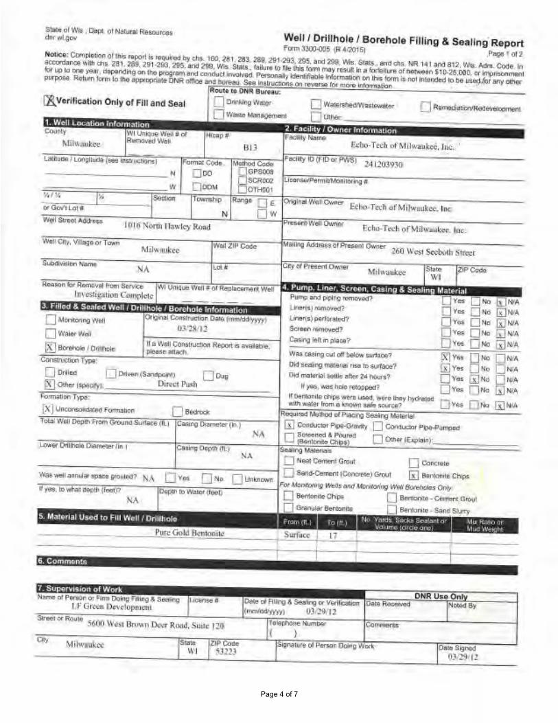
Page 4 of 7
SU!Ct: ol 1/\'4. D.!i,1 OI Natllr.il Resouroo, dnr wt{lov Well / Drillhole I Borehole Filling & Seallng··Report
Fa-m 3'300-0'.15 tfl" 4•'20151 .Pll9J t Ol 2 NC)hco: CCf!IJ-'(o:~ri O! !Iii:; r'1po1I is r•Qil.lt'ed by i;h$._ 1&:'l, 1$1, 2'3!, 289. 21>1•293,, 29S, ~nd ~9 Wis. S1<1C:S .. ts1ddla. t.R 141 .a,rn, 8 l2, '!Ns. Ad'l1. Cooe In i!ICCIJlfdlll'l(l8 wllh d'llj 281. 28~, 291·2&3, Z95. and 2118. Wirs $1.)\9; ., tailure I() nit: Olia form m11y· rC$1.111 kl a fartelh,~Of ~e,'I $11>-25,000,~ ~~11Mll'II tot l.c'l lo Qn8 )'Mt, d0Pendl119 on 1M p,ogr.itrHl(Y.I conduct r~~d Penan~ly l~!e rmoim;i1JOfl Ol'I lh!$ turn is no! lnt~f,chid 10 oe bte,.;,i~r arr; cthqr purP9W R.e!t•n IOnn IQ it,e ~lllmprj;r,e ONR ~'b ana bt1n-at1. S11e lnalruc::oru; M r-f'ila rcu rno,o 1t1IM'n11.:ion .
Rot1te 10 OHR Bwteu:
{E._ Verification OnJy of Fill and Seal 0 Om-111119\\111tor
□ Vl&t.tt:: ~&O!!mllrll
0 W~l'8fled!l\l1111i,Gl,<,lll,.,:,t
0 0 1!':,er
hicapff
BU Lali:11c!A / l00fi:!lud9 (~ iltllll+,r,!l(lml I f.ormat COC,c,. MC!hod Co6:t. Facilf:y 10 (F!Oo; S) ~al l20J9J() ________ _ N O co
BGPSOO!l SCRl.'02
O0'fH001 Y, 1¼ "
0 Mor,,to,1119 Well
Ow.i1erwG1 1£1 Soaitioln I 0(1IJl()fe
~onf:,pe:
w O oo~
" I l)lfi Nur1h I lo1wlcy• R(,fl(I
WoilZlflCoc:c
NA l.cl~
-----: . '
o,,;i.-,111 C<.ill$1rut~n D;af{o (rni1111:Wyyyy) 03-'21i ln
tr 3 \•;q11 COAi!ru?:!IM R&eort i::; ~•ebltl, pleHe 111t.,ct'\
Echo-T d:h ofMil.,.11u~ce. IM.
P11/T',;l ;in.1 l)lf:'4n!) n:,nm,,ll(I?
U 1e'i,JlQl'!IO-;~? l.,iel'(s) P$l'IOl'flll:d?
Screcn~ed?
~~ ieft in ;,I.lee?
ZIPCuco
..
0 Olilce O Dfl"(!l\(S~:1~1) 0 Olli
~ O;ttcr IS.~!. Dired Pllih
\\I~ c.88i119 0,1! otl belo,,,, surl11,;e?
01-:1 aim·rr.g ITTG«l!llb "" ll)~? Or.I moiorl.l! &i,1llc ebef ·i• hOurl!?
!x]v., □,., o w, @ Yes Q No O w,QYcs @ No O wA ov~ rJNu @ WA If )'$8, ..,'$ hr.lo !'ffl;>rhd?
If OllnlonUq ctil)e wtfll ~ . .... <;rc- lh1y l'l)df~ 1-omJa:l!on Tw,:i: v.11ti ... ,..;e, fro1110 knOW!l ti• 11cvce?
fx] Vll~M!&(I .fCiml:lhon D Be.ndl lwquif'I)(! '"-lttiod u( ~ S&ii1"9 "4318!i91 o, .. Ll"' @NIA
'ir~=;:;;;, .,~.;,~..,;;;:;,,;;-;,~ .. ,;;;;.,,G;.,..,;;;;;,~••&~,..,.;;o,;;T,(cu171c~..,:;;;;;,,.~o,;;;;;;,,,~.~,.,;;-;<•;;;1---; @ C<mdv::ior P~-G<snt:, D CO'W!uoo, PO&-f'-<1~a
D Se!'eencd & P,,"1Ut8tl O 0-.ni:r (:-loin)· 8tfllorli1..e Qi $ ~ •
N,\ SIN!~ "'-"llen..u
0 N~ Ce/nm! G1011t D Concrete - --------- - - -:::::----;:::::-- -;::::;-- - 7 D Se,-\a;.Cotnffll •Concr~)G,1°,'1! Iii S$1'11Clll!lf! Cl-.""PS, wa~~•.onni.la•~au!ifQl!l/iO? N,1 O v,. 0-'• O t.!11kn0'.<lr. .-......
F(); .\tol'M'()(l'1i9 Wtib M(J AfOrM'On.!fV w«i• ~ vrf!Y
f /$$, lowl' .• -:u r.eo11q rC01)°? □ 8eMOni10CNp$ □ B11t11llf')1e-Ce..tiert Grr;1.11
NA D ~li'lr Btr«.nl!e O Bento1l1C • S...nd S.\..111)'
s~ Zl?Cot!e WI ~31!3
~I , V ,,1,h l:i.:, ><~ S,:,.,, '.,,~t "' ,;.:, 1w« nr,i.,. ~rr.1
\lu '-:,,-.,, )! \ 111<'. ,\'-<r.;I_.
Ot.Y.e oi flllrg & ~~ 0( Vill'lf/Ctllion Oate Roee!Ylld NIXOC.1 By (lrnu'i:dl)'tr,1 93119/1?
DNR U&e On
f tlel)J'IOne Nurnw COmrf,1:rn { )

Page 5 of 7
State o( Wi& , Oi>PL of Pqllfl'• Aci~:s onr~.go,,- Well/ Drillholo / Borehole Filling & Seall.ng Report
F<ltm 3300-00!1 (R '412011) ?:iso 1 c, 2 N<,llicq; Co~lehoo O! lhi$~tts: rvq"red b)'(tl&, 160, ?IJt 283, 2119, 2'9Mal, 29.5, SRd ioo, WIS. SUI!.$- ,arl(f du; NA 1d:f.1r,d 6 12. Vil$, Adf'l'I, Codr. In 81:Cv(;}SA~ l',iti, ci's. 28l, 1S9, 291,29l, 29S, .1ncl 289, Vii;, Sl9t$ .• (Dlure lb Al!! U,is l()fll'I ma, rti&'-'l r'I a ~411111 of bc1v.~n t 10.zs,-000. Qt hl)'lsor11nnN. ft.It IIP IQ~ ~t, ~l)Clldn; 0(1 ti•~ :>f'Q9r811l alld 1:QC'ICUCI i~(J Per.1ona11, idCflll!l;il)le int'Otmi11IOO OI\ 11-.s form i$ noc Sl\~l'IOeO 4t) t,1$ used fo, ~!YI Oll'lt:1 p.irpo,.e. ROJuro 6:'11111 to cne appror,fla1.e DI~ office 11'1d lx;to)&J. Seo ~slruclfons °" •·l!v.ne ,o, f'tKX1tD11btma!i01:1.
R4u ... ,o ONR BufNi,:
!l).vcrificatlon Only of Fill and Seal 0 Onnklfl!) Wall!f
c w .. i,.e \~neorner,i;
814
□,•111tc~~,wa11ew~tr,:r-
C °"'". • ' .
I.WJ.Jdei Lono;i1111dct 1sco 1ns11u::'J:in&) Format CQde ,.,,lu:id Cod~
§GPS008 SCRGO? OTI<OO,
F:aeb1yJO (nD ot P'/\'S) 24J2(1J930
----- --- --"" Ooo
¼i¼ ,,. w o onM
'";j GOY'I Lot fl
Weil 21? C.OOe
Re;ison IOr Rornc1181 rrcm S$Nile& WI Vni:iue tNffll ;; OI Rl:11la1lem!llltWell lnv,:..(tS,;llion Complcic
' □MOflCQ/lngWi;! O waterw~, fSJ Bor~ fOnltnol&
CMi:I~ ry;i~,
If a Wdl Conswcli:111 Atp0rt • ~~lei, i;iti:1<'!'8 att&:n.
0 OO!e<I O DriYel'l •·~0pi.,W11j :J Dug
[I Q\f!er (~ily)': Oucc1 Pu,;ti
1..-.e,1,1 rotn<Wo)(t?
U"le,ts) ocrfOl't11erd?
Strem l'MIOYed? Qisl'lgltA..ipbllll?
WM C1JoRr4 e:,1 C(I bi:(ow $lltooe?
Old~ llW.er<lllirlMi 10$.lif.:,ce'(
Did ITl(l!e.'ia! ,e!lle all(,, N lxk.r.l?
II )'8~. ~s IIQI& teeuµpod?
ff ~11lted\9S'lll'"8U&!:<l.•werc~&y l't/d!81110 QV- □•" r.:i, NIA FOlffl:WM rl'1)e. W-.Wil!"l'roM&lmO'.'ll$AAl$0WCC1 .. -, ,..., W
[XI lJl'~lccl Fon~&llol'I D SO>:IIOl!a Hoqvlffld Me~ OIi Pbcne So;ilng M!lk'tl11!
1r~..,:;;;,, w~o~l~0.;;,""1;;.,F~,,...~.~Ga;,~Q,~m~o•s~,n;;;,~~;:;;.,~,-,,,,.s:;;""';;;;;°""';;;::~,..;;;:;,~\lfl•.T,---1 ~ C.Crdlic!Of Pi»Gr~ 0 Condl,¢)0r P~e-Pum:>{1(1
NA Dt~='bi~)c Ooi11~(EXJ1taln/ C;i~lno 01:p!h (fl J
NA s.»1.-.g M;itqrlS,1$
0 ;,ic,at C$1neor,1 Grollt. 0 C:mcr1110
- - - ---------==---==--- -=c-- --, 0 S.,11d-C$meo'11 (Cbricrcr.t1) GfOJI @ Bew'l!CC"tll:I ~ W.iit •'<!ti o~ t,,09te gol,;l,0,.11 Iii A O Yeo, 0 No D Ur.It~ Fot-JIMlt/.l,irlf! w«i, ;ii?(! Uoli1.'G~ M~ a-;,o1,
11, OM/.
NA
Pun: Gold BCllt()nitc
. ' . . N9.me vi Pcr$on¢, firm Otll119 Am'!g a ~ *'II
I.F Gl\."'¢0 IN\~~l<1pmc01
~1 °' RolM! 5600 Wt-!,,I Drown 0...<c:r Road. S1.111..: 120
Sia!& 21PCOO& WI :S3:U3
D Ber11~ ~ 0 8o11tonll.e • ~l <lw!A
D Gr.11111!&1' Bl!l'll0nl4 0 88"110rifle • $;ii'(! Sluf7'/
,~ \i, , 'r':,r:J~ "o-1 "S..,~i""'! f.-f
',<:lurrw I~ ... ,.,. Cl"IO' Mt> h>h:J,~ M, d l'lf-.• t,'

Page 6 of 7
stale ot W!&. Ocllt -o! IMll.lriti R880Urtuc:t'lr'M.90't Woll / Drlllhole / Borehole Filling & Sealing Report
f0fm!300.COS (Ft .t!W1S) P.tC~ I odl Natlct: COmpkiuon ot lh$11'!pv,t e.~,..,ed byQflS. 160, l61 283, 26,9, 291-293. 295, :md199. Wis, St.II&. and dis. MR 1~1 a l1d 812.. Wl6. Adm. Code In aeuont,)nce Mil~ 281 ~89. 291~2!13, 2115; ~rd 2\19. Vlis . SI.le$ , fol.iro 10 m,, lhls 1orm il?Oy re1'w. lrl a 1~11t1r& -0rb111\..'8ero $10-i5.00'>, 01 h'll)lt&Ol"lm;n; ror Ill) 10 one '/8,at. oe!pendi'l!} an. 4/ie P11'.lgt.11JH1•1d conouc1 liWoN<:o. PetSQr1c11!y kle.'l1Jfiabl!! info,~ 1~,f\ Ori l~s &1,-..,. ~ no.! 11\f~dcid 10 be 11a"° for .ar-v c lhr.r purll(l€t8. Rcl11m ,Otm ,o cne .&i.'flioprla-8 ONR ott,·ce a~ bur&a1.1. Sec in&INCtio,ii; M reverr10 fet «11Jri: .-.1onna1,11:i,,
Rovt'J to DNR &Ol'Hu: '~ Verification Only of Fill t nd Seal 0 0.11\klllg W.ilt,t'
0 W..Ste l,fari,t~''lll!N:
□ W.ir.,el$hed.W.a&l.,_to•
□0111~ Coumy
Mih,311..Ro,;i
---------" -1/, I H ¼ TG-wtnrlllp.
N I (I I ('I "JCJrth Ha,~ It)' Road
Ml1w11ukct
I" :\ "''.
HLS
~ •"811 DE O w
ReilfoOf! re,, Rcmo,val 1,o,nSnM(l9 WI IKll{lue \~! fr rJ ~bneme,11 V-.'o) Jnn:srisa,1on Cou~h.'ie ..
D ~IIIIOrifl\l W!t
0 \lft,,,ef\VcU
~ Bl!fcM'r}J()l!OY.1111
Con$ltoCIIOI\ Type:
N 9 ~t-CMl,;l'lJCtjon kol)Otl it llvatl:llllG, pklllsci !¥;!$Cl>
0 Ofillcld L.1 OrMt11 (S11r4.l)Oif\ll D ~ !!I 01hor(1;1)E(ify), l>in:-c1 P\1sb
• Edm~Ttth ofM1lwaul1..-e, foe.
F9,;t,t',IJ(FJDcrPWS .. 2-ill 0JIJ)0
.Ectio-Teel! u( Milwa11l:.:c, loc.
Pump _,nd fli?lh(I remayq(P
Ul',;!r(s)rffllOYed?
Ull«(5► P$!f0:rt1111a?
S!ll'$$111ema¥Ccf? Ca:c;l11gle,!1 i11pl~?
W.i,9 CHWIS CUlQIJ ~low IIJl'lllc.&?
O;,j &eating: rn;;leXal lt'IC .lO ~l.(f&ee?
Cid m~al ~ afl(I' ?-' 1-.,11,fl II Yelt, ..-M n.,19 (il!Ci)ocd1
!I b,:,11lon(,8 cti!pa WCIIC \1$8<1, -IC !hqy f'!ytlrated J:onoo:t:,n l~f)e: '111111 WIit« Jro.n ii llNIV."' s.:ito $0U1¢1:1?
(X J UJ'lcxtr.:ir,/k'lat«t Nlrm;.:ton O &t!rock Roq.ilretl M~ or Plildng Sea,lnQ M:!r.(ln;:,i
~Yes BNQ Q twA (B]Yes Nii □WA ov .. G)No 0 NIA o, .. 0 "' 0N/.\ WYes C)No @N•A.
,,~.~,.~,,N • .,,~o;;,.,;:;;;;,,,,~""'""'G""""';;;;;;;.5;.""""';;.,;;-;;,,~l~Ct,~,,~,~o~,~, .. ;:::;,=.,~,.,.;-7,- - - 7 G] <:oriouetc.-Pii»-0ie~,1y :=i Cort.1111:tor PIPfl'P\Jn)l»l!
D S¢1'~eot POl.nd D 01her (E,.pol!r'lt. Be.'lklr..10 Cl?ill$l
NA Slllil!IIO .. l11tori11lt
0 Noal'CIM'll,.,,1; <--ov1 O Co,~
- ----- - --- - - -::;--- ---::=-- ---::=--- -i □ Sano-Cl!-111 (DaflCl'tllel Grc11t ~ SOnl(W'lhe Ck111s w,;,s W.l am11bt ~ oro:i11111; NA O Y ei; 0 No D liMl'KliWI fot" ,,,o,,~ H~'t &nd Moll!too,lt ~ &15/l(\'H. o,a
11 "~"- JO WMtdef)ITI (m .... 11 □ e.cmc.'lt,$ Chilll'i O &1~11ile-
0 ¢91N:l!'!I Gr!lli
0 Gr~r.U'.ai" 881110nt~ Q ~ntotii!e • S;ino Slu,iy
Aiil::ifl~ii JTt1Wfi@j: .. N• -----------------1-f-s~_,-r._""_-1~---ll--+-1-------1=!==,-----
~tr-e Of F'G.ll«I Cr 17.m U~r.g Afllg A Seall••it LF Gr~n Ck\d1.1pmc111
Sllllc Z!Pcede WI S:l.!J3
ONR UM Ofll Date Rkt.'IVlX! Noled ey
0a:RSif,'l\!ci (tj/l9l ll

Page 7 of 7
State-o(Wls. Dopt ,Of ~IJKat Rti!Xlu,u,s ®·•i.oov Well/ Orillholo / Borehole Filling & Sealing Report
~fM3)00-0()5 tR4t.!01&) P~e1 «"2 N~lce; C:!~IIOt'I ol 11\4 ffll)01'l1SreQulr~ IY(<tlS. 160, i81, 283, 280, 291•293. 295. ltll(f 299, Wis. Staii-, ;ir,d Ch,. NR 11! 1 aoo 8 12. VIIS, Adm Code. In 800om,ll'IC@ w.,th err$. 281, 205:I, 231·293. 295, -:Incl 299, Vii&, Slat&.. foo.ire 16 li',o lh"s lefm Ina)' f.!Sllh ~ & !Of'fej,Jr ci ofMIYl'Cfll'.$10·25.(lOO, 01 rll?'l&Ol"lf!\t!nl ro1 llp IQ one yv.ar. ¢8Pt'f'ldhs on ltle pr~"' o1nd condu::t lnVOl'le{!. Pllf&Ot'laily idffllilieblcl lnfoorl&t!o11 on 11118 form Ii I'll)( ~lfflitoo 0-be ll:i6d to, any oth9r Pt•IJ)OGo. R-.ittl form 1<>'11~ ltWOOllrl!ltct DNA omi:e al'l'.I burel'!IJ See 1hs!rut1ions 0n i tvene re, l'!Wlfe lnfcrlfli11lon.
ROllto to ONE\ Bon:.;m:
0 Drl<!~Jlg Wa1er
Q Waste ""MIi~ 8,Vorifh::atlon Only of Fill and Seal
---------· w
1/, CooM lownihip
N \~II Slmnt Addie11i
IOJ6 No,th U11wlcy R.oad
NA
Ri:a;ot1 fc,, Rwmav91 from 5'11\l«t 1m·c$1ls1111011 C.unwtcte
0 Monlllll"irig Wei
Q \'/Mcr W&U
"'"
R11r,se OE ow
iRi 6o(aha'C J o,m-0111 II :i V',\lJ COl"ISt-U(SIOfl Riep011 u1 <1"8.il91:te, ~!IC ot1,:1cl•
OJ11!i!Mi('Ji0ft T ypc:
0 Wilte1$he,d1¼',1i&k!~\t't
Q o,,~, •
Eclkr-l'ecti of Mll\\•111,kce. bit
f"cmy ID {fiO llf PWS) 14120.19}0
Echo-T cdl ur Milw-.i.ul:<'t". Ill<;,
" Pwnp ,ani, p!l)in9 fflrM•'(I~
Unel(i;) remu.-el!?
Ul!«(sl ~rlo•::s111lt' Ser,e,e:11 tl!m3.-ct<t1
Ceeil'lg ,cfj in Pl/:lult?
[J 011119d O Orr.~n {S9Nl>C<nt! D oua
~ OlhQr t&Oo.-;(y)'. l)iflX'l t\i~b If yce1, -~ h;)l(I 1t11~gd1
'N;if eaaS\11" c:a:t ~ff beluw surtaoo? OQ Well/I(! tn:1!,c,1.11 ~ kl s~'1
Old fllMo.mal -w:i~aftet24 taurs-.,
iX1Y•• 0 •• 0"'• Gi:Jv., □"" D •1• LJYEO Gi)No Q NIA Ovee 0No GJNtA
I( l:otllon~ ctti;is .-..ere ltSt'd, v.~re they liyn~t.e,:1 ~o,n'(tli011 Type ,,.ilhw;nert<orn II knall"1 &ate sour09?
( X) ~1180lieated f::ol~ □ ~O•otk Recp.ifl!d M~ <ir Pl.xl119 SG&iinq MMe!!"$' ,,~.~ ... ;;,,.;;;.,;:;,~0"<0~1~,,.~,.~m~Ga;.,..,.;:;;:~,,s.,;;;;;;-;;:;7,(l"l.)C1'C~,~,.=,~on1,~~~;:;,,.,~_ ~,;~.,,----1 @ Condudnr Pfr,e-Gn,,,lty ::i Condncso, Pipe,~~
D -..,,,,. """""' r o 1~--(6~111113c~1 LJ 11\1,t ..... _VI)
;:iv., 0-No lijN.>,t,.
SK1111g M;i(.(),riA1$
O Ne:itC$t,1,.,lll em.,1 O c~ - --- - - ---- - - ---~- --:------::-:-- --i O S&nd.C1N"n<mi1Con.crol$) 0101.a !iJ &mlanl:1 Cllil)il Vh,$ wei• arv,111!!1 'lp:t:»9i'Qlll!tt? NA D Yet, 0 No [J Unknl)w,) Fcr~)CfnA' liic».l ;,tlQ ~
9 Weo ~ ~ :
If Yr;:$ li>'wha::dllQCn (f&«J? 0 ~m«ii:e CIiio& O !Sert.1011ile • Cctm0nl ~O>JI
_J Gr.ir11.ila1 8emto.ir,e L l 6,MIOIIIIC • SMd SIIK!Y
Nio•l'09f°'Po1$Q(l 0t r...-m l»f<i F•ina & sea111111 l ,10e11&c # Lf" Grtcn lk~>elOJlllk:lll Oz,1eoff1lll'l!i 8 Se;itlng-(1, Veritlc;11f~ D:ltc Hc,:ewed Noted By
(!llmt<ldfyyYY> 0)"29) 12
DNR UHO"I
.. ,. WI

APPENDIX B BOREHOLE ABANDONMENT FORM
(STN-07) – OCTOBER 2018
() Stantec
Design with community in mind

1
Page 1 of 1
State of Wis., Dept. of Natural Resources dnr.wi.gov
Well / Drillhole / Borehole Filling & Sealing Report Form 3300-005 (R 4/2015) Page 1 of 2
Notice: Completion of this report is required by chs. 160, 281, 283, 289, 291-293, 295, and 299, Wis. Stats., and chs. NR 141 and 812, Wis. Adm. Code. In accordance with chs. 281, 289, 291-293, 295, and 299, Wis. Stats., failure to file this form may result in a forfeiture of between $10-25,000, or imprisonment for up to one year, depending on the program and conduct involved. Personally identifiable information on this form is not intended to be used for any other purpose. Return form to the appropriate DNR office and bureau. See instructions on reverse for more information.
Route to DNR Bureau:
0 Verification Only of Fill and Seal D Drinking Water D Watershed/Wastewater ~ Remediation/Redevelopment
D Waste Management ...:1 Other: __________________ _
1. Well Location Information 2. Facility / Owner Information County WI Unique Well # of Hicap # Facility Name
Removed Well Ec.c _ Tec.i~ ..,._.M.,_.i_lw_a.,..u_k_e..,...e......,... __ ~'5;=;f~ N.....,.,..-_ 0_,-=t--..,.,_- ~- - ~--.-----,~--Facility ID (FID or PWS) Latitude / Longitude (see instructions) Format Code Method Code
N □DD 0GPS008 ----------- 0 SCR002
0DDM 0OTH001 w Llcense/PermlVMonltoring #
¼/¼ ¼ Section Township Range D E Original Well Owner
or Gov't Lot # N Ow _W_e_ll_S_t-re_e_t A- d-d-re_s_s _ ____ .._ ___ _._ ___ _._ _____ Present Well Owner
lO I b LR tJ. \.\~-.,;\ Wel l City, Village or Town
M; \ w Cl,\) I< ~e... Subdivision Name
!)a Monitoring Well
D Water Well
Well ZIP Code
S '30'2.t;r Lot #
WI Unique Well # of Replacement Well
Original Construction Date (mm/dd/yyyy)
to / 4 2o1g
Malling Address of Present Owner
City of Present Owner
Pump and piping removed?
Llner(s) removed?
Liner( s) perforated?
Screen removed?
Casing left in place?
. ;
D Borehole / Drillhole
Construction Type:
If a Well Construction Report is available, please attach.
~ Drilled D Driven (Sandpoint) Doug
Was casing cut off below surface?
Did sealing material rise to surface?
Did material settle after 24 hours?
If yes, was hole retopped?
ZIP Code
□Yes □ No ~ N/A
□Yes □ No ~ N/A
□ Yes □ No ~ N/A
□Yes ~ No □ NIA ~ Yes □ No □ NIA
~ Yes □ No ON/A
rx! Yes □ No □ NIA □ Yes □ No [gj N/A
□ Yes □ No gj N/A D Other (specify): _______ _________ _
Formation Type: If bentonite chips were used, were they hydrated with water from a known safe source? D Yes D No D N/A
~ Unconsolidated Formation D Bedrock
Total Well Depth From Ground Surface (ft.) Casing Diameter (in.)
l4.a j_ Lower Drillhole Diameter (In.) Casing Depth (fl.)
£.~2 S 14.o
Required Method of Placing Sealing Material
D Conductor Pipe-Gravity D Conductor Pipe-Pumped
fv'l ScreenE:d & Poured D Other (Explain)· 161 Bentonite Chips) ·---------
Sealing Materials
D Neat Cement Grout D Concrete
Was well annular space grouted? D Yes ~ No O Unknown ------- - -------.- --- - --------fFor Monitoring Wells and Monitoring Well Boreholes Only:
D Sand-Cement (Concrete) Grout ~ Bentonite Chips
If yes, to what depth (feet)? Depth to Water (feet) ~ Bentonite Chips D Bentonite .. Cement Grout
<i? , 4 5 D Granular Bentonite D Bentonite .. Sand Slurry
6. Comments
DNRUse Onl Name of Person or Firm Doing Filling & Sealing License # Date of Filling & Sealing or Verification Date Received Noted By
~ta.x-. le.c:.. Lo'I'\ ~ulti 'r\ Se-rvi c .. .e/, (mm/dd/yyyy) lO / t Z. / 2.0 l ~ Street or Route Telephone Number Comments
\<i?s i 8owl~s AJ~. S0;-i;e 25D ("3' ) 3143 - s880 City
St. Lcv, _s State ZIP Code
MO l3o2£ Date Signed
l0 / 141 /2o1r

APPENDIX C BOREHOLE ABANDONMENT FORMS
APRIL 2019
() Stantec
Design with community in mind

SMP67
° °
' '
26 7 21NE NW
4/1/2019
Bentonite chips
Present Well Owner
Facility ID (FID or PWS)
Original Well Owner
Other
Remediation/Redevelopment
Street or Route
City of Present Owner
Notice: Completion of this report is required by chs. 160, 281, 283, 289, 291-293, 295, and 299, Wis. Stats., and ch. NR 141, Wis. Adm. Code. In accordancewith chs. 281, 289, 291-293, 295, and 299, Wis. Stats., failure to file this form may result in a forfeiture of between $10-25,000, or imprisonment for up to one year,depending on the program and conduct involved. Personally identifiable information on this form is not intended to be used for any other purpose. Return thisform to the appropriate DNR office and bureau. See instructions on reverse for more information.
Was casing cut off below surface?Did sealing material rise to surface?Did material settle after 24 hours? If yes, was hole retopped?If bentonite chips were used, were they hydratedwith water from a known safe source
License/Permit/Monitoring #
Mailing Address of Present Owner
Lattitude / Longitude (Degrees and Minutes)
State ZIP Code
Facility Name
Name of Person or Firm Doing Filling & Sealing License #7. Supervision of Work DNR Use Only
6. Comments
5. Material Used to Fill Well / Drillhole
1. Well Location InformationWI Unique Well # ofRemoved Well
Well City, Village or Town
County
Telephone Number4/1/2019Soils & Engineering Services, Inc.
1102 Stewart Street
Madison WI 53713
Depth to Water (feet)
YesYesYesYes
NoNoNoNo
N/AN/AN/AN/A
YesYesYesYes
Yes
To (ft.)
Date of Filling & Sealing (mm/dd/yyyy)
0.1
NoNoNoNo
No
N/AN/AN/AN/A
N/A
4.0
Casing Diameter (in.)
State ZIP Code
Route to:
Signature of Person Doing Work
Noted By
Date Signed
¼
Milwaukee
241203930
N/A
Milwaukee Metropolitan Sewerage District
Well ZIP Code
Well Street Address
260 West Seeboth Street
Milwaukee WI 53204
Eco-Tech of Milwaukee Inc
' N"" ' W
Drinking Water
Date Received
Comments
2. Facility / Owner Information
4. Pump, Liner, Screen, Casing & Sealing Material
City
Verification Only of Fill and Seal
Hicap #
Waste Management
(608) 274 - 7600
Bentonite - Cement GroutBentonite - Sand Slurry
For Monitoring Wells and Monitoring Well Boreholes Only:
Sealing MaterialsNeat Cement GroutSand-Cement (Concrete) GroutConcrete
Clay-Sand Slurry (11 lb./gal. wt.)Bentonite-Sand Slurry " "Bentonite Chips
If yes, to what depth (feet)?
1016 North Hawley Road
Bentonite ChipsGranular Bentonite
Required Method of Placing Sealing Material
Lower Drillhole Diameter (in.)
Conductor Pipe-PumpedOther (Explain)
Pump and piping removed?Liner(s) removed?Screen removed?Casing left in place?
Watershed/Wastewater
Conductor Pipe-GravityScreened & Poured(Bentonite Chips)
Method Code (see instructions)
No. Yards, Sacks Sealantor Volume (circle one)
¼ / ¼
or Gov't Lot #EW
RangeSection Township
Form 3300-5 (R 4/08) Page 1 of 2State of Wis., Dept. of Natural Resourcesdnr.wi.gov
Well / Drillhole / Borehole Filling & Sealing
Drilled
Other (Specify)
2.3
Original Construction Date3. Well / Drillhole / Borehole Information
Subdivision Name Lot #
Reason For Removal From Service WI Unique Well # of Replacement Well
Milwaukee
Construction Type:Driven (Sandpoint) Dug
Monitoring Well
Water Well
Drillhole / BoreholeIf a Well Construction Report isavailable, please attach.
Soil borehole abandonment
53208
Formation Type:
No UnknownYesWas well annular space grouted?
Mix Ratioor Mud Weight
N/A
From (ft.)
Surface
BedrockUnconsolidated Formation
Total Well Depth From Ground Surface (ft)
Casing Depth (ft.)
04/05/2019
Page 1 of 15
D
I I I
I I
□ □ ~
~ □ □
~
□
I
I
I
I
□
~
I
I
D D
I
□
□
I
~ □
□ ~
□ □ □
□ □
I
D D
□ □
□ □
w/✓~A,, CA cl
I I
□ □ ~ □ □ ~ □ □ ~ □ ~ □ □ □ ~ ~ □ □ □ □ ~ □ □ □
□ □ □
□ □ ~
I
I

SMP68
° °
' '
26 7 21NE NW
4/2/2019
Bentonite chips
Present Well Owner
Facility ID (FID or PWS)
Original Well Owner
Other
Remediation/Redevelopment
Street or Route
City of Present Owner
Notice: Completion of this report is required by chs. 160, 281, 283, 289, 291-293, 295, and 299, Wis. Stats., and ch. NR 141, Wis. Adm. Code. In accordancewith chs. 281, 289, 291-293, 295, and 299, Wis. Stats., failure to file this form may result in a forfeiture of between $10-25,000, or imprisonment for up to one year,depending on the program and conduct involved. Personally identifiable information on this form is not intended to be used for any other purpose. Return thisform to the appropriate DNR office and bureau. See instructions on reverse for more information.
Was casing cut off below surface?Did sealing material rise to surface?Did material settle after 24 hours? If yes, was hole retopped?If bentonite chips were used, were they hydratedwith water from a known safe source
License/Permit/Monitoring #
Mailing Address of Present Owner
Lattitude / Longitude (Degrees and Minutes)
State ZIP Code
Facility Name
Name of Person or Firm Doing Filling & Sealing License #7. Supervision of Work DNR Use Only
6. Comments
5. Material Used to Fill Well / Drillhole
1. Well Location InformationWI Unique Well # ofRemoved Well
Well City, Village or Town
County
Telephone Number4/2/2019Soils & Engineering Services, Inc.
1102 Stewart Street
Madison WI 53713
Depth to Water (feet)
YesYesYesYes
NoNoNoNo
N/AN/AN/AN/A
YesYesYesYes
Yes
To (ft.)
Date of Filling & Sealing (mm/dd/yyyy)
0.1
NoNoNoNo
No
N/AN/AN/AN/A
N/A
4.0
Casing Diameter (in.)
State ZIP Code
Route to:
Signature of Person Doing Work
Noted By
Date Signed
¼
Milwaukee
241203930
N/A
Milwaukee Metropolitan Sewerage District
Well ZIP Code
Well Street Address
260 West Seeboth Street
Milwaukee WI 53204
Eco-Tech of Milwaukee Inc
' N"" ' W
Drinking Water
Date Received
Comments
2. Facility / Owner Information
4. Pump, Liner, Screen, Casing & Sealing Material
City
Verification Only of Fill and Seal
Hicap #
Waste Management
(608) 274 - 7600
Bentonite - Cement GroutBentonite - Sand Slurry
For Monitoring Wells and Monitoring Well Boreholes Only:
Sealing MaterialsNeat Cement GroutSand-Cement (Concrete) GroutConcrete
Clay-Sand Slurry (11 lb./gal. wt.)Bentonite-Sand Slurry " "Bentonite Chips
If yes, to what depth (feet)?
1016 North Hawley Road
Bentonite ChipsGranular Bentonite
Required Method of Placing Sealing Material
Lower Drillhole Diameter (in.)
Conductor Pipe-PumpedOther (Explain)
Pump and piping removed?Liner(s) removed?Screen removed?Casing left in place?
Watershed/Wastewater
Conductor Pipe-GravityScreened & Poured(Bentonite Chips)
Method Code (see instructions)
No. Yards, Sacks Sealantor Volume (circle one)
¼ / ¼
or Gov't Lot #EW
RangeSection Township
Form 3300-5 (R 4/08) Page 1 of 2State of Wis., Dept. of Natural Resourcesdnr.wi.gov
Well / Drillhole / Borehole Filling & Sealing
Drilled
Other (Specify)
2.3
Original Construction Date3. Well / Drillhole / Borehole Information
Subdivision Name Lot #
Reason For Removal From Service WI Unique Well # of Replacement Well
Milwaukee
Construction Type:Driven (Sandpoint) Dug
Monitoring Well
Water Well
Drillhole / BoreholeIf a Well Construction Report isavailable, please attach.
Soil borehole abandonment
53208
Formation Type:
No UnknownYesWas well annular space grouted?
Mix Ratioor Mud Weight
N/A
From (ft.)
Surface
BedrockUnconsolidated Formation
Total Well Depth From Ground Surface (ft)
Casing Depth (ft.)
04/05/2019
Page 2 of 15
D
I I I
I I
□ □ ~
~ □ □
~
□
I
I
I
I
□
~
I
I
D D
I
□
□
I
~ □
□ ~
□ □ □
□ □
I
D D
□ □
□ □
□ □ ~
Wlf/t;;u,u Cdt cJ
I I
□ □ ~ □ □ ~ □ □ ~ □ ~ □ □ □ ~ ~ □ □ □ □ ~ □ □ □
□ □ □
I
I

SMP69
° °
' '
26 7 21NE NW
4/1/2019
Bentonite chips
Present Well Owner
Facility ID (FID or PWS)
Original Well Owner
Other
Remediation/Redevelopment
Street or Route
City of Present Owner
Notice: Completion of this report is required by chs. 160, 281, 283, 289, 291-293, 295, and 299, Wis. Stats., and ch. NR 141, Wis. Adm. Code. In accordancewith chs. 281, 289, 291-293, 295, and 299, Wis. Stats., failure to file this form may result in a forfeiture of between $10-25,000, or imprisonment for up to one year,depending on the program and conduct involved. Personally identifiable information on this form is not intended to be used for any other purpose. Return thisform to the appropriate DNR office and bureau. See instructions on reverse for more information.
Was casing cut off below surface?Did sealing material rise to surface?Did material settle after 24 hours? If yes, was hole retopped?If bentonite chips were used, were they hydratedwith water from a known safe source
License/Permit/Monitoring #
Mailing Address of Present Owner
Lattitude / Longitude (Degrees and Minutes)
State ZIP Code
Facility Name
Name of Person or Firm Doing Filling & Sealing License #7. Supervision of Work DNR Use Only
6. Comments
5. Material Used to Fill Well / Drillhole
1. Well Location InformationWI Unique Well # ofRemoved Well
Well City, Village or Town
County
Telephone Number4/1/2019Soils & Engineering Services, Inc.
1102 Stewart Street
Madison WI 53713
Depth to Water (feet)
YesYesYesYes
NoNoNoNo
N/AN/AN/AN/A
YesYesYesYes
Yes
To (ft.)
Date of Filling & Sealing (mm/dd/yyyy)
0.1
NoNoNoNo
No
N/AN/AN/AN/A
N/A
4.0
Casing Diameter (in.)
State ZIP Code
Route to:
Signature of Person Doing Work
Noted By
Date Signed
¼
Milwaukee
241203930
N/A
Milwaukee Metropolitan Sewerage District
Well ZIP Code
Well Street Address
260 West Seeboth Street
Milwaukee WI 53204
Eco-Tech of Milwaukee Inc
' N"" ' W
Drinking Water
Date Received
Comments
2. Facility / Owner Information
4. Pump, Liner, Screen, Casing & Sealing Material
City
Verification Only of Fill and Seal
Hicap #
Waste Management
(608) 274 - 7600
Bentonite - Cement GroutBentonite - Sand Slurry
For Monitoring Wells and Monitoring Well Boreholes Only:
Sealing MaterialsNeat Cement GroutSand-Cement (Concrete) GroutConcrete
Clay-Sand Slurry (11 lb./gal. wt.)Bentonite-Sand Slurry " "Bentonite Chips
If yes, to what depth (feet)?
1016 North Hawley Road
Bentonite ChipsGranular Bentonite
Required Method of Placing Sealing Material
Lower Drillhole Diameter (in.)
Conductor Pipe-PumpedOther (Explain)
Pump and piping removed?Liner(s) removed?Screen removed?Casing left in place?
Watershed/Wastewater
Conductor Pipe-GravityScreened & Poured(Bentonite Chips)
Method Code (see instructions)
No. Yards, Sacks Sealantor Volume (circle one)
¼ / ¼
or Gov't Lot #EW
RangeSection Township
Form 3300-5 (R 4/08) Page 1 of 2State of Wis., Dept. of Natural Resourcesdnr.wi.gov
Well / Drillhole / Borehole Filling & Sealing
Drilled
Other (Specify)
2.3
Original Construction Date3. Well / Drillhole / Borehole Information
Subdivision Name Lot #
Reason For Removal From Service WI Unique Well # of Replacement Well
Milwaukee
Construction Type:Driven (Sandpoint) Dug
Monitoring Well
Water Well
Drillhole / BoreholeIf a Well Construction Report isavailable, please attach.
Soil borehole abandonment
53208
Formation Type:
No UnknownYesWas well annular space grouted?
Mix Ratioor Mud Weight
N/A
From (ft.)
Surface
BedrockUnconsolidated Formation
Total Well Depth From Ground Surface (ft)
Casing Depth (ft.)
04/05/2019
Page 3 of 15
D
I I I
I I
□ □ ~
~ □ □
~
□
I
I
I
I
□
~
I
I
D D
I
□
□
I
~ □
I
□ ~
□ □ □
□ □
D D
□ □
□ □ ~
□ □
W~/(IiAu Cdt {l
I I
□ □ ~ □ □ ~ □ □ ~ □ ~ □ □ □ ~ ~ □ □ □ □ ~ □ □ □
□ □ □
I
I

SMP70
° °
' '
26 7 21NE NW
4/2/2019
Bentonite chips
Present Well Owner
Facility ID (FID or PWS)
Original Well Owner
Other
Remediation/Redevelopment
Street or Route
City of Present Owner
Notice: Completion of this report is required by chs. 160, 281, 283, 289, 291-293, 295, and 299, Wis. Stats., and ch. NR 141, Wis. Adm. Code. In accordancewith chs. 281, 289, 291-293, 295, and 299, Wis. Stats., failure to file this form may result in a forfeiture of between $10-25,000, or imprisonment for up to one year,depending on the program and conduct involved. Personally identifiable information on this form is not intended to be used for any other purpose. Return thisform to the appropriate DNR office and bureau. See instructions on reverse for more information.
Was casing cut off below surface?Did sealing material rise to surface?Did material settle after 24 hours? If yes, was hole retopped?If bentonite chips were used, were they hydratedwith water from a known safe source
License/Permit/Monitoring #
Mailing Address of Present Owner
Lattitude / Longitude (Degrees and Minutes)
State ZIP Code
Facility Name
Name of Person or Firm Doing Filling & Sealing License #7. Supervision of Work DNR Use Only
6. Comments
5. Material Used to Fill Well / Drillhole
1. Well Location InformationWI Unique Well # ofRemoved Well
Well City, Village or Town
County
Telephone Number4/2/2019Soils & Engineering Services, Inc.
1102 Stewart Street
Madison WI 53713
Depth to Water (feet)
YesYesYesYes
NoNoNoNo
N/AN/AN/AN/A
YesYesYesYes
Yes
To (ft.)
Date of Filling & Sealing (mm/dd/yyyy)
0.1
NoNoNoNo
No
N/AN/AN/AN/A
N/A
4.0
Casing Diameter (in.)
State ZIP Code
Route to:
Signature of Person Doing Work
Noted By
Date Signed
¼
Milwaukee
241203930
N/A
Milwaukee Metropolitan Sewerage District
Well ZIP Code
Well Street Address
260 West Seeboth Street
Milwaukee WI 53204
Eco-Tech of Milwaukee Inc
' N"" ' W
Drinking Water
Date Received
Comments
2. Facility / Owner Information
4. Pump, Liner, Screen, Casing & Sealing Material
City
Verification Only of Fill and Seal
Hicap #
Waste Management
(608) 274 - 7600
Bentonite - Cement GroutBentonite - Sand Slurry
For Monitoring Wells and Monitoring Well Boreholes Only:
Sealing MaterialsNeat Cement GroutSand-Cement (Concrete) GroutConcrete
Clay-Sand Slurry (11 lb./gal. wt.)Bentonite-Sand Slurry " "Bentonite Chips
If yes, to what depth (feet)?
1016 North Hawley Road
Bentonite ChipsGranular Bentonite
Required Method of Placing Sealing Material
Lower Drillhole Diameter (in.)
Conductor Pipe-PumpedOther (Explain)
Pump and piping removed?Liner(s) removed?Screen removed?Casing left in place?
Watershed/Wastewater
Conductor Pipe-GravityScreened & Poured(Bentonite Chips)
Method Code (see instructions)
No. Yards, Sacks Sealantor Volume (circle one)
¼ / ¼
or Gov't Lot #EW
RangeSection Township
Form 3300-5 (R 4/08) Page 1 of 2State of Wis., Dept. of Natural Resourcesdnr.wi.gov
Well / Drillhole / Borehole Filling & Sealing
Drilled
Other (Specify)
2.3
Original Construction Date3. Well / Drillhole / Borehole Information
Subdivision Name Lot #
Reason For Removal From Service WI Unique Well # of Replacement Well
Milwaukee
Construction Type:Driven (Sandpoint) Dug
Monitoring Well
Water Well
Drillhole / BoreholeIf a Well Construction Report isavailable, please attach.
Soil borehole abandonment
53208
Formation Type:
No UnknownYesWas well annular space grouted?
Mix Ratioor Mud Weight
N/A
From (ft.)
Surface
BedrockUnconsolidated Formation
Total Well Depth From Ground Surface (ft)
Casing Depth (ft.)
04/05/2019
Page 4 of 15
D
I I I I
I I
□ □ ~
~ □ □
~ □
□ ~
I
I
D D
I
□
□
~ □
□ ~
□ □ □
□ □
D D
□ □
I I
□ □ ~ □ □ ~ □ □ ~ □ ~ □ □ □ ~ ~ □ □ □ □ ~ □ □ □
□ □ □
□ □
□ □ ~

SMP71
° °
' '
26 7 21NE NW
4/2/2019
Bentonite chips
Present Well Owner
Facility ID (FID or PWS)
Original Well Owner
Other
Remediation/Redevelopment
Street or Route
City of Present Owner
Notice: Completion of this report is required by chs. 160, 281, 283, 289, 291-293, 295, and 299, Wis. Stats., and ch. NR 141, Wis. Adm. Code. In accordancewith chs. 281, 289, 291-293, 295, and 299, Wis. Stats., failure to file this form may result in a forfeiture of between $10-25,000, or imprisonment for up to one year,depending on the program and conduct involved. Personally identifiable information on this form is not intended to be used for any other purpose. Return thisform to the appropriate DNR office and bureau. See instructions on reverse for more information.
Was casing cut off below surface?Did sealing material rise to surface?Did material settle after 24 hours? If yes, was hole retopped?If bentonite chips were used, were they hydratedwith water from a known safe source
License/Permit/Monitoring #
Mailing Address of Present Owner
Lattitude / Longitude (Degrees and Minutes)
State ZIP Code
Facility Name
Name of Person or Firm Doing Filling & Sealing License #7. Supervision of Work DNR Use Only
6. Comments
5. Material Used to Fill Well / Drillhole
1. Well Location InformationWI Unique Well # ofRemoved Well
Well City, Village or Town
County
Telephone Number4/2/2019Soils & Engineering Services, Inc.
1102 Stewart Street
Madison WI 53713
Depth to Water (feet)
YesYesYesYes
NoNoNoNo
N/AN/AN/AN/A
YesYesYesYes
Yes
To (ft.)
Date of Filling & Sealing (mm/dd/yyyy)
0.1
NoNoNoNo
No
N/AN/AN/AN/A
N/A
4.0
Casing Diameter (in.)
State ZIP Code
Route to:
Signature of Person Doing Work
Noted By
Date Signed
¼
Milwaukee
241203930
N/A
Milwaukee Metropolitan Sewerage District
Well ZIP Code
Well Street Address
260 West Seeboth Street
Milwaukee WI 53204
Eco-Tech of Milwaukee Inc
' N"" ' W
Drinking Water
Date Received
Comments
2. Facility / Owner Information
4. Pump, Liner, Screen, Casing & Sealing Material
City
Verification Only of Fill and Seal
Hicap #
Waste Management
(608) 274 - 7600
Bentonite - Cement GroutBentonite - Sand Slurry
For Monitoring Wells and Monitoring Well Boreholes Only:
Sealing MaterialsNeat Cement GroutSand-Cement (Concrete) GroutConcrete
Clay-Sand Slurry (11 lb./gal. wt.)Bentonite-Sand Slurry " "Bentonite Chips
If yes, to what depth (feet)?
1016 North Hawley Road
Bentonite ChipsGranular Bentonite
Required Method of Placing Sealing Material
Lower Drillhole Diameter (in.)
Conductor Pipe-PumpedOther (Explain)
Pump and piping removed?Liner(s) removed?Screen removed?Casing left in place?
Watershed/Wastewater
Conductor Pipe-GravityScreened & Poured(Bentonite Chips)
Method Code (see instructions)
No. Yards, Sacks Sealantor Volume (circle one)
¼ / ¼
or Gov't Lot #EW
RangeSection Township
Form 3300-5 (R 4/08) Page 1 of 2State of Wis., Dept. of Natural Resourcesdnr.wi.gov
Well / Drillhole / Borehole Filling & Sealing
Drilled
Other (Specify)
2.3
Original Construction Date3. Well / Drillhole / Borehole Information
Subdivision Name Lot #
Reason For Removal From Service WI Unique Well # of Replacement Well
Milwaukee
Construction Type:Driven (Sandpoint) Dug
Monitoring Well
Water Well
Drillhole / BoreholeIf a Well Construction Report isavailable, please attach.
Soil borehole abandonment
53208
Formation Type:
No UnknownYesWas well annular space grouted?
Mix Ratioor Mud Weight
N/A
From (ft.)
Surface
BedrockUnconsolidated Formation
Total Well Depth From Ground Surface (ft)
Casing Depth (ft.)
04/05/2019
Page 5 of 15
D
I I I
I I
□ □ ~
~ □ □
~
□
I
I
I
I
□
~
I
I
D D
I
□
□
I
~ □
□ ~
□ □ □
□ □
I
D D
□ □
□ □
W/✓tF!A, Cdt C
I I
□ □ ~ □ □ ~ □ □ ~ □ ~ □ □ □ ~ ~ □ □ □ □ ~ □ □ □
□ □ □
□ □ ~
I
I

SMP72
° °
' '
26 7 21NE NW
4/1/2019
Bentonite chips
Present Well Owner
Facility ID (FID or PWS)
Original Well Owner
Other
Remediation/Redevelopment
Street or Route
City of Present Owner
Notice: Completion of this report is required by chs. 160, 281, 283, 289, 291-293, 295, and 299, Wis. Stats., and ch. NR 141, Wis. Adm. Code. In accordancewith chs. 281, 289, 291-293, 295, and 299, Wis. Stats., failure to file this form may result in a forfeiture of between $10-25,000, or imprisonment for up to one year,depending on the program and conduct involved. Personally identifiable information on this form is not intended to be used for any other purpose. Return thisform to the appropriate DNR office and bureau. See instructions on reverse for more information.
Was casing cut off below surface?Did sealing material rise to surface?Did material settle after 24 hours? If yes, was hole retopped?If bentonite chips were used, were they hydratedwith water from a known safe source
License/Permit/Monitoring #
Mailing Address of Present Owner
Lattitude / Longitude (Degrees and Minutes)
State ZIP Code
Facility Name
Name of Person or Firm Doing Filling & Sealing License #7. Supervision of Work DNR Use Only
6. Comments
5. Material Used to Fill Well / Drillhole
1. Well Location InformationWI Unique Well # ofRemoved Well
Well City, Village or Town
County
Telephone Number4/1/2019Soils & Engineering Services, Inc.
1102 Stewart Street
Madison WI 53713
Depth to Water (feet)
YesYesYesYes
NoNoNoNo
N/AN/AN/AN/A
YesYesYesYes
Yes
To (ft.)
Date of Filling & Sealing (mm/dd/yyyy)
0.1
NoNoNoNo
No
N/AN/AN/AN/A
N/A
4.0
Casing Diameter (in.)
State ZIP Code
Route to:
Signature of Person Doing Work
Noted By
Date Signed
¼
Milwaukee
241203930
N/A
Milwaukee Metropolitan Sewerage District
Well ZIP Code
Well Street Address
260 West Seeboth Street
Milwaukee WI 53204
Eco-Tech of Milwaukee Inc
' N"" ' W
Drinking Water
Date Received
Comments
2. Facility / Owner Information
4. Pump, Liner, Screen, Casing & Sealing Material
City
Verification Only of Fill and Seal
Hicap #
Waste Management
(608) 274 - 7600
Bentonite - Cement GroutBentonite - Sand Slurry
For Monitoring Wells and Monitoring Well Boreholes Only:
Sealing MaterialsNeat Cement GroutSand-Cement (Concrete) GroutConcrete
Clay-Sand Slurry (11 lb./gal. wt.)Bentonite-Sand Slurry " "Bentonite Chips
If yes, to what depth (feet)?
1016 North Hawley Road
Bentonite ChipsGranular Bentonite
Required Method of Placing Sealing Material
Lower Drillhole Diameter (in.)
Conductor Pipe-PumpedOther (Explain)
Pump and piping removed?Liner(s) removed?Screen removed?Casing left in place?
Watershed/Wastewater
Conductor Pipe-GravityScreened & Poured(Bentonite Chips)
Method Code (see instructions)
No. Yards, Sacks Sealantor Volume (circle one)
¼ / ¼
or Gov't Lot #EW
RangeSection Township
Form 3300-5 (R 4/08) Page 1 of 2State of Wis., Dept. of Natural Resourcesdnr.wi.gov
Well / Drillhole / Borehole Filling & Sealing
Drilled
Other (Specify)
2.3
Original Construction Date3. Well / Drillhole / Borehole Information
Subdivision Name Lot #
Reason For Removal From Service WI Unique Well # of Replacement Well
Milwaukee
Construction Type:Driven (Sandpoint) Dug
Monitoring Well
Water Well
Drillhole / BoreholeIf a Well Construction Report isavailable, please attach.
Soil borehole abandonment
53208
Formation Type:
No UnknownYesWas well annular space grouted?
Mix Ratioor Mud Weight
N/A
From (ft.)
Surface
BedrockUnconsolidated Formation
Total Well Depth From Ground Surface (ft)
Casing Depth (ft.)
04/05/2019
Page 6 of 15
D
I I I I
I I
□ □ ~
~ □ □
~ □
□ ~
I
I
D D
I
□
□
~ □
□ ~
□ □ □
□ □
D D
U/2 .
I I
□ □ ~ □ □ ~ □ □ ~ □ ~ □ □ □ ~ ~ □ □ □ □ ~ □ □ □
□ □ □
□ □
□ □ ~
□ □

SMP73
° °
' '
26 7 21NE NW
4/2/2019
Bentonite chips
Present Well Owner
Facility ID (FID or PWS)
Original Well Owner
Other
Remediation/Redevelopment
Street or Route
City of Present Owner
Notice: Completion of this report is required by chs. 160, 281, 283, 289, 291-293, 295, and 299, Wis. Stats., and ch. NR 141, Wis. Adm. Code. In accordancewith chs. 281, 289, 291-293, 295, and 299, Wis. Stats., failure to file this form may result in a forfeiture of between $10-25,000, or imprisonment for up to one year,depending on the program and conduct involved. Personally identifiable information on this form is not intended to be used for any other purpose. Return thisform to the appropriate DNR office and bureau. See instructions on reverse for more information.
Was casing cut off below surface?Did sealing material rise to surface?Did material settle after 24 hours? If yes, was hole retopped?If bentonite chips were used, were they hydratedwith water from a known safe source
License/Permit/Monitoring #
Mailing Address of Present Owner
Lattitude / Longitude (Degrees and Minutes)
State ZIP Code
Facility Name
Name of Person or Firm Doing Filling & Sealing License #7. Supervision of Work DNR Use Only
6. Comments
5. Material Used to Fill Well / Drillhole
1. Well Location InformationWI Unique Well # ofRemoved Well
Well City, Village or Town
County
Telephone Number4/2/2019Soils & Engineering Services, Inc.
1102 Stewart Street
Madison WI 53713
Depth to Water (feet)
YesYesYesYes
NoNoNoNo
N/AN/AN/AN/A
YesYesYesYes
Yes
To (ft.)
Date of Filling & Sealing (mm/dd/yyyy)
0.1
NoNoNoNo
No
N/AN/AN/AN/A
N/A
4.0
Casing Diameter (in.)
State ZIP Code
Route to:
Signature of Person Doing Work
Noted By
Date Signed
¼
Milwaukee
241203930
N/A
Milwaukee Metropolitan Sewerage District
Well ZIP Code
Well Street Address
260 West Seeboth Street
Milwaukee WI 53204
Eco-Tech of Milwaukee Inc
' N"" ' W
Drinking Water
Date Received
Comments
2. Facility / Owner Information
4. Pump, Liner, Screen, Casing & Sealing Material
City
Verification Only of Fill and Seal
Hicap #
Waste Management
(608) 274 - 7600
Bentonite - Cement GroutBentonite - Sand Slurry
For Monitoring Wells and Monitoring Well Boreholes Only:
Sealing MaterialsNeat Cement GroutSand-Cement (Concrete) GroutConcrete
Clay-Sand Slurry (11 lb./gal. wt.)Bentonite-Sand Slurry " "Bentonite Chips
If yes, to what depth (feet)?
1016 North Hawley Road
Bentonite ChipsGranular Bentonite
Required Method of Placing Sealing Material
Lower Drillhole Diameter (in.)
Conductor Pipe-PumpedOther (Explain)
Pump and piping removed?Liner(s) removed?Screen removed?Casing left in place?
Watershed/Wastewater
Conductor Pipe-GravityScreened & Poured(Bentonite Chips)
Method Code (see instructions)
No. Yards, Sacks Sealantor Volume (circle one)
¼ / ¼
or Gov't Lot #EW
RangeSection Township
Form 3300-5 (R 4/08) Page 1 of 2State of Wis., Dept. of Natural Resourcesdnr.wi.gov
Well / Drillhole / Borehole Filling & Sealing
Drilled
Other (Specify)
2.3
Original Construction Date3. Well / Drillhole / Borehole Information
Subdivision Name Lot #
Reason For Removal From Service WI Unique Well # of Replacement Well
Milwaukee
Construction Type:Driven (Sandpoint) Dug
Monitoring Well
Water Well
Drillhole / BoreholeIf a Well Construction Report isavailable, please attach.
Soil borehole abandonment
53208
Formation Type:
No UnknownYesWas well annular space grouted?
Mix Ratioor Mud Weight
N/A
From (ft.)
Surface
BedrockUnconsolidated Formation
Total Well Depth From Ground Surface (ft)
Casing Depth (ft.)
04/05/2019
Page 7 of 15
D
I I I I
I I
□ □ ~
~ □ □
~ □
□ ~
I
I
D D
I
□
□
~ □
□ ~
□ □ □
□ □
D D
□ □
I I
□ □ ~ □ □ ~ □ □ ~ □ ~ □ □ □ ~ ~ □ □ □ □ ~ □ □ □
□ □ □
□ □
□ □ ~

SMP74
° °
' '
26 7 21NE NW
4/2/2019
Bentonite chips
Present Well Owner
Facility ID (FID or PWS)
Original Well Owner
Other
Remediation/Redevelopment
Street or Route
City of Present Owner
Notice: Completion of this report is required by chs. 160, 281, 283, 289, 291-293, 295, and 299, Wis. Stats., and ch. NR 141, Wis. Adm. Code. In accordancewith chs. 281, 289, 291-293, 295, and 299, Wis. Stats., failure to file this form may result in a forfeiture of between $10-25,000, or imprisonment for up to one year,depending on the program and conduct involved. Personally identifiable information on this form is not intended to be used for any other purpose. Return thisform to the appropriate DNR office and bureau. See instructions on reverse for more information.
Was casing cut off below surface?Did sealing material rise to surface?Did material settle after 24 hours? If yes, was hole retopped?If bentonite chips were used, were they hydratedwith water from a known safe source
License/Permit/Monitoring #
Mailing Address of Present Owner
Lattitude / Longitude (Degrees and Minutes)
State ZIP Code
Facility Name
Name of Person or Firm Doing Filling & Sealing License #7. Supervision of Work DNR Use Only
6. Comments
5. Material Used to Fill Well / Drillhole
1. Well Location InformationWI Unique Well # ofRemoved Well
Well City, Village or Town
County
Telephone Number4/2/2019Soils & Engineering Services, Inc.
1102 Stewart Street
Madison WI 53713
Depth to Water (feet)
YesYesYesYes
NoNoNoNo
N/AN/AN/AN/A
YesYesYesYes
Yes
To (ft.)
Date of Filling & Sealing (mm/dd/yyyy)
0.25
NoNoNoNo
No
N/AN/AN/AN/A
N/A
8.0
Casing Diameter (in.)
State ZIP Code
Route to:
Signature of Person Doing Work
Noted By
Date Signed
¼
Milwaukee
241203930
N/A
Milwaukee Metropolitan Sewerage District
Well ZIP Code
Well Street Address
260 West Seeboth Street
Milwaukee WI 53204
Eco-Tech of Milwaukee Inc
' N"" ' W
Drinking Water
Date Received
Comments
2. Facility / Owner Information
4. Pump, Liner, Screen, Casing & Sealing Material
City
Verification Only of Fill and Seal
Hicap #
Waste Management
(608) 274 - 7600
Bentonite - Cement GroutBentonite - Sand Slurry
For Monitoring Wells and Monitoring Well Boreholes Only:
Sealing MaterialsNeat Cement GroutSand-Cement (Concrete) GroutConcrete
Clay-Sand Slurry (11 lb./gal. wt.)Bentonite-Sand Slurry " "Bentonite Chips
If yes, to what depth (feet)?
1016 North Hawley Road
Bentonite ChipsGranular Bentonite
Required Method of Placing Sealing Material
Lower Drillhole Diameter (in.)
Conductor Pipe-PumpedOther (Explain)
Pump and piping removed?Liner(s) removed?Screen removed?Casing left in place?
Watershed/Wastewater
Conductor Pipe-GravityScreened & Poured(Bentonite Chips)
Method Code (see instructions)
No. Yards, Sacks Sealantor Volume (circle one)
¼ / ¼
or Gov't Lot #EW
RangeSection Township
Form 3300-5 (R 4/08) Page 1 of 2State of Wis., Dept. of Natural Resourcesdnr.wi.gov
Well / Drillhole / Borehole Filling & Sealing
Drilled
Other (Specify)
2.3
Original Construction Date3. Well / Drillhole / Borehole Information
Subdivision Name Lot #
Reason For Removal From Service WI Unique Well # of Replacement Well
Milwaukee
Construction Type:Driven (Sandpoint) Dug
Monitoring Well
Water Well
Drillhole / BoreholeIf a Well Construction Report isavailable, please attach.
Soil borehole abandonment
53208
Formation Type:
No UnknownYesWas well annular space grouted?
Mix Ratioor Mud Weight
N/A
From (ft.)
Surface
BedrockUnconsolidated Formation
Total Well Depth From Ground Surface (ft)
Casing Depth (ft.)
04/05/2019
Page 8 of 15
D
I I I
I I
□ □ ~
~ □ □
~
□
I
I
I
I
□
~
I
I
D D
I
□
□
I
~ □
□ ~
□ □ □
□ □
I
D D
□ □
□ □
u);[/t~Au CA (l
I I
□ □ ~ □ □ ~ □ □ ~ □ ~ □ □ □ ~ ~ □ □ □ □ ~ □ □ □
□ □ □
□ □ ~
I
I

SMP75
° °
' '
26 7 21NE NW
4/2/2019
Bentonite chips
Present Well Owner
Facility ID (FID or PWS)
Original Well Owner
Other
Remediation/Redevelopment
Street or Route
City of Present Owner
Notice: Completion of this report is required by chs. 160, 281, 283, 289, 291-293, 295, and 299, Wis. Stats., and ch. NR 141, Wis. Adm. Code. In accordancewith chs. 281, 289, 291-293, 295, and 299, Wis. Stats., failure to file this form may result in a forfeiture of between $10-25,000, or imprisonment for up to one year,depending on the program and conduct involved. Personally identifiable information on this form is not intended to be used for any other purpose. Return thisform to the appropriate DNR office and bureau. See instructions on reverse for more information.
Was casing cut off below surface?Did sealing material rise to surface?Did material settle after 24 hours? If yes, was hole retopped?If bentonite chips were used, were they hydratedwith water from a known safe source
License/Permit/Monitoring #
Mailing Address of Present Owner
Lattitude / Longitude (Degrees and Minutes)
State ZIP Code
Facility Name
Name of Person or Firm Doing Filling & Sealing License #7. Supervision of Work DNR Use Only
6. Comments
5. Material Used to Fill Well / Drillhole
1. Well Location InformationWI Unique Well # ofRemoved Well
Well City, Village or Town
County
Telephone Number4/2/2019Soils & Engineering Services, Inc.
1102 Stewart Street
Madison WI 53713
Depth to Water (feet)
YesYesYesYes
NoNoNoNo
N/AN/AN/AN/A
YesYesYesYes
Yes
To (ft.)
Date of Filling & Sealing (mm/dd/yyyy)
0.25
NoNoNoNo
No
N/AN/AN/AN/A
N/A
8.0
Casing Diameter (in.)
State ZIP Code
Route to:
Signature of Person Doing Work
Noted By
Date Signed
¼
Milwaukee
241203930
N/A
Milwaukee Metropolitan Sewerage District
Well ZIP Code
Well Street Address
260 West Seeboth Street
Milwaukee WI 53204
Eco-Tech of Milwaukee Inc
' N"" ' W
Drinking Water
Date Received
Comments
2. Facility / Owner Information
4. Pump, Liner, Screen, Casing & Sealing Material
City
Verification Only of Fill and Seal
Hicap #
Waste Management
(608) 274 - 7600
Bentonite - Cement GroutBentonite - Sand Slurry
For Monitoring Wells and Monitoring Well Boreholes Only:
Sealing MaterialsNeat Cement GroutSand-Cement (Concrete) GroutConcrete
Clay-Sand Slurry (11 lb./gal. wt.)Bentonite-Sand Slurry " "Bentonite Chips
If yes, to what depth (feet)?
1016 North Hawley Road
Bentonite ChipsGranular Bentonite
Required Method of Placing Sealing Material
Lower Drillhole Diameter (in.)
Conductor Pipe-PumpedOther (Explain)
Pump and piping removed?Liner(s) removed?Screen removed?Casing left in place?
Watershed/Wastewater
Conductor Pipe-GravityScreened & Poured(Bentonite Chips)
Method Code (see instructions)
No. Yards, Sacks Sealantor Volume (circle one)
¼ / ¼
or Gov't Lot #EW
RangeSection Township
Form 3300-5 (R 4/08) Page 1 of 2State of Wis., Dept. of Natural Resourcesdnr.wi.gov
Well / Drillhole / Borehole Filling & Sealing
Drilled
Other (Specify)
2.3
Original Construction Date3. Well / Drillhole / Borehole Information
Subdivision Name Lot #
Reason For Removal From Service WI Unique Well # of Replacement Well
Milwaukee
Construction Type:Driven (Sandpoint) Dug
Monitoring Well
Water Well
Drillhole / BoreholeIf a Well Construction Report isavailable, please attach.
Soil borehole abandonment
53208
Formation Type:
No UnknownYesWas well annular space grouted?
Mix Ratioor Mud Weight
N/A
From (ft.)
Surface
BedrockUnconsolidated Formation
Total Well Depth From Ground Surface (ft)
Casing Depth (ft.)
04/05/2019
Page 9 of 15
D
I I I
I I
□ □ ~
~ □ □
~
□
I
I
I
I
□
~
I
I
D D
I
□
□
I
~ □
□ ~
□ □ □
□ □
I
D D
□ □
□ □
W/✓tF!A, Cdt C
I I
□ □ ~ □ □ ~ □ □ ~ □ ~ □ □ □ ~ ~ □ □ □ □ ~ □ □ □
□ □ □
□ □ ~
I
I

SMP76
° °
' '
26 7 21NE NW
4/2/2019
Bentonite chips
Present Well Owner
Facility ID (FID or PWS)
Original Well Owner
Other
Remediation/Redevelopment
Street or Route
City of Present Owner
Notice: Completion of this report is required by chs. 160, 281, 283, 289, 291-293, 295, and 299, Wis. Stats., and ch. NR 141, Wis. Adm. Code. In accordancewith chs. 281, 289, 291-293, 295, and 299, Wis. Stats., failure to file this form may result in a forfeiture of between $10-25,000, or imprisonment for up to one year,depending on the program and conduct involved. Personally identifiable information on this form is not intended to be used for any other purpose. Return thisform to the appropriate DNR office and bureau. See instructions on reverse for more information.
Was casing cut off below surface?Did sealing material rise to surface?Did material settle after 24 hours? If yes, was hole retopped?If bentonite chips were used, were they hydratedwith water from a known safe source
License/Permit/Monitoring #
Mailing Address of Present Owner
Lattitude / Longitude (Degrees and Minutes)
State ZIP Code
Facility Name
Name of Person or Firm Doing Filling & Sealing License #7. Supervision of Work DNR Use Only
6. Comments
5. Material Used to Fill Well / Drillhole
1. Well Location InformationWI Unique Well # ofRemoved Well
Well City, Village or Town
County
Telephone Number4/2/2019Soils & Engineering Services, Inc.
1102 Stewart Street
Madison WI 53713
Depth to Water (feet)
YesYesYesYes
NoNoNoNo
N/AN/AN/AN/A
YesYesYesYes
Yes
To (ft.)
Date of Filling & Sealing (mm/dd/yyyy)
0.1
NoNoNoNo
No
N/AN/AN/AN/A
N/A
4.0
Casing Diameter (in.)
State ZIP Code
Route to:
Signature of Person Doing Work
Noted By
Date Signed
¼
Milwaukee
241203930
N/A
Milwaukee Metropolitan Sewerage District
Well ZIP Code
Well Street Address
260 West Seeboth Street
Milwaukee WI 53204
Eco-Tech of Milwaukee Inc
' N"" ' W
Drinking Water
Date Received
Comments
2. Facility / Owner Information
4. Pump, Liner, Screen, Casing & Sealing Material
City
Verification Only of Fill and Seal
Hicap #
Waste Management
(608) 274 - 7600
Bentonite - Cement GroutBentonite - Sand Slurry
For Monitoring Wells and Monitoring Well Boreholes Only:
Sealing MaterialsNeat Cement GroutSand-Cement (Concrete) GroutConcrete
Clay-Sand Slurry (11 lb./gal. wt.)Bentonite-Sand Slurry " "Bentonite Chips
If yes, to what depth (feet)?
1016 North Hawley Road
Bentonite ChipsGranular Bentonite
Required Method of Placing Sealing Material
Lower Drillhole Diameter (in.)
Conductor Pipe-PumpedOther (Explain)
Pump and piping removed?Liner(s) removed?Screen removed?Casing left in place?
Watershed/Wastewater
Conductor Pipe-GravityScreened & Poured(Bentonite Chips)
Method Code (see instructions)
No. Yards, Sacks Sealantor Volume (circle one)
¼ / ¼
or Gov't Lot #EW
RangeSection Township
Form 3300-5 (R 4/08) Page 1 of 2State of Wis., Dept. of Natural Resourcesdnr.wi.gov
Well / Drillhole / Borehole Filling & Sealing
Drilled
Other (Specify)
2.3
Original Construction Date3. Well / Drillhole / Borehole Information
Subdivision Name Lot #
Reason For Removal From Service WI Unique Well # of Replacement Well
Milwaukee
Construction Type:Driven (Sandpoint) Dug
Monitoring Well
Water Well
Drillhole / BoreholeIf a Well Construction Report isavailable, please attach.
Soil borehole abandonment
53208
Formation Type:
No UnknownYesWas well annular space grouted?
Mix Ratioor Mud Weight
N/A
From (ft.)
Surface
BedrockUnconsolidated Formation
Total Well Depth From Ground Surface (ft)
Casing Depth (ft.)
04/05/2019
Page 10 of 15
D
I I I I
I I
□ □ ~
~ □ □
~ □
□ ~
I
I
D D
I
□
□
~ □
□ ~
□ □ □
□ □
D D
□ □
I I
□ □ ~ □ □ ~ □ □ ~ □ ~ □ □ □ ~ ~ □ □ □ □ ~ □ □ □
□ □ □
□ □
□ □ ~

SMP77
° °
' '
26 7 21NE NW
4/2/2019
Bentonite chips
Present Well Owner
Facility ID (FID or PWS)
Original Well Owner
Other
Remediation/Redevelopment
Street or Route
City of Present Owner
Notice: Completion of this report is required by chs. 160, 281, 283, 289, 291-293, 295, and 299, Wis. Stats., and ch. NR 141, Wis. Adm. Code. In accordancewith chs. 281, 289, 291-293, 295, and 299, Wis. Stats., failure to file this form may result in a forfeiture of between $10-25,000, or imprisonment for up to one year,depending on the program and conduct involved. Personally identifiable information on this form is not intended to be used for any other purpose. Return thisform to the appropriate DNR office and bureau. See instructions on reverse for more information.
Was casing cut off below surface?Did sealing material rise to surface?Did material settle after 24 hours? If yes, was hole retopped?If bentonite chips were used, were they hydratedwith water from a known safe source
License/Permit/Monitoring #
Mailing Address of Present Owner
Lattitude / Longitude (Degrees and Minutes)
State ZIP Code
Facility Name
Name of Person or Firm Doing Filling & Sealing License #7. Supervision of Work DNR Use Only
6. Comments
5. Material Used to Fill Well / Drillhole
1. Well Location InformationWI Unique Well # ofRemoved Well
Well City, Village or Town
County
Telephone Number4/2/2019Soils & Engineering Services, Inc.
1102 Stewart Street
Madison WI 53713
Depth to Water (feet)
YesYesYesYes
NoNoNoNo
N/AN/AN/AN/A
YesYesYesYes
Yes
To (ft.)
Date of Filling & Sealing (mm/dd/yyyy)
0.25
NoNoNoNo
No
N/AN/AN/AN/A
N/A
8.0
Casing Diameter (in.)
State ZIP Code
Route to:
Signature of Person Doing Work
Noted By
Date Signed
¼
Milwaukee
241203930
N/A
Milwaukee Metropolitan Sewerage District
Well ZIP Code
Well Street Address
260 West Seeboth Street
Milwaukee WI 53204
Eco-Tech of Milwaukee Inc
' N"" ' W
Drinking Water
Date Received
Comments
2. Facility / Owner Information
4. Pump, Liner, Screen, Casing & Sealing Material
City
Verification Only of Fill and Seal
Hicap #
Waste Management
(608) 274 - 7600
Bentonite - Cement GroutBentonite - Sand Slurry
For Monitoring Wells and Monitoring Well Boreholes Only:
Sealing MaterialsNeat Cement GroutSand-Cement (Concrete) GroutConcrete
Clay-Sand Slurry (11 lb./gal. wt.)Bentonite-Sand Slurry " "Bentonite Chips
If yes, to what depth (feet)?
1016 North Hawley Road
Bentonite ChipsGranular Bentonite
Required Method of Placing Sealing Material
Lower Drillhole Diameter (in.)
Conductor Pipe-PumpedOther (Explain)
Pump and piping removed?Liner(s) removed?Screen removed?Casing left in place?
Watershed/Wastewater
Conductor Pipe-GravityScreened & Poured(Bentonite Chips)
Method Code (see instructions)
No. Yards, Sacks Sealantor Volume (circle one)
¼ / ¼
or Gov't Lot #EW
RangeSection Township
Form 3300-5 (R 4/08) Page 1 of 2State of Wis., Dept. of Natural Resourcesdnr.wi.gov
Well / Drillhole / Borehole Filling & Sealing
Drilled
Other (Specify)
2.3
Original Construction Date3. Well / Drillhole / Borehole Information
Subdivision Name Lot #
Reason For Removal From Service WI Unique Well # of Replacement Well
Milwaukee
Construction Type:Driven (Sandpoint) Dug
Monitoring Well
Water Well
Drillhole / BoreholeIf a Well Construction Report isavailable, please attach.
Soil borehole abandonment
53208
Formation Type:
No UnknownYesWas well annular space grouted?
Mix Ratioor Mud Weight
N/A
From (ft.)
Surface
BedrockUnconsolidated Formation
Total Well Depth From Ground Surface (ft)
Casing Depth (ft.)
04/05/2019
Page 11 of 15
D
I I I
I I
□ □ ~
~ □ □
~
□
I
I
I
I
□
~
I
I
D D
I
□
□
I
~ □
□ ~
□ □ □
□ □
I
D D
□ □
□ □
W/✓tF!A, Cdt C
I I
□ □ ~ □ □ ~ □ □ ~ □ ~ □ □ □ ~ ~ □ □ □ □ ~ □ □ □
□ □ □
□ □ ~
I
I

SMP78
° °
' '
26 7 21NE NW
4/2/2019
Bentonite chips
Present Well Owner
Facility ID (FID or PWS)
Original Well Owner
Other
Remediation/Redevelopment
Street or Route
City of Present Owner
Notice: Completion of this report is required by chs. 160, 281, 283, 289, 291-293, 295, and 299, Wis. Stats., and ch. NR 141, Wis. Adm. Code. In accordancewith chs. 281, 289, 291-293, 295, and 299, Wis. Stats., failure to file this form may result in a forfeiture of between $10-25,000, or imprisonment for up to one year,depending on the program and conduct involved. Personally identifiable information on this form is not intended to be used for any other purpose. Return thisform to the appropriate DNR office and bureau. See instructions on reverse for more information.
Was casing cut off below surface?Did sealing material rise to surface?Did material settle after 24 hours? If yes, was hole retopped?If bentonite chips were used, were they hydratedwith water from a known safe source
License/Permit/Monitoring #
Mailing Address of Present Owner
Lattitude / Longitude (Degrees and Minutes)
State ZIP Code
Facility Name
Name of Person or Firm Doing Filling & Sealing License #7. Supervision of Work DNR Use Only
6. Comments
5. Material Used to Fill Well / Drillhole
1. Well Location InformationWI Unique Well # ofRemoved Well
Well City, Village or Town
County
Telephone Number4/2/2019Soils & Engineering Services, Inc.
1102 Stewart Street
Madison WI 53713
Depth to Water (feet)
YesYesYesYes
NoNoNoNo
N/AN/AN/AN/A
YesYesYesYes
Yes
To (ft.)
Date of Filling & Sealing (mm/dd/yyyy)
0.25
NoNoNoNo
No
N/AN/AN/AN/A
N/A
8.0
Casing Diameter (in.)
State ZIP Code
Route to:
Signature of Person Doing Work
Noted By
Date Signed
¼
Milwaukee
241203930
N/A
Milwaukee Metropolitan Sewerage District
Well ZIP Code
Well Street Address
260 West Seeboth Street
Milwaukee WI 53204
Eco-Tech of Milwaukee Inc
' N"" ' W
Drinking Water
Date Received
Comments
2. Facility / Owner Information
4. Pump, Liner, Screen, Casing & Sealing Material
City
Verification Only of Fill and Seal
Hicap #
Waste Management
(608) 274 - 7600
Bentonite - Cement GroutBentonite - Sand Slurry
For Monitoring Wells and Monitoring Well Boreholes Only:
Sealing MaterialsNeat Cement GroutSand-Cement (Concrete) GroutConcrete
Clay-Sand Slurry (11 lb./gal. wt.)Bentonite-Sand Slurry " "Bentonite Chips
If yes, to what depth (feet)?
1016 North Hawley Road
Bentonite ChipsGranular Bentonite
Required Method of Placing Sealing Material
Lower Drillhole Diameter (in.)
Conductor Pipe-PumpedOther (Explain)
Pump and piping removed?Liner(s) removed?Screen removed?Casing left in place?
Watershed/Wastewater
Conductor Pipe-GravityScreened & Poured(Bentonite Chips)
Method Code (see instructions)
No. Yards, Sacks Sealantor Volume (circle one)
¼ / ¼
or Gov't Lot #EW
RangeSection Township
Form 3300-5 (R 4/08) Page 1 of 2State of Wis., Dept. of Natural Resourcesdnr.wi.gov
Well / Drillhole / Borehole Filling & Sealing
Drilled
Other (Specify)
2.3
Original Construction Date3. Well / Drillhole / Borehole Information
Subdivision Name Lot #
Reason For Removal From Service WI Unique Well # of Replacement Well
Milwaukee
Construction Type:Driven (Sandpoint) Dug
Monitoring Well
Water Well
Drillhole / BoreholeIf a Well Construction Report isavailable, please attach.
Soil borehole abandonment
53208
Formation Type:
No UnknownYesWas well annular space grouted?
Mix Ratioor Mud Weight
N/A
From (ft.)
Surface
BedrockUnconsolidated Formation
Total Well Depth From Ground Surface (ft)
Casing Depth (ft.)
04/05/2019
Page 12 of 15
D
I I I I
I I
□ □ ~
~ □ □
~ □
□ ~
I
I
D D
I
□
□
~ □
□ ~
□ □ □
□ □
D D
□ □
I I
□ □ ~ □ □ ~ □ □ ~ □ ~ □ □ □ ~ ~ □ □ □ □ ~ □ □ □
□ □ □
□ □
□ □ ~

SMP79
° °
' '
26 7 21NE NW
4/2/2019
Bentonite chips
Present Well Owner
Facility ID (FID or PWS)
Original Well Owner
Other
Remediation/Redevelopment
Street or Route
City of Present Owner
Notice: Completion of this report is required by chs. 160, 281, 283, 289, 291-293, 295, and 299, Wis. Stats., and ch. NR 141, Wis. Adm. Code. In accordancewith chs. 281, 289, 291-293, 295, and 299, Wis. Stats., failure to file this form may result in a forfeiture of between $10-25,000, or imprisonment for up to one year,depending on the program and conduct involved. Personally identifiable information on this form is not intended to be used for any other purpose. Return thisform to the appropriate DNR office and bureau. See instructions on reverse for more information.
Was casing cut off below surface?Did sealing material rise to surface?Did material settle after 24 hours? If yes, was hole retopped?If bentonite chips were used, were they hydratedwith water from a known safe source
License/Permit/Monitoring #
Mailing Address of Present Owner
Lattitude / Longitude (Degrees and Minutes)
State ZIP Code
Facility Name
Name of Person or Firm Doing Filling & Sealing License #7. Supervision of Work DNR Use Only
6. Comments
5. Material Used to Fill Well / Drillhole
1. Well Location InformationWI Unique Well # ofRemoved Well
Well City, Village or Town
County
Telephone Number4/2/2019Soils & Engineering Services, Inc.
1102 Stewart Street
Madison WI 53713
Depth to Water (feet)
YesYesYesYes
NoNoNoNo
N/AN/AN/AN/A
YesYesYesYes
Yes
To (ft.)
Date of Filling & Sealing (mm/dd/yyyy)
0.1
NoNoNoNo
No
N/AN/AN/AN/A
N/A
4.0
Casing Diameter (in.)
State ZIP Code
Route to:
Signature of Person Doing Work
Noted By
Date Signed
¼
Milwaukee
241203930
N/A
Milwaukee Metropolitan Sewerage District
Well ZIP Code
Well Street Address
260 West Seeboth Street
Milwaukee WI 53204
Eco-Tech of Milwaukee Inc
' N"" ' W
Drinking Water
Date Received
Comments
2. Facility / Owner Information
4. Pump, Liner, Screen, Casing & Sealing Material
City
Verification Only of Fill and Seal
Hicap #
Waste Management
(608) 274 - 7600
Bentonite - Cement GroutBentonite - Sand Slurry
For Monitoring Wells and Monitoring Well Boreholes Only:
Sealing MaterialsNeat Cement GroutSand-Cement (Concrete) GroutConcrete
Clay-Sand Slurry (11 lb./gal. wt.)Bentonite-Sand Slurry " "Bentonite Chips
If yes, to what depth (feet)?
1016 North Hawley Road
Bentonite ChipsGranular Bentonite
Required Method of Placing Sealing Material
Lower Drillhole Diameter (in.)
Conductor Pipe-PumpedOther (Explain)
Pump and piping removed?Liner(s) removed?Screen removed?Casing left in place?
Watershed/Wastewater
Conductor Pipe-GravityScreened & Poured(Bentonite Chips)
Method Code (see instructions)
No. Yards, Sacks Sealantor Volume (circle one)
¼ / ¼
or Gov't Lot #EW
RangeSection Township
Form 3300-5 (R 4/08) Page 1 of 2State of Wis., Dept. of Natural Resourcesdnr.wi.gov
Well / Drillhole / Borehole Filling & Sealing
Drilled
Other (Specify)
2.3
Original Construction Date3. Well / Drillhole / Borehole Information
Subdivision Name Lot #
Reason For Removal From Service WI Unique Well # of Replacement Well
Milwaukee
Construction Type:Driven (Sandpoint) Dug
Monitoring Well
Water Well
Drillhole / BoreholeIf a Well Construction Report isavailable, please attach.
Soil borehole abandonment
53208
Formation Type:
No UnknownYesWas well annular space grouted?
Mix Ratioor Mud Weight
N/A
From (ft.)
Surface
BedrockUnconsolidated Formation
Total Well Depth From Ground Surface (ft)
Casing Depth (ft.)
04/05/2019
Page 13 of 15
D
I I I
I I
□ □ ~
~ □ □
~
□
I
I
I
I
□
~
I
I
D D
I
□
□
I
~ □
□ ~
□ □ □
□ □
I
D D
□ □
□ □
u);[/t~Au CA (l
I I
□ □ ~ □ □ ~ □ □ ~ □ ~ □ □ □ ~ ~ □ □ □ □ ~ □ □ □
□ □ □
□ □ ~
I
I
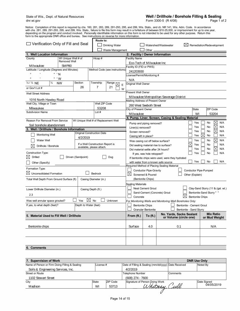
SMP80
° °
' '
26 7 21NE NW
4/2/2019
Bentonite chips
Present Well Owner
Facility ID (FID or PWS)
Original Well Owner
Other
Remediation/Redevelopment
Street or Route
City of Present Owner
Notice: Completion of this report is required by chs. 160, 281, 283, 289, 291-293, 295, and 299, Wis. Stats., and ch. NR 141, Wis. Adm. Code. In accordancewith chs. 281, 289, 291-293, 295, and 299, Wis. Stats., failure to file this form may result in a forfeiture of between $10-25,000, or imprisonment for up to one year,depending on the program and conduct involved. Personally identifiable information on this form is not intended to be used for any other purpose. Return thisform to the appropriate DNR office and bureau. See instructions on reverse for more information.
Was casing cut off below surface?Did sealing material rise to surface?Did material settle after 24 hours? If yes, was hole retopped?If bentonite chips were used, were they hydratedwith water from a known safe source
License/Permit/Monitoring #
Mailing Address of Present Owner
Lattitude / Longitude (Degrees and Minutes)
State ZIP Code
Facility Name
Name of Person or Firm Doing Filling & Sealing License #7. Supervision of Work DNR Use Only
6. Comments
5. Material Used to Fill Well / Drillhole
1. Well Location InformationWI Unique Well # ofRemoved Well
Well City, Village or Town
County
Telephone Number4/2/2019Soils & Engineering Services, Inc.
1102 Stewart Street
Madison WI 53713
Depth to Water (feet)
YesYesYesYes
NoNoNoNo
N/AN/AN/AN/A
YesYesYesYes
Yes
To (ft.)
Date of Filling & Sealing (mm/dd/yyyy)
0.1
NoNoNoNo
No
N/AN/AN/AN/A
N/A
4.0
Casing Diameter (in.)
State ZIP Code
Route to:
Signature of Person Doing Work
Noted By
Date Signed
¼
Milwaukee
241203930
N/A
Milwaukee Metropolitan Sewerage District
Well ZIP Code
Well Street Address
260 West Seeboth Street
Milwaukee WI 53204
Eco-Tech of Milwaukee Inc
' N"" ' W
Drinking Water
Date Received
Comments
2. Facility / Owner Information
4. Pump, Liner, Screen, Casing & Sealing Material
City
Verification Only of Fill and Seal
Hicap #
Waste Management
(608) 274 - 7600
Bentonite - Cement GroutBentonite - Sand Slurry
For Monitoring Wells and Monitoring Well Boreholes Only:
Sealing MaterialsNeat Cement GroutSand-Cement (Concrete) GroutConcrete
Clay-Sand Slurry (11 lb./gal. wt.)Bentonite-Sand Slurry " "Bentonite Chips
If yes, to what depth (feet)?
1016 North Hawley Road
Bentonite ChipsGranular Bentonite
Required Method of Placing Sealing Material
Lower Drillhole Diameter (in.)
Conductor Pipe-PumpedOther (Explain)
Pump and piping removed?Liner(s) removed?Screen removed?Casing left in place?
Watershed/Wastewater
Conductor Pipe-GravityScreened & Poured(Bentonite Chips)
Method Code (see instructions)
No. Yards, Sacks Sealantor Volume (circle one)
¼ / ¼
or Gov't Lot #EW
RangeSection Township
Form 3300-5 (R 4/08) Page 1 of 2State of Wis., Dept. of Natural Resourcesdnr.wi.gov
Well / Drillhole / Borehole Filling & Sealing
Drilled
Other (Specify)
2.3
Original Construction Date3. Well / Drillhole / Borehole Information
Subdivision Name Lot #
Reason For Removal From Service WI Unique Well # of Replacement Well
Milwaukee
Construction Type:Driven (Sandpoint) Dug
Monitoring Well
Water Well
Drillhole / BoreholeIf a Well Construction Report isavailable, please attach.
Soil borehole abandonment
53208
Formation Type:
No UnknownYesWas well annular space grouted?
Mix Ratioor Mud Weight
N/A
From (ft.)
Surface
BedrockUnconsolidated Formation
Total Well Depth From Ground Surface (ft)
Casing Depth (ft.)
04/05/2019
Page 14 of 15
D
I I I I
I I
□ □ ~
~ □ □
~ □
□ ~
I
I
D D
I
□
□
~ □
□ ~
□ □ □
□ □
D D
□ □
I I
□ □ ~ □ □ ~ □ □ ~ □ ~ □ □ □ ~ ~ □ □ □ □ ~ □ □ □
□ □ □
□ □
□ □ ~

SMP81
° °
' '
26 7 21NE NW
4/2/2019
Bentonite chips
Present Well Owner
Facility ID (FID or PWS)
Original Well Owner
Other
Remediation/Redevelopment
Street or Route
City of Present Owner
Notice: Completion of this report is required by chs. 160, 281, 283, 289, 291-293, 295, and 299, Wis. Stats., and ch. NR 141, Wis. Adm. Code. In accordancewith chs. 281, 289, 291-293, 295, and 299, Wis. Stats., failure to file this form may result in a forfeiture of between $10-25,000, or imprisonment for up to one year,depending on the program and conduct involved. Personally identifiable information on this form is not intended to be used for any other purpose. Return thisform to the appropriate DNR office and bureau. See instructions on reverse for more information.
Was casing cut off below surface?Did sealing material rise to surface?Did material settle after 24 hours? If yes, was hole retopped?If bentonite chips were used, were they hydratedwith water from a known safe source
License/Permit/Monitoring #
Mailing Address of Present Owner
Lattitude / Longitude (Degrees and Minutes)
State ZIP Code
Facility Name
Name of Person or Firm Doing Filling & Sealing License #7. Supervision of Work DNR Use Only
6. Comments
5. Material Used to Fill Well / Drillhole
1. Well Location InformationWI Unique Well # ofRemoved Well
Well City, Village or Town
County
Telephone Number4/2/2019Soils & Engineering Services, Inc.
1102 Stewart Street
Madison WI 53713
Depth to Water (feet)
YesYesYesYes
NoNoNoNo
N/AN/AN/AN/A
YesYesYesYes
Yes
To (ft.)
Date of Filling & Sealing (mm/dd/yyyy)
0.1
NoNoNoNo
No
N/AN/AN/AN/A
N/A
4.0
Casing Diameter (in.)
State ZIP Code
Route to:
Signature of Person Doing Work
Noted By
Date Signed
¼
Milwaukee
241203930
N/A
Milwaukee Metropolitan Sewerage District
Well ZIP Code
Well Street Address
260 West Seeboth Street
Milwaukee WI 53204
Eco-Tech of Milwaukee Inc
' N"" ' W
Drinking Water
Date Received
Comments
2. Facility / Owner Information
4. Pump, Liner, Screen, Casing & Sealing Material
City
Verification Only of Fill and Seal
Hicap #
Waste Management
(608) 274 - 7600
Bentonite - Cement GroutBentonite - Sand Slurry
For Monitoring Wells and Monitoring Well Boreholes Only:
Sealing MaterialsNeat Cement GroutSand-Cement (Concrete) GroutConcrete
Clay-Sand Slurry (11 lb./gal. wt.)Bentonite-Sand Slurry " "Bentonite Chips
If yes, to what depth (feet)?
1016 North Hawley Road
Bentonite ChipsGranular Bentonite
Required Method of Placing Sealing Material
Lower Drillhole Diameter (in.)
Conductor Pipe-PumpedOther (Explain)
Pump and piping removed?Liner(s) removed?Screen removed?Casing left in place?
Watershed/Wastewater
Conductor Pipe-GravityScreened & Poured(Bentonite Chips)
Method Code (see instructions)
No. Yards, Sacks Sealantor Volume (circle one)
¼ / ¼
or Gov't Lot #EW
RangeSection Township
Form 3300-5 (R 4/08) Page 1 of 2State of Wis., Dept. of Natural Resourcesdnr.wi.gov
Well / Drillhole / Borehole Filling & Sealing
Drilled
Other (Specify)
2.3
Original Construction Date3. Well / Drillhole / Borehole Information
Subdivision Name Lot #
Reason For Removal From Service WI Unique Well # of Replacement Well
Milwaukee
Construction Type:Driven (Sandpoint) Dug
Monitoring Well
Water Well
Drillhole / BoreholeIf a Well Construction Report isavailable, please attach.
Soil borehole abandonment
53208
Formation Type:
No UnknownYesWas well annular space grouted?
Mix Ratioor Mud Weight
N/A
From (ft.)
Surface
BedrockUnconsolidated Formation
Total Well Depth From Ground Surface (ft)
Casing Depth (ft.)
04/05/2019
Page 15 of 15
D
I I I I
I I
□ □ ~
~ □ □
~ □
□ ~
I
I
D D
I
□
□
~ □
□ ~
□ □ □
□ □
D D
□ □
I I
□ □ ~ □ □ ~ □ □ ~ □ ~ □ □ □ ~ ~ □ □ □ □ ~ □ □ □
□ □ □
□ □
□ □ ~

APPENDIX D WACO OIL INVESTIGATION DATA
DELTA, 2005
Relevant excerpts from the following letter report available on BRRTS; enclosed figures were prepared by Delta Environmental Consultants, Inc.
between 2001 and 2005.
Final Case Closure – Waco Oil Company (Bulk Storage Area) 5309 West State Street, Milwaukee, WI 53208
BRRTS #02-41-001079; FID #241200850
() Stantec
Design with community in mind

Page 1 of 4
7.-9' a .. .:o.5
~- "f.- llOQ E,.<O~ X• 1,700
\2(.T• L500 1J5h<0.5
""1BE•<0.5 ~ .. s. ORO•<l-6
__ ... ~-"'i r...._~--: ___ ,---.)
\
,Ill r,--1 =~-USED~>Hii: I {-«11-)
(11£-.un~~l
,-----,-.
il!HMW-2
Iii HMW-8
--... * ,,.""p:?:~-:;:* .· --;-------:,-,t"~ GP-10 _ • ::1l~-------;-.-----;-•-... -----~:- PROPE;fITYUNE
- - ->,;i;i£i;;;,·- - - - - a'Z~?!'- - -- - · ~~~;:-J !r ~ ~ ~ - ,~?_;~~ .. -=- · • ___ _: _• ~~~=-~ -~-- --,;,•mm·- - - - - '1"$:;",.;f -- ~.
--~
sc,u,. rm
,o
¢1 MONITORING WELL
@ MONffORING WELL (ABANOONED)
ll HOLT EL£Cm!C MQt.llTORJWG WEU..
0 RECOVERY WELL {ABANDONED)
)I( GP- t GEOPROBE SORING LOCATION (OCTOBER 2000)
~-1 GEOPROBE BORING LOCATION (N""9<BER 2002)
~P-11 GEDMOBE BORING LOCATION (WW 200-<)
• 8-30 SOH_ SORING LOCATtON
SAMPLE 0/Hl 5'MPU: OIYTH (FED)
8ENZf.NE {ug/kg) fOLUENE {ug/kg) ETHYt8£NZENE (ug/kg) TOTAL l<Yl.ENES (ug/kg)
!t;:::~t:~~~~ ~~~:i METHYL TERTIARY 8VTYl £11-!ER {ug/kg} GASOUNt RANGE ORGANICS (mg/kgJ DIESEL JW.IGE ORGANICS (mg/kg)
(ug/-Kg} • MICROGRAMS PER KILOGRAM
(mg/kg) .. MIWGAAMS PER KILOGRAM
< • NOT DETECTED AT OR A80VE THE INDICAT£0 M£rn00 DETECTION LJMIT
------ EXCAVATION 80UN[)ARY
---- }!REA Of' SOil WITH RCl. t'.XCEE:0£!11C£S
CONCENTRATIONS tN SOLO ITPt 0:CO:O TH£. NR 12/J RESIOUAl CONTM.fflWiT l£VEl.S (RCls) fOO UNSAl\JRATEO SOIL {A80\IE. 14'-14.5')
FIGURE 1 RESIDUAL SOIL CONTAMINATION MAP
WACO OIL COMPANY MILWAUKEE, WISCONSIN
PROJCCi HO.
!000-104
OA)C
10/24/03
~ Delta ... ~ ..

Page 2 of 4
10 JO DO
B= J.4 T= <0.20 E• <0.22 X= <0.23
TMBs""' 0 27 MTB(= 7.2
9 ... 74 T= 1.1 E• 2.7 X= 1.0
TMBs= 0 75 MT8t .. J2
5 4 04
B• 50 T= 1.7 E= 1.J x- J.4
TMBs= 2.03 MTBE= 2.9
8 15 OJ
a- 2.5 T• <0.2 E= <0.22 X= 0.77
TMBs•0.4 MTBE= 2 4
MILWAUKEE FENCE CO
10 JO 00
B= <2.0 T= <0.90 E= <0.40 X• 1.7
lMBs::s O 69 MTBE= <0.65
8 15 03
8= 1,9 T= <0.18 E= <0.22 X: 0.54
TMBs= <0.25 MTBE= 1.3
8 15 03
8=> 4.4 T"' <0.55 E= 2.5 x- 2.7
TMBs• 9.8 MTS£• <1.2 CHRY• 15
6 6 00
B= <0.10 T-= <0.10 E• <0.25 x .. <0.25
TM8sm <0.10 MTB[: <0.25
SHED
10 JO 00
B= <O.lJ T= <0.20 E- <0.22 X=<0.23
TMBs= <0.29 MTBE= <0.47
5 4 04
8= 1000 T• 8.8 [= 98 X= 19
TMBs .. 25 IITBE. ... 73
8 18 OJ
B= <0.5 T• <0.5 E= <0.5 X=- <0.5
TMBs= <1.0 MTBE .. <0.5
\ -;
___ -,\ ~~ ~------\ __ ->
HMW-11!;!
MVl-351Ji r FORMER / GASOLINE TANKS
. ---------...... ,., SB-F ..,
MW-12R
FORMER (R[r.lOV£D 1985) USED OIL TANK {R[M0'-1£D 19<J'4)
10/30 00
B= <0 13 T= <0.20 E= <0.20 X: <0.22
TMBsoo 0.47 MT9E"" <0.40
10 30 QC
B= <0.65 T:: <1.1 E= <0.80 X= 1 6
TMBs• 1.5 MTBE= <0.80
\
• -33 I
8 18 OJ
e- <0.5 T= <0.5 E= <0.5 X= <0.5
TMBs• <1.0 MTBE= <0.5
I I I I
~-~a-,~s-o~3~ B-= 5.S T= <0.25 E= <0 22 X= 0.98
TMBs,..041 MTBE= 1.1
8 18 OJ
~ HMW-2 ::~ rOOMER usl. I I (SiZE/LOCAooy' APPROX.)
8== 0 816 r ... 0.966 E= <05 X• 2.00
~J / TMBs= L16 MTBE= 2.39
8 18 OJ
8=- 0.585 T-<= <0.5 E= <0.5 X• l.11
HOLT ELECTRI✓ 5225 WEST STATE f tCT
TMBs• < 1.0 MTBE= 8.17
/
/ 81803
B= <0.5
I T:<05 E• <0.5 X= 0.574
~ HMW-6 ~™-•_•-_'·-"~ I MT9E., 1.01
10/30/00
8=2 7 T= 3.2 E= 19 X:: 94
TMBs= 176 MTB[= 60
HMW-5 I!;!
-3
~ HMW--7
/ l!;j HMW-8
8 1B OJ
s~ <O.s l= <0.5 E"" <0.5 x"' <0.5
TMBs= <l.0 MTBE..- <0.5
a 18 03
s- <0 5 T• <0.5 E.= <0.5 X= <0.5
TMBs• <1.0 MTBE= <0.5
8 15 03
8= <0.25 T= <0.11 E• <0.22 x- <0.39
TM8s,. <0.25 MTBE= <0.23
B(o)P=1,7 CHRYz 1.5
8 15 03
B= 0.27 T== 016 E• <0.22 X= <0.39
TMBs= <0.25 MTBE= <0.23
·2·0·0·0·
LEGEND:
MOMITOR!MG WELL
MONITORING WELL (ABANDONED)
HOLT ELECTRIC MONITORING WELL
RECOVERY WELL (ABANDONED)
GEOPROBE BORING LOCATION (OCTOBER 2000)
+<;P-1
-$-GP-1 l
GEOPROBE BORING LOCATION (NOVEMBER 2002)
GEOPROBE BORING LOCATION (MAY 2004)
• 8··30
DATE
8= T= E~ X=
TM8s= MTBE= B(o)P=
· CHRY=
(ug/L)
SOIL BORING LOCATION
SAMPLE DATE
BENZENE (ug/L) lOLUENE (ug/L) fTHYLBENZENE (ug/L) TOTAL XYLENES (ug/L) TOTAL TRIMETHYLBENZENES (ug/L) METHYL TERTIARY BUTYL ETHER (ug/L) BENZO(o)PYRENE (ug/L) CHRYSENE ( ug/L)
MICROGRAMS PER LITER
NOT DETECTED AT OR ABOVE THE INOICATED METHOD DETECTION LIMIT
--- ESTIMATED EXTENT OF IMPACTED GROUNDWATER
BOLD TYPE DENOTES AN EXCEEDENCE OF THE NR 140 ENFORCEMENT STANOARD (ES)
5 7 02
B=- <0.13 T= <0.20 [9 <0.22 x- <0.2J
TMEis- <0.29 MTEE• <0.lE
iJI MVl-17 PROPERTY UNE
40
FIGURE 2 GROUNDWATER ANALYTICAL RESULTS SUMMARY MAP
MOST RECENT RES UL TS WACO OIL COMPANY
MILWAUKEE, WISCONSIN
SCALE fN FEET

Page 3 of 4
MILWAUKEE FENCE CO.
--" ------ j ~~ ~~----\--! GAS6~~~E:ANKS
FORMER (Ra.lOVED 19115) USED OIL TANK (REMCM:D 11'194)
MILWAUKEE FENCE CO.
r---, I I I I I I I I I I L ___ J
\~FOR~ER 8,000 GALLON HEATING OIL TANK
("8i\NOONEO IN PVC( 1988)
• SB-F MW-12R
RE~EDIATION SH
GP♦17
(Z) MW-41
"' "' (%1 MW-31 "' "' "'
HMW-1 l!li]
Fiil HMW-3
(Z) MW-40
II I I
I;]! HMW-2 :=>.: FORMER USTs 11 (SIZE/LOCATION APPROX)
LJ
HOLT ELECl'RIC 5225 WEST STATE STREET
I I I I
T FORMER UST
(SIZE/LOCATION APPROX )
~ HMW-4
HMW-5 I;]!
w- 4
~HMW-6
~ HMW-7
l!li] HMW-8
LEGEND:
.:GP-1
♦GP-1
-$-GP-11
• B-30
MONITORING WELL
MONITORING WELL (ABANDONED)
HOLT ELECTRIC MONITORING WELL
RECOVERY WELL (ABANDONED)
GEOPROBE BORING LOCATION (OCTOBER 2000)
GEOPROBE BORING LOCATION (NOVEMBER 2002)
GEOPROBE BORING LOCATION (MAY 2004)
SOIL BORING LOCATION
WEEDS & BRUSH
RAJLROAD TRACKS
FENCE
RAILROAD GRAVEL
SURFACE BARRIER MAINTENANCE AREA
(Z) MW-17 "'-~PROPERTYLINE -.,, "'_._"' ------,._....,-+ "' -.,~---------:-+ ____ "'lP-,.
:t(GP-3 ll: GP-2 "' "' + "'GP-1 )I( "'
- - - :--;- - - PROPERTY LINE
I •o'-32 I
40
SHED SCALE IN FEET
FIGURE 3 SURFACE BARRIER MAINTENANCE AREA
WACO OIL COMPANY MILWAUKEE, WISCONSIN
PROJECT NO. PREPARED BY DRAWN BY A 1000-104 AM DD D It
t-=OATE~--t"""~,WE~Dll'c-1=-m.E =.,,.,--< ~ e a 1/5/05 001045M ~ .... a-:,=.,.on:::.-:..c.
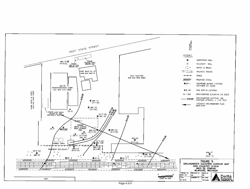
Page 4 of 4
(619.12) ~ 1%)
+- "' MW-31
-------1 r" ..... ('"- 'lit;- _..i
I j ~---- \-/
FORMER GASOLINE TANKS
MW-351%) (618.92) FORMER (RCMOVC0 1985)
r---, I I I I I I I I I I L ___ J
USED OIL TANK (REMOVE01994)
ZENITH TRANSPORTATION CORP.
5321 WEST STATE STREET
\_FORMER 8,000 GAU. HEATING OIL TANK
(A&.NOONEO IN Pl.AC
SHED
1%) MW-41 (617.30)
1%) MW-16 (617.80)
HOLT ELECTRIC 5225 WEST STATE STREET
0 40
SCALE IN FEET
LEGEND:
1%)
• 8-30
(617.80)
--613.00 -
MONITORING WELL
RECOVERY WELL
WEEDS & BRUSH
RAILROAD TRACKS
FENCE
RAILROAD GRAVEL
GEOPROBE BORING LOCATION (OCTOBER 27, 2000)
SOIL BORING LOCATION
GROUNDWATER ELEVATION (IN FEET)
GROUNDWATER CONTOUR LINE CONTOUR INTERVAL = 1.00 FEET
INFERRED GROUNDWATER FLOW DIRECTION
MW-17 1%)
(612.17)
FIGURE 5. GROUNDWATER ELEVATION CONTOUR MAP
DATA COLLECTED 10-30--00 WACO OIL COMPANY
MILWAUKEE, WISCONSIN PROJECT NO. PREPARED BY DRAWN BY
1-'ooo""°",..TE-~'-o_• _-+"'=•E'.1EWE!l==~BY~t.c~~:~ .... =ec--1 ♦A ~!!~)~111"?, .. lnc 6/16/01 00104SM A& vur-.ui•-·